journal of astronomical history and heritage
318
-
Upload
khangminh22 -
Category
Documents
-
view
0 -
download
0
Transcript of journal of astronomical history and heritage


JOURNAL OF ASTRONOMICAL HISTORY AND HERITAGE ISSN 1440-2807
EDITORS
Professor Wayne ORCHISTON (Thailand) – Managing Editor Associate Professor Ruby-Ann DELA CRUZ (Philippines) – Papers Editor
ASSOCIATE EDITORS Dr Clifford CUNNINGHAM (USA)
Professor Richard de Grijs (Australia) Associate Professor Duane HAMACHER (Australia)
Dr James LEQUEUX (France) Dr Peter ROBERTSON (Australia)
EDITORIAL BOARD
Dr Alan BATTEN (Canada) Professor NHA Il-Seong (South Korea) Dr Suzanne DÉBARBAT (France) Professor Ray NORRIS (Australia) Dr Steven DICK (USA) Professor F. Richard STEPHENSON (England) Dr Priscila FAULHABER (Brazil) Professor Xiaochun SUN (China) Dr Ian GLASS (South Africa) Professor Joseph S. TENN (USA) Professor Bambang HIDAYAT (Indonesia) Professor Virginia TRIMBLE (USA) Professor Ionnis LIRITZIS (Greece) Professor Mayank VAHIA (India) Professor Nick LOMB (Australia Professor Brian WARNER (South Africa) Dr Tsuko NAKAMURA (Japan) Professor Gudrun WOLFSCHMIDT (Germany)
The Journal of Astronomical History and Heritage (JAHH) was founded by John Perdrix and Wayne Orchiston in 1998, and since 2021 has been issued quarterly, in March, June, September and December. It features review papers, research papers, archival papers, short communications, correspondence, IAU reports and book reviews.
Papers on all aspects of astronomical history are considered, including studies that place the evolution of astronomy in political, economic and cultural contexts. Papers on astronomical heritage may deal with historic telescopes and observatories, conservation projects (including the conversion of historic observatories into museums of astronomy), and historical or industrial archaeological investigations of astronomical sites and buildings. All papers are refereed prior to publication. There are no page charges, and in lieu of reprints authors are sent a pdf or Word camera-ready version of their paper so that they can generate their own reprints on demand.
The JAHH has its own dedicated web site at: https://www.jahh.org. This includes guidelines for the preparation and submission of papers, our ethics and malpractice statement, impact factors, and access to back issues.
Prospective contributors should read the ‘Guide for Authors’ on our web site and carefully follow these guidelines when preparing manuscripts. Papers should be submitted online or, if you don't have access to email, they should be saved as Word and pdf files on a memory stick and posted to:
Professor Wayne Orchiston Managing Editor, Journal of Astronomical History and Heritage 523 Moo 1, Soi Ban Cholae, Mae Taeng, Chiang Mai 50150, Thailand.
Book reviews should be sent to Dr Clifford Cunningham ([email protected]).
The JAHH is an open access electronic journal, and is published by the National Astronomical Research Institute of Thailand (NARIT). All content back to Vol. 1 (1998) may be downloaded free of charge from the Journal’s web site (www.jahh.org), the NARIT web (http://www.narit.or.th/index.php/en/jahh) or the SAO/NASA Astrophysics Data System site (http://bit.ly/1bMwxBr) and its 11 mirror sites around the world. The electronic version of the journal will continue to be produced four times a year (normally at the end of March, June, September and December) and posted on these web sites. Those who want a hard copy may print it out or have it done by their local printers. For this reason, a single pdf of each entire issue (including the cover) is available on the NARIT site.
For all enquiries, email the Managing Editor ([email protected]).
The views and opinions expressed in this Journal are not necessarily those of the Editors or the Editorial Board.
COVER IMAGE
During the seventeenth century Western Jesuit astronomers were busy in China, Cochinchina (present-day Vietnam), Siam (present-day Thailand), the Philippines, the Dutch East Indies (present-day Indonesia) and India.
The two images on the cover of this issue of JAHH are from Siam, where King Narai had a special interest in astronomy and between 1681 to 1688 hosted Jesuit astronomers from Belgium and France. After successfully observing a lunar eclipse in December 1685 along with Jesuit astronomers, King Narai sanctioned the construction of Wat San Paulo, which included a 4-storey tower observatory. This is shown in the upper painting, and part of the observatory still exists at Lop Buri. The lower painting depicts the Jesuits observing a partial solar eclipse on 30 April 1688, with an ailing King Narai viewing from a nearby window in his palace at Lop Buri. Soon after this event one of the King’s relatives staged a coup d’état, a few weeks later King Narai died, and the Jesuit astronomers and most Westerners were then expelled from Siam. For details of seventeenth-century Jesuit astronomy in Siam see the paper by Orchiston et al. on pages 498–520 in this issue of JAHH.

245
JOURNAL OF ASTRONOMICAL HISTORY AND HERITAGE ISSN 1440-2807
VOLUME 24 NUMBER 2 JUNE 2021
CONTENTS
Page
Papers
Interferometry and monochromatic imaging at Marseille Observatory 247 Yvon Georgelin and James Lequeux
Time signals for mariners in South Africa 285 Roger Kinns
Time signals for mariners in the Atlantic Islands and West Africa 315 Roger Kinns
Where was mean solar time first adopted? 337 Simone Bianchi
The Seven Sisters: a Pleiades cantata 345 Clifford J. Cunningham and Barbara Bacik Case
Ragoonatha Charry and the observations of the total solar eclipse of 1868 from Vanpurthy (Wanparthy), India 363
T.V. Venkateswaran
King Rama IV, Sir Harry Ord and the total solar eclipse of 18 August 1868: power, politics and astronomy 389 Wayne Orchiston and Darunee Lingling Orchiston
European longitude prizes. 2: Astronomy, religion and engineering solutions in the Dutch Republic 405
Richard de Grijs
Unified analysis of observation dates for ancient star maps and catalogues in Asia 440 Tsuko Nakamura
Australian eclipses: the Western Australian eclipse of 1974 and the East Coast eclipse of 1976 475
Nick Lomb
Showcasing seventeenth-century Jesuit astronomy in Asia: the lead-up to the first scientific observations of a solar eclipse carried out in Siam 498 Wayne Orchiston, Darunee Lingling Orchiston, Lars Gislén, Martin George, Boonrucksar Soonthornthum, Françoise Launay, Suzanne Débarbat and
Matthieu Husson
Karl Schwarzschild, Annie J. Cannon and Cornelis Easton: the honorary PhDs of Jacobus C. Kapteyn 521
Pieter C. van der Kruit Book Reviews
Chinese Astrology and Astronomy: An Outside History, by Jiang Xiaoyuan 544 David Pankenier
Heaven on Earth: How Copernicus, Brahe, Kepler and Galileo Discovered the Modern World, by L.S. Fauber 545
Clifford Cunningham
Internationality in the Astronomical Research of the 18th to 20th Centuries, edited by G. Wolfschmidt 546
Andreas Schrimpf
Leopolis Scientifica. Science in Lviv till the Middle of the XX Century, edited by Oleh Petruk 548
Volodymyr Pelykh and Roman Plyatsko
The Light Ages: The Surprising Story of Medieval Science, by Seb Falk 549 Marion Dolan
Mars, by Stephen O’Meara 552 Clifford Cunningham

Contents
246
The Sky Atlas, by Edward Brooke-Hitching 554 Clifford Cunningham
Star Maps, History, Artistry, and Cartography (Third Edition), by Nick Kanas 554 Clifford Cunningham
Celestial Atlas: A Journey in the Sky Through Maps, by Elena Percivaldi 554 Clifford Cunningham
Storočia Astronómie v Prešove, edited by Renáta Kolivošková 556 Martin Vaňko
The Mythology of the Night Sky: Greek, Roman and Other Celestial Lore, by David Falkner 558
Clifford Cunningham
Astronomical Myths: Based on Flammarion’s “History of the Heavens”, by John F. Blake 558
Clifford Cunningham
The Birth of Modern Astronomy, by Harm J. Habing 559 Robert W. Smith
Published by the National Astronomical Research Institute of Thailand, 260 Moo 4, T. Donkaew, A. Maerim, Chiang Mai 50180, Thailand.

Journal of Astronomical History and Heritage, 24(2), 247–284 (2021).
247
INTERFEROMETRY AND MONOCHROMATIC IMAGING AT THE MARSEILLE OBSERVATORY
Yvon Georgelin
Observatoire de Marseille/LAM 38 rue Frédéric Joliot-Curie, 13013 Marseille, France
E-mail: [email protected]
and
James Lequeux LERMA, Observatoire de Paris-PSL-Sorbonne Université,
61 Avenue de l’Observatoire, 75014 Paris, France E-mail: [email protected]
ABSTRACT: We first give a brief history of the astronomical observatory in Marseilles, which was founded in 1702. Then, we describe the first attempt to measure at this Observatory the angular diameter of stars by interferometry, in 1873–1874. Because the size of the remarkable Foucault telescope that was used by Édouard Stéphan for this program was only 80 cm, none of the bright stars were resolved, and the upper limit to their diameters was given as 1/6 of an arcsecond. This result was however a very significant advance, as only fancy figures had been given previously for stellar diameters. The next incursion in interferometry of the Marseille Observatory took place in 1911–1914, when Charles Fabry and Henri Buisson measured with the same telescope the radial velocity and the temperature of the Orion Nebula, using the Pérot–Fabry interferometer developed at the Marseille University. After World War II, the Observatory underwent a complete renewal. Then Georges Courtès used interference filters to obtain deep photographs of HII regions, and Pérot–Fabry interferometers for measuring their radial velocities. We describe the very important instrumental advances realized for this program, in particular the focal reducers that allowed a considerable increase in sensitivity. The final result obtained by Courtès and his collaborators was a complete Hα survey of the Milky Way, which was the basis for a new description of the structure of our Galaxy, with four spiral arms, and a detailed Hα survey of the Magellanic Clouds. The distribution of HII regions in the closest galaxies was also observed and their velocity fields determined. In 1963, Courtès built the first integral field spectrograph, based on an array of micro-lenses; it had a great success, so that similar instruments are mounted at the focus of the largest present and future telescopes.
KEYWORDS: HII regions, Galactic structure, Magellanic clouds, M 33, M 31, Wide-field camera, Focal reducer, Fabry–Pérot interferometer, Monochromatic imaging, Micro-lenses array, Integral field spectrometer.
Like the companion paper “The Rise of Ultraviolet Astronomy in France” in the March 2021 issue of this journal (Lequeux, 2021), this new paper also is dedicated to the memory of Georges Courtès, who died on 30 October 2019, aged 94.
1 A BRIEF HISTORY OF THE OBSERVATORIES IN MARSEILLES
Astronomy in Provence has a rather glorious early history, thanks primarily to Nicolas Fabri de Peiresc (1580–1637; Gassendi, 1657). Peiresc observed the satellites of Jupiter from his house in Aix-en-Provence immediately after their discovery by Galileo, determined their period of revolution with a remarkable accuracy, and prepared ephemerides of their position; before Galileo, he had the idea to use their eclipses to determine longitudes (Tolbert, 1999), although he realized that this method would not be practical at sea. He discovered the Orion Nebula at the end of 1610 (Bigourdan, 1916). Peiresc also organ-ized a determination of longitudes of several Mediterranean harbors using the lunar eclipse of 28 August 1635, and found the East–West extent of the Mediterranean Sea too large by 1000 km (Miller, 2000).
However, the first observatory in Marseil-les was only founded in 1702 by the Jesuits, in their house of the Montée des Accoules, through the action of Jean-Mathieu de Cha-zelles (1657–1710), Professor of Hydrography at the Arsenal of galleys, who had worked with Jean-Dominique Cassini in Paris and managed to obtain subsidies from King Louis XIV.1 In 1749, this observatory was promot-ed as the ‘Royal Observatory of the Navy’ after the suppression of the galleys: in this way it acquired a national character, preserv-ed until today. In 1781, it was united with the local Academy of Sciences, which renovated the building that contained the Observatory, where it held its meetings (Figure 1). After the suppression of this Academy in 1793, dur-ing the French Revolution, the Observatory was preserved and remained active until its transfer to another location in 1862–1863. The building is presently an elementary school, but the historical part survives, including the

Yvon Georgelin and James Lequeux Interferometry and Imaging at Marseille Observatory
248
Figure 1: Marseille Observatory, Montée des Accoules, at the end of the eighteenth century (© Musée de la Marine, Chambre de Commerce et d’Industrie de Marseille-Provence). astronomical tower but without the three domes.
In parallel, there was from 1714 another observatory in the city: that of Father Louis Feuillée (1660–1732), of the order of Min-imes, a pupil of de Chazelles. Feuillée did not observe very often, as he was mainly trav-elling in central and southern America, es-sentially as a botanist. However, he deter-mined the longitudes of several towns using eclipses of the satellites of Jupiter, and some of his observations are of high interest, in particular that of the very rare occultation of a bright star by Jupiter observed at Coquimbo on 6 April 1710: this gives the most ancient precise measurement of the position of the planet. After the death of Feuillée, the Min-imes were no longer interested in astronomy, Feuillée’s observatory was closed and the salary attached to his position was transfer-red to the other observatory.
Figure 2: Jean-Louis Pons (courtesy: Marseille Observatory).
The Accoules Observatory was initially directed by Jesuits: Father Antoine-François de Laval (1664–1728), another pupil of de Chazelles, then after his death Father Esprit Pézenas (1692–1776), until the suppression of Jesuits in France in 1763. Guillaume de Saint-Jacques de Silvabelle (1722–1801) succeeded him, then Jacques-Joseph Thulis (1748–1810) until his death, Jean-Jacques Blanpain (1777–1843) until 1822, Jean-Félix Adolphe Gambart (1800–1836) until his pre-mature death and finally Benjamin Valz (1787 –1867), who retired in 1860.
The eighteenth-century Observatory was rather well equipped through Royal subsidies, in particular with a reflecting Gregorian tele-scope by Short (it is preserved together with other instruments and books of the Observa-tory). However, the personnel were limited to the Director, an astronomer-adjunct (after 1777) and a concierge. The activities were rather classical and of good quality according to Jean Bernoulli (1744–1807), who visited the Observatory in 1774, and Baron Franz-Xaver von Zach (1754–1832). A real break-through occurred when the concierge, Jean-Louis Pons (1761–1831, Figure 2), discover-ed a comet in 1801 with a telescope he had built himself (Figure 3). He had been trained in astronomy by Silvabelle, who was himself a specialist of comets and had worked on the return of Comet 1P/Halley. Pons, who dis-covered no fewer than 23 comets from Mar-seilles, was promoted to astronomer-adjunct in 1813. He was invited to Italy to become the first Director of the Marlia Observatory, near Lucca in 1819, where he discovered seven more comets. In 1825, he was appointed Director of the Florence Observatory and dis-covered seven further comets before his death (Bianchi, 2020). Pons was the most

Yvon Georgelin and James Lequeux Interferometry and Imaging at Marseille Observatory
249
prolific discoverer of comets ever.
For his part, Jean-Félix Adolphe Gambart discovered 13 comets from Marseilles, and he demonstrated that the comet discovered in 1826 by Biela was in fact periodic and had already been observed in 1772 and 1805. Arago says in his eulogy (Arago, 1855: 450):
A great natural facility, and habit, had led the young correspondent of the Academy of sciences to make in a few hours complicated calculations which formerly would have required several days. (our translation).
The German astronomer Ernst Wilhelm Tempel (1821–1889), who between 1860 and 1870 observed from Marseille Observatory, discovered eight comets during his stay (plus seven elsewhere, four asteroids and several tens of nebulae, including those around the Pleiades). Marseilles was at the forefront of cometary and nebular astronomy! As for Benjamin Valz, his main interest was in asteroids, and his student, Jean Chacornac (1823–1873) discovered Phocea in 1853, and then four more asteroids before he trans-ferred to Paris Observatory in 1857.
In spite of this activity, the instrument-ation of the Observatory was progressively becoming obsolete, because the Bureau des Longitudes, which was in charge of all French astronomy since the Revolution, preferred to send outmoded Parisian instruments to the provincial observatories rather than pay for new ones. Thus, these observatories were destined to decline; indeed, Marseille Ob-servatory almost closed down in 1860 when Valz retired, although he was replaced by Charles Simon (1825–1880) for two years.
In fact, what saved Marseille Observatory was the imaginary belief that observing conditions in Paris were deteriorating, where-as those in the south of France were much more favorable. In 1862 the famous optician Léon Foucault (1819–1868) and the mechan-ic Friedrich Wilhelm Eichens (1818–1884) had produced in Paris a magnificent reflecting telescope, 80 cm in diameter, which was to remain for some time the largest modern reflecting telescope with a silvered glass mirror.2 Urbain Le Verrier (1811–1877), the discoverer of Neptune, was then the Director of Paris Observatory, and he decided to install the telescope in the south of France, and after some hesitation, Marseilles was chosen in 1862 (for details, see Lequeux, 2013: Chapter 5).
The mayor of the city was enthusiastic, since the old observatory at the Accoules had been completely inoperative for the previous
two years and was enclosed in a quarter with small narrow streets, whereas Le Verrier wish-ed for an open site, well away from important buildings. The site chosen for the new Mar-seille Observatory was on the Longchamp Plateau, which was almost entirely surround-ed by public gardens. In fact, there was al-ready a great deal of construction going on in the area, but very little industry, and public lighting had yet to annoy astronomers. A decree of 1863 established Marseille Obser-vatory as “… a branch of the Paris Observa-tory”. (Lequeux, 2013: 121).
Le Verrier sent Auguste Voigt (1828–1909) to supervise the on-site operations as an adjunct astronomer, in replacement of Simon. Overloaded with work and pressure from Le Verrier, Voigt resigned in 1866 and
Figure 3: One of the telescopes used by Pons in Marseilles to observe comets (courtesy: Marseille Observatory). was himself replaced by Édouard Stéphan (1837–1923; Figure 4). Le Verrier kept the title of Director until his death in 1877. Sté-phan was assisted by two adjunct astron-omers, Alphonse Borrelly (1842–1926) and Jérôme Eugène Coggia (1849–1919), both of whom had discovered several comets and asteroids during the preceding directorships. The land and equipment of the new Obser-vatory belonged to the city of Marseilles, which granted up 15,000 francs annually to-ward the costs.
The Observatory was inaugurated at the end of 1864; the architect was Henri-Jacques Espérandieu (1829–1874), who also design-ed the famous church of Notre-Dame de la Garde that dominates Marseilles. The main building of the Observatory had only two large rooms on the ground floor: the Director’s of-
Yvon Georgelin and James Lequeux Interferometry and Imaging at Marseille Observatory
250
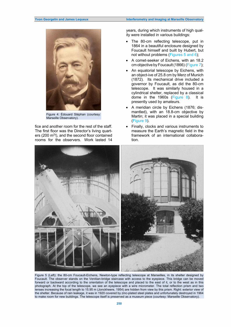
Figure 4: Édouard Stéphan (courtesy: Marseille Observatory).
fice and another room for the rest of the staff. The first floor was the Director’s living quart-ers (200 m2!), and the second floor contained rooms for the observers. Work lasted 14
years, during which instruments of high qual-ity were installed in various buildings:
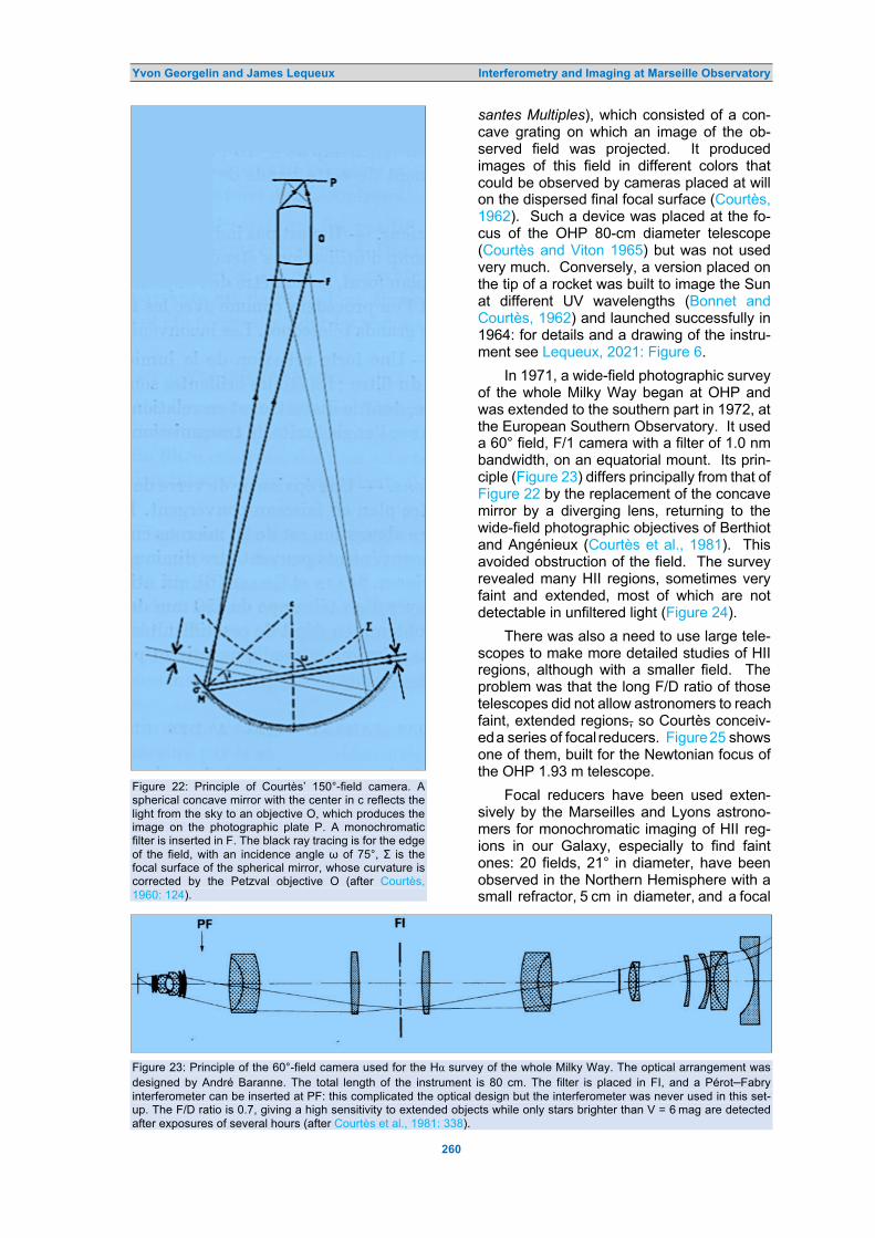
• The 80-cm reflecting telescope, put in 1864 in a beautiful enclosure designed by Foucault himself and built by Hubert, but not without problems (Figures 5 and 6);
• A comet-seeker of Eichens, with an 18.2 cm objective by Foucault (1866) (Figure 7);
• An equatorial telescope by Eichens, with an object-ive of 25.8 cm by Merz of Munich (1872). Its mechanical drive included a governor by Foucault, as did the 80-cm telescope. It was similarly housed in a cylindrical shelter, replaced by a classical dome in the 1960s (Figure 8). It is presently used by amateurs.
• A meridian circle by Eichens (1876; dis-mantled), with an 18.8-cm objective by Martin; it was placed in a special building (Figure 9).
• Finally, clocks and various instruments to measure the Earth’s magnetic field in the framework of an international collabora-tion.
Figure 5 (Left): the 80-cm Foucault-Eichens, Newton-type reflecting telescope at Marseilles, in its shelter designed by Foucault. The observer stands on the Venitian-bridge staircase with access to the eyepiece. This bridge can be moved forward or backward according to the orientation of the telescope and placed to the east of it, or to the west as in this photograph. At the top of the telescope, we see an eyepiece with a wire micrometer. The total reflection prism and two lenses increasing the focal length to 15.95 m (Jonckheere, 1954) are hidden from view by this prism. Right: exterior view of the shelter. Because of rain leakage, it was in 1920 covered by zinc-plated steel plates and unfortunately destroyed in 1964 to make room for new buildings. The telescope itself is preserved as a museum piece (courtesy: Marseille Observatory).

Yvon Georgelin and James Lequeux Interferometry and Imaging at Marseille Observatory
251
One may note that the comet-seeker, equatorial and the meridian circle corre-sponded to the specifications spelled out in 1847 by Wilhelm Struve in a letter in French to Le Verrier, in which he described an ideal observatory inspired by that of Pulkovo (the complete translated letter is in Lequeux, 2013: 64):
Figure 6: Side view of the mirror of the 80-cm telescope. The mirror has an unusual shape, being thicker in the center. This ensured less gravitational deformation when inclined. Foucault placed on the back a rubber cushion that could be inflated by the observer to correct for this deformation: an ancestor of active optics (courtesy: Marseille Observatory).
Figure 7: The Marseille Observatory comet seeker. This telescope has disappeared, but a similar one can be seen at Strasbourg Observatory. The equatorial mount-ing is designed so that the head of the observer was at the crossing of the two axes (courtesy: Marseille Obse-rvatory).
A good meridian circle equipped with a re-fractor of at least 4, and if possible 5 or 6 pouces [slightly larger than inches] aper-ture, in order that planetary observations can be carried out at the same time as stellar observations, and provide a com-parison with the equatorial observations.
A large equatorial refractor of at least 6 pouces aperture, or better yet a larger
Figure 8: The Merz–Eichens 26-cm equatorial (courtesy: Marseille Observatory).
aperture, perhaps of 9 pouces like that of Dorpat [nowadays Tartu in Estonia; this is the famous Fraunhofer telescope]. This telescope must be equipped with a per-fect filar micrometer, in which the threads can be illuminated by reflection in the dark field of view, so as to render possible the reliable observation of comets.
A comet searcher of the highest quality.
Two pendulums of the highest qual-ity, of which one should be positioned next to the meridian circle and the other destined for use next to the large tele-scope, set up in a revolving turret.
A good box chronometer which will serve to correlate the two pendulums.
It is probable that Le Verrier, who no doubt would have very much liked to have such a comet-seeker in Paris, sought to follow Struve’s recommendations to the letter.
Figure 9: The meridian building (courtesy: Chambre de Commerce et d’Industrie de Marseille-Provence).

Yvon Georgelin and James Lequeux Interferometry and Imaging at Marseille Observatory
252
Figure 10: A Hubble Space Telescope photograph of Stephan’s Quintet of galaxies. The four redder galaxies form an interactive group, at a mean distance of about 106 Mpc. The bluer galaxy at top left, NGC 7320, is much closer, at 12.6 Mpc. HII regions have been detected and their radial velocities measured with the 3.6 m CFH telescope and the Russian 6 m telescope by Plana et al. (1999) (courtesy: Space Telescope Science Institute).
The new Marseille Observatory remain-ed under the tutelage of Paris Observatory until 1878, when it became independent and rejoined the ensemble of observatories con-structed in France at the end of the nine-teenth century in Algeria (then a French col-ony), Besançon, Bordeaux, Lyons and Nice. An observatory had existed in Toulouse since 1733, and it was rejuvenated. A large ob-servatory was also built in Strasbourg, then a part of Germany, which became French in 1919, after World War II (WWII). All these Observatories are still active, although the observations are generally made in more fav-orable locations; the last one was created in Grenoble in 1985. At Marseille Observatory,
the building and the equipment remained pretty much unchanged until the end of WWII. 2 ATTEMPTS TO MEASURE THE ANGULAR DIAMETER OF STARS BY INTERFEROMETRY
The 80-cm reflecting telescope in Marseilles has been actively used for a whole century. With it, Stéphan discovered no fewer than 800 nebulae (mostly galaxies) between 1869 and 1885 (e.g., see Stéphan, 1884), including the celebrated quintet of galaxies that bears his name (Figure 10). From these long years of observation, Stéphan concluded that out of the 420 galaxies he observed, 171 belonged to 65 groups. From 1906 to 1962, Robert

Yvon Georgelin and James Lequeux Interferometry and Imaging at Marseille Observatory
253
Jonckheere (1888–1974) discovered 3,350 visual binaries, many with this telescope, proving in this way that reflecting telescopes are just as good as refractors for these types of observations (e.g., see Jonckheere, 1954, which gives interesting details about the tele-scope).
The 80-cm telescope was also used by Stéphan in 1873–1874 in an attempt to mea-sure the angular diameter of stars by interfer-ometry (Lequeux 2020: Chapter 7). This possibility was proposed as early as 1851 by the physicist Hippolyte Fizeau (1819–1896) in a manuscript preserved in the Archives of the French Academy of Sciences and titled “On a way to derive the diameters of the stars from some interference phenomena” (our translation); but he only published his idea in 1868, as a very short note in a report to the Academy, which mostly went unnoticed (Fiz-eau, 1868: 934, our translation):
There exists ... for most phenomena of interference, such as Young’s fringes, Fresnel’s mirrors … a remarkable and necessary relationship between the size of the fringes and that of the light source, so that fringes of extreme thinness can occur only when the light source has al-most imperceptible angular dimensions; hence, to say it in passing, there may be some hope that based on this principle and forming, for example, using two very wide-spaced slits, interference fringes at the focus of the large instruments used to observe the stars, it will be possible to get some new information on the angular dia-meters of these stars.
We do not know how Stéphan learnt of this idea and came into contact with Fizeau. In any case, it was clearly Fizeau who sug-gested that he measure the apparent dia-meters of stars in this way. In a letter to Fizeau dated 1 February 1874, preserved at the French Academy of Sciences, Stéphan describes his observations in detail. Here are some excerpts of this letter, which we have translated into English:
After various tests, I opted for a screen with two crescents placed directly on the mirror. It is with this disposition that the flexures of the telescope have the least influence. Now, this is capital; because, for a fringe, it is necessary that the two beams received in the microscope eye-piece keep nearly the same intensity and it is quite difficult to adjust the relative positions of the mirror, of the screen, and the total reflection prism [which sends the beam to the side in the Newtonian mount-ing of the telescope] so that one of the beams does not acquire a more or less great preponderance when the instrument
is tilted.
The screen that I use today is pierced by two crescent-shaped open-ings limited by equal circles, 80 centi-meters in diameter; the major axes of these crescents are parallel and their distance is 0.65 m [A drawing in the margin is reproduced here as Figure 11].
One can hardly exceed this spacing: beyond, the images will weaken in an exaggerated manner and lose too much of their sharpness. This drawback arises from the fact that, in the telescope mir-rors, regardless of the quality of the work, the periphery is somewhat less perfect than the rest of the surface …
For nine months I have observed most of the visible stars, including those of the 3rd magnitude and some of the 4th. All gave me fringes.
Figure 11: Drawing by Stéphan of the diaphragm put on the mirror of the 80-cm telescope (courtesy: Archives of the Académie des Sciences, Paris).
Thus, the apparent diameter of all
observed stars is considerably less than 1/6 of an arc second.
If I am not mistaken, this is a well-established concept, the first that has been obtained on the matter. Such a re-sult is not without importance. Moreover, it undermines in no way the hope that we had to determine the diameter of some stars. The principle of the method re-mains, the instrument is too small, that’s all.
As is well known, Albert A. Michelson (1852–1931) and Francis G. Pease (1881–1938) made in 1920 the first measurement of the apparent diameter of a star, Betelgeuse, using a scheme proposed by Fizeau 69 years earlier (reproduced as Figure 7.2 in Lequeux, 2020). Curiously, Michelson does not cite the pioneer observations of Stéphan nor does he

Yvon Georgelin and James Lequeux Interferometry and Imaging at Marseille Observatory
254
Figure 12: Alfred Pérot, then a Pro-fessor in Marseilles (photograph: Jacques Pérot).4
make any reference to Fizeau, whom he knew well however.
One cannot underestimate the historical importance of Stéphan’s (1874) observat-ions. At that time, no one had any idea of the real diameters of stars, for which very diver-gent, mostly nonsense values had been pro-posed. Stéphan was the first Marseilles ast-ronomer to enter the domain of interferomet-ry. Many more were to come, but in a differ-ent way. 3 THE PÉROT–FABRY INTERFEROMETER
Throughout the twentieth century astronomy at Marseilles was characterized by the use of a novel instrument: the Pérot–Fabry inter-ferometer.3 This instrument derives from interferometer set-ups used by Fizeau, then
Figure 13: Charles Fabry, around 1925 (photograph: André Maréchal; courtesy: Marseille Observatory).
by the Marseilles physicist Jules Macé de Lépinay (1851–1904), to measure accurately the thickness of transparent plates or the distance between two parallel surfaces (Georgelin and Tachoire, 2002: 105–109; Le-queux, 2020: Chapter 8).
Alfred Pérot (1863–1925; Figure 12) and Charles Fabry (1867–1945; Figure 13) were both Professors of Physics at Marseille Uni-versity: Pérot from 1888 to 1908, the date on which he was nominated Professor at the École Polytechnique in Paris and at the same time physicist at the Observatoire de Meudon, where he discovered the gravitational redshift of solar lines (Pérot, 1920; 1921); Fabry from 1893 to 1921, when he became a Professor at Paris University, and in 1926 at the École Polytechnique after the death of Pérot. He retained this position until his retirement in 1936. In 1919, Fabry had created the Institut d’Optique Théorique et Appliquée in Paris which he directed until his death, a very suc-cesssful college where most of the bright French physicists specializing in optics were and are still educated (for details of the life and work of the two men, see Georgelin and Tachoire, 2002: 114–131).
Pérot and Fabry collaborated from 1894 in the laboratory of Macé de Lépinay. Pérot was more of an experimentalist and Fabry a theorist, so that they were wholly comple-mentary. In 1892, Fabry had the idea that the interference fringes between monochromatic light reflected by two parallel surfaces would be sharper if these surfaces were made semi-transparent by a very thin silver deposit. This was the basis of the Pérot–Fabry interfero-meter (Figure 14). Then, they built several such interferometers that immediately had many applications in metrology: they made it possible to measure very accurately the sep-aration between two reflecting surfaces if the wavelength was known, or inversely to mea-sure with high accuracy the wavelength of the illuminated light if this spacing was known.
Pérot and Fabry measured with their in-terferometer the wavelengths of many lines relative to the standard meter, with a pre-cision considerably better than obtained prev-iously by Henry Rowland (1848–1901), the reference at the time. Since Rowland had pu-lished his wavelengths in the first issues of The Astrophysical Journal in 1895, Pérot and Fabry published their own methods and re-sults in this same journal (Fabry and Pérot, 1901; 1902; 1904; Pérot and Fabry, 1902; 1904).
From 1899 to 1921, Pérot, Fabry, and their collaborators used an interferometer, fol-

Yvon Georgelin and James Lequeux Interferometry and Imaging at Marseille Observatory
255
lowed by a conventional slit spectrometer with a Rowland concave grating, to measure the wavelengths of the solar absorption lines (Figure 15). The spectral resolution was that of the interferometer and could be extremely good given the high solar flux.
In 1905 another personage appeared, namely Henri Buisson (1873–1944; Figure 16). Professor of Physics at Marseille Uni-versity, he succeeded Macé de Lépinay and started a long collaboration with Fabry, first in metrology, then in geophysics. They showed that the absorption of solar and stellar rad-iation at wavelengths shorter than 290 nm was due to ozone, and measured by spec-troscopy its abundance in the upper atmo-sphere (Fabry and Buisson, 1913). They ob-served the line shifts due to the rotation of the Sun, and, in 1921, confirmed for many lines the gravitational redshift predicted by Einstein and found previously by Pérot (Buisson and Fabry, 1921). This result was presented by Einstein himself the next year at the Collège de France. In 1927, Horace Babcock confirm-ed this result in the near-infrared, using a sim-ilar set-up (Babcock, 1927).
In January 1911, Fabry and Buisson in-stalled a Pérot–Fabry interferometer at the focus of the Eichens–Merz Equatorial at Mar-seille Observatory to observe the Orion Neb-ula and saw interference rings superposed on the image of the Nebula in the 500.7 nm line. With a plate sensitive to the blue and ultra-violet, they photographed rings produced by Hγ at 434.1 nm and by another line at 372.7 nm (Fabry and Buisson 1911). We know now that the 500.7 and 372.7 nm lines are re-spectively forbidden lines of [O III] and [OII] but they were then attributed to unknown elements. Fabry and Buisson noted that the size of the telescope and its aperture ratio
Figure 14: Principle of the Pérot–Fabry interferometer. The light from an extended monochromatic light source is collimated by a lens, then crosses two parallel surfaces separated by air or vacuum; a second lens produces the image of the extended source. Interference rings are produced on the screen, with a low contrast if there is a single reflection on each surface (bottom). But if the surfaces are made semi-transparent by a thin deposit of silver, or better by dielectric multilayers, the bright rings become sharper due to the addition of the multiple reflections in phase with each other (middle). The figures at the top show the interference rings formed on the screen, whose contrast (‘finesse’ from the French) is higher if the reflection by the surfaces is increased (right); then the overall light transmission is reduced. The interferometer is now close to a resonant cavity. If the extended light source A is not uniform, its image A’ is modulated by the interference rings (diagram: James Lequeux). (1/12) were much too small to obtain a good sensitivity, and they soon turned to the 80-cm
Figure 15: A portion of the channeled spectrum of the Sun (positive image), obtained in 1909. Along the abscissae, the great dispersion of the concave grating separates the numerous absorption lines; along the ordinates, the symmetrical Pérot–Fabry rings are seen. Cylindrical lenses deform the image for easier reading. The colored arrows indicate for two lines the positions of the three first rings (green, blue and red, respectively). The widths of these rings indicate the widths of the corresponding lines (see e.g. the difference between the two lines near the arrows on the left), and their positions allow to obtain the lines’ wavelengths with high accuracy (after Fabry, 1938: 192).

Yvon Georgelin and James Lequeux Interferometry and Imaging at Marseille Observatory
256
Figure 16: Henri Buisson (courtesy: Observatoire de Marseille).
Foucault–Eichens telescope. The best results were obtained in 1914 and will be described below. Figure 17: The Pérot–Fabry interferometer at the prime focus of the 80-cm telescope. The focus is in F. In A, a pair of achromatic lenses of uviol glass give a parallel beam, which crosses the interferometer B. C is an achromatic lens forming the image of the nebula modulated by the interference rings on the photographic plate P. Filters were inserted into the optical path to observe only one line at a time (after Buisson et al., 1914: 242). Figure 18: The interferometer at the prime focus of the 80-cm telescope. On the right, a hydrogen lamp gave a wavelength reference for the Hγ line (courtesy: Album du Laboratoire de Physique de l’Université de Marseille).
Figure 17 shows the principle of the instrument installed at the prime focus of the telescope, and Figure 18 reproduces a con-temporary photograph.
Figure 19 shows the results of the ob-servation of 12 March 1914. The Director of the Observatory, Henri Bourget (1864–1921), who had replaced Stéphan after his retire-ment in 1907, had joined Buisson and Fabry for observing. Rings from the Orion Nebula were observed simultaneously with those giv-en by the Hγ lamp, allowing to obtain the rad-ial velocity of the nebula, 15.8 km/s on aver-age at the time of the observation (local vari-ations were noted). The widths of the rings gave an upper limit to the temperature of the emitting gas, 15,000 degrees. Although a part of the width could be due to turbulence, the temperature was certainly of the order of 10,000 degrees, a surprise because scien-tists like Svante Arrhenius (1859–1927), Jo-seph Norman Lockyer (1836–1920), or Henri Poincaré (1854–1912) were convinced that nebulae were very cold. The width of the rings given by the ‘nebulium’ doublet at 372.6/372.9 nm (Figure 20) was used as an attempt to obtain the atomic weight of the unknown element, about 3 times that of hydrogen. In the same way, the line at 500.6 nm was attributed to another element with an atomic weight of about 2. The authors of the paper published in The Astrophysical Journal (Buisson et al., 1914: 257) wrote:
It is curious to note that the classification of the elements recently given by Ryd-berg leads to the admission, between hydrogen and helium, of two unknown elements having respectively the atomic weights 2 and 3.
Needless to say, these conclusions vanished when Ira S. Bowen (1898–1973) showed in 1928 that these lines were forbidden lines of oxygen once and twice ionized, respectively. 4 STAGNATION AND RENEWAL
French and German astronomy were sev-erely struck by WW1 and went into stagnation until the 1930s. In France, the limited means of the observatories were mostly devoted to the endless enterprise of the Carte du Ciel and to routine observations: no really import-ant work was done during this period, except for the results obtained by Bernard Lyot (1897–1952) on the surfaces of the Moon, Mercury and Mars with his polarimeter (1923–1929), then on the Sun with his cor-onagraph and monochromatic filter (1930–1933). The authorities, and in particular the Minister of Scientific Research, the physicist

Yvon Georgelin and James Lequeux Interferometry and Imaging at Marseille Observatory
257
Figure 19: Interference rings in the Hγ line observed for the Orion Nebula (bottom) and from a lamp (top) at the prime focus of the 80-cm telescope (negative photograph). A ring (anneau) with the same interference order (4640) is indicated in both parts of the photograph; the difference in radius is due to the Doppler–Fizeau effect, 42 km/s, which combines the known velocity of the Earth in the direction of the Nebula with the radial velocity of the Nebula, 15.8 km/s; the distance between two successive rings corresponds to 64.6 km/s (courtesy: Marseille Observatory).
Figure 20: Interference rings in Hγ (left) and in the [OII] line at 372.8 nm (right) observed in the Orion Nebula. Buisson, Fabry, and Bourget (1914) note: “The rings show local deformations in certain regions, indicating irregularities of speed which may amount to about 10 km per second. Movements of this sort are manifested in the region to the southeast of the Trapezium [bottom right] in the direction of the star Bond 685.” (after Buisson et al., 1914: Plate VII).

Yvon Georgelin and James Lequeux Interferometry and Imaging at Marseille Observatory
258
Figure 21: At the Haute-Provence Observatory, on 8 May 1945, the date of the armistice ending WW2. From left to right, Charles Fehrenbach, Bernard Lyot, André Danjon, Daniel Chalonge and Daniel Barbier (Georgelin Collection). Jean Perrin (1870–1942, Nobel Prize in 1926), were aware of the problem, which was not limited to astronomy. In 1935 they created the Caisse Nationale de la Recherche Scie-ntifique that became later the Centre National de la Recherche Scientifique (CNRS), inde-pendent from the Universities. The following year, the CNRS founded in Paris the Service d’Astrophysique, which was later called the Institut d’Astrophysique de Paris (IAp), and in the South of France the Observatoire de Haute-Provence (OHP), both against the will of the Director of Paris Observatory. A num-ber of iconoclast astronomers appeared dur-ing this period: Jean Dufay (1896–1967), Director of the Lyons Observatory from 1933 to 1966 and also of OHP from 1939 to 1965; Daniel Barbier (1907–1965), Daniel Cha-longe (1895 –1977), the optician André Cou-der (1897–1979) and André Danjon (1890–1967) (Figure 21). In Paris, Henri Mineur (1899–1964) became the first Director of the IAp. Elsewhere in Europe, some contemp-orary great names were those of Arthur Ed-dington (1882–1944), Bertil Lindblad (1895–1965), Jan Oort (1900–1992), Bengt Ström-gren (1908–1987), etc.
In Marseilles, Jean Bosler (1878–1973), who became Director in 1923 after the death of Henri Bourget in 1921 and a short interim
tenure of Henri Buisson, was of the conserva-tive species. Astrophysics, which had started with the interferometric study of the Orion Nebula, was forgotten, and the activities of the Observatory were completely ‘classical’, although of good quality thanks especially to Robert Jonckheere and David Beloritzky (1901–1982).
Things were to change after WW2, due to the strong personality of Danjon, who com-pletely reorganized French astronomy. He wanted discipline, order and the sense of col-lective work to replace individualism and leth-argy that, according to him, was the norm before 1940. In 1946, he wrote in his project of reform of the observatories (our translat-ion):
My focus is that the young French ast-ronomers who are following me, when reaching mature age, do not have the feeling of having lived isolated in our Ob-servatories, of having wasted their good years on inefficient tasks, and of having spent their time in fruitless struggles against indifference.
Who were these young astronomers? In Marseilles, Charles Fehrenbach (1914–2008) and Georges Courtès (1925–2019). Fehren-bach came from Strasbourg to Marseilles in 1937 as a high-school Professor of Physics

Yvon Georgelin and James Lequeux Interferometry and Imaging at Marseille Observatory
259
and joined the Observatory in 1942; he was hired in 1943 by Dufay, who did not come very often to OHP, as Adjunct-Director of this Observatory. He became Director of OHP in 1966, upon the retirement of Dufay, a post that he kept until 1983. In parallel, he succeeded Bosler in 1948 as the Director of Marseille Observatory. The personnel of this Observatory were then limited to three astronomers, one researcher from the CNRS, a mechanic, a secretary and a concierge. Fehrenbach was replaced in 1971 by Guy Monnet, then by the first author of this paper (YG) in 1976, who was succeeded by the sec-ond author (JL) from 1983 until 1988.
Fehrenbach played a major role in the renovation of Marseille Observatory, where the scientific, technical and administrative personnel increased considerably during the 1950s and 1960s. New buildings were con-structed to house offices, as well as optical and mechanical workshops. Fehrenbach was also deeply involved in the creation of the European Southern Observatory.
At Marseille Observatory, three activities developed in parallel:
(1) Astronomical optics, with specialties in spectrographs (André Baranne, 1932–2021) and aspherical surfaces (Gérard Lemaître); (2) The study of stellar populations with objective prisms, especially in the Magellanic Clouds—the favorite topic of Fehrenbach; and (3) The study of interstellar matter and Galactic structure.
We will now concentrate on this latter do- main because it involved a resurrection of Pérot–Fabry interferometry thanks to Georges Courtès.
Courtès studied astronomy at the Uni-versity of Montpellier under Pierre Humbert (1891–1953), a charismatic personality famil-iar with the history of astronomy, a topic in which Courtès developed a life-long interest. In 1946, he became an Assistant in Physics at the University, and was recruited by the CNRS the following year for OHP. He stayed there until the end of 1949, learning the techniques of optical astronomy. He built a nebular spectrograph that he used to observe the night sky with Jacques Blamont (1926–2020), discovering the forbidden nitrogen line at 519.9 nm and OH bands close to the Hα line of hydrogen. This spectrograph was then installed on the 1.2 m diameter telescope for observations of comets and novae (Fehren-bach and Courtès, 1949).
In 1949, Strömgren stayed at OHP for some time. He had published ten years ear-lier his fundamental article of the ionization of HII regions (Strömgren, 1939) and maintain-ed an active interest in interstellar matter (see e.g. Strömgren, 1948, another very important pa-per). Strömgren worked with Fehrenbach and Courtès on relatively narrow pass-band (12 nm) interference filters for observing the lines emitted by HII regions. This resulted in beautiful Hα photographs of HII regions in Cygnus (including the America Nebula) and in Perseus, obtained with 75-mm diameter, F/1.4 objectives (Fehrenbach, 1951). Many new HII regions were discovered in a first survey of the northern Milky Way (Courtès, 1951a, 1951b; note that the Galactic longi-tudes given in these papers are in the old system, the Galactic Center being at 327° instead of 0° in the present system). This drew the attention of Otto Struve (1897–1963) and Bart J. Bok (1906–1983). Struve (1951a) published an account in Sky & Tele-scope. Strömgren had a decisive influence on Courtès, who thanked him profusely (and also Fehrenbach, as needed) in his thesis (Courtès, 1960: 117). He wrote:
I am pleased to express to them here my deep gratitude for the beautiful subject of research that they have entrusted to me. (our English translation).
These results encouraged Courtès to try to reach an apparently impossible goal: to build an instrument with a 120° field, a very small F/D ratio, and able to accommodate a narrow-band interference filter. No photo-graphic objective could meet these charac-teristics, even when putting in front a diverg-ing lens as in the hypercinor combination of Berthiot or the rétrofocus of Angénieux. The solution involved placing a concave mirror at a distance from the objective. The first instru-ment with a 120° field of view was built on this principle in 1949, then a final one with a 150° field, open at F/1.8, in 1951 (Figure 22). The same principle had been adopted by Louis G. Henyey (1910–1970) and Jesse L. Green-stein (1909–2002) during WW2 for military applications, but never published, so that Courtès learned about this only in 1952 through Struve (1951b). The 150°-field cam-era was little used and was essentially con-sidered a test for wide-field space cameras for UV observations. Two versions of these cameras were constructed and are described in the companion paper (Lequeux, 1921: Fig-ures 8 and 21).
Another invention of Courtès was the multiple-passband filter (BPM for Bandes Pas-
Yvon Georgelin and James Lequeux Interferometry and Imaging at Marseille Observatory
260
Figure 22: Principle of Courtès’ 150°-field camera. A spherical concave mirror with the center in c reflects the light from the sky to an objective O, which produces the image on the photographic plate P. A monochromatic filter is inserted in F. The black ray tracing is for the edge of the field, with an incidence angle ω of 75°, Σ is the focal surface of the spherical mirror, whose curvature is corrected by the Petzval objective O (after Courtès, 1960: 124).
santes Multiples), which consisted of a con-cave grating on which an image of the ob-served field was projected. It produced images of this field in different colors that could be observed by cameras placed at will on the dispersed final focal surface (Courtès, 1962). Such a device was placed at the fo-cus of the OHP 80-cm diameter telescope (Courtès and Viton 1965) but was not used very much. Conversely, a version placed on the tip of a rocket was built to image the Sun at different UV wavelengths (Bonnet and Courtès, 1962) and launched successfully in 1964: for details and a drawing of the instru-ment see Lequeux, 2021: Figure 6.
In 1971, a wide-field photographic survey of the whole Milky Way began at OHP and was extended to the southern part in 1972, at the European Southern Observatory. It used a 60° field, F/1 camera with a filter of 1.0 nm bandwidth, on an equatorial mount. Its prin-ciple (Figure 23) differs principally from that of Figure 22 by the replacement of the concave mirror by a diverging lens, returning to the wide-field photographic objectives of Berthiot and Angénieux (Courtès et al., 1981). This avoided obstruction of the field. The survey revealed many HII regions, sometimes very faint and extended, most of which are not detectable in unfiltered light (Figure 24).
There was also a need to use large tele-scopes to make more detailed studies of HII regions, although with a smaller field. The problem was that the long F/D ratio of those telescopes did not allow astronomers to reach faint, extended regions, so Courtès conceiv-ed a series of focal reducers. Figure 25 shows one of them, built for the Newtonian focus of the OHP 1.93 m telescope.
Focal reducers have been used exten-sively by the Marseilles and Lyons astrono-mers for monochromatic imaging of HII reg-ions in our Galaxy, especially to find faint ones: 20 fields, 21° in diameter, have been observed in the Northern Hemisphere with a small refractor, 5 cm in diameter, and a focal
Figure 23: Principle of the 60°-field camera used for the Hα survey of the whole Milky Way. The optical arrangement was designed by André Baranne. The total length of the instrument is 80 cm. The filter is placed in FI, and a Pérot–Fabry interferometer can be inserted at PF: this complicated the optical design but the interferometer was never used in this set-up. The F/D ratio is 0.7, giving a high sensitivity to extended objects while only stars brighter than V = 6 mag are detected after exposures of several hours (after Courtès et al., 1981: 338).

Yvon Georgelin and James Lequeux Interferometry and Imaging at Marseille Observatory
261
Figure 24 (Top): Hα distribution over the entire Milky Way. (Bottom): for comparison, the Milky Way in visible light. From left to right, the region of the Galactic Center, the Vela-Puppis region (above the Large Magellanic Cloud slightly to the right), the spectacular Orion region, and the Cygnus region. The data are from Sivan (1974), and the visible photograph from ESO (courtesy: ESO/S. Brunier). Figure 25: A focal reducer (F/1, field 1° 12’) correcting the coma of the Newtonian focus of the OHP 1.93 m telescope, calculated by André Bayle and Jean Espiar. An interference filter or a Pérot–Fabry interferometer could be inserted into the optical path. Dimensions in millimeters (after Courtès, 1960: 133). reducer at F/1.5, mounted on an equatorial table (Dubout-Crillon, 1976). Focal reducers have also been used for monochromatic imaging of nearby galaxies like M 31, M33, M 51, M 82, NGC 253, NGC 2997, and NGC 4258. As an example, Figure 26 shows an unpublished Hα image of M33; for details of observations and a photograph of the instru-ment, see Boulesteix et al. (1974).
Courtès also conceived, independently of Olin Wilson (1909–1994) and Guido Münch (1921–2020) at Mount Wilson and Palomar, a multi-slit nebular spectrograph (Courtès, 1964: 330), to measure the Hα/[NII] line in-tensity ratio, an indicator of the degree of excitation in HII regions (see Figures 27 and 28).
5 THE COME-BACK OF THE PÉROT–FABRY INTERFEROMETER
While searching for the most sensitive way to detect the line emission of extended, faint HII regions, Courtès (1960: 133–153) realized that the Pérot–Fabry interferometer was ideal for that purpose. Moreover, it allowed mea-surement of the radial velocity of the source. Although little used in astronomy since the 1914 observations of the Orion Nebula dis-cussed earlier, the interferometer had not been completely forgotten. Walter Baade (1893–1960), Fritz Goos (1883–1968), P.P. Koch, and Rudolf Minkowski (1895–1976) had used it in Hamburg to study the intensity distribution in the spectral lines of the Orion Nebula, with a rather strange set-up (Baade et al., 1933); this was before Baade emigrated to the USA in 1931 and was rejoined by Minkowski in 1935. Thanks to the

Yvon Georgelin and James Lequeux Interferometry and Imaging at Marseille Observatory
262
Figure 26: The nearby galaxy M 33 photographed in Hα with the focal reducer of Figure 25, at the 1.93 m telescope of OHP (Archives Courtès, Laboratoire d’Astrophysique de Marseille). Figure 27: The multi-slit spectrograph for the Newtonian focus of the OHP 1.93-m telescope (after Courtès et al., 1969b: 223). Figure 28: Multi-slit spectrograph of the whole Orion Nebula. The size of the covered field is 45′. Hα is the strongest line, with the two unequal [NII] lines on either side (after Baudel, 1970: 66).
very high wavelength resolution they reach-ed, which allowed them to measure the width of the line, they could fix the temperature of the nebula from 7500 K around the Trapez-ium to 5000 K in the periphery.
A Pérot–Fabry interferometer was also used in 1942 by Dufay, the physicist Jean Cabannes (1885–1959), and the astronomer Junior Gauzit (1902–1977) to study the emis-sion lines of the night sky (Dufay et al., 1942). An interferometer has also allowed to study the physical parameters and the winds in the high atmosphere by observing a cloud of lith-ium delivered by a rocket (Lequeux, 2021: Figure 3). This was known by Courtès, who borrowed a 30-mm diameter interferometer from Dufay and detected in October 1950 several faint, extended nebulae in Cygnus. This interferometer (often designated as étalon, both in French and in English) yielded

Yvon Georgelin and James Lequeux Interferometry and Imaging at Marseille Observatory
263
better performances than that of Fabry and his collaborators because the semi-reflecting layers of thin silver had been replaced by di-electric multi-layers. But it was too small, and Courtès struggled to obtain a 60-mm etalon that would keep its parallelism in every pos-ition of the telescope. The plates were polish-ed to 1/40 of Hα wavelength by André Cou-der, the covering multilayers of zinc sulfide and cryolite were deposited by the physicist René Dupeyrat in the Laboratory of Physical Research of the Sorbonne University in Par-is, and the invar separators produced by Courtès himself.
With this, Courtès could map the velocity field over the Orion Nebula and over the ex-tended, less disturbed faint HII region around λ Orionis. His purpose was to see if the Kol-mogorov law of turbulence, as formulated for velocities by von Weiszäcker, applied to these nebulae: “In a homogeneous medium the rel-ative velocity v between two points at a dist-ance l is on the average proportional to l1/3.” Figure 29 shows the result, with a remark-able agreement for relatively short distances (Courtès, 1953). A similar result was obtain-ed for NGC 434 (Courtès, 1960: 207).
Courtès, who was clearly at the forefront of astrophysics of his time, was now well known by the American astrophysical comm-unity. Otto Struve, a regular contributor to Sky & Telescope, first wrote a short paper titled “Glowing hydrogen in the Milky Way” (Struve, 1951a) reporting on Courtès’ Hα imaging, then a more substantial paper to describe the novel interferometric method, titled “Motions in gaseous nebulae” (Struve, 1955). After recalling the multi-slit obser- vations of the Orion Nebula by Wilson and
Figure 29: A spectrum of turbulence in the λ Orionis nebula. The Kolmogorov law of turbulence is verified for relatively short distances (after Courtès, 1953: 379). Münch mentioned earlier, he noted:
Another method is in some respects even more powerful … This technique uses a Fabry–Pérot etalon or interferometer … This idea is not new … but in recent years improvements in the construction of the interferometer plates have created an enormous gain in the quality of the obser-vations. The new work that we shall describe this month is that of a young French astronomer, Georges Courtès, a member of the staff of the Marseille Ob-servatory. His observations were made during the past four years with the 120-cm reflector of the Haute Provence Ob-servatory near St. Michel. (Struve, 1955: 93).
Then Struve presented the principle and a photograph of the equipment, and showed some results obviously communicated to him by Courtès. Those reproduced in Figure 30 and not published elsewhere are parti-cularly interesting, as well as Struve’s cap-tion, which we also reproduce. Struve also mentioned Courtès’ results on the velocity
Figure 30: The original caption by Struve was “Compare the direct Hα photograph of the Horsehead nebula (left) with the Courtès interferometer picture at the right. The bright hydrogen circles are smaller than those in the superimposed strip from a laboratory source; from this difference the radial velocity of the nebula may be measured.” [The fainter line is due to NII] (after Struve, 1955: 94).

Yvon Georgelin and James Lequeux Interferometry and Imaging at Marseille Observatory
264
Figure 31: Courtès with students and colleagues in 1965. From right to left: Marie-Hélène Demoulin, Georges Courtès, Marianne Bretz, Gustavo Carranza, Jean Moutonnet, André Baranne, Paul Bastie, André Vuillemin, Yvon Georgelin, Guy Monnet, Jean-Michel Deharveng, and Daniel Lacroix (Georgelin Collection). shifts near the elephant trunks, which are now interpreted as due to the ionization and evap-oration of the trunk neutral gas into the sur-rounding space. He concluded, while citing the results of Courtès on turbulence: “The interferometer method in its modern form is evidently going to be a powerful and versatile means of investigating nebulae.” (Struve, 1955: 94).
Probably following this beautiful homage, Courtès was invited by Nicholas U. Mayall (1906–1993), Director of Lick Observatory, for a 6-month stay in 1956 at the University of California in Berkeley and at Lick, with a Fulbright Fellowship. He installed his focal reducer with a Pérot–Fabry etalon on the 90-cm Crossley telescope, which was equipped by Mayall with an excellent offset pointing system, and obtained interferograms of 16 Galactic HII regions. After his return, he observed many other HII regions with the interferometer, covering most of the Milky Way: 16 with the OHP 80-cm telescope, 127 with the 120-cm telescope, and 70 with two refractors, 15 and 10 cm in diameter, in the Southern hemisphere.5 This material, sup-plemented by the identification of the ionizing stars of the HII regions also done by Courtès, was to be at the basis of the mapping of the Galaxy that will be described in the next
section of this paper. An important review paper (Courtès, 1964) describes the instru-ments used in these observations, gives some results, and presents many new ideas, in particular the possibility of placing behind a Pérot–Fabry etalon an array of small lenses, each giving an interferogram. This will be detailed below, in Section 8.
Courtès (1960) defended his PhD thesis in 1958 and was promoted to “Maître de recherches” of CNRS the following year. He was now able to establish a research group at Marseille Observatory, which grew rapidly in this very favorable period for scientific research in France (e.g. see Figure 31).6
In 1968, Courtès was awarded two ob-serving sessions with the Palomar 5-m tele-scope, then the largest in the world, and came with several students. Courtès had an excel-lent relation with Guido Münch, who was a member of the Palomar staff, and this had certainly helped to obtain this privilege. One of the authors (JL) was then at CalTech, and he and his wife took the opportunity to visit the 5-m telescope with Courtès and his two students (Yvon Georgelin and Guy Monnet). We remember that the safety rules were not really respected, as one could (and often did) touch bare conductors with 110 volts AC when climbing to the prime focus cabin! Fig-

Yvon Georgelin and James Lequeux Interferometry and Imaging at Marseille Observatory
265
Figure 32: Courtès and Georgelin at the prime focus of the 5-m Palomar telescope, ready for an observation night (photograph by Guy Monnet, Georgelin Collection).
ure 32 shows Courtès and Yvon Georgelin in this cabin, where they have brought a spec-ially built focal reducer and an interferometer (Courtès: 1960: Figure 4). Another former student of Courtès was Marie-Hélène De-moulin, who at the time was working with Margaret Burbidge at the University of Calif-ornia in San Diego. Both observed with the 3-m diameter telescope at Lick, because Pal-omar was then forbidden to women!
Amongst the results of the Palomar ob-servations, we can cite the measurement of the expansion velocity of NGC 6888, a nebula expelled by a massive Wolf-Rayet star, which was often considered wrongly a supernova remnant (Georgelin and Monnet, 1970b). Figure 33 shows an interferogram of a part of the nebula, where the line splitting due to the expansion is clearly seen.
Several galaxies also were observed at Palomar to map their velocity fields: NGC 253, M 33, NGC 6946 (Monnet, 1971), and M 31, (which also was extensively observed at the OHP; Deharveng and Pellet, 1969; 1975).
Figure 33: Pérot–Fabry Hα interferogram, obtained with the Palomar 5-m telescope, of a part of NGC 6888, showing the line splitting due to the expansion of the nebula at about 50 km/s. The inter-fringe distance corresponds to 280 km/s (after Georgelin and Monnet, 1970b: 242).

Yvon Georgelin and James Lequeux Interferometry and Imaging at Marseille Observatory
266
The existence of diffuse Hα emission due to ionization of the general interstellar medium was discovered thanks to the extreme sensi-tivity of the interferometer observations (Fig-ure 34). This diffuse ionized gas with its Hα emission (Sivan, 1974) also exists in our Gal-axy where it dominates the low-density inter-stellar medium, but its origin is still poorly known: leaks of ionized gas out of HII regions through the champagne effect, or ionization by isolated hot stars, or to a small extent ionization by X-rays (see the discussion in Lequeux, 2005: 110).
Figure 34 (Top): The diffuse Hα emission in the region of the Southern arm of the galaxy M 33, observed with the Palomar 5-m telescope. Top, a monochromatic Hα photograph. (Bottom): an interferogram of a part, at the same scale. The diffuse emission is not visible in the photograph but is detected as faint rings in the inter-ferogram (after Monnet, 1971: 380).
Several other galaxies have been ob-served at the 1.93-m OHP telescope with Pérot–Fabry interferometers, often combined with observations with a nebular spectro-graph and other instruments, and their velo-city fields, rotation curves, and physical para-meters determined: M 33 (Carranza et al. 1968; Comte and Monnet, 1974), M 51 (Car-ranza et al., 1969), M 101 (Comte et al., 1979), NGC 2403 (Deharveng and Pellet 1970), NGC 4449 (Crillon and Monnet, 1969a), NGC 4490-85 (Boulesteix et al.,
1970) and NGC 4631 (Crillon and Monnet, 1969b). Many details can be found in Courtès (1973; 1977). Several Galactic HII regions have also been studied in detail with the same set-up, for example, the Orion Nebula by Lise Baudel-Deharveng with high spectral and spatial resolutions (Deharveng, 1973).
A focal reducer, with a Pérot–Fabry etalon and an RCA two-stage image tube, at the foci of the ESO 3.6-m and 1.5-m telescopes has been used to study M 83 (= NGC 5236, Comte, 1981), NGC 300 (Marcelin et al., 1985a), NGC 1566 (Comte and Duquennoy, 1982), NGC 1313 (Marcelin and Gondoin, 1983) and NGC 2997 (Marcelin et al., 1980).
At ESO, the velocity field and the rotation curve of the Large Magellanic Cloud have been obtained in a first step with the 10-cm diameter refractor described later in Section 7 (Georgelin and Monnet, 1970a). In a sec-ond step, a pioneering work on extragalactic bubbles and super bubbles with direct imag-ing in the lines of [SII] and Hα as well as Pérot–Fabry kinematics has been completed by Margarita Rosado, Annie Laval, Yvonne Jonckheere-Georgelin, and Guy Monnet. It revealed a type of rapid-expansion bubble now thought to be formed by the combined action of supernova explosions and stellar winds (Georgelin et al. 1983; Rosado, 1986; Rosado et al. 1981; 1982a; 1982b). In a third step, this work on extragalactic super-nova remnants and bubbles was continued with the scanning Pérot–Fabry interferometer describ-ed in Section 6 by Margarita Rosado, Annie Laval, and their collaborators (Laval et al. 1989; 1992, Rosado et al. 1990; 1993).
An F/1 focal reducer (without interfero-meter) was installed at the focus of the 6-m telescope of the Special Astrophysical Obser-vatory at Zelentchuk, under an agreement be-tween the USSR Academy of Sciences and the French Ministère des Relations Exté-rieures. The active cooperation between the USSR and France in space affairs, in which Courtès was involved, was instrumental in reaching this agreement. A new, complete Hα survey of the HII regions in M 33 was ob-tained (Courtès et al., 1987; see Figure 35). The ionized gas of the bulge of M 31 (Bou-lesteix et al., 1987) and in M 81 (Petit et al., 1988), NGC 2403 (Sivan et al., 1990) and NGC 6946 (Bonnarel et al., 1986) was also observed with the same set-up. These observations are amongst the most spectac-ular ones obtained with what was then the largest telescope in the world, which unfortun-ately was located in a relatively poor site.

Yvon Georgelin and James Lequeux Interferometry and Imaging at Marseille Observatory
267
Figure 35: Mosaic of Hα images of M 33 obtained with an F/1 focal reducer at the focus of the 6-m Soviet telescope. The coordinates are for 1950.0. Note the numerous shell-like HII regions and the remarkable alignment of HII regions along the southern arm. Compare to Figure 26: in both cases, the observation was seeing-limited, and the F/1 aperture was the same, so the only advantage of the 6-m telescope was in shorter exposures (after Courtès et al., 1987: Figure 1a).
At Córdoba Observatory in Argentina,
Gustavo Carranza had installed on the 1.5-m telescope a 20′-field focal reducer with a Pérot–Fabry interferometer, built in Marseilles as all similar instruments. It has been applied to observations of the kinematics of our Galaxy and of other galaxies: the Magellanic
Clouds (Carranza et al., 1971), NGC 1313 (Agüero and Carranza, 1975; Carranza and Agüero, 1977a), NGC 4945 (Carranza and Agüero, 1983) and NGC 7793 (Carranza and Agüero, 1977b).

Yvon Georgelin and James Lequeux Interferometry and Imaging at Marseille Observatory
268
6 THE CIGALE SCANNING PÉROT–FABRY INTERFEROMETER
In Maryland, in 1974, Brent Tully, used a Fabry–Pérot interferometer with pressure scanning and an image tube detector, to ob-tain a detailed velocity map of the spiral gal-axy M 51 (Tully, 1974). This is the first known astronomical use of a scanning Fabry–Pérot interferometer. The same year, at Imperial College in London, T.R. Hicks, N.K. Reay and R.J. Scaddan developed a piezoelectric scan-ning Fabry–Pérot (Hicks et al., 1974). James Caplan (1942–2020) was the first astrono-mer in France to take an interest in these developments and to collaborate with them. The scanning interferometer was later com-mercialized by Queensgate Ltd in London and adopted by all interested astronomers.
On the other hand, a new detector, the Image Photon Counting System (IPCS), had been developed in 1970–1972 by Alec Bok-senberg and D.E. Burgess at University Col-lege London (see e.g. Boksenberg, 1972). In France, a similar system, derived from those used for space UV observations (see Le-queux, 2021), was made available by Thom-son-CSF in 1976. The first astronomical application of this system, named COLIBRI, was achieved by Jacques Boulesteix in 1978 (Boulesteix, 1979): he obtained monochro-matic images of the NGC 604 HII region in M 33 in Hα, Hβ, [OIII], [NII] and [SII]. COLIBRI was also used with the Soviet 6-m telescope in October 1980 with a Pérot–Fabry etalon, to observe the general emission of the [NII] line at 665.84 nm in M 33, and in January 1981 for the study in Hα of the galaxies NGC 925 and NGC 2903, and NGC 4258 with its curi-ous jet (Boulesteix et al., 1982).
In 1980, Keith Taylor and Paul D. Ather-ton developed a new instrument that they nam-ed TAURUS, for mapping the velocity field of extended emission-line sources. TAURUS involved a home-made scanning Pérot–Fabry interferometer and Boksenberg’s IPCS as a detector (Taylor and Atherton, 1980).
The Marseilles astronomers could not fall behind, so they developed a similar system. This was CIGALE, for Cinématique des GAL-axiEs (Boulesteix et al., 1983), with a Queens-gate scanning Pérot–Fabry interferometer and the COLIBRI IPCS detector. It was first mount-ed at the Cassegrain focus of the 3.6-m Canada-France-Hawaii Telescope (CFHT). NGC 2903 was observed in Hα with 12 scan-ning steps of the etalon (Boulesteix et al., 1984) and NGC 6946 with 15 scanning steps (Bonnarel et al., 1988), as well as the southern arm of M 33 (also in Hβ and [OIII]), NGC 1068,
M 100, M 101, NGC 3351, NGC 3938, NGC 6946, NGC 4395 and M 51 in [NII]), M 81 in [OIII] (see references in Boulesteix et al., 1984), and NGC 2535-36 (Amram et al., 1989). The Crab Nebula jet was also studied (Marcelin et al., 1990).
CIGALE was also mounted with an F/2, 9.6′ field focal reducer at the focus of ESO’s 1.5-m telescope. We reproduce in Figure 36 the observations of the N 62B bubble in the Large Magellanic Cloud (Laval et al., 1987) to show how the scanning interferometer works, although it is not easy to interpret immediately what is registered. One of the interests of the system is to cover all parts of the observed field, without the gaps between the rings of a fixed etalon. More bubbles, supernova rem-nants, and other features of the Magellanic Clouds have been observed later. Hα emis-sion associated with the HI bridge that con-nects the two Magellanic Clouds has been detected (Marcelin et al., 1985b).
The Marseilles observers were also invit-ed to mount a scanning Pérot–Fabry inter-ferometer at the focus of the 2.6-m Armenian telescope in Byurakan, to observe the pair of interacting galaxies NGC 7752-53 (Marcelin et al., 1987). This was the beginning of a last-ing cooperation with Armenian astronomers.
We stop here the list of galaxies observed with CIGALE. Many more have been observ-ed since, including blue compact galaxies and elliptical galaxies, and also various Gal-actic objects. A list can be obtained by searching for Boulesteix in ADS, because he has co-authored most of the corresponding papers as the scientist responsible for the instrument. Focal reducers with Pérot–Fabry scanning interferometers derived from CIGALE have been installed on a variety of telescopes: for a list until 1989, see Bland and Tully (1989: 724). More recent ones have been installed at the Canadian Mont Megan-tic Observatory (Hernandez et al., 2003), at the Mexican observatory in San Pedro Martir (Rosado et al., 1995), at the William Herschel telescope in the Canary Islands (Hernandez et al., 2007) and at the 4-m NOAO-Brazil SOAR telescope at Cerro Pachon near Cerro Tololo (Mendés de Oliveira et al., 2013). There is also a Pérot–Fabry scanning interferometer called NEFER in the OSIRIS instrument of the GRANTECAN 10.4 m Spanish telescope. Margarita Rosado is responsible for this in-strument that has been designed and con-structed by a multidisciplinarity team from the Instituto de Astronomía of the Universidad Nacional Autónoma de México, the Labora-toire d’Astrophysique de Marseille and the In-

Yvon Georgelin and James Lequeux Interferometry and Imaging at Marseille Observatory
269
Figure 36: Observations in Hα of the bubble N 62B in the LMC with CIGALE mounted at the 1.5 m ESO telescope. Images with 20 successive spacing steps of the plates of the Pérot–Fabry interferometer are shown, covering one interference order. Each step corresponds to 18.8 km/s. From this, the velocity structure of the nebula can be obtained as well as its image. The existence of an expansion of the bubble can be seen qualitatively from the presence of an intensity minimum of the inner ring in frame 17 (bottom left) (after Laval et al., 1987: 200). stituto de Astrofísica de Canarias. This dem-onstrates the lasting success of this type of instrument.
It is impossible here to go through the variety of results obtained with the Pérot–Fabry interferometer. Some early results are
presented in Courtès (1977). Amongst them, the most remarkable is probably a study of HI, HII, and stars of different ages in the southern arm of M33, which presented solid evidence for the density-wave theory of spiral structure.

Yvon Georgelin and James Lequeux Interferometry and Imaging at Marseille Observatory
270
Figure 37: Graphical summary of the different techniques used for studying the structure of the interstellar matter in the Galaxy: visible interstellar absorption lines (Na I, CaII), 21 cm emission from neutral atomic gas, Hα line emission and radio recombination line emission (the 109α line at a frequency of 5 GHz is an example) from HII regions, photometric distance of exciting stars of HII regions. Lacking: molecular line emission (adapted from Courtès, 1973: 117).
The Hα images and velocities along the
Galactic plane were at the origin of a deep study of Galactic structure, which will be de-tailed in the next section. 7 THE 4-ARM STRUCTURE OF THE GALAXY REVEALED
The Hα survey of the northern Milky Way (Courtès, 1951a; 1951b) and the Pérot–Fabry interferometer measurements of radial vel-ocities of HII regions, including faint and dist-ant ones, were strong incentives for a new study of the structure of our Galaxy by the Marseilles astronomers. The previous invest-igations along the Galactic Plane were limited by interstellar extinction to a region of about 3 kpc around the Sun, and the only complete map of the Galaxy was obtained by radio ast-ronomers using the 21-cm line of interstellar hydrogen (Oort et al., 1958). It revealed a spiral structure, but only in a crude way as the distances were rather uncertain and a dist-
ance ambiguity exists in the inner Galaxy. No survey of the molecular component was yet available, as the 2.6 mm line of CO was only discovered in 1970. As HII regions were observed to delineate rather well the spiral structure of external galaxies, a study of their distribution in our Galaxy looked promising. However, such a study from optical obser-vations alone was still limited by interstellar extinction, although it could extend to large distances in some directions. Fortunately, radio recombination lines of hydrogen from HII regions had been discovered in 1965 by Bertil Höglund and Peter G. Mezger (1928–2014). As radio waves were not affected by interstellar extinction, the recombination lines were observable throughout the whole Milky Way and the radial velocity of their source determined. Figure 37 shows the interrelat-ion between the different techniques to study the structure of our Galaxy.
Thomas L. Wilson, Peter Mezger, Francis

Yvon Georgelin and James Lequeux Interferometry and Imaging at Marseille Observatory
271
F. (Frank) Gardner (1924–2002), and Doug-las K. Milne carried out a complete Galactic survey of sources of radio recombination lines (Wil-son et al., 1970). Unfortunately, they could not solve the distance ambiguity for many sources and their map of the Galaxy is uncertain for this reason. Combination with optical observations was necessary.
A large optical program of measurement of the radial velocities of HII regions was started in 1969 by Yvon Georgelin. His wife Yvonne M. Jonckheere-Georgelin was in charge of searching for the exciting stars and measuring their distances. Beginning with the southern Milky Way, this work took place at the ESO Observatory at La Silla. They were able to observe during 65 consecutive nights! They installed a refractor with a focal reducer and an Hα interference filter on the same equatorial mounting as Fehrenbach’s refractor that was equipped with an objective prism, and this allowed them to obtain simul-taneously the Hα photography of the field and low-resolution spectra of stars in the same field, in order to detect the exciting stars. Then interferograms of the HII regions were taken during dark sky periods with the 1.5-m telescope equipped with another focal reduc-er and a Pérot–Fabry interferometer. At Full Moon, higher-resolution spectra of the detect-ed exciting stars were obtained with this tele-scope equipped with the Marseilles ChiliCass
spectrograph. UBV photometry of these stars was secured in service observing with the 1-m telescope by Patrice Bouchet in 1969, then by Robert Garnier in 1970 and 1972 (Bigay et al., 1972). The results were combined with those of Wilson et al. (1970).
Already, in 1969, 4000 radial velocities had been obtained in the North by Courtès and collaborators and 6000 in the South by the new survey, as well as many distances of exciting stars. From them, a new rotation curve of the Galaxy was derived, in excellent agreement with Schmidt’s model (1965); the Hα velocities showed good agreement with those of the main maxima of the 21-cm line emission, and the first delineation of four spir-al arms within 4 kpc of the Sun was presented (Courtès et al., 1969a). The optical data them-selves, including 174 different HII regions, were published by Georgelin and Georgelin (1970a; 1970b), with the addition of three very distant HII regions in Carina, up to 9 kpc (Georgelin and Georgelin, 1970c). In the North, UBV photometry and spectra of 45 exciting stars and radial velocities of 60 new HII regions were obtained (Georgelin et al., 1973). These results associated with those of David Crampton allowed one to obtain an improved distribution of optical HII regions (Crampton and Georgelin, 1975).
Figure 38 presents a model of the spiral structure of our Galaxy derived from all avail-
Figure 38: 4-arm spiral model of the Galaxy, obtained from high-excitation parameter HII regions (U > 70 pc cm –2). The distance to the Galactic Center was taken as 10 kpc (after Georgelin and Georgelin, 1976: 74).

Yvon Georgelin and James Lequeux Interferometry and Imaging at Marseille Observatory
272
Figure 39: Delphine Russeil filling with liquid nitrogen the dewar of the photon-counting detector attached to a 36-cm diameter telescope at ESO-La Silla (photograph: Michel Marcelin).
able optical and radio observations (Georg-elin and Georgelin, 1976). The distance am-biguity for 67 HII regions without observed exciting stars had been resolved with high certainty for 44 of them, and a larger uncer-tainty for 23 others, using different criteria. This model of the spiral structure was first presented in the unpublished PhD thesis of Yvonne Jonckheere-Georgelin (1975), for which Bart Bok was the external referee.
In 1990, ESO generously constructed a shelter with an opening roof to house a 36-cm Ritchey–Chrétien telescope with a focal re-ducer, a Queensgate scanning Pérot–Fabry interferometer, and a Thomson–CSF photon-counting detector. This ensemble was nam-ed ‘Hα Survey of the Milky Way and the Mag-ellanic Clouds’. Figure 39 shows the system and Figure 40, as an example of the results, an image of the Hα line intensity and velocity field in the Small Magellanic Cloud.
Areas of the Milky Way were selected according to their richness in HII regions (Hα or radio recombination lines) and to their strategic position for determining the position of the spiral arms encountered along the line of sight (for example, see Russeil et al., 1995; 2005). From these new observations and complementary data on interstellar absorpt-ion lines and molecular gas, an improved model of the spiral structure of the Galaxy has
Figure 40: Color-coded Hα line image of the Small Magellanic Cloud obtained by Étienne Le Coarer from Hα Survey observations. The red parts are receding and the blue ones approaching (after Le Coarer et al., 1993: 368).

Yvon Georgelin and James Lequeux Interferometry and Imaging at Marseille Observatory
273
Figure 41 (Left): the final Marseilles 4-arm spiral model of the Galaxy (after Russeil, 2003: 143). The circles represent HII regions with their diameters representing their excitation parameters. The position of the Sun is indicated by a star; the adopted distance to the Galactic Center (at the origin of the coordinates) is 8 kpc. The central bar is schematized, as well as some arm structures. (Right): at the same scale, a recent model from Gaia Data Release 2 (after Khoperskov et al., 2020: 4). The positions of the arms, defined here as over-densities of stars, are shown with error bars. The position of the Sun is indicated by a black circle; the adopted distance to the Galactic Center is 8.19 kpc. The open symbols represent the positions of high-mass star-forming regions with trigonometric parallaxes measured in radio by Very Long Baseline Interferometry (VLBI) of their H2O masers (after Reid et al., 2014: 5). Figure 42: Mounting to measure the radial velocity of small HII regions. A diaphragm limits the region to be observed. The microscope objective projects on the photographic plate a pupil with an interference ring (after Courtès, 1960: 211). been developed at Marseille Observatory and is presented as Figure 41 (Russeil, 2003). It confirmed the previous model and doubled the known lengths of the four arms. As the figure shows, observations of trigonometric parallaxes of H2O masers by VLBI and of stars with the Gaia satellite confirm the prin-cipal arm features. 8 TOWARDS MULTI-OBJECT SPECTROSCOPY
In 1958, Courtès had the idea of inserting behind an Hα filter and a Pérot–Fabry etalon located in the focal plane of the 1.2-m OHP telescope the objective of a microscope. A
diaphragm selected a circular portion of the Orion Nebula, 20′′ in diameter; the micro-scope objective collected the corresponding light and formed on a photographic plate an image of the telescope mirror, a pupil, with the first interference ring superimposed (Figure 42). The measurement of the diameter of this uniform ring where all the Hα light entering the hole was concentrated allowed one to measure the radial velocity with an accuracy of 3 km/s, better than what was then attain-able with conventional spectrographs.
An inconvenience of the fixed Pérot–Fabry interferometer is that the parts of the image between the successive interference

Yvon Georgelin and James Lequeux Interferometry and Imaging at Marseille Observatory
274
Figure 43: Multi-lens mounting. The light from the objective crosses the interference filter Fi, and the Pérot–Fabry fixed interferometer P.F. The focal plane of the 1.93-m OHP telescope is in F. Each of the multi-lens produces at p a pupil (image of the telescope main mirror) with the central interference ring. The F/1 objective O registers the images of these pupils on the photographic plate (after Courtès, 1973: 145).
rings are missed. As we have seen, this in-convenience disappears with scanning inter-ferometers, but these instruments were not available before 1980. In order to avoid it, Courtès imagined in 1963 “… after long nights of insomnia …” extending the micro-scope device of Figure 42 by inserting a mosaic of micro-lenses (Stanhope lenses)7 at the focus of the telescope, behind the filter and the etalon (Figure 43).8 Each of these lenses acts as a field lens and produces a small image of the telescope mirror, a pupil, on which one central interference ring is sup-erposed. A focal-reducing objective projects on the photographic plate an image of all these small pupils with their interference rings. In this way, the object is decomposed into a regular mosaic of its different parts, each with its own ring (Figure 44). Of course, the angular resolution is limited by the size of the micro-lenses.
A few results were obtained for HII re-gions of M 33, but it turned out that the micro-lens solution was less sensitive than the con-ventional Pérot–Fabry set-up (see Courtès, 1973: 148, and note 8). Courtès remarked that it would however become of interest when
Figure 44: Hα Pérot–Fabry rings produced by the multi-lens array of Figure 43 on a part of the Wolf–Rayet nebula NGC 6888. Each ring appears double, because Hα and the [NII] line at 658.3 nm have comparable intensities (after Courtès, 1973: 146).
larger telescopes would be available. But for the moment, it was abandoned.
A resurrection occurred a few years later with a new device named TIGER (Courtès, 1982). In this paper, Courtès (1982: 123) wrote:
A study of the Faint Object Camera of the Space telescope [see Lequeux, 2021 for Courtès’ contribution to this instrument] convinced us that preliminary spectro-graphic explorations of 20 arc second fields would be a necessary preparation for the space observations. The new spectrograph design proposed in this pa-per enables one to obtain in one expos-ure simultaneous spectra of an array of 1×1 arcsec2 image elements. The image at the Cassegrain focus of a telescope can be enlarged by auxiliary optics and projected on a multi-square-shaped lens array.
TIGER was one of the first integral-field spectrometers, which are instruments able to give simultaneous spectra of all points of an astronomical object (Figures 45 and 46). It derived directly from the instrument of Figure 43, but without the Pérot–Fabry interferome-ter. However, its interest was not immed-iately understood by the astronomical com-munity, even in Marseilles, until Courtès in-sisted on demonstrating it to his staff. Indeed, at the beginning of the 1980s, optical fibers had appeared in astronomical spectrographs, in both multi-object and integral-field spectro-scopic modes. Their use was a shock for Courtès, who was an optical purist. He said:
… the optical fibers bypass a funda-mental law of optics which makes cor-respond, to any ray incident on the pupil, a point in the focal plane. (private communication to Yvon Georgelin).
He also thought that it was not necessary for both modes, to impose the passage through a slit, a useless vestige of the nineteenth cen-tury. Indeed, no slit is necessary in TIGER, which belongs to the integral-field mode, and

Yvon Georgelin and James Lequeux Interferometry and Imaging at Marseille Observatory
275
Figure 45: Drawing by Courtès of the principle of the integral field spectrograph TIGER, so named by Courtès because of the stripes formed by the spectra and as homage to The Tyger, a famous poem by William Blake. An array of micro-lenses produces a mosaic of very small pupils. The remaining part is a classical spectrograph based on a Grism (a grating deposited on a prism so that there is no deviation for the central observed wavelength), providing spectra of all the pupils on a CCD. A slight rotation between the dispersion axis and the micro-lenses array, combined with the use of a broad-band filter, avoid overlapping of the spectra (after Courtès, 1982: 124).
Figure 46: Realization of the integral field spectrometer TIGER. The figures on the bottom illustrate the application to observation of a galaxy. The optics has been calculated by André Baranne, and the instrument was automated, with three wheels for changing respectively the enlarger, the lens array and the grism. The detector was a double-density RCA CCD with 640 × 1024 pixels, limiting usually the field to about 5′′ in spectrography and 25′′ in imaging mode. The data reduction procedure was written by Roland Bacon and his young staff at the Lyons observatory (after Courtès et al., 1988: Figure 1). even in multi-object spectrographs: astrono-mers from Toulouse have built for the focal reducer at the Cassegrain focus of the 3.6-m CFHT the multi-object PUMA 1 spectrograph, without optical fibers. In this spectrograph, holes at the position of the different targets
are drilled in a mask placed in the focal plane, and the spectra are obtained by a Grism (Fort et al., 1986; Soucail et al., 1987). Its principle is thus similar to TIGER, except that the multi-lens mosaic is replaced by a mask. Good-bye to optical fibers and happy return to imag-

Yvon Georgelin and James Lequeux Interferometry and Imaging at Marseille Observatory
276
ing!
TIGER was built in the framework of a collaboration between Marseilles and Lyons Observatories and installed in 1987 at the Cassegrain focus of the 3.6-m CFH telescope (Bacon et al., 1988; Courtès et al., 1988). It enjoyed considerable success. Amongst the many results obtained with TIGER at the CFH telescope, mostly in discretionary time, the observation of the ‘Einstein Cross’, a quad-ruple gravitational image of a quasar caused by an intervening galaxy, is particularly inter-esting (Adam et al., 1989).
A derivative of TIGER is PYTHEAS, an integral field spectrograph in which the dis-persive element is a scanning Pérot–Fabry interferometer followed by a grism (Georgelin et al., 1995). Its design is similar to that of TIGER (Figure 46) except that the interfero-meter is inserted in front of the multi-lens ar-ray. Each micro-lens selects the central part of the interferogram. For each step of the interferometer scan, a channeled spectrum of the very small field selected by each lens is registered on the 2-D detector, instead of a continuous spectrum for TIGER: maxima occur when twice the spacing of the interfero-meter plates is an integer number of wave-lengths. Scanning the interferometer step by step and registering the result at each step allows it to benefit from the high spectral resolution of the interferometer over a wide wavelength range, while the angular resolut-ion is given by the micro-lens array and can also be very high. The micro-lens array can be replaced by a mask with holes at the image of the objects of interest, as for the PUMA device discussed above. PYTHEAS is the ultimate in integral-field spectrometers, which for example allowed astronomers to obtain simultaneously high-resolution spectra of many stars in a globular cluster.
Many integral field spectrographs similar to TIGER or PYTHEAS or inspired by them have been built, for example, MUSE and GIRAFFE-IFU at the ESO Very Large Tele-scope (VLT). More are in preparation for the giant telescopes presently under construct-ion, for example, MOSAIC and HARMONI for ESO’s Extremely Large Telescope (ELT). This testifies to the remarkable imagination and long-term views of Georges Courtès. 9 CONCLUSION
In March 1994, IAU Colloquium 149 on “Tri-dimensional Optical Spectroscopic Methods in Astrophysics”9 was held in Marseilles in honor of Georges Courtès (see Comte and Marcelin, 1995). In the Foreword, Georges
Comte (1995: XIV) wrote:
The purpose of “tridimensional” spectro-scopy (also called spectro-imaging) is to obtain spectral information (the third di-mension) on spatially extended objects (2 space dimensions), such as planets, comets, extended nebulae, galaxies, or fields densely populated with many stellar objects that are simultaneously observ-ed. Extensions of this concept are 2-D space reconstructions of point sources by means of Doppler imaging, multispectral speckle interferometry, differential inter-ferometry, etc.
Various techniques have been devel-oped to overcome the basic constraints of getting tridimensional information (the so-called “data cube”) with finite two-dimen-sion detectors. Scanning interferometers and Integral Field Spectrographs now pro-vide complementary spatio-spectral sam-pling performances in the visible range while the Fourier Transform Spectro-Imager, the first near-infrared 3-D instru-ment, is a superb tool for the study of emission lines in K band.
A new era now opens for astrophysics with the upcoming 8–10 m telescopes. On these instruments which will offer adaptive optics, spectro-imaging devices will allow a full preservation of the imag-ing quality of the telescopes and a very rational use of telescope time.
These advances in optical instrument design coupled with state-of-the-art digi-tal detectors have led to major progress in various fields of astrophysics. From Solar System objects to the most remote optically visible radio galaxies, 3-D spec-troscopy has led to considerable break-throughs in the physical understanding of astronomical objects.
Many such observations were reported at this Colloquium. In a remarkable contribution, Pierre Connes (1928–2019) and Étienne Le Coarer gave a comprehensive review of 3-D spectrometers, stressing that the interferent-ial color photography technique invented in 1892 and developed by Gabriel Lippmann (1845–1921) can be considered as the first 3-D spectrometer (Lippmann, 1894): the Lipp-mann photographic plate contains the spec-tral information of the incoming light, with a wavelength resolution that depends on the thickness of the emulsion and can reach a resolving power of several thousands. This spectral information can be recovered if need-ed. For this, Lippmann received the Nobel Prize in 1908. Étienne Le Coarer (a pupil of Courtès and Connes, who moved from Marseilles to Grenoble) has proposed with collaborators a miniature Stationary-Wave Interferential Fourier Transform Spectrometer

Yvon Georgelin and James Lequeux Interferometry and Imaging at Marseille Observatory
277
(SWIFTS), directly derived from Lippmann’s invention (Le Coarer et al., 2007).
At the conclusion of the Colloquium, Joss Bland-Hawthorn (1995: 379) from the Univer-sity of Sydney in Australia wrote:
France is arguably the most innovative nation when it comes to optical design in astronomy. It is clear that, at least from a Marseillaise perspective, this is partly the legacy of Charles Fabry and Alfred Pérot. We heard at the end of the first day the extraordinary legacy left behind by these great pioneers: the first detailed spectro-scopic studies of the ozone layer and the Orion nebula, detection of gravitational redshift in Solar spectral lines, verification of the Doppler–Fizeau principle, and most crucially, the giant leap that became possible in defining internationally accept-ed measurement standards.
This may be over-enthusiastic, but it is nevertheless clear that the French school of optics founded by Léon Foucault, Hippolyte Fizeau, and Charles Fabry with his collabor-ators, has always been and is still at the fore-front of research. Georges Courtès was one of the most imaginative and prestigious mem-bers of this school. 10 NOTES
1. Documents (in French) about the Obser-vatory from 1862 are available at https://promenade.imcce.fr/fr/pages5/550.html
2. The Foucault 80-cm diameter telescope is of the Newton-type, with a parabolic mirror. As for the previous 40-cm Fou-cault telescope, the prism necessary to direct the beam to the side was kept small to minimize obscuration, but this meant that the focus was well inside the tube and out of reach of a simple eyepiece. Two relay lenses then brought the focus outside the tube but introduced spherical aberration, which Foucault eliminated by modifying slightly the shape of the mir- ror (Tobin 2003: 217 and 222). When Charles Fabry installed his Pérot–Fabry interferometer at the prime focus of the telescope, he was unaware of the spher-ical aberration thus introduced by the mirror alone, which prevented him from separating the four stars in Orion’s Trap-ezium. Still, the optical surface is excel-lent: after a ‘Foucault test’ on the sky in 1954, the famous astronomer and optic-ian André Couder declared: “I could not have done better.” In 1964, Roland Le-blondet, an excellent and experienced optician at Marseille Observatory, did a
Hartmann Test on the dismantled mirror, which showed a surface quality slightly better than λ/20 up to a diameter of 0.74 m, but only λ/6 beyond that. The poor quality on the edges had been noted already by Stéphan (see his letter of 1
February 1874 cited in Section 2).
An 83-cm diameter telescope, almost identical to the Marseilles one, was built in 1875 for the Toulouse Observatory by the Henry brothers (optics) and Eichens (mechanical parts), but it has seen little use. A 120-cm telescope was erected at Paris Observatory in 1876 but was a fail-ure (Lequeux, 2013: Chapter 7). A more famous glass-mirror reflecting telescope is the 91-cm Crossley telescope, con-structed by Common in 1879 but only put into use in 1885 in England, then rebuilt in 1896 for the Lick Observatory.
3. Every time there is a paper dealing with their interferometer, the questions of an accent in Pérot’s last name and the Fabry–Pérot name order are raised by the referees and/or the editors. In Marseilles, it is called the Pérot–Fabry interferometer and we will stick with this designation. In Paris and in foreign countries, the order of the scientists is generally reversed, probably beginning in the USA with Bab-cock (1927), because Fabry had become more celebrated than Pérot. In France, the label Fabry–Pérot probably appeared for the first time in 1934 in the thesis of Pierre Rouard (1908–1989), who was to succeed in 1944 his advisor Henri Buis-son as Director of the laboratory founded by Fabry at the University of Marseille. Pérot’s last name has been written with or without an accent. Although his name is written without an accent on his birth certificate, Pérot added it in his PhD thesis and other publications in order to convey the correct pronunciation. Fabry, who wrote most of their joint papers, always used Perot, without an accent. However, in their first two (and funda-mental) papers, published in 1896 in the Comptes Rendus Hebdomadaires des Séances de l’Académie des Sciences, their names are written Ch. Fabry et A. Perot, and A. Pérot et Ch. Fabry, respect-ively. A similar example is the couple Stephan-Stéphan: we use Stéphan in this paper. As to Fabry’s first name, Charles, we find it abbreviated as C. or Ch.
4. Jacques Pérot, General Curator of Patri-mony, is the grandson of Alfred Pérot. He preserves in his family a standard meter that has been compared to the official

Yvon Georgelin and James Lequeux Interferometry and Imaging at Marseille Observatory
278
one using a Pérot–Fabry interferometer and has served to measure the wave-length of the red line of cadmium in relat-ion to the official meter. For details, see Georgelin and Tachoire (2002: 132–135).
5. These observations were made during a trip from November 1955 to April 1956 in South Africa, where Courtès and the Bel-gian astronomer Jean Dommanget (1924 –2014) were in charge of ‘prospection and site study’ for a possible implantation of the European Southern Observatory (ESO): see Dommanget (1962).
6. Many other students of Courtès are mis-sing from the photograph in Figure 31. His students were, in chronological order of their entry at the Observatory: Paul Cruvellier (1959), Maurice Viton (1962), Guy Monnet (1963), Yvon and Yvonne Georgelin (1963), Annie Laval (1963), Renée Crillon-Dubout (1963), Raymond Louise (1963), Marie-France Chériguène- Duval (1964), Jean-Michel Deharveng (1965), Lise Baudel-Deharveng (1968), Jacques Boulesteix (1968), Jean-Pierre Sivan (1968), Georges Comte (1971), James Caplan (1971), Michel Marcelin (1978), François Bonnarel (1984), Etien-ne Le Coarer (1986), Philippe Amram (1987), Delphine Russeil (1993), Henri Plana (1993) and Benoît Epinat (2006). Several of them worked with Courtès in the Laboratoire d’Astronomie Spatiale (LAS) described in the companion paper (Lequeux, 2021), while being still affiliat-ed administratively with the Observatory.
With the exception of David Cramp-ton (DAO, Victoria, Canada), who collab-orated with Yvonne Georgelin on the ex-citing stars of HII regions, the collabor-ations were essentially around the use of the Pérot–Fabry interferometer: with Gu-stavo Carranza, Estela Agüero and Gui-llermo Goldès (Observatorio de Cordoba, Argentina); with Margarita Rosado and Patricia Ambrocio-Cruz (Instituto de Ast-ronomía, UNAM, Mexico); with Jean-René Roy, Claude Carignan, Robin Ar-senault and Gilles Joncas (Laval Univer-sity, Quebec), and Olivia Hernandez (Uni-versity of Montreal, Canada); and with Claudia Mendes de Oliveira (Universi-dade de São Paulo, Brazil).
7. The focus of these Stanhope ‘magnifiers’ is formed on the backside of these thick lenses that are placed in contact with objects. They were invented by Lord Charles Stanhope (1753–1816), a mem-ber of the Royal Society, and had great success in medical microscopy but also as
scientific amusements for young people, in particular by pasting the image of a landscape on the flat backside. In Mar-seilles, they were easy to find and de-picted the famous church Notre-Dame de la Garde, soon competing with pin-ups in a bikini. However, Courtès wanted the rear face had the same curvature as the front one, and the 271 lenses, 2.4 mm in diameter and 15 mm in thickness, were manufactured one by one and assembled together. Courtès realized later that such mosaics of lenses had already been used by Gabriel Lippmann and Henri Chrétien (1879–1956) in some optical devices.
8. This gives us the opportunity to convey how Courtès directed his students, with his willingness to innovate in order to try to catch up with the big American tele-scopes. In a calm and even paternal tone Courtès in 1964 described with simplicity to one of the authors (Y.P. Georgelin) the procedure to follow in order to build a simple prototype:
Calculate the plate separation of the Pérot–Fabry etalon so that the first inter-ference ring projects onto the F/5 pupil of the 193-cm. Make a very light prototype, 2 kg, and fix it on a 16×16 cm subframe adaptable on the photographic lens of Couder: you will then be able to position in x,y,θ our 4 Stanhope lenses of 2.4-mm diameter. Ask Agniel, the OHP photo-grapher, for a contact print of the photo-graph of the galaxy M 33 taken by Tex-ereau at this focus. Ask Urios (then the only technician assigned to Courtès), to prepare a circular bakelite (a hard, black plastic) plate and to drill holes at the position of four HII regions of the contact print to insert the Stanhope lenses. On a similar plexiglass plate, he will drill in the same way small holes at the position of these HII regions and of the guiding stars. At the telescope you will illuminate lat-erally the plexiglass with a small lamp and the small reference holes will be visible; it will be enough to adjust the eye-glass shade in xyθ to position them on the stars. Then you will substitute the bake-lite plate and the lenses will be positioned on invisible HII regions.
This direct procedure of Courtès must be compared to the heavy indirect proced-ure used for the operation of the Medusa spectrograph; a gnomic projection is us-ed to transform the measured positions on the Palomar Sky Survey plate to the appropriate scale (Hill et al., 1980). This first extragalactic interferogram obtained in October–November 1964 made it pos-sible to simultaneously measure 4 radial velocities with high precision (unpublish-

Yvon Georgelin and James Lequeux Interferometry and Imaging at Marseille Observatory
279
ed PhD thesis of Yvon P. Georgelin, 1967). In 1965, John C. Brandt and Guido Münch had only collected 29 low-preci-sion radial velocities of M 33 obtained one by one.
The following season (October–Nov-ember 1965), it was decided to use a solid Pérot–Fabry etalon (a single plane-parallel silica slide) of 265 μm thickness and 45 mm diameter. 271 Stanhope lenses were polished one by one and assembled without gluing into a hexag-onal insect eye, at a time when industrial resin lens frames did not yet exist. This insect eye made it possible to obtain multi-interferograms of M 33 in the inte-
gral field mode (Courtès and Georgelin, 1967). Thus, the Pérot–Fabry integral field spectrograph (Courtès 1964) pre-ceded the Grism integral field spectro-graph TIGER (Courtès, 1982).
9. The scanned version of IAU Colloquium 149 is accessible freely via https://www.cambridge.org/core/journals/international-astronomical-union-colloquium/volume/0ACDB7F1D463D42B5E20887CF925A305#
11 ACKNOWLEDGEMENTS
We thank Michel Marcelin for specifying some uncertain points and for suggesting a number of improvements to this paper.
12 REFERENCES
All papers cited can be accessed electronically through ADS (https://ui-adsabs-harvard-edu), except for a few, as indicated.
Adam, G., Bacon, R., Courtès, G., Georgelin, Y., Monnet, G., and Pécontal, E., 1989. Observations of the Einstein Cross 2237+030 with the TIGER Integral Field Spectrograph. Astronomy & Astrophysics, 208, L15–L18.
Agüero, E., and Carranza, G., 1975. Kinematics of NGC 1313: a correction and new data. Observatory, 95, 179–180.
Amram, P., Marcelin, M., Boulesteix, J., and Le Coarer, E., 1989. The detailed velocity field of the ionized gas in the interacting pair of galaxies NGC 2535-36. Astronomy & Astrophysics Supplement Series, 81, 59–66.
Amram, P., Boulesteix, J., Georgelin, Y.M., Georgelin, Y.P., Laval, A., Le Coarer, E., Marcelin, M., and Rosado, M., 1991. Deep Hα survey of gaseous emission regions in the Milky Way and the Magellanic Clouds. The Messenger, 64, 44–50.
Arago, F., 1855. Œuvres Complètes. Tome 3. Paris, Gide & Baudry. (https://gallica.bnf.fr/ark:/12148/bpt6k92709b?rk=128756;0) (in French).
Baade, W., Goos, F., Koch, P.P., and Minkowski, R., 1933. Die intensitätverteilung in den spektrallinien des Orion-Nebels. Zeitschrift für Astrophysik, 6, 355–384 (in German).
Babcock, H.D., 1927. A study of the infra-red solar spectrum with the interferometer. The Astrophysical Journal, 65, 140–162.
Bacon, R., Adam, G., Baranne, A., et al., 1988. The Integral Field Spectrometer TIGER. In Ulrich, M.-H. (ed.), Very Large Telescopes and their Instrumentation. Garching, ESO. (Proceedings of the ESO Conference held in Garching on March 21–24, 1988). Pp. 1185–1194.
Baudel, L. (Lise Baudel-Deharveng), 1970. Le rapport Hα/[NII] dans la nébuleuse d’Orion. Astronomy & Astrophysics, 8, 65–72 (in French).
Bianchi, S., 2020. The founding of Arcetri observatory in Florence. Journal of Astronomical History and Heritage, 23, 553–581.
Bigay, J.H., Garnier, R., Georgelin, Y. M., and Georgelin, Y.P., 1972. A new contribution to the study of the Carina Spiral feature. Astronomy & Astrophysics, 18, 301–309.
Bigourdan, G., 1916. La découverte de la nébuleuse d’Orion (N.G.C. 1976) par Peiresc. Comptes Rendus Hebdomadaires des Séances de l’Académie des Sciences, 162, 489–490 (https://gallica.bnf.fr/ark:/12148/bpt6k3115n/f491.item) (in French).
Bland, J., and Tully, R.B., 1989. The Hawaii imaging Fabry–Perot interferometer (HIFI). Astronomical Journal, 98, 723–735.
Bland-Hawthorn, J., 1995. Tridimensional spectroscopic techniques: Conference summary. In Comte and Marcelin, 369–381.
Boksenberg, A., 1972. Performance of the UCL image photon counting system. In Laustsen, S., and Reiz, A. (eds.), Proceedings of ESO/CERN Conference on Auxiliary Instrumentation for Large Telescopes. Geneva, May 2–5, 1972. Proceedings. Geneva, European Southern Observatory. Pp. 295–316.
Bonnarel, F., Boulesteix, J., and Marcelin, M., 1986. Morphology of the ionized gas in the spiral galaxy NGC 6946. Astronomy & Astrophysics Supplement Series, 66, 149–170.
Bonnarel, F., Boulesteix, J., Georgelin, Y.P., Lecoarer, E., Marcelin, M., Bacon, R., and Monnet, G., 1988. Kinematics of ionized gas in the spiral galaxy NGC 6946. Astronomy & Astrophysics, 189, 59–65.
Bonnet, R.M., and Courtès, G., 1962. Un filtre à bandes passantes multiples et réglables destiné à l'étude du continu solaire ultraviolet. Annales d’Astrophysique, 25, 367–373 (in French).
Boulesteix, J., 1979. First observations of faint extended emission sources with an image photon counting system. Advances in Electronics and Electron Physics, 52, 379–388.

Yvon Georgelin and James Lequeux Interferometry and Imaging at Marseille Observatory
280
Boulesteix, J., Dubout-Crillon, R., and Monnet, G., 1970. Étude cinématique de l’hydrogène ionisé dans NGC 4490-85. Astronomy & Astrophysics, 8, 204–212 (in French).
Boulesteix, J., Courtès, G., Laval, A., Monnet, G., and Petit, H., 1974. An optical study of M33: I. Morphology of the gas. Astronomy & Astrophysics, 37, 33–48.
Boulesteix, J., Georgelin, Y., Marcelin, M., and Fort, J.A., 1982. Two dimensional interferometric photon count- ing observations with the 6m telescope. In Kopal, Z., and Rahe, J. (eds.), Instrumentation for Astronomy with Large Optical Telescopes. Cambridge, Cambridge University Press (IAU Colloquium 67). Pp. 223–227 (https://www.cambridge.org/core/journals/international-astronomical-union-colloquium/article/two-dimensional-interferometric-photon-counting-observations-with-the-6m- telescope/C2D828F3E4F7B27C9F178A252F1BE151).
Boulesteix, J., Georgelin, Y., Marcelin, M., and Monnet, G., 1984. First results from CIGALE Scanning Perot–Fabry Interferometer. Proceedings of SPIE 0445, Instrumentation in Astronomy, V, 37–41.
Boulesteix, J., Georgelin, Y.P., Le Coarer, E., Marcelin, M., and Monnet, G., 1987. Kinematics of ionized gas in the center of the Andromeda Nebula (M 31). Astronomy & Astrophysics, 178, 91–94.
Buisson, H., Fabry, C., and Bourget, H., 1914. An application of interference to the study of the Orion Nebula. The Astrophysical Journal, 40, 241–258.
Buisson, H., and Fabry, C., 1921. Sur le déplacement des raies solaires sous l’action du champ de gravitation. Comptes Rendus Hebdomadaires des Séances de l’Académie des Sciences, 172, 1020–1022. (https://gallica.bnf.fr/ark:/12148/bpt6k6237819j/f16.item) (in French).
Carranza, G., Courtès, G., Georgelin, Y., Monnet, G., and Pourcelot, A., 1968. Interferometric study of ionized hydrogen in M 33; new kinematical and physical data. Annales d’Astrophysique, 31, 63–100.
Carranza, G., Crillon, R., and Monnet, G., 1969. Kinematic study of ionized hydrogen in M 51. Astronomy & Astrophysics, 1, 479–491.
Carranza, G., Monnet, G., and Chériguène, M.F., 1971. Étude interférométrique de l’hydrogène ionisé dans le Petit Nuage et dans le Grand Nuage de Magellan. Astronomy & Astrophysics, 10, 467–468 (in French).
Carranza, G.J., and Agüero, E.L., 1977a. Interferometric study of NGC 1313. Astrophysics & Space Science, 46, 23–31.
Carranza, G.J., and Agüero, E.L., 1977b. Interferometric study of NGC 7793. Astrophysics & Space Science, 47, 397–400.
Carranza, G.J., and Agüero, E.L., 1983. Interferometric study of NGC 4945. Observatory, 103, 257–259. Comte, G., and Monnet, G., 1974. Physical studies of emission regions in M 33. Astronomy & Astrophysics,
33, 161–176. Comte, G., Monnet, G., and Rosado, M., 1979. An optical study of the galaxy M 101. Derivation of a mass
model from the kinematics of the gas. Astronomy & Astrophysics, 72, 73–81. Comte, G., 1980. Kinematics and dynamics of M 83 from Hα interferometry. I – Observations: the velocity field.
Astronomy & Astrophysics Supplement Series 44, 441–450. Comte, G., and Duquennoy, A., 1982. The Galaxy NGC 1566: distribution and kinematics of the ionized gas.
Astronomy & Astrophysics, 72, 7–18. Comte, G., 1995. Foreword. In Comte and Marcelin, XVI–XVII. Comte, G., and Marcelin, M. (eds.), 1995. Tridimensional Optical Spectroscopic Methods in Astronomy. San
Francisco, Astronomical Society of the Pacific (ASP Conference Series, I.A.U. Colloquium 149, Volume 71). Courtès, G., 1951a. Étude de la voie lactée en lumière monochromatique Hα de 320 à 350° et de 25 à 80° de
longitude galactique. Comptes Rendus Hebdomadaires des Séances de l’Académie des Sciences, 232, 795–797 (https://gallica.bnf.fr/ark:/12148/bpt6k31848/f795.item) (in French).
Courtès, G., 1951b. Étude de la voie lactée en lumière monochromatique Hα de 80 à 180° de longitude galactique, Comptes Rendus Hebdomadaires des Séances de l’Académie des Sciences, 232, 1283–1285 (https://gallica.bnf.fr/ark:/12148/bpt6k31848/f1287.item) (in French).
Courtès, G., 1953. Internal motion observed in emission regions. In Burgers, J.M., and van de Hulst, H.V. (eds.), Gas Dynamics of Cosmic Clouds. Amsterdam, North Holland (IAU Symposium #2). Pp. 131–133 (https://archive.org/details/GasDynamicsOfCosmicClouds/page/n153/mode/2up); see also Courtès, G., 1953. La turbulence dans l’espace interstellaire en émission. Comptes Rendus Hebdomadaires des Séances de l’Académie des Sciences, 237, 378–380 (https://gallica.bnf.fr/ark:/12148/bpt6k3189t/f378.item) (in French).
Courtès, G., 1960. Méthodes d’observation et étude de l’hydrogène interstellaire en émission. Annales d’Astrophysique, 23, 115–217 (in French).
Courtès, G., 1962. Utilisation en astrophysique des filtres interférentiels très sélectifs et d’un filtre à bandes passantes multiples. Comptes Rendus Hebdomadaires des Séances de l’Académie des Sciences, 254, 1738–1740 (https://gallica.bnf.fr/ark:/12148/bpt6k40013/f35.item) (in French),
Courtès, G., 1964. Interferometric studies of emission nebulosities. Astronomical Journal, 69, 325–333. Courtès, G., and Viton, M., 1965. Un filtre à bandes passantes multiples, réglables et simultanées destiné à
l’analyse spectrophotmétrique des images télescopiques. Annales d’Astrophysique, 28, 691–697 (in French).
Courtès, G., and Georgelin Y.,1967. Montage Pérot–Fabry à multi-lentilles. Journal de Physique, Colloque C 2, supplement to N° 3-4, Tome 28, C2–218 (https://jphyscol.journaldephysique.org/articles/jphyscol/abs/1967/02/jphyscol196728C240/jphyscol196728C240.html) (in French).
Courtès, G., Georgelin, Y.P., Georgelin, Y.M., and Monnet, G., 1969a. The shape of the galactic spiral arms

Yvon Georgelin and James Lequeux Interferometry and Imaging at Marseille Observatory
281
and parameters of galactic rotation determined from observations of HII regions. Astrophysical Letters, 4, 129–136.
Courtès, G., Louise, R., and Monnet, G., 1969b. A study of Hα/[NII] ratio in diffuse nebulae. Astronomy & Astrophysics, 3, 222–227.
Courtès, G., 1973. Spiral structure and kinematics of the Galaxy from a study of the H II regions; Fabry–Perot interference methods applied to ionized hydrogen. Vistas in Astronomy, 14, 81–161.
Courtès, G., 1977. HII regions in galaxies of the Local Group. In van Woerden, H. (ed.), Topics in Interstellar Matter. Dordrecht, Reidel. Pp. 209–242.
Courtès, G., Sivan, J.P., and Saisse, M., 1981. A very-wide-field, high luminosity, and high spectral resolution camera for the observation of the diffuse, ionized component of the Galactic interstellar medium. Astronomy & Astrophysics, 97, 334–341.
Courtès, G., 1982. An Integral Field Spectrograph (IFS) for large telescopes. In Humphries, C.M. (ed.), Instrumentation for Astronomy with Large Optical Telescopes. Dordrecht, Reidel (IAU Colloquium 67). Pp. 123–128 (https://link-springer-com.ezproxy.obspm.fr/chapter/10.1007%2F978-94-009-7787-7_16).
Courtès, G., Petit, H., Sivan, J.-P., Dodonov, S., and Petit, M., 1987. Hα survey of M33 with the six-meter telescope: morphology of the general diffuse emission, evidence for a chaotic medium of bubbles and filaments. Astronomy & Astrophysics, 174, 28–56.
Courtès, G., Georgelin, Y., Monnet, G., Bacon, R., and Boulesteix, J., 1988. A new device for faint objects high-resolution imagery and bidimensional spectrography. In Robinson, L.B. (ed.), Instrumentation for Ground-Based Optical Astronomy, Present, and Future. New York, Springer. Pp. 266–274 (not digitized).
Crampton, D., and Georgelin, Y.M. 1975. The distribution of optical HII regions in our Galaxy. Astronomy & Astrophysics, 40, 317.
Crillon, R., and Monnet, G., 1969a. Étude cinématique de l’hydrogène ionisé dans NGC 4449. Astronomy & Astrophysics,1, 449–451 (in French).
Crillon, R., and Monnet, G., 1969b. Étude cinématique de l’hydrogène ionisé dans NGC 4631. Astronomy & Astrophysics, 2, 1–5 (in French).
Deharveng, J.M., and Pellet, A., 1969. Étude interférométrique des regions H II du bras nord-est de M 31. Astronomy & Astrophysics, 1, 208–222 (in French).
Deharveng, J.M. and Pellet, A., 1970. Étude cinématique de l’hydrogène ionisé dans NGC 2403. Astronomy & Astrophysics, 7, 210–212 (in French).
Deharveng, L. (Lise Baudel-Deharveng), 1973. Large-scale line splitting in the Orion Nebula. Astronomy & Astrophysics, 29, 341–343.
Deharveng, J.M., and Pellet, A., 1975. Étude cinématique et dynamique de M 31 à partir de l’observation des regions d’émission. Astronomy & Astrophysics, 38, 15–28 (in French).
Dommanget, J., 1962. L’organisation des campagnes de prospection: I. Afrique du Sud. In Rösch, J. (ed.), Le Choix des Sites d’Observation Astronomique (Site Testing). Cambridge, Cambridge University Press (IAU Symposium #19). Pp. 235–248 (https://www.cambridge.org/core/journals/symposium-international-astronomical-union/article/i-afrique-du-sud/755E3E3E8C8CFEFD1D3796B361CDA22B) (in French).
Dubout-Crillon, R., 1976. HII regions of the northern Milky Way: medium-large-field photographic atlas and catalogue. Astronomy & Astrophysics Supplement Series, 25, 25–54.
Dufay, J., Cabannes, J., and Gauzit, J., 1942. L’analyse interférentielle des raies brillantes du ciel nocturne. L’Astronomie, 56, 149–155 (in French).
Fabry, C., and Pérot, A., 1901. On a new form of interferometer. The Astrophysical Journal,13, 265–272. Fabry, C., and Pérot, A., 1902. Measures of absolute wave-lengths in the solar spectrum and in the spectrum
of iron. The Astrophysical Journal, 15, 73–96; 261–273. Fabry, C., and Pérot, A., 1904. On the corrections to Rowland’s wave-lengths. The Astrophysical Journal, 19,
119–120. Fabry, C., and Buisson, H., 1911. Application of the interference method to the study of nebulae. The
Astrophysical Journal, 33, 406–409. Fabry, Ch., and Buisson, H., 1913. L’absorption de l’ultra-violet par l’ozone et la limite du spectre solaire.
Journal de Physique Théorique et Appliquée, 5, 196–206 (https://archive.org/details/journaldephysiq14physgoog/page/n201/mode/2up?q=Buisson) (in French).
Fabry, C., 1938. Œuvres Choisies, Publiées à l’Occasion de Son Jubilé Scientifique. Paris, Gauthier-Villars (https://gallica.bnf.fr/ark:/12148/bpt6k3369r/f1.item.r=Fabry%20Oeuvres%20choisies) (in French).
Fehrenbach, C., and Courtès, G., 1949. Le spectre des comètes Bester 1947 k et Honda Bernasconi 1948 g. Annales d’Astrophysique, 12, 66–78 (in French).
Fehrenbach, C., 1951. L’espace interstellaire. L’Astronomie, 65, 133–144 (in French). Fizeau, H., 1868. Prix Bordin. Comptes Rendus Hebdomadaires des Séances de l’Académie des Sciences,
66, 932–934 (https://gallica.bnf.fr/ark:/12148/bpt6k30232/f934.item) (in French). Fort, B., Mellier, Y., Picat, J., Rio, Y., and Lelièvre, G., 1986. Multi aperture spectroscopy with rapid mask
fabrication and installation. In Crawford, D.L. (ed.), Instrumentation in Astronomy VI. Tucson, SPIE--the International Society for Optical Engineering (Proceedings of the meeting, Tucson, Arizona, March 4–8, 1986, Part I). Pp. 321–327.
Gassendi, P., 1657. The Mirrour of True Nobility & Gentility: Being the Life of N.C. Fabricius, Lord of Peiresk. London (accessible via google.books).
Georgelin, Y.P., and Georgelin, Y.M., 1970a. Vitesses radiales et distances des regions HII galactiques. Astronomy & Astrophysics, 6, 349–363 (in French).
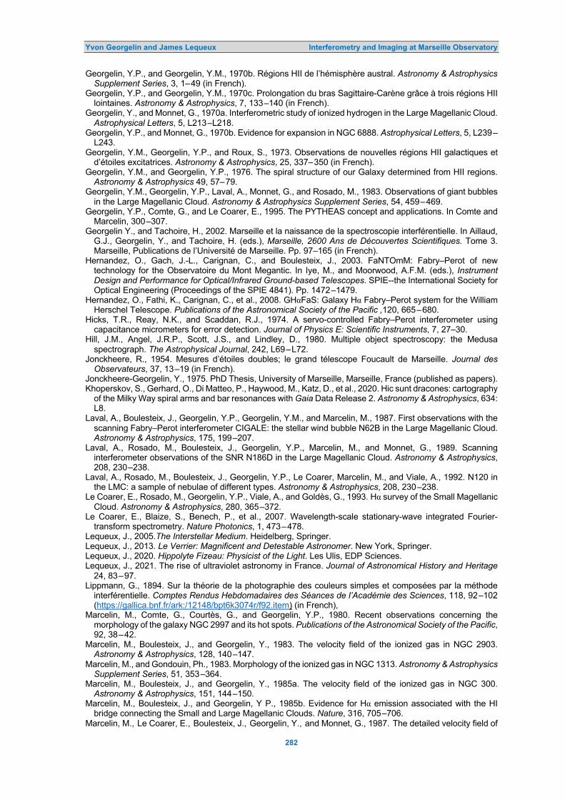
Yvon Georgelin and James Lequeux Interferometry and Imaging at Marseille Observatory
282
Georgelin, Y.P., and Georgelin, Y.M., 1970b. Régions HII de l’hémisphère austral. Astronomy & Astrophysics Supplement Series, 3, 1–49 (in French).
Georgelin, Y.P., and Georgelin, Y.M., 1970c. Prolongation du bras Sagittaire-Carène grâce à trois régions HII lointaines. Astronomy & Astrophysics, 7, 133–140 (in French).
Georgelin, Y., and Monnet, G., 1970a. Interferometric study of ionized hydrogen in the Large Magellanic Cloud. Astrophysical Letters, 5, L213–L218.
Georgelin, Y.P., and Monnet, G., 1970b. Evidence for expansion in NGC 6888. Astrophysical Letters, 5, L239–L243.
Georgelin, Y.M., Georgelin, Y.P., and Roux, S., 1973. Observations de nouvelles régions HII galactiques et d’étoiles excitatrices. Astronomy & Astrophysics, 25, 337–350 (in French).
Georgelin, Y.M., and Georgelin, Y.P., 1976. The spiral structure of our Galaxy determined from HII regions. Astronomy & Astrophysics 49, 57–79.
Georgelin, Y.M., Georgelin, Y.P., Laval, A., Monnet, G., and Rosado, M., 1983. Observations of giant bubbles in the Large Magellanic Cloud. Astronomy & Astrophysics Supplement Series, 54, 459–469.
Georgelin, Y.P., Comte, G., and Le Coarer, E., 1995. The PYTHEAS concept and applications. In Comte and Marcelin, 300–307.
Georgelin Y., and Tachoire, H., 2002. Marseille et la naissance de la spectroscopie interférentielle. In Aillaud, G.J., Georgelin, Y., and Tachoire, H. (eds.), Marseille, 2600 Ans de Découvertes Scientifiques. Tome 3. Marseille, Publications de l’Université de Marseille. Pp. 97–165 (in French).
Hernandez, O., Gach, J.-L., Carignan, C., and Boulesteix, J., 2003. FaNTOmM: Fabry–Perot of new technology for the Observatoire du Mont Megantic. In Iye, M., and Moorwood, A.F.M. (eds.), Instrument Design and Performance for Optical/Infrared Ground-based Telescopes. SPIE--the International Society for Optical Engineering (Proceedings of the SPIE 4841). Pp. 1472–1479.
Hernandez, O., Fathi, K., Carignan, C., et al., 2008. GHαFaS: Galaxy Hα Fabry–Perot system for the William Herschel Telescope. Publications of the Astronomical Society of the Pacific ,120, 665–680.
Hicks, T.R., Reay, N.K., and Scaddan, R.J., 1974. A servo-controlled Fabry–Perot interferometer using capacitance micrometers for error detection. Journal of Physics E: Scientific Instruments, 7, 27–30.
Hill, J.M., Angel, J.R.P., Scott, J.S., and Lindley, D., 1980. Multiple object spectroscopy: the Medusa spectrograph. The Astrophysical Journal, 242, L69–L72.
Jonckheere, R., 1954. Mesures d’étoiles doubles; le grand télescope Foucault de Marseille. Journal des Observateurs, 37, 13–19 (in French).
Jonckheere-Georgelin, Y., 1975. PhD Thesis, University of Marseille, Marseille, France (published as papers). Khoperskov, S., Gerhard, O., Di Matteo, P., Haywood, M., Katz, D., et al., 2020. Hic sunt dracones: cartography
of the Milky Way spiral arms and bar resonances with Gaia Data Release 2. Astronomy & Astrophysics, 634: L8.
Laval, A., Boulesteix, J., Georgelin, Y.P., Georgelin, Y.M., and Marcelin, M., 1987. First observations with the scanning Fabry–Perot interferometer CIGALE: the stellar wind bubble N62B in the Large Magellanic Cloud. Astronomy & Astrophysics, 175, 199–207.
Laval, A., Rosado, M., Boulesteix, J., Georgelin, Y.P., Marcelin, M., and Monnet, G., 1989. Scanning interferometer observations of the SNR N186D in the Large Magellanic Cloud. Astronomy & Astrophysics, 208, 230–238.
Laval, A., Rosado, M., Boulesteix, J., Georgelin, Y.P., Le Coarer, Marcelin, M., and Viale, A., 1992. N120 in the LMC: a sample of nebulae of different types. Astronomy & Astrophysics, 208, 230–238.
Le Coarer, E., Rosado, M., Georgelin, Y.P., Viale, A., and Goldès, G., 1993. Hα survey of the Small Magellanic Cloud. Astronomy & Astrophysics, 280, 365–372.
Le Coarer, E., Blaize, S., Benech, P., et al., 2007. Wavelength-scale stationary-wave integrated Fourier-transform spectrometry. Nature Photonics, 1, 473–478.
Lequeux, J., 2005.The Interstellar Medium. Heidelberg, Springer. Lequeux, J., 2013. Le Verrier: Magnificent and Detestable Astronomer. New York, Springer. Lequeux, J., 2020. Hippolyte Fizeau: Physicist of the Light. Les Ulis, EDP Sciences. Lequeux, J., 2021. The rise of ultraviolet astronomy in France. Journal of Astronomical History and Heritage
24, 83–97. Lippmann, G., 1894. Sur la théorie de la photographie des couleurs simples et composées par la méthode
interférentielle. Comptes Rendus Hebdomadaires des Séances de l’Académie des Sciences, 118, 92–102 (https://gallica.bnf.fr/ark:/12148/bpt6k3074r/f92.item) (in French),
Marcelin, M., Comte, G., Courtès, G., and Georgelin, Y.P., 1980. Recent observations concerning the morphology of the galaxy NGC 2997 and its hot spots. Publications of the Astronomical Society of the Pacific, 92, 38–42.
Marcelin, M., Boulesteix, J., and Georgelin, Y., 1983. The velocity field of the ionized gas in NGC 2903. Astronomy & Astrophysics, 128, 140–147.
Marcelin, M., and Gondouin, Ph., 1983. Morphology of the ionized gas in NGC 1313. Astronomy & Astrophysics Supplement Series, 51, 353–364.
Marcelin, M., Boulesteix, J., and Georgelin, Y., 1985a. The velocity field of the ionized gas in NGC 300. Astronomy & Astrophysics, 151, 144–150.
Marcelin, M., Boulesteix, J., and Georgelin, Y P., 1985b. Evidence for Hα emission associated with the HI bridge connecting the Small and Large Magellanic Clouds. Nature, 316, 705–706.
Marcelin, M., Le Coarer, E., Boulesteix, J., Georgelin, Y., and Monnet, G., 1987. The detailed velocity field of

Yvon Georgelin and James Lequeux Interferometry and Imaging at Marseille Observatory
283
the ionized gas in the interacting pair of galaxies NGC 7752-53. Astronomy & Astrophysics, 179, 101–107. Marcelin, M., Véron-Cetty, M.P., Woltjer, L., Boulesteix, J., d’Odorico, S., and Le Coarer, E., 1990. Kinematics
of the jet of the Crab Nebula. Astronomy & Astrophysics, 228, 471–476. Mendes de Oliveira, C., Taylor, K., Quint, B. et al., 2013. The Brazilian Tunable Filter Imager for the SOAR
Telescope. Publications of the Astronomical Society of the Pacific, 125, 396–408. Miller, P.N., 2000. Peiresc's Europe: Learning and Virtue in the Seventeenth Century. New Haven, Yale
University Press. Monnet, G., 1971. Evidence for a new class of very extended HII regions in the disks of Sc galaxies. Astronomy
& Astrophysics, 12, 379–387. Oort, J.H., Kerr, F.J., and Westerhout, G., 1958. The Galactic System as a spiral nebula. Monthly Notices of
the Royal Astronomical Society, 118, 379–389. Pérot, A., and Fabry, C., 1899. On the application of interference phenomena to the solution of various
problems of spectroscopy and metrology. The Astrophysical Journal, 9, 87–115. French version in Bulletin Astronomique, 16, 5–32.
Pérot, A., and Fabry, C., 1902. A reply to the recent article by Louis Bell. The Astrophysical Journal, 16, 36–37.
Pérot, A., and Fabry, C., 1904. Rapport sur la nécessité d’établir un nouveau système de longueurs d’onde étalons. The Astrophysical Journal, 20, 318–326 (in French).
Pérot, A., 1920. Comparaison des longueurs d’onde d’une raie de bande du cyanogène dans la lumière du Soleil et dans celle d’une source terrestre. Comptes Rendus Hebdomadaires des Séances de l’Académie des Sciences, 171, 229–232 (https://gallica.bnf.fr/ark:/12148/bpt6k3124m/f229.item) (in French).
Pérot, A., 1921. Mesure de la pression de l’atmosphère solaire dans la couche du magnésium et verification du principe de relativité. Comptes Rendus Hebdomadaires des Séances de l’Académie des Sciences, 172, 578–581 (https://gallica.bnf.fr/ark:/12148/bpt6k6237812n/f22.item) (in French).
Petit, H., Sivan, J.-P., and Karachentsev, I.D., 1988. Optical HII regions in M 81. Astronomy & Astrophysics, Supplement Series 74, 475–484.
Plana, H., Mendès de Oliveira, C., Amram, P., Bolte, M., Balkowski, C., and Boulesteix, J., 1999, Detection and velocities of Hα emission regions in Stephan’s Quintet. The Astrophysical Journal, 516, L69–L72.
Reid, M.J., Menten, K.M., Brunthaler, A. et al., 2014. Trigonometric parallaxes of high mass star forming regions: the structure and kinematics of the Milky Way. The Astrophysical Journal, 783, 130 (14 pages).
Rosado, M., Georgelin, Y.P., Georgelin, Y.M., Laval, A., and Monnet, G.,1981. Kinematics of ring-shaped nebulae in the LMC. I – The radial velocity field of N 70. Astronomy & Astrophysics, 97, 342–346.
Rosado, M., Georgelin, Y.M., Georgelin, Y.P., Laval, A., and Monnet, G.,1982. Kinematics of ring-shaped nebulae in the LMC. II – The radial velocity field of N 185. Astronomy & Astrophysics, 115, 61–64.
Rosado, M., 1986. An empirical study of ring-shaped nebulae in the LMC. Astronomy & Astrophysics, 160, 211–228.
Rosado, M., Laval, A., Boulesteix, J., Georgelin, Y.P., Greve, A, Marcelin, M., Le Coarer, E., and Viale, A., 1990. Scanning interferometer observations of the shell N 186E in the Large Magellanic Cloud. Astronomy & Astrophysics, 268, 315–324.
Rosado, M., Laval, A., Le Coarer, E., Boulesteix, J., Georgelin, Y.P., and Marcelin, M., 1993. The supernova remnant N 120 in the Large Magellanic Cloud. Astronomy & Astrophysics, 272, 541–548.
Rosado, M., Langarica, R., Bernal, A., Cobos, F., Garfias, F., Gutiérrez, L., Tejada, C., and Ticono, 1995. The UNAM scanning Fabry–Pérot interferometer (PUMA) for the study of the interstellar medium. Revista Méxicana de Astronomía y Astrofísica (Series de Conferencias), 3, 263–266.
Russeil, D., 2003. Star-forming complexes and the spiral structure of our Galaxy. Astronomy & Astrophysics, 397, 133–146.
Russeil, D., Georgelin, Y.M., Georgelin, Y.P., Le Coarer, E. and Marcelin, M., 1995. Galactic HII regions at l = 234. Astronomy & Astrophysics Supplement Series, 114, 557–664.
Russeil, D., Adami, C., Amram, P., Le Coarer, E., Georgelin, Y.M., Marcelin, M., and Parker, Q., 2005. A deep Hα survey of the Milky Way. VI. The l = 332° area. Astronomy & Astrophysics, 429, 497–507.
Schmidt, M., 1965. Rotation parameters and distribution of mass in the Galaxy. In Blaauw, A., and Schmidt, M. (eds.), Galactic Structure. Chicago, University of Chicago Press. Pp. 513–530.
Sivan, J.-P., 1974. A new look at the interstellar hydrogen through a very-wide-field photographic Hα survey of the whole Milky Way. Astronomy & Astrophysics Supplement Series, 16, 163–172.
Sivan, J.-P., Petit, H., Comte, G., and Maucherat, A.J., 1990. Optical HII regions in NGC 2403. Astronomy & Astrophysics, 237, 23–35.
Soucail, G., Mellier, Y., Fort, B., Picat, J.P., and Cailloux, M., 1987. Data reduction and spectrophotometric performances of PUMA 1: an on-line multiaperture spectroscopic system used at the CFHT. Astronomy & Astrophysics, 184, 361–372.
Stéphan, E., 1874. Sur l’extrême petitesse du diamètre apparent des étoiles fixes. Comptes Rendus Hebdomadaires des Séances de l’Académie des Sciences, 76, 1008–1012 (https://gallica.bnf.fr/ark:/12148/bpt6k3035z/f870.item) (in French).
Stéphan, E., 1884. Notes sur les nébuleuses découvertes à l’observatoire de Marseille. Bulletin Astronomique, 1, 286–290 (in French).
Strömgren, B., 1939. The physical state of interstellar hydrogen. The Astrophysical Journal, 89, 526–547. Strömgren, B., 1948. On the density distribution and chemical composition of the interstellar gas. The
Astrophysical Journal, 108, 242–275.

Yvon Georgelin and James Lequeux Interferometry and Imaging at Marseille Observatory
284
Struve, O., 1951a. Glowing hydrogen in the Milky Way. Sky & Telescope, 10, 58 (not digitized). Struve, O., 1951b. Photography of the counterglow. Sky & Telescope, 10, 215–218 (not digitized). Struve, O., 1955. Motions in gaseous nebulae. Sky & Telescope, 14, 93–95 (not digitized). Taylor, K., and Atherton, P.D., 1980. Seeing-limited radial velocity field mapping of extended emission line
sources using a new imaging Fabry–Pérot system. Monthly Notices of the Royal Astronomical Society, 191, 675–684.
Tobin, W., 2003. The Life and Science of Léon Foucault. Cambridge, Cambridge University Press. Tolbert, J.T., 1999. Fabri de Peisesc’s quest for a method to calculate terrestrial longitude. Historian, 61, 801–
820. Tully, B., 1974. The kinematics and dynamics of M 51. The Astrophysical Journal Supplement, 27, 415–435. Wilson, T.L., Mezger, P.G., Gardner, F.F., and Milne, D.K., 1970. A survey of H 109α recombination line
emission in Galactic HII regions of the southern sky. Astronomy & Astrophysics, 6, 364–384.
Dr James Lequeux, born in 1934, started a second career in the history of science when he retired in 1999. Before that, he was an astronomer at Paris Observatory, specializing in interstellar matter and the evolution of galaxies. He was Director of Marseille Observatory from 1983 to 1988 and knew well most of the scientists cited in this paper.
For 15 years James was one of the two Editors-in-Chief of the European journal Astronomy & Astrophysics. Currently, he is an Associate Editor of the Journal of Astronomical History and Heritage (JAHH).
He has published several textbooks and many books on the history of physics and astronomy, and has written nine papers for the JAHH
Dr Yvon Georgelin, born in 1941, began his career as an astronomer-observer in 1963 in the team of Georges Courtès by studying the galactic HII regions and the MagelIanic Clouds. He followed Courtès in his innovative and often highly criticized projects of multi-object and integral field Pérot–Fabry spectrography with Stanhope lenses.
He was Director of Marseille Observatory from 1976 to 1982, and a member of the instrument commission of the 3.6-m Canada-France-Hawaii Telescope. He continued to develop interferential techniques and to observe, particularly in the Southern Hemisphere.
The third part of his career was devoted to conferences, articles, and sites—such as astronomie.regards.free.fr—on astronomical discoveries from Chaldean and Greek
antiquity to the present day, which he tried to embellish with cultural elements.
Journal of Astronomical History and Heritage, 24(12), 285–314 (2021).
285
TIME SIGNALS FOR MARINERS IN SOUTH AFRICA
Roger Kinns Glenavon, Back Road, Clynder, Helensburgh G84 0QQ,
Scotland, United Kingdom. E-mail: [email protected]
Abstract: The aim of this paper is to establish the nature of visual time signals for mariners that used to exist in South Africa. It builds on earlier research concerning the Royal Observatory at the Cape of Good Hope, using Admiralty lists of time signals, notices to mariners and other sources to show how they evolved. South Africa used an extraordinary range of time signals, including the first shuttered lamp in 1823, one of the earliest time balls and a wide range of subsequent time ball types. Various contradictions between different records have been found and resolved as far as possible.
Initial ideas for precise chronometer calibration signals have been attributed to Robert Wauchope during his naval service at the Cape of Good Hope from 1818. The 1836 time ball at the Cape Observatory was constructed locally and supplemented by a manually-operated repeater ball at Lion’s Rump in 1853. The Observatory ball was replaced in 1863 using an apparatus supplied from London. The Observatory time balls were not included in Admiralty lists from 1880 onwards. A time ball at Simon’s Bay was added in 1857, later replaced by a disc and then by another time ball in 1898. Additional time signals were provided at Alfred Docks, Port Elizabeth, Port Alfred and East London. All were ultimately controlled by electric telegraph from the Cape Observatory. The first 1870s time ball at the Docks was replaced in 1894 and had increased elevation after 1904. A time ball at Durban in Natal was established in 1883 and relocated in 1904. The last time ball service in South Africa was withdrawn in 1934 when wireless and telegraph signals had become almost universally available. The Docks time ball was restored in 1997.
Keywords: Time balls, time guns, time discs, South Africa 1 INTRODUCTION
Accurate determination of longitude is essential to navigation and was one of the great technical challenges that had to be met when ships ventured into open oceans. Its solution using either the method of lunar distances or marine chronometers to determine time at a prime meridian, has been well-described by Howse (1997) and other authors. The method of lunar distances required accurate predictions of the position of the Moon relative to the stellar back-ground for inclusion in nautical almanacs, as well as development of precision instruments that included the sextant. Easily taken for grant-ed by nineteenth century navigators, the meth-od had been developed over centuries, with contributions from gifted astronomers and en-gineers in many different countries to take it from an astronomical concept to a precision technique (de Grijs, 2020).
Although marine chronometers were much more accurate than ordinary clocks and watches, there could be significant cumulative errors after a long period at sea. Regular mea-surements using a sextant and the method of lunar distances were made to check chrono-meters: a chronometer rate could vary mark-edly from that determined by its manufacturer, while the accuracy and reduction of astronom-ical measurements depended on conditions at sea and the skill of the navigator. Land-based signals, with known geographical co-ordinates and measurements of time using star transits, provided a more rigorous test.
1.1 Time Signals in Harbour
Land-based signals took many different forms, including discs, guns, flags and lights, but the option preferred by the British Admiralty was a time ball, dropped at a prominent position at the same time each day within sight of ships in harbour. It had been invented by Robert Wau-chope (1788–1862), a distinguished Royal Navy officer, with a first trial implementation at Ports-mouth, England in 1829, followed by the public time ball at Greenwich in 1833 (Bartky and Dick, 1981). The ball would be raised to cross-trees at a stated time before the signal, so that an observer would know that a signal was im-minent. The time to be recorded was the mo-ment a gap first appeared between the top of the ball and the cross-trees, as the ball was released by triggers to descend in initial free fall.
A dissimilar arrangement in Mauritius (Lloyd, 1833; Herschel, 1836) predated Green-wich by six months. In that arrangement, a black ball was hidden behind a shutter in an observatory tower, painted white. A flag was hoisted one hour before the time signal and the shutter was raised to show the ball in a white-painted room. This was the first preparatory signal. The flag was lowered as the second preparatory signal, five minutes before the shut-ter was dropped. The moment of ball disap-pearance was the exact time signal. Apart from Greenwich and Mauritius, only two other time balls are known to have preceded the first installation at the Cape of Good Hope. These

Roger Kinns Time Signals for Mariners in South Africa
286
were at St. Helena in 1834 (Bartky and Dick, 1981; Kinns, 2021b) and at Calcutta in 1835 (Kinns, 2020c; Phillimore, 1958: 114). Another early time ball in Africa was established in 1839 at the Cape Coast Castle on the Gold Coast, now Ghana (Kinns, 2021b; Maclean, 1840).
To be of value to navigators, the time had to be precise and the signal had to be repeated at regular intervals. Then, the rate at which a chronometer was gaining or losing time, as well as the absolute error on a particular day, could be determined. That calibration would be re-peated at other ports. Any adjustment was de-ferred until return to a chronometer maker. It was only in the 1930s that radio time sig- nals and radio receivers were sufficiently widely available to make most time balls and other visual signals redundant. 1.1.1 The Prime Meridian and Time Zones
Greenwich had been used as the zero longitude origin, or prime meridian, in the British Nautical Almanac since the eighteenth century. Other prime meridians had been used by different countries. Following the International Meridian Conference in Washington, USA in October 1884, Greenwich would become the prime mer-idian for the whole world (Howse, 1997: 145). This was a politically sensitive issue for many countries, notably France, but there was no denying the advantage to mariners in having all marine charts based on the same prime meridian. It took a long time for all countries to discard previously favoured prime meridians (Howse, 1997: 150).
The time-zone system recognised that ideally local mean time should be within about 30 minutes of standard mean time within a time zone, so the Earth was split into time zones at 15o intervals of longitude, each covering a one-hour range of local mean time. That was mod-ified by the positions of coastlines and of bound-aries between different countries, and by politi-cal considerations. Time zones were subject to modification. In South Africa, for example, the reference meridian was changed in 1903 from 22.5° E to 30° E of Greenwich. They are still subject to change. 1.1.2 Greenwich Civil Time
Before 1925, Greenwich mean time for astro-nomical purposes, with zero hours at noon, was 12 hours different from the time used by the population at large. Confusingly, both were cal-led Greenwich Mean Time (GMT) and they were often muddled. The decision was then made to introduce the term ‘Greenwich Civil Time’, with zero hours at midnight, and to use this for astronomical as well as domestic pur-
poses (Howse, 1997: 151). This change is re-flected in international lists of time signals that were issued during the 1920s. 1.2 Geographical Scope
The present study covers what is now the Re-public of South Africa. It is dominated by the development of time signals at the Cape of Good Hope, starting with a time gun by 1807, a shuttered lamp in about 1823 and an array of time balls and time discs around the southern coast from Cape Town to Durban that lasted until the 1930s. The Cape Observatory offered one of the first ever time ball services from 1836.
Mauritius in the Indian Ocean and St. Helena in the South Atlantic had important early time balls because of their locations on the trade routes for sailing ships. Their port fac-ilities declined in commercial importance after the introduction of steam ships and the opening of the Suez Canal in November 1869 but con-tinued to be important strategically. The Maur-itius and St Helena time balls have been des-cribed in three recent papers (Kinns, 2020a; 2020b; 2021b). There were many other time signals in mainland Africa but they were sparse-ly distributed in relation to South Africa. 2 ADMIRALTY LISTS OF TIME SIGNALS
The British Admiralty published lists of time signals for mariners at regular intervals. The first edition was “Prepared from official sources to December 1880.”, so was applicable in 1881. The list dated 1898 was “Prepared from official sources to 31st December 1897.” This had become the usual practice, but there was some variation of the closure date between editions. It was usual to include details of preparatory signals and the procedures adopted in case of a signal failure. These preparatory signals in-cluded the raising of the ball, first to half height and then to full height, at specified intervals before the drop. The style of presentation var-ied between editions, but similar levels of detail were retained. In order to expose changes be-tween successive editions, the data from suc-cessive editions have been restructured for each location that had time signals, while re-taining the key elements concerning location, signal type, timing and reliability.
The Admiralty lists provide a remarkable record of the changes that occurred at part-icular locations after 1880, but there is always a need to check the accuracy of entries against local announcements that may have been mis-sed. Various errors have become obvious during the present work. Earlier records are us-ed to define signal introductions from the 1830s

Roger Kinns Time Signals for Mariners in South Africa
287
onwards. Entries from lists for 1880, 1898, 1904, 1908, 1911, 1922 and 1930 are used in this paper, supplemented by lists issued in the United States and notices to mariners. Admir-alty lists for 1922 and 1930 were subdivided into parts that covered specific geographical reg-ions. 2.1 Accuracy of Time Signals
Comments about the accuracy and reliability of time signals were often derived from reports by visiting ships. They were usually qualitative and served as a guide to subsequent visitors. Ideal-ly, signals should be accurate to better than ±1 second. One second of time corresponds to a longitude error of 15 arc-seconds, or about 0.46 km at the equator. A more demanding require-ment was to allow determination of the chrono-meter rate from measurements on successive days. Chronometer rates were often several seconds per day and varied according to en-vironmental conditions. They depended on the
quality of chronometer design and manufact-ure. Determination of the rate to an accuracy of ±1 second per day would usually be sufficient. The best-equipped observatories, such as those at Greenwich, Edinburgh and the Cape, aimed for an accuracy of ±0.2 seconds in daily signals. Measurements over 5 days would then give a rate accuracy of better than ±0.1 seconds per day. 2.2 The 1880 Admiralty List for Africa
All the 1880 list entries for Africa, apart from Mauritius and St Helena, are transcribed in Table 1. The types of signalling devices includ-ed time balls, discs and a time gun. All the entries in Table 1 are in South Africa.
There is an anomaly in the ‘local’ time specified for the Table Bay time ball (highlight-ed in red): it did not correspond to the stated longitude for the specified GMT. The Table Bay ball was 33 arc-seconds West of the Simon’s Bay disc so local astronomical time was 2.2 sec-
Table 1: 1880 Admiralty list of time signals in Africa, excluding Mauritius and St. Helena.
Latitude &
Longitude Place Signal
Adopted
Location of
Time Signal
Time of Signal Being Made Additional Details GMT
h. m. s. Local Time h. m. s.
British Possessions – Cape of Good Hope Colony 33° 54′ 27′′ S. 18° 25′ 15′′ E.
Table Bay
Ball
also
Gun
At Alfred Docks.
47 feet above high water
36 feet above ground.
(Drop 6 feet.)
On Imhoff Battery.
22 46 5
23 46 5
00 00 00
01 00 00
Ball dropped (by electricity from the Cape Observatory) at noon Cape mean time. Gun fired (by electricity from the Cape Observatory) at 1h 0m p.m. Cape mean time.
34° 11′ 30′′ S. 18° 25′ 48′′ E.
Simons Bay
Circular disc
Mast close to Simons Town
Telegraph Office.
63 feet above high water
40 feet above ground.
(Drop 6 feet.)
23 46 5 0 59 48.2 Disc raised to a right angle with mast at 5 minutes be-fore signal. Disc falls (by electricity from the Cape Observatory) at moment of 1h 0m Cape mean time. When signal fails in accu-racy, the disc is kept up till 2 o'clock, then lowered.
33° 57′ 43′′ S. 25° 37′ 21′′ E.
Port Elizabeth
Black disc
At the Lighthouse.
220 feet above
high water 43 feet above
ground. (Drop 5 feet.)
23 46 5 1 28 34.4. Disc dropped (by electricity from the Cape Observatory) at moment of 1h 0m p.m. Cape Colony mean time. When signal fails in accu-racy, a chequered red and blue flag will be shown from the lighthouse, and ball dropped 5 minutes later, or at 1h 5m p.m. Cape mean time.
33° 36′ 10′′ S. 26° 54′ 10′′ E.
Port Alfred Ball
54 feet above high water.
26 feet above ground.
(Drop 18 feet.)
23 46 5 1 33 41.6 Ball dropped (by electricity from the Cape Observatory) at 1h 0m p.m. Cape mean time.

Roger Kinns Time Signals for Mariners in South Africa
288
Figure 1: Time signal locations in 1880 (map modifications: Roger Kinns). onds later: it was shown in the 1880 list as being 11.8 seconds earlier. This difference of 14 sec-onds results from the difference between Cape time and local astronomical time at the Table Bay signal location. Cape time corresponded to the longitude of the Observatory (Maclear, 1853). The time gun on the Imhoff Battery at Table Bay was fired one hour after the time ball was dropped: the longitude of the Observatory, rather than the unstated longitude of the gun, determined the time of firing. The local times at Simon’s Bay, Port Elizabeth and Port Alfred corresponded to their stated longitudes East of Greenwich.
Lists of this type were expanded and modi-fied over the years: time signals were introduc-ed in different ports; there were changes in the location, type and timing of signals, and oc-casional corrections to latitude and longitude. In later editions, there was sometimes a state-ment of the dates when the signal was estab-lished and when it was last modified.
The locations of the time signals listed in 1880 are shown in Figure 1. The Port Elizabeth disc may actually have been a ball at the end of a lever arm (see later). 3 SOUTH AFRICA
There has been extensive previous research into the development of time signals in South Africa, especially those controlled by the Cape Observatory. The aim of this section is to est-ablish the accuracy of information provided to
navigators in international lists of signals and to identify the types of apparatus used in South Africa. Apparent contradictions between differ-ent sources have been resolved as far as pos-sible.
Figure 2 shows the eventual locations of time signals in South Africa from Cape Town to Durban. This extends the 1880 list to include later time signals. They were established and withdrawn at different times. 3.1 Development of Time Signals Under Cape Observatory Control
Table 2 showing time signal development is derived from a summary by Evans (1993), with references to research by Harding (1971), Warner (1979) and Bisset (1984). The paper by Harding has not been found, but the entries have been checked using other sources. Evans referred to reports by H.M. Astronomer at the Cape of Good Hope, which are shown in the table as reports of HMA with the year to which they refer. There are a few references to time signals at the Royal Observatory in Monthly No-tices of the Royal Astronomical Society. These are included separately in the main reference list at the end of this paper. Additional refer-ences are cited in the form used by Evans. Insertions in italics within square brackets are for clarification.
Developments after 1934 are not shown in Table 2. By that time, time balls and time discs had been withdrawn. Subsequent transmiss-

Roger Kinns Time Signals for Mariners in South Africa
289
Figure 2: Locations of time signals in South Africa (map modifications: Roger Kinns). Ions of time were by electric telegraph and wireless; only the gun remained to reflect earlier history. Some earlier entries that are not directly related to time signals for mariners have been excluded, but entries are otherwise those by Evans with minor adjustments.
There are mentions of return signals in 1873 and 1895. These indicated that the tele-graph signal had released the time ball satis-factorily. The time ball at Deal on the south coast of Kent in England had been released by telegraph from Greenwich with a return signal to confirm the drop from 1 January 1855 (Howse, 1997: 102). Deal is about 100 km from Greenwich. 3.2 Noon Gun in Cape Town
By 1807 a noon gun was fired from the Imhoff Battery on the seaward side of the Castle in
Cape Town. It was one of the means by which ships in Table Bay “… could determine the error and rate of their chronometers.” (Warner, 1979: 47). Ideally, the flash of the gun or the puff of smoke would have been noted as the time signal: the delay in sound propagation to ships in Table Bay varied with atmospheric conditions and ship location. The accuracy of the gun signal is likely to have been modest in its early years of operation, as it was not controlled from an astronomical observatory. It would have had high precision from 1864 onwards, when it was fired electrically from the Observatory.
The history of time guns in Cape Town was explored by Bisset (1984), using Army records. There were various changes to the location and time of the gun signal during the nineteenth and twentieth centuries which have been summar-ised by Evans (1993).
Table 2: Development of Time Signals controlled by the Cape Observatory (after Evans, 1993).
Date Event Reference
1807 Noon Gun fired from Imhoff Battery, Cape Town Castle. Used to rate ships chronometers. Bisset, 1984.
1821
Instruments for time determination erected at the Observatory. [A temporary hut was used to house portable instruments that included a transit telescope. This allowed astronomical observations prior to erection of permanent observatory buildings. The new Observatory was operational in 1829.]
Harding, 1971
4 Jan. 1833 Flash pistol and powder magazine purchased for visually signalling time. Harding, 1971 30 Sep. 1836 Time ball erected to SE of the Observatory Warner, 1979
Oct. 1853 Observatory time ball not visible from whole of Table Bay. Repeating time ball on Lion’s Rump Warner, 1979
1857 Time ball in Simons Town. A portable transit instrument determined the time at which to drop the time ball. Warner, 1979
21 May 1860 Observatory time ball hidden by trees, re-located N. Warner, 1979

Roger Kinns Time Signals for Mariners in South Africa
290
Sep. 1861 Electric release of three time balls from Observatory. Warner, 1979 Jun. 1863 Observatory time ball once again moved. Warner, 1979 1864 Gun fired electrically from Royal Observatory. Bisset, 1984
1873 Return signal from Port Elizabeth time ball 0.3 to 0.6 sec after trigger signal sent. [The return telegraph signal indicated that the ball had actually been released.]
Royal Observatory, 1873
1877 Time distribution by telegraph.
Royal Observatory, 1877
1878 Noon ball dropped at docks for shipping. 13:00:00: Time balls dropped at: - Observatory, Simons Town, Port Elizabeth, Kimberley.
Royal Observatory, 1878
21 Jul. 1889
Electric time signals: Noon signal drops time ball at docks. 13:00:00: Time ball dropped at Simon's Bay; time ball dropped at Port Elizabeth; time ball dropped at East London; Gun fired at Imhoff battery. Government telegraphic system distributed a time signal for use in the Cape colony, Orange Free State and Transvaal.
Report of H.M. Astronomer at the Cape of Good Hope for the period 26 May 1879 to 21 July 1889
7 Feb. 1892
Arrangements made for changing civil time of colony. Previously Observatory mean time was used for telegraphic purposes throughout the colony and different railway systems used local time of their main station. At junction of E and W railway systems it was decided to adopt 22.5 degrees E as longitude for all time purposes. This worked so well that that the uniform time of the Cape Colony was adopted by both the Transvaal and the Orange Free State.
Report of HMA, 1889 to 1892
8 Feb. 1892 Time signals at Observatory mean time noon and 1pm discontinued in favour of a single signal at Greenwich mean noon which corresponds to 13 30 00 of Uniform South African time.
1893
Daily signals from Observatory at GMT noon: 1. Disc dropped at Simon's Bay for shipping. 2. Gun fired at Imhoff Battery for shipping and town. 3. Time ball dropped at docks in Cape Town. 4. Disc dropped at Lighthouse in Port Elizabeth. 5. Ball dropped at East London. 6. Ball dropped at Port Alfred. 7. Signal to all telegraph offices in Cape, Orange Free State and Transvaal.
A clock in the Harbour Tower at the Cape Town docks is electrically controlled from the observatory.
Report of HMA, 1893
1894 Daily signals from the Observatory at GMT noon: - Same as 1893. New time ball erected in a conspicuous position near Resident Engineer’s Office of the Cape Town Docks.
Report of HMA, 1894
1895 Daily signals from the Observatory at GMT noon: - Same as 1894.
Report of HMA, 1895 20 Mar. 1895
Two return signals from Cape Town time ball 1. at the instant the ball begins to fall 2. at the bottom of its drop.
[The return telegraph signals indicated that the ball had been released and arrived at its rest position.]
1896 Daily signals from the Observatory at GMT noon: - Same as 1895. Simon’s Bay disc failed often from old age. Report of HMA, 1896
1897 Daily signals from the Observatory at GMT noon: - Same as 1896. Simon’s Bay disc dropped up to 11 Dec 1897 Report of HMA, 1897
1 Jan. 1898 Simon’s Bay disc being replaced by time-ball. 2 Feb. 1898 to 9 Feb. 1898 Cape Town gun under repair.
Report of HMA, 1898 14 Apr. 1898 Simon’s Bay time-ball operational.
1898 Daily signals from the Observatory at GMT noon: - Same as 1897 except for the Port Alfred ball which was discontinued. Telegraphic signals also go to Rhodesia [now Zimbabwe].
18 Dec. 1900 Cape Town time-ball position: - 74.83 ft above l.w.o.s.t. 30 ft above ground level (ball drops 10 ft) Latitude 33° 54′ 24′′ S. Longitude 18° 25′ 10.4′′ E
SAAO Archives No A0035: Chronometers and Time Signals 1900-1906.
1901 Daily signals from the Observatory at GMT noon: - Same as 1898. Failures at Port Elizabeth and East London partly due to interruption of the lines by the Boers. Report of HMA, 1901
1 Nov. 1901 Hourly signal sent to Wynberg station - set clocks every hour. 1902 Daily signals from the Observatory at GMT noon: - Same as 1901. Report of HMA, 1902 4 Aug. 1902 Noon gun to Lion Battery on Signal Hill. Gun now fired from Signal Hill battery. 28 Feb. 1903 Midnight
The whole of South Africa adopts longitude 30 degrees E for time determination. That is 2 hrs ahead of Greenwich time.
Government Gazette, February 1903
1904 Second floor added to time-ball building. Government Gazette 27 August 1982
1914 Daily signals from the Observatory at 10 00 00 GMT: 1. Ball dropped at Simon's Bay for shipping. Report of HMA, 1914

Roger Kinns Time Signals for Mariners in South Africa
291
2. Gun fired from battery on Signal Hill. 3. Time ball dropped at docks in Cape Town. 4. Disc dropped at Lighthouse in Port Elizabeth. 5. Ball dropped at East London.
1 Sep.1914 Daily transmission of wireless time signal for shipping on Union Government wireless station at Slangkop.
6 Feb.1925 Broadcast of time but noon gun retained Bisset, 1984
1925
Daily signals from the Observatory at 10 00 00 GMT: 1. Ball dropped at Simonstown dockyard for shipping. 2. Gun fired from battery on Signal Hill. 3. Time ball dropped at docks in Cape Town. 4. Disc dropped at Lighthouse in Port Elizabeth. 5. Ball dropped at East London.
Time signal sent to telegraphic system and railway services. A clock in the Harbour Tower at the Cape Town docks is electrically controlled from the observatory. Daily transmission of wireless time signal for shipping on Union Government wireless station at Slangkop.
Report of HMA, 1925
6 Feb. 1925 Time signal from the Observatory consisting of 4 dashes, the commencement of the last being on the hour, was transmitted by Local Broadcasting Association 3 times per day.
1926
Daily signals from the Observatory at 10 00 00 GMT: 1. Ball dropped at Simonstown dockyard for shipping. 2. Gun fired from battery on Signal Hill. 3. Time ball dropped at docks in Cape Town. 4. Disc dropped at Lighthouse in Port Elizabeth. 5. Ball dropped at East London.
Time signal sent to telegraphic system and railway services. A clock in the Harbour Tower at the Cape Town docks is electrically controlled from the observatory. Daily transmission of wireless time signal for shipping on Union Government wireless station at Slangkop.
Report of HMA, 1926
1927 Daily signals from the Observatory at 10 00 00 GMT: - Same as 1926. Report of HMA, 1927 1928 Daily signals from the Observatory at 10 00 00 GMT: - Same as 1927.
Report of HMA, 1928
Aug. 1928 Automatic control of clock in Harbour Tower discontinued as Harbour Administration considered it unnecessary.
15 Sep. 1928
Belin apparatus to send international (ONOGO) time signals installed. Transmission from Slangkop once a day. Local Broadcasting Association transmits last group of ONOGO signal (6-pips) at 1500 and 1800 GMT. Beginning of 6th pip is on the hour.
1929 Daily signals from the Observatory at 10 00 00 GMT: - Same as 1928. Report of HMA, 1929 8 Feb. 1929 Simonstown time-ball dismantled. 30 Sep. 1930 Disc in Port Elizabeth dismantled. Report of HMA, 1930
1933
Daily signals from the Observatory at 10 00 00 GMT: 1. Gun fired from battery on Signal Hill. 2. Time ball dropped at docks in Cape Town.
Time signal sent to telegraphic system and railway services. Time signal also received at meteorological stations in Bulawayo and Salisbury. Daily transmission of wireless time signal for shipping on Union Government wireless station at Slangkop.
Report of HMA, 1933
31 Oct. 1933 6-pip signal transmitted by African Broadcasting Company changed from 1700 and 2000 SAST to 1300, 1700, 1800, 1900, 2000, 2100 SAST.
1934 Daily signals from the Observatory at 12 00 00 SAST: 1. Gun fired from battery on Signal Hill.
Report of HMA, 1934 1 Feb. 1934
Time ball at docks in Cape Town discontinued. Time signal sent to telegraphic system and railway services. Time signal also received at meteorological stations in Bulawayo and Salisbury. Daily transmission of wireless time signal for shipping on Union Government wireless station at Slangkop.
7 Sep. 1934 Removal of the time ball at the Docks. The ball was made in 1932 from thin steel plate.
The Cape Times, 7 September 1934
In February 1892, time signals at noon and
1 pm were discontinued in favour of a single signal at noon, Greenwich mean time. The gun was moved from the Imhoff Battery to the Lion Battery on Signal Hill in August 1902. From midnight on 28 February 1903, the whole of South Africa adopted a time zone based on longitude 30° E, two hours ahead of Greenwich.
The gun was then fired at noon, South African Standard Time. The gun signal “… was re-tained at the request of the Municipality of Cape Town.” after time balls and time discs had been withdrawn (Bisset, 1984: 67; Warner, 1979: 115).
The noon gun is still operating in 2021 and

Roger Kinns Time Signals for Mariners in South Africa
292
Figure 3: The Noon Gun being fired on Signal Hill in 1993 (photograph: Willie Koorts). is a popular tourist attraction. Figure 3 shows the gun being fired on 4 November 1993 for the first time after the circuits had been modern-ised. The gun had been fired automatically since 1864, but the Lion Battery site was not open to the public until 1997, Evans (1993) not-ed that the report of the gun on Signal Hill can be heard at the Observatory about 18.5 sec-onds after detonation.
The guns are 18-pounder muzzle loaders bearing the monogram of King George III, cast in the Bahamas (Bisset, 1984: 69). Several guns of this type have been used for signalling time and two were later operated in parallel, with one acting in reserve should the other fail to fire. 3.3 The First Directors of the Cape Observatory
In A History and Description of the Royal Ob-servatory, Cape of Good Hope, Gill (1913) gives biographies of the Directors who preceded him. The following short summaries are deriv-ed largely from that book. Sir David Gill (1843–1914) is highly regarded for his pioneering work in astronomy. He was Director of the Cape Ob-servatory from 1877 to 1906 and was knighted in 1900 (Obituary,1914). 3.3.1 Fearon Fallows (1820 to 1831)
The Reverend Fearon Fallows (1788–1831) was
appointed as the first Director of the Obser-vatory by the British Board of Longitude in October 1820. His year of birth had been given as 1789, but this was corrected after research by Warner (1997). He served at the Cape from August 1821 until his premature death in July 1831 but never received timely support from the Board or Admiralty for development of his staff and facilities. Conditions were primitive and undoubtedly contributed to his early death. His life and work have been described by Cameron-Swan (1931).
Soon after his arrival at the Cape
… whilst he hunted for a site in conformity with Admiralty requirements, Fallows ob-tained from the local Government a settler’s wooden hut, which he converted into a temporary observatory for his portable in-struments. (Cameron-Swan, 1931: 6).
The site for the new observatory was approved in July 1822, but he did not receive authority to implement his plans until December 1824. The Observatory buildings had been erected by the end of 1827 but the instruments were not fully operational until 1829.
3.3.2 Thomas Henderson (1831 to 1833)
Thomas Henderson (1798–1844) was appoint-ed to succeed Fallows in October 1831 and arrived at the Cape in April 1832. He resigned in May 1833, in protest at the conditions under which he had to operate. He returned to Edin-

Roger Kinns Time Signals for Mariners in South Africa
293
burgh, where he became the first Astronomer Royal for Scotland. . 3.3.3 Thomas Maclear (1833 to 1870)
Thomas Maclear (1794–1879) was appointed to succeed Henderson in July 1833 and arrived at the Cape in January 1834. Like Fallows and Henderson, he found that working conditions were primitive and he too suffered from lack of staff to support his work. During his long ten-ure, the Observatory was expanded with the erection of new buildings and additional instru-ments.
From 1834 to 1838 Maclear worked closely with Sir John Herschel at the Cape. Many of their exchanges are recorded in Herschel at the Cape (Evans et al., 1969), which contains Her-schel’s edited diaries and correspondence dur-ing an extraordinarily productive period. Cap-tain Robert Wauchope, RN, inventor of the time ball, visited Maclear and Herschel on several occasions. Herschel also corresponded with John Augustus Lloyd in Mauritius. A diary entry on 12 March 1835 (Evans, 1969: 151) “Packed up & sent in Captn Loyds (sic) papers.” is probably a reference to the paper about the first observatory in Mauritius that was communicat-ed to the Royal Astronomical Society by Her-schel and presented in April 1836 (Herschel, 1836). Charles Piazzi Smyth (1819–1900), lat-er to succeed Henderson as the second Ast-ronomer Royal for Scotland, became Maclear’s assistant in 1835 at the age of sixteen. Piazzi Smyth’s descriptions of the Edinburgh time ball arrangement were rooted in his experience at the Cape (Kinns, 2011).
To quote Gill: “In the days of Maclear, a time ball was erected near the Observatory which was dropped in lieu of the pistol signal.” (Gill, 1913: 143). This 1836 time ball was sup-plemented by a repeater ball on Lion’s Rump (now called Signal Hill) in October 1853, moved a short distance in May 1860 and replaced by a new apparatus in June 1863. Other signals were distributed around the coast of South Africa during Maclear’s tenure, with electrical control from the Cape Observatory. 3.4 The First Visual Signals at the Cape
The Nautical Magazine was first published in 1832. It used the longer title of The Nautical Magazine and Naval Chronicle between 1837 and 1870. It included various articles and not-ices about time signals for mariners from 1835 onwards. The following statement was written by the editor in 1835 as an introduction to the time ball service at St Helena that started in January 1834 (Editorial, 1835: 658). It provoked a reaction from Robert Wauchope that led to
acceptance of his claim to invention of the time ball (Wauchope, 1836).
The plan of communicating time by signal from observations, being coeval with the improvement of chronometers, is of recent date. The advantages of it are great to seamen, and it has been a matter of some surprise to us, that even within the few last years it has not been more generally adopt-ed. We remember it to have been employ-ed successfully by the Rev. Mr. Fallows, when he was astronomer at the Cape of Good Hope, about the year 1820. His plan was to eclipse a light at the moment of eight o’clock (mean time) by means of a shutter. The light was distinctly seen by the shipping in the roads, and the officers being on the look-out, were enabled to obtain a rate for the chronometers on board.
The article also mentioned rocket signals pro-posed by Captain Owen before going on to des-cribe the St Helena arrangement. Wauchope’s response did not contradict the statement about the shuttered lamp (Wauchope, 1836).
I had pointed out the advantages to be derived from the plan for communicating time by means of telegraphs so far back as 1818, in my remark-book transmitted to the Admiralty when in command of the Eury-dice, at that time on the Cape and St. Hel-ena station. Sir Jahl. Brenton was then nav-al commissioner at the Cape, and an extract from a letter of his, dated 15th November, 1833, to Mrs. Wauchope, will, I think, es-tablish my prior claim to the invention, be-fore the Rev. Mr. Fallows, (who, it appears, was astronomer at the Cape in 1820,) or Captain William Owen, R.N.
It appears from this statement that Wauchope had never met Fallows, who arrived at the Cape in 1821 and died in 1831. 3.4.1 Fallows’ Shuttered Lamp
The shuttered lamp was an important develop-ment. A key feature of the signal would have been the preparatory opening of a shutter to alert ships: closure, which made the lamp dis-appear, was the exact time signal. Fallows is likely to have used an Argand lamp, which was much brighter than an ordinary oil lamp but was still dim in relation to modern lighting. It was almost another century before electric lights could be used to provide a bright and accurate signal, again using the moment of extinction as the exact time. Its initial date of operation is likely to have been in 1823 (Bartky and Dick, 1981): Fallows did not arrive at the Cape until August 1821. Curiously, this lamp was not mentioned by Gill (1913), suggesting that early records at the Cape Observatory had been lost. The same applies to any discussion at the Cape concerning Robert Wauchope’s ideas for visual

Roger Kinns Time Signals for Mariners in South Africa
294
signals. Instead, Gill referred to a pistol signal and an unsophisticated time ball that is prob-ably a myth. 3.4.2 Mythical Time Ball at the Cape
The following statement suggests that the very first time ball may have been at the Cape (Gill, 1913: 143):
In the days of Fallows and Henderson, the Astronomer, a few minutes before the ap-pointed hour, ascended to the roof of the Observatory, taking with him a chronometer (of which he had previously determined the error) and a large brass-barrelled pistol. This ungainly weapon is still preserved as an interesting relic. When the second hand of the chronometer reached the appointed instant the pistol was discharged and its flash was observed by a signalman pro-vided with a telescope, and he, by means of a rope attached to his foot, dropped a time ball in the neighbourhood of the Bay.
Figure 4: The 1833 flash pistol used by Henderson in 1833 (courtesy; Ian Glass). The same statement was repeated by Camer-on-Swan (1931: 13). It does not undermine Wauchope’s claim to time ball invention but suggests that a basic time ball may have been in operation at the Cape before the refined ex-perimental version at Portsmouth in 1829 (Wau-chope, 1830). There is, however, serious doubt about its veracity.
The signal would not have been possible until after the Observatory buildings had been erected in 1827 but could have preceded full operation of the Observatory in 1829. If the pistol was fired at night, a time ball would have been invisible to shipping. Another major weak-ness would have been the lack of a preparatory signal. Warner (1979) could not find explicit evidence to support Gill’s statement and con-cluded that the time ball was a myth. Bartky and Dick (1981) concurred. 3.4.3 1833 Flash Pistol
There is a January 1833 note that “Flash pistol and powder magazine purchased for visually
signalling time.” (Harding, 1971). The date is after Fallows had died and not long before Hen-derson left the Cape:
Early in 1833 Henderson started a new time service … a brass barrel percussion pistol for the making of night signals to vessels in Table Bay, for the regulation of their chro-nometers … with this gun and a pocket chronometer, Henderson each night climb-ed onto the roof of the Observatory and fir-ed a charge of black powder at an ad-vertised time. (Warner, 179: 32).
The 1833 pistol is shown in Figure 4. 3.5 Observatory Time Balls
3.5.1 1836 Observatory Time Ball
An Observatory time ball was in operation from October 1836 (Bartky and Dick, 1981), having been erected on 30 September. The apparatus was simpler than the 1833 Greenwich apparat-us, but used the same basic principles.
An 1852 description of the first time ball is shown below (Maclear, 1852). According to this description, the location had not been changed since its erection in 1836 and high accuracy was achieved. The ball diameter was 5 feet, as at Greenwich. The 1852 notice suggested that it would have to be moved because of new construction that interrupted its line of sight from Table Bay. A ‘repeater’ time ball was con-structed on Lion’s Rump in July 1853. This repeater ball was initially under manual control and dropped when the Observatory time ball was seen to fall.
The Observatory time ball was relocated north on 21 May 1860 because it had become hidden by trees (Evans, 1993).
THE OBSERVATORY TIME BALL – Cape of Good Hope
The signal ball is five feet in diameter. It slides upon a rope attached to an arm pro-jecting from the flag-staff at the height of 45 feet from the ground, and commands the outer anchorage in clear weather; but close in, particularly from the decks of small craft, the line of sight is interrupted by windmills and houses.
No alteration has been made in the position of the flag-staff since it was first established; which position is the least ob-jectionable to the sweep of the astronomical instruments, compatible with the command of the harbour. Otherwise, the staff might be placed to the north-west of the Observa-tory, so as to almost entirely clear the wind-mills and houses before-mentioned. The removal to the north-west is now under con-sideration; but it is proper to remark, that no arrangement at the Observatory can obvi-ate the relative interruptions caused by the

Roger Kinns Time Signals for Mariners in South Africa
295
Figure 5: Detail from a January 1837 drawing by Sir John Herschel (courtesy: Willie Koorts).
masts and rigging of a group of vessels at the anchorage. This could only be a met by a less distant, and particularly by a more elevated, position for the signal ball than the ground about the Observatory can furnish.
The signal is made daily, Sundays and Good Fridays excepted, (and contingent exceptions that will be noticed presently,) at one o’clock, Cape mean time, corres-ponding to 11h. 46m. 5s. Greenwich time: and its precision is tested by an observer at the Normal mean time clock. An examinat-ion of the registered times of drop, since the beginning of this year, shows that the prob-able error has been reduced from about two-tenths of a second in time, to one-tenth part of a second in time. There is, therefore, an equal chance that the signal may hap-pen one-tenth of a second too early or too late. This degree of accuracy is more than sufficient for the wants of the seaman, whose ordinary method of noting time signals ad-mits of no such precision.
‘
Furthermore, with regard to the fount-ain from which the time for signal is derived, it may be well to record, that when the sky is clear, the error of the transit clock (which checks the Normal clock) is determined by astronomical observation as near the time of signal as is practicable.
The notice was extended with further observat-ions concerning time ball reliability.
Figure 5 shows a detail from a camera lu-cida drawing that was made by Sir John Her-schel in January 1837, not long after the time ball was first erected. The complete drawing is included in Herschel at the Cape (Evans et al., 1969: Plate 12). Herschel’s diary entry for 2 January 1837 headed “Observatory“ reads “Rose at 7.–Took sketch of the building from across the Salt River.”
The time ball and mast can be seen to the left of the Observatory. The diameter of the ball
appears to be larger than the 5 feet noted by Maclear (1852), but it is possible that the first time balls at the Observatory had a larger dia-meter than later. Large balls, probably made of wickerwork and covered in black-painted can-vas, would have been difficult to manage in high winds and prone to damage. Piazzi Smyth (1853b) noted the frequent self-destruction of early time balls at the Cape.
Figure 6 is from an engraving published in The Illustrated London News (Cape Town Ob-servatory, 1857), by an unknown artist. The black ball is in its raised position and is offset from the mast. 3.5.2 1853 Lion’s Rump Time Ball
Details of the time ball at Lion’s Rump were is-sued on 13 December 1853 (Maclear, 1853). The same notice was published in the 1854 Nautical Magazine and is transcribed below. It points out that the signal was available from 14 October 1853 and that observers should sub-tract one second from the time of ball release to give the exact time of 1 pm.
ESTABLISHMENT OF AN ADDITIONAL TIME BALL AT THE CAPE OF GOOD HOPE. [153.] Mr Thomas Maclear, the Royal Astronomer at the Cape of Good Hope, has given notice, that the Time Ball attached to the Cape Ob-servatory, not being generally visible by the Shipping on the eastern side of Table Bay, owing to the intervention of buildings, an-other has been established by the liberality of the Colonial Government, at the oppo-site side of the Bay. It stands on the Lions Rump, and commenced work on the 14th of last October.
The Observer should note the time by his chronometer when this Ball begins to fall; and by subtracting one second from that time, he will have the moment of One o’clock p.m. by mean time at the Cape Ob-
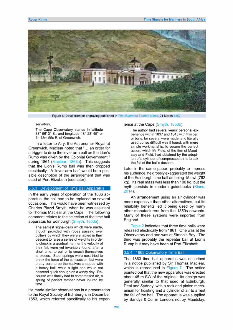
Roger Kinns Time Signals for Mariners in South Africa
296
Figure 6: Detail from an engraving published in The Illustrated London News, 21 March 1857.
servatory.
The Cape Observatory stands in latitude 33° 56′ 3″ S., and longitude 18° 28′ 45′′ or 1h 13m 55s E. of Greenwich.
In a letter to Airy, the Astronomer Royal at Greenwich, Maclear noted that “… an order for a trigger to drop the lever arm ball on the Lion’s Rump was given by the Colonial Government.” during 1861 (Maclear, 1863a). This suggests that the Lion’s Rump ball was then dropped electrically. A ‘lever arm ball’ would be a pos-sible description of the arrangement that was used at Port Elizabeth (see later). 3.5.3 Development of Time Ball Apparatus
In the early years of operation of the 1836 ap-paratus, the ball had to be replaced on several occasions. This would have been witnessed by Charles Piazzi Smyth, when he was assistant to Thomas Maclear at the Cape. The following comment relates to the selection of the time ball apparatus for Edinburgh (Smyth, 1853a).
The earliest signal-balls which were made, though provided with ropes passing over pulleys by which they were enabled in their descent to raise a series of weights in order to check in a gradual manner the velocity of their fall, were yet invariably found, after a short time, to pull or to smash themselves to pieces. Steel springs were next tried to break the force of the concussion, but were pretty sure to be themselves snapped with a heavy ball, while a light one would not descend quick enough on a windy day. Re-course was finally had to compressed air, a spring of perfect temper never injured by time …
He made similar observations in a presentation to the Royal Society of Edinburgh, in December 1853, which referred specifically to his exper-
ience at the Cape (Smyth, 1853b).
The author had several years’ personal ex-perience within 1837 and 1845 with this ball or balls, for several were made, and literally used up, so difficult was it found, with mere simple workmanship, to secure the perfect action, which Mr Field, of the firm of Maud-slay and Field, had obtained by the adopt-ion of a cylinder of compressed air to break the fall of the ball’s descent.
Later in the same paper, probably to impress his audience, he grossly exaggerated the weight of the Edinburgh time ball as being 15 cwt (762 kg). Its real mass was less than 100 kg, but the myth persists in modern guidebooks (Kinns, 2014).
An arrangement using an air cylinder was more expensive than other alternatives, but its reliability benefits led it being used by many other manufacturers from the 1850s onwards. Many of these systems were imported from England.
Table 2 indicates that three time balls were released electrically from 1861. One was at the Observatory and one was at Simon’s Bay. The third was probably the repeater ball at Lion’s Rump but may have been at Port Elizabeth. 3.5.4 1863 Observatory Time Ball
The 1863 time ball apparatus was described in a notice published by Sir Thomas Maclear, which is reproduced in Figure 7. The notice pointed out that the new apparatus was erected about 45 m SW of the original. Its design was generally similar to that used at Edinburgh, Deal and Sydney, with a rack and pinion mech-anism for hoisting and a cylinder of air to arrest the fall of the ball. The apparatus was supplied by Sandys & Co. in London, not by Maudslay,

Roger Kinns Time Signals for Mariners in South Africa
297
Figure 7: Notice of a new time ball at the Cape in 1863 (Maclear. 1863c).
Sons & Field. It featured in two letters from Maclear to Airy, which pointed out defects in the delivered system that had to be rectified before the apparatus could be used and suggested that a similar apparatus for New Zealand should be inspected in London (Maclear, 1863a; 1863b). The other apparatus was erected at Wellington, New Zealand, and provided the first time ball service in New Zealand from 1864
(Kinns, 2017). It was designed to give a drop height of 18 feet, which was unusually large for a rack and pinion hoisting arrangement and required strengthening of the mast to allow operation in a windy environment (Maclear, 1863a).
The notice in Figure 7 shows that the time ball was raised by 10 feet at 5 minutes before the signal, paused there for about 2 minutes

Roger Kinns Time Signals for Mariners in South Africa
298
Figure 8: The Observatory time ball after 1863 (courtesy: Ian Glass). and then raised to its maximum height. The 1863 notice indicated that the ball was painted red with a black central band and had a dia-meter of 5½ feet.
Figure 8 shows the Observatory time ball after 1863. The locations of stays for the mast in Figure 8 suggest that it may have been de-
cided to reduce the drop height from 18 feet to a more usual 10 feet after initial service. The mast cross-section differs from that described by Maclear (1863a), indicating that the hoisting arrangement had been changed in other re-spects. The original would have had the square cross-section used at Wellington, New Zealand

Roger Kinns Time Signals for Mariners in South Africa
299
(see Kinns, 2017a: 74, Figure 2).
Neither the Observatory nor Lion’s Rump time balls featured in the first (1880) or subse-quent Admiralty lists. Table 2 shows that the time ball at the Observatory was still operating in 1878, or at least in 1877 when the report is likely to have been prepared (Royal Observa-tory, 1878). Time balls were also in operation at Simon’s Town and Port Elizabeth, with an inland time ball at Kimberley. These were drop-ped at 1 pm, when the gun was fired. A ball at the Docks was dropped at noon, accompanied by a privately operated time ball. The latter and the Kimberley time ball are outside the scope of the research in this paper.
Time-balls are dropped at one o'clock each day at the Observatory, Simon's Town, Port Elizabeth, and Kimberly, and a gun is fired in Cape Town. At noon a ball is dropped in the Cape Town Docks for the use of the shipping, and a private ball, erected by a Cape Town clockmaker, is dropped by a secondary current. A clock has been est-ablished at Port Elizabeth, which is regulat-ed daily after a comparison with the mean solar clock of the Observatory. These ar-rangements have generally worked well, and through them accurate Cape mean time is distributed over a large portion of the Colony. In long circuits, like those in use, failures will occasionally take place through breakage or carelessness, but such failures are not frequent.
Port Elizabeth appears to have used a ball at the end of a lever arm (see later). It is some-times described as a disc. 3.6 Cape Town Docks Time Ball
3.6.1 First Docks Time Ball
The time ball at the Docks is variously describ-ed as the Cape Town time ball, the Table Bay time ball and the Alfred Docks time ball. The first Admiralty list (List of Time Signals, 1880) gave the place as “Table Bay” and the location as “At Alfred Docks”. The early history of this time ball is obscure and there are various in-consistencies in Admiralty descriptions.
The date of installation may have been in 1877 or earlier. There is a suggestion that the Docks time ball was installed in 1873 (Spencer-Jones, 1993). It might have been supplied by Siemens Brothers in London using a mechan-ical system manufactured by Maudslay, Sons & Field, which was thought to be destined for the Cape (Sells, 1883). However, there is strong evidence that the single apparatus built by Maudslays for Siemens Brothers in 1873 was a replica of the 1855 apparatus for Sydney and was installed at Lyttelton, New Zealand rather than at the Cape (Kinns, 2009; 2017). No de-
tails of the Docks arrangement before 1894 have been found. 3.6.2 Admiralty List Entries for Table Bay
Table 3 shows Admiralty list entries for Table Bay between 1880 and 1930. The local time anomaly in the 1880 list has been pointed out in Section 2.1. The ball drop time had been changed to local astronomical time by 1898. The local time is astronomical time in the lists from 1898 to 1908, based on zero hours at noon. This was changed to Standard time in the 1922 list, still based on zero hours at noon. It changed to civil time, based on zero hours at midnight, in the 1930 list. The local time given for the firing of the gun was incorrect in the lists for 1898, 1904 and 1908; it should have been the same as the time of the ball drop.
The 1880 list gave the location as 33° 54′ 27′′ S., 18° 25′ 15′′ E. From 1898, the time ball location was given as 33° 54′ 24′′ S., 18° 25′ 15′′ E. The small change in latitude between 1880 and 1898 suggests a relocation to the north of about 90 m, but this could be a correction. There were small changes in coordinates be-tween 1922 and 1930, which are presumed to be further corrections as the location was un-changed. It is difficult to make sense of Admir-alty list entries for Table Bay in several other respects. The time ball height above water changed by 30 feet between 1898 and 1922, with no significant change in the height above ground; they should change by the same amount if the tower height is changed. The 1922 and 1930 Admiralty lists both include a controlled clock in the tower, but automatic con-trol from the Observatory had been discontin-ued in August 1928 (Evans, 1993). The drop height was recorded as 6 feet in the Admiralty lists, which was incorrect from 1894 onwards; it may have been correct for the first time ball at the Docks. 3.6.3 1894 Docks Time Ball
In 1894, a new time ball had been “… erected in a conspicuous position near Resident Engin-eer’s Office of the Cape Town Docks.” (Evans, 1993). Table 2 gives the time ball location in 1900 as 33° 54′ 24′′ S., 18° 25′ 10.4′′ E, about 100 m further west than in Admiralty lists. This is likely to be a longitude correction that had not been registered by the Admiralty. The ball was 30 feet above ground level and dropped 10 feet. From 18 April 1895, return signals to the Obser-vatory confirmed that the ball had commenced and finished its drop. The Docks time ball was dropped at noon, rather than 1 pm as at other locations in South Africa.

Roger Kinns Time Signals for Mariners in South Africa
300
Table 3: Admiralty list entries for Table Bay.
Date Latitude
& Longitude
Signal Location
of Time Signal
Time of Signal Being Made Additional Details GMT
h. m. s. Local Time h. m. s.
1880
33° 54′ 27′′ S. 18° 25′ 15′′ E.
Ball
Gun
At Alfred Docks.
47 feet above high water.
36 feet above ground.
(Drop 6 feet.)
On Imhoff battery.
22 46 5
23 46 5
00 00 00
01 00 00
Ball dropped (by electricity from the Cape Observatory) at noon Cape mean time. Gun fired (by electricity from the Cape Observatory) at 1h 0m p.m. Cape mean time.
1898
33° 54′ 24′′ S. 18° 25′ 15′′ E. Ball
Gun
[As for 1880]
0 00 00
0 00 00
01 13 41
01 13 00
Ball dropped (by electricity from the Cape Observatory) at 1h 30m 00s Cape Colony mean time. Gun fired (by electricity from the Cape Observatory) at 1h 30m 00s Cape Colony mean time.
1904
33° 54′ 24′′ S. 18° 25′ 15′′ E.
Ball
Gun
[As for 1880]
22 00 00
22 00 00
23 13 41
23 13 00
Ball dropped (by electricity from the Cape Observatory) at noon Cape Col-ony mean time. Gun fired (by electricity from the Cape Observatory) at noon Cape Colony mean time.
1908
33° 54′ 24′′ S. 18° 25′ 15′′ E. Ball
Gun
[As for 1880]
22 00 00
22 00 00
23 13 41
23 13 00
Ball dropped (by electricity from the Cape Observatory) at noon Cape Col-ony mean time. Gun fired (by electricity from the Cape Observatory) at noon Cape Colony mean time.
1911 Ball
Gun
GMT h. m. s.
Standard Time
h. m. s.
1922
33° 54′ 24′′ S. 18° 25′ 15′′ E.
Ball
Gun
At Alfred Docks.
77 feet above high water
37 feet above ground.
(Drop 6 feet.)
Battery on Signal Hill.
22 00 00
22 00 00
0 00 00
12 00 00
Ball dropped, electrically from the Cape Observatory, at Noon, Standard time. A clock in the ground floor of the clock tower at the docks is controlled electrically from the observatory. If the clock is correct, the galvanometer on its face should show no deflection at the 50th and 60th seconds of each minute. Before comparing chrono-meters with this clock it should be ascertained that it is correct. Fired, electrically from the Cape Ob-servatory, at Noon, Standard time
GMT (Civil) h. m. s.
Standard Time (Civil)
h. m. s.
1930
33° 54′ 21′′ S. 18° 25′ 12′′ E. Ball
Gun
[As for 1922]
10 00 00
10 00 00
12 00 00
12 00 00
Ball dropped electrically from the Cape Observatory at Noon, Standard time.
[Clock as for 1922]. Fired electrically from the Cape Ob-servatory at Noon, Standard time.
Evans (1993) recorded that an extra storey
was added to the tower in 1904, so this change should have been reflected in the 1908 list. The
ball diameter and drop height were recorded by Evans as 5 feet and 10 feet in 1900. Extracts from drawings of the 1894 installation are repro-

Roger Kinns Time Signals for Mariners in South Africa
301
1894 Mechanism 1894 Ball
Figure 9: The 1894 time ball at the Docks (courtesy: Gabriël Fagan). duced in Figure 9, confirming these dimens-ions. The height of the signal was stated to be 30 feet above ground and 74 feet above low water in 1900. The 1894 drawing shows that the above-ground height of the centre of the ball in its raised position was indeed 30 feet. It was then a single-storey building, with part of the time ball apparatus in a deep basement. Its height was increased by adding another storey in 1904.
The Docks time ball was discontinued on 1 February 1934 and the ball itself was removed on 7 September (Evans, 1993). The tower re-mained in place. 3.6.4 Restored Docks Time Ball
The tower was declared a National Monument in 1982, but the time ball was then an immov-able fibreglass replica. The Cape Town water-front was redeveloped during the 1990s and it was decided to recreate the time ball that was withdrawn in 1934, using a replica of the original apparatus shown in Figure 9 (Glass et al., 1997). Restoration started in 1997 under the management of the late Gabriël Fagan (1925–2020), a renowned architect and conservation specialist. The original time ball apparatus had been lost, but the Department of Mechanical Engineering at the University of Cape Town built a working replica. The time ball could be
dropped again at 1 pm under electrical control from the South African Astronomical Observa-tory. The GPS coordinates of the time ball are given as 33° 54′ 21.3′′ S., 18° 25′ 09′′ E., almost exactly those reported in 1900.
Figure 10 shows the Docks time ball after its restoration to the 1934 condition. The height of the centre of the raised time ball above ground is now about 14.5 m, 5.5 m higher than its 1894 elevation of 9 m. 3.7 Simon’s Bay Time Balls and Discs
The Admiralty list entries referred to Simons bay and then Simon’s Bay, rather than Simon’s Town. A common spelling is now Simonstown. It is the home of the South African Navy’s larg-est base.
The first time ball at Simon’s Bay was erect-ed in 1857. It was regulated using a portable transit telescope, as indicated in Table 2, until telegraph lines had been constructed between the Observatory and Simon’s Bay. Electric op-eration was announced in The Times (Cape Town, 1861):
The [telegraph] line from Cape Town to Simon’s Bay is now made available for dropping the time-ball in the Admiralty-yard, thanks to Sir Thomas Maclean (sic), the Astronomer Royal …
The time ball had been replaced by a time disc

Roger Kinns Time Signals for Mariners in South Africa
302
Figure 10: Docks time ball tower after restoration (photograph: Michael Peel). before 1878, but the disc arrangement had become worn and failed frequently in 1896 and 1897, as shown in Table 2. A sketch of the arrangement is shown in Figure 11.
The disc was used for the last time on 11 December 1897 and replaced by a time ball which became operational on 14 April 1898.
3.7.1 Admiralty List Entries for Simon’s Bay
The Admiralty list entries for Simon’s Bay be-tween 1880 and 1930 are shown in Table 4.
The 1880 Admiralty list included the circular disc. The list for 1898 was prepared before the change of signal type, so still included the disc

Roger Kinns Time Signals for Mariners in South Africa
303
signal. There were small corrections to the lat-itude and longitude between 1880 and 1898, but no further changes afterwards. The list for 1904 indicated that the time ball was initially painted white, but this was changed to a chequered black and white paint scheme be-fore 1908. There was no reported change in the signal location or the drop height with the change from a disc to a ball. Table 2 indicates that the time ball was dismantled on 8 February 1929. Inclusion in the 1930 Admiralty list was therefore incorrect.
The time ball arrangement may have been similar to those erected in Singapore in 1893 and Auckland in 1901, using weights, rather than an air cylinder, to control the descent (Kinns, 2021a). The small drop height is also con-sistent with installation of a lever arm ball, which appears to have been the arrangement at Port Elizabeth. 3.8 Port Elizabeth Time Balls and Discs
An electric telegraph link from the Cape may have been used to drop a time ball at Port Elizabeth as early as 1861 (see Table 2). It was certainly in operation by 26 August 1865 (War-ner, 1979). The time ball provided a return sig-nal to the Observatory in 1873, as shown in the following report (Royal Observatory, 1873):
A return-signal has been arranged for after the drop of the Port Elizabeth time-ball. The distance over which the wires are carried is
Figure 11: Sketch of the time disc at Simon’s Bay (courtesy: David Erickson, Simonstown Historical Society, via Ian Glass).
over 600 miles. The return-signal reaches the Observatory from 3/10 to 6/10 of a second after the current leaves the Observatory.
Table 4: Admiralty list entries for Simon’s Bay.
Date Latitude
& Longitude
Signal Location
of Time Signal
Time of Signal Being Made Additional Details GMT
h. m. s. Local Time h m s.
1880
34° 11′ 30′′ S. 18° 25′ 48′′ E.
Circular disc
Mast close to Simons Town
Telegraph Office.
63 feet above
high water. 40 feet above
ground. (Drop 6 feet.)
23 46 5 0 59 48.2 Disc raised to a right angle with mast at 5 minutes before signal. Disc dropped (by electricity from the Cape Observatory) at moment of 1h 0m p.m. Cape mean time. When signal fails in accuracy, the disc is kept up till 2 o'clock, then lowered.
1898
34° 11′ 35′′ S. 18° 25′ 58′′ E.
Circular disc [As for 1880]
0 00 00 1 13 43.9 Disc raised to a right angle with mast at 5 minutes before signal. Disc dropped (by electricity from the Cape Observatory) at moment of 1h 0m p.m. Cape mean time. When signal fails in accuracy, the disc is kept up till 2 o'clock, then lowered.
1904
34° 11′ 35′′ S. 18° 25′ 58′′ E.
White ball [As for 1880]
22 00 00
23 13 43.9 Ball hoisted 5 minutes before signal. Ball falls (by electricity from the Cape Observatory) at moment of noon Cape Colony mean time. When signal fails in accuracy, the ball is kept up about 10 minutes and then lowered.

Roger Kinns Time Signals for Mariners in South Africa
304
1908
34° 11′ 35′′ S. 18° 25′ 58′′ E.
Black and white
chequered ball
[As for 1880]
22 00 00
23 13 43.9
[As for 1904]
1911
Black and white
chequered ball
GMT h. m. s.
Standard Time
h. m. s.
1922
34° 11′ 35′′ S. 18° 25′ 58′′ E. Black and
white chequered
ball
Mast near telegraph office.
63 feet above
high water 40 feet above
ground. (Drop 6 feet.)
22 00 00 0 00 00 Ball hoisted at 5 minutes before the signal, and dropped, electrically from the Cape Observatory at Noon, Standard time. Should the signal fail, the ball will be kept up for about 10 minutes, then slowly lowered.
GMT (Civil)
h. m. s.
Standard Time (Civil)
h. m. s.
1930
34° 11′ 35′′ S. 18° 25′ 58′′ E
Black and white
chequered ball
[As for 1922]
10 00 00 12 00 00
[As for 1922]
The linear separation is about 400 miles, so the cable was not routed directly. Table 2 indicates that a time ball was still in use during 1889, but the description had been changed to a time disc by 1894. This change of description is discus-sed later: there may not have been an actual change of signal type. 3.8.1 Admiralty List Entries for Port Elizabeth
The Admiralty list entries for Port Elizabeth are shown in Table 5. The entries for 1880 and 1898 refer to both a ball and a disc in the col-umns describing the signal and its location. The apparent contradiction is highlighted in red.
The following description was published in 1916 (Africa Pilot, 1916: 141–142):
Time signal. — At Port Elizabeth Light-house, at an elevation of 220 feet above high water, a black ball is dropped by elec-tricity from the Cape Observatory at 0 h. 0 m. 0 s. South Africa standard time, corre-sponding to 22 h. 0 m. 0 s. Greenwich mean time; but the signal is not made on Sundays or public holidays. Should the signal be inaccurate, a checkered red and blue flag will be hoisted at the lighthouse and the ball dropped 5 minutes later, or at 0 h. 5 m. 0 s. South Africa standard time.
The 1916 notice is consistent with the 1908 Admiralty list, both referring to a ball. Table 2 suggests that the ball had been changed to a disc by 1893 but this may be misleading. Figure 12 shows the disc in raised and lowered pos-itions at the lighthouse. Although described as a disc, it appears that it was actually a ball attached to a lever arm, so that it could be ob-served from any direction. This would explain
why the same location and drop height were given for both the ball and the disc and why the 1880 and 1898 lists of time signals referred to both: the change was a matter of description. Maclear had described the time ball at Lion’s Rump as a lever arm ball in 1863. The essential difference from a conventional time ball was the dropping arrangement. The “disc” was dismantl-ed on 30 September 1930. 3.9 Port Alfred
The relative locations of time signals at Port Elizabeth, Port Alfred and East London are shown in Figure 2. The Port Elizabeth signal was established first and remained in use long-est of the three signals. It was followed by the Port Alfred signal and then the signal at East London.
The time balls at Port Alfred and East Lon-don did not appear in the report for 1878 (Royal Observatory, 1878). The ball at Port Alfred was, however, noted in the 1880 Admiralty list. 3.9.1 Admiralty List Entries for Port Alfred
The Admiralty list entries for Port Alfred are shown in Table 6. There was a small correction to the longitude between 1880 and 1898, cor-responding to a change of 0.3 seconds in astronomical time. The corrected signal locat-ion was 1h 47m 36.3s fast on Greenwich. The drop time changed in combination with time zone modifications.
There was no description of the time ball arrangement in Admiralty lists, other than the elevation and drop height.

Roger Kinns Time Signals for Mariners in South Africa
305
Table 5: Admiralty list entries for Port Elizabeth.
Date Latitude
& Longitude
Signal Location
of Time Signal
Time of Signal Being Made Additional Details GMT
h. m. s. Local Time h. m. s.
1880
33° 57′ 43′′ S. 25° 37′ 21′′ E..
Black disc
At the Lighthouse.
220 feet above
high water. 43 feet above
ground. (Drop 5 feet.)
23 46 5 1 28 34.4 Disc dropped (by electricity from the Cape Observatory) at moment of 1h 0m p.m. Cape Colony mean time. When signal fails in accuracy, a che-quered red and blue flag will be shown from the lighthouse, and ball dropped 5 minutes later, or at 1h 5m p.m. Cape mean time.
1898
33° 57′ 43′′ S. 25° 37′19′′ E..
Black ball
[As for 1880]
0 00 00 1 42 29.3 Disc dropped (by electricity from the Cape Observatory) at moment of 1h 30m 00s Cape Colony mean time. When signal fails in accuracy, a che-quered red and blue flag will be shown from the lighthouse, and ball dropped 5 minutes later, or at 1h 35m 00s p.m. Cape Colony mean time.
1904
33° 57′ 43′′ S. 25° 37′ 19′′ E..
Black ball
[As for 1880]
22 00 00 23 42 29.3 Ball dropped (by electricity from the Cape Observatory) at moment of noon Cape Colony mean time. When signal fails in accuracy, a che-quered red and blue flag will be shown from the lighthouse, and ball dropped 5 minutes later, or at 0h 5m 0s p.m. Cape Colony mean time.
1908
33° 57′ 43′′ S. 25° 37′ 19′′ E.
Black ball [As for 1880]
22 00 00
23 42 29.3 Ball dropped (by electricity from the Cape Observatory) at moment of noon Cape Colony mean time. When signal fails in accuracy, a che-quered red and blue flag will be shown from the upper window of the light-house, and ball dropped 5 minutes later, or at 0h 5m 0s p.m. Cape Colony mean time.
1911 Black ball
GMT h. m. s
Standard Time
h. m. s
1922
33° 57′ 43′′ S. 25° 37′ 19′′ E..
Black disc [As for 1880]
22 00 00 00 00 00 Disc dropped, electrically from the Cape Observatory at Noon, Standard time. Should the signal be inaccurate, a red and blue chequered flag will be shown from the upper window of the light-house, and the signal repeated at 0h 05m 00s, Standard time.
GMT (Civil) h. m. s.
Standard Time (Civil) h. m. s.
1930
33° 57′ 43′′ S. 25° 37′ 19′′ E.
Black disc
[As for 1880]
10 00 00 12 00 00 Disc dropped electrically from the Cape Observatory at Noon, Standard time. Should the signal be inaccurate, a red and blue chequered flag will be shown from the upper window of the ligh-thouse, and the signal repeated at 12h 05m 00s, Standard time.
Table 2 indicates that the Port Alfred time
ball had been discontinued in 1898, but the following notice and Table 6 show that this was either incorrect or a temporary withdrawal. The
signal was not discontinued until 1911 (Notices, 1911). The Admiralty notices appear to be correct.

Roger Kinns Time Signals for Mariners in South Africa
306
Disc raised Disc lowered
Figure 12: The semaphore disc or ball at Port Elizabeth (courtesy: Klaus Hülse collection).
Table 6: Admiralty list entries for Port Alfred.
Date Latitude
& Longitude
Signal Location
of Time Signal
Time of Signal Being Made Additional Details GMT
h. m. s. Local Time h. m. s.
1880
33° 36′ 10′′ S. 26° 54′ 10′′ E. Ball
54 feet above high water.
26 feet above ground.
(Drop 18 feet.)
23 46 05 01 33 41.6 Ball dropped (by electricity from the Cape Observatory) at moment of 1h 0m p.m. Cape mean time.
1898 33° 36′ 10′′ S. 26° 54′ 05′′ E. Ball [As for 1880]
0 00 00 01 47 36.3 Ball dropped (by electricity from the Cape Observatory) at moment of 1h 30m p.m. Cape Colony mean time.
1904 33° 36′ 10′′ S. 26° 54′ 05′′ E. Ball [As for 1880]
22 00 00 23 47 36.3 Ball dropped (by electricity from the Cape Observatory) at moment of noon Cape Colony mean time.
1908 33° 36′ 10′′ S. 26° 54′ 05′′ E. Ball [As for 1880]
22 00 00 23 47 36.3 Ball dropped (by electricity from the Cape Observatory) at moment of noon Cape Colony standard mean time.
1911 1922 1930
Port Alfred signal discontinued
AFRICA -- Southeast coast – Port Alfred – Time signal discontinued. The German Government has given notice that the time ball which has hitherto been dropped from a staff near the West Mole, Port Alfred, southeast coast of Africa, has been discon-tinued. (Notice to Mariners, 1911: No. 44).
The ball was dropped from a staff near the West Mole. Figure 13 shows the location of the time ball near the harbour entrance.
The drop height of 18 feet happens to be the same as that for the 1863 apparatus at the Cape Observatory. The evidence is circum-stantial, but it is conceivable that the 1863 ap-paratus was re-used at Port Alfred, as the time ball at Alfred Docks had become the principal signal for Table Bay before 1880.

Roger Kinns Time Signals for Mariners in South Africa
307
Figure 13: Location of the Port Alfred time ball (map modification: Roger Kinns). 3.10 East London
The East London ball was noted in the Table 2 entry for 1889 and in later entries up to 1929. It had been withdrawn by 1933. 3.10.1 Admiralty List Entries for East London
The Admiralty list entries for East London are shown in Table 7. Figure 3 shows that the Port Alfred and East London signals were not far apart.
The time ball was dropped from an iron frame at high elevation. The drop height was
15 feet. The apparatus would have been much simpler than those used at the Observatory in 1863 and at Alfred Docks after 1894. The time ball at East London probably used the ‘Devon-port Principle’, which was developed in 1884–1885 by Admiral Wharton, then Hydrographer of the Navy. It was used at “Singapore, Ports-mouth, Brisbane, Cairo, Port Said, Alexandria and other locations.” (Lewis, 1910). This type of design reduced the cost of time ball in- stallations and allowed a wide range of drop heights with electrical triggering.
Table 7: Admiralty list entries for East London.
Date Latitude
& Longitude
Signal Location
of Time Signal
Time of Signal Being Made Additional Details GMT
h. m. s. Local Time h. m. s.
1880 No reported signal at East London
1898
33° 01′ 50′′ S. 27° 54′ 55′′ E.
Ball Iron frame on Signal Hill.
00 00 00
1 51 39.7 Ball dropped (by electricity from the Cape Observatory) at 1h 30m 00s p.m. Cape Colony mean time. Should the signal fail, a yellow flag is hoisted about 5 minutes after the ball has been dropped. Not visible from vessels alongside the wharves.
1904
33° 01′ 50′′ S. 27° 54′ 55′′ E.
Ball Iron frame on Signal Hill.
22 00 00
23 51 39.7 Ball dropped (by electricity from the Cape Observatory) at noon, Cape Colony mean time.
[Signal failure: As for 1898]
1908 33° 01′ 50′′ S. 27° 54′ 55′′ E. Ball
Iron frame on 149 feet hill.
22 00 00
23 51 39.7 Ball dropped (by electricity from the Cape Observatory) at noon, Cape Colony standard mean time.

Roger Kinns Time Signals for Mariners in South Africa
308
200 yards S.W. by S. from Signal Hill.
160 feet above
high water. (Drop 15 feet.)
[Signal failure: As for 1898]
1911 Ball
GMT h. m. s.
Standard Time
h. m. s.
1922
33° 01′ 50′′ S. 27° 54′ 55′′ E.
Ball
Iron frame on hill near signal
station.
160 feet above high water.
(Drop 15 feet.)
22 00 00
0 00 00 Ball dropped electrically from the Cape Observatory, at Noon, Standard time. Should the signal be inaccurate, a yellow flag will be hoisted about 5 minutes after. The ball falls slowly and is not to be relied on within one second. Not visible alongside the wharves. Signal not made on Sundays or public holidays.
GMT (Civil) h. m. s.
Standard Time (Civil)
h. m. s.
1930 33° 01′ 50′′ S. 27° 54′ 55′′ E. Ball [As for 1922] 10 00 00 12 00 00 [As for 1922]
3.11 Durban, Natal
In 1882, David Gill, Director of the Cape Obser-vatory, asked the Government of Natal to est-ablish an astronomical observatory at Durban, in anticipation of the transit of Venus on 6 December that year. A site for the observatory was chosen in the southwest corner of the Natal Botanic Gardens. Initial equipment at the Natal Observatory included a 75-mm Troughton & Simms transit instrument and a sidereal clock by Dent (Natal Observatory).
It is believed that a time ball was estab-lished in 1883, controlled by Natal Observatory. Following the formation of the Union of South Africa in 1910 the post of Government Astrono-mer of Natal was abolished and the Observa-tory was closed in 1911. 3.11.1 Edmund Nevill aka Edmund Neison
Edmund Neville Nevill (1849–1940) was ap-pointed Government Astronomer of Natal and Director of the Observatory. Nevill also used the name Edmund Neison. He is perhaps best known for his book The Moon (Nevill, 1940). The following extracts relating to his work in South Africa are from his obituary (Spencer Jones, 1941).
EDMUND NEVILLE NEVILL was born at Beverley, Yorkshire, on 1849 August 27 … and was elected a Fellow of the [Royal Astronomical] Society in 1873 under the name of Edmund Neison, having the curi-ous idea that it was derogatory to the holder of an ancient name to make a career in science.
Nevill had gone to South Africa as Gov-ernment Astronomer for Natal. There had been under consideration for several years a proposal for the establishment of an ob-servatory in Durban. The observatory was started in 1882, with the aid of sums voted by the Corporation of Durban and by the Legislative Council of Natal, a Grubb 8-inch equatorial being presented by Mr. Harry Escombe. Mr. (later Sir David) Gill, H.M. Astronomer at the Cape, had been consult-ed and Nevill received an urgent telegram from Gill, offering him the post of Govern-ment Astronomer. He sailed almost on twenty-four hours’ notice on 1882 October 27, reached Durban on November 27 and, in accordance with instructions furnished by the Colonial Secretary, he took possession of the Observatory on December 1 as Ast-ronomer to the Natal government. On De-cember 6 he obtained successful observat-ions of the transit of Venus, for which the conditions were exceedingly fine.
But lack of financial support soon made itself felt and work had more and more to be restricted to routine observations–determin-ations of time for the provision of a time-service, meteorological and tidal observat-ions. In 1888 Nevill was appointed Govern-ment Chemist and Official Assayer for Nat-al, and combined this office with that of Government Astronomer until his retire-ment.
The Natal Observatory came to an end in 1911 and Nevill, who had been elected a Fellow of the Royal Society in 1908, return-ed to England to live in retirement at East-bourne … Nevill reverted to his family name in 1888, in accordance with the conditions

Roger Kinns Time Signals for Mariners in South Africa
309
of a will … He died on 1940 January 14 in his ninety-first year.
3.11.2 Admiralty List Entries for Durban
The Admiralty list entries for Durban are shown in Table 8. The place was given as Natal in 1898, as Port Natal (Durban) in lists up to 1911 and then as Durban in the lists for 1922 and 1930. The “local” time in early lists was Natal standard time defined by the Observatory location, not astronomical time at the signal location. The 1898 and 1904 lists show the initial location of the time ball.
The first time ball at Durban was included in the lists for 1898 and 1904. The time ball had been relocated in 1904, as indicated below (Notices, 1905: 22).
AFRICA - Southeast coast - Port Natal - Time ball - Position altered. – The Government of Natal has given notice, dated November 3, 1904, that the time ball at port Natal bas been removed from the point to a position on the bluff, from which the Bluff lighthouse bears N. 59 ° E. true … distant 260 yards, and the south leading mark N. 22° W. true … The time ball will be dropped as before, on every day except
Table 8: Admiralty list entries for Durban.
Date Latitude
& Longitude
Signal Location
of Time Signal
Time of Signal Being Made Additional Details GMT
h. m. s. Local Time h. m. s.
1880 No reported signal at Durban
1898
29° 52′ 30′′ S. 31° 03′ 00′′ E.
Ball
At 3 cables N.N.W. ½ W. from Sandy
point, North side of Entrance to
port.
23 00 00
1 04 01 Ball dropped at 1h 00m 00s p.m. Natal standard mean time. When signal fails in accuracy, a blue flag with white centre is hoisted at the Time Ball staging about 1h 05m 00s p.m., as a Notice that the Signal can-not be relied on. [Note: signal not made on Sundays.]
1904
29° 52′ 30′′ S. 31° 03′ 00′′ E.
Ball
At 3 cables N.N.W. ½ W. from Sandy
point, North side of Entrance to
port.
23 00 00 1 04 01
[As for 1898]
1908
29° 52′ 44′′ S. 31° 03′ 42′′ E.
Ball
On the Bluff 260 yards S. 83° W. from the Bluff
lighthouse.
95 feet above high water.
(Drop 8 feet)
23 00 00
1 04 01
Ball dropped at 1h 00m 00s p.m. Natal standard mean time.
[Signal failure as for 1898]
1911 Ball
GMT h. m. s.
Standard Time
h. m. s.
1922
29° 52′ 44′′ S. 31° 03′ 42′′ E.
Ball
On the Bluff, westward of the
lighthouse.
283 feet above high water.
(Drop 8 feet.)
22 00 00
0 00 00 Signal established or altered in 1916. Ball dropped at 0h 00m 00s, Standard time. Should the signal be inaccurate, the ball will be re-hoisted and again drop-ped at 3h 00m 00s Standard time. Not made on Sundays. Chronometers may be compared at the port office, where an electric signal is received every hour from the Ob-servatory.
GMT (Civil) h. m. s
Standard Time (Civil) h. m. s.
1930 29° 52′ 44′′ S. 31° 03′ 42′′ E. Ball [As for 1922] 10 00 00
12 00 00 [As for 1922]

Roger Kinns Time Signals for Mariners in South Africa
310
Figure 14: Natal Observatory in 1903 (Don Africana Library, Durban).
Sunday, at 1h. 00m. 00s. p.m. Natal stan-dard mean time, corresponding to 23h. 00m. 00s. Greenwich mean time. Approx. position: Lat 29° 52′ 44′′ S., Long. 31° 03′ 42′′ E.
Figure 15: Durban lighthouse (Klaus Hülse collection).
The stated latitude and longitude were 29° 52′ 44′′ S., 31° 03′ 42′′ E., identical to those given in Admiralty lists. This suggests that the same time ball was used from 1904 until the signal was withdrawn. The drop height of 8 feet remained the same in all lists from 1908. There was a change in the location description be-tween 1908 and 1922. “S. 83° W.” is an alter-native to “westward”, but the change in signal elevation from 95 to a more plausible 283 feet above high water is probably a correction. The Bluff itself is 195 feet high (McCallum, 2014). The time of the drop was changed on 1 Sep-tember 1912 from 1h. 00m. 00s. to noon South Africa standard time (Notices, 1912: 839).
Figure 14 shows a view of Natal Obser-vatory from the North East. The small veranda was constructed around the Transit Room. Dir-ector Nevill appears in the foreground. The photograph was published in the Natal Illustrat-ed Railway Guide of 1903 (Natal Observatory).
Figure 15 shows the lighthouse in a tinted photograph. The time ball may have been sus-pended from the signal mast, which was clearly used for a large number of different signals. 4 DISCUSSION AND CONCLUDING REMARKS
The aim of this paper is to establish the nature of time signals for mariners in South Africa. The research builds on previous work concerning the Royal Observatory at the Cape of Good

Roger Kinns Time Signals for Mariners in South Africa
311
Hope, using Admiralty lists of time signals, no-tices to mariners and other sources to expose and resolve contradictions. It forms part of a description of visual time signals for mariners worldwide that is being developed by the au-thor. South Africa played a key role in signal de-velopment.
Initial development of visual time signals for calibration of marine chronometers has been attributed to Captain, later Admiral, Robert Wau- chope, who served at the Cape from 1818 and was later in command of ships that visited Cape Colony. Wauchope developed close relation-ships with Thomas Maclear, Director of the Cape Observatory from 1833 and Sir John Herschel, who worked at the Cape from 1834 to 1838 and was an active correspondent with other astron-omers. A key feature of the successful visual arrangements was a preparatory signal to alert navigators that an exact signal was imminent. Fearon Fallows, the first Director of the Cape Observatory, had used an oil lamp from about 1823, lit several minutes before the signal and then hidden by a shutter at the designated time. It was to be almost another century before high-powered electric lights could be used for time signalling. Fallows had to work with severely limited facilities for many years and the Cape Observatory only became operational in 1829. Wauchope’s ideas led eventually to the time ball, with successful experiments at Portsmouth in 1829–1830. The design concept was pub-lished widely and Wauchope tried to persuade various national authorities to adopt his ideas. The flash of a gun at the Cape had been used from 1807, but it only became a precise time signal under observatory control in 1864. A flash pistol was used as an evening signal at the Cape Observatory in 1833 by Henderson, who succeeded Fallows as Director.
The first operational time ball service was at Port Louis, Mauritius in April 1833, using a shuttered, stationary ball designed by John Au-gustus Lloyd without Wauchope’s involvement. The system at Greenwich, designed by Mauds-lay, Sons & Field, was operational in October 1833 and became the model for later succes-sful arrangements worldwide. A time ball in St. Helena was in use by the East India Company in January 1834, followed by another in Calcut-ta in January 1835. These systems were built locally, as was the next implementation at the Cape Observatory in September 1836.
The time ball at the Observatory had to be moved and supplemented by a repeater signal at Lion’s Rump from 1853 when trees and build-ings obscured it from Table Bay. The repeater signal was operated manually at first, using a lever arm ball. It was controlled by electric tele-
graph from 1861, together with the time ball at Simon’s Bay, which had been established in 1857 and regulated initially using a portable transit telescope. The Observatory time ball was replaced in 1863 using an electric time ball supplied by Sandy’s & Co. in London. Available descriptions and photographs indicate that the 1863 arrangement with a drop height of 18 feet was later modified to give a reduced drop height.
A time ball at Table Bay, also described as being at The Docks or at Alfred Docks, was erected in the 1870s, but its origins are obscure. It may have been erected as early as 1873. It featured in the Admiralty list of time signals from the first edition in 1880, which did not include the Observatory time balls. A new arrangement was used from 1894, whose details have been established from contemporary drawings. The tower height was increased by adding another story in 1904. Admiralty lists from 1898 on-wards had not been altered as they should have been to reflect the modifications in 1894 and 1904. The Docks time ball was restored in 1997 using a working replica of the 1894 apparatus.
The first time ball at Simon’s Bay was erect-ed in 1857 and controlled by electric telegraph from 1861. It was described as a disc by the Astronomer in 1893, followed by announce-ments in 1896 and 1897 that the disc mechan-ism was failing to work reliably through old age. It was replaced by a new time ball, which be-came operational in April 1898. Admiralty lists described the signal as a disc in 1880, as a white ball in 1904 and as a black and white chequered ball in lists from 1908 to 1930. The stated location and drop height were unchang-ed throughout.
The time signal at Port Elizabeth has been variously described as a time ball or a time disc, occasionally with both descriptions in the same notice. It was described as a time ball in an 1873 announcement that a return telegraph sig-nal was available to confirm the drop, and by the Astronomer in 1889. It was then described as a disc by the Astronomer in 1893. It was described as both a ball and a disc in Admiralty lists for 1880 and 1898; as a ball in 1904, 1908 and 1911; and as a disc in 1922 and 1930. A possible explanation is that the same signal was used throughout. Available photographs suggest that it was a lever arm ball, which dropped in a circular arc. The advantage over a simple disc was that it would appear as a circular object from any direction.
There were time balls at Port Alfred and East London, further east than Port Elizabeth but still within Cape Colony. The signal at Port Alfred was listed by the Admiralty in 1880, 1898,

Roger Kinns Time Signals for Mariners in South Africa
312
1904 and 1908, but not in 1911 and later lists. This is consistent with a notice to mariners that the signal had been discontinued in 1911. The time ball at East London was in use by 1889 and was discontinued in 1933.
An Observatory was built in Durban to ob-serve the 1882 Transit of Venus, with Edmund Nevill (aka Neison) as its Director. A time ball was erected soon afterwards, with regulation from the Observatory. The ball had been mov-ed to a location near the Bluff lighthouse in 1904 and remained there until the service was with-drawn in 1930. The Observatory was closed in 1911. After that, the time ball was operated using telegraph signals from the Cape Obser-vatory.
There are still some unknown features of several time signals in South Africa. The history of the time ball at the Docks in Cape Town be-fore 1894 is uncertain and descriptions in later Admiralty lists have been shown to be inaccu-rate. The designs of the time ball apparatus used at Port Alfred, East London and Durban are uncertain. The Port Alfred time ball had a drop height of 18 feet and was located near the harbour entrance. It featured in the 1880 Ad-miralty list when no Observatory time ball was listed. 18 feet was the design drop height for the 1863 apparatus at the Cape Observatory, later limited to about 10 feet. It is possible that the 1863 apparatus was re-used at Port Alfred when it was no longer needed at the Observa-
tory, but evidence is only circumstantial. The time ball at East London was dropped from an iron frame on top of a hill. This is likely to have used the “Devonport Principle”, giving the stated 15 feet drop height at low cost with elec-trical triggering. This type of design is known to have been used for a high proportion of time balls supplied from England after 1885. 5 ACKNOWLEDGEMENTS
I am most grateful to Paul Fuller for sharing the results of his meticulous research into the life of Robert Wauchope, whose ideas on visual time signals had first developed at the Cape of Good Hope. This paper builds on historical studies by distinguished astronomers in South Africa, using international lists and notices to mar-iners. Dr Ian Glass, Willie Koorts and Chris de Coning, of the South African Astronomical Ob-servatory, kindly provided additional illustrat-ions and references. Willie Koorts and Chris de Coning have produced excellent videos concerning time signals at the Cape (see: https://youtu.be/BKU32cTe75o and https://youtu.be/nkBOkyl2hJw). The late Gab-riël Fagan provided extensive information in 2009 about the 1894 time ball at the Docks. Various illustrations in this paper have come from the remarkable collection of post cards and photographs assembled by Klaus Hülse in Germany. I also thank referees for suggesting improvements to the original draft.
6 REFERENCES
Admiralty List of Time Lights and Visual Time Signals, Part VI: Indian and West Pacific Oceans (corrected to 31st December 1921). London, published for the Hydrographic Department, Admiralty by His Majesty’s Stationery Office, 1922.
Admiralty List of Time Lights and Visual Time Signals, Part VI: Indian and West Pacific Oceans (corrected to 31st December 1929). London, published for the Hydrographic Department, Admiralty by His Majesty’s Stationery Office, 1930.
Africa Pilot, Volume I, 1916. H.O. No. 105. Washington, Government Printing Office, 1916. Bartky, I.R., 1987. The bygone era of time balls. Sky and Telescope, 73 (1), 32–35. Bartky, I.R. and Dick, S.J., 1981. The first time balls. Journal for the History of Astronomy, 12, 155–164. Bisset, Cdr.W.M., 1984. Cape Town’s time-guns. Scientia Militaria, South African Journal of Military Studies, 14(4),
67–71. Cameron-Swan, Capt. D., 1931. The Rev. Fearon Fallows, M.A., F.R.S., F.R.A.S. (Presidential Address, Session
1930-31). The Journal of the Astronomical Society of South Africa, 3(1), 1–14. Cape Town, 1861. Notice headed “Cape Town, Cape of Good Hope, Nov. 21, 1861.” The Times, 7 January (1862). Cape Town Observatory, 1857. Supplement published in The Illustrated London News, 21 March, 271 (1857). De Grijs, R., 2020. A (not so) brief history of lunar distances: lunar longitude determination at sea before the
chronometer. Journal of Astronomical History and Heritage, 23(3), 495–522. Editorial, 1835. The time-ball of St. Helena. The Nautical Magazine, 4, 658–660. Evans, D.S., Deeming, T.J., Hall Evans, B., and Goldfarb, S., 1969. Herschel at the Cape: Dairies and
Correspondence of Sir John Hershel, 1834–1838. Austin, University of Texas Press. Evans, G. P., 1993. History of Time Guns and Time-Balls in South Africa. Unpublished memorandum, South African
Astronomical Observatory. Gill, D., 1913. A History and Description of the Royal Observatory, Cape of Good Hope. London, H.M. Stationery
Office. Gill, D., Obituary, 1914. Sir David Gill, The Observatory, 37 (472), 115–117. Glass, I.S., Evans, G.P., and Lastovica, E., 1997. Waterfront time ball to drop again, 1997. Monthly Notes of the
Astronomical Society of Southern Africa, 56, 108–109. Harding, G., 1971. The Cape Town Noon Gun. [This reference has not been sighted by the author. It was included

Roger Kinns Time Signals for Mariners in South Africa
313
in the 1993 list by Evans, without details other than a publication date of 15 October 1971. The dates have been confirmed using other sources.]
Herschel, J., 1836. Account of an Observatory constructed at the Mauritius. Communicated by Sir J. Herschel, Monthly Notices of the Royal Astronomical Society, 3, 157–160.
Howse, D., 1997. Greenwich Time and the Longitude. London, Philip Wilson Publishers Ltd. Kinns, R., and Abell, L., 2009. The contribution of Maudslay, Sons & Field to the development of time balls in
Australia. International Journal for the history of Engineering & Technology, 79(1), 59–90. Kinns, R., 2009. Time keeping in the Antipodes: a critical comparison of the Sydney and Lyttelton time balls. Journal
of Astronomical History and Heritage, 12(2), 97–107. Kinns, R., 2011. The early history of the Edinburgh time ball and time gun. International Journal for the history of
Engineering & Technology, 81(2), 264–290. Kinns, R., 2014. Did the Edinburgh time ball really weigh 15 cwt? International Journal for the History of Engineering
& Technology, 84(2), 160–174. Kinns, R., 2017. The principal time balls of New Zealand. Journal of Astronomical History and Heritage, 20(1), 69–
94. Kinns, R., 2020a. The 1833 time ball at Port Louis, Mauritius: the forgotten service for chronometer calibration.
International Journal for the History of Engineering & Technology, 89(1-2), 264–275. Kinns, R., 2020b. The time balls of Mauritius. Journal of Astronomical History and Heritage, 23(2), 281–296. Kinns, R., 2020c. Time signals for mariners in India, Burma and Ceylon. Journal of Astronomical History and
Heritage, 23(3), 523–552. Kinns, R., 2021a. Time signals for mariners in Southeast Asia: time balls, disks, bells, guns and lights. In Orchiston,
W., and Vahia, M. (eds.), Exploring the History of Southeast Asian Astronomy: A Review of Current Projects and Future Prospects and Possibilities. Cham (Switzerland), Springer. Pp. 411–458.
Kinns, R., 2021b. Time signals for mariners in the Atlantic Islands and West Africa. Journal of Astronomical History and Heritage, 24(2), 315–336.
Lewis, T., 1910. Handwritten Notes for the Astronomer Royal, dated 21–25 April 1910. Royal Greenwich Observatory Archives RGO 7/257, Papers of William Christie, Cambridge University Library.
List of Time Signals, Established in Various Parts of the World 1880: Compiled for the Use of Seamen, as an Aid for Ascertaining the Errors and Rates of Chronometers (Prepared from Official Sources to December 1880). 1st Edition. London, printed for the Hydrographic Department, Admiralty, 1880.
List of Time Signals, Established in Various Parts of the World 1898: Compiled for the Use of Seamen, as an Aid for Ascertaining the Errors and Rates of Chronometers (Prepared from Official Sources to 31st December 1897). 5th Edition. London, printed for the Hydrographic Department, Admiralty, 1898.
List of Time Signals, Established in Various Parts of the World 1904: Compiled for the Use of Seamen, as an Aid for Ascertaining the Errors and Rates of Chronometers (Prepared from Official Sources to 1st April 1904). London, printed for the Hydrographic Department, Admiralty, 1904.
List of Time Signals, Established in Various Parts of the World 1908: Compiled for the Use of Seamen, as an Aid for Ascertaining the Errors and Rates of Chronometers (Prepared from Official Sources to 1st January 1908). London, printed for the Hydrographic Department, Admiralty, 1908.
List of Time Signals, Established in Various Parts of the World 1911: Compiled for the Use of Seamen, as an Aid for Ascertaining the Errors and Rates of Chronometers. London, printed for the Hydrographic Department, Admiralty, 1911.
Lloyd, J.A., 1833. Rating chronometers in the Mauritius, 19 April 1833. Notice published in the Nautical Magazine, 1835, 5, 136.
Maclean, G., 1839. Notice to mariners: Cape Coast Castle, 27 July 1839, Naval Chronicle, 1840, 128 Maclear, T., 1852. The Observatory time ball – Cape of Good Hope, dated 7 July 1852. Notice in the Nautical
Magazine and Naval Chronicle, 21, 611–612. Maclear, T., 1853. Establishment of an Additional Time Ball at the Cape of Good Hope. Notice to Mariners [No.
153]. Issued by the Hydrographic Office, 13 December 1853. Reproduced in the 1854 Nautical Magazine and Naval Chronicle, 23, 54.
Maclear, T., 1863a. Letter to G.B. Airy, dated 16 June. Royal Greenwich Observatory Archives, RGO 6/615, File 7, Leaves 145–146, Papers of George Airy, Cambridge University Library.
Maclear, T., 1863b. Letter to G.B. Airy, dated 18 June. Royal Greenwich Observatory Archives, RGO 6/615, File 7, Leaf 147, Papers of George Airy, Cambridge University Library.
Maclear, T., 1863c. New Time-Ball at the Royal Observatory [Cape of Good Hope]. Copy in the Royal Greenwich Observatory Archives, RGO 6/615, File 7, Leaf 148, Papers of George Airy, Cambridge University Library.
McCallum, G.L., 2014. Bluff Lighthouse, Durban. The article includes several photographs of the lighthouse and signal mast (https://grahamlesliemccallum.wordpress.com/2014/05/27/bluff-lighthouse-durban/).
Natal Observatory (http://assa.saao.ac.za/sections/history/observatories/natal_obs/). Nevill, E.N., 1940. Obituary Notice, Nature, 145, 339–340. Notices to Mariners of 1905, Nos. 1 to 52. Washington Government Printing Office, 1906. Issued as Notice to
Mariners No. 1209, 1904. London, Admiralty. Notices to Mariners of 1911, Nos. 1 to 52. Washington Government Printing Office, 1911. Notices to Mariners of 1912, Nos. 1 to 52. Washington Government Printing Office, 1912. Notices to Mariners of 1922, Nos. 1 to 26. Washington Government Printing Office, 1922. Phillimore, R.H., 1958. Historical Records of the Survey of India, Volume 4. Dehra Dun (U.P.).

Roger Kinns Time Signals for Mariners in South Africa
314
Royal Observatory at the Cape of Good Hope, 1873. Report of the Council to the Fifty-third Annual General Meeting: Proceedings of Observatories, February 1873. Monthly Notices of the Royal Astronomical Society, 33, 229.
Royal Observatory at the Cape of Good Hope, 1877. Report of the Council to the Fifty-seventh Annual General Meeting: Proceedings of Observatories, February 1877. Monthly Notices of the Royal Astronomical Society, 37, 176–177.
Royal Observatory at the Cape of Good Hope, 1878. Report of the Council to the Fifty-eighth Annual General Meeting: Proceedings of Observatories, February 1878. Monthly Notices of the Royal Astronomical Society, 38, 186–187.
Sells, C., 1883. Notebook 12: April 1878 to March 1883. Table inside end cover of notebook showing five time balls supplied by Maudslay, Sons & Field (transcribed in Kinns and Abell, 2009: 61), archived in the Science Museum Library, Swindon. Charles Sells was the Chief Draughtsman at Maudslay Sons & Field for 49 years.
Smyth, C.P., 1853a. Remarks on the erection of the time-ball of the Royal Observatory, Edinburgh. Monthly Notices of the Royal Astronomical Society, 14(1), 23–25.
Smyth, C.P., 1853b. Notice of the time ball at the Royal Observatory at Edinburgh. ‘Given at the request of the Council on 12 December 1853. A working model and diagrams were exhibited.’ Later published in Select Papers of the Society of Arts, 4 (1856), 191–196.
Spencer Jones, H.S., 1941. Obituary Notices: Fellows:- Nevill, Edmund Neville. Monthly Notices of the Royal Astronomical Society, 101(3), 137–139.
Spencer Jones, J., 1993. Time and the sailor. Waterfront Review, 26–27. The Illustrated London News, 21 March 1857. Warner, B., 1979. Astronomers at the Royal Observatory, Cape of Good Hope. Cape Town, Balkema. A review by
P.B. Byrne was published in the Irish Astronomical Society Journal, 14(5/6), Mar-Jun 1980, 105–107. Warner, B., 1997. The age of Fallows. Monthly Notes of the Astronomical Society of Southern Africa, 56, 107. Wauchope, R., 1830. Plan for ascertaining the rates of chronometers by signal. Edinburgh New Philosophical
Journal, 8, 160–162, 289–291. Wauchope, R., 1836. Letter to the Editor of The Nautical Magazine, 2 April 1836, with supporting testimonials
concerning time ball invention. The Nautical Magazine, 5, 460–464.
Dr Roger Kinns was born in Winchester, England, in 1944. He read Mechanical Sciences as an undergraduate at Gonville and Caius College, Cambridge and then took an MASc degree in control engineering at the University of Waterloo in Ontario, Canada, before returning to Cambridge to complete a PhD on unsteady aerodynamics.
Roger was Maudslay Research Fellow of Pembroke College, Cambridge, from 1971 to 1975. He then joined YARD Ltd in Glasgow, Scotland to lead development and application of techniques for the acoustic design of ships and submarines. He has worked as an independent consultant since 1999 with principal research interests in underwater noise and vibration due to marine propulsion systems. Until 2019 he was a Senior Visiting
Research Fellow in the School of Mechanical and Manufacturing Engineering at the University of New South Wales in Sydney, Australia. Presently, Roger is Treasurer of the Maudslay Society and Maudslay Scholarship Foundation.
The Maudslay connection led to an enduring fascination with the history of engineering and particularly time signals worldwide. Roger has published a succession of research papers on English, Scottish, Australian, New Zealand and Mauritius time balls and other time-signalling devices and techniques in a number of different journals, including JAHH, and he has a chapter on the time balls of Southeast Asia in Exploring the History of Southeast Asian Astronomy: A Review in Current Projects and Future Prospects and Possibilities (2021, Springer). Currently he is researching the time balls of Asia, Europe and the Americas, for further JAHH papers.

Journal of Astronomical History and Heritage, 24(2), 315–336 (2021).
315
TIME SIGNALS FOR MARINERS IN THE ATLANTIC ISLANDS AND WEST AFRICA
Roger Kinns
Glenavon, Back Road, Clynder, Helensburgh G84 0QQ, Scotland, United Kingdom.
E-mail: [email protected] Abstract: The first time ball on an Atlantic island was established at Jamestown, St Helena in January 1834. It was one of the earliest operational time balls. New insights into preceding time ball trials at Portsmouth, England in 1829–1830 are presented. The primary time ball in St Helena was erected at the Ladder Hill Observatory, with a repeater time ball and a time gun. The Observatory was closed in 1836, but the time ball service continued with limited apparatus into the twentieth century. Notices about a time ball at Ascension were published in 1860 and 1865.
A time ball at the Cape Coast Castle in Ghana was erected in July 1839 but may not have existed for long. A flag and time gun at Accra were listed by 1898. In 1932, there was a combined time ball and time gun service at Takoradi but no service at Accra. A time ball at St. Paul de Loanda in Angola was regulated by the observatory there from 1879. It was later replaced by time lights. There had also been a short-lived time ball at Tokonu in Nigeria, noted as being regulated from Loanda.
Clocks were available for chronometer calibration in the Azores at Punta Delgada by 1904 and at Horta by 1908, regulated from Lisbon and Hamburg respectively. Telegraph office signals were available at Tenerife and Madeira by 1911. The most northerly time ball on the west coast of Africa at Dakar in Senegal was established in the early twentieth century but then withdrawn. It was re-established in 1911 and was still operating in 1920. New time signals were introduced on São Vicente Island in the nearby Cape Verde islands in February 1922, including a time ball. Telegraph signals had previously been available in the islands.
Keywords: Time balls, Portsmouth, Ascension, Azores, Cape Verde Islands, Madeira, St Helena, Tenerife, West Africa. 1 INTRODUCTION
1.1 Geographical Scope
The aim of this paper is to describe time signals for mariners that used to exist on the Atlantic islands and the west coast of Africa, before the introduction of radio signals. Early time balls in Africa were concentrated around the Cape of Good Hope, but time signals were also needed at other locations for strategic reasons and to serve the principal trade routes between Eu-rope, Asia and Australasia. Figure 1 shows the locations of signals that are described in this paper. They were introduced by many different countries. Details of time signals were avail-able to all nations through unclassified lists that supported world trade. 1.2 Early Time Signals
The need for land-based signals that would al-low chronometer calibration at different ports followed the increasingly wide availability of chronometers in the nineteenth century. Robert Wauchope (1788–1862) is credited with invent-ion of the time ball concept by 1824, followed by successful experiments at Portsmouth in 1829 that led to the Greenwich time ball in 1833. He had previously considered various ideas for signals that could be telegraphed to ships and discussed these with his brother officers while serving at the Cape of Good Hope
from 1818 (Bartky and Dick, 1981).
Long before 1818, the flash of a gun had been used as an approximate time signal, but the guns were not then under observatory con-trol and there was no preparatory signal. Much later, guns could be fired electrically from an observatory and became precision signals. An interim solution, unpopular with mariners, was to watch for the flash of gun, usually within a minute or two either side of a nominal time, and await receipt of the exact time of firing from an observatory on the following day. The army could look after the gun and the observatory did not have to divert resources to time ball oper-ation.
The earliest accurate visual signal appears to have been designed by Fearon Fallows (1788 –1831), the first Astronomer at the Cape who arrived there in 1821. He introduced a shuttered oil lamp in about 1823. There is no evidence that he ever met Wauchope, but he may have been aware of earlier discussions. 1.2.1 The Time Ball at Portsmouth
The nature and extent of the time ball trials at Portsmouth, and the subsequent erection of an operational time ball there, are still shrouded in mystery, but it is now possible to add signifi-cantly to earlier research (Bartky and Dick, 1981). The Portsmouth time ball experiments

Roger Kinns Time Signals in the Atlantic Islands and West Africa
316
Figure 1: Principal time signal locations in the Atlantic and West Africa (courtesy Google Earth; map modifications: Roger Kinns). may have been based on Wauchope’s concept-ual design (Wauchope, 1830), but a press an-nouncement dated 22 October 1829 showed that the Admiralty had introduced some import-ant design modifications (Barrow, 1829):
The Lords Commissioners of the Admiralty hereby give notice that a BALL will be drop-ped daily (Sundays excepted) from the High Tower of Portsmouth Dock Yard, at the mo-ment of One o’clock, mean time at Green-wich; by observing the first movement of which Ball, all Vessels at Spithead and in Portsmouth Harbour may have an oppor-tunity of regulating their Chronometers.
John Barrow, who signed the notice, was the Second Secretary of the Admiralty. The locat-ion is likely to have been on top of a square tower, close to the Saluting Platform, which had been used as a semaphore station since the early 1820s (MacDougall, 2017). Wauchope had proposed that a moving ball should be raised to the level of a fixed ball and that the
signal time should be when the lower ball had dropped by one diameter. It was in fact decided to use the time of release from the outset. The double ball feature was no longer necessary when the signal was the time of release. Wau-chope was informed of the success of the ex-periments by Barrow in July 1830 (Wauchope, 1836: 462).
The arrangement used a manually operat-ed shutter signal at the Dockyard Observatory to alert the time ball operator, who then dropped the ball. The design of a reliable braking system to arrest the ball descent would have been a particular challenge. It is not clear whether the apparatus was used after the trials, or whether it was withdrawn until erection of a more per-manent arrangement that took advantage of trials experience. A new Semaphore Tower was erected at Portsmouth in 1833 (MacDou-gall, 2017). It was given as the time ball lo-cation in 1856 correspondence and in Admiralty

Roger Kinns Time Signals in the Atlantic Islands and West Africa
317
notices until it burned down on 20 December 1913. The black ball on the Semaphore Tower had a diameter of 3 feet 9 inches and a drop height of 18 feet (Lists of Time Signals; 1880, 1898, 1908).
The early arrangement at Portsmouth was not highly regarded by the Editor of The Nauti-cal Magazine. He made various uncompliment-ary remarks about the Portsmouth arrangement in an introduction to the arrangement at St Helena (Editorial, 1835: 658–659):
… we find by a printed document before us, that a plan was established at Portsmouth in 1830, and certainly the drawing on the plate which accompanies it represents a very inferior one, compared with that of the Greenwich time-ball, in which elegance and durability are combined on truly scientific principles … At Portsmouth, the plan of giv-ing the time is far from being perfect. And it has besides the additional disadvantage of being signalized twice over, instead of be-ing communicated directly to the shipping … and we could wish that the first naval arsenal of the country was as well provided in this respect as the first observatory in the world.
Criticism of the time ball system at Ports-mouth continued for decades after 1856. Ast-ronomer Royal George Airy (1801–1892) had recommended provision of a new apparatus by Maudslay, Sons & Field, supplier of the 1833 Greenwich apparatus. He received a quotation in November 1856 for a system based on those manufactured for Deal and Sydney, Australia (Maudslay,1856). The necessary funding was not made available and Portsmouth used an al-ternative arrangement on the Semaphore Tow-er. A small time ball at the Observatory, regu-lated using a transit telescope, was used to signal time to the Semaphore Tower until Janu-ary 1878, when automatic operation by electric telegraph had long been preferred (Airy, 1878). A clock regulated by telegraph from Greenwich was used for automatic release of the main ball from February 1878 (Swainson, 1878). The arrangement for dropping the ball used the ‘Devonport Principle’ from 1892 (Lewis, 1910; Tate, 1910). 1.2.2 Early Operational Time Balls
The time ball at Port Louis, Mauritius was oper-ational in April 1833 and preceded that at Green-wich by six months. It used an apparently unique arrangement of a static ball behind a shutter in an observatory tower (Lloyd, 1833; Herschel, 1836). Its design and those of later time balls in Mauritius have been described by Kinns (2020a; 2020b). Wauchope had no direct involvement in the Port Louis design by John
Augustus Lloyd (1800–1854). The time ball at Greenwich became the standard for later devel-opments, offering high accuracy and reliability.
The time ball at St Helena was operational in January 1834 under observatory control, us-ing Wauchope’s ideas. It used a ball sliding on a mast and an arrangement of ropes and weights to arrest its descent. A repeater time ball was also available and there was initially a time gun. The Observatory was closed in 1836, but the time ball service continued into the twentieth century. The location of the primary time ball was changed after observatory clos-ure. Ascension Island, further north and west, also had a little-known time ball in the 1860s.
The St. Helena time ball preceded those at Calcutta in 1835 (Phillimore, 1958; Kinns, 2020c) and the Cape of Good Hope in 1836 (Bartky, 1987; Bartky and Dick, 1981; Kinns, 2021). 1.3 Admiralty List Entries
The British Admiralty published lists of time sig-nals for mariners at regular intervals. The first edition was “Prepared from official sources to December 1880”, so was applicable in 1881. The list dated 1898 was “Prepared from official sources to 31st December 1897”. This had become the usual practice, but there was some variation of the closure date between editions. It was usual to include details of preparatory signals and the procedures adopted in case of a signal failure. The style of presentation varied between editions, but similar levels of detail were retained. In order to expose changes be-tween successive editions, the data from suc-cessive editions have been restructured for each location that had time signals, while re-taining the key elements concerning location, signal type, timing and reliability.
The Admiralty lists provide a remarkable record of the changes that occurred at partic-ular locations after 1880, but there is always a need to check the accuracy of entries against local announcements that may have been mis-sed. Earlier records are used to define signal introductions from the 1820s onwards. Entries from lists for 1880, 1898, 1904, 1908 and 1911 are used in this paper. Other sources have been used to determine the existence of signals before 1880 and after 1911. Later Admiralty lists for West Africa and the Atlantic islands have not been seen by the author. 2 ATLANTIC ISLANDS
Several Atlantic islands were important as lo-cations on trade routes for sailing ships and were colonised for that purpose. Many had

Roger Kinns Time Signals in the Atlantic Islands and West Africa
318
strategic importance and were occupied by Eu-ropean powers or trading companies. The is-lands of St. Helena and Ascension became British Dependencies. The Azores and Madeira are autonomous regions of Portugal. There is no record of a visual time signal at Madeira. The Cape Verde islands were a Portuguese col-ony and nearby Senegal was a French colony, prior to independence. The Canary Islands are an autonomous region of Spain. Some visual time signals were discontinued when trade routes changed while others were late intro-ductions. 2.1 St Helena
The island of St Helena is believed to have been discovered by the Portuguese in May 1502. The island was uninhabited, but with an abundance of trees and fresh water. The Port-uguese imported livestock, fruit trees and vege-tables, and built a chapel and one or two houses, but did not establish a permanent set-tlement. The island was an important rendez-vous point and source of food for ships re-turning from Asia to Europe. Sick mariners were frequently left on the island to recover before taking passage on the next ship to call at the island. The following historical summary is derived primarily from Saint Helena Island Info (2021).
The existence of St Helena was known only to the Portuguese until it was visited by Captain Thomas Cavendish in 1588 on his return from a voyage around the world. The Dutch are believed to have occupied St Helena for some years before 1649 when the British East India Company ordered all of its homeward-bound vessels to wait for one another at St Helena. The Company was granted a charter to govern the island by Oliver Cromwell in 1657. A fleet commanded by Captain John Dutton arrived at St Helena in 1659 and took control of the island. Dutton was the first Governor, from 1659 to 1661. A fort was completed within a month and houses were built. The Company lost control of St Helena for five months in 1673 when it was occupied temporarily by the Dutch. It flew the Union Flag from 1687, having previously flown the Company flag.
The remoteness of St. Helena made it at-tractive to European powers as a place of per-manent exile for the Emperor Napoleon, and he was confined on the island from October 1815 until his death in May 1821. During that period the island was under the jurisdiction of the British Crown. The East India Company resum-ed control in 1821. A provision of the India Act of 1833 transferred control of St Helena from the East India Company to the Crown with
effect from 22nApril 1834. The last Company Governor, Charles Dallas, stayed in post after the India Act came into force, not leaving until the first Crown Governor, General George Mid-dleton, arrived on 24t February 1836.
Subsequent administrative cost-cutting trig-gered a long-term population decline as well as a reduction in observatory facilities. The latter half of the nineteenth century saw the advent of steamships not reliant on trade winds and di-version of trade from routes via the Cape of Good Hope to routes via the Suez Canal. The number of ships calling at the island fell from 1100 in 1855 to only 288 in 1889.
The extent of the population decline in St Helena after the opening of the Suez Canal was well described in an article published in the Inverness Courier (St Helena, 1900).
Passengers to the Cape who have never taken the trouble to go up to the high ground of St Helena can have little idea (says a correspondent) of what a beautiful combin-ation of semi-tropical and temperate growth is to be found there. The hills range up to about 2000 feet above the sea. There is no harbour, but only an open roadstead off Jamestown, sheltered from the south-east trade wind, which blows ninety-nine days out of the hundred. At one time, the pop-ulation approached 20,000, and it managed to get along somehow by supplying provis-ions to homeward bound vessels returning round the Cape. But the opening of the Suez Canal led to fewer vessels calling there, and those that anchored off the island only came there to correct the Greenwich time. The salvation of the place has been the development of the South African gold-fields, for though the population is now un-der 4000, there is no work for them except to take off watercress and cabbages to pas-sing ships. A feature of the island is “Jacob’s Ladder”. A wooden staircase of 699 steps, with an average slope 39 de-grees to the vertical.
Figure 2 shows a historic map of St Helena. Ladder Hill is located near the capital James-town on the NW coast of the island, and the aforementioned ‘Jacob’s Ladder’ is clearly vis-ible in Figure 3. 2.1.1 Ladder Hill Observatory
The Ladder Hill Observatory was commission-ed by Governor Walker in the 1820s. Its found-ation stone is dated 13 September 1826. It was directed by Lieutenant Manuel Johnson (1805–1859) of the St Helena Artillery, whose work in cataloguing stars of the Southern Hemisphere is still highly regarded (Johnson, 1835). The observations were made between November 1829 and April 1833. He received the Gold

Roger Kinns Time Signals in the Atlantic Islands and West Africa
319
Figure 2: Historic map of St Helena (sainthelenaisland.info).
Figure 3: This photograph shows Jacob’s Ladder from the Wharf at Jamestown. The old Ladder Hill Observatory can be seen at the centre top of the hill (sainthelenaisland.info).

Roger Kinns Time Signals in the Atlantic Islands and West Africa
320
Figure 4: The disused Ladder Hill Observatory during the nineteenth century (sainthelenaisland.info). Medal of the Royal Astronomical Society for that work. His major contributions to astronomy in St Helena have been described by Warner (1981). He left St Helena in 1833 and built a distinguished career as an astronomer at Ox-ford.
The observatory was closed on 29 Febru-ary 1836
… due to its uselessness and immense annual cost of £300, the Crown Commis-sioners reporting that they had been unable to learn its establishment had been attend-ed with any important result to science. (Saint Helena, 2021).
That was a remarkable assertion, given Johnson’s achievements. Most of the instru-ments were sent to Canada, although the clocks were retained. The building was then used as a mess hall for the fort and the Ladder Hill Observatory was never re-established.
Navigation guides for the South Atlantic included the following note about rockets in the entry for St Helena (Findlay, 1867; 1883):
The practice of discharging rockets for rating the chronometers of vessels touching
here has also been discontinued and a time ball has been substituted. This ball was originally hoisted at the Observatory …
The firing of rockets to indicate time had been proposed at the Cape of Good Hope in about 1826 but the plan appears to have been rejected there (Editorial, 1835: 658).
A nineteenth century photograph of the ob-servatory building is shown in Figure 4. 2.1.2 The First Time Ball at St Helena
An editorial concerning the St Helena time ball has been noted previously (Editorial, 1835). The parts of that editorial relating specifically to St Helena are reproduced below:
We shall now extract from the remarks of H.M.S Thalia, Captain R. Wauchope, his account of the St. Helena Time-ball, on the arrival of that ship there in December last [1834]:–“On our arrival at St. Helena, after an eighteen days’ passage from Prince's Island, we found my chronometer-signal established there. The ball drops at mean noon, St. Helena time, for the benefit of the inhabitants; and at one P.M. mean time at Greenwich, for the advantage of the shipping. The ball is hoisted half-mast high

Roger Kinns Time Signals in the Atlantic Islands and West Africa
321
five minutes before the time, and at one minute before to the mast-head.
It gives universal satisfaction both to the inhabitants and to all ships touching at the island; so much so, that I understood that several ships touched there in conse-quence of the signal, that otherwise would not have done so. On board the Thalia, we found the observations come out every day accurately to a second, which is much more correct than any observations that can be made by means of the sextant and artificial horizon.”
We shall not stop to question this latter assertion, our object being to describe the apparatus, which we may briefly do as follows …
The article went on describe the apparatus, us- ing the diagram reproduced in Figure 5. The description is restructured as Table 1, using the original wording.
The building and cupola are recognisable from the photograph in Figure 4. The diagram suggests that the drop height was about 11 feet, given a ball diameter of 2 feet 8 inches. It is difficult to understand from the information in Table 1 how the apparatus actually worked. The ball appears to slide down a tapered mast, rather than being suspended from a gaff, but no ropes for hoisting it are shown. The ball had a mass of 22 lbs and its descent appears to have been controlled using lead weights attached to ropes. These were stated to have masses of 8 lbs and 10lbs. The smaller weight was lifted when the ball had fallen to the half-mast pos-ition, presumably freely under gravity, while the larger mass was lifted when the ball was only 2 feet from the cupola. The combined mass of the two lead weights was less than that of the ball, so would not even have prevented its con-tinuing downward acceleration in the absence of friction. The arrangement clearly worked in practice, so there is great deal missing from the description.
The description of the apparatus was fol-lowed by reproduction of a notice issued by the Observatory at St Helena that was dated 21
January 1834. It included the observation that the astronomer would allow for the delay of a fraction of a second in releasing the ball and that this applied both to the Observatory time ball and the repeater ball, which also appears to have been at Ladder Hill. A gun would also be fired. Although firing was not automatic, the gun responded to the observatory signal rather than being fired at a nominal time which might be in error by a minute or more. Furthermore,
To prevent mistakes, a White Ball, hoisted upon a Staff over the Observatory, will de-note the time, agreeably to the following instructions:–
The ball will be hoisted half mast at five minutes, and close up at two minutes before twelve o’clock.
At the instant of the Mean Time, at noon of St. Helena, the ball will drop from the top of the Staff, when the gun will be fired at High Knoll.
The signal will be repeated at one o’clock, at the instant of Greenwich mean time, for the benefit of the shipping.
A ship wishing to correct her chrono-meters, and arriving after one P.M., and not likely to remain the twenty-four hours, may hoist the “Blue Peter” at the main-topgallant mast-head, when the same method will be adopted, at the next ensuing hour after the signal. Foreign ships to substitute their ensign for the “Blue Peter.”
Should there be any uncertainty, and the ship wishes to have the signal repeated, she will dip the flag, and rehoist it, on ob-serving the ball half-mast. The ball will again drop, at the ensuing quarter of the last hour.
Ships concealed from a view of the Ob-servatory, will attend to the Repeating Ball at Ladder Hill, and in neither case is any allowance to be made for loss of time, since the astronomer will make the calculation of the few tenths required.
It was a controversial editorial, because it led to a protest from Wauchope (1836) that his in-vention of the time ball and consideration of other visual signals had not been recognised
Table 1: Features of the 1834 time ball apparatus at St Helena (from The Nautical Magazine, 1835: 659).
Identification (see Figure 5)
Description
a The ball, half-mast high: a globe of canvas, 22 lbs. weight, and 2ft. 8in. diameter. b, c The covering of the building in which the mast is fixed
c to d Imaginary, since the rope only goes from the roof to the floor of the cupola e The stopper fixed to the floor, by which the ball is let fall.
f and g The figures f and g represent the stopper on a larger scale; the former as it is closed, ready for letting the ball fall; the latter, as opened after the ball is down.
h The whole mast-ring, or the eye in the rope, through which the tongue e of the stopper is passed, when the ball is hoisted to the masthead.
i Half mast-ring, with 8 lbs. of lead attached, to check the fall of the ball when it reaches half mast high..
k 10 lbs of lead, to provide a second check when it reaches within two feet of the dome of the cupola, to prevent staving of the ball, or injuring of the dome.

Roger Kinns Time Signals in the Atlantic Islands and West Africa
322
Figure 5: The St Helena Time Ball (after The Nautical Magazine, 1835).
properly. That was accepted by the editors of The Nautical Magazine. He was still writing similar letters to newspapers in 1852 as a Rear-Admiral, when a new time ball at The Strand in London was announced without mentioning his invention of it (Wauchope,1852).
The arrangement at St Helena was unusual during the first half of the nineteenth century. At
many other places, time guns were fired by the Army at a nominal time and the precise time of firing was noted by the local observatory. This time would only be available to ships on the
following day, if at all. It was never a popular arrangement. The following letter relates to the Madras time gun in 1841 and represents typical criticism (Madras, 1841: 363):
For ascertaining the error of chronometers, you must note the time of the flash of the 8 P.M. gun fired at the fort, and the corres-ponding Madras mean time, as noted at the observatory, will be sent off the next morn-ing from the master attendant’s office; but as the flash is not always distinctly seen at the observatory, too much reliance is not to be placed on this mode of ascertaining the

Roger Kinns Time Signals in the Atlantic Islands and West Africa
323
error.
By the 1860s, time guns could be fired elec-trically from an observatory and became pre-cision signals. 2.1.3 Continuation after 1836
A letter published in The Nautical Magazine confirmed that the time ball service continued after closure of the Ladder Hill Observatory (Liddell, 1837). The Observatory time ball had been removed and the original repeater ball was not mentioned, but a repeater time ball on Ladder Hill was included in later Admiralty no-tices. The principal time ball was now locat- ed in Jamestown itself. There had also been changes to unhelpful regulations concerning ship movements:
Perhaps it is not generally known to your maritime readers, interested in our eastern trade, that since the island of St. Helena was transferred from the Company’s to the King’s government, the port regulation, obliging ships before anchoring to send their boats to Bank’s Battery, and others equally absurd, have been rescinded.
On our homeward voyage last year, I wrote to the governor, General Middlemore, from Ascension, stating how unnecessary and annoying it was to the shipping; and I
was glad to find, on our visit to the island in March last that this regulation, with others, preventing ships entering before sunrise, or departing after sunset, had been abolished many months before.
It gave me also great pleasure to observe, that, although General Middlemore had brought out instructions to shut up the beautiful little observatory, and send home the valuable instruments so munificently provided by the East India Company, the admirable system of dropping a ball for reg-ulating chronometers was still kept up as efficiently as ever. The ball has been re-moved from the hill to the town, and is now in charge of the master-attendant, Mr. Gul-liver, late master of H.M.S. Thalia, whose attention to it is unremitting. It is dropped at two stated times every day, and oftener, if requested by any commander.
Liddell also encouraged the British Government to provide time balls at Liverpool, Deal, Ply-mouth and Falmouth in England. It was many years before they were actually erected.
The photograph in Figure 6 shows the low-er level time ball on a tall mast. It was taken on Queen Victoria’s birthday in 1866. By that time, the Ladder Hill Observatory had been long clo-sed and this was the primary signal.
Figure 6: The St Helena time ball in 1866 (photograph by John C. Lilley, St Helena Museum).

Roger Kinns Time Signals in the Atlantic Islands and West Africa
324
2.1.4 Admiralty List Entries for St Helena
Table 2 shows Admiralty list entries for St Hel-ena between 1880 and 1904. The Time Office ball and the repeater time ball at the top of Ladder Hill had been discontinued by 1908. The repeater time ball was released from a yard arm on a flagstaff and had a much larger drop height than the primary ball. This may have been the original repeater time ball arrange-ment in 1834.
The Admiralty lists note that ‘Ladder Hill Observatory’ time was used in St Helena. The Observatory had ceased operation in 1836, but its latitude and longitude are likely to have been measured by Johnson when extensive instru-ments were available. Astronomical clocks had been retained after Observatory closure and were probably regulated using a sextant and a nautical almanac. It has been shown recently that the longitude in use up to 1990 was in error by 732 m (Saint Helena, 2021). The GPS lat-itude and longitude of the Observatory site are
are approximately 15° 55′ 30′′ S.; 5° 43′ 07′′ W.
There was a fee of 5 shillings for provision of the time ball service in April 1859 (Russell, 1859: 343). This fee was noted by Findlay in 1867 and 1883 and was still extant in 1888 (notice in St. Helena Museum). It appears to have been accepted without complaint.
There are no known photographs of the repeater time ball on Ladder Hill, but a drawing of the rear of the observatory was made by Durand Brager, the artist who was present for the exhumation of Napoleon in 1840. Figure 7 shows the central part of the drawing, including a flagstaff which may have been used for drop-ping the repeater ball listed in Table 2.
The sketch shown in Figure 8 is highly styl-ised and not to scale. The flagstaff and gun locations are shown but there is no indication of a nearby observatory. The sketch is believed to date from 1789, long before time balls were introduced. Two balls or discs are shown sus-
Table 2: Admiralty list entries for James Town, St Helena.
Date Latitude
& Longitude
Signal Location
of Time Signal
Time of Signal Being Made Additional Details GMT
h. m. s. Local Time h. m. s.
1880
15° 55' 0″ S. 5° 42' 30″ W.
[not stated]
Ball
Ball
Time Office west side of the
lines, James Town Valley. 74 feet above
high water. 40 feet above
ground. (Drop 13 feet.)
Yard arm of the flag staff on Ladder Hill.
653 feet above high water.
45 feet above ground.
(Drop 40 feet.)
01 00 00
01 00 00
00 37 10
00 37 10
Ball is hoisted half way up as a pre-paratory at 5 minutes before signal. Ball hoisted close up at 2 minutes before signal. Ball dropped at 1h 0m p.m. Greenwich mean time, which corresponds to 0h 37m p.m. St. Helena (Ladder Hill Ob-servatory) mean time. [Note..–Signal not made on Sundays. Ships desirous of rating or compar- ing chronometers may send them to the Time Office, or, on application, may have the signal repeated at any hour.] Ball is hoisted half way up as a pre-paratory at 5 minutes before signal. Ball hoisted close up at 2 minutes before signal. Ball dropped at 1h 0m p.m. Greenwich mean time, which corresponds to 0h 37m p.m. St. Helena (Ladder Hill Ob-servatory) mean time. [Note..–Signal is in sight of the whole anchorage, and can easily be observ-ed by ships passing within a few miles of the harbour. Signal not made on Sundays.]
1898
15° 55' 20″ S. 5° 42' 25″ W. Approximate.
15° 55' 17″ S. 5° 42' 42″ W
Ball
Ball
[As for 1880]
01 00 00
01 00 00
00 37 10
00 37 10
[As for 1880]
1904 . Ball
Ball
1908 1911 No reported signal at St. Helena

Roger Kinns Time Signals in the Atlantic Islands and West Africa
325
Figure 7: Part of an 1840 drawing by Durand Brager, showing a flagstaff on Ladder Hill (courtesy: St Helena Museum).
Figure 8: 1789 sketch of St Helena by an unknown artist (courtesy: St Helena Museum). pended from a sloping arm, but these were probably used for purposes other than signal-ling time. The sketch shows a signal gun being fired. This may have been adopted as a time gun, after the observatory had been construct-ed.
2.2 Ascension
Like St Helena, Ascension Island was discov-ered as an uninhabited island by the Portu-guese in about 1502. There was then almost no vegetation on an extinct volcano that had risen from the Atlantic, about 1300 km from St Helena, 1600 km from Africa and 2200 km from
Roger Kinns Time Signals in the Atlantic Islands and West Africa
326
South America. Its area is only about 90 km2, with EW and NS dimensions of about 14 and 11 km. The extraordinary history and administrat-ion of Ascension are described in detail by Hart-Davis (2016).
Ascension became important as a victual-ling centre for ships on long voyages. Its flora and fauna were developed by importing species from many different countries. It was first col-onised by the British in 1815, in order to dis-courage any attempt to rescue Napoleon from St Helena. After the death of Napoleon in 1821, it became an important centre for interception of slave ships sailing from the west coast of Africa to South America. From 1815 to 1922, Ascension was run as a naval shore establish-ment with a detachment of marines. Its Com-manding Officers were in either the Royal Navy or the Royal Marines (Hart-Davis, 2016: 233–234). Ascension became a dependency of the Crown Colony of St Helena in 1922.
Ascension was never strongly defended and its garrison was only a few hundred strong. The island was close to being abandoned in the 1860s, when the Admiralty found it hard to just-ify continued expenditure on the garrison and its facilities. It again became important in the twentieth century for communications, first as a telegraph station in 1901, then for radio com-munications during WWI and later for tracking of vehicles in Space. Its airfield was developed by the United States during WWII and further extended later. It continues to be an important military facility.
The islands of Tristan da Cunha and Gough Island were administered as dependencies of St Helena. No evidence has been found of vis-ual time signals for mariners on those islands. 2.2.1 The Ascension Time Ball
Hart-Davis did not mention the existence of a time ball or associated observatory facilities on Ascension. He noted that David Gill (later Director of the Cape Observatory) and his wife had stayed there for several months in 1877 to observe the Opposition of Mars, but they brought their own equipment and set up a tem-porary observatory. Gill’s observations were published in Monthly Notices of the Royal Ast-ronomical Society (Gill, 1879).
Facilities for time determination in the 1860s were probably limited to sextants, chro-nometers and almanacs carried by naval ves-sels stationed there. Despite those limitations, there was a time ball service.
A notice concerning a time ball at Ascen-sion was published in The Nautical Magazine (Time Signal Ball, 1860) and is transcribed be-
low.
Time Signal Ball at Ascension. — In order that vessels calling at Ascension may read-ily find the errors and rates of their chrono-meters, a Time Ball is dropped daily (Sun-days excepted) from a flagstaff at the Mast-er’s cottage, precisely at one o’clock of Greenwich mean time. The Master’s co-tage is to the southward of Hayes Hill, and is the only one near it bearing a flagstaff. The Ball when hoisted ready to be dropped is at a height of ninety feet above the level of the sea, and may be readily seen from the anchorage. Considering the longitude of the flagstaff to be 14° 26′ 30′′ W. or, in time, 0h. 57m. 42s; the ball falls at 2m. 18s. after noon of Ascension mean time, the first instant of falling being that which is to be noted by the chronometer. Vessels not intending to remain for the usual signal hour may have the ball dropped at any conven-ient period of the day for Greenwich time by applying for it to be done at the cottage.
Another, much shorter, notice was publish-ed in 1865, but the drop times had changed (The Time Ball, 1865).
The Time Ball is now dropped from a staff on Hayes Hill at 8h. a.m. and 1h. p.m. mean time at Ascension. The corresponding mean times at Greenwich will be 8h. 57m. 42. and 1h. 57m. 42s. respectively. Should the ball fall at the wrong time, the negative pendant will be hoisted, and the ball will be again dropped at ten minutes after the times stat-ed.
In 1860, the time ball had been dropped at 1 pm Greenwich mean time. By 1865, the ball was dropped twice daily, first at 8 am and then at 1 pm Ascension mean time. Both notices pointed out its proximity to Hayes Hill. Other records of the time ball have not been found. It probably had a short life, given continuing bud-getary pressures (Hart-Davis, 2016).
Figure 9 shows a map of Ascension pub-lished in 1876. Hayes Hill is very close to George Town on the western side of the island, as detailed in Figure 10. The GPS latitude and longitude of Hayes Hill are 7° 55′ 57′′ S.; 14° 24′ 52′′ W. The longitude stated in 1860 and 1865 was therefore 1′ 38′′ too far west. This corres-ponds to an error of about 2.5 km.
There were no entries for Ascension in Admiralty lists between 1880 and 1911. 2.3 Cape Verde Islands
Table 4 shows Admiralty list entries for the Cape Verde islands. There was no reported time signal in 1908 but a telegraph signal was available in 1911.

Roger Kinns Time Signals in the Atlantic Islands and West Africa
327
Figure 9: Map of Ascension (Science History Images ID: 2BE1090).
Three time signals were introduced on São Vicente island in February 1922, all at 10 am local time, corresponding to noon at Greenwich. There was a time ball at the port captain’s office, plus a diamond-shaped repeater signal and a gun at the fort (Notices, 1922: 510). The complete notice is transcribed below.
(1641) CAPE VERDE ISLANDS—São Vicente Island-—Porto Grande Visual time slgnal—Information.—Since February 9, 1922, the time signal at Porto Grande has been made in the following manner from the signal mast of the meteorological station located in the building of the captain of the port:
The ball (sphere) is hoisted at half must at 9h 55m; mastheaded at 9h 58m, and dropped at 10h a. m., the time correspond-ing to that of the 30° meridian of longitude west of Greenwich.
This signal is repeated from the sema-phore mast at the fort with a black diamond-shape. The dropping of the diamond-shape is accompanied by the firing of a gun at the saluting battery on Mondays, Wednesdays, and Fridays. Approximate position of Porto Grande: latitude 16° 53′ N., longitude 24° 59′ W.
The time ball and flagstaff signals were still in use in 1942, but the time gun had been discontinued (Sailing Directions, 1942; 273):
Time signals are made on the flagstaff at the captain of the port’s office and at the
Figure 10: Detail from Figure 9 showing Georgetown and Hayes Hill.

Roger Kinns Time Signals in the Atlantic Islands and West Africa
328
Table 4: Admiralty list entries for the Cape Verde islands
Date Latitude
& Longitude
Signal Location
of Time Signal
Time of Signal Being Made Additional Details GMT
h. m. s. Local Time h. m. s.
1880 1898 1904 1908
No reported signal at Cape Verde Islands
1911 Telegraph Telegraph Office
Figure 11: Locations of time balls in the Cape Verde islands and Senegal.
semaphore on the fort on Monte Videa. A ball is hoisted half way up at 5 minutes before and close up at 2 minutes before the signal; it is dropped at 10h. 00m. 00s. standard time, corresponding to 12h. 00m. 00s. Greenwich civil time.
Figure 11 shows the location of the time ball at Porto Grande on São Vicente island in the Cape Verde Islands, as specified in the 1922 notice. The map also shows the location of the time ball at Dakar in Senegal (see later). The two signals were separated by about 870 km. 2.4 Canary Islands and Madeira
There were no entries in Admiralty lists for either Madeira or the Canary Islands before 1908, as indicated in Table 5. Telegraph sig-nals had become available to mariners at Mad-eira and Tenerife by 1911. Their locations are shown in Figure 1. 2.5 Azores
Table 6 shows Admiralty list entries for the
Azores. A clock was available at Punta Del-gada by 1904 and another was available at Horta by 1908. Their locations are shown in Figure 1. 3 WEST AFRICA
3.1 St. Paul de Loanda, Angola
St. Paul de Loanda (now Luanda) is the capital and largest city of Angola. It is located on Angola’s coast with the Atlantic Ocean and serves as Angola’s chief seaport and admini-strative centre. Portuguese explorer Paulo Dias de Novais founded Luanda in 1576 as ‘São Paulo da Assumpção de Loanda’. It is the world’s third most populous Portuguese-speak-ing city, behind only São Paulo and Rio de Janeiro in Brazil. Angola has had a chequered colonial and post-colonial history but was a Portuguese colony during the period of visual time signals.
The Admiralty list entries for St. Paul de Loanda are shown in Table 7.
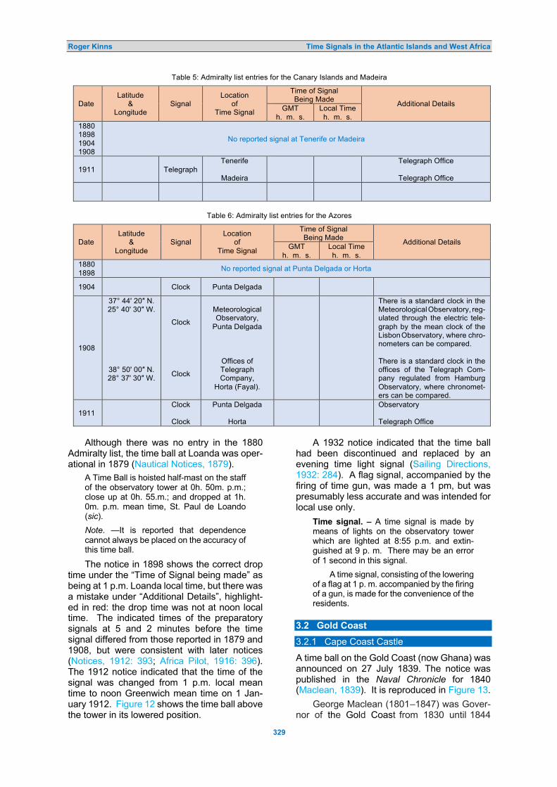
Roger Kinns Time Signals in the Atlantic Islands and West Africa
329
Table 5: Admiralty list entries for the Canary Islands and Madeira
Date Latitude
& Longitude
Signal Location
of Time Signal
Time of Signal Being Made Additional Details GMT
h. m. s. Local Time h. m. s.
1880 1898 1904 1908
No reported signal at Tenerife or Madeira
1911
Telegraph Tenerife
Madeira
Telegraph Office
Telegraph Office
Table 6: Admiralty list entries for the Azores
Date Latitude
& Longitude
Signal Location
of Time Signal
Time of Signal Being Made Additional Details GMT
h. m. s. Local Time h. m. s.
1880 1898 No reported signal at Punta Delgada or Horta
1904 Clock Punta Delgada
1908
37° 44' 20″ N. 25° 40' 30″ W.
38° 50' 00″ N. 28° 37' 30″ W.
Clock
Clock
Meteorological Observatory,
Punta Delgada
Offices of Telegraph Company,
Horta (Fayal).
There is a standard clock in the Meteorological Observatory, reg- ulated through the electric tele-graph by the mean clock of the Lisbon Observatory, where chro-nometers can be compared. There is a standard clock in the offices of the Telegraph Com-pany regulated from Hamburg Observatory, where chronomet-ers can be compared.
1911 Clock
Clock
Punta Delgada
Horta
Observatory Telegraph Office
Although there was no entry in the 1880
Admiralty list, the time ball at Loanda was oper-ational in 1879 (Nautical Notices, 1879).
A Time Ball is hoisted half-mast on the staff of the observatory tower at 0h. 50m. p.m.; close up at 0h. 55.m.; and dropped at 1h. 0m. p.m. mean time, St. Paul de Loando (sic).
Note. —It is reported that dependence cannot always be placed on the accuracy of this time ball.
The notice in 1898 shows the correct drop time under the “Time of Signal being made” as being at 1 p.m. Loanda local time, but there was a mistake under “Additional Details”, highlight-ed in red: the drop time was not at noon local time. The indicated times of the preparatory signals at 5 and 2 minutes before the time signal differed from those reported in 1879 and 1908, but were consistent with later notices (Notices, 1912: 393; Africa Pilot, 1916: 396). The 1912 notice indicated that the time of the signal was changed from 1 p.m. local mean time to noon Greenwich mean time on 1 Jan-uary 1912. Figure 12 shows the time ball above the tower in its lowered position.
A 1932 notice indicated that the time ball had been discontinued and replaced by an evening time light signal (Sailing Directions, 1932: 284). A flag signal, accompanied by the firing of time gun, was made a 1 pm, but was presumably less accurate and was intended for local use only.
Time signal. – A time signal is made by means of lights on the observatory tower which are lighted at 8:55 p.m. and extin-guished at 9 p. m. There may be an error of 1 second in this signal.
A time signal, consisting of the lowering of a flag at 1 p. m. accompanied by the firing of a gun, is made for the convenience of the residents.
3.2 Gold Coast
3.2.1 Cape Coast Castle
A time ball on the Gold Coast (now Ghana) was announced on 27 July 1839. The notice was published in the Naval Chronicle for 1840 (Maclean, 1839). It is reproduced in Figure 13.
George Maclean (1801–1847) was Gover-nor of the Gold Coast from 1830 until 1844

Roger Kinns Time Signals in the Atlantic Islands and West Africa
330
Table 7: Admiralty list entries for St. Paul de Loanda, Angola
Date Latitude
& Longitude
Signal Location
of Time Signal
Time of Signal Being Made Additional Details GMT
h. m. s. Local Time h. m. s.
1880 No reported signal at St. Paul de Loanda
1898
8° 48' 45″ S. 13° 13' 20″ E..
Ball
At the Observatory
24 07 6.7 01 00 00 Ball is hoisted half way up as a preparatory at 5 minutes before sig-nal. Ball hoisted close up at 2 minutes be-fore signal. Ball dropped at noon St. Paul de Loanda (Observatory) mean time. This signal has been reported to be inaccurate.
1904 Ball
1908
8° 48' 46″ S. 13° 13' 19″ E..
Ball
At the Observatory
24 07 6.7 01 00 00 Ball is hoisted half way up as a preparatory at 10 minutes before sig-nal. Ball hoisted close up at 5 minutes be-fore signal. Ball dropped at 1 p.m. St. Paul de Loanda (Observatory) mean time. Ball not dropped on Sundays or public holidays. This signal has been reported to be inaccurate.
1911 Ball
Figure 12: Loanda Observatory (Klaus Hülse Collection).
(Wikipedia). The apparatus at the Cape Coast Castle was similar in many respects to the 1836 arrangement at the Royal Observatory, Cape of Good Hope, with a ball having a diameter of 5 feet that was dropped from a gaff (Kinns, 2021). The footnote in Figure 14 suggests that the stat-
ed longitude was too far east by more than 2 km. The time ball may have had a short life. 3.2.2 Accra
The Admiralty list entries for Accra are shown in Table 8. There was no entry in 1880.

Roger Kinns Time Signals in the Atlantic Islands and West Africa
331
Figure 13: Announcement of the Cape Coast time ball (Naval Chronicle, 1840: 128)
A flag and gun were in use by 1898. The signal was of doubtful accuracy until at least 1908, because of the need for re-transmission of telegraph signals from London. Editions after 1911 have not been seen by the author. 3.2.3 Takoradi Time Ball and Gun
Another time ball had been erected by 1932, as shown in the following entry for Takoradi (Sail-ing Directions, 1932: 75).
Time signal. - A time signal is made from the Prince of Wales Clock Tower. The time used is that of Greenwich meridian from January 1 to August 31 and that of 5° E. (0h. 20m. fast on Greenwich mean time) during the remainder of the year. Simultaneously with the dropping of the time ball a gun is fired from the harbor signal station.
Takoradi, now joined with Sekondi in Ghana, is about 200 km WSW of Accra. The time ball was operated in conjunction with a
time gun. Unusually, the local time was ad-vanced by 20 minutes between 1 September and 31 December each year. The drop time was not stated in the notice. There was no mention of a time signal at Accra. 3.3 Tokonu, Nigeria
A time ball existed in 1893 at the port of Tokonu on the Bight of Benin, now part of Nigeria (West Coast of Africa, 1893: 232).
Time ball.- A time ball is hoisted on the flagstaff of the telegraph office; the time is given from Loanda …
The time was regulated from Loanda, in An-gola, but no further details were specified in the notice. It was not mentioned in the subsequent 1908 edition, so it probably had a short life. It did not appear in Admiralty lists between 1898 and 1911. Tokonu is about 110 km from Lagos, the capital of Nigeria.

Roger Kinns Time Signals in the Atlantic Islands and West Africa
332
Table 8: Admiralty list entries for Accra.
Date Latitude
& Longitude
Signal Location
of Time Signal
Time of Signal Being Made Additional Details GMT
h. m. s. Local Time h. m. s.
1880 No reported signal at Accra
1898
05° 31' 48″ N. 0° 11' 30″ W. Flag
and
Gun
Direct Company's Telegraph
Office
11 00 46 11 00 00 Flag dropped at 11h 00m 00s Accra mean time. Greenwich mean time is received daily, Sundays excepted, at 10h 00m 00s a.m., from London by Post Office Chronograph; but being re-transmitted through several stat-ions is not exact.
1904 Flag
and Gun
1908
05° 31' 48″ N. 0° 11' 30″ W. Flag
and Gun
Direct Company's Telegraph
Office
11 00 46 11 00 00
[As for 1898]
1911 Flag
And Gun
3.4 Dakar, Senegal
Dakar is at the western end of the Cape Verde peninsula, with the Cape Verde Islands further west. It was the most northerly of the signals in Sub-Saharan Africa. Senegal had been a French colony, becoming independent in 1960.
Time signals at Dakar did not feature in Admiralty lists up 1911, but there was a time ball there for a limited period. The following notice was published in 1911, indicating that an earlier time ball had been re-established (Not-ices, 1911: 315).
AFRICA – West coast – Dakar –Time signal reestablished. – Referring to Notice to Mariners No. 19(966) of 1909, the French Government has given further notice that the time signal at Dakar, west coast of Africa, has been reestablished.
The signal consists of a black ball 3 feet in diameter dropped on a mast located at the southeastern angle of the Arsenal Grounds.
It is hoisted 5 minutes before and drop-ped at 11h. 09m. 41.5s., Greenwich mean time, corresponding to 10h. 00m. 00s., Da-kar mean time. The ball is immediately re-hoisted and dropped again 2 minutes later.
Should the signal fail a red flag is shown from the mast and the signal will be repeated 10minutes after the first ball was dropped.
In the above notice, times appear to have been based on zero hours at midnight, not zero hours at noon as usually expected for time ball data.
This time ball was noted in later United States sailing directions (East Atlantic Pilot, 1916: 426; 1918: 401; 1920: 412). By then
Dakar mean time had been changed to 1 hour slow on Greenwich. The entry for 1920 is transcribed below.
Time Signal. - A time signal is established at Dakar. It consists of a black ball hoisted on a mast in the eastern part of the arsenal five minutes before the hour and dropped at 22 hrs. 00 m. 00 sec. standard time, cor-responding to 23 hrs. 00 m. 00 sec. Green-wich mean time. The ball will be rehoisted immediately afterwards, and dropped again 2 minutes later. Should the time be inaccu-rate, a red flag will be hoisted at the yard-arm, and these signals will then be repeated at 22 hrs. 00 m. 00 sec. and 22 hrs. 12 m. 00 sec. standard mean time.
This notice gave the same information as in 1916 and 1918. Times were based on zero hours at noon for astronomical purposes.
Figure 14 shows the arsenal under con-struction, before erection of the time ball. The time ball is likely to have been in the vicinity. 4 CONCLUDING REMARKS
The first time ball on an Atlantic island was established at Jamestown, St Helena in Janu-ary 1834, following only Mauritius and Green-wich in 1833 and the first experimental time ball at Portsmouth in 1829. The Portsmouth trials were declared a success in 1830, but the trans-ition to an operational service at Portsmouth may not have occurred until long after intro-duction of the Greenwich service in 1833.
St Helena was then an important rendez-vous and victualling centre for sailing ships returning from the Far East. The primary time ball was erected at the Ladder Hill Observatory, with a repeater time ball at a similar level and a

Roger Kinns Time Signals in the Atlantic Islands and West Africa
333
Figure 14: Dakar Arsenal under construction in 1902 (https://www.senegal-online.com/gallery/cartes-postales-anciennes-du-port-de-dakar/). gun that was fired when the ball was dropped. A description of the apparatus, including a dia-gram, was published in The Nautical Magazine during 1835, but it was difficult to interpret. It indicated that the ball slid down a mast and was controlled using ropes and weights. There were no details of the triggering arrangement. The time ball had been reported by Captain Robert Wauchope as being an accurate signaI, but the associated editorial was sceptical and led to a protest from Wauchope that his claim to time ball invention had not been recognised appropriately.
St Helena was transferred from the East India Company to the Crown in 1833, followed by cost-cutting. The well-equipped Observa-tory had been established in the 1820s and had been operated with distinction by Lieutenant Manuel Johnson, who made observations of the southern stars between 1829 and 1833. He published a catalogue in 1835 that is still highly-regarded. Despite that, the Ladder Hill Obser-vatory was closed in 1836 and instruments other than astronomical clocks were withdrawn. The time ball service, but not the gun, continued under control from the Time Office in James-town, with a repeater ball on Ladder Hill that was dropped from a yard arm. It appears that the service was regulated using a sextant and the clocks. It had been discontinued by 1908.
Johnson had a distinguished career in astronomy after his return to England in 1833, rooted in the encouragement he received as a young man from the Governor of St Helena. He took his MA at Oxford University in 1839 and was Director of the Radcliffe Observatory from 1839 until his death in 1859. He was elected a Fellow of the Royal Society in 1856 and served as President of the Royal Astronomical Society from 1855 to 1857.
Many other Atlantic islands and various lo-cations on the west coast of Africa had time signals. In several cases, their existence has only been identified from Admiralty lists, notices to mariners and sailing directions published in the United States, without supporting evidence from local historical records. Further research may expose other time signals.
Ascension had been garrisoned by the Brit-ish in 1815 in order to inhibit any attempt to release Napoleon from exile in St Helena. Ascension then played an important role in capturing slave ships that were still plying be-tween West Africa and South America. It was administered as a Royal Navy shore station with a detachment of marines until 1922. Not-ices about a time ball at Ascension were pub-lished in The Nautical Magazine in 1860 and 1865, at a time when the island was at risk of being abandoned through concern about the

Roger Kinns Time Signals in the Atlantic Islands and West Africa
334
cost of maintaining the garrison. There was never a permanent observatory and the time ball service must have been operated using equipment available on Royal Navy ships. There is no mention of the time ball in an otherwise comprehensive history of the island. Ascension became an important communicat-ions centre in the twentieth century, with ex-tensive development during both WWI and WWII, and remains important strategically.
No signals in the Azores were reported in Admiralty lists up to 1898. A clock was avail-able at the Meteorological Office at Punta Del-gada by 1904, regulated by telegraph from Lis-bon. Another was available at the telegraph office in Horta by 1908, regulated from Ham-burg. Chronometers could be calibrated at the telegraph offices in Tenerife and Madeira by 1911.
The most northerly time ball on the west coast of Africa was at Dakar in Senegal on the Cape Verde Peninsular. It is likely to have been introduced in the early twentieth century but was not included in Admiralty lists between 1898 and 1911. It was re-established in 1911 and was still operating in 1920. Three new time signals were introduced on São Vicente Island in the Cape Verde islands in February 1922, including a time ball, a diamond-shaped repeat-er signal and a gun. That was a late date for introduction of a new time ball, given the in-creasing availability of wireless signals. A telegraph signal had been previously available. The first two São Vicente signals were still operating in 1941.
An early time ball had been erected at the Cape Coast Castle near Accra on the Gold Coast, now Ghana, in July 1839. Its arrange-ment was similar to that used in 1836 at the
Cape of Good Hope. Its creator, George Mac-lean, had died in 1847 and the time ball service does not appear to have been maintained for long. There was no entry for Accra in the 1880 Admiralty list but a flag, accompanied by a time gun, was listed between 1898 and at least 1911. In 1932, there was a combined time ball and time gun service at Takoradi, about 200 km from Accra, but there was no indication of a continued service at Accra. There was also a short-lived time ball at Tokonu in Nigeria, noted in United States sailing instructions as regulat-ed from Loanda in 1893, but not mentioned in later editions.
There was an important time ball at St. Paul de Loanda in Angola, regulated by the observa-tory there. It was announced in 1879. It had been replaced by a 9 pm time light at the ob-servatory by 1930. 5 ACKNOWLEDGEMENTS
The research described in this paper makes extensive use of the excellent website “Saint Helena Island Info”, which includes a wealth of information about St Helena and its history from first discovery to the present day. Several illu-strations have been taken from that website. I am grateful to John Turner, the website man-ager and to Nick Thorpe at the St Helena Mus-eum in Jamestown, for additional images and for checking my draft text.
Paul Fuller located references concerning the first time ball experiments at Portsmouth that throw further light on early developments in England. I also thank Klaus Hülse in Germany for providing a postcard illustration from his ex-tensive collection and reviewers for suggesting improvements to the paper.
6 REFERENCES
Africa Pilot, Volume I, 1916. H. O. No. 105, Washington Government Printing Office, 1916. Airy, G.B., 1878. Letter to the Secretary of the Admiralty, dated 12 February. Royal Greenwich Observatory
Archives RGO 6.618, Papers of George Airy, Cambridge University Library. Barrow, J., 1829. Admiralty Office notice dated 22 October 1829. The Morning Post, 24 October, page 1. Bartky, I.R., 1987. The bygone era of time balls. Sky and Telescope, 23(1), 32–35. Bartky, I.R., and Dick, S.J., 1981. The first time balls. Journal for the History of Astronomy, 12, 155–164. Editorial, 1835. The time-ball of St. Helena. The Nautical Magazine, 4, 658–660. Findlay, A.G., 1867. Sailing Guide for the Ethiopic or South Atlantic Ocean, Fifth Edition. London, Holmes Laurie. Findlay, A.G., 1883. Sailing Guide for the Ethiopic or South Atlantic Ocean, Ninth Edition. London, Holmes Laurie. Gill, D., 1879. On the value of the solar parallax derived from observations of Mars made at Ascension Island during
the opposition of 1877. Monthly Notices of the Royal Astronomical Society, 39(8), 434–437. East Atlantic Pilot, H. O. No. 134, First Edition, 1916; Second Edition, 1918; Third Edition, 1920. Washington,
Government Printing Office. Hart-Davis, D., 2016. Ascension, the Story of a South Atlantic Island. Second Edition. Ludlow, Merlin Unwin Books. Johnson, M.J., 1835. A Catalogue of 606 Principal Fixed Stars in the Southern Hemisphere. Printed by the Royal
Astronomical Society at the Expense of the Honourable East India Company. Kinns, R., 2017. The principal time balls of New Zealand. Journal of Astronomical History and Heritage, 20(1), 69–
94. Kinns, R., 2020a. The 1833 time ball at Port Louis, Mauritius: the forgotten service for chronometer calibration.
International Journal for the History of Engineering & Technology, 89(1-2), 264–275.

Roger Kinns Time Signals in the Atlantic Islands and West Africa
335
Kinns, R., 2020b. The time balls of Mauritius. Journal of Astronomical History and Heritage, 23(2), 281–296. Kinns, R., 2021. Time signals for mariners in South Africa. Journal of Astronomical History and Heritage, 24(2),
285–314. Liddell, J., 1837. St. Helena Time Ball. Letter to the Editor dated 1 May. The Nautical Magazine, 354–355. Lewis, T., 1910. Handwritten Notes for the Astronomer Royal, dated 21–25 April. Royal Greenwich Observatory
Archives RGO 7 257, Papers of William Christie, Cambridge University Library. List of Time Signals, Established in Various Parts of the World 1880: Compiled for the Use of Seamen, as an Aid
for Ascertaining the Errors and Rates of Chronometers (prepared from official sources to December 1880). 1st Edition. London, printed for the Hydrographic Department, Admiralty, 1880.
List of Time Signals, Established in Various Parts of the World 1898: Compiled for the Use of Seamen, as an Aid for Ascertaining the Errors and Rates of Chronometers (prepared from official sources to 31st December 1897). 5th Edition. London, printed for the Hydrographic Department, Admiralty, 1898.
List of Time Signals, Established in Various Parts of the World 1904: Compiled for the Use of Seamen, as an Aid for Ascertaining the Errors and Rates of Chronometers (prepared from official sources to 1st April 1904). London, printed for the Hydrographic Department, Admiralty, 1904.
List of Time Signals, Established in Various Parts of the World 1908: Compiled for the Use of Seamen, as an Aid for Ascertaining the Errors and Rates of Chronometers (prepared from official sources to 1st January 1908). London, printed for the Hydrographic Department, Admiralty, 1908.
List of Time Signals, Established in Various Parts of the World 1911: Compiled for the Use of Seamen, as an Aid for Ascertaining the Errors and Rates of Chronometers. London, printed for the Hydrographic Department, Admiralty, 1911.
Lloyd, J.A., 1833. Rating Chronometers in the Mauritius, 19 April 1833. Notice published in the Nautical Magazine, 1835, 5, 136.
MacDougall, P., 2017. Portsmouth Dockyard Through Time. Stroud, Amberley Publishing. Maclean, G., 1839. Notice to Mariners, dated 27 July 1839. The Naval Chronicle, 1840, 128. Madras, 1841. Entry in The Nautical Magazine and Naval Chronicle for 1841, 363. Maudslay, Sons & Field, 1856. Letters to G.B. Airy dated 6 and 13 November 1856. Royal Greenwich Observatory
Archives: RGO 6.613. Nautical Notices, 1879. Notice 333, The Nautical Magazine, 48, 989. Notices to Mariners of 1911, Nos. 1 to 52. Washington Government Printing Office, 1911. Notices to Mariners of 1912, Nos. 1 to 52. Washington Government Printing Office, 1912 Notices to Mariners of 1922, Nos. 1 to 26. Washington Government Printing Office, 1922. Phillimore, R.H., 1958. Historical Records of the Survey of India. Volume 4. Dehra Dun, Survey of India. Russell, D.S. (Master of Doctor Franklin), 1858. Log of the whaling barque Doctor Franklin, 8 Nov 1856 – 1 Aug
1859. New Bedford Whaling Museum Catalogue Number, KWM 1033. Sailing Directions for the SW Coast of Africa, Third Edition, 1932. H. O. No. 105. Washington, United States
Government Printing Office, 1932. Sailing Directions for the West Coasts of Spain, Portugal and North-West Africa, Fifth Edition, 1942. H. O. No. 134.
Washington, United States Government Printing Office, 1942. Saint Helena Island Info, 2021. Website sponsored and maintained by Burgh House Ltd.
(http://sainthelenaisland.info/; accessed April 2021). St Helena, 1900. Article published in the Inverness Courier, 16 March 1900, page 6. Swainson, H.G., 1878. Memorandum to G.B. Airy in response to questions, dated 20 March. Royal Greenwich
Observatory Archives RGO 6 618, Papers of G.B. Airy. [Swainson was Superintendent of the Portsmouth Observatory.]
Tate, A.G., 1910. Letter to Christie, dated 17 November. Royal Greenwich Observatory Archives RGO 7 257, Papers of William Christie, Cambridge University Library. [Tate was the Admiral Superintendent at Portsmouth.]
The Time Ball, 1865. Nautical Notices in The Nautical Magazine, 1865: 161. Time Signal Ball at Ascension, 1860. Nautical Notices in The Nautical Magazine, 1860, 499. Warner, B., 1981. Manuel Johnson and the St. Helena Observatory. Vistas in Astronomy, 25, 383–409. Wauchope, R., 1830. Plan for ascertaining the rates of chronometers by signal. Edinburgh New Philosophical
Journal, 8, 160–162; 289–291. Wauchope, R., 1836. Letter to the Editor of The Nautical Magazine, 2 April 1836, with supporting testimonials
concerning time ball invention. Nautical Magazine, 5, 460–464. Wauchope, R., 1852. Wauchope Time-Ball (from the East India and Colonial Chronicle), 15 September 1852, re-
published by The Witness, 20 October 1852.
Dr Roger Kinns was born in Winchester, England, in 1944. He read Mechanical Sciences as an undergraduate at Gonville and Caius College, Cambridge and then took an MASc degree in control engineering at the University of Waterloo in Ontario, Canada, before returning to Cambridge to complete a PhD on unsteady aerodynamics.
Roger was Maudslay Research Fellow of Pembroke College, Cambridge, from 1971 to 1975. He then joined YARD Ltd in Glasgow, Scotland to lead development and application of techniques for the acoustic design of ships and submarines. He has worked as an independent consultant since 1999. Until 2019 he was a Senior Visiting Research Fellow in the School of Mechanical and Manufacturing Engineering at the University of New

Roger Kinns Time Signals in the Atlantic Islands and West Africa
336
South Wales in Sydney, Australia. Presently, Roger is Treasurer of the Maudslay Society and Maudslay Scholarship Foundation.
The Maudslay connection led to an enduring fascination with the history of engineering and particularly time signals worldwide. He is co-owner of Thalia, a 1924 keelboat which shares its name with Wauchope’s command when he visited St Helena in 1834. Roger has published a succession of research papers on time balls and other time-signalling devices and techniques and he has a chapter on the time signals of Southeast Asia in Exploring the History of Southeast Asian Astronomy: A Review in Current Projects and Future Prospects and Possibilities (2021, Springer).

Journal of Astronomical History and Heritage, 24(2), 337–344 (2021).
337
WHERE WAS MEAN SOLAR TIME FIRST ADOPTED??
Simone Bianchi INAF-Osservatorio Astrofisico di Arcetri, Largo E. Fermi, 5, 50125, Florence, Italy.
E-mail: [email protected]
Abstract: It is usually stated in the literature that Geneva was the first city to adopt mean solar time, in 1780, followed by London (or the whole of England) in 1792, Berlin in 1810 and Paris in 1816. In this short paper I will partially revise this statement, using primary references when available, and provide dates for a few other European cities. Although no exact date was found for the first public use of mean time, the primacy seems to belong to England, followed by Geneva in 1778–1779 (for horologists), Berlin in 1810, Geneva in 1821 (for public clocks), Vienna in 1823, Paris in 1826, Rome in 1847, Turin in 1849, and Milan, Bologna and Florence in 1860.
Keywords: mean solar time 1 INTRODUCTION
The inclination of the Earth’s axis with respect to the orbital plane and its non-uniform revolut-ion around the Sun are reflected in the irregu-larity of the length of the day, when measured from two consecutive passages of the Sun on the meridian. Though known since ancient times, the uneven length of true solar days be-came of practical interest only after Christiaan Huygens (1629–1695) invented the high-accuracy pendulum clock in the 1650s. For proper registration of regularly-paced clocks, it then became necessary to convert true solar time into mean solar time, obtained from the position of a fictitious mean Sun; mean solar days all having the same duration over the course of the year. Tables providing the equat-ion of time, i.e. the difference between mean and true (sometimes called apparent) solar time, throughout the year, were computed already by Huygens, and in the early 1670s they were perfected by John Flamsteed (1646 –1719, who was to become the first Astronomer Royal at the Royal Observatory, Greenwich—see, e.g., Tur-ner, 2015) into the form used today.
At first, the use of mean solar time was of concern for astronomers and horologists only. Public clocks continued to be regulated on the true Sun, using sundials and meridian lines. Thus, it was necessary to register them often, at the risk of damaging the mechanisms. The increasing need to know the time precisely, together with the availability of higher-accuracy watches, eventually made the adoption of mean solar time necessary. But where was mean solar time first adopted?
In the modern literature it is often stated that Geneva was the first city to use mean solar time for public clocks, in 1780, followed by England (or just London, in some texts) in 1792, Berlin in 1810 and Paris in 1816: see, for ex-ample, Howse (1980: 82) and Dohrn-van Rossum (1996: 346). Their source is likely Bigourdan (1914: B.8). However, there is no
reference to the source of that information in Bigourdan (1914), nor in earlier occurrences of the sequence, a few articles describing time zones around the years of their introduction (Möller, 1891; Oppermann, 1890; Rocca, 1893). References are instead provided in Houzeau (1882: 151), which is probably the main source for the later texts. The lack of primary sources in most texts was noted by Lundmark (1996), who questioned the date for the adoption of mean solar time in England and suggested, tentatively, that it happened later, together with the country-wide adoption of Greenwich mean time (I maintain here that it happened earlier than 1792). Even in the nineteenth century, Raab (1889) lamented how difficult it was to find information about this topic, because of the scant official and scientific documentation.
I recently had the opportunity to study the introduction of mean solar time (henceforth ‘mean time’) in Italy and compare it in a Euro-pean context (Bianchi, 2019; 2020b). Unlike previous researchers, I could make use of the ever-increasing availability of on-line digital libraries. Thus, I was able to access some new primary sources, which has led me to revise some of the dates when mean time was introduced throughout Europe, and I present this new information below (and in Figure 1). 2 FIRST GENEVA OR ENGLAND?
The quoted primacy in the use of mean time by Geneva fits with the importance of watch-making in the economy of the city. Indeed, it was the local Société pour l’Encouragement des Arts et de l’Agriculture that installed a mean time meridian on a wall of the Cathedral of St. Pierre; the aim was to help local watch-makers check the accuracy of their products, without the need to refer to tables for the equation of time. An analemma, an 8-shaped curve mark-ing the Sun’s position at noon of mean time throughout the year, was traced on top of an existing meridian by the astronomer Jacques-

Simone Bianchi Adoption of Mean Solar Time
338
Figure 1: European nations and localities mentioned in the text and the dates when they adopted mean time. Labels in purple show the major events described in Sections 2 to 5 below, while those in green are found in the literature and require further research—see Section 6 (base map: d-maps.com; map modifications: Simone Bianchi).
Figure 2 (left): Portrait of Professor Jacques-André Mallet, in the Bibliothèque de Genève (https://fr.wikipedia.org/wiki/Jacques-Andr%C3%A9_Mallet#/media/Fichier:Portrait_de_Jacques_Andr%C3%A9_Mallet,_professeur.jpg).
André Mallet (1740–1790; Figure 2), founder and Director of Geneva Observatory. The revised meridian was installed in 1778 (Figure 3). The Geneva Government found the enter-prise commendable, reimbursed the Société for the cost of the installation, and put a person in charge of ringing a bell at noon, so that artisans in the neighborhood could know mean time without the need of leaving their workshops. The bell signal was already at work in 1779, when it was put under the care of a church warden (Gautier, 1894; Memoires, 1780; Ram-bal, 1889). The service was intended for the watch-making industry, and not for public use at large (although the bell could be heard by

Simone Bianchi Adoption of Mean Solar Time
339
everybody). Clocks in Geneva, including the Cathedral one, still remained regulated to true time. Mean time was eventually adopted a few decades later, starting from 15 April 1821. The day was chosen ad hoc, since it is one of the four in a year in which true and mean time coincided (i.e. the equation of time was null). The bell signal for the horologists remained in use for more than 20 years after then, until the late 1840s (Gautier, 1894).
The Director of Paris Observatory, Jérôme Lalande (1732–1807) quoted the Memoires de la Société (1780) in a note of his treatise Ast-ronomie (Lalande, 1792: 341) and wrote that Geneva used mean time from 1780. He had added that information also in an earlier ency-clopaedical entry about meridians (Lalande, 1785). In both references, however, he made clear that Geneva was not first: mean time was already in use in England before 1785. Refer-ring to Lalande (1792), Houzeau (1882: 151) said that mean time “… was used in England in 1792.”1 In later texts, this became “… it was used in England from 1792 …”, confusing the year in which Lalande’s Astronomie was pub-lished with the beginning of the service.
The adoption of mean time in England must have occurred between the end of the seven-teenth century and the mid-eighteenth century, but I could find no precise date in the literature. Later accounts said that public clocks in London “… never had shewn any other but mean time …” (Vulliamy, 1828: 12). The fact that mean time was already in use for so long is also sug-gested by the first edition of The Nautical Al-manac … (Maskelyne, 1766). In fact, the ephemerides in the Almanac were provided in true time, in order to be readily compared with time measurements from the height of the Sun and used in the determination of geographical coordinates at sea. However, a caveat was added to the explanations:
This [true] Time is different from that shewn by Clock and Watches well regulated at Land, which is called equated or mean Time ... that which should be shewn by a good Clock or Watch ... an equable Motion, such as that of Clocks and Watches ought to be. (The Nautical Almanac and Astronomical Ephemeris, 1766: 145, 150).
Indeed, Giuseppe Piazzi (1746–1826), Director of Palermo Observatory, stated that mean time had been used for public clocks in England prior to 1750 (Piazzi, 1798; see also Tuscano, 2016). Despite the lack of a precise year, it is never-theless clear that the primacy for the public use of mean time belongs to England. 3 BERLIN AND VIENNA
In 1787 a clock made by the court and city hor-
ologist Christian Möllinger (1754–1826) was installed over the entrance of the Berlin Acad-emy of Sciences. The clock had two quadrants, one on the interior of the building, and one on the façade along the Unter den Linden boule-vard and accessible to the public. Both quad-rants had two hands for minutes, one showing true time and the other mean time. While the clock quickly became a popular stop-over for setting pocket watches, the presence of two hands for minutes confused the public and caus-
Figure 3: The meridian at the Cathedral of Saint Pierre in Geneva (Association …, 1891: 105; see also Rambal, 1889: 113). The meridian was removed after restorations to the Cathedral (Gautier 1894: 5).
ed protests. After just a few weeks the mean time minute hand was removed from the ex-ternal quadrant, which then only showed true time. At the same time, local authorities failed to get public clocks in accord with the Academy clock (Görike and Kiesant, 2021; Sauter, 2007).
Eventually, mean time was adopted for public use at the end of 1810, as usually re-ported in the literature. The switch was pro-posed by the Director of Berlin Observatory, Johann Elert Bode (1747–1826; Figure 4) at a

Simone Bianchi Adoption of Mean Solar Time
340
Figure 4: Berlin’s Johann Elert Bode (https://commons.wikimedia.org/wiki/File:Johann_Elert_Bode.jpg).
Figure 5: Joseph Johann von Littrow (https://en.wikipedia.org/wiki/Joseph_Johann_von_Littrow#/media/File:Joseph_Johann_von_Littrow.jpg).
Figure 6: An undated portrait of Ferdinand Berthoud by an unknown painter (https://en.wikipedia.org/wiki/Ferdinand_Berthoud#/media/File:Ferdinand_Berthoud_-_Uhrmacher.jpg).
meeting of the Academy of Sciences early in December that year. Soon after, the Academy clock was set on mean time, and the authorities had all public clocks regulated on that, and “… since then Berlin, as already other big cities did, relies on mean time ....” (Bode, 1811: 230). While it is not clear to which big cities Bode referred (unless he just meant London and Geneva), other cities in the Kingdom of Prussia must have followed the capital; from the edition for 1830, the Berliner Kalender (1829: xliii) started to use mean time for its ephemerides, “… since now in Berlin and in the most im-portant Prussian cities the clocks are regulated on mean time ...”
Another astronomer, the Director of Vienna Observatory Joseph Johann von Littrow (1781–1840; Figure 5) was responsible for the switch in the capital of the Austrian Empire. From 1 March 1823, a bell at Vienna Observatory was first rung two minutes before noon, to alert clock regulators, and then every 2 seconds from 22 seconds before noon; at the last stroke, the bell of the Cathedral of St. Stephan rang, and on this all bell-towers and public clocks were to be regulated. Unlike previously, noon was that of mean time (Littrow, 1823). 4 PARIS
When speaking of the use of mean time in Geneva and England, Lalande (1785: 385) added: “… the Englishmen are surprised [to know] that true time, or solar time, is still used in France, despite its irregularities.” The Court and Navy Horologist Ferdinand Berthoud (1727–1807; Figure 6) had already proposed the use of mean time in France, from as early as 1754. During the Revolution, Berthoud (1797: 3) made his proposal again: he hoped that the Académie des Sciences, which had made "… weights and measures uniform and invariable …", would have encouraged the use of the uniform, mean time in place of the uneven true time. While noting that some nations already used mean time (though he did not say explicitly England and Geneva), Berthoud appealed to French pride and concluded
… that in a nation well known for Enlighten-ment, only mean time can be adopted for civil use ... (Berthoud, 1797: 11).
His proposal was backed by Lalande, who, in the Connaissance des Tems (1797: 187), stat-ed “… that one should leave true time and use, even in society, mean time.” A few years later, Berthoud (1802) reiterated his proposal, but to no avail. After more than a decade, a text printed in Dublin said “… we [in Ireland] reckon by mean time; in France they use solar time.” (Ennis, 1816: xvii).

Simone Bianchi Adoption of Mean Solar Time
341
The statement that mean time started to be used in Paris in 1816 comes from the treatise Astronomie Populaire (Arago, 1854; see also Houzeau, 1882), a posthumous publication of the lectures of the Director of Paris Observa-tory, François Arago (1786–1853; Figure 7). Besides the year, the text does not provide many details on the implementation of the measure. It says only that the Bureau des Longitudes was asked by the prefect of the Seine Department, Gaspard de Chabrol (1773–1843), for a report on the possible effects of the change: apparently, the prefect feared there would be social unrest; instead, the change passed unnoticed. The quoted year, however, must have been a mis-print. The change act-ually happened on 24 December 1826, when all Paris clocks, starting with the new clock on the building of the Paris Bourse (stock exchange) and that of the Hôtel de Ville (city hall), switched to mean time. As with Geneva in 1821, the choice fell on a date in which the equation of time was null. An article announcing the meas-ure in the newspaper Le Courier Français com-mented that the administration took a laudable decision, finally putting Paris on a par with other cities, such as London, Amsterdam and Gen-eva (Du temps vrai, 1826). That the switch took place in 1826 is also confirmed by Vulliamy (1828). The same article includes a few sent-ences from the report that Arago made on be-half of the Bureau des Longitudes, stating again the utility of public mean time for the watch-making industry (similar words also are found in Arago, 1854). 5 ITALY
The switch to mean time happened later in Italy. In Rome, it was made shortly after the change in reckoning the hours. Until the middle of the eighteenth century, in the various Italian states the day (of 24 equal hours) started half an hour after sunset. This implied that clocks had to be regulated every day, but for practical reasons this was done every fortnight, using precomput-ed tables (Colzi, 1995).
From 1750, the Grand Duchy of Tuscany was the first state to adopt the hour count fol-lowing the so-called French (or ultramontane) style (Bianchi, 2019), i.e. the usual system with a 24-hour day starting at midnight and having noon at 12 o’clock (of true time). The adoption in Italy was gradual, and was only complete by the end of the Napoleonic wars. After the Restoration, only the Papal States switched back to the old system but returned to the mod- ern one after the ascent to the papacy of Pio IX in 1846. On the advice of Francesco de Vico S.J. (1805–1848; Figure 8), Director of Collegio
Figure 7: Francois Arago (https://en.wikipedia.org/wiki/Fran%C3%A7ois_Arago#/media/File:Fran%C3%A7ois_Arago_par_Ary_Scheffer.jpg).
Romano Observatory, the change was made more drastic, with the introduction of mean time and the start of a time signal on 1 January 1847 (Colzi, 1995; Secchi, 1877).
Another astronomer, Giovanni Antonio Am-edeo Plana (1781–1864; Figure 9) was behind the switch to mean time of Turin, capital of the Kingdom of Sardinia (he was the Director of the local observatory); this happened in autumn 1849 (Il tempo vero e il tempo medio, 1849). Mean time was used afterwards for telegraphy and railways in the Kingdom of Sardinia, and later this practice extended to the Italian Penin-sula while the unification into the new Kingdom of Italy proceeded. The provisional governments of Milan, Bologna and Florence, for example, introduced the use of mean time for public clocks in 1860 (on 29 February, 20 March, and 24 December, respectively; Bianchi, 2019).
Figure 8: Francesco de Vico (https://it.wikipedia.org/wiki/Francesco_Angelo_de_Vico#/media/File:Francesco_Angelo_de_Vico,_legista.png).

Simone Bianchi Adoption of Mean Solar Time
342
Figure 9: Giovanni Antonio Amedeo Plana (https://en.wikipedia.org/wiki/Giovanni_Antonio_Amedeo_Plana#/media/File:Giovanni_Plana.jpg).
In Florence the use of mean time was hoped for in order to follow what was done “… in Turin and in every learned city of Europe.” (Ridolfi, 1860). Before the adoption of mean time, the civic clock on the tower of the Palazzo Vecchio in Florence was set on true time by using a meridian line in the square below. Instead, from 24 December 1860 the noon of mean time was signaled to the Palazzo Vec-chio by the lowering of a flag at the old Florence Observatory (the Specola; Bianchi, 2020a; 2020b). The public, believing that the Sun’s in-dication gave the correct time, started to com-
Figure 10: Meridian line with analemma in the Piazza della Signoria in Florence. It was probably installed at the end of 1861 (photograph: Simone Bianchi).
plain that the tower clock was no longer ac-curate (Bianchi, 2019). The authorities solved the problem by installing a new meridian line with an analemma for mean time (and this still exists today—see Figure 10). It was traced by the observatory's Director, Giovanni Battista Donati (1826–1873; Figure 11). 6 CONCLUDING REMARKS
I have revised here the chronology of the adoption of mean time in Europe. Mean time was first used for public clocks in England, from at least the mid-eighteenth century; in Geneva from 1778–1779 (but only for the use of watch-makers, while in 1821 for public clocks); in Berlin in 1810; in Vienna in 1823; in Paris in 1826; in Rome in 1847; in Turin in 1849; in Milan, Bologna and Florence in 1860.
Figure 11: Giovanni Battista Donati (https://commons.wikimedia.org/wiki/File:Donatigiovanibattista.jpg
Since the scope of my work was mainly that
of checking a statement common in the liter-ature (like, e.g., in Howse, 1980), my research is in no way complete. Indeed, I found indicat-ions for the switch to mean time in other cities and countries. For these, however, I have not been able to find detailed references. I list them here, hoping they could be useful for further in-vestigations: the whole of Ireland passed to mean time before 1816, and Amsterdam before 1826 (Section 4); most cities in Prussia be-tween 1810 and 1829 (Section 3); Sweden, ac-cording to almanacs, in the early-1840s (Lund-mark, 1996; Möller, 1891); Naples sometime before Rome, apparently the first city to do so in Italy (Decuppis, 1853); Bern and the whole of Switzerland in 1853 (Wolf, 1872). 7 NOTES
1. I am responsible for all French-to-English, German-to-English and Italian-to-English translations in this paper.

Simone Bianchi Adoption of Mean Solar Time
343
8 ACKNOWLEDGEMENTS
This research has made use of several digital libraries, including Google Books, Internet Archive, NASA’s Astrophysics Data System, HathiTrust Digital Library, Gallica library of the Bibliothèque Nationale de France, ANNO newspaper library of the Österreichischen
National-Bibliothek, e-newspaper archives of the Swiss National Library, digital collections of the Sächsische Landesbibliothek- Staats- und Universitätsbibliothek Dresden, e-rara portal of Swiss libraries, and the CRISPA project of the Biblioteka Uniwersytecka w Warszawie.
9 REFERENCES
Arago, F., 1854. Astronomie Populaire. Volume I. Paris, Gide et J. Baudry. Association pour la restauration de Saint-Pierre, 1891. Saint-Pierre, Ancienne Cathédrale de Genève. Genève,
Imprimerie Suisse. Berliner Kalender auf das Gemein Jahr 1830. Berlin, Kalender Deputation (1829). Berthoud, F., 1797. De la Mesure du Temps par les Horloges, dans l’Usage Civil. Paris, A.-J. Baudelot & J.-M.
Eberhart. Berthoud, F., 1802. Histoire de la Mesure du Temps par les Horloges. Volume 1. Paris, Imprimerie de la
République. Bianchi, S., 2019. Il segnale orario a Firenze. Atti della Fondazione Giorgio Ronchi, 74, 61– 89. Bianchi, S., 2020a. The founding of Arcetri Observatory in Florence. Journal of Astronomical History and Heritage,
23, 553 –581. Bianchi, S., 2020b. The time signal in Florence. In La Rana, A., and Rossi, P. (eds.), Proceedings of the 39th
Annual Conference. Società Italiana degli Storici della Fisica e dell’Astronomia. Pisa, Pisa University Press. Pp. 367–372.
Bigourdan, G., 1914. Le jour et ses divisions. Les fuseaux horaires et l’Association Internationale de I’Heure. In Annuaire pour l’An 1914. Paris, Bureau des Longitudes. Pp. B1–B107.
Bode, J.E. (ed.), 1811. Astronomisches Jahrbuch für das Jahr 1814. Berlin, C.F.E. Späthen. Colzi, R., 1995. Che ora era? Raffronto tra le ore all’italiana e alla francese a Roma. Studi Romani, 43, 93–102. Connaissance des Tems, a l’Usage des Astronomes et des Navigateurs, pour l’Année Sextile VII.e de la
République; du 22 Septembre 1798 au 22 Septembre 1799. Paris, Imprimerie de la République (1797). Decuppis, P., 1853. Della Misura del Tempo e della Utilità di Regolare gli Orologi Sul Tempo Medio. Firenze,
Stamperia sulle Logge del grano. Dohrn-van Rossum, G., 1996. History of the Hour. Clocks and Modern Temporal Orders. Chicago, University of
Chicago Press. Du temps vrai et du temps moyen. Le Courier Français. 12 December (1826). Ennis, F., 1816. A Complete System of Modern Geography; or the Natural and Political History of the Present State
of the World. Dublin, J. Charles. Gautier, R., 1894. Le Service Chronométrique a l’Observatoire de Genève. Geneva, Aubert-Schuchardt. Görike, F., and Kiesant, S., 2021. Christian Möllinger, Alte Akademieuhr, 1787, Inv. Nr. K/G-0001
(https://berlin.museum-digital.de/index.php?t=objekt&oges=87150; accessed 5 February 2021). Houzeau, J.C., 1882. Vade-mecum de l’Astronomie. Bruxelles, F. Hayez. Howse, D., 1980. Greenwich Time and the Discovery of the Longitude. Oxford, Oxford University Press. Il tempo vero e il tempo medio, 1849. Museo Scientifico, Letterario ed Artistico Ovvero Scelta Raccolta di Utili e
Svariate Nozioni in Fatto di Scienze, Lettere ed Arti, 11, 382–383. Lalande, J., 1785. Méridienne ou Ligne Méridienne. In Encyclopédie Méthodique. Mathématiques. Volume II. Paris,
Panckouche. Pp. 379–385. Lalande, J., 1792. Astronomie. Volume I. Third Edition. Paris, P. Didot. Littrow, J.J., 1823. Über die Regulierung der öffentlichen Uhren. Wiener Zeitschrift für Kunst, Literatur, Theater und
Mode, 27 February. Littrow, J.J., 1836. Physische Astronomie oder Gesetze der himmlischen Bewegungen. Beschreibung und Lehre
vom Gebrauch der Astronomischen Instrumente. Stuttgart, Hoffmann. Lundmark, L., 1996. The separation of time and nature. In Fraser, J.T., and Soulsby, M.P. (eds.), Dimensions of
Time and Life: The Study of Time and Life VIII. Madison, International Universities Press. Pp. 97–104. Maskelyne, N., 1766. The Nautical Almanac and Astronomical Ephemeris, for the year 1767. London, W.
Richardson & S. Clark. Memoires de la Société Etablié à Genève pour l’Encouragement des Arts et de l’Agriculture. Introduction, 1(2), pp.
iii–vi (1780). Möller, A., 1891. Borgerlig tid och Verldstid. Lund Universitets Års-skrift, 28, 1–18. Oppermann, W., 1890. Wie und wann vollzieht sich der Uebergang zu einer einheitlichen Zeitrechnung. Glaser’s
Annalen für Gewerbe und Bauwesen, 27, 210–213. Piazzi, G., 1798. Sull’orologio italiano, ed Europeo. Palermo, Reale stamperia. Raab, R., 1889. Ueber mittlere Zeit. Deutsche Uhrmacher-Zeitung, 13, 81 –83; 90– 91. Rambal, J., 1889. Enseignement Théorique de l’Horlogerie. Geneva, Comité-Directeur du journal Suisse
d’Horlogerie. Ridolfi, C., 1860. Letter to the Director of the Department of Public Instruction, dated 18 November. Museo Galileo,
Firenze (Fondo ARMU, Copialettere 38, pp. 98–102).

Simone Bianchi Adoption of Mean Solar Time
344
Rocca, G., 1893. L’ora universale. La Rassegna Nazionale, 71, 38 –76. Sauter, M.J., 2007. Clockwatchers and stargazers: time discipline in early modern Berlin. The American Historical
Review, 112, 685–709. Secchi, A., 1877. L’Astronomia in Roma nel Pontificato di Pio IX. Roma, Tipografia della Pace. Turner, A., 2015. The eclipse of the Sun: sun-dials, clocks and natural time in the late seventeenth century. Early
Science and Medicine, 20, 169–186. Tuscano, M.L., 2016. L’evoluzione dei sistemi orari nelle meridiane a camera oscura di Sicilia. In Fregonese, L.,
and Gambaro, I. (eds.), Proceedings of the 33rd Annual Conference. Società Italiana degli Storici della Fisica e dell’Astronomia. Pavia, Pavia University Press. Pp. 95–106.
Vulliamy, B.L., 1828. Some Considerations on the Subject of Public Clocks, Particularly Church Clocks: with Hints for their Improvement. London, McMillan.
Wolf, R., 1872. Handbuch der Mathematik, Physik, Geodäsie und Astronomie. Volume II. Zürich, F. Schulthess. Dr Simone Bianchi graduated in Physics at the University of Florence in 1995, with a thesis on Astrophysics. He obtained a PhD in Astronomy at Cardiff University (UK) in 1999. Later, he was employed on postdoctoral positions at the Max-Planck-Institut für Astronomie in Heidelberg and at the ESO/Max-Planck-Institut für Astrophysik in Garching bei München (Germany). Since the end of 2001 he has been a research astronomer at the Istituto Nazionale di Astrofisica – Osservatorio Astrofisico di Arcetri, in Florence.
His research interests lie in observational and theoretical studies of dust extinction and emission in the interstellar medium of spiral galaxies and in theoretical studies of the formation and survival of dust grains. He is a member of international collaborations and co-author of about 130 refereed papers. He is also interested in the history of astronomy and
has published several works on the history of Italian astronomy, and of Arcetri Observatory and its astronomers, but particularly Wilhelm Tempel.

Journal of Astronomical History and Heritage, 24(2), 345–362 (2021).
345
THE SEVEN SISTERS: A PLEIADES CANTATA
Clifford J. Cunningham 5201 North Spring View Drive, Tucson, Arizona 85749, USA.
E-mail: [email protected]
and
Barbara Bacik Case 5002 Liberty Hill Trail, Sherman, Texas 75092, USA.
E-mail: [email protected]
Abstract: A nineteenth century cantata inspired by the ancient Greek mythology of the Pleiades (Πλήίάδες) is analysed for the first time. While it was very much an expression of the Victorian culture of the United States, it also served as a vehicle to promote the Central Star hypothesis of the German astronomer Johann Heinrich von Maedler.
Keywords: Pleiades, Seven Sisters, Astronomical music, American cantata, Greek Mythology, Frank Leslie Bristow, Johann Heinrich von Maedler 1 INTRODUCTION
A study of this 1889 secular cantata The Seven Sisters by Frank Bristow (Figure 1) is especially relevant to the history of astronomy, as it is inspired by the Pleiades star cluster and its associated mythology (Blake, 1877). Its subject matter highlights the level of astronomical interest there was in American society of the late nineteenth century. American astronomy and music had been linked for years—for example, there was sheet music for the total solar eclipse of 1869, which was a combination of waltz, galop, polka and mazurka (Kent, 2019). Each of these musical forms were com-posed by Bristow. The cantata under study here assumes even more importance when one examines it as a document of the highest rar-ity—there are no examples listed in Worldcat (which lists worldwide library holdings) or any other public repository. While its existence elsewhere cannot be ruled out, the cantata under study here may be the only extant ex-ample of this work, which one of us (Cun-ningham) located in a rare book shop in 2018.1
Cantata is a vocal form, beginning in the Baroque period, consisting usually of a number of movements such as arias, recitatives, duets, and choruses which are based on a narrative text. This can be lyrical, dramatic, religious or, in the case of The Seven Sisters, based on legend or mythology. Thus,
The earliest American cantatas were com-posed in Boston, New York, and Philadel-phia during the eighteenth century as can-tata odes, a genre based on English models (specifically those of Henry Purcell), con-taining solos, duets, and a few choruses. (Orr, 2013: 491).
In a time before recorded and broadcast music performed by professional artists saturat-
ed the public consciousness, people made their own music. In the nineteenth and early twen-tieth centuries, almost every middle-class home had a piano around which family and friends would gather to sing old favourites and try out new tunes. This provided a rich environment for the cantata to flourish. Scholars typically ascribe the first cantata by an American to George Frederick Root (1820–1895) who com-posed The Flower Queen: or The Coronation of the Rose in 1852 (Root, 1981: 12). However, Stopp (2010) has discovered that “Root began this aspect of his musical career indebted to four innovative and successful cantatas by James C. Johnson …” (1820–1895), whose lifespan covered the same years as Root. Through their work, the cantata—by the 1850s —became established as a favourite form of music to be sung in schools across the country.
To avoid confusion, mention must be made of a precursor to this work with the same name: The Seven Sisters was a musical burlesque extravaganza performed in New York City in 1860. It was produced by British actress and theatre manager Laura Keene (1826–1873), and written by Thomas Blaides de Walden (1811–1873). 2 THE COMPOSER
Frank Leslie Bristow (1845–1914; Figure 2), born near Jacksonville, Illinois, was the son of one preacher, Benjamin Franklin Bristow (1815–1888), and the grandson of another, Archibald Bristow (1772–1846). His ancestors emigrated from England to Virginia in 1663. Frank made his career as a musician, com-poser, and entrepreneur. He was known as the “…mellow-hearted music teacher of Covington …” in Kentucky (Frank Bristow, 1899). Frank Bristow was buried in Covington’s Linden Grove

Clifford J. Cunningham and Barbara Bacik Case The Seven Sister: A Pleiades Cantata
346
Figure 1: Front cover of The Seven Sisters cantata by Frank Bristow (Cunningham Collection). cemetery.
Although Frank served on the Union side in the Civil War, as a musician and drum major (= band leader) with the 101st Illinois Volunteer Infantry Regiment, he never supported racial
equality. The Regiment took part in General William Tecumseh Sherman's Atlanta cam-paign and the famous March to the Sea in 1864. After the war, he returned to continue his formal education, receiving his BA in 1866 from Illinois

Clifford J. Cunningham and Barbara Bacik Case The Seven Sister: A Pleiades Cantata
347
College in Jacksonville, Illinois. He also re-ceived an honorary MA ten years later (Cat-alogue of the Phi Alpha Society, 1890). He studied with Edward Anders Wimmerstedt (1838–1883), Director of the Music Department of Illinois Female College (Olson, 1908: 708). A Swedish immigrant seven years older than Frank, Wimmerstedt was a prolific composer and organist; he may have pointed Frank to-wards a like career mixing teaching, perform-ing, and composing. Before he settled down as a public school teacher in Covington, Frank taught in institutions in several states, including (according to a list that he gave to the Phi Alpha Society at his alma mater in 1890): Patterson Institute, Bourbon county, Kentucky; Warsaw Female College, Kentucky; Tuscaloosa Female College, Alabama; Arkansas Female College, Little Rock, Arkansas; Alabama Central Female College, Tuscaloosa, Alabama; Southwestern University, Georgetown, Texas; Plattsburg Col-lege, Missouri; Millersburg Female College, Kentucky; and Las Vegas Female College, New Mexico.
There was a big market for sheet music for all these pianos and Frank did his part to meet the demand. He composed in a variety of forms, and dedicated several compositions to family members. Frank had some success with hymn writing; among his efforts in that genre were Sweet Rest at Home and Rejoice! Re-joice! the Lost is Found. He also composed dance music — Pit-A-Pat Polka and Last Love Mazurka and patriotic tunes such as Fair Bride of Liberty Awake! A National Song. More am-bitious works included Ten Little Sunflowers, for Two-part Chorus and Piano in 1891, and most importantly two cantatas for female voices: Rainbow (1872; with poetry by the Reverend B.F. Larrabee), and The Seven Sisters (1889).
Worldcat lists only seven entries for music by Bristow but others are in the Historic Sheet Music Collection of the Library of Congress. To date 111 compositions have been identified, though few are known beyond their titles or descriptive phrases in catalogs. The John Church Company of Cincinnati, at 66 West Fourth Street, published The Seven Sisters. This Company—one of the largest sheet music firms in the country—published many of Brist-ow’s works, the earliest recorded being Home Sweet Home in 1871. Bristow's notated music, which consists simply of a cover page followed by three or four pages of music, was the way most people would have encountered his music as these were the least expensive. The Library of Congress collection contains 10 examples dating between 1880 and 1885 published by George D. Newhall of Cincinnati, and several others published by John Church.
3 THE PLEIADES IN POPULAR AMERICAN CULTURE
3.1 Maedler's Central Sun Hypothesis
Why did Bristow choose the Pleiades as the subject of a cantata? One reason may have been the reverence in which this cluster was held by so many people, especially as it was mentioned in the Bible (Kyselka, 1993: 176). In 1874, a newspaper article expressed it best:
There is a fascination about this group of stars which is not attached to any other in the broad concave; there is a mystery in its history which lends a charm to its sparkling gems. (The Pleiades, 1874).
A performance of The Seven Sisters in Ironton, Missouri, prompted a newspaper report to in-clude astronomical information of a quite fan-tastic nature:
Figure 2: Frank Leslie Bristow in a pho-tograph from the late 1880s (after The Illinois College …, 122).
An eminent astronomer conjectures that one of the “Pleiades” is the Central Star of the universe of planetary systems, around which all the systems of Suns, moons and stars revolve, and that there is the throne of the Omnipotent Ruler of creation. Pleiades can now be seen between 2 and 3 o'clock in the morning in the East. It is a small cluster of stars and rises a little before Venus – the morning star. (Local Brevities, 1897).
The veracity of the newspaper may be judged by its ironic tagline, appearing under the masthead: Our God, Our Country and Truth. The notion that the Pleiades represented a special point in the Universe appeared in sev-eral other newspapers in this era. It derives from the Director of Dorpat Observatory, Jo-hann Heinrich von Maedler (1794–1874; Figure 3), who believed—based on a survey of stellar proper motions—that this cluster was the center

Clifford J. Cunningham and Barbara Bacik Case The Seven Sister: A Pleiades Cantata
348
Figure 3: Johann Heinrich von Maedler (https://en.wikipedia.org/wiki/Johann_Heinrich_von_M%C3%A4dler#/media/File:Johann_Heinrich_M%C3%A4dler.jpg).
of the Universe, with all the other stars revolving around Alcyone:
I pronounce the Pleiades to be the central group of that mass of fixed stars limited by the stratum composing the Milky Way, and Alcyone as the individual star of this group, which, among all others, combines the greatest probability of being the true central sun. (Maedler, 1846; his italics).
He even computed the time of the Sun’s revo-lution and assigned a period of 18.2 million years! Maedler’s hypothesis (see Figure 4) leapt from the pages of a German journal to English-language magazines in both England and America. Soon after its publication, the
theory was reported by respected members of academia, including the mathematician William Rowan Hamilton (1847):
The general conclusions of Maedler re-specting the constitution of the whole syst-em of the fixed stars exclusive of the distant nebulae are the following. He believes that the middle is indicated by a very rich group the Pleiades containing many considerable individual bodies though at immense dist-ances from us. Round this he supposes there is a zone proportionally poor in stars and then a broad rich ring formed layer followed by an interval comparatively de-void of stars and afterwards by another annular and starry space perhaps with sev-eral alternations of the same kind the two outmost rings composing the two parts of the milky way which are confounded with each other by perspective in the portions most distant from ourselves. Professor Maedler has acknowledged in his work his obligations which are those of all inquirers in sidereal astronomy to the researches of the two Herschels, Sir William and Sir John.
O.M. Mitchell, Director of the Cincinnati Ob-servatory, termed it a “… wonderful theory …” in a revised version of a book by Elijah Burritt (1849: 168), and it was included in many other popular astronomy books during the remainder of the century. Maedler’s mistaken views cer-tainly entered the wider consciousness of the American public through an article in Scientific American (Alcyone, 1858), and were soon in-cluded in American books for children such as this one by John Brocklesby (1857: 307–308):
CENTRAL SUN. Does the sun move in a
Figure 4: The Central Sun depicted on one of 12 astronomical cards issued by James Reynolds of London from 1846 to 1860 (National Maritime Museum, Greenwich, London).

Clifford J. Cunningham and Barbara Bacik Case The Seven Sister: A Pleiades Cantata
349
straight line or in an orbit? All celestial anal-ogies indicate the latter, and Maedler, of Dorpat Observatory, believes from numer-ous observations which he has made that he has discovered the great central sun around which not only our solar system but the stars themselves revolve. Alcyone in the group of the Pleiades is supposed to be this central sun. Its distance from us is so great that it would require 537 years for a ray of light to pass from this orb to the earth and if our sun revolves about it his periodic time must be no less than eighteen millions of years.
Within a few years
... the idea of an Alcyonic centre has taken full possession of the text-books, and is therefore generally accepted theory with the mass of astronomical writers and read-ers. (The Pleiades, 1875).
Another 20 years saw no change in this mis-taken belief: “On that captivating theory poetic theologians made Alcyone the center of the uni-verse and the throne of heaven.” (Knight, 1898). Bristow incorporated the idea in his cantata (see Section 6.2). The controversy surrounding Maedler's calculations can be found in Alex-ander (1860). A full scholarly treatment of the history of the Central Sun concept has yet to be written. A summary of its background by Fred-erick William Henkel (1869–1913), an astrono-mer posted to Markree Observatory from 1898 to 1902, does little to dispel its allure, although he qualifies its centrality to the known Universe. Writing 65 years after its publication by Maed-ler, Henkel (1911: 159) wrote:
The community of proper motions amongst the stars of the Pleiades and the similarity of the spectra given by many of these bodies render it highly probable that they serve as a physical centre for the motions of many other stars, perhaps even of our own Sun, though it is another question whether all the millions of celestial objects are affected by a common revolution.
3.2 Other Newspaper Reports
At this stage we must consider the know- ledge being delivered to the public about the Pleiades. Several American newspapers re-printed sermons being delivered in Washington DC by Reverend Thomas De Witt Talmadge (1832–1902; Figure 5). A particularly pertinent one is his sermon entitled Seek Him That Ma-keth the Seven Stars and Orion. Printed in an Ohio newspaper, it reads in part:
... if things are all mixed and disquieting, and your brain is hot and your heart sick, get some one to go out with you into the starlight and point out to you the Pleiades, or, better than that, get into some observa-
tory, and through the telescope see further than Amos with the naked eye could – namely, two hundred stars in the Pleiades, and that in what is called the sword of Orion. (God in the Stars …, 1897).
Amos is a reference to the Biblical passage Amos 5:8. Also from 1897, the Pleiades featur-ed prominently in an article entitled Culture, from a New Orleans newspaper. After decrying the fact women don’t even know the names of flowers in their own garden, the writer casts his eyes upwards:
Then there is the great blue vault above, with its endless panorama of clouds, and its majestic procession of constellations. What mystic friendships may be cultivated with the stars, with what confidence we look up every night for the seven splendid suns that wheel in circling grandeur about the pale pole star. How we learn to count the time for the reappearing of the coy Pleiades with fiery Aldebaran in their train. (Culture, 1897).
Figure 5: Thomas De Witt Talmadge (https://en.wikipedia.org/wiki/Thomas_De_Witt_Talmage#/media/File:Thomas_DeWitt_Talmage_c1870.jpg).
The most stunning representation of the
Pleiades in popular culture was written by the amateur astronomer William H. Knight (1835–1925) for the Los Angeles Herald newspaper. This 1898 article covering half a page, including a fine illustration of the star cluster (Figure 6), was appropriately given the subheading “A word picture of the most beautiful cluster.” Knight gives an excerpt from Tennyson’s poem Locksley Hall, and describes the mythology of the cluster from Mesopotamia, Greece and Rome, but hews closely to current scientific studies in his astronomical description. Even the distance of the Pleiades, 500 light years, is not far off the mark given by modern mea-surements of 444 light years. Most importantly, he thoroughly discounted the hypothesis of Maedler that Alcyone was a central point in the

Clifford J. Cunningham and Barbara Bacik Case The Seven Sister: A Pleiades Cantata
350
Figure 6: The Pleiades star cluster, and their mythological parents Atlas and, at left, Pleione (after Knight, 1898: 16). Universe; alas, this entirely mystical and erron-eous belief persists to the present day, as evi-denced by many websites that promote it.
These are just a few examples of the use of the Pleiades in instructional articles, sermons and poetry in popular culture of the late nine-teenth century, an age where exposés on ast-ronomy often appeared on the front pages of newspapers. Far from being an esoteric topic, Bristow chose to write his cantata about a star cluster that was familiar to many American newspaper readers, as well as the rural farmers who were still very much attuned to the dark night sky. Household almanacs, long a feature of American life, “… tracked the changing pat-terns of constellations like the reappearance of the Pleiades each spring.” (Valencius et al, 2016: 75). In 1885, just four years before Bris-tow wrote his cantata, American symbolist artist Elihu Vedder (1836–1923) painted The Pleiades (currently in the collection of The Metropolitan Museum of Art, New York) as seven scantily-clad females, yet another example of how that
star cluster and its mythology had permeated the American psyche (see Section 6.3). 4 THE CANTATAS BY BRISTOW IN PERFORMANCE
As both of Bristow's cantatas were scored for females only, it is not surprising they were used as entertainment vehicles by girls' schools. In fact, the title page of Rainbow states it was “…designed for the use of academies, female seminaries, exhibitions, concerts, etc.” On 7 June 1876, the Daily Arkansas Gazette report-ed on a performance “… given by the pupils of the Arkansas Female College … [which] drew a large and appreciative audience.” It reports that
The ‘Rainbow,’ a cantata, by Prof. Bristow, was the leading feature of the performance, and was listened to with unabated interest by lovers of scientific music. (At the Opera-House, 1876).
After listing the young ladies who gave the per-formance, the breathless writer concludes “The arrangement of the colors, the execution of the

Clifford J. Cunningham and Barbara Bacik Case The Seven Sister: A Pleiades Cantata
351
Figure 7: An advertisement for the cantata by the John Church Company. parts and the construction of the cantata re-flected credit upon both pupils and teacher.” That this cantata was described as “… scientific music …” is most remarkable, and must surely have been an inspiration for The Seven Sisters 17 years after Rainbow was composed. That it was still being performed decades later is evi-denced by a brief entry in the 19 May 1907 issue of the Richmond Palladium, an Indiana newspaper. With a dateline of Cambridge City, Indiana, we read:
An excellent musical program is being pre-pared for the last day of school at the high school, by Prof. J. T. Reese. It will consist of several vocal and instrumental select-ions, one of which is a cantata from ‘The Rainbow’ by F. C. [sic] Bristow, in which six girls from the high school will take part. (Eastern Indiana …, 1907).
An article about Rainbow offers an unex-pected (and science-based) link with The Sev-en Sisters. In a synopsis of a performance, the newspaper in Reno (Nevada) states:
In the Cantata, Light is represented as ‘Mother’ of the seven sisters – the colored rays – because when passed through a
prism of glass or drops of water, it is re-solved into these seven colors. (Nevada The Rainbow, 1889).
No archival locations for Rainbow have been identified; the authors would appreciate being notified by anyone who has a copy.
The Seven Sisters was listed as one of six Cantatas and Operettas that could be perform-ed “… for School Exhibitions …” in the major music magazine The Etude. The magazine described it as a work that
... will be found suitable for all exhibitions and entertainments where the performance is necessarily limited to women's voices, and affords many opportunities for beautiful tableaux and costume effects. (For Pupils’ Recitals …, 1907).
In its length of about 40 minutes, it accords with the typical cantata length which ranged from 10 to 60 minutes, whereas oratorios were typically one to three hours.
The publisher of the cantata, The John Church Company, ran an advertisement for “Seasonal Music” that appeared in many news-papers (Figure 7). Under the category of Sem-

Clifford J. Cunningham and Barbara Bacik Case The Seven Sister: A Pleiades Cantata
352
inaries, it stated:
Seminaries that desire a new Cantata for use at close of school are recommended to examine Frank L. Bristow’s latest work (just published) entitled, ‘The Seven Sisters,’ a Cantata for ladies’ voices which will furnish abundant material for a delightful entertain-ment. Price, 35 cts by mail, postpaid. (Sea-sonable Music, 1889).
Due to the scoring of an all-female cast of so-loists and chorus (Bristow specifies in the cast of characters that even a male character must be played by a female: “A young lady must re-present Mercury’s part.”), this work was typical-ly used in a public-school environment.
It is impossible to know every venue where ‘The Seven Sisters’ was performed, but many traces of it remain in local newspapers across the United States. A few examples will suffice. The earliest recorded performance was on 3 April 1890 in Marysville, Ohio. Admission was 10 and 15 cents, or 20 cents for a reserved seat. It is recorded that “… fifty little children in gayest costume and carrying bright flowers …” took part. (Grand Cantata …, 1890). It was performed at Mary Sharp College in Nashville, Tennessee, on 9 June 1890 (Mary Sharp Col-lege …, 1890), and at Calvary Baptist Church in Sacramento, California, on 6 August 1890 (The Seven Sisters, 1890) where we are informed that
Every measure received universal ap-plause, and upon the completion of the programme all present partook of ice cream and cakes.
The newspaper in Marion, Ohio, reported that the cantata has been performed at St. Mary's school:
The Seven Sisters, a cantata, was a beauti-ful thing, with twenty characters represent-ed by as many young ladies and misses. The music was very pretty and brought out the richness and culture of the chorus of young voices. It was costumed prettily, while the stage settings added to the bril-liancy of the picture. (St. Mary's Schools …, 1891).
At a performance in Sterling, Kansas, the local newspaper adds the important scene and costuming information that
The young ladies wore Grecian costumes, and the stage was beautifully decorated to represent the heavens. The music was fine, and well rendered. It was followed by a beautiful tableau. (The Cantata, 1892).
This review highlights a very particular aspect of the performance of The Seven Sisters, one that had deep roots in American culture. In the period before the American Civil War (that is, pre-1860),
… maids and matrons alike could indulge their fancies in a widely enjoyed parlor entertainment, the tableau vivant (or living picture).
Just as in the dress-up aspect in the cantata (Grecian costumes), “… women turned their creativity toward displaying themselves as god-desses, shepherdesses, queens, and sprites.” (Elbert, 2002: 235).
A performance held at the Opera house in Deadwood, South Dakota, on 13 August 1892 merited two articles on the same page of the Black Hills Daily Times. The first of these re-ports:
A few days ago the Times took occasion to mention the cantata to be rendered by young ladies of Deadwood, and it now takes pleasure in stating that Saturday evening August 13 at the opera-house, Deadwood, has been selected as the time and place for themselves rendering of this beautiful and entertaining performance. (Cantata of Pleiades, 1892).
The second article gave the names of the cast, followed by the synopsis shown in Figure 8.
Perhaps its most famous venue was Wes-leyan College in Atlanta, as reported in The Atlanta Constitution on 27 May 1893 (At Wes-leyan …, 1893). Bristow’s place of residence, Covington, put on a performance at the Odd-Fellows Hall on 4 May 1894, with the price of admission of 25 cents: “Prof. Bristow certainly did great credit to himself in so successfully conducting the rendition of this astronomical composition.” (Covington …, 1894). Other nine-teenth-century performances include 15 June 1894 at Levi High School in Memphis, Ten-nessee (Levi High School …, 1894); 15 Febru-ary 1895 at the Rhode Opera House in Ken-osha, Wisconsin (High School …, 1895); in late September 1895 at the Le Couteulx St. Mary’s Institution for the Improved Instruction of Deaf-Mutes in Buffalo, New York (Documents of the Senate of the State of New York, 1896: 16–17); and as a closing exercise at Logan High School in Danville, Kentucky, in May 1896 (School Closed, 1896).
There was even an international perform-ance of The Seven Sisters:
A packed hall greeted the efforts of the pupils of the Canterbury Superior Public School on Wednesday night, in their efforts to raise a prize fund by a tuneful cantata in the Canterbury Town Hall.
This was in Sydney, Australia, on 7 December 1898 (School Concert …, 1898).
There was an extensive report about an 1899 performance in the local newspaper of

Clifford J. Cunningham and Barbara Bacik Case The Seven Sister: A Pleiades Cantata
353
Figure 8: Article on the cantata in the Black Hills Daily Times (1892). Sioux Falls, Iowa, which will serve as a syn-opsis of the cantata before we turn to a detailed study of the music and text in Sections 5 and 6.
The argument of this “Cantata of the stars” was clearly and concisely stated by Theo-dore Bailey. The curtain then rose upon a scene which called forth a hearty applause due less to the pretty groups upon the stage than to the appropriate stage settings. The cantata opens with a pretty chorus of re-joicing among “The Pleiades” or seven daughters of Atlas and Pleione, who were famous for their amiable virtues and mutual affections. Pleasant conversation inter-spersed with sweet music follows, till the entrance of Mercury, the messenger of the gods. This part was enacted by little Mar-garet Gunnison who was graceful and dainty enough in her pretty white costume with winged slippers and caps to be the real messenger of the deities. After greeting the sisters, she sang “Twinkle, Twinkle Little Star” in a clear, sweet voice with perfect enunciation. Mercury then proceeds to business, producing and reading the edict of Zeus. This creator of all things, being in want of a particular star to be the sole cen-ter of the mighty galaxy of stars and con-stellations has decided upon Merope, the youngest and most beautiful of the seven sisters. Further, he decrees that henceforth her beautiful face shall be veiled from the gaze of mortal man in order to prevent jeal-
ousies arising and that peace and harmony may reign supreme in celestial realms [see Section 6.3]. Mercury then salutes the future queen of the heavens and departs, singing “Twinkle, Twinkle, Little Star.” Dur-ing the pause between the first and second scenes, recitations were given by the three boys from Miss Langworthy's primary, which proved that though they are least in quan-tity, they are not in quality.
The second scene of the cantata repre-sented the sisters after their translation to the heavens where the constellations pay homage to their queen in the order of Spring, autumn, summer and winter, each being announced by a sister of the queen. Each of these sessions was represented by one girl in appropriate costume, bearing a banner, and attended by three smaller girls representing the different months of the seasons. Then Mercury enters, bringing the homage of the Stars of the North and of the South, presenting their banners to two of the Pleiades. The scene closes with the decision of the heralds of the season, that no one season is especially propitious for mortal man to be happy and sing, but that he who is content
“He knoweth the time To be happy and sing Is summer and winter And autumn and spring.”
The entire cantata was most pleasing, but

Clifford J. Cunningham and Barbara Bacik Case The Seven Sister: A Pleiades Cantata
354
Figure 9: Article on the cantata from The Enterprise (1902).
the rendition of the chorus “Pit-a-Pat” was the gem of the production and deserves special praise for the expression with which it was given. Altogether the cantata was a success of which the directors may feel well repaid for their earnest and painstaking ef-forts. (Cantata and Drama, 1899).
In the early twentieth century, it was per-formed numerous times—the following is just a selection. It served as the close of the Figure 10: Article on the cantata from The Davenport Times (1902).
Greenwood graded school of Greenwood, Mississippi, on 27 May 1902 (Closing Exer-cises …, 1902). An excerpt from the news-paper article serves here to list all the names of the seven sisters, and roles in the cantata, with 12 principal actresses and a cast of 40 more, not counting the musicians—quite an ambitious production (Figure 9). Note that Sterope is more usually referred to as Ast-erope, and Alycyone is a typo, as it should be Alcyone.
On 17 November 1902, a performance at the Armory in Rock Island, Illinois (just across the State border with Davenport, Iowa), was given prominent coverage in the local news-paper, The Davenport Times (Pleasing Cantata …, 1902). Figure 10 shows the opening of a nine-paragraph article that reiterated Maedler's Central Star hypothesis, offered a synopsis of the cantata, and made particular note of two singers:
Miss Harriet M. Cropper, who took the part of Merope, has often been heard here, and her voice has delighted many critical aud-iences ... Miss Gertude Carse, who took the part of Mercury, surprised and delighted all who heard her by the volume and the sweetness of her voice.
A newspaper in Junction City, Kansas, re-ported on its performance on 27 May 1904 (The Junction City Weekly). The cantata was per-formed in 1911, at a Catholic school in Owens-boro, Kentucky (Mt. St. Joseph's …, 1911); in 1913 in South Bend, Indiana, at St. Joseph Academy (Cantata is a Success, 1913); and as late as 1918 in Piqua, Ohio (Present Cantata, 1918). 5 ANALYSIS OF THE MUSIC
Frank L. Bristow’s cantata The Seven Sisters comprises an Introduction or Overture which is

Clifford J. Cunningham and Barbara Bacik Case The Seven Sister: A Pleiades Cantata
355
Figure 11: The first page of music from The Seven Sisters cantata (Cunningham Collection).
sectional (5) in structure. However, it serves as a unifying factor in the following eleven sections or movements. An audio-video recording of the Overture, for solo piano, was made as a com-plimentary resource for this paper (see Case, 2021). The cantata is scored for all females as chorus or soloists, or a combination thereof.
The initial introduction (Figure 11) is in the key
of Ab major in 2/4-time signature and is ar-ranged for piano. However, there is an ind-ication of a possible arrangement for an orch-estra with the tremolo effect in LH of the tempo di marcia. There is a total of five sections in the Introduction: I. Allegro vivace. II. Andante (waltz-like). III. Bridge (tempo di marcia) leading and connecting to IV. Tempo di valse (waltz-like) and finally V. Allegretto which is a trans-

Clifford J. Cunningham and Barbara Bacik Case The Seven Sister: A Pleiades Cantata
356
formation of the tempo di valse in IV. Both waltzes have a strong (accented) first beat.
In summary, the Introduction (overture or tutti) shows great ingenuity and economy of means, through Bristow’s use of thematic mat-erial and its transformation thereof. He uses repetition, motivic transformation, and different genres of musical forms such as waltzes, marches, polkas and lullabies.
Movement 2, Let Us Rejoice, is scored for the chorus. He uses the opening motive of the Introduction in a slowed-down, augmented lyr-ical style in the key of Ab.
Movement 3, Sweet Content, is in the key of G, which gives a big ‘colour’ change irrad-iating a ‘sweet’ content. It features an aria for Merope, with choral filler proclaiming the joys of the seasons. The structure is [A] Merope and choral commentary, [B] chorus, then da capo al Fine (then back to) [A]. This movement feat-ures a dialogue between the sisters emphasiz-ing contentment and joy in life: “… a meritorious life will lead to reward in the sky.”
Movement 4, The Sailor’s Lullaby, begins with a waltz using the head motive (interval of a 4th) of the Introduction. It features a solo for Alcyone harmonized in 3rds and 6ths by the chorus. This section features the ‘sea winds’ lulling all to sleep and memories of a mother singing her boy to sleep. The second section is a mother’s lullaby with Alcyone being the moth-er role accompanied by chorus ‘humming’ in a rocking, effective lullaby! This is repeated with a 2nd verse.
Movement 5, Seed Time, and Reaping Time is a moderate ¾ waltz-like tempo with a solo for Elektra accompanied by a lower-voiced chorus. Bristow gets a lot of mileage with the use of sequences and repetitions. The overall struct-ure is [A][B][B] closing. Mercury, the messen-ger, enters after hearing the “… harmonious blending …” of the sisters.
Movement 6, Twinkle, Twinkle. The open-ing Mercury solo is the Introductions’ opening theme (allegro vivace), followed by a choral response using the opening ‘head motive’ of an octave and chorus singing Elektra’s opening solo, now harmonized! The Structure is [A] [B][A] with four solo verses for Elektra followed by a refrain-like choral response.
Movement 7, Song of Spring, features three verses for chorus using the ‘head motive’ of a 4th derived from the opening Introduction. The song is a description of the awakening of Spring: wind, flowers, leaves, primrose stars. At the end is a soliloquy of Spring constellations com-ing forth.
Movement 8, Summer Showers and Sum-mer Flowers, is a 2/4 tempo ‘polka-like’ dance in the key of Eb for chorus. The ‘pit-a-pat’ choral opening gives a ‘dancing feet’ effect and is re-peated. There are three verses and a refrain after each verse.
Movement 9, Autumn Days, a waltz-like song, is comprised of four verses duet and chorus. The thematic material is derived from the Introduction (tempo di valse). The refrain-like chorus is a repetition of the duet’s thematic material. It is descriptive of autumn leaves and sheaves stored away. In the following dialog, Merope speaks of autumn leaves passing as the year does.
Movement 10, Winter Bells, is for the cho-rus. The opening figuration in R.H. accompani-ment gives a ‘bell-effect.’ The ‘sequential’ 2 verses is followed by an antiphonal harking bell-like response. There are two verses. This is Section [A] in the key of F. Section [B] is in A major and is derived from the opening allegretto section of the Introduction, only not in the same key [12 bars]. It is repeated and the 2nd time offers a ‘jingle jingle’ bell-like choral effect. The song heralds the end of the year, with remin-iscing about the past year.
Movement 11, Hail! Orion, Hail is a fiery march-like ‘Hail to the Stars of Orion’ for a 2-part chorus. The thematic material is derived from the Introduction of the Bridge [m.17-20] with the following tempo di marcia [m.21-28] presented in the key of F. This movement is of a joyful, march-like character. The overall struc-ture is an ABA. Bristow is unifying again! At the end, Mercury enters praising the sisters.
Movement 12, Stars of the North and Stars of the South. It is comprised of a Sterope solo [V.I], and a solo with Taygeta [V.II]. Both solos are followed by a choral refrain thereby giving a [A] solo plus choral response [Refrain], then [B] solo plus choral response. The 16-beat lyrical solo by Sterope praises the ‘stars of the North’ while ‘the stars of the South’ are praised by Taygeta. 6 ANALYSIS OF THE TEXT
6.1 Translation of the Sisters to the Heavens
The key element of the speeches in the first few movements is spoken by Celeno in movement 3:
... the seven daughters of Atlas and Pleione are to be translated to the realms of never-ending suns, there to shine forever in the constellation of the mighty Taurus as the ‘PLEIADES’, or ‘Seven Sisters.’
Further, they are to shine as ‘Stars of the

Clifford J. Cunningham and Barbara Bacik Case The Seven Sister: A Pleiades Cantata
357
Figure 12: The Edict of Jupiter from movement 6 of The Seven Sisters (Cunningham Collection). Ocean’ to guide mariners, which leads into the song The Sailor’s Lullaby. In ancient Greek mythology, the sisters were translated (trans-formed into stars) by Zeus to prevent them from being ravaged by Orion (Norris and Norris, 2021). 6.2 The Edict of Jupiter
On page 26 of his 50-page cantata, Bristow comes to the key theme of his work in the form of an edict from Zeus, King of the Gods (read to the assembled cast by Mercury, a messenger of the gods). It derives directly from the Central Star hypothesis, brilliantly melding Maedler's astronomical work with ancient Greek mythol-ogy. This is from movement 6 (see Figure 12).
Bristow put his own ‘spin’ on the hypothes-is, selecting Merope instead of Alcyone as the Central Star. 6.3 Merope
Immediately following the Edict was an Adden-da, which served as the conclusion of the First Scene,
It is hereby decreed by the Council of Cel-estial Deities – Zeus presiding – that in fut-ure the beautiful face of our queen Merope be veiled and hidden forever from the gaze of mortal man, to prevent jealousies arising amongst the constellations over her prefer-ment, that peace and harmony may ever reign supreme in celestial matters.
Signed and sealed a second time by ZEUS, Ruler of Mt. Olympus
That this is a pivot point of the cantata is evident not only from its placement midway through the composition but from the fact this declaration by Zeus often featured in newspap-er reviews of the performed work. The myth surrounding Merope's fate was not confined to the classicists in America of the nineteenth cen-tury. “A rare, popular treatment of the myth appeared in Godey’s Lady’s Book in 1854 …”, a widely-read annual publication (The Pleiades, 1854). The steel engraving (Figure 13) depicts Merope as the central figure, “… flying heaven-ward with her sisters, distinguished only by her raised arm which obscures the star on her crown.” (Lessing, 2006: 253). The vision of Merope in this engraving may have served as an inspiration for the American sculptor Ran-dolph Rogers (1825–1892), who created a marble sculpture of Merope in 1875. “His Mer-ope, with her flying hair and drapery and her graceful, diagonal pose, clearly shows the influ-ence of the Beaux-Arts style.” (Lessing, 2006: 255). The 1854 engraving was accompanied by a poem, the opening stanza reads:
Borne by music on their way, Every chord a living ray, Sinking on a song-like breeze, The lyre of the Pleiades; With its seven fair sisters bent O’er their starry instrument, Each a star upon her brow, Somewhat dim in daylight's glow, That clasped the flashing coronet On their midnight tresses set.

Clifford J. Cunningham and Barbara Bacik Case The Seven Sister: A Pleiades Cantata
358
Figure 13: The Pleiades in Godey’s Lady’s Magazine (1854).
In addition to the music that must accom-
pany the Pleiades, this reflects the costume direction Bristow gives in The Seven Sisters, where he directs that all except Merope wear “… coronets with a bright star of tin or gold leaf.” Merope is directed to wear a black coronet with a “jet star”, signifying that it too should be black, signifying invisibility (as it is in the engraving 34 years earlier). The last portion of the poem in 1854 tells the tale of Merope who died upon touching “… our cold earth …”—an allusion to her marriage to a mere mortal—but not sur-prisingly the cantata adopts an entirely carefree existence for all seven sisters. 6.4 The Constellations
Where did Bristow get his text from in the Second Scene, dealing with the constellations giving obeissance to the Pleiades as the centre of all things? It is certain he wrote very little of it himself.
The poems given for each constellation are not by Bristow, but rather were copied from a popular astronomy book, The Geography of the Heavens by Elijah Burritt. It went through many editions in the nineteenth century, the fifth being 1843.
Figure 14 reproduces one of several pages of text dealing with the introduction and des-cription of the constellations. It immediately follows the singing of Song of Spring, the start of movement 7. The lines about the Crow come from Burritt (1843: 368); the lines attached to Virgo the Virgin are from Burritt (1843: 91); the two lines about Hydra are from Burritt (1843: 84); and the lines about Berenice's Hair are to be found in Burritt (1843: 90). Most of the last line of Figure 12 is also from Burritt (1843: 99): beginning with “… the figure of a man ...” to the end is from him. Bristow forgot the beginning quotation mark, but did end it with a closed quote: “... other.” Likewise, much of the open-ing speech of Alcyone, dealing with Boӧtes, is taken from Burritt (1843: 95). The number of stars given in the poem, such as 95 for Leo Major, has Burritt as the source.
Once these constellations have been intro-duced by Alcyone, the chorus opens movement 8 with Summer Showers and Summer Flowers (the Pit-a-pat song mentioned in the review of the Sioux Falls performance; Section 4). After this Elektra and Merope introduce more con-stellations, followed by the song Autumn Days (movement 9).

Clifford J. Cunningham and Barbara Bacik Case The Seven Sister: A Pleiades Cantata
359
Figure 14: An introduction to several constellations from movement 7 (Cunningham Collection). The introduction of the Autumn constellations by Merope and Maia is followed by Winter Bells, which begins movement 10. After Celano introduces the constellations of Winter, move-ment 11 commences with the song Hail! Orion! Hail! Mercury then re-enters, singing Twinkle, twinkle, and then hands the banner of the
Northern Stars to Sterope. The 12th movement then begins with the tune Stars of the North and Stars of the South. Mercury next hands the banner of the southern stars to Taygeta. Mer-ope then brings the cantata to a conclusion with this speech:

Clifford J. Cunningham and Barbara Bacik Case The Seven Sister: A Pleiades Cantata
360
Stars of the North, and Stars of the South! Thy Queen thus greets thy presence here: “Ye both have starry lights that will forever shine resplendent to beautify and adorn the world! Ye both have borne your starry Cross, and well deserve your Crowns. Stars of the North, shine on in thy glorious grand-eur! Stars of the sunny South, shone on in thy modest beauty – each contented in your needful spheres. And now, ye heralds sweet of seasons fair, since hours pass away and with them go the starry pageants of the skies, what think ye is the time most propit-ious for mortal man to sing? What season of the year should hearts be tuned to mel-ody?”
The other six sisters all agree that each season should be a time “… to be happy and sing …” an all-embracing and graceful fin- ale where Mercury once again sings Twinkle Twinkle Little Star, a well-known song of the nineteenth century based on words from an 1806 poem by the English poet Jane Taylor (1783–1824). 7 CONCLUSION
Bristow’s use of popular dance forms such as waltzes, polkas, and including marches and lullabies, is indicative of the late Victorian styles that saw their full expression in the cantata. The cantata
… was democratic music at its richest, if not always its finest, in that the music was meant for everyone to sing and appreciate, even if much of it was never more than merely Victorian. (Orr, 2013: 491).
The Seven Sisters falls squarely within this des-cription, although 'everyone' in that case was for girls only.
Stopp (1969: 388) notes that “By the first decade of the twentieth century, interest in this form was superseded by a growing attention to opera and symphonic works …”, and in popular music, the Ragtime era made famous by Scott Joplin’s Maple Leaf Rag of 1899. While Bristow composed many pieces of music, his foray into the cantata form is evidenced by only two ex-
amples. Thus, in a survey of the most noted American composers of cantatas from 1850–1919, he fails to make the list, which includes nine others. However, the survey conducted by Jacklin Stopp (1969) reveals important inform-ation that helps us put The Seven Sisters in context. Of 94 cantatas in the survey for adult voices, 62 were scored for mixed chorus, 19 for male chorus, and most rarely 13 for a female chorus. There is no comparable survey of can-tatas for children's voices, such as The Seven Sisters.
This cantata itself is a rare find, unavailable to musicologists, musicians and historians of astronomy for more than a century. A measure of its obscurity is that it does not feature in a comprehensive list of music inspired by Astron-omy (Fraknoi, 2018). The Seven Sisters ap-pears to be unique among American cantatas in its focus on Greek mythology in an astro-nomical context. An unheralded example of astronomical history and heritage in America of the nineteenth century, it is a lovely work that should be heard and performed. One of us (Case) has recorded the Overture, which can be viewed on YouTube. A complete staged performance of the cantata is planned, and this will also be video recorded for public viewing. 8 NOTE
1. The Seven Sisters was purchased in 2018 by one of us (Cunningham) at Sandra Hoekstra Bookseller, 153 Main Street, Thomaston, Maine, USA. The printed can-tata measures 6 x 8 inches (155 × 205 mm).
9 ACKNOWLEDGEMENT
Thanks to Neil Allen Bristow (second-cousin-three-times-removed of Frank Bristow) for bio-graphical information, and for bringing the photo-graph of Frank Bristow to our attention. Thanks also to the Reverend Craig M. Sturm for record- ing the performance of Bristow’s Overture by Dr Barbara Basik Case, and the National Maritime Museum (London) for Figure 4.
10 REFERENCES
Alcyone. Scientific American, 13, January issue, page 17 (1858). Alexander, C.A. (trans.), 1860. Latest researches of M. Maedler relating to the general movement of the stars
around a central point. Annual Report of the Board of Regents of the Smithsonian Institution. Washington, Thomas H. Ford. Pp. 220–233. [From a paper in French in Bibliotheque Universelle de Geneve (1859)].
At the Opera-House. Daily Arkansas Gazette, 7 June issue, page 4 (1876) (Newspapers.com). At Wesleyan: The Commencement of the Famous Institution Began Yesterday. The Atlanta Constitution, 26, 27
May issue, page 3 (1893). Atlanta, Georgia (Newspapers.com). Blake, J.F., 1877. The Pleiades. In Astronomical Myths Based on Flammarion’s History of the Heavens. London,
Macmillan and Co. Pp. 111–137. Brocklesby, J., 1857. Elements of Astronomy, for Schools and Academies with Explanatory Notes. New York,
Farmer, Brace & Co. Burritt, E.H., 1843. The Geography of the Heavens. New York, Huntington, and Savage.

Clifford J. Cunningham and Barbara Bacik Case The Seven Sister: A Pleiades Cantata
361
Burritt, E.H., 1849. The Geography of the Heavens, revised and corrected by O.M. Mitchell. New York, Huntington, and Savage.
Cantata and Drama. The Daily Argus-Leader, 7 June issue, page 5 (1899). Sioux Falls, South Dakota (News-papers.com).
Cantata is a Success, The South Bend Tribune, 51(6), 3 June issue, page 5 (1913). South Bend, Indiana (News-papers.com).
Cantata of Pleiades. Black Hills Daily Times, 16(111), 13 August issue, page 2 (1892). Deadwood, South Dakota (Newspapers.com).
Case, B.B., 2021. Performance recording of the Overture to The Seven Sisters, 24 March. (Posted on YouTube: https://youtu.be/YEzEa1o0HWk).
Catalogue of the Phi Alpha Society, 26, 65–66 (1890). Illinois College. Chilton, L., 2013. The LAAS History Detective, Episode 4: William H. Knight. Los Angeles Astronomical Society
(www.laas.org). Closing Exercises of Greenwood Graded School. The Enterprise, 16(23), 23 May issue, page 5 (1902). Greenwood,
Mississippi (Newspapers.com). Covington: The Public School Cantata. The Cincinnati Enquirer, 51(125), 5 May issue, page 6 (1894). Cincinnati,
Ohio (Newspapers.com). Culture. The Times-Democrat, 35, 4 December issue, page 4 (1897). New Orleans, Louisiana (Newspapers.com). Documents of the Senate of the State of New York. Twenty-Fourth Annual Report of the Le Couteulx St. Mary’s
Institution for the Improved Instruction of Deaf-Mutes. 5(22), January issue (1896). Eastern Indiana and Western Ohio. Richmond Palladium, 32(119), 19 May issue, page 3 (1907) (News-
papers.com). Elbert, M., 2002. Striking a historical pose: Antebellum tableaux vivants, “Godey’s” illustrations, and Margaret
Fuller’s heroines. The New England Quarterly, 75(2), 235–275. For Pupils’ Recitals, School Exhibitions, College Announcements, and Baccalaureate Services. The Etude, 25, 210
(1907) (available online). Fraknoi, A., 2018. Music Inspired by Astronomy, Organized by Topic (http://www.fraknoi.com/wp-
content/uploads/2018/06/Fraknoi-Music-and-Astronomy-Article.pdf). Frank Bristow. The Kentucky Advocate, 30 June issue, page 3 (1899). Covington, Kentucky (Newspapers.com). God in the Stars of the Heavens. Xenia Daily Gazette, 16, page 4 (1897). Xenia, Ohio (Newspapers.com). Grand Cantata of the Pleiades or Seven Stars and Mercury. The Union County Journal, 16(45), 10 April issue,
page 7 (1890). Marysville, Ohio (Newspapers.com). Hamilton, W.R., 1847. Royal Irish Academy: Central Sun. The Literary Gazette and Journal of the Belles Lettres,
London, no. 1563, 2 January, page 33. Henkel, F.W., 1912. Maedler on the Central Sun. The Observatory, 35(447), 156–159. High School Entertainment. The Evening News, 1, 14 February issue, page 2 (1895). Kenosha, Wisconsin
(Newspapers.com). Kent, D., 2019. The North American eclipse of 1869. Physics Today, 72, 46–50. Knight, W.H., 1898. Story of the Pleiades: a miniature universe of three thousand suns are visible. Los Angeles
Herald, 25(185), 3 April issue, page 16. Kyselka, W., 1993. On the rising of the Pleiades. The Hawaiian Journal of History, 27, 173–183. Lessing, L.K., 2006. Presiding Divinities: Ideal Sculpture in Nineteenth-Century American Domestic Interiors. PhD
Thesis, Department of the History of Art, Indiana University, Bloomington, Indiana, USA. Levi High School: The Exercises were Varied and Deeply Interesting. The Memphis Commercial, 9, 20 June issue,
page 5 (1894). Memphis, Tennessee (Newspapers.com). Local Brevities. Iron County Register, 31, 8 July issue, page 5 (1897). Ironton, Missouri (Newspapers.com). Maedler, J.H., 1846. Die Centralsonne [The Central Sun]. Astronomische Nachrichten, 566, 214–228; 567, 229–
240. Mary Sharp College: Programme of the Commencement Exercises Next Week. The Daily American, 15, 4 June
issue, page 5 (1890). Nashville, Tennessee (Newspapers.com). Mt. St. Joseph’s Commemorates Her Patronal Feast: High Mass, Sermon, Banquet, Entertainment. Owensboro
Daily Messenger, 32, 22 March issue, page 8 (1911). Owensboro, Kentucky (Newspapers.com). Norris, R.P., and Norris, B.R.M., 2021. Why are there Seven Sisters? In Boutsikas, E., McCluskey, S.C., and
Steele, J. (eds.), Advancing Cultural Astronomy. Cham (Switzerland), Springer. Pp. 223 –235. Olson, E.W., 1908. History of the Swedes of Illinois. Volume 1. Chicago, Engberg-Holmberg Publishing Company. Orr, N.L. 2013. The United States. In Di Grazia, D.M. (ed.), Nineteenth-Century Choral Music. New York,
Routledge, Taylor & Francis. Pp. 475–499. Pleasing Cantata Given at Armoury. The Davenport Times, 16, 18 November issue, page 2 (1902). Davenport,
Iowa (Newspapers.com). Present Cantata. The Piqua Daily Call, 35, 8 April issue, page 4 (1918). Piqua, Ohio (Newspapers.com). Root, D.L., 1981. American Popular Stage Music, 1860–1880. Ann Arbor, UMI Research Press. School Closed. The Tri-Weekly Advocate, 33(66), 22 May issue, page 3 (1896). Danville, Kentucky (News-
papers.com). School Concert at Canterbury. The Sydney Morning Herald, 18(953), 12 December issue, page 5 (1898). Sydney,
Australia. Seasonable Music, Public Opinion, 7(1), 13 April issue, page 1 (1889). Washington and New York (available
online).

Clifford J. Cunningham and Barbara Bacik Case The Seven Sister: A Pleiades Cantata
362
St. Mary’s Schools: Their Commencement Exercises Delightfully Successful. The Marion Star, 24 June issue, page 3 (1891). Marion, Ohio (Newspapers.com).
Stopp, J.B., 1969. The secular cantata in the United States: 1850–1919. Journal of Research in Music Education, 17(4), 388–398.
Stopp, J.C., 2010. James C. Johnson and the American secular cantata. American Music, 28(2), 228–250. The Cantata, The Bulletin and Gazette, 1(48), 27 May issue, page 5 (1892). Sterling, Kansas (Newspapers.
com). The Illinois College Alumni Fund Book of Memorial Memberships Centennial Edition 1829–1929. Jacksonville,
Illinois. The Junction City Weekly Union, 27 May issue, page 2 (1904). Junction City, Kansas (Newspapers.com). The Pleiades. Godey’s Ladies’ Magazine, 48(15), 21 (1854). Philadelphia
(https://www.gutenberg.org/files/49380/49380-h/49380-h.htm). The Pleiades. The Chicago Daily Tribune, 20, 25 November issue, page 3 (1875). Chicago, Illinois (News-
papers.com). The Pleiades. The Indiana Progress, 5(9), 5 March issue, page 10 (1874). Indiana, Pennsylvania (Newspapers.
com). The Rainbow. Daily Nevada State Journal, 32, 17 December issue, page 3 (1889) (Newspapers.com). The Seven Sisters. Sacramento Daily Record-Union, 79(140), 7 August issue, page 3 (1890). Sacramento, Cali-
fornia (Newspapers.com). Valencius, C., Spanagel, D., Pawley, E., Gronim, S., and Lucier, P., 2016. Science in early America: print culture
and the sciences of territoriality. Journal of the Early Republic, 36, 73–123.
Clifford J. Cunningham earned his PhD in the history of astronomy at the University of Southern Queensland in Australia, where he is now a Research Fellow in the Centre for Astrophysics. He is also a Research Associate of the National Astronomical Research Institute of Thailand.
His undergraduate degrees in Physics and Classical Studies were earned at the University of Waterloo in Canada. He has published 15 books on the history of astronomy: Introduction to Asteroids (in 1988), a 5-volume series on nineteenth century asteroid research, 7 volumes to date in the Collected Correspondence of Baron Franz von Zach, and (as editor)
The Scientific Legacy of William Herschel. His most recent book, published in 2021, is Asteroids by Reaktion Press. He is currently editing one of six volumes in Bloomsbury’s Cultural History of the Universe.
He was appointed by Springer as a Series Editor of their Historical & Cultural astronomy books in 2019, and is an Associate Editor of the Journal of Astronomical History and Heritage, a contributor to Encyclopedia Britannica, and since 2001 has been the history of astronomy columnist for Mercury magazine. He also appeared on the Star Trek television show Deep Space Nine as a human Starfleet officer.
Asteroid (4276) was named Clifford in his honour in 1990 by the International Astronomical Union (IAU) based on the recommendation of its bureau, the Harvard-Smithsonian Center for Astrophysics. In 2020 he was elected to membership in the IAU
Barbara Bacik Case of Sherman, Texas, is a concert pianist, coach, accompanist, teacher, adjudicator, organist and chamber music performer. Her background includes a Bachelors of Music in Piano from the Eastman School of Music with Mrs. Cecile Genhart; a Masters of Music in Piano Performance with John Perry at the University of Kansas; and a Doctor of Musical Arts degree in Piano Performance from the University of Texas at Austin. Her doctoral dissertation on Dvorak’s Piano Trios has been included in the book Chamber Music: A Research and Information Guide by John H. Baron.
She served as Assistant Professor of Piano at Austin College, and has performed at such prestigious venues as the Mozarteum in Salzburg, the Konzerthaus (Schubert Saal) in Vienna, and at the Cleveland Opera’s performance of Carmen.
.

Journal of Astronomical History and Heritage, 24(2), 363–388 (2021).
363
RAGOONATHA CHARRY AND OBSERVATIONS OF THE TOTAL SOLAR ECLIPSE OF 1868 FROM VANPURTHY
(WANPARTHY), INDIA
T.V. Venkateswaran Vigyan Prasar, National Institute of Science Communication, Prithvi Bhavan,
Lodhi Road, opp. India Habitat Centre, New Delhi 11003, India. E-mail: [email protected]
Abstract: The eclipse of 18 August 1868, often called as the ‘The Great Indian Eclipse’, and described as a ‘watershed event’, took place at a time when what can be called as ‘old eclipse studies’ was fading and the era of solar physics, using spectroscopy, photography, polarimeter and so on, was starting to bloom. It was also a notable event in the history of the emergence of modern astronomy and astrophysics in India. Although observations of eclipses were conducted earlier, it was in 1868 that the Madras Observatory organised an eclipse expedition, and for the first time an Indian astronomer led a modern astronomical eclipse expedition. Ragoonatha Charry, the First (head) Assistant at the Observatory led a team of astronomy enthusiasts to observe the eclipse from Vanpurthy (Wanparthy) situated near the central line of the path of totality.
While the significant scientific breakthroughs, such as the discovery of helium and the spectral characteristics of prominences and the corona, were made during the 1868 eclipse mainly by the British and French expeditions at Guntur and Masulipatnam, this expedition led by an Indian astronomer, had an impact on the public imagination and subsequently on calendar reform in southern India.
In this paper, we focus mainly on Ragoonatha Charry’s expedition to Vanpurthy, a principality under the dominion of the Nizam of Hyderabad state. We examine the preparatory scientific work done by Ragoonatha Charry, associated personnel on the expedition, the selection and establishment of their observing station, the scientific instruments that they used, the observations that they made, and the impact that this particular eclipse had on the public imagination.
Keywords: total solar eclipse, Madras Observatory, Ragoonatha Charry, Vanpurthy, scientific instruments, astronomical observations, public impact 1 INTRODUCTION
Eighteenth century and early nineteenth cen-tury astronomers were engaged in positional astronomy, and the discipline was a kind of what Sorrenson (1996: 39) calls ‘mixed math-ematics’, an assortment of “… astronomy, nav-igation, surveying, cartography and geography ... crucially important to a mercantile and im-perial nation[s].” Furthermore, observations of solar and lunar eclipses, during the late eight-eenth century,
… provide … [astronomers in Europe with] … substantiation for theories predicting its occurrence ... [and] when made in concert with other observations around the globe ... served to fix the relative distance be-tween the observers (longitude), a prime task of geography. (ibid.).
Such improvements led to the composition of more precise Nautical Almanacs, which aided officers and sailors on the high seas, espec-ially for the exploration, discovery and con-quest of distant lands for European powers (Croarken, 2003).
However, by the mid-nineteenth century, as the resolving power of the telescope im-proved, novel features, such as the chromo-sphere, prominences and a serrated lunar limb dazzled astronomers. Photography was first
deployed for observing a total solar eclipse in 1851 (Cottam and Orchiston, 2015). However, it was during the total solar eclipse of 1860, observed from Spain, that British astronomer Warren De la Rue (1815–1889) used photo-graphy to confirm that prominences were in-deed appendages of the Sun (De la Rue, 1862). Meanwhile, during the 1860s, William Huggins (1824–1910) attached a spectro-scope to his telescope and established that it was possible to study the chemical composit-ion of stars and celestial objects (for details see Becker, 2011). Thus, by the middle of the nineteenth century, a new possibility during a solar eclipse of exploring solar physics was beginning to emerge. The arrival of spectro-scopy and photography resulted in a change in the objectives of eclipse expeditions: the quest to understand the nature and composition of the Sun and solar spots, prominences, the chromosphere and the corona dominated eclipse studies from the mid-nineteenth cen-tury.
Excited about the new solar physics pos-sibilities, in 1868 European astronomers were galvanised. The British organised eclipse ex-peditions to India (Orchiston et al., 2017), the French to India and Siam (Thailand) (Orchis-ton and Orchiston, 2017), the Germans to

T.V. Venkateswaran Ragoonatha Charry and the 1868 Solar Eclipse
364
Aden and the Dutch to Celebes in the Dutch East Indies—now Sulawesi in Indonesia (Mumpuni et al., 2017), to observe the eclipse that was to be one of exceptional duration with totality lasting for more than five minutes.
Norman Robert Pogson (1829–1891), the Government Astronomer at Madras Observa-tory, was only too well aware of the winds of change when he wrote:
On the occasion of the grand eclipse under consideration, of nearly six minutes dura-tion, it will be a great pity if no adequate attempt is made to secure similar photo-graphic records upon so extraordinarily favourable an opportunity ... [and] recent application of spectrum analysis to astron-omy, so successfully achieved by Mr. W. Huggins of London, by which we are actually informed as to the very materials of which the various celestial objects are composed. (Pogson, 1867: 6).
Clearly, Pogson was alluding to the possibility of using a spectroscope to understand the na-ture of the enigmatic prominences. In short, it was clear that photography and spectroscopy were the future of eclipse studies.
However, at that time Madras Observatory lacked the necessary instrumentation and train-ing, but Pogson obtained the loan of a spec-troscope and he arranged for photography to be carried out. However, as he lacked the new tools and the required training, the ob-servations made by Ragoonatha Charry (1828 –1880)1 were steeped in the tradition of early nineteenth-century eclipse observations. Rag-oonatha Charry was the ‘native’ First Assist-ant to the Government Astronomer and dis-patched to Vanpurthy (in Hyderabad State).
In this paper we focus on the preparations, observations, the tools and techniques and the objectives of the eclipse expedition led by Ragoonatha Charry within the frame of the ‘old eclipse studies’. We present the preparatory scientific work, popularisation and public en-gagement carried out by Ragoonatha Charry, and we summarise the observations made by him and his team members. 2 SCIENTIFIC OVERVIEW
The application of photography, spectroscopy, the polariscope, the photometer and such newer instruments to the study of astronomy in general and the eclipsed Sun in particular, fundamentally changed the character of ast-ronomy and solar eclipse studies during the late nineteenth century. Nevertheless, during the late eighteenth century and early nineteen-th century, before the advent of these instru-ments, a specific observational strategy had
emerged as a procedural routine for studying the solar (and lunar) eclipses by both profess-sional and amateur astronomers. In this Sect-ion, we describe the engagement and preoc-cupations of astronomers, both professional and amateur, during solar eclipse studies. 2.1 Solar Eclipse Studies
2.1.1 Improving the Accuracy of Tables
The total solar eclipse is an enchanting cel-estial event and naturally attracted the attent-ion of astronomers. In India, there was an early tradition of observing eclipses to correct astronomical tables. In his work, Jyotirmīm-āṃsā Nīlakaṇṭha argued that the
… astronomical parameters and models inherited from the texts of the past were not in themselves permanently correct, but needed constantly to be improved and cor-rected based on a systematic practice of observation and reason. (Minkowski, 2002: 495; see, also, Hari, 2003).
During the late eighteenth century and early nineteenth century eclipse observations gain-ed vital importance in Europe to observat-ionally verify the predictions made in the al-manacs.. During the late eighteenth century, using the gravitational theories of Newton and Laplace, more accurate Moon tables were be-ing prepared. These Moon tables and the tables of the eclipses of the Jupiter satellites published in the Nautical Almanac aided mar-iners in finding longitude while on the high seas. Mayer’s lunar tables, Burckhardt’s tables, Hansen’s tables and their various im-provements in the hands of astronomers were one of the preoccupations of the late eight-eenth and early nineteenth-century astronomy in Europe. See Croarken (2003) and Forbes (1965), respectively, on the early history of the Nautical Almanacs and the emergence of the astronomer as a paid full-time professional. These developments in astronomy and its con-sequent impact on the development of novel navigational devices enabled the European voyages of exploration, discovery and con-quest to regions hitherto unknown to Euro-peans. Thus, the story of astronomy during the eighteenth and early nineteenth century cannot be separated from the story of colonial expansion, subjugation and consolidation.
Advances in the design and construction of micrometers enabled more accurate obser-vational measurements of the Moon and Sun during eclipses, leading to a keen interest in verifying the accuracy of the various nautical almanacs and tables. A contemporary astro-nomical work describes how
… to the astronomer [eclipses] have in all

T.V. Venkateswaran Ragoonatha Charry and the 1868 Solar Eclipse
365
ages proved valuable in the highest de-gree, as tests of great delicacy of ascer-taining the accuracy of his calculations rel-ative to the place of the moon, and hence deducing a further improvement of the in-tricate theory of her movements. (Grant, 1852: 359).
James Bradley (1693–1762), who served as Astronomer Royal and a Professor of Astron-omy in Oxford, undertook more than 230 ob-servations to compare the prediction in May-er’s table and the observation to verify its veracity (see Bradley, 1756). The Reverend Main (1808–1878), who had been the Presi-dent of Royal Astronomical Society, wrote that
… during the progress of a solar eclipse an opportunity is offered for determining the difference of the errors of the tabular places of the sun and moon, and the errors of their assumed semi-diameters. (Main, 1863: 353).
The Royal Astronomical Society considered the improvement of lunar tables as one of the significant accomplishments by the Society dur-ing the nineteenth century (Dreyer and Turner, 1923). The expedition to observe the solar eclipse even as late as 1871 was said to have “... afforded a very favourable opportunity of determining the error of Hansen’s Lunar Tables at the period of conjunction ...” (Observations …, 1870: 148–149). 2.1.2 Eclipse Curiosities
If on the one hand the practical demand of improving the accuracy of the ephemerides gave an impetus, then curiosity-driven science also played a role. With the improvements in the telescope’s power, it was now possible to see details, hitherto invisible, of the Sun and its appendages, in particular during the total phase of a solar eclipse. The report by dis-tinguished British astronomer Francis Baily (1774–1844) of the observation of what came to be known as ‘Baily’s beads’ in the 1830s, and ‘solar protuberances’ (prominences) dur-ing the total solar eclipse of 1842 electrified the astronomers in Europe. Baily (1842: 212) had picturesquely described the prominences as
… rose coloured protuberances … [or] red flames … apparently emanating from the circumference of the moon, but evidently forming a portion of the corona.
Details of sunspots, such as their penumbral and umbral regions and their dynamics, and exotic phenomena like prominences, caught the attention of astronomers. As Meadows (1970: 10) notes,
… the observations of 1842 initiated curi-osity and quest to inquire into the physical
nature of the solar appendages such as chromosphere, the corona and the prom-inences.
There were about 46 eclipses of the Sun between 1800 and 1868, yet only a handful were reported by amateur astronomers and even fewer by professional astronomers. The total solar eclipses of 1842, 1851 and 1860 were visible from Europe, and hence were ob-jects of intense study by European astron-omers, but the same enthusiasm did not ex-tend to the 7 August 1850 eclipse, for although it was one of the longest duration total eclipses of the century, it was only visible (weather per-mitting) from faraway Hawaii, not from Europe. Until the middle of the nineteenth century, European astronomers were happy to observe the eclipse that came by their lands, but then with the observation of the chromosphere, prominences and the corona only possible during the total phase of a total solar eclipse, and the possibility of making new discoveries in solar physics, astronomers from Europe de-cided to let no opportunity to go waste. From then on, astronomers from Europe were willing to undertake arduous journeys across the seas, even to reach the Antipodes, in order to observe total eclipses of the Sun (e.g., see Pang, 2002). 2.2 Observations of A Solar Eclipse
A total solar eclipse is an enchanting cosmic event that attracts the attention of astronomers and the general public alike (e.g. see Cottam and Orchiston, 2015).
The topics and themes reported during all total solar eclipses observed between 1860 and 1878 were summarised by Ranyard (1879) in a special volume of the Memoirs of the Roy-al Astronomical Society and are a good indi-cator of the intellectual curiosities that pre-vailed during the mid-nineteenth century. This volume also gathers and compares recent ad-vances in solar eclipse observations using polariscopic, photographic and spectroscopic instruments, and also examines reports of the occultation of sunspots by the limb of the Moon, and the cusps of the solar crescent. Likewise, the ‘instructions’ and ‘suggestions’ issued to observers for various eclipses during the early nineteenth century also give a clue as to what the astronomers were expected to watch and record during a total solar eclipse (e.g. see BAAS,1850, and Alexander, 1854).
From these, we can discern the following primary procedural routine of a solar eclipse observation during the early nineteenth cen-tury:
1) Cusps measurements;

T.V. Venkateswaran Ragoonatha Charry and the 1868 Solar Eclipse
366
Figure 1: Intersection of the disc of Sun and Moon during an eclipse. S centre of Sun disc, M centre of Moon's disc, CC' the line joining the cups or horns, D point of intersect-ion of the line SM with CC' (after Chauvenet, 1871: 432).
2) Observation of sunspots and their occult-
ation by the limb of the Moon; 3) Observation and recording of the ‘appen-
dages’ seen during the eclipse such as prominences, streamers in the corona and so forth;
4) The impact of the totality and partial phases on flora, fauna and human beings; and
5) Collection of meteorological data, including the quality of the darkness during the eclipse.
2.2.1 Cusp Measurements
Accurately recording the contact timings dur-ing an eclipse (see Figure 1) was imperative in order to verify and validate astronomical tables. However, astronomers were well aware of the unpredictable vagaries of nature, and that clouds could often hamper the precise measurement of the contacts. Furthermore, even when circumstances were favourable, such measurements could be tainted with er-rors. Measuring the angular distance be-tween the cusps enabled interpolation of the contact timings, which was more reliable than the direct measurement. Hence, as the emin-ent British astronomer Francis Baily (1774–1844) asserted:
... in eclipses of the sun, the measurement
of the distances of the solar cusps affords one of the best means of determining the beginning and end of the eclipse. (Baily, 1838: 31).
The respected Canadian/American astronomer Simon Newcomb (1835–1909) observed:
... it was very common, in observing an eclipse of the sun, to measure or estimate the distance apart, and the angle of pos-ition of the cusps … Newcomb (1870: 366).
Astronomers routinely measured the angular distance of the chord between the cusps (or horns) during the partial phase of the eclipse.
In Figure 1, let S and M be the centres of the disc of Sun and Moon respectively. As the Moon appears to move over the surface of the Sun and the partial phase commences, the points of the intersection of both the circles, C and C′ in the above diagram, called the cusp (or horn), form a chord. The angular distance between these two points, CC′, during various points of the progress of the partial eclipse, can be measured with a double wire micro-meter. We then obtain CC′1, CC′2, CC′3 ... for time t1, t2, t3 ... By plotting the measure of the chord as a function of time, and extrapolating the curve, one can arrive at the precise con-tact time of the limbs of Moon and Sun (see Atkinson, 1955).
The development of the ‘double wire micro-meter’ (Figure 2) enabled the accurate mea-surement of the cusps (see Challis, 1879: 23–25 for details). On the other hand, as the re-solving power of the telescopes increased, the measurement of the cusps became complicat-ed. Firstly, the measurement of the distance, as well as the position angle, was affected by refraction. Nonetheless, by measuring the alt-itude of the Sun, correction for refraction could be easily carried out. However, the Moon is not a perfect sphere and hence does not pre-sent a smooth circular edge. The irregular edge made the cusp measurements difficult. Thus, even while acknowledging the import-ance of the measurement of the cusps, Baily
Figure 2: The double wire micrometer constructed by Troughton. A & B: micrometer head, that can be turned; m & f are ‘double’ wires that can be moved transversely; the comb ‘l – l’ tells the integral number of revolutions, and the fractional is read from the graduation ‘a – a’ (after Challis, 1879: 24).
T.V. Venkateswaran Ragoonatha Charry and the 1868 Solar Eclipse
367
(1838: 31) cautioned that.
… if those cusps always presented a finely pointed apex, this would undoubtedly be the case. But, it is frequently found that the cusps are rounded, or serrated, or broken into parts, and consequently that we cannot obtain the correct measures be-tween the true points of the cusps.
Nevertheless, as the American astronomer Wil-liam Bartlett (1804–1893) noted:
… repeated measurements of the angular distance between the points of the solar cusps, during the progress of the eclipse, promise to remove these objections. (Bart-lett, 1854: 33).
See Newcomb (1870) for a discussion on the measurement of the cups to determine the contact timings.
Measuring cusp distances was a standard protocol during the observation of late eight-eenth century and early nineteenth century solar eclipses. When he prepared a memoir for observing the annular solar eclipse of 1820, Francis Baily stipulated:
It is presumed that the observer will also, from time to time, during the progress of the eclipse, observe and note down the distance and inclination of the cusps in the usual manner. (Baily, 1820: 96).
In calling attention to ‘Suggestions for the Observation of the Annular Eclipse, Oct. 9, 1847, made by the British Association for the Advancement of Science, Oxford, June 26, 1847’, the Reverend Professor Baden Powell (1796–1860) stressed that
… the principal object must be to make several measures of the distance between the cusps about the time when that distance is smallest … (Powell, 1848: 17).
This was particularly so for observers located in regions where only a partial eclipse was visible.
As British astronomer Andrew Ellicott (1754 –1820) noted, cusp measurements were often used to verify the predictions made in tables like the Nautical Almanac (Ellicott, 1809). For example, England’s Astronomer Royal George Biddell Airy (1801–1892) used the cusps mea-surement to confirm the predicted values dur-ing the total eclipse of 1860 (Airy, 1861). Com-menting on the solar eclipse of 1847, as seen in Liverpool, it is observed that
… to identify the precise moment of the greatest phase of the eclipse, its magni-tude, or the time when it ended, was im-possible, not merely from the uncertainty of Liverpool time, but also from the very nature of the phenomenon … (Anony-mous; 1847: 349),
and the astronomer suggested that one should have resorted to use of micrometer:
The most serviceable mode of ascertaining the moment of the greatest phase of the eclipse, would have been by micrometrical measurement of the interval between the two cusps or horns of the luminous cres-cent of the sun’s disc; a method which has not been before propounded for trial on such occasions, but which seems likely to answer, if carefully executed. (ibid.).
2.2.2 Occultations of Sunspots
Since the first telescopic observations by Gal-ileo and Thomas Harriot in 1610, sunspots have been a puzzle. The nature of sunspots, what caused them to appear and disappear, their periodicity, and their connection with prom-inences and the corona were hotly debated topics during nineteenth-century solar astron-omy.
Systematic studies of sunspots commenc-ed with the German astronomer Samuel Hein-rich Schwabe (1789–1875) who from the 1840s counted and tabulated the visible sun-spots on the solar surface for 30 years and concluded that instead of varying randomly, the number of sunspots rose and fell with a period of about ten years. Soon the par- allelism of an 11-year sunspot cycle and the change in the average intensity of the geo-magnetic activity was found by Scottish-born John (later Johann von) Lamont (1805–1879; Soffel, 2015). By the mid-nineteenth century the link between the sunspot cycle and the Earth’s geomagnetism was becoming clear (see Carter (2009), Cawood (1977; 1979), and Schröder (1997)), and the sunspot cycle rapid-ly became a topic of great interest among ast-ronomers. By observing the movement of sunspots, the rotation of the Sun was estab-lished, yet sunspots were still an enigma dur-ing the middle nineteenth century (see De la Rue et al., 1867). In Australia, a contemporary scholar, Tasmania’s leading astronomer Fran-cis Abbott (1799–1883) affirmed:
It is now more than two centuries and a half since Galileo discovered the solar-spots, and astronomers and physicists have speculated, and still speculate much to explain the phenomenon. (Abbott, 1870: 63).
Various views on the nature of sunspots were presented. What were they? Many theories were articulated. A mid-nineteenth century account says:
M. de la HIRE supposed them to be solid, opaque bodies, which swim upon the liquid matter of the sun, and which are sometimes entirely immersed. M. de la

T.V. Venkateswaran Ragoonatha Charry and the 1868 Solar Eclipse
368
LANDE supposes that the sun is an opaque body, covered with a liquid fire, and that the spots arise from the opaque parts, like rocks, which, by the alternate flux and reflux of the liquid igneous matter of the sun, are sometimes raised above the surface. The spots are frequently dark in the middle, with an umbra about them; and M. de la LANDE supposes that that part of the rock which stands above the surface forms the dark part in the centre, and those parts which are but just covered by the igneous matter form the umbra. Dr. Wilson, Professor of Astronomy at Glas-gow, opposes this hypothesis of M. de la LANDE ... The opinion of Dr. Wilson is, that the spots are excavations in the lumin-ous matter of the sun, the bottom of which forms the umbra ... Dr. HALLEY conjectur-ed that the spots are formed in the at-mosphere of the sun. Dr. HERSCHEL supposes the sun to be an opaque body, and that it has an atmosphere; and if some of the fluids which enter into its comp-osition should be of a shining brilliancy, whilst others are merely transparent, any temporary cause which may remove the lucid fluid will permit us to see the body of the sun through the transparent ones. (Vince, 1814: 220–221).
Ranyard (1879: 1–6) records puzzling ob-servations of the apparent behaviour of sun-spots during the progression of the eclipse. In 1858 Liais reported that “… the penumbra of one of the larger spots flattened out parallel to the moon’s limb just before it was occulted …”, while in 1861 Charles George Talmage claim-ed that one of the spots “… suddenly blaze forth with mauve tint around it …”. Schott re-ported in 1869 that as the limb off the Moon approached, he saw a “… black ligament form and reform as the spots.” Such inexplicable and bizarre behaviour created a mystery sur-rounding sunspots. Thus, during a solar eclipse, the occultation of sunspots by the limb of the Moon was observed to
… determine whether any alteration such as might be produced by the intervention of a lunar atmosphere could be perceived. (Ranyard, 1879: 1).
2.2.3 Novel Phenomena and ‘Solar Appendages’
Novel phenomena such as ‘Baily's beads’ and ‘solar appendages’ such as the corona and prominences visible during an eclipse were part of the intense study. Locating the prom-inences, and observing their shapes, structure and colour, were some of the quests during a total solar eclipse. While sunspots could be seen most days, prior to the invention of the spectrohelioscope and the coronagraph, a tot-al eclipse of the Sun offered the only oppor-
tunity to observe and study prominences and the corona. In addition, there was a theory that prominences emanated from sunspots, and hence observations were made to
… ascertain whether any connexion exist-ed between the phenomenon of the red flames usually seen at total eclipses of the sun and such spots as might be then situated near either limb. (Pogson,1852: 117).
2.2.4 The Effect of a Total Solar Eclipse on People, Animals, and Plants
The compendium that was assembled by Ranyard (1879: 219–223) reports the effect of the totality of a solar eclipse on the behaviour of the animal and plant world. As the eclipse progressed towards totality,
…flowers and leaves which ordinarily close at night begin long before totality to show signs of closing … [and] earth-worms came to the surface of the ground during an eclipse that was far from total … people in-stinctively shouted when the first beam of light appeared.
There were also puzzling observations: “… in the insect world ants go on working during to-tality … [and chickens] scratched away as if nothing were happening.” (ibid.). It was com-mon for an astronomer to observe the unusual happenings around them. For other accounts see Baily (1838). 2.2.5 Meteorological Data
Although astronomy was central to the obser-vatory, during the nineteenth century, it was part of a larger group of ‘observatory sciences’ which included geodesy, meteorology, geo-magnetism, seismology, and even statistics (Aubin et al., 2010). Therefore, during solar eclipses, it was a usual practice to collect data on general weather conditions, atmospheric pressure, temperature, and relative humidity. 3 PREPARATORY SCIENTIFIC COMPUTATIONS
As the ‘Government Astronomer’, Pogson was expecting that expeditions in India would be organised under his leadership, and so he planned to station
… several competent observers ... in dif-ferent localities along the central line in the Indian Peninsula to secure noteworthy observations of this great phenomenon. (Charry. 1868a: 193).
With this objective in mind, he enthusiastically identified four locations for observing camps, three in India and one in British Burma, all very close to the centre-line of totality:

T.V. Venkateswaran Ragoonatha Charry and the 1868 Solar Eclipse
369
Figure 3: Locations of the places appearing in this article (map modifications: T.V. Venkateswaran). (1) Tenasserim (Tanintharyi or Taninthayi, in
Southwestern Myanmar—which at the time was part of British India;
(2) Masulipatam (Machilipatnam; 16h 10m N, 81° 08′ E) or Narsipore (Nursapore, or Narsapur, or Narsapuram, 16h 26m N; 81° 42′ E near Kakinada, formerly called Co-canada) on east coast of India;
(3) Muktul (Muctul, or modern day Makhtal, 16h 30m N, 77° 30′ E, near Hyderabad); and
(4) Beejapore (Bijapur, 16h 50m N, 75° 42′ E).
Most Indian localities mentioned in this paper are shown in Figure 3. Pogson (1868: 1) re-marked:
It was at first contemplated to locate ob-servers at four points upon the line of to-tality, viz., on the east coast of Tenasserim, at Masulipatam or Narsipore, and near Muktul and Beejapore.
Incidentally, Vanpurty was initially not one of the suitable sites identified for eclipse expedit-ions by Pogson.
However, the home Government in Eng-land, guided by the Astronomer Royal, thought otherwise. The Royal Society, the Royal Ast-ronomical Society, and the Royal Engineers took the lead and organised a major expedi-tion to India, under the leadership of Major James Francis Tennant (1829–1915), bypass-ing Madras Observatory altogether. Given the anticipated British and other foreign teams, Pogson had to moderate his plans. Pogson (1868: 1) says:
The extraordinary preparations which had, however, been made, by the fitting out of
no less than five separate and distinct’ European expeditions, rendered such pre-cautions …
of making elaborate plans to observe using the astronomers from India ‘unnecessary', so he “… decided to rest contented with three stations, viz., Vunpurthy, Masulipatam, and Narsipore.” (ibid.). However, even this plan did not materialise, and eventually Madras Ob-servatory was only able to mount two eclipse expeditions, one to Masulipatam led by Pog-son, and the other to Vunpurthy, under the care of his ‘trusted aide’ Ragoonatha Charry (Sen, 2014: 117).
When preparing for the eclipse expeditions Ragoonatha Charry computed eclipse circum-stances for the select geographical locations and assisted Pogson in preparing a map of the path of totality across the Indian Peninsula. He also identified lunar occultations that could be used by the observing parties to compute the latitudes and longitudes of their campsite. 3.1 Computation of Eclipse Circumstances
Ragoonatha Charry then assisted Pogson in computing the eclipse circumstances on 18 August 1868 for
… twelve important and conveniently ac-cessible stations situated within the limits of totality, and of its partial phases at Mad-ras, Calcutta, Bombay and Rangoon. (Pog-son 1867: 6).
The cities and towns, falling within the totality, for which Ragoonatha Charry computed the eclipse circumstances were: Hyderabad, Kur-nool, Masulipatam (Masulipatnam), Guntoor

T.V. Venkateswaran Ragoonatha Charry and the 1868 Solar Eclipse
370
(Guntur), Vinukonda (Vinnakonda), Daverkon-da (Devarakonda), Ghunapoora (Gummakon-da), Muktull, Suggur (Sugur), Beejapoor (Bija-pur), Kolapoor (Kolapur), Viziadoorg or Gheria (Vijaydurg). These computations along with a lengthy description of the forthcoming eclipse, a map and a chart of stars and planets that probably would be visible during the duration of totality, was published as a special supple-ment of the Madras Asylum Almanac for the year 1867 (see Pogson, 1867). The Almanac was a colonial publication that had appeared annually since 1799. The title page of the book about the 1868 eclipse is shown below in Figure 4. Figure 4: The cover page of the 1867 book titled Popular Description of the Total eclipse of the Sun on August 18th 1868, prepared at the Madras Observatory for the Asylum Press Almanac (Facsimile e-book copy). 3.1.1 Eclipse Circumstances for Different Geographical Locations
Ragoonatha Charry used Leverrier’s Tables for the Sun and Hansen’s Tables for the Moon, as given in the Nautical Almanac to compute the eclipse circumstances (Pogson, 1867: 7). For the twelve towns within the totality region, Ra-goonatha Charry calculated the time of the first contact, beginning of the total phase, time of the greatest obscuration, end of the total phase and the time of the last contact. The timing was provided both in Madras mean time and local mean time. The mean time of the Mad-ras Observatory, served as the standard time for Madras Province and including Ceylon
(now Sri Lanka) at the turn of the century. It also was used as ‘Railway time’ throughout British Indian territories (Milne, 1899: 180–181). Furthermore, Ragoonatha Charry also com-puted the duration of the eclipse, the duration of totality, the angle of the first contact and last contact from the north point, the angle of the first and last contact from the vertex, and also the distance in miles of the 12 observing sta-tions from the central line of totality.
For the four locations where only partial phase would be witnessed, he computed the time of the beginning of eclipse, time of great-est obstruction, time of end of eclipse, total duration of the eclipse, angle of the contact from the north point and vertex for the first and last contacts, magnitude of the eclipse (taking the Sun’s diameter = 1) and the direction of the limb that would be obscured.
Furthermore, he also computed and pre-sented the positions of the north and south limits as well as the central line of the eclipse. For each successive five minutes from 15h 55m to 16h 25m (GMT) longitude, he com-puted the place where the eclipse would arrive on the north limit, the centre line and the southern limit of the path of totality. For each of these six locations, along the centre line he also computed the apparent diameter of the Moon (with the Sun = 100), the relative motions of the Sun and Moon per minute, the Sun’s altitude, the breadth of the Moon’s shadow across the surface of Earth, and the duration of the totality that would be witnessed at these locations.
In making these computations, he had to assume a latitude and longitude for each selected town. While for Madras, the Obser-vatory records were used to infer latitude and longitude, for Hyderabad, and Beejapoor, the results made available by the Trigonometrical Survey of India were relied upon. For Calcut-ta, Bombay, Rangoon, Kurnol, Masulipatam, Guntour, Ghunapoora, Muktull, Suggur, and Kolapoor the figures given in the Asylum Press Almanac was relied on. For Kolappor John-ston's Atlas, for Vinukonda, the Pharoah's At-las of southern India and for Viziadroog, Rap-er's navigation were used. Some of the figures used by Ragoonatha Charry differed from other records of the period. For example, according to the Trigonometrical Survey (see Thuillier and Smyth, 1875: clxxii) the latitude and longitude of Ghunapoora were 16° 33′ 50′′ N and 78° 5′ 20′′ E, but according to the as-sumption used by Ragoonatha Charry, it was 16° 34′ N and 78° 6′ 30′′ E. Perhaps Ragoon-atha Charry was aware of inexactness of the latitudes and longitudes of places, and that is

T.V. Venkateswaran Ragoonatha Charry and the 1868 Solar Eclipse
371
why he disclosed the assumptions that he had used in the publication. This involved, time-consuming computations that were undertaken by Ragoonatha Charry
… from pure attachment to science ... ac-complished solely in ... leisure hours, with-out the slightest aid or advice from anyone … [and by spending] considerable labour. (Pogson, 1867: 6).
3.1.2 Computation of Occultations for the Month of August 1868
Determining the precise location of the eclipse camp, that is latitude and longitude, is a prerequisite for the observations to be of any use. As a part of the preparation for the eclipse, Ragoonatha Charry (1868a) comput-ed the ‘occultations visible in the month of August, 1868, at Madras, and along the shad-ow path of the total eclipse of the sun in India’, to assist computing the latitude and longitude of the eclipse campsite. Ragoonatha Charry says (1868a: 193)
As it is intended that several competent observers shall be stationed in different localities along the central line in the Indian Peninsula to secure noteworthy observat-ions of this great phenomenon, and as it is also probable that these observers may have to remain in their places some days prior and subsequent to the date of the occurrence of the eclipse, to ascertain their geographical positions, &c., it occurred to me that, by means of corresponding obser-vations of the occultations of stars by the Moon at the Madras Observatory, as well as at the different places in the track of the shadow at which the eclipse may have been recorded, the terrestrial longitudes of such stations might be pretty accurately determined.
Ragoonatha Charry selected twelve lunar oc-cultations that occurred near the date of the eclipse (Table 1). He computed the times of disappearance, reappearance, and the points of contact for these stars as observed from Madras Observatory as well as Viziadroog (Vijayadurg), Muktull (Makhtal) and Masulipat-am (Machilipatnam/Masulipatnam). Incident-ally, all three places were located along the central line of totality, and were equidistant in terms of longitude.
He also provided a table to obtain the times and points of contact in the neighbour-hood of the three above-mentioned geograph-ical positions, if the east longitude varied by one degree. Thus along the line of totality, using his tables, he hoped that the astron-omers would be able “… to ascertain easily and approximately the times and points of contact for all intermediate stations.” (Charry,
1868a: 193) and from that deduce the longi-tude of the location of their eclipse campsite. However, we have a record of only two ob-servers using these tables to compute their positions, namely Pogson from Masulipatnam, and Mootoosawmy from Madras Observatory. 3.1.3 An Innovative Method Devised
For ease in computing eclipse circumstances, instead of carrying out intricate time-consum-ing calculations, Ragoonatha Charry devised an innovative method of using a ‘slide rule’, a gadget widely used during the nineteenth cen-tury for making various calculations—see Bay-ly (1864) and Stoll (2006). With the aid of this device, which was based on logarithms, it was easy not only to multiply, divide and find square- and cube-roots, but also to compute ratios, inverses, sines, cosines and tangents. With the device, it was easy to proportion the differences or give the inferior parts, either in sexagesimals or decimals. Table 1: Stars identified by Ragoonatha Charry that would be occulted by the Moon close to the time of the 1868 solar eclipse.
Date (1868) Star 2 August 7043 B.A.C 3 August 29 Capricorni 4 August 38 Aquarii e2 10 August μ Ceti 12 August 1046 B.A.C
Aldebaran 14 August 12599 Lalande
12650 Lalande 19 August 21487 Lalande 22 August Weisse's Bessel 23 August ξ Librae 25 August 5579 B.A.C
During the nineteenth century, Mr Wool-
house’s method was the prevailing algorithm used to compute eclipse circumstances, and these also were used for calculating the Naut-ical Almanac (e.g. see Woolhouse, 1836). Al-though this tedious method required gruelling calculations, it was eased by the use of log-arithmic tables, and algorithms using loga-rithms were readily available (see Shadwell, 1847: 1–3; cf. Gummere, 1837; Gummere and Kendall, 1857). Ragoonatha Charry made innovative use of the slide rule to make these computations even easier.2 Ragoonatha Charry (1868b: 75) informs us that
Mr. Woolhouse’s method is followed, I be-lieve, in the Nautical Almanac. The skele-ton forms of this method, which are printed in great detail for logarithmic calculations, may be greatly simplified and facilitated by the use of a slide-rule accurately divided.
Of course, the application of the slide rule re-duced the accuracy a little, but it was at a toler-

T.V. Venkateswaran Ragoonatha Charry and the 1868 Solar Eclipse
372
able level.
Ragoonatha Charry (1868b: 75) communi-cated his findings to the Literary and Philosoph-ical Society of Manchester on 27 November 1867:
I have prepared the necessary calculations connected with the total solar eclipse to take place in the Indian Peninsula on the 18th of August, 1868 ... In these calculat-ions, I find that a slide rule constructed for trigonometrical purposes may most advan-tageously be used even in such intricate
Figure 5: A photograph of Chintamani Ragoonatha Charry taken in about 1860 (from the collection of Ms Cherry Armstrong, the great-great-grand-daughter of N.R. Pog-son).
cases as the solar eclipse. It saves more than three-fourths of the time and labour; and having calculated independently with the slide-rule as well as by means of log-arithms for several places, I found the dif-ference rarely to amount to half a minute in time, which is no great matter in predicting for amateurs, and even for intending ob-servers.3
Out of the twelve stations for which he com-puted the eclipse circumstances,
… six stations given only to the nearest minute were found by the approximate method, but for the rest by exact calcul-ation … (Pogson 1867: 6).
After comparison, Pogson (ibid.) found that
The first approximations, rarely differing from the final and more elaborate calcu-lations by more than half a minute of time, were arrived at solely by means of an ordinary Slide Rule, the dexterous and judicious employment of which saves a vast amount of tedious and laborious com-putation.
3.2 Popular Work in Tamil
From bibliographical records we discovered that Ragoonatha Charry (1868c) published a booklet in Tamil explaining the 1868 total solar eclipse. We have been unsuccessful in trac-ing a copy. All that is known has been drawn from the bibliographical records which sug-gests that he identified the places where a to-tal eclipse could be observed (weather per-mitting), and provided times of the eclipse cir-cumstances, the duration of total darkness, and other curious celestial events or objects visible during totality. 4 THE ECLIPSE EXPEDITION
4.1 The Expedition Team
Ragoonatha Charry was accompanied by his brother, C. Rungacharry, and his nephew, C. Appoo Iyengar for these 1868 eclipse obser-vations. Except for information that his brother was a Head Clerk with the Madras Railway Audit Office and Appoo Iyengar was a writer (clerk) at the Salem Civil Court (Charry, 1871) we know very little about them.
According to Dikshit (1981), Rao et al. (2009), and Shylaja (2009; 2012), Chintamani Ragoonatha Charry (Figure 5) was born on 17 March 1828, and hailed from a family of pañ-cāngkam (almanac) makers. He joined Mad-ras Observatory as a menial assistant at the age of 18 in 1846 and eventually became First (or Head) Assistant to the Government Astron-omer. He served under various Directors of the Observatory and earned their trust and appreciation for his ‘zeal’ and the meticulous work that he undertook at the Observatory. His father, his brother-in-law and his sons all were Assistants at Madras Observatory at one time or another.
Ragoonatha Charry’s astronomical work re-lated to eclipse observations (particularly in 1868 and 1871), preparation of the Madras Star Catalogue (Pogson, 1871b; Sen, 1989), discoveries of minor planets (Pogson, 1861), observations of comets, and the discovery of

T.V. Venkateswaran Ragoonatha Charry and the 1868 Solar Eclipse
373
variable stars (R Reticuli and another star whose identity is uncertain—see Rao et al., 2009). These were key episodes in the an-nals of modern astronomy and astrophysics in India. Upon recognising his scientific acumen and achievements, Norman Pogson, as Gov-ernment Astronomer at Madras Observatory and E.B. Powell, as Director of Public Instruct-ion in the Madras Government (who was him-self an accomplished astronomer in addition to being a Colonial official) recommended Ra-goonatha Charry as a Fellow of Royal Astro-nomical Society, and he was elected in 1872.
When the new series of the Madras Al-manac, The Asylum Press Almanac, was com-menced in 1862, the publishers sought the services of Ragoonatha Charry to prepare ast-ronomical tables and pañcāṅkam for inclusion in the Almanac. Ragoonatha Charry empha-sised the need to incorporate modern obser-vations that improved on the traditional meth-ods of astronomical calculations and initiated a major calendar reform in Southern India. His new method of computing pañcāngkam (native almanacs used for civil, cultural and religious temporal ordering, but presently confined largely to cultural and religious domains) call-ed Dṛk siddhānthā (empirical theory) resulted in a movement for calendar reform and the emergence of the ‘scientific’ Dṛk pañcāngkam that currently are vogue in the southern part of India (Venkateswaran, 2009; 2018b). Perhaps his experience in computing eclipse circum-stances, occultations, and customising the Nautical Almanac for given latitudes and longitudes for the total solar eclipse of 1868, gave Ragoonatha Charry the competence and computational skills to develop his ‘scientific’ pañcāṅkam. Ragoonatha Charry’s Dṛk pañ-cāṅkam, based upon the modern Nautical Almanac, was published in Tamil and Telugu for many years, starting from 1868. He also prepared a manuscript of the ‘tables’ that can be used to compute the Dṛk pañcāngkam along with Tadakamalla Venkata Krishna Rao from Triplicane for use by other pañcāṅkam computers.
Ragoonatha Charry also showed a keen interest in communicating astronomy to the general public, and he wrote ‘popular’ ac-counts of the total solar eclipses of 1868 (Charry, 1868c) and 1871 (Charry, 1871) and the 1874 transit of Venus (Charry, 1874) in Hindustani, Urdu, Tamil, Kannada and Telugu languages, and in English. He also gave public lectures and arranged telescopic sky-viewing sessions from his house for astronomy enthusiasts, and especially native pañcāṅkam-makers in an attempt to convince them of the need for calendar reform. Charry (1874: 7–8)
wrote:
I keep at home [astronomical instruments] expressly for the purpose of explaining to our countrymen their nature and use. One of them is a five-foot equatorial telescope through which I will show you the Moon, some of the planets and stars tonight ...
He also planned to form an astronomical so-ciety with subscriptions assigned to establish-ing an observatory where he could train ‘nat-ive’ astronomers, but before he could pursue these dreams, he passed away in 1880. 4.2 Vanpurthy
Vanpurthy (also called Vanparthi, Wanapurthy, Wanparti, Wanparthy, and currently known as Wanaparthy) was a samasthān (tributary est-ate or principality) in the south-west of Mah-būbnagar District of Hyderabad State, under the Nizam’s Dominion (see Figure 6). The estate consisted of about 450 square miles, with 124 villages scattered over the Nagar, Karnul, Jedcheral Mahbubnagar Kalvakuri and Amrabad taluks, and with a paltry population of about 60,000 (Khan, 1909; Meyer, et al. 1908: 355). The estate was primarily a ‘col-lector of revenue’ from the farmers and traders who paid almost half of their revenue as a tribute to the Nizam of Hyderabad. Although tiny, the estate styled itself as a ‘kingdom’ and the ruler was designated ‘raja’ (King), but was just a vassal of the Nizam of Hyderabad state.
Two years before the 1868 eclipse Raja Rameshwar Rao I, the 15th ruler of the princi-pality (r. 1822–1866), had died and his adopt-ed son Raja Ramkrishna Rao III became the 16th ruler, and would reign from 1866 to 1880. Although he was the titular head of the prin-cipality, he was a minor at the time, and so his mother, Rani Shankaramma
… administered the samasthān and suc-ceeded so well that not only the samas-thān was freed from heavy debts, but created balances which were utilized for effecting a number of progressive public works which stand to this day as monu-ments to her thrifty and progressive admin-istration. (Mudiraj, 1929: 628).
The samasthān was ‘progressive’, opening modern schools in every village, instituting a public hospital, and supporting literary activit-ies. Even before electricity was introduced in major towns in British India, Vanpurthy was electrified. The rulers were “… active patrons of Telugu and Sanskrit poetry …” (Ronken, 1987: 185); they established a printing press in Vanpurthy; and its library boasted books writ-ten in English, Sanskrit, Persian, Urdu, Telugu, and Kannada (Mudiraj, 1929: 633).

T.V. Venkateswaran Ragoonatha Charry and the 1868 Solar Eclipse
374
Figure 6: A map showing Hyderabad state. Wanaparthy is marked by the red ellipse (after The Imperial Gazeeter of India, 1909; Wikimedia commons).
Govind Venkoba Naik, a rich business-man, banker (who lent money to the Rajas under the Nizam, including the Raja of Van-purthy), and a statesman, assisted the admin-istration as the Prime Minister (Diwan) and managed to save the samasthān from financial collapse (Mudiraj, 1929: 444 A-D). Govind Venkoba Naik was described by Ragoonatha Charry as a “… lover of science …” (Pogson, 1868: 26), and he took a keen interest in the eclipse expedition and provided all assist-ance.4 4.3 The Journey
As the expedition had the requisite sanction from the administration of the Madras Presi-dency, the full force of the colonial admini-stration was mobilised to facilitate the eclipse party. Most of the places chosen for the ob-servations were located along the railway lines or steamer routes to enable the travel of the astronomers and the safe transport of their telescopes and other equipment.
The expedition party led by Ragoonatha Charry left
… Madras on the 4th August for Vun-purthy, 45 miles north of Kurnool and 12 miles south of the central line of the shad-ow, and reached it on the 14th, having travelled 228 miles by railway, and the remainder, about 142 miles, by bullock transit. (Pogson 1868: 23).
This tedious ten-day trip is illustrated in Figure 7.
The Madras Government had requested the Resident of Hyderabad (i.e. the Madras Government’s representative in the Nizam’s court) to provide full cooperation, and Pogson recorded his
… thanks to the acceptable aid rendered him by the authorities in the Nizam's dom-inions, in compliance with the request of the Madras Government made through the Resident of Hyderabad, as well as on the part of the Madras Railway Company, and their obliging contractor, B. W. Barnett, Esq., who helped him on his way by special transit along the yet unfinished portion of the line, he arrived at his destination, across a very awkward and difficult line of country, without injury to any of the instru-

T.V. Venkateswaran Ragoonatha Charry and the 1868 Solar Eclipse
375
Figure 7: A railway map of Southern India circa 1865. The route that Ragoonatha Charry’s party took by railway and then bullock cart is shown in red and green respectively (map modifications: T.V. Venkateswaran).
mental appliances entrusted to his care. (Pogson, 1868: 14).
4.4 The Eclipse Camp
The town of Vanpurthy is about 1319 ft above mean sea level, and the surrounding area is peppered with small hillocks of about 1400 to 1600 feet above mean sea level (see Figure 8). Ragoonatha Charry chose a spot that is about sixty feet higher compared to the sur-roundings (Pogson, 1868: 24). The expedition had an aneroid barometer and they measured the barometric data and compared it with the corresponding barometric records at Madras to compute the elevation of the station as 1516 feet above mean sea level. Trees were felled to get a clear, unhindered view of the sky. Ra-goonatha Charry described their eclipse camp:
Vunpurthy is situated on high ground, amidst distant hills of small elevation, and the spot I selected was a small hill about sixty feet higher than the surrounding ground, which had been found to command
a good view. I had it cleared of trees. (Pog-son, 1868: 23).
Although the expedition party arrived at Van-purthy on 14 August 1868—just four days be-fore the eclipse—it took them three days to get the campsite fully ready and the instruments installed. Fortunately, on the morning of 17 August the instruments were operational. 5 THE INSTRUMENTS
The instruments taken from Madras Observ-atory to Vanpurthy by Ragoonatha Charry’s eclipse party are listed in Table 2, and des-cribed individually below. 5.1 The 4-inch Dollond Refractor
This instrument was the main telescope used by the expedition. The telescope had a four inch objective and the magnifying power of the eye-piece used for the eclipse observation was about 50×. Since the Sun could not be viewed directly during the eclipse the eyepieces
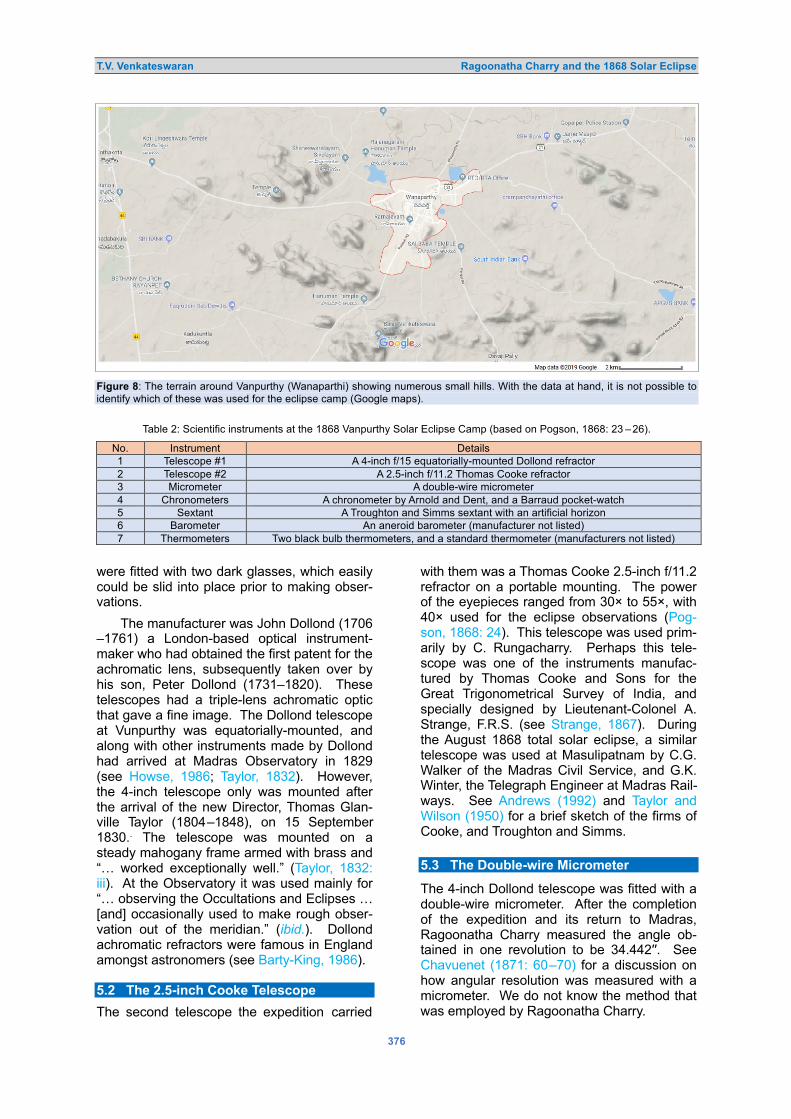
T.V. Venkateswaran Ragoonatha Charry and the 1868 Solar Eclipse
376
Figure 8: The terrain around Vanpurthy (Wanaparthi) showing numerous small hills. With the data at hand, it is not possible to identify which of these was used for the eclipse camp (Google maps).
Table 2: Scientific instruments at the 1868 Vanpurthy Solar Eclipse Camp (based on Pogson, 1868: 23 –26).
No. Instrument Details 1 Telescope #1 A 4-inch f/15 equatorially-mounted Dollond refractor 2 Telescope #2 A 2.5-inch f/11.2 Thomas Cooke refractor 3 Micrometer A double-wire micrometer 4 Chronometers A chronometer by Arnold and Dent, and a Barraud pocket-watch 5 Sextant A Troughton and Simms sextant with an artificial horizon 6 Barometer An aneroid barometer (manufacturer not listed) 7 Thermometers Two black bulb thermometers, and a standard thermometer (manufacturers not listed)
were fitted with two dark glasses, which easily could be slid into place prior to making obser-vations.
The manufacturer was John Dollond (1706 –1761) a London-based optical instrument-maker who had obtained the first patent for the achromatic lens, subsequently taken over by his son, Peter Dollond (1731–1820). These telescopes had a triple-lens achromatic optic that gave a fine image. The Dollond telescope at Vunpurthy was equatorially-mounted, and along with other instruments made by Dollond had arrived at Madras Observatory in 1829 (see Howse, 1986; Taylor, 1832). However, the 4-inch telescope only was mounted after the arrival of the new Director, Thomas Glan-ville Taylor (1804–1848), on 15 September 1830.. The telescope was mounted on a steady mahogany frame armed with brass and “… worked exceptionally well.” (Taylor, 1832: iii). At the Observatory it was used mainly for “… observing the Occultations and Eclipses … [and] occasionally used to make rough obser-vation out of the meridian.” (ibid.). Dollond achromatic refractors were famous in England amongst astronomers (see Barty-King, 1986). 5.2 The 2.5-inch Cooke Telescope
The second telescope the expedition carried
with them was a Thomas Cooke 2.5-inch f/11.2 refractor on a portable mounting. The power of the eyepieces ranged from 30× to 55×, with 40× used for the eclipse observations (Pog-son, 1868: 24). This telescope was used prim-arily by C. Rungacharry. Perhaps this tele-scope was one of the instruments manufac-tured by Thomas Cooke and Sons for the Great Trigonometrical Survey of India, and specially designed by Lieutenant-Colonel A. Strange, F.R.S. (see Strange, 1867). During the August 1868 total solar eclipse, a similar telescope was used at Masulipatnam by C.G. Walker of the Madras Civil Service, and G.K. Winter, the Telegraph Engineer at Madras Rail-ways. See Andrews (1992) and Taylor and Wilson (1950) for a brief sketch of the firms of Cooke, and Troughton and Simms. 5.3 The Double-wire Micrometer
The 4-inch Dollond telescope was fitted with a double-wire micrometer. After the completion of the expedition and its return to Madras, Ragoonatha Charry measured the angle ob-tained in one revolution to be 34.442′′. See Chavuenet (1871: 60–70) for a discussion on how angular resolution was measured with a micrometer. We do not know the method that was employed by Ragoonatha Charry.

T.V. Venkateswaran Ragoonatha Charry and the 1868 Solar Eclipse
377
5.4 The Chronometers
The expedition team carried two chronomet-ers, one of which was an old pocket watch manufactured by Barraud which although “… cleaned and repaired for the occasion …” (Pogson, 1868: 23) before the commencement of the expedition, was “… quite useless from its bad daily rate.” (ibid.). Instead the exped-ition members relied on the Arnold and Dent chronometer, which was “… tolerably steady in its performance.” (ibid.). 5.5 The Sextant
The sextant was manufactured by Troughton and Simms, came with a stand, and was fitted with an artificial horizon. 5.6 The Meteorological instruments
The team carried with them an aneroid baro-meter, two black bulb thermometers, and a standard thermometer for meteorological ob-servations (see Buchan (1866) for protocols). 6 THE OBSERVATIONS
We do not have a record of the specific in-structions, if any, given to Ragoonatha Charry. However, the work assigned to him for the December 1871 total solar eclipse is telling. On that occasion, he was instructed to conduct
… general observations, consisting of care-ful micrometrical measurements of the cusps, of conspicuous prominences, of the extant and figure of corona, amount of darkness, visibility of stars, and accurate times of the various phenomena. (Pogson, 1871a).
Similarly, when he went to observe the 6 June 1872 annular eclipse, he was again ask-
ed to make general observations and specific-ally to observe the corona (Pogson, 1872: 331). It is clear that the work assigned, and routinely expected to be followed by him was in the ‘old eclipse studies’ mould.
As the sky was cloudy on 18 August 1868 and the event only was visible intermittently, Ragoonatha Charry was able to observe only a few aspects of the eclipse. One of the im-portant observations made by his team was to measure the angular distance between the solar cusps and compute the timing of the eclipse events. A summary of these observat-ions is presented below in Table 3. 6.1 Determining the Latitude and Longitude of the Observation Site
Ragoonatha Charry (1868a) had intended to use lunar occultation to determine the latitude and longitude of his eclipse camp, but there were limited opportunities to make such obser-vations. He had arrived at the site on 14 Aug-ust, the first observations were possible on the 17th, and the expedition departed Vanpurthy on 21 August. So, the only occultation that he could possibly observe was of 21487 Lalande on 19 August. However, right from the time of their arrival, the “… weather had been unfav-ourable …” and the sky was over-cast, which prevented any clear observations. Thus, dur-ing his time at Vanpurthy Ragoonatha Charry had just “… one pretty clear observing night, namely, August 19th …” (Pogson, 1868: 23), so he could not use the method he had sug-gested for determining the co-ordinates of the eclipse camp.
Instead, he had to resort to the time-tested classical textbook method for finding latitude and longitude (see Bowditch, 1826). He twice
Table 3: A summary of the cusp measurements made by Ragoonatha Charry at Vanpurthy during the total solar eclipse of 18 August 1868 (based on Pogson, 1868: 23).
Vunpurthy Mean Time 18 August 1868
Cusp measurement
Remarks Corrected Distance Position Angle
h. m. s. ′ ′′ °
8 3 9.9 a.m. ...... ...... ...... First contact.
8 10 34.9 13 59.7 280.5 With the wire micrometer; but the distance doubtful, possibly one revolution of 34.4′′ too large
8 17 5.9 ...... ..... ..... Bisection of a large spot D, in the S.W. quadrant of the disc.
9 6 59.8 ...... ..... ..... Spot B bisected in the S.E. quadrant
9 17 --- ...... ..... ….. Large protuberance seen at upper limb
9 57 30.7 29 29.4 With the sextant
10 27 50.2 18 57.4 281.9 With the wire micrometer
10 29 59.7 17 48.3 281.9
10 32 21.7 16 37.6 281.9

T.V. Venkateswaran Ragoonatha Charry and the 1868 Solar Eclipse
378
Table 4: Contact timings at Masulipatnam of total phase of the 18 August 1868 solar eclipse (based on Pogson, 1867: 1868).
Masulipatnam
Beginning of total phase
(Local mean time)
End of total phase
(Local mean time)
As computed by Ragoonatha Charry
9h 34m 25s 9h 40m 10s
Observed by Pogson
9h 34m 14.2s 9h 40m 5.8s
Table 5: First and last contact timings at Masulipatnam of the 18 August 1868 solar eclipse (based on Pogson, 1867: 1868).
Masulipatnam
First contact (Local mean
time)
Last contact (Local mean
time) As computed by
Ragoonatha Charry 8h 18m 59s 11h 5m 6s
Observed by G.K. Winter
8h 19m 15s* 11h 4m 43s
* However, Winter cautions that he “… cannot speak very positively as this being exact, though I believe it to be so within one or two seconds.” (Pogson, 1868: 20).
measured the altitude of γ Draconis to obtain the latitude, and on the only clear night avail-able, 19 of August he “... took several double altitudes of γ Draconis shortly before and after its meridian passage.” (Pogson, 1868: 23). Re-ducing these values to the meridian, he com-puted the latitude of the station to be 16° 22′ 18′′ N.
Meanwhile, the longitude was computed using the classical method of comparing the local time with the standard reference chrono-meter. Local time of the eclipse station was obtained by measuring the altitude of the Sun using the sextant. The computation of the local time was carried out on 16, 18, 19 and 21 August. The local time was compared to the standard time as shown by the Arnold and Dent chronometer, which had been set to show Madras mean time. Comparison of both yield-ed the longitude. In fact, Ragoonatha Charry
… assumed the mean daily rate of the best chronometer to be uniform throughout the interval between [his] departure from and return to Madras. (Pogson, 1868: 24).
From this measurement, he obtained a value of 8m 45.3s West of Madras, or 5h 12m 12s East of Greenwich as the longitude of the Table 6: Beginning and end of partial phase in Madras of the 18 August 1868 solar eclipse (based on Pogson, 1867: 1868).
Madras
First contact (Madras time)
Last contact (Madras time)
As computed by Ragoonatha Charry
8h 14m 29s 11h 0m 37s
Observed by T.Mootoosawmy
Pillay
8h 14m 54.4s 11h 0m 42.8s
eclipse station. 6.2 Cusps Measurement
Due to the cloudy condition of the sky on 18 August, Ragoonatha Charry was able to use the micrometer to measure the cusps only four times during the eclipse, at 8h 10m 34.9s, 10h 27m 50.2s, 10h 29m 59.7s and 10h 32m 21.7s. He also used the sextant to measure the cusps at 9h 57m 30.7s. Table 3 gives the cusp distances and position angles after cor-recting for refraction, as computed by Ragoon-atha Charry.
Because he lacked a micrometer, Runga-charry was not able make any measurement of the cusps. However, he reported that at 8h 16m 49s the
… horns were pointed, and the moon’s limb sharply defined … [Then at] 9h. 3m. The moon’s limb was observed to be notched and somewhat undulating. The horns also appeared to be blunt. (Pogson, 1868: 25).
6.3 First Contact
Ragoonatha Charry reported that first contact was at 8h 3m 9.9s a.m. local mean time. Since there is no additional information, we are not sure if the timing was arrived at by visual reckoning or was interpolated from the cusp measurements. C. Rungacharry used the smaller telescope and noted that first con-tact occurred at 8h 3m 13s. Noting the differ-ence in their times, Ragoonatha Charry sug-gested that his brother was … “probably a little too late.” (Pogson, 1868: 25).
It is also worth comparing the eclipse com-putations carried out by Ragoonatha Charry and those derived from observations at Masu-lipatnam and Madras. The results are shown here in Tables 4, 5 and 6. 6.4 Sunspot and Prominences
The sunspots seen at the time of the eclipse were given the same identifiers as marked on the Kew Observatory image that was released subsequent to the eclipse. At 8h 17m 5.9s local mean time, Ragoonatha Charry observ-ed that sunspot D in the south-western quad-rant of the Sun was bisected in the micrometer, and at 9h 6m 59.8s local mean time sunspot B in the south-eastern quadrant was bisected.
Rungacharry also noted a large sunspot [D], and he reported that the “… contact of the moon's limb with the centre of a large spot in the S. W. quadrant occurred at 8h. 16m. 49s.” (Pogson, 1868: 25), about 17 seconds earlier than the time noted by Ragoonatha Charry.

T.V. Venkateswaran Ragoonatha Charry and the 1868 Solar Eclipse
379
About one minute after the totality, around 9h17m local mean time, Ragoonatha Charry was able to once again glimpse the eclipse. The clouded sky gave a sudden respite, and a “… passing thin break in the clouds …” enabl-ed him to observe a prominent prominence (he referred to it as a ‘protuberance’) on the upper limb of the Sun, however “… its sudden ap-pearance and the vexatious return of heavy clouds rendered measurement with the micro-meter …” impossible (Pogson, 1868: 25). None-theless, he estimated its position to be
10° to the right of the vertex as seen in ... [the] inverting telescope, or 90° from the north point towards the east … [and its length] one-tenth of the sun’s diameter and its breadth about one-tenth of its length. (ibid.).
Ragoonatha Charry recalled it to be “… nearly the same breadth except at its end, where it abruptly sloped off to a point.” He also noted that it was a pale yellowish colour rather than anticipated red (ibid.). 6.5 Arrival of the Shadow and Darkness During the Eclipse
During totality, the Sun is completely covered by the Moon, and darkness falls. However, the bright corona might provide some lighting. Likewise, illuminated belts of clouds and the sky near the horizon may contribute to the general illumination. Thus, as Ranyard (1879: 217) observes, the
… degree of darkness during totality differs greatly according to the terrestrial condit-ions surrounding the observer, the clear-ness of the atmosphere, the clouds and objects upon the horizon, the size of the area of totality, and the position of the ob-server within the area of darkness at the moment of his observation.
During the 18 August 1868 eclipse, Rag-oonatha Charry made a careful record of the arrival of the shadow, and the darkness during the totality. He says “… the scenery during the time of totality was awfully sublime.” (Pogson, 1868: 24). He had briefed onlookers to watch out for the shadow sweeping in from the west, and as instructed, just at the beginning of the totality, they cried out “… darkness coming, and covering hill after hill; the shadow has come over us.” (Pogson, 1868: 24). Ragoon-atha Charry also reported that the instant of commencement of totality was not
… very dark, but few seconds after it be-came so much more so, that I was unable to see some steps near me distinctly. (Pogson, 1868: 24).
Furthermore, he said it was so dark that it “… was impossible to recognise the face of a per-
son standing within a distance of three yards …” (ibid.) and he had to use a lamp to look at the time on the chronometer. He concluded:
I can safely say that it was quite as dark as on a clear star-light night ... Lighted candles appeared just as bright as in the night-time, and I was told that my lights were distinctly seen three-quarters of a mile off. (Pogson, 1868: 24).
Midway through the eclipse, probably be-cause the sky was cloudy and offered nothing to observe, Rungacharry turned his telescope towards the west and north-west directions and
… found darkness covering the horizon, and in a moment all around us was im-mersed in the same gloomy shadow. (Pog-son, 1868: 25).
Further, between 9h 15m and 9h 20m, during totality, he reported:
… my pencil notes and the features of persons within four feet could hardly be distinguished. Two hills, apparently close to each other, although at a distance of about twenty miles in the direction of N. W. by W., were made out with difficulty. (Pog-son, 1868: 25).
6.6 The Meteorological Observations
C. Appoo Iyengar, one of the members of the expedition team, appears to have been as-signed the duty of collecting meteorological observations. From the observations he re-corded it is clear that the weather was playing ‘spoilsport’. The day before the eclipse, on 17 August 1868, the sky was cloudy. Records on the day of the eclipse ranged from with pas-sing clouds to an overcast sky, gentle to mod-erate breezes, with only a few gaps in the clouds to permit the observing team any view of the eclipse. Ragoonatha Charry summar-ised the situation:
From our arrival at Vunpurthy the weather had been unfavourable, and early on the morning of the eclipse day, the aspect of the sky was far from promising. It began to clear, however, towards the east about 7 A. M., but to my great sorrow clouds over-spread the heavens by 8 A. M., and both before and after the time of totality the sky was almost overcast. (Pogson, 1868: 23).
Readings were recorded periodically of at-mospheric pressure, and temperatures regist-ered by the thermometer in the shade and in sunlight respectively. Both thermometers show-ed the expected temperature variations during the eclipse.
Throughout the eclipse, observers report-ed that “… the colour of the sky between the clouds was pale yellow.” (Pogson, 1868: 25),

T.V. Venkateswaran Ragoonatha Charry and the 1868 Solar Eclipse
380
while Ragoonatha Charry noted that a
… remarkable feature of the phenomenon was the stillness of the atmosphere during the whole time of totality, and for some time afterwards. The moderate breeze was blowing at the commencement of the eclipse diminished by degrees to a dead calm, which continued for about a quarter of an hour after the sun’s re-appearance. (Pogson, 1868: 24).
6.7 Behaviour of People, Animals and Plants During the Totality
Both Ragoonatha Charry and Rungacharry re-ported aberrant behaviour of people in the villages around the hillock at Vurnparthy. Rag-oonatha Charry “… heard loud shouting from the people at a distance during the total dark-ness …” (Pogson, 1868: 25), while Runga-charry reported: “I also heard a great noise of the people at a distance, crying out as on the approach of some great calamity.” (ibid.).
Rungacharry also noted that he was able to observe the behaviour of cattle grazing in the plains below the hillock during and after the eclipse. He observed
… a small herd of bullocks, most of them lying down before the eclipse, began to move off, but returned to their former place just after the totality. (ibid.).
Meanwhile, the Diwan (Prime Minister) of the principality informed Ragoonatha Charry that locals from the town of Vyaperla (Yaparla) reported that buds of the jasmine flower that usually only bloomed at night were found fully open, while the leaves of the tamarind trees closed during the eclipse, as if it were night (Pogson, 1868: 26). 7 A MOSAIC OF INDIAN RESPONSES
From the report submitted by Ragoonatha Charry, we have some glimpse into how the Indian public reacted to this eclipse that had generated such widespread interest. Govindu Venkoba Naik, the Diwan of Vunpurthy, assist-ed the eclipse observation team both during their journey and while in Vanpurthy. He also collected information on the eclipse from ‘intel-ligent people’ at Vyaperla (currently Yaparla), a village about 40 kilometres south of Vapurthy, who reported observing “… red protuberances, [and] four broad and long beams of light in the corona.” (Pogson, 1868: 26). Perhaps the sky was clear there and visibility was good, be-cause the people also reported being able to see about 30 stars during totality.
Chavudappa Row who was the Collector’s Sheristadar (record keeper of the chief colonial district official) at Kurnool had a copy of Pog-
son’s pamphlet Popular Description of the Eclipse, that contained the computations and maps prepared by Ragoonatha Charry. Cha-vudappa Row, and others, reported that they were able to observe the planet Mercury and
… the star Regulus, just below the dark limb of the moon, shining like a bright point through the dim light of the corona during the totality. (Pogson, 1868: 26).
Interestingly, the Reverend John Sharp who observed from Masulipatam noted that the ‘natives’ observed the stars shining in the darkness during totality, and that he was able to observe Mars, which was listed by Ragoon-atha Charry as one of the planets that would probably be visible during totality (Pogson, 1868: 22).
These reports contrasted with the antici-pated ‘reaction’ of Indian villagers, which was one of dread and apprehension. From his observing station at Masulipatam, Pogson was concerned about
… native curiosity attracting ... a crowd of idle gazers … [and that] such a visitation would doubtless have proved a very ser-ious drawback [for our astronomers] during the totality … (Pogson, 1868: 13),
but to his great gratification they were left “... unmolested, and as quiet as if in an enclosed English garden.” (ibid.). Nevertheless, Pogson reported that “… a mob, thousands thick, had collected …” around the temporary shed they had earlier erected in the premises of a small court in Masulipattnam. The ‘mob’ was “… in anticipation of beholding some astonishing per-formances or ceremonies in connexion with the eclipse.” (ibid.). However, Pogson (ibid.) noted that
To their credit … not an article was miss-ing, simple curiosity, not acquisitiveness, being the sole cause of their troublesome interference.
Nevertheless, fearing that the onlookers at Masulipattnam might fiddle with the thermo-meters and other instruments, Pogson had his temporary metrological station removed to an-other location two miles distant, at the civil hospital. Furthermore, Pogson comments that while he was enchanted with the celestial spectacle and marvelled at the sight of Venus, Mercury, Castor and Pollux and many stars through the light hazy clouds, a local Indian gardener working at a distant house
… continued his hedge operations up to the moment of totality, and was at work again immediately after, as if nothing had happened … [He neither worried about the] feared dragon eating up the sun … [nor had any more] appreciation of the

T.V. Venkateswaran Ragoonatha Charry and the 1868 Solar Eclipse
381
wonders of nature than the sticks he was cutting. (Pogson, 1868: 7).
On the other hand, Ragoonatha Charry found the ‘intelligent natives’ relished the cel-estial spectacle of eclipse by observing the corona and prominences, and comparing the star chart prepared earlier and published be-fore the eclipse with the actual stars visible during the darkness of totality.
While a colonial perspective tended to taint the accounts published by European ast-ronomers, including Pogson, not all Europeans gave disparaging accounts of Indian responses to a total solar eclipse. The Scottish writer Violet Jacob (1863–1946) was travelling in India during the late nineteenth century and she witnessed the eclipse of 1898 from the garden of an Indian named Bankwala. The educated Indians who had gathered there to witness the eclipse were not scared that the daemon Rahu would devour the Sun, nor were they engaged in excessive ritualism (Jacob, 1990: 110). As Pang (2002: 80–81) points out, often the alarmist European accounts
… reveal much more about the European anxieties than actual native behaviour … [and that perhaps the] Indians treated an eclipse in precisely the same way most European did, as an interesting scientific curiosity and excuse for a good party.
While Ragoonatha Charry wrote a treatise in Tamil, for the general public, about the solar eclipse of 1868, karuṅkuḷam Kiruṣṇā jōciyar (1868a; 1868b), a native almanac-maker, wrote a treatise about the same eclipse illustrated with predictions. It was published as a bilin-gual publication in Sanskrit and English as well as in grantha and Tamil. Needless to say, the the eclipse circumstances computed by Kiruṣ-ṇā jōciyar using the traditional Vakya method did not match with the observations, and the deviations were substantial.5 Yet the eclipse kindled the intellectual curiosity of all those who could make predictive computations of its circumstances. Moved by the spectacle of the eclipse, and the eclipse expedition, the court poet of the Raja of Vunpurthy, Parakālat-Svāmi, Śrīkṛṣṇa Brahmatantra (1868) compos-ed a verse in Sanskrit Suryoparāgadarpaṇa. This book was translated by Kappaguntulu Lakṣmaṇa Śāstri into Telugu (Sarma, 1995: 194). 8 DISCUSSION
8.1 Empire and the Sciences
As recently explored by deGrasse Tyson and Lang (2018), the relationship between the celestial studies for navigation, conquest and hegemony during the colonial times to the
latest exploitation of satellite-enabled warfare goes to show that science, and even an eso-teric area like astronomy, can have political uses. The emergence of astronomy and ast-ronomical observatories in Europe and colon-ial regions and their connection to colonial am-bitions have been well studied (e.g. see Aubin et al., 2010; Hidayat, 2000; McAleer, 2013; Miller, 2015). Kochhar (1992) demonstrates how astronomical observatories set up in India served as colonial tools, even when scientific curiosity played a part. Specifically, on eclipse observation expeditions, Pang (2002), details the manner in which imperialism made pos-sible these expeditions by deploying the
… ‘tools of empire’– railroads, steamships, military and naval technology, telegraphs, and other technologies and services –allowed eclipse parties to recreate the observatory in India, Egypt, and Brazil, carry out their observations, and behave within that temporary social site in ways that were familiar and comfortable ...
Pogson’s plan of conducting a prestigious survey of southern stars from Madras was slashed by Airy, and Pogson also was left ‘high and dry’ for the 1868 eclipse and had to use a ruse of setting up a meteorological station at the cyclone-prone coastal town of Masulipat-nam to mount his expedition (see Chapman, 1988; Nath, 2018; Reddy et al., 2007). In a colonial setting, even a European scientist like Pogson in the colony had to struggle with the ‘metropolis’. We should recall that just before the 1868 eclipse, the Astronomer Royal in England wanted Madras Observatory to be shut down and dismantled. Fortunately for India—and the future of Indian astronomy—Airy’s aim was unsuccessful.
It may be noted that the expedition by the British astronomers under the leadership of Major Tennant was funded equally by the Gov-ernment of India and the British Government, and the Madras Observatory expeditions plan-ned by Pogson were only possible because his friend Baden Powell, Director of Public Instruction, sold the concept (along with the required funding) to the Government of Ma-dras Presidency. In the empire of science, the metropolis-periphery contradiction had its im-pact on the science, scientific institutions and even European scientists in the colonies. 8.2 Indians and Eclipse Culture
Often studies on eclipse culture focus more on the European experience and hardly ever look at the Indian (native) responses. Although there were exceptions, the depiction of the ‘natives’ as lacking in intelligence and acumen was standard fare by European astronomers.

T.V. Venkateswaran Ragoonatha Charry and the 1868 Solar Eclipse
382
It is worth recalling the opinion of Joseph Nor-man Lockyer, on indigenous responses. Writ-ing about total solar eclipses, recent and up-coming, Lockyer had the following advice for amateur astronomers who may wish to under-take eclipse work in far-off colonial lands:
The natives will crowd the observes, and their talk, and perhaps even their fears, may much interfere with observations. (Lockyer, 1897: 18).
He then recalled with horror—to suitably instil fear and even a sense of adventure—his alleg-ed experience in India during his 1871 eclipse expedition, where he had relied on a strong force of military and police to extinguish
…smoke of sacrificial fires [lit by natives] to frighten away Rahu, the Dragon which is supposed to cause eclipses by swallowing the sun. (ibid.).
There is no need to say that in Lockyer’s imag-ination, astronomers—including amateur ast-ronomers—would be Europeans. Typical of the colonial mentality, in the chapter titled ‘Strange Eclipse Customs’, Chambers (1902: 190–194) singles out every culture other than Europeans as harbouring ‘barbarous’ views. Even Pogson, who had a good relationship with his Indian assistants, opined that “… ra-tional natives are very scarce under normal circumstances and impossible to find during an eclipse.” (cited in Pang, 1993: 275).
But obviously not all Europeans had the colonial mentality of viewing all indigenous peoples as being inherently incapable. An Anonymous (1868) article in Chamber’s maga-zine, notes the work of ‘Ragoonatha Charya’ in computing the eclipse circumstances, and says:
the keen intellect of the Hindu is capable of much, when untrammelled by superstition … [and] who can say what conquests in the fields of science he may yet be dest-ined to accomplish.
For that author, intellectual want among the Indians was not innate or immutable. It was superstitious beliefs that were clouding the “… keen intellect of the Hindus.” (ibid.).
A prejudiced and colonial Europeans may ascribe obstinate clinging to ‘tradition’ as the ‘nature of natives’, but for Ragoonatha Charry, the obdurate behaviour of karuṅkuḷam Kiruṣṇā jōciyar was located in the ignorance of ill-informed Indians and not in the innate nature or the nature and tradition of astronomy in India. Ragoonatha Charry argued that the Indian astronomical tradition gave precedence to the ‘empirical validation/verification’ over everything else. Thus, for Ragoonatha Charry the astronomy that he and his indigenous colleagues encountered in the observatory was
not alien. Unfamiliar modern instruments might initially be bewildering, but once mastered they could be ‘domesticated’.
As argued elsewhere (Venkateswaran, 2007), during the mid-nineteenth century, in Madras Presidency, the ‘native literati’ that usually belonged to traditional elite communit-ies often saw ‘modern’ science introduced by the Europeans not as a threat but as the “… latest entrant in the evolving authoritative uni-versal knowledge …” of human endeavour (Kapila, 2010: 130).6 The ‘ancient' sciences of India were its precursor, and in the historicism that was propounded by the native literati, the knowledge claims of yesteryears were marred by mythologies, both in India as well as in ancient Europe. Thus, by the deployment of ancient/modern narratives, the native literati blunted the superiority claims of Europe, de-nied the exclusivity of ‘sciences’ to the West, legitimised their participation in the pursuit of modern science as continuation of past pract-ices, modified for the present day, and pre-sented the classical texts on astronomy and so on as the fonts that led to present-day know-ledge. The quest for understanding the world around us can be traced not only to the an-cient Greeks, but can also be seen in ancient Indian science. Superstitions like Rahu and Ketu7 are either allegorical for a simple-mind-ed ‘public’ or are merely beliefs of yesteryear, just like that of the European subterranean god, Vulcan, spewing volcanos.8
It is but a truism to state that the alleged 'native' responses seen through the eyes of the Western observer will not suffice to fully understand the relationship between the then-emerging ‘modern science’ and the ‘natives’. Pang (2002: 3) laments that the source to understand the point of view of “… indigenous peoples, the subjects of so much derision and fear on the part of British astronomers …” is awfully lacking. Here is an example of an Indian leading an eclipse expedition, abeit under the supervision of a European (Pogson), to an Indian state, beyond the direct rule of the British. Ragoonatha Charry, the First Assistant to Madras Observatory, led a three-member team to Vanpurthy near the central line of the 18 August 1868 total solar eclipse. He per-formed essential and significant preparatory scientific work and made a modest contribut-ion to the eclipse studies of the mid-nineteenth century. He also took part in the expeditions to observe the 1871 total solar eclipse, the 1872 annular solar eclipse, and the 1874 transit of Venus.
Ragoonatha Charry was not the only Ind-ian to engage in ‘modern astronomy’. G.V.

T.V. Venkateswaran Ragoonatha Charry and the 1868 Solar Eclipse
383
Jugga Row a wealthy individual from Visakha-patnam “... selected the divine science of astronomy as the study and pursuit ...”, took tuition from T.G. Taylor, the Madras Observa-tory Astronomer, and established a private observatory at his house, Daba Gardens, way back in 1840. His son-in-law, Ankitam Venkata Narsinga Row (1827–1989) (anglicised name Nursing Row) continued to pursue this interest and was admitted as a fellow of the Royal Astronomical Society (Rao et al., 2011).
If our goal is to understand not the Euro-pean interlocutor’s perception of India but rath-er the changing place of Europe and modern science in the Indian imagination, then it is vital to look at sources that are not only set in a dialogical process to the West, but also a dialogical process within its members. For this, it is imperative to go beyond the English (or Western language) sources in order to get the indigenous responses and the debates that ensued. 8.3 Indians and Modern Science
‘Modern science’ is often seen as multi-cultural and a product of an historical dialogue be-tween the West and Egyptian, Chinese, Ind-ian, and Arabic cultures. It is therefore seen as primarily a European (or Western) phenom-enon by appealing
… solely to intellectual, social, and cult-ural influences, causes, and ideas within Europe … [but] that marginalizes the im-portance of contributions, if any, of cultures beyond Europe to the birth and growth of modern science … (Bala, 2006: 21)
which is the core of the Eurocentric view of the history of science. Modern science is a unique creation of the European imagination, and its consequence that other cultures did not create modern science and for various reasons did not have the capacity to do so are a corollary of this Eurocentric view of science.
Thus, framed, as European, the quest nat-urally tilts towards examining the articulations advanced by ‘natives’ for rationalising their participation in the modern sciences. However, they may be interesting, overwhelming preoc-cupation to ‘rationalisation’ by natives leads to essentialising ‘Western’ and ‘Indian’ astrono-my. While being aware of the significance of colonialism “… both in terms of development of astronomy in colonial India as well as con-struction of scientific knowledge …”, as Sen (2014: 11) points out, perhaps
… various models of hybridity or appropri-ation in existing histories of science in col-onial India might be deemed insufficient in themselves.
As we pay attention to the practical engage-ment between European and Indian, in ob-serving, recording, using instruments, drawing inferences, and grappling with practical quest-ions of discovery and validation, in short as we start to examine the domains of the scientific practice, be it colonial observatory or a native effort, actors begin to behave as if they belong to a “… community of rational beings, irre-spective of race, nationality or religion.” (Sar-ton, 1954: 117). The conviviality, circulation of ideas and cosmopolitanism among the actors from the varied cultural background at the sites of modern science such as the observ-atories and colleges readily comes out if we emphasise practice rather than the articulation of rationalisations (Guha, 2015: 275–276).
History of science is not merely ‘cultural history’. Despite the normative power of science and the cultural imports within the introduction of modern science into colonial India, science as an authoritative body of ‘pub-lic’ knowledge cannot be wished away. As a community of rational beings, the rational dia-logue was feasible, and although it had to suffer hardship a non-European could contrib-ute to the general body of ‘modern’ science. Be it Ragoonatha Charry’s effort at measuring the solar cusps, or devising an ‘easy’ algorithm with the ‘slide rule' based on eclipse comput-ations, or Pogson's spectroscopic and photo-graphic observations to make sense of the constitution of the Sun, there is no incompre-hensibility between the two. Step outside this domain of practice and Pogson’s gaze sees the ‘animal-like apathy of low caste natives’, while on the other hand, for Ragoonatha Char-ry it is the overwhelming public curiosity to-wards a remarkable celestial event.
Furthermore, it is important to recognise that the ‘natives’ are not an undifferentiated category. Hierarchies, power structures and plain exploitation prevailed within the ‘native’ society and culture too. The interaction not only happens between a Westerner and the ‘native’ in a colonial setting but within the ‘natives’ too there was contention to make sense of the emerging new world. The new professional class emerging from the tradit-ional elite communities was itself in contra-diction with the traditional seats of power (Ven-kateswaran, 2019). Using the new opportunit-ies presented by the colonial state and emerg-ing capitalism, new groups were asserting their place ‘at the high table’. These ‘native’ sections made sense of the cultural import of modern science in their own way distinct from the traditional elite communities (Venkateswar-an, 2008). Elsewhere (Venkateswaran, 2018a) we have discussed the dialogical process that

T.V. Venkateswaran Ragoonatha Charry and the 1868 Solar Eclipse
384
ensues and the reconfiguration of ideas, both by the ‘natives’ and the colonial actors, in particular sciences, were not by coercion, but by compulsion of ocular evidence and the pro-tagonists behaved as if they were members of one community of rational beings, despite power hierarchies. 9 CONCLUDING REMARKS
The eclipse of 1868 was an influential event in the annals of Indian astronomy and astrophys-ics just as it was a ‘watershed event’ in the history of solar physics. Madras Observatory geared itself to observe from five locations, including one in British Burma. However, colonial priorities intervened, and it was forced to reduce these to three locations. In the end, only two expeditions could take place, and the one led by Ragoonatha Charry was marred by unfavourable weather.
Although the cloud cover prevented the observation of the eclipse, the reports from the observation team led by Ragoonatha Charry found its place in various accounts of the eclipse observations being collated during the mid-nineteenth century. The Compendium on the 1868 total solar eclipse prepared by the famous German astronomer Weiss (1870) and the compendium prepared by Ranyard (1879) at the behest of the Royal Astronomical So-ciety of all solar eclipses between 1860 and 1878 included the extracts of the reports by Ragoonatha Charry.
Experience in computing the eclipse cir-cumstances, occultations of the stars from va-rious geographical locations, and development of the ‘slide rule’ method, helped Ragoonatha Charry to prepare his ‘scientific’ pañcāngkam and initiate calendar reform in Southern India. The acclaim and reception of the pamphlet on the 1868 eclipse received among the general public gave him the confidence to undertake public communication of modern astronomy by way of publication of books and talks in Tamil (and other regional languages). These events perhaps sparked ‘popular science’ initiatives in India (at very least in Madras Presidency), and topics relating to astronomy in school text-books saw a change. Until then, astronomy was linked to navigation and geodetic surveys, and was firmly intertwined with positional astronomy. Following the 18 August 1868 total solar eclipse one can discern new textbooks sporting chapters on eclipses, and such topics in astronomy giving a picture of awe and spectacle. However, these interesting themes, which need to be explored further, are beyond the scope of this paper.
The August 1868 Madras Observatory sol-
ar eclipse expeditions and their aftermath made a significant impact on the role of the Ob-servatory in the eyes of the British colonial officials in Madras. A code of instructions was framed in 1870, which placed the Madras Ob-servatory subservient to the Astronomer Royal and restricted the Astronomer to undertake special investigations, only if such a task “… will not interfere with the routine of the ob-servation nor retard the work of reduction and publication.” (Markham,1878: 336–337). The confidence of the administration of the Madras Presidency in Pogson and Ragoonatha Char-ry, earned from the successful conduct of the 1868 solar eclipse expeditions enabled the or-ganisation of subsequent solar eclipse exped-itions in 1871, 1872 and a transit of Venus ex-pedition in 1874, despite the code restricting activity to the collection of data for the metro-polis. The 1868 expedition led by Ragoonatha Charry elevated the position of the Indian Assistants in the eyes of Pogson and British officials. Until then, the Indian assistants were employed only in menial work relating to the observations. Partly because Pogson resign-ed himself to the fact that he would not be provided with a European Assistant, and partly as a result of the exceptional zeal shown by Ragoonatha Charry, the position of Indian Ass-istants at the Observatory was amended. Thus, the participation of Ragoonatha Charry in the 1868 expedition played a significant role in shaping the institutional changes that took place during the second half of the nineteenth century, but to provide a complete picture of the tumultuous decades of the 1860s and 1870s in the annals of Madras Observatory is beyond the scope of this paper. 10 NOTES
1. His name was spelt in various ways in contemporary literature and also in later lit-erature. While the Obituary (1881: 180) published by the Royal Astronomical So-ciety records ‘Chintamanny’, his submis-sions to the Monthly Notices of the Society appeared under the names Charey (Ra-goonatha Charey, 1859) and Chary (Ra-goonatha Charry, 1868a). Dikshit (1981: 181), a contemporary chronicler, referred to him as Cintamani Raghunatha Acarya. Following Rao et al. (2009), we use the spelling of his name as it appears in his signature, namely Ragoonatha Charry.
2. It is interesting that William Stephen Jacob (1813–1862), an earlier Director of Madras Observatory, who mentored Ragoonatha Charry, had also suggested using the slide rule to ease the calculation of the double star orbits (Jacob, 1855).

T.V. Venkateswaran Ragoonatha Charry and the 1868 Solar Eclipse
385
3. The full text is not available in the Journal and only a short note was published there. Historians should perhaps examine the archives of the Society to find out whether the letter with the full description has sur-vived.
4. Ragoonatha Charry (1871: 21) also ack-nowledged his valued contribution during the 1868 eclipse in the Tamil booklet that he prepared for the total solar eclipse of 1871.
5. Ragoonatha Charry (1871) published a de-tailed criticism of the shortcomings of the
computations made by Kiruṣṇā jōciyar. 6. But note that Kapila’s (2010) paper discus-
ses the ‘enchantment of science in India’, and how the reception of well-studied bio-science differed from the reception of other sciences, including astronomy.
7. Rahu and Ketu were demons in puranic mythology, who devour Sun and the Moon to result in the appearance of an eclipse.
8. See Venkateswaran (2002) for a discussion of how a mix of ‘modern’ and ‘ancient’ was used to blunt the colonial construct of ‘western’ and ‘eastern’ to knowledge claims.
11 REFERENCES
Abbott, F., 1870. The Sun and its office in the Universe. Monthly Notices of Papers & Proceedings of the Royal
Society of Tasmania, 62–69. Airy, G.B., 1861. Results of observations of the solar eclipse of 1860, July 18, made at the Royal Observatory,
Greenwich, for determination of the errors of the tabular elements of the eclipse. Monthly Notices of the Royal
Astronomical Society, 21, 155–157. Alexander, S., 1854. Suggestions relative to the observation of the solar eclipse of May 26, 1854. The
Astronomical Journal, 3, 169–172. Andrews, A.D., 1992. Cyclopaedia of Telescope Makers. Part 1 (AF). Irish Astronomical Journal, 20, 102–183. Anonymous, 1847. Solar Eclipse. Inserted between pp. 548–549 in the Nautical Almanac and Astronomical
Ephemeris for the year 1847. London, John Murray, 1843 (google books; accessed on 2 February 2019). Anonymous, 1868. The Hindu view of late eclipse. Chamber’s Journal of Popular Literature, Science and Arts,
(Fourth series), V, 676–679. Atkinson, R. d’E., 1955. An introduction to the eclipse Moon. Vistas in Astronomy, 1, 180–189. Aubin, D., Bigg, C., and Sibum, H.O., 2010. The Heavens on Earth: Observatories and Astronomy in Nineteenth-
century Science and Culture. Durham, Duke University Press. BAAS (British Association for the Advancement of Science), 1850. Suggestions to astronomers for the
observation of the total eclipse of the sun on July 28, 1851 (unpublished). Bala, A., 2006. The Dialogue of Civilizations in the Birth of Modern Science. New York, Palgrave Macmillan. Baily, F., 1820. Memoir relative to the annular eclipse of the Sun, which will happen on September 7, 1820. The
Philosophical Magazine, 55(262), 85–102. Baily, F., 1838. On a remarkable phenomenon that occurs in total and annular eclipses of the Sun. Memoirs of
the Royal Astronomical Society, X(1), 1–42. Baily, F., 1842. Some remarks on the total eclipse of the Sun, on July 8th, 1842. Monthly Notices of the Royal
Astronomical Society, 5, 208–220. Barty-King, H., 1986. Eyes Right: The Story of Dollond & Aitchison, 1750–1985. London, Quiller Press. Bartlett, W.H.C., 1854. On the solar eclipse of 1854, May 26. Astronomical Journal, 4(5), 33–35. Bayley, W.H., 1864. Hand-book of the “Double” Slide Rule: Showing its Applicability to Navigation, Including
Some Remarks on Great Circle Sailing and Variation of the Compass with Useful Astronomical Memoranda. London, Bell & Daldy.
Becker, B.J., 2011. Unravelling Starlight: William and Margaret Huggins and the Rise of the New Astronomy. Cambridge, Cambridge University Press.
Bowditch, N., 1826. The New American Practical Navigator; Being an Epitome of Navigation; Containing All the
Tables Necessary to be Used with the Nautical Almanac. Sixth Edition. New York, E. & G.W. Blunt. Bradley, J., 1756. Miscellaneous Works and Correspondence. Oxford, Oxford University Press. Buchan, A., 1868. Handy Book of Meteorology. Second Edition. London, W. Blackwood and Sons. Carter, C., 2009. Magnetic fever: global imperialism and empiricism in the nineteenth century. Transactions of the
American Philosophical Society, 99(4), xxvi + 169. Cawood, J., 1977. Terrestrial magnetism and the development of international collaboration in the early
nineteenth century. Annals of Science, 34, 551–587. Cawood, J., 1979. The magnetic crusade: science and politics in early Victorian Britain. Isis, 70, 493–518. Challis, J., 1879. Lectures on Practical Astronomy and Astronomical Instruments. London, Deighton, Bell & Co.
London. Chambers, G.F., 1902. The Story of Eclipses. New York, Appleton & Co. Chapman, A., 1988. Science and the public good: George Biddell Airy (1801–92) and the concept of a scientific
civil servant. In Rupke, N.A. (ed.), Science, Politics and the Public Good. London, Palgrave Macmillan. Pp. 36–62.
Charey, Ragoonatha, 1859. On the determination of personal equation by observations of the projected image of the Sun. Monthly Notices of the Royal Astronomical Society, 19(10), 337–339.

T.V. Venkateswaran Ragoonatha Charry and the 1868 Solar Eclipse
386
Chary, C. Ragoonatha, 1868a. Occultations visible in the month of august, 1868, at Madras, and along the shadow path of the total eclipse of the sun in India. Monthly Notices of the Royal Astronomical Society, 28, 193–196.
Charry, C. Ragoonatha, 1868b. On the use of the slide rule in computation of eclipses. Proceedings of the Liter-
ary and Philosophical Society of Manchester, 7, 75. Charry, C. Ragoontha, 1868c. 1868 m āṇṭiṉ cūriya kirakaṇam (Total eclipse of the Sun in 1868. First Edition).
Madras, Vethantha Vidhya Vilasa Acchukoodam (in Tamil). Charry, C. Ragoonatha, 1871. 1871 ṭicampar 12ām tēti pūrṇa cūriya kirakaṇam (Eclipse of the Sun on December
12th 1871). Madras, Kalarathnagara Press (in Tamil). Charry, C. Ragoonatha, 1874. Transit of Venus. Madras, Original Pamphlet (Reprinted, 2012, Indian Institute of
Astrophysics Archives Publication Series No. 3, Bangalore). Chauvenet, W., 1871. A Manual of Spherical and Practical Astronomy Volume II. Fourth, revised and corrected
Edition. Philadelphia, J.P. Lippincott & Co. Cottam, S., and Orchiston, W., 2015. Eclipses, Transits and Comets of the Nineteenth Century: How America’s
Perception of the Skies Changed. New York, Springer. Croarken, M., 2003. Tabulating the heavens: computing the Nautical Almanac in 18th-century England. IEEE
Annals of the History of Computing, 25(3), 48–61. De la Rue, W., 1862. The Bakerian lecture—On the total solar eclipse of July 18th, 1860, observed at
Rivabellosa, near Miranda de Ebro, in Spain. Philosophical Transactions of the Royal Society of London, 152, 333–416.
De la Rue, W., Stewart, B., and Loewy, B., 1867. Researches on solar physics. American Journal of Science, 128, 179–192.
deGrasse Tyson, N., and Lang, A., 2018. Accessory to War: The Unspoken Alliance Between Astrophysics and
the Military. New York, WW Norton & Company. Dikshit, S.B., 1981. Bharatiya Jyotish Shastra (History of Indian Astronomy during the Siddhanthic and Modern
Period), Volume 2. Trans. into English by R.V. Vaidya. New Delhi, Meteorological Department, Government of India Press.
Dreyer, J.L.E., and Turner, H.H., (eds.), 1923. History of the Royal Astronomical Society. London, Royal Astronomical Society.
Dunn, R., and Higgitt, R. (eds.), 2015. Navigational Enterprises in Europe and its Empires, 1730–1850. London, Palgrave Macmillan (Cambridge Imperial and Post-Colonial Studies Series).
Ellicott, A., 1809. Observations of the eclipse of the Sun, June 16th, 1806; made at Lancaster. Transactions of the
American Philosophical Society, 6, 255–260. Forbes, E.G., 1965. The foundation and early development of the Nautical Almanac. The Journal of Navigation,
18, 391–401. Grant, R., 1852. History of Physical Astronomy from the Earliest Ages to the Middle of the Nineteenth Century.
London, Henry G. Bohn. Guha, S., 2015. Conviviality and cosmopolitanism: recognition and representation of “East” and “West” in
Peninsular India c. 1600–1800. In Lefèvre, C., Županov, I., and Flores, J. (eds.), Cosmopolitismes en Asie du
Sud: Sources, Itinéraires, Langues (XVIe–XVIIIe Siècle). Paris, de l'EHESS. Gummere, J., 1837. Practical rule for calculating, from the elements in the Nautical Almanac, the circumstances
of an eclipse of the Sun, for a particular place. Transactions of the American Philosophical Society, 5, 297–317.
Gummere, J., and Kendall, E.O., 1857. An Elementary Treatise on Astronomy: In Two Parts, the First Containing
a Clear and Compendious View of the Theory, the Second, a Number of Practical Problems, to which are
Added Solar, Lunar, and Other Astronomical Tables. Philadelphia, E.C. & J. Biddle. Hari, K.C., 2003. Eclipse observations of Paramesvara, the 14–15 century astronomer of Kerala. Indian Journal
of History of Science, 38, 43–57. Hidayat, B., 2000. Under a tropical sky: a history of astronomy in Indonesia. Journal of Astronomical History and
Heritage, 3, 45–58. Howse, D., 1986. The Greenwich list of observatories: a world list of astronomical observatories, instruments and
clocks, 1670–1850. Journal for the History of Astronomy, 17(4), 1–89. Jacob, V., 1990. Diaries and Letters from India 1895 –1900. (Edited by C. Anderson). Edinburgh, Canongate
Books Ltd. Jacob, W.S., 1855. On the computation of double star orbits. Monthly Notices of the Royal Astronomical Society,
15(8), 205–209. Kapila, S., 2010. The enchantment of science in India. Isis, 101(1), 120–132. Khan, 1909. Imperial Gazetteer of India Provincial Series Hyderabad State. Calcutta, Superintendent of
Government Printing. Kiruṣṇā jōciyar karuṅkuḷam, 1868a. Grahanadarpanam, A Treatise on Eclipses on the 1st of August 1868.
Madras, Varthamana Tharangini Branch Press (in Tamil). Kiruṣṇā jōciyar karuṅkuḷam, 1868b. Krahaṇatarppaṇam. A Treatise on Eclipses on the 1st of August 1868.
Madras, Varthamana Tharangini Branch Press (in Tamil). Kochhar, R., 1992. Science in British India. I: Colonial tool. Current Science, 63(11), 689–694. Lockyer, N., 1897. Recent and Coming Eclipses: Being Notes on the Total Solar Eclipses of 1893, 1896 and
1898. London, Macmillan. Main, R., 1863. Practical and Spherical Astronomy: For the Use Chiefly of Students in the Universities. Cam-

T.V. Venkateswaran Ragoonatha Charry and the 1868 Solar Eclipse
387
bridge, Deighton, Bell & Co. Markham, C R., 1878. A Memoir on the Indian Surveys. Second Edition. London, W.H. Allen and Company. McAleer, J., 2013. ‘Stargazers at the world’s end’: telescopes, observatories and ‘views’ of empire in the
nineteenth-century British Empire. The British Journal for the History of Science, 46, 389–413. Meadows, A.J., 1970. Early Solar Physics. London, Pergamon Press. Meyer, William S., Sir, et al., 1908. The Imperial Gazetteer of India. Volume XXIV. New Edition. Oxford,
Clarendon Press. Miller, D.P., 2015. Longitude networks on land and sea: the East India Company and longitude measurement ‘in
the wild’, 1770–1840. In Dunn, R., and Higgitt, R. (eds.), Navigational Enterprises in Europe and its Empires,
1730–1850. London, Palgrave Macmillan. Pp. 223–247. Milne, J., 1899. Civil time. The Geographical Journal, 13, 173–194. Minkowski, C., 2002. Astronomers and their reasons: working paper on Jyotihśāstra. Journal of Indian
Philosophy, 30, 495–514. Mudiraj, K.K., 1929. Pictorial Hyderabad. Hyderabad, The Chandrakanth Press. Mumpuni, E.S., Orchiston, W., and Steinicke, W., 2017. J.A.C. Oudemans’ observations of the 18 August 1868
and 12 December 1871 total solar eclipses from the Dutch East Indies. In Nakamura and Orchiston, 357–373. Nakamura, T., and Orchiston, W., 2017. The Emergence of Astrophysics in Asia: Opening a New Window on the
Universe. Cham (Switzerland), Springer. Nath, B.B., 2018. The beginnings of modern astronomy research in British India: Pogson and Evershed. Indian
Journal of History of Science, 53, T179–T183. Newcomb, S., 1870. On a very accurate method of determining the relative positions of the centers of the Sun
and Moon during a nearly central eclipse of the Sun. Astronomische Nachrichten, 76, 365–368. Obituary: Chintamanny Ragoonatha Chary. Monthly Notices of the Royal Astronomical Society, 41(4), 180–183. Observations of the solar eclipse of 1870, Dec. 21–22, made at the Royal Observatory, Greenwich. Monthly
Notices of the Royal Astronomical Society, 31, 148–149. Orchiston, W., and Orchiston, D.L., 2017. King Rama IV and French observations of the 18 August 1868 total
solar eclipse from Wah-koa, Siam. In Nakamura and Orchiston, 291–317. Orchiston, W., Lee, E.-H., and Ahn, Y.-S., 2017. British observations of the 18 August 1868 total solar eclipse
from Guntoor, India. In Nakamura and Orchiston, 771–793. Pang, A.S.K., 1993. The social event of the season: solar eclipse expeditions and Victorian culture. Isis, 84, 252–
277. Pang, A.S.K., 2002. Empire and the Sun: Victorian Solar Eclipse Expeditions. Stanford, Stanford University
Press. Parakāla-Svāmi, Śrīkṛṣṇa -Brahmatantra: Suryoparāgadarpaṇa, With a Telugu translation by Kappaguntulu
Lakṣmaṇa Śāstri. Hyderabad, A.P.S. Government Museum Series No 1, 1981. Pogson, N.R.,1852. Observations of solar spots about the time of the total eclipse. Memoirs of the Royal
Astronomical Society, 21, 117–120. Pogson, N. R., 1861. Discovery of a new planet “Asia”. Madras Journal of Literature and Science, 6, 100–102. Pogson, N. R., 1867. Popular Description of the Total Eclipse of the Sun Aug. 18, 1868, Prepared at the Madras
Observatory. Madras, Asylum Press. Pogson, N.R., 1868. Report of the Government Astronomer Upon the Proceedings of the Observatory, in
Connexion with the Total Eclipse of the Sun on August 18th, 1868, as Observed at Masulipatam, Vunpurthy,
Madras and Others Stations in Southern India. Madras, Madras Observatory. Pogson, N.R., 1871a. Letter to the Acting Chief Secretary to Madras Government, dated 3 July. Cited in Rao et
al., 2009, 204. Pogson, N.R., 1871b. Letter to R.S. Ellis, dated 16 August. Madras Observatory, Tamilnadu Archives. Pogson, N.R., 1872. Observations made during the Eclipse of June 6, 1872. Monthly Notices of Royal
Astronomical Society, 32, 330–331. Powell, B., 1848. On the Eclipse of October 1847, Report of the Seventeenth Meeting of the British Association
for Advancement of Science held at Oxford June 1847. London, John Murray. Ranyard, A.C., 1879. Observations made during total solar eclipses. Memoirs of the Royal Astronomical Society,
XLI. Rao, N.K., Vagiswari, A., and Birdie, C., 2011. Early pioneers of telescopic astronomy in India: GV Juggarow and
his observatory. Current Science, 100, 1575–1581. Rao, N.K., Vagiswari, A., Thakur, P., and Birdie, C., 2009. Ragoonatha Charry and his variable star astronomy.
Journal of Astronomical History and Heritage, 12, 201–210. Reddy, V., Snedegar, K., and Balasubramanian, R. K., 2007. Scaling the magnitude: the fall and rise of N.R.
Pogson. Journal of the British Astronomical Association, 117, 237–245. Ronken, L.H., 1987. Days of the Beloved Orient. Hyderabad, Blackswan. Sarma, S.R., 1995. Sanskrit as vehicle for modern science: Lancelot Wilkinson’s efforts in the 1830’s. Studies in
History of Medicine and Science, 14, 189–199. Sarton, G., 1954. Experiments with truth by Faraday, Darwin, and Gandhi. Osiris, 11: 87–107. Schröder, W., 1997. Some aspects of the earlier history of solar-terrestrial physics. Planetary and Space Science,
45, 395–400. Sen, J., 2014. Astronomy in India, 1784–1876. London, Pickering & Chatto. Sen, S.N., 1989. Madras meridian circle observation of fixed stars during 1862 to 1887. Indian Journal of History
of Science, 24, 257–283.

T.V. Venkateswaran Ragoonatha Charry and the 1868 Solar Eclipse
388
Shadwell, C.F.A., 1847. Tables for Facilitating the Approximate Prediction of Occultations and Eclipses for Any
Particular Place. London, RB Bate. Shylaja, B.S., 2009. Chintamani Ragoonathachari and contemporary Indian astronomy. Current Science, 96,
1271‒1273. Shylaja, B.S., 2012. Chintamani Ragoonathachari and Contemporary Indian Astronomy. Bangalore,
Navakarnataka Publishers. Soffel, H.C., 2015. History of the Munich-Maisach-Furstenfeldbruck Geomagnetic Observatory. History of Geo-
and Space Sciences, 2, 65‒86. Sorrenson, R., 1996. Towards a history of the Royal Society in the eighteenth century. Notes and Records of the
Royal Society of London, 50(1), 29‒46. Stoll, C., 2006. When slide rules ruled. Scientific American, 294(5), 80‒87. Strange, A., 1867. On a transit instrument and zenith sector, to be used on the Great Trigonometrical Survey of
India, for the determination, respectively, of longitude and latitude. Proceedings of the Royal Society, 15, 385‒387.
Taylor, E.W., and Wilson, J.S., 1950. At the Sign of the Orrery: The Origins of the Firm of Cooke, Troughton &
Simms. York, Cooke, Troughton & Simms. Taylor, T.G., 1832. Result of Astronomical Observations Made at the Honorable The East India Company's
Observatory at Madras for the Year 1831. Volume 1. Madras, Government Observatory. Thuillier, H.R., and Smyth, R. (comp.), 1875. A Manual of Surveying for India: Detailing the Mode of Operations
on the Trigonometrical, Topographical and Revenue Surveys of India. (Third edition; revised and enlarged). Calcutta, Thacker, Spink and Company.
Venkateswaran, T.V., 2002. The topography of a changing world: geological knowledge during the late nineteenth century colonial Madras Presidency. Indian Journal of History of Science, 37, 57‒83.
Venkateswaran, T.V., 2007. Science and colonialism: content and character of natural sciences in the vernacular school education in the Madras Presidency (1820–1900). Science & Education, 16(1), 87‒114.
Venkateswaran, T.V., 2008. Words and world views: cultural reconfiguration and domestication of modern science in Tamil Nadu. Contemporary Perspectives, 2(1), 112‒135.
Venkateswaran, T.V., 2009. Chinthamani Ragoonathachary and secularisation of time during the late nineteenth century Madras Presidency. In Subramaniam, K., and Mazumdar, A. (eds.) Proceedings of EpiSTEM-3. Mumbai. Pp. 25‒32.
Venkateswaran, T.V., 2018a. Star wars in colonial Tamil region: contours of a discourse between European missionary and a ‘native’ pañcāngkam computer on ‘modern’ astronomy. Journal of Scientific Temper, 4, 188‒216.
Venkateswaran, T.V., 2018b. Ragoonatha Charry and his ‘scientific’ pañcāṅga. In Orchiston, W., Sule, A., and Vahia, M.N. (eds.), The Growth and Development of Astronomy and Astrophysics in India and the Asia-Pacific
Region: ICOA-9, Pune, India, 15‒18 November 2016. New Delhi, Hindustan Book Agency and Springer Nature. Pp. 263‒296.
Venkateswaran T.V., 2019. Social aspects of shifting standards of Vākya almanac computation. In Subramanian, J. (ed.), Proceedings of the Tenth International Mathematics Education and Society Conference. Hyderabad, Sri Satya Sai Designing Studio Pvt Ltd. Pp. 834‒843.
Vince, Reverend S., 1814. A Complete System of Astronomy. Volume 1. Second Edition. London, G. Woodfall. Weiss, E., 1870. Discussion der während der totalen sonnenfinsterniss am 18. August 1868 angestellten
Beobachtungen und der daraus folgenden Ergebnisse. (Mit 2 Taflen) Sitzungsberichte. Akademie der
Wissenschaften (Wien) Mathematisch-Naturwissenschaftliche Klasse, 62(2), 873‒1016. Woolhouse, Mr, 1836. On eclipses (Appendix). In Nautical Almanac and Astronomical Ephemeris for the Year
1836. With an Appendix. London, John Murray. Pp. 53‒148. Dr T.V. Venkateswaran has a BSc (Mathematics) and an MA in History from the University of Madras, a Post Graduate Diploma in Science Communication from Pondicherry University. and a PhD from Tamil University in Thanjavur. Currently, he is a scientist with ‘Vigyan Prasar’, the National Institute for Science Communication, Department of Science and Technology, in New Delhi. He is also the founding Chief Editor of “India Science Wire”, an online science and technology news feature service published by the Department.
Dr Venkateswaran has wide-ranging research interests, including the history of popular science in the Tamil region; the evolution of calendars; the history of Indian Astronomy; and science, colonialism and modernity in India.
He is also a prolific popular science writer, with more than 25 popular science books and 300 popular science articles to his credit. He also conducts weekly television science shows, is a resource person for training programmes, and writes columns for many newspapers and periodicals.

Journal of Astronomical History and Heritage, 24(2), 389–404 (2021).
389
KING RAMA IV, SIR HARRY ORD AND THE TOTAL SOLAR ECLIPSE OF 18 AUGUST 1868: POWER, POLITICS
AND ASTRONOMY
Wayne Orchiston National Astronomical Research Institute of Thailand, 260 Moo 4,
T. Donkaew, A. Maerim, Chiang Mai 50180, Thailand, and Centre for Astrophysics, University of Southern Queensland, Toowoomba,
Queensland 4350, Australia. E-mail: [email protected]
and
Darunee Lingling Orchiston Independent researcher, 523 Moo 1, Soi Ban Cholae, Mae Taeng,
Chiang Mai 50150, Thailand. E-mail: [email protected]
Abstract: The August 1868 total solar eclipse was a watershed event in astronomical history and through
spectroscopic and photographic analyses led to major breakthroughs in solar physics. This eclipse was observed
from Aden, India, Siam and the Dutch East Indies.
Apart from the scientific accomplishments, this eclipse also played an important diplomatic role in Siam, where
the English and the French had colonial aspirations. Sir Harry Ord was the Governor of the British Straits
Settlements, based in Singapore. In this paper we look at his involvement in King Rama IV’s eclipse campaign,
and the way in which his presence was part of the King’s tactic to counter French and British colonial aspirations.
We also see that King Rama IV used the 1868 eclipse as a vehicle to show the Thai people the superiority of
Western scientific astronomy over traditional Siamese astrology.
Keywords: 18 August 1868 solar eclipse, Siam, Wha-koa, King Rama IV, Sir Harry Ord, power, politics,
colonialism 1 INTRODUCTION
The total solar eclipse of 18 August 1868 has been described as a ‘watershed event’ in in-ternational astronomy and solar physics (Or-chiston and Orchiston, 2017: 314). The path of totality (Figure 1) extended from Aden in the Arabian Peninsula, across peninsular India, Siam (present-day Thailand), the southern tip of Cochinchina (now Vietnam), the island of Borneo, various islands further east in the Dutch East Indies (now Indonesia), through the extreme southern part of New Guinea, and on to the New Hebrides. With a maximum duration of 6 m 50 s (just east of Siam in the Gulf of Thai-land), this was one of the longest solar eclipses on record. British, French, German and local Indian and Dutch expeditions were sited in Aden, across India, in southern Siam, at the point where the eclipse path entered Borneo, and on an islet in the Dutch East Indies (e.g., see Launay, 2012; 2021; Mumpuni et al., 2017; Nath, 2013; Orchiston and Orchiston, 2019; 2021; Orchiston et al., 2017a; 2017b; 2019; Soonthornthum and Orchiston, 2021; Venkat-eswaran, 2021). Because of its long duration, and the fact that it occurred at just the right time in history—when photography, spectroscopy and polarisation studies were being applied to astronomy (e.g., see Cottam and Orchiston, 2015; Hearnshaw, 2009; Hughes, 2013)—ast-
ronomers were able to establish the basic chemical composition of prominences, the chromosphere and the corona, and to deter-mine that light from the corona was polarised. Meanwhile, during totality Norman Pogson, Di-rector of Madras Observatory
Figure 1: A map showing the path of totality in blue of the solar eclipse of 18 August 1868. A partial eclipse was visible between the two green lines, while the two pink lines mark the end points of the eclipse (after Espenak and Meeus, 2006).
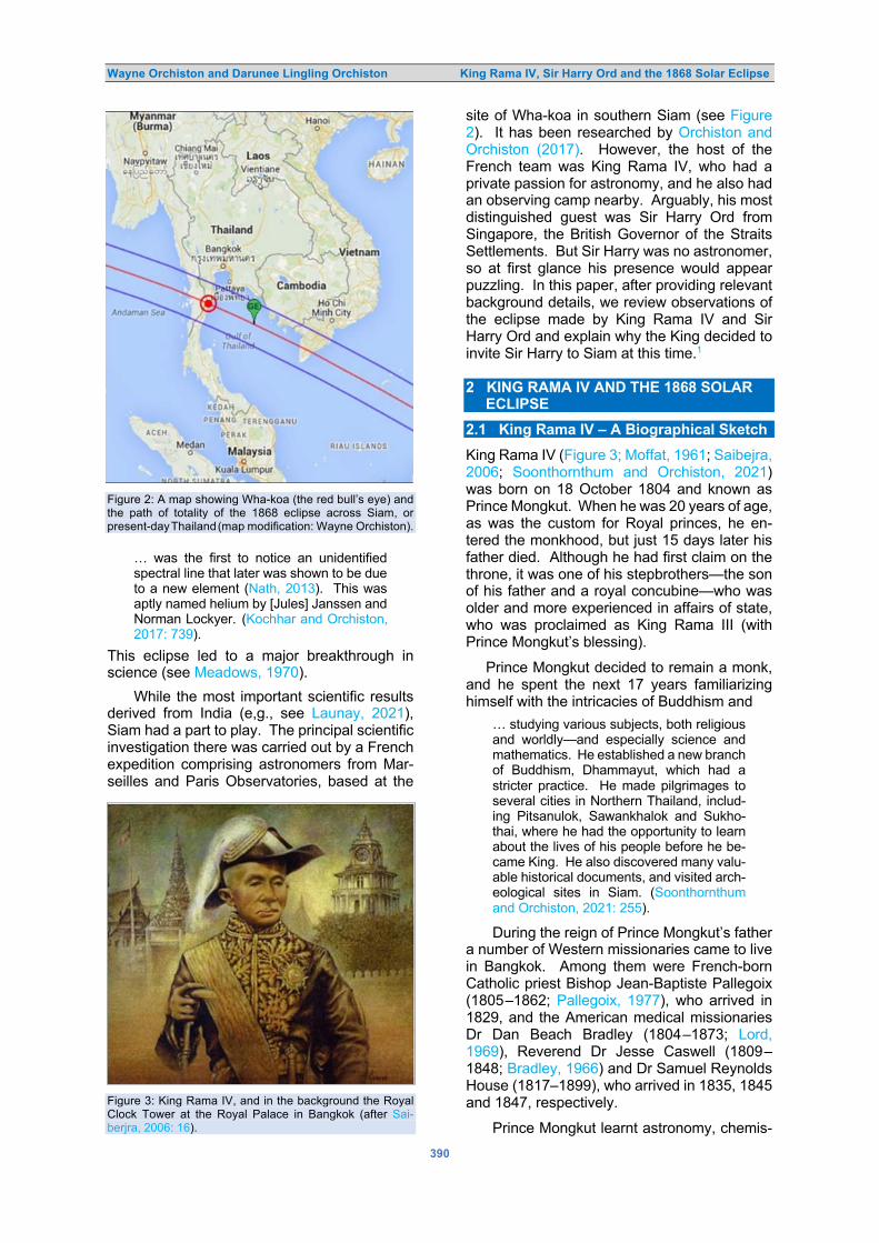
Wayne Orchiston and Darunee Lingling Orchiston King Rama IV, Sir Harry Ord and the 1868 Solar Eclipse
390
Figure 2: A map showing Wha-koa (the red bull’s eye) and the path of totality of the 1868 eclipse across Siam, or present-day Thailand (map modification: Wayne Orchiston).
… was the first to notice an unidentified
spectral line that later was shown to be due
to a new element (Nath, 2013). This was
aptly named helium by [Jules] Janssen and
Norman Lockyer. (Kochhar and Orchiston,
2017: 739).
This eclipse led to a major breakthrough in science (see Meadows, 1970).
While the most important scientific results derived from India (e,g., see Launay, 2021), Siam had a part to play. The principal scientific investigation there was carried out by a French expedition comprising astronomers from Mar-seilles and Paris Observatories, based at the
Figure 3: King Rama IV, and in the background the Royal Clock Tower at the Royal Palace in Bangkok (after Sai-berjra, 2006: 16).
site of Wha-koa in southern Siam (see Figure 2). It has been researched by Orchiston and Orchiston (2017). However, the host of the French team was King Rama IV, who had a private passion for astronomy, and he also had an observing camp nearby. Arguably, his most distinguished guest was Sir Harry Ord from Singapore, the British Governor of the Straits Settlements. But Sir Harry was no astronomer, so at first glance his presence would appear puzzling. In this paper, after providing relevant background details, we review observations of the eclipse made by King Rama IV and Sir Harry Ord and explain why the King decided to invite Sir Harry to Siam at this time.1 2 KING RAMA IV AND THE 1868 SOLAR ECLIPSE
2.1 King Rama IV – A Biographical Sketch
King Rama IV (Figure 3; Moffat, 1961; Saibejra, 2006; Soonthornthum and Orchiston, 2021) was born on 18 October 1804 and known as Prince Mongkut. When he was 20 years of age, as was the custom for Royal princes, he en-tered the monkhood, but just 15 days later his father died. Although he had first claim on the throne, it was one of his stepbrothers—the son of his father and a royal concubine—who was older and more experienced in affairs of state, who was proclaimed as King Rama III (with Prince Mongkut’s blessing).
Prince Mongkut decided to remain a monk, and he spent the next 17 years familiarizing himself with the intricacies of Buddhism and
… studying various subjects, both religious
and worldly—and especially science and
mathematics. He established a new branch
of Buddhism, Dhammayut, which had a
stricter practice. He made pilgrimages to
several cities in Northern Thailand, includ-
ing Pitsanulok, Sawankhalok and Sukho-
thai, where he had the opportunity to learn
about the lives of his people before he be-
came King. He also discovered many valu-
able historical documents, and visited arch-
eological sites in Siam. (Soonthornthum
and Orchiston, 2021: 255).
During the reign of Prince Mongkut’s father a number of Western missionaries came to live in Bangkok. Among them were French-born Catholic priest Bishop Jean-Baptiste Pallegoix (1805‒1862; Pallegoix, 1977), who arrived in 1829, and the American medical missionaries Dr Dan Beach Bradley (1804‒1873; Lord, 1969), Reverend Dr Jesse Caswell (1809‒1848; Bradley, 1966) and Dr Samuel Reynolds House (1817‒1899), who arrived in 1835, 1845 and 1847, respectively.
Prince Mongkut learnt astronomy, chemis-

Wayne Orchiston and Darunee Lingling Orchiston King Rama IV, Sir Harry Ord and the 1868 Solar Eclipse
391
try, geography, French and Latin from Bishop Pallegoix and English first from Dr Bradley and later from Dr Caswell. The Prince
…. also joined several scientific discussion
sessions with Dr Caswell (e.g., about evid-
ence that the Earth was spherical), and he
also attended scientific and medical lec-
tures and demonstrations organized by Dr
Samuel Reynolds House … (Soonthorn-
thum and Orchiston, 2021: 260).
While still a Prince, Mongkut also studied astronomy using traditional Siamese and Mon astronomical texts, and once he became King Rama IV, in 1851, following the death of King Rama III, he had increasing access to Western books on astronomy. He found the British Nautical Almanac an indispensable tool, but arguably one of the most authoritative of the text books at his disposal was the Sixth Edition of Sir John Herschel’s Outlines of Astronomy, which was published in 1859.
King Rama IV was no mere armchair ast-ronomer, for he made sextant observations of the Sun and selected stars from different lo-calities in Siam in order to determine their lat-itudes and longitudes.
He also liked to observe rarer astronomi- cal objects and events, such as solar and lunar eclipses, and impressive naked-eye comets, and he used comets (in particular) to try and educate his people and allay their fears and superstitions inherited through Buddhism. For example, when Donati’s Comet (C/1858 L1 Donati) graced the Siamese sky in September and October 1858 King Rama IV issued the following public announcement, with a Thai title that meant “Do Not Panic with the Appearance of the Comet”:
On Saturday 10th Month 10th Day of the
Waning Moon, the Naichop Kotchasin
Songbat Khwa [the ‘Right Keeper of the
Elephant’] saw this comet. Then on
Thursday 10th Month 15th Day of the Wan-
ing Moon, many royal family members and
noblemen also saw it. King Rama IV saw it
and said that it had appeared once during
the reign of King Rama II … So, the people
should not panic. (cited in Soonthornthum
and Orchiston, 2021: 273).
2.2 King Rama IV’s Eclipse Calculations
Even before he became King Rama IV, Prince Mongkut had honed his ability to compute eclipse ephemerides. Thus, after the British Governor of Hong Kong, Sir John Bowering (1792–1872), visited Siam in April 1855, he reported: :
I have now before me a curious tract of forty
pages, printed at Bangkok in 1850, and
which consists of a series of communicat-
ions from the present King … to the Bang-
kok Calendar. They give the calculations of
the eclipses of the year; and the prince says
he prints them, that his foreign friends “may
know that he can project and calculate
eclipses of the sun and moon, occultations
of planets, and some fixed stars of first and
second magnitude …” (Bowring, 1857:
443–444).
Gislén and Eade (2021: 649) have studied original Southeast Asian solar eclipse calculat-ions and discovered that they
… have some interesting features. It turns
out that they use the Âryabhaṭa traditional
[Indian] parameters for the Sun, and for the
Moon an improved version of the Âryabhaṭa
canon that was introduced in a canon Gra-hacaranibandhanasaṃgraha (Billard, 1971; Haridatta, 1954) dated around 100 CE.
These computations also have their own
ways of handling the parallax problem in
solar eclipses and for the Thai calculations,
an original, very rough method of calculat-
ing the duration of the eclipses (Gislén and
Eade, 2001), possibly being inherited from
ancient times. The Thai solar eclipse calcu-
lation above is not particularly good, it does
not predict a total eclipse, the reason being
that the calculation uses a sidereal longi-
tude for the Sun when calculating the par-
allax.
Undoubtedly, the most important eclipse that King Rama IV ever calculated the details of was the total solar eclipse of 18 August 1868, where he used Western, Mon and Siamese sources to provide the following prediction:
The total solar eclipse will be visible on
Tuesday 18th August 1868 with the center
line at Wha Kor district in Prachuap Kiri
Khan province. The path of the total solar
eclipse visible in Siam is 130 lida to 140 lida
[i.e. around 240–260 km]. The total eclipse
in Siam will be visible from Pranburi District,
Prachuap Kirikhan province to Chumporn
province [approximately 230 km. long].
(Division of Literature …, 1999: 283; our
English translation).
By good fortune, Figure 4 is a Chiang Mai man-uscript (Anonymous, 1868) that outlines the calculations required for the 18 August 1868 total solar eclipse. Gislén and Eade (2019: 467) show that
The calculation follows exactly the tradit-
ional calculation scheme for a solar eclipse
with the 63 steps given by Wisandarunkorn
(1997: 190‒204). The calculation in the
manuscript is shown as a series of numbers
accompanied by a Thai technical label that
in most cases has a Sanskrit or Pali origin.
Gislén and Eade (2019) provide a detailed an-alysis of the calculations in an Appendix in their paper.

Wayne Orchiston and Darunee Lingling Orchiston King Rama IV, Sir Harry Ord and the 1868 Solar Eclipse
392
Figure 4: A traditional Thai calculation for the total solar eclipse of 18 August 1868 (after Anonymous, 1868).

Wayne Orchiston and Darunee Lingling Orchiston King Rama IV, Sir Harry Ord and the 1868 Solar Eclipse
393
2.3 King Rama IV’s Observations of the Eclipse
King Rama IV determined to conduct observat-ions of the 18 August 1868 eclipse from Wha-koa in southern Siam, on the Gulf of Thailand, but he also
… realized that if he was to successfully
host Western astronomers [from France]
intent on observing the … eclipse … then
he needed to supply them with a reliable
time service that met international stand-
ards. (Orchiston and Orchiston, 2021).
Accordingly, in 1868 he established a stand-ardised national time service in Siam, based on ‘Bangkok Standard Time’, which used the Royal Observatory at Greenwich in England as the ‘Zero Meridian’. The Grand Palace in Bang-kok where the Royal Clock Tower shown in Figure 3 was erected, was thought to be 100° E of Greenwich. The Royal Clock Tower served as the prime meridian for Siam, and was 6.7 hours ahead of Greenwich. As Soonthorn-thum and Orchiston (2021: 270) have pointed out,
… Siam was the first country in the world to
[establish a national time service] … follow-
ed soon after, on 2 November 1868, by
New Zealand (King, 1902). Siam and New
Zealand were the pioneers, long before
other countries around the world …
In order to observe the eclipse from Wha-koa, King Rama IV arranged to make a 15-day excursion. He was away from Bangkok from 7 to 21 August. Amongst others, he was ac-companied by his son, Prince Chulalongkorn (see Figure 5) who, although only 15 years of age, had already inherited an interest in astron-omy from his father.
Luckily, fortune smiled on southern Siam on 18 August 1868, Wha-koa experienced clear skies, and the King, his Royal entourage and his invited guests, all saw a remarkable celest-ial spectacle. Here is a contemporary account of what became known nationally as ‘The King of Siam’s Eclipse’:
10.06 am: This was first contact according
to King Rama IV’s calculation and predict-
ion, but the sky was very cloudy and first
contact could not be observed.
10.46 am: The clouds gradually dispersed.
The Sun was visible, and a partial eclipse
was seen. The King performed a Royal
consecration rite.
11.25 am: The Sun’s light became very
‘soft’, similar to the Full Moon at night.
11.30 am: The Moon blocked the Sun’s
light down to one-twelfth. Some stars were
now visible in the sky. There was a big
chatter from the crowd.
Figure 5: King Rama IV and his son, Prince Chulalongkorn (courtesy: National Archives, Bangkok).
11.36 am: Totality was seen. A big promin-
ence was visible on the east side of the
eclipsed Sun.
11.43 am: A strip of a seesaw-like pattern
was seen at the south-western edge of the
Sun.
1.09 pm: The fourth contact, the end of the
total solar eclipse. Siam people called this
moment ‘Mokkhaborisut’ (Immaculatelly
Freed). (Division of Literature …, 1999:
309–315; our English translation).
One of the successes of the eclipse exped-ition was the photograph taken at totality (Fig-ure 6) by Luang Akani Naruemitr (1830–1891),
Figure 6: Photograph taken during totality (courtesy: National Archives, Bangkok.

Wayne Orchiston and Darunee Lingling Orchiston King Rama IV, Sir Harry Ord and the 1868 Solar Eclipse
394
who later adopted the name Francis Chit and became the official Court Photographer during the reign of King Rama V.
Obviously, King Rama IV was overjoyed by the success of his 1868 solar eclipse campaign, but this event had a most unfortunate conse-quence that he could not have foreseen: the swampy land at the eclipse camp was riddled with mosquitoes, and many of the eclipse-watchers—including King Rama IV and his son —contracted malaria. While Prince Chulalong-korn recovered, his father did not. He died on 1 October 1868, just two and half weeks before his 64th birthday. Figure 7: Sir Harry Ord, during the period when he was Governor of Western Australia (courtesy: Government House, Western Australia).
It is ironic that King Rama IV paid the ult-imate price for his devotion to astronomy, but it is fortunate that his son, as King Rama V, was able to indulge his own interest in astronomy. Just seven years later, he invited British astron-omers to Siam to observe the 6 April 1875 total solar eclipse from a site near Petchaburi (Eu-archukiati, 2021a), and he also organized a Royal Eclipse Drawing Competition in Bangkok (Euarchukiati, 2021b). 3 SIR HARRY ORD AND THE 1868 SOLAR ECLIPSE
3.1 Sir Harry Ord – A Biographical Sketch
Britain’s Harry Saint George Ord was a very different person to King Rama IV, although some might say that he hankered for the trap-pings of royalty. Born in North Cray, Kent, on
17 June 1819, he was trained at the Royal Military Academy (Woolwich) and became a ‘career soldier and diplomat’.
After serving in the Royal Engineers (1837–1856) and fighting in the Crimean War (1854), Ord served as Commissioner of the Gold Coast (in West Africa) during 1855–1856, then as Com-missioner at the Courts of Paris and The Hague in 1856–1857.
Then came the first of his senior colonial appointments, as the Governor of Dominica in 1857–1861, followed by Governor of Bermuda (1861–1864). He then was Special Commis-sioner to West Africa, from 1864 to 1867, be-fore becoming the first Governor of the Straits Settlements from 1867 to 1873—which is the focus of this paper. Knighted in 1868, Sir Harry’s last colonial appointment was as Gov-ernor of Western Australia (1877–1880). He then retired to England to pursue his interest in zoology and died suddenly from a heart attack on 20 August 1885 (two months after his 66th birthday) while in Homburg, Germany.
Back on 28 June 1846, Harry Ord had mar-ried Julia Graham, daughter of Admiral James Carpenter, and they had three sons. 3.2 Governor of the Straits Settlements
Prior to 1867, the independent British settle-ments of Penang, Malacca and Singapore on the Malayan Peninsula were administered from British India. Then the Colonial Office in Lon-don decided to form a separate Crown colony, the Straits Settlements, and selected Harry Ord as the first Governor, with his headquarters in Singapore (Koh, 2006).
Harry St. George Ord, Esquire, “… Colonel in the Army, Lieutenant-Colonel of the Royal Engineers, and Companion of the Order of the Bath …” (Buckley, 1984: 787) arrived in Singapore on 16 March 1867 with a reputation in England as a capable administrator who would solve or at least ameliorate the political, social and economic woes of the Straits Settle-ments.
Yet from the start Ord alienated himself from many by insisting on being addressed as ‘His Excellency’, and he soon was seen as
… masterful and overbearing, and extrava-
gant in his views of what was due to the
dignity of his office. He did not seek advice,
and did not accept it when it was tendered.
(Nunn, 1991: 94).
Ord and his Government became increasingly unpopular:
Led by an unbridled and vituperative press,
nurtured by the frustrations of the gentle-
men of commerce—put out less by alleged

Wayne Orchiston and Darunee Lingling Orchiston King Rama IV, Sir Harry Ord and the 1868 Solar Eclipse
395
Figure 8: The new Government House of Sir Harry Ord (https://www.straitstimes.com/singapore/a-peek-inside-the-istana).
depression (Singapore’s trade figures rose
steadily throughout this period) than by the
curtailment of profitable areas of invest-
ment inherent in Peninsular unrest—and
inflamed always by Ord’s own ungovern-
able brusqueness, it took issue with him on
innumerable points of domestic policy, as
well as on the central problem of the Malay
States. (Moore and Moore, 1969: 351).
The aforementioned ‘Malay States’ were a special problem, with a virtual civil war raging in northern Malaya, as two Chinese factions fought for control of the lucrative tin mines in the region. One group was supported by the local Malayan Sultan and the other by residents of Penang. Although there were thousands of injuries and deaths, Ord and his administration did nothing (Braddell, 1991), and it was left to Ord’s successor to try and resolve this major issue.
Yet as Moore and Moore (1969: 351) stress, it is unfair to blame all of the problems of the Straits Settlements on Ord, because “… he stood between the death of the old policy and the genesis of a new one.” As such he must have realized that popularity stood for nought.
It remains for us to review one of Ord’s crowning achievements, even though at the time—as might be expected—it drew criticism from many, who saw it as yet another reflection on his ‘delusions of grandeur’. We refer to the construction of a new Government House, which
was erected, at enormous cost, between 1867 and 1869. Apparently, Ord was dissatisfied with the standard of the existing Government House, which prompted him to authorize con-struction of what later (in 1959) became known as ‘the Istana’ (see Figure 8),2 “… a property befitting the importance of Singapore … set on 106 acres (42 ha) of land from what had been C.R. Prinsep’s nutmeg estate.” (Corfield and Corfield, 2006). As might be expected, re-actions at the time were mixed, but not all were negative. For example, on 24 April 1869 the Straits Times newspaper announced:
Far better to have a handsome memorial of
extravagance to stare us in the face than a
memory of folly, in a half-finished, or even
badly finished work. Laying all prejudices
aside moreover … It must be admitted that
the building is a handsome one—the hand-
somest in a long way in the Settlement and
one which will be an ornament to the place
long after those who fought for and against
it have passed away. (ibid.).
Sir Harry Ord certainly would have seen the new Government House as a residence befit-ting a Governor of his regal calibre! 3.3 Sir Harry Ord’s Observations of the Eclipse
3.3.1 The Eclipse Camp
Apparently, it was Henry Alabaster (1836–1884), the Acting British Consul in Bangkok,

Wayne Orchiston and Darunee Lingling Orchiston King Rama IV, Sir Harry Ord and the 1868 Solar Eclipse
396
Figure 9: The two houses erected for Sir Harry Ord’s party, in their compound, close to the beach (after Ord, 1868: [Plate 4]). who suggested to King Rama IV that he invite Sir Harry Ord—the region’s leading British resi-dent—to join him in Siam and observe the 18 August 1868 solar eclipse (Ord, 1868). But this was as much a political decision as an astro-nomical one since Sir Harry had never profess-ed any passion for astronomy, and besides, there was no guarantee that tropical southern Siam would exhibit clear skies on the vital day.
Nonetheless, an invitation was dispatched and gratefully accepted, and on 16 August—just two days shy of the eclipse—the Colonial Steamer Pei-Ho anchored off the eclipse site with Singapore’s first ever party of committed eclipse chasers.
While the French astronomers were based at ‘Wha-koa’ (Orchiston and Orchiston, 2017), King Rama IV had his eclipse camp set up a little further north, near a village that Sir Harry Ord (1868: 1) referred to as ‘Whae-Whan’. This village was situated
… within Siamese territory on the East
Coast of the Malay Peninsula, in Lat: 11°
38′ N and Long: 99° 39′ East, and almost at
the foot of the Mountain Kow Luan, 4,236
feet high. (ibid.).
The King’s eclipse camp was located be-side the beach. Originally the site had been covered in jungle, which was cleared to make way for a three-storey temporary palace for the King and an assortment of single-storey houses for his Royal Entourage from Bangkok and his distinguished local and international guests. These houses
… were all raised three feet above the level
of the ground, [and] they were built almost
exclusively of split bamboos and covered
with the ordinary thatch of the country “At-
tap” or dried palm leaves … (Ord, 1868: 3).
The houses that King Rama IV’s construct-
ion team had erected for Sir Harry Ord’s party were impressive on all counts. The main house
… was about 140 feet long and 50 feet
wide, and consisted of two separate build-
ings, the larger had on the level of the
ground a saloon capable of dining 40 or 50
people, and on either side, raised about 3
feet, a range of small rooms, 12 in all, for
the occupation of the members of the Gov-
ernor’s suite. At the further end was a small
building containing two bed rooms and
dressing rooms, the verandah forming a
convenient sitting room in which visitors
were received. This part of the house was
boarded and floored with wood, the other
being entirely of split bamboos. (Ord, 1868:
6).
The two houses are shown in Figure 9.
Furthermore, King Rama IV spared no effort in making sure that Sir Harry Ord’s stay in Siam would be memorable. For example, he arrang-ed for a French chef, aided by an Italian and numerous Siamese assistants, to provide the best possible food and drink, and
Singapore and Bangkok had been ransack-
ed to procure all the delicacies attainable in
this climate, and excellent cooking with var-
ious wines, and plenty of ice left nothing to
be desired in this respect (ibid.).
Sir Harry Ord’s party and Henry Alabaster, his wife, and other distinguished guests from Bangkok “… certainly never anticipated finding such luxurious accommodation in a Siamese jungle.” (ibid.). 3.3.2 Observations of the Eclipse
Eclipse day dawned cloudy, with even a little rain, and there seemed little chance, if any, of viewing the eclipse, which was expected to begin mid-morning.

Wayne Orchiston and Darunee Lingling Orchiston King Rama IV, Sir Harry Ord and the 1868 Solar Eclipse
397
However, to the surprise of all, slowly the clouds cleared, and the partially eclipsed Sun became visible. Sir Harry Ord’s party had ac-cess to two small telescopes, a 2.75-inch re-fractor and a 3.25-inch reflector, plus binoculars and a clock (Ord, 1868: 8). Major McNair of the Royal Artillery tracked the eclipse with one of the telescopes, noting sunspots present and their locations, while Sir Harry Ord used binoc-ulars to observe prominences and note their form and position (Ord, 1868: 8–9).
The Singapore party also had access to the following meteorological instruments: “… a deli-cate mountain barometer, two excellent aneroid barometers, [and] three thermometers of var-ious constructions …” (ibid.). Captain Moysey of the Royal Engineers was charged with taking meteorological observations throughout the eclipse, including temperature measurements of sea water, while others in the party “… un-dertook to notice the general effects produced by the Eclipse on the sky, the sea, and the sur-rounding country.” (Ord, 1868: 9).
Sir Harry Ord (ibid.) reported in his booklet that
… at 11h. 20m., the whole face of the sky
had become darker, and objects at a dist-
ance were fainter in outline, the sea had
changed from a warm green tint to a dark
purple, and the ships at a distance of three
miles from the shore were very indistinct,
the thermometer now registered 6° lower in
temperature, and the coolness of the air
was perceptible to all. At 11h. 25m. the
darkness was more intense, the distant
objects on the land could scarcely be dis-
cerned, and trees in the immediate neigh-
bourhood of the house were as black mass-
es, while here and there stars came into
sight in the zenith, the ships at sea had dis-
appeared from view. At the time of the
complete obscuration of the Sun which took
place at 11h. 30m., the darkness was so
considerable that at a distance of a few feet
a person's features were undiscernible, and
all sense of distance appeared to be lost,
the thermometers could not be read without
a light being held close to them, and the
face of the sky was studded with stars as in
deep twilight.
When totality occurred, Major McNair was look-ing out for Baily’s Beads, but saw no sign of them. Meanwhile, Sir Harry Ord (1868: 10)
… noticed that as the Sun became covered
and the corona of light round the moon
appeared a regular protuberance of a bril-
liant crimson color started forth at A in the
annexed diagram, almost in the line of the
moon’s diameter as viewed from the South.
Three prominences were clearly visible, and they are shown in Figure 10. The most prom-inent of these, marked ‘B’, was termed ‘The Great Horn’ by astronomers in India (see Orch-iston et al., 2017a) and was calculated to be between about 130,000 and 145,000 km in height (Mumpuni et al., 2017: 363; Orchiston et al., 2017: 786).
Figure 10: Drawings of the eclipse showing the three prominences, A, B and D (adapted from Ord, 1868: [Plate IX]).

Wayne Orchiston and Darunee Lingling Orchiston King Rama IV, Sir Harry Ord and the 1868 Solar Eclipse
398
Totality at the Siam eclipse site lasted 6 minutes and 45 seconds, close to the maximum for this eclipse (indicated by the green marker in Figure 2), and then this splendid event was over. Notwithstanding the inclement weather at daybreak, to the surprise of all the eclipse observations had been a success.
Late that same afternoon, King Rama IV decided on short notice to visit Sir Harry Ord’s residence. After seating himself between Sir Harry and Lady Ord, the King proved to be Figure 11: Title page of Sir Harry Ord’s illustrated 1868 booklet about his visit to Siam and the 18 August 1868 total solar eclipse (Ord, 1868).
… in a very good humour, his calculations
of the time of the eclipse having proved ex-
tremely correct, (report said more so than
those of the European observers) … [and
he] talked a good deal, chiefly in English,
expressing a hope that His Excellency was
pleased with his visit and found every thing
that he required. (Ord, 1868: 12).
The following day Sir Harry and Lady Ord visited King Rama IV’s palace, and the King
… held a long communication in English
with the Governor, in which he repeated his
expression of the pleasure it had been to
him to make the acquaintance of His Ex-
cellency and Lady Ord, and his hope that
the most friendly relations would always
exist between the two Governments. (Ord,
1868: 14).
The King also talked about wishing to visit Sing-apore, so on this occasion he was operating more in ‘diplomatic mode’ than ‘astronomical mode’! More on this strategy in Section 4.1. 3.3.3 The Eclipse Booklet
As we have seen, Sir Harry Ord was no astronomer, but he was a successful exper-ienced diplomat and he realized that he could score political points by highlighting his person-al involvement in King Rama IV’s eclipse cam-paign. He was, after all, the most senior British representative at ‘Whae-Whan’, and he saw it as significant that the King chose to balance his Western links by inviting not just French astron-omers but also a senior British diplomat, and one from Singapore to boot, not from India or even from Mother England.
Sir Harry’s response to this unique opport-unity was to publish a booklet, containing 23-pages of thoroughly readable text, along with a one-page table, and 12 pages of photographs (some of which are presented in this paper). The cover of this booklet is shown in Figure 11. We can be sure that this booklet was the shining light of his 1868 Annual Report to the Colonial Office, and while it contributes nothing of note to astronomical science, what it does do is detail Sir Harry’s total involvement in his one and only solar eclipse expedition. When placed in a socio-political context, this has great value —as we shall see in Section 4.1, below. 4 DISCUSSION
4.1 Power, Politics and the Wha-koa Eclipse
Till now we have focused on the astronomical aspects of the 1868 solar eclipse, but Aubin (2010) has pointed out that there are also im-portant non-astronomical aspects that warrant investigation.
For example, he suggests
… that King Rama IV used the eclipse both
for domestic and international political ends.
On the one hand he exploited the eclipse to
consolidate his authority within Siam by
demonstrating the superiority of Western
science—in this case astronomy—over lo-
cal long-entrenched astrology and super-
stition, although he still had to find a way of
balancing his Western astronomical know-
ledge and interests against his inherited
Thai astrological commitments and obligat-
ions (see Cook 1993). (Orchiston and Orch-
iston, 2017: 312–313).
King Rama IV achieved this, and his eclipse expedition is now celebrated within Thailand. Moreover, it
… now stands for the establishment of mod-

Wayne Orchiston and Darunee Lingling Orchiston King Rama IV, Sir Harry Ord and the 1868 Solar Eclipse
399
Figure 12: Map showing mid-nineteenth century Siam bordered by British and French colonies to the west, north, east and south, and the obvious threats imposed by France (the crocodile) and Britain (the whale) (after Orchiston and Vahia, 2021: 12).
ern science, which by and large followed
western norms and applied western tech-
nology, but remained respectful towards
traditional belief systems. (Aubin, 2010:
89).
As a result, King Rama IV is now acknowledged and revered as the ‘Father of Thai Science’ (see Saibejra, 2006; Soonthornthum and Orchi-ston, 2021).
But there is another tantalizing non-astro-nomical dimension to the 18 August 1868 total solar eclipse: of how King Rama IV used it as a tool to defuse the colonial aspirations that Britain and France entertained towards his be-loved Siam. He
… saw Siam as an ‘appetizing morsel’ in an
‘inter-colonial sandwich’, with British col-
onies to the west (present-day India, Sri
Lanka, Bangladesh and Myanmar) and
French counterparts (present-day Laos,
Cambodia and Vietnam) to the east. (Orch-
iston and Orchiston, 2017: 313).
When France forced independent Cambodia to accept its ‘protection’ in 1863 this caused a dilemma in Bangkok (Tuck, 1995), and King Rama IV is reported to have asked:
Since we are now being constantly abused
by the French because we will not allow
ourselves to be placed under their domin-
ation like the Cambodians, it is for us to
decide what we are going to do; whether to
swim up-river to make friends with the
crocodile [the French] or to swim out to sea
and hang on to the whale [the British] …
(Moffat, 1968: 124).
This scenario, and the obvious colonial threats are clearly illustrated in Figure 12.
In 1868 King Rama IV adopted a time-honored strategy used successfully by sover-eign nations intent on maintaining their auton-omy:
To show the value and richness of their own
knowledge traditions, they attempted to
channel the symbolic power of eclipses in a
manner more flexible than that of west-
erners. In syncretistic fashion they muster-
ed the strength of both endogenous and
occidental knowledge traditions. In their
view solar eclipses were an ideal terrain for
seducing Europeans into believing in both
their ability to adapt to modern science and
the value of traditional knowledge. Such
demonstrations played a key role in the de-
fense of Thailand’s political independence.
(Aubin, 2010: 91).
In the end King Rama IV decided to adopt both strategies simultaneously:
… he would invite the French to base their
eclipse camp on Siamese territory, near his
own observing site, and at the same time
encourage British diplomats and others of
importance to join his own eclipse entour-
age … (Orchiston and Orchiston, 2017:
314).
In this context, King Rama IV saw Sir Harry Ord as a ‘key player’ in the thorny issue of Siam’s independence, not to mention the political fu-ture of the Malayan Peninsula.
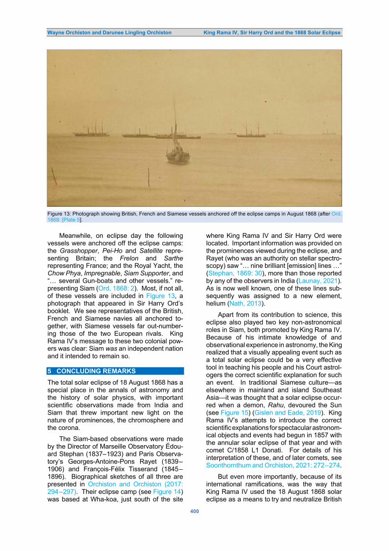
Wayne Orchiston and Darunee Lingling Orchiston King Rama IV, Sir Harry Ord and the 1868 Solar Eclipse
400
Figure 13: Photograph showing British, French and Siamese vessels anchored off the eclipse camps in August 1868 (after Ord, 1868: [Plate 5].
Meanwhile, on eclipse day the following vessels were anchored off the eclipse camps: the Grasshopper, Pei-Ho and Satellite repre-senting Britain; the Frelon and Sarthe representing France; and the Royal Yacht, the Chow Phya, Impregnable, Siam Supporter, and “… several Gun-boats and other vessels.” re-presenting Siam (Ord, 1868: 2). Most, if not all, of these vessels are included in Figure 13, a photograph that appeared in Sir Harry Ord’s booklet. We see representatives of the British, French and Siamese navies all anchored to-gether, with Siamese vessels far out-number-ing those of the two European rivals. King Rama IV’s message to these two colonial pow-ers was clear: Siam was an independent nation and it intended to remain so. 5 CONCLUDING REMARKS
The total solar eclipse of 18 August 1868 has a special place in the annals of astronomy and the history of solar physics, with important scientific observations made from India and Siam that threw important new light on the nature of prominences, the chromosphere and the corona.
The Siam-based observations were made by the Director of Marseille Observatory Édou-ard Stephan (1837–1923) and Paris Observa-tory’s Georges-Antoine-Pons Rayet (1839–1906) and François-Félix Tisserand (1845–1896). Biographical sketches of all three are presented in Orchiston and Orchiston (2017: 294–297). Their eclipse camp (see Figure 14) was based at Wha-koa, just south of the site
where King Rama IV and Sir Harry Ord were located. Important information was provided on the prominences viewed during the eclipse, and Rayet (who was an authority on stellar spectro-scopy) saw “… nine brilliant [emission] lines …” (Stephan, 1869: 30), more than those reported by any of the observers in India (Launay, 2021). As is now well known, one of these lines sub-sequently was assigned to a new element, helium (Nath, 2013).
Apart from its contribution to science, this eclipse also played two key non-astronomical roles in Siam, both promoted by King Rama IV. Because of his intimate knowledge of and observational experience in astronomy, the King realized that a visually appealing event such as a total solar eclipse could be a very effective tool in teaching his people and his Court astrol-ogers the correct scientific explanation for such an event. In traditional Siamese culture—as elsewhere in mainland and island Southeast Asia—it was thought that a solar eclipse occur-red when a demon, Rahu, devoured the Sun (see Figure 15) (Gislen and Eade, 2019). King Rama IV’s attempts to introduce the correct scientific explanations for spectacular astronom-ical objects and events had begun in 1857 with the annular solar eclipse of that year and with comet C/1858 L1 Donati. For details of his interpretation of these, and of later comets, see Soonthornthum and Orchiston, 2021: 272–274.
But even more importantly, because of its international ramifications, was the way that King Rama IV used the 18 August 1868 solar eclipse as a means to try and neutralize British

Wayne Orchiston and Darunee Lingling Orchiston King Rama IV, Sir Harry Ord and the 1868 Solar Eclipse
401
Figure 14: Photograph by Rayet of the French eclipse camp, showing instrument huts and the 40-cm (left) and 20-cm (right) reflecting telescopes set up outdoors (courtesy: Archives, Observatoire de Marseille, 132 J 84). and French colonial aspirations vis-à-vis Siam. We can do no better in ending this paper than to quote Aubin (2010: 89): “… the eclipse ex-pedition of 1868 was—and remains—one of the king’s shrewdest political acts.” 6 NOTES
1. This paper is based on a paper with the same title and by the same authors that was presented at the second conference of the Southeast Asian Astronomy Network’s History and Heritage Working Group in Mandalay, Myanmar, in November 2017.
2. Note that ‘Istana’ means ‘palace’ in the Malay language.
7 ACKNOWLEDGEMENTS
We are eternally grateful to Dr Lars Gislén (Sweden) for kindly presenting the original ver-sion of this paper at the Mandalay conference on our behalf, when last-minute visa problems prevented us from attending the conference.
We also wish to thank Visanu Euarchukiati (Bangkok) for providing information relevant to this paper, and staff from the National Library in Singapore for their assistance during the data
collecting phase of this project, and especially for arranging for us to receive an e-copy of Sir Harry Ord’s 1868 booklet.
Finally, we are grateful to Dr Lars Gislén, Government House (Perth, Australia), Mar- seilles Observatory (France) and the National Archives (Bangkok, Thailand) for making avail-able Figures 5, 6, 7, 14 and 15.
Figure 15: Thai amulet showing Rahu eating the Sun (Gislén Collection).
8 REFERENCES
Anonymous, [ca. 1868]. Manuscript. Chiang Mai University Library (CMUL MS 18-011) (in Thai).

Wayne Orchiston and Darunee Lingling Orchiston King Rama IV, Sir Harry Ord and the 1868 Solar Eclipse
402
Aubin, D., 2010. Eclipse politics in France and Thailand, 1868. In Aubin, D., Bigg, C., and Sibim, H.O. (eds.). The Heavens on Earth: Observatories and Astronomy in Nineteenth-Century Science and Culture. Durham (North
Carolina), Duke University Press. Pp. 86–117.
Billard, R., 1971. L’astronomie Indienne. Paris, École Française d’Extrème-Orient (in French).
Bowring, J., 1857. The Kingdom and People of Siam: With a Narrative of the Mission to that Country in 1855. Two
Volumes. London, J.W. Parker.
Braddell, R.St.J., 1991. A short history of the Colony. In Makepeace et al., Volume 1, 12–31.
Bradley, W.L., 1966. Prince Mongkut and Jesse Caswell. Journal of the Siam Society, 55, 29–41.
Buckley, C.B., 1984. An Anecdotal History of Old Times in Singapore. Singapore, Oxford University Press.
Cook, N., 1993. A tale of two city pillars: Mongkut and Thai astrology on the eve of modernization. In
Wijeyewardene, G., and Chapman, E.C. (eds.), Patterns and Illusions: Thai History and Thought. Canberra,
Australian National University, Department of Anthropology. Pp. 276–304.
Corfield, J.J., and Corfield, R.S., 2006. Encyclopedia of Singapore. Lanham, Scarecrow Press.
Cottam, S., and Orchiston, W., 2015. Eclipses, Transits and Comets of the Nineteenth Century: How America’s Perception of the Skies Changed. Cham (Switzerland), Springer.
Division of Literature and History, Fine Arts Department, 1999. Golden Jubilee Collection of the Historical Archives, Volume 4. Bangkok, Fine Arts Department (in Thai).
Espenak, F., and Meeus, J., 2006. Five Millennium Canon of Solar Eclipses: ‒1999 to +3000. Greenbelt, NASA
(Technical Publication TP-2006-214141). Euarchukiati, V., 2021a. The 1875 British solar eclipse expedition to Siam led by Sir Arthur Schuster. In Orchiston
and Vahia, 2021a, 317–344. Euarchukiati, V., 2021b. Observations of the 6 April 1875 total solar eclipse from the Grand Palace in Bangkok. In
Orchiston and Vahia, 2021a, 345–372. Gislén, L., and Eade, J.C., 2001. South East Asian eclipse calculations. Centaurus, 43, 278‒307.
Gislén, L, and Eade, J.C., 2019. The calendars of Southeast Asia. 5: eclipse calculations, and the longitudes of
the Sun, Moon and planets in Burmese and Thai astronomy. Journal of Astronomical History and Heritage, 22,
458–478.
Gislén, L., and Eade, J.C., 2021. The influence of India on Southeast Asian astronomy: of calendars and
calculations. In Orchiston and Vahia, 2021a, 635–651.
Haridatta, 1954. Grahacâranibandhana. Madras, Kuppuswami Sastri Research Institute.
Hearnshaw, J., 2009. The Analysis of Starlight: One Hundred and Fifty Years of Astronomical Spectroscopy.
Second Edition. Cambridge, Cambridge University Press.
Hughes, S., 2013. Catchers of the Light. The Forgotten Lives of the Men and Women who First Photographed the Heavens. Their True Tales of Adventure, Adversity & Triumph. Two Volumes. Paphos, ArtDeCiel Publishing.
King, T., 1902. On New Zealand Mean Time, and on the longitude of the Colonial Observatory, Wellington; with a
note on the Universal Time question. Transactions and Proceedings of the Royal Society of New Zealand, 35,
428–451. Kochhar, R., and Orchiston, W., 2017. The development of modern astronomy and emergence of astrophysics in
India. In Nakamura and Orchiston, 705‒770.
Koh, T. (ed.), 2006. Singapore. The Encyclopedia. Singapore, Editions Didier Millet.
Launay, F., 2012. The Astronomer Jules Janssen: A Globetrotter of Celestial Physics. New York, Springer.
Launay, F., 2021. Observations of the total solar eclipse of 18 August 1868 carried out by Jules Janssen at
Guntoor, India. Journal of Astronomical History and Heritage, 24, 114‒124.
Lord, D.C., 1969. Mo Bradley and Thailand. Grand Rapids, William B. Eerdman’s.
Makepiece, W., Brooke, G.E., and Braddell, R. St. J. (eds.), 1991. One Hundred Years of Singapore. Two Volumes.
Singapore, Oxford University Press.
Meadows, J., 1970. Early Solar Physics. Oxford, Pergamon Press.
Moffat, A.L., 1961. Mongkut, the King of Siam. Ithaca, Cornell University Press.
Moore, D., and Moore, J., 1969. The First 150 Years of Singapore. Singapore, Donald Moore Press Ltd. in
association with the Singapore International Chamber of Commerce.
Mumpuni, E.S., Orchiston, W., and Steinicke, W., 2017. J.A.C. Oudemans’ observations of the 18 August 1868
and 12 December 1871 total solar eclipses from the Dutch East Indies. In Nakamura and Orchiston, 357–373.
Nakamura, T., and Orchiston, W. (eds.), 2017. The Emergence of Astrophysics in Asia. Cham (Switzerland),
Springer International Publishing. Nath, B.B., 2013. The Story of Helium and the Birth of Astrophysics. Cham (Switzerland), Springer. Nunn, B., 1991. Some account of our Governors and Civil service. In Makepiece et al., Volume 1, 69–148.
Orchiston, W., and Orchiston, D.L., 2017. French observations of the 18 August 1868 total solar eclipse from Wha-
koa, Thailand. In Nakamura and Orchiston, 291‒317. Orchiston, W., Lee, E.-H., & Ahn, Y.-S., 2017a. British observations of the 1868 total solar eclipse from Guntoor,
India. In Nakamura and Orchiston, 771‒793.
Orchiston, W., Mumpuni, E.S., and Steinicke, W., 2017b. J.A.C. Oudemans and nineteenth century astronomy in
the Dutch East Indies. In Nakamura and Orchiston, 329–356.
Orchiston, W., Orchiston, D.L., George, M., Soonthornthum, B., Gislén, L., Débarbat, S., Husson, M., and Launay,
F., 2019. The role of eclipses and European observers in the development of ‘modern astronomy’ in Thailand.
In Orchiston, W., Sule, A., and Vahia, M., (eds.). The Growth and Development of Astronomy and Astrophysics in India and the Asia–Pacific Region. ICOA-9, Pune, India, 15–18 November 2016. New Delhi, Hindustan Book
Agency and Springer. Pp. 173‒216.
Wayne Orchiston and Darunee Lingling Orchiston King Rama IV, Sir Harry Ord and the 1868 Solar Eclipse
403
Orchiston, W., and Orchiston, D.L., 2021. The role of temporary Western observatories in the development of
professional astronomy in Thailand. In Diokno, M. (ed.), Where Science Met Empire: Observatories in Asia in the Late 19th to Mid-20th Centuries. Singapore, National University of Singapore Press. In press.
Orchiston, W., and Vahia, M. (eds.), 2021a. Exploring the History of Southeast Asian Astronomy: A Review of Current Projects, and Future Prospects and Possibilities. Cham (Switzerland), Springer.
Orchiston, W., and Vahia, M., 2021b. Exploring the history of Southeast Asian astronomy: a checklist of recent
projects and future prospects and possibilities. In Orchiston and Vahia, 2021a, 3–36.
Ord, Sir Harry St. George, 1868. Account of a Visit to the King of Siam at Whae-Whan on the East Coast of the Malayan Peninsula, in August 1868. Singapore, Government Press.
Pallegoix, J.B. (translated by Komonbutra, S.T.), 1977. Story of Siam. Bangkok, Progress Publisher.
Saibejra, N., 2006. King Mongkut, the Father of Thai Science. In Chen, K.Y. Orchiston, W. Soonthornthum, B., and
Strom, R. (eds.), Proceedings of the Fifth International Conference on Oriental Astronomy Held in Chiang Mai, Thailand, 4–8 October 2004. Chiang Mai: Chiang Mai University. Pp. 15–18.
Soonthornthum, B., 2011. The emergence of astronomy in Thailand. In Nakamura, T., Orchiston, W., Sôma, M.,
and Strom, R. (eds.). Mapping the Oriental Sky. Proceedings of the Seventh International Conference on Oriental Astronomy. Tokyo, National Astronomical Observatory of Japan. Pp. 179 –186.
Soonthornthum, B., and Orchiston, W., 2021. King Rama IV: astronomer and ‘The Father of Thai Science’. In
Orchiston and Vahia, 2021a, 253–284. Stephan, M., 1869. Report on the observation of the eclipse of the Sun of 18 August 1868. English translation (pp.
[vi] +93) of the French original published in Archives des Missions Scientifique et Littéraires …, 5, 535– 618. Tuck, P.J.N., 1995. The French Wolf and the Siamese Lamb: The French Threat to Siamese Independence, 1858–
1907. Bangkok, White Lotus.
Venkateswaran, T.V., 2021. Ragoonatha Charry and observations of the total solar eclipse of 1868 from Vanpurthy
(Wanparthy), India. Journal of Astronomical History and Heritage, 24, 385–410.
Wisandarunkorn, L., 1997. Khamphi Horasasat Thai (Profound Thai Astrology). Bangkok, In-print (in Thai).
Professor Wayne Orchiston has BA (Honours) and PhD degrees from the University of
Sydney. Formerly he worked in optical and radio astronomy in Australia and New Zealand.
He now works at the National Astronomical Research Institute of Thailand and is also an
Adjunct Professor of Astronomy in the Centre for Astrophysics at the University of Southern
Queensland.
He has wide-ranging research interests and has published extensively, with research
papers on astronomical archives; the history of cometary and meteor astronomy; the history
of meteoritics; the early development of astrophysics; historic eclipses and the development
of solar physics; historic transits of Venus; historic telescopes and observatories; amateur
astronomy and the amateur–professional interface; ethnoastronomy; early astronomical
groups and societies; Cook voyage astronomy; and the history of radio astronomy. Since moving to Thailand in
2013 much of his recent research has related to Indian, Thai, Indonesian, Philippine, Japanese, Australian and
New Zealand history of astronomy.
His recent books include Exploring the History of New Zealand Astronomy: Trials, Tribulations, Telescopes and Transits (Springer, 2016), John Tebbutt: Rebuilding and Strengthening the Foundations of Australian Astronomy (Springer, 2017), The Emergence of Astrophysics in Asia: Opening a New Window on the Universe
(Springer, 2017, co-edited by Tsuko Nakamura); Exploring the History of Southeast Asian Astronomy: A Review of Current Projects and Future Prospects and Possibilities (Springer, 2021, co-edited by Mayank Vahia), and The Golden Years of Australian Radio Astronomy: An Illustrated History (Springer, 2021, co-authored by Peter
Robertson and Woody Sullivan). He has also co-edited a succession of conference proceedings.
Wayne has been very active in the IAU for several decades, and is the current President of Commission C3
(History of Astronomy). In the past, he was responsible for founding the Transits of Venus and Historical Radio
Astronomy Working Groups. In 1998 Wayne co-founded the Journal of Astronomical History and Heritage, and is
the current Managing Editor. He also serves as an Editor of Springer’s Series on Historical and Cultural Astronomy.
In 2013 the IAU named minor planet 48471 ‘Orchiston’ after him, and more recently he and one of his former
American graduate students, Dr Stella Cottam, shared the 2019 Donald E. Osterbrock Book Prize from the
American Astronomical Society for their book Eclipses, Transits, and Comets of the Nineteenth Century: How America’s Perception of the Skies Changed (Springer, 2015).
Mrs Darunee Lingling Orchiston is a successful businesswoman in Chiang Mai (Thailand),
and also doubles as Professor Wayne Orchiston’s part-time Research Assistant.
She has a special interest in ethnoastronomy and was taught traditional Lanna
astronomy by her father (a medical doctor) and her grandfather (a businessman). Darunee
Lingling has participated in research on Philippine and Thai astronomical history; Thai
meteorites; and Indian, Maori and Thai ethnoastronomy, and engaged in archival work, data
collecting and field work in Australia, France, India, Singapore and Thailand.
She has co-authored research papers that have been published in the Journal of Astronomical History and Heritage, and in the following books: The Emergence of

Wayne Orchiston and Darunee Lingling Orchiston King Rama IV, Sir Harry Ord and the 1868 Solar Eclipse
404
Astrophysics in Asia: Opening a New Window on the Universe (Springer, 2017), The History of World Calendars and Calendar-making (Yonsei University Press, 2017), The Growth and Development of Astronomy and Astrophysics in India and the Asia–Pacific Region (Hindustan Book Agency and Springer, 2019), and Exploring the History of Southeast Asian Astronomy: A Review of Current Projects and Future Prospects and Possibilities
(Springer, 2021). She also has co-authored research papers presented at conferences and seminars in Austria,
India, Myanmar, the Philippines, Singapore, South Korea and Thailand.

Journal of Astronomical History and Heritage, 24(2), 405–439 (2021).
405
EUROPEAN LONGITUDE PRIZES. 2: ASTRONOMY, RELIGION AND ENGINEERING
SOLUTIONS IN THE DUTCH REPUBLIC
Richard de Grijs Department of Physics and Astronomy, Macquarie University,
Balaclava Road, Sydney, NSW 2109, Australia E-mail: [email protected]
Abstract: The late-sixteenth century witnessed a major expansion of Dutch shipping activity from northern European waters to the Indian Ocean and beyond. At a time when the Renaissance had just arrived on the North Sea’s shores, scientist-scholars, navigators and merchants alike realised the urgent need for and potential profitability of developing a practical means of longitude determination at sea. Under pressure of early adopters, including Petrus Plancius and Simon Stevin, on 1 April 1600 the national government of the Dutch Republic announced a generous longitude prize, which would see gradual increases in value over the next two centuries. In addition to leading thinkers like Galileo and Christiaan Huygens, the Low Countries spawned major talent in pursuit of a longitude solution. Their solutions reached well beyond applications of the ephemerides of Jupiter’s moons or the development of a stable marine timepiece. Studies of the Earth’s magnetic field, lunar distances, astronomical observations combined with simple trigonometry and the design of a ‘golden compass’ all pushed the nation’s maritime capabilities to a higher level. Dutch efforts to ‘find East and West’ were unparalleled and at least as insightful as those pursued elsewhere on the continent. Keywords: Galileo Galilei, Christiaan Huygens, Dutch East India Company, pendulum clocks, Jupiter’s moons, lunar distances, terrestrial magnetism. 1 EXPANDING TRADE ROUTES
Although international trade networks and ship-ping routes saw tremendous growth in late-medieval times, in Europe that expansion was initially almost entirely driven by the Spanish (Castilian)–Portuguese rivalry and the associ-ated quest for maritime dominance (for a review, see de Grijs, 2020b). By the 1580s, however, sailors hailing from Flemish ports and the Hanseatic cities extended their active range beyond North and Baltic Sea coasts to destinations as far away as the East Indies. They thus required more sophisticated navi-gational aids to safely travel across the open oceans (Schilder and van Egmond, 2007). Over the course of the next few centuries, this pressing need led directly to the establishment of well-funded longitude prizes (e.g., Howse, 1998) by the governments of Castile (‘Spain’), the Dutch Republic, the Venetian Republic and Great Britain, as well as by the French Aca-démie Royale des Sciences through its Meslay Prize (e.g., Boistel, 2015).
King Philip II, the Spanish monarch, est-ablished a generous longitude prize in 1567, which his son, Philip III, confirmed and in-creased in value upon his accession to the Spanish throne in 1598 (de Grijs, 2020b). The Staten Generaal (States General) of the Unit-ed Provinces of the Dutch Republic, and to a lesser extent also lower-level governing bodies (van Berkel, 1998), had been under pressure since the early 1590s by scientists—including Petrus Plancius, Simon Stevin and Matthijs
Lakeman (Davids, 1986: 69; Wepster, 2000)—to issue their own reward to anyone who could provide an adequate and practical solution to what the Dutch referred to as the problem of ‘finding East and West’.
On 1 April 1600, the States General finally announced the availability of a reward of 5,000 carolus guilders (florins), as well as a life an-nuity of 1,000 pounds, for successful appli-cants (Davids, 2009):
346. Resolution 1 April – At the request of Jacob van Straten,1 … [it] has been re-solved that, while there are several others who have indicated that they have found the same [a method to determine longitude at sea], that all contenders will be required to provide written explanations of their in-ventions within six weeks, or at most two months, upon which all written submis-sions will be opened and examined, that it is promised and agreed that to those who have offered a genuine invention against which there are no objections, an annual sum of one thousand pounds of twenty stuivers 2 each and five thousand guilders in cash … will be paid, inasmuch … that if multiple [submissions] have resulted in perfect inventions, that [the successful contenders] will share their written explan-ations with the others and compete. (Dav-idse, 2000–2020).
This resolution was well overdue. At least five contenders had entered the fray even be-fore the first Dutch longitude prize had been established (Davids, 1986: 69). There was a clear need for facilitation and encouragement

Richard de Grijs European Longitude Prizes. 2: Dutch Republic
406
Figure 1: Map of the ‘Brouwer’ route (courtesy: Redgeographics, via Wikimedia Commons; Creative Commons Attribution-Share Alike 4.0 International license). of navigational progress by the highest au-thorities. Although there was no direct link to the Spanish longitude competition, a number of submissions originated from applicants who had been inspired by and often had first submitted their proposals to the Spanish Casa de la Contratación (House of Trade) in Seville (Spain). As we will see below, Galileo Galilei 3 was a ‘repeat submitter’, although his proposal to the Dutch authorities was not necessarily identical to that submitted to the Spanish Crown.
On 7 July 1611, on the recommendation of Hendrick Willemsz Nobel, Albert Joachimi and Willem van Velsen4 (councillors and expert as-sessors), the States General increased its prize amount. The reward was consolidated into a single, maximum lump sum of 15,000 guilders (Davidse, 2000–2020; Dodt van Flens-burg, 1846: 244). In 1660 it was increased once again, to 25,000 guilders. A year after the States General had announced their initial reward, the Staten van Hollant ende Westfries-lant (the provincial States of Holland and Westfrisia) announced their own version of a longitude prize, offering 150 guilders to anyone
for an initial written explanation of their meth-od. This prize would be offered provided that the proposers were prepared to have their methods tested at sea. In addition, a lump sum of 3,000 guilders and an annuity of 1,000 guilders would be awarded if six to eight nav-igation experts would attest to the method’s practicality and reliability (de Grijs, 2020b). By 1738, the States of Holland were prepared to pay as much as 50,000 guilders to successful applicants.
The gradual increases in the prize amounts on offer may have been related to changes in the shipping routes to the Dutch East Indies. Initially, ships commandeered by the Vereen-igde Oostindische Compagnie (VOC; the Dutch East India Company, established in 1602) adopted direct routes across the Indian Ocean from the Cape of Good Hope to Batam and Batavia (present-day Jakarta, Indonesia). How-ever, from 1616 a different course was man-dated, which involved a rapid transition across the Indian Ocean at a latitude of about 40° South, followed by a directional change to the north at the approximate longitude of Batavia (Wepster, 2000): see Figure 1. This southern,

Richard de Grijs European Longitude Prizes. 2: Dutch Republic
407
Figure 2: Plate 1 from Ongeluckige voyagie, van’t schip Batavia (Unlucky Voyage of the Ship Batavia; 1647) (Wikimedia Commons; public domain). ‘Brouwer’ route took advantage of the prevail-ing westerly trade winds (‘the roaring forties’), thus allowing completion of the voyage much more rapidly than before. Meanwhile, the more temperate climate contributed to a better over-all health profile of the crews and a lower inci-dence of perishable-food decay.
Determination of one’s longitude while on the rapid southerly leg was of paramount im-portance. A premature turn northwards would direct the ships to the Sumatra coast, from whence sailing conditions across the Sunda Strait to Batavia were treacherous. A late course change, however, could be even more devastating, as evidenced for instance by the Dutch East Indiaman Batavia’s shipwreck (see Figure 2) on the Houtman Abrolhos off the Western Australian coast in 1629.
Eventually, by 1775, almost forty propos-als had been submitted for one of the Dutch longitude rewards. Most applicants were bas-ed in the Dutch Republic, although a number of high-profile hopefuls—including Galileo, in 1634—hailed from abroad, particularly from the Holy Roman Empire and from France (Dav-ids, 2009). Many were philosophers, scien-
tists or those employed in affiliated professions (e.g., Andreas van Berlicom in the mid-seven-teenth century; van Berlicum, 1656). Perhaps surprisingly, only few were practicing sailors (Wepster, 2000). Yet, despite this flurry of pro-posals, neither the States General nor the States of Holland ever awarded the full prize money. However, they regularly offered prom-ising contenders significant expense allow-ances. Among those provided with an ex-pense budget, the most successful contender was Jan Hendricksz Jarichs van der Ley (see Figure 3).5 In 1625, he was awarded an annuity of 1,200 guiders for himself and his heirs, which would pay out 19,000 guilders by the time the agreement was cancelled in 1655 (Davids, 2005).
In Spain, all proposals vying for a share of its longitude prize were assessed by a single agency, the Casa de la Contratación, acting through the Conseja de Indias (Council of the Indies). In the Dutch Republic, however, the initial assessments of and responses to the various proposals received by the governing bodies were handled in a more ad hoc man-ner, involving a larger number of stakeholders

Richard de Grijs European Longitude Prizes. 2: Dutch Republic
408
Figure 3: Portraits of the main characters driving the innovations described in this article, both scientist-scholars and opportunistic ‘projectors’, ordered from left to right and from top to bottom by date of birth. Individuals depicted include (i) Plancius (1552–1622); (ii) Galileo (1564–1642); (iii) Jarichs van der Ley (c. 1566–1639); (iv) Metius (1571–1635); (v) van Nierop (1610–1682); (vi) Christiaan Huygens (1629–1695); and (vii) Willemsz (Graaf) (1652–1704). (Figure credits: Wikimedia Commons, except for (vii): Rijksmuseum Amsterdam. All images are in the public domain, except for (iii): Creative Commons CC0 1.0 Universal Public Domain Dedication). covering a wider range of expertise. Most commonly, the States General would convene an ad hoc committee of theoristen, experts in the theory of navigation, to solicit their expert opinion as to the theoretical correctness of the proposed solution. If a proposal passed that initial assessment, ‘practisijns ende stierluij-den’, experienced sailors (literally, practicing navigators), would be enlisted to provide their expert advice as to whether the solution was “… completely secure and certain.” (Davids, 1986: 73) and also practically viable. This penultimate phase might be repeated a num-ber of times, sometimes also including further discussions and debate regarding the meth-od’s merits. The final assessment phase then involved actual sea trials.
The ad hoc committees of theoristen in-cluded established scholars, teachers and surveyors (see Figure 4)6—including Joseph Justus Scaliger, Rudolf and Willebrord Snel-lius, Stevin, Sybrand Hansz Cardinael (Sy-brand Hanssen), Franciscus (Frans) van Schooten, Christiaan Huygens, Martinus Hort-ensius (van den Hove), Burchard de Volder, Petrus (Pieter) van Musschenbroek, Willem Jansz Blaeu and Isaac Beeckman, among oth-ers. Initially, the States General would invite expert commentary by letter, although oral re-ports to the full assembly were also accept-able. This process became more formalised by the middle of the seventeenth century. The
Government would pass a resolution to re-quest the expertise of earmarked technical ex-perts, who would then be sent a formal missive, accompanied by any relevant mat-erial for assessment (Thomassen, 2009). Re-ports had to be delivered in written form, a practice implemented from the 1630s.
Many of these theoristen committees drew heavily on the expertise of teachers and schol-ars at universities or prominent (‘Illustre’) col-leges (Davids, 1990). For instance, two Lei-den University employees, including Rudolf Snellius, Professor of Mathematics from 1581, and Scaliger, Professor of History from 1591, were appointed to one such committee in 1598, together with Stevin, Lucas Jansz Wag-henaer and Ludolf van Ceulen (Davidse, 2000–2020). On 3 November 1617 the States General requested that Stevin, Gerard Meer-man, Jacob Magnus and Bocko van Burmania assess Jarichs van der Ley’s proposal. At var-ious times between 1618 and 1620, Adriaen Metius, Nicolaus Mulerius and Willebrord Sne-llius, as well as a number of surveyors, ex-perienced sailors and instructors of navigation were also invited to offer their assessments on Jarichs van der Ley’s proposal (Davids, 1986: 80–82, 284–287). Meanwhile, in 1635 van den Hove, Blaeu and Beeckman were asked “… to receive a written description of and ex-amine …” Galileo’s proposal (Davidse, 2000–2020; Thomassen, 2009). I will discuss these

Richard de Grijs European Longitude Prizes. 2: Dutch Republic
409
Figure 4: As Figure 3 but for the officials, examiners and support personnel playing important roles in the validation of all longitude solutions discussed in this article. (i) Ludolf van Ceulen (1540–610); (ii) Scaliger (1540–1609); (iii) Rudolf Snellius (1546–1613); (iv) van den Kerckhove (d. 1619); (v) Stevin (1548–1620); (vi) Jan (Johan) de Groot (1554–1640); (vii) Mulerius (1564–1630); (viii) le Canu (1563–1630), teaching a nautical class; (ix) Carolus (c. 1566–c. 1636); (x) Prince Maurits (1567–1625); (xi) Blaeu (1571–1638); (xii) de Houtman (1571–1627); (xiii) Dou (1572–1635); (xiv) Willebrord Snellius (1580–1626); (xv) Hugo de Groot (1583–1645); (xvi) Reael (1583–1637); (xvii) Colvius (1594–1671); (xviii) Constantijn Huygens (1596–1687); (xix) Hartlib (c. 1600–1662); (xx) van Schooten (1615–1660); (xxi) van Beuningen (1622–1693); (xxii) Hudde (1628–1704); (xxiii) Bekker (1634–1698); (xxiv) van Musschenbroek (1692–1761); (xxv) Lulofs (1711–1768); (xvi) van Swinden (1746–1823); and (xvii) Nieuwland (1764–1794) (Figure credits: Wikimedia Commons, except for (iv): Regional Archives Dordrecht; (viii): Oudhoorn Archives; and (ix): Wanna Know History blog, November 2015. All images are in the public domain, except for (vi): Creative Commons CC0 1.0 Universal Public Domain Dedication; (vii): Creative Commons Attribution-Share Alike 3.0 Unported, 2.5 Generic, 2.0 Generic and 1.0 Generic licenses; and (xvii): Creative Commons Attribution-Share Alike 2.5 Generic license). proposals in detail below.
In the second half of the seventeenth cen-tury, this external expertise was still highly sought after. On several occasions in the 1680s and 1690s, de Volder—Professor of Physics, Astronomy and Mathematics at Lei-den University—developed into a high-profile expert providing support to the National Gov-ernment, the Provincial Government of Hol-land, as well as the Amsterdam chamber of the VOC in their assessments of newly pro-posed longitude solutions (Davids, 1986: 132, 135 –137). In fact, the VOC became a centre of expertise of sorts, given that it employed dedicated pilot examiners, who were experts in navigation themselves. As such, from the middle of the seventeenth century until about 1730, the States General frequently referred
contenders for its longitude prize to the VOC (Davids, 1986: 73, 81–83, 132, 180; Vanpae-mel, 1989).
The joint pursuit of trade and practical science came naturally to the sailors engaged in the East India voyages and their paymast-ers. Scientific endeavours were pursued syst-ematically ever since the first Dutch voyage to Asia in 1595 (see Figure 5), the so-called Eerste Schipvaart (van Berkel, 1998). On that voyage, Plancius took charge to obtain suf-ficient numbers of observations of variations of the ‘magnetic declination’ (deviations of the compass needle from true North) as a potent-ial but ultimately unsuccessful means to deter-mine one’s longitude at sea.
From the 1740s, the States General in-creasingly relied on the services of technical

Richard de Grijs European Longitude Prizes. 2: Dutch Republic
410
Figure 5: The Dutch East India fleet of the Eerste Schipvaart (1595–1596), commanded by Cornelis de Houtman (source: Willard Hanna, Bali Chronicle, via Wikimedia Commons; public domain). experts affiliated with universities and Illustre colleges, which was reflected in their job des-criptions. Between 1743 and 1796, lecturers in mathematics, astronomy and nautical science at Amsterdam’s Athenaeum Illustre (see Fig-ure 6)—the predecessor of the University of Amsterdam—were jointly appointed as pilot examiners at the VOC’s Amsterdam chamber. Similarly, the VOC’s pilot examiner at its Zee-land chamber in Middelburg was simultane-ously appointed as Professor of Philosophy, Mathematics, Physics and Astronomy at the town’s Illustre college.
In 1787, the Admiralties of Amsterdam and Rotterdam formalised these arrangements by creating the Committee on Matters Relating to the Determination of Longitude at Sea and the Improvement of Charts7 (Davids, 2015), which became an agency of the Dutch Navy from 1795 until its dissolution in 1850. This Long-itude Committee always included one or two Professors from either the Athenaeum Illustre in Amsterdam, Leiden University or Utrecht University. Its main purpose was to dissem-inate knowledge regarding maritime carto-graphy, longitude determination at sea and other aspects of nautical science (Davids, 1986: 188, 342, 399–400; Davids, 2016). One of its most important tasks was the translation and adaptation of the British Nautical Almanac for a reference meridian through Tenerife’s Teide volcano instead of Greenwich.
Only a small fraction of the initial submis-sions eventually reached the sea trial phase, and if they did, prolonged debates about their viability often ensued upon the ships’ return. Among the most promising proposals whose development was taken forward to practical sea trials (Davids, 2008: 446) was Jarichs van der Ley’s improved technique of ‘dead reck-oning’, which was taken on a “… voyage of the
experiment …” in 1618. Later that century, a number of Huygens’ marine timepieces were tested on sea trials undertaken as part of regular VOC voyages to the Cape of Good Hope in the 1680s and 1690s (e.g., de Grijs, 2017). In the 1730s, the VOC also undertook a number of sea trials of instruments for the improved measurement of speed and leeway invented by Leendert Vermase and Jasper van der Mast.
From approximately the 1580s, Dutch knowledge of maritime navigation had improv-ed rapidly, allowing the nation’s scholars to become leaders in marine cartography, partic-ularly of the North and Baltic Seas. The most famous sixteenth-century cartographer was Waghenaer (1585), on account of his publicat-ion of the first illustrated book of sailing direct-ions, Spieghel der Zeevaerdt … (Mariner’s Mir-ror; see Figure 7). However, in the modern public mind, the history of longitude determin-ation in the Netherlands is firmly associated with Huygens’ pendulum clocks and, to a less-er extent, Galileo’s unsuccessful attempts at securing one of the Dutch longitude prizes. Yet, well before the heyday of these illustrious scholars, from the sixteenth century, the nat-ion’s scientists and navigators were actively engaged in practical approaches to solving this most vexing problem. It is my aim to highlight the advances made in this field over the better part of two centuries, by providing a compre-hensive overview of the people, methods and developments involved and pursued. 2 EARLY CONTENDERS
The collection of resolutions passed by the States General around the turn of the sixteenth century represents a treasure trove of infor-mation about early efforts to develop novel methods for longitude determination at sea.

Richard de Grijs European Longitude Prizes. 2: Dutch Republic
411
Figure 6: (Top) The Amsterdam Athenaeum Illustre in 1650 (Cornelis Springer, 1878) (courtesy: Teylers Museum, Haarlem, via Wikimedia Commons; public domain). (Bottom) Interior (Hermanus Petrus Schouten, c. 1770–1783) (courtesy: Rijksmuseum Amsterdam, via Wikimedia Commons; Creative Commons CC0 1.0 Universal Public Domain Dedication).

Richard de Grijs European Longitude Prizes. 2: Dutch Republic
412
These resolutions, which have been made available online8 for historical research, en-compass a complete record of any such meth-ods offered to the Dutch Government for pos-sible patenting between 1576 and 1625. 2.1 Patent Applications Leading Up to the Dutch Prize Announcement
Not surprisingly, the earliest of the resolutions referring to a new longitude invention relates to a prominent contemporary scholar: Petrus Plancius. This Dutch–Flemish astronomer and cartographer was a Reformed Church clergy-man from the southern Netherlands. He foll-
Figure 7: Spieghel der Zeevaerdt (title page), a collection of coastal maps from 1584–1585 by Lucas Jansz Waghenaer (Wikimedia Commons; Creative Commons Attribution 3.0 Unported license). owed in the footsteps of his illustrious Spanish predecessors by whom he was influenced—including João de Lisboa, Francisco Faleiro and Alonso de Santa Cruz—by proposing a possible solution based on observations of the magnetic compass needle and its variation with position (Davids, 1986: 70–71, 75; Jonkers, 2000).
Plancius was convinced that a global pat-tern showing the relationship between mag-netic declination and the direction of true North could be derived (van Berkel, 1998). The idea was that closer to the Poles, the magnetic
declination would be more obvious. If this was indeed correct, this magnetic property might be employed to determine one’s position on the open seas, provided that one could sim-ultaneously determine one’s latitude. This also assumed that the behaviour of the Earth’s magnetic field was known sufficiently well. Magnetic declination tables could then provide the final piece of the puzzle to determine the corresponding longitude, since the direction of true North could be determined from the Sun’s meridian passage (or, at night, the direction to Polaris, the North Star).
At the request of the Dutch merchant navy, on 3 September 1593 the States of Hol-land resolved to hear Plancius explain his method. The governing body appointed a Committee of theoristen, composed of Joost de Menyn, the Heer (landlord) of Warmond; Jan (Johan) de Groot, Mayor of Delft; a deputy acting for Amsterdam and Willem Cornelisz Kort from the Noorder Quartiere, literally the northern quarter (the northern region of the present-day Dutch province of North Holland). A few days later, on 7 September, the States of Holland resolved that Plancius would re-ceive generous financial compensation for his efforts, provided that the method proved suc-cessful during sea trials.
The first Dutch East India fleet departed from the anchorage at Texel, on the North Sea, in April 1595 en route to the East Indies, where they arrived in 1596. Plancius had taught Frederik de Houtman, junior merchant of the VOC, how to measure and record com-pass declinations. In the mean time, he had continued to improve his method in collabor-ation with Mathijs Syeverts (Sieverts, Syvertsz Lakeman). In fact, in 1593 Syeverts had pro-duced a new portolan-style marine map (cf. de Grijs, 2017: Ch. 2), equipped with additional navigation aids (such as graduated arcs). He claimed that
… all pilots, navigators and skippers would [be able to] sail South and North, as well as East and West, with certainty … and [they] could know where they were without [the need for] any guessing at what dist-ance and how far to the East, West, South or North, given the prevailing conditions. (Davidse, 2000–2020: Note 3).
Syeverts (1597) appears to have been in-spired by a rather curious voyage referred to in his 1597 manuscript, A Very Helpful Treatise for all Sailors/Based on a Discussion Between Two Pilots. Its subtitle is telling, Many Helpful Things Revealed by the Pilots In Particular the Highly Sought-After Art to Find East and West and Observations of the Same …, followed by the maxim, “Who is it who knows other than he
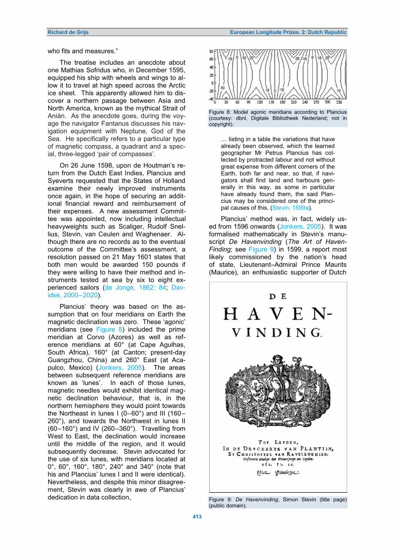
Richard de Grijs European Longitude Prizes. 2: Dutch Republic
413
who fits and measures.”
The treatise includes an anecdote about one Mathias Sofridus who, in December 1595, equipped his ship with wheels and wings to al-low it to travel at high speed across the Arctic ice sheet. This apparently allowed him to dis-cover a northern passage between Asia and North America, known as the mythical Strait of Anián. As the anecdote goes, during the voy-age the navigator Fantanus discusses his nav-igation equipment with Neptune, God of the Sea. He specifically refers to a particular type of magnetic compass, a quadrant and a spec-ial, three-legged ‘pair of compasses’.
On 26 June 1598, upon de Houtman’s re-turn from the Dutch East Indies, Plancius and Syeverts requested that the States of Holland examine their newly improved instruments once again, in the hope of securing an addit-ional financial reward and reimbursement of their expenses. A new assessment Commit-tee was appointed, now including intellectual heavyweights such as Scaliger, Rudolf Snel-lius, Stevin, van Ceulen and Waghenaer. Al-though there are no records as to the eventual outcome of the Committee’s assessment, a resolution passed on 21 May 1601 states that both men would be awarded 150 pounds if they were willing to have their method and in-struments tested at sea by six to eight ex-perienced sailors (de Jonge, 1862: 84; Dav-idse, 2000–2020).
Plancius’ theory was based on the as-sumption that on four meridians on Earth the magnetic declination was zero. These ‘agonic’ meridians (see Figure 8) included the prime meridian at Corvo (Azores) as well as ref-erence meridians at 60° (at Cape Agulhas, South Africa), 160° (at Canton; present-day Guangzhou, China) and 260° East (at Aca-pulco, Mexico) (Jonkers, 2005). The areas between subsequent reference meridians are known as ‘lunes’. In each of those lunes, magnetic needles would exhibit identical mag-netic declination behaviour, that is, in the northern hemisphere they would point towards the Northeast in lunes I (0–60°) and III (160–260°), and towards the Northwest in lunes II (60–160°) and IV (260–360°). Travelling from West to East, the declination would increase until the middle of the region, and it would subsequently decrease. Stevin advocated for the use of six lunes, with meridians located at 0°, 60°, 160°, 180°, 240° and 340° (note that his and Plancius’ lunes I and II were identical). Nevertheless, and despite this minor disagree-ment, Stevin was clearly in awe of Plancius’ dedication in data collection,
Figure 8: Model agonic meridians according to Plancius (courtesy: dbnl, Digitale Bibliotheek Nederland; not in copyright).
… listing in a table the variations that have already been observed, which the learned geographer Mr Petrus Plancius has col-lected by protracted labour and not without great expense from different corners of the Earth, both far and near, so that, if navi-gators shall find land and harbours gen-erally in this way, as some in particular have already found them, the said Plan-cius may be considered one of the princi-pal causes of this. (Stevin, 1599a).
Plancius’ method was, in fact, widely us-ed from 1596 onwards (Jonkers, 2005). It was formalised mathematically in Stevin’s manu-script De Havenvinding (The Art of Haven-Finding; see Figure 9) in 1599, a report most likely commissioned by the nation’s head of state, Lieutenant–Admiral Prince Maurits (Maurice), an enthusiastic supporter of Dutch Figure 9: De Havenvinding, Simon Stevin (title page) (public domain).

Richard de Grijs European Longitude Prizes. 2: Dutch Republic
414
efforts at attaining maritime dominance over the British. Stevin does not leave any doubt about his manuscript’s intentions:
It is known, that for a long time past, prin-cipally since the great voyages to the Ind-ies and America began, a means has been sought by which the navigator might know at sea the longitude of the place where his ship is at the moment, in order thus to get to the harbours to which he wishes to go, but that hitherto it has not been possible to arrive at such accurate knowledge of the longitude. For some people, hoping to find it through the variation of the compass [the magnetic declination], ascribed a pole to the said variation, calling it magnetic pole, but it is found upon further experience that these variations do not obey a pole. Nev-ertheless the search for this has furnished a means for reaching a desired harbour, even though the true longitudes of both the harbour and the ship are unknown. (Stev-in, 1599a).
Stevin’s aim was indeed modest; he in-tended to provide a means to reach a given harbour, or even to enable ships of a particular fleet to regroup at a specific point, without knowledge of one’s specific longitude:
Since the given variation and latitude in combination indicate a definite point, both at sea and on the land, it follows from this that it is possible for ships to find each other at a given point at sea, far from the land. This is useful, among other things, to help the ships of a fleet to reassemble after a storm. By this means it is also pos-sible to fix a rendezvous where ships com-ing from different directions may meet at a predetermined time. (Stevin, 1599a: App-endix).
A mathematician, physicist and engineer, Stevin differed from Plancius in the sense that he did not make any assumptions about the dependence of magnetic declination on geo-graphic position. Neither was he convinced of the existence of a magnetic pole, a location usually conceived as a rocky outpost some-where in the Arctic. Instead, he was a strong supporter of carefully executed empirical science, and so he advocated the collection of as many measurements as possible over as wide an area as feasible to allow for a proper assessment of Plancius’ theory.
His approach may well have been a fore-runner to today’s fashionable efforts to faci-litate ‘citizen science’. Stevin believed that uneducated sailors could obtain the requisite observations just as well as the average edu-cated person (van Berkel, 1998). However, he reasoned that it was imperative to engage those sailors, and so instead of writing in French or Latin, he published his instructions
and technical treatises in Dutch, using simple language. He even endeavoured to translate all remaining technical terms from Latin into Dutch for the first time. Around the turn of the seventeenth century, scholars adopted this ap-proach more often (e.g., Stevin’s contempor-ary Adriaan Metius also regularly published in Dutch; Dijkstra, 2012).
In his treatise De Havenvinding, Stevin had collected all such measurements from the Eerste Schipvaart to the East Indies to provide a more comprehensive and improved assess-ment of Plancius’ method (for a less favour-able opinion of Stevin’s work, see Busken Huet, 1882–1884: 238, Note 1). Stevin’s method of data collection was sound, which facilitated his Finally, by 1611 the Plancius method had actually been invalidated based on overwhelming empirical evidence.
In retrospect, the 1590s became a turning point in the history of Dutch efforts of longitude determination. In addition to Plancius, three other inventors applied for intellectual property protection by the Dutch authorities, before a longitude prize had even been formally est-ablished: Simon van der Eycke in 1595, Rey-nier Pietersz van Twisch in 1597 and 1598, and—as we saw already—one Jacob van Straten in 1600.
Simon van der Eyke, also known as Duch-esne, du Chesne or à Quercu (although the latter surname is likely an incorrect identificat-ion; Bierens de Haan, 1878: 7), had settled in Delft by 1584, where he taught mathematics. He is notorious for his treatise on the (in-correct) calculation of π via examination of the quadrature of a circle (‘squaring the circle’), which was severely criticised by his contemp-oraries.
In an attempt to redeem his damaged re-putation, he asked the States of Holland to issue him with a privilege for a new instrument he had developed to “… find the East and West …” (Davidse, 2000–2020), and which would allow him to produce more accurate maps. On 12 September 1595, the provincial government agreed to offer the inventor “… honest compensation so that he … will be satisfied and content.” (Bierens de Haan, 1878: 99), provided that his invention turned out to be practical for use at sea and that he would disclose, within three months, all tech-nical details to a committee appointed by the governing body. However, since van der Eycke also indicated that his instrument would be useful to determine one’s latitude, that is, the instrument was said to allow the user to measure “… longitude both in the East and West and … latitude in the South and North

Richard de Grijs European Longitude Prizes. 2: Dutch Republic
415
…”, the invention was most likely simply an improved means of determining the altitudes of celestial objects (Molhuysen et al., 1911–1937).
Meanwhile, Reynier Pietersz van Twisch (Twisck, vant Wisch), on the other hand, had developed a truly novel instrument that was commonly seen as having great promise. Van Twisch, who counted Plancius among his friends or at least among his acquaintances (Busken Huet, 1882–1884: 237), was an ex-perienced navigator with the Dutch merchant navy, and so he came with excellent cred-entials. On 8 March 1597, the States General awarded him a privilege for twelve years to construct an instrument that could easily measure the altitudes of the Sun and the stars at sea (Davidse, 2000–2020). Three days later, the Commission of experts retained to assess van Twisch’s proposal additionally awarded him a patent for an instrument that
… by measuring the [altitude of the] Sun could allow [one] to know the deviation of the needle [the magnetic declination] as well as the longitude …,
an instrument that would float and which be-came known as the ‘golden compass’ (Collot d’Escury, 1829: 295).
In early March 1598 van Twisch applied to the provincial States of Holland for a subsidy to construct two instruments. One of these was a new invention known as a Quadrantem Azimuthalium seu verticulu cuius planu hori-zontale (translation into Latin: Stevin, 1599b: 19), an azimuthal quadrant that turned about a vertical axis over a horizontal graduated circle (see Figure 10). Upon receipt of his appli-cation, on 13 March 1598 the States of Ho-lland appointed a Committee composed of Scaliger, Rudolf Snellius, van Ceulen, Stevin and deputies of Amsterdam, Rotterdam, Hoorn and Enkhuizen to examine the instruments and report on their performance during sea trials. Although the Committee’s conclusions are unknown, Stevin recommended adoption of the instrument. This suggests that the theo-risten deemed the device practically useful.
The device was kept horizontal by floating on the surface. It consisted of a quadrant that was placed on a round compass “… in the form of a double quadrant …”, with a sight channeling a beam of sunlight onto the com-pass, which was equipped with a graduated circle (Blok and Molhuysen, 1912: 1458–1459). The angular direction thus indicated by the beam of sunlight, presumably at the time of the Sun’s meridian passage, would directly yield the compass needle’s deviation with re-spect to true North. For the first time, these
magnetic declinations were expressed in ang-ular rather than temporal units, adopting com-mon practice similar to latitude determination (Abbing, 1841: 132).
Van Twisch demonstrated the successful performance of his device on a tour around the Dutch provinces of Holland, Utrecht and Fries-land. He also received ringing endorsements from the influential merchant and historian Jan Huyghen van Linschoten of Enkhuizen and from a number of experienced sailors and nav-igators on voyages to the African coast at Guinea, as well as the East and West Indies. Figure 10: The ‘golden compass’ of van Twisch: Quadrantem Azimuthalium seu verticulu cuius planu horizontale, that is, an azimuthal quadrant that turns about a vertical axis over a horizontal graduated circle (after Stevin, 1599b; public domain). In addition, Stevin included a description and drawing of the instrument in De Havenvinding and its Latin and French translations (see also his subsequent publication: Stevin, 1608), clearly recommending that navigators should use “… an azimuthal quadrant, the horizontal plane of which, notwithstanding the movement of the ship, always remains level.” (Stevin, 1599a).

Journal of Astronomical History and Heritage, 24(2), 405–439 (2021).
416
Figure 11: Het Ghebruyck der naeld wiisinge tot dienste der zee-vaert beschreven (Keteltas, 1609: title page; public domain).
Yet, Plancius’ golden compass was sev-
erely criticised by the cartographer and ex-perienced navigator Aelbert Hendriksz Haeyen (1599) in his manuscript, Een Corte Onderrich-tinge … (Brief Instructions …; Blok and Molhuy-sen, 1912). As a consequence, van Twisch declined an offer from the States General of a 5,000 guilder reward, combined with a 1,000 guilder annuity. On 3 September 1611, he once again submitted a new instrument design to the States General, this time in collaboration with Gerrit Pieters, and again the Government convened a Committee of experts. Despite his successful applications, in 1613 van Twisch died an old man of small fortune. 2.2 A Cottage Industry Emerges
The announcement of the first Dutch longitude prize in April 1600 led to a flurry of activity, with numerous ‘projectors’, from genuine scientist-scholars to lunatics and those keen to cash in on the generous cash prize clamouring for the attention of the governing bodies. This is rem-iniscent of what happened in Spain around the same time (de Grijs, 2020b) and of what would happen following the establishment of the Brit-ish Longitude Prize a century later (de Grijs, 2017).
Nevertheless, both the States General and
the provincial States of Holland were forced to take any and all applications seriously, given the enormous economic and political ramifica-ions associated with developing a viable so-lution to the longitude problem. As we will see shortly, this compelled the governing bodies to continue to engage even with those projectors whose ideas were clearly untenable.
One of the first promising applications foll-owing the establishment of the prize, once again exploiting magnetic declinations, was champ-ioned by Barent Evertsz Keteltas. On 19 Aug-ust 1608, he applied to the States General for a patent and subsidy to construct a new instru-ment. Prince Maurits and members of the States of Holland discussed the merits of Ket-eltas’s proposal at a meeting at the prince’s quarters on 17 October that year. A decision would not be made before 22 October. How-ever, Prince Maurits took the opportunity of the 17 October meeting to already inform the States of Holland of the conclusions of the committee of experts that had been enlisted to examine the invention (Vermij, 2010).
Keteltas (1609) proceeded to write a book to support his invention, The Use of the Com-pass Needle in Service of Maritime Navigation (see Figure 11), which he dedicated to Prince Maurits and the Admiralty of Holland, Zeeland

Richard de Grijs European Longitude Prizes. 2: Dutch Republic
417
and Westfrisia. He also presented copies to the Amsterdam City Council. In response to his advocacy, on 10 August 1610 the City Council gave him 25 guilders (Laboranter, 1862), while the States General awarded him 150 pounds (Laboranter, 1871; Smit, 1925) on 2 September 1610. However, the States Gen-eral also made it clear that he should not expect any additional financial compensation for any further development of this device (Davids, 2000–2020). Although there is no surviving evidence of Keteltas’s continued in-volvement in nautical instrument development, his name reappears a few years later as an expert committee member retained to assess an application for the longitude prize by Jarichs van der Ley.
An excellent example of how far the Dutch Government felt it needed to go in its pursuit to secure a practical longitude solution is offered by their protracted engagement with the Eng-lishman Thomas Leamer (Leoman, Lyamor) of Amsterdam. By all accounts, Leamer was an unpleasant person in his interactions (Sprung-er, 1993: 81–82) and lacked even a basic un-derstanding of mathematics and astronomy. As early as the winter of 1609, Leamer sub-mitted a request for a share of the Dutch Gov-ernment’s longitude prize, at the time rumour-ed to be as high as 25,000 guilders (Blok and Molhuysen, 1912: 790–791). We first formally hear about Leamer from a resolution issued on 28 August 1610, when the States General awarded him a patent, although without com-mitting to offer an assessment of the method’s added value or viability (Davidse, 2000–2020).
Self-taught in Hebrew, Leamer’s interest in the longitude problem was apparently inspired by insights he had gained from his religious studies, combined with a few short ocean voy-ages he had undertaken and his interactions with acquaintances associated with the VOC (Blok and Molhuysen, 1912). One of the key elements of his proposed new method consist-ed of assigning numerical values to Hebrew words so as to discover their hidden mean-ings. Specifically, he marked his instrument’s graduated arc with letters spelling out E-L-O-H-I-M, the Hebrew name for ‘God’. Leamer was convinced that he had worked out a novel method of longitude determination similar to the lunar distance method, although substant-ially different from the practical implementation of Plancius.
Despite the initial non-committal response from the States General, the governing body issued two additional resolutions in response to Leamer’s correspondence. On 24 March 1611, the States General resolved to provide
Leamer with a copy of the resolution in which its longitude prize was announced. Next, on 4 July 1611, we learn that Leamer had offered a demonstration of his method if the States Gen-eral would advise him on the size of the award. The Government decided to send deputies representing the provinces of Holland, Zee-land and Friesland to appease the applicant and to notify him that he would be considered for a reward of 10,000 guilders. This was in-creased to a maximum of 15,000 guilders in a resolution of 7 July, at Leamer’s request (Dav-idse, 2000–2020).
Rudolph Snellius and the nautical expert Robbert Robbertsz le Canu were tasked with assessing Leamer’s proposal. Despite their unfavourable opinion—“… more a preacher’s than an astronomer’s thesis …” (Blok and Mol-huysen, 1912: 790)—they offered him a chance at redemption by asking him to calculate a number of example problems. It transpired, however, that Leamer had not even mastered the basics of mathematics and astronomy (de Wreede, 2007), and so his ‘invention’ was deemed useless and futile. On 6 July 1612, the Admiralty of Amsterdam concurred and re-solved to return Leamer’s manuscripts. In re-sponse, Leamer (1612) proceeded to publish his ideas, a description of the method and a refutation of the objections in a confusing and lengthy pamphlet, Clear Demonstration of How to Find One’s Meridian Longitude Using the Timepiece of Elohim or the Great Owner, Namely by Means of the Sun, Moon and Stars at all Positions in the World . He offered his manuscript to the States General for their consideration on 12 October 1612.
Undeterred by the fact that Prince Maurits had decreed that all Dutch ships were to be equipped with instruments for longitude deter-mination according to Plancius’ design, Leam-er bluntly declared that Plancius’ approach was unsuitable (Blok and Molhuysen, 1912: 790–791). He appealed the rejection of his method, arguing that the assessors were bias-ed against him. This prompted the Govern-ment to appoint a new Committee, including the famous cartographer Blaeu, but once again the Committee’s verdict was that Leamer’s proposal was “… vain and frivolous.” (Ploeg, 1934: 50). In addition, the Protestant theolog-ian Abraham Coster (1613) penned a deva-astating response to Leamer’s religion-infused pseudo-science, The Horrific, Unheard-of Blas-phemy and Rage of Thomas Leamer . The dispute escalated until well into 1615, to the extent that Plancius himself was pulled into a public debate about the relationship, if any, between Hebrew letters and the art of navi-gation (Nauta et al., 1988: 245). The text of this

Richard de Grijs European Longitude Prizes. 2: Dutch Republic
418
debate is no longer available.
While this polemic with Leaman was play-ing out, the Dutch Government also enter-tained novel and significantly more promising ideas proposed by Court (Courdt, Coert, Coen-raed, Coenraedt) Boddeker (Boddecker, Bor-reker, Borckel) of Bremen. Boddeker had constructed a device he referred to as a glo-bum (globe) or a ‘cooperen granaetcogel ’ a copper ball the size of a fist, on which “… the longitude and latitude of the world with all of its regions, degrees and numerous indications …” had been inscribed (Blok and Molhuysen, 1914: 125–126), so that “… all sensible skip-pers and navigators will be able to find and measure the degrees, both East and West, and South and North, without fail.” (Dodt van Flensburg, 1846: 261). In addition to this de-vice, on 21 May 1612 Boddeker and Jarichs van der Ley jointly offered the States General a 24-hour hourglass, with the request that they be reimbursed for the expenses incurred (Dav-idse, 2000–2020).
Duly impressed, on 23 May the Dutch Pa-rliament resolved to award the pair 15,000 guilders if the invention stood up to rigorous testing at sea. In response, Boddeker offered the States General “… a certain written model …”, while also requesting that the invention be examined by ‘sensible’ navigators (Blok and Molhuysen, 1914: 125–126). The Government subsequently decided, on 12 June, that Bod-deker would be asked to construct and deliver the instruments described in his manuscript. The following year, he would also need to demonstrate the practical viability of his ap-proach to a Committee composed of members retained by the Admiralty of Amsterdam (which was informed by the States General on 18 June) and the VOC (Davidse, 2000–2020). Once again duly impressed, the Committee of experts approved the invention, except for “… an instrument with which he could measure [the] time.” (Blok and Molhuysen, 1914: 126). This approval was followed by a formal res-olution to the same effect.
Given this favourable assessment, in July 1613 Boddeker requested that his expenses be covered to the tune of 400 guilders, a request he later supplemented with a patent application. The Government eventually ap-proved both, offering him an advance on 8 January 1614. Curiously, nothing else is known about Boddeker’s subsequent efforts, other than that he apparently left The Hague some time that year, 364 guilders in debt and leaving behind a “… pretty copper globe that is worth much more.” (Blok and Molhuysen, 1914: 126). The States General compensated
his creditor on 27 November 1614, offering an advance payment of 250 guilders. Boddeker resurfaced the following year, since on 2 June 1615 he requested not only that his method be examined by the most experienced sailors and navigators, to be appointed by the Admiralty, but he also offered to take his instrument to the test during a sea trial (Davidse, 2000–2020). The States General resolved to pass on this request to the Admiralty of Amsterdam, but no further correspondence is available as to the outcome.
Also around this time, Metius’ Basic As-tronomy Education (1614) appeared, in which the author—an accomplished astronomer and nautical expert—suggested that one’s longi-tude might be obtained by observations of the mountains on the Moon, which by that time could be observed quite easily. After all, Hans Lippershey’s ‘spyglass’ had facilitated the de-velopment of Galileo’s telescope already by 1609 (Vermij, 2010). However, Metius was clearly aware that any method of time mea-surement remained inherently uncertain in the absence of a reliable timekeeper (Ploeg, 1934). In addition, one would need to take into account the Moon’s libration, which was not well understood at the time.
Meanwhile, a few other hopefuls attempt-ed to obtain a share of the generous prize money. First, we learn from the historical col-lection of resolutions passed by the States General that one Abraham de Huysse of La Rochelle must have submitted one or more instruments for consideration by the Dutch par-liament (Davidse, 2000–2020). On 18 Febru-ary 1616, the governing body resolved to have a demonstration of his instrument proposal as-sessed by Willem van Driel, Magnus and Stev-in. The historical trail goes cold following that resolution, however, and we do not hear from de Huysse again.
An unusual method was suggested by Jan Jansz Stampioen, ‘the Elder’, teacher of navi-gation to skippers and first mates in Rotter-dam. Stampioen was also a surveyor, an ac-complished cartographer and an inspector of weights and measures. He may have been a navigator himself earlier in his career, since he is said to have sailed to the Arctic (Blok and Molhuysen, 1912: 1356–1357). From exper-ience, he believed that sailors could navigate without the use of instruments and determine the altitude of Polaris without any problems.
On 27 July 1617, the States General re-ceived a request from Stampioen to be grant-ed a 12-year privilege to teach sailors and navigators, and publish, four new methods to determine the altitude of Polaris. It appears

Richard de Grijs European Longitude Prizes. 2: Dutch Republic
419
that these methods could, in turn, be used for position determination (Davidse, 2000–2020). The Government resolved that Stampioen would have to pass an examination prior to being afforded this privilege. Stevin and a number of deputies organised a suitable as-sessment on 29 July 1617, returning a positive recommendation.
Later that year, on 29 December, the Ad-miralty of Rotterdam enlisted a Committee, which included Stampioen’s colleague David Davidtsz and Captain Kunst, for further as-sessment of Stampioen’s methods. On 27 January 1618 he was offered 400 guilders as reward for his invention. The States General offered him an eight-year patent for his manu-script, New Tables to Measure the Altitude of Polaris, etc. (Stampioen, 1618) and, on 10 April 1619, a financial reward of 150 guilders (Blok and Molhuysen, 1912: 1356–1357; van der Aa, 1874: 945). 3 DEAD RECKONING: TAKE 2
In 1616–1617, proposals from two credible ap-plicants significantly increased the stakes of the longitude competition. Abraham Cabeljau (Cabeliau, Cabeliaeu) and Jarichs van der Ley had both been working on modified and im-proved versions of the traditional technique of dead reckoning, supplemented with trigono-metric calculations. It is possible that both men knew each other more than cursorily, giv-en that Jarichs van der Ley’s patent appli-cation of 28 October 1617 imposed identical conditions to those requested by Cabeljau in his applications of June 1617 (Molhuysen et al., 1927: 259–260). Although the use of trigo-nometry soon became a standard approach in navigation, Cabeljau and Jarichs van der Ley were early adopters. Jarichs van der Ley’s proposal (see below), in particular, was a fore-runner of developments to come. It is no won-der, therefore, that his approach became one of the few methods that made it to actual sea trials.
Cabeljau, a bookkeeper from Amster-dam,9 initially approached the States General in 1616 to advertise his new invention, “… by means of which one could find all compass directions, both the longitude East and West and the latitude South and North.” (Molhuysen et al., 1927: 259–260). In response, on 9 November 1616 the States General agreed to issue him with a patent, provided that the in-vention proved practically viable. The Govern-ment hence ordered that sea trials be organ-ised; a resolution issued on 16 December sug-gests that Cabeljau followed up by providing additional instructions and background inform-
ation. On 1 June 1617, the States General re-warded him with 100 thalers for his manu-script, Arithmetic for Long-distance Shipping, for Determination of all Compass Directions both the Longitude East and West and the Latitude South and North, Practised, Describ-ed and Revealed in the Service of all Sailors
(Cabeljau, 1617).
From a resolution of 13 June 1617 we learn that Cabeljau requested a reward—a request he repeated on 29 June of that year—and sug-gested that his new method be put to the test on war ships cruising in the vicinity of Cabo de Finis Terre (Cape Finisterre, northwest Spain), Tercera (Azores), the Canary Islands and Cabo de St. Vincent (Cape St. Vincent, south-west Portugal), since “… there the uncertain-ties affecting maritime navigation are greatest ...” (Davidse, 2000–2020). On 14 June, his re-quest was passed on to the Admiralty of Am-sterdam, which was asked to ‘secretly’ design a set of instructions to carry out the requisite trials. The Admiralty’s recommendation, sent to the States General on 18 November 1617, was unfavourable, declaring Cabeljau’s meth-od ‘frivolous’ and hence ineligible for a reward. As a result, on 6 December the States General resolved to reject his proposal, returning his annotated manuscript the following day (Mol-huysen et al., 1927: 259–260).
Meanwhile, however, Jarichs van der Ley’s star had risen, while his proposals had matured significantly from their early inception in 1612 (Historische Vereniging Noord-oost Friesland, 2011). A mathematician by training and Receiver General (tax collector) for the Frisian Admiralty in Dokkum by trade, he had filed a patent application as early as 1612 for a new Generale Grondregel (General Ground Rule) to potentially solve the longitude prob-lem. Jarichs van der Ley was a keen sup-porter of exact, rule-based approaches, aiming to leave behind the era of sailing by intuitive estimates, a time of ‘inconsistency’ (Schotte, 2019: 83). Application of his method allowed for a straightforward confirmation of one’s lati-tude using simple astronomical observations, which would simultaneously assist in correct-ing any errors in the estimated longitude. How-ever, over the course of extended voyages any errors in longitude incurred anywhere along the route could still be compounded, thus lim-iting the method’s intrinsic accuracy in ma-pping one’s destination.
The States General retained a Committee of theoristen, including Stevin and Samuel Marolois, mathematician and military engineer, for an initial examination of Jarichs van der Ley’s method. Their initial, favourable assess-

Richard de Grijs European Longitude Prizes. 2: Dutch Republic
420
ment suggested that it deserved a more detail-ed study by experienced navigators. That jury, which included Plancius, Keteltas, Willem Jan-sen (most likely Willem Jansz Blaeu), Sybrand Hanssen, the navigator Hendrik Reyers and Hessel Gerritsz, eventually judged it unfavour-ably (Historische Vereniging Noord-oost Frie-sland, 2011). Jarichs van der Ley was partic-ularly unhappy, because he perceived that the members had reached their unfavourable con-clusion already prior to having assessed his approach in any detail. Therefore, he request-ed that the jury’s comments be disclosed in written form, to which four of the Committee members eventually consented.
It took Jarichs van der Ley about five months to provide a detailed written response and exposition of his method in the form of a manuscript that became a seminal work on practical maritime navigation, The Golden Seal of Ocean Navigation, etc. (van der Ley, 1615). He wrote this treatise to defend his approach against its critics, so it took the form of a series of dialogues combined with generally glowing profiles of his critics (Historische Vereniging Noord-oost Friesland, 2011). Despite his strong objections and the clear explanation of his method’s basis, the four Committee mem-bers could not be swayed. Yet, Jarichs van der Ley persisted in lobbying the Admiralty of Amsterdam, meanwhile accusing the Com-mittee members of incompetence and unde-clared conflicts of interest.
Despite the experts’ unfavourable assess-ment, the Admiralty was still interested in Jar-ichs van der Ley’s method. Its Council reach-ed the conclusion that conflicts of interest among the examiners could indeed have play-ed an undue role (Historische Vereniging Noord-oost Friesland, 2011). A new Commit-tee was established, including Stevin, Jan Pietersz Dou and Melchior van den Kerck-hove. The Admiralty also sponsored a sea trial to the North Atlantic in 1618. The ship, the Bruyn-Visch, commanded by the carto-grapher and pilot Joris Carolus, left the Dutch Republic on 4 June 1618 on its way to Iceland and thence along the northeast coast of Greenland and Newfoundland, returning to its homeport via the Azores on 19 November 1618. Jarichs van der Ley was convinced that the voyage had secured him his share of the longitude prize, but Carolus was less enthus-iastic: although the voyage had indeed contrib-uted to determining geographic positions more accurately than previous measurements, com-pounding of the longitude errors during the voyage had resulted in some not altogether insignificant discrepancies. This, of course, raises the question as to the threshold require-
ed for an improved method to warrant de-claring its originator worthy of a share of the longitude prize.
Jarichs van der Ley nevertheless contin-ued to pursue formal recognition of the merits of his method, which relied on transparent protractors and specially prepared paper for charting northern latitudes (Schotte, 2019: 82). In 1619, he once again published a detailed explanation of the method as well as a set of his charts in a textbook, Gesicht des Grooten Zeevaerts (Overview of Ocean Navigation; van der Ley, 1619; see Figure 12), which was large-ly based on his 1615 treatise. In a carto-graphic context, he was among the first de-velopers of stereographic projections, with his maps and charts showing curved parallels, meridians and loxodromes (rhumb lines that cross all meridians at the same angle) so as to facilitate more accurate position determination (see Figure 13). In fact, along with Adriaen Veen he was a pioneer in the transformation from the use of platte pascaerten (plane portolan-type charts) to the gebulte kaarten (spherical charts) occasionally used by the first East India fleets. Despite Jarichs van der Ley’s innovations, which formed an integral aspect of the cartographic and navigation re-naissance of the Low Countries, his project-ions were eventually not generally adopted; the Mercator projection became the workhorse approach instead.
Nevertheless, Jarich van der Ley’s persis-tence eventually paid off, however, at least to some extent. Initially, the Committee of theo-risten that had been convened to examine the outcome of the Bruyn-Visch’s voyage once again returned an unfavourable assessment by the end of their three-year tenure, on 5 Jan-uary 1619. However, a triumvirate that includ-ed Metius and Willebrord Snellius overturn- ed that assessment the following year (de Wreede, 2007), confirming
… that the rule to find the longitude at sea, by several theoristen as well as practisijns, and also through navigation to distant places, by means of ships of the Royal Admiralty in Holland, had been subject to experimentation and was approved, is deemed very helpful for cartographic re-form and correction and in general service to navigation on the high seas of the oceans, the Lords of the States General have sent, in this year [1620], based on the report received from the practisijns as well as theoristen, letters of credence, and instructions to all Colleges, directors, ships’ captains, navigators, that they will learn and know these rules forever, follow and use them, according to the letter re-ferred to dated 21 July and signed by M.

Richard de Grijs European Longitude Prizes. 2: Dutch Republic
421
Figure 12: Gesicht des Grooten Zeevaerts (Jarichs van der Ley, 1619). (Top) Title page. (Bottom) Corrections required to determine one’s longitude (public domain).
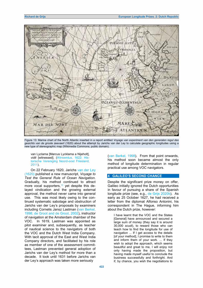
Richard de Grijs European Longitude Prizes. 2: Dutch Republic
422
Figure 13: Marine chart of the North Atlantic inserted in a report entitled Voyage van experiment van den generalen regul des gesichts van de groote zeevaert (1620) about the attempt by Jarichs van der Ley to calculate geographic longitudes using a new type of stereographic map (Wikimedia Commons; public domain).
van Lyclama [Marcus Lycklama a Nijeholt], vidit [witnessed]. (Winsemius, 1622; His-torische Vereniging Noord-oost Friesland, 2011).
On 22 February 1620, Jarichs van der Ley (1620) published a new manuscript, Voyage to Test the General Rule of Ocean Navigation. Gradually, his method continued to attract more vocal supporters,10 yet despite this de-layed vindication and the growing external approval, the method never came into general use. This was most likely owing to the con-tinued systematic sabotage and obstruction of Jarichs van der Ley’s proposals by examiners including Cornelis Jansz Lastman (van Berkel, 1998; de Groot and de Groot, 2002), instructor of navigation at the Amsterdam chamber of the VOC. In 1619, Lastman was appointed as pilot examiner and, subsequently, as teacher of nautical science to the navigators of both the VOC and the Dutch West India Company. With tacit approval of the East and West India Company directors, and facilitated by his role as member of one of the assessment commit-tees, Lastman prevented general adoption of Jarichs van der Ley’s method for more than a decade. It took until 1631 before Jarichs van der Ley’s approach was taken more seriously
(van Berkel, 1998). From that point onwards, his method soon became almost the only method of longitude determination in regular practical use among VOC navigators. 4 GALILEO’S SECOND CHANCE
Despite the significant prize money on offer, Galileo initially ignored the Dutch opportunities in favour of pursuing a share of the Spanish longitude prize (see, e.g., de Grijs 2020b). As early as 25 October 1627, he had received a letter from the diplomat Alfonso Antonini, his correspondent in The Hague, informing him about the Dutch prize, however:
I have learnt that the VOC and the States [General] have announced and secured a large sum of money (they say it is around 30,000 scudi), to reward those who can teach how to find the longitude for use of navigation ... If I get access to the details [of your method], I promise to write to them and inform them of your work. ... If they wish to adopt the approach, which seems beautiful and great to me, I will enjoy not only having made the proposition, but having made myself useful to conclude the business successfully and forthright. And if, by chance, you wish the negotiations to

Richard de Grijs European Longitude Prizes. 2: Dutch Republic
423
be done in secret, you can count on my discretion, which has never failed and will never fail ... (Buyse, 2017: 21–22).
Galileo’s initial rebuffing of the Dutch longi-tude competition was significant, given that the prize money Antonini had informed him about far outweighed his meagre annual professorial salary at the University of Pisa of just 60 scudi. Nevertheless, he was intent on securing the Spanish longitude prize instead. Although it had become clear already by 1618 that his proposal to use the ephemerides of Jupiter’s moons as an accurate, natural clock was not considered favourably by the Spanish Crown, he persisted in submitting updated proposals in 1620, 1629 and 1631, all to no avail (de Grijs, 2020b). Meanwhile, much of his attent-ion was also focused on completion of his last major work, the Discourses and Math-ematical Demonstrations Relating to Two New Sciences, which was eventually published in 1638 (Galilei, 1638).
Galileo’s attitude changed after the Cath-olic Church censured him in 1633 for his out-spoken pro-Copernican views. He needed a safer, less controversial subject to focus on, although he still pursued a solution to the long-itude problem based on observations of Jup-iter’s moons—potentially contentious in the eyes of the Inquisition. Given his predicament, some of Galileo’s Dutch friends were hoping to extract him from Italy to provide him with a safe haven in the more tolerant Dutch Repub-lic. These efforts were led by Hugo de Groot (Grotius), former leader of the Dutch Remon-strants and a diplomat in his own right, who lived in exile in Paris and represented the Swedish government there (Ploeg, 1934).
In July 1635, de Groot informally announc-ed to his friends—including van den Hove, Professor ‘in the Copernican theory’ at the Am-sterdam Athenaeum Illustre, Blaeu and Laur-ens Reael, former VOC Governor-General and former Dutch Navy Admiral—that Galileo was reasonably confident to have found a way to determine longitude at sea. The Italian scho-lar’s idea of using a pendulum clock in com-bination with the eclipses of Jupiter’s satellites was first proposed in a letter to the leading French mathematician and geostatistician Jean de Beaugrand of 11 November 1635:
I have such a time measurer [numeratore del tempo] that if four or six examples of this instrument were constructed, and if they were allowed to operate at the same time, we would find that in confirmation of their accuracy, the times measured and indicated by these timekeepers would show differences of only one second, not only from hour to hour, but from day to day
and from month to month, so uniform would be their operation; these clocks are really admirable for the observers of mot-ion and celestial phenomenon, and in ad-dition, their construction is very simple and far less subject to outside influences than are other instruments which have been in-vented for a similar purpose. (Buyse, 2017: 27).
The ‘time measurer’ Galileo had in mind was likely a forerunner to the pendulum clock (Galilei, 1639). The pendulum clock was first developed later in the seventeenth century, partly on the basis of Galileo’s descriptions (e.g., de Grijs, 2017):
More likely they were a form of vibration counter, consisting of a pendulum bob sus-pended on a string which was given im-pulse manually or by clockwork. (Bedini, 1991: 18).
In this sense, Galileo’s proposal as supplied to the States General was substantially different from his earlier proposals submitted to the Spanish authorities. Those had not included a description of a stable, working marine time-piece. Note that Galileo’s ‘time measurer’ was not meant to transport ‘standard time’ from the homeport across the ocean (as had been sug-gested by Gemma Frisius a century earlier; de Grijs, 2017; 2020a). He intended his clock to show and keep local time for much shorter periods between successive astronomical events, in combination with astronomical meth-ods.
Galileo’s proposed approach was based on the use of astronomical ephemeris tables, including tables of the eclipses and occultat-ions of Jupiter’s moons, as standard time ref-erence. He did not realise that transporting stable clock time would be the eventual so-lution to the longitude problem. Galileo’s pro-posal as eventually submitted to the States General highlighted the high quality of his telescopes compared to that of the spyglasses available at the time in the Dutch Republic, and the accuracy of his ephemeris tables of Jupiter's satellites.
Although Galileo’s advanced age prevent-ed him from travelling to the Dutch Republic, de Groot had already enlisted van den Hove and Élie Diodati—Galileo’s friend and repre-sentative in Paris—in persuading the Italian scholar to formally present his discovery to the States General (de Waard, 1939–1953: 236–237; Garcia, 2004). The strongest argument that likely persuaded Galileo to proceed was that the Committees of experts routinely ap-pointed by the governing body were composed of first-rate scientists who would value the merits of his invention.

Richard de Grijs European Longitude Prizes. 2: Dutch Republic
424
On 15 August 1636, Galilei (1636b) pen-ned an elaborate description of his method for dissemination to the States General (de Waard, 1939–1953: (4) 241–244; Drake, 1978: 374), written in Italian, which he sent to Diodati in Paris. On 20 September 1636, Diodati pas-sed on Galileo’s missive to Reael (Galilei, 1636a; 1655: (XVI) 491– 492), the Italian schol-ar’s most important backer in the Dutch Re-public. He simultaneously informed the Ad-miral that, jointly with de Groot, he would act as intermediary in the negotiations with the Dutch government. On 23 September, Diodati also informed Galileo that he would do every-thing in his power to conclude the negotiations successfully (Galilei, 1655: (XVI) 489–491).
In his lengthy letter, Galileo claimed to have constructed highly accurate timepieces, whose “… construction is very simple and far less subject to outside influences than are other instruments which have been invented for a similar purpose.” (Galilei, 1655: (XVII) 463–469). Nevertheless, he also pointed out that his clock could only record the time from midday onwards, and that the proposed obser-vations of Jupiter’s moons would require a stable observation platform. In fact, one could not risk losing sight of Jupiter for any length of time during the observations, since the eclipse ingress and egress timings of its moons would only last on the order of a minute.
Despite these practical difficulties, he felt that he was now well placed to calculate and tabulate these eclipses with reasonable accu-racy, thus making them useful for navigation purposes. Simultaneously, Galileo wrote to de Groot and van den Hove, via Diodati, impres-sing upon them the need to make progress towards practical implementation of his propos-al given his own deteriorating health. De Groot (1636) responded on 20 September 1636, stating that he fully supported the “… most ex-quisite …” discovery Galileo proposed, which he hoped would be useful “… for all mankind.”
Once Galileo’s letter had been translated by Reael and passed on to The Hague, where it arrived on 11 November 1636, a Committee chaired by van den Hove and including Blaeu and Reael was appointed (de Waard, 1939–1953: (4) 245–251). Initially, they had also intended to appoint Jacobus van Gool, an Orientalist and mathematician at Leiden Uni-versity (de Waard, 1939–1953: (4) 253), but instead the Committee agreed to invite Beeck-man to join their ranks. (In 1631 Beeckman had proposed the use of Jupiter’s satellites as a celestial clock, independently of Galileo; de Waard, 1939–1953: (3) 229–230.) In their report of 5 December 1636 the States General
confirmed that,
… through his zealous research Galileo believes to have found a certain method to determine at every moment and in every place of the world, at sea as on land, the true longitude of the location, and how much more to the East or to the West this location is situated from the Meridian of any city or port, that may be chosen freely; presenting this invention with regard to the laudable reputation [to be gained for him-self] and the government in this country, and also [with regard to] the premium of-fered to the first author who would show and dedicate [his invention] to Her Great Power. (Buyse, 2017: 22).
We learn from Diodati’s letter of 16 March 1637 to van den Hove (Galilei, 1655: (XVII) 43) that by that time Galileo had not yet received any official acknowledgement from the States General, a complaint Diodati would repeat sev-eral times in his correspondence with Dutch representatives over the next few months. Four days later, Diodati also wrote to Con-stantijn Huygens—Christiaan’s father and sec-retary to stadtholder (regent) Prince Frederik Hendrik—asking him to intervene. The elder Huygens responded positively on 23 April (Gal-lilei, 1655: (XVII) 59–60), in French, although he emphasised that there were two important obstacles preventing Galileo’s proposal from returning a favourable assessment, including the general lack of sufficiently high-quality tele-scopes and the instability of ships at sea.
Meanwhile, on 7 April 1637 the Committee of theoristen presented their recommendation to the States General. The governing body resolved that a second Committee, composed of Commissioner Arnold van Rantwijck, Mayor Johan van Weede of Utrecht and Mayor Wol-ter Schoneburch of Groningen, in addition to Reael, was required to advise on the next steps. On 25 April 1637 the States General offered Galileo a gold chain with a medal val-ued at 500 guilders (de Waard, 1939–1953: (4) 267; equivalent to about 1,000 scudi) as a show of their goodwill and in anticipation of a positive outcome of Galileo’s submission. However, Galileo never received the 30,000 scudi he had been promised for the delivery of a viable solution to the longitude problem. The States General also ordered the VOC to pro-vide Reael with an expense account to the tune of 1,000 guilders. Nevertheless, the Cath-olic Pope Urban VIII prohibited Galileo from dealing with the Dutch Protestant Government and hence Galileo was forced to decline the reward. In addition, Reael did not pursue con-struction of Galileo’s proposed instruments, for which the expense account had ultimately been established.

Richard de Grijs European Longitude Prizes. 2: Dutch Republic
425
In his 23 April 1637 response to Diodati, Constantijn Huygens expressed his desire that the ‘great man’ (Galileo) would live to see the successful development of a stable timepiece that could be used for navigation at sea. In fact, in a letter from March 1637, Galileo had already pleaded with Diodati to convince Huy-gens that he had come up with a solution to the stability problem, which Galileo himself for-warded to Reael in June 1637 (Galilei, 1892–1909: (XVII) 46–49 and 96–105):
It would be a waste of time to occupy Your Lordship’s attention any longer with the de-tails. You can command artists of the ut-most skill in the manufacture of clocks and other excellent mechanisms. They have only to know that the pendulum gives vi-brations of exactly equal duration, whether the arc be great or small, in order to devise methods of construction of greater precis-ion than any that I could devise. (Robert-son, 1931: 86).
Galileo’s solution involved a marine chair composed of a large universal joint, with one hemispherical component moving inside a sec-ond, which in turn was to be fixed to the ship. Both components had to be separated by wat-er or oil and it was crucial to retain a gap be-tween them, which could be achieved with eight to ten springs, all in all a rather cumber-some contraption (Ariotti, 1972; Galilei, 1892–1909: (XVI) 96–99; see also de Grijs, 2020b; Figure 14). Reael called Galileo’s stabilising platform solution impractical, and he thought it implausible that his sailors could operate such a complex device, since they were
… rude people, men only superficially ac-quainted with mathematics and astronomy … and who still find insuperable the prob-lem of using your discovery on a moving ship, continually being tossed about. (Gali-lei, 1892–1909: (XVII) 116–117; cf. Ariotti, 1972: 368).
Diodati, meanwhile, had become impatient by the delayed response from the States Gen-eral, while he was also less than pleased that Galileo’s insights had been leaked, through correspondence between Beeckman and Mar-in Mersenne, the French scientist-priest, to one of the Italian scholar’s main competit- ors, the French astronomer and mathematician Jean-Baptiste Morin de Villefranche (Morinus) (de Waard, 1939–1953: (4) 261–262). How-ever, Constantijn Huygens explained that the Committee had to assess both the theoretical merits of Galileo’s method and its practical ap-plication, alongside their other commitments, which implied that the process would take quite some time (de Waard, 1939–1953: (4) 267–268).
Meanwhile, van den Hove sent Diodati a lengthy letter on 27 April 1637, reassuring him that Morin de Villefranche had not been pro-vided with any information crucial to enable him to beat Galileo to the prize (de Waard, 1939–1953: (4) 270). On 22 May 1637, Dio-dati responded with an invitation to van den Hove to meet Galileo in the Dutch Republic’s embassy in Venice, where Galileo would be prepared to reveal additional details of this method that would, in turn, facilitate its prac-tical viability. That meeting never took place. Although van den Hove eventually secured a Government grant of 2,000 guilders to under-take the journey to Italy, via Paris (Ploeg, 1934), van den Hove’s death intervened.
In addition, the enterprise which had init-ially looked very promising soon turned sour. The official letter from Reael containing the initial response of the States General did not reach Galileo until 23 June 1637 (de Waard, 1939–1953: (4) 258–259). His detailed re-sponse with instructions regarding the practical operation of his proposed instruments, return-ed to Reael on 22 August 1637, arrived on Reael’s deathbed and remained unopened on his desk (Galilei, 1892–1909: 96–105, 174–175): Councillor Nicolaes van Reigersberch notified de Groot, his brother-in-law, in a letter of 25 October 1637 that Reael had passed away on 10 October:
The loss of two children through the con-tagious sickness [the plague] had plunged this good man into such profound melan-choly, that he forgot all other thoughts and even those that were very dear to his heart. Even a letter from Galileo Galilei, which was given to him when he was still healthy, remained unopened, which I men-tion so that the said Galileo may be in-formed of it. (de Waard, 1939–1953: (4) 282; No. 1).
In his response to Constantijn Huygens, dated 28 February 1640 (Worp, 1892–1894), Diodati (1640) referred to these and other unfortunate events that had happened in the mean time. He said that Galilei’s proposal, as submitted to the States General had been affected by several interruptions. These in-cluded the complete loss of Galileo’s eye-sight during the past two years (probably because of unprotected observations of the Sun; Ploeg, 1934) and the untimely death on 17 August 1639 of van den Hove, who had until recently been the sole survivor of the four Commiss-ioners originally tasked with researching Gali-leo’s proposal. Beeckman and Blaeu had died earlier, in May 1637 and October 1638, re-spectively.
Nevertheless, Diodati confirmed that Gal-

Richard de Grijs European Longitude Prizes. 2: Dutch Republic
426
ileo was keen to continue his pursuit of the construction of a timing device to determine longitude at sea. In his letter to Diodati of 30 December 1639 (Galilei, 1655: (XVIII) 132–133), Galileo proposed to send one of his stu-dents, Vincenzo Renieri, to the Dutch Republic to provide more technical details. He also sug-gested that the States General appoint new Committee members. In fact, on 28 February 1640 Diodati asked Constantijn Huygens for assistance, given his expertise in the subject matter. The States General briefly considered convening a new committee, but that commit-tee did not materialise (Mersenne, 1636). De-spite Diodati’s impassioned plea to the elder Huygens, I have not uncovered any evidence of the latter’s involvement since receiving Dio-dati’s letter from 1640, beyond a suggestion to involve Willem Boreel, VOC Governor (Ploeg, 1934: 53). And so this is where Galileo’s pur-suits ended, unsuccessfully; he would not en-gage with the States General or his Dutch sup-porters again prior to his death on 8 January 1642.
Ultimately, the States General cited as their main reason for rejection of Galileo’s pro-posal his method’s practical unviability for use on pitching and rolling ships at sea. In addit-ion, the governing body remained unconvinced of the reliability and accuracy of the eclipse and occultation tables (Adam, 1910; Huygens, 1662–1663), despite Galileo’s assurances. Nevertheless, Galileo’s method did not disap-pear from consideration completely. In 1661, Dirck Rembrandtsz van Nierop, the shoemak-er-turned-mathematician from Nieuwe Niedorp, wrote about longitude determination at sea based on the ephemerides of Jupiter’s satel-lites. Unfortunately, he did not manage to make the method work successfully on board a moving ship either. 5 TIME AND TIME AGAIN
For the next significant submission of a solut-ion to the longitude problem to the States Gen-eral, we have to wait until 1655. At the young age of 26, the States General retained Chris-tiaan Huygens to assess a proposed new method by Jan Kołaczek of Leszno (Johannes Placentinus), Professor of Mathematics from Francfort (Frankfurt) an der Oder, for the pur-poses of issuing a possible patent (Omodeo, 2016). It is possible that his father had recom-mended the young Huygens to the States Gen-eral, given that Huygens Jr. was invited to con-tribute as “… the son of the Lord Zuylichem.” The young Huygens was tasked with a careful assessment of Placentinus’ invention. It was said to allow the “… determination of East and West …” using observations of the Moon.
… provid[ing] a way to find the longitude of places, both on land and at sea, at any time, day or night, and in this way, given the latitude of the location and having found its longitude, to determine the pos-ition of a ship as it is being swayed by storm and wanders back and forth, etc. (Placentinus, 1655).
Therefore, in March 1655 Huygens wrote to Andreas Colvius, a personal friend of Beeck-man:
I expect, in turn, that you will send me manuscripts regarding the determination of longitude and whatever else you own from Galilei’s legacy. (Huygens, 1655c).
In this instance, Galilei’s legacy included cor-respondence with Diodati, de Groot, van den Hove, Reael, Alphonse (Alfonso) Pollot(to)—an Italian officer at the Dutch Government with whom Galileo had exchanged letters about the determination of longitude around 1637—and the elder Huygens (Galilei, 1892–1909: 123–191, specifically letters from 1718). In 1622 Colvius had used a journey to Venice to meet Italian scholars and collect and copy numerous books and manuscripts. At Huygens’ request, Colvius (1655) sent the young scholar his notes, as well as a manuscript written by Gal-ileo, attached to a letter dated 23 March 1655.
Placentinus had tabulated the maximum lunar elevation as well as those of the constel-lations Leo (the Lion; specifically for the lion’s tail) and Lyra, calculated for the Frankfurt an der Oder meridian from April through June 1655, in addition to step-by-step instructions to determine one’s longitude:
First, measure during the months of April, May, and June of 1655 at your location the time at which the Moon reaches its highest elevation, either during the day as derived from the solar elevation or at night by determining star heights; such observat-ions are not unknown to those who prac-tice math, and also to sailors they are hardly a secret.
2°. Compare this time, observed at your meridian, with the time indicated in the table, and note the difference in the mer-idians between your location and that of Frankfurt [an der Oder], in hours and min-utes.
3°. Convert the observed meridian differ-ence into degrees and minutes away from the Equator, according to the second table, and you find the difference in longitude between Frankfurt [an der Oder] and your location. (Placentinus, 1655).
Huygens’ (1655b) assessment of Placen-tinus’ invention was devastating. He referred to the proposed method as ‘Placentinus’ non-sense’, pointing out that the method violated

Richard de Grijs European Longitude Prizes. 2: Dutch Republic
427
basic astronomical principles, including the as-sumption that the Moon would traverse 15 de-grees on the sky in an hour, just like the Sun. In reality, the Moon travels approximately half a degree less per hour than the Sun. Huygens stated that Placentinus’ proposed method had
… by no means as good a basis as those of others before him, who have tried to achieve the same. Their [the others’] in-ventions, although they were considered of little or no use (because of major miscalcu-lations that could arise from the smallest observational errors or imperfections in their Ephemeris tables), however, were theoret-ically well founded. But this discovery of Johannes Placentinus is so far removed from offering any benefit or use, that it even sins against the foundations of as-tronomy, and it is nothing but a gross fal-lacy. (Huygens, 1655b).
Huygens’ unfavourable assessment was not universally welcomed, however. The Ger-man–British polymath Samuel Hartli(e)b, for in-stance, was rather impressed by Placentinus’ ideas:
Placentinus Bohemus Professor Mathe-maticus upon the Oder at Frankford hath published a Booke De Longitudine11 which is thought the best that ever hath been written and should not have beene thus plainly discovered the States of Holland and others having set so great a price and reward for it, which belike this Professor was ignorant of. (Hartlib Papers, 1655).
Surprisingly, Hartlib suggests here that Placentinus was not aware of the Dutch long-itude prize, but that statement appears incor-rect. After all, Placentinus (1655) applied for a patent from the States General, introducing his ideas as “… [n]ew and careful research of the longitudes of places, by Dutchmen, French, English and Spanish most desired.”.
Following Huygens’ unfavourable assess-ment, the States General (1655) decided to consult a number of other experts for a second opinion, including van Schooten. Huygens and van Schooten subsequently exchanged numerous letters between March 1655 and November 1656; van Schooten hence became Huygens’ de facto mentor during the early stages of his career. Their correspondence included a copy of the Opere di Galileo Galilei (Works of Galileo Galilei). This is important as regards the Dutch efforts to determine longi-tude at sea, because Galileo’s manuscript in-cluded ideas about pendulums.
It is possible that this first official assign-ment by the States General triggered the young Huygens’ interest in pursuing a solution to the longitude problem. At the very least, the first notes in his handwriting on this topic or-
iginate from early 1655, when he copied a pas-sage from Metius’ (1621) treatise, Institutiones Astronomicae Geographicae (Ch. 4):
Brief instructions as to the use of clocks to find Eastern and Western Longitudes.
However, this method is probably the eas-iest and most suitable that one could en-counter (namely using clocks to find the eastern and western longitudes), its only difficulty and problem are related to incor-rectly and irregularly running clocks. You, therefore, zealous researchers versed in the examination of natural things, pay at-tention to this, work to correct this problem and to establish the true and invariable course of nature: having established it, you will have found the true philosopher's stone and the brave sailors will no longer run into danger so often. (Huygens, 1655a).
Huygens’ own pursuit of a practical solut-ion to the longitude problem is well-known and has been covered by many authors, including in detail in my recent monograph, Time and Time Again: Determination of Longitude at Sea in the 17th Century (de Grijs, 2017). For an in-depth discussion of Huygens’ place among the thought leaders of his time, I refer the inter-ested reader to the latter publication. In the remainder of this section, I will summarise his achievements as they pertain to the Dutch longitude competition and his interactions with the Dutch Government in pursuit of the prize.
Irrespective of the numerous contributions by other scholars, Huygens is rightly known as the first person to combine the pendulum—a metal ball suspended by a silk thread—with the clock mechanism. (However, note that Richard Harris of London is credited to have converted a church clock to employ a pendu-lum in 1642; Reid, 1826: 179.) On 12 January 1657, he wrote to van Schooten that
… one of these days, I invented a new type of construction for a time piece, which can be used to measure times so accu-rately that there is more than a little hope that this can be used to determine the longitude, at least as regards travel on the seas. (Huygens, 1657a).
Huygens was, at least initially, keen to discuss his new invention with van Schooten and his peers. He proudly announced his in-vention to the French mathematician Claude Mylon on 1 February 1657, although without providing any detail:
The news that you tell me regarding the journey of Mr. Bulliaut [Ismaël Boulliau; French astronomer and mathematician] to these lands rejoices me very much … I also want to show him one of my new

Richard de Grijs European Longitude Prizes. 2: Dutch Republic
428
inventions, which will be of the greatest benefit to astronomy, and I sincerely hope to apply it successfully in search of longi-tude. You may hear more about in a little while. (Huygens, 1657b).
It appears that by this time the Dutch long-itude competition had run its course, however: in 1658–1660 the English polymath Robert Hooke explored the possibility that his own novel, spring-driven watches might be eligible for any of the awards issued for “… finding the longitude”. However, the legendary rewards appeared to no longer exist on the European continent (Robertson, 1931: 172).
Nevertheless, in summer 1662 Huygens wrote several enthusiastic letters to both his brother Lodewijk and to Sir Robert Moray, the Scottish statesman, referring to a
… small pendulum clock ... which works sufficiently well to serve for [the purposes of] longitude determination, and which, once I have given it a push, continues to move without stopping in my room, where it is suspended from 5 foot long ropes, but I have yet to test it on water, for which we should requisition a reasonably sized ves-sel to [allow us to] sail on choppy seas, something I do not know when I could achieve it. (Huygens, 1662).
The provincial States of Holland (1664) eventually issued a fifteen-year patent for his marine clock on 16 December 1664. Mean-while, Huygens had realised that he could po-tentially make a profit from his work, part-icularly now that his first marine clock looked like it might sustain rigorous sea trials. There-fore, he temporarily halted his plans to publish his new treatise, Horologium Oscillatorium, which contained full technical details and which he had been working on since making the first revisions to its precursor, Horologium, in 1660.
By 1682, Huygens’ sustained efforts to per-fect his marine clock design had become suf-ficiently promising to attract the attention of the Governors of the VOC. As a result, the VOC issued a first resolution of support on 31 De-cember 1682 (VOC Governors, 1682). It spe-cifically authorised the Mayor of Amsterdam, Johannes Hudde, Governor of the VOC and a mathematician by training, to
… correspond with Mr. Huygens and one [Johannes] van Ceulen [watchmaker] about the invention and construction of very ac-curate timepieces, which would not deviate from each other by more than a second per day [24 hours], in which way the East and West could be found …
In view of the VOC’s encouragement, on 17 December 1683 Huygens sent his design drawings and an approximate model of his
new invention to van Ceulen. Huygens seem-ed keen to test his novel (tricord) design in practice; his tricord clocks were pendulum clocks where the bob was attached to three strings suspended from a circular frame. Writ-ing to the Dutch mathematician Bernhard Ful-lenius Jr., he stated that
… at the request of the [East India] Com-pany, I have undertaken the construction of clocks to determine the longitude, pos-sessing as constant a regularity as those with the three-foot pendulum, but such as should not be disturbed by the motion of the sea. I found the task to be more dif-ficult than I had initially thought, although it is not completed yet there is little doubt that it will succeed. (Huygens, 1683).
Van Ceulen soon produced two of the nov-el tricord clocks, which enabled Huygens to make a convincing case to the VOC, in July 1684, for financial and practical support. At their meeting on 27 July 1684, the Governors of the VOC approved a financial contribution to van Ceulen so as to “… complete the work to perfection …”, recording that
The Lord Mayor Hudde has stated that he is authorised by the resolutions of 31 De-cember 1682 and 28 February 1684 to … spend one to two thousand guilders on [the endeavour] … despite not having achieved the aim … proposing whether the assembled [governors] could approve pay-ment of two hundred silver ducats to the aforementioned van Ceulen, … on account of the work so far completed. (VOC Gov-ernors, 1684).
On 13 August 1685, Huygens travelled to Amsterdam with his two new marine clocks, hoping to suspend and regulate them on board a VOC galleon. To his regret, however, “… for the wind was perfect for a trial …” (Huygens, 1685a), he did not manage to test them in practice, since Hudde was absent. Huygens’ next journey to Amsterdam, on 9 September 1685, was more fruitful. The VOC’s Governing Board had assigned him a ship and a captain, Barent Fockes, at their meeting of 30 August 1685 (VOC Governors, 1685); they also authorised Hudde to pay van Ceulen a second tranche of 200 ducats for his work and com-pensate the blacksmith he had retained with a fee of 70 guilders. Hudde was charged with retaining oversight, to make sure that the pro-ject would lead to ‘enlightenment’ of the state of maritime navigation.
Huygens met with a very courteous and amenable Barent Fockes, who had however been given instructions to sail to the VOC’s main anchorage at the northern Dutch island of Texel rather than merely onto the Zuyder-zee (Huygens, 1685b), the inland sea-turned-

Richard de Grijs European Longitude Prizes. 2: Dutch Republic
429
lake in present-day Netherlands. This would involve a 7–8 day voyage instead of the 2–3 days Huygens had anticipated, but the Gov-ernors of the VOC insisted on a trial on the open sea. After all, Huygens wrote to his fath-er, initial tests on open water would need to be successful, because “… otherwise it would be useless to continue further afield.”
On 11 September they embarked on their voyage from the port of Amsterdam, the only test ever undertaken by Huygens himself. How-ever, because of a severe storm (Constantijn Huygens, 1685), the captain was forced to seek refuge at Enkhuizen Harbour, fearing damage to his sails. They completed their voyage to Texel a few days later. Despite the rough conditions, one of the clocks continued to run smoothly (Huygens, 1685c); the second clock ran intermittently. Nevertheless, Huy-gens (1685d) was strengthened in his con-viction that his clocks were seaworthy. He informed Hudde on 26 October 1685 that his envoy Thomas Helder was ready and pre-pared to take his marine clocks on an endur-ance voyage to the Cape of Good Hope (Huy-gens, 1685e). The VOC subsequently made provision for two of Huygens’ clocks and two attendants to join its fleet on a voyage to the Cape.
Huygens prepared detailed instructions for Helder, his assistant Johannes de Graaff (de Graef) and their companion on the voyage, the clockmaker Willem van der Dussen, Instruct-ions and Education as Regards the Use of the Clock to Find the Longitudes of East and West (Huygens, 1686). His instructions included guidance regarding the mounting, regulating and maintenance of the timepieces.
The first VOC-sanctioned long-range voy-age commenced on 24 May 1686, arriving at the Cape on 26 September. Much of the voyage was affected by rough seas, and so Helder did not manage to obtain any useful measurements. The East Indian return fleet set off from the Cape en route to Texel on 20 April 1687, but notes on the clocks’ perform-ance do not begin until 10 May 1687 (Huy-gens, 1687). When they returned to the home anchorage on 15 August 1687, Helder was no longer on board. He had died shortly after having left the Cape, in late April 1687, and many of his notes had disappeared. Huygens’ second envoy, de Graaff, had taken over and managed to acquire enough measurements for Huygens to trace back the ship’s course.
Huygens (1688) submitted his findings re-garding his clocks’ accuracy—Report Regard-ing Longitude Determination by Clocks on the Voyage from the Cape of Good Hope to Texel
in the Year 1687—to Hudde on 24 April 1688. He conceded that there was a small problem with the longitudes determined by his clocks: the measurements seemed to imply that the ship had sailed right through Ireland and Scotland (see Figure 14).
Huygens attributed the ship’s apparent dev-iation from the VOC’s navigators’ route to the effects of the Earth’s rotation: the ‘spinning-off’ (centrifugal) effect on bodies, and hence their loss of weight, was greater at the Equator than towards the Poles (for a discussion, see de Grijs, 2017). The updated route showed that they had clearly not sailed right through Ireland and Scotland on their way to the VOC’s an-chorage, and that the ship’s terminus after 117 days at sea was just 19 km East of the actual longitude of Texel—for the time an unprece-dentedly accurate determination of a ship’s position at sea.12 It amounted to a loss of just 68 seconds of clock time over the course of the voyage from the Cape to Texel.
It is unclear whether anyone not directly involved with the VOC or in the examination of Huygens’ claims was aware of the signifi-cant discrepancies that had come to light when tracing back the ship’s route based on the clocks’ raw measurements. There is no evi-dence that Huygens commented in any corre-spondence on the apparent trajectory through Ireland and northern Scotland, although a memorandum by David Gregory, the inventor, from 11 November 1691 includes a passage which suggests that Huygens may have dis-cussed the problem of the latitude dependence of the gravitational force during a journey to England in the summer of 1689:
By observations of a ship from the Cape of Bonne Esperance [the Cape of Good Hope] to Texel on board which was a two of these Clocks, the course of the ship was on the coast of Ireland on the supposition the weight was the same in all parts of the earth or the pendulys vibration in equal times, but if the the [sic] other hypothesis of the less weight at the Equator be true the course will be (as it was) by the north of Scotland but both systems bring the ship to Texel. (Gregory manuscripts, 1627 –1720).
In his letter to Hudde accompanying Huy-gens’ report, he referred to another letter from the Dutch scholar and manuscript collector Isaäc Vossius to Coenraad van Beuningen, VOC Governor. Vossius questioned the ac-curacy of the measurements, stating that …
… the clock of Mr. Christiaen Huijgens [sic] performs excellently, but if one were to calibrate it based on the Eclipses, it will indicate during the 24 hours of a day and a

Richard de Grijs European Longitude Prizes. 2: Dutch Republic
430
Figure 14: The route determined by the Alcmaer’s navigators is indicated by the westernmost curve (green); that based on raw timing measurements is represented by the easternmost curve (yellow). Upon correction for the effects of the Earth’s rotation, Huygens arrived at the curve closest to but slightly to the east of the westernmost route (red). (after Oeuvres Complètes de Christiaan Huygens, IX, 273; not in copyright).
night no more than 22 hours. (Vossius, 1688).
Huygens countered that in Vossius’ letter,
… where he objects to the observations of the Jesuits at the Cape of Good Hope and in general against observations of the longitude based on the Satellites of Jup-iter, but both without any reason, since he has little knowledge of Astronomy and of the relevant type of observations … Be-cause one cannot fathom what the mean-
ing is of these words. (Huygens, 1688).
The close match of the end point of Huy-gens’ corrected route with the independently known longitude of the Texel anchorage con-vinced him of the viability of his clocks as ac-curate marine timepieces. He summarised his conviction in the opening paragraph of his re-port to the VOC’s Governors:
I can bring very good news concerning this invention, for I have found that by using

Richard de Grijs European Longitude Prizes. 2: Dutch Republic
431
the aforementioned clocks the longitudes between the Cape of Good Hope and Tex-el have on the whole been measured very well, and the total longitude between these two places [has been measured] so per-fectly that it only deviates by 5 or 6 leagues, which I admit I have seen with exceptional satisfaction, it being certain proof of the possibility of this very-long-sought-after affair. (Huygens, 1688: Appen-dix II).
Huygens’ reference to an accuracy of his positional determination of 5 or 6 leagues cor-responds to approximately 30 km or 27 min-utes of arc at the latitude of Texel. If Huygens’ claim of such a high accuracy was indeed cor-rect, this implies that he would have met the accuracy threshold (better than 30 minutes of arc, or 55 km at the Equator) for the award of the full prize money of £20,000 associated with the British Longitude Act of 1714. It is, there-fore, curious that Huygens’ report to Hudde was apparently never widely circulated among contemporary scientists nor translated into French, Latin or English. Perhaps the strength of Huygens’ claim may not have been as great as implied by his bold assertion that his clocks could be used to determine the longitude with-out any reasonable doubt.
On 14 May 1689 Huygens’ report and his route map were passed on to de Volder for for-mal review. The latter was generally support-ive of Huygens’ conclusions, but he cautioned the VOC Governors that they should not place too much weight on the results of a single ex-periment (de Volder, 1689). His careful scru-tiny of Huygens’ analysis revealed that the Dutch scholar had made a mistake in his cal-culations pertaining to the ship’s longitude on 8 June 1687, which also affected all subsequent calculations (de Volder, 1689: 341). The cor-rected values resulted in the improved accu-racy of the ship’s longitude with respect to that of the coast of Texel of 17 minutes of arc.
Despite the good agreement between the course recorded in the ship’s log and Huygens’ corrected trajectory, the latter was by neces-sity based on interpolation. In his report to the VOC, Huygens commented that …
… the differences between the mariners and the corrected clocks are usually about 1 or 2 degrees, and always less than 3 degrees. And it should amaze no one that the mariners’ reckoning would be 3 de-grees off the true longitude on such a long voyage, because of the uncertainty in their guesses, from unknown currents and the ship’s falling behind, as well as from its uncertain advancement. (Huygens, 1688: Appendix II).
Since this first test on board a VOC ship
had left too many open questions, de Volder recommended that the VOC undertake a second sea trial. Once again, de Graaff was employed to take charge of the clocks. The outward leg commenced on 29 December 1690, arriving at the Cape on 4 June 1691. The return ship departed from the Cape on 26 June 1692, arriving at Veere Harbour, south of Rotterdam, on 10 October 1692.
Unfortunately, this second sea trial was anything but a success. First, only one of the two clocks taken on board was operational during the outbound voyage. Yet no useful data could be obtained during the first leg from Texel to the Cape Verdian port of St. Jago (São Tiago) because of inclement weather conditions at the anchorage that had prevent-ed an initial calibration, despite repeated at-tempts to do so by de Graaff (1690a; 1690b 1690c; 1690d). The second clock was not operational at any time throughout the voyage (de Graaff, 1693; Huygens, 1693a).
On arrival at the Cape, de Graaff fell seri-ously ill for about three weeks. In addition, the need to obtain proper measurements and cal-ibration of the clocks based on the Sun’s mot-ion, for which he needed at least three weeks, caused them to delay their return voyage by a full year (de Graaff, 1691; de Graaff et al., 1691). However, when he finally embarked on the return voyage, he did not install the clocks correctly, so that once again no useful data were obtained (Huygens, 1693a). Despite the array of errors affecting de Graaff’s measure-ments (de Graaff, 1692), in his report Huygens (1693a) significantly understated the rather disastrous results, reporting that “… the clocks have not proved such a success as we had hoped for.”
In addition to issues related to the ac-curacy of the measurements, the trial also suffered from a number of basic flaws in the experimental set-up. For instance, no attempt was made to check Huygens’ corrections inde-pendently, either by obtaining measurements with a ‘seconds pendulum’ or by calibrating the measurements using the longitudes of well-known landmarks. The latter could have been ascertained by observations of the ephemer-ides of Jupiter’s moons at the Cape. Indeed, this was one of Huygens’ main recommendat-ions in his final report:
It would still be very helpful if one invest-igated the true longitude at some important places with regard to the Meridian of Texel or Amsterdam, by observing the satellites of Jupiter. (Huygens, 1688: Appendix II).
In fact, Huygens specifically suggested that measurements taken on both legs of the
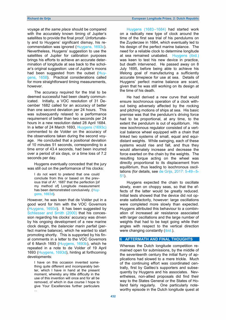
Richard de Grijs European Longitude Prizes. 2: Dutch Republic
432
voyage at the same place should be compared with the accurately known timing of Jupiter’s satellites to provide the final proof. Unfortunate-ly and to Huygens’ significant dismay, his re-commendation was ignored (Huygens, 1693c). Nevertheless, Huygens’ suggestion to use the satellites of Jupiter for calibration purposes brings his efforts to achieve an accurate deter-mination of longitude at sea back to the schol-ar’s original suggestion: use of Jupiter’s moons had been suggested from the outset (Huy-gens, 1658). Practical considerations called for more straightforward timing measurements, however.
The accuracy required for the trial to be deemed successful had been clearly commun-icated. Initially, a VOC resolution of 31 De-cember 1682 called for an accuracy of better than one second deviation per 24 hours. This was subsequently relaxed to a performance requirement of better than two seconds per 24 hours in a new resolution dated 28 April 1684. In a letter of 24 March 1693, Huygens (1693c) commented to de Volder on the accuracy of the observations taken during the second voy-age. He concluded that a positional deviation of 10 minutes 51 seconds, corresponding to a time error of 43.4 seconds, had been incurred over a period of six days, or a time loss of 7.2 seconds per day.
Huygens eventually conceded that the jury was still out on the performance of his clocks:
I do not want to pretend that one could conclude from this or based on the prev-ious trial of Ao. 1687 that the perfection [of my method of] Longitude measurement has been demonstrated conclusively. (Huy-gens, 1693d).
However, he was keen that de Volder put in a good word for him with the VOC Governors (Huygens, 1693d). It has been suggested by Schliesser and Smith (2000) that his conces-sion regarding his clocks’ accuracy was driven by his ongoing development of a new marine clock design, the balancier marin parfait (per-fect marine balance), which he wanted to start promoting shortly. This is supported by his fin-al comments in a letter to the VOC Governors of 6 March 1693 (Huygens, 1693b), which he repeated in a note to de Volder of 19 April 1693 (Huygens, 1693d), hinting at forthcoming developments:
I have on this occasion invented some-thing quite different and incomparably bet-ter, which I have in hand at the present moment, whereby any little difficulty in the use of this invention will once and for all be removed, of which in due course I hope to give Your Excellencies further particulars ...
Huygens (1683–1684) had started work on a radically new type of clock around the time of the first sea trial of his pendulums on the Zuyderzee in 1684, which eventually led to his design of the perfect marine balance. The need for a reliable clock to determine longitude at sea remained unabated. Huygens (ibid.) was keen to test his new device in practice, but death intervened. He passed away on 8 July 1695, before being able to achieve his lifelong goal of manufacturing a sufficiently accurate timepiece for use at sea. Details of Huygens’ perfect marine balance are scant, given that he was still working on its design at the time of his death.
He had derived a new curve that would ensure isochronous operation of a clock with-out being adversely affected by the rocking and pitching motions of ships at sea. His basic premise was that the pendulum’s driving force had to be proportional, at any time, to the extent the pendulum is out of equilibrium. His new isochronous regulator consisted of a vert-ical balance wheel equipped with a chain that linked two systems of small, equal and equi-distant weights. While swinging, each of these systems would rise and fall, and thus they would alternately increase and decrease the force exerted on the chain by the weights. The resulting torque acting on the wheel was directly proportional to its displacement from equilibrium, thus leading to isochronous oscil-lations (for details, see de Grijs, 2017: 5-49–5-51).
Huygens expected the chain to oscillate slowly, even on choppy seas, so that the ef-fects of the latter would be greatly reduced. Initial tests showed that the device did not op-erate satisfactorily, however: large oscillations were completed more slowly than expected. Huygens attributed this behaviour to a combin-ation of increased air resistance associated with larger oscillations and the large number of weights that had to be kept going while their angles with respect to the vertical direction were changing constantly (ibid.). 6 AFTERMATH AND FINAL THOUGHTS
Whereas the Dutch longitude competition re-mained open for submissions, by the middle of the seventeenth century the initial flurry of ap-plications had slowed to a mere trickle. Much of the continuing effort was coordinated cen-trally, first by Galileo’s supporters and subse-quently by Huygens and his associates. Nev-ertheless, non-allied proposals did find their way to the States General or the States of Ho-lland fairly regularly. One particularly note-worthy episode in the Dutch longitude quest at

Richard de Grijs European Longitude Prizes. 2: Dutch Republic
433
this time descended into a rather unpleasant polemic, which eventually did not result in much progress towards the ultimate goal.
From the 1680s, Bernhard Fullenius ‘de Jongere’ (junior), Professor at the University of Franeker (now defunct), began corresponding with increasing frequency with Huygens in the context of their efforts to find a solution to the longitude problem. However, their construct-ive engagement was soon rudely interrupted by the appearance of one Lieuwe Willemsz (Graaf), a Mennonite priest and a loud-mouth-ed, belligerent Frisian mathematician and al-manac composer. Over the course of the next decade, Fullenius and Willemsz became em-broiled in an increasingly fierce and acrimoni-ous polemic (Dijkstra, 2012).
Willemsz soon associated himself with and looked for guidance to Matthias Wasmuth, a controversial German Professor in Hebrew at the Academy in Rostock, who would subse-quently be appointed as a Professor of Divinity at the University of Kiel. Towards the end of his life, he turned his focus and interests to astronomy, because he believed that his in-sights into the main religious texts he was familiar with allowed him to make a major breakthrough (Bayerische Akademie Der Wis-senschaften, 2018). He claimed that divine revelation had facilitated him to perfect his breakthrough, which in turn made him act as if he was the new leader of the European ast-ronomical community.
Willemsz had devised his own ideas on longitude determination at sea (Graaf, 1689: 4–5), and he sought the assistance of the publicist Balthasar Bekker to help him dissem-inate his ideas more widely. Bekker admitted that Willemsz’ work was too complicated for his understanding, so he recommended that the latter seek input from his brother-in-law, Fullenius Jr. (Bekker, 1692: 19–20). A meet-ing was arranged in 1688, but when Fullenius asked Willemsz to explain the foundations of his calculations, Willemsz refused because he did not trust Fullenius’ motives, fearing that his secret would be stolen (Davids, 1995). As a direct consequence of his perceived mistreat-ment by Fullenius, Willemsz started a sland-erous campaign against the former (Fullenius, 1689), while simultaneously drumming up sup-port for his method from powerful patrons across the province of Friesland (Dijkstra, 2007). Fullenius maintained that he did not think that Willemsz’ idea would work in prac-tice, which thus gave rise to a fierce polemic that became increasingly political in nature (for full details, see Dijkstra, 2012).
Willemsz was eventually allowed to ap-
pear before the Deputy States of Friesland, who offered him a letter of recommendation to present his ideas on solving the longitude problem to a Commission of the States Gen-eral (Davids, 1986: 131, 426). Nevertheless, Willemsz never fully disclosed in detail how he intended to solve the longitude problem. He only discussed his method in vague terms; if and when he revealed any details, he did so in the form of examples or ‘proofs’ (his desig-nation). He claimed that he had been inspired by both a divine revelation and the ideas of Wasmuth, which had allowed him to calculate ephemeris tables. To determine one’s longi-tude, it would be sufficient to measure the distance between the Moon and one of a num-ber of designated reference stars. His tables could then be used to determine one’s position on Earth. Whereas this type of lunar distance method had become well-established by the end of the seventeenth century (e.g., de Grijs 2020a), Willemsz’ claim was less than trust-worthy given that he claimed to be able to calculate the notoriously uncertain lunar orbit to unprecedented precision—without disclos-ing how.
In addition, Willemsz’ tables purportedly also provided a direct correlation between the lunar distance measured on the sky and the distance on Earth between the observer and the biblical Garden of Eden. In essence, his method was said to be useful for calculating the local time in the Garden of Eden (Graaf, 1691), but without the need to know the local time at the observer’s position, a physical impossibility as the method required just a single free parameter to find the longitude. Willemsz claimed to have discovered a ‘big secret’—which he however never disclosed—allowing him to calculate the exact position of the Garden of Eden (Dijkstra, 2012). Eventu-ally, his contemporaries turned away from this loud-mouthed miscreant, who was too preci-ous about his ideas to disseminate them more widely.
Individual requests to be considered for any of the Dutch longitude prizes, if only for the expenses component, continued to trickle in until well into the eighteenth century. In the Delft city archives (2020), we find records of hopeful projectors filing patent applications for the determination of longitude at sea from as recently as the 1740s and 1750s. These in-clude a submission by one Pieter de Fay, ac-countant in Amsterdam, from 1746–1750 and another application filed in 1756 by one G.G. Stokman from Isleben, near Leipzig.
De Fay had filed a patent application with both the provincial States of Holland, and with

Richard de Grijs European Longitude Prizes. 2: Dutch Republic
434
the States of Zeeland, for his method to de-termine “… the length of East and West at sea …” as early as 19 August 1746, and again on 31 December of that year. On 14 March 1749, the States of Holland retained Pieter van Musschenbroek and Johan Lulofs, Professors of Philosophy at Leiden University, to examine de Fay’s method. As a result, on 26 March 1749, the States of Holland resolved that de Fay’s method was neither novel nor sufficient to warrant a patent (States of Holland, 1749). In a second resolution issued on 27 February 1750, the States of Holland agreed to ask the deputies of the city of Delft to re-examine the proposed method so as to determine whether the applicant could be awarded compensation for the expenses incurred in the development of his method and the construction of the rel-evant devices (States of Holland, 1750).
Stokman’s request for a subsidy and a patent arrived at the States of Holland on 22 February 1756. His request was discussed at the next Council Meeting on 28 February, where it was decided to request an expert as-sessment from the deputies of the city of Delft as part of a Committee convened by the States of Holland (States of Holland, 1756).
The second half of the eighteenth century saw further institutionalised attempts to secure means to determine longitude at sea. As we saw already, in 1787 the Admiralty of Amster-dam established its Longitude Committee. This was a clear sign that state agencies were en-thusiastic about substantially increasing their involvement in finding suitable practical means in support of the main challenges in navigat-ion. The first Longitude Committee was com-posed of Jan Hendrik van Swinden, Professor of Mathematics, Physics, Astronomy, Logic and Metaphysics at the Amsterdam Athen-aeum Illustre; Pieter Nieuwland, van Swin-den’s protégé; Gerard Hulst van Keulen, the leading publicist of anything nautical and an expert teacher of longitude methods; and—from 1789—Jacob Florijn, representative of the Admiralty of Rotterdam.
In the National Archives of the States of Holland, a detailed treatise from 1793 by Hen-drik de Hartog(h), mathematician, navigator and astronomer at the Amsterdam Athenaeum Illustre, is listed (States of Holland Archives, 2020). His work covers longitude determinat-ion and is identified as a follow-up publication to one published around 1771 by Pybo Steen-stra, one of his predecessors at the Athen-aeum Illustre. De Hartog is said to also have been involved in the early developments of the Longitude Commission (Zandvliet, 1999). In 1787, he published his first manuscript dealing
with longitude determination based on lunar distances (de Hartog, 1793), which became the mandated method for ships of both the Admiralty of Amsterdam and the VOC in 1788. The record in the National Archives refers to a complete treatise on this subject, which earned him a promotion to examiner of the VOC on 22 February 1790. For a more in-depth discus-sion of the Longitude Committee’s remit and achievements until it dissolution in 1850, I refer the reader to Davids’ (2015) lucid essay.
It should have become clear that Dutch ef-forts to find a practically viable solution to the longitude problem were as rich as those put forward to the Spanish Crown around the same time, as well as those submitted in response to the establishment of the British Longitude Prize in 1714. Whereas most overviews of Dutch efforts focus on Huygens’ pursuit of a practical marine timepiece, and sometimes also on Gal-ileo’s proposals to use the ephemerides of Jupiter’s satellites, comprehensive reviews of the full series of developments during this per-iod are lacking, even in Dutch. The present paper aims to remedy that situation, while at the same time showcasing the breadth of ideas originating from the tolerant republic on the North Sea, from methods based on mag-netic declinations and lunar distance measure-ments to the development of stable marine timepieces.
The start of the Scientific Revolution, ex-emplified by Galileo’s astronomical ‘heresy’, combined with increased trade across the world’s oceans created the ideal conditions across the European continent to make sign-ificant progress on the pre-eminent scientific and practical problem of the era, the need for a viable method of longitude determination at sea. 7 NOTES
1. On 15 February 1600, the States General had received a letter from Prince Maurits dated 10 February 1600, informing the governing body that one Jacob van Strat-en claimed to have “… found the height from the East and the West …”; little else is known about him, other than that he seems to have jealously guarded his sec-retive solution to the longitude problem (Davidse, 2000–2020).
2. The stuiver was a pre-decimal Dutch coin; twenty stuivers represented a monetary value equal to one guilder or—as indicated in this quotation—one pound.
3. Galileo Galilei is usually simply referred to by his first name, a convention I have adopted here too.

Richard de Grijs European Longitude Prizes. 2: Dutch Republic
435
4. The Dutch surname ‘van Velsen’ is rather common. A detailed search of online archives yielded only a certain ‘Willem van Velsen’ as possible identification for this person; see the Resolutiën Staten-Gen-eraal 1576 –1625 (see Note 8) and the Repertorium van ambtsdragers en ambte-naren 1428 –1861 (http://resources.huygens.knaw.nl/repertoriumambtsdragersambtenaren1428-1861).
5. Figure 3 is a portrait gallery of the main characters driving the developments des-cribed in this paper, if and when their images were available in the public do-main. I encourage the reader to refer to this compilation whenever a new character voicing an original solution is introduced in a more than cursory manner.
6. Like Figure 3, Figure 4 is a portrait gallery of officials, examiners and other important support personnel who were instrumental in driving the longitude discussion forward.
7. Commissie tot de Zaaken, het Bepalen der Lengte op Zee en het Verbeteren der Zee-
kaarten Betreffende. 8. http://resources.huygens.knaw.nl/retroboe
ken/statengeneraal/. 9. He is often confused with his namesake
who went to Sweden to become a key economic adviser to Kings Karl IX and Gustav II Adolphus and their Governments; it appears, however, that this identification is incorrect (Molhuysen et al., 1927).
10. As a case in point, the online Rijks Geschiedkundige Publicatiën (National Historic Publications) contain a witness statement from 17 September 1621 in favour of Jarichs van der Ley’s method (Dutch National Historic Publications, 1510–1672).
11. This probably refers to an earlier version of the second edition of Placentinus’ Geo-tomia.
12. The discrepancy originally reported by Huygens was 25 minutes of arc; de Vold-er’s corrections led to the adjusted value adopted here.
8 REFERENCES
The following abbreviation is used: HOC = Oeuvres Completes de Christiaan Huygens.
Abbing, C.A., 1841. Geschiedenis der stad Hoorn, hoofdstad van West-Vriesland gedurende het grootste gedeelte der XVII en XVIII eeuw, of vervolg op Velius Chronyk, beginnende met het jaar 1630, 1. Hoorn, Gebr. Vermande (in Dutch).
Adam, C., 1910. Oeuvres de Descartes, III, 74 (in French). Ariotti, P.E., 1972. Aspects of the conception and development of the pendulum in the 17th century. Archive for
the History of Exact Sciences, 8, 329–410. Bayerische Akademie Der Wissenschaften, 2018. Allgemeine Deutsche Biography, 41, 230–232 (in German). Bedini, S.A., 1991. The Pulse of Time. Florence, Leo S. Olschki. Bekker, B., 1692. Ondersoek van de Betekeninge der Kometen. Amsterdam, Jan Claesz ten Hoorn (in Dutch). Bierens de Haan, D., 1878. Bouwstoffen voor de geschiedenis der wis- en natuurkundige wetenschappen in de
Nederlanden, 12. Amsterdam, Koninklijke Akademie van Wetenschappen (in Dutch). Blok, P.J., and Molhuysen, P.C. (eds.), 1912. Nieuw Nederlandsch biografisch woordenboek, 2. Leiden, A.W.
Sijthoff (in Dutch). Blok, P.J., and Molhuysen, P.C. (eds.), 1914. Nieuw Nederlandsch biografisch woordenboek, 3. Leiden, A.W.
Sijthoff (in Dutch). Boistel, G., 2015. From Lacaille to Lalande: French work on lunar distances, nautical ephemerides and lunar
tables, 1742– 85. In Dunn and Higgitt, 47–64. Busken Huet, C., 1882–1884. Het land van Rembrand: Studiën over de Noordnederlandsche beschaving in de
zeventiende eeuw, 1. Haarlem, Tjeenk Willink (in Dutch). Buyse, F.A.A., 2017. Galileo Galilei, Holland and the pendulum clock. O que nos faz pensar, 26, 9–43. Cabeljau, A., 1617. Reken-Konst Vande Groote See-vaert Waer doormen op alle streken van’t Compass so wel
de Lenghde Oost ende West kan vinden als de Breede Zuydt ende Noort, Ghepractiseert, beschreven ende int licht ghebracht to dienst van alle Zeevarende Lieden (Arithmetic for Long-distance Shipping, for Determination of all Compass Directions both the Longitude East and West and the Latitude South and North, Practised, Described and Revealed in the Service of all Sailors). Amsterdam, Paulus van Ravesteyn (in Dutch).
Collot d’Escury, H., 1829. Holland’s Roem in Kunsten en Wetenschappen, VI(1). The Hague and Amsterdam, Gebroeders van Cleef (in Dutch).
Colvius, A., 1655. Letter to Christiaan Huygens, dated 23 March. In HOC, I, 323 (No. 218). Coster, A., 1613. De grouwelijke ongehoorde blasphemien ende raserijen van Thomas Leamer (The Horrific,
Unheard-of Blasphemy and Rage of Thomas Leamer ). Rotterdam, Mathys Bastiaensen (in Dutch). Davids, C.A., 1986. Zeewezen en wetenschap: De wetenschap en de ontwikkeling van de navigatietechniek in
Nederland tussen 1585 en 1815. PhD Thesis, Utrecht University. Amsterdam/Dieren, De Bataafsche Leeuw (in Dutch).
Davids, C.A., 1990. Universiteiten, illustre scholen en de verspreiding van technische kennis in Nederland, eind 16e–begin 19e eeuw. Batavia Academica, VIII, 3–34 (in Dutch).
Davids, C.A., 1995. Openness or secrecy? Industrial espionage in the Dutch Republic. Journal of European Economic History, 24, 333–348.

Richard de Grijs European Longitude Prizes. 2: Dutch Republic
436
Davids, K., 2005. ‘Weest EenDERLEY sins.’ Jan Hendricksz. Jarichs van der Ley (c. 1566–1639) en de eenheid in godsdienst en navigatie. In Daalder, R., Loomeijer, F., and Wildeman, D. (eds.), Koersvast. Vijf eeuwen navigatie op zee. Zaltbommel, Aprilis. Pp. 132–141 (in Dutch).
Davids, K., 2008. The Rise and Decline of Dutch Technological Leadership: Technology, Economy and Culture in the Netherlands, 1350–1800. Volume 1. Leiden, Brill.
Davids, K., 2009. Dutch and Spanish global networks of knowledge in the early modern period: structures, changes and limitations. In Proceedings of the International Workshop on Iberian–Netherlandish Knowledge Exchanges. Amsterdam, IISG/N. W. Posthumusinstituut (www.lowcountries.nl; 2009-1). 16 pp. (https://research.vu.nl/ws/portalfiles/portal/2502404/227843.pdf; accessed 29 May 2020).
Davids, K., 2015. The Longitude Committee and the practice of navigation in the Netherlands, c. 1750–1850. In Dunn and Higgitt, 32–46.
Davids, K., 2016. Making knowledge ‘useful’ in Europe between c. 1750 and 1850: a comparison of shipbuilding and navigation technology. In Morel, T., Parolini, G., and Pastorino, C. (eds.), The Making of Useful Know-ledge. Berlin, Max Planck Institut für Wissenschaftsgeschichte. Pp. 11–23.
Davidse, A., 2000–2020. Resoluties lengtebepaling. (translated) https://adcs.home.xs4all.nl/stevin/varia/resoluties.html [accessed 29 May 2020] (in Dutch?).
de Graaff, A., 1691. Letter to Christiaan Huygens, dated 17 December. In HOC, X, 205–206 (No. 2718) (in Dutch).
de Graaff, J., 1690a. Letter to Christiaan Huygens, dated 21 December. In HOC, IX, 578 (No. 2646) (in Dutch). de Graaff, J., 1690b. Letter to Christiaan Huygens, dated 23 December. In HOC, IX, 579 (No. 2647) (in Dutch). de Graaff, J., 1690c. Letter to Christiaan Huygens, dated 26 December. In HOC, IX, 582 (No. 2650) (in Dutch). de Graaff, J., 1690d. Letter to Christiaan Huygens, dated 29 December. In HOC, IX, 584 (No. 2653) (in Dutch). de Graaff, J., Meybos, G., and van Laer, P., 1691. Letter to the VOC governors (n.d.). In HOC, X, 207–208 (No.
2720) (in Dutch). de Graaff, J., 1692. Letter to Christiaan Huygens, dated 19 November. In HOC, X, 341 (No. 2774) (in Dutch). de Graaff, J., 1693. Letter to Christiaan Huygens, dated 14 February. In HOC, X, 396–398 (No. 2789) (in Dutch). de Grijs, R., 2017. Time and Time Again: Determination of Longitude at Sea in the 17th Century. Bristol, Institute
of Physics Publishing. de Grijs, R., 2020a. A (not so) brief history of lunar distances: Lunar longitude determination at sea before the
chronometer. Journal of Astronomical History and Heritage, 23, 495–522. de Grijs, R., 2020b. European longitude prizes. 1: Longitude determination in the Spanish Empire. Journal of
Astronomical History and Heritage, 23, 465–494. de Groot, H., 1636. Letter to Galileo Galilei, dated 20 September. In Briefwisseling van Hugo Grotius, 7, 398 (No.
2763) (in Latin). de Groot, S.J., and de Groot, B.J., 2002. De Schatkamer en de Kunst der Stuerluyden (1621–1714): De
navigatieboeken van Cornelis Jansz Lastman. In de Meer, S., Mörzer Bruyns, W.F.J., Slechte, C.H., and Witteman, N.H. (eds.), Schatkamer. Franeker, Van Wijnen. Pp. 83–99 (in Dutch).
de Hartog, H., 1793. Volledige verhandeling over de bereekening der lengte op zee, door middel van den afstand der maan van de zon of vaste sterren ... opgesteld ten dienste der zeevarende. Amsterdam, Gerard Hulst van Keulen (in Dutch).
de Jonge, J.K.J., 1862. De Opkomst van het Nederlandsch gezag in Oost-Indië, 1. Amsterdam, Nijhoff/Muller (in Dutch).
de Volder, B., 1689. Letter to the VOC Governors, dated 22 July. In HOC, IX, 339–343 (No. 2547) (in Dutch). de Waard, C., 1939–1953. Journal tenu par Isaac Beeckman de 1604 à 1637, publié avec une introduction et des
notes par C. de Waard. The Hague, Martinus Nijhoff (in French). de Wreede, L.C., 2007. Willebrord Snellius (1580–1626), a Humanist Reshaping the Mathematical Sciences.
PhD Thesis, Utrecht University. Delft City Archives, 2020. (https://zoeken.stadsarchiefdelft.nl/detail.php?id=10332124; accessed 8 June 2020);
record numbers 3376 and 3385 (in Dutch). Dijkstra, A., 2007. Het vinden van oost en west in het Friesland van de zeventiende eeuw. De polemiek tussen
Lieuwe Willemsz. Graaf (1652–1704) en Bernhardus Fullenius Jr. (1640–1707). PhD Thesis, University of Groningen (in Dutch).
Dijkstra, A.F.B., 2012. Between Academics and Idiots: A Cultural History of Mathematics in the Dutch Province of Friesland (1600–1700). PhD Thesis, Twente University. (https://religiondocbox.com/Pagan_and_Wiccan/85042748-Between-academics-and-idiots.html: accessed 9 June 2020).
Diodati, É., 1640. Letter to Constantijn Huygens, dated 28 February. In Worp, J.A. (ed.), 1892–1894. No. 2318 (in Dutch).
Dodt van Flensburg, J.J., 1846. Archief voor kerkelijke en wereldsche geschiedenissen, inzonderheid van Utrecht, 5. Utrecht, N. van der Monde (in Dutch).
Drake, S., 1978. Galileo at Work: His Scientific Biography. New York, Dover. Dunn, R., and Higgitt, R. (eds.), 2015. Navigational Enterprises in Europe and Its Empires, 1730–1850. New
York, Palgrave Macmillan. Dutch National Historic Publications, 1510–1672. Bronnen tot de geschiedenis van het bedrijfsleven en het
gildewezen van Amsterdam 1510–1672: Part 2, 1612–1632. GS 78. P. 416 (in Dutch). (http://resources.huygens.knaw.nl/retroboeken/gildewezen/#source=2&page=459; accessed 5 June 2020).
Fullenius, B., 1689. Brief geschreven aan een voomaam heer deser provincie. Leeuwarden; Fullenius, B., 1690.
Richard de Grijs European Longitude Prizes. 2: Dutch Republic
437
Nodig bericht ... op seker laster-schrift. Franeker (in Dutch). Galilei, G., 1636a. Letter to Laurens Laurensz Reael, dated 6 June. In HOC, II, No. 673c (in Latin). Galilei, G., 1636b. Letter to the States General, dated 15 August. In HOC, III, No. 673d (in Latin). Galilei, G., 1638. Discorsi e dimostrazioni matematiche intorno a due nuove scienze (Discourses and
Mathematical Demonstrations Relating to Two New Sciences). Leiden, Elsevier. Galilei, G., 1639. L’usage du Cadran ou de l’Horloge Physique Universel sans l'Ayde du Soleil ny d'autre
Lumière. Paris, Hachette Livre BNF (2016) (in French). Galilei, G., 1655. Opere di Galileo Galilei. Bologna (in Italian). Galilei, G., 1892–1909 (reprinted 1929–1939 and 1964–1966). Le Opere di Galileo Galilei Edizione Nazionale, 3.
Favaro, A., ed. Florence, Barbèra (in Italian). Garcia, S., 2004. Élie Diodati et Galilée: Naissance d’un Réseau Scientifique dans l’Europe du XVIIe Siècle.
Florence, Leo S. Olschki (in French). Graaf, L.W., 1689. Eenvoudig en onvervalscht verhaal, van 't voorgevallene in 's Gravenhage ter Vergaaderinge
van de Ho: Mog: Heeren, de Staaten Generaal der Vereenigde Nederlanden. over 't aanwysen van 't vinden der Lengte van Oost en West. Amsterdam, J. van Keulen (in Dutch).
Graaf, L.W., 1691. D’eerste opening and gewis onderwys van de waere vinding der lengte van Oost en West. Leeuwarden, Hendrik Rintjes (in Dutch).
Gregory manuscripts, 1627–1720. Royal Society: GB 0117 MS/247. Haeyen, A.H., 1599. Een Corte Onderrichtinge belangbende die kunst vander Zeevaert (Brief Instructions …).
Amsterdam, published by the author. Hartlib Papers, 1655. Ephemerides, Part 2. 29/5/15A-28B (http://www.hrionline.ac.uk/hartlib). Historische Vereniging Noord-oost Friesland, 2011. Jan Hendrick Jarichs van der Ley (1565–1639), een
onbekend genie uit Dokkum. (https://www.hvnf.nl/2005/09/jan-hendrick-jarichs-van-der-ley-1565-1639-een-onbekend-genie-uit-dokkum; accessed 5 June 2020) (in Dutch).
Howse, D., 1998. Greenwich Time and the Longitude. London, Philip Wilson Publishers. Huygens, C., 1655a. HOC, XVII, 200 (in Dutch). Huygens, C., 1655b. Letter to the States General, dated 4 March. In HOC, I, 318–319 (No. 214) (in Dutch). Huygens, C., 1655c. Letter to Andreas Colvius, March (n.d.). In HOC, I, 322 (No. 217) (in Latin). Huygens, C., 1657a. Letter to Frans van Schooten, dated 12 January. In HOC, II, 5 (No. 368) (in Dutch). Huygens, C., 1657b. Letter to Claude Mylon, dated 1 February. In HOC, II, 7 (No. 370) (in French). Huygens, C., 1658. Letter to Giovanni Batista Hodierna, dated 24 September. In HOC, II, 223–225 (No. 518) (in
Latin). Huygens, C., 1662. Letter to Robert Moray, dated 9 June. In HOC, IV, 148–152 (No. 1022) (in French). Huygens, C., 1662–1663. HOC, IV, 458 (in Dutch). Huygens, C., 1683. Letter to Bernhardus Fullenius, dated 12 December. In HOC, VIII, 474–478 (No. 2327) (in
Dutch). Huygens, C., 1683–1684. III. Premier projet de 1683 ou 1684 du ‘Balancier marin parfait’ de 1693. HOC, XVIII,
536–538 (in French). Huygens, C., 1685a. Letter to Constantijn Huygens, dated 23 August. In HOC, IX, 20–22 (No. 2394) (in Dutch). Huygens, C., 1685b. Letter to Constantijn Huygens, dated 9 September. In HOC, IX, 26–27 (No. 2398) (in
Dutch). Huygens, C., 1685c. Letter to Johannes Hudde, October (n.d.). In HOC, IX, 37 (No. 2406) (in Dutch). Huygens, C., 1685d. Letter to Constantijn Huygens, dated 3 October. In HOC, IX, 30–32 (No. 2401) (in Dutch). Huygens, C., 1685e. Letter to Johannes Hudde, dated 26 October. In HOC, IX, 37 (No. 2407) (in Dutch). Huygens, C., 1686. Instructie en onderwijs aangaende het gebruijk der Horologiën tot het vinden der Lengde van
Oost en West. In HOC, IX, 55–76 (No. 2423) (in Dutch). Huygens, C., 1687. Letter to Abraham de Graef, dated 3 October. In HOC, IX, 222–223 (No. 2488) (in Dutch). Huygens, C., 1688. Letter to Johannes Hudde, dated 24 April. In HOC, IX, 267–268 (No. 2517); Appendix II: No.
2519, Rapport aengaende de Lengdevindingh door mijne Horologien op de Reys van de Caep de B. Esperance tot Texel Ao. 1687. In HOC, IX, 272–291 (in Dutch).
Huygens, C., 1693a. HOC, XVIII, 546–561 (in Dutch). Huygens, C., 1693b. Letter to the VOC governors, dated 6 March. In HOC, X, 423–424 (No. 2796) (in Dutch). Huygens, C., 1693c. Letter to Burchard de Volder, dated 24 March. In HOC, X, 433–434 (No. 2798) (in Dutch). Huygens, C., 1693d. Letter to Burchard de Volder, dated 19 April. In HOC, X, 443–444 (No. 2803) (in Dutch). Huygens, C. (Constantijn), 1685. Letter to Christiaan Huygens, dated 11 September. In HOC, IX, 28–29 (No.
2399) (in Dutch). Jonkers, A.R.T., 2000. North by Northwest: Seafaring, Science, and the Earth’s Magnetic Field, 1600–1800. PhD
Thesis, Vrije Universiteit, Amsterdam. Pp. 304–314. Jonkers, A.R.T., 2005. Parallel meridians: diffusion and change in early-modern oceanic reckoning. In Par-
mentier, J., ed. Noord-Zuid in Oostindisch perspectief. The Hague, Walburg. Pp. 17–42. Keteltas, B.E., 1609. Het Ghebruyck der naeld wiisinge tot dienste der zee-vaert beschreven (The Use of the
Compass Needle in Service of Maritime Navigation). Amsterdam, Barent Otsz (in Dutch). Laboranter, 1862. Boeken enz. vereerd of opgedragen aan de admiraliteit te Amsterdam. Navorscher, 12, 274 (in
Dutch). Laboranter, 1871. Kaartenmakers, graveurs, etc. 1603–1614. Navorscher, 21, 515 (in Dutch). Leamer, T., 1612. Klare vertooninge, hoe men door het uurwerk van Elohim ofte den grooten Eyghenaer,
namelijck door son, maan en sterren in alle plaetsen der werrelt zijn meridiaenslenghte sal kunnen vinden

Richard de Grijs European Longitude Prizes. 2: Dutch Republic
438
(Clear Demonstration of How to Find One’s Meridian Longitude Using the Timepiece of Elohim or the Great Owner, Namely by Means of the Sun, Moon and Stars at all Positions in the World ) . Kampen, published by the author (in Dutch).
Mersenne, M., 1636. Correspondance de Mersenne, IX, 172 (in French). Metius, A., 1614. Grondelijcke Onderwijsinghe van de Sterrekonst (Basic Astronomy Education). Amsterdam,
Willem Jansz (in Dutch). Molhuysen, P.C., Blok, P.J., and Kossmann, K.H.F. (eds.), 1927. Nieuw Nederlandsch biografisch woordenboek,
7. Leiden, A.W. Sijthoff (in Dutch). Molhuysen, P.C., Blok, P.J., Knappert, L., and Kossmann, F.K.H. (eds), 1911–1937. Nieuw Nederlandsch
biografisch woordenboek, 1. Leiden, A.W. Sijthoff. P. 842 (in Dutch). Nauta, D., de Groot, A., de Jong, O.J., van der Linde, S., Posthumus Meyjes, G.H.M. (eds.), 1988. Biografisch
lexicon voor de geschiedenis van het Nederlands protestantisme, 3. Kampen, J.H. Kok (in Dutch). Omodeo, P.D., 2016. Central European polemics over Descartes: Johannes Placentinus and his academic
opponents at Frankfurt on Oder (1653–1656). In Feingold, M., (ed.), History of Universities, XXIX/1. Oxford, Oxford University Press. Pp. 29–64.
Placentinus, J., 1655. HOC, I, 320 (No. 215) (in Dutch). Ploeg, W., 1934. Constantijn Huygens en de Natuurwetenschappen. PhD Thesis, Leiden University (in Dutch). Reid, Th., 1826. A Treatise on Clock and Watchmaking. Edinburgh. Robertson, J.D., 1931. Evolution of Clockwork. London, Cassell & Co. Schilder, G., and van Egmond, M., 2007. Commercial cartography and map production in the Low Countries,
1500–ca. 1672. In Woodward, D. (ed.), History of Cartography. Volume 3. Chicago, University of Chicago Press. Pp. 1384–1432.
Schliesser, E., and Smith, G.E., 2000. Huygens’ 1688 Report to the Directors of the Dutch East India Company on the Measurement of Longitude at Sea and the Evidence it offered against Universal Gravity Archive for the History of the Exact Sciences (http://philsciarchive.pitt.edu/5510/; Appendix 2; accessed 8 June 2020).
Schotte, M.E., 2019. Sailing School: Navigating Science and Skill, 1550–1800. Baltimore, Johns Hopkins University Press.
Smit, J., 1925. Eenige aanteekeningen betreffende wetenschap, kunst en kunstnijverheid ten tijde van het Bestand. Oud Holland, 42. Pp. 159–165 (in Dutch).
Sprunger, K.L., 1993. Trumpets from the Tower: English Puritan Printing in the Netherlands, 1600–1640. Leiden, Brill.
Stampioen, J., 1618. Nyeuwe taeffelen der Polus-hoochte enz (New Tables to Measure the Altitude of Polaris, etc.). Manuscript (in Dutch).
States General, 1655. Letter to Christiaan Huygens, dated 8 March. In HOC, I, 320–321 (No. 216) (in Dutch). States of Holland, 1664. Letter to Christiaan Huygens, dated 16 December. In HOC, V, 166–167 (No. 1286) (in
Dutch). States of Holland, 1749. Resolutiën van de Heeren Staaten van Holland en Westvriesland, 1, 210 (in Dutch). States of Holland, 1750. Resolutiën van de Heeren Staaten van Holland en Westvriesland, 119, 196 (in Dutch). States of Holland, 1756. Resolutiën van de Heeren Staaten van Holland en Westvriesland, 128, 127 (in Dutch). States of Holland Archives, 2020. Entry no. 3.01.04.01; inventory no. 1760:
(https://www.nationaalarchief.nl/onderzoeken/index/nt00315/10afabee-71e3-102d-a0ea-005056a23d00; accessed 8 June 2020) (in Dutch).
Stevin, S., 1599a. De Havenvinding. Leiden, Plantin (in Dutch). Stevin, S., 1599b. ΛIMENEVPETIKH, sive porluum investigandorum ratio. Metaphraste Hug. Grotio Batavo.
Leiden, Academiae Lugduno-Batavae (in Dutch). Stevin, S., 1608. Wisconstighe gedachtenissen. Eertclootschrift, 170. See also
(https://www.sophiararebooks.com/pages/books/3954/simon-stevin/limenheuretica-greek-sive-porluum-investigandorum-ratio-metaphraste-hug-grotio-batavo; accessed 2 June 2020) (in Dutch).
Syeverts, M., 1597. Een Tractaet seer dienstelijck voor alle Zee-varende Luyden/door het t’samen spreken van twee Piloten … (A Very Helpful Treatise for all Sailors/Based on a Discussion Between Two Pilots …). Amsterdam, Laurens Jacobs (https://dbnl.nl/tekst/siev002trac01_01/; accessed 2 June 2020) (in Dutch).
Thomassen, T.H.P.M., 2009. Instrumenten van de macht: De Staten-Generaal en hun archieven 1576–1796. PhD Thesis, University of Amsterdam (in Dutch).
van Berkel, K., 1998. Citaten uit het boek der natuur. Amsterdam, Bert Bakker. (https://www.dbnl.org/tekst/berk003cita01_01/colofon.php [accessed 29 May 2020) (in Dutch).
van Berlicum, A., 1656. In de natuirliicke dingen aen te mercken, haer mate, reden, en gewicht, de oorsaecken van de bewegingen [...] de lengte van Oost en West te vinden. Rotterdam, A. Leers (in Dutch).
van der Aa, A.J., 1874. Biographisch woordenboek der Nederlanden, 17 (2). Haarlem, J.J. van Brederode (in Dutch).
van der Ley, J., 1617. Het gulden zeeghel des grooten zeevaerts, daerinne beschreven wordt de waerachtige grondt vande zeylstreken en platte pas-caerten (voor desen noyt bekent) waermetals onder een secreten Zeegaende ghenerale Regule vant gesicht des groote Zeevaerts bevesticht en tot zyn vollencomen perfectie gebracht wordt, dienende tot een Voorlooper van de voorschreven Regule, daerinne mede ghesien worden, de onbehoorlycke Procedueren die de wedersprekers seghen deselve ende het ghemeene best drie jaren lanck hebben ghepleecht (The Golden Seal of Ocean Navigation …). Leeuwarden, van der Rade.
van der Ley, J., 1619. Gesicht des Grooten Zeevaerts (Overview of Ocean Navigation). Franeker, Jan Lamrinck. van der Ley, J., 1620. Voyage vant experiment vanden generalen regul des Gesichts vande groote zeevaert

Richard de Grijs European Longitude Prizes. 2: Dutch Republic
439
(Voyage to Test the General Rule of Ocean Navigation). The Hague, Hillebrant Jacobssz. Vanpaemel, G., 1989. Science disdained: Galileo and the problem of longitude. In Maffioli, C.S., and Palm, L.C.,
(eds.), Italian Scientists in the Low Countries in the XVIIth and XVIIIth Centuries. Amsterdam, Rodopi. Pp.111–129.
Vermij, R., 2010. The telescope at the court of the stadtholder Maurits. In van Helden, A., Dupré, S., van Gent, R., and Zuidervaart, H., (eds.), The Origins of the Telescope. History of Science and Scholarship in the Netherlands, 12. Amsterdam, KNAW Press. Pp. 73–92.
VOC Governors, 1682. Resolutiën van de Bewinthebberen van de Oostindische Comp.ie ter Camer tot Amsterdam, 31 December 1682. In HOC, XVIII, 533–535 (in Dutch).
VOC Governors, 1684. Resolutiën van de Bewinthebberen van de Oostindische Comp.ie ter Camer tot Amsterdam, 27 July 1684. In HOC, XVIII, 533–535 (in Dutch).
VOC Governors, 1685. Resolutiën van de Bewinthebberen van de Oostindische Comp.ie ter Camer tot Amsterdam, 30 August 1685. In HOC, XVIII, 534–535 (in Dutch).
Vossius, I., 1688. Letter to Coenraad van Beuningen, dated 23 February. In HOC IX, 269–272 (No. 2518). Waghenaer, L.J., 1585. Spieghel der Zeevaerdt, vande Navigatie der Westersche. Leyden, Christoffel Plantijn (in
Dutch). Winsemius, P., 1622. Chronyck ofte historische geschiedenisse van Vrieslandt, fol. 902 (in Dutch). Wepster, S., 2000. Een kwestie van tijd: De ontwikkeling van de maansafstandenmethode voor lengtebepaling
op zee, MA Thesis, Utrecht University (http://www.staff.science.uu.nl/~wepst101/ld/kwestievantijd.pdf; accessed 29 May 2020) (in Dutch).
Worp, J.A. (ed.), 1892–1894. De Briefwisseling van Constantijn Huygens. (http://resources.huygens.knaw.nl/retroboeken/huygens/#page=0&source=19; accessed 8 June 2020); Rijks Geschiedkundige Publicatiën. ’s Gravenhage, Martinus Nijhof (in Dutch).
Zandvliet, K., 1999. Adriaen de Lelie’s portrait of 1790 of the VOC examiner Hendrik de Hartog. Bulletin van het Rijksmuseum, 47, 74–79.
Professor Richard de Grijs obtained his PhD in Astrophysics from the University of Groningen (Netherlands) in 1997. He subsequently held postdoctoral research positions at the University of Virginia (USA) and the University of Cambridge (UK), before being appointed to a permanent post at the University of Sheffield (UK) in 2003. He joined the Kavli Institute for Astronomy and Astrophysics at Peking University (China) in September 2009 as a full Professor. In March 2018, Richard moved to Macquarie University in Sydney (Australia) as Associate Dean (Global Engagement).
Richard has been a Scientific Editor of The Astrophysical Journal since 2006 and took on the role of Deputy Editor of The Astrophysical Journal Letters in September 2012. He held this latter role until mid-2018. He has just joined the ‘Editorial Team’ of JAHH as an
Associate Editor. Richard received the 2012 Selby Award for excellence in science from the Australian Academy of Science, a 2013 Visiting Academy Professorship at Leiden University from the Royal Netherlands Academy of Arts and Sciences, a 2017 Erskine Award from the University of Canterbury (New Zealand) and a Jan Michalski Award from the Michalski Foundation (Switzerland) in 2017.
His research focuses on the astronomical distance scale as well as on many aspects of star cluster physics, from their stellar populations to their dynamics and their use as star-formation tracers in distant galaxies. He is also engaged in a number of research projects related to the history of astronomy, with particular emphasis on the seventeenth century. In 2017, he published Time and Time Again: Determination of Longitude at Sea in the 17th Century (IOP Publishing).

Journal of Astronomical History and Heritage, 24(2), 440–474 (2021).
440
UNIFIED ANALYSIS OF OBSERVATION DATES FOR ANCIENT STAR MAPS AND CATALOGUES IN ASIA
Tsuko Nakamura
Institute for Oriental Studies, Daito-bunka University, Tokumaru 2-19-10, Itabashi, Tokyo 175-0083, Japan.
E-mail: [email protected]
Abstract: It is an intriguing subject in the history of astronomy to determine scientifically observation dates of stars recorded in ancient star maps and catalogues of East Asia. Most of previous studies used least-squares fitting as a function of time between observation and calculation for a group of selected stars, and they simply took the resulting mean residuals as the dating errors. In 2014, the author of this paper was given an opportunity to perform a dating analysis of a star map drawn on the ceiling of the stone room of the Kitora tumulus discovered in 1998, located at Nara in Japan. The construction time of the tumulus had been inferred by archaeologists to be around the end of the 7th century. The main difficulty in treating stellar coordinates of Chinese origin was that their longitudes had not been measured from a common cardinal point, thus preventing us from directly using the precession theory. After trial-and-error experiments, we developed a method for analyzing the observation epoch of stars exclusively using the 28-Xiu constellations based on an interval estimation in modern statistics. This method is applicable to many historical star maps and catalogues in a unified way. Furthermore, to reduce the error range of dating, the bootstrap method for small sample sizes was introduced. As a result, we obtained 81 BC ± 42 years (for a 90% confidence level) as the observation date of the Kitora star map. The same procedure was applied, with successful outcomes, to data in the Shi shi xingjing, the Almagest catalogue, the famous stone-inscribed Suzhou tianwentu, the 28-Xiu observations by Guo Shoujing, the Japanese paper star map Koshi Gesshin-zu, and Ulugh Beg’ s star catalogue. Thus, it is certain that our approach can be effectively used for other old star maps and catalogues yet unexplored.
Keywords: Star map and catalogue, constellation, precession, dating analysis, interval estimation
1 INTRODUCTION
Astronomy has often been regarded as one of the earliest natural sciences in human history. Astronomy is also characterized by the fact that it had already been developed as an exact mathematical science from ancient times in both the Western and Eastern worlds. Its rep-resentative aspects are calendrical astronomy based on the motion theories of celestial bodies and star catalogues and maps compiled and drawn from positional observations of stars on the celestial sphere.
Regarding the second aspect, this paper reports our recently devised method for statist-ically estimating observation dates of stars, which can be widely applied to historical star catalogues and maps.1 This method uses, in a unified way, exclusively star positions for the Chinese fundamental system of asterisms that originated approximately 2,500 years ago, namely the 28-Xiu constellations (Xiu # lit-erally means a lodge) (e.g., Needham, 1959; Sun and Kistemaker, 1997). Such an ap-proach that adopts strict interval estimation in modern statistics has never been attempted before in this field.
This research was initially motivated by the Kitora whole-sky star map discovered some 20 years ago at Nara, an ancient capital of Japan, to examine the observational epoch of its stars. In general, the dating analysis of star cata-
logues and maps utilizes gradual time variat-ions of celestial coordinates of stars caused by the precessional motion of the Earth’s rotation axis. However, since the ancient traditional Chinese coordinates of stars are unique and did not allow us to compare them directly with the coordinates calculated from modern pre-cession theory, we had to use a variety of trial-and-error approaches to achieve our goal.
First, by applying our proposed method to a certain old star catalogues and maps whose observation epochs have already been estab-lished, we could successfully reproduce their values. Thus, we decided to apply the same method to stars in the Kitora star map; we obtained their reasonable observation periods and found them to be consistent with relevant historical materials. Section 2 below provides an overview of mural-painted burial mounds in East Asia and their characteristics, including the Kitora tumulus in Japan. Section 3 ex-plains the principle and practical processes of how our statistical dating analysis for ancient star catalogues and maps was conducted relat-ing to the traditional Chinese stellar coordinate system and its observation instruments. Sect-ion 4 presents the estimated observational epoch for the 28-Xiu constellations in the Kitora star map.
To assess the applicability of our dating analysis method, the results applied to the star

Tsuko Nakamura Observation Dates for Asian Star Maps and Catalogs
441
Figure 1: Map of Korea, China and Japan and their present capitals. Many mural-painting or decorative tumuli are found over the Jilin province of China, the northern half of Korean peninsula and the western part of Japan. The diamond mark near Osaka is Nara city where the Kitora tumulus is located (map: Tsuko Nakamura).
catalogue contained in the Almagest by Ptol-emy are provided in Section 5 in comparison with the results from the previous section. Section 6 discusses dating of several historical star catalogues and maps produced in China, the Middle East, and Japan during the med-ieval and pre-modern eras. Through these sections, we could validate our proposed dat-ing method. 2 MURAL PAINTED TUMULI OF EAST ASIA AND DISCOVERY OF THE STAR MAP IN THE KITORA TUMULUS
In Korea, China, and Japan, there exist num-erous special kinds of ancient burial mounds for the dead (Figure 1). They are called the mural painting or decorative tumuli whose stone walls of an interior room are decorated commonly with colorful paintings. Such tumuli are densely distributed from the Jilin Province of north-eastern China down to the northern part of the Korean Peninsula that used to be under the reign of the Koguryeo Kingdom (37 BC–AD 668). To date, about one hundred of these sites have been excavated by archae-
ologists, revealing their construction era to be the third to the seventh centuries AD (Chon, 2005). Most of their inside walls were painted with colorful designs of people wearing ethnic clothing or abstract geometric patterns. Al-though some of these paintings appeared to express constellations in the sky, the star con-figurations were so imprecise that none of them could be used for scientific analysis—from an astronomical viewpoint.
In 1973, a decorated tumulus named Takamatsu-dzuka, located at Asuka village, Nara (the earliest capital of Japan), was under archaeological investigation, and a neat 28-Xiu drawing was found on the ceiling of the stone room. As the shape of each constellation was realistic, this tumulus attracted considerable public attention. Yabuuchi (1975) reported that the arrangement of the Takamatsu-dzuka’s 28-Xiu constellations closely resembled a star map investigated in 1963–1965 on the ceiling of the Astana tumulus at Turfan, in the Xinjiang province of China (Institute of Archeology, Chinese Academy of Social Sciences, 1978: Figure 66), suggesting that the star map origin-

Tsuko Nakamura Observation Dates for Asian Star Maps and Catalogues
442
Figure 2: The 28-Xiu constellations drawn on the ceilings of the Takamatsu-dzuka tumulus (left, after Yabuuchi, 1975) and the Astana one (right, Institute of Archeology, Chinese Academy of Social Sciences,1978). The shapes of the 28-Xiu asterisms for the Takamatsu-dzuka look close to the reality, while those for the Astana seem to be fairly stylized. The band-like pattern running from the upper left to the lower right seen in the Astana drawing could be the Milky Way. ated in central China and was later transmitted to both Middle Eastern and Far Eastern count-ries (see Figure 2).
From 1983, researchers started unearthing another small burial mound in the same village, called the Kitora tumulus, and in 1998, they discovered an elaborate-looking painting of the hemispherical star map using an endoscope camera. Since this star map was so similar to a stone-inscribed map made in the middle of the thirteenth century in China (see Figure 12 and Section 6), it had a strong impact on both historians and astronomers. Archaeologists suggest that the two Japanese tumuli were constructed between the end of the seventh century and the beginning of the eighth century, and the dead buried inside might be members of the Emperor’s family or local ruling clans (e.g., Aboshi, 2006).
Miyajima (1999) first tried to estimate the observation epoch of the Kitora tumulus stars using positional data measured by an endo-scope—we will come back to this matter again in Section 4. In 2004, the Nara National Re-search Institute for Cultural Properties removed all the Kitora paintings, including the star map, from walls to protect them from damage by erosion and mold and to preserve them in an air-conditioned building. In this occasion, the institute produced very precise digital images of the star map by correcting distortion effects caused by, for example, camera lenses. Thanks to the Kitora image files made available by the Nara institute, the author of this paper could develop a unified dating method for ancient star catalogues and maps (Nakamura, 2015).
3 STATISTICAL METHODS FOR DATING ANALYSIS OF HISTORICAL STAR CATALOGUES AND MAPS USING 28-XIU CONSTELLATIONS
Our initial interest in the Kitora star map was to know whether the shape of each asterism and the arrangement of the 28-Xiu constellations were correct from an astronomical viewpoint. If so, we can expect to statistically estimate the observation epoch of these stars by measuring their positions on the star map and combining them with modern precision theory. Having said that, it is difficult to directly compare mea-surements with theories because the traditional Chinese celestial coordinates are quite differ-ent from modern ones, that is, the right as-cension (α) and declination (δ). Before dis-cussing this situation in concrete terms, how-ever, it will be appropriate for us to explain first the system of celestial coordinates and obser-vational instruments developed in ancient China as a background to the subsequent sect-ions. 3.1 The 28-Xiu Constellations as a Celestial Framework
From around the Tang Dynasty (seventh cen-tury), the Chinese had divided all the constel-lations into a few sky zones such as the circum-polar region called Ziwei Yuan (Purple Palace city wall). Among them, the system of the 28-Xiu constellations, which lies roughly along the equator and the ecliptic, had already been est-ablished in as early as the fifth century BC and was one of the most fundamental concepts in the ancient Chinese astronomy. In fact, the

Tsuko Nakamura Observation Dates for Asian Star Maps and Catalogues
443
Figure 3: Historical Xiudu observations of Juxing stars for the 28-Xiu constellations cited in the Yuan shi (1369). Empty cells of the table mean that their values are the same as those in the upper corresponding cells (based on Bo, ca. 1999). earliest complete set of the 28-Xiu constellation names was recorded on the cover of a lacquer-ed costume box as one of the burial remains in the tumulus of King Yi (�), who ruled over the Zeng(7) province during the Warring States period and died in 433 BC (e.g., Sun and Kistemaker, 1997).
It is likely that the 28-Xiu constellations were invented at their origin to make astrolog-ical predictions depending on where the Moon lodged in the sky, since the number 28 is close to the sidereal period of the Moon, 27.3 days. Later on, the 28-Xiu constellations served as a framework to measure celestial coordinates of stars and planets, as well as season indicators in the Chinese calendar, even though the sig-nificance of the latter role was gradually lost towards pre-modern times (Nakamura, 2017).
The way in which traditional Chinese cel-estial coordinates were expressed has intimate relations with their observation instruments. In ancient China, the equatorial armillary sphere was used to observe the latitudes and longi-tudes of celestial bodies (e.g. Needham, 1959a). According to Han shu, Lulizhi (History of the Former Han Dynasty), the Chinese armillary sphere was invented by an astronomer Luoxia Hong (R�d) at the time of the Taichu Calen-dar reform (104 BC) during the Former Han era, and he and his colleagues used it to measure celestial positions of the 28-Xiu constellation stars for the first time. For example, these val-ues are cited in Yuan shi (History of Yuan Dyn-asty) as observations made by Luoxia Hong (see the uppermost part of Figure 3).
The rightmost column reads the observat-ion times, from the top downwards, respectively, measurements in 104 BC of the Former Hang
Dynasty by Luoxia Hong (R�d), in the Kai-yuan (c�) period (713–741) of the Tang Dyn-asty by the monk astronomer Yi Xing (�U), in the Huangyou (DF) period (1049–1051) of the Song Dynasty, in the Yuanfeng (�Z) per-iod (1078–1085), in the Chongning (&$ ) period (1102–1106), and in the early times of the Zhiyuan (O�) period (1264–1294) of the Yuan Dynasty by Guo Shoujing.
For each of the 28-Xiu constellations, a positional reference star called Juxing (\2) was defined from which relative longitudes and latitudes of other nearby stars were measured. On the other hand, the location of each Juxing star itself in the sky was indicated by the two quantities named Xiudu (#() and Qujidu (�8(). The former is the difference in right as-cension (α) between two neighboring Juxing stars (star i + 1 and star i), αi+1 – αi, and the latter means co-declination of each star, name-ly, 90° – δ. For easy recognition, the following notation will be used hereafter whenever ap-propriate:
dRA = αi+1 – αi (1)
and
cDC = 90° – δ (2)
From the viewpoint of modern astronomy, Xiudu (dRA), in particular, is a very strange quantity to show a position because its value does not give us any information where the star is located on the celestial sphere. Given the whole set of the 28 Juxing stars, the mutual configuration of the 28-Xiu constellations can be determined, but their absolute arrangement in the sky is still unknown. The reason why the ancient Chinese adopted such an unusual measure of longitude is, perhaps, that dRA and

Tsuko Nakamura Observation Dates for Asian Star Maps and Catalogues
444
cDC can easily be observed with an early equatorial armillary sphere (see the section on the armillary sphere in Needham, 1959a), while it was difficult for them to measure α and δ, the arc lengths from cardinal points like the vernal or autumnal equinox and the equator, since they are both invisible. 3.2 Unified Use of the 28-Xiu Constellations
As all the 28 Juxing stars are reasonably bright and widely distributed throughout the sky, we decided to adopt them solely for the dating an-alysis of the Kitora star map and other sources because it was expected that this approach would allow us to obtain an unbiased obser-vation epoch of the star map even with data points as small as 28.
In statistical dating analysis of historical star catalogues and star maps, the first thing we need to do in preparation is to identify the stars in the material in question. This identification process involves two steps. The first is to know which Juxing star corresponds to the one in a modern star catalogue by using information such as the Bayer designation, which was first adopted in his star atlas Uranometria (1603).
This process was performed in 1911 by Jesuit Fathers Yachita Tsuchihashi (�9� ) and S. Chevalier at the Yushan Astronomi-cal Observatory in Shanghai (Tsuchihashi and Chevalier, 1911). They collated approximate-ly 1,300 Chinese star names with correspond-ing European ones based on the star catalogue in Yixiang kaocheng (Treatise on Astronomical
Instruments; the stars were observed in 1744), which were published in 1755 by the German Jesuit astronomer Dai Jinxian (I. Kögler) and his collaborators. We also make use of this result in this paper.
The second identification step is to know which star in the Kitora star map corresponds to the one named in the star table of Yixiang
kaocheng. This step took more time and effort than we had initially anticipated because every star on the original Kitora star map had no written literal information, and most drawings of the 28-Xiu constellation shapes were more or less exaggerated or distorted. As a result, we inevitably compromised with subjective or un-confident identifications of several Juxing stars (see Figure 7). After this process, we can pro-ceed to the next research phase: dating analy-sis using precession theory. 3.3 Plan of Statistical Dating Analysis
The basic idea of dating analysis is to look for the year that is closest to a corresponding one
(C) calculated from the precession theory (a contribution from proper motion is neglected because of its insignificance) for the measured position (O) of each Juxing star. In other words, we require that the absolute value of (O–C) be-comes minimum. However, since the mea-sured position of each star generally includes various errors, to increase the robustness of obtained results, it is common to process data for all the Juxing stars as a whole, namely using the criterion Σi(O–C) i 2/n = minimum (where the summation is taken over the data points of n). This is a well-known statistical approach called the least squares method—we also follow the same approach in this paper.
Of course, the least squares method can be applied directly to the Kitora dRA and/or cDC data. However, regarding the dRA data, it will be shown in the next section that dating analysis using this quantity does not provide a generally substantially useful estimation of the observation epoch in general because the dRA is a particularly insensitive variable to the time variation due to precession. Owing to this draw-back, we had to search for other approaches in the following subsection.
As mentioned earlier in Section 3.1, the largest obstacle to the adoption of the Xiudu (dRA = αi+1 – α) for the dating analysis is that the quantity is not measured from the equi-noxes, so each Xiudu cannot be located in the sky. This situation can be visually illustrated using a schematic diagram.
For simple explanation, a three-star system is assumed here (Figure 4) instead of the actual 28 Juxing stars, which is not shown on a sphere but on a plane. P denotes the north pole, G is the vernal equinox, and Oi and C i are measured and theoretical positions of each star, respect-ively. The point of each C i on the sky plane can be determined unambiguously from pre-cession theory. Each arc PO i can also be drawn from the Qujidu value since cDC = 90° – δ. On the other hand, Xiudu such as arc O1O2 (or angle O1PO2) can never be drawn clearly in Figure 4 because it is not measured from the cardinal direction PG. If we consider all of Ois as a whole, we can specify the shape of the triangle O1O2O3 around P, but its orientation is not yet defined. This is the main reason why Xiudu is not appropriate to our dating criterion, Σi(O–C) i 2/n = minimum. 3.4 Analysis Using ‘Positional Shift’
Before addressing the above problem, we in-troduce and discuss a new observable, ‘posit-ional shift’ (hereafter abbreviated as PS). This quantity is defined as
PS2 = (αO – αC)2 cos2δC + (δO – δC)2 (3)

Tsuko Nakamura Observation Dates for Asian Star Maps and Catalogues
445
for each Juxing star, where the subscripts O and C represent measured and theoretical val-ues. In Figure 4, PS corresponds to the arc O iC i, denoted by a thick and short bar.
The introduction of PS has two purposes. One is intended to improve the dating precision of star catalogues and maps. By using PS, we can statistically estimate observation epochs more precisely rather than analyzing α or δ sep-arately due to increased information. How-ever, it is obviously impossible to calculate (αO –αC) from the Xiudu value. As for this problem, a plan to overcome this difficulty is discussed in Subsection 3.5 below.
The other purpose to adopt PS is to take into account the drawing quality of the star map. Examining the Kitora star map in detail, we noticed that lines connecting stars in the aster-isms are often not straight, and sometimes doubly drawn—this is good evidence of free-hand drawing without the use of a scale or a protractor. In dating analysis of such a star map, we believe that it is more reasonable to measure each Juxing star as a point (namely as a PS value) than as dRA or cDC data inde-pendently. This idea for mathematically treat-ing freehand-drawn images is consistent with the psychological notion that human brains are likely to recognize the shape of things not as one-dimensional information such as longitude and latitude but as two-dimensional information like PS.
These are the reasons why we introduce PS as a new observation quantity. Further-more, it is shown in Section 4 that adopting PS data is useful in enabling us to perform more precise dating, as long as the dating results ob-tained by using the dRA or cDC data separ-ately do not contradict each other. 3.5 Juxing Stars Taken as the Longitudinal Origin
Through trial-and-error attempts to utilize the dRA effectively, an idea came to our mind: to perform statistical dating analysis by regarding each Juxing star as the longitudinal origin. Fig-ure 5 shows a conceptual explanation of the idea. First, we assume that the positions of all the Juxing stars in the Kitora star map were observed in a hypothetical year (AD 300) and were perfectly accurate without any errors. In this case, the origin of longitude can be arbit-rary, and we may take each Juxing star as the origin. Then, we can calculate the longitudes of all the Juxing stars, and their PSs in Equation (3) become zero only in AD 300. As a result, the square root of the corresponding value Σi(O–C) i 2/n for each Juxing star will behave as a function of time like each left-hand panel of
Figure 5, in which for simplicity, the number of the Juxing star system is taken to be three and the precession theory is approximated by a linear expression.
Next, we add a small random error to PS data of each Juxing star. This time, the square root of Σi(O–C) i 2/n for each Juxing star is ex-pected to behave as shown in the right-hand panel of Figure 5, and the estimated observat-ion epoch for each Juxing star will be T1, T2, and T3, which are slightly different from AD 300. Nevertheless, their average value should still be close to AD 300, especially if the number of data points is close to that of the real Juxing stars. Note that this procedure can be effect-ive in processing not only PS data but also the dRA. Figure 4: A schematic diagram of the dating analysis using the Chinese Xiudu and Qujidu when n = 3. For the mean-ing of each alphabetical symbol see the text (diagram: Tsuko Nakamura)
That said, we were not 100% sure whether or not this approach was logically correct in a strict sense. However, guided by intuition, we attempted to apply this procedure to a few hist-orical star catalogues and star maps whose ob-servation dates were known and, eventually, could obtain satisfactory results—their respect-ive outcomes are discussed in Section 6. Hence, we decided to apply the above method to the Kitora data as well. 3.6 Dating Estimation by Simulation
In most of the past dating analyses of star catalogue and star maps, the standard devi-ation (SD) at the minimum value of Σi(O–C) i 2/n was considered to be the error range of an estimated date. However, this is justified only if the number of data points is large enough for the residual distribution to become a Gaussian (or normal) distribution. Meanwhile, the Juxing

Tsuko Nakamura Observation Dates for Asian Star Maps and Catalogues
446
Figure 5: Conceptual graphs explaining the behavior of the square root (E) of Σi (O–C) i
2/n (n = 3) for zero error (left) and small non-zero error (right) data. It is assumed that the observation date is AD 300 and the precession theory is approximated by a linear equation (plots: Tsuko Nakamura).
stars provide at most 28 data points and often a fewer than that owing to some deficit of data. In this situation a blindly calculated SD gen-erally gives no more than a meaningless mea-sure as an error range of the estimated date, because the residual distribution for a star map such as the Kitora one containing large errors is often far from the Gaussian distribution, or its theoretical distribution property is unknown.
In such cases, it is common to calculate a practical error range by simulation. This meth-od infers an error range by numerical simu-lation from about a hundred artificial residual distributions made from the histogram of the original residuals (O–C) i using computer-gen-erated pseudo-random numbers. This error range estimation by simulation was adopted also for the Kitora data and other star cata-logues and maps in the following sections.
There is a promising means to confirm the validity of the above procedure, called model analysis. This approach uses, as model data, theoretical positions of the Juxing stars at an assumed date such as AD 300.0 with artificial errors (generally of random nature) added. Then, after having analyzed these hypothetical observation data by the above procedure, we examine how precisely the original date AD 300.0 is recovered. This result will be explain-ed in Section 4, along with that for the Kitora star map. 3.7 Interval Estimation Using the Bootstrap Method
In modern statistics (e.g., see Conover, 1971), the estimation of a statistical quantity is con-ducted as follows: first, specify a confidence level (β) such as 90% or 95%, and thereby
calculate a corresponding confidence interval (in other words, an uncertainty width of estimat-ion) for the mean value of the quantity, for example.2 This approach is usually called in-terval estimation. An interval can be obtained analytically or numerically; the simulation meth-od described in the previous subsection is one of the numerical procedures.
Although the simulation method mentioned above can be applied to a wide variety of prob-lems, it generally takes a lot of work and time to produce a sufficient number of simulated ob-servation data—a more refined interval needs much more simulation data.
To overcome this inconvenience we search-ed for numerical techniques that facilitate cal-culations with reduced labor and time and, eventually found the bootstrap method. The bootstrap method (or bootstrapping) is a new interval estimation algorithm, recently propos-ed by a US statistician Bradley Efron (1979). This method allows the processing of a wide variety of statistical variables, including non-parametric variables. It can also provide a reasonably precise estimation for noisy data and a sparse sample size, as small as 20–30, (Efron and Tibshirani, 1994). Because of these benefits, the bootstrap method has recently be-come one of the most popular statistical tech-niques widely used in various fields of science and technology, economics, psychology, etc. (e.g., Chernick, 1999).
In this paragraph, we briefly describe an outline and characteristics of the bootstrap method. The basic concept of this method is to estimate the statistics of a population by ran-dom resampling. Usually, a hundred or a little more artificial datasets are produced from orig-

Tsuko Nakamura Observation Dates for Asian Star Maps and Catalogues
447
inal observed data, allowing multiple sampling of the same data value and using all the data-sets synthetically, necessary statistical quantit-ies such as a mean (average) and the corre-sponding confidence intervals are calculated for a pre-specified confidence level β. Con-cerning the theoretical details, the readers should refer to relevant references (e.g., Cher-nick, 1999; Efron, 1979). The concrete steps of the bootstrap calculation for the Kitora data are given in Section 4.
Regarding the dating estimation of ancient star catalogues and maps, we have so far dis-cussed a few methods above. In the analyses of Section 4–6, these methods will selectively be used depending on their necessity and in-tended purposes. However, since we found that the approach mentioned below could gen-erally achieve the most reliable observation epochs, we have called it the ‘28-Xiu BS method’, and it is summarized in the following paragraph.
The 28-Xiu BS method first obtains by a least squares fitting the 28 observation epochs for each Juxing star taken as the longitudinal origin. Statistical quantities to be analyzed can be right ascension, PS, or even insensitive Xiudu (dRA) if useful. Then, by using all the obtained epochs we calculate a synthetic epoch in combination with the bootstrap method—this value is the final observation epoch that we need. The 28-Xiu BS method will mainly be applied to estimation of the observation dates of historical star maps and catalogues, includ-ing the Kitora star map. 4 ESTIMATION OF THE OBSERVATION EPOCH FOR THE KITORA STAR MAP
4.1 The Kitora Tumulus Star Map and its Measurements
This star map was drawn on the ceiling of a stone room (size: 2.40m deep × 1.04m wide × 1.24m high) in the Kitora burial mound. Fig-ure 6 is a photograph of the main part of the map with the north pole as the center, painted on the plaster wall (Nara National Research Institute for Cultural Properties, 2016). The equator (diameter 40cm), ecliptic,3 inner (17cm), and outer (61cm) circles (called X Gui)4 and star-connecting lines for each asterism are all drawn in red ink. The total number of confirm-ed asterisms and stars amounted to 68 and approximately 300, respectively. A magnify-ing glass revealed that most of the star images were represented by a tiny coin-like gold with a diameter of 6mm and a thickness of approx-imately 0.3mm. Although Figure 6 shows hor-izontal exfoliation of plaster in the upper middle,
this did not affect the dating result of this star map.
After printing the Kitora digital image of Figure 6 in the same size as the original one, we measured the Xiudu (cDC) with a steel scale and the Qujidu (dRA) with a protractor for each of the 28 Juxing stars relative to the north pole as the center of the equatorial circle. Since in China there existed no mathematical projection concept such as the stereographic one that was widely used by ancient Greek scholars, in Figure 6 the Qujidu simply repre-sents the radial distance from the north pole to a Juxing star, and the Xiudu is an angle be-tween two neighboring stars seen at the north pole.5 Measuring accuracy for a distance and an angle were 0.5mm (corresponding to 0.23°) and 0.5°, respectively.
Figure 7 represents a graphical summary of the above measurements. To each of the 28-Xiu constellations, its name by a single Chin-ese character and the pronunciation is attach-ed. Our identified Juxing stars are shown by red dots with a sequential Arabic number start-ing from Jiao (Y). We could not identify three Juxing stars, Niu (?), Nu (!) and Xu (T) due to the damage of the plaster surface so that neither the Xiudu nor the Qujidu of them were obtained.
All of the measured data for the Juxing stars are given in Table 1. Note that names of other asterisms are indicated only by Chinese characters in Figure 7; all of those identifi-cations were made by the Nara National Re-search Institute for Cultural Properties (2016). Since our main interest of this paper is to do the dating analysis by exclusive use of the 28-Xiu Juxing stars, we do not discuss here whether the identification of other stars is cor-rect or not. 4.2 Calculations of Precession
To estimate the observation date of the Kitora star map, first, we have to calculate the exact positions (α and δ) of the Juxing stars for more than ten centuries at an interval of 50 or 100 years. In doing so, it is common to use the precession theory by S. Newcomb (Nautical Almanac Office, 1961) and the standard of modern star catalogues, the Yale Bright Star
Catalogue (Hoffleit 1981). As these mathe-matical forms are expressed most elegantly by rotation matrices but their actual operations are somewhat complicated, they are not shown here. Interested readers should refer to Mue-ller (1969), Seidelmann (1992), or the Appendix in Nakamura (2018).

Tsuko Nakamura Observation Dates for Asian Star Maps and Catalogues
448
Figure 6: The central part of a photograph of the Kitora ceiling star map (courtesy: Nara National Research Institute for Cultural Properties), cited from Kitora Tumulus Star Atlas Constellations Photo Book (2016). The equator, ecliptic and inner and outer Gui circles are drawn with red ink, and each star image is expressed by a tiny coin-like gold. 4.3 Dating Analysis of the Xiudu and Qujidu
In this paper, we performed almost all calcu-lations manually using Microsoft Excel. In such circumstances, it is practically impossible to apply the exact procedure mentioned above to the interval estimation of the Kitora’s obser-vation epoch, in which very laborious repeated similar computations are required.
This problem can be alleviated by adopting approximated equations for the precession theory instead of the exact method above. For this purpose, we constructed linear and quadratic equations to obtain the α and δ of the Juxing stars as a function of time. These coef-ficients are given in Tables A1 and A2 of the Ap-pendix. In the following analyses of Sections
4–6, the theoretical positions of the 28 Juxing stars are calculated using the two tables. We confirmed that the linear approximation provid-ed us with mean errors of 0.5°–0.8° from the rigorous values between 200 BC and AD 1300, thus this approximation was sufficiently accu-rate for the dating analysis of the Kitora star map whose (O–C) errors were often more than 3°–4°. Similarly, mean errors of the quadratic approximation were less than 0.1° during the period 200 BC–AD 1800 (Nakamura, 2018), so this approximation can effectively be applied to most observational data of pre-modern times. 4.3.1 Results Using the Qujidu Data
For the interval estimation, we first specify a confidence level (β). For large sample statistics, it is common to use β = 95% or 99%. However,

Tsuko Nakamura Observation Dates for Asian Star Maps and Catalogs
449
Figure 7: A graphical representation of the Kitora star map. Each red dot with an Arabic number indicates the Juxing star identified by the author. Note that the orientation of the ecliptic circle is totally wrongly drawn (see Note No. 3). The fundamental structure of the graph was borrowed from a figure shown in Kitora Tumulus Star Atlas Constellations Photo Book (Nara National Research Institute for Cultural Properties, 2016). the data points of the Juxing stars in ancient star maps are limited to 28 at maximum and their raw positions often comprise large errors, thus β was set to a modest value, 90%, throughout in this paper.
At intervals of a century, using the linear precession formula for declination in Table A1, we calculated the SD2 ≡ Σi(O–C) i 2/n, where SD corresponds to the mean error (or the standard deviation), and n is the sample number used in this analysis. In the case of the Kitora star map, the data for three Juxing stars (Niu, Nu, and Xu) were missing, and a few (O–C)s reach-ed unacceptably large values, 8–10°, due to imprecise freehand drawing. Such outlier data must be removed before analysis generally with a limit of 2SD or 3SD, otherwise a reliable
dating cannot be expected.
Eventually, we selected 17 sample data (Table 1) with their (O–C)s of less than 5° at 100 BC and drew a Year versus SD graph, which is shown in Figure 8(b). After fitting a quadratic curve to the SD data points by least squares, we obtained 73 BC as the most prob-able estimate (‘point estimation’) of the obser-vation year for declination. Then, to estimate its error range, we made up 100 pseudo data sets of (O–C)s for simulation, which were con-structed by adding to theoretical values artificial random errors based on the histogram of the original (O–C)s (whose SD was 2.8°) and cal-culated the error range (‘interval estimation’) for β = 90% by repeatedly drawing graphs, such as those in Figure 8(b), a hundred times. This

Tsuko Nakamura Observation Dates for Asian Star Maps and Catalogs
450
Table 1: Measured values for the Xiudu and Qujidu of the Juxing stars in the Kitora star map. range (confidence interval) was found to be [350 BC, AD 210] or 73 BC ± approximately 280 years, and it is displayed as a horizontal bar at the bottom of Figure 8(b) panel. 4.3.2 Results for the Xiudu Data
Next, we applied the same procedure to the Kitora Xiudu (dRA) data in Table 1. Figure 8(a) represents a Year versus SD plot, to which a quadratic curve was fitted by the method of least-squares, and we obtained 79 BC as the most probable observation date using 20 sample data with their (O–C)s less than 3° (about 2SD). Moreover, the corresponding confidence interval was found to be [550 BC, 370 AD] or 79 BC ± approximately 450 years using the same simulation method as the one adopted in the previous subsection. Compar-ing this interval estimate with that for the Qujidu data, one can see that the two ranges overlap well with each other, and the central values, 73 BC and 79 BC, are very close.
However, this is no more than showing that the two interval estimates are not inconsistent, and both dates are far from precise. Particular-larly, the total width of the Xiudu interval amount-ed to 900 years, indicating that we could not obtain any meaningful observation date from
the Xiudu data. Note that the error ranges still remained ±150–200 years even when β was reduced to 50%–60%.
The large uncertainty width produced by the Xiudu data can be easily explained quali-tatively by examining Table A1 in the Appendix. In fact, one can see that the time rate of the Xiudu, dΔRA/dt, is approximately one hundred-th of that for RA, thus variations per millennium are only ≤1°. The reason for such a slow change is that the Xiudu is defined as the dif-ference in the right ascension between two neighboring stars (see Equation 1), while the RA of each Juxing star increases nearly at a similar rate due to the precession. As we tried to detect such a small change in the Xiudu data with a few degrees of noise, it was inevitable for us to have had the uncertainty range as large as ±450 years (also see the long hori-zontal bar at the bottom of Figure 8(a)). In other words, the Xiudu is a very insensitive ob-servation variable with respect to time (this can also be understood if we compare the ordinate spacing of Figure 8(a) with those of two other panels), and thus it is inappropriate to use the Xiudu in the dating analysis of star maps and catalogues except for otherwise inevitable cas-es.
No. 28-Xiu Juxing Qujidu DC Xiudu rel-RA Year 1 � α Vir 92.2 –2.2 11.0 0.0 –64 2 � κ Vir 84.6 5.4 9.0 11.0 –23 3 � α Lib 95.5 –5.5 15.0 20.0 –82 4 � π Sco 104.3 –14.3 6.8 35.0 –255 5 σ Sco 112.2 –22.2 7.8 41.8 –76 6 � μ Sco 126.3 –36.3 19.1 49.6 8 7 � γ Sgr 117.4 –27.4 12.9 68.7 19 8 � φ Sgr 119.5 –29.5 54.4 81.6 150 9 � β Cap
10 � ε Aqr 11 � β Aqr 12 � α Aqr 98.1 –8.1 16.1 136.0 –79 13 α Peg 83.6 6.4 16.1 152.1 –137 14 � γ Peg 81.7 8.3 5.1 168.2 –118 15 � ζ And 67.3 22.7 19.8 173.3 42 16 β Ari 71.4 18.6 7.9 193.1 –102 17 � 35 Ari 73.1 16.9 11.9 201.0 –61 18 � 17 Tau 61.7 28.3 15.7 212.9 –274 19 � ε Tau 68.3 21.7 17.2 228.6 –105 20 � λ Ori 67.7 22.3 1.9 245.8 –2 21 � δ Ori 94.6 –4.6 8.0 247.7 –69 22 � μ Gem 64.8 25.2 29.6 255.7 165 23 " θ Cnc 63.7 26.3 4.3 285.3 –185 24 � δ Hya 77.7 12.3 16.1 289.6 –88 25 � α Hya 86.5 3.5 10.3 305.7 –9 26 � υ Hya 94.6 –4.6 23.4 316.0 –313 27 � α Crt 109.1 –19.1 11.9 339.4 28 � γ Crv 114.4 –24.4 8.7 351.3 –279
mean –80.7 SD 121.5

Tsuko Nakamura Observation Dates for Asian Star Maps and Catalogs
451
Figure 8: Year vs. Mean errors (SD) for three types of analyses: (a) Xiudu data (section 4.3.2), (b) Qujidu data (section 4.3.1) and (c) the 28-Xiu BS method for PS data. A horizontal bar below each panel represents its full width of the confidence interval (β�90%).
4.4 Dating Analysis by the Bootstrap Method Using Positional Shift
Next, let us consider the dating analysis using both the Qujidu and Xiudu data together. In this approach, we can expect more precise dat-ing results (here ‘more precise’ means that we can reduce the confidence interval of estimat-ion) unless results from the Qujidu and Xiudu data contradict each other.
For this purpose, a new quantity, namely PS, was introduced in Section 3.4 (Equation 3), and its significance was explained there. Then, in Section 3.5, we proposed a new method that uses PS data effectively. As the first step, this method calculates 28 dates from PS values by taking each Juxing star as the longitudinal ori-gin, whose results are summarized in the last column of Table 1 (for the Kitora only 24 PS data were available). For example, the most
probable observation date for No. 1 star (YJiao, α Vir) was found to be 64 BC, for No. 8 (/ Dou, φ Sgr) it was AD 150, and so on. For No. 27 star (K Yi, α Crt), we could not detect any date when Σi(O–C) i 2/n = minimum between 500 BC and AD 1000.
The second step is to obtain the most prob-able observation date of the Kitora star map by synthetically combining all the years listed in Table 1. There may be a few choices to achieve the goal. The most primitive method will be to calculate the average of 24 dates shown in Table 1, resulting in 81 BC with the SD of 122 years. It is worth noting that the 81 BC is very close to 73 BC and 79 BC obtained from the Qujidu and Xiudu analyses—this is not just a coincidence but an anticipated outcome from the discussion in Section 3.5.
Tsuko Nakamura Observation Dates for Asian Star Maps and Catalogues
452
The final step is to improve the dating esti-mation precision, specifically to reduce the width of the confidence interval using sound statistical techniques. Following the trial-and-error experiments, we recognized that the 28-Xiu BS method mentioned in Section 3.7 was one of the best dating methods in terms of both precision and labor, as far as we use Microsoft Excel to perform manual calculations (Yoshi-hara, 2009).7 Then, we obtained [123 BC, 39 BC] or 81 BC ± 42 years (β = 90%) as the final estimate of the observation date for the Kitora star map. This result is shown in Figure 8(c), along with the corresponding confidence inter-val as a horizontal bar at the bottom of the panel.
4.5 Summary of Results and Model Analysis
Figure 8 is intended as a summary to show a comparison of the three dating estimates so far made in Section 4. On the basis of the lengths of the three horizontal bars in the figure, we understand that the 28-Xiu BS method on PS data achieved the most precise estimation. Therefore, we regard [123 BC, 39 BC] or 81 BC ± 42 years (β = 90%) as our final estimated ob-servation date for the Kitora star map. Further-more, the fact that we could succeed in stat-istical estimation with the uncertainty range of as small as 42 years also means that the Kitora star map is one of the oldest scientific products.
Meanwhile, a question may arise as to whether the 28-Xiu BS method can really be effective in dating analysis of other ancient star maps and catalogues. The best way to answer this question is to perform a model analysis.8
For this analysis, we first prepared a few sets of hypothetical model data for the 28 Juxing stars to be analyzed; the data were generated by adding pseudo-random errors to the theoretical right ascensions and declinat-ions of the stars at an assumed date AD 300.0. Then, our goal is to ascertain how precisely the originally assumed date can be recovered by the 28-Xiu BS method.
As shown at the top row of Table A3 in the Appendix, we generated three kinds of model data, including pseudo-random errors whose SDs are 1.5°, 1.0°, and 0.7°, similar to real error sizes of the Kitora data, and analyzed them using the 28-Xiu BS method. These artificial random errors were added to the right ascen-sion and declination separately. Entries in each line are least-squares-fitted observation dates when the corresponding Juxing star is taken as the origin of longitude. The last line contains the resulting final confidence intervals: [282, 337] or 310 ± 28 years for SD = 1.5°, [282, 319]
or 301 ± 19 years for SD = 1.0°, and [261, 298] or 280 ± 19 years for SD = 0.7° (β = 90%).
These findings indicate that the 28-Xiu BS method could recover the assumed original observation date AD 300.0 with error intervals of 20–30 years, and the intervals decreased approximately in proportion to SD values. Therefore, we conclude that the 28-Xiu BS method is one of the most prospective ap-proaches to perform dating analysis of old star maps and catalogues such as the Kitota star map.
At the end of this Subsection, let us briefly mention the geographic latitude calculated from the sizes of the equatorial and the inner Gui circles in an old star map, which some re-searchers have claimed to be that of the ob-servation place of stars. In the case of the Kitora star map, the latitude was found to be 37.6°–38.1°, the same as the Miyajima’s value (1999).
However, Nakamura (2018) discusses anoth-er possibility. That is, from an extensive sur-vey of Chinese literature and the dating an-alysis of historical star maps such as the one in Section 6.3, he suggests that it is more suitable to regard the inner Gui circle as the sky area drawn mainly for the convenience of users of a star map, rather than expressing the latitude of the observing place of stars.4 4.6 Past Estimates and Historical Background on the Construction of the Kitora Tumulus
4.6.1 Previous Dating Estimates
Shortly after the discovery of the Kitora star map in 1998 (see Section 2), Miyajima at-tempted for the first time to estimate the ob-servation date of the map by using several mea-sured stars and reported approximately 65 BC without providing any error range (1999). Al-though his date is seemingly close to our est-imate 81 BC ± 42 years (β = 90%), this should be taken as a coincidence.
The biggest problem of Miyajima’s estimat-ion is that he claims to have obtained the ob-servation date by analyzing the right ascension data. However, as explained in Section 2, since the ancient star map like the Kitora cannot pro-vide the right ascension values in principle, how Miyajima actually measured the right ascens-ion of the analyzed stars is unclear. Besides, both Miyajima’s data points and quality were fairly limited compared with our case. Thus, it will be reasonable to understand that Miyaji-ma’s result is just a preliminary inference, al-though it was eventually not far off the point.

Tsuko Nakamura Observation Dates for Asian Star Maps and Catalogues
453
Soma (2016) independently performed a dating of the Kitora star map using its digital data provided by the Nara National Research Institute for Cultural Properties. He adopted a unique approach of analysis, inverse to the orthodox ones taken by Miyajima (1999) and Nakamura (2015) to measure stellar positions. Using only declinations of 11 stars (5 near the equator and 6 near the inner Gui circle), Soma first determined the center and the size of the inner Gui circle, without referring to the one drawn in the Kitora star map. Then, by recalc-ulating coordinates of those stars, he conclud- ed that the observation epoch of the Kitora stars was AD 300 ± 90 years (the standard deviation), and the geographic latitude of the observing site was 33°.9 ± 0°.7. However, these results contain a few non-negligible problems.
First, as mentioned in Section 3.2, most asterism shapes including the 28-Xius were freehand drawn, so more or less exaggerated or distorted. In such a situation, the reliability of the position and the size for the inner circle obtained from only six stars (and the resulting geographic location of the observation site) is highly doubtful. The second problem is that we cannot find out any clues about the esti-mated observation year of AD 300 among the official historical records of the successive Chin-ese dynasties.6 Thirdly, since the uncertainty range of the estimated date, ± 90 years, is the classical standard deviation blindly calculated from the (O–C) residuals using as small as about ten stars, the value itself is almost mean-ingless as a practical measure of errors from the viewpoint of the small sample statistics. In order for Soma’s conclusion to be sufficiently persuasive, elaborate simulation procedures and model analysis based on such statistics will be inevitable, as was made extensively in this paper. 4.6.2 Historical Background on the Construction of the Kitora Tumulus
Lastly, we discuss briefly the historical back-ground on the construction of the Kitora tum-ulus. It is mentioned in Section 2 that archae-ologists infer that the tumulus was completed between the end of the seventh century and the beginning of the eighth century. So, around this time, what was the political situation in Japan?
During the last half of the seventh century, two brother Emperors Tenji and Tenmu first built up the basic framework of Japan as a cen-tralized state, called the Ritsuryo system under legal codes having the same name. The struc-ture and function of the Japanese Government was a scaled-down model of the Chinese Tang
Dynasty. Regarding astronomical matters in the Government, Tenmu played a leading role because he was interested in astrological ad-ministration.
According to Nihon Shoki, the first officially compiled national history of Japan in AD 675, the Bureau of Onmyo (Yinyang) was establish-ed by Tenmu, as a scaled-downed institution model corresponding to that of the Tang Dyn-asty.
This Bureau consisted of departments of astrological divination, Yinyang philosophy, water clock (clepsydra), and calendar publicat- Figure 9: The Korean ancient astronomical observatory called Silla Observatory (��) near Busan. The Korean historical literature states that this was founded during the reign period (AD 632–647) of the Queen Seondeok ���� of the Silla Kingdom, 57 BC–AD 935. ion. It is also reported that in the same year, an astrological observatory named the Sensei-dai (�2�) was constructed. This was prob-ably similar to the Korean ancient astronomical observatory in Kyeongju close to Busan (see Figure 9), which was founded in the first half of the seventh century and still exists (Nha et al., 2017). Moreover, it is worth noting that only during the reign of Tenmu (673– 686), the num-ber of records on astronomical events written in Nihon Shoki increased significantly, demon-strating Tenmu’s strong interest in astronomical divination.

Tsuko Nakamura Observation Dates for Asian Star Maps and Catalogues
454
This fact suggests that responding to Ten-mu’s intention, observing staff of the Sensei-dai and the Bureau of Onmyo worked hard to watch the sky. For the purpose, they must have needed a detailed whole-sky star map that the Japanese at that time had no other choice than to import from China. Because of these historical backgrounds, we imagine the possibility that the unknown person buried in the Kitora tumulus might have been a high-ranking officer or a patron related to the Bureau of Onmyo; whose members and subordinates might have drawn the ceiling star map to ex-press their respect for and gratitude to the dead.
The main reason for this speculation stems from the fact that as found in almost all the ancient tumuli excavated thus far in East Asia, the inside rooms of tumuli were never places where a scientific star map like the Kitora one was drawn. Such places were mostly decor-ated with paintings showing objects praying for the peaceful soul of the dead, or a heavenly afterlife. In this sense, the Kitora star map was an exceptional tumulus drawing. Hence, we predict that there is little chance that a similar star map will be discovered on the inside of another tumuli in the future.
4.7 The Original Sources of the Kitora Star Map
Considering both the dating analysis result of the Kitora star map and its historical back-ground, it is almost certain that the original source of the star map was brought to Japan directly from China or via the Korean Peninsula. If so, it will be historically meaningful to explore possible sources in the ancient Chinese literat-ure. The star map is likely to have been drawn as paper copies from the original, since Nihon
Shoki reported that in AD 610 the Buddhist priest Donchou (5*) from the Koguryeo King-dom came to Japan and taught the Japanese the technique of papermaking, together with Chinese ink and color paints. At that time, the Japanese lacked the ability to draw star maps using numerical data such as those found in star catalogues.
Chinese history of astronomy tells us (e.g., Sun and Kistemaker, 1997) that the astronomer of the fourth century Chen Zhuo (e�) com-bined past constellation systems invented by three ancient astronomical schools into one and, thereby for the first time, probably pro-duced a circular star map similar to the Kitora star map. However, no such ancient star maps have survived in China, with the earliest-known existing maps dating to the eleventh and twelfth centuries. Therefore, we have no other option than to look for clues of the original source of
the Kitora star map in Chinese historical docu-ments, where the 28-Xiu data would have been recorded in the form of descriptive sentences or star catalogues, because star maps usually were drawn based on star catalogues. 4.7.1 Analysis of the Shi Shi Xingjing Data
As can be seen in the table of Figure 3, the only positional data on the 28-Xiu Juxing stars known prior to the construction date of the Kitora tum-ulus (approximately AD 700) were those ob-served by Luoxia Hong during the Former Han era (Section 3.1). Historical records report that these data were written in the book Shi shi
xingjing (E;2J Star Manual of Master Shi), which is attributed to the legendary astronomer Shi Shen (EC). However, the book was lost a long time ago and is only cited in the Kai-
yuang zhanjing (Treatise on Astrology of the
Kaiyuang Times) authored by the astronomer of Indian origin Qutan Xida during the Kaiyuang period (713–741) of the Tang Dynasty. Hence, in this Subsection, we carry out a dating anal-ysis of the 28-Xiu data cited in the Kaiyuang
zhanjing.
The Shi shi xingjing data of Juxing stars taken from the Kaiyuang zhanjing are sum-marized in Table A4 in the Appendix. Note that the numbers are shown in the traditional Chinese degree unit (365.25°, instead of ord-inary 360°).
Applying the simulation method to the Xiudu data, we obtained AD 134 ± ~270 years (unless specifically mentioned, β is always equal to 90%) with a mean residual of approximately 0.5°. The comparison of this mean residual with that for the Kitora star map (which is ap-proximately 3°) indicates that the Shi shi xing-
jing is a very reliable data source. Analysis of the Qujidu data using the same method gave AD 21 ± ~250 years.
On the other hand, the 28-Xiu BS method applied to the PS data provided us with the date [65 BC, 43 BC] or 54 BC ± 12 years—a much more precise value than the previous two val-ues; hence, we take this estimate as our final dating of the Shi shi xingjing data. This finding also reveals that the observation epoch of the Juxing stars in the Shi shi xingjing is sub-stantially newer than the traditional explan-ations in historical documents that the book Shi
shi xingjing was written in the Chunqiu-Zhang-guo (3I�+�, the eighth to third centuries BC) era. Our obtained date of 54 BC ± 12 years is close to the time of Luoxia Hong (see Figure 3), the inventor of the armillary sphere, or seemingly closer to the time of Geng Shou-chang (M%1) who observed stellar positions

Tsuko Nakamura Observation Dates for Asian Star Maps and Catalogues
455
using an armillary sphere developed by him in 52 BC (Yabuuchi 1969: 68; Sun and Kiste-maker 1997: 38).
Since the Shi shi xingjing is one of the very important classics in Chinese astronomy, there is a long history of research on this literature, particularly regarding the estimation of the ob-servation dates of stars recorded in the book. Thus, we briefly review these studies in the context of our results.
Professor Ueda (1929) of Kyoto University was the first to perform a dating analysis of stars by a graphical method using the Qujidu data in the Shi shi xingjing. Most researchers mentioned below, including Ueda, used many other stars in addition to the 28-Xiu Juxing stars. Ueda concluded that the stars in the Shi shi
xingjing consisted of two separate groups, whose observation dates were approximately 300 BC and AD 200. Although Ueda’s results were supported by some later historians (e.g., see Pan, 1989), other scholars (e.g., Yabuuchi, 1969) opposed Ueda’s conclusions.
Yabuuchi (ibid.) inferred the observation date of the Shi shi xingjing to be approximately 70 BC (without providing any error range) from a paragraph in the book that reported that the Sun’s ecliptic longitude was 20° from the No. 8 Juxing star Dou (/) on the winter solstice day. Other scholars (Maeyama, 1977, and Sun and Kistemaker, 1997) estimated the date to be 70 BC ± 30 years and 78 BC ± 20 years, re-spectively. Thus, we find that the two most recent estimates are consistent with our results, and the observation date of the Shi shi xingjing has now been established. However, it will be worth emphasizing that the uncertainty ranges of all the past estimates, other than ours, were not derived from the interval estimation theory of modern statistics but simply were the SDs calculated using residuals after analysis. 4.7.2 The Cheonsang Yeolcha Bunyajido Korean Stone-inscribed Star Map
It is well known that Korea has an historically famous hemispheric stone star map entitled Cheon-sang Yeolcha Bunyajido (�[�:�a��), that was inscribed in 1396 (201cm × 123cm), which is very similar to the Kitora star map. The upper part of Cheonsang Yeolcha Bunyajido draws the star map, and the lower part provides relevant astronomical explanat-ions, including information on the 28-Xiu con-stellations (Figure 10).
According to sentences written in the lower part, when the Koguryeo Kingdom was con-quered by the Tang-Shilla powers in 668, they abandoned in a river the original stone-inscrib-
ed star map made by the Kingdom. Fortun-ately, however, a rubbed print copy had been preserved by a Korean family for centuries, and its descendant offered it to the King Lee Seiji, the founder of the Lee Dynasty around the end of the fourteenth century. The King soon order-ed Court astronomers to inscribe a new stone star map in 1395, based on the original one, that is shown here in Figure 10. Taking ac-count of this historical situation, we conducted dating analysis of the Juxing stars shown on this star map.
We first attempted to measure star posit-ions on the star map but could not identify sev-eral Juxing stars, perhaps, due to the inac-curacy of the inscription. Hence, we analyzed the map with an emphasis on the data provided in the table of the lower part. As values of the Xiudu data were essentially the same as those in the Shi shi xingjing, we did not analyze the Xiudu data. Eventually, we estimated the ob-servation dates to be 53 BC ± ~100 years from the Qujidu data measured from the star map using the simulation method, 51 BC ± ~100 years (with a mean residual of 1.2°) from the same stars listed in the table, and [78 BC, 54 BC] or 66 BC ± 13 years from PS data using the 28-Xiu BS method, respectively. Hence, as usual, we consider 66 BC ± 13 years to be our final date for the Korean star map.
From the dating estimates obtained so far on the Kitora star map (81 BC ± 42 years), the Shi shi xingjing data (54 BC ± 12 years), and the Korean stone-inscribed star map (66 BC ± 13 years), one can see that the confidence intervals of each dating result overlap well. This strongly suggests that there must have existed a common source from which the three sources mentioned above originated.
Meanwhile, since there are no known historical star positions older than those of the Shi shi xingjing, it will be reasonable for us to conclude at the moment that as far as the 28-Xiu Juxing stars concerned, their data in the Japanese and Korean star maps were inherited from the Shi shi xingjing. This situation is graphically summarized in the upper part of Figure 11. Regarding mention of the Almagest in the Figure, refer to Section 5 below.
5 ANALYSIS OF THE STAR CATALOGUE IN THE ALMAGEST AND THE AUTHENTICITY PROBLEM OF PTOLEMY’S OBSERVATIONS
The dating estimation method so far discussed using the 28-Xiu constellations as a ‘common probe’ was initially planned for analyses of old star maps and catalogues in East Asia, but it is no problem at all to apply it to those of the West-

Tsuko Nakamura Observation Dates for Asian Star Maps and Catalogs
456
Figure 10: A rubbed print of the stone-inscribed star map Cheonsang Yeolcha Bunyajido in 1395.
Figure 11: A graphical summary of dating estimates for the Kirota star map, the Shi shi xingjing, the Korean stone-inscibed star map, and the Ptolemy’s star catalogue in the Almagest (diagram: Tsuko Nakamura).

Tsuko Nakamura Observation Dates for Asian Star Maps and Catalogs
457
ern world. In this Section we treat the star po-sitions contained in the Almagest (Mathemat-
ike Syntaxis) authored by the Greek astron-omer Ptolemy around 145 AD (Claudius Ptole-maeus, ~AD 90–ca. AD 168?). In fact it is in-triguing to compare Ptolemy’s data with those in the Shi shi xingjing by the 28-Xiu BS method, since both are the representative ancient star catalogues of the West and the East compiled in almost the same historical era. At the same time, this comparison is also useful to evaluate objectively the performance ability of our dating procedure.
As is well known, the Almagest is the cul-minating achievement of Greek astronomy, with emphasis on the theory of planetary mot-ion, and the 48 constellations recorded in the Almagest are direct ancestral ones of the mod-ern constellation system now in worldwide use, which contains 88 members. Ptolemy’s star catalogue is included at the end of Book VII (the 27 northern constellations) and at the begin-ning of Book VIII (the 21 southern ones) in the Almagest, and lists 1022 stars in total (Grass-hoff, 1990; Toomer, 1984; and Yabuuchi, 1958). After the decline of Hellenistic Civilization, this star catalogue has been respected for more than ten centuries in the Western world as an authority on stellar positions.
5.1 Did Ptolemy Observe the Stars in his Star Catalogue?
In Chapter 2 of Book VII Ptolemy claims that star positions of his catalogue were observed by himself from Alexandria, Egypt, in AD 139. However, from the late sixteenth century on doubts have been raised about whether Ptol-emy’s star catalogue in the Almagest really was based on his own observations. It has been suggested that Ptolemy did not measure the positions of the stars in his catalogue, but simp-ly modified an earlier star list by Hipparchus, adopting an assumed precession rate in order to pretend that the star positions actually were based on Ptolemy’s own observations.
The Danish astronomer Tycho Brahe (1546 –1601) was the first to discuss this authenticity problem. It is well known that at this observa-tory on the island of Hven in Denmark, Brahe continued astronomical observations during 1575–1597 by improving on or inventing many superior instruments and securing a large body of measured data, having the highest accuracy attainable with the unaided eye. Tycho first de-termined a precession constant (the variation rate in the ecliptic longitude) from his own high-precision data covering many years, and with this constant he calculated back the stellar positions to Ptolemy’s times and compared
them with those in the Almagest. The result was that the ecliptic longitudes in Ptolemy’s list were systematically about 1° too small (see Thurston, 1994). Thus, Tycho suspected that Ptolemy’s catalogue could have been a product of manipulated calculation, not of Ptolemy’s direct observations.
Ever since, although there had been ‘pros’ (for example Laplace (1787), cited in Section 2.2 in Grasshoff (1990)) and ‘cons’ on the val-idity of Ptolemy’s star catalogue among reput-ed astronomers, some of them—such as J.J. Lalande (1732–1807) and J.B.J. Delambre (1749–1822)—have been strongly criticical of Ptolemy. They concluded that as Ptolemy ad-hered too much to the precession rate of one degree per century, which had originally been obtained by Hipparchus, Ptolemy intentionally removed the observational data inconsistent with this rate, or modified Hipparchus’ star list. Perhaps the most severe critic of the Almagest was the American astronomer and historian of science Robert R. Newton (1918–1991).
In his book The Crime of Claudius Ptol-emy, Newton (1977) queried not only the star catalogue in the Almagest but also other chap-ters, on motions of the Sun, Moon and five planets, and theories of luni-solar eclipses. A main cause of Newton’s overall distrust of the Almagest came from the fact that Ptolemy’s theories and observations in his book were in accordance with each other too perfectly. This meant that Ptolemy must have deliberately ig-nored observations that ran counter to his theories. Regarding Newton’s accusation (1977) of Ptolemy’s star catalogue, in part-icular, various opposing arguments (e.g., see Gingerich, 1981; 1993) and defending ones (Dambis and Efremov, 2000; Evans, 1987; Rawlins, 1982), have continued to be published. Therefore, we decided to apply our 28-Xiu BS method to the star catalogue in the Almagest as well, in an attempt to ascertain whether the long-standing accusation against Ptolemy are justified or not. 5.2 Analysis of the 28-Xiu Stars in Ptolemy’s Almagest Catalogue
Section 3 explained that traditional Chinese astronomy used stellar positions in the equa-torial coordinate system. On the other hand, in ancient Greece, astronomers adopted those in the ecliptic coordinate system; star cata-logue data in the Almagest also were written with ecliptic longitudes and latitudes referred to the equinoxes. In the equatorial coordinate system, we saw in Tables A1 and A2 that the precessional motion changes both in right as-cension and declination of stars in a compli-

Tsuko Nakamura Observation Dates for Asian Star Maps and Catalogues
458
cated way as a function of time. However, in the ecliptic coordinate system only the long-itudes of all stars increase nearly at the same rate, while their ecliptic latitudes stay almost fixed (Thurston, 1994: 150).
Therefore, it is simpler to treat positions in the ecliptic coordinate system directly using the 28-Xiu BS method. Nevertheless, we wished to analyze the Almagest catalogue in the same way as the Shi shi xingjing data from a stand-point of impartial comparison. Fortunately, in Appendix B Grasshoff (1990) provided posit-ions in both coordinate systems, so we could easily calculate the Xiudu and Qujidu values for the 28 Juxing stars (Table A5) via the star designations in the Bayer Atlas, Uranometria (1603). Because the Almagest catalogue gives angular values down to the unit of 10′, it was expected that we could estimate a more pre-cise observation date than that for the Shi shi
xingjing data.
First, from the analysis of the Xiudu data by the simulation method, the estimated date was AD 13 ± approximately 200 years. Thus, here again, one can understand that the Xiudu is a very insensitive quantity for the dating analysis. Next, applying the 28-Xiu BS method to PS data of the Almagest, we obtained [63, 84] or AD 74 ± 10 years (β = 90% and the mean residual of 0.7°). We regard this result as our final estimation for Ptolemy’s alleged observat-ion date and it is indicated in the lower right-hand part of Figure 11 as a short horizontal bar. As anticipated, one can see that a slightly more precise dating is achieved, in terms of the confidence interval, than that for the Shi shi
xingjing data.
By the way, we soon notice from Figure 11 that our obtained date for the Almagest cata-logue is very different from the one Ptolemy claimed, AD 139, so that some interpretation of the contradiction is required. Ptolemy mention-ed that the precession rate discovered by Hip-parchus was one degree per century for the ecliptic longitude (the true value is 1° every 72 years). Thus, we attempted to bring back our obtained date [AD63, AD84] to the past using Ptolemy’s wrong precession rate during the time span between Ptolemy and Hipparchus (139+128 = 267 years). That is, we should go back by 267 × 72/100 = 193 years. This re-sulted in [129BC, 110BC]; this new confidence interval is shown at the left-hand side of the bottom in Figure 11. Then we see that the range surely overlaps with the observation time by Hipparchus, 128 BC.
This result seems to support the long-time suspicion, at least as far as the 28 Juxing stars concerned, that Ptolemy did not make the
observations himself, but simply modified the positions in Hipparchus’ star list by calculing the wrong precession correction of 1° per cen-tury. Although our finding is no more than a confirmation of past suspicions, at the same time it shows that analysis by the 28-Xiu BS method can give proper dating estimations of ancient star maps and catalogues in general.
Finally, we finish this section by presenting below our views on the authenticity problem of Ptolemy’s star catalogue. In many chapters of the Almagest Ptolemy improved on or refined his theories and astronomical constants by incorporating the achievements of earlier ast-ronomers, including Hipparchus. These works by Ptolemy covered the fields of solar and lunar motions, luni-solar eclipses, and the orbits of the five known planets. Surely, if Ptolemy had measured star positions himself he would have obtained a more refined precession rate than 1° per century by combing his own observat-ions with those provided by Hipparchus.
In fact, had a precession rate been re-calculated using the whole set of declination data for the 18 stars that Ptolemy gave in Chap-ter 3 of Book VII as his own observations, it would have provided about 50 arcsec per year, a value close to the true one (Delambre, 1817; Grasshoff, 1997: 101–104). Nevertheless, Ptol-emy stubbornly adhered to the rate of 1° per century by picking only six stars whose posit-ions did not contradict his assumed rate, and neglected 12 other stars—otherwise, his adopt-ed precession rate was not in accordance with the his catalogue as a whole. Ptolemy’s irrat-ional choice disclose by itself that his catalogue in the Almagest was compiled not by observat-ion but by modified Hipparchus’ list. 6 DATING ANALYSIS OF OTHER HISTORICAL ASIAN STAR MAPS AND CATALOGUES
As noted in Section 4, the original or paper copies of the Kitora tumulus star map drawn around the end of the seventh century did not exist in neither China nor Japan at the time. The earliest known surviving star maps and catalogues date after the tenth century. In this Section, therefore, we try to apply our 28-Xiu BS method to historical star maps and cata-logues from these later times. However here, our primary interest in analyzing those records is not the dating itself but rather to confirm how precisely the 28-Xiu BS method can estimate their observation dates, because those dates are more or less known from the official hist-orical literature. Below we present dating re-sults for a few representative star maps and catalogues from China, Japan and the Islamic world.
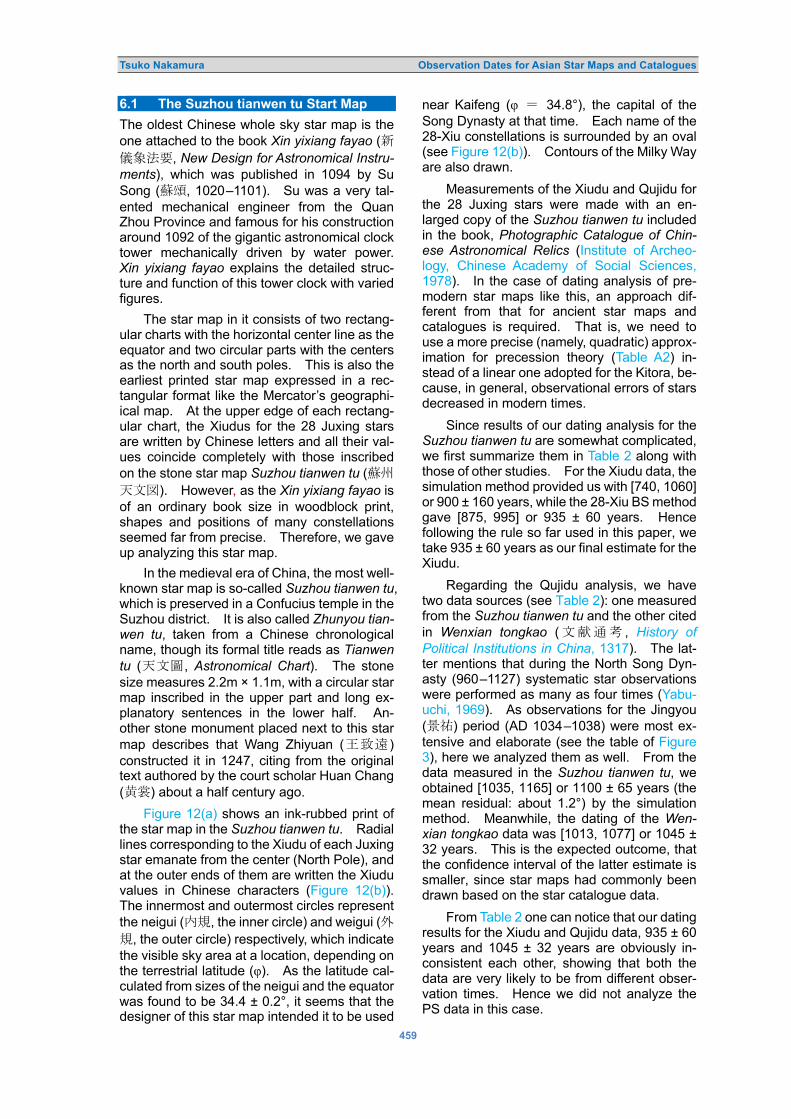
Tsuko Nakamura Observation Dates for Asian Star Maps and Catalogues
459
6.1 The Suzhou tianwen tu Start Map
The oldest Chinese whole sky star map is the one attached to the book Xin yixiang fayao (0�[>W, New Design for Astronomical Instru-
ments), which was published in 1094 by Su Song (Sg, 1020–1101). Su was a very tal-ented mechanical engineer from the Quan Zhou Province and famous for his construction around 1092 of the gigantic astronomical clock tower mechanically driven by water power. Xin yixiang fayao explains the detailed struc-ture and function of this tower clock with varied figures.
The star map in it consists of two rectang-ular charts with the horizontal center line as the equator and two circular parts with the centers as the north and south poles. This is also the earliest printed star map expressed in a rec-tangular format like the Mercator’s geographi-ical map. At the upper edge of each rectang-ular chart, the Xiudus for the 28 Juxing stars are written by Chinese letters and all their val-ues coincide completely with those inscribed on the stone star map Suzhou tianwen tu (S'�.�). However, as the Xin yixiang fayao is of an ordinary book size in woodblock print, shapes and positions of many constellations seemed far from precise. Therefore, we gave up analyzing this star map.
In the medieval era of China, the most well-known star map is so-called Suzhou tianwen tu, which is preserved in a Confucius temple in the Suzhou district. It is also called Zhunyou tian-
wen tu, taken from a Chinese chronological name, though its formal title reads as Tianwen
tu (�.�, Astronomical Chart). The stone size measures 2.2m × 1.1m, with a circular star map inscribed in the upper part and long ex-planatory sentences in the lower half. An-other stone monument placed next to this star map describes that Wang Zhiyuan (AP_) constructed it in 1247, citing from the original text authored by the court scholar Huan Chang (hV) about a half century ago.
Figure 12(a) shows an ink-rubbed print of the star map in the Suzhou tianwen tu. Radial lines corresponding to the Xiudu of each Juxing star emanate from the center (North Pole), and at the outer ends of them are written the Xiudu values in Chinese characters (Figure 12(b)). The innermost and outermost circles represent the neigui (�X, the inner circle) and weigui (�X, the outer circle) respectively, which indicate the visible sky area at a location, depending on the terrestrial latitude (φ). As the latitude cal-culated from sizes of the neigui and the equator was found to be 34.4 ± 0.2°, it seems that the designer of this star map intended it to be used
near Kaifeng (φ i 34.8°), the capital of the Song Dynasty at that time. Each name of the 28-Xiu constellations is surrounded by an oval (see Figure 12(b)). Contours of the Milky Way are also drawn.
Measurements of the Xiudu and Qujidu for the 28 Juxing stars were made with an en-larged copy of the Suzhou tianwen tu included in the book, Photographic Catalogue of Chin-
ese Astronomical Relics (Institute of Archeo-logy, Chinese Academy of Social Sciences, 1978). In the case of dating analysis of pre-modern star maps like this, an approach dif-ferent from that for ancient star maps and catalogues is required. That is, we need to use a more precise (namely, quadratic) approx-imation for precession theory (Table A2) in-stead of a linear one adopted for the Kitora, be-cause, in general, observational errors of stars decreased in modern times.
Since results of our dating analysis for the Suzhou tianwen tu are somewhat complicated, we first summarize them in Table 2 along with those of other studies. For the Xiudu data, the simulation method provided us with [740, 1060] or 900 ± 160 years, while the 28-Xiu BS method gave [875, 995] or 935 ± 60 years. Hence following the rule so far used in this paper, we take 935 ± 60 years as our final estimate for the Xiudu.
Regarding the Qujidu analysis, we have two data sources (see Table 2): one measured from the Suzhou tianwen tu and the other cited in Wenxian tongkao (.@^L , History of
Political Institutions in China, 1317). The lat-ter mentions that during the North Song Dyn-asty (960–1127) systematic star observations were performed as many as four times (Yabu-uchi, 1969). As observations for the Jingyou (4F) period (AD 1034–1038) were most ex-tensive and elaborate (see the table of Figure 3), here we analyzed them as well. From the data measured in the Suzhou tianwen tu, we obtained [1035, 1165] or 1100 ± 65 years (the mean residual: about 1.2°) by the simulation method. Meanwhile, the dating of the Wen-
xian tongkao data was [1013, 1077] or 1045 ± 32 years. This is the expected outcome, that the confidence interval of the latter estimate is smaller, since star maps had commonly been drawn based on the star catalogue data.
From Table 2 one can notice that our dating results for the Xiudu and Qujidu data, 935 ± 60 years and 1045 ± 32 years are obviously in-consistent each other, showing that both the data are very likely to be from different obser-vation times. Hence we did not analyze the PS data in this case.

Tsuko Nakamura Observation Dates for Asian Star Maps and Catalogues
460
Figure 12(a): The star map of the Tianwen tu, or the so-called Suzhou tianwen tu construced by Wang Zhiyuan in 1247. Figure 12(b): A part of the star map including constellations Mao (No.18 �, Pleiades) and Shen (No. 21, �, Orion).

Tsuko Nakamura Observation Dates for Asian Star Maps and Catalogs
461
On the other hand, Yabuuchi (1969) stud-ied in detail observations of the 28-Xiu con-stellations conducted during the Song Dynasty, to check whether or not the Juxing stars at that time were the same as those in the late Han era. Comparing theory (C) with observations (O) of the Qujidu and Xiudu for the assumed year of 1050, he judged that, because of both the (O–C)s being sufficiently small, the Qujidus and Xiudus in the literature were surely from the Song Dynasty era. In particular, he notic-ed that all the Xiudu values inscribed along the outer circumference of the Suzhou tianwen tu completely matched the records of observat-ions for the Yuanfeng (�Z) period (1078–1085).
Then, from our results and Yabuuchi’s work, what can we learn about the dating of the Suz-
hou tianwen tu? One important point is that our statistical dating analysis demonstrates that the Xiudu data inscribed in the Suzhou
tianwen tu were not from the North Song Dyn-asty era but actually from much earlier times (the first half of the tenth century). In other words, the Xiudu and Qujidu observations shown in the Suzhou tianwen tu were made during two different periods separated by more than a century (Table 2). This means that even official historical records by the national Government sometimes were wrong, presum-ably because scholars and astronomers at that time often had a tendency to traditionally trust more the data in the ancient literature rather than new observations. 6.2 The 28-Xiu Observations by Guo Shoujing
Guo Shoujing (`"-, 1231–1316) was the astronomer from the Hebei province who play-ed the most important role in the calendar reform of the Yuan Dynasty. As is well known, the Shoushi Calendar was completed in 1280 by Guo and his contemporary colleagues and was the culminating point of achievements in Chinese calendrical history.
Soon after Khubilai, the first Emperor of the Yuan Dynasty, ordered Guo and other Chinese astronomers to compile a new calendar in 1276, Guo started designing and constructing as many as thirteen astronomical instruments, and he made precise observations of the Sun, Moon and stars with them for about five years. It is likely that star positions including those of the 28-Xiu constellations were observed by the in-strument named Jianyi (the Simplified Instru-ment), which was used to measure the Xiudu and Qujidu of stars independently using sep-arate graduated circles, revealing Guo’s out-standing talent (e.g., see Needham, 1959a).
The Xiudu data of the 28 Juxing stars by the instrument are cited as observations during the Zhiyuan (O�) period (1264–1294) in the cal-endrical part of the official history of the Yuan Dynasty (the Yuanli, see Figure 3). From their values shown in the last row of the table in Figure 3, we recognize that Guo’s instrument could measure angles down to the unit of one twentieth of the Chinese degree, an unprece-dented accuracy.
We first analysed the above Xiudu data for the Zhiyuan period by the simulation method. The obtained date [1247, 1307] or 1277 ± 30 years (mean residual: 0.13°) suggests that Guo’s Juxing star observations were surely performed within just a few years after the order of calendar reform by the Emperor. Moreover, the smallness of both the confidence interval and the mean residual also confirm that Guo’s measurements of star positions were really very precise, as was repeatedly mentioned in the history of Chinese astronomy.
Table 2: Dating summary of the Suzhou tianwen tu.
Xiudu Qujidu-1* Qujidu-2* Simulation
method [740, 1060] or 900±160
[1035, 1165] or 1100±65
[1013, 1077] or 1045±32
28-Xiu BS method
[875, 995] or 935±60
Yabuuchi (1969) 1078–1085
1050 (assumed)
(*) Qujidu-1 and Qujidu-2 mean the data measured from the star map and those cited in the Wenxian tongkao (1317), respectively. In these analyses theoretical values of precession are calculated based on a quadratic approximation (Table A2).
As for the Qujidu data observed by Guo, there seems to be no record among documents in the official Chinese history. In the 1980s the book entitled Sanyuan lieshe ruxiu qujiji (���Q #�8f, Collection of the Xiudu and
Qujidu for Celestial constellations) was discov-ered, which summarized the Xiudu and Qujidu of about 740 stars including the 28-Xiu Juxing stars, along with a diagram for each asterism (Chen, 2003: 538). This was one of a series of books by an unknown author compiled during the Ming Dynasty. Although it was once sup-posed that the Qujidu data were based on Guo’s observations in 1280 (Pan, 1989), later they were found to be actually from around 1380 (Sun, 1996). As our 28-Xiu BS method applied to the same data also gave the date [1354, 1386] or 1370 ± 16 years, this result certainly negates the argument that the Qujidu data were observed ones made by Guo. 6.3 The Ceiling Star Map in King Qian Yuan-guan’s Tumulus
There still exist some notable circular star maps

Tsuko Nakamura Observation Dates for Asian Star Maps and Catalogues
462
in the pre-modern era of China other than those already mentioned (e.g., see Chen et al., 1996). However, we will not treat them any further, since observation dates for most of them in this period are more or less known from historical documents and literature, thus seemingly not much worthy of the analysis. Nevertheless, here is one very interesting exception, the ceil-ing star map of the King Qian Yuanguan’s tum-ulus. Below we describe the outline of the star map, followed by its dating analysis.
In the 1960s and 1970s in the Hangzhou district of Zhehong Province, burial mounds for the ruler and his family of the Wuyue state were excavated. They were constructed for King Qian Yuanguan (b�B) and his second wife, who died in 941 and 952 respectively. On the stone ceiling inside each tumulus an elabor-ately designed star map was inscribed. These ceilings measured as large as 4.7 m × 2.6 m × 0.3 m (Institute of Archeology, Chinese Aca-demy of Social Sciences, 1978). The unique point about the star maps was the number of constellations shown there. In such a wide stone area, only a few circumpolar asterisms, the Big Dipper and the 28-Xiu constellations were drawn, in addition to the equator and the inner and outer Gui circles (see Figure 13(a)). Obviously, this was not due to the star map being unfinished, since the stone ceiling of the second wife’s tumulus also had the same con-figuration of asterisms. Neither star names nor the circle graduation were written anywhere. We attempt to do dating analysis of this Qian Yuanguan star map in the following paragraph.
We measured the Xiudu and Qujidu of the 28-Xiu Juxing stars on an enlarged copy of the ink-rubbed print (Institute of Archeology, Chin-ese Academy of Social Sciences, 1978) using a linear scale and a protractor. According to Yi Shitong �� (1989), real sizes of the equator diameter and the inner circle were 123.1 cm and 51.1 cm. Figure 13(b) shows a part of the star map near the Shen xiu (Orion) with Arabic numerals for our identified Juxing stars. Table A6 represents their measured Xiudu and declination values. The data for four Juxing stars are missing because of image de-fects.
For the declination data, the simulation method using a hundred curves like Figure 8 provided us with the date [833, 1233] or 1033 ± 200 years, in which 15 Juxing stars with residu-als less than 5° were adopted. Although a simple least-squares estimate of the Xiudu data gave us the year 835, we did not attempt the simu-lation method for the data. The reason is that experience has taught us that the confidence interval for the Xiudu data is generally larger
than that for the declination.
Next, we made a least-squares dating est-imation for PS values by taking each Juxing star as the longitudinal origin. The results for 23 Juxing stars are summarized in the last col-umn of Table A6,9 in which the linear preces-sion theory of Table A1 was used. Then we applied the 28-Xiu BS method to all the years in the table, thus getting our final estimation date [897, 987] or 942 ± 45 years. From this dating one can see that the 28-Xiu BS method for PS data gives a much better result also in this case. Nevertheless, since the mean re-sidual during this period was as large as 5°, we may conclude that King Qian Yuanguan’s star map was far from accurate, contrary to its im-pressive appearance; remember that the mean residual for the Kitora star map was about 4° (refer to Section 4).
Now let us consider the background as to why such an unusual stone star map was constructed. A clue to answering this quest-ion is the interval 942 ± 45 years itself. This period overlaps with the lifetime of King Qian Yuanguan and there is no observation record of the 28 Xiu constellations in the Chinese national history during this era, so his astrono-mers may have made measurements of these constellations in response to his order for some unknown but important purpose. Then after the deaths of the King and his wife, it is likely that his successor, vassals, and astronomers inscribed the observations as the special star map to express appreciation of and respect for the King. In any case, the problem of King Qian Yuanguan’s star map will be an interesting target for future studies.
At the end of this Subsection we make some comments about the geographic latitude calculated from the equator and the inner (or outer) Gui circle of the star map. Such a lati-tude has often been understood as that of the observed location. But, as the obtained value for the star map was 37.1–37.9°, this is quite different from the latitude of the Wuyue state which is around 30°. Yi (1989) also worried about this contradiction. However, we have already discussed how the latitude calculated from the Gui circles of a star map generally has nothing to do with the place where the stars actually were observed from. 6.4 Dating Analysis of the Koshi Gesshin-zu Japanese Astrological Star Map
Once there existed in Japan an old star map which was drawn by a court astronomer of the fourteenth century for astrological purposes, but was lost during the Tokyo bombardment fire

Tsuko Nakamura Observation Dates for Asian Star Maps and Catalogues
463
Figure 13(a): An ink-rubbed print of the King Qian Yuanguan’s star map in his tumulus. Figure 13(b): A part of the star map including constellations from Wei () through Gui (�). Numbered white dots are the Juxing stars identified by the author, and the plus-mark on the left was determined as the North Pole, the center of the equatorial circle.

Tsuko Nakamura Observation Dates for Asian Star Maps and Catalogs
464
Figure 14: A photographic copy of the Koshi Gesshinzu star map. (Courtesy of the National Astronomical Observatory of Japan). The vertical size of the star map copy measures 28cm. of WW II in 1945. A photographic copy is now preserved at the library of the National Astro-nomical Observatory of Japan. It is titled Koshi
Gesshin-zu (Latticed Lunar Motion Star Map), which consists of a long rectangular map of Mercator type with the Equator as the central horizontal line and a circular circumpolar part centered at the North Pole. Figure 14 shows an eastern half of the rectangular part including 13 of 28-Xiu constellations from No. 16 to No. 28 (see Table 1). Explanatory notices attach-ed to the star map say that its author Yasuyo Abe produced this around AD 1320 based on a much earlier star map that had been handed down from his ancestors. Because the Abe family (later called the Tsuchimikado) provided the Chief Court Astrologer to the Emperor from the tenth century, the original star map must have been used for the purpose of Yinyang ast-rological divination, depending on which con-stellation the Moon was located at. Although the Chinese origin of the star map is unknown, as the following analysis verifies, this was sure-ly the earliest scientific star map drawn on paper in Japan.
The most conspicuous characteristic of the star map is that constellations are shown on a latticed (or grid) graph paper,10 which is also reflected in the title of the star map. In modern sciences latticed papers are commonly used to express numerical data exactly in graphical form. Examining the star map in detail, how-
ever, we see that the positions and shapes of many of the asterisms are far from precise and seem to have been drawn free-hand, suggest-ing that the author of this star map did not rec-ognize the correct usage of latticed graph paper. Moreover, a sinusoidal curve crossing the Equator in the map also looks so inaccurate that some researchers have regarded it as the ecliptic, and others as the lunar path (Ohsaki, 1987)—although the latter interpretation seems more consistent with the title of the star map.
We measured positions of Juxing stars us-ing an enlarged copy owned by the NAOJ. As the total number of lattices in the horizontal direction amounted to 365, this means that the unit of the longitude is the traditional Chinese one. Regarding the Qujidu data we counted the number of the latitudinal lattices for each Ju-xing star from the Equator, while the Xiudu val-ues written at the bottom of the rectangular map (see Figure 14) were adopted for analysis because of inaccuracy in asterism shapes.
As for dating of the Xiudu data, 485 ± about 25 years (the mean residual: 0.8°) was ob-tained by the simulation method (we got near-ly the same result for both the linear and the quadratic approximations of the precession theory). For unknown reasons this confidence interval was unusually small compared with other cases.
On the other hand, from the Qujidu values

Tsuko Nakamura Observation Dates for Asian Star Maps and Catalogues
465
measured for 21 Juxing stars we got 545 ± 90 years (the mean residual: 2.1°) by the simu-lation method with the quadratic precession theory (Table A2). As the confidence interval for the Xiudu overlaps with that for the Qujidu, both the dating results do not contradict each other. But one can easily notice that the Qujidu estimate is worse than that for the Xiudu, probably because of free-hand drawing of the 28-Xiu constellations. This indicates that this star map was not as precise as its latticed graphical appearance would suggest.
In the past Ohsaki (1987) analyzed the observation date of this star map by adopting the declination data of 191 stars. His result was 500 ± 50 years, which agrees with our est-imate of 545 ± 90 years within each uncertainty range. At the same time, since the uncertain-ty range by Ohsaki was an ordinary standard deviation, corresponding to a theoretical prob-ability of about 68% for the Gaussian error distribution, it is understood that our method (β = 90%) can provide a date that is as precise as Ohsaki’s but with a much smaller sample size, of 21.
In the Chinese official histories, we could not locate observations of the 28-Xiu constel-lations between the latter half of the fifth cen-tury and the first half of the sixth century. However, it may be worth noting that this period overlaps with the lifetime of the astronomer Zu Chongzhi (G=�, 429–500). He was a tal-ented engineer who not only invented the Zhinan-che (an instrument with a magnetic com-pass), but he also compiled the Daming Cal-endar between AD 457 and 464 that included the effect of precession for the first time. From the latter fact, it is possible to suppose that for his calendar reform he made observations of the 28-Xiu constellations again or produced a new star map in which the star positions were calculated by Chinese precession theory (1° per 50 years) at that time, then one of its copies was transmitted to Japan in a much later date. In any case, this Japanese star map will be an interesting target for further studies. 6.5 The Observation Epoch of Ulugh Beg’s Star Catalogue
Finally let us change our view on star maps and catalogues from East Asia to those by Arabic astronomers in the Middle East. It is well known that the Greek astronomy that culminated in Alexandria was not inherited by the Romans but by the Islamic people after the ninth century. Thabit ibn Qurra (836–901), and Muhammad al-Battani (ca. 850–929) both made efforts to develop further the astronomy in Ptolemy’s Almagest. In parallel with such activities pre-
modern astronomical observatories were con-structed in Malaga, Samarkand and Istanbul (Hoskin and Gingerich, 1997).
On the basis of the star catalogue in the Almagest, Islamic astronomers tried to improve it by observations and gave Arabic proper names to bright stars, some of which are now familiar to us, such as Rigel (β Ori), Aldebaran (α Tau), Altair (α Aql), Vega (α Vir), Deneb (α Cyg) and others. The representative work on Islamic constellations is the Book of the Fixed
Stars authored by the Persian astronomer Abd al-Rahman al Sufi (903–986) in AD 964. In his book al-Sufi describes each of the Islamic 48 constellations in comparison to the corres-ponding Greek ones, illustrating star charts with constellation shapes and their member stars (e.g., see Hafez et al., 2011).
At Samarkand, the old capital of Uzbek-istan and an important oasis city on the Silk Road, the remains of an ancient astronomical facility were unearthed by the Russian archae-ologist Vassily Vyatkin in 1908. From Islamic historical records it was soon identified as the huge astronomical observatory constructed by Ulugh Beg (1394–1449), the fourth Timurid Sultan. Prior to that position, he was the long- serving Governor of Samarkand, and was high-ly interested in intellectual matters. He was not only an excellent astronomer and mathe-matician but also a patron of science and cult-ure, inviting many talented scholars to make the city an intellectual center.
The underground remains of the obser-vatory were found to be the graduated arc of a gigantic sextant with a radius of 36m, the size intended for increasing the measuring accu-racy (Figure 15). Ulugh Beg completed it in 1429 and by commanding subordinate astron-omers he made precise observations of the transit altitudes of the Sun and more than a thousand stars. It is said that this resulted in the Ulugh Beg star catalogue of 1437 (the Zij-i-
Sultani) which included the data of 993 stars. This catalogue was a substantial revision of al-Sufi’s star table. Furthermore, using other astronomical instruments Ulugh Beg could im-prove the precession constant in the ecliptic longitude to be 51.4′′ per year (the correct value is 50.2′′ per year), and the obliquity of the ecliptic (ε) to be 23° 30′ 17′′ (the correct value at that time was 23° 30′ 48′′).
In order to confirm the observation epoch of the Ulugh Beg star catalogue, we analyzed his measurements by the simulation method with the quadratic precession theory. The data were taken from the Appendix in Yabuuchi’s translation of Hevelius Star Atlas (1993) and given in Table A7. Through the Bayer desig-

Tsuko Nakamura Observation Dates for Asian Star Maps and Catalogues
466
Figure 15: The graduated underground arc of the Ulugh Beg’s gigantic sextant at Samarkand (left) and a restoration image of the observatory (right) (courtesy: Ulugh Beg Observatory Museum). nations and the Bright Star Catalog (Hoffleit and Jascheck, 1982), we identified the corre-sponding 28-Xiu Juxing stars except for the No.18 Mao constellation (the Pleiades), and calculated their right ascensions and declin-ations in Table A7 from the Newcomb’s formula (Mueller, 1969) assuming ε = 23.513° at AD 1430.
Once the equatorial coordinates of the Ju-xing stars were obtained, we applied the same dating method to them as that used for the Almagest stars (Section 5). Here are the re-sulting estimates of the observation dates: from right ascension analysis: 1450 ± 10 years (the mean residual: 0.4°), and from declination analysis: 1425 ± 25 years (the mean residual: 0.3°), so both results are consistent with each other. Although the lower bound of the former estimate is different by a few years from the completion year of the Ulugh Beg catalogue (1437), this seems partially due to the fact that the simulation method frequently used random numbers. So, the above outcomes show that our statistical analysis adopting the 28 Juxing stars can provide a correct date within an error of 10 years or so.
Regarding the measuring accuracy of the Ulugh Beg star catalogue, both Shevchenko (1990) and Krisciunas (1993) have made de-tailed error analyses of it. They found that the mean error of the catalogue was about 16′. Hence, we see that our residuals of 0.3–0.4° are nearly compatible with their values as well.
7 CONCLUDING REMARKS
From the above-mentioned results, it can be seen that our 28-Xiu BS method provides more precise dating of old star maps and catalogues than the conventional approaches used in the past, with a sample number of just a few tens to be analyzed. So, what were the main rea-sons for our successful estimations?
Observed positions of stars suffer gener-ally from the instrumental and setting errors of the armillary sphere used for measurements, sometimes leading to a bias in dating. Unless analyzed stars are scattered all over the sky, even when numbering more than a hundred, the influence from the above biased errors on the estimated observation date was inevitable. To cope with the problem, some researchers introduced setting and instrumental errors in their analysis parameters as well (e.g., Mae-yama 1977; Sun and Kistemaker 1997).
On the other hand, the 28-Xiu constellation system used in our analysis consists of only 28 Juxing stars, but all of them are fairly bright; the faintest one is No. 17 WeiN (35 Ari) with the visual magnitude of 4.6. First, this situation allowed us to apply our method successfully to many historical star maps and catalogues.
Another advantage of using the 28-Xiu constellations for the purpose of dating anal-ysis is that they are distributed over a wide declination range in the sky (from –35° to +25°) irregularly all along the equator and the ecliptic.

Tsuko Nakamura Observation Dates for Asian Star Maps and Catalogues
467
This situation canceled out an excessive ap-pearance of positive or negative (O–C) values in measurements caused by instrumental and setting errors of the armillary spheres used, thus resulting in less biased dating as a whole.
The third merit of adopting the 28-Xiu con-stellations is due to smallness of the data size. As the 28 Juxing stars can be measured easily within a year, this ensures that all of their ob-servations were conducted usually in the same year. By contrast, if we try to use for analysis too many stars recorded in star maps and catalogues in an attempt to increase the dating accuracy, it may conversely endanger the as-surance that all the data are from the same observation epoch—note that there is no way of knowing the observation date of each star, unless it is clearly written in the historical re-cords.
In conclusion we emphasize that the most essential point in using the 28-Xiu constellat-ions method for dating analysis is to allow us to apply it to many historical star maps and cat-alogues in a unified way, and to compare them from a common viewpoint. 8 ACKNOWLEDGEMENTS
The author expresses his gratitude to three anonymous referees, whose comments and advice were helpful in improving the original manuscript. 9 NOTES
1 This paper is a concisely reorganized ver-sion of the Japanese book published by the same author in 2018 (Nakamura, 2018), correcting a few mistakes and adding sub-sequent new findings and insights.
2 Confidence level is sometimes called ‘con-fidence coefficient’ as well. The meaning of a confidence level 95%, for instance, is as follows: if measurements of a statistical quantity are made a hundred times inde-pendently, the statistical estimates of the true value of the quantity fall 95 times into the corresponding confidence interval. Nat-urally, the larger the confidence level, the wider the width of the confidence interval; namely if we set up higher reliability of estimation, the error range inevitably be-comes wider.
3 If we compare Figure 6 or Figure 7 with Figure 12 (Suzhou tianwen tu), one can easily notice that the ecliptic of the Kitora star map is quite wrong in terms of its orientation. Although the true reason of the failure is unknown, one possibility is that when the Kitora painter drew the ecliptic referring to the original star map
designed on a sheet of paper, presumably he put it in a wrong direction by mistake (Miyajima, 1999).
4 The inner and outer circles (X Gui) express the sky regions in which stars never sink below or never rise above the horizon and their sizes are calculated from an assumed value of the geographic latitude. From this relationship some researchers have claimed that the two circles allow us to determine the location where the stars in a star map were observed. However, Naka-mura (2015; 2018) showed that, through a total surveying of the Chinese literature contained in the Siku Quanshu (�)�6) completed in 1782 and consisting of 79,000 books and documents, the two circles were drawn mainly for the conven-ience of users of a star map, and in general had nothing to do with the place where the stars were observed.
If the above view is justified, the geo-graphic latitude obtained from the inner Gui circle of the Kitora star map of 37.6–38.1° (close to the location of the capital of the Koguryeo Kingdom in ancient Korea, ca. first century BC to seventh century AD), may indicate the possibility that the original of the Kitora star map was transferred to Japan not directly from China but via the Korean Peninsula. That is to say, it is like-ly that the inner circle was added anew to the original Chinese star map to meet the need to use the star map in Korea.
5 At present, the Cartesian coordinates (x, y), or the polar coordinates (r, θ) like those adopted in the Kitora star map to express positions of stars are one of the most ele-mentary ways for planar graphical repre-sentation. Interestingly, however, such an approach was surprisingly recent in the Western world. According to Friendly et al. (2010), the earliest known use of the one-dimensional graph, to show the route from Toledo, Spain to Rome, was invented in 1644 by Michael F. van Langren (ca. 1600–1675), who is known to have pub-lished a broadsheet lunar map for the first time in 1645 (Whitaker, 1989).
6 In China from ancient times, astrological astronomy had politically been of top-prior-ity importance, because it was believed that the Chinese Emperor was chosen by Heaven to rule over his country. Accord-ingly, from the Late Han dynasty on, the Government passed a law to prohibit ordin-ary people from being involved in astron-omy. For instance, the Tang liutien (The
Six Institutional Classification of the Tang
Dynasty) of AD 738 stated that if a person

Tsuko Nakamura Observation Dates for Asian Star Maps and Catalogues
468
who was not a Court Astronomer studied astrological books or used astronomical in-struments (such as an armillary sphere) for observations, he would be punished (Nak-ayama, 1969: 15). And this regulation also applied to the Da Qing Huidien shili (Collected Institutions of the Qing Dynasty), which was written in 1690. Given this sit-uation, it would have been almost impos-sible for a non-Governmental citizen to observe stellar positions using an armillary sphere or produce a star map. Hence there was very little possibility that the oservations other than those of the times shown in the table in Figure 3 were actually performed, including the one of AD 300 obtained by Sôma (2016).
7 Following Yoshihara (2009), we clearly ex-plain calculation process of the 28-Xiu BS method using the Kitora data (Table 1). First, we regarded 24 dates in the last col-umn given in Table 1 as the original popu-lation whose mean value is expressed here by Θ, and on the basis of the population we made up n sets of artificial data groups by random resampling (permitting multiple sampling of the same data value). Then the boot strap theory teaches us that the confidence interval of the mean for the original population can be obtained by [Θ –σnZn(β) and Θ + σnZn(1 – β)], where σn, Zn(β) and Zn(1 – β) are statistical quantities calculated from all the above n sets of pseudo-data groups generated in a com-puter for β = 90%. Note that Θ is not al-ways located at the center of the confid-ence interval depending upon the values of Zn(β) and Zn(1 – β). Although there are several procedures to estimate σn and Zn, it is common to select the one giving the minimum width of the confidence interval as the final result (Chernick, 1999; Yoshi-hara, 2009).
8 During actual observations in modern ast-
ronomy, we sometimes encounter situat-ions where we are forced to handle the data with meager sample numbers and/or of low quality caused by noise due to the instrumental detection limit, poor weather, and so on. In the case of astronomical observations, the observer cannot gener-ally set up the measuring conditions him-self, or try again to make the same mea-surements—this is an important difference between astronomy and physics experi-ments carried out in a laboratory. To com-pensate for such inconvenience, we often perform a model analysis instead.
9 For the Juxing star No. 22 (�, Jing) the minimum of Σi(O–C) i 2/n did not exist during AD 200–1700.
10 Although scientific Mercator-type star maps like the one in the book Xin yixiang fayao (0�[>W) published in 1094 by Su Song (see Section 6.1) must have needed some sort of lattices for the purpose of an exact design, to the author’s knowledge, there seem to be no such products of Chinese origin drawn on latticed paper. In the Chin-ese history of geography, however, one can find a very famous example of a lat-ticed map, called Yuji tu (H]�). This map of continental China inscribed in 1137 on a stone monument is now preserved in the Museum of Historical Monuments in Xian city; the unit of the lattice measures a hundred Chinese lis (li: about 400 meters). Meanwhile, the astronomer Shen Kuo (<,, 1030–1094) of the Song Dynasty and Huan Chang (hV), the author of Suzhou
tianwen tu inscribed in the twelfth century, were deeply involved in the production of such scientific geographical maps as well (Needham, 1959b). Thus, it is reasonable to consider that techniques of latticed map-making were applied by them also to star maps at around that time.
10 REFERENCES
Aboshi, Z., 2006. Studies of Mural Painted Tumuli. Tokyo, Gakusei-sha (in Japanese). Bayer, J., 1603. Uranometria. Augsburg, Christophorus Mangus. Bo, S. (ed.), ca. 1999. Collected Works of the Classics in the Chinese Science and Technology, Volume on
Astronomy, Part 5. Zhengzhou, Henan Educational Publication (in Chinese). Chen, M., et al. (eds.), 1996. Star Charts in Ancient China. Shenyang, Lening Educational Publ (in Chinese
with English abstract). Chen, M., 2003. Chinese History of Science and Technology. (Volume on Astronomy). Beijing, Science
Publications (in Chinese). Chernick, M.R., 1999. Bootstrap Methods: A Practitioner’s Guide. New York, Wiley. Chon, H, 2005. The World Heritage, Mural Painted Tumuli of the Koguryeo Kingdom. Tokyo, Kadokawa
Publishing (in Japanese). Conover, W.J., 1971. Practical Nonparametric Statistics. New York, Wiley. Dambis, A.K., and Efremov, Yu.N, 2000. Dating Ptolemy’s star catalogue through proper motion: the
Hipparchan epoch. Journal for the History of Astronomy, 31, 115–134. Delambre, J.B.J.,1817. Histoire de l’Astronomie Ancienne. Volume II. Paris, Libraire pour les Sciences.

Tsuko Nakamura Observation Dates for Asian Star Maps and Catalogues
469
Efron, B., 1979. Bootstrap methods: Another look at the jackknife. The Annals of Statistics. 7(1), 1–26. Efron, B., and Tibshirani, R.J., 1994. An Introduction to the Bootstrap. New York, Chapman & Hall. Evans, J., 1987. On the origin of the Ptolemaic star catalogue. Journal for the History of Astronomy, 18, 155–
172; 233–278. Friendly, M., Valero-Mora, P., and Ibanez Ulargui, J., 2010. The first (known) statistical graph: Michael Florent
van Langren and the “secret” of longitude. The American Statistician, 64(2), 1–12. Gingerich, O., 1981. Ptolemy revisited: a reply to R.R. Newton. Quarterly Journal of the Royal Astronomical
Society, 22, 40–44. Gingerich, O., 1993. The Eye of Heaven: Ptolemy, Copernicus and Kepler. New York, American Institute of
Physics. Grasshoff, G., 1990. The History of Ptolemy’s Star Catalogue. New York, Springer. Hafez, I., Stephenson, R., and Orchiston, W., 2011. Abdul-Rahman al-Sufi and his Book of the Fixed Stars. In
Orchiston, W., Nakamura, T., and Strom, R. (eds.), Highlighting the History of Astronomy in the Asia-Pacific Region, Proceedings of the ICOA-6 Conference. New York, Springer. Pp. 121–138.
Hoffleit, D., and Jaschek. C., 1982. The Bright Star Catalog. Fourth Edition. New Haven, Yale University Observatory.
Hoskin, M., and Gingerich, O., 1997. Medieval Latin astronomy. In Hoskin, M. (ed.), The Cambridge Illustrated History of Astronomy. Cambridge, Cambridge University Press. Pp. 50–67.
Institute of Archeology, Chinese Academy of Social Sciences, 1978. Photographic Catalogue of Chinese Astronomical Relics. Beijing, Cultural Relics Publishing House (in Chinese).
Krisciunas, K. 1993. A more complete analysis of the errors in Ulugh Beg’s star catalogue. Journal for the History of Astronomy, 24, 269–280.
Laplace, P.S., 1797. Exposition du Système du Monde. Volume II. Paris, Cercle-Social. Maeyama, Y., 1977. The oldest star catalogue, Shi shi Xingjing, Prismata Naturwissenschafts geschichtl.
Studien, 211–245. Miyajima, K., 1999. Japanese old star maps and astronomy of East Asia. Jinbun Gakuho(����), 82, 45–
99 (in Japanese). Mueller. I.I., 1969. Spherical and Practical Astronomy as Applied to Geodesy. New York, Federick Ungar. Nakamura, T., 2015. Statistical estimation of observation dates for the Kitora star map and relating Chinese
star catalogues. Journal of History of Science, Japan, 54, 192–214 (in Japanese with English abstract). Nakamura, T., 2017. The 28-Xiu constellations in East Asian calendars and analysis of their observation dates.
In Nha, I.-S., Orchiston, W., and Stephenson, F.R., (eds.), The History of World Calendars and Calendar-making: Proceedings of the International Conference in Commemoration of the 600th Anniversary of the Birth of Kim Dam. Seoul, Yonsei University Press. Pp. 165–175.
Nakamura, T., 2018. Deciphering the Ancient Starry Sky from the Kitora Tumulus Star Map: A History of Star Maps and Catalogues in Asia. Tokyo, University of Tokyo Press (in Japanese).
Nakayama, S., 1969. A History of Japanese Astronomy. Cambridge (Mass.), Harvard University Press. Nara National Research Institute for Cultural Properties (ed.), 2016. Kitora Tumulus Star Atlas Constellations
Photo Book. Nara, Nara National Research Institute for Cultural Properties Research (Report Volume 16) (in Japanese, with English abstract).
Nautical Almanac Office, 1961. Explanatory Supplement to the Astronomical Ephemerides. London, Her Majesty’s Stationary Press.
Needham, J., and Wang, L., 1959a. Science and Civilization in China, the Sciences of the Heavens. Volume 3, Part 2. London, Cambridge University Press.
Needham, J., and Wang, L, 1959b. Science and Civilization in China, the Sciences of the Earth. Volume 3, Part 3. London, The Syndics of Cambridge University Press.
Newton, R.R.,1977. The Crime of Claudius Ptolemy. Baltimore, The Johns Hopkins University Press. Nha, I., Nha, S. L. and Orchiston, W., 2017. The development of astronomy in Korea and the emergence of
astrophysics in South Korea. In Nakamura, T., and Orchiston, W. (eds.), The Emergence of Astrophysics in Asia: Opening a New Window on the Universe. New York, Springer. Pp.151–209.
Ohsaki, S., 1987. History of Chinese Constellations. Tokyo, Yuzan-kaku. (in Japanese). Pan, N., 1989. Zhongguo Hengxing Guance Shi (Observation History of Stars in China). Shanghai, Scholar
Press. Rawlins, D., 1982. An investigation of the ancient star catalog. Publications of the Astronomical Society of the
Pacific, 94, 359–373. Seidelmann, P.K. (ed.), 1992. Explanatory Supplement to the Astronomical Almanac, Completely Revised and
Rewritten Version. Mill valley, University of Science Books. Shevchenko, M., 1990. An analysis of errors in the star catalogue of Ptolemy and Ulugh Beg. Journal for the
History of Astronomy, 21, 187–201. Sôma, M., 2016. Estimating the year and place of observations for the celestial map in the Kitora Tumulus.
Report of the National Astronomical Observatory of Japan, 18, 1–12 (in Japanese, with English Abstract). Sun, X., 1996. Star catalogue in Tainwen Huichao. In Chen, M. et al., (eds.), Zhongguo guxingtu (Star Charts
in Ancient China). Shenyang, Liaoning Educational Publication. Pp. 79–108 (in Chinese). Sun, X., and Kistemaker, J.,1997. The Chinese Sky during the Han. Leiden, Brill. Thurston, H., 1994. Early Astronomy. Berlin, Springer. Toomer, G.J., 1984. Ptolemy’s Almagest. London, Duckworth. Tsuchihashi, Y., and Chevalier, S., 1911. Catalogue d’Étoiles Fixes Observées à Pékin sous l’Empereur, K’ien-

Tsuko Nakamura Observation Dates for Asian Star Maps and Catalogues
470
long. Shanghai, Zo-se Observatoire. Ueda, J., 1929. Shi shen’s catalogue of stars, the oldest catalogue in the Orient. Report of Department of
Science, Kyoto University, 13(1), 35–66. Whitaker, E.A, 1989. Selenography in the seventeenth century. In Taton, R., and Wilson, C.(eds.), The General
History of Astronomy. Volume 2. Cambridge, Cambridge University Press. Pp. 119–143. Yabuuchi, K., 1958. Ptolemy’s Almagest. Tokyo, Koseisha (in Japanese). Yabuuchi, K., 1969. Chinese Calendrical Sciences Tokyo, Heibonsha (in Japanese). Yabuuchi, K., 1975. Star maps depicted in decorative tumuli. Tenmon Geppou (The Astronomical Herald ), 68,
314–318 (in Japanese). Yabuuchi, K., 1993. Ulugh Beg’s star catalogue. In Hevelius Star Atlas. Tokyo, Chijin Shokan. Pp. xx-xx (in
Japanese). Yi, S., 1989. Stone inscribed star map of the King of the Wuyue state. In Collected Works of Chinese
Astronomical Relics. Bejing, Institute of Archeology, Chinese Academy of Social Sciences. Pp. 252–258 (in Chinese).
Yoshihara, K., 2009. Bootstrap Data Analysis Using EXCEL. Tokyo, Baihu-kan (in Japanese). 11 APPENDIX Table A1: Linear approximation of precession.
Rate (°/100y) No. 28-Xiu Juxing RA1 (°) DC1 (°) dRA/dt dDC/dt dΔRA/dt 1 � α Vir 175.95 0.49 1.252 –0.592 0.039 2 � κ Vir 187.36 0.13 1.291 –0.510 –0.008 3 � α Lib 196.43 –5.68 1.283 –0.548 0.093 4 � π Sco 211.36 –17.66 1.376 –0.472 0.014 5 σ Sco 216.69 –17.93 1.39 –0.437 0.121 6 � μ Sco 221.36 –31.35 1.511 –0.345 0.012 7 � γ Sgr 240.45 –26.97 1.523 –0.245 –0.003 8 � φ Sgr 250.77 –25.57 1.52 –0.145 –0.097 9 � β Cap 277.00 –18.13 1.423 0.104 –0.051
10 � ε Aqr 284.70 –14.08 1.372 0.172 –0.033 11 � β Aqr 296.38 –11.98 1.339 0.272 –0.042 12 � α Aqr 305.73 –7.97 1.297 0.343 –0.086 13 α Peg 321.88 5.93 1.211 0.439 0.023 14 � γ Peg 338.41 4.92 1.234 0.505 0.000 15 � ζ And 346.66 13.87 1.234 0.520 0.045 16 β Ari 2.51 10.88 1.279 0.514 0.052 17 � 35 Ari 13.43 18.53 1.331 0.489 0.036 18 � 17 Tau 28.16 16.61 1.367 0.421 0.002 19 � ε Tau 39.22 13.24 1.369 0.351 –0.040 20 � λ Ori 56.94 6.90 1.329 0.213 –0.090 21 � δ Ori 58.04 –3.30 1.239 0.207 0.240 22 � μ Gem 65.96 21.50 1.479 0.122 –0.001 23 " θ Cnc 98.76 23.19 1.478 –0.190 –0.125 24 � δ Hya 102.63 11.28 1.353 –0.221 –0.117 25 � α Hya 117.34 –0.90 1.236 –0.343 –0.040 26 � υ Hya 124.02 –6.18 1.196 –0.394 0.005 27 � α Crt 140.85 –7.74 1.201 –0.502 0.028 28 � γ Crv 159.13 –5.91 1.229 –0.574 0.023
RA1 and DC1 are the right ascension and declination in degrees for AD 1, and dRA/dt and dDC/dt are their variation rates per century. dΔRA/dt is the Xiudu rate per century. This approximation is valid with errors of less than 0.5–0.8° during the period from 200 BC to AD 1300.
Table A2: Quadratic approximation of precession.
1900.0 RA DC No. 28-Xiu Juxing RA (°) DC (°) A B C A B C 1 � α Vir 199.981 –10.639 0.0128 175.570 0 –0.0055 –0.211 2 � κ Vir 211.890 –9.808 0.0129 187.310 0 –0.0053 0.099 3 � α Lib 221.288 –15.581 0.0132 196.030 0 –0.0050 –6.359 4 � π Sco 238.200 –25.826 5.0E-07 0.0142 210.910 4.0E-07 –0.0049 –18.300 5 σ Sco 243.777 –25.353 0.0144 216.230 5.0E-07 –0.0046 –18.562 6 � μ Sco 251.274 –37.876 0.0158 220.850 6.0E-07 –0.0043 –31.970 7 � γ Sgr 269.658 –29.584 0.0156 239.930 7.0E-07 –0.0028 26.810

Tsuko Nakamura Observation Dates for Asian Star Maps and Catalogues
471
8 � φ Sgr 279.852 –27.094 0.0155 250.320 7.0E-07 –0.002 26.184 9 � β Cap 303.848 –15.097 0.0144 276.600 7.0E-07 0.0007 –18.737
10 � ε Aqr 310.566 –9.862 0.0139 284.280 6.0E-07 0.0014 –14.714 11 � β Aqr 321.574 –6.011 0.0135 295.980 5.0E-07 0.0025 –12.609 12 � α Aqr 330.162 –0.806 0.0131 305.330 4.0E-07 0.0033 –8.603 13 α Peg 344.945 14.667 0.0123 321.520 0 0.0049 5.240 14 � γ Peg 2.021 14.628 0.0126 338.060 0 0.0054 4.248 15 � ζ And 10.509 23.723 0.0126 346.320 0 0.0055 13.195 16 β Ari 27.278 20.319 0.0131 2.260 0 0.0054 1.015 17 � 35 Ari 39.395 27.282 0.0137 13.157 0 0.0051 17.858 18 � 17 Tau 54.734 23.799 0.0140 27.929 –4.0E-07 0.0050 15.871 19 � ε Tau 65.694 18.959 0.0139 39.058 –5.0E-07 0.0044 12.519 20 � λ Ori 82.407 9.867 0.0134 56.749 –6.0E-07 0.0031 6.180 21 � δ Ori 81.724 –0.358 0.0125 57.842 –6.0E-07 0.0030 –4.010 22 � μ Gem 94.228 22.565 0.0149 65.842 –7.0E-07 0.0023 20.733 23 " θ Cnc 126.473 18.433 0.0147 98.600 –7.0E-07 –0.0009 22.470 24 � δ Hya 128.090 6.053 0.0135 102.450 –6.0E-07 –0.0012 10.551 25 � α Hya 140.668 –8.225 0.0124 117.130 –5.0E-07 –0.0026 –1.607 26 � υ Hya 146.667 –14.378 0.0120 123.810 –4.0E-07 –0.0032 –6.894 27 � α Crt 163.725 –17.766 0.0122 140.610 0 –0.0048 –8.427 28 � γ Crv 182.665 –16.987 0.0125 158.750 0 –0.0054 –6.586
RA and DC values for the year AD 1900.0 in the 4th and 5th columns are taken from The Bright Star Catalogue (Hoffleit and Jaschek, 1981). RA and DC of an arbitrary year can be calculated by At2 + Bt + C, where t = the Christian era. This approximation is valid with errors of less than 0.1° between 200 BC and AD 1800.
Table A3: An example of model analysis for the assumed date of AD 300.0.
AD300.0 SD (1.5) SD (1.0) SD (0.7) No. 28-Xiu Juxing Year Year Year 1 � α Vir 289 365 285 2 � κ Vir 225 330 289 3 � α Lib 406 379 255 4 � π Sco 290 307 284 5 σ Sco 347 347 300 6 � μ Sco 186 329 323 7 � γ Sgr 543 131 283 8 � φ Sgr 104 369 198 9 � β Cap 142 267 289
10 � ε Aqr 309 315 294 11 � β Aqr 302 329 281 12 � α Aqr 242 351 299 13 α Peg 426 344 273 14 � γ Peg 428 270 280 15 � ζ And 276 262 306 16 β Ari 320 251 333 17 � 35 Ari 276 303 280 18 � 17 Tau 316 281 306 19 � ε Tau 334 317 315 20 � λ Ori 304 304 285 21 � δ Ori 127 305 293 22 � μ Gem 368 282 273 23 " θ Cnc 389 371 390 24 � δ Hya 315 316 2.84 25 � α Hya 351 248 290 26 � υ Hya 319 122 251 27 � α Crt 310 261 266 28 � γ Crv 438 361 303
Mean 310 301 280 S.D. 97 62 63
28-Xiu-BS [282, 337] [282, 319] [261, 298]
As for SD(1.5), SD(1.0) and SD(0.7), refer to the text (Section 4.5).

Tsuko Nakamura Observation Dates for Asian Star Maps and Catalogues
472
Table A4: Xiudu and Qujidu data of Shishi xingjing.
No. 28-Xiu Juxing Xiudu Qujidu 1 � α Vir 12 91 2 � κ Vir 9 3 � α Lib 16 94 4 � π Sco 5 108 5 σ Sco 5 109 6 � μ Sco 18 124 7 � γ Sgr 11 118 8 �� φ Sgr 26.25 116 9 �� β Cap 8 110
10 !� ε Aqr 12 106 11 � β Aqr 10 104 12 � α Aqr 17 99 13 α Peg 16 85 14 �� γ Peg 9 86 15 � ζ And 16 70 16 β Ari 12 80 17 � 35 Ari 14 72 18 � 17 Tau 11 74 19 � ε Tau 16 78 20 �� λ Ori 2 84 21 � δ Ori 9 94.4 22 �� μ Gem 33 70 23 " θ Cnc 4 68 24 � δ Hya 15 77 25 � α Hya 7 90 26 � υ Hya 18 97 27 � α Crt 18 99 28 � γ Crv 17 99
Sum 366.25
Note that the sum of all the Xiudus is not 365.25° but 366.25°, probably due to a copying mistake in the past literature. Table A5: Dating analysis of the Almagest data.
No. 28-Xiu Juxing RApt DCpt Xiudu (°) Rel-RA Year 1 � α Vir 176.2 –0.5 11.6 0.0 130.4 2 � κ Vir 187.8 –0.5 9.0 11.6 114.6 3 � α Lib 196.8 –6.6 14.7 20.7 117.0 4 � π Sco 211.5 –18.3 5.4 35.4 115.3 5 σ Sco 216.9 –18.8 4.5 40.8 112.0 6 � μ Sco 221.4 –32.1 19.7 45.3 17.2 7 � γ Sgr 241.1 –27.8 9.9 64.9 82.3 8 � φ Sgr 251.0 –26.2 26.7 74.9 42.8 9 � β Cap 277.7 –18.4 7.3 101.6 83.3
10 � ε Aqr 285.0 –14.4 11.9 108.8 61.2 11 � β Aqr 296.9 –12.5 9.1 120.7 66.3 12 � α Aqr 306.0 –8.4 16.3 129.9 61.0 13 α Peg 322.3 5.7 16.5 146.1 64.1
14 � γ Peg 338.8 4.4 8.7 162.6 66.5 15 � ζ And 347.5 13.6 16.1 171.4 25.8 16 β Ari 3.6 10.7 10.0 187.5 28.0 17 � 35 Ari 13.6 18.1 26.7 197.5 70.4 18 � 17 Tau 19 � ε Tau 40.3 12.8 17.5 224.1 77.0 20 � λ Ori 57.8 6.7 0.9 241.6 58.3 21 � δ Ori 58.7 –4.1 8.3 242.5 48.4 22 � μ Gem 66.9 20.9 31.8 250.8 106.2 23 " θ Cnc 98.7 22.4 4.5 282.5 20.3 24 � δ Hya 103.2 10.1 14.2 287.0 66.8 25 � α Hya 117.4 –2.0 7.0 301.3 95.5 26 � υ Hya 124.4 –6.7 16.4 308.3 59.9

Tsuko Nakamura Observation Dates for Asian Star Maps and Catalogues
473
27 � α Crt 140.8 –8.7 18.3 324.7 106.2 28 � γ Crv 159.1 –7.1 17.1 342.9 126.2
mean 74.9 SD 33.1
* RApt and DCpt are converted values from the ecliptic longitudes and latitudes given in the Almagest (Grasshoff, 1990). Since we could not identify No. 18 (�) Juxing star in the Almagest catalogue, the actually analyzed number of stars are 27.
Table A6: Dating analysis of the star map of King Qian Yuanguan’s tumulus.
No. 28-Xiu Juxing Xiudu (°) DC (°) Year 1 � α Vir 9.5 76.1 1090 2 � κ Vir 8.0 78.3 1187 3 � α Lib 14.0 69.5 1124 4 � π Sco 5.5 82.0 929 5 σ Sco 11.5 73.2 847 6 � μ Sco 15.0 68.1 812 7 � γ Sgr 12.5 71.7 519 8 � φ Sgr 27.0 50.6 734 9 � β Cap 12.5 71.7 934
10 � ε Aqr 11.0 73.9 1048 11 � β Aqr 9.0 76.9 1035 12 � α Aqr 14.5 68.8 924 13 α Peg 54.5 10.4 912 14 � γ Peg 15 � ζ And 16 β Ari 17 � 35 Ari 14.5 68.8 1069 18 � 17 Tau 15.5 67.4 948 19 � ε Tau 15.0 68.1 1141 20 � λ Ori 0.0 90.0 978 21 � δ Ori 13.5 70.3 854 22 � μ Gem 25.5 52.7 23 " θ Cnc 2.0 87.1 1008 24 � δ Hya 17.5 64.4 990 25 � α Hya 24.0 54.9 905 26 � υ Hya 27 � α Crt 15.5 67.4 721 28 � γ Crv 12.5 71.7 956
mean 942 SD 156
Table A7: Ulugh Beg’s 28-Xiu observations.
Ecl.-long. Ecl.-lat. RA Dec. No. 28-Xiu Juxing Sec.* ° ′ ° ′ α (deg) δ (deg) 1 � α Vir 6 16 10 –2 9 194.05 –8.36 2 � κ Vir 6 26 52 3 0 206.01 –7.59 3 � α Lib 7 7 52 0 45 215.74 –13.47 4 � π Sco 7 24 40 –5 27 230.84 –24.27 5 σ Sco 8 0 28 –3 45 237.43 –23.98 6 � μ Sco 8 7 55 –15 15 243.10 –36.72 7 � γ Sgr 8 23 49 –7 12 262.87 –30.56
8 � φ Sgr 9 2 19 –3 54 272.60 –27.39 9 � β Cap 9 26 10 4 45 297.25 –16.31
10 � ε Aqr 10 3 49 8 9 304.20 –11.43 11 � β Aqr 10 15 43 8 48 315.42 –7.80 12 � α Aqr 10 25 31 10 9 324.38 –3.48 13 α Peg 11 15 55 19 0 339.32 11.81 14 � γ Peg 0 1 22 12 24 356.23 11.90 15 � ζ And 0 13 25 17 18 5.20 21.17 16 β Ari 0 27 7 7 51 22.18 17.78 17 � 35 Ari 1 9 40 10 54 33.45 25.05 18 � 17 Tau 19 � ε Tau 2 1 10 –2 54 59.65 17.62 20 � λ Ori 2 16 31 –13 30 76.71 9.39

Tsuko Nakamura Observation Dates for Asian Star Maps and Catalogues
474
21 � δ Ori 2 14 34 –23 57 75.92 –1.19 22 � μ Gem 2 27 31 –1 15 87.32 22.24 23 " θ Cnc 3 27 40 –1 15 119.50 19.47 24 � δ Hya 4 2 25 –12 30 121.86 7.49 25 � α Hya 4 19 31 –22 30 134.69 –6.31 26 � υ Hya 4 28 10 –26 0 141.40 –12.29 27 � α Crt 5 15 55 –22 42 158.10 –15.33 28 � γ Crv 6 2 46 –14 18 176.71 –14.19
* ‘Sec.’ in the ecliptic longitude column means the sequential number of the zodiacal constellations (Grasshof, 1990).
Dr Tsuko Nakamura worked at the National Astronomical Observatory of Japan for thirty years from 1976, and then taught at Teikyo-Heisei University (Tokyo) for seven years and at the Open University of Japan (Chiba) for ten years as a Professor. He has done research in the fields of both planetary sciences and mainly the history of Japanese astronomy. So far he has published 51 papers in international refereed journals in the first field, and 13 in English and 49 in Japanese in the second field.
His recent books, for the past ten years, are: Deciphering the Ancient Starry Sky from the Kitora Tumulus Star Map (2018, University of Tokyo Press, in Japanese); The Emergence of Astrophysics in Asia: Opening a New Window on the Universe (2017, Springer, co-edited by Wayne Orchiston); A History of Oriental Astronomy (2014, Maruzen Publ., in Japanese); Five Thousand Years of Cosmic Visions (2011, University
of Tokyo Press, co-authored by Sadanori Okamura, in Japanese); Highlighting the History of Astronomy in the Asia-Pacific Region: Proceedings of the ICOA-6 Conference (2011, co-edited by Wayne Orchiston and Richard G. Strom); and Mapping the Oriental Sky: Proceedings of the ICOA-7 Conference (2011, National Astronomical Observatory of Japan, co-edited by Wayne Orchiston, Mitsuru Sôma and Richard G. Strom).
Tsuko is on the Editorial Board of the Journal of Astronomical History and Heritage. Asteroid Tsuko (6599), a member of Flora family, was named after him in 1991. One of his favorite things is to visit domestic and overseas art museums and in particular to look for historical paintings relating to astronomy.

Journal of Astronomical History and Heritage, 24(2), 475–497 (2021).
475
AUSTRALIAN ECLIPSES: THE WESTERN AUSTRALIAN ECLIPSE OF 1974
AND THE EAST COAST ECLIPSE OF 1976
Nick Lomb Centre for Astrophysics, University of Southern Queensland, PO Box 4196,
Springfield Central Qld 4300, Australia. E-mail: [email protected]
Abstract: In 1974 and 1976 total eclipses of the Sun were visible from Australia for the first time in over 50 years. For the 1974 eclipse only the northern limit of totality touched land and observers were scattered across the few towns along the south-west coast of Western Australia. Clouds disturbed most scientific observations, while two rocket flights with instruments to image the Sun in ultraviolet light failed to obtain useful results. However, some amateur astronomers were fortunate with the weather at their locations so that they could observe the totally eclipsed Sun. The eclipse was notable for a viewing flight on a Boeing 727 passenger aircraft organised by an American travel company. This was the first commercial eclipse flight. The 1976 eclipse attracted many scientists, both local and from overseas, who mainly gathered in the NSW town of Bombala. Once again, clouds prevented observations. Unusually, the path of totality included the major city of Melbourne with its almost three million inhabitants. To try to prevent eye damage, the authorities encouraged the population to stay indoors during the eclipse and only watch on television. They were generally successful, though with the consequence that millions of people missed out on a once-in-a-lifetime chance to view a total eclipse from their own backyards.
Keywords: 1974 total eclipse, 1976 total eclipse, solar filters, eye damage, commercial eclipse flight
1 INTRODUCTION
Two total eclipses of the Sun, two years apart, were visible from Australia in the mid-1970s. Though the path of totality was below the Aus-tralian coastline for the first, on 20 June 1974, its northern limit clipped the south-west corner of the state of Western Australia. The second, on 23 October 1976, had the path of totality cross the south-east part of the continent, pas-sing through the states of South Australia, Victoria and New South Wales. Total eclipses tend to happen in remote parts of the world, so it was unusual that in 1976 totality passed over the city of Melbourne, a city then of 2.8 million people and the capital of the state of Victoria. Figure 1 gives an overview of the paths of to-tality for the two eclipses in the vicinity of Australia.
These two eclipses were the first seen from Australia since the important eclipse of 1922, at which astronomers from Lick Observatory, stat-ioned in Western Australia, verified Einstein’s prediction of the deflection of starlight near the Sun1 (Treschman, 2014). In the following 50 or so years, there were major developments in technology, in the available equipment and in the direction of eclipse research. In the 1970s the emphasis was on the study of the corona as total solar eclipses, then and now, provide the best way of examining the hot outer atmo-sphere of the Sun.
In the half century since the previous eclipse, the number of amateurs had also grown and they had access to better equipment
such as the common 20-cm aperture Schmidt-Cassegrain telescopes manufactured by Cele-stron (Anonymous, 2017) and aperture solar filters. This meant that amateurs took a much greater role in eclipse observation than at earl-ier eclipses. As emphasised in previous papers on historical eclipse expeditions (Lomb, 2016; 2020), one of the most important aspects of considering eclipses is the glimpses they provide of astronomers away from their normal routine. For the 1974 and 1976 eclipses, these glimpses apply not just to professional ast-ronomers but also to amateurs. Unlike those earlier eclipses, there are still people with us, who were observers at one or other of the two eclipses, and their recollections greatly assist with understanding what happened at those events.
Though observations at both eclipses were disturbed by clouds, many people managed to observe totality. This paper first looks at the 1974 eclipse and the associated activities of professional and amateur observers. An im-portant part of the 1974 eclipse was the first commercial eclipse flight, on which those on-board were guaranteed a good look at the eclipsed Sun without the fear of clouds. The 1976 eclipse is considered next. Probably, the most important aspect of that eclipse was that totality encompassed a highly populated city. This paper considers questions such as: How did the authorities cope with the coming eclipse? What advice did they give? What planning did they do?
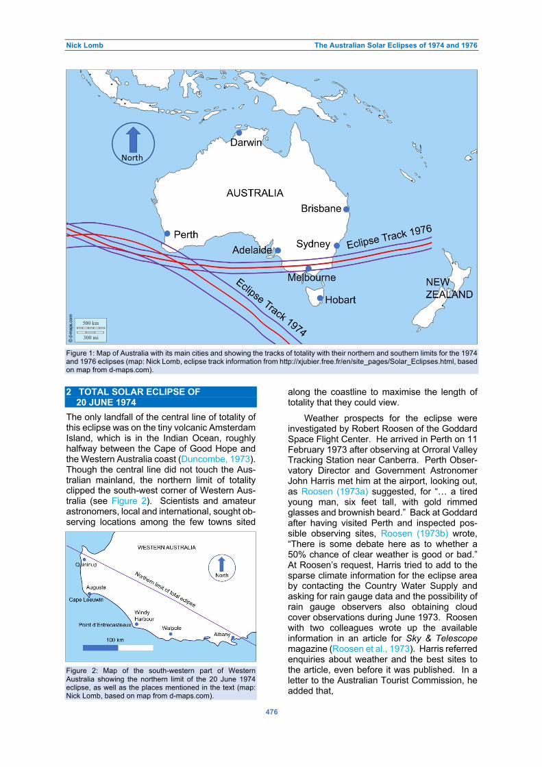
Nick Lomb The Australian Solar Eclipses of 1974 and 1976
476
Figure 1: Map of Australia with its main cities and showing the tracks of totality with their northern and southern limits for the 1974
and 1976 eclipses (map: Nick Lomb, eclipse track information from http://xjubier.free.fr/en/site_pages/Solar_Eclipses.html, based
on map from d-maps.com).
2 TOTAL SOLAR ECLIPSE OF 20 JUNE 1974
The only landfall of the central line of totality of this eclipse was on the tiny volcanic Amsterdam Island, which is in the Indian Ocean, roughly halfway between the Cape of Good Hope and the Western Australia coast (Duncombe, 1973). Though the central line did not touch the Aus-tralian mainland, the northern limit of totality clipped the south-west corner of Western Aus-tralia (see Figure 2). Scientists and amateur astronomers, local and international, sought ob-serving locations among the few towns sited Figure 2: Map of the south-western part of Western
Australia showing the northern limit of the 20 June 1974
eclipse, as well as the places mentioned in the text (map:
Nick Lomb, based on map from d-maps.com).
along the coastline to maximise the length of totality that they could view.
Weather prospects for the eclipse were investigated by Robert Roosen of the Goddard Space Flight Center. He arrived in Perth on 11 February 1973 after observing at Orroral Valley Tracking Station near Canberra. Perth Obser-vatory Director and Government Astronomer John Harris met him at the airport, looking out, as Roosen (1973a) suggested, for “… a tired young man, six feet tall, with gold rimmed glasses and brownish beard.” Back at Goddard after having visited Perth and inspected pos-sible observing sites, Roosen (1973b) wrote, “There is some debate here as to whether a 50% chance of clear weather is good or bad.” At Roosen’s request, Harris tried to add to the sparse climate information for the eclipse area by contacting the Country Water Supply and asking for rain gauge data and the possibility of rain gauge observers also obtaining cloud cover observations during June 1973. Roosen with two colleagues wrote up the available information in an article for Sky & Telescope magazine (Roosen et al., 1973). Harris referred enquiries about weather and the best sites to the article, even before it was published. In a letter to the Australian Tourist Commission, he added that,
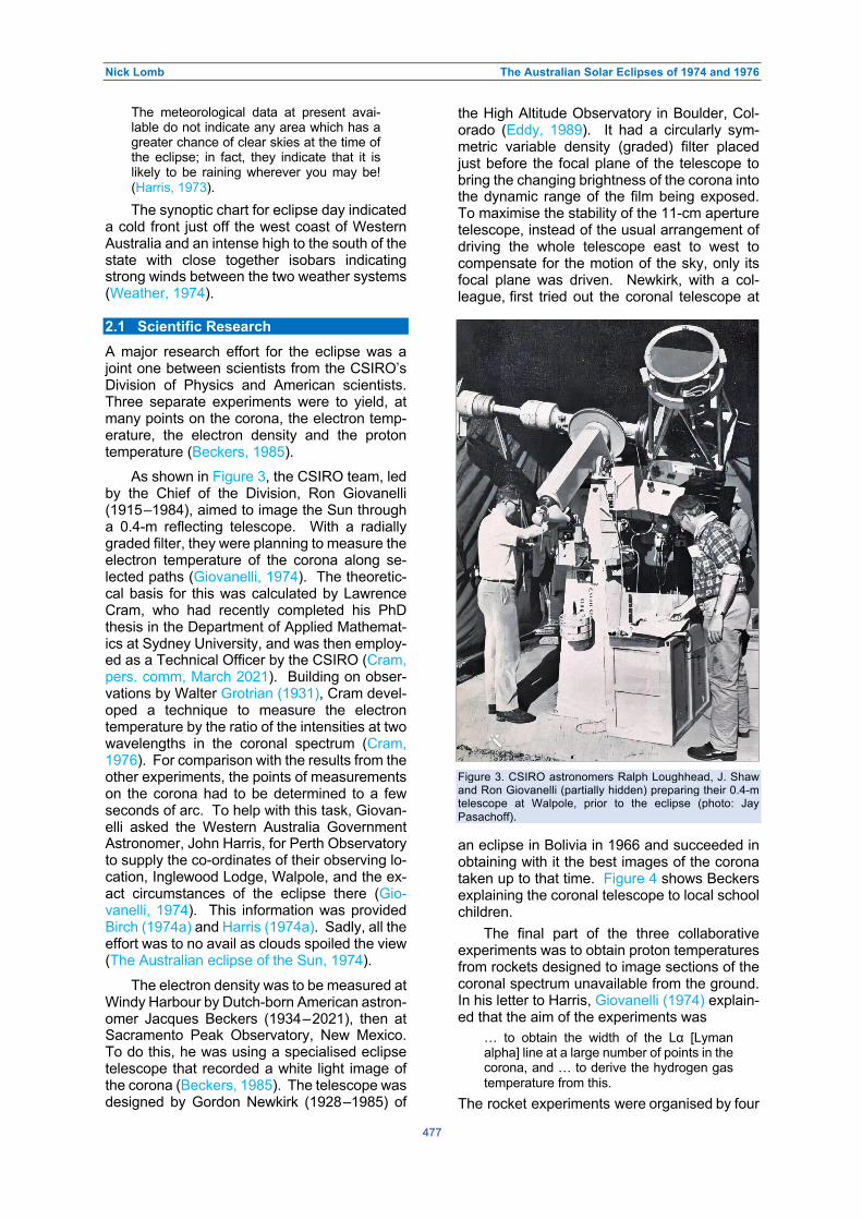
Nick Lomb The Australian Solar Eclipses of 1974 and 1976
477
The meteorological data at present avai-lable do not indicate any area which has a greater chance of clear skies at the time of the eclipse; in fact, they indicate that it is likely to be raining wherever you may be! (Harris, 1973).
The synoptic chart for eclipse day indicated a cold front just off the west coast of Western Australia and an intense high to the south of the state with close together isobars indicating strong winds between the two weather systems (Weather, 1974). 2.1 Scientific Research
A major research effort for the eclipse was a joint one between scientists from the CSIRO’s Division of Physics and American scientists. Three separate experiments were to yield, at many points on the corona, the electron temp-erature, the electron density and the proton temperature (Beckers, 1985).
As shown in Figure 3, the CSIRO team, led by the Chief of the Division, Ron Giovanelli (1915–1984), aimed to image the Sun through a 0.4-m reflecting telescope. With a radially graded filter, they were planning to measure the electron temperature of the corona along se-lected paths (Giovanelli, 1974). The theoretic-cal basis for this was calculated by Lawrence Cram, who had recently completed his PhD thesis in the Department of Applied Mathemat-ics at Sydney University, and was then employ-ed as a Technical Officer by the CSIRO (Cram, pers. comm, March 2021). Building on obser-vations by Walter Grotrian (1931), Cram devel-oped a technique to measure the electron temperature by the ratio of the intensities at two wavelengths in the coronal spectrum (Cram, 1976). For comparison with the results from the other experiments, the points of measurements on the corona had to be determined to a few seconds of arc. To help with this task, Giovan-elli asked the Western Australia Government Astronomer, John Harris, for Perth Observatory to supply the co-ordinates of their observing lo-cation, Inglewood Lodge, Walpole, and the ex-act circumstances of the eclipse there (Gio-vanelli, 1974). This information was provided Birch (1974a) and Harris (1974a). Sadly, all the effort was to no avail as clouds spoiled the view (The Australian eclipse of the Sun, 1974).
The electron density was to be measured at Windy Harbour by Dutch-born American astron-omer Jacques Beckers (1934–2021), then at Sacramento Peak Observatory, New Mexico. To do this, he was using a specialised eclipse telescope that recorded a white light image of the corona (Beckers, 1985). The telescope was designed by Gordon Newkirk (1928–1985) of
the High Altitude Observatory in Boulder, Col-orado (Eddy, 1989). It had a circularly sym-metric variable density (graded) filter placed just before the focal plane of the telescope to bring the changing brightness of the corona into the dynamic range of the film being exposed. To maximise the stability of the 11-cm aperture telescope, instead of the usual arrangement of driving the whole telescope east to west to compensate for the motion of the sky, only its focal plane was driven. Newkirk, with a col-league, first tried out the coronal telescope at Figure 3. CSIRO astronomers Ralph Loughhead, J. Shaw
and Ron Giovanelli (partially hidden) preparing their 0.4-m
telescope at Walpole, prior to the eclipse (photo: Jay
Pasachoff).
an eclipse in Bolivia in 1966 and succeeded in obtaining with it the best images of the corona taken up to that time. Figure 4 shows Beckers explaining the coronal telescope to local school children.
The final part of the three collaborative experiments was to obtain proton temperatures from rockets designed to image sections of the coronal spectrum unavailable from the ground. In his letter to Harris, Giovanelli (1974) explain-ed that the aim of the experiments was
… to obtain the width of the Lα [Lyman alpha] line at a large number of points in the corona, and … to derive the hydrogen gas temperature from this.
The rocket experiments were organised by four

Nick Lomb The Australian Solar Eclipses of 1974 and 1976
478
Figure 4: Jacques Beckers explaining his solar telescope to school children at Windy Harbour (photograph: Jay Pasachoff).
United States laboratories, Sandia, Los Ala-mos, Laboratory for Atmospheric and Space Physics of the University of Colorado and Sac-ramento Peak Observatory. Two Sandhawk-Terrier rockets were to be launched from Lan-celin, north of Perth, 30 seconds apart (Rockets to chase eclipse, 1974). The northerly location was chosen as at the 30 km operational altitude of the rockets the eclipse track shifted north from its location on the ground. Each rocket carried a payload of a telescope connected to a high-resolution spectrograph and camera. Be-fore launch, the Bureau of Meteorology set up a 30-metre tower and a portable radar system to give information on high altitude wind move-ments. The launch complex was built by local contractors with the assistance of several Com-monwealth Government agencies (Lathrop, 1975). The rockets were duly launched. Tele-metry indicated that one successfully acquired the Sun and made the planned observations, while the other did not. One capsule was re-covered, while the other was not, due to heavy seas and a weak signal from its electronic bea-con. As luck would have it, the recovered cap-sule was the one that had not observed the Sun. Sandia Corporation offered a $1000 re-ward for the recovery of the missing capsule, explaining that it had to be found within five days for otherwise the film containing the re-
sults would deteriorate ($1000 offered for lost probe capsule, 1974). It was not found.
Among other observers was the trio of Jay Pasachoff of Williams College, Massachusetts with his wife, Naomi, and Stephen Edberg of the University of California at Santa Cruz (Figure 5), who set up their equipment near Giovanelli’s team at Walpole (June Solar Eclipse: A First Word, 1974). To cover every eventually, they had a Piper plane on standby in case of clouds. When the clouds did roll in and looked persist-ent, the two Pasachoffs took that option and took off with only four minutes to go before to-tality. The small plane could not fly high enough so that all they saw of the corona was, as re-ported by Pasachoff, “… a light ring around the dark moon.” Pasachoff saw his first eclipse in 1959, while a first-year student at Harvard Uni-versity (Kersten, 2017). He is one of three um-braphiles or eclipse chasers, who have seen a record setting 33 total eclipses, as of 2017. Glen Schneider (Section 2.3) is one of the other record setters. Two years later, Pasachoff (pers. comm., April 2021) and Schneider had both increased their tallies to 35. 2.2 The Eclipse Flight
Despite cloud over much of the eclipse area, about 40 lucky amateur astronomers enjoyed

Nick Lomb The Australian Solar Eclipses of 1974 and 1976
479
Figure 5: Stephen Edberg with Naomi and Jay Pasachoff and their equipment (photograph: Jay Pasachoff).
an uninterrupted view of the eclipse for just over seven minutes. They were on an especially charted eclipse fight, the first commercial eclipse one. There had been eclipse flights previously but only for scientists carrying out experiments. The most famous of these flights was the flight of the prototype Concorde 001 to observe a total eclipse over Africa on 30 June 1973 (Guillermier and Koutchmy, 1999: 132–135; Léna, 2016). Organised by French ast-ronomers, the flight took off from La Palma in the Canary Islands and followed the arc of the Moon’s shadow to provided totality for a phen-omenal 74 minutes. This was only possible due to the aircraft flying at speeds of over twice the speed of sound. Concorde 001 is now on display at the National Air and Space Museum of France, located within the Paris-Le Bourget airport (Lemaire, 2015–2021).
The 1974 flight was organised by Horst Engel, the president of VIP Travel, a company located in Sierra Madre, California, a small town near Pasadena, which was the home of NASA’s Jet Propulsion Laboratory (JPL) and the Cali-fornia Institute of Technology (Caltech). Horst Engel (pers. comm., October 2020) and VIP Travel had organised eclipse expeditions be-fore but this one was a little tricky because of
the poor weather prospects and the eclipse path being over water. Instead, one of the JPL scien-tists, noting the success of the Concorde flight, suggested using an aircraft instead of trying to observe from the ground. VIP Travel contacted Ansett Airlines, which they had used previously for travel within Australia. After seeking more details and getting in touch with the Astronomi-cal Society of Victoria (henceforth ASV),2 the airline agreed. Fortunately, Ansett had two Boeing 727s that were certified for travel over water, with both aircraft having periscopic sex-tants in the roof of the cockpit to allow celestial navigation when out of range of electronic navi-gational aids.
The passengers for the flight consisted mainly of an American party of keen eclipse observers led by Harry Nelson, Professor of Mathematics at Augustana College, Rock Is-land, Illinois (Trainor, 1974). Before reaching Melbourne, from where the flight was to orig-inate, the party had visited the main astronom-ical sites in Australia, including Sydney Obser-vatory, the Parkes Radio Telescope and the Tidbinbilla tracking station. The Americans were joined by Jim Trainor from the ASV, who was the main contact for the Society, Arthur Coombs, President of the ASV, plus three other

Nick Lomb The Australian Solar Eclipses of 1974 and 1976
480
Figure 6: Inside the plane during the 1974 eclipse flight, showing telescopes and other gear pointed out through the windows
(photograph: Arthur Coombs; courtesy: Barry Clark).
Society members, as well as a couple from the Astronomical Society of South Australia and two from the Astronomical Society of New South Wales. The whole group left Melbourne for Perth on the evening before the eclipse, flying on the same plane as was to make the eclipse flight.
While the flight participants slept at a Perth Airport hotel, technicians removed the seats on the left-hand side of the aircraft. When the observers boarded the plane the next morning, they found that “The left half of the plane is like a carpeted cricket pitch”. Soon after take-off at 10:40 am local time, the passengers were free to set up their cameras, tripods and other equip-ment on the cricket pitch (Figure 6). Numbers Figure 7 (left): The diamond ring at the beginning of totality,
photographed from onboard the Ansett aircraft (photo-
graph: Arthur Coombs; courtesy: Barry Clark).
Figure 8 (right): The eclipsed Sun and its corona, photo-
graphed from onboard the Ansett aircraft (photograph:
Arthur Coombs; courtesy: Barry Clark).
on the flight had been limited so that each part-icipant had their own window. The flight plan was to fly west to reach the central line near the point of maximum duration of totality and then fly along the line. The plane flying at about 950 kilometres per hour could not keep up with the Moon’s shadow, which was moving at about 2250 kilometres per hour, but would extend totality compared to the stationary maximum of five minutes nine seconds. The altitude of the Sun was 34°, so that it could be easily observed through the windows.
The flight, piloted by a senior Ansett pilot, Captain Ken Morris, who was a member of the ASV, went to plan apart from running into cloud just before totality. Though the plane’s navigat-or was certain that they would break out of it before the crucial time, it was decided to increase altitude from 30,000 feet to 32,000 feet and the cloud vanished. As from the ground, the eclipse began with the sight of the diamond ring (Figure 7) and then the corona (Figure 8) came into view, as well as the planets Venus and Saturn and the bright star Sirius. For seven minutes and nine seconds participants could take their photographs and make other obser-vations. The Perspex windows were, of course, not ideal to look through plus there was a vibrat-ion that would have affected longer exposures from the constant movement of people; a move-

Nick Lomb The Australian Solar Eclipses of 1974 and 1976
481
ment that disturbed the stability of the aircraft. One participant had allowed for the vibration of the plane by having gyro stabilisers fitted to her camera equipment (Carlos, 1996–2007). This was prolific eclipse observer and well-known New York musician, Wendy Carlos.
After totality was over and the observing gear stowed, the plane landed at Perth airport and the elated passengers disembarked (Fig-ure 9). From there they returned to Melbourne on a scheduled flight.
2.3 Ground-based Observers
Those people who set up at Cape Leeuwin and nearby Augusta were fortunate as the clouds there cleared for the duration of the eclipse and almost four minutes of totality could be seen. Among the crowd of mainly Western Austral-ians near the Cape Leeuwin lighthouse (Figure 10), there was a coach load of about a dozen people from New York City. One of them was Glenn Schneider, then an undergraduate but later to become a well-known astronomer at the Space Telescope Science Institute and at the University of Arizona. He has retained his in-terest in solar eclipses, attending his 35th total eclipse in 2019 (Schneider, 2019). In his 1974 notebook Schneider recorded his concern about the weather preventing viewing of the eclipse. However, this concern was ameliorated by a long phone call to the Bureau of Meteorology in Perth, where the forecaster indicated that the clouds would pass before the eclipse (Schneid-er, 1974). Schneider set up his extensive equip-ment—a Questar telescope, a spectrograph and a 400 mm lens, all with cameras on tripods with weights for stability. When totality com-menced
There was not any diamond ring at sec- ond contact nor any shadow bands. The chromosphere was visible for about 12 seconds, and [a] naked eye prominence visible 15° above the contact tangent point.
Later a coronal streamer could be seen growing to 6½ solar radii. At mid-totality Schneider could see Achernar, Sirius, Canopus and, with averted vision, Rigel. Venus became visible five minutes before totality and faded into the daytime sky about five minutes after. There was a diamond ring at third contact and after-wards weak shadow bands could be seen on a sheet of paper.
Frankston’s Bruce Tregaskis (1927–2008) (Skilton, 2009) was another observer in the vicinity of Cape Leeuwin lighthouse. Tregaskis, together with his daughter and a colleague from the ASV, drove to Cape Leeuwin from Perth after hearing a radio interview indicating there were clouds in the Walpole area (Tregaskis,
Figure 9. After the eclipse flight, Horst Engel (left) and
Arthur Coombs (right) with the four hostesses, who had
been on board (photo: Arthur Coombs).
1974). They set up Tregaskis’ home-built 10-cm cm reflector and a pair of binoculars on a stand in a sheltered area among trees. As totality approached, Tregaskis noted that “… an eerie bluish sunset …” seemed to occur. Pink and orange colours appeared on clouds low in the south-west. He took a photograph of totality by holding a camera to the eyepiece of the 10-cm telescope. Just before the end of totality he saw that “… the west limb of the Sun appeared mauvish-red as the chromosphere came into view for some seconds.” After the diamond ring and the end of totality, Tregaskis had a better view of the shadow bands on a sheet laid on the ground: Figure 10. Cape Leeuwin lighthouse (photograph: Amanda
Slater; courtesy Flickr, (CC BY-SA 2.0)).

Nick Lomb The Australian Solar Eclipses of 1974 and 1976
482
The bands, which were not continuous but were often broken up into short sections of no more than a foot [30 cm] in length, were separated from each other by 7 to 15 cm. They moved slowly across the sheet ap-proximately towards the east and lasted for about two minutes.
Canadian journalist Peter Faulkner (pers. comm., October 2020) was close to Cape Leeu-win, at the Flying Doctor airstrip at Augusta (Faulkner, 1974). Faulkner had seen a total eclipse two years earlier at Nova Scotia in Can-ada and had learnt from that experience. On this occasion he planned meticulously in ad-vance, even arriving at the site two days before the eclipse. Faulkner’s main instrument at Aug-usta was an 800-mm telephoto lens with a cam-era coupled to it and supported on two tripods for rigidity. With this arrangement he planned two series of shots, one on colour slide film and the other on black and white negative film. A second instrument was a 200-mm lens with a 2X teleconverter and a camera, all on one tri-pod. He had two more cameras: one with a wide-angle lens that was placed on top of his hired car with a small camera and one for mis-cellaneous shots. At 1 pm he tuned into the ABC for the hourly time signal and a few min-utes later started a tape recorder to be ready to record impressions of totality due at 1:12 pm WAST. As the sky darkened before second contact, Faulkner noted that the high-altitude cirrus clouds that remained after the clouds had cleared earlier in the day, “… were seen radi-ating in advance of the approaching shadow in a fanlike configuration.” Just before the appear-ance of the diamond ring at third contact Faulk-ner saw Saturn, which was only 10° from the Sun. During totality, he had felt a chill in the air as the temperature had dropped by 15° F [8° C] since first contact. Faulkner was satisfied with the results of his photography and he summed up the eclipse by stating:
All aspects of the event were near perfection: the Sun itself was in an ideal position in the sky, it was mid day, the at-mosphere was relatively free of clouds, and of course totality was a generous four min-utes in length.
Most observers sought out a site to maxi-mise the duration of the eclipse. One, who did not, was David Herald of Canberra. Herald was following the advice of American astronomer David W. Dunham, then at the University of Texas, Austin. Dunham’s suggestion was to observe from just inside one of the limits of a total eclipse to maximise the visibility of Baily’s beads—these bright spots, due to mountains and valleys at the edge of the lunar disc, are seen as the Moon moves in front of the Sun.
Herald and a companion set up their equipment about 6 km from the northern limit of the eclipse, near Quininup Beach, at the intersection of two roads (Herald, 1976). Their equipment was simple: a 60-mm refractor or lens telescope that projected a 10-cm wide image of the Sun onto a screen. As well, they had a portable tape recorder to record a voice commentary of what was seen, together with time signals from radio station VNG at Lyndhurst in Victoria. Fortun-ately, the sky was clear at the time of the eclipse, apart from high cloud that did not affect the image. Playing back their recording after the eclipse, they found 72 events associated with Baily’s beads, with the time of each event established to ±0.3 second. From this data Herald identified the lunar feature responsible for each event using a published lunar profile (Watts, 1963). Armed with this information, Herald derived corrections to the ecliptic longi-tude and latitude of the ephemeris position of the Sun as well as the radius of the Sun; these corrections turned out to be small compared to the calculated mean errors associated with them.
Another eclipse observer was Friedhelm (Freddy) Dorst from the Astronomy Institute at Münster University, Münster, Germany. He wrote to Perth Observatory requesting assist-ance to reach his chosen eclipse site at Point Entrecasteaux and listed his instruments as a 1000-mm focal length photo lens with a focal ratio of 5.6 and four cameras (Dorst, 1974a). According to Martin Mobberley (2007: 180), Freddy Dorst is Germany’s top eclipse chaser with a record of 21 successes from 24 total eclipses. He has a reputation for arriving at a continent different to his own, seeing an eclipse and heading straight back to Germany. On this occasion he lived up to his reputation as he spent only one week in Perth. Perth Obser-vatory assisted by hiring on his behalf a VW Combi van equipped as a caravan and provid-ing a driver for the trip to the eclipse site (Harris, 1974b). On returning home he sent his thanks to Harris together with some photos that he said indicated the bad seeing conditions during to-tality (Dorst, 1974b).
Most of Perth Observatory staff went to Windy Harbour, near Dorst’s location, and judg-ing by the photographs (Figures 11 and 12) made it a pleasant day’s outing. Unfortunately, thin cloud spoilt the view and no successful photographs of the eclipse were taken (Birch, 1974b). However, a recently appointed Obser-vatory Assistant, Celia Blackshaw, was at Augusta and took a photo of the eclipse that the Observatory could happily distribute (Harris, 1974c).

Nick Lomb The Australian Solar Eclipses of 1974 and 1976
483
Figure 11 (left): Perth Observatory staff at Windy Harbour preparing for totality. Left to right: Greg Lowe, Mike Candy, Dennis
Harwood and Dick Gans (photograph: Perth Observatory; courtesy Craig Bowers).
Figure 12 (right): Perth Observatory staff member Dennis Harwood with his wife, Derice, at Windy Harbour before totality
(photograph: Perth Observatory; courtesy Craig Bowers).
Dave Marshall, a guide-lecturer at the
Science Museum of Victoria in Melbourne, was another successful observer at Augusta. He took with him a simple, yet ingenious device consisting of a photometer, a watch and a 15-cm aluminium mirror that formed an image of the Sun (Marshall, 1974). A movie camera imaged all the instruments at 15-second inter-vals. With the data collected during the eclipse, he could plot the overall sky brightness during the eclipse against time and compare the re-sults with a theoretical curve based on the eclipse geometry. Marshall also noted what he saw around him. Animals he found just stopped and [laid] down as it became dark. Most of the human onlookers, he said, were school parties brought by buses. There were others as well:
Generally, the overseas visitors were equip-ped with telephoto cameras. One visitor who was photographing his nineteenth eclipse had a stack of filters looking like exposed film, which he kept whipping in front of his camera in some obviously planned sched-ule.
2.4 The Public
In 1974 there were no generally accepted solar filters available for the public (further discussed in Section 4). Aluminised mylar film was only just becoming available and, in fact, Glenn Schneider at Cape Leeuwin was giving them away, but they were not yet officially recognis-ed. As a result, the Australian College of Oph-thalmologists issued a warning for people not to view the eclipse directly or through any kind of glasses such as sunglasses, oxy-welder gog-gles, sooted glasses or dark coloured glasses (Warning on eclipse, 1974). The College said that at the previous Australian eclipse “170 people, most of them children, permanently damaged the sight in one or both eyes after looking directly at the eclipse.” Some of these
people had looked for less than ten seconds. With these and other warnings in mind, most people in the Western Australian capital of Perth, where the Moon covered 96 per cent of the width of the Sun, stayed indoors and watch-ed on television. Some people were under-standably confused: one wanted to know if it was safe to do her washing, another whether keeping hats on would provide protection and yet another whether she should protect her elderly dog’s eyesight by keeping it indoors (Eclipse causes fears, 1974). The Australian Broadcasting Commission (ABC) televised the eclipse from its outside broadcast unit at Albany until “… just before the clouds closed in.” (Bun-bury, 1974). 3 THE TOTAL SOLAR ECLIPSE OF 23 OCTOBER 1976
The eclipse began at sunrise in Tanzania, in eastern Africa, with the central line crossing the Indian Ocean, passing to the south of Western Australia and central Australia before reaching the coast of south-eastern Australia (Fiala and Duncombe, 1975). From South Australia it entered Victoria, passed over Melbourne and moved into New South Wales (NSW), exiting the Australian mainland to the south of Sydney (Figure 13). The Moon’s shadow travelled quickly, crossing the almost 11,000 km from the African coast to Melbourne in just over three hours. Melbourne experienced two minutes and forty-five seconds of totality centred on 4:41 pm AEST in the afternoon.
Most serious observers sought out locat-ions on the central line with towns such as Millicent in South Australia, Ballarat in Victoria and Bombala and Merimbula in New South Wales being the most popular. Weather pros-pects were no better than for the 1974 Western Australian eclipse. According to the USNO circ-

Nick Lomb The Australian Solar Eclipses of 1974 and 1976
484
Figure 13: Map of south-east Australia showing the central line, together with the northern and southern limits of the 23 October
1976 eclipse. Places mentioned in the text are marked (map: Nick Lomb, based on map from d-maps.com).
ular (Fiala and Duncombe, 1975), rainfall was to be expected one day in two in southern Victoria but the prospects improved to the east towards the south coast of NSW with rainfall only on one day in three. Mean afternoon cloudiness was 6.4 eighth of the sky at Ballarat, 5.4 at Melbourne and 4.4 at the south coast. The Astronomical Society of Victoria’s eclipse subcommittee suggested that the Bombala area, just to the north of the Victorian border, would be good for observing, explaining that it was between two mountain ranges that pro-vided protection from “… moisture-bearing air-streams.” (Lawrence, 1976). Climate data can give an indication of weather prospects but more definite indications can only be obtained from weather forecasts much closer to the date and time of the eclipse. On the morning of eclipse day, the latest satellite image showed a large bank of cloud about to move in from south of the continent and head over the eclipse track from South Australia to New South Wales (Sin-not, 1976). Eclipse viewing prospects seemed poor at all Australian locations.
3.1 Scientific Research
In 1976 opportunity was taken of the total eclipse to try to carry out a large variety of scientific research. Some of this was optical as would be expected. For instance, the whole of the Department of Physics of the University of Wollongong travelled to Bombala to conduct experiments looking at
… such features as the chromospheric boundary, shadow bands, light intensity and the infrared and polarization properties of the outer corona. (The University of Wol-longong, 1976: 38).
Glen Moore (pers. comm., September 2020), Wollongong University, says that the chromo-spheric boundary was to be imaged using the Fe XIV emission line at 5303 Angstroms using a special interference filter. However, due to an airline handler strike the filter was held up at Melbourne airport. It required an appeal to the head of the Australian Council of Trade Unions (ACTU), Bob Hawke, later to become Prime Minister, for an exception to be made. The handlers found the filter and delivered it to Bom-bala. Unfortunately, all to no avail as clouds pre-vented observations.
A variety of other research was carried out during the eclipse. Norman Labrum with two colleagues from CSIRO Radiophysics, John Archer and Christopher Smith, observed the eclipse at 3-mm wavelength using a specially-built 1-metre radio telescope (Figure 14) (Lab-rum et al., 1978). The eclipse provided the op-portunity to map the solar brightness with a resolution of only a few arc seconds, a res-olution that could not then be reached by other techniques. To maximise weather prospects and for technical reasons, a site at Stawell in Victoria was chosen for the location of the radio telescope. On eclipse day clouds built up that prevented observations at the beginning of the

Nick Lomb The Australian Solar Eclipses of 1974 and 1976
485
Figure 14: John Archer working on the 1-metre telescope, with which he, Norman Labrum and Christopher Smith observed the
Sun at 3 mm from Stawell during the 1976 eclipse (courtesy: CSIRO Radio Astronomy Image Archive).
eclipse, however, during totality there was a break in the clouds with only a thin layer of cir-rus remaining. Though the cirrus cloud inter-fered with the observations, useful results were obtained. The radius of the radio Sun was determined to be 0.7% greater than when view-ed visually. As well, at 3-mm wavelength the Sun was found to be slightly brighter at its edge or limb than the rest of its disc.
Astronomers talk about the Moon’s shadow moving along the Earth’s surface and note the temperature drop around the time of totality. Of course, the reduced heating in the region of the shadow also affects the atmosphere. It has hence been suggested that the supersonic mo-tion of the cold patch associated with the shad-ow of the Moon should create bow shocks, as
from a fast-moving boat in a river. These bow shocks could extend from the lower atmo-sphere to the ionosphere. To examine this pos-sibility, Goodwin and Hobson (1978), both from the South Australian Institute of Technology, looked for pressure variations during the eclipse using four microbarographs. They found grav-ity waves with peak-to-peak amplitudes of 0.1 to 0.2 Pascals and a period of 23 minutes.
Three researchers from the University of Adelaide looked for variations in winds at around 90 km height in the atmosphere using a ground station in the path of totality and two, at Melbourne and Woomera, outside the path (Ball et al., 1980). No variation was found that could clearly be connected to the eclipse.

Nick Lomb The Australian Solar Eclipses of 1974 and 1976
486
Kenneth Lynn from the Australian Defence Scientific Service examined the ionosphere us-ing very low frequency (VLF) signals at two wavelengths from three navigation or communi-cation transmitters, including one on the North West Cape, on the coast of Western Australia (Lynn, 1981). He found deviations in the phase of the signal that were less than expected from the usual daily variation. The pressure changes and the ionospheric results were suggestive of the atmospheric bow wave associated with the eclipse. However, the phenomenon was not definitely established until 2017. During the eclipse of 21 August that year, the ionosphere was probed with a network of around 2000 navigation satellite receivers scattered across North America (Zhang et al., 2017). Disturb-ances in electron content emanating from the eclipse region were clearly found with a durat-ion of about one hour and a wavelength of 300 to 400 kilometres.
The effect of the decrease in light during total eclipses on animals like horses and birds has often been observed, but is there an effect on aquatic animals? Two sets of researchers set out to find out during the 1976 eclipse. Phillip Suter and Bill Williams of La Trobe and Adelaide Universities, respectively, investigat-ed stream flow in the Acheron River, Victoria, near the centre line (Suter and Williams, 1977). They took hourly samples for almost the entire day of the eclipse using a steel frame with nets of 0.1 metre sampling area. No increase in the numbers of drifting organisms was found though, as expected, there was an increase after sunset.
Another set of researchers sampling at a creek did find the looked for increase during the eclipse but only for some species, or more precisely some taxa (Cadwallader and Eden, 1977). These taxa were larvae of four species that exhibited increased abundance both during the eclipse and after sunset. Larvae from an-other taxa, that is active during the day, showed the opposite effect of a decrease in abundance during reduced light levels. 3.2 Eclipse Flights
The success of the 1974 Boeing 727 eclipse flight led the Astronomical Society of Victoria to arrange a similar flight to view the October 1976 eclipse. Jim Trainor, who had been the local contact for the previous flight, was the organ-iser. Again, the plane was to be chartered from Ansett with a maximum of 36 passengers so that each would have their own window to ob-serve the eclipse. The plan was for the aircraft to depart from Melbourne (Tullamarine) Airport at about 4:00 pm and return an hour and a half
later. Like on the previous flight, the pilot was to be ASV member Ken Morris and the navi-gator was also to remain the same. The plane was to intercept the central line above a spot near Mount Gambier, where totality was longest on land, and then fly on a track arranged to provide a good view of the Sun at its elevation of approximately 27°. The cost was given as $180 (equivalent to about $1150 in 2019 dol-lars) per passenger, with a ballot if more than the allocated number of passengers wanted to be onboard (Reserve Bank of Australia, 2021).
There were others observing the eclipse from the air, but with smaller aircraft. One such flight was with five people, four of them mem-bers of the Astronomical Society of Western Australia (White, 1977). For people in Western Australia wanting to see the eclipse, it was cheaper and quicker to hire an aircraft to fly a return trip of 1200 km to intercept the central line 240 km off the coast then to undertake the much longer return trip to the eastern states, where the line passed over land. A five-seater aircraft with twin engines was hired for the flight. Leaving Perth at 11:15 am WAST, the aircraft first flew to refuel at Albany, where the weather was cloudy and wet. From there the aircraft flew towards the central line and by climbing to 3900 metres, slightly above the plane’s permitted alt-itude, the pilot managed to find a clear patch in the clouds just in time for second contact and totality. One of those onboard, A.G.T. White, reports that at totality,
In the immediate vicinity of the Sun, pastel blue streamers contrasted with the intense black of the Moon’s unilluminated hemi-sphere … [and that] As far as the eye could see, the clouds were bathed in various shades of yellow, orange, pink and mauve, due to the refraction of light.
White, sitting in the co-pilot’s seat, could identify the planets Mercury, Venus and Mars together with the bright star Spica in the darkness of totality. During the eclipse, the temperature outside the aircraft dropped by 5.5°C to –6.7°C. After totality concluded with the diamond ring, the aircraft returned to Perth.
Other people, who saw or tried to see the eclipse from small aircraft included Graeme White3 and Gordon Robertson, then postgrad-uate students in astrophysics at Sydney Univer-sity. An aviation engineering student friend of White (pers. comm., January 2021) offered to fly them with friends to Merimbula from Sydney in a hired Piper light aircraft, giving them the flexibility to relocate to avoid poor weather. The group camped at the airfield prior to eclipse day (Figure 15). On the day, with clouds closing on the Merimbula airfield, White asked the pilot to

Nick Lomb The Australian Solar Eclipses of 1974 and 1976
487
Figure 15: A group at Merimbula airport in front of the Piper aircraft with which Graeme White and friends flew from Sydney and
then observed totality from the air. Graeme White is second from the right. A tent draped over the wing of the aircraft can be
seen, as well as two other small aircraft (photograph: Gordon Robertson).
try to take the plane to find a gap in the clouds. He failed to do so and returned to be above the airfield when totality occurred. To the pleasant surprise of White and friends, they found the clouds had thinned sufficiently to view the eclipse, however, the pilot was unhappy with the sudden darkness for he had no experience of night fly-ing.
Robertson (pers. comm., January 2021) tried to view the eclipse from another small aircraft. He could not see the fully eclipsed Sun, but he was impressed with
… the amazing speed with which the shadow raced in from the horizon and then out again at the end of the eclipse [totality, and with] … the rather strange sight of a bright sunlit strip at the horizon while it was dark where we were.
Maurice Clark, who later obtained a PhD from Murdoch University in Western Australia and is now at Texas Tech University, reports that he observed the eclipse from near Millicent in South Australia (Clark, n.d.). There he met up with friends from the Astronomical Society of Western Australia, two of whom had a light plane on standby in case of poor weather. The two decided to take the plane only 20 minutes be-fore totality, so they raced the 35 km to the air-port in 15 minutes. After they had run to the
plane, the pilot took off and climbed steeply to an altitude of 16,000 feet (~5000 metres) to find a hole in the clouds. They successfully saw to-tality and took photographs but suffered from the lack of oxygen at that altitude. 3.3 Ground-based Observers
3.3.1 Melbourne
The Moon’s shadow passed directly over Mel-bourne, the capital of the State of Victoria and a major city of 2.8 million people at the time. There was considerable cloud covering the city but many serious observers managed to see totality. (Public observation of the eclipse is covered in Section 4.) One such observer was defence scientist and ASV member, Barry Clark. Clark (per. comm., October 2020) obtained per-mission from the then custodian of Melbourne Observatory, the Science Museum of Victoria, to use the historic 20-cm lens telescope (Fig-ure 16) at the Observatory during the eclipse. Strangely, he was alone in an almost desert-ed Observatory, apart from his family outside the telescope dome and another ASV member, Rob-ert Luke Bryant, who had previously been the Deputy Curator of the telescope. Most others were trying to observe from their homes, from the aircraft hired by the ASV or had travelled to sites like Ballarat. Clark was fortunate that dur-

Nick Lomb The Australian Solar Eclipses of 1974 and 1976
488
Figure 16: The historic Troughton and Simms lens telescope (the South Equatorial) in its dome at Melbourne Observatory. Barry
Clark, who used the telescope during the 1976 eclipse is on the right, with another ASV member Barry Cleland (photograph:
Barry Clark).
ing totality he could observe through a patch of sky that was clear, apart from some thin cirrus. Bravely, during the 2 minutes and 45 seconds of totality, he looked directly at the covered Sun with low and medium power eye-pieces. He was “… astounded to see that the directly visible prominences were not brilliant red but ‘electric blue’”. Being an expert on optics and light, he now says that he “… should have expected to see a slightly desaturated red with a bluish tinge.” This is exactly what he saw at two subsequent eclipses.
Russell Cockman (pers. comm., January 2021), an ASV member and the current (2021) Director of the Society’s Solar Section, also saw totality. He was then living in suburban Mel-bourne, to the south-east of the city centre. On the morning of 23 October, the sky was blue and clear but around lunchtime clouds started covering the sky. Still, he set up his 60-mm refractor in the backyard and managed to take a few photographs of the partially eclipsed Sun from a white card, on which he was projecting the image. When the clouds thickened and completely hid the Sun, he went inside to watch the eclipse on television. Noticing the sudden
darkness outside, he went outside and fortuit-ously he saw
… the totally eclipsed sun clear in a sizable hole in the clouds. I was mesmerised. I remember the black moon, the bright cor-ona and the unreality of the scene, but before I had time to savour the spectacle the moon moved on to 3rd contact and the diamond ring.
Robin Hirst, then an astronomy lecturer at the State College of Victoria at Melbourne and later the Director of the Melbourne Planetarium, saw it from the roof of an eight-storey building at the College, together with 60 students (Dun-can, 2016). Hirst (pers. comm., January 2021) had the students project the partial phases through a Celestron and a few 10-cm Newton-ian reflecting telescopes onto cards. Only when the eclipse was total did he give the signal for the students to view the Sun directly through the telescopes. Forty years afterwards he said of the eclipse:
It’s burned into my memory. To see this shadow race across the landscape and come across you, everything seemed to go extremely still. It was very quiet, and it was
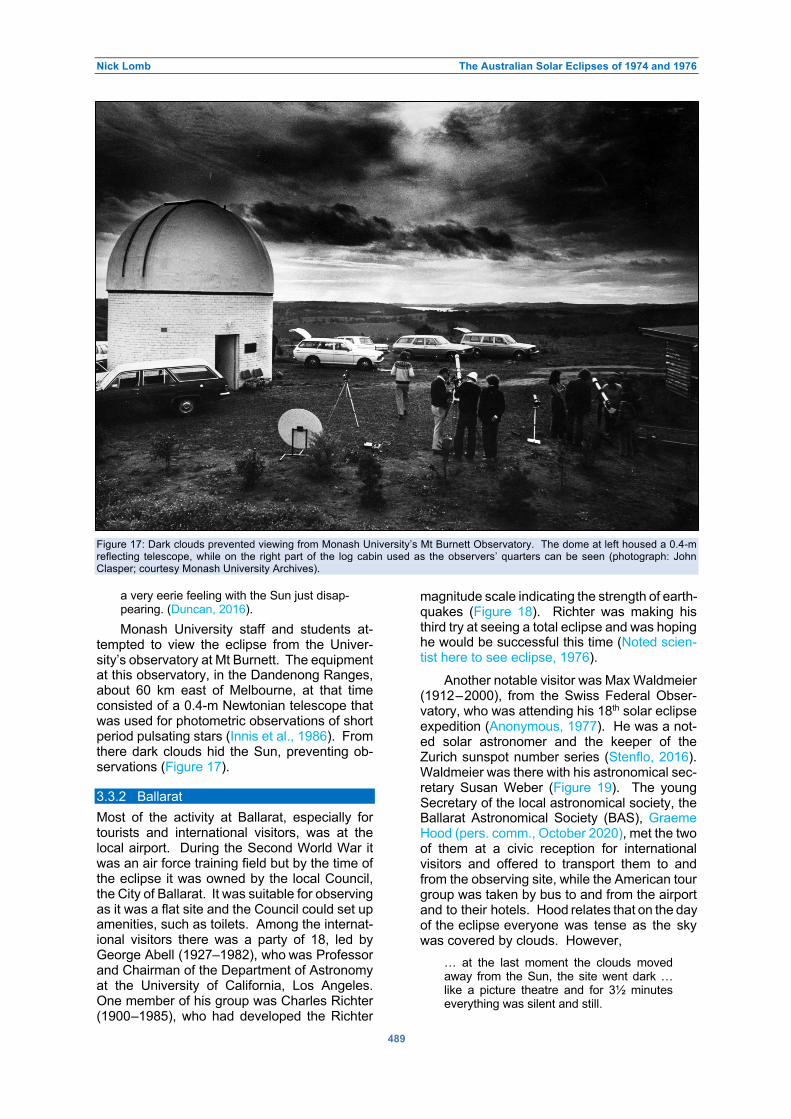
Nick Lomb The Australian Solar Eclipses of 1974 and 1976
489
Figure 17: Dark clouds prevented viewing from Monash University’s Mt Burnett Observatory. The dome at left housed a 0.4-m
reflecting telescope, while on the right part of the log cabin used as the observers’ quarters can be seen (photograph: John
Clasper; courtesy Monash University Archives).
a very eerie feeling with the Sun just disap-pearing. (Duncan, 2016).
Monash University staff and students at-tempted to view the eclipse from the Univer-sity’s observatory at Mt Burnett. The equipment at this observatory, in the Dandenong Ranges, about 60 km east of Melbourne, at that time consisted of a 0.4-m Newtonian telescope that was used for photometric observations of short period pulsating stars (Innis et al., 1986). From there dark clouds hid the Sun, preventing ob-servations (Figure 17). 3.3.2 Ballarat
Most of the activity at Ballarat, especially for tourists and international visitors, was at the local airport. During the Second World War it was an air force training field but by the time of the eclipse it was owned by the local Council, the City of Ballarat. It was suitable for observing as it was a flat site and the Council could set up amenities, such as toilets. Among the internat-ional visitors there was a party of 18, led by George Abell (1927–1982), who was Professor and Chairman of the Department of Astronomy at the University of California, Los Angeles. One member of his group was Charles Richter (1900–1985), who had developed the Richter
magnitude scale indicating the strength of earth-quakes (Figure 18). Richter was making his third try at seeing a total eclipse and was hoping he would be successful this time (Noted scien-tist here to see eclipse, 1976).
Another notable visitor was Max Waldmeier (1912–2000), from the Swiss Federal Obser-vatory, who was attending his 18th solar eclipse expedition (Anonymous, 1977). He was a not-ed solar astronomer and the keeper of the Zurich sunspot number series (Stenflo, 2016). Waldmeier was there with his astronomical sec-retary Susan Weber (Figure 19). The young Secretary of the local astronomical society, the Ballarat Astronomical Society (BAS), Graeme Hood (pers. comm., October 2020), met the two of them at a civic reception for international visitors and offered to transport them to and from the observing site, while the American tour group was taken by bus to and from the airport and to their hotels. Hood relates that on the day of the eclipse everyone was tense as the sky was covered by clouds. However,
… at the last moment the clouds moved away from the Sun, the site went dark … like a picture theatre and for 3½ minutes everything was silent and still.

Nick Lomb The Australian Solar Eclipses of 1974 and 1976
490
Figure 18: George Abell (white shirt) and Charles Richter
(hat) at Ballarat airport preparing for the eclipse of 23
October 1976 (photograph: Graeme Hood).
A group of 13 BAS members elected to
watch the eclipse from the top of a small hill called Mount Hollowback that is only a few kilometres from the centre of Ballarat (Willsher, 1976). They had with them a 15-cm reflecting telescope and a 60-mm refractor or lens tele-
scope that were intended to be used for project-jecting the image of the Sun, but heavy clouds made this difficult. Though the Sun was cov-ered in cloud during the partial phase, the ele-vated site allowed the approach of the Moon’s dark shadow to be tracked from the brightness of nearby lakes. Lake Learmonth to the west, turned an ‘inky black’ just before the shadow reached the watchers on Mt Hollowback. Dur-ing totality, the clouds thinned allowing glimps-es of the corona. Spica and Canopus were vis-ible but no planets due to the clouds. Street-lights in Ballarat came on during the eclipse, as well as the headlights of cars passing below. As the shadow swept past, Lake Learmonth was seen to change colour from black to silver. Some observers managed to glimpse the dia-mond ring, while others saw it as bright spikes of sunlight through the clouds.
In the months preceding the eclipse, some members of BAS put in considerable ef-fort to interest and educate the local community about the forthcoming event.4 A booklet was published, television and radio appearances were made and tours of Ballarat Observatory were used to give talks. On the day of the eclipse the President of the Society, Bruce Allen (pers. comm., October 2020), and other mem-bers gathered at the Observatory to observe the event and to provide public viewing. Two telescopes were provided, a 12.5-cm refractor
Figure 19: Susan Weber, Max Waldmeier and Graeme Hood at Ballarat airport waiting for the eclipse of 23 October 1976
(photograph: Graeme Hood).

Nick Lomb The Australian Solar Eclipses of 1974 and 1976
491
and a 20-cm reflecting telescope, both project-ing the Sun onto white cards. As at the nearby Ballarat Airport, clouds dispersed just before totality and allowed a view of the diamond ring and the eclipsed Sun. An unfortunately located cloud blocked the Sun, about two thirds of the way through totality, but more than one hundred visitors and members were grateful for what they had managed to see. The next day the local newspaper published on its front page a photograph of the partially eclipsed Sun taken from the eclipse projection with the 12.5-cm telescope.
BAS also had a radio section, the members of which set up two VHF antennas facing west at Ballarat Observatory. They also had a single wire antenna to receive short wave time signals at 15 MHz from the radio station WWV that broadcasted from Colorado (Lindorff, 1976). The two VHF antennas and their receivers were tuned so that several frequencies could be mon-itored during the eclipse. Some of these were only noise, while others were carrier frequen-cies, including that of Channel 0 transmitted from Mount Dandenong near Melbourne. Ob-vious changes were noted during the eclipse: the noise at frequencies without a transmitter decreased, while the carrier signals plus the signal from WWV increased. 3.3.3 Bombala
Bombala, lying near the centre line, is a town in the south-east corner of NSW, close to the Vic-torian border. With a population at the time of around 1500 people, it and the surrounding properties were one of the main centres for eclipse observers. The rush to Bombala was triggered by Roger Giller, the Eclipse Coordin-ator and soon-to-be President of the NSW Branch of the British Astronomical Association in Sydney. In a letter published in the February 1976 issue of Sky & Telescope magazine, Giller (1976) pointed out the advantages of Bombala, including, he claimed, the best weather pros-pects for any site, and the support of the local Lions Club. He emphasised that he had access to a sheep and cattle property outside of town that was only five kilometres north of the central line. This property of 4000 acres or 16 square kilometres was ‘Tregedar’, owned by a fell- ow amateur astronomer, Roger Morgan-Bruce. There was a huge response to the letter from astronomers around the world and the whole project became larger than Morgan-Bruce and the Lions Club could handle.
The other service clubs in the town, Rotary, Apex and Rotoract, became involved, as the newspapers reported that Bombala was the best eclipse viewing spot (Macklin, 1976). In
addition to professional eclipse observers and amateur astronomers, thousands of public visi-tors were expected and the town planned a festival of the eclipse. The problem of how people could safely observe the eclipse was solved with the arrival in town of the American astronomy retailer Roger W. Tuthill with his alu-minium-coated mylar Solar Skreen. The com-bined service clubs purchased $1200 worth of his solar filters and thought that they had over-come the problem. However, the local member of the NSW Parliament, John Akister, asked the Minister of Health whether the filters were safe (Akister and Stewart, 1976). In reply the Min-ister, Kevin Stewart, referred to advice from the Department of Optometry at the University of New South Wales that the filters should not be used by ‘untrained persons’ and he advised anyone interested to watch on television (more on filters in Section 4).
In the end the optometrists and ophthalmol-ogists were pleased and everyone else was disappointed as heavy clouds covered the sky, with only about five minutes when the partially eclipsed Sun could be glimpsed (Hefner, 1976). The service clubs were disappointed as there were only about 3500 people at the town’s race-course for the planned day’s activities, instead of the expected over 10,000, so that much of the food and drink purchased to feed the visitors remained unsold. The astronomers, who set up their equipment at ‘Tregedar’ and other sur-rounding properties were obviously disappoint-ed, with one astronomer overheard to make the hyperbolic comment, “I think I’ll commit sui-cide.” 3.3.4 Merimbula
Merimbula is a small city to the east of Bom-bala, about 500 km to the south of Sydney and right on the coast. There, as the Moon’s shad-ow left mainland Australia, the eclipse duration was two minutes and 47 seconds with the Sun 19° above the horizon at mid-eclipse. The Astronomical Society of Australia, the country’s association for professional astronomers, se-lected the town for its first Beach Meeting (Goss, 1977). Held at a local caravan park, the meeting was held from 22 to 24 October 1976, that is, bookending the day of the eclipse. More than 50 members of the Society attended, so that together with families and friends there were about 180 people present. Some people camped, some stayed in the caravans and some at a nearby motel. Catering was provided by the local scout troop at an average cost of $1.50 per adult meal. The scientific sessions were held on each morning of the three days with only a blackboard available as a visual aid.
Nick Lomb The Australian Solar Eclipses of 1974 and 1976
492
There were also evening talks ‘suitable for wives and older children’ and a public talk at the local scout hall.
On the afternoon of eclipse day most part-icipants drove to Roger Morgan-Bruce’s ‘Trege-dar’ property near Bombala, to try the view the eclipse and take part in a communal barbecue. As previously mentioned, from there clouds prevented sighting totality. Most of those who stayed at Merimbula, including the Director of Sydney Observatory, Harley Wood, his wife, daughter and the daughter’s soon-to-be hus-band, did manage to see it (Russell, 2008: 181). Ros Madden, Wood’s daughter, recalled that after they chose a viewing spot, her father “… organised his viewing device and two sheets of paper, one with a hole in the middle.” With this projection technique and despite some cloud, they could view the partial phase of the eclipse. Looking directly during totality, they could see Baily’s beads “… flickering around the Sun.” 4 DISCUSSION: FILTERS AND THE PUBLIC
In a detailed paper published in the August 1976 issue of the Australian Journal of Optom-etry, ASV member Barry Clark considered pos-sible solar filters for use by the public at the forthcoming eclipse (Clark, 1976). He explain-ed that at previous Australian eclipses there were always people who had suffered eclipse blindness or solar retinitis. These people were usually under 20 years old and mostly male. They sustained the eye injury because they did not use a filter, used one that was inadequate or did not follow instructions. The common sug-gestion of using pinhole projection as a safe way of looking at the Sun was often misunder-stood with people looking through the pinhole.
The damage from direct solar viewing is mainly from visible and infrared wavelengths, with ultraviolet wavelengths only making a small contribution. Clark suggested that for safety and comfort a suitable solar filter should only transmit 0.0001 per cent in visual and some-what higher in infrared. Discussing available filters, namely sunglasses, welding filters, smok-ed glass and exposed black and white photo-graphic film, he only suggests the last as a pos-sible safe filter. He mentions a Melbourne pho-tographic company planning to distribute photo-graphic filters mounted in cardboard frames printed with warnings about direct viewing of the Sun. These filters were tested in a research laboratory and found to have visible transmit-tance of 0.0003 per cent and infrared below 0.001 per cent. Clark suggested that further reductions in transmittance were needed for these filters. He did not discuss the aluminised mylar filters being sold by Roger W. Tuthill at
Bombala, probably as they were too new and not widely distributed.
Filters became an important issue before the eclipse. As previously mentioned, Tuthill’s filters were discussed and advised against in the NSW Parliament. There was a similar dis-cussion in the Victorian Parliament. On 22 September 1976, Thomas William Roper, the Shadow Minister for Health, asked the Premier, Rupert Hamer, about the photographic film type solar filters (Victoria Parliamentary Debates (Hansard), 1976–1977: 2700–2704). He said, one copy of the device, made by Academy Film Productions Pty Ltd, has been tested by a re-search laboratory of the Department of Defence and has been found to be safe. However, he thought that does not mean that all other copies are safe and mentioned that he had two copies of the filter and they were already scratched. He requested the Government to control these devices or prevent their distribution. In reply the Premier said the company had wanted their fil-ter to be advertised together with Government eclipse warnings. This was not acceptable and he said further:
The safest thing is not to look at it but to wait until it is shown on television a little later. Whatever device may be tested, it cannot be guaranteed to be safe in every case.
In a further question to the Premier, on 5 October 1976, Roper asked about the compos-ition of the Government’s Solar Eclipse Com-mittee that had evaluated the photographic fil-ter (Victoria Parliamentary Debates (Hansard), 1976–1977: 2891–2892). Hamer in reply gave a full listing of the 14 members of the Commit-tee. It included representatives of the ASV, the Science Museum of Victoria, the Premier’s De-partment, the police, Australia Post, the Sur-veyor-General and the Department of Health.
Though the Australia Post’s representative on the Committee was from its Philatelic Sect-ion, it seems that there was no stamp issued in association with the eclipse. However, there was a special eclipse day postmark available (Figure 20).
There were plenty of warnings in Mel-bourne and other cities, where the eclipse was only partial, for the public to only view the eclipse on television. The Health Commission of NSW, the Australian College of Ophthalmol-ogists and the Australian Optometrical Associ-ation were among those that stated that there was no way to safely view the eclipse except by trained scientists (Scanlan, 1976). In Mel-bourne there were even large posters hanging on street corners headed, “WARNING! SOLAR ECLIPSE TODAY” as well similar flyers insert-ed into newspapers on eclipse day, all author-

Nick Lomb The Australian Solar Eclipses of 1974 and 1976
493
Figure 20: An unposted envelope with a postmark for the eclipse of 23 October 1976 (collection: Nick Lomb).
ised by the Solar Eclipse Committee (Schneid-er, n.d.). These warnings had strong effects. In Melbourne the horse racing at Moonee Valley was timed so that the second last race started well before totality and the last race started well after (Scanlan, 1976). In Sydney, where the eclipse was 93% complete, grade cricket was disrupted with the team captains at one match agreeing to stop early, while at another, one team walked off to protect the players’ eyesight and the opposing team claimed a forfeit (Con-fusion over eclipse, 1976). Also, in Sydney, the author failed in getting his seven-year-old nephew to look at the projection through a 60-mm refractor of the partially eclipsed Sun onto card, as the child was so indoctrinated from school that he insisted on only watching on television.
Television was certainly popular during the 35 minutes of the eclipse broadcasts with the number of sets in use increasing from the usual Saturday figure of 16% to 63% (Rating figures: ABC won eclipse audience, 1976). That meant that television sets were in use in 546,000 homes. Of the three TV stations carrying the event, the transmission by the Australian Broad-casting Commission (ABC) was easily the most watched. The ABC broadcast the eclipse from Ballarat Airport with a specially devised equa-torial-like camera mount that could track the Sun, as well as from Mount Hollowback, outside Ballarat, Mt Dandenong, outside Melbourne and from the roof of their Melbourne studios (Australian Television Archive, 1976). Due to clouds, the presenter Ralphe Neill could only show totality from Ballarat Airport, but he could demonstrate the darkness due to totality from the other sites. A few members of the public did not heed the warnings and tried to watch the Sun directly during the eclipse.
In Melbourne 150 people, who feared eye damage, visited the Victorian Eye and Ear Hospital afterwards (Six have possible injury, 1976). Of these 150, doctors cleared all but five. These included two little girls aged four and six, but none of the cases was serious. There was another eye injury in Adelaide, where a drunken man had stared at the partially eclipsed Sun for 10 minutes. 5 CONCLUDING REMARKS
The 1974 and 1976 eclipses were the first to be visible from Australia since 1922. In the interim there had been great advances in technology and available equipment. Sophisticated filters, telescopes and radio instruments were pointed at the Sun at both eclipses by local scientists and a large cohort from overseas. Unfortun-ately, cloud cover at the main sites, at which the scientists were concentrated during both eclipses, frustrated research efforts. There were some useful results though, in radio observat-ions of the Sun and in fields only tangentially related to astronomy, such as gravity waves in the atmosphere and stream drift.
Amateur astronomers came into their own at these two eclipses with better telescopes, telephoto lenses and aperture filters available than at earlier eclipses. For most, the two eclipses were the first total ones that they ob-served, as the relatively cheap airfares that al-lowed the practice of travelling the world to witness total eclipses elsewhere were not yet available. Despite cloud and inexperience with eclipse observations, some, like David Herald at Quininup Beach, managed to do serious research, while others obtained spectacular photographs of the corona.
The most memorable part of the 1974 total

Nick Lomb The Australian Solar Eclipses of 1974 and 1976
494
eclipse was the successful eclipse flight, which was the first commercial eclipse flight. This was followed by a similar flight for the 1976 eclipse. It set up a trend for astronomy flights in Aus-tralia such as the series of Halley’s Comet view-ing flights in 1986 conducted by Trans Australia Airways (TAA); the author was the lecturer on a number of those.
Providing information to the public about eclipses, especially a total eclipse, is always a fine balance. People are being told that some-thing exciting is happening in the sky above their heads but under no circumstances should they look. In Melbourne, a major city lying in the path of totality, the authorities decided to take no chances. The public was warned not to look at Sun under any circumstances and to watch only through the medium of television. The use of all filters, even those that were safe or close to being safe, was disparaged, as was the use of pinhole projection on the basis that instructions for its use could be misunderstood. Repeated warnings, together with widespread cloud during the eclipse, had the beneficial result that in Melbourne only a few people sustained eye damage and none seriously. However, the hidden cost of all the warnings and the lack of proper information being provid-ed was that the city’s over two million inhabit-ants were deprived of the chance to see, for the first and probably the last time in their lives, the wonderful sight of a totally eclipsed Sun. We will never know how many children would have been stimulated by the sight to choose to study science and go on to make major contributions to society.
On the early afternoon of 22 July 2028, an-other Australian city will experience totality. The city is Sydney with a current population of over 5 million people. There will be almost four minutes of totality and again it will be a Saturday so most of the city’s population will be free to view the eclipse. The chances of being able to view it is high, as in July the mean number of cloudy days recorded at Observatory Hill is only 8.7, which is one of the lowest values for the year (Australian Government Bureau of Meteor-ology, 2021). With eclipse glasses easily avail-able, with public outreach at places like Sydney Observatory and by amateur groups and, if astronomers take a leading role in educating the public, many more people will have the opportunity to be safely awed by the spectacle of the eclipsed Sun than in Melbourne 52 years earlier. Those, who are willing to travel a little, can follow up two years later with the total eclipse of 25 November 2030 that will pass to the north-west of Adelaide, South Australia and end at sunset just to the west of Brisbane, Queensland.
6 NOTES
1. It is often said that the deflection of starlight by the Sun as predicted by Einstein was confirmed by Arthur Stanley Eddington at a 1919 eclipse (Kennefick, 2019). However, as shown by Treschman (2014: 147–152), that earlier verification was too readily ac-cepted despite it being based on limited and arbitrarily selected data.
2. The Astronomical Society of Victoria was then, as it is now, a large and active organ-isation with some of its members doing se-rious research. These included Bruce Tre-gaskis (Section 2.3), who made visual ob-servations of variable stars and Barry Ad-cock, who used his home-built telescope to study the planets (Orchiston, 2000: 21–23). Other members built unusual telescopes of the folding-mirror variety, some of which were the largest, or among the largest, of their type anywhere in the world. As well, there was research into the history of ast-ronomy and a commitment to education and outreach (Orchiston, pers. comm., March 2021).
3. Before commencing his PhD Graeme White was an amateur astronomer, who was the first to sight Comet White-Ortiz-Bolelli (C/ 1970 K1), one of the Kreutz family of sun-grazing comets (Orchiston et al., 2020).
4. Education is not new for the Ballarat Astro-nomical Society as it is linked to the Ballarat Municipal Observatory. The Observatory was opened in 1886 for use by students at the Ballarat School of Mines and a regular astronomy class was taught there (Burk, 1986). The total eclipse revived local inter-est in astronomy and led to the Society greatly increasing its educational activities for the public.
7 ACKNOWLEDGMENTS
The author is grateful to Dr Barry Clark, who provided his recollections of the 1976 eclipse, appropriate articles including his own paper on solar filters for the public, and slides taken by Arthur Coombs on the 1974 eclipse flight, as well as comments on the draft paper. Arthur Coombs shared his memories of the 1974 eclipse flight and provided an extra photograph. Dr Craig Bowers, historian at Perth Observa-tory, scanned and provided the Observatory’s entire file on the 1974 eclipse, as well as scan-ned photographs from the eclipse. Glen Moore kindly provided relevant articles and recollect-tions. Dr Graeme White and Dr Gordon Robert-son provided images and their reminiscences of the 1976 eclipse. Graeme Hood, Horst Engel, Peter Faulkner and Mark Rigby shared their memories of the 1974 eclipse, as did Dr Russell

Nick Lomb The Australian Solar Eclipses of 1974 and 1976
495
Cockman, Ian Sullivan, Dr Robin Hirst and Bruce Allen of the 1976 eclipse. Judith Bailey of Bal-larat Observatory, Karen Rogers of Monash University Archives, Dr Ron Ekers and Dr John Archer were all most helpful. Professor Law-rence Cram provided much useful information and references, while Professor Jay Pasachoff
greatly improved the paper with his comments, information and photographs. The Managing Editor of JAHH, Professor Wayne Orchiston, was also of great assistance. Some of the pho-tographs in this paper were enhanced through MyHeritage.com.
8 REFERENCES
$1000 offered for lost probe capsule. The Age, 25 June, page 13 (1974). Akister, J.E., and Stewart, K.J., 1976. Eclipse of the Sun, Hansard & House Papers, NSW Parliament
(https://api.parliament.nsw.gov.au/api/hansard/search/daily/searchablepdf/HANSARD-290296563-675; acces-sed online January, 2021).
Anonymous, 1977. Totality from Zanzibar to Merrimbula. Sky & Telescope, 53, 4–11. Anonymous, 2017. A brief summary of a long, rich history at Celestron
(https://www.celestron.com/blogs/news/celestrons-rich-history; accessed online January 2021). Australian Government Bureau of Meteorology, 2021. Climate statistics for Australian locations
(http://www.bom.gov.au/climate/averages/tables/cw_066062.shtml; accessed online January 2021). Australian Television Archive, 1976. Total eclipse Victoria Australia – late 70's ABC TV coverage
(https://www.youtube.com/watch?v=j9_w1r8vArw; accessed online January 2021). Ball, S.M., Stubbs, T.J., and Vincent, R.A., 1980. Upper atmosphere wind observations over Southern Australia
during the total solar eclipse of 23 October 1976. Journal of Atmospheric and Terrestrial Physics, 42, 21–25. Beckers, J.M., 1985. Contributions by R.G. Giovanelli to solar instrumentation. Australian Journal of Physics, 38,
769–773. Birch, P.V., 1974a. Letter to R.G. Giovanelli, dated 11 April. Perth Observatory (File 0918). Birch, P.V., 1974b. Letter to R. Panizza, dated 8 July. Perth Observatory (File 0918). Bunbury, W.H.R., 1974. Letter to B.J. Harris, dated 3 July. Perth Observatory (File 0918). Burk, K., 1986. A history of James Oddie, Captain Henry Evans Baker and the Ballarat Municipal Observatory. The
Oddie-Baker Bulletin, 8, 3–15. Cadwallader, P., and Eden, A., 1977. Effects of a total solar eclipse on invertebrate drift in Snobs Creek, Victoria.
Australian Journal of Marine and Freshwater Research, 28, 799–805. Carlos, W., 1996–2007. Eclipse page (http://www.wendycarlos.com/eclipse.html#70s; accessed online December
2020). Clark, B.A.J., 1976. The use of filters for eclipse viewing by the public. Australian Journal of Optometry, 59, 259–
265. Clark, M., n.d. Total solar eclipse October 23, 1976 (http://www.phys.ttu.edu/~ozprof/se231076.htm; accessed
online January, 2021). Confusion over eclipse. The Sydney Morning Herald, 25 October, page 21 (1976). Cram, L.E., 1976. Determination of the temperature of the solar corona from the spectrum of the electron-scattering
continuum. Solar Physics, 48, 3–19. Dorst, F., 1974a. Letter to Perth Observatory, dated 2 April. Perth Observatory (File 0918). Dorst, F., 1974b. Letter to B.J. Harris, no date. Perth Observatory (File 0918). Duncan, J., Total solar eclipse in Victoria in 1976 won’t be seen again for years. Herald Sun, 21 October (2016). Duncombe, J.S., 1973. Total solar eclipse of 20 June 1974. United States Naval Observatory Circular, 144. Eclipse causes fears. Canberra Times, 20 June, page 1 (1974). Eddy, J.A., 1989. Gordon Newkirk's contributions to coronal studies. In McNally, D. (ed.), Highlights of Astronomy,
Volume 8. Amsterdam, Kluwer Academic Publishers. Pp. 503–512. Faulkner, P., 1974. The West Australian total eclipse. Bulletin Astronomical Association of Queensland. Fiala, A.D., and Duncombe, J.S., 1975. Total solar eclipse of 23 October 1976. United States Naval Observatory
Circular 152. Giller, R., 1976. Letter. Sky and Telescope, 51, 75. Giovanelli, R.G., 1974. Letter to B.J. Harris, dated 4 March. Perth Observatory (File 0918). Goodwin, G.L., and Hobson, G.J., 1978. Atmospheric gravity waves generated during a solar eclipse. Nature, 275,
109–111. Goss, W.M., 1977. The inaugural beach meeting of the ASA, 22–24 October 1976. Proceedings of the
Astronomical Society of Australia, 3, 181–182. Grotrian, W., 1931. Ergebnisse der Potsdamer Expedition zur Beobachtung der Sonnenfinsternis am 9. Mai 1929
in Takengon (Nordsumatra). 6. Mitteilung. Über die Intensitätsverteilung des kontinuierlichen Spektrums der inneren Korona. Zeitschrift fur Astrophysik, 3, 199–226.
Guillermier, P., and Koutchmy, S., 1999. Total Eclipse. New York, Springer. Harris, B.J., 1973. Letter to P. Gamage, dated 7 June. Perth Observatory (File 0918). Harris, B.J., 1974a. Letter to R.G. Giovanelli, dated 13 May. Perth Observatory (File 0918). Harris, B.J., 1974b. Letter to F. Dorst, dated 28 May. Perth Observatory (File 0918). Harris, B.J., 1974c. Letter to C.S. McDaniel, no date. Perth Observatory (File 0918). Hefner, R., 1976. Dulled day at Bombala, cloud eclipses solar event. Canberra Times, 25 October, page 1. Herald, D., 1976. Observations of Baily’s Beads from near the northern limit of the total solar eclipse of June 20,

Nick Lomb The Australian Solar Eclipses of 1974 and 1976
496
1974. The Moon, 15, 91–107. Innis, J.L., Thompson, K., and Coates, D.W., 1986. The Monash University Observatory equipment and research.
In Hearnshaw, J.B., and Cottrell, P.L. (eds.), Instrumentation and Research Programmes for Small Telescopes.
Proceedings of the 118th Symposium of the International Astronomical Union, held in Christchurch, New
Zealand, December 2-6, 1985. Dordrecht, Reidel Publishing Company. Pp. 293–294. June solar eclipse: a first word. Sky & Telescope, 48, 71 & 96 (1974). Kennefick, D., 2019. No Shadow of a Doubt: The 1919 Eclipse That Confirmed Einstein's Theory of Relativity.
Princeton, Princeton University Press. Kersten, J., 2017. The New Yorkers Tied for the Total-Solar-Eclipse Record. The New Yorker
(https://www.newyorker.com/magazine/2017/08/28/the-new-yorkers-tied-for-the-total-solar-eclipse-record; accessed online March 2021).
Labrum, N.R., Archer, J.W., and Smith, C.J., 1978. Solar brightness distribution at 3 mm wavelength from observations of the eclipse of 1976 October 23. Solar Physics, 59, 331–343.
Lathrop, L.W., 1975. Summary of solar eclipse operations in Australia, June 1974 (https://inis.iaea.org/collection/NCLCollectionStore/_Public/06/211/6211687.pdf?r=1&r=1; accessed online December, 2020).
Lawrence, R.J.C., (ed.), 1976. Total Solar Eclipse 1976 October 23 Victoria. Melbourne, Astronomical Society of Victoria.
Lemaire, J.-P., 2015–2021. Musée de l’Air et de l’Espace (https://www.museeairespace.fr/; accessed online March 2021).
Léna, P., 2016. Racing the Moon's Shadow with Concode 001. Cham (Switzerland), Springer International Publishing.
Lindorff, L., 1976. Radio report. Oddie-Baker Bulletin, Ballarat Astronomical Society, December. Lomb, N., 2016. Australian solar eclipse expeditions: the voyage to Cape York in 1871. Journal of Astronomical
History and Heritage, 19, 79–95. Lomb, N., 2020. Australian eclipse expeditions: James Short and the eclipses of 1908, 1910 and 1911. Journal of
Astronomical History and Heritage, 23, 26–46. Lynn, K.J.W., 1981. The total solar eclipse of 23 October 1976 observed at VLF. Journal of Atmospheric and
Terrestrial Physics, 43, 1309–1316. Macklin, R., 1976. How eclipse split Bombala. The Bulletin, 98, 17–17. Marshall, D.F., 1974. An eclipse through the eyes of a visitor (and a simple brightness meter). ASV Journal, October
70–73. Mobberley, M., 2007. Some very keen eclipse chasers. In Total Solar Eclipses and How to Observe Them. New
York, Springer. Pp. 175–186. Noted scientist here to see eclipse. The Sydney Morning Herald, 20 October, page 2 (1976). Orchiston, W., 2000. Amateur telescope making in Australia: an historical perspective. Amateur Telescope Making
Journal, 15, 10–26. Orchiston, W., Drummond, J., and Kronk, G., 2020. Observations of the Great September Comet of 1882 (C/1882
R1) from New Zealand. Journal of Astronomical History and Heritage, 23, 628–658. Rating figures: ABC won eclipse audience. The Age, 4 November, page 38 (1976). Reserve Bank of Australia, 2021. Inflation calculator (https://www.rba.gov.au/calculator/annualDecimal.html;
accessed online January, 2021). Rockets to chase eclipse. The Sydney Morning Herald, 10 June, page 2 (1974). Roosen, R.G., 1973a. Letter to B.J. Harris, dated 17 January. Perth Observatory (File 0918). Roosen, R.G., 1973b. Letter to B.J. Harris, dated 22 March. Perth Observatory (File 0918). Roosen, R.G., Verdone, P.H., and Jackson, A., 1973. The June, 1974, total solar eclipse. Sky & Telescope,
November, 295–297. Russell, R., 2008. Two People and a Place: The Family who Lived in Sydney Observatory. Sydney, Roslyn Russell
Museum Services and Rosamond Madden. Scanlan, J., 1976. The eclipse: the blinding darkness of the Moon. The Sydney Morning Herald, 22 October, page 7. Schneider, G., 1974. Observing notebook supplement (http://nicmosis.as.arizona.edu:8000/ECLIPSE_WEB/ECLIPSE_74/ECLIPSE_74_REPORT.html; accessed
December 2020). Schneider, G., 2019. Self-confessed umbraphile (http://nicmosis.as.arizona.edu:8000/UMBRAPHILLIA.html;
accessed online December 2020). Schneider, G., n.d. 23 October 1976: a dark day for Melbourne, Australia
(http://nicmosis.as.arizona.edu:8000/ECLIPSE_WEB/ECLIPSE_76/ECLIPSE_76_SCARE.html; accessed Jan-uary, 2021).
Sinnot, R.W., 1976. October's total eclipse. Sky & Telescope, 52, 403–438. Six have possible injury. Canberra Times, 25 October, page 1 (1976). Skilton, P., 2009. Bruce Tregaskis (1927–2008), Scorpius
(https://www.mpas.asn.au/scorpius/2009/SCORPIUS%201%20JAN_FEB%202009.pdf; accessed December 2020).
Stenflo, J.O., 2016. Transition of the sunspot number from Zurich to Brussels in 1980: a personal perspective. Solar Physics, 291, 2487–2492
Suter, P.J., and Williams, W.D., 1977. Effect of a total solar eclipse on stream drift. Australian Journal of Marine
and Freshwater Research, 28, 793–798.

Nick Lomb The Australian Solar Eclipses of 1974 and 1976
497
The Australian eclipse of the Sun, 1974. Sky & Telescope, 48, 140–142. The University of Wollongong, 1976. Annual report
(https://ro.uow.edu.au/cgi/viewcontent.cgi?referer=https://www.google.com/&httpsredir=1&article=1001&context=annrep; accessed online January 2021).
Trainor, J.B., 1974. A race against the Moon: the story of the first commercial eclipse viewing flight. ASV Journal, August, 50–57.
Tregaskis, T.B., 1974. A ground party to the eclipse. ASV Journal, June, 58–59. Treschman, K.J., 2014. Early astronomical tests of General Relativity: the gravitational deflection of light. Asian
Journal of Physics, 23, 145–170. Victoria Parliamentary Debates (Hansard), 1976–1977. Forty-seventh Parliament, session commencing 1976, 328. Warning on eclipse. Canberra Times, 20 June, page 10 (1974). Watts, C.B., 1963. The marginal zone of the Moon. Astronomical Papers Prepared for the Use of the American
Ephemeris and Nautical Almanac, 17, 1–951. Weather. The Age, 21 June, page 21 (1974). White, A.G.T., 1977. An in-flight observation of the antipodean eclipse,1976 October 23. Journal of the British
Astronomical Association, 88, 23–27. Willsher, M., 1976. My solar eclipse 23:10:76. Oddie-Baker Bulletin, Ballarat Astronomical Society, December. Zhang, S.R., Erickson, P.J., Goncharenko, L.P., Coster, A.J., Rideout, W., and Vierinen, J., 2017. Ionospheric bow
waves and perturbations induced by the 21 August 2017 solar eclipse. Geophysical Research Letters, 44, 12,067–12,073.
Dr Nick Lomb obtained a PhD from Sydney University for work on short-period variable stars. Soon after he joined Sydney Observatory, it came under the auspices of the Museum of Applied Arts and Sciences and he became Curator of Astronomy.
Nick is the author of several books on astronomy including the annual Australasian Sky
Guide that is in its 31st edition and Transit of Venus: 1631 to the Present.
He is now an Adjunct Professor at the University of Southern Queensland. With regard to solar eclipses, he has been to three and has been fortunate with the weather at all of them: South Australia 2002, Siberia 2008 and Palm Cove (Queensland) 2012.

Journal of Astronomical History and Heritage, 24(2), 498–520 (2021).
498
SHOWCASING SEVENTEENTH-CENTURY JESUIT ASTRONOMY IN ASIA: THE LEAD UP TO THE FIRST SCIENTIFIC
OBSERVATIONS OF A SOLAR ECLIPSE MADE IN SIAM
Wayne Orchiston National Astronomical Research Institute of Thailand, 260 Moo 4,
T. Donkaew, A. Maerim, Chiang Mai 50180, Thailand, and Centre for Astrophysics, University of Southern Queensland, Toowoomba,
Queensland 4350, Australia. E-mail: [email protected]
Darunee Lingling Orchiston
Independent researcher, 523 Moo 1, Soi Ban Cholae, Mae Taeng, Chiang Mai 50150, Thailand.
E-mail: [email protected]
Lars Gislén Lund University, Dala 7163, 24297 Hörby, Sweden.
E-mail: [email protected]
Martin George National Astronomical Research Institute of Thailand, 260 Moo 4,
T. Donkaew, A. Maerim, Chiang Mai 50180, Thailand, and Centre for Astrophysics, University of Southern Queensland, Toowoomba,
Queensland 4350, Australia. E-mail: [email protected]
Boonrucksar Soonthornthum National Astronomical Research Institute of Thailand, 260 Moo 4,
T. Donkaew, A. Maerim, Chiang Mai 50180, Thailand . E-mail: [email protected]
Françoise Launay Independent researcher, Paris (France). E-mail: [email protected]
Suzanne Débarbat, and Matthieu Husson, SYRTE, Observatoire de Paris, 61 avenue de l’Observatoire,
F-75014 Paris, France. E-mails: [email protected]; [email protected]
Abstract: The first great ruler to encourage the adoption of Western culture and technology throughout Siam was King Narai, who also had a passion for astronomy. He showed this by encouraging French and other Jesuit missionaries, some with astronomical interests and training, to settle in Siam from the early 1660s. One of these was Father Antoine Thomas, and he was the first European known to have carried out scientific astronomical observations from Siam, in 1681 and 1682. Later, the lunar eclipse of 11 December 1685 assumed an important place in the history of Thai astronomy when a contingent of French missionary-astronomers joined King Narai and his court astrologers and observed it from the King’s country retreat near Lop Buri. This event so impressed the King that he approved the erection of a large modern well-equipped astronomical observatory at Lop Buri. Construction of Wat San Paulo Observatory—as it was known—began in 1686 and was completed in 1687. A second contingent of French Jesuit astronomers settled in Lop Buri at about this time, and were involved in various astronomical observations. Arguably, the last of these of any importance was of the partial solar eclipse of 30 April 1688, just one week before the sudden demise of scientific astronomy in Siam.
In this paper we examine King Narai’s enlightened attitude towards Western science and technology and his growing interest in Western astronomy, before discussing the observations that he and/or the Jesuit missionary-astronomers made leading up to and including the partial solar eclipse of 30 April 1688. We then explore the growing disquiet among some members of the Royal Family that triggered a coup on 5 June 1688 when King Narai was overthrown and most of the Western missionary-astronomers were expelled from Siam.
Keywords: Siam, King Narai, French Jesuit astronomers, astronomical observations, 1688 solar eclipse

Wayne and Darunee Lingling Orchiston, Lars Gislén et al. Seventeenth century Jesuit astronomy in Siam
499
1 INTRODUCTION
The emergence of Western (scientific) astron-omy in Siam (present-day Thailand) was intri-cately associated with the arrival of Jesuit ast-ronomers. The Jesuits are an order of the Roman Catholic religion with a long tradition in science, and especially mathematics and ast-ronomy (Udias, 2003; 2015). While the astro-nomical activities of European Jesuits in Bei-jing during the seventeenth century are well known (e.g. see Gislén, 2017; Needham, 1959; Pigatto, 2004; Udias, 1994), few astronomers are aware that French Jesuits triggered the emergence of scientific astronomy in Siam and India (see Kochhar, 1991; Rao et al., 1984) during this same century. This paper is the latest in a series aimed at documenting sev-enteenth century Jesuit activities in Siam. Other papers in the series attempt to provide an overview (Orchiston, 2021b), or discuss solar and lunar eclipses visible from Lop Buri and Ayutthaya between 1681 and 1688 (Orch-iston et al., 2019; c.f. Smithies, 2003), but es-pecially the lunar eclipses of 22 February 1681 (Orchiston et al., 2021a) and 11 December 1685 (Gislén et al., 2018; Orchiston et al., 2016; c.f. Gislén, 2004). After providing suit-able background material, this paper focusses on the solar eclipse of 30 April 1688, which was visible as a partial event from Siam.1
But before examining this particular eclipse we need to meet King Narai, who made pos-sible the introduction of scientific astronomy in Siam at this time. 1.1 King Narai: A Biographical Sketch
‘King Narai the Great’ (Figure 1) was one of the most revered of Thailand’s historic rulers. He was born in 1633 and died prematurely on 11 July 1688. He was the fourth king to rule during the Prasat Thong Dynasty, which was the fourth of the five Dynasties of the Ayut-thaya Kingdom (see Table 1).
In 1686, two years before his death, King Narai was described by a visiting Westerner as
… about 55 years old, handsome, lovely, dark, has good behaviour, and is brave. He is also intelligent, a good ruler … [and is] kindhearted … (Chaumont, 1686).
The previous year another Western visitor des-cribed him as “… a very thin man, of low stat-ure, and no beard …” (see Smithies, 1996: 53) —which hardly tallies with the likeness shown in Figure 1! We suspect that
the preparation of this portrait involved a degree of artistic licence, triggered in no small part by the fact that not long be- fore these Western accounts of 1685‒1686
Figure 1: A contemporary French sketch purporting to show the appearance of King Narai in 1686 (https://en.wikipedia.org/wiki/Narai#/media/File:French_depiction_of_King_Narai.jpg).
King Narai had entertained a Persian del-egation, and he liked their attire so much that he decided to adopt it for his own court appearances … (Orchiston et al., 2021a: 226).
When he became the King of Ayutthaya in 1656, Narai was just 23 years of age, and he remained on the throne until his death. Upon his succession he had inherited a large
... and powerful kingdom in the centre of mainland South-East Asia. His realm reached south to the kingdoms of Pattani, Ligor, Phattalung and Songkhla; in the east Cambodia had acknowledged Ayutthaya’s suzerainty, and in the west the port of Tenasserim on the Bay of Bengal was under Thai control. (Hodges, 1999: 36).
For these and other Thai localities mentioned in this paper see Figure 2. Table 1: Thai kingdoms and dynasties. King Narai ruled during the Prasat Tong Dynasty.
Kingdom Duration (years AD)
Dynasty
Sukhothai 1238–1438 Ayutthaya 1350–1767 Uthong
Suphannaphum Sukhothai
Prasat Thong Ban Phlu Luang
Thonburi 1767–1782 Rattanakosin/
Bangkok 1782–

Wayne and Darunee Lingling Orchiston, Lars Gislén et al. Seventeenth century Jesuit astronomy in Siam
500
Figure 2: A map showing Thailand localities mentioned in the text (map: Wayne Orchiston).
Figure 3: A contemporary sketch of Constantine Phaulkon (https://en.wikipedia.org/wiki/Constantine_Phaulkon).
King Narai was very active in international affairs, and he saw exposure to Eastern and Western civilizations as a way of developing Siam. Accordingly, he signed treaties with England, France, Holland and Persia and also expanded trade between Siam and India, Indonesia, China and Japan. These initiatives led to a proliferation of international trade, and cemented “... Ayuthaya’s reputation as an ‘em-porium of the East’ ...” at this time, which rest-ed largely “... upon her role as a focus for the trans-shipment of goods between Europe/India and China/Japan ...” (Sternstein, 1965: 108).
Long before he became King, Narai had displayed a passion for astronomy, and we can trace this back to his education. In keep-ing with his Royal pedigree, as a prince Narai had received a sound Buddhist temple edu-cation from the monks, but he also was taught non-religious subjects such as astrology, ast-ronomy, mathematics and medicine by lay teachers. As we observed, the young prince showed a special interest in astronomy and astrology, and it is noteworthy that his lay teacher in these subjects later was appointed Siam’s Chief Royal Astrologer. Hodges (1999: 36) also reminds us that
Narai’s contact with foreigners also con-tributed to his education. His reign coin-cided with European advances in the sciences associated with navigation, ast-ronomy and horology. He lived in an age when humans were first beginning to grasp the nature and extent of the cosmos ...
Once he was King, Narai was in an ideal position to indulge his astronomical interests, and he learnt about telescopes and other scientific instruments, the newly constructed Paris Observatory and Jesuit astronomical act-ivities in Peking from Jesuits and others who were on their way to Peking or returning home to Europe and stopped off in Siam along the way.
Moreover, King Narai sometimes was able to influence the types of gifts he received from visiting dignitaries, which went far beyond the typical “... cloth, spices and jewellery of his predecessors ...” and—at his specific request —included telescopes, clocks, military equip-ment, etc. (ibid.).
King Narai’s passion for astronomy—and especially Western Astronomy—also blossom-ed through a very unlikely catalyst, who went by the name of ‘Phaulkon’.
In 1675 a Greek adventurer named Con-stantine Phaulkon (1647–1688; Figure 3; Sioris, 1988; 1992) came to Siam. He quickly learnt Thai, and since he was already fluent in English, French, Portuguese and Malay he joined King

Wayne and Darunee Lingling Orchiston, Lars Gislén et al. Seventeenth century Jesuit astronomy in Siam
501
Narai’s court as a translator. Thanks to his prior experience in England’s East India Com-pany Phaulkon quickly emerged as one of the King’s favourites and gained increasing power until he became the King’s principal advisor.
Through Phaulkon’s influence, Siam forg-ed close diplomatic relations with the court of Louis XIV (1638–1715) of France as part of a carefully planned strategy to use the French as a counter to the growing economic dominance of the Dutch and English in Siam (Cruysse, 2002; Hutchinson, 1933). King Narai also had heard of King Louis XIV’s military success over the Dutch during the war of 1672–1679 (Love, 1994a). Meanwhile, for their part, the French
... had been seeking ways to establish France as a great commercial, political and military power in the Far East, in direct chal-lenge to Dutch hegemony. (Love, 1994b: 156).
Consequently, they were eager to establish a major trading centre in Siam, and also to convert the local population to Catholicism, so increasing numbers of French missionaries and lay persons made their way to Siam, and particularly Ayutthaya, Lop Buri and Bangkok. 2 FATHER ANTOINE THOMAS
Among the newcomers to Siam was a 37year-old Belgian Jesuit missionary-astronomer nam-ed Antoine Thomas (1644–1709; Lefebvre, 1930) who arrived in Ayutthaya on 1 Septem-ber 1681, intent on carrying out missionary work in Japan. However, Japan closed its doors to Western missionaries, so Thomas had to remain in Siam while alternative plans were arranged for him to move to China. In the interim, he carried out astronomical observations between October 1681 and Feb-ruary 1682 (Henniquin, 2004), which provided the latitude and longitude of Ayutthaya. To our knowledge, Father Antoine Thomas was the first Westerner to carry out serious astronomi-cal observations from Siam (Orchiston et al., 2021a). 3 ARRIVAL OF THE FRENCH JESUIT MISSIONARY-ASTRONOMERS
In July 1682 Antoine Thomas arrived in China and for a short while Siam was without Western astronomers. Then in January 1684 two Thai ambassadors were sent to France and had an audience with King Louis XIV. They presented the King with a letter from King Narai inviting him to send astronomers to Siam. The following year the French obliged, and on 3 March 1685 a mission led by che-valier de Chaumont (1640–1710) sailed from Brest on the l’Oiseau and la Maligne bound for
Siam. Accompanying Chaumont was a contin-gent of six Jesuit missionary-astronomers
… sent out by Louis XIV., under a royal patent, to carry out scientific work in the Indies and in China, in order, as the patent puts it, “to establish Security in Navigation and to improve Sciences and Arts.” (Giblin, 1909: 1).
Among their gifts for King Narai were a celest-ial globe, a terrestrial globe, telescopes and other scientific instruments (Tachard, 1686).
When these Jesuit astronomers arrived in Siam in 1685 they soon unwittingly became involved in a power struggle with non-Jesuit Catholic missionaries from the Société des Missions Étrangeres de Paris (Cruysse, 2002; Hutchinson, 1933). At that time, missionaries from the Société were already well established in Siam, and their goal was simply to capture the minds, hearts and souls of the Siamese by gathering as many Catholic converts as pos-sible. Whilst this was an aim of the Jesuits, they also had scientific objectives in mind. To access King Narai both parties had to use Phaulkon as an intermediary, and most of those from the Société despised him. For their part, the Jesuits found him helpful and sup-portive, partly because he was a recent Jesuit convert himself (thanks, in large part, to Father Antoine Thomas)2 and partly because of the King Narai’s personal passion for astronomy. Phaulkon was very aware of the King’s cel-estial interests and he endeavoured to find ways to exploit this situation to the mutual ben-efit of His Majesty and his Jesuit friends.
Meanwhile, although five of the Jesuit ast-ronomers were determined to move to China when the opportunity occurred, one of their number, Father Guy Tachard (1651–1712), de-cided to remain in Siam, and he quickly be-came immersed in local astro-politics. Thus, Tachard
... set himself to cultivate an intimacy with Phaulkon acting as his secretary and con-fidant ... [and soon] was working on behalf of the Jesuits to supplant Bishop Laneau [from the Société des Missions Étrangères de Paris] as intermediary between the French and Siamese Courts. (Hutchinson, 1933: 25).
This tactic worked admirably, and Father Tach-ard soon became King Narai‘s personal astro-nomical consultant and eventually his scientific ambassador, first to Paris and later to the Vatican (Smithies and Bressen, 2001).
From our viewpoint as astronomers we may view Tachard as an astro-politician par excellence, and Vongsuravatan (1992; 1994) would wholeheartedly agree, but others have

Wayne and Darunee Lingling Orchiston, Lars Gislén et al. Seventeenth century Jesuit astronomy in Siam
502
Figure 4: A drawing supposedly showing King Narai and the Jesuit astronomers observing the 11 December 1685 total lunar eclipse from the King‘s country retreat near Lop Buri. Elsewhere (Orchiston et al., 2016) we have shown that this drawing is riddled with artistic licence, which is not surprising, perhaps, given that the artist never even visited Siam (en.wikipedia.com)! painted a far less flattering picture of him (e.g. see Cruysse, 1992; Smithies, 1994). In this paper we aim to separate politics from astron-omy, but in a seventeenth century Siamese milieu this is not always easy to do. 4 THE DECEMBER 1685 LUNAR ECLIPSE
While they were waiting for the chance to go to China, the French astronomers hoped to carry out celestial observations, but from the very start they were frustrated:
... because all the time we were at Ayutia the City and the Camping places were so inundated that we had no place to set them up. The very house where we were lodged, being of wood, the least movement shook it so much that our·Clocks and our Quadrants were disturbed. (Tachard, 1686).3
This situation only changed when they moved to Lop Buri and King Narai invited them to join him at his ‘country retreat’—a comfortable palace at the water reservoir near Lop Buri— on the evening of 10–11 December 1685 and
observe a lunar eclipse.
This not only allowed the Jesuits an op-portunity to once more test and calibrate their instruments and carry out useful astronomical observations (that in this instance would yield the latitude and longitude of Lop Buri), but it also was a chance to demonstrate the poten-tial of Western astronomy and astronomical instrumentation—to showcase scientific astron-omy in front of King Narai and his Court Ast-rologers and, hopefully, to impress Phaulkon.
Fortunately clear skies prevailed, and the King and the Jesuit astronomers successfully observed the eclipse (see Figure 4).4 From all accounts King Narai found this a very intel-lectually stimulating experience, and it was the launching pad for a plan to further develop Western astronomy in Siam.
On 15 December 1685—just four days after the Jesuit astronomers had observed the eclipse—chevalier de Chaumont set sail for France, having accomplished all of his desig-nated objectives bar one, which was to convert

Wayne and Darunee Lingling Orchiston, Lars Gislén et al. Seventeenth century Jesuit astronomy in Siam
503
Figure 5: A contemporary painting of Wat San Paulo, with its distinctive 4-storey observatory (https://upload.wikimedia.org/ wikipedia/commons/5/57/Wat_San_Paolo_Plan.jpg). King Narai to Catholicism. Accompanying him was a Siamese delegation led by Kosa Pan, and Father Tachard, who carried a letter from King Narai to King Louis XIV inviting him to send a second contingent of astronomers to Siam. Tachard (1689) explains how this came about:
... Phaulcon conversed with the King about obtaining 12 Jesuit Mathematicians, with the idea of building an observatory similar to those at Paris and at Peking. He ex-plained to His Majesty the glory and utility which would accrue to him and the advan-tage which his subjects would draw from these from which they would learn the most beautiful Arts and finest Sciences of Europe. The King consented to this pro-ject, and it was decided that Tachard should return to France for the Jesuits.
In addition to King Narai’s letter, Father Tachard carried a letter from Phaulkon to Father François de La Chaise (1624–1709), King Louis’ personal confessor in Paris:
The King my master having already order-ed the Father Superior to select a site at Louvo, (Lopburi),5 and another at Ayutia, to build Churches, Observatories and Houses, which may seem to him proper, I under-take at the same time to give orders that all these will be ready to receive the Fathers on their arrival. If the six Mathe-maticians (the Fathers and my Brothers), have been able to accomplish so much in two months what will not fifty or more do in the space of twenty years. (Tachard, 1689;
our italics).
This was an ambitious plan to make Siam a bastion of Western astronomy in Asia, with well-equipped observatories.
King Louis also was impressed with the achievements of the first French contingent of astronomers (Tachard, 1689), and he readily agreed to send a second contingent (of 14, not 12, astronomers), who would be based in Siam (not China) and would have access to the observatories that Phaulkon indicated were under construction in Ayutthaya and Lop Buri. 5 WAT SAN PAULO OBSERVATORY AND THE SECOND CONTINGENT OF JESUIT ASTRONOMERS
The first of these observatories was located at Lop Buri, and construction began in 1686. The result was Wat San Paulo, an impressive two-storey rectangular structure with a large inter-nal courtyard, and a four-storey tower Obser-vatory at one end (see Figure 5). The scale of the overall building is somewhat deceptive in that it catered for far more than astronomy: in addition to the Observatory it provided accom-modation for Lop Buri Jesuits and included a church and a seminary. The Observatory sect-ion of the building was completed in 1687.
When we compare the Wat San Paulo octagonal Observatory with the design of Paris Observatory, it would seem that the former was modelled on the two flat-roofed octagonal

Wayne and Darunee Lingling Orchiston, Lars Gislén et al. Seventeenth century Jesuit astronomy in Siam
504
Figure 6: A photograph of the Paris Observatory original building showing the octagonal towers at either end of the building (the dome on the right-hand tower came later). We believe that the Wat San Paulo Observatory was inspired by the Paris Observatory towers (https://www.timeout.fr/paris/feature/selection/top-10-paris-monuments).
Table 2: Astronomical observations carried out at Ayutthya and Lop Buri between 1686 and 1688 inclusive (after Bhumadhon, 2000).
Year Date Observation(s) 1686 Comets
Jovian satellite phenomena 30 November Lunar eclipse
1687 January-February Conjunctions of Mars 11 March Occultation of Io by Jupiter 20 March Lunar occultation of Jupiter 27 March Occultation of Io by Jupiter
26-28 April Jovian satellites The double star z Ursae Majoris
1688 16 April Lunar eclipse 30 April Partial solar eclipse
‘wings’ that graced each end the Paris Ob-servatory building (cf. Figures 5 and 6). Paris Observatory also was championed by King Louis XIV. Construction began in 1667, and it was finished in 1671 (Bobis and Lequeux, 2012), just 15 years before Wat San Paulo was erected.
As we have seen, when King Narai invited King Louis XIV to send a second contingent of Jesuit astronomers to Siam he promised that a new observatory also would be constructed for them in Ayutthaya, so that this city and Lop Buri could share equally in the flowering of scientific astronomy in his nation. However, according to Udias (2003: 54) construction of the new observatory at Ayutthaya only began in May 1688, but before much progress could be made King Narai and Constantine Phaul-kon were dead and all construction ceased.
Notwithstanding claims to the contrary (Hodges, 1999: 36), Siam never received its second seventeenth century astronomical observatory (Giblin, 1909). 6 ASTRONOMICAL OBSERVATIONS FROM AYUTTHAYA AND LOP BURI DURING 1686–1688
When further archival work has been carried out on Paris records it is hoped that details of the astronomical observations carried out at Ayutthaya and at Lop Buri (including from Wat San Paulo), and the specific telescopes used for each of these, will be presented in a later paper in this series. All that we can do at this stage is list in Table 2 the observations of eclipses, planets, comets and stars that are known to have been conducted between 1686 and April 1688 and summarise some of them.
Wayne and Darunee Lingling Orchiston, Lars Gislén et al. Seventeenth century Jesuit astronomy in Siam
505
6.1 The Lunar Eclipse of 30 November 1686
As we have seen, King Narai had a special interest in eclipses, and the total lunar eclipse of 30 November 1686 was no exception. The King advised Father Fontenay that he planned to observe it from Lop Buri, but in the end could not do so as he was too busy. However, most of the Jesuit astronomers carried out successful observations. Elsewhere (Orchiston et al., 2019: 185), we provide the following details:
… this eclipse began in the morning not long before the beginning of astronomical twilight (the Sun was still 25° below the horizon), and the Moon was in the western sky. By mid-eclipse, when 51% of the Moon’s diameter was in the Earth’s shad-ow, civil twilight was about to begin; around this time, the sky would have been blue all over and normal daylight activities could have commenced, even though some of the brightest stars would still have been visible. As the twilight continued to increase in brightness, the Moon continued to move even lower in the western sky, setting at sunrise, which occurred at 06h 27m local time (before the eclipse had ended). In the period just before sunrise, the Moon would have been far less prominent due to its low altitude and the quite bright twilight.
Fathers Le Comte, Gerbillon and Visdelou, accompanied by Monsieur de La Mare, the Royal Engineer of Siam and Monsieur Veret, the Director of the French East India Company in Ayutthaya, observed the eclipse from the backyard and a terrace of a house in Ayut-thaya. Meanwhile, in Lop Buri, Fathers Fonte-nay and Bouvet observed from the house of Louis Laneau (1637–1696), the Bishop of Met-ellopolis and Head of the French Foreign Mis-sions in Siam), along with other local priests and Father Jean Baptiste Malbonard who was the leader of the monks in Ayutthaya (Bhum-adhon, 2000: 47–49). We note that the fact that the Lop Buri observations were carried out from a house rather than from Wat San Paulo would indicate that the Observatory was still under construction at this time.
A significant result that derived from these eclipse observations was the discovery that Lop Buri was just 12 km east of Ayutthaya (ibid.). 6.2 The Lunar Eclipse of 16 April 1688
King Narai was free when the 16 April 1688 lunar eclipse occurred and he observed it from his Palace in Lop Buri together with “… his Brahmin astrologer, and he even sent to the [Jesuit] Fathers a mandarin to ask them some
questions.” (Le Blanc, 1692). Meanwhile, the Jesuit astronomers carried out their observat-ions independently from Wat San Paulo (see the English translation of an unpublished man-uscript by a French Jesuit in Smithies, 2003).
This eclipse was visible on the evening of 15‒16 April in the few hours following midnight in a completely dark sky, and ended long before the beginning of astronomical twilight. The event began with the Moon very high in the southern sky. By mid-eclipse, when 59% of the Moon’s diameter was in the Earth’s shadow, the Moon was still almost as high but in the south west, and at the end of the event it was somewhat farther west, but still almost half way between the horizon and the zenith.
In 1692 Marcel Le Blanc (1692), one of those in the second contingent of Jesuit ast-ronomers, published an account of his stay in Lop Buri and this also mentions the April 1688 eclipse. This is the first time that astronomical observations are specifically mentioned in any published sources as being made from Wat San Paulo Observatory, but Le Blanc’s ref-erence to “… the laughter and voices of the French workmen who lived in a courtyard of the house.” (Smithies, 2003: 195) indicates that at least a part of the massive Wat San Paulo building was still under construction at this time. This appears to add credence to Smithies’ (2003: 200) claim that because of the ‘1688 Revolution’ (see Section 8.1, below) the construction of the Wat San Paulo complex was never completed. 6.3 The DoubleStar z Ursae Majoris
The observations of z Ursae Majoris deserve special mention as this was the first double star to be discovered, by Galileo Galilei (1564–1642), on 7 January 1617. The first far south-ern double star discovered was a Crucis, which Father Fontenay recorded from the Cape of Good Hope in 1685 whilst en route to Siam with the first contingent of French astronomers.
Rao et al. (1984) mistakenly identify a Cen-tauri as the second double star to be discov-ered, but its detection occurred later, in Pondi-cherry (India) in December 1689 when Father Richaud (late of Siam) noticed it in with his 12-ft telescope while observing Comet C/1689 XI. 6.4 The Zodiacal Light
Although not listed in Table 2, when one of the second contingent Jesuit astronomers, Father Richaud later penned a report from India, he indicated that the Zodiacal Light also was observed from Lop Buri during his time there:
As early as 1683 one had observed at Paris

Wayne and Darunee Lingling Orchiston, Lars Gislén et al. Seventeenth century Jesuit astronomy in Siam
506
(late
Figure 7: Eyepiece projection is used to observe the partial solar eclipse of 30 April 1688 with a telescope with a simple altazimuth mounting. Those present were: King Narai, a group of twelve Westerners (one of whom is briefing King Narai) and thirteen Thais from King Narai’s court (after Jacq-Hergoualc’h, 1986: item 99).
an extraordinary brilliance which appear-ed just before the sunrise and just after the sunset along the length of the ecliptic path near the sun. The same light was ob-served in Siam in the year 1686 and 1687. We even observed it many times in Pondi-cherry in 1680. It was very large and stretched itself practically through the length of the equator. After the setting of the sun it rose to more than 40 degrees. (Rao et al., 1984: 83; our italics).
7 THE SOLAR ECLIPSE OF 30 APRIL 1688
This is the only solar eclipse observed by King Narai and the Jesuit missionary-astronomers, and is described by Major de Beauchamp in a 1688 manuscript that has been published by Smithies (2003: 197). By April 1688 King Narai’s health was failing, but
Mr Constance [Phaulkon] took advantage of this occasion to speak to him about an eclipse of the sun which was to occur in a few days; he asked if his health was strong enough to allow him to witness it, and [if so] the Jesuit Fathers would give him this pleasure. He replied he was, and he should bring them when the eclipse was to occur. Mr Constance brought the Jesuit Fathers to the palace; they set up their telescopes before the king who spent at
most less than half an hour with them because the weather was not as good as one would have hoped. (our italics).
This 30 April 1688 solar eclipse is depicted in Figure 7. The original legend of this “... often reproduced naïve watercolour by an unknown artist ...” (Smithies, 2003: 198) confirms Beau-champ’s claim that the observations were made from King Narai’s palace in Lop Buri and not from Wat San Paulo Observatory (or the King’s water reservoir ‘country retreat’), even though only one telescope, and not the “telescopes” mentioned in the above quotation, is shown.
Figure 8 shows the path of totality of this eclipse, which began in western India, cross-ed China, Siberia and northern Alaska before ending in northern Canada. The maximum duration of totality was 3m 40s. Details of the eclipse, as viewed from King Narai’s Palace in Lop Buri, are shown in Table 3. The eclipse began early in the morning when the Sun was low in the eastern sky at an altitude of just 10° and an azimuth of 77°. By mid-eclipse, the Sun was 23° above the horizon and at an azi-muth of 80°, and 73.5% of the Sun’s disk was covered by the Moon. Despite this, the de-crease in light would have been barely per-ceptible to the average person, as the human
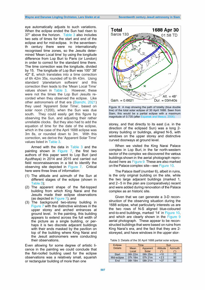
Wayne and Darunee Lingling Orchiston, Lars Gislén et al. Seventeenth century Jesuit astronomy in Siam
507
eye automatically adjusts to such variations. When the eclipse ended the Sun had risen to 37° above the horizon. Table 3 also includes two sets of times for the start and end of the eclipse and for mid-eclipse. In the seventeen-th century there were no internationally recognised time zones, so the Jesuits deter-mined ‘Mean Local time’ by using the longitude difference from Lop Buri to Paris (or London) in order to correct for the standard time there. The time correction was the longitude, divided by 15. The longitude of Lop Buri was 100° 38′ 42′′ E, which translates into a time correction of 6h 42m 35s, rounded off to 6h 43m. Using standard ‘planetarium software’ and this correction then leads to the ‘Mean Local Time’ values shown in Table 3. However, these were not the times the Lop Buri Jesuits re-corded when they observed the eclipse. Like other astronomers of that era (Bianchi, 2021) they used ‘Apparent Solar Time’, based on solar noon (1200), when the Sun was due south. They could easily get this figure by observing the Sun, and adjusting their rather unreliable clocks. But they also had to add the equation of time for the date of the eclipse, which in the case of the April 1688 eclipse was 3m 8s, or rounded down to 3m. With this correction, we derive the ‘Apparent Solar Time’ values listed in Table 3.
Armed with the data in Table 3 and the painting shown in Figure 7, the first two authors of this paper went to Lop Buri (and Ayutthaya) in 2014 and 2015 and carried out field reconnaissances in a bid to identify the observing site depicted in Figure 7. Critical here were three lines of information:
(1) The altitude and azimuth of the Sun at different stages of the eclipse (shown in Table 3);
(2) The apparent shape of the flat-topped building from which King Narai and the Jesuits made their eclipse observations (as depicted in Figure 7); and
(3) The background two-storey building in Figure 7 with the distinctive windows in the upper storey and arched entrances at ground level. In the painting, this building appears to extend across the full width of the picture as a single building, or per-haps it is two discrete adjacent buildings with their ends masked by the pavilion on top of the building where King Narai and the Jesuit astronomers were conducting their observations.
Even allowing for some degree of artistic li-cence in the painting we could conclude that the flat-roofed building used for the eclipse observations was a relatively small, squarish or rectangular building of more than one
Figure 8: A map showing the path of totality (blue double line) of the total solar eclipse of 30 April 1688. Seen from Siam, this would be a partial eclipse with a maximum magnitude of 0.735 (after Espanek and Meeus, 2006). storey, and that directly to its east (i.e. in the direction of the eclipsed Sun) was a long 2-storey building or buildings, aligned N-S, with windows on the upper storey and distinctive curved doorways at ground level.
When we visited the King Narai Palace complex in Lop Buri, in the far north-western sector of the complex we discovered the various buildings shown in the aerial photograph repro-duced here as Figure 9. These are also marked on the Palace complex site—see Figure 10.
The Palace itself (number 6), albeit in ruins, is the only original building on the site, while the two large adjacent buildings (marked 1, and 2–5 in the plan are (comparatively) recent and were added during renovation of the Palace complex as an historic site.
Given that we can generate a 3-D recon-struction of the observing situation during the 1688 eclipse, what particularly interests us are the two rows of N-S aligned blue-coloured end-to-end buildings, marked ‘14’ in Figure 10, and which are clearly shown in the Figure 9 aerial photograph. These appear to be recon-structed buildings that were based on ruins from King Narai’s era, and the fact that they are 2-storeyed, and have windows in the upper stor- Table 3: Details of the 30 April 1688 partial solar eclipse.
Eclipse Details
Time Sun Mean Local
Apparent Solar
Altitude (°)
Azimuith (°)
Start 06h 22m 06h 25m +10 77 Mid-eclipse 07h 18m 07h 21m + 2 3 80
End 08h 18m 08h 21m +37 82
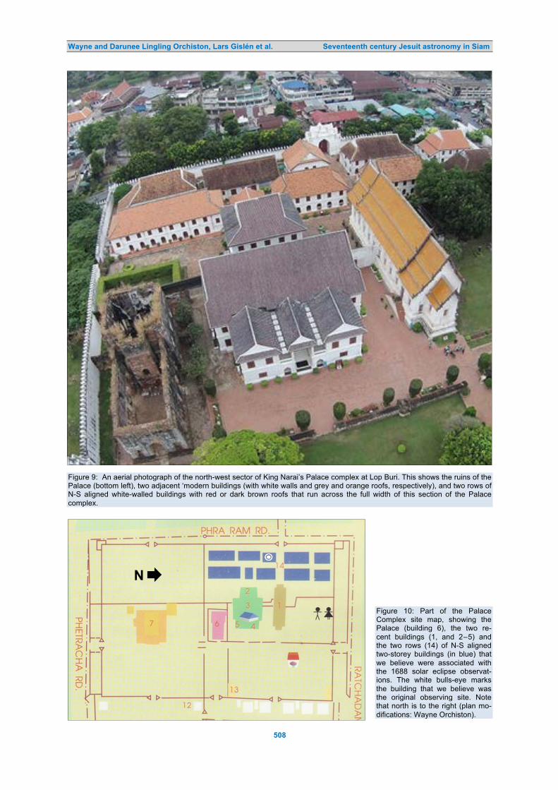
Wayne and Darunee Lingling Orchiston, Lars Gislén et al. Seventeenth century Jesuit astronomy in Siam
508
Figure 9: An aerial photograph of the north-west sector of King Narai’s Palace complex at Lop Buri. This shows the ruins of the Palace (bottom left), two adjacent ‘modern buildings (with white walls and grey and orange roofs, respectively), and two rows of N-S aligned white-walled buildings with red or dark brown roofs that run across the full width of this section of the Palace complex.
Figure 10: Part of the Palace Complex site map, showing the Palace (building 6), the two re-cent buildings (1, and 2–5) and the two rows (14) of N-S aligned two-storey buildings (in blue) that we believe were associated with the 1688 solar eclipse observat-ions. The white bulls-eye marks the building that we believe was the original observing site. Note that north is to the right (plan mo-difications: Wayne Orchiston).

Wayne and Darunee Lingling Orchiston, Lars Gislén et al. Seventeenth century Jesuit astronomy in Siam
509
ey and curved doorways at ground level can hardly be an accident (see Figure 11).
If we accept this identification then we can track King Narai and the Jesuit astronomers to the centrally-located smallest of the buildings in the western row of reconstructed buildings, identified in Figure 12, and marked by the white bulls-eye in Figure 10. 8 DISCUSSION
8.1 The Demise and Re-emergence of Scientific Astronomy in Siam
The success of the French Jesuit astronomers was in large part due to the patronage of King Narai and the role that Constantine Phaulkon played in fostering Siamese-French ties, but this combination ultimately would lead to their downfall (see Cruysse, 2002; Le Blanc, 1692; Smithies, 2002). As might be expected, Phaul-kon’s rise to power in Siam generated consider-able envy among some members of the Thai Royal Family, including Phra Phetracha, King Narai’s cousin. Meanwhile, the King’s toler-ance of Catholicism, his eagerness to foster closer ties between Siam and France, and his open support for Western astronomy at the expense of traditional Thai astrology, created disquiet amongst members of the Royal Fam-ily, in the Siamese Court, and among Buddhist monks. By May 1688 King Narai was serious-ly ill (it is thought by some that he had been poisoned), and a malicious rumour was spread that Phaulkon wished to become the next King of Siam and planned to install the designated heir, Phra Pui (King Narai’s foster son), as a puppet ruler. This was precisely the excuse that Phra Phetracha needed to stage a coup d’état, and Phaulkon, Phra Pui and their sup-porters were arrested and on 5 June 1688 they were executed.7 When he learnt of this King Narai was mortified, but was too weak to or-ganise a counter-offensive, and he died soon afterwards, on 11 July.
Phra Phetracha then went and installed himself as the new King of Ayutthaya, and reversed King Narai’s previous enlightened policies by closing Siam’s ‘doors’ to the West and expelling most of the foreigners who were living there (Smithies, 2002). This led to the immediate close-down of Wat San Paulo. All but one of the Jesuit astronomers there quickly moved to the protection of the French fort in Bangkok and from there sailed for India, thus bringing to an abrupt end an all-too-short, yet extremely productive, period of scientific astronomical activity in Siam.
Nearly two centuries would pass before Western astronomers were able to re-instate—
albeit temporarily—scientific astronomy in Siam, first in 1868 when French astronomers would observe a total solar eclipse from Wha- koa (see Figure 2) under the patronage of King Rama IV (Orchiston and Orchiston, 2017; 2021; Soonthornthum and Orchiston, 2021), and then in 1875 when British astronomers would observe another total solar eclipse, this time from Chulai Point near Petchaburi (see Figure 2) and with the support of King Rama V (Euarchukiati, 2021a; Hutawarakorn-Kramer and Kramer, 2006). An additional attraction during the 1875 eclipse was a drawing contest that King Rama V arranged at the Royal Place in Bangkok—where the eclipse also was total (see Euarchukiati, 2021b).
Then in 1929 King Rama VII continued this Royal patronage when British and German expeditions came to Pattani in far southern Thailand to observe the 9 May 1929 total solar eclipse (Soonthornthum et al., 2021). In a bid to enhance their chances of meeting clear skies, the British party split in two, with one of the components based at Alor Star, just across the border in the Unfederated Malaya State of Kedah (see Noor and Orchiston, 2021).
This Royal patronage of scientific astron-omy initiated by King Narai and demonstrated by Kings Rama IV, V, VII and IX has continued through to the present day, with strong support from Her Royal Highness Princess Maha Chakri Sirindhorn (see Soonthornthum, 2011), culminating in the establishment of the Nation-al Astronomical Research Institute of Thailand in Chiang Mai in 2009 and the opening of the Thai National Observatory and its 2.4-m Ritchey-Chrétien telescope on Doi Inthanon (see Figure 2) in 2013. 8.2 Commemorating the Early History of Scientific Astronomy in Siam
We are lucky that there are still historic buildings and ruins in Siam that mark the sites where pioneering astronomical observations were made by King Narai and French Jesuit astronomers in the seventeenth century.
Regrettably, all attempts to pinpoint the location of Father Antoine Thomas’ pioneering solar, lunar and stellar observations of 1681–1682 have failed (see Orchiston, 2021a), but later sites where King Narai and members of the first and second contingents of French Jesuit astronomers observed from are known and in some cases remains of the associated buildings and rooms still exist.
Thus, we know that King Narai observed the 11 December 1685 lunar eclipse from his water reservoir ‘country retreat’ and also the

Wayne and Darunee Lingling Orchiston, Lars Gislén et al. Seventeenth century Jesuit astronomy in Siam
510
Figure 11: A recent photograph, looking south, of the western facades of the eastern row of reconstructed buildings that run across this sector of the King Narai Palace Complex. We believe, allowing for artistic licence, that this reflects the view intended by the artist of the painting in Figure 7, had he been sited at ground level and looking south instead of east (photograph: Darunee Lingling Orchiston).
Figure 12: A view looking north along the eastern facades of the western row of reconstructed buildings that run across this sector of the Narai Palace Complex. We believe that the small building second from the left (with the conspicuous verandah) marks the site of the building were King Narai and the Jesuit astronomers were located when they observed the 30 April 1688 partial solar eclipse—see, also, Figure 10 (photograph: Darunee Lingling Orchiston).

Wayne and Darunee Lingling Orchiston, Lars Gislén et al. Seventeenth century Jesuit astronomy in Siam
511
Figure 13: Parts of the interpretive panel (top) and commemorative monument (bottom) at the water reservoir site (photographs: Darunee Lingling Orchiston).
30 April 1688 solar eclipse from his Palace in down-town Lop Buri, and through careful re-views of the published records and archival sources and associated on-site fieldwork we have even been able to postulate which partic-ular buildings were used (for the 1685 eclipse see Orchiston et al., 2016). As we have seen in this paper, the 30 April 1688 solar eclipse was observed from King Narai’s Palace—not from Wat San Paulo or from King Narai’s water
reservoir place—and it is important that this site is marked with a commemorative plaque or a display panel, like those installed at Wat San Paulo, for example. Instead, all we have at the moment is a commemorative plaque and an interpretive panel at King Narai’s small water reservoir palace claiming that the 1688 solar eclipse was observed there (see Figure 13). This, of course, is totally incorrect.

Wayne and Darunee Lingling Orchiston, Lars Gislén et al. Seventeenth century Jesuit astronomy in Siam
512
Figure 14: The display panel in the car park at Wat San Paulo, showing on the right the section of the complex that is preserved within the historical reserve. Note here the incorrect spelling of Wat San Paulo (4 November 2015 photograph: Martin George).
This is not the only instance of incorrect astronomical signage at Lop Buri’s astronom-ical sites, which surely should be a major con-cern for the National Astronomical Research Institute of Thailand (NARIT) and Thailand’s heritage authorities. Such signage not only provides visitors with totally misleading inform-ation, but it also reflects badly on NARIT, which supposedly vetted the installation of commemorative plaques and interpretive pan-els at these sites—without even bothering to check the facts first with those astronomers who have carefully researched French Jesuit astronomy in Siam and presented their find-ings at international conferences and publish-ed them in reputable international outlets—such as Springer books and journals like this one.
Without doubt, the crowning glory of Thai-land’s astronomical heritage was the Wat San Paulo Observatory, which was erected at Lop Buri in 1686–1687. About half of the huge rectangular structure shown in Figure 5 is now preserved within an historical reserve (see Fig-ure 14), and apart from the foundations, a section of the observatory tower has survived (see Figure 15). While the Government’s Fine
Arts Department has done an excellent job in consolidating the foundations of the building and preserving what is left of the tower obser-vatory, the associated signage leaves much to be desired. We noted that the names Wat San Paulo, Wat San Paolo and Wat Sanpaolo all appear at various places within the historic re-serve (Figure 16), but just the one spelling should have been used throughout. There is also a major problem with the English trans-lation on the interpretative panel near the ruins of the observatory, where it refers to the ob-servatory as a ‘planetarium’—see Figure 17. Of course, planetariums were a twentieth cen-tury invention, and did not exist back in the seventeenth century, and as every astronomer knows the two are very very different entities. This, once again, raises the question of the astronomical literacy of the person (or people) responsible for the signage at Wat San Paulo.
While discussing heritage matters, there is one further topic that deserves mention. Now that UNESCO is working closely with the Inter-national Astronomical Union—through Comm-ission C4 (Astronomy and World Heritage)—we need to examine whether Wat San Paulo should be nominated for inclusion on the World

Wayne and Darunee Lingling Orchiston, Lars Gislén et al. Seventeenth century Jesuit astronomy in Siam
513
Figure 15: Remains of Wat San Paulo Observatory (photographs: Darunee Lingling and Wayne Orchiston). Figure 16: Further examples of the incorrect spelling of ‘Wat San Paulo’ at the site; see, also, Figure 14 (photographs: Darunee Lingling Orchiston).

Wayne and Darunee Lingling Orchiston, Lars Gislén et al. Seventeenth century Jesuit astronomy in Siam
514
Figure 17: The second author of this paper posing beside the panel display at Wat San Paulo on 4 November 2015. Note that although the name of the facility is listed correctly here, for some inexplicable reason the labelling refers to a planetarium instead of an observatory (photograph: Wayne Orchiston). Heritage List (Ruggles and Cotte, 2011; 2017). If this option is pursued, then Thai heritage staff and astronomers will need to liaise closely with international representatives from the International Council of Sites and Mon-uments (ICOMOS). Pursuing any nomination is a major time-consuming challenge, so this must be carefully assessed before a decision is made (see Ruggles and Cotte, 2017). The key question will be: Does Wat San Paulo have “outstanding universal value (OUV)” in relation to astronomy?
However, even if the answer to this quest-ion is ‘No’, Wat San Paulo certainly should be considered for the IAU list of ‘Outstanding Astronomical Heritage’ (OAH), which is main-tained by Commission C4, along with the wat-er reservoir site and King Narai’s main palace at Lop Buri, and the sites at Wha-koa and Chulai Point where observations were made of the total solar eclipses of 1868 and 1875. The OAH was set up to accommodate
… astronomical heritage sites that are outstanding in science and the history of astronomy but do not necessarily demon-strate Outstanding Universal Value which
would be needed for inscription on the World Heritage List. (Wolfschmidt et al., 2021).
With the passage of time, the histories of other sites or facilities will need to be researched (e.g. Pisaisanlalak Pavilion in Ayutthaya, and Chiang Mai University’s Princess Sirindhorn Observatory) and added to this national list, which should be maintained and updated locally by NARIT. 5 CONCLUDING REMARKS
Largely because of King Narai’s personal inter-est in astronomy, and the influence of his main advisor, Constantine Phaulkon, Siam (present-day Thailand) experienced the first blossoming of Western scientific astronomy in the sev-enteenth century. On 22 February 1682 the Belgian Jesuit missionary-astronomer Father Antoine Thomas observed a lunar eclipse from Ayutthaya. Then in December 1685 King Narai and a group of French Jesuit missionary- astronomers observed a lunar eclipse from Lop Buri. This was the catalyst that led to the construction of an impressive observatory faci-lity in Lop Buri, the arrival of a new contingent

Wayne and Darunee Lingling Orchiston, Lars Gislén et al. Seventeenth century Jesuit astronomy in Siam
515
of French Jesuit missionary-astronomers, and plans for a major long-term commitment to Western astronomy by King Narai and Con-stantine Phaulkon. Alas, this was not to be, for the winds of socio-political change blew rather strongly in Siam at this time. A little over two years later, on 30 April 1688, King Narai and the French Jesuit missionary-astronomers observed a partial solar eclipse from the King’s Palace in Lop Buri. These were the last known major astronomical observations made by the French astronomers before King Narai’s un-timely death in July and the close-down of all Western astronomical endeavours in Siam.
Elsewhere (Orchiston et al., 2021a: 244–245) we have suggested that
The all-too-short period from December 1685 to June 1688 was Siam’s first ‘Golden Age of Scientific Astronomy’, as the French Jesuit visitors carried out a range of different types of astronomical observations from Lop Buri and Ayutthaya, including three further lunar eclipses and one partial solar eclipse …
However, Siam’s first astronomical ‘Golden Age’ ended abruptly in July 1688 when King Narai died. This was disastrous for ‘Western astronomy’ …
Siam’s scientific romance with solar eclipses then had to endure a 180-yr hiatus before Western astronomers were invited to Wha-koa and Chulai Point to observe the hallmark eclipses of 1868 and 1875. Just as in King Narai’s era, the success of both nine-teenth century expeditions can be traced back to Royal patronage, a phenomenon that con-tinued through into the twenty-first century, leading ultimately to the founding of the Nat-ional Astronomical Research Institute of Thai-land (NARIT) in 2009.
History then was destined to repeat itself. The founding Director of NARIT was one of the authors of this paper (BS) and he mimicked King Narai’s tactic in inviting a well-known Western astronomer (the first author of this paper) to join NARIT and develop the history of astronomy area until NARIT became known as an international Centre of Excellence in this field. That objective was soon achieved, thanks in no small part to support provided by a large pool of international collaborators (five of whom are co-authors of this paper).8 6 NOTES
1. This paper is a greatly revised and ex-panded version of a paper about the 30 April 1688 solar eclipse that was present-ed by Wayne Orchiston, Darunee Lingling Orchiston, Martin George and Boonruck-sar Soonthornthum at the first meeting of
the History of Astronomy Working Group of the Southeast Asian Astronomy Net-work (SEAAN), which was held at Ao Nang (Thailand) on 30 November and 1 December 2015 (Orchiston et al., 2015).
2. Constantine Phaulkon played a key role in facilitating the development of scientific as-tronomy in Siam, and it may be that initial- ly he acquired this sympathy for astronomy from Father Thomas, who on 2 May 1682 (Smithies, 1994: 176)—not long after the 22 February lunar eclipse—converted him from the Church of England faith to Roman Catholicism (Hutchinson, 1933).
3. This quotation and subsequent ones listed as ‘Tachard (1686)’ are actually taken directly from Giblin (1909) and are Giblin’s English translations of the astronomical excerpts contained in Tachard’s 2-volume work Voyage de Siam des Pères Jésuites Envoyés par le Roi aux Indes & à la Chine (1686).
4. For details of the Jesuit astronomers, their instruments, the Moon map that they used for reference purposes, and their observations, see Gislén et al. (2018) and Orchiston et al. (2016). It is interesting that even though the presents that King Louis XIV gave King Narai included tele-scopes, the Siamese king did not use one of these to observe the lunar eclipse, rely-ing instead on telescopes supplied on the night by the Jesuit astronomers.
5. In the 1680s Lop Buri was variously refer-red to as Louvo (Tachard, 1686), Louveau (Gervaise, 1689), Luvo (see Giblin, 1904) and Lawo (ibid.) by the French.
6. Although Tachard specifically says that six-teen Jesuit astronomers went to Siam in 1687, Udias (2003) could find evidence of only fourteen when he researched this topic.
7. This is sometimes referred to as the ‘1688 Siamese Revolution’, even though it was not a popular uprising, or a ‘revolution’, in the strict sense of the word.
8. The sequel to this saga also has Phra Phetracha-like overtones in that several years after Professor Boonrucksar step-ped down as Director, NARIT decided that it no longer had need for a Western ast-ronomer to lead history of astronomy re-search. Accordingly, on 30 September 2021 that contract will end, and the inter-national collaborations in history of astron-omy research will cease.
7 ACKNOWLEDGEMENTS
Apart from the calculations for Table 3, which were performed by the third and fourth authors

Wayne and Darunee Lingling Orchiston, Lars Gislén et al. Seventeenth century Jesuit astronomy in Siam
516
of this paper, research on the seventeenth century Jesuit astronomy in Siam was largely based on data gathered by the first two authors during a detailed literature survey, three visits to Lop Buri and Ayutthaya in 2014 and 2015 and a trip to Paris in 2017. We are
grateful to Professor Jesus Torres (Philip-pines), and staff from the Lop Buri City Hall, the Department of Fine Arts at Kraisorm Siharat Pavilion (the ‘Water Reservoir Palace’ in Lop Buri), the Jesuit Archives in Paris and Paris Observatory for their assistance.
8 REFERENCES
Aubin, D., 2010. Eclipse politics in France and Thailand, 1868. In Aubin, D., Bigg, C., and Sibim, H.O. (eds.). The Heavens on Earth: Observatories and Astronomy in Nineteenth-Century Science and Culture. Durham (North Carolina), Duke University Press. Pp. 86–117.
Bhumathon, B., 2000. Astronomical Archives from France Concerning the Kingdom of Siam during the Reign of King Narai, Bangkok, Thai Astronomical Society (in Thai).
Bianchi, S., 2021. Where was mean solar time first adopted? Journal of Astronomical History and Heritage, 24, 359–366.
Bobis, L., and Lequeux, J. (eds.), 2012. L’Observatoire de Paris: 350 Ans de Science. Paris, Gallimard and Observatoire de Paris (in French).
Chaumont, A. de, 1686. Relation de l’Ambassade de Monsieur le Chevalier de Chaumont à la Cour du Roy de Siam, avec ce qui s’est Passé de plus Remarquable durant son Voyage. Paris, Arnoult Seneuse et Daniel Horthemels (in French).
Cruysse, D. van der, 1992. Aspects of Siamese-French relations during the seventeenth century. Journal of the Siam Society, 80, 63–69.
Cruysse, D. van der, 2002. Siam and the West, 1500 –1700. Chiang Mai, Silkworm Books. Espenak, F., and Meeus, J., 2006. Five Millennium Canon of Solar Eclipses: ‒1999 to + 3000. Greenbelt, NASA
(Technical Publication TP-2006-214141). Euarchukiati, V., 2021a. The 1875 British solar eclipse expedition to Siam led by Sir Arthur Schuster. In Orchiston
and Vahia, 317–344. Euarchukiati, V., 2021b. Observations of the 6 April 1875 total solar eclipse from the Grand Palace in Bangkok. In
Orchiston and Vahia, 345–372. Gervaise, N., 1689. Histoire Naturelle et Politique de Royaume de Siam. Paris, E. Ducastin (in French). Giblin, R.W., 1904. Lopburi past and present. Journal of the Siam Society, 5(3), 8–28. Giblin, R.W., 1909. Early astronomical and magnetic observations in Siam. Journal of the Siam Society, 6(2), 1–
15. Gislén, L., 2004. Analysis of the astronomical information in Tachard: “Voyage to Siam in the Year 1685”.
Centaurus, 46, 133–144. Gislén, L., 2017. Analysis of French Jesuit observations of Io made in China in AD 1689–1690. Journal of
Astronomical History and Heritage, 20, 264–270. Gislén, L., Launay, F., Orchiston, W., Orchiston, D.L., Débarbat, S., Husson, M., George, M., and Soon-
thornthum, B., 2018. Cassini’s 1679 map of the Moon and French Jesuit observations of the lunar eclipse of 11 December 1685. Journal of Astronomical History and Heritage, 21, 211‒225.
Hennequin, K., 2004. Les premières observations astronomiques occidentales par le père Thomas de la Société de Jésus au Siam à la fin du XVIIe siècle. Aséanie, 13, 63–101 (in French).
Hodges, I., 1999. Time in transition: King Narai and the Luang Prasoet Chronicle of Ayutthaya. Journal of the Siam Society, 87, 33 –44.
Hutawarakorn-Kramer, B., and Kramer, M., 2017. King Rama V and British observations of the 6 April 1875 total solar eclipse from the Chao Lai Peninsula, Siam. In Nakamura and Orchiston, 319–325.
Hutchinson, E.W., 1933. The French Foreign Mission in Siam during the XVIIth century. Journal of the Siam Society, 26(1), 1–71.
Jacq-Hergoualc’h, M. (ed.), 1986. Phra Narai, Roi de Siam et Louis XIV. Paris, Musée de l’Orangerie (in French). Kochhar, R., 1991. French astronomers in India during the 17th–19th centuries. Journal of the British
Astronomical Association, 101, 95 –100. Le Blanc, M., 1692. Histoire de la Revolution du Roiaume de Siam Arrivée en l’Année 1688. Deux Tomes. Paris,
Horace Molin (in French). Lefebvre S.J., B., 1930. Antoine Thomas de Namur Missionnaire et Astronome (1644‒1709). Bruxelles,
Établissements Émile Bruylant (in French). Love, R.S., 1994a. The making of an Oriental despot: Louis XIV and the Siamese embassy of 1686. Journal of
the Siam Society, 82, 57–78. Love, R.S., 1994b. Simon de la Loubere: French views of Siam in the 1680s. Journal of the Siam Society, 82,
155–164. Nakamura, T., and Orchiston, W. (eds.), 2017. The Emergence of Astrophysics in Asia. Cham (Switzerland),
Springer International Publishing. Nath, B.B., 2013. The Story of Helium and the Birth of Astrophysics. Cham (Switzerland), Springer. Needham, J., 1959. Science and Civilization in China. Volume III. Mathematics and the Sciences of Heaven and
Earth. Cambridge, Cambridge University Press. Noor, N.A.B.M., and Orchiston, W., 2021. The total solar eclipse of 9 May 1929: the British expedition to Alor Star

Wayne and Darunee Lingling Orchiston, Lars Gislén et al. Seventeenth century Jesuit astronomy in Siam
517
in the Unfederated Malay State of Kedah. In Orchiston and Vahia, 391–410. Orchiston, W., Orchiston, D.L., George, M., and Soonthornthum, B., 2015. The first scientific observations of a so-
lar eclipse carried out in Siam. Paper presented at the first meeting of the History of Astronomy Working Group of the Southeast Asian Astronomy Network (SEAAN), Ao Nang (Thailand), 30 November–1 December 2015.
Orchiston, W., and Orchiston, D.L., 2017. French observations of the 18 August 1868 total solar eclipse from Wha-koa, Thailand. In Nakamura and Orchiston, 291‒317.
Orchiston, W., Orchiston, D.L., George, M., Soonthornthum, B., Gislén, L., Débarbat, S., Husson, M., and Launay, F., 2019. The role of eclipses and European observers in the development of ‘modern astronomy’ in Thailand. In Orchiston, W., Sule, A., and Vahia, M., (eds.). The Growth and Development of Astronomy and Astrophysics in India and the Asia-Pacific Region. ICOA-9, Pune, India, 15-18 November 2016. New Delhi, Hindustan Book Agency and Springer. Pp. 173‒216.
Orchiston, W., and Orchiston, D.L., 2021. King Rama IV, Sir Harry Ord and the total solar eclipse of 18 August 1868: power, politics and astronomy. Journal of Astronomical History and Heritage, 24, 389‒404.
Orchiston, W., and Vahia, M. (eds.), 2021. Exploring the History of Southeast Asian Astronomy: A Review of Current Projects, and Future Prospects and Possibilities. Cham (Switzerland), Springer.
Orchiston, W., Dumon, P., Gislén, L., Orchiston, D.L., George, M., Launay, F., Débarbat, S., Husson, M., and Soonthornthum, B., 2021a. Father Antoine Thomas and the birth of ‘modern astronomy’ in Thailand. In Orchiston and Vahia, 225‒252.
Orchiston, W., Orchiston, D.L., George, M., Soonthornthum, B., and Komonjinda, S., 2021b. Seventeenth century Jesuit astronomical activities in Siam. In Shi, Y.-L. (ed.). Astronomical Heritages in Asia-Pacific Areas: Proceedings of the Eighth International Conference on Oriental Astronomy. Hefei, University of Science and Technology of China.
Pigatto, L., 2004. Astronomical observations made by Jesuits in Peking during the seventeenth and eighteenth centuries. In Orchiston, W., Stephenson, R., Débarbat, S., and Nha, I.-S. (eds.). Astronomical Instruments and Archives from the Asia-Pacific Region. Seoul, Yonsei University Press. Pp. 55 – 66.
Rao, N.K., Vagiswari, A., and Louis, C., 1984. Father J. Richaud and early telescope observations in India. Bulletin of the Astronomical Society of India, 12, 81– 85.
Ruggles, C., and Cotte, M. (eds.), 2011. Heritage Sites of Astronomy and Archaeoastronomy in the Context of the UNESCO World Heritage Convention, ICOMOS & IAU Thematic Study. Bognor Regis, Ocarinabooks.
Ruggles, C., and Cotte, M. (eds.), 2017. Heritage Sites of Astronomy and Archaeoastronomy in the Context of the UNESCO World Heritage Convention, ICOMOS & IAU Thematic Study. Volume 2. Paris, UNESCO.
Sioris, G.A., 1988. Phaulkon – The Greek First Counsellor of the Court of Siam: An Appraisal. Bangkok, Siam Society.
Sioris, G.A., 1992. Phaulkon. A personal attempt at reconstituting a personality. Journal of the Siam Society, 80, 59–62.
Smithies, M., 1994. Saint Tachard: a rejoinder to Vongsuravatana. Journal of the Siam Society, 82, 175–178. Smithies, M., 1996. The Siamese Memoirs of Count Claude de Forbin 1685 –1688. Chiang Mai, Silkworm Books. Smithies, M., and Bressan, L., 2001. Siam and the Vatican in the Seventeenth Century. Bangkok, River Books. Smithies, M., 2002. Three Military Accounts of the 1688 “Revolution” in Siam. Bangkok, Orchid Press. Smithies, M., 2003. Eclipses in Siam, 1685 and 1688, and their representation. Journal of the Siam Society, 91,
189 –204. Soonthornthum, B., 2011. The emergence of astronomy in Thailand. In Nakamura, T., Orchiston, W., Sôma, M.,
and Strom, R. (eds.). Mapping the Oriental Sky. Proceedings of the Seventh International Conference on Oriental Astronomy. Tokyo, National Astronomical Observatory of Japan. Pp. 179 –186.
Soonthornthum, B., and Orchiston, W., 2021. King Rama IV: astronomer and ‘The Father of Thai Science’. In Orchiston and Vahia, 253–284.
Soonthornthum, B., Euarchukiati, V., and Orchiston, W., 2021. The total solar eclipse of 9 May 1929: the British and German expeditions to Siam. In Orchiston and Vahia, 373–389.
Sternstein, L., 1965. ‘Krung Kao’: the old capital of Ayuthaya. Journal of the Siam Society, 53, 82–121. Tachard, G., 1686. Voyage de Siam des Pères Jésuites Envoyés par le Roi aux Indes & à la Chine. Paris,
Seneuze et Horthemels (in French). Tachard, G., 1689. Second Voyage du Père Tachard et des Jesuites Envoyez par le Roy au Royaume de Siam:
Contenant Diverses Remarques d’Histoire, de Physique, de Geographie, & d’ Astronomie. Paris, Horthemels (in French).
Udias, A., 1994. Jesuit astronomers in Beijing, 1601–1805. Quarterly Journal of the Royal Astronomical Society, 35, 463 – 478.
Udias, A., 2003. Searching the Earth and the Sky. The History of Jesuit Observatories. Dordrecht, Kluwer. Udias, A., 2015. Jesuit Contribution to Science: A History. Cham (Switzerland), Springer.
Vongsuravatana, R., 1992. Un Jésuite à la Cour de Siam. Paris, France—Empire (in French).
Vongsuravatana, R., 1994. New investigations of Franco-Siamese relations in the 17th century: for a rehabilitation of Father Tachard. Journal of the Siam Society, 82, 97–100.
Wolfschmidt, G., Belmonte Aviles, J.A., Ruggles, C., Ferlet, R., Komonjinda, S., Liritzis, I, and Michaelian, A.M., 2021. Triennial Report 2018–2021. Commission C4: World Heritage and Astronomy. In Lago, M.T. (ed.), Reports on Astronomy 2018–2021. Transactions IAU, Volume XXXA.

Wayne and Darunee Lingling Orchiston, Lars Gislén et al. Seventeenth century Jesuit astronomy in Siam
518
Professor Wayne Orchiston has BA (First Class Honours) and PhD degrees from the University of Sydney. Formerly he worked in optical and radio astronomy in Australia and New Zealand. He now works at the National Astronomical Research Institute of Thailand and is also an Adjunct Professor of Astronomy in the Centre for Astrophysics at the University of Southern Queensland. Wayne has supervised a large pool of graduate students in history of astronomy through James Cook University and the University of Southern Queensland, in Australia.
He has wide-ranging research interests, and has prepared papers on aspects of Australian, Chinese, English, French, German, Georgian, Indian, Indonesian, Iraqi, Italian, Japanese, Korean, Malaysian, New Zealand, Philippines, South African, Thai and US
astronomy.
His recent books include Eclipses, Transits, and Comets of the Nineteenth Century: How America’s Perception of the Skies Changed (Springer, 2015, co-authored by Stella Cottam), Exploring the History of New Zealand Astronomy: Trials, Tribulations, Telescopes and Transits (Springer, 2016), John Tebbutt: Rebuilding and Strengthening the Foundations of Australian Astronomy (Springer, 2017), The Emergence of Astrophysics in Asia: Opening a New Window on the Universe (Springer, 2017, co-edited by Tsuko Nakamura); Exploring the History of Southeast Asian Astronomy: A Review of Current Projects and Future Prospects and Possibilities (Springer, 2021, co-edited by Mayank Vahia), and The Golden Years of Australian Radio Astronomy: An Illustrated History (Springer, 2021, co-authored by Peter Robertson and Woody Sullivan). He has also co-edited a succession of conference proceedings.
Wayne has been very active in the IAU for several decades, and is the current President of Commission C3 (History of Astronomy). In the past, he was responsible for founding the Transits of Venus and Historical Radio Astronomy Working Groups. In 1998 Wayne co-founded the Journal of Astronomical History and Heritage, and is the current Managing Editor. He also serves as an Editor of Springer’s Series on Historical and Cultural Astronomy. In 2013 the IAU named minor planet 48471 ‘Orchiston’ after him, and more recently he and one of his former American graduate students, Dr Stella Cottam, shared the 2019 Donald E. Osterbrock Book Prize from the American Astronomical Society for their book Eclipses, Transits, and Comets of the Nineteenth Century: How America’s Perception of the Skies Changed (Springer, 2015).
Mrs Darunee Lingling Orchiston is a successful businesswomen (she is the owner and manager of the B-N Shop in Kad Suan Kaew Shopping Centre in Chiang Mai, Thailand), who was taught traditional Lanna astronomy by her father (a medical doctor) and her grandfather (a businessman).
She also doubles as Professor Wayne Orchiston’s part-time Research Assistant and has a special interest in ethnoastronomy. She has participated in research on Philippines and Thai astronomical history; Thai meteorites; and Indian, Maori and Thai ethnoastronomy, and engaged in archival work, data-collecting and fieldwork in Australia, France, India, Singapore and Thailand.
Her research papers have appeared in the Journal of Astronomical History and Heritage, and in the books The Emergence of Astrophysics in Asia: Opening a New Window on the Universe (Springer, 2017), and Exploring the History of Southeast Astronomy: a Review of Current Projects and Future Prospects and Possibilities (Springer, 2021), as well as in a number of conference proceedings. She has co-authored papers presented at conferences and seminars in Austria, India, Myanmar, the Philippines, Singapore, South Korea and Thailand.
Darunee Lingling and Wayne Orchiston live in the Thai countryside one hour’s drive from the northern city of Chiang Mai.
Dr Lars Gislén received a PhD in high energy particle physics from the University of Lund in 1972. He worked in 1970/1971 as a researcher at the Laboratoire de physique théorique in Orsay (France) with models of high energy particle scattering. He has also done research on atmospheric optics and with physical modelling of biological systems and evolution.
He has worked as an Assistant Professor (University Lector) at the Department of Theoretical Physics at the University of Lund, where he gave courses on classical mechanics, electrodynamics, statistical mechanics, relativity theory, particle physics, cosmology, solid state physics and system theory.
For more than twenty years he was a delegation leader and mentor for the Swedish team in the International Physics Olympiad and the International Young Physicists’ Tournament.
Lars retired in 1983, and since then his interests have focused on medieval European astronomy and on the astronomy and calendars of India and Southeast Asia. He has published more than 20 research papers in this field. He has also made public several spreadsheet tools implementing a number of astronomical models from Ptolemy to Kepler as well as computer tools for the calendars of India and Southeast Asia. He is a member of the IAU.

Wayne and Darunee Lingling Orchiston, Lars Gislén et al. Seventeenth century Jesuit astronomy in Siam
519
Dr Martin George has a BSc (Honours) from the University of Tasmania and a PhD from the University of Southern Queensland (Australia). Until recently, he was Manager of the Launceston Planetarium at the Queen Victoria Museum in Launceston, Tasmania.
Martin is actively involved in the International Planetarium Society (IPS), being the current Board Member for Oceania, Chair of both International Relations and Elections, and a former President of the Society (2005‒2006). In 2018 he was presented with the IPS Service Award. He is a member of the IAU and the Astronomical Society of Australia, and is a former President of the Astronomical Society of Tasmania. He also served as administrator of the Grote Reber Medal for Radio Astronomy from 2005 to 2014.
Martin’s major research interest is the history of Tasmanian astronomy. His PhD research was on low-frequency radio astronomy in Tasmania during the three decades beginning in the mid-1950s and a succession of his research papers, which had been published in the Journal of Astronomical History and Heritage (JAHH), were incorporated into his thesis. He has also co-authored several other research papers, on Thai and Australian astronomical history (also published mainly in JAHH), and he has co-authored two books: Advanced Stargazing (Weldon-Owen, 1995) and Hale-Bopp: Comet of the Century, (TON OR GRAMMY, 1997), in Thai.
Martin is passionate about communication of astronomy and he regularly presents public lectures, speaks to common-interest groups, and works closely with the media. He speaks about astronomy on several regular radio programmes, and writes astronomy columns for Astronomy magazine and Hobart’s Saturday Mercury newspaper in Tasmania. In 2009 he was awarded the David Allen Prize for Astronomy Communication by the Astronomical Society of Australia, and the Winifred Curtis Medal for Science Communication by the Science Teachers' Association of Tasmania.
Martin has lived in Launceston, Tasmania, for many years. He is a keen traveller and avid eclipse-chaser, having been to 75 countries, and has included visits to many planetaria and astronomical sites. At home he enjoys making astronomical observations, especially of the aurora australis.
Professor Boonrucksar Soonthornthum was the Dean of the Faculty of Science at Chiang Mai University from 2004 to 2007 and the Founding Director of the National Astronomical Research Institute of Thailand (NARIT), from 2004 to 2017. Currently, he continues to be associated with NARIT. He has been awarded an Honorary DSc in Astrophysics by Rajabhat Songkla University (2008); an Honorary DSc in Physics by Rajabhat Chiang Mai University (2012); an Honorary PhD in Astronomy by Chiang Mai University (2016); and an Honorary PhD in Physics by Rajabhat Rambhai Barni University (2019).
Boonrucksar’s principal research interests are in astrophysics, physics, and astronomical history and heritage. He has published more than 70 papers and edited five
books. He also has led many projects setting up astronomical facilities within Thailand, and has received many national awards in recognition of his work. He also serves in an advisory capacity for several institutions.
Currently, Boonrucksar is the Vice President of IAU Commission C1 (Astronomy Education and Develop-ment), and since 2007 has been the Chair of the Southeast Asia Astronomy Network. He was the President of the International Olympiads on Astronomy and Astrophysics (2007‒2011), and is the current Chairman of the Thai Astronomy Olympiad Competition. He is a Fellow of the Royal Astronomical Society.
He has been President of the Thai Physics Society since 2017, and is the current Vice-President of The Science Society of Thailand Under the Patronage of His Majesty the King. He is also a member of the Thai Astronomy Society, the Science Society of Thailand and the Thai Academy of Science and Technology.
Françoise Launay made her whole career as a research engineer at Meudon Observatory where she was the technical head for a large high resolution vacuum ultraviolet spectrograph installed in the very place where the astronomer Jules Janssen carried out his laboratory experiments. She was also involved in preservation of artefacts of scientific history. She had joined the team of historians at Paris Observatory as an associate researcher when she published Janssen’s biography (Vuibert/ Observatoire de Paris, 2008; Springer, 2012) and continued researching astronomical instrument makers. She is now devoting herself to discovering unpublished material to document also the biographies of unknown or erroneously known encyclopaedists and people whose names appear in the correspondences of D’Alembert (including himself!), Diderot and Condorcet.
Dr Suzanne Débarbat obtained her Doctorat d’État (1969) Science and Mathématiques, and spent her whole career at Paris Observatory, starting in 1953. Nowadays she has an honorary position, but from 1985 to 1992 she was Director of the research group Systèmes de Référence Spatio-Temporels and from 1987 to 1992 of the Département d’Astronomie Fondamentale (which is nowadays known as Systèmes de Référence Temps-Espac, or SYRTE).
After working on fundamental astronomy, and determining the astrometric positions of the main planets of the

Wayne and Darunee Lingling Orchiston, Lars Gislén et al. Seventeenth century Jesuit astronomy in Siam
520
Solar System with a Danjon Astrolabe, Suzanne began researching the history of Paris Observatory: its astronomers, their instruments, their research and their discoveries. This is an on-going project.
Over the years, Suzanne has published many research papers and books in the fields of astrometry, geodesy and related sciences and, from 1976, on history of astronomy. She also has participated in most of the exhibitions at the Observatory, and prepared small books or brochures concerning the Observatory (mostly in collaboration with the Library).
She also participated with Antoine Hurtado in a documentary film about the Système Métrique Décimal and, with Lilly Hibbed, on her exhibition “First Light - β Persei” (Conservatoire National des Arts et Métiers-Galerie de Soussan), for the Year of Light in
France (2015).
Among other societies, Suzanne is a member of the IAU (Commission on History of Astronomy, President: 1991–1994); the Bureau des Longitudes (President: 2004–2005); the Académie Internationale d’Histoire des Sciences; and the Comité National Français d’Histoire et de Philosophie des Sciences et des Techniques (General Secretary: 2007–2009).
From 1976 to 1981 Suzanne was Editor-in-Chief of l’Astronomie magazine, and she has been responsible for the republication of books issued by the Bureau des longitudes. She has organized several conferences, colloquia and symposia, and edited the proceedings.
The IAU named minor planet 15671 ‘Suzannedebarbat’ in her honour, and she has received the Prix des Dames (SAF 1977), Prix Jules-Janssen (SAF 2013), and the Prix Paul Doistau–Emile Blutet de l’Information Scientifique (Académie des Sciences 2019, France) with Dominique Bernard. She is a member of the Légion d’honneur, Ordre national du Mérite, Ordre des Arts et des Lettres, ordre des Palmes académiques.
Dr Matthieu Husson works at l‘Observatoire de Paris. His initial training was in mathematics (University of Paris VI), after which he studied the history of medieval Latin sciences at the fourth section of the École Pratique des Hautes Études where he obtained a PhD in 2007 on the mathematical sciences in the fourteenth century.
While continuing his interest in mathematical practices, Matthieu’s subsequent research has focused on the history of astronomy as an ‘intermediate science’ at the end of the Middle Ages (fourteenth to fifteenth centuries). Through an analysis of the tables, texts and diagrams contained in the numerous scientific manuscripts produced during this period, his research attempts to grasp the ways in which the specific astronomical practices attested by these documents, crucial for the development of the discipline in Europe, are
part of a global and shared history over the longue durée.
Currently this research is developing in the context of the ERC project ALFA, Shaping a European Scientific Scene: Alfonsine Astronomy (CoG 723985, 2016, alfa.hypotheses.org) of which Matthieu is the P.I. His research is also deeply engaged in the digital humanities, as attested by the creation of DISHAS, Digital Information System for the History of Astronomy, an internationally developed web platform for critical edition and analysis of astronomical tables (dishas.obspm.fr).

Journal of Astronomical History and Heritage, 24(2), 521–543 (2021).
521
KARL SCHWARZSCHILD, ANNIE J. CANNON AND CORNELIS EASTON: THE HONORARY PhDs OF
JACOBUS C. KAPTEYN
Pieter C. van der Kruit Kapteyn Astronomical Institute, University of Groningen,
P.O. Box 800, 9700 AV Groningen, the Netherlands. E-mail: [email protected]
Abstract: Honorary degrees and particularly doctorates are important instruments to enhance the standing of universities and professors, in addition to receiving these as a measure of a scientist’s recognition. Jacobus C. Kapteyn from the University of Groningen in the Netherlands, one of the most prominent astronomers of his times, received three of these and has persuaded his university to award at least three, possibly five. I examine the background of the selection of the latter in view of developments in Kapteyn’s time in his career, international astronomy and political and cultural circumstances.
Key words: Honorary degrees; statistical astronomy; Galactic astronomy; spectral classification; Selected Areas 1 INTRODUCTION
Universities boost their standing and prestige by appointing or keeping important scientists on their staff that have performed groundbreaking research, preferably while being employed by them, but if necessary when performed else-where. Listing alumni that have become lead-ing researchers anywhere else but who started their careers by defending their thesis work at the university involved is also used to justify claims concerning success and status. Another important instrument is awarding honorary doctorates to prominent scientists or cultural or political figures.
One aspect of a professor’s success may be taken to be who his or her students are. This involves for professors at most universities supervising research of students that leads to the defense of an important thesis, after which conferring a doctorate on the student as ‘pro-motor’1 on behalf of the Senate (or other body representing the university). But it is also pos-sible to nominate persons for an honorary doctorate (Doctor honoris causa)2 and act as an honorary promotor.
Jacobus C. Kapteyn (1851–1922; Figure 1) was a Professor of Astronomy at the University of Groningen in the Netherlands from 1878 to 1921. In his days he was one of the most prom-inent astronomers in the world, which can be illustrated by the fact that the most important observatories signed up to his ‘Plan of Selected Areas’ in which observations of stars in each of the 206 Areas were collected. Harvard College Observatory, under the directorship of Edward C. Pickering (1846–1919), photographed all these areas and sent large stacks of plates to Groningen for measurement of positions and magnitudes. Even more telling, George E. Hale (1868–1938) in 1908 adopted Kapteyn’s ‘Plan’ as the primary program for his brand new, giant
60-inch telescope on Mount Wilson, the largest in the world, and had Kapteyn appointed for life as a Research Associate by the Carnegie Instit-ution of Washington, and between 1908 and 1914 Kapteyn annually visited Mount Wilson.
Kapteyn did not have many students de-fending their theses under him during the ten-ure of his professorship. There were only eight, of which Willem de Sitter (1872–1934) undoubt-edly is the most prominent. Pieter J. van Rhijn (1886–1960), who was to become his success-or, has also gained some international stand-ing. Actually, Adriaan van Maanen (1884–1946) might also be counted as a student of Kapteyn, since he performed a significant part of his thesis research in Groningen with Kapteyn; in spite of graduating under Albertus A. Nijland (1868–1936) in Utrecht he regarded Kapteyn as his real mentor. Three more students started their thesis work while Kapteyn was in office but
Figure 1: Jacobus C. Kapteyn from a drawing in
1908 by Cornelis Easton (courtesy: Kapteyn
Astronomical Institute).

Pieter C. van der Kruit Honorary Doctorates Arranged by Kapteyn
522
completed their theses only when van Rhijn had taken over (and in fact after Kapteyn had died). Of these Jan Schilt (1894–1982) pursued a very successful career in the USA, but without dis-pute the most prominent of Kapteyn’s nach-wuchs (i.e. including the ones who started their research under Kapteyn even though van Rhijn eventually was their thesis supervisor) is Jan Hendrik Oort (1900–1992). Much more on Kap-teyn and Oort can be found in my academic (van der Kruit, 2015; 2019), and wider-audience (van der Kruit, 2021a; 2021b) biographies.
It is not well documented that Kapteyn was promotor in at least three cases of an honorary doctorate. The first one, awarded to journalist and amateur astronomer Cornelis Easton (1864–1929), is usually noted, but those of very prominent astronomers Karl Schwarzschild (1873–1916) and Annie Jump Cannon (1863–1941) are much less known. Schwarzschild’s is rarely mentioned, Cannon’s usually listed but understandably eclipsed by the more prestigi-ous one she obtained a few years later from Oxford, and sometimes only the latter one is mentioned
The circumstances applying to the confer-ring of these degrees are the subject of this paper. Questions addressed are the following. Was this unusual? Why did Kapteyn select these people? Did Schwarzschild and Cannon actually come to Groningen to receive the hon-ors? Kapteyn himself had three honorary doctorates, from Cape Town, Harvard and Ed-inburgh. How does this compare with others? He had none from English, German or French universities, where after all many of the leading astronomers in Europe were working. Does this tell us something or doesn’t it?
This paper is aimed at an audience of hist-orians and others interested, not necessarily with an astronomical expertise. I therefore will describe in some detail the required astronomi-cal background to appreciate the significance of matters discussed. The reader is assumed to be familiar with basic astronomical concepts. 2 BACKGROUND
This section has been shortened, because it was thought most information in the original version should be known to the readers of this journal. A more extended version for those interested in more background of this paper is available on my homepage (van der Kruit, 2021c). 2.1 Honorary Degrees: General
According to Merriam-Webster an honorary de-gree is “a degree given by a college or uni-versity to someone who is not a student but who
has done something important” (Merriam-Web-ster Dictionary, 2020). The first such degree seems to have been awarded by the University of Oxford, UK. According to their Website (Ox-ford University, 2020) this happened in 1478 or 1479.
In the USA the first honorary degree was awarded by Harvard University in 1692. Har-vard claims to have awarded over 2300 honor-ary degrees by now (Harvard University, 2020). In the UK the Universities of Oxford and Cam-bridge are prolific awarding institutions; accord-ing to Heffernan and Jöns (2007), these award-ed respectively 1487 and 1111 doctorates dur-ing the twentieth century. Both universities now award between eight and ten degrees per year. Harvard University nowadays awards between 5 and 15 degrees. But these of course are not all doctorate degrees.
The University of Groningen has awarded almost 300 honorary doctorates, the first occur-ring in 1717 (University of Groningen, 2020), which was for Abrahamus Trommius (Abraham Trom) in theology for a concordance of both the Old and the New Testament. However, already from 1618 onward there were doctorates award-ed sine examine, so without submitting and defending a thesis. An interesting example is one awarded in 1634 to the famous theologian Gisbertus Voetius, who was a preacher who was being appointed Professor of Theology at Utrecht. It was felt undesirable that he would award PhDs without having obtained this degree himself and this is how that was solved. Astronomer Frederik Kaiser (1808–1872) in Leiden was a comparable case; he was award-ed an honorary doctorate in 1835 so that he could be appointed lecturer in 1837 and event-ually in 1840 Professor of Astronomy.
Honorary doctorates in Groningen are rare in most years but do occur in larger numbers in the years of an anniversary that is a multiple of fifty years. The peak at the tricentennial in 1914 was enormous, 67 in total starting with Queen Wilhelmina of the Netherlands. At other times the University has been more modest, in 2014 at the fourth centennial (aptly named ‘for infinity’ or ‘4∞’) there were only nine. In recent years that were not a lustrum (quinquennium) it was mostly zero, sometimes one or exceptionally two. Groningen honorary doctorates are much, much rarer than Cambridge, Oxford or Harvard, but the latter ones are certainly more sought after.
For completeness I note that as a matter of principle some universities do not confer hon-orary degrees at all, but all Dutch universities do award honorary degrees.
Like the first one at Oxford, honorary doc-

Pieter C. van der Kruit Honorary Doctorates Arranged by Kapteyn
523
torates are awarded often to royalty and pol-itical figures. In case of the Netherlands, for example Queen Juliana of the Netherlands has received honorary doctorates from both Leiden and Groningen and in addition eight more from foreign universities. Some renowned persons have tens of such honorary degrees; for ex-ample Nelson Mandela had over fifty, one of them from Leiden university. Kapteyn’s Univer-sity of Groningen honored the Queens of the Netherlands, Wilhelmina in 1914 at its 300-th anniversary and Juliana at its 350-th, and more recently international dignitaries Helmuth Kohl, Desmond Tutu and Ban Ki-Moon. This may sometimes be controversial, e.g. for the case of Groningen when Kohl a few years later was implicated in the CDU donations scandal, or when Oxford University’s governing assembly, Congregation, by a large majority refused Mar-garet Thatcher an honorary doctorate. 2.2 Honorary Degrees: University of Groningen
For reference to the discussion in the remain-der of this paper, I give some statistics on hon-orary doctorates at Groningen during Kapteyn’s tenure of his professorship, actually between 1878 when he was appointed and 1922, one year after his retirement and the time of his death.
I already alluded to the remarkable peak of 67 in the year of the University’s tricentennial, 1914. There were 14 in Kapteyn’s day before that year, and five after. The first one, in 1884, did not set the scene; it was famous physician and microbiologist H.H. Robert Koch, one of the founders of bacteriology and the concept of in-fectious diseases. He would receive the Nobel Prize in 1905 for identifying the bacterium that caused tuberculosis.
After that there were only Dutch persons who had important academic contributions on their record, but for one reason or another had never been in a position to present a PhD the-sis—what we might call ‘corrective’ honorary doctorates. One of these was amateur astrono-mer Cornelis Easton, to whom I will return below. Another example was the first woman who received an honorary doctorate from Gron-ingen, Jantina Tammes, who studied for and obtained secondary teacher qualifications in a number of natural sciences and then worked as the assistant of Willem Moll, Professor of Bot-any in Groningen. Her contributions led to the award of an honorary doctorate in 1911. She went on to become the first female Professor at the University of Groningen and the second in the country (after Johanna Westerdijk from Am-sterdam, who also was a botanist. These wo-
men held extraordinary professorships, i.e. add-ed to the normal contingent; the lower status illustrates the slow progress toward gender equality). Except for Koch in 1884, all up to the 1914 peak were these ‘corrective’ honorary doctorates.
Another good example is Maria H.J.P. Thomassen, who was awarded an honorary degree by the Faculty of Medicine in 1905. This is also an amusing case, because this person was incorrectly claimed on the basis of the list on the University’s Website (University of Gron-ingen, 2020) to be a physician and the first fe-male recipient of an honorary doctorate by Gron-ingen (Nieuwsbad van het Noorden, 2018). However, Maria Thomassen was definitely male (from Roman Catholic parents in the southern province of Limburg, where boys named Maria were not uncommon), and he was not a phys-ician, but a veterinarian. He had studied at the prominent School for Veterinarians in Utrecht, which could not award doctorates. Later he became a teacher at this School, and also did significant scientific research, sometimes to-gether with Hartog Hamburger, Professor of Physiology at Groningen, who acted eventually as an honorary promotor. In 1925 this School would become a Faculty within the University of Utrecht and could then award doctorates.
It should be noted that cases of ‘corrective’ honorary degrees were not uncommon, be-cause the occasion arose easily. An important illustration is related to the admission to univer-sities. Initially, this was restricted to boys (no girls yet) from the Gymnasium (or grammar school). But in 1863 a new type of school—the Hoogere Burger School (HBS) or Higher Civic School)—was introduced, where much atten-tion was paid to mathematics and the natural sciences, but where no Greek and Latin was taught. This was the preferred route around the end of the nineteenth century for boys and girls attracted to mathematics and science, where admission to the university was accomplished by taking a special, additional, exam. It is the route many Dutch Nobel Prize winners of that period had followed. The astronomer Jan Hen-drik Oort also did this.
In 1914 there were 44 foreigners among the honorary doctorates awarded by Groningen, one of whom was Karl Schwarzschild. The other 43 were mostly important scientists, not-ably Léon Duguit, leading French scholar of public law; Niels Thorkild Rovsing, Danish surg-eon; Arthur Louis Day, American geophysicist and volcanologist; Henri Pirenne, Belgian historian; and Britain’s Alicia Stott (née Boole), female mathematician who never held an aca-demic position but nevertheless made a num-

Pieter C. van der Kruit Honorary Doctorates Arranged by Kapteyn
524
ber of valuable contributions in her field. These were definitely leaders in their fields, but prob-ably the most important scientist was Svante August Arrhenius (1859–1927) from Sweden, founder of physical chemistry, who had receiv-ed the Nobel Prize for Chemistry in 1903. Arrhenius also wrote papers and books on astronomy and astrophysics.
The remainder were influential Dutchmen, such as the famous architect Hendrik Petrus Berlage; social democrat but known as a com-munist sympathizer, well-known poet Albert Verwey; and musician, music teacher, com-poser and conductor of classical music Peter Gijsbert van Anrooy, who was a very good friend of Kapteyn. But also Carel Coenraad Geertsema, prominent politician and public administrator and at the time also President-Curator of Groningen University.
A special case was the doctorate awarded to steel magnate and philanthropist Andrew Carnegie (1835–1919). The archives at Gron-ingen University contain a telegram from him in which he profoundly thanks the University for the honor but notifies them that he will not be present at the celebrations.
In 1914 there were 43 ordinary Professors at the University of Groningen, so most of these could have proposed two candidates (or more) for these honorary degrees. A number of can-didates must have been chosen not by indiv-idual professors, but by the governing bodies within the University as a whole, especially the ones that concerned politicians or public admin-istrators. Since van Anrooy was a very good friend of Kapteyn, the latter might very well have taken the initiative and proposed his name. Carnegie might very well have come out of Kapteyn’s sleeve as well. After all, there was no other connection to my knowledge between the University of Groningen and Carnegie other than Kapteyn's appointment by the Carnegie Institution. It might have been a way of showing gratitude for this and the excellent and unique opportunities offered to Kapteyn to conduct his research at Mount Wilson Observatory. Then it would make sense that it was Kapteyn himself who came up with the idea.
Between 1914 and 1922 there were only five more honorary doctorates, four to Dutch public figures and one to Annie Cannon. Of the 19 awards during Kapteyn’s Professorship and outside the celebrations in 1914, only two were international scientists (Koch and Cannon), the rest were Dutch persons who were awarded the degree in the ‘corrective’ sense defined above. That Kapteyn was allowed to propose a degree for a prominent foreign scientist in an ordinary year was very unusual and testifies to his ex-
ceptionally prominent status within the Univer-sity. After all, Kapteyn's fame especially in the USA, evidenced by his collaboration at Mount Wilson and his appointment by the Carnegie Institution, must not have gone unnoticed by his peers, such as other professors and fellow members of the Senate. The numbers suggest that having proposed three and having that many accepted must have been highly unusual, but Kapteyn's status within the University was such that if someone was allowed that many it would have to be him.
On the other hand, we may ask: which Gron-ingen professors were honored with an honor-ary doctorate elsewhere between 1878 and 1922? This information can be found in the annual summaries of events (the ‘Lotgevallen’ or Happenings, literally ‘Fates’) in the University by the Rector Magnificus. However, this may not always be complete, since the relevant installment fails to mention Kapteyn’s honorary degree from Harvard! These were:
• Bernard Hendrik Kornelis van der Wijck, Professor of Philosophy and Logic (Edin-burgh 1884),
• Jan Willem van Wijhe, Professor of Anat-omy and Embryology, founder of the Ana-tomical Laboratory (Freiburg 1889, Aber-deen 1906),
• Jacobus Cornelius Kapteyn (Cape Town 1905, Harvard 1909, Edinburgh 1921),
• Hartog Jacob Hamburger, Professor of Physiology and Histology, founder of the Physiological Laboratory (Aberdeen 1906, Utrecht 1922, Padua 1922),
• Anton Gerard van Hamel, clergyman and Professor of French Language and Liter-ature, Editor of the prominent Dutch literary magazine De Gids (Utrecht 1906),
• Barend Sijmons, Professor of German Lan-guage and Literature (St. Andrews 1912),
• Franz Marius Theodor de Liagre Bohl, Prof-essor of Hebrew and Assyrian (Bonn 1915).
Hamburger’s degree in Utrecht was actually awarded at the centennial of the School for Veterinary Science. The total count is then twelve degrees bestowed upon seven individ-uals in 45 years. Kapteyn’s degrees from Cape Town and Harvard were the only ones from outside Europe. 2.3 Jacobus C. Kapteyn
Jacobus Cornelius Kapteyn, who lived from 1851 to 1922, is one of the most prominent founders of the field of statistical astronomy. A general introduction to this field with much background and Kapteyn’s contributions can be found in Paul (1993), for Kapteyn himself see

Pieter C. van der Kruit Honorary Doctorates Arranged by Kapteyn
525
my biographies of him (van der Kruit, 2015; 2021a).
Kapteyn's professional life’s aim was to determine the distribution of stars in space, building on the approach of the ‘Star Gauges’ by William Herschel (1738–1822) about a cen-tury before him. His first contribution was the provision of a catalogue of stars in the Southern Hemisphere comparable to the Bonner Durch-musterung in the north and for this his part was to measure the photographic plates taken of the complete southern sky by David Gill (1843–1914) from Cape Town. This took him twelve years of labor. The Cape Photographic Durch-musterung was published in three installments, the last one in 1900, the final year of the nine-teenth century, when Kapteyn approached the age of fifty. He developed the method of stat-istically estimating distances of groups of stars, so-called secular parallaxes, using their proper motions which contain a reflection of the motion of the Sun through space in addition to the pec-uliar motion of each star itself. His assumption was that these latter components were homo-geneous and isotropic. For his goal of con-structing the structure of the sidereal system he needed to make two more assumptions, name-ly that there was no attenuation of light in space by scattering or absorption by interstellar dust and that everywhere the mix of stars was the same.
By careful study of proper motions across the sky and looking for systematic patterns he discovered that this first assumption was false, and that in addition to random motions of the stars there seemed to be a set of two system-atic streams—when corrected for the motion of the Sun—precisely opposite to each other, accurately directed along the Milky Way, and, using radial velocities from elsewhere, at a relative speed of about 40 km/sec. These are Kapteyn’s ‘Star Streams’, which he announced at a large international congress during the St. Louis World Exhibition in 1904. Karl Schwarz-schild, as we will see, soon came up with an alternative explanation that proved in the end to be the correct one. Of course, the presence of the ‘Streams’ significantly complicated Kap-teyn’s use of secular parallaxes, but did not make it impossible.
In order to proceed with his program to map the stellar distribution in space, he devised a very ambitious undertaking, defining 220 areas of sky that avoided bright stars and unusual crowding of fainter stars to derive properties of all stars to as faint levels as possible: magni-tudes, colors, proper motions, radial velocities (because of the difficulty of obtaining sufficiently accurate spectra for all but the brighter stars
this was not restricted to the formal areas), etc.
One very fundamental new property that he needed to consider as well was the spectral type, a classification of the stars in terms of the lines in their spectra that proved later funda-mental in understanding differences among stars and their structure and evolution. This classification scheme was defined around 1901 by the work of Annie J. Cannon (building also on the work of others), although at the time the physics and astrophysics underlying it was not at all understood.
This ‘Plan of Selected Areas’ was defined in 1906, and Kapteyn succeeded in getting twenty major observatories to commit to provid-ing observations. In the Introduction I already mentioned Harvard College Observatory under E. Pickering and Mount Wilson Observatory under George E. Hale which provided large amounts of observing time to expose plates for the star counts and colors. Some notable fur-ther contributions were from the German obser-vatories at Bergedorf (Hamburg) and Potsdam (Berlin) for spectral typing using objective prisms; Radcliffe (Oxford), Yerkes, Yale and the Cape for proper motions and parallaxes; Lick and Mount Wilson for radial velocities; and quite a few others. It took decades to complete all of the observations.
To briefly round out the story on Kapteyn, I note that he did a number of studies on inter-stellar absorption (extinction), correctly inferring that it would be stronger in the blue and there-fore give rise to increasing reddening of stars with increasing distance, but he kept worrying that he automatically selected in his studies different mixes and therefore colors of stars with distance. He actually arrived at quite rea-sonable values for the amount of extinction, as we know now, although to a significant extent this was fortuitous. In 1916, he quickly accept-ed evidence presented by Harlow Shapley (1885–1972) for absence of absorption when the latter found that with Kapteyn’s absorption stars in globular clusters would have to be intrinsically some two magnitudes redder than observed. The option that dust was restricted to the plane of the Milky Way did not seem to have occurred to Kapteyn, Shapley or any other influential astronomer at the time. Although astronomers suspected the presence of ab-sorbing dust, it took until the work by Robert J. Trumpler (1886–1956) in 1930 on diameters of star clusters that the case for interstellar ab-sorption was convincingly settled and it had become clear that it was restricted to a thin layer in the plane of the Galaxy.

Pieter C. van der Kruit Honorary Doctorates Arranged by Kapteyn
526
Neglecting absorption, near the end of his life Kapteyn used star counts and proper mo-tions to make a ‘first attempt’ at deriving a rather flat model of the sidereal system. His final major contribution was to open up the field of stellar (nowadays usually referred to as galactic) dynamics, where he explained the equilibrium of the spatial distribution as a balance between the motions of stars and their collective gravi-tational force. In the perpendicular direction the distribution was maintained by random motions, in the plane of the system in addition by rotation and the associated centrifugal motion which he found was adequately provided by assuming two systems of stars rotating in opposite direct-ions, which he identified with his ‘Star Streams’. The Sun was in the inner parts, some 650 pc from the center.
Figure 2: Cornelis Easton in 1906. This
photograph comes from the Album Amicorum,
presented to H.G. van de Sande Bakhuyzen on
the occasion of his retirement as Professor of
Astronomy and Director of Leiden Observatory
in 1908 (after Leiden Observatory, 1908).
Now, this contrasted with Shapley’s more spherical and larger system of globular clusters. Eventually this was brought together in the picture of a disk and halo, with Kapteyn’s syst-em expanded by a factor of three or so when extinction was realized to affect the stellar distribution in the plane, and Shapley’s shrunk by a factor of two. It took until 1938 before Jan Hendrik Oort used the accumulating data in the ‘Plan of Selected Areas’ to repeat Kapteyn’s analysis allowing for absorption. For detailed discussions and references to major papers in the development of all of this see van der Kruit (2015; 2019; 2021a; 2021b). Note that any discussion on Kapteyn suffers from the fact that his archives, curiously except for the letters David Gill sent him, have been lost, presumably during the bombing of Rotterdam in 1940 (see
the contribution by Petra van der Heijden in the 1999 ‘Kapteyn Legacy’ symposium; van der Kruit and van Berkel, 2000). 3 DR. HONORIS CAUSA C. EASTON AND KAPTEYN’S 25th ANNIVERSARY AS A PROFESSOR IN 1903
Cornelis Easton (see Figure 2) lived from 1864 to 1929. He was primarily a journalist, but in addition was an accomplished amateur ast- ronomer (see Blaauw (2014) for biographical notes; this and the English-language article by van E., (1929) are based on an extensive bio-graphical article in Dutch by astronomer Johan W.J.A. Stein SJ (1929) from the Vatican Ob-servatory).
After his secondary education (at the HBS), Easton spent a few years studying various sub-jects at what is now known as the Technical University of Delft, after which he switched to study French and obtained the qualifications for a secondary school teacher in that subject. But rather than picking up that profession he took on jobs as a newspaper journalist, eventually as editor (in-chief) of some daily or monthly news-papers and magazines.
He had developed a strong interest already as a child in astronomy and as a young man started producing drawings of the Milky Way, some of which he published. Very early on, he wondered what it would look like ‘from space’, that is to say from outside and from other dir-ections, speculating there was spiral structure as in the famous drawing of the Whirlpool Nebula by William Parsons (1800–1867). This gave him the idea that the Milky Way had in fact the structure of a spiral-shaped star cluster.
So Easton had been intrigued by the obser-vation of spiral nebulae and became convinced that our Galaxy should not be any different and had to have spiral structure as well. He there-fore derived a model for the Galactic spiral structure on the basis of the assumption that the Sun was well away from the center and in areas in the Milky Way that were relatively bright we were looking along spiral arms and in darker areas in between such arms. In 1900 he pub-lished his ideas in a paper titled “A new theory of the Milky Way” in The Astrophysical Journal (Easton, 1900). He eventually improved this using photographs of the Milky Way from many sources, giving rise to the representation in Figure 3, taken from a later paper in The Astro-physical Journal (Easton, 1913). The ring at the outer edge is a sketch of the Milky Way on the sky between latitudes +10⁰ and –10⁰, and the inner part the derived structure. It must be said that Kapteyn seemed to have judged this to be an unjustified over-interpretation.

Pieter C. van der Kruit Honorary Doctorates Arranged by Kapteyn
527
Figure 3: Easton’s model for the spiral structure of the Stellar System, based on a sketch of the Milky Way from
many photographs of the outer shell (after Easton, 1913: Plate 3).
Still, Easton’s efforts were sufficient reason
to propose an honorary doctorate in 1903. It is probably not a coincidence that Kapteyn that year celebrated his 25th anniversary as a Prof-essor. In 1878 he was appointed to a new Chair in Astronomy in Groningen, spurred by the fact that a new law on higher education had come into force. This law stipulated among others that the curricula at the three state-funded universities should be the same and this gave rise to a very substantial increase in professors at and in the budgets of the universities. For Groningen a new Professorship in Astronomy was opened, but no accompanying obser-vatory, which resulted in Kapteyn establishing an astronomical laboratory, an ‘observatory without telescopes’. So there had been a burst of professorial appointments in 1878 and the Rector Magnificus in Groningen in his annual report on the ‘Lotgevallen’ of the University not-ed with great satisfaction that of these many jubilees Kapteyn had been the only one to be honored with a prestigious Knighthood in the
Order of the Netherlands Lion. Maybe the University honored Kapteyn by allowing him to bestow an honorary doctorate.
From the ‘Lotgevallen’ of the University for the academic year 1902/1903:
One doctoral award took place honoris causa, in a public and extraordinary session of the Senate. On the 13th June Mr. C. Easton from Rotterdam, where he is an editor of the Nieuwe Rotterdamse Courant, on the basis of his excellent service for the science of astronomy, was promoted honor-ably to doctor in mathematics and astron-omy. Promotor was prof. Kapteyn.
In the NASA/Harvard Astrophysics Data System, Easton has no fewer than 22 publi-cations, of which 11 are in leading international journals including, in addition to The Astrophys-ical Journal, Monthly Notices of the Royal Astronomical Society, Nature, Astronomische Nachrichten, and the Bulletin of the Astronomi-cal Institutes of the Netherlands. Some of these publications concern correlations between the

Pieter C. van der Kruit Honorary Doctorates Arranged by Kapteyn
528
distribution of bright stars and the brightness of the Milky Way and distances of features in the Milky Way.
He was also interested in long term pat-terns in the weather. Kapteyn had been inter-ested in this also. From widths of tree rings in oak trees in the Trier area in Germany, Kapteyn had inferred also in the 1880s a periodicity of 12.4 years in the amount of rainfall between 1770 and 1880. Easton analyzed ‘modern’ temperature data for Western Europe since around 1850, less accurate ones in the one hundred years before that and classifications of the harshness of winters in the centuries before that. Easton then had found that there was an 89-year period in the occurrence of severe win- Figure 4: Karl Schwarzschild in one of the few pictures
available of him (schoolsobservatory.org).
ters, about seven times the period of Kapteyn’s cycle. Attempts to attribute that at least partly to the solar cycle were not successful.
Easton eventually became Chairman of the amateur organization Netherlands Association for Meteorology and Astronomy and Editor-in-Chief of its periodical Hemel & Dampkring (Sky & Atmosphere). For an amateur astronomer his contribution was remarkable. 4 DR. HONORIS CAUSA K. SCHWARZSCHILD AND THE UNIVERSITY’S TRICENTENNIAL IN 1914
Karl Schwarzschild (see Figure 4) lived from 1873 to 1916 (for two authoritative obituaries see Hertzsprung, 1917, and Eddington, 1917). Already during his secondary school years he published two papers on the determination of the orbits of binary stars and as a student an-
other paper on variable stars. He studied under Hugo H. Ritter von Seeliger (1849–1924) in Munich. Von Seeliger would later produce a model of the sidereal system much like Kap-teyn’s and at about the same time. However, it was more mathematical, schematic and difficult to follow. Schwarzschild wrote a PhD thesis on Poincaré’s theory of rotating liquid bodies, after which he spent some time as Assistant at Vienna, where he developed new methods to derive stellar magnitudes from photographic plates. This had of course been done before, notably by Kapteyn and Gill in the Cape Photo-graphic Durchmusterung (and also in the Carte du Ciel), but Schwarzschild improved the pro-cedure considerably by using extra- or intra-focal exposures, in the process describing al- so the characteristic of reciprocity failure—although not by that name—in photographic plates (that at faint levels it takes more than twice the exposure time to reach the same level of photographic density for twice as faint inci-dent light). He derived an empirical formula describing the relation between exposure (brightness multiplied by exposure time) and the resulting photographic density. Already in 1901, after a second period in München, he was appointed Professor and Director of the Obser-vatory in Göttingen.
His most important work at that time was the ‘Göttingen Actinometrie’, 3 a survey of stellar magnitudes between the celestial equator and +20⁰ declination, replacing his method of out-of-focus exposures by a new method based on a regular shaking of the plate during exposure to distribute the light over a larger area of emul-sion. The instrument developed for this was called a ‘Schraffierkassette’.
The ‘Göttingen Actinometrie’ contained 3500 stars. The word ‘Actinometrie’ was deriv-ed from the instrument that John Herschel (1792–1871) had built, with which he had determined the energy radiated by the Sun by measuring the increase in temperature in a closed volume that was exposed to sunlight. Herschel had named that an actinometer, from the Greek word ‘aktina’ for ray (of light). The term has also been used by John A. Parkhurst (1861–1925) who published about the same time as Karl Schwarzschild the ‘Yerkes Actino-metry’ of stars around the North Celestial Pole, a kind of precursor of the ‘North Polar Se-quence’. The ‘Göttingen Actinometrie’ produc-ed an important piece of information, namely a very tight correlation between stellar colors and spectral types, thus establishing Karl Schwarz-schild’s reputation.
In 1909 Schwarzschild was appointed Dir-ector of the Potsdam Astrophysical Observa-

Pieter C. van der Kruit Honorary Doctorates Arranged by Kapteyn
529
tory, a very prestigious position. Potsdam took part in Kapteyn’s ‘Plan of Selected Areas’, eventually providing accurate photographic magnitudes for stars in the northern ‘Areas’ that were too bright for the deep plates taken at Har-vard and Mount Wilson. The Schwarzschild Archives at the Niedersächsische Staats- und Universitätsbibliothek Göttingen has provided me with scans of the relevant correspondence. Kapteyn and Schwarzschild corresponded reg-ularly. The Kapteyns visited Potsdam in May 1911 and there is also some correspondence between Mrs Kapteyn and Mrs Schwarzschild, the former writing in English apologizing that German is ‘beyond my power’.
Kapteyn and Schwarzschild were on very good terms. The latter had asked support from Kapteyn to have two younger astronomers invited to spend some time at Mount Wilson, for which Kapteyn mediated by recommending them to George Hale. The first person that Kap-teyn introduced to Hale on recommendation of Schwarzschild was Ernst Arnold Kohlschütter (1883–1969), who had obtained a PhD from Karl Schwarzschild while the latter was still at Göttingen and had moved to Hamburg after-wards. This opened what David DeVorkin (2000) has dubbed the ‘Pipeline’ (see his con-tribution to the 1999 ‘Legacy Symposium’ on Kapteyn (van der Kruit and van Berkel, 2000) and that of Klaas van Berkel (2000) in the same volume). Kohlschütter went to Mount Wilson in 1911 and stayed until the start of WWI. He worked with Walter S. Adams (1876–1956) and they discovered the relation between the width of spectral lines and absolute magnitude (the dwarf–giant distinction for late types) and intro-duced the spectroscopic parallax. Later Kap-teyn and Adams had a bitter argument when Kapteyn felt Kohlschütter did not get the credit he deserved from Adams.
The second person was Ejnar Hertzsprung (1873–1967), a Danish astronomer working for Karl Schwarzschild at Potsdam. Kapteyn intro-duced him to Hale in 1912 and took him along during his Mount Wilson visit that year. Before that Hertzsprung spent some time in Groningen and by the time they started out for California he was engaged to the younger daughter Hen-riette Kapteyn. They got married in May 1913 and Henriette moved with him to Potsdam that year.
Although the ‘Actinometrie’ was interesting work to Kapteyn, probably the most relevant in the context of the honorary degree was Schwarzschild’s theoretical work related to the structure of the Milky Way as a Stellar System. There are two things to mention.
The first of these concerns Kapteyn’s ‘Star
Streams’. Not long after Kapteyn’s presen-tation of these in 1904, Schwarzschild noted that the interpretation of two distinct streams of stars moving through one another was not the only possibility. He had described the distribut-ion of peculiar velocities of stars in space as much like that of molecules in a gas, which means according to the Maxwellian distribution. These velocities then are distributed as a Gaus-sian curve, but isotropic, so Gaussians with the same dispersion (or mean velocity) in all direct-ions. Schwarzschild proposed a distribution that was also of this Maxwellian form but with dispersions that were different in three different perpendicular directions. These then were the observations equivalent to two opposite streams in the direction of the largest dispersion. It became known as an ellipsoidal distribution, which then would mimic two opposite streams while in fact it was a single distribution that hap-pened to be anisotropic. Kapteyn had stuck to his interpretation of the distinct streams on the basis of the observed property that the make-up of stars in both streams was distinctly differ-ent. Prominent British astronomer Arthur Stan-ley Eddington (1882–1944) supported that view for a long time as well, until the evidence for different compositions of the streams disap-peared with better data. Schwarzschild’s pro-posal was adopted definitely after Jan Oort had discovered Galactic rotation and from dynamics showed that the long axis of the velocity ellip-soid had to point toward and away from the center of the Galaxy. That Kapteyn’s streams deviated from this by 20⁰, an observational result that turned out to be correct and referred to as the deviation of the vertex, remained a problem until it was explained by Oort later as due to the gravitational influence of spiral struct-ure. To honor his work in this area the velo- city ellipsoid remains to be referred to as the Schwarzschild distribution.
There was however another contribution of Schwarzschild that might have been the strong-est argument in favor of an honorary doctorate and that has to do with the derivation of the spatial distribution of stars from counts as a function of apparent magnitude. Suppose that we know the distribution of stellar types, and thus absolute magnitudes, at any position in the system. This ‘luminosity function’ was assum-ed to be the same everywhere and in principle can be determined locally using statistical stud-ies and secular parallaxes. Now if we know this luminosity function and the stellar density, the distribution of stars, the counts of stars in a part-icular direction as a function of apparent mag-nitude, follows from a summation using these two functions. Take an apparent magnitude and a position on the sky. For each element of

Pieter C. van der Kruit Honorary Doctorates Arranged by Kapteyn
530
Figure 5: Part of the paper by Karl Schwarzschild where he developed a method to solve the integral inversion problem in statist-
ical astronomy. Here he introduces special analytical forms of the distribution functions (after Schwarzschild: 1912: 367–368).
distance from the Sun along the corresponding line of sight each apparent magnitude corres-ponds to a certain absolute magnitude. The number of stars seen at that apparent mag-nitude from this element then is the total density of stars there multiplied by the fraction of stars of the required absolute magnitude, which is the value of the luminosity curve at that absolute magnitude. All such contributions from ele-ments at other distances along the line of sight, corresponding to different absolute magni-tudes, then have to be added up to find the total count of stars of that particular apparent mag-nitude.
Mathematically this is an integral, which can be evaluated in principle in a straightfor-ward manner. But the solution required is the inverse. Given the form of the luminosity curve and the star counts at apparent magnitudes, the problem is to determine the total density as a function of distance. That means ‘inverting’ the integral and inversion of integral equations is notoriously difficult. Now in 1912 Karl Schwarz-schild, being interested in this problem, possibly since he was a student after all of von Seeliger, had developed a method to solve this problem for the case that the luminosity curve was a Gaussian function (see Figure 5). Of course, this was of enormous importance to Kapteyn. Indeed, later in 1920 he and van Rhijn chose the Schwarzschild method to solve for the distribution of stars in space, which resulted in the Kapteyn Model.4
There are in the archives of the University of Groningen many notes related to the hon-orary doctorates in 1914, but although discus-sions about how to choose the candidates are recorded in minutes of the meetings of the Senate and Faculties, there is no record of supporting arguments for the choices. It seems obvious that Kapteyn had the work described
above in mind when he proposed Schwarz-schild. The archives in Göttingen contain the letter to him in which he was notified of the award. In accordance with the customs of the time it is in Latin. No explanation regarding the work the award was made for was given in the letter. Also, the diploma or ‘bull’ was phrased in Latin (see Figure 6).
The question is whether or not Karl Schwarzschild actually came to Groningen to receive the degree in person and attended the celebrations of the tricentennial. The answer is that he did. The direct evidence consists of two small pieces of paper, on which he wrote rather short notes to the Rector Magnificus (Schwarz-schild, 1914a; 1914b). They were in German, but when translated into English they say:
Potsdam, 20-IV-1914. To the Rector and Senate of the University of Groningen I express my cordial thanks for the honor you have extended to me. It will be a great pleasure to attend the cele-ebration of the three hundredth anni-versary of the university. Your sincerely dedicated K. Schwarzschild.
Potsdam, 5 July 1914 To the academic Senate of the National University of Groningen, I express cordial thanks for the sending of the beautiful medal that will help me to keep alive the remembrance of the impressive celebration in Groningen. Your fully dedicated K. Schwarzschild.
The archives of the University of Groningen contain a printed note by the Rector Magnificus, specifying the procedure to use in the selection of honorary doctorates: that each Faculty (there were five) would nominate six scientists, plus another fifteen representatives of foreign uni-versities and learned societies, for a total of 45.

Pieter C. van der Kruit Honorary Doctorates Arranged by Kapteyn
531
Figure 6: Diploma or ‘doctoral bull’ for the honorary degree of Karl Schwarzschild from the University of Groningen in 1914
(courtesy: Schwarzschild Archives).
The Senate would take care that the final lists would be uniform in composition of nationali-ties, disciplines, etc. There is no good record in the archives of the Senate, Rector Magnificus or Faculty of Natural Sciences of which pro-fessor proposed which candidate. It would be a safe bet that Kapteyn proposed Karl Schwarz-schild.
The University had 43 professors in five Faculties: Theology (6), Law (6), Medicine (11), Arts and Philosophy (10), and Natural Sciences (10). It must have been too difficult to decide which professor could and which could not pro-pose a person and have his proposal accepted, so that—despite the 45 proposed by the Rector —in the end the number grew to 67.
The file in the Archives with organizational details of the tricentennial contains long lists of guests and representatives to the proceedings, and since the hotel accommodations in Gron-ingen were limited, visitors were for the larger part invited to stay with professors in their priv-ate homes. The archives contain a map of the city of Groningen so that visitors could find their way around. It was oriented with the west at the top (note that the word orientation comes from
putting the east at the top). The accommoda-tion lists show that Schwarzschild and another honorary doctor, Peter van Anrooy, had been staying with Kapteyn. No doubt Karl Schwarz-schild came to Groningen to receive the honor-ary degree and attend the celebrations. He is also on the printed list of the 283 attendees of the celebratory dinner, as are Kapteyn and van Anrooy.
The celebrations started on Monday 29 June, with a session where guests were re-ceived. A special commemorative book was presented (University of Groningen, 1916); it in-cluded an over 200-page history of the Univers-ity written by well-known Professor of History Johan Huizinga (he would move to Leiden in 1915) and various other contributions on the University in the past or present, including a description by Kapteyn of his Astronomical Lab-oratory. Also, a special memorial medal was presented (Figure 7), of which Schwarzschild later had received a specimen according to his note above. The formalities of the celebration took place on 30 June in the Nieuwe Kerk, a major church in Groningen, but not in the large Martini Church in the center of town where cur-

Pieter C. van der Kruit Honorary Doctorates Arranged by Kapteyn
532
Figure 7: The memorial medal that the University of Groningen had had struck for the celebration of its tricentennial in 1914 (after
University of Groningen, 1914).
rently such festivities and ceremonies take place. The program was full of speeches by dignitaries and representatives from other uni-versities and learned societies. Kapteyn had been asked by the US National Academy of Sciences to be its formal representative and given a text to read out (see van der Kruit (2015) for details); he had been elected a Fel-low of the Academy in 1907. On the following day,1 July, a special session of the Senate took place during which the honorary degrees were officially bestowed upon the 67 laureates. The Rector Magnificus took care of the one for H.M. Queen Wilhelmina, the others were granted by the Deans of the Faculties, so there was no specific individual promotor. For Schwarzschild the Dean was biologist Jan Willem Moll. The degrees were bestowed by pronouncing the official formula in Latin. Karl Schwarzschild was honored for his “exceptional contributions to many aspects of astronomy and physics”, and was proclaimed—somewhat contradictorily—a doctor of mathematics and astronomy.
Nowadays Karl Schwarzschild is principally known for the Schwarzschild radius of a black hole. This was work he did later. Weeks after the tricentennial the First World War broke out and Schwarzschild—although already 40 years of age—volunteered to serve in the German Army, where he eventually rose to lieutenant of the artillery. In 1915 he was stationed in Russia where he wrote three papers on General Rela-tivity and Quantum Mechanics. He solved Ein-stein’s field equations for the case of a point mass—or a single piece of very concentrated matter—and found that there was an event horizon. Gravity is so strong that light cannot escape through this horizon so that an outside
observer cannot be aware of any events inside. This dimension of a black hole (a term coined later), defined as that of the event horizon, became known as the ‘Schwarzschild radius’.
In Russia in 1915 Schwarzschild began to suffer from pemphigus, a rare autoimmune skin disease from which he died in 1916 at the age of only 42. 4.1 Interlude: Peter Gijsbert van Anrooy
Peter Gijsbert van Anrooy (1879–1954), who also stayed with the Kapteyns, was a musician, composer and conductor. He had been Direct-or of the Symphony Orchestra in Groningen (the Groninger Orkest Vereeniging) between 1905 and 1911; later he worked in the Hague as Director of the renowned ‘Residentie-orchestra’ (Den Haag is the place of residence of the Government), and the ‘Toonkunst-choir’ (toonkunst is a now somewhat outdated word for music in general). In 1914 he worked in Arn-hem in between these two assignments.
Henriette Hertzsprung-Kapteyn wrote a biography of her father (Hertzsprung-Kapteyn, 1928), from which I quote (in my English trans-lation, also available on the Web, see Hertz-sprung-Kapteyn, 1928):
It was around his 60-th birthday that he start-ed to attend a course about music in order to better appreciate this art. He was not gifted as a musician, did not play an in-strument and he did not have a good singing voice. He had his own manner of expres-sing himself using music, which at home was referred to as ‘trumpeting’. As soon as he started producing this sound, Mrs. Kap-teyn could not resist going to the piano and accompanying him, which had a very origin-

Pieter C. van der Kruit Honorary Doctorates Arranged by Kapteyn
533
al effect. You could hear him coming home while singing and sometimes while working he would suddenly start singing, usually parts of sonatas or symphonies that he was familiar with. He wanted to hear the same old pieces again and again, the new unknown ones having little appeal to him. But the art in itself, the depth of it, was a mystery to him; it filled him with a quiet, respectful awe and for an artist he felt the deepest admiration. He followed a course, taught by Peter van Anrooy, at that time the conductor of the Groningen orchestra, which interested him enormously. Every Wednesday evening he attended the con-cert of the orchestra in the ‘Harmonie’, concentrating on the beauty of music and always felt enriched by it. His acquaintance with van Anrooy, which soon became a close friendship, took him closer to art. He found many parallels between science and art. Isn’t it true that both are in their ideal form unselfish and striving toward truth and purest expression? Oblivious to earthly fame and prosperity in order to give the highest that a person has to give? In that way he regarded art as the sister of science.
At the funeral of Kapteyn, van Anrooy play-ed on the organ the final choir from Bach’s Mat-thäus Passion. Considering this friendship and teacher–pupil relation it is not unlikely that van Anrooy was actually also proposed by Kapteyn for an honorary doctorate and was subsequent-ly asked to put him up during the festivities. The Dean of the Faculty of Arts and Philosophy, Professor of English Literature and Sanskrit, Johan Hendrik Kern, praised van Anrooy in his laudatory as an “… expert musician, excellent and skillful orchestra conductor, who in our country successfully raised music to a higher standard.” He was promoted to Doctor of Arts.
I note before ending this section that And-rew Carnegie, who I suspect had been pro-posed by Kapteyn, received an honorary doc-torate in the Faculty of Law for “… his dedi-cation to the laws of war and peace, not only in words but particularly in deeds.” 5 DR. HONORIS CAUSA A.J. CANNON AND KAPTEYN’S RETIREMENT IN 1921
Annie Jump Cannon (1863–1941; Figure 8) studied physics from 1880 to 1884 at Wellesley College in Massachusetts, which was (and is) one of the top academic schools for women in the USA. Her middle name ‘Jump’ was her mother’s maiden name. She returned home, developing an interest in photography and stud-ied all aspects of it, perfecting her skills and as a photographer she traveled through Europe. In 1893, after returning home, she published her photographs, which drew some attention. At about the same time she suffered from
scarlet fever which left her almost deaf. After her mother’s death, she returned to Wellesley where she was hired to teach physics. It was also there that she developed an interest in astronomy and spectroscopy. She studied ast-ronomy at Wellesley and for this took courses at Radcliffe College not far from Harvard Col-lege, where Edward Pickering, who taught there, noted her and hired her in 1896 as one of his assistants. She finished her Masters at Wel-lesley in astronomy in 1907. At Harvard, Can-non became a member of the Harvard group of female computers that Pickering had hired.
It is assumed that readers of the journal are familiar with the history of spectral types of stars and I will not recount that here. For those less informed on this issue I refer to the longer orig- inal version of this paper (van der Kruit, 2021c). Suffice it here to recall that the final result was published by Annie Cannon, who defined the now universally adopted sequence O, B, A, F,
G, K, M, with each subdivided into ten sub-
Figure 8: Annie Jump Cannon in 1922 (commons.
Wikimedia.org/wiki/File:AnnieJumpCannon192
2Portrair.jpg).
classes. Cannon is said to have been able eventually to classify 200 stars per hour or 18 seconds per star. This work, which resulted in the Groningen award, was published by Cannon and Pickering in nine volumes of the Harvard Annals between 1918 and 1924, and it contain-ed about 250,000 stars (and later it was ex-panded as the Henry Draper Extension).
Figure 9 shows two tables from the original publication in 1901, in which Cannon proposed more or less the sequence as we know it now and its subdivisions (although the second cap-ital letter later disappeared). The type ‘N’ was later considered not part of the sequence and the ‘O’ was moved to the top of it.
The proposal by Kapteyn to award Cannon

Pieter C. van der Kruit Honorary Doctorates Arranged by Kapteyn
534
Figure 9: Reproduction of the original introduction of the spectral types as we know them today in 1901. At the top the proposed
order (‘N’ later dropped from being part of the sequence and ‘O’ was moved to the front). Below some typical stars and their
classifications (after Cannon and Pickering, 1901: 139; 145). an honorary doctorate is conserved in the Gron-ingen Archives. To preserve the authenticity, I
will reproduce it in translation in full:
It is known that an entirely new field of research in classical astronomy has been added by the ascent of spectroscopy. A field in which insights have been given that in the past seemed impossible. – What we know about the evolution of cosmic bodies is based entirely, or at least for a major part, on spectroscopic observations and with the researches in the last few years it appears that the role spectroscopy will play in the study of the structure and motions of the sidereal world will become an almost equally fundamental one.
In the meantime the faintness of stars is raising obstacles for the study, obstacles that for the moment can be overcome only
for the brightest stars and then only after inexhaustible patience and tireless en-ergy. Science however has to no lesser ex-tent a need for spectra of fainter stars. It is especially for the faint stars, stars of mag-nitude 12, that statistical investigations have led to results concerning the structure of the universe. It is reasonable to expect that when such investigations can be done separately for each of the spectral types that the harvest of important results will be much richer.
Unfortunately we are not there yet, but the most important step in this area appears to have been taken. After the Observatory in Potsdam in 1883 had obtained for a part of the sky spectra for 4000 stars, nothing was done in this field that in importance is a match to the work at the observatory at Harvard. In 1890 the so-called Draper Cat-

Pieter C. van der Kruit Honorary Doctorates Arranged by Kapteyn
535
alogue was published for all stars that can just be seen by a sharp, naked eye. In total 10,000 stars.
Until almost the present time this is all that astronomers in general terms had at their disposal. The prospect of much ex-tended determinations was not good. Tele-scopic stars need much more work and their number grows disturbingly quickly with every next unit of magnitude. Ten years ago no astronomer would have expected that now in 1921 we would have available 200,000 carefully determined spectral types of nearly all stars up to the 9th magnitude plus a large number even beyond that of 10th or even the 11th magnitude. A quarter of those, comprising four tomes is already available to astronomers, the rest is in press and will presumably be accessible to everybody within a year.
This gigantic effort, a true monument of organization, skill and perseverance is due to a single woman
Annie J. Cannon.
For all those who wish to study the evolution and the structure of the great stellar system the appearance of this publication is the most important event in the last few years. It opens the possibility described above to study separately stars of different spectral classes, classes just as diverse as the classes in the animal kingdom. What is missing to reach the same limit for all stars will also not take too long because com-pleteness for the faintest stars will not be required.
In what urgent need the work of Miss Cannon will provide, is most clearly illu-strated by the fact that the Harvard Ob-servatory as reaction to urgent insistence of a large number of astronomers has made, by mail, available the manuscript with an enormous mass of data. The Groningen Laboratory would not have been able to complete its latest publications without the thousands of spectra that Miss Cannon with extraordinary kindness has made available.
I believe that it is a real obligation for astronomers to give a proof of their grati-tude and bring homage for a piece of work for the satisfactory completion of which except for Miss Cannon possibly no one else in the world would have had the skill, perseverance and self-sacrifice; a piece of work so urgent and of such far-reaching significance. And since Groningen, possib-ly more than any other university, had the fortune to profit from this work, I believe that the Senate and University of Groningen should not forgo the privilege to associate itself with the author
Miss Annie J. Cannon
by offering her an honorary doctorate in Mathematics and Astronomy. (University of
Groningen, 1921).
The Groningen work Kapteyn refers to is that of van Rhijn, who was making preparat-ions, by determining mean parallaxes as a function of apparent magnitude, to repeat the analysis of the distribution of stars in space separately for various spectral types. The pro-posal was approved and Annie Cannon was duly informed of the decision. No record of this is present in the Groningen Archives, nor among the scans that were made for me of the Cannon Archives files on the Groningen and Oxford honorary doctorates at the Harvard Uni-versity Archives – Pusey Library. The letter in reply is available at Harvard in handwritten and typed form, the latter being identical to the handwritten version that was actually sent to the Groningen Rector Magnificus. Dated 16 June 1921, it reads in part:
To be ranked among the scholars of that ancient and renowned seat of learning founded just before the Pilgrim Fathers left Holland for the wilderness of my own Country, to be thus linked with the Gron-ingen Astronomical Laboratory, made fam-ous by Professor Kapteyn, the world’s great-est astronomer of to-day, is indeed the highest honor of my life, far exceeding my fondest dreams.
It will be impracticable for me to go to Groningen to receive the diploma in person, and therefore I shall be most grateful to you if you will be kind enough to forward it by mail ... (Cannon, 1921).
So Cannon did not come to Groningen, which may have been a real disappointment for Kap-teyn. There was then no special celebratory session of the Senate at which the doctorate would have been bestowed. The files on her Oxford honorary doctorate in the Cannon Ar-chives actually contain a letter from Kapteyn (1921) concerning her Groningen degree, dat-ed 10 June 1921:
Dear Miss Cannon, Let me be the first to congratulate you on the well earned honour conferred on you by the University of Groningen. As far as I know you and Schwarzschild are the only persons upon whom the doctorate in Math-ematics and Astronomy ‘honoris causa’ has been bestowed. I hope you will find in this tribute at least some small return for a work which even in Astronomy has hardly a par-allel, a work which is so urgently demanded for the further progress of science and which will earn for you the gratitude of all who try to penetrate somewhat further in the mysteries of the stellar Universe. Very truly yours, J. C. Kapteyn
Kapteyn fails to mention Easton, so maybe he did not consider him to be a ‘real’ astronomer. However, the phrasing is such that Easton should have been mentioned. The diploma was
Pieter C. van der Kruit Honorary Doctorates Arranged by Kapteyn
536
sent from Groningen on 6 July, accompanied by a letter from the Rector expressing regret she would not come but ‘understanding her mo-tives’. It is noteworthy that the files in the Can-non Archives do contain a large number of con-gratulatory letters, telegrams and cards, mostly from friends and organizations (such as the President of Wellesley College), but only one from an astronomer (Otto J. Klotz, Director of the Dominion Observatory in Canada).
Among the further honors Cannon received were honorary doctorates from Wellesley Col-lege, her Alma Mater, where she had been both a student and a teacher, and from Oxford Uni-versity in the UK. Note that she had received only a Master’s degree from Wellesley but had not continued to submit a PhD thesis, so this was a special honor. This was in 1925 and the two proposed dates for the ceremonies almost excluded Annie Cannon from attending both. Not much correspondence is available on the two degrees in the Cannon Archives. The only relevant piece is a draft of a letter to the Pres-ident of Wellesley College (Cannon, 1925), which begins as follows:
It is with the deepest appreciation of the high honor proposed for me by the trustees of Wellesley College that I write you my acceptance and expectation to be present on May twenty-ninth. It is the very day I was booked to sail, but I find that I can change to a boat going a few days later which will put me in England in due season.
There are essentially no congratulatory letters, telegrams, etc. in the Cannon files associated with these two honorary degrees, so these must have been filed somewhere else.
There is a well-known photograph of Annie Cannon where she wears the gown and cap associated with her honorary doctorate from Oxford. She seems to have hoped to receive such a gown also from the University of Gronin-gen. Both the Cannon and Groningen files contain a letter from the Rector Magnificus (or-iginal in handwriting, copy in Groningen typed) in response to a (missing) letter from Cannon. The reply letter is dated 26 October:
Dear Miss Cannon, I have your letter of 10 October, for which my thanks. There is no gown or hood con-nected with the doctorate in this country; it was abolished already more than a century ago. Only the professors of the universities wear on official occasions a black velvet gown with white ‘chabot’ and black velvet cap. The universities have no colours nor utterly decorations, - all in the severe pur-itan style, as you see. I hope you will con-sole yourself about this! (Rector Magnificus, 1921).
This is not to say that Annie Cannon would not have appreciated the high honor from Groningen. She obviously wore the Oxford gown and cap with pride. It is fully understand-able she would have been more taken by and would not fail to attend the ceremony of the honorary doctorates from her own Wellesley College and the renowned University of Oxford. 6 DISCUSSION
In the first place I briefly discuss Kapteyn and his honors. He was awarded three honorary doctorates. It is of interest to note that there are none from universities in England, France, Ger-many, Russia, etc., which were leading nations in astronomical research. This may not be sig-nificant since Kapteyn’s honors, listed in van der Kruit (2015: Appendix A.4) show that he defin-itely received high honors from a number of these nations, such as knighthoods, medals and memberships of academies and learned societies. By the way, the honorary degree from Edinburgh was unrelated to Kapteyn’s col-laboration with David Gill who, although Scot-tish, was raised in Aberdeen and studied there under Maxwell, and had nothing to do with Edin-burgh.
It is interesting to briefly compare Kapteyn with his famous pupils de Sitter and Oort. Wil-lem de Sitter has been awarded four honorary doctorates: Cambridge 1925, Cape Town 1929, Wesleyan 1931 and Oxford 1932. Did he take the initiative for Leiden University to award hon-orary degrees to astronomers? Yes, in three cases he did, namely for Robert T.A. Innes (1861–1933) in 1923 and Friedrich Küstner (1856–1936) and Henri-Alexandre Deslandres (1853–1948) in 1928.5 Innes was Director of the Union Observatory in Johannesburg, with which de Sitter at about the same time had neg-otiated a collaboration and the establishment of Leiden’s Southern Station on its premises in Johannesburg. Küstner was Emeritus Director of Bonn Observatory, and Deslandres was a French astronomer and Director of Meudon Ob-servatory in Paris.
The award was on the occasion of the Lei-den General Assembly of the International Ast-ronomical Union, of which de Sitter was Pres-ident at the time. There is more to note about this: de Sitter wanted to end the isolation of Germany, which after the First World War had been excluded from international organizations (see below for more on this), so he used his prerogative as President to invite individual German astronomers. In this spirit, he took the initiative to honor a French and a German ast-ronomer with honorary doctorates. He had some difficulty convincing the Leiden Senate to

Pieter C. van der Kruit Honorary Doctorates Arranged by Kapteyn
537
award two honorary titles in one discipline at the same time. While Küstner worked in astronomy relevant to the Leiden program—he had contin-ued the tradition of the Bonner Durchmusterung by setting up photographic programs for posit-ional astronomy, in particular for proper motions —Deslandres did not, his field being the Sun and its atmosphere. He was the ranking French astronomer and had been one of the Vice-Presidents of the IAU since 1922 and was end-ing his term in Leiden.
More remarkable is Jan Oort, who had ten honorary doctorates, including from Oxford, Cambridge and Harvard (see van der Kruit, 2019: Appendix A.5), yet did not take even a single initiative to award one by Leiden Univer-sity. In fact the next astronomer after Küstner in 1928 to receive a Leiden honorary doctorate was later Nobel Prize laureate Reinhard Genzel in 2010!6 Pieter van Rhijn did not receive any honorary doctorates and did not take the initia-tive to have the University of Groningen award another one. In fact, no astronomer has re-ceived an honorary doctorate from Groningren since Cannon was awarded one.
What about Kapteyn’s choices of Schwarz-schild and Cannon? Who else might he have considered? Some of the most critically import-ant persons for him in establishing his career and international fame had been David Gill (for the Cape Photographic Durchmusterung), Si-mon Newcomb (1835–1909) (for making his work known in America and Canada, and in-viting him in 1904 to the St. Louis Congress), George Hale (for inviting him to Mount Wilson as a Carnegie Research Associate and adopt-ing the ‘Plan of Selected Areas’ as a prime observing project for the 60-inch telescope), and Edward Pickering (for a major contribution from Harvard to the Plan).
Gill and Newcomb had died by 1914, but Pickering lived until 1919 and would have been an option in 1914. Kapteyn had received his honorary doctorate from Harvard in 1909 and could have reciprocated the honor. Kapteyn was very sensitive about giving credit where it belonged and realized that the work for the Henry Draper Catalogue for the most part must have been done really by Annie Cannon. There had been disagreements with Pickering, espec-ially about the latter’s insistence to include a ‘Special Plan’ of areas in the Milky Way, which meant much extra work; it had annoyed Kap-teyn that he had to accept this to ensure Pick-ering’s cooperation. In the end, he would have considered Schwarzschild’s work more suitable and he had better relations with him. In any case, from a scientific as well as a personal point of view, Schwarzschild probably seemed
a more agreeable choice.
Hale certainly would have been a possibility in 1914. This might have resulted in an uncom-fortable situation with Andrew Carnegie receiv-ing the same honor at the same time, who after all in a sense was Hale’s superior or ‘boss’. In fact, it is far from ruled out that Kapteyn was involved in selecting Carnegie (but who else on the Groningen University faculty would have a connection to him?), and then also including Hale might have been too much.
Then there is Anders S. Donner (1854–1938), who Kapteyn had first met at the great Carte du Ciel congress in Paris in 1887. Don-ner was Director of the Helsingfors Observatory (Swedish for Helsinki), where he acquired plates for his participation in the Carte du Ciel. Kap-teyn and Donner had quickly become very good friends (they were among the younger attend-ees in Paris and not part of ‘the establish-ment’), and over the years Donner had collect-ed an enormous amount of photographic mater-ial for Kapteyn, which resulted in quite a number of joint papers of the Publications of the Astro-nomical Laboratory at Groningen. Until 1925, 39 volumes appeared in these Publications, of which no fewer than nine were based on plates taken by Donner. However, Donner had not published any significant papers himself; his vocation seemed to have been operating the telescope (at least in winter; at his latitude the observatory was closed from April through Aug-ust when at night there is no end to astronomi-cal twilight) and providing photographic plates for others.
There is one other person who has meant much to Kapteyn, and who might certainly have qualified for an honorary degree and that is Arthur S. Eddington (see Figure 10). Without doubt, Eddington was one of the most promin-ent astronomers of the twentieth century. When Kapteyn had presented his ‘Star Streams’ in 1904, within two years Eddington, who had just become Chief Assistant at the Royal Observ-atory Greenwich after having been one of the brightest students at Cambridge, devised a quantitative test and applied this to a set of stars in the Groombridge Catalog for which new proper motions were available at Greenwich. Whereas Kapteyn used brighter stars all over the sky, Eddington’s material constituted more stars over a limited part of the sky, which also were fainter. His results did, as he wrote, “… strongly support Kapteyn’s hypothesis of two star-drifts.” (Eddington,1906: 63).
Now in 1914, Eddington was only 32 years of age and this would seem a little young for an honorary doctorate. But in 1921 he certainly could have been a good candidate. In addition
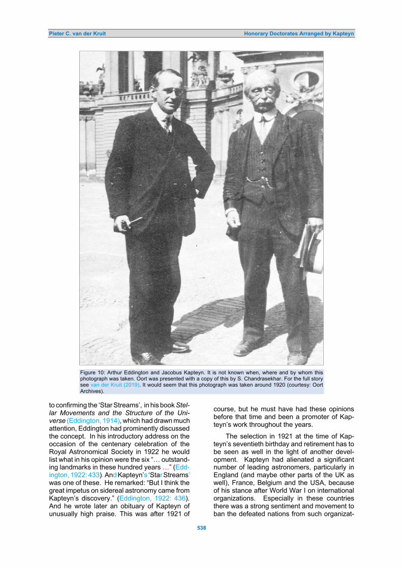
Pieter C. van der Kruit Honorary Doctorates Arranged by Kapteyn
538
Figure 10: Arthur Eddington and Jacobus Kapteyn. It is not known when, where and by whom this
photograph was taken. Oort was presented with a copy of this by S. Chandrasekhar. For the full story
see van der Kruit (2019). It would seem that this photograph was taken around 1920 (courtesy: Oort
Archives).
to confirming the ‘Star Streams’, in his book Stel- lar Movements and the Structure of the Uni-verse (Eddington, 1914), which had drawn much attention, Eddington had prominently discussed the concept. In his introductory address on the occasion of the centenary celebration of the Royal Astronomical Society in 1922 he would list what in his opinion were the six “… outstand-ing landmarks in these hundred years …” (Edd-ington, 1922: 433). And Kapteyn’s ‘Star Streams’ was one of these. He remarked: “But I think the great impetus on sidereal astronomy came from Kapteyn’s discovery.” (Eddington, 1922: 436). And he wrote later an obituary of Kapteyn of unusually high praise. This was after 1921 of
course, but he must have had these opinions before that time and been a promoter of Kap-teyn’s work throughout the years.
The selection in 1921 at the time of Kap-teyn’s seventieth birthday and retirement has to be seen as well in the light of another devel-opment. Kapteyn had alienated a significant number of leading astronomers, particularly in England (and maybe other parts of the UK as well), France, Belgium and the USA, because of his stance after World War I on international organizations. Especially in these countries there was a strong sentiment and movement to ban the defeated nations from such organizat-

Pieter C. van der Kruit Honorary Doctorates Arranged by Kapteyn
539
ions that were being formed just after the end of WWI. Kapteyn had vehemently opposed set-ting these up without participation from Ger-many, Austria, and the other Central Powers, in particular the International Research Council and the International Astronomical Union. More background on this can be found in an author-itative book by Kevles (1993), The Physicists. Together with his friend, physiology and psy-chology Professor Gerardus Heymans, Kap-teyn took the initiative to circulate an open letter strongly protesting and condemning this atti-tude, which in the end was signed by almost 300 persons (however, Kevles fails to mention the role of Heymans; see van der Kruit (2015) for an excerpt from this letter).
When Kapteyn’s 70th birthday was app-roaching in 1921, de Sitter took the initiative to prepare the publication of Kapteyn’s selected works. A committee that was formed quickly ran into opposition in the UK, apparently be-cause German Küstner was a member. So, when Frank W. Dyson (1868–1939), who then was at Greenwich, solicited help among British astronomers, he did get support from Arthur Ed-dington, but strong opposition from many others as well. French astronomer Jules Baillaud (1876–1960), Belgian Georges Lecointe (1869 –1929), and English astronomer Herbert H. Turner (1861–1930) from Oxford were among the most outspoken among European astrono-mers in arguing for the exclusion of German scientists after the war. They and others incor-rectly accused Kapteyn of having accepted the ‘Orden pour le Mérite’ from the German Kaiser at the same time as the captain of the submar-ine that had sunk the Lusitania. The ‘Orden pour le Mérite’ was a German distinction be-stowed by the Kaiser. It was a very high honor for a foreign scientist to receive that distinction (a few foreign astronomers had preceded Kap-teyn, such as Simon Newcomb, David Gill and Edward Pickering, as well as German astrono-mers Freidrich Argelander (1799–1875) and Arthur von Auwers (1838–1915), but also fam-ous scientists had received it, such as Charles Darwin, Lord Rayleigh, Hendrik Lorentz, and others). Kapteyn had received the ‘Orden’ in 1914 just before the War, at the same time as von Seeliger and Max Planck. This was in the Scientific Class, but there also was a Military Class, which the captain of the submarine that sunk the passenger ocean liner Lusitania—an act that enraged the world and played an im-portant role in the US joining the War—had received, but that was in 1917! Yet his stance did not prevent Kapteyn from being appointed not long after the War as a corresponding mem-ber of the French Academie and Foreign Mem-ber of the Royal Society (of London). De Sitt-
er’s plan came to naught and he and Kapteyn’s successor in Groningen, Pieter van Rhijn, might have resorted to a plan to have an honorary doctorate selected by Kapteyn.
Now Eddington was the first Englishman who was prepared to work toward reconcili-ation. George Hale seemed to have sided with those opposing Germany, but he in any case defended Kapteyn as being far from pro-German. After all, in their correspondence dur-ing the War, Kapteyn had expressed repeatedly his view that Germany was to blame for the War and had also very strongly condemned the sinking of the Lusitania. In 1920 Eddington was the only Englishman who attended the congress of the Astronomische Gesellschaft. Whether avoiding further escalation played a role in not selecting Eddington in 1921 remains a matter of speculation, but considerations like these must have played a role, regardless of how appropriate it had been to honor him this way on scientific grounds.
In 1922 an argument against selecting Hale for an honorary doctorate might have been Kap-teyn’s very poor relations with Walter Adams, who was Hale’s deputy. Adams might have seen this as a provocation against him, which Kapteyn would have wanted to avoid.
The choice of Annie Cannon seems to have had two other aspects. In the first place, a gen-uine appreciation and admiration for the work of stellar spectral classification at Harvard as a very fundamental and vital contribution to ast-ronomy. Cannon, in that case, would easily qualify as the obvious first exponent of this work, as Kapteyn expressed in his arguments to the Senate when he proposed her. Kapteyn was rather strict about giving credit where it belonged, as was clear from the Adams and Kohlschütter case. Of course, the Henry Draper Catalogue was compiled under Pickering’s dir-ectorship, but with the latter dead the honorary degree could easily go to Cannon, where Kap-teyn must have felt the credit belonged, without passing over Pickering. The second thing that may also have played a role was that Kapteyn would have welcomed the fact that it would be a woman who was being honored. Kapteyn had a record of supporting women’s rights.
One of his best friends in Groningen was the well-known Professor of Philosophy and Psychology Gerardus Heymans (see van der Kruit, 2015; 2021a). Heymans was among other matters interested in differences between men and women. He researched this with questionnaires, asking professors and lecturers at Dutch universities about character traits such as individuality, ability for abstraction, memory, etc., and whether they felt predominantly male

Pieter C. van der Kruit Honorary Doctorates Arranged by Kapteyn
540
or female. Kapteyn and his calculators helped reduce these data and maybe contributed to this as well. Although Kapteyn and Heymans were good friends, they often had different opin-ions, but when it came to women’s suffrage they were in perfect agreement. It is true that Hey-mans lobbied more actively for women’s suff-rage, but according to a thorough study by Inge de Wilde (1998) concerning New Participants in Science: Female Students and Teachers at the University of Groningen, 1871–1919, Kapteyn was certainly involved in Heymans’ circle of ac-quaintances who worked for women’s emanci-pation.
It is also remarkable that Kapteyn was the first astronomer in the Netherlands with a fe-male PhD student, Etine Imke Smid. She obtained her PhD degree in 1914 on a thesis, which concerned the study of proper motions of more than one hundred stars. She was the first woman in the Netherlands to obtain a doctorate with an astronomical dissertation. After her defense, Etine Smid worked for Kamerlingh Onnes in Leiden for some time, but moved to Deventer after she got married and left science.
And I quote from Henriette Hertzsprung-Kapteyn’s biography:
The children had grown up by now and all three of them were doing academic studies. The two girls were among the first female students. The oldest had chosen medicine and I took law as subjects, which gave rise to much criticism in these turbulent days of the fight for women’s rights, but Kapteyn felt that females studying at universities was so natural and unquestionable, that one did not get far with counter arguments. The son went to Freiburg in Saxony to study min-ing engineering. (Hertzsprung-Kapteyn, 1928).
The eldest daughter indeed studied medicine in Groningen, the younger law, for a while in Gron-ingen, but she later switched to English in Am-sterdam. The son went to Freiburg to study mining engineering; the fact that he did not go to Delft for this had to do with the lower costs of studying in Freiburg. His choice to send his daughters to university meant Kapteyn had to support three children during academic studies and that was a major financial burden. Profes-sors did earn a respectable salary, but many of them, including Kapteyn, did extra teaching in order to be able to finance their children’s stud-ies. Kapteyn chose to carry the financial burden of his daughters entering university, even if this meant that his son would have to go and study in Germany. Female students at universities were still quite a rarity; the first female student at a Dutch university was Aletta Henriette Jac-obs, who entered Groningen University to study medicine in 1871, followed six years later by her sister Charlotte, who studied pharmacy (hardly
a generation before Kapteyn’s daughters enter-ed university).
So, Kapteyn was a supporter of women’s emancipation. The fact that he was an uncon-ventional man in a number of ways may have been a reaction to his strictly religious upbring-ing. But he did not allow reform on all fronts. His marriage was along conventional lines; his wife took care of the household, while Kapteyn saw the finances as his exclusive responsibility.
Still, he had ‘caught two birds with one stone’ by simultaneously honoring the great progress in stellar spectroscopy and selecting a female honorary doctorate. Excluding the ava-lanche of honorary degrees in 1914, Cannon’s was the first honorary doctorate from Gronin-gen to go to a foreign scientist since Robert Koch in 1884. And it was also only the second honorary doctorate to go to a female from abroad in the history of Groningen University, after Alice Boole Stott in the 1914 tricentennial. This ‘drought’ would last until 1958, when Am-erican Professor of Neuroanatomy, Elizabeth Caroline Crosby, would become the third.
After his formal retirement Kapteyn and his wife left Groningen. They had bought a house in Hilversum, and after some travel in Europe they moved in with their daughter and her hus-band in Amsterdam before settling in their new house. Leiden Observatory had offered Kap-teyn a part-time appointment to take charge of the Astrometric Department, but by then the first signs of what would prove to be a fatal illness appeared, and he died in Amsterdam within a year of his retirement. Henriette Hertz-sprung-Kapteyn (1928) tells us that Kapteyn and his wife had left Groningen quietly. They had said farewell to their friends during dinners in small numbers and left unnoticed one day at seven in the morning. It is a pity that Annie Cannon could not come to Groningen to accept the honor in person during a special ceremonial meeting of the Senate to mark the departure of possibly Groningen’s most successful and cele-brated professor. 7 CONCLUDING REMARKS
On three different occasions Kapteyn proposed honorary doctorates for the University of Gro-ningen. The first one, in 1903, coincided with his 25th anniversary as a Professor in Gron-ingen, and it went to Cornelis Easton, a Dutch journalist and amateur astronomer. The degree was awarded to honor him for his work on mapping the Milky Way by making drawings. Easton followed up on this by attempting to derive the spiral structure of our Galaxy.
In 1914 Kapteyn proposed the German astronomer Karl Schwarzschild for a Groningen
Pieter C. van der Kruit Honorary Doctorates Arranged by Kapteyn
541
honorary doctorate, particularly for his theoret- ical contributions to the study of the structure and kinematics of stellar distributions in space.
Kapteyn most likely also proposed mus-ician, composer, teacher and friend, Peter van Anrooy, who not only developed his taste and appreciation for music but taught him lessons as well to better understand music.
It is very well possible that Kapteyn also had a determining role in the selection of the American industrialist and philanthropist An-drew Carnegie, the benefactor of the Institution that bore his name and provided Kapteyn with a Research Associate position that facilitated much of his research, including his annual visits to Mount Wilson Observatory.
Maybe for this reason the option of select-ing George Ellery Hale was not favored, while the otherwise very real option of Arthur Stanley Eddington was put aside because of his rela-tively young age.
There were a few controversies that may have limited the choice in 1921 and were to play an adverse role in many aspects of Kapteyn’s legacy. One was the rather poor relations be-tween him and Walter S. Adams, the Director of Mount Wilson Observatory, which prevented Kapteyn from returning to California after WWI, and which might have escalated had Hale been selected for a Groningen honorary doctorate.
Another was Kapteyn’s stand on what he viewed as the extremely objectionable policy of excluding nations such as Germany and Austria that had been defeated in WWI from member-ship of international political and scientific or-ganizations. Eddington also very strongly de-fended the same position as Kapteyn, but had Kapteyn selected him for an honorary Gronin-gen degree this might have escalated tensions with others.
When Kapteyn retired in 1921 he proposed Annie Cannon for her fundamental and essent-ial contributions to the Harvard spectral clas-sification and the Henry Draper Catalogue. He might have felt that in this way she would re-ceive the credit she deserved, which for women typically would go instead to the male director under whom they worked. The fact that Edward Pickering had died helped, since it meant that he did not have to be passed over. An im-portant argument for Cannon’s selection was Kapteyn’s support for women’s equality and rights. He must have welcomed the idea that she would be the first foreign female thus hon-ored by the University of Groningen.
With the imminence of the outbreak of the War in 1914, Schwarzschild’s enlisting in the German Army and his death during the War are
probably the reasons why his honorary Gron-ingen doctorate is seldom if ever mentioned, even in obituaries. In contrast, Cannon’s Gron-ingen degree usually is mentioned, although it was overshadowed by the one she received from the University of Oxford. Cannon’s deci-sion not to come to Groningen meant that there was no formal ceremony to mark Kapteyn’s retirement and departure from Groningen. 8 NOTES
1. In the Netherlands, Belgium, Germany and a few other countries the professor who has supervised the research is designated as the promotor and bestows the degree upon the candidate on behalf of the university. When I use this word ‘promotor’ in this paper it may also refer to the equivalent in other European countries.
2. Although at the University of Groningen the official name of an honorary doctorate is a ‘Doctor honoris causa’, for simplicity we will usually refer to this as an honorary doctor-ate throughout this paper.
3. I have retained the German name ‘Actino-metrie’, just as I have done with ‘Durch-musterung’ in the CPD.
4. When the luminosity function is unknown, there actually is a second integral equation to be solved simultaneously and that in-volves mean parallaxes as a function of ap-parent magnitude, derived from proper mot-ions and secular parallaxes. Kapteyn had studied this mathematical problem around 1900 with his brother Willem, who was a Professor of Mathematics in Utrecht. This was cumbersome so Schwazrschild’s meth-od was to be preferred.
5. The site of Leiden University (2020) lists honorary doctorates, but erroneously lists Deslandres as having been awarded a doc-torate in 1900.
6. In a formal sense this is incorrect, since Jacob Evert Baron de Vos van Steenwijk received one in 1959 from the Faculty of Law. He held a PhD in astronomy (from 1918 under Ernst van de Sande Bakhuy-zen), but became a politician and admini-strator, with appointments such as Mayor, Queen’s Commissioner and President-Cur-ator of Leiden University. But throughout his career he was actively involved in Dutch astronomy and attended IAU General As-semblies.
9 ACKNOWLEDGEMENTS
I am grateful to the staff of the Archives at the Niedersächsische Staats- und Universitätsbib-liothek Göttingen and of the Harvard University Archives – Pusey Library for providing scans of

Pieter C. van der Kruit Honorary Doctorates Arranged by Kapteyn
542
the relevant correspondence in the Schwarz-schild and Cannon archives. I thank historians Klaas van Berkel and David Baneke for critically reading a draft of this paper and for making
useful comments and suggestions. I also thank staff of the Kapteyn Astronomical Institute for support and help and for hospitality extended to an Emeritus Professor as guest scientist.
10 REFERENCES
Blaauw, A., 2014. Easton, Cornelis. In Hockey, T., et al., (eds.), The Biographical Encyclopedia of Astronomers. Second Edition. New York, Springer. Pp. 633–634.
Cannon, A.J., and Pickering, E.C., 1901. Spectra of bright southern stars photographed with the 13-inch Boyden Telescope as part of the Henry Draper Memorial. Annals of Harvard College Observatory, 28, 129–263.
Cannon, A.J., 1921. Letter to the Rector Magnificus of the University of Groningen, dated 16 June. University of Groningen Archives.
Cannon, A.J., 1925. Undated letter to the President of Wellesley College. Cannon Archives, Harvard University Archives – Pusey Library.
DeVorkin, D., 2000. Internationalism, Kapteyn and the Dutch pipeline. In van der Kruit and van Berkel, 129–150. de Wilde, I., 1998. Nieuwe deelgenoten in de Wetenschap: Vrouwelijke studenten en docenten aan de Rijks-
universiteit Groningen 1871–1919. Assen, van Gorcum. Easton, C., 1900. A new theory of the Milky Way. Astrophysical Journal, 12, 136–158. Easton, C, 1913. A photographic chart of the Milky Way and the spiral theory of the Galactic System. Astrophysical
Journal, 37, 105 –118. Eddington, A.S., 1906. Systematic motions of the stars. Monthly Notices of the Royal Astronomical Society, 67,
34–36. Eddington, A.S., 1914. Stellar Movements and the Structure of the Universe. London, Macmillan. Eddington, A.S., 1917. Obituary Notice, Associate: Schwarzschild, Karl. Monthly Notices of the Royal Astronomical
Society, 77, 314 –319. Eddington, A.S., 1922. Introductory address delivered on the occasion of the Society’s centenary celebrations.
Monthly Notices of the Royal Astronomical Society, 82, 433–437. Harvard University, 2020. Honorary Degrees, ‘honoca’ (www.harvard.edu/oncampus/commencement/honorary-
degrees). Heffernan, M., and Jöns, H., 2007. Degrees of influence: the politics of honorary degrees in the Universities of
Oxford and Cambridge, 1900–2000. Minerva: A Review of Science, Learning and Policy, 45(4), 389–416. Hertzsprung, E., 1917. Karl Schwarzschild. Astrophysical Journal, 45, 285 –292. Hertzsprung-Kapteyn, H., 1928. J.C. Kapteyn; Zijn leven en werken. Groningen, Wolters (electronic version
available at www.dbnl.org/tekst/hert042jcka01_01/ ; for more information and my English translation see www.astro.rug.nl/JCKapteyn/HHKbiog.html).
Kapteyn, J.C., 1921. Letter to Annie Jump Cannon, dated 10 June. Cannon Archives, Harvard University Archives – Pusey Library.
Kevles, D.J., 1995. The Physicists: The History of a Scientific Community in Modern America. Cambridge (Mass.), Harvard University Press.
Leiden Observatory, 1908. Album Amicorum, presented to H.G. van de Sande Bakhuyzen (see local.strw.leidenuniv.nl/album1908/book info.html).
Leiden University, 2020. Eredoctoraten en prijzen (see www.universiteitleiden.nl/over-ons/feiten-en-cijfers/eredoctoraten-en-prijzen).
Merriam-Webster Dictionary, 2020. Web site: www.merriam-webster.com/dictionary/honorary+degree. Nieuwsblad van het Noorden, 2018. Web site: www.dvhn.nl/groningen/Dit-is-waarom-Ban-Ki-moon-een-
eredoctoraat-van-de-Rijksuniversiteit-Groningen-verdient-23674056.html. Oxford University, 2020: Honorary degrees, Early history (www.ox.ac.uk/news-and-events/The-University-
Year/Encaenia/Honorary-Degrees-Early-History). Paul, E.R., 1993. The Milky Way Galaxy and Statistical Cosmology, 1890–1924. Cambridge, Cambridge University
Press. Rector Magnificus, 1921. Letter to Annie Jump Cannon, dated 16 October. University of Groningen Archives. Schwarzschild Archives. Niedersächsische Staats- und Universitätsbibliothek Göttingen, Germany. Schwarzschild, K., 1912. Zür stellarstatistik. Astronomische Nachrichten, 190, 361–366. Schwarzschild, K., 1914a. Note to the Rector and Senate, University of Groningen, dated 20 April. University of
Groningen Archives. Schwarzschild, K., 1914b. Note to the Senate, University of Groningen, dated 5 July. University of Groningen
Archives. Stein SJ, J.W.J.A., 1929. Dr. C. Easton, in memoriam. Hemel & Dampkring, 27, 225–236; 258–271. University of Groningen, 1902/1903. Lotgevallen. University of Groningen Archives. University of Groningen, 1914. Academia Groningana, MDCXIV–MCMXIV; Gedenkboek ter gelegenheid van het
derde eeuwfeest der Universiteit te Groningen, uitgegeven in opdracht van den Academischen Senaat. University of Groningen, 1916: Academia Groningana 29 Juni – 1 Juli 1914: Verslag van de herdenking van het
3de eeuwfeest der Universiteit te Groningen. University of Groningen, 2020. Overzicht eredoctoraten 1717–2018 (www.rug.nl/about-ug/pro_le/prizes-and-
awards/honorary-doctorates/eredoctoraten-1717-2018.pdf.) University of Groningen, 1921. Proposal by J.C. Kapteyn to award Annie Jump Cannon an Honorary Doctorate.
University of Groningen Archives. van Berkel, K., 2000. Growing astronomers for export: Dutch astronomers in the United States before World War

Pieter C. van der Kruit Honorary Doctorates Arranged by Kapteyn
543
II. In van der Kruit and van Berkel, 151–174. van der Kruit, P.C., and van Berkel, K., 2000. The Legacy of J.C. Kapteyn: Studies on Kapteyn and the
Development of Modern Astronomy. Dordrecht, Kluwer. van der Kruit, P.C., 2015. Jacobus Cornelius Kapteyn: Born Investigator of the Heavens. Springer International
Publishing. van der Kruit, P.C., 2019. Jan Hendrik Oort: Master of the Galactic System. Cham (Switzerland), Springer. van der Kruit, P.C., 2021a. Pioneer of Galactic Astronomy: A Biography of Jacobus Cornelius Kapteyn. Cham
(Switzerland), Springer. van der Kruit, P.C., 2021b. Master of Galactic Astronomy: A Biography of Jan Hendrik Oort. Cham (Switzerland),
Springer. van der Kruit, P.C., 2021c. This is an expanded version of this paper, which is available from the author’s web
page: www.astro.rug.nl/~vdkruit van E., E. [van Everdingen], 1929. Dr. C. Easton. Nature, 124(3130), 659.
Pieter C. van der Kruit is Emeritus Jacobus C. Kapteyn Distinguished Professor of Astronomy at the Kapteyn Astronomical Institute of the University of Groningen in the Netherlands. He obtained his PhD in astronomy from Leiden University in 1971 under Jan Hendrik Oort. He held a prestigious Carnegie Postdoctoral Fellowship at the Mount Wilson and Palomar Observatories in Pasadena (California), before moving to the University of Groningen in 1975. He has held visiting positions at various institutions, including Mount Stromlo Observatory in Canberra (Australia), the Institute of Astronomy in Cambridge (UK), the Space Telescope Science Institute in Baltimore (USA), the European Southern Observatory in Santiago (Chile), the Instituto de Astrofísica de Canarias in Tenerife (Spain) and the Carnegie Observatories in Pasadena (California).
His research concerns the structure and dynamics of disks in galaxies. He has published over 160 papers, more than half as lead or sole author, contributed substantially to over 20 more, and authored or edited eight books, among which are recent biographies of Jacobus Cornelius Kapteyn and Jan Hendrik Oort.
In Groningen he taught introductory astronomy and advanced level courses on the structure and dynamics of galaxies for many years, the latter also at a Saas-Fee winter school in Switzerland and in university curricula in Porto (Portugal), in Santiago (Chile) and in Beijing (China).
He is a former Director of the Kapteyn Astronomical Institute and has been a member and often chairman of numerous national and international boards and committees, notably President of Council of the European Southern Observatory and Chairman of the Board for the Atacama Large Millimeter Array (ALMA). In 2006 he received a Royal Decoration as Knight in the Order of the Netherlands Lion.

Journal of Astronomical History and Heritage, 24(2), 544–560 (2021).
544
BOOK REVIEWS Chinese Astrology and Astronomy: An Outside History, by Jiang Xiaoyuan. Trans. Chen Wenan. (Singapore, World Scientific, 2021). Pp. xx+312. ISBN 978-981-122-345-7 (hardback), 160 × 235 mm, US $128. First published as Tianxue waishi ���� (Shanghai: Shanghai Jiaotong Daxue, 2015).
Jiang Xiaoyuan is one of China’s foremost scholars of the history of astronomy and ast-rology. He has published extensively not only on ancient China but also comparative studies of the astrological and astronomical traditions of Western classical civilization, Mesopotamia, India, and Islam. Jiang dis-tinguishes what he prefers to call tianxue �� ‘the study of the heavens’ from ‘astronomy’ to underscore the difference between tradit-ional Chinese approaches and modern West- ern scientific astronomy (Chapters 1 & 2). Jiang has subtitled his study An Outside History, the objective being on the one hand to present an alternative historiographic ap-proach and sidestep the unproductive quest-ion whether the ancients’ pursuits qualify as ‘science’ in the modern sense. On the other hand, Jiang’s framing of the subject was also a declaration of his position in the polemics
about the history of science education in China during the 1980s–1990s. Then the ‘watchword’ was to ‘invigorate the country through science, technology and education’, with an attendant concern about Eurocentrism in the educational curriculum, in response to which a nationalistic effort was mounted by some to qualify some traditional Chinese dis-ciplines as scientific.
The book was written in the late 1990’s and was clearly intended for a Chinese read-ership, presumably in secondary and tertiary education. As the author states, while cov-ering essentially the same ground as his mag-isterial The True Origin of the Study of the Heavens (Jiang, 1991) which won a national book award, An Outside History was intended as a less specialized, more accessible treat-ment. Given the targeted readership, there are sections replete with names of prominent figures and works that will be opaque to readers who do not have a grounding in the history of ideas and chronology of China.
Nevertheless, non-Chinese readers will find much of interest in the book, such as Chapter 3, on what kind of people were en-gaged in tianxue in Ancient China?; Chapters 5–6, astronomical phenomena and tianxue literature (including examples of medieval ob-servatory logs, the earliest star charts and stellar nomenclature, discussion of the most influential prognostication manuals, etc.); Chapters 7–8, competing cosmological theo-ries and Sino-foreign influences (principally India and Buddhism); Chapters 10–11, the introduction of Western astronomy by Jesuits and its early reception; Chapter 12, collisions between East and West and reactions to foreign influences by scholars who asserted that Western learning originated from China; Chapter 13, the legacy of Chinese tianxue and the importance of its accumulated know-ledge base in modern astronomical research.
Since it was originally written some 25 years ago, with the exception of Joseph Needham’s highly influential early work (1959) and an off-hand mention of Nathan Sivin (page 272), there is no mention of important Western scholarship such as John Hender-son’s studies of the history of Chinese science and cosmology (1984; 1986) or Pankenier (1995). Since the Chinese version of this book first appeared in 2015 and the English version in 2021 there should also have been ample time to take account of more recent scholarship, e.g., Feng (2001) and Morgan (2013).

Book Reviews
545
Generally speaking, the English translat-ion is commendable for being the work of a non-native English speaker, despite a few lapses into Chinglish, the occasional howler, and haphazard proofreading. There are a few categorical statements that bring the reader up short, such as “Western medicine has not yet become an exact science, so it is not a science yet …”, therefore it is on a par with Chinese traditional medicine (page 275). Despite minor flaws the highlighted chapters are highly informative and advance some original perspectives on the role of ‘the study of the heavens’ in pre-modern China, espec-ially concerning potential Indian influence on cosmology by the early imperial period (ca. third century BCE). Jiang’s Chinese Astrology and Astronomy: An Outside History is an essential resource for English-speaking read-ers investigating the study of the heavens in imperial China.
References
FENG Shi��, 2001. Archaeoastronomy in China, Zhongguo tianwen kaoguxue ������ (Beijing, Shehui kexue chubanshe).
Henderson, J.B., 1984. The Development and De-cline of Chinese Cosmology. New York, Colum-bia University Press.
Henderson, J.B., 1986. Ch'ing scholars’ views of Western astronomy. Harvard Journal of Asiatic Studies, 46(1), 121–148.
JIANG Xiaoyuan, 1991. The True Origin of the Study of the Heavens, Tianxue zhen yuan ���. Shenyang, Liaoning jiaoyu chubanshe.
Morgan, D.P., 2013. Knowing Heaven: Astronomy, the Calendar, and the Sagecraft of Science in Early Imperial China. Chicago, University of Chi-cago Press.
Needham, J., with the research assistance of Wang Ling, 1959. Science and Civilisation in China. Volume 3: Mathematics and the Sciences of the Heavens and the Earth. Cambridge, Cam-bridge University Press.
Pankenier, D.W., 1995. The cosmo-political back-ground of heaven’s mandate. Early China, 20, 121–176.
David Pankenier Professor Emeritus, Modern Languages
and Literatures, Lehigh University Bethlehem, Pennsylvania, USA.
E-mail: [email protected]
Heaven On Earth: How Copernicus, Brahe, Kepler and Galileo Discovered the Modern World, by L.S. Fauber. (New York, Pegasus Books, 2019). Pp. xii + 332. ISBN 978-1-64313-204-4 (hardback), 155 × 235 mm, US $29.95.
The four great astronomers in the Early Modern era—Copernicus, Brahe, Kepler and Galileo—are the subject of this unusual hist-
ory of astronomy book. The best way to describe it is simply by quoting a passage on the author’s description of Kepler’s book The Harmony of the World:
Planets were plucked out of the quintes-sence, which knew no time, and placed back, recalibrated to the pulse of the human heart. The welkin grew thick with beats off the drum of reason, the parlia-ment of fixed stars announced their fires in anticipation, the cosmos let out the ethereal drone of orchestral tuning. The universe began to play, conducted by Kepler’s theory of harmony. (page 94).
Well, what can one say to that? Either the reader will be captivated by the prose, or reminded of the worst excesses of Victorian literature. When I first read the author’s take on the ancient reaction to the study of retro-grade planetary motion, I thought he or she was a bit daft: “The ancient Egyptians must have thought the planets drunk.” (page 6). But as I read further into the text I realised that while this is certainly not a scholarly history of astronomy book (which has a limited audi-ence), the author has carefully digested most of the relevant material about those four great astronomers and presented it in a novel fash-ion. By novel I do mean there are novelistic approaches to some of the material, but it gets to heart of the matter that any reader can relate to. For example:
As a child, it had brought Kepler physical pain that he had been denied the gift of

Book Reviews
546
prophecy. Personal, immediate, mystic-al experience of God was the form of it he most desired, but he was too immoral, he thought, had committed too many crimes to receive such a gift. He never acted like a mystic, but he hoped he might access mystical insights through mathe-matics. (page 86)
Fauber describes Galileo’s book Dialogue on the Two Chief World Systems as “the literary equivalent of a single man trying to take apart a castle with his bare hands,” the castle being nearly two millennia of commentary on Aristotle’s natural philo-sophy. (page 215).
The author (who is only identified as hav-ing attended Bard College and is now working on a PhD in Computer Science at the Uni-versity of California, Riverside), is quite aware of his/her approach to the subject matter. It is evident if one reads the endnotes in con-junction with the text. The author has a pow-erful line about Giordano Bruno’s reaction to a portrait of Jesus thrust before him, after he had been tied to a stake for execution: “Bruno would not look–out of disdain for Christ? Unlikely–out of disdain for the Church.” (page 88). Turn to the note for this and you will read “I step into histrionics here, naturally.” (page 281). This self-reflection actually saves the book from the travesty it could have been—what we have instead is a gem that is all the better for being unpolished.
These notes comprise 60 pages, giving exact locations for the material used to create the narrative, and much more. For example, a note on pages 312–314 contains the first English translation of a poem about Galileo by Maffeo Barberini (better known as Pope Urban VIII).
The book contains many delights, includ-ing quite a bit on Tycho’s sister Sophie (listed as Sophia in the index), such as a quote from Tycho on his attempt to dissuade her from astrological speculations. Written with brio, the breezy, off-the-cuff style of this book serves as a counterpoint to all other books I have read on the four ‘greats’. Despite the latitude taken in many instances, it is not, however, counterfactual. Even professional historians of astronomy may reconsider cer-tain people or events in a different light after reading this, and it can equally well be recom-mended as an entry-level text to the com-plexities that surround early modern astron-omy.
Dr Clifford Cunningham University of Southern Queensland
5201 North Spring View Drive, Tucson, USA E-mail: [email protected]
Internationality in the Astronomical Re-search of the 18th to 20th Centuries edited by G. Wolfschmidt (Hamburg, Tredition, Nuncius Hamburgensis, Volume 49, 2020), Pp. 508, ISBN 978-3-7482-4975-7 (paper-back), €39.90, 220mm × 170mm, 978-3-7482-4976-4 (hardback), €46.60, 226mm × 175mm, 978-3-7482-4977-1 (e-Book), €9.90.
This is the Proceedings of the meeting of the Working Group for the History of Astronomy of the German Astronomical Society held on 17– 19 August, 2018 at Kuffner Observatory in Vienna.
There is no research in astronomy or any other field without contact with other scientists, and science is usually not bound to national borders. The guiding ideas of the topic ad-dressed in this meeting were the beginnings of international cooperation mediated by the newly founded academies and societies; the establishment of the first journals as academy publications; and international campaigns.
The proceedings start with an introduction to the historical development of the internat-ionality in the astronomical research by Gud-run Wolfschmidt covering the foundation of national and international astronomical acad-emies with focus on the German societies and the IAU, the international campaigns of ob-serving transits, creating star catalogs and monitoring variable stars, and ending in a short and rather incomplete mention of some current international projects.
Thirteen of the seventeen contributions to the meeting more or less addressing the gen-eral topic in a time range from the seven-teenth to the twenty-first century are present-ed as chapters in the book; four contributions are included with abstracts only. The time range given in the title could be cause for mis-understanding: the cover pages state eight-eenth to twentieth century, the title page eight-eenth to twenty-first century, but actually sev-enteenth to twenty-first century is the correct range of the contributions. The papers con-centrate on Austrian and German astronomi-cal research.
In the first paper a detailed analysis of Kepler’s eclipse observations from 1616 to 1620 in Linz is presented, in order to identify the house where Kepler lived when authoring his third law of planetary motion. The paper also gives a list and a short explanation of Kepler’s publications that he finished while in Linz. The second paper describes the life of Giovanni Jacopo de Marinoni, mathematician, astronomer and geodesist in Vienna at the beginning of the eighteenth century. His pri-

Book Reviews
547
vate observatory was the first observatory in Vienna. The Venus transit observations of 1761 at Vienna by Maximilian Hell, successor of Marinoni as Director of Vienna Observatory, and the French team of César François Cas-sini de Thury as well as Hells expedition to Vardøya (1768/1769) are in focus of the next two papers.
In the nineteenth century the internation-ality of science was strongly supported by the newly founded academies and societies. The German Astronomical Society (Astron-omische Gesellschaft) was founded in 1863 with German as its business language but membership was not bound to any nationality. Until the end of World War I the fraction of foreign astronomers was about 60%. The de-velopment of international membership during the first 150 years of its history is presented in the first paper in the nineteenth century sect-ion of the book. Two contributions cover the founding history of Greece’s first observatory by Georgios Constantin Bouris and the ex-change between German and Greek astron-omers in the nineteenth century. The influ-ence of Ernst Mach’s historical critical anal-ysis of Newtons mechanics on the develop-ment of the General Theory of Relativity by Albert Einstein is discussed in the last paper of this section.
The section of the twentieth century starts with a presentation on the cooperation of Jo-hann Palisa, Joseph Rheden and Max Wolf in the compilation of the Wolf-Palisa star charts from photographic plates of the Bruce Tele-scope in Heidelberg. Several years ago, an extended version of this paper was published by Schnell (2014).
One of the highlights of this proceedings is the paper about the international cooper-ation in variable star research. It contains a very good historical review of the develop-ment of that field of astronomical research and it addresses the need for co-operation in time-domain astronomy as well as open ac-cess to the data. Thus, variable star re-search is promoting global citizenship. The following paper describes Maria Wähnl’s ef-forts in rebuilding and reviving the Urania Observatory at Vienna after its destruction near the end of World War II by an airstrike. The impact of Austrian chemists in the field of cosmochemistry at the Max Planck Institute for Chemistry at Mainz/Germany during the twentieth century is the topic of another paper.
And finally, another highlight is the report about the development of neutrino physics with a special emphasis on the solar neutrino puzzle and its solution. The motivation of
co-operation in this example is the huge effort necessary to make progress that can only be managed together.
When comparing internationality in other fields of science, one is missing some in-troductory remarks on the special motivation for cooperation in astronomy using ground-based observations: the all-sky coverage and the total time coverage in time-domain ast-ronomy demands cooperation and often was, and still is, the driving force! And, the Intro-duction does not address the development of the virtual observatory, the world-wide open database of astronomical data. Astrono-mers are leading players in open access shar-ing of data without any limitations to nation-ality.
The book is written in German except the paper about the influence of the Mach prin-ciple on the General Theory of Relativity; but all papers start with abstracts in English and in German.
The proceedings of a rather small meet-ing cannot hope to fully cover the topic of internationality in astronomical research. How-ever, the book contains papers that presum-ably are not found elsewhere, and gives special insights into internationality in Austrian and German astronomy.
Reference
Schnell, A. 2014. Überholt vom Fortschritt – die Geschichte einer Koproduktion Heidelberg–Wien, Die Wolf-Palisa-Karten (ein früher photographischer Himmelsatlas), Acta Historica Astronomiae 50, 151–166.

Book Reviews
548
Professor Andreas Schrimpf History of Astronomy and Observational
Astronomy, Philipps-Universität Marburg, Physics Department, Renthof 5, D-35032
Marburg, Germany. E-Mail: [email protected]
marburg.de
Leopolis Scientifica. Science in Lviv till the Middle of XX Century. Two Volumes, edited by Oleh Petruk. (Lviv, Artos, 2020). Volume 1: pp. 336. ISBN 978-617-642-492-5 (hardback); Volume 2: pp. 412. ISBN 978-617-642-493-2 (hardback). 200 × 290 mm.
The city of Leopolis (other spellings are Lem-berg in German, Lwów in Polish and Lviv in Ukrainian) was founded in the thirteenth cen-tury by the Ukrainian ruler Daniel of Galicia (Danylo Halytskyi), the King of Ruthenia. The city and the region were taken by the Polish king in the next century. Galicia be-came a part of the Habsburg Monarchy in
1772, and of Poland after the World War I. At present, the eastern part of Galicia includ-ing Lviv is in Ukraine, and the western part is in Poland. The city is located at an important cross-roads; it was always a multinational city, with dominance of Catholic and Orthodox Christians, as well as Jews. The regions around the city were dominated by Ukrainians.
Lviv University was founded in 1661 when the Polish King John II Casimir gave the title of University to the Jesuit College that had been established in 1608. Thus, the middle of the seventeenth century is assumed as the beginning of science in Lviv. The two-vol-ume book Leopolis Scientifica is devoted to an analysis of history of science in the city from that time up till World War II. The ed-ition is a collection of papers written by prom-inent scholars. The first volume is devoted to history of the state scientific centers, the University and Polytechnic. At the same time, considerable attention is paid to activities of the underground Ukrainian University and Ukrainian scientific societies. (These non-Governmental institutions arose as a result of efforts by Ukrainians in the late nineteenth and early twentieth centuries to have an op-portunity for the highest education; this was almost impossible at that time.)
The second volume deals with develop-ment of Mathematics, Physics and Astronomy. The book is of the large format, with more than 800 illustrations in both volumes. This review is devoted to the second volume. Its table of contents is as follows: Mathematics in Lviv (Yaroslav Prytula, pp. 3–182), Ukrainian Mathematical Trinity (Bohdan Ptashnyk, pp. 183–218), Physics in Lviv educational instit-utions since seventeenth century (Andrij Rov-enchak, pp. 219–286), Physics and Physi-cists in Shevchenko Scientific Society in Lviv (Yurij Holovatch, Yulian Honchar, Marjana Krasnytska, pp. 287–338), Astronomical Ob-servatory in Lviv University (Stepan Apun-evych, Bohdan Novosyadlyj, pp. 339–356), Astronomy in Lviv Polytechnic (Stepan Sav-chuk, Liubov Yankiv-Vitkovska, pp. 357–380), Astronomy in Ukrainian Scientific Societies (Oleh Petruk, pp.381–406).
As one can see, three papers in this volume are devoted to astronomy. The first explores evidence about scientific astronomi-cal observations performed in Lviv, and is related to the year 1764 when the priest Dom-inik Lysogorski studied a solar eclipse. Ast-ronomical education at that time was already at a high level as one can see from the pro-grams of public exams for students of the two-years mathematical courses in the Lviv Jesuit College during 1745–1749. The specialized institution, Astronomical Observatory, was opened in Lviv on 15 May 1771, i.e. 250 years ago. Therefore, it is amongst the oldest ob-servatories in Europe. It was created by the efforts and funding of the Jesuits, in particular Sebastian Sierakowski, who prepared the project of the tower (Sierakowski was later the Rector of Jagiellonian University in Cracow).
Book Reviews
549
Lviv Observatory hosted in the last decades of eighteenth century a number of famous scientists, including Josef Lies-ganig and Franz von Zach. Actually, the paper by Apunevych and Novosyadlyj introduces the reader to the history of astronomical edu-cation and research at Lviv University. Dur-ing the twentieth century, the Directors of the Observatory were Marcin Ernst (the most notable writer of popular astronomical books in Poland) and Eugeniusz Rybka (after the World War II, he was a Director of astro-nomical observatories in Cracow and Wro-claw, and in 1952 was elected as the Vice-president of International Astronomical Union).
One of the prominent achievements in astronomy at Lviv University involved Lies-ganig and his collaborators, who created the first topographic map of Galicia in 1790; then Marian Smoluchowski applied his kinetic theory to the atmospheres of planets (1900 and 1901); and Samuil Kaplan discovered the unstable circular orbits in the Schwarzschild field (1949), created a theory of white dwarf cooling (1950), and contributed to the theory of the interstellar medium. The first vertical solar telescope with a double-reflection spec-trograph in eastern Europe was estabished at Lviv University Observatory.
In the next study, Savchuk and Yankiv-Vitkovska describe the second Observatory in Lviv, which was built in the 1870s. This in-stitution was operated mostly for the needs of geodesy and education. Three prominent scientists need to be mentioned in relation to this Observatory: Dominik Zbrożek, Vaclav Laska and Lucjan Grabowski.
Ukrainians in Lviv had very limited access to high schools. Even those who obtained PhD degrees, as a rule, could only work in gymnasiums. Therefore, the Shevchenko Scientific Society (founded in 1873), in which one Section was devoted to Natural Sciences, Mathematics and Medicine, played an im-portant role. The Chief of this Section for a few decades was Volodymyr Levytsky. He and other members of this Section published scientific papers in the fields of mathematics, physics and astronomy. They also active- ly promoted science (including astronomy) among Ukrainians by publishing articles and giving public lectures.
Essays in the two-volume set are thor-ough, with many facts found and published for the first time. Most of the authors have made significant achievements in the history of various branches of science. Their studies are based on a careful study of the archival sources and propose a deep understanding of
the complex processes that accompany the progress of science. The authors create a systematic panoramic picture, which is ex-tremely interesting to read, not only for schol-ars but for anyone who wants to learn about the history of culture in this part of Eastern Europe. Although the focus of the book is on the various stages of research and education in Lviv, it also objectively highlights important international and state-building processes.
Special attention should be paid to the illustrations, which include many unique pho-tographs and copies of documents. The authors went to considerable effort to find them, many of which are published for the first time. Each of the papers in this book con-tains a detailed bibliography that will be useful for future researchers. Without doubt, this large-scale project will be greatly appreciated by the scientific community.
This book, in the Ukrainian language, was published under the auspices of the Institute for Applied Problems in Mechanics and Math-ematics of the Ukrainian National Academy of Sciences. The papers were collected and scientifically edited by Oleh Petruk. An ele-gant edition of the book was prepared and published by the Artos publishing house. The publication appeared thanks to the good will of the sponsors, who are co-founders of the IT company SoftServe, which is now the largest employer of talented young people in Lviv with a good mathematics and physics edu-cation.
Dr Volodymyr Pelykh & Dr Roman Plyatsko Institute for Applied Problems in Mechanics and Mathematics of the Ukrainian National
Academy of Sciences, Lviv, Ukraine. E-mail: [email protected]
The Light Ages: The Surprising Story of Medieval Science, by Seb Falk (New York, W.W. Norton and Company, 2020) Pp. 391, ISBN 9781324002932 (hardcover), 160 × 230 mm. US $30.00.
The Light Ages: The Surprising Story of Med-ieval Science is by Cambridge historian and lecturer Seb Falk who specializes in the hist-ory of astronomy, navigation and mathemat-ics from their early development through the Middle Ages into the contemporary period. Falk puts to rest the obsolete and long-dis-credited notion that referred to the medieval period as ‘The Dark Ages’ and illuminates the advancements in scientific knowledge as well as the spirit of experimentation that actually existed. To illustrate his survey of astronom-ical theories and advances, Falk researched

Book Reviews
550
the compelling story of a fourteenth-century monk-scholar-astronomer-crusader, Johan-nes de Westwyk, tracking his life through his writings and scattered references found in various documents. The Light Ages tells the tale not only of the struggles, research and accomplishments of Westwyk, but the world around him; the emerging sciences and tech-nological achievements in timekeeping, mechanical clocks, optics, astronomical in-struments, navigation and medicine. Falk defines and appraises the … “irresistible med-ieval drive to tinker, to redesign, to increment-ally improve or upgrade technology.” Using Brother Westwyk’s life and achievements as an anchor that he returns to over and over in his ambitious tome, Falk guides the reader through the intellectual advances and under-standing of science, especially astronomy in the Pre-Renaissance world of Europe.
John of Westwyk received his basic edu-cation and then took monastic vows at the Benedictine Abbey of St. Albans, Hertford-shire, England in the 1370s. Many medieval abbeys were lonely, isolated spots devoted to prayer, poverty and subsistence farming but not St Albans. Dating back to the eighth century and honoring England’s first martyr, the wealthy complex comprised numerous imposing buildings and functioned as a lively center of economic, societal and religious activities—an artistic and intellectual hub.
Located one day’s journey on the main road north from London, the comfortable abbey offered hospitality to Royalty in transit, as well as bishops, emissaries and scholars passing to and from Oxford University, just fifteen miles further north.
St. Albans boasted many famous mem-bers of their monastery including Richard of Wallingford (1292–1336), the leprous clock-maker, and Matthew Paris (c.1200–1259), the celebrated writer of the Illustrated Chronicles; Observations of Thirteenth-Century Life. Paris’ writings detailed and illuminated British and world historical events and religious act-ivities. He created many important maps culled from well-traveled pilgrims and even crusaders who visited the abbey. Paris also produced a book on astrology that discussed the work of Hermann Contractus or the Lame (1013–1054), even drawing his picture. Her-mann of Reichenau had written on sundial, mathematics and The Uses of the Astrolabe with instructions for making one.
Abbot of St Albans from 1327 until his death, Richard of Wallingford’s astronomical clock was the wonder of Britain and sat in the south transit of the abbey church until 1539 when it was destroyed during Henry VIII’s dissolution of the monasteries. The huge clock, measuring eight feet across, displayed the Sun and Moon moving across the sky at varying speeds, as well as the accurate phases of the Moon and the lunar nodes. J.D. North published an excellent edition of Wallingford’s writings in 1976 fully describing the clock’s intricate workings. Called ‘the world’s most advanced astronomical clock’, its numerous wheels and dials were so com-plicated that it was not completely finished until twenty years after Wallingford’s death. Westwyk would have viewed the great clock at least seven times a day during the man-datory canonical hours of prayers chanted by the monks throughout each day and night.
The medieval Church had a reputation for discouraging scientific advancements, but Falk demonstrates the opposite was true. Friar John and other monks and priests were encouraged to attend university for higher ed-ucation. Westwyk’s writings indicate he at-tended Oxford although no proof survives. The clergy were expected to acquire know-ledge of astronomy and mathematics neces-sary for measuring time and making precise astronomical observations for creating accu-rate Church calendars. Monks used astro-labes and other scientific instruments and often maintained records of exact planetary and stellar positions. The positions of the

Book Reviews
551
planets as they moved through each constel-lation of the zodiac were made, copied, cor-rected and re-calculated by trained monks. Tracking the appearance of certain stars at special points, between two windows, over a tower, or on the horizon would signal the proper time for their daily prayers and an-nounce feast days.
Citing Westwyk as a medieval university student, Falk presents an extensive survey of the curriculum offered at that time through the Seven Liberal Arts and the widely-read ast-ronomical textbook of Johannes de Sacro-bosco, De Sphaera. A beginning text often used was Priscian’s Institutes of Grammar. Three branches of philosophy (moral philo-sophy, natural philosophy and metaphysics) were studied, as well as the contributions and importance of Islamic scientific scholars such as Al-Farghani, Abu Ma’shar and Al-Biruni, and the basic role astronomy and astrology played in medieval medicine.
Eventually Brother Westwyk was transfer-red to a small Northumbrian abbey, Tyne-mouth Priory, built on a rocky outcrop over-looking the North Sea, which must have test-ed the vows of the bright and curious astron-omer. Another monk described the “… dense and gloomy fogs … [that] dull the eyes, hoars-en the voice and constrict the throat …”, add-ing that “… spring with its flowers is outlawed there; summer warmth is banned …” (page 180). Even worse, his new priory library had only “… a dozen or so books.” (page 181). He must have brought along a few since he continued his studies and astronomical obser-vations, charting the planetary positions and movements of the heavens.
Falk picked up traces of Westwyk’s life again in 1383 when he joined a crusade along with six other monks of St Albans lead by the Bishop of Norwich, Henry de Despenser. Perhaps fighting on crusade was more ap-pealing than the boring life in gloomy Tyne-mouth that saw no summers. In return for the promise of enormous spiritual benefits and indulgences, numerous participants from all occupations joined the crusade against the loyalists of the Antipope Clement VII ruling from Avignon. The Papal schism had split the Catholic Church and two popes (later three) claimed legitimacy. The schism was tied to the Hundred Years War between En-gland and France. Initially the campaign was successful, but not for long; the army began to suffer losses and then succumbed to dys-entery. The religious crusade set off with great hopes in May 1383 but by the end of September had retreated to England in defeat.
After Westwyk’s return from the dreadful battles, there is no record of the astronomer monk’s whereabouts for ten years until he reappears staying at a London inn or guest-house of St Albans Abbey. There, complain-ing of pig-filled streets, he wrote his final man-uscript, an instructional manual for construct-ing a scientific instrument of his own invention and explanation of its use as an astronomical device which he called Equatorie of the Plan-etis. Falk begins his book discussing this manuscript, which was first discovered in the 1950s in the Cambridge Peterhouse Library, MS 7, dated 1392. The manuscript was sus-pected to be the author’s draft of a treatise on the astrolabe and was initially attributed to Geoffrey Chaucer who wrote the Treatise on the Astrolabe in 1391 but Chaucer scholars could never prove it. Surprisingly it was writ-ten in Middle English not Latin used in all Church documents, which also pointed to Chaucer.
Much later, the actual author was discov-ered by Norwegian scholar Kari-Anne Rand after comparing the identical writing style of the Equatorium to Westwyk’s previous man-uscript called Albion that was discovered in 2000. This manuscript was another com-pendium of astronomical calculations signed Johannes de Westwyk and based on Richard of Wallingford’s work. He had created the work at St Albans for their monastic library. Actually in 1379 Westwyk had copied and annotated two Latin manuscripts on the use of astronomical instruments originally written by Wallingford.
Westwyk personally interacted with the English poet and astronomer and cites him through his writings. Based on Arabic astro-nomical writing, Chaucer’s Treatise on the Astrolabe included two parts, the instrument’s description and an explanation of its use. Westwyk’s text and the tables comprising his Equatorium manuscript are arranged in a similar manner. He may have modeled his work on that manuscript; he also included new terms coined by Chaucer. Many Arabic words had been absorbed into astronomical writings; even the Moslem invocations were adapted by Christian astronomers. More than twenty words or phrases have their first English appearance in Westwyk’s handwriting; most were astronomical terms or parts of the instrument he made in order to make their meaning clear. Although mathematics was generally still recorded in Roman numerals, Westwyk created his astronomical tables in Indian-Arabic numbers. He wrote in the ver-nacular to make the instructions understand-able for tradesmen to construct his ‘planetary

Book Reviews
552
computer’; just as Chaucer had written for his ten-year-old son.
The Equatorie of the Planetis described a large instrument, six feet across, which West-wyk specially designed to calculate the posit-ions of each planet with surprising precision. Throughout his manuscript you can follow his thinking as he worked; he crossed out words and noted further explanations. Falk ex-plains the construction and operation of the Equatorium in excruciating detail, which would have worked better as an appendix for the truly devoted historians and astronomers. All but the most interested and advanced readers will probably skim the lengthy and in-volved description of the construction and operation of the astronomical device. After this manuscript production there has been no further information on Johannes de Westwyk yet discovered.
Falk’s book (named a Best Book of 2020 by The Telegraph, The Times, and BBC Hist-ory Magazine) is divided into seven finely crafted chapters in which he manages to re-vitalize the medieval period with its variety of interesting personalities, theological doctrines, and cosmological theories that reach into numerous areas. Study of nature and of the heavens was a fundamental part of medi- eval lives, including those in religious orders. Falk contends that rather than being isolated in their monasteries, medieval monks were influenced by an “… international scientific fraternity of Jews and Muslims, Italians and Germans.” (page 121). They were eager to keep up with intellectual progress and the lat-est scientific discoveries. There was no con-tradiction in being a monk and a scientist.
Through the life of a single, undistinguish-ed, but captivating monk, Falk touches on all aspects of medieval life, on the monks’ Rule of St Benedict, chanting, prayer, memorizat-ion techniques, canon law, the movement of books in monastic libraries, the Albigensian Crusade and the Black Death. Almost drown-ing in exacting details, he describes the Ro-man calendric system of Kalends, Nones, and Ides, the Muslims and Jews in Spain. He mentions innumerable personalities who made contributions to medieval astronomy, including Walcher of Malvern, Pedro Alphon-so, Constantine the African, Gerard of Cre-mona, Roger Bacon and Robert Grosseteste, explaining the scientific explosion before the Renaissance. Falk notes that for medieval people, the “… study of the world – that is, the whole created cosmos – was a route to moral and spiritual wisdom.” (page 295).
This survey, or reader’s guide, to the
Middle Ages, with 62 illustrations, is well constructed and tediously researched. It seems overly ambitious, at times trying to cover all bases; in some areas too tedious for newcomers and then covering too much well-known material for those knowledgeable in medieval studies.
Dr Marion Dolan Independent Scholar, Deerfield Beach,
Florida, USA. E-mail: [email protected]
Mars, by Stephen James O’Meara. (Lon-don, Reaktion, 2020). Pp. 230. ISBN 978-1-78914-220-4 (hardback), 180 × 230 mm, US$40.00.
Mars by Stephen James O’Meara is the latest in a series of Kosmos books by Reaktion Press on the Solar System. Published to date are volumes on Jupiter, Mercury, Saturn, The Moon, and The Sun. In the interests of full disclosure, my Asteroids book in the series was published in May 2021.
O’Meara, who has asteroid 3637 named in his honour, is a well-known writer of popular astronomy books, and his association with Sky & Telescope and Astronomy magazines has brought his name to the attention of everyone interested in astronomy. His fluid prose is always a delight to read, and no-where has it been more needed than this book on Mars, where terms such as cyanobacteria, sputtering, andesitic lava and crystal mag-netic field litter the text. Not all of these are explained, but 11 pages of references are given for the reader who wants to explore further.
An example of his writing to make com-plex issues more relatable is his mention of ice ages on Mars.
In contrast to Earth’s ice ages, a Marian ice age waxes when the planet’s poles warm up ...They wane when the poles cool and lock water into polar ice caps … Understanding the ice caps’ Jekyll-and-Hyde behaviour is important for future missions to Mars, so we can plan where the water will be when we send astro-nauts to the planet. (pages 89–90).
Specifically, on the topic of history of ast-ronomy, O’Meara has a rich history of Martian studies to choose from. The first 50 pages of the book are an extremely fine synopsis of this history, beginning with a finely-crafted sentence, “Mars has burned its imprint on the human imagination ever since stargazers first pondered its appearance in the night sky.” (page 7). A resident of Botswana, O’Meara begins with rock drawings dated to 70,000

Book Reviews
553
years ago in that country. While fascinating, this prehistoric depiction of the Milky Way has no known connection with Mars, or any other planet. However, a photograph of the eclips-ed Moon close to Mars on 28 July 2008 is especially beautiful, as it includes elephants in the Botswana landscape. The research paper of JAHH Associate Editor Duane Ham-acher (2018) is duly noted, wherein he dis-covered the misidentification by anthropolo-gists of Mars with a mythical being covered in red ochre. The old tale was actually refer- ring to the red star Antares.
O’Meara shows us the earliest drawings of Mars, by Francesco Fontana in 1636, and the “… first indisputable recording of the V-shaped Syrtis Major dark surface marking, giving birth to the study of Martian geo-graphy …” by Christiaan Huygens in 1659 (page 27). The finest early geographic maps were drawn by Giovanni Cassini in 1666, which are also shown here. To William Her-schel he attributes the first unequivocal state-ment of Mars’ likeness to Earth, “… one that ignited the imagination with possibilities of life beyond Earth.” (page 31). On that topic, I was quite surprised that the American fiction writer Ray Bradbury was totally ignored by O’Meara, as no one is more closely associ-ated with the idea of life on Mars than Bra-dbury—an unfortunate lacuna in an otherwise excellent text.
The whole business of canals on Mars is naturally explored, but an important twist on this topic—ignored in most accounts—makes it much more intriguing. It is typically stated the canali noted by Giovanni Schiaparelli at the opposition of 1877 were soon misinter-preted as man-made canals, but O’Meara quotes Schiaparelli in 1895 as stating the idea intelligent beings were behind them “… ought not to be regarded as an absurdity.” (page 38). The efforts of Percival Lowell to capitalise on all this is also well-known (a new section of the JAHH based on astronomical archives includes a paper on the Lowell-Schiaparelli correspondence—see Putnam and Sheehan, 2021), but O’Meara seems to have the chron-ology a little mixed up. He mentions the ob-servations of Eugène Antoniandi made at the close opposition of 1909, which led to his 1930 publication of a book on Mars in which he called the canals illusions. A couple of paragraphs later, O’Meara states Antoniandi’s arguments did not sway Lowell “… who con-tinued to popularize his views in two more books, Mars and its Canals (1906) and Mars as the Abode of Life (1908) …”, but these were published prior to Antoniandi’s observat-ions and analysis (page 42).
The author ably covers the study of Mars throughout the twentieth century, and gives us a remarkable quote that encapsulates the ‘romancing of Mars’ that Lowell, H.G. Wells and Orson Welles were instrumental in cre-ating. He cites a 1959 U.S. Congressional report on space activities, which stated that “… there is rather good evidence that some indigenous life forms may exist …” on the red planet (page 56)!
O’Meara’s survey of spacecraft encount-ers with Mars consume most of the book, perhaps the best brief survey of Martian ex-ploration ever published, although I did find the inclusion of two graphics on methane production (pages 115 and 125) a bit puzzling, as one was certainly sufficient. Rounded out by chapters on the Martian moons (which cov-er their history of observation and geology) and what citizen astronomers can expect to see on the Martian surface in their own tele-scopes, this is a superb book on a planet whose red glare has entranced humanity through the ages.
References
Hamacher, D., 2018. Observations of red-giant variable stars by Aboriginal Australians. Austr-alian Journal of Anthropology, 29(1), 89–107.
Putnam, J., and Sheehan, W., 2021. A complicated relationship: an introduction to the correspond-ence between Percival Lowell and Giovanni Virginio Schiaparelli. Journal of Astronomical History and Heritage, 24, 170–227.
Dr Clifford Cunningham University of Southern Queensland
5201 North Spring View Drive, Tucson,

Book Reviews
554
AZ, USA E-mail: [email protected]
The Sky Atlas, by Edward Brooke-Hitching. (San Francisco, Chronicle Books, 2019). Pp. 255. ISBN 978-1-7972-0118-4 (hard-back), 195 × 250 mm, US $29.95.
Star Maps: History, Artistry, and Carto-graphy (Third Edition), by Nick Kanas. (Chichester, Springer/Praxis, 2019). Pp. xxxvi + 563. ISBN 978-3-030-13612-3 (hardback), 175 × 250 mm, US $54.99.
Celestial Atlas: A Journey in the Sky through Maps, by Elena Percivaldi. (Milan, White Star, 2018). Pp. 207. ISBN 978-88-544-1310-8 (hardback), 277 x 319 mm, US $39.95.
These three books each offer a different perspective on celestial cartography. The Sky Atlas is by Edward Brooke-Hitching, who has no academic credentials and is the author of a book on obsolete pastimes. Not surprisingly the book contains no references, and is re-plete with inaccurate or misleading state-ments. This is unfortunate as it contains a huge number of beautifully reproduced images that nicely illustrate man’s enduring fascination with depicting the cosmos.
The most egregious of the errors is his bald assertion about Hipparchus. “By ranking the stars in six tiers by order of brightness, he invented the first stellar magnitude scale.” (page 58). As I have shown (Cunningham, 2020), that is not the case. In a section on Islamic astronomy, he devotes a full page to
the dramatic painting of the seventeenth-cen-tury Mogul Emperor Jahangir, “… holding what is likely a celestial globe.” The painting shows him balancing a globe in his right hand, an allusion to the name he took on his access-ion to the throne since Jahangir means 'world-seizer'. Thus, it more is likely to signify a globe of the Earth, as even he could hardly aspire to seize the heavens. In any case the globe depicts neither stars nor land, so its true meaning is quite uncertain. The author does qualify his assertion with “likely,” but I find this insufficient without further informing the read-er about the allusion to his name.
Another questionable interpretation de-rives from Thomas Kuhn’s widely criticised book The Copernican Revolution. In a dis-cussion of Copernicus, Brooke-Hitching uses the famous ‘Frankenstein’ quote from Coper-nicus about taking various body parts to pro-duce a monster rather than a man. Brooke-Hitching employs a misplaced metaphor (Co-pernicus himself used ballet as a metaphor) when he writes “Copernicus was fascinated by his predecessor’s lack of success in rat-ionalizing the system as a fully working sym-phony.” (page 120). But as the historian of mathematics Viktor Blåsjö (2007) stated in a review of Kuhn’s book with specific reference to the Copernican quote, the failure of his pre-decessors was not the motivating factor:
Thus, I say: Copernicus was driven not by a crisis of Ptolemaic astronomy but by the beautiful consequences of his theory, such as the determination of the planetary distances and simple explanations of pre-viously unexplained phenomena (e.g., retrograde motion, bounded elongation, etc.).
Finally, I will mention a diagram reproduc-ed on page 180. It is misleadingly captioned “William Herschel’s sketch of the Milky Way.” Rather than depicting the Milky Way as a whole, as the caption implies, it was never meant to be other than a ‘section’ through the Milky Way, as explained by Steinecke (2018: 76–78).
The Celestial Atlas is by Elena Percivaldi, who has a degree in Medieval history from Milan University. The large format of her book enables one to get a fine appreciation for much of the detail in maps. For each of the 11 atlases under consideration, from those by Peter Apian in 1540 to Elijah Burritt in 1833, we are treated to the most spectac-ular celestial imagery ever created, with most shown in colour. The Latin title of each plate is given in full, followed by a description of typically 150–200 words. A fuller descript-ion would give the reader further insight into

Book Reviews
555
the myriad details each map displays, and there is ample room for more text as it appears on a nearly blank facing page. Most illustrations cover a full page and continue about a fifth of the way across a second page which contains the text, meaning the spine of the book interferes with an unobstructed view of the plates. The only alternative would have required the book to be printed even larger than it is, to maintain the typical image size width of 325 mm and height of 290 mm. This was the route taken in a monumental book (van Gent, 2006) that fully reproduced the atlas of Andreas Cellarius: it measures 325 × 540 mm. In that book many plates were given a full two-page spread, but the central section (obscured by the book spine) was giv-en again in another full-page. The explana-tory details that are lacking in Percivaldi, such as the identification of all the human figures in the frontispiece to Cellarius’ atlas, can be found in van Gent. Nevertheless, the Perci-valdi book is the finest I have seen in offering a large number of large high-quality images from not just one, but every major celestial atlas ever printed. A stunning display.
The third edition of Star Maps is by Nick Kanas, a medical doctor who is Professor Emeritus at the University of California. This is certainly the finest book ever published on its broad remit that covers the history, artistry and cartography of celestial maps, but its largest image size of only 125 × 180 mm means that details can only be seen with the aid of a magnifier.
On occasion Kanas falls back on plati-tudes, such as “The constellation of Musca has an interesting story.” (page 131). But overall, the text is clear and packed with detail, which sometimes serves as a corrective to the text by Percivaldi. In a description of the nomenclature history of the obsolete constel-lation Musca Borealis, she states “… in 1674 Ignace-Gaston Pardies named it Lilium (fleur-de-lis) …” (page 185). Kanas, however, cor-rectly explains that while Pardies placed an image of the fleur-de-lis for these stars near Aries, the name Lilium only appeared “… five years later in a map by Royer.” (page 133). The Kanas book would benefit from an Ap-pendix listing all the obsolete constellations, with their dates of creation and other pertinent data. The 3-page section on the subject is good, but much other relevant detail appears elsewhere in the book. The Index is of no help, as constellation names are not included. A more inclusive index would be of great ben-efit to the reader, but having a bibliography at the conclusion of each chapter is excellent.
Star Maps was first printed in 2007, fol-lowed by the Second Edition in 2012. One can now say the work has come to maturity, with new chapters on Terrestrial and Celestial Pictorial Maps, and 42 pages on Celestial Images in Artistic Paintings. Fifty-four new figures have been added, and unlike earlier editions this one is hardcover. It includes celestial globes and astronomical instruments,

Book Reviews
556
a study of the frontispieces of atlases, and even a few maps of the Solar System, al-though the focus of the book is on stellar/ constellation maps. In its totality, this is a tremendous reference source.
References
Blåsjö, V., 2007. Review of The Copernican Revolution. 5 December, online review. https://www.amazon.com/review/R3HNDLT4RW3507
Cunningham, C.J., 2020. ‘Dark stars’ and a new interpretation of the ancient Greek stellar mag-nitude system. Journal of Astronomical History and Heritage, 23(2), 231–256.
Steinecke, W., 2018. William Herschel’s ‘star gages’ and the structure of the Milky Way. In Cunningham, C.J. (ed.), The Scientific Legacy of William Herschel. Cham (Switzerland), Springer. Pp. 59–96.
Van Gent, R., 2006. Harmonia Macrocosmica. Kӧln, Taschen.
Dr Clifford Cunningham University of Southern Queensland
5201 North Spring View Drive, Tucson, AZ, USA
E-mail: [email protected]
Storočia Astronómie v Prešove, edited by Renáta Kolivošková. (Hurbanovo (Slovak-ia), Slovenská ústredná hvezdáreň, 2018). Pp. 228, ISBN 978-80-85221-97-8 (hard-back), 165 × 235 mm, €6.
This book, Storočia astronómie v Prešove (Centuries of Astronomy in Prešov), was published on the occasion of the 70th anni-versary of the first public observatory in Slo-vakia, which was established in Prešov. The author divided the book into twelve chapters:
I. Fifteenth to Nineteenth Centuries II. Astronomical Activities before the Estab-
lishment of the Public Observatory III. Directors of the Observatory in Presov IV. Professional Activity V. Overview of Observation Equipment VI. Popularization and Methodical Activity VII. Astronomical Campaigns VIII. Slovak Astronomical Society and Club of
Young Astronomers IX. Projects X. Curiosities XI. Planetarium XII. Summary
The author of this publication is Renáta Kolivošková, who has been working as an independent specialist at the Observatory and Planetarium (hereinafter referred to as HaP) in Prešov since 1990. She is a long-term contributor to the Astronomický informátor bulletin (Astronomical Informant), published by HaP Prešov for the general public, as well
as for members of the Slovak Astronomical Society at the Slovak Academy of Sciences. Her professional activities include in particular the preparation of popular material in the form of educational publications for children and youths; audiovisual programs in the planet-arium; the organization of seminars for teach-ers of physics; and various projects focusing on astronomy. Given these facts, I cannot imagine a more appropriate author for the book under discussion here.
The early chapters of this historical tour map the astronomical activities in the city of Prešov and its surroundings long before the establishment of the Observatory itself. Al-though it often happens that the archive is the only source of relevant historical information, in this case the author still managed to identify and summarize the activities of important ast-ronomers present between the fifteenth and nineteenth centuries.
A few pages later, I was pleasantly sur-prised and pleased by the text, which des-cribes the difficult path of one telescope, the so-called ‘Staroďalská 60-ka’. Much has been written about the journey of this telescope, but in this case, the author summarizes its pil-grimage into a holistic story. Anyone who reads the story of this telescope will under-stand that it educated more than one gener-ation of Slovak astronomers.
The book also introduces us to the per-sonalities involved in the birth of the Obser-vatory in 1948. This was the result of the endless efforts of people like Alexej Duchoň, Ján Lešo, Ján Hanzély, Štefan Karabín, and the first Director, Imrich Szeghy. Their dili-gence resulted in the ceremonial opening of the Public Observatory of Prešov, in a building situated on Rumanova Street. This happen-ed on 28 October 1948, which was an import-ant date at that time: The Day of Nation-alization, and at the same time the 30th an-niversary of the establishment of the Czech-oslovak Republic.
As part of its professional activities, the Observatory in Prešov initially focused mainly on observing the Sun: systematic observat-ions of sunspots, reflecting the activity of our nearest star. The oldest observation that can be found in the Observatory's archives dates back to 10 January 1941. It was per-formed by Dr Alexej Duchoň. At the begin-ning of the 1960s, another subject in the pro-fessional program of the Observatory began to emerge: the visual and telescopic obser-vation of meteors, meteor showers and com-ets. In addition, an increasing interest in the visual observation of variable stars was re-

Book Reviews
557
corded at the Observatory between the years 1975 and 1989. The spiritual ‘father’ of this professional direction was Pavol Rapavý, the current Director of the Observatory in Rim-avská Sobota. Last but not least, we must also mention the occultations of Solar System objects, which have been systematically ob-served since May 1997. Our colleague Miloš Socháň was mainly responsible for this type of research, which mainly focused on lunar occultations. Finally, the professional pro-gram of the Observatory also included met-eorological observations.
This area has developed in a very re-markable way in Prešov. Ján Adam Ray-man an eighteenth century doctor, pharmacist and polymath was the first to make meteor-ological observations in Slovakia. He began recording temperature and air pressure in Prešov from 1 June 1717and continued to make readings until 30 June 1720. After his death, other pharmacists continued these observations, because they considered them important in detection of mass diseases and infections. Thanks to these observations, Prešov has maintained meteorological stat-ions of international importance since 1860.
In the nineteenth century, we learn about the Meteorological Observatory at the Evan-gelical College in Prešov, when the astro-nomical observatory was transformed into a Royal meteorological station. After the great fire of Prešov in 1887 the meteorological stat-ion was moved to the Royal Catholic Gymnas-ium. A long era of meteorological observat-ions in Prešov started in 1927, when Duchoň built a meteorological station on the roof of his house. Although meteorological observing stations moved together with the observatory building over the decades, these observations lasted until 1992 with short breaks, when the station at HaP in Prešov was closed down.
The next chapter of this book logically follows up on the previous part, by introducing us to the professional focus of the Obser-vatory in Prešov. Reader have an opportun-ity to see the photographic documentation of the observing techniques, which the Obser-vatory was and still is equipped with, and with-out which the observations of the Sun, stars, meteors or comets would not be possible. The text describes technical parameters of instruments, supplemented by attractive high-quality photographs of celestial objects.
The most important area of work of the Observatory in Prešov was and still is astron-omy popularization and education. In the 1950s and 1960s this was mainly through lectures, discussions and public observing
session, which of course have survived through to the present day. After the Public Observatory was taken over by the Municipal National Committee in 1955, conditions for organizing astronomical workshops were cre-ated, and these were run on a regular annual basis, including regional astronomical work-shop for the leaders of astronomical clubs. In the 1970s, these programs were expanded at a local, regional even a national level, to include seminars and training sessions for teachers and leaders of astronomical clubs, and both stand-alone and traveling exhib-itions. This type of work is very close to hobby group activities, particularly those of students at primary and secondary schools. Meanwhile, astronomical clubs can work under the guidance of experts from the Ob-servatory in Prešov. Thanks to these activit-ies, children gain a positive attitude towards the natural sciences.
The Observatory in Prešov has also been involved in a number of international astro-nomical campaigns involving coordinated ob-servations of astronomical phenomena and events. Usually, the purpose has been to attract as many observers as possible. Ex-amples of past campaigns involving the Observatory are: international observations of Halley's Comet and Comet Hale-Bopp; the solar eclipse of August 1999; the great op-position of Mars in 2003; and the transit of Venus in 2004.

Book Reviews
558
After a sustained effort, Prešov observers reached an exceptional milestone on 4 Oct-ober 1984 when the planetarium building was opened. The beginning of its operation of-fered professionals much wider opportunities for popularization, but also for education of children, youth and the general public. It has been an integral part of the Observatory for nearly 40 years.
The book Storočia astronómie v Prešove by Kolivošková shows how many sources the author had to deal with in order to create such a cross-section of the history of astronomy in Prešov. The literature and sources point to the original texts from the founder of this scientific discipline in Prešov, Duchoň, through articles by the Directors of the Observatory, the material in the State District Archive in Prešov and in the archive of the Observatory itself. The overall impression from the book is positive. The chapters are sequential in time, as outlined in the Contents, and it is clear that the author cared about finding a balance between the text and the supporting photographs.
I think this book has something for every-one, not only people of the city Prešov but those with an interest in the history of this part of Slovakia (400km east of the capital, Brat-islava). In this book, the author tried to syst-ematize, summarize and capture as accurate-ly as possible the important milestones in the history of astronomy in this region, and it is up to a reader to assess whether the author succeeded.
Dr Martin Vaňko Stellar Department, Astronomical Institute,
Slovak Academy of Sciences, Tatranská Lomnica, 059 60, Vysoke Tatry, Slovakia.
Translation: Natália Klemanová E-mail: [email protected]
The Mythology of the Night Sky: Greek, Roman and Other Celestial Lore. Second Edition, by David E. Falkner. (Cham, Springer, 2020). Pp. xvi + 331. ISBN 978-3-030-47693-9 (softcover), 155 × 235 mm, US $29.99.
Astronomical Myths: Based on Flam-marion’s “History of the Heavens”, by John F. Blake. (Triamazikamno Editions, 2020). Pp. 212. ISBN 979-8-612-70088-3 (softcover), 153 × 230 mm, $29.75.
These two books on astronomical mythology can most profitably be read together. David Falkner is president of the Minnesota Astro-nomical Society, while John Blake is long deceased. The edition of the 1877 book by Blake (1839–1906) reviewed here was pri-
vately published in 2020 with an attractive colour cover depicting the constellation Draco. Even though it does not include any of the original illustrations, this is a fine new pub-lication of the English-language version of

Book Reviews
559
Camille Flammarion’s 1872 book Histoire des cieux; it was modified by Blake, who aban-doned the original conversational-style French text.
The key factor linking both books is the audience for which they were written: the pub-lic, and amateur astronomers. Thus, neither can (or should be) measured against a schol-arly work. While the Blake book is valuable for the perspective it offers on the nineteenth-century approach to astronomical mythology, one must expect the recent Falkner book (a second edition of his 2011 effort) to be fully up-to-date and free of any egregious errors. Sadly, that is not the case.
My reading of the Falkner title suddenly halted at the line “… Ptolemy must have trav-elled very near the equator at some point.” (page 35). No reference is given for this astonishing assertion, which is not surprising as it has no known factual basis. Falkner is led to this ‘pretty evident’ claim because Ptolemy included “… Eridanus as well as the constellations of the ship Argo in his list of 48 constellations.” (page 35). Ptolemy certainly worked in Alexandria, but even if he had visit-ed Upper (southern) Egypt, that would still be 22° north of the equator. Actually, Ptolemy relied on the Roman expeditions of Flaccus and Maternus to Ethiopia for information from the far south, and likely other sources as well.
Quite troubling is the Falkner book Biblio-graphy: nearly half its entries refer to a Wiki-pedia page, and most of the remaining entries are to Internet sites. Even high school stu-dents are warned against using Wikipedia as a reference in an essay! Furthermore, the Blake book is not referenced. None of the entries of genuine sources is in alphabetical order by author: it appears Springer violated its own rules for creating a bibliography.
Considering their importance in astro-nomical lore, allotting the Pleiades only three paragraphs to explain its associated myth-ological lore seems scant. By contrast, the Blake book devotes an entire 13-page chap-ter to the cluster. While the strength of the Falkner book is that you can quickly find the name of a particular star, asteroid, or plan-etary moon and read its associated astro-nomical and mythological information, the Blake book provides a narrative about myths that ranges widely from eclipses and comets to astrology, cosmography and cosmology. Both books do well on the origin of the con-stellations.
Falkner’s book contains a map of each constellation, with star names and NGC
objects listed. They derive from Starry Night Education, and appear to be screen captures. The font size of the designated deep sky objects is so small (less than 6pt) in many cases as to require a magnifying glass, and the type itself is a bit fuzzy. The outline of the constellations is fine, with the star names in red, but lacking precise coordinates, so their value for actually pointing a telescope at any of the deep sky objects is zero.
Falkner devotes a third of a page to the ‘mystery’ of the eclipsing variable star Epsilon Aurigae. He notes that astronomers observ-ed the eclipse “… that started in 2009 and ran until early 2011,” with a “… host of orbiting observatories.” (page 32). He concludes this discussion by stating “… there is no doubt that the mystery of Epsilon Aurigae will be solved during this cycle.” Clearly, this passage was in the first edition of the book, but was not updated to reflect the study of this star during the intervening nine years that largely solved the mystery! This is a true disservice to the reader. That problem page 32 also has a typo: stiking instead of striking.
While the addition of mythological tales from cultures other than the Greco-Roman world is welcome in this new edition, its flaws prevent it from being the really excellent book it had the potential to be.
Dr Clifford Cunningham University of Southern Queensland
5201 North Spring View Drive, Tucson, AZ, USA
E-mail: [email protected]
The Birth of Modern Astronomy, by Harm J. Habing (Cham, Springer, 2019). Pp. xlii + 565. ISBN 978-3-319-99081-1 (hardback), 156 × 234 mm, €166.39.
In the years between 1945 and 2015, ast-ronomy was transformed in terms, among other things, of the discipline’s content, the instruments astronomers used, and the relat-ionship between astronomy and national gov-ernments. What, however, is the best ap-proach to writing the history of modern ast-ronomy? How much weight should an author give to intellectual factors compared to, say, economic and social considerations? In The Birth of Modern Astronomy, Harm J. Habing, a well-known Dutch astronomer at the University of Leiden, centres his account almost entirely on the shifting content of ast-ronomical ideas and theories, together with the role played therein by instruments, to make sense of the remaking of astronomy in the post-World War II era. As he tells it, this story has a triumphant conclusion because “Mankind now knows its full history” (page

Book Reviews
560
555).
Habing divides the book into two chief periods and thereby makes significant claims about the history of observational astronomy and the sort of research performed in each period. Part One centres on ‘1945–1984: Anything Goes’, and Part Two deals with ‘1985–2015: Long Planned Exploration’. By ‘Anything Goes’, he means that between 1945 and 1984, astronomical research
… was a kind of ‘wild west’ show: scien-tists (always physicists, rarely astrono-mers) measured celestial radiation in a wavelength band that had never before been studied by astronomers and this led to totally unexpected discoveries … (page xxi).
Habing then argues that the most spectacular objects at every wavelength had been discov-ered by about 1980. In the decade that fol-lowed, these objects began to be subjected to intense, systematic study and this sort of in-vestigation predominated in the second per-iod after the transition years of the 1980s. The nature of astronomical research, Habing therefore contends, differed substantially in the first and second periods.
Both parts of the book are devoted mainly to sections on stars and galaxies, although there are important chapters on instrumental developments and Habing gives a balanced discussion of ground and space-based obser-vations. The Birth of Modern Astronomy is
profusely illustrated with photographs of ast-ronomical objects and plots and diagrams of various kinds, many in color. Habing also employs text boxes that discuss astronomers (e.g., Jan Oort), concepts (e.g., Kelvin-Helmholtz time), instruments and telescopes (e.g., the IRAS spacecraft) and ideas (e.g., Intuition and Logic). He employs no mathe-matics and does not delve into any topic in great detail, but this is hardly a book for the general reader. Instead, it appears to be aimed principally at working astronomers who would like a broad overview of the develop-ment of their discipline. Nor does Habing attempt to cover all areas of astronomy as he does not discuss planets, comets or other Solar System objects. Even so, the book is about 600 pages in length.
While the book cites numerous scientific papers, the author did not draw on the grow-ing historical literature on modern astronomy. Habing, for example, pays close attention to early radio astronomy and pioneering astro-nomical research with rockets. He might therefore have engaged, for instance, with two major works on these topics, by Sullivan (2009) and DeVorkin (1993).
Habing, then, has written a work that is perhaps best read as a personal view of 70 years of astronomical history. He draws on his experiences and the knowledge gained during his astronomical career, together with careful reviews of the astronomical literature, to provide a narrative of shifts in astronomical thinking and changes in instruments. In so doing, Habing has produced an absorbing book, as well as a resource for future writers seeking to provide more rounded accounts of the remarkable emergence of modern astron-omy. References
DeVorkin, D.H., 1993. Science with a Vengeance: How the Military Created the U.S. Space Sciences After World War II. New York, Springer-Verlag.
Sullivan, W.T., 2009. Cosmic Noise: A History of Early Radio Astronomy. Cambridge, University of Cambridge Press.
Dr Robert W. Smith Department of History and Classics,
University of Alberta, Edmonton, Alberta, T6H 3V8, Canada.
E-mail: [email protected]