Is the Flamborough Head No-take Zone protecting rocky shore intertidal communities?
50
Is the Flamborough Head No-take Zone protecting rocky shore intertidal communities? Jonathan Holt & Bryce D. Stewart Marine Ecosystem Management Report no. 3, University of York May 2012
Transcript of Is the Flamborough Head No-take Zone protecting rocky shore intertidal communities?

Is the Flamborough Head No-take Zone protecting rocky shore intertidal communities?
Jonathan Holt & Bryce D. Stewart
Marine Ecosystem Management Report no. 3, University of York
May 2012

Flamborough Head No-take Zone and rocky shore intertidal communities
2
J Holt & BD Stewart, University of York
To be cited as: Holt J & Stewart BD (2012) Is the Flamborough Head No-take Zone protecting rocky shore intertidal communities? Marine Ecosystem Management Report no. 3, University of York, 50pp.

Flamborough Head No-take Zone and rocky shore intertidal communities
3
J Holt & BD Stewart, University of York
Table Of Contents Section Page no.
Abstract 2
Introduction 3
Methods
Study sites
Data collection
Data analysis
7
10
13
Results
Comparison of species composition between the No-take Zone (NTZ)
and control site at Flamborough Head
Comparison of the abundance and distribution of key species of flora
and fauna, between the NTZ and control site at Flamborough Head.
Comparison of the population structure of key species of fauna
between the NTZ and control site at Flamborough Head.
Human depreciative behaviour at the intertidal zone in the study areas.
Investigate the extent to which visitors are aware of the No-take Zone.
15
19
25
28
29
Discussion 33
Conclusion 40
Study Limitations 41
Further Study 41
Acknowledgements 42
References 43
Appendices 48

Flamborough Head No-take Zone and rocky shore intertidal communities
4
J Holt & BD Stewart, University of York
List of Figures
Figure 1 Map of the NTZ and the control site at Flamborough
Head on the North Yorkshire Coast, England.
8
Figure 2 View of the Intertidal zone at the NTZ, facing east
towards the control site.
9
Figure 3 View of the control site from the access point at South
Landing.
10
Figure 4 Mussel bed at the NTZ. 11
Figure 5 Mean percentage cover of algae species at each
sampling site comparing the NTZ and control sites.
17
Figure 6 Mean density of animal species at each sampling site
comparing the NTZ and control site
18
Figure 7 (a - e) Vertical distribution of key flora species, along the
intertidal zone.
20
Figure 8 (a – e) Mean density of the key animal species and their
distribution down the shore.
23
Figure 9 (a – d) Population structure. Shell length composition within
the NTZ and control sites of key fauna species.
25
Figure 10 (a – b) Depreciative behaviour at the study sites 28
Figure 11 (a – d) Characteristics of visitors at the NTZ 29 - 31
Figure 12 (a – d) Awareness and support for the NTZ 31 - 32
List of Tables
Table 1 Algae species ranked according to species abundance 16
Table 2 Animal species ranked according to species
abundance.
18
Table 3 Comparison of mean percentage cover of key algae
species using One-way ANOVA
19
Table 4 Comparison of mean density of key animal species
using One-way ANOVA.
20
Table 5 Comparison of mean shell size of key animal species
using One-way ANOVA.
27

Flamborough Head No-take Zone and rocky shore intertidal communities
J Holt & BD Stewart, University of York
5
Abstract
Improved management approaches are needed for our coastal and ocean
environments and marine protected areas are being increasingly promoted as
a possible solution. In the UK there are three No-take Zones (NTZ’s). This
study focused on the latest one established in July 2010 at Flamborough
Head on the North Yorkshire Coast. The extent to which the NTZ at
Flamborough Head has protected intertidal communities from human activities
and the extent to which visitors are aware and comply with the No-take Zone
regulations were assessed between August and September 2011.
Although the community composition of the two sites was broadly similar,
there were some significant differences. Overall there was significantly higher
mean algae cover at the control site, whereas there was significantly less
mean density of animals. Both sites had similar key species. However, the
mussel Mytilus edulis was an important species in the NTZ and the protection
of the mussel beds was one of the key reasons why the NTZ at Flamborough
Head was situated in that location. Not only was the density of M. edulis at the
NTZ found to be significantly higher, but they were also found to be
significantly larger in size. The study also found an increased abundance of
Semibalanus balanoides Mytilus edulis Littorina littorea & obtusata and
Nucella lapillus at the NTZ.
Both sites experienced very similar patterns of human visitation behaviour;
this means that many of the visitors to the NTZ site were either not aware or
did not comply with the NTZ regulations. The findings from the questionnaire
survey showed that by raising people’s awareness it is possible to develop
public support and therefore commitment to marine protected areas.
It is too soon to attribute any of the differences between the two sites to the
effects of protection but this study should serve as a very useful baseline
upon which to monitor future changes.

Flamborough Head No-take Zone and rocky shore intertidal communities
J Holt & BD Stewart, University of York
6
1 Introduction
1.1 The Intertidal Zone
The intertidal zone (also called the littoral zone) is a band of land between the
limits of high and low tides (JNCC, 1989), and forms a link between marine
and terrestrial environments. Rocky shores are variable coastal habitats that
are often intrinsically rich in both species richness and habitat diversity
(Brehaut, 1982), with species from many genera present. Diversity is further
enhanced by the presence of microhabitats such as rock pools, boulders and
fissures (Raffaelli and Hawkins, 1996).
Due to the rise and fall of the tide a gradient of submergence and exposure is
created along a vertical slope (Lewis, 1964). This determines the ecology of
the intertidal zone as species occupy different levels depending on their
tolerance to physical processes such as wave action, temperature and salinity
and biological processes that may include settlement, recruitment, predation
and competition (Terlizzi et al., 2002). It is these differences in physical and
biological processes that are the main cause of variation in intertidal
communities (Paine and Levin, 1981; Sousa, 1984).
In the UK the intertidal region is extensive and important. As well as providing
shelter and food for marine species the zone is extremely important for birds
(Stockdale, 2007). Migrating birds and wading birds that feed at low tide are
dependant on intertidal communities for food and nutrients. It is also a popular
recreational area and is therefore of considerable value to the local economy
(Addison et al., 2008).
1.2 Anthropogenic Impacts
Many intertidal zones are substantially affected by a variety of stresses
caused by human activity (Crowe et al., 2000). Intertidal communities and
species are sensitive to both acute and chronic human activity. The extent to
which they are a threat depends on their magnitude, duration and frequency
(Menge and Branch, 2001).

Flamborough Head No-take Zone and rocky shore intertidal communities
J Holt & BD Stewart, University of York
7
High intensity (acute) impacts, such as the aftermath from oil spills, show the
vulnerability of intertidal communities. The time scale of recovery from such
events can be slow (between 10 – 15 years) this can potentially affect
community structure. The risk of invasion from non-native species may also
have a significant impact (Hill et al., 1998). However, the main causes of
impact are those sustained over a period of time (chronic) such as low
intensity pollution, sea level rise and recreational activity (Keough and Quinn,
1998).
The coast, including the intertidal zone, appeals to many people. As no one in
the UK lives more than 73 miles from the coast and with many people
choosing to live or spend their holidays near the coast, the area has now
become the UK’s greatest leisure resource. Inevitably the habitats and
communities of the intertidal region are at risk from high recreational pressure,
and the large numbers of tourists visiting during the holiday season only
increases this pressure. Trampling, rock pooling, littering and the collection of
organisms are major threats for the wildlife of rocky intertidal shores (Brosnan
and Crumrine, 1994). There have been several studies that have focused on
how human impacts can reduce biodiversity, and alter community structure
(Brosnan and Crumrine, 1994; Keough and Quinn, 1998).
1.3 Marine Protected Areas and No-take Zones
The protection and conservation of marine environments is becoming
increasingly important to society. The World Summit on Sustainable
Development (2002) required the development of Marine Protected Areas
(MPAs). An MPA can be defined as:
‘Any area of intertidal or subtidal terrain, together with its overlying waters and
associated flora, fauna, historical and cultural features, which has been
reserved by law or other effective means to protect part or all of the enclosed
environment’ (IUCN, 1999).

Flamborough Head No-take Zone and rocky shore intertidal communities
J Holt & BD Stewart, University of York
8
Although, MPA’s are protected by law, the level of protection is determined by
the type of designation. A No-take Zone (NTZ) is a type of MPA that offers a
high level of protection and potentially offers long-term benefits due to the
restriction and prohibition of damaging human activities (Natural England,
2011).
Marine Conservation Zones are a new designation introduced through the UK
Marine and Coastal Access Act (2009). By June 2012, the Marine
Conservation Zone Project (MCZ), led by Natural England and the Joint
Nature Conservation Committee (JNCC) will recommend to the government a
network of MCZs around the UK. This will include sites identified by the Net
Gain Project, in the North Sea. It is expected that one of the sites selected for
inclusion in the MCZ will be that of the Flamborough NTZ.
Although NTZs are recognised globally as an important tool for managing
human impacts on the marine environment (Halpern and Warren, 2002), in
the UK NTZs are at an early stage, with only three areas designated at the
moment; these are Lundy Island in the Bristol Channel, Lamlash Bay on the
Isle of Arran and Flamborough Head on the Yorkshire Coast. The NTZ at
Flamborough Head uses a more integrated approach by being the first to
incorporate the intertidal habitat, thereby protecting the littoral chalk
communities. Also, by adopting the Ecosystem Approach the NTZ can offer
protection for commercial species and their habitats as well as non-
commercial species, by prohibiting all extractive and damaging activities.
There is very little ecological data available for this area; however, a Phase 1
level study did take place well before the NTZ existed. Howson (2001)
conducted an intertidal mapping survey at Flamborough Head. Two transects
used in his survey were in the NTZ and were used again in this study. Even
though there were additional studies of some species such as Fucus spiralis,
Scott et al., (2001) and Littorina saxatilis, Wood et al., (2008) at Flamborough
Head, they did not take place within this study area. Therefore there is
insufficient quantitative data available to use for monitoring (Thomson et al.,
2009). There has been no investigation in the UK into the extent to which the
No-take Zone is helping to protect the intertidal zone from the levels of

Flamborough Head No-take Zone and rocky shore intertidal communities
J Holt & BD Stewart, University of York
9
disturbance arising from human activity. It is clear that as a pilot NTZ area an
investigation needs to take place, in order to assess the effectiveness of using
the NTZ as a management tool for marine environmental conservation.
1.4 Aim
The aim of this study was to assess the extent to which the No-take Zone at
Flamborough Head has protected intertidal communities from human
activities, using species composition, and abundance, size, and distribution
data.
We also aim to assess the extent to which visitors were aware and comply
with the No-take Zone Regulations.
It is expected that this study will be the first in a time series so that the
effectiveness of NTZs can be measured into the future.
To meet these aims the following objectives will be followed:
Objectives
Compare the species composition of intertidal communities between
the protected and non-protected sites at Flamborough Head.
Quantify and compare the abundance and distribution of key species of
flora and fauna at the study sites.
Quantify and compare the population structure of key species of fauna
at the study sites.
Record human depreciative behaviour in the intertidal zone in the study
sites.
Investigate the extent to which visitors are aware of the No-take Zone.

Flamborough Head No-take Zone and rocky shore intertidal communities
J Holt & BD Stewart, University of York
10
2 Study Site
2.1 Flamborough Head
Flamborough Head on the East coast of Yorkshire is of national, European
and international importance due to the extensive chalk sea cliffs providing
habitats for important species of breeding seabirds. It is the most northerly
location at which you can find coastal chalk cliffs in the UK (Yorkshire Wildlife
Trust, 2006). Coastal chalk is a rare and unusual marine habitat and yet
Flamborough Head accounts for 9% of all European coastal chalk.
As well as vertical cliffs, extensive horizontal wave cut chalk platforms support
a wide range of diverse plants and animals that are not common elsewhere.
Furthermore, because the headland is also a biogeographic boundary it is an
area where certain marine species reach their southern and northern
distributional limits (JNCC, 2004).
Due to its important wildlife, outstanding landscape and heritage value the
area is protected by many nature conservation designations. As well as
having the status of Heritage Coast the area is designated as an SSSI,
SAC and SPA, because the marine site has both these designations the area
was termed a European Marine Site in 1992. Danes Dyke and South Landing
are both LNRs. On 21/7/2010 a byelaw formally established a No-take Zone
at Flamborough Head. A huge amount of tourists are attracted to the area
throughout the year and potentially this may cause a huge amount of
recreational stress on the biota. At the moment there is not enough
knowledge to predict the outcomes of No-take Zones therefore it is necessary
to carry out further research in order to establish the ecological effects of
protection.
Flamborough Head No-take Zone and rocky shore intertidal communities
J Holt & BD Stewart, University of York
11
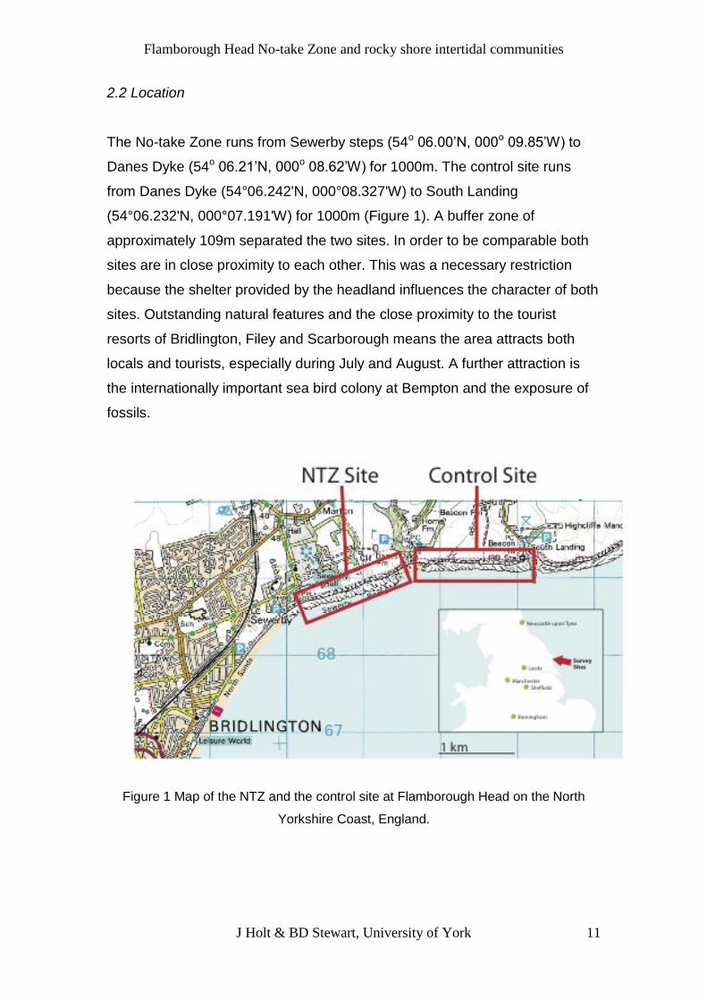
2.2 Location
The No-take Zone runs from Sewerby steps (54o 06.00’N, 000o 09.85’W) to
Danes Dyke (54o 06.21’N, 000o 08.62’W) for 1000m. The control site runs
from Danes Dyke (54°06.242'N, 000°08.327'W) to South Landing
(54°06.232'N, 000°07.191'W) for 1000m (Figure 1). A buffer zone of
approximately 109m separated the two sites. In order to be comparable both
sites are in close proximity to each other. This was a necessary restriction
because the shelter provided by the headland influences the character of both
sites. Outstanding natural features and the close proximity to the tourist
resorts of Bridlington, Filey and Scarborough means the area attracts both
locals and tourists, especially during July and August. A further attraction is
the internationally important sea bird colony at Bempton and the exposure of
fossils.
Figure 1 Map of the NTZ and the control site at Flamborough Head on the North
Yorkshire Coast, England.

Flamborough Head No-take Zone and rocky shore intertidal communities
J Holt & BD Stewart, University of York
12
2.3 Site description
The gently sloping intertidal chalk platforms interspersed with gullies and
crevices are able to support unique communities of algae and invertebrates.
The area has strong tides and the water is generally turbid, due to the
presence of the ‘Flamborough front’. This offshore frontal system is formed
when the cold, deeper stratified waters of the Northern North Sea mix with the
warm shallower, waters of the Southern North Sea, resulting in a nutrient
upwelling (Thomson et al., 2009). The movement of the seawater therefore
keeps the surface of the rocks clear from sediment, which allows algae and
specialised invertebrates to burrow into the soft chalk and colonise the
surface. Steep vertical chalk cliffs surround the rocky shore so access to the
coastal sites is by steps at Sewerby and via minor roads at Danes Dyke and
South Landing.
Figure 2. View of the Intertidal zone at the NTZ, facing east towards the control site.

Flamborough Head No-take Zone and rocky shore intertidal communities
J Holt & BD Stewart, University of York
13
Figure 3. View of the control site from the access point at South Landing.
3 Method
3.1 Data collection and sampling methods.
Eight vertical transects were set up at 100 metre intervals, perpendicular to
the coast, at each site. Surveys began on August 14th, 2011 and continued
until September 28th, 2011 (tide permitting). At the NTZ site (Sewerby) the two
fixed transects already established by Natural England were included in this
scheme (Thomson et al., 2009). These transects were subdivided into six
sampling points which were arranged evenly along the tidal range. GPS was
used to identify the location of all the sampling points and to measure the
elevation at the start and along each transect. Large deep fissures and rock
pools were avoided. The survey was repeated at each site 3 times giving a
total of 288 quadrats. To compensate for any changes over the summer the
surveys were carried out in stages.
In order to determine the abundance of algae the percentage cover of all
species present was estimated by using a 1m2 quadrat that was subdivided
into 4 % subsections. Photographs were taken of the quadrat to allow for
reference at a later stage.

Flamborough Head No-take Zone and rocky shore intertidal communities
J Holt & BD Stewart, University of York
14
All fauna at each sampling site along the transects were also sampled in a
non-destructive way in situ by counting the number of individuals present in a
0.25m2 (50cm x 50cm) quadrat, which was placed randomly alongside the
1m2 quadrat. Certain species (e.g. mussels and barnacles) were highly
abundant and it would have been extremely time consuming to have counted
all the individuals. Therefore in this situation the number of individuals were
counted within each of the four corner squares (5 x 5cm) and added together
and scaled up to give an estimate of the total abundance within the 0.25m2
quadrat.
Following this callipers were used to measure the height and circumference of
10 individual organisms such as limpets, mussels and periwinkles (key
species), that were randomly distributed along each transect. Identification of
species was done in situ, however when there was uncertainty photographs
were taken so that recognition could be made later by a marine expert.
Sampling focussed on key species. Species that were difficult to differentiate
were identified to the genus only. Figure 4 shows the mussel bed (key
species) located at the No-take Zone. (Pre-survey work, see appendices).
Figure 4. Mytilus edulis (mussel bed) at the NTZ.

Flamborough Head No-take Zone and rocky shore intertidal communities
J Holt & BD Stewart, University of York
15
3.2 Organism Surveys
The intertidal zone could only be accessed during limited periods of the day
when the tide was low, usually that was one hour either side of the low water
time. The height to which the tide rises and falls varies from day to day as
does the time of day. A local tide table was used to plan a fieldwork calendar.
Great care was taken to include a variety of visitation times, sampling varied
in terms of times, days, weekends, months and public holidays.
3.3 Human Surveys
Human disturbance was recorded by observing depreciative behaviour when
surveying each transect. The number of people present at each transect were
counted and their behaviour monitored. These human surveys took place at
the same time as the ecological surveys. Depreciative behaviour recorded
included:
Trampling - Randomly walking on flora and fauna
Handling - Overturning rocks.
Extracting - Collecting flora and fauna
3.4 Questionnaire Surveys
One hundred questionnaires were conducted in situ at the access points to
the study sites. At Sewerby 33 questionnaires were completed, at Danes
Dyke 34 were completed and at South Landing 33 were completed. The
questionnaires took place on August 27th and August 28th. To overcome time
constraints a questionnaire was developed that encouraged a structured
response to particular issues regarding the NTZ. (Questionnaire, see
appendices).

Flamborough Head No-take Zone and rocky shore intertidal communities
J Holt & BD Stewart, University of York
16
4 Data Analysis
The mean total percentage cover of algae at each study site from all surveys
was calculated and the mean total density of individual animals at each study
site from all surveys was calculated. This abundance data was used for the
overall comparison between sites and displayed in a table using rank order.
Trends were displayed as a line graph and tables displayed the results of
community composition for comparison between control and NTZ sites.
Abundance data of key species was used to plot bar graphs using ± Standard
Error bars to illustrate any variation around the mean. Abundance data and
shell size data were used to display bar graphs. These were used to depict
any trends allowing for easier comparison.
Inferential statistics were then applied. Any differences between sites were
tested for significance through a one-way Analysis of Variance (ANOVA).
One-way ANOVA was considered a suitable and robust test for these
comparisons because of a balanced design as there were an equal number of
observations in each group. One-way ANOVA was used to compare the
species composition and community structure between control and NTZ sites
to see if protection will be effective. All analyses were performed using IBM
SPSS Statistics v. 19.0.
The abundance data of mussels were transformed prior to one-way ANOVA
being applied. This was done due to heterogeneous variances and so that the
data could fit more closely the underlying assumptions of the statistical test.
The number of people engaged in depreciative behaviour was calculated and
displayed as pie charts. The pie charts act as a visual aid and allow any
similarities or differences between behaviour, to be seen clearly.
Questionnaires were conducted and analysed. The data was displayed in
various descriptive graphs to allow clear understanding of peoples’
characteristics and their awareness of the NTZ.

Flamborough Head No-take Zone and rocky shore intertidal communities
J Holt & BD Stewart, University of York
17
5 Results
5.1 Comparison of species composition between the NTZ and control site at
Flamborough Head
Total mean percentage cover of algae at study sites.
Algae species at each sampling site were compared between the NTZ and
the control site. Total mean percentage cover was lowest in the NTZ (100%),
whereas the control site had the highest (122%). At the NTZ 17 out of 40
species at the sample sites showed 0% cover, whereas at the control site 25
out of 40 species showed 0% cover (Table 1). Therefore, although there was
a higher mean percentage cover of algae at the control site, there was 20%
more species present at the NTZ
Table 1. The mean percentage cover of species of algae observed inside
(NTZ) and outside (Control) the No-take Zone at Flamborough Head
NTZ Control
Rank Mean
% cover Rank Mean
% cover
Fucus serratus Toothed Wrack 1 20 1 29
Enteromorpha (Ulva) intestinalis Gut Weed 2 19 3 19
Fucus vesiculosis Bladderwrack 3 19 2 25
Ceramium rubrum (sp.) 4 7 5 7
Rhodothsmniella floridula Sand Binder 5 7 4 8
Ulva lactuca Sea Lettuce 6 5 9 5
Chondrus crispus Carragheen / Irish Moss 7 5 8 5
Laurencia (Osmundea) sp. Pepper Dulse 8 4 17 0
Cladophora rupestris (sp.) Common Green Branch Weed 9 3 7 6
Lithothamnion sp.(Paint like red) 10 3 6 7
Petalonia fascia Broad Leaf Weed 11 2 16 0
Cladostephus spongiosus Hairy Sand Weed 12 2 10 3
Mastocarpus stellatus 13 1 29 0
Corrallina officinalis (sp.) Coralline Red 14 1 14 1
Enteromorpha (Ulva) linza 15 1 30 0
Encrusting Brown 16 1 27 0
Laminaria digitata Oarweed 17 1 21 0
Fucus spiralis Spiral Wrack 18 1 13 1

Flamborough Head No-take Zone and rocky shore intertidal communities
J Holt & BD Stewart, University of York
18
Meembranoptera alata Winged Weed 19 0 19 0
Desmarestia aculeata Desmartest's Prickly Weed 20 0 15 1
Laminaria hyperborea Cuvie 21 0 31 0
Halidryas siliquosa Sea Oak 22 0 26 0
Saccharina latissima Sugar Kelp 23 0 12 1
Alaria esculenta Dabberlocks 24 0 32 0
Ascophyllum nodosum Egg Wrack 25 0 33 0
Bifurcaria bificurcata 26 0 22 0
Cliona celatal Yellow Sponge 27 0 23 0
Enteromorpha (Ulva) muscoides 28 0 34 0
Fucus ceranoides 29 0 11 2
Heterosiphonia plumosa Siphoned Feather Weed 30 0 18 0
Himanthalia elongata Thongweed 31 0 35 0
Laminaria saccharina Sea Belt 32 0 36 0
Lomentaria articulata 33 0 37 0
Pelvetia canaciculata Channelled Wrack 34 0 28 0
Phycodrys rubens 35 0 38 0
Polysiphonia lanosa 36 0 39 0
Porphyra umbilicalis (sp.) 37 0 24 0
Saccorhiza polyschides Furbelows 38 0 40 0
Sargassum muticum Wireweed 39 0 25 0
Orange Sponge 40 0 20 0
Total 100 122
Figure 5. Algae species. A comparison of mean percentage cover between the NTZ
and control site, showed consistently higher algae cover at the control site.
Figure 5 indicates a trend that showed the control site consistently had a
higher cover of algae when compared to the NTZ. Mean algae cover ranged

Flamborough Head No-take Zone and rocky shore intertidal communities
J Holt & BD Stewart, University of York
19
from 64% (quadrat 1) to 116% (quadrat 6) for the NTZ, whereas at the control
site the range was from 87% (quadrat 1) to 157% (quadrat 6). The highest
difference was quadrat 6.
There was a considerable difference in total mean algae cover between the
study sites with the control site showing a higher percentage (121.84%
compared to 99.82%). The control site showed a significant difference of (F =
10.45, p = 0.002).
Total mean density of individual animals at study sites.
Animal species at each sampling site were compared between the NTZ and
the control site. Total mean density was over two and half times greater at the
NTZ with 5532 per transect compared to 2041 per transect at the control site.
This was due mainly to the high mean density of barnacles at 5264 per
transect and mussels at 257 per transect in the NTZ (Table 2).
Table 2. Animal species. Overall community compositions from mean density
estimates (no. / transect) of individual animals within the NTZ and control sites.
Species were ranked according to species abundance. Key species are indicated in
red.
Genus Common Name
NTZ Control
Rank Mean
Density Rank Mean
Density Semibalanus balanoides
Barnacle 1 5264 1 2066
Mytilus edulis Common mussel 2 257 4 0 Littorina littorea & obtusata
Common & Flat periwinkle 3 7 3 1
Patella vulgata Common limpet 4 3 2 3
Nucella lapillus Dog whelk 5 0 6 0 Carcinus maenas Green Shore crab 6 0 8 0
Cancer pagurus Edible Crab 7 0 9 0 Actinia equina Beadlet anemone 8 0 7 0 Plomatoceros lamarcki
Kneelworm 9 0 5 0
Total 5532 2071

Flamborough Head No-take Zone and rocky shore intertidal communities
J Holt & BD Stewart, University of York
20
Figure 6. Animal species. Mean density of animal species at each sampling site comparing the NTZ and control site.
Figure 6 indicated a trend that showed the NTZ consistently had a higher
mean density of animals when compared to the control site. At the NTZ
quadrat 3 showed significant variation with a minimum variation (5000), this
was 4 times lower than the maximum (20000).
The data were analyzed for differences in abundance between sites. The NTZ
showed a significantly higher density (5532.58 per transect) compared to
(2071.40 per transect), a significant difference of (F = 4.76, p = 0.034).
5.2 Comparison of the abundance and distribution of key species of flora and
fauna, between the NTZ and control sites at Flamborough Head.
The species rank order of algae and their abundance at each study site is
depicted in Table 1. The rank order showed key species were in the top five,
and in terms of their abundance showed both sites had similar species but the
order was dis-similar.
The species rank order of animals and their mean density (no. / transect) at
each study site is depicted in Table 2. The rank order showed key species
were in the top five, except for Nucella lapillus at the control site, which had a
ranking of 6. Other species although present at both sites, were ranked
differently.

Flamborough Head No-take Zone and rocky shore intertidal communities
J Holt & BD Stewart, University of York
21
Inferential statistical assessment was carried out to determine the significance
of differences of abundance of key species at the study sites. Table 3
indicated there was no significant difference in mean percentage cover of the
key algae species, Ceramium rubrum, Enteromorpha (Ulva) intestinalis, Fucus
serratus and Rhodothsmniella floridula, however there was a significantly
higher mean difference at the NTZ of Fucus vesiculosis (F = 6.02, p = 0.018).
Table 3 Comparison of mean percentage cover of key algae species between sites
using One-way ANOVA. Non-significant results (p < 0.05) are denoted as NS.
Genus Common Name
Mean
F. Ratio P- Value NTZ Site
Control Site
Ceramium rubrum 7.05 7.34 0.012 0.911 NS
Enteromorpha (Ulva) intestinalis Gut weed 19.42 18.76 0.29 0.866 NS
Fucus serratus Toothed wrack 19.71 29.40 3.88 0.055 NS
Fucus vesiculosis Bladder wrack 18.69 27.06 6.02 0.018 S
Rhodothsmniella floridula
Sand Binder 6.95 8.29 0.28 0.598 NS
Table 4. Comparison of mean density (no. / m2) of key animal species between sites
using One-way ANOVA. Non-significant results (p < 0.05) are denoted as NS.
Genus Common Name
Mean
F. Ratio P- Value NTZ Site
Control Site
Littorina littorea and obtusata
Common and Flat periwinkle 3.73 0.78 10.30 0.002 S
Mytilus edulis Common mussel 1.93 0.75 11.62 0.001 S
Nucella lapillus Dog whelk 0.16 0.28 4.19 0.46 NS
Patella vulgata Common limpet 2.76 3.29 0.59 0.447 NS
Semibalanus balanoides
Barnacle 4183.58 2290.28 1.52 0.224 NS
Table 4 indicates there was no significant difference in mean density (no. / m2)
of the key animal species Nucella lapillus, Patella vulgata and Semibalanus

Flamborough Head No-take Zone and rocky shore intertidal communities
J Holt & BD Stewart, University of York
22
balanoides, however, there was a significant difference for Littorina littorea
and obtusata (F = 10.30, p = 0.002) and Mytilus edulis (F = 11.62, p= 0.001).
Figure 7a. Fucus serratus
Figure 7b. Enteromorpha (Ulva) intestinalis

Flamborough Head No-take Zone and rocky shore intertidal communities
J Holt & BD Stewart, University of York
23
Figure 7c. Fucus vesiculosis
Figure 7d. Ceramium rubrum (sp.)
Figure 7e. Rhodothsmniella floridula
Figures 7a – 7e. Comparison, of vertical distribution of key flora species along the
intertidal zone, between the NTZ and the control site. Species showed typical
zonation patterns.
Figures 7a – 7e show the mean percentage cover of key algae species and
vertical distribution along the intertidal zone. The patterns of zonation at both
sites were generally similar but there was consistently less algae cover at the
NTZ.

Flamborough Head No-take Zone and rocky shore intertidal communities
J Holt & BD Stewart, University of York
24
Enteromorpha (Ulva) intestinalis (Figure 7b) and Fucus vesiculosis (Figure
7c) were found more frequently on the upper shore, whereas Fucus serratus
(Figure 7a) Ceramium rubrum (Figure 7d) and Rhodothsmniella floridula
(Figure 7e) were found more frequently on the lower shore.
Figure 7d suggested Ceramium Rubrum was more abundant in the NTZ
though there was a large degree of variation. Fucus serratus was more
abundant in the upper shore at the control site, otherwise both sites showed a
similar distribution pattern (Figure 7a).
Figures 8a – 8e illustrates the mean density of key animal species and their
vertical distribution along the intertidal zone. All species showed a distinct
zonation pattern along the shore but the NTZ showed more abundance of
Semibalanus balanoides Mytilus edulis Littorina littorea & obtusata and
Nucella lapillus at the NTZ.
Figure 8a. Semibalanus balanoides

Flamborough Head No-take Zone and rocky shore intertidal communities
J Holt & BD Stewart, University of York
25
Figure 8b. Mytilus edulis
Figure 8c. Littorina littorea & obtusata

Flamborough Head No-take Zone and rocky shore intertidal communities
J Holt & BD Stewart, University of York
26
Figure 8d. Patella vulgate
Figure 8e. Nucella lapillus
Figures 8a – 8e. Mean density of the key animal species and their distribution down
the shore.
There was a similar pattern of distribution of Semibalanus balanoides (Figure
8a) and Patella vulgate (Figure 8d) at both sites. Both species were more
frequently found on the upper shore.
There were considerable differences between the NTZ and the control site.
Figure 8b showed no Mytilus edulis at the control site whereas at the NTZ
there was a high abundance on the lower shore.
Figure 8c showed Littorina littorea & obtusata was present across the upper,
middle and lower shore but was significantly more abundant at the NTZ
especially in the middle and lower shore.
Figure 8e showed there was a low abundance of Nucella lapillus at both sites
but particularly at the control site. It was difficult to accurately compare
distribution when the abundance of species was so low.

Flamborough Head No-take Zone and rocky shore intertidal communities
J Holt & BD Stewart, University of York
27
5.3 Comparison of the population structure of key species of fauna between
the NTZ and control site at Flamborough Head
As a key characteristic of population structure the shell size of Nucella lapillus,
Littorina littorea and obtusata (periwinkle sp.), Mytilus edulis and Patella
vulgate were measured and compared.
Figures 9a – 9d show population structure - shell length composition within NTZ and
control sites of key fauna species. Most individuals had a larger shell size at the NTZ.
Figure 9a. Nucella lapillus
Figure 9b. Littorina littorea and obtusata (periwinkle sp.)

Flamborough Head No-take Zone and rocky shore intertidal communities
J Holt & BD Stewart, University of York
28
Figure 9c. Mytilus edulis
Figure 9d. Patella vulgate
Figure 9a showed a very low abundance of Nucella lapillus at the control site,
there were too few individuals to compare sites.
Figure 9c showed there was a significant increase in size of Mytilus edulis at
the NTZ compared to the control site. Mytilus edulis was uncommon in the
control site with just a few small individuals but at the NTZ there was a stable
population with many more individuals, ranging from 0.8mm to 5mm.
Littorina littorea and obtusata (periwinkle sp.) and Patella vulgate (figure 9b
and figure 9d) showed the population structure to be similar at both sites.
Flamborough Head No-take Zone and rocky shore intertidal communities
J Holt & BD Stewart, University of York
29
Littorina littorea and obtusata had a range of sizes from 0.4 to 3.2mm and
Patella vulgate had a range of sizes from 0.8 to 6mm with most individuals in
the mid range.
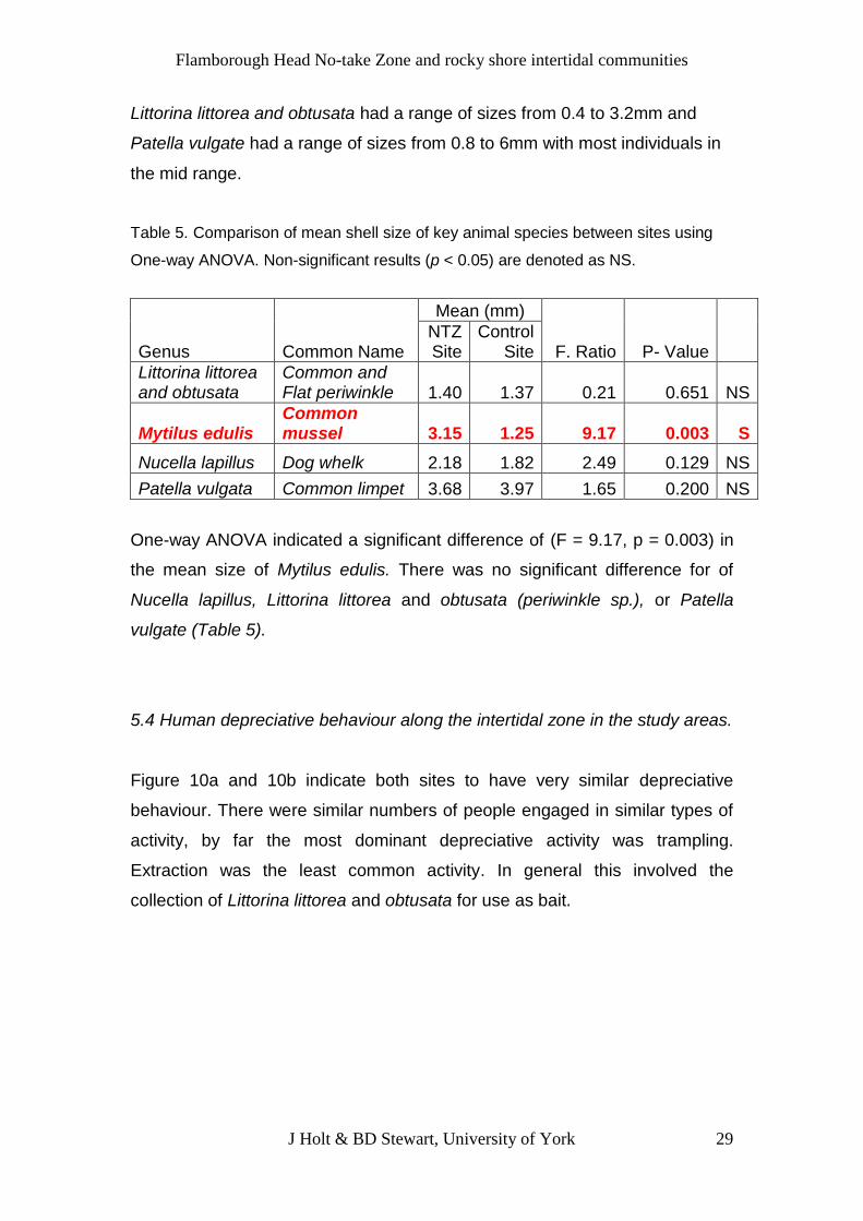
Table 5. Comparison of mean shell size of key animal species between sites using
One-way ANOVA. Non-significant results (p < 0.05) are denoted as NS.
Genus Common Name
Mean (mm)
F. Ratio P- Value NTZ Site
Control Site
Littorina littorea and obtusata
Common and Flat periwinkle 1.40 1.37 0.21 0.651 NS
Mytilus edulis Common mussel 3.15 1.25 9.17 0.003 S
Nucella lapillus Dog whelk 2.18 1.82 2.49 0.129 NS
Patella vulgata Common limpet 3.68 3.97 1.65 0.200 NS
One-way ANOVA indicated a significant difference of (F = 9.17, p = 0.003) in
the mean size of Mytilus edulis. There was no significant difference for of
Nucella lapillus, Littorina littorea and obtusata (periwinkle sp.), or Patella
vulgate (Table 5).
5.4 Human depreciative behaviour along the intertidal zone in the study areas.
Figure 10a and 10b indicate both sites to have very similar depreciative
behaviour. There were similar numbers of people engaged in similar types of
activity, by far the most dominant depreciative activity was trampling.
Extraction was the least common activity. In general this involved the
collection of Littorina littorea and obtusata for use as bait.

Flamborough Head No-take Zone and rocky shore intertidal communities
J Holt & BD Stewart, University of York
30
Figure 10a. Depreciative behaviour at NTZ (n = 412 people).
Figure 10b. Depreciative behaviour at control site (n = 405 people).
5.5 Investigate the extent to which visitors are aware of the No-take Zone.
Characteristics of visitors (11a – 11 d).
Visitors to the area were predominantly male (63%), spanning the age range
45 – 65+ (82%). There were a lot of regular visitors to the area, many visiting
every month (36%); the frequency of other visits was mixed. The frequency of
visitation suggests the area was well supported locally, but because the
survey was carried out during the summer holidays it is not surprising that
32% were making a yearly return visit while 22% were visiting for the first

Flamborough Head No-take Zone and rocky shore intertidal communities
J Holt & BD Stewart, University of York
31
time. Bridlington appears to be a traditional seaside resort for people visiting
from South and West Yorkshire (90%). The distance most people travelled
was as far as 137 miles (band 5). The furthest distance travelled was band 9
(312 – 387 miles). The highest number of people visiting (12) was from Hull.
By far the most popular activity when visiting the area was walking (56%) and
dog walking (29%).
Figure 11a. Age and sex of visitors questioned at the Flamborough Head NTZ and
control site during August 27th and August 28th 2011 (n = 100).
Figure 11b. How often people visit the Flamborough Head NTZ
and control site (n = 100).

Flamborough Head No-take Zone and rocky shore intertidal communities
J Holt & BD Stewart, University of York
32
Figure 11c. Distance travelled by visitors to the study areas. Red circles indicate the
location from which visitors had travelled. The red circle increased in size
exponentially, with the number of people visiting from that area.
Figure 11d. The popularity and range of activities people engaged in while visiting the
Flamborough Head study sites. (n = 129)

Flamborough Head No-take Zone and rocky shore intertidal communities
J Holt & BD Stewart, University of York
33
Awareness and support for NTZ (12a – 12d)
Although 57% of visitors knew about the NTZ, only 49% of these had any
understanding of the purpose and objectives of the area. A high proportion
(81%) of people who knew about the NTZ were aware of the site because
they read the signage close to the access points. Information was not gained
via the internet, tourist information, or advertisements. The extent of support
for the NTZ was overwhelmingly in agreement with 96% indicating they totally
agree, while the other 4% partially agreed.
Figure 12a. Percentage of people aware of the NTZ. More than half had knowledge
of the site.
Figure 12b. Percentage of people who knew about and understood the NTZ
regulations.

Flamborough Head No-take Zone and rocky shore intertidal communities
J Holt & BD Stewart, University of York
34
Figure 12c. Ways in which people received information about the NTZ. Nearly all
leant about the site from signage.
Figure 12d. Visitor’s opinion as to whether they agree to the establishment of the
NTZ.
6 Discussion
There may be many reasons for the observed differences in the abundance of
key species between the study sites. A direct and potentially damaging effect
of human visitation to the intertidal zone is the extraction of organisms
(Murray et al., 1999). Extraction may indirectly affect other species, which may
result in changes to the overall community structure (Addison, 2008). These
effects are exacerbated when the target species have a key role in structuring
the community (Underwood, 2005). In the UK several rocky shore species

Flamborough Head No-take Zone and rocky shore intertidal communities
J Holt & BD Stewart, University of York
35
found at Flamborough Head are exploited by humans, including Littorina
littorea and obtusata, Mytilus edulis, Nucella lapillus and Patella vulgata. They
are collected for human consumption, for research, fishing bait and for
aquariums (Addessi, 1994).
The collection of commercial species for food and bait can directly result in a
substantial reduction in the abundance and average size of the harvested
species population (Addison 2008). This is because when rocky intertidal
species are harvested, larger individuals are often preferentially collected
(Roy et al., 2003). The size structure of the population may change to smaller
and younger individuals that may result in a disproportionate decrease in the
reproductive ability of the population because the reproductive potential
increases exponentially with size (Branch, 1974; Smith et al., 2008). This
trend was observed at Flamborough Head; for example the mussel population
at the control site contained just a few small individuals relative to the
protected site. However, whether this was due to human exploitation requires
further discussion and investigation.
6.1 Compare the species composition of intertidal communities between the
protected and non-protected sites at Flamborough Head.
This report examined the species composition of marine algae (seaweeds)
and invertebrates at both the Flamborough Head No-take Zone (NTZ) and an
adjacent, unprotected control site. Although the community composition of the
two sites was broadly very similar, there were some significant differences in
total algae cover and the abundance of certain species. These results and the
comparisons made between the NTZ and the control site can now be used to
establish a quantitative baseline of the structure of these communities soon
after (1 year) the designation of the Flamborough Head NTZ. How these
communities change in the longer term can now be used to assess the
effectiveness of the NTZ for meeting its conservation objectives.
Overall there was slightly but significantly higher algae cover at the control
site compared to the NTZ. This may be due the presence of more suitable
Flamborough Head No-take Zone and rocky shore intertidal communities
J Holt & BD Stewart, University of York
36
habitat for the establishment of algae at the control site. The community
present on a rocky shore will be strongly influenced by the structure and
texture of the substratum (Brehaut, 1982). The porous nature of chalk means
water is retained, allowing species to extend their range. There may have
been more chalk platforms at the control site, which enabled Fucus serratus
to extend its range to the upper shore. Species such as Ulva intestinalis (gut
weed) and Ulva lactuca (sea lettuce) were equally present at both sites.
However, at the control site when compared to the NTZ there was more
percentage cover on the lower shore as algae dominated the area. This may
be due to chalk-boring species such as Cliona celataI (yellow sponge) that is
only found at the control site. The holes they create may then be used as
footholds by the algae, thereby increasing the habitat available (Net Gain,
2011). More research needs to be carried out as to why Cliona celataI is not
present at the NTZ.
The mean density of animals was significantly less at the control site than the
NTZ. Although interactions between species can be complex it is likely that
algae cover at the control site is dominating the shore and thereby affecting
the interactions of other species. The abundance and distribution of algae can
actually swamp grazing activity (Raffaelli and Hawkins, 1996). Limpet grazing
then becomes less effective. Barnacles are reduced in number by the
presence of limpets and by predation by dog whelks. The sweeping of fucoid
fronds will also reduce the settlement of barnacles (Jenkins et al., 1999). It
seems therefore that the algae at the control site, is an important organising
force, which is controlling the density of animals.
6.2 Quantify and compare the abundance and distribution of key species of
flora and fauna, at the study sites.
The distribution and abundance of the most common plant and animal
species was also compared between the two sites. This included some
species (e.g. the common mussel, Mytilus edulis, which might be expected to
benefit from protection because it is targeted for food and bait (Smith et al.,
2008).

Flamborough Head No-take Zone and rocky shore intertidal communities
J Holt & BD Stewart, University of York
37
To evaluate the effects of human disturbance on the community the mean
percentage cover of key algae species and the mean number of key animal
species, were assessed. Both sites had similar key species. At both sites the
most frequently occurring algae were Fucus serratus and the most frequently
found animal was the Semibalanus balanoides. Fucus serratus found on the
lower shore, is able to extend its range up shore at Flamborough Head due to
the porous chalk platforms. Semibalanus balanoides occurs in great quantity
due to its ability to survive at higher levels than its competitors and predators
(Menge, 1991).
In addition, Fucus vesiculosis was found to be significantly more abundant at
the control site. Also, Littorina littorea and obtusata were found to be more
abundant in the NTZ. An explanation for this maybe because as there is a
lack of abundance of Littorina littorea and obtusata at the control site
ephemeral algae and tiny fucus germlings are not being consumed which then
allows the later succession of Fucus vesiculosis to become dominate. The
dominance of Littorina littorea and obtusata at the NTZ maybe because of a
higher percentage of bare rock available and the protection offered by the
NTZ which prevents the extraction of Littorina littorea and obtusata as bait
(Lubchenco, 1983).
Patterns of vertical distribution of rocky shore organisms have been
extensively studied since Stephenson and Stephenson (1949), and Lewis
(1964). It is recognised that the general patterns of zonation on rocky shores
can be explained in terms of physical factors (direct and indirect) interacting
with biological factors to set distribution patterns (Raffaelli and Hawkins,
1996). In this investigation the comparison of patterns of abundance and
distribution were greatly strengthened by the fact that both sites were within
equivalent environments. The trends in this report suggest similar zonation
patterns and similar species present in the intertidal zone in general.
However, this study also suggests the formation of a trend whereby changes
are beginning to take place at the NTZ with an increased abundance of
Semibalanus balanoides Mytilus edulis Littorina littorea & obtusata and

Flamborough Head No-take Zone and rocky shore intertidal communities
J Holt & BD Stewart, University of York
38
Nucella lapillus. As previously exploited species the NTZ might be of benefit
as it protects them from extraction. The significance of these changes is hard
to establish at the moment but future monitoring will allow long-term
ecological changes to be assessed.
6.3. Quantify and compare the population structure of key species of fauna at
the study sites.
Net Gain was a North Sea Marine Conservation Zone Project that was set up
in 2009 to identify and recommend Marine Conservation Zones to the
government. Net Gain recommended that at Flamborough Head Mytilus
edulis should be protected as it had been heavily exploited in the past and
was an important species in the NTZ. When of sufficient size and distribution
they can play an important functional role by stabilising the sediment
(Thomson et al., 2009). The protection of the mussel beds is one of the key
reasons why Net Gain recommended the NTZ at Flamborough Head is
situated in that location.
The density and size of mussels at the NTZ was found to be significantly
higher. In the west corner of the NTZ there was evidence of an extensive
mussel bed as mapped by Hill (2010). This could be early evidence that the
NTZ is protecting stocks from extraction.
There have been many previous studies that examine the common effects of
commercial species within protected areas and many have shown that
protection can increase the mean size of target species (Halpern and Warren,
2002; Beukers-Stewart et al., 2005). The effect of improved recruitment is
illustrated by comparing the size structure of Littorina littorea and obtusata,
Mytilus edulis and Patella vulgata, which all show a stable population with a
range of sizes at the NTZ.
It is too early to say whether the NTZ is responsible for these population
changes, it is therefore important that these species continue to be monitored
over at least the next 5 to 10 years so that trends in population changes can
be measured and the effects of protection more fully evaluated.

Flamborough Head No-take Zone and rocky shore intertidal communities
J Holt & BD Stewart, University of York
39
6.4 Human depreciative behaviour along the intertidal zone in the study sites.
Depreciative behaviour is essentially behaviour which causes un-intentional
damage. For example, visitors may not understand the value of protected
resources and their potential effects on those resources (Alessa et al., 2003).
Human use of the intertidal zone can be very destructive because of
trampling, the overturning of rocks and the collection and disturbance of
certain species (Keough and Quinn, 1998).
The results in this study show that the level of trampling appears to be quite
high at both sites (over 64% of observed activity). Fletcher and Frid (1996)
found that even light trampling was enough to reduce the abundance of
fucoids. If attachments are weakened there is an increased risk of
dislodgement during storms. Brosnan and Crumrine (1994) also found that
trampling destabilized mussel beds by loosening the byssal attachment,
making them more susceptible to wave action. In contrast, there is no
evidence that the mussel beds at the NTZ are being affected by trampling as
the results from this study show there is still a high density and size of this
population.
Overturning rocks was another popular activity. The underside of rocks is a
refuge for intertidal organisms as they provide protection from desiccation
during low tide and from predators during periods of inundation (Addessi,
1994). Humans turn over boulders out of curiosity or in search of food and
bait. Addessi (1994) found a direct correlation between the distribution and
abundance of people in relation to the gradients of physical disturbance. The
handling of flora and fauna is driven by people who posses knowledge about
the intertidal ecosystem. Curiosity leads them to investigate further, and often
they express a desire to share they’re knowledge and experience with others.
Usually these interactions involve parent and child (Alessa et al., 2003).
Therefore it seems that personal attitudes are more significant than
knowledge in driving depreciative behaviours. This behaviour is compatible
with the observations in this report which shown no difference in the handling
behaviour of people when in the NTZ.

Flamborough Head No-take Zone and rocky shore intertidal communities
J Holt & BD Stewart, University of York
40
The fact that both sites experienced very similar patterns of human visitation
behaviour is perhaps not surprising given the close proximity of the NTZ and
the control site, and given that walking and handling are popular activities.
However, it would be expected that there should be little or no extraction at
the NTZ. The fact that levels of extraction were almost exactly the same at
both sites means that many people were not complying with the NTZ
regulations. Murray et al., (1999) also found that the frequency of extraction
continued even when signs displayed protection status. Compliance and
enforcement of the law are critical determinants of the success of a NTZ
(Hoskins et al., 2009). At Flamborough Head there is no evidence that
enforcement of the law is taking place. Without enforcement the protective
laws seem to be ineffective (Murray et al., 1999). Smith et al., (2008)
concluded that due to a lack of enforcement protected marine reserves might
not be effective in protecting and enhancing intertidal marine life.
Even if collecting is stopped through enforcement, the other impacts of human
use such as trampling and over turning of rocks will still persist (Brosnan and
Crumrine, 1994) because the NTZ does not offer protection from these
activities. It may therefore be necessary for management options to include
exclusion zones thereby restricting public access completely, or perhaps
different zones which could be accessed at different times, thereby restricting
access as appropriate (Keough and Quinn, 1998). In order to carry out
successful management practices, it is important that surveillance and
monitoring schemes are used to determine whether the management of the
site is effective.
6.5 Investigate the extent to which visitors are aware of the No-take Zone.
Effective management of human activities at the intertidal zone does not only
depend on sound scientific research only. The input and involvement of local
people and visitors is necessary for the implementation of the NTZ regulations
(Murray et al., 1999).
Flamborough Head is in close proximity to the popular tourist areas of
Flamborough, Bridlington, Scarborough and Filey with the area receiving over

Flamborough Head No-take Zone and rocky shore intertidal communities
J Holt & BD Stewart, University of York
41
56,000 visitors per year (East Riding News, 2006). The demographics of the
population visiting the study sites was of an older age group than the general
population, so this would suggest that families do not travel far from the main
tourist beaches of Bridlington and Filey, and therefore do not visit as often the
NTZ is some distance away from these areas. The vast majority of people
visiting the NTZ are local and visit the area many times, which implies an
enjoyment of and an appreciation for the natural environment.
Walking, (including dog walking) was the most popular activity carried out by
visitors (85%). As a result trampling may become a major problem at the NTZ.
As rocky shores become increasingly popular so the degree of trampling can
be extremely high leading to a reduction in flora and fauna (Fletcher, 1997).
Trampling can be particularly heavy in conservation areas where public
access is encouraged to promote awareness of marine wildlife (Fletcher and
Frid, 1996). To overcome this impact a clearly defined path could be
established at the NTZ as it becomes more popular.
There is clearly a need for increased awareness of the NTZ, both in terms of
knowing it’s there and what its purpose is. This would be of benefit to the NTZ
because as the data suggests those participants that were aware of the NTZ
were also strongly in support of it. As many of the visitors were from the local
area and therefore more likely to know about the NTZ, there is a need to
better inform new visitors, who may be less aware of habitats’ sensitivity.
Education is vital, as greater public awareness will help foster stewardship of
the marine environment by promoting the value of nature and encouraging the
support for conservation, whether it’s for the local or visiting public (Jones,
1999). A lack of knowledge is a factor that may explain the weak relationship
between environmental concern and environmentally responsible behaviour
(Hines, 1987). Effective targeting of education could be used to change
entrenched behaviour, especially that of local people whose detrimental
activities may have been carried out in the NTZ for a long time. Participants in
such activities will need convincing through evidence that damage is being
caused.

Flamborough Head No-take Zone and rocky shore intertidal communities
J Holt & BD Stewart, University of York
42
Analysis of our findings identified the need for better communication. At the
moment signage is the tool by which people are receiving information but this
method is clearly only reaching a limited amount of people. Leaflets and
booklets could be produced and distributed through popular venues such as
the tourist office, libraries and even local supermarkets. These would have the
advantage of being able to be updated relatively quickly. An interactive web
site could engage young people in the area as well as being a forum where
people can voice their opinions and experiences. The message of the reasons
why the NTZ exists, the intended outcome, and the benefits for the
environment and people, needs to be communicated much more widely.
In conclusion, although it is too early to say whether the NTZ at Flamborough
Head is providing any benefits to the intertidal community due to it being
recently established, the signs are encouraging. It is likely that any substantial
improvements will be seen in future monitoring. However, extraction of certain
species such as Littorina littorea and obtusata still appears to be occurring
within the NTZ and this could hinder recovery. Trampling is a disturbance that
can often result in persistent changes to intertidal communities. An area may
need to be fenced off (or similar) so that an exclusion zone is created thereby
fully protecting at least some areas of intertidal flora and fauna. From our
analysis of personal behaviour and awareness of visitors to the area it
appears there also needs to be more education on the impacts of human
activity in the NTZ.
Study limitations
The surveys were carried out as thoroughly and accurately as possible.
Although every care was taken to identify the species as definitively as
possible there is a possibility that some species could have been mis-
identified. Even so, any mistakes made should have been compensated for by
the fact that the surveys were repeated three times at each transect.

Flamborough Head No-take Zone and rocky shore intertidal communities
J Holt & BD Stewart, University of York
43
The study was carried out in the summer months of August and September.
However due to the changes that may occur in the Intertidal zone throughout
the year the data presented may not be representative for the whole year.
Species composition and the abundance of species before Flamborough
Head NTZ was established was unknown therefore any changes that have
taken place between the NTZ and the control site could not be verified.
However this study is intended to be the first in a series of an annual
monitoring scheme so any future changes will be assessed.
Further studies
There is presently no understanding of intertidal communities between
protected and non-protected sites in the UK. This baseline study can be used
to compare and contrast with new NTZs as they become established around
the country, thereby improving our understanding of how NTZs can be
developed as a management tool.
Furthermore, it is important that monitoring continues to take place (every
year) at the NTZ and control site at Flamborough Head. More data is required
on how human activity is affecting the communities at the NTZ, as this will
help us to better understand regional and global differences in intertidal
communities.
Acknowledgements
We would like to thank Leanne Stockdale and Robbie Fisher for their
guidance during the design of this investigation. Katherine Gray gave
permission for parking at the field site.

Flamborough Head No-take Zone and rocky shore intertidal communities
J Holt & BD Stewart, University of York
44
References
Addessi, L., (1994). Human Disturbance and Long-term changes on a Rocky
Intertidal Community. Ecological Applications, 4 (4), pp.786-797.
Addison, P.F.E.M., Koss, R.S., O’Hara, T.D., (2008). Recreational use of a
rocky intertidal reef in Victoria: Implications for Ecological Research and
Management. Australasian Journal of Environmental Management, 15,
pp.169-179.
Alessa, L., Bennett, S., and Kliskey, A., (2003). Effects of knowledge,
personal attribution and perception of ecosystem health on depreciative
behaviour in the intertidal zone of Pacific Rim National Park and Reserve.
Journal of Environmental Management, 68, pp.207-218.
Branch, G.M., (1974). The ecology of Patella Linnaeus from the Cape
Peninsula, South Africa. 2. Reproductive cycles. Transactions from the Royal
Society of South Africa, 41, pp.111–160.
Beukers-Stewart, B.D., Vause, B.J., Mosely, M.W.J., Rossetti, H.L., Brand,
A.R., (2005). Benefits of closed area protection for a population of scallops.
Marine Ecology Progress Series, 298, pp.189-204.
Brehaut, R.N., (1982). Ecology of Rocky Shores. International review of
Hydrology, 68 (5), p.742.
Brosnan, D.M., and Crumrine, L.L., (1994). Effects of humans trampling on
marine rocky shore communities. Journal of Experimental Marine Biology and
Ecology, 177, pp.79-97.
Crowe, T.P., Thompson, R.C., Bray, S., Hawkins, S.J., (2000). Impacts of
anthropogenic stress on rocky intertidal communities. Journal of Aquatic
Ecosystem Stress and Recovery, 7, pp.273–297.

Flamborough Head No-take Zone and rocky shore intertidal communities
J Holt & BD Stewart, University of York
45
Fletcher, H., (1997). The Impact and Management of Visitor Pressure on
Rocky Shore Communities. University of Newcastle upon Tyne, UK.
Fletcher, H., and Frid, C.L.J., (1996). Impact and management of visitor
pressure on rocky intertidal algal communities. Aquatic Conservation: Marine
and Freshwater Ecosystems, 6, pp.287–297.
Halpern, B.S., and Warner, R.R., (2002). Marine reserves have rapid and
lasting effects. Ecology letters, 5, pp.361-366.
Hill, S., Burrows, M.T., Hawkins, S. J., (1998). Intertidal Reef Biotopes: An
overview of dynamics and sensitive characteristics for conservation
management of marine SACs. Scottish Association for marine Science.
Hines, J.M., Hungerford, H.R., Tomera A.N., (1987). Analysis and synthesis of
research on responsible environmental behavior: a meta-analysis. Journal of
Environmental Education, 18, pp.1–18.
Hoskin, M.G., Coleman, R.A., Carlshausen, L., (2009). Effects of the Lundy
No-take Zone: the first five years (2003-2007). Report to Natural England,
DEFRA and WWF-UK.
Howson, C.M., (2001). Flamborough Head cSAC intertidal survey.
Peterborough: English Nature.
IUCN, (1999). Guidelines for Marine Protected Areas. Gland, Switzerland and
Cambridge, UK.
Jenkins, S.R., Norton, T.A., Hawkins, S.J., (1999). Settlement and post-
settlement interactions between Semibalanus balanoides (L.) (Crustacea:
Cirripedia) and three species of fucoid canopy algae. Journal of Experimental
Marine Biology and Ecology, 236, pp.49-67.
Flamborough Head No-take Zone and rocky shore intertidal communities
J Holt & BD Stewart, University of York
46
Joint Nature Conservation Committee, (1989). Guide lines for Selection of
Biological SSSIs: Intertidal marine habitats and saline lagoons. Peterborough:
Joint Nature Conservation Committee.
Joint Nature Conservation Committee, (2004). Common Standards Monitoring
Guidance for Littoral Rock and Inshore Sublittoral Rock Habitats.
Peterborough: Joint Nature Conservation Committee.
Jones, P.J.S. (1999). Marine nature reserves in Britain: Past lessons, current
states and future issues. Marine Policy, 23 (4), pp.375 – 396.
Keough, M.J., and Quinn, G.P., (1998). Effects of periodic disturbances from
trampling on rocky shore intertidal algal beds. Ecological Applications, 8,
pp.141-161.
Lewis, J. R., (1964). The Ecology of Rocky Shores. London: English
Universities Press Limited, London, England.
Lubchenco, J., (1983). Littorina and Fucus: effects of herbivores, substratum,
heterogeneity, and plant escapes during succession. Ecology, 64. pp.1116-
1123.
Menge, B. A., (1991) Relative Importance of recruitment and other causes of
variation in rocky intertidal community structure. J. Exp. Mar. Biol. Ecol. 146.
pp. 69-100.
Menge, B. A., and G. M. Branch., (2001). Rocky Intertidal Communities.
Marine community ecology, Sunderland: Sinauer Associates.
Murray, S.N., Denis, T.D., Kido, J.S., Smith, J.R., (1999). Human visitation
and the frequency and potential affects of collecting on rocky intertidal
populations in South Californian Marine Reserves. CalCOF Report, 40,
pp.100-106.

Flamborough Head No-take Zone and rocky shore intertidal communities
J Holt & BD Stewart, University of York
47
Natural England, (2011). Marine Protected Areas.
http://www.naturalengland.org.uk/ourwork/marine/protectandmanage/mpa/def
ault.aspx (Online). [Accessed 18th January 2012].
Paine, R. T., and Levin, S. A., (1981). Intertidal landscapes: disturbance and
the dynamics of pattern. Ecological Monographs, 51, pp.145–178.
Raffaelli, D.G., and Hawkins, S.J., (1996). Intertidal Ecology. London:
Chapman and Hall.
Roy, K., Collins, A.G., Becker, B.J., Begovic, E., Engle, J.M., (2003).
Anthropogenic impacts and historical decline in body size of rocky intertidal
gastropods in Southern California. Ecology Letters, 6, pp.205-211.
Scott, G., Hull, S., Hornby, S., Hardy, G and Owens, N., (2001). Phenotypic
variation in Fucus spiralis (Phaeophyceae): morphology, chemical phenotype
and their relationship to the environment. Eur. J. Phycol., 36. pp.43-50.
Smith, J.R., Fong, F., Ambrose, R.F., (2008). The Impact of Human Visitation
on Mussel Bed Communities along the California Coast: Are Regulatory
Marine Reserves Effective in Protected These Communities? Environmental
Management, 41. pp.599-612.
Sousa, W. P., (1984). The role of disturbance in natural communities. Annual
Review of Ecology and Systematics, 15, pp.353–391.
Stephenson, T. A., and Stephenson, A., (1949). The universal features of
zonation between the tidemarks on rocky coasts. The Journal of Ecology, 38,
pp.289-305.
Stockdale, L., (2007). The Flamborough Head Management Plan. March
2007. Flamborough Head Project Officer, Bridlington, UK.

Flamborough Head No-take Zone and rocky shore intertidal communities
J Holt & BD Stewart, University of York
48
Terlizzi, A., Frashetti, S., Guidetti, P., Boero, F., (2002). The effects of sewage
discharge on shallow hard substrate sessile assemblages. Marine Pollution
Bulletin, 44, pp.544-550.
Thomson, S., Elliott, M., Johnson, M., Perez-Dominguez, R., and Hull, S.,
(2009). No-take Zone Monitoring: Flamborough Head. Hull: Institute of
Estuarine & Coastal Studies.
Underwood, A.J., (2005). Exploitation of species on the rocky coast of New
South Wales (Australia) and options for its management. Ocean and Coastal
Management, 20, pp.41-62.
Wood, H.M., Grahame, J.W., Humphray, S., Rogers, J., Butlin, R.K., (2008).
Sequence differentiation in regions identified by a genome scan for local
adaptation. Molecular Ecology, 17, pp.3123-3131.
Yorkshire Wildlife Trust, (2006). http://www.ywt.org.uk/flamborough_cliffs.php
(offline). [Accessed 10th October 2011].

Flamborough Head No-take Zone and rocky shore intertidal communities
J Holt & BD Stewart, University of York
49
Appendices
Pre- survey work
Equipment required
Collins Pocket Guide to the Seashore of Britain and Europe (Hayward, et
al., 1996)
Students Guide to the Seashore (Fish and Fish, 2008)
Plastic bags – for unidentified species
Fieldwork tables and pencil
Suitable footwear and clothing
Tape measure
Quadrat (0.5m x 0.5m), dissected into 1% squares
Quadrat (1.0m x 1.0m), dissected into 4% squares
Digital Camera (Cannon E550)
Calipers - For measuring fauna size
GPS – Garmin eTrex Summit HC, High-sensitivity GPS navigator

Flamborough Head No-take Zone and rocky shore intertidal communities
J Holt & BD Stewart, University of York
50
Acronyms
EMS European Marine Site
JNCC Joint Nature Conservation Committee
LNR Local Nature Reserve
MPA Marine Protected Areas
NTZ No-take Zone
SAC Special Area of Conservation
SPA Special Protected Area
SSSI Site of Special Scientific Interest
YWT Yorkshire Wildlife Trust