IRANIAN PALEOLITHIC SITES ON TRAVERTINE AND TUFA FORMATIONS
18
UNION INTERNATIONALE DES SCIENCES PRÉHISTORIQUES ET PROTOHISTORIQUES INTERNATIONAL UNION FOR PREHISTORIC AND PROTOHISTORIC SCIENCES PROCEEDINGS OF THE XV WORLD CONGRESS (LISBON, 4-9 SEPTEMBER 2006) ACTES DU XV CONGRÈS MONDIAL (LISBONNE, 4-9 SEPTEMBRE 2006) Series Editor: Luiz Oosterbeek VOL. 28 Session C15 Iran Palaeolithic Le Paléolithique d’Iran Edited by Marcel Otte Ferreidoun Biglari Jacques Jaubert BAR International Series 1968 2009
-
Upload
uni-tuebingen -
Category
Documents
-
view
2 -
download
0
Transcript of IRANIAN PALEOLITHIC SITES ON TRAVERTINE AND TUFA FORMATIONS

UNION INTERNATIONALE DES SCIENCES PRÉHISTORIQUES ET PROTOHISTORIQUES INTERNATIONAL UNION FOR PREHISTORIC AND PROTOHISTORIC SCIENCES
PROCEEDINGS OF THE XV WORLD CONGRESS (LISBON, 4-9 SEPTEMBER 2006)
ACTES DU XV CONGRÈS MONDIAL (LISBONNE, 4-9 SEPTEMBRE 2006)
Series Editor: Luiz Oosterbeek
VOL. 28
Session C15
Iran Palaeolithic
Le Paléolithique d’Iran
Edited by
Marcel Otte Ferreidoun Biglari
Jacques Jaubert
BAR International Series 1968 2009

This title published by Archaeopress Publishers of British Archaeological Reports Gordon House 276 Banbury Road Oxford OX2 7ED England [email protected] www.archaeopress.com BAR S1968 Proceedings of the XV World Congress of the International Union for Prehistoric and Protohistoric Sciences Actes du XV Congrès Mondial de l’Union Internationale des Sciences Préhistoriques et Protohistoriques Outgoing President: Vítor Oliveira Jorge Outgoing Secretary General: Jean Bourgeois Congress Secretary General: Luiz Oosterbeek (Series Editor) Incoming President: Pedro Ignacio Shmitz Incoming Secretary General: Luiz Oosterbeek Volume Editors: Marcel Ote, Ferreidoun Biglari and Jacques Jaubert Iran Palaeolithic / Le Paléolithique d’Iran. Vol. 28, Session C15. © UISPP / IUPPS and authors 2009 ISBN 978 1 4073 0501 1 Signed papers are the responsibility of their authors alone. Les texts signés sont de la seule responsabilité de ses auteurs. Contacts : Secretary of U.I.S.P.P. – International Union for Prehistoric and Protohistoric Sciences Instituto Politécnico de Tomar, Av. Dr. Cândido Madureira 13, 2300 TOMAR Email: [email protected] www.uispp.ipt.pt Printed in England by Blenheim Colour Ltd All BAR titles are available from: Hadrian Books Ltd 122 Banbury Road Oxford OX2 7BP England [email protected] The current BAR catalogue with details of all titles in print, prices and means of payment is available free from Hadrian Books or may be downloaded from www.archaeopress.com

109
IRANIAN PALEOLITHIC SITES ON TRAVERTINE AND TUFA FORMATIONS
Saman HEYDARI-GURAN, Elham GHASIDIAN & Nicholas J. CONARD Institut für Ur- und Frühgeschichte und Archäologie des Mittelalters, Abteilung für Ältere Urgeschichte
und Quartärökologie, Universität D-72070 Tübingen, Schloss Hohentübingen; [email protected]; [email protected]; [email protected]
Abstract: While the Iranian Paleolithic sites from the caves and rockshelters of the Zagros Mountains are widely known, current research by the Tübingen-Iranian stone age research project (TISARP) has documented many new, open-air Paleolithic localities. Recent survey has focused on regions containing travertine and tufa deposits, and our initial results point to these formations as attractive places for Paleolithic research. These geomorphological features are formed around the outlets of hot springs in areas of Eocene to Quaternary volcanic activity. Volcanic systems exist in a long and wide belt along the Central Plateau of Iran from the bazman mountain (Urumieh-Dokhtar volcanic belt) in the southeast to the Sahand Mountain in the northwest of the country. Hunter and gatherer societies used these geological features for stone knapping, hunting and living sites. Some of the sites in travertine and tufa deposits have yielded large assemblages of lithic artifacts. Travertine and tufa formations may help to predict the location of paleolithic sites in various part of Iran. Here we discuss the relationship between the travertine and tufa deposits and paleolithic settlement in these regions. Among many travertine and tufa deposits in iran, to date very few of them have been surveyed for paleolithic sites. Many of these mineral-rich, geothermal springs have formed carbonate deposits which provide good settings for the preservation of cultural materials. The TISARP surveys demonstrate the essential importance of systematic geoarchaeological research for gaining a better understanding of the Paleolithic prehistory of Iran.
INTRODUCTION
This paper describes recent research on several fossil-spring travertine and tufa localities, which are principally found along the Urumieh-Dokhtar volcanic belt in Iran and documents prehistoric occupations in this region. The aim of this paper is to examine the association between early human and travertine formations in the context of arid and semi-arid land of the Iranian Central Plateau. Here we presented an initial classification of geological settings and morphology of travertine and tufa sites in Iran. Archaeologically these formations are important since many prehistoric settlements have formed around the springs in the dry lands through the world (Heydari and Ghasidian, 2004, Le Tensorer et al., 2007). Geolo-gical descriptions of natural places as Paleolithic settle-ments may help us to understanding last environmental conditions and early pattern of human settlement in the region (Heydari, 2007). Although the travertine and tufa formations covered an extended area of Iran, they have not been studied geologically and archaeologically.
TERMINOLOGY
Travertines are calcium carbonate precipitation developed from organic and inorganic processes in karstic, hydro-thermal springs, small rivers and swamps. They are spon-gy, compact and contain crystal structures in different colors. They are classified as calcitic tufa, calc tufa, and sinter crust and plant tufa. Characteristic features are used to distinguish between tufa and travertine. Pedley (1990) defined tufas as highly porous, spongy, paper – leaved and woody textured cool-fresh water carbonate deposits. In contrast, he defined travertines as extremely well –
lithified, spary calcite textured, diagenetic old calcerous tufa deposits (Atabey, 2002). Travertine and tufa formations are particularly common in the late Quaternary and recent succession. Today, they form under a wide range of climate regimes from cool temperature to semi-arid. They may also cover wide areas, sometimes kilometers in length, where a great variety of lithofacies are developed from well cemented and massive transverse fluvial barriers to loose and thinly laminated lime mud (Ford and Pedley, 1992 and 1996). The term of tufa is normally used as a travertine synonym, but it usually has a more restricted meaning and is reserved to designate those travertines that have high porosity and low density.
REGIONAL DISTRIBUTION OF TUFA AND TRAVERTINE IN IRAN AND GEOLOGICAL CONTEXT
In general, volcanic structures occur in three main zones in Iran (Fig. 9.1A):
− Azerbaijan- Alborz- Sabzevar zone in the north and northwest of Iran (around 600 km long);
− Eastern zone, Lut Block area (around 400 km long) and;
− Urumieh- Dokhtar volcanic zone (UDVZ) which covers the central of Iran from northwest to southeast (around 2000 km long) (Fig. 9.1A).
Travertine and tufa formations, which are presented in this paper, are associated with the UDVZ (Fig. 9.1A) (Schröder, 1944). The UDVZ is a complex and extrusive igneous rocks, comprising andesitic, rhyolitic, and basaltic volcanic and volcaniclastic rocks that are associated with dioritic and granodioritic plutons,

IRAN PALAEOLITHIC / LE PALÉOLITHIQUE D’IRAN
110
Fig. 9.1 A. Map showing the distribution volcanic structures in Iran; Fig. 9.1 B. Map showing the distribution of travertine and tufa formation in the Takht- Soleiman Region and Paleolithic sites
Fig. 9.1 C. Simplified geological map of Karkas Mountain and Paleolithic travertine sites; (modified from Geological quaderangle map of Iran, No. F 7, and Kashan)
continuous calcalkaline magmatic activity from Eocene to present, peaked during the Oligo–Miocene (Berberian and Berberian, 1981; Berberian and King, 1981; Berberian and Alavi-Tehrani, 1971). Among the twelve discovered sites, two of them are located in Takht-e Soleiman Region in the northern and north part of the UDVZ and ten of them are located in the eastern slope of the Karkas Mountains in the central part of UDVZ (Fig. 9.1A and C).
GEOMORPHOLOGICAL CLASSIFICATION OF TUFA AND TRAVERTINE IN IRAN
The classification of different travertine and tufa deposits has been based on several criteria. One criterion
is the physical properties, for instance, Eisenstuke (1951) classified travertines according to the degree of coherence distinguishing hard travertines and incoherent travertines. Another system, this one used by the botanic German school (Wallner, 1934; Stirn, 1964), utilizes as a main indicator the type and nature of the plant vegetation involved in the formation of travertine (Julia, 1983). Other classifications are based on the geomorphological position in which the travertines and tufa are formed. The geomorphological classification of these phenomena probably can help to account for early human occupation and site formation in our study regions. From a morphological perspective, the Iranian travertine and tufa Paleolithic sites fall into four major groups:

S. HEYDARI-GURAN ET AL.: IRANIAN PALEOLITHIC SITES ON TRAVERTINE AND TUFA FORMATIONS
111
Fig. 9.2. An overview of the Takht-e Soleiman Region, lake and Paleolithic sites (photo S. Heydari-Guran)
1. Cascade or perched springline (slope system): (a) proximal: When the travertine and tufa formation developed from a spring on a mountain slope distributaries develop on the surface of the deposit and become foci for precipitation. Over a long duration a cascade formed on the valley side. (b) distal: Typically, these are low-angle, sheet- like deposits of tufa (Ford and Pedley, 1996). The travertine sites of Niyasar, Hol Abad I and II (proximal) and West Khozaq (distal) are the examples of these kinds of formations.
2. Fissure ridges (crust or mound): In areas, prone to faulting, hydrothermal hot water (and gasses) frequently rises along linear resurgences. Much of the crystalline carbonate precipitates in the immediate vicinity of the fissure and narrow, resulting in high calcium carbonate travertine mounds (Ford and Pedley, 1996). The travertine sites of Sefid Ab and Kuh Sahel belong to these groups of morphology. The fissure ridge-type travertine accumulated at intersection points of the northwest- southeast trending faults in eastern parts of the Karkas massif near the Kashan City.
3. Barrage system: Developed commonly in gorge sites from the damming of flowing water by a number of actuate, downstream facing, transverse phytoherm barrages or dams (Ford and Pedley, 1996).
4. Terraces: Complex terraced travertine deposits develop as lobate planar sheets away from thermal resurgences. Generally, they are steepest proximally, where they are
cascades, and descending flights of shallow actuate pools (Ford and Pedley, 1996).
Travertine and tufa formations can also be subdivided into the older travertine on the uplifted plateau and younger lowland travertine deposits (Smith et al., 2004). Here, our best indication for the age of Quaternary travertine formation is the existence of Paleolithic artifacts from different periods on or around travertine deposits.
PALEOLITHIC TRAVERTINE AND TUFA SITE LOCALITIES IN IRAN
The travertine localities, which are present here, are located in the two different geographical regions that are around 500 km from each other along the Urumieh- Dokhtar escarpment. The first region is Takht-e Soleiman in northwestern Iran above 2000 m a.s.l. with cool and humid environmental conditions and the Karkas Region where principally most of the travertine occupations occurred with in a arid and semi- arid environment, lying between 1000-1500 m a.s.l..
Travertine and tufa of Takht-e Soleiman Region
Takht-e Soleiman area contains one the greatest concentrations, of travertine spring deposits in Iran (Heydari and Ghasidian, 2004) (Fig. 9.1B, 9.2). Several

IRAN PALAEOLITHIC / LE PALÉOLITHIQUE D’IRAN
112
Tab. 9.1: Summary table for the Paleolithic travertine and tufa sites in Iran
Site Geograpical
Position Region Morphological forms and
elevation Active
spring* Archaeological
period Published or
reported Artifacts
appearance
1. Chakhmaq Li
36°37'34.22" 47°12'33.37"
Takht-e Soleiman
A chert quarry near inactive travertine terraces,
2280 m a.s.l. –
Middle Paleolithic
Heydari and Ghasidian
(2004)
Surface (c.a. 500m)
2. Chal Tappeh
36°35'57.67" 47°14'28.29"
Takht-e Soleiman
Inactive travertine terraces, 2300 a.s.l.
– Middle
Paleolithic
Heydari and Ghasidian
(2004)
Surface (c.a. 300m)
3. Niyasar 33°58'9.77"N 51° 8'23.29"E
Niyasar Typical cascade or perched springline (slope system),
proximal, 1400 m a.s.l. *
Middle Paleolithic
Personal observation
Subsurface
4. West Khozaq
34° 0'26.07"N 51°18'34.23"E
Kashan Typical cascade or perched springline (slope system),
distal, 1250 m a.s.l. – ?
Heydari (perso-nal observation
2003)
Surface (c.a. 100m)
5. East Khozaq
33°59'43.42"N 51°19'4.61"E
Kashan Inactive fissure ridge,
mound type, 1300 m a.s.l. *
Middle Paleolithic?
Heydari (perso-nal observation
2003)
Surface (c.a. 150m)
6. Fin-e Kuchak
33°56'38.61"N 51°22'4.73"E
Kashan Barrage system,
1040 m a.s.l. *
Lower Paleolithic?
Biglari (2003), Heydari (2003)
Surface (c.a. 100m2)
7. Sefid Ab 33°55'35.84"N 51°23'38.87"E
Kashan Fissure ridge, mound,
1030 m a.s.l. *
Upper Paleolithic
Biglari (2003), Heydari (2003)
Surface
8. Zard-e Kuh Sahel
33°55'41.10"N 51°23'53.29"E
Kashan Fissure ridge, mound,
1035 m a.s.l. * ?
Biglari (2003), Heydari (2003)
Surface
9. Kuh Sahel 33°55'33.80"N 51°23'49.38"E
Kashan Fissure ridge, mound,
1032 m a.s.l. – ?
Biglari (2003), Heydari (2003)
Surface
10. Kaftar Khun
33°54'13.32"N 51°22'25.75"E
Kashan Typical cascade or perched springline (slope system),
proximal, 1150 m a.s.l. –
Middle Paleolithic
Heydari (2003) Surface
11. Hol Abad I
33°34'53.15"N 52° 0'17.68"E
Arisman Typical cascade or perched springline (slope system), Proximal, 1100 m a.s.l.
* Middle, Upper
and Epipaleolithic
Heydari-Guran and Ghasidian
(in press)
Surface (c.a. 500m2)
12. Hol Abad II
33°35'8.63"N 51°59'40.90"E
Arisman Typical cascade or perched springline (slope system), Proximal., 1080 m a.s.l.
– ? Heydari-Guran and Ghasidian
(in press) Surface
lime – producing, cold-water (sometimes warm-water) springs can be observed in this region. The springs and their travertine deposits are located along a north – northwesterly trending thrust fault (Qeynrejeh – Chahar Tagh Fault). It seems that these springs and their associated travertine deposits were raised from a relatively deep – seated ground along the faulted zone. The underground waters are intimately connected with the steams and gases formed by subcrustal magma. The travertine deposits that are widespread as well as terrace- like structure of the Takht-e-Soleiman travertine deposits are derived from high discharge springs. Those with dome – shaped as well as high conical structures, e.g. Zendan –e Soleiman are formed from low discharge springs. The deposits mainly consist of calcitic travertine. It is assumed that, the climatic conditions, shortage of CO2, alkalinity of the environmental conditions, the low temperature of the springs as well as high content of calcium bicarbonate, are decisive factors in the formation of the travertine (Baba- khani and Amini – Charogh, 1990). These carbonate deposits cover an area of approximately 300
km2. Many travertine-depositing springs flow in Takht-e Soleiman Region, among them the Takht-e Soleiman Spring, with the most discharge, created a lake with around 90 m diameter (Heydari and Ghasidian 2004).
1. Chal Tappeh: The terrace of the Chal Tappeh travertine (2290 m a.s.l.) is a large travertine terrace, which is located 270m southeast of the lake of Takht-e Soleiman (Fig. 9.2). Fifty-two pieces of stone artifacts were collected of area around 300 m2 from the surface of the site. The raw material comprises of different categories (Table 9.2). Generally, we divided the artifacts into two groups: tools and debitage. The debitage group consists of cores, flakes, and debris. The only four cores of the assemblage are flake and multidirectional cores. The small size of the cores and large amount of the small flakes and debris suggest to that the reduction stages mostly happened at the site. More artifacts are needed to confirm this. Most of the pieces are heavily patinated. The existence of Levallois flakes among the assemblage was outstanding. The typology resembles to the Mousterian

S. HEYDARI-GURAN ET AL.: IRANIAN PALEOLITHIC SITES ON TRAVERTINE AND TUFA FORMATIONS
113
Tab. 9.2: Raw materials and artifacts from Chal Tappeh.
Raw material Artifacts
Chert jasper Quartz quartzite chalcedony opal
Core 4
Plain flake 6 1 1 2 2 1
Levallois flake 4 1
Notch 1
Scraper 5
Debris 18 1 2
Total 38 2 1 3 4 1
Industry of the Middle Paleolithic of sites located in the Zagros Mountains (Dibble, 1981). The raw material type and the size of the Levallois flakes differ to the ones in the Zagros sites, which probably indicate two different periods of settlement. Notches and scrapers are clearly recognizable even through most of the pieces are highly patinated (Fig. 9.3).
The small size of the lithic artifacts is notable. It is probably due to the small size of the raw materials of different varieties. The cores are heavily reduced and there are many discarded pieces. It probably indicates a shortage of stone raw material and the application of different technological strategies were a response to that shortage. This kind of strategy is some what similar to the lithic artifacts from Hunter’s Cave in the Zagros Mountains (Dibble, 1981). Except the Levallois flakes, the other pieces do not show any significant characteristics relating them to a specific time period.
2. Chakhmaq Li: Chakhmaq Li1 is a homogenous chert outcrop, which is associated with travertine terraces at 2300 m a.s.l., which is located 2700 m north-northwest of Takht-e Soleiman Lake. From the survey, Fifty-four pieces were collected from numerous pieces spread on the surface. The assemblage consists of cores, flakes, debitage, debris, and tools. Generally, the assemblage is based on the flake production. The cores of the assemblage contain useful information about the technology and they consist of the great amount of our assemblage. Most of the cores are inclined (Conard et al., 2004) and are Levallois flake, blade, and point cores (Fig. 9.4). The flakes also form a large component of the assemblage and are usually Levallois and plain flakes. The average size of flakes and their technology fit with the cores and can confirm their contemporary age. Most of the artifacts are heavily patinated. It shows that probably the site was occupied during a single period. The only three tools are made on flake blank and consist of an elongated flake which is truncated on top and two scrapers (Fig. 9.4). The great amount of the artifacts 1 The word “Chakhmaq Li” in the local dialect means a place covered by chert stone.
spread on surface of the site shows that the site was probably workshop for lithic artifacts. The cores, cortical flakes, debitage and debris, the rejuvenation face pieces, and retouched pieces all show different stages of reduction sequence in the site, and indicate that the whole stage from raw material procurement to tool production happened at the site.
Tab. 9.3: Lithic artifacts from Chakhmaq Li
Lithic artifacts No %
Flake core 5 9.2
Levallois blade core 2 3.7
Miscellaneous flake core 2 3.7
Discoid core 3 5.5
Plain flake 21 38.8
Levallois flake 8 14.8
Tools 3 5.5
Debris 10 18.5
Total 54 100
Apparently, the easily accessible raw material close to the site allowed the knappers of Chakhmaq Li to produce lithic artifacts in different favorable sizes. The raw material is grey, fine-textured chert that was procured in an outcrop a few meters beside the knapping workshop. The overall picture which emerges from these few surface collections may indicate a special methodology of the occupants due to the special subsistence requirements of the region and cultural development. It is perhaps more likely that the typology of the region and deposition may have been responsible for giving a very different picture from what was happening on the other sites in Zagros.
Travertine and tufa of Karkas ranges
The Karkas Mountains range from Kashan to Ardestan over more than 100 km and are mainly composed of igneous (plutonic and volcanic), pyroclastic and some-

IRAN PALAEOLITHIC / LE PALÉOLITHIQUE D’IRAN
114
Fig. 9.3. A selection of Chal Tappeh artifacts
what sedimentary Tertiary rocks. The central part of the mountain chain consists of Precambrian– Paleozoic basement (Heydari-Guran and Ghasidian, forthcoming).
The Karkas Mountains and eastern foothills are located at the middle of the Central plateau of Iran (Fig. 9.1A and C) and elevations of the mountains range between 1500 to over 4000 m a.s.l.. Annual precipitation ranges between 300 and 400 mm on the mountains to slightly below 120 mm in the eastern part of the study area. During the geoarchaeological surveys in the foothills of the Karkas mountains many large and small travertine and tufa
deposits were visited by Heydari (2003) in 2003 and 2004. Up to 12 different travertine depositional morphologies, associated with Paleolithic artifacts can be identified in this region.
3. Niyasar: Niyasar was the first travertine site in Iran that yielded Paleolithic artifacts.2 Niyasar is a typical perched
2 In 2000 an Iranian archaeological team (consist of S. Razmjou, director; F. Biglari; H. Fahimi and S. Heydari) conducted mapping and investigation inside the artificial tunnel of Niyasar travertine. During the work, they found some characteristic Levallois artifacts inside the channels, 5-8m lower than the surface of the Niyasar travertine.

S. HEYDARI-GURAN ET AL.: IRANIAN PALEOLITHIC SITES ON TRAVERTINE AND TUFA FORMATIONS
115
Fig. 9.4. A selection of Chakhmaq Li artifacts
IRAN PALAEOLITHIC / LE PALÉOLITHIQUE D’IRAN
116
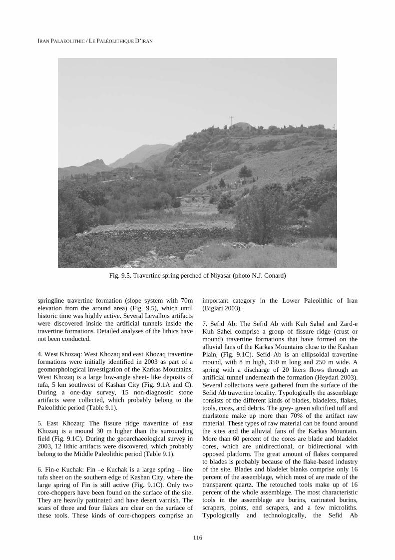
Fig. 9.5. Travertine spring perched of Niyasar (photo N.J. Conard)
springline travertine formation (slope system with 70m elevation from the around area) (Fig. 9.5), which until historic time was highly active. Several Levallois artifacts were discovered inside the artificial tunnels inside the travertine formations. Detailed analyses of the lithics have not been conducted.
4. West Khozaq: West Khozaq and east Khozaq travertine formations were initially identified in 2003 as part of a geomorphological investigation of the Karkas Mountains. West Khozaq is a large low-angle sheet- like deposits of tufa, 5 km southwest of Kashan City (Fig. 9.1A and C). During a one-day survey, 15 non-diagnostic stone artifacts were collected, which probably belong to the Paleolithic period (Table 9.1).
5. East Khozaq: The fissure ridge travertine of east Khozaq is a mound 30 m higher than the surrounding field (Fig. 9.1C). During the geoarchaeological survey in 2003, 12 lithic artifacts were discovered, which probably belong to the Middle Paleolithic period (Table 9.1).
6. Fin-e Kuchak: Fin –e Kuchak is a large spring – line tufa sheet on the southern edge of Kashan City, where the large spring of Fin is still active (Fig. 9.1C). Only two core-choppers have been found on the surface of the site. They are heavily pattinated and have desert varnish. The scars of three and four flakes are clear on the surface of these tools. These kinds of core-choppers comprise an
important category in the Lower Paleolithic of Iran (Biglari 2003).
7. Sefid Ab: The Sefid Ab with Kuh Sahel and Zard-e Kuh Sahel comprise a group of fissure ridge (crust or mound) travertine formations that have formed on the alluvial fans of the Karkas Mountains close to the Kashan Plain, (Fig. 9.1C). Sefid Ab is an ellipsoidal travertine mound, with 8 m high, 350 m long and 250 m wide. A spring with a discharge of 20 liters flows through an artificial tunnel underneath the formation (Heydari 2003). Several collections were gathered from the surface of the Sefid Ab travertine locality. Typologically the assemblage consists of the different kinds of blades, bladelets, flakes, tools, cores, and debris. The grey- green silicified tuff and marlstone make up more than 70% of the artifact raw material. These types of raw material can be found around the sites and the alluvial fans of the Karkas Mountain. More than 60 percent of the cores are blade and bladelet cores, which are unidirectional, or bidirectional with opposed platform. The great amount of flakes compared to blades is probably because of the flake-based industry of the site. Blades and bladelet blanks comprise only 16 percent of the assemblage, which most of are made of the transparent quartz. The retouched tools make up of 16 percent of the whole assemblage. The most characteristic tools in the assemblage are burins, carinated burins, scrapers, points, end scrapers, and a few microliths. Typologically and technologically, the Sefid Ab

S. HEYDARI-GURAN ET AL.: IRANIAN PALEOLITHIC SITES ON TRAVERTINE AND TUFA FORMATIONS
117
Fig. 9.6. Plan and simplified cross section of the Holabad I travertine platform
assemblage belongs to the Upper Paleolithic period (Biglari 2003). Biglari in the description of the stone artifacts of Sefid Ab points to some Aurignacian elements and analogies with the contemporary assemblage from Warwasi and Shanidar (Biglari 2003).
8. Zard-e Kuh Sahel: Another fissure-ridge travertine formation has yielded thirty-six lithic artifacts from the surface of this travertine dome, consisting of cores, flakes, blade and bladelets, retouched tools and debris. The raw materials are mostly tuff, marlstone, chert, and quartz.
Flakes and tools make up most of the debitage rather than blades or bladelets. The tools, which are mostly notch/ denticulates and backed pieces, show that the assemblage most probably belongs to the Upper Paleolithic period (Biglari 2003).
9. Kuh Sahel: The travertine circular mound of Kuh Sahel with a 360 m diameter is the largest fissure-ridge travertine formation in the region (Fig. 9.1C). 40 years ago this travertine was quarried for over a decade for house construction in Kashan City. Only two stone

IRAN PALAEOLITHIC / LE PALÉOLITHIQUE D’IRAN
118
Fig. 9.7. A view Hol Abad I (photo S. Heydari-Guran)
artifacts have been discovered, one of which is a notch and the other is a large tuffaceous piece with several flake negative scars. At the north-west margin of Kuh Sahel, there is a small travertine mound (20x15 m) with an active spring (discharge of 15 liters). Twenty lithic artifacts of tuff and marlstone were discovered on the surface of the site, which are not diagnostic of any period (Biglari 2003).
10. Kaftar Khun: The travertine of Kaftar Khun was identified in 2003 as part of geomorphological investigations in the Karkas Mountains (Fig. 9.1C). This cascade travertine locality consists of many small caves and shelters, which were formed during erosional activities on the 70 m cliff (with sixty to seventy degrees dip) of the formation (Heydari 2003). They are now occupied by Hyenas. The entrance and interior of these dens contain a mass of different kinds of animal bones. Several Levallois Middle Paleolithic artifacts were discovered on the surface during mapping of the site by, F. Biglari, M. Mashkur and S. Heydari. The detailed study of the lithics from this site is currently being conducted.
11. Hol Abad I: Hol Abad (Höl Abad) is the name of a large travertine platform on the north slope of an isolated mountain with the same name, 10 km south and southeast of the town of Arisman and around 65 km southeast of travertine formation group of the Kashan Region (Fig. 9.1C). Close to this travertine platform, the remains of an abandoned village and pomegranate garden are located (Fig. 9.1C and 9.6). Höl in the local dialect means small cave, and in the 30 m high wall face of the travertine,
many small caves are visible. The perched spring line travertine and tufa deposits of Holabad with a relatively round regular shape( 350 m long southwest to northeast and 300 m wide, southeast to northwest), and over 30 m thick (Fig. 9.6 and 9.7). An outlet of a subterranean tunnel (similar to a Qanat) and a pool are located to the north-northwest of this platform (Fig. 9.8). This Qanat-like structure comes from the top of the Hol Abad, where we think the former spring of the Hol Abad travertine was located. By using a Qanat and keeping the water under ground, the people were able to bring the water to their fields with minimum evaporation (Fig. 9.8). The date of construction for this Qanat-like structure is not clear (possibly within last the few centuries) but when the Qanat was constructed deviated the spring, halting travertine formation (Fig 9.9). During two days of surveying and mapping the site, we collected almost all of the visible artifacts on the surface (956 pieces). The shape of the site and the artifact density and typology clearly show two periods of occupation that occurred in two different parts (north and southeast) of the travertine formation (Fig 9.6). The southeast part (younger period) is about two meters higher than the north part of the site. After recognizing 2 phases among the artifacts on the surface of the site, we decided to collect them separately and in analyzing them, we considered these two separate phases according to their occurrence on the site. The northern part of the site is formed by a wavy shape travertine which in some parts is extensively eroded. In this part most of the artifacts occurred inside several shallow gullies (maximum 80 cm deep) and particularly in red-brown to brown silt and fine sand area that is 14 m long and 6 m wide (Fig. 9.6). Except for rare cases, most

S. HEYDARI-GURAN ET AL.: IRANIAN PALEOLITHIC SITES ON TRAVERTINE AND TUFA FORMATIONS
119
Fig. 9.8. The spring at the travertine site of Hol Abad. (Photo N.J. Conard)
Fig. 9.9. Sedimentary depositional model of Hol Abad I and Sefid Ab travertine formations
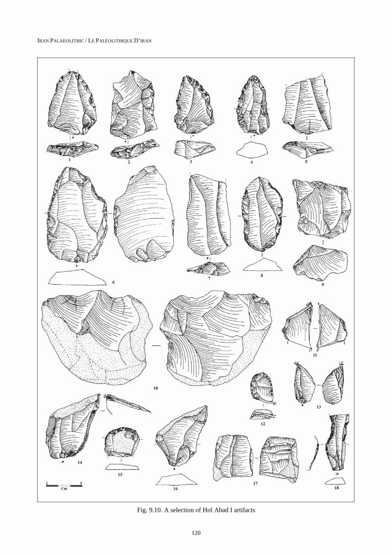
of the artifacts from these gullies and exposed area probably belong to the Middle Paleolithic industries. Levallois blades and flakes, different kinds of scrapers (convergent, dejetè, side scraper), and Levallois points etc. (Fig. 9.10: 1-8) represent this period. We organized the retouched and used tools into two groups of formal and informal tools (see Ghasidian et al., in press). In
tables 9.4 and 9.5, different kinds of tool in this part of Hol Abad are shown. Tuff and volcanic lava, the easily accessed and available raw material around the site, are heavily exploited for lithic production (Table 9.4). Only in rare cases are chert artifacts found in this part of Hol Abad. Most of the pieces are heavily patinated and the edges of many of the artifacts have been damaged by
IRAN PALAEOLITHIC / LE PALÉOLITHIQUE D’IRAN
120
Fig. 9.10. A selection of Hol Abad I artifacts

S. HEYDARI-GURAN ET AL.: IRANIAN PALEOLITHIC SITES ON TRAVERTINE AND TUFA FORMATIONS
121
Tab. 9.4: The distribution of different types of retouched tools and their raw material, Holabad, North
Formal tools Raw material No. Time period
notch elongated flake, hafted piece green silicified tuff 1 Upper Pal.
truncated blade Chert 1 Upper Pal.
burin Chert 1 Upper Pal.
retouched blade and end scraper green silicified tuff 1 Upper Pal.
side scraper gray silicified tuff 2 Middle pal.
side scraper green silicified tuff 2 Middle pal.
side scraper Nonsilicified igneous 3 Middle pal.
convergent scraper silicified igneous 1 Middle pal.
dejetè scraper silicified igneous 1 Levallois mid. pal.
simple scraper Nonsilicified igneous 2 Middle pal.
side and end scraper gray silicified tuff 1 Middle pal.
scraper and denticulate green silicified tuff 1 Middle pal.
end scraper silicified igneous 1 Middle pal.
denticulate blade Nonsilicified igneous 1 Middle pal.
denticulate blade silicified igneous 1 Middle pal.
notch flake Nonsilicified igneous 1 Middle pal.
retouched flake silicified igneous 1 Middle pal.
retouched flake gray silicified tuff 2 Middle pal.
retouched flake Nonsilicified igneous 2 Middle pal.
retouched blade gray silicified tuff 2 Middle pal.
retouched flake green silicified tuff 1 Levallois Mid. Pal.
point silicified igneous 1 Levallois Mid. Pal.
point Nonsilicified igneous 1 Levallois Mid. Pal.
point Chalcedony 1 Levallois Mid. Pal.
point green silicified tuff 1 Middle Pal.
point gray green tuff 1 Levallois Mid. Pal.
Total 34
trampling and rolling on the surface, damaging the edges of many of the artifacts. Blade blanks are poorly represented in both formal and informal tools compared to flakes. The later periods’ pieces (Upper and probably Epipaleolithic) are extremely are among this assemblage. It is possible that they have been washed down from the higher Upper Paleolithic and Epipaleolithic layers. Relatively few pieces with cortex indicate that the preparation of cores and cortex removal occurred somewhere else, probably closer to the raw material resources, and that the prepared cores were brought to the site. Except for Levallois pieces, it seems that (the rest) of the Middle Paleolithic did not follow a well-defined and clear technology in their morphology. Most of the cores are inclined flake cores, which are probably Middle Paleolithic (see Conard et al. 2004). A few of them are blade cores although they are not clearly indicative of the late Paleolithic period. The rest of the core types match with tool types and plain blanks. Most of them have an irregular shape. They were reduced intensively before
being discarded. The existence of 3 crested blades also indicates intensive use of the cores. In some cases fractures inside the texture, did not let the knappers strike any more blanks. Like most of the Middle Paleolithic industries so far known in Iran (see e.g. Baumler and Speth, 1993), the Middle Paleolithic industry here is flake-based and associated with more flake blanks and cores compared to blades. Except for cherty blades and several made of silicified tuffs, which seem to be Upper Paleolithic, the rest are large and irregular blades, including some Levallois blades (7 pieces). Their size varies from 2 cm to 9 cm. the smallest blades are made of chert, which is typical for the sites of this region (Conard et al., 2006) and the largest blades are made of nonsilicified igneous rock. Debris consists of large pieces of tested pebbles that still retain their original shape, broken pieces along the fractures of their texture, and small pieces created during the preparation of cores and striking the main blanks. 11 clear Levallois plain flakes exist in the assemblage. Except for these flakes and small

IRAN PALAEOLITHIC / LE PALÉOLITHIQUE D’IRAN
122
Tab. 9.5: The distribution of different types of retouched tools and their raw material, Holabad, South-east
Formal Tools Raw material No. Time period
burin nonsilicified igneous 1 Upper Pal.
burin silicified igneous 1 Upper Pal.
burin chert 2 Upper Pal.
burin gray silicified tuff 1 Upper Pal.
double burin green silicified tuff 1 Upper Pal.
notched and denticulate blade chert 1 Upper Pal.
notched blade chalcedony 1 Upper Pal.
side scraper chert 1 Upper Pal.
scraper chalcedony 1 Upper Pal.
end scraper chalcedony 1 Upper Pal.
end scraper chert 1 Upper Pal.
retouched blade chert 3 Upper Pal.
retouched flake chert 3 Upper Pal.
retouched flake novacolite 1 Upper Pal.
backed blade chert 1 Upper Pal.
borer gray silicified tuff 1 Upper Pal.
awl green silicified tuff 1 Upper Pal.
Total 22
amounts of chert flakes, which are smaller, the rest are not diagnostic and mostly seem to be Middle Paleolithic. Their size, like the blades, is varied (1.5 cm to 10 cm). 7.5% of the pieces are covered by calcite as is to be expected since the pieces were found in front of this setting. In addition, as we expected, there is no sign of desert varnish and very few pieces that have been burnt (1.39%). Table 9.5 shows that compare to the whole assemblage, little debris exists. This reason and also the low percentage of pieces with cortex lead us to conclude that the initial process of reduction sequence happened where some else and the prepared cores were brought to the site. In the southeast of Hol Abad, the condition is somewhat different. Here, the artifact size is smaller, especially in chert and silicified tuff pieces. Although very rare, Levallois flakes can be recognized (1.8%). The cores are mostly irregular platform cores and except for one, the rest seem to be discarded. The existence of a few rejuvenation face flakes, core tablets and crested blades show the intensive use of the cores until they were abandoned. Although there are flake and mixed cores, most are blade (let) cores with one or two platforms and are small in size. There are some other elements in the tool assemblage, such as end scrapers, backed blades, and burins (Fig. 9.10; 11-18) which are characteristic of the late Upper Paleolithic and Epipaleolithic, but like the other surface pieces, it is hard to determine a definite period.
12. Hol Abad II: During the survey of Holabad I, we visited Hol Abad II, which is located 1000 m west of Hol Abad I (Table 9.1). This site is a perched spring line
travertine around 150 square meters. Apparently, during a short humid environmental condition, the water table was higher and the spring of Hol Abad II was active. Only two non-diagnostic lithic artifacts were discovered on the deposits of this travertine.
PALAEOENVIRONMENTAL CONSIDERATIONS
Some writers, notably Nicod (1981), Pazdur et al., (1988), Goudie et al., (1993), and Taylor et al., (1994) have related variations in travertine and tufa sequences to climatic changes. In temperate regions (and in arid and semi-arid regions like Iran) tufa and travertine deposition coincides with the warmer and wetter phases of the glacial/interglacial sequences (Ford and Pedley, 1996). At least our preliminary considerations show the travertine formations in the Karkas Mountains are connected to changes in the water table during the wet and dry conditions. Modern hydrothermal activity at the Karkas region is largely limited to a few springs with low water volume discharges. Although their thermal activity is low, some of them such as Kaftar Khun, Holabad and Zardeh-e Kuh Sahel show large amounts of fossil travertine deposits associated with the springs indicating higher paleo- water discharges able to supply enough thermal water to precipitate this significant amount of carbonate (Heydari-Guran and Ghasidian, in press).
Paleoclaimatological studies in the Zagros Mountains of Iran and Iraq (100 km west of Takht-e Soleiman region) have shown small glaciers evidently formed during cold

S. HEYDARI-GURAN ET AL.: IRANIAN PALEOLITHIC SITES ON TRAVERTINE AND TUFA FORMATIONS
123
intervals in the Zagros Mountains when the snow line descended to between 300 and 1,150 m below its modern average (Wright, 1960, 1961, 1976, and 1980, Schweizer, 1975). The Middle Paleolithic sites of Takht-e Soleiman are located at 2300 m a.s.l., which suggest this region was under the snowline during the ice age. We think that early human occupation may have been possible in Takht-e Soleiman during one of the late Pleistocene interglacial.
CONCLUSION
Travertine and tufa formations are widely distributed in Iran. They have been deposited by the precipitation of calcium carbonate in connection with the arrival mineral-rich and calcium bicarbonate-saturated hot groundwater, at ground surface and loss of its CO2 content. Fossil-spring deposits and associated artifacts in the Karkas Mountains and Takht-e Soleiman provide a record of human occupation during the late Pleistocene and early Holocene. Concentrations of lithic artifacts due to from the Middle Paleolithic to the end of the Paleolithic period and indicate repeated occupation of fossil-spring localities at least from the late Pleistocene to early the Holocene. These travertine localities represented significant water sources located near chert resources, and as such would have been particularly favorable environments for habitation. The density and variety of material culture on tufa and travertine- deposits is dependent on the intensity of spring flow that occurred within these regions, which has a distinctly different history of spring flow.
In general, most of the studied travertine and tufa Paleo-lithic sites have the characteristics below in common:
• Although the travertine sites are not the only Paleolithic sites in these two regions (Takht-e Soleiman and the Karkas range) these sites are the richest localities in these regions.
• In the Karkas Mountains, the travertine and tufa sites are the only localities with reliable water sources.
• Except far Niyasar, the anthropogenic materials on the travertine and tufa formations are exposed on the surface.
• Because of the nature of travertine formations all travertine and tufa localities in the studied regions have panoramic views to the surrounding landscapes around.
• The Paleolithic localities of Takht-e Soleiman (ca 2300 m a.s.l.) are the highest known Paleolithic localities in Iran and the Middle East.
• During the Paleolithic survey of Arisman Region, many Paleolithic sites were discovered on the sand dunes near the travertine site of Hol Abad (Heydari and Ghasidian, forthcoming, Conard et al 2005). The spring of the Hol Abad was the only water source in this region, allowing Holabad to be used as a campsite through the Arisman Region.
• Finally travertine and tufa formations can be used to predict the location of Paleolithic sites in various part of Iran.
Acknowledgments
The authors are very grateful to M. Azarnoosh, the former director of Iranian Center for Archaeological Research, S. M. Shahmirzadi, J. Nokandeh, S. Razmjoo, F. Biglari, H. Fahimi, and B. Helwing. Also S. Klantari and N. Heydari are thanked for their help with the field works. Many thanks go to C. Miller for his valuable comments on the draft of the paper.
References
ATABEY, E., 2002. The formation of fissure ridge type laminated travertine-tufa deposits microscopical characterristics and diagnosis, Kirsehir Central Anatolia. Mineral Res. Expl. Bul. 123-124: Pp. 59-65.
BABA KHANI, A. and M. AMINI CHAROQ, 1992. Travertine forming waster sources in Takab area. Scientific quaterly journal of Earth Science, vol. 1, No. 2,. 50-59 (in Persian).
BAUMLER, F. and J.D. SPETH, 1993.A, A Middle Paleolithic Assemblage from Kunji Cave, Iran. In: The Paleolithic Prehistory of the Zagros-Tauros. The University Museum of Archaeology and Anthropo-logy, University of Pennsylvania, Philadelphia. Pp. 1-73.
BERBERIAN M. and N. ALAVI-TEHRANI, 1971. Structural analyses of Hamadan metamorphic tecto-nictes: a paleotectonic discussion.Geol. Survey Iran, report 41.
BERBERIAN F. and M. BERBERIAN, 1981. Tectono-plutonic episodes in Iran. In: Gupta H.K., Delany F.M. (eds) Zagros Hindu Kush Himalaya Geodynamic evolution. American Geophysical Union,Washington DC, Pp. 5–32
BERBERIAN M. and G.C.P. KING, 1981. Towards a paleogeography and tectonic evolution of Iran. Can J Earth Sci. 18: Pp.210–265.
BIGLARI, F., 2003. The Preliminary Survey of Paleolithic Sites in the Kashan Region, in S. Malek Shahmirzadi (ed.), The Silversmiths of Sialk (Sialk Reconsideration Project), Report n° 2, Tehran: Iranian Center for Archaeological Research, Iranian Cultural Heritage Organization, Pp. 151-168 (in Persian).
CONARD, N.J., M. SORESSI, J.E. PARKINGTON, S. WURZ and R. YATES, 2004. Unified lithic taxonomy based on patterns of core reduction. South African Archaeological Bulletin 59 (179):Pp. 13-17.
CONARD, N.J., E. GHASIDIAN, S. HEYDARI and M. ZEIDEE, 2006. Report on the 2005 survey of the Tübingen-Iranian Stone Age Research Project in the

IRAN PALAEOLITHIC / LE PALÉOLITHIQUE D’IRAN
124
provinces of Esfahan, Fars and Kohgiluyeh-Boyer-ahmad. Archaeological Reports 5: 9-34.
DIBBLE, H. 1981. The Mousterian Industry from Bisitun Cave (Iran). In: Paléorient 10/2: Pp 23–34.
EISENSTUKE, M., 1951. Die kalktuffe und ihre molluskenfauna bei schmeiechen nahe Blaubeuren (Schwabische Alb): N. jb. Geol. Palaont. Abh., v. 93, Pp. 247-276.
FORD, T.D. and H.M. PEDLEY, 1992. Tufa deposits of the world. International Speleological Society of Japan, Vol. 17, 46-63.
FORD, T.D. and H.M. PEDLEY, 1996. A review of tufa and travertine deposits of the world. Earth- Science Reviews 42, 117-175.
GHASIDIAN, E., A. AZADI and S. POLLOCK, in press, Toll-e Bashi 2003: Chipped stone artifacts.
GOUDIE, A.S., H.A. VILES, and A. PENTECOST, 1993. The late Holocene tufa decline in Euroupe. The Holocene, 3: Pp. 181-186.
HEYDARI, S. 2003. Geoarchaeological researches at Karkas Mountain, Kashan Region. In: S. Malek Shahmirzadi (ed.), The Silvermiths of Sialk, ICHO. Tehran, Iran. Pp. 129-149 (in Persian).
HEYDARI, S. and E. GHASIDIAN, 2004. Preliminary report of late Pleistocene geoarchaeological research in the Takht- Soleiman travertine region. Proceeding of the International Symposium on Iranian Archaeology: Northwestern Region. Edited by M. Azarnoush. pp. 27- 43. Iranian Center for Archaeological research. (in Persian).
HEYDARI, S. 2007. The impact of geology and geomorphology on cave and rockshelter archaeo-logical site formation, preservation and distribution in the Zagros Mountain of Iran. Geoarchaeology: An international Journal, Vol. 22, No.6, 653-669.
HEYDARI-GURAN, S. and E. GHASIDIAN, (in press). The Paleolithic Survey in Arisman Region; Central Plateau of Iran.
JULIA, R., 1983, Travertines. In: P.A. Scholle, D.G. Bebout and C.H. Moore (Eds), Carbonate Depositional Environments. Am. Assoc. Petrol. Geol. Mem., 33: Pp. 64-72.
Le TENSORER, J.M. JAGHER, R. RENTZEL, P. HAUCK, T. ISMAIL-MEYER, K. PÜMPIN, C. and D. WOJTCZAK1, 2007. Long-Term Site Formation Processes at the Natural Springs Nadaouiyeh and Hummal in the El Kowm Oasis, Central Syria. Geoarchaeology: An International Journal, Vol. 22, No. 6, Pp. 621–639.
NICODE, J., 1981. Repartition, classification, relation avec les milieux karstiques et karstification. In : For-mations Carbonatees externes: Tufs et Travertines. Actes Coll. Assoc.Geogr. Fr., pp.173-176. Also in Bull. Assoc.Geogr. Fr., 479-480 : 181-187.
PAZDUR, A. and M.F. PAZDUR, 1986. 14C dating of calcareous tufa from different environments. Radiocarbon, 28: 534-538.
PEDLEY, H.M., 1990. Classification and environmental models of cool freshwater tufa. Sediment. Geol., 68: 143-154.
SCHRÖDER J.W., 1944. Essai sur la structure de l’Iran. Eclogae geologicae Helvetiae 37:37–81
SCHWEIZER, G., 1975. Untersuchungen zur Physiogeo-graphie von Ostanatolien und Nordwestiran. Tübingen: Geographischen Instituts der Universität Tübingen.
SMITH, J.R., GIEGENGACK, R. SCHWARCZ, H.P., MCDONALD, M. M.A., KLEINDIENST, M.R., HAWKINS, A.L., and C.S. CHURCHER, 2004. A reconstruction of Quaternarey pluvial environments and human occupations using stratigraphey and geochronology of fossil- spring tufas, Kharga Oasis, Egypt. Geoarchaeology: An International journal, Vol. 19, No. 5, 407-439.
STIRN, A., 1964, Kalktuffworkommen und kalktufftypen der Schwabischen Alb.: Abh. Karst Hohlenkde, E, H.1, 91 p.
TAYLOR, D.M., H.I. GRIFFITHS, H.M. PEDLEY, and I. PRINCE, 1994. Radiocarbone-dated Holocene pollen and ostracod sequences from barrage tufa-dammed fluvial systems in the white peak, Derbyshire, U.K. The Holocene, 4: Pp. 356-364.
WALLNER, J., 1934, Beitrag Zur Kenntnis der vaucheriatuffe: Zbl. Bakteriol. Parasitenk. Infek., 2.Abt., v.90,Pp. 150-154.
WRIGHT, H.E., jr. 1960. “Climate and prehistoric man in the eastern Mediterranean,” in R. Braidwood & B. Howe (eds), Prehistoric investigations in Iraqi Kurdistan. Pp. 71–95. Oriental Institute, University of Chicago, Studies in Ancient Oriental Civilization 31.
WRIGHT, H.E., jr. 1961. Pleistocene glaciation in Kurdistan. Eiszeitalter und Gegenwart 12:131–64.
WRIGHT, H.E., jr. 1976. The environmental setting for plant domestication in the Near East. Science 194:385–89.
WRIGHT, H.E., jr. 1980. Climatic change and plant domestication in the Zagros Mountains. Iran 18:145–48.