INTEGRATING THE RECREATIONAL SPACES OF RANGPUR CITY CORPORATION, BANGLADESH: A PERSPECTIVE FROM...
15
Proceedings of the Ninth International Space Syntax Symposium Edited by Y O Kim, H T Park and K W Seo, Seoul: Sejong University, 2013 INTEGRATING THE RECREATIONAL SPACES OF RANGPUR CITY CORPORATION, BANGLADESH: A perspective from space syntax 119 Tasneem Tariq Bangladesh University of Engineering and Technology e-mail : [email protected], [email protected] Farida Nilufar Bangladesh University of Engineering and Technology e-mail : [email protected] Abstract Rangpur, one of the most recent City Corporations of Bangladesh, is blessed with natural resources like open places, parks and water bodies at the centre of its city heart. This area has high potentiality to be developed as the central “Recreational Hub” of this newly announced City Corporation. Open spaces work as the lungs of a city or a town. But often it is observed that these gathering spaces are not used to its full potential due to the location and insufficient accessibility to these areas from rest of the city. This paper aims to study the integration and accessibility of the selected public recreational open spaces of Rangpur City Corporation with “Space syntax” methodology by using different Urban Intervention Strategies for increasing the integration of the specific area. Through comparison and analysis, this paper thrives to find out some strategic guidelines to be implemented for the utmost use of the selected public open areas and to increase the intelligibility of these recreational spaces within the upcoming Master Plan of Rangpur City Corporation. Keywords: Open space, Rangpur City, Space Syntax, Accessibility, Integration Theme: Urban Space and Social, Economic and Cultural Phenomena
Transcript of INTEGRATING THE RECREATIONAL SPACES OF RANGPUR CITY CORPORATION, BANGLADESH: A PERSPECTIVE FROM...

Proceedings of the Ninth International Space Syntax Symposium
Edited by Y O Kim, H T Park and K W Seo, Seoul: Sejong University, 2013
INTEGRATING THE RECREATIONAL SPACES OF RANGPUR CITY
CORPORATION, BANGLADESH:
A perspective from space syntax
119
Tasneem Tariq
Bangladesh University of Engineering and Technology
e-mail : [email protected], [email protected]
Farida Nilufar
Bangladesh University of Engineering and Technology
e-mail : [email protected]
Abstract
Rangpur, one of the most recent City Corporations of Bangladesh, is blessed with natural
resources like open places, parks and water bodies at the centre of its city heart. This area has
high potentiality to be developed as the central “Recreational Hub” of this newly announced City
Corporation. Open spaces work as the lungs of a city or a town. But often it is observed that
these gathering spaces are not used to its full potential due to the location and insufficient
accessibility to these areas from rest of the city. This paper aims to study the integration and
accessibility of the selected public recreational open spaces of Rangpur City Corporation with
“Space syntax” methodology by using different Urban Intervention Strategies for increasing the
integration of the specific area. Through comparison and analysis, this paper thrives to find out
some strategic guidelines to be implemented for the utmost use of the selected public open
areas and to increase the intelligibility of these recreational spaces within the upcoming Master
Plan of Rangpur City Corporation.
Keywords: Open space, Rangpur City, Space Syntax, Accessibility, Integration
Theme: Urban Space and Social, Economic and Cultural Phenomena
Proceedings of the Ninth International Space Syntax Symposium, Seoul, 2013
T Tariq and F Nilufar: Integrating the recreational spaces of rangpur city corporation, Bangladesh 119: 2
1. PROLOGUE : PLANNING AND DESIGN OF PUBLIC OPEN SPACES WITH
EVIDENCE-BASED APPROACH
The city as a collective project exists because its public spaces exist as well (Rubén, 2012). These
public spaces have an important role regarding the environmental, economic and social context
in the city as well as sources or providers of life, quality and sustainability (Chiesura, 2004).
Basically, the public spaces are spaces of socialization where the interpersonal relationships are
generated and these relationships and different kinds of them or their intensity may vary
regarding place characteristics, time of use and frequency of social interactions (Gehl, 1956).
Among these public spaces, a large number are open spaces. These open spaces include all
private and public lands that are open in character and used as a place for open air recreation
that may include from a small play lot to vast hunting grounds. Urban open spaces are
considered as important elements of a city which need to be integrated to achieve a quality
environment. According to Roger, “A clear articulation of public space connects neighbourhoods
to connect to each other and link people within localities to their social institutions”. Rogers
(1999) In fact, open spaces which are accessible to general public, provide an integral and
necessary part of urban living and an indispensable element within urban region. With a better
urban design and environmental quality, the streets may be enhanced as “great streets” (Jacobs,
1996), facilitating the urban legibility and their own identity (Lynch, 1960) and so, improving an
attractive image of the city. In this way, streets as connectors among public spaces (parks,
gardens, etc) should be considered, analyzed, treated and designed as public spaces (Rubén,
2012). In this sense, the accessibility is related to pedestrian and this research considers this
issue. The pedestrian movement is the mobility model that has the capacity of maintaining the
most direct relationship and interaction with the city, e.g. through the senses, in the interaction
with other pedestrians, in the possibility of participating in the trading activity and cultural one
along the streets (Venturi, 1998) and enjoying the natural, architectonic environment (Jacobs,
1996). Regarding that, mobility plans appear much later than urban plans instead of drawing
integration with joint strategies in future urban developments, where connected, integrated
public open spaces is a priority as a revitalizing action in the city (Gehl, 1936).
The city of Rangpur, in Bangladesh, has been considered as an ideal area due to its urban history
and the presence of a wide variety in the typology of streets and public spaces. The process of
preparing Master Plan for Rangpur City Corporation of Rangpur, the newest divisional town of
Bangladesh, has been undertaken to provide guidance for the development and development
control of this area. It is found that a number of large and medium scale open spaces are
scattered in Rangpur city which can set as the “Breathing Zone” of the city. In rapidly
urbanizing countries, public open spaces are shrinking at an alarming rate. So it is high time to
analyse how to create a well-connected city layout where all the public gathering spaces like
open spaces, zoo, stadium, children’s park etc will be connected ensuring pedestrian
accessibility and should be highly integrated within the whole city grid so that people can have
an easy access to these places which can create a strong social, cultural and environmental
impact on the city-dwellers. Urban strategies should be taken to improve accessibility to the
public open spaces to integrate these areas within the Master Plan. The extent to which an
environment allows people a choice of access through it from place to place is a quality as
termed as accessibility. Accessibility is an important tool of sustainability. It improves the
economic, social and environmental condition of the area. With the increase of number of
access routes, the choice increases and the environment becomes more responsive.
Accessibility is important at two scales - at the city as a whole and to its immediate local. The
relative ability of all the existing links to connect the site both to the city as a whole and to the
immediate surroundings is considered to decide the relative importance of extending each link
into and through the site, to achieve an appropriate balance between permeability at the city
wide and local scales. Within the limited scope of a paper this research only deals with the

Proceedings of the Ninth International Space Syntax Symposium, Seoul, 2013
T Tariq and F Nilufar: Integrating the recreational spaces of rangpur city corporation, Bangladesh 119: 3
location and physical access to the open spaces.
This paper deals with the potential recreational hub of Rangpur City Corporation which is
identified as large scale public open spaces and the analysis of physical location and accessibility
of these spaces will be carried out by using ‘Space Syntax’. In order to analyze all these
questions about spatial characteristics; integration and visibility of the study area in Rangpur is
going to be assessed. This paper intends to identify the public gathering spaces at the central
area of Rangpur City Corporation and to analyze these open spaces in terms of accessibility as
many of these are not potentially used because of inadequate accessibility (Rangpur Structure
Plan, 1986). In order to assess how these areas are connected within the city, this paper will
consider the followings: • To identify the Integration Core of the Rangpur Sadar. • To identify the areas of public open spaces, parks, play grounds and other recreational
uses like green belts, retention pond, water bodies, natural reservoirs etc. • To analyze the integration of some selected public open spaces and to assess the
accessibility of these spaces using “Space Syntax”. • To suggest an Urban Intervention strategy to increase the potential use of these
gathering spaces.
The present study only focuses on the large scale open spaces of Rangpur City Corporation
within its limited scope. A sample of six recreational open spaces has been selected to analyze
with “Space Syntax”.
2. SPACE SYNTAX: METHODOLOGY
Space Syntax is a method for describing and analyzing the relationships between social structure
and spatial structure. The analysis of the urban grids is based on the axial map. Integration is a
static global measure. It describes the average depth of a space to all other spaces in the system.
The spaces of a system can be ranked from the most integrated to the most segregated.
Integration has now been found empirically to correlate well with observed patterns of space
occupancy, use and movement in towns and cities in different parts of the world. Global
Integration provides a global index of relative integration and segregation for that line relative to
all others. Axial lines with warmer colours indicate high global or local integration value. In
general, local integration relate to the spatial properties of space up to three steps (R=3) away
from the root. Intelligibility, is the correlation between connectivity and integration; and it
describes how far the depth of a space from the layout as a whole can be inferred from the
number of its direct connections, i. e. what can be understood of the global relation of a space
from what can be observed within that space. The pedestrian accessibility to public spaces is
usually analyzed in terms of time or distance of trips along the pedestrian network. This
network and its configuration is a key factor to collect the pedestrian flows at different scales in
the city; neighbourhood, quarter, district or city. Therefore, a planning process that analyzes
these structural implications on the city could plan public spaces with better criteria (Rubén,
2012). This paper is developed on two key ideas: accessibility and spatial configuration. In
application of these ideas or its measures it is going to link other concept, integration.
Accessibility refers to the ease to arrive to facilities, activities or goals, which could be appointed
in general as opportunities. In addition accessibility could be defined as “the intensity of the
possibility of interaction” (Hansen, 1959) and interchange (Engwicht, 1993). The spatial
configuration plays a primitive or principal role for the pedestrian mobility (Hillier et al, 1993).
Proceedings of the Ninth International Space Syntax Symposium, Seoul, 2013
T Tariq and F Nilufar: Integrating the recreational spaces of rangpur city corporation, Bangladesh 119: 4
Under the theory of Space Syntax the proposed integration measures the degree in which a
node is integrated or segregated with respect to a part of total (local integration) or the whole
(global integration). This paper is based on the pedestrian network and the public space of the
Rangpur City. To undertake spatial configuration analysis based on street network, different
measures of axial map have been used here as provided by the spatial configuration software
DepthMap, developed by Alasdair Turner . Local-global integration and intelligibility are some of
the most interesting measures that could be used to analyze spatial configuration in the
Rangpur city. These measures of spatial configuration in the axial map are put in together with
the diversity of public space and their capacity to offer accessibility. Then analysis with Space
Syntax has been done on two phases.
Phase 01: The configurational properties of the Rangpur Sadar Upazilla have been analyzed by
“Space Syntax”. Then six large open spaces have been selected as recreational open spaces
based on Field Survey. The location and accessibility of these open spaces have been analyzed.
Phase 02: By creating different options of Urban Interventions, results have been analysed.
Then the findings of the syntactic analysis are triangulated with some observations which led to
some Design Guidelines to increase the integration and accessibility of the selected area.
3. CASE OF STUDY: RANGPUR CITY
This research work is developed on the pedestrian network of Rangpur city and its public spaces.
The definition of public spaces collects a diversity of spaces as squares, gardens, parks, or
playgrounds. Rangpur city is located in the northern region of Bangladesh. Geographically it is
located between 15003' and 26o00' North latitudes and between 88o57' and 89o32' east
longitudes. Rangpur is situated on the bank of the river Ghagat- a tributary of the river Teesta.
The Master Plan of Rangpur city corporation is going on for an area of approximately 200 sq. Km.
According to the Population Census 2001, total population of Rangpur paurashava was 465,768.
Compared to other urban centers of the region, urban growth is quite high in Rangpur. It is the
seventh largest town of the country. The importance of Rangpur town enhanced with the
declaration of Rangpur division in January 2010. The Rangpur Municipality had been upgraded
into City Corporation in 2011. Rangpur division has a bright prospect to become one of
country's strong economic bases if its potential for agricultural production could be harnessed
properly. The region is endowed with various natural resources. If proper attention is given in
exploitation of these resources, it is likely to become a prosperous economic zone of the
country (Rangpur Inception Report, 2012). The region will demand high level services in
education, healthcare, job security and other opportunities commensurate with a regional
centre. Simultaneously the need of recreational zone as well as interactive spaces will become
one of most the important priorities of the city. Therefore, it is important to prepare itself with a
proper Master Plan for physical growth of the city in such a way that it can meet the
recreational need with provisions of utility services of modern living. It was mentioned in
Rangpur Structure Plan, 1986 that recreational facilities in Rangpur are conspicuous by their
absence. Most games and athletics are practices and held in Collectorate Ground. The stadium
is in a bad shape, while the newly constructed gymnasium has been commissioned by the
District Sports Association. The need for parks, playgrounds and recreational facilities are real
and pressing. The Paurashava has undertaken a scheme of developing the Chikli Lake into a lake
park but inadequate accesses, funds, insensitivity to the natural features and isolation from the
urban fabric render the park unattractive. Both Chikli and Kukrul lakes are excellent natural
resources for recreation. They have higher potentials than is being realised. There is no reason
why these cannot be developed and integrated into the urban system

Proceedings of the Ninth International Space Syntax Symposium, Seoul, 2013
T Tariq and F Nilufar: Integrating the recreational spaces of rangpur city corporation, Bangladesh 119: 5
Space No. Space Name Space No. Space Name
1 Rangpur Zoo 4 Chiklee Lake
2 Rangpur Stadium 5 Kukrul Lake 3 Cricket Garden 6 Shurovi Uddan
Figure 1 Selection of Sample Area in Rangpur City Corporation
So, if proper actions are taken there is a high chance to improve the existing recreational
condition of Rangpur as it is blessed with many natural features like public open spaces at the
centre which is identified as a highly potential “Recreational Hub” performing as successful
public gathering spaces. This recreational hub consists of several gathering spaces as listed
below: Rangpur Zoo and Botanical Garden, Football Stadium, Cricket Garben, Shuruvi Uddan,
Rangpur Shishu Park, Chiklee Bill, Kukrul Bill, Shamshundoru Canal, Eidgah, Long Tennis Complex,
Table Tennis Complex, Rangpur Zilla School Field, Rangpur Govt. College Field etc. Six major
Public Open Spaces have been identified as the sample area to analyze the integration and
accessibility of these spaces with the whole city. (Figure:1)

Proceedings of the Ninth International Space Syntax Symposium, Seoul, 2013
T Tariq and F Nilufar: Integrating the recreational spaces of rangpur city corporation, Bangladesh 119: 6
4. SPATIAL ANALYSIS OF RANGPUR CITY: AN ASSESSMENT OF RECREATIONAL OPEN
SPACES
4.1 General Spatial Character of Rangpur Sadar
1,2,3,4,5,6,7 Most Integrated Road, R=n A,B,C Most Integrated Road, R=3 E,F,G Roads with maximum Connectivity
Figure 2 Spatial Analysis of Rangpur Sadar Upazila
As the map of Rangpur City Corporation is in process, the map of Rangpur Sadar Upazila
(prepared by “GIS UNIT” of Local Government Engineering Department, compiled from LGED
Upazila Base Maps 1994-95, Landsat TM 1998, GPS Survey 1999 and Field Checking in 2010), which
creates the larger part of the city corporation, has been used as the Base Map for the Syntactic

Proceedings of the Ninth International Space Syntax Symposium, Seoul, 2013
T Tariq and F Nilufar: Integrating the recreational spaces of rangpur city corporation, Bangladesh 119: 7
Analysis of this area. The Axial Map of Rangpur Sadar Upazila has been analyzed by Depthmap and
Global Integration(R=n), Local Integration (R=3) and Connectivity measures are considered.
The high value lines (marked with red by Space Syntax) of Global Integration, Local Integration
and Connectivity are identified and compared with corresponding 10% Core. It is found that all
the red marked lines in Global context (Road No.1-7), in Local context (Road No A,B,C) and for
Connectivity (Road E,F,G ) are within the 10 % Core of corresponding measure of Rangpur Sadar
Upazila.
Table 1 Global Integration Values, Local Integration Values and Connectivity
Road No
Ref: Fig:02 Global Integration Value, HH Local Integration Values[HH] Connectivity
1 0.78370184
2 0.77553898
3 0.79272395
4 0.76135504
5 0.81299067
6 0.80449224
7 0.76928514
A 2.84504
B 3.03122
C 2.85137
E 12
F 13
G 13
Max 0.81299067 3.0312238 13
Min 0.65717131 1.9310595 4
Mean 0.533366 1.24766 2.82905
4.2 Spatial evaluation of the selected open spaces
To have more detailed information about the selected sample area of recreational open spaces,
the existing map is updated with scientific information and this base map has been used to
analysis the accessibility into the selected recreational area. With the aim of observing the
spatial configuration in a more detailed way, some public spaces have been selected in this
paper. The sample area of six recreational open spaces is identified on the Axial Map and
analysed by Space syntax to identify their positions within Global and Local Integration of
Rangpur Sadar Upazilla.

Proceedings of the Ninth International Space Syntax Symposium, Seoul, 2013
T Tariq and F Nilufar: Integrating the recreational spaces of rangpur city corporation, Bangladesh 119: 8
Figure 3.1 Global Integration [HH], R=n
Figure 3.2 Local Integration [HH] ,(R=3)
Figure 3 Analysis of six recreational open spaces
By Space Syntax, the Global, Local Integration and Connectivity of Rangpur City Corporation
have been analyzed. Then only the sample area is observed thoroughly to understand
consequently the Global and Local Integration around the selected Public Open spaces. (Figure 3)
4.3 Identifying Access Road to Sample Area
Table 2 Public Open Spaces with their Connectivity and Integration Value
No. Open Space Access
Road Connectivity
integration HH
R=n
integration HH
R=3
1 Rangpur Zoo 1.1 2 0.5215676 1.1365665
1.2 4 0.55811375 1.6037242
2 Rangpur Stadium
2.1 4 0.55811375 1.6037242
2.2 4 0.55670172 1.4724894
2.3 2 0.51987326 1.0207884
3 Cricket Graden
3.1 2 0.59516197 1.5226898
3.2 3 0.55453873 1.31797
3.3 3 0.52010363 1.3057258
3.4 4 0.55670172 1.4724894
4 Chiklee Lake 4.1 1 0.49220547 0.68957245
5 Kukrul Lake 5.1 4 0.4588870 1.569167
5.2 2 0.47528327 1.1365665
5.3 2 0.4438267 1.1
6 Shurovi Uddan 6.1 7 0.64385182 2.2132308
6.2 2 0.5951619 1.5226898
Max 7 0.64385182 2.2132308
Min 1 0.44382674 0.68957245
Mean 4 0.54383928 1.451401625
The integration of the access roads of the six selected open spaces are analyzed to understand
how this sample area is integrated with the whole city at present. (Figure 4)
Proceedings of the Ninth International Space Syntax Symposium, Seoul, 2013
T Tariq and F Nilufar: Integrating the recreational spaces of rangpur city corporation, Bangladesh 119: 9
Space No 01 Space No 02
Space No 03 Space No 04
Space No 05 Space No 06
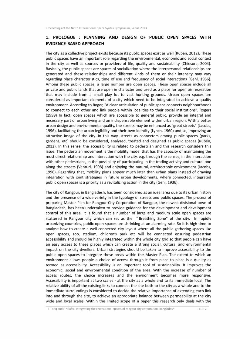
Figure 4 Access road Identification
4.4 Analysis of Access Road to Sample Area:
To develop a better urban planning with regard to public spaces and pedestrian accessibility,
spatial configuration need to be analyzed during the processes of spatial planning. At the same
time, issue of urban planning dealing with public spaces and that of mobility planning dealing
with accessibility should be managed in an integrated way. Now, the Global and Local
Integration, and Connectivity of these access roads are analyzed to evaluate the existing
condition of Intelligibility of the recreational spaces. (Table: 2)
4.4.1 Global Integration of Access Roads:
The mean Global Integration of the city is 0.541969. Now the Global Integrations of the access
roads to the recreational spaces are compared below.
11
22
2
3.
3.
3.
3.4
4
6
6
5 5.
5

Proceedings of the Ninth International Space Syntax Symposium, Seoul, 2013
T Tariq and F Nilufar: Integrating the recreational spaces of rangpur city corporation, Bangladesh 119: 10
Rangpur Zoo (Space No.1: Rd 1.1,1.2) : The Average integration value (0.539841) of the access
roads of Rangpur Zoo is lower than the Mean Global Integration value of the city (0.54383928).
So this Zoo should be rather integrated with the city to attract people. This zoo contains a
Botanical Garden and Shushu park within its premise. So it has a high potential to be one of the
most successful Public Spaces of this City Corporation.
Rangpur Stadium (Space No. 2, Rd 2.1, 2.2, 2.3): It does not hold a high integration value. As
Rangpur City Corporation has been already announced, there is a good chance to convert this
existing stadium as an international Stadium in near future. So to invite thousands of people, for
an international match, it should be more integrated within the city.
Cricket Garden (Space No. 3, Rd3.1, 3.2, 3.3, and 3.4): This is moderately connected with the
city (higher than Mean Global Integration 0.54383928). But the Stadium has not been built in
this area. But it is functioning as a public open space as various tournaments take place and
people gather from various areas to enjoy the matches.
Chiklee Lake (Space No.4, Rd 4.1) and Kukrul Lake (Space No.5, Rd 5.1, 5.2): These lakes have a
very low Global Integration value which is less than 0.5 (Mean Global Integration 0.54383928).
So these spaces with high potentiality are not working as successful public open space because
of the lack of proper integration with the city. So the issue identified by Rangpur Structure Plan
(1986) about lack of accessibly is attested for this area.
Shurovi Uddyan (Space No.6: Rd 6.1, 6.2): Shurovi Uddyan has the highest Global Integration
value among the six public open spaces which indicates this space is strongly integrated with
the City.
4.4.2 Local Integration of Access Roads: The mean Local Integration of the city is 1.32681.
Below, the Local Integration of the access roads to the recreational spaces is compared.
Rangpur Stadium (Space No.2, Rd 2.1, 2.2, 2.3) has a moderately good Local Integration value
which is higher than Mean Local Integration (1.32681). Rangpur stands at a High-risk Earthquake
prone area. So, this stadium should have the scope of being used as an Earthquake Shelter. As
higher Local Integration value is an indicator of a successful Earthquake Shelter, the values
indicate that it will work successfully during the disaster period.
The most interesting observation from the analysis is, one f the access road of Kukrul Lake
(Space No.5, Rd 5.1) has the third highest Local Integration value (1.560167) but it is not
functioning as a successful open space. So only the high Local Integration Value cannot be the
indicator of a successful public open space. So, to create a successful public open space the
Global integration values of the places need to be increased, instead the Local Integration.
4.4.3 Connectivity of Access Roads
One of the access roads of Cricket Garden (Space No 3), Road 3.1 has a very low connectivity (2),
but the Global Integration value is 0.59516197, which is higher than the Mean Global
Integration (0.541969) of Rangpur City. One of the access roads of Kukrul Lake (road 5.1) has a
good connectivity (4) but Global Integration is very low (0.4588707) and it is weakly integrated
with the city. Here, Connectivity shows a strong relationship with Local Integration but not with
the Global Integration. Therefore, here Connectivity cannot be considered as an indicator of a
good public space as its relationship with Global Iintegration, an indicator of the public
gathering space, is not so significant.

Proceedings of the Ninth International Space Syntax Symposium, Seoul, 2013
T Tariq and F Nilufar: Integrating the recreational spaces of rangpur city corporation, Bangladesh 119: 11
5. PROPOSED SPATIAL INTERVENTIONS AND THEIR EFFECTS
Rangpur City has grown for years in an unplanned manner. Now as Rangpur has been declared
as a Division and Rangpur City Corporation has also been announced, this area will now have a
huge growth within a very short period. It is high time to have a rational and sensible planning
for this area as it still has the potential to be a well integrated and sustainable City Corporation
in future.
Figure 5 Alternative Spatial Intervention Strategies
Proceedings of the Ninth International Space Syntax Symposium, Seoul, 2013
T Tariq and F Nilufar: Integrating the recreational spaces of rangpur city corporation, Bangladesh 119: 12
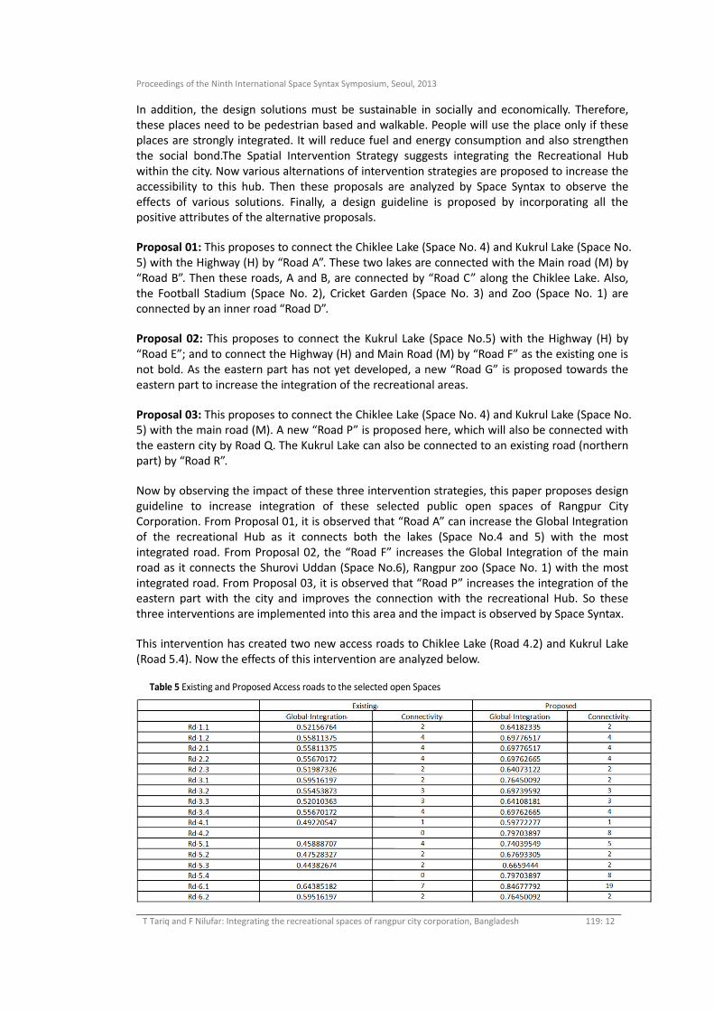
In addition, the design solutions must be sustainable in socially and economically. Therefore,
these places need to be pedestrian based and walkable. People will use the place only if these
places are strongly integrated. It will reduce fuel and energy consumption and also strengthen
the social bond.The Spatial Intervention Strategy suggests integrating the Recreational Hub
within the city. Now various alternations of intervention strategies are proposed to increase the
accessibility to this hub. Then these proposals are analyzed by Space Syntax to observe the
effects of various solutions. Finally, a design guideline is proposed by incorporating all the
positive attributes of the alternative proposals.
Proposal 01: This proposes to connect the Chiklee Lake (Space No. 4) and Kukrul Lake (Space No.
5) with the Highway (H) by “Road A”. These two lakes are connected with the Main road (M) by
“Road B”. Then these roads, A and B, are connected by “Road C” along the Chiklee Lake. Also,
the Football Stadium (Space No. 2), Cricket Garden (Space No. 3) and Zoo (Space No. 1) are
connected by an inner road “Road D”.
Proposal 02: This proposes to connect the Kukrul Lake (Space No.5) with the Highway (H) by
“Road E”; and to connect the Highway (H) and Main Road (M) by “Road F” as the existing one is
not bold. As the eastern part has not yet developed, a new “Road G” is proposed towards the
eastern part to increase the integration of the recreational areas.
Proposal 03: This proposes to connect the Chiklee Lake (Space No. 4) and Kukrul Lake (Space No.
5) with the main road (M). A new “Road P” is proposed here, which will also be connected with
the eastern city by Road Q. The Kukrul Lake can also be connected to an existing road (northern
part) by “Road R”.
Now by observing the impact of these three intervention strategies, this paper proposes design
guideline to increase integration of these selected public open spaces of Rangpur City
Corporation. From Proposal 01, it is observed that “Road A” can increase the Global Integration
of the recreational Hub as it connects both the lakes (Space No.4 and 5) with the most
integrated road. From Proposal 02, the “Road F” increases the Global Integration of the main
road as it connects the Shurovi Uddan (Space No.6), Rangpur zoo (Space No. 1) with the most
integrated road. From Proposal 03, it is observed that “Road P” increases the integration of the
eastern part with the city and improves the connection with the recreational Hub. So these
three interventions are implemented into this area and the impact is observed by Space Syntax.
This intervention has created two new access roads to Chiklee Lake (Road 4.2) and Kukrul Lake
(Road 5.4). Now the effects of this intervention are analyzed below.
Table 5 Existing and Proposed Access roads to the selected open Spaces

Proceedings of the Ninth International Space Syntax Symposium, Seoul, 2013
T Tariq and F Nilufar: Integrating the recreational spaces of rangpur city corporation, Bangladesh 119: 13
Figure 6 Proposed Intervention Strategy and their spatial impact
Figure 07 shows that the proposed Urban Intervention Strategy has significantly improved the
Global Integration values (marked with Red) of the selected open spaces. The Master Plan of
Rangpur City Corporation can adopt these guidelines to integrate the Central Recreational Hub
within the whole City.
PF
A

Proceedings of the Ninth International Space Syntax Symposium, Seoul, 2013
T Tariq and F Nilufar: Integrating the recreational spaces of rangpur city corporation, Bangladesh 119: 14
Figure 7 Comparative Analysis of Global Integration of Access Roads
The Intelligibly Graph shows that the value slope, correlation (R) has improved from 0.52155 to
0.74967. So this intervention converts the city into a much more legible and readable area
which has relationship of becoming a successful Public Open Spaces.
Figure 8 Comparative Analysis of Intelligibly of Access Roads
8. CONCLUDING REMARKS
The Master Plan of Rangpur City Corporation has full potentiality to develop as a well balanced
area in future with both buildings and public spaces. This paper provides a base of an
Intervention Strategy for the upcoming Master Plan of Rangpur City Corporation. If large scale
open spaces locate at highly integrated area, these will be within people’s daily movement
network and used frequently. So, the use of the central Recreational Hub of Rangpur City
Corporation should be improved by implementing intervention of this urban strategy to
integrate the six large open spaces with the city grid. Space Syntax helps us to analyze the
accessibility of these open spaces which in turn helps in such decision-making. This paper, thus,
suggests an Urban Intervention Strategy based on Space Syntax to integrate the public open
spaces with the city. Further studies and analysis have to be done to have a comprehensive
planning proposal of Rangpur City Corporation.
Global Integration of Existing
Global Integration of proposed
R=0.52155 R=0.74967
Proceedings of the Ninth International Space Syntax Symposium, Seoul, 2013
T Tariq and F Nilufar: Integrating the recreational spaces of rangpur city corporation, Bangladesh 119: 15
REFERENCES
Chiesura, A. 2004. “The role of urban parks for the sustainable city.” Landscape and Urban
Planning: 129‐38.
Rubén, TALAV ERA. 2012. “Improving Pedestrian Accessibility to Public Space through Space
Syntax Analysis.” Paper presented at Eighth International Space Syntax Symposium,
Santiago, PUC.
Engwicht. 1993. Reclaiming our cities and towns: Better living with less traffic. Philadelphia:
New Society Publishing.
Gehl J. 1956. “La humanización del espacio urbano: la vida social entre los edificios.” Barcelona:
Reverté.
Government of The People’s Republic of Bangladesh Ministry of Local Government, Rural
Development & Cooperatives Local Government Engineering Department. Consultants:
Joint Venture of Engineering & Planning Consultants Ltd. (EPC), Ehsan Khan Architects
Ltd. (EKAR), Data Experts (PVT.) Ltd. 2012. “Preparation Of Master Plan For Rangpur
Divisional Town Under District Towns Infrastructure Development Project- Inception
Report.”
Handy, S. L., and D. A. Niemeier. 1997. “Measuring accessibility: an exploration of issues and
alternatives.” Environment and Planning A 29(7): 1175‐1194.
Hansen, W. 1959. “How Accessibility Shapes Land Use.” Journal of the American Planning
Association 25(2):73‐76.
Hillier, B., A. Penn, J. Hanson, A. Grajewski, and J. Xu. 1993. “Natural movement: or
configuration and attraction in urban pedestrian movement.” Envionment and Planning
B: Planning and Design 20: 29‐60.
Jacobs, A. B. 1996. Grandes Calles. Ed. Universidad de Cantabria.
Lynch, K. 1960. La imagen de la ciudad. Barcelona.
Urban Development Directorate, Ministry of Works, U.N. Centre for Human Settlements
(HABITAT) and U.N. Development Programme. 1986. “Rangpur Structure Plan: Rangpur
pourashava, Bangladesh National Physical Planning Project.”
Venturi, R. 1998. Aprendiendo de Las Vegas: el simbolismo olvidado de la forma arquitectónica.
in Gustavo Gili, Barcelona.