Understanding the use of urban green spaces from ... - X-MOL

1
The Generation of Diversity: Mixed-Use and Urban Sustainability Graeme Evans and Jo Foord
In: Urban Sustainability Through Environmental Design: Approaches to time-people-place
responsive urban spaces
Sergio Porta, Kevin Thwaites, Ombretta Romice, Mark Greaves (eds.) Taylor & Francis
ISBN 9780415384803 December 2007
Introduction
This chapter presents the development of a GIS-based analysis and planning tool arising from a
study of mixed-use inner city areas. The study forms part of a major research project:
VivaCity2020: Urban Sustainability for the 24 hour City, supported under the UK Engineering and
Physical Sciences Research Council’s (EPSRC) Sustainable Urban Environment programme. The
meta-theme of Sustainable Development, as defined in Bruntland (1997) has been operationalised
in the UK in terms of the performance and progress of a set of Quality of Life indicators (DETR,
2000), applied at national, regional and local ”quality of life counts” levels. It is at the local level
that quality of life is both experienced and expressed, and where local governance, environmental
management and liveability is most manifest.
VivaCity has taken an ambitious approach to interrogating urban sustainability and in developing
practical solutions and a knowledge base by which urban design, planning and development can
be better integrated and understood (see www.vivacity2020.org). Uniquely, this has entailed
empirical research into the social, economic, environmental and related design and planning
processes that contribute to urban quality of life. This includes environmental quality such as air
and noise pollution, crime, housing layout, and amenities such as public toilets. The notion of the
compact city which is the subject of this particular toolkit, encompasses:
1. social mix - income, housing tenure, demography, visitors, lifestyles; 2. economic mix - activity, industry, scales (micro-large), consumption-production
3. physical land-use mix - planning use-class, vertical and horizontal, amenity/open space;
4. temporal mix (of 1. to 3.) - 24-hour economy, shared use of premises/space, e.g. street
markets, entertainment, live-work These urban environmental elements that combine to determine the quality of life in higher density,
mixed-use locations, can be triangulated in terms of the key features shown below. These
elements have traditionally been treated as separate factors in urban policy and practice, however

2
their dynamic inter-action and conflicts are fundamental to understanding urban carrying capacity
and the impacts of development and land-use change. Diagram 1. Mixed-Use Elements
Mixed-Use* Building / Site* Area / District / Quarter* Urban Village* Use-Class: Residential, Retail, Office, Leisure, ‘Mixed’
* Shared Workspace* Consumption-Production* Live-Work* Living-above-the-Shop
Vitality* Animated, Pedestrians* 24 Hour / Evening Economy* Temporal night/day,week/end * User: resident, worker, visitor * Social / housing tenure mix* Natural Surveillance:
crime/fear of crime, safety* Quality of Life: Liveability* Street: markets, festivals, art
Seedbed economies* Micro-enterprises/SMEs* Clusters e.g. New Economy* Production Chains/Synergies* Local Markets/ Economy* Local Employment* Community Enterprises* Large-Medium-SME links* Organisational flexibility
PHYSICAL SOCIAL
ECONOMIC
Sustainable?Conflicts?Design?
Mixed-Use or Mixed Messages?
The imperatives driving the promotion of mixed-use and high density residential and employment
land-use - “densification” - derive from core aspects of the urban sustainability agenda. These
include the demand for additional housing arising from increased population, inward migration and
social change (e.g. single/childless couples, ageing population) and limits to supply due to current
density levels and land-use, and development control on green belt. Secondly, the need to reduce
car and other vehicular use in order to reduce carbon emissions and pollution. Solutions include
the increased use of brownfield sites (previously developed land) as well as the re-use of non-
residential buildings (e.g. industrial premises) for housing and services employment and facilities,
and the development of higher density, mixed-use buildings for housing, retail, commercial/office
and amenities (e.g. health, leisure) - thus encouraging local employment and consequent reduced
travel to work and routine activities (Evans, 2005). The advantages of greater mixed-use
development can be summarized below:
Concentration and Diversity of Activities
Vitality Less need to travel Local Economy & Clusters
A more secure environment
Less reliance on car Production chain; Innovation spillovers
More attractive and better quality town centres
More use of and opportunity for public transport
More local employment and services
Economic, social and environmental benefits
Source: adapted from DoEn (1995)
3
Whilst mixed-use, higher density development and compact city hierarchies now underpin
sustainable communities (ODPM, 2003) and housing growth plans, these basic concepts are
neither reflected in legislation, nor in guidance which can inform the design, location and impact
assessment of mixed-use. For example, there is no planning use-class for mixed-use, nor an
institutional property investment category (separate residential, retail, commercial sectors), and
thus no detailed standards on what constitutes a sustainable mix, at what scale, or combination of
activity (Evans, 2005). Conversely, Building Regulations can restrict and limit the flexible use of
space. In short, a policy panacea without a sound evidence base. Common requests from those we
have consulted have thus included: the proportional mix of uses in building design (architects);
models of urban carrying capacity e.g. retail, evening economy and transport (town planning and
licensing officers); and housing mix in terms of tenure, amenities and densities (housing
associations and developers).
Scale and Distinctions
The scale at which ‘mixed-use’ operates and has evolved - until recently, “organically”, rather than
plan or design-led - ranges from the micro to meso level, and at larger and smaller physical scales.
Rowley (1996) identifies the following key variables in mixed-use, suggesting that the practice is
not homogenous and local/specific conditions need to be taken into account:
• Location types, uses and activities - Nature of users, occupiers, comings & goings, mix and balance of primary and other uses, compatibility, synergy • Intensity/density; grain of development; permeability - Street layout, ease of movement,
footfall along routes • Character of surrounding development - Age of area and buildings ; capacity to respond and
accommodate to change; range of design considerations, within & between buildings/public spaces - vertically and horizontally, size of units, visibility and legibility of uses
• Market - local/regional property and development economics; organisational flexibility • Social-cultural mix - history, settlement; lifestyle trends/demands, tenure • Planning and Urban policy e.g. regeneration, design guidance, licensing
The Generation of Diversity therefore seeks to assess how the physical (including design); the
economic (production, consumption, location); and social - inter-relate in sustainable urban
4
environments and at differing scales. This includes where synergies and advantages are realised
(above), but also where conflicts of use arise.
Tool development
A response to the conceptual and qualitative question surrounding mixed use in its various guises
has been firstly, the development of a comprehensive data architecture to capture and interrogate
the social, economic, land use and related aspects that make-up the compact city in practice. This
entailed drawing on and analysing data, policy and indicators which previously had not been
considered or viewed together, let alone synthesized. A typology of geodata included:
• Socio-Economic - Census (community, demography, travel to work) • Index of Multiple Deprivation (IMD) - areas ranked by factors of need/risk • Economic activity and ‘health’ - industry activity (SIC) and descriptors, employment (scale),
start-ups/closures, benefit payments (e.g. unemployment) • Crime - recorded crime data (e.g. burglary, street, vehicle) • Land-use - UDAL classifications, floor space and valuation (non-domestic premises) • Pollution - noise complaints, air quality, and commercial traffic flow • Points of Interest - commercial, retail, visitor attractions, amenities and transport
National administrative data, supplemented with the locally generated (e.g. crime) exists at various
levels of local geography representing output areas (OAs - lower, middle, upper) below the level of
ward (electoral area), as well as point and postcode data, e.g. businesses, recorded crime.
Premises data, key to modelling mixed-use, is however divided between non-domestic and
housing, whilst the vertical mix and activity classifications required to understand the economic,
social and inter-relationships and flows, requires a more detailed analysis, which was undertaken in
this case through local area surveys. This entailed land-use surveys based on observation and the
creation of a classification data base which expanded normal land-use categories, recording
aspects such as opening and closing times and street level (ground floor) activity during day and
night times. Pedestrian activity was also monitored though timed counts at key nodes.
Tool pilot
A testbed area in which to pilot the methodology and toolkit was selected. Clerkenwell - based on a
historic and contemporary mixed-use, “urban village” (Aldous, 1992) with established and growing

5
residential (“loft living”), office, evening entertainment and “new economy” activity (Foord, 2007),
situated on the fringe of the City of London and straddling three local authorities. This
demonstration pilot used here, was followed by testbeds in city centres of Sheffield and
Manchester.
A key issue in the mixed-use, high density debate, is ‘quality of life’ - is it sustainable and what mix
works and doesn’t, and at what scale - building, block, street, neighborhood? The compact city
model also suggests that vibrant local economies can be supported without significant inward travel
(commuting), and that business location choices and markets reflect this. In order to test out this
aspect, questionnaire-based interviews were conducted with residents and businesses, as well as
semi-structured interviews with policy and development industry representatives, to gauge their
respective views and approach to mixed-use in practice. A more detailed analysis of the survey
findings and spatial analysis is available in Aiesha and Perdokliani (2005); Aiesha and Evans
(2006); Foord (2007), with a comprehensive VivaCity explication in Cooper et al. (2007).
A sample of the set of results from the mapping and visualisation of primary and secondary data is
shown below. Correlating land-use and economic activity with social and other environmental
factors has for the first time enabled concepts and questions of mixed-use scale and impacts to be
assessed objectively, supported by empirical and experiential evidence drawn from local
stakeholders.
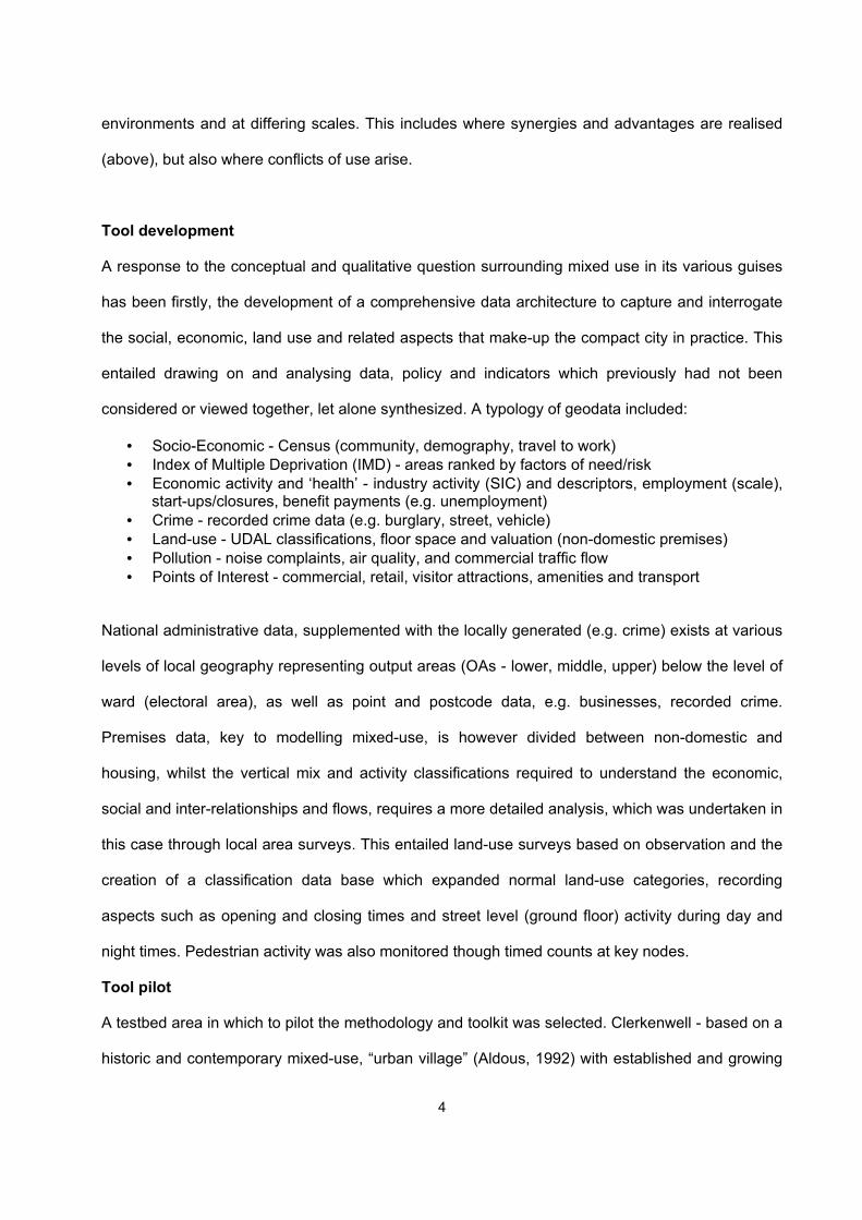
The first set (Fig. 1) shows the results of the vertical land-use analysis by floor, and in terms of
land-use types (colour-coded). Five zones within the area (Fig.2) were selected for detailed
observation, based on analysis of building types/morphology, road/pedestrian networks (Space
Syntax) and land-use mix. This clearly shows the north-south separation between residential and
more commercial/mixed-use zones, but also the residential use above first floor, as the purple
(darker) shaded blocks expand upwards with high-rise dwellings, and encroach into the more
mixed land-use area.

6
The second set (Fig. 2) overlays recorded crime densities (“hotspots”) firstly for commercial
burglary, mapped against office/services premises. This indicates the concentration of break-ins in
the commercial zone, which are less prevalent in the more mixed-use area, but more frequent in
the fringe of the area which reverts to mono-use. Domestic burglary (not shown) mapped against
residential property, not surprisingly (“supply-led”), also shows a higher concentration in the
housing-only area, but is less evident in the mixed (“living above the shop”) properties. This
contradicts the received wisdom that mixed-use areas are more vulnerable and mono-use safer -
the reverse seems to be the case here. Resident surveys confirmed a low level of “fear of crime”,
but greater concern for anti-social behaviour, particularly environmental (litter/rubbish, noise). On
the other hand, robbery (“street crime”) mapped against evening activity such as bars, clubs and
restaurants highlights key crime hotspots (Fig.2), in this case focused on specific “café culture”
streets, where pick-pocketing, snatch theft, as well as vehicle crime (bike theft, car break-ins) is
very high. These few partially permeable streets present too many open access points for
pedestrians, bikes, and have poor surveillance (a conclusion shared by the local Police).
Finally, the key analysis of how mixed and “safe” an area is, can be drawn from the visualisations
and correlation of land-uses and activity in 2D and 3D format (Fig.1). This is represented in Figure
3 in terms of both activity and economic mix. This is based on analysis of new ‘points of interest’
(POI) OS data, showing the density of the mixed-use area with a range of commercial, leisure and
visitor amenities, in contrast to the less diverse zones, which also attract higher street and vehicle
crime. This includes cases where ground floor use is dominated by night-time or consumption
activity.
Conclusion
By synthesizing detailed land-use, economic and socio-environmental data in this way,
presumptions in favour of mixed-use as animated, naturally surveilled and diverse economic/social
spaces, are confirmed at the sub-ward scale. “Urban Villages” do appear to evolve and require
separate activity and land-use areas within a larger mixed-use neighbourhood. However,

7
overdominant activity and land-use - whether residential, office or entertainment - exhibit greater
environmental and social problems and are thus less sustainable.
The GIS data analysis and synthesis techniques summarized here, serve therefore as both an
analytical and interrogatory tool, to which other layers of social, economic, environmental data can
be applied, visualised, and more sophisticated spatial modelling undertaken.
8
Figure 1. Land-use by Floor (Ground, First, Above-First Floor) (c) Crown Copyright. Ordnance Survey. All rights reserved

9
Figure 2. Proximity of Commercial Burglary and Offices, and “Street” Crime and Evening Economy (Bars, Clubs, Restaurants) (c) Crown Copyright. Ordnance Survey. All rights reserved

10
Figure 3. Points of Interest data showing areas of multiple activity and mixed-use premises density [Source of POI - OS, 2006 - www.ordnancesurvey.co.uk/oswebsite/products/pointsofinterest/index.html] (c) Crown Copyright. Ordnance Survey. All rights reserved
11
References
Aiesha, R. and Evans, G.L. (2007) ‘VivaCity: Mixed-Use and Urban Tourism’, in: Smith, M. (ed) Tourism, Culture and Regeneration. Wallingford, CAB International: 35-48 Aiesha, R. and Perdikogianni, I. (2005) Decoding urban diversity in “mixed-use” neighbourhoods. Proceedings of Sustainable Urban Environments: ‘Vision into Action’ Conference, Birmingham Aldous, T. (1992) Urban Villages: A Concept for Creating Mixed-Use Urban Developments on a Sustainable Scale. London, Urban Villages Group. Brundtland, G. et al. (1987). Our common future. Report of the 1987 World Commission on Environment and Development. Oxford, OUP Cooper, R., Evans, G.L., et al. (eds) (2008) VivaCity2020: Urban Sustainability for the 24-Hour City. Oxford, Blackwell’s (forthcoming) DETR (2000). Our towns and cities: the future. London, HMSO DoE (1995) PPG13: A Guide to better Practice. Department of the Environment. London, HMSO Evans, G.L (2005) ‘Mixed-Use or Mixed Messages?’ Planning in London, No.54: 26-29 Foord, J. (2008) ‘What’s it like here? Working and Living in a creative neighbourhood’, Urban Studies (Hutton, T. , ed.) (forthcoming issue on the ‘New Economy’) Rowley, A. (1996) ‘Mixed-use development: ambiguous concept, simplistic analysis and wishful thinking?’, Planning Practice and Research 11(1): 87-99
Copyright © 2022 FDOKUMEN