Extracting Product Information from Email Receipts Using ...
Upload
khangminh22Category
view
1download
0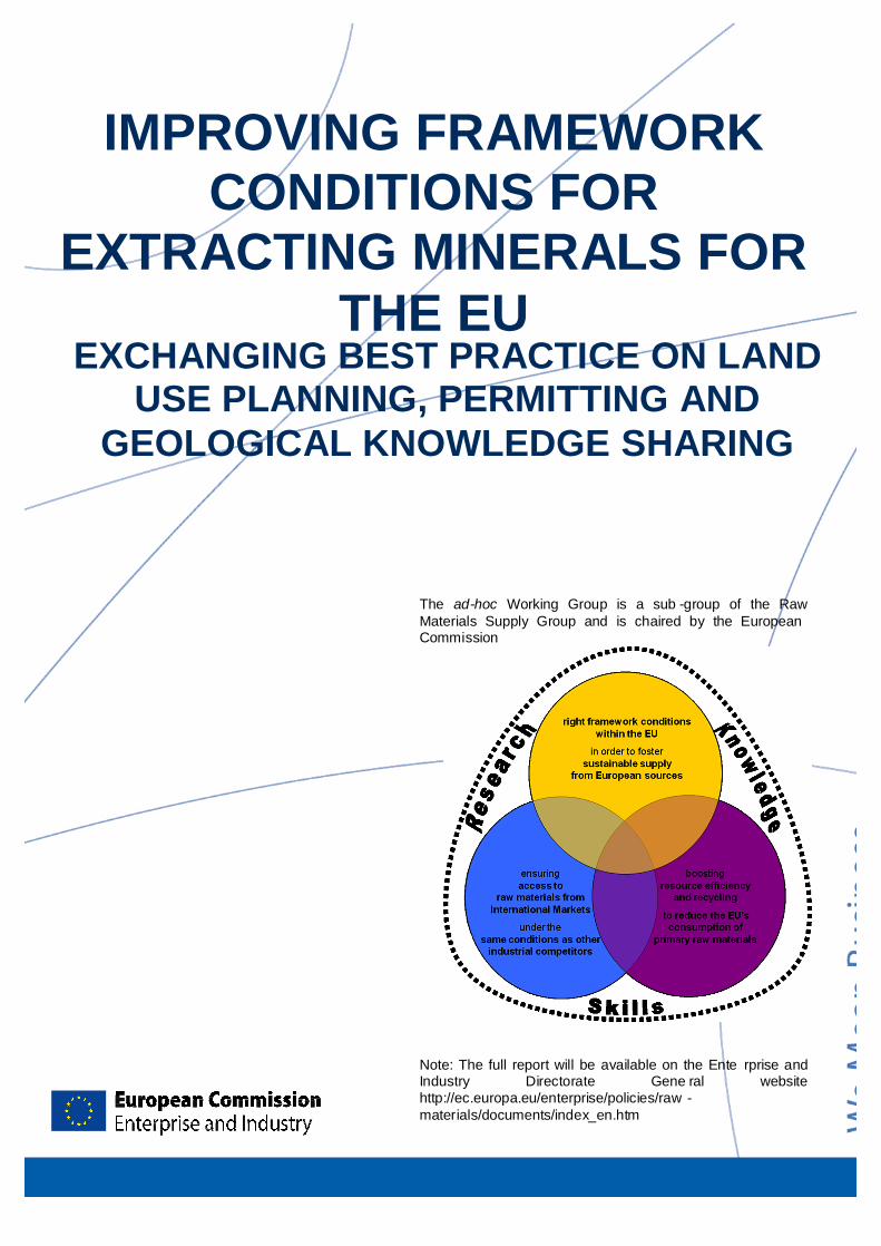
IEXCHANGING BEST PRACTICES
i
EXCHANGING BEST PRACTICE ON LAND USE PLANNING, PERMITTING AND
GEOLOGICAL KNOWLEDGE SHARING
IMPROVING FRAMEWORK CONDITIONS FOR
EXTRACTING MINERALS FOR THE EU
The ad-hoc Working Group is a sub -group of the Raw Materials Supply Group and is chaired by the European Commission
Note: The full report will be available on the Ente rprise and Industry Directorate Gene ral website http://ec.europa.eu/enterprise/policies/raw -materials/documents/index_en.htm

EXCHANGING BEST PRACTICES
ii
Note: The text may be subject to final drafting adjustments.
This document reflects the view of the Commission services and is not of a binding n ature.
European Commission, 01.07.2010
Reproduction is authorised provided the source is acknowledged
Based on questionnaires , the preparatory drafts of this guidance document were written by Jon Gra ntham, Catrin Owens and Elisabeth Davies, all Land Use Consultants, under contract to the Europe an Commission (contract n° 30-CE-021568/00-41).

EXCHANGING BEST PRACTICES
iii
TABLE OF CONTENTS
Executive Summary ................................ ................................ ................................ ................................ ..iii 1. INTRODUCTION ................................ ................................ ................................ ................................ ...... 1
Methodology................................ ................................ ................................ ................................ .............. 2 Report Structure ................................ ................................ ................................ ................................ ........ 3
2. MINERALS POLICY ................................ ................................ ................................ ................................ 4 Sustainable Minerals Policy ................................ ................................ ................................ ..................... 6 European Minerals Policy ................................ ................................ ................................ ........................ 7
Summary of Chapter and Recommen dations ................................ ................................ ........................ 7 3. LAND USE PLANNING PO LICY FOR MINERALS ................................ ................................ ............10
Coverage of Different Mineral Types................................ ................................ ................................ .....10 Level of Government at which Minerals are Covered ................................ ................................ ..........10 Planning for the Future Need for Minerals ................................ ................................ ............................ 11 Safeguarding ................................ ................................ ................................ ................................ ...........12 Allocation of Land for Mineral Extraction ................................ ................................ .............................. 14 Guiding Principles for Sustainable Spatial Development of the Europe an Continent as set out by CEMAT ................................ ................................ ................................ ................................ .................... 16
Summary of Chapter and Recommendations ................................ ................................ ...................... 16 4. AUTHORISATION ................................ ................................ ................................ ................................ ..18
Standardised Application Forms ................................ ................................ ................................ ............19 Publication of the Authorisation Process ................................ ................................ .............................. 19 Parallel Assessment ................................ ................................ ................................ ............................... 20 One-Stop-Shop ................................ ................................ ................................ ................................ .......20 Fixed Time Period ................................ ................................ ................................ ................................ ...22 On-site Discussion ................................ ................................ ................................ ................................ ..22 Other Issues Raised ................................ ................................ ................................ ............................... 23
Summary of Chapter and Recommendations ................................ ................................ ...................... 23 5. ACHIEVING TECHNICAL, ENVIRONMENTAL AND S OCIAL EXCELLENCE ............................... 25
LEGAL Codes or FRAMEWORK ................................ ................................ ................................ ...........25 VOLUNTARY codes ................................ ................................ ................................ ............................... 26 Ensuring Remediation and Restoration ................................ ................................ ................................ 27 Examples of Successful Site Remediation and Restoration ................................ ............................... 29 Contemporary Sites ................................ ................................ ................................ ................................ 30 Publications ................................ ................................ ................................ ................................ ............. 34 Abandoned Historic Sites ................................ ................................ ................................ ....................... 35 Publications ................................ ................................ ................................ ................................ ............. 37
Summary of Chapter and Recommendations ................................ ................................ ...................... 37 6. GEOLOGICAL KNOWLEDGE BASE ................................ ................................ ................................ ..39
Existing data coverage ................................ ................................ ................................ ........................... 42 Harmonising of EU -level data ................................ ................................ ................................ ................ 42 Crucial data sourc es................................ ................................ ................................ ............................... 42

EXCHANGING BEST PRACTICES
ii
Extent of current 3D modelling ................................ ................................ ................................ .............. 43 Borehole coverage ................................ ................................ ................................ ................................ ..44 Importance of marine mineral deposits ................................ ................................ ................................ .45
Summary of Chapter and Recommendations ................................ ................................ ...................... 45 7. BETTER NETWORKING BE TWEEN THE NATIONAL G EOLOGICAL SURVEYS ........................ 47
Areas for Improvement in Networking ................................ ................................ ................................ ...47 Situation in USA and Canada ................................ ................................ ................................ ................ 47 Overcoming Continuity Issues ................................ ................................ ................................ ............... 48 Need for Enhanced Interoperability beyond OneGeologyEurope ................................ ....................... 48 INSPIRE Directive Overview ................................ ................................ ................................ .................. 48 European Collaboration ................................ ................................ ................................ .......................... 49 Methods of Organisation ................................ ................................ ................................ ........................ 49
Summary of Chapter and Recommendations ................................ ................................ ...................... 49 8. NEED TO INTEGRATE TE RRESTRIAL SUB -SURFACE INFORMATION INTO T HE GMES LAND
SERVICE................................ ................................ ................................ ................................ ................. 51 Acquiring terrestrial sub -surface information ................................ ................................ ........................ 51 Who are the actors acquiring sub -surface information? ................................ ................................ ......52 Using sub-surface information for land use planning ................................ ................................ ...........52 GMES developments ................................ ................................ ................................ .............................. 52
RECOMMENDATIONS ................................ ................................ ................................ .......................... 53 9. SUMMARY OF RECOMMEND ATIONS OF THE WORKIN G GROUP ................................ ............54
10. REFERENCE ................................ ................................ ................................ ................................ ..........56
11. ACRONYMS ................................ ................................ ................................ ................................ ...........57
12. TABLE OF FIGURES ................................ ................................ ................................ ............................. 58
13. ANNEX ................................ ................................ ................................ ................................ ...................... II
I. MEMBERS OF THE AD -HOC WORKING GROUP ................................ ................................ .............. II
II. EUROPEAN MINERALS NE TWORK ................................ ................................ ................................ ... III Activities of eMINEnt: ................................ ................................ ................................ .............................. IV Structure of eMINEnt ................................ ................................ ................................ ............................... IV Programme 1 – DEPOSIT................................ ................................ ................................ ....................... IV Programme 2 - RESOURCE................................ ................................ ................................ ....................V Programme 3 - OUTLOOK................................ ................................ ................................ ....................... V Coordination ................................ ................................ ................................ ................................ .............VI

EXCHANGING BEST PRACTICES EXECUTIVE SUMMARY
iii
EXECUTIVE SUMMARY The work on this report has been undertaken in response to Actions 6 and 7 proposed in the Raw Materials Initiative, linked to the second pillar of the Initiative and in close coo peration with Member States and stakeholders. In order to facilitate this pro cess, the Ad Hoc Working Group on Exchanging Best Practice on Land Use Planning, Permitting and Ge ological Knowledge Sharing (the Working Group) was created under the umbrella of the Raw Materials Supply Group in April 2009. The Working Group consisted of a mix of experts from national and regional ministries, geological surveys, extractive and downstream industries, and universities.
The mandate of the Working Group was to research and identify examples of best pra ctice covering minerals policy, application and authorisation processes, land use planning, and codes and technical guidance, in order to disseminate these for consideration by interested parties in Member States and to make recommendations. A key part of its work was a comprehensive questionnaire survey conducted in late 2009 covering:
• Exchange of best practices in land use planning
• Geological knowledge base and better networking
• Integrating sub -surface information in GMES
The findings of the report and the subsequent views of various stakeholders will provide an important input to the future Communication on raw materials
Recommendations of the working group
The group recommends a National Minerals Policy to ensure that the mineral r esources are provided to society in an economically viable way, harmonised with other national policies, based on sustainable d evelopments principles and including a commitment to provide a legal and information fram ework.
The Minerals Planning Policy is seen as key component of the national minerals policy. It should describe in detail the ways that future minerals supply will be secured and de monstrate a strong link to broader land use planning policy and regulation.
A Sustainable Minerals Policy shall be based on the principles of sustainable develo pment and incorporate economic, environmental and s ocial requirements.
Any land use policy for minerals must utilise a robust digital geological knowledge base ensuring fair and equal consideration of all potential uses of land including the eventual extraction of raw materials. Alongside information on the r esource of local importance, a method for estima ting the long term demand for these mater ials, and a means by which this can be translated into a spatial plan while recognising the contribution of recycled mater ials a needed.
The most important elements of the minerals exploration and extraction application pro cess are: clarity, understanding and certainty of what needs to be provided in order to get authorisation for minerals exploration or extraction.
This can take the shape of a standardised application form or could be set out in legisl ation or guidance.
Speeding up the authorisation processes may be achieved through integrating the different permits required so that they are issued by one competent authority (a one -stop-shop) and with only one environmental impact assessment or by parallel assessment.
Codes of practice are important instruments to achieve technical, social and enviro nmental excellence. Use of codes of practice, guidelines or equivalent by industry helps to ensure protection of the environment from adverse impacts of mineral extraction.
To improve the knowledge base of mineral deposits in the EU the need ha rmonised EU-level data sets stands out. Better networking between the national Geological Surveys of Member States is the basis for cooperation between relevant institutions and the Ge ological Survey and driven by the need to:
• achieve synergies between the Geological Surveys
• provide public data for policy making

EXECUTIVE SUMMARY EXCHANGING BEST PRACTICES
ii
• facilitate investment in exploration and extraction
• provide minerals intelligence.
• The networking must be structured, organised, long -term oriented and consensus based
Standardised and accurate statistical data on world wide minerals production, imports and exports, and publication of this data on an annual basis. This would serve to analyse trends and help decision makers to better unde rstand and monitor the EU’s supply and demand situation and related risks.
GMES will provide parts of the needed satellite data for e.g. ground stability monitoring which could be processed into directly useful information for RMI by national institutes or value-adding industry in the Member States. Alternatively, GMES could also potentially directly provide such services while requiring an assessment of whether respecting the principle of subsidiarity, of costs, benefits, political priorities etc.
Medium to long term projects should base on experience gained (e.g. ProMine project) to develop future ‘3D -Europe’ projects while focussing at first on the areas with known mineral potential.
The development of a pan -European programme of deep scientific borehole s data acquisition, processing and modelling should be considered as an important component of Europe’s scientific infrastructure.
Finally, the ad-hoc Working Group concluded that the replies to the questionnaires and the discussions of both Working Groups (i.e. the one on exchanging best practices and the parallel one on defining critical raw materials for the EU ) clearly indicated that the actions r equired in the sector have to respond to the very dynamic changes due to the global, Eur opean, national and local needs.
The Ad Hoc Working Group recommends to establish an annual event on mineral resources issues especially with regards to knowledge and research and exchange of best practices on minerals policies under the EU Council Presidency in cooperation w ith the Commission.

EXCHANGING BEST PRACTICES INTRODUCTION
1
1. INTRODUCTION
Raw materials are essential for the functioning of modern societies, and access to these raw materials is vital to the economy of the EU. Key sectors such as the construction, chemicals, information technology, telecomm unications, automotive and aerospace industries, need a ready supply of non -energy raw materials at an affordable price. Interruptions to this supply can jeopardise the competitive position of comp anies within these industrial sectors, thereby threatening the functioning of the EU eco nomy.
Further complexities are added by the fact that geological raw materials are a finite r esource, and extraction is spatially constrained to the areas in which the materials naturally occur. Whilst some uses of raw material s may be reduced through improvements in tec hnology, in many cases substitution of the raw materials is impossible, or would take many years to achieve.
The European Commission Communic ation “the Raw Materials Initiative – meeting our critical need for growth and jobs in Europe ”1 of 2008, focussed on the various challenges regarding access to non -energy raw materials. It is an integrated strategy that ties together various EU policies, notably trade, external relations, development, competitiveness, environ ment and research. Ten lines of action were esta blished, based on the three pillars of the stra tegy which aim to:
• 1st Pillar: Ensure access to raw mat erials from international markets under the same conditions as other industrial co mpetitors;
• 2nd Pillar: Set the right framework conditions within the EU in order to foster sustainable supply of raw materials from European sources ; and
• 3rd Pillar: Boost overall resource efficiency and promote recycling to reduce consumption of primary raw materials and decrease the relative import d ependence.
1 COM (2008) 699 – 4 November 2008
Figure 1.1: Model of the three pillar Raw Materials Initiative and its relation to Research, Knowledge and Skills.
The work detailed in this report has been undertaken with regards to actions 6 and 7 of the Raw Materials Initiative, linked to the second pillar of the Initiative. Action 6 involves ide ntifying actions to promote the exchange of best practices in the area of land use planning and administrative conditions for e xploration and extraction. Action 7 involves better ne tworking between national Geological Surveys with the aim of increasing the EU’s know ledge base, and looking into the need to develop a medium to long term strategy for int egrating sub -surface components into land se rvices of the GMES 2 Land Monitoring Core Service.
Work has been undertaken in close cooperation with Member States and stakeholders. In order to facilitate this process, the ad-hoc Working Group on Exchanging Best Practice on Land Use Planning, Permitting and Geological Knowledge Sharing (hereafter called the Working Group) was created under the u mbrella
2 Global Monitoring for Environment and Security,
http://www.gmes.info/.

INTRODUCTION EXCHANGING BEST PRACTICES
2
of the Raw Materials Supply Group 3 in April 2009.
The Working Group consisted of a mix of experts from national and regional ministries, geo logical surveys, extractive and downstream industries, universities and non -governmental organis ations (NGOs)4.
Land Use Consultants were commissioned by the European Commission to provide tec hnical assistance to the Working Group and editorial responsibil ity for the report prepared by the Working Group.
The objectives of the Working Group were to:
• identify actions to promote the exchange of best practices in the area of land use planning and administrative conditions for exploration and extra ction;
• develop the knowledge base of European resources by promotion of better networ king between European Geological Surveys, competent authorities and ac ademia; and
• consider the need to develop a medium to long term strategy for integra ting sub-surface components into the land services element of the GMES Land Monitoring Core Service.
The Working Group’s remit was to research and identify examples of best practice, and to disseminate these for consideration by interested parties within Member States. Accor dingly, any recommendations made are not mand atory.
The study completed by the University of Leoben in 2004 (hereafter referred to as the Leoben Study5) has been a key refe rence in relation to action 6. It highlighted a number of elements of best practice in relation t o raw materials, covering minerals policy, application and authorisation processes, land use pla nning, and codes and technical guidance notes. These
3 The Raw Materials Supply Group is an expert group with a
long standing history. It is chaired by Enterprise and Industry DG, and comprises representatives from Member States, industry and other stakeholders.
4 A parallel ad-hoc Working Group was created at the same time in order to prepare a report entitled "Defining critical raw materials for the EU".
5 Mineral Planning Policies and Supply Practices in Europe. Department of Mining and Tunnelling, University of Leoben, Austria, November 2004. Commissioned by the European Commission Enterprise Directorate General under Contract no. ETD/FIF 2003 0781.
elements have been considered again by the Working Group.
The Leoben Study provides a comprehe nsive summary of the situation in a number of Member States, and it is not the function of this report to replicate this information, but rather to highlight specific elements of best practice for wider dissemination.
It is also noted that a period of six years has elapsed since the publication of the Leoben Study, and ther efore the situations in Member States may have altered in this time. As such, this Report provides an i mportant opportunity for stakeholders to input into the preparation for a Report that the Commiss ion will deliver to the Council on the implementation of the Raw Materials Initiative by the end of 2010.
METHODOLOGY
The Working Group met on six occasions during the study, providing an opportunity to exchange ideas and compare practices in different countries. A key part of the work was a comprehensive questionnaire survey conducted in late 2009 . Three questionnaires were sent to various experts and stakeholders within the Member States covering:
• Exchange of best practice in minerals policy, land use planning, authorising minerals exploration and extraction, and achieving technical and environmental exce llence
• Improving the EU minerals knowledge base and better networking
• Integrating sub -surface information components into the GMES Land se rvice
A comprehensive analysis of the questionnaire responses received relating to e xchange of best practice and the EU minerals know ledge base was undertaken, the results of which are summarised in a series of tables. Due to the technical nature of the subject, the analy sis and interpretation of the GMES questionnaire was undertaken by a sub -group of members from the Working Group. A list of the GMES sub -group members is included as Annex 1.
The questionnaire responses provided an important source of information for the W orking Group.
An initial review of the findings was undertaken at the Working Group meeting in Febr uary 2010,

EXCHANGING BEST PRACTICES INTRODUCTION
3
and agreement was reached on the broad areas of best practice to highlight in the final report. The findings relating to GMES were prepared by the sub-group of experts.
REPORT STRUCTURE
The remainder of this Report comprises two main components:
• Findings (Sections 2 to 8):
o Minerals Policy
o Land Use Planning Po licy
o Authorising Minerals Exploration and Extraction
o Achieving Technical, Environmental and Social Exce llence
o Knowledge Base of Mineral D eposits
o Better Networking Between The National Geological Su rveys
o Need to Integrate Terrestrial Sub -surface Information into t he GMES Land Service
• Summary of Recommendations of the Working Group (Se ction 9)
The Report of the Working Group provides the basis for a Report that the Commission will deliver to the Council on the implementation of the Raw Materials Initi ative by the end of 2010.

MINERALS POLICY EXCHANGING BEST PRACTICES
4
2. MINERALS POLICY
An agreed definition of what constitutes both national minerals policy and national minerals planning policy was considered fundamental to the exchange of best practice between Me mber States. However, no such definitions cu rrently exist that are common to all Me mber States.
Suggested Definition of a National Minerals Policy
A statement or statements of agreed objectives for the management of mineral r esources which aim to ensure their supply to meet the needs for those mine rals. National mineral policy may also set out the spatially -orientated processes that will be used to achieve those obje ctives
Suggested Definition of a National Minerals Planning Policy
Those statements, documents etc., which collectively contain the m echanisms which aim to achieve the objectives set out in national minerals policy through the planning system, together with any guidance which aims to provide clarity to decision making on the regulation of land use and stakeholder consultation processes.
One finding of the Working Group is that all the statements that constitute national policy are unlikely to be found in a single document. More usually, national policy is a combination of different legislation, codes and guidance which reflect the actual minerals resources present and legislative and institutional structures of individual member states.
Not surprisingly minerals policy pra ctices vary considerably throughout Member States. For example, the level at which minerals policy is formulated is la rgely dependent on the degree to which national government delegates decision making for minerals matters to other authorities. This in turn sets the shape of the legislative mechanisms that are put in place. Each Member
State has evolved a system which be st suits their own political and geological ci rcumstances.
In all the cases considered it was apparent that the aim of the policy was to protect and promote the supply of minerals b ecause of their economic significance, but mindful of other policy considerations such as environmental protection (see also the Report of the ad-hoc Working Group on "Defining crit ical raw materials for the EU").
Examples of National Minerals Policies:
The Austrian Minerals Resources Plan, and the systems in place in Germany, th e Netherlands and the Flemish region of Belgium all display elements of the definitions given above, best fitting to the legal framework, but there are no examples which di splay them all.
Austria: Work on the Austrian Minerals Resources Plan commenced in 2001, with the intention of providing minerals resource maps covering all the mineral deposits in the cou ntry. In the early stages, the emphasis of the work was on compiling information on the occurrence of minerals, under the au spices of a Geology and Resources Working Group.
The National Geological Survey of Austria, the Austrian Mining Association and the Au strian Academy of Sciences were all closely involved in the detailed mapping and evaluation process. This resulted in a series of 1:200,000 digital maps, coupled with a detailed evaluation of approximately 3500 mineral (metals, industrial minerals, energy fuels) and construction material occurrences.
An innovative, objective and analytical method was developed to evaluate the occu rrences of construction materials (sand and gravel, hard rock), based on their ‘u sability’. The computer based evaluation process takes account of quality, quantity and regional importance, together with restrictions resulting from conflicting land uses. Those occurrences foun d to be unrestricted were investigated fu rther to establish whether the supply of sand and gravel and hard rock from these areas would be sufficient to meet the future demand in each district.

EXCHANGING BEST PRACTICES MINERALS POLICY
5
Parallel to the initial mapping exercise, the work was assisted by three working groups:
• Economics of Mining Working Group
• Geographical Information Systems (GIS) Applications Wor king Group
• Security of Supply Wor king Group
The various strands of work came together, resulting in an assessment of the importance, quality and quantity of minerals resources, and a judgement over whether they are of “proven worth for protec ting” in land use planning, albeit the Mineral Resources Plan is not a land use planning policy document. The assessment of the “worth” of resources invol ved national Government working closely with regional representatives and other stakeholders. Ultimately this led to identification of “mineral resources priority zones” to be declared by the competent author ities of the provinces and used in land use plan ning. The assessment of the demand for a particular mineral helped to determine the amount of a pa rticular mineral that needed to be accorded priority.
Using the proposed definition of a minerals policy above, the Austrian Minerals Policy together with the Austrian Minerals Resources Plan displays most elements, notably the types of minerals and mineral activity, long term supply and safeguarding identified mineral deposits in land use planning, and the relationship of mineral policy to other national polic ies (especially biodive rsity). Related to this latter point, it is evident that quality of life issues were addressed as part of the Plan.
Germany : There is no single Minerals Policy document in Germany, nor is it considered necessary in the eyes of nation al Government representatives. German minerals policy is a combination of distinct policies and codes which reflect the constitutional, legislative and institutional structure. The main instruments at the federal level are the ‘elements of a raw materials strategy of the German government’ (published March 2007) and the comprehensive German mining legislation. The latter comprises the Federal Mining Act 1980 and a number of Mining Ordinances on technical and procedural issues, in effect covering all a spects of mining.
The Federal Mining Act contains detailed rules on royalties for the extraction of mineral
resources, yet also providing the potential to vary the percentage rate if it is deemed to be harming the economic performance of the industry. The Act also contains detailed provisions for ensuring compliance and monitoring within the mi ning industry.
In summary, the mining legislation in Germany provides a ‘cradle to grave’ framework for managing the industry.
Greece : The situation in Greece is similar to Germany. The principal legislative control of minerals is the Mining Code. The Code encapsulates the most mining law, covering exploration and extraction of mining ores. Industrial minerals and marbles, as well as aggregates, are reg ulated by specific l aws, as well as regulating issues relating to the natural and the man-made environment. Moreover, for mining to be allowed in Greece an extended environmental permitting stage is required, where the opinions of numerous competent authorities is required.
The Netherlands also provides an exa mple of a national minerals policy, insofar that the national policy on surface raw materials is integrated into the National Spatial Plan. This defines a reduced role for Government in managing supply and demand for mate rials, relying instead on the market. To facil itate this, the Government has sought to remove elements of policy and regulation which were deemed to obstruct the orderly extraction of raw mater ials.
The aim of policy is to secure extraction of materials in accordance with the principle of sustainable development, mirroring the approach in a number of Member States. Put simply, the aim is that raw materials should be used economically and for as higher -grade applications as possible, and that maximum use should be made of secondary and recycled materials. Where extraction is permitted by national and local authorities, schemes should be multifunctional, whereby there are other benefits beyond the simple winning of materials, for example recreation, navigation , biodiversity.
The decision of the Dutch Government to step back from a hands -on role in the stee ring the supply and demand for raw materials should not be interpreted as there being an absence of national policy direction. On the contrary, many of the characteristics of a comprehensive minerals policy in the definition above are present.

MINERALS POLICY EXCHANGING BEST PRACTICES
6
Belgium (Flemish Region ): In addition to national policies, regional mining policies can provide a comprehensive strategic policy. One example of a regional mining polic y is from the Flemish Region in Belgium. In 2003, the Flemish Government ratified the Flemish Parliament Act on Surface Mineral Resources. This Act defines the basic objective of the policy regarding the management of surface mineral resources as follows: “to cater for current and future generations’ needs for surface mineral resources in a sustainable manner" and established the framework for making plans (respectively general and special plans) of surface mi neral resources.
The Act on Surface Mineral Res ources addresses the specific needs of the extraction industry with regard to its needs in several different areas e.g. land use planning, su pply and use of mineral natural resources, rehabilitation and environmental aspects. The overall aim of creating a sustainable management of mineral resources is further specified into six aims with economical, social and environmental components:
• the extraction has to allow an improvement of the economical, social and environmental components;
• the extraction industry must keep a future perspective of further develo pment;
• an efficient and high -quality use of extracted surface mineral resources is r equired;
• the extraction should be optimal within the foreseen extraction sites and with a minimum use of surface area;
• one should stimulate the use of alternative products; and,
• nature and the natural environment should be maintained and further developed as much as poss ible.
The General Plan of Surface Mineral R esources6 supplies a number of concepts regarding a sustainable extraction policy. Furthermore, the general plan analyses the needs for surface mineral resources for the next 5 years on the basis of economic studies, marketing research
6 Adopted by the Flemish Government on 10th July 2008
and consultation. It gives an overview of the imports and exports and the current an d potential use of alternative materials. The bottlenecks and actions which are highlighted by this analysis and which are necessary to implement the sustainability objectives are described in great detail. Finally, the impact of the general surface minera l resources plan on the environment and agriculture is examined, together with the socio -economic consequences and financial implications of a sustainable extraction policy. More correl ation will be made with the concept of sustainable materials management and life cycle anal yses in order to reduce the consumption of primary raw materials.
A clear and important linkage between mi nerals policy and land use policy is made by the determination of special plans of surface mineral resources (‘Bijzondere oppervlaktedelfstoffenplannen – BOD’). These plans are determined for each geological and/or geographical deduced raw material variety. Based on a realistic, substantiated determin ation of the demand (demand for 25 years and evaluated every 5 years) and taken into account the geological, spatial, ecological, social, economical en agricultural cond itions, new sites of extraction are determined and existing, fully exploited sites are given a new land use destination. These special plans pay particular attention to th e environmental impact and the influence on the safety and health of people due to the extraction. They are also subjected to the legislation of the environmental impact assessment. The implementation of the plans is fulfilled by the regional spatial imple mentation plans which are determined by the land use planning autho rity.
SUSTAINABLE MINERALS POLICY
There are currently no national minerals policies or national minerals planning policies in place within Member States that cover the full range of issues necessary to address the key issue of sustainability in the context of minerals planning.
The Working Group considered the elements which could define a sustainable minerals policy and concluded that with respect to minerals, a sustainable policy (Solar et al., 2009) needs to:
• facilitate the transformation of natural mineral capital into built physical, economic, environmental or social capital of equal or greater value;

EXCHANGING BEST PRACTICES MINERALS POLICY
7
• ensure that environmental and negative social impacts of mining are minimised and their costs incorporated into production functions;
• require transparency and information sharing;
• reconsider the allocation of rights and the availability of resources across gener ations;
• address benefit risk trade -offs from the perspective of multiple stakeh olders and create contingency plans that will ameliorate the effects of mineral market booms and busts; and
• be correlated and consistent with other governmental pol icies.
While there are numerous references to sustainability in relation to minerals, these tend to be focused on environmental issues such as environmental protection, transport or land reclamation, including positive effects such as employment, restoration and biodiversity contribution. Issues such as the social costs of development and product ion, equity, and transparency are generally not a ddressed.
So while the overriding objective in the English Minerals Policy Statement 1 mentioned in the box is supported by a number of more detailed statements of policy, as a whole it amounts to a narrower definition of a sustainable policy than that described by Solar et al. (2009). This is because there is no explicit provision for capital transformation 7, social impact reduction, or fairness.
7 Capital transformation refers to the inter-linkages between
social, economic and environmental capital. A more detailed explanation can be found in the report "Towards a thematic strategy on the sustainable use of natural resources - Working Group 1 Supply of Resources", see http://ec.europa.eu/environment/natres/pdf/final_report_wg1.pdf
Example of including Sustainability into a Minerals Policy in England
Minerals Policy Statement 1: Planning and Minerals, which was published for England in 2006 states that: “It is e ssential that there is an adequate and steady supply of material to provide the infrastructure, buildings and goods that society, indu stry and the economy needs, but that this provision is made in a ccordance with the principles of sustainable development”.
There are references to sustainability in the policies considered but these tend to be focused on environmental issues such as envir onmental protection, transport or land recl amation.
EUROPEAN MINERALS PO LICY
Consideration was also given as to whether there should be a minerals policy at the European level, and if so, what matters it should address, within the framework of the European Sustainable Indu strial Policy. On the one hand it is felt that to have such a policy would exceed the authority of the Commission, whereas on the other, some Member States could see real value in establishing a Europe -wide policy position to bring mineral resources on to an equal footing with other resource issues.
A third, intermediate option was also proposed by questionnaire respondents, suggesting that there should be EU level guidelines on the development and implementation of a national mineral resources policy (or policies), documenting all the issues that need to be addressed in order to meet the aims of the Raw Materials In itiative.
SUMMARY OF CHAPTER AND RECOMMENDATIONS Members of the Working Group were agreed that because of the diversity of pol itical and geological circumstances within Member States it is not advisable to seek to impose prescriptive recommendations relating to mineral planning policy. However, analysis of practices that are in place indicate that each Member State should consider if it would be helpful to work towards adopting the following policy elements:
• A National Minerals Policy including the legal framework and the information fram ework;

MINERALS POLICY EXCHANGING BEST PRACTICES
8
• A Minerals Planning Po licy; and
• A Sustainable Minerals Policy based on the economic, the environmental and the s ocial pillar.

EXCHANGING BEST PRACTICES MINERALS POLICY
9
Best Practice: Policy El ements
National Minerals Policy
A clear statement of national minerals policy, setting out objectives to ensure that the mineral resources are provided to society in an economically viable way, harmonised with other national policies and based on sustainable developments principles. This could include a commitment to provide a legal and information fram ework:
Legal framework
• Legal frameworks (m inerals acts), covering all types of minerals to guarantee legal and planning certainty for all parties involved, and speedy and streamlined authorisation pro cesses.
• A transparent non -distorting fiscal framework as a stimulus for exploration and acquis ition. • Effective safeguarding of actual and potential mineral resources through land use planning to avoid
improper land use and/or sterilisation of mineral resources.
Information framework
• Reliable and comprehensive national and international statistics for trend analysis and as a decision base for authorities and the i ndustry.
• A detailed geological knowledge base which is publicly available within the legal frameworks of Member States and includes comprehensive geological, geochemical, geophysical and genera l mineral data.
Minerals Planning Policy
Raw materials planning policy as a key component of the national minerals policy should d escribe in detail the ways that future minerals supply will be s ecured and demonstrate a strong link to broader land use plann ing policy and regul ation.
Sustainable Minerals Policy
An ethics based Minerals Policy based on the principles of sustainable development and comprising the following three pillars:
The economic pillar
• Providing a proper long term economic environment for exploration and mining activities to ensure minerals supply.
• Safeguarding mineral deposits through land use planning to secure future minerals supply promoting research and development for resources and energy eff iciency.
The environmental pillar
• Ensuring that the negative environmental impacts of the extractive industry are controlled to acceptable levels of risk .
• Promoting sound site reclamation and aftercare pra ctices. • Promoting research and development, e.g. environmentally sound mining methods (cradle to
grave), materials efficiency, substitution, recycling and us e of Best Available Tec hniques (BAT)
The social pillar
• Promoting the essential contribution of minerals in soc iety. • Promoting a transparency for government, authorities, industry, NGOs and the general public (from
local to national) to avoid conflicts and support sound and timely decision making. •

LAND USE PLANNING POLICY FOR MINERALS EXCHANGING BEST PRACTICES
10
3. LAND USE PLANNING POLICY FOR MINERALS
A key best practice finding of the Leoben Study was that land use planning should be undertaken at a high level (national or r egional) and should consider long periods (20 years and more). Following on from this, various aspects of policy were identified as being part of best practice, including a solid and well substantiated database of inform ation covering all land uses as well as the geological resource, and an evaluation process that enables the land use planning authority to identify areas where extraction may or may not be permitted based on clear criteria that cover all significant aspects, including information concerning mineral deposits. The questionnaire included various questions on land use planning, and the key findings are summarised in this section of the report.
The Working Group agreed that a comprehensive land use policy for minerals should be based on the following el ements:
• a digital geological knowledge base ;
• a transparent methodology for identific ation of mineral resources (quality, quantity, local importance);
• long term estimates for regional and local minimum demand (especially for constru ction materials), taking account of ot her sources of materials (eg. recycled), based on sustainable development principles as a monitoring tool ; and
• identifying and safeguarding mineral resources to meet minimum demand, taking account of other land uses .
The questionnaire responses indicate th at most countries display most of these characte ristics in some form, at various levels in Government (national, regional and local). Case studies are discussed under the fo llowing headings:
• Coverage of different mineral types;
• Levels of government at whic h minerals are covered;
• Planning for the future need for mine rals;
• Identification of mineral potential a reas.
Use of geological databases in planning, and coverage of geological information is a ddressed in Section 7 of this report.
COVERAGE OF DIFFE RENT MINERAL TYPES
Generally all mineral types are covered by land use planning policies, but often with a di stinction between those minerals deemed to be of national significance, usually for economic reasons, and of those of regional or local significance (principally construction materials). In the case of the former, there is usually a national mining law go verning how the mineral can be worked, and rights to extraction are vested in the State. These tend to be high value minerals or energy minerals. Conversel y, in some Member States lower value materials, notably construction a ggregates, are dealt with through land use planning legi slation.
LEVEL OF GOVERNMENT AT WHICH MINERALS ARE CO VERED
Most countries do not have a national land use plan for minerals. Miner als are more commonly dealt with at the sub -national level. Most notably, countries with a strong regional or federal framework have r egional plans.
However there are some exceptions to this. In Greece there is a National Fram ework of Land Planning and Sus tainable Develo pment (2008) that covers minerals alongside other topics. As its name suggests, it sets out a national policy framework for planning for minerals rather than detailed geograph ical prescriptions. The same is true in Lithuania where the ‘General Plan’ formulated in accordance with the Territorial Planning Law esta blishes a similar framework. In the Netherlands there is a National Spatial Plan which covers raw materials at a strategic level (addressing the importance of the issue and the general principles for extraction), with more detail provided in r egional (spatial) plans.
United Kingdom : In England a further example is the series of Mineral Policy Stat ements (MPS) in . As explained in the introduction to all MPSs, they: “[...] set out the Go vernment’s national planning policies for minerals planning in

EXCHANGING BEST PRACTICES LAND USE PLANNING POLICY FOR MINERALS
11
England. These co mplement, but do not replace or overrule, other national planning policies, and should be read in conjun ction with other relevant statements of national planning policy. MPS1 sets out the Government’s key overarching policies and principles which apply to all minerals”.
Similar documents exist in Wales and Sco tland. Minerals Planning Policy Wales (MPPW) (2001) 8 sets out the land use planning policy guidance of the National A ssembly for Wales in relation to mineral extraction and related development in Wales, which includes all minerals and substances in, on or under land, extracted either by underground or surface working. Scottish Planning Policy provides the policy framework 9 that planning authorities should use when preparing their development plans and in determining planning applic ations.
It is the opinion of the Working Group that a national planning framework can help to e nsure that minerals interests are accorded due weigh t in the land use pla nning process, and therefore in appropriate national ci rcumstances, would be best practice.
However, not all national circu mstances lend themselves to a national land use plan (or framework) for minerals. Most notably, countries with a strong regional or federal fram ework have regional plans. For example, in Denmark10 there are six Regional Raw M aterial Plans. A Regional Raw Material Plan is a plan for extraction and supplying society with the materials needed. Minerals policies in the p lan have priority over other land use designations. In En gland, each region (of which there are nine) is required to prepare a Regional Spatial Strategy (soon to be replaced by an Integrated Regional Strategy) containing policies on minerals, notably the apportionment of construction materials b etween the constituent mineral planning authorities. The Regional Strategies must accord with the national MPSs.
The competence for establishing basic laws regulating Mining Activities lies at the n ational level in Spain, but each Autonomous Region has competence for further develo ping the national
8//wales.gov.uk/topics/planning/policy/minerals/?lang=en 9 /www.scotland.gov.uk/Publications/2010/02/03132605/0 10 Internet adress
law, through establishing regional plans for example.
PLANNING FOR THE FUT URE NEED FOR MINERALS
A key component of a land use planning policy as defined by the Working Grou p is that there should be an approach to long term estimates of minimum demand, especially mainly for construction materials (sand and gravel and crushed rock). Such a pproaches should take account of other materials (recycled and secondary) and be based on the principles of sustainable develo pment. The responses to the questionnaire reveal nume rous examples of long term planning for construction materials (i.e. sand and gravel, and crushed rock) with more local terms of use, but far fewer with respect to other minerals which are subject to regional, national or even global developments of the markets.
A representative selection of the various approaches to establishing the need for construction material are summarised in Table 3.1 Most notably, countries with a strong regional or federal framework have regional plans.
However, not all countries seek to quantify the need for minerals. In Slovenia , for example, no future predictions are made. This is b ecause the National Resources Manageme nt Programme (2009) seeks to establish a flexible framework, such that supply can be a djusted at all times to meet demand, a market -led approach in effect. Within this framework, the Mining Authority within a particular area sets an annual u pper production level for each site, principally on environmental grounds.
A similar approach is taken in Germany . As noted above, it is relatively common practice to quantify the need for construction materials, and then to ensure that the land use pla nning system makes provision to meet this demand. Much less common is a similar a pproach with respect to other materials. Part of the explan ation for this is that in many countries strategically important materials are protected by national legisl ation, thereby ensuring tha t they can be worked if required.
The Austrian Minerals Resources Plan adopts an econometric approach to calc ulating need for all minerals, not just construction materials. It brings together geological r esource information, with economic data on imports a nd price, rates of production, imports and the possibility of
LAND USE PLANNING POLICY FOR MINERALS EXCHANGING BEST PRACTICES
12
substitution. This is used to calculate the need for a particular mineral, and then prov ision is made in land use planning policy, paying particular to the protection of important European environmental a reas (e.g. Natura 2000 sites).
SAFEGUARDING
Once the presence of a potential minerals resource has been established through geological surveys (or any other kind of exploration process), the objective of safeguarding through the planning process is to
protect mineral resources from sterilisation by non-mineral development (hou sing, roads, etc). Safeguarding does not necessarily mean that the resource identified will be extracted, but rather it puts in place a check to ensure that extraction is at least considered before any form of sterilising development can go ahead. It follows, therefore, that a safeguar ding approach should also encourage the prior extraction of minerals where practicable. The Working Group considers to be a prudent approach to the management of finite resources.
Table 3.1: Approaches to the Estim ation of Need for Construction Materials.
COUNTRY ESTIMATION OF NEED F OR CONSTRUCTION MATERIALS
Austria
Econometric modelling: The Austri an Minerals Plan adopts an econometric a pproach to estimate the need for construction materials. The long term demand (50 years for sand and gravel, 100 years for hard rocks) is deducted from the present annual per capita demand of a particular planning di strict, considering major infrastructure projects and demographic progn oses.
Within a planning district, long term demand and supply should be balanced, conside ring transportation distances less than 30 km.
Belgium (Flanders)
Econometric modelling: the Fl emish Government commissioned two studies from separate consultancy firms to calculate the need for primary resources in Flanders. Although slightly different in approach, and therefore outcomes, each firm analysed past production figures and employment da ta. This analysis was tested through a series of stakeholder discussions with end users, the extraction industry and local authorities (the municipalities) to calculate the need for materials in one year. This figure was then multiplied by 25 to establish a 25 year need (i.e. volume of material), which was then incorporated into the General Plan of Surface Mineral Resources. The figures are reviewed every five years.
Cyprus
Sales based approach: the national policy makes provision for the need for minerals up to 2025, based on three growth scenarios: zero, 3% and 10% increase in d emand for products. The demand is determined based on past sales of minerals which is derived from the environmental fees (tax) paid per tonne of pr oduction.
Czech Republic
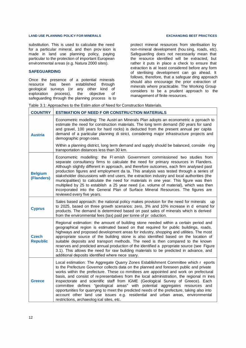
Regional estimation: the amount of building stone needed within a certain period and geographical region is estimated based on that required for public buildings, roads, highways and proposed development areas for industry, shopping and utilities. The most appropriate source of the building stone is also identified based on the location of suitable deposits and transport methods. The need is then compared to the known reserves and predicted annual production of the identified a ppropriate source (see Figure 3.1). This allows the need for raw building materials to be predicted in advance, and additional deposits identified where nece ssary.
Greece
Local estimation: The Aggregate Quarry Zones Establishment Committee which r eports to the Prefecture Governor collects data on the planned and foreseen public and private works within the prefecture. These co mmittees are appointed and work on prefectural basis, and consist of re presentatives from the local administration, the regional m ines inspectorate and scientific staff from IGME (Geological Survey of Greece). Each committee defines “geological areas” with potential aggregates resources and opportunities for quarrying to meet the predicted needs of the prefecture, taking also into account other land use issues e.g. residential and urban areas, environmental restrictions, archaeolog ical sites, etc.
EXCHANGING BEST PRACTICES LAND USE PLANNING POLICY FOR MINERALS
13
a)
b)
Figure 3.1: Mining of building stones and aggregates in the Ústí nad Labem region with areas with need of building raw materials and with the schematic direction of distribution in year 2010 (a) and estimations for 2025 (b), reproduced from Godany et al. (2003) with pe rmission by CGS.

LAND USE PLANNING POLICY FOR MINERALS EXCHANGING BEST PRACTICES
14
Some examples of safeguarding mea sures were highlighted in the questionnaire returns. In Hungary, for example, Minerals Management Zones are designated in a ccordance with the Spatial Development Act 2003. These zones cover all mineral reserves in the national Minerals Inventory. In England , mineral plannin g authorities identify areas of mineral resources to be safeguarded at the local level by the mineral planning authority. There is provision within the planning system in England to extend this safeguarding beyond the resource itself, to include the infrastructure required to transport minerals (e.g. planned and potential rail heads, wharves and associated storage, and handling and processing facilities). Once safeguarded areas have been identified, proposals for development in the safeguarded areas that would result in sterilisation are r eferred to the mineral planning authority for consideration and comment prior to determ ination.
The experience in Austria , where there has been considerable investment during the preparation of the Minerals Resources Plan in identifying and evaluating the geological resources, is that reliable and comprehensive information makes it possible to safeguard mineral resources against c ompeting land uses. It was previously the case that the identification of minerals resources for future extraction was not accorded an equivalent priority to protection of other land uses (e.g. important areas of vegetation), princ ipally because not enough was known about the quality and quantity of the resource. Now, it is possible to safeguard the minerals resources of sufficient quality and quantity which are not in contradiction with “no -go zones” or “conflict zones”.
ALLOCATION OF LAND F OR MINERAL EXTRACTION
Ensuring a steady supply of raw materials requires the allocation of land in spatial plans. The Leoben Study considered the identification of categories of land at the local level, based on clear criteria that cover all significant a spects (including information concerning mineral deposits), as best practice. Generally, there are three types of area allocated:
• areas where in principle no extraction will be allowed;
• areas where extraction may be allowed subject to certain cond itions;
• areas where in principle extraction will be permitted.
In effect, this classification of land amounts to a continuum of acceptability. At one end of the continuum are areas where extraction will generally be permitted, thereby creating certainty that an appl ication for extraction is likely to be approved. This implies that all the necessary considerations have been taken into account while the land use plan for mine rals was being prepared, such that an area where extra ction will be permitted would not result in unacceptab le impacts on other land uses or the environment more generally.
At the other end of the continuum are areas where extraction will generally not be permi tted. These tend to be areas where extraction would result in unacceptable environmental, social or economic impacts. Examples of such areas include internationally and nationally important landscapes and habitats, and areas close to centres of population. In between are areas where proposals will be considered on their individual merits, taking into accou nt environmental, social and economic i mpacts.
It is noted that such classifications can change over time, as legislation and economic, environmental and social cond itions evolve. So an area where today extraction is not permitted can tomorrow be exploited , and thus should not be sterilised. A degree of flexibility and/or the ability to review classifications is required in order to address such changes.
The questionnaire asked whether such a sy stem of identification of land exists in Member States, and, if it does, how the areas are ident ified and
Best practice Examples of National Land Use Policies for Minerals in Austria and the UK (England )
Both the Austrian Minerals Pl an and the English Model cover most aspects of land use planning policy for mine rals (based on digital geological maps, transparent evaluation methods, long term demand estimates, identification of areas to be safeguarded).

EXCHANGING BEST PRACTICES LAND USE PLANNING POLICY FOR MINERALS
15
the strengths and weaknesses of a particular approach. The Table 3.2 summarises examples of the responses r eceived.
The description of the situation in Portugal included in Table 3.2 is based upon the methodology used for defining areas of protection of geological resources in land use planning, such as in the Algarve Region, in a study conducted by the former IGM E, the Portuguese Geological Survey. The Algarve Region has been subject to consi derable development pressures, especially for tourism -related development. One cons equence of rapid urbanisation was that some mineral resources were sterilised because there was insuff icient knowledge of their value. The development of the methodology was in response to this, the aim being to reduce the conflict between the presence of important mineral reserves and the pressure for urban develo pment.
Five stages of work were undertaken. Stages 1, 2 and 3 involved the mapping of geological resources (at 1 :50,000 scale), followed by validation through field work. The fourth stage involved the classification of land into the categories listed in Table 3.2 potential, preserved, complementary and consolidated. The fifth and final stage in volved the production of a regional resources map for the Algarve, to be included in the Regional Sp atial Plan of the Algarve 2007. As its name implies, the Plan brings together the ge ological information with other land uses to identify where mineral exploration could go ahead. In terms of best practice, the regional plan now clearly indicates the preferred areas for working minerals, taking full account of all other development pre ssures on land.
Some respondents attempted to quantify the benefits of des ignating areas which may or may not be acceptable for mineral extraction. For example, designation of a Vorranggebiet in Germany is viewed as saving time and costs when bring forward sites for extra ction. Also, it is viewed as giving some certainty that s ites will be permitted, therefore justifying the private investment required to get a site permitted and operational. In other words, an essential prerequisite of ensuring a steady supply of raw materials is to define what might be termed the ‘accessible resource’ in land use plans.
Although identified as best practice in the Leoben Study, not all respondents agreed that identifying areas for mineral extraction works in
practice. For example, one respondent from Germany commented that despite the designation of areas called Vorranggebiete and Vorbehaltsgebiete at the Federal (Länder) level, mining companies still find that extraction activities lose out to other land uses because the planning authority is able, within the framework of national planning law, to alter the design ation.
By contrast, some countries do not a ppear to operate a system of designation of the sort described, on the basis that ge neral planning law is adequate to bring forward areas for mineral extraction. Examples include Slovenia , Czech Republic, and the Netherlands .
Some Member States provide a summary approach to define accessible r esources.
Austria: Metallic ores , Industrial Minerals , Energy Fuels : The Geological Survey of Austria, the Austrian Mining Association and the Austrian Academy of Sciences were closely involved in the evaluation process of more than 3500 known mineral occurrences. More than 100 of which have been considered to be worth protecting.
Construction materials : An innovative, objective and analytical method was deve loped to evaluate occurrences of construction m aterials (sand and gravel, hard rocks). Using a “lithological map” (a geological map displaying the usability of geological units), a computer based evaluation process (taking into account the parameters: qual ity, quantity, regional importance) resulted in 5 classes of sui tability.
Classes 1 -3 indicate areas where geological units with the best suitability for exploitation coincide with “no go areas” or “co nflict zones” in land use terms (e.g. Natura 2000). The remaining occurrences in “no conflict” zones were then investigated in detail to clarify whether the long term demand (50 years for sand and gravel, 100 years for hard rocks) for each district can be met. In areas where there is insufficient supply compared with the demand, occurrences of classes 1 -3 were reconsidered to establish whether mining is possible under certain conditions.
Similar approaches have been developed for hard rock occurrences, metallic ores, indu strial minerals and energy fuels.
Those mineral occurrences identified as worthy of protection due to their quality and qua ntity, that do not coincide with no go areas in land use terms, were declared by the competent land use

LAND USE PLANNING POLICY FOR MINERALS EXCHANGING BEST PRACTICES
16
authorities of the provinces as raw material safeguarding areas in l and use planning.
United Kingdom (England): Each English Region is required to apportion the required volume of aggregate production between the mineral planning authorities that make up the region. The West Midlands Regional Assembly has recently publishe d a proposed approach to apportionment which includes a definition of minimum accessible aggregate resource.
The starting point was basic geological data available from the British Geological Survey (BGS). The BGS data shows the distribution of aggregate resources in the region in GIS form. The best available data at the regional scale is the DiGMapGB -50 Mineral Resource dataset at 1:50 000. There was some evidence that there were gaps in the BGS data (e.g. incomplete coverage of the Shropshire 'fault line' and SW Herefordshire). Consequently, some mineral planning authorities did further work with the BGS to map their resource more acc urately.
In order to approximate the amount of aggr egate resource available in each sub -region (i.e. mineral planning author ity area), any worked out aggregate quarries were excluded from the data. Aggregate resources within urban areas and major transport infrastructure were also excluded, as were mineral resources that fall within internationally designated areas for environmental protection 11. It should be noted that this was only for the purposes of calculating the minimum supply pote ntial of the region, and in no way implies that minerals cannot be worked in Natura 2000 sites. Any site level proposals would be considered in the light of the Habitats Directive.
In addition, a buffer of 38 km was applied to the Major Urban Areas (MUAs) and Settl ements of Significant Development beyond MUAs 12 to approximate the viable transport distance, as these settlements are likely to generat e most of the demand for aggregates. This was because proximity of aggregates to markets was identified as an important issue influencing the accessibility of the resource in ec onomic terms, and could act as a barrier to transporting aggregates around the Region. An economist for the Minerals Pro ducts Association (an industry
11 Special Areas of Conservation, Special Protection Areas,
Ramsar sites and World Heritage sites 12 As defined in the West Midlands Regional Spatial Strategy
umbrella organisation) a dvised that a distance of 38 km could be used to reflect the distance within which it is economically viable to transport minerals by road.
The data were made a vailable as GIS layers which could be used to quantify the area of accessible resource, which was then computed into a volume, based on advice from a geological expert. The final minimum volumes of a ccessible resource were then used to help define the apportionment of supply responsibility to each individual mineral planning a uthority.
GUIDING PRINCIPLES F OR SUSTAINABLE SPATIAL DEVELOPMENT OF THE EUROPEAN CO NTINENT AS SET OUT BY CEMAT
The European Conference of Ministers responsible for Regional Planning (C EMAT) has set out Guiding Principles for Sustainable Spatial Development of the European Cont inent13. None of the principles make explicit reference to raw materials; however one of the principles is to ensure the enhancement and protection of natural resou rces and natural heritage. The questionnaire asked whether these principles have been incorporated into the land use planning system of an individual country, and if so, how? All respo ndents answered no to this question.
SUMMARY OF CHAPTER AND RECOMMENDATIONS Best practice requires that a land use planning policy for raw materials is distinct from, but related to, national minerals po licy. Any land use policy for minerals must utilise a robust digital geological knowledge base, identifying mineral occurrences using a tran sparent methodology. Alongside information on the resource, for certain minerals of local importance there should also be a method for estimating the long term demand for these materials, and a means by which this can be translated into a sp atial plan. Recognising the contribution of recycled materials, ultimately, the aim should be to ensure fair and equal consideration of all potential uses of land including the eventual extraction of raw materials.
13 Recommendation Rec (2002) 1 of the Committee of
Ministers to Member States on Guiding Principles for Sustainable Spatial Development of the European Continent, adopted 30th January 2002.

EXCHANGING BEST PRACTICES LAND USE PLANNING POLICY FOR MINERALS
17
At present there is a lack of integrated land-planning framework seeking to balance competing interests, for example, between national and local levels or between mining and nature conservation. Improvements in practises can help achieve a better relationship b etween protected areas and other lan d uses, for example, by incorporating areas of known
mineral potential into decision -making about new protected areas.
A national planning framework that can help to ensure that minerals inte rests are accorded due weight in the land use planning process, a nd therefore in appropriate national circu mstances, would be best practice.
Table 3.2: Identification of Areas for Mineral Extraction
COUNTRY SUMMARY OF APPROACH
Austria
The land use acts of the nine Austria n provinces provide various sol utions: Positive planning: Some provinces prefer sectoral deve lopment plans ("Sektorale Entwicklungspläne") with special regard to construction materials. Whilst others prefer regional development plans ("Regionale Entwicklun gspläne") which pay attention to minerals as well. Negative planning: A quite different approach is used in one pro vince by defining "no-go" zones for aggregate extraction. As such, aggregate e xtraction is allowed outside these areas and when not contr adicting with other land uses.
France Some plans identify areas where extraction will not be permitted, mainly for environmental reasons. However, the onus is on the mining company to identify the areas where there are minerals and to secure the necessary pe rmits for extraction.
Germany
The Federal land use legislation enables the designation of areas called Vorranggebiete and Vorbehalt sgebiete. Vorranggebiet (“Priority area”) defines an area where one particular land use is generally allowed (i.e. prioritis ed), over others. The prioritis ation is the result of a planning procedure in which different uses are assessed, the result being that the non prioritised uses are excluded in the area because they are judged to be incompatible. If an area is determined as a “Vorranggebiet” for mining, this effe ctively means that mining is permitted. It also safeguards the area, and ther efore the mineral resource, against other contradictory uses. This equates to the definition of extraction being allowed in princ iple. “Vorbehaltsgebiet ” describes an area where a certain use, i.e. mining, shall be particularly considered in the planning process when balancing different competitive land uses. The designation as a Vorb ehaltsgebiet does not in itself determine the land uses all owed in this area. It is still necessary to carry out a planning procedure to define the aims and pr eferred land uses in the area concerned. This equates to an area where extraction will be allowed subject to certain cond itions. Neither instrument differen tiates between diffe rent mineral types.
Poland
Mineral deposits are protected in the local spatial plan only where there is confirmed knowledge that the resources are present. The example of Grodków in Brzeg community was highlighted. Here mineral resourc es are protected in the local spatial plan, and there is a presumption that they will be extracted and then the land restored for other uses.
Portugal
Regional Plans in Portugal identify four types of area: Potential: area with mineral and geological cha racteristics that ind icate potential for extraction, warranting more exploration studies. Preserved (also referred to as Strategic): area where mineral r esources have been identified but for economic, environmental or social reasons, extraction has not taken place, but may be extracted in the future in the light of market cond itions. Complementary: area adjacent to an existing mineral working where extraction will take place. The area allowed for extra ction will be equivalent to an area that has been extrac ted and restored. Consolidated: an area of ongoing extraction.

AUTHORISATION EXCHANGING BEST PRACTICES
18
4. AUTHORISATION
Minerals exploration and extraction authorisation or licensing systems can be slow and expensive. The minerals industry is often r equired to obtain numerous permits. 14 The Leoben Study reported that in some areas this has deterred companies from investing in minerals exploration and extraction.
14 Additional EU-Directives may be in place when an
extraction site starts production, or in case of extraction in a marine environment. Under specific circumstances other legal obligations based on EU Directives may be required in some cases (e.g. the Netherlands: 2004/18/EC Directive on the coordination of procedures for the award of public works contracts, public supply contracts and public service contracts).
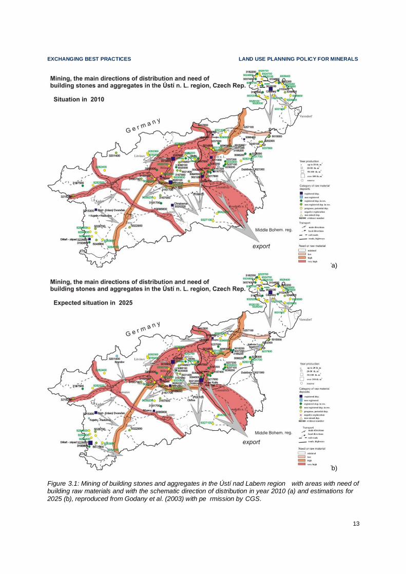
The Working Group considers that an important element of the minerals exploration and extraction licensing systems in Member States i s the involvement of key stak eholders at an early stage, which often results in “smooth rides” with respect to the permitting pro ces. .
Figure 4.1: Simplified diagram to il lustrate the various EU legal requirements related to the permitting process for land based extraction activities; adopted with changes from Kullmann 2002 .
Note: Non Energy Extractive Industry (NEEI -) symbol indicated mining activities in central Europe since the early 16 century. All links to be found via http://ec.europa.eu/environment 1 [...]eia/eia-legalcontext.htm; 2 [ ]/nature/legislation/habitatsdirective/index_en.htm ; 3 [...]/water/water -framework/ index en.html ; 4 [...]/waste/landfill_index.htm ; 5 [...]/waste/min ing/index.htm; 6 [...]/seveso/index.htm ; 7 [...]/air/pollutants/stationary/ippc/ index.htm; 8 -[...]/emas/index_en.htm .
EMAS-Regulation* (EC) No 1221/2009
voluntary basis
Natura2000
IPPC-Directive7 Integrated Pollution
Prevention and Control
2008/1/EC
SEVESO II-Directive6
2003/105/EC
Management of waste from the
extractive industries5
“Mining waste Directive”
2006/21/EC
Landfill of waste Directive4
99/31EC Residue Deposits /
Underground Waste Reutilisation
Water framework Directive3
2000/60/EC
Groundwater Directive
2006/118/EC
Bird Directive2
2009/147/EC
Habitats Directive (92/43/EEC)
EIA-Directive1 Environmental Impact Assessment
85/337/EEC as amended by
97/11/EC, 2003/35/EC, 2009/31/EC
NEEI

EXCHANGING BEST PRACTICES AUTHORISATION
19
Other ways of improving the authorisation process outlined by the Leoben Study are:
• Use of standardised application form s;
• Undertaking parallel asses sments;
• Providing a ‘one -stop-shop’.
The questionnaire survey included various questions on authorising minerals explor ation and extraction (including permitting), drawing on the best practices outlined by the Leoben Study. The key findings are summ arised in this section of the report.
STANDARDISED APPLICA TION FORMS The questionnaire responses and the Working Group were divided on whether standardised application forms are best practice. The view from Austria was that a standard ised application form would not work due to differences between authorities and their interaction, varying local issues and site peculiarities. In Greece a standardised application form containing yes / no / maybe answers was judged to be illegal by the Supreme Administrative Court, as it did not allow for a proper evaluation of the potential environmental impacts of a mining project. However, it was noted that a standardised application form accompanied by analytical studies could enhance the permitting procedures. By contrast, in France a standard application form is used that covers all aspects of the authorisation process.
A number of countries responded to the questionnaire stating that they already have a standardised application form, but that it is only used for a specific purpose. For exa mple, in the Flemish Region of Belgium the standard application form is for environmental permitting only; in Finland, Sweden and Estonia they are used for minerals exploration or mining only; and, in Cyprus solely for planning permission. In Albania a standard applic ation form is used to cover land use planning, mining rights, mine closure, and site remediation, with a second standardised application form for environmental permitting.
In Germany there is no standard ised application form, instead the information that must be provided at the application stage is set out clearly in legislation. As such, the respondents saw no value in implementing a standardised application form in Ge rmany.
It is the opinion of the Wor king Group that the most important elements of the application process are clarity, understanding and certainty of what needs to be provided in order to get authorisation for minerals exploration or extraction. The use of a standard application form can assist, but such forms are not in universal use. Instead, such elements of the application process could be set out in legislation or guidance. Of more importance is the need to ensure that the procedure by which activities are authorised or licensed is unde rstandable and accessible to potential applicants and the general public.
PUBLICATION OF THE A UTHORISATION PROCESS
To aid minerals exploration and extraction, the procedure by which these activities are authorised or licensed should be understandable and accessible to potential applicants and the general public.
Often, the minerals exploration and extra ction authorisation process is published in legal acts, as is the case in Germany , Lithuania , Portugal and Poland. However, although accessible through websites, such legal documents may not be easily understood. Publication of and easy access to transparent, coherent, multi -lingual information on websites is considered best practice.
In Denmark , the Agency for Spatial and Environmental Planning has published a guidance document for authorities, companies and the public to use 15. Similarly, Greece has published a Citizen’s Guide to permitting procedures, which is also available via the internet and in several go vernment ministries.
The majority of questionnaire responses stated that the minerals exploration and extraction authorisation processes in their countries is publicised through the internet, usually on governmental websites. For example, in several federal states in Germany guidance documents on the autho risation procedure are pu blished via the internet. The publication and accessibility of information in Sweden has been highlighted as a best practice e xample.
15 www.blst.dk/Virksomheder/Raastoffer.

AUTHORISATION EXCHANGING BEST PRACTICES
20
PARALLEL ASSESSMENT
For the purpose of the questionnaires, parallel assessment was defined as the process by which more than one assessment or investigation required by authorities to authorise the operation of a minerals extraction site is undertaken in parallel. For example, this could involve the authorisation process being undertaken at the same time as both the environmental permitting process and the health and safety assessment. Parallel assessment is not to be confused with a ‘one -stop-shop’ system that is dealt with below.
One of the problems with parallel asses sment highlighted by respondents is the potential for unnecessary expenditure. For example, should one of the assessments being undertaken in parallel be rejected or refused by the relevant authority, the remaining assessments will have been undertaken unnecessarily. This view was expressed by representatives from France, Sweden and England. Other potential
16 www.sgu.se and www.bergsstaten.se.
weaknesses noted were lower legal transparency and, in the Netherlands, the high level of involv ement required from the primary authority. Positives of parallel assessment were also highlighted, the most significant of which is that it speeds up the authorisation process.
Parallel assessment can take different forms, as described in Table 4.1.
Outside the EU27 Member States, a minerals prospector in Norway is free to pursue se veral legal processes du ring the exploration phase, such as planning, environmental impact assessment and poll ution control.
It is the opinion of the W orking Group that parallel assessment can speed up the minerals exploration and extraction authorisation process, and should help ensure a sound decision as quickly as possible. This in turn will help reduce unnecessary expenditure by all parties concerned , including industry. A two phase parallel assessment system such as that used in the Netherlands where key decisions are made first and minor decisions at a later stage, based on proposals reflecting thorough stak eholder consultation, could go some way to addressing this issue.
ONE-STOP-SHOP
For the purpose of the questionnaires, a ‘one -stop-shop’ system was defined as a system where the authorities involved in an application for authorisation (e.g. the consenting authority, the environmental agency, the w ater authority etc) join together to meet the a pplicants all at once, thereby avoiding hierarchical applications. The aim of such a system is to achieve a coherent, simplified and accelerated applic ation process.
Germany was one of the few countries that reported an established one -stop-shop system. In Germany, the mining a uthority is responsible for the whole permitting procedure and therefore is the only contact for the applicant. Non -EU member Albania launched a one -stop-shop system in 2009 through the c reation of the National Licensing Centre, which has the duty of promoting and publicising permits for mining rights.
The Netherlands is intending to implement national and regional one -stop-shop systems in the next three years, based on the use of a single integrated enviro nmental permit for all land-based extraction. In principle, the
Best Practice: Publicising Information about Minerals Legislation in Sweden
Concise information o n relevant legisl ation for minerals exploration and extra ction is available on the websites of the Swedish Geological Survey and Mining Inspectorate 16. This includes an unoff icial translation of the Mineral Act and Ordinance as well as a brochure entitled "Guide to Mineral legislation and Regulations in Sweden" . The Act and the Guide are also available in a printed form.
The Mining Inspectorate, an indepen dent body within the Swedish Geological Su rvey, is a small, highly computerised and service -orientated department with two offices, one in Luleå and one in F alun. Applicants may call the Mining Inspectors Office for advice on filling in the necessary application forms for authorisation, and the Mine Inspector sets up fixed time for handling applic ations rece ived. Furthermore, the Inspe ctorate has an online map service showing all valid permits in Sweden, which is updated once a month. There is also free access to geological information, e xploration reports and drill cores at the Survey´s Mineral Information O ffice (in Malå).

EXCHANGING BEST PRACTICES AUTHORISATION
21
municipality will be the point of contact for the applicant, with other authorities contributing to the permit as necessary. The permitting authority that receives the applic ation will vary depending on the type of permit required and the complexity of the project. There is some cross -over between parallel assessment and a one -stop-shop system.
Portugal is a good example of where the lines of distinction between the two proce sses are blurred. As described in Table 4.1, applications
for minerals extraction with an exploitation area of less than 5ha are presented to the DGEG and to the Economy Regional Offices, who are the sole people to dea l with the applicants i.e. a one -stop-shop. However, in turn, DGEG consult the environmental and land use institutions, which then study the application at the same time and provide an opinion – parallel assessment. The final decision is taken by DGEG and the Economy Regional Offices, who communicate it to the applicant.
Table 4.1: Examples of Parallel Assessment.
COUNTRY SUMMARY OF APPROACH
Austria
Under Austrian EIA legislation, mining activities above a gi ven minimum dimension are dealt with through a concentrated authorisation process. This means that under the u mbrella of the authority in charge, all other authorities are involved in the same process – parallel assessment. The applicant and relevant authorities meet in advance of an application being submitted to determine which expertise is nece ssary to determine the project in question.
Denmark
An applicant for minerals extraction must submit a single standard application form that covers all permits re quired. Under Section 8 of the Raw Materials Act, the municipality to which the application for a raw materials extraction permit is submitted has a duty to present the appl ication to other relevant authorities (which issue separate permits), which assess the information provided in para llel. This is known as the “coordination obligation”. This system enables the permits to be issued faster.
Netherlands
Similar to the Danish system, the applicant for a permit for extraction in the Netherlands can require t he primary authority to coordinate any other permits required (a process undertaken at the r egional level). This allows the information provided to be assessed in parallel. However, in order to reduce unnecessary expenditure on documenting applications, th e appl icant can choose a two -phase assessment, where key decisions are made first and minor dec isions in at a later stage.
Poland
The parallel assessment process used in Poland means that the applicant’s documents are tran sferred to different authorities at the same time i.e. concession authorities, environment protection agency, mining authority. This requires numerous forms to be completed, but accelerates the licence granting pro cess.
Portugal
Applications for minerals extraction with an exploit ation area of less than 5ha do not require an environmental impact assessment. Such applications are presented to the Directorate General for E nergy and Geology (DGEG) and to the Economy Regional Offices, who then ask for the opinion of environmental and land use institutions. The requests are studied by these organisations at the same time. The final decision is taken by DGEG and the Economy Regional Offices, who communicate it to the applicant.
United Kingdom (Northern Ireland)
The applicant for minerals extr action is required to submit applic ations in parallel. This reduces the time for licenses to be granted, and can lead to the early identification of any problematic issues. However, it does rely on good communication between authorities, and can lead to du plication of effort by the applicant.

AUTHORISATION EXCHANGING BEST PRACTICES
22
Best Practice: Single administration process in Germany
The main feature of German mining legislation is its comprehensive stru cture, implementing integrated risk pr evention through an approach with strict requiremen ts on concessions, health and safety, environment and other i ssues as well as differentiated mechanisms for compliance and monitoring. These provisions set up a comprehe nsive legal system covering all aspects of mining, including health and safety and environment, supervised by one single administration (one -stop shop). This approach directly implements the challenges of the concept of sustai nable development, taking into consideration the three pillars of environmental protection, social development and economic development, with each of these three policy areas being mutually supportive of the others.
In Denmark , due to the ‘coordination agreement’ described in Table 4.1, there is no need to implement a one -stop-shop system as only a single application is submitted and permit issued.
Although some Member States already follow a one-stop-shop approach, this can be di fficult to implement due to the number and variety of authorisations required for minerals exploration and extraction. This often results in various government or advisory institutions being involved in the authoris ation process.
FIXED TIME PERIOD
The Leoben Study notes that the time required for extraction permission varies consi derably between Members Stat es. This is confirmed by the responses received to the questionnaire. The use of a fixed time period, within which all or part of applications for authorisation should be determined (i.e. a pproved or refused), can help to restrict the length of time taken by planning authorities to make decisions, and thereby improve the authorisation process. For example, the implementation of a four month limit for environmental permitting in Flemish Region of Belgium was deemed necessary to allow companies a process by w hich they can challenge delays in the authorising procedure. In Cyprus, the three month limit for an authorisation decision leads to complaints because delays are common as a result of understaffed authorities.
By contrast, some countries do not have fixed time periods, such as Germany and Finland; although in Finland’s case there are informal target times for the authoris ation of licences.
Sweden , like Finland, has no fixed time per iods for dealing with exploration permits under the Swedish Minerals Act. H owever, the questionnaire responses received state that goals are set for the time in which the Mining Inspectorate should deal with an application and that these are usually achieved. The ability to meet these time goals (in contrast to a number of other countries) is attributed to prioritisation of the issue by the Mining Inspe ctor, and the fact that the Mining Inspectorate is a very small, independent body. There are only nine people in two offices, all of whom are flexible, service -minded and expected t o be able to do “everything” in the processes – as such the applications are not passed from one person to another. In addition, the Mi ning Inspectorate is also highly compute rised, using GIS -systems to support the handling of applications.
As described, the administration of an exploration permit application within Sweden is very efficient. However, the opposite is true when it comes to the environmental permi tting process required to o perate a mine. For these permits, it is usual for the authorisation pro cess to take two years or more.
ON-SITE DISCUSSION
It is the opinion of the Working Group that transparent on -site discussions between the applicant for minerals exploration or extraction and key stakeholders prior to the submission of an authorisation or licensing application help to achieve a smooth permitting process. The majority of Member States stated that such discussions were undertaken, although they are not always held on -site or mandatory. Benefits of such discussions e xpressed by the questionnai re respondents include:
• ‘Frontloading’ inform ation and ironing out any issues prior to the application being submitting, to minimise cost and delay, and to clarify expectations of the supporting information required. Discussions improve the chances of dete rmining an application within the time frame and encourage higher standards of application overall. In England, what are know as ‘pre -application discussions’ are positively encouraged, the intention being to resolve all technical issues

EXCHANGING BEST PRACTICES AUTHORISATION
23
before the applica tion is submitted. Mineral planning authorities can charge applicants for the time they incur during these discussions.
• Enabling the applicant to prove their technical and financial capability and to try to reduce/avoid future land use and environmental co nstraints. (Portugal)
• The ability to discuss the project, to clarify requirements, to identify shortcomings in the applicant’s approach, and to identify any special conditions. ( United Kingdom – Northern Ireland)
• Streamlining the process, discussing and gathering information, and avoiding contradictory statements in the application. (Austria)
Although not all countries use on -site discussions, none of the questionnaire responses provided negative feedback or weaknesses of such stakeholder engag ement.
OTHER ISSUES RAISED
Alongside responses to the questions posed, two respondents raised additional notable points with regards to the authorisation of minerals exploration and extra ction. These are described below.
An example was provided where there has been an increase in the number of environmental impact assessments that companies must undertake in order to open a new quarry. Legislation regarding land use planning, permitting, mining waste etc has lead to requirements for comp anies to produce at least three environmental impact assessments, each including a stakeholder communication processes. This can make the authorisation process difficult, long and expe nsive for both companies and the authorising bodies. Streamlining this system could aid minerals exploration and extraction. It is the view of the Working Group therefore, that best practice is achieved when all environmental a spects are assessed in a single process, based on one study only.
Although on-site discussions are not common in the Netherlands, com munity consultation is undertaken in order to build social acceptance of projects. Through these consultations, pr ojects
have been able to take into account those issues that are important for the local community. Implementing this approach to consultation has been a contributory factor in an i ncrease in the number of authorisations granted, and as such is considered best pra ctice by the Working Group.
SUMMARY OF CHAPTER AND RECOMMENDATIONS It is the opinion of the Working Group that the most important elem ents of the minerals exploration and extraction application process are clarity, understanding and certainty of what needs to be provided in order to get authorisation for minerals exploration or extraction. This does not necessarily need to take the shape of a standardised application form, but instead could be set out in legislation or guidance.
Representations from industry emphasised the need to speed up the minerals expl oration and extraction authorisation processes. This may be achieved through integr ating the different permits required so that they are issued by one competent authority (a one -stop-shop) and with only one environmental impact asses sment.
However, it is the view of the Working Group that a one-stop-shop system can be difficult to implement due to the number and variety of authorisations required for minerals expl oration and extraction, which often involves a number of government or advisory instit utions. A potential solution suggested was the formation of a Committee to coordinate the ci rculation of all relevant studies to the various competent authorities. This Committee could be formed at the national or regional level depending on the size and the potential impacts of the mining project under study, and the administrative situation of the country.
Parallel assessment can also speed up the minerals exploration and extraction authoris ation process, and should help ensure a sound decision as quickly as possible. This in turn will help reduce unnecessary expenditure by all parties concerned, including industry.
In some cases, community consultation is undertaken in order to build social acceptance of projects. Through these consultations, pr ojects have been able to take into account those issues that matter for the local community. Implementing this approach to consultation has been a contributory factor in an increase in the

AUTHORISATION EXCHANGING BEST PRACTICES
24
number of authorisations granted, and as such is considered best practice by the Working Group.

EXCHANGING BEST PRACTICES TECHNICAL, ENVIRONMENTAL AND SOCIAL EXCELLENCE
25
5. ACHIEVING TECHNICAL, ENVIRONMENTAL AND SOCIAL EXCELLENCE
The Leoben Study recommended the use of codes of practice as important instr uments to achieve environmental and technical excellence. As such, a section of the questionnaire on exchanging best practices in land use pla nning focussed on obtaining examples of codes o f practice or guidelines that aim to ensure the protection of the environment from adverse impacts of mineral extraction.
The Working Group accords a high priority to the achievement of technical, enviro nmental and social excellence in the area of land use planning and administrative conditions for exploration and extraction of raw materials. However the means by which excellence is achieved varies b etween Member States. It is possible to draw a distinction between the use of legal frameworks and voluntary commitments in this regard. While both are som etimes referred to as “Codes”, there is an important distinction between them. In some cases, the requirements are set out in legislation, whereas in others greater reliance is placed on voluntary codes of practice, either formulated by individual companies, or by industry representative organisations alone or in cooperation with authorities or NGOs.
This leads to an important distinction b etween “Code” as a legal framework and “Code” as a voluntary commi tment.
Figure 5.1: Relations of codes of best practice .
LEGAL CODES OR FRAMEWORK
In general and as a result of European legislation implemented in Member States, all companies are obl iged to undertake site remediation and restoration following extraction. Selected examples of the legal codes of practice or frameworks described by respo ndents to the questionnaire are described below. It must be noted that the examples shown are not exhaustive.
The Working Group considers that the e xchange of best practice in the context of n ational legal provisions for certain issues of technical and environmental manag ement might be useful. This is the case, for example, with the EU’s BAT document on the management of waste from the extractive industry17. This comprises a collection of best available techniques, linked to the Directive of the European Parliament and of the Council on the management of waste from extractive industries and amending Directiv e 2004/35/EC.
Cyprus : The environment is protected from adverse impacts of minerals extraction in C yprus through the evaluation, approval and a pplication of an ‘Environmental Management Study for Operating Mines and Quarries’. Each site is required to pro duce an updated Env ironmental Management Study every five years, which is evaluated and approved on site by a Multidisciplinary Committee. At any time a Competent Authority can inspect a mine or quarry to monitor the implementation of conditions attached t o licences and those required by law.
The Environmental Management Study of an operating mine or quarry generally i ncludes:
• A summary of the operation: Including a short summary of the history of the mine or quarry, reference to previous studies and
17 European Commission (January 2009) Reference
Document on Best Available Techniques for the Management of Tailings and Waste-Rock in Mining Activities (BREF MTWR).
Legal framework of national mining legislation
Guidance deve loped to supplement the legal framework
Code

TECHNICAL, ENVIRONMENTAL AND SOCIAL EXCELLENCE EXCHANGING BEST PRACTICES
26
works, and an introduction of the contents of the Environmental Ma nagement Study.
• A summary of the reserves, produ ction and life of the operation: Gives the actual production figures for the previous five year period, the projected production for the next five year period and a re -evaluation of the reserves included within the boundaries of the quarry.
Maps and timetables: Updated topo graphic and geological maps showing the plans for the development of the mine or quarry for the next five year period. If any part s of the quarry or mine require restoration, then restoration and conservation plans are i ncluded.
Details of activities, including inform ation on:
• the management of the excavations and waste disposal;
• the processing of the raw material and the management of any wastes produced;
• the source of any impacts on the environment (dust, noise, transportation, health and safety) and provides the mitigation required.
Cost of the restoration: Including a) an est imate of the cost of the planned restoration and conservation, and b) an estimate of the cost of implementing restor ation and conservation plans should the mine or quarry be suddenly abandoned.
The strengths of the Environmental Manag ement Study are identified as being that:
• a bank guarantee is required based on the estimate of the cost of implementing restoration and conservation plans should the mine or quarry be suddenly abandoned;
• the Multidisciplinary Committee includes participants from all competent and local authorities; and,
if the conditions attache d to a license or contained within the Environmental Ma nagement Study are unjustifiably violated by the operator, then measures can be taken against the company.
Current weaknesses of this system are the lack of implementation of the measures, and
problems arising from delays in r enewing the mine or quarry licence. These two weaknesses are linked and so the Committee for Sustainable Development of Mineral Resources is working to suggest improvements to the competent authorities.
France: ‘The Mining Code’ of France requires the rehabilitation of sites once its operation has ceased. The Code also requires that the termination of operations at a mine includes measures to prevent any negative after -effects that could be generated as a result of the mining operations.
Spain has robust regulations in place to deal with the restoration of sites since The Mi ning Act of 1973 and the Royal Decree of 1982 r equiring the integration of a remedi ation/restoration plan into the extraction plan. The Royal Decree of 2009 ‘Management of Extra ctive Industry Waste and Protection and Rehabilitation of Spaces affected by Mining Activities’ pr ovides sufficient detail to ensure the protection of the environment from adverse impacts of mineral extraction.
United Kingdom (England): All planning consents in the UK require sound restor ation and aftercare provisions that are legally enforceable. Regular reviews are undertaken to ensure aftercare provisions are up to date with best practice .
VOLUNTARY CODES
It is also relatively common withi n Member States for the legislation governing the management and restoration of extraction to be supplemented by voluntary codes of pra ctice. This might be because the legal framework does not include the necessary technical pr ovisions, or the required lev el of detail. Such codes are , therefore, complementary to legislation and regulations, and are voluntary. Some important examples are listed below:
General Business Conduct : Most industry associations and companies in the se ctor have codes of good business conduct.
Sustainable development : Many industry associations and companies in the sector have codes of sustainable development.
Safety (Dam Stability): The International Commission of Large Dams 18 (ICOLD) provides
18 http://www.icold-cigb.net

EXCHANGING BEST PRACTICES TECHNICAL, ENVIRONMENTAL AND SOCIAL EXCELLENCE
27
guidance on the design, building and clos ure of modern long -term stable dams.
Environmental protection : Codes on best practice for environmental protection can take different forms and cover different areas, such as mine exploration, closure and rehabil itation, and biodiversity. One example is t he guide to minerals and the historic environment pu blished by the Confederation of British Industry: ‘Mineral Extraction and Archaeology: A Practice Guide (2008)’.
Rehabilitation through integrated mine cl osure planning: Mine closure is a site specific ex ercise which is why it is very difficult to cover it appropriately through technical regulations. Environmental targets can be set by legisl ation, but the technical implementation is very varied. Often similar circumstances only occur outside Europe which is why in some sub -sectors codes of practice are more successfully developed at international level.
Management of Biodiversity : Biodiversity guidance has been provided at International and European level. Sub -sectors have commi tted themselves to targets. However, ind ividual site characteristics and the specific biodiversity to be protected mean that techn ical expertise is left mostly to the company level.
Health and Safety : Legislation is suppl emented by some International Codes as well as best practice gu ides from the Standing Working Party on the Extractive Industry (SWPEI) and the European cross sectoral industry agreement, for example on the Handling of Respirable Crystalline Silica. Furthermore, numerous documents of binding character to the governments have been published by the International Labour Office (ILO) in Geneva.
Social Management Aspects : Social and community relations codes of practice have proven useful since this is an area which can only be partly regulated, for example , with regard to legally stipulated stakeholder consultations. However, successful human relations and social acceptance (the Social Licence concept) depend on trust which cannot be stipulated by law, but sustained by good and reliable practice on the ground. Codes of pra ctice, therefore , need to embrace the manag ement of historic and cultural conditions and can provide best practice in a managerial context.
ENSURING REMEDIATION AND RESTORATION
In the past there was no obligation on the extractive industry regarding site rem ediation and restoration once extraction oper ations had ceased. However, this changed consi derably towards the end of the last century. Now, through careful management and early stakeholder involvement, high quality site remediation and restor ation can be achieved, and can often result in new land uses such as nature conservation or recre ation.
In general, due to EU legislation impl emented in Member States, today all co mpanies are obliged to rehabilitate or restore their sites. For example, in Denmark site remediation and restoration is ensured through mandatory approval of an extraction and aftercare plan, with a financial guarantee in place to fulfil the aftercare obligation. Similarly, site remediation and restoration is ensured in Finland through environmental regul ations and the requirement for site specific financial guara ntees.
In the Netherlands , an application will not be accepted without a good restoration plan, the applicant also has to provide a financial guarantee to ensure remediation and/or restoration. In Slovenia , each company that has been granted mining rights is obligated by the Mining Act to take care of remediation once extraction has ceased.
Mine closure is a very site and community specific exercise which is why it is very difficult to cover it appropriately through technical regulations. Environmental targets can be set by legislation, but the technical implementation is very varied and evolves over the typical lif etime of a mine (which is often decades). Very o ften sites find their mo st applicable example to learn from outside of Europe, for example, the same combination of ore -type, benefic iation process and social context may only exist outside of Europe. For awareness -raising and establishment of know ledge-sharing networks, some industry sub-sectors’ Codes of Practice are therefore more effective if developed at international level.
More detail provided by respondents on the methods used to ensure site remedi ation and restoration is set out below .

TECHNICAL, ENVIRONMENTAL AND SOCIAL EXCELLENCE EXCHANGING BEST PRACTICES
28
Best Practice Examples of Voluntary Codes in Sweden, the Nethe rlands and Finland
Sweden : There are Ethical Rules 19 which the members of the Swedish Association of Mines, Mineral and Metal Producers are committed to follow. The Rules include, amongst other things, sustainable development, occu pational health and safety and environmental protection.
Under these Rules there are guidelines and policies for some key areas, for e xample:
• Guidelines for expl oration work.
• Guidelines on good practice for e xploration in protected a reas.
• Policy and techn ical guidelines for the design, building and closure of modern long-term stable dams according to the recommendations of the International Commission of Large Dams (ICOLD).
In addition, a large amount of research has been undertaken on the management of minerals sites or management of tailings, for example, which is often su pported by research organisations (including the Technical University of Luleå) and thus available to everyone.
The Netherlands : Two codes of practice have been developed in the Netherl ands: The ‘Gedragscode’, the code of conduct of the extractive industry federation (FODI); and, a code of practice for me mbers of Cascade, an Industry Association. The latter contains ten key elements of the industry’s approach towards sustainable extracti on (relating to sand, gravel and clay extraction).
Finland: The ‘Exploration and Mining in Finland’s Protected Areas, the Sami Homeland, the ‘Reindeer Herding Area Guide’ and ‘The Finnish Mine Closure Handbook’ 20 provide guidance on extraction site remediation and restoration.
19
http://www.industriarbetsgivarna.se/web/Ethical_Rules.aspx
20 http://arkisto.gtk.fi/ej/ej74.pdf
Belgium (Flanders) : site remediation and restoration is ensured in the Decree on Surface Mineral Resources through the use of extra ction permits, financial guarantees and the development of a remediation or restoration plan. The latte r is the responsibility of a steering committee. Me mbers of this committee are from local and regional administrations, with representatives of the municipality, the pro vince and the regional authorised administr ations, for example the agriculture or natur e department (depending on the proposed new land use of this site). Together the steering committee develops a remediation and/or re storation strategy, which leads to a detailed d esign plan for each site.
VLAREM is the environmental regulatory process in the Flemish Region of Belgium for all activities and/or construction projects that i mpact the environment. The strengths of VLAREM are:
• it creates one clear framework for all activities that can affect the enviro nment;
• it is composed of different conditions for specific activities e.g. minerals e xtraction;
• the permitting proc edures have fixed time -frames;
• it is flexible, allowing additional cond itions to be formulated by the government if r equired e.g. where conditions are not specific enough for certain sit es.
The questionnaire response from Belgium (Flanders) mentions that they have not encountered any weaknesses of the VLAREM regulatory process.
An example of where the VLAREM pro cess has been used in practice is slope failure. The conditions for minerals extraction (section 5.18 of VLAREM II) contain specifications for slopes resulting from minerals extraction, such as slope inclination. Some sites recently experienced problems with slope instability, which resulted in slope failure. As a result, the Nat ural Resources Service commissioned an e xtensive study to investigate the problem, which will, once completed, recommend modifications to the slope specifications contained within VLAREM.
Greece : Remediation and restoration in Greece is ensured by specific t erms set out in a site’s Environmental and Opera ting permit. Inspections and audits are undertaken, fina ncial guarantees

EXCHANGING BEST PRACTICES TECHNICAL, ENVIRONMENTAL AND SOCIAL EXCELLENCE
29
are required and sanctions imposed where necessary.
In extraordinary cases, in order to operate a mine or quarry in Greece, the Ministr ies in charge are required to appoint an enviro nmental committee to monitor the co mpletion of specific environmental terms attached to a mineral extraction permit. This is a system currently implemented for the metallic mineral mines in Stratoni, under the village of Stratoniki, northern Greece – further information on the Stratoni Mine is provided later in this se ction.
Poland: The permission to extract d escribes in detail the measures to be undertaken with regard to restoration once mi ning activities have ceased, to be undertaken by the site o perator. In addition, the mining company is obliged to dedicate funds for future restoration works. It is impossible to use the money put aside for this purpose without the permission of the permi tting authority. The brown coal open pits in K onin, Be•chatów have been successfully r estored to water reservoirs, forests, wild parks and industrial areas through this pro cess.
France: Site remediation and restoration is achieved in France through implement ation of The Mining Code and The Env ironmental Code. In order to obtain authorisation for e xtraction, a financial gua rantee to rehabilitate the site must be obtained by the mining oper ator from a bank.
To mitigate the environmental cons equences of abandoned mines and for min es whose operators have defaulted or disappeared (orphaned mines), the French State replaces the operators and makes the site safe.
The rehabilitation process of a closed mine includes two parts. The first is a regulatory procedure regarding the abandonmen t of a mine. An inventory of the measures to be undertaken in order to make the site safe is produced. These measures are then implemented by the opera ting company, after which the work undertaken is verified by the state services. If the work has been com pleted correctly, a decree is issued that makes it possible to abandon the mine.
The second part of rehabilitation is of a contractual nature, the aim of which is to make the site compatible with its new use, be it an industrial area, leisure ground, far mland etc.
Spain: By law, companies in Spain have to integrate a remediation/restoration plan into their extraction plan. The country also impl ements a
compulsory financial guarantee system. The 2009 Royal Decree 975/2009 on the ‘Management of Extractive I ndustry Waste and Protection and Rehabilitation of Spaces A ffected by Mining Activities’ provides su fficient detail at the national level to ensure the prote ction of the environment from adverse impacts of mineral extraction. Although the Royal D ecree was only passed in 2009, Spain has had robust regulations in place to deal with the restor ation of sites the Mining Act of 1973, which is still in force.
The strength of the Royal Decree is that it is detailed and clear enough to be consi dered as a complete gu ideline for the extractive indu stries. A point of conflict of the system in Spain is that although there is not a European Dire ctive or national law that precludes mineral e xtraction in ‘Protected Natural Spaces’ (Natura 2000 sites, Natural Reserves etc), certain regional and local administrations who are able to develop laws or land uses planning legislation have banned mineral extraction in such areas, thereby restricting the industry in these Protected Natural Spaces. However, a recent amendment to the Mining Act (Article 122) requires specific justification for any prohibition of mineral extraction in certain areas, preventing the general restriction of extractive industries through regional or local land use planning.
United Kingdom (England) : All planning consents in the UK require sound restor ation and where appropriate aftercare pr ovisions that are legally enforceable. Regular reviews are undertaken to ensure aftercare prov isions are up to date with best practice.
EXAMPLES OF SUCCESSF UL SITE REMEDIATION AND RE STORATION
When discussing site remediation and restoration, it is important to distinguish between restoration of long abandoned hi storic sites and the closure of contemporary sites. In the case of the former, remediation and restoration is usuall y undertaken by the Member States. By contrast, due to legislative changes, remediation and restoration of contemp orary sites is carried out by the site operator/owner, usually through implementation of an integrated and progressive restoration plan, carri ed out through the lifetime of the mine or quarry.
In response to the questionnaire, exa mples of successful site remediation and restoration following mineral extraction were provided by the

TECHNICAL, ENVIRONMENTAL AND SOCIAL EXCELLENCE EXCHANGING BEST PRACTICES
30
respondents. The purpose of this section of the questionnaire was to highlight how ma nagement of new and existing sites can result in high quality site remediation. However, some of the examples of site remediation and restoration provided fall into the category of long abandoned historic sites, which are not repr esentative of the quality of restoration that can be achieved t oday.
In order to reflect the questionnaire r esponses received, this section has been split into examples of remediation and restoration of contemporary sites and remediation and restoration of long abandoned historic sites.
CONTEMPORARY SITES
Sweden : The Stekenjokk mine in northern Sweden is located above the tree line in the Lapland Mountains. Information on the site and the restoration implemented has been e xtracted from an International Council o n Mining and Metals publications (undated) entitled ‘The closure of the Stekenjokk mine in Northern Sweden and 15 years of post -closure follow-up’, provided by a respondent to the questio nnaire.
The site is located in an environmentally sensitive area whic h is also of strategic importance for the Lappish reindeer bree ding community and is crossed by a salmon bearing creek. Although site closure and restoration was not an integral part of the mine’s development in the early 1970s, the site’s environmental sensitivities were understood.
From 1976 to 1988 the site was unde rground mined using cut -and-fill for pyritic copper, zinc and silver ore. Processing was also unde rtaken on site, with the coarse fraction of the flotation tailings used as back -fill material , and the finer fraction deposited in a tailings dam.
Prior to closure, the preparations for decommissioning started with the obje ctives to:
• Prevent the area from becoming a major source of acid mine drainage (AMD), also known as acid rock drai nage (ARD);
• Removal of facilities that could be hazar dous to humans or wil dlife; and
• Adapting the area to the surrounding environment.
Apart from the tailings pond, the decommissioning work at the site included reclamation of small waste rock dumps, a small
open pit and various surface installations. Figure 5.2 shows a view of the Stekenjokk mine during operation.
Figure 5.2: View of Stekenjokk mine during operation; source Boliden AB (2006), reproduced with permission by Bolden AB.
During the operation of the mine, closure and after-closure, a constant dialogue was maintained with the Lappish community and other stakeholders. Potential ARD formation from the closed tailings pond was the primary environmental concern at closure, however, aspects related to rei ndeer keeping and visual impacts related to tourism were also of high importance. The reclamation of the surface installations and the underground mine were relatively straight forward, however, several alternative methods for the reclamation of the tailings pond were studied, including flooding, dry covering, de -pyritisation and buf fering.
A careful evaluation of the alternatives f avoured the flooding alternative, which was found safe, more efficient and by far the most cost effective method at the site. A h ydrological investigation provided the basis for the final design of the water cover, assuring the pe rformance of the water cover even in the case of the 1000 years drought. Geochemical tests and modelling showed the water cover would result in an acceptable discharge water quality and acceptable water quality in the receiving creek.
The closure work was initiated in the summer of 1990 and completed in summer 1992. All surface installations were removed, the open pit was flooded and the waste -rock was used for constructing break -waters in the tailings pond and for improving the long -term stability of the downstream dam. All disturbed areas were re -vegetated with grass which turned out to be very attractive reindeer grazing a reas.
The effectiveness of the decommissioning process was closely monitored, focussing in itially on effluent water from the tailings pond, water level fluctuations, re -suspension of tailings and

EXCHANGING BEST PRACTICES TECHNICAL, ENVIRONMENTAL AND SOCIAL EXCELLENCE
31
breakwater stability. However, over time the monitoring was expanded to i nclude the success of the re-vegetation, dam safety issues and biological monitoring mainly focussed on the establishment of fish in the decommissioned tailings pond. Figure 5.3 shows the restored Stekenjokk mine and the results of a fish inventory in the tailings pond performed in 2002. Char (Salvelinus Alpinus ) has naturally established and are repr oducing in the pond.
The planning, construction, operation and closure of the Stekenjokk mine was pe rformed long before International Guidelines on biodiversity or mine closure were commonly available21. This meant developing and “retrofitting” a closure concept to the mine that could be acceptable to stakeholders and the sensitive environment. Nevertheless, if the mine was to be planned today, the concept would probably not be very di fferent. It has shown to be effective with respect to the set objectives and biodiversity issues.
Main improvements that would be possible if the site was designed today would be:
• The design, building and cl osure of modern long-term stable dams according to International Commission of Large Dams (ICOLD) recommend ations.
• Adding a thin diffusion barrier of inert material on top of the deposited tailings to further reduce sulphide oxidation rat es and the release of weathering products to the water column in the short - and medium-term.
• To lead the creek through the flooded tai lings pond instead of around it. This is an additional improvement that is still possible with only small modifications. T his would significantly speed up the establishment of a sustainable ecosystem in the closed pond.
• Avoid the use of high sulphide waste -rock in the support fill of the dow nstream dam.
Over the years minor corrective measures have been necessary to ensure th e performance of the closure. These include repeated re -vegetation efforts in limited specific areas due to
21 Recently published Guidance includes the ICMM Good
Practice Guidance for Mining and Biodiversity (2006) and the European Commission Guidance on Non-energy mineral extraction and Natura 2000 (2010).
erosion and the harsh climate, impro ving dam safety by increasing the discharge capacity and covering the downstream dam with m oraine due to its unexpected content of su lphides.
Figure 5.3: Restored Stekenjokk mine tai lings pond. Source: B oliden AB (2006) The closure of the Stekenjokk mine in Northern Sweden and 15 years of post -closure follow-up.
Austria: East of the Upper Austrian city of Linz and within the wetlands of the river Danube, sand and gravel was extracted for decades. The land level at which extraction took place had been previously modified by power plants, poplar monocultures and a lack of flood dynamics.
In 2000, after the natural areas within the site were comprehensively mapped, a new sp atial concept together with new mining and reclamation strategies were developed and approved through the EIA process. After completion of the gravel e xtraction, the site was partially refilled with e xcavated soil and large backwater areas were created based on historical maps of the area. On the extensive shallow banks, sludge and mud from a remaining natural backwater was applied. In addition small water bodies with different structures were created, with large areas left to naturally regenerate.
The approach followed has been very successful. A number of rare plant species have re-colonised from the mud, with no less than 18 highly endangered red -list-species returning in relatively large pop ulations to the newly -designed shore waters. The most outstanding result is the reappearance of the Fringed W ater-lily (Nymphoides peltata ) and the European Frogbit (Hydrocharis morsus -ranae) - both species were pre viously extinct in Upper Au stria.

TECHNICAL, ENVIRONMENTAL AND SOCIAL EXCELLENCE EXCHANGING BEST PRACTICES
32
Figure 5.4: Application of original mud and sludge to aid re -colonisation (top) and the successful colonisation of the area (bottom). Wittmann (2007) reproduced with kin d permission of Dr. H. Wittmann.
Amphibian and reptile fauna has also seen high levels of growth, in terms of both species numbers and population size. The Eur opean green toad (Bufo viridis ) has returned after not being seen for 25 years. In addition, bird fauna has also benefited from the restoration strategy, especially sandpiper ( Actitis hypoleucos ), little ringed plover ( Charadrius dubius ), bluethroat (Luscinia svecica ) and sand martin ( Riparia riparia).
This gravel extraction project at Steyregg is of nationwide significance for species conserv ation, described alongside projects undertaken by various NGOs and the state conservation agency.
Greece : Parnassos Mountain, in the Fokida region of Greece, is home to a successfully restored open cast bauxite mi ne (other bauxite mines are still operational in the vicinity). When operational, the maximum depth of the excavation was 40 m, leaving an area in need of rehabilitation of two he ctares. Before the mine was opened, the site was a barren hill
surrounded by fir tree forest. The basis of the site closure plan was to improve the landscape following extra ction, by creating a new area of forest to complement that existing in the surrounding landscape.
Figure 5.5: Parnassos Mountain bau xite mine during operation, with courtesy by Tzimopoulos Haralabos .
The idea of “crea ting nature” through the site closure meant that geometric shapes and symmetry were avoided where possible in the landscaping, and the void was back filled to imitate the surrounding land (this involved e xtra cost associated with loading and transpor ting waste back from temporary stockpiles). In order to make the plants self -dependent, plan ting took place with very limited use of fertile soil and irrigation was used to a minimum.
The results are almost a complete su ccess, with the new forest already visible and growing. Figure 5.5 shows the active site, Figure 5.6 the site once rehabilitation was co mpleted.
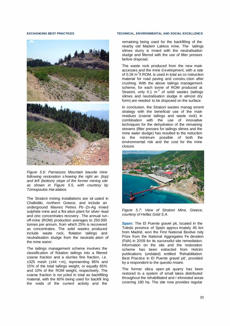
EXCHANGING BEST PRACTICES TECHNICAL, ENVIRONMENTAL AND SOCIAL EXCELLENCE
33
Figure 5.6: Parnassos Mountain bauxite mine following restoration s howing the right an (top) and left (bottom) slope of the former mining site as shown in Figure 5.5, with courtesy by Tzimopoulos Har alabos.
The Stratoni mining installations are sit uated in Chalkidiki, northern Greece, and include an underground Mavres Petres Pb -Zn-Ag mixed sulphide mine and a flot ation plant for silver -lead and zinc concentrates recovery . The annual run-off-mine (ROM) production averages to 250.000 tonnes per annum, from which 25% is recovered as concentrates. The solid wastes produced include waste rock, flotation tailings and neutralisation sludge from the neutralis ation of the mine water.
The tailings management scheme involves the classification of flotation tailings into a filtered coarse fraction and a slurries fine fraction, i.e. ±325 mesh (±44 •m), representing 85% and 15% of the total tailings weight, or equally 65% and 10% of the ROM weight, respectively. The coarse fraction is rec ycled in total as backfilling material, with the 60% being used for backfil ling the voids of the current activity and the
remaining being used for the backfilling of the nearby old Madem Lakkos mine. The tailings slimes slurry is mixed with the neutralisation sludge and filtered with the use of filter presses before disposal.
The waste rock produced from the new main accesses and the mine d evelopment, with a rate of 0.26 m 3/t ROM, is used in total as co nstruction material for road paving and constru ction after crushing. With the above tailings management scheme, for each tonne of ROM produced at Stratoni, only 0.1 m 3 of solid wastes (tailings slimes and neutralisation sludge in almost dry form) are needed to be disposed on the surface.
In conclusion, the Stratoni wastes manag ement strategy with the beneficial use of the main residues (coarse tailings and waste rock) in combination with the use of innovative techniques for the dehydration of the remaining streams (filter presses for tailings slimes and the mine water sludge) has resulted to the reduction to the minimum possible of both the environmental risk and the cost for the mine closure.
Figure 5.7: View of Stratoni Mine, Greece, courtesy of Hellas Gold S.A.
Spain: The El Puente gravel pit, located in the Toledo province of Spain approx imately 45 km from Madrid, won the First National Biodive rsity Prize from the National Aggregates Fe deration (FdA) in 2009 for its successful site remediation. Information on the site and the restoration scheme has been extracted from Holcim publications (undated) entitled ‘Rehabilitation Best Practice in El Puente gravel pit’, provided by a respondent to the questio nnaire.
The former silica open -pit quarry has been restored to a system of small lakes distributed throughout the rehabilitated and r eforested areas covering 180 ha. The site now provides regular

TECHNICAL, ENVIRONMENTAL AND SOCIAL EXCELLENCE EXCHANGING BEST PRACTICES
34
shelter for 171 bird species, of which 72 are aquatic birds and 27 species are nesting. Although the site is surrounded by roads, farmland, railways and minerals extraction sites, it also located within one of the main bird migration routes, providing an important haven for migra ting birds.
Restoration of the site was pla nned before extraction commenced. Topsoil removed to enable extraction was stored on site for use in the creation of the forested areas. In order to mimic the natural environment as much as possible, the excavation avoided creating straight lines, instead incorporating curved asymmetrical co ntours.
An independent biologist worked alon gside the site operator to provide advice on lan dscaping, slope angle, the creation of islands and screening (the latter achieved with vegetation in order to protect the birds ' privacy and pr event direct contact with humans). Where the depth of the basins created by the extraction process was too great to allow light to pen etrate, the basins were filled with inert material to reduce the depth.
The reforestation work in El Puent e has sought to recreate the original ecosystems in the area. Advised by the independent b iologist, the site operator created a plant and tree nursery for use during the restoration. These species grown were selected for their ability to adapt to the environment and produce the most natural results possible.
Monitoring of the restoration consists of planned periodical visual inspections and co llection of plant and soil samples from the r estored areas. The objective is to monitor the performance of the various vegetation types and techniques used in the gravel pit’s restor ation in order to evaluate their effectiveness and undertake further work if nece ssary.
In recognition of the importance of the r estored gravel pit, the Government of Castile -La Mancha designated the site as a zone of special protection for birds (ZEPA) in 2008.
United Kingdom (England) : The Minerals Products Association Rest oration Awards is an annual scheme used to recognise and cel ebrate outstanding achievement in quarry rest oration. One of the winners in 2009 was the Cauldron Cement Works in Staffordshire, En gland. The 17.1 ha restored site is adjacent to the still
operational part of the works, which supplies 8% of England’s cement requir ements.
The restoration was undertaken by the oper ator, Lafarge Cement UK, in partnership with the Staffordshire Wildlife Trust., and created four zones: a shale lake; reedbeds; grazing land; and, a post-industrial biodiversity area. The latter two were created within former waste tips.
The quarry now sup ports a variety of wil dlife and habitats, as well as naturally treating any ammonia-contaminated water via the reedbed. The quarry also hosts regular site visits from local schools and colleges, and supports education through the use of interpretation boards around the restored area.
The most well known mineral site restor ation project in the UK is the Eden Project, Cor nwall. A former china clay works has been tran sformed into an international visitor attra ction containing the world’s largest greenhouse (or biome).
PUBLICATIONS
In addition to the site specific examples pr ovided by respondents, useful sources of further information were provided. These included:
• A recent publication by the Post -Mining Alliance (PMA) in association with the Eden Project entitled ‘101 Things to do with a hole in the ground’ 22. The book sets out the potential after uses of a mine or quarry site.
• The International Council on Mining and Metals (ICMM) provides several guidance documents such as the "Financial Assu rance for Mine Closure and Reclamation" and the one on closing a mine in a sustainable manner23
• The European Commission has set a website to promote best practice examples of the extractive industry and biodive rsity24.
• Other examples can be found at:
22 Pearman, G (2009) 23 http://www.icmm.com/page/9568/planning-for-integrated-
mine-closure-toolkit 24
http://ec.europa.eu/environment/biodiversity/business/sectors/extractive-industry/best-practices-examples-and-guidance_en.html

EXCHANGING BEST PRACTICES TECHNICAL, ENVIRONMENTAL AND SOCIAL EXCELLENCE
35
http://www.goodpracticemining.org
http://www.afterminerals.com
http://www.bvbaustoffe.de/root/img/pool/d ownloads/uhu -flyer.pdf
http://www.tezebni -unie.cz/
ABANDONED HISTORIC S ITES
The restoration of abandoned historic sites presents a specific set of difficulties as a r esult of:
• A lack of clear owne rship;
• The lack of closure, remediation and restoration planning;
• A legacy from the use of operational practices that are now ou tdated; and,
• Limited funding oppo rtunities.
Despite these problems, some examples of successful site remediation and restor ation were provided by respondents to the questio nnaire. Selected examples have been pr ovided below.
Austria: There is a long mining tradition in Austria. Salt mining can be traced back to the Celtic Period (Hallstatt period; 400 – 800 B.C.). Some old mining sites are o perated as "Show Mines". These show mines offer a unique opportunity for the general public to visit (old) underground workings as a tourist attraction, which helps people u nderstand where minerals come from, the hard working conditions of the past and the min ing heritage. In add ition, old underground workings are also used for other purposes not related with mi ning.
One example is the Arzberg Silver Mine in St yria which is primarily a tourist mine, but also used for:
• Training students – universities use the s afe underground mine system for geological mapping, mine surveying etc;
• Seismic station of the Austrian Earth Quake Survey – due to its location in a seismic quiet area (far away from railroads, highways etc) the Central Institute for Meteorology and Geodynamics has installed a broadband seismic station with automatic data transmission;
• Underground cheese refining – the high humidity and the constant low temperature is an optimal environment for cheese refi ning. The cheese is stored underground or some months resulting in top quality pro ducts; and
• Source for geothermal energy – the mine water within the flooded shaft is used for heating and cooling the buildings next to the mine (using a heat pump system), saving energy and emissions.
Figure 5.8: Guided tours in the Arzberg Silver Mine. Source: Community of Ar zberg.
Figure 5.9: Underground cheese refining in Arzberg Silver Mine. Source: Leopold Weber
These uses of the old silver mine at Arzberg show clearly that, when properly r estored, such sites are important examples for mining her itage.
Cyprus : The remediation and restoration of the Troodos Mountain asbestos mine in C yprus was undertaken by the Government. M ining for

TECHNICAL, ENVIRONMENTAL AND SOCIAL EXCELLENCE EXCHANGING BEST PRACTICES
36
asbestos from the slopes of Troodos began at the start of the 1900s and continued until the site’s closure in 1988. In that time an estimated 130 million tonnes of rock was excavated, producing 1 million tonnes of asbestos fibres 25..
Figure 5.10: Troodos Mountain asbestos mine (top) and associated waste dump during operation (bottom), Environmental Rehabilitation: Asbestos Mine Cyprus (undated) Geological Survey Depar tment, Cyprus
The extraction o f asbestos led to serious environmental problems:
• Creation of a vast void in the mou ntain.
• The stability of the vast waste dumps that had accumulated over nearly a century of extraction.
25 Information on the site has been extracted from a
publication by the Cypriot Geological Survey Department entitled ‘Environmental Rehabilitation: Asbestos Mine Cyprus (undated)’, provided by a respondent to the questionnaire
• The complete destruction of the orig inal pine forest.
• Pollution of bo th air and water with asbe stos fibres.
Figure 5.10 show the site prior to restor ation.
Remediation of the site began in 1995 u nder the guidance of a multidisciplinary team co nsisting of a geologist, a geotec hnical engineer, forester, mining engineer, town planner, health inspector and environmental scientist. The work was conducted in accordance with the Restor ation Plan and focussed mainly on the stability of the waste dumps (Figure 5.10 bottom) and the reforesta tion and re -vegetation of the restored areas.
Figure 5.11: Troodos Mountain asbestos mine during restoration showing re -profiled waste dumps and planting. Source: Geological Su rvey Department, Cyprus.
The work undertaken as part of the reforest ation and re-vegetation (soil covering, tree and shrub planting, seeding) all co ntribute to the stability of the waste dumps, as well as decreasing

EXCHANGING BEST PRACTICES TECHNICAL, ENVIRONMENTAL AND SOCIAL EXCELLENCE
37
exposure of the asbestos fibres to erosion and therefore transporta tion in the water system. Over five tonnes of seeds of 20 different endemic and native species were used, ai ming to reproduce the local flora. Thatching is used to protect the seeds from the wind and rain.
Figure 5.10 and Figure 1.1 show the Troodos Mountain mine following remediation and restoration of the waste dumps.
One of the difficulties encountered with the restoration is finding and importing sufficient volumes of fertile soil from neighbou ring areas. With a soil depth of 1m on the horizontal areas and 20-30cm on the re -profiled slopes, approximately 5,000m3 of soil is required per hectare.
Greece : Lavrion Technological and Cu ltural Park (LTCP), is a place of scientific research, education, bus iness and cul ture. The LTCP is founded on the site of an old French Mining Company of Lavrion (Co mpagnie Francaise des Mines du Laurium) in 1992, as a result of the initiative undertaken from the National Technical University of Athens. LTCP aims at linking scientific and technological research conducted in Athens with the needs and interests of the business world.
In order to implement vital environmental remediation works in the area of LTCP the programme ‘Soil remediation in the LTCP area’ is in progress. The object ive of the project is to restore the contaminated territories in the r egion. The project is funded under the "Competitiveness" Programme of Greek Ministry of Development, and consists of three sub -projects. These relate to the construction of the landfill for the containment of the contaminated soils, the development of an underground repository for the safe storage of special wastes and finally the setting up of a state of the art environmental measurement and assessment laboratory to ensure the proper fun ctioning of the above installations.
Portugal: Mining activities carried out in mainland Portugal through the 19th and 20th centuries (until the end of the 1980s), resulted in various environmental impacts that are now considered to be unaccep table.
In 2001, and in accordance with enviro nmental EU guidelines, the Portuguese Government addressed to EDM (Empresa de Desenvolvimento Mineiro, SA) a public service concession to carry out environmental
rehabilitation of abandoned mines. The aim was to address the environmental problems resulting from the mining industry that in the past was ruled by distinct princ iples.
From inventories and site surveys, coordin ation of design and environmental studies, procurement, biding, management and supervision of contracts and works, to the monitoring and post -remediation control, EDM, SA has been able to achieve a timely a pproved plan of action. With the financial support of EU funds, until 2013, this plan i nvolves the major areas affected by the mining industry in Po rtugal.
The results achieved, both environmental and socio-economic, have earned the recogn ition of central and local administration authorities and of the local populations that have more directly benefited.
In the 175 abandoned mining areas and many others sites with local security situations, it is expected that within seven years (fifteen years after the beginning of the EDM public service concession), keeping the pace of projected works, the impacts associated with mining operations in Portugal will have bee n be significantly reduced or even eliminated, due to the adopted management strategy and to the actuation pursued.
PUBLICATIONS
In addition to the site specific examples pr ovided by respondents, a useful source of further information is the 2008 IUCN -ICMM Roundtable Report on Restoration of Legacy Sites 26.
SUMMARY OF CHAPTER AND RECOMMENDATIONS Codes of practice are important instr uments to achieve technical, social and environmental excellence. The use and a cceptance of such codes of practice in many Eur opean countries is highly dependent on the degree to which the national legislation stipulates technical d etails already. Use of codes of practice, guidelines or equivalent by industry helps to ensure prote ction of the environment from adverse impacts of mineral extraction. Some are set out in legislation, and an important number are
26 http://www.icmm.com/page/4988/restoration-of-legacy-
sites-roundtable.

TECHNICAL, ENVIRONMENTAL AND SOCIAL EXCELLENCE EXCHANGING BEST PRACTICES
38
improved or compl emented by codes of practice promoted by the industry.
Genuine engagement with stakeholders and communities is essential for promoting and achieving sustainabl e development. The minerals resources sector is the source of a significant proportion of materials on which society depends. It supports regional communities, creates employment, provides facilities and enhances services, including health, education and w elfare, through its contribution to local, regional and national economies. Industry should be, and in many cases is, committed to sustainable d evelopment in terms of minimising any possible adverse effects on the community or enviro nment. The resources sector is aware that in order to maintain its ‘social licence’ to operate, it must engage constructively with communities and
stakeholders. An open and effective social engagement involves transparency and communication on mineral resources economic potential and development pe rspectives.
It is important to distinguish between restor ation of long abandoned hi storic sites and the closure and restoration of contemp orary sites. Examples of both situations were provided by respondents to the questionnaire, theref ore both are reflected.
There was no consensus in the Working Group that any of the examples provided within this section necessarily constitute best practice. However, the examples selected have been included as information on approaches that can be taken with regards to codes of practice for the protection of the environment and site remediation and restor ation.

EXCHANGING BEST PRACTICES TECHNICAL, ENVIRONMENTAL AND SOCIAL EXCELLENCE
39
6. GEOLOGICAL KNOWLEDGE BASE
The Raw Materials Initiative highlights the improvement of the EU knowledge base as a condition to enhance sustaina ble supply from within the EU. The identific ation and mining of deep-seated concealed deposits is one of the key components of an EU strategy to secure the reliable and undistorted access to raw m aterials. As noted in relation to land use pla nning policy, the availability of comprehensive information on geological resources should underpin the preparation of spatial plans. This will ensure allocation of sufficient areas of e xtraction to meet demand for minerals and help to avoid sterilisation of important raw materials.
As a result of these statements, the Commi ssion recommended that the National Geological Surveys become more actively involved in land use planning within the Me mber States.
In response to the statements from the
Figure 6.1: Illustration of a hidden deep -seated mineral deposit not identifiable by direct observation, modified with permission from TNO27.
Raw Materials Initiative, one of the three questionnaire surveys carried out by the Working Group was split into two topics. The first focussed on improving the knowledge base of mineral deposits within the EU, and is the subject of this Section. The second topic on networking between National Geological Societies is discussed in Section 7 below.
27 Geological Survey of the Netherlands
As noted in relation to land use planning policy (Section 3 above), the availability of comprehensive information on geological resources should underpin the preparatio n of spatial plans. This will ensure allocation of sufficient areas of e xtraction to meet demand for minerals and help to avoid sterilisation of important raw materials.
Major technological developments have made it possible to get detailed three dimension al pictures of the Earth crust, providing essential information on the location of deep -seated, concealed mineral depo sits (Figure 6.1). End-users of geological knowledge are no longer limited by the representation of geology as static two-dimensional (2D) printed maps but can benefit from three dimensional (3D) digital representations of its geology and of the related resources.
Figure 6.2: Assessments and homogenising multi-layer information system within the ProMine-Project building a basis for 3D and 4D modelling.

GEOLOGICAL KNOWLEDGE BASE EXCHANGING BEST PRACTICES
40
Moreover, the fourth dimension, time, should be added to these digital represe ntations as past geological and climatic changes are not well understood. The resulting four dimension (4D) models28 would be of great use to focus mineral exploration efforts. Such a knowledge base should be concentrated between the su rface and 4 km below the surface, as this is likely to be where metallic minerals impo rtant to the future economical develo pment of Europe are to be found and will increa singly become economically and technically accessible thanks to technological deve lopments.
Economic mining nowadays takes place up to a depth of about 1.5 km (e.g. in Finland and Sweden). The identification and mining of such deep-seated concealed deposits is one of the key components required to secure reliable access to these important raw m aterials.
Specialised knowledge is needed to turn the raw thematic geoscientific data into inf ormation that is meaningful to the broad range of end -users. These users include public a uthorities for land -use planning policy making, and to attract the investment to turn geological pote ntial into social and economic wealth. Hence good int egration of this specialised knowledge in policy -making is needed.
Figure 6.3: Geological 3D model of the main geological units structures in the Skellftefield, Northern Sweden, with cou rtesy of Boliden AB and Luleå Tekniskal Unive rsitet.
In every Member State it is the role of the national and regional Geological Surveys, often in collaboration with research institutes, to
28 4D models used here for geological maps modelling the
three space dimensions plus time.
develop the geological knowledge base needed to locate and assess mineral resources potential, groundwater, sub -surface space for infrastructure develo pment and storage purposes, and to plan the mitigation of natural hazards of geological origin. The Working Group considers that pu blicly available and accessible digital, interope rable data on the natur e, location, extent and geometry of minerals, at sufficiently high resolutions, is essential for national authorities to assess their mineral potential. Promotion of mineral potential helps to attract the investment necessary for more detailed exploration and exploitation.
Austria: The Interactive Raw Materials Information System "IRIS" is a web -based, accessible and free interactive online system ("digital metallogenetic map of Austria") 29. It covers information relating to more than 3500 different mineralisations by location, geological setting, shape, mineral content, size, detailed information (cross sections) and references. Furthermore detailed information of the geochemical survey (35 elements, 40.000 samples), geostatistical analysis (principal component analyses) and aeromagnetical surveys is retrievable s imultaneously.
Germany : the web portal www.GisInfoService.de visualises inform ation on geological resources and the ove rlap with other land uses. This tool helps to avoid sterilisation of important raw mater ials, as it displays not only information on geology but also information on biodiversity, water protection, land use pla nning, listed sites and urban development . The portal is provided by industry ass ociations, the web services are supplied by respective state authorities Using this system, the companies of the extractive industry have a detailed and automatically updated overview about the placement of any protection area close to their present and future sites.
The knowledge base needs to reflect the requirements of the three main segments of the minerals industry: construction m aterials (e.g. sand and gravel, d imension stone) , industrial minerals (e.g. kaolin, limestone, gypsum) and metallic minerals (e.g. ferrous and non -ferrous). While the knowledge base on construction minerals, and to a lesser extent, on industrial minerals is deemed satisfactory, more data is required to gain a good understanding of
29 http://geomap.geolba.ac.at/IRIS/einstieg.html

EXCHANGING BEST PRACTICES GEOLOGICAL KNOWLEDGE BASE
41
European resources of metallic, and to some extent, of industrial minerals o ccurring at depth (the sub-surface). Moreover, data that does exist has been produced in a ccordance with a variety of different national or regional models which have evolved over time.
Best Practice on knowledge sharing: The Fennoscandian shield ore deposit database and metallogenic map 30
The public -domain Fennoscandian Ore Deposit Database (FODD) contains data on more than 900 metal mines, unexploited deposits and significant occurrences within Fennoscandia (the Precambrian shi eld and the Caledonides in Norway, Sweden, Finland and northwest Russia). Information on the deposits includes the location, mining history, to nnage and commodity grades, together with a commentary on data quality, geological setting, age, ore mineralogy, style of mineralisation, genetic models, and the primary sources of data. Information on mineral resources is mostly based on in situ geological estimates, which should not be confused with the present industrial r esource and reserve standards.
Databases covering extensive areas are important working tools for modern exploration; the assoc iated metallogenic map is at a scale of 1:2,000,000. Public mineral deposit databases are used by governments to attract investment, helping investors to select larger areas as targets for more d etailed work.
An example of joint working between di fferent countries is development of the Fennosca ndian shield ore deposit database and meta llogenic map by the Geological Surveys of Finland, Norway , Russia and Sweden31.
However, it is not practicable to undertake mineralogical, geochemical and geophysical (collectively known as multi -thematic) surveys in the whole of the EU in order to increase the knowledge base for industrial and metallic minerals. As such, the deve lopment of a pan-European knowledge base should take place through a targeted approach, focussed on a reas
30 http://en.gtk.fi/research2/program/mineralpotential
/fodd.html 31 The four regions are the main actors of the Barents
Region.
with a high potential for mineral deposits (also known as metallogenic provinces). The association of European Geological Surveys (EuroGeoSurveys) and the Internati onal Union of Geological Sciences (IUGS) could develop a European data model from existing data models and interoperability developments. In addition, a common language should be developed to ensure the interoperability of data and information collected.
Work undertaken in 2007 EuroGeoSurveys highlighted the need for the knowledge base to comprise: • Geology, with a special focus on the
geological potential for mineral depo sits.
• Statistics and analysis on global mi nerals potential, resources and reserves rep orted according to international reporting standards (e.g. JORC 32, EU code of conduct33, SAMREC34, UNFC35), as well as information on production and production sites (mining, processing, metallurgical operations).
• Three dimensional (3D) ge ological models of the potential for deep -seated, concealed, metallic mineral resources between the surface and 5 km, in particular metallogenic provinces that are already known for their good exploration potential. This should be facilitated by the impleme ntation of new low -impact exploration and exploitation technologies.
• Key data in metallogenic provinces should comprise the following data themes:
o satellite data;
o airborne high -resolution geophysics (radiometric, magnetic, electromagnetic, gravimetric and other methods with a line spacing of 500m or less),
o ground-based geophysics (seismic, gravimetric, magnetic, electric and electromagnetic methods;
o multi-element geochemistry (soils and rocks);
32 www.jorc.org/jorc_code.asp
33 www.coc.eu/ 34 www.samcode.co.za/downloads/SAMREC2009.pdf 35 http://www.unece.org/energy/se/pdfs/UNFC/UNFCemr.pdf

GEOLOGICAL KNOWLEDGE BASE EXCHANGING BEST PRACTICES
42
o heavy mineral studies and other mineralogical data indicative of mineral occurrences; and,
o deep bore hole data – mainly for scientific purposes.
• Staff with expertise in mineral deposits and multi-thematic data processing and modelling, especially in relation to the critical and important minerals indicated in the Raw Materials Initiative.
The report of EuroGeoSurveys led to the questions asked within the first section of the geological knowledge base and better networking que stionnaire. The responses are summarised below, with follow -up questions posed where applicable .
EXISTING DATA COV ERAGE
With only a couple of exceptions, Member States represented through the questionnaire responses agreed that there is scope for improving data coverage in relation to minerals (such as geology, geophysics, mineralogy, geochemistry etc) in Member State s. The main benefits of improving data on metallogenic provinces that were noted by the que stionnaire respondents are to:
• improve the know ledge base;
• promote viable and beneficial inves tment;
• ensure the security and sustainability of minerals supply;
• reduce environmental impacts; and,
• encourage economic growth.
From the responses received it is apparent that the data coverage and type varies greatly between countries and, in some Member States, between regions within countries.
HARMONISING OF EU -LEVEL DATA
Respondents were generally in agreement that there is a need for harmonised EU -level data sets relating to mineral deposits and areas potentially containing mineral deposits. Noted benefits of harmon isation included:
• to increase effective communic ation;
• to reduce unnece ssary costs related to the difficulties in locating existing data, mana ging the issues related to multilingualism and heterogeneity of avai lable data ;
• to provide policy su pport;
• to establish EU -wide, uniform and unb iased information for miner al supply planning;
• to facilitate information e xchange; and
• to provide quality data to help decision making concerning competing land uses.
The responses also noted the difficulties associated with achieving such harmonis ation. The interoperability of data sets from Member States is central to the ability to harmonise existing information – the computer programmes in which information is held must be interoperable. A si gnificant effort will be needed to achieve data i nteroperability with multilingual access; ProMine36 provides only the first step, developing pan -European interoperability arrangements for data describing mineral deposits (see Section 7) .
CRUCIAL DATA SOURCES
The questionnaire asked respondents what data sources, expertise and services are cr ucial for the development of an EU -level Mineral Policy. The responses received included a number of reoccurring answers, which are d etailed below:
Data Sources:
• Airborne and satellite multispectral images (remote sensing);
• Geophysical data, airborne and gro und surveys;
• Geochemical data, soil and bedrock ;
• Geological maps ;
• 3D and 4D models ;
• Borehole databases ;
36 ProMine is a Large-scale Integrating Project (LIP) with
funding of €17million in the 7th research framework programme (FP7) of which €11million comes in a grant by the European Commission. http://promine.gtk.fi/about.html

EXCHANGING BEST PRACTICES GEOLOGICAL KNOWLEDGE BASE
43
• Mineralogical studies ;
• Metallogenical studies ;
Expertise:
• National Geological Surveys ;
• Experts to interpret data (including e xperts in minerals geology, geophysics, geoche mistry, GIS, 3D modelling and minerals ec onomics);
• Universities and research i nstitutes;
• Input regarding the economic pote ntial of mineral depo sits;
• Governments ;
Services:
• Support decision makers ;
• Resource accounting ;
• Communication to th e general public, highlighting and stressing the importance of minerals and metals in the modern s ociety;
• Establish mineral resources capacity buil ding within the European Commission, including education consider ations;
In addition to the categories listed above, data requirements necessary for the step -by-step development of an EU -level strategy to e nhance the sustainable supply of raw mat erials from EU sources were also hig hlighted:
• Standardised and accurate mineral depo sits, their content, size, grade an d conditions.
• Policies, regulations and strategies.
• Environmental and social i mpacts.
• Research and development, bringing together geoscientific and mining communities, as well as stakeholders in general.
The Working Group agreed with the data, expertise and services listed by the questionnaire responses, however there was no
consensus on which are the most crucial elements required.
EXTENT OF CURRENT 3D MODELLING
The amount of 3D modelling and evaluation currently completed or ongoing varies between Member States, but in general very little is undertaken. However, the majority of Member States agree that 3D and 4D (the latter inclu ding time) modelling will become increasingly important as additional reserves are and will continue to be required.
Where large scale 3D modelling is unde rtaken in Member States, it is often carried out by oil and gas companies; therefore, the data is not necessarily publicly available. This situation was reported in Austria , Portugal and Romania. One of the exceptions is the Flem ish Region in Belgium, where large -scale 3D-mapping of the subsoil and Tertiary formations is currently b eing undertaken by the regional a uthority, and a 3D -model of the Quaternary, Cretaceous and Palaeozoic bedrock has already been completed. The Quate rnary and Tertiary rocks are primarily used in constru ction.
In Greece , the Institute of Geology and Mineral Exploration (IGME) has applied 3D modelling in ground and karstic water management stu dies and geothermal resource explor ation.
The British Geological Survey (BGS) is also developing a variety of 3D and 4D models of shallow and deep subsurface geology at different resolutions. However, deep models have concentrated on sedimentary basins because of availability of data and interest from the energy sector . The Geological Survey of France (BRGM), also has expertise in 3D and 4D modelling.
One of the suggestions for addressing the lack of 3D modelling and evaluation currently undertaken in Member States is to develop and fund a long -term ‘3D-Europe’ project, focussing at first on the areas with known mineral potential. However, this would need to be developed alongside the exis ting ProMine project (a first step in the right direction), the aim of which is to develop 3D and 4D modelling for locating deep seated metallic ore bodies.
Public mineral resources data distribution through the ProMine project will be based on the EarthResourceML data model currently developed by GeoScience Victoria (Australia) and a number of European Geological Su rveys.

GEOLOGICAL KNOWLEDGE BASE EXCHANGING BEST PRACTICES
44
This data mode l is a candidate for the INSPIRE data scheme on mineral resources data interoperability.
Best practice on improving the ge ological knowledge base: The ProMine Project on new mineral resources in Europe
The non-energy extractive industry (NEEI) is a significant contributor to the economy of the EU providing metallife rous and non-metalliferous mineral r esources to the society, as well as providing direct and indirect employment. The philosophy behind ProMine is to stimulate the extractive industry to delive r new products to manufactu ring industry.
The project consortium includes 27 par tners from 11 EU Member States led by the Geological Survey of Finland (GTK). Industry partners in the ProMine consortium pr oduce more than 70% of metals in the EU, so implementation of results from the pr oject will translate into direct and significant economic benefits. The project will:
• Develop the first ever pan -European GIS -based database containing the known and predicted metalliferous and non -metalliferous resources, whi ch together define the strategic resources (including secondary resources) of the EU. Geological subsurface models will be demonstrated for four major active mining belts in Europe, i.e. the Fennoscandian Shield , the Forsudetic belt in Poland-Germany, the Iberian belt in Portugal-Spain and the Hellenic belt of Northern Greece.
• Give estimates of the volumes of potentially strategic metals (e.g. cobalt, niobium, vanadium, antimony, platinum group elements and REE) and minerals that are currently not e xtracted in Europe.
• Develop five new, high value mi neral-based (nano) products.
• Enlarge the number of profitable p otential targets in Europe.
• Establish a new, cross -platform information group between the European Technology Platform on Sustainable Mineral Resource s (ETP-SMR) and other platforms.
A reoccurring issue raised through the questionnaires is that 3D modelling relies on raw data from deep boreholes and mines as well as geochemical and geophysical data layers. The existence and use of deep boreholes is discussed further below.
BOREHOLE COVERAGE
The majority of Member States have at least some deep boreholes (>1000 m), but they are often drilled by commercial companies and mostly from the oil and gas sector rather than mineral resources. As such, the result ing information and drill cores are only available once confidentiality i ssues have been resolved and may have limited relevance as to the geology of some important potentially mineralised areas. There are some exceptions where Geological Surveys have dril led deep boreholes and/or commercial companies are willing or are required to share the data they have collected. In some countries the Geological Surveys are the custodians of data and drill cores.
Belgian Geological Survey (GSB) holds a central core dep ository in Brussels containing geological, analytical data and geophysical data, which are available to the public d epending on the type, age and targets of the source o nshore boreholes. In addition, a dig ital database of soil and sub-soil information is a vailable free of charge to the public in the Flemish R egion37.
Czech Republic : some geological data is publicly available in accordance with the Mining and Geological Code, with basic information about boreholes accessible on the eEARTH website38.
France: BRGM is the custodian of all pu blic drill core data, the data from which is publicly available and in Germany data from deep boreholes is available at regional geological surveys where the dril ling was funded (in full or in part) using public money. Slovakia and Portugal also have a series of complete data from boreholes stored by the Geological Surveys.
Portugal: the LNEG Drill Core facility was first established in 1972. With exploration increa sing in the country, there was a need to create new
37 http://dov.vlaanderen.be 38 http://fraga.nitg.tno.nl/dinoLks/eEarth.jsp

EXCHANGING BEST PRACTICES GEOLOGICAL KNOWLEDGE BASE
45
locations for archiving cores co ming from this research. New file facilities were created on the ancient mining of Aparis, Alentejo but also in Lisbon (1997) and Oporto (1990).
Drill Core Storage and facilities, consisting of two buildings, are situated near the ce ntre of Lisbon and Oporto. The Core Library serves as an archive and a client service facility, provi ding drill core, geological sample material and information relating to exploration carried out in Portugal.
A total of more than 650 km, of core represen ting about 1,500 drill holes from all over the Portugal provides a diverse geological suite from Paleozoic to Cenozoic. Of particular i nterest to oil and gas companies is the very large collection of core from petroleum research. All cores are stored in cardboard boxes archived on shelves. Core derived from mineral expl oration, resource evaluation and geological investigation is normally public available. The Core Library also holds cores and cuttings from onshore and offshore oil and gas wells dating from 1940 to the present.
It is apparent from the questionnaire r esponses received that there are currently no plans for any of the Member States to drill to depths of 1000 m or more. However, such scientific drilling, together with geophysics and geostatistical modelling, is seen to be essential to develo ping the EU knowledge base.
In order to address the lack of raw data from deep boreholes, with its implications for 3D and 4D modelling, EuroGeoSurveys suggests that geophysical data from airborne surveys, geochemical data, and information on deep boreholes should be available at an EU level for selected areas (metallogenic provinces), and the development of a pan -European pr ogramme of data acquisition, processing and modelling should be considered as an important component of Europe’s scientific infr astructure.
IMPORTANCE OF MARINE MINERAL DEPOSITS
In general, responses to the questionnaire agreed that marine mineral deposits will play an increasingly important role in the supply of minerals to Europe. However there was some debate over whether their research and exploitation should be as important as land -based resources. Reo ccurring comments, issues or questions for further discussion were raised. They included:
• The need for the di fference between coastal construction minerals and deep -sea metall ic mineral deposits to be clear;
• A number of countries already extract marine construction aggregates;
• Research and development projects are required to improve the knowledge base regarding deep-sea deposits and the technology required to exploit them;
• Exploitation must be in line with sustai nable development, with particular attention given to marine and coastal envir onmental impacts.
Following analysis of the questionnaire responses, the Working Group were asked whether research and exploration of deep -sea minerals is as important as similar work on land -based resources, however there was no agreement on the a nswer.
SUMMARY OF CHAPTER AND RECOMMENDATIONS Data acquisition and processing activities rest with the national and r egional Geological Surveys and some specialised public research institutes while, on the basis of the mineral potential outlined by the public data, the extractive industry will apply for exploration permits and intensify the data acquisition on much smaller areas, where mineral resources are known or anticipated. The Working Group considers that the EU could play an important role in supporting rel evant professional training initiatives, the aim being to ensure sufficient, suitably qualified professionals to provide the required knowledge base in the future. Furthermore, development of the knowledge base must include the extractive industry, equipment manufacturing industry and other related industries in order to ensure the development of safe extraction t echnologies as future metal mining may take place at great depths and/or in remote areas.
The Working Group acknowledges the need for data and information at EU level on global minerals production, imports and exports, and outputs, and on shifts in the glo bal minerals industry.

GEOLOGICAL KNOWLEDGE BASE EXCHANGING BEST PRACTICES
46
The development of the EU knowledge base on mineral resources should be based on several pillars, namely:
Intelligent mineral statistics comprising:
• Standardised and a ccurate statistical data on world wide minerals produ ction, imports and exports;
• Analysis and comments on demand, su pply and underpinning factors such as tec hnology shifts, geographic or capitalistic concentrations and geopolitical fa ctors.
This data and information should be pu blished on an annual basis to serve to analyse trends and help decision makers to better understand and monitor the EU supply and demand situ ation and related risks . It should be prepared in collaboration between EuroStat, interested European Commission services and national authorities already pr oducing such data and information for their national or regional authorities.
Developing the "Europe 3D" data and knowledge basis to assess the EU potential for deep seated, hidden mineral deposits (see also Section 8) .
Due to the size of the project, the effort it involves in data acquisition, processing and modelling, the amount of highly qualified expertise required this should be a 20 to 30 years programme focused on known mineral -rich areas.
The first stage should be an FP7/FP8 coordination action invo lving the interested European Commission Services, the EU Geological Su rveys in order to develop common methodologies, work procedures, semantic interoperability and the precise definition of a multi-annual work plan involving airborne and in situ geophysics, geochemistry, deep scientific boreholes, sampling, laboratory work, mapping, modelling and the development of 3D visualisation tools
Education The EU, like other advanced economies faces a shortage of young
professionals with a mineral resources indust ry relevant education. The European Commission and the Member States would need to see how to promote mineral resources related educ ation as part of a broader education on the use of natural resources.
Public awareness . It has been shown that public awareness is a key instrument to get board acceptance to an idea or se ctor. Public events like the Minerals Days, the Green Week and positive articles in the public press are some steps to be taken. Awards and schola rships for advertisement/posters promoted in in particular at schools might attract young people. The working group encouraged all stakeholders and Member States to increase there visibility to the public by joining specific public events and increasing their contacts to the l ocal press
Developing an information platform to a ssess the conflicts of deposits with other land uses : The long term access to deposits should be taken into account in land use pla nning. Cross-border geolog ical projects as eWater, eEarth, One Geology, FODD and SARMa might be combined with other relevant information services to visualise deposits and their potential conflicts at the European and regional level. Possible environmental services which might be integrated are: UN Data base on Protected Areas, UNESCO world heritage, data from the Integrated Biodiversity Asses sment Tool (IBAT), and the European Information System NATURA 2000. Spatial inform ation in fields of geology, environment and land use planning provided by regional state authorities might be integrated to ensure covering a large area of Europe in a quantitative and qualitative manner. Relevant Web Services which are currently planned or under construction (in scope of INSPIRE) might be added in d ecent time.
Such a system would help to channel the needed knowledg e for the extractive i ndustry and to enhance the cooperation of state authorities and the industry on the European and national levels.

EXCHANGING BEST PRACTICES BETTER NETWORKING
47
7. BETTER NETWORKING BETWEEN THE NATIONAL GEOLOGICAL SURVEYS
As set out in the previous section, the Raw Materials Initiative determined that the sustainable supply of raw materials based in the EU requires that the knowledge base of EU mineral deposits be i mproved. In addition to the measures set out in Section 6, the Raw Materials Initiative also recommended that achie ving this overall aim would be assisted by better networking between the National Geological Surveys. Better networking would facilitate the exchange of information and improve the interoperability of data and their dissem ination.
From an EU perspective the Geological Surveys in Member States have operated heterogeneously, according to a variety of national remits (or in the cases of Belgium, Germany , Italy and Spain, regional) and economic models. For example, in Germany the Federal Institute for Geoscienc es and Natural Resources (BGR) is the central geoscientific authority providing advice to the German Federal Government on all geo -related topics. It is subordinate to the Federal Ministry of Economics and Technology (BMWi). In addition to this federal ins titution, State Authorities for Mining, Energy and Geology work on a regional level.
Networking among Geological Surveys has been limited because raw materials were in abundant supply and countries beyond Europe with larger demand and well organised supply did not significantly impact the markets. As the global situation changes, it is necessary to promote better sharing of data, information, experience and knowledge, leading to greater ha rmonisation within the EU.
The need for better networking between Geological Surveys led to a series of questions comprising the second section of the geological knowledge base and better networking questionnaire. The responses received to these questions are summ arised below.
AREAS FOR IMPROVEMEN T IN NETWORKING
The following areas were identified by respondents as important for improving networking between EU Ge ological Surveys:
• Sharing experience and knowledge;
• Harmonisation, management, access ibility and exchange of dig ital data;
• creation of a database of laboratory equipment that can be shared;
• Funding; and,
• Joint research efforts.
• There was no agreement by the Wor king Group on which of these areas is the most important area on which to focus.
SITUATION IN USA AND CANADA
Most respondents were aware of the role played by the federal Geological Surveys of Canada (GSC) and the USA (USGS) in supporting the mineral resources industry in different states. Respondents to the questionnaires identified lessons that could be learnt from the role played by the Geological Surveys in C anada and the USA., such as:
• Significance of global mineral data and statistics (production, reserve, trade...) and of mineral deposit know ledge;
• Need of recognising the significance of minerals
• The benefit and methodology for undiscovered mineral r esources39;
• Need for continuous improvement of geological networks to serve the needs of society;
39 This assessment is known as the 3-part assessments
mythology of the USGS, which assesses 1) areas are delineated according to the types of deposits permitted by the geology, 2) the amount of metal and some ore characteristics are estimated using trade and tonnage models, and 3) the number of undiscovered deposits of each type, see Singer 1993 http://minerals.usgs.gov/

BETTER NETWORKING EXCHANGING BEST PRACTICES
48
• Importance of application of inte rnet based digital data;
• Importance of including social and environmental considerations as data and information.
The Japan Oil, Gas and Metals National Corporation (JOGMEC) fulfils a sim ilar role.
OVERCOMING CONTINUIT Y ISSUES
The questionnaires asked respondents how the current continuity issues with mineral resources -related statistics could be overcome, and how is it possible to ne twork public national minerals intelligence activities among the EU Geological Surveys and other relevant authorities? A number of ideas reoccurred in the responses to this question, which can be amalgamated into three steps:
• Step 1: Obtain EU -level funding in order to achieve the subsequent steps. Without stable funding, none of the measures would be successful.
• Step 2: Standardise the la nguage used by Geological Surveys, for example, so that the terms reserve and resource are defined and used as such thro ughout Europe.
• Step 3: Introduce a common European statistics sheet, as a uniform reporting system to underpin the concept of Minerals Intell igence.
• Step 3: The information obtained through the reporting system should be amalgamated in an EU-wide database of harmonised statistics.
Step 3 of the process could be aided through joint efforts with EUR OSTAT. It is possible to network public national minerals intelligence activities among the EU Geological Surveys and other relevant authorities.
NEED FOR ENHANC ED INTEROPERABILITY BEYOND ONEGEOLOGYE UROPE
The general view of Member States is that enhanced interoperability of data beyond the coverage of the OneGeologyEurope project is required.
Some of the responses received noted that although the OneGeology Europ e project is a good start, it should be built upon and expanded to cover a wider remit such as deep d eposits.
For example, the interoperability of ge ological and mineral resources data is not a ddressed in OneGeology Europe, which is focussed on producing a harmonised su rface map, which is of very limited value in countries such as Finland where there are very few outcrops as the hard rock geology is almost completed covered by superficial deposits.
Best practice on networking: OneGeology Europe
The aim of the OneGeology Europe 40 project as a network of Geological Surveys is to make geological spatial data held by surveys and national geological institutes discove rable and accessible through a uniform data model. The result is a web -accessible, interoperable , geological spatial dataset for the whole of Europe at 1:1 million scale. This will allow researchers, consultants, environmentalists, construction and water industries, pla nners and local, regional and central governments to make more informed decisions about the resources underlying Europe.
INSPIRE DIRECTIVE OV ERVIEW
The implementation of the INSPIRE 41 Directive is a step towards improving networking amongst Geological Surveys. The obligations of the INSPIRE Directive relating to existing public digital mineral resources data include:
• the production of compliant thematic data and metadata; and
• the development of an Implementing Rule laying down technical arrangements for the data interoperability and, where practicable, harmonisation of spatial datasets a nd services.
The EuroGeoSource project (EU Inform ation and Policy Support System for Su stainable Supply of Europe with Energy and Mineral Resource) aims
40 OneGeology Europe is a pan-European Best Practice
Network programme with funding of €3.25million contracted in the framework eContentplus Programme of which €2.6million comes in a grant from the EC.
41 For further information http://inspire.jrc.ec.europa.eu/

EXCHANGING BEST PRACTICES BETTER NETWORKING
49
to achieve a broad consensus on methods and standards in the corresponding INSPIRE data schemes, involving all relevant stakeholders in the energy and mineral r esources sectors. One of the main obje ctives of the project is to agree on, or create a format for, the delivery of key economic attributes for oil & gas and mineral resource deposits. The developed format will be recommended to the corresponding working groups for inclusion in the INSPIRE specification.
The questionnaire responses received were generally in favour of the need to provide a state of the art overview of the implementation of the INSPIRE Directive, supporting EuroGeoSurveys to lead a common approach to mineral reserve evaluation and assessment, and a ccess to the digital data held by each Geological Survey.
However, it was also raised that whilst the INSPIRE Directive fosters schematic interoperability, a progressive shift towards semantic interoperability is just as necessary to see all geoscientists in Europe working in accordance with an agreed, common data model.
EUROPEAN COLLABORATI ON
With a rare exception, all questionnaire responses agreed that there is a need for collaboration between Geological Surveys in relation to the following five fields:
• research on mineral deposits and mi neral systems;
• 3D modelling tec hniques;
• conceptual data models for mineral d eposit information;
• interoperability techniques, such as EarthResourcesML, a geoscience mark -up language dedicated to describe mineral resources data (ore deposits and mines); and;
• vocabularies, semantics and multilingual applications.
Consideration of 4D modelling tec hniques was raised by a number of respondents as an additional field requiring collaboration between Geological Surveys, as were:
• reserve classification;
• mineral economics;
• mineral statistics and intelligence, i ncluding geological resource accoun ting;
• recommended standar ds for geochemical and geophysical data;
• creation of a critical mineral deposits database for Europe ; and
• engagement of non -Member States.
METHODS OF ORGANISAT ION
The majority of questionnaire responses agree that the activities and networking me ntioned in this section of the geological knowledge base and better networking questio nnaire should be organised at the EU -level. Some of the detailed responses go on to state that the actual work should be undertaken at the national level, but then aggregated at E U level under EU supervision/monitoring and with financial support. EU research projects and long -term coordination activ ities are needed to create an efficient and permanent network of Geological Surveys and other relevant institutions (academia, mining i nstitutions, etc) also outside the EU (e.g. GSC, JO GMEC and USGS).
SUMMARY OF CHAPTER AND RECOMMENDATIONS Better pan-European networking between the Geological Su rveys of Member States will serve as a tool for collecting, storing, analysing, reporting and disseminating the EU mine rals knowledge base, including mineral deposits. This can be achieved through cooperation between relevant institutions and the Geological Survey. In the future, networking should be driven by the need to:
• Achieve synergies between the Geological Surveys;
• Provide public data for policy ma king;
• Facilitate investment in exploration and extraction; and
• provide minerals inte lligence.

BETTER NETWORKING EXCHANGING BEST PRACTICES
50
In order to achieve these goals the ne tworking must be structured, organised, long -term oriented, and co nsensus based.
Implementation of global data models and the INSPIRE Directive will lead to the ha rmonising of the national minerals data sets for the pan -EU knowledge base. This data could then be used for securing contin uous supplies of raw materials from European sources, and also for planning strategies for future extraction of mineral resources and land use. Harmonisation will create uniform terminology and sta ndardise the terms and definitions used by Geological Surveys.
Moreover, while INSPIRE fosters schematic interoperability, a progressive shift towards semantic interoperability is necessary, to see all geoscientists in Europe working to an agreed common data model. The implementation of the INSPIRE Directive, supported by EuroGeoSurveys’ lead, will facilitate the identification of and access to the digital data held by each Geolog ical Survey.
There is a need for collaboration among EU Geological Surveys also in relation to the research on mineral deposits and mineral systems; interoperability techni ques42; conceptual data models for mineral deposit information; interchange techniques; and, vocabularies, semantics and multilingual applications.
Consideration of modelling techniques has been identified as an additional field requiring collaboration betw een Geological Surveys, as has engagement of non -Member States. For example, the federal Geological Surveys of Canada (GSC) and the USA (USGS) are supporting the mineral resources industry in different ways, including supply vulnerabil ities. The Japan Oil, Gas and Metals National Corporation (JOGMEC) fulfil a similar role. The networking among Geological Surveys should be organised at EU -level. While the actual work should be undertaken at national level (and funded from national level), it could then be aggregated at EU level. EU research projects and long-term coordination activities are needed to create an efficient and permanent network of Geological Surveys and other relevant institutions (academia, mining instit utions, etc)
42 Such as e.g. EarthResourcesML, a geoscience mark-up language dedicated to describe mineral resources data (ore deposits and mines).
also outside the EU (e.g. GS C, JOGMEC and USGS).To asses how better networking should be organised the working group re commend the following:
• The terminology used by Geological Surveys need to be standardised, so that for example, the technical terms reserve and resource are defined and used as such throughout Europe.
• Common definitions for estimation of unknown resources and potential zones in 3D are needed. Currently ongoing activities in the area of international standardisation with regard to reporting of reserves and resources e xpected to be concluded in 2011/12 by UNECE will provide a basis for this and should be fo llowed up on a EU -level.
• Common European statistics sheet, as a uniform reporting system to underpin the concept of Minerals Inte lligence, should be introduced. The information obtained through the reporting system should be amalgamated in an EU-wide database of harmonised statistics. The networking among Geological Surveys should be organised at EU -level, which would allow achieving the recommendations' above more coh erent and straightforward. The core of networking activities could be the European Minerals Network (eMINEnt; Appendix page III) coordinated by the EuroGeoSurveys, including capacity building in developing countries. European Geological Surveys should reinforce contacts with GSC, USGS and JOGMEG on priority a ctions.

EXCHANGING BEST PRACTICES INTEGRATION OF SUB-SURFACE INFORMATION
51
8. NEED TO INTEGRATE TERRESTRIAL SUB-SURFACE INFORMATION INTO THE GMES LAND SERVICE
The integration of sub -surface components into the GMES Land service is part of a m edium-long term strategy as unde rlined in the Raw Material Initiative, to be addressed in the 2nd step of the GMES programme implementation (2014 plus). However, this chapter investigates potential use of GMES land service for assessing areas of high poten tial and monitoring of the environmental impact of some raw material sites.
Over 20 national Geological Surveys and some Member States, industries and academic institutions responded to questions about the relationship between the RMI and Global Monitoring of Environment and Security (GMES). Only one respondent saw no benefits. In contrast, some 60% of respondents highlighted the benefits of relating the two, reflecting the acknowledged potential for minerals in these geographical areas. The need expressed by the majority was for comprehensive sub -surface information as a support to a range of mineral related issues from exploration, through land use planning to managing the mining le gacy.
Subsurface Information is defined as Geographic Information that des cribes the nature, location, structure, 3D geometry, chemical and physical parameters, history and dynamics of Earth’s subsurface and its individual components: its rocks; mineral deposits; energy sources and reservoirs; groundwater; and geohazard sources and mechanisms.
While land-cover/land-use mapping using multi -spectral data (most available EO satellite data) has some limited use for RMI, the most useful EO technologies for the RMI are hyperspectral, for mineral mapping and waste management, and InSAR, for monitoring ground instability associated with mining. Neither of these forms part of the current set of GMES Services. However, ground instability monitoring has been demonstrated in GMES pr ojects (TerraFirma 43) and dedicated GMES satellites under development will provide needed data Opinion
43 TerraFirma is a pan-European ground motion hazard
information service, www.terrafirma.eu.com.
was divided as to whether the needed services could, in future, be provided by GMES. But, whether done through GMES or another mechanism, services providing tailored sub -surface information for RMI need to int egrated in-situ, airborne and sa tellite data.
Earth Observation (EO) is defined as satellite, airborne and in-situ data acquis ition by any type of sensor, or by direct human observations, from nanometric to macr oscopic scales. Only such multi-method EO at variou s scales, combining remote sensing with in-situ geological observations, mapping, borehole data, geophysics and geochemistry can give a meaningful picture of the complex Earth system from 0 to - 4000m to discover deep seated resources as required by RMI.
ACQUIRING TERRESTRIAL SUB-SURFACE INFORMATION
The most important observations for RMI are in-situ. They make possible sub -surface penetration from tens to a few thousands of metres. This is done by using ground -based geophysical survey tools 44; geological an d geochemical sampling. Based on the above and in combination with geological field observations, 3D models and maps can be extrapolated. In-situ observations can be targeted on loc ations and timing, provide high resolution and are the only way to measure some param eters.
Airborne methods are also important. They include airborne geophysical surveys by using radiometrics, gravity, magnetics and electro -magnetics and airborne measurements by using remote sensing, multi - and hyper -spectral lithologic and mine ral mapping at various wavelengths. Some resolution of airborne observations is traded for a more synoptic coverage of the region under study compared to in-situ methods, but some measurements are difficult from the air.
44 Such tools are e.g. gravity, seismic refraction r eflection
and tomography, magnetics, and electro-magnetics together with borehole sampling and down-hole geophysical sensors.
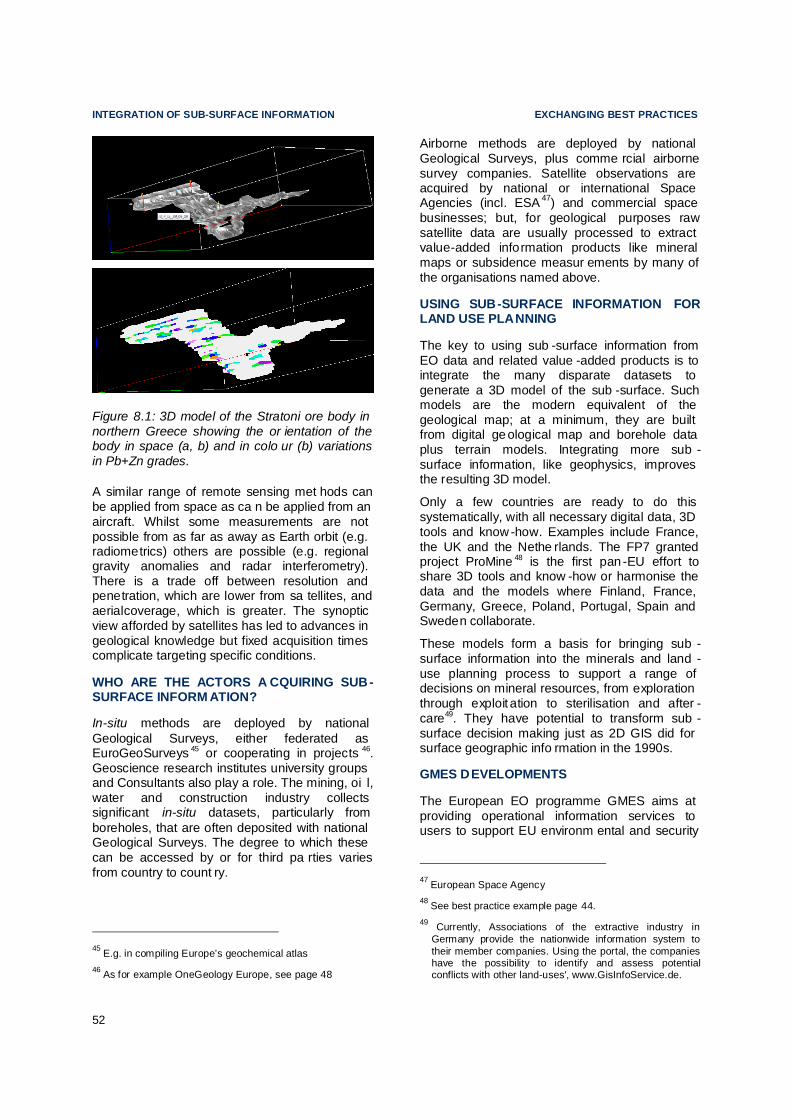
INTEGRATION OF SUB-SURFACE INFORMATION EXCHANGING BEST PRACTICES
52
Figure 8.1: 3D model of the Stratoni ore body in northern Greece showing the or ientation of the body in space (a, b) and in colo ur (b) variations in Pb+Zn grades.
A similar range of remote sensing met hods can be applied from space as ca n be applied from an aircraft. Whilst some measurements are not possible from as far as away as Earth orbit (e.g. radiometrics) others are possible (e.g. regional gravity anomalies and radar interferometry). There is a trade off between resolution and penetration, which are lower from sa tellites, and aerialcoverage, which is greater. The synoptic view afforded by satellites has led to advances in geological knowledge but fixed acquisition times complicate targeting specific conditions.
WHO ARE THE ACTORS A CQUIRING SUB-SURFACE INFORM ATION?
In-situ methods are deployed by national Geological Surveys, either federated as EuroGeoSurveys 45 or cooperating in projects 46. Geoscience research institutes university groups and Consultants also play a role. The mining, oi l, water and construction industry collects significant in-situ datasets, particularly from boreholes, that are often deposited with national Geological Surveys. The degree to which these can be accessed by or for third pa rties varies from country to count ry.
45 E.g. in compiling Europe’s geochemical atlas 46 As for example OneGeology Europe, see page 48
Airborne methods are deployed by national Geological Surveys, plus comme rcial airborne survey companies. Satellite observations are acquired by national or international Space Agencies (incl. ESA 47) and commercial space businesses; but, for geological purposes raw satellite data are usually processed to extract value-added information products like mineral maps or subsidence measur ements by many of the organisations named above.
USING SUB-SURFACE INFORMATION FOR LAND USE PLANNING
The key to using sub -surface information from EO data and related value -added products is to integrate the many disparate datasets to generate a 3D model of the sub -surface. Such models are the modern equivalent of the geological map; at a minimum, they are built from digital geological map and borehole data plus terrain models. Integrating more sub -surface information, like geophysics, improves the resulting 3D model.
Only a few countries are ready to do this systematically, with all necessary digital data, 3D tools and know-how. Examples include France, the UK and the Nethe rlands. The FP7 granted project ProMine 48 is the first pan -EU effort to share 3D tools and know -how or harmonise the data and the models where Finland, France, Germany, Greece, Poland, Portugal, Spain and Sweden collaborate.
These models form a basis for bringing sub -surface information into the minerals and land -use planning process to support a range of decisions on mineral resources, from exploration through exploit ation to sterilisation and after -care49. They have potential to transform sub -surface decision making just as 2D GIS did for surface geographic info rmation in the 1990s.
GMES DEVELOPMENTS
The European EO programme GMES aims at providing operational information services to users to support EU environm ental and security
47 European Space Agency 48 See best practice example page 44. 49 Currently, Associations of the extractive industry in
Germany provide the nationwide information system to their member companies. Using the portal, the companies have the possibility to identify and assess potential conflicts with other land-uses', www.GisInfoService.de.
B

EXCHANGING BEST PRACTICES INTEGRATION OF SUB-SURFACE INFORMATION
53
policies from local to global level, and to manage natural resources and biodive rsity.
The GMES services have been developed based on an extensive consultation with users and through a number of R&D and precursor activities. The precurso r activities demonstrated the potential of spaceborne, airborne and in-situ EO data in EU -wide integrated env ironmental and human health risk assessment of past and recent mining regions.
GMES is now moving from research to operation with the Commission pr oposal for a Reg ulation on the European Earth observation pr ogramme (GMES) and its initial operations (2011 – 2013)50 currently discussed in the European Council and Parliament. The objective is to have the regulation adopted by the end of 2010. This proposal establishes a new Community programme called GMES with pr ovision on the contents of each component (Space, in situ and services), governance issues, data policy etc. It identifies a budget of EUR 107 M for GMES initial operations for the period 2011 -2013. The objective is to have a fully -fledge GMES programme beyond 2014 with a larger budget from the next financial perspective. Therefore , the implementation of GMES operational services will be stepwise.
The development of the GMES dedicated Sentinel-1 will provide continuity of radar capacity. In addition to monitoring ground movements over time (detecting deformations down to the centimetre level), the data can also be used to generate elevation models; in combination with digital surface geology and digital borehole data, this is a fundamental building block for the construction of 3D geological models.
RECOMMENDATIONS Currently, some project -based EO services provide information that can be of use for RMI. Operational land -use services will gradually be provided by GMES from 2011 onwards. However, there is potential for further optimised EO services for geological and especially RMI purposes. This includes services based on satellite data, airborne and in-situ surveys measuring surface topography and cha nges to it, geology, soils, chemistry, mineral and phys ical
50 COM(2009)223 (final), http:// eurlex.europa.eu/LexUri
Serv/LexUriServ.do?uri=COM:2009:0223:FIN:EN:PDF.
properties in 3D and 3D structure and changes to it, throughout the sub -surface zone of human interaction.
GMES will provide parts of the needed satellite data for such services , e.g. for ground stability monitoring . These satellite data could be processed into directly us eful information for RMI by national institutes or value -adding industry in the Member States. Altern atively, GMES could also potentially directly provide such se rvices while respecting the principle of subsidiarity, of costs, benefits, political priorities etc.
The experience gained by the ProMine project should serve to develop a long -term ‘3D-Europe’ project, focussing at first on the areas with known mineral potential. The dev elopment of a pan-European programme of deep scientific boreholes data acquisition, processing and modelling should be considered as an important component of Europe’s scientific infr astructure.
The development of Europe’s 3D data acquisition and modelling capacity should be accelerated, to populate European, national, regional, local 3D models specific to RMI requirements, to integrate geological models and those of other disciplines. Three areas need to be addressed:
• integration of remote and in-situ data in 3D models for RMI appl ications;
• development and di ssemination across EU of 3D modelling methods, tools and know -how; and
• EU-wide subsurface data, information and 3D model harmonisation
RECOMMONDATIONS EXCHANGING BEST PRACTICES
54
9. SUMMARY OF RECOMMENDATIONS OF THE WORKING GROUP
This section outlines a number of oper ational recommendations for follow -up and support which are based on the lessons learned during the work in relation to:
• minerals policy, land use planning and administrative conditions for exploration and extraction;
• developing the knowledge base of Eur opean resources by promotion of better networking between European Geological Surveys, competent authorities and ac ademia with a clear EU remit; and
• developing a medium to long term strategy for integrating sub -surface components into the land services element of the GMES Land Monito ring Core Service.
Due to the diversity of political and ge ological circumstances within Member States it is not advisable to seek to impose prescriptive recommendations relating to mineral pla nning policy.
However, analysis of practices that are in place indicate that each Member State should co nsider if it would be helpful to work towards adopting the recommended policy el ements.
The group recommends a National Minerals Policy to ensure that the miner al resources are provided to society in an economically v iable way, harmonised with other national pol icies and based on sustainable development principles. This could include a commi tment to provide a legal and information framework . Within this outline, the Minerals Planning Po licy is seen as key component of the national minerals policy and should describe in d etail the ways that future minerals supply will be secured and demonstrate a strong link to broader land use planning policy and regulation. Furth ermore, a Sustainable Minerals Policy shall be based on the principles of sustainable development and incorporate economic, environmental and social requirements.
Any land use policy for minerals must utilise a robust digital geological knowledge base.
Alongside information on the resource, for certain minerals of local i mportance there should also be a method for estimating the long term demand for these materials, and a means by which this can be translated into a spatial plan while recognising the contri bution of recycled materials.
The aim of a land use policy for minerals should be, ultimately, to ensure:
• fair and equal consideration of all p otential uses of land including the eventual extraction of raw materials .
A national planning framework can help to ensure that minerals are accorded due weight in the land use planning process, and therefore in appropriate national circumstances is recommended as best practice.
The most important elements of the mi nerals exploration and extraction application pro cess are:
• clarity ,
• understanding and
• certainty of what needs to be pr ovided in order to get authorisation for minerals exploration or extra ction.
This does not nece ssarily need to take the shape of a standardised a pplication form, but instead could be set out in legislation or guidance. Speeding up the authorisation processes may be achieved through integrating the diffe rent permits required so that they are issued by one competent authority (a one-stop-shop) and with only one environmental impact assessment or by parallel assessment. It is for individual Member States to decide which el ements of best practice in authorisation to adopt, based on national circumstances.
Codes of practice are important instr uments to achieve technical, social and enviro nmental excellence. Use of codes of practice, guidelines or equivalent by industry helps to ensure protection of the environment from adverse impacts of mineral extraction.
EXCHANGING BEST PRACTICES RECOMMONDATIONS
55
There are important issues that need to be addressed to improve the knowledge base of mineral deposits in the EU. Principal among these is the lack of harmonised EU -level data sets.
Better networking between the national Geological Surveys of Member States is the basis for cooperation between relevant institutions and the Geological Survey dri ven by the need to:
• achieve synergies between the Geological Surveys;
• provide public data for policy ma king;
• facilitate investment in exploration and extraction; and
• provide minerals inte lligence.
In order to achieve these goals the know ledge base and networking must be structured, organised, long -term oriented and co nsensus based.
• Standardised and a ccurate statistical data on world wide minerals production, i mports and exports, and publication of this data on an annual basis. This would serve to analyse trends and help decision makers to better understand and monitor the EU’s supply and demand situation and r elated risks.
• Implementation of global data models and INSPIRE Directive will lead to the harmonising of the national minerals data sets for the Pan EU knowledge base. This data could then used for securing continuous supplies of raw materials from European sources, and also for planning strategies for future extraction of mineral resources and land use. Harmonisation will create uniform te rminology and standardise the terms and definitions used by Geological Surveys.
GMES will provide satellite data which are needed for providing RMI -targeted info rmation
services, and land -cover/land-use maps and monitoring which can benefit RMI. Services tailored for RMI and based on GMES data can be provided by competent national institutes or companies, or, alternatively, potentially by GMES if European funding is justified.
Medium to long term development projects should build upon experience gained by for example the ProMine project to d evelop future ‘3D-Europe’ projects while focussing at first on the areas with known mineral potential. The development of a pan -European programme of deep scientific boreholes data acquisition, processing and modelling should be consi dered as an important component of Europe’s scientific infrastructure.
The development of Europe’s 3D data acquisition and modelling capacity should be accelerated, to populate European, national, regional, local 3D models that are specific to RMI requirements and to integrate geological models with those of other disciplines. Three areas need to be addressed:
• integration of remote and in-situ data in 3D models for RMI appl ications;
• development and di ssemination across EC of 3D modelling methods, tools and know-how; and
• EC-wide subsurface data, information and 3D model harmonis ation.
The Working Group concluded that the replies to the questionnaires and the di scussions of both Working Groups (i.e. the one on exchanging best practices and the pa rallel one on defining critical raw materials for the EU ) clearly indicated that the actions required in the sector have to respond to the very dynamic changes due to the global, European, national and local needs.
The Working Group recommends to e stablish an annual event on mineral resources issues especially with regards to knowledge and research and exchange of best practices on minerals policies under the EU Council Presidency in cooperation with the Commission.

REFERENCE EXCHANGING BEST PRACTICES
56
10. REFERENCE
Boliden AB (2006) The closure of the St ekenjokk mine in Northern Sweden and 15 years of post -closure follow-up
Boliden AB and Luleå Tekniskal Universitet (Figure 6.3)
Christmann P., EuroGeoSurveys (2004). Towards a thematic strategy on the su stainable use of natural resources: Working Group 1 - Supply of Resources. The European Union 6th Environmental Action Pr ogramme
Committee of Ministers to Member States (2002) Recommendation on Guiding Principles for Sustainable Spatial Development of the European Continent, adopted 30 th January 2002
Department of Mining and Tunnelling, University of Leoben, Austria (November 2004). Mineral Planning Policies and Supply Practices in Europe. Commissioned by the European Commission Enterprise Directorate General under Contract no: ETD/FIF 2003 0781
Directive 2007 /2/EC of the European Parliament and of the Council of 14 March 2007 establis hing an Infrastructure for Spatial Information in the European Community (INSPIRE)
European Commission (2010) Guidance document on Non -energy mineral extraction and Natura 2000 [in prep]
European Commission (20 th May 2009) Proposal for a Regulation of the European Parli ament and of the Council on the European Earth observation programme (GMES) and its initial operations (2011 –2013) (COM(2009)223)
European Commission (4th November 2 008) Communication on The raw materials initi ative – meeting our critical needs for growth and jobs in Europe (COM(2008)699 final).
European Commission (January 2009) Reference Document on Best Available Techniques for the Management of Tailings and Waste-Rock in Mining Activities (BREF MTWR)
Geological Survey Department, Cyprus (undated) Environmental Rehabilitation: Asbestos Mine C yprus
Godany et. al. (2003): Regional raw material policy of the Ústí n. L. region. – CGS, Prague. (Fig. 3.2 a, b)
ICMM (2006) Good Practice Guidance for Mi ning and Biodiversity , http://www.icmm.com/page/1182/good -practice-guidance-for-mining-and-biodiversity
Kullmann, U. (2002). Requirements for a modern mining law. Chronique de la r echerche minière, No hors série, p. 33
Pearman, G (2009) 101 Things to do with a hole in the ground.
Singer, D.A., 1993, Basic concepts in three -part quantitative assessments of undiscovered mineral resources: Nonrenewable Resources, 2(2). 69-81.
Šolar, S.V., Shields, D.J. , and M.D. Miller (2009). Mineral Policy in the Era of Sustainable Development: historical context and future content. RMZ - Materials and GeoEnvironment, 56(3): 304-321.
Wittmann, H . , 2007 ,Kies" for Biodiversity and Protection of Species - the Steyregg Gravel Pit Project, BHM Berg - und Hüttenmännische Monatshefte, Volume 152, Number 10 / October 2007, http://www.springerlink.com/content/y707765465504010/

EXCHANGING BEST PRACTICES ACRONYMS
57
11. ACRONYMS
4D four-dimension models (space and time)
AMD acid mine drainage
ARD acid rock drainage
BGR Federal Institute for Geosciences and Natural Resources, Germany
BGS British Geological Survey
BMWi Federal Ministry of Economics and Technology, Germany
BRGM Bureau de recherches géologiques et minières France,
CGS Czech Geological Survey
EDM Empresa de Desenvolvimento Mineiro, SA, Portugal
EIA environmental impact assessment
EU European Union
EuroGeoSurveys European Geological Surveys
FdA National Aggregates Federation, Spain
FP7 European Commissions 7th Framework Programme for Research
GSB Geological Survey, Belgium
GSC Geological Survey of Canada
IBAT Integrated Biodiversity Assessment Tool
ICMM International Council on Mining and Metals
ICOLD International Commission of Large Dams
IGME Geological Survey, Portugal
ILO International Labour Office / Geneva
INSPIRE Infrastructure for Spatial Information in the European Community
IRIS Interactive Raw Materials Information System, Austria
IUGS International Union of Geological Sciences
JOGMEC Japan Oil, Gas and Metals National Corporation
JORC Joint Ore Reserves Committee
LNEG Geological Survey of Portugal
LNEG National Laboratory for Energy and Geology, Portugal
LTCP Lavrion Technological and Cultural Park
MPPW Minerals Planning Policy Wales
MPS Mineral Policy Statements
MUA Major Urban Areas
NEEI Non-Energy Extractive Industry
NGO Non Government Organisation
PMA Post-Mining Alliance
RMI Raw Materials Initiative
ROM run-of-mine
SAMREC South African Code for Reporting of Exploration Results, Mineral Resources and Mineral Reserves
SWPEI Standing Working Party on the Extractive Industry
TNO Geolagical Survey of the Netherlands
UNFC United Nations Framework Classification for Fossil Energy and Mineral Resources
USGS United States Geological Surveys, USA
VLAREM Environmental regulatory process in the Flemish Region of Belgium
ZEPA zone of special protection for birds, Castile-La Mancha, Spain

TABLE OF FIGURES EXCHANGING BEST PRACTICES
58
12. TABLE OF FIGURES
Figure 1.1: Model of the three pillar Raw Materials Initiative and its relation to Research, Knowledge and Skills. ................................ ........... 1
Figure 3.1: Mining of building stones and aggregates in the Ústí nad Labem region with areas with need of building raw materials and with the schematic direction of distribution in year 2010 (a) and estimations for 2025 (b), reproduced from Godany et al. (2003) with permission by CGS. ................. 13
Figure 5.1: Relations of codes of best practice. 25
Figure 5.2: View of Stekenjokk mine during operation; source Boliden AB (2006), reproduced with permission by Bolden AB. ........ 30
Figure 5.3: Restored Stekenjokk mine tailings pond. Source: Boliden AB (2006) The closure of the Stekenjokk mine in Northern Sweden and 15 years of post -closure follow-up.31
Figure 5.4: Application of original mud and sludge to aid re -colonisation (top) and the successful colonisation of the area (bottom). Wittmann (2007) reproduced with kind permission of Dr. H. Wittmann. 32
Figure 5.5: Parnassos Mountain bauxi te mine during operation, with courtesy by Tzimopoulos Haralabos. .......... 32
Figure 5.6: Parnassos Mountain bauxite mine following restoration showing the right an (top) and left (bottom) slope of the former mining site as shown in Figure 5.5, with courtesy by Tzimopoulos Haralabos. ..... 33
Figure 5.7: View of Stratoni Mine, Greece, courtesy of Hellas Gold S.A. .... 33
Figure 5.8: Guided tours in the Arzberg Silver Mine. Source: Community of Arzberg................................. ..... 35
Figure 5.9: Underground cheese refining in Arzberg Silver Mine. Source: Leopold Weber ......................... 35
Figure 5.10: Troodos Mountain asbestos mine (top) and associated waste dump during operation (bottom), Environmental Rehabilitation: Asbestos Mine Cyprus (undated) Geological Survey Department, Cyprus ................................ ....... 36
Figure 5.11: Troodos Mountain asbestos mine during restoration showing re -profiled waste dumps and planting. Source: Geological Survey Department, Cyprus. ... 36
Figure 6.1: Illustration of a hidden deep -seated mineral deposit not identifiable by direct observation, modified with permission from TNO. .............. 39
Figure 6.2: Assessments and homogenising multi-layer information system within the ProMine -Project building a basis for 3D and 4D modelling. ................................ .. 39
Figure 6.3: Geological 3D model of the main geological units structures in the Skellftefield, Northern Sweden, with courtesy of Boliden AB and Luleå Tekniskal Universitet. ..... 40
Figure 8.1: 3D model of the Stratoni ore body in northern Greece showing the orientation of the body in space (a, b) and in colour (b) variations in Pb+Zn grades. .......................... 52

ANNEX EXCHANGING BEST PRACTICES
I
13. ANNEX

ANNEX EXCHANGING BEST PRACTICES
II
I. MEMBERS OF THE AD-HOC WORKING GROUP
CHAIR SPILIOPOULOU Maria, Chairman of the Group, European Commissi on, Enterprise and Industry DG MEMBERS - IN ALPHABETICAL ORD ER – ARVANITIDIS Nikos; IGME (Institute of Geology and Mineral Exploration), Greece BARNES Dave, IMERYS Minerals Limited CHRISTMANN Patrice, BRGM, France DE VISSCHER Frédéric, Carmeuse Group, Belgium FEITO Jorge, Magnesitas Navarras 51 HEEROMA Pierre, Boliden AB HOBDEN Ken, Mineral Products A ssociation KULLMANN Ulrich, BMWi (Ministry of Economy and Technology) Germany LAHTINEN Raimo, GTK ( Geological Survey of Finland) Finland MANKELOW Josef M., BGS (British Geological Survey) United Kingdom MARTINS Luís Plácido, DGEG (Direcção -Geral de Energia e Geologia) Ministry of Ecomomy and Innovation, Portugal MASSON Josiane52 European Commission, Enterprise and Industry DG MORLIERE Adeline, Ministry of Ecology , Energy and Sustainable Development,France PAYNE Agata, European Commission, Environment DG PIETERSEN Hans, Ministry of Transport, Public Works and Watermanagement, The Netherlands PRADO ORCOYEN Lorena, Ministry of Industry, Tourism and Co mmerce, Spain RAMBOUSEK Petr, CGS (Czech Geological Survey) Czech Republic SCHÄCHTER Norbert, VRB SCHLOTMANN Mathias, CEPMC
51 Mr. Feito was replaced at a certain stage by Alberto Josa
– same company. 52 Ms Masson was replaced at a certain stage by Espen
Volden same unit.
ŠOLAR Slavko V., Geological Survey of Slovenia, Slovenia SVANFELDT Gunnar, Mining Inspectorate of Sweden (Falun office), Sweden SZAMALEK Krzysztof, Geological Survey, Poland VERHAERT Griet Environment, Nature and Energy Department - Flemish Government, Belgium WEBER Leopold, BMWFJ, Federal Ministry of Economy, Family and Youth, Austria WERNECK Ulrich, Süd-Chemie WITTENBERG Antje, European Commission, Enterprise and Industry DG ZAFIRATOS Ioannis, Hellenic Ministry of Development, Greece Some NGOs invited have not attended the meetings of the Group. SUB GROUP ON GMES CHEVREL Stéphane, BRGM, France MARSH, Stuart, British Geological Survey, United Kingd om JEANJEAN Herve, Entrerprise and Industry DG VOLDEN Espen, Entrerprise and Industry DG INVITED EXPERTS DAVIES Elizabeth, Land Use Consultants DRILSMA, Johannes, Euromines FELL Antoni, UEPG FRICKE Dirk, UEPG GRANTHAM Jon, Land Use Consultants HEBESTREIT Corina, Euromines HIBLOT Mathieu Unicem LAWLOR Niall, European Commission, Enterprise and Industry DG OWENS Catrin, Land Use Consultants KADL•ÁKOVÁ Jitka, GeoBusiness Commission, Germany WYART, Michelle, IMA -Ruope

exchanging best practices Annex
III
Proposed action related to the work of the ad hoc working group “exchanging best pra ctices on land use planning, permitting and geological know ledge sharing”
II. EUROPEAN MINERALS NETWORK
eMINEnt
Recommendation: Set up a European Minerals Network (eMINEnt) based on:
Raw Materials Initiative: “Securing reliable and undistorted access to raw materials is increasingly becoming an important factor for the EU’s competitiveness and, he nce, crucial to the success of the Lisbon Partnership for growth and jobs.”
“The sustainable supply of raw materials based in the EU requires that the knowledge base of mineral deposits within the EU will be improved. In addition, the long term access to these deposits should be taken into account in land use planning. Therefore the Commission recommends that the national geological su rveys become more actively involved in land use planning within the Member States. In line with the principle of subsidiari ty, the Commission proposes to provide a platform for Member States to exchange best practices in the area of land use planning (such as for example the Austrian Minerals Plan) and other important framework conditions for the extractive industry. Moreover, the Commission recommends better networking between the national geological surveys to facilitate the exchange of information and improve the interoperability of data and their dissemination, with particular attention to the needs of SMEs. Additionally, t he Commission, in conjunction with Member States, will look into developing a medium to long term strategy for integrating sub -surface components into the Land service of Kopernikus18, which can feed into land-use planning and improve its quality. “
Work at the national level: such as (a) available data and information, (b) analytical expe rtise / studies, (c) interpretation and modelling, and (d) improved coordination among different data suppliers and data consumers at EU level and possibly at the EU-US level.
Maximise the benefits from past and current EU -funded projects: such as Promine, EuroGeoSource, A EGOS, etc
Aim: Mineral intelligence encompasses a broad suite of information, including but not limited to supply and demand data. This data is fundamental to evaluate the availability of mineral raw materials within the EU, the EU´s import dependence, potential supply risks as well as environmental and social aspects. Based on this EU minerals information knowledge base, policy makers and actors in the ec onomy and the society can make better informed decisions to evaluate the EU´s competitiveness of this sector. EU member states and the EU Commission may also use the results to develop suitable instruments to counteract problematic developments.
Much of the partly geo -referenced data on mineral raw materials is already available for the EU. The difficulty is that these data e.g. for raw material reserves/resources, production, consumption, imports, exports etc. currently reside in numerous different locatio ns, are captured, collated and disseminated by different institutions, and are stored mostly in national systems in forms that may not be interoperable. Similarly, minerals expertise is available, but is housed in a variety of institutions, including government agencies, universities, NGO’s and industry. There is need for a network to facilitate access to these resources and to promote collaboration among experts; however, the creation of new staffed EU body is not the purpose of this proposal.
EuroGeoSurveys’ member organisations hold vast amounts of data in different forms, as well as expertise, knowledge and interests. As a result they are well placed to facilitate better communication and cooperation. The proposed action to strengthen cooperation will start with developing a jointly agreed database of the mineral resources expertise (by field), equipment, human resources (noting language skills), and types of data (noting format) in various surveys. Coordination by EGS is essential to demonstrate me mbers’ research

ANNEX EXCHANGING BEST PRACTICES
IV
potential, the excellent EU know ledge base, and the usefulness of outcomes and benefits from the application of geosciences to soc iety.
ACTIVITIES OF EMINEN T:
To foster the EU non -energy extractive i ndustry sustainability and its contributions to the goals of the Lisbon strategy on economic growth and competitiveness and of the Sustainable Development Stra tegy.
Facilitate provision of accurate and ad equate information on minerals both within and outside Europe for use by the European Union institutions, industry and members states, including:
Information on mineral resources, reserves, production, and areas of mineralization,
Economic (market) conditions, enviro nmental and social impacts,
Forecasts of potential impacts of proposed raw materials, economic and enviro nmental policies.
Recommend methods for, and assist in, organising and harmonising EU mineral intelligence (statistical and spatial information), including:
Evaluation of available minerals data and information (including the authority responsible for minerals data accuracy, adequacy, and relevance),
Enhancement of the existing mineral intell igence capacity at the national and intern ational levels,
Coordination of the activities of the various minerals intelligence centres and cooper ation with other data centres / organ isations.
To enhance sustainable development of the non -energy extractive sector in developing cou ntries
To support data/ information infrastructures, and
Capacity building and institutional strengt hening.
To foster education and to support better communication with the general public and specific stakeholders in order to facilitate balanced and well -informed debates and decisions related to the non -energy extractive industry.
STRUCTURE OF EMINENT
The Network will compris e three programmes and their coordination. Each programme will have domicile at one, or possibly more, national geological survey, and will have a planned
annual or biennial output. Coordination will be undertaken by EuroGeoSurveys. Each programme will b uild on existing national -level data that is already collected, or including that for which annual national -level collection is mandatory, together with the outcomes of relevant, in particular EU, minerals projects and other sources. All data and informati on will conform to European -level standards, through adaptation or transfo rmation if needed.
eMINEnt will be structured to have an (inner) core group networking and an (outer) broader group (including data users) networking. Programmes will be cross -linked horizontally and vertically linked to coordination. Coordination will serve a two-fold purpose: (a) to serve as technical and other support to programmes, (b) to perform horizontal activities relevant to all programmes.
Figure 1: Structure of eMINEnt (three programmes and coordination)
The individual programmes, their coordination and tasks will be:
PROGRAMME 1 – DEPOSIT
Rationale: This Programme has a direct link to the Raw Materials Initiative text: “the know ledge base of mineral deposits within the EU...”
Aim: The Programme will develop an investors portal giving information on the mineral resources and deposits within European Union.It includes ideas from the previous proposal ‘Critical Minerals Deposits Information System’ (CriSys) and aims: (a) t o develop the interoperability of mineral deposits (EarthResourcesML) -related geographic information in line with, and beyond, the INSPIRE Directive requirements, and (b) to collect, organise and make available to policy -makers and industry EU knowledge o f mineral

exchanging best practices Annex
V
(including critical ones) to the EU and of mineral resources / deposits, both onshore and of fshore.
The EU mineral deposit database will include the spatial distribution of mineral deposits on an appropriate IT platform and will emphasise deposits of critical minerals. The Pr ogramme outputs will be appropriate for use at a variety of scales, from that appropriate to land use planning up to the pan -European level. Input to the database is expected from geological surveys, mine authorities, academia , and institutes. Several sets of data will be collected including geology, airborne geophysics, multi -element geochemistry and others.
The Programme will be linked with GMES.
Product: Map of mineral deposits in Europe
Proposed domicile:
Bureau de Recher ches Géologiques et Minières - BRGM, France
Inner network:
Geological Survey of Finland – GTK, Finland
Institute of Geology and Mineral Expl oration – IGME, GR
Sveriges Geologiska Unde rsoumlökning – SGU, Sweden
Geološki zavod Slovenije – GeoZS, Slovenia
PROGRAMME 2 - RESOURCE
Rationale: At the national level, different sets of minerals data are collected. Besides core information on production and reserve statistics, mineral information consists of (a) technical data (mining, processing, metallurgical oper ations), (b) economic data (production, reserves & resources, trade, down -stream use/consumption, imports/exports), (c) mineral policy, plans, programmes and regulation information (permitting, taxation, sta ndardization, labour, environment), (e) environmen tal information (environmental impact, resource efficiency), (d) social mining information (H&S, labor issues, education, communication, partnership, local community, certification, SME & small scale mining, NGOs), and (f) RTD & innovation information (science & applied projects).
Aim: To collect national -level data on minerals, to harmonise it, and then present it at the European level in accordance with data already collected by EUROSTAT that has a clear mandate by MS and EC for economic data on , for example, exports and imports. In combination
with Programme 1, this data would contribute to an EU-level minerals intell igence database. As in Programme 1, there will be emphasis on critical minerals. Input is expected from national authorised bodies, e.g., collecting minerals data, in particular from governmental agencies and national surveys. Data and information will be public.
Product: European Minerals Yearbook
Proposed domicile:
British Geological Su rvey - BGS, UK
Inner network:
Institute of Geology a nd Mineral Exploration – IGME, Greece
Sveriges Geologiska Undersoumlökning – SGU, Sweden
Geological Survey of Finland – GTK, Finland
PROGRAMME 3 - OUTLOOK
Rationale: An annual or biennial report on the minerals supply situation in Europe will not only add to the knowledge base on minerals in Europe, but will underscore the need for the minerals information provided by Programmes 1 and 2. Outlook will carry out a ssessments of the EU mineral raw material situation – based on Programmes 1 and 2 – and by using econometric methods, which are partly b eing developed within the EU Raw Materials Initiative ad-hoc Group “Defining critical raw materials”. The results will provide policy makers and actors in the economy and the society with a fundamental analysis of the markets allowing them to develop suitable instruments to counteract problematic d evelopments.
Aim: To produce an annual forward -looking analysis of the minerals supply and demand situation in Europe with special attention given to critical minerals based on the outputs of the programmes DEPOSIT and RESOURCE and various other sources. This Outlook will provide a firm basis for informed ongoing discussion and a solid base for decision making at different levels and by different groups of stak eholders.
Product: European Minerals Outlook
Proposed domicile:
Bundesanstalt für Geowissenshaften und Rohstoffe - BGR, Germany
Inner network:
Geological Survey of Finland – GTK, Finland

ANNEX EXCHANGING BEST PRACTICES
VI
COORDINATION
Rationale: Coordination of the activities of the three programmes is e ssential to ensure that the work is carried out effectively and efficiently, ensuring mutual cooperation and avoiding any duplication of effort.
Aim: The Coordination will have multiple responsibilities. It will undertake activities that are necessary for all programmes, so as to have a consistent approach avoid redundant e fforts. For example, it will deal with horizontal activities, such as terminology, data intero perability and communication / educ ation and promotion. It will facilitate communication wit hin and outside the network, preparing a uniform design for eMINEnt products, including a web portal, which it will maintain. It will deal with distribution / dissemination of network products – annual/biennial publications that will be available in paper and through a network web portal. Furthermore, the Coordination will maintain the network of experts and enhance cooperation with other bodies (such as OECD, World Bank and others) with a similar purpose elsewhere e.g countries /Canada, USGS, APC and BRIC countries/, academia, industry, associations, etc. It will initiate and organise minerals -related meetings and conferences. It should also communicate with the ETP SMR and propose plans and topics for further research on the basis of identified knowledge g aps. Finally, the Coordination will manage outreach to, and interaction and communication with, developing countries. This is a horizontal activity in that it will necessitate involvement of Programmes 1, 2, and 3.
Product: Web portal, publications, outrea ch activities, etc…
Proposed domicile:
EuroGeoSurveys, Belgium
Financing: Implementation of the eMINEnt network is possible if an appropriate, already available, funding source at EU level is identified. The following additional requirements also need to be fulfilled:
Memorandum of understanding among Member States / Geological Surveys,
Co-financing among EC and member states; industry should be included.
Basis of this proposal:
Outcomes of two TAIEX workshops: (a) INFRA 25708 that was organised in co -operation with Geological Survey of Slovenia and Eurogeosurveys, in Ljubljana, Slovenia, December 10 -11, 2007, (b) INFRA 26211 that was organised in co -operation with Eurogeosurveys, in Brussels, Be lgium, February 14-15, 2008
Questionnaire of Eurogeosurveys circulated in January 2008 among European Geological surveys.
Questionnaires of Ad Hoc working group “exchanging best practices on land use pla nning, permitting and geological knowledge sharing”, November 2009
Discussion with DG Enterprise and internal discussion with secretariat of EGS, in particular within Mineral Resources Expert Group at the beginning of 2010.
April, 2010
APPENDIX 1: POTENTIAL AREAS OF ACTIVITY OF THE NETWORK 1. Available data and expertise,
1.1. Raw Data:
1.1.1. Production, Re serves and resources,
1.1.2. Trade,
1.1.3. Recycling,
1.1.4. Consumption,
1.1.5. Mineral potential in Europe, new mi ning projects
1.1.6. Closed, abandoned mines / mining areas.
1.2. Aggregated Data and Indicators
1.2.1. Economic, environmental and social,
1.2.2. EUROSTAT – environmental, national satellite accounts,
1.2.3. TSSNR (Thematic strategy on…)
1.2.4. EU SDI indicators of mining se ctor.
2. Analytical expertise / studies,
2.1. Terminology – Semantics,

exchanging best practices Annex
VII
2.2. Improved reporting (reporting culture can be improved by demonstrating added value, engaging CEOs, proving that confidentiality is recognised),
2.3. Information technology – website collecting and sharing,
2.4. Sharing guidelines and best practices, and also telling failures.
3. Data interpretation,
3.1. EU mineral supply and material requirements,
3.2. EU trade pattern internally and with rest of world,
3.3. EU security of supplies issues,
3.4. EU critical minerals.
4. Improved coordination among different data suppliers and data co nsumers.
4.1. Cooperation and Data Integr ation among data suppliers:
4.1.1. Academia,
4.1.2. Mining and geological instit utions
4.1.3. Agencies on national level (St atistics, Customs, Environmental Agency),
4.1.4. Industry level (Chamber of commerce, private institut ions), and
4.1.5. Minerals related (law, administrative, environmental, economic, social instit utions that also deal with mineral resources /GMES, INSPIRE, ../).
4.2. Coordinating groups include data suppliers and consumers:
4.2.1. European national dat a collection centers (mostly Geological su rveys),
4.2.2. EEA, EUROSTAT, Data Centre, JRC,
4.2.3. US (USGS in particular), Canada, Australia,
4.2.4. Industry,
4.2.5. OECD, World Bank,
4.2.6. ACP countries, BRIC countries,
4.2.7. Land Use Planners,
4.2.8. Civil society,
4.2.9. MFA community.
Copyright © 2022 FDOKUMEN