Impacts of future climatic and land cover changes on the hydrological regime of the Madeira River...
13
Impacts of future climatic and land cover changes on the hydrological regime of the Madeira River basin J. L. Siqueira Júnior & J. Tomasella & D. A. Rodriguez Received: 13 December 2013 /Accepted: 18 January 2015 # Springer Science+Business Media Dordrecht 2015 Abstract Brazilian strategic interest in the Madeira River basin, one of the most important of the southern Amazon tributaries, includes the development of hydropower to satisfy the country’ s growing energy needs and new waterways to boost regional trade and economic development. Because of evidences that climate change impacts the hydrological regime of rivers, the aim of this study was to assess how global climate change and regional land cover change caused by deforestation could affect the river’ s hydrological regime. To achieve this goal, we calibrated a large-scale hydrological model for the period from 1970–1990 and analyzed the ability of the model to simulate the present hydrological regime when climate model simulations were used as input. Climate change projections produced by climate models were used in the hydrological model to generate scenarios with and without regional land-use and land-cover changes induced by forest conversion to pasture for the period from 2011– 2099. Although results show variability among models, consensus scenarios indicated a decrease in the low-flow regime. When the simulations included forest conversion to pasture, climate change impacts on low flows were reduced in the upper basin, while, in the lower basin, discharges were affected along the whole year due to the more vigorous land-use conversion in the Brazilian region of the basin. 1 Introduction The Amazon basin, generally considered to be one of the world’ s critical biodiversity hotspots, is a mosaic of ecosystems, vegetation types and various forest formations in addition to including several types of savanna and natural pasture formations. The basin includes a large variety of landscapes, soils, geological domains and different climate regimes that determine contrasting hydrological regimes (Molinier et al. 1996). Recently, the region has drawn the attention of the scientific community because of the occurrence of extreme events, all of them with approximately 100 years of recurrence, including severe hydrological droughts from 2005 Climatic Change DOI 10.1007/s10584-015-1338-x Electronic supplementary material The online version of this article (doi:10.1007/s10584-015-1338-x) contains supplementary material, which is available to authorized users. J. L. S. Júnior (*) : J. Tomasella : D. A. Rodriguez Centro de Ciência do Sistema Terrestre - INPE, Cachoeira Paulista, Brazil e-mail: [email protected]
Transcript of Impacts of future climatic and land cover changes on the hydrological regime of the Madeira River...
Impacts of future climatic and land cover changeson the hydrological regime of the Madeira River basin
J. L. Siqueira Júnior & J. Tomasella & D. A. Rodriguez
Received: 13 December 2013 /Accepted: 18 January 2015# Springer Science+Business Media Dordrecht 2015
Abstract Brazilian strategic interest in the Madeira River basin, one of the most important ofthe southern Amazon tributaries, includes the development of hydropower to satisfy thecountry’s growing energy needs and new waterways to boost regional trade and economicdevelopment. Because of evidences that climate change impacts the hydrological regime ofrivers, the aim of this study was to assess how global climate change and regional land coverchange caused by deforestation could affect the river’s hydrological regime. To achieve thisgoal, we calibrated a large-scale hydrological model for the period from 1970–1990 andanalyzed the ability of the model to simulate the present hydrological regime when climatemodel simulations were used as input. Climate change projections produced by climate modelswere used in the hydrological model to generate scenarios with and without regional land-useand land-cover changes induced by forest conversion to pasture for the period from 2011–2099. Although results show variability among models, consensus scenarios indicated adecrease in the low-flow regime. When the simulations included forest conversion to pasture,climate change impacts on low flows were reduced in the upper basin, while, in the lowerbasin, discharges were affected along the whole year due to the more vigorous land-useconversion in the Brazilian region of the basin.
1 Introduction
The Amazon basin, generally considered to be one of the world’s critical biodiversity hotspots,is a mosaic of ecosystems, vegetation types and various forest formations in addition toincluding several types of savanna and natural pasture formations. The basin includes a largevariety of landscapes, soils, geological domains and different climate regimes that determinecontrasting hydrological regimes (Molinier et al. 1996). Recently, the region has drawn theattention of the scientific community because of the occurrence of extreme events, all of themwith approximately 100 years of recurrence, including severe hydrological droughts from 2005
Climatic ChangeDOI 10.1007/s10584-015-1338-x
Electronic supplementary material The online version of this article (doi:10.1007/s10584-015-1338-x)contains supplementary material, which is available to authorized users.
J. L. S. Júnior (*) : J. Tomasella :D. A. RodriguezCentro de Ciência do Sistema Terrestre - INPE, Cachoeira Paulista, Brazile-mail: [email protected]

to 2010 (Marengo et al. 2008; Tomasella et al. 2011) and major floods from 2009 to 2012(Marengo et al. 2013).
The Madeira River is already one of the Amazon tributaries experiencing intense defores-tation (Trancoso et al. 2009). The size and the rapid rate at which the forest is being convertedto either agricultural or pasture have fueled scientific interest about the potential impacts ofthose changes on the hydrological regime of the Amazon River (Coe et al. 2009). In addition,climate change (CC) scenarios predicted using regional climate models indicate that the centraland eastern Amazon regions may experience rainfall deficiencies in the future and anincreased frequency of extreme precipitation events over most of western Amazonia(Marengo et al. 2011).
In regard to identifying the determinant factors of land-use and land-cover changes (LUCC)in Amazonia, the essential role of the combination of economic factors and national policies isundeniable (Geist et al. 2006). In this context, the Brazilian federal government has set outplans to push economic development through an initiative known as the Growth AccelerationProgram - PAC (PAC 2013). The PAC has made investments of public and private fundstotaling $52 billion in the Amazon region between 2012 and 2014 and is planning anadditional investment of $36 billion through 2020. Of the total amount invested in theBrazilian Amazon, 37 % will be allocated in the construction of hydropower dams, whichcorresponds to 45 % of the planned energy expansion during the period. The new dams willincrease the Brazilian Amazon’s share of power generation to 23 % of the national output, upfrom 10 % today. Therefore, the decisive role of the Amazon region in balancing Brazil’sfuture energy requirements is crucial.
The objective of this paper is to analyze how land use, land cover and global climate mayimpact the hydrological regime of the Madeira River. We calibrated a large-scale hydrologicalmodel to the Madeira Basin using comprehensive quality controlled meteorological andhydrological data from Bolivia, Brazil and Peru, rather than reanalysis (Ribeiro Neto et al.2008), or satellite data (Collischonn et al. 2008), or models comparisons (Guimberteau et al.2012) as in previous studies in Amazonia. We verified the performance of the hydrologicalmodel in terms of river discharges in 19 sub-basins using both observed data and climatemodel simulations as input for the period 1970–1990. This analysis, generally not consideredin previous studies, is critical to reduce the uncertainties of the projected scenarios.
We assessed the potential impacts on the hydrological regime of several global climateprojections with and without the inclusion of regional deforestation trajectories in two keylocations in Bolivia and Brazil. While in most previous studies in Amazonia (for instanceGuimberteau et al. 2012) the impacts on hydrological regime have been assessed in terms ofmonthly and sometimes annual discharges, we analyzed impacts in terms of high and lowdischarges extracted from the flow duration curve. Since the impacts of global climate changeand regional land cover changes are more significant in the extremes rather than on the meanvalues, we concluded that the most previous studies could be underestimating the potentialimpacts.
2 Study area
With drainage area of approximately 1,420,000 km2 across Bolivia (51 %), Brazil (42 %) andPeru (7 %), the Madeira River is one of the most important Amazonian tributary. The Madeirariver mean discharge at its mouth to the Amazon is approximately 31,704 m3s−1, whichcorresponds to 15 % of the Amazon mean discharge. Andean tributaries of the Madeira Riverdrain semi-arid areas of high altitude and areas of tropical humid forest of the piedmont. The
Climatic Change

basin mean average rainfall is approximately 1834 mm year−1 (Molinier et al. 1996), with astrong spatial variability ranging from 255 mm year−1 at the station of Caracato (2650 masl) inthe Bolivian Andes to more than 3000 mm year−1 in stations located at less than 1500 masl(Espinoza Villar 2009).
3 Data and methodology
This section provides a brief summary of the type of data, data processing and models used inthis paper. SupplementaryMaterial, sections S.1-6, presents a detailed description of the sourcesof data, the hydrological model formulation, climate models used and the methodology.
We assembled meteorological, hydrological and soil data from different sources of Bolivian,Brazilian and Peruvian sources (Fig. 1). Topographic and historical LUCC trends were derivedfrom satellite data. For future projections, we combined regional LUCC trajectories with globalCC from a suite of IPCC models.
The distributed hydrological model developed at the Instituto Nacional de PesquisasEspaciais, hereafter referred as MHD-INPE (Tomasella and Rodriguez 2014), was calibratedin 19 sub-basins of the Madeira River using observed discharges and interpolated meteoro-logical data as input) for the period from 1970 to 1990 by applying the Shuffled ComplexEvolution Algorithm (Duan et al. 1994) to the simple average of two objective functions(performance criteria). In addition, the performance of the model was evaluated using FlowDuration Curve—FDC signatures (Ley et al. 2011).
Observed meteorological data was also used to correct the bias of climate models simula-tions, both for present (1970–1990) and future (2011–2099) climate. To assess the ability ofthe hydrological model to simulate discharge when using climate model results as input, wecompared observed flow duration curves with simulations of the hydrological model for thepresent climate.
Bias-corrected climate projections were then used as the input of the hydrological model toassess the impact of CC on river discharges on the monthly means and various FDCsignatures, including and excluding regional LUCC trajectories. We used the non-parametricWilcoxon test for medians to assess statistically significant changes in FDC signatures.
Finally, we analyzed the potential impact of CC, both including and not including LUCCtrajectories in two representative discharge stations in the upper and lower Madeira basin; andin terms of hydropower generation in Santo Antonio run-of-river plant, currently underconstruction in the lower Madeira basin.
4 Results and discussion
4.1 Climate model projections
After bias correction the climate projections (details in the Supplementary Material S.7)indicate a reduction of the mean annual rainfall of −13.8, −8.1, −13.5 and −12.8 % for themodels M1, M2, M3 and M4, respectively, at the end of the century. The global models MR5,CSR and HD2 showed a decrease in rainfall of −0.01, −1.3 and −4.0 %, respectively. Theseresults are consistent with those of Marengo et al. (2011). Finally, the projections from IPSshow a different sign and variability, suggesting an increase of 2.8 % on average by the end ofthe century. In terms of temperature, model projections suggest an increase of the averagetemperature for the period from 2071–2099 ranging from 3.8 °C in M2 to 6.2 °C in M4.
Climatic Change

Fig. 1 On the top shows the location of the Amazon and Madeira River basins; at the bottom shows theelevation and drainage network map of the Madeira River basin showing rainfall, discharge stations and thehydropower plants
Climatic Change

4.2 Discharge simulations for the period from 1970–1990
The results of the calibration procedure of the hydrological model for 19 sub-basins usingobserved data as input showed that the values of NS and NSlog were above 0.7 in allcatchments, except for the Miraflores and Ariquemes sub-basins. The worst model perfor-mance is observed in Miraflores with NS equal to 0.53, which is acceptable for the purpose ofthis study (Moriasi et al. 2007).
Discharge simulated for historical period (1970–1990), using atmospheric data as input, areconsistent with results obtained from the calibration stage. Percentage biases of the runoff wereless than 20 % and FDC signatures were consistent between simulations using observedmeteorological data and climate model outputs.
Supplementary Material S.8 includes details about data processing, the hydrological modelimplementation and calibrations, as well as the performance of the model for each sub-basinsusing meteorological observations and atmospheric simulations as input.
4.3 Global climate and land-use and land-cover changes impacts
For the sake of simplicity, we show the results for two representative gauging stations: PuertoSiles, in the upper basin, and Fazenda Vista Alegre, in the lower basin (Fig. 1). For clarity,baseline information shown in the figures of this section corresponds to the average of monthlydischarge of all climate models for the period 1970–1990, although hydrological impacts werecalculated considering the difference between the results for future projections of each modeland the simulation of the same model for the period 1970–1990. The statistical significance ofthe differences between the projections and baselines are shown in Tables S.8 and S.9 insection S9 of Supplementary Material. We considered that the potential impacts on thehydrological cycle due to LUCC and global climate change are more reliable when thedischarges projected shown consensus in signal and along different time slices.
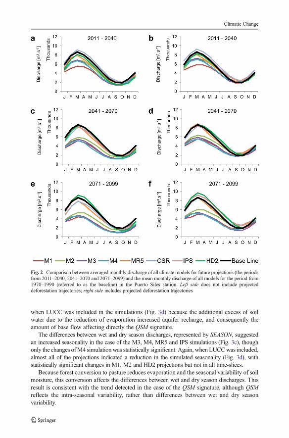
For the scenarios where regional LUCC are not included, most of the models indicated areduction in mean monthly discharges at Puerto Siles, as shown in Fig. 2 (a, c and e). However,CSR and HD2 projections indicated discharges higher than the baseline, mainly during the wetseason, for the periods 2011–2040 and 2071–2099 respectively. With the inclusion of LUCC(Fig. 2b, d and f), the impacts of CC are partially counterbalanced and the dry seasondischarges increased for several of the models, except for the CSR projection for the period2011–2040, which showed a reduction in low discharges. Moreover, the effects of LUCC inthe wet season discharges were relatively less important than in the lower discharges.
Regarding the FDC signatures, M1, M2, M4 and MR5 projections showed a reduction theslope of the FDC for medium range discharges, QSM. Meanwhile, M3, CSR, IPS and HD2projections indicate a gradual increase, up to a 26 % increase in the case of the IPS simulation(Fig. 3a). However, it is important to note that only the M2 projection for 2041–2070 and HD2projection for 2071–2099 were statistically significant. When LUCC trajectories were includ-ed, QSM decreased for at least one period in the M3, MR5, CSR, IPS and HD2 simulations(Fig. 3b).
The mid-segment of the FDC is associated with flows from moderate size precipitation andto the intermediate-term primary and secondary base flow relaxation response of the basin(Yilmaz et al. 2008; Ley et al. 2011). QSM signature also represents the medium-rangevariability of runoff coefficients (Ley et al. 2011). Therefore, steeper slopes of the FDCindicate an increased flashiness of the discharge responses to precipitation (Ley et al. 2011),which are a response to increasing intra-seasonal variability of rainfall affecting the rainfall-runoff responses as observed, for instance in IPS projection (Fig. 3a). This effect was reduced
Climatic Change
when LUCC was included in the simulations (Fig. 3d) because the additional excess of soilwater due to the reduction of evaporation increased aquifer recharge, and consequently theamount of base flow affecting directly the QSM signature.
The differences between wet and dry season discharges, represented by SEASON, suggestedan increased seasonality in the case of the M3, M4, MR5 and IPS simulations (Fig. 3c), thoughonly the changes ofM4 simulationwas statistically significant. Again, when LUCCwas included,almost all of the projections indicated a reduction in the simulated seasonality (Fig. 3d), withstatistically significant changes in M1, M2 and HD2 projections but not in all time-slices.
Because forest conversion to pasture reduces evaporation and the seasonal variability of soilmoisture, this conversion affects the differences between wet and dry season discharges. Thisresult is consistent with the trend detected in the case of the QSM signature, although QSMreflects the intra-seasonal variability, rather than differences between wet and dry seasonvariability.
Fig. 2 Comparison between averaged monthly discharge of all climate models for future projections (the periodsfrom 2011–2040, 2041–2070 and 2071–2099) and the mean monthly discharge of all models for the period from1970–1990 (referred to as the baseline) in the Puerto Siles station. Left side does not include projecteddeforestation trajectories; right side includes projected deforestation trajectories
Climatic Change

With regard to the long-term sustainability of flow, indicated by MWL, all projections areconsistent with the possibility of low flows being significantly lower in the scenarios withoutregional LUCC changes (Fig. 3e). Most of these changes were statistically significant. Theimpacts were reduced by the inclusion of forest conversion to pasture (Fig. 3f): only M1, M3
Fig. 3 Variability between modeled and simulated signatures of the flow duration curve—FDC in the PuertoSiles station: slope of the FDC at the medium range—QSM (a–b); differences between wet and dry seasondischarges—SEASON (c–d); low flow segment of the FDC – MWL (e–f); and high flow segment of the FDC –MWH (g–h); Simulated discharges are the result of hydrological model simulations using data as input for allclimate models using data for the period from 1970–1990. Left side panels do not include projected deforestationtrajectories; right side include projected deforestation trajectories
Climatic Change

and M4 showed significant reduction of MWL, while HD2 showed significant increment(Table S.8 in the Supplementary Material). These results indicate that land use conversion,which is associated with the reduction of transpiration, partially counterbalance the reductionof rainfall and increase potential evaporation projected in most climate change scenarios(Supplementary Material S.10). In general, there was no consensus among projectionsconcerning the signals in peak discharges indicated by the MWH statistic, both under climatechange scenarios and considering the conversion of forest to pasture (Fig. 3g–h). Most of thestatistically significant changes resulted in decreasing MWH.
Figure 4 shows the mean monthly discharge simulations for the Fazenda Vista Alegrestation. Most of the scenarios in the simulations without deforestation (Fig. 4a, c, and e)suggested a reduction of discharge along the whole year. However, CSR projections producedhigher than the baseline discharges in 2011–2040, while IPS projections discharges werehigher in 2041–2070 and 2070–2099. Comparing the projections in Puerto Siles (Fig. 2a, cand e) and Fazenda Vista Alegre (Fig. 4a, c, and e), HD2 projections have the most differentbehavior (particularly for the period 2071–2099) among all the other climate models, associ-ated with changes in the spatial distribution of rainfall.
When LUCC are introduced in the simulations (Fig. 4b, d, and f), IPS, CSR and MR5models indicated higher than the baseline discharges, with a larger variability among modelsboth in signal and along time-slices. This result differs with the impacts predicted for the upper
Fig. 4 Comparison between averaged monthly discharge of all climate models for future projections (the periodsfrom 2011–2040, 2041–2070 and 2071–2099) and the mean monthly discharge of all models for the period from1970–1990 (referred to as the base line) in the Fazenda Vista Alegre station. The left side does not includeprojected deforestation trajectories; the right side includes projected deforestation trajectories
Climatic Change

gauging station of Puerto Siles, where the inclusion of deforestation in the simulationsprimarily affected the dry season discharge (Fig. 2b, d, and f), whereas in Fazenda VistaAlegre (Fig. 2b, d, and f), the impacts occurred over the entire year. The differences in theimpact of LUCC in the upper and lower Madeira can be explained by the more vigorous land-use conversion projected for the lower basin (details in the Supplementary Material S.11),which affect the water balance more significantly in the Brazilian side of the basin.
In addition, dry season flows in Fazenda Vista Alegre were, in the case of the M2, MR5,and IPS projections, lower than the dry season flows of the unaltered vegetation scenarios,which appear to contradict the fact that LUCC scenarios are associated with reduced evapo-ration. This result is due to the occurrence of faster flows in LUCC scenarios compared to theCC scenarios (because of the higher wet season discharges), which cause a more rapidrecession. Since the wave propagation used by the hydrological model is purely kinematic,this result should be considered with caution because Amazon River tributaries suffer back-water effects close to the river main stem (Meade et al. 1991).
In Fazenda Vista Alegre, most of the models indicated decrease in QSM of up to 23 % inM4 scenario (Fig. 5a), which were significant for M2, M3 and M4 simulations. Conversely,CSR, IPS and HD2 simulations suggested an increase of up to 17 %, with only the HD2projection showing significant increment for 2071–2099.
If the LUCC trajectories are included, the signal is reversed. Except for M2 and M4, theremaining projections showed an increased QSM of up to 36 % in the CSR scenario (Fig. 5b),implying a more flashy response of the basin at this station due to LUCC (Yilmaz et al. 2008).This is directly related to higher wet season flows associated with LUCC (Fig. 4b, d, and f)compared with the scenarios that include only CC (Fig. 4a, c, and e).
In Fazenda Vista Alegre, SEASON signature suggested mixed signals among climatemodels (Fig. 5c). Only the increment indicated by IPS for 2041–2070 was statisticallysignificant. Major differences are introduced by LUCC changes, and most of projectionsindicated an increasing seasonality of up to 58 % (HD2) (Fig. 5d). In general, projectionsagree in that the low discharges, indicated byMWL, could be statistically significantly reducedby the scenarios that do not include regional LUCC changes (Fig. 5e).
The impacts were mixed under the vegetation conversion scenario, with theMWL signaturereduced in the case of the M1, M3, M4 and in some time-slices for other projections. Inaddition, projections of IPS for 2071–2099 showed a statistically significant increase in MWL(Fig. 5f).
Finally, the majority of the models suggest a decreased of MWH in the projections of CCscenarios (Fig. 5g). After the inclusion of LUCC changes (Fig. 5h), the signals are consistent inalmost all simulations, and indicated a statistically significant increase in peak discharges.
4.4 Effect of climate and land use changes on energy potential
The averaged energy potential estimated from the hydrological model simulations using all theclimate models was 2359 MW for the period from 1970–1990 at the Santo Antonio damlocation. This estimation is higher than the firm energy capacity of 2218 MW projected for theplant, because firm energy estimations are based on the hydrological critical period (June 1949through November 1956).
In terms of the impacts of the CC scenario, there is no consensus among models. The Eta-INPE model (projections M1-M4) indicated consistent reductions (up to −45 % by 2099) ofenergy potential, whereas the remaining projections showed less important effects with mixedsignals. For instance, the CSR projection suggests an increase of 12 % for the period from2011–2040. Including LUCC in the projections, reductions in the M1-M4 integrations are
Climatic Change

reduced, whereas the other projections indicate increases of up to 38 % (IPS) for the periodfrom 2071–2099.
Fig. 5 Variability between modeled and simulated signatures of the flow duration curve—FDC in the FazendaVista Alegre station: slope of the FDC at the medium range—QSM (a–b); differences between wet and dryseason discharges—SEASON (c–d); low flow segment of the FDC—MWL (e–f); and high flow segment of theFDC—MWH (g–h); Simulated discharges are the result of hydrological model simulations using data as input forall climate models using data for the period from 1970–1990. Left side panels do not include projecteddeforestation trajectories; right side include projected deforestation trajectories
Climatic Change

Decreasing energy potential in theM1-4 scenarios was related to the reduction of dischargesduring the whole year due to CC effects, which are largely counterbalanced by LUCC effects. InMR5, CSR, IPS and HD2 projections, on the other hand, wet and dry season dischargeschanges due to CC have opposite signals, which resulted in lower than the baseline annualdischarges and, then, in the energy potential. Under LUCC effects, both, higher and lowerdischarges increased, resulting in a more consistent change in the energy potential in thoseprojections. Supplementary Material S.12 contains detailed information about the projections.
It is clear that a consensus has not been reached between the models regarding energypotential. This result can be explained by the fact that energy potential estimations are based onaverage discharges, whereas the projections consensus regarding the impact in the upperMadeira Basin indicates the reduction of minimum discharges, which only marginally affectsthe average discharges.
5 Conclusions
We evaluated the impacts of climate and land use change on flow regime of the Madeira Riverbasin by considering climate change outputs from climate models with and without projecteddeforestation trajectories from a land-use and land-cover change model.
The MHD-INPE hydrological model was successful in simulating observed river dis-charges in 19 sub-basins of the Madeira River. When the hydrological model used bias-corrected climate model simulations as the input, the results indicated consistency with boththe mean discharges and four FDC signatures that represent the entire hydrological regime. Weconclude that the hydrological model forced with the climate model data adequately repre-sented the observed hydrological regime.
In general, changes induced by climate change were statistically significant in few FDCsignatures. Significant changes were verified mainly in the high and low flow segments. Thenumber of projected FDC signatures with significant change increased when LUCC isconsidered, especially the seasonality and variability in medium range flows.
The different scenarios generated for the Puerto Siles gauge-station under climate changeshowed consensus in terms of the MWL statistics, which indicates a reduction of long-termsustainability of flow. If land-use and land-cover changes are introduced (mostly forestconversion to pasture), the scenarios conclude that there will be less intra-seasonal andseasonal variability in discharge related to an increase of soil moisture in the dry season.
With regard to the Fazenda Vista Alegre gauge-station, the projections of climate changeconsistently suggest a reduction of lower discharges. When forest conversion to pasture isincluded in the analysis, the reduction of the impacts in lower discharges persists and coexistswith increased higher discharges in most of the projections. The decline in projected dischargesuggested by some models driven by climate change are consistent with those observed byStickler et al. (2013).
In general, it is possible to conclude that climate change scenarios affect extreme dischargesof the Madeira River basin. Although forest conversion to pasture reduces these impacts in theupper Madeira basin, the effects in the lower Madeira basin are enhanced in the highdischarges. These signals are a consequence of the more vigorous land-use conversion onthe Brazilian side of the basin. Moreover, impacts are more significant in extreme discharges,which suggest that previous studies, based on monthly or even annual discharges, are probablyunderestimating the intensity of those impacts.
We recognize that the results show variability between models, which is caused byuncertainties inherent in each of the model chains used to study the impacts. We used state
Climatic Change

of the art data models for climate and land-use and land-cover changes and verified theirperformance for current climate conditions using observations. In addition to the uncertaintiesresulting from our incomplete knowledge of the function of earth systems, the projectionsinclude other sources of uncertainty, such as economic policies and deforestation trajectoriesamong others. Consequently, these conclusions should be analyzed accordingly.
Acknowledgments The authors acknowledge ‘Rede GEOMA’, ‘Rede Clima’, ‘Conselho Nacional deDesenvolvimento Científico e Tecnológico’ (CNPq), HYBAM and the CMIP5 modelling groups.
References
Coe MT, Costa MH, Soares-Filho BS (2009) The Influence of historical and potential future deforestation on thestream flow of the Amazon River—land surface processes and atmospheric feedbacks. J Hydrol 369:165–174. doi:10.1016/j.jhydrol.2009.02.043
Collischonn B, Collischonn W, Tucci C (2008) Daily hydrological modeling in the Amazon basin using TRMMrainfall estimates. J Hydrol (Amsterdam), p. 207
Duan Q, Sorooshian S, Gupta V (1994) Optimal use of the SCE – UA global optimization method for calibratingwatershed models. Journal of Hydrology, Vol 158:265–284. doi:10.1016/0022-1694(94)90057-4
Espinoza Villar JC (2009) Spatio-temporal rainfall variability in the Amazon basin countries (Brazil, Peru,Bolivia, Colombia, and Ecuador). International Journal of Climatology 29:1574–1594. doi:10.1002/joc.1791
Geist HJ, McConnell W, Lambin EF, Moran E, Alves D, Rudel T (2006) Causes and trajectories of land-use/cover change. In: Lambin EF, Geist H (eds) Land-use and land-cover change, local process and globalimpacts. Springer, Berlin Heidelberg. doi:10.1007/3-540-32202-7
Guimberteau M et al (2012) Discharge simulation in the sub-basins of the Amazon using ORCHIDEE forced bynew datasets. Hydrol Earth Syst Sci 16:911–35
LeyR, CasperMC, HellebrandH,Merz R (2011) Catchment classification by runoff behaviour with self-organizingmaps (SOM). Hydrology and Earth System Sciences 8:3047–3083. doi:10.5194/hessd-8-3047-2011
Marengo JA, Nobre CA, Tomasella J, Oyama MD, de Oliveira GS, de Oliveira R, Camargo H, Alves LM,Brown IF (2008) The drought of Amazonia in 2005. Journal of Climate 21:495–516. doi:10.1175/2007JCLI1600.1
Marengo JA, Chou S, Kay G, Alves LM, Pesquero J, Soares W, Santos DC, Lyra A, Sueiro G, Betts R, Betts R,Chagas D, Gomes J, Bustamante J, Tavares P (2011) Development of regional future climate changescenarios in South America using the Eta CPTEC/HadCM3 climate change projections: climatology andregional analyses for the Amazon, São Francisco and the Parana River basins. Climate Dynamics 23:1–20.doi:10.1007/s00382-011-1155-5
Marengo JA, Borma LS, Rodriguez DA, Pinho P, Soares WR, Alves LM (2013) Recent extremes of drought andflooding in Amazonia: vulnerabilities and human adaptation. American Journal of Climate Change 02:87–96. doi:10.4236/ajcc.2013.22009
Meade R, Rayol J, Conceição S, Natividade J (1991) Backwater effects in the Amazon river basin of Brazil.Environmental Geology and Water Sciences 18:105–114. doi:10.1007/BF01704664
Molinier M, Guyot JL, Oliveira E, Guimarães V (1996) Les regimes hydrologiques de l’Amazone et de sesaffluents. In L’hydrologie tropicale: géoscience et outil pour le développement. IAHS Publishers: Mai, Paris;209–222
Moriasi DN, Arnold JG, Van Liew MW, Binger RL, Harmel RD, Veith TL (2007) Model evaluation guidelinesfor systematic quantification of accuracy in watershed simulations. Transactions of the American Society ofAgricultural and Biological Engineers 50(3):885–900
Programa de Aceleração do Crescimento—PAC (2013) Ministério do Planejamento. Governo Federal. <http://www.pac.gov.br/pub/up/relatorio/ffaff442f57973143fbd0a6c39b8ae69.pdf>
Ribeiro Neto A, Silva RCV, Collischonn W, Tucci CE (2008) Simulação na Bacia Amazônica com DadosLimitados: Rio Madeira. Revista Brasileira de Recursos Hídricos 13:47–58
Stickler CM, et al (2013) Dependence of hydropower energy on forests in the Amazon Basin at local and regionalscales. [S.l.]. 2013. to the NWS distributed hydrologic model. Water Resour Res 44:W09417. doi:10.1029/2007WR006716
Tomasella J, Rodriguez DA (2014) A numerical approach for modelling sub-grid variability in tropicalcatchment. Hydrol Process - Submitted 2014
Climatic Change

Tomasella J, Borma LS, Marengo JA, Rodriguez DA, Cuartas LA, Nobre CA, Prado MCR (2011) The droughtsof 1996–1997 and 2004–2005 in Amazonia: hydrological response in the river main-stem. Hydrol Process(25) 1228–1242. doi:10.1002/hyp.7889
Trancoso R, Carneiro Filho A, Tomasella J, Schietti J, Forsberg BR, Miller RP (2009) Deforestation andconservation in major watersheds of the Brazilian Amazon. Environmental Conservation 36:277–288. doi:10.1017/S0376892909990373
Yilmaz KK, Gupta HV, Wagener T (2008) A process-based diagnostic approach to model evaluation: applicationto the NWS distributed hydrologic model. Water Resources Res 44, W09417. doi:10.1029/2007WR006716
Climatic Change