HyCon: a framework for context-aware mobile hypermedia
30
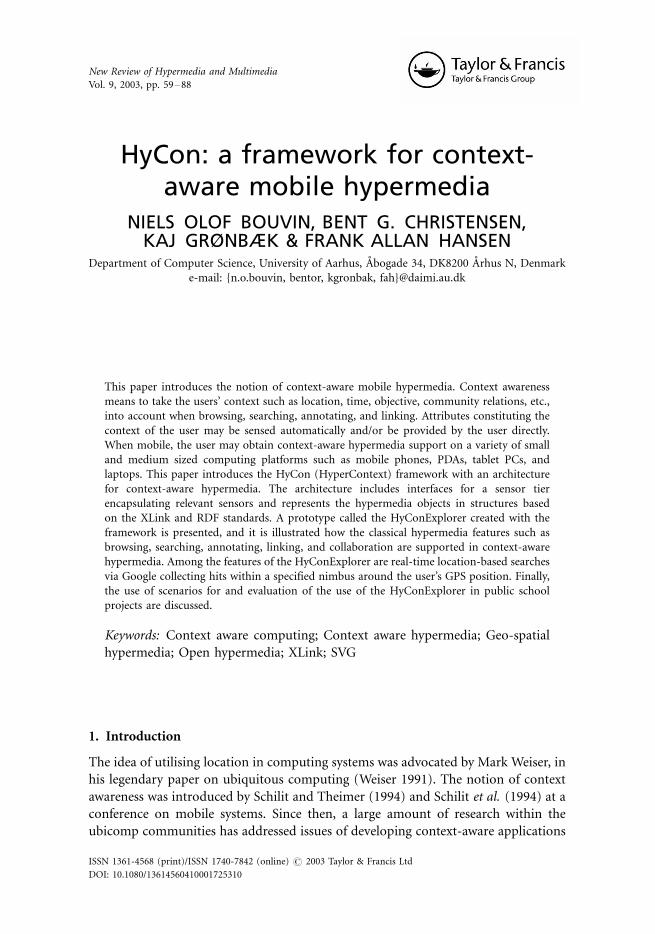
HyCon: a framework for context- aware mobile hypermedia NIELS OLOF BOUVIN, BENT G. CHRISTENSEN, KAJ GRØNBÆK & FRANK ALLAN HANSEN Department of Computer Science, University of Aarhus, A ˚ bogade 34, DK8200 A ˚ rhus N, Denmark e-mail: {n.o.bouvin, bentor, kgronbak, fah}@daimi.au.dk This paper introduces the notion of context-aware mobile hypermedia. Context awareness means to take the users’ context such as location, time, objective, community relations, etc., into account when browsing, searching, annotating, and linking. Attributes constituting the context of the user may be sensed automatically and/or be provided by the user directly. When mobile, the user may obtain context-aware hypermedia support on a variety of small and medium sized computing platforms such as mobile phones, PDAs, tablet PCs, and laptops. This paper introduces the HyCon (HyperContext) framework with an architecture for context-aware hypermedia. The architecture includes interfaces for a sensor tier encapsulating relevant sensors and represents the hypermedia objects in structures based on the XLink and RDF standards. A prototype called the HyConExplorer created with the framework is presented, and it is illustrated how the classical hypermedia features such as browsing, searching, annotating, linking, and collaboration are supported in context-aware hypermedia. Among the features of the HyConExplorer are real-time location-based searches via Google collecting hits within a specified nimbus around the user’s GPS position. Finally, the use of scenarios for and evaluation of the use of the HyConExplorer in public school projects are discussed. Keywords: Context aware computing; Context aware hypermedia; Geo-spatial hypermedia; Open hypermedia; XLink; SVG 1. Introduction The idea of utilising location in computing systems was advocated by Mark Weiser, in his legendary paper on ubiquitous computing (Weiser 1991). The notion of context awareness was introduced by Schilit and Theimer (1994) and Schilit et al. (1994) at a conference on mobile systems. Since then, a large amount of research within the ubicomp communities has addressed issues of developing context-aware applications New Review of Hypermedia and Multimedia Vol. 9, 2003, pp. 59 /88 ISSN 1361-4568 (print)/ISSN 1740-7842 (online) # 2003 Taylor & Francis Ltd DOI: 10.1080/13614560410001725310
Transcript of HyCon: a framework for context-aware mobile hypermedia
HyCon: a framework for context-aware mobile hypermedia
NIELS OLOF BOUVIN, BENT G. CHRISTENSEN,KAJ GRØNBÆK & FRANK ALLAN HANSEN
Department of Computer Science, University of Aarhus, Abogade 34, DK8200 Arhus N, Denmark
e-mail: {n.o.bouvin, bentor, kgronbak, fah}@daimi.au.dk
This paper introduces the notion of context-aware mobile hypermedia. Context awareness
means to take the users’ context such as location, time, objective, community relations, etc.,
into account when browsing, searching, annotating, and linking. Attributes constituting the
context of the user may be sensed automatically and/or be provided by the user directly.
When mobile, the user may obtain context-aware hypermedia support on a variety of small
and medium sized computing platforms such as mobile phones, PDAs, tablet PCs, and
laptops. This paper introduces the HyCon (HyperContext) framework with an architecture
for context-aware hypermedia. The architecture includes interfaces for a sensor tier
encapsulating relevant sensors and represents the hypermedia objects in structures based
on the XLink and RDF standards. A prototype called the HyConExplorer created with the
framework is presented, and it is illustrated how the classical hypermedia features such as
browsing, searching, annotating, linking, and collaboration are supported in context-aware
hypermedia. Among the features of the HyConExplorer are real-time location-based searches
via Google collecting hits within a specified nimbus around the user’s GPS position. Finally,
the use of scenarios for and evaluation of the use of the HyConExplorer in public school
projects are discussed.
Keywords: Context aware computing; Context aware hypermedia; Geo-spatial
hypermedia; Open hypermedia; XLink; SVG
1. Introduction
The idea of utilising location in computing systems was advocated by Mark Weiser, in
his legendary paper on ubiquitous computing (Weiser 1991). The notion of context
awareness was introduced by Schilit and Theimer (1994) and Schilit et al. (1994) at a
conference on mobile systems. Since then, a large amount of research within the
ubicomp communities has addressed issues of developing context-aware applications
New Review of Hypermedia and Multimedia
Vol. 9, 2003, pp. 59�/88
ISSN 1361-4568 (print)/ISSN 1740-7842 (online) # 2003 Taylor & Francis Ltd
DOI: 10.1080/13614560410001725310
and physical environments. Despite the high level of attention, there are still many
different definitions and notions of context being used in the literature. Dey (2001)
has introduced a concise definition of context:
Context is any information that can be used to characterise the situation of anentity. An entity is a person, place, or object that is considered relevant to theinteraction between a user and an application, including the user and applicationsthemselves.
and of context awareness:
A system is context-aware if it uses context to provide relevant information and/orservices to the user, where relevancy depends on the user’s task.
According to Dey, there are three types of context-aware application support,
namely presentation of information and services, automatic execution of services,
and tagging of context to information to support later retrieval.
We see both needs and prospects in applying such a notion of context aware-
ness to hypermedia, and we will argue that this is a new research area that re-
quires more attention now as hypermedia moves beyond desktop computers and
traditional Web browsers and into smaller mobile devices. We will briefly
discuss previous hypermedia research that has touched upon issues regarding
context.
1.1. Context and hypermedia
Relating Dey’s definitions to hypermedia, we may think of adaptive hypermedia (De
Bra et al. 1999; Brusilovsky and Rizzo 2002) applications aiming at adapting
hypermedia navigation to the user based on some recorded profile of the user or their
context. But the main focus of adaptive hypermedia has so far been on modelling the
user (Beaumont 1994) rather than analysing the context in which the user is situated
when browsing. Thus, we see a need for taking the user’s real-time context into
account when working with hypermedia.
In the hypermedia literature, the term context has played another role when
discussing navigation context with the hypermedia structures per se. Delisle and
Schwartz (1987) introduced the notion of context in their HAM architecture to
constrain the substructure in which hypermedia navigation and linking were
undertaken. This means that context in this case was considered a purely structural
partitioning concept, and the only thing it has in common with the notion of context
awareness in this paper is the fact that browsing and linking are constrained to some
kind of context given by the user explicitly or implicitly. The FOHM hypermedia
model (Millard et al. 20002002) supports the notion of context as a filtering
mechanism on the hypermedia structures. FOHM allows first-class hypermedia
objects to be augmented with context objects. These are sets of key/value pairs that
describe in which context the objects are visible. When the object structures are
60 N. O. Bouvin et al.

retrieved, only those structures whose context attributes match that of the user’s
context or the given query are returned; structures that do not are pruned away.
Another notion of context in hypermedia is represented by the works of Hardman
et al. (1993), where the notion of context is the surroundings of the link marker in a
hypermedia document, and the issues are what to preserve in the user’s view when
following the link out of the context. Finally, El-Beltagy et al. (2001) introduced a
notion of context, where the user’s profile and a current Web page in focus are used
to infer and generate new multi-headed links between the current page and other
contextually related Web pages. This notion of context is also quite different from
what we are introducing in this paper, since it is only the users’ more or less static
profile and the current Web page which are considered to be the context.
1.2. Context-aware hypermedia
By context-aware hypermedia we take Dey’s definitions as the starting point, but
when talking about hypermedia, we see the need to go beyond just providing
information and services depending on the user’s tasks. We see a need to let the users
create annotations, links, collections, guided tours, and the like, automatically tagged
with the captured context information. Thus, we focus on creating more than just a
context-aware browsing and navigation system, namely full context-aware hyperme-
dia systems, where users can become producers and provide hypermedia structured
materials to co-workers, school mates, or friends.
Based on Dey’s definitions, we have in our design discussions divided the concept
of context into three basic perspectives: physical context , digital context , and
conceptual context . The physical context is the physical surroundings of an entity;
object, system or person. The physical context includes physical location, physical
objects, physical interaction, and absolute time and space. Computer systems may be
aware of the physical context by capturing information about it. The digital context
includes computer models, infrastructure, protocols, available (digital accessible)
devices and services, recorded history, and relative time and space. The conceptual
context describes a user’s activity, intention, focus, and understanding of the
surroundings. Most entities may have both a physical and a digital representation,
i.e. the physical phenomenon is modelled in the computer system. The relationship
between the physical entity and the digital model is the user’s understanding (the
conceptual model or user model). The representation of physical entities in the digital
model should thus reflect the conceptual context.
Since physical objects are characterised by being positioned in absolute time and
space, we can store and retrieve information about them by capturing or computing
related context information. We use this as the basis for browsing, searching, and
producing hypermedia structures in the user’s context. This is described in Sections
3�/6. However, in the digital context, time and space are relative. Temporal events
may be rearranged, and virtual physical context may be explored by changing
parameters in the digital model (e.g. the user may explore structures related to a
Context-aware mobile hypermedia 61

location which is both temporally and physically remote from their current location).
We use this to support browsing, searching, and manipulation of hypermedia
structures while being outside the physical context to which these structures are
related. However, the digital context may also represent relationships not found in
any physical context, e.g. the result of searching for annotations created by a certain
user may be annotations associated with physical objects belonging to different points
in time and space. Thus, the digital context may include relationships computed
from, or on top of, the representations of associations in the digital and physical
context(s).
1.3. Use scenarios and cases
Some projects working with context-aware systems are based on use scenenarios from
indoor working environments like the PARCTab (Want et al. 1995); others focus on
outdoor tourist-information systems (Abowd et al. 1997). We have found our
inspiration and use scenarios in school environments focusing on project oriented
learning activities outside the class room (Nørregaard et al. 2003). School projects
have inspired the design, and initial prototypes have been developed in a
participatory design process together with kids and teachers from a local school.
Evaluation of the recently developed prototypes also took place within the school
environment.
2. The HyCon framework for context-aware mobile hypermedia
We have over the years developed a number of hypermedia frameworks and systems,
such as Devise Hypermedia (Grønbæk and Trigg 1994), the Arakne framework
(Bouvin 2002), and Xspect (Christensen et al. 2003). None of these have explored
mobility or context awareness, and we have therefore designed a new framework
architecture serving as a platform for the development of context-aware services. This
section discusses the framework architecture, its implementation, data model, and a
prototype application built on the framework.
2.1. Service framework architecture
The HyCon service framework architecture is divided into four layers, as shown in
Figure 1. The architectural approach is similar to earlier work, such as the Open
Hypermedia System Working Group’s Open Hypermedia Model (Reich et al. 1999)
and Construct (Wiil et al. 2001), both heavily inspired by the seminal Dexter
architecture (Halasz and Schwartz 1994). Key to the HyCon service framework
architecture, compared to earlier work, is an extra layer dedicated to handling sensors
and sensor information.
62 N. O. Bouvin et al.
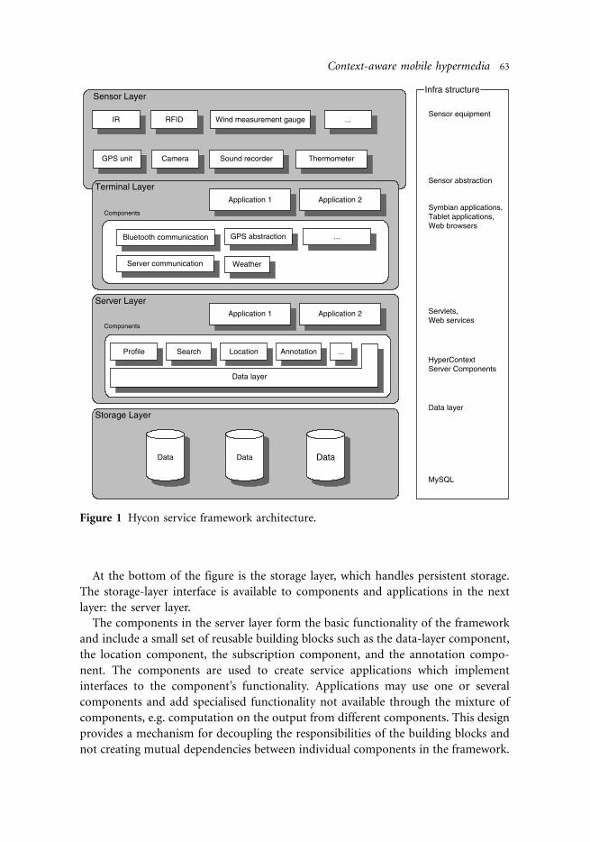
At the bottom of the figure is the storage layer, which handles persistent storage.
The storage-layer interface is available to components and applications in the next
layer: the server layer.
The components in the server layer form the basic functionality of the framework
and include a small set of reusable building blocks such as the data-layer component,
the location component, the subscription component, and the annotation compo-
nent. The components are used to create service applications which implement
interfaces to the component’s functionality. Applications may use one or several
components and add specialised functionality not available through the mixture of
components, e.g. computation on the output from different components. This design
provides a mechanism for decoupling the responsibilities of the building blocks and
not creating mutual dependencies between individual components in the framework.
Figure 1 Hycon service framework architecture.
Context-aware mobile hypermedia 63
The purpose of the server layer is to provide data and functionality to the
terminal layer. The division between reusable components and specialised
applications is found again in the terminal layer: the components are implementing
the communication to the server layer, and the applications are implementing
functionality and user interfaces appropriate for the terminal device in use. The
hardware platform of the terminal layer may include all sorts of mobile equipment:
laptops, tablet PCs, PDAs, and cell phones. These devices may have access to sensor
information. Sensors can be integrated within the terminal device (e.g. a camera in
a phone) or be external (e.g. a Bluetooth-enabled GPS unit). Sensor information is
accessed through tailored interfaces to components handling the parsing and
computation of the raw sensor data. This sensor abstraction is very similar to the
mechanism implemented in the Context Toolkit (described in Section 8). The
sensor components in our framework correspond to widgets and interpreters in the
Context Toolkit.
2.2. Interfaces and service infrastructure
The infrastructure and interfaces of the service framework can be realised in various
ways*/one way is the traditional client�/server model, which was chosen for our
implementation. The functionality of the storage layer is handled by a MySQL1 server
with a database having tables and relations corresponding to object and context
relationships. The server layer offers a data-layer component that maps between
language objects and the database format. The data layer supports a basic set of
methods to store, retrieve, query, and delete objects from the database. This set of
methods provides the interface to the storage layer.
The runtime environment for components and applications in the server layer is an
application server. The applications are implemented as Java servlets and Java Web
services, and thus provide their interfaces via CGI and SOAP to the terminal layer.
The CGI version is internally represented as a filter chain with application servlets
producing XML data output at the beginning of the chain and an XSLT servlet
transforming the data to specific output formats [e.g. HTML or Scalable Vector
Graphics (SVG) (Jackson and Ferraiolo 2002)] at the end of the chain. This has been
implemented to easily support a wide range of mobile devices with different
computation and display capabilities in the terminal layer.
The terminal layer may consist of many different hardware and software platforms,
as indicated above. We have experimented with terminal layer platforms ranging from
tablet PCs to Symbian phones, and laptops. As sensors and content-capturing devices
we have used external Bluetooth-enabled GPS units, built-in sound recorders, and
digital cameras (both built-in and external USB cameras).
In order to integrate the context framework with existing online services, the
components in the server and terminal layers can communicate and retrieve
information from resources other than the storage layer. This enables integration
with services providing online maps, weather information, and search engines.
64 N. O. Bouvin et al.
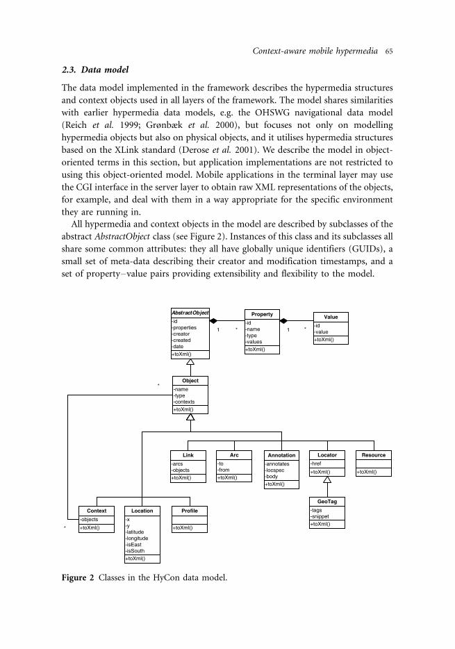
2.3. Data model
The data model implemented in the framework describes the hypermedia structures
and context objects used in all layers of the framework. The model shares similarities
with earlier hypermedia data models, e.g. the OHSWG navigational data model
(Reich et al. 1999; Grønbæk et al. 2000), but focuses not only on modelling
hypermedia objects but also on physical objects, and it utilises hypermedia structures
based on the XLink standard (Derose et al. 2001). We describe the model in object-
oriented terms in this section, but application implementations are not restricted to
using this object-oriented model. Mobile applications in the terminal layer may use
the CGI interface in the server layer to obtain raw XML representations of the objects,
for example, and deal with them in a way appropriate for the specific environment
they are running in.
All hypermedia and context objects in the model are described by subclasses of the
abstract AbstractObject class (see Figure 2). Instances of this class and its subclasses all
share some common attributes: they all have globally unique identifiers (GUIDs), a
small set of meta-data describing their creator and modification timestamps, and a
set of property�/value pairs providing extensibility and flexibility to the model.
Figure 2 Classes in the HyCon data model.
Context-aware mobile hypermedia 65

The generic Object class is used to describe objects not explicitly represented in the
model (e.g. new physical objects, persons, things, digital content, etc.). This class
makes it easy to implement prototypes dealing with phenomena not represented in
the data model without having to change the model.
A number of predefined classes are derived from the Object class. These include:
Context, Profile, Location, Link, Arc, Locator, Resource, and Annotation. Instances of
the Context class are special objects in the model used to create explicit collections of
objects somehow belonging to the same context (e.g. groups of people or available
devices in a user’s surroundings). Context collections are not disjoined: objects may
be part of multiple contexts, and contexts may include several objects. The Profile
class describes objects containing preferences of a user or device (e.g. the presentation
specification of a terminal device). Objects from the Location class represent points
of interest and are used whenever digital information is associated with physical
places. The Link, Arc, Locator, and Resource classes describe XLink-based structures
on top of the other objects in the system. These classes are discussed further in
Section 6. Locator objects are also used to represent digital resources reachable by a
URI in the model. The derived GeoTag class is used to tag elements with URIs (e.g. to
enable tagging of a location with a URI of a Web page describing the place). Objects
from the Annotation class are similar to the GeoTag objects in that they can annotate
any element in the model. However, the content of annotations is not limited to a
URI, but can include multimedia content such as text, images, sound, and video.
Annotations are discussed in Section 5.
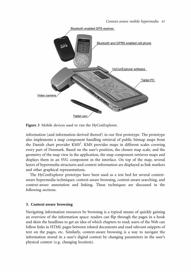
2.4. The HyConExplorer prototype
The HyConExplorer prototype is our first implementation of a client application
utilising the framework. The prototype is a Java application designed to run on
commercially available tablet PCs connected to the network through WLAN or GPRS
connections on cell phones (see Figure 3).
The tablet has a mounted camera for capturing low-resolution images, video, and
audio in the application. The user’s physical location is registered through a
Bluetooth-enabled GPS unit light enough to be carried in a shirt pocket. Figure 4
shows the tablet and the HyConExplorer in use, with two students walking our
campus area, browsing, and making annotations on points of interest.
As the prototype is developed in Java, it implements the full data model described
in the previous section. Communication to services running on the application server
is primarily through the SOAP interface, with hypermedia structures and context
objects being sent as XML-encoded Java objects. However, upload and download of
shared multimedia files are done through the CGI interface.
The prototype implements components handling the communication with the
server applications, sensor components handling GPS, and camera-data manipula-
tion. This means that even though our framework is designed to support context
information from multiple sensors, we are currently only utilising location
66 N. O. Bouvin et al.
information (and information derived thereof) in our first prototype. The prototype
also implements a map component handling retrieval of public bitmap maps from
the Danish chart provider KMS2. KMS provides maps in different scales covering
every part of Denmark. Based on the user’s position, the chosen map scale, and the
geometry of the map view in the application, the map component retrieves maps and
displays them in an SVG component in the interface. On top of the map, several
layers of hypermedia structures and context information are displayed as link markers
and other graphical representations.
The HyConExplorer prototype have been used as a test bed for several context-
aware hypermedia techniques: context-aware browsing, context-aware searching, and
context-aware annotation and linking. These techniques are discussed in the
following sections.
3. Context-aware browsing
Navigating information resources by browsing is a typical means of quickly gaining
an overview of the information space: readers can flip through the pages in a book
and skim the headlines to get an idea of which chapters to read; users of the Web can
follow links in HTML pages between related documents and read relevant snippets of
text on the pages, etc. Similarly, context-aware browsing is a way to navigate the
information stored in a user’s digital context by changing parameters in the user’s
physical context (e.g. changing location).
Figure 3 Mobile devices used to run the HyConExplorer.
Context-aware mobile hypermedia 67

In our prototypes, we have experimented with both implicit browsing of the digital
context and the more common explicitly user-controlled browsing as in Web
browsers, for example. When considering mobile hypermedia systems, we can
describe these two ways of browsing by adopting the terms direct physical navigation
and indirect representational navigation from Geo-Spatial hypermedia (Grønbæk et
al. 2002).
Direct physical navigation allows the user to browse information by changing
parameters in the physical context. Physically walking or driving from one location to
another will affect parameters such as time and location in the physical context,
allowing the system to find associated information in the digital context. Systems
using this kind of browsing include location-based tourist-information systems and
guide systems. We use this kind of browsing in our prototypes to let users equipped
with GPS terminals bump into information (annotations, linked documents, or trails
of information) when moving about in the physical world. When physically entering
a predefined context, the associated information is pushed to the user.
However, it is not always desirable or feasible to have to physically move around to
browse information. Indirect representational navigation allows the user to navigate
information associated with remote locations by specifying a virtual location in the
system. Examples of this kind of navigation include browsing through lists of hotels
or restaurants in remote cities while planning a trip home at the office. The GeoTags3
and GeoURL4 systems also fall into this category by letting users browse pages by
their proximity to a given location. We employ this kind of browsing to allow users to
investigate and manipulate the hypermedia structures in the system, even though they
are not actually in the physical context associated with the structures. This also
Figure 4 Context-aware hypermedia on a moblie tablet PC with camera [SitePack
(Nielsen et al. 2003)]. The tablet has network connection through a Bluetooth-
and GRPS-enabled cell phone and reads GPS coordinates from the GPS unit
visible in the user’s pocket (b).
68 N. O. Bouvin et al.

addresses the problem encountered with early versions of GUIDE (Cheverst et al.
2001 section. 2.1), where only information about physically nearby objects was made
available, thus constraining the users’ ability to plan ahead or just browse.
Figure 5 illustrates a typical pattern for context-aware browsing based on direct
physical navigation. The user, equipped with a mobile terminal (PDA, cell phone, or
tablet PC) and GPS equipment walks down a street [Figure 5(a)]. As the user walks,
the time and their position are continuously updated in the system. When either has
changed by a certain delta, the system makes an update request to the hypercontext
server [Figure 5(b)]. The request may include contextual information such as
position and time and other parameters such as user ID and nimbus [the region the
user projects themself as introduced in the MASSIVE CVE system (Greenhalgh and
Benford 1995)]. The context server maps the context information coupled with the
user’s profile to the hypermedia structures in its database [Figure 5(c)]. These results
are returned to the user, and the mobile device is updated accordingly [Figure 5(d)],
e.g. with new link markers on a map or items in a list.
In this scenario, no direct user intervention is required*/the mobile client samples
simple contextual information from the physical environment which is mapped to
relevant hypermedia structures by the context server. Especially when dealing with
mobile devices with limited user interfaces, where traditional browsing (perhaps
Figure 5 Context-aware browsing.
Context-aware mobile hypermedia 69

through multiple layers of menus or lists) quickly becomes tedious, context-aware
browsing proves to be an efficient alternative.
4. Context-aware searching
Context-aware searching is based on the general idea of using contextual information
as one of the criteria to a search for information. This helps narrow down the
information, so the obtained results are more relevant for the user. The contextual
information used could be the time of day when looking for shops that are open, the
user’s location to avoid information of shops in another city, or how many people
there are in a group when trying to locate a restaurant where they all can be seated.
The benefit of adding criteria based on context information is of course highly
dependent on the search engine used and how the context data can be formulated as
appropriate criteria.
When using mobile equipment, an inherently interesting part of the context is the
location. This single piece of contextual knowledge can be used to locate other
resources associated with the location, thus bringing location-relevant information to
the user. We have experimented with context-aware searching (Geo-Based Search*/
GBS) on the Web using location from the gathered context information and
keywords on the topic of interest, thus adding a geographical proximity criterion to
the search. GBS is an example of a search in existing unstructured information bodies
not prepared for context-aware applications in any way.
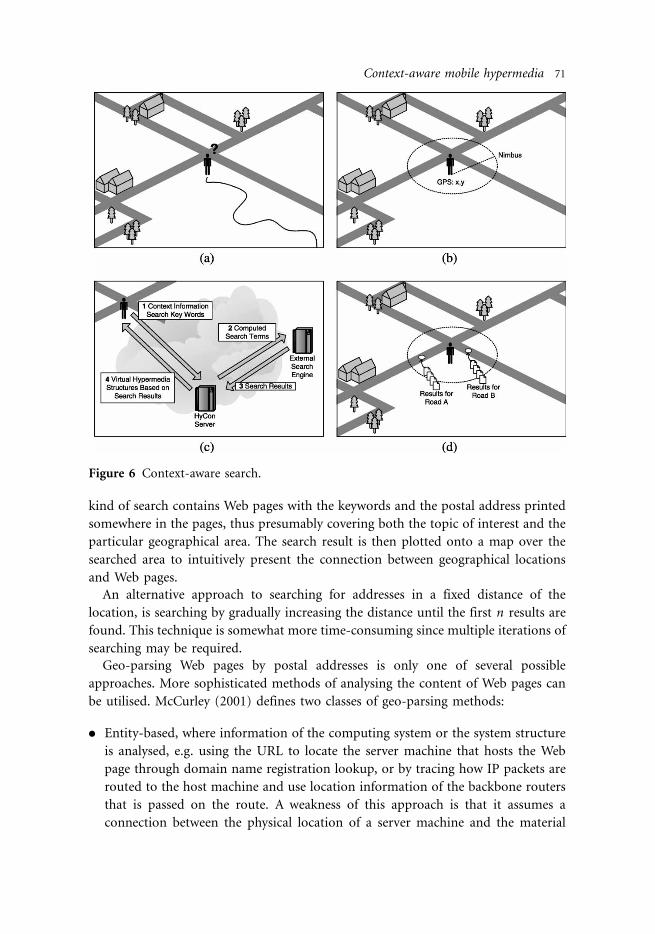
Figure 6 illustrates a typical pattern for context-aware search. A user is in an
unfamiliar neighbourhood and wants to find information about interesting nearby
sites [Figure 6(a)]. The location is retrieved from the GPS sensor, and the search
radius is determined [Figure 6(b)]. The location information is sent, together with
keywords and profile preferences, to the hypercontext server, which forms search
terms for the external search engine [Figure 6(c)]. The results from the external
search engine are then transformed into virtual hypermedia structures, which can be
read and manipulated by the user Figure 6(d)]. Figure 7 shows this kind of context-
aware search in the HyConExplorer prototype. Based on a few search terms and the
captured context information, the context server has located two roads near the user
matching the search. Search hits are marked as dots on the digital map. When
activating a link marker, the link endpoint is presented by a snippet of text. If the
endpoint looks interesting, it can be viewed in an appropriate external viewer (Web
browser, PDF viewer, video player, etc.).
When implementing the GBS service, a transformation from the GPS coordinates
to some derived information is necessary, since very few search engines index Web
pages by GPS coordinates. However, a database of all public postal addresses in
Denmark and their GPS coordinates is freely available from the Danish chart provider
KMS. By using this database, postal addresses within a fixed proximity of the location
can be determined. Together with the keywords, these postal addresses are much
more useful for existing mainstream search engines such as Google. A result of this
70 N. O. Bouvin et al.
kind of search contains Web pages with the keywords and the postal address printed
somewhere in the pages, thus presumably covering both the topic of interest and the
particular geographical area. The search result is then plotted onto a map over the
searched area to intuitively present the connection between geographical locations
and Web pages.
An alternative approach to searching for addresses in a fixed distance of the
location, is searching by gradually increasing the distance until the first n results are
found. This technique is somewhat more time-consuming since multiple iterations of
searching may be required.
Geo-parsing Web pages by postal addresses is only one of several possible
approaches. More sophisticated methods of analysing the content of Web pages can
be utilised. McCurley (2001) defines two classes of geo-parsing methods:
. Entity-based, where information of the computing system or the system structure
is analysed, e.g. using the URL to locate the server machine that hosts the Web
page through domain name registration lookup, or by tracing how IP packets are
routed to the host machine and use location information of the backbone routers
that is passed on the route. A weakness of this approach is that it assumes a
connection between the physical location of a server machine and the material
Figure 6 Context-aware search.
Context-aware mobile hypermedia 71

provided by it. This might not always be the case, especially when Web pages are
placed at Web hotels.
. Content-based, where the content itself is analysed, e.g. determining the language
of the page, finding names of geographical sites, finding telephone numbers,
finding names of events that only occur certain places, finding names of people,
and locating them. Geo-parsing the content of Web pages is only successful if
location information is present and is parsed correctly.
Our method of using postal addresses printed in the Web pages falls in the class of the
content-based methods. Another content-based method is used by Google’s ‘Search
by Location’ service5 (also described in Section 8), where the postal address is typed
in together with the keywords to search for. They describe their geo-parsing method
very briefly (in the FAQ) as:
We analyze the entire content of a page to extract hints or ‘signals’ that enable us toassign a corresponding physical location, then return results that match thegeographic range you specify (e.g. ‘near Jacksonville, Florida’).
Since none of the geo-parsing methods described here is guaranteed to work for
every Web page, they should be combined, thus hopefully resulting in a more robust
and detailed analysis of location relevance.
Figure 7 Searching and browsing in the HyConExplorer prototype. Dots on the digital
map are link markers for information: annotated location, linked documents,
and search results. Activating a link marker presents the linked information in
the right frame in the window.
72 N. O. Bouvin et al.

The approach of geo-parsing Web pages to determine a geographic association
provides little reliability and poor precision, but the techniques enable integration
into existing material not prepared for context-aware search. Another approach is
used by the projects Geotags and GeoURL, where meta-tags are inserted into the Web
pages defining the corresponding geographic location. This approach provides a very
precise and reliable mapping, but relies on the authors of Web pages to embed the
meta-tags in their documents, enabling indexing by the service.
5. Context-aware annotation
The browsing and searching techniques discussed in the previous sections present
novel approaches to navigation of the information space based on context filtering.
This kind of filtering proves especially useful when accessing information on small
hand-held devices with limited display and input capabilities such as cell phones and
PDAs. However, as stated in the introduction, one of our goals was to go beyond the
classical context-aware browsing and navigation systems, and support users as active
producers of information in the system.
The combination of context sensors with mobile devices equipped with built-in
cameras and microphones allows users to create video, audio, photo, and text
annotations, and automatically tag them with captured context information. This
supports the creation of material documenting or commenting on an object or
situation and automatically having this material inserted and indexed in the system.
We have built different prototypes supporting the creation of multimedia
annotations on mobile devices. The first prototype was a simple gallery system
(Nørregaard et al. 2003) enabling school children (with Nokia 7650 picture phones)
to write email messages with image or video attachments and send them to the
gallery service. The gallery service created Web pages from the received text messages,
attached images, and image meta-data. The pages were used by the pupils to create
reports and presentations of their field work (see Section 7). This prototype only
utilised simple context information such as the time-stamp in the image meta-data
and the sender of the email to establish a measure of the annotation context.
Our second prototype, the HyConExplorer, is based on the framework presented in
this paper. When an annotation is created in the HyConExplorer, it is associated with
context information captured or computed on the client. This information makes it
possible to locate the annotation later by browsing or searching as described earlier.
Figure 8 illustrates a typical pattern for creating context-aware annotations. The
user, equipped with a mobile terminal, has arrived at an interesting location which
they want to annotate. The HyConExplorer displays link markers on the map for
several existing hypermedia objects which they can be annotated: locations, linked
documents, annotations, and (virtual) search results [Figure 8(a)]. The user chooses,
however, not to annotate any of the existing objects but an area nearby [Figure 8(b)].
After having photographed the area and written a small textual comment, the
annotation data are sent as a request to the context server together with collected
Context-aware mobile hypermedia 73

context information from the application. Since the annotation comments on an
object (the location of the new area) not present in the server’s database, this object
must be created as well as the annotation object. The context server updates the
database with the new location and annotation data, and returns the updated
structures to the client [Figure 8(c)]. The new annotation is now part of the user’s
digital context and is displayed in the HyConExplorer [Figure 8(d)]. An example of
the creation of annotations in the HyConExplorer prototype is illustrated in Figure 9.
The user has typed in a textual comment and is capturing a photo with the tablet PC’s
camera. Capturing of context information takes place ‘behind the scenes’ and is not
visible to the user*/the user only has to deal with creating the content of the
annotation.
The data model used in the system is shown in Figure 2. Annotations in the model
(represented by the Annotation class) are meta-data objects holding a reference to the
annotated object, the textual comment, and a number of properties describing
associated media files (video, audio, images, etc.). Since both digital objects (e.g.
documents, links, and annotations) and object-representing physical phenomena
(real physical objects and physical locations) are modelled as subclasses of the generic
Object class in the model, all types of objects in the model can be annotated.
Furthermore, this technique allows annotations to annotate other annotations and
Figure 8 Context-aware annotation.
74 N. O. Bouvin et al.

thus provides a mechanism for creating discussion threads in a given context where
users’ comments on each other’s annotations.
Contrary to many open hypermedia systems, we have chosen to represent
annotations as single meta-data objects. Typically, open hypermedia systems support
annotations by using fully fledged hypermedia links, linking a local resource from the
link-base into some externally stored document (Grønbæk et al. 2000; Bouvin et al.
2002; Christensen et al. 2003). Potentially, this makes it harder to move the
annotation from one link base to another, since several components (the local
resource, the representation of the remote document, and the link components) have
to be computed and assembled before the annotations can be moved. Our approach
is more closely related to the RDF-based Web annotations implemented by W3C’s
Annotea system (Kahan et al. 2001). Annotation objects in Annotea are described by
a dedicated RDF schema, which includes properties for the type of the annotation,
the annotated resource (described by a simple XLink link), a location specifier
pointing into the annotated document, the body of the annotation, We have found
such a representation to be simpler to handle in the case of annotations. Since the
annotations are located as single objects in the link-base, moving and sending them
around in the system become more lightweight operation than when dealing with full
link structures. Furthermore, since our annotation structures are so closely related to
Annotea annotations, it would be trivial to export the structures to RDF for
presentation on the Web, e.g. with the Annotea Web browser.
Other context-aware systems concerned with supporting the user as producer of
information are the CyberGuide and CyBARguide (Long et al. 1996) described in
Figure 9 Creating multimedia annotations in the HyConExplorer prototype.
Context-aware mobile hypermedia 75

Section 8. CyBARguide supports users adding new points of interest to the system’s
database. Though not implemented (Abowd et al. 1997) suggest that users should be
able to leave comments and impressions as ‘virtual graffiti’ when visiting a location.
This is similar to creating an annotation on a visited location in the HyConExplorer.
6. Context-aware linking
In our prototypes, we have primarily experimented with links which would make
good sense in a mobile hypermedia context. This has resulted in simple links (2-ary
links) linking external documents to objects in the link base and extended links (n-
ary links) linking a collection of objects (typically locations) into a single logical trail
trough the objects.
The Web presents a massive corpus of information, and much of the information
available through the Web may be relevant in a given physical context. Thus,
supporting links to existing Web pages is an effective means of integrating this
information into the system.
External resources are represented by instances of the Locator class in the data
model (see Figure 2). The locator object acts as a document proxy [RefSpec
(Grønbæk and Trigg 1995)] with a URI reference to the actual document. The URI
may optionally include a fragment identifier (LocSpec) specifying a point or region in
the document. The GeoTag class in Figure 2 represents a special simple link
connecting a remote resource (given by the URI reference) to an object in the system’s
database. The GeoTag objects also include a snippet attribute containing a small
textual description of the linked page. We have added this attribute to hold extra
information about pages when linking search results from external search engines
into the system, but the GeoTags also serve as a general mechanism for tagging/
linking objects with remote resources.
Guided tours as a hypermedia concept go back to Bush (1954) and have seen many
implementations and variations since then, such as tabletops (Trigg 1988), Walden’s
Paths (Furuta et al. 1997), or Scripted Documents (Zellweger 1989). In HyCon, we
use extended n-ary links to express trails or paths through a collection of objects. In
mobile hypermedia, this will typically mean trails through a collection of locations,
where the link represents a guided tour and the locations represent stops on the tour.
This mechanism has several interesting applications: in a school environment, a
teacher may prepare a field trip for the school children by creating a guided tour
through an area the children are to investigate. Each stop on the tour may include a
description of the site and additional linked material. This material may be divided
into several different layers of information: history, archaeology, politics, environ-
mental info, nature guidance, etc. Upon arriving at a stop, the pupils are presented
with one or more of the layers, depending on their mode and defined task.
Furthermore, the pupils can collect further material at the site and add annotations
commenting on the material and on the teacher’s predefined material through the
linking and annotation mechanisms. At home in the classroom, the trail of
76 N. O. Bouvin et al.

information may serve as a way to present the results of the field trip for their class
mates. In another scenario, the pupils may diverge from the predefined trail and
create their own trail as they walk along. Other groups of pupils working
simultaneously in the same area may bump into the newly created trail and instantly
observe the results of diverging from the teacher’s guided tour.
The linking mechanism used to describe trails is derived from our earlier
experiences with XLink-based guided tour structures in the Xspect system
(Christensen et al. 2003). In Xspect, a single XLink link-type element constituted a
guided tour with XLink locator-type elements as stops on the tour and XLink arc-
type elements as directed edges (or tour segments) between the stops. In the current
data model (see Figure 2), we have generalised the stops on the tour to be instances of
the general Object class and thus support easy linking of both Location-type and
Locator-type objects. Instances of the Arc class still describe the traversal behaviour of
the link, so the result is XLink-based structures on top of the objects in the system.
This design makes it easy to export trails in the system to XLink structures which may
be used for Web presentations, for example.
7. Use scenarios and evaluation
School projects have inspired the design of the HyConExplorer and the HyCon
framework. Initial prototypes were developed in a participatory design process
together with kids and teachers from a local school (Nørregaard et al. 2003).
Children engaged in learning activities away from the classroom may benefit from
context-aware hypermedia services in several ways. Modern pedagogy is project-
oriented and stimulates pupils to work in groups where they research a subject and
make some report, multimedia production, and/or oral presentation. For such
learning activities, pupils and students need to document their exploration of subjects
outside the class room. This requires some mobile tools to support the documenta-
tion and preliminary production of content for the final reporting. Thus, pupils may
carry mobile devices that let them collect, organise, and work with information they
produce or find through our context-based hypermedia services. The mobile devices
may be used to capture and collect information in the field and as an interface to start
presentations of the collected information in interactive room environments in
schools, universities, libraries, or other learning environments.
With the HyCon framework presented in this paper, we can provide context-based
information services for cities, landscapes, museums and other cultural heritage.
Possible layers of information to browse and search based on the context may
include: history, archaeology, politics, environmental info, nature guidance, demo-
graphy, biology, energy, trade, industry, transport, and traffic. All of these subjects
may be explored relative to a given context, e.g. location, time, project task, or group
members.
The collaboration and linking services can be used by other groups who research
on the same subject in the same area. A group may at some stage bump into
Context-aware mobile hypermedia 77

information created by another group at a particular spot at an earlier stage. The
other group may also discover that the previous group has left a trail with a collection
of linked information, which can be useful for their own research on the subject with
their perspective. During the evaluation of the HyConExplorer, one teacher suggested
that data produced by pupils investigating a biotope could be saved year after year.
When new pupils return to the biotope, they can compare their findings with the data
from earlier years and thus investigate the evolution of the biotope over time.
At this stage, we have conducted a number of smaller experiments with school
children (Nørregaard et al. 2003) using the gallery service and Nokia 7650 picture
phones as the documentation and browsing tool. These experiments have inspired
the development of the services for the HyConExplorer. The HyConExplorer has been
evaluated by teachers and children from three local schools. The teachers were
involved in framing a realistic project work scenario on which the evaluation
workshop was based. The theme of the workshop was a project called ‘Our City’,
where groups of pupils were sent out to document on different areas of Aarhus. The
evaluation was conducted in four steps.
In the first step, the teachers were shown the software and had time to experiment
with it. In this step, they used the HyConExplorer to collect initial teaching material
and link it to locations in Aarhus. This first step allowed the teachers to create a
foundation for the project and control the material the children would find when
moving about in the city. In the second step, a member from our team introduced the
children to the hardware and the HyConExplorer, and the teachers presented the field
assignment to the children. The children were given a few minutes to explorer the
tools and ask questions. In the third step, the children were split into three groups
and sent to different parts of the city (Figure 10). The children investigated their part
of the city by browsing the material the teachers previously had linked into the system
and by creating annotations on the spot. Each group was accompanied by two
Figure 10 Children browsing and collecting material in the city.
78 N. O. Bouvin et al.
persons from our team*/one acting as technical backup and one recording the
children with a video camera. In the final step, the children returned to the classroom
and created presentations with the HyConExplorer’s built-in presentation tool
(allowing presentations to be compiled directly from the hypermedia structures in the
system). Each group presented their findings to the other groups and concluded on
their experiences with the use of the system.
Both teachers and children were generally excited about the features provided by
the HyConExplorer. The ability to browse and search for information in context and
the association between the physical world, the map, and the information seemed to
work well. However, several issues became apparent during the workshop.
One group of children chose to split all of the equipment (tablet PC, cell phone,
and GPS) amongst them and carry it in their hands. Another group put the cell
phone in their bag and strapped the GPS unit to the bag. The first group complained
about the amount of equipment they had to carry, and it seemed difficult for them to
understand that they had to stay within a few metres from each other for the
Bluetooth units to communicate properly. The second group did not have these
problems, but both groups complained about the weight of the tablet PC. Thus, we
saw a clear need to ‘black-box’ the various units so that the system would seem
simpler. One approach to this could be simply to hide the equipment, as the second
group did, so that the focus would only be on the tablet. Another approach would be
to use more integrated hardware, e.g. cell phones with built-in GPS receivers, thus
effectively decreasing the number of physical devices needed.
Another issue which quickly became apparent was the limited network bandwidth
on the GPRS-based cell phones. We experienced data-transfer rates of approximating
20 kbit/s when receiving data and even less when uploading images and other data to
the server. This made the communication with the server slow when browsing and
especially when creating annotations. The children found the task of creating
annotations tedious and boring, as they had to wait for 10�/30 s after having created
an annotation to ensure that the data were properly stored on the server. As the
bandwidth on new phones increases, this issue will become less important, but we are
considering implementing local caching and buffering on the clients. This will result
in faster operations when producing material and will work better with devices with
limited network bandwidth. The local buffer needs to be synchronised with the main
system. This can be done either when arriving at a hot-spot offering higher
bandwidth connections or by having a separate background thread continuously
sending data from the buffer to the server.
8. Related work
This section gives a number of examples of systems and frameworks that in one form
or another support context awareness.
Geo-spatial hypermedia (Grønbæk et al. , 2002, 2003) is a special case of context-
aware information system, where the focus is primarily on associations between
Context-aware mobile hypermedia 79

locations (in the real and the virtual) and digital material (be it multimedia
annotations, links to technical documentation, sightseeing information, etc.). Geo-
spatial hypermedia systems can be broadly divided into two categories, depending on
the support for user content authoring in the field.
A number of systems have explored the use of location in a hypermedia context.
The approaches vary from using location as triggers for other actions to more
traditional information systems. Location is not the only kind of context that might
be considered for a context-aware system, but it is the most prevalent. The main
difference is how the location is used, e.g. for locating the nearest printer, triggering
nearby sensors, or recording the location of the user.
The Xerox PARCTab (Want et al. 1995), the first context-sensitive computer, was
developed in 1992. The PARCTab took advantage of the simple idea of location
awareness by using a palm-sized computer (the ‘tab’) with a pen interface linked to an
infrared network. Limited by the processing power of the tab, applications were
executed in a full-size computer infrastructure, and the results were transmitted over
the IR network and displayed on the display of the tab. The cellular network provided
location information on a room-by-room basis. The resulting PARCTab applications
became the first location-based applications on PDA-like devices.
Long et al. (1996) and Abowd et al. (1997) discuss the Cyberguide project, which
was an attempt to replicate a human tour-guide service through the use of mobile
and hand-held technology and ubiquitous positioning and communication services.
Tour guide systems have been built for both indoor and outdoor environments
within and around the Georgia Tech campus. One of the prototypes, called
CyBARguide, was running on a Newton MessagePad equipped with a GPS receiver.
Users driving with the CyBARguide could locate a point of interest that satisfied
certain requirements (special offers, free parking, good ambiance). In addition, the
authors suggest future support for users leaving comments that would become
available to other users, after having visited a point of interest.
The Context Toolkit (Dey 2001; Dey et al. 2001) makes it possible to add the use of
context to existing non-context-aware applications and to evolve existing context-
aware applications. The toolkit is built on a layered architecture, and the architecture
makes context-aware applications resistant to changes in the context-sensing layer. It
encapsulates changes such that applications do not need to be modified. The
architecture is built on the concept of enabling applications to obtain context
parameters independently of how the context was acquired. The architecture also
introduces a so-called context widget . A context widget acquires a certain type of
context information and it makes that information available to applications in a
generic manner, regardless of how it is actually sensed. Applications can access
context from widgets using traditional poll and subscribe methods, similar to
graphical user interface (GUI) widgets. In addition to context widgets, the Context
Toolkit supports interpreters , which transform context information by raising the
level of abstraction, and aggregators grouping logically related context information.
80 N. O. Bouvin et al.
Geographical Information Systems (Laurini and Thompson 1992) have been used
for many years to combine layers of data with maps. The uses for such systems have
diversified, and they have become quite widespread. In comparison with this work
described herein, most GIS applications differ by the focus on overview rather than
localised context. Most GIS systems are still data-heavy applications mainly used on
stationary machines.
An example of a mobile GIS application is described by (Stockus et al. 1999).
consisting of a Java applet running on a laptop computer with a GPS unit and
connected to the Internet through a cell phone. The system allowed the user to see a
representation of themselves superimposed on layers of maps downloaded to the
computer.
The Topos system (Grønbæk et al. 2002, 2003) is a document-centred collaborative
virtual environment originally aimed at architects. It enables users to collect and
arrange collections of documents, models and other material in 3D spaces. The
system has explored a number of interfaces, such as 3D displays and large touch-
sensitive screens. In order to explore the coupling between the virtual and the
physical, the system has also found use on GPS-equipped tablet PCs. By coupling the
virtual 3D spaces (often containing architectural models and many related
documents) with the real world and the buildings virtually depicted, it becomes
possible for users to interact with documents, e.g. as they inspect a building site (and
for other users to see on-site users’ whereabouts). By using the ARToolKit, users of
Topos can, by placing markers in the field, judge the impact of new buildings, as 3D
models are overlaid on the recorded video of the location.
Nielsen et al. (2003) present a mobile AR system, called the SitePack supporting
architects in annotating and visualising models in real time. The SitePack applies a
novel combination of GPS tracking and vision-based feature tracking in its support
for architects. One example of use is Zone of Visual Impact assessment in outdoor
environments. Another example is indoor facility management support, where
maintenance workers may retrieve and visualise models of electrical and heating
installations, for example, based on the context in which they work.
Furuta and Na (2002) introduce the notion of responsive hypertext provided by a
version of the petri-net based Trellis system caT (context-aware Trellis). caT supports
specifying characteristics of the external environment in which the hypertext is being
used (e.g. the reader’s location, time of day, user characteristics such as age and job
title, etc.). caT relies on the user providing the context information, and the hypertext
must be prepared by its authors to respond to context parameters.
The Ambient Wood (Weal et al. 2003) is a project aimed at augmenting
schoolchildren’s learning experience in a woodland setting. As the students move
about in the wilderness, their handheld computer sets off various sensors, allowing
their progress to be tracked as well as creating an interactive experience (through
hidden speakers, etc.). When the students have finished their exploration of the
setting, they can return to the classroom and reflect and report on their exploration
Context-aware mobile hypermedia 81

based on the recorded data. Thus, while the students create content by moving and
acting in an open space, the editing takes place afterwards.
The GUIDE project (Cheverst et al. 2002) provides tourists with information
about sites in Lancaster and suggests other sites that might be of interest. The GUIDE
system calculates its position relative to 802.11 base stations placed at Lancaster
attractions. This makes for relatively coarse resolution but averts the problems
inherent with GPS navigation between buildings. The GUIDE system has been tested
successfully in real use (Cheverst et al. 2000), thus supporting the concept of
electronic tourist guides.
A shared characteristic of many AR and location-based systems described herein is
the emphasis on navigation support and information access. Systems aimed at
supporting the authoring of material in the field are much less common. While the
ability to find one’s way or access prerecorded data is certainly valuable, recording
one’s own impressions is similarly important. This allows the user to be active rather
than a passive receptacle. While boards of tourism and other official bodies
doubtlessly can create high-quality content, it is crucial that the ability to author
(and therefore to critique) content is generally available. The proliferation of blogs
and other ‘grass root’ Web sites illustrates the willingness of people to freely create
content for general consumption (e.g. the user-submitted (and unpaid) reviews
found on Amazon). A tourist might, for example, visit a nearby restaurant based on
the recommendation of an official city guide and then later rate the restaurant by
adding a new annotation to the system.
Geo-spatial hypermedia systems in general allow users to search for and browse
existing annotations and structures related to a specific location. The ability to create
a search engine query based on an address generated from a GPS location is a novel
approach (as described in Section 4) that provides access to much online material
that has not been specifically authored for geo-spatial use or registered into the
system.
Alexa6 is an example of a context-aware system not utilising location. Alexa is the
system behind ‘What’s Related’ found in many Web browsers to help users discover
new Web pages. Alexa creates a context around a Web page primarily by storing the
browsing trails generated by its many users. Web sites close to each other on these
trails are judged to be related and are thus presented as contextually close to other
users. For a further discussion on this and similar techniques, see Fu et al. (2000).
Web sites dynamically adapting to their users are quite common*/a well-known
example is the book recommender in Amazon7. This system recommends new books
to the customer based on the customer’s previous buying habits and the aggregated
buying habits of customers with similar tastes.
The Google Search by Location service (described in Section 4) is similar to our
approach inasmuch as it allows the user to search for Web pages pertaining to a given
address. The difference is that the Google system requires the user to enter the
address in question, whereas we allow the user to search for ‘here’ (the user might not
know the current address), leaving the system to compute the closest addresses and
82 N. O. Bouvin et al.
then feed that to the search engine. As such, the Google Search by Location would
work very nicely in conjunction with our system by moving the burden of generating
a correct query for a given address from our system to Google. Similarly, geo-tagged
Web pages (see Section 4), should they become widespread, would fit well with our
approach.
9. Future work
Context-aware hypermedia is still a relatively new field, and there are a number of
areas for future development. The area is very much pushing the edge of what is
technologically feasible, and with technological progress come new possibilities and
challenges.
The continuing miniaturisation of electronics will ensure the integration of GPS
into common handheld devices*/already, GPS is available in high-end cell phones
and PDAs. Similarly, the bandwidth available for wireless devices will increase with
the adoption of 3G phone networks and the proliferation of urban WiFi hotspots.
We are currently actively pursuing the development of a Symbian8 version for
mobile phones. This development takes place in a joint project between the
University of Aarhus, the University of Aalborg, and two private Danish companies;
Innovation Lab9 and Euman10. One of the objectives of this project is to be able to
present information such that the context-aware hypermedia applications can be
provided for a broad spectrum of platforms and user interfaces. This requires
development of a cross-platform concept for user interfaces for context-aware
services. Here, we are investigating interfaces described solely in SVG. We see great
promise in utilising SVG as an interface language, since advanced interfaces may be
produced on the server side (from XML data and XSLT stylesheet transformations)
and sent to a variety of different clients. This can be done without implementing
specific interfaces for each client platform, thus raising the level of abstraction and
decreasing development time.
Another interesting area to be further investigated is the concept of context-aware
collaboration where the user’s context information within a project group is explicitly
and/or implicitly shared to support collaboration.
A simple yet effective mechanism is the ‘Pal Finder’, where each member of a group
has a list in their profile of other group members. The group members are presented
with appropriate aspects of their contexts, e.g. their physical position plotted onto a
map, their current activity, or live video broadcasts from a camera on their terminal
device. In this way, the Pal Finder supports synchronous sharing of context
information between members of a project group.
Participating in synchronous sharing of context information requires the users to
be working at the same time. An alternative approach is to save the context
information on a shared store, so other group members at a later time can access it
and reconstruct the situation. In mobile hypermedia, the recorded context
information could be structured as trails, as described in Section 6. Group members
Context-aware mobile hypermedia 83
can, after having recorded a guided tour annotate, link and manipulate it, as any
other hypermedia structure. So, by making trails of context information organised as
guided tours, asynchronous sharing is supported. This resembles Bush’s (1954)
original vision of using trails to share information, but the trails we have described
take the form of paths between physical locations.
When collaborating using shared resources such as trails, notifications to group
members of changes made to the resources allow group members to be aware of
others’ work and progress without inspecting all parts of the shared resources. The
concept could be extended to include notifications of changes in group members’
context information, e.g. a notification could be sent when a specific group member
turns thier live video broadcast on.
The current prototypes have not featured many annotations at one spot*/broader
adoption would entail far more common spatial collisions of annotations and other
structures. While abundance of content is a boon, it quickly becomes unmanageable
and confusing. This may be addressed by adapting to the user’s preferences and prior
behaviour, as done in adaptive hypermedia. Location and history may give good
indicators of relevance, e.g. a newcomer/tourist to an area may be in interested in
material not as pertinent to the local residents. These areas of research are still open
to us.
10. Conclusion
In this paper, we have introduced the HyCon framework for context-aware mobile
hypermedia. We have surveyed a number of different systems and frameworks that
deal with context awareness in different areas. Based on this and previous work on
open hypermedia, we have proposed and implemented a context-aware mobile
hypermedia framework with a layered architecture, data structures, servers and clients
providing open hypermedia support for a variety of mobile devices that integrates
facilities to sense a set of context parameters. The HyCon architecture includes
interfaces for an open Sensor tier which models relevant sensors like GPS,
thermometers, RFID antennas, and the like. HyCon provides its services in two
versions, namely as SOAP interfaces and as CGI interfaces. It represents the
hypermedia objects as structures derived from the XLink and RDF standards. For
the visualisations in the interface, the device-independent SVG format is utilised,
where possible, to keep the client code device independent. A prototype, called the
HyConExplorer, built within the framework is presented, and it is illustrated how
classical hypermedia features such as browsing, searching, annotating, linking, and
collaboration are supported in context-aware hypermedia. Among the features of the
HyConExplorer are real-time location-based searches via Google collecting hits
within a specified nimbus around the user’s GPS position. Finally, use scenarios for
the use of the HyConExplorer in public school projects are discussed. The school
projects focus on outdoor exploration of cities or landscapes. An example is exploring
an area where archaeological findings have been geo-tagged in a database, such that a
84 N. O. Bouvin et al.

user of the HyConExplorer may ‘bump into’ the findings on the mobile device and
make picture annotations and links between relevant information.
We see many prospects of further development of these technologies; the
HyConExplorer will be further developed also for cell phone devices and will be
utilised in the recently started project on interactive school environments under the
Centre for Interactive Spaces11.
Acknowledgements
The work has been funded by the Danish National Centre of IT research through project #333,
ContextIT. ContextIT is associated the Centre for Pervasive Computing12. We wish to thank all of
our colleagues in the ContextIT project, in particular Ole Iversen and Christina Nielsen for their
inspirational empirical work with the school kids. Finally, we wish to thank Architect Gunner
Kramp, for his customisation of the Tablet PC to run the HyConExplorer.
Notes
[1] http://www.mysql.com/
[2] http://www.kms.dk
[3] http://www.geotags.com/
[4] http://www.geourl.org/
[5] http://labs.google.com/location/
[6] http://www.alexa.com/
[7] http://www.amazon.com/
[8] http://www.symbian.com/
[9] http://www.innovationlab.net/
[10] http://www.euman.dk/
[11] http://www.interactivespaces.net/
[12] http://www.pervasive.dk/
References
G.D. Abowd, C.G. Atkeson, J. Hong, S. Long, R. Kooper and M. Pinkerton, ‘‘Cyberguide: a mobile
context-aware tour guide’’, Wireless Networks , 3(5), pp. 421�/433, 1997.
I. Beaumont, ‘‘User modeling in the interactive anatomy tutoring system ANATOM-TUTOR’’, User
Modeling and User-Adapted Interaction , 4, pp. 21�/45, 1994.
N.O. Bouvin, ‘‘Augmenting the Web through open hypermedia’’, The New Review of Hypermedia
and Multimedia , 8, pp. 3�/26, 2002.
N.O. Bouvin, P.T. Zellweger, K. Grønbæk and J.D. Mackinlay, ‘‘Fluid annotations through open
hypermedia: Using and extending emerging Web standards’’, in Proceedings of the 11th
International World Wide Web Conference, Honolulu, May, W3C , New York: ACM Press, 2002,
pp. 160�/171.
P. Brusilovsky and R. Rizzo, ‘‘Map-based horizontal navigation in educational hypertext’’, in
Proceedings of the 13th ACM Hypertext Conference, College Park, MD, June , K.M. Anderson, S.
Moulthrop and J. Blustein, Eds., New York: ACM Press, 2002, pp. 1�/10.
V. Bush, ‘‘As we may think’’, The Atlantic Monthly, 176(1), pp. 101�/108, 1945.
Context-aware mobile hypermedia 85

K. Cheverst, N. Davies, K. Mitchell, A. Friday and C. Efstratiou, ‘‘Developing a context-aware
electronic tourist GUIDE: some issues and experiences’’, in Proceedings of the SIGCHI
Conference on Human Factors in Computing Systems , New York: ACM Press, 2000, pp. 17�/24.
K. Cheverst, N. Davies, K. Mitchell and C. Efstratiou, ‘‘Using context as a crystal ball: Rewards and
pitfalls’’, Personal and Ubiquitous Computing , 5(1), pp. 8�/11, 2001.
K. Cheverst, K. Mitchell and N. Davies, ‘‘The role of adaptive hypermedia in a context-aware tourist
GUIDE’’, Communications of the ACM , 45(5), pp. 47�/51, 2002.
B.G. Christensen, F.A. Hansen and N.O. Bouvin, ‘‘Xspect: bridging open hypermedia and XLink’’, in
Proceedings of the 12th International World Wide Web Conference, Budapest, Hungary, May,
W3C , New York: ACM Press, 2003, pp. 490�/499.
P. De Bra, G.-J. Houben and H. Wu, ‘‘AHAM: a Dexter-based reference model for adaptive
hypermedia’’, in Proceedings of the 10th ACM Hypertext Conference, Darmstadt, Germany,
February, K. Tochtermann, J. Westbomke, U.K. Wiil and J.J. Leggett, Eds., New York: ACM
Press, 1999, pp. 147�/156.
N.M. Delisle and M.D. Schwartz, ‘‘Contexts*/a partitioning concept for hypertext’’, ACM
Transactions on Information Systems , 5(2), pp. 168�/186, 1987.
S. Derose, E. Maler, D. Orchard and B. Trafford (Eds.), XML Linking Language (XLink). W3C
Recommendation 27 June 2001, W3C, June 2001. http://www.w3.org/TR/xlink/.
A.K. Dey, ‘‘Understanding and using context’’, Personal and Ubiquitous Computing , 5(1), pp. 4�/7,
2001.
A.K. Dey, D. Salber and G. D. Abowd, ‘‘A conceptual framework and a toolkit for supporting the
rapid prototyping of context-aware applications’’, Human�/Computer Interaction (HCI)
Journal , 16(2�/4), pp. 97�/166, 2001.
S.R. El-Beltagy, W. Hall, D.D. Roure and L. Carr, ‘‘Linking in context’’, in Proceedings of the 12th
ACM Hypertext Conference Arhus, Denmark, August , H. Davis, Y. Douglas and D.G. Durand,
Eds., New York: ACM Press, 2001, pp. 151�/160.
R. Furuta, F.M. Shipman III, C.C. Marshall, D. Brenner and H.-W. Hsieh, ‘‘Hypertext paths and the
World-Wide Web: Experiences with Walden’s Paths’’, in Proceedings of the 8th ACM Hypertext
Conference, Southampton, April , M. Bernstein, L. Carr and K. Østerbye, Eds., New York:
ACM Press, 1997, pp. 167�/176.
R. Furuta and J.-C. Na, ‘‘Applying caT’s programmable browsing semantics to specify World-Wide
Web documents that reflect place, time, reader, and community’’, in Proceedings of the 2002
ACM Symposium on Document Engineering , New York: ACM Press, 2002, pp. 10�/17.
X. Fu, J. Budzik and K.J. Hammond, ‘‘Mining navigation history for recommendation’’, in
Proceedings of the 5th International Conference on Intelligent User Interfaces , New York: ACM
Press, 2000, pp. 106�/112.
C. Greenhalgh and S. Benford, ‘‘MASSIVE: a collaborative virtual environment for teleconferen-
cing’’, ACM Transactions on Computer�/Human Interaction , 2(3), pp. 239�/261, 1995.
K. Grønbæk and R.H. Trigg, ‘‘Design issues for a Dexter-based hypermedia system’’, Communica-
tions of the ACM , 37(2), pp. 40�/49, 1994.
K. Grønbæk and R.H. Trigg, ‘‘Toward a Dexter-based model for open hypermedia: Unifying
embedded references and link objects’’, in Proceedings of the 7th ACM Hypertext Conference,
Bethesda, MD, March , 1996, pp. 149�/160.
K. Grønbæk, L. Sloth and N.O. Bouvin, ‘‘Open hypermedia as user controlled meta data for the
Web.’’, in Proceedings of the 9th International World Wide Web Conference, Amsterdam, May
W3C , 2000, pp. 553�/566.
K. Grønbæk, P.P. Vestergaard and P. Ørbæk, ‘‘Towards geo-spatial hypermedia: Concepts and
prototype implementation’’, in Proceedings of the 13th ACM Hypertext Conference, College
Park, MD, June , K.M. Anderson, S. Moulthrop and J. Blustein, Eds., New York: ACM Press,
2002, pp. 117�/126.
86 N. O. Bouvin et al.
K. Grønbæk, J. F. Kristensen, P. Ørbæk and M. A. Eriksen, ‘‘‘Physical hypermedia’: organising
collections of mixed physical and digital material’’, in Proceedings of the 14th ACM Hypertext
Conference, Nottingham, UK, August , L. Carr and L. Hardman, Eds., New York: ACM Press,
2003, pp. 10�/19.
L. Hardman, D.C.A. Bulterman and G. Van Rossum, ‘‘Links in hypermedia: the requirement for
context’’, in Proceedings of the 5th ACM Hypertext Conference, Seattle, WA November, New
York: ACM Press, 1993, pp. 183�/191.
F.G. Halasz and M. Schwartz, ‘‘The Dexter hypertext reference model’’, Communications of the
ACM , 37(2), pp. 30�/39, 1994.
D. Jackson and J. Ferraiolo, Scalable Vector Graphics (SVG) 1.1. W3C working draft, W3C,
February 2002. http://www.w3.org/TR/SVG11/.
J. Kahan, M.-R. Koivunen, E. Prud’Hommeaux and R.R Swic, ‘‘Annotea: An open rdf infrastructure
for shared web annotations’’, in Proceedings of the 10th International World Wide Web
Conference , Hong Kong, May, W3C , 2001.
R. Laurini and D. Thompson, Fundamentals of Spatial Information Systems , London: Academic
Press, 1992.
S. Long, R. Kooper, G.D. Abowd and C.G. Atkeson, ‘‘Rapid prototyping of mobile context-aware
applications: the Cyberguide case study’’, in Proceedings of the 2nd Annual International
Conference on Mobile Computing and Networking , New York: ACM Press, 1996, pp. 97�/107.
K.S. McCurley, ‘‘Geospatial Mapping and Navigation of the Web’’, in Proceedings of the 10th
International World Wide Web Conference, Hong Kong, May, W3C , 2001, pp. 221�/229.
D.E. Millard, L. Moreau, H.C. Davis and S. Reich, ‘‘Fohm: a fundamental open hypertext model for
investigating interoperability between hypertext domains’’, in Proceedings of the 11th ACM
Hypertext Conference, San Antonio, TX May 2000 , K.M. Anderson, Ed., New York: ACM
Press, 2000, pp. 93�/102.
D.E. Millard, D.T. Michaelides, D.D. Roure and M.J. Weal, ‘‘Beyond the traditional domains of
hypermedia’’, in Proceedings of the International Workshop on Open Hypermedia Systems Core
Concepts and Research Directions, Pre-Conference Workshop at the ACM 13th International
Conference on Hypertext and hypermedia (HT02), University of Maryland, College Park, MD
June 2002 , D. Millard, J. Haake and S. Reich, Eds., Informatik Berichte, FernUniversitat
Hagen, Hagen, 2002, pp. 26�/32.
M.B. Nielsen, G. Kramp and K Grønbæk, ‘‘Mobile augmented reality support for architects based
on feature tracking techniques’’, in Proceedings of the Workshop on Interactive Visualisation
and Interaction Technologies, Krakow, Poland , Berlin: Springer, 2004.
P. Nørregaard, J. Andersen, C. Dindler, J. Frich, O.S. Iversen and C. Nielsen, ‘‘Networking news*/a
method for engaging children actively in design’’, in Proceedings of the 26th Information
Systems Research Seminar in Scandinavia (IRIS) , 2003, p. 26.
S. Reich, U.K. Wiil, P.J. Nurnberg, H.C. Davis, K. Grønbæk, K.M. Anderson, D.E. Millard and J.
Haake, ‘‘Addressing interoperability in open hypermedia: the design of the open hypermedia
protocol’’, The New Review of Hypermedia and Multimedia , 5, pp. 207�/248, 1999.
B.N. Schilit and M. Theimer, ‘‘Disseminating active map information to mobile hosts’’, IEEE
Network , 8, pp. 22�/32, 1994.
B.N. Schilit, N.I. Adams and R. Want, ‘‘Context-aware computing applications’’, in Proceedings of
the Workshop on Mobile Computing Systems and Applications, Santa Cruz, CA, December,
IEEE Computer Society, 1994, pp. 85�/90.
A. Stockus, A. Bouju, F. Bertrand and P. Boursier, ‘‘Integrating GPS data within embedded Internet
GIS’’, in Proceedings of the 7th ACM International Symposium on Advances in Geographic
Information Systems , New York: ACM Press, 1999, pp. 134�/139.
R.H. Trigg, ‘‘Guided tours and tabletops: tools for communicating in a hypertext environment’’, in
Proceedings of the 1988 ACM conference on Computer-Supported Cooperative Work , New York:
ACM Press, 1988, pp. 216�/226.
Context-aware mobile hypermedia 87

R. Want, B. Schilit, A. Norman, R. Gold, D. Goldberg, K. Petersen, J. Ellis and M. Weiser, ‘‘An
overview of the PARCTab ubiquitous computing experiment’’, IEEE Personal Communica-
tions , 2(6), pp. 28�/43, 1995.
M. Weiser, ‘‘The computer for the 21st century’’, Scientific American , 265(3), pp. 66�/75, 1991.
M.J. Weal, D.T. Michaelides, M.K. Thompson and D.C. Deroure, ‘‘The ambient wood journals:
replaying the experience’’, in Proceedings of the 14th ACM Hypertext Conference, Nottingham,
UK, August , L. Carr and L. Hardman, Eds., New York: ACM Press, 2003, pp. 20�/27.
U.K. Wiil, D.L. Hicks and P.J. Nurnberg, ‘‘Multiple open services: A new approach to service
provision in open hypermedia systems’’, in Proceedings of the 12th ACM Hypertext
Conference , H. Davis, Y. Douglas and D.G. Durand, Eds., Arhus, Denmark, August, 2001,
pp. 83�/92.
P.T. Zellweger, ‘‘Scripted documents: a hypermedia path mechanism’’, in Proceedings of the 2nd ACM
Hypertext Conference, Pittsburgh, PA, November, New York: ACM Press, 1989, pp. 1�/14.
88 N. O. Bouvin et al.