Holocene history of Hubbard Glacier in Yakutat Bay and Russell Fiord, southern Alaska
15
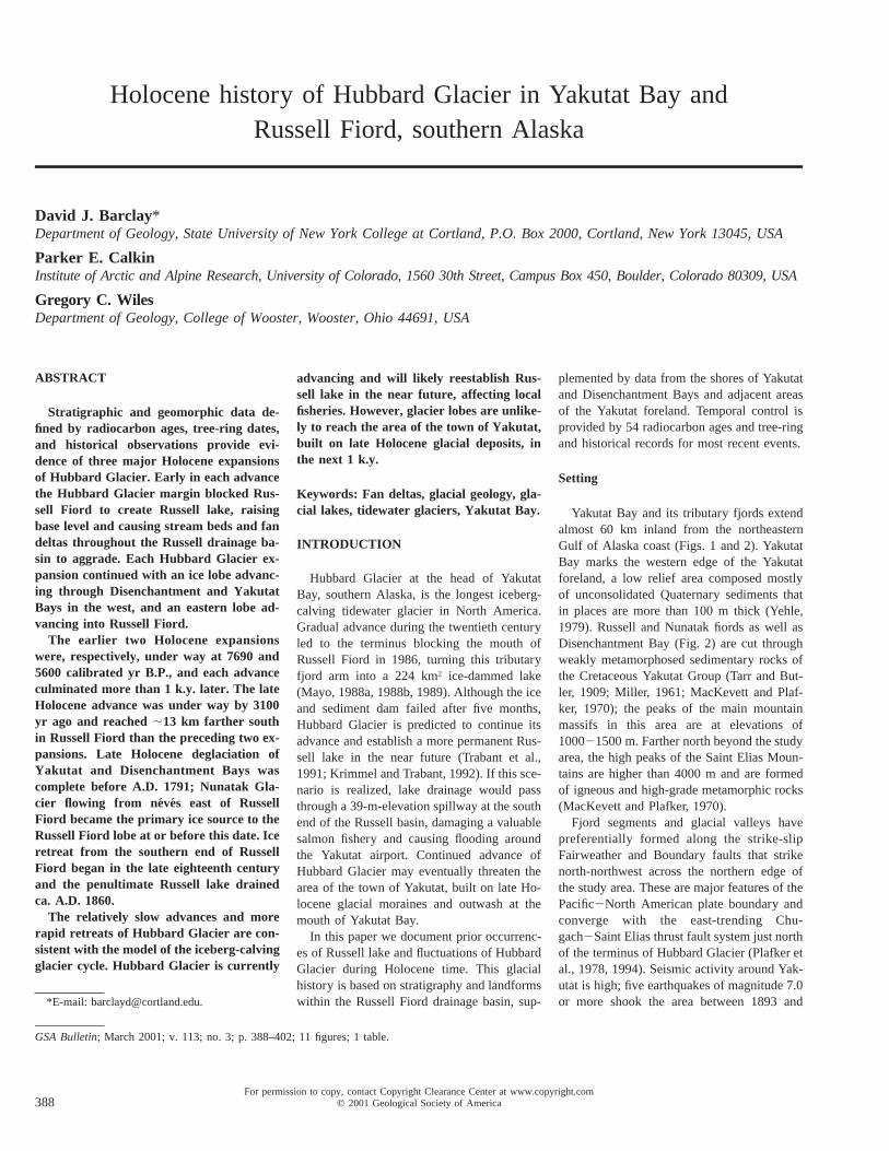
For permission to copy, contact Copyright Clearance Center at www.copyright.com q 2001 Geological Society of America 388 GSA Bulletin; March 2001; v. 113; no. 3; p. 388–402; 11 figures; 1 table. Holocene history of Hubbard Glacier in Yakutat Bay and Russell Fiord, southern Alaska David J. Barclay* Department of Geology, State University of New York College at Cortland, P.O. Box 2000, Cortland, New York 13045, USA Parker E. Calkin Institute of Arctic and Alpine Research, University of Colorado, 1560 30th Street, Campus Box 450, Boulder, Colorado 80309, USA Gregory C. Wiles Department of Geology, College of Wooster, Wooster, Ohio 44691, USA ABSTRACT Stratigraphic and geomorphic data de- fined by radiocarbon ages, tree-ring dates, and historical observations provide evi- dence of three major Holocene expansions of Hubbard Glacier. Early in each advance the Hubbard Glacier margin blocked Rus- sell Fiord to create Russell lake, raising base level and causing stream beds and fan deltas throughout the Russell drainage ba- sin to aggrade. Each Hubbard Glacier ex- pansion continued with an ice lobe advanc- ing through Disenchantment and Yakutat Bays in the west, and an eastern lobe ad- vancing into Russell Fiord. The earlier two Holocene expansions were, respectively, under way at 7690 and 5600 calibrated yr B.P., and each advance culminated more than 1 k.y. later. The late Holocene advance was under way by 3100 yr ago and reached ;13 km farther south in Russell Fiord than the preceding two ex- pansions. Late Holocene deglaciation of Yakutat and Disenchantment Bays was complete before A.D. 1791; Nunatak Gla- cier flowing from ne ´ve ´s east of Russell Fiord became the primary ice source to the Russell Fiord lobe at or before this date. Ice retreat from the southern end of Russell Fiord began in the late eighteenth century and the penultimate Russell lake drained ca. A.D. 1860. The relatively slow advances and more rapid retreats of Hubbard Glacier are con- sistent with the model of the iceberg-calving glacier cycle. Hubbard Glacier is currently *E-mail: [email protected]. advancing and will likely reestablish Rus- sell lake in the near future, affecting local fisheries. However, glacier lobes are unlike- ly to reach the area of the town of Yakutat, built on late Holocene glacial deposits, in the next 1 k.y. Keywords: Fan deltas, glacial geology, gla- cial lakes, tidewater glaciers, Yakutat Bay. INTRODUCTION Hubbard Glacier at the head of Yakutat Bay, southern Alaska, is the longest iceberg- calving tidewater glacier in North America. Gradual advance during the twentieth century led to the terminus blocking the mouth of Russell Fiord in 1986, turning this tributary fjord arm into a 224 km 2 ice-dammed lake (Mayo, 1988a, 1988b, 1989). Although the ice and sediment dam failed after five months, Hubbard Glacier is predicted to continue its advance and establish a more permanent Rus- sell lake in the near future (Trabant et al., 1991; Krimmel and Trabant, 1992). If this sce- nario is realized, lake drainage would pass through a 39-m-elevation spillway at the south end of the Russell basin, damaging a valuable salmon fishery and causing flooding around the Yakutat airport. Continued advance of Hubbard Glacier may eventually threaten the area of the town of Yakutat, built on late Ho- locene glacial moraines and outwash at the mouth of Yakutat Bay. In this paper we document prior occurrenc- es of Russell lake and fluctuations of Hubbard Glacier during Holocene time. This glacial history is based on stratigraphy and landforms within the Russell Fiord drainage basin, sup- plemented by data from the shores of Yakutat and Disenchantment Bays and adjacent areas of the Yakutat foreland. Temporal control is provided by 54 radiocarbon ages and tree-ring and historical records for most recent events. Setting Yakutat Bay and its tributary fjords extend almost 60 km inland from the northeastern Gulf of Alaska coast (Figs. 1 and 2). Yakutat Bay marks the western edge of the Yakutat foreland, a low relief area composed mostly of unconsolidated Quaternary sediments that in places are more than 100 m thick (Yehle, 1979). Russell and Nunatak fiords as well as Disenchantment Bay (Fig. 2) are cut through weakly metamorphosed sedimentary rocks of the Cretaceous Yakutat Group (Tarr and But- ler, 1909; Miller, 1961; MacKevett and Plaf- ker, 1970); the peaks of the main mountain massifs in this area are at elevations of 100021500 m. Farther north beyond the study area, the high peaks of the Saint Elias Moun- tains are higher than 4000 m and are formed of igneous and high-grade metamorphic rocks (MacKevett and Plafker, 1970). Fjord segments and glacial valleys have preferentially formed along the strike-slip Fairweather and Boundary faults that strike north-northwest across the northern edge of the study area. These are major features of the Pacific2North American plate boundary and converge with the east-trending Chu- gach2Saint Elias thrust fault system just north of the terminus of Hubbard Glacier (Plafker et al., 1978, 1994). Seismic activity around Yak- utat is high; five earthquakes of magnitude 7.0 or more shook the area between 1893 and
-
Upload
independent -
Category
Documents
-
view
0 -
download
0
Transcript of Holocene history of Hubbard Glacier in Yakutat Bay and Russell Fiord, southern Alaska
For permission to copy, contact Copyright Clearance Center at www.copyright.comq 2001 Geological Society of America388
GSA Bulletin; March 2001; v. 113; no. 3; p. 388–402; 11 figures; 1 table.
Holocene history of Hubbard Glacier in Yakutat Bay andRussell Fiord, southern Alaska
David J. Barclay*Department of Geology, State University of New York College at Cortland, P.O. Box 2000, Cortland, New York 13045, USA
Parker E. CalkinInstitute of Arctic and Alpine Research, University of Colorado, 1560 30th Street, Campus Box 450, Boulder, Colorado 80309, USA
Gregory C. WilesDepartment of Geology, College of Wooster, Wooster, Ohio 44691, USA
ABSTRACT
Stratigraphic and geomorphic data de-fined by radiocarbon ages, tree-ring dates,and historical observations provide evi-dence of three major Holocene expansionsof Hubbard Glacier. Early in each advancethe Hubbard Glacier margin blocked Rus-sell Fiord to create Russell lake, raisingbase level and causing stream beds and fandeltas throughout the Russell drainage ba-sin to aggrade. Each Hubbard Glacier ex-pansion continued with an ice lobe advanc-ing through Disenchantment and YakutatBays in the west, and an eastern lobe ad-vancing into Russell Fiord.
The earlier two Holocene expansionswere, respectively, under way at 7690 and5600 calibrated yr B.P., and each advanceculminated more than 1 k.y. later. The lateHolocene advance was under way by 3100yr ago and reached ;13 km farther southin Russell Fiord than the preceding two ex-pansions. Late Holocene deglaciation ofYakutat and Disenchantment Bays wascomplete before A.D. 1791; Nunatak Gla-cier flowing from neves east of RussellFiord became the primary ice source to theRussell Fiord lobe at or before this date. Iceretreat from the southern end of RussellFiord began in the late eighteenth centuryand the penultimate Russell lake drainedca. A.D. 1860.
The relatively slow advances and morerapid retreats of Hubbard Glacier are con-sistent with the model of the iceberg-calvingglacier cycle. Hubbard Glacier is currently
*E-mail: [email protected].
advancing and will likely reestablish Rus-sell lake in the near future, affecting localfisheries. However, glacier lobes are unlike-ly to reach the area of the town of Yakutat,built on late Holocene glacial deposits, inthe next 1 k.y.
Keywords: Fan deltas, glacial geology, gla-cial lakes, tidewater glaciers, Yakutat Bay.
INTRODUCTION
Hubbard Glacier at the head of YakutatBay, southern Alaska, is the longest iceberg-calving tidewater glacier in North America.Gradual advance during the twentieth centuryled to the terminus blocking the mouth ofRussell Fiord in 1986, turning this tributaryfjord arm into a 224 km2 ice-dammed lake(Mayo, 1988a, 1988b, 1989). Although the iceand sediment dam failed after five months,Hubbard Glacier is predicted to continue itsadvance and establish a more permanent Rus-sell lake in the near future (Trabant et al.,1991; Krimmel and Trabant, 1992). If this sce-nario is realized, lake drainage would passthrough a 39-m-elevation spillway at the southend of the Russell basin, damaging a valuablesalmon fishery and causing flooding aroundthe Yakutat airport. Continued advance ofHubbard Glacier may eventually threaten thearea of the town of Yakutat, built on late Ho-locene glacial moraines and outwash at themouth of Yakutat Bay.
In this paper we document prior occurrenc-es of Russell lake and fluctuations of HubbardGlacier during Holocene time. This glacialhistory is based on stratigraphy and landformswithin the Russell Fiord drainage basin, sup-
plemented by data from the shores of Yakutatand Disenchantment Bays and adjacent areasof the Yakutat foreland. Temporal control isprovided by 54 radiocarbon ages and tree-ringand historical records for most recent events.
Setting
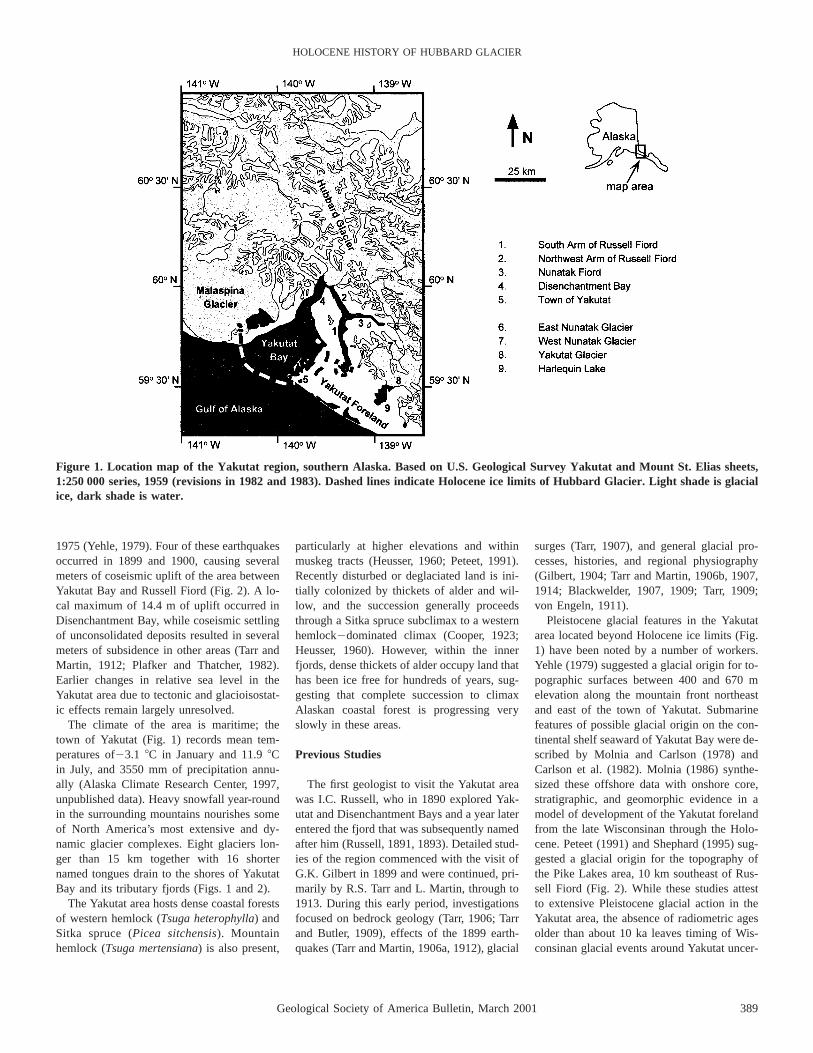
Yakutat Bay and its tributary fjords extendalmost 60 km inland from the northeasternGulf of Alaska coast (Figs. 1 and 2). YakutatBay marks the western edge of the Yakutatforeland, a low relief area composed mostlyof unconsolidated Quaternary sediments thatin places are more than 100 m thick (Yehle,1979). Russell and Nunatak fiords as well asDisenchantment Bay (Fig. 2) are cut throughweakly metamorphosed sedimentary rocks ofthe Cretaceous Yakutat Group (Tarr and But-ler, 1909; Miller, 1961; MacKevett and Plaf-ker, 1970); the peaks of the main mountainmassifs in this area are at elevations of100021500 m. Farther north beyond the studyarea, the high peaks of the Saint Elias Moun-tains are higher than 4000 m and are formedof igneous and high-grade metamorphic rocks(MacKevett and Plafker, 1970).
Fjord segments and glacial valleys havepreferentially formed along the strike-slipFairweather and Boundary faults that strikenorth-northwest across the northern edge ofthe study area. These are major features of thePacific2North American plate boundary andconverge with the east-trending Chu-gach2Saint Elias thrust fault system just northof the terminus of Hubbard Glacier (Plafker etal., 1978, 1994). Seismic activity around Yak-utat is high; five earthquakes of magnitude 7.0or more shook the area between 1893 and
Geological Society of America Bulletin, March 2001 389
HOLOCENE HISTORY OF HUBBARD GLACIER
Figure 1. Location map of the Yakutat region, southern Alaska. Based on U.S. Geological Survey Yakutat and Mount St. Elias sheets,1:250 000 series, 1959 (revisions in 1982 and 1983). Dashed lines indicate Holocene ice limits of Hubbard Glacier. Light shade is glacialice, dark shade is water.
1975 (Yehle, 1979). Four of these earthquakesoccurred in 1899 and 1900, causing severalmeters of coseismic uplift of the area betweenYakutat Bay and Russell Fiord (Fig. 2). A lo-cal maximum of 14.4 m of uplift occurred inDisenchantment Bay, while coseismic settlingof unconsolidated deposits resulted in severalmeters of subsidence in other areas (Tarr andMartin, 1912; Plafker and Thatcher, 1982).Earlier changes in relative sea level in theYakutat area due to tectonic and glacioisostat-ic effects remain largely unresolved.
The climate of the area is maritime; thetown of Yakutat (Fig. 1) records mean tem-peratures of23.1 8C in January and 11.9 8Cin July, and 3550 mm of precipitation annu-ally (Alaska Climate Research Center, 1997,unpublished data). Heavy snowfall year-roundin the surrounding mountains nourishes someof North America’s most extensive and dy-namic glacier complexes. Eight glaciers lon-ger than 15 km together with 16 shorternamed tongues drain to the shores of YakutatBay and its tributary fjords (Figs. 1 and 2).
The Yakutat area hosts dense coastal forestsof western hemlock (Tsuga heterophylla) andSitka spruce (Picea sitchensis). Mountainhemlock (Tsuga mertensiana) is also present,
particularly at higher elevations and withinmuskeg tracts (Heusser, 1960; Peteet, 1991).Recently disturbed or deglaciated land is ini-tially colonized by thickets of alder and wil-low, and the succession generally proceedsthrough a Sitka spruce subclimax to a westernhemlock2dominated climax (Cooper, 1923;Heusser, 1960). However, within the innerfjords, dense thickets of alder occupy land thathas been ice free for hundreds of years, sug-gesting that complete succession to climaxAlaskan coastal forest is progressing veryslowly in these areas.
Previous Studies
The first geologist to visit the Yakutat areawas I.C. Russell, who in 1890 explored Yak-utat and Disenchantment Bays and a year laterentered the fjord that was subsequently namedafter him (Russell, 1891, 1893). Detailed stud-ies of the region commenced with the visit ofG.K. Gilbert in 1899 and were continued, pri-marily by R.S. Tarr and L. Martin, through to1913. During this early period, investigationsfocused on bedrock geology (Tarr, 1906; Tarrand Butler, 1909), effects of the 1899 earth-quakes (Tarr and Martin, 1906a, 1912), glacial
surges (Tarr, 1907), and general glacial pro-cesses, histories, and regional physiography(Gilbert, 1904; Tarr and Martin, 1906b, 1907,1914; Blackwelder, 1907, 1909; Tarr, 1909;von Engeln, 1911).
Pleistocene glacial features in the Yakutatarea located beyond Holocene ice limits (Fig.1) have been noted by a number of workers.Yehle (1979) suggested a glacial origin for to-pographic surfaces between 400 and 670 melevation along the mountain front northeastand east of the town of Yakutat. Submarinefeatures of possible glacial origin on the con-tinental shelf seaward of Yakutat Bay were de-scribed by Molnia and Carlson (1978) andCarlson et al. (1982). Molnia (1986) synthe-sized these offshore data with onshore core,stratigraphic, and geomorphic evidence in amodel of development of the Yakutat forelandfrom the late Wisconsinan through the Holo-cene. Peteet (1991) and Shephard (1995) sug-gested a glacial origin for the topography ofthe Pike Lakes area, 10 km southeast of Rus-sell Fiord (Fig. 2). While these studies attestto extensive Pleistocene glacial action in theYakutat area, the absence of radiometric agesolder than about 10 ka leaves timing of Wis-consinan glacial events around Yakutat uncer-

390 Geological Society of America Bulletin, March 2001
BARCLAY et al.
Figure 2. Location map of the study area. Based on U.S. Geological Survey Yakutat sheet 1:250 000 series, 1959 (revision in 1982), andNOAA 1:80 000, Yakutat Bay chart, 1990. LBE—Logan Beach; AQA—Aquadulce Creek; CAL—Calahonda Valley; 2GC—Two GorgeCreek; HKC—Hendrickson Creek; 3HM—Three Hummingbird; SCV—Shelter Cove; ETC—East Tebenkoff Creek; OGH—OrganicHigh; GLC—Glacier Creek; MTL—Mountaintop Lake; LMT—Limit Bluffs; STB—Stump Bluffs; RFM—Russell Fiord Moraine; FSP—Forest Service Path; YBM—Yakutat Bay Moraine; OCP—Ocean Cape.
tain. However, a general estimate of retreatfrom late Wisconsinan ice stands may bemade by consideration of other glaciers alongthe northeastern Gulf of Alaska coast, whichhad retreated to near modern positions by 13500 yr B.P. (Mann and Hamilton, 1995).
Prior investigations of the Holocene glacial
history of the Yakutat area have mostly beenconducted at a reconnaissance level. Plafkerand Miller (1958) suggested that HubbardGlacier expanded to the mouth of Yakutat Baybetween 970 and 1290 yr B.P., and a laterreadvance culminated at Blizhni Point (Fig. 2)between A.D. 1700 and 1791. Two terminal
moraines enclosing the southern end of Rus-sell Fiord were identified by Miller (1961) ina preliminary geologic map of the Yakutatarea. Wright (1972) and Carlson (1989) de-tailed submarine glacial features in Yakutatand Disenchantment Bays. Evidence for Rus-sell lake existing at 6310 and 4890 yr B.P.
Geological Society of America Bulletin, March 2001 391
HOLOCENE HISTORY OF HUBBARD GLACIER
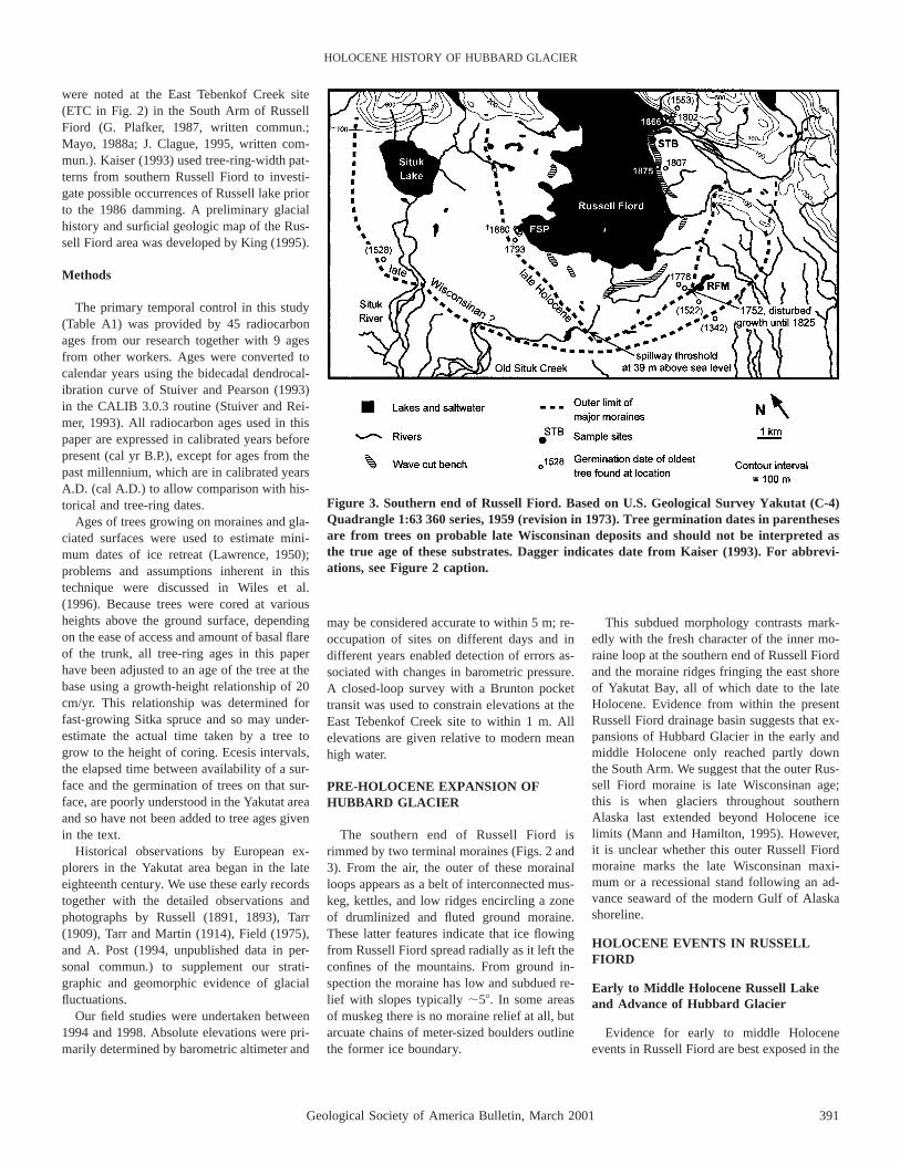
Figure 3. Southern end of Russell Fiord. Based on U.S. Geological Survey Yakutat (C-4)Quadrangle 1:63 360 series, 1959 (revision in 1973). Tree germination dates in parenthesesare from trees on probable late Wisconsinan deposits and should not be interpreted asthe true age of these substrates. Dagger indicates date from Kaiser (1993). For abbrevi-ations, see Figure 2 caption.
were noted at the East Tebenkof Creek site(ETC in Fig. 2) in the South Arm of RussellFiord (G. Plafker, 1987, written commun.;Mayo, 1988a; J. Clague, 1995, written com-mun.). Kaiser (1993) used tree-ring-width pat-terns from southern Russell Fiord to investi-gate possible occurrences of Russell lake priorto the 1986 damming. A preliminary glacialhistory and surficial geologic map of the Rus-sell Fiord area was developed by King (1995).
Methods
The primary temporal control in this study(Table A1) was provided by 45 radiocarbonages from our research together with 9 agesfrom other workers. Ages were converted tocalendar years using the bidecadal dendrocal-ibration curve of Stuiver and Pearson (1993)in the CALIB 3.0.3 routine (Stuiver and Rei-mer, 1993). All radiocarbon ages used in thispaper are expressed in calibrated years beforepresent (cal yr B.P.), except for ages from thepast millennium, which are in calibrated yearsA.D. (cal A.D.) to allow comparison with his-torical and tree-ring dates.
Ages of trees growing on moraines and gla-ciated surfaces were used to estimate mini-mum dates of ice retreat (Lawrence, 1950);problems and assumptions inherent in thistechnique were discussed in Wiles et al.(1996). Because trees were cored at variousheights above the ground surface, dependingon the ease of access and amount of basal flareof the trunk, all tree-ring ages in this paperhave been adjusted to an age of the tree at thebase using a growth-height relationship of 20cm/yr. This relationship was determined forfast-growing Sitka spruce and so may under-estimate the actual time taken by a tree togrow to the height of coring. Ecesis intervals,the elapsed time between availability of a sur-face and the germination of trees on that sur-face, are poorly understood in the Yakutat areaand so have not been added to tree ages givenin the text.
Historical observations by European ex-plorers in the Yakutat area began in the lateeighteenth century. We use these early recordstogether with the detailed observations andphotographs by Russell (1891, 1893), Tarr(1909), Tarr and Martin (1914), Field (1975),and A. Post (1994, unpublished data in per-sonal commun.) to supplement our strati-graphic and geomorphic evidence of glacialfluctuations.
Our field studies were undertaken between1994 and 1998. Absolute elevations were pri-marily determined by barometric altimeter and
may be considered accurate to within 5 m; re-occupation of sites on different days and indifferent years enabled detection of errors as-sociated with changes in barometric pressure.A closed-loop survey with a Brunton pockettransit was used to constrain elevations at theEast Tebenkof Creek site to within 1 m. Allelevations are given relative to modern meanhigh water.
PRE-HOLOCENE EXPANSION OFHUBBARD GLACIER
The southern end of Russell Fiord isrimmed by two terminal moraines (Figs. 2 and3). From the air, the outer of these morainalloops appears as a belt of interconnected mus-keg, kettles, and low ridges encircling a zoneof drumlinized and fluted ground moraine.These latter features indicate that ice flowingfrom Russell Fiord spread radially as it left theconfines of the mountains. From ground in-spection the moraine has low and subdued re-lief with slopes typically ;58. In some areasof muskeg there is no moraine relief at all, butarcuate chains of meter-sized boulders outlinethe former ice boundary.
This subdued morphology contrasts mark-edly with the fresh character of the inner mo-raine loop at the southern end of Russell Fiordand the moraine ridges fringing the east shoreof Yakutat Bay, all of which date to the lateHolocene. Evidence from within the presentRussell Fiord drainage basin suggests that ex-pansions of Hubbard Glacier in the early andmiddle Holocene only reached partly downthe South Arm. We suggest that the outer Rus-sell Fiord moraine is late Wisconsinan age;this is when glaciers throughout southernAlaska last extended beyond Holocene icelimits (Mann and Hamilton, 1995). However,it is unclear whether this outer Russell Fiordmoraine marks the late Wisconsinan maxi-mum or a recessional stand following an ad-vance seaward of the modern Gulf of Alaskashoreline.
HOLOCENE EVENTS IN RUSSELLFIORD
Early to Middle Holocene Russell Lakeand Advance of Hubbard Glacier
Evidence for early to middle Holoceneevents in Russell Fiord are best exposed in the

392 Geological Society of America Bulletin, March 2001
BARCLAY et al.
Figure 4. Stratigraphy and radiocarbon ages at the East Tebenkof Creek site (ETC). See Figure 2 for location. All elevations are abovemodern sea level.
East Tebenkof Creek stream cut (ETC in Figs.2 and 4). Here, the lowest stratigraphic unit isa poorly sorted boulder gravel with subangularclasts derived from adjacent bedrock of theYakutat Group (Fig. 4, section A). This unitis interpreted to be the deposit of an early Ho-locene fan delta that we presume was gradedto tidewater.
The basal boulder gravel unit is overlain by1.5 m of rhythmically bedded fine sand, silt,and clay (Fig. 4, sections A and B). Drop-stones of crystalline lithologies from the SaintElias Mountains within this lacustrine unitsuggest that iceberg-rafted debris reached intothe South Arm of Russell Fiord, an unusualoccurrence today, and support interpretation ofthis flooding surface as the result of HubbardGlacier damming the mouth of Russell Fiord.The lacustrine sediments grade vertically intosteeply dipping sand and gravel foreset bedsoverlain by gravel topset beds (Fig. 4, sectionA), indicating progradation of the fan delta atthe East Tebenkof Creek site out into the new,higher water level of Russell lake. The topset-foreset contact of this deltaic package is fairlyconstant along the exposure at 20 m above sealevel; this contact marks the water level in this
early to middle Holocene Russell lake andwas probably controlled by a spillway cutthrough the late Wisconsinan moraine at thesouthern end of Russell Fiord (Fig. 3).
The date of this flooding event is providedby ages of alder stumps in growth position atthe contact of the fan delta boulder gravel andthe overlying lacustrine unit. Two such stumpsat the East Tebenkof Creek site (Fig. 4, sectionA) have radiocarbon ages that intercept thecalibration curve at 7767 and 7634 cal yr B.P.,while a similar age of 7673 cal yr B.P. wasobtained from wood in an identical setting atthe Organic High site to the south (Fig. 2).Averaging these three samples gives an age ofabout 7690 cal yr B.P. for this first Holocenedamming of Russell Fiord. Ages from woodincorporated into debris flow and fan delta de-posits at, respectively, the Glacier Creek andHendrickson Creek sites (Table A1; Figs. 2and 5) indicate hillslope instability and aggra-dation of a second fan delta in response to theraising of base level in the Russell drainagebasin at this time. Stratigraphy and ages oftransported wood (Fig. 4) show that the fandelta at the East Tebenkof Creek site contin-ued to aggrade for at least the next 1 k.y.
The advance of Hubbard Glacier southwardinto early to middle Holocene Russell lake isindicated by a silty basal till at the Hendrick-son Creek site, stratigraphically constrained tohave been deposited between 7787 and 5585cal yr B.P. (Figs. 2 and 5). No terminal mo-raine preserved today marks the culminationof this advance. However, as described in thenext section, topset-foreset contacts at the EastTebenkof Creek site indicate that the waterlevel in the succeeding phase of Russell lake,during the middle Holocene, reached 45 mhigher than water in the early to middle Ho-locene Russell lake (Fig. 4). This is consistentwith the water level in middle Holocene Rus-sell lake being controlled by a new, higherspillway cut through a terminal moraine con-structed south of the East Tebenkof Creek siteduring culmination of the early to middle Ho-locene advance of Hubbard Glacier.
Further evidence indicating the maximumof the early to middle Holocene advance ofHubbard Glacier comes from stratigraphy atthe Limit Creek site (Figs. 2 and 5). Here,early to middle Holocene Russell lake depos-its are overlain by very poorly sorted stratifiedgravel beds containing faceted and striated
Geological Society of America Bulletin, March 2001 393
HOLOCENE HISTORY OF HUBBARD GLACIER
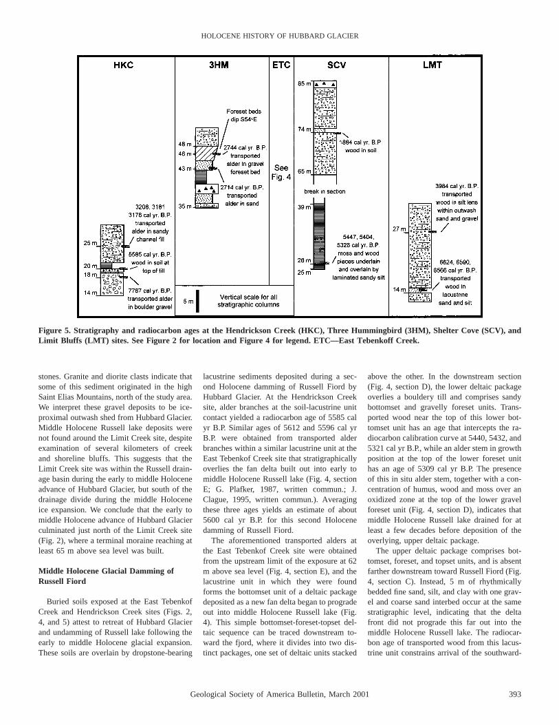
Figure 5. Stratigraphy and radiocarbon ages at the Hendrickson Creek (HKC), Three Hummingbird (3HM), Shelter Cove (SCV), andLimit Bluffs (LMT) sites. See Figure 2 for location and Figure 4 for legend. ETC—East Tebenkoff Creek.
stones. Granite and diorite clasts indicate thatsome of this sediment originated in the highSaint Elias Mountains, north of the study area.We interpret these gravel deposits to be ice-proximal outwash shed from Hubbard Glacier.Middle Holocene Russell lake deposits werenot found around the Limit Creek site, despiteexamination of several kilometers of creekand shoreline bluffs. This suggests that theLimit Creek site was within the Russell drain-age basin during the early to middle Holoceneadvance of Hubbard Glacier, but south of thedrainage divide during the middle Holoceneice expansion. We conclude that the early tomiddle Holocene advance of Hubbard Glacierculminated just north of the Limit Creek site(Fig. 2), where a terminal moraine reaching atleast 65 m above sea level was built.
Middle Holocene Glacial Damming ofRussell Fiord
Buried soils exposed at the East TebenkofCreek and Hendrickson Creek sites (Figs. 2,4, and 5) attest to retreat of Hubbard Glacierand undamming of Russell lake following theearly to middle Holocene glacial expansion.These soils are overlain by dropstone-bearing
lacustrine sediments deposited during a sec-ond Holocene damming of Russell Fiord byHubbard Glacier. At the Hendrickson Creeksite, alder branches at the soil-lacustrine unitcontact yielded a radiocarbon age of 5585 calyr B.P. Similar ages of 5612 and 5596 cal yrB.P. were obtained from transported alderbranches within a similar lacustrine unit at theEast Tebenkof Creek site that stratigraphicallyoverlies the fan delta built out into early tomiddle Holocene Russell lake (Fig. 4, sectionE; G. Plafker, 1987, written commun.; J.Clague, 1995, written commun.). Averagingthese three ages yields an estimate of about5600 cal yr B.P. for this second Holocenedamming of Russell Fiord.
The aforementioned transported alders atthe East Tebenkof Creek site were obtainedfrom the upstream limit of the exposure at 62m above sea level (Fig. 4, section E), and thelacustrine unit in which they were foundforms the bottomset unit of a deltaic packagedeposited as a new fan delta began to progradeout into middle Holocene Russell lake (Fig.4). This simple bottomset-foreset-topset del-taic sequence can be traced downstream to-ward the fjord, where it divides into two dis-tinct packages, one set of deltaic units stacked
above the other. In the downstream section(Fig. 4, section D), the lower deltaic packageoverlies a bouldery till and comprises sandybottomset and gravelly foreset units. Trans-ported wood near the top of this lower bot-tomset unit has an age that intercepts the ra-diocarbon calibration curve at 5440, 5432, and5321 cal yr B.P., while an alder stem in growthposition at the top of the lower foreset unithas an age of 5309 cal yr B.P. The presenceof this in situ alder stem, together with a con-centration of humus, wood and moss over anoxidized zone at the top of the lower gravelforeset unit (Fig. 4, section D), indicates thatmiddle Holocene Russell lake drained for atleast a few decades before deposition of theoverlying, upper deltaic package.
The upper deltaic package comprises bot-tomset, foreset, and topset units, and is absentfarther downstream toward Russell Fiord (Fig.4, section C). Instead, 5 m of rhythmicallybedded fine sand, silt, and clay with one grav-el and coarse sand interbed occur at the samestratigraphic level, indicating that the deltafront did not prograde this far out into themiddle Holocene Russell lake. The radiocar-bon age of transported wood from this lacus-trine unit constrains arrival of the southward-

394 Geological Society of America Bulletin, March 2001
BARCLAY et al.
Figure 6. Composite stratigraphy and ra-diocarbon ages at the Stump Bluffs site. SeeFigure 2 for location and Figure 4 forlegend.
Figure 7. Stratigraphy and radiocarbon ages at the Two Gorge Creek site. See Figure 2for location and Figure 4 for legend.
advancing Hubbard Glacier margin at the EastTebenkof Creek site to after 4862 cal yr B.P.(Fig. 4, section C). The topset-foreset contactof the middle Holocene fan delta at the EastTebenkof Creek site drops from 65 to 50 mabove sea level when traced toward RussellFiord (Fig. 4, sections E and D); this may re-flect fluvial downcutting of the spillwaythrough the early to middle Holocene terminalmoraine during the 750 yr or more that themiddle Holocene Russell lake existed.
Middle Holocene Maximum and Retreatof Hubbard Glacier in Russell Fiord
The Stump Bluffs site in southern RussellFiord was south of the early to middle Holo-cene terminal moraine, and so outside of thearea flooded by the middle Holocene Russelllake (Fig. 2). This bluff exposure (Fig. 6) dis-plays several discrete episodes of meltwaterponding or sand and gravel aggradation, sep-arated by intervals of landsurface stabilizationand concomitant forest growth. Radiocarbonages from the forest beds suggest that thesesediments, which we interpret to be distal out-wash from Hubbard Glacier, were being de-
posited here from at least ca. 4300 to 3474 calyr B.P. (Table A1).
Distal outwash from Hubbard Glacier mayalso have been aggrading at the Forest ServicePath site (Fig. 2) during the middle Holocene.Here, one of several tree stumps that protrudethrough the modern beach and intertidal zonehas a radiocarbon age that intercepts the cal-ibration curve at 3960, 3958, and 3926 cal yrB.P. Farther north, the upper ice-proximal out-wash sediments at the Limit Creek site (Figs.2 and 5) were also deposited at about thissame time, based on an age of 3984 cal yrB.P. from transported wood incorporated intoa thin silt lens within these poorly sorted grav-el deposits.
The interval of outwash aggradation fromat least ca. 4300 to 3474 cal yr B.P. at thewidely spaced Stump Bluffs, Forest ServicePath, and Limit Creek sites suggests that thisis when Hubbard Glacier stood at the southernend of Russell lake and was delivering melt-water and sediment directly onto the forestedlowland to the south. As with the precedingadvance, no terminal moraine preserved todaymarks the maximum stand of Hubbard Glacierduring middle Holocene time. However, thedeposition of ice-proximal outwash at theLimit Creek site (Fig. 5) leads us to suggestthat the middle Holocene advance culminatedat or close to the terminal moraine built duringthe early to middle Holocene maximum ofHubbard Glacier, just north of the Limit Creeksite (Fig. 2).
Retreat of the Hubbard Glacier terminusfrom its middle Holocene maximum and
draining of Russell lake may be marked bydeposition of a sandy fluvial channel fill 25 mabove sea level at the Hendrickson Creek site(Figs. 2 and 5). Transported alder branches inthis channel fill yielded a radiocarbon age thatintercepted the calibration curve at 3208,3181, and 3176 cal yr B.P. (Table A1).
Late Holocene Advance of HubbardGlacier in Russell Fiord
A third major Holocene expansion of Hub-bard Glacier occurred following retreat fromthe middle Holocene advance. Foreset beds ofa fan delta at the Three Hummingbird site(Figs. 2 and 5) yielded two pieces of trans-ported wood with respective ages of 2744 and2714 cal yr B.P.; a late Holocene phase ofRussell lake, into which this fan delta wasprograding, had to have been initiated by thistime. Topset-foreset contacts at the ThreeHummingbird site and two other stream-cutexposures nearby to the south indicate thatwaters within this late Holocene Russell lakereached 45250 m above sea level.
A similar age of 2776 cal yr B.P. was ob-tained from transported wood in a bouldergravel at 140 m above sea level at the TwoGorge Creek site (Figs. 2 and 7). This bouldergravel unit thickens toward Russell Fiord; wesuggest that this deposit represents aggrada-tion of a fjord-side stream channel in responseto raised base level in the Russell drainagebasin at this time.
Ice-contact deposits between 60 and 160 melevation at the Two Gorge Creek site (Figs.
Geological Society of America Bulletin, March 2001 395
HOLOCENE HISTORY OF HUBBARD GLACIER
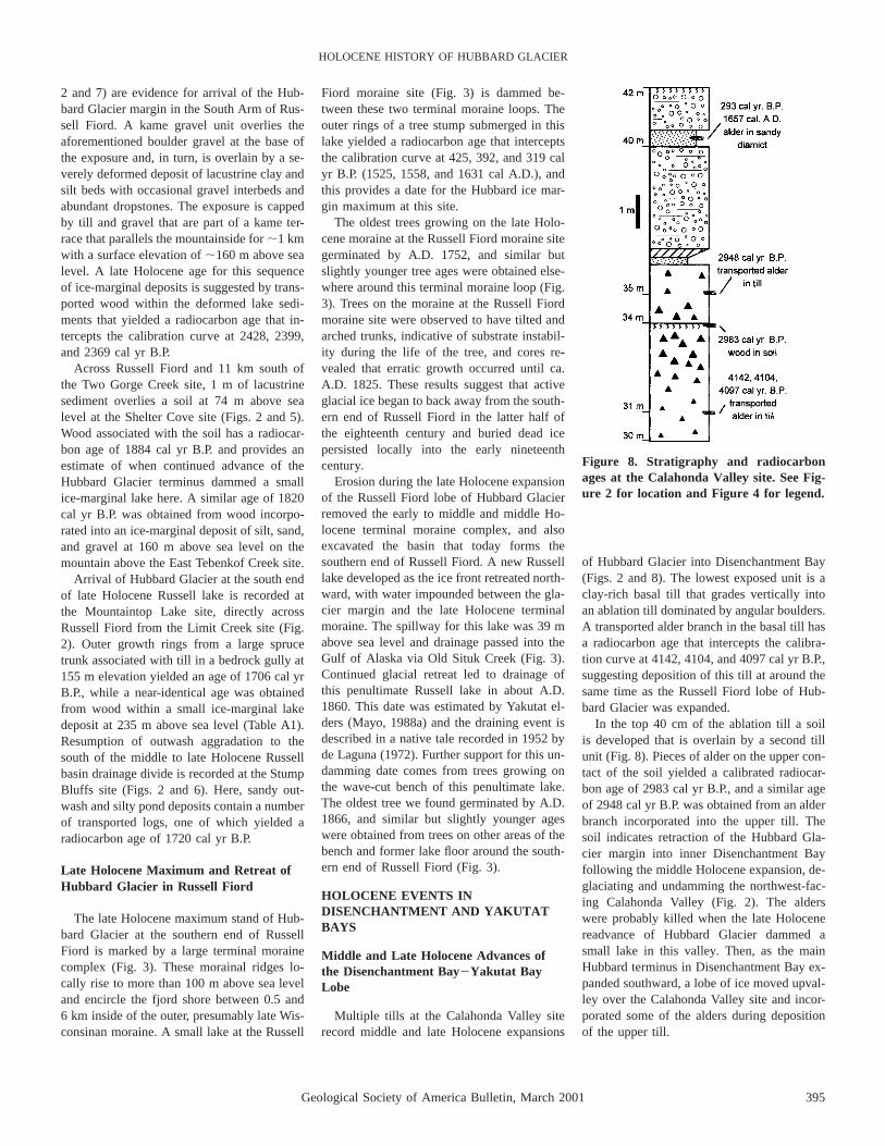
Figure 8. Stratigraphy and radiocarbonages at the Calahonda Valley site. See Fig-ure 2 for location and Figure 4 for legend.
2 and 7) are evidence for arrival of the Hub-bard Glacier margin in the South Arm of Rus-sell Fiord. A kame gravel unit overlies theaforementioned boulder gravel at the base ofthe exposure and, in turn, is overlain by a se-verely deformed deposit of lacustrine clay andsilt beds with occasional gravel interbeds andabundant dropstones. The exposure is cappedby till and gravel that are part of a kame ter-race that parallels the mountainside for ;1 kmwith a surface elevation of ;160 m above sealevel. A late Holocene age for this sequenceof ice-marginal deposits is suggested by trans-ported wood within the deformed lake sedi-ments that yielded a radiocarbon age that in-tercepts the calibration curve at 2428, 2399,and 2369 cal yr B.P.
Across Russell Fiord and 11 km south ofthe Two Gorge Creek site, 1 m of lacustrinesediment overlies a soil at 74 m above sealevel at the Shelter Cove site (Figs. 2 and 5).Wood associated with the soil has a radiocar-bon age of 1884 cal yr B.P. and provides anestimate of when continued advance of theHubbard Glacier terminus dammed a smallice-marginal lake here. A similar age of 1820cal yr B.P. was obtained from wood incorpo-rated into an ice-marginal deposit of silt, sand,and gravel at 160 m above sea level on themountain above the East Tebenkof Creek site.
Arrival of Hubbard Glacier at the south endof late Holocene Russell lake is recorded atthe Mountaintop Lake site, directly acrossRussell Fiord from the Limit Creek site (Fig.2). Outer growth rings from a large sprucetrunk associated with till in a bedrock gully at155 m elevation yielded an age of 1706 cal yrB.P., while a near-identical age was obtainedfrom wood within a small ice-marginal lakedeposit at 235 m above sea level (Table A1).Resumption of outwash aggradation to thesouth of the middle to late Holocene Russellbasin drainage divide is recorded at the StumpBluffs site (Figs. 2 and 6). Here, sandy out-wash and silty pond deposits contain a numberof transported logs, one of which yielded aradiocarbon age of 1720 cal yr B.P.
Late Holocene Maximum and Retreat ofHubbard Glacier in Russell Fiord
The late Holocene maximum stand of Hub-bard Glacier at the southern end of RussellFiord is marked by a large terminal morainecomplex (Fig. 3). These morainal ridges lo-cally rise to more than 100 m above sea leveland encircle the fjord shore between 0.5 and6 km inside of the outer, presumably late Wis-consinan moraine. A small lake at the Russell
Fiord moraine site (Fig. 3) is dammed be-tween these two terminal moraine loops. Theouter rings of a tree stump submerged in thislake yielded a radiocarbon age that interceptsthe calibration curve at 425, 392, and 319 calyr B.P. (1525, 1558, and 1631 cal A.D.), andthis provides a date for the Hubbard ice mar-gin maximum at this site.
The oldest trees growing on the late Holo-cene moraine at the Russell Fiord moraine sitegerminated by A.D. 1752, and similar butslightly younger tree ages were obtained else-where around this terminal moraine loop (Fig.3). Trees on the moraine at the Russell Fiordmoraine site were observed to have tilted andarched trunks, indicative of substrate instabil-ity during the life of the tree, and cores re-vealed that erratic growth occurred until ca.A.D. 1825. These results suggest that activeglacial ice began to back away from the south-ern end of Russell Fiord in the latter half ofthe eighteenth century and buried dead icepersisted locally into the early nineteenthcentury.
Erosion during the late Holocene expansionof the Russell Fiord lobe of Hubbard Glacierremoved the early to middle and middle Ho-locene terminal moraine complex, and alsoexcavated the basin that today forms thesouthern end of Russell Fiord. A new Russelllake developed as the ice front retreated north-ward, with water impounded between the gla-cier margin and the late Holocene terminalmoraine. The spillway for this lake was 39 mabove sea level and drainage passed into theGulf of Alaska via Old Situk Creek (Fig. 3).Continued glacial retreat led to drainage ofthis penultimate Russell lake in about A.D.1860. This date was estimated by Yakutat el-ders (Mayo, 1988a) and the draining event isdescribed in a native tale recorded in 1952 byde Laguna (1972). Further support for this un-damming date comes from trees growing onthe wave-cut bench of this penultimate lake.The oldest tree we found germinated by A.D.1866, and similar but slightly younger ageswere obtained from trees on other areas of thebench and former lake floor around the south-ern end of Russell Fiord (Fig. 3).
HOLOCENE EVENTS INDISENCHANTMENT AND YAKUTATBAYS
Middle and Late Holocene Advances ofthe Disenchantment Bay2Yakutat BayLobe
Multiple tills at the Calahonda Valley siterecord middle and late Holocene expansions
of Hubbard Glacier into Disenchantment Bay(Figs. 2 and 8). The lowest exposed unit is aclay-rich basal till that grades vertically intoan ablation till dominated by angular boulders.A transported alder branch in the basal till hasa radiocarbon age that intercepts the calibra-tion curve at 4142, 4104, and 4097 cal yr B.P.,suggesting deposition of this till at around thesame time as the Russell Fiord lobe of Hub-bard Glacier was expanded.
In the top 40 cm of the ablation till a soilis developed that is overlain by a second tillunit (Fig. 8). Pieces of alder on the upper con-tact of the soil yielded a calibrated radiocar-bon age of 2983 cal yr B.P., and a similar ageof 2948 cal yr B.P. was obtained from an alderbranch incorporated into the upper till. Thesoil indicates retraction of the Hubbard Gla-cier margin into inner Disenchantment Bayfollowing the middle Holocene expansion, de-glaciating and undamming the northwest-fac-ing Calahonda Valley (Fig. 2). The alderswere probably killed when the late Holocenereadvance of Hubbard Glacier dammed asmall lake in this valley. Then, as the mainHubbard terminus in Disenchantment Bay ex-panded southward, a lobe of ice moved upval-ley over the Calahonda Valley site and incor-porated some of the alders during depositionof the upper till.
396 Geological Society of America Bulletin, March 2001
BARCLAY et al.
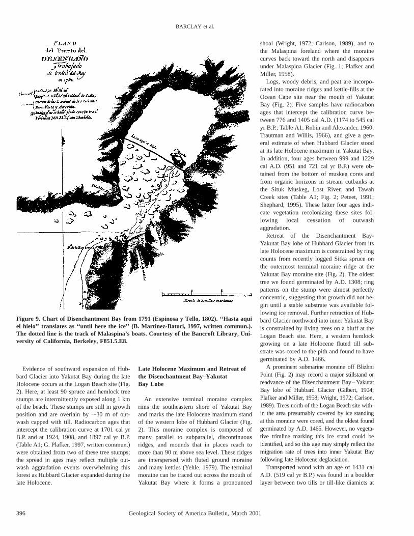
Figure 9. Chart of Disenchantment Bay from 1791 (Espinosa y Tello, 1802). ‘‘Hasta aquiel hielo’’ translates as ‘‘until here the ice’’ (B. Martinez-Batori, 1997, written commun.).The dotted line is the track of Malaspina’s boats. Courtesy of the Bancroft Library, Uni-versity of California, Berkeley, F851.5.E8.
Evidence of southward expansion of Hub-bard Glacier into Yakutat Bay during the lateHolocene occurs at the Logan Beach site (Fig.2). Here, at least 90 spruce and hemlock treestumps are intermittently exposed along 1 kmof the beach. These stumps are still in growthposition and are overlain by ;30 m of out-wash capped with till. Radiocarbon ages thatintercept the calibration curve at 1701 cal yrB.P. and at 1924, 1908, and 1897 cal yr B.P.(Table A1; G. Plafker, 1997, written commun.)were obtained from two of these tree stumps;the spread in ages may reflect multiple out-wash aggradation events overwhelming thisforest as Hubbard Glacier expanded during thelate Holocene.
Late Holocene Maximum and Retreat ofthe Disenchantment Bay–YakutatBay Lobe
An extensive terminal moraine complexrims the southeastern shore of Yakutat Bayand marks the late Holocene maximum standof the western lobe of Hubbard Glacier (Fig.2). This moraine complex is composed ofmany parallel to subparallel, discontinuousridges, and mounds that in places reach tomore than 90 m above sea level. These ridgesare interspersed with fluted ground moraineand many kettles (Yehle, 1979). The terminalmoraine can be traced out across the mouth ofYakutat Bay where it forms a pronounced
shoal (Wright, 1972; Carlson, 1989), and tothe Malaspina foreland where the morainecurves back toward the north and disappearsunder Malaspina Glacier (Fig. 1; Plafker andMiller, 1958).
Logs, woody debris, and peat are incorpo-rated into moraine ridges and kettle-fills at theOcean Cape site near the mouth of YakutatBay (Fig. 2). Five samples have radiocarbonages that intercept the calibration curve be-tween 776 and 1405 cal A.D. (1174 to 545 calyr B.P.; Table A1; Rubin and Alexander, 1960;Trautman and Willis, 1966), and give a gen-eral estimate of when Hubbard Glacier stoodat its late Holocene maximum in Yakutat Bay.In addition, four ages between 999 and 1229cal A.D. (951 and 721 cal yr B.P.) were ob-tained from the bottom of muskeg cores andfrom organic horizons in stream cutbanks atthe Situk Muskeg, Lost River, and TawahCreek sites (Table A1; Fig. 2; Peteet, 1991;Shephard, 1995). These latter four ages indi-cate vegetation recolonizing these sites fol-lowing local cessation of outwashaggradation.
Retreat of the Disenchantment Bay-Yakutat Bay lobe of Hubbard Glacier from itslate Holocene maximum is constrained by ringcounts from recently logged Sitka spruce onthe outermost terminal moraine ridge at theYakutat Bay moraine site (Fig. 2). The oldesttree we found germinated by A.D. 1308; ringpatterns on the stump were almost perfectlyconcentric, suggesting that growth did not be-gin until a stable substrate was available fol-lowing ice removal. Further retraction of Hub-bard Glacier northward into inner Yakutat Bayis constrained by living trees on a bluff at theLogan Beach site. Here, a western hemlockgrowing on a late Holocene fluted till sub-strate was cored to the pith and found to havegerminated by A.D. 1466.
A prominent submarine moraine off BlizhniPoint (Fig. 2) may record a major stillstand orreadvance of the Disenchantment Bay2YakutatBay lobe of Hubbard Glacier (Gilbert, 1904;Plafker and Miller, 1958; Wright, 1972; Carlson,1989). Trees north of the Logan Beach site with-in the area presumably covered by ice standingat this moraine were cored, and the oldest foundgerminated by A.D. 1465. However, no vegeta-tive trimline marking this ice stand could beidentified, and so this age may simply reflect themigration rate of trees into inner Yakutat Bayfollowing late Holocene deglaciation.
Transported wood with an age of 1431 calA.D. (519 cal yr B.P.) was found in a boulderlayer between two tills or till-like diamicts at
Geological Society of America Bulletin, March 2001 397
HOLOCENE HISTORY OF HUBBARD GLACIER
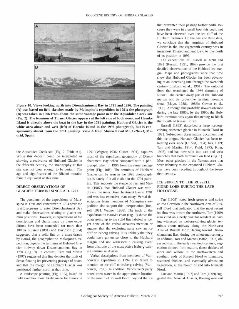
Figure 10. Views looking north into Disenchantment Bay in 1791 and 1996. The painting(A) was based on field sketches made by Malaspina’s expedition in 1791; the photograph(B) was taken in 1996 from about the same vantage point near the Aquadulce Creek site(Fig. 2). The terminus of Turner Glacier appears at the left side of both views, and HaenkeIsland is directly above the boat in the bay in the 1791 painting. Hubbard Glacier is thewhite area above and west (left) of Haenke Island in the 1996 photograph, but is con-spicuously absent from the 1791 painting. View A from Museo Naval MS 1726–73, Ma-drid, Spain.
the Aquadulce Creek site (Fig. 2; Table A1).While this deposit could be interpreted asshowing a readvance of Hubbard Glacier inthe fifteenth century, the stratigraphy at thissite was not clear enough to be certain. Theage and significance of the Blizhni moraineremain equivocal at this time.
DIRECT OBSERVATIONS OFGLACIER TERMINI SINCE A.D. 1791
The personnel of the expeditions of Mala-spina in 1791 and Vancouver in 1794 were thefirst Europeans to enter Disenchantment Bayand make observations relating to glacier ter-mini positions. However, interpretations of thedescriptions and charts made by these expe-ditions have been contended for more than100 yr. Russell (1891) and Davidson (1904)suggested that a solid line on a chart drawnby Bauza, the geographer on Malaspina’s ex-pedition, depicts the terminus of Hubbard Gla-cier midway down Disenchantment Bay in1791 (Fig. 9). In contrast, Tarr and Martin(1907) suggested this line denotes the limit ofdense floating ice preventing passage of boats,and that the margin of Hubbard Glacier waspositioned farther north at that time.
A landscape painting (Fig. 10A), based onfield sketches most likely made by Bauza in
1791 (Wagner, 1936; Cutter, 1991), capturesmost of the significant geography of Disen-chantment Bay when compared with a pho-tograph taken in 1996 from the same vantagepoint (Fig. 10B). The terminus of HubbardGlacier can be seen in the 1996 photograph,but is barely if at all visible in the 1791 paint-ing. This supports the stance of Tarr and Mar-tin (1907), that Hubbard Glacier was with-drawn into inner Disenchantment Bay in 1791and was less extensive than today. Verbal de-scriptions from members of Malaspina’s ex-pedition also support this interpretation (Rus-sell, 1891; Wagner, 1936). The track of theexpedition on Bauza’s chart (Fig. 9) shows theboats going up to the solid line labeled as ice,yet none of the verbal accounts mention orsuggest that the exploring party saw an icecliff or iceberg calving. It is unlikely that theycould have gotten so close to the Hubbardmargin and not witnessed a calving eventfrom this, one of the most active iceberg-calv-ing termini in Alaska.
Verbal descriptions from members of Van-couver’s expedition in 1794 also failed tomention an ice cliff or iceberg calving (Van-couver, 1798). In addition, Vancouver’s partynoted open water in the approximate locationof the mouth of Russell Fiord, beyond the ice
that prevented their passage farther north. Be-cause they were in a small boat this could nothave been observed over the ice cliff of theHubbard terminus. On the basis of these data,we conclude that the terminus of HubbardGlacier in the late eighteenth century was ininnermost Disenchantment Bay, to the northof its position in 1996.
The expeditions of Russell in 1890 and1891 (Russell, 1891, 1893) provide the firstdetailed observations of the Hubbard ice mar-gin. Maps and photographs since that timeshow that Hubbard Glacier has been advanc-ing at an increasing rate through the twentiethcentury (Trabant et al., 1991). The outburstflood that terminated the 1986 damming ofRussell lake carried away part of the Hubbardmargin and its protective terminal moraineshoal (Mayo, 1988a, 1988b; Cowan et al.,1996). Although this probably slowed advanceduring the late 1980s, by the 1990s the Hub-bard terminus was again threatening to blockthe mouth of Russell Fiord.
Russell (1893) described a large iceberg-calving tidewater glacier in Nunatak Fiord in1891. Subsequent observations document thatthis ice tongue, Nunatak Glacier, has been re-treating ever since (Gilbert, 1904; Tarr, 1909;Tarr and Martin, 1914; Field, 1975; King,1995), and has now split into east and westbranches that both terminate on land (Fig. 1).Most other glaciers in the Yakutat area thatwere tributary to the expanded Hubbard Gla-cier have been receding throughout the twen-tieth century.
ICE SUPPLY TO THE RUSSELLFIORD LOBE DURING THE LATEHOLOCENE
Tarr (1909) noted fresh grooves and striaeat low elevation in the Northwest Arm of Rus-sell Fiord that indicated that the most recentice flow was toward the northwest. Tarr (1909)also cited an elderly Yakutat resident as hav-ing witnessed an iceberg-calving glacier ter-minus about midway along the NorthwestArm of Russell Fiord, facing toward Disen-chantment Bay, during the nineteenth century.In addition, Tarr and Martin (1906b, 1907) ob-served that in the early twentieth century, veg-etation thinned from mature, dense thickets ofalder and willow in the northwestern andsouthern ends of Russell Fiord to immature,scattered thickets, and eventually almost novegetation, at the mouth of and into NunatakFiord.
Tarr and Martin (1907) and Tarr (1909) sug-gested that Nunatak Glacier, flowing west out

398 Geological Society of America Bulletin, March 2001
BARCLAY et al.
Figure 11. Time-distance diagram showing advances of Hubbard Glacier in Disenchant-ment and Yakutat Bays (left) and Russell Fiord (right). Control points are radiocarbonages with one standard deviation range (T-bars) and tree-ring minimum dates (open cir-cles). The dashed line indicates a middle Holocene advance of uncertain extent into Dis-enchantment and Yakutat Bays.
of Nunatak Fiord, dammed the penultimateRussell lake in the South Arm during the eigh-teenth and nineteenth centuries. We concurwith this conclusion and infer that NunatakGlacier became the primary source of ice tothe Russell Fiord lobe when Hubbard Glacierin Disenchantment Bay retreated north of theentrance to Russell Fiord. This had occurredbefore Malaspina’s visit in A.D. 1791, andpossibly much earlier. Ice flow in the North-west Arm of Russell Fiord would have re-versed direction, and Nunatak Glacier wouldhave been left with termini facing both north-west and south. We suggest that these two ter-mini retreated back toward Nunatak Fiord dur-ing the nineteeth century and intersected in1860, allowing the penultimate Russell lake todrain.
Support for a major expansion of ice fromthe neves east of Russell Fiord during the lateHolocene comes from outlet glaciers thatdrain southward from this area to the Yakutatforeland. Trees close to the current terminusof Yakutat Glacier (Fig. 1) were drowned inan ice-dammed lake ca. 1100 cal yr B.P. (G.Wiles and G. Jacoby, 1996, unpublished datain personal commun.), indicating expansion ofthis major outlet tongue at that time. This ad-vance of Yakutat Glacier culminated at thesouth end of Harlequin Lake (Fig. 1) beforeA.D. 1850 (A. Post, 1994, unpublished datain personal commun.). Furthermore, Shephard(1995) cored trees on the terminal moraines ofseveral other glaciers farther east along theYakutat foreland and inferred that these icetongues had also reached maxima in the past150 yr.
HUBBARD GLACIER AND THEICEBERG-CALVING GLACIER CYCLE
A time-distance diagram (Fig. 11) that sum-marizes the Holocene history of Hubbard Gla-cier clearly shows the cyclic nature of thethree major fluctuations. This strongly sup-ports the notion of an iceberg-calving glaciercycle, wherein slow terminus advance is fol-lowed by rapid, often catastrophic breakupand retreat (Post, 1975; Trabant et al., 1991).The rate of advance is closely related to therate at which a protective terminal moraineshoal can be reworked and moved down thefjord with the advancing terminus (Meier andPost, 1987; Alley, 1991; Powell, 1991); retreatfrom this shoal places the terminus in deeperwater, where it is unstable and so prone torapid calving and recession.
Reconstructed mean advance rates are bestconstrained for the Russell Fiord lobe and
range from 28 to 42 m/yr; this compares fa-vorably with observed advance rates of Hub-bard Glacier during the twentieth century of16247 m/yr (Trabant et al., 1991), and similaradvance rates documented at other Alaskantidewater glaciers (Meier and Post, 1987). Ad-vance of the western lobe was slowest throughinner Yakutat Bay, where the bay widenswhile remaining deep (Figs. 2 and 11), re-quiring addition of sediment from upglacier toenable growth of the stabilizing terminal mo-raine shoal. In contrast, advance was fasterthrough outer Yakutat Bay where water depthsare generally much shallower.
Deglaciation during the late Holocene wasinitiated in the Disenchantment Bay2YakutatBay lobe. Presumably rapid calving retreat(Post, 1975; Post and Motyka, 1995) broughtthe margin of the western Hubbard Glacierlobe back into Disenchantment Bay; deglaci-ation then proceeded into Russell Fiord andeventually left the entire fjord system free ofglacial ice. Given that the DisenchantmentBay2Yakutat Bay lobe is more exposed to theGulf of Alaska and so potentially more unsta-ble than the Russell Fiord lobe, this asynchro-nous retreat of the lobes of Hubbard Glacier
probably also occurred following the early tomiddle and middle Holocene ice expansions.
Although Nunatak Glacier was blocking theSouth Arm of Russell Fiord during the lateHolocene deglaciation, we have assumed inour reconstruction (Fig. 11) that it was Hub-bard Glacier that dammed and then advancedsouthward along Russell Fiord during each ofthe major Holocene glacial expansions. Thisis reasonable given that iceberg-calvingtongues such as Hubbard and Nunatak Gla-ciers usually only stabilize following rapidcalving retreat once they reach shallow waterat the heads of their fjords (Trabant et al.,1991). When readvance occurs, Hubbard Gla-cier has to advance only 10 km to block Rus-sell Fiord, and this will happen long beforeNunatak Glacier can extend 25 km to reachthe junction of Nunatak and Russell Fiords.Also, Hubbard Glacier is much larger thanNunatak Glacier (Fig. 1), and so will dominateice flow through Russell Fiord when both ofthese glaciers are expanded.
Hubbard Glacier today is early in the ad-vancing stage of the iceberg-calving glaciercycle (Trabant et al., 1991) and this advanceis driven by an accumulation area ratio (AAR)
Geological Society of America Bulletin, March 2001 399
HOLOCENE HISTORY OF HUBBARD GLACIER
of 0.96, the highest of any Alaskan tidewaterglacier (Meier et al., 1980; Viens, 1994). Thishigh AAR reflects the loss by Hubbard Glacierof almost its entire ablation area during degla-ciation of the fjord system following the lateHolocene maximum. In order to attain a stableAAR of 0.65 (Meier and Post, 1962; Mann,1986), Hubbard Glacier needs to gain ;2000km2 of ablation area (Barclay, 1998). This isapproximately equal to the combined areas ofYakutat and Disenchantment Bays and Russelland Nunatak Fjords, suggesting that HubbardGlacier will continue to expand in the futureto restore its lost ablation area and reach equi-librium with current climate.
It is almost inevitable that Hubbard Glacierwill redam Russell Fiord to create Russell lakein the near future, although exactly when thiswill occur is less certain. The Holocene his-tory of Hubbard Glacier suggests that follow-ing this blockage the Hubbard terminus willdivide into two lobes that will continue to ad-vance southward through, respectively, Dis-enchantment Bay2Yakutat Bay in the westand Russell Fiord in the east. Although sometemporary lake filling and draining episodesmay occur such as happened in 1986 and inthe middle Holocene, Russell lake will even-tually become established as a stable featureof the Yakutat area.
Creation of a stable Russell lake with drain-age into Old Situk Creek will initially havesome negative local impacts, including deathof saltwater organisms trapped in Russell lake,damage to the Situk River salmon fishery, andinundation of areas around Yakutat airport(Reeburgh et al., 1976; Mayo, 1988a). How-ever, prior Holocene advances of HubbardGlacier have taken 1 k.y. or more to reachmaxima in outer Yakutat Bay or southern Rus-sell Fiord following creation of Russell lake.This suggests that the area of the town of Yak-utat, built on and adjacent to the terminal mo-raine of the late Holocene expansion, is un-likely to be threatened by Hubbard Glacieruntil late in the third millennium A.D., if atall.
SUMMARY AND CONCLUSIONS
The earliest recognized Holocene expansionof Hubbard Glacier blocked the mouth of Rus-sell Fiord ca. 7690 cal yr B.P. Waters of this
early to middle Holocene Russell lake rose to;20 m above present sea level and drainedacross a late Wisconsinan moraine at thesouthern end of the Russell drainage basin.Hubbard Glacier advanced southward intoRussell lake for ;1 k.y., to a maximum stand;12 km north of the modern southern shoreof Russell Fiord. A terminal moraine reachingat least 65 m above sea level was constructedat this maximum. The DisenchantmentBay2Yakutat Bay lobe of Hubbard Glacierpresumably expanded at the same time; bothlobes then retreated, restoring the tidewaterconnection to Russell Fiord.
The second Holocene expansion of Hub-bard Glacier initially blocked Russell Fiordca. 5600 cal yr B.P.; this lake drained for atleast a few decades before being firmly estab-lished ca. 5309 cal yr B.P. This middle Ho-locene advance of the Hubbard Glacier margininto Russell Fiord culminated in the same areaas the previous advance, and meltwater andoutwash spread over a forested lowland inwhat is now the southern end of Russell Fiordfor at least 800 yr during this maximum stand.The western lobe of Hubbard Glacier ad-vanced into outer Disenchantment Bay andprobably farther during this same middle Ho-locene interval. Retreat of both lobes restoredthe tidewater connection to Russell Fiord be-fore ca. 3200 cal yr B.P.
A third advance of Hubbard Glacier wasunder way by ca. 3100 cal yr B.P. and broughtthe Russell Fiord ice margin to the terminalmoraine complex of the previous advances byca. 1710 cal yr B.P. Supplemented by ice flow-ing from Nunatak Fiord and neves to the east,the Russell Fiord lobe continued to advance,ultimately to construct the terminal loop mo-raine that forms the southern end of the Rus-sell Fiord drainage basin today. During thislate Holocene advance and maximum, the ear-ly through middle Holocene terminal morainecomplex and the lowland area beyond wereeroded into the current configuration of south-ern Russell Fiord.
The Disenchantment Bay2Yakutat Baylobe of Hubbard Glacier reached a maximumat the Gulf of Alaska coast ca. A.D.1000. Re-treat of this lobe was under way by A.D. 1308and the terminus was behind its 1996 positionbefore 1791. Following separation from Hub-bard Glacier, ice flow in the Northwest Arm
reversed direction as Nunatak Glacier becamethe primary source of ice to the Russell Fiordlobe. Ice began to retreat from the southernend of Russell Fiord in the late eighteenth cen-tury; simultaneous southeastward retreat of icefrom the Northwest Arm led to the two ter-mini backing into each other ca. 1860, allow-ing the penultimate Russell lake dammed inthe South Arm of Russell Fiord to drain. Nun-atak Glacier has continued to retreat throughthe twentieth century while Hubbard Glacierhas been readvancing, certainly since 1891and probably since before 1791.
The three major Holocene fluctuations ofHubbard Glacier are distinctly cyclic andstrongly support the concept of an iceberg-calving glacier cycle (Post, 1975; Trabant etal., 1991). Slow advances taking 121.5 k.y.are followed by more rapid deglaciation,which for at least the late Holocene cycle wasinitiated in the Disenchantment Bay2YakutatBay lobe. Hubbard Glacier will likely blockRussell Fiord in the near future and Old SitukCreek will become established as the outletriver from Russell lake. Although HubbardGlacier will probably continue to advancesouthward, the terminus is unlikely to reachclose to the area of the town of Yakutat for atleast another 1 k.y.
APPENDIX
Table A1 provides further details of the radiocar-bon samples and ages used to constrain the Holo-cene history of Yakutat Bay and Russell Fiord. Allages obtained for this study are included, togetherwith selected ages of other workers that were usedin this paper.
ACKNOWLEDGMENTS
We thank George Plafker and John Clague forsharing unpublished data and observations, and JackMcGeehin for providing details of U.S. GeologicalSurvey radiocarbon data. Gordon Jacoby, GeoffreyKing, Julie Gloss Barclay, David Frank, and Elo-wyn Yager assisted with field work and with labo-ratory analyses of tree-ring samples, and BettinaMartinez-Batori translated the text on Bauza’s chart.Logistical support from Meg Mitchell of the Ton-gass National Forest2Chatham area, and from staffof the Wrangell2Saint Elias National Park is grate-fully acknowledged. Climate data were provided bythe Alaska Climate Research Center (http://climate.gi.alaska.edu). This work was supported bythe National Science Foundation under grant OPP-9321213.
400 Geological Society of America Bulletin, March 2001
BARCLAY et al.
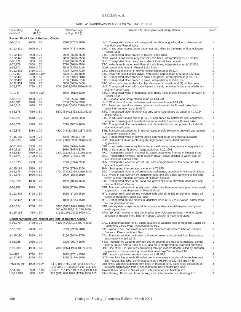
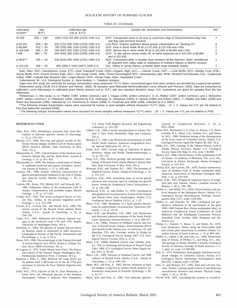
TABLE A1. RADIOCARBON AGES FOR YAKUTAT REGION
Laboratory Age Calibrated age Sample site, description and interpretation Ref.#number* (B.P.)† (cal yr. B.P.)§
Russell Fiord lobe of Hubbard Glacierb-80,514 7000 6 70 7920 (7787) 7640 HKC. Transported alder in alluvial gravel, fan delta aggrading due to damming of
first Holocene Russell Lake.1
b-122,431 6990 6 70 7920 (7767) 7630 ETC. In situ alder stump under bottomset unit, killed by damming of first HoloceneRussell Lake.
1
b-122,432 6930 6 70 7900 (7690) 7580 ETC. Transported alder branch in Russell Lake fines. 1b-122,440 6910 6 70 7890 (7673) 7560 OGH. Wood in soil overlain by Russell Lake fines, interpretation as b-122,431. 1b-85,671 6880 6 60 7790 (7653) 7550 GLC. Transported alder branches in diamict, debris flow deposit. 1b-76,876 6850 6 70 7770 (7634) 7540 ETC. Alder branch underneath Russell Lake fines, interpretation as b-122,431. 1b-85,672 6570 6 70 7540 (7395) 7290 OGH. Wood with moss in Russell Lake fines. 1b-122,433 6410 6 70 7390 (7276) 7180 ETC. Large alder branch in gravel, interpretation as b-80,514. 1I-14,735 6310 6 110** 7390 (7190) 6880 ETC. Peat with wood within gravel, from same approximate area as b-122,433. 2b-122,435 6100 6 50 7160 (6942) 6810 ETC. Transported alder branch in sand and gravel, interpretation as b-80,514. 1b-122,430 6030 6 70 7150 (6878) 6720 ETC. Transported alder branch in sand, interpretation as b-80,514. 1b-122,434 5830 6 70 6850 (6665) 6460 ETC. Wood with peat under silty clay, deposited in small pond (?) on fan delta. 1b-76,877 5780 6 80 6760 (6624,6590,6566) 6410 LMT. Transported wood with alder leaves in sand, deposited in early to middle Ho-
locene Russell Lake.1
I-14,734 4890 6 100†† 5900 (5612) 5330 ETC. Transported wood in bottomset unit, dates initial middle Holocene formation ofRussell Lake.
2
b-80,513 4860 6 70 5730 (5596) 5340 ETC. Location and interpretation same as I-14,734. 1b-85,681 4820 6 70 5700 (5585) 5330 HKC. Wood in soil under bottomset unit, interpretation as I-14,734. 1b-80,515 4680 6 70 5590 (5447,5404,5328) 5100 SCV. Moss and wood fragments underlain and overlain by Russell Lake fines,
same interpretation as b-85,677?1
b-85,676 4650 6 50 5570 (5440,5432,5321) 5290 ETC. Transported alder in bottomset unit, same lake phase as dated by I-14,734and b-80,513.
1
b-85,677 4610 6 70 5570 (5309) 5050 ETC. In situ alder stump above b-85,676 and buried by bottomset unit, constrainstemporary draining and re-establishment of middle Holocene Russell Lake.
1
b-85,679 4320 6 80 5210 (4862) 4650 ETC. Transported alder in lacustrine unit, deposited in second phase of middle Ho-locene Russell Lake.
1
b-76,879 3880 6 70 4510 (4342,4335,4287) 4090 STB. Transported spruce log in gravel, dates middle Holocene outwash aggradationin southern Russell Fiord.
1
b-115,188 3680 6 70 4230 (3984) 3780 LMT. Transported wood in gravel, dates aggregation of ice-proximal outwash. 1b-85,673 3640 6 70 4140 (3960,3958,3926) 3730 FSP. Hemlock(?) stump protruding through beach, dates distal outwash
aggradation.1
b-101,601 3380 6 60 3820 (3626) 3470 STB. In situ alder, temporary landsurface stabilization during outwash aggradation. 1b-80,516 3290 6 60 3680 (3474) 3370 STB. In situ spruce(?) stump, interpretation as b-101,601. 1b-85,680 3010 6 70 3370 (3208,3181,3176) 2960 HKC. Transported alder in channel fill, dates undammed interval of Russell Fiord. 1b-76,874 2700 6 60 2930 (2776) 2740 2GC. Transported hemlock log in boulder gravel, gravel graded to water level of
late Holocene Russell Lake.1
b-76,875 2590 6 50 2770 (2744) 2500 3HM. Transported wood in foreset unit, dates progradation of fan delta into late Ho-locene Russell Lake.
1
b-115,189 2520 6 60 2760 (2714) 2360 3HM. Setting and interpretation same as b-76,875. 1b-85,675 2430 6 60 2730 (2428,2399,2369) 2340 2GC. Transported alder in deformed lake sediments, deposited in ice-marginal lake. 1b-76,878 1960 6 50 2000 (1884) 1810 SCV. Wood in soil overlain by lacustrine sand and silt, dates damming of this side
valley by late Holocene advance of Hubbard Glacier.1
b-85,678 1880 6 70 1950 (1820) 1620 ETC. Transported alder in silt, sand and gravel at 160 m elevation, deposited adja-cent to Hubbard Glacier.
1
b-98,987 1820 6 60 1880 (1720) 1570 STB. Transported hemlock in silty sand, dates late Holocene resumption of outwashaggradation in southern end of Russell Fiord.
1
b-122,436 1790 6 50 1830 (1706) 1560 MTL. Spruce trunk pushed into mountainside with till at 155 m elevation, dates ad-vance of Hubbard Glacier over site.
1
b-122,437 1790 6 60 1860 (1706) 1540 MTL. Transported spruce pieces in lacustrine fines at 235 m elevation, dates smallice marginal lake at site.
1
b-85,674 1730 6 70 1820 (1682,1676,1616) 1500 STB. Woody debris layer in sand, temporary landsurface stabilization during out-wash aggradation.
1
b-115,192 330 6 50500 (425,392,319) 290 1450(1525,1558,1631) 1660 A.D. RFM. Spruce(?) stump in lake dammed by late Holocene terminal moraine, dates
advance of Russell Fiord lobe of Hubbard Glacier to maximum stand.1
Disenchantment Bay–Yakutat Bay lobe of Hubbard Glacierb-98,979 3780 6 70 4400 (4142,4104,4097) 3930 CAL. Transported alder in till, dates advance of western lobe of Hubbard Glacier up
Calahonda Valley from Disenchantment Bay.1
b-98,978 2890 6 70 3220 (2983) 2810 CAL. Wood in soil, constrains retreat and readvance of western lobe of HubbardGlacier in Disenchantment Bay.
1
b-115,190 2850 6 60 3150 (2948) 2790 CAL. Transported alder in till over soil, wood presumably derived from landsurfaceassociated with b-98,978.
1
b-98,988 2080 6 70 2300 (2007) 1870 YBM. Transported wood in outwash 100 m beyond late Holocene moraine, contra-dicts b-98,983 and W-4486 at LBE and so is interpreted as reworked old wood.
1
b-98,983 1980 6 50 2010 (1924,1908,1897) 1820 LBE. One of 901 in situ trees protruding through modern beach, killed by outwashaggradation from advancing Disenchantment Bay-Yakutat Bay lobe.
1
W-4486 1780 6 80†† 1880 (1701) 1520 LBE. Location and interpretation same as b-98,983. 3b-122,439 1260 6 50 1290 (1174) 1060 OCP. Hemlock log in kettle fill within terminal moraine complex of Disenchantment
Bay-Yakutat Bay lobe, same exposure as b-98,984, b-122,438 and I-439.1
‘‘Muskeg #1’’ 1090 6 80** 1170 (951) 750 780 (999) 1200 A.D. Lost River. Organic sediment from base of muskeg core, dates local cessation ofoutwash aggradation from Disenchantment Bay-Yakutat Bay lobe.
4
b-54,384 920 6 110††
1060 (886,875,823,817,791) 660 890(1064,1075,1127,1133,1159) 1300 A.D. Tawah Creek. Wood in ‘‘basal peat’’, interpretation as ‘‘Muskeg #1’’. 5
USGS-923 880 6 65** 930 (731) 650 1020 (1219) 1300 A.D. Situk Muskeg. Basal peat from muskeg core, interpretation as ‘‘Muskeg #1’’. 6
Geological Society of America Bulletin, March 2001 401
HOLOCENE HISTORY OF HUBBARD GLACIER
TABLE A1. (Continued).
Laboratory Age Calibrated age Sample site, description and interpretation Ref.#number* (B.P.)† (cal yr. B.P.)§
W-559 830 6 160†† 1060 (725) 520 890 (1225) 1430 A.D. OCP. Transported wood in silt lens in outermost ridge of Disenchantment Bay-Yak-utat Bay lobe terminal moraine.
7
b-65,331 820 6 80 920 (721) 650 1030 (1229) 1300 A.D. Lost River. Organic sediment above gravel, interpretation as ‘‘Muskeg #1’’. 8b-98,984 810 6 50 790 (705) 660 1160 (1245) 1290 A.D. OCP. Peat in same kettle fill as b-122,439, b-122,438 and I-439. 1b-122,438 800 6 50 790 (697) 650 1160 (1253) 1300 A.D. OCP. Spruce log in same kettle fill as b-122,439, b-98,984 and I-439. 1I-439 560 6 75†† 660 (545) 480 1290 (1405) 1480 A.D. OCP. ‘‘In situ spruce stump under till’’ at same exposure as b-122,439, b-98,984
and b-122,438.9
b-98,977 500 6 40 550 (519) 490 1400 (1431) 1460 A.D. AQA. Transported alder in boulder layer between till-like diamicts, either remobilizedtill deposits from valley walls or readvance of Hubbard Glacier to Blizhni moraine.
1
b-115,191 250 6 50 440 (293) 0 1520 (1657) 1955 A.D. CAL. Alders in sandy diamict, probably dates large landslide nearby. 1
Note: Sites: HKC—Hendrickson Creek; ETC—East Tebenkoff Creek; OGH—Organic High; GLC——Glacier Creek; LMT——Limit Bluffs; SCV—Shelter Cove; STB—Stump Bluffs; FSP—Forest Service Path; 2GC—Two Gorge Creek; 3HM—Three Hummingbird; MTL—Mountaintop Lake; RFM—Russell Fiord Moraine; CAL—CalahondaValley; YBM—Yakutat Bay Moraine; LBE—Logan Beach; OCP—Ocean Cape; AQA—Aquadulce Creek.
*Laboratories: W-, U.S. Geological Survey; b-, Beta Analytic; I-, Teledyne Isotopes.†Ages from this study are corrected for isotopic fractionation using measured 13C/12C ratios. Uncorrected ages from other workers are denoted by a superscript symbol.§Determined using CALIB 3.0.3 (Stuiver and Reimer, 1993). All samples used bidecadal dendrocalibration curve (Stuiver and Pearson, 1993). Data are presented as
calibration curve intercept(s) in calibrated years before present (cal yr. B.P.) with two standard deviation range. A.D. equivalents are given for samples from the lastmillennium.
#References: 1—this study; 2—G. Plafker (1987, written commun.) and J. Clague (1995, written commun.); 3—G. Plafker (1997, written commun.) and J. McGeehin(1997, written commun.); 4—Shephard (1995, collected by R.G. Holloway); 5—Shephard (1995); 6—Molnia (1986) and Peteet (1991); 7—Plafker and Miller (1958) andRubin and Alexander (1960, collected by J.H. Hartshorn); 8—Davis (1996); 9—Trautman and Willis (1966, collected by D.J. Miller).
**The following isotopic fractionation values were assumed for humus or peat samples without measured 13C/12C ratios: 227 6 3. Values are d13C per mil relative toPee Dee belemnite standard (PDB).
††The following isotopic fractionation values were assumed for wood samples without measured 13C/12C ratios: 225 6 2. Values are d13C per mil relative to PDB.
REFERENCES CITED
Alley, R.B., 1991, Sedimentary processes may cause fluc-tuations of tidewater glaciers: Annals of Glaciology,v. 15, p. 119–124.
Barclay, D.J., 1998, Tree-ring and glacial records of Ho-locene climate change, northern Gulf of Alaska region[Ph.D. dissert.]: Buffalo, State University of NewYork, 232 p.
Blackwelder, E., 1907, Glacial features of the Alaskan coastbetween Yakutat Bay and the Alsek River: Journal ofGeology, v. 15, p. 415–433.
Blackwelder, E., 1909, The Yakutat coastal plain of Alaska:A combined terrestrial and marine formation: Ameri-can Journal of Science, v. 27, p. 459–466.
Carlson, P.R., 1989, Seismic reflection characteristics ofglacial and glacimarine sediment in the Gulf of Alaskaand adjacent fjords: Marine Geology, v. 85, p.391–416.
Carlson, P.R., Bruns, T.R., Molnia, B.F., and Schwab, W.C.,1982, Submarine valleys in the northeastern Gulf ofAlaska: Characteristics and probable origin: MarineGeology, v. 47, p. 217–242.
Cooper, W.S., 1923, The recent ecological history of Gla-cier Bay, Alaska: II; the present vegetation cycle:Ecology, v. 4, p. 223–246.
Cowan, E.A., Carlson, P.R., and Powell, R.D., 1996, Themarine record of the Russell Fiord outburst flood,Alaska, U.S.A.: Annals of Glaciology, v. 22, p.194–199.
Cutter, D.C., 1991, Malaspina and Galiano; Spanish voy-ages to the northwest coast 1791 and 1792: Seattle,University of Washington Press, 160 p.
Davidson, G., 1904, The glaciers of Alaska that are shownon Russian charts or mentioned in older narratives:Geographical Society of the Pacific Transactions andProceedings, v. 3, ser. 2, 93 p.
Davis, S.D., 1996, The archaeology of the Yakutat foreland:A socioecological view [Ph.D. dissert.]: College Sta-tion, Texas A&M University, 581 p.
de Laguna, F., 1972, Under Mount Saint Elias: The historyand culture of the Yakutat Tlingit: Washington, DC.,Smithsonian Institution Press, 3 volumes, 913 p.
Espinosa y Tello, J., 1802, Relacion del viage hecho porlas goletas Sutil y Mexicana en al ano de 1792 parareconocer el estrecho de Fuca: Madrid, Imprenta real,185 p.
Field, W.O., 1975, Glaciers of the St. Elias Mountains, inField, W.O., ed., Mountain glaciers of the NorthernHemisphere, Volume 2: Hanover, New Hampshire,
U.S. Army Cold Regions Research and EngineeringLaboratory, p. 143–297.
Gilbert, G.K., 1904, Glaciers and glaciation in Alaska, Vol-ume 3: New York, Doubleday, Page and Company,231 p.
Heusser, C.J., 1960, Late Pleistocene environments of northPacific North America: American Geographical Soci-ety Special Publication 35, 307 p.
Kaiser, K.F., 1993, Growth rings as indicators of glacieradvances, surges and floods: Dendrochronologia, v.11, p. 101–122.
King, G.S., 1995, Surficial geology and preliminary chro-nology of Russell Fiord, Alaska [Master’s thesis]: Buf-falo, State University of New York, 103 p.
Krimmel, R.M., and Trabant, D.C., 1992, The terminus ofHubbard Glacier, Alaska: Annals of Glaciology, v. 16,p. 151–157.
Lawrence, D.B., 1950, Estimating dates of recent glacieradvances and recession rates by studying tree growthlayers: American Geophysical Union Transactions, v.31, p. 243–248.
MacKevett, E.M., Jr., and Plafker, G., 1970, Geochemicaland geophysical reconnaissance of parts of the Yakutatand Mount Saint Elias Quadrangles, Alaska: U.S.Geological Survey Bulletin 1312-L, p. 1–12.
Mann, D.H., 1986, Reliability of a fjord glaciers fluctua-tions for paleoclimatic reconstruction: Quaternary Re-search, v. 25, p. 10–24.
Mann, D.H., and Hamilton, T.D., 1995, Late Pleistoceneand Holocene paleoenvironments of the North Pacificcoast: Quaternary Science Reviews, v. 14, p. 449–471.
Mayo, L.R., 1988a, Advance of Hubbard Glacier and clo-sure of Russell Fiord, Alaska—Environmental effectsand hazards in the Yakutat area, in Galloway, J.P., andHamilton, T.D., eds., Geologic studies in Alaska bythe U.S. Geological Survey during 1987: U.S. Geo-logical Survey Circular 1016, p. 4–16.
Mayo, L.R., 1988b, Hubbard Glacier near Yakutat, Alas-ka—The ice damming and breakout of Russell Fiord/Lake, 1986: U.S. Geological Survey Water Supply Pa-per 2325, p. 42–49.
Mayo, L.R., 1989, Advance of Hubbard Glacier and 1986outburst of Russell Fiord, Alaska, U.S.A.: Annals ofGlaciology, v. 13, p. 189–194.
Meier, M.F., and Post, A., 1962, Recent variations in massnet budgets of glaciers in western North America: In-ternational Association of Scientific Hydrology, v. 58,p. 63–77.
Meier, M.F., and Post, A., 1987, Fast tidewater glaciers:
Journal of Geophysical Research, v. 92, p.9051–9058.
Meier, M.F., Rasmussen, L.A., Post, A., Brown, C.S., Bind-schadler, R.A., Mayo, L.R., Trabant, D.C., and Sikon-ia, W.G., 1980, Predicted timing of the disintegrationof the lower reach of Columbia Glacier, Alaska: U.S.Geological Survey Open-File Report 80–582, 34 p.
Miller, D.J., 1961, Geology of the Yakutat District, Gulf ofAlaska Tertiary Province, Alaska: U.S. GeologicalSurvey Open-File Map 61–103, scale 1:96 000.
Molnia, B.F., 1986, Glacial history of the northeastern Gulfof Alaska—A synthesis, in Hamilton, T.D., et al., eds.,Glaciation in Alaska: Anchorage, Alaska GeologicalSociety, p. 219–235.
Molnia, B.F., and Carlson, P.R., 1978, Surface sedimentaryunits of northern Gulf of Alaska continental shelf:American Association of Petroleum Geologists Bul-letin, v. 62, p. 633–643.
Peteet, D.M., 1991, Postglacial migration history of lodge-pole pine near Yakutat, Alaska: Canadian Journal ofBotany, v. 69, p. 786–796.
Plafker, G., and Miller, D.J., 1958, Glacial features and sur-ficial deposits of the Malaspina district, Alaska: U.S.Geological Survey Miscellaneous Geologic Investi-gations Map I-271, scale 1:250 000.
Plafker, G., and Thatcher, W., 1982, Geological and geo-physical evaluation of the mechanisms of the great1899–1900 Yakutat Bay, Alaska earthquakes [abs.], inAmerican Geophysical Union Conference on FaultBehavior and the Earthquake Generation Process,Snowbird, Utah, October 1982: Programs and Ab-stracts, n.p.
Plafker, G., Hudson, T., Bruns, T., and Rubin, M., 1978,Late Quaternary offsets along the Fairweather faultand crustal plate interactions in southern Alaska: Ca-nadian Journal of Earth Sciences, v. 15, p. 805–816.
Plafker, G., Gilpin, L.M., and Lahr, J.C., 1994, Neotectonicmap of Alaska, in Plafker, G., and Berg, H.C., eds.,The geology of Alaska: Boulder, Colorado, GeologicalSociety of America, Geology of North America, v. G-1, plate 12, scale 1:2 500 000.
Post, A., 1975, Preliminary hydrography and historical ter-minal changes of Columbia Glacier, Alaska: U.S.Geological Survey Hydrologic Investigations AtlasHA-559, 3 sheets, scale 1:10 000.
Post, A., and Motyka, R.J., 1995, Taku and LeConte Gla-ciers, Alaska: Calving-speed control of late-Holoceneasynchronous advances and retreats: Physical Geog-raphy, v. 16, p. 59–82.
Powell, R.D., 1991, Grounding-line systems as second-or-
402 Geological Society of America Bulletin, March 2001
BARCLAY et al.
der controls on fluctuations of tidewater termini oftemperate glaciers, in Anderson, J., and Ashley, G.,eds., Glacial marine sedimentation; paleoclimatic sig-nificance: Geological Society of America Special Pa-per 261, p. 75–93.
Reeburgh, W.S., Muench, R.D., and Cooney, R.T., 1976,Oceanographic conditions during 1973 in RussellFjord, Alaska: Estuarine and Coastal Marine Science,v. 4, p. 129–145.
Rubin, M., and Alexander, C., 1960, U.S. Geological Sur-vey radiocarbon dates V: American Journal of ScienceRadiocarbon Supplement, v. 2, p. 129–185.
Russell, I.C., 1891, An expedition to Mount Saint Elias,Alaska: National Geographic Magazine, v. 3, p.3–204.
Russell, I.C., 1893, Second expedition to Mount Saint Elias,in 1891: U.S. Geological Survey Thirteenth AnnualReport, part 2, p. 1–91.
Shephard, M.E., 1995, Plant community ecology and clas-sification of the Yakutat foreland, Alaska: Sitka, Alas-ka, U.S. Department of Agriculture, Forest Service,214 p.
Stuiver, M., and Pearson, G.W., 1993, High-precision bi-decadal calibration of the radiocarbon timescale, A.D.1950–500 B.C. and 2500–6000 B.C.: Radiocarbon, v.35, p. 1–23.
Stuiver, M., and Reimer, P.J., 1993, Extended 14C databaseand revised CALIB radiocarbon calibration program:Radiocarbon, v. 35, p. 215–230.
Tarr, R.S., 1906, The Yakutat Bay region: U.S. GeologicalSurvey Bulletin 284, p. 61–64.
Tarr, R.S., 1907, Recent advance of glaciers in the YakutatBay region, Alaska: Geological Society of AmericaBulletin, v. 18, p. 257–286.
Tarr, R.S., 1909, The Yakutat Bay region, Alaska; physi-ography and glacial geology: U.S. Geological SurveyProfessional Paper 64, p. 11–144.
Tarr, R.S., and Butler, B.S., 1909, The Yakutat Bay region,Alaska; aerial geology: U.S. Geological Survey Pro-fessional Paper 64, p. 145–178.
Tarr, R.S., and Martin, L., 1906a, Recent changes of levelin the Yakutat Bay region, Alaska: Geological Societyof America Bulletin, v. 17, p. 29–64.
Tarr, R.S., and Martin, L., 1906b, Glaciers and glaciationof Yakutat Bay, Alaska: American Geographical So-ciety Bulletin, v. 38, p. 145–167.
Tarr, R.S., and Martin, L., 1907, Position of Hubbard Gla-cier front in 1792 and 1794: American GeographicalSociety Bulletin, v. 39, p. 129–136.
Tarr, R.S., and Martin, L., 1912, The earthquakes at YakutatBay, Alaska, in September, 1899: U.S. GeologicalSurvey Professional Paper 69, 135 p.
Tarr, R.S., and Martin, L., 1914, Alaskan glacier studies: Wash-ington, D.C., National Geographic Society, 498 p.
Trabant, D.C., Krimmel, R.M., and Post, A., 1991, A pre-liminary forecast of the advance of Hubbard Glacierand its influence on Russell Fiord, Alaska: U.S. Geo-logical Survey Water-Resource Investigations Report90-4172, 34 p.
Trautman, M.A., and Willis, E.H., 1966, Isotopes, Inc. ra-diocarbon measurements V: Radiocarbon, v. 8, p.161–203.
Vancouver, G., 1798, A voyage of discovery to the NorthPacific Ocean and around the world, 1791–1795: Ed-ited and with appendices by Lamb, W.K., 1984: Lon-don, Hakluyt Society, 1665 p.
Viens, R.J., 1994, Dynamics and mass balance of temperatetidewater calving glaciers of southern Alaska [Mas-ter’s thesis]: Seattle, University of Washington, 149 p.
von Engeln, O.D., 1911, Phenomena associated with glacierdrainage and wastage: Zeitschrift fur Gletscherkunde,v. 6, p. 104–150.
Wagner, H.R., 1936, Journal of Tomas de Surıa of his voy-age with Malaspina to the northwest coast of Americain 1791: Pacific Historical Review, v. 5, p. 234–276.
Wiles, G.C., Calkin, P.E., and Jacoby, G.C., 1996, Tree-ringanalysis and Quaternary geology: Principles and re-cent applications: Geomorphology, v. 16, p. 259–272.
Wright, F.F., 1972, Marine geology of Yakutat Bay, Alaska:U.S. Geological Survey Professional Paper 800-B, p.B9–B15.
Yehle, L.A., 1979, Reconnaissance engineering geology ofthe Yakutat area, Alaska, with emphasis on evaluationof earthquake and other geologic hazards: U.S. Geo-logical Survey Professional Paper 1074,44 p.
MANUSCRIPT RECEIVED BY THE SOCIETY SEPTEMBER 22, 1999REVISED MANUSCRIPT RECEIVED APRIL 20, 2000MANUSCRIPT ACCEPTED APRIL 21, 2000
Printed in the USA