Goring-Morris, A. N., & A. Belfer-Cohen. 2013. Houses and households: A Near Eastern perspective. In...
11
19 Introduction The Near East is the geographic region where the processes of ‘Neolithisation’ first crystallised (c. 11,500 cal BP onward), prior to its dispersion as a ‘package’ to Eu- rope and other parts of the Old World. We shall provide a brief overview and a discussion of the architectural developments pertaining to Neolithic phenomena in the region (also known as the ‘Fertile Crescent’). In particular, the focus will be on the Levant, i.e. those areas south of the Taurus/Zagros mountains through to the Red Sea in the south, and from the Mediterranean coast eastwards to the Syro-Arabian desert (Fig. 2.1). The Levant’s geographic orientation is one stretching from north to south, inter- spersed on its west-east axis by topographic features deriving from the configura- tion of the Syro-African Rift valley. Four main ecological provinces can be ob- served—in the south, the ‘Mediterranean province’ (including the Damascus basin), bordered on the south and east by the ‘Arid province’; and, to the north, the ‘Middle Euphrates’ and the ‘Upper Tigris’ provinces. We prefer herewith to grossly sub- divide the area into northern and southern cultural provinces, with a line between the Damascus basin and Beirut separating the two (for a detailed discussion, see Belfer-Cohen and Goring-Morris 2011a). Accordingly, the northern Levant extends from this line up to the Taurus/Zagros mountain ranges, while the southern Levant (including the ‘Levantine corridor’ along the Rift Valley) extends to the Sinai pen- insula. The mosaic arrangement in the southern Levant displays greater ecological variability (the desert regions included) over smaller distances than in the northern D. Hofmann, J. Smyth (eds.), Tracking the Neolithic House in Europe, One World Archaeology, DOI 10.1007/978-1-4614-5289-8_2, © Springer Science+Business Media New York 2013 Chapter 2 Houses and Households: a Near Eastern Perspective A. Nigel Goring-Morris and Anna Belfer-Cohen A. N. Goring-Morris () Department of Prehistory, Institute of Archaeology, The Hebrew University of Jerusalem, Jerusalem 91905, Israel e-mail: [email protected] A. Belfer-Cohen Department of Prehistory, Institute of Archaeology, The Hebrew University of Jerusalem, Jerusalem 91905, Israel e-mail: [email protected]
Transcript of Goring-Morris, A. N., & A. Belfer-Cohen. 2013. Houses and households: A Near Eastern perspective. In...

19
Introduction
The Near East is the geographic region where the processes of ‘Neolithisation’ first crystallised (c. 11,500 cal BP onward), prior to its dispersion as a ‘package’ to Eu-rope and other parts of the Old World. We shall provide a brief overview and a discussion of the architectural developments pertaining to Neolithic phenomena in the region (also known as the ‘Fertile Crescent’). In particular, the focus will be on the Levant, i.e. those areas south of the Taurus/Zagros mountains through to the Red Sea in the south, and from the Mediterranean coast eastwards to the Syro-Arabian desert (Fig. 2.1).
The Levant’s geographic orientation is one stretching from north to south, inter-spersed on its west-east axis by topographic features deriving from the configura-tion of the Syro-African Rift valley. Four main ecological provinces can be ob-served—in the south, the ‘Mediterranean province’ (including the Damascus basin), bordered on the south and east by the ‘Arid province’; and, to the north, the ‘Middle Euphrates’ and the ‘Upper Tigris’ provinces. We prefer herewith to grossly sub-divide the area into northern and southern cultural provinces, with a line between the Damascus basin and Beirut separating the two (for a detailed discussion, see Belfer-Cohen and Goring-Morris 2011a). Accordingly, the northern Levant extends from this line up to the Taurus/Zagros mountain ranges, while the southern Levant (including the ‘Levantine corridor’ along the Rift Valley) extends to the Sinai pen-insula. The mosaic arrangement in the southern Levant displays greater ecological variability (the desert regions included) over smaller distances than in the northern
D. Hofmann, J. Smyth (eds.), Tracking the Neolithic House in Europe, One World Archaeology, DOI 10.1007/978-1-4614-5289-8_2, © Springer Science+Business Media New York 2013
Chapter 2Houses and Households: a Near Eastern Perspective
A. Nigel Goring-Morris and Anna Belfer-Cohen
A. N. Goring-Morris ()Department of Prehistory, Institute of Archaeology, The Hebrew University of Jerusalem, Jerusalem 91905, Israel e-mail: [email protected]
A. Belfer-CohenDepartment of Prehistory, Institute of Archaeology, The Hebrew University of Jerusalem, Jerusalem 91905, Israel e-mail: [email protected]
20
Levant. Furthermore, two of the great rivers of the ‘Fertile Crescent’, the Euphrates and Tigris (and to some extent the Orontes), are dominant features of the northern Levant, creating linear corridors that bisect the broader landscape to create a patch-work of homogenous, yet distinct sub-regions. Thus we should note the contrasts between the northern Levant and the southern Levant. Interestingly, recent research demonstrates that the island of Cyprus should be included within the framework of early Levantine ‘Neolithisation’ processes (Guilaine and Le Brun 2003; Peltenberg and Wasse 2004; Vigne 2011; Vigne et al. 2012). However, it is important to stress that central Anatolia represents a quite different trajectory, in that developments there reflect the initial dispersion (as opposed to origins) of the Neolithic ‘package’ westwards (e.g. Özdoğan and Basgelen 1999; Düring 2011).
There is a general consensus that numerous elements incorporated in ‘Neo-lithisation’ processes in the Near East were present during the late Epipalaeolithic Natufian complex, c. 15,000–11,500 cal BP (Belfer-Cohen and Goring-Morris in press). There is initial evidence for durable architectural elements already in semi-sedentary hamlets from the early Natufian, as part of a continuum from the Natu-
Fig. 2.1 Map of the Near East
A. N. Goring-Morris and A. Belfer-Cohen
21
fian to the Neolithic. These elements incorporate semi-subterranean round struc-tures of varying sizes, custom-built graves, and an assortment of installations, e.g. stone-lined hearths and pavements (for detailed description, see Goring-Morris and Belfer-Cohen 2003, 2008). Especially notable during the early phase of the Natu-fian is the presence of large-scale structures, ranging in size from 50–150 m2, that were clearly larger than the residential structures of earlier Epipalaeolithic huts, e.g. Ohalo II (Nadel 2006). Given the coeval presence of several such large structures in some sites, we believe that these early Natufian structures were the domiciles of social units larger than the nuclear family. Other structures, of similar shape, were very small in size, e.g. 2–4 m2, and their functions clearly focused on different, special activities.
We shall not delve here into the discourse of when a structure becomes a house or, to paraphrase Watkins (1990), when a ‘house’ becomes ‘home’; yet, it is quite clear from the internal spatial patterning of both mundane and symbolic artefact categories within these structures that we are facing an amalgamation of profane and symbolic activities of particular social units, each distinct from its immediate neighbouring structure (e.g. Valla 1989, 2008). Suffice it to say that such issues (‘house’ as ‘home’, public/communal/corporate vs. private domains) merit further in-depth discussion.
In evaluating local developments, it can be stated that Near Eastern ‘Neolithisa-tion’ processes:
1. were of longer duration than formerly assumed;2. varied significantly throughout the ‘greater’ Levantine region;3. were more complex in nature than previously supposed; and4. were un-orchestrated, in the sense of being unintended developments with no
ultimate ‘goal’.
The prevailing subdivision of the Near Eastern Neolithic was first proposed by Kenyon (1957) following her investigations at Jericho. Hence the Levantine Neo-lithic is presented in a four phase terminological framework: Pre-Pottery Neolithic A (PPNA: c. 11,500–10,500 cal BP), Pre-Pottery Neolithic B (PPNB: c. 10,500–8400 cal BP), Pottery Neolithic A (PNA: c. 8400–7500 cal BP), and Pottery Neo-lithic B (PNB: c. 7500–6500 cal BP). It should be noted that the PPNA shares greater commonalities with the Natufian than with the PPNB, while the PNA (in the south) could be more comfortably accommodated within the PPNB world. We shall only briefly relate to Pottery Neolithic developments in the north, as with time the differences between the north and south grew to incorporate distinctive local characteristics, e.g. the half-circular tholoi structures restricted to eastern Syria and northern Iraq (Akkermans and Schwarz 2003; Huot 1994). It seems that certain cultural traits (if not the scale of settlements and specific architectural traditions) of the northern PNA presage the unique developments of the later, Sumerian, city-states. Since many scholars have argued that the PNB corresponds more closely to the chronologically following Chalcolithic period (e.g. Garfinkel 2009), we shall not discuss it here.
2 Houses and Households: a Near Eastern Perspective
22
Contrary to the Neolithic ‘package’ diffusing later into Europe, pottery as an integral part of the material cultural assemblage appears only with the PNA, some 3000 years after the earliest recognized Neolithic stage, the PPNA (Belfer-Cohen and Goring-Morris 2010); equally, plant and animal domestication was long-term and un-orchestrated (Zeder 2011). Spanning more than 5000 years, the differ-ent Neolithic phases display considerable diachronic and synchronic variability throughout the Levant. This reflects diverse starting conditions in the different phy-togeographical regions, palaeoenvironmental changes (e.g. the supposed climatic effects of the Younger Dryas and the ‘8200 year’ event), socio-cultural trajectories and interactions, as well as unforeseen circumstances (for detailed discussion see Belfer-Cohen and Goring-Morris 2011b; Goring-Morris and Belfer-Cohen 2011). Demonstrable domestication of plants and animals is first recognized during the PPNB, though in an uneven manner in time and space (Vigne 2008; Zeder 2009). Accordingly, we find combinations of farmers and herders, farmers and hunters, fishers and farmers, hunter-gatherers and pastoralists, all sharing, to a degree, cer-tain material culture traits—hence the notion of a pan-Levantine PPNB koine or ‘interaction sphere’ (Bar-Yosef and Belfer-Cohen 1989). It is of interest to note that the PPNB can be considered as the ‘floruit’ of the Near Eastern Neolithic, since the following Pottery Neolithic displays marked regional variability, smaller settle-ments, and fewer cross-regional characteristics (Goring-Morris and Belfer-Cohen 2010; in press).
It is within this framework that we shall summarise the architectural evidence for ‘house/household’ and ‘home’ during the Pre-Pottery Neolithic in the Levant. We present the data with a running commentary, returning to certain issues in the following discussion.
Architectural Developments during the Neolithic
Pre-Pottery Neolithic A
Settlement patterns during the PPNA in the southern Levant are mostly restricted to the lowlands, whether in the Rift valley (usually at intervals of 20–25km) on al-luvial fans or along the western flanks of the central hills. There was almost no oc-cupation of the arid margins in either the east or the south at this time. A hierarchy of site sizes is documented, with the largest reaching up to c. 6 acres (about ten times the size of Natufian hamlets—Goring-Morris et al. 2009).
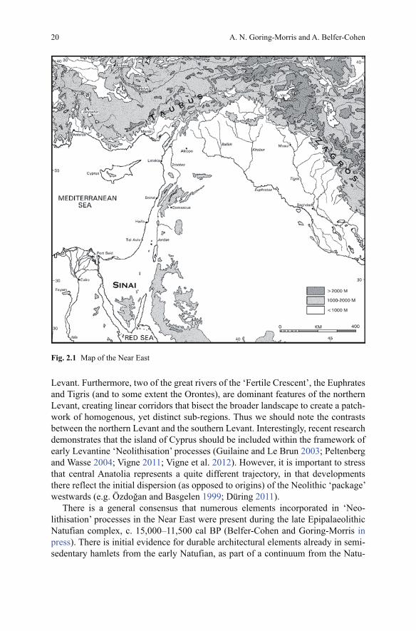
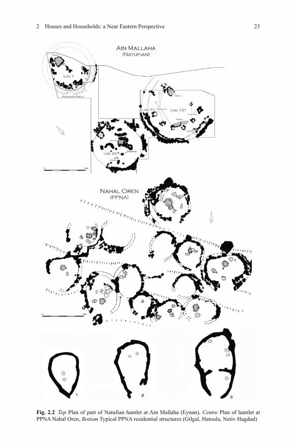
PPNA domiciles appear to consist of dispersed, short-lived, single storey cir-cular or oval semi-subterranean structures, much in the architectural tradition of the preceding Natufian (Fig. 2.2). Their sizes and accompanying furniture mostly indicate the accommodation of nuclear families (Goring-Morris and Belfer-Cohen 2008; Simmons 2007). Construction was of wattle and daub or, somewhat later, of mud brick on stone foundations with wooden posts and beams to support flat roofing and pisé floors, sometimes with interior partitions (Bar-Yosef and Gopher
A. N. Goring-Morris and A. Belfer-Cohen
23
Fig. 2.2 Top Plan of part of Natufian hamlet at Ain Mallaha (Eynan), Centre Plan of hamlet at PPNA Nahal Oren, Bottom Typical PPNA residential structures (Gilgal, Hatoula, Netiv Hagdud)
2 Houses and Households: a Near Eastern Perspective
24
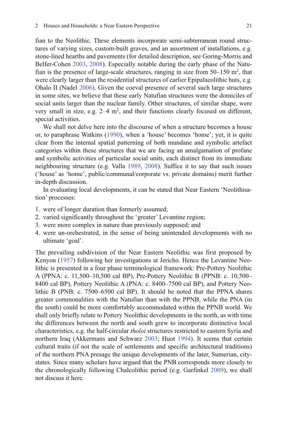
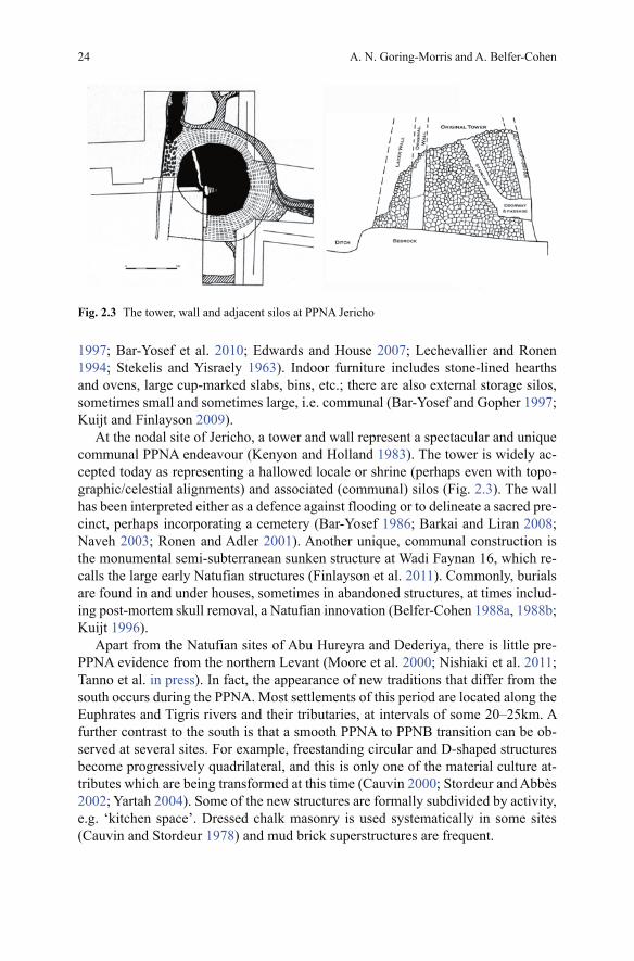
Fig. 2.3 The tower, wall and adjacent silos at PPNA Jericho
1997; Bar-Yosef et al. 2010; Edwards and House 2007; Lechevallier and Ronen 1994; Stekelis and Yisraely 1963). Indoor furniture includes stone-lined hearths and ovens, large cup-marked slabs, bins, etc.; there are also external storage silos, sometimes small and sometimes large, i.e. communal (Bar-Yosef and Gopher 1997; Kuijt and Finlayson 2009).
At the nodal site of Jericho, a tower and wall represent a spectacular and unique communal PPNA endeavour (Kenyon and Holland 1983). The tower is widely ac-cepted today as representing a hallowed locale or shrine (perhaps even with topo-graphic/celestial alignments) and associated (communal) silos (Fig. 2.3). The wall has been interpreted either as a defence against flooding or to delineate a sacred pre-cinct, perhaps incorporating a cemetery (Bar-Yosef 1986; Barkai and Liran 2008; Naveh 2003; Ronen and Adler 2001). Another unique, communal construction is the monumental semi-subterranean sunken structure at Wadi Faynan 16, which re-calls the large early Natufian structures (Finlayson et al. 2011). Commonly, burials are found in and under houses, sometimes in abandoned structures, at times includ-ing post-mortem skull removal, a Natufian innovation (Belfer-Cohen 1988a, 1988b; Kuijt 1996).
Apart from the Natufian sites of Abu Hureyra and Dederiya, there is little pre-PPNA evidence from the northern Levant (Moore et al. 2000; Nishiaki et al. 2011; Tanno et al. in press). In fact, the appearance of new traditions that differ from the south occurs during the PPNA. Most settlements of this period are located along the Euphrates and Tigris rivers and their tributaries, at intervals of some 20–25km. A further contrast to the south is that a smooth PPNA to PPNB transition can be ob-served at several sites. For example, freestanding circular and D-shaped structures become progressively quadrilateral, and this is only one of the material culture at-tributes which are being transformed at this time (Cauvin 2000; Stordeur and Abbès 2002; Yartah 2004). Some of the new structures are formally subdivided by activity, e.g. ‘kitchen space’. Dressed chalk masonry is used systematically in some sites (Cauvin and Stordeur 1978) and mud brick superstructures are frequent.
A. N. Goring-Morris and A. Belfer-Cohen
25
In several villages, deep subterranean communal structures are interspersed amongst the houses. Architecturally, these resemble the kiva of the American Southwest. Several boast formal internal divisions or benches, and unusual con-tents are sometimes recovered. Examples include Jerf el-Ahmar, Mureybet, and Tel Abr’ 3. They clearly held a ritual function of some kind and may have been used by extended families or other social units, such as moieties or demes (Kozlowski 2002; Rosenberg and Redding 2000; Stordeur et al. 2000; Watkins et al. 1995; Yartah 2004, 2005). These architectural features also indicate intra-site social subdivisions.
The spectacular site of Göbekli Tepe, situated on a high hilltop at the headwaters of the Balikh in south-east Turkey, is most obviously a non-domestic site (Belfer-Cohen and Goring-Morris 2005; Peters and Schmidt 2004; Schmidt 2006, 2007), contrary to the views of some scholars (Banning 2011). Notably, the site demon-strates no evidence for domesticates, so that it reflects hunter-gatherer subsistence, although it is ‘Neolithic’ in terms of chronology. Intriguingly, several other similar sites have been identified within a 70km radius of Göbekli Tepe (Çelik 2000, 2004, 2006). The numbers and scale of the ritual structures (differing in specific motifs of artistic embellishment) and their subsequent intentional in-filling must have in-volved a large input of manpower from neighbouring communities, perhaps on a competitive basis.
The Pre-Pottery Neolithic B
The Mediterranean zone of the southern Levant saw substantial disruption at the end of the PPNA and the transition to the early PPNB (Edwards et al. 2004; Goring-Morris et al. 2009; Khalaily et al. 2007; Kuijt 2003; Kuijt and Goring-Morris 2002). There is a marked shift in settlement patterns, and the PPNB as well as the early Pottery Neolithic, i.e. the Yarmukian,1 are characterized by the founding of villages that increase in size through the course of the PPNB. These large-scale villages (‘megasites’) eventually reach up to 12 ha in extent (e.g. Gebel 2004; Kuijt 1994, 2000; Rollefson 1997, 2001 and references therein).2 The gradual introduction of domesticated herd animals (goats and sheep) in various areas and at different times during the course of the PPNB (Zeder 2011) certainly had a profound impact, as animals would have been corralled within the physical confines of communities (Goring-Morris et al. 2009). To date, our idea as to the overall density of residential ‘packing’, that is to say of the population density within these large settlements, is not very precise. Furthermore, and contrary to commonly held opinions, this by no
1 It is important to distinguish between the middle, late and final PPNB (the so-called PPNC) in terms of the scale and nature of the settlements. Also, as noted in the introduction, although tradi-tionally defined as ‘PNA’ we consider the Yarmukian culture as representing the culminating phase of early Neolithic village society and the final stages of the PPNB koine.2 There is a common tendency to overestimate site sizes and densities, leading to exaggerated population estimates (Campbell 2010).
2 Houses and Households: a Near Eastern Perspective
26
means represents the prototype of the later Near Eastern village, which remained so familiar into sub-recent times.3
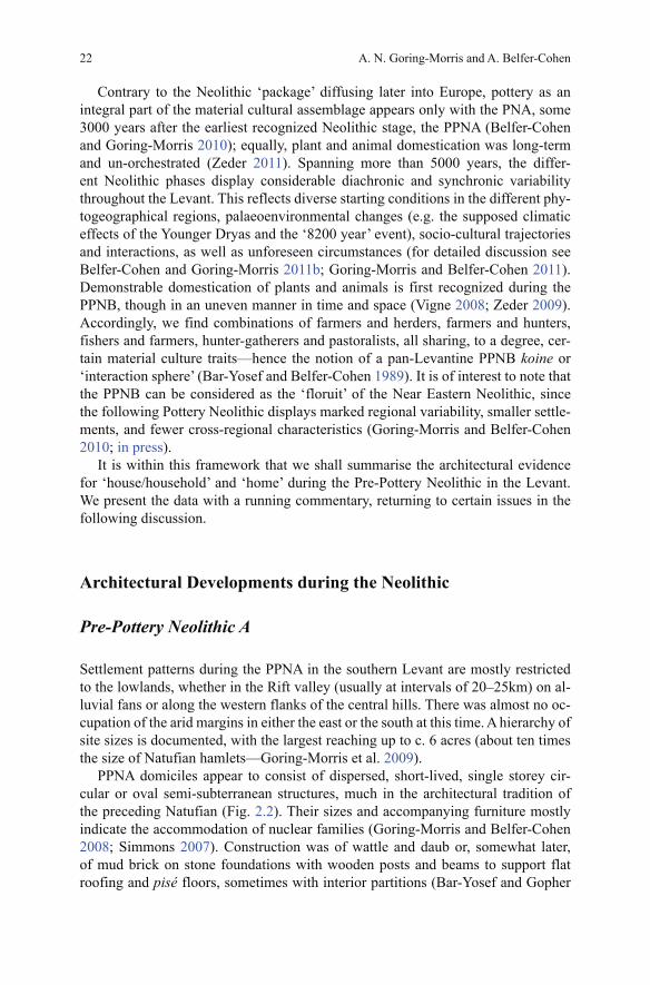
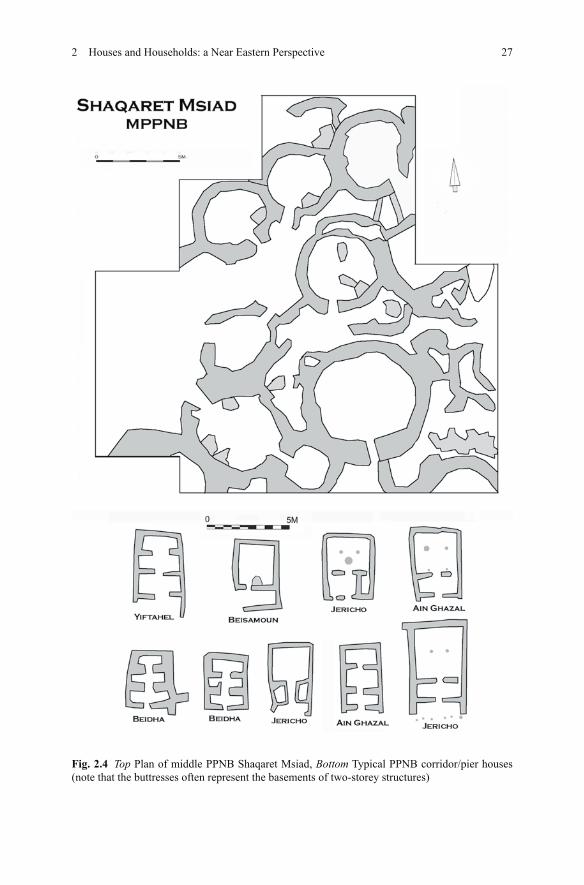
Unfortunately, there are few data for domestic architecture during the formative early PPNB, with only hints at the site of Motza (Judean hills) for the shift from cir-cular to quadrilateral architecture. This shift is, however, most clearly documented in situ during the Middle PPNB at Beidha and the more or less coeval circular structures at Shaqaret Msiad (Fig. 2.4), both at the edge of the Mediterranean prov-ince (Byrd 1994, 2005a, 2005b; Kinzel et al. 2011). Whereas some view the change from round to square structures simply as a diachronic, developmental shift, other explanations seem more pertinent; for example, it could be considered as reflecting increasing permanence (see the following section).
The basic architectural concept of PPNB agricultural villages in the Mediter-ranean zone of the southern Levant is founded on quadrilateral units, often with multiple cells. There are several basic and recurring PPNB residential plans:
1. The long-axis ‘corridor’ house, pier-house or ‘megaron’, sometimes two-storied. The upper storey had one or two larger rooms in which domestic activities were concentrated. The semi-subterranean basement consisted of multiple cells sepa-rated by buttresses and was used for storage and workshops (e.g. Beidha, ’Ain Ghazal and Yiftahel—see Banning and Byrd 1987; Braun 1997; Byrd 2005a; Rollefson 2001; and see Fig. 2.4).
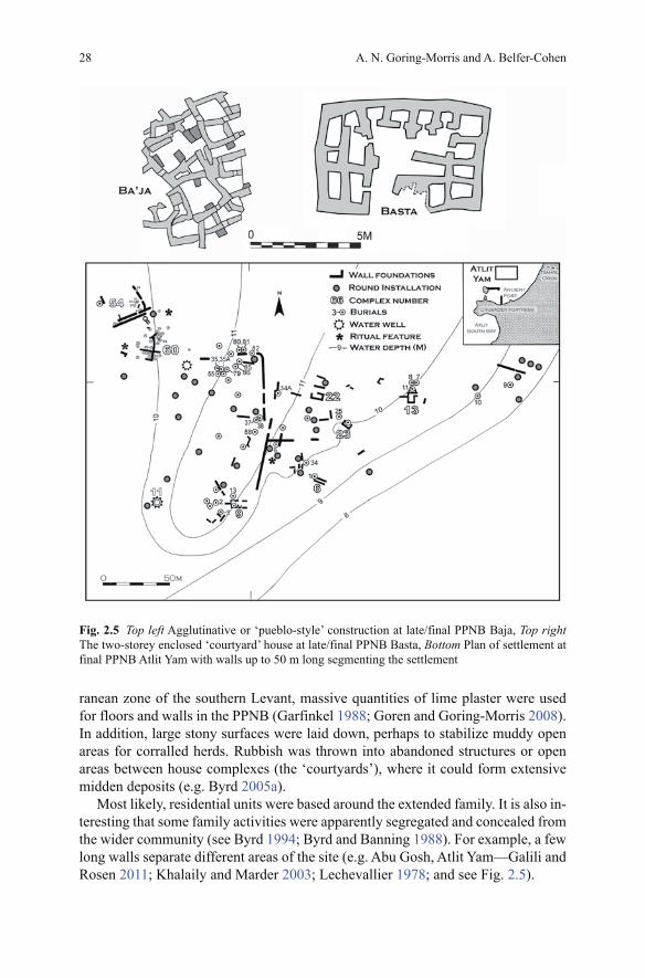
2. The enclosed ‘courtyard’ house. Again, small cells on the ground floor are entered through raised doors/windows. This formed the base for an upper floor for domestic activities (e.g. Basta and es-Sifiya—see Gebel et al. 2006; Mahas-neh 1997; and see Fig. 2.5).
3. Loose ‘pueblo-style’ structures. Sometimes up to two or three storeys high, this agglutinative array of structures is found on steep slopes (e.g. Ba’ja, Ain Jam-mam and Wadi Ghuwair—Gebel and Hermansen 2004; Simmons and Najjar 2003; Waheeb and Fino 1997; and see Fig. 2.6).
4. Enclosed single storey courtyard residential units. These are a feature of the end of the PPNB/beginning of the Pottery Neolithic, i.e. of the Yarmukian culture (Sha’ar Hagolan—Garfinkel and Ben-Shlomo 2002; and see Fig. 2.7).
The presence of different coeval architectural styles likely reflects a variety of fac-tors, whether specific topographic and ecological settings, changing subsistence modes, social structure or group identities (as in the American Southwest—see Wilshusen and Potter 2010).
In most areas, constructions of mud brick were erected on stone foundations, although dressed stone masonry is a characteristic feature of southern Jordan (see references in previous sections). Stone-built channels can be found under some structures. Apparently, these prevented rising damp and provided drainage, e.g. es-Sifiya and Basta (Gebel et al. 2006; Mahasneh and Bienert 2000). In the Mediter-
3 There is no evidence for continuity from the PPNB megasites through to the early city states of the Early Bronze period in the southern Levant in contrast to the north, where continuity is more marked (see Goring-Morris and Belfer-Cohen 2008).
A. N. Goring-Morris and A. Belfer-Cohen
27
Fig. 2.4 Top Plan of middle PPNB Shaqaret Msiad, Bottom Typical PPNB corridor/pier houses (note that the buttresses often represent the basements of two-storey structures)
2 Houses and Households: a Near Eastern Perspective
28
Fig. 2.5 Top left Agglutinative or ‘pueblo-style’ construction at late/final PPNB Baja, Top right The two-storey enclosed ‘courtyard’ house at late/final PPNB Basta, Bottom Plan of settlement at final PPNB Atlit Yam with walls up to 50 m long segmenting the settlement
ranean zone of the southern Levant, massive quantities of lime plaster were used for floors and walls in the PPNB (Garfinkel 1988; Goren and Goring-Morris 2008). In addition, large stony surfaces were laid down, perhaps to stabilize muddy open areas for corralled herds. Rubbish was thrown into abandoned structures or open areas between house complexes (the ‘courtyards’), where it could form extensive midden deposits (e.g. Byrd 2005a).
Most likely, residential units were based around the extended family. It is also in-teresting that some family activities were apparently segregated and concealed from the wider community (see Byrd 1994; Byrd and Banning 1988). For example, a few long walls separate different areas of the site (e.g. Abu Gosh, Atlit Yam—Galili and Rosen 2011; Khalaily and Marder 2003; Lechevallier 1978; and see Fig. 2.5).
A. N. Goring-Morris and A. Belfer-Cohen

http://www.springer.com/978-1-4614-5288-1