gold Mining in the Carolinas - National Register of Historic ...
115
-
Upload
khangminh22 -
Category
Documents
-
view
0 -
download
0
Transcript of gold Mining in the Carolinas - National Register of Historic ...
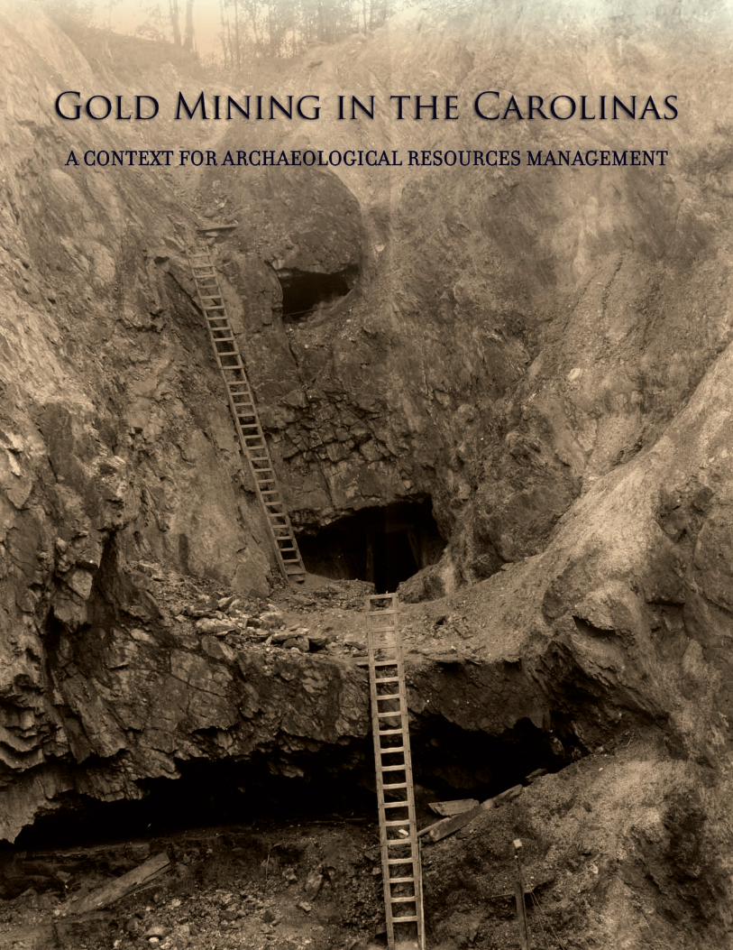
Gold Miningin the Carolinas
A Context for ArChAeologiCAl resourCes MAnAgeMent
Report submitted to:Haile Gold Mine, Inc. • 7283 Haile Gold Mine Road • Kershaw, South Carolina 29067
Report prepared by:New South Associates • 6150 East Ponce de Leon Avenue • Stone Mountain, Georgia 30083
Natalie Adams Pope – Principal Investigator
Brad Botwick – Archaeologist and Author
March 31, 2012 • Final ReportNew South Associates Technical Report 2053

gold Mining in the Carolinasi
Abstract
Gold mining was a significant early industry in North and South Carolina. The first commercial gold mines in the United States were in North Carolina, and the development of the mining industry led to important developments in the region’s economy, settlement, industry, and landscape. Although a moderate number of cultural resources relating to the Carolina gold mining industry have been identified, there has been little archaeological research into it to date. Most of the research has been completed for compliance or heritage projects, and site identification and evaluation has been hindered by the lack of a comprehensive historic context.
This document comprises a first step towards providing such a context. It contains an overview of the Carolina gold mining industry that discusses its historic development and significance. Also included is a description of the procedures used for mining and handling gold ore in the Carolinas from the nineteenth to early twentieth centuries to help researchers understand the specific functions of individual cultural resources. The document also provides descriptions of property types expected at historic gold mines in the region. A literature review describes the past gold mining in the Carolinas and explores how archaeologists have approached the evaluation and study of gold mine sites in the region thus far. Finally, the document presents recommendations for survey and documentation followed by specific guidelines for evaluating the National Register of Historic Places significance of gold mining sites in the Carolinas.
This context was written as a part of mitigation of Archaeological Site 38LA383, the Stamp Mill at Haile Gold Mine. The purpose of this context is to provide guidance for archaeological studies of gold mining in the Carolinas, regardless of whether it is related to compliance with Federal laws, heritage studies, or academic research. This context can be used to aid researchers in making National Register evaluations under Section 106 of the National Historic Preservation Act but does not dictate mitigation efforts or actions, which are negotiated on a case by case basis for eligible properties. It should be noted that any mitigation efforts should be proportionate to the undertaking and provide sufficient flexibility to allow for a variety of creative mitigation options.
Since the discovery of gold on the Haile property, the mine has been opened and closed numerous times. This has compromised the integrity of historic mining features that may have otherwise contained research potential. The Stamp Mill is the only known recorded mining feature that has been determined worthy of further study. This context as well as an archaeological documentation report produced by New South Associates satisfies a Memorandum of Agreement between the South Carolina State Historic Preservation Office and Haile Gold Mine.

gold Mining in the Carolinasiii
AbSTRACT ................................................................................................................................................................. iTAbLe OF CONTeNTS ............................................................................................................................................. iii LIST OF FIGUReS ..................................................................................................................................................... vLIST OF TAbLeS ...................................................................................................................................................... vii
I. INTRODUCTION ....................................................................................................................................................1
II. PHySICAL eNvIRONMeNT OF GOLD IN THe CAROLINAS ...............................................................................3Description and Properties of Gold ....................................................................................................................3Physiographic Context of Gold in the Carolinas .................................................................................................3Geology of Gold in the Carolinas ........................................................................................................................5Gold Deposits .....................................................................................................................................................7
III. HISTORIC CONTexT: GOLD MININg IN THe CAROLINAS ................................................................................9Discovery and early Development .....................................................................................................................9expansion and Climax of the Gold Mining Industry .........................................................................................11Revival and Decline ..........................................................................................................................................18
Iv. MINING AND MeTALLURGy OF GOLD .............................................................................................................23Prospecting .......................................................................................................................................................23
extraction ..........................................................................................................................................................24
beneficiation .....................................................................................................................................................28
Mechanical Methods ..................................................................................................................................29
Amalgamation ............................................................................................................................................31
breaking and Crushing ........................................................................................................................31
Stamp Mills...........................................................................................................................................33
Concentrating .............................................................................................................................................36
Hydrometallurgy ................................................................................................................................................39
Chlorination ................................................................................................................................................39
Roasting ...............................................................................................................................................39
Chlorination Procedure ........................................................................................................................41
Cyanide ................................................................................................................................................43
Gold Mining Practice ........................................................................................................................................44
v. GOLD MINING PROPeRTy TyPeS......................................................................................................................47
Prospecting and extraction Property Types ............................................................................................................48
Placer Mining ...........................................................................................................................................................48
Hard Rock/Lode/vein Mining ......................................................................................................................50
Table of Contents
iv
Processing ........................................................................................................................................................53
Ancillary Mining Property Types .......................................................................................................................55
Structures ...................................................................................................................................................55Transportation Features ..............................................................................................................................56Water Conveyance Systems .......................................................................................................................57
Mining Community Property Types ...................................................................................................................57Domestic Structure Remains ......................................................................................................................57Domestic Artifact Deposits .........................................................................................................................58Domestic Landscape Features ..................................................................................................................58
Inter-Site Mining Support Property Types .........................................................................................................58Inter-Site Linear Transportation Features ....................................................................................................59Inter-Site Conveyance Systems ..................................................................................................................59Inter-Site Utilities .........................................................................................................................................60Historic Mining Landscapes .......................................................................................................................61Integration of Property Types .....................................................................................................................61
vI. THe ARCHAeOLOGy OF GOLD MININg IN THe CAROLINAS ........................................................................61
Archaeological Data base ...............................................................................................................................61
Literature Review ..............................................................................................................................................62
vII. ARCHAeOLOGICAL IDeNTIFICATION AND ReCORDING OF GOLD MINING SITeS ....................................75
Survey/Identification ................................................................................................................................................75
Mining Properties as Cultural Landscapes .......................................................................................................80
Delineating and Recording Historic Gold Mines for evaluation Studies ...........................................................81
vIII. evALUATING CAROLINA GOLD MINe SITeS ................................................................................................83
Historic Contexts and Areas of Significance ..........................................................................................................83
Areas of Significance: NRHP Criteria for evaluation ...............................................................................................84
Research Topics for Archaeological evaluation ......................................................................................................85
Integrity ..............................................................................................................................................................88
Location ............................................................................................................................................................90
Design ...............................................................................................................................................................91
Setting ........................................................................................................................................................91
Materials .....................................................................................................................................................91
Workmanship ..............................................................................................................................................92
Feeling ........................................................................................................................................................92
Association .................................................................................................................................................92
evaluating the Significance of Carolina Gold Mining Sites .......................................................................92
ReFeReNCeS CITeD ..............................................................................................................................................97

gold Mining in the Carolinasv
APPeNDIx A: ARCHAeOLOGICAL ReSeARCH TOPICS .....................................................................................103
Technology ......................................................................................................................................................104
Historical ethnography/Cultural History of Mining ..........................................................................................105
ethnicity of Distinct Culture Groups and ethnic Interactions ..........................................................................106
Gender and Family Aspects of Mining ...........................................................................................................107
economic Aspects of Mining and Quarrying ..................................................................................................108
Policy, Law, and Regulation of Mining and Self-Governance .........................................................................109
List of FiguresFigure 1. Physiographic Regions of the Carolinas. ...............................................................................................4
Figure 2. Gold Producing Regions of the Carolinas. .............................................................................................7
Figure 3. early Mining in the Carolinas Relied on basic Tools and was Conducted on a Small Scale ...............10
Figure 4. Carolina Gold Mines became More Industrialized by the 1840s. .......................................................15
Figure 5. African-American Miners Drilling Holes for blasting in a North Carolina Gold Mine ............................16
Figure 6. Phoenix Mine, Cabarrus County, North Carolina. view of the Mill and Chlorination Plant,
Circa 1907. ...........................................................................................................................................20
Figure 7. Panning was an Important Prospecting Method. .................................................................................23
Figure 8. Assaying equipment. ...........................................................................................................................24
Figure 9. Haile Pit, Haile Gold Mine, Lancaster County, South Carolina, 1904. ..................................................25
Figure 10. Underground Mine: The Randolph Shaft, 800-Foot Level, Gold Hill Copper Company ......................26
Figure 11. “Planned Mining” of the Randolph vein, Gold Hill Area. ......................................................................26
Figure 13. Headframe--Phoenix Mine, Cabarrus County, North Carolina, Late 1800s ( .......................................28
Figure 14. enclosed Headframe--Gold Hill Copper Company, Rowan County, North Carolina, Unknown Date ..28
Figure 12. “Whim” For Hoisting Ore From a Mineshaft. .........................................................................................28
Figure 15. Rocker or Cradle Rocker ......................................................................................................................29
Figure 16. Log Rockers, Gold Hill District, North Carolina, Unknown Date ..........................................................30
Figure 17. Long Tom ..............................................................................................................................................30
Figure 18. blake Jaw Crusher. blake Crushers Were Among the Most
Common Types Used at American Mines ............................................................................................31
Figure 19. Cross Section of an Arrastra ................................................................................................................31
Figure 20. Operation of a Horse-Powered Arrastra. ..............................................................................................31
Figure 21 Chilian Mill at North Carolina Gold Mine Near Salisbury ......................................................................32
Figure 22. basic Features of a Stamp ...................................................................................................................33
Figure 23. Stamp Mill battery Section Showing Major Components .....................................................................34
Figure 24 Ten Stamp battery with Amalgamation Plates, Ore bin, and Framing. ................................................35

vi
Figure 25 Pot Retort. The Casing at the Lower end of the Tube is the
Water Jacket For Condensing the Mercury vapor ...............................................................................36
Figure 26. Section of a Horizontal Retort Within a Permanent Masonry Furnace. ................................................36
Figure 27. Three-Compartment Hartz-Type Jigs ...................................................................................................36
Figure 28. Section of a Hartz Jig Showing Arrangement of the Piston and Ore box. ...........................................37
Figure 29. Wilfley-Type Concentrating Table .........................................................................................................37
Figure 30. “vanner” or belt Concentrator ..............................................................................................................38
Figure 31. Diagram of the Ore Handling Process from Crushing Through Stamping and
Concentrating, Coggins Gold Mine, Montgomery County, North Carolina. .........................................38
Figure 32. Reverberatory Furnace ........................................................................................................................40
Figure 33. Chlorination Tub Used For the Plattner Process ...................................................................................41
Figure 34. Metal Chlorination barrel, Shown With Revolving Mechanism ............................................................42
Figure 35. Cross-Section of the Chlorination Plant at Haile Gold Mine, Lancaster County,
South Carolina, circa 1880s-1908, Illustrating the Chlorination Process .............................................42
Figure 36. Howie Mine Cyanide Tanks, Union County, North Carolina, circa 1906. Six 190-Ton Leaching Tanks
are to the Left with Tracks That Allowed Access For Ore Cars to Load Them.
The Three Tanks at Right Contained Cyanide Solution ........................................................................43
Figure 37. Zinc boxes Used at the Iola Mine Cyanide Plant, Montgomery County, North Carolina ......................44
Figure 38. Gold Mining Could Involve varying Levels of Technology. One Miner is Holding a Pan to Check
Tailings of Mechanical Log Washers. Shuford Mine, Catawba County, North Carolina .......................45
Figure 39. Hydraulic Placer Mining Produced Distinctive Features .......................................................................49
Figure 40. Map of Site 31GS120, Long Creek Gold Mine, Gaston County, North Carolina.
Features Lettered ‘e,’ ‘F,’ and ‘G’ are Prospect Pits. Features ‘A,’ ‘b,’ and ‘C’ are Shafts ....................49
Figure 41. Mine Waste or Ore Dumps Consist of broken Rock Piles and are Sometimes Recognized as
Unnatural Contours on Hill Sides. Howie Gold Mine, Union County, North Carolina ..........................50
Figure 42. Adit. Note the Ore Dump Immediately Outside the Mine Opening and the
Wooden Tracks. Near High Point, North Carolina. Unknown Date. ......................................................51
Figure 43. Abandoned Underground Works (Drifts and Stopes) exposed in an Open Cut.
Haile Gold Mine, Lancaster County, South Carolina, 1904 ..................................................................52
Figure 44. Coggins Gold Mine Stamp Mill, Montgomery County, North Carolina, 1978 ........................................53
Figure 45. Interior of the Phoenix Gold Mine Stamp Mill Showing Stamps and Amalgamation Tables
(Center) and Concentration Room (Left.). Cabarrus County, Circa Late 1800s ..................................54
Figure 46. Modern Chilian Mill. The Masonry Foundation Might Not be Functionally
Diagnostic If the Mill Was Removed .....................................................................................................55
Figure 47. Map of the Fentress Mine, Guilford County, North Carolina, Showing the Types
of Auxiliary Structures Typical for a Gold Mining Operation, early 1900s ............................................56
Figure 48. Water Conveyance Systems Might Leave Distinct Archaeological Traces.
Parker Mine, Stanly County, North Carolina (Nitze and Wilkens 1897). ..............................................56

gold Mining in the Carolinasvii
Figure 49. brick Chimney base and Pier, Site 38LA383 Workers House, Haile Gold Mine,
Lancaster County, South Carolina ........................................................................................................58
Figure 50. Small-Gauge Railroad at Haile Gold Mine, Lancaster County, South Carolina.
A Trestle Carried the Line to the Third Floor of the Stamp Mill to Deliver Ore ......................................59
Figure 51. Archaeological Map of a Part of the Haile Gold Mine Stamp Mill Showing a Railroad
Cut (Feature 13) and Trestle Footings (Feature 14) Leading to the Stamp Mill (Feature 7) .................59
Figure 52. Masonry equipment Mounts for the Corliss Steam engine, Haile Gold Mine
Stamp Mill (Site 38LA383), Lancaster County, South Carolina. ...........................................................60
Figure 53. Archaeological Plan of the Reed Gold Mine engine/Mill House, Cabarrus County, North Carolina .....68
Figure 54. The extant Coggins Gold Mine Stamp Mill was Recorded in 1977 (Arnold 1977). ..............................71
Figure 55. Gold Hill Mine, Rowan County, South Carolina, Circa 1880s to 1890s. Archaeological
Remnants of Site Such as This Could Include Large Surface Features but Few Artifact
Deposits That Could be Found With Shovel Tests ...............................................................................76
Figure 56. Mining Sites May Spread Widely and Include Areas of empty Space. Components
of the Haile Gold Mine in Lancaster County, South Carolina, Covered Nearly a Mile
but Many Areas Were Never Used .......................................................................................................78
Figure 57. The Interior of any Standing Mining Structures Should be Carefully Documented With
Particular Attention Given to How the equipment Was Arranged. Coggins Gold Mine
Stamp Mill, Montgomery County, North Carolina. ................................................................................79
List of TablesTable 1. Recorded Archaeological Sites Representing Historic Gold Mines in North and South Carolina ............66
Table 2. Sample Questions/Topics for Determining Historic Themes
Associated with Carolina Gold Mining Sites .............................................................................................94

gold Mining in the Carolinas1
I. INTRODUCTION
gold mining was a significant activity in North
and South Carolina. Gold was discovered in
1799 in North Carolina and for a time before
the Civil War, mining was the second most important
economic activity in the State. The gold industry in
South Carolina developed later, but the State saw
significant developments in the technology and science
of gold ore processing. Despite its importance in these
states, there has been little scholarly attention given
to gold mining. This document presents a first effort
at developing a historical context for the management
and study of gold mine sites in the Carolinas.
A native metal, gold is widely distributed in the earth’s
crust. It is concentrated in economically viable
quantities only in some locations. In the Carolinas, it
occurs in meta-volcanic and meta-sedimentary contexts
associated of the Piedmont and, more specifically, in a
series of linear regions that generally run in a northeast
to southwest axis from virginia to Georgia. Where it
occurs in high enough concentrations, gold can be
found as free particles eroded from the host rock and
deposited in stream valleys (placers), embedded as
veins in host rock--typically quartz in Carolinas (lodes),
or as disseminated mineralized deposits (sulfides).
All three types of deposits supported profitable gold
operations in the Carolinas at different times.
The earliest commercial gold mines in the United
States were in North Carolina and, for a period before
the California Gold Rush, the Carolinas and Georgia
produced nearly all the gold circulating in the country,
remaining an important economic activity until the Civil
War. Although gold production never regained its
earlier importance, efforts to restart the gold industry in
the Carolinas gave rise to a period of experimentation
with new methods and technologies of extracting
gold from lower quality ores. Over the nineteenth and
early twentieth centuries, gold mining in the Carolinas
contributed to new economic activities and organizations,
technologies, land use and settlement practices, labor
arrangements, and business practices.
In addition to presenting an overview of gold mining in
the Carolinas, this document describes the processes,
technology, and equipment involved in regional gold
mining, insofar as they are known. As noted, several
different mining processes were used in the region,
mainly to target different types of deposits. For naturally
occurring free gold (gold fragments eroded into stream
deposits), miners could use relatively simple collection
methods (gravity). For gold remaining embedded in
host rock, other techniques were required not only
to extract the gold-bearing rock but also to free and
separate the gold from it (crushing and processing).
As these kinds of sources became exhausted, miners
increasingly sought other or new ways to extract gold
from mineralized deposits. These recalcitrant ores
required treatment with chemical baths, roasting, and
/or mechanical separation, all of which required more
elaborate structures and equipment than had been seen
previously in Carolina gold fields.
Mines in general are unique archaeological resources
because individual features and cultural deposits
belonging to a single site can be widely dispersed across
a landscape with areas containing empty space or
features with different functions or chronologies between

2
them. Many of the standard approaches to locating and
recording archaeological sites are problematic in dealing
with historic gold mines. More productive strategies
involve greater archival research in preparation for
fieldwork, greater use of pedestrian survey and visual
inspection, and expansion of survey areas to account
for the broad and sometimes disconnected character
of gold mine sites. Similarly, in evaluating gold mine
sites, archaeologists must be aware of their potential
large size and the various separate activity areas that
together comprised individual mining operations.
Finally, evaluation of gold mining sites, like any
archaeological or historic property, requires
consideration of the site’s historic significance. The four
National Register of Historic Places (NRHP) Criterion
of Significance and seven aspects of integrity provide
frameworks for determining if a site is significant.
Archaeological sites are most often judged on the
basis of their research potential but historic gold mines
may contain large and visible structures and surface
features that evoke their associations to the historically
important events, people, and technologies of mining.
In evaluating gold mine sites, it is important to consider
their possible historical associations as well as their
information value. To assess the research value of a
gold mine site, it is useful to compare the site’s datasets
against pre-determined research issues or questions.
This context proposes a series of topics and specific
questions to guide archaeologists in determining
whether or not a site has the ability to expand our
understanding of Carolina gold mining.
This document represents part of the mitigation effort
for Site 38LA383, representing the remains of the late
nineteenth- to early twentieth-century Haile Gold Mine
stamp mill in Lancaster County, South Carolina. The
South Carolina Division of Archives and History agreed
to a “creative mitigation” that involved documentation
of the history of the site (History and Archaeology of
the Haile Gold Mine Stamp Mill [Site 38LA383]) along
with the preparation of a historic context report for
other gold mine sites in the region. Archival research
pertaining to 38LA383 provided a detailed historic
context that indicated both the function of the stamp
mill in the operation of the mine, and the overall
historic significance of Haile Gold Mine. Among
the most important gold producers in the southeast,
Haile was also the site of important innovations in the
chlorination process for extracting gold from sulfide
ores. Archaeological fieldwork at the stamp mill, the
only extant portion of the overall gold mine operation,
included mapping and limited excavation, which
documented the site’s arrangement with respect to
the physical landscape and provided details about
its spatial organization, the flow of ore through the
plant, and construction details (botwick and Swanson
2011).
The purpose of this context is to provide guidance for
archaeological studies of gold mining in the Carolinas,
regardless of whether it is related to compliance with
Federal laws, heritage studies, or academic research.
This context can be used to aid researchers in making
National Register evaluations under Section 106 of the
National Historic Preservation Act but does not dictate
mitigation efforts or actions, which are negotiated on a
case by case basis for eligible properties. It should be
noted that any mitigation efforts should be proportionate
to the undertaking and provide sufficient flexibility to
allow for a variety of creative mitigation options.
This context report was developed by New South
Associates, Inc. The recent re-emergence of gold
industry in the Carolinas provided an opportunity to
consider the history and archaeology of this important
mineral industry.

gold Mining in the Carolinas3
II. Physical Environment of Gold in the Carolinas
The geology and environmental context of gold
significantly affect where it is found and how it
is obtained. This chapter provides an overview
of the physical contexts of gold in the Carolinas to
understand the historical development of the regional
gold mining industry.
DescRiption anDpRopeRties of GolD
gold is a native metal (a metal found in its metallic form,
either pure or as an alloy, in nature) and is distinguished
by its weight, malleability, and color. It is usually yellow
but impurities can change it to silver-white or orange-
red. Pure gold has a relatively heavy specific gravity
of 19.3, which was a means for separating it from host
rock or overburden. Its resistance to all acids except
aqua regia (a mix of hydrochloric and nitric acids) was
another basis for extracting it. Gold is grouped with
siderophile elements (those having a geochemical
affinity for metallic iron), a property that causes it to
collect in residual fluids and later metallic or sulfide
phases rather than in earlier silicate phases of cooling
magmas. In nature, gold forms alloys with other metals
and almost all gold contains some silver and frequently
copper and iron as well (Carpenter 1999:7).
Purity is a common way of describing gold. Purity, or
fineness, refers to the weight proportion of gold in an
alloy or in impure gold and is expressed in parts per
thousand. Gold usually contains about 10 percent
other metals, giving it a fineness of 900. “Karat” also
describes purity expressed in 24ths rather than parts
per 1,000. Thus, 24-karat gold is 1,000 fine or pure
and 10-karat gold refers to an alloy of gold and one or
more other metals that is 10/24 or 41.7 percent gold
by weight. Fineness refers only to the gold content of
an alloy and not its non-gold constituents (Carpenter
1999:7; butterman and Amey 2005:1-2).
Gold has numerous uses because of various special properties. It conducts electricity, does not tarnish, works easily, can be drawn into wire or hammered into thin sheets, alloys with many other metals, can be melted and cast into detailed shapes, and has an attractive color and luster. Gold has highly symbolic values in many cultures, and it remains a standard for assessing beauty, wealth, purity, accomplishment, and power (Geology.com 2005). Historically and at present, its most common use is for jewelry (Carpenter 1999:7; Geology.com 2005). At least 85 percent of the newly consumed or reused gold in circulation goes into jewelry. About 10 percent of worldwide use is for coinage. It also has numerous other industrial, medical, and decorative uses, and about 12 percent of annual consumption goes toward electronics, medicine, dentistry, computers, awards, pigments, guilding, and optics (butterman and Amey 2005:1; Geology.com 2005).
physioGRaphic context of GolD in the caRolinas
North and South Carolina encompass portions of four
physiographic regions: the Coastal Plain, the Fall Zone/
Sandhills, the Piedmont, and the blue Ridge (Figure
1). Gold is found mainly in the Piedmont with minor
amounts in the blue Ridge (Feiss et al. 1991:325).
In South Carolina, gold is also found in the Sandhills
region where it overlaps older Piedmont rocks has been
eroded from the older Piedmont rocks.

4
Figure 1. Physiographic Regions of the Carolinas.
The blue Ridge is part of the Appalachian Mountain
system. It is a region of steep ridges, inter-mountain
basins and valleys that intersect at varying angles,
giving it a rugged character. elevations reach heights
over 1,500 meters (5,000 ft.) above sea level (asl).
Rocks forming the blue Ridge are mostly crystalline
schists and gneisses that resist erosion and contribute
to the region’s rugged terrain (Kovacik and Winberry
1989:14-16; North Carolina Geological Survey [NCGS]
2004). valleys are typically steep-sided, narrow, and
separated by thin ridge crests. Streams are short and
fast flowing with many rapids and waterfalls (Kovacik
and Winberry 1989:17).
east of the blue Ridge, the Piedmont comprises a
dissected plain characterized by gently rolling areas
interrupted by steep valleys along larger streams. In
the western part of the region, the terrain becomes quite
rugged. Height differences between the hills and valleys
range up to several hundred feet and overall elevations
in the Piedmont are about 100-200 meters (300-600 ft.)
asl (Murphy 1995; NCGS 2004). Rivers are long, have
many tributaries, and wide floodplains. broad uplands,
whose elevations vary little in local areas, separate the
valleys (Kovacik and Winberry 1989:17).
The Piedmont and blue Ridge have a complex geologic history. Rock types within the Piedmont are primarily metamorphic schists, gneisses, and slates, with some intrusions of igneous granite. Six hundred million years ago during the late Precambrian, the region now comprising the Piedmont perigondwana terrain consisted of an island or continental fragment off the gondwana coast. About 470 million years ago, this landmass collided with the mainland, setting off the formation of the blue Ridge Mountains. At the same time, intrusive activity injected magma into cracks, joints, and cavities in the existing strata where it eventually cooled to form granitic plutons. The Piedmont and blue Ridge thus have different geologic histories but
topography, relief, and elevation distinguish them as
separate physiographic regions (Kovacik and Winberry
1989:16-17). As discussed below, the volcanic activity
and metamorphism were important in the formation of
workable gold deposits.
gold Mining in the Carolinas5
The Sandhills is a unique region in the Carolinas that
overlaps the Fall Line and marks a rough boundary
between the Coastal Plain and Piedmont. Kovacik and
Winberry (1989) treated the area as a distinct province
of South Carolina. Diemer and bobyarchick (2005)
described it as a sub-district of the Fall Line in North
Carolina, where it only extends northeast as far as
Harnett and Lee counties. Rounded hills with gentle
slopes characterize the region. Relief is generally
moderate but becomes rugged in places, with ridge
and hillcrests reaching 15-76 meters (50-250 ft.) above
adjacent valley bottoms. Maximum elevations are 220
meters (725 ft.) asl. The Sandhills originated as an
ancient shoreline during a higher stand of the Atlantic
Ocean. When the sea retreated 40 million years ago,
it left the remnant dunes and beaches inland (Kovacik
and Winberry 1989:18; Diemer and bobyarchick 2005).
Gold finds in the Sandhills are associated with the
Carolina Slate belt, which is geologically related to the
Piedmont but overlapped by Coastal Plain sediments
on its eastern side (McCauley and butler 1966:16).
GeoloGy of GolD in the caRolinas
Gold occurs widely but sparsely through the earth’s
crust and waters and only a small portion of it was
concentrated enough to be economically recoverable
(butterman and Amey 2005:12, 14). Gold so aggregated
exists in two principal forms: placers and lodes, with
lodes being subdivided into veins and disseminated
deposits or mineralized zones (Carpenter 1999:16).
Lodes are primary deposits containing the gold as it
first concentrated while placers are secondary deposits
containing gold eroded from lodes. Lode deposits
occur in diverse shapes and sizes including tabular
cross-cutting vein deposits, breccia zones, irregular
replacement bodies, pipes, stockworks, and other
shapes. In disseminated deposits, gold commonly
associates with the sulfide minerals of arsenic, copper,
iron, silver, and other metals but is occluded in them
and does not enter the crystal lattices except in the
sulfotelluride nagyagite and possibly the argentiferous
calaverite sylvanite gold sulfide uytenbogaardtite. Gold
is intimately associated with quartz and chalcedony
in many different kinds of ores (butterman and Amey
2005:13-14).
In the Carolina Piedmont, gold-bearing mineral
deposits are mostly stratabound in metavolcanic-
metasedimentary sequences or associated with intrusive
bodies. volcanic-hosted massive sulfide deposits are
an important source of base metals, silver, and gold. In
general, these occur in the Carolina slate belt, while a
few sulfide-facies iron formations and massive pyrite
bodies are known from the Kings Mountain belt. The
most important gold-bearing sulfide deposits of the
Piedmont were those of the Cid District in Davidson
County, North Carolina, the Gold Hill District in Rowan,
Stanly, and Cabarrus counties, North Carolina, and the
Lincolnton-McCormick District, McCormick County,
South Carolina. Host rocks for these massive sulfides
include metamorphosed felsic pyroclastic rocks
including the Uwharrie Formation and Albemarle Group
in North Carolina and the Persimmon Fork Formation,
Richtex Formation and Lincolnton metadacite in South
Carolina. Gold was also situated in stratabound
stratiform massive sulfide deposits and volcanic-hosted
and carbonate-hosted deposits in the Piedmont. The
greatest part of this mineralization is the Carolina Slate
belt metavolcanic rocks, with minor amounts from the
Kings Mountain belt (Feiss et al. 1991:328-329).
The Carolina Slate belt, which accounted for most gold
production in the Carolinas contains thick sequences
of undifferentiated felsic and mafic metavolcanic rocks
labeled the Uhwarrie Formation in North Carolina, the
Persimmon Fork Formation in central South Carolina,
and felesic pyroclastic sequence in the Little River
6
Series along the South Carolina-Georgia border. Rocks
include crystal, lithic, and vitric tuffs and breccias as
well as flows. Above these volcanic formations lie
metasedimentary sequences of subaqueous epiclastic
argillites, metamudstones, and metagraywackes
known as the Albemarle Group in North Carolina, the
Richtex Formation in central South Carolina, and the
upper sedimentary sequence of the Little River Series
in southwest South Carolina to northeast Georgia (Feiss
et al. 1991:332). Stratabound gold mineralization was
common at the transition site from the metavolcanic
to the metasedimentary sequence, and most Carolina
Slate belt gold mines and prospects lie along or within
a mile of these contacts (Feiss et al. 1991:332; Murphy
1995:83; Carpenter 1999:18). Gold typically occurs as
submicroscopic particles disseminated in unaltered
metavolcanic and metasedimentary rocks. Where
present, gold is always associated with pyrite, but
there are extensive areas of barren pyritic rocks. In
quartz, gold occurs as individual grains and ribbons.
In pyrite, it occurs as inclusions, and in quartz and
pyrite, it occurs on grain boundaries and fractures
(Feiss et al. 1991:332).
In the blue Ridge, gold was mostly mined from placers
and a few quartz veins. Lode deposits of the region
are associated with metamorphic quartz veins in
mica schists and amphibolites of the Ashe Formation
equivalents. These were not major prospects and lode
deposits in the region do not appear to have produced
significant quantities (Feiss et al. 1991:325).
gold-bearing quartz veins and disseminated lode deposits formed through ancient volcanic activity and the effects of hot circulating water. Disseminated deposits formed at the same time as the associated rocks and commonly occur with iron and copper sulfides (pyritic materials). Gold-bearing quartz veins formed later when mountain building caused the
original rocks to heat, deform, and fracture (Knapp and Glass 1999:6). As magma cooled and created granite plutons, elements within it bonded and crystallized in an orderly way determined by each mineral’s crystallization temperature, the presence of other minerals, and the temperature of the cooling magma. Quartz and rare metals such as gold, silver, copper, and platinum crystallized last and, as hot liquid solution, filled cracks in the granite and spread into the nearby surrounding rock. When the gold finally solidified, it formed concentrated pockets or flakes within and near the quartz veins (Murphy 1995:81-82).
Six geological belts produced gold in North Carolina (Figure 2). The eastern Slate belt had chief production areas in Warren, Halifax, Nash, and Franklin counties. The Carolina Slate belt, extending southwest from Person County through South Carolina and into Georgia, contained important mines in Moore, Randolph, Montgomery, Stanly, Rowan, and Cabarrus
counties. The Charlotte belt, which supported
some of the largest and most productive mines
in North Carolina, was met in Guilford, Davidson,
Rowan, Cabarrus, and Mecklenburg counties. The
Kings Mountain belt, containing scattered mines in
Cleveland, Gaston, Lincoln, and Catawba counties,
extended into South Carolina. The Piedmont belt
contained the South Mountain gold region between
Rutherfordtown and Morgantown in burke, McDowell,
and Rutherford counties. The blue Ridge belt lay west
of the Piedmont (or in the blue Ridge). Most of the
counties here produce gold but Ashe, Cherokee, and
Henderson counties were the most important (State
board of Agriculture 1896; Knapp and Glass 1999:7).
In South Carolina, gold deposits are most often
associated with two major belts of low-ranking green
schist to amphibolite grade metamorphic rocks that
trend northeasterly across the central portion of the
State. To the southeast is the Carolina Slate belt, which
as noted extends from North Carolina to Georgia. South

gold Mining in the Carolinas7
Figure 2. Gold Producing Regions of the Carolinas.
Carolina counties that were important gold producers
in the Slate belt included Lancaster, Chesterfield,
McCormick, and Fairfield. The second belt is the Kings
Mountain belt, which extends south from North Carolina
and includes lodes in Abbeville, york, and Cherokee
counties (McCauley and butler 1966:16).
GolD Deposits
In the Carolinas, economically important gold sources
were in lode and placer deposits. Lode deposits occur
as disseminated deposits and veins. veins are generally
less than 1.3 meter (4 ft.) wide but can be larger. Their
lengths may vary from only a few to hundreds of meters
and they may be isolated or in groups. Most dip steeply
and trend to the northeast. veins consist mainly of
quartz. Gold is found in the upper oxidized zones of
veins where it has been freed by weathering within the
quartz vein or at the margins of the veins. below the
weathered zones gold occurs in small fractures, around
grain boundaries, or as irregular masses (Carpenter
1999:16). Mining gold from vein deposits involved
crushing the host rock to free the gold particles and then
collecting these through various methods (discussed in
Chapter Iv).
As disseminated deposits, gold is associated with
volcanic country rock that was altered and mineralized,
chiefly to quartz, sericite, and chlorite. Mineralized
zones may be greater than 30 meters (100 ft.) wide and
have indefinite boundaries that grade into the country
rock. Ore quality varies throughout and gold typically
occurs in only a small portion of the zone. Gold in
disseminated deposits is so finely distributed that it is
difficult to detect without magnification or other means.
Gold is often hosted within the sulfide minerals,
particularly pyrite (Carpenter 1999:16-18). Typically,
8
the mineralized zones contain low-grade gold ores
that must be extracted through complex mechanical
and chemical procedures to make their recovery
worthwhile.
Placers are secondary deposits containing gold derived
from weathered and eroded lodes that have been
transported and concentrated by gravitational forces,
water, and wind (butterman and Amey 2005:14). They
are found mainly on present stream valleys flowing
through the areas where lode deposits occur but can
also be found in relict streambeds floating in valley
or ridge slopes. Some placers are also in colluvial
material that moves downslope but has not been
influenced by stream action. In the Piedmont, placers
can also lie in residual saprolite overlying weathered
lode deposits (McCauley and butler 1966:14; Murphy
1995:82; Carpenter 1999:19).
Alluvial deposits containing gold are usually three
to six feet thick but vary in width and thickness
depending on the material available for transport, the
size and velocity of the stream, and the terrain the
stream crosses. These deposits overlie weathered but
undisturbed country rock. The coarsest fragments of
alluvium, usually quartz, settle immediately above the
country rock and deposits grade up to finer material.
Gold typically occurs with the coarse layer (McCauley
and butler 1966:14; Carpenter 1999:19). In placer
deposits, gold is loose or free and can be collected
through relatively simple methods such as hand
picking. Most often, placers were worked with simple
mechanical methods such as panning, rockers, and
sluices that are discussed in detail in Chapter Iv.
gold Mining in the Carolinas9
III. Historic Context: Gold Mining in the Carolinas
Historians of mining, as well as historians of
North and South Carolina, have generally
overlooked the importance of gold mining
in the region (Knapp 1975:1). Until recently, gold
mining was, if anything, considered too insignificant
an economic activity in the Carolinas to warrant
serious investigation. Writing around the time gold
mining ended (for a period) in the region, for example,
MacClaren (1908:488) asserted that gold mining in
the United States “may be said to have commenced
only with the fourth decade of the nineteenth century.”
In other words, despite the fact that gold was being
mined in the Carolinas in the early 1800s, with
substantial activity by the 1820s, the 1849 discovery
of gold in California truly inaugurated the industry in
the country. He acknowledged that the “Appalachian
states supplied much of the gold required for coinage
between 1830 to 1850,” but characterized the total
output of the southeast as insignificant compared to
what came afterward from the western states.
While the southeast never produced the quantities of
gold as the west, the region produced considerable gold
supplies in the nineteenth century, with North Carolina
being particularly significant in establishing the region’s
industry and its character. In terms of importance to
the State’s economy, gold mining during the nineteenth
century was second to agriculture and had significant
impacts on the settlement and growth of the central part
of the State. Moreover, experience and skills learned and
equipment used in Carolina gold mines were important
in developing the western gold fields. Also, later in the
nineteenth century important gold-handling innovations
were made in the Carolinas that made it possible to
extract gold from refractory ores. Finally, some of the
models for industrial operations and organizations
later put into use in North Carolina’s furniture, textile,
and tobacco industries were first developed in gold-
producing operations (Kickler 2011).
Histories of gold mining in the Carolinas include studies
by Green (1937), Knapp (1975; Knapp and Glass 1999),
and Glass (1985) for North Carolina. The following
overview relies heavily on these sources. For South
Carolina, McCauley and butler (1966) and Murphy
(1995) provided historical information although these
authors were primarily concerned with geology rather
than history.
Overall, the history of gold mining in the Carolinas was
marked by initial discoveries around the turn of the
nineteenth century followed by gradual development
of the industry as miners worked part-time around the
agricultural cycle. In the 1820s, gold mining grew into a
more professional occupation as production increased
and new ore sources were discovered. This period
lasted into the 1840s and 1850s, after which production
declined. Gold mining revived in the last quarter of the
nineteenth century and persisted to about World War
I. Characteristics of this period included experimental
technologies, new forms of investment and speculation,
and a few very large operations. Mining started again
in the 1930s and lasted until World War II, but this
period saw relatively little production.

10
Figure 3. Early Mining in the Carolinas Relied on Basic Tools and was Conducted on a Small Scale (Goodrich 1831).
DiscoveRy anD eaRly Development
The first authenticated discovery of gold in the United
States took place on John Reed’s Cabarrus County,
North Carolina farm in 1799 (Green 1937; Knapp
1975:1). This discovery set off the development of gold
mining in the State. According to the story, Reed did
not realize that the 17-pound gold rock his son found in
Little Meadow Creek was valuable and sold it for $3.50
after a few years of using it as a doorstop. Later, upon
learning the value of the discovery, Reed set to work
The discovery of gold at Reeds Mine did not trigger
a frenzied rush, but it set in motion a process of
steady growth and improvement. New mining
initially focused on the creeks surrounding Reed’s
property. Most mines were not very lucrative and few
emerged as noteworthy. All mining at this time was
in the Piedmont counties of North Carolina. Despite
the generally low level of activity, gold discoveries
were made in several central and western counties
through the 1820s. Mining techniques remained
crude and mining development remained haphazard
(Green 1937:9; Knapp 1975:6-7; Knapp and Glass
1999:8-12) (Figure 3).
Many miners did not own the
properties they worked but leased
plots from landowners and sought
gold seasonally between agricultural
cycles. Most were subsistence
farmers who ran their agricultural
activities with few, if any, slaves.
Cotton agriculture began spreading
into the region during the first
decades of the nineteenth century
and created an interconnection
between this crop and gold. When
cotton prices declined after 1818,
for example, some farmers and
slave owners turned their attention
to mining. As cotton production
rose over the years, while prices fell and production
costs remained the same, cotton producers faced
the option of emigrating to another state or switching
to mining. Cotton plantations also relied heavily on
slave labor and its expansion into the Piedmont led to
the increased use of slaves in the gold mines (Knapp
and Glass 1999:12).
actively searching the creek for more. In 1803, after
ascertaining the strike was worthwhile, Reed took on
three partners, all relatives, to expand the operation.
Under this arrangement, once the crops were in and the
water level of the creek had lowered in the late summer,
the partners supplied equipment and slaves to dig for
gold (Knapp 1975:3-4).
gold Mining in the Carolinas11
The practice of mining gold part-time persisted
in North Carolina for 20 years after the initial Reed
discovery. Green (1937:8) described gold mining
during this time as lacking skill, system, and scientific
method. It generally consisted of small-scale
operations involving individuals or small groups of
miners working together. Wealthier landowners
often preferred investing in land and slaves and put
slaves to work looking for gold with little additional
investment in equipment or expertise. This led, in
Green’s (1937:13) view, to mining being conducted
in a “desultory, careless, extravagant, and unskilled
manner.” All of the work focused on relatively easy
to reach placers in creek beds and equipment was
the simplest kind available: picks, shovels, and
pans. More elaborate but still simple gear was
introduced as the easier to find large nuggets started
to become scarcer (Green 1937; Knapp 1975:5).
Wooden boxes, washers, and rockers were simple
devices that essentially relied on the same process
as panning: the separation of free gold particles
from waste material by suspending the mix in water
and washing out the lighter waste while gold sank.
The chief improvement of these later devices over
panning was in the volume of material that could be
processed. by 1809, some miners had begun to use
mercury to improve the recovery process (Green
1937:8). Mercury forms an amalgam with gold and
thus “captures” it as the gold-bearing ores wash
across a mercury-covered surface. The gold was
separated from the mercury in a retort that drew off
the mercury, leaving the gold behind to be smelted.
For the first 20 years of the Carolina gold industry,
production was at a low-level and not as lucrative as it
could be and there was no effort at expanding mining
operations. There was no development of a South
Carolina gold industry during this time. Although a
gold find was made in the Greenville district in 1802,
there was no subsequent development. Mining
for copper had taken place prior to the American
Revolution in South Carolina but if any gold was
found along with the copper, it was not reported.
No significant mining took place until after gold was
found at the Haile property in Lancaster County in
1827 (McCauley and butler 1966:8, 10).
expansion anD climax of the GolD mininG inDustRy
After about 1825, gold mining operations in North
Carolina expanded. Much of the work at this time
remained sporadic and not very lucrative, but over
time gold mining started to have economic and
social impacts and a few mines started operating
systematically. by the 1830s, portions of the State
experienced a genuine gold rush and mining become
the second most important economic activity after
agriculture (Knapp and Glass 1999:13). The South
Carolina gold industry also emerged as an important
concern during this period. Gold was discovered on
the property of benjamin Haile in 1827, which eventually
developed into one of the state’s most important gold
mines, and a second operation started at the brewer
mine in Chesterfield County in 1828. The first shipment
of South Carolina gold to the U.S. Mint was in 1829
(McCauley and butler 1966:8).
From the 1820s to the Civil War, gold mining in
North Carolina went through two general periods of
development. The first of these lasted about 10 years
from the mid 1820s to mid 1830s, which covered
the onset of more vigorous development and then
stabilization of the industry. The period after the
mid-1830s to about 1849 saw the establishment of
a branch of the U.S. Mint in Charlotte but declining
productivity. The discovery of gold in California in 1849
exacerbated but did not cause the decline (Green
1937; Knapp 1975; Knapp and Glass 1999). South

12
Carolina entered the gold industry at the end of the
1820s and caught the rush affecting North Carolina.
Gold was first found at the brewer mine in 1828 and
operations quickly expanded to included between
100 and 200 miners by 1830-1831 (Graton 1906:90;
McCauley and butler 1966:10). benjamin Haile soon
turned his holdings over to tenants willing to lease and
mine 50-foot parcels along Ledbetter (now Haile Gold
Mine) Creek (Murphy 1995:72; botwick and Swanson
2011). This continued for about 20 years, the tenants
being planters who sent slaves to perform the manual
labor of mining gold (McCauley and butler 1966:46).
During the antebellum period, knowledge of the nature
and extent of gold deposits in the Carolinas grew
considerably. The gold mining industry also introduced
certain innovations to the Carolina Piedmont like steam
power, wage labor, corporations, and northern and
foreign investment (Knapp and Glass 1999:124). For
South Carolina, the antebellum era has been considered
a single period for gold mining (McCauley and butler
1966; Murphy 1995:72), although it is clear that the
gold mining industry here went through similar stages
in its development and yield, reaching a production
peak around 1833 and then entering a long period of
declining output (McCauley and butler 1966:10).
Several events and trends contributed to these
developments. During the period, mining moved
from exclusive exploitation of placers to include lode
sources. The discovery of gold in a quartz vein in
1825 in Stanly County (part of Montgomery County at
that time) led to a renewed interest and a systematic
search for new sources. vein mining comprised a
means of reaching gold at its source instead of relying
on irregular stream deposits. Also, it offered hope that
gold supplies could be obtained from particular strata
or ore layers (Knapp 1975:7). New discoveries by
farmers continued to expand the known extent of gold
throughout the region, while depressed cotton prices
also contributed to development as farmers sought
alternative sources of income (Green 1937:10-11;
Knapp 1975:7; Knapp and Green 1999:13).
Capital investment was another new development.
Mining companies began obtaining incorporation
grants from the State, the first being the North Carolina
Gold Mining Company. This was an important change
in the way gold mining was organized and carried out,
as corporations using skilled workers and mechanical
equipment had the capacity to outpace and marginalize
individual miners and small partnerships. A related
change was the source of the capital. Rather than being
raised locally, northern U.S. and european, primarily
british, investors provided the funds for developing the
industry (Knapp and Glass 1999). Speculation, much
of it dishonest, also came to be an important aspect of
the North Carolina gold industry (Green 1937:13).
Moreover, the new emphasis on vein mining made
these new forms of capitalization, organization, and
scale necessary. vein and quartz mines required
deep excavations, mechanical processing of ore,
and specialized workers. The process of extracting
ore, shoring mine shafts and drifts, stamping the ore,
amalgamating it, and separating the gold from the
amalgam could require between 25 and 100 workers
(Green 1937:13). The expense of buying, installing, and
operating the equipment, and hiring the labor--much of
which was necessary before any gold was produced
--was beyond the reach of most individual landowners
and small partnerships. vein mines discovered during
the 1825 to 1835 period, such as the Capps, Rudisill,
and McComb mines in Mecklenburg County, North
Carolina, were thus controlled and operated by gold
mining corporations employing experienced miners
and the latest technology. At the same time, however,
prospectors continued to discover and develop dozens
of mines, albeit less formally and elaborately (Knapp
1975:8).

gold Mining in the Carolinas13
Mining began to take on the shape of a full-time
profession at the end of the 1820s. Local laborers
were considered incapable of accomplishing the
required work, opening the way for foreign-born
miners. Numbers of new immigrants appeared in the
region, with varying skills and experiences, and skilled
prospectors came to be recognized as a distinct
occupational group (Green 1937:11; Kickler 2011).
Notable among the newcomers were european mining
experts, particularly Cornish natives who had a cultural
heritage of mining in their home country (Knapp and
Glass 1999:19). Foreign workers, though, were not
only from Cornwall; they came from numerous places
in europe and South America. To this mix were added
native-born whites and African Americans who, if not
considered proficient miners, could perform menial
labor (Green 1937). Women, both white and black,
also worked in the gold fields, mainly as panners
at smaller family-run operations. African-American
slavery was another feature of antebellum gold mines.
Some corporations put slaves to work in the mines or
in support roles such as cutting timber, growing food
for miners, or performing assorted unskilled tasks
(Knapp and Glass 1999:20-21). by at least the end
of the gold mining era, however, African-American
workers were performing similar work as white men.
Harpers Magazine (1857) described a Gold Hill mine
where observers found “a couple of negroes boring in
the rock with iron sledge and auger.” Given that slaves
were often put to work at various small-scale mining
operations, it is not surprising that they would develop
the abilities of experienced miners.
As the 1830s progressed, the gold industry began to
impact the State in various ways. Counties in the gold
region were noticeably wealthier than those in other
areas. In addition, the region’s economies expanded
as a result of gold providing jobs, putting money into
circulation, and increasing property values. Gold
mining also promoted technological growth. Tradeoffs
to these developments, according to contemporary
observers, included alcoholism, “moral degeneracy
from easy money,” and neglect of agriculture (Knapp
and Glass 1999:27). extremes of wealth and poverty
were also created while more industrialized mining took
its toll on the lives and health of miners. Mining also
had significant environmental consequences in surface
erosion and contaminated water supplies (Knapp and
Glass 1999:27-28).
The development of the mining industry in the 1830s
gave rise to several regional boomtowns, including
brindletown, bissell, Capps, Jamestown, Washington,
Morgantown, Gold Hill, and Charlotte. These towns
sprang up in the wakes of major strikes, providing
sources of housing, goods, supplies, and services
to suddenly swelled ranks of miners. As mines were
exhausted or news of richer discoveries came out,
these boomtowns could suddenly become deserted or
nearly so (Green 1937:14).
Charlotte consisted of a small village at the beginning
of the 1820s. Gold strikes and mine development
near it spurred its growth as the local mines during
the decade became some of the State’s most
important ones (Knapp and Glass 1999:14). Mining
companies invested in the town, building large and
luxurious houses for supervisors and additional but
less extravagant housing for mine workers. The St.
Catherines Mine, located southwest of the town, put up
stables, storehouses, carpenter shops, a smelting and
assay house, and saw and gristmills (Green 1937:16).
In 1837, the U.S. Congress granted Charlotte a branch
of the U.S. mint to coin the gold being produced in the
region.
Southerners began promoting the creation of branch
mints in 1830. Traveling to the national mint in
Philadelphia was difficult and dangerous. Moreover,

14
there was no uniform circulating medium in the south.
Gold in raw form was used for exchange but was of
uncertain purity. Also, once sent to Philadelphia, little
of the coined gold returned south to circulate. Without
an official mint, several private mints emerged to
meet the demand for coinage. The bechtler mint in
Rutherford County was the most famous and operated
from the 1831-1857, handling gold in both North and
South Carolina (Knapp and Glass 1999:29; Kickler
2011). Christopher bechtler emigrated from Germany
in 1829, arrived in Philadelphia, and made his way to
North Carolina where he advertised his mint in July
1831, suggesting he quickly moved to the region to
take advantage of the emerging gold rush. Christopher
died in 1843, and the business continued under the
direction of his sons and nephew (Trinkley and Hacker
1995:15-16).
Meanwhile, efforts to have Congress authorize a branch
of the U.S. Mint in the region continued. Congress
finally approved three branches, one in New Orleans to
handle gold and silver, and one each in Charlotte and
Dahlonega, Georgia for coining gold only. Construction
of the Charlotte mint began in January 1836 and the
mint opened in December 1837. Destroyed by fire in
1844, the mint was rebuilt and repaired after another
fire in 1845 (Green 1937:25-27). The mint produced
steadily to the Civil War despite problems in the gold
mining industry and constant political opposition from
Congressional Whigs (Knapp and Glass 1999:31-
32). Although the Federal government had become
involved in the gold industry, the private bechtler mint
continued to operate because of the quality of the coins
it turned out (McCauley and butler 1966:11; Carpenter
1999:15).
In the mid-1830s, the North Carolina gold industry
quickly but temporarily declined as a result of various
influences. For one, deposits at the mint declined.
Second, the gold rush in burke County, which was
based on placer deposits, ended. From that point, only
poor whites, free blacks, and possibly slaves worked the
residual sources and only sporadically. Another reason
for the decline was the emergence of new investment
and work opportunities, which drew money and labor
from the placer mines. New investments included
vein mining in other counties and states, as well as
agriculture and railroad construction. vein mining also
faced a crisis, however. The economic panic of 1837 left
large firms short of funds, bankrupt, or dormant. Also,
poor management practices and difficulties in keeping
mechanical equipment operating caused some mines
to fail (Knapp and Glass 1999:30-31).
Mining processes began to encounter new challenges
as well. As easy to reach placers and vein sources
were used up, and mines went deeper underground,
expenses and safety risks increased. In addition, the
ores encountered once the water table was reached
were mainly sulferet or pyrite ores that were difficult to
separate from gold. To make a profit, mining companies
required efficient methods for dewatering the mines
and then processing these ores. During the antebellum
period, no good solution to the problem was found and
mining often stopped upon reaching the water table
(Knapp and Glass 1999:31).
The North Carolina gold industry rebounded at the end
of the 1830s. The establishment of the mint helped in
the resurgence, bringing national attention to the North
Carolina gold fields and another round of increased
speculation heading into the 1840s (Green 1937:30).
New companies seeking to get started in mining formed.
Often, these companies were not focused on gold but
had multiple interests such as manufacturing or land
development. by the 1840s, mining had recovered,
production expanded, and activity increased at
numerous mines (Nitze and Wilkens 1896:679; Knapp
and Glass 1999:35).

gold Mining in the Carolinas15
Figure 4. Carolina Gold Mines Became More Industrialized by the 1840s (Harpers 1857).
Among the important developments at this time was
the discovery of gold on the Portis property in Franklin
County in 1838, which opened the eastern slate belt.
Activity soon followed in Nash, Halifax, and Warren
counties. Mining also began in the Cid District in
Davidson County at this time (Carpenter 1999:15). The
Gold Hill district in Rowan County emerged as one of
the most important and renowned gold areas in North
Carolina as well, with the first mining operations taking
place in 1842. Gold Hill quickly developed into a small
village supported by three mines initially. At least 15
mines were active in the District by 1848 (Carpenter
1999:15; Glass 1985; Knapp and Glass 1999:35).
Gold mining in North Carolina was well developed by
the 1840s and incorporated industrial labor practices
and equipment necessary for large-scale operations
(Figure 4). Although small-scale operations persisted
throughout the gold region, mining corporations had
begun utilizing mechanical equipment for moving and
processing ore and materials. The basic operation of a
lode or vein mine (described in more detail in Chapter
introduced to the gold industry during the antebellum
period included stamp mills, devices developed in
europe in the seventeenth century and adapted for
use in North America. Stamp mills had a vertical
component, the stamp, which crushed gold-bearing
ore against a block. Any easily collected gold was
taken from the crushed product while the residue might
be discarded or sent for further processing in Chilean
mills or arrastras, which were relatively simple grinding
devices. Collection was facilitated with the addition
of mercury to form an amalgam with the gold (Knapp
and Glass 1999:23-24). Power to operate mechanical
devices could be provided by humans, animals, or
water. Later, steam engines were put to work as well
(Glass 1985:428).
Gold mining in South Carolina went through a slightly
different trajectory through the 1830s. The Haile and
brewer mines dominated production in the State until
1838. That year, just after the Charlotte mint opened,
production at both declined sharply as the relatively
easy to reach placers became exhausted. The mines
tried to find ways to recover gold from deeper deposits
but were not generally successful (Murphy 1995:74).
efforts to improve production at the Haile Mine included
the installation of a stamp mill in 1837, which would
be used to crush lode deposits and release gold as
well as prepare the ore for further processing (botwick
and Swanson 2011). This seems to have been an
isolated development, however. At the nearby brewer
Mine, ore continued to be processed using manual
techniques of rockers, arrastras, and Chilean mills into
the 1880s; the first stamp mill was built here only in
1886 (Graton 1906:90; McCauley and butler 1966:36).
Overall production in the State, as noted, continued
to decline through the end of the antebellum period.
While over 300 mines operated in the State between
1820 and 1850 (Murphy 1995:75), there was little of the
capitalization and industrial organization seen in North
Carolina.
Iv) involved extracting ore from the mine, hoisting it
to the surface, crushing it to release gold, and then
separating the gold pieces from the uneconomic
material waste ore. Mechanical devices that were

16
Figure 5. African-American Miners Drilling Holes for Blasting in a North Carolina Gold Mine (Harpers 1857).
Glass (1985) described the conditions of miners work
and non-work lives in the Gold Hill, North Carolina area
at this time (1840s-1850s). Glass noted that mining
first began in the Gold Hill area in 1842 and was first
focused only on surface deposits along streambeds
and the sides of ridges. As early as the mid-1840s,
however, larger companies began hard-rock mining
underground and in the process, created an industrial
environment that redefined the nature of the work and
the relationship of miners to nature, machinery, and
fellow workers.
With respect to the nature of the work, Glass was
primary concerned with the underground operations,
which reflected the most extreme change in the mining
industry in this area from the earlier periods. Miners
first sunk vertical shafts to varying depths and then
worked in horizontal drifts to reach the desired ore
deposits. Underground work was done by hand, with
teams of miners hand-driving steel bars into the rock
and then using blasting powder to break the ore free
and into manageable fragments (Figure 5). Loosened
ore was loaded into buckets and hoisted to the surface
where it was placed in wheelbarrows and taken to the
mill. At the mill, the ore was sledged to further break it
up and then put through various pieces of machinery
for crushing, grinding, and agitating to extract flakes
of gold. Although mule power was mostly used in the
hoisting from the mines, steam power was increasingly
common for powering the mill equipment (Glass
1985:423-428).
The various processes of extracting and milling ore led
to important divisions of labor in the mine workforce.
The work required hard physical labor and specialized
skills, as well as supervision and teamwork. Miners
working underground needed to understand the nature
of the ore deposits and required the ability to follow
rich deposits. Technical staff at the mine included
engineers, blacksmiths, wheelwrights, and carpenters,
and each specialist required support from common
laborers. Non-mining personnel included managers
or company agents who handled accounting, payroll,
and supply. At simpler operations, many of these job
requirements overlapped, but as mining became more
complicated, the workforce grew more complex. The
first sign of change was the division of the workforce
into shifts in the late 1840s (Glass 1985:428-430).
Within shifts, workers were further separated into the
“underground force” and the “top ground force,” each
including both “miners,” who performed the skilled
jobs (e.g., drilling, timbering, blasting, and mechanical
operations on the surface), and “laborers” responsible
for most of the manual chores (e.g., cobbing, carrying
ore). Of the workers classed as miners at Gold Hill at
gold Mining in the Carolinas17
this time, about half were from Cornwall. Laborers were
mostly native-born whites or slaves. Women also worked
in the mines, although their participation was restricted
to surface tasks such as operating log washers to re-
process mill tailings. Women were more likely to find
employment in the mine village performing tasks like
washing, sewing, and teaching (Glass 1985:430, 442).
Respecting gender, Glass (1985:442) found that the
mining community of Gold Hill was unusual compared to
others in having a relatively large proportion of married
men and smaller families.
Glass also found that mining in this area provided a
decent, but not extravagant living. Miners mostly
rented or lived in boarding houses or hotels and could
not afford to accumulate large amounts of real estate or
personal property. The wages were determined through
negotiation, a practice possibly derived from Cornish
precedents, which gave them some autonomy. Wage
rates paid to unskilled workers and children suggested
they were also subject to negotiation. Rates paid for
slaves, however, were more uniform, suggesting fixed
costs for hiring them. Slaves and white workers could
also earn income with extra work and odd jobs, such as
shop work, cleanup, breaking ore, or dipping candles
(Glass 1985:436-438).
Many miners lived in company towns or communities
that grew up near the mines. Glass (1937) cited
records of the High Shoal Gold Mining Company
between 1848 and 1849 that indicated the company
operated a commissary. The company bought corn,
bacon, flour, tallow, potatoes, beef, and meal to feed
the miners, and also sold them shoes, tobacco, sugar,
and tea. Miners often found themselves in debt to
these company stores (Glass 1985:439).
Mining was extremely dangerous. Accidents resulting
in maiming injuries and death were common, and
increased through the antebellum period. The most
frequent causes of injury included blasts, slips from
ladders and platforms, and falling objects within
the shafts (Glass 1985:434-435). Although badly
needed, no efforts to provide relief to the hazardous
conditions in the mines were made until the North
Carolina General Assembly passed “An Act to Provide for the Inspection and Regulation of Mines” in 1897.
This legislation, however, did not provide meaningful
protection for miners because sufficient safeguards
never went into place and little pressure was ever put
on mining companies to comply with the regulation
(barber 2008).
North Carolina gold mining in the 1840s peaked in
intensity and then declined as the California gold
rush started. Although activity fell off, production
remained comparable to that of the 1830s. Some
capital and skilled labor did move west, though, and
miners who had gained experience in Georgia and the
Carolinas, as well as Cornwall, introduced important
developments to California (Green 1937:31; Carpenter
1999:15; Knapp and Glass 1999:36).
Heading into the 1850s, investors saw opportunities in
North Carolina gold mining. The State legislature tried
stimulating interest by sponsoring geological and mining
reports on the State’s mineralogical resources (Green
1937:31). The legislature further passed acts to promote
mining and manufacturing. Additional inducements
included low wages, improved transportation, higher
land values, and gains in agriculture, manufacturing,
and commerce. The outcome of these incentives and
attractions was an increase in outside investment, as
before mainly from the northern states and europe, with
an emphasis on corporate mining. This time, many of
the firms did not actively mine, but only promoted and
sold stock to northern investors. Also, new mining
companies were not restricted to dealing with specific
minerals, and many companies produced copper as
well as gold (Knapp and Glass 1999:37-38).
18
Also in the 1850s, mining engineers started various,
mostly unsuccessful experiments intending to extract
gold from refractory ores. Hydraulic mining was also
introduced. This technique, perfected in California,
involved firing jets of water at earthen banks or hillsides
to wash out the gold-bearing matrix. Sluices carried
away the material and caught free gold particles in
riffles (Knapp and Glass 1999:41-42). Although its
effectiveness was demonstrated in North Carolina,
particularly in servicing placers already worked by
older methods, hydraulic systems were not widely used
in the State prior to the Civil War (Green 1937:35-36).
In South Carolina, the most significant development of
this time was the opening of the Dorn mine in McCormick
County in 1852, which obtained a reputation as a
particularly rich prospect and led to the formation of
the New york-based Dorn Mining Company (Whitney
1854:133; Murphy 1995:75). In only 16 months, between
1852 and 1853, this property yielded ore from an open
pit 300 feet long, 15 feet wide, and 12 feet deep before
its returns declined sharply after 1853 (McCauley and
butler 1966:52; Feiss et al. 1991:329). Writing in the
mid-nineteenth century, Whitney (1854:133) stated
that there was virtually no gold mining at this time in
South Carolina, but McCauley and butler (1966:11)
cited evidence for considerable mining activity, even
if production was low. There were 58 mines operating
in the years before the Civil War distributed among
Chesterfield, Lancaster, Spartanburg, Union, york,
Abbeville, edgefield, Greenville, and Pickens counties.
The limited production at this time might reflect the
generally low-level and amateur method of mining.
Lieber (1858:59) expressed consternation at mine
owners who treated their holdings like a “child’s game”
rather than an “earnest business.”
Despite optimistic assessments (Whitney 1854:129),
the gold mining industry faltered in the Carolinas during
last years before the Civil War. While the war ultimately
contributed to the end, by the mid-1850s most mines
were either out of business or struggling financially.
There were several reasons for this change in fortune.
For one, the New york money markets tightened. Also,
the investment bubble burst following a period of
flagrant speculation and dishonest marketing of mining
stocks (Knapp 1975:13-14). Inadequate technology
combined with inept management and general
inefficiency also contributed to the decline. Finally,
the easily obtainable gold sources were generally
exhausted and as yet there were no techniques to
profitably extract gold from refractory ores and pyrite
(McCauley and butler 1966:11; Knapp and Glass
1999:43). Many mine operators closed down when
faced with the necessity of employing ever-increasingly
complex equipment and procedures for extracting ore
from deep deposits (Murphy 1995:75).
Revival anD Decline
efforts at reviving the Carolina gold industry following
the Civil War were sporadic but continued until about
World War I, when all significant production stopped.
Mining resumed in the 1930s in response to rising gold
prices but finally stopped completely during World War
II. The period after the Civil War was characterized
by the continued use of industrialized methods and
systems, and the application of new technologies to
extract gold from refractory ores. Also, there were
instances of substantial individual activity and success,
but overall the industry lacked the energy it had in prior
years. In North Carolina, the gold industry occupied
a much smaller proportion of the State’s economy and
society than it did before the war (Knapp and Glass
1999:124-125).
Although gold mining continued on a small scale under
the Confederate government, the Civil War essentially
ended any significant operations. Recovery started

gold Mining in the Carolinas19
as early as the late 1860s but on a smaller scale than
before the war. efforts to promote North Carolina mines
to northern investors arose almost immediately after the
war ended as local interests tried to restart the State’s
economy. Turning to northern capital was necessary
because of the up-front costs involved in reopening the
badly damaged mines. It took a while for investment
and production to begin, however, because lingering
resentment made it difficult for southerners to accept
overtures by northern capitalists. Nevertheless, some
preliminary work started by 1867 when work to reopen
the Rudisill mine began. At the Kings Mountain mine
in Gaston (Cleveland) County, a new, all-iron stamp
mill was installed, while at other mines new equipment
was ordered and set up in preparation for the eventual
resumption of mining (Knapp and Glass 1999:125-
126).
The federal, state, and local governments contributed
to the effort at reviving the industry. The Charlotte
mint reopened in 1868 as an assay office. (Ingots had
to be sent to Philadelphia to be coined.) The assay
office continued operating until 1908, partly as a pork
barrel. The State restarted the geological survey, which
turned out numerous reports on the mining industry,
its progress, and potential. The State also created an
industry to inspect and regulate mines, particularly coal
mines (Knapp and Glass 1999:126-127). As barber
(2008) pointed out, however, this agency tended to be
friendlier to the mine operators than the miners.
Ultimately, individual initiative reopened various
Carolina mines in the 1870s. To make a profit, mining
operations during this period required more expensive
equipment, maintenance, and supplies than during
earlier periods, along with skilled workers and managers
who commanded high salaries (Knapp and Glass
1999:128). Nevertheless, typical operations exhibited
a high degree of “haste and waste” as absentee owners
ordered equipment and facilities without understanding
the specific requirements of their sites. This sometimes
resulted in mills that were not able to run full-time
owing to not having enough ore available. In other
instances, the rush to bring in the latest equipment
led to waste because particular deposits could have
been processed more efficiently using older methods.
Finally, many operations employed unskilled managers.
The net result was the failure of many gold mines during
this period (Knapp and Glass 1999:129). Production
during this period and into the 1880s followed a pattern
of intermittent upswings and declines, which Nitze and
Wilkens (1896:679-680) largely attributed to short-term
increases in production at individual mines. In general,
production was low prior to 1880, with South Carolina
returns being under $10,000 annually (McCauley and
butler 1966:11). North Carolina mines performed
considerably better, producing between $66,000
and $141,000 worth of gold between 1866 and 1888
(Carpenter 1999:17).
In the 1880s, the industry began to show steady
improvement. Production, while increasing, remained
below the average national output. Some of the
improvement was due to the return of northern and
european investors, who contributed the modernized
equipment necessary to get at and process deeper
ores. because of the low quality of these ores, they
had to be handled in increasing quantities to maintain
gold production. In spite of these developments, North
Carolina mines paid few dividends to stockholders
(Knapp and Glass 1999:130-132).
An exception to this trend was the Phoenix mine in
Cabarrus County, North Carolina (Figure 6). Mining
resumed here before 1880 under the supervision of
German-born Carl Adolph Thies. Thies introduced
the Mears chlorination process for handling sulfuret
ores to the Carolinas and then streamlined it into the
“Thies process,” which he then set up at the Haile

20
Gold Mine in Lancaster County, South Carolina (Nitze
and Wilkens 1896:685; McCauley and butler 1966:11;
Murphy 1995:76; botwick and Swanson 2011). Thies’
system (described in detail in Chapter Iv) was well
suited to the region’s ores. It was not patented and
the cost of the plant was relatively low. Additionally, it
recovered around 90 percent of the gold in the sulfide
ore compared to about 40 percent yielded by other
methods. Production at the Phoenix Mine rose, making
it one of the few mines in the area to pay dividends
to stockholders. by 1887, it had become one of the
largest mines in the State but operations halted when
Thies moved to South Carolina to take over the Haile
Mine (Knapp and Glass 1999:137-138).
During this era, numerous techniques and procedures
for handling sulfide ores were tried in the southeast.
Nitze and Wilkens (1896:685) characterized the region
as the “’proving-ground’ of almost all the patent gold-
saving processes invented.” The experience of e.
Gybbon Spilsbury, Thies’ predecessor at Haile Gold
Mine, provides an example of this. Spilsbury took
over as superintendent of Haile in 1880. Prior to this,
the mine tried to reopen using straight amalgamation
processes, which were no longer suitable for the kinds
of low-grade ore available. Recognizing that the
only way to turn a profit from the mine was to extract
gold from sulfides and pyrites, Spilsbury instituted
several changes. His improvements included turning
from open-pit to underground works and installing or
expanding equipment to better process the stamp
mill tailings. Spilsbury’s eight-year tenure was marked
by experimentation with various techniques including
roasting stamp mill tailings before putting them through
another round of amalgamation and employing a blake
dry crushing mill to produce finely ground ores, a
procedure soon abandoned. He also tried the Designolle
process, which used a solution of mercuric chloride to
improve the recovery of gold from concentrated ores
after stamping. This also failed to produce acceptable
results. Finally, by the late 1880s, Spilsbury considered
using chlorination but never had the chance to try it at
Haile (botwick and Swanson 2011).
Thies’ improved chlorination process kept the Haile
Mine going into the early twentieth century and made
it the only profitable South Carolina gold mine at this
time (Graton 1906:77, 111). In North Carolina, too,
Figure 6. Phoenix Mine, Cabarrus County, North Carolina. View of the Mill and Chlorination Plant, Circa 1907 (Platt 1907).

gold Mining in the Carolinas21
most mines were not successful during this period and
the largest deposits at the Charlotte assay office were
by mines involved in prospecting and developmental
work, not regular operators. The chief problem with
North Carolina mines was the low quantity and quality
of the extant ore. each dollar of gold cost nearly two
dollars to produce (Knapp and Glass 1999:138).
Moreover, inept management persisted. “by 1895,
the southern gold fields for many years had been the
playground of dubious technicians, promoters, and
inventors. Numerous mines had been directed by
innocent amateurs or dishonest bunglers” (Knapp and
Glass 1999:439).
The first few years of the twentieth century saw a
resumption of gold mining in North Carolina, as new
processing methods were applied and efforts were
made to modernize the industry. Production quadrupled
between 1900 and 1915, partly as a result of the cyanide
process that developed late in the nineteenth century
and quickly replaced older methods. Upgraded
milling equipment also contributed to the resurgence
(Carpenter 1999:15; Knapp and Glass 1999:140-141;
Hardesty 2010:84).
In South Carolina, several mines opened or restarted
around the turn of the century (Graton 1906; McCauley
and butler 1966). Nevertheless, except for the Haile
mine, not many went into full operation. Additionally,
some activity was by individuals working placers
(Graton 1906:111). While Haile Gold Mine remained
the most prominent and productive operation in South
Carolina during this period, the region around Smyrna
and Hickory Grove in york and Cherokee counties
emerged as an important locus of gold mining and
prospecting (Murphy 1995:76).
North Carolina gold production declined suddenly
and dramatically after 1915. The reason for this was
the lack of sulfur-free ore that could be processed
economically. The sudden closing of the Gold Hill mine
in Rowan County added to the problem because this
mine yielded over a quarter of all gold from the State
at this time. Finally, the outbreak of World War I led
northern and european investors to turn away from gold
and toward war production, which was more pressing
and profitable. Finally, gold by this time comprised
only a small part of the State’s industry and other
opportunities began to draw investors and potential
labor (Knapp and Glass 1999:146). Similarly, World
War I marked the end of any significant gold production
in South Carolina as wartime needs drew off labor and
investment interest (Murphy 1995:76).
In 1934, gold prices rose from $20.67-$35.00 per ounce,
leading to a renewal of activity in the Carolinas. Low
labor costs and new processes of separating minerals
also contributed to the revival. Many old abandoned
properties were revisited and exploration for new
sources commenced. Most activity, though, was on
a small scale during the Great Depression, and often
involved amateurs panning or using old-fashioned
rockers (Knapp 1975: 17; Carpenter 1999:15; Knapp
and Glass 1999:147). More experienced miners were
attracted to opportunities in western mines (Murphy
1995:78). Twenty-six mines operated in South Carolina
during this period (1931-1942). The area around
western york and eastern Cherokee counties in South
Carolina saw some gold-related development at this
time. An assay office operated in Hickory Grove
between 1933 and 1936, while at Smyrna the White
Star Milling Company built a 50-ton flotation mill to
process ore extracted from the surrounding area. The
mill did not survive long, however, operating only from
1934-1936. In addition, despite the activity, the new
cyanide plant at Haile Gold Mine, completed in 1937,
accounted for almost 98 percent of all gold production
in the State, indicating that most efforts did not amount
to much (McCauley and butler 1966:12).
22
his period of activity lasted until World War II. Labor
shortages caused by the war was a factor, but most
importantly War Production board Limitation Order
L-208 required nonessential gold mines to shut down so
that labor and equipment could be applied to activities
deemed more necessary for the war. Much of the
machinery at regional plants was then sold for scrap.
There were sporadic efforts at mining for gold after
the war but not many significant developments. In
the late twentieth-century, however, rising gold prices
encouraged companies to search for and develop
low-grade ore deposits that formerly would have been
unprofitable. Recent activities have included reopening
the Haile, brewer, and barite Hill mines in South Carolina
using the cyanide heap-leach method. The Ridgeway
mine, also in South Carolina, began producing gold in
1988 with the vat-leach method (Carpenter 1999:15).
This period of activity lasted until World War II. Labor
shortages caused by the war was a factor, but most
importantly War Production board Limitation Order.
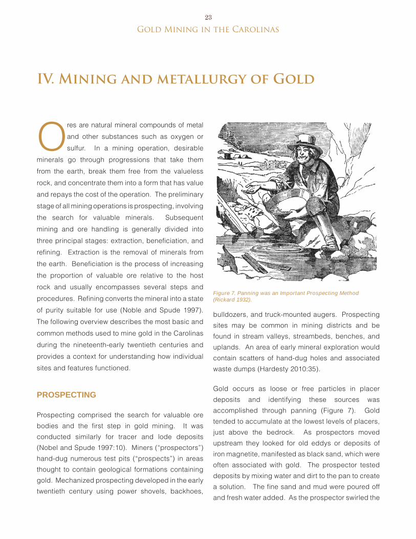
gold Mining in the Carolinas23
IV. Mining and metallurgy of Gold
Figure 7. Panning was an Important Prospecting Method (Rickard 1932).
Ores are natural mineral compounds of metal
and other substances such as oxygen or
sulfur. In a mining operation, desirable
minerals go through progressions that take them
from the earth, break them free from the valueless
rock, and concentrate them into a form that has value
and repays the cost of the operation. The preliminary
stage of all mining operations is prospecting, involving
the search for valuable minerals. Subsequent
mining and ore handling is generally divided into
three principal stages: extraction, beneficiation, and
refining. extraction is the removal of minerals from
the earth. beneficiation is the process of increasing
the proportion of valuable ore relative to the host
rock and usually encompasses several steps and
procedures. Refining converts the mineral into a state
of purity suitable for use (Noble and Spude 1997).
The following overview describes the most basic and
common methods used to mine gold in the Carolinas
during the nineteenth-early twentieth centuries and
provides a context for understanding how individual
sites and features functioned.
pRospectinG
Prospecting comprised the search for valuable ore
bodies and the first step in gold mining. It was
conducted similarly for tracer and lode deposits
(Nobel and Spude 1997:10). Miners (“prospectors”)
hand-dug numerous test pits (“prospects”) in areas
thought to contain geological formations containing
gold. Mechanized prospecting developed in the early
twentieth century using power shovels, backhoes,
bulldozers, and truck-mounted augers. Prospecting
sites may be common in mining districts and be
found in stream valleys, streambeds, benches, and
uplands. An area of early mineral exploration would
contain scatters of hand-dug holes and associated
waste dumps (Hardesty 2010:35).
Gold occurs as loose or free particles in placer
deposits and identifying these sources was
accomplished through panning (Figure 7). Gold
tended to accumulate at the lowest levels of placers,
just above the bedrock. As prospectors moved
upstream they looked for old eddys or deposits of
iron magnetite, manifested as black sand, which were
often associated with gold. The prospector tested
deposits by mixing water and dirt to the pan to create
a solution. The fine sand and mud were poured off
and fresh water added. As the prospector swirled the
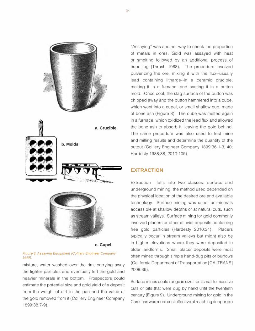
24
Figure 8. Assaying Equipment (Colliery Engineer Company 1899).
c. cupel
a. crucible
b. molds
mixture, water washed over the rim, carrying away
the lighter particles and eventually left the gold and
heavier minerals in the bottom. Prospectors could
estimate the potential size and gold yield of a deposit
from the weight of dirt in the pan and the value of
the gold removed from it (Colliery engineer Company
1899:38.7-9).
“Assaying” was another way to check the proportion
of metals in ores. Gold was assayed with heat
or smelting followed by an additional process of
cupelling (Thrush 1968). The procedure involved
pulverizing the ore, mixing it with the flux--usually
lead containing litharge--in a ceramic crucible,
melting it in a furnace, and casting it in a button
mold. Once cool, the slag surface of the button was
chipped away and the button hammered into a cube,
which went into a cupel, or small shallow cup, made
of bone ash (Figure 8). The cube was melted again
in a furnace, which oxidized the lead flux and allowed
the bone ash to absorb it, leaving the gold behind.
The same procedure was also used to test mine
and milling results and determine the quantity of the
output (Colliery engineer Company 1899:36.1-3, 40;
Hardesty 1988:38, 2010:105).
extRaction
extraction falls into two classes: surface and
underground mining, the method used depended on
the physical location of the desired ore and available
technology. Surface mining was used for minerals
accessible at shallow depths or at natural cuts, such
as stream valleys. Surface mining for gold commonly
involved placers or other alluvial deposits containing
free gold particles (Hardesty 2010:34). Placers
typically occur in stream valleys but might also be
in higher elevations where they were deposited in
older landforms. Small placer deposits were most
often mined through simple hand-dug pits or burrows
(California Department of Transportation [CALTRANS]
2008:86).
Surface mines could range in size from small to massive
cuts or pits that were dug by hand until the twentieth
century (Figure 9). Underground mining for gold in the
Carolinas was more cost effective at reaching deeper ore
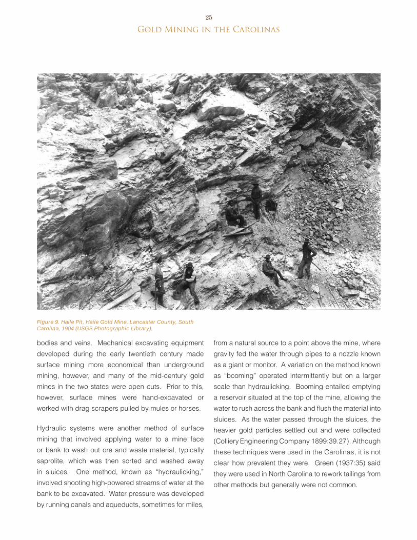
gold Mining in the Carolinas25
Figure 9. Haile Pit, Haile Gold Mine, Lancaster County, South Carolina, 1904 (USGS Photographic Library).
bodies and veins. Mechanical excavating equipment
developed during the early twentieth century made
surface mining more economical than underground
mining, however, and many of the mid-century gold
mines in the two states were open cuts. Prior to this,
however, surface mines were hand-excavated or
worked with drag scrapers pulled by mules or horses.
Hydraulic systems were another method of surface
mining that involved applying water to a mine face
or bank to wash out ore and waste material, typically
saprolite, which was then sorted and washed away
in sluices. One method, known as “hydraulicking,”
involved shooting high-powered streams of water at the
bank to be excavated. Water pressure was developed
by running canals and aqueducts, sometimes for miles,
from a natural source to a point above the mine, where
gravity fed the water through pipes to a nozzle known
as a giant or monitor. A variation on the method known
as “booming” operated intermittently but on a larger
scale than hydraulicking. booming entailed emptying
a reservoir situated at the top of the mine, allowing the
water to rush across the bank and flush the material into
sluices. As the water passed through the sluices, the
heavier gold particles settled out and were collected
(Colliery engineering Company 1899:39.27). Although
these techniques were used in the Carolinas, it is not
clear how prevalent they were. Green (1937:35) said
they were used in North Carolina to rework tailings from
other methods but generally were not common.
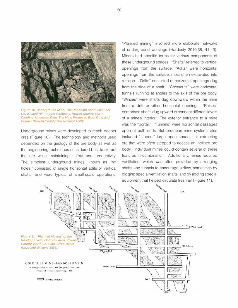
26
Figure 10. Underground Mine: The Randolph Shaft, 800-Foot Level, Gold Hill Copper Company, Rowen County, North Carolina, Unknown Date. The Mine Produced Both Gold and Copper (Rowan County Government 2008).
Figure 11. “Planned Mining” of the Randolph Vein, Gold Hill Area, Rowan County, North Carolina, Circa 1890s (Nitze and Wilkens 1896).
Underground mines were developed to reach deeper
ores (Figure 10). The technology and methods used
depended on the geology of the ore body as well as
the engineering techniques considered best to extract
the ore while maintaining safety and productivity.
The simplest underground mines, known as “rat
holes,” consisted of single horizontal adits or vertical
shafts, and were typical of small-scale operations.
“Planned mining” involved more elaborate networks
of underground workings (Hardesty 2010:38, 41-43).
Miners had specific terms for various components of
these underground spaces. “Shafts” referred to vertical
openings from the surface. “Adits” were horizontal
openings from the surface, most often excavated into
a slope. “Drifts” consisted of horizontal openings dug
from the side of a shaft. “Crosscuts” were horizontal
tunnels running at angles to the axis of the ore body.
“Winzes” were shafts dug downward within the mine
from a drift or other horizontal opening. “Raises”
comprised shafts dug upward to connect different levels
of a mine’s interior. The exterior entrance to a mine
was the “portal.” “Tunnels” were horizontal passages
open at both ends. Subterranean mine systems also
included “stopes,” large open spaces for extracting
ore that were often stepped to access an inclined ore
body. Individual mines could contain several of these
features in combination. Additionally, mines required
ventilation, which was often provided by arranging
shafts and tunnels to encourage airflow, sometimes by
digging special ventilation shafts, and by adding special
equipment that helped circulate fresh air (Figure 11).

gold Mining in the Carolinas27
The general procedure for developing an underground
mine was to sink one or more shaft to approach or
intersect the gold-bearing strata. Once that was
accomplished, drifts were opened at different levels to
follow the ore (Knapp 1975:11). Much of the work was
accomplished through hand excavation. blasting was
also in use by the mid-1800s and late in the century,
pneumatic rock drills and hammers were introduced.
The steps for working in an underground mine were to
first, drive blasting holes into the rock with cast steel
bars about 1.5 inches in diameter, 3-4 feet long, and
having one end shaped into a chisel. Miners worked in
pairs, one holding the bar and the other hammering it
to depths between 18 inches and three feet. The hole
was then loaded with blasting powder and sealed with
a fuse extending through the plug (Glass 1985:423).
After the explosion, the waste rock was discarded and
the ore taken in wheelbarrows or cars to the main shaft
for hoisting.
Drainage was a constant problem in mines and was
handled either mechanically or by arranging the
workings to allow water to flow out of an adit on the
hillside. Ultimately, mechanical pumps were used
(Hardesty 2010:53-55). These were steam-driven and
operated continuously, while the piping and equipment
used for them often took up considerable space in
the underground areas. Timbering or building wood
supports to hold up shafts and drifts was not usually
necessary in the Carolinas because the surrounding
rock usually held itself. Timbering was mostly used
when extra support was necessary, such as in holding
up pumping apparatus (Glass 1985:423, 426, 431).
Glass (1985:431-433) described working in
underground gold mines around the middle of the
nineteenth century. Miners entered and left the mine
through shafts from the surface using a series of ladders
that stood on narrow wooden platforms set about every
20 feet and reaching depths of several hundred feet.
The rungs and platforms were typically covered in
slippery mud and the miners made the trip carrying
their tools and equipment with them. Once inside the
mine, the only light came from the candles that miners
wore in their hats. The mine atmosphere was filled with
smoke from blasting and dripping water. The ceilings
were low and the footing was uncertain and sometimes
partially blocked by ore piles. Moreover, crosscuts and
other interior passages were usually made only the
minimum size necessary, making it necessary to travel
on hands and knees in some places.
Whether a mine was underground or at the surface,
it required means to remove the ore from the mine
and transport it to the mill or plant for processing.
Wheelbarrows were the simplest method for moving
materials around. More elaborate methods included
tracked trams and ore cars powered by mules or
horses, and later by steam, diesel, or electricity.
Removing ore via vertical and inclined shafts required
special structures and equipment. The simplest methods
involved having miners or laborers carry ore containers
and gear up and down ladders. Mechanical equipment
included windlasses powered by hand or animal
(horse-powered versions were known as “whims”), and
later by steam or other fuel (Figure 12). More elaborate
structures included headframes, consisting of tower-
like structures built over the mineshaft, which might be
simple frameworks or enclosed structures (Figures 13
and 14). Powered winching mechanisms raised and
lowered a cage or bucket from a pulley or sheave
mounted in the top of the tower (Hardesty 2010:49-
51). Larger North Carolina mines used Cornish-
style iron buckets known as “kibbles” to hoist ore
and people to the surface (Knapp 1975:12). Later,
various forms of skip or cage were used and different
arrangements of headframes, hoisting engines, and
hoisting drums or reels were developed (Ketchum
1912).

28
Figure 14. Enclosed Headframe--Gold Hill Copper Company, Rowan County, North Carolina, Unknown Date (Rowan County Government 2008).
Figure 13. Headframe--Phoenix Mine, Cabarrus County, North Carolina, Late 1800s (North Carolina Office of Archives and History).
Figure 12. “Whim” For Hoisting Ore From a Mineshaft (Whitney 1854).
Beneficiation
beneficiation refers to the process of separating
valuable minerals from the worthless portion of an
ore (gangue) and concentrating the valuable portion
into smaller bulk and weight (Richards 1909:1; Allen
1920:4). In general ore handling, this procedure is also
termed “concentrating.” Gold occurs as loose particles
or as inclusions within a surrounding matrix. Free gold
is uncombined with other substances, and is most often
found in placers or as constituents of weathered rock/
saprolite. Relatively large gold particles can also be
encased in other minerals and are released by breaking
and crushing. For example, it commonly occurs in
quartz rock from which the sulfides have been removed
by leaching, leaving only the quartz, fingers or veins

gold Mining in the Carolinas29
Figure 15. Rocker or Cradle Rocker (The Colliery Engineering Company 1899).
of free gold, and iron oxides. Finally, gold occurs in
sulfides, which consist of compounds of sulfur with more
than one element (Thrush 1968). In this context, gold is
typically distributed as minute particles (eissler 1900:6)
that require complex procedures to separate from
the gangue. Different beneficiation procedures were
developed to handle ore and recover gold from these
varying conditions. Hayward (1952) categorized these
processes as mechanical methods, amalgamation,
hydrometallurgical methods, and smelting.
mechanical methoDs
Mechanical methods rely on the relatively high
specific gravity of native gold to separate it from waste
materials. The simplest techniques for gold mining,
these methods were usually used on placer deposits
and to supplement other methods. The essential
procedure was to place gravel, sand, and soil into a
container, add water, and agitate the mixture, which
allowed the lighter waste materials to float and wash
out while the heavier gold particles fell to the bottom
of the container. Panning was the most basic form of
concentrating but was limited as an industrial method
because of the low speed and volume of material that
could be processed.
Improved devices included rockers, sluice boxes, and
variations such as the “long tom.” Rockers consisted
of boxes mounted on curved wooden runners (the
“rockers”) and having an open front. The top of the box
had a perforated bottom and below this was a backward-
sloping baffle board or canvas apron. The bottom level
contained riffles. To operate, the miner put gravel in
the top level and ladled water over it while manually
rocking the device. The baffle board deposited the
screenings to the back of the lower level and as they
washed out the open front, the riffles caught the heavier
gold particles (Richards 1909:323-324) (Figure 15).
A similar apparatus was the log rocker, consisting of
split, hollowed out logs measuring about 20 feet long.
These were used in conjunction with various hand and
mechanical ore breaking and crushing processes.
After being pulverized to the consistency of mud,
the ore went to the log rockers where a stream of water
washed it through the trough to an open end. Grooves
cut into the bottom of the rocker were filled with mercury
to catch the gold particles and form an amalgam. Log
rockers were typically set up in multiple units and
could be operated manually or with powered machines
(Figure 16). These were sometimes used to recover any
residual gold that had passed through other collection
methods.
Another device, the sluice, consisted of a flat-bottomed
trough or chute through which water mixed with sand
and gravel flowed. Water continuously flowed through
the sluice while sand and gravel were shoveled
in. Riffles built into the floor of the sluice created a
suspension that allowed the lighter materials to wash

30
Figure 17. Long Tom (The Colliery Engineering Company 1899).
Figure 16. Log Rockers, Gold Hill District, North Carolina, Unknown Date (Nitze and Wilkens 1897).
out while catching the heavier gold flakes. Sluices
were also used along with hydraulicking and booming,
as described above. The “long tom” utilized a similar
principal as a sluice but consisted of a trough with a
screen or perforated metal plate (the “riddle”) at the
outlet end. Sand and gravel were shoveled into the
trough and agitated as a continuous stream of water
washed through, carrying smaller particles through the
riddle and into a lower tier with riffles that caught the
gold (Figure 17). Sometimes, mercury would be added
to the riffles to amalgamate with the gold (The Colliery
engineering Company 1899; Richards 1909:322;
Gregory 1907:7; Hayward 1952:426).

gold Mining in the Carolinas31
Figure 18. Blake Jaw Crusher. Blake Crushers Were Among the Most Common Types Used at American Mines (International Library of Technology 1902).
Figure 20. Operation of a Horse-Powered Arrastra (Rose 1898).
Figure 19. Cross Section of an Arrastra (Richards 1909).
amalGamation
Gold readily bonds to mercury, and the principal of
amalgamation was to expose gold to mercury, which
then drew it away from unwanted gangue. Common
practice involved washing gold-bearing pulp (a mixture
of water and ground ore capable of flowing) over a
surface coated with mercury or amalgam. The gold was
recovered from the amalgam by distilling the mercury
in a retort and smelting the gold to remove residual
impurities (Hayward 1952:430). before reaching this
point, the ore had to be reduced in size, a process
conducted in one or more stages.
Breaking and crushing
Although crushing ore could be an end stage in gold
mining, it was nearly always a first step in extracting
gold encased in hard rock or sulfides. As a stand-alone
process, miners simply crushed the rock and collected
the freed gold particles, commonly with one of the
mechanical methods described above, such as panning.
For amalgamation and hydrometallurgial processes,
breaking and crushing was meant to reduce the rock for
the machines that would handle it later, and to generate
particles of a uniform size for subsequent treatments.
breaking was usually the first step, while crushing and
grinding were applied sequentially to produce grains
the size of coarse sand or finer (“slime”). This process
of reducing and regulating the size of the ore fragments
was known as “comminution” (International Library of
Technology 1902:25.1; Thrush 1968).
Preliminary breaking reduced the ore to sizes suitable
for the crushing machines and/or enhanced its friability.
Methods included blasting, calcining by fire, hand
hammers, and rock breakers. blasting and hand
hammering are self-explanatory. Other devices included
jawbreakers that operated intermittently as the hinged jaws
opened and closed (Figure 18), and spindle or gyrating
crushers that ran continuously as rock was fed from an ore
bin (Lock 1901; International Library of Technology 1902;
Richards 1909; Hardesty 2010:67). breaking took place
underground at the mine, at the top level or surface of
the mine, at the mill, or in a separate dedicated structure
(Hardesty 1988:39).

32
Figure 21. Chilean Mill at North Carolina Gold Mine Near Salisbury (Nitze and Wilkens 1897).
From the preliminary breaking, the ore went through
processes that crushed or ground it into pulp that could
be washed across the amalgamation plates. early or
“traditional” devices for this were arrastras, Chilean
mills, and stamp mills. Arrastras were relatively simple
devices. Often described as “primitive,” they were
used in Mexico by Spanish mining operations as early
as the 1500s and persisted at small-scale operations in the American west into the twentieth century (Kelly and Kelly 1983:90; van bueren 2004; Hardesty 2010:17). Arrastras consisted of circular rock-lined measuring from 8-20 feet in diameter and varying in depth. They contained a central column crossed by a horizontal pole. Large stones slung from the poles were dragged around the arrastra to pulverize gold-bearing rock,
which had been previously reduced to relatively small sizes (Thrush 1968; Hardesty 1988:39). Near the end of the grinding cycle, mercury was added to form an amalgamation. When complete, the pulp was let out of the arrastra and the amalgam was collected with sluices, cradles, or long toms. The process required considerable energy to operate and treated only low quantities of ore. To make a profit, relatively rich ores were necessary along with low investment and overhead
costs (Kelly and Kelly 1983:86; van bueren 2004:7-8).
Chilean or chili mills resembled arrastras, consisting of
circular enclosures with a stone or iron base. The principal
difference was that Chilean mills used vertical rollers that
ran around the enclosure to grind the ore (Figure 21).
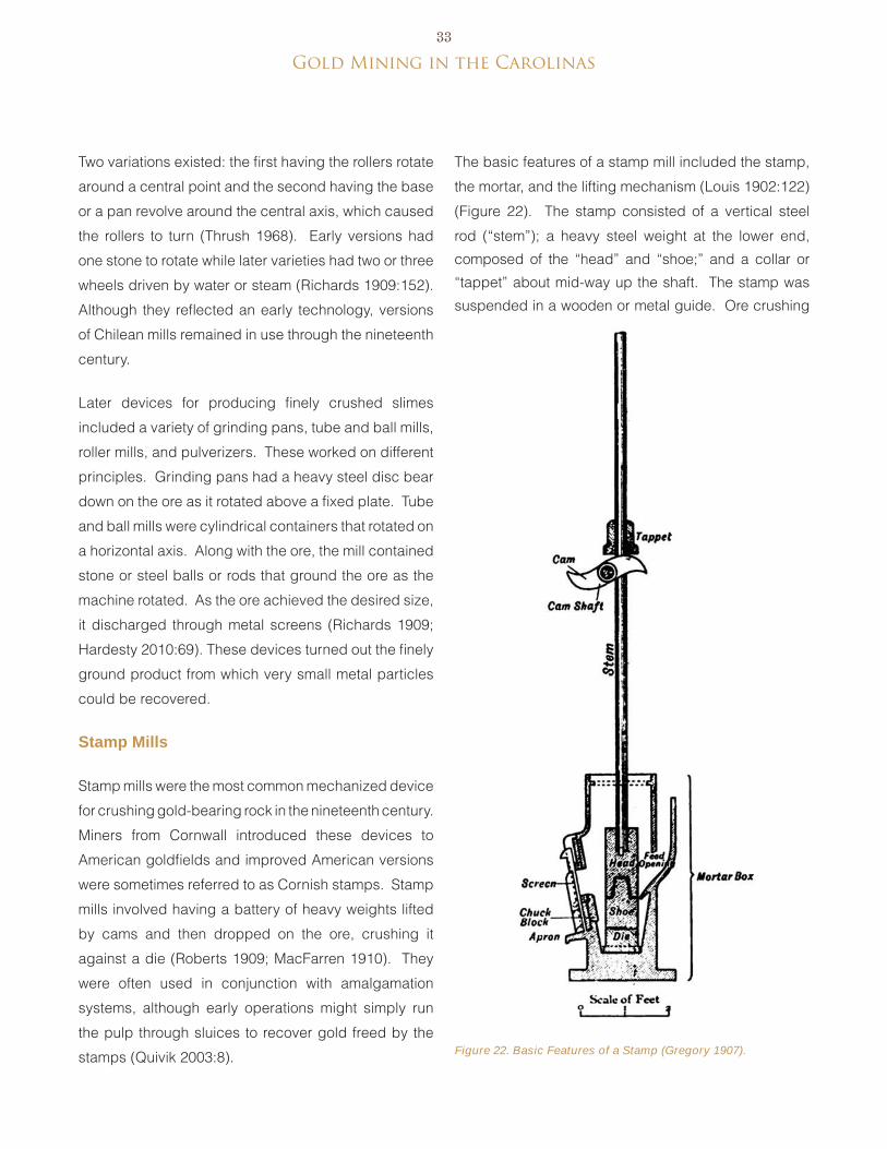
gold Mining in the Carolinas33
Figure 22. Basic Features of a Stamp (Gregory 1907).
Two variations existed: the first having the rollers rotate
around a central point and the second having the base
or a pan revolve around the central axis, which caused
the rollers to turn (Thrush 1968). early versions had
one stone to rotate while later varieties had two or three
wheels driven by water or steam (Richards 1909:152).
Although they reflected an early technology, versions
of Chilean mills remained in use through the nineteenth
century.
Later devices for producing finely crushed slimes
included a variety of grinding pans, tube and ball mills,
roller mills, and pulverizers. These worked on different
principles. Grinding pans had a heavy steel disc bear
down on the ore as it rotated above a fixed plate. Tube
and ball mills were cylindrical containers that rotated on
a horizontal axis. Along with the ore, the mill contained
stone or steel balls or rods that ground the ore as the
machine rotated. As the ore achieved the desired size,
it discharged through metal screens (Richards 1909;
Hardesty 2010:69). These devices turned out the finely
ground product from which very small metal particles
could be recovered.
stamp mills
Stamp mills were the most common mechanized device
for crushing gold-bearing rock in the nineteenth century.
Miners from Cornwall introduced these devices to
American goldfields and improved American versions
were sometimes referred to as Cornish stamps. Stamp
mills involved having a battery of heavy weights lifted
by cams and then dropped on the ore, crushing it
against a die (Roberts 1909; MacFarren 1910). They
were often used in conjunction with amalgamation
systems, although early operations might simply run
the pulp through sluices to recover gold freed by the
stamps (Quivik 2003:8).
The basic features of a stamp mill included the stamp,
the mortar, and the lifting mechanism (Louis 1902:122)
(Figure 22). The stamp consisted of a vertical steel
rod (“stem”); a heavy steel weight at the lower end,
composed of the “head” and “shoe;” and a collar or
“tappet” about mid-way up the shaft. The stamp was
suspended in a wooden or metal guide. Ore crushing

34
Figure 23. Stamp Mill Battery Section Showing Major Components (Arnold 1977).
took place in a container called a “mortar box,” which
had a feed opening or hopper for ore to enter and a
screen across the discharge opening. Crushing took
place on a die at the base of the mortar box. Mortar
boxes were commonly sized to fit a row of 3-5 individual
stamps. A camshaft extended across the stems just
below the tappets. A pulley or spur wheel turned the
camshaft, causing the S-shaped cams to engage the
tappets, push the stamps upward, and then let them
drop. The cams were usually arranged to fall separately
in the order of 1-3-5-2-4. Ore was fed through the
hopper with water and was crushed as it passed across
the die. Once it reached the appropriate degree of
fineness, it splashed through the screen and onto the
apron plate at the front of the mortar box (Louis 1902;
Gregory 1907:27; Hayward 1952:430).
Stamp mills or batteries were huge, multi-floor
structures supported by large wooden frames and
blocks to absorb the pounding (Figures 23 and 24).
The aboveground portion of the mill could measure
approximately 20 feet high and about 15 feet wide,
including the drive pulley, for a five-stamp mill (Roberts
1909:87). The massive framing held the camshaft and
guides for the stems. built of wood, cast iron, steel, or
wrought iron, the structure had to be extremely rigid and
durable to withstand the constant hammering and the
pull of the belt on the gearing. The usual arrangement
consisted of two uprights for up to five stamps mounted
on a horizontal sill. A third upright was added for a
battery of 10 stamps. The uprights were connected
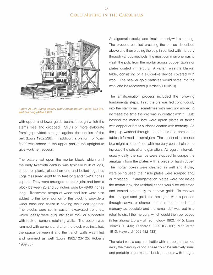
gold Mining in the Carolinas35
Figure 24 Ten Stamp Battery with Amalgamation Plates, Ore Bin, and Framing (Allen 1920).
with upper and lower guide beams through which the
stems rose and dropped. Struts or more elaborate
framing provided strength against the tension of the
belt (Louis 1902:230). In addition, a platform or “cam
floor” was added to the upper part of the uprights to
give workmen access.
The battery sat upon the mortar block, which until
the early twentieth century was typically built of logs,
timber, or planks placed on end and bolted together.
Logs measured eight to 15 feet long and 15-20 inches
square. They were arranged to break joint and form a
block between 20 and 30 inches wide by 48-60 inches
long. Transverse straps of wood and iron were also
added to the lower portion of the block to provide a
wider base and assist in holding the block together.
The blocks were set in custom-excavated trenches,
which ideally were dug into solid rock or supported
with rock or cement retaining walls. The bottom was
rammed with cement and after the block was installed,
the space between it and the trench walls was filled
and rammed as well (Louis 1902:123-125; Roberts
1909:85).
Amalgamation took place simultaneously with stamping.
The process entailed crushing the ore as described
above and then placing the pulp in contact with mercury
through various methods, the most common one was to
wash the pulp from the mortar across copper tables or
plates coated in mercury. A variant was the blanket
table, consisting of a sluice-like device covered with
wool. The heavier gold particles would settle into the
wool and be recovered (Hardesty 2010:70).
The amalgamation process included the following
fundamental steps. First, the ore was fed continuously
into the stamp mill, sometimes with mercury added to
increase the time the ore was in contact with it. Just
beyond the mortar box were apron plates or tables
with copper or brass surfaces coated with mercury. As
the pulp washed through the screens and across the
tables, it formed the amalgam. The interior of the mortar
box might also be fitted with mercury-coated plates to
increase the rate of amalgamation. At regular intervals,
usually daily, the stamps were stopped to scrape the
amalgam from the plates with a piece of hard rubber.
The mortar boxes were cleaned as well and if they
were being used, the inside plates were scraped and/
or replaced. If amalgamation plates were not inside
the mortar box, the residual sands would be collected
and treated separately to remove gold. To recover
the amalgamated gold, the amalgam was squeezed
through canvas or chamois to strain out as much free
mercury as possible and the remainder was put in a
retort to distill the mercury, which could then be reused
(International Library of Technology 1902:14-15; Louis
1902:310, 430; Richards 1909:103-106; MacFarren
1910; Hayward 1952:432-433).
The retort was a cast iron kettle with a tube that carried
away the mercury vapor. These could be relatively small
and portable or permanent brick structures with integral
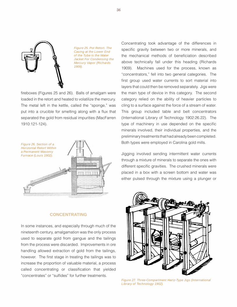
36
Figure 25. Pot Retort. The Casing at the Lower End of the Tube is the Water Jacket For Condensing the Mercury Vapor (Richards 1909).
Figure 27. Three-Compartment Hartz-Type Jigs (International Library of Technology 1902).
fireboxes (Figures 25 and 26). balls of amalgam were
loaded in the retort and heated to volatilize the mercury.
The metal left in the kettle, called the “sponge,” was
put into a crucible for smelting along with a flux that
separated the gold from residual impurities (MacFarren
1910:121-124).
concentRatinG
In some instances, and especially through much of the
nineteenth century, amalgamation was the only process
used to separate gold from gangue and the tailings
from the process were discarded. Improvements in ore
handling allowed extraction of gold from the tailings,
however. The first stage in treating the tailings was to
increase the proportion of valuable material, a process
called concentrating or classification that yielded
“concentrates” or “sulfides” for further treatments.
Concentrating took advantage of the differences in
specific gravity between two or more minerals, and
the mechanical methods of beneficiation described
above technically fall under this heading (Richards
1909). Machines used for the process, known as
“concentrators,” fell into two general categories. The
first group used water currents to sort material into
layers that could then be removed separately. Jigs were
the main type of device in this category. The second
category relied on the ability of heavier particles to
cling to a surface against the force of a stream of water.
This group included table and belt concentrators
(International Library of Technology 1902:26.22). The
type of machinery in use depended on the specific
minerals involved, their individual properties, and the
preliminary treatments that had already been completed.
both types were employed in Carolina gold mills.
Jigging involved sending intermittent water currents
through a mixture of minerals to separate the ones with
different specific gravities. The crushed minerals were
placed in a box with a screen bottom and water was
either pulsed through the mixture using a plunger or
Figure 26. Section of a Horizontal Retort Within a Permanent Masonry Furnace (Louis 1902).
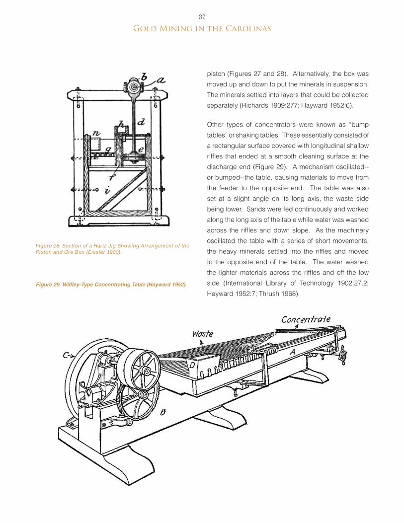
gold Mining in the Carolinas37
Figure 29. Wilfley-Type Concentrating Table (Hayward 1952).
Figure 28. Section of a Hartz Jig Showing Arrangement of the Piston and Ore Box (Eissler 1900).
piston (Figures 27 and 28). Alternatively, the box was
moved up and down to put the minerals in suspension.
The minerals settled into layers that could be collected
separately (Richards 1909:277; Hayward 1952:6).
Other types of concentrators were known as “bump
tables” or shaking tables. These essentially consisted of
a rectangular surface covered with longitudinal shallow
riffles that ended at a smooth cleaning surface at the
discharge end (Figure 29). A mechanism oscillated--
or bumped--the table, causing materials to move from
the feeder to the opposite end. The table was also
set at a slight angle on its long axis, the waste side
being lower. Sands were fed continuously and worked
along the long axis of the table while water was washed
across the riffles and down slope. As the machinery
oscillated the table with a series of short movements,
the heavy minerals settled into the riffles and moved
to the opposite end of the table. The water washed
the lighter materials across the riffles and off the low
side (International Library of Technology 1902:27.2;
Hayward 1952:7; Thrush 1968).
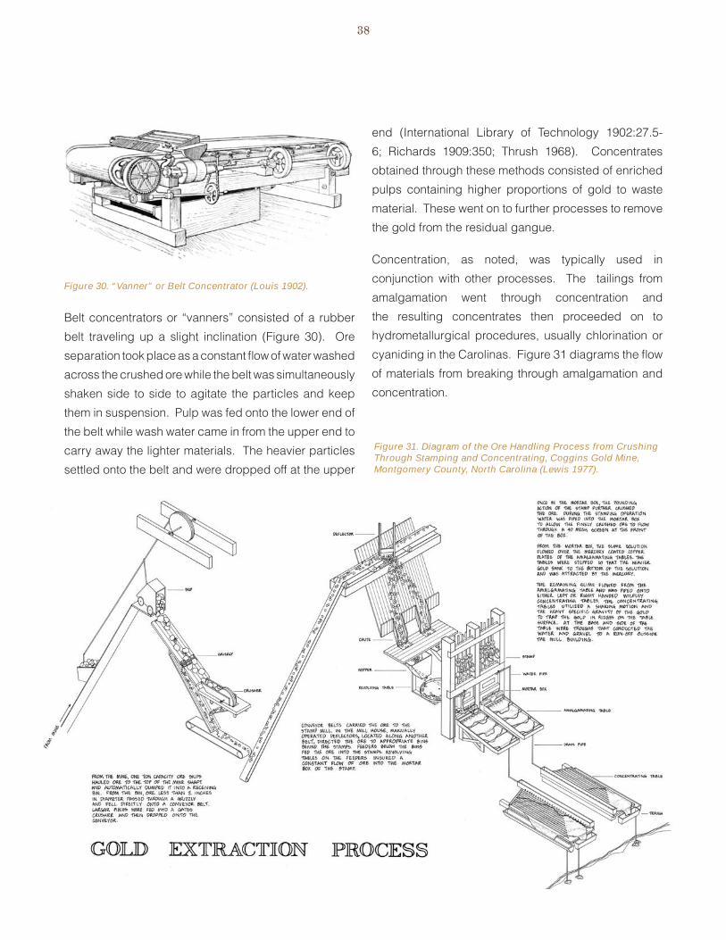
38
Figure 30. “Vanner” or Belt Concentrator (Louis 1902).
Figure 31. Diagram of the Ore Handling Process from Crushing Through Stamping and Concentrating, Coggins Gold Mine, Montgomery County, North Carolina (Lewis 1977).
belt concentrators or “vanners” consisted of a rubber
belt traveling up a slight inclination (Figure 30). Ore
separation took place as a constant flow of water washed
across the crushed ore while the belt was simultaneously
shaken side to side to agitate the particles and keep
them in suspension. Pulp was fed onto the lower end of
the belt while wash water came in from the upper end to
carry away the lighter materials. The heavier particles
settled onto the belt and were dropped off at the upper
end (International Library of Technology 1902:27.5-
6; Richards 1909:350; Thrush 1968). Concentrates
obtained through these methods consisted of enriched
pulps containing higher proportions of gold to waste
material. These went on to further processes to remove
the gold from the residual gangue.
Concentration, as noted, was typically used in
conjunction with other processes. The tailings from
amalgamation went through concentration and
the resulting concentrates then proceeded on to
hydrometallurgical procedures, usually chlorination or
cyaniding in the Carolinas. Figure 31 diagrams the flow
of materials from breaking through amalgamation and
concentration.

gold Mining in the Carolinas39
hyDRometalluRGy
Hydrometallurgy involved the treatment of ore,
concentrates, and other metal-bearing materials by
wet processes, usually involving conversion of one
component to solution and its recovery from the solution
(Thrush 1968). variations of two methods were used at
Carolina gold mines: chlorination and cyanide.
chloRination
Considered obsolete by the mid-twentieth century,
the chlorination process involved converting the gold
to chloride, leaching it out with water, precipitating it,
and then refining it (Hayward 1952:417). The process
was developed in 1848 by Carl Frederick Plattner and
introduced in California in 1857 (International Textbook
Company 1902:34.1; Hardesty 1988:47-48, 2010:80).
The method was common in the Carolina goldfields.
Technical advancements to the process included
changing the containers in which chlorination took
place and improving the preparation and introduction
of the chlorine.
Roasting
before the ore went through chlorination, it was roasted.
Roasting could take place either in bulk as the ore
came from the mines or after it went through stamping
and concentrating (eissler 1900:258). The purpose
of roasting was to drive off sulfur, arsenic, and other
volatile substances that were combined with the metals
and to form metallic oxides, leaving only metallic gold
that could combine with chlorine during the subsequent
chemical treatment (Rose 1898:234). The process also
changed the character of soluble salts such as ferrous
sulfate or chloride so they would not act on the gold in
solution (International Textbook Company 1902:34.4).
Roasting could take place in the open, a technique
known as “pile roasting” or “heap roasting.” Although
essentially this involved piling the ore on a bed of fuel
and firing it, the method of arranging the pile was
important to achieve certain results. Ideally, larger
fragments of ore were placed in the center of the pile
with smaller sizes towards the exterior. The whole was
covered in a layer of fines or concentrates. Moreover,
the bed was specially constructed of layers of slag, clay,
and calcined ore with channels to allow air to circulate.
The mound of ore could measure between about 6-8
feet and were built in the shape of a truncated square
pyramid and could range from 25-85 feet on a side
(Schnabel 1898:29-30). The most common practice
was for the pile to measure about 24x18x6 feet high. A
pile this size would burn 30-40 days (eissler 1900:278)
In the Carolinas, roasting was mostly accomplished
in furnaces or reverberatories. The process began
with a low heat that freed the sulfur of the sulfides and
combined it with oxygen to produce volatile sulfuric acid.
Known as an “oxidizing roast,” this stage required the
introduction of excessive air into the furnace as the ore
was heated. As the metals in the ore lost part of their
sulfur, they were converted into oxides and sulfates,
consisting predominantly of iron sulfates. because
these would precipitate the gold from a solution of
chloride of gold, they required elimination by gradually
increasing the roaster heat to decompose the sulfates
and form oxides, a process called a “dead roast”
(Wilson 1897:20-21; eissler 1900:258-260; International
Textbook Company 1902:34.4). For “chloridizing
roasting,” salt was added during the roast if certain
substances, such as lime, magnesia, or lead, were
present in the ore. The heat released chlorine from the
salt. The free chlorine then combined with the metals
to form metal chlorides that would not absorb chlorine
during the subsequent treatment (Rose 1898:242;
International Textbook Company 1902:34.4-5). In sum,
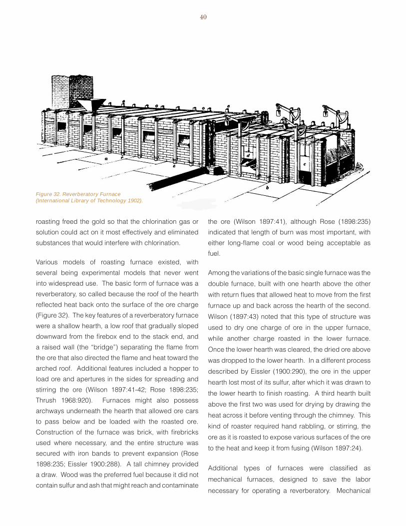
40
Figure 32. Reverberatory Furnace (International Library of Technology 1902).
roasting freed the gold so that the chlorination gas or
solution could act on it most effectively and eliminated
substances that would interfere with chlorination.
various models of roasting furnace existed, with
several being experimental models that never went
into widespread use. The basic form of furnace was a
reverberatory, so called because the roof of the hearth
reflected heat back onto the surface of the ore charge
(Figure 32). The key features of a reverberatory furnace
were a shallow hearth, a low roof that gradually sloped
downward from the firebox end to the stack end, and
a raised wall (the “bridge”) separating the flame from
the ore that also directed the flame and heat toward the
arched roof. Additional features included a hopper to
load ore and apertures in the sides for spreading and
stirring the ore (Wilson 1897:41-42; Rose 1898:235;
Thrush 1968:920). Furnaces might also possess
archways underneath the hearth that allowed ore cars
to pass below and be loaded with the roasted ore.
Construction of the furnace was brick, with firebricks
used where necessary, and the entire structure was
secured with iron bands to prevent expansion (Rose
1898:235; eissler 1900:288). A tall chimney provided
a draw. Wood was the preferred fuel because it did not
contain sulfur and ash that might reach and contaminate
the ore (Wilson 1897:41), although Rose (1898:235)
indicated that length of burn was most important, with
either long-flame coal or wood being acceptable as
fuel.
Among the variations of the basic single furnace was the
double furnace, built with one hearth above the other
with return flues that allowed heat to move from the first
furnace up and back across the hearth of the second.
Wilson (1897:43) noted that this type of structure was
used to dry one charge of ore in the upper furnace,
while another charge roasted in the lower furnace.
Once the lower hearth was cleared, the dried ore above
was dropped to the lower hearth. In a different process
described by eissler (1900:290), the ore in the upper
hearth lost most of its sulfur, after which it was drawn to
the lower hearth to finish roasting. A third hearth built
above the first two was used for drying by drawing the
heat across it before venting through the chimney. This
kind of roaster required hand rabbling, or stirring, the
ore as it is roasted to expose various surfaces of the ore
to the heat and keep it from fusing (Wilson 1897:24).
Additional types of furnaces were classified as
mechanical furnaces, designed to save the labor
necessary for operating a reverberatory. Mechanical

gold Mining in the Carolinas41
furnaces were classified into four classes: stationary
hearth furnaces with mechanically moving hoes for
rabbling; rotating-bed furnaces with stationary hoes or
stirrers; rotating cylindrical furnaces that tumbled the
ore while it was roasted; and shaft furnaces arranged to
have powdered ore fall in a shower through an ascending
column of hot air. Numerous brands and variations on
these basic types were available and put into use with
varying degrees of success (Rose 1898).
As roasting was completed, the ore was moved to a
cooling floor. From here, it went to the chlorination
plant.
chlorination procedure
The basic chlorination procedure involved exposing
roasted ore to chlorine gas and then leaching the ore
in a water solution to produce gold chloride. Ferrous
sulfate was added to the solution to precipitate the gold,
which was then filtered out (Hardesty 2010:79). The
precipitated gold was then melted into bars (Thrush
1968).
The Plattner chlorination process, developed by Karl
F. Plattner in the 1850s, took place in airtight pitch-
coated wooden vats (Figure 33). Chlorine gas was
produced outside the vat in a separate process and
introduced to the roasted ore via a pipe at the base of
the vat. The gas was allowed to permeate the ore over
several days. At the end of this time, water was added
to leach out the trichloride of gold and this solution was
drawn off to precipitating tanks, built of wood staves
in the same manner as the chlorination vats and also
sealed with lead, pitch, or other material. A solution
of iron sulfate was added to the tanks before the gold
solution entered, causing the gold to precipitate into a
brown powder that settled to the bottom of the tank.
The residual solution was siphoned off and the process
of adding ferrous sulfate and a fresh solution from the
leaching vat was repeated several times until enough
gold precipitate accumulated to warrant cleaning it from
the tank. The precipitate was gathered, washed, dried,
melted in crucibles, and formed into gold bars (eissler
1900:345; International Textbook Company 1902:34).
Modifications to the basic process related primarily to
ways the chlorine was introduced to the ore and how
the chlorination was handled. The first innovation was
the substitution of revolving barrels for the vats, as in
the Delacy process (patented 1864). This improvement
shortened the time required to chlorinate a charge of
ore. Also, the barrels had a larger capacity than the
vats. Another modification was the Mears process
(patented 1877), which exchanged the wooden
containers with lead-lined iron barrels and modified the
gas-introduction procedure to admit it under pressure,
which was thought to speed the rate of chlorination
(eissler 1900:382; International Textbook Company
1902:34.2).
Figure 33. Chlorination Tub Used For the Plattner Process (International Textbook Company 1902).
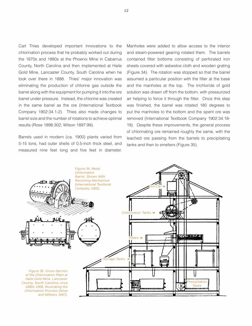
42
Carl Thies developed important innovations to the
chlorination process that he probably worked out during
the 1870s and 1880s at the Phoenix Mine in Cabarrus
County, North Carolina and then implemented at Haile
Gold Mine, Lancaster County, South Carolina when he
took over there in 1888. Thies’ major innovation was
eliminating the production of chlorine gas outside the
barrel along with the equipment for pumping it into the ore
barrel under pressure. Instead, the chlorine was created
in the same barrel as the ore (International Textbook
Company 1902:34.1-2). Thies also made changes to
barrel size and the number of rotations to achieve optimal
results (Rose 1898:302; Wilson 1897:99).
barrels used in modern (ca. 1900) plants varied from
5-15 tons, had outer shells of 0.5-inch thick steel, and
measured nine feet long and five feet in diameter.
Manholes were added to allow access to the interior
and steam-powered gearing rotated them. The barrels
contained filter bottoms consisting of perforated iron
sheets covered with asbestos cloth and wooden grating
(Figure 34). The rotation was stopped so that the barrel
assumed a particular position with the filter at the base
and the manholes at the top. The trichloride of gold
solution was drawn off from the bottom, with pressurized
air helping to force it through the filter. Once this step
was finished, the barrel was rotated 180 degrees to
put the manholes to the bottom and the spent ore was
removed (International Textbook Company 1902:34.18-
19). Despite these improvements, the general process
of chlorinating ore remained roughly the same, with the
leached ore passing from the barrels to precipitating
tanks and then to smelters (Figure 35).
Figure 34. Metal Chlorination Barrel, Shown With Revolving Mechanism (International Textbook Company 1902). Ore Car k
Chlorination Tanks k
Filters k
Storage Tanks k
PrecipitationTanks
Figure 35. Cross-Section of the Chlorination Plant at Haile Gold Mine, Lancaster
County, South Carolina, circa 1880s-1908, Illustrating the Chlorination Process (Nitze
and Wilkens 1897).

gold Mining in the Carolinas43
Figure 36. Howie Mine Cyanide Tanks, Union County, North Carolina, circa 1906. Six 190-Ton Leaching Tanks are to the Left with Tracks That Allowed Access For Ore Cars to Load Them. The Three Tanks at Right Contained Cyanide Solution (Howie Mining Company 1906).
cyaniDe
Cyaniding is the process of treating ground gold and silver ores with a solution of sodium or potassium cyanide. The method was developed in the 1880s and began to replace other methods soon afterwards. The first American cyanide mills were built in 1891 and used for gold. The method was not applied to silver ores until after 1900 (Hardesty 1988:51, 2010:84). Cyanide processes in combination with improved milling procedures helped create a resurgence of gold production in the Carolinas between 1900 and World War I (Knapp and Glass 1999:140) (Figure 36).
The cyanide process could vary in specific steps and procedures depending on the nature of the ore and materials, but there were three principal stages to the process: dissolving, precipitation, and smelting (Hayward 1952:437; Thrush 1968; Hardesty 1988:51). Roasting was not usually required except to remove an
element that prevented or hindered the gold’s solution in cyanide (Clennell 1910:286). Cyaniding worked best on fine concentrates because the smaller particles dissolved fastest (eissler 1900:485).
Clennell (1910) described the process as it was generally practiced. Typically, sands and slimes were treated separately with different techniques. Sands went through percolation methods and slimes through agitation. Some plants only processed very fine concentrates using the “all sliming method,” which required finely pulverized ore (Hayward 1952:437-438). by 1910, “all slime” plants achieved the desired texture with ball and tube or rod mills (Hardesty 1988:41; 2010:69). The detailed descriptions provided below indicate the processes along with equipment and materials.

44
Figure 37. Zinc Boxes Used at the Iola Mine Cyanide Plant, Montgomery County, North Carolina (Platt 1907).
Cyaniding was applied to the tailings of amalgamation, which removed the coarser gold particles. Wilfley tables or other concentrators separated and enriched the gold-bearing ores before further treatment. The amalgamation tailings then went through a hydraulic separation process in a device known as a “spitzlutte,” which used water jets to separate the slimes and sands. Sand then went through percolation to ready it for cyaniding. Percolation involved distributing the sand in a collecting vat that was continually flushed with water to float off residual slimes. The sand might be treated with lime at this point to reduce acidity. Next, the sand went to a filter or leaching tank where dissolving took place. This stage required a series of washes, typically including 1-2 baths in a weak cyanide solution, one in a strong solution, and several more in increasingly weaker solutions. Finally, a water wash completed the process. The solution was drawn off from the bottom of the tank so that the filter, a mat of coconut fiber and canvas, ensured the clarity of the liquid. Sometimes, additional settling was required to make certain that the liquid sent to the precipitation boxes was clear (Clennell 1910:33ff; Hardesty 2010:88).
To this point, slimes were handled differently. Once separated from the sand, the slimes went to a spitzlutte or other vessel to remove superfluous water. Lime was added to help the slimes coagulate and settle. Alternatively, slimes were processed on concentration belts before going to collection tanks for settling. The dissolving stage took place in agitation tanks where mechanical stirrers or pressurized air injections suspended the tailings long enough to be dissolved. The slimes might go through additional procedures such as decantation, during which additional settling and agitation took place before the water and moist residue were separated, or filter presses, in which compressed air or vacuums separated the liquid from the solid residue. The important point in treating the slimes was to ensure that the liquid sent to the precipitation boxes was as clear as possible (Clennell 1910; Hardesty 2010:89-90).
The solution from the sands and slimes went through the same processes of precipitation and smelting. Precipitation took place in zinc boxes, consisting of trough-like containers with internal dividers that allowed the solution to flow under and over them as successive boxes were filled (Figure 37). Zinc shavings were added to the solution to precipitate the gold. At this point, a metallic deposit formed on the zinc, which if done properly would be brownish black and would be most prevalent in the first compartment of the zinc box but decrease thereafter. The gold precipitate was collected and put through an additional acid treatment to convert the zinc to water-soluble zinc sulfide and eliminate other impurities that could be washed out. This process was sometimes aided by stirring or heating, or the precipitate was roasted instead of being subjected to acid treatment. The final step in the process was smelting. The precipitate was mixed with a flux and sometimes an oxidizer, heated in crucibles or reverberatories, and the bullion cast into molds (International Library of Technology 1902:32:11; Clennell 1910).
GolD mininG pRactice
It is important to note that while gold mining involved
several steps from extraction to producing bullion,
individual mining operations could include or omit
particular steps, or combine them in different ways,

gold Mining in the Carolinas45
Figure 38. Gold Mining Could Involve Varying Levels of Technology. One Miner is Holding a Pan to Check Tailings of Mechanical Log Washers. Shuford Mine, Catawba County, North Carolina (Pratt 1907).
depending on the nature of the ore, the chronological
period, or the preferences of specific mine operators.
The preceding descriptions reflect general practices
for gold ore handling as conducted in the Carolinas,
insofar as they are known. Different individual steps
and equipment types could be combined in various
ways. For example, panning or log rockers, both
representing relatively simple concentration methods,
might be used as a final procedure on ore tailings
that had already passed through more elaborate and
mechanized crushing and concentrating processes.
Thus, these “earlier” and “more primitive” techniques
could be found in direct functional and chronological
association with extensive underground workings,
stamp mills, and concentrating plants. Also, steps
might be omitted altogether. As noted, hydraulicking
systems in the Carolinas were often used to re-
work tailings from other processes. A hydraulicking
operation, then, might possess elaborate and possibly extensive water management features but would not necessarily have associated stamping and crushing machinery. Finally, different methods could be used in combination, for example cyaniding was sometimes used in conjunction with amalgamation (McCauley and butler 1966:4). Some mine operators, on the other hand, could not afford to build chemical treatment plants and so performed only the stamping and concentrating and then sent the concentrates elsewhere for treatment (brenner 1977:2).
Another point to consider is that there is no precise correlation between site complexity and chronology. Although the preceding overviews of mining history and processes imply a trajectory toward more elaborate mining operations as easy to reach and process ores played out, some of the simplest gold recovery methods persisted through the nineteenth
46
and twentieth centuries. As noted, for example, pans and log rockers could be used in combination with larger operations (Figure 38). They were also associated with smaller mines and prospecting even as some mines expanded tremendously and employed elaborate systems and equipment. Moreover, around the turn of the century, a few North Carolina mines installed older types of equipment, such as log washers, to handle ore from saprolites (Pratt 1907:18). (Log washers were trough-like containers containing
a central rod with paddles. As water and saprolite were added, the paddles agitated the mixture and released the rock from the clayey saprolite.) During the Great Depression of the 1930s, people tried to find gold at many abandoned mines using these techniques (Knapp 1975:17). Smaller and less elaborate mines could thus date more recently than larger ones and therefore, researchers dealing with individual mines, mills, and plants must consider a range of possible configurations and chronological
associations.

gold Mining in the Carolinas47
V. Gold Mining Property Types
Interpreting and evaluating gold mining sites in the Carolinas requires accurate identification of numerous individual sites and features. Identification
establishes the historical and functional contexts of properties and therefore is necessary to evaluate their historic and archaeological significance. In addition, knowledge of resource types and how they functioned together can help delineate individual processes on sites with multiple or overlapping activities. Finally, correct identification can generate important data for studying historic gold mines, even when the site at hand lacks significance under the NRHP. The preceding overview of gold mining processes in the Carolinas indicated the range of activities that produced cultural resources and how they related to one another. The following discussion provides guidance for identifying specific resource types and linking them to particular mining processes.
Hardesty and Little (2009:27) referred to property types as the “key link between the historic context of a property and the property itself.” Property types are groupings of individual properties that share physical and/or associative attributes. Physical attributes may encompass style, structural type, size, scale, proportions, design, method of construction, spatial arrangement, or others. Associative attributes are the property’s relationship to important persons, activities, and events (Lee and McClelland 1999).
Approaches to defining and categorizing property types related to mining typically focus on their functional associations. For example, Noble and Spude (1997) organized properties into the three principal activities of extraction, beneficiation, and refining. They also included property classes associated with mining but not directly related to the extraction and handling of ore,
such as landscapes, as well as buildings, structures, or systems that support mining operations. Property types might occur in various combinations. Small-scale, simple mines might include only extraction-related activities, while types associated all aspects of extraction, upgrading, and refining ores, along with support activities, might be present at larger mining operations (Noble and Spude 1997:10; CALTRANS 2008:81).
CALTRANS (2008) developed a historical context and archaeological research design for mining properties in California that provided an excellent reference for identifying, classifying and describing historic resources associated with mining. Although the authors of the CALTRANS study organized property types by functional categories like other guides, their concern with accuracy in identification led them to provide detailed descriptions of different types of archaeological resources. This approach is useful to emulate for historic gold mining properties in the Carolinas because it would contribute to greater consistency in site descriptions, as well as encouraging archaeologists in the Carolinas to closely observe and record the forms and functions of the resources they find and evaluate.
Types are divided into five categories: (1) prospecting and extraction; (2) ore processing; (3) intra-site ancillary features; (4) domestic remains pertaining to social, non-technical elements of mining; and (5) large regional linear properties that support the mining operation. With certain modifications, these five general categories are applicable to Carolina
gold mine sites. [It should be noted as well that
CALTRANS was able to draw on relatively well
defined, documented, and visible resource types,

48
but archaeologists and historians in the Carolinas
have not always had these kinds of resources in
mind when conducting surveys or dealing with gold
mine sites. Consequently, the resource types proposed
here are partly speculative and subject to revision as
investigators put more emphasis on identifying and
studying them.]
pRospectinG anD extRaction pRopeRty types
Prospecting and extraction property types reflect
the activities related to the discovery, assessment,
development, and working of gold mines. An extensive
range of property types fall into this functional category
and the types can be divided and subdivided depending
on the type and scale of mining involved. CALTRANS
(2008) separated resources into types related to placer
mining and those associated with hard rock/lode/vein
mining. These different resource types produced
distinctive and characteristic material remains that
might be distinguishable in the Carolinas.
placeR mininG
Different resource types and morphological variation
of placer mining can be indicative of different time
periods, technologies, and methods. Resource types
that CALTRANS (2008:82) placed under placer mining
included:
Tailings piles, subdivided into small piles of •
placer tailings, oblong piles of placer tailings,
long lines of placer tailings, pits with placer
tailings, and surface exposures of placer rock;
Cut banks, channels, and placer tailings;•
River diversion;•
Dredge tailings; and•
Drift mining remains.•
Tailings piles are waste rock left from prospecting
or mining. At placer mines, they consist of water-worn rocks with little soil located on creek drainages, along bars and riverbanks, or at locations of ancient exposed river deposits. They can be various shapes and sizes, depending on the methods and equipment that produced them. For instance, a tailing pile produced using a rocker would have an undulating ground surface composed of uniform-sized gravel and cobble deposits where the hopper was emptied. Long toms produced similar remains but the piles would be linear or oblong and measure up to 15-20 feet long, reflecting the longer apparatus used to separate the gold. Sluice boxes produced similar shaped but longer tailings piles (CALTRANS 2008:83-84). Tailings related to placer mining along stream valleys may be the most difficult to identify in the Carolinas because of their ephemeral nature and potential post-occupation disturbance. These features reflect relatively transient and small-scale mining operations, and there might be comparatively little documentation to help predict their occurrence in a given locale, as opposed to later mining operations. Surveyors should watch for linear piles of cobbles and pebbles as evidence of placer mine tailings.
On the other hand, activities related to prospecting and mining older placers from ridges or slope sides might be more readily identified. Pits with placer tailings reflect small-scale prospecting. The associated landscapes tend to undulate with mounds and shallow pits and are located on hillsides, and ridges. Pits are less than 10 feet in diameter and have piles of cobbles and river rock adjacent to them. Numerous pits could be evidence that gold was found and the workings were expanded (a process known as ‘coyoting’). Hydraulic systems would also produce visible archaeological features. These should include massive water runoff chutes and steep cut faces. Features such as ground sluices cut
into bedrock might also exist (CALTRANS 2008:85, 87)
(Figure 39).
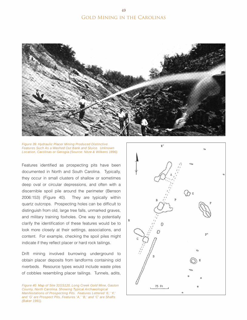
gold Mining in the Carolinas49
Figure 39. Hydraulic Placer Mining Produced Distinctive Features Such As a Washed Out Bank and Sluice. Unknown Location, Carolinas or Gerogia (Source: Nitze & Wilkens 1896).
Figure 40. Map of Site 31GS120, Long Creek Gold Mine, Gaston County, North Carolina. Showing Typical Archaeological Manifestations of Prospecting Pits. Features Lettered ‘E,’ ‘F,’ and ‘G’ are Prospect Pits. Features ‘A,’ ‘B,’ and ‘C’ are Shafts (Baker 1991).
Features identified as prospecting pits have been
documented in North and South Carolina. Typically,
they occur in small clusters of shallow or sometimes
deep oval or circular depressions, and often with a
discernible spoil pile around the perimeter (benson
2006:153) (Figure 40). They are typically within
quartz outcrops. Prospecting holes can be difficult to
distinguish from old, large tree falls, unmarked graves,
and military training foxholes. One way to potentially
clarify the identification of these features would be to
look more closely at their settings, associations, and
content. For example, checking the spoil piles might
indicate if they reflect placer or hard rock tailings.
Drift mining involved burrowing underground to
obtain placer deposits from landforms containing old
riverbeds. Resource types would include waste piles
of cobbles resembling placer tailings. Tunnels, adits,

50
Figure 41. Mine Overburden or Ore Dumps Consist of Broken Rock Piles and are Sometimes Recognized as Unnatural Contours on Hill Sides. Howie Gold Mine, Union County, North Carolina (Howie Mining Company 1906).
and shafts might have collapsed, but their presence might be projected from tailings locations. Traces of ore car routes might also exist (CALTRANS 2008:92).
Certain site types known in California, such as river diversion and dredge tailings, are not expected in the Carolinas. Some form of water management should be observable, however, because certain methods required water to be carried over long distances and retained in reservoirs. These should be located adjacent to cuts and other hydraulic system features, and should be at a higher elevation in relation to them. Channels and ditches necessary to fill the reservoirs
might be present.
haRD Rock/loDe/vein mininG
extraction and handling of vein sources of ore
produced distinctive resource types. This method of mining involved working primary rock deposits, often underground, and required more complex and advanced technologies, as well as larger applications of capital. In addition, the minerals produced with this type of mining required further processing to separate the valuable ore from the waste rock. CALTRANS (2008:92) divided hard rock mining properties into six types:
Small pits and surface vein workings;•
Overburden piles;•
Shafts, adits, and inclines;•
Mills and other processing units;•
Underground workings; and•
Open pit mines.•
Small pits and surface vein workings dealt with hard rock outcrops. Property types include pits with adjacent quarried rocks (not stream cobbles) or exposed host rock outcrops with excavated-out veins. Adits, shafts, and other evidence of mining and exploration might be found nearby. A small mill might also be present at larger operations to break and crush the rock
(CALTRANS 2008:93).
Overburden piles consist of host rock excavated
from the mine that was immediately discarded near
the mine site. Characteristic property types include
piles of broken rock with little or no topsoil. They
should be visible as unnatural contours on hillsides
or as long, flat-topped ridges beginning at the mine
portal and extending away from it (at larger mines)
(Figure 41). They probably also mark the locations
of mine shafts and adits, which would lie uphill from
the pile and possibly be collapsed and no longer
visible. Overburden piles might be affected by post-
deposition processes, such as re-working the material
using different separation techniques, or robbing it
for use as fill (CALTRANS 2008:94-95). erosion may
also obscure overburden pile locations.
Shafts, adits, and inclines refer to elements of underground mines. The entrance to an underground mine is called a portal, which opens to either an adit or shaft. Adits, or drifts, are openings that run horizontally or nearly so to the lode, while shafts are vertical openings that extend to the lode deposit (Figure 42). Shafts can be identified as square, often caved in or partly filled, holes in the surface and may have footings for head frames and hoists around them. Adits typically lie on slopes and appear as collapsed trenches. both types of features should have waste

gold Mining in the Carolinas51
Figure 42. Adit. Note the Ore Dump Immediately Outside the Mine Opening and the Wooden Tracks. Near High Point, North Carolina. Unknown Date (Rowan County Government 2008).
rock piles associated with them. If no waste piles are present, the openings might reflect air vents, drains, or other types of features. Additional features that might be associated with portals reflect transportation (tramways, paths), footings for hoisting, hauling, and power generating equipment, and remnants of wooden shoring or collaring (CALTRANS 2008:95-96).
The presence of shafts, adits, and waste piles
would indicate the existence of underground mines.
These features might also become exposed where
open-pit methods were used at the sites of earlier
underground workings (Griffin 1974:19) (Figure 43).
For mine studies in California, CALTRANS (2008:96)
specifically prohibits exploration of underground
features, stating that they should be studied only
with documents. This policy was adopted in Georgia
as well (botwick et al. 2011) and should be applied to
the Carolinas because the potential consequences of
entering an unsafe underground mine far outweighs
any potential data that could be collected.
Gold mining in open pits appears to have been a
later phenomenon in the Carolinas and evidence of
them should be relatively easy to identify. As with
underground mines, there should be waste rock piles
and evidence of transportation, hoisting, and other
equipment for accessing the works. In some instances,
the open pit might have openings for trams or roadways.
At twentieth-century mines where excavation was
done with mechanical excavators and hauled with
trucks, roads and garages might be present as well
(CALTRANS 2008:97). Although they might leave very

52
Figure 43. Abandoned Underground Works (Drifts and Stopes) Exposed in an Open Cut. Haile Gold Mine, Lancaster County, South Carolina, 1904 (USGS Photographic Library).

gold Mining in the Carolinas53
Figure 44. Coggins Gold Mine Stamp Mill, Montgomery County, North Carolina, 1978 (Photograph by JoAnn Sieburg-Baker; Brenner 1977).
clear surface remains, open mines could become
obscured by vegetation, caving, and slumping, making
them more difficult to delineate.
pRocessinG
Processing refers to the operations required to
remove gold from overburden rock and convert it into
a useful commodity. It includes the various steps of
beneficiation and for gold mines would sequential
steps to reduce ore size, sort them, and separate
gold from the waste. These steps varied in complexity
and location, depending on the ore type, time period,
technology, individual operators, and other factors.
based on preceding overviews of mining practices, the
property types related to processing in the Carolinas
include mills and mill tailings.
There could be considerable variation in mineral
processing plants. extant processing structures
are rare, given their specific uses, the salvage and
relocation of equipment, and the passage of time since
mining activities ceased. One prominent North Carolina
exception being the Coggins Gold Mine stamp mill in
Montgomery County, built in the early 1900s and still
standing in the late 1970s (brenner 1977) (Figure 44).
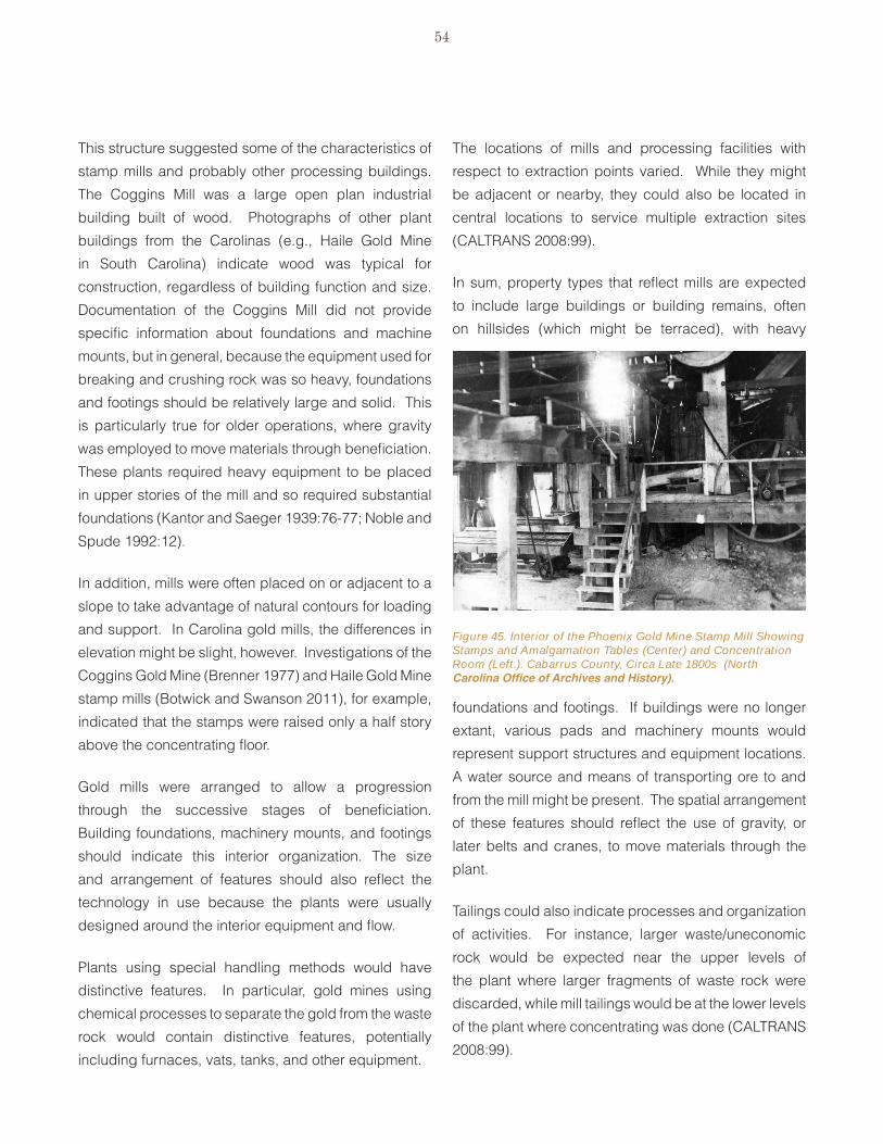
54
The locations of mills and processing facilities with
respect to extraction points varied. While they might
be adjacent or nearby, they could also be located in
central locations to service multiple extraction sites
(CALTRANS 2008:99).
In sum, property types that reflect mills are expected
to include large buildings or building remains, often
on hillsides (which might be terraced), with heavy
Figure 45. Interior of the Phoenix Gold Mine Stamp Mill Showing Stamps and Amalgamation Tables (Center) and Concentration Room (Left.). Cabarrus County, Circa Late 1800s (North Carolina Office of Archives and History).
This structure suggested some of the characteristics of
stamp mills and probably other processing buildings.
The Coggins Mill was a large open plan industrial
building built of wood. Photographs of other plant
buildings from the Carolinas (e.g., Haile Gold Mine
in South Carolina) indicate wood was typical for
construction, regardless of building function and size.
Documentation of the Coggins Mill did not provide
specific information about foundations and machine
mounts, but in general, because the equipment used for
breaking and crushing rock was so heavy, foundations
and footings should be relatively large and solid. This
is particularly true for older operations, where gravity
was employed to move materials through beneficiation.
These plants required heavy equipment to be placed
in upper stories of the mill and so required substantial
foundations (Kantor and Saeger 1939:76-77; Noble and
Spude 1992:12).
In addition, mills were often placed on or adjacent to a
slope to take advantage of natural contours for loading
and support. In Carolina gold mills, the differences in
elevation might be slight, however. Investigations of the
Coggins Gold Mine (brenner 1977) and Haile Gold Mine
stamp mills (botwick and Swanson 2011), for example,
indicated that the stamps were raised only a half story
above the concentrating floor.
Gold mills were arranged to allow a progression
through the successive stages of beneficiation.
building foundations, machinery mounts, and footings
should indicate this interior organization. The size
and arrangement of features should also reflect the
technology in use because the plants were usually
designed around the interior equipment and flow.
Plants using special handling methods would have
distinctive features. In particular, gold mines using
chemical processes to separate the gold from the waste
rock would contain distinctive features, potentially
including furnaces, vats, tanks, and other equipment.
foundations and footings. If buildings were no longer
extant, various pads and machinery mounts would
represent support structures and equipment locations.
A water source and means of transporting ore to and
from the mill might be present. The spatial arrangement
of these features should reflect the use of gravity, or
later belts and cranes, to move materials through the
plant.
Tailings could also indicate processes and organization
of activities. For instance, larger waste/uneconomic
rock would be expected near the upper levels of
the plant where larger fragments of waste rock were
discarded, while mill tailings would be at the lower levels
of the plant where concentrating was done (CALTRANS
2008:99).
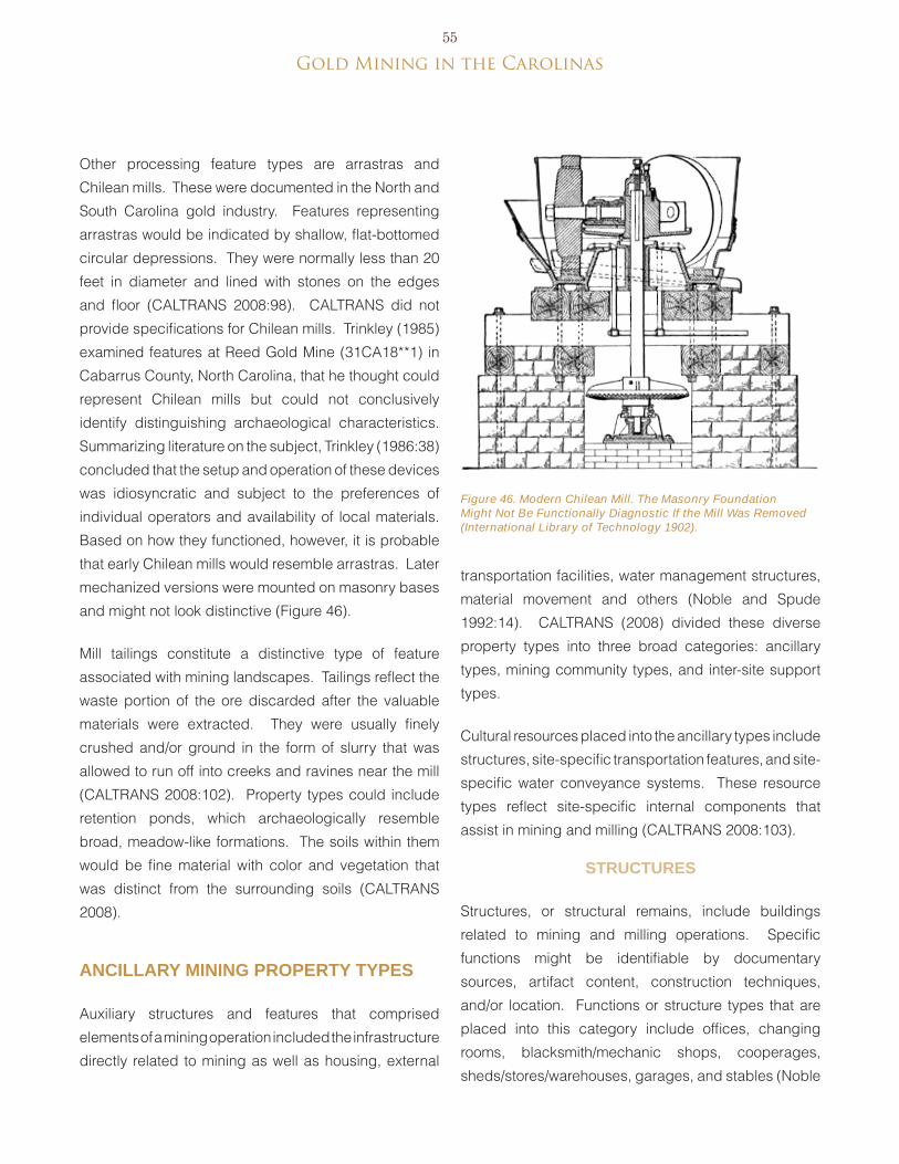
gold Mining in the Carolinas55
Figure 46. Modern Chilean Mill. The Masonry Foundation Might Not Be Functionally Diagnostic If the Mill Was Removed (International Library of Technology 1902).
Other processing feature types are arrastras and
Chilean mills. These were documented in the North and
South Carolina gold industry. Features representing
arrastras would be indicated by shallow, flat-bottomed
circular depressions. They were normally less than 20
feet in diameter and lined with stones on the edges
and floor (CALTRANS 2008:98). CALTRANS did not
provide specifications for Chilean mills. Trinkley (1985)
examined features at Reed Gold Mine (31CA18**1) in
Cabarrus County, North Carolina, that he thought could
represent Chilean mills but could not conclusively
identify distinguishing archaeological characteristics.
Summarizing literature on the subject, Trinkley (1986:38)
concluded that the setup and operation of these devices
was idiosyncratic and subject to the preferences of
individual operators and availability of local materials.
based on how they functioned, however, it is probable
that early Chilean mills would resemble arrastras. Later
mechanized versions were mounted on masonry bases
and might not look distinctive (Figure 46).
Mill tailings constitute a distinctive type of feature
associated with mining landscapes. Tailings reflect the
waste portion of the ore discarded after the valuable
materials were extracted. They were usually finely
crushed and/or ground in the form of slurry that was
allowed to run off into creeks and ravines near the mill
(CALTRANS 2008:102). Property types could include
retention ponds, which archaeologically resemble
broad, meadow-like formations. The soils within them
would be fine material with color and vegetation that
was distinct from the surrounding soils (CALTRANS
2008).
ancillaRy mininG pRopeRty types
Auxiliary structures and features that comprised
elements of a mining operation included the infrastructure
directly related to mining as well as housing, external
transportation facilities, water management structures,
material movement and others (Noble and Spude
1992:14). CALTRANS (2008) divided these diverse
property types into three broad categories: ancillary
types, mining community types, and inter-site support
types.
Cultural resources placed into the ancillary types include
structures, site-specific transportation features, and site-
specific water conveyance systems. These resource
types reflect site-specific internal components that
assist in mining and milling (CALTRANS 2008:103).
stRuctuRes
Structures, or structural remains, include buildings
related to mining and milling operations. Specific
functions might be identifiable by documentary
sources, artifact content, construction techniques,
and/or location. Functions or structure types that are
placed into this category include offices, changing
rooms, blacksmith/mechanic shops, cooperages,
sheds/stores/warehouses, garages, and stables (Noble

56
Figure 48. Water Conveyance Systems Might Leave Distinct Archaeological Traces. Parker Mine, Stanly County, North Carolina (Nitze and Wilkens 1897).
and Spude 1992:14; CALTRANS 2008:103) (Figure
47). Mine sites in operation over a long period of time
might have more than one of a particular structure
type as a result of replacement, moving buildings, or
rearrangement of the site. In the absence of extant
structures, archaeological remains would most likely
consist of foundations and artifact scatters associated
with the mine or mill (CALTRANS 2008:103-104).
tRanspoRtation featuRes
Site-specific transportation features can or may include
trails, roads, and tramways used to move ores, waste
rock, people, and equipment around the mine site.
Roads or trails were always present at mines, while
other transportation features varied, depending on the
type of mining, scale of operations, and other factors.
Archaeological manifestations of these systems consist
of linear, continuous grades leading between main areas
of the mine or mill. Tramways would be distinguished
by uniform grades, possibly trestles, and rails and ties,
which might be removed after the mine closed. Aerial
tramways would be represented by cables, head frames,
gondolas, and buckets (CALTRANS 2008:104).
Figure 47. Map of the Fentress Mine, Guilford County, North Carolina, Showing the Types of Auxiliary Structures Typical for a Gold Mining Operation, Early 1900s (Pratt 1907).

gold Mining in the Carolinas57
WateR conveyance systems
Water was an integral element of nearly every kind of
mining and had to be available as long as the mill or
processing plant operated. Features related to water
supply included rivers, reservoirs, cisterns, and tanks,
which would typically be located uphill of the mill to
permit gravity feed. Ditches, pipes, and penstocks
moved water through the mining site and plant, while
drains removed spent water from the area (CALTRANS
2008:105). Remnants of these systems might include
earthen berms, ditches, and channels. In addition,
footings for aboveground water tanks, penstocks, or
other conveyance structures could exist (Figure 48).
mininG community pRopeRty types
Mining community property types include domestic
residential activities of miners, mine-support staff, and
their families. Mining communities were often transient
but were distinctive. Associated property types can
be classified into three groups: domestic structural
remains (including service buildings), domestic artifact
deposits, and domestic landscape features. To be
considered a residential site associated with mining,
the domestic property types must be physically and
historically associated with the mineral industries and
must exhibit one or more of the following attributes:
They must have quantities of domestic •
artifacts,
They must contain distinctly domestic features •
such as hearths, or
Documents should identify them as domestic-•
residential structures (CALTRANS 2008:106).
Domestic stRuctuRe Remains
CALTRANS (2008) and Hardesty (2010) described
the types of structures and related archaeological
remains expected in mining communities of the
western United States. It is not known how well
these apply to the Carolinas but future research
should be able to characterize trends. In general,
the simplest houses for miners were tents and lean-
tos, with improved housing consisting of full or partial
enclosures with walls of logs, lumber, or fieldstone
and a canvass roof. Other shelters consisted of
partially subterranean pits or enclosures dug into
hillsides. These simple structures were mostly
associated with early mining and most likely would
relate to placer mines. They would be expected near
the mines and might include earthen pads (raised or
obviously prepared in some way), foundations (pier or
perimeter), dugouts (squared pits cut into the ground
or slopes), hearths, drainage features, and sheet
refuse or scatters of domestic artifacts. Structures
30 feet or more in length could represent barracks
or dining halls, which would be further distinguished
by the presence of large refuse deposits containing
tablewares, food containers, and faunal remains
(CALTRANS 2008:106-108).
Houses or miners’ cottages existed in some districts.
These might have represented more substantial
and permanent structures than some of the types
described for the western states, although the type of
construction might have varied. For example, at the
Pioneer Mills Gold Mine in Cabarrus County, North
Carolina, a former miner’s cabin dating to the 1850s
was described as consisting of a one-story, saddle-
notched log structure that stood until 1989 (Huffman
1990). Where such structures are no longer extant,
archaeological remains might include more obvious
foundations or piers with substantial chimney mounds,
such as Feature 15 at the Haile Gold Mine Stamp Mill
Site (38LA383). This feature represented a workers’
house supplied by the gold mining company and
was reflected by brick piers, a central chimney, and
deposits of domestic artifacts (botwick and Swanson

58
Figure 49. Brick Chimney Base and Pier, Site 38LA383 Workers House, Haile Gold Mine, Lancaster County, South Carolina (Photo: New South Associates, Inc.).
2011) (Figure 49). brick, nails, and window glass
might be more prominent among the construction materials.
Domestic aRtifact Deposits
CALTRANS (2008:109-110) characterized the artifact deposits associated with mining residential sites as sheet refuse and filled features. These would resemble those at any domestic site. Sheet refuse occurs in the vicinity of a dwelling and reflects materials discarded or lost on the surface by site residents. It might occur throughout the living area of a dwelling or adjacent to and downhill from the dwelling area. Filled features, or “hollow-filled features” consist of concentrated artifact deposits reflecting disposal into features such as trash pits, cellars, prospects, privies, or other abandoned subsurface openings.
Domestic lanDscape featuRes
Landscape features associated with mining sites generally fall into two groups: plantings and stonework (CALTRANS 2008:110). Plantings reflect the efforts of mining households to create domestic environments featuring orchards and vegetable and ornamental gardens. Features reflecting planting holes and beds might be discernible archaeologically and in some instances, plants might remain growing at the site. Domestic landscape features could also include paths, retaining walls, and terraces.
inteR-site mininG suppoRtpRopeRty types
CALTRANS (2008:110) described inter-site mining
support properties as “separate, distinct sites that
may extend many miles, creating a link between the
mining site and the outside world. They represent
linear systems for delivery of services or access and
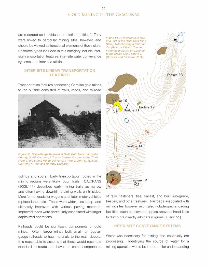
gold Mining in the Carolinas59
are recorded as individual and distinct entities.” They
were linked to particular mining sites, however, and
should be viewed as functional elements of those sites.
Resource types included in this category include inter-
site transportation features, inter-site water conveyance
systems, and inter-site utilities.
inteR-site lineaR tRanspoRtation featuRes
Transportation features connecting Carolina gold mines to the outside consisted of trails, roads, and railroad
sidings and spurs. early transportation routes in the mining regions were likely rough trails. CALTRANS (2008:111) described early mining trails as narrow and often having downhill retaining walls on hillsides. More formal roads for wagons and, later, motor vehicles replaced the trails. These were wider, less steep, and ultimately improved with various paving methods. Improved roads were particularly associated with larger capitalized operations.
Railroads could be significant components of gold mines. Often, larger mines built small- or regular-gauge railroads to haul materials to the main depots. It is reasonable to assume that these would resemble standard railroads and have the same components
Figure 51. Archaeological Map of a Part of the Haile Gold Mine Stamp Mill Showing a Railroad Cut (Feature 13) and Trestle Footings (Feature 14) Leading to the Stamp Mill (Feature 7) (Botwick and Swanson 2011).
Figure 50. Small-Gauge Railroad at Haile Gold Mine, Lancaster County, South Carolina. A Trestle Carried the Line to the Third Floor of the Stamp Mill to Deliver Ore (Photo, John C. Jenkins, Courtesy of Tom and Dorothy Gregory).
of rails, fasteners, ties, ballast, and built sub-grade, trestles, and other features. Railroads associated with mining sites, however, might also include special loading
facilities, such as elevated tipples above railroad lines
to dump ore directly into cars (Figures 50 and 51).
inteR-site conveyance systems
Water was necessary for mining and especially ore
processing. Identifying the source of water for a
mining operation would be important for understanding
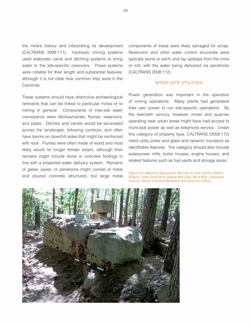
60
Figure 52. Masonry Equipment Mounts for the Corliss Steam Engine, Haile Gold Mine Stamp Mill (Site 38LA383), Lancaster County, South Carolina (Botwick and Swanson 2011).
the mine’s history and interpreting its development
(CALTRANS 2008:111). Hydraulic mining systems
used elaborate canal and ditching systems to bring
water to the site-specific reservoirs. These systems
were notable for their length and substantial features,
although it is not clear how common they were in the
Carolinas.
These systems should have distinctive archaeological
remnants that can be linked to particular mines or to
mining in general. Components of inter-site water
conveyance were ditches/canals, flumes, reservoirs,
and pipes. Ditches and canals would be excavated
across the landscape, following contours, and often
have berms on downhill sides that might be reinforced
with rock. Flumes were often made of wood and most
likely would no longer remain extant, although their
remains might include stone or concrete footings in
line with a projected water delivery system. Remains
of gates, pipes, or penstocks might consist of metal
and poured concrete structures, but large metal
components of these were likely salvaged for scrap.
Reservoirs and other water control structures were
typically stone or earth and lay upslope from the mine
or mill, with the water being delivered via penstocks
(CALTRANS 2008:112).
inteR-site utilities
Power generation was important in the operation
of mining operations. Many plants had generated
their own power to run site-specific operations. by
the twentieth century, however, mines and quarries
operating near urban areas might have had access to
municipal power as well as telephone service. Under
this category of property type, CALTRANS (2008:112)
listed utility poles and glass and ceramic insulators as
identifiable features. The category should also include
waterpower mills, boiler houses, engine houses, and
related features such as fuel yards and storage areas.
gold Mining in the Carolinas61
Remains of at least one boiler shed and engine
room were found in association with the Haile Gold
Mine stamp mill (38LA383) in Lancaster County,
South Carolina (Figure 52). Additionally, a later
brick structure was interpreted as a possible boiler
shed associated with pyrite mill that was built at the
property (botwick and Swanson 2011). Investigations
at the Reed Mine in Cabarrus County, New Carolina
also produced evidence of a boiler pit associated
with the site’s engine/mill house (18CA18**1) (babits
1974; Trinkley 1986).
histoRic mininG lanDscapes
Historic mining landscapes are one type of rural
historic landscape, which may “contain significant
areas of vegetation, open space, or natural features
that embody, through past use or physical character,
significant historical values. buildings, industrial
structures, objects, designed landscapes, and
archaeological sites may also be present” within
them (McClelland et al. 1999:3). Noble and Spude
considered landscapes a historic mining property
type, characterizing them as evidence of a human
activity that modified the natural features of the earth.
Historic mining landscapes “evoke images of time,
place and historical patterns,” and may include
various components that embody historical and
traditional land use practices associated with the
extraction and handling of mineral products (Noble
and Spude 1997:13-14). Although this study of
historic gold mining in the Carolinas is focused on
archaeological resources, landscapes are a valid
concept to consider because archaeological sites
may make up or contribute to a historic landscape.
Landscapes related to mining could encompass
various resources associated with particular types
of mining (e.g., strip or placer mining), the spatial
organization of mining, typical natural and cultural
landforms related to mining activity (e.g., pits, waste
dumps), distinct types of buildings and structures,
transportation and circulation systems, and specific
vegetation patterns caused by mining (Noble
and Spude 1997:14). They may also incorporate
communities shaped as a result of mining activity
(McClelland et al. 1999:27).
In dealing with archaeological sites as sole or
contributing elements of historic gold mining
landscapes, researchers should consider the way
the various features, objects, artifact scatters or
concentrations, and other residues of past activities
represent broader systematic patterns of land use.
For example, a historic landscape related to placer
mining might consist of distributions of prospecting
pits, excavated areas, tailings, and water management
features dispersed through a specific natural
drainage area. A more complex mining landscape
could include a series of excavated and eroded
ridges and valleys from which gold bearing ore was
removed, combined with features such as mine and
mill tailings, remains of hoisting, crushing, and other
ore handling buildings and structures; traces of roads
and tramways that reflect circulation systems; and
possibly archaeological remains or extant houses
and other buildings representing communities whose
establishment or growth was related to gold mining.
inteGRation of pRopeRty types
An important determination, beyond identifying
archaeological remains of mining activities, is how
individual properties relate to one another, a step that
Noble and Spude (1997:9) referred to as “property
analysis.” This consideration requires linking separate,
sometimes widely spaced features, artifacts, and
contexts and understanding the spatial, chronological,
and functional aspects of their associations. The
preceding descriptions of individual property types

62
are intended to facilitate identification and inventory
of various archaeological elements. The following
discussion provides concepts for understanding how
they interrelated as components of complete mining
operations and how they reflect those operations.
The concept of “feature systems” (Hardesty 1988:9,
1990:45, 2010:16) provided a framework for
understanding how archaeological remains of mining
relate to one another within specific functional systems
over time and space. They also help link disconnected
remnants of these systems to historic contexts (Hardesty
and Little 2009:121). Feature systems comprise groups
of features, objects, and structures that functioned
together in the extraction, processing, and shipping
of mineral resources. They include components that
may be isolated or spaced at a distance from one
another but still form part of a single specific mining
operation. The resources that make up feature systems
are linked chronologically and they may encompass
not just mines and processing plants, but also the
infrastructure, administrative, and community activities
associated with mining. because a single operation
could potentially spread widely across and through a
geographical area and include numerous parts with
different specific functions, the concept provides a
useful tool for understanding that certain disparate
resources were part of a single dispersed operation.
Hardesty (1990:45) described feature systems as “an
interface of the spheres of history, archaeology, and
ethnography,” by which he meant that combinations of
archival sources, oral information and recollections, and
archaeological materials provided the data necessary to
define particular feature systems. Hardesty’s application
of the concept indicates it has various dimensions. At one
level, it provides a conceptual device for understanding
the links between geographically dispersed resources,
as described above (Hardesty 2010:17). At another
level, documentary and ethnographic sources yield
information necessary to construct models of the
morphology and activities associated with a particular
feature system, which in turn provides a guide to
identify and understand archaeological resources
(Hardesty 1988:9-10; 2010:16-17). Finally, individual
archaeological properties can reflect more than one
feature system. For example, a trash dump containing
both household and industrial refuse would be part of
a domestic feature system and an industrial process
feature system (Hardesty 1988:10, 2010:19-20).
Feature systems thus constitute analytical units for
understanding how individual and multiple resources
related to one another and to particular processes
(CALTRANS 2008:81). With respect to evaluating
historical or archaeological significance, feature
systems provide a framework for understanding how
complete a resource is, a determination that is important
in conveying its historical function and associations,
as well as its research value. Hardesty pointed out
that assessments of significance could reasonably be
expected to involve consideration of complete feature
systems instead of individual properties. evaluating
archaeological significance this way would rate a
resource in terms of its overall research value (in other
words, the information it could provide about an entire
process or system) rather than the information potential
of several individual features (Hardesty 1990:45-46).
To summarize the preceding chapter, it is important to note
that the purpose of defining gold mining property types
for the Carolinas is to ensure precise identification, or at
least begin a process of developing consistent terms to
describe and interpret archaeological features related
to mining. Clearly, as more archaeologists conduct
survey and evaluation of these mining-related sites,
the typology will become more precise and applicable
to Carolina gold mining. Accurate identification and
description is also critical in sorting out various activities
and time periods that might be represented at a single
gold Mining in the Carolinas63
mine site, where reactivation of older mines or the
application of new technologies and procedures can
overlap and cut through the archaeological remains
of previous operations (Noble and Spude 1997:9).
Clear identifications of chronological and functional
associations are also important considerations in
evaluating historical and archaeological significance
because the site must be able to convey its relations
to particular historical contexts (CALTRANS 2008).
Features with indeterminate or ambiguous functions
and dates, or that only reflect “general mining activities,”
would not contribute substantial research data.
A second consideration is to understand and interpret
individual features in terms of the wider geographical,
chronological, and functional contexts they relate
to. Put another way, this consideration is intended to
encourage archaeologists to look beyond individual
or groups of isolated sites and try to link them to the
broader mining operations they were part of. This is
important not only to better understand how individual
properties, features, and objects operated together,
but also to ensure that entire systems or related groups
of resources are considered together for interpretation
and significance evaluation.

gold Mining in the Carolinas65
strong inferences about overall patterns. For example,
of the 18 sites in North Carolina, six are in Cabarrus
County and four others are in Mecklenburg County.
These counties were among the most important gold
producing regions in the State. However, of the 10 sites
recorded in these counties, nine are associated with
only two different mines. The locations of these mine
sites, therefore, did not indicate significant patterns
in site distribution but more likely reflect the way mine
sites have been recorded. In some instances, related
resources are grouped together into a single site and in
others they are split apart and recorded separately.
On the other hand, the South Carolina sample is
made up mostly of sites in Abbeville and McCormick
counties, which were important gold-production areas
in the nineteenth century. The sites included in the
table mostly represent separate individual or groups of
prospecting pits and mineshafts and more accurately
reflect the importance of mining in these districts. Other
parts of the State where mining was important, however,
such as Lancaster County, are barely represented in the
sample, probably as a result of differences in survey
coverage. The large number of sites in Abbeville and
McCormick counties are associated with the Sumter
National Forest, which has been subject to extensive
archaeological survey.
Dates for the sites in the sample mostly began in the
nineteenth century with end dates in the twentieth
century. This span roughly corresponds to the known
gold mining era in the Carolinas. One eighteenth-
century site was the home of John Reed, owner of the
first working gold mine in the region. More significant
is that most sites have beginning dates that fall into two
general periods: the 1830s and the 1850s. These dates
VI. The Archaeology of Gold Mining in the Carolinas
To date, archaeological investigations of gold
mining in North and South Carolina have been
limited. There are comparatively few recorded
archaeological sites and few studies of these sites
beyond the survey and evaluation level. Additionally,
detailed investigations have been limited in scope and
generally emphasized preservation and reconstruction
goals, with broader research topics being secondary
considerations. This chapter reviews the archaeological
database of gold mining sites in the Carolinas to
illustrate work that has been completed, identify
preservation and management needs, and suggest
potential opportunities for research.
aRchaeoloGical DataBase
Review of archaeological site inventories and National
Register of Historic Places (NRHP) files in each state
yielded a total of 36 properties (Table 1). Roughly
50 mine sites have been recorded in Sumter National
Forest, South Carolina (benson 2006), some of which
are included in Table 1, but site files were not available
for inspection and the specific types of mineral
resources could not be verified. Furthermore, at the
present time, site inventory files in both South Carolina
and North Carolina have limited search capabilities,
making it difficult to develop a complete inventory of all
gold-mining sites. The following data should therefore
be viewed as a sample representing recorded historic
gold mine sites in the Carolinas.
The site files revealed trends in site location, age,
project type (compliance, research, etc.), and the types
of extant remains. because of the small sample size
and the manner sites are recorded, it is difficult to make
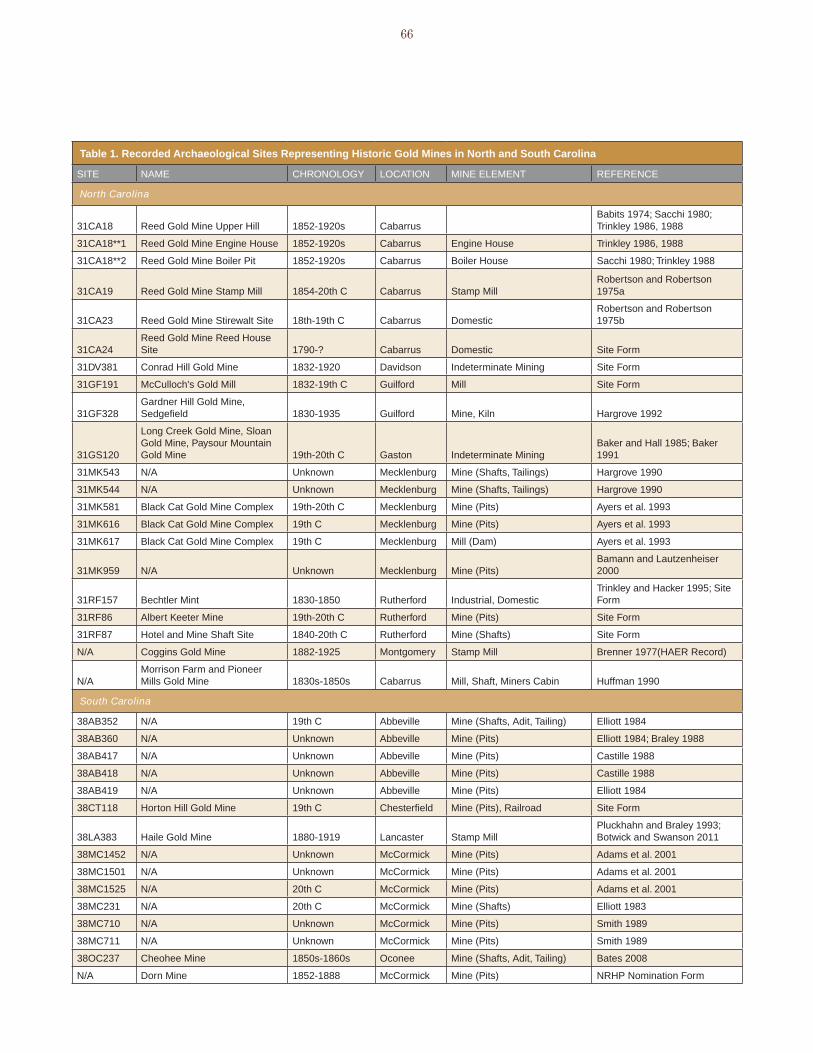
66
table 1. Recorded archaeological sites Representing historic Gold mines in north and south carolina
SITE NAME CHRONOLOGY LOCATION MINE ELEMENT REFERENCE
North Carolina
31CA18 Reed Gold Mine Upper Hill 1852-1920s Cabarrus Babits 1974; Sacchi 1980; Trinkley 1986, 1988
31CA18**1 Reed Gold Mine Engine House 1852-1920s Cabarrus Engine House Trinkley 1986, 1988
31CA18**2 Reed Gold Mine Boiler Pit 1852-1920s Cabarrus Boiler House Sacchi 1980; Trinkley 1988
31CA19 Reed Gold Mine Stamp Mill 1854-20th C Cabarrus Stamp MillRobertson and Robertson 1975a
31CA23 Reed Gold Mine Stirewalt Site 18th-19th C Cabarrus DomesticRobertson and Robertson 1975b
31CA24Reed Gold Mine Reed House Site 1790-? Cabarrus Domestic Site Form
31DV381 Conrad Hill Gold Mine 1832-1920 Davidson Indeterminate Mining Site Form
31GF191 McCulloch's Gold Mill 1832-19th C Guilford Mill Site Form
31GF328Gardner Hill Gold Mine, Sedgefield 1830-1935 Guilford Mine, Kiln Hargrove 1992
31GS120
Long Creek Gold Mine, Sloan Gold Mine, Paysour Mountain Gold Mine 19th-20th C Gaston Indeterminate Mining
Baker and Hall 1985; Baker 1991
31MK543 N/A Unknown Mecklenburg Mine (Shafts, Tailings) Hargrove 1990
31MK544 N/A Unknown Mecklenburg Mine (Shafts, Tailings) Hargrove 1990
31MK581 Black Cat Gold Mine Complex 19th-20th C Mecklenburg Mine (Pits) Ayers et al. 1993
31MK616 Black Cat Gold Mine Complex 19th C Mecklenburg Mine (Pits) Ayers et al. 1993
31MK617 Black Cat Gold Mine Complex 19th C Mecklenburg Mill (Dam) Ayers et al. 1993
31MK959 N/A Unknown Mecklenburg Mine (Pits)Bamann and Lautzenheiser 2000
31RF157 Bechtler Mint 1830-1850 Rutherford Industrial, DomesticTrinkley and Hacker 1995; Site Form
31RF86 Albert Keeter Mine 19th-20th C Rutherford Mine (Pits) Site Form
31RF87 Hotel and Mine Shaft Site 1840-20th C Rutherford Mine (Shafts) Site Form
N/A Coggins Gold Mine 1882-1925 Montgomery Stamp Mill Brenner 1977(HAER Record)
N/AMorrison Farm and Pioneer Mills Gold Mine 1830s-1850s Cabarrus Mill, Shaft, Miners Cabin Huffman 1990
South Carolina
38AB352 N/A 19th C Abbeville Mine (Shafts, Adit, Tailing) Elliott 1984
38AB360 N/A Unknown Abbeville Mine (Pits) Elliott 1984; Braley 1988
38AB417 N/A Unknown Abbeville Mine (Pits) Castille 1988
38AB418 N/A Unknown Abbeville Mine (Pits) Castille 1988
38AB419 N/A Unknown Abbeville Mine (Pits) Elliott 1984
38CT118 Horton Hill Gold Mine 19th C Chesterfield Mine (Pits), Railroad Site Form
38LA383 Haile Gold Mine 1880-1919 Lancaster Stamp MillPluckhahn and Braley 1993; Botwick and Swanson 2011
38MC1452 N/A Unknown McCormick Mine (Pits) Adams et al. 2001
38MC1501 N/A Unknown McCormick Mine (Pits) Adams et al. 2001
38MC1525 N/A 20th C McCormick Mine (Pits) Adams et al. 2001
38MC231 N/A 20th C McCormick Mine (Shafts) Elliott 1983
38MC710 N/A Unknown McCormick Mine (Pits) Smith 1989
38MC711 N/A Unknown McCormick Mine (Pits) Smith 1989
38OC237 Cheohee Mine 1850s-1860s Oconee Mine (Shafts, Adit, Tailing) Bates 2008
N/A Dorn Mine 1852-1888 McCormick Mine (Pits) NRHP Nomination Form
gold Mining in the Carolinas67
were important milestones in the history of regional gold
mining. Mining activity increased substantially in the
1830s after a period of slow development. This period
was also one where mining began to take on a more
professional and industrial character. The 1850s saw
generally low production but was a period of greater
speculation and efforts at reviving the industry. Although
again, the sample size is too small to strongly suggest
any conclusions, it is worth noting that there appears
to be a correlation in the visibility of archaeological
sites and periods of greater gold mining intensity and
changes in the organization of mining in this region.
Looking at the circumstances of site recordation, the
sites were identified and investigated mainly in the
context of compliance surveys or heritage projects.
This indicates that gold mine site investigations have
been dealt with mainly on an incidental basis (i.e., when
they are discovered in the course of a survey) or when
they are well-known and obvious enough to warrant site
preservation, often in the context of historical museums
and parks, such as is the case with Reed Gold Mine
in North Carolina and the Dorn Mine in South Carolina.
Although some of the work conducted at Reed Mine
has been oriented toward research (Trinkley 1986), it
was still completed for purposes of preservation and
interpretation rather than purely to address questions
regarding gold mining, mining technologies, miners,
or similar topics. This emphasis on preservation-
driven discoveries and studies indicates a need for
an archaeological context that can facilitate discovery,
evaluation, and research goals.
Finally, with respect to the extant remains or mine
elements that have most often been recorded,
unspecified pits are the most common, having been
recorded at 21 of the 36 sites. Pits at mine sites have
generally been interpreted as reflecting prospecting
activities. Additionally, the roughly 50 mine or mineral
extraction sites recorded at Sumter National Forest are
predominantly prospecting sites (as noted, inventory
forms for many of the sites at Sumter National Forest
were not available for this study) (James bates, Sumter
National Forest Archaeologist, personal communication,
2011). There is a considerable range of mine elements
in the group, however, including elements related to the
extraction of ore (pits, shafts), transportation (railroad),
ore processing (mill, stamp mills), and power generation
(boiler house, engine house, milldam). Further, three sites
contained domestic components related to residents of
the mine site. One of the domestic sites (bechtler Mint),
moreover, was related to an activity that was auxiliary to
mining: coining the gold generated by regional mines.
Thus, the site files indicate considerable richness and
diversity among gold mining sites in the Carolinas.
liteRatuRe RevieW
A review of archaeological survey, investigation, and
management reports indicates the way archaeologists
have handled gold mining sites in the Carolinas. As
stated above, virtually all the archaeological data
on gold mine sites in these states has derived from
compliance or heritage projects. In the absence of
state or regional guidelines for evaluating these kinds
of resources, most of the effort to deal with the research
and historical value of these sites has been done in an
ad hoc way and often with a narrow view that does not
consider individual sites or site elements within broader
landscapes or historical developments.
An example of this is the work completed to date at
Reed Gold Mine (31CA18) and related properties, which
now comprise a North Carolina Historic site (Figure 53).
Several archaeological studies were undertaken here
after the State acquired the property in the early 1970s
(babits 1974; Robertson and Robertson 1975a, 1975b;
Sacchi 1980; Trinkley 1986, 1988). Nearly all the work
focused mainly on the engine/mill house on Upper
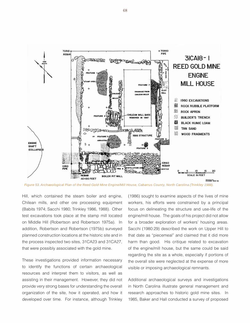
68
Hill, which contained the steam boiler and engine,
Chilean mills, and other ore processing equipment
(babits 1974; Sacchi 1980; Trinkley 1986, 1988). Other
test excavations took place at the stamp mill located
on Middle Hill (Robertson and Robertson 1975a). In
addition, Robertson and Robertson (1975b) surveyed
planned construction locations at the historic site and in
the process inspected two sites, 31CA23 and 31CA27,
that were possibly associated with the gold mine.
These investigations provided information necessary
to identify the functions of certain archaeological
resources and interpret them to visitors, as well as
assisting in their management. However, they did not
provide very strong bases for understanding the overall
organization of the site, how it operated, and how it
developed over time. For instance, although Trinkley
(1986) sought to examine aspects of the lives of mine
workers, his efforts were constrained by a principal
focus on delineating the structure and use-life of the
engine/mill house. The goals of his project did not allow
for a broader exploration of workers’ housing areas.
Sacchi (1980:29) described the work on Upper Hill to
that date as “piecemeal” and claimed that it did more
harm than good. His critique related to excavation
of the engine/mill house, but the same could be said
regarding the site as a whole, especially if portions of
the overall site were neglected at the expense of more
visible or imposing archaeological remnants.
Additional archaeological surveys and investigations
in North Carolina illustrate general management and
research approaches to historic gold mine sites. In
1985, baker and Hall conducted a survey of proposed
Figure 53. Archaeological Plan of the Reed Gold Mine Engine/Mill House, Cabarrus County, North Carolina (Trinkley 1988).

gold Mining in the Carolinas69
alternatives for the Gastonia Municipal Airport in
Gaston County, North Carolina. The survey resulted
in the identification of Site 31GS20**, representing the
Long Creek Gold Mine. baker and Hall (1985:36, 45)
recommended further documentation of the site as a
means of mitigation.
Subsequent work included photographic documentation
and mapping of the site. baker described the site
as consisting of “several enormous holes that are
distributed across the slopes of several upland terraces”
(baker 1991:16). These reflected partially filled shafts.
Related features included spoil, a trench, a roadbed,
and a loading chute. In assessing the significance
of the site, baker (1991:20) stated, “gold mining was
prominent in its day. The historical significance of the
gold mining sites that remain today, however, has not
yet been established.” He judged the site to have
little historical importance and did not consider its
archaeological significance.
Hargrove (1990) identified two gold mines in
Mecklenburg County during a highway survey near
Charlotte. The sites (31MK543 and 31MK544)
included shaft remains and associated mine and mill
tailings. No evidence of mining, processing, or other
equipment was found. The specific mines these sites
represented could not be identified and the dates of
operation were uncertain. beyond the identification
of the sites, an important outcome of this survey was
that Hargrove created a formal approach for evaluating
the archaeological significance of gold mining sites
in North Carolina based on research potential. The
need for such guidance, as Hargrove (1990:39) stated,
was due to the fact that no standards for determining
significance had been developed for small, short-lived
gold mining operations, which comprised a majority of
the regional industry. Using Hardesty’s (1988, 1990)
criteria for western mines, Hargrove suggested that
significant gold mining sites would provide information
about a range of topics or research domains, including
environment; technology of mining; household
consumption; organization of households, settlements,
and social groups; demography of mining communities;
ideology; and chronology. Hargrove judged 31MK543
and 31MK544 as having limited research potential
because they consisted of only shafts and tailings.
These features might offer information on the subject
of environment, particularly the selection of mining
locations, but they would be uninformative about the
other six topics (Hargrove 1990:40).
Hargrove (1990:40) also drew on Hardesty’s (1990)
“significance evaluation matrix,” which considers three
contextual levels or geographical scales as a basis for
evaluation. As Hargrove summarized it, questions to
ask of a mining site included:
How does the site fit into a world system? (i.e.,
How does it reflect its connection with the
broader world at the time it operated? Does
it contain information about how the mine and
miners related to the wider society)?
How does the site relate to its district (the
community that might grow up around a mine
or set of mines)?
Does the site contain information about
“feature systems” (consisting of isolated,
separate features related to one another as
part of an individual mining system [Hardesty
1990:45])?
For sites 31MK543 and 31MK544, Hargrove felt that
the sites had little ability to provide archaeological
information about their place in broader economic,
commercial, or social systems. Similarly, they were not
good examples (because of poor preservation) of the
mining operations typical in the Charlotte area. Finally,

70
the absence of most of the features, buildings, and
equipment associated with gold mining meant that the
sites did not illustrate their feature systems (Hargrove
1990:40).
Hargrove’s (1990:40) last basis for evaluating gold
mine sites borrowed from Noble (1989), who combined
a historic landscape perspective and aspects of
archaeological integrity. Historic landscapes consist of
geographical areas that have been used, shaped, or
modified over time by human actions, occupation, or
intervention and that possess a concentration, linkage,
or continuity of historic buildings, vegetation, roads,
waterways, and natural features. Archaeological
sites can be viewed through the concepts of visibility,
the above-ground physical site elements, and focus,
consisting of the patterns in the ground that remain
observable when above-ground elements are gone.
Combining these concepts, Noble (1989:2) asserted
that a site with both visibility and focus would be eligible.
A site with focus but no visibility might be eligible. A
site with visibility but no focus would not be eligible
nor would a site lacking both visibility and focus. With
respect to the Mecklenburg County sites, Hargrove
(1990:40) stated that they had focus, indicated by pits
and tailings, but no visibility (standing structures) and
they could not provide information about mining and
milling technology.
Hargrove (1992) applied the same evaluation criteria
to the Gardner Hill Mine (31GF328) in Guilford County,
which was associated with the NRHP-listed Gardner
House property and historically produced gold and
copper. A survey of the property identified two stone
kilns probably used for copper production as well as a
mineshaft and associated ore dump (Hargrove 1992:8).
To assess this site’s historical and archaeological
significance, Hargrove (1992:10-11) applied the
evaluation framework he developed for the two sites in
Mecklenburg County. Hargrove felt that the existence
of archaeological information on two other mining sites,
the Reed mine and McCulloch mill, helped establish a
context for 31GF328 as part of Piedmont mining district.
Hargrove also felt that site 31GF328 had the potential
to provide information about environment (particularly
the selection of mining locations) and technology
(through examination of the kilns). In evaluating the
site’s NRHP eligibility, Hargrove (1992:12) concluded
that it contributed to the historic significance of the
Gardner House property although it lacked individual
distinction.
These two studies by Hargrove provide the first efforts
at developing evaluation criteria for the archaeological
significance of gold mining sites in the Carolinas.
Hargrove’s work pre-dates the National Register bulletin
Guidelines for Identifying, Evaluating, and Registering
Historic Mining Properties, released in 1992 (Noble and
Spude 1997). A factor that complicated Hargrove’s
effort was the absence of a gold-mining context that
would help identify these site types and their role
of in the Carolina gold industry. by way of gauging
the significance of these sites, Hargrove (1990:39)
referenced better-preserved examples with greater
visibility and/or focus than the ones he was dealing
with. However, a stronger argument for or against
archaeological significance could be made with a more
general understanding of how these sites were created,
how they fit into overall mining systems, and what they
represented in terms of technological development and
general mining practices.
Subsequent investigations of gold mine sites in North
Carolina did not build substantially on Hargroves’ work
although they occasionally referenced it. The 1993
survey of the east Mecklenburg Quarry in Mecklenburg
County resulted in the identification of three sites
(31MK581**, 31MK616**, 31MK617**) that represented
elements of the historic black Cat Gold Mine. The
group of sites represented five pits, probably dating to
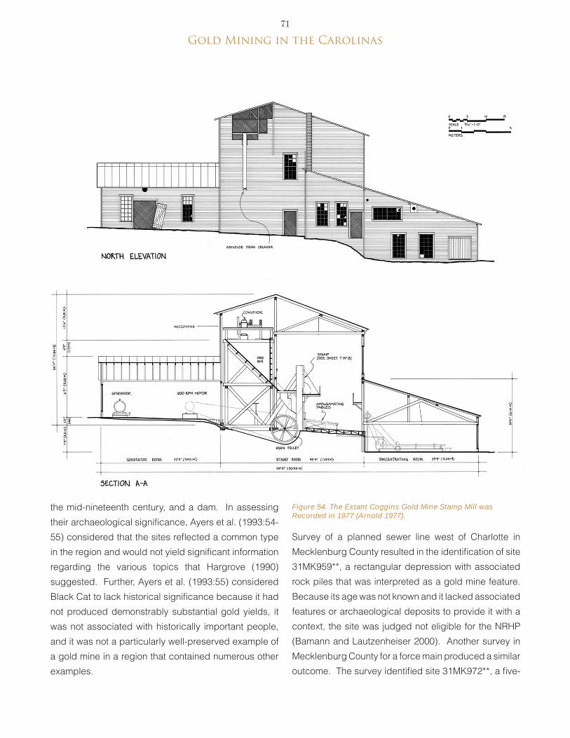
gold Mining in the Carolinas71
the mid-nineteenth century, and a dam. In assessing
their archaeological significance, Ayers et al. (1993:54-
55) considered that the sites reflected a common type
in the region and would not yield significant information
regarding the various topics that Hargrove (1990)
suggested. Further, Ayers et al. (1993:55) considered
black Cat to lack historical significance because it had
not produced demonstrably substantial gold yields, it
was not associated with historically important people,
and it was not a particularly well-preserved example of
a gold mine in a region that contained numerous other
examples.
Survey of a planned sewer line west of Charlotte in
Mecklenburg County resulted in the identification of site
31MK959**, a rectangular depression with associated
rock piles that was interpreted as a gold mine feature.
because its age was not known and it lacked associated
features or archaeological deposits to provide it with a
context, the site was judged not eligible for the NRHP
(bamann and Lautzenheiser 2000). Another survey in
Mecklenburg County for a force main produced a similar
outcome. The survey identified site 31MK972**, a five-
Figure 54. The Extant Coggins Gold Mine Stamp Mill was Recorded in 1977 (Arnold 1977).
72
meter wide pit interpreted as a gold prospect. The site
was judged to have a low research potential because
of the absence of machinery and other technological
features. Consequently, no further investigations were
recommended (edwards 2001:28-30).
Although it was not investigated archaeologically,
a particularly noteworthy site in North Carolina is the
Coggins Gold Mine stamp mill in Montgomery County
(Figure 54). In 1977, the early twentieth-century stamp
mill remained standing and received Historic American
engineering Record (HAeR) documentation. Most of
the equipment had been removed and the building was
in disrepair, but the documentation illustrated the scale,
arrangement, and operation of this plant, which was
deemed to be representative of North Carolina stamp
mills (brenner 1977). Documentation indicated the
large size of the building, approximately 111x70 feet
with two rear ells for power generation, needed to house
the 50 stamps. The plant was an open plan industrial
building with a mezzanine where ore was delivered and
conveyed to the bins that fed the stamps. Drawings
and photographs show the structure was heavily framed
with exterior clapboard and no interior paneling. The
documentation did not provide detailed information on
aspects of the structure that could be expected at an
archaeological site, however, such as the construction
of stamp or machine mounts or building foundations.
In South Carolina, most gold mine sites have been
documented during surveys of Sumter National Forest,
which contains three ranger districts that overlap
historically important mining regions. Most of the work
in the Sumter National Forest at mine sites has involved
only identification (elliott 1983, 1984; braley 1988;
Castille 1988; Smith 1989). In general, the sites reflect
prospects and shafts or adits for underground mines.
Additionally, archaeological remains of placer mining
have been noted on Townes Creek in Cherokee County
(Andrew Pickens Ranger District) (bates 2008:5). No
substantial remains of ore handling or transportation
facilities have been recorded in the national forest yet.
In most cases, individual researchers have evaluated
the Sumter National Forest sites on the basis of integrity,
basing judgment of their potential research value and
historical significance on their state of preservation
and how it compared to other sites in the region.
bates (2008) provided a more detailed evaluation of
two mid nineteenth-century mine sites, 38OC237 and
38OC277 (a lead mine) in preparation for filling of
deep shafts. Noting that the sites were more complex
than most mineral industry sites in the Sumter National
Forest, bates judged them to have significant research
potential because of their archaeological content and
historic associations. Specific questions that the sites
could provide data to address were drawn from the
Sumter National Forest Overview (benson 2006; bates
2008:27-28):
What is the period of greatest mineral ��
prospecting and mining in each ranger
district?
Were prospectors and miners local men? ��
Did outsiders flock into the region or were
miners brought in? What ethnic groups were
represented?
Were specialists involved? Were these large ��
sophisticated operations?
What kinds of remains do gold mine ��
exploration and mining leave behind on
the Sumter National Forest? What types of
features? What types of sites?
What kinds of historic/archival records exist ��
related to mineral prospecting and mining?
benson (2006) developed an overview of cultural
resources of the Sumter National Forest. He noted that
evidence of mining (all minerals), consisting of adits,
shafts, creek dredging, flumes and “probable smelting

gold Mining in the Carolinas73
furnaces” was extensive along Tamassee, Townes, Cheohee, Moody, and Cantrell creeks in the Andrew Pickens Ranger District (benson 2006:75). In describing the sites associated with mining and prospecting in the Sumter National Forest, benson (2006:153) noted that prospecting pits are often in small clusters, vary in depth and shape (from round to oval), commonly have a visible spoil pile around their margins, and typically occur within quartz outcrops. benson further observed that these sites can be difficult to identify because they sometimes resemble tree falls, unmarked graves, or military training foxholes, among others.
Although little detailed work has been conducted at gold mine sites in the forest, benson demonstrated the potential of viewing these sites together as a reflection of patterned behavior. He correlated site locations with certain environmental and cultural variables to generalize about distributions. breaking down the distributions by ranger district, benson found that in the Andrew Pickens Ranger District gold prospecting and mining sites were mostly within 1,200 meters of Moody, Cantrell, and White Oak creeks. Sites were in both upland and bottomland positions, with upland sites often being on slopes. For the enoree Ranger District, the mining and prospecting sites were most often found on knolls, but also occurred on ridge slopes and one saddle. The knolls were most likely underlain by resistant quartz, and therefore would have been likely places to prospect for lode gold. Another pattern for this ranger district was that all eight of the mining sites lay within 500 meters of a historic residence. At the Long Cane Ranger District, 36 sites were distributed nearly evenly between ridge noses, steep ridge flanks, and knolls. Sites on ridge flanks took advantage of the access to rock outcrops. Residential sites were often within 500 meters of the sites in this district as wells
(benson 2006:220-221).
A recent study at Haile Gold Mine in Lancaster County
comprised an example of a documentation project that
examined a single resource in relative detail (botwick
and Swanson 2011). Additionally, the work dealt with
the nineteenth- to twentieth-century stamp mill that
operated here, and thus was one of the few processing
sites studied. The site was initially identified during a
Phase I survey but never formally evaluated (Pluckhahn
and braley 1993). As part of the resumption of mining at
the site, Haile Gold Mine knew of SHPO’s interest in the
stamp mill and volunteered to perform the mitigation
data recovery (see botwick and Swanson 2011).
However, the study was conducted as part of a “creative
mitigation” and so rather than a full excavation, due to
the lack of actual remains, the fieldwork was limited to
documenting surface features with limited subsurface
investigation. While production of this archaeological
context served to compensate for the lack of more
extensive fieldwork, incorporating the Haile Gold Mine
into the history of Gold Mining in the Carolinas was part
of this approach.
The Haile Gold Mine study produced important data
on gold mining in South Carolina and raised questions
that could potentially be addressed at other sites.
Historical research indicated that it was significant in
the development of gold processing technology, being
the location where Carl Thies implemented an improved
system of chlorination. The site once was included
in a large operation of several open pits, extensive
underground works, breaking plants, the stamp mill and
concentration house, and the chlorination plant, along
with support facilities (e.g., machine shops, power
houses), workers’ housing, and a small-gauge railroad.
except for the stamp mill, archaeological remains of the
historic gold mine were enveloped and/or destroyed by
later (1930s and 1980s) operations. Archaeological work
at the stamp mill documented the general organization
of this operation, as well as, features related to the
support and operation of machinery, a workers’s house,
and a possible boiler house dating to the World War I
conversion of the stamp mill to a pyrite mill. This work
also indicated the way the mill’s designers utilized and

74
modified natural terrain to facilitate milling. Among
the results of the study was the discovery that the
mill and associated structural features were relatively
insubstantial in their construction. Similarly, the footings
of the worker’s house were inconsistent in construction.
These findings led to questions about how the mine
approached construction and maintenance of facilities,
and whether this approach was typical of Carolinas
mining operations (botwick and Swanson 2011).
In addition to sites directly related to gold mining,
limited archaeological study of auxiliary sites has been
conducted. Trinkley and Hacker (1995) conducted
a survey and prepared a preservation plan for site
31RF157**, representing the bechtler Mint site in
Rutherford County, North Carolina. As with other
studies reviewed here, this one was performed in the
context of a heritage project at a site whose location
was well known to historians and the general local
public. The archaeological survey was conducted to
assess the site and evaluate its NRHP eligibility. The
study also discussed preservation issues and potential
interpretation opportunities. The archaeological site was
interpreted as the bechtler residence and workshop.
Trinkley and Hacker’s analysis of the finds emphasized
their similarity to southern plantations or farmsteads,
which was one aspect of the site. Aside from noting the
discovery of crucible fragments used in gold working
or assaying, there was no consideration of the site as a
type of industrial or commercial operation.
The literature review highlights aspects of the current
state of gold mine archaeology in the Carolinas. In
general, sites have been identified on the basis of large,
very visible features or else they were already known
from other sources, such as historical information or local
custom. In addition, none of the sites identified in the
region has been studied purely for scholarly purposes
with previously developed research objectives applied
to them. Instead, sites have generally been examined
only to aid in reconstruction or management as part of
a Section 106 compliance undertaking. evaluations
of research potential have mostly been made with
reference to integrity but rarely with reference to broader
research topics or themes. Although some efforts have
been made to introduce explicit evaluation criteria,
notably by Hargrove (1990, 1993), there has been little
consistency in this regard.
In addition, the work up to now has illustrated the
relatively piecemeal manner in which archaeologists
have dealt with gold mining sites in the Carolinas. This
is to say that archaeologists appear to have recorded
individual features associated with specific mines but
not taken into account the larger sites that these kinds
of features might relate to. Historic mining sites can
cover expansive areas, with extraction, processing,
and other facilities located at great distances from
one another. Several reports noted the absence of
associated features, but it is not clear if these were
sought beyond surveying the adjacent area. Admittedly,
mine sites pose challenges that are difficult to integrate
into standard cultural resource surveys, but evaluating
individual or groups of prospects or mine shafts without
reference to the larger mining operation makes it difficult
to accurately interpret and evaluate these resources.

gold Mining in the Carolinas75
VII. Archaeological Identification and Recording of Gold Mining Sites
Historic gold mine sites are common in portions of the Carolinas but their unique attributes make them challenging to identify and record
during surveys and evaluation studies. This chapter outlines suggested survey, identification, and recording procedures. Many of the recommended methods are applicable to other mineral resource sites as well.
suRvey/iDentification
As noted in the previous chapter, archaeological
remnants of historic gold mines might be encountered during National Historic Preservation Act Section 106 cultural resource surveys or heritage projects. Archaeologists working in the Carolinas have done a good job of identifying the more obvious physical remains of gold mine sites, but site delineation studies as part of a NRHP evaluation require accounting for all components of a site. The majority of identified property types associated with gold mining in the Carolinas are prospects and shafts, although it is likely that other feature types survive above and below ground.
Archival research is more important in identifying mining properties than it is for most cultural resources surveys. Site-specific or study area-specific documentary research prior to conducting fieldwork is necessary to determine the general mining practices used in a region and specific mining sites that might occur in an individual survey area (Hardesty 1988:108; CALTRANS 2008:156). Maps and other archival sources, such as historic aerial photographs and local histories, can indicate the presence of mines in a project area and the types of mineral extraction and processing activities involved. Documents also provide information for developing preliminary models of mines and their probable locations (Hardesty
1988:108; 2010:21). This preliminary knowledge familiarizes surveyors with the feature types expected and helps to accurately identify any found during the fieldwork (Noble and Spude 1997:7). Sources that are useful for identifying specific gold mine locations in the Carolinas include Nitze and Wilkens (1897), Pratt (1907), Sloan (1908), Carpenter (1999), and McCauley and butler (1966).
Historical documents that indicate potential site locations are limited, however. Aside from providing only general information on site locations, they could exaggerate the size of particular mines and the scales of production, leading surveyors to look for features that were planned but never built. Moreover, while they could indicate the location of a mine and its major components, they did not always provide details about mundane features, such as shafts, adits, outhouses, and trash scatters (Hardesty 1988:108-109, 2010:22). Many of these kinds of features, however, are visible either at the surface or through archaeological methods and can be located through fieldwork. Moreover, it is apparent that some mining operations were well documented with descriptions, maps, and photographs while many were small-scale or exploratory operations having few or no documentary records useful for locating them.
Consideration of the types of mining prevalent in an area can also help to develop preliminary models of site locations. Placer mining typically follows drainages. Lode mining was oriented with respect to geologic structures (Noble and Spude 1997:6). Hardesty’s (1988:108, 2010:21-22) study of Nevada mines suggested that mine locations were mainly
related to ore distributions, while factors such as water,
towns, and transportation venues provided secondary
influences, and, what is more, were often established
with respect to the mine locations.
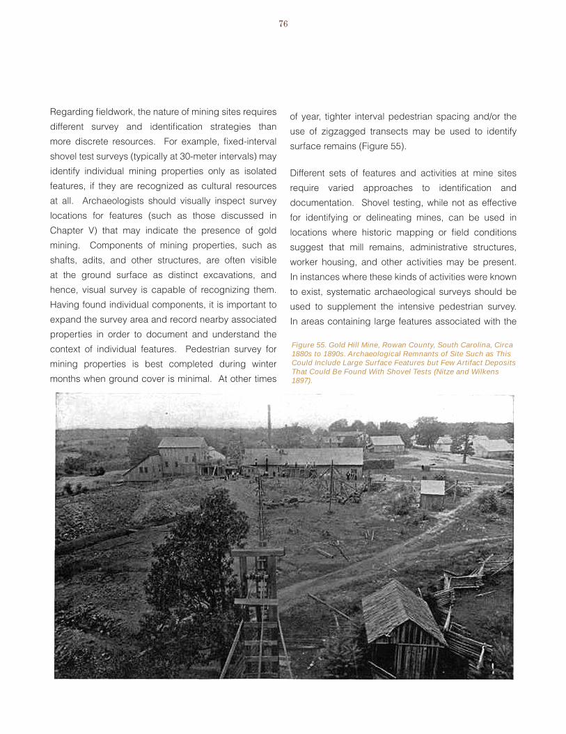
76
Figure 55. Gold Hill Mine, Rowan County, South Carolina, Circa 1880s to 1890s. Archaeological Remnants of Site Such as This Could Include Large Surface Features but Few Artifact Deposits That Could Be Found With Shovel Tests (Nitze and Wilkens 1897).
Regarding fieldwork, the nature of mining sites requires
different survey and identification strategies than
more discrete resources. For example, fixed-interval
shovel test surveys (typically at 30-meter intervals) may
identify individual mining properties only as isolated
features, if they are recognized as cultural resources
at all. Archaeologists should visually inspect survey
locations for features (such as those discussed in
Chapter v) that may indicate the presence of gold
mining. Components of mining properties, such as
shafts, adits, and other structures, are often visible
at the ground surface as distinct excavations, and
hence, visual survey is capable of recognizing them.
Having found individual components, it is important to
expand the survey area and record nearby associated
properties in order to document and understand the
context of individual features. Pedestrian survey for
mining properties is best completed during winter
months when ground cover is minimal. At other times
of year, tighter interval pedestrian spacing and/or the
use of zigzagged transects may be used to identify
surface remains (Figure 55).
Different sets of features and activities at mine sites
require varied approaches to identification and
documentation. Shovel testing, while not as effective
for identifying or delineating mines, can be used in
locations where historic mapping or field conditions
suggest that mill remains, administrative structures,
worker housing, and other activities may be present.
In instances where these kinds of activities were known
to exist, systematic archaeological surveys should be
used to supplement the intensive pedestrian survey.
In areas containing large features associated with the

gold Mining in the Carolinas77
major mining activities, however, subsurface testing
is generally not necessary and would not justify the
effort put into it. This is particularly true for features like
tailings and waste rock piles (CALTRANS 2008:156).
The unused spaces between areas of intensive activity
generally do not contain substantial cultural resources
related to mining either. Nevertheless, some form of
sampling should be applied to these areas. Hardesty
(1988:109, 2010:23) recommended dividing the areas
into transects and surveying a percentage of them.
Metal detector survey, or the use of a magnetometer,
is recommended for the identification of remnant
architectural and landscape features, including railroad
rails and spikes in potential rail beds, structural remains
from processing areas, and nails from residences and
other structures. Metal detector survey should be used
judgmentally on mining sites to aid the determination of
integrity; for example, if rails do not appear to remain in
railroad bed locations, then is it likely that the mining site
has been salvaged after abandonment, which effects
the site’s integrity. A magnetometer can be used to
map the subsurface placement of metal remains, such
as rails, as well as buried metal processing facilities
and equipment. Ground penetrating radar (GPR) can
also be used to record the subsurface elements of mine
structures. Light Detection and Ranging (LIDAR) data,
if available, is extremely useful for identifying mining
site features and their locations. LIDAR records subtle
differences in surface contours, and can be used on
mining sites to reveal excavation locations
In addition, involving industrial historians, historians of
technology, landscape architects, mining engineers,
and geologists in the field can help in identifying and
interpreting properties (Noble and Spude 1997:9;
McClelland et al. 1999:7). These professionals can
also provide important assistance with pre- and post-
survey archival research.
The expansive and discontinuous nature of mining sites
is another consideration in identifying and delineating
them. Mining sites often do not consist of a continuous
scatter of artifacts and features like “traditional” sites but
instead they may contain components that are widely
separated from one another (Figure 56). Identifying
these dispersed features and deposits is necessary to
completely reconstruct and understand an individual
mining operation. Field searches must therefore be
comparatively intense and wide-ranging to ensure that
all related features and activity areas are identified
(Hardesty 1988:109, 2010:21; McClelland et al. 1999).
The underground components of mine sites (shafts,
drifts, and other structures) must be considered,
although these kinds of features present significant
obstacles to survey and recordation. Hardesty seemed
to be of two minds on the subject of underground
workings. On the one hand, he noted that they could
contain significant information about chronology and
activities associated with particular mines (Hardesty
1988:25-27, 2010:46). At another time, however, he
stated the opposite position, stating that they rarely
yielded useful information (Hardesty 1990:49-50).
Regardless of their research potential, because of
the unstable nature of underground features, they
should never be entered except under the supervision
of mine-safety experts (Hardesty 1988:27, 2010:49;
CALTRANS 2008:177). The locations of these features
can sometimes be determined on the basis of surface
remains or where they have been exposed during later
open pit excavations (Griffin 1974:18-19; Noble and
Spude 1992:9). Remote sensing techniques such
as GPR can be used to detect the presence of filled
mine openings but should be used with caution (Noble
and Spude 1997:9). Archaeological geophysical
prospecting techniques typically have a limited depth
range of 1-3 meters, depending on soil conditions,
giving them limited usefulness for locating deeper
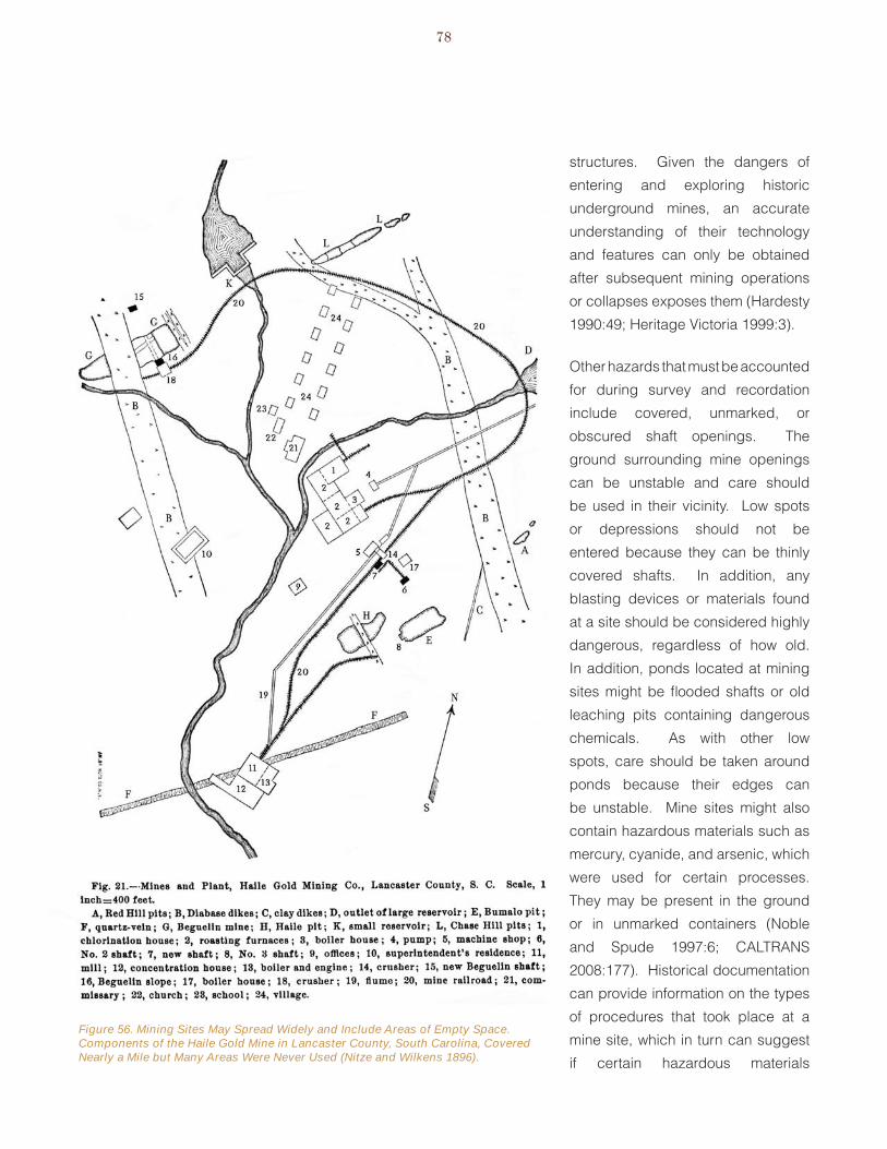
78
Figure 56. Mining Sites May Spread Widely and Include Areas of Empty Space. Components of the Haile Gold Mine in Lancaster County, South Carolina, Covered Nearly a Mile but Many Areas Were Never Used (Nitze and Wilkens 1896).
structures. Given the dangers of
entering and exploring historic
underground mines, an accurate
understanding of their technology
and features can only be obtained
after subsequent mining operations
or collapses exposes them (Hardesty
1990:49; Heritage victoria 1999:3).
Other hazards that must be accounted
for during survey and recordation
include covered, unmarked, or
obscured shaft openings. The
ground surrounding mine openings
can be unstable and care should
be used in their vicinity. Low spots
or depressions should not be
entered because they can be thinly
covered shafts. In addition, any
blasting devices or materials found
at a site should be considered highly
dangerous, regardless of how old.
In addition, ponds located at mining
sites might be flooded shafts or old
leaching pits containing dangerous
chemicals. As with other low
spots, care should be taken around
ponds because their edges can
be unstable. Mine sites might also
contain hazardous materials such as
mercury, cyanide, and arsenic, which
were used for certain processes.
They may be present in the ground
or in unmarked containers (Noble
and Spude 1997:6; CALTRANS
2008:177). Historical documentation
can provide information on the types
of procedures that took place at a
mine site, which in turn can suggest
if certain hazardous materials
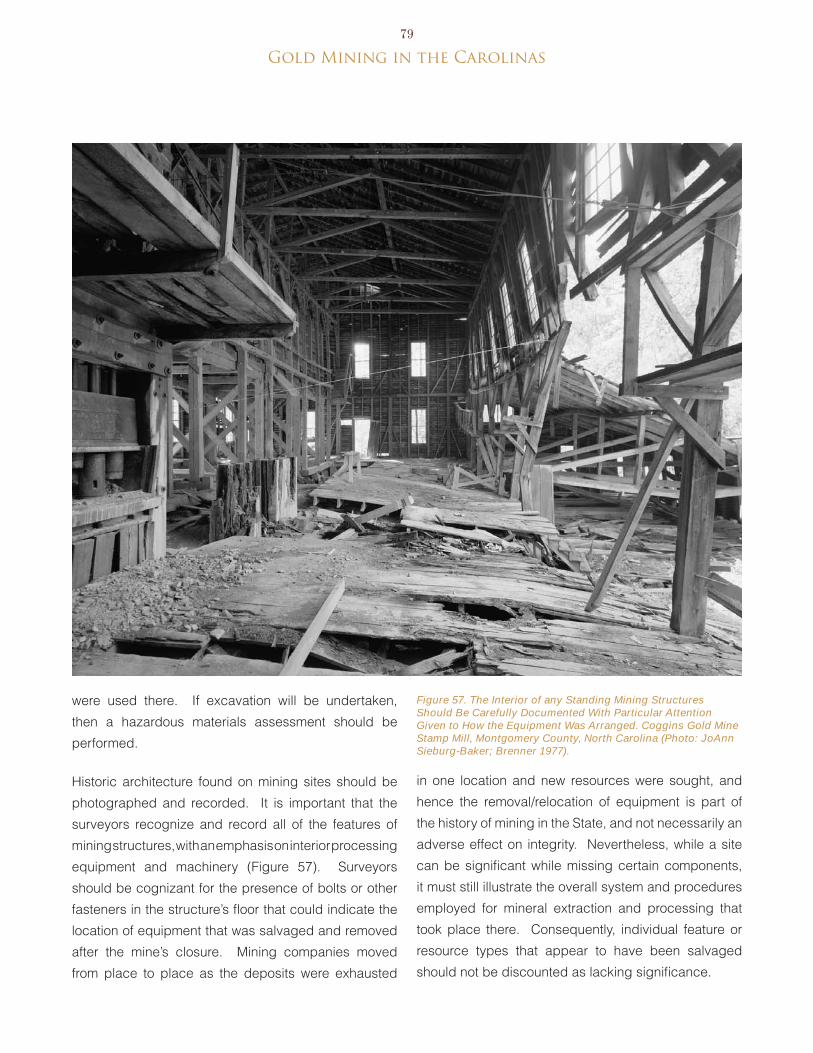
gold Mining in the Carolinas79
Figure 57. The Interior of any Standing Mining Structures Should Be Carefully Documented With Particular Attention Given to How the Equipment Was Arranged. Coggins Gold Mine Stamp Mill, Montgomery County, North Carolina (Photo: JoAnn Sieburg-Baker; Brenner 1977).
were used there. If excavation will be undertaken,
then a hazardous materials assessment should be
performed.
Historic architecture found on mining sites should be
photographed and recorded. It is important that the
surveyors recognize and record all of the features of
mining structures, with an emphasis on interior processing
equipment and machinery (Figure 57). Surveyors
should be cognizant for the presence of bolts or other
fasteners in the structure’s floor that could indicate the
location of equipment that was salvaged and removed
after the mine’s closure. Mining companies moved
from place to place as the deposits were exhausted
in one location and new resources were sought, and
hence the removal/relocation of equipment is part of
the history of mining in the State, and not necessarily an
adverse effect on integrity. Nevertheless, while a site
can be significant while missing certain components,
it must still illustrate the overall system and procedures
employed for mineral extraction and processing that
took place there. Consequently, individual feature or
resource types that appear to have been salvaged
should not be discounted as lacking significance.
80
The scale of mining properties, the variety of resources
they contain, and their setting in cultural landscapes all
mandate the use of Geographic Information Systems
(GIS) to record, map, and interpret their remains. It is
important to correctly identify specific feature types to
assist in accurately characterizing the mining processes
being identified and their chronologies (CALTRANS
2008:156). Features should be recorded by GPS
along with property type in the data dictionary field.
Locations should include each property’s boundaries.
GIS overlays should be developed, including property
limits/boundaries as identified through archival
research, historic maps or plats showing structure
locations, historic aerial photographs, LIDAR data, and
other resources, as available.
mininG pRopeRties as cultuRal lanDscapes
Historic gold mine sites are unusual cultural resources
and encompass a variety of historical and cultural
properties. They might cover expansive areas and
include diverse features, sites, and cultural deposits
including the obvious vestiges of mineral extraction,
such as mines and waste piles, an array of processing
and transportation facilities, and support structures such
as powerhouses, offices, and blacksmith shops. They
can also include extensive underground components,
broad areas of unused space, and housing for workers
and their families. Additionally, seemingly isolated
structures and features may have historical relationships
as discrete parts of a single mining operation. Moreover,
the location and functioning of mining sites often have
close connections with the physical environment.
because of these qualities, and the difficulties in
identifying and delineating them, the survey of historic
gold mines is sometimes best accomplished through a
cultural landscape approach that identifies and records
all properties, both sites and structures, associated with
a mining operation.
The National Register bulletin Guidelines for Evaluating
and Documenting Rural Historic Landscapes defines
a historic rural landscape as “a geographical area that
historically has been used by people, or shaped or
modified by human activity, occupancy, or intervention,
and that possesses a continuity of areas of land use,
vegetation, buildings, and structures, roads, waterways,
and natural features” (McClelland et al. 1999:1-2).
Historic gold mines can be identified, evaluated, and
studied with reference to a geographical area rather
than to individual features, sites, or structures.
viewing historic gold mines as rural historical landscapes
can link isolated features and structures that appear to
have no significant historical or functional associations.
Rural historic landscapes may include industrial types
and “contain significant areas of vegetation, open
space, or natural features that embody, through past
use or physical character, significant historical values.
buildings, industrial structures, objects, designed
landscapes, and archaeological sites may also be
present” (McClelland et al 1999:3). A classification
system of 11 characteristics of a rural landscape helps
in reading and interpreting the natural and cultural forces
that acted on it. McClelland et al. (1999:3) defined the
landscape characteristics as “tangible evidence of
the activities and habits of the people who occupied,
developed, used, and shaped the land to serve human
needs.” Further, they might reflect beliefs, attitudes,
traditions, and values of the people who created them.
The 11 characteristics are divided into two groups:
processes that have shaped the land, and physical
components that are visible in the landscape. The four

gold Mining in the Carolinas81
characteristics classified as processes are: Land Use
and Activities; Patterns of Spatial Organization; Response
to the Natural environment; and Cultural Traditions.
When addressing historic gold mining properties,
these characteristics can help in understanding how
and why a mining landscape developed over time. The
seven characteristics that make up components of the
landscape are those features that illustrate the way a
historic landscape was developed and organized. These
include Circulation Networks; boundary Demarcations;
vegetation Related to Land Use; buildings, Structures,
and Objects; Clusters (of buildings, structures, and
other features); Archaeological Sites; and Small Scale
elements. The National Register bulletin Guidelines
for evaluating and Documenting Rural Historic
Landscapes described these concepts in detail and
provided specific examples (McClelland et al. 1999:4-
6, 15-18). Components of mining landscapes in the
Carolinas could include, among others, underground
workings, open cuts, tailings, roads, railroads, stamp
mills, processing plants (e.g., chlorination or cyanide),
retort and assay buildings, storage bins, retaining
ponds, water delivery and drainage systems, shops,
stables, offices, and houses.
In identifying and evaluating historic gold mine
properties as historic landscapes, it is suggested that
consideration be given to how the land was shaped and
manipulated to extract, process, and deliver mineral
resources. Mining landscapes should show evidence
of specific land use practices, transportation networks,
vegetation patterns, large and small elements that are
distinctive of mining, buildings, and structures, as well
as illustrating how these functioned together within a
geographical area. It should be said as well that not
all historic gold mines or properties would necessarily
be considered historic landscapes, and decisions as
to how to categorize a property or groups of properties
would have to be made during survey and evaluation.
DelineatinG anD RecoRDinG histoRic GolD mines foR evaluation stuDies
Procedures for recording gold mine sites overlap those
of survey but call for greater detail and consideration of
how the various structures, features, and deposits relate
to historic contexts and convey historic significance.
After the initial Phase I survey identified mining features
at Humbug Creek in Arizona, for example, researchers
from Dames & Moore returned and intensively
resurveyed the site to record it (Ayres et al. 1992).
Although Phase I survey for mining sites involves
considerable archival research, the recordation phase
might include additional documentary study combined
with fieldwork.
Historical research at the recording stage is intended
to contribute more detailed information about what
activities took place at a particular site as well as
providing information necessary for establishing a
site’s period(s) of historic significance and what historic
contexts it might relate to. Chain-of-title research
should be conducted to determine the property’s
ownership and associated mining companies, which
often leased mineral rights but did not own the mine.
This information also indicates the historical boundaries
of the mine. Secondary sources are also useful
documents if they describe particular sites (CALTRANS
2008:156). Historic maps and photographs are also
good resources for documented sites.
Fieldwork at this stage should include more detailed
recording methods, including photography, preparation
of architectural plans and elevations (if structures are
present), sketches of machinery and other objects,
narrative descriptions, and preparation of scaled maps
(Noble and Spude 1997:9). Detailed fieldwork, mapping,
and recording are particularly important in establishing
the content of a site and its boundaries. Gold mining
sites may be recorded as either a set of sites within a

82
complex or district, or a series of features within a single
site. The determination as to which of these options
is appropriate depends on the size of the resource, its
complexity, and its associations, chronology, and the
types of features and elements involved (CALTRANS
2008:157). It is important, however, that in either case,
individual or groups of features are related to a broader
mining operation.
evaluation fieldwork should also emphasize collecting
information necessary to assess integrity and
significance and should employ methods appropriate
for making these determinations. The total site, including
both structures and archaeological materials, must be
assessed to determine how well it conveys a sense of
time, place, and historical patterns or themes, as well as
how well it might address important research questions
(Noble and Spude 1997:9). Detailed recording will
help with this by providing the information necessary
to identify individual features and interpret how they
related historically.
Finally, the physical remains of the site must be analyzed
to link them to the mine during its period(s) of operation
and to the social and economic systems in which it
functioned. The analysis and interpretation can be
complicated by the actual life cycle of the mine. Mines
may be abandoned and then re-opened at a later time, or
new technologies and processes can be applied, which
can damage or destroy older features and deposits.
The site structure that emerges from these sequential
episodes of development and abandonment often
consists of sets of overlapping features, depositional
strata, and objects that can be viewed as “horizontal
stratigraphy.” Remains from various time periods may
be damaged or destroyed by later developments, and
chronologically or functionally related features could be
widely spaced (Hardesty 1990:48). Hardesty (1990:48)
cautioned against viewing a mine site as a continuous
accumulation of historic debris, stating that its structure
more likely represents disjointed remnants of multiple
uses and activities. It is important to determine the
temporal relationships of individual features in order
to accurately interpret engineering and other systems
(Noble and Spude 1997:9).
The use of a geodatabase is encouraged at this
stage. A geospatial database (geodatabase) consists
of a GIS with an associated database in Access or
similar software. The database should contain feature
descriptions, functions, ages, and images. González-
Tenant illustrated the use of GIS and geodatabases
to map and interpret gold mining sites in the Otago
Goldfields of New Zealand (González-Tenant 2009),
and his study showed the utility of this approach in
mapping resources by function, age, and landscape.
Preparation of a geodatabase would include detailed
recording of mining property types with GPS, preparing
descriptive analyses of each property as well as its age
of construction for use in mapping and displaying mining
landscapes over time, georeferencing historic maps of
the mining site, and comparing the spatial distribution
of the site with other recorded mining properties. Use
of geodatabase analysis will facilitate the evaluation of
several aspects of integrity, including location, setting,
and design.
gold Mining in the Carolinas83
VIII. Evaluating Carolina Gold Mine Sites
it impacted settlement and landscape, introduced
industrial practices and organization, and affected
the regional economy. Additionally, some aspects of
gold mining technology developed or improved in the
Carolinas were later put into use in the more renowned
western gold fields. The Carolina region was also the
site of important innovations in chemical processing of
gold ore. Gold mining directly impacted settlement,
as new communities emerged or older ones expanded
and reoriented as new gold regions opened. Gold
attracted foreign-born specialists and employed
laborers in small and large-scale industrial settings for
the first time in the southeast, and thus had important
impacts on demography and labor. Also, gold mining
led to the introduction of northern and foreign capital
being invested heavily into the region as well as the
introduction of corporations.
Historic contexts can encompass one or more “themes”
or “areas of significance.” The National Park Service
(1990) defined a theme as a means of organizing sites
into coherent patterns based on certain concepts or
subjects, such as environment or technology, that
have influenced the historic or cultural development
of a region. A theme is considered significant if it can
be demonstrated through scholarly research to be
important in American history. evaluating a historic
gold mine site requires determining how the theme of
the context is significant in the history of the local area,
the state, or the nation (National Park Service 1990:8).
A single site could relate to more than one theme.
The preceding summary of the historic context and
significance suggests that significant themes or areas
of significance for gold mining in the Carolinas include:
Historic gold mines in North and South Carolina
may have significance because they reflect
important aspects of history. Determining the
significance of a historic gold mine site requires working
through a number of steps and considering how a site
relates to historic contexts, what its research value is,
the anticipated use of the site, including resumption of
mining activity, and how its physical condition affects
its ability to convey its significance. The following
sections discuss the factors to consider in evaluating
the archaeological significance of historic gold mines in
the Carolinas and suggest research topics that can be
used in determining a site’s study potential.
histoRic contexts anD aReas of siGnificance
Historic contexts are patterns or trends in history
that provide a framework for understanding specific
occurrences, properties, or sites. They provide a means
for relating specific sites to broad historical patterns
and thus interpreting their meanings and evaluating
their significance.
The historic context of this project can be stated as
“Gold Mining in the Carolinas,” encompassing the
historical, technological, economic, labor, and cultural
developments related to producing gold bullion in
this region. Gold mining in the Carolinas ranged from
small-scale workings to industrial operations using
various mechanical and chemical processes to remove
gold from waste rock. Gold mining had important
impacts on the historic development of the Carolinas,
and especially the North Carolina Piedmont, where
84
Archaeology•
Historic--Non-Aboriginal•
Commerce•
Community Planning and Development•
economics•
engineering•
ethnic Heritage (Primarily european, African-•
American)
exploration/Settlement•
Industry•
Invention•
Labor•
Landscape•
Science•
Social History•
Transportation•
aReas of siGnificance: nRhp cRiteRia foR evaluation
The significance of a historic property is evaluated with
respect to four NRHP Criteria found at 36 CFR Part
60.4. In addition, sites must be assessed in light of their
relationship to historic contexts. Finally, a site’s NRHP
eligibility is a function of its integrity or its physical ability
to convey its historic significance. In other words, it
must not only be a good representative of its historic
context, but must also be in a condition that clearly
demonstrates its relationship to the context.
The four NRHP Criteria for evaluation require that
districts, sites, buildings, structures, and objects
possess integrity of location, design, setting, materials,
workmanship, feeling, and association, and meet one
or more of the criteria of evaluation.
Refers to properties that are associated Criterion A. with events that have made a significant
contribution to the broad patterns of our
history;
Covers properties that are associated with Criterion B. the lives of significant persons in the past;
Relates to properties must embody the Criterion C. distinctive characteristics of a type, period,
or method of construction, or represent the
work of a master, or possess high artistic
values, or represent a significant and
distinguishable entity whose components
may lack individual distinction; or
Deals with properties that have yielded or Criterion D. are likely to yield information important to
prehistory or history.
Assessments under the first three criteria are made with reference to particular historic processes, events, and people associated with specific gold mines in the Carolinas. Hardesty (1988:109) referred to them as mainly the province of historians, architects, and engineers, although archaeologists would be expected to deal with them given that most gold mining sites in the Carolinas are presently archaeological resources. The important historical developments and trends of gold mining in the Carolinas were discussed in Chapter III and should be referenced in determining how individual sites reflect historical developments, people, or types. For Criterion C, Hardesty (1988:110, 1990:50) also suggested that representativeness and ‘rarity’ are important considerations. Specific questions to consider are whether a site is the first of its kind, is it the last survivor of a type, or does it represent an important change in technology, new or innovative practices, or experimental approaches?
evaluating archaeological sites under Criterion D requires asking what important research issue(s) could the site provide information about? To make such a determination, it is helpful to identify the relevant research questions in advance. Hardesty noted that the lack of clearly identified research topics was a major impediment in evaluating the historical and archaeological significance of mining sites. The practice of evaluating sites with site-specific and ad hoc
gold Mining in the Carolinas85
questions led to trivial research questions and vague topics that were difficult to apply (Hardesty 1990:42-43). The following discussion suggests research topics for assessing the information potential of gold mining
and other mineral industry sites in the Carolinas.
ReseaRch topics foR aRchaeoloGical evaluation
Historic mining sites reflect industrial workplaces and in some instances also the domestic world of the workers, managers, and other people involved with mines and miners. A recent historic context for Georgia mining sites provided topics for evaluating the archaeological research potential of these resources (botwick et al. 2011:Appendix 4). Many of the research topics that deal with gold mines can be addressed with a combination of archival, architectural, and archaeological sources (Hardesty 1988:12, 2010:23), although archaeology provides a unique means to study intimate and poorly documented aspects of past behavior at mining sites. The research topics for Carolina gold mining sites were adapted from the CALTRANS (2008) research design for California mining sites. Appendix A contains specific questions that can be addressed at gold mining sites in the Carolinas to help establish research potential. The general topics of concern are summarized below. The
topics include the following:
1. Technology and technological development of mining
4. Gender and family aspects of mining
2. Historical ethnography/cultural history of mining
5. economic aspects of mining
3. ethnicity of distinct culture groups and ethnic interactions
6. Policy, law, and regulation of mining and self-governance
Remains of technology are often the most visible
remnants of historic mining (Hardesty 1988:12, 2010:23).
Research into the technology of mining generally deals
with what equipment and techniques were used at
individual mines, how they were implemented, and
how they changed over time. These topics can also be
studied at the regional level. Additionally, the effects
of general technological advancements on mining can
also be examined.
Studying the technology of mining can encompass not
just the equipment used to extract and process ore, but
also the byproducts of these activities. Studying waste
handling and management at the Standard Mill, bodie,
California, and tailings outside butte and Anaconda,
Colorado, Quivik (2003, 2007) demonstrated varying
technological approaches that mill operators developed
to reprocess tailings and more generally to mitigate the
environmental effects of mill wastes. Another study of
mill byproducts was at the Reed Gold Mine in North
Carolina. Here, Trinkley (1986:83) suggested that
plotting the particle sizes of tailings deposits could be
indicative of different activity areas.
Historical ethnography/cultural history of mining
can encompass topics such as mining settlements.
Hardesty (1988:13) cast the residential settlement or
mining camp as one of the principal units of study in
the archaeology of mining, stating that it is the shape
and activity of settlements are expressions of the
interactions that take place within the social sphere
of mining regions. Research topics dealing with
settlements concern how they become established and
develop into communities, and what social, economic,
and political forces shape them. This topic also deals
with individual households and groups of households
(community) and is concerned with such topics as the
composition and nature of households, permanence,
demography, shelter types, and variation over time and
mine type/organization.
The topic of ethnicity is concerned with identifying
cultural markers in the archaeological record of mining.
Additionally, the process of socializing various ethnic
86
or national groups is a topic of concern (Gray 2009).
Cultural differences or distinctions might be present in both the workplace, for example in the methods or equipment used, or in the domestic sphere. Carolina miners included whites, African-Americans, and europeans who brought and/or developed varying approaches to gold mining and associated practices. Addressing this topic would require clear evidence of miners’ ethnicity, the mining methods used, and/or archaeological deposits associated with domestic occupations.
Gender and family aspects of mining also may include the workplace and domestic world. Women and children participated in certain mining operations in the Carolinas and were certainly present in mining settlements. because archaeology handles the more intimate aspects of households and communities, it can provide important information about the presence of women and children in mining communities, attitudes toward them, and the nature of their lives (Moore 2009; Prangnell and Quirk 2009). because so little is known about the gender and family aspects of mining in the Carolinas, research into this topic at this point involves determining how women and children can be identified at mine sites and what effects the presence or absence
of families had on mining communities.
Consideration of the economic characteristics of
mining considers the production and consumption of
commodities (Noble and Spude 1997:17). This theme
covers topics ranging from individuals and households
to how mines and mining regions related to the outside
world. Specific issues include what mines produced,
how mining generated income for various individuals,
how mining was capitalized, and how these influenced
material culture. Additionally, the topic considers how
mines and mining influenced other economic activities
and infrastructure in the region. Issues of consumption
can cover the materials that different social,
occupational, and economic classes purchased.
Finally, topics related to policy, law, and regulation of
mining and self-governance deal with the nature and
influence of federal, state, and local regulations on
mining activities. These issues are typically handled by
historians but archaeology has a potential to contribute
information on how laws and legislation influenced land
use and water rights, efforts to adapt mining/quarrying
practices to environmental and labor regulation, and the
effects of mineral industries on the physical environment
(Quivik 2007).
beyond the topics suggested by the CALTRANS (2008)
research design, investigations of mining sites in the
Carolinas and elsewhere raise general and region-
specific questions. Investigations at the Haile Gold
Mine stamp mill site (38LA383) in Lancaster County,
South Carolina, raised additional topics about regional
gold mining. At Haile, aspects of construction observed
at a railroad ramp and a worker’s house suggested a
haphazard approach to facilities maintenance. Another
finding was the lack of substantial building foundations
associated with the stamp mill, a building type whose
function required strength and durability. The building
seemed to have used wood pilings, although this was
not strongly confirmed by archaeological evidence, and
the reason for the absence of stone or masonry was not
clear. This result has implications for understanding the
economics of industrial gold mining operations as well as
the ideologies affecting their organization, construction,
and appearance. For example, mining sites, and
industrial buildings and landscapes in general, can
portray cultural ideologies (Hardesty 1988; 2010); social
and aesthetic principals, both at the corporate and
social levels (Alanen and bjorkman 1998; Greenwood
1998; Malone and Parrott 1998); corporate identity
(Slaton 1996); and business or management styles
(Heite 1992). Many of these topics are manifested in
phenomena such as the layout, appearance, and use of
space at individual sites. Further research at other sites
could focus on the specifics of mine structure design in
gold Mining in the Carolinas87
the Carolinas to look for patterns and determine if the
finds at 38LA383 were typical or anomalous (botwick
and Swanson 2011).
Looking beyond individual sites, benson’s (2006)
analysis of mine distributions in the Sumter National
Forest, South Carolina indicated a potential for regional
analysis. benson, as noted, correlated site locations
with specific environmental variables, showing that
they refect patterns of human behavior. What was
lacking from benson’s investigation, however, was
detail on the site types and chronology, forcing him into
making only very general statements about mine sites
and their environmental or other associations. More
precise information would yield more informative and
robust information about the development and variation
of mining practices in the Carolinas. For example, site
data from Alaska revealed that different types of placer
mines were associated with distinct artifacts, features,
and landscape modifications (Hovis 1998:29). This
example also highlights the importance of accurate
identification of sites and features for generating useful
archaeological data (CALTRANS 2008).
Hardesty (1988:1; 1990:44-45) pointed out that
archaeological research into historic mines can be
viewed at different scales or “contextual levels,” which
include the world system, the mining district, and the
locality. Questions about mines that take into account the
world system deal with variability and change at national
and international scales and may include processes
such as the impact of industrialization on the mining
workplace. The mining district is a smaller geographical
scale for studying mining. Hardesty (1990:45) generally
equated it with the community level of analysis. Research
topics include population dynamics; the roles of
ethnicity, gender, class, and kinship; patterns of mining
technology and workplace in the district; and the district
as an economic system. Finally, the smallest analytical
levels are individual mining settlements or households,
mills, or mines. Hardesty (1990:45) suggested that
questions concerning variability and change in the social
organization, ethnicity, economics, and demography
of individual households would be an important topic.
Additionally, reconstructing the technological processes
of particular mines would be topic to consider. In sum,
all of the topics described above can be viewed at each
of these levels.
Hardesty (1988, 2010) advocated an evolutionary
perspective to structure the study of change and
variability in mining regions. In this framework, “mining
frontiers” consist of networks of “islands” subject to
boom and bust cycles. Islands represent areas within a
landscape where ore deposits have been found. They
are colonized by miners and supplied and administered
from external sources, most likely in urban centers
(Hardesty 1988:1). boom-bust cycles occur as a result
of local conditions (e.g., exhaustion of ore bodies)
and outside influences (e.g., fluctuating ore prices,
technological limitations). Hardesty’s interest is how
miners cope with these cycles as well as how they deal
with the island structure of the frontier.
Hardesty (1988:112-114, 2010:180-183) provided
a theoretical framework to understand and explain
these coping strategies and their material correlates.
Summarizing Kirch’s model of adaptation, Hardesty
characterized the process of adaptation as a predictable
three-stage sequence that should be observable in the
archaeological and documentary record. Colonists
first enter a new environment, bringing with them
adaptations developed in the previous environment.
This period is typified by limited variability and poor
adaptation. Second, colonists enter a period of coping
during which experimentation and innovation increase,
leading to greater variability. The final stage reflects the
fully adapted colonists. The most appropriate adaptive
strategies will have emerged, leading to less variability
but greater environmental fit.

88
Coping strategies, moreover, are divided into two
classes: opportunistic and resilient. Opportunistic
strategies refer to activities or conduct for maximizing
resource gains. These strategies might be expected to
arise in response to unexpectedly abundant ore bodies
or market opportunities and could include movement to new geographical areas, intensification of activities, or cooperation to gather together more resources. behavioral correlates might include radical settlement shifts and household organization as well as reduced variability and increased population growth (Hardesty 1988:112, 2010:180).
Resiliency coping strategies tend to be more flexible and are useful for dealing with unpredictable or uneven ore sources. Not only are ore sources apt to be variable, but their extraction and milling requirements can vary as well, making flexibility important. Resiliency strategies involve experimentation and may increase behavioral variability among mining settlements and households, as well as population decline. Tactics for dealing with uncertainty or change may include searching for new markets, cutting costs, and geographical contraction. Failed efforts at dealing with opportunities can lead to shifts to new resources or abandonment of an area (Hardesty 1988:113, 2010:182-184).
Hardesty’s proposed research agenda for the western mining regions has applicability for research into the Carolina gold fields. It provides a broad-scale regional approach to examining individual sites and investigating widespread patterns of change and variability. Hardesty (1988:111) was explicit that he was not trying to force a single research program onto the field of mining archaeology and the same point should be taken here. The objective of the preceding discussion was to suggest general research themes and analysis frameworks to assist archaeologists in evaluating the NRHP eligibility of gold mine sites in the Carolinas. As researchers become more familiar with the existing database, it is expected that modifications to the above topics or new topics will arise.
inteGRity
In addition to determining the type of significance
a site possesses, the National Register Criteria for
evaluation require that its integrity must be assessed.
beyond describing its condition, integrity refers to the
ability of a property to convey its association with a
particular historic context. It is an extremely important
concept in determining historic significance and the
nature of historic mine sites can make judging integrity
problematic. The formation and structure of mining sites
often damage their physical condition and affect their
research potential or their capacity to be interpreted.
Two points to emphasize in considering the integrity
of mining sites are the tendency of these sites to be
reused over and over, and the way that their horizontal
distributions can affect their condition.
Mining sites often reflect multiple episodes of use
and abandonment, with different periods of activity
leaving separate overlapping and intersecting
features, strata, and objects. The tendency of mining
sites to go through alternating periods of activity and
idleness can result in damage or destruction to earlier
elements. Changing mining technologies often are the
cause that can aggravate this phenomenon. Modern
operations typically work through surface techniques
that involve opening large areas and in the process
remove extensive archaeological remains as well as
isolating features or site components that were once
associated as parts of a functioning operation. For
example, at Haile Gold Mine in Lancaster County, early, mid and late-twentieth-century activities removed nearly all remnants of the nineteenth-century operation, leaving only the archaeological remains of the historic stamp mill and other features in its immediate vicinity. Although the stamp mill site (Site 38LA383) possessed some research value, the integrity of the broader gold mining operation was thus compromised.
gold Mining in the Carolinas89
Mining sites are also unique in that they can be described as having “horizontal stratigraphy.” This is to say that objects, features, and other resources related to a given period or occupation might be spatially separated, with later features between them, rather than vertically
separated as at more traditional archaeological sites.
because of this condition, mining sites -- or depositional
units within them -- must sometimes be viewed as
discontinuous remnants of repeated occupations
and activities rather than contiguous aggregations of
deposits, features, and structures (Hardesty 1988:12,
1990:48, 2010:20). Assessing integrity in this case
would have to consider whether or not widely dispersed
site elements could be related to one another despite
distance and possibly the presence of intervening
modern elements.
The preceding discussion implies that the formation and
structure of historic mines would make them unlikely to
have integrity, in the sense that their current condition
would impair their ability to convey their historic
associations. However, evaluations of integrity would
depend on the nature of particular sites and why they
might be significant (National Park Service 1990). If a
site were evaluated with respect to how, in its entirety,
it embodied a complete mining process, then ideally it would have clear representations of the processes of extracting, processing, and refining ore, along with the auxiliary activities, such as transportation, water supply, power generation, and possibly administration and residential areas. Moreover, it should be possible to relate these to specific historic contexts or themes. Sites that only retain one aspect of the mining process or that have been reworked so often that individual features cannot be related to one another, to a process, or to a historic period would have poor integrity. Clearly, few sites would meet the ideal situation because it is unlikely that all elements of the system would remain intact or even in good shape. However, the key point is not on the specific condition of individual elements making up a property, but whether the overall mining
system remains discernable and able to convey its historical associations (Noble and Spude 1997:21; Noble 1998:14).
At the same time, individual properties might also have significance even if properties with functional and/or chronological relationships no longer exist. For example, a processing plant whose overall context no longer existed could be considered significant if it conveyed a sense of its function and how it operated, or if it exemplified the technology in use at a particular time or place, or represented unique or innovative technologies. Moreover, an individual archaeological site could have research potential on technology, miners, or other aspects of gold production. Thus, in evaluating integrity, researchers should be explicit about what makes a site significant and how the site expresses that significance.
The following sections describe the procedures for evaluating Carolina gold mining sites with reference to their historic contexts and integrity. There are seven aspects of integrity: location, design, setting, materials, workmanship, feeling, and association. The NRHP criteria stipulate that a site must possess at least several or most of these aspects. Which of the aspects of integrity a site must have and how important each one is in evaluating a particular site depends on the nature of the site itself and why it might be significant (National Park Service 1990). For historic gold mines, it is important to consider not just individual properties, but the entire mining system and assess its degree of intactness and visibility. An ideal site for the NRHP would clearly reflect the processes of extracting and processing minerals as well as the supporting activities of transportation, water supply, power generation, and possibly administration and residential areas. It should also be possible to relate these resources to specific historic contexts or themes. Sites that only retain one aspect of the mining process or have been reworked so often that individual features cannot be related to one another or to a historic period would be judged to have
90
poor integrity and thus not eligible for inclusion in the
NRHP. If clear physical evidence of a complete system
remains discernable and can be interpreted, damage
or loss of some parts of it may not eliminate overall
integrity (Noble and Spude 1997:21; Noble 1998:13-
14).
Moreover, in dealing with the archaeological remains
of gold mines, integrity mostly refers to the quality of
information potential (Little et al. 2000:36-37). Thus,
although an overall mining operation might lack
integrity because individual elements are missing or
disassociated, remaining individual features or loci
might still have archaeological research potential and
could be considered NRHP eligible. Alternatively, an
individual feature or locus of a mine might possess
some aspects of integrity, but lack research potential
due to its disassociation with the rest of the mine, which
may have been destroyed. In addition, it is possible for
a site to have integrity but lack significant information
potential. For example, information redundancy could
render a site with integrity ineligible for the NRHP.
Also, a site with integrity might have little information
potential. As CALTRANS (2008:158) stated it, sites
or features such as these “may provide incremental
information that becomes important when analyzed
on larger scales, [but] individually they are rarely
eligible.” The information potential of such sites, if any,
would be exhausted through Phase I survey or Phase II
evaluation, which would record their salient features for
future comparison, but which taken individually would
not warrant NRHP listing.
There are seven aspects of integrity: location,
design, setting, materials, workmanship, feeling, and
association. The NRHP criteria stipulate that a site
must possess at least several or most of these aspects.
Which of the aspects of integrity a site must have and
how important each one is in evaluating a particular site
depends on the nature of the site itself and why it might
be significant (National Park Service 1990). For historic
gold mines, it is important to consider not just individual
properties, but the entire mining system and assess its
degree of intactness and visibility. If clear physical
evidence of a complete system remains discernible and
can be interpreted, damage or loss of some parts of it
may not eliminate overall integrity (Noble and Spude
1997:21; Noble 1998:13-14). Moreover, in dealing with
the archaeological remains of gold mines, integrity
mostly refers to the degree of preservation or quality
of information potential, but varies with respect to the
historic context of the archaeological property (Little
et al. 2000:36-37). The seven aspects of integrity are
described below:
location
Location is the place where the historic property was
built or the historic event took place. The relationship
between the property and its location can be important
for understanding why the property was created,
and contributes to creating a sense of the property’s
association with historic events and people (National
Park Service 1990). Gold mining sites have integrity
of location if the remnants of the mining operation are
in their original location. Although a mine cannot be
relocated, components of a mining operation could
be and the timing and associations of such moves
must be considered in assessing integrity (Nobel and
Spude 1997:19). Archeological resources with any
degree of preservation almost always have integrity of
location, although lack of integrity in this regard would
not necessarily preclude a site having significance.
The importance of integrity of location depends on the
historic context (Little et al. 2000:38). For example, if a
site’s significance was based on the information potential
of the milling equipment, which had been moved from
its original place of use, then integrity of location would
not be critical in determining its significance.
gold Mining in the Carolinas91
DesiGn
Design refers to the combination of elements that
create the form, plan, space, structure, and style of a
property. It reflects deliberate choices made during the
original conception and planning of a property (or its
significant alteration). A property’s design manifests
historic functions and technologies as well as aesthetics
(National Park Service 1990). Mining sites can be
viewed differently because expansion and alteration of
the extraction sites, mills, and other features were normal
parts of a site’s lifecycle. Consideration of integrity of
design must therefore look at the site’s original layout
as well as its ability to illustrate its evolution through
time. In addition, to have integrity of design, a mining
site should have enough of its original components to
illustrate the flow of extracting minerals and turning out a
commodity. Underground portions of a mine are usually
unstable and should never be entered. Therefore, their
integrity does not have to be considered (Noble and
Spude 1997:20; Noble 1989).
Integrity of design can also apply to districts, the concept
referring to the way buildings, sites, or structures relate
to one another (National Park Service 1990). In the case
of a historic mining district, integrity of design could
consider how extraction locations, mill placement,
transportation routes, and other features were arranged
with respect to one another and/or within a landscape.
Similarly, for archaeological sites reflecting gold mines,
integrity of design concerns the patterns of structures,
features, and artifact deposits within and/or between
sites (Little et al. 2000:39).
settinG
Setting is the physical environment of a historic
property. Unlike location, integrity of setting refers to the
character of the place in which the property achieved
historical significance. This aspect of integrity deals
with how the property is situated and its relationship
to surrounding features and open space. Physical
features that make up the setting of a historic property
can be natural or manmade, and should be examined
not just with the boundaries of the property but also
between the property and its surroundings (National
Park Service 1990). For historic mine sites, the features
that make up the setting may include numerous
manmade features such as mine and mill tailings, ruins,
abandoned machinery, and other debris. Noble and
Spude (1997:21) indicate that these kinds of industrial
remains can represent important aspects of setting that
contribute to the integrity of a mining site. In contrast,
modern intrusions detract integrity of setting. These
can include more recent mining activities that have
destroyed historic resources or left them isolated from
their surroundings. Modern development unrelated to
mining can also disturb integrity of setting.
Archaeological sites are less susceptible to visual
impacts. If a site possesses important research
potential, then the lack of historical setting would not
automatically detract from its significance (Little et al.
2000:40).
mateRials
Materials are the physical elements that were
combined or deposited during a specific time period
and in a particular pattern or configuration to form a
historic property (National Park Service 1990:45).
While integrity of materials typically requires the
retention of original structural fabric, mine sites often
experienced modifications and repair, and replacement
of original components was and expected part of their
working life. For these kinds of resources, retention
of integrity requires the use of complementary or
sympathetic materials (Noble and Spude 1997:21).
With archaeological sites eligible under Criterion D,
92
integrity of materials is judged by the presence of
intrusive artifacts and features, the completeness of the
assemblages, or the quality of preservation (Little et al.
2000:41).
WoRkmanship
Workmanship constitutes the physical evidence of
the crafts of a particular culture or people during
a given period of prehistory or history. It reflects
artisans’ labor and skill in constructing or altering a
building, structure, object, or site. Workmanship can
apply to an entire property or individual components
and may be expressed as vernacular methods and
techniques or as highly sophisticated work. Also, it
may reflect traditional work or innovations associated
with particular periods or movements. It can indicate
technologies of craft, illustrate aesthetic principals of a
period, and reveal individual, local, regional, or national
applications of technological processes and aesthetic
principals (National Park Service 1990:45). This aspect
of integrity is most often applied under Criterion C, which
emphasizes design, construction, and craftsmanship.
Mine sites should retain evidence of original workmanship
(Noble and Spude 1997:21). For archaeological sites,
workmanship mostly considers the quality of the artifacts
or features, as well as the skill required to produce them
(Little et al. 2000:41). For features associated with
mining sites, this standard provides a useful basis for
evaluating integrity of workmanship.
feelinG
Integrity of feeling considers how a resource expresses
the aesthetic or historic sense of a particular time
period. To have integrity of setting, a site must
contain physical features and characteristics that,
when considered together, convey the site’s historic
qualities or enhance its ability to do so (National Park
Service 1990:45). Noble and Spude (1997:21) remark
that closed down and deserted mines are often more
evocative than active ones. Abandoned mines reflect
the boom and bust cycle of mining, but encroachment
by modern development can affect integrity of feeling
by diminishing the sense of isolation and desertion.
This sort of impact would not necessarily impinge on
the historic feeling of a site significant for its research
value, however (Little et al. 2000:42).
association
Association relates to the direct link between an
important historic event or person and a historic
property. A resource is considered to have integrity
of association if it is the pace where an event or
activity took place and is sufficiently intact to convey
that relationship. It requires physical features
that demonstrate the associations and historic
qualities (National Park Service 1990:45). Integrity
of association is most important under Criteria A
and b. For mine and quarry sites to have integrity
of association, they must still contain structures,
machinery, and other visible features and these must
convey a strong sense of connectedness between
properties and a contemporary observer’s ability to
discern the historical activity that took place at the
site. Integrity of association for sites eligible Under
Criterion D is judged according to the strength of the
relationship between the site’s information potential and
the important research questions (Little et al. 2000:42).
evaluatinG the siGnificance of caRolina GolD mininG sites
The significance of a historic property must be
assessed and explained with reference to its historic
context. To assess the significance of a property within
the Carolinas Gold Mining context, five things must be
determined (National Park Service 1990):

gold Mining in the Carolinas93
The facet of history of the local area, state, or 1.
nation that the property represents;
Whether that facet of history is significant;2.
Whether it is a type of property that has 3.
relevance and importance in illustrating the
historic context;
How the property illustrates that history; and4.
Whether the property possesses the physical 5.
features necessary to convey the aspect
of history with which it is associated (i.e.,
integrity).
For archaeological sites, Little et al. (2000:29) list “Five
Primary Steps in a Criterion D evaluation” that cover the
same basic process but in an order that more closely
follows the way archaeologists often evaluate sites.
The five steps require:
Identifying the site’s data set(s) or categories 1.
of archaeological, historical, or ecological
information (roughly the same as Step 3
above).
Specifying the historic context(s) or the 2.
appropriate historical and archaeological
framework in which to evaluate the property
(Step 1 above).
Determining the important research 3.
questions(s) the site might address (similar to
Step 2 above with some overlap of Step 3).
Considering site integrity or whether the site 4.
has the potential or known ability to answer the
research questions (Step 5 above).
Identifying the important information that 5.
archaeological study of the site has yielded or
is likely to produce (corresponding to Step 4
above).
In evaluating an archaeological site, the first step usually
involves determining the type, function, and chronology
of a site along with the data sets (artifacts, features,
and patterned relationships between artifacts, features,
soil stratigraphy, and/or aboveground remains) that
the site contains. Once this information is determined,
the site can be related to specific archaeological
issues. Integrity receives higher priority than for other
types of historic properties because archaeological
significance, and ultimately decisions as to whether
sites or their information content should be preserved,
depends upon it. Archaeological contexts (in the sense
of the relationships between finds, their proveniences,
depositional matrices, and associated materials
[Renfrew and bahn 2000:50]) are extremely important
for archaeological analysis. Without a sure context or
good integrity, most archaeological sites have little value
for analysis, rending further evaluation less important.
Therefore, while the evaluation process requires first
determining a site’s significance and then its integrity,
in actual practice integrity is sometimes assessed
earlier in the process. Specific research issues to
which the site might apply are delineated later in the
process. The approach taken by individual researchers
may vary depending on the nature of the site and the
type of significance it might have and the reason for
undertaking the research. The following discussion
follows the more general procedure described by the
National Park Service (1990).
The first step toward evaluating historical significance
is to identify what theme or area of significance,
geographical area, and chronological period the
property represents. Historic gold mine sites in the
Carolinas would relate to the historic contexts provided
in this document. Their significance would most likely
result from their associations with important events
(Criterion A); engineering, technology, or design
qualities (Criterion C); or research potential (Criterion D).
It is possible that resources could also be associated
with historically important persons (Criterion b) if the
resource relates to the productive life of the person in
the field in which he or she achieved significance.

94
table 2. sample Questions/topics for Determining historic themes associated with carolina Gold mining sites
Theme Guiding Questions/evaluation Topics
Archaeology Does the resource have a potential to provide important information from archaeological study of •mining processes, technology, laborers, or related domestic sites?
Commerce Did the mine produce commodities for exchange and barter?•What effect did the mine have on regional trade?•
Community Planning and Development
Was there a company town or community associated with the mine, and if so, did it express any •corporate or other ideologies or aesthetics?
economics How did the mine effect the economic development of the region or locality?•Did secondary economic activities, e.g., land speculation, develop as a result of mining?•
engineering Does the mine reflect (or not) the work of professional engineers?•How does the mine exemplify engineering practices of the time it was in operation?•What engineering innovations are present, if any?•
exploration/Settlement Does the site reflect historical events, processes, or people related to the exploration or settlement of a •locality or region?
ethnic Heritage Does the site relate to or reflect aspects of ethnic or national identity in mining trades?•Does the site illustrate ethnic, cultural, or national mining practices? •
Industry Mining properties reflect the processes of managing materials, labor, and equipment to produce goods •and services. They also produced materials used in other industries (Noble and Spude 1997:16). How does the site reflect industrial processes and approaches to producing mineral commodities?•Did the site affect or influence the industrial development of a locality region?•Was the site associated with broader industrial activities, such as producing a raw material used to •make of other important products?
Invention Was the site associated with the development or creation of new technologies, processes, or products?•Does the site exemplify the application of new technologies, processes, or products?•
Labor Mining sites were significant in the history of unions, worker safety, and other aspects of labor history •(Noble and Spude 1997:16). Does the site have associations with significant events or developments in labor history?•
Landscape Do the site and associated area illustrate aspects of distinctive land use practices associated with •mining?Does the landscape exemplify or evoke images of time, place, and historical patterns related to mineral •industries?
Science Does the site have an association with important developments in geology, metallurgy, and other •aspects of mining engineering (Noble and Spude 1997:17)?
Social History Does the site have associations with significant social, labor, or corporate movements or events? •

gold Mining in the Carolinas95
Step 2 of the evaluation process is to determine if the
theme of the context is significant. Table 2 lists the
areas of significance that gold mine sites might relate
to along with questions or topics useful for determining
if and how sites are significant. Of the applicable areas of significance that Noble and Spude (1997:15-17) suggested for mining sites associated with Criterion A, the ones most relevant to Carolina gold mines include commerce, community planning and development, economics, engineering, ethnic heritage, exploration/settlement, invention, industry, labor, law, politics/government, science, and social history. Under Criterion b, gold mines might relate to themes of exploration/settlement, invention, and labor. Gold mines significant under Criterion C would most likely reflect aspects of architecture and engineering. Sites eligible under Criterion D are likely to have significance in the area of archaeology, although other themes could apply. To be considered significant under this criterion, sites should be evaluated with respect to research questions that identify the data sets necessary to address them (Noble and Spude 1997:17).
Once the site’s type and area of significance are determined, the third step in evaluating a historic gold mine is to determine property type and whether it is important in illustrating the historic context. Property types that represent historic gold mines in the Carolinas represent the range of activities associated with extracting minerals and turning them into
commodities.
The fourth step in the evaluation process is to
determine how the property represents the context
through specific historic associations, architectural or
engineering values, or information potential. In this
case, the property types described previously reflect
the mining context. Site-specific archival research and
fieldwork would be required to determine how individual
properties relate to and reflect the four criteria and
areas of significance.
The final step in evaluating properties is to determine if
they possess the physical features necessary to reflect
the significance of the historic context. This involves
considering the ways that the properties can represent
the theme. At this stage, the property must also be
evaluated with respect to the applicable aspects of
integrity. Properties that have the defined characteristics
are eligible for the NRHP.
As stated in the introduction of this document, the
purpose of this context is to provide guidance for
archaeological studies of gold mining in the Carolinas,
regardless of whether it is related to compliance with
Federal laws, heritage studies, or academic research.
This context can be used to aid researchers in
conducting historic and cultural resource studies under
Section 106 of the National Historic Preservation Act,
but does not dictate mitigation efforts or actions, which
are negotiated on a case by case basis for eligible
properties. It should be noted that any mitigation efforts
should be proportionate to the undertaking and provide
sufficient flexibility to allow for a variety of creative
mitigation options.
gold Mining in the Carolinas97
References CitedAdams, Natalie P., Leslie e. Raymer, J.W. Joseph, and bonnie Frick
2001 Phase I Archaeological Survey of 4.219 Acres, Lake Thurmond, McDuffie, Lincoln, Wilkes, and Columbia Counties, Georgia and McCormick County, South Carolina. Reported Submitted to U.S. Army Corps of engineers, Savannah, Georgia, by New South Associates, Inc., Stone Mountain, Georgia.
Alanen, Arnold R., and Lynn bjorkman
1998 Plats, Parks, Playgrounds, and Plants: Warren H. Manning’s Landscape Designs for the Mining Districts of Michigan’s Upper Peninsula, 1899-1932. IA: The Journal of the Society For Industrial Archeology 24(1):41-60.
Allen, A.W.
1920 Handbook of Ore Dressing. McGraw-Hill book Company, New york.
Arnold, Rebecca
1977 Coggins Gold Mine--Rich-Cog Mining Company (1913-1926) (Measured Drawing, HAeR NC-4). Historic American engineering Record, National Park Service, Washington, D.C. On file, U.S. Library of Congress, Washington, D.C.
Ayers, Harvard G., Davyd Foard Hood, John Callahan, and Larry Kimball
1993 An Archaeological Survey of the East Mecklenburg Quarry, Mecklenburg County, North Carolina. Prepared for vulcan Materials Company, Winston Salem, North Carolina.
Ayres, James e., A.e. Rogge, everett J. bassett, Melissa Keane, and Diane L. Douglass
1992 Humbug! The Historical Archaeology of Placer Mining on Humbug Creek in Central Arizona. Report prepared for U.S. bureau of Reclamation, Phoenix, Arizona, by Dames & Moore, Phoenix, Arizona.
babits, Larry e.
1974 A Preliminary Investigation of the Site of the Reed Gold Min engine Millhouse, Cabarrus County. Ms on file, North Carolina Department of Cultural Resources, Historic Sites Section, Raleigh.
baker, C. Michael
1991 Archaeological Testing and Evaluation of Three Archaeological Sites Within the Proposed Gastonia Municipal Airport, Gaston County, North Carolina. Prepared for Delta Associates, Inc., Richmond, virginia, by Hall & baker Archaeological Consultants, Weaverville, North Carolina.
baker, C. Michael, and Linda G. Hall
1985 An Archaeological Evaluation of Three Proposed Alternate Sites for the Gastonia Municipal Airport. Prepared for Delta Associates, P.e., Inc., Richmond, virginia. Asheville, North Carolina.
bamann, Susan e., and Loretta Lautzenheiser
2000 Archaeological Survey, Proposed Sewer Line, Coffey Creek Tributary to Shopton Road, Mecklenburg County, North Carolina. Report Prepared for Law engineering and environmental Services, Inc., Charlotte, North Carolina, by Coastal Carolina Research, inc., Tarboro, North Carolina.
barber, Joshua M.
2008 North Carolina Mining and the Failed Safety Legislation of 1897. Senior Thesis, Department of History, University of North Carolina, Asheville.
bates, James F.
2008 A Cultural Resource Evaluation of the Kuhtman (38OC237) and Moody (38OC277) Mine Shaft Closures, Sumter National Forest, Oconee County, South Carolina. Francis Marion and Sumter National Forests Cultural Resources Management Report 2008-02.
benson, Robert W.
2006 Cultural Resources Overview of the Sumter National Forest. Francis Marion and Sumter National Forests CRM Report 06-07. Prepared for Francis Marion and Sumter National Forests, USDA Forest Service, Columbia, South Carolina by Southeastern Archaeological Services, Inc., Athens, Georgia.
botwick, brad, and Mark Swanson
2011 History and Archaeology of the Haile Gold Mine Stamp Mill (38LA383), Lancaster County, South Carolina. Report submitted to Haile Gold Mine, Kershaw, South Carolina, by New South Associates, Inc., Columbia, South Carolina.
botwick, brad, Mark Swanson, J.W. Joseph, edward Flicker, and Keith G. Seramur
2011 Mining and Mineral Industries of North Georgia: A Historic Context. Prepared for Georgia Department of Transportation, Atlanta, and Post buckley Schuh & Jernigan, Atlanta.
brayley, Chad O.
1988 A Cultural Resource Survey of a Minerals Prospecting Permit Site, Compartment 196, Long Cane Ranger District, Sumter National Forest. Prepared for Texasgulf Minerals and Metals, Inc., Chapel Hill, North Carolina by Southeastern Archaeological Services, Inc., Athens, Georgia.

98
brenner, James T.
1977 Historic American building Record, Rich-Cog (Coggins) Gold Stamp Mill, Albemarle County, North Carolina. Historic American engineering Record on file at Library of Congress, Washington, D.C. electronic document available at the Library of Congress American Memory Website <http://memory.loc.gov/ammem/index.html >. Retrieved July 13, 2011.
butterman, W.C., and earle b. Amey III
2005 Mineral Commodity Profiles--Gold. U.S. Geological Survey Open-File Report 02-303. U.S. Department of the Interior, Reston, virginia.
California Department of Transportation (CALTRANS)
2008 A Historical Context and Archaeological Research Design for Mining Properties in California. Sacramento.
Carpenter, P. Albert III
1999 Gold in North Carolina. North Carolina Geological Survey Information Circular 29. North Carolina Department of environment and Natural Resources, Raleigh. (Second Reprinting; originally published 1993.)
Castille, George J. III
1988 A Cultural Resources Survey of Three Mineral Prospecting Sites on the Long Cane Ranger District, Sumter National Forest. Francis Marion and Sumter National Forests Cultural Resources Management Report 88-10. Prepared for Texasgulf Minerals and Metals, Inc., Chapel Hill, North Carolina.
Clennell, J.e.
1910 The Cyanide Handbook. McGraw-Hill book Company, New york.
Colliery engineer Company
1899 A Treatise on Prospecting. (International Correspondence Schools edition.) burr Printing House, New york.
1901 Mines and Minerals, volume 21 (August 1900 to July 1901). Scranton, Pennsylvania.
Diemer, John A., and Andy R. bobyarchick
2005 Land Regions, the North Carolina Atlas Revisited. electronic document <httop//www.ncatlasrevisted.org/homefrm.html> Accessed September 1, 2009.
edwards, briece R.
2001 An Archaeological Survey of a Proposed Forced Main Corridor (2.7 Miles) Along Beaverdam Creek, Tributary, and Dixie River Road, Shopton Vicinity, Mecklenburg County, North Carolina. Report submitted to brown & Caldwell engineering, Charlotte, North Carolina, by Cultural Resources Assessment Group, LLC, Raleigh, North Carolina.
eissler, M.
1900 The Metallurgy of Gold (Fifth edition). Crosby Lockwood and Son, London.
elliott, Dan
1983 Cultural Resources Survey in Compartments 211, 213, 223, 225, 226, 227, 236, 237, 240, 241, 242, 247 and 254 in McCormick and Greenwood Counties, South Carolina. Francis Marion and Sumter National Forests CRM Report 1983-50. Columbia, South Carolina.
1984 An Archeological Survey of Selected Timber Stands on the Long Cane Division, Sumter National Forest. Francis Marion and Sumter National Forests CRM Report 85-1. Columbia, South Carolina.
Feiss, P. Geoffrey, Arthur H. Maybin III, Stanley R. Riggs, and Andrew e. Grosz
1991 Mineral Resources of the Carolinas. In The Geology of the Carolinas, edited by J. Wright Horton Jr., and victor A. Zullo, pp. 319-345. University of Tennessee Press, Knoxville.
Geology.com
2005 Gold--Mineral Properties and Uses. electronic document <http://geology.com/minerals/gold.shtml>. Retrieved July 20, 2011.
Glass, brent D.
1985 The Miner’s World: Life and Labor at Gold Hill. The North Carolina Historical Review 62:(4):420-447.
Gonzalez-Tenant, edward
2009 Using Geodatabases to Generate “Living Documents” for Archaeology: A Case Study from the Otago Goldfields, New Zealand. Historical Archaeology 43(3):20-37.
Goodrich, Samuel Griswold
1831 The First Book of History, for Children and Youth. Richardson, Lord, and Holbrook, boston.
Graton, L.C.
1906 Reconnaissance of Some Gold and Tin Deposits of the Southern Appalachians. United States Geological Survey bulletin No. 293. Washington, D.C.
Gray, Amie
2009 Material Culture of the Marginalized. In The Archaeology of Class War: The Colorado Coalfield Strike of 1913-1914, edited by Karin Larkin and Randall H. McGuire, pp. 219-250. University Press of Colorado, boulder.
Green, Fletcher Melvin
1937 Gold Mining: A Forgotten Industry of Ante-bellum North Carolina. Reprint from the North Carolina Historical Review 16(1-2).
gold Mining in the Carolinas99
Greenwood, Richard
1998 A Mechanic in the Garden: Landscape Design in Industrial Rhode Island. IA: The Journal of the Society For Industrial Archeology 24(1):9-18.
Gregory, John Walter
1907 Gold Mining and Gold Production. Society for the encouragement of Arts, Manufactures & Commerce, London.
Griffin, A.R.
1974 Industrial Archaeology as an Aid in the Study of Mining History. Industrial Archaeology 11(1):11-32.
Hardesty, Donald L.
1988 The Archaeology of Mining and Miners: A view from the Silver State. Historical Archaeology Special Publication Series Number 6. Ann Arbor, Michigan.
1990 evaluating Site Significance of in Historical Mining Districts. Historical Archaeology 24(2):42-51
2010 Mining Archaeology in the American West: A View from the Silver State. University of Nebraska Press, Lincoln.
Hardesty, Donald L., and barbara J. Little
2009 Assessing Site Significance: A Guide for Archaeologists and Historians (Second edition). AltaMira Press, Lanham, Maryland.
Hargrove, Thomas
1990 An Archaeological Reconnaissance Survey of the Proposed Charlotte Outer Loop (Western Section), From I-77 (General Younts Expressway) to N.C. 27 (Mount Holly Road), Mecklenburg County, North Carolina. Report Submitted to Kimley Horn and Associates, Raleigh, North Carolina by Archaeological Research Consultants, Inc., Raleigh.
1992 Archaeological Investigation of the Gardner Hill Mine Site (31GF328). Greensboro/Jamestown Vicinity, Guilford County, North Carolina. Archaeological Research Consultants, Inc., Raleigh, North Carolina.
Harpers Magazine
1857 North Carolina Illustrated by Porte Crayon, Iv: The Gold Region. Harpers New Monthly Magazine 15 (August). electronic Copy on File at University of North Carolina at Asheville, D.H. Ramsey Library, Special Collections <http:toto.lib.unca.edu>. Accessed July 13, 2011.
Hayward, Carle R.
1952 An Outline of Metallurgical Practice (Third edition). D. van Nostrand Company, Inc., Toronto, Ontario.
Heite, edward F.
1992 Unearthing business History: Can Archeology Provide evidence for Interpreting Management Styles? IA: The Journal of the Society For Industrial Archeology 18(1-2):123-128.
Heritage victoria
1999 Historic Gold Mining Sites in Hepburn Mining Division (Draft.). PDF available at Heritage victoria Web Site <http://www.heritage.vic.gov.au/Home.aspx>
Hovis, Logan W.
1998 Finding Them Was the easy Part: Making Sense of Historic Mine Sites on the Last Frontier. CRM 7:26-29.
Howie Mining Company
1906 The Howie Mining Company, Incorporated. Chicago, Illinois.
Huffman, William H.
1990 Robert Harvey Morrison Farm and Pioneer Mills Gold Mine National Register of Historic Places Registration Form. One file, North Carolina Division of Historic Resources, Raleigh.
International Library of Technology
1902 Surface Arrangements of Ore Dressing and Milling, Sampling Ores, Roasting and Calcining Ores, the Cyanide Process. International Textbook Company, Scranton, Pennsylvania.
International Textbook Company
1902 A Textbook on Metallurgy of Gold, Silver, Copper, Lead, and Zinc. Scranton, Pennsylvania.
Kantor, Harry S., and Geoffrey A. Saeger
1939 Changes in Technology and Labor Requirements in the Crushed Stone Industry. Works Progress Administration, National Research Project and Department of the Interior bureau of Mines, Report No. e-8. Philadelphia, Pennsylvania.
Kelly, Roger e., and Marsha C.S. Kelly
1983 Arrastras: Unique Western Historic Milling Sites. Historical Archaeology 17(1):85-95.
Ketchum, Milo S.
1912 The Design of Mine Structures. McGraw-Hill book Company, New york.
Kickler, Troy L.
2011 Antebellum Gold Mining (1820-1860). electronic document, North Carolina History Project. <http://www.northcarolinahistory.org> Retrieved July 13, 2011.
Knapp, Richard F.
1975 Golden Promise in the Piedmont: The Story of John Reed’s Mine. The North Carolina Historical Review 52(1):1-19.
Knapp, Richard F., and brent D. Glass
1999 Gold Mining in North Carolina: A Bicentennial History. North Carolina Office of Archives and History, Raleigh.
100
Kovacik, Charles F., and John J. Winberry
1989 South Carolina: the Making of a Landscape. University of South Carolina Press, Columbia. (Originally Published 1987 by Westview Press, boulder, Colorado.)
Lee, Antoinette J., and Linda F. McClelland
1999 How to Complete the National Register Multiple Property Documentation Form. National Park Service, Washington, D.C.
Lewis, Michele F.
1977 Gold extraction Process, Coggins Gold Mine--Rich-Cog Mining Company (1913-1926) (Measured Drawing, HAeR NC-4). Historic American engineering Record, National Park Service, Washington, D.C. On file, U.S. Library of Congress, Washington, D.C.
Lieber, Oscar M.
1858 Report on the Survey of South Carolina. R.W. Gibbes, State Printer, Columbia.
Little, barbara, erika Martin Seibert, Jan Townsend, John H. Sprinkle, Jr., and John Knoerl
2000 National Register Bulletin: Guidelines for Evaluating and Registering Archaeological Properties. National Park Service, Washington, D.C.
Lock, C.G. Warnford
1901 Gold Milling: Principles and Practice. e. & F.N. Spon, Ltd., London.
Louis, Henry
1902 A Handbook of Gold Milling. MacMillan and Co., Limited, London.
MacClaren, J. Malcom
1908 Gold: Its Geological and Geographical Distribution. The Mining Journal, London.
MacFarren, H.W.
1910 Practical Stamp Milling and Amalgamation. Mining and Scientific Press, San Francisco, California.
Malone, Patrick M., and Charles A. Parrott
1998 Greenways in the Industrial City: Parks and Promenades Along the Lowell Canals. IA: The Journal of the Society For Industrial Archeology 24(1):19-40.
McCauley, Camilla K., and J. Robert butler
1966 Gold Resources of South Carolina. South Carolina State Development board, Division of Geology bulletin No. 32. Columbia.
McClelland, Linda F., J. Timothy Keller, Genevieve P. Keller, and Robert Z. Melnick
1999 Guidelines for Evaluating and Documenting Rural Historic Landscapes. National Register bulletin 30 (Revised). National Park Service, Washington, D.C.
Moore, Summer
2009 Working Parents and the Material Culture of victorianism: Children’s Toys at the Ludlow Tent Colony. In The Archaeology of Class War: The Colorado Coalfield Strike of 1913-1914, edited by Karin Larkin and Randall H. McGuire, pp. 285-310. The University Press of Colorado, boulder.
Murphy, Carolyn Hanna
1995 Carolina Rocks! The Geology of South Carolina. Sandlapper Publishing Company, Inc., Orangeburg, South Carolina.
National Park Service
1990 National Register Bulletin 15: How to Apply the National Register Criteria for Evaluation. Washington, D.C.
Nitze, H.b.C., and H.A.J. Wilkens
1896 The Present Condition of Gold-Mining in the Southern Appalachian States. Transactions of the American Institute of Mining Engineers 25:661-796.
1897 Gold Mining in North Carolina and Adjacent South Appalachian Regions. North Carolina Geological Survey bulletin No. 10. Raleigh.
Noble, bruce J., Jr.
1989 A National Register Perspective evaluating Historic Mining Resources. CRM Bulletin 12(2):1-3.
1998 Reflections on Previous Ruminations: Some Thoughts About Mining Site eligibility and National Register bulletin 42. CRM 7:13-14.
Noble, bruce J., Jr., and Robert Spude
1997 National Register Bulletin: Guidelines for Identifying, Evaluating, and Registering Historic Mining Properties. U.S. Department of the Interior National Park Service, Washington, D.C. (Originally Published 1992.)
North Carolina Geological Survey (NCGS)
2004 Physiography of North Carolina (Map). North Carolina Department of environment and Natural Resources, Raleigh.
Quivik, Fredric L.
2003 Gold and Tailings: The Standard Mill at bodie, California. IA, The Journal of the Society for Industrial Archeology 29(2):5-28.
2007 The Historical Significance of Tailings and Slag: Industrial Waste as Cultural Resource. IA, The Journal of the Society for Industrial Archaeology 33(2):35-52.
Pluckhahn, Thomas and Chad O. braley
1993 An Intensive Cultural Resource Survey of the Haile Gold Mine, Lancaster and Kershaw Counties, South Carolina. Prepared for Haile Mining Company, Inc., Kershaw, South Carolina, by Southeastern Archeological Services, Inc., Athens, Georgia.
gold Mining in the Carolinas101
Prangnell, Jonathan and Kate Quirk
2009 Children in Paradise: Growing Up on the Australian Goldfields. Historical Archaeology 43(3):38-49.
Pratt, Joseph Hyde
1907 The Mining Industry of North Carolina During 1906. The North Carolina Geological and economic Survey economic Paper No. 14. Raleigh.
Renfrew, Colin, and Paul bahn
2000 Archaeology: Theories, Methods, and Practice (Third edition). Thames and Hudson, New york.
Richards, Robert Hallowell
1909 Ore Dressing, volume Iv (First edition). McGraw-Hill book Company, New york.
Rickard, T.A.
1932 Man and Metals, volume II. Whitlesey House, New york.
Robertson, ben P, and Linda b. Robertson
1975a A Preliminary Report on Excavation at Reed Gold Mine Stamp Mill: 1974-1975. Submitted to Archaeology Section, North Carolina Division of Archives and History, Department of Cultural Resources, Raleigh.
1975b E.I.S. Work at the Reed Gold Mine State Historic Site: 1975. Submitted to Archaeology Section, North Carolina Division of Archives and History, Department of Cultural Resources, Raleigh.
Rose, T. Kirke
1898 The Metallurgy of Gold (Third edition). Charles Griffin and Company, Ltd., London.
Rowan County (North Carolina) Government
2008 Theo. buerbaum’s Salisbury. electronic Document on File at the Rowan Public Library <http://www.rowancountync.gov/GOveRNMeNT/Departments/RowanPublicLibrary.aspx>. Accessed August 19, 2011.
Sacchi, Richard R.
1980 Excavations at the Reed Gold Mine Boiler Pit/Chimney Complex, Cabarrus County, North Carolina. North Carolina Department of Cultural Resources, Division of Archives and History, Historic Sites Section, Raleigh.
Schnabel, Carl
1898 Handbook of Metallurgy, Volume I: Copper--Lead--Silver--Gold. Translation by Henry Louis. Macmillan and Co., Limited, London.
Slaton, Amy
1996 Aesthetics of a Modern Industry: buildings of the Delaware, Lackawanna & Western Railroad’s Scranton yards. IA: The Journal of the Society For Industrial Archeology 22(2):25-39.
Sloan, earle
1908 Catalogue of the Mineral Localities of South Carolina. South Carolina Geological Survey, Series Iv, bulletin No. 2. Columbia.
Smith, Charlotte A.
1989 Cultural Resources Survey of Portions of Compartments 212 and 217, Long Cane District, Sumter National Forest. Francis Marion and Sumter National Forests CRM Report 89-16. Columbia, South Carolina. Prepared for Molycorp, Inc., Louviers, Colorado, by Southeastern Archaeological Services, Inc., Athens, Georgia.
State board of Agriculture
1896 North Carolina and Its Resources. Raleigh.
Thrush, Paul W. (compiler and editor)
1968 A Dictionary of Mining, Mineral, and Related Terms. U.S. Department of the Interior, Washington, DC.
Trinkley, Michael
1986 Archeological Investigations at the Reed Gold Mine Engine Mill House (31CA18**1), Reed Gold Mine State Historic Site, Cabarrus County, North Carolina. Prepared for North Carolina Department of Cultural Resources, Division of Archives and History, Raleigh, by Chicora Foundation, Inc., Columbia, South Carolina.
1988 Additional Archaeological Investigations at the Engine Mill House, Reed Gold Mine State Historic Site, Cabarrus County, North Carolina 31CA18**1. Prepared for North Carolina Department of Cultural Resources, Division of Archives and History, Raleigh, by Chicora Foundation, Inc., Columbia, South Carolina.
Trinkley, Michael, and Debi Hacker
1995 An Archaeological Survey and Preservation Plan for The Bechtler Mint Site, 31RF157**. Prepared for Rutherford County and Rutherford County Historical Society, Rutherfordton, by Chicora Foundation, Inc., Columbia, South Carolina.
United States Geological Survey
2010 Photographic Library. electronic Files Available at <http://libraryphoto.cr.usgs.gov/>.
van bueren, Thad M.
2004 The “Poor Man’s Mill”: A Rich vernacular Legacy. IA, Journal of the Society For Industrial Archaeology 30(2):5-23.
Whitney, J.D.
1854 The Metallic Wealth of the United States. Lippincott, Grambo & Co., Philadelphia, Pennsylvania.
Wilson, eugene benjamin
1897 The Chlorination Process (First edition). John Wiley and Sons, New york.
gold Mining in the Carolinas103
Appendix A: Archaeological Research topics
The history of gold mining in the Carolinas is known
in a general way, although it is uneven. The following
discussion provides topics and specific questions useful
for guiding research and for evaluating archaeological
significance under NRHP Criterion D. Addressing the
research themes discussed in this chapter also offers a
potential for better understanding the economic history
of the Carolinas and its landscape, as well as aspects
of mining history, technology, and its social relations.
The following research topics mainly follow the
guidelines set out by CALTRANS (2008) for the
archaeology of mining in California. While the work that
CALTRANS has completed is a good starting point for
Carolina gold mines, it requires some modification to
account for local history and circumstances. Moreover,
as archaeologists in the Carolinas become more familiar
with the database of sites and site types, research
topics that are formulated to better explore the local
situation can be developed.
CALTRANS (2008) put forth six research themes for
dealing with mining sites in California. The topics are
sometimes interrelated and can be addressed through
archival and archaeological sources. They include:
Technology and technological development of 1.
mining
Historical ethnography/cultural history of mining2.
ethnicity of distinct culture groups and ethnic 3.
interactions
Gender and family aspects of mining4.
economic aspects of mining5.
Policy, law, and regulation of mining and self-6.
governance

104
technoloGy
Remnants of mining technology comprise among
the most visible features of mining sites, and include
mine and mill tailings, shafts, adits, mill foundations,
machinery mounts, tramways, headframes, and other
structures (Hardesty 1988:12). Although written
information is available about how various technological
processes operated, these sources can be unreliable or
misleading for various reasons and the study of actual
processes can provide new information about how
technological systems functioned (Gordon and Malone
1994:13). Moreover, the study of mining technology
in the Carolinas can be informative about how general
practices were adapted to local circumstances.
CALTRANS (2008:121) provided a list of technology-
related questions for individual sites in California that
can be adopted for use in the Carolinas as a first step.
Although they refer to individual sites, consistently
addressing these questions will help generate
comparable data on mines and quarries in the State. As
the material record of mining and quarrying in becomes
better known, these questions can be modified,
appended, or removed as necessary.
During what time period or periods did the mine •
operate?
Who owned, managed, or operated the •
mine. Was it individual, joint stock, corporate,
investment, or other?
Was the mine operated periodically or •
continuously and why?
What processes does the site exhibit? How did •
they operate/function, and how did they change
over time?
How were processes adapted to specific •
conditions?
Is there evidence of equipment reuse or •
replacement?
Are the technologies older than those common •
during the time period the site was active?
Is there evidence of vernacular innovation and •
under what conditions did this innovation take
place?
What influenced the choice of certain mining •
methods (labor costs, cost constraints, limited
equipment availability, cultural preference,
innovations)?
Do mining processes evident at the site agree with •
or differ from those documented in historic records
or through oral history? If different, what might be
the reason for these divergences?
How was water delivered for industrial and •
domestic use? Did miners obtain water by
developing sources on site or tapping into a
regional system?
Who made up the labor force and how did it •
change over time?
Did changes in technology or management •
practices influence the layout of the mine,
operations, or labor?

gold Mining in the Carolinas105
histoRical ethnoGRaphy/cultuRal histoRy of mininG
CALTRANS (2008:121-122) describes this topic as
dealing with the history or culture history of particular
mining settlements or individuals. Research is
completed by both historians and archaeologists. A
benefit of this topic is that it combines historical studies
of specific mining communities or individuals associated
with mining and archaeological studies that can
address more intimate details of mining communities
and households. This theme encompasses topics
such as settlement, individuals, and households and
community.
Settlement in this context refers to attempts to
establish mining camps and how they grow into
mining communities. emphasis is placed on how
the settlement process takes place and the social,
economic, and political forces that shape it. The study
of individuals is important when the archaeological
or material remains at a site can be associated with
the people who worked and lived there. Finally, the
topic of households and community covers domestic
units, individual or group (“community”) associated
with mining industries. Individual and groups of
domestic units can be compared between different
sites (CALTRANS 2008:122-126). Research questions
associated with this theme are:
What activities/events took place at the site?•
What time period or periods are represented?•
Was there more than one occupation?•
Is there temporal variation within or between loci •
or feature systems?
Was settlement exclusively associated with mining •
or did other types of services develop to support
the mine and the miners?
Who lived on the site (numbers, gender, ethnic •
or cultural groups, class, age, known individuals)
and did the demography change through time? If
so, how and why?
What was the duration of occupation and mining •
activity?
Are cycles of occupation abandonment evident?•
Is the migration or settlement pattern evident •
(early transitory or long-term)?
Is variation in population groups (e.g., family, •
groups of men, single, class or ethnic segregation)
evident within discernible households?
How did people at this site respond to local, •
regional, statewide, or national events? Is it
possible to distinguish causal relationships with
larger societal trends from the archaeological
remains?
106
ethnicity of Distinct cultuRe GRoups anD ethnic inteRactions
Issues related to ethnicity have been of particular
interest to archaeologists and mining sites in the
western United States have provided important sources
of archaeological data. In the Carolinas, the presence
of european laborers and mining specialists has been
documented through written sources. Gold miners also
included native-born Whites and African Americans.
The archaeological manifestations of these groups is
unknown, however, because to date there have been
no detailed studies of mines or miners’ housing in the
region.
For this research topic, CALTRANS (2008:139-140)
recommended the following questions for mining sites
in the west. These have varying usefulness for the
Carolinas because of the potentially different cultural
and racial contexts:
Do archival sources indicate the presence of •
ethnic, cultural, or national variation at the site or
its vicinity?
Is there a historic context for the presence of this •
group and identification of their immigration and
work history?
What links did this group maintain with the •
homeland?
What is the time period of the occupation and •
were there multiple occupations of the site and or
periods of abandonment in between?
Who worked at the site and did different ethnic •
groups work together or sequentially? Is there
evidence of interaction between different ethnic
groups?
Are there archaeological markers of different •
ethnic/cultural groups?
Is there evidence for how space was organized or •
the types of structures used, and what does this
evidence indicate about ethnic behavior?
Is there other evidence of this ethnic group in the •
vicinity or region?
Was the site isolated or part of a community?•
How does the evidence for ethnic groups on •
this site compare to similar sites? How does it
compare to euroamerican sites of the same time?
Is there evidence that traditional cultural practices
were maintained? What cultural practices were
adapted from euroamerican or other cultures?
Are ethnically distinctive mining methods or •
technological innovations present?
Does the site help distinguish types of mining •
methods that were employed by distinct groups
through time, by region, and for different mineral
types?
Were the site occupants independent workers or •
employed by a mining operation?
How did they workers organize themselves?•
How did organization change over time and •
among different groups of workers?

gold Mining in the Carolinas107
GenDeR anD family aspects of mininG
Issues dealing with gender and family cover both the
work and domestic spheres of mining. While mines
would be considered male-dominated places, women
and children performed certain tasks. They were
also present in the domestic setting associated with
mines. These industries, however, could have unique
domestic and workplace arrangements. While some
mining interests had workers’ cottages at the mines to
accommodate families, others might have boarding
houses that were solely male and institutional spaces.
Also, domestic sites associated with placer mines
might consist of male-only residential arrangements.
The leading questions can help better delineate and
understand housing and domestic arrangements
associated with Carolina gold mines (CALTRANS
2008:144):
Is it possible to identify women or children at •
mining sites in the archaeological record?
What roles did women and/or children have •
in mining support services? What are the
archaeological manifestations of these roles? Is
it possible to extrapolate those indicators to sites
without known associations?
How did mining households or communities •
containing women and/or children differ from
those without? Is it possible to distinguish cultural
or behavioral themes in such differences?
Is there a correlation between numbers of females •
and stability? Is it possible to distinguish driving
forces for stability and could women be the force
historically attributed to them?
Is there a gender disparity in proximity of domestic •
occupation to mine sites? What does this indicate
about the nature of female participation in
settlement patterns? Does it differ by mineral?
What challenges faced women who became sole •
owners of mines? Can the archaeological record
expose differences between female- and male-
owned mines?
Is the capitalization of solely women-owned mines •
different than male owned mines? In essence
could women finance mining operations through
stocks or banking institutions or through other
means?
Were women owned mines related to specific •
minerals or precious metals?
Did women who were the sole owners of mines/•
quarries participate in the daily operations of the
mine? How might this participation appear in the
archaeological record?
108
economic aspects of mininG anD QuaRRyinG
This topic relates to the production and consumption of
commodities (Nobel and Spude 1997:17). The theme
encompasses economics of mining and quarrying at
various scales from the household to the world system
(CALTRANS 2008:144). One of the topics that can be
investigated under this heading is the economic niche
of gold mining, particularly how it generated income for
various individuals as a full-time profession, seasonal
labor, investment opportunity, or other arrangement.
With respect to consumption, the topic can deal with
the materials different social, cultural, and occupational
classes purchased. Additionally, consumption can
address the market development and relationships that
mining regions had with the outside world. This might
include the development of boomtowns or communities
that arose to provide services and distribution points for
mining areas. For commodity production, this theme
includes issues related to how mining operations were
financed and how different capitalization strategies
influenced operations. Questions that can guide
research into the economics of mining and quarrying
include the following (CALTRANS 2008:148).
Who invested in the mine (the miners, joint-stock •
company, outside capital)? Was the venture
heavily capitalized?
Is there evidence of expensive and/or imported •
materials and/or technology?
What types of access to markets was available •
during different periods?
At what pace did industrial infrastructure develop?•
What role did the mine play in the region’s growth •
and economic development?
What other businesses were present and in what •
phase did they develop?
Are a variety of socio-economic classes evident at •
the site? Is class segregation evident?
How does the material culture of different classes •
compare? How does the socioeconomic profile of
household and the site change through time?
Was mining only a facet of a more complex •
survival strategy that included other pursuits such
as farming or wage labor?
Where did the miners get their food and other •
goods and services? How did this change over
time?
Did miners invest much time preparing food at •
home or did they eat away from their residences?
Did they reside in rooming houses and eat at
boarding houses?
How did the role of mining change over time for •
individuals, households, communities, or regions?
gold Mining in the Carolinas109
policy, laW, anD ReGulation of mininG anD self-GoveRnance
This theme deals with the nature and influence of federal,
state, and local regulations on mining activities. For
California, CALTRANS (2008:149) notes that research
into this topic had mostly referred to the gold rush and
dealt with three principal topics: crime, development of
mining law and water rights systems, and the relationship
of the state government to federal government. These
topics have generally been the purview of historians.
However, archaeologists can contribute information to
certain topics, such as the effects of mineral industries
on the physical environment, the impacts of laws and
policies on land use and water rights, and efforts
adapt mining practices to environmental and labor
regulation. Specific questions to address this theme
are (CALTRANS 2008:152-153).
Are there mining codes covering the site area?•
What environmental changes are visible at the site •
and can those changes be attributed to a specific
phase of occupation or specific occupants?
Is there evidence of responses to increasing •
government regulation of mining such as
increased environmental restrictions?
Is there evidence of adaptation to changing water •
policies, such as reliance on water conserving
technologies?
How many miners worked the site and how were •
they organized? How did the organization of
workers change through time?
Is there evidence of corporate or individual •
responses to increasing government regulation of
mining such as increased safety requirements?
Can changes in company policy be correlated to •
changes of technology or social behavior at the
site?
What type of social order is evident at the site?•
Does the site exhibit a sense of organized •
community (e.g., a large population of permanent
settlers) or was it predominantly a transient male
population?
Were social boundaries established or enforced •
based on ethnicity, class, or other social or
political factors? Is there evidence of social
inequality?

110
California Department of Transportation (CALTRANS)
2008 A Historical Context and Archaeological
Research Design for Mining Properties in
California. Sacramento.
Gordon, Robert b., and Patrick M. Malone
1994 The Texture of Industry: An Archaeological
View of the Industrialization of North America.
Oxford University Press, New york.
Hardesty, Donald L.
1988 The Archaeology of Mining and Miners: A view
from the Silver State. Historical Archaeology
Special Publication Series Number 6. Ann
Arbor, Michigan.