Glacier surface-area changes in Sagarmatha national park ...

1
1
Glaciological and geomorphological map of 1
Glacier Noir and Glacier Blanc, French Alps 2
This is an Accepted Manuscript of an article published by Taylor & Francis Group in 3
Journal of Maps on 17th June 2015, available online: 4
http://www.tandfonline.com/doi/full/10.1080/17445647.2015.1054905 5
Abstract 6
This paper presents and describes a glaciological and geomorphological map of Glacier Noir and 7
Glacier Blanc, French Alps. Glacier Noir is a debris-covered glacier and is adjacent to Glacier 8
Blanc, a clean-ice (debris-free) glacier. The glaciological and geomorphological evolution of 9
Glacier Blanc is well-known, but the evolution of Glacier Noir is poorly understood, as is the 10
case for many debris-covered glaciers globally, despite their importance in a number of mountain 11
ranges around the world (e.g. European and Southern Alps, the Himalayas and the Rockies). The 12
accompanying map was created by manually digitising aerial ortho-images and historical 13
georeferenced photographs from 1952-2013. The main glacial and geomorphological features of 14
both glaciers were mapped including: debris cover, crevasses, moraines, hummocky terrain and 15
scree areas. Hydrological features (supra- and pro- glacial streams and meltwater ponds) were 16
also mapped. The map illustrates the key differences between Glacier Noir and Glacier Blanc, 17
and is important for understanding future glaciological and geomorphological changes. 18
Keywords 19
Debris-covered glacier, Glaciology, Geomorphology, Hydrology, Glacier Noir, Glacier Blanc 20

2
2
1. Introduction 21
Mountain glaciers are currently contributing ~27 % of the observed global sea level rise with a 22
large uncertainty of more than 20% (Jacob et al., 2012). Although the contribution of debris-free 23
or clean-ice glaciers is well-known, debris-covered glaciers and their contribution are still poorly 24
understood. Debris-covered, or debris-mantled glaciers, are those where part of the surface of 25
the ablation area, is covered by a layer of rock debris including dust, ash and boulders of various 26
sizes (Hambrey et al., 2008, Cogley et al., 2011, Singh et al., 2011). 27
Debris-covered glaciers represent ~5% of all mountain glaciers worldwide (WGMS and NSIDC, 28
1989, updated 2012) and the rate of sea-level rise attributed to them differs from clean-ice 29
glaciers due to the insulating effect of the debris layer (Reznichenko et al., 2010). A better 30
understanding of long-term glaciological processes on debris-covered glaciers is needed to 31
reduce the uncertainty of their contribution to global sea level. 32
The debris layer on debris-covered glaciers derives from a number of sources, most notably 33
valley-side rockfalls (Deline and Kirkbride, 2009). These rockfalls can be significant at the 34
glacier-scale, such as is the case for the Black Rapids Glaciers (Shugar et al., 2012) and the 35
Sherman Glacier (Marangunic, 1972) rock avalanches. These rock avalanches form specific 36
deposits characterised by the regular thickness of the debris layer and angular grains (Hewitt, 37
2009). Other sources of debris include collapsing lateral moraines (Hambrey and Ehrmann, 38
2004) and debris elevated from subglacial and englacial positions to supraglacial positions 39
(Goodsell et al., 2005). The debris from these latter sources is more heterogeneous and may 40
contain a mix of sub-angular to sub-rounded grains. 41
The supply of surface debris to the glacier’s terminus has great control over the 42
geomorphological processes occurring on and adjacent to that glacier (Reznichenko et al., 2011) 43
and often results in the formation of very large geomorphological features, such as the Waiho 44
3
3
Loop moraine in the Southern Alps, New Zealand (Tovar et al., 2008). From a glaciological 45
point of view, the elevation of the snout of a debris-covered glacier would be lower than a 46
similar clean-ice glacier. Specific glaciological and geomorphological dynamics of a debris-47
covered glacier are beginning to be considered in the interpretation of glaciated landscape and 48
landforms (Reznichenko et al., 2012, Carrasco et al., 2013). Accurate interpretation and 49
attribution of features to debris-covered glaciers can lead to re-interpretation of palaeo-climatic 50
conditions contributing to their formation (Shulmeister et al., 2009, Vacco et al., 2010). 51
Here, a detailed map is presented in order to provide the basis for investigating the 52
geomorphological context of, and relationships between, a debris-covered glacier (Glacier Noir) 53
and an adjacent and morphometrically-similar clean-ice glacier (Glacier Blanc). This map will also 54
help the re-interpretation of palaeo-landforms where debris-covered glaciers may have 55
contributed to their formation. 56
2. Study site 57
Located in the Haute Vallée de St Pierre in the “Écrins” National Park (Parc National des 58
Écrins) in the French Alps (Figure 1), Glacier Noir is a 4.5 km long debris-covered glacier with a 59
surface area of 3.8 km². In contrast, the surface of adjacent Glacier Blanc is debris-free. Both 60
glaciers were confluent in the Pré de Madame Carle field during the Little Ice Age (LIA, 16th to 61
mid-19th century, [Mann, 2002]). Pré de Madame Carle was a grazing field before it was 62
transformed into an outwash plain by the advance of the glacier during the LIA (Letreguilly and 63
Reynaud, 1989). 64
Glacier Noir (44°54’58” N, 6°23’03” E) has an elevation range of 2200 to 3600 m and comprises 65
a main trunk (2200 to 2900 m in elevation) of 1.1 km² (2.6 km long), orientated WSW-ENE with 66
a single tributary (2500 to 3600 m in elevation) of 2.7 km² (3.2 km long), orientated SSW-NNE. 67

4
4
The tributary is now an independent glacier - named here as Glacier Noir Sud - having separated 68
from the main glacier between 2009 and 2013. 69
Glacier Blanc (44°56’25” N, 6°22’42” E) has an elevation range of 2500 to 4000 m and is 5.5 km 70
long (4.8 km²), being orientated SW-NE in its upper section (3050 to 4000 m in elevation), 71
which is relatively flat and then NW-SE in the steep crevassed area approaching its terminus 72
(2500 to 3050 m in elevation). This main trunk is fed by six individual accumulation basins 73
(cirques). 74
Both glaciers have attracted previous glaciological research, with Glacier Blanc being more 75
widely studied (Allix, 1922, Allix, 1929, Vivian, 1967a, Letreguilly and Reynaud, 1989, Reynaud 76
and Vincent, 2000, Rabatel et al., 2002, Reynaud and Vincent, 2002, Thibert et al., 2005, Rabatel 77
et al., 2008, Rabatel et al., 2013), than Glacier Noir (Allix, 1922, Allix, 1929, Vivian, 1967b, 78
Cossart et al., 2006, Stott and Mount, 2007, Mount and Stott, 2008). The most recent studies 79
have focused on sediment transport in the proglacial stream at Glacier Noir and on the variation 80
of the equilibrium line altitude (ELA) at Glacier Blanc and its determination by optical remote 81
sensing. 82
3. Data and methods 83
3.1. Data sources 84
Mapping was conducted by manually digitising aerial ortho-images (six RGB tiles of 5 km by 5 85
km with a 50 cm resolution) using QGIS software (Section 3.2). The National Institute of 86
Geographic and Forestry Information (IGN) provided the ortho-images. These images are part 87
of the French national database, ©BDORTHO, and were taken during summer 2013. 88
The toponymy comes from the IGN topographical map (Meije-Pelvoux 3436 ET), which is 89
included in the database ©SCAN25. The scale of the map is 1:25000. 90
5
5
The dates of formation of the moraines are from various sources: 91
- A public engagement booklet edited by the “Écrins” National Park (Écrins, 2005) on the 92
glaciers present in the park. 93
- Unpublished historical and archive documents owned by the “Écrins” National Park. 94
- Archived ortho-images and georeferenced aerial photographs extracted from the 95
historical IGN database. This database is the compilation of previous versions of the 96
©BDORTHO, grouping aerial scenes from 1952 to 2009. 97
The archived ortho-images were also used for the photo-interpretation of moraines, which is 98
sensitive to the position of shadows (Otto and Smith, 2013). 99
The interpretation of the ortho-images was verified and refined by direct field observation 100
between mid-August and mid-September 2014, particularly where the ortho-images have 101
shadowed areas or other areas where a misinterpretation is possible. All ground-based 102
photographs presented in this article and on the map were taken during the same period. 103
3.2. Software and digitising tools 104
All mapping and digitising was conducted in ©QGIS software (QGIS, 2014), a free and open 105
source geographic information system. Multiple versionsof QGIS have been used (see Software 106
Section below) as well as the updated versions of the following plugins: 107
- autoSaver plugin, for automatic saves of the work in progress 108
- Digitizing Tools plugin, for additional digitising options 109
- GdalTools plugin, for elevation data extraction 110
- Georeferencer GDAL plugin, for the georeferencing of the aerial images 111
- GPS Tools plugin, for the import of field data 112
- Multipart Split plugin, for better management of multiple features in the same layer 113

6
6
The map was designed using the composer module of QGIS. The ground-based photographs 114
presented on the map were modified using ©Adobe Illustrator CS2. 115
The digitisation of the ortho-images was conducted within a scale range of 1:1000 to 1:10000, 116
allowing a global view of each feature across the study site’s large altitudinal range. 117
3.3. Map design 118
3.3.1. General principles 119
The mapped features are divided into four themes with additional background data: glaciological, 120
geomorphological, hydrological and anthropogenic. The different colour schemes used are 121
theme dependent. Glaciological features are depicted using only black and white colours. 122
Geomorphological features are depicted in brown to yellow colours.In addition, vegetated 123
features are presented in dark green. Hydrological features (ponds and streams) are depicted 124
using different hues of blue. Although not essential to the map’s principal purpose, 125
anthropogenic features which provide important context (e.g. buildings) are depicted in grey. To 126
bring contrast to the map, the background contour lines are depicted in light green. 127
3.3.2. Specific digitising cases 128
Moraines have been digitised only as moraine ridges. Ridges are the best indicators of the 129
position of a moraine and so help to understand the retreat history of glaciers. The extent of 130
moraines has not been digitised to not overload the map with more polygons. From field 131
observations, crevasses and crevasse traces represent the large majority of the structural features 132
on Glacier Blanc and Glacier Noir. However, due to the ortho-image resolution and the heavily 133
disturbed area in the curve of Glacier Blanc, the recognition of foliations and/or lineations was 134
particularly difficult, and consequently, some might have been digitised as crevasses. 135

7
7
In addition to digitising active and relict meltwater ponds, their areas of topographical influence 136
(see Section 4.3.1) was also mapped as separate features because of their importance in the 137
melting of debris-covered glaciers (Sakai et al., 2000). 138
4. Description of the mapped features 139
4.1. Glaciological features 140
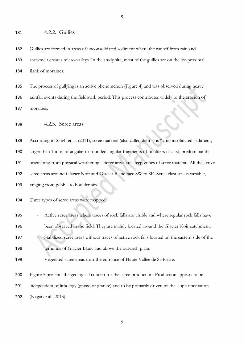
4.1.1. Glacier outlines 141
Glaciers were identified using the following definition: “mass of ice presenting active flow 142
pattern” which is a simplified version of the GLIMS definition (Rau et al., 2005). This definition 143
was used as a guide to outline digitization of both glaciers, although defining the lateral and 144
frontal boundaries was easier for Glacier Blanc (i.e., between clean ice and proglacial debris) than 145
for the ablation area of Glacier Noir, where the debris cover makes the identification of the 146
glacier limit (Figure 2) and flow patterns more difficult (Cogley et al., 2011; Paul et al., 2013). 147
4.1.2. Debris cover 148
For this map, we defined debris cover as where there is no clean ice visible. The precise limits of 149
debris-covered areas are difficult to define because of the continuous variations in debris 150
concentration that are encountered in the field. In addition, the debris cover must have been 151
persistent, i.e. appearing in images separated by at least one year. By these criteria, no debris 152
cover was mapped on Glacier Blanc because the debris cover areas are temporary and localised, 153
and are rapidly buried by snow in the accumulation area, or removed from the surface through 154
crevasses in the ablation area. 155
4.1.3. Crevasses 156
Crevasses form when the extension strain exceeds a critical threshold (Vaughan, 1993) resulting 157
in fields of fractures with distinctive lengths and orientations. This fractured area is particularly 158

8
8
visible on the lower section of Glacier Blanc where the glacier changes direction and becomes 159
steeper. 160
On Glacier Noir, most of the crevasses are filled by debris that leaves only traces of the 161
crevasses visible on the surface. These crevasse traces create only low relief perturbations and are 162
consequently not visible by direct observation in the field. 163
4.1.4. Nunataks and bare-rock areas 164
Nunataks are areas of glaciers where the bedrock is exposed (Singh et al., 2011). Nunataks and 165
other bare-rock areas are mainly present on the south-facing side of Glacier Blanc. The locations 166
of these rock exposures vary, as they are dependent on the ice thickness and the ice flow. 167
Consequently, the features mapped are only those present when the aerial images were taken in 168
2013, as for streams (Section 4.3.2). 169
4.2. Geomorphological features 170
These features are all related to the former presence of a glacier. 171
4.2.1. Moraines 172
Moraines are landforms built by the deposition by glaciers of glacial sediments (Singh et al., 173
2011). There are many types of moraines (Bennett and Glasser, 2009); around Glacier Noir and 174
Glacier Blanc these are mostly frontal and lateral moraines and were mapped accordingly. 175
During the LIA, Glacier Noir and Glacier Blanc had a common terminus and produced a large 176
moraine, like many other alpine glaciers. This LIA frontal moraine has been partially washed 177
away by the proglacial stream, and currently, the only large LIA moraine intact is the lateral 178
moraine of Glacier Noir. This moraine is recognisable because of its large size compared to the 179
surrounding moraines (Figure 3). 180
9
9
4.2.2. Gullies 181
Gullies are formed in areas of unconsolidated sediment where the runoff from rain and 182
snowmelt creates micro-valleys. In the study site, most of the gullies are on the ice-proximal 183
flank of moraines. 184
The process of gullying is an active phenomenon (Figure 4) and was observed during heavy 185
rainfall events during the fieldwork period. This process contributes widely to the erosion of 186
moraines. 187
4.2.3. Scree areas 188
According to Singh et al. (2011), scree material (also called debris) is “Unconsolidated sediment, 189
larger than 1 mm, of angular or rounded angular fragments of boulders (clasts), predominantly 190
originating from physical weathering”. Scree areas are steep zones of scree material. All the active 191
scree areas around Glacier Noir and Glacier Blanc face SW to SE. Scree clast size is variable, 192
ranging from pebble to boulder-size. 193
Three types of scree areas were mapped: 194
- Active scree areas where traces of rock falls are visible and where regular rock falls have 195
been observed in the field. They are mainly located around the Glacier Noir catchment. 196
- Stabilized scree areas without traces of active rock falls located on the eastern side of the 197
terminus of Glacier Blanc and above the outwash plain. 198
- Vegetated scree areas near the entrance of Haute Vallée de St-Pierre. 199
Figure 5 presents the geological context for the scree production. Production appears to be 200
independent of lithology (gneiss or granite) and to be primarily driven by the slope orientation 201
(Nagai et al., 2013). 202

10
10
4.2.4. Hummocky terrain 203
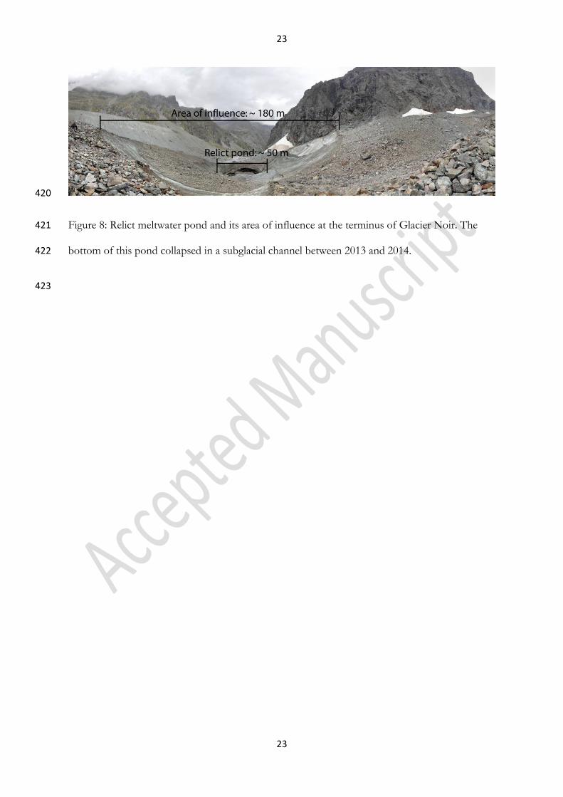
On the map, hummocky terrain (Figure 6) designates an assemblage of debris and glacial 204
sediment pits and mounds including small, possibly ice-cored moraines (Singh et al., 2011). 205
The hummocky terrain is located in the proglacial area of both glaciers and in a former lower 206
accumulation cirque of Glacier Noir Sud. Like gullies, these areas are particularly active and their 207
morphology evolves closely with the variation of the proglacial streams, especially during heavy 208
rainfall events. 209
4.2.5. Bedrock with incised channels 210
Large areas of bedrock (gneiss) with incised channels are visible in front of Glacier Blanc, 211
revealed as the glacier receded. Field observations confirm that some of the channels have 212
subglacial origins and are probably Nye channels. Nye channels (or N-Channels) are subglacial 213
channels directly carved into bedrock by meltwater discharge (Nye, 1973). .Most of the visible 214
channels are now abandoned except for those occupied by the glacier's main proglacial streams. 215
4.2.6. Outwash plain 216
An outwash plain is a large flat area covered with well-sorted glaciofluvial sediment. Braided 217
rivers often develop widely in outwash plains, for example in Iceland where they are called 218
“sandur” because of the predominance of sand- and gravel-sized sediment across such plains. 219
The proglacial streams of Glacier Noir and Glacier Blanc converge in the upper part of the 220
outwash plain to form a dynamic braided stream system as shown in Figure 7 at two different 221
dates. 222
4.3. Hydrological features 223
4.3.1. Meltwater ponds 224

11
11
Meltwater ponds are depressions on the ice surface that are filled with water released by the melt 225
of snow and ice. Numerous, often large, supraglacial meltwater ponds are a common feature on 226
debris-covered glaciers. Indeed, such ponds form the basis of one key classification of the 227
morphological evolution of debris-covered glaciers (Benn et al., 2012). 228
Meltwater ponds form by differential melting between debris-covered and clean ice areas. 229
Ablation of the latter is faster than the former, creating a depression – here called the area of 230
topographical influence – where water can be stored. This process involves a positive feedback 231
loop where the edge of the depression becomes steeper and so less debris-covered, inducing 232
further melting and consequently steepening of the side. This feedback loop gradually extends 233
the area of topographic influence of meltwater ponds. 234
However, these meltwater ponds are eventually drained supraglacially via a channel or englacially 235
via crevasses. The drainage process creates relict/trace ponds (Figure 8) where the difference 236
between the pond itself and the area of topographic influence is still visible. 237
4.3.2. Streams 238
Water streams on the study site are produced by the melt of glaciers. They are found in two 239
different positions: on the surface (supraglacial streams) and in front (proglacial streams) of both 240
glaciers. Due to the dynamics (water discharge, deposition of sediment) and ephemeral nature of 241
proglacial streams, especially in the outwash plain, only principal active channels were mapped, 242
illustrating the situation at the time the aerial images were acquired. 243
Supraglacial streams could only be observed on the debris-covered surface of Glacier Noir. Most 244
of the mapped streams were restricted to the ablation area. No visual expression of supraglacial 245
streams was found on aerial images of Glacier Blanc despite their presence in the field (Figure 9). 246
Therefore, supraglacial streams were not mapped on Glacier Blanc. 247

12
12
4.4. Anthropogenic features and elevation data 248
The Glacier Noir and Glacier Blanc site is a tourist attraction in the “Écrins” National Park and 249
so buildings (three refuges, one visitor centre and public restroom facilities), roads and hiking 250
trails were additionally mapped to provide context. 251
Contour lines from the IGN 1998 digital elevation model (DEM) were added as background 252
information. To clarify the topographical context of the map, arêtes lines were added on the 253
DEM as well as some altitude points. 254
5. Conclusion 255
We describe here a new glaciological and geomorphological map of Glacier Noir and Glacier 256
Blanc in the French Alps. The mapped features were divided into four different themes 257
(glaciological, geomorphological, hydrological and anthropogenic) to facilitate the understanding 258
of the map and future studies and comparisons. However, these four themes interact closely. 259
Glacier Noir and Glacier Blanc are the main actors of sediment transport and deposition, 260
creating a range of geomorphological features, from sand layers in the proglacial area to LIA 261
moraines. The streams are, on the contrary, the main actors of erosion on the surface of Glacier 262
Noir, acting to transfer sediment of the debris layer from the top of the glacier to the terminus, 263
as well as eroding the proglacial terrain of both glaciers to create an outwash plain further 264
downstream. Meltwater ponds are the perfect example of the interaction of glacial (melting of 265
debris-free ice cliffs), geomorphological (back wasting of debris from the layer) and hydrological 266
(storage and drainage of significant quantities of water) processes. Finally, anthropogenic features 267
such as roads and bridges modify erosional/depositional patterns in a complex way, especially in 268
the outwash plain. 269

13
13
Understanding these processes and their interactions is part of a larger research project on the 270
impact of variations in supraglacial debris cover on glacier evolution and dynamic response to 271
climatic forcing. 272
Acknowledgements 273
The aerial images and orthophotographs were provided by the French National Institute of 274
Geographic and Forestry Information under an education and research licence. The fieldwork 275
season was possible thanks to the “Ecrins” National Park (activity authorisation 060/2014) and 276
has been funded by the British Society for Geomorphology under the Postgraduate Research 277
Grant programme and by the Department of Geography and Earth Sciences of Aberystwyth 278
University under the Postgraduate Discretionary Research Fund programme. 279
We would like to thank Stephen Jennings for his useful comments on the map and Patricia 280
Gongal for her helpful comments on the manuscript. 281
Software 282
Mapping and composing: QGIS 2.2, 2.4, 2.6, and 2.6.1. 283
Digitizing tools (up to date version): autoSaver plugin, Digitizing Tools plugin, GdalTools 284
plugin, Georeferencer GDAL plugin, GPS Tools plugin, Multipart Split plugin. 285
Figures on the map: Adobe Illustrator CS2 286
References 287
ALLIX, A. 1922. Les glaciers des Alpes françaises en 1921. Revue de géographie alpine, 10, 325-333. 288 ALLIX, A. 1929. Observations glaciologiques faites en Dauphiné jusqu'en 1924. Les Études 289
rhodaniennes, 5, 185-186. 290 BENN, D. I., BOLCH, T., HANDS, K., GULLEY, J., LUCKMAN, A., NICHOLSON, L. I., QUINCEY, D., 291
THOMPSON, S., TOUMI, R. & WISEMAN, S. 2012. Response of debris-covered glaciers in the 292 Mount Everest region to recent warming, and implications for outburst flood hazards. Earth-293 Science Reviews, 114, 156-174. 294

14
14
BENNETT, M. M. & GLASSER, N. F. 2009. Glacial geology: ice sheets and landforms, John Wiley & 295 Sons. 296
CARRASCO, R. M., PEDRAZA, J., DOMINGUEZ-VILLAR, D., WILLENBRING, J. K. & VILLA, J. 2013. 297 Supraglacial Debris Supply in the Cuerpo de Hombre paleoglacier (Spanish Central System): 298 Reconstruction and Interpretation of a Rock Avalanche Event. Geografiska Annaler Series a-299 Physical Geography, 95, 211-226. 300
COGLEY, J. G., HOCK, R., RASMUSSEN, L. A., ARENDT, A. A., BAUDER, A., BRAITHWAITE, R. J., 301 JANSSON, P., KASER, G., MOLLER, M., NICHOLSON, L. & ZEMP, M. 2011. Glossary of Glacier 302 Mass Balance and Related Terms. IHP-VII Technical Documents in Hydrology, 86. 303
COSSART, E., FORT, M., JOMELLI, V. & GRANCHER, D. 2006. Les variations glaciaires en Haute-304 Durance (Briançonnais, Hautes-Alpes) depuis la fin du xix e siècle: mise au point d'après les 305 documents d'archives et la lichénométrie. Quaternaire, 17, 75-92. 306
DELINE, P. & KIRKBRIDE, M. P. 2009. Rock avalanches on a glacier and morainic complex in Haut Val 307 Ferret (Mont Blanc Massif, Italy). Geomorphology, 103, 80-92. 308
ÉCRINS, P. N. D. 2005. Territoire Écrins - Les Cahiers Thematiques du Parc National: Les glaciers. In: 309 ÉCRINS, P. N. D. (ed.). 310
GOODSELL, B., HAMBREY, M. J. & GLASSER, N. F. 2005. Debris transport in a temperate valley glacier: 311 Haut Glacier d'Arolla, Valais, Switzerland. Journal of Glaciology, 51, 139-146. 312
HAMBREY, M. J. & EHRMANN, W. 2004. Modification of sediment characteristics during glacial 313
transport in high‐alpine catchments: Mount Cook area, New Zealand. Boreas, 33, 300-318. 314 HAMBREY, M. J., QUINCEY, D. J., GLASSER, N. F., REYNOLDS, J. M., RICHARDSON, S. J. & CLEMMENS, 315
S. 2008. Sedimentological, geomorphological and dynamic context of debris-mantled 316 glaciers, Mount Everest (Sagarmatha) region, Nepal. Quaternary Science Reviews, 27, 2361-317 2389. 318
HEWITT, K. 2009. Rock avalanches that travel onto glaciers and related developments, Karakoram 319 Himalaya, Inner Asia. Geomorphology, 103, 66-79. 320
JACOB, T., WAHR, J., PFEFFER, W. T. & SWENSON, S. 2012. Recent contributions of glaciers and ice 321 caps to sea level rise. Nature, 482, 514-518. 322
LETREGUILLY, A. & REYNAUD, L. 1989. Past and forecast fluctuations of glacier Blanc (French Alps). 323 Annals of Glaciology, 13, 159-163. 324
MANN, M. E. 2002. Little ice age. Encyclopedia of global environmental change. John Wiley & Sons. 325 MARANGUNIC, C. 1972. Effects of a landslide on Sherman Glacier, Alaska. Institute of Polar Studies. 326 MOUNT, N. & STOTT, T. 2008. A discrete Bayesian network to investigate suspended sediment 327
concentrations in an Alpine proglacial zone. Hydrological Processes, 22, 3772-3784. 328 NAGAI, H., FUJITA, K., NUIMURA, T. & SAKAI, A. 2013. Southwest-facing slopes control the formation 329
of debris-covered glaciers in the Bhutan Himalaya. Cryosphere, 7, 1303-1314. 330 NYE, J. F. 1973. Water at the bed of a glacier. Hydrology of Glaciers. Cambridge: IASH Publisher. 331 OTTO, J. C. & SMITH, M. J. 2013. Geomorphological mapping. Geomorphological Techniques. British 332
Society for Geomorphology. 333 PAUL, F., BARRAND, N. E., BAUMANN, S., BERTHIER, E., BOLCH, T., CASEY, K., FREY, H., JOSHI, S. P., 334
KONOVALOV, V., LE BRIS, R., MOLG, N., NOSENKO, G., NUTH, C., POPE, A., RACOVITEANU, A., 335 RASTNER, P., RAUP, B., SCHARRER, K., STEFFEN, S. & WINSVOLD, S. 2013. On the accuracy of 336 glacier outlines derived from remote-sensing data. Annals of Glaciology, 54, 171-182. 337
QGIS, D. T. 2014. QGIS Geographic Information System [Online]. http://www.qgis.org/: Open Source 338 Geospatial Foundation Project. http://qgis.osgeo.org. 339
RABATEL, A., DEDIEU, J. P. & REYNAUD, L. 2002. Reconstitution des fluctuations du bilan de masse du 340 Glacier Blanc (Massif des Écrins, France) entre 1985 et 2000, par télédétection optique 341 (imagerie Spot et Landsat). La Houille Blanche, 2002, 64-71. 342
RABATEL, A., DEDIEU, J. P., THIBERT, E., LETREGUILLY, A. & VINCENT, C. 2008. 25 years (1981–2005) 343 of equilibrium-line altitude and mass-balance reconstruction on Glacier Blanc, French Alps, 344 using remote-sensing methods and meteorological data. Journal of Glaciology, 54, 307314. 345

15
15
RABATEL, A., LETREGUILLY, A., DEDIEU, J. P. & ECKERT, N. 2013. Changes in glacier equilibrium-line 346 altitude in the western Alps from 1984 to 2010: evaluation by remote sensing and modeling 347 of the morpho-topographic and climate controls. Cryosphere, 7, 1455-1471. 348
RAU, F., MAUZ, F., VOGT, S., KHALSA, S. & RAUP, B. 2005. Illustrated GLIMS Glacier Classification 349 Manual, Version 1.0. GLIMS Regional Centre,“Antarctic Peninsula”, GLIMS (Global Land Ice 350 Measurement from Space), NSIDC. 351
REYNAUD, L. & VINCENT, C. 2000. Relevés de fluctuations sur quelques glaciers des Alpes françaises. 352 La Houille Blanche, 2000, 79-86. 353
REYNAUD, L. & VINCENT, C. 2002. Histoire des fluctuations des glaciers en remontant le Petit Age de 354 Glace. La Houille blanche, 2002, 16-19. 355
REZNICHENKO, N., DAVIES, T., SHULMEISTER, J. & MCSAVENEY, M. 2010. Effects of debris on ice-356 surface melting rates: an experimental study. Journal of Glaciology, 56, 384-394. 357
REZNICHENKO, N. V., DAVIES, T. R. H. & ALEXANDER, D. J. 2011. Effects of rock avalanches on glacier 358 behaviour and moraine formation. Geomorphology, 132, 327-338. 359
REZNICHENKO, N. V., DAVIES, T. R. H., SHULMEISTER, J. & WINKLER, S. 2012. Influence of rock 360 avalanches upon the formation of moraines and their subsequent palaeoclimatic 361 interpretation: a critical appraisal. Zeitschrift Fur Geomorphologie, 56, 37-54. 362
SAKAI, A., TAKEUCHI, N., FUJITA, K. & NAKAWO, M. Role of supraglacial ponds in the ablation process 363 of a debris-covered glacier in the Nepal Himalayas. Debris-covered Glaciers: Proceedings of 364 an International Workshop Held at the University of Washington in Seattle, Washington, 365 USA, 13-15 September 2000, 2000. IAHS, 119-132. 366
SHUGAR, D. H., RABUS, B. T., CLAGUE, J. J. & CAPPS, D. M. 2012. The response of Black Rapids 367 Glacier, Alaska, to the Denali earthquake rock avalanches. Journal of Geophysical Research-368 Earth Surface, 117, 14. 369
SHULMEISTER, J., DAVIES, T. R., EVANS, D. J. A., HYATT, O. M. & TOVAR, D. S. 2009. Catastrophic 370 landslides, glacier behaviour and moraine formation – A view from an active plate margin. 371 Quaternary Science Reviews, 28, 1085-1096. 372
SINGH, V. P., SINGH, P. & HARITASHYA, U. K. 2011. Encyclopedia of snow, ice and glaciers, Springer. 373 STOTT, T. & MOUNT, N. 2007. Alpine proglacial suspended sediment dynamics in warm and cool 374
ablation seasons: Implications for global warming. Journal of Hydrology, 332, 259-270. 375 THIBERT, E., FAURE, J. & VINCENT, C. 2005. Bilans de masse du Glacier Blanc entre 1952, 1981 et 376
2002 obtenus par modèles numériques de terrain. La Houille Blanche, 2005, 72-78. 377 TOVAR, D. S., SHULMEISTER, J. & DAVIES, T. R. 2008. Evidence for a landslide origin of New Zealand’s 378
Waiho Loop moraine. Nature Geoscience, 1, 524-526. 379 VACCO, D. A., ALLEY, R. B. & POLLARD, D. 2010. Glacial advance and stagnation caused by rock 380
avalanches. Earth and Planetary Science Letters, 294, 123130. 381 VAUGHAN, D. G. 1993. Relating the occurrence of crevasses to surface strain rates. Journal of 382
Glaciology. 383 VIVIAN, R. 1967a. Le glacier Blanc. Revue de géographie alpine, 55, 729732. 384 VIVIAN, R. 1967b. Le glacier Noir. Revue de géographie alpine, 55, 733736. 385 WGMS & NSIDC 1989, updated 2012. World Glacier Inventory. Compiled and made available by the 386
World Glacier Monitoring Service, Zurich, Switzerland, and the National Snow and Ice Data 387 Center, Boulder CO, U.S.A. 388
389

16
16
Figures 390
391
Figure 1: Overview map presenting the position of the study site (red rectangle) in “Écrins” 392
National Park (solid black line). Background map: IGN ©SCANREGIONAL. Inset: location 393
(red marker) of the study site in the European Alps. Background image: ©NASA. 394
17
17
395
Figure 2: Extract of 2013 orthophotograph illustrating the difficulties in determining the edge of 396
Glacier Noir, especially in the area between the northern border and the LIA moraine. 397

18
18
398
Figure 3: Glacier Noir (white dotted line) and its LIA moraine (black dashed line). The LIA 399
moraine is the largest geomorphological feature i the study site and its ridge is constantly ~50-60 400
m above the surface of the glacier from the terminus to the headwall. 401

19
19
402
Figure 4: The new gullies (white arrows) created during a heavy rainfall event (26/08/2014) on 403
the southern side of the LIA moraine of Glacier Noir. 404

20
20
405
Figure 5: Geological map of the study site with superimposed scree areas. Geological variations 406
(mainly gneiss except for Glacier Noir Sud with granite) in the study area cannot explain the 407
origin of the scree areas. Slope orientation is the main factor in the scree production. Adapted 408
from Bureau de Recherche Géologiques et Minières (BRGM) maps 0822N and 0823N. 409

21
21
410
Figure 6: Hummocky terrain in the proglacial area of Glacier Blanc. The hummocky moraine 411
(green) are easily eroded by the proglacial stream. The frontal moraine (white) marks the lower 412
limit of this hummocky area. 413
414

22
22
415
Figure 7: Outwash plain of Glacier Noir and Glacier Blanc. As a consequence of the heavy 416
rainfall event of 26th August 2014, the proglacial stream shifted from the northern edge of the 417
outwash plain to the southern edge, illustrating this highly dynamic environment. 418
419
23
23
420
Figure 8: Relict meltwater pond and its area of influence at the terminus of Glacier Noir. The 421
bottom of this pond collapsed in a subglacial channel between 2013 and 2014. 422
423

24
24
424
Figure 9: Various meltwater channels in the study area. (A) Active meltwater channel just below 425
the accumulation area of Glacier Noir. (B) Trace of meltwater channels in the ablation area of 426
Glacier Noir. (C) Active meltwater channels on Glacier Blanc highlighted by pink dye. Note the 427
difference in scale between these images. 428
Copyright © 2022 FDOKUMEN