Availability of Coal Resources in Illinois: Mt. Carmel Quadrangle, Southeastern Illinois
Upload
khangminh22Category
view
0download
0
Geologic Map of the McCartys
7.5-Minute Quadrangle, Cibola County, New
Mexico
By
Colin T. Cikoski1, Paul G. Drakos2, and James W. Riesterer2
1 New Mexico Bureau of Geology and Mineral Resources, 801 Leroy Place, Socorro, NM 87801
2Glorieta Geoscience, Inc., P.O. Box 5727, Santa Fe, NM 87502-5727
June, 2017
New Mexico Bureau of Geology and Mineral Resources
Open-File Geologic Map OF-GM 265
Scale 1:24,000
This work was supported by the U.S. Geological Survey, National Cooperative
Geologic Mapping Program (STATEMAP) under USGS Cooperative Agreement
G16AC00287 and the New Mexico Bureau of Geology and Mineral Resources.
New Mexico Bureau of Geology and Mineral Resources
801 Leroy Place, Socorro, New Mexico, 87801-4796
The views and conclusions contained in this document are those of the author and
should not be interpreted as necessarily representing the official policies,
either expressed or implied, of the U.S. Government or the State of New Mexico.
1
Table of Contents 1. Introduction .......................................................................................................................................... 3
1.1. Geologic and geographic setting ................................................................................................... 3
1.2. Previous work................................................................................................................................ 3
1.3. General terminology notes ........................................................................................................... 3
1.4. Acknowledgements ....................................................................................................................... 4
2. Middle-Late Cenozoic Geology ............................................................................................................. 5
2.1. Alluvial deposits ............................................................................................................................ 5
2.1.1. Soils ....................................................................................................................................... 6
2.2. Igneous Geology ............................................................................................................................ 6
3. Cretaceous geology ............................................................................................................................... 9
3.1. Mancos Shale ................................................................................................................................ 9
3.2. Crevasse Canyon Formation ....................................................................................................... 10
3.3. Gallup Sandstone ........................................................................................................................ 10
3.4. Dakota Sandstone ....................................................................................................................... 11
4. Structure ............................................................................................................................................. 12
5. Hydrology ............................................................................................................................................ 14
5.1. Springs ......................................................................................................................................... 14
6. References cited.................................................................................................................................. 15
7. Tables .................................................................................................................................................. 18
Table 1: Summary of geochronologic data for the McCartys 7.5-minute quadrangle ................... 19
8. Figures ................................................................................................................................................. 20
Figure 3-1: Stratigraphic section measured through fan unit Qf2 .................................................. 20
Figure 3-2: Stratigraphic section measured through fan unit Qf4 .................................................. 21
Figure 3-3: Stratigraphic section measured through Qal in Cañon Largo ....................................... 21
Figure 3-4: Fracture control in upper Cañon del Conejo ............................................................... 22
Figure 3-5: Recent arroyo incision in unnamed canyon west of abandoned airfield on McCarty
Mesa ................................................................................................................................................ 23
Figure 3-6: Stratigraphic section measured through Qasw in Cañon Largo ................................... 24
Figure 5-1: Stereonet of structural measurements in an outcrop of the Black Mesa Road fault... 25
Figure 5-2: Stereonet of structural measurements in an outcrop of the Airport Road fault. ........ 26
Figure 5-3: Photo of an outcrop of the Airport Road fault ............................................................. 27

2
3
1. Introduction
1.1. Geologic and geographic setting The McCartys quadrangle lies a few kilometers (km) east-southeast of the town of Grants along I-
40 in northwestern New Mexico. Over half the quadrangle lies on Pueblo of Acoma land, while the
remainder is a mix of private ranch land, BLM, and minor state of New Mexico land. The Rio San Jose river
valley roughly bisects the quadrangle along an east-west transect. The northeast quarter of the
quadrangle lies mainly on the broad, low-relief southern piedmont of Mount Taylor, and is traversed
south-southeastward by Rinconada Creek. The northwest quarter of the quadrangle is dominated by
Horace Mesa, a broad “prong” of the Mount Taylor highland capped by Plio-Pleistocene basalt flows. The
south half of the quadrangle consists of low sandstone-capped mesas separated by broad alluvial valleys.
Elevations ranges from about 1,854 meters (m) above mean sea level (amsl) where the Rio San Jose exits
the quadrangle to a high of about 2,336 m amsl on Horace Mesa.
Geologically, the quadrangle lies in the Acoma Sag section of the Colorado Plateau along the
eastern limb of the McCartys syncline (Woodward, 1982), along or just south of the Jemez lineament and
to the south of the Mount Taylor volcanic field and east of the Zuni-Bandera volcanic field. The majority
of the quadrangle is underlain by clastic Mesozoic strata capped by a variable thickness of Pliocene to
Holocene basalts and Quaternary alluvial cover. Structural relief is generally low.
1.2. Previous work Early studies concerning the McCartys area include the reconnaissance work of Dutton (1885) and
mapping of the Mount Taylor coal field by Hunt (1936). A concerted geologic mapping and stratigraphic
study effort was performed in the 1960’s through 1980’s by the United States Geological Survey (USGS)
in support of uranium resource development. Maxwell (1977) mapped the McCartys quadrangle during
this period, utilizing the stratigraphy established previously by Dutton, Hunt, and mappers on surrounding
quadrangles as well as by new research by Landis et al. (1973). Hook et al. (1983) and Molenaar (1983)
would subsequently further refine the Cretaceous stratigraphy above the Dakota Sandstone.
Largely simplified in earlier geologic studies, the Cenozoic section received renewed interest in
the 1980’s and 1990’s as a part of larger-scale studies of the volcanic and landscape history of the Mount
Taylor and Zuni-Bandera areas (e.g., Drakos et al., 1991; Laughlin et al., 1993). Refinement of this
chronology continues sporadically to this day (e.g., Cascadden et al., 1997; Channer et al., 2015; Dunbar
and Phillips, 2004; Goff et al., 2015; Laughlin and WoldeGabriel, 1997).
More recent geologic mapping efforts by the New Mexico Bureau of Geology and Mineral
Resources (NMBGMR) concentrated on the Mount Taylor area (synthesized by Goff et al., 2015) and
subsequently proceeded down the Rio San Jose from Grants. This report synthesizes these previous
studies with original geologic mapping from the 2015-17 seasons to provide an up-to-date geologic
product for the McCartys quadrangle.
1.3. General terminology notes Geologic terms are after Compton (1985), soil terms after Birkeland (1999), carbonate horizon
stages after Gile et al. (1966) and Machette (1985), and color notation after Munsell Color (2009).
Coordinates are given in Universal Transverse Mercator (UTM) coordinates after the NAD83 Zone 13S
datum.
4
1.4. Acknowledgements We thank J. Michael Timmons, Geologic Mapping Program Manager at the NMBGMR, and the
USGS STATEMAP program for funding to conduct this study. We thank the Governor and Council of the
Pueblo of Acoma for permission to work on pueblo lands. Steve Juanico (Water Rights Office), Franklin
Martinez (Department of Natural Resources), and Emilio Torivio (Department of Natural Resources) were
instrumental in obtaining permission to work on Pueblo of Acoma lands. We also thank Chris Gutierrez,
manager of the Diamond G Ranch, for permission to work on his ranch lands. Cartography was provided
by the NMBGMR map production group, coordinated by Phil Miller. Stereonet figures were generated
using Stereonet 8 by R. W. Allmendinger and N. C. Cardozo (Allmendinger et al., 2012; Cardozo and
Allmendinger, 2013).

5
2. Middle-Late Cenozoic Geology
2.1. Alluvial deposits Mapping of surficial deposits follows the style and terminology developed by Grimm (1983),
Drakos et al. (1991), Osburn et al. (2009), and Cikoski et al. (2016). Quaternary sediments include fluvial
terrace, alluvial fan deposits, and valley floor alluvium. Quaternary deposits contain a predominance of
volcanic clasts of mixed lithologies, secondary Cretaceous sandstone clasts, and minor chert pebbles. Fan
units Qf1-Qf4, mapped in the northeastern part of the Quadrangle and north of the Rio San Jose, form
the distal part of a fan complex at the mouth of canyons draining the south side of Mt. Taylor, including
Rinconada Canyon on the McCartys Quadrangle. Deposition of the Water Canyon fan east of the McCartys
Quadrangle, which began by early Pleistocene time (correlative fine-grained deposits exhibit reversed
polarity; Drakos et al. (1991)), record incision into the volcanic edifice, erosion of the amphitheater on Mt
Taylor, and episodic piedmont aggradation, incision, and stabilization (Drakos and Riesterer, 2013). The
piedmont has been extensively dissected since initial fan deposition, therefore Qf1 and Qf2 surfaces are
preserved as relatively small remnants. Qf1 deposits underlie fan surfaces 30 to 35 m above local base
level west of Rinconada Creek and are approximately 13 m thick with a basal contact on the Twowells
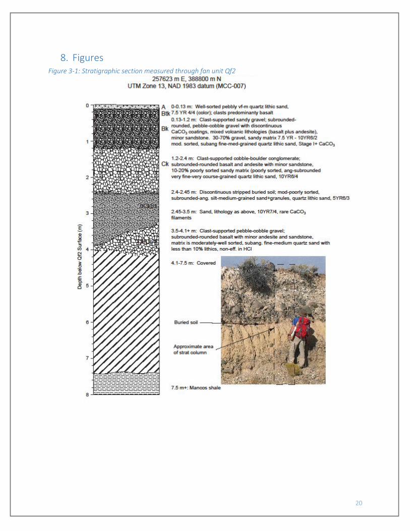
Tongue of the Dakota Sandstone (map unit Kdt). Qf2 deposits are up to 8 m thick and include a partially
stripped surficial soil with an A-Btk-Bk profile, buried soils, and multiple depositional units, indicating
deposition over a relatively long time period (FIGURE 3-1). Qf3 is preserved as a single isolated fan
remnant within the McCartys Quadrangle west of Rinconada Creek. Much of the modern piedmont in the
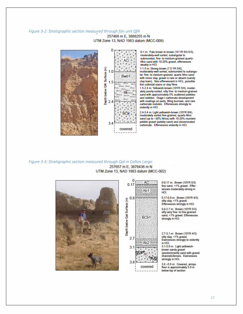
distal part of the fan complex is composed of Qf4 surfaces. Qf4 deposits exhibit weakly developed soils
indicating a likely Holocene age for this deposit (FIGURE 3-2). Aggradation of the modern piedmont
including Qf4 is likely a result of aggradation along the Rio San Jose valley associated with eruption of the
0.38 to 0.128 Ma Laguna flow (Lipman and Menhert, 1979; Champion et al., 1988) and the 0.325 Ma
Laguna Pueblo flow (Channer et al., 2015), which flowed eastward down the Rio San Jose drainage from
the Zuni-Bandera volcanic field to the west.
Deposits underlying terrace surfaces along Rio San Jose are preserved as isolated erosional
remnants along the modern Rio San Jose drainage. Qt1 (not preserved as a mappable unit on the
McCartys Quadrangle) includes axial Rio San Jose gravel and tributary gravel facies approximately 7 m
thick, and overlies the Cubero Sandstone Tongue of the Dakota Sandstone (map unit Kdc) on Woods Mesa
south of the Rio San Jose on the adjacent Cubero Quadrangle. Qt2 is a strath terrace approximately 6.5
m thick with local channels up to 10 m thick comprising sandy gravel deposits overlying the Paguate
Tongue (Kdp) north of the Rio San Jose. Qt3 includes two small erosional remnants overlying the Cubero
Tongue of the Dakota Sandstone and the Mancos Shale.
Valley floor alluvium in tributary drainages is composed primarily of fine-grained sand, silt and
clay with gravel lenses, weakly-developed surficial soils, and buried soils distinguished primarily by A
horizon development (FIGURE 3-3). Thickness of various alluvial deposits, based on well log data (Risser
and Lyford, 1984) and outcrop descriptions ranges from 5-20 m in tributary drainages to 30 to 50 m under
the Rio San Jose valley floor. Rio San Jose alluvium includes coarse-grained sandy gravel sections and is
interbedded with a 12 m to 18 m thick basalt flow (likely the Laguna Pueblo flow; cf., Channer et al., 2015),
encountered 6 m to 25 m below the valley floor (Risser and Lyford, 1984).
The fan and terrace units described above are not present south of the Rio San Jose on the
McCartys Quadrangle. Unit Qpal likely represents an early Pleistocene pediment deposit derived from
6
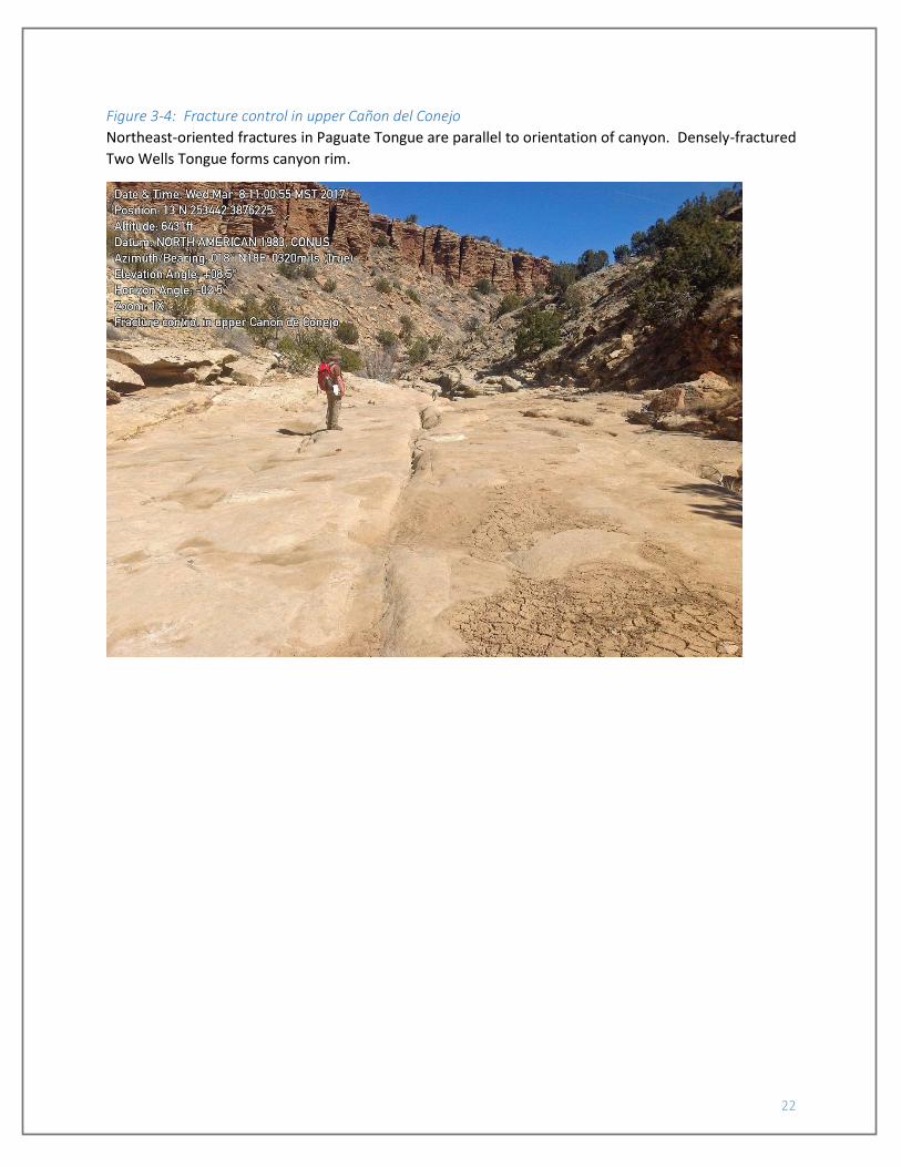
source areas to the south. Lumber and Conejo Canyons appear to have eroded along predominant east-
and northeast-oriented fracture sets in the Twowells and Paguate Tongues of the Dakota Sandstone
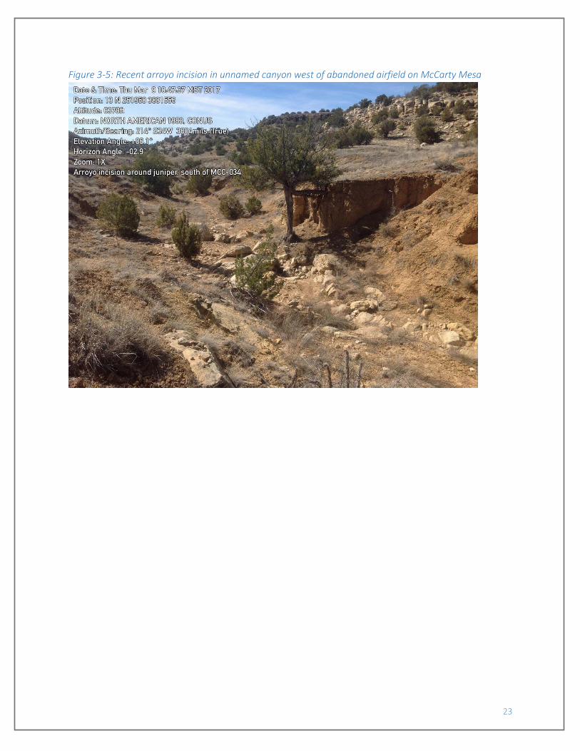
(FIGURE 3-4). Arroyo incision into canyon floors tributary to the Rio San Jose is recent (less than 100 years
old), as shown by juniper trees now suspended on root pedestal above the modern arroyo floor (FIGURE
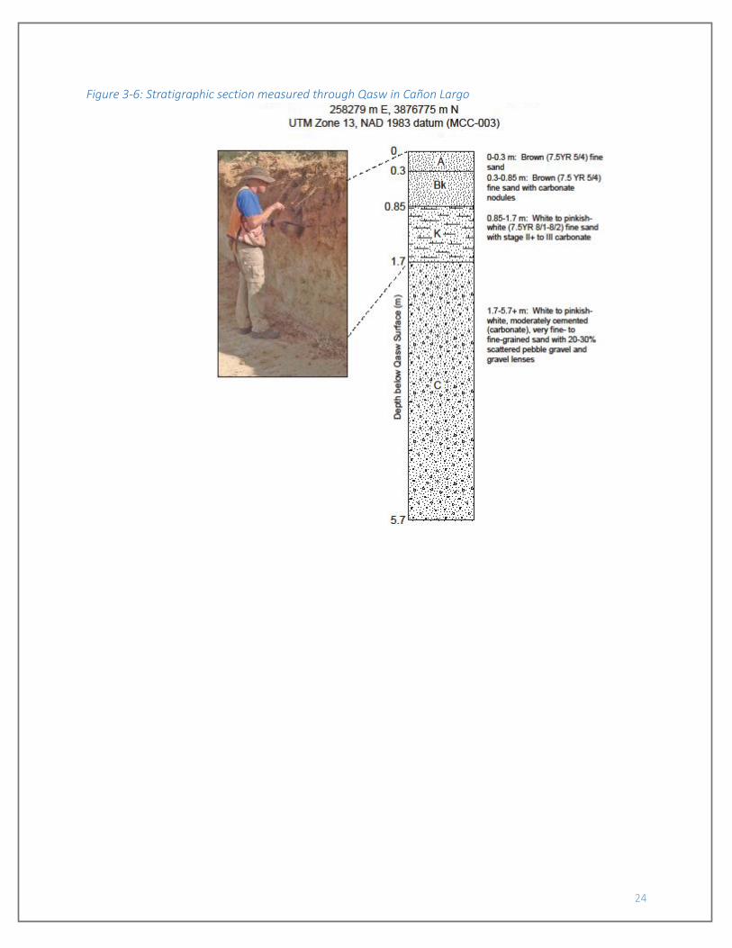
3-5). Slopes below mesa tops are commonly mantled by slopewash deposits (unit Qasw), which are up to
6 m thick and exhibit a well-developed carbonate horizon (FIGURE 3-6), indicating deposition over a
relatively long time period of as much as 100,000 years.
The Pliocene and Quaternary deposits and associated geomorphic surfaces in the Mt. Taylor area
record a history of long-term incision interrupted by periods of deposition and formation of geomorphic
surfaces during times of base level stability. In contrast to the overall Pliocene-Quaternary history, the
late Quaternary has been characterized by alternating periods of erosion and deposition. Approximately
200-300 m of incision into the Pliocene pediment surface underlying the high basalts along the southern
flank of Mount Taylor has occurred between 2.5 Ma and the present time, likely in response to regional
uplift (cf., Drakos et al., 1991). Periods of erosion and deposition during the late Quaternary are likely in
response to climatic fluctuations, continued regional uplift, and/or episodic volcanism in the Zuni-Bandera
volcanic field periodically blocking drainages (Drakos and Riesterer, 2013).
2.1.1. Soils The semiarid climate of the Grants-Laguna area and the regional carbonate dust influx has favored
the development of carbonate soils. Soils were described based on methods described in Birkeland
(1999). Carbonate morphology and Bt horizon development are the morphologic characteristics which
best distinguish soils in the Grants-Laguna area. Carbonate soils in the study area and the adjacent Cubero
Quadrangle (Cikoski et al., 2016) exhibit Stage I through III carbonate morphology (terminology after Gile
et al. (1966) and Machette (1985)). Colors range from 5YR to 2.5Y, soil structure ranges from massive to
strong subangular blocky or prismatic, and clay film morphology ranges from absent to thin, with common
coatings on ped faces.
2.2. Igneous Geology Exposed within the McCartys quadrangle are Plio-Pleistocene basalts of the Mount Taylor volcanic
field, Pleistocene-Holocene basalts of the Zuni-Bandera volcanic field, a late Oligocene dike, and several
undated dikes likely associated with one or more of these igneous periods.
The oldest exposed igneous rock is the Acomita dike (unit Tbda) of Laughlin et al. (1983), a north-
northwest-trending basaltic andesite dike that can be followed for approximately 10 km across this
quadrangle and into neighboring quadrangles. On the McCartys quadrangle, it is aphanitic to weakly
porphyritic, with rare fine (commonly <1 mm across) phenocrysts of fine plagioclase and lesser pyroxene.
Very locally, megacrysts (or xenocrysts or crystal aggregates) of plagioclase up to 1 cm across, anhedral,
rounded, and oblate in shape, are found. The dike is generally poorly exposed, forming rounded ridges in
the southern and central portions of the quadrangle, and only locally cropping out in the northern part of
the quadrangle in Tafoya Canyon. Where exposed, the dike is commonly strongly jointed. Where the dike
is thin, the jointing is principally subvertical or steeply-dipping and parallel to dike margins; where thick,
the jointing is commonly perpendicular to dike margins and columnar, and likely related to cooling.
7
Locally, thin sills extend out from the dike margins into surrounding wall rock units, usually where
intruding shales. Aldrich et al. (1986) report a K-Ar age of 30.7 ± 1.4 Ma for the dike (TABLE 1). Mesozoic
strata are offset down-to-the-southwest by up to about 8 m across the dike, indicating the dike collocates
with a fault. Offset is apparent across nearly the entire extent of the dike within the quadrangle. It is not
clear the relative timing of slip and dike intrusion.
Plio-Pleistocene basalts associated with the Mount Taylor volcanic field, located mainly to the
north of the quadrangle, cap Horace Mesa in the northwest quarter of the quadrangle. Extensive 40Ar/39Ar
dating by Goff et al. (2015) indicate the field as a whole extends from the Lower Pliocene into the Lower
Pleistocene. Within the McCartys quadrangle, the basal flow in the southeast corner of Horace Mesa has
been dated twice, to 2.72 ± 0.1 Ma by the 40Ar/39Ar method (Channer et al., 2015) and to 3.24 ± 0.17 Ma
by the K-Ar method (Laughlin et al., 1993; TABLE 1), placing the lowest flow on Horace Mesa in the Upper
Pliocene; the upper flows have not been dated.
Up to three flows may be distinguished beneath Horace Mesa based on flow breaks. However,
the lower two are identical in texture and mapped together (unit Tbp). The lower two, plagioclase-
pyroxene porphyritic flows only crop out along the southeastern portion of the on-quad Horace Mesa, as
well as beneath a nearby, unnamed mesa to the east. In one location along the eastern flank of Horace
Mesa (approximately 253940 m E, 3888690 m N), a buttress unconformity is exposed separating the basalt
from Cretaceous strata, with a strike of N40E and dip of 68° to the SE. The restricted extent of the flows
and exposed steeply-dipping buttress contact suggest the flows filled a paleocanyon carved into the
underlying Cretaceous strata. The upper, mainly aphanitic flow (unit QTbf) is more extensive, capping
most of Horace Mesa and the adjacent unnamed mesa. A roughly circular break in the basalt occurs
around 253180 m E, 3888060 m N, where Cretaceous strata occur at the surface underlying a topographic
basin. This break is inferred to have been a topographic high during the eruption of QTbf, causing the flow
to divert around this area. Subsequent erosion preferentially removed the softer Cretaceous strata,
eroding the former hill or cuesta to a basin. Basalt flows are cut by northeast-trending normal faults with
up to about 50 m of offset.
Basalts of the Zuni-Bandera volcanic field are represented at the surface by the El Calderon (Qbc)
and McCartys (Qbm) flows (names after Maxwell, 1986), which can be followed westward up the Rio San
Jose valley then southward into the El Malpais to centers to the southwest of the quadrangle. Each is
weakly porphyritic, bearing fine phenocrysts of olivine and pyroxene. The younger McCartys flow is largely
exposed with primary flow features well-preserved, while the older El Calderon flow is blanketed by a
variable thickness of eolian and alluvial sediments. Both have been the subject of multiple attempts at
age dating. The age of the McCartys flow is well-constrained to 2.4 to 3.9 ka (Laughlin et al., 1994; Dunbar
and Phillips, 2004; TABLE 1), while the age of the El Calderon flow is less well-constrained, with accepted
estimates between 34.7 and 128 ka (Champion et al., 1988; Laughlin et al., 1993; Cascadden et al., 1997;
Dunbar and Phillips, 2004; TABLE 1). In addition to these flows at the surface, at least one basalt flow is
commonly encountered in wells drilled along the Rio San Jose between the El Malpais and the town of
Laguna (cf., Risser and Lyford, 1983, 1984). Channer et al. (2015) obtained 40Ar/39Ar ages on Zuni-Bandera
basalts at the surface and from dill holes, and acquired nearly-identical ages for the Laguna Pueblo flow
cropping out by the town of Laguna (322 ± 1 ka) as for a basalt encountered in a drill hole drilled in the
Rio San Jose valley just west of the quadrangle boundary (325 ± 4 ka). Based on this observation, it is
plausible that the basalt occurring in the subsurface intercalated into Rio San Jose alluvium is the Laguna
Pueblo flow (Qblp, shown on cross-section A-A’).

8
Finally, several thin, variably plagioclase-pyroxene±olivine porphyritic dikes (QTbpd) occur in the
southeastern corner of the quadrangle. These dikes are west-northwest- to north-northwest-trending,
and could be associated with emplacement of the Acomita dike, or could be radial dikes extending
outward from the Mount Taylor volcanic field.
9
3. Cretaceous geology We reviewed the history of the Cretaceous stratigraphy in this general region in our report on the
geology of the Cubero quadrangle (Cikoski et al., 2016), and more detail on the stratigraphy can be found
there. In a very broad sense, the Cretaceous system consists of interbedded sandstones, shales, lesser
mudstones-siltstones, and a few limestones associated with the Western Interior Seaway. The Cretaceous
section is capped by a substantial unconformity, and no rocks younger than the Crevasse Canyon
Formation are preserved on this quadrangle.
3.1. Mancos Shale The Mancos Shale in this area consists of multiple tongues of poorly-exposed gypsiferous shales
with rare sandy shales and trace sandstones, limestones, and sparry gypsum beds. The Mancos
intertongues with all the other Cretaceous units. Nomenclature is based largely on stratigraphic location,
and is after Hunt (1936), Landis et al. (1973), and Hook et al. (1983). We additionally employ an undivided
upper Mancos Shale unit (Kmu) in the poorly-exposed hills along Rinconada Creek, where stratigraphic
location is unclear.
Most tongues consist of gypsiferous shales with lesser siltstones and absent to rare sandy shales,
overlying a sharp basal contact with an underlying sandstone unit and grading upsection into an overlying
sandstone unit. Exceptions to this description are the Bridge Creek Limestone beds of the Rio Salado
Tongue (unit Kmb), Semilla Sandstone Member (Kms), and Mulatto Shale Tongue (Kmm). The Bridge Creek
Limestone beds (after Hook et al., 1983) consist of interbedded shales, limy shales, and fine-grained
carbonate grainstones and packstones, which weather to a distinct pale yellowish brown color (2.5Y 7/1
and 8/2-8/3 measured) that can often be used to map the unit through poorly-exposed slopes. Limestones
and limy shales are thickly laminated to thinly bedded, weathering to a platy residuum that is also
distinctive. As used on this quadrangle, the Bridge Creek Limestone map unit includes all shales between
the top of the Twowells Tongue of the Dakota Sandstone (Kdt) and the uppermost Bridge Creek bed.
The Semilla Sandstone Member (after Dane et al., 1968) consists mainly of concretionary shales
with rare, thin sandstones. The sandstone beds are muddy, very fine- to fine-grained, and commonly
internally planar- or cross-laminated. Sandstone bed thickness and abundance increase upsection, with
the top of the unit consisting of a 2-m-thick, laterally-extensive interval of thinly-bedded sandstones.
Underlying sandstone beds are typically lenticular, discontinuous, and often no more than a few
centimeters thick. Shales associated with these sandstones bear roughly spherical calcareous concretions
up to 70 cm in diameter, in an abundance and size not seen in the remaining Mancos Shale units. Similar
concretions were described by Dane et al. (1968) and Fleming (1989) for the shales of the Semilla
Sandstone Member in other locations, and this may to be a regionally-common distinguishing feature. As
a map unit, the Semilla Sandstone Member extends from the lowest Semilla sandstone bed to the highest
Semilla sandstone bed, including all intervening shales, between the top of the Twowells Tongue of the
Dakota and the base of the “F” tongue of the Gallup Sandstone (Kgf). The Juana Lopez Member, which
overlies the Semilla Sandstone further east (C.T. Cikoski, Laguna quadrangle geologic mapping, in
progress), was not recognized on this quadrangle.
The Mulatto Shale Tongue (after Hunt, 1936) intertongues with the Crevasse Canyon Formation,
and contains notably more sandy mudstones and sandstone relative to underlying Mancos tongues. Thin
beds of muddy sandstone are a major component of the map unit. As mapped, the unit includes all
10
interbedded shales and sandstones between the thick sandstone intervals of the Borrego Pass Lentil (Kcb,
below) and Dalton Sandstone (Kcda, above).
The undivided shale unit Kmu, used along Rinconada Creek, likely includes strata at least in part
equivalent to the Whitewater Arroyo and Rio Salado Tongues of the Mancos, including the Bridge Creek
Limestone beds, and possibly includes thin equivalents of the Twowells Tongue of the Dakota Sandstone.
This map unit is only used where a lack of exposure precludes a more precise unit assignment. Correlation
to the aforementioned Mancos tongues and Twowells Tongue is based on the elevation range across
which the Kmu map unit occurs and exposures at the base of Horace Mesa along the west flank of the
Rinconada Creek valley.
3.2. Crevasse Canyon Formation The Crevasse Canyon Formation consists of the interval of dominantly non-marine sedimentary
rocks between the underlying Gallup Sandstone and the overlying Point Lookout Sandstone (Allen and
Balk, 1954; the latter unit does not occur on this quadrangle). It is subdivided here after Sears (1925),
Sears et al. (1941), and Allen and Balk (1954), with the addition of the Borrego Pass Lentil of Correa (1970),
which was formerly referred to informally as the “stray” sandstone.
In a broad sense, the Crevasse Canyon Formation consists of interbedded sandstones, mudstones,
shales, and local coal seams that here constitute a transgressive-regressive sequence. In ascending order,
the sequence consists of the heterolithic Dilco (Coal) Member, sandstones of the Borrego Pass Lentil,
shales of the Mulatto Tongue of the Mancos Shale, sandstones of the Dalton Sandstone, and finally the
heterolithic Gibson (Coal) Member. The heterolithic members (Dilco, Gibson) consist of interbedded
siltstones, shales, sandstones, and local coal seams. Sandstone-dominated members (Borrego Pass,
Dalton) consist of very fine- to medium-grained, cross-stratified, quartz-rich sandstones with trace
siliceous pebbles. The Borrego Pass and Dalton commonly form continuous sandstone cliffs or ledges that
can be mapped through the landslide blocks and colluvium on the flanks of Horace Mesa. In contrast, the
Dilco and Gibson Members, as well as the Mulatto Tongue, are poorly-exposed and commonly buried by
colluvium. Their locations are often inferred from mapping of the Borrego Pass and Dalton.
The basal contact with the underlying “C” tongue of the Gallup Sandstone is sharp. The upper
contact is not exposed on this quadrangle.
3.3. Gallup Sandstone The Gallup Sandstone here consists of multiple tongues of dominantly marine sandstone that
intertongues with the Mancos Shale. Molenaar et al. (1996) measured numerous sections throughout the
San Juan basin, and based on this work proposed a set of regional correlations that distinguish six
sandstone tongues, referred to by letters A through F, with A as the youngest and F as the oldest. Based
on sections presented from the vicinity of this quadrangle, we infer that their tongues C, E, and F are
present on this quadrangle.
Each tongue consists of one or two intervals of upsection-coarsening, very fine- to fine- or
medium-grained, quartz-rich sandstones. The C and F tongues each consist of a single interval, while the
E tongue commonly consists of two intervals. Beds grade upsection from muddy, indistinctly-bedded, and
11
locally bioturbated to clean, well-bedded, and commonly cross-stratified. Basal contacts for each interval
are gradational, while top contacts are sharp.
The top of the Gallup Sandstone is placed at the base of the lowest non-marine strata of the
Crevasse Canyon Formation.
3.4. Dakota Sandstone The Dakota Sandstone in this area consists of multiple tongues of dominantly marine sandstone
that intertongues with the Mancos Shale in the lower portion of the Cretaceous section. Nomenclature is
after Pike (1947), Owen (1966), and Landis et al. (1973). The basal Encinal Canyon Member of Aubrey
(1988) was not found in outcrop.
The upper three sandstone tongues (Cubero (Kdc), Paguate (Kdp), and Twowells (Kdt)) each
consist of upwards-coarsening sequences of very fine- to fine- and locally medium-grained quartz-rich
sandstone. Beds tend to grade upsection from muddy and massive to clean and well-bedded and
commonly cross-stratified. Basal contacts are gradational, and upper contacts are sharp. Sandstones are
locally fossiliferous, and locally bear burrow structures. The Cubero Tongue, where exposed, is of fairly
constant thickness across the quadrangle. In contrast, the Paguate Tongue thins in outcrop considerably
in the flanks of Canipa Mesa, and pinches out just south of the quadrangle boundary. The Twowells
Tongue may pinch out in the northeast of the quadrangle, as it could not be found in outcrop in the valley
along Rinconada Creek; if the Twowells is present, it is thinned, and included with the undivided Mancos
Shale unit Kmu.
The lowermost member of the Dakota Sandstone, the Oak Canyon Member, consists of
interbedded shales and sandstones. It is commonly subdivided into upper (Kdou) and lower (Kdol) map
units, with the lower unit including all the sandstone intervals and intervening shales, and the upper unit
including all the shales above the uppermost sandstone interval and below the Cubero Tongue. Shales are
similar in description to the Mancos Shale. Sandstones are very fine- to medium-grained, quartz-rich,
planar or lenticular-bedded with common cross-stratification.
The base of the Dakota Sandstone, a profound regional unconformity, was not found in outcrop
in the quadrangle.

12
4. Structure Structure consists of normal offset along a continuous north-northwest-trending fault, normal
offset along several northeast-trending faults, strike-slip offset along northeast-trending faults, and a
variety of small-magnitude, but mappable, monoclinal folds and normal faults of a variety of trends.
The lone north-northwest-trending normal fault collocates with the Acomita dike and is likely
related to that feature, although the relative order of events, fault offset and dike intrusion, is not clear.
The fault has a low magnitude of offset, at most about 8 m down-to-the-west, but appears continuous
across the entire quadrangle. Where exposed, the fault dips steeply (78 to 87°) westward. No slip vector-
indicators were observed in exposures.
The northeast-trending normal faults are most apparent in the northwest corner of the map area,
where they offset the basalts atop Horace Mesa, indicating at least some slip since the Plio-Pleistocene.
At least one fault appears to be continuous southwestward across the Rio San Jose valley into the
Cretaceous section; no offset of the alluvium or Holocene McCartys flow is apparent along this trace,
however. Map patterns and outcrops indicate fault planes dip 54 to 66°, mainly to the southeast but
locally to the northwest, with offsets of Horace Mesa basalt units up to about 50 m. Notably, the
magnitude of slip across the fault crossing Tafoya Canyon appears to be greater in the Cretaceous section
as compared to the Plio-Pleistocene basalts capping Horace Mesa; offsets of Cretaceous strata was
estimated in the field at 16 to 20 m down-to-the-southeast, while the upper flow (QTbf) is offset only
about 2 m. This indicates that normal offset along northeast-trending faults occurred both prior to and
following eruption of the Plio-Pleistocene basalts capping Horace Mesa.
Three northeast-trending faults in the southern half of the quadrangle are interpreted to have
strike-slip offset: the Black Mesa Road, Airport Road, and Canipa Spring faults. Strike-slip is inferred for
the first two faults based on outcrop evidence, and for the third based on map patterns. Right-lateral
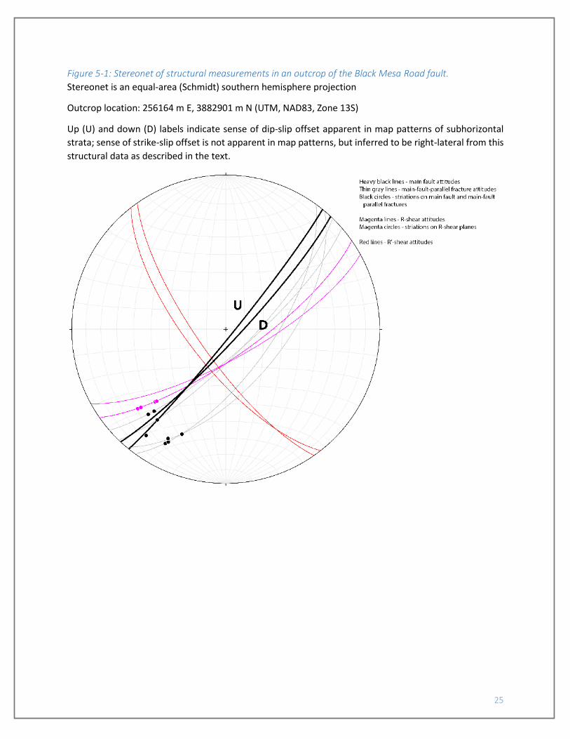
strike-slip is apparent in an outcrop of the Black Mesa Road fault circa 256165 m E, 3882900 m N (NAD83
UTM). Here, the main fault and main-fault-parallel fractures have an average attitude of N42E/75SE, offset
strata in the dip-slip direction down-to-the-southeast, and bear striations that rake, on average, 26° from
the southwest (FIGURE 5-1), indicating a slip vector with a substantial right-lateral component. The outcrop
also bears several small-offset fractures with average attitude of N58E/74SE bearing striations with
average rake angle of 31° from the southwest (FIGURE 5-1). Offset across these fractures is right-lateral
and down-to-the-southeast, synthetic to the main fault. The synthetic sense-of-slip and shallow acute
angle between the strike of the main fault and that of the synthetic fractures (16°) suggests these small-
offset features are Riedel shears (R-shears), and the clockwise (looking down) difference in strike attitudes
from the main fault to the R-shears again suggests right-lateral slip across the fault. Finally, an additional
set of very small-offset fractures with average attitude of S36E/72SW and probable left-lateral offset is
also apparent in this outcrop (FIGURE 5-1); the vector of slip across these fractures is not entirely clear,
but their attitude and probable left-lateral sense of offset would be consistent with conjugate Riedel
shears (R’-shears) associated with a right-lateral strike-slip fault.
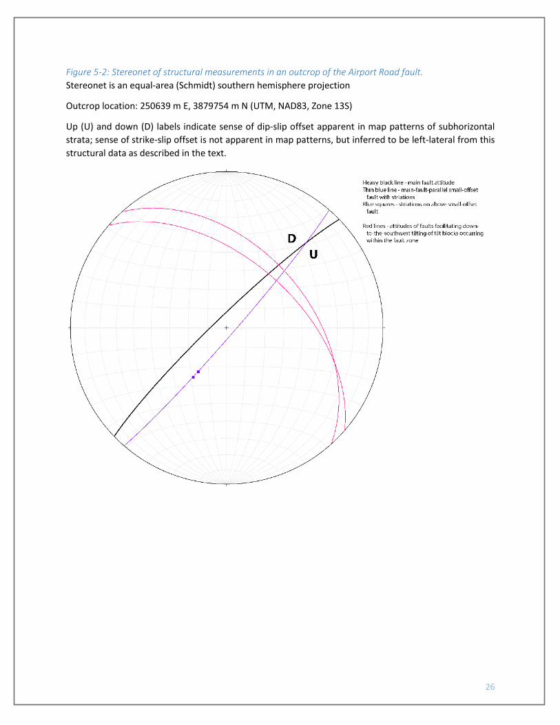
An outcrop of the Airport Road fault circa 250640 m E, 3879750 m N suggests left-lateral, down-
to-the-northwest oblique-slip. The main fault trend and main-fault-parallel faults have an average attitude
of S43W/89NW, with down-to-the-northwest dip-slip offset apparent in the subhorizontal sandstone beds
on either side of the fault zone. Striations were found on one main-fault-parallel fracture with an average
rake angle of 60° from the southwest (FIGURE 5-2), which, combined with the sense of dip-slip, would
13
indicate left-lateral, down-to-the-northwest oblique-slip. In addition, within the fault zone are a set of
down-to-the-southwest-tilted fault blocks, with tilting facilitated by normal faults with an average attitude
of N46W/51NE (FIGURES 5-2 AND 5-3), suggesting a component of northeast-southwest-directed
extension at least in this part of the fault zone. This outcrop occurs immediately northeast of a bend in
the trace of the fault, from north-northeast-trending (southwest side of the bend) to more northeast-
trending (northeast side of the bend). Such a bend would be a releasing bend in a left-lateral fault, which
could result in minor extensional structures such as the titled blocks observed here.
Strike-slip offset is inferred for the Canipa Spring fault based on the occurrence of the Canipa
Spring monocline at a bend in the trace of the Canipa Spring fault. The Canipa Spring fault is not well
exposed, but the trace is well-constrained, and circa 258420 m E, 3879680 m N the fault makes a set of
bends; from southwest to northeast, the fault bends from northeast-trending to east-trending then back
to northeast-trending. The Canipa Spring monocline is also not well exposed, but bedding attitudes
collected on Dakota sandstone beds indicate a shallow monocline occurs in this area as well, with
subhorizontal strata to either side of beds dipping up to 6° to the east-northeast. Directly within the bend
of the Canipa Spring fault trace, bedrock is not exposed, but the topography, here upheld by the Cubero
Tongue of the Dakota Sandstone, also shows a monocline-like trend, with subhorizontal slopes to either
side of a gentle northeast-aspect slope that occurs in the bend in the fault trace. Outcrops and bedding
attitudes observed further southeast, both on- and off-quad, suggest that the Canipa Spring monocline
does not continue far from the Canipa Spring fault trace, suggesting the two structural features are
related. We suggest that the Canipa Spring monocline could be the product of local northeast-southwest-
directed compression at the bend in the Canipa Spring fault. Such compression would result from left-
lateral offset across the fault.
Small magnitude monoclines and normal faults of a variety of attitudes occur through the
southern half of the quadrangle. Faults have east-northeast to east-southeast trends, with striations
indicating nearly pure dip-slip (rakes of 80 to 90° from the strike direction). Faults dip to both the north
and south, and displacements are <5 m. One fault in the southeast corner of the map decreases in
magnitude upsection, becoming a small monocline. Additional small monoclines are found with north-
northeast- to north-trends, and these may also overlie small-offset faults. A continuous “hinge,” mapped
as the anticlinal bend of a monocline, can be followed east-southeastward across McCarty Mesa and into
Cedar Hill; across this small-magnitude fold, beds steepen from subhorizontal on the south to gently (~2°)
dipping to the north-northwest through north-northeast on the north. Although each of these features is
small in magnitude, they are included on the map for their lateral continuity.
14
5. Hydrology Hydrology was not a focus of this study. However, some observations of geologic controls on
spring flow were collected.
5.1. Springs Three named springs (Canipa, Conejo, and Lane spring) are located within the McCartys
Quadrangle. Canipa Spring is a rheocrene spring that emerges from the Canipa Creek alluvium where the
Canipa Creek drainage crosses the Acomita dike. Discharge from Canipa Spring is apparently controlled
by shallow groundwater flow moving upward along the dike. Flow toward the spring may be influenced
by the Canipa Spring monocline, which folds Cretaceous strata just up-gradient (south) of the spring
imparts a local shallow east-northeastward dip to the base of the alluvium. Discharge from the spring was
estimated to be 1-5 gallons per minute (gpm) in March, 2017.
Conejo Spring is a hillslope or contact spring that discharges at the contact between the Twowells Tongue
of Dakota Sandstone and the underlying Mancos Shale on the south wall of Cañon del Conejo. A secondary
small seep is present in the Mancos shale approximately 30 m west and 6-7 m downslope (north) of the
Conejo Spring orifice. Abundant tufa blocks present in outcrop and as float in the vicinity of Conejo Spring
and the unnamed seep indicate that spring discharge in this area has persisted for an extended period of
time. Combined discharge from Conejo Spring and the unnamed seep was estimated at less than 0.5 gpm
in March, 2017.
Lane Spring is a hillslope or contact spring located south of Tafoya Canyon on the east flank of
Horace Mesa. Spring flow discharges from colluvium covering the hill slope, but Mancos shale is exposed
in the vicinity of the spring and is likely the control on spring discharge, with discharge probably occurring
at the contact between the Gallup Sandstone and the underlying Mancos Shale. A second spring is located
approximately 70 m north-northwest of the Lane Spring location shown on the McCartys quadrangle.
Combined discharge from the two springs, estimated at the point where they discharge to the stock tank,
is 1.5 to 2 gpm.
15
6. References cited Aldrich, M. J., Chapin, C. E., and Laughlin, A. W., 1986, Stress history and tectonic development of the Rio
Grande rift, New Mexico: Journal of Geophysical Research, v. 91, no. B6, p. 6199-6211. Allen, J. E., and Balk, R., 1954, Mineral resources of Fort Defiance and Tohatchi quadrangles, Arizona and
New Mexico: New Mexico Bureua of Mines and Mineral Resources, Bulletin 36, 192 p. Allmendinger, R. W., Cardozo, N. C., and Fisher, D., 2012, Structural Geology Algorithms: Vectors &
Tensors, Cambridge, England, Cambridge University Press. Aubrey, W. M., 1988, The Encinal Canyon Member, a new member of the Upper Cretaceous Dakota
Sandstone in the southern and eastern San Juan basin, New Mexico, in, "Revisions to Stratigraphic Nomenclature of Jurassic and Cretaceous Rocks of the Colorado Plateau": U.S. Geological Survey, Bulletin 1633 A-C, p. 57-69.
Birkeland, P. W., 1999, Soils and Geomorphology, Third Edition, Oxford, Oxford University Press, 430 p. Cardozo, N. C., and Allmendinger, R. W., 2013, Spherical projections with OSXStereonet: Computers and
Geosciences, v. 51, no. 0, p. 193-205. Cascadden, T. E., Geissman, J. W., Kudo, A. M., and Laughlin, A. W., 1997, El Calderon cinder cone and
associated basalt flows, in Maberry, K., ed., "Natural History of El Malpais National Monument": New Mexico Bureau of Geology and Mineral Resources, Bulletin 156, p. 41-51.
Champion, D. E., Lanphere, M. A., and Kuntz, M. A., 1988, Evidence for a new geomagnetic reversal from lava flows in Idaho: Discussion of short polarity reversals in the Brunhes and late Matuyama polarity chrons: Journal of Geophysical Research, v. 93, p. 11667-11680.
Channer, M. A., Ricketts, J. W., Zimmerer, M. J., Heizler, M. T., and Karlstrom, K. E., 2015, Surface uplift above the Jemez mantle anomaly in the past 4 Ma based on 40Ar/39Ar dated paleoprofiles of the Rio San Jose, New Mexico, USA: Geosphere, v. 11, no. 5, p. 1384-1400.
Cikoski, C. T., Drakos, P. G., and Riesterer, J. W., 2016, Geologic map of the Cubero 7.5-minute quadrangle, Cibola County, New Mexico: New Mexico Bureau of Geology and Mineral Resources, Open-File Geologic Map OF-GM-256, scale 1:24,000.
Compton, R. R., 1985, Geology in the Field, John Wiley & Sons, Inc., 398 p. Correa, A. C., 1970, Borrego Pass Lentil, a new member of the Crevasse Canyon Formation, southern San
Juan basin, New Mexico: The Mountain Geologist, v. 7, p. 99-102. Dane, C. H., Kauffman, E. G., and Cobban, W. A., 1968, Semilla Sandstone, a new member of the Mancos
Shale in the southeastern part of the San Juan basin, New Mexico: U.S. Geological Survey, Bulletin 1254-F, 21 p.
Drakos, P. G., Harrington, C. D., Wells, S. G., Perry, F. V., and Laughlin, A. W., 1991, Late Cenozoic geomorphic and tectonic evolution of the Rio San Jose and tributary drainages within the Basin and Range/Colorado Plateau transition zone in west-central New Mexico, in Julian, B., and Zidek, J., eds., "Field guide to geologic excursions in New Mexico and adjacent areas of Texas and Colorado": New Mexico Bureau of Mines and Mineral Resources, Bulletin 137, p. 149-157.
Drakos, P. G., and Riesterer, J. W., 2013, Water Canyon/Timber Canyon fan complex on the southeast flank of Mount Taylor, New Mexico, in Zeigler, K. E., Timmons, J. M., Timmons, S., and Semken, S. C., eds., "Geology of the Route 66 Region: Flagstaff to Grants": New Mexico Geological Society, Fall Field Conference Guidebook, p. 175-179.
Dunbar, N. W., and Phillips, F. M., 2004, Cosmogenic 36Cl ages of lava flows in the Zuni-Bandera volcanic field, north-central New Mexico, U.S.A., in Cather, S. M., McIntosh, W. C., and Kelley, S. A., eds., "Tectonics, Geochronology, and Volcanism in the Southern Rocky Mountains and Rio Grande Rift": New Mexico Bureau of Geology and Mineral Resources, Bulletin 160, p. 309-317.

16
Dutton, C. E., 1885, Mount Taylor and the Zuni Plateau, in Powell, J. W., ed., "Sixth Annual Report of the United States Geological Survey to the Secretary of the Interior, 1884-1885": U.S. Geological Survey, p. 105-198.
Fleming, T. F., 1989, New reference sections for the Semilla Sandstone Member of the Mancos Shale and their genetic implications: New Mexico Geology, v. 11, p. 1-7.
Gile, L., Peterson, F. F., and Grossman, R. B., 1966, Morphologic and genetic sequences of carbonate accumulation in desert soils: Soil Science, v. 101, p. 347-360.
Goff, F., Kelley, S. A., Goff, C. J., McCraw, D. J., Osburn, G. R., Lawrence, J. R., Drakos, P. G., and Skotnicki, S. J., 2015, Geologic map of Mount Taylor, Cibola and McKinley Counties, New Mexico: New Mexico Bureau of Geology and Mineral Resources, Open-File Report OFR-571, scale 1:36,000.
Grimm, J. P., 1983, The late Cenozoic history of the Lobo Canyon drainage basin, Mount Taylor volcanic field, New Mexico, in Wells, S. G., Love, D. W., and Gardner, T. W., eds., "Chaco Canyon Country": American Geomorphological Field Group, Field Trip Guidebook, p. 45-50.
Hook, S. C., Molenaar, C. M., and Cobban, W. A., 1983, Stratigraphy and revision of nomenclature of Upper Cenomanian to Turonian (Upper Cetaceous) rocks of west-central New Mexico, in Hook, S. C., ed., "Contributions to Mid-Cretaceous Paleontology and Stratigraphy of New Mexico, Part II": New Mexico Bureau of Mines and Mineral Resources, Circular 185, p. 7-28.
Hunt, C. B., 1936, The Mount Taylor coal field, Part 2, in Sears, J. D., Hunt, C. B., and Dane, C. H., eds., "Geology and Fuel Resources of the Southern Part of the San Juan Basin, New Mexico": U.S. Geological Survey, Bulletin 860-B, p. 31-80.
Landis, E. R., Dane, C. H., and Cobban, W. A., 1973, Stratigraphic terminology of the Dakota Sandstone and Mancos Shale, west-central New Mexico: U.S. Geological Survey, Bulletin 1372-J, 44 p.
Laughlin, A. W., Aldrich, M. J., and Vaniman, D. T., 1983, Tectonic implications of mid-Tertiary dikes in west-central New Mexico: Geology, v. 11, p. 45-48.
Laughlin, A. W., Perry, F. V., Damon, P. E., Shafiqullah, M., McIntosh, W. C., Harrington, C. D., Wells, S. G., and Drakos, P. G., 1993, Geochronology of Mount Taylor, Cebollita Mesa, and Zuni-Bandera volcanic fields, Cibola County, New Mexico: New Mexico Geology, v. 15, no. 4, p. 81-92.
Laughlin, A. W., Poths, J., Healey, H. A., Reneau, S., and WoldeGabriel, G., 1994, Dating of Quaternary basalts using the cosmogenic 3He and 14C methods with implications for excess 40Ar: Geology, v. 22, p. 135-138.
Laughlin, A. W., and WoldeGabriel, G., 1997, Dating the Zuni-Bandera volcanic field, in Maberry, K., ed., "Natural History of El Malpais National Monument": New Mexico Bureau of Mines and Mineral Resources, Bulletin 156, p. 25-30.
Lipman, P. W., and Menhert, H. H., 1979, Potassium-argon ages from the Mount Taylor volcanic field, New Mexico: U.S. Geological Survey, Professional Paper 1124-B, 8 p.
Machette, M. N., 1985, Calcic soils of the southwestern United States, in Weide, D. L., ed., "Soils and Quaternary Geology of the Southwestern United States": Geological Society of America, Special Paper 203, p. 1-22.
Maxwell, C. H., 1977, Preliminary geologic map of the McCartys quadrangle, Valencia County, New Mexico: U.S. Geological Survey, Open-File Report 77-380, scale 1:24,000.
-, 1986, Geologic map of El Malpais lava field and surrounding areas, Cibola County, New Mexico: U.S. Geological Survey, Miscellaneous Investigations Series Map I-1595, scale 1:62,500.
Molenaar, C. M., 1983, Principal reference section and correlation of Gallup Sandstone, northwestern New Mexico, in Hook, S. C., ed., "Contributions to Mid-Cretaceous Paleontology and Stratigraphy of New Mexico, Part II": New Mexico Bureau of Mines and Mineral Resources, Circular 185, p. 29-40.

17
Molenaar, C. M., Nummedal, D., and Cobban, W. A., 1996, Regional stratigraphic cross sections of the Gallup Sandstone and associated strata around the San Juan basin, New Mexico, and parts of adjoining Arizona and Colorado: U.S. Geological Survey, Oil and Gas Investigations Chart OC-143.
Munsell Color, 2009, Munsell Soil-Color Charts: Grand Rapids, MI. Osburn, G. R., Kelley, S. A., Goff, F., Drakos, P. G., and Ferguson, C. A., 2009, Geologic map of the Mount
Taylor 7.5-minute quadrangle, Cibola County, New Mexico: New Mexico Bureau of Geology and Mineral Resources, Open-File Geologic Map OF-GM-186, scale 1:24,000.
Owen, D. E., 1966, Nomenclature of Dakota Sandstone (Cretaceous) in San Juan basin, New Mexico and Colorado: American Association of Petroleum Geologists Bulletin, v. 50, p. 1023-1028.
Pike, W. S., 1947, Intertonguing marine and nonmarine Upper Cretaceous deposits of New Mexico, Arizona, and southwestern Colorado: Geological Society of America, Memoir 24, 103 p.
Risser, D. W., and Lyford, F. P., 1983, Water resources on the Pueblo of Laguna, west-central New Mexico: U.S. Geological Survey, Water-Resources Investigations Report 83-4038, 308 p.
-, 1984, Water resources on the Pueblo of Acoma, Cibola County, New Mexico: U.S. Geological Survey, Administrative Report (unpublished), 199 p.
Sears, J. D., 1925, Geology and coal resources of the Gallup-Zuni basin, New Mexico: U.S. Geological Survey, Bulletin 767, 53 p.
Sears, J. D., Hunt, C. B., and Hendricks, T. A., 1941, Transgressive and regressive Cretaceous deposits in southern San Juan Basin, New Mexico, in: U.S. Geological Survey, Professional Paper 193, p. 101-121.
Woodward, L. A., 1982, Tectonic framework of Albuquerque country, in Wells, S. G., Grambling, J. A., and Callender, J. F., eds., "Albuquerque Country II": New Mexico Geological Society, Fall Field Conference Guidebook 33, p. 141-145.
18
7. Tables

Table 1: Summary of geochronologic data for the McCartys 7.5' quadrangle
Unit Age1 (Ma) ±2σ2 Type3 Ref.4 Latitude Longitude CommentsQbc 1.57 0.26* K‐Ar L79 Too old (Laughlin et al., 1993); taken from ~3 miles east of Grants along I‐40. *Unclear if published error is 1σ or 2σ
0.128 0.033 K‐Ar CL880.054 0.1 K‐Ar L93 ** ** **Published lat/long are inconsistent with described location; location described as ~3 miles east of Grants along I‐40.0.0347 0.003 36Cl DP04 35.07°N 107.75°W Weighted mean of 0 mm/kyr and 5 mm/kyr erosion rate assumptions
0.115‐0.120 ‐‐ PM C97 Suggested to have erupted during the Blake geomagnetic polarity eventTbp 3.238 0.17 K‐Ar L93 35.09°N 107.71°W
2.72 0.011 Ar/Ar C15 Sampled basalt reported to overlie ancestral Rio San Jose gravelsTbda 30.7 1.4 K‐Ar A86 35.03°N 107.62°W
Age1 (ka)Qbm 2.97 0.12 14C L94 34°56.01'N 107°50.33'W
3.01 0.14 14C L94 34°56.01'N 107°50.33'W2.5 1.1 3He L94 35°05.16'N 107°46.52'W2.4 0.6 3He L94 35°05.16'N 107°46.52'W3.9 1.2 36Cl DP04 34°55.97'N 107°50.45'W Weighted mean of 0 mm/kyr and 5 mm/kyr erosion rate assumptions
Notes1: Age as published. No attempt made to normalize values. C‐14 ages are not calibrated calendar ages.2: Uncertainty as published, scaled to ±2σ where appropriate.3: PM – age range suggested by comparison of radiometric ages and basalt flow paleomagnetic data to the paleomagnetic record; 14C ages date material from buried soils immediately underlying the flows;
3He and 36Cl are cosmogenic surface exposure ages; 40Ar/39Ar and K‐Ar are crystallization ages.4: A86 ‐ Aldrich et al., 1986; C97 – Cascadden et al., 1997; C15 ‐ Channer et al., 2015; CL88 – Champion and Lanphere, 1988; DP04 – Dunbar and Phillips, 2004; L79 ‐ Laughlin et al., 1979;
L93 – Laughlin et al., 1993; L94 – Laughlin et al., 1994.
20
8. Figures Figure 3-1: Stratigraphic section measured through fan unit Qf2
21
Figure 3-2: Stratigraphic section measured through fan unit Qf4
Figure 3-3: Stratigraphic section measured through Qal in Cañon Largo
22
Figure 3-4: Fracture control in upper Cañon del Conejo
Northeast-oriented fractures in Paguate Tongue are parallel to orientation of canyon. Densely-fractured
Two Wells Tongue forms canyon rim.
23
Figure 3-5: Recent arroyo incision in unnamed canyon west of abandoned airfield on McCarty Mesa
24
Figure 3-6: Stratigraphic section measured through Qasw in Cañon Largo
25
Figure 5-1: Stereonet of structural measurements in an outcrop of the Black Mesa Road fault.
Stereonet is an equal-area (Schmidt) southern hemisphere projection
Outcrop location: 256164 m E, 3882901 m N (UTM, NAD83, Zone 13S)
Up (U) and down (D) labels indicate sense of dip-slip offset apparent in map patterns of subhorizontal
strata; sense of strike-slip offset is not apparent in map patterns, but inferred to be right-lateral from this
structural data as described in the text.
26
Figure 5-2: Stereonet of structural measurements in an outcrop of the Airport Road fault.
Stereonet is an equal-area (Schmidt) southern hemisphere projection
Outcrop location: 250639 m E, 3879754 m N (UTM, NAD83, Zone 13S)
Up (U) and down (D) labels indicate sense of dip-slip offset apparent in map patterns of subhorizontal
strata; sense of strike-slip offset is not apparent in map patterns, but inferred to be left-lateral from this
structural data as described in the text.

27
Figure 5-3: Photo of an outcrop of the Airport Road fault
Outcrop location: 250639 m E, 3879754 m N (UTM, NAD83, Zone 13S)
View is to the west-northwest. Red lines bound a set of tilted blocks occurring within the fault zone. Fault
blocks are rotated down-to-the-southwest along a set of northwest-striking normal faults. These tilt
blocks indicate a measure of northeast-southwest extension occurring along the fault zone at this
location.
Copyright © 2022 FDOKUMEN