Facilitating Faster Broadband Deployment - International ...
Upload
independentCategory
view
3download
0
University of Nebraska - LincolnDigitalCommons@University of Nebraska - Lincoln
US Department of Energy Publications US Department of Energy
1-1-2008
Generic Simulation Models For FacilitatingStakeholder Involvement In Water ResourcesPlanning And Management: A Comparison,Evaluation, and Identification of Future NeedsH. AssataDepartment of Civil and Environmental Engineering, American University of Beirut, PO Box 11-0236, Riad EI Solh, Beirut1107 2020, Lebanon
E. van BeekDelft Hydraulics/Twente University, PO Box 177, 2600 MH Delft, The Netherlands
C. BordenDHI Water * Environment clo University ofIdaho, 322 E. Front St., Suite 340, Boise, ID 83702, USA
P. GijsbersWL Delft Hydraulics, Inland Water Systems, PO Box 177, 2600 MH, Delft, The Netherlands
A. JolmaGeoinformation and Positioning, Helsinki University of Technology, PO Box 1200, 02015 TKK, Finland
See next page for additional authorsFollow this and additional works at: http://digitalcommons.unl.edu/usdoepubPart of the Bioresource and Agricultural Engineering Commons
This Article is brought to you for free and open access by the US Department of Energy at DigitalCommons@University of Nebraska - Lincoln. It hasbeen accepted for inclusion in US Department of Energy Publications by an authorized administrator of DigitalCommons@University of Nebraska -Lincoln.
Assata, H.; van Beek, E.; Borden, C.; Gijsbers, P.; Jolma, A.; Kaden, S.; Kaltofen, M.; Labadie, J.W.; Loucks, D.P.; Quinn, N.W.T.;Sieber, J.; Sulis, A.; Werick, W.J.; and Wood, D.M., "Generic Simulation Models For Facilitating Stakeholder Involvement In WaterResources Planning And Management: A Comparison, Evaluation, and Identification of Future Needs" (2008). US Department ofEnergy Publications. Paper 67.http://digitalcommons.unl.edu/usdoepub/67

AuthorsH. Assata, E. van Beek, C. Borden, P. Gijsbers, A. Jolma, S. Kaden, M. Kaltofen, J.W. Labadie, D.P. Loucks,N.W.T. Quinn, J. Sieber, A. Sulis, W.J. Werick, and D.M. Wood
This article is available at DigitalCommons@University of Nebraska - Lincoln: http://digitalcommons.unl.edu/usdoepub/67
CHAPTER THIRTEEN
GENERIC SIMULATION MODELS FOR
FACILITATING STAKEHOLDER INVOLVEMENT IN
WATER RESOURCES PLANNING AND
MANAGEMENT: A COMPARISON, EVALUATION,
AND IDENTIFICATION OF FUTURE NEEDS
H. Assata, E. van Beek b, C. Borden c, P. Gijsbers d, A. Jolma e, S. Kaden f,
M. Kaltofen f, J.W. Labadie g, D.P. Loucks h, N.W.T. Quinn i, J. Sieber i ,
A. Sulis k, W.J. Werick I, and D.M. Wood m
Contents 13.1. 13·2. 13·3· 13·4· 13·5· 13·6.
Introduction Model Characteristics and Comparisons Stakeholder Involvement Enhancing Non-expert Modelling Accessibility Reaching Out to Younger Generations The Current State of the Art - Results of Workshop Discussion 13.6.1 On detail and complexity 13.6.2 On stakeholder participation and shared vision modelling 13.6.3 On applied technology 13.6.4 On development and continuity
230 231
238 238 239 240 240 241 242 243
a Department of Civil and Environmental Engineering, American University of Beirut, PO Box 11-0236, Riad EI Solh, Beirut 1107 2020, Lebanon
b Delft Hydraulics/Twente University, PO Box 177, 2600 MH Delft, The Netherlands C DHI Water * Environment clo University ofIdaho, 322 E. Front St., Suite 340, Boise, ID 83702, USA d WL Delft Hydraulics, Inland Water Systems, PO Box 177, 2600 MH, Delft, The Netherlands e Geoinformation and Positioning, Helsinki University of Technology, PO Box 1200, 02015 TKK, Finland f WASY GmbH, Institute for Water Resources Planning and Systems Research, Waltersdorfer Strasse 105, 12526
Berlin, Germany
g Department of Civil and Environmental Engineering, Colorado State University, Fort Collins, CO 80523-1372, USA
h Hollister Hall, Cornell University Ithaca, NY 14853, USA i Berkeley National Laboratory, University of California, 1 Cyclotron Road, BId. 70A-3317H Berkeley, CA 94720,
USA
j Stockholm Environment Institute, US Center, 11 Curtis Avenue, Somerville, MA 02144, USA k Hydraulic Sector, Department of Land Engineering, University of Cagliari, Piazza d'Armi, 09123 Cagliari (CA),
Italy I 14508 Chesterfield Lane, Culpeper, VA 22701, USA
m Danish Hydraulics Institute, Oakland, CA, USA
Environmental Modelling, Software and Decision Support 1574-101X.
© 2008 Elsevier B.V All rights reserved.
Published in ENVIRONMENTAL MODELLING, SOFTWARE AND DECISION SUPPORT: STATE OF THE ART AND NEW PERSPECTIVES, edited by A. J. Jakeman, A. A. Voinov, A. E. Rizzoli, & S. H. Chen (Amsterdam et al.: Elsevier, 2008).This article is a U.S. government work and is not subject to copyright in the United States.
230
13.6.5 On content 13.7. Overall Conclusion Acknowledgements References
13.1. INTRODUCTION
H. Assaf et at.
244 244 245 245
Water resources planning and management tools have been moving away from a top down (command and control) approach to a bottonl up (grass-roots) approach - which emphasises the involvement of stakeholders, not only specialists, in all stages of planning - from the identification of problems and issues, the selection of potential solutions to project inlplenlentation and operation. Ideally, a participatory grassroots planning process should provide a transparent and flexible platform for all stakeholders to collectively: examine the main elements of their shared water system; understand the Inain issues and problenls to be addressed; participate in identifying alternative policies; and select fairly balanced and broadly supported solutions. Chapter 3 discusses these issues on the broader context of decision support for environmental management.
There exist today a variety of generic simulation models incorporated within interactive graphics-based interfaces that are available for studying water related planning and management issues in river basins and at the same time appropriate for facilitating stakeholder involvement in the planning and decision-making process. While each model has its own special characteristics, they all are designed to facilitate the input, storage, retrieval, and display of geographic, hydrologic, anddepending on the model and application - socioeconomic data associated with specific river basins or regions. The input data also include the policies defining how the water resources are to be managed over space and time. The outputs of these simulation models describe the impacts of these water management policies. Most importantly, they provide a means of involving stakeholders in reaching a shared vision of how their water resource system works, and the possible economic, environmental, hydrologic and/or ecological impacts of alternative development and management policies.
Different generic decision support systems often vary in the types and detail of analyses they can perform. One of the challenges of developing such tools is in trying to satisfy the needs of those at different levels of decision making. Water resource managers typically desire tools that provide greater detail than government agency heads or politicians, who are among those who request and often provide the money for such studies. Public stakeholder groups may differ in the detail they consider appropriate for making good decisions. Ideally, generic simulation models should be able to satisfy everyone involved in the planning and management process. In fact, that is a challenge.
As in all technological innovation the process of achieving consensus-based, sound resource and environmental management policies is often experimental; usuallv incremental and if managed responsibly, progressive and adaptive as neW
Generic Simulation Models for Facilitating Stakeholder Involvement 231
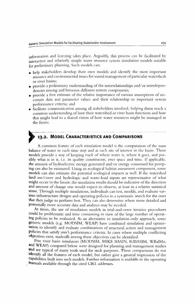
information and learning takes place. Arguably, this process can be facilitated by interactive and relatively simple water resource system simulation models suitable for preliminary planning. Such models can:
• help stakeholders develop their own models and identifY the most important resource and environmental issues for sound management of particular watersheds or river basins;
• provide a preliminary understanding of the interrelationships and/or interdependencies among and between different system components;
• provide a first estimate of the relative importance of various assumptions of uncertain data and parameter values and their relationship to important system performance criteria; and
• facilitate communication among all stakeholders involved, helping them reach a common understanding of how their watershed or river basin functions and how that might lead to a shared vision of how water resources might be nlanaged in the future.
F~~'MODEL CHARACTERISTICS AND COMPARI~ONS A common feature of each silTIulation model is the computation of the mass
balance of water in each time step and at each site of interest in the basin. These models provide a way of keeping track of where water is, where it goes, and possibly what is in it, i.e. its quality constituents, over space and time. If applicable, the amount of hydroelectric energy generated and/or energy consUlned for pumping can also be estimated. Using an ecological habitat assessment component, some models can also estimate the potential ecological impacts as well. If the watershed land use/cover and hydrologic and waste-load inputs are representative of what might occur in the future, the sinlulation results should be indicative of the direction and amount of change one would expect to observe, at least in a relative statistical sense. Through multiple simulations, individuals can test, modifY, and evaluate various infrastructure designs and operating policies in a systematic search for the ones that they judge to perform best. They can also determine where more detailed and potentially more accurate data and analyses may be needed.
At times, the use of simulation models in trial-and-error iterative procedures ~ould be problematic and time consuming in view of the large number of operatIng policies to be evaluated. As an alternative to simulation-only approach, some generic models (e.g. MODSIM, WEAP) have combined simulation and optimisation to identifY and evaluate combinations of structural action and nlanagement policies that satisfY user's performance criteria. In cases where multiple conflicting objectives exist, tradeoffs among these objectives can be identified.
Five river basin simulators (MODSIM, MIKE BASIN, RIBASIM, WBalMo, and WEAP) compared below were designed for planning and management studies ~d are typical of many tools used for such purposes. These comparisons do not ldentify all the features of each model, but rather give a general impression of the ~apabilities built into such models. Further information is available in the operating
i tnanuals available through the cited URL addresses.
232
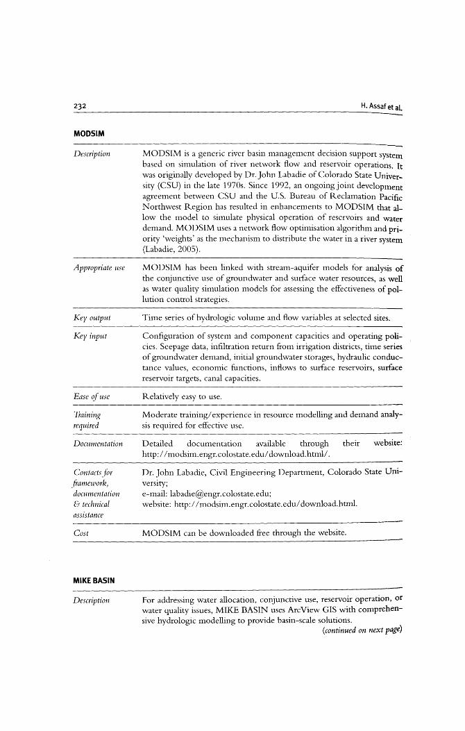
MODslM
Description
Appropriate use
Key output
Key input
Ease of use
Training required
Documentation
Contacts for framework, documentation & technical assistance
Cost
MIKE BASIN
Description
H. Assaf et at.
MODSIM is a generic river basin management decision support system based on simulation of river network flow and reservoir operations. It was originally developed by Dr. John Labadie of Colorado State University (CSU) in the late 1970s. Since 1992, an ongoing joint development agreement between CSU and the U.S. Bureau of Reclamation Pacific Northwest Region has resulted in enhancements to MODSIM that allow the model to simulate physical operation of reservoirs and water demand. MODSIM uses a network flow optimisation algorithm and priority 'weights' as the mechanism to distribute the water in a river system (Labadie, 2005).
MODSIM has been linked with stream-aquifer models for analysis of the conjunctive use of groundwater and surface water resources, as well as water quality simulation models for assessing the effectiveness of pollution control strategies.
Time series of hydrologic volume and flow variables at selected sites.
Configuration of system and component capacities and operating policies. Seepage data, infiltration return from irrigation districts, time series of groundwater demand, initial groundwater storages, hydraulic conductance values, economic functions, inflows to surface reservoirs, surface reservoir targets, canal capacities.
Relatively easy to use.
Moderate training/experience in resource modelling and demand analysis required for effective use.
Detailed documentation available through http:// modsim. engr. colo state. edu/ download.html/ .
their website:
Dr. John Labadie, Civil Engineering Department, Colorado State Uni-versity; e-mail: [email protected]; website: http://modsim.engr.colostate.edu/ download.html.
MODSIM can be downloaded free through the website.
For addressing water allocation, conjunctive use, reservoir operation, or water quality issues, MIKE BASIN uses ArcView GIS with comprehensive hydrologic modelling to provide basin-scale solutions.
(continued on next page)
Generic Simulation Models for Facilitating Stakeholder Involvement 233
(continued)
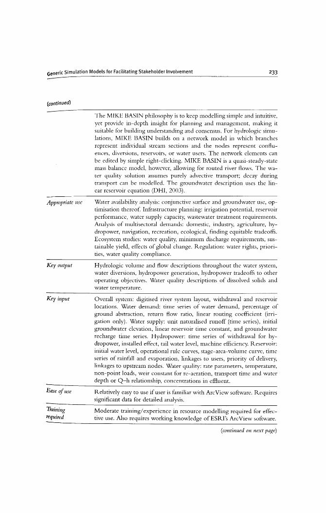
Appropriate use
Key output
Key input
Ease <1 use
Training required
The MIKE BASIN philosophy is to keep modelling simple and intuitive, yet provide in-depth insight for planning and management, making it suitable for building understanding and consensus. For hydrologic simulations, MIKE BASIN builds on a network model in which branches represent individual stream sections and the nodes represent confluences, diversions, reservoirs, or water users. The network elements can be edited by simple right-clicking. MIKE BASIN is a quasi-steady-state mass balance model, however, allowing for routed river flows. The water quality solution assumes purely advective transport; decay during transport can be modelled. The groundwater description uses the linear reservoir equation (DHI, 2003).
Water availability analysis: conjunctive surface and groundwater use, optimisation thereof. Infrastructure planning: irrigation potential, reservoir performance, water supply capacity, wastewater treatment requirements. Analysis of multisectoral demands: domestic, industry, agriculture, hydropower, navigation, recreation, ecological, finding equitable tradeoffs. Ecosystem studies: water quality, minimum discharge requirements, sustainable yield, effects of global change. Regulation: water rights, priorities, water quality compliance.
Hydrologic volume and flow descriptions throughout the water system, water diversions, hydropower generation, hydropower tradeoffs to other operating objectives. Water quality descriptions of dissolved solids and water temperature.
Overall system: digitised river system layout, withdrawal and reservoir locations. Water demand: time series of water demand, percentage of ground abstraction, return flow ratio, linear routing coefficient (irrigation only). Water supply: unit naturalised runoff (time series), initial groundwater elevation, linear reservoir time constant, and groundwater recharge time series. Hydropower: time series of withdrawal for hydropower, installed effect, tail water level, machine efficiency. Reservoir: initial water level, operational rule curves, stage-area-volume curve, time series of rainfall and evaporation, linkages to users, priority of delivery, linkages to upstream nodes. Water quality: rate parameters, temperature, non-point loads, weir constant for re-aeration, transport time and water depth or Q-h relationship, concentrations in effluent.
Relatively easy to use if user is familiar with ArcView software. Requires significant data for detailed analysis.
Moderate training/experience in resource modelling required for effective use. Also requires working knowledge of ESRI's Arc View software.
(continued on next page)

234
(continued)
Training available
Documentation
Contacts for framework, documentation & technical assistance
Cost
RIBASIM
Description
Appropriate use
Key output
H. Assaf et al.
MIKE BASIN courses are arranged both regularly and upon request (see http://www.dhisoftware.com/mikebasin/Courses/).
Detailed documentation including on-line tours of the model available through their website: http://www.dhisoftware.com/mikebasin/Download/.
DHI's Software Support Centre; Tel.: +45 45 16 93 33; Fax: +45 45 16 92 92; e-mail: [email protected]; website: http://www.dhisoftware.com/mikebasin/.
Licensed software cost US $3000 per class set, US $300 to update each set. In addition Arc View software is required.
RIBAS 1M is a generic model package for simulating river basins under various hydrological conditions. The model package links the hydrological water inputs at various locations with the specific water users in the basin. RIBASIM enables the user to evaluate a variety of measures related to infrastructure and operational and demand management, and to see the results in terms of water quantity and flow composition. RIBAS 1M can also generate flow patterns that provide a basis for detailed water quality and sedimentation analyses in river reaches and reservoirs. Demands for irrigation, public water supply, hydropower, aquaculture, and reservoir operation can be taken into account. Irrigation demand can be calculated based on cropping patterns, irrigation practices and meteorological data. Surface and groundwater resources can be allocated. Minimum flow requirements and flow composition can be assessed (WL/Delft Hydraulics, 2007).
Evaluation of the options and potential for development of water resources in a river basin. Water allocation issues. Assessment of infrastructure, and operational and demand management measures.
Water balance providing the basic information on the available quantity of water as well as the flow at every location and any time in the river basin. This takes into account drainage from agriculture, discharges from industry and the downstream re-use of water in the basin. Pro:" duced hydropower and crop production and/or crop damage due to water shortages.
(continued on next page)
Generic Simulation Models for Facilitating Stakeholder Involvement 235
(continued)
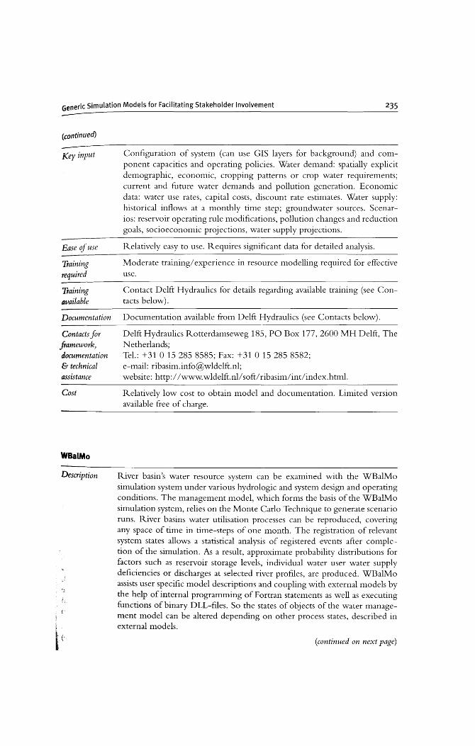
Key input
Ease of use
Training required
Training available
Documentation
Contacts for framework} documentation & technical assistance
Cost
WBalMo
Description
f,
Configuration of system (can use GIS layers for background) and component capacities and operating policies. Water demand: spatially explicit demographic, economic, cropping patterns or crop water requirements; current and future water demands and pollution generation. Economic data: water use rates, capital costs, discount rate estimates. Water supply: historical inflows at a monthly time step; groundwater sources. Scenarios: reservoir operating rule modifications, pollution changes and reduction goals, socioeconomic projections, water supply projections.
Relatively easy to use. Requires significant data for detailed analysis.
Moderate training/experience in resource modelling required for effective use.
Contact Delft Hydraulics for details regarding available training (see Contacts below).
Documentation available from Delft Hydraulics (see Contacts below).
Delft Hydraulics Rotterdamseweg 185, PO Box 177,2600 MH Delft, The Netherlands; Tel.: +31 0 15 285 8585; Fax: +31 0 15 285 8582; e-mail: [email protected]; website: http://www.wldelft.nllsoft/ribasimlintlindex.html.
Relatively low cost to obtain model and documentation. Limited version available free of charge.
River basin's water resource system can be examined with the WBalMo simulation system under various hydrologic and system design and operating conditions. The management model, which forms the basis of the WBalMo simulation system, relies on the Monte Carlo Technique to generate scenario runs. River basins water utilisation processes can be reproduced, covering any space of time in time-steps of one month. The registration of relevant system states allows a statistical analysis of registered events after completion of the simulation. As a result, approximate probability distributions for factors such as reservoir storage levels, individual water user water supply deficiencies or discharges at selected river profiles, are produced. WBalMo assists user specific model descriptions and coupling with external models by the help of internal programming of Fortran statements as well as executing functions of binary DLL-files. So the states of objects of the water management model can be altered depending on other process states, described in external models.
(continued on next page)
(continued)
Appropriate use
Key output
Key input
Ease if use
Training required
Training available
Documentation
Contacts for framework, documentation & technical assistance
Cost
H. Assaf et al~
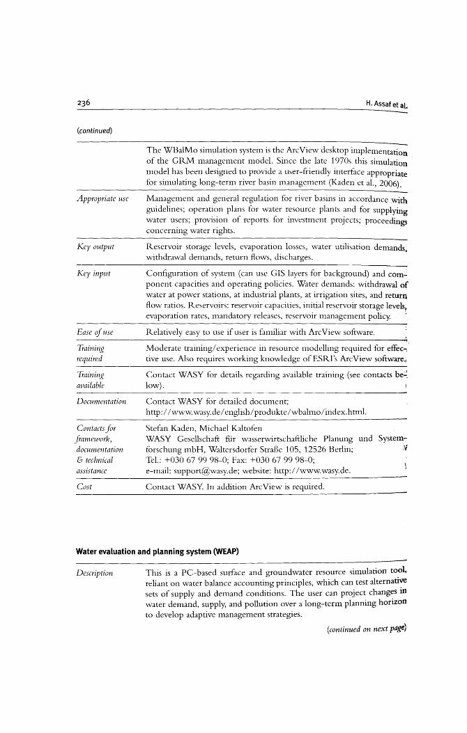
The WBalMo simulation system is the ArcView desktop implementation of the GRM management model. Since the late 1970s this simulation model has been designed to provide a user-friendly interface appropriate for simulating long-term river basin management (Kaden et al., 2006).
Management and general regulation for river basins in accordance with guidelines; operation plans for water resource plants and for supplying water users; provision of reports for investment projects; proceedings concerning water rights.
Reservoir storage levels, evaporation losses, water utilisation demands, withdrawal demands, return flows, discharges.
Configuration of system (can use GIS layers for background) and com": ponent capacities and operating policies. Water demands: withdrawal of water at power stations, at industrial plants, at irrigation sites, and return flow ratios. Reservoirs: reservoir capacities, initial reservoir storage levels, evaporation rates, mandatory releases, reservoir management policy. \
Relatively easy to use if user is familiar with ArcView software.
Moderate training/ experience in resource modelling required for effec-: tive use. Also requires working knowledge ofESRI's ArcView software"
Contact WASY for details regarding available training (see contacts be':;. low).
Contact WASY for detailed document; http://www.wasy.de/english/produkte/wbalmo/index.htrnl.
Stefan Kaden, Michael Kaltofen WASY Gesellschaft fur wasserwirtschaftliche Planung forschung mbH, Waltersdorfer StraBe 105, 12526 Berlin; Tel.: +030 67 9998-0; Fax: +03067 99 98-0; e-mail: [email protected]; website: http://www.wasy.de.
Contact WASY. In addition ArcView is required.
und System:''J
Water evaluation and planning system (WEAP)
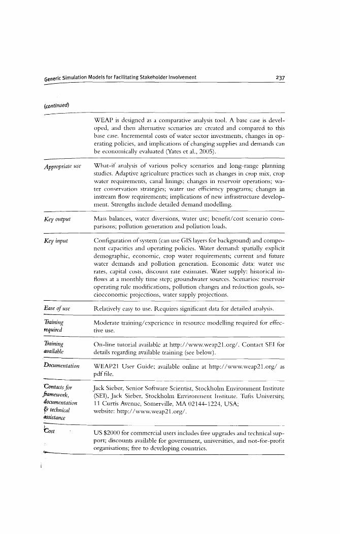
Description This is a PC-based surface and groundwater resource simulation tool, reliant on water balance accounting principles, which can test alternative sets of supply and demand conditions. The user can project changes in water demand, supply, and pollution over a long-term planning horizon to develop adaptive management strategies.
(continued on next page)
Generic Simulation Models for Facilitating Stakeholder Involvement 237
(continued)
Appropriate use
Key output
Key input
Ease of use
Training required
Training available
Documentation
Contacts for framework, documentation F technical assistance
~
'Cost
WEAP is designed as a comparative analysis tool. A base case is developed, and then alternative scenarios are created and compared to this base case. Incremental costs of water sector investments, changes in operating policies, and implications of changing supplies and demands can be economically evaluated (Yates et al., 2005).
What-if analysis of various policy scenarios and long-range planning studies. Adaptive agriculture practices such as changes in crop mix, crop water requirements, canal linings; changes in reservoir operations; water conservation strategies; water use efficiency programs; changes in instream flow requirements; implications of new infrastructure development. Strengths include detailed demand modelling.
Mass balances, water diversions, water use; benefit/cost scenario comparisons; pollution generation and pollution loads.
Configuration of system (can use GIS layers for background) and component capacities and operating policies. Water demand: spatially explicit demographic, economic, crop water requirements; current and future water demands and pollution generation. Economic data: water use rates, capital costs, discount rate estimates. Water supply: historical inflows at a monthly time step; groundwater sources. Scenarios: reservoir operating rule modifications, pollution changes and reduction goals, socioeconomic projections, water supply projections.
Relatively easy to use. Requires significant data for detailed analysis.
Moderate training/experience in resource modelling required for effective use.
On-line tutorial available at http://www.weap21.org/. Contact SEI for details regarding available training (see below).
WEAP21 User Guide; available online at http://www.weap21.org/ as pdf file.
Jack Sieber, Senior Software Scientist, Stockholm Environment Institute (SEI), Jack Sieber, Stockholm Environment Institute. Tufts University, 11 Curtis Avenue, Somerville, MA 02144-1224, USA; website: http://www.weap21.org/.
US $2000 for commercial users includes free upgrades and technical support; discounts available for government, universities, and not-for-profit organisations; free to developing countries.
238 H. Assaf et at.
13.3. STAKEHOLDER INVOLVEMENT
Traditionally, modelling tools have played a crucial role in supporting and revitalising the water resources planning and management profession. Water resources models have grown in sophistication from simple single mathematical procedures to physically-based and highly graphical, full-blown software applications. The adoption of a participatory approach by leading planning agencies, e.g. US Army Corps of Engineers, has created the opportunity for using modelling (among other technologies) to facilitate the involvement of stakeholders at all stages of decision nuking. Stakeholders should be involved in the nlOdelling steps of
• 'drawing in' the basin configuration, • identifYing the sites of interest, • inputting the data relevant to the particular site or reach, • testing various assumptions if there are stakeholder disagreements to determine
how important those different assumptions are to the decisions that need to be made, and
• continuing on to full simulations with alternative hydrologic and water quality data sets, as appropriate.
This will give stakeholders a sense that it is not just someone else's model, it is their model, and they will better understand its strengths and weaknesses.
In essence, the challenge lies in enabling non-experts to achieve familiarity with the water resource system, its components and interactions and to help them understand the main issues and problems from a variety of perspectives. This approach helps the involved stakeholders appreciate the potential impact of alternative policies and management options on their interests, and the interests of other stakeholder~ such as providing estinlates of both direct and indirect impacts on environmental and econonlic resources.
13.4. ENHANCING NON-EXPERT MODELLING ACCESSIBILITY
Improvements in information technology, coupled with the development of information analysis and processing capabilities, have made system modelling more accessible to non-experts. The following is a non-exhaustive list of some of these achievenlents, with sonle continuing challenges, that provide a glimpse into future research needs:
• GIS technology is being used in the design of user interface, data processing~ analysis and visualisation. All the DSSs reviewed in this paper incorporate, at different levels, map or picture display capabilities. Increasingly DSSs are incorporating the use of GIS technology, especially the mainstream business anq engineering communities, exemplified by the advent of highly powerful, intuitive and widely available GIS products such as ArcView, ArcGIS or MapWindow. In the future data available from Google Earth Pro (Google, 2007) will surely be a resource users will want to incorporate into their interfaces.
Generic Simulation Models for Facilitating Stakeholder Involvement 239
• A remaining nlajor challenge in the use of models in water resources planning is the clear communication of nlodel results and model uncertainties, especially with respect to developing measures and constructs that clearly and fairly address the often conflicting interests of stakeholders (see also Chapters 5 and 6).
• At the core of simulation-based water resources planning is the concept of scenarios (see also Chapter 9). This approach considers a set of statistically independent scenarios about the uncertain future in the search for a "robust" decision policy that minimises the risk of nuking the wrong decision. In the majority of DSSs - scenario formulation and their simulation within models is conducted externally and generally depends on the skill and experience of the analysts. Sulis (2006) provides an example of this in his WARGI-DSS. More focused efforts are needed to develop nlore realistic conceptual frameworks and procedures for developing and analysing scenarios in the discipline of water resources planning and management.
• Some of the innovations that have increased the user base of water resources models and involved greater numbers of non-experts in the water resources modelling process are the improvement of high level modelling and analysis capabilities through automation, the click-drop-and-add and other highly visual sinlulation environments and interactive visualisation tools. This is similar to the trend in programming and software applications, e.g. Visual Basic and Exce1. Water re-
. sources modellers can benefit from the experience in developing science and technology educational packages, such as the NASA's EdGCM (Chandler et a1., 2005).
• Virtual Reality (VR) or real world-like simulations and user interactions can incite interest and facilitate more intinute understanding of the water resources system. For exanlple, VR methods have been used in the Life Safety Model (LSM) to produce dynamic and visual simulations of people reacting to a danl breach flood by escaping via vehicles and on foot (Assaf and Hartford, 2(02).
• Free and Open Source Software (FOSS), which includes the freely-shared Linux operating system, offers the potential of facilitating model development and use especially in developing countries. Several open-source geospatial software including Quantum GIS (Quantum GIS, 2007), PostGIS (PostGIS, 2007), MapServer (MapServer, 2(07), and GRASS (GRASS, 2007) are freely available for a wide array of tasks and can be easily linked to or incorporated within simulation models. Despite their availability at no cost, ownership costs of FOSS including technical support and training can be significant. (For more discussion of this topic, see Chapter 10.)
The water resources modelling community can benefit from the experience of other modelling groups in making highly advanced models accessible to the public ~d younger generations in particular. This can bring about two main advantages In reaching out to stakeholders and the public at large:
240 H. Assaf et at.
• The technology used in customlsmg and adapting nlodels to cater to novice users such as students can be readily applicable and transferable to those of stakeholders. The two groups have similarities with respect to their lack of expertise in modelling and their curiosity and, one hopes, interest in model applications. Educational software packages can provide a less risky testing ground for novel ideas.
• Early introduction of modelling concepts and issues to younger generations is a valuable investnlent since it will foster the formation of well informed future stakeholders who will be more receptive and understanding of the role of science and technology in addressing critical issues.
13.6. THE CURRENT STATE OF THE ART - RESULTS OF WORKSHOP DISCUSSION
How well have generic river basin simulation models performed? To address this question we focused mostly on the five models described above, with participants of the workshop commenting on their experiences with these and other models designed to serve similar purposes. Workshop participants were familiar with the models. Some had experience with one or nlore of the software codes and routinely appreciated their utility.
13.6.1 On detail and complexity
All of the models discussed in this chapter are one-dinlensional node-link representations of water resource systenls. Each nlodel application is fornlulated through a graphics-based interface. First the system configuration is defined (drawn in). This typically defines the nlodel application data requirenlents. These data may be entered interactively or, especially for tinle-series data, as flat files or tables that can be cut and pasted from spreadsheets. The software perfornls hydrologic mass balances -some consider flow hydraulics and permit water routing, a necessary feature if short model time step durations relative to the time flow would take to travel through the entire basin are chosen. None of these nlodels are fully-fledged hydraulic models and they do not consider flow hydrodynanlics. Their relative simplicity reduces the input data, and therefore the cost, required for simulation as well as the detail and precision that can be found in the results.
Some of the models include water quality, but nlost water quality modelling conlponents are relatively simple cOlnpared to the state of the art in water quality nlodelling. Some of the models can be linked to more detailed higher-dimensional nlodels (e.g. MODFLOW for groundwater-surface water interactions or more complex water quality models). Within the accuracy provided by their simplifying assumptions, these decision support systems (DSSs) attempt to address problems involving, for example, the interactions anlong watershed land uses, the quantity of ground and surface waters, the quality of surface waters, and the health of impacted ecosystems. These processes typically involve quite different time and space scales
Generic Simulation Models for Facilitating Stakeholder Involvement 241
and this presents a challenge in constructing models that are designed to address issues characterised by these quite different tenlporal and spatial scales.
Each of the five models presented in this chapter have been applied in various basins in numerous countries. Occasionally there are cultural issues associated with their use. In some basins, especially where the flow in rivers is largely base flow from groundwater accretions, surface-groundwater interactions can be very important if one is to sinlulate the water resource system realistically. The streanl-groundwater interaction has posed a challenge to many water basin nlodels mostly because of the process time scale differences but also because of the difficulty in obtaining good groundwater accretion (or depletion) data. MODSIM can link to 3D nlodels (like MODFLOW) to capture the dynamics of this interaction between surface and groundwater. WBalMo can link to groundwater models (like FEFLOW) as well.
While there is a definite place for simple, less data demanding, models, there is a danger that they can be too simple. There is also a danger that over time they can become too complex. We need good models with sufficient detail to adequately address the issues of concern. Can we build a model for planning that also works for operations? Can we provide adequate precision in any generic model that by definition is not built to fit the particular details of specific basins?
In the era of shared vision modelling, the interface can make or break a nlodei. The nlodel interface has to be intuitive, clean and efficient. It must satisfY a highly versatile audience with a wide spectrum of knowledge, background and interests. Borrowing from the GIS technology, WEAP allows users to zoom up and down geographically but it is harder to ZOOITI up and down with respect to modelled spatial and tenlporal resolutions. Can we learn from other technologies that are successful in reaching out to the public at large? Can we make our models as intuitive as Google Earth is to operate?
Conclusioll: Model complexity is an issue. It is always a temptation to make a relatively simple nl0deilTIOre complex to address certain new problenls or issues. There are advantages to both simple and complex models, and sonlehow our generic general purpose sirnulation models need to address the needs of those who want things simple and those who want things more realistic or detailed without detracting frOlTI the advantages of both.
13.6.2 On stakeholder participation and shared vision modelling
Stakeholder participation in developing conceptual models can be very helpful in gaining support for actual actions taken in the region or basin (Palmer et aI., 1999; US Army Corps of Engineers, 2007). Experience with stakeholder groups in model definition and analysis is nlixed. Some participatory nl0delling experiences have been very successful and others not so lTIuch. Some expressed concern that stakeholder involvem~ent could possibly degrade the scientific quality and rigour of the analysis. Others believe it may be the most effective way to ensure buy-in at the conclusion of the planning process when model results are being discussed and for the input of any socioeconomic considerations. These sinlulation nlodels nlust address the issues of interest to all stakeholders, and delineate the tradeoffs among objectives where such tradeoffs exist.
242 H. Assaf et al.
The US Army Corps of Engineers have built a nunlber of their river basin sinlulation nlodel (called shared vision model) interfaces using Visual Basic in Excel. This interface can then link to various simulation rnodules that have been developed using other software.
COllclllsio1l: Interactive, relatively simple generic sirnulation models or lnodelling platforms have been proven to be useful in facilitating stakeholder involvement and buy-in of the nlodel results. But it takes work and patience on the part of those leading the participation process. Stakeholder involvenlent in rnodel building of particular river basins or watersheds can vary from just overseeing what is being done to actual nlodel operation and testing of alternative data sets and assumptions.
13.6.3 On applied technology
Sonle of these DSSs are very nlodular. A nl0dular approach is often useful for addressing various levels of information needs and for linking to site-specific models. The approach also allows inclusion of client-owned models that are trusted by those clients, whether better or worse than other alternative modelling approaches. Sonle generic models are nlore modular than others. Modules can be added to WEAP but only by trained developers. MODSIM has used the PERL scripting language in the past to modifY rules and provide custonlisation. Perl is an interpreted progranllning language - for rules, thus avoiding the need to reconlpile the whole progranl after modifications in interactive consensus-building situations. However, this has resulted in slow systenl operation in some cases. In a conlplex systenl precompiling PERL will allow it to run much faster. Currently MODSIM is shifting to Microsoft's progralllllling language independent .NET technology, which allows a cleaner design, componentisation of software, enhanced maintainability and reusability of the code base, and faster operation in many cases.
One of the greatest advantages of the .NET Fralllework is providing users with the ability to customise MODSIM for any specialised operating rules, input data, output reports, and access to external models running concurrently with MODSIM, all without having to nlOdifY the original MODSIM source code. Custolllised code can be developed in any of the several .NET languages that are fi-eely provided with the .NET Framework. All important PUBLIC variables and object classes in MODSIM are directly accessible to the custom code, and the .NET CLR produces executable code as opposed to other applications requiring scripts to be prepared in an interpreted language such as PERL or JAVASCRIPT with poorer runtime performance. WBalMo models can be customised with internal FORTRAN statements; functions of binary DLL-files are also supported.
Increasingly these generic simulation nlodels are built on top of a geographic information system. MIKE-BASIN and WaBaMo require the use of ESRI's GIS software such as ArcView or ArcGIS. To some this is an advantage, to others it is a constraint and an expensive one if they do not otherwise use GIS. Everyone agrees that there is an advantage of seeing the defined water resource system on top of a map or aerial photograph of the region. This is inviting for stakeholders. They see their places of interest in the basin being modelled. WEAP has built into the code a limited vector representation of the geographic area of interest, but this requires no
Generic Simulation Models for Facilitating Stakeholder Involvement 243
additional software or cost. For users with expertise in GIS and license ownership of ESRI's ArcGIS software, GEO-MODSIM is a full implenlentation of MODS 1M that operates as a custom extension in ArcMap, allowing autOlllatic generation of Iv10DSIM networks from geometric networks and processing of spatial database information for MODSIM network features. GEO-MODSIM nenvorks can be de\Teloped, edited, executed, and output results displayed completely within the ArcMap interface of ArcGIS.
COllclllSioll: A l110dular approach to generic simulation l110delling allows for varying degrees of conlplexity and utility. Increasingly, maps and photographs are being used along with digital elevation l110dels in sonle cases, for model inputs and for improved visualisation of model results. Models that provide flexibility in defining operating policies are particularly useful when sinlulating complex, multipurpose, \yater resource systenls.
13.6.4 On development and continuity
All generic river basin simulation models have had their development challenges. O\Ter time many challenges are met, and others appear when the nlodels are applied in a ne\v setting. The developers of RIBASIM have continuously inlproved their model over tinle, although they clainl that nearly all their professional applications still require SOll1e l11odification and/or further extension to the existing nlodeI.
Models such as these are constantly in a state of developl11ent. It is expensive to keep models current or alive and to service (respond to the needs of) those \\'ho wish to use the nl0deI. Model continuity depends on the continuity of the dC\Telopers and the support frOlll their institution.
Are generic nlodels sustainable? Does one need to nuke such 1110dels commercial to nuintain them, like MikeBasin or WBaIMo? How can \ve best route flO\\'s when our tinle steps require it? How can we best track water ownership \yhere applicable? These are just a few of the challenges facing those interested in the developnlent of il11proved generic river basin sinlulation models. In the ideal
. world, it would be nice to think that such models could be developed, maintained and serviced \vithout cost to the user. In this ideal world all such nlodels should be open source and in the public domain free of charge. Regretfully this is rarely possible. Of the models reviewed in this paper, MODSIM fronl Colorado State University manages to do this, at least to a large extent. Some of us involved in the early developnlent of interactive generic river basin nlodelling (under DOS!) tried, but finally had to adnlit \ve could not sustain such efforts, so our hat is off to CSU! (For more discussion of this topic see Paper W13a of the workshop at http://www.iemss.orgliemss2006.)
Model developers will always be developing new and better models, and this effort will be helped if we do a better job of documenting what has been done before and why. There are also real advantages in learning fronl the experiences of others in possibly different disciplines (see for example, Castelletti and SonciniSessa, 2006, 2007; Letcher et aI., 2007; Nidumolu et aI., 2007; Rees et aI., 2006).
Conclusion: Real generic models that will serve all stakeholders in all river basins probably cannot be developed. Existing generic models are in a constant state of
244 H. Assaf et at.
development. Developing and maintaining models is expensive. Does it nuke any sense for those building such models to cooperate? Or does competition result in inlproved products and state of the art? It seems these are interesting questions to ponder.
13.6.5 On content The motivation for developing MODSIM, beginning in 1979, was to incorporate water law and rules into an allocation model suitable for western US conditions. At that time few generic models had this capability. Today MODSIM also includes water banking (as do some Australian river basin sinlulation models) that most models still ignore.
One weakness felt is that all models do not adequately address decision-maker issues such as poverty, socioeconomic and environmental impacts. While not directly addressing these overriding issues WEAP is especially rich in policy analysis tools related to costs and demand estimations.
Modelling actor or stakeholder behaviour is problenlatic, and certainly not subject to optimisation nlethods as economic theory might suggest. Integrated modelling should include socioeconomic drivers or processes since human behaviour can change more than physical processes.
Ecological objectives are becoming increasingly important. Most consider ecological impacts using separate analyses based on the outputs of the river basin simulation models, yet this output does not always conform to the needs of ecologists. Included within the MIKE suite of models is a generic ecosystem simulator EcoLab which, like the popular MatLab toolbox, provides sonle basic tools that allow engineers and planners, with the assistance of ecologists and environmental systenls modellers, to consider ecological impacts more comprehensively. The future use of toolboxes such as EcoLab with the models discussed in this paper might provide increased opportunities for interdisciplinary hydroecology or ecohydrological nlodelling.
Conclusion: Defining the scope of our generic models is a challenge given the many special features of various basins throughout the world and their particular water nunagelnent issues and constraints. It therefore makes sense to build into our generic water resource sinlulation models maximum flexibility. Continuing software and technological developments can help make this possible (Argent et al., 2006; Klopfer, 2003).
13.7. OVERALL CONCLUSION
There exist today a variety of generic simulation models incorporated within interactive graphics-based interfaces that are available for studying water-related planning and management issues in river basins and at the same time appropriate for facilitating stakeholder involvenlent in the planning and decision-making process. Yet there remain many challenges. There is still much to do in developing generic nlodelling or decision support platfornls that when fed with input data become models of particular systems. In alnlost every application, there seems to be

Generic Simulation Models for Facilitating Stakeholder Involvement 245
some features of the physical river basin system, or some performance measures of interest, that motivate some modifications that will increase the capabilities of the so-called generic model. And each successive application leads to nlodel conlplexity, and fatter user manuals.
Yet there is a real need to perform preliminary screening analyses of proposed water infrastructure development plans or management policies. And it is not easy, nor cheap, to develop from scratch and in a short time, a simulation model of a particular river basin. Perhaps these relatively sinlple simulation studies using generic models will be sufficient, but more likely the results of such simulations will be able to identity just where more detailed, and more expensive, data collection and analyses are needed. One of the advantages of modelling is not only to identity the best designs and operating policies, but also just what data are needed and how accurate they need be in order to determine what is best.
Finally just what is best is very dependent on stakeholder perceptions. Getting a group of stakeholders to come to a shared vision of how their river basin system works is not a trivial exercise, and getting them to come to a common view of how it should work (meaning be developed, managed and/or operated) is even harder. But this is where generic simulation modelling software that permits interactive system definition and data input, editing and rapid testing via simulations of alternative assumptions is useful. If one can get the influential stakeholders to sit around the table with a computer in front of them, they can all become involved in defining their system and inputting data, i.e. model development, and then performing sinlulation and sensitivity studies. They can be involved even if they do not want to touch any part of the computer. They can express their opinions and concerns while learning the concerns and interests of other stakeholders. These inputs can be incorporated within the generic model in ways they can observe. This iterative interactive process has helped stakeholders in the past, and should be able to help stakeholders in the future, feel ownership of the resulting nlodel and eventually, one hopes, come to a consensus on just what decisions are the best.
ACKNOWLEDGEMENTS
The authors wish to acknowledge the useful comments of Drs. Andrea Rizzoli and Alexey Voinov as
well as all who attended and expressed their opinions at the workshop.
REFERENCES Argent, R.M., Gijsbers, PJ.A., Perraud, J.-M., Podger, G.M., 2006. A Conceptual Software System
for Water Allocation, Planning and Catchment Management. CSIRO Land and Water, and e Water
CRC, Canberra, Australia. Assaf, H., Hartford, D.N.D., 2002. A virtual reality approach to public protection and emergency
preparedness planning in dam safety analysis. In: Proceedings of the Canadian Dam Association
(CDA) 2002 Annual Conference, Victoria, Canada, October 10. Castelletti, A., Soncini-Sessa, R., 2006. A procedural approach to strengthening integration and par
ticipation in water resource planning. Environmental Modelling and Software 21, 1455-1470. Castelletti, A., Soncini-Sessa, R., 2007. Coupling real-time control and socio-economic issues in
participatory river basin planning. Environmental Modelling and Software 22, 1114-1128.
H. Assaf et al.
Chandler, M.A., Richards, S.j., Shopsin, M.F., 2005. EdGCM: Enhancing climate education through climate modelling research projects. In: Proceedings of the 14th Symposium on Education, the 85th American Meteorological Society (AMS) Annual Meeting, San Diego, CA, USA.
DHI, 2003. MIKE BASIN A Versatile Decision Support Tool for Water Resources Management Planning, Guide to Getting Started Tutorial. Danish Hydraulic Institute, Denmark.
Google, 2007. Google Earth User Guide. Google Inc. GRASS, 2007. Welcome to GRASS GIS. http://grass.itc.it/. Last accessed on June 23, 2007. Kaden, S., Kaltofen, M., Koch, H., 2006. Water resources management and water availability in the
Elbe River Basin under conditions of global change. In: Voinov, A., Jakeman, A.j., Rizzoli, A.E. (Eds.), Proceedings of the iEMSs Third Biennial Meeting: "Summit on Environmental Modelling" and Software. International Environmental Modelling and Software Society, Burlington, USA.
Klopfer, E., 2003. Technologies to support the creation of complex systems models-Using StarLogo software with students. Biosystems 71, 111-123.
Labadie, J., 2005. MODSIM: River basin management decision support system. In: Singh, v., Frevert, D. (Eds.), Watershed Models. CRC Press, Boca Raton, Florida.
Letcher, R.A., Croke, B.F.W, Jakeman, A.j., 2007. Integrated assessment modelling for water resource allocation and management: A generalised conceptual framework. Environmental Modelling and Software 22,733-742.
MapServer, 2007. Welcome to MapServer. http://mapserver.gis.umn.edu/. Last accessed on June 23, 2007.
Nidumolu, U.B., van Keulen, H., Lubbers, M., Mapfumo, A., 2007. Combining interactive multiple goal linear programming with an inter-stakeholder communication matrix to generate land use options. Environmental Modelling and Software 22,73-83.
Palmer, R.N., Werick, Wj., MacEwan, A., Wood, A.W, 1999. Modeling water resources opportunities, challenges, and trade-offs: The use of Shared Vision Modeling for negotiation and conflict resolution. In: Proceedings of the ASCE's 26th Annual Conference on Water Resources Planning and Management, Tempe, AZ, June.
PostGIS, 2007. PostGIS. http://postgis.refractions.net/. Last accessed on June 23, 2007. Quantum GIS, 2007. Quantum GIS. http://qgis.org/. Last accessed on June 23,2007. Rees, H.G., Holmes, M.G.R., Fry, M.j., Young, A.R., Pitson, D.G., Kansakar, S.R., 2006. An inte
grated water resource management tool for the Himalayan region. Environmental Modelling and Software 21, 1001-1012.
Sulis, A., 2006. WARGI-SIM: A general simulation model for water system under drought conditions. Department of Land Engineering, Hydraulic Sector, University of Cagliari (Italy).
US Army Corps of Engineers, 2007. Shared vision modelling. http://\N\VW.svp.iwr.usace.army.rnil/ svmpage.htm. Last accessed on June 23, 2007.
WL/Delft Hydraulics, 2007. RIBSIM. http://www.wldelft.nl/soft/ribasimlint/. Last accessed on June 23,2007.
Yates, D., Sieber, j., Purkey, D., Huber-Lee, A., 2005. WEAP21 a demand, priority, and preference driven water planning model. Part 1. Model characteristics. Water International 30 (4), 487-500.
Copyright © 2022 FDOKUMEN