From West End to Woollongabba: Indigenous camps and the origin of Brisbane’s parks
27
From West End to Woollongabba: Indigenous camps and Brisbane’s parks Ever since Julia Coleman and Jae Hall flagged the possible existence of Aboriginal “villages” on the north coast of New South Wales and Moreton Bay (Coleman 1982, Hall 1982) there has been on-going debate as to the size, permanency and antiquity of Aboriginal campsites in south-eastern Queensland. More recently, Aboriginal cultural landscapes have gained growing recognition, and strategies are developing to embrace how these could (or should) impact on our metropolitan planning (Greenop & Memmott 2006). This paper discusses the continuing importance and gradual recognition of former Aboriginal campsites in and around Brisbane’s parks. The paper proposes that Brisbane’s campsites seem to have followed a generic plan and continued in many places from pre-contact into historic times. The author discusses moves towards compiling more accurate and detailed “camp histories,” and how this may help untangle some of the issues facing attempts to incorporate Indigenous use of these areas. Ad hoc encampments or permanent, planned ‘villages’? Across Australia, ceremonial and art sites have long held precedence in Indigenous heritage planning. This may be because they conform to the British vision of Australia as a “pristine” wilderness with which Aboriginal people had only ‘spiritual’ connection (Head 2000). However, Aboriginal interactions with the landscape more regularly consisted of what Rapoport termed ‘capital’ or pragmatic modifications (Rapoport 1972): quarries, fishing weirs, pathways, food stores, grinding grooves, rock wells, trade routes, fire-managed ‘park lands’ and camping grounds. Growing awareness of such sites has driven legal protection within our urban landscapes (Memmott 2001; Greenop & Memmott 2006 : 268-9). Paul Memmott found Aboriginal ‘town camps’ (known as yumbas in western Queensland) ubiquitous around Australian country towns during the 19 th to early 20 th centuries (Memmott 1996; Greenop & Memmott 2006: 167). It is significant that this word - yumba - 1
Transcript of From West End to Woollongabba: Indigenous camps and the origin of Brisbane’s parks

From West End to Woollongabba: Indigenous camps and Brisbane’s parks
Ever since Julia Coleman and Jae Hall flagged the possible existence of Aboriginal “villages” on the north coast of New South Wales and Moreton Bay (Coleman 1982, Hall 1982) there has been on-going debate as to the size, permanency and antiquity of Aboriginal campsites in south-eastern Queensland. More recently, Aboriginal cultural landscapes have gained growing recognition, and strategies are developing to embracehow these could (or should) impact on our metropolitan planning (Greenop & Memmott2006). This paper discusses the continuing importance and gradual recognition of former Aboriginal campsites in and around Brisbane’s parks. The paper proposes that Brisbane’s campsites seem to have followed a generic plan and continued in many places from pre-contact into historic times. The author discusses moves towards compiling more accurate and detailed “camp histories,” and how this may help untangle some of the issues facing attempts to incorporate Indigenous use of these areas.
Ad hoc encampments or permanent, planned ‘villages’?
Across Australia, ceremonial and art sites have long held precedence in Indigenous heritage planning. This may be because they conform to the British vision of Australia as a “pristine” wilderness with which Aboriginal people had only ‘spiritual’ connection (Head 2000).
However, Aboriginal interactions with the landscape more regularly consisted of what Rapoport termed ‘capital’ or pragmatic modifications (Rapoport 1972): quarries, fishing weirs,pathways, food stores, grinding grooves, rock wells, trade routes, fire-managed ‘park lands’ and camping grounds. Growing awareness of such sites has driven legal protection within our urban landscapes (Memmott 2001; Greenop & Memmott 2006: 268-9).
Paul Memmott found Aboriginal ‘town camps’ (known as yumbas in western Queensland) ubiquitous around Australian country towns during the 19th to early 20th centuries (Memmott 1996; Greenop & Memmott 2006: 167). It is significant that this word - yumba -
1

literally means “home” (Godwin & Scott L’Oste-Brown 2002: 198). Herb Wharton’s personal reminiscences of Cunnamulla yumba suggested that at least in western Queensland, such camp sites were the equivalent of a ‘hometown’ (Wharton 1996: 3-5). Likewise, post-contact camps of the northern Queensland rainforests have been found to function like Western ‘villages’ in terms of sociability and identity (Henry 1999).
The relationship of these camps to pre-contact encampments; theirsize both before and after settlement, and the commonality of their layout across the continent are thus emerging as areas of debate (Paul Irish, person commun, October 2013). By the 1920s, the prevailing image was that Aboriginals pitched huts in no particular pattern. This outlook doubtless served to place Aboriginals as ‘non-residents’ - ‘just passing through’ without apermanent presence on the landscape. Consequently, camp sites were often ignored in heritage listings, which further compoundedthe dearth of knowledge.
Harry Lourandos challenged this image when he discovered what he considered “permanent villages” in western Victoria (Lourandos 1977). In 1982, Julia Coleman and Jae Hall expanded this theory by proposing similar villages flourished from north coast NSW to south east Queensland (Coleman 1982; Hall 1982). 19th century newspaper reports depicted at least half a dozen ‘major’ camps around Brisbane, with populations estimated at 200 to 300 or even600 to 1,000 residents each (see Q 22 Jan 1896: 167; CM 27 July 1938: 3; BC 29 March 1930: 31; Petrie 1904: 164; SMH 23 Feb 1847:3; Q 1 June 1907:8; BC 24 Nov 1923:7).
Large areas were evidently required for such populations by early-Contact times. For example, the South Brisbane/ Woolloongabba camp was described as stretching from the foot of “Highgate Hill and on (to) the slanting slopes of Cumboomeya (Somerville House),” and from that point out as far as today’s Woolloongabba Cricket Grounds (Melton 20 March 1915: 58-59; ClarkQ 7 Aug 1909: 21; Clark Q 14 Oct 1916: 41; Q 1 June 1907: 8). Additionally “sometimes they made a camp in the little scrub then
2

situated on the river bank near the recent entrance to the (SouthBrisbane) Dry Dock” (Melton 20 March 1915: 58-59).
However, it was soon contested whether such formations were actually “villages” of any duration (Godwin 1988, Nicholson 1994)and now even the West Victorian ‘villages’ are considered suspect(Hiscock 2008:253) – their existence locked into the “Intensification debate” within Australian archaeology (e.g. Lourandos 1980; Lourandos & Ross 1994). Currently the verdict isstill out as to whether Indigenous populations anywhere in Australia, and especially south-east Queensland, were significantly larger or more ‘settled’ in the millennia before white settlement (Ross 1985, Ulm 1995, Ulm & Hall 1996).
Nevertheless, it has become obvious that terms such as “camp” or “camping ground” fail to capture the complexity of Aboriginal living sites in south-eastern Queensland. Tim O’Rourke has proposed “habitual campsites” as a more accurate label, but concedes the usefulness of “village”as a figurative description of therelative permanency of these sitesand the sturdy nature of their huts(O’Rourke 2013: 862). Certainly,these were named places much likeWestern villages. Local place namesare often camp names. Rod Milnefound the region’s place namestended to contain suffices ending inbah/ ba/ dah/ dhan/ dha – all of whichhe views as corruptions of dhagun – ‘camping place’ (Milne 1993: Intro).
Moreover, habitual or “regular”camps had predictable features(Rapoport 1972: 37). Archaeologically, they were located on specific combinations of soil, landscape and resources (Coutts 1966; Lilley 1984:26). They correlate with water sources, certainelevations, geologies and vegetation types (Hall & Lilly 1987; Ulm, Border et al 1995: 24). Their fish-and sea- based economiesprobably intensified this regularity (Nicholson 1994).
3

20th century town camps followed set spatial plans determined by kin relationships, ceremonial needsand shared resources (Gargett &Hayden 1991). Paul Memmott found these socio-spatial structures occurring continent-wide during the 19th century, persisting in Aboriginal settlements today (Memmott 2002: 66f; Memmott 2007: 110, 232, 258f). Certainly for south-east Queensland encampments,we know camps had standard ‘ground plans’ and orientations, with set areas for various groups or activities (Fig.1, based on Gaiarbau in Langevad 43-44).
The regularity of these sites is reflected in the fact that they were “packed up” when left (the sheets stored above ground on logs) and resurrected on the same sites (Gaiarbau in Langevad: 41). In fact, when some 400 stored sheets were at one time stolenby white settlers in the Lockyer Valley, it aroused a serious conflict between settler and Indigenous communities (Campbell 1936: 5).
It now seems each camp site had “amenities” such as fish traps, weirs, hunting grounds or bungwall swamps, but whether this suggests deliberate planning or surveyor bias remains uncertain (Walters 1985, Walters 1985a; Rowland & Connolly 2002).
Figure 2: 'Amenities' often associated with camps
Thus we may be reaching the point of speculating whether
Aboriginal camps were“self-sufficient.”Certainly many
4
Figure 1: SE Qld camp ground plan, as recalled by Gaiarbau

Brisbane’s camps were described as having their own burial grounds - often across a creek or channel from the camp, corroboree/ bora grounds, and pullen pullen (tournament grounds) – the latter usually occupying a vale or dip between camping areas,which occupied surrounding ridges – see Figure 2. William Clark and Chas Melton likewise indicate that Woolloongabba camp had a bora ground running from Reid Street up to the Hawthorn Street Anglican Church. There was a tournament ground on the low area by the waterholes, on what is now Figure 3: Amenities adjacent to Brisbane camps
Leopard Street, and possibly a burial area near the Dry Docks (Clark Q 7 Aug 1909: 21; Clark Q 14 Oct 1916: 41; Q 1 June 1907: 8; Kerkhove 1985: 4-5). Very similarly, the Breakfast Creek camphad a funerary area by Newstead House (Bond 2009: ; Steele 1983: 125) and a tournament ground (Dawson 2009:14). Corroborrees were performed at Breakfast Creek (NAIGA 10 Jan 1860: 2; Steele 1984: ) suggesting a dance ground (see Figure 3).
‘Fringe camps’ or first settlements?
As the nature of pre-contact campsites is usually surmised from post-Contact observations, it follows that the relationship between pre- and post-contact camps is attracting increasing attention. Within south-eastern Queensland, the “villages” Jae Hall proposes are often described as only emerging after the 1840s or 1850s – developing on the “fringes” of settlement in response to depleted natural resources and oppressive measures imposed by pioneers (see Evans 1975; Evans 1999; Fisher 1992:73).
In other words, a chasm presumably exists between pre- and post- contact camps. Aboriginal society supposedly fell apart at the dawn of settlement - the victors establishing fringe camps to maintain ‘refugees’ as “slaves” for cheap sex and cheap labour (Evans 1984; Reynolds 2013:118). Occupants of these “inauthentic remnants” (Morgan 2006) were pacified with various intoxicants
5
(Reynolds 1978; Collman 1979), and were deliberately imprisoned in a spiral of dependency, incarceration and suicide (Hunter 1991).
This dismal image of “increasing degradation” (Johnston 1988: 56-57) has proved problematic. It assumes Aboriginals were completely passive and unable to cope - their socio-spatial patterns crumbling in the wake of settlement. This is complicatedby the tendency to view Aboriginal encampments as ‘underdeveloped’ or ‘degraded’ (e.g. Fisher 1992) on account of their hotchpotch incorporation of Western materials, scattered about an ‘open air’ arrangement. However, as Gillian Cowlishaw emphasizes, such simplicity was traditional, and to equate it with poverty merely betrays our Eurocentric biases concerning material possessions and cash. Aboriginal culture favored leisureand material simplicity, which naturally created rather differentliving arrangements. Moreover, individuals are obliged to discard and re-distribute, rather than hoard or expand (Cowlishaw 1988: 74).
Thus these camps’ amalgam of materials could equally be interpreted as a beneficial adaptation: “hybrid economies” wherein hunting-gathering was blended with casual work, barter and ‘extracting the rent’1 from white settlements (see Lloyd 2010). By keeping labour and trade relations with white settlements fairly casual, these camps maintained enough space and time for ceremonial, societal and recreational obligations, whilst enabling the community to extract any useful items from 1 What Europeans considered ‘begging’ and ‘theft’ was viewed by Aboriginal people asasserting traditional resource rights. Headmen repeatedly informed settlers that asthey had taken the land, they should give payment. They believed Aboriginal peoplewere entitled to demand or take food or tobacco from their ‘guests’ (Petrie 1904: 104,169 and Teague 1976: 85).
6

the newcomers. In time this fostered restrictions and addictions, but overall, greater eco-political independence and amore varied and meaningful lifestyle was possible through this arrangement than through complete mergence with white society.
Thus ‘fringe’ camps might not be as powerless as they seem, and neither might they be as recent as they seem. The 1852 Annual Report on the State of Aboriginals in New South Wales (which at that time included Queensland) describes how in the years of intense resistance Aboriginal populations “retreated” (moved to camp sites that afforded greater protection such as those closer to dense scrubs, swamps or rocky hills), but it notes that immediately after conflict subsided, the people “came in” to their age-old open campsites, from which they went to work for adjoining homesteads (NSW Archives Annual Reports re Aborigines, 22 Sept 1852, 52/1, 4/7153: 2; see also Feehely c.1990). It seems that across south-east Queensland, fishing villages and work camps where often merged with or alongside Aboriginal camps wherever necessity dictated, as ‘Dramingo’ noted concerning oyster camps in southern Moreton Bay:
The camp is like a small fishing station, with the dash of a blacks' camp through it, an amalgamation I should think only to be met with on the coast of Australia (Q 3 April 1880: 429).
In other words, despite the toll of massacres and some degree of forced and voluntary relocation, including exclusion from many metropolitan areas (Robinson 2002; Greenop & Memmott 2006: 259), considerable continuity in the location of Aboriginal camps seems characteristic of the historic era (see Irish 2011:35). There was apparently little reason for colonial authorities to shift camping grounds unless absolutely necessary and the news from archaeology in the Kimberleys is that, as a consequence, many post-contact camps have very ancient roots (Smith 2001).
7

Wherever the terrain is sufficiently intact to permit archaeological surveys, there seems similar evidence of the antiquity of post-Contact camps around Brisbane (Hall & Lilly 1987).
In other words, a “deep history” of Indigenous-European interaction may underlie the development of our first settlements(Jones 2009: 34, 41). Pioneers required the same resources as Aboriginal people, and a large, healthy campsite was a fair indication that a spot was suitable for settlement. The architect of Brisbane’s settlement - John Oxley – advocated ‘settlement sites’ not because these were vacant but because “they (the Aborigines) are very numerous (here)” (Oxley 16 September 1823 & 2 December 1823 in Steele 127). As late at the 1930s, Brisbane residents conversant with the earliest settlers were well-aware that their forebears had deliberately placed themselves at sites already central to Aboriginal people:
… the bold adventurer, having marked with an axe on the four corner trees the boundary of his selection of 100 square milesfalls the first trees for his horse yard and splits the firstslabs for his home, with rifle holes in the walls to keep off the blacks that for years will dispute with him possession of the waterhole which is his headquarters (emphasis mine, Yarra, CM 3 March 1934 : 21).
It appears that many white towns and suburbs began beside important Aboriginal camps and even adopted their name. For example, Nambour is listed as Nambour (Nambah) three decades prior to any land being selected by Europeans in the area. It was a known Aboriginal camp. The first white settler there (Mathew Carroll) acknowledges he pitched his hut right against this camp, which today is the Showgrounds - the heart of Nambour (see Kerkhove 2009: ).
We find a similar situation regarding Barcaldine. In 1846, explorer Thomas Mitchell mapped his expedition through western
8

Queensland. He shows a “native camp” on “Lagoon Creek” near the Maranoa River - evidently a bustling spot, as Mitchell scribbled “tribe of natives” a little below this (Hoch 1986:13). This was 600 kilometers beyond any white settlement. Barcaldine was initially “Lagoon Creek” Railway Station, and the town was surveyed and laid out close to the native camp – which continued to be used. Even today, Lagoon Creek is the Aboriginal hub of Barcaldine (Kerkhove 2008: 6). Perhaps, then, European towns – not Aboriginal camps – are ‘fringe settlements’?
The historical study of Brisbane’s campsites
If Queensland’s towns and suburbs owe some part of their origins to Aboriginal camps, a fuller history of those camps deserves to be written. Unfortunately, until 1950, almost no records were kept (Cowin 1950: Abstract). Most official histories of Brisbane do not refer to Aboriginal presence (see Lawson 1973; Cole 1984; McBride et al 2009; Laverty 2009; Gregory and McClays 2010).
It was not until 1978 that Colliver and Woolston noted a connection between campsites and Brisbane’s suburban parks and other reserves– identifying former camping grounds at Sandgate Golf Club, Meandah Railway Station, Nudgee Golf Club, and SedgleyPark/ Alderley Railway Station (Colliver & Woolston 1978: 60-61).A few years later, John Steele’s Aboriginal Pathways plotted this relationship across all of south-east Queensland and northern NSW(see Steele 1983: 124-126, 129).
9

To push this realization further, Bob Weatherall (CEO of FAIRA) initiated the gathering of documents to demonstrate the Aboriginal history of a place he was much involved with: MusgravePark in South Brisbane. The resultant Musgrave Park Report (1985) showed fromearlysources thatthe area hada sizableIndigenouscamp in thevicinity,and that thepark hadevolved frommuch largerreserveskept forpublic orwater use(Kerkhove1985 – see Figure 4).
Over the next two decades, the importance of Victoria Park, Musgrave Park, Breakfast Creek and the lagoon reserves of Sandgate was fleshed out by historical studies – especially through the Brisbane History Group (see Evans 1987, Cryle 1987, Blake1987, MacKenzie Smith 1995, Kidd 2000). Conflict history was the main focus (e.g. Fisher 2003, Evans 2004, Richards 2007), but slowly the contribution of these places to the local economy is being documented (see Kerkhove 2013). Through Michael Aird’s Brisbane Blacks (2001) and Alex Bond’s Songlines to Brisbane (Bond 2009), an Aboriginal perspective is also starting to appear.
10
Figure 4: South Brisbane camp & reserves 1840s-1860s

From campsite to park
Doubtless the next step should be documenting how individual campsites passed into their current form, and influenced their surrounds. Here I will make a beginning, investigating camps at Woody Point, Victoria Park, Breakfast Creek, and Wynnum. My focusis the origin and longevity of these sites.
Woody Point (Tambal)
The first civilian settlement on theRedcliffe peninsular occurredbetween Woody Point and Hayes Inlet(Q 27 Dec 1924: 11). Significantly,this is also where early residentsrecall the main Aboriginal campflourishing during the 1880s and 1890s- the arc of “Hayes Inlet – the mouthof the Pine (River)” - more preciselyBells’ Paddock and an area nearby -opposite Victoria House, and today’sEildon Croquet Club. This falls halfwaybetween Clontarf and Woody Point (Box1985: 2; Line CM 17 August 1935: 19; BC10 Nov 1924: 14). “Hundreds” came herefor corroborees and tournaments,especially during the mullet season. Important Brisbane/ Caboolture identities such as Kerwalli (King Sandy), Catchpenny, King Jonny Boat and King Freddy were often seen here (SM 9 March 1930: 21). Photos show them displaying tow-row nets at their huts. They caught and sold fish and oysters (SM 9 March 1930: 21).
By 1900, the group was down to around 20-30. The last well-knownresident seems to have been Sam Bell (Boama) who died there in 1913 (Box 1985:3; BC 20 Sept 1932: 13). Thus part of the significance of this site is its being the last traditional campsite in Redcliffe.
11
Figure 5: Woody Point camp and contemporary parks

Today, the area has a cluster of small parks around the Esplanade(Figure 4). One is still called Bell’s Paddock. The rest have names such as Bicentennial, Apex, Filmer, Woody Point, and Crockatt. Most of this was originally ‘Bell’s Paddock’ which was:
…much bigger in those days than it is now. It extended from Victoria Avenue to Thompson Crescent, taking in Donald and McLennan Streets… (Box 1985: 2).
Thus, as at Musgrave Park, we seem to be dealing with the original, earliest core of what is now a suburb (or in this case a city),
which has survived as an open space (remnant parklands). Again, we seem tobe dealing with an area left unofficially to its Aboriginal residents for over a century, but now in municipal use.
We know this was not a ‘fringe camp’ because Mathew Flinders came to shore exactly here in 1799 (that is, to the beach directly south of the rocky shoals of “the greenhead” - Woody Point) and was able to describe huts, canoes and nets (Steele 1972: 121). In other words, a quarter of a century
before any European settlement, this campsite was already flourishing.
To this day, there are broken fragments of stone tools at Bell’s Paddock Park (see Figure 5), and in 1935, an Aboriginal burial with a large shell was found at Woody Point (CM 6 August 1935 p. 13). All this suggests long-term occupancy.
Twenty-three years after Flinders’ visit, and still before European settlement, the castaways Finnegan, Pamphlet and Parsons paddled across Hayes Inlet to “the point that had originally been pointedout to us by the blacks” - a headland that Steele estimates was
12
Figure 6: Stone tool fragments at ApexPark, Clontarf

Woody Point (Steele 171). Here they encountered huts and a canoe full of fish. As Woody Point had an Aboriginal name – Tambal (Steele 1983: 186) – it is likely that the beach and camp below it (on Hayes Inlet) were all known as Tambal. Around Moreton Bay, the castaways had been continually directed from one campsite onto another.
York’s Hollow (Barrambin)
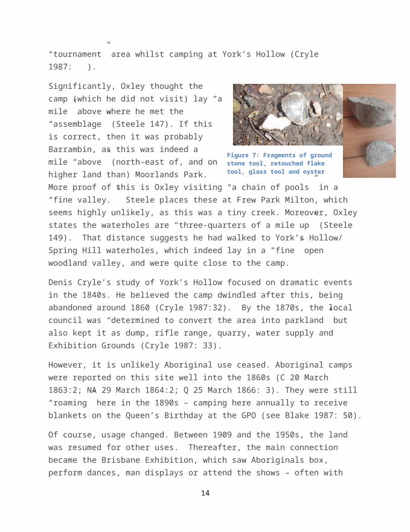
York’s Hollow (Barrambin – today’s Victoria Park and Exhibition Grounds) was a hotspot in Indigenous-white relations during the 1840s and 1850s. Stone artifacts and oyster shell can still be seen here (Figure 7), probably signifying occupancy in either pre-contact or early contact times, as stone was rapidly abandoned for iron when the latter became readily available.
This was probably the camp John Oxley heard when he was surveyingpotential sites for settlement on the Brisbane River. He was camped between what is now Toowong and Milton, and complained of the tumult he heard at night from a camp some distance away. In the morning he encountered a “very large assemblage” of Aborigines “in the same spot” as he had the previous year (see Oxley 27 September 1824 in Steele 147). These had evidently walked over from the camp. Oxley met this group, from Steele’s calculations, roughly where Moorlands Park in Toowong now lies. This area, including today’s Roma Street and Milton, was “low open forest” (Oxley 2 December 1823). It was regularly used for inter-tribal corroborees and tournaments (Petrie 1904; Bond 2009:Steele 1983: 97-98). The openness of the country would have allowed the Aboriginals to approach the explorers, which they could not do at the vine forest that covered much of Brisbane City (Young 1990). Groups from west of Brisbane used this
13
“tournament” area whilst camping at York’s Hollow (Cryle 1987: ).
Significantly, Oxley thought thecamp (which he did not visit) lay “amile” above where he met the“assemblage” (Steele 147). If thisis correct, then it was probablyBarrambin, as this was indeed amile “above” (north-east of, and onhigher land than) Moorlands Park.More proof of this is Oxley visiting “a chain of pools” in a “fine valley.” Steele places these at Frew Park Milton, which seems highly unlikely, as this was a tiny creek. Moreover, Oxley states the waterholes are “three-quarters of a mile up” (Steele 149). That distance suggests he had walked to York’s Hollow/ Spring Hill waterholes, which indeed lay in a “fine” open woodland valley, and were quite close to the camp.
Denis Cryle’s study of York’s Hollow focused on dramatic events in the 1840s. He believed the camp dwindled after this, being abandoned around 1860 (Cryle 1987:32). By the 1870s, the local council was “determined to convert the area into parkland” but also kept it as dump, rifle range, quarry, water supply and Exhibition Grounds (Cryle 1987: 33).
However, it is unlikely Aboriginal use ceased. Aboriginal camps were reported on this site well into the 1860s (C 20 March 1863:2; NA 29 March 1864:2; Q 25 March 1866: 3). They were still “roaming” here in the 1890s – camping here annually to receive blankets on the Queen’s Birthday at the GPO (see Blake 1987: 50).
Of course, usage changed. Between 1909 and the 1950s, the land was resumed for other uses. Thereafter, the main connection became the Brisbane Exhibition, which saw Aboriginals box, perform dances, man displays or attend the shows – often with
14
Figure 7: Fragments of ground stone tool, retouched flake tool, glass tool and oyster

great regularity (Scott & Laurie 2008: 44, 162-4, 226; Box 1985: 6). During the Depression and 1940s, this was an area of cheap army homes and the park itself had a large camp of squatters. These included a number of Aboriginal families (Aird 2001: ).
Breakfast Creek (Yowogera)
The site Oxley and Cunningham most favoured for the future Brisbane was Breakfast Creek. The explorers chose this spot for its high occupancy:
Numerous were the beaten paths of the wild aborigine. His several fireplaces showed me that this point of the river was numerously inhabited and not an hour had elapsed before four of the savages made their appearance (Oxley 16 September 1824 in Steele 125).
Cunningham found “ten native wells” in the vicinity and his compatriot quite candidly admits they were “not a half mile” from“the (native) encampment” (Oxley 16 September 1824 in Steele 125).
A year later, settlement began not on Oxley’s recommended site but still fairly closeby – at what is now North Quay in Brisbane City (3 kms to the west). Between first settlement (1825) and the 1860s, we have many references to the ‘large’ Aboriginal campof Breakfast Creek. These occur over every month, suggesting continuous use. Frequent visitors included resistance leaders: Yilbung Jemmy and Dundalli, and Dalaipi, who issued his famous “Indictments” from this spot. The camp was a regular source of fish for the white settlement.
Ray Evans believed Yowogera was fully extinguished in 1861 (Evans1987: 41). However, that entire decade and into the 1870s, newspapers continue to mention events at the camp (NAQGA 1 Aug
15

1863: 3; 28 October 1865; CC 26 May 1866: 4; BC 9 Feb 1867: 514; Q 12 May 1932: 35). In 1886, The Figaro described Chinese celebrations at the Breakfast Creek temple and noted “there are afew blacks about yet” (QFP Feb 1886: 15). As was the case with other former camps of Brisbane, this area now has a number of parks: Newstead, Crosby, Bartley’s Hill, Oriel, Albion Raceway and Eagle Farm Raceway.
Black’s Camp (Wynnum)
Transition from camp to park is most openly stated in Wynnum. “Alarge ‘black’s camp’ on the shore at Wynnum North” (Port c.1995: 3) is mentioned in various news reports during the 1880s-1890s (BC 3 Jan 1890, BC 6 Jan 1890: 43, BC 1 Dec 1889: 2; Jan 1884: 4). It evidently had shaped Wynnum’s identity, as white residentswere well aware that they were living in the area already called Wynnum “after the pandanus” which one resident complained “is useless as food” (Gough c.1995).
White and black communities lived and worked together in the infant fishing industry here, on which local Aboriginals relied. The Aboriginal area was simply “the black’s camp” (Clarke 2012:18; Lovekin BC 11 Dec 1895 :2).
Sometime after 1900 the Aboriginal community was not erecting huts in the camp itself. Locals recall they had “integrated well”– the children attending school with them into the 1920s and later (Port c.1995:3). It seems some found continued employment in local fishing and at the local hotel (Harbison 1995). Certainly a few individuals with connections to fishing continuedto live in Wynnum right up to the current day (Murray 1995).
In 1908 “the Blacks’ Camp land” was offered to Council, who purchased it. Council minutes from between 1908 and 1933 refer to maintenance work on the sea wall work on what was now used as
16

‘public land’ (which meant a dump and rifle range – much like Victoria Park) but in the records this was still “Black’s Camp” (Q 6 Jan 1923: 29; BC 20 Sept 1916: 3).
Only in 1933 it was ‘Blacks Camp’ changed to ‘Beach End’ (BC 7 Feb 1933: 10) and even then the old name continued in popular use(Port c.1995: 3). Over the next sixty years, the usual roads, lawns, playgrounds and bowls clubs were added to the park’s confines.
Today the site is known as Elanora Park (Harbinson 1998). Even this, according to one local, is simply an Anglicized version of glenora– a word he believes means “black’s camp” (Port c.1995:3). Whether or not this is correct, it shows the strength of local traditions concerning this spot.
Camps/ parks as foci for Brisbane’s contemporary Indigenous community
Between the late 1890s and 1950s, legal restrictions dismantled most yumbas – especially in South-eastern Queensland. Also by this time most Aboriginal families had started residing in suburban homes. In fact, Assimilation policies and the associated‘exemptions’ from Reserves drip-fed a ‘return to the towns’ afterthe 1930s, becoming a tidal wave following the Queensland Aborigines Act 1971 (Greenop & Memmott 2006: 260). It is due to this burgeoning urbanism that studies of Aboriginal Brisbane are usually recent and sociological in nature (see for example, Smith& Biddle 1975; Brough et al 2006; Demosthenos et al 2006).
Aboriginal families residing in suburban homes often chose to live beside former camping grounds (see Aird 2001). Historic events equally focused the Aboriginal community of Brisbane onto these sites.
The best example is Musgrave Park, which we have already noted isthe last fragment of two larger reserves that held the South
17
Brisbane/ Woolloongabba camp. As was the case with other camps, the area was never completely abandoned. Near the Mater Hospital (the Woolloongabba campsite) some 30 Aboriginals still collected bunya nuts c.1900 (SM 16 June 1935: 6), and between the 1890s and1910s, Indigenous men frequently ‘loitered’ in, or visited, the area – probably on account of West End Girls Home, to which many Aboriginal women were forcibly removed (Kerkhove 1985; Blake 1987: ), and because the Aboriginal Protector (Archibald Meston) resided a block away from the park.
By the late 1940s and 1950s, Musgrave Park was becoming a networking place, mustering the urban influx (Aird 2001; Kerkhove1985; Romano 2008). Around 1971, the Black Panther party began nearby. They took their protests to another Brisbane park (Roma Street – a former tournament grounds – see Bond 2009) and many arrests were made. This was foundational to the national Aboriginal Embassy in Canberra (Lothian 2007: 21).
In September 1982, international focus fell on Musgrave Park’s “tent city” of 300 residents (and thousands of protesters) (Romano 2008). Aboriginal people were claiming Musgrave Park as Aboriginal land. They organized a protest that marched from hereto Roma Street Park, arousing a “State of Emergency” by the then-government of Queensland, with further arrests. During Expo 88 a similar tent city was erected only to be pulled down (Kerkhove 1985, Romano 2008:43). More recently a tent embassy was put up inMusgrave Park to commemorate the Canberra tent embassy. Over 2012, the forcible and repeated dismantling of this embassy and its ‘sacred fire’ again drew international attention to Brisbane (BT 16 May 2012, CM 12 Dec 2012). Meanwhile – for 15 years – Aboriginal groups pressed to have a lease over part of the park. A lease was finally granted in 1999 for the establishment of an Aboriginal cultural centre (Armstrong 2001; Greenop & Memmott 2006: 268-269). The park now hosts up to 20,000 visitors for NAIDOC events (Romano 2008: 45).
18

Thus certain parks remain pivotal to Brisbane’s Indigenous identity, though they thereby pose issues around access. Compounding this are problems of identity. Brisbane’s Indigenousdiversity has grown over the decades. Though it preserves and melds together many traditional Indigenous values (Greenop 2008),its local identity remains contentious (Keen 1988: 2-4; Fredericks2004: 4).
One solution has been to focus on remnant vegetation, which parksand reserves preserve. Thus there are now “bush tucker” gardens and “Indigenous walks” in several Brisbane reserves. The Nurri Millen ‘totems’ – art installations at the Boondall Wetlands – are probably the best known example (Huie 1998:101). In the 1990s, Brisbane Aboriginal artists were also commissioned to create ‘traditional’ rock art in overhangs at J C Slaughter CreekFalls Picnic Reserve. Although the credibility of such exercisesis debated, they have assisted in acknowledging Aboriginal occupation (Jacobs 1995).
Unfortunately, bush tucker walks and art pieces also embody a clinical distancing. When Aboriginal groups actually occupy a Brisbane park or reserve, they find themselves much less welcome.This is especially problematic in Brisbane. There is still insufficient agreement as to whose heritage Brisbane’s reserves and parks ultimately represents, and how to go about incorporating the diversity of public use (Steve Lintern pers. comm., May 2013). Are “blacks in the park” squatters who “drink alcohol and cause a public nuisance” or are they “true” locals, returning to their “own place”? (Moore BT 19 May 2012). Aboriginals in Brisbane strongly claim particular parks as “campsites” and “home” (Romano 2008:48), yet officially these sites are under the jurisdiction of local shire governments.
Conclusions
19

In both pre-Contact and post-Contact times, Aboriginal camps in the Brisbane region seem to have been more populous and more permanent than is often supposed. Camping grounds followed distinctive plans, with internal features and possibly external associations. Although debate continues as to their similarity to “villages,” they functioned as ‘hometowns’ for Indigenous Australians.
Fringe camps have long been treated as the by-product of Europeaninvasion. This now seems less certain, given the antiquity of some sites. As in other Queensland towns, many Brisbane Aboriginal camps (including ‘fringe camps’) occupied areas that became parks and reserves. The checkered history of the transformation of Aboriginal camps into suburban parks continues to plague negotiations between Indigenous communities and government authorities, most notably in the case of Musgrave Park(South Brisbane). Nevertheless, parks and reserves serve as focifor Indigenous activities in Brisbane to this day.
The development of a history of each Brisbane Aboriginal camp andits relation to nearby reserves may help address some of the issues facing both Indigenous and non-Indigenous communities regarding the use and ownership of Brisbane’s parklands. This hasbeen a very slow process, but is lately gathering speed. Long-term, such research could culminate in guidebooks that would better demonstrate the historic significance of Aboriginal camps in Brisbane. More importantly, it may even establish that many suburbs, towns and indeed cities began as Aboriginal camps, and that European settlement sprang up on the periphery of these, rather than visa versa.
Sources
20

Armstrong, Helen B. and Seto, Jan M. and O'Hare, Danny J. (2001) Report 4: Reports of the Case Studies, Sim, Jeannie and Armstrong, Helen, Eds. . Cultural Landscape Research Unit, QUT. Investigating Queensland's Cultural Landscapes: CONTESTED TERRAINSSeries Report 4: REPORTS OF THE CASE STUDIES Published by Cultural Landscape ResearchUnit, Queensland University of Technology, Brisbane,
Blake, T., ‘Excluded, Exploited, Exhibited: Aborigines in Brisbane 1897 – 1910,’
Brough Mark, Chelsea Bond Julian Hunt David Jenkins Cindy Shannon Lisa Schubert Social capital meets identity Aboriginality in an urban setting Journal of Sociology Journal of Sociology December 2006vol. 42 no. 4 396-411
CAMPBELL JOHN Early settlement Of Queensland BIBLIOGRAPHICAL SOCIETY OF QLD. TRANSACTIONS NO.1 1936, 5.
Clark, W, 7 August 1909, A Jubiliee Retrospect – The City of South Brisbane The Queenslander p. 21
Cole, John R. 1984 Shaping a city : greater Brisbane 1925-1985 Eagle Farm, Qld. William Brooks
Coleman, Julia. "A new look at the north coast: fish traps and villages." Coastal Archaeology in Eastern Australia (1982): 1-10.
Collmann J., 1979, Fringe camps and the development of Aboriginal administration in Central Australia, Social Analysis: The International Journal of Social and Cultural Practice (Berghahn) No. 2 (November 1979), pp. 38-57
Colliver, Frederick StanleyWoolston, Frank P. 1978 A;boriginals in the Brisbane area’, Brisbane Retrospective (Brisbane: Library Board of Queensland)
Coutts P. J. F. 1966 Features of Prehistoric Campsites in Australia Australian Anthropological Society Mankind Volume 6 , Issue 8 , pages 338–346, November 1966
Cowin Winifred 1950European-Aboriginal relations in early Queensland1859-97School of History, Philosophy, Religion, and Classics The University of Queensland Honours Thesis
Demosthenous, Catherine, Boni Robertson*, Anuja Cabraal** Supriya Singh** 2006 Cultural Identity and Financial Literacy: Australian Aboriginal Experiences of Money and Money Management Smart Internet Technology Cooperative Research Centre & GriffithUniversity Smart Internet Technology Cooperative Research Centre & RMIT University Paper presented to the Financial Literacy, Banking and Identity Conference 25th and 26th October 2006, Storey Hall RMIT University, Melbourne
21
Evans Ray 1999, ‘Steal away’: The fundamentals of aboriginal removal in Queensland journal of Australian Studies Volume 23, Issue 61, Special Issue: Imaginary Homelands
_____ 1987 Wanton Outrage
Evans R and C. Ferrier (eds.) Radical Brisbane: An Unruly History, pp 309-315. Carlton: Vulgar Press.
FEEHELY DAN &. DAN O’DONNELL, c.1990, THE FIRE PEOPLE 1830s – 1930s - A HISTORY OF THE BURRA THE ABORIGINAL PEOPLE OF THE EASTERN DARLING DOWNS
Fisher, Rod 1990 Brisbane : the Aboriginal presence 1824-1860 Brisbane History Group Papers (Brisbane History Group) ; no. 11 Brisbane, Qld. Brisbane Historical Group
Fisher, R., 1992, From Depredation to Degradation – The Aboriginal Experience at Moreton Bay 1842-1860, in Rod Fisher, ed,, Brisbane – The Aboriginal Presence 1824-1850 Brisbane: Brisbane History Group Papers No. 12
Fisher, R., 2003, Diggles Down Under – Brisbane via Sydney from Merseydere 1855-80 Brisbane: Brisbane History Group Series No. 3
Fredericks, Bronwyn. Urban Identity, Eureka Street, 14 (10): 30-31. 2004.
Fredericks, Bronwyn L., Leitch, Angela, & Barty, Robert (2008) 'Big mobs in the city now' : the increasing number of Aboriginal and Torres Strait Islander people living inurban areas. In World Indigenous Peoples' Conference: Education (WIPC:E), 7-11th December 2008, Melbourne, Victoria.
Gargett Rob and Brian Hayden Site Structure Kinship and Sharing in Aboriginal Australia Implications for Archaeology 13 Piuntupi 1971 Ellen M. Kroll, T. Douglas Price ed The Interpretation of Archaeological Spatial Patterning 1991 Plenum New York 11-32
Godwin Luke 1988 Around the Traps: A Reappraisal of Stone Fishing Weirs in Northern New South Wales Archaeology in Oceania (Oceania Publications, University of Sydney) Vol. 23, No. 2 (Jul., 1988), pp. 49-59
Godwin Luke & Scott L’Oste-Brown, ‘A past remembered: Aboriginal ‘historical’ places in central Queensland – yaqmbas 2002 edited by Rodney Harrison, Christine Williamson After Captain Cook: The Archaeology of the Recent Indigenous Past in Australia AltaMira 2002 Walnut Creek
Greenop, Kelly (2008) Inala traditions: People, places and history in urban Indigenouscommunities. Traditional Dwellings and Settlements Working Paper Series, 216 :26-48. Berkley
22

Greenop, K. Memmott, P. Contemporary urban Aboriginal place values in Brisbane 8th Australasian Urban History/Planning History Conference Past Matters (ERA 2010 Rank B) Wellington Campus, New Zealand9-11 February, 2006 Past Matters: Heritage, History and the Built Environment: Proceedings from the 8th Australasian Urban History/Planning History Co C. L. Miller M. M. Roche Palmerston North, New Zealand School of People, Environment & Planning, Massey University 2006
Greenop Kelly & Paul Memmott, Aboriginal Identity and Place in the Intercultural Settings of Metropolitan Australia edited by Evelyn Peters, Chris Andersen Indigenous in the City: Contemporary Identities and Cultural Innovation
Hall, J. 1982 Sitting on the crop of the bay: An historical and archaeological sketch of Aboriginal settlement and subsistence in Moreton Bay, southeast Queensland. In S. Bowdler (d.) Coastal Archaeology in Eastern Australia, pp.79-95. Canberra: Department of Prehistory, Research School of Pacific Studies, The Australian National University.Occasional Papers in Prehistory. No. 1 1.
Hall, J. Ian Lilley Excavation at the new Brisbane Airport site (LB:C69): evidence for early mid-Holocene coastal occupation in Moreton Bay, SE Queensland Qld Archaeological Research Vol 4 1987
Head Lesley 2000 Second Nature: The History and Implications of Australia as Aboriginal Landscape Syracuse Uni Syracuse
Henry, Rosita (1999) Practising place, performing memory: identity politics in an Australian town , the 'Village in the rainforest' PhD thesis, James Cook University.
HIscock, P., 2008, Archaeology of Ancinet Australia London: Routledge
Hunter Ernest Out of sight, out of mind—2. Social and historical contexts of self-harmful behaviour among aborigines of remote Australia Social Science & Medicine, Elsevier –1991Volume 33, Issue 6, Pages 661-671
Irish, P, 2013, Revisiting Bennelong Point: Urban Aboriginal Settlements and the Origins of the Aborigines Protection Board, 13 Septmeber 2013
Jacobs, J.M., 1995 ‘That Dangerous Fantasy of Authenticity': a Review of the J. C. Slaughter Falls Community Arts Project, Brisbane Cultural Geographies April 1995 2:211-214,
Jones Susanne Montana 2009, The Anatomy of a Relationship: Doing archaeology with an Indigenous community on a former mission – A case study at Point Pearce, South Australia A thesis submitted in partial fulfilment of the requirements of the degree of Bachelor of Archaeology with Honours in Archaeology Department of Archaeology School of Humanities Flinders University of South Australia April 2009
23

Keen, I 1988 Introduction, in Being Black: Aboriginal Cultures in Settled Australia edited by Ian Keen Canberra: Aboriginal Studies Press
Kerkhove. Ray 1985 West End to Woolloongabba : the early and aboriginal history of a district Foundation for Aboriginal and Islander Research Action Brisbane
____________, 2008, Report (to QSNT Brisbane): Bidjara Connections in the Aramac, Barcaldine and Adavale Regions,’ Nambour: ICP
____________, 2009, Aboriginal Nambour Nambour: Interactive Community Planning (ICP
_____________, 2013, Aboriginal trade in fish and sea foods to settlers in 19th centurysouth-east Queensland: a vibrant industry? Queensland Review Vol:20:1 December 2013
Kidd, R. 2000 History of the Princess Alexandra Hospital Site. Diamantina Health Care Museum
Inc [online]. Available from: http://www.linksdisk.com/roskidd/site/Speech12.htm.
Lambert-Pennington, A.K. 2005 Being in Australia: Belonging to the Land: The Cultural Politics of Urban
Aboriginal Identity. PhD Dissertation; Department of Cultural Anthropology, Duke University.
Lawson, Ronald Lynton1973 Brisbane in the 1890's : a study of an Australian urban society St. Lucia, Qld. University of Queensland Press
Lilley, I., 1984 Late Holecene Subsistence and Settlement in SUbcoastal South easternQueensland, Queensland Archaewology Research 1984 Vol.1, 8-32.
Lothian, K., 2007 Moving Blackwards: Black Power and the Aborginal Embassy, edited by Ingereth MacFarlane, Mark Hannah Transgressions: Critical Australian Indigenous Histories ANU e-Press
Lourandos Harry Change or stability?: Hydraulics, hunter‐gatherers and population in temperate Australia World Archaeology Volume 11, Issue 3, 1980 Special Issue: Water management pages 245-264
24
Lourandos, H 1977b, ‘Aboriginal spatial organisation and population: south-western Victoria reconsidered’, Archaeology and Physical Anthropology in Oceania, 12,pp. 202–25.
Lourandos Harry and Anne Ross The Great 'Intensification Debate': Its History and Place in Australian Archaeology Australian Archaeology No. 39 (Dec., 1994), pp. 54-63
MacKenzie Smith, J., ‘Sandgate before the Railway,’ 1995, in Rod Fisher, ed, Brisbane:People, Plans and Programs Kelvin Grove: Brisbane History Group No. 14
M'Mahon, T. J., 31 July 1924, Brisbane 70 Years Ago. Octogenerian’s Memories – an Interesting Story, The Brisbane Courier p.18 t
Melton, C., ‘When Wolloongabba was Wattle-scented,’ 20 March 1915, Melton Cuttings Book MSS, RQHS pp.58-59
_________ When Woolloongabba was Wattle-Scented, Historical Society of Queensland Journal Vol.1:6, April 1919, p.347
Memmott P aul 1996 FROM THE 'CURRY TO THE 'WEAL: ABORIGINAL TOWN CAMPS AND COMPOUNDSOF THE WESTERN BACK-BLOCKS 1996 Fabrications: The Journal of the Society of Architectural Historians, Australia and New Zealand Volume 7, Issue 1, 1996 pages 1-50
_________, 2002 Sociospatial Structures of Australian Aboriginal Settlements Australian Aboriginal Studies Issue 1 (2002) 66-87
____________, 2007 Gunyah, Goondie and Wurley: The Aboriginal Architecture of Australia Uni of Qld PRess
Memmott, Paul and Moran, Mark, 2001, Indigenous Settlements of Australia. , Australia:State of the Environment Second Technical Paper Series (Human Settlements), Series 2, Department of the Environment and Heritage, Commonwealth of Australia.
Morgan, G. 2006 Unsettled Places: Aboriginal People and Urbanisation in New South Wales. Kent Town: Wakefield Press
Nicholson, Ann & Scott Cane Pre-European coastal settlement and use of the sea No 39(1994) Australian Archaeology (Australian Archaeological Association Inc)
O’Rourke, Tim “Aboriginal Camps and ‘Villages’ in Southeast Queensland” in Proceedings of the Society of Architectural Historians, Australia and New Zealand:30, Open, edited by Alexandra Brown andAndrew Leach (Gold Coast, Qld: SAHANZ, 2013), vol. 2, p 851-863.
Petrie CC., 1904, Tom Petrie’s Reminiscences of Early Queensland Hawthorn: Lloyd O’Neill
25

Rapoport Amos Australia Aborigines and the Definition of Place, Senior Lecturer of Architecture University of Sydney, Sydney, N.S.W. Australia 1972
Reynolds, Henry Fringe camps in Nineteenth Century Queensland Lectures on North Queensland History : Third series Townsville, Qld James Cook University, Dalton, B. J.History Dept. 1978
Reynolds, H., 2013, Forgotten War Sydney: NewSouth
Richards, J., 2007, ‘Fred Wheeler and the Sandgate Native Police camp,’ Journal of theRoyal Historical Siciety of Queensland, August 2007, Vol.120: 3, pp. 107-122.
Robinson. Shirleene "Keep them away from Brisbane: Bribie Island aboriginal reserves 1877-79 and 1891-92" Moreton Bay matters. Ed. M. Johnson. Brisbane: Brisbane History Group, 2002. 49-55.
Romano Diana 2 May 2008 ‘We is Human Beings.Musgrave People’.Connecting to Urbanised Place and Country in Musgrave Park, South Brisbane A thesis submitted in partial fulfilment of the requirements of a Bachelor of Arts with Honours Degree in the Schoolof Social Science,The University of Queensland
Ross Anne Archaeological Evidence for Population Change in the Middle to Late Holocenein Southeastern Australia Archaeology in Oceania Vol. 20, No. 3, Trends towards Social Complexity in Australia and Papua New Guinea. II (Oct., 1985), pp. 81-89
Rowland, Mike & Malcolm Connolly, 2002, Towards GIS Mapping and Spatial Modelling of Archaeological Sites in the Southeast Queensland Bioregion Qld Archaeolog Research Vol13 2002
Scott, Joanne and Ross Laurie 2007 Colonialism on display: Indigenous people and artefacts at an Australian agricultural show ABORIGINAL HISTORY 2007 VOL 31 continual interest in Aboriginal court (exhibit)_ 1870s to 1910s
____________________, 2008Showtime: a history of the Brisbane Exhibition St Lucia QLD, Australia University of Queensland Press
Smith, A., 1995, ‘Woolloongabba Transport – Its Changing Face,’ in Rod Fisher, ed., 1995, Brisbane: People, Plans and Programs Kelvin Grove: Brisbane History Group No. 14
Smith, Hazel M. Biddle, Ellen H. 1975 Look forward, not back: Aborigines in metropolitan Brisbane, 1965-1966 Australian National University Press (Canberra)
Smith Pamela A. 2001 Station Camps: Identifying the Archaeological Evidence for Continuity and Change in Post-Contact Aboriginal Sites in the South Kimberley, Western
26
Australia Australian Archaeology Australian Archaeological AssociationNo. 53 (Dec., 2001), pp. 23-31
South Bank Corp./ R.I. Longhurst & Historical Research Service, 1988, South Bank: An Historical Perspective from Then Until Now Brisbane: South Bank Corporation
Steele, J.G., 1975, The Brisbane River Adelaide: Rigby
_________, 1983:Aboriginal Pathways, Southeast Queensland and the Richmond River, University of Queensland Press, St Lucia
________., 1983a, The Explorers of Mreton Bay
Thorpe, B & Raymond Evans, 1999, Frontier transgressions: Writing a historyof race, identity and convictism in early colonial Queensland, Continuum: Journal of Media & Cultural Studies Volume 13, Issue 3, 1999 Special Issue: Postcoloniality and Cultural Studies pages 325-332
Ulm, Sean (1995). Fishers, Gatherers and Hunters on the Moreton Fringe: Reconsidering the Prehistoric Aboriginal Marine Fishery in Southeast Queensland, Australia BA (Hons), Department of Anthropology and Sociology, The University of Queensland.
Ulm, Sean, and Hall, Jay (1996) Radiocarbon and cultural chronologies in southeast Queensland prehistory. In: Australian Archaeology '95: Proceedings of the 1995 Australian Archaeological Association Annual Conference. Tempus: archaeology and material culturestudies in anthropology , 6 . University of Queensland, St Lucia, QLD, Australia, pp. 45-62.
Ulm, Sean Bryce Barker, Andrew Border, Jay Hall, Ian Lilley, Ian McNiven, Robert Neal and Mike Rowland Pre-European Coastal Settlement and Use of the Sea: A View from Queensland Australian Archaeology No. 41 (Dec., 1995), pp. 24-26 Australian Archaeological Association
Walters Ian 1985 The Toorbul Point Aboriginal fish trap Qld Arch Research Vol 2 (1985) Walters Ian 1985a Some observations on the material culture of Aboriginal fishing in the Moreton Bay area: implications for archaeology Q Arch Resach Vol 2 1985
Watson, I. 2007 Settled and Unsettled Spaces: Are we free to roam? In A. Moreton-Robinson (ed.) Sovereign Subjects: Indigenous Sovereignty Matters, pp 15-32. Crows Nest: Allen and Unwin.
27