From spatial data to geo-web Services - what next?
12
From spatial data to geo-web Services - what next? Nirmalendu Kumar, Survey of India Key words: Geo web service, Service chaining, Service Composition, National Data registry Abstract Now, spatial data is ubiquitous in one form or the other but the problems for the users are in their access, availability and meaningful integration. With the advent of web GIS all these problems has taken a different dimensions. Geo Web services (GWS) are capable of collaborating process control and sharing data and information across applications over different platforms hiding all the details of implementation and GWS can be invoked through the standard interface not just limited within one organization, but also across the organization. They are more suitable for handling huge-amount, distributed, and diverse geospatial data/information as compared to the conventional approach of geospatial data dissemination. However, the functions provided by isolated services are limited and for powerful functionality, these shared services require composition or chaining. It seems Geospatial Web Service Chain GWSC, will likely become the mainstream solution for Distributed Geographic Information Processing in the near future (Yang, 2009). However, it is a great challenge for beginners to create, deploy and utilize GWSC. People in Computer Science are usually not familiar with geospatial domain knowledge, Geospatial practitioners may lack the knowledge about web services and service chains and the end users may lack both. In India, pioneering work is being done in the domain of OGC compatible Geo Web Services (GWS) and various data producing agencies in the country are in the different stages of providing GWS from their respective organizations. National Spatial Data Infrastructure (NSDI) is about to launch a prototype of National Data Registry (NDR) where all such GWS can be registered and will be available for Service chaining for the creation of meaningful web services to the users. The various approaches reviewed in this paper will help in developing the appropriate strategies for the service chaining in this country. 1. Introduction We have all heard the quote that 80% of all data contains some reference to geography. In fact, spatial data is now ubiquitous in one form or the other but the problems for the users are in their access, availability and meaningful integration. With the advent of web GIS all these problems has taken a different dimensions. Now, a Web service, which is a modular self-describing, and self-contained software application, discoverable and accessible through standard interfaces over the network can provide an user a quality geo spatial product and services without having any so called GIS software to solve their problem in hand over the web. A standard registry or catalog is often used to publish and discover these Web services and when built using open standards, Web services permits users to dynamically access, exchange, deliver, and process geospatial data and products on the World Wide Web, no matter what platform or protocol is used. 2. Why Geo Web Services (GWS) is so important? The major benefit of Web services is the interoperability enabled by those standards: which make them capable of collaborating process control and sharing data and information across applications over different
Transcript of From spatial data to geo-web Services - what next?
From spatial data to geo-web Services - what next?
Nirmalendu Kumar, Survey of India
Key words: Geo web service, Service chaining, Service Composition, National Data registry
Abstract
Now, spatial data is ubiquitous in one form or the other but the problems for the users are in their access,
availability and meaningful integration. With the advent of web GIS all these problems has taken a
different dimensions.
Geo Web services (GWS) are capable of collaborating process control and sharing data and information
across applications over different platforms hiding all the details of implementation and GWS can be
invoked through the standard interface not just limited within one organization, but also across the
organization. They are more suitable for handling huge-amount, distributed, and diverse geospatial
data/information as compared to the conventional approach of geospatial data dissemination. However,
the functions provided by isolated services are limited and for powerful functionality, these shared
services require composition or chaining. It seems Geospatial Web Service Chain GWSC, will likely
become the mainstream solution for Distributed Geographic Information Processing in the near future
(Yang, 2009). However, it is a great challenge for beginners to create, deploy and utilize GWSC. People
in Computer Science are usually not familiar with geospatial domain knowledge, Geospatial practitioners
may lack the knowledge about web services and service chains and the end users may lack both.
In India, pioneering work is being done in the domain of OGC compatible Geo Web Services (GWS) and
various data producing agencies in the country are in the different stages of providing GWS from their
respective organizations. National Spatial Data Infrastructure (NSDI) is about to launch a prototype of
National Data Registry (NDR) where all such GWS can be registered and will be available for Service
chaining for the creation of meaningful web services to the users. The various approaches reviewed in this
paper will help in developing the appropriate strategies for the service chaining in this country.
1. Introduction
We have all heard the quote that 80% of all data contains some reference to geography. In fact, spatial data is
now ubiquitous in one form or the other but the problems for the users are in their access, availability and
meaningful integration. With the advent of web GIS all these problems has taken a different dimensions.
Now, a Web service, which is a modular self-describing, and self-contained software application,
discoverable and accessible through standard interfaces over the network can provide an user a quality geo
spatial product and services without having any so called GIS software to solve their problem in hand over the
web. A standard registry or catalog is often used to publish and discover these Web services and when built
using open standards, Web services permits users to dynamically access, exchange, deliver, and process
geospatial data and products on the World Wide Web, no matter what platform or protocol is used.
2. Why Geo Web Services (GWS) is so important?
The major benefit of Web services is the interoperability enabled by those standards: which make them
capable of collaborating process control and sharing data and information across applications over different

platforms. A Web service hides all the details of implementation under a well-defined interface and thus, other
applications or services can invoke such a Web service through the standard interface not just limited within
one organization, but also across the organization. It facilitates real-time data access, on-demand/customized
information delivery, easy integration, and extended collaboration, achieved at the slightest cost of
performance compared to proprietary distributed computing approaches. Web Service is more suitable for
handling huge-amount, distributed, and diverse geospatial data/information as compared to the conventional
approach of geospatial data dissemination. Geo web services – often referred to as geo-services are a special
kind of web services that support the handling of geographic information and typically enable the user to
derive new geo-information, based on spatial, temporal and thematic relationships. These are usually
subdivided into three categories: data services, processing services and registry or catalogue services (Alameh
2003).
3. Why Service chaining is required?
As geodata has become largely available through Spatial Data Infrastructures (SDI) as a GWS geographic
information sharing and interoperability in distributed and heterogeneous computing environments is now
possible. However, the functions provided by isolated services are limited and for powerful functionality, these
shared services require composition. The composition model of a series of distributed geospatial services
working collaboratively to accomplish a complicated task with certain specifications is by calling a Geospatial
Web Service Chain (GWSC). A GWSC can effectively solve the computationally intensive problems and
complex procedure issues in Geographic Information Processing, with reduced development costs by
promoting software reuse. It seems GWSC, will likely become the mainstream solution for Distributed
Geographic Information Processing in the near future (Yang, 2009). Extracting geo-information from web-
based GWSC is an important issue for applications in which decision makers have to integrate multiple
sources to answer questions regarding a geospatial context. GWSC is also promising to establish distributed
platforms for large-scale computational calculations such as complex simulation models. In particular,
interoperable geoprocessing services can be chained to create new value-added chains (Alameh 2003).
To evaluate a service’s fitness-for-use and to create meaningful combinations of services, it is necessary to
model the essential properties of services that facilitate their discovery, composition and execution. A service
can be characterized by the information it deals with, (data input and output) and how it processes this
information (the operations that the service makes available to the user). The abstraction of information and
processes is an important instrument to simplify the view on the often-complex structure of a service.
4. Challenges in Service chaining
New challenges lie ahead to integrate these services into meaningful service chains and make them instantly
available to the clients. It is a great challenge for beginners to create, deploy and utilize a Geospatial Web
Service Chain (GWSC). People in Computer Science are usually not familiar with geospatial domain
knowledge. Geospatial practitioners may lack the knowledge about web services and service chains. The end
users may lack both.
In the IT field, various web services composition specifications have been proposed (e.g., WS-BPEL (OASIS,
2007), WS-CDL (W3C, 2004a), WSFL (IBM, 2001)). These specifications provide a good foundation for
modelling GWSC, but the problem is that they are closely associated with IT implementations and focus too
much on technological details. To create and utilize a composition model, users not only need to master

professional GIS knowledge, but also have thorough knowledge of XML-related specifications (e.g., XPATH,
XQuery, XSLT), web services specifications (e.g., WSDL, SOAP, UDDI, WSIF) and also understand
composition specification itself. All these dramatically increase learning costs and modelling difficulties,
hindering the exploitation of GWSC technologies to some extent and its widespread application.
The integrated exploitation of those distributed services can be facilitated by service chaining, which involves
service discovery, abstract composition (identifying service chain functionality), concrete composition
(identifying service chain messaging) and execution, typically in this order. The first two, service discovery
and abstract composition deal with semantics, while the latter two, concrete composition and execution deal
with syntactic issues.
Three types of chaining are defined in ISO 19119(ISO, 2005):
i. User-defined (transparent) —a user defines and manages a chain.
ii. Workflow-managed (translucent)—a user invokes a service that manages and controls the
chain and the service is aware of the individual services in the chain.
iii. Aggregate (opaque)—a user invokes a service that carries out the chain, and the user has no
awareness of the individual services in the chain.
5. Different approaches for Service Chaining
Various researchers have adopted different approach to chain the various available Geo web services to meet
the user requirement. Now the paper reviews few of such approaches.
5.1. Geo-Service Chaining through Deep Service Descriptions
Rob Lemmens et al (2007) demonstrate the integrated use of semantic and syntactic service descriptions,
which they are defining as Deep Service Descriptions, for service chaining by combining two prototypes: one
that deals with geo-service discovery abstract composition (called ‘GeoMatchMaker’), with one that supports
concrete composition and execution of geo-services services (called ‘Integrated Component Designer’). The
integrated architecture purposed is given in figure-1. They emphasize that most other service chaining
approaches confine themselves to handling either syntactic or semantic service descriptions using proprietary
formats descriptions, which hamper an effective integration of discovery, composition and execution of
multiple services. However in essence, service chaining should help a user by providing an appropriate
combination of executable services to solve a specified problem or query. Current XML-based service
description languages such as the Web Ontology Language-Services (OWL-S) and the Web Service
Description Language-Semantics (WSDL-S), allow them to build a geoservice-reuse architecture based on
common ontologies and shared service descriptions. Here the ontology-based descriptions are used as
representations of service requests and advertisements in a matchmaking process. The matchmaking is
performed by an ontology reasoner, which can infer implicit relationships that exist in a knowledge base
containing service descriptions as sets of concepts. The offered solution is flexible and extensible. The link
between the abstract (conceptual) and concrete composition of services is realized by annotation, which
connects ontology elements with parameters of executable code.
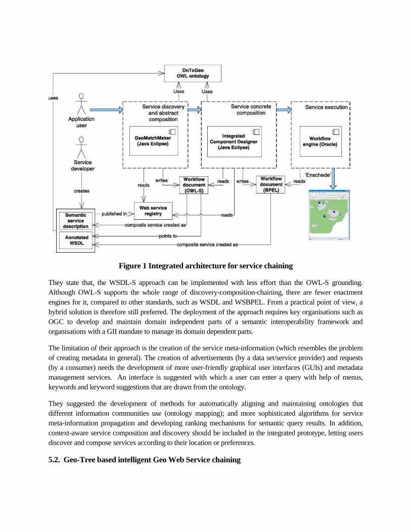
Figure 1 Integrated architecture for service chaining
They state that, the WSDL-S approach can be implemented with less effort than the OWL-S grounding.
Although OWL-S supports the whole range of discovery-composition-chaining, there are fewer enactment
engines for it, compared to other standards, such as WSDL and WSBPEL. From a practical point of view, a
hybrid solution is therefore still preferred. The deployment of the approach requires key organisations such as
OGC to develop and maintain domain independent parts of a semantic interoperability framework and
organisations with a GII mandate to manage its domain dependent parts.
The limitation of their approach is the creation of the service meta-information (which resembles the problem
of creating metadata in general). The creation of advertisements (by a data set/service provider) and requests
(by a consumer) needs the development of more user-friendly graphical user interfaces (GUIs) and metadata
management services. An interface is suggested with which a user can enter a query with help of menus,
keywords and keyword suggestions that are drawn from the ontology.
They suggested the development of methods for automatically aligning and maintaining ontologies that
different information communities use (ontology mapping); and more sophisticated algorithms for service
meta-information propagation and developing ranking mechanisms for semantic query results. In addition,
context-aware service composition and discovery should be included in the integrated prototype, letting users
discover and compose services according to their location or preferences.
5.2. Geo-Tree based intelligent Geo Web Service chaining
Liping Di (2005) took another approach, for managing service chaining and he purposes an interoperable
system framework for developing web-service-based intelligent geospatial knowledge systems. The designed
system facilitates personalized, on-demand geospatial information or knowledge discovery and dissemination.
The system is able to answer "what if' questions by automatically and intelligently chaining individual service
modules to form a complex geospatial processing model, matching the input data with the model, and
executing the processing model to deliver answers to the users. The system also has the capabilities to evolve
and improve by itself. The framework is based on the geo-object and geo-tree concepts, which simulate the
geospatial processing models constructed by the experts in geospatial knowledge discovery. The framework
also relies on the geospatial interoperability standards, developed primarily by the Open Geospatial
Consortium (OGC), recent progress in semantic Web technology and interoperable geospatial Web services.
The geo-object and geo-tree concepts provide the mechanism to unify the representation of geospatial data,
information, and knowledge, capture the process of geospatial knowledge discovery, manage geospatial
knowledge, and enable the dynamic reuse of geospatial knowledge in multiple applications. From the services
point of view, a geo-tree is a complex service chain. A web-service based geospatial knowledge system built
on the geo-tree framework will enable opaque automated chaining of available data and services in a web
service environment to answer users' queries.
The framework supports (1) standards-based automated geospatial data and services discovery and access; (2)
domain knowledge driven intelligent geo-object decomposition for geo-tree/workflow construction; (3)
automated geospatial web service chaining, binding, and execution based on the geo-tree/workflow; and (4)
management of workflows and geospatial models. The system purposed also provides a mechanism for
capturing experts' geospatial knowledge and making them available to general users. Currently, such
framework is being implemented in GeoBrain.
5.3. Model-driven geo-spatial web service composition
The issues that service chaining has to handle include complicated processing, spatial calculation, and
invoking of heterogeneous data. Issues still baffling in service chaining are first, the quality of geospatial
service is rarely considered during the construction of service chain; second, the process model of geospatial
service chain cannot be shared and reused, since the process model generated by automatic composition is
dynamic and does not have a fixed process model. The processing of geographic information usually follows
some routine workflow, while in the execution of the workflow, an atomic process in the procedure can be
replaced by another process that employ a new algorithm.
Wu Dua et al (2014) propose model-driven composition architecture for the geospatial service, and
demonstrate the application by the classic facility location analysis. They modeled the location analysis of
sewage treatment plant from the point of geo-processing service. The aim was to select the suitable parcels that
meet following conditions:
i. the altitude should be below 365m to cut down the cost;
ii. outside the flooded area;
iii. around the river within 1000 m to cut down the pipeline cost;
iv. away from urban residents at least 150 m;
v. better in exploitable vacant lot, to cut down the expropriation cost;
vi. around sewage concentrated center within 1000 m.
Five types of services are used in the location analysis, including buffer, intersection, selection, symmetrical
difference and union. Furthermore, the evaluation criteria of geospatial service are provided to promote the
construction of service chain. The process model of composite service can be shared and reused because it is
independent on the specific language that describes the web service, such as wsdl, owls, wsmo and so on.
For composition of service chains, they designed GwscFlow model, an abstract and extensible workflow
model, to describe the composition of geospatial service. The core elements of GwscFlow model include
AbstractGwscElement, FlowNode, GwscFlow, Transition, WebService and FlowGate. They focus on five
evaluation criteria about non-functional properties: execution time, cost, reputation, reliability and availability,
according to the theory of service selection (Zeng LZ, 2004). The service composition problem is transformed
to the dynamic binding problem, in which the abstract service node is bound to specific service by
matchmaking algorithms. In this work, the genetic algorithm is adopted to optimize the service composition
process by satisfying the quality constraints thereby maximizing the quality of service chain.
5.4. GeoChaining
Huayi Wu (2011) purposed GeoChaining is a GWSC modelling tool designed and developed based on the
assumption that an integrated visual editing interfaces, validation tools, and one-click deployment wizards may
help to lower the learning curve and improve modelling skills of GWSC. Thus, GeoChaining integrates visual
editing, validation, deployment, execution etc. into a unified platform. By employing the available Virtual
Globe, users can intuitively visualize raw data and results produced by GeoChaining. All of these features
allow users to easily start using GWSC, regardless of their professional background and computer skills.
Further, GeoChaining supports GWSC model reuse, meaning that an entire GWSC model created or even a
specific part can be directly reused in a new model. This greatly improves the efficiency of creating a new
GWSC, and contributes to the sharing and interoperability of GWSC.
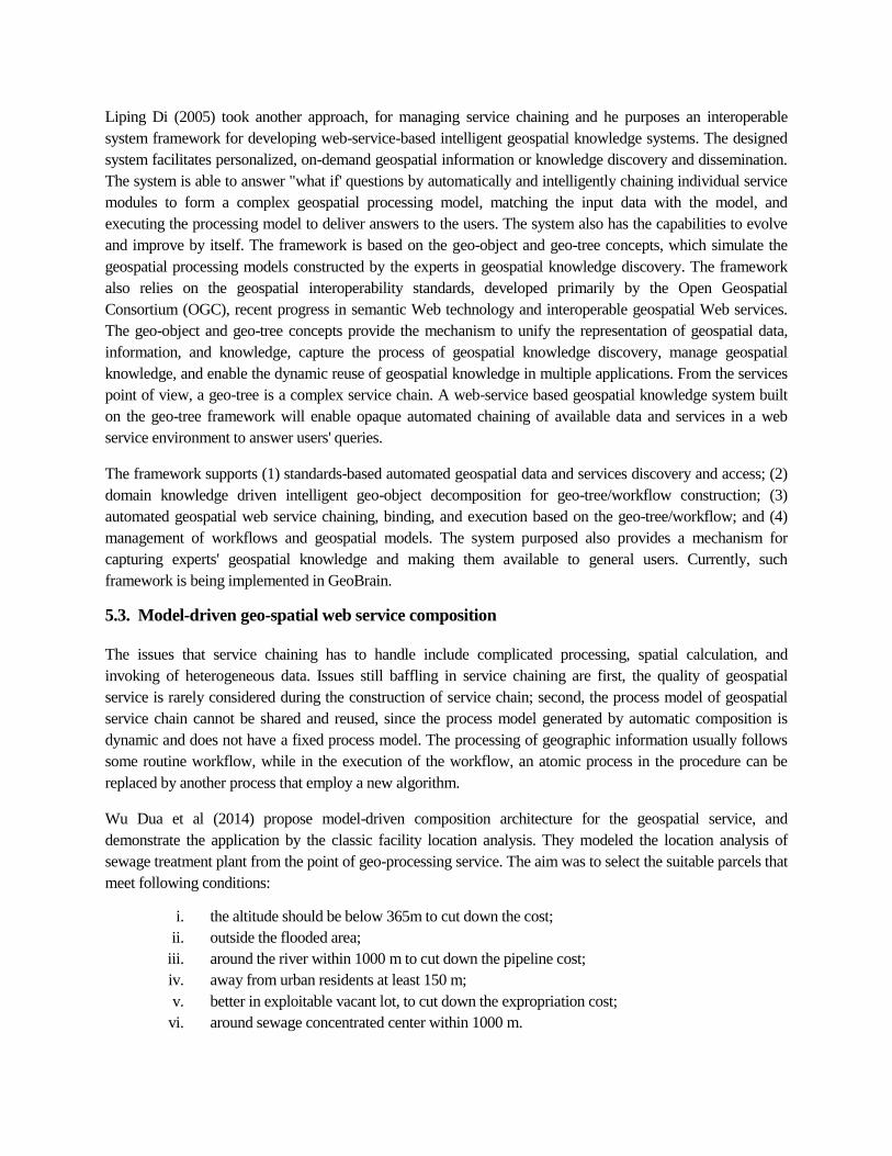
System Architecture of GeoChaining
GeoChaining is designed with three-tier architecture, i.e., with client, server and resource tiers, as illustrated in
Figure. 2.
Figure: 2 System Architecture of GeoChaining , Huayi Wu (2011)
They validated the feasibility of GeoChaining platform’s design, by a GWSC model about 3D features
classification and rendering analysis. This GWSM model contains two component services, i.e., a hill shade
rendering service and a 3D feature classification and fusing service. Input raw data were DEM and classified
image, while the output data result was the fused image, showing classification and rendering results for 3D
features.
Thus, GeoChaining hidesTechnical specification details solve the complexity problem that inhibits non-
specialist use. Researcher claims that users with different backgrounds and levels of expertise can now easily
design, deploy and execute their own GWSC models in the same GUI by using simple “drag-and-drop” and
“one-click” operations.
5.5. Semantics-based automatic composition of geospatial Web service chains
Peng Yue et al. (2006) presents an approach for automating geospatial Web service composition byemploying geospatial semantics in the service-oriented architecture (SOA). It shows how ontology-based geospatial semantics are used in a prototype system for enabling the automatic discovery,access, and chaining of geospatial Web services. A case study of the chaining process for derivinga landslide susceptibility index illustrates the applicability of ontology-driven automatic Webservice composition for geospatial applications.
The automatic service composition relies mainly on solutions to three issues: (1) how to makegeospatial Web services interoperable both syntactically and semantically; (2) how toautomatically discover, based on the syntactic and semantic descriptions, the most appropriate dataand services; and (3) assemble them to build the composite service. Syntactical interoperability ofWeb services is achieved mainly using two common Web service standards: Web servicedescription language (WSDL) and simple object access protocol (SOAP). WSDL is used todescribe a Web service in terms of its interfaces and SOAP formalizes the XML-based messagetransportation between Web services. Ontologies are crucial to making the semantics of theexchanged content machine understandable. The Web ontology language (OWL), recommended byW3C as the standard Web ontology language, is designed to represent semantics based on aflexible graph model composed of Resource Description Framework (RDF) triples. Furthermore,

the Semantic Web services initiative (SWSI) introduces OWL-S as the representative technologyfor describing the semantics of individual Web services. The work explores Web servicecomposition in the geospatial domain, through the introduction and design of OWL-basedontologies conveying semantic information on geospatial services and data. Syntacticallyinteroperable Web services can be chained manually under SOA. In this study, they explore thesemantic support in the different aspects of SOAP. In particular, an automatic and intelligentcomposition architecture based on the “DataType”and “ServiceType”ontologies is designed andtested. A prototype system backed by NASA EOS data and a number of OGC-compliant services,with OWL/OWL-S ontology descriptions, is implemented.
As a use case, they find the solution to a user question “What was the susceptibility of DimondCanyon, California, United States to landslide on January 10, 2005?” and using semantic chainingit return an image map containing the landslide susceptibility index value. If we want to let themachine automate this process, the system should be able to identify, at each step in the servicechaining process, semantically correct data and services without human interactions. By usingontologies to enrich the data and service description, the semantics of data and services aremachine understandable and conceptually potential data and services can be discovered through theattached logical reasoning process.
Geospatial semantics
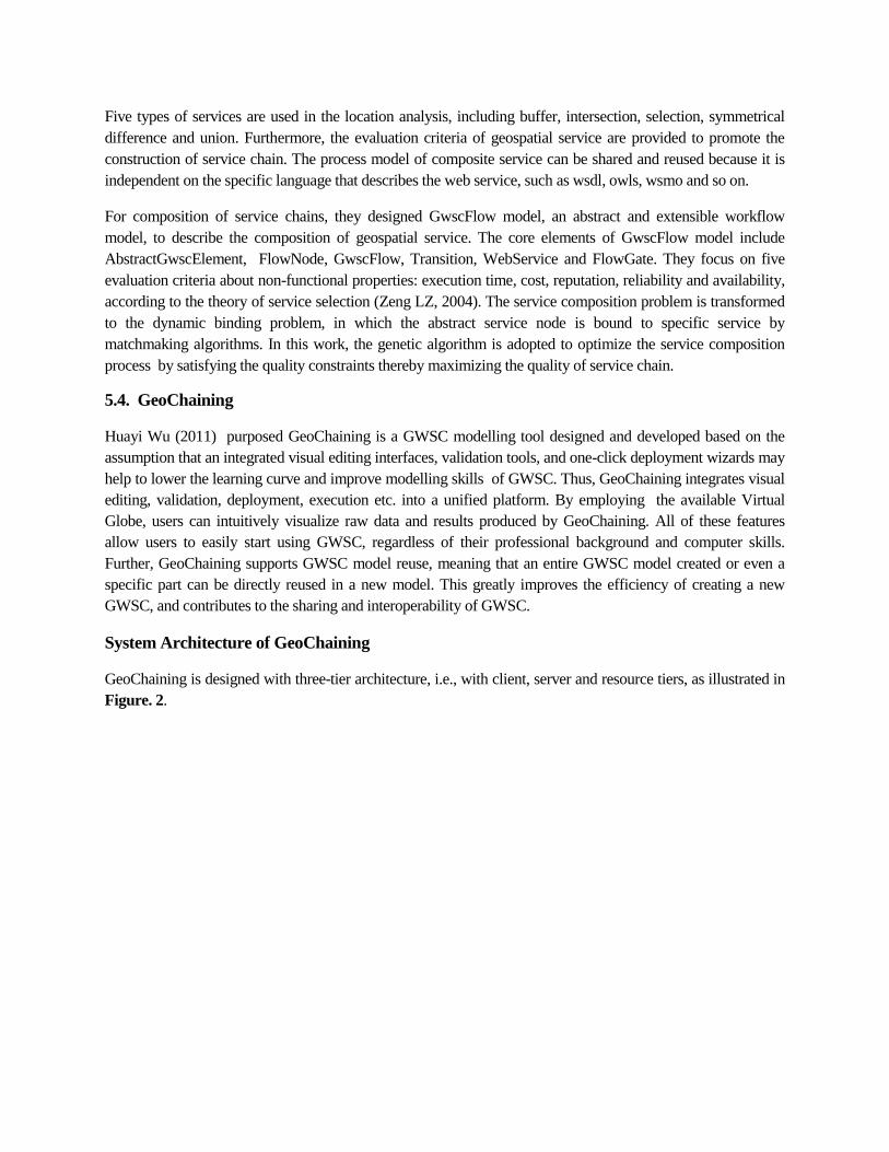
Geospatial semantics are those that convey content information about geospatial data, entities,phenomena, functionalities, relationships, processes, services, etc. Based on the degree ofgenerality, ontologies can be divided into three levels (Guarino, 1997): top-level ontologies,domain ontologies, and application ontologies. Top-level ontologies describe the general conceptsindependent of domain, for example, object or event. Domain ontologies describe the concepts in ageneric domain such as the geospatial domain. Application ontologies are related to a specificdomain or task that is intended for use in one application rather than across many applications.
They mainly design the domain and application ontologies. For data semantics, they developed“DataType”ontologies including the Global change master directory (GCMD) “DataType”and thelandslide susceptibility “DataType”ontologies. Landslide susceptibility “DataType”ontologycontains the necessary entity classes in this application such as “Terrain_Elevation”and“Terrain_Slope”. When bridging the domain ontologies and application ontologies, the“subClassOf”axiom is added to signify that “Terrain_Slope”is a subcategory of “Topology”in theGCMD ontology, while the “equivalentClass”axiom is added to signify that “Terrain_Elevation”inthe landslide susceptibility “DataType”ontology is equivalent to “Terrain_ Elevation”in the GCMDontology. For functional semantics, “ServiceType”ontologies are developed, including the GCMD“ServiceType”ontology and the landslide susceptibility “ServiceType”ontology. In addition to the“DataType”and “Service-Type”ontologies, they also included the “Association”ontologies todescribe the relationships between services and data. The geospatial semantic schema used by themis as given in figure 3:
Figure: 3 Geospatial semantics schema (taken from Peng Yue et al. 2006)
Their work demonstrates that ontologies, both those for data and those for services, are useful for
conveying geospatial semantics and the automatic construction of geospatial models. A mediated
RDF structure in the “DataType” ontology can significantly reduce the number of required schema
mappings between service messages. They suggest that the functional semantics of services need
further consideration in the automation of service composition and intend to explore the spatial
reasoning. Their work provides a framework for automatic composition of geospatial Web services
and introduction of AI planning methods will enhance the capability of automatic service
composition.
5.6. SAW-GEO orchestration of Grid-Enabled Geospatial Web Services
Gobe Hobona et al. (2010) examined the integration of Grid services and geospatial web services
into workflows for Geoscientific processing. They proposed an architecture that bridges web
services based on the abstract geospatial architecture (ISO19119) and the Open Grid Services
Architecture (OGSA) and presented a workflow management system, called SAW-GEO that
supports orchestration of Grid-enabled geospatial web services. An implementation of SAW-GEO
is presented, based on both the Simple Conceptual Unified Flow Language (SCUFL) and the
Business Process Execution Language for Web Services (WS-BPEL or BPEL for short). They
explored the potential of workflow enactors to support the creation of geoscientific workflows
involving web services based on standards of the Open Geospatial Consortium and implemented a
prototype for the analysis of groundwater vulnerability using borehole data. The sample workflow
implementation using two different workflow enactors and their distinct languages demonstrated
that the proposed approach is independent of the workflow enactor adopted and it could be used to
support collaborative workflows that involve analytical services provided by multiple
organizations.
Here the orchestration involves the coordination of various web services by a central enactor in
contrast to “chaining” which involves referencing web services from one another such that each
service directly invokes another in the same workflow. This approach has the advantages that it
allows the OGSA service to support OGC messages without compromising the validity of those
messages and it allows the integrated service to be independent of the underlying service interface,
whether it is based on WSRF or alternatives. Moreover, OGSA service can offer an authentication
layer to manage access to the OpenGIS web service but cost in performance because of the
additional tier between the client and the OGC web service and increases the possibility of there
being a service fault. However, regardless of enactor-used, the system supported OGC data types,
large geospatial datasets and parallel sub processes; thereby demonstrating enactor-independence.
Their work provides an approach for supporting geoscientific workflows using both Taverna and
ActiveBPEL; with a geo-oriented application of enactors. The use of a proxy service for caching
datasets during workflow enactment, preserve the integrity of the source data and provide access to
participating services. Furthermore, the addition of a parameter in the SOAP request for specifying
a target GWS offers dynamic referencing at runtime. They have suggested that the possibility of
implementing an OpenGIS Web Service Processor for Taverna should be investigated and more
work has to be done to standardize the integration of OpenGIS web services with OGSA
frameworks.
5.7. Web Services Chaining for supporting Real-Time Status Monitoring
Standard geospatial web services only have two simple statuses: success or failure. However, the procedures
for geospatial information processing and analysis always feature intensive data, complex computation, and
long processing times. The standard geospatial web services composition only provides basic functions and
cannot fully satisfy geospatial information processing and analysis needs. The problems with standard
geospatial web services are numerous, including difficulties in controlling and monitoring geospatial web
services, composition optimization, and error tracking. The execution status of geospatial web services
composition must be monitored as it becoming the basis for further optimization of the geospatial web services
composition model.
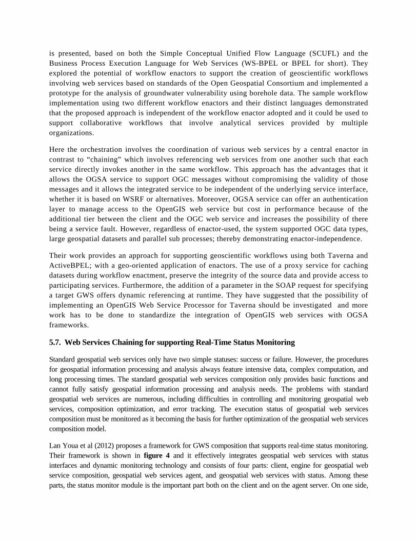
Lan Youa et al (2012) proposes a framework for GWS composition that supports real-time status monitoring.
Their framework is shown in figure 4 and it effectively integrates geospatial web services with status
interfaces and dynamic monitoring technology and consists of four parts: client, engine for geospatial web
service composition, geospatial web services agent, and geospatial web services with status. Among these
parts, the status monitor module is the important part both on the client and on the agent server. On one side,
the module on the client communicates with the module on the agent server and shows the progress
dynamically; on the other side, the module on the agent server cycle queries the status interfaces provided by
geospatial web services delivering the status for collecting the real-time status. Experiments demonstrate that
the framework can really show execution information, reminds users with bottleneck information and provides
a foundation for further improvements in the efficiency of the model’s execution.
Figure 4 Framework Design (taken from Lan Youa et al (2012))
Their prototype took ActiveBpel engine for the geospatial web services composition. A java servlet was
implemented as the geospatial web services agent and Tomcat 5.5 was used as the service container. The
geospatial web services with status interfaces are implemented with C++ program language. The states that
their goal is to construct a fused geospatial web services composition including not only the web services with
status interfaces but also those with no status interfaces, which will make the framework more expansive.
6. Conclusions
In India, pioneering work is being done in the domain of OGC compatible Geo Web Services (GWS)
and various data producing agencies in the countries are in the different stages of providing GWS
from their respective organizations. National Spatial Data Infrastructure (NSDI) is about to launch a
prototype of National Data Registry (NDR) where all such GWS can be registered and will be
available for Service chaining for the creation of meaningful web services to the users. The various
approaches reviewed in this paper will help in developing the appropriate strategies for the service
chaining in this country.
References:
1. Alameh, Nadine (2003) Chaining geographic information Web services. IEEE Internet Computing7(5): 22-29.
2. Gobe Hobona et al. (2010), Orchestration of Grid-Enabled Geospatial Web Services in GeoscientificWorkflows, IEEE Transactions On Automation Science And Engineering, Vol. 7, No. 2, April 2010
3. Huayi Wu (2011), DIY Geospatial Web Service Chains: Geochaining Make It Easy, InternationalArchives of the Photogrammetry, Remote Sensing and Spatial Information Sciences, VolumeXXXVIII-4/W25, 2011 ISPRS Guilin 2011 Workshop, 20-21 October 2011, Guilin, China
4. Lan Youa et al (2012) a geospatial web services composition framework supporting real-time status
monitoring, ISPRS Annals of the Photogrammetry, Remote Sensing and Spatial Information Sciences,
Volume I-4, 2012 XXII ISPRS Congress, 25 August – 01 September 2012, Melbourne, Australia
5. Liping Di(2005) A Framework for Developing Web-Service-Based Intelligent Geospatial KnowledgeSystems, Geographic Information Sciences Vol. 11, No. 1, June 2005
6. Rob Lemmens et al (2007) Enhancing Geo-Service Chaining through Deep Service Descriptions,Transactions in GIS, 2007, 11(6): 849–871
7. Wu Dua et al (2014) Model-Driven Geospatial Web Service Composition, The International Archivesof the Photogrammetry, Remote Sensing and Spatial Information Sciences, Volume XL-6, 2014ISPRS Technical Commission VI Symposium, 19 – 21 May 2014, Wuhan, China
8. Yang, C., et al., (2009), Introduction to distributed geographic information processing research.International Journal of Geographical Information Science, 23(5), pp. 553-560
9. Zeng, L.Z., et al., 2004. QoS-aware middleware for Web Services Composition, IEEE TransactionsOn Software Engineering. 30(5): p. 311-327.