Forest policies, management and conservation in Soviet (1920-1991) and post-Soviet (1991-2005)...
15
International Forestry Review Vol. 7 (2), 2005 113 Evolution of the forest cover in Armenia 1 Department Geography and Environmental Studies, University of Colorado at Denver, Campus Box 172, P.O. Box 173364, Denver, CO 80217-3364, USA 2 Forestry Department, Armenian Agricultural Academy, Teryan 74, 375009 Yerevan, Republic of Armenia R. MORENO-SANCHEZ 1 and H.Y. SAYADYAN 2 Email: [email protected], [email protected] SUMMARY This paper illustrates the geographical extent of the Armenian forests at five points in time, from the year 4,000 B.C. to the present. For each period the social and economic context that is most relevant to the use and conservation of the forests is presented. An extensive literature search for the most reliable geological, archaeological, and bio-geographical records was conducted to provide an estimate of the extent of the forest cover in ancient times. According to the estimates produced, and the National Forest Inventories during the Soviet period, the forest cover has decreased from covering approximately 35% of Armenia during the first three millennia B.C., to 8.1% during the 1950s, 11.2% during the 1980s , to7-8% today. The degree of deforestation that Armenia has suffered and the likelihood of losing the remaining highly fragmented forest areas in the coming years is highlighted. Keywords: Armenia, forest cover, deforestation, GIS, forest inventories. INTRODUCTION The uses of the goods and services provided by the Armenian forests have evolved through time in response to changes in population, culture, politics, and economics. The last few decades have seen a reduction of the extent and quality of the forest cover in Armenia. Given the current economic, social and political conditions in the country this decline is likely to continue and probably accelerate. This poses a serious threat to Armenia’s long-term sustainable development. To reverse this trend it is important to revive Armenian forestry culture and educate a new generation of stakeholders, scientists, resource managers, and politicians (in Armenia and abroad) about the characteristics and extent of the Armenian forests. Since the dissolution of the United Socialist Soviet Republics (USSR) in 1991, Armenia has been working on developing its human, material and knowledge infrastructure for the management of its natural resources. During the Soviet period most of the planning and decision-making regarding these activities took place at a centralized level and little local infrastructure was developed. There are different data and articles on forest and land-use changes in Armenia but they are very scattered and never have been compiled and interpreted. Furthermore, there are no explicit cartographic representations of the historical extent of the forest cover in the country that are reliable and based on the best information from literature, archaeological, and bio-geographical sources. The purpose of this article is to present in a consistent format the evolution of the extent of the forest cover in the Republic of Armenia from approximately the year 4000 B.C. to the present making use of the most reliable direct and indirect sources of information for each of the historical periods considered. A set of consistent cartographic products were created using Geographic Information Systems (GIS) to illustrate the geographical extent of the forest cover. For each historical period considered, the most relevant social, economic, and environmental conditions that affected the use of the forests and their conservation are described. Our aim is to contribute to the knowledge base of Armenian natural resources for the benefit of the international community and the Armenian people. The remainder of the article is organized as follows: the second section presents a brief overview of the history, the physical and human geography, and the forest cover characteristics in Armenia, following sections present the most relevant social and economic conditions for each of the historical periods considered, and a map of the estimated forest cover extent based on the most reliable sources of information for the period, finally a discussion and a series of conclusions and recommendations are presented. All the maps used in this paper are in Universal Transverse Mercator (UTM) projection NAD 83 zone 38.
-
Upload
armagrar-uni -
Category
Documents
-
view
3 -
download
0
Transcript of Forest policies, management and conservation in Soviet (1920-1991) and post-Soviet (1991-2005)...

International Forestry Review Vol. 7 (2), 2005113
Evolution of the forest cover in Armenia
1 Department Geography and Environmental Studies, University of Colorado at Denver, Campus Box 172, P.O. Box 173364,Denver, CO 80217-3364, USA2 Forestry Department, Armenian Agricultural Academy, Teryan 74, 375009 Yerevan, Republic of Armenia
R. MORENO-SANCHEZ 1 and H.Y. SAYADYAN 2
Email: [email protected], [email protected]
SUMMARY
This paper illustrates the geographical extent of the Armenian forests at five points in time, from the year 4,000 B.C. to thepresent. For each period the social and economic context that is most relevant to the use and conservation of the forests ispresented. An extensive literature search for the most reliable geological, archaeological, and bio-geographical records wasconducted to provide an estimate of the extent of the forest cover in ancient times. According to the estimates produced,and the National Forest Inventories during the Soviet period, the forest cover has decreased from covering approximately35% of Armenia during the first three millennia B.C., to 8.1% during the 1950s, 11.2% during the 1980s , to7-8% today.The degree of deforestation that Armenia has suffered and the likelihood of losing the remaining highly fragmented forestareas in the coming years is highlighted.
Keywords: Armenia, forest cover, deforestation, GIS, forest inventories.
INTRODUCTION
The uses of the goods and services provided by theArmenian forests have evolved through time in responseto changes in population, culture, politics, and economics.The last few decades have seen a reduction of the extentand quality of the forest cover in Armenia. Given thecurrent economic, social and political conditions in thecountry this decline is likely to continue and probablyaccelerate. This poses a serious threat to Armenia’s long-term sustainable development. To reverse this trendit is important to revive Armenian forestry culture andeducate a new generation of stakeholders, scientists,resource managers, and politicians (in Armenia and abroad)about the characteristics and extent of the Armenianforests.
Since the dissolution of the United Socialist SovietRepublics (USSR) in 1991, Armenia has been working ondeveloping its human, material and knowledge infrastructurefor the management of its natural resources. During theSoviet period most of the planning and decision-makingregarding these activities took place at a centralized leveland little local infrastructure was developed. There are different data and articles on forest and land-use changesin Armenia but they are very scattered and never havebeen compiled and interpreted. Furthermore, there are noexplicit cartographic representations of the historicalextent of the forest cover in the country that are reliableand based on the best information from literature,
archaeological, and bio-geographical sources.The purpose of this article is to present in a consistent
format the evolution of the extent of the forest cover in theRepublic of Armenia from approximately the year 4000B.C. to the present making use of the most reliable directand indirect sources of information for each of the historicalperiods considered. A set of consistent cartographicproducts were created using Geographic Information Systems (GIS) to illustrate the geographical extent of theforest cover. For each historical period considered, themost relevant social, economic, and environmentalconditions that affected the use of the forests and theirconservation are described. Our aim is to contribute to theknowledge base of Armenian natural resources for thebenefit of the international community and the Armenianpeople. The remainder of the article is organized asfollows: the second section presents a brief overview ofthe history, the physical and human geography, and theforest cover characteristics in Armenia, following sectionspresent the most relevant social and economic conditionsfor each of the historical periods considered, and a map ofthe estimated forest cover extent based on the most reliablesources of information for the period, finally a discussionand a series of conclusions and recommendations arepresented. All the maps used in this paper are in UniversalTransverse Mercator (UTM) projection NAD 83 zone 38.

Evolution of the forest cover in Armenia 114
BRIEF OVERVIEW OF ARMENIAN HISTORY,HUMAN AND PHYSICAL GEOGRAPHY, ANDFOREST COVER CHARACTERISTICS
FIGURE 1 Map of Armenia
The Republic of Armenia is located in southwest Asia eastof Turkey (see Figure 1). Over the centuries Armenia enjoyed brief periods of autonneomy and came under thesway of various empires including the Roman, Byzantine,Arab, Persian, and Ottoman. It was incorporated into Russiain 1828 and into the United Soviet Socialist Republics(USSR) in 1920. Independence was achieved in 1991. Theearly years as an independent nation were marked by warand economic hardships. From 1988 to 1994 Armenia wasinvolved in an armed conflict with Azerbaijan overNagorno-Karabakh a region assigned to Soviet Azerbaijanin the 1920s by the Soviet leadership. In May 1994 acease-fire took hold, but by then the economies andenvironment in both countries had been severely damaged(CIA 2005).
The country has a total area of 29 800 km 2 (similar to thesize of Belgium). The lowest elevation is 400m along theDebed River (northern Armenia), and the highest is4,090 m at the top of the mountain Aragats (central Armenia see Figures 1 and 2). About half of the area of thecountry has elevations of 2000 m or higher and only 3% ofthe country lies below 650m (see Figure 2). The countryfaces several environmental problems and challengesincluding: a) soil erosion (it is estimated that two thirds ofthe country suffers from heavy to medium erosion processes (Hayrapetyan 2000)) and pollution from toxicchemicals, b) water shortage (in particular for irrigation)and water pollution, c) the pollution and draining of Sevana Lich (Lake Sevan) from its use for hydropowergeneration and irrigation, which is a serious threat to drinking water supplies, d) increased deforestation sincethe 1990s when citizens scavenged for firewood becauseof an energy crisis, e) biodiversity loss (CIA 2005).

R. Moreno-Sanchez and H. Y. Sayadyan115
The country is a republic with 11 provinces. The currentpopulation is 3,326,448 (estimate for 2003 based on thefirst Armenian census of 2001), which currently is decreasingat a rate of 0.07% due mostly to emigration to othercountries. Two thirds of the total population is concentratedin the capital Yerevan (1 091 230 people) and in theArarat plain region. Over 98% of the population is over 15and can read and write.
Armenia is situated in a dry subtropical climatic zone.Annual precipitation ranges from 250-300 mm in theArarat plain to 1 000 millimetres on Mount Aragats (seeFigure 1 and Figure 2). The country’s complex topographycreates several microclimates and these give rise to a largediversity of vegetation types from a semi-desert in Araratplain to sub-alpine and alpine zones at the top of MountAragats (see Figure 1). There are about 3 600 differentspecies of high vascular plants in the country (Grigoryan1979, Vardanyan 2003).
The following terms are used in this paper:
• Forest cover to denote a land cover dominated by treespecies.
• Deforestation to indicate the long-term or permanentremoval of the forest cover (totally or below 10% ofthe ground cover) and conversion to a non-forestedland use (Lund 1999).
• Degradation to indicate a reduction in the natural ordesirable characteristics of a forest (e.g. age classesstructure, density, or standing stock genetic quality).
The Armenian forest cover is rich in biodiversity, it contains 110 tree and 152 shrub species (Abrahamyan1960, Grigoryan 1979). The dominant tree species are broadleaf deciduous trees. Today a mix of oak (Quercusspp.), beech (Fagus orientalis) and hornbeam (Carpinusbetulus) compose 81.3% of the forest cover. Pines (Pinus
spp.) mostly in plantations represent 5.3%, juniper(Juniperus spp.) 2.5%, and other broadleaf deciduous trees(mainly hornbean coppice Capinus caucasica, lime Tiliacordata, ash Fraxinus exelsior, and maple Acer spp.)10.9% of the forest cover.
The north-eastern and south-eastern parts of thecountry and the eastern bank of Lake Sevan have the most favourable climatic and environmental conditions for thegrowth of forests. Today 62% of the forest cover is foundin the northeast, 36% in the southeast, and only 2% in thecentral region of the country.
Several studies have, directly or indirectly, addressedforest cover and land-use changes in Armenia, howeverthese studies: a) are very scattered, b) are found in publications of very limited access and distribution, c) arepublished in Armenian or Russian which limits access tothe international community, d) do not have an explicitgeographical representation or have used differentgeographical reference systems making them incompatiblefor geographical extent comparisons and visualization.
In the work presented in this paper we have aimed to:a) consolidate the most reliable information regardingchanges in forest cover over the longest historical spanpossible, b) create an explicit geographical representationof the forest cover in ancient times using the results ofgeological, archaeological, and bio-geographical studies,c) create, using GIS, a digital set of geographical layersrepresenting the national forest cover at different points intime that is consistent and comparable, d) make thisinformation accessible to the international community,and d) provide the basis for the creation of a nationaldigital geographical atlas of the Armenian forest resources.
After carrying out an extensive search for direct andindirect sources of information regarding the extent of theforest cover in Armenia, we decided to create or compilean explicit geographic representation of the forest coverfor the following historical periods: a) From the BronzeAge (4000 to 3000 B.C.) to the year 1 B.C., b) The XVIIand XVIII centuries, c) the National Forest Inventory of1966-1968, d) the last Soviet period National ForestInventory in 1986-1989, and e) an estimation of forestcover in the year 2000.
The scale of the maps presented here is such that theextent of the forest cover can not be mapped down to thehectare resolution as it is reported in the body of the textand Tables 2 and 3. Also, as it will be described later, fordifferent reasons for each of the historical periodsconsidered there is a high degree of uncertainty regarding:the exact extent of the forest cover (less so for the Sovietperiod forest inventories), and the estimations of some ofthe most important forest parameters (such as meanannual growth). We have reported the areas and percentagefigures according to the sources where they were found.However for the reasons mentioned, it is recommendedthat the reader consider that the forest cover areas and percentages reported in the text and Tables are reliable tothe nearest thousand hectares and to the nearest one percent.
FIGURE 2 Topography of Armenia

Evolution of the forest cover in Armenia 116
Several studies suggest that large areas in the countryhave not supported forests since the tertiary period (seeFigure 3). Takhtajyan (1937), Grossheim (1948), andYaroshenko (1956) suggest that many vegetation types,particularly mountain xerophytes (e.g. pistachio Pistaciamutica, almond Amygdalus fenzlianum, and rosa Rosaspp.) in south-western Armenia and the neighbouringNakhichevan area (in the north of the Republic ofAzerbajan see Figure 1), were formed in the second half ofthe tertiary period and have kept their original forms tothis day. The same is true for xerophytes that evolvedsince the beginning of the quaternary era in the areasaround the cities of Aragats, Aparan, Qanaker, and Nork(the last two cities are suburbs of the capital Yerevan) incentral Armenia (see Figure 1), and in the Erablur andSisian plateaus (between the cities of Sisian y Goris seeFigure 1) in southern Armenia (Yaroshenko 1956). Analysesof quaternary volcanism and geological developments(Abrahamyan 1967) largely support that forests have notexisted in all the above mentioned areas since the tertiaryperiod.
FUGURE 3 Map of areas that have not supported forestssince the tertiary period
ESTIMATION OF THE FOREST COVER DURING THEYEARS 4 000 TO 1 B.C.
Several archaeological studies (Lalayan 1931, Mnatsakanyan1952, Mezhlumyan 1972) have found remnants of animalssuch as deer (Cervus elaphus), bears (Ursus spelearctos),wolf (Canis lupus L.), and foxes (Vulpes vulpes L.) that arestrongly associated with the presence of deciduous forestson the western, north-western and south-eastern banks ofLake Sevan, and in south-western Armenia. Thesefindings date back to the years 4 000 to 1 000 B.C. Someof these studies (Mnatsakanyan 1952) have also foundbronze and wooden statues of deer and other animals thatinhabit deciduous forests. Pollen analyses done in thevalley of the Masrik river (south-eastern bank of LakeSevan) (Takhtajyan 1941) and the valley of the Gavaragetriver (western bank of Lake Sevan) (Sayadyan 1983)strongly support the idea that broadleaf deciduous forestsonce existed there. Dal (1947) found remains of deer in theVayk and Urts mountains (next to the city of Vayk seeFigure 1 and Figure 4) in south-central Armenia that dateback to the year 2,000 B.C. These findings suggest thatduring this period there was a large broadleaf deciduous

R. Moreno-Sanchez and H. Y. Sayadyan117
forest in the area around the city of Vayq (see Figure 4).Throughout Armenia there are many direct and indirect
indications of human population impacts on the forestsduring the first millennium B.C. (Piotrovskiy andGyuzalyan 1933, Piotrovskiy 1944, Martirosyan 1951,Martirosyan and Israelyan 1981). According to cuneiformregistrations of the Urartian kings Menua, Argishti, Sarduri II,and Ursa (IX-VII centuries B.C.), and several Assyriankings including king Khatushil (XIV-XIII centuries B.C.),the population in the Armenian highlands was occupiedwith horticulture, animal husbandry, and cultivation ofseveral fruits, in particular grapes. These activities implythat forested areas needed to be cleared and forest productsused for vineyard guides, construction materials andfuelwood. The practice of planting forests was highlypopular during the Urartu kingdom (IX to the XVII centuryB.C.) (Piotrovskiy 1944, Mirimanyan 1959).
According to geological studies (Geology of ArmeniaSSR 1962) and paleogreographical studies (Abrahamyan1967), forests could only exist on sedimentary rocksbecause neither volcanic rocks nor ancient lake or riverbeds could support them (see Figure 3).
To create the map shown in Figure 4, it was necessary
to: a) delineate the areas that had not supported forestssince the tertiary and quaternary periods to this day, andare covered by xerophytes vegetation as shown in Figure3, b) delineate the mountain areas where sedimentaryrocks are present, c) delineate the areas where thearchaeological and bio-geographical studies suggest thatforests once existed, and d) delineate the areas in the elevation range (500 to 2 700m) that according to severalstudies favours the existence of forests (Gulisahsvili 1955,1958, Makhatadze 1957, Abrahamyan 1958a, 1958b). Themap in Figure 4 shows the areas that could have supportedforests based on these criteria. The areas identifiedencompass currently existing remnants of forests that havenot been destroyed due to their inaccessibility. This givesus a small degree of confirmation that the areas identifiedrepresent the potential extent of the forest cover.
FIGURE 4 Estimated forest cover during the years 4 000 to 1 B.C.
ESTIMATION OF THE FOREST COVER DURING THE17th AND 18 th CENTURIES A.D.
Political instability marked the social and economicscenes in Armenia from the 1st to the 18 th century A.D.

Evolution of the forest cover in Armenia 118
The country’s independence was lost several times infrequent waves of invasions from the Roman Empire,Persia, Arabs, Mongols, and the Turk-Seljuk. These warsaffected the Armenian forests, for example, Arabhistorians (Istakhri, and Ibn Al Fakikh) from the 8 th and9 th centuries noted that Arab invaders cut and exportedhigh quality timber from Armenia. The same occurredduring the Byzantine, Turk, and Persian invasions (Leo1917).
There are few records from the 1st to the 18th centuriesdescribing the forest cover, however it is valuable to crossreference the little information there is with other sourcesto try to estimate the forest cover during this period.According to the 5 th century Armenian historian MovsesKhorenatsi (Khorenatsi 1981), the Armenian king Ervand(first century A.D.) planted a forest (know as the TsnndotsAntar forest) around the ancient city of Bagaran in theArarat plain, and another forest (Sosyac Antar forest)close to the city of Armavir. Today there are no remnantsof these plantations because they were located in easilyaccessible areas in the middle of Ararat plain and long agohave been converted to agricultural use. In the 4 th century,king Khosrov (330-339 D.C.) established a forest plantation
between the Azat and Vedi rivers in central Armenia thatstill exists today. In 1958, this forest (known as theKhosrov forest) became the first State Forest Reserve inArmenia.
According to the Armenian historian Leo (Leo 1917)during the 7 th and 8 th centuries on the southern bank ofLake Sevan there was well-developed wood handicraftproduction in the towns of Tsar (meaning ‘tree’ in Armenian)and Takhtak (meaning ‘wood board’ in Armenian). Thesetowns do not exist today and their exact historical locationis unknown, however the whole southern bank of LakeSevan is currently devoid of natural forests (see Figure 6).In the medieval ages large areas of forests in Armeniawere transformed into agricultural land at the lowerelevations and into grasslands for cattle and sheep grazingat higher elevations (Sayadyan 1997). Before 1828, forestsin Armenia were in the hands of small private owners. In1828, when Armenia joined the Russian Empire, themajority of the forest areas were included under the TsarForest Department. It is interesting to note that themajority of the forests in Armenia belonged to the stateeven before the Soviet period.
Several Armenian and Russian botanists and foresters
FIGURE 5 Estimated forest cover distribution during the 17 th and 18 th centuries

R. Moreno-Sanchez and H. Y. Sayadyan119
from the 1930s (Kuznetsov 1900, 1909, 1915, Kara-Murza1929, 1931, Shelkovnikov 1929, Zedelmeyer 1930,Maghakyan 1941, Takhtajyan 1941, Yaroshenko 1941, 1956)and 1950s (Dal 1947, Grossheim1948, Gulisashvili 1955,1958, Makhatadze 1957, Abrahamyan 1958a, 1958b,Mirimanyan 1959) estimated that the forest cover inArmenia 200-300 years ago was probably twice as muchas the one existing during the first part of the 20 th century.Considering that according to the 1950s forest data inventory the natural forest cover in Armenia wasapproximately 9% of the total area of the country, we canestimate that forests covered approximately 18% ofArmenia during the 17 th and 18 th centuries (see Table 3).Also, the vegetation map of German botanist Koch (Koch1850) from the middle of 19 th century servers as furtherconfirmation of this estimation.
During the 18 th to the 20 th century the human impacton the forests changed in nature from mainly deforestationdue to agriculture in the lower elevations and animalhusbandry in the high mountain meadows, to overexploitation for industrial uses. During the period 1763 to1917 75 000 tonnes of copper were processed in 20 smallmetallurgical factories located across the country (8 innorthern and 12 in southern Armenia see Figure 5) (Melkonyan 1955). According to this reference, annually40 to 42 thousand m 3 of wood were used for preliminary‘roasting’ of raw copper ore, 2 333 tonnes of charcoalwere use for further ‘roasting’, 2000 tonnes of charcoalwere used for fusing, and 333 tonnes of charcoal wereused for the clean up (Melkonyan 1955). If we accept theconversion of 7 m 3 of wood for 1 tonnene of charcoal(which is the case for Armenian hardwood forests), thenthe total annual wood consumption for copper productionwas on average 73,000 to 75,000 m 3 per year for thementioned period (40-42 thousand m 3 plus 32,666 m 3 toproduce 4,666 tonnes of charcoal). Melkonyan (1955) alsomentions that 24 tonnes of charcoal were required to produce 1 tonne of red copper. Again, if we accept theabove-mentioned conversion rate of wood to charcoal, thisproduction would require an average of 81 818 m 3 ofwood per year over the indicated 154-years period.Another example of the intense use of the forests is thereport by Shopen (1852) who notes that in the second halfof 19 th century only the small city of Nor Bayazet(currently named Gavar - see Figure 5) located on westernbank of Lake Sevan extracted 2,000 m 3 of timber for fuelwood from the eastern bank of the lake.
All the previously referenced information does nothave an explicit geographical representation. To create theforest cover map in Figure 4 we used the results of thestudies carried out by the Armenian and Russian botanistsand foresters from the 1930s and 1950s cited above, andlater studies by Yaroshenko (1962), Abrahamyan (1967),Dolukhanov (1976), Grigoryan (1979), Khurshudyan et al.(1987), Kurshudyan (1999a), Khurshudyan (1999b), andVardanyan (2003). These studies estimated that thealtitudinal distribution of forest cover in Armenia duringthe 17 th and 18 th centuries retreated in the lower elevations from 500 meters to 700 meters and in thehigher elevations from 2,700 meters to 2,500 meters above
sea level. Using this information we proceeded to reducethe forested areas in Figure 4 to the elevation range 700 to2,500 meters resulting in the map shown in Figure 4.
THE SOVIET PERIOD NATIONAL FORESTINVENTORIES AND FOREST MANAGEMENTPRACTICES IN ARMENIA
The copper mining industry was established in the late1800s by French missionaries in accordance with a licenseagreement with the Tsar government. The first visualforest inventory activities were conducted in 1887 by thesemissionaries in the most northern and south-eastern partsof the country around the copper mines in these regions(see Figure 5). The purpose of the inventories was toestimate the volume of timber that could be converted tocharcoal for the copper industry and the availability oftimber to support the construction of the associated railway.
Forest inventory and management plans during theSoviet period were centrally prepared (usually in Moscowor at a regional forestry office such as in Georgia) far awayfrom the Armenian forests (Thuresson et al. 1999, Thuresson2003). Forest inventories at the national level took place atten-year intervals during 1956-1958, 1966-1968, 1978-1983 and 1986-1989. Soviet forest inventories werecharacterized by the use of ‘visual assessments’. Aerialphotography and field visits were used to determine theextent of the forest cover and to classify it into homogeneousforest stands. Then experienced foresters would walkthrough the forest stands and visually estimate key forestparameters such as age, height, diameter, and species composition. There was no use of sampling methods basedon inventory sites or statistical methods to extrapolate thesampled tree’s characteristics to homogenous forestsstands. Obviously, this approach was highly subjectiveand made the estimation of key forest stand parameters(such as the mean annual growth) a guessing game. It hasbeen proven that these practices grossly underestimatedthe mean annual growth of the Armenian forests (Thuressonet al. 1999). This underestimation was used as a base todetermine allowable cuts and design management regimes.The resulting poor management decisions from the 1930s
TABLE 1 Tree age categories distribution for Armenianforests during the 1960’s and 1980’s
Age Class (years) 1980s
9.3
51.4
17.6
21.7100
Young stands(1-40)Middle age stands(40-100)Mature stands(100-140)Over mature stands(More than 140)Total
1960s
6.5
46.5
21.1
25.9100
% of the total forest cover

Evolution of the forest cover in Armenia 120
FOREST COVER ACCORDING TO THE 1966-1968NATIONAL FOREST INVENTORY
Brief economic and social context during the 1960s and
1970s
Characteristics of the forest cover in Armenia during
the 1960s and 1970s
TABLE 2 Tree species distribution 1941-1988
to the 1950s, combined with protectionist policies, ledto the creation of over-mature forests (see age classesdistribution in Table 1) with low densities and low annualgrowths.
agriculture development, the population and number ofsettlements increased drastically. At the beginning ofSoviet period (1920) the total population in Armenia was720 000 people. By the 1960s it was close to two milliondue to immigration and the high population growth rateafter World War II. The new settlements and their associatedroads networks had an impact on forest cover particularlyat lower elevations. Extensive animal husbandry (sheep,goats, and cattle) in the higher elevations impacted theareas next to sub-alpine and alpine meadows pastures.
Armenia has never had a large forest industry. The mainforest industries are small particle board and furniture factories and wood handicrafts. During the 1960s 60 000to 70 000 m3 per year of timber were extracted from theArmenian forests mainly as result of the removal of deadand infected trees. The particle board and furnitureindustries are concentrated in the capital Yerevan and thecity of Ijevan in north-eastern Armenia. Starting in the1960s timber imports from Russia grew exponentially andreached approximately 90% of the demand for forestproducts in Armenia.
According to forest inventory data from the 1960s therewere a total of 253 000 hectares covered by forest. Thissurface represents 8.5% of the Armenia territory. It wasestimated that there were 29.7 million m 3 of timber, andthat the average timber volume per hectare was 117.4 m 3.In 1966 88.34% of the total forest cover was composed ofmixed oak, beech and hornbeam stands (see Table 2). Pineoccupied 0.98% of the forest cover, and juniper forestsoccupied 1.66%. Only 0.33% of the pine forests cover wasnatural, the rest corresponds to different plantations establishedduring the second half of the 20 th century. During the1960s and 1970s the forest cover was geographicallydistributed as follows: 28% in the northeast, 2.3% in thecentral region, 2.2% around Lake Sevan and 13.9% in thesoutheast (see Figure 6 and Table 2).
The industrial exploitation of the Armenian forests clearlystarted when the country joined the Russian empire in1828. After the establishment of the Soviet authority inArmenia in 1920 the country switched from an extensiveagrarian economy to a highly industrialized economy withgreat impact on its natural resources and environment.Most of the industrial and agricultural infrastructure ofSoviet Armenia was established during the 1930s to the1950s. The growth of the copper-molybdenum mineindustry demanded large amounts of timber that wasextracted from the forests starting in the areas next to theindustrial cities such as Kapan, Kajaran, Agarak, Alaverdy,Akhtala and Shamlugh (these last two cities are suburbs ofthe Alaverdy city see Figure 5). The copper industry andlater the very large chemical industry established duringthe Soviet period created a serious air pollution problemthat affected the forests health in northern and southernArmenia. During the 1960s and 1970s many new chemical,machinery and light industry factories were built in thecapital Yerevan and the city of Vanadzor among others.
The creation of large collective agricultural units(sovkhoz and kolkhoz units) dramatically increased theimpact on soil and water resources. Improper agriculturalpractices caused erosion and degradation of large areas(Hayrapetyan 1976, 1979). The area of irrigated andmechanically cultivated lands increased each year duringthe 1960’s and 1970’s.
In parallel to the industrialization and intensive
Dominant
tree species
PineJuniperOak
Beech
Hornbeam
MapleHornbeam(c)BirchLimeElmAshOther speciesTotal
Area(hectares)
9277862
8024110920160365
2109486769
2950634
30698674
284379
1941% of totalforest cover
0.332.77
28.21
38.4
21.23
0.073.340.271.040.221.083.05100
Area(hectares)
9696357
83294853104654327581026117213151062807
2040241753
1956% of totalforest cover
0.42.4
34.5
35.7
19.2
1.14.10.50.60.40.30.8100
Area(hectares)
25004200
872008970046600
-6600800
1000--
14400253000
1966% of totalforest cover
0.981.66
34.47
35.45
18.42
-2.610.320.4--
5.69100
Area(hectares)
1295127149785289533509762533
-1957141519492141
10746273111
1977% of totalforest cover
0.54.7
35.8
32.8
18.6
0.9-
0.70.50.70.84
100
Area(hectares)
177008400
1200009660055100
-8300
--
3006.97350.2
17642.9334100
1988% of totalforest cover
5.32.5
35.9
28.9
16.5
-2.5--
0.92.25.3100

R. Moreno-Sanchez and H. Y. Sayadyan121
The economic and social conditions during the 1980smimicked closely the conditions and trends displayedduring the previous two decades. There were practicallyno commercial forest cuts and 90% of the demand forforest products was satisfied with imports from Russia.
According to forest inventory data from the 1980sthere were a total 334 100 hectares covered by forestrepresenting 11.2% of the territory (see Figure 7 and Table3). It was estimated that there were 41.7 million m 3 oftimber, and that the average timber volume per hectarewas 124.9 m 3. This is the largest extent of the forest coverduring the Soviet era. This estimation implies a 1% perdecade increase in the forest cover from 1956 to 1986(from 8.1% to 11.2% of the total territory), or 3 078hectares per year during this period for a total of 92 347hectares. This increase is due mainly to the forest plantationsthat were carried out during the 1970’s and 1980’s(Khurshudyan et al. 1987, Sayadyan and Nalbandyan 2002).
FIGURE 6 Forest cover according to the 1966-1968 National Forest Inventory
FOREST COVER ACCORDING TO THE 1986-1989NATIONAL FOREST INVENTORY
The intense deforestation processes that started during the18 th and 19 th centuries continued until the 1950s. Forestinventory data show that in 1941 (Maghakyan 1941) thetotal forest cover was 284 379 hectares or 9.6 % of theArmenian territory (see Table 3). This amount decreasedto 241 753 hectares (8.1% of the territory) by 1956(Abrahamyan 1960). The participation of Armenia as partof the USSR in World War II and the huge industrializationand intense agricultural development in the post-war periodinfluenced the deforestation process. Nevertheless, the1978-1983 National Forest Inventory reports that forestscovered 9.98% of the country, an increase of 1.88% fromthe 1956 data (see Table 3). This increase is explained bythe forest plantations established from the 1950’s to the1970’s mainly around Lake Sevan (17 000 hectares), andthe cities of Yerevan and Vanadzor, and by the reductionof regulated and unregulated forest cuttings due to theincrease of timber imports from Russia. The forest covermap shown in Figure 6 is derived from the 1966-1968National Forest Inventory.

Evolution of the forest cover in Armenia 122
the Armenian forestry state agency ‘Armforest’ togetherwith the Swedish National Board of Forestry (NBF)conducted a Forest Resources Assessment in Armenia thatincluded only some parts of the country. According to thisassessment the annual growth was provisionally estimatedto be 2.86 m3 per hectare per year, which is roughly twiceas much as the previous official Soviet forest inventoriesFigures (1.4 m3 per hectare per year) (Thuresson et al. 1999).
Authorized forest cuttings during the 1991-1996 periodwere close to 100 000 m 3 per year which satisfied 10-15%of the Armenian internal demand for timber products. Ithas been estimated that from 1997 to 2002 illegal forestcuts averaged at least 1 000 000 m 3 per year (CountryProfile 2002). Results of the 1998 Armenian ForestResources Assessment Project (Thuresson et al. 1999)show that both legal and illegal cuttings during the 1991-1996 period amount to 600 000 m 3 per year. There is notan accurate estimation of the current levels of cutsoccurring in Armenia. In any case, these cutting levels areconsiderably higher than the most recent estimates of themean annual growth of the Armenian forests which hasbeen estimated to be 450 000 m 3 per year (Thuresson et al.1999, Thuresson 2003). These numbers lead to the
The decade of the 1990s was harsh and turbulent inArmenia. In 1991 Armenia got its independence from theformer USSR. During the following year the countryexperienced political violence and several economicshocks. The separation from the USSR, compounded by adevastating earthquake in 1988, and the 1988-1994 warwith the neighbouring Republic of Azerbaijan created atransportation, economic and energy blockade. Thissituation put a tremendous pressure on the forests as sourceof fuel wood. It is estimated that during the 1990s nearly50% of the energy consumed in households near to forestedareas came from fuelwood (Thuresson et al. 1999).
There has not been a forest inventory with nationalcoverage since the declaration of independence in 1991.All the information regarding the current state of theArmenian forests is based on the last Soviet forest inventoryin 1986-1989, and unfortunately many managementdecisions are still taken based on these data. In 1997-1999,
FIGURE 7 Forest cover according to the 1986-1989 National Forest Inventory
ESTIMATED NATIONAL FOREST COVER FOR THEYEAR 2000
Brief economic and social context during the 1990s

R. Moreno-Sanchez and H. Y. Sayadyan123
According to the most conservative estimates about 3 to4% of the national forest cover has been destroyed sincethe 1986-1989 National Forest Inventory. This means thatthe forest cover has decreased from 11.2% of the nationalterritory to 7-8% today (see Figure 8 and Table 3). Inabsolute values this is a decrease of 90 000 hectares or onefourth of the total forest cover that existed in 1988. Theareas where legal and illegal forest cuttings are takingplace are concentrated around large cites as well as smallvillages in the forested areas (see Figure 8) (AmericanUniversity of Armenia 1998, Country Profile 2002,Sayadyan and Nalbandyan 2002, Mitchell 2004, Sayadyan2005).
During the late 1990s and early 2000s as the timberimports from Russia decreased to almost zero, the forestindustry in Armenia depended on raw materials obtainedmainly from illegal forest cuts. The extraction andconsumption of fuelwood has decreased from the early1990s levels due mostly to a regular supply of importedgas and electricity, however it is estimated that it is still
Estimation of the forest cover in the year 2000
FIGURE 8 Estimated forest cover for the year 2000
conclusion that severe deforestation and/or degradation ofthe forests is occurring.
Examples of this deforestation and degradation processcan be clearly seen in the basin of Lake Sevan whereapproximately a quarter of the forest plantations aroundthe lake have been clear cut (Sayadyan 1997, Sayadyan1999, Sayadyan and Nalbandyan 2002). Also, old high-quality mixed oak and beech forests are being replaced byyoung low-quality coppice hornbeam forests because ofhigh-grade cuttings for illegal timber exports to Europe,Turkey and Iran (Thuresson 2003). In addition, importantforest degradation processes are taking place due to thecutting of bushes in the very dry areas of southern andcentral Armenia, and to subsistence animal husbandry:The cuttings have accelerated erosion processes and havecreated conditions for mud flows during the short andintensive rains that occur in the summer in these regions(Sayadyan 1999). Many small owners became depend onsheep and cattle for their subsistence after the privatisationof the large collective farms. These animals usually foragein an unregulated manner in the meadows and grassland ofstate-owned forests.
education of the international community and a newgeneration of Armenians. A picture (in our case a map) isworth a thousand words and this is especially true whentrying to emphasise the urgent need to protect and regenerateArmenia’s forests (compare Figures 4 and 8).
Although the economic conditions in the country haveslowly improved in recent years, it is likely that thedeforestation and degradation processes will take severalyears to slow down or reverse. Unless the Armenianpeople and the international community take drastic andeffective action, the forests in the areas where unregulatedforest cuts are taking place (see Figure 7) will likelydisappear within the next few decades, leaving the countryfor all practical purposes devoid of forest cover.
The history of the Armenian people is closely relatedto its forests and it is not an exaggeration to assert thattheir future depends on them. The mitigation of some ofthe most critical environmental problems the country isfacing today (erosion and water supplies depletion) isdirectly linked to the conservation and recuperation of theforest cover. With the historical and cartographical information presented here it is hoped that this paper hasin a small way contributed to educating the internationalcommunity and the Armenian scientists, managers, politicians and people about the history and current stateof the forest cover in Armenia.
Evolution of the forest cover in Armenia 124
high, particularly in towns and villages close to forestedareas (Thuresson et al. 1999). People that got involved inthe 1990s in the business of selling fuelwood cut illegallyhave evolved their activities to the production of materialsfor construction (e.g. doors, windows, and furniture), theproduction of high quality oak timber for brandy barrels,and more recently to the export of high quality oak, beech,and walnut timber to Europe, Turkey, and Iran. In thisevolution, as their profits rose their operations have grownin size and sophistication.
Until a national forest inventory is carried out using thelatest technologies and statistical methods, there is a highdegree of uncertainty about the current extent and conditionof the forest cover in Armenia. However, without a doubt,it can be stated that deforestation, high-grade cuttings, anddegradation of the standing stock is occurring at an alarming rate. The estimated forest cover extent for theyear 2000 shown in Figure 8 is based on the most recentand reliable reports by Thuresson et al. (1999), CountryProfile (2002), Mitchell (2004), and Sayadyan (2005) aswell as by extensive personal visits to the areas. The areasin Figure 8 where legal and illegal cuttings are occurringare subject to the highest rates of deforestation ordegradation and hence are the most likely to rapidly deteriorate or disappear.
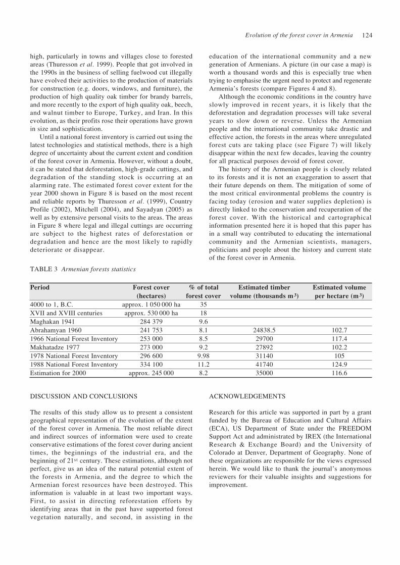
TABLE 3 Armenian forests statistics
ACKNOWLEDGEMENTSDISCUSSION AND CONCLUSIONS
The results of this study allow us to present a consistentgeographical representation of the evolution of the extentof the forest cover in Armenia. The most reliable directand indirect sources of information were used to createconservative estimations of the forest cover during ancienttimes, the beginnings of the industrial era, and the beginning of 21st century. These estimations, although notperfect, give us an idea of the natural potential extent ofthe forests in Armenia, and the degree to which theArmenian forest resources have been destroyed. Thisinformation is valuable in at least two important ways.First, to assist in directing reforestation efforts byidentifying areas that in the past have supported forestvegetation naturally, and second, in assisting in the
Research for this article was supported in part by a grantfunded by the Bureau of Education and Cultural Affairs(ECA), US Department of State under the FREEDOMSupport Act and administrated by IREX (the InternationalResearch & Exchange Board) and the University ofColorado at Denver, Department of Geography. None ofthese organizations are responsible for the views expressedherein. We would like to thank the journal’s anonymousreviewers for their valuable insights and suggestions forimprovement.
Period
4000 to 1, B.C.XVII and XVIII centuriesMaghakan 1941Abrahamyan 19601966 National Forest InventoryMakhatadze 19771978 National Forest Inventory1988 National Forest InventoryEstimation for 2000
Forest cover
(hectares)
approx. 1 050 000 haapprox. 530 000 ha
284 379241 753253 000273 000296 600334 100
approx. 245 000
% of total
forest cover
35189.68.18.59.2
9.9811.28.2
Estimated timber
volume (thousands m 3)
24838.52970027892311404174035000
Estimated volume
per hectare (m 3)
102.7117.4102.2105
124.9116.6

R. Moreno-Sanchez and H. Y. Sayadyan125
GROSSHEIM, A.A. 1948. Rastitelniy pokrov Kavkaza(Vegetation cover of Caucasus). Izdatelstvo Moskovskogoobshestva ispitateley prirodi-Publication of Moscowassociation of naturalists, Moscow, SSSR. 284pp. (InRussian).
GULISASHVILI, V.Z. 1955. Zakonomernosti vrasprostranenii lesnoy rastitelnosti i glavnikhdrevesnikh porod v Zakavkaze (The criteria’s of forestvegetation and principal forest species distribution inTranscaucasia). Botanicheskiy jurnal-Botanical journal.40 (1):18-32. (In Russian).
GULISASHVILI, V.Z. 1958. Alpiyskaya granica drevesnoyrastitelnosti na Kavkaze v svyazis pochvenno -klimaticheskimi usloviyami (The Alpine boundary offorest vegetation in Caucasia in relation with soil-climaticconditions). Izvestiya rossiyskogo geograficheskogoobshestva- Izvestiya of Russian Geographic society 90
(2):158-163. (In Russian).HAYRAPETYAN, E.M. 1976. Hoghayin erozian ev lernayin
hoghagorcutyuny (Soil erosion and mountainhorticulture).Yerevan, Armenia. 220pp. (In Armenian).
HAYRAPETYAN, E.M. 1979. Gyughatntesakanogtagorcumic durs ekac hogheri juracman ughinery(The cultivation of lands out of agricultrial utilization).Yerevan, Armenia.58pp. (In Armenian).
HAYRAPETYAN, E.M. 2000. Hoghagitutyun (SoilScience). Asoghik, Yerevan, Armenia. 456 pp. (InArmenian).
KARA-MURZA, E.N. 1929. Lesa gyuneyskogo poberejya(Forest of Gyuney bank). In: BER,G L.S. (ed.) LakeSevan basin. Hydrometeoizdat, Leningrad, 1: 441-447.(In Russian).
KARA-MURZA, E.N. 1931. Otchet o geobotanicheskikhrabotakh Sevanskoy ekspedicii 1927-1928 (Report ongeo-botanical activities of Sevan expedition 1927-1928). In: BERG, L.S. (ed.) Lake Sevan basin.Hydrometeoizdat, Leningrad, 2: 113-188. (In Russian).
KOCH, K. Karte von dem Kaukasischen Isthmus und vonArmenien.1850.
KHORENATSI, M. (a historian from 5 th century) 1981.Patmutyun hayoc (The History of Armenia). ArmenianState University Library, Yerevan, Armenia. 428pp,(in Armenian).
KHURSHUDYAN, P.A., TER-GHAZARYAN K.A. andGABRIELYAN V.G. 1987. Lesa I lesnoe khozyaystvaArmyanskoy SSR (Forests and forest enterprise inArmenian SSR). In:Lesa I lesorazvedene v ArmyanskoySSR-Forests and silviculture in Armenian SSR. TrudiBotanicheskogo instituta Akademi nauk ArmyanskoySSR-Work papers of Institute of Botany of Academyof Sciences of Armenia XII, Yerevan, Armenia: 5-41.(In Russian).
KHURSHUDYAN, P.A. 1999a. Jermastichani bardzracmandepqum antarayin tsackuytum hnaravor phophokhutyunneryev spasvogh khoceli erevuytneri meghmacmanmijocarumneri kankhatesumy (The prediction ofmitigation means of possible changes and expectedvulnerability in the case of temperature rise in forest
ABRAHAMYAN, A.G. 1958a. Lesa verkhnego gornogopoyasa severnoy Armenii i puti ikh vostanovleniya(Forests of upper timberline in Northern Armenia andmeans for their rehabilitation).Avtoreferat doktorskoydissertacii- Short version of doctoral dissertation.Yerevan, Armenia.22pp. (In Russian).
ABRAHAMYAN, A.G. 1958b. Verkhniy predel lesovsevernoy Armenii i prichini ee obuslavlivayushchie(Forests of upper timberline in Northern Armenia andcauses for their formations). In: Sbornik trudov molodikhnauch.rabotn. MSKH Armyanskoy SSR-Collection ofyoung scientists’ articles of scientific-researchinstitutions’. Ministry of Agriculture of ArmenianSSR, Yerevan, Armenia:212-217. (In Russian).
ABRAHAMYAN, H.A. 1960. Hayastani antarnery (TheArmenian forests). Haypethrat-Armenian state publica-tion, Yerevan, Armenia. 68pp. (In Armenian).
ABRAHAMYAN G.S. 1967. Paleogeograficheskiy analizrasprostraneniya lesov v Armyanskoy SSR (Pale -geographic analyse of forest distribution in ArmenianSSR). Izvestiya Akademii nauk Armyanskoy SSR: naukio zemle - Izvestiya of Academy of Sciences of ArmenianSSR:Earth Sciences 5-6:165-174. (In Russian).
AMERICAN UNIVERSITY OF ARMENIA, EnvironmentalConservation and Research Center. 1988. State ofthe Environment 1998: Armenia, Yerevan, Armenia:American University of Armenia. Online at: http://www.aua.am/aua/research/ecrc/SoEnew/soeeng.htm Country Profile. 2000. Johannesburg Summit 2002.Armenia. Country profile. 42pp.
DAL, S.K. 1947. Novie biogeograficheskie dannie obistoricheskikh granicakh lesov v Arm.SSR (New bio -geographical data on historical boundaries of forests inthe Armenian SSR). Dokladi Akademii nauk ArmyamskoySSR-Proceedings of the Academy of Sciences of theArmenian SSR. VI (3): 81-86 (In Russian, summary inEnglish).
DOLUKHANOV, A.G. 1976. Verkhnie predeli lesa Isubalpiyskiy poyas v gorakh Kavkaza (Upper forestboundaries and sub alpine zone in Caucasian mountains).In: Visokogornaya geoekologiya - Geo - ecology ofhighlands.Moscow: 46-49. (In Russian).
Geologiya Armyanskoy SSR:Geomorfologiya (Geology ofArmenian SSR: Geomorphology). 1962. Akademiyanauk Armyanskoy SSR-Academy of Sciences ofArmenian SSR. 1,Yerevan, Armenia. 586pp. (In Russian).
GRIGORYAN, A.A. 1979. Hayastani antarneri tsareri utperi arjeqavor tesaknery (Valuable three species andbushes of Armenia). Hayastan Publications, Yerevan,Armenia. 168pp. (In Armenian).
GRIGORYAN, R.A. 1974. Estestvennie lesa i prirodnayadendroflora basseyna ozero Sevan (Natural forests anddendroflora of Lake Sevan basin). Trudi instituta Botaniki Akademii nauk Armyanskoy SSR-Works ofInstitute of Botany of Academy of Sciences of ArmenianSSR 19: 5-37. (In Russian).
REFERENCES

Evolution of the forest cover in Armenia 126
cover). In: Armenia-Climate Change Study, FirstNational Report. (In Armenian, resume in English).
KHURSHUDYAN, P.A. 1999b. Jermastichany 2-3 ° Cbardzranalu ev teghumnery 10% nvazelu depqummijavayri khoceliutyan meghmann strategianantaratsatsk taracqneri yndarzakman mijocov (Mitigationstrategy vulnerability of the environment in case oftemperature rise for 2-3°C and precipitation reductionfor 10% by expanding the forest covered areas). In:Armenia-Climate Change Problems: 308-321. (inArmenian, resume in English).
KOCH, K. 1850. Karte von dem Kaukaschenistumus undvon Armenien. En Warten und gezeichnet nacheigenen Horisontal-Aufnahmen und mit Beuntzung dervorhandenen Materialen. Berlin, Germany. (In German).
KUZNETSOV, N.I. 1900. O prichine bezlesiya Armenii(About the causes of forestless ness of Armenia).Izvestiya Imperatorskogo Russkogo GeograficheskogoObshestva- Bulletin of imperial Russian geographicunion 36 (6): 576-578. (In Russian).
KUZNETSOV, N.I. 1909. Principi deleniya Kavkaza nabotaniko-geograficheskye provincii (The principals ofdivision of Caucasia on botanical-geographical provinces).Zapiski rossiyskoy akademii nauk-Bulletin of RussianAcademy of Sciences 8 (24): 171. (In Russian).
KUZNETSOV, N.I. 1915. Kratkiy ocherk istorii razvitiyarastitelnosti Kavkaza (Short remark on evolution historyof Caucasian Vegetation).Vestnik russkoy flori-Bulletinof Russian flora I: 1-16. (In Russian).
LALAYAN, E. 1931. Raskopki kurganov v sovetskoyArmenii (Mavzoleys’ excavations in Soviet Armenia).Izdatelstvo Akademii Nauk SSSR-Publication of Academy of Sciences of USSR, Yerevan, Armenia.56pp. (In Armenian).
LEO, A.B. 1917. Hayoc patmutyun (Armenian History).1,Tbilisi, Georgia. (In Armenian).
LUND, G. 1999. A ’forest’ by any other name. EnvironmentalScience and Policy, 2(2): 125-134.
MAGHAKYAN, A.K. 1941. Rastitelniy pokrov ArmyanskoySSR (Vegetation of Armenian SSR). Akademia naukSSSR: Otdel Armenii/Botanicheskiy institut-Academyof Sciences of USSR: Armenian branch / BotanicalInstitute. Moscow-Leningrad. 276pp. (In Russian).
MAKHATADZE, L.B. 1957. Dubravi Armenii (Oakforests of Armenia). Yerevan, Armenia. 327pp. (InRussian).
MAKHATADZE, L.B. 1977. Dubravi Armenii (Oakforests of Armenia). Yerevan, Armenia. 327pp. (InRussian).
MARTIROSYAN, A.A. 1951. Kultura yujnogo zakavkazyav 7-6 vekakh do n.e. po arkhivnim dannim (The cultureof Southern Transcaucasia in VII-VI centuries B.C.according archive data). Short version of doctoral dissertation. Yerevanskiy Gosudarstvenniy Universitet-Yerevan State Univeristy, Yerevan, Armenia. 28pp.(In Russian).
MARTIROSYAN, H.A. and ISRAELYAN, H.R. 1981.Geghama lerneri jarapatkernery (The pictographs of
mountains Geghama). Yerevan, Armenia. 84pp. (InArmenian).
MELKONYAN, V.A. 1955. Metallurgiya medi v Armenii(Istoricheskiy ocherk)(The metallurgy of copper inArmenia (Historical review). Metalurgizdat - ‘Metallurgy’publication Moscow, USSR. 71pp. (In Russian).
MEZHLUMYAN, S.K. 1972. Paleofauna epokh eneloita,bronza i zheleza na territorii Armenii (Paleo-fauna ofeneolith, bronze and iron periods in Armenia).Publikacii Akademii nauk Armenii-Publication ofAcademy of Sciences of Armenia. Yerevan Armenia.178pp. (In Russian).
MIRIMANYAN, KH.P. 1959. Poslelesnoe proiskhojdenienagornikh stepey Armenii (The post-forest origin ofthe upland steppes of Armenia). Botanicheskiy jurnal -Botanical Journal. 44 (5):617-633. (In Russian).
MITCHELL, A. 2004. Illegal logging, survey and analysis.Draft report. Armenian Ministry of Nature Protection/Swedish International Development Agency. Yerevan,Armenia. 1952 pp.
MNATSAKANYAN, H.H. 1952. Hnagitakan peghumnerySevana lchi camaqac teritoriayum (Archaeologicalexcavations in drained part of Lake Sevan). PublikaciiAkademii nauk Armyanskoy SSR-Publication ofAcademy of Sciences of Armenia. Yerevan, Armenia.111pp. (In Armenian).
PIOTROVSKIY, B.B. and GYUZALYAN, A.T. 1933.Kreposti Armenii doyrartskogo i Urartskogo vremeni(The castels of Armenia of pre-urartian and urartianperiods. Pimk-Pimk, Issue 3-4: 53pp. (In Russian).
PIOTROVSKIY, B.B. 1944. Istoriya i kultura Urartu(History and Culture of Urartu). Publikacii Akademiinauk Armyanskoy SSR-Publication of Academy ofsciences of Armenian SSR. Yerevan, Armenia. 364 pp.(In Russian).
SAYADYAN, Y.V. 1983. Chelovek i sreda v poslelednikovoevremya v basseyne ozero Sevan i sopredelnikhoblastyakh (Men and environment in postglacial periodin Lake Sevan basin and neighbourhood areas). In:Problems of Quaternary Geology in Armenia. Yerevan,Armenia: 67-73. (In Russian).
SAYADYAN, H.Y. 1997. Sevana lchavazani bnakanlandshaftneri phophokhumy mardacin gorconiazdecutyamb (The alternation of natural landscapes ofLake Sevan basin by antropogen factor). Doctoraldissertation, Yerevan State University, Armenia.165pp. (In Armenian).
SAYADYAN, H. Y. 1999. The Forests of Armenia: TheirManagement, Utilization and Conservation. Manuscript,American University of Armenia: 25pp.
SAYADYAN, H. Y. 2005. Illegal logging in Armenia.Draft report. In: World Bank project ‘EnsuringSustainability of Forests and Livelihoods throughImproved Governance and Control of Illegal Loggingfor Economies in Transition’. World Bank, Yerevan,Armenia. 36 pp.
SAYADYAN, H.Y. and NALBANDYAN, A. 2002. Hayastani antarneri nerka vichaky (The current state of

R. Moreno-Sanchez and H. Y. Sayadyan127
U.S. CENTRAL INTELLIGENCE AGENCY (CIA) 2005.The World Factbook http://www.odci.gov/cia/publications/factbook/geos/am.html
VARDANYAN, ZH.H. 2003. Derevya i kustarniki Armeniiv prirode i kulture (Trees and bushes of Armenia innature and culture). Institut botaniki NAN Armenii –Institute of Botany of NAS of Armenia.Yerevan,Armenia. 367pp. (In Russian).
YAROSHENKO,G.D. 1962. Bukovie lesa Armenii (Beechforests of Armenia). Yerevan, Armenia.178pp. (InRussian).
YAROSHENKO, P.D. 1941. O prichinakh bezlesiyayujnoy Armenii (About reasons on forestless ness ofSouthern Armenia). Izvestiya Akademi nauk SSSR:Armyanskiy otdel-Izvestiya of Academy of Sciences ofUSSR: Armenian branch. 2 (7), Yerevan, Armenia,49-56. (In Russian).
YAROSHENKO, P.D. 1956. Smeni rastitelnogo pokrovaZakavkazi v ikh svyazi s pochvenno-klimaticheskimiiiizmeneniyami i deyatelnostyu cheloveka (Alterationof Trans-Caucasian vegetation cover in relation withsoil-climatic changes and human impact). Akademiyanauk SSSR: dalnevostochniy otdel I institut botanikiimeni V.L. Komarova-Academy of Sciences of USSR: FarEast branch and Botanical Institute after V.L. Komarova,Moscow-Leningrad, USSR.242pp. (In Russian).
ZEDELMEYER, O.M. 1930. Otchet o geobotanicheskomissledovanii jugo-vostochnogo i yuzhnogo beregovozero Sevan letom 1928 (Report on Geo-botanicalinvestigations on south-eastern and southern bank ofLake Sevan in summer, 1928). In: Berg, L.S. BasinLake Sevan(Gokcha). Hydromteoizdat, Leningrad2(2):189-252. (In Russian).
the Armenian forests), Gitutyun ev tekhnika amsagir -Science and Technique journal 10-12: 4-7.
SHELKOVNIKOV, A.B. 1929. Lesopokritost basseynaozero Sevan v proshlom (Forest cover of Lake Sevanbasin in the past). In: Berg, L.S. (ed.)Basseiyn ozeroSevan-Lake Sevan bassin. Hydrometeoizdat, Leningrad.1: 457-467pp. (In Russian).
SHOPEN,I. 1852. Istoricheskii pamiatnik sostoianiiaArmianskoi Oblasti v epokhu eia prisoedineniia kRossiiskoi imperii (Historical monument on the statusof Armenian region in the epoch of incorporation intoRussian empire). Imperatorskaya Akademiya Nauk -Imperial Akademy of Sciences Publication, St. Petersburg,Russia. 1234 pp. (In Russian).
TAKHTAJYAN, A.L. 1937. Kserofilnaya rastitelnostskeletnikh gor armenii (Xerophile vegetion of skeletonneemountains in Armenia). Trudi armyanskogo filialaakademii nauk SSSR-Work papers of Armenian academyof sciences/ Branch of USSR Academy of Sciences II:
61-128. (in Russian). TAKHTAJYAN, A.L. 1941. Botaniko-geograficheskiy
ocherk Armenii (Botanical-geographic overview ofArmenia). Trudi Botanicheskogo Instituta Armyanskogofiliala akademii nauk SSSR -Work papers of Institute ofBotany of Armenian Academy of Sciences/ Branch ofUSSR Academy of Sciences 2: 180pp. (in Russian).
THURESSON, T., DRAKENBERG B. and TER -GHAZARYAN K. 1999. Forest Resources Assessmentfor Armenia. SIDA-Armenia project (1997-1999).Yerevan, Armenia.121pp.
THURESSON, T. 2003. Armenia. Forest utilization.Report on FAO mission on sustainable oak utilizationby Yerevan Brandy Company. Armenian Ministry ofNature Protection, Yerevan, Armenia. 21pp.