Socio economic conditions of interstate migrant workers in ...
Upload
khangminh22Category
view
1download
0
m, April 12, 2019
Mr. Wendall Meyer, Division Administrator Federal Highway Administration 380 Jackson Street, Suite 500 St. Paul, Minnesota 55101
RE: FONSI Recommendation for 1-94 Reconstruction from Clearwater to Albertville Minnesota State Project: S.P. 8680-173 Wright County, Minnesota
Dear Mr Meyer:
Enclosed are the required supporting documents for the Minnesota Department of Transportation (Mn DOT) to
recommend a Finding of No Significant Impact (FONSI) for the above-referenced project. The Environmental
Assessment (EA) for the project was prepared and circulated for public comment on January 21, 2019. A public
meeting was held on February 4, 2019 at the Monticello Community Center. The comment period remained
open through February 28, 2019. The proposed project is described in detail in the EA and summarized in the
attached Findings of Fact and Conclusions (Findings) document.
Documents submitted in support of the FONSI are included in the attached Findings prepared as part of the
Minnesota state environmental review process. The Findings includes documentation of the following:
• A copy of the Findings of Fact, Conclusions, and Order (Findings) prepared as part of the Minnesota state
environmental review process;
• Comments received on the Project and the EA, and Mn DOT responses to timely and substantive
comments. Comments received and responses are included in the Findings in Appendix B;
• An opportunity for a public hearing was published in the Wright County Herald Journal on March 8,
2019. After 30 days, no requests for a public hearing was received.
• A Certificate of Compliance with Title 23, Section 128, of U.S. Code. The Certification of Compliance is
included in the Findings in Appendix A;
• A photocopy of an Affidavit of Publication from a newspaper of general circulation in the project area .
Affidavits of Publication are included in the Findings in Appendix A;
Additional and updated studies are included in the Findings document along with a list of Environmental
Commitments on the project.
DEPARTMENT OF TRANSPORTATION
Office of Environmental Stewardship, 395 John Ireland Boulevard, St. Paul, MN 55155
Mr. Wendall Meyer Page 2 April 12, 2019
Having completed the Environmental Assessment and the public involvement and review processes as described
above, MnDOT has determined that the proposed action does not have the potential to cause significant
environmental impacts. In accordance with 23 CFR 771.119 (g), a FONS! is hereby recommended for the
proposed action.
Sincerely,
Scott Bradley r
Acting Director, Office of nvironmental Stewardship
Enclosures: Hard copy Findings of Fact and Conclusions Document
cc: Claudia Dumont, Mn DOT District 3 Debra Moynihan , MnDOT OES

FINDINGS OF FACT and
CONCLUSIONS
I-94 Reconstruction from Clearwater to Albertville
State Project No. 8680-173
Prepared by: Minnesota Department of Transportation
April 2019

I-94 Reconstruction from Clearwater to Albertville Project Page i April 2019 Findings of Fact & Conclusions
CONTENTS
1. Statement of Issue................................................................................................................. 1
2. Administrative Background ..................................................................................................... 2
3. Findings of Fact ..................................................................................................................... 3
3.1 Project Description ........................................................................................................... 3
3.2 Additional Information Regarding Items Discussed in the EA/EAW Since It Was Published .......... 4
3.3 Findings Regarding Criteria for Determining the Potential for Significant Environmental Effects .. 4
4. Conclusions .........................................................................................................................14

I-94 Reconstruction from Clearwater to Albertville Project Page 1 March 2019 Findings of Fact & Conclusions for Segments 1 and 2
FINDINGS OF FACT AND CONCLUSIONS
I-94 Reconstruction from Clearwater to Albertville
(Segments 1 and 2) Located in:
Wright County, Minnesota
1. STATEMENT OF ISSUE
The Minnesota Department of Transportation (MnDOT) is proposing to reconstruct Interstate 94 (I-94) with a third travel lane in each direction between Clearwater and Albertville in Wright County. This project proposes to complete a pavement overlay for the segment of I-94 between Trunk Highway (TH) 24 in Clearwater to County State Aid Highway (CSAH) 8 in Hasty and will reconstruct I-94 between CSAH 8 and CSAH 37 in Albertville, MN. The total project length is approximately 24.2 miles. Construction is planned for project segments between TH 24 in Clearwater and TH 25 in Monticello in 2020 and 2021 construction seasons. Construction for project segments between TH 25 in Monticello and CSAH 37 in Albertville is currently unfunded. Project location and segments are shown in Figure 1.
The EA/EAW assessed the I-94 corridor from TH 24 in Clearwater to CSAH 37 in Albertville, including all 4 segments. While impacts avoidance and minimization measures are being determined for the whole corridor, not all mitigation measures are being finalized at this time since MnDOT is seeking environmental clearance only for segments 1 and 2, since segments 3 and 4 are not in the currently approved STIP or the current CHIP. Mitigation measures have been determined for most SEE impacts (e.g. wetlands). This is a Type I project for noise per 23 CFR 772. Since segments 3 and 4 are not in the currently approved STIP or the current CHIP, noise abatement measures in these segments that are identified as feasible and reasonable (absent voting by the benefited receptors) will not be voted upon by the benefited receptors at this time. When funds become available for segments 3 and 4, the project proposer will initiate a NEPA reevaluation to seek environmental clearance for those segments. The NEPA reevaluation process will include voting on noise abatement measures by the benefited receptors in those segments as well as any other appropriate updates to SEE impacts and mitigation measures.
Preparation of an Environmental Assessment Worksheet (EAW) is required for this project under Minnesota Rules 4410.4300, Subpart 22.B for additional travel lanes on an existing road for a length of one or more miles. MnDOT is the project proposer and the Responsible Governmental Unit (RGU) for review of this project, as per Minnesota Rules 4410.4300, Subpart 22.B.
MnDOT’s decision in this matter shall be either a negative or a positive declaration of the need for an environmental impact statement for Segments 1 and 2. MnDOT must order an Environmental Impact Statement (EIS) for the project if it determines the project has the potential for significant environmental effects.
Based upon the information in the record, which comprises the Environmental Assessment/Environmental Assessment Worksheet (EA/EAW) for the proposed project, related studies referenced in the EA/EAW, written comments received, responses to the comments, and other supporting documents included in this Findings of Fact and Conclusions document, MnDOT makes the following Findings of Fact and Conclusions:

I-94 Reconstruction from Clearwater to Albertville Project Page 2 March 2019 Findings of Fact & Conclusions for Segments 1 and 2
2. ADMINISTRATIVE BACKGROUND
2.1 The Minnesota Department of Transportation is the Responsible Governmental Unit and project proposer for the I-94 Reconstruction from Clearwater to Albertville project. A combined Federal Environmental Assessment and State Environmental Assessment Worksheet (EA/EAW) has been prepared for this project in accordance with Minnesota Rules Chapter 4410 and the National Environmental Policy Act (NEPA) (42 USC 4321 et. seq.). The EA/EAW was developed to assess the impacts of the project and other circumstances in order to determine if an Environmental Impact Statement (EIS) is indicated.
2.2 The EA/EAW was filed with the Minnesota Environmental Quality Board (EQB) and circulated for review and comments to the required EAW distribution list. A “Notice of Availability” was published in the EQB Monitor on January 21, 2019. A press release was distributed to the MnDOT District 3 media list and postcards were delivered to residents within 500 feet of the project corridor. The notice was published in the Monticello Times on January 24, 2019. The Open House was postponed due to inclement weather and a subsequent notice was published on January 31st. These notices are included in Attachment A. Additionally, notices were published on the project web page at http://www.dot.state.mn.us/i94-mg-clearwater/index.html. These notices provided a brief description of the project and information on where copies of the EA/EAW were available and invited the public to provide comments that would be used in determining the need for an EIS on the proposed project.
2.3 A public meeting was held on February 4, 2019 from 6:00 p.m. to 8:00 p.m. at the Monticello Community Center. Verbal comments were addressed at the meeting and written comments are summarized in Appendix A. The public meeting was advertised via the project website, press release, postcard, and local media outlets. In compliance with 23 CFR § 771.119, MnDOT and the Federal Highway Administration (FHWA) offered the opportunity for a public hearing on the EA/EAW. The legal notice was published in the Wright County Herald Journal on March 8, 2019. Requests for a hearing were held open for 30 days from publication. No formal request for a public hearing was made.
2.4 The EA/EAW was made available for public review at the following locations:
• MnDOT – 3725 12th Street North, Saint Cloud, MN 56303 • Great River Regional Library, Saint Cloud – 1300 West St. Germain St, Saint Cloud,
MN 56301 • Great River Regional Library, Monticello - 200 W 6th St, Monticello, MN 55362
• Great River Regional Library, St. Michael - 11800 Town Center Dr, St Michael, MN 55376
• Great River Regional Library, Clearwater, 740 Clearwater Ctr, Clearwater, MN 55320
The EA/EAW comment period extended from January 21 to February 20, 2019. An extension of comment period was requested by USEPA until 2/28/19 due to federal government shutdown and was agreed to by MnDOT.
2.5 Two written agency comment letters were received during the comment period and two attendees provided written comments at the public meeting. All comments received during the EA/EAW comment period were considered in determining the potential for significant

I-94 Reconstruction from Clearwater to Albertville Project Page 3 March 2019 Findings of Fact & Conclusions for Segments 1 and 2
environmental impacts. Comments received during the comment period and responses to substantive comments are provided in Appendix B.
3. FINDINGS OF FACT
3.1 Project Description
3.1.1 Existing Conditions: I-94 is a major freeway connecting Fargo, North Dakota with the Twin Cities to western Wisconsin. Regionally, I-94 connects the growing northwest suburbs of the Twin Cities to Saint Cloud and greater Central Minnesota. The limits of the I-94 Albertville to Clearwater project, State Project (SP) 8680-173, extend from TH 24 in Clearwater to CSAH 37 in Albertville. The total project length is approximately 24.2 miles and crosses the municipalities of Clearwater, Monticello, Otsego, and Albertville and the townships of Clearwater, Silver Creek, and Monticello, and the unincorporated community of Hasty. This section of I-94 was constructed in the late 1960s and early 1970s and is nearing 50 years old.
Due to length and other factors, the project has been separated into segments. The potential segments as shown in Figure 1 (Appendix C) include, from west to east:
• Segment 1: Clearwater to Hasty exit (TH 24 to CSAH 8) – 5.4 miles • Segment 2: Hasty exit to Monticello (CSAH 8 to TH 25) – 8.48 miles
• Segment 3: Monticello to CSAH 18 (TH 25 to CSAH 18) (median barrier was previously completed as part of SP 8680-158) – 3.15 miles
• Segment 4: CSAH 18 to CSAH 37 in Albertville – 7.17 miles
Currently, Segments 1, 2, and 4 are rural road section with two lanes of traffic in each direction with a vegetated ditch in the center median. Segment 3 is an urban section with a barrier is the center median.
3.1.2 Proposed Project: The project is proposing a full reconstruction of I-94 within Segment 2, CSAH 8 in Hasty to TH 25, and Segment 4, CSAH 18 in Monticello to CSAH 19 in Albertville, as an urban highway section with a concrete median barrier. Segment 3, TH 25 to CSAH 18 in Monticello, incudes restriping and shoulder additions as this section has previously been reconstructed to an urban section. Segment 1, TH 24 in Clearwater to CSAH 8 in Hasty, includes an overlay with widening to the outside. All segments would add an additional 12-foot lane of traffic in each travel direction. The proposed typical section includes three 12-foot travel lanes, a 10-foot inside shoulder, and a 10-foot paved outside shoulder in each direction. A continuous concrete median barrier would separate the two travel directions from Hasty to Albertville. The existing vegetated median ditch would be maintained between Clearwater and Hasty. Storm sewer would replace the drainage function of the existing median ditch in segments 2, 3, and 4 and drainage functions would remain largely unchanged in Segment 1. Nine stormwater management areas would be constructed. Three noise walls are proposed for construction, one of which has been confirmed via the noise voting process. Additionally, the segment between Clearwater and Hasty will have lane additions to the outside and maintain the center grass median.
Segments 1 and 2, as shown in Figure 1, is the portion of the project being submitted for approval under this Findings of Fact and Conclusions.

I-94 Reconstruction from Clearwater to Albertville Project Page 4 March 2019 Findings of Fact & Conclusions for Segments 1 and 2
3.2 Additional Information Regarding Items Discussed in the EA/EAW Since It Was Published
Since the EA/EAW was published, the following information pertaining to the project has been updated:
• Two additional culvert crossings, at Otter Creek and Silver Creek, are proposed to be replaced. This is in addition to replacing the culvert at Fish Creek, which was identified in the EA/EAW. The Silver and Otter Creek culverts will be replaced in-kind. The Fish Creek culvert will be extended 12 feet to the south. Culvert replacements are shown in Appendix D.
• On-going design activities, including culvert replacements additions, have resulted in changes to the estimated aquatic resource impacts. The Wetland 2-Part Finding has been updated to reflect the changes to aquatic resource impacts and to clarify if an impact is to be considered permanent or temporary. The updated finding is included in Appendix D of this findings document.
• The noise wall solicitation process for Noise Wall S1 concluded with the wall being voted to be part of the project as originally proposed in the EA/EAW. The noise wall is illustrated in Figure 7-22 and 7-23 of the EA/EAW and will be constructed with Segments 1 and 2, and subject to this Finding. Noise Wall O1 and I1 are located in project segments 3 and 4 and will be reviewed for environmental clearance through a future EA reevaluation
3.3 Findings Regarding Criteria for Determining the Potential for Significant Environmental Effects
Minnesota Rules 4410.1700 provides that an environmental impact statement shall be ordered for projects that have the potential for significant environmental effects. In deciding whether a project has the potential for significant environmental effects, the following four factors described in Minnesota Rules 4410.1700, Subp.7 shall be considered:
A. type, extent, and reversibility of environmental effects;
B. cumulative potential effects. The RGU shall consider the following factors: whether the cumulative potential effect is significant; whether the contribution from the project is significant when viewed in connection with other contributions to the cumulative potential effect; the degree to which the project complies with approved mitigation measures specifically designed to address the cumulative potential effect; and the efforts of the proposer to minimize the contributions from the project;
C. the extent to which the environmental effects are subject to mitigation by ongoing public regulatory authority. The RGU may rely only on mitigation measures that are specific and that can be reasonably expected to effectively mitigate the identified environmental impacts of the project; and
D. the extent to which environmental effects can be anticipated and controlled as a result of other available environmental studies undertaken by public agencies or the project proposer, including other EISs.
MnDOT’s key findings with respect to each of these criteria are set forth below:
3.3.1 Type, Extent, and Reversibility of Impacts
MnDOT finds that the analysis completed during the EA/EAW process is adequate to determine whether the project has the potential for significant environmental effects. The EA/EAW describes the type and extent of impacts anticipated to result from the proposed project. In addition to the information in the EAW, the additional information described in Section 3.2 of this Findings of Fact and Conclusions document as well as the public/agency

I-94 Reconstruction from Clearwater to Albertville Project Page 5 March 2019 Findings of Fact & Conclusions for Segments 1 and 2
comments received during the public comment period (see Appendix A) were taken into account in considering the type, extent and reversibility of project impacts. Following are the key findings regarding potential environmental impacts of the proposed project and the design features included to avoid, minimize, and mitigate these impacts:
3.3.1.1 Land Use: The proposed project is located largely within existing MnDOT right-of-way, with the exception of two proposed stormwater management areas, one located northwest of the Grover Avenue bridge and the other northwest of the 120th Street bridge. MnDOT will obtain permanent easements in these two locations which will not preclude any future adjacent planned land uses. No Federal Emergency Management Agency (FEMA) 100-year floodplains are located within the project limits. The proposed project is compatible with existing and planned land use and zoning.
3.3.1.2 Geology, Soils, and Topography/Land Forms: Approximately 325 acres will be graded. A Stormwater Pollution Prevention Plan (SWPPP) will be developed for the project. All areas disturbed during construction would be revegetated in accordance with the SWPPP and related permitting requirements. In areas of steep slopes, special consideration will be given to prevent erosion during construction, such as erosion control blankets and soil reinforcement. No impacts to soils or topography are anticipated once the project is complete.
3.3.1.3 Water Resources: Various water resources were reviewed in the EA/EAW and are summarized below:
Groundwater: Two Minnesota Department of Health (MDH) Wellhead Protection Areas (WPA) and Drinking Water Supply Management Areas (DWSMA) are located within the project limits. No proposed infiltration practices will be located within these WPA’s.
Twelve wells were identified on the MDH County Well Index (CWI)27 within the project right-of-way from TH 24 to CSAH 37. Four of the wells are listed as active, and their use is indicated as monitoring wells. Wells that are impacted must either be sealed by a licensed well contractor according to Minnesota Rules, Chapter 4725, or be relocated and coordinated with the MPCA and MDH.
Stormwater: The project would result in approximately 107 acres of increased impervious surface area primarily due to the additional lane of travel in each direction and increased shoulder widths. Segments 2 and 4 of the corridor would be reconstructed as an urban highway with stormwater infrastructure replacing the conveyance function in the center median ditch and culvert system. The system will include a series of storm sewer pipes that collect drainage from inlets in the median and convey it to vegetated ditches and/or stormwater management areas to the outside of the new road alignment. Segment 1 of the corridor would maintain the existing drainage network but extend culverts where widening is to occur.
The project will need to comply with the NPDES Construction Stormwater General Permit and Clearwater River Watershed District Total Maximum Daily Load (TMDL) water quality requirements. The primary regulatory stormwater objectives that will apply to the project area as follows:

I-94 Reconstruction from Clearwater to Albertville Project Page 6 March 2019 Findings of Fact & Conclusions for Segments 1 and 2
• Rate Control: Proposed Conditions shall not exceed existing runoff rates for the 2-year, 10-year, or 100-year critical storm events, using Atlas 14 precipitation depths.
• Volume Reduction: stormwater runoff volume reduction shall be achieved onsite for 1-inch runoff generated from new impervious surfaces.
• Water Quality Volume: Based on 107 acres of net new impervious, 8.9 acre-feet of water quality volume shall be achieved on a project-wide basis.
To meet the terms of the permit, nine stormwater management areas are proposed that will be designed to meet NPDES permit criteria. Five of these areas are currently planned as infiltration practices based on data available during this preliminary stage of design. All infiltration practices will include pretreatment consistent with NPDES permitting requirements.
All existing culverts in segments 2 and 4 would need to be removed and replaced with new reinforced concrete storm sewer pipes located in the same general locations as existing culverts. The existing drainage routing would be maintained to the extent possible. Culverts at Fish Creek, Silver Creek, and Otter Creek would be reconstructed by the project.
The ultimate receiving water for the project is the Mississippi River. Other receiving waters upstream of the Mississippi River and that may receive some runoff form the project corridor include the Clearwater River, Rice Lake, Silver Creek, Otter Creek, Otsego Creek, School Lake, and Hunters Lake which all flow into the Mississippi. The Mississippi River, Clearwater River, Silver Creek, School Lake, and Hunters Lake are listed as impaired. The project, as required by the NPDES permit, will be required to follow TMDL specific implementation activities regarding construction stormwater; thus, the project is not anticipated to further contribute to these impairments.
As part of the NPDES permit, a Stormwater Pollution Prevention Plan (SWPPP) will be developed for the project. The SWPPP will require erosion control BMPs to be implemented by the contractor during all phases of construction. Some of these measures will include silt fence, bioroll check dams, erosion control blanket, and temporary basins. The type and extent of erosion control BMPs will be dependent on the impairment of the downstream waterbody.
Surface Water: Over 50 acres of aquatic resources were identified within the I-94 right-of-way from TH 24 to the western city limits of Albertville. In total, 2.59 acres of aquatic resource impacts are proposed; of which, 2.21 acres are permanent. Impacts are summarized in Appendix D, the Wetland Assessment and Two-Part Finding form.
The project will require approval/permits from the Wetland Conservation Act, US Army Corps of Engineers (USACE), and Department of Natural Resources. All water resources that are anticipated to be impacted by the project will be included in the permit application. Based on the amount and type of aquatic resource impacts, this project is anticipated to qualify for the USACE Transportation Regional General Permit.

I-94 Reconstruction from Clearwater to Albertville Project Page 7 March 2019 Findings of Fact & Conclusions for Segments 1 and 2
Wetland impact minimization measures include:
• Inside and outside shoulders have been reduced to 10-foot width of paved surface (10.5 feet is standard)
• Inslopes have been reduced to 1:4 from Clearwater to Hasty (1:6 is preferred standard) along outside shoulder to reduce width of overall cross section by four feet on either side of freeway and limit grading required
• Inslopes beyond the clear zone were reduced to 1:2.5 for two wetland locations to minimize fill into Wetland #2 and Wetland #6
• Stormwater treatment areas have been designed to use existing stormwater best management practice (BMP) locations and avoid wetland impacts where possible. In total, 16 areas between Clearwater and Albertville were evaluated for stormwater management. Areas were eliminated due to drainage limitations (i.e. not located in suitable location to receive stormwater runoff), insufficient right -of-way availability, or the presence of wetlands. Nine areas have been identified that met most or all of the siting criteria. In order to limit wetland impacts, two of these areas have been located in areas proposed for right-of-way acquisition.
• One of the remaining management areas is located in proximity to a wetland (Wetland #2). The pond orientation has been situated to completely avoid impacts to the wetland.
It is anticipated that wetlands will be replaced at a 2:1 ratio within Bank Service Area 7 (BSA 7). Wet ditches typically would not require mitigation provided that the ditch is replaced and there is no loss of function. The project would maintain ditches along the outside of the proposed toe of slope. Specific credit purchase amounts will be determined through coordination with the USACE and the MnDOT Office of Environmental Stewardship.
The culverts at Fish Creek, Silver Creek, and Otter Creek are proposed to be replaced as part of the project. Silver and Otter Creek culverts will be replaced in-kind. The Fish Creek culvert will be replaced and lengthened 12 feet to the south. Culvert replacements are shown in Appendix D. Fish Creek and Silver Creek are not DNR Public watercourses; however, the culverts act as control structures for Fish Lake and Locke Lake, respectively; therefore, these replacements will require authorization by the DNR. In addition, Otter Creek north of I-94 is considered a DNR Public Watercourse and this replacement will require authorization by the DNR. Construction activities within DNR public waters will require a DNR Public Waters Work Permit. If dewatering rates during construction exceed 10,000 gallons per day or a million gallons per year, a DNR water appropriation permit will be required and will acquired by the contractor.
3.3.1.4 Contamination/Hazardous Materials/Wastes: MnDOT’s Contaminated Materials Management Team (CMMT) reviewed the Minnesota Pollution Control Agency (MPCA) and Minnesota Department of Agriculture (MDA) databases to check for known contaminated sites in the predominantly rural, minimally developed

I-94 Reconstruction from Clearwater to Albertville Project Page 8 March 2019 Findings of Fact & Conclusions for Segments 1 and 2
project area. Based on the database review, there is one inactive LUST facility within 500 feet of the project area.
Given the nature and location of the project area, this project has a low risk of impacting potentially contaminated sites. Currently, the proposed project will require acquisition of 2.77 acres of right-of-way in the two locations identified for stormwater management. Project excavation and grading will be relatively minor for resurfacing work. More extensive excavation work is associated with culvert replacement; however, since the culvert replacement work is primarily in rural, more undeveloped portions of this project, this decreases the chances of encountering contaminants that may have originated from an off-site source and migrated into the right-of-way. During final design, a Phase 2 investigation will be completed, as necessary, at the stormwater treatment area locations.
Solid wastes generated during construction of the project will be disposed of property in a permitting, licensed solid waste facility and potentially recyclable construction materials will be directed to the appropriate storage, crushing or renovation facility.
Toxic or hazardous materials used during construction will be stored in accordance with MPCA guidelines and regulations. Appropriate best management practices will be used during storage and in the event of a spill. Any contamination or spills occur during construction will be the responsibility of the contractor, who will notify the MPCA Duty Officer and work to contain and remediate the contaminated soil/materials.
3.3.1.5 Fish, Wildlife, Plant Communities, and Sensitive Ecological Resources (Rare Features): This project will take place almost entirely within I-94 right-of-way. Habitats include mostly manicured and unmanicured grasslands, with some spread out woodland. In general, wildlife species found within the vicinity of the project limits are those species generally adapted to live in areas of mixed development and fragmented rural habitats and wildlife displaced by the project will likely relocate to suitable nearby areas.
Plant Communities: Vegetation, including herbaceous vegetation and trees, will be removed during construction of the project. Approximately 2.0 acres of tree removal is expected.
This segment of I-94 runs adjacent to the Mississippi River just north of the Monticello city limits, anywhere from approximately 350 feet to 1,500 feet for approximately two miles. This area includes natural communities that are considered a Minnesota Site of Biodiversity Significance. The site location ranges from directly adjacent to 100 feet from MnDOT right-of-way along the eastbound travel lanes, and 100 to 300 feet from MnDOT right-of-way along the westbound travel lanes. The Minnesota Site of Biodiversity Significance north of Monticello will be identified on construction plans as an Area of Environmental Sensitivity. Currently, a stormwater pond is shown within or adjacent to this area. MnDOT will coordinate the location of this pond with the DNR during final design with the intent to relocate the proposed pond to avoid high quality habitat and plant communities to the extent possible. If the area is to be disturbed during construction, the area must protect and preserve vegetation

I-94 Reconstruction from Clearwater to Albertville Project Page 9 March 2019 Findings of Fact & Conclusions for Segments 1 and 2
according to MnDOT specs, utilize native seed mixes, and use bionetting as erosion control blanket.
The project is not anticipated to involve any in-water work within infested waters, so further spread of invasive Eurasian water milfoil within Locke Lake and Fish Lake is not anticipated. While there are no known specific locations of noxious weeds within the project limits, it is likely they are present. The contractor would be required to follow guidelines outlined by the MnDOT Horticultural Specialist, which includes identifying and eradicating noxious weeds prior to construction.
Species: The northern long-eared bat (Myotis septentrionalis) is listed by the USFWS as threatened in Wright County. There are no documented maternity roost trees or hibernacula within the project area. However, MnDOT is committing to the recommended tree removal guidelines set forth by the USFWS, to minimize potential impacts to Northern Long-eared bat habitat.
Any ‘in-water’ work will follow work in water restrictions (no work between March 15 and June 15).
3.3.1.6 Historic Properties: The proposed project was reviewed by MnDOT Cultural Resources Unit (CRU) staff for potential impacts to historic resources. MnDOT CRU determined that there would be no historic properties affected by the proposed project.
3.3.1.7 Air: Air quality impacts will primarily be construction-related due to dust. Dust generated during construction will be minimized through standard dust control measures such as applying water to exposed soils and limiting the extent and duration of exposed soil conditions. Construction contractors will be required to control dust and other airborne particulates in accordance with MnDOT specifications in place at the time of project construction.
During construction, particulate emissions will temporarily increase due to the generation of fugitive dust associated with activities such as grading and other soil disturbance. The following dust control measures will be undertaken as necessary:
• Minimize the duration and extent of areas being exposed or regraded at any one time.
• Spray construction areas and haul roads with water, especially during periods of high wind or high levels of construction activity.
• Minimize the use of vehicles on unpaved surfaces when feasible.
• Tarp trucks hauling soil, sand, and other loose materials or require trucks to maintain at least two feet of freeboard.
• Pave, apply water as needed, or apply (non-toxic) soil stabilizers on unpaved access roads, parking areas and staging areas at construction sites.
• Use water sweepers to sweep paved access roads, parking areas, and staging areas at construction sites.
• Use water sweepers to sweep streets if visible soil material is carried onto adjacent public streets.

I-94 Reconstruction from Clearwater to Albertville Project Page 10 March 2019 Findings of Fact & Conclusions for Segments 1 and 2
• Hydroseed or apply (non-toxic) soil stabilizers to inactive construction areas (previously graded areas inactive for ten days or more).
• Enclose, cover, water, or apply (non-toxic) soil binders to exposed stockpiles (dirt, sand, etc.).
• Limit traffic speeds on unpaved roads to 15 miles per hour.
• Utilize appropriate erosion control measures to reduce silt runoff to public roadways.
• Replant vegetation as quickly as possible to minimize erosion in disturbed areas.
• Use alternative fuels for construction equipment when feasible.
• Maintain properly tuned equipment. • After construction is complete, dust levels are anticipated to be minimal
because all soil surfaces exposed during construction will be in permanent cover (i.e., tracked, paved, or revegetated areas).
Odors could be generated by exhaust from diesel engines engaged in construction activities and fuel storage areas. All machinery will be properly equipped to control emissions.
3.3.1.8 Noise: The construction activities associated with implementation of the proposed project will result in increased noise levels relative to existing conditions. These impacts will primarily be associated with construction equipment and pile driving. It is anticipated that night construction may be required to expedite construction, minimize traffic impacts, and improve safety. However, construction will be limited to daytime hours as much as possible. The use of pile drivers, jack hammers, and pavement sawing equipment will be prohibited during nighttime hours.
Traffic Noise: Based on the noise wall analysis completed for the corridor, three noise walls met the feasibility and reasonableness criteria and are proposed as part of the project (Walls I1, O1, and S1). One existing noise wall will remain in-place and unchanged with the project. The noise wall solicitation process for Noise Wall S1 concluded with the wall being voted to be part of the project as originally proposed in the EA/EAW. Noise Wall O1 and I1 are located in project segments 3 and 4 that are not yet programmed for construction. Voting will occur for these proposed walls when these segments receive funding and enter into final design.
If conditions substantially change by the time the project reaches the final design stage, noise abatement measures may not be provided. If that occurs, receptors that would have received benefits from noise walls, and local officials will be notified of plans to eliminate or substantially modify a noise abatement measure prior to the final design process. This notification will explain any changes in site conditions, additional site information, any design changes implemented during the final design process, and noise wall feasibility and reasonableness.
3.3.1.9 Transportation:
Parking Spaces: This project will not have an effect on any existing or proposed parking within the project vicinity.

I-94 Reconstruction from Clearwater to Albertville Project Page 11 March 2019 Findings of Fact & Conclusions for Segments 1 and 2
Estimated Traffic Generation: The 2018 traffic study completed for this project identified the Average Annual Daily Traffic (AADT) ranges from 41,500 vpd west of TH 24 in Clearwater to 65,800 vpd west of CSAH 19 in Albertville. Additionally, I-94 is a heavy freight corridor, with freight vehicles representing nearly 10 to 15 percent of total traffic (approximately 5,000 to 11,000 vpd). I-94 serves as a primary thoroughfare for recreational traffic for travelers from the Twin Cities to greater Minnesota. Weekend traffic (Friday WB and Sunday afternoon EB) during peak recreational season (Memorial Day through Labor Day) can increase traffic by 15% to 20%.
The study corridor is anticipated to experience growth averaging 1.2 to 1.3 percent along the I-94 corridor. Based on the anticipated growth, the Design Year (2040) ADT is anticipated range from 55,500 vpd west of TH 24 in Clearwater to 80,000 vpd west of CSAH 19 in Albertville. Recreational volumes are anticipated to increase at a similar rate.
The purpose of the proposed project is to improve mobility through the corridor during all travel periods and will allow two lanes of traffic in each travel direction during construction; as a result, mitigation is not needed.
Transit: This project will have no impact on transit or other transportation modes.
Traffic Impacts During Construction: The project would be constructed in a way that allows for two travel lanes to remain open in both the westbound and eastbound direction of I-94 to the extent possible, and any single lane restriction would be limited to the shortest period feasible; therefore, minor construction related impacts are expected to result from this project. A Traffic Management Plan (TMP) is being developed for the project and will be finalized during final engineering design.
3.3.1.10 Social Impacts: The project mainly takes place within existing right-of-way; thus, the project is not expected to cause any adverse impact to any community or neighborhood. No categories of people uniquely sensitive to transportation (e.g. children, elderly, minorities, persons with mobility impairments) will be unduly impacted.
3.3.1.11 Considerations Related to Pedestrians and Bicyclists: The proposed project is limited to I-94 where bicycle and pedestrian access is prohibited. There are no temporary closures of trails anticipated with the construction of this project. No permanent impacts to bicycles or pedestrians are anticipated, and there are no opportunities for bicycle or pedestrian improvements with the project.
3.3.1.12 Environmental Justice: An environmental justice study was completed as part of the EA/EAW. Readily identifiable minority and low-income populations are affected by the project. However, the adverse effects of the project will not be predominately borne by the identified minority or low-income population, nor will they be appreciably more severe or greater in magnitude than the adverse effect that will be suffered by the non-minority or non-low-income population. Therefore, the proposed action will not have disproportionality high or adverse human health or environmental effects on any minority population or low-income population.

I-94 Reconstruction from Clearwater to Albertville Project Page 12 March 2019 Findings of Fact & Conclusions for Segments 1 and 2
3.3.1.13 Economics: This project would add a third lane in each direction of I-94 between TH 24 and the western city limits of Albertville. During construction, two lanes of traffic would be allowed to remain open in each travel direction. Therefore, because minimal effect on mobility is anticipated, no economic impacts are anticipated for this project.
3.3.1.14 Right of Way and Relocations: This project would be constructed almost entirely within I-94 right-of-way. The only permanent easements that are required are for two stormwater management areas, one located northwest of the Grover Avenue bridge and the other northwest of the 120th Street bridge, identified in Figure 7. Both of these locations are adjacent to existing right-of-way and are currently undeveloped vegetated land. Temporary easements might be required to replace the culvert at Fish Creek.
3.3.1.15 Noise and Vibration: A traffic noise study was completed for the project and three barriers were found to meet MnDOT’s cost effectiveness reasonableness threshold and noise reduction design goal. The results to date are summarized in Section 3.2.3 and Section 3.3.1.8.
Summary finding with respect to this criterion: MnDOT finds that the Segments 1 and 2 of the Project, as it is proposed, does not have the potential for significant environmental effects based on the type, extent, and reversibility of impacts to the resources evaluated in the EA/EAW and in the Findings summary above. Project impacts will be mitigated as described in the EA/EAW and in the Findings above.
3.3.2 Cumulative Potential Effects of Related or Reasonably Foreseeable Future Projects
In accordance with Minnesota Rules, part 4410.4300, subpart 22.B, cumulative potential effects of related or anticipated future projects were identified and included in Section 5.19 of the EA/EAW. The primary actions that have potential for cumulative impacts with this project are those actions that have potential to affect wetlands, stormwater, and traffic. Five projects were identified and evaluated in the EA/EAW; however, there was no potential for cumulative impacts identified as a result of this project in conjunction with other past, present, or reasonably foreseeable future projects.
3.3.3 Extent to Which the Environmental Effects are Subject to Mitigation by Ongoing Public Regulatory Authority
3.3.3.1 The mitigation of environmental impacts will be designed and implemented in coordination with regulatory agencies (including the coordination and approvals described in Section 3.3.1 above) and will be subject to the plan approval and permitting processes. Permits and approvals that have been obtained or may be required prior to project construction include those listed in Table 1.
3.3.3.2 The permits listed in Table 1 include general and specific requirements for mitigation of environmental effects of the project. Therefore, MnDOT finds that the environmental effects of the project are subject to mitigation by ongoing regulatory authority.

I-94 Reconstruction from Clearwater to Albertville Project Page 13 March 2019 Findings of Fact & Conclusions for Segments 1 and 2
Table 1. Agency Approvals and Permits
Unit of Government Type of Application Status
STATE
Minnesota State Historic Preservation Office (MnSHPO)
Section 106 Determination and Programmatic Agreement (PA)
Complete
MnDOT as Local Governmental Unit under the Wetland Conservation Act
Wetland Replacement Plan, if needed
Application has been submitted
MnDOT Right-of-way agreements In process MnDOT Environmental Assessment
Worksheet Complete
MnDOT EIS Need Decision Complete DNR State Endangered Species
Review Complete
DNR Public Waters Work Permit Application has been submitted
DNR Groundwater Appropriation Permit (if necessary)
To be requested by contractor
Minnesota Pollution Control Agency (MPCA)
NPDES Permit Preliminary drainage plans complete and will be used to obtain high-level permit approval; specific construction SWPPPs will be prepared by designer for each construction year
MPCA Section 401 Water Quality Certification
Pending, to be received via Section 404 permit
FEDERAL
USACE Section 404 Wetland Impact Permit
Application has been submitted
USFWS (completed by MnDOT Office of Environmental Stewardship on behalf of FHWA)
Endangered Species Act Section 7 Determination
Complete
FHWA Section 4(f) determination Not required
FHWA Section 106 determination Complete
FHWA Environmental Assessment Approval
Complete
FHWA EIS Need Decision Pending
3.3.4 Extent to Which Environmental Effects can be Anticipated and Controlled as a Result of Other Environmental Studies
3.3.4.1 MnDOT has extensive experience in roadway construction. Many similar projects have been designed and constructed throughout the area encompassed by this governmental agency. All design and construction staff are very familiar with the project area.
3.3.4.2 No problems are anticipated which the MnDOT staff have not encountered and successfully solved many times in similar projects in or near the project area. Mn DOT finds that the environmental effects of the project can be anticipated and controlled as a result of the assessment of potential issues during the environmental review process and MnDOT's experience in addressing similar issues on previous projects.
4. CONCLUSIONS
1. The Minnesota Department of Transportation has jurisdiction in determining the need for an environmental impact statement on this project.
2. All requirements for environmental review of the proposed project have been met.
3. The EA/EAW and the permit development processes to date related to the project have
generated information which is adequate to determine whether the project has the potential for significant environmental effects.
4. Areas where potential environmental effects have been identified will be addressed during the
final design of Segments 1 and 2 of the project. Mitigation will be provided where impacts are expected to result from project construction, operation, or maintenance. Mitigative measures will be incorporated into project design and have been or will be coordinated with state and federal agencies during the permit processes.
5. Based on the criteria in Minnesota Rules part 4410.1700, subp. 7, the project does not have the potential for significant environmental effects.
6. An Environmental Impact Statement is not required for Segments 1 and 2 of the 1-94 Reconstruction from Clearwater to Albertville Project.
7. Any findings that might properly be termed conclusions and any conclusions that might properly be called findings are hereby adopted as such.
Based on the Findings of Fact and Conclusions contained herein and on the entire record:
The Minnesota Department of Transportation hereby determines that Segments 1 and 2 of the 1-94 Reconstruction from Clearwater to Albertville Project will not result in significant environmental
impacts, and that the project does not require the preparation of an environmental impact statement.
For Minnesota Department of Transportation
Signature and Date Mn DOT Chief Environmental Officer
1-94 Reconstruction from Clearwater to Albertville Project Page 14 March 2019 Findings of Fact & Conclusions for Segments 1 and 2

APPENDIX A – Public Involvement: EA/EAW Comment Period
Public Meeting Summary
EQB Notice of Availability
Public Hearing Certificate of Compliance
Newspaper Legal Notices
Monticello Times Publications

Public Meeting Summary
An open house for I-94 Reconstruction from Clearwater to Albertville Project was held as follows:
Monday February 4, 2019 from 6:00 p.m. to 8:00 p.m.
Monticello Community Center 505 Walnut Street, Monticello, MN 55362
Approximately 30 individuals attended the open house meeting. The purpose of the meeting was to present the project and seek public input on the Environmental Assessment/Environmental Assessment Worksheet. Additional information was also available regarding two other projects on I-94 (St. Michael to Albertville and Maple Grove to Rogers). The format of the meeting was a come-and-go station concept on either end of a formal presentation, which occurred at 7:00 p.m. At the open house, attendees were invited to provide written comments (on comment cards provided at the meeting). Copies of all written comments are included in Appendix B along with responses to substantive comments.
Staff from MnDOT and Kimley-Horn and Associates were on hand at the open house to discuss the project and to answer questions. Several informational items regarding the project were made available at the meeting including the following:
• Project information handout • I-94 projects (including St. Michael to Albertville and Maple Grove to Rogers) handout
• Project Display Boards o Project overview (typical sections/project segments) o Project purpose and need o Completed projects along I-94 o Planned projects along I-94 o Environmental review overview o Potential environmental impacts o Schedule
• Comment & Feedback Form • Project Layout
• Project Presentation (PowerPoint Slides)
A presentation was given to provide an overview of the project and findings from the EA/EAW. Participants had an opportunity to ask questions or record written comments as part of the official public meeting record.
Included on the following page is the Minnesota Environmental Quality Board (EQB) Monitor publication that announced the availability of the EA/EAW and provided details of the open house meeting. Project notices have been posted to the MnDOT project website here: http://www.dot.state.mn.us/i94-mg-clearwater/.
In compliance with 23 CFR § 771.119, MnDOT and the Federal Highway Administration (FHWA) offered the opportunity for a public hearing on the EA/EAW. The legal notice was published in the Wright County Herald Journal on March 8, 2019. The period to requests a hearing was held open for 30 days from publication. No formal request for a public hearing was made. The legal notice is and public hearing certificate of compliance is attached.
I-94 Clearwater to Albertville
1
Open House #1 - Meeting Summary Monday, February 4, 2019 6:00pm – 8:00 p.m. Monticello Community Center
Format: Formal presentation at 7:00 p.m. with a come-and-go station concept before and after.
Purpose: Present the I-94 Clearwater to Albertville project and seek public input on the Environmental Assessment Worksheet (EAW)/Environmental Assessment (EA). Additional information was also available regarding two other projects on I-94 (St. Michael to Albertville, and Maple Grove to Rogers).
Comments Received: 30 attendees signed-in and 2 comments forms were submitted.
Public Comment
• Limit jake braking @ mile post 170 1/2 to 181 • Updates in local papers of major changes in traffic flow or closures will help plan alt. routes• More MnDOT cameras installed with the project?• Fri PM westbound/Sun PM eastbound extra signage & patrols to control congestion• Sound barriers on how much of the project? Installed before to control construction noise?• New bridge between Hwy 25&18 affected (Monticello)?• More patrols in general during and after to control speeding, distracted driving, and aggressive drivers• Utilize 24/7 construction in towns to finish faster?• Funding secured for entire project? Or hoping for future approval of state/fed funds?• Affects/reroute on MnDOT test lanes between Albertville & Monticello?• Good team tonight with lots of info! Thank you
Photo of presentation at the open house

January 21, 2019 EQB Monitor Notice

Public Hearing Certificate of Compliance

Newspaper Legal Notices

Monticello Times Publications


APPENDIX B – EA/EAW Comments and Responses
The EA/EAW for the I-94 Reconstruction from Clearwater to Albertville Project was distributed on January 18, 2019 to agencies and organizations on the official distribution list, as well as additional agencies/organizations that had either requested a copy of the document, and/or that could be affected by the proposed project. The comment period for the EA/EAW officially closed at the end of the business day on February 20, 2019. An open house to receive comments on the proposed project and EA/EAW was held on February 4, 2019 (see Appendix A to further details). At the open house, attendees were invited to submit written comments through February 20, 2019 on cards provided at the open house, via US Postal Service, or via e-mail.
During the public review and comment period, MnDOT received comments on the EA/EAW from a total of two agencies and two individuals.
Consistent with state and federal environmental review rules, substantive comments received are responded to in this appendix, as part of the Findings of Fact and Conclusions for the project record. Specifically, responses have been prepared for substantive statements pertaining to analysis conducted for and documented in the EA/EAW, including: incorrect, incomplete or unclear information; permit requirements; content requirements. These comments and responses are included in Appendix B1 below. Written comments agreeing with the EA/EAW project information, general opinions, statements of fact, or statements of preference were not formally responded to, but are included in Appendix B2 below.
Appendix B1 – Substantive Comments and Responses to Those Comments
This section contains the comments and written responses to substantive comments received from the following individuals/agencies during the public comment period:
• US Environmental Protection Agency
• Minnesota Pollution Control Agency
Appendix B2 – Other Comments Received
This section includes the individuals who submitted comments during the public comment period which expressed an opinion about the proposed I-94 Reconstruction from Clearwater to Albertville Project.

APPENDIX B1 –Substantive Comment Letters and Responses
United States Environmental Protection Agency


Response to Comment A Comments noted. Fish Creek, Silver Creek, and Otter Creek are now proposed for reconstruction as outlined in Section 3.2 above. These culverts are proposed to be replaced at the same dimensions and invert elevations; the culvert at Fish Creek will be extended 12 feet to the south. There is no floodplain fill proposed as part of this project. MnDOT designs stormwater systems using Atlas 14 precipitation depths. A SWPPP will be developed for this project. All areas disturbed during construction would be revegetated in accordance with the SWPPP and related permitting requirements.
Response to Comment B Comment noted. The contractor will be required to follow the requirements of the NPDES Construction Stormwater permit, which includes considerations for MDH WPA and DWSMA.
Response to Comment C Comment noted. The traffic noise analysis was conducted in accordance with State and FHWA noise policies and three noise walls are proposed as part of the project.
Response to Comment D All construction equipment used on the project will be required to meet the emissions requirements identified in MnDOT’s Standard Specifications for Construction.
Minnesota Pollution Control Agency


Response to Comment A Thank you for reviewing the EA/EAW. According to MPCA Antidegradation Assessment for Section 401 Water Quality Certification Applicants (dated July 18th, 2017) guidance, the form does not need to be completed if the project qualifies for a U.S. Army Corps of Engineers (USACE) 404 General Permit. Based on the amount and type of aquatic resource impacts, this project is anticipated to qualify for the USACE Transportation Regional General Permit. The MPCA has provided Section 401 certifications, with conditions, for activities authorized by the Transportation Regional General Permit. If the Section 401 conditions cannot be met, then an Individual Section 401 certification is needed and an Antidegradation Assessment form will be completed.
Response to Comment B Potential in water BMPs have been incorporated into the environmental commitments, included in Appendix D. These commitments will be carried forward by MnDOT into final design and construction by incorporating them into an Environmental Management Plan using “Green Sheets: for environmental tracking.
Response to Comment C The Wetland Impact Assessment and Two Part Finding Form, Appendix D, has been updated to classify impacts by type (i.e. temporary vs permanent). This information has been added into Table 1, 4, 5, and 6 in the Two Part Finding.
Response to Comment D Comment noted. The project will not result in impacts to the noted impairments.
Response to Comment E Noted. The SWPPP will be submitted to MPCA for review prior to obtaining permit coverage.

APPENDIX B2 – Other Comments Received

Comments Received at Open House on February 4, 2019


Response to Comment A Thank you for your comment. Enforcement of noise ordinance policies is up to local municipalities and State Patrol.
Response to Comment B Thank you for your comment. MnDOT intends to engage the public regularly during construction of the project. Project information with regards to temporary closures and traffic flow changes will be posted to the MnDOT project website, http://www.dot.state.mn.us/i94-mg-clearwater/, delivered to individuals on the project email list, and provided to local media outlets via press releases.
Response to Comment C The existing cameras will be replaced from Monticello to Clearwater, but no additional cameras will be installed.
Response to Comment D MnDOT recognizes the unique traffic patterns of this corridor with regard to recreational traffic, which is one reason why MnDOT intends to keep two lanes of traffic open in each direction during peak travel times during construction. MnDOT is considering incorporating Intelligent Transportation System (ITS) signing to deliver current travel time information to travelers during construction.
Response to Comment E Proposed noise barrier locations are shown in Figures 7-22, 7-23, 7-29, 7-30, and 7-31 of the EAW. The selected contractor for construction will determine at what point during project construction that the noise wall will be installed.
Response to Comment F The new bridge over I-94 at Fallon Avenue will not be affected by this project.
Response to Comment G Comment noted.
Response to Comment H It is anticipated that some overnight and weekend construction will be utilized during construction. MnDOT works closely with contractors to ensure maximum efficiency during the construction process. The project team is currently committed to completing construction of Segments 1 and 2 by the end of the 2021 construction season.
Response to Comment I Funding is currently only secured for project segments 1 and 2. MnDOT will be working to secure funding for segments 3 and 4 from available funding sources which may include state and/or federal funds.
Response to Comment J The proposed project does not include any construction within the MnROAD research facility. Once construction of Segment 4 is complete, only truck traffic will be routed through the MnROAD test facility for data collection.

APPENDIX C – Figures

Figure 1: Project Segments

APPENDIX D – Additional and Updated Studies/Memoranda
Wetland Assessment and Two-Part Finding
Culvert Replacements Added
Environmental Commitments

March 2019 1
Wetland Impact Assessment & Two Part Finding Form
Project Description
S.P. Number: S.P. 8680-173 County: Wright County
Project Name: I-94 Reconstruction from TH 24 in Clearwater Watershed: Mississippi River- St. Cloud (17)
to CSAH 37 in Albertville
The project will include the addition of a third lane in both directions of I-94 between Clearwater and Albertville
in Wright County. This project proposes to complete a pavement overlay for the segment of I-94 between TH 24
in Clearwater and CSAH 8 in Hasty, and will reconstruct I-94 between CSAH 8 and CSAH 37 in Albertville, MN.
The total project length is approximately 24.2 miles. Construction between Clearwater and Monticello, project
segments 1 and 2, is planned to start in 2019 and continue into the 2020 and 2021 construction seasons.
Construction timing has not been determined for the segment between Monticello and Albertville , project
segments 3 and 4.
Purpose and Need
The purpose of this project is to provide a long-term solution for highway users by improving pavement
conditions and freight movement, while enhancing traffic mobility on I-94 between Clearwater and Albertville.
MnDOT has identified a number of factors justifying the need for the I -94 Albertville to Clearwater Improvement
Project. The needs have been categorized by primary, secondary, and additional considerations. MnDOT
recognizes that some of these needs may differ by segment.
Primary needs include the primary transportation problems of the project corridor. The primary needs that have
been examined include:
• Improve poor pavement conditions: Pavement conditions along segments of I-94 are deteriorating and reaching the end of their service life
• Maintain freight mobility: Two lanes in each direction must remain open during construction in order to maintain efficient traffic flow for freight and commuter traffic
Secondary needs are other transportation problems that may be able to be addressed at the same time as primary needs. The secondary needs that have been examined include:
• Address geometric deficiencies that restrict traffic flow: Traffic mobility is being compromised due to narrow inside shoulders
• Repair or replace degraded stormwater infrastructure: Stormwater drainage infrastructure along the corridor has reached the end of its service life or needs maintenance
Additional considerations are elements that are not central to the purpose and need of the project but are important criteria for evaluating build alternatives, including:

I-94 Reconstruction from Clearwater to Albertville
• Environmental considerations
Overview: Total Wetland Impacts
This environmental document addresses permanent and temporary wetlands impacts. Permanent wetland
impacts result in a loss in the quantity, quality or biological diversity of a wetland and will not be restored to pre-
project conditions and functions within 90 days of the impact occurrence. Temporary wetland impacts will be
repaired, rehabilitated or restored to existing conditions within 90 days of the impact occurrence. The
regulatory agencies will ultimately determine whether an impact to an aquatic resource is permanent or
temporary. Temporary impacts will be addressed through the permitting process.
Table 1. Total Permanent and Temporary Impacts - Preferred Alternative
Permanent Impacts Temporary Impacts (Acres) (Acres)
Wetland basins 0.99 0.07
Ditches with wetlands in the bottom (WCA* and USACE**) 0.00 0.00
Ditches with wetlands in the bottom (USACE only) 1.09 0.02
Other Aquatic Resources 0.13 0.29
*Wetland Conservation Act
**US Army Corps of Engineers
Location of Wetlands in Project Area
Aquatic resources within the project right-of-way from TH 24 to the Albertville city limits were delineated using
Level 11 and Level 22 delineation methodology during the 2017 and 2018 growing seasons. The Level 2
delineation was conducted for a western part of the project (TH 24 in Clearwater to TH 25 in Monticello) in the
summer of 2017, for a central part of the project (TH25 to the eastern extents of the MnROAD facility) in the
summer of 2018, and an eastern portion of the project (MnROAD facility to Albertville) in the summer of 2018
and included all areas within MnDOT right-of-way. The median was delineated using Level 1 methodology. A
total of 152 wetlands, 3 stormwater ponds, 9 tributaries, and 1 lake were identified within the project study
area. Figure 7 of the Environmental Assessment document illustrates the location of delineated aquatic
resources in the study area. Table 2 lists total wetland basins, ditches with wetlands in the bottom and other
aquatic resources (lakes, rivers, streams, etc.) located within the right-of-way of the project corridor.
1 Level 1 methodology consisted of a desktop analysis utilizing aerial photography, National Wetland Inventory mapping, soil data, and topography, among other data sources. 2 Level 2 methodology is on-site method established in the 1987 Corps of Engineers Wetlands Delineation Manual (USACE, 1987) and the Midwest Regional Supplement (USACE, 2012) as required by both the Minnesota Wetland Conservation Act and Section 404 of the Clean Water Act.
March 2019 2

I-94 Reconstruction from Clearwater to Albertville
March 2019 3
Table 2. Aquatic Resource Overview
Total Areas (Acres)
Wetland basins 35.52
Ditches with wetlands in the bottom (WCA and USACE) 0.00
Ditches with wetlands in the bottom (USACE only) 15.71
Other Aquatic Resources 0.74
PART 1: Avoidance Alternatives
This section presents the alternatives evaluation process, alternatives that were evaluated for the project but
were rejected from further consideration, and alternatives that remain under consideration. Alternatives were
developed and evaluated based on their ability to meet the project purpose and needs and perform across
evaluation criteria (i.e. additional considerations). The proposed project maintains I-94 in its current alignment.
No alternatives were evaluated that would relocate the freeway as this would have substantial social,
environmental, and economic impacts.
Alternatives Considered but Rejected
A variety of build alternatives were developed that tried to meet the purpose and need of the project. In order
to maintain two lanes of traffic in each direction during construction, temporary and permanent third lanes
were investigated to determine feasible construction staging. As cost estimates were compared along with other
design factors such as drainage infrastructure and future maintenance, it was clear that temporary construction
lanes were not cost effective if extended along the entire corridor. Thus, the alternatives described here
considered a permanent third travel lane in each travel direction, but differed based on the direction of the
widening, whether to the inside (toward the median) or to the outside, and to the degree of roadbed
disturbance (overlay vs full reconstruction). Due to the project length at 24.2 miles and the variability of
environmental conditions present throughout, each build alternative was considered for each project segment.
Overlay Alternatives
Three alternatives were developed that would have maintained the current road alignment, conducted
pavement rehabilitation via an unbonded concrete overlay, and constructed a new third lane. The third lane
would have been constructed by building a consistent road base to the existing I -94 lanes and adding a concrete
overlay to ensure the road profile was maintained across all travel lanes. The overlay options would have
required some full reconstruction, specifically, lowering the road profile at bridges to account for the raised
elevation resulting from the overlay. The overlay alternatives were initially considered low-cost options;
however, through preliminary engineering and cost estimates, it was discovered they did not provide adequate

I-94 Reconstruction from Clearwater to Albertville
March 2019 4
drainage with a rural ditch section, did not allow room for standard inside shoulder widths, and required greater
impacts to right of way needed and wetland impacts.
Alternative A: Overlay with Widening to the Inside
Alternative A would have added two 12-foot lanes, one eastbound and one westbound, to the inside of the
existing road alignment. The alternative was dismissed because the resulting median would have been narrow,
approximately 28 feet wide and less than 2 feet deep, providing limited width and flow capacity for drainage
functions.
Alternative B: Overlay with Widening to the Outside
Alternative B would have added two 12-foot lanes, one eastbound and one westbound, to the outside of the
existing road alignment. The alternative was dismissed for Segments 2, 3, and 4 because the resulting
environmental impacts would have been significant (i.e. over 12 acres of wetland impact and approximately 1.35
acres of temporary easements needed for construction). The alternative was viewed as viable between TH 24
and CSAH 8 in Hasty because there were minor wetland impacts (less than 0.15 acres) and no right-of-way
impacts.
Alternative C: Overlay with Widening to the Westbound Inside and Eastbound Outside
Alternative C was developed in response to the drainage issues of Alternative A and the environmental issues of
Alternative B. It would have added two 12-foot lanes, one to the inside along the westbound direction and one
to the outside of the eastbound direction. Environmental and drainage issues were still present, but to a lesser
degree than Alternatives A and B. The alternative was viewed as the best overlay option but was eventually
dismissed in favor of a full reconstruction option when considering the maintenance costs associated with an
overlay life cycle of pavement.
Full Reconstruction Alternatives
Full reconstruction alternatives were developed with the understanding that they could result in a higher
construction cost but result in a greater pavement life, meaning less future pavement rehabilitation costs. The
reconstruction would allow roadway alignment shifts if needed to avoid or minimize some environmental
impacts which would not be practical with overlay options.
Alternative E1: Full Reconstruction with 4-foot Paved Median Shoulder
Alternative E1 was identical to Alternative C in terms of the location of lane additions. This alternative, like
overlay options A through C, would have allowed for a 4-foot median shoulder (5.5 feet usable width). In
coordination with maintenance and emergency services entities, it was concluded that a 4-foot shoulder was
not wide enough to avoid impacts to the inside lane of traffic during emergency and maintenance situations;
therefore, this option was dismissed as it would not meet the maintain freight/traffic mobility needs of the
project.

I-94 Reconstruction from Clearwater to Albertville
March 2019 5
Alternative E2 Full Reconstruction with 10.5-foot Paved Median Shoulder
Alternative E2 would have resulted in a full reconstruction of the corridor, centered on the existing median. This
reconstruction would have allowed for a 12-foot inside shoulder (including 1.5-foot aggregate) which would
allow for all lanes of traffic to remain open, even during maintenance or emergency situations. The alternative
was dismissed because the difference in environmental impacts would have been substantial (i.e. over 9 acres of
wetland impact).
Alternatives Summary
A summary of rejected alternatives is provided in Table 6. Alternative D, the recommended alternative is
discussed in the next section.
Table 3. Alternatives Evaluation
Evaluation Criteria Alternatives
A B C D E1 E2 Temporary right-of-way impacts (acres)3
0.06 1.38 0.93 0 0.31 0.48
Wetland impact (acres) 4.8 12.2 9.4 2.17* 9.4 9.4
Maintenance considerations Median barrier type Cable Cable Cable Concrete Cable Cable Requires lane closure for maintenance and repair
Yes Yes Yes No Yes No
Construction considerations Crossovers required? Yes Yes Yes No Yes Yes Pavement Longevity4 Low Low Low High High High
Roadway design standard Minimum usable inside shoulder width (ft)
5.5 5.5 5.5 12 5.5 12
Lane closure likely due to incidents/breakdowns in Yes Yes Yes No Yes No median?
Drainage Implications5 Inadequate
Median Flow Capacity
Replace and Extend
Culverts
Replace and Extend
Culverts
New Median Storm Sewer
System; Maintain Outside
Replace and Extend
Culverts
Replace and Extend
Culverts
Ditches
*Includes permanent and temporary impacts to wetlands and wet ditches
3 All build alternatives involve 2.77 acres of right-of-way acquisition for two stormwater ponds 4 Low pavement longevity is the result of pavement on an overlay life cycle, high pavement longevity indicates a boosted initial pavement life from a new pavement reconstruction 5 All build alternatives assume stormwater pond construction in same locations

I-94 Reconstruction from Clearwater to Albertville
March 2019 6
Alternatives Under Consideration
There are two alternatives being considered, the “No-Build” (i.e. continue pavement management regimen) and
“Build” (recommended reconstruction alternative).
No Build Alternative
The No Build Alternative assumes I-94 remains as-is and pavement management continues as needed. The No-
Build alternative would not maintain two lanes of traffic in each direction during maintenance activities;
therefore, does not meet the full purpose of the project and needs of the I -94 corridor. Complete avoidance of
wetlands is not possible along the existing corridor while still meeting the projects purpose and need.
Recommended Alternative – Combination of Alternatives B and D
The recommended alternative assumes a full reconstruction (Alternative B) of I -94 between Albertville and
Hasty (Segments 2, 3, and 4) as an urban highway section with a concrete median barrier, and an overlay with
widening to the outside (Alternative B) between Hasty and Clearwater. Both would construct an additional 12-
foot lane of traffic in each travel direction between Hasty and Albertville. The proposed typical section, shown in
Figure 3 of the EA, includes three 12-foot travel lanes, a 10-foot inside shoulder, and a 10-foot paved outside
shoulder in each direction. A continuous concrete median barrier would separate the two travel directions
between Albertville to Hasty. The existing vegetated median ditch would be maintained between Hasty and
Clearwater. Storm sewer would replace the drainage function of the existing median ditch between Hasty and
Albertville and drainage functions would remain largely unchanged between Clearwater and Hasty. Nine
stormwater management areas would be constructed. Additionally, the segment between Clearwater and Hasty
will have lane additions to the outside and maintain the center grass median. This combination of alternatives B
and D provide the least amount of overall environmental impacts as well as lower cost. The build alternative not
only meets the purpose and need of the project, it also outperforms the other build alternatives when
considering environmental impacts, drainage feasibility, project cost, and provides the most lasting user benefit.
Stormwater Management: The project would increase the amount of impervious surface area compared to
existing conditions. This additional impervious surface results in additional stormwater runoff from the project
corridor. National Pollutant Discharge Elimination System (NPDES) permitting requires treatment of stormwater
runoff from new impervious surfaces prior to discharge to receiving waters (i.e., water quality treatment to
remove sediment, pollutants, etc.). There is no permitting requirement for rate control; however, without
attenuation, increases in runoff rates can result in downstream flooding. There should be no increase in
discharge rates off MnDOT right of way onto off-site properties without approval from project area cities.
Therefore, there is a need to include stormwater management features with the project.
The location of stormwater management features is determined by many factors, including space limitations
(i.e., available right of way), drainage patterns and boundaries, grades, discharge points, environmental
constraints, etc. As described above, wetlands and other aquatic resources are located throughout the I -94
project corridor. Effort has been made to construct stormwater management features outside existing wetland
areas.

I-94 Reconstruction from Clearwater to Albertville
March 2019 7
PART 2: Minimization Measures
It was not feasible to completely avoid all wetland impacts resulting from this proposed improvement. Wetland
impacts that are unavoidable have been minimized to the extent practicable without compromising safety. In
order to minimize wetland impacts, the following minimization measures have been used:
• Inside and outside shoulders have been reduced to 10-foot width of paved surface (10.5 feet is
standard)
• Inslopes have been reduced to 1:4 from Clearwater to Hasty (1:6 is preferred standard) along outside
shoulder to reduce width of overall cross section by four feet on either side of freeway and limit grading
required
• Inslopes beyond the clear zone were reduced to 1:2.5 for two wetland locations to minimize fill into
Wetland #2 and Wetland #6
• Stormwater treatment areas have been designed to use existing stormwater best management practice
(BMP) locations and avoid wetland impacts where possible. In total, 16 areas between Clearwater and
Albertville were evaluated for stormwater management. Areas were eliminated due to drainage
limitations (i.e. not located in suitable location to receive stormwater runoff), insufficient right -of-way
availability, or the presence of wetlands. Nine areas have been identified that met most or all of the
siting criteria. In order to limit wetland impacts, two of these areas have been located in areas proposed
for right-of-way acquisition.
• One of the remaining management areas is located in proximity to a wetland (Wetland #2). The pond
orientation has been situated to completely avoid impacts to the wetland.
Table 4 below identifies the anticipated wetland impacts for the preferred alternative concept. Anticipated
impacts are based on preliminary construction limits. The preferred alternative is anticipated to result in
approximately 2.21 acres of permanent aquatic resource impacts, including: 0.99 acres of wetland impacts, 1.09
acres of wet ditch impacts, and 0.13 acres of tributary impacts. Additionally, approximately 0.38 acres of
temporary impacts, including: 0.07 acres of wetland impacts, 0.02 acres of wet ditch impacts, and 0.29 acres of
tributary impacts. Temporary impacts during construction have been estimated and will be included in the
permit application review process with details on restoration plans.

I-94 Reconstruction from Clearwater to Albertville
March 2019 8
Table 4. Wetlands within the Project Area (Level 2 Wetland Delineation)
Basin ID
Section,
Township,
Range
Circ
39
Wetland Type/
Existing Plant
Community
Type(s)
Basin
Size
(Acres)
Permitting
Jurisdiction
(USACE, DNR,
WCA)
Project
Segment
Size of Impact of
the Preferred
Alternative (Acres
or Square Feet)
Anticipated
Impact Type
(Permanent/
Temporary
Wetland #2
S7, T122N, R26W
2 Fresh (Wet)
Meadow 0.20
USACE, WCA
1 113 SF Permanent
Wetland #6
S20, T122N, R26W
3 Shallow Marsh
0.52 USACE,
WCA 1 91 SF Temporary
Wetland #9
S21, T122N, R26W
3 Shallow Marsh
0.5 USACE,
WCA 2 34 SF Temporary
Wetland #13
S22, T122N, R26W
2 Fresh (Wet)
Meadow 0.04
USACE, WCA
2 57 SF Temporary
Wetland #14
S26, T122N, R26W
2 Fresh (Wet)
Meadow 0.02
USACE, WCA
2 41 SF Temporary
Wetland #15
S26, T122N, R26W
3 Shallow Marsh
0.38 USACE,
WCA 2 21 SF Temporary
Wetland #28
S30, T122N, R25W
3 Shallow Marsh
0.18 USACE,
WCA 2 23 SF Temporary
Wetland #29
S4, T121N, R25W
2 Fresh (Wet)
Meadow 0.08
USACE, WCA
2 224 SF Temporary
Wetland #30
S4, T121N, R25W
3 Shallow Marsh
0.31 USACE,
WCA 2 166 SF Temporary
Wetland #32
S3, T121N, R25W
3 Shallow Marsh
0.13 USACE,
WCA 2 153 SF Temporary
Wetland #65
S18, T121N, R24W
2 Fresh (Wet)
Meadow 0.14
USACE, WCA
4 0.11* Permanent
Wetland #68
S19, T121N, R24W
2 Fresh (Wet)
Meadow 0.15
USACE, WCA
4 0.11* Permanent
Wetland #72B
S20, T121N, R24W
3 Shallow Marsh
1.82 USACE,
WCA 4 0.02 Temporary
Wetland #72C
S20, T121N, R24W
3 Shallow Marsh
0.35 USACE,
WCA 4 101 SF Temporary

I-94 Reconstruction from Clearwater to Albertville
March 2019 9
Basin ID
Section,
Township,
Range
Circ
39
Wetland Type/
Existing Plant Community
Type(s)
Basin
Size
(Acres)
Permitting
Jurisdiction (USACE, DNR,
WCA)
Project
Segment
Size of Impact of
the Preferred Alternative (Acres
or Square Feet)
Anticipated
Impact Type (Permanent/
Temporary
Wetland #74B
S20, T121N, R24W
3 Shallow Marsh
6.68 USACE,
WCA 4 273 SF Temporary
Wetland #75D
S28, T121N, R24W
3 Shallow Marsh
2.01 USACE,
WCA 4 300 SF Temporary
Wetland #76
S28, T121N, R24W
3 Shallow Marsh
0.32 USACE,
WCA 4 0.02 Permanent
Wetland #77A
S28, T121N, R24W
3 Shallow Marsh
0.65 USACE,
WCA 4 0.02 Permanent
Wetland #79A
S28, T121N, R24W
2 Fresh (Wet)
Meadow 0.23
USACE, WCA
4 233 SF Temporary
Wetland #81
S27, T121N, R24W
3 Shallow Marsh
0.12 USACE,
WCA 4 71 SF Permanent
Wetland #86
S34, T121N, R24W
3 Shallow Marsh
6.44 USACE,
WCA 4 119 SF Permanent
Wetland #93
S35, T121N, R24W
3 Shallow Marsh
0.23 USACE,
WCA 4 0.01 Temporary
Wetland #94
S35, T121N, R24W
2 Fresh (Wet)
Meadow 0.93
USACE, WCA
4 0.23 Permanent
3 Shallow Marsh
0.69 USACE,
WCA 4 0.45 Permanent
Wetland #95
S35, T121N, R24W
3 Shallow Marsh
1.20 USACE,
WCA 4
0.04 Permanent
239 SF Temporary
Total Permanent
Impacts: 0.99
Total Temporary
Impacts: 0.07
* Impacts to these resources either entirely or partially due to construction of a potential noise wall; as design
progresses, these impacts will be refined

I-94 Reconstruction from Clearwater to Albertville
March 2019 10
Table 5. Ditches with Wetlands in the Project Area (Level 2 Wetland Delineation)
Ditch ID
Section,
Township,
Range
Circ
39
Wetland Type/ Existing Plant
Community
Type(s)
Basin
Size
(Acres)
Permitting
Jurisdiction (USACE,
DNR, WCA)
Project
Segment
Size of Impact of the Preferred
Alternative
(Acres or Square
Feet)
Anticipated Impact Type
(Permanent/
Temporary
Wet Ditch #25
S26, T122N, R26W
3 Shallow Marsh
0.02 Incidental 2 0.02 Permanent
Wet Ditch #40
S26, T122N, R26W
3 Shallow Marsh
0.09 Incidental 2 4 SF Permanent
Wet Ditch #54
S22, T122N, R26W
3 Shallow Marsh
0.96 Incidental 2 0.11 Permanent
178 SF Temporary
Wet Ditch #55
S22, T122N, R26W
3 Shallow Marsh
0.02 Incidental 2 0.02 Permanent
Wet Ditch #56
S22, T122N, R26W
3 Shallow Marsh
0.08 Incidental 2 0.08 Permanent
Wet Ditch #57
S22, T122N, R26W
3 Shallow Marsh
0.42 Incidental 2 298 SF Permanent
Wet Ditch #58
S23, T122N, R26W
3 Shallow Marsh
0.11 Incidental 2 0.11 Permanent
Wet Ditch #59
S23, T122N, R26W
3 Shallow Marsh
0.01 Incidental 2 0.01 Permanent
Wet Ditch #60B
S26, T122N, R26W
3 Shallow Marsh
0.60 Incidental 2 237 SF Permanent
203 SF Temporary
Wet Ditch #67
S19, T121N, R24W
2 Fresh (Wet)
Meadow 0.16 Incidental 4 0.03 Permanent
Wet Ditch #71
S20, T121N, R24W
2 Fresh (Wet)
Meadow 0.32 Incidental 4 162 SF Temporary
Wet Ditch #74A
S20, T121N, R24W
3 Shallow Marsh
0.47 Incidental 4 0.02 Permanent
Wet Ditch #75A
S20, T121N, R24W
3 Shallow Marsh
0.33 Incidental 4 0.02 Permanent
Wet Ditch #78
S28, T121N, R24W
3 Shallow Marsh
2.65 Incidental 4 178 SF Temporary
Wet Ditch #80
S28, T121N, R24W
3 Shallow Marsh
0.13 Incidental 4 185 SF Permanent
Wet Ditch #82
S27, T121N, R24W
2 Fresh (Wet)
Meadow 0.18 Incidental 4 114 SF Temporary
Wet Ditch #83
S27, T121N, R24W
2 Fresh (Wet)
Meadow 0.02 Incidental 4 65 SF Temporary

I-94 Reconstruction from Clearwater to Albertville
Ditch ID
Section,
Township, Range
Circ
39
Wetland Type/
Existing Plant
Community Type(s)
Basin
Size (Acres)
Permitting
Jurisdiction
(USACE,
DNR, WCA)
Project
Segment
Size of Impact of
the Preferred
Alternative (Acres or Square
Feet)
Anticipated
Impact Type
(Permanent/ Temporary
Wet Ditch #84
S27, T121N, R24W
2 Fresh (Wet)
Meadow 0.10 Incidental 4 0.10* Permanent
Wet Ditch #85
S27, T121N, R24W
2 Fresh (Wet)
Meadow 0.05 Incidental 4 0.05 Permanent
Wet Ditch #87
S34, T121N, R24W
1 Seasonally
Flooded Basin
1.40 Incidental 4 187 SF Temporary
Wetland Ditch #88
S34, T121N, R24W
2 Fresh (Wet)
Meadow 0.10 Incidental 4 0.10 Permanent
Wetland Ditch #89
S34, T121N, R24W
2 Fresh (Wet)
Meadow 0.09 Incidental 4 0.09 Permanent
Wetland Ditch #90
S34, T121N, R24W
2 Fresh (Wet)
Meadow 0.17 Incidental 4 0.17 Permanent
Wetland Ditch #91
S34, T121N, R24W
2 Fresh (Wet)
Meadow 0.02 Incidental 4 0.02 Permanent
Wetland Ditch #92
S34, T121N, R24W
1 Seasonally
Flooded Basin
0.07 Incidental 4 0.05 Permanent
Wetland Ditch #96
S35, T121N, R24W
1 Seasonally
Flooded Basin
0.10 Incidental 4 0.07 Permanent
Total Permanent Impacts:
1.09
Total Temporary Impacts:
0.02
* Impacts are anticipated due to excavation which may not require mitigation
March 2019 11

I-94 Reconstruction from Clearwater to Albertville
Table 6. Other Aquatic Resources within the Project Area (Level 2 Wetland Delineation)
Resource ID
(Name)
Section,
Township,
Range
Wetland Type/
Existing Plant
Community
Type(s)
Basin
Size
(Acres)
Permitting Jurisdiction
(USACE,
DNR, WCA)
Project
Segment
Size of Impact of the Preferred
Alternative (Acres or
Square Feet + Linear
Feet)
Anticipated Impact Type
(Permanent/Temporar
y
Tributary #20 (Fish Creek)
S7, T122N, R26W
Riverine 0.10 USACE,
DNR 1
336* ln ft 0.09* ac
Permanent
24 ln ft 376 ac
Temporary
Tributary #21 S18,
T122N, R26W
Riverine 0.03 USACE 1 208* ln ft 0.03* ac
Temporary
Silver Creek S21,
T122N, R26W
Riverine 0.06 USACE,
DNR 2
226* ln ft 0.13* ac
Temporary
Tributary #31 (Otter Creek)
S3, T121N, R25W
Riverine 0.05 USACE,
DNR 2
228* ln ft 0.11* ac
Temporary
Tributary #64 S18,
T121N, T24W
Riverine 0.04 USACE 4 96 ln ft 0.04 ac
Permanent
Tributary #73 S20,
T121N, R24W
Riverine 0.01 USACE 4 10 ln ft 134 SF
Temporary
Tributary #87 S20,
T121N, R24W
Riverine 0.02 USACE 4 10 ln ft 158 SF
Temporary
Tributary #88 S19,
T121N, R24W
Riverine 0.003 USACE 4 4 ln ft 27 SF
Temporary
Total Permanent Impacts:
0.13
Total Temporary Impacts:
0.29
*Impact includes tributary area within culvert which likely will not require mitigation
March 2019 12

I-94 Reconstruction from Clearwater to Albertville
March 2019 13
Table 7. Aquatic Resource Impacts by Project Segment
Project Segment
Wetlands Ditches Other Aquatic Resources
Permanent Temporary Permanent Temporary Permanent Temporary
1 113 SF 91 SF 0.00 ac 0.00 ac 0.09 ac 0.04 ac
2 0.00 ac 0.02 ac 0.37 ac 381 SF 0.00 ac 0.24 ac
3 0.00 ac 0.00 ac 0.00 ac 0.00 ac 0.00 ac 0.00 ac
4 0.99 ac 0.05 ac 0.72 ac 0.02 ac 0.04 319 SF
The location of each wetland impact is illustrated in Figure 7 of the EA.
COMPENSATION (REPLACEMENT/ENHANCEMENTS)
Applications for wetland permits are being coordinated with the appropriate agencies with wetland jurisdiction.
Expected wetland mitigation needs are refined on a continual basis during early stages of project design, and
therefore subject to change. The preferred method of wetland replacement is to use established, federally and
state approved wetland bank credits. Efforts will be made to replace wetland losses within the bank service area
of the wetland impact. The specific wetland compensation (bank credits) to be used will be determined through
consultation with the US Army Corps of Engineers (USACE) and the MnDOT Office of Environmental Stewardship
(OES) as the project proceeds.
For the USACE, ditches with wetland bottoms may be replaced at a different ratio, dependent on the following
items:
• If a ditch bottom wetland is filled but a new ditch created (the ditch is shifted) no mitigation is typically
required;
• If a ditch bottom wetland is filled but no new ditch is created mitigation may be required at a 1:1 ratio.
The minimum amount of wetland mitigation to be required is estimated at 0.99 acres at a 2:1 ratio or 2.18 acres.
The project area is located in Bank Service Area 7.
CONCLUSION
In accordance with Executive Order 11990, based upon the above factors and considerations, it is determined that there is no practicable alternative to the proposed construction in the identified wetlands, and that the proposed action includes all practicable measures to minimize harm to the wetlands.

I-94 Reconstruction from Clearwater to Albertville
March 2019 14
Based on the estimated 0.99 acres of permanent wetland basin impacts, 1.09 acres of permanent impacts to USACE/WCA ditches with wetlands in the bottom, and 0.13 acres of permanent impacts to other aquatic resources, it is anticipated that the project will qualify for the following USACE Section 404 General Transportation permit. This finding is subject to change as continued coordination occurs with the USACE as the permitting processes proceeds. The final mitigation plan will be determined during the permit review process.
EXHIBITS
• See Figure 7 of the EA for delineated wetland boundaries and impact locations
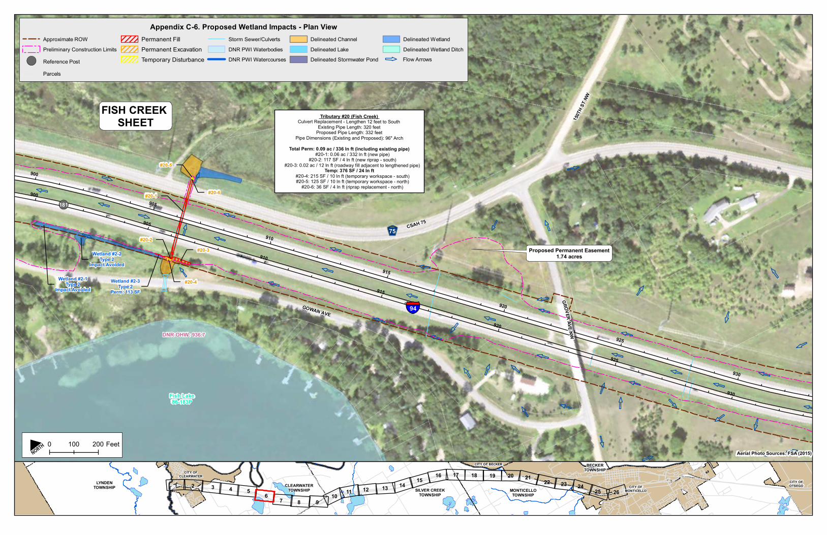
!(
900
905
910
915
920
925
930
900
905
910
915
920
925
930
Proposed Permanent Easement1.74 acres
DNR OHW: 936.7
Wetland #2-1Type 2
Impact Avoided
Wetland #2-2Type 2
Impact Avoided
Wetland #2-3Type 2
Perm: 113 SF
Tributary #20 (Fish Creek) Culvert Replacement - Lengthen 12 feet to South
Existing Pipe Length: 320 feetProposed Pipe Length: 332 feet
Pipe Dimensions (Existing and Proposed): 96" Arch Total Perm: 0.09 ac / 336 ln ft (including existing pipe)
#20-1: 0.06 ac / 332 ln ft (new pipe) #20-2: 117 SF / 4 ln ft (new riprap - south)
#20-3: 0.02 ac / 12 ln ft (roadway fill adjacent to lengthened pipe) Temp: 376 SF / 24 ln ft
#20-4: 215 SF / 10 ln ft (temporary workspace - south) #20-5: 125 SF / 10 ln ft (temporary workspace - north)
#20-6: 36 SF / 4 ln ft (riprap replacement - north)#20-1
#20-2#20-3
#20-4
#20-5
#20-6
FISH CREEK SHEET
Fish Lake86-183P
75
GROVERAVE NW
150T
H STNW
CSAH 75
GOWAN AVE
181
§̈¦94
Appendix C-6. Proposed Wetland Impacts - Plan ViewApproximate ROWPreliminary Construction Limits
!( Reference PostParcels
Permanent FillPermanent ExcavationTemporary Disturbance
Storm Sewer/CulvertsDNR PWI WaterbodiesDNR PWI Watercourses
Delineated ChannelDelineated LakeDelineated Stormwater Pond
Delineated WetlandDelineated Wetland Ditch
Service Layer Credits:
SILVER CREEKTOWNSHIP
CLEARWATERTOWNSHIP
LYNDENTOWNSHIP MONTICELLO
TOWNSHIP
BECKERTOWNSHIP
CITY OFMONTICELLO
CITY OFCLEARWATER
CITY OFOTSEGO
CITY OF BECKER
3 4 5 6 1012 13 14 15 16 17 18 19 20 21 22 23
261 2
7 8 911
2425
N 0 200100 FeetAerial Photo Sources: FSA (2015)
Flow Arrows

!(
1055 10601065
10701075
10801085
1055 10601065
10701075
10801085
Locke Lake Public Access
Wet Ditch #23Type 3
No Impact
Wet Ditch #24Type 3
No Impact
Wetland #9Type 3
Temp: 34 SF Wet Ditch #45Type 3
No ImpactWet Ditch #46
Type 3No Impact
Wetland #47Type 6
No Impact
Locke Lake #46No Impact
Wetland #11Type 2
No Impact
Wetland #12Type 3
No Impact
DNR OHW: 960.2
Tributary #10 (Silver Creek)In-kind Culvert Replacement
Pipe Length: 198 ln feetPipe Dimensions: 5'X10' box (2)
Temp: 0.13 ac / 226 ln ft (including pipe)Perm: 0 ac / 0 ln ft
SILVER CREEK SHEET
Unnamed86-354W
Unnamed86-354W
Unnamed86-354W Locke Lake
86-168P
Silve
r Cree
k
75
150TH ST NW
143RD ST NW
148TH ST NW
CSAH 75
184 §̈¦94
Appendix C-11. Proposed Wetland Impacts - Plan ViewApproximate ROW
Preliminary Construction Limits
!( Reference Post
Parcels
Permanent Fill
Permanent Excavation
Temporary Disturbance
Storm Sewer/Culverts
DNR PWI Waterbodies
DNR PWI Watercourses
Delineated Channel
Delineated Lake
Delineated Stormwater Pond
Delineated Wetland
Delineated Wetland Ditch
Service Layer Credits:
SILVER CREEKTOWNSHIP
CLEARWATERTOWNSHIP
LYNDENTOWNSHIP MONTICELLO
TOWNSHIP
BECKERTOWNSHIP
CITY OFMONTICELLO
CITY OFCLEARWATER
CITY OFOTSEGO
CITY OF BECKER
3 4 5 6 1012 13 14 15 16 17 18 19 20 21 22 23
261 2
7 8 911
2425
N 0 200100 Feet
Aerial Photo Sources: FSA (2015)
Flow Arrows
10901090

780 785 790 795 800 805
780 785 790 795 800 805
Wetland #30-1Type 3
Temp: 18 SF
Wetland #32-1Type 3
Temp: 106 SFWetland #33Type 3
No Impact
Wetland #29Type 2
Temp: 224 SF
Wetland #32-2Type 3Temp: 47 SF
Tributary #31 (Otter Creek)In-Kind Culvert Replacement
Pipe Length: 198 ln ftPipe Dimensions: 108" RCP Arch (2)
Temp: 0.11 ac / 228 ln ft (including pipe)Perm: 0 ac / 0 ln ft
Wetland #30-2Type 3Temp: 148 SF
OTTER CREEK SHEET
Otter Creek
Otter Creek
CITY OF MONTICELLOMONTICELLO TOWNSHIP
CROCUSLA
CROCUS CIR
BALBOUL CIR
ELWOOD RD
NICHOLAS CIR
PRAIRIE RD
HEADMAN LA
MARVIN ELWOOD RD
JERRY LIEFERT DR
§̈¦94
Appendix C-23. Proposed Wetland Impacts - Plan ViewApproximate ROW
Preliminary Construction Limits
!( Reference Post
Parcels
Permanent Fill
Permanent Excavation
Temporary Disturbance
Storm Sewer/Culverts
DNR PWI Waterbodies
DNR PWI Watercourses
Delineated Channel
Delineated Lake
Delineated Stormwater Pond
Delineated Wetland
Delineated Wetland Ditch
Service Layer Credits:
SILVER CREEKTOWNSHIP
CLEARWATERTOWNSHIP
LYNDENTOWNSHIP MONTICELLO
TOWNSHIP
BECKERTOWNSHIP
CITY OFMONTICELLO
CITY OFCLEARWATER
CITY OFOTSEGO
CITY OF BECKER
3 4 5 6 1012 13 14 15 16 17 18 19 20 21 22 23
261 2
7 8 911
2425
N 0 200100 Feet
Aerial Photo Sources: FSA (2015)
Flow Arrows
!(
!(
775810
815
775810
815

March 2019
Environmental Commitments The following environmental commitments include mitigation activities and public commitments made during NEPA/MEPA, environmental permit requirements, and other legal and regulatory requirements related to environmental compliance. This method of tracking environmental commitments from project scoping, into project design, and through construction, is necessary to: (1) ensure that environmental commitments are carried into final design, (2) help contractors comply with construction components, (3) track and document compliance, and (4) promote consistency. These commitments will be carried forward by MnDOT into final design and construction by incorporating them into an Environmental Management Plan using “Green Sheets” for environmental tracking.
Fish and Wildlife
• If ‘in-water’ work is required in DNR Public Waters or at outlets designated control structure (i.e. Silver Creek and Fish Creek), the project team will coordinate with the DNR and, if necessary, apply for and receive Public Waters Work Permit
• If ‘in-water’ work is required, follow work in water restrictions (no work between March 15 and June 15)
• If dewatering in excess of 10,000 gallons per day is expected, a dewatering permit will be applied for by the Contractor. Dewatering discharge will be treated to be free of suspended sediment before entering surface waters.
• Identify Monticello Savanna as ‘Area of Environmental Sensitivity’ on plans; if area is to be disturbed by construction:
o Protect and preserve vegetation according to MnDOT Spec 2572.3
o Utilize native seed mixes as developed by BWSR and MnDOT in ‘Vegetation Establishment Recommendations’
o Use bio-netting as erosion control blanket
• Identify Locke Lake and Fish Lake as “Designated Infested Waters” on project plans with notes prohibiting work within these waters
• MnDOT is committing to the recommended tree removal guidelines set forth by the USFWS, to minimize potential impacts to Northern Long-eared bat habitat (see correspondence in Appendix A)
Vegetation
• Proper erosion and sediment control will be implemented as defined in the SWPPP (see the “Vegetation Establishment Letter” in Appendix A)
• When working near trees/shrubs that warrant protection, place temporary fencing (MnDOT SPEC 2572.3A.1) and include plan sheet 5-297.302 in plan set to prevent areas near or under trees to not become staging areas
• Identify and eradicate noxious weeds before construction

March 2019
Wetlands
• Follow conditions specifically outlined in respective permits issued for the project
• All wetland impacts are located within right-of-way owned by MnDOT; thus, MnDOT is the Local Government Unit (LGU) for all wetland impacts of this project
• All preserved wetland areas will be labeled on plan sheets as “Environmentally Sensitive Areas”
• The roadway cross section has been modified to use a 10-ft inside and outside paved shoulder rather than 10.5-ft to minimize wetland impacts
• Inslopes have been reduced to 1:4 from Clearwater to Hasty (1:6 is preferred standard) along outside shoulder to reduce width of overall cross section by at four feet on either side of roadway
• Inslopes beyond the clear zone were reduced to 1:2.5 for two wetland locations (Wetland 2 and Wetland 6)
• All stormwater BMPs have been situated to avoid impacts to wetlands.
• As design continues, further reduction in wetland impact will be encouraged
• Wetland impacts will be mitigated as directed by the permits issued for this project and will be coordinated via the Office of Environmental Stewardship
Wells
• Known active wells near the construction limits will be labeled on plan sheets as sensitive resources to prevent impacts due to potential project changes during construction
Contamination
• Provide all excavation locations and depths to MnDOT’s Contaminated Materials Management Team prior to grading
• During final design a Phase 2 investigation will be completed, as necessary, at the stormwater treatment area locations
• Unknown materials may be encountered during construction that were not identified during the initial site investigations. A Construction Contingency plan (CCP) will be written and incorporated within the RAP, and it will discuss how to handle the unknowns that may be encountered.
• A spill kit will be kept near any storage tanks. Appropriate measures will be taken during construction to avoid spills that could contaminate groundwater or surface water in the project area.
• If a spill or leak were to occur during construction, the Project Engineer and Minnesota Duty Officer will be contacted and appropriate action to remediate will be taken immediately in accordance with MPCA guidelines and regulations in place at the time of project construction
• If any demolition of buildings or bridges is added to this project, coordinate with the Regulated Materials Unit and obtain necessary demolition approvals

March 2019
Erosion Control
• A SWPPP will be developed for this project. All areas disturbed during construction would be revegetated in accordance with the SWPPP and related permitting requirements.
• MnDOT will revegetate disturbed soils with native seed mixes in areas that are not proposed for mowed turf grass using the guidance developed by the Minnesota Board of Water and Soil Resources or the Vegetation Establishment Recommendations (MnDOT 2015)
• During construction, in-water BMPs will incorporated as necessary to reduce or eliminate total suspended solids from being conveyed to impaired waters.
Water Quality/Stormwater
• The project will address stormwater management requirements by adding nine stormwater
treatment areas that will be designed to meet water quality treatment requirements. The ponds
will be maximized within the constraints of existing right-of-way to provide required treatment
while avoiding wetlands and other resources of concern.
Section 404
• The necessary permits will be obtained from the US Army Corps of Engineers through continued coordination and review. Permits will be obtained by project segment dependent on the construction schedule.
Construction Noise
• High-impact noise construction activities will be limited in duration to the greatest extent possible. The use of pile drivers, jack hammers, and pavement sawing equipment will be prohibited during nighttime hours.
Traffic Noise
• Based on the noise wall analysis completed for the corridor, three noise walls met the feasibility and reasonableness criteria and are proposed as part of the project (Walls I1, O1, and S1). One existing noise wall will remain in-place and unchanged with the project.
• Noise Wall S1 will be constructed as part of the first phase of construction (Clearwater to Monticello). When the project’s final design and public involvement process have been completed, MnDOT will make the final decision regarding noise wall installation.
• Voting for Walls I1 and O1 will be conducted when that phase of the project is funded and planned for construction.
• If conditions substantially change by the time the project reaches the final design stage, noise abatement measures may not be provided. If that occurs, receptors that would have received benefits from noise walls, and local officials will be notified of plans to eliminate or substantially modify a noise abatement measure prior to the final design process. This notification will explain any changes in site conditions, additional site information, any design changes implemented during the final design process, and noise wall feasibility and reasonableness.

March 2019
Safety Rest Area Program
• Coordinate construction closures of the Enfield Rest Area and/or ramps on eastbound I-94 with Mark Motschke
• Assess conditions of the acceleration/deceleration ramps as well as parking pavement, may be eligible for NHFP funds
• Although the curb ramps and accessible routes to the building were corrected under an earlier project, MnDOT will confirm the rest area meets ADA compliance
Right-of-Way
• MnDOT will obtain permanent easements in the two locations where stormwater management will be create outside existing right-of-way
Air Quality
• All construction equipment used on the project will be required to meet the emissions requirements identified in MnDOT’s Standard Specifications for Construction.
Copyright © 2022 FDOKUMEN