FISHING AND COASTAL ADAPTATIONS AT ‘ATLIT-YAM—A SUBMERGED PPNC FISHING VILLAGE OFF THE CARMEL...
34
‘Atiqot 48, 2004 INTRODUCTION The fluctuations of climatic conditions during the Neolithic period induced major socio- economic changes within human societies of the Levant. Global warming that followed the last glacial maximum resulted in deglaciation, rise in sea level, reduction of coastal plains and significant changes in coastal palaeoenvironments (Van Andel 1989:736; Pirazzoli 1998:72). Two thousand years of intensive exploitation of the environment during the Pre-Pottery Neolithic (PPN) period, caused severe pressure on the natural environment and significantly reduced the availability of natural resources (Rollefson 1989; Rollefson and Köhler-Rollefson 1993). Toward the end of the PPN, the interaction between man and environment brought about the collapse of socio-economic systems and induced damage to the natural environment. This situation called for totally new economic strategies and new social organizations (Bar-Yosef and Belfer- Cohen 1989; Gopher 1993; Gopher and Gophna 1993; Rollefson and Köhler-Rollefson 1993). Consequently, during the end of the ninth and the first half of the eighth millennium BP, 1 new economic strategies were developed in different coastal and terrestrial regions of the Levant (Mediterranean, Irano-Turanian and Saharo- Arabian zones). These new strategies entailed the integration of agriculture, pastoralism, fishing and hunting. Although exploitation of marine resources is documented from many Levantine Pleistocene and Holocene sites, the role of marine resources in the economic subsistence system of the coastal Neolithic communities of the southern Levant is yet unclear. This is chiefly because the coastal prehistoric settlements are submerged off the present-day coastline and data was lacking until recently. Submerged prehistoric sites off the coast of Israel have been exposed in recent decades due to human intervention in natural processes (Wreschner 1977, 1983; Raban 1983; Galili and Weinstein-Evron 1985; Galili 1985, 1987; Galili and Inbar 1986, 1987; Galili, Kaufman and Weinstein-Evron 1988; Galili and Nir 1993; Galili and Sharvit 1994–5, 1998b; Galili, Sharvit and Nagar 1998). Sand quarrying and construction of marine structures (jetties, breakwaters) have considerably reduced the availability of sand on the seabed. As a result, sites covered by a protective layer of sand for thousands of years are now being exposed by sea storms. Shortly after the exposure, the sites are subject to erosion and rapid disintegration. Years of underwater rescue surveys, excavations and documentation, yielding numerous pieces of information, are to be pieced together in puzzle-fashion. Submerged prehistoric settlements off the Carmel coast (Fig. 1) are mainly of two periods: Pre-Pottery Neolithic C (PPNC), as defined by Rollefson (1989) for ‘Ein Ghazzal, and the Late Pottery Neolithic (PN) Wadi Rabah culture. In addition, meager remains of Middle PN Jericho IX culture (‘Lodian’) were uncovered at the Nevé–Yam site (Fig. 2). Six PN sites dated to 6500–7000 BP: Kefar Shamir, Kefar Gallim (North), Kefar Gallim, Tel Hreiz, Megadim and Nevé–Yam (Fig. 1) are now submerged at water depths of 0–5 m. FISHING AND COASTAL ADAPTATIONS AT ‘ATLIT-Y AM—A SUBMERGED PPNC FISHING V ILLAGE OFF THE CARMEL COAST, ISRAEL EHUD GALILI, OMRI LERNAU AND IRIT ZOHAR
-
Upload
independent -
Category
Documents
-
view
3 -
download
0
Transcript of FISHING AND COASTAL ADAPTATIONS AT ‘ATLIT-YAM—A SUBMERGED PPNC FISHING VILLAGE OFF THE CARMEL...

‘Atiqot 48, 2004
INTRODUCTION
The fluctuations of climatic conditions during
the Neolithic period induced major socio-
economic changes within human societies
of the Levant. Global warming that followed
the last glacial maximum resulted in
deglaciation, rise in sea level, reduction of
coastal plains and significant changes in coastal
palaeoenvironments (Van Andel 1989:736;
Pirazzoli 1998:72). Two thousand years of
intensive exploitation of the environment during
the Pre-Pottery Neolithic (PPN) period, caused
severe pressure on the natural environment
and significantly reduced the availability of
natural resources (Rollefson 1989; Rollefson
and Köhler-Rollefson 1993). Toward the end
of the PPN, the interaction between man and
environment brought about the collapse of
socio-economic systems and induced damage
to the natural environment. This situation called
for totally new economic strategies and new
social organizations (Bar-Yosef and Belfer-
Cohen 1989; Gopher 1993; Gopher and Gophna
1993; Rollefson and Köhler-Rollefson 1993).
Consequently, during the end of the ninth and
the first half of the eighth millennium BP,1 new
economic strategies were developed in different
coastal and terrestrial regions of the Levant
(Mediterranean, Irano-Turanian and Saharo-
Arabian zones). These new strategies entailed
the integration of agriculture, pastoralism,
fishing and hunting.
Although exploitation of marine resources is
documented from many Levantine Pleistocene
and Holocene sites, the role of marine resources
in the economic subsistence system of the
coastal Neolithic communities of the southern
Levant is yet unclear. This is chiefly because the
coastal prehistoric settlements are submerged
off the present-day coastline and data was
lacking until recently.
Submerged prehistoric sites off the coast of
Israel have been exposed in recent decades
due to human intervention in natural processes
(Wreschner 1977, 1983; Raban 1983; Galili
and Weinstein-Evron 1985; Galili 1985, 1987;
Galili and Inbar 1986, 1987; Galili, Kaufman
and Weinstein-Evron 1988; Galili and Nir
1993; Galili and Sharvit 1994–5, 1998b; Galili,
Sharvit and Nagar 1998). Sand quarrying
and construction of marine structures (jetties,
breakwaters) have considerably reduced the
availability of sand on the seabed. As a result,
sites covered by a protective layer of sand for
thousands of years are now being exposed by
sea storms. Shortly after the exposure, the sites
are subject to erosion and rapid disintegration.
Years of underwater rescue surveys, excavations
and documentation, yielding numerous pieces
of information, are to be pieced together in
puzzle-fashion.
Submerged prehistoric settlements off the
Carmel coast (Fig. 1) are mainly of two periods:
Pre-Pottery Neolithic C (PPNC), as defined by
Rollefson (1989) for ‘Ein Ghazzal, and the Late
Pottery Neolithic (PN) Wadi Rabah culture. In
addition, meager remains of Middle PN Jericho
IX culture (‘Lodian’) were uncovered at the
Nevé–Yam site (Fig. 2). Six PN sites dated to
6500–7000 BP: Kefar Shamir, Kefar Gallim
(North), Kefar Gallim, Tel Hreiz, Megadim and
Nevé–Yam (Fig. 1) are now submerged at water
depths of 0–5 m.
FISHING AND COASTAL ADAPTATIONS AT ‘ATLIT-YAM—A SUBMERGED
PPNC FISHING VILLAGE OFF THE CARMEL COAST, ISRAEL
EHUD GALILI, OMRI LERNAU AND IRIT ZOHAR

EHUD GALILI, OMRI LERNAU AND IRIT ZOHAR2
In this study, fish remains recovered at ‘Atlit-
Yam, as well as items associated with fishing
and the exploitation of marine resources will
be described and discussed. Ancient fishing and
fish-processing methods will be reconstructed
and the contribution of marine resources to
the economy of the PPNC population will be
evaluated.
THE SITE
The submerged PPNC settlement of ‘Atlit-
Yam (Galili and Weinstein-Evron 1985; Galili
1987; Galili, Weinstein-Evron and Ronen 1988;
Galili et al. 1993; Galili and Nir 1993; Galili,
Sharvit and Shifroni 1999) is situated 300–
500 m offshore in the northern bay of ‘Atlit, 10
km south of Haifa (34º56'E, 32º42.5'N), at water
depths of 8–12 m (Fig. 1). The archaeological
material is embedded in the upper layer of a
dark clay matrix, which fills the trough between
a submerged sandstone ridge and the coastline.
Underwater excavations and surveys have
revealed foundations of several rectangular
structures, paved floors, straight walls, hearths, Fig. 1. Location map of the Carmel coast and the
submerged Neolithic sites.
Fig. 2. Cultural entities of submerged settlements off the Carmel coast and 14C datings.

FISHING AND COASTAL ADAPTATIONS AT ‘ATLIT-YAM 3
circular ritual installations, storage and
production installations and water wells. The
structures and the installations are sparsely
dispersed over the site with wide open spaces
in between (see Fig. 3). The tool assemblage
consists of flint, stone and bone artifacts, as well
as some ornaments. Based on the architecture,
the typology of the tools and 14C dates, the site is
dated to the PPNC period. Radiocarbon dating
of several charcoal and waterlogged plant
fragments yielded ages of 8170 to 7250 ybp
(Table 1), with one exceptionally young date of
6580 ybp.
Botanical remains recovered from the
site include charcoal and waterlogged plant
fragments (branches, seeds and pollen) of
domesticated and non-domesticated vegetation
(Galili et al. 1993; Hartman, Kislev and Galili
1997; Hartman 1997). Osteological remains
include wild mammals (herbivores, omnivores
and predators) reptiles, amphibians, fish and
domesticated pig, dog and goat, and cattle in
the early stages of domestication (Horwitz and
Tchernov 1987; Galili et al. 1993; Horwitz et
al. 1999; Dayan and Galili 2001). In addition,
human remains of at least 90 individuals were
found in both primary and secondary burial
contexts (Galili et al. 2000; Eshed et al. 2000).
The ‘Atlit-Yam site is unsurpassed among
submerged settlements in its degree of
preservation. Not only is it the largest and best-
preserved prehistoric settlement yet found on
the Mediterranean seabed, but it is also the only
one known to contain in situ human burials.
MATERIALS AND METHODS
Excavations and Surveys 1984–2000Fourteen excavation seasons were focused
on selected features revealed in the exposed
Table 1. 14C Dates from the ‘Atlit-Yam Site
Laboratory
Reference*
Date (YBP)
Uncalibrated
Calibrated**
Calendaric Age
(YBC)
Sample Provenance
PTA 3950 8000 ± 90 7010–6766 Charred branch Near Structure 13
RT 707 8140 ± 120 7411–6786 Charred branch Near Structure 13
RT 944A 7670 ± 85 6599–6429 Charred wheat Locus 10A (wheat and fish bone
concentration)
RT 944C 7610 ± 90 6561–6348 Charred branches Locus 10A (wheat and fish bone
concentration)
PITT 0622 7550 ± 80 6480–6180 Charred wheat Structure 10A (wheat and fish bone
concentration)
RT 1431 7300 ± 120 6233–5992 Waterlogged wood Structure 11 (water well) (2.9–3.1)***
RT 2479 7460 ± 55 6361–6216 Waterlogged tree branch Structure 11 (water well) (1.9–2.3)
RT 2477, 2478 7605 ± 55 6458–6385 Waterlogged tree branch Structure 11 (water well) (2.3–2.9)
RT 2475 7465 ± 50 6361–6220 Waterlogged tree branch Structure 11 (water well) (3.5–4.0)
RT 2493, 2495 7755 ± 55 6563–6470 Waterlogged tree branch Structure 66 (water well) (0.5–1.0)
RT 2489, 2492 7880 ± 55 6993–6596 Waterlogged tree branch Structure 66 (water well) (0–0.5)
RT 2681 6580 ± 35 5521–5490 Waterlogged plants
(grass)
Structure 32 (round pit) (0–0.5)
RT 3038 8000 ± 45 7010–6766 Charcoal Human burial (H67) near Structure 54
RT 3043 7250 ± 45 6150–6000 Waterlogged wood Near Structure 56
RT 2496, 2497 8170 ± 55 7253–7043 Waterlogged plant fibers Structure 65 (0–0.3)
*RT= Weitzmann Institute, Israel; PITT=Pittsburgh, USA; PTA= Pretoria, South Africa.
**Dendrochronological Calibration, after Stuvier and Reimer 1993.
*** (2.9–3.1) = Depth of archaeological layer under the sea floor.
YBP = Year Before Present

EHUD GALILI, OMRI LERNAU AND IRIT ZOHAR4
areas of the seabed. In addition, rescue surveys
conducted in the winter months served to
document structures and installations and to
preserve and retrieve any occasionally exposed
finds (human skeletons, artifacts and organic
remains), facing imminent threat of destruction.
The digging activities were carried out either
manually with a knife or with a dredging
system operated by a water pump. Loose
sediments were removed by a dredger until
the clay containing the archaeological material
was reached. The deposit was then excavated
in 10 cm intervals in 0.5 × 0.5 m squares.
The excavated material was placed in tagged
plastic bags, marked by square and layer, and
taken ashore to be sieved. Small or fragile
artifacts were collected in plastic jars and core
samples of in situ clay were taken for pollen and
sediment analysis.
Post-Dive Conservation and Documentation
The excavated material underwent a series
of conservation treatment: (1) Each bag of
excavated material was submerged in a large
plastic tub of tap water. Large and medium-
size objects (stones, artifacts, etc.) were then
removed manually, dried and marked. (2) The
water was then circulated manually and
hovering waterlogged organic material was
collected using a 0.5 mm mesh strainer.
(3) The waterlogged organic material was stored
in a solution of tap water and alcohol (5:1).
(4) The remaining material was sieved with
water in a 1 mm mesh strainer and subsequently
dried in wooden trays. (5) Tiny bones, charcoal,
botanic material and flint implements, were
extracted. (6) Bones and artifacts were
immersed in tap-water tubs for three days to
dissolve salts and were then dried in the shade
and marked.
Analysis of the Fish RemainsThe fish remains were identified by comparing
the sub-fossil bones with those of recent
fish material in Tel Aviv University and in
O. Lernau’s reference collections. Skeletal
elements were determined according to the
terminology of Tyler (1980), Cannon (1987)
and Wheeler and Jones (1989). We calculated
the number of identified bones/specimens
(NISP) and the minimum number of individuals
(MNI) for each species (Klein and Cruz-Uribe
1984).
Bones that suited the criteria for size
estimation (Wheeler and Jones 1989) were used
for body size (body mass and standard length)
estimation. Measurements were performed
with a digital caliper to a precision of 1 mm (see
method described by Morales and Roselund
1979). The body size of B. Carolinensis was
assessed by using the linear regression method
calculated from 42 recent triggerfish (Zohar
1994:231–237; Zohar et al. 1994). For other
species, body size was estimated in comparison
either to the bones in the reference collection, or
to published data.
Comparative Data
The reconstruction of fishing methods at ‘Atlit-
Yam is based on archaeological evidence,
ethnographic and iconographic sources, ocea-
nographic data, fish-catch statistics, interviews
and personal observations.
To obtain firsthand information concerning
current habitats and behavior of fish populations,
local fishermen employing a variety of fishing
techniques combined with diving were
interviewed. The information presented here
represents over 50 years of fishing experience
and more than 9000 hours of diving. Reports
on the Fisheries of Palestine (Hornell 1935)
provided valuable information on traditional
fishing methods, fish-catch statistics and
fishermen subsistence in the first third of the
twentieth century, prior to the appearance
of mechanized boats, synthetic fishing nets
and lines and modern diving equipment.
Reports of the Israel Ministry of Agriculture,
Department of Fisheries (Anonymous 1963)
were also used as reference for comparison.
Data on sea conditions were obtained from the
Israel National Oceanographic Institute, based
on measurements taken by the Hadera port
authorities, Ashdod port and ship observations

FISHING AND COASTAL ADAPTATIONS AT ‘ATLIT-YAM 5
(Goldsmith and Soffer 1983), Mediterranean
pilot manuals of the Dutch navy (Anonymous
1957) and the British navy (Anonymous 1976),
and from observations of fishermen during the
second half of the twentieth century.
Loci with Fish RemainsFish remains were recovered from six structures
and installations at the site (Fig. 3), some fully
excavated (Nos. 11, 10A, 35A) and others
probed (Nos. 9, 13, 20) (Galili 1985, 1987;
Galili and Inbar 1987; Galili et al. 1993).
Locus 10A (Figs. 3: No. 10A; 4).— Most of
the fish remains (89%) recovered from the
site originated from L10A, where a dense
concentration of fish bones and cereal grains
was recovered. The fish remains and the grains
were embedded in a pocket-like clay deposit,
lacking association with either a container or a
living floor. The deposit was located in an open
flat area, a few meters from wall foundations
Fig. 3. Top, right: ‘Atlit peninsula and bays. Inset: ‘Atlit-Yam site.
Fig. 4. Diver excavating L10A (Photo: J. Galili).
and installations. A hearth filled with charcoal
and ashes was discovered embedded in the
clay in the northeastern corner of the excavated
area (plan 1). Excavations (2.0 × 2.0 × 0.3 m)
revealed a large quantity of fish remains, as well
as cereal grains, chiefly domesticated emmer
wheat (Triticum dicoccon) and naked wheat

EHUD GALILI, OMRI LERNAU AND IRIT ZOHAR6
(T. parvicoccum) (Galili et al. 1993). This
concentration of grains is apparently the largest
accumulation of wheat ever discovered at PPN
sites in the Near East: it consisted of some
27,000 well-preserved seeds of domesticated
cereals, as well as associated weeds (Carex extensa, Cyperus laevigatus, C. rotunds and
Scirpuus maritimus), which are typical of
cultivated fields. The total volume of the ‘lens’
containing the charred plant remains was about
10 liters. The wheat was embedded in a cone-
shaped concentration of scattered fish bones,
approximately 175 liters in volume.
Although the wheat was concentrated within
the fish deposit, the distribution patterns of
the two assemblages were clearly different.
The fish bones were embedded in clay, which
contained associated archaeological material,
such as flint artifacts, animal bones, some
isolated human bones and stones, whereas
the wheat concentration consisted almost
exclusively of charred plant matter. The fish-
bone deposit was densest at the center while the
edges contained isolated and dispersed bones; it
penetrated deeper than the grains into the clay
toward the east, attaining an unknown depth
beyond the excavation square. The borders of
the wheat deposit were, in contrast, sharp and
well defined. The grains were charred, while
most of the fish bones were not.
In addition to fish remains, a few human
bones and approximately 60 bones of sheep/
goat and cattle were recovered from L10A. The
mammal bones included mainly post-cranial
bones and a few skull elements of sheep/goat
(Horwitz, unpublished data). The animal species
represented in L10A are similar to those found
in the site as a whole (c. 50% sheep/goat and c.
50% cattle) (Horwitz and Tchernov 1987; Galili
et al. 1993).
The flint assemblage consists of some 50
flakes, several cores, a sickle blade, an awl, a
chisel and a few hundred chips.
Structures and installations that can be
associated with the fish bones were discovered
in the vicinity of L10A: foundations of a
rectangular structure (4 × 5 m) constructed from
undressed stones (dwelling?) were found 3–4 m
south of L10A (Fig. 3: No. 10). The structure
contained two hearths, 0.8 m in diameter,
containing gray ash and a concentration of
artifacts, including three well-shaped projectile
points made of pressure-flaked flint (Fig. 5)
(daggers or spearheads), a pierced stone (Fig.
6:A) (end sinker of fishing net?) and a small
oval limestone bowl.
Another circular pit (Fig. 3: No. 65), 2 m in
diameter, was located 10 m to the southeast; it
was filled with plano-convex fired mud bricks
and a concentration of charred plant fibers
Plan 1. Plan and section of L10A.

FISHING AND COASTAL ADAPTATIONS AT ‘ATLIT-YAM 7
(flax?). About 10 m northwest of the fish bones
were three megaliths (Fig. 3: No. 67) (each
1.2 m high). Two of these are of anthro-
pomorphic shape, grooved around their upper
sections and creating a so-called ‘neck’ (Galili,
Sharvit and Shifroni 1999).
Structure 20 (Fig. 3: No. 20).— A 4-m-long
straight wall foundation, constructed of two
rows of undressed stones. A large concentration
of charred organic material was discovered
0.5 m south of the wall. Examination of the
surface revealed an assortment of flint artifacts,
stone and bone implements, charred wood,
plant remains and 62 fish bones.
Water Well (Fig. 3: No. 11).— A 5.5-m-deep
shaft, reaching a depth of 15.5 m below
present-day mean sea level (Galili and Nir
1993; Galili and Sharvit 1998), explored in
three excavation seasons. The sieved sediments
have yielded large quantities of animal bones,
mostly domesticated goat, sheep and wild and
domesticated pigs (Horwitz et al. 1999), cattle
Fig. 5. Spearheads/daggers recovered from ‘Atlit-Yam.
Fig. 6. Stone net sinkers recovered from ‘Atlit-Yam.
A
B

EHUD GALILI, OMRI LERNAU AND IRIT ZOHAR8
(domesticated?) and carnivores, primarily dogs
(Dayan and Galili 2001), as well as numerous
small bones of rodents and reptiles, and insects.
Sixteen bones of fish were retrieved from
sampled sediments. In addition, hundreds
of flint, stone, wood and bone artifacts, and
thousands of charred and waterlogged seeds of
wild and domesticated plants were recovered.
Plants of economic value include domesticated
and wild cereals, wild fruits, domesticated
legumes, domesticated linum (flax) and plant
seeds of species used to this day as fish poison,
medicine, or spices by traditional Levantine
villagers (Hartman 1997). Large quantities of
tree branches and pollen grains were recovered
as well. Analyses of the finds show that at a
certain point in time the well was converted
into a refuse pit, presumably as a result of water
salinization caused by the rise of sea level.
Structure 13 (Fig. 3: No. 13).— A rectangular
(5 × 8 m) dwelling foundation, constructed from
undressed fieldstones. A number of hearths and
three human burials were discovered nearby. A
1 × 2 m probe within the structure revealed flint
artifacts, bone and stone implements, animal
bones and four fish vertebrae.
Structure 9 (Fig. 3: No. 9).— A wall foundation
of a rectangular dwelling (5 × 14 m) constructed
from undressed stones. A 2 × 2 m probe revealed
animal bones, flint and limestone artifacts and
three fish bones.
L35A (Fig. 3: No. 35A).— Excavation of a
2 × 4 m area, in a dense concentration of
flint artifacts revealed a chipping floor with
thousands of flakes, chips and cores, a few tools,
a few animal bones and a single fish bone.
FINDINGS
The Fish RemainsMore than 6000 fish remains were collected
from the sieved material. These included a large
number of small unidentifiable fragments
of bones and scales. Skeletal elements were
identified for 4074 remains and taxonomic
status determined for 3842 identified bones.
Of the identified remains, 3778 (98.3%) were
recovered from L10A and 64 from six other
loci (Table 2); 254 bones (6.2% of the recovered
bones) were blackened by fire. Some of the fish
bones were discovered in partial articulation
(up to 10 vertebrae together), and most of the
skeletal elements were represented.
The following is a detailed catalogue of the
identified remains in their order of frequency:
(A) Balistidae (Leatherjackets): The 3736
specimens (97.2% of all identified remains)
of this family that were recovered from
the site (Table 3) consisted of 49 different
skeletal elements, including teeth, scales and
numerous small fragments of pterygiophores
(Fig. 7). All of these can be assigned to
the sole representative of this family in the
Table 2. Fish Bones Recovered from ‘Atlit-Yam (see Fig. 3 for location)
10A 20 Water Well 11 13 9 35a Total NISP (MNI)
Balistidae 3678 50 3 4 1 3736 (88)
Serranidae 34 34 (4)
Sciaenidae 32 2 34 (7)
Sparidae 30 2 1 33 (7)
Mugilidae 3 3 (1)
Carangidae 1 1 (1)
Elasmobranchii 1 1 (1)
Unidentified 2780 12 10 2802
Total 6558 62 16 4 3 1 6644 (110)
NISP = Number of Individual Specimens
MNI = Minimum Number of Individuals

FISHING AND COASTAL ADAPTATIONS AT ‘ATLIT-YAM 9
Skeletal Element Detail NISP
Neurocranium Vomer 34
Parasphenoid 39
Frontal 89
Prefrontal 22
Ethmoid 52
Supraoccipital 22
Basioccipital 30
Exooccipital 10
Pterotic 19
Epiotic 6
Prootic 36
Pterosphenoid 14
Branchiocranium Dens 169
Premaxilla 51
Maxilla 46
Dentary 39
Articular 29
Palatine 26
Entopterygoid 1
Ectopterygoid 12
Metapterygoid 25
Quadratum 64
Hyomandibular 92
Opercular 32
Preopercular 113
Epihyal 1
Ceratohyal 9
Urohyal 11
Branchial elements 11
Vertebral Column 1st vertebra 36
2nd vertebra 49
3rd vertebra 51
Abdominal vertebra 82
Caudal vertebra 396
16th vertebra 33
17th vertebra (last) 30
Haemal spine of- 22
Undefined vertebra 3
Median Fins 1st dorsal spine 110
2nd dorsal spine 79
3rd dorsal spine 38
Supraneural 18
Skeletal Element Detail NISP
Pterygial carina 148
1st interhaemal
pterygiophore
27
Pterygiophore
splinters
528
Caudal Skeleton Hypural 23
Appendicular Skeleton Basipterygium
(pelvis)
111
Cleithrum 124
Postcleithrum 92
Supracleithrum 48
Scapula 40
Coracoid 3
Scales 541
Table 3. Frequency Distribution of Balistes
Carolinensis Skeletal Elements (Total NISP = 3736)
Mediterranean, the Gray triggerfish Balistes carolinensis (Gmelin 1789). The majority of
these remains, 3678 bones and scales, were
recovered from L10A; 50 in L20; 4 in L13; 3 in
the well (L11) and one in L9. The MNI for the
triggerfish was estimated at 76 for L10A and
88 for the entire site. The calculated standard
lengths of the fish from L10A are in the range
of 10 to 45 cm, averaging 23 cm. Body mass
calculations for the triggerfish in L10A are in
the range of 90 to 3400 gm, averaging 500 gm
(Zohar et al. 1994:234).
Remains of B. carolinensis, totaling 110
specimens, have been identified in 11 additional
sites in Israel. Of these, only eight specimens
were dated to the Neolithic period: 7 out of 8
fish bones in Kabri (Lernau 2002) and one out
of 297 in the PPNC site of Afridar in Ashqelon
(Lernau, unpublished data). Triggerfish were
not identified at five other Neolithic sites,
among them Ziqim, with 51 identified fish
bones (Garfinkel et al. 2002) and Hatoula, an
Epipaleolithic and early Neolithic site, with 502
identified bones (Lernau and Lernau 1994).
Small schools or pairs of young B. carolinensis are found in shallow waters (4–
15 m) among rocks and rich vegetation, while
larger individuals, move deeper and inhabit
coarse sandy and silty bottoms near isolated
rocks or shipwrecks (Golani and Darom 1977;

EHUD GALILI, OMRI LERNAU AND IRIT ZOHAR10
Fig. 7. Triggerfish bones: (a) Left premaxilla and maxilla, complete, lateral view; (b) Left dentary, complete, lateral view; (c) Right quadrate, complete, lateral view; (d) Left hyomandibula, complete, lateral view; (e) Left
post-cleithrum, complete; (f) Right cleithrum, broken, lateral view; (g) Pelvis, broken, left-lateral view; (h) Fourth vertebra, well preserved, left-lateral view; (i) Same, anterior view; (j) First dorsal spine, complete, left-lateral view.
Spine is locked in a vertical position by the action of 2nd and 3rd spines (wherefrom the fish derives its name);(k) Same, dorsal view; (l) Second dorsal spine, complete, left-lateral view; (m) Pterygial carina, broken, left-lateral view. This bony structure supports the three dorsal spines, which combine to form the trigger mechanism; (n) Same,
medial view; (o) Parasphenoid bone, broken, left-lateral view; (p) Ethmoid bone, complete, ventral view.
FISHING AND COASTAL ADAPTATIONS AT ‘ATLIT-YAM 11
Fischer, Bianchi and Scott 1981; Caveriviere
1982; Whitehead et al. 1986; Essuman and
Diakite 1990; Nelson 1994).
Annual reports of the Israel Department of
Fisheries (Shapiro and Znovsky 1996) and the
Reports on the Fisheries of Palestine (Hornell
1935), indicate that this fish was not a common
fishermen’s catch during the twentieth century.
(B) Serranidae (Groupers): All 34 bones
were recovered from L10A. They consist of
22 different skeletal elements: 27 from the
region of the cranium, 4 from just behind it (2
first vertebrae, 1 second and 1 third vertebra)
and 3 anal pterygiophores representing the
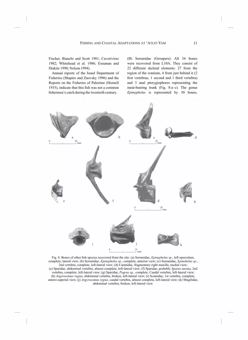
meat-bearing trunk (Fig. 8:a–c). The genus
Epinephelus is represented by 30 bones,
Fig. 8. Bones of other fish species recovered from the site: (a) Serranidae, Epinephelus sp., left operculum, complete, lateral view; (b) Serranidae, Epinephelus sp., complete, anterior view; (c) Serranidae, Epinehelus sp.,
2nd vertebra, complete, left-lateral view; (d) Caranidae, fragmentary right maxilla, medial view;(e) Sparidae, abdominal vertebra, almost complete, left-lateral view; (f) Sparidae, probably Sparus aurata, 2nd
vertebra, complete, left-lateral view; (g) Sparidae, Pagrus sp., complete, Caudal vertebra, left-lateral view; (h) Argyrosomus regius, abdominal vertebra, broken, left-lateral view; (i) Scianidae, 1st vertebra, complete,
antero-superial view; (j) Argyrosomus regius, caudal vertebra, almost complete, left-lateral view; (k) Mugilidae, abdominal vertebra, broken, left-lateral view.

EHUD GALILI, OMRI LERNAU AND IRIT ZOHAR12
most of them probably belonging to the white
Grouper E. aeneus (Geoffrey Saint Hilaire 1817)
(Table 4), and 2 bones to the dusky Grouper E. marginatus (Lowe 1834). The MNI for this
family was estimated at four. Estimated standard
lengths, based on 20 measured bones, ranged
between 19 and 48 cm with an average of 34.
Over 1300 bones of groupers have been
identified in archaeological excavations in
Israel. Of these, 62 bones dated to the Natufian,
the Khiamian and the Sultanian cultures were
recovered from the inland Epipaleolithic site
of Hatoula, 252 from the coastal PPNC site of
the Ashqelon marina (Perrot and Gopher 1996;
Garfinkel 1999, 2001; Lernau, unpublished
data), 49 from the PN site of Ziqim (Garfinkel
et al. 2002), 2 from the Neolithic strata at Kabri
(Lernau 2002), one from PPNB Yiftah’el
(Lernau, unpublished data) and 4 from the
submerged PN site of Nevé-Yam (Horwitz,
Lernau and Heschel, in press).
The body mass analysis seems to indicate
that the ancient inhabitants of ‘Atlit-Yam did
not capture large groupers. At Afridar, the
estimated average size of groupers was higher
(51 cm long, range 32–76 cm), at Ziqim it was
57 cm (range 49–79 cm) and in the Late Bronze
and Iron Age II city of Lakhish it was 60.5 cm
(range 40–82 cm) (Lernau, pers. comm.).
Epinephelus aeneus inhabits rocks and
clayey sand bottoms at depths of 2–50 m; at
70–120 cm they return to deeper waters (up to
200 m) and live on the clayey bottom. When
spawning, E. aeneus, like other members of
the family, forms groups with reduced activity
in selected areas, where they are likely to be
caught more easily.
Epinephelus marginatus resembles E. aeneus,
yet never leaves the shallow rocky habitats.
Young individuals of up to 3 kg are found in
shallow waters (0.5–15.0 m), whereas older
and bigger ones (up to 25 kg) reach deeper
waters, about 60 m deep. E. costea (formerly E. alexandriunus) is a predator that inhabits rocky
habitats or coarse sand near rocks, at water
depths of 2–200 m and can reach a weight of
7 kg.
Table 4. Bones of the Family Serranidae
Skeletal Element Identification NISP
L M R
Neurocranium
Posttemporal Epinephelus sp. 1
Vomer Serranidae indet. 1
Parasphenoid Epinephelus sp. 1
Frontal Epinephelus sp. 1
Supraoccipital Epinephelus sp. 1
Basioccipital Epinephelus sp. 1
Branchiocranium
Premaxilla Epinephelus sp. 1
Maxilla Epinephelus sp. 1
Dentary Epinephelus sp. 2
Articular Epinephelus sp. 2 2
Palatine Epinephelus sp.
Epinephelus
marginatus
1 1
1
Quadratum Epinephelus sp. 2
Hyomandibular Epinephelus sp.
Epinephelus
marginatus
1
1
Opercular Epinephelus sp. 1 1
Subopercular Epinephelus sp. 1
Urohyal Epinephelus sp. 2
Vertebral Column
1st vertebra Serranidae indet.
Epinephelus sp.
1
1
2nd vertebra Epinephelus sp. 1
3rd vertebra Epinephelus sp. 1
Abdominal vertebra
Caudal vertebra
Median Fins
Pterygiophore Serranidae indet.
Epinephelus sp.
2
1
Appendicular skeleton
Cleithrum Epinephelus sp. 1
Supraclethrum Epinephelus sp. 1
NISP = Number of Identified Specimens
R = right L = left M = median
(C) Sciaenidae (Drums or Croakers): Of 34
bones belonging to this family (Table 5; Fig.
8:h–j), 32 are from L10A and 2 from L9. They
are represented by eight different skeletal
elements: 2 from the head region and 6 from the

FISHING AND COASTAL ADAPTATIONS AT ‘ATLIT-YAM 13
trunk. Thirty vertebrae of various types were
recovered, including the first three vertebrae
(7 bones), with the remainder representing
the meat-bearing trunk. Fourteen bones could
further be identified with the species Meagre
Argyrosomus regius (Asso 1801). Estimation of
MNI was seven (six in L10A). Measurements
of 31 bones allowed estimations of standard
lengths between 10 and 42 cm (average 20
cm).
So far 780 bones of this family have been
identified in various excavated assemblages
of fish, but only a few are dated to prehistoric
periods: 43 in Hatoula, 1 in Yiftah’el, 1 in Ziqim
(estimated standard length 65 cm) and 1 in the
Ashqelon marina (estimated standard length 57
cm). Captured Drums became much larger in
sites dated to historical periods, as for instance
in Bronze Age Lakhish (24–150 cm with an
average SL of 55 cm). A. regius is a migratory
predator that feeds on small fish and large
invertebrates and may attain a maximum length
of 150 cm (80 kg). It inhabits various grounds,
including open areas and shallow rocky and
sandy bottoms (1–70 m deep). It sometimes
enters fresh water streams and coastal lagoons.
Until about 20 years ago it was common
along the coast of Israel, but has since almost
disappeared.
(D) Sparidae (Sea Breams, Porgies): From this
family 33 bones were recovered, 30 from L10A,
2 from L11 and 1 from L9 (Table 6; Fig. 8:e–g).
They represent 12 different skeletal elements,
including 12 bones from the region of the head
and 21 from the meat-bearing trunk. Sixteen
bones could be further identified as belonging
to four different genera: six of the gilthead
seabream Sparus aurata (Linnaeus 1758), five
of the genus Pagrus, probably the species P. coeruleostictus (Valenciennes 1830); four of
the genus Dentex and one striped sea bream
Lithognatus mormyrus (Linnaeus 1758). Most
other bones probably belong to the first three
genera, but their state of preservation did not
allow for definitive identification. Estimated
MNI was seven (five for L10A). Measurements
of bones showed two size-groups: 11 bones
belonged to small fish with an average length
Table 5. Bones of the Family Sciaenidae
Skeletal Element Identification NISP
L M R
Branchiocranium
Premaxilla Sciaenidae indet. 1
Dentary Sciaenidae indet. 1
Vertebral Column
1st vertebra Sciaenidae indet. 2
2nd vertebra Sciaenidae indet. 4
3rd vertebra Sciaenidae indet. 1
Abdominal
vertebra
Sciaenidae indet.
Argyrosomus regius5
5
Caudal vertebra Sciaenidae indet.
Argyrosomus regius5
9
NISP = Number of Identified Specimens
R = right; L = left; M = median
Table 6. Bones of the Family Sparida
Skeletal Element Identification NISP
L M R U
Neurocranium
Basioccipital Sparidae indet. 1
Branchiocranium
Dens Sparidae indet. 1
Maxilla Sparidae indet. Dentex sp.
1 1
Dentary Sparidae indet.
Lythognatus mormyrus
1
1
Articular Sparidae indet. 2
Palatine Sparus aurata 2
Quadratum Sparidae indet. 1
Urohyal Sparidae indet. 1
Vertebral Column
2nd vertebra Sparus aurata 1
Abdominal
vertebra
Sparidae indet.
Sparus aurata Dentex sp.
3
1
3
Caudal vertebrae Sparidae indet.
Sparus aurata Pagrus pagrus
5
2
5
Median Fins
Pterygiophore Sparidae indet. 1
NISP = Number of Identified Specimens
R = right; L = left; M = median; U = unidentified

EHUD GALILI, OMRI LERNAU AND IRIT ZOHAR14
of 20 cm (range 17–29 cm) and nine bones
belonged to larger fish with an average length
of 45 cm (range 43–47 cm). All the larger-sized
bones probably belong to Pagrus or Dentex.
Remains of Sparidae have been identified in
almost every excavated assemblage of fish in
Israel, including 176 bones in Epipaleolithic
Hatoula, 16 bones in the Neolithic Ashqelon
marina, four bones in Yiftah’el, one bone in
Ziqim and two bones in Nevé-Yam. However,
one needs to bear in mind that their apparent
relative abundance might be the biased result
of a robustness of their bones, especially jaws
and vertebrae. Sparus aurata inhabits waters
with a wide range of salinity. Before they reach
a length of 40 cm and a weight of about 1 kg,
young fish live mainly in coastal rocky habitats
or lagoons (0.5–15.0 m deep). They later
inhabit deeper waters (up to 40 m) above rocky
bottoms, attaining a maximum size of about
60 cm and a weight of up to 5 kg in the Eastern
Mediterranean.
Dentex dentex (Linnaeus 1758) feeds on
mollusks and inhabits coarse sand near rocks at
water depths of 2–150 m. It attains a maximum
length of about 80 cm (9 kg). During summer it
migrates to deeper waters.
Lithognatus mormyrus inhabits sandy
bottoms or rocky bottoms adjacent to sand
down to about 80 m, attaining a maximum
length of about 40 cm (1 kg). During August it
migrates to deeper waters.
(E) Mugilidae (Mullets): Three bones were
recovered from L11 (Fig. 8:k), one head bone
and two 3rd vertebrae. One bone could be
further identified as the flathead mullet Mugil cephalus (Linnaeus 1758), with an estimated
standard length of about 32 cm.
There have been close to 3,000 identifications
of mullets in archaeological sites in Israel but
hardly any in prehistoric periods (three bones in
Afridar, two in Hatoula and one in Yiftah’el).
Members of the Mugilidae family are
common in the coastal waters of the Levant.
They feed on algae, floating debris and
plankton. Mugilidae can adapt to a wide range
of salinity, from freshwater to salty lagoons, and
attain maximum lengths of 60–70 cm (4 kg).
They inhabit various habitats, including sandy
and rocky bottoms close to the coast, at water
depths of 0.5–10.0 m. They also form schools
in open waters close to the surface. Mugilidae
are catadromic fish; when young they migrate
upstream rivers, grow in freshwater and then
return to the sea to breed.
(F) Carangidae (Jacks and Pompanos): one
very small maxilla, less than 20 mm in length
(Fig. 8:d), from L10A.
Some species of Carangidae identified and
dated to the Neolithic period (one from the
PPNC Ashqelon marina and two from PN Néve-
Yam). They probably belong to the species
Seriola dumerili, fish with an estimated length
of over 100 cm (Lernau, unpublished data).
Carangidae are rapid swimming and
schooling fish, some of its species are pelagic
while others inhabit coastal areas.
(G) Subclass Elasmobranchii (Cartilaginous
fish, Sharks and Rays): one calcified centrum of
a vertebra was recovered from the well (L11).
DISCUSSION
The Ichtyofauna from ‘Atlit-Yam: Cultural or Natural Deposit?The discovery of fish bones at the submerged
site of ‘Atlit-Yam, although associated with
archaeological remains, raises the question of
whether they are the result of human activities,
or a natural deposit. The archaeological finds
were embedded in solidified clay of terrestrial
origin. The archaeological layers were free of
disturbances that could be attributed to post-
depositional processes (intrusions of later
cultural phases, rodents, tree roots, etc.). The
site represented a single phase of occupation
situated between two waterlogged episodes; at
the beginning of the Holocene, 10,000–13,000
BP, the coastal area was a poorly drained marsh.
Neolithic occupation commenced at c. 8200 BP,
when the marshes presumably dried out. By

FISHING AND COASTAL ADAPTATIONS AT ‘ATLIT-YAM 15
c. 7500 BP the site had been abandoned and was
subsequently flooded by the sea (Galili and Nir
1993). The origin of the archaeological material
embedded in the clay, including the fish bones,
was undoubtedly associated with the Neolithic
settlement. Fire traces identified on 6.2% of
the recovered bones also indicate that the fish
bones were a man-made deposit. Analysis of
fragmentation patterns and representation of the
different skeletal elements of triggerfish from
L10A confirmed that the fish had been processed
and deposited by man (Zohar et al. 2001).
The fish bones recovered from ‘Atlit-Yam had
been submerged in water for some 8,000 years,
embedded in a fine-grained matrix of poorly-
oxygenated marshy clay, typical of waterlogged
environments. These conditions turned out to
be extremely favorable for the preservation of
the bones (Lernau and Ben-Horin 1994; Zohar
et al. 2001). The high representation of almost
all the skeletal elements of triggerfish, including
vertebrae in articulation and a large number of
scales, was only possible due to the outstanding
local taphonomic conditions. A relatively large
variety of skeletal elements of other fish species
recovered from L10A has been preserved as
well, including brittle and fragile bones. There
are no indications of the taphonomic impact of
marine erosion on the bones, or on any other
cultural artifact, such as one would expect
from studies of sea level changes in the region
(Raban and Galili 1985; Galili, Weinstein-
Evron and Ronen 1988; Galili and Nir 1993).
A gradual rise in sea level, rather than a sudden
catastrophic tectonic subsidence followed by
rapid inundation of the village, should have
meant a lengthy exposure to the high-energy
impact of waves and to long-shore currents.
The bones and other archaeological remains
would have had little chance of surviving the
advancing sea. Thus, the remarkable state of
preservation of the archaeological material
suggests that the village of ‘Atlit-Yam had been
covered by a thick layer of sand before it was
flooded. The sand protected it from weathering
in the breaker-zone during the inundation period
(Galili and Nir 1993).
Considering the favorable preservation
conditions at the site, the absence of skeletal
elements of a larger number of fish species
(excluding B. carolinensis) is worth discussing.
This absence may be related to modes of
processing and habits of consumption, or to the
feeding of domesticated pigs and dogs with the
remains of fish. Studies of the carnivore species
found in ‘Atlit-Yam (Dayan and Galili 2001)
confirm that dogs were present at the site and
were probably fed with kitchen refuse.
The Dominance of Triggerfish in the Sub-Fossil Fishbone Fauna at ‘Atlit-YamThe concentration of at least 76 individual
triggerfish in L10A is at present the largest man-
made deposit of B. carolinensis bones found to
date in Israel, and probably elsewhere in the
Levant. The 58 triggerfish bones (MNI = 12)
scattered across the site constitute 55% of all
fish bones recovered, excluding those in L10A.
It is thus dominant throughout the site with the
exception of L9 (see Table 2).
Triggerfish can multiply rapidly over short
periods of time. An explosive increase in the
biomass of B. carolinensis was documented
in the 1970s in West Africa, from a few tons
in 1970 to about 1.5 million tons in 1981
(Essuman and Diakite 1990). This upsurge
prevailed until 1986, when a decrease of B. carolinensis was noted, unrelated to over-
exploitation (Caveriviere 1990). Triggerfish
were commercialized in Ghana and Togo
during these years of plenty, as the annual
catch grew from a negligible quantity to 13,000
tons (Caveriviere 1982). The abundance was
followed by a rapid development of fish-
processing industries, including simple outdoor
plant industries and commercial distribution
(Essuman and Diakite 1990). In addition, the
local population consumed the fish in large
quantities, despite their earlier aversion, when
fishermen would throw the triggerfish back
into the sea. The sudden explosive upsurge
may be attributed to a contemporaneous rise in
salinity and decline in temperatures of Atlantic
coastal waters, noted at the same time and

EHUD GALILI, OMRI LERNAU AND IRIT ZOHAR16
possibly the result of several years of drought
(Caveriviere 1982). There was also a rise in
the plankton biomass with abundance of two
other fish species—Sardina pilchardus and
Macrorhamphosus scolopax. Studies of the
life cycle of the triggerfish showed a strong
dependence of larvae and juveniles on water
temperatures, suggesting a dormant potential
for rapid proliferation dependant on favorable
conditions (Caveriviere 1990).
The high MNI proportion of triggerfish in
‘Atlit-Yam (80%) may be assigned to local
environmental circumstances related to the
existence of a lagoon (Galili et al. 1993), where
small triggerfish could have found shelter
from predators, or to a proliferation of this fish
species in the entire eastern Mediterranean
region at the time. It may also indicate cultural
specialization based on fishing technology or
culinary preferences.
At the Neolithic site of Cape Andreas
Kastros in Cyprus (eighth millennium BP),
contemporaneous with the later phase of ‘Atlit-
Yam, 7.8% of the identified fish bones belonged
to B. carolinensis (Desse and Desse-Berset
1994). Desse suggested that this high percentage
was the result of fishing specialization.
Alternations in the Mediterranean sea
conditions over time (salinity, currents,
temperatures, etc.) could have been caused by
climatic changes, fluctuations of the Nile River
channels and a supply of fresh water from the
Black Sea (Stanley and Warne 1993; Horowitz
1992:378; Horowitz 1998; Stanley and Galili
1996). Supportive sea conditions and (or)
the lack of competition, could have induced
the proliferation of triggerfish in the region,
similarly to the recent upsurge in the Eastern
Atlantic (Zohar et al. 1994; Stanley and Galili
1996; Galili, Sharvit and Weinstein-Evron
1997).
The Fish Concentration in L10A—Storage or Refuse Pit?The large number of triggerfish, concentrated
in a small well-defined volume of clay, suggests
that one is not dealing here with remains of
meals or with accumulated refuse over time.
Taphonomic studies of the triggerfish bones
from L10A indicate that they represent whole
fish, including skins, tightly stored in a small
space at a particular point in time (Lernau and
Ben Horin 1994; Zohar et al. 2001). The fact
that the depression contained a considerable
amount of fish and cereal grains (that were
valuable food products), a few animal bones
and little else indicates that it was not a typical
garbage dump, where one would expect to
find a diversity of mixed artifacts and animal
bones, similar to the refuse that was found in
the water well. The archaeological context
suggests that the cereal grains were wrapped
in a container made of organic material (that
had gradually disintegrated) and were added to
the pit where the fish had already been stored
for future consumption, thus explaining their
separation.
In addition to taphonomic study from the
archaeological patterns of the deposit, some
clues and insights into the modes of processing
the triggerfish in ‘Atlit-Yam may be gained
through ethnographic considerations. In Ghana,
the captured triggerfish are gutted and salted
overnight with crude salt, spread to dry in the
sun for one day, and then packed tightly in
traditional round mud ovens for initial storage
(Nerquaye-Tetteh 1985). Similarly, the Sinai
Bedouins split the fish longitudinally (leaving
the two halves joined along the abdomen), and
dry it in the sun with or without salt. In larger
fish (3 kg and over), the backbones are removed
and parallel transverse incisions are cut along
the side flesh. Another method of processing
triggerfish, also practiced by Sinai Bedouins, as
well as many fishermen and restaurants in Israel
(Fig. 9), is by slicing the skin on both sides of the
fish (one short vertical cut at the base of the tail
and two longitudinal cuts along the top and the
bottom), pulling it forcefully and then removing
the exposed flesh, thus leaving the skin, gut
and the entire skeleton including the head in
one piece to be disposed as refuse. This last-
mentioned procedure is apparently wasteful,
entailing the disposal of edible parts. Moreover,

FISHING AND COASTAL ADAPTATIONS AT ‘ATLIT-YAM 17
although it would explain the concentrated fish
remains, was unlikely to have been employed
by the inhabitants of ‘Atlit-Yam. All other
considerations mentioned above indicate that
we are dealing with storage of whole fish rather
than a refuse dump.
Had the tough skins of the triggerfish in
‘Atlit-Yam been left intact, one would expect
to find a full representation of the skeletal
elements. Since the branchial arch region is
under-represented at ‘Atlit-Yam (Table 3), this
is not the case. The taphonomic study (Zohar
et al. 1994) confirms that the triggerfish in
L10A were indeed split, gutted, and spread
open without removing the spine, in a manner
similar to recent practices, so that the skin
still adhered to the flesh, but no longer held
the bones together. Fish conservation could
have been achieved by salting and drying in
the sun or by smoking. Crude sea salt was
available along the coast through evaporation.
Its production for domestic consumption, using
small depressions on the coastal cliffs, has been
commonly practiced along the Levantine coast
until recently.
The three megaliths (10 m northwest of
L10A) might have had a ritual significance,
and may offer an alternative explanation to
the findings in this locus. The fish, wheat and
other artifacts and goods found in the vicinity
of L10A (see above) would have constituted
offerings placed in an area that served for
public ceremonies and rituals. However, this
hypothesis is as yet unsubstantiated.
Reconstruction of PPNC Fishing GroundsReconstruction of palaeo-marine environments
and potential fishing grounds in the ‘Atlit-
Yam region is based on recent sea-bottom
morphology, sediments and bathymetry (Eitam
and Ben Avraham 1992; Khaikin 1999; Adler
1985) and studies of tectonic activity and sea
level fluctuations during the Holocene (Galili,
Weinstein-Evron and Ronen 1988; Galili and
Sharvit 1998a, 1998b; Nir and Eldar-Nir 1987).
The dominant features on the sea bottom off the
present Carmel coast are the sandstone ridges
and the sandy troughs between them (Fig. 10).
As no major tectonic activity took place in
the region after the PPNC occupation (Galili,
Weinstein-Evron and Ronen 1988; Galili and
Sharvit 1998a) and the sea level at the PPNC
was c. 16 m below present-day level (Galili
and Nir 1993), we can reconstruct the coastline
and the marine environment in the region 8000
years ago (Fig. 11).
The submerged kurkar ridge, situated c. 200 m
west of ‘Atlit-Yam at water depths of 6–10 m,
was a rocky coastal ridge that sheltered the
settlement from southwesterly and westerly
storm winds and sea spray (Fig. 11). Another
6-km-long kurkar ridge—the Tira ridge (Eitam
and Ben-Avraham 1992)—is situated 3–9 km
north of the site at a depth of 6–18 m. East of
this submerged ridge lies an elongated sandy
trough at a maximum depth of 17 m, with a sand
layer 1–3 m thick. During the PPNC period this
ridge must have been an elongated north–south
oriented peninsula (tongue) a few kilometers
long, surrounded with seawater and attached to
the mainland at its northern edge. The western
and southern slopes of the ridge formed rocky
coastlines with small bays, coastal caves and
east–west oriented erosion channels. Up to
a water depth of 5–6 m (21–22 m deep today),
the sea bottom west of this rocky peninsula was
most probably a highly productive and rich
rocky habitat. The sand layer that covered the
Fig. 9. Triggerfish processed in a Haifarestaurant (1991).

EHUD GALILI, OMRI LERNAU AND IRIT ZOHAR18
bottom of the trough during the PPNC, when
the sea level was considerably lower and there
was less sand in the region, must have been
1–2 m thinner than it is today. The trough
situated between the peninsula and the mainland
Fig. 10. Recent physical characteristics of the ‘Atlit-Yam marine environment (modified after Eitam and Ben-Avraham 1997; Khaikin 1999 and Adler 1985).
formed a 3–4 km long shallow (1–2 m deep)
sandy lagoon.
About 3.5 km northwest of the ‘Atlit-Yam
site, at a water depth of 32–42 m, is the south
edge of another kurkar ridge, 1–2 km wide, and

FISHING AND COASTAL ADAPTATIONS AT ‘ATLIT-YAM 19
Fig. 11. Reconstructed physical conditions and fishing grounds at ‘Atlit-Yam region in the PPNC, assuming a sand layer 1–2 thinner than at present.
c. 8 km long, the Megadim ridge (Eitam and
Ben-Avraham 1992). At the time of occupation
of ‘Atlit-Yam, the summits of this ridge were
at a water depth of 16–25 m.
Five different marine habitats can be
reconstructed in this region (Fig. 11): (1) an
approximately 3–5 km long rocky coastline
on the west slope of the peninsula (presently

EHUD GALILI, OMRI LERNAU AND IRIT ZOHAR20
the submerged ridge north of the village);
(2) several square kilometers of shallow (0–5 m
deep), rocky sea-bottom west of the peninsula;
(3) 1–2 sq km of shallow sandy lagoon east of
the peninsula; (4) 4–5 sq km of relatively deep
(16–25 m deep) rocky sea-bottom (presently
the submerged kurkar ridge at a water depth of
32–42 m); (5) c. 8 km long sandy beach, with a
sandy sea-bottom that may have been occupied
by mollusks, crabs and fish.
Such an abundance of highly productive fishing
grounds in the vicinity of the settlement could
have supported many families, if proper fishing
technologies were available and practiced.
Access to the peninsula and the adjacent fishing
grounds to its west required the use of boats (or
a 3.5 km walk, if the entrance to the lagoon was
shallow enough to be crossed on foot).
The fish species at ‘Atlit-Yam provide data on
the nature of fishing grounds exploited by the
PPNC inhabitants. While trying to reconstruct
ancient fishing grounds and strategies, one
must bear in mind that natural changes in
the physical conditions of the Mediterranean
over time, and human interference in modern
times, may have considerably changed habitats
and marine life. Powell (1996:79), however,
has suggested that marine resources of the
Mediterranean are essentially unchanged from
antiquity and prehistory to the present. Reports
of the Palestine Department of Fisheries
(Hornell 1935) as compared with recent fish
catches show that since the beginning of the
twentieth century some species, which were
previously abundant, have almost disappeared
(e.g., A. regius and M. cephalus) while others
(mainly Lessepian immigrants from the Red
Sea) have filled vacant environmental niches.
Nevertheless, all the identified species of fish
from ‘Atlit-Yam are indeed still present in the
region and have probably not changed their
behavioral patterns: Most habitats have survived
over time, maintaining fish communities and
their feeding and breeding strategies. We
suggest that by combining the reconstruction of
ancient fishing grounds with ethnological data
on traditional fishing technologies practiced
in the region until recently, one may gain
some qualitative insights into ancient fishing
strategies.
Table 7 summarizes the fish species found in
‘Atlit-Yam and provides details regarding recent
habitats, behavior during fishing, seasonality,
and present-day coastal fishing methods.
Where, in the vicinity of ‘Atlit-Yam, could the
identified kinds of fish be caught? Lithognatus mormyrus and A. regius inhabit chiefly shallow
sandy environments, and could thus have been
captured in the sandy beaches near the village or
in the sandy lagoon. The species E. marginatus, E. costea, S. aurata and B. carolinensis favor
rocky habitats and could have been caught in
the shallow areas (1–2 m deep) west of the
land tongue, or in the deeper, rocky habitat (17–
25 m) of the western ridge, where E. aeneus, D. dentex and larger specimens of B. carolinensis
would also have been found. Mugilids could
have been captured in all the above mentioned
marine environments. The fish bones recovered
from the site coincide with species presently
inhabiting diverse marine environments
identical to the above mentioned reconstructed
ones. Study of the fish assemblage thus confirms
the reconstruction based on physical conditions
and environmental observations. Comparison
of the ancient catch with coastal catches in the
same region during the first half of the twentieth
century (Hornell 1935; Anonymous 1963)
shows a significant change in the representation
of B. carolinensis: in ‘Atlit-Yam, this fish
constitutes 84% of the catch, while it is almost
absent in the modern catch.
Reconstruction of Fishing Techniques of the ‘Atlit-Yam FishermenSeveral active and passive fishing methods can
be reconstructed from the fish remains, human
skeletons, botanical remains and the associated
material culture. These include fishing with
nets, hooks and lines, spear fishing, harpooning,
poisoning and the use of bows and arrows. The
archaeological finds at the site indicate that
fishing with nets was practiced by the PPNC
population:

FISHING AND COASTAL ADAPTATIONS AT ‘ATLIT-YAM 21
Table 7. Recent Availability and Habitats of Fish Families and Species from ‘Atlit-Yam, Methods of Fishing and
Fish Behavior During Fishing
Fish Species:
Genus and/or
Family
Methods of Fishing Behavior Patterns During Fishing Period of Presence in Coastal Waters
Serranidae: Epinephelus aeneus
Trawling, long line, single
hook and line, gill nets after
storms or at night, rarely
caught by spear
Escapes divers rather than enter
a cave. Enters cave only to evade
a chasing diver. If frightened,
batters and tears the net
Present all year round, approaches
coasts in April–May, Nov., Dec.
Epinephelus marginatus
Long line, single hook and
line, seines in shallow water,
rarely by gill nets set after
storms or at night, spear
fishing
Hides in caves and under stones to
evade diver or net. Clings to rock
with gill and back fins
Present all year round, common in
April–June, schooling in June–July
Epinephelus costea
Single hook and line, long
line, occasionally by gill net
set after storms or at night,
spear fishing
Short escape distance (1–2 m), to
cave only as a last resort (Arabic
name Hafash—brave), rams the
net and often tears it
Present all year round, schooling in
May–June
Sparidae: Sparus aurata
Single hook and line, long
line, gill net set after storms
and at night, rarely with
surrounding nets, spear
fishing
In the presence of diver or net,
hides under the sand or lies
horizontally at the bottom to avoid
the net, capable of escaping on its
side under the foot rope
Present all year round, mostly
Sept.–Nov.
Dentex dentex Usually not lured by baited
hooks, gill net set at night
Does not respond to the presence
of net, does not batter the net
Relatively rare, Schooling close to
the coast in Feb.–Apr.
Lithognatus mormyrus
Coastal seine, gill net, hook
and line from coast, gill net
set at night
Buries itself in the sand in the
presence of a net, capable of
escaping on its side, sliding under
the foot rope of the net
Present all year round, common
Oct.–Nov., May
Scianidae: Argyrosomus regius
Hook and line from coast,
gill net with end loop set
at night, or after storms,
coastal seine
Tends to group in schools, does
not tear net, relatively easy to
capture by net in large quantities
(schools)
Present mainly in cold winter waters
Mugilidae: Mugil cephalus
Cast net, hook and line
from coast, gill net set at
night, surrounding net, traps
in tidal zone. Sometimes
beaches on dry land to
escape predatory fish
Capable of escaping by leaping in
the air over net buoys
Present all year round, common
Aug.–Sept.
Balistidae: Balistes carolinensis
Gill net set at night, single
hook and line, long line,
speared easily by free divers
Escape distance limited, divers
get very close; when speared,
attempts to bite and makes sounds
Present all year round, large
specimens school in Oct. in
relatively deep water.
Carangidae:
Trachurus sp.Purse seine, gill net Rapid swimmer
(1) Twenty-six perforated stones and pebbles,
19 of limestone and the rest of local kurkar
stone, comprise 7% of the stone tool assemblage
(Fig. 6). They range in length between 5 and
25 cm, weighing 100 gm to 3 kg. A pebble
marked by a circumscribing groove (probably
for tying a rope) was also recovered (Galili et
al. 1993) (Fig. 6:B). The small sinkers were
probably used for foot-ropes and the bigger
ones may have been used as sinkers at the nets’
edges (Stewart 1981:78, 79, 91). Perforated and
grooved stones used by traditional fishermen
until recently, have been discovered in the
Sea of Galilee (Nun 1993) and in prehistoric
coastal and inland sites associated with fishing:
‘Enan, a Natufian settlement in the Hula basin
(Perrot 1966), Sha‘ar Ha-Golan, a Yarmoukian
settlement in the Jordan Valley (Stekelis 1966:

EHUD GALILI, OMRI LERNAU AND IRIT ZOHAR22
Pl. 62), and Khirokitia, a Neolithic settlement
in Cyprus (Astruc 1994).
(2) A pointed spatula (15 cm long), with
a perforation (0.5 cm in diameter) at its edge
(Fig. 12:c), and two spatula fragments, may
have been used for net-making. Five wide, flat
spatula fragments (Fig. 12:d) could have been
used as gauges for the production of fishing
nets. Similar artifacts used for producing nets
by traditional fishermen in Canada are reported
by Stewart (1981:123).
(3) Flax fibers and seeds of domesticated flax
recovered from the site (Galili et al. 1993;
Hartman 1997) indicate that plant fibers were
produced in the village and may have been
used for producing fishing gear, e.g., nets and
ropes. Flax was used by local fishermen for
producing fishing nets until recently (Avitsur
1976; Hornell 1935).
(4) Several stone artifacts recovered from
‘Atlit-Yam bear incisions of a grid pattern (Fig.
13). Similar grid incisions found at Sha‘ar Ha-
Golan (Stekelis 1966: Pl. 59) were associated
with fishing net iconography (Nun 1964:21).
Pierced stones, probably net weights, found in
the Neolithic site of Khirokitia, Cyprus, also
bear net-like incisions (Astruc 1994).
(5) Some of the fish species identified at the site
can be captured using nets (see Table 7), e.g.,
D. dentex, A. regius and M. cephalus.
(6) B. Carolinensis body mass and standard
length distribution (Zohar et al. 1994) are
typical of fish captured with a gill net, its eye
size estimated at 30–45 mm (Shehadeh Adib,
pers. comm.).
(7) Unusual dental attrition, caused by
continuous movement of ropes pulled between
Fig. 12. Bone artifacts from ‘Atlit-Yam: (a) fishing hook; (b) bone points; (c) perforated spatula;
(d) net gauges; (e) reconstruction of fishing hook (after Stewart 1981).
Fig. 13. Stone artifacts from ‘Atlit-Yam bearing grid or net-like incisions.

FISHING AND COASTAL ADAPTATIONS AT ‘ATLIT-YAM 23
the teeth, was identified in some of the ‘Atlit-
Yam skeletons: definitely not a result of eating
habits, this wear can clearly be associated with
the production of fishing nets (Hershkovitz
and Galili 1990). Anthropological research
shows that one of these individuals suffered
from serious arthritis that prevented him from
walking; thus he could have contributed to the
community by producing nets (Hershkovitz
and Galili 1990).
There are various methods of net fishing:
coastal seine, cast net, trammel net and gill net.
An early descriptive evidence for the use of
these methods comes from the Old and Middle
Kingdoms of Egypt (Brewer and Friedman
1989), though there is no direct evidence for the
use of cast nets or coastal seines in prehistoric
times.
At ‘Atlit-Yam nets could have been set by
either boats or rafts. Coastal seine and gill nets
could have been used in the sandy regions close
to the coastline, for capturing fish that occupied
sandy habitats (e.g., L. mormyrus) or migrating
fish passing through sandy areas. Gill nets (set
by walking) are widely used by traditional
Bedouin fishermen in Sinai Red Sea coasts and
could have served the ancients for fishing in
shallow rocky areas and small closed bays.
Fishing with Hook and Line.— A broken bone
artifact was recovered from the well. It may
well represent a broken fishing hook. Also
there are a few points 4–5 cm long (Fig. 12:a),
which may have served as barbs of composed
leister spearheads or composed hooks similar
to those used by aborigines in North America
(Stewart 1981).
Some of the fish species identified at ‘Atlit-
Yam (e.g., E. marginatus, E. costea and S. aurata) could have been captured with hooks
and lines from the shore. Other species (e.g.,
E. aeneus) that occupy offshore habitats, may
have been captured with single lines and hooks,
using either boats or rafts. This is not the case
with B. carolinensis, however, as his sharp
powerful teeth would tear any plant or skin-
made line. Since finds associated with fishing
hooks are rare, and gorges are totally absent in
‘Atlit-Yam, it seems that this method was not
widely applied.
Free-Diving.— Free-diving with unprotected
eyes limits visibility and cold winter waters
can expose a free-diver to hypothermia after
c. 15 minutes. Nevertheless, diving to a depth
of a few meters, a free-diver can still carry out
a variety of activities. Powell (1996:83–84)
pointed out the difficulty of identifying free-
diving in the archaeological record, as the
only equipment that it requires are a stone
weight, a knife and a basket. Local undressed
stones that were probably used for buoyancy
control are abundant on the sea floor. Woven
baskets are not often preserved and knives may
allude to other purposes as well. Some indirect
archaeological and anthropological finds may,
however, provide circumstantial evidence for
diving activity. An ear pathology, auditory
exostosis, caused by diving in cold water, was
observed in the ear channels of at least four
male skeletons recovered from the site. As this
syndrome is relatively rare, its high frequency in
the male population of the Neolithic settlement
is significant and most probably indicates spear
fishing and food collection through free-diving
(Hershkovitz and Galili 1990).
Some of the fish species identified in ‘Atlit-
Yam (e.g., B. carolinensis, E. marginatus and E. costaea) are easy to capture by spear or knife,
or even with bare hands while free-diving. The
last two species tend to hide in small crevices
and under rocks when approached by a diver.
This behavior makes them easy prey for free-
divers. Other fish bury themselves in the sand
(L. mormyrus and S. aurata) or lie horizontally
on the bottom when they are encircled by a net.
In order to improve their harvest present-day,
traditional fishermen tend to dive and poke at
the hiding fish with a stick, forcing them into
the gill net. Prehistoric fishermen may have
combined the use of gill nets with free-diving
in shallow waters (1–6 m). Crabs, sea urchins,
mollusks and octopuses were probably abundant
in the Neolithic period, and a free-diver familiar

EHUD GALILI, OMRI LERNAU AND IRIT ZOHAR24
with the marine environment would have easily
obtained a daily catch (Hershkovitz and Galili
1990). Fifteen bifacial pressure-flaked flint
points (daggers or spearheads) (8–14 cm long)
were recovered from the site. Of these, a cluster
of four points (Fig. 5) was found in Structure 10
(rectangular dwelling) several meters south of
L10A. These tools are almost absent in other
Neolithic sites in the southern Levant. Their
presence in ‘Atlit-Yam may suggest that they
are associated with spear-fishing or gutting of
fish.
Traps.— Fishing with weir, basket or barricade
traps has an advantage over using gill nets or
lines and hooks, as the fish do not perish during
the fishing process. Unlike other methods that
require rapid retrieval to avoid decay or loss
of the captured fish, a trap can be left at sea
for a few days. Evidence of Mesolithic fishing
with wooden traps was found in the North
Sea (Verhart 1995). Fishing with weir traps is
evidenced in this region in the first half of the
twentieth century (Hornell 1935:43, 102, 104)
and they are still in use in the Sea of Galilee and
the Red Sea (Grophit 1991:13). Iconographic
evidence shows fishing with weir traps in the
Old Kingdom of Egypt (Brewer and Friedman
1989:31–38). The lack of evidence for fish
trapping in ‘Atlit-Yam is probably due to
the fact that the traps were made of organic
material which was not preserved; moreover,
trap sinkers are identical to net-end sinkers and
cannot be differentiated.
Bow and Arrow.— Arrowheads are often used
for fishing by traditional fishermen (Stewart
1981). This method is practiced in inland
waters, but it may also have been possible in
shallow lagoons or tidal pools at sea. Sixty
arrowheads were recovered from the site, most
of them of Byblos and Amuq types (4–6 cm
long), and a few of small (2.5–3.0 cm) types:
Nizzanim, Ha-Parsa and Herzliyya (Galili et al.
1993). These arrowheads may have served for
hunting, as well as fishing.
Toxic Plants.— A single seed of Styrax officinalis was identified among the floral
remains excavated at the well (Galili et al.
1993), indicating that fish poisoning could
have been practiced at the site (Galili et al.
1993). This tree grows to this day in the Mount
Carmel region and in Western Galilee, and its
seeds serve for poisoning fish (Avitsur 1976:
105–106), a method recorded in the Sea of
Galilee until the twentieth century (Nun 1964:
89) and locally on the Mediterranean coast at
the beginning of the twentieth century (Hornell
1935:46–48).
Other Strategies of Marine Exploitation.—
The ‘Atlit-Yam inhabitants most probably
consumed a variety of marine species of types
common in the littoral zone. In traditional
coastal communities, foraging seafood in
the inter-tidal zone and in shallow waters is
generally practiced by women, children and old
folk (Powell 1996:77). Sand crabs, sea urchins,
octopuses, bivalves, snails and annelids, are
common today in the region, and were most
probably abundant in the Neolithic period.
Though sea turtles can be captured and turtle
eggs easily gathered in the laying season, the
absence of their remains in the bone assemblage
of ‘Atlit-Yam may reflect indigenous taboo.
Shortly after strong winter storms, fish
species of 1–8 kg and sea turtles are washed
ashore along the Israeli coast. The fish usually
float on the sea surface, unable to descend
due to excessive buoyancy, and die soon after
being washed ashore. The most common fish
species of this area are groupers and triggerfish.
By scavenging along a few kilometers of
coastline after a storm, an individual can collect a
considerable amount of fish. A search performed
early in the morning, soon after a storm, yields
fresh fish that are sometimes alive. No doubt
fresh fish were washed ashore and consumed by
the Neolithic inhabitants.
Marine Mollusks.— Exploitation of cepha-
lopods leaves scanty detectable traces in the

FISHING AND COASTAL ADAPTATIONS AT ‘ATLIT-YAM 25
archaeological record. Seashells, on the other
hand, preserve well (up to 80% of the mollusk
biomass is resistant to decay) and are therefore
likely to be over-represented (Powell 1996:
36). Even a limited mollusk-diet can yield
a rich kitchen waste in the form of shell
middens. The absence of shell concentrations
in the prehistoric coastal settlements of the
southern Levant (Ronen 1980:31) and in the
‘Atlit-Yam site is therefore significant, and
worth mentioning. Man-made and naturally
deposited shells in a coastal site are difficult
to distinguish, unless human modifications are
evident. The shell species recovered from the
sediments at ‘Atlit-Yam lacked anthropogenic
concentrations of empty shells, shell ornaments
or modified shells. Various shells, particularly
Dentalium and Cyprea, were recovered from
pre-Neolithic and Neolithic inland sites in
the southern Levant, some of them up to 90
km inland (Reese 1991). There is no reason
to assume that the PPNC population of the
coastal settlements would ignore such valuable
commodities, which could have been traded
with inland communities. The absence of shell
middens, or modified shells at the site can
therefore be thus explained: (1) Shells were
very common in the vicinity of the village
and therefore neither processed nor used as
ornaments, but rather collected for trading
purposes; (2) Mollusks were not relied upon as
a source of food, as other sources of marine and
terrestrial food were abundant and preferable;
(3) Taboo customs precluded the consumption
of shellfish.
Reconstruction of Sea Conditions and Fishing Seasons in PPNC Carmel CoastRecent Sea Conditions for Coastal Fishing along the Carmel Coast.— The favorable
fishing seasons in the region are autumn
(September–November) and spring (March–
May; Fig. 14). The currents are then relatively
moderate and the transparency of the water
facilitates diving. In autumn the winds alternate
between easterlies and northerlies, many fish
species are schooling, and at any rate easy to
catch. As the water is still relatively warm, the
gill net cannot be left overnight due to danger
of fish decay. The night gill net can, however,
be used for some two hours in the evening or
before dawn.
During spring (toward the end of February
and throughout March) southwesterly storms
gradually decrease, with growing intervals
(which are ruled by the east winds) in between.
April and May are choice seasons with the sea
calm and clear most of the time, the water still
relatively cold. The gill net can therefore be
left at sea overnight. Surrounding gill nets,
beach seine, hand line hooks and spear fishing
by free-diving can serve the fishermen to
catch abundant fish, including lobsters. This
situation prevails until the summer storms of
mid-June.
In winter (December to mid-February), the
frequency of southwesterly cyclonic storms and
the harshness of sea conditions often interfere
with fishing activity. Visibility is marred by
river-floods, currents and waves up to 12 m
high. Fishing opportunities are less frequent
than during the spring and fall seasons.
The first winter storm usually appears in
November. The cyclonic winter storms usually
break after a few days of easterly winds and
last for a few days. At the end of the cycle, the
southwesterly winds turn to northerlies.
During summer (mid-July to end-August),
there are frequent and rapid southwesterly
summer storms (locally termed Barawanza)
characterized by medium-height waves (2–
3 m). These storms last a few days each and
imply the worst fishing conditions.
It seems that before the large-scale modern
exploitation of marine resources, there was
considerably higher availability of fish in the
region. Modern innovations, such as motor
engines, synthetic fibers (for nets and fishing
lines), marine charts, echo sounders, scuba
diving equipment and weather forecast services,
have reduced risks for life and equipment.
However, these improvements may have been
the cause of over-exploitation and reduction in
the volume of marine resources.

EHUD GALILI, OMRI LERNAU AND IRIT ZOHAR26
The floral and entomological remains from
the ‘Atlit-Yam well provide evidence for a more
humid and slightly colder climate during the
PPNC, lower by c. 3°C than today (Kislev,
Hartman and Galili 1996; Galili, Sharvit and
Weinstein-Evron 1997; Hartman, Kislev and
Galili 1997). Horowitz (1998), basing his
study on pollen assemblages, deep sea cores,
terrestrial sediments and cave deposits, has
suggested that climatic and sea conditions
prevailing in the eastern Mediterranean region
during the Neolithic period differed from those
of today in several respects: (a) no cyclonic
thunderstorms and no moderate storms; (b) a
more uniform dispersal of precipitation during
the year, including some summer rains; (c) a
calm sea, favorable for navigation; and (d) a
stratified sea, more productive in the coastal
zones than in open waters.
Varying patterns of sea conditions are also
indicated by the fish remains and the sediments
from the well (Zohar et al. 1994; Galili, Sharvit
and Weinstein-Evron 1997; Stanley and Galili
1996). It is difficult, however, to assess the
impact of such changes on the distribution and
availability of fish species, fish habitats and fish
behavior.
For the sake of discussion we may consider
the possibility of exploitation in two possible
climatic patterns:
Fig. 14. Recent inshore fishing in the Carmel coastal waters: sea condition patterns, fishing methods, availability of fish families and fishing seasons (+ = high; ± = medium; - = low).

FISHING AND COASTAL ADAPTATIONS AT ‘ATLIT-YAM 27
(1) Sea conditions similar to the present-day
conditions (hot dry summer, cold and wet winter
with cyclonic storms). Neolithic fishing seasons
could have been similar to recent traditional
fishing in the region. The model (Fig. 15) is an
estimation based on data from various sources.
Judging by modern local fishing activities, the
Neolithic population apparently relied largely
on autumn and spring marine exploitation with
reduced fishing and marine food procurement
strategies practiced in summer and winter.
Evidence for free-diving in cold water during
wintertime is indicated by the auditory exostosis
found in the male skeletons recovered from
the site. We therefore suggest that Neolithic
fishing seasons were largely dictated by access
to fishing grounds ruled by sea conditions and
the practice of technologies, rather than by the
availability of fish.
(2) Sea conditions such as proposed by
Horowitz (1998), may have affected the
seasonality, the habitats, the availability and
the distribution of fish species, as well as the
fishing methods employed. It seems premature,
if not impossible, to reconstruct all the potential
biological, ecological and cultural implications
of such conditions. However, such climatic
patterns (Horowitz 1998) would have been
favorable for Neolithic fishing communities:
the suggested sea conditions enabled better
access to fishing grounds all year round and
reduced risks to equipment and life. The waters
must have been clearer and slightly warmer,
thus enhancing conditions for free-diving.
Fig. 15. Year-round exploitation of marine and terrestrial resources in ‘Alit-yam: a possible reconstruction. Degree of labor investment: H = high; M = medium; L = low.

EHUD GALILI, OMRI LERNAU AND IRIT ZOHAR28
Economic Strategies at ‘Atlit-Yam and the Role of Marine ExploitationSocieties subsisting on marine resources supp-
lementary to terrestrial (faunal and floral, wild
or domesticated) resources prove to be more
economically stable (Hayden, Chrisholom and
Schwartz 1987) than wholly terrestrial-based
societies. The terrestrial exploitation area of a
coastal village is half the size of that exploited by
an inland settlement, based on a similar walking
radius. Thus, the coastal settlements needed to
rely heavily on marine resources to compensate
for the loss of terrestrial area. The coastal
region was hostile and threatening for humans:
marshes infected with malaria mosquitoes, and
the lack of perennial water sources prevented
or disrupted sedentary occupation. Moreover,
fishing was and is still considered an arduous
and risky activity. Unless restricted to the
coastal region by social or economic factors,
a population settling along the coast must
have been strongly motivated to do so. High
productivity of the marine environment and
availability of marine resources, which was
probably higher during the Neolithic period
than today (due to less intensive exploration),
most likely were the encouraging factors
for PPNC populations. These, as well as the
limited carrying capacity of inland areas, the
shrinking of natural resources, the growth of the
population-size and the competition with other
populations, may have played the dominant
roles in the decision to settle the coastline and
rely on marine resources.
The domesticated cereals, legumes and flax
seeds and the associated weeds that usually
grow in cultivated fields, complemented by
the sickle blades recovered from the site,
demonstrate that the PPNC inhabitants also
engaged in agriculture (Galili et al. 1993). The
seed assemblage indicates an extensive exploi-
tation of wild and domesticated plants, which
could have provided most of the necessary
components of human diet: domesticated
cereals (providing carbohydrates), fresh
and preserved fruits: figs, grapes, dates and
raspberries (providing sugars), almonds and
legumes (providing vegetable protein) and
lipids (Hartman 1997). The 91 plant species
identified at the site, included spices (Dafni
1984), medicines (Palvitz et al. 1987) and
livestock fodder (Gutman Mario, pers. comm.).
The faunal remains retrieved from the
surface layers, representing the early phases of
occupation, suggest that at the end of the ninth
and the beginning of the eighth millennia BP,
the PPNC population relied on hunting and
incipient herding, in addition to agriculture and
fishing (Galili et al. 1993). The faunal remains
recovered from the well indicate that during the
later stages of occupation in the village (7550–
7750 BP), husbandry of goats, sheep, pigs and
possibly cattle was widely practiced (Horwitz et
al. 1999). The faunal assemblage corroborates
the assumption that at the early stages of
occupation, hunting was more intensive than
at the later stages, when there was grazing on
a larger scale.
Powell (1996:35), basing her studies on con-
temporary Greek fishing societies, concluded
that the Mediterranean, and especially the
Aegean region, is less fertile than the North
Atlantic and the Pacific coasts, and cannot
provide year-round subsistence relying on
marine resources only. Therefore, large
scale and specialized fisheries had not been
developed there, however, the variety of species
in the Mediterranean compensates for what it
lacks in quantity. She pointed out that fishing
activity is not the single economical strategy
of most contemporary Greek fishermen, and
that due to a combination of year-round farming
and fishing activities they are less vulnerable
to drastic changes in the availability of marine
resources. This may have also been the case in
‘Atlit-Yam. Assuming that sea conditions and
seasonality patterns were similar to the present-
day ones, we can reconstruct the economic
activities carried out by the PPNC inhabitants as
relying on both terrestrial and marine resources
(Fig. 15). Though some of these strategies
most probably required specialization, seasons
of unemployment in farming and possibly in
fishing would enable cooperation and multi-
FISHING AND COASTAL ADAPTATIONS AT ‘ATLIT-YAM 29
disciplinary application of procurement strate-
gies.
The peak season of cereal, flax and legume
farming stands apart from the preferred fishing
seasons. Sowing could have been carried
out in December, when fishing declined, and
harvesting in June, when the fishing season
ended. Animal husbandry is one of the most
beneficial and rewarding environmental
strategies of a gathering subsistence. Herds
consuming wild vegetation require relatively
low labor investment, and thus grazing
does not affect farming or fishing activities.
Nevertheless, herds can feed on harvested fields
when wild plants are scarce. Such a regime is
still applied in this region by traditional farmers.
Shepherds probably carried weapons to protect
both themselves and their livestock and could
thus engage simultaneously in opportunistic
hunting and foraging.
If the climatic and sea conditions were
as proposed by Horowitz (1998), one can
hypothesize on the impact of such conditions
on human economic activity. A cooler climate
with summer rains and a constantly calm sea
rendered sea sailing safer and increased access
to marine resources. Fishing could have been
carried out more intensively all year-round
and be planned not to interfere with other
subsistence activities. Summer rains induced
the availability of green grasses raising the
productivity of grazing and farming activities.
The exploitation of marine resources played
an important role in ‘Atlit-Yam economy
as evidenced by fish bones and other finds
associated with marine adaptation. This was
probably supplemented by curing meat, storing
grains, dried fruit and fish, raising livestock,
foraging and hunting. These food procurement
strategies, and the availability of drinking water
from wells, enabled year-round occupation
in the coastal village. Some of the inhabitants
were liable to stray from the village in order
to acquire distant raw materials, such as flint,
basalt stone, or to trade in e.g., seashells. It
seems, however, that the village was occupied
by most of the inhabitants all year-round.
The dispersed rectangular dwellings inter-
spaced by open areas are typical of a village
society composed of several groups or families,
each representing an independent production
unit (Flannary 1972). Collaboration would have
been applicable in communal activities, such as
defense construction of public enterprises, cults
and rituals. Collaboration would also apply to
highly specialized activities, such as fishing and
boat construction.
As alluded by the auditory exostosis cases,
fishing involving diving and net fishing was
practiced by men, which would leave foraging
and possibly farming to be carried out by
women. Hunting was most probably a highly
specialized male occupation performed possibly
by shepherds.
Seafaring Capabilities and Shifting of CulturesThe ‘Atlit-Yam population’s usage of watercraft
is suggested indirectly by archaeological
evidence: (1) Near-shore fishing strategies are
indicated by some of the fish species recovered
from the site, e.g., E. aeneus, D. dentex and large
specimen of B. carolinensis. (2) Elbow abrasion
and specific muscle markings identified in some
of the skeletons could be the result of paddling
(Hershkovitz and Galili 1990).
Of the 165 bifacial flint tools discovered
at ‘Atlit-Yam most are axes. Many of them
are heavy and broad. The percentage of
the bifacial tools on the ‘Atlit-Yam surface
assemblage is relatively high in comparison
to other Neolithic assemblages. The axes may
then allude to intensive wood crafting, possibly
of watercraft.
It has been suggested that traditions and
agriculture permeated from the Near East
westward, to the European coasts of the
Mediterranean (Zohary and Hopf 1988;
Renfrew 1996; Thomas 1996; Harris 1996;
Broodbank 2000:15–41). Powell (1996:52,
53) has suggested that connections, ideas
and cultural habits of the northern coasts of
the eastern Mediterranean followed counter-
clockwise sea currents, which dictated sailing
routes. However, judging by modern sailing

EHUD GALILI, OMRI LERNAU AND IRIT ZOHAR30
activity from the Levant shores to southern
Anatolia and Greece, it seems that sailing routes
are dictated by the wind regime rather than by
currents. Nevertheless, winds are usually more
favorable for sailing to the east than to the west.
The finds from ‘Atlit-Yam indicate that
the Mediterranean-style fishing village—
exhibiting simultaneous herding, farming and
fishing—emerged on the Levantine coasts
at the end of the ninth and the beginning of
the eighth millennia BP. Shortly thereafter,
the phenomenon extended into the eastern
Mediterranean basin, as observed in the Cypriot
Cape Andreas Castros site (Desse and Desse-
Berset 1994), the Cyclops cave in Jura Island
(Sampson 1998; Sampson and Kozwoski 1999)
and the Franchthi cave in Peloponnesian Greece
(Jacobsen 1981).
Concluding RemarksThe finds from ‘Atlit-Yam indicate that during
the PPNC period the Carmel coastal inhabitants
were engaged in agriculture, which included the
cultivation of wheat, barley, legumes and flax,
the herding of goats, sheep, pigs and possibly
cattle. They intensively exploited wild plants,
hunted, trapped or foraged wild animals and
exploited the marine environment by employing
a variety of fishing strategies. This wide-
spectrum subsistence economy of terrestrial and
marine resources enabled a relatively secure and
stable economy and lifestyle. It minimized risks
induced by fluctuations in terrestrial resources
(rainfall, natural fluctuations in the availability
of wild plants and animals, etc.). Exploitation
of marine resources and the development of
permanent water sources did not depend on
existing natural water sources or rainfall and
considerably raised the carrying capacity of
the coastal region, opening new terrain for
permanent settlement. These developments
probably reduced the need for transhumance and
enabled year-round occupation of the coastal
region. ‘Atlit-Yam serves as an example of an
early Mediterranean self-sustainable fishing
village, one of a settlement type characteristic
of the Mediterranean zone to this day, and it
demonstrates the success and sustainability of
this subsistence pattern.
ACKNOWLEDGEMENTS
This paper is dedicated with special gratitude
to the late Hanan Lernau, who carried out
the pioneering work on the fish remains from
‘Atlit-Yam. Special gratitude is extended
to Josef Galili, a pioneer of underwater
archaeology in Israel and inventor of recovery
and photography techniques, for organizing the
excavation and for underwater photography.
The research was funded by the Irene Levi Sala
CARE Foundation, the National Geographic
Foundation, S.H. and Helen R. Scheuer Family
Foundation, the Morris M. Polver Scholarship
Funds of Israel, The National Center for
Collaboration between Natural Sciences and
Archaeology at the Weizmann Institute of
Science, Aharon Katzir Center of the Weizmann
Institute of Science, Na‘amat Organization
for Working Women, The Israeli Diving
Federation, MAFCAF Foundation, Maria
Rossi Ascoli Foundation, The Israel Antiquities
Authority and The University of Haifa. The
Department of Anatomy and Anthropology of
Tel Aviv University generously allowed us to
use their research facilities. We thank Knud
Rosenlund and Inge Enghoff, of the Zoological
Museum, Copenhagen, for their generous
assistance and hospitality, Israel Hershkovitz
and Tamar Dayan for their tremendous help
and encouragement, the archaeologists-divers
Jim Dwyer, Vered Eshed and Tami Shabi and
other volunteer divers who participated in the
excavations, as well as the fishermen Adib
Shehadeh, Adam Kotzer and Adnan Shehadeh;
Baruch Rosen for reviewing the manuscript,
Liora Kolska Horwitz for reviewing and editing
the manuscript and Sharon Ben-Yehuda for
editing and arranging the drawings.

FISHING AND COASTAL ADAPTATIONS AT ‘ATLIT-YAM 31
1 Dates in this text are uncalibrated unless indicated
otherwise.
REFERENCES
Adler E. 1985. The Submerged Kurkar Ridges off the Northern Carmel Coast. M.A. thesis, University of
Haifa. Haifa.
Anonymous 1957. Middellandse Zee, Oceano-grafische en Meteorologische Gegevens (The
Mediterranean Oceanographic and Meteorolgical
Data). Koninklijk Nederlands Meteorologisch
Instituut. Staatsdrukkerij – en Uitgeverijbedrijf –
‘S. Gravenhage.
Anonymous 1963. Hadayig BeIsrael. Israel Ministry
of Agriculture, Department of Fisheries, p. 15
(Hebrew).
Anonymous 1976. Mediterranean Pilot V: The Coasts of Libya, Egypt, Syria, Lebanon and Israel: The Southern Coast of Turkey and the Island of Cyprus (6th ed.). Published by The Hydrographer
of the Navy, Ministry of Defence. Taunton,
Somerset.
Astruc L. 1994. Fouilles Récentes à Khirokitia
(Chypre) 1988–1991. In A. Le Brun ed. Etudes Neolithiques, Editions Recherche sur les Civilisations. Paris. Pp. 270–277.
Avitsur S. 1976. Man and His Work. Jerusalem
(Hebrew).
Bar-Yosef O. and Belfer-Cohen A. 1989. The Origins
of Sedentism and Farming Communities in the
Levant. JWP 3:447–498.
Brewer J.D. and Friedman R.F. 1989. Fish and Fishing in Ancient Egypt: The Natural History of Egypt II. Warminster. Pp. 31–38, 40–41.
Broodbank C. 2000. Colonization and Configuration
in the Insular Neolithic of the Aegean. In P.
Halstead ed. Neolithic Society in Greece (Sheffield
Studies in Aegean Archaeology). Sheffield.
Cannon D.Y. 1987. Marine Fish Osteology: A Manual for the Archaeologist (Department of
Archaeology Simon Fraser University, Burnbay).
British Columbia.
Caveriviere A. 1982. Le baliste des cotes africaines
(Balistes carolinensis). Biologie, proliferation
et possibilités d‘exploitation. Oceanol. Acta. 5:
453–459.
Caveriviere A. 1990. Evolution des indices
d’abondance du baliste (Balistes carolinensis) et
de leur taille movenne dans la zone Cote d’Ivoire-
Chana-Togo-Benin. Report of the Ad hoc working Group on the Demersal Stocks of the Western Gulf of Guinea (Statistical Division 34.3.4). Coastal
Centre of the Islands Santa Cruz de Ternifine,
Spain, 23–27 March 1987, 89/48. Pp. 195–207.
Dafni A. 1984. Edible Wild Plants in Israel (Hebrew).
Dayan T. and Galili E. 2001. A Preliminary Look at
Some New Domesticated Dogs from Submerged
Neolithic Sites off the Carmel Coast. In S.J.
Rockford ed. Dogs: Issues and Methods in the Analysis of Archaeological Remains. London.
Desse J. and Desse-Berset N. 1994. Osteometry
and fishing strategies at Cape Andreas Kastros
(Cyprus, 8th millennium BP). In W. Van Neer ed. Fish Exploitation in the Past. Proceedings of the 7th Meeting of the ICAZ Fish Remains Working Group (Annales du Musée Royal de l’Afrique
Centrale: Sciences Zoologiques No. 274). Tervuren.
Pp. 69–79.
Eitam Y. and Ben-Avraham T. 1992. Morphology and
Sediments of the Inner Shelf Off Northern Israel.
Journal of Earth Sciences 41:27–44.
Eshed V., Galili E., Goring-Morris N. and Hershkovitz
I. 2000. Paleodemographic Study of Two Neolithic
Populations: Kfar HaHoresh (PPNB) and Atlit-
Yam (PPNC), Israel. Proceedings of the Annual Meeting of the Israel Prehistoric Society. Jerusalem
(Hebrew).
Essuman K. and Diakite B. 1990. L‘utilisation du
balistes (Balistes carolinensis) au Ghana et au
Senegal. FAO Fisheries Circ. 828:1–23.
Fischer W., Bianchi G. and Scott W.B. eds. 1981.
FAO Species Identification Sheets for Fishery Purposes, Eastern Central Atlantic I. Ottawa.
Flannary K.V. 1972. The Origins of the Village
as a Settlement Type in Mesoamerica and the
Near East: A Comparative Study. In P.J. Ucko,
R. Tringnam and G.W. Dimbleby eds. Man, Settlement and Urbanism. Duckworth, London.
Pp. 23–54.
Galili E. 1985. Clay Exposures and Archaeological Finds on the Sea Bottom, Between Haifa and Atlit. M.A. thesis, University of Haifa . Haifa (Hebrew;
English abstract).
NOTE

EHUD GALILI, OMRI LERNAU AND IRIT ZOHAR32
Galili E. 1987. A Late Pre-pottery Neolithic B Site
on the Sea Floor at Atlit. Mitekufat Haeven 20:
30*–36* (Hebrew; English summary, pp. 50–71).
Galili E. and Inbar M. 1986. Underwater Clay
Exposures Along the Israeli Coast and Submerged
Settlements off the Carmel Coast. Proceedings of the 5th Coastal Symposium. Haifa. Pp. 39–48
(Hebrew).
Galili E. and Inbar M. 1987. Underwater Clay
Exposures Along the Israeli Coast, Submerged
Archaeological Remains and Sea-Level Changes
in the Northern Carmel Coast. Horizons in Geography 22:3–34 (Hebrew).
Galili E., Kaufman D. and Weinstein-Evron M.
1988. 8,000 Years Under the Sea. Archaeology 41:
66–67.
Galili E. and Nir Y. 1993. The Submerged Pre-Pottery
Neolithic Water Well of ‘Atlit-Yam, Northern
Israel, and Its Palaeoenvironmental Implications.
The Holocene 3:265–270.
Galili E. and Sharvit J. 1994–5. Evidence of Olive
Oil Production from the Submerged Site at Kfar
Samir, Israel. Mitekufat Haeven 26:122–133.
Galili E. and Sharvit J. 1998a. Ancient Coastal
Installations and the Tectonic Stability of the Israeli
Coast in Historical Times. In I.S. Stewart and C.
Vita-Finzi eds. Coastal Tectonics (Geological
Society. Special Publications London No. 146).
Pp. 147–163.
Galili, E. and Sharvit, J. 1998b. Submerged Neolithic
Water-Wells from the Carmel Coast of Israel.
In Landschaftsverband Rheinland, Rheinisches Amt für Bodendenkmalpflege (Brunnen der
Jungsteinzeit, Int. Symp. Erkenlenz, Oktober
1997). Rheinland-Verlag: Cologne, Habelt, Bonn.
Pp. 31–44.
Galili E., Sharvit J., Eshed V., Hershkovitz I.
2000. The Burials at Atlit-Yam—A PPNC Site
Submerged off the Carmel Coast. Proceedings of the Annual Meeting of the Israel Prehistoric Society. Jerusalem.
Galili E., Sharvit J. and Nagar A. 1998. Nevé-Yam—
Underwater Survey. ESI 18:35–36.
Galili E., Sharvit J. and Shifroni A. 1999. Atlit-Yam
Excavations 1993–4. HA–ESI 109:30*–31*.
Galili E., Sharvit J. and Weinstein-Evron M. 1997.
The Palaeoenvironment of the Carmel Coast
During the 8th–7th millennium BP: Evidence
from Submerged Prehistoric Settlements. In
B. Galil and Y. Mart eds. The Mediterranean Continental Margin of Israel, Symposium of Israel Oceanographic and Limnological Research, The National Institute of Oceanography. Haifa. Pp.
32–39.
Galili E. and Weinstein-Evron M. 1985. Prehistory
and Paleoenvironments of Submerged Sites along
the Carmel Coast of Israel. Paléorient 11:37.
Galili E., Weinstein-Evron M., Hershkovitz I.,
Gopher A., Kislev M., Lernau O., Horowitz L.K.
and Lernau H. 1993. Atlit-Yam: A Prehistoric Site
on the Sea Floor Off the Israeli Coast. JFA 20:133.
Galili E., Weinstein-Evron M. and Ronen A.
1988. Holocene Sea-Level Changes Based on
Submerged Archaeological Sites Off the Northern
Carmel Coast in Israel. Quaternary Research 29:
36.
Garfinkel Y. 1999. Radiometric Dates from Eighth
Millennium B.P. Israel. BASOR 314:1–13.
Garfinkel Y. 2001. Neolithic Ashqelon. In A. Sasson,
Z. Safrai and N. Sagiv eds. Ashkelon, A City on the Seashore. Tel-Aviv. Pp. 39–56.
Garfinkel Y., Dag D., Horwitz L.K., Lernau O. and
Mienis H.K. 2002. Ziqim, A Pottery Neolithic Site
in the Southern Coastal Plain of Israel, A Final
Report. Journal of the Israel Prehistoric Society
32:73–145.
Golani D. and Darom D. 1977. Handbook of the Fishes of Israel. Jerusalem.
Goldsmith V. and Soffer S. 1983. Wave Climatology
of the Southeastern Mediterranean. Israel Journal of Earth-Sciences 32:1–51.
Gopher A. 1993. Sixth–Fifth Millennia B.C.
Settlements in the Coastal Plain, Israel. Paléorient 19:55–63.
Gopher A. and Gophna R. 1993. Cultures of the
Eighth and Seventh Millennia BP in the Southern
Levant: A Review for the 1990s. JWP 7:297–353.
Grophit A. ed. 1991. Fishing in Israel in 1991. Tel
Aviv (Hebrew).
Hartman A. 1997. Landscape and Agriculture of the Carmel Coastal Plain in the PPNC Period, Reconstruction from Plant Macrofossils of Atlit-Yam Well. M.A. thesis, Bar Ilan University. Ramat
Gan.
Hartman A., Kislev M. and Galili E. 1997.
Reconstruction of Landscape Units in the Atlit
Bay 8000 Years Ago. Proceedings of the Annual Meeting of The Israel Society for Ecology and Environmental Quality Sciences. Haifa. P. 83
(Hebrew).
Harris D.R. 1996. The Origins and Spread of
Agriculture and Pastoralism in Eurasia: An
Overview. In D.R. Harris ed. The Origins and Spread of Agriculture and Pastoraslism in Eurasia.
London. Pp. 552–576.
Hayden B., Chrisholom B. and Schwartz H.P. 1987.
Fishing and Foraging: Marine Resources in the
Upper Paleolithic of France. In O. Soffer ed. The

FISHING AND COASTAL ADAPTATIONS AT ‘ATLIT-YAM 33
Pleistocene Old World: Regional Perspectives.
New York. Pp. 279–291.
Hershkovitz I. and Galili E. 1990. 8000 Year-Old
Human Remains on the Sea Floor near Atlit, Israel.
Journal of Human Evolution 5:319–358.
Hornell J. 1935. Report on the Fisheries of Palestine.
London. Pp. 43, 46–48, 102, 104, Appendices 28,
81, 83, 84, 85.
Horowitz A. 1992. Palinology of Arid Lands.
Amsterdam–London–New York–Tokyo.
Horowitz A. 1998. The First Mediterranean
Navigators—Possible Role of Climate in the
Neolithic Settlement of the Islands. In A. Demaison
ed. Navigation, Échanges et Environment en Mediterranée. Montpellier, France. Pp. 112–116.
Horwitz L.K., Galili E., Sharvit J. and Lernau
O. 2002. Fauna from Five Submerged Pottery
Neolithic Sites off the Carmel Coast. Journal of the Israel Prehistoric Society 32:147–174.
Horwitz L.K. and Lernau O. In preparation. Fauna
from the Pottery Neolithic Site of Nevé Yam. In
E. Galili Ed. Submerged 6th–5th Millennium BC Settlements off the Carmel Coast (IAA Reports).
Horwitz L.K. and Tchernov E. 1987. Faunal Remains
from the PPNB Site of Atlit-Yam. Journal of the Israel Prehistoric Society 20:72–78.
Horwitz L.K., Tchernov E., Ducos P., Becker C.,
Driesch V.D.A., Martin L. and Garrard A. 1999.
Animal Domestication in the Southern Levant.
Paléorient 25:63–80.
Jacobsen T.W. 1981. Franchthi Cave and the
Beginning of Settled Village Life in Greece.
Hesperia 50:303–319.
Khaikin L. 1999. Gas Pipe Route Survey Bathymetric Chart, Scale 1:20000.
Kislev M., Hartman A. and Galili E. 1996. Evidence
from Atlit-Yam for a Colder Climate during the
PPNC period. Proceedings of the Annual Meeting of the Israel Prehistoric Society (Hebrew).
Klein R.G. and Cruz-Uribe K. 1984. The Analysis of Animal Bones from Archaeological Sites. Chicago.
Lernau O. 2002. Fish Bones. In A. Kempinski
(N. Scheftelowitz and R. Oren eds.) Tel Kabri: The 1986–1990 Excavation Seasons (Tel Aviv
University Institute of Archaeology Monograph
Series 20). Tel Aviv. Pp. 409–427.
Lernau O. and Ben Horin M. 1994. Taphonomic
Curve and Index: A Preliminary Exploration
of a New Concept. In W. Van Neer ed. Fish Exploitation in the Past. Proceedings of the 7th Meeting of the ICAZ Fish Remains Working Group
(Annales du Musée Royal de l’Afrique Centrale,
Sciences Zoologiques, No. 274). Tervuren. Pp.
17–24.
Lernau H. and Lernau O. 1994. The Fish Remains.
In M. Lechevallier and A. Ronen eds. Le site de Hatoula en Judée occidentale, Israël (Memoires
et Travaux du Centre de Recherche Français de
Jerusalem No. 8). Paris. Pp. 111–124.
Morales A. and Rosenlund K. 1979. Fish Bone Measurements. Steenstrupia, Copenhagen.
Nelson J.S. 1994. Fishes of the World. New York.
Nerquaye-Tetteh G.A. 1985. Triggerfish (Balistes spp.) Processing Industry at Elmina (A Fishing Village in the Central Region of Ghana). Rome.
Nir Y. and Eldar-Nir I. 1987. Ancient Wells and their
Geoarchaeological Significance in Detecting
Tectonics of the Israel Mediterranean Coastline
Region. Geology 15:3–6.
Nun M. 1964. Ancient Jewish Fishery. Tel Aviv.
(Hebrew).
Nun M. 1993. Ancient Stone Anchors and Net Sinkers from the Sea of Galilee. Kibbutz Ein Gev.
Palvitz D., Yaniv Z., Dafni A. and Friedman Y. 1987.
Survey of Wild Plants in Israel as a Source of Medicine. Tel Aviv (Hebrew).
Perrot, J. 1966. Le Gisement Natoufien de Mallaha
(Eynan), Israel. L’Anthropologie 70:437–483.
Perrot J. and Gopher A. 1996. A Late Neolithic Site
near Ashkelon. IEJ 46:145–166.
Peterson G.H. 1985. The Eastern Mediterranean
Shelf Bionetwork in Global Connection including
some Biological and Geological Implications.
In M. Moraitou-Apostolopoulou and V. Kiortis
eds. Mediterranean Marine Ecosystems (NATO
Conference Series 1, Ecology 8). New York. Pp.
147–162.
Pirazzoli P.A. 1998. Sea-Level Changes, The Last 20,000 Years. Chichester–New York–Brisbane–
Toronto–Singapore.
Powell J. 1996. Fishing in the Prehistoric Aegean.
Jonsered.
Raban A. 1983. Submerged Prehistoric Sites off the
Mediterranean Coast of Israel. In P.M. Masters and
N.C. Flemming eds. Quaternary Coastlines and Marine Archaeology. London. Pp. 215–232.
Raban A. and Galili E. 1985. Recent Maritime
Archaeological Research in Israel—A Preliminary
Report. International Journal of Nautical Archaeology 14:321–356.
Reese D.S. 1991. Marine Shells in the Levant:
Upper Palaeolithic, Epipaleolithic and Neolithic.
In O. Bar-Yosef and F.R. Valla eds. The Natufian Culture in the Levant (Archaeological Series 1,
International Monographs in Prehistory). Ann
Arbor. Pp. 613–628.
Renfrew C. 1996. Language Families and the Spread
of Farming. In D.R. Harris ed. The Origins and

EHUD GALILI, OMRI LERNAU AND IRIT ZOHAR34
Spread of Agriculture and Pastoraslism in Eurasia.
London. Pp. 70–92.
Rollefson G.O. 1989. The Aceramic Neolithic of the
Southern Levant: The View from ‘Ain Ghazal.
Paléorient 15:135–140.
Rollefson G. and Köhler-Rollefson I. 1989. The
Collapse of Early Neolithic Settlements in the
Southern Levant. In I. Hershkovitz ed. People and Culture in Change (BAR Int. S. 508). Oxford. Pp.
73–89.
Ronen A. ed. 1980. The Carrying Capacity of the Coastal Plain of Israel Before Domestication.
Haifa (Hebrew).
Sampson A. 1998. The Neolithic and Mesolithic
Occupation of the Cave of Cyclope, Youra,
Alonnessos, Greece. The Annual of the British School of Archaeology at Athens 93:1–22.
Sampson A. and Kozlowski S.K. 1999. The Cave of
Cyclope in the Northern Aegean: A Specialized
Fishing Shelter of Mesolithic and Neolithic
Periods. Neo-Lithics 3:5–7.
Shapiro J. and Znovsky G. eds. 1996. The Fisheries and Aquaculture of Israel, 1994. Tiberias.
Stanley D.J. and Warne A.G. 1993. Nile Delta:
Recent Geological Evolution and Human Impact.
Science 260:628–634.
Stanley D.J. and Galili E. 1996. Sediment Dispersal
Along Northern Israel Coast During the Early
Holocene: Geological and Archaeological
Evidence. Journal of Marine Geology 130:11–17.
Stekelis M. 1966. The Yarmoukian Culture.
Jerusalem.
Stewart H. 1981. Artifacts of the Northwest Coast Indians. Vancouver.
Thomas J. 1996. The Cultural Context of the First
Use of Domestication in Continental Central and
Northwest Europe. In D.R. Harris ed. The Origins and Spread of Agriculture and Pastoralism in Eurasia. London. Pp. 310–322.
Tyler J.C. 1980. Osteology, Phylogeny and Higher Classification of the Fishes of the Order Plectognathi (Tetradontiformes) (NOAA Technical
Reports NMFS circular, No. 434). Miami.
Van Andel T.H. 1989. Late Quaternary Sea-Level
Changes and Archaeology. Antiquity 63:733–745.
Verhart L.B.M. 1995. Fishing for the Mesolithic. The
North Sea: A Submerged Mesolithic Landscape.
In A. Fischer ed. Man and Sea in the Mesolithic.
Oxford. P. 299.
Wheeler A. and Jones K.G. 1989. Fishes.
Cambridge.
Whitehead P.J.P., Bauchot M.L., Hureau J., Nielsen
J. and Tortonese E. eds. 1986. Fishes of the Northeastern Atlantic and the Mediterranean
(UNESCO). Paris.
Wreschner E.E. 1977. Newe Yam—A Submerged
Late-Neolithic Settlement Near Mount Carmel.
Eretz-Israel 13:260–271.
Wreschner E.E. 1983. The Submerged Neolithic
Village ‘Neve-Yam’ on the Israeli Mediterranean
Coast. In P.M. Masters and N.C. Flemming Eds.
Quaternary Coastlines and Marine Archaeology.
London. Pp. 325–333.
Zohar I. 1994. Exploitation of Marine Resources by the Neolithic Inhabitants of Atlit-Yam, Israel: A Multivariate Analysis Based on Gray Triggerfish (Balistes Carolinensis) Remains. M.A. thesis,
University of Haifa. Haifa.
Zohar I., Dayan T., Spanier E., Galili E. and Lernau
O. 1994. Exploitation of Grey Triggerfish (Balistes carolinensis) by the Pehistoric Inhabitants of
‘Atlit-Yam, Israel: A Preliminary Report. In
W. Van Neer ed. Fish Exploitation in the Past. Proceedings of the 7th Meeting of the ICAZ Fish Remains Working Group (Annales du Musée Royal
de l’Afrique Centrale; Sciences Zoologiques, No.
274). Tervuren. Pp. 231–237.
Zohar I., Dayan T., Galili E. and Spanier E. 2001.
Fish Processing During the Early Holocene:
A Taphonomic Case Study from Coasts, Israel.
Journal of Archaeological Science 28:1041–1053.
Zohari D. and Hopf M. 1988. Domestication of Plants in the Old World: The Origin and Spread of Cultivated Plants in West Asia, Europe, and the Nile Valley. Oxford.