fh 2015 15 ir.pdf - Universiti Putra Malaysia Institutional ...
49
UNIVERSITI PUTRA MALAYSIA ASSESSMENT OF ALOS PALSAR L-BAND SAR FOR ESTIMATION OF ABOVE GROUND BIOMASS IN TROPICAL FORESTS HAMDAN BIN OMAR FH 2015 15
-
Upload
khangminh22 -
Category
Documents
-
view
0 -
download
0
Transcript of fh 2015 15 ir.pdf - Universiti Putra Malaysia Institutional ...

© COPYRIG
HT UPM
UNIVERSITI PUTRA MALAYSIA
ASSESSMENT OF ALOS PALSAR L-BAND SAR FOR ESTIMATION OF ABOVE GROUND BIOMASS IN TROPICAL FORESTS
HAMDAN BIN OMAR
FH 2015 15

© COPYRIG
HT UPM
ASSESSMENT OF ALOS PALSAR L-BAND SAR FOR ESTIMATION OF
ABOVE GROUND BIOMASS IN TROPICAL FORESTS
By
HAMDAN BIN OMAR
Thesis Submitted to the School of Graduate Studies, Universiti Putra Malaysia,
in Fulfilment of the Requirements for the Degree of Doctor of Philosophy
February 2015

© COPYRIG
HT UPM
COPYRIGHT
All materials contained within the thesis, including without limitation text, logos,
icons, photographs and all other artwork, is copyright material of University Putra
Malaysia unless otherwise stated. Use may be made of any material contained within
the thesis for non-commercial purposes from the copyright holder. Commercial use of
material may only be made with the express, prior written permission of University
Putra Malaysia.
Copyright © Universiti Putra Malaysia.

© COPYRIG
HT UPM
DEDICATION
“Praise to Almighty Allah, Alhamdulillah for all He granted”
To my late mother, Almarhumah Che Bidah Che Him (1939 – 2014)
To my late father, Almarhum Omar Abdullah (1933 – 2009)
My beloved Wife, Noor Azura Awang
My beloved daughters, Ayu Zharifa, Ain Zahra, Afia Zarin & Alya Zenia
My late daughter, Noorul Firdausi (24/05/2013)
Family and friends
I went through the toughest time in my life during the study
Thank you for all the supports and encouragements

© COPYRIG
HT UPM
i
Abstract of thesis presented to the Senate of Universiti Putra Malaysia in fulfilment
of the requirement for the Degree of Doctor of Philosophy
ASSESSMENT OF ALOS PALSAR L-BAND SAR FOR ESTIMATION OF
ABOVE GROUND BIOMASS IN TROPICAL FORESTS
By
HAMDAN BIN OMAR
February 2015
Chair : Lt. Cdr. Assoc. Prof. Mohd Hasmadi Ismail RMNVR, PhD
Faculty : Forestry
Tropical forest biomass is one of the key parameters in addressing issues relating to
climate change as it known to store large amount of carbon. Retrieving biomass over
large forest areas has been challenging due to the limited data resource, accessibility,
and various technical issues. Remote sensing data has been used actively for forest
biomass estimation since the last three decades and it is proven to be effective.
Although there are issues and arguments raised in the estimation accuracy, research
is continuously being carried out. Synthetic aperture radar (SAR) system has its own
potential in retrieving biomass but several issues are remaining unaddressed. One of
the biggest issues in the system is signal saturation at high level of biomass and this
has been identified as the most critical challenge. Studies concentrating on the use of
SAR system for biomass retrieval in Malaysia are very limited and literatures on this
subject matter are scarce. This study therefore was conducted to address this issue
and attempted to produce estimations of aboveground biomass (AGB) on several
types of forests in Peninsular Malaysia by using Phased Array L-band SAR (Palsar)
on board the Japanese Advanced Land Observing Satellite (Alos). The study was
conducted on three forest types, which are lowland dipterocarp, hill dipterocarp, and
mangroves. A number of sampling plots have been established in respective forest
types. By using these sample plots information, factors contributing to the variation
in L-band SAR signal has been identified. Empirical models for the estimation of
AGB in these forests have been developed. The level of saturation of AGB has been
also determined for each forest types. The study found that the allometric equation
used for AGB calculation did affects the estimation and pixel degradation from 25 m
to 50 m was found most appropriate for AGB estimation in lowland and dipterocarp
forests. While there is no significance difference of backscatter response towards
natural and logged forests, the study found that biomass in canopies of trees with
dbh ≥ 30 cm has better interaction with the backscatter. The inclusion of trees with
dbh >10 cm also improved the estimation. The AGB in lowland and hill dipterocarp
forests in the whole Peninsular Malaysia, which has an extent of 4,709,806.34 ha,
has been estimated at 1,650,819,055 Mg with and root means square error (RMSE)
of ±19.32 Mg ha-1 (at AGB < 200 Mg ha-1) and ±79.58 Mg ha-1 (at AGB > 200 Mg
ha-1). The saturation level for these forests was at 200 Mg ha-1 at backscatter of -12
dB in HV polarization. The study also established empirical models for mangrove
forest. It was estimated that the AGB in the whole mangroves of Peninsular
Malaysia, which has an extent of 115,108 ha was at 11,441,795 Mg with RMSE at
±33.90 Mg ha-1. The saturation level for this forest type occurred at around 100 -
© COPYRIG
HT UPM
ii
150 Mg ha-1 at backscatter of -15 dB in HV polarization. The study revealed that the
incorporation of texture measures in the images has improved the estimation
accuracy as compared to images without texture measure. Overall, the study found
that the HV polarization is the best for AGB estimations. The capability of Palsar
data in estimating AGB on the forest types is evaluated. The potential, issues and
challenges of Palsar data in the retrieval of AGB on these forests are elaborated in
details and explained critically in this thesis.
© COPYRIG
HT UPM
iii
Abstrak tesis yang dikemukakan kepada Senat Universiti Putra Malaysia sebagai
memenuhi keperluan Ijazah Doktor Falsafah
PENILAIAN TERHADAP ALOS PALSAR SAR BERJALUR-L UNTUK
PENGANGGARAN BIOJISIM ATAS TANAH DALAM HUTAN TROPIKA
Oleh
HAMDAN BIN OMAR
Februari 2015
Pengerusi : Lt. Kdr. Prof. Madya Mohd Hasmadi Ismail PSSTLDM, PhD
Fakulti : Perhutanan
Biojisim hutan tropika merupakan salah satu parameter utama dalam merungkai isu-
isu berkaitan dengan perubahan iklim kerana ia mampu menyimpan karbon dalam
jumlah yang besar. Penilaian biojisim bagi kawasan hutan yang luas adalah satu
cabaran yang besar antara lain disebabkan oleh kekurangan data, akses yang terhad
dan pelbagai isu-isu teknikal. Data penderiaan jauh telah digunakan secara aktif
dalam penilaian biojisim semenjak tiga dekad yang lalu dan ia terbukti efektif.
Walaupun terdapat beberapa isu dan pertelingkahan dari segi ketepatan anggaran,
namun kajian masih tetap dilaksanakan. Sistem radar bukaan sintetik (SAR)
mempunyai keupayaan tersendiri dalam penilaian biojisim namun beberapa isu
berkaitan masih tidak terungkai. Salah satu isu terbesar dalam sistem tersebut adalah
ketepuan isyarat terhadap biojisim yang berkadar tinggi dan ini telah dikenal pasti
sebagai cabaran paling kritikal. Kajian yang menumpukan penggunaan sistem SAR
untuk penilaian biojisim di Malaysia adalah sangat terhad dan rujukan berkenaan
perkara ini juga jarang ditemui. Justeru, kajian ini telah dijalankan untuk merungkai
isu tersebut dan cuba untuk menghasilkan anggaran biojisim atas tanah (BAT) di
dalam kawasan hutan di Semenanjung Malaysia dengan menggunakan Phased Array
L-band SAR (Palsar) yang terdapat pada Japanese Advanced Land Observing
Satellite (Alos). Kajian dijalankan terhadap tiga jenis hutan, iaitu hutan dipterokarp
pamah, dipterokarp bukit, dan hutan paya laut. Sejumlah bilangan plot sampel telah
ditubuhkan di dalam kawasan hutan berkaitan. Dengan menggunakan maklumat plot
sampel ini, faktor yang menyumbang kepada perubahan isyarat SAR berjalur L telah
dikenal pasti. Beberapa model empirikal telah dihasilkan untuk mengaggar BAT
bagi jenis-jenis hutan tersebut. Kadar ketepuan bagi BAT juga telah dutentukan.
Kajian mendapati bahawa persamaan alometri yang digunakan untuk pengiraan
BAT memainkan peranan dalam hasil anggaran dan degradasi piksel daripada 25 m
kepada 50 m adalah paling sesuai untuk penentuan BAT di dalam kawasan hutan
dipterokarpa pamah dan bukit. Walaupun tiada perbezaan ketara dalam tindak balas
serak balik di antara hutan asli dan hutan dibalak, kajian mendapati bahawa biojisim
yang terkandung dalam kanopi pokok bersaiz ≥ 30 cm mempunyai interaksi yang
baik dengan serak balik SAR. Penglibatan pokok bersaiz ≥ 10 cm juga menambah
baik hasil anggaran. Dianggarkan bahawa BAT yang terkandung di dalam hutan
dipterokarpa pamah dan bukit di seluruh Semenanjung Malaysia ialah 1,650,819,055
Mg dengan purata ralat ±19.32 Mg ha-1 (pada BAT < 200 Mg ha-1) dan ±79.58 Mg
ha-1 (pada BAT > 200 Mg ha-1). Kadar ketepuan untuk kedua-dua jenis hutan ini
adalah 200 Mg ha-1 berlaku pada serak balik -12 dB dalam polarisasi HV. Kajian
© COPYRIG
HT UPM
iv
juga telah menghasilkan model empirical untuk hutan paya laut. Telah dianggarkan
bahawa BAT yang terkandung di dalam hutan paya laut di seluruh Semenanjung
Malaysia adalah 11,441,795 Mg dengan purata ralat ±33.90 Mg ha-1. Ketepuan
untuk jenis hutan ini berlaku pada kadar sekitar 100 – 150 Mg ha-1 pada serak balik -
15 dB dalam polarisasi HV. Kajian mendedahkan bahawa penglibatan ukuran
tekstur dalam imej telah meningkatkan kemampuan penilaian berbanding imej tanpa
ukuran tekstur. Secara umum didapati bahawa polarisasi HV merupakan yang
terbaik untuk menganggar BAT hutan. Keupayaan data Palsar dalam penganggaran
BAT bagi kesemua jenis hutan tersebut telah dinilai. Potensi, isu serta cabaran
dalam penganggaran BAT dalam hutan-hutan tersebut menggunakan data Palsar
diulas secara teperinci dan dijelaskan secara kritikal di dalam tesis ini.
© COPYRIG
HT UPM
v
ACKNOWLEDGEMENT
I would like to express deep appreciation to Lt. Cdr. Assoc. Prof. Dr. Mohd
Hasmadi Ismail RMNVR, my supervisor, for being supportive and for the guidance
he provided during my study. His expertise has driven me into the right direction
and always making things clear. My heartiest thank to my co-supervisor, Dr. Khali
Aziz Hamzah that encouraged me to further study up to this level. Thanks also goes
to the other co-supervisors, Assoc. Prof. Dr. Helmi Zulhaidi Mohd Shafri the Head
of Department of Civil Engineering, Faculty of Engineering and Dr. Norizah
Kamarudin a lecturer in the Faculty of Forestry, UPM, who have given me guidance
to keep me along the right path in conducting this study.
I would like record thanks to the Forest Research Institute Malaysia (FRIM) that
provided financial support for me to complete the study. Thanks also go Japan
Aerospace Exploration Agency (JAXA) that provided the Alos Palsar data through
the research agreement under the Kyoto & Climate Initiative (K&C), Phase 3.
Sincere thanks to the Director General of FRIM, Dato’ Dr. Abd Latif Mohmod who
gave the moral support and the Director of Division of Forestry and Environment,
Dr. Ismail Harun who has always monitor the progress of my study and being a very
understanding boss. Special gratitude also goes to KPKKT whose provide the
supporting data and allowing the research team to conduct the study in its
concession forest. I would also like to thank all the staff of Geoinformation
Programme, particularly those who helped me in conducting fieldwork and ground
data collection.
I am grateful and forever indebted to my wife, Dr. Noor Azura Awang for her
unceasing supports and prayers, love, concern and kind understanding. Last but not
least, warm regards to my friends and all who have helped and supported me, one
way or another, in accomplishing this study.
© COPYRIG
HT UPM
vi
I certify that a Thesis Examination Committee has met on 17 February 2015 to
conduct the final examination of Hamdan bin Omar on his thesis entitled
“Assessment of Alos Palsar L-Band Sar for Estimation of Above Ground Biomass in
Tropical Forests” in accordance with the Universities and University Colleges Act
1971 and the Constitution of the Universiti Putra Malaysia [P.U.(A) 106] 15 March
1998. The Committee recommends that the student be awarded the Doctor of
Philosophy.
Members of the Thesis Examination Committee were as follows:
Muhammad Firuz Ramli, PhD
Associate Professor
Faculty of Environmental Studies
Universiti Putra Malaysia
(Chairman)
Shattri Mansor, PhD
Professor
Faculty of Engineering
Universiti Putra Malaysia
(Internal Examiner)
Biswajit Pradhan, PhD
Associate Professor
Faculty of Engineering
Universiti Putra Malaysia
(Internal Examiner)
Masami Shiba, PhD
Professor
Faculty of Agriculture
University of the Ryukyus, Japan.
(External Examiner)
_______________________________
ZULKARNAIN ZAINAL, PhD Professor and Deputy Dean
School of Graduate Studies
Universiti Putra Malaysia
Date: 13 May 2015
© COPYRIG
HT UPM
vii
This thesis was submitted to the Senate of Universiti Putra Malaysia and has been
accepted as fulfilment of the requirement for the degree of Doctor of Philosophy.
The members of the Supervisory Committee were as follows:
Lt. Cdr. Mohd. Hasmadi Ismail RMNVR, PhD
Associate Professor
Faculty of Forestry
Universiti Putra Malaysia
(Chairman)
Helmi Zulhaidi Mohd Shafri, PhD
Associate Professor
Faculty of Engineering
Universiti Putra Malaysia
(Member)
Norizah Kamarudin, PhD
Faculty of Forestry
Universiti Putra Malaysia
(Member)
Khali Aziz Hamzah, PhD
Division of Technical Services
Forest Research Institute Malaysia
(Member)
_______________________________
BUJANG BIN KIM HUAT, PhD Professor and Dean
School of Graduate Studies
Universiti Putra Malaysia
Date:

© COPYRIG
HT UPM
viii
Declaration by graduate student
I hereby confirm that:
this thesis is my original work;
quotations, illustrations and citations have been duly referenced;
this thesis has not been submitted previously or concurrently for any other
degree at any other institutions;
intellectual property from the thesis and copyright of thesis are fully- owned
Universiti Putra Malaysia, as according to the Universiti Putra Malaysia
(Research) Rules 2012;
written permission must be obtained from supervisor and the office of Deputy
Vice-Chancellor (Research and Innovation) before thesis is published (in the
form of written, printed or in electronic form) including books, journals,
modules, proceedings, popular writings, seminar papers, manuscripts, posters,
reports, lecture notes, learning modules or any other materials as stated in the
Universiti Putra Malaysia (Research) Rules 2012;
there is no plagiarism or data falsification/fabrication in the thesis, and scholarly
integrity is upheld as according to the Universiti Putra Malaysia (Graduate
Studies) Rules 2003 ( Revision 2012-2013) and the Universiti Putra Malaysia
(Research) Rules 2012. The thesis undergone plagiarism detection software.
Signature: _____________________________ Date: ___________________
Name and Matric No: Hamdan bin Omar, GS34249

© COPYRIG
HT UPM
ix
Declaration by Members of Supervisory Committee
This is to confirm that:
the research conducted and the writing of this thesis was under our supervision;
supervision responsibilities as stated in the Universiti Putra Malaysia (Graduate
Studies) Rules 2003 (Revision 2012-2013) are adhered to.
Signature: _____________________
Name of Chairman of Supervisory Committee
Lt. Cdr. Assoc. Prof. Mohd Hasmadi Ismail RMNVR, PhD
Signature: _____________________
Name of Member of Supervisory Committee
Assoc. Prof. Dr. Mohd Helmi Zulhaidi Mohd Shafri
Signature: _____________________
Name of Member of Supervisory Committee
Dr. Norizah Kamarudin
Signature: _____________________
Name of Member of Supervisory Committee
Dr. Khali Aziz Hamzah

© COPYRIG
HT UPM
x
TABLE OF CONTENTS
Page
ABSTRACT i
ABSTRAK iii
ACKNOWLEDGEMENTS v
APPROVAL vi
DECLARATION vii
LIST OF TABLES xiii
LIST OF FIGURES xv
LIST OF ABBREVIATIONS xix
CHAPTER
1 INTRODUCTION
1.1 General background 1
1.2 Problem statements 3
1.3 Research questions 5
1.4 Aim and objectives 5
1.5 Scopes of the study 6
1.6 Significances of the study 7
1.7 Research design 7
1.8 Organization of the thesis 9
2 LITERATURE REVIEW
2.1 Introduction 11
2.2 Issues related to biomass estimation 11
2.3 Tropical forests biomass 13
2.4 Satellite SAR for AGB estimation 15
2.5 L-band SAR for AGB estimation 16
2.6 L-band Alos Palsar for AGB estimation 18
2.7 L-band Alos Palsar for AGB estimation in
Malaysia
22
2.8 Research gaps 23
2.9 Justifications for the use of Palsar 24
3 FACTORS AFFECTING L-BAND ALOS PALSAR
BACKSCATTER ON TROPICAL FOREST
BIOMASS
Hamdan Omar, Mohd Hasmadi Ismail, Khali Aziz
Hamzah, Norizah Kamarudin & Helmi Zulhaidi Mohd
Shafri
(Global Journal of Science Frontier Research, ISSN:
0975-5896, Vol. 14, Issue 3 (2014): 51-63)
3.1 Abstract 27
3.2 Introduction 27
3.3 Materials and methods 30
3.3.1 The study area 30
3.3.2 Field inventory data 31
3.3.3 Satellite and supporting data 31
3.3.4 Methodology 33

© COPYRIG
HT UPM
xi
3.4 Results and discussion 38
3.4.1 Summary of sampling plots 38
3.4.2 Results from experiment 1 40
3.4.3 Results from experiment 2 41
3.4.4 Results from experiment 3 42
3.4.5 Results from experiment 4 43
3.4.6 Summary of experiments 1-4 44
3.4.7 Results from experiment 5 49
3.5 Conclusion 50
4 DETERMINING L-BAND SATURATION LEVEL
FOR ABOVEGROUND BIOMASS ASSESSMENT
OF DIPTEROCARP FORESTS IN PENINSULAR
MALAYSIA
Hamdan Omar, Mohd Hasmadi Ismail, Khali Aziz
Hamzah, Norizah Kamarudin & Helmi Zulhaidi Mohd
Shafri
(Journal of Tropical Forest Science, ISSN: 0128-1283,
Vol. 27, Issue 3 (2015): 1-12)
4.1 Abstract 51
4.2 Introduction 51
4.3 Material and methods 53
4.3.1 The study area 53
4.3.2 Satellite and supporting data 53
4.3.3 Forest survey data 54
4.3.4 Methodology 55
4.4 Results and discussion 58
4.4.1 Summary of forest survey data 58
4.4.2 The forest-non-forest classification 59
4.4.3 Aboveground biomass estimation 60
4.5 Validation of the estimates 64
4.6 Conclusion 66
5 L-BAND ALOS PALSAR FOR BIOMASS
ESTIMATION OF MATANG MANGROVES,
MALAYSIA
Hamdan Omar, Khali Aziz Hamzah & Mohd Hasmadi
Ismail
(Remote Sensing of Environment, ISSN: 0034-4257, Vol.
155: 69-78)
5.1 Abstract 69
5.2 Introduction 69
5.3 Materials and methods 71
5.3.1 The study area 71
5.3.2 Satellite data 73
5.3.3 Field Data Collection 74
5.3.4 Plot level biomass 74
5.3.5 Methodology 75
5.4 Results and discussion 76
5.4.1 Summary of the sample plots 76
© COPYRIG
HT UPM
xii
5.4.2 Biomass modelling and estimations 77
5.4.3 Aboveground biomass distribution 83
5.5 Model validation 86
5.6 Conclusion 89
6 DEVELOPMENT OF EMPIRICAL MODEL FOR
ESTIMATING ABOVEGROUND BIOMASS IN
LOGGED FOREST USING L-BAND SAR
Hamdan Omar & Mohd Hasmadi Ismail
(Submitted to Jurnal Teknologi ,ISSN: 2180-3722,
November 2013)
6.1 Abstract 91
6.2 Introduction 91
6.3 Materials and methods 92
6.3.1 The study area 92
6.3.2 Satellite images and supporting data 93
6.3.3 Methodology 94
6.4 Results and discussion 96
6.5 Conclusion 102
7 ESTIMATING BIOMASS IN LOGGED
TROPICAL FOREST USING L-BAND SAR
(PALSAR) DATA AND GIS
Hamdan Omar, Mohd Hasmadi Ismail, Khali Aziz
Hamzah, Helmi Zulhaidi Mohd Shafri & Norizah
Kamarudin
(Under review for publication in the Sains Malaysiana,
ISSN: 0126-6039, submitted in June 2015)
7.1 Abstract 103
7.2 Introduction 103
7.3 Materials and methods 105
7.3.1 The study area 105
7.3.2 Satellite images and supporting data 106
7.3.3 Methodology 107
7.4 Results and discussion 109
7.4.1 Sampling plots 109
7.4.2 Stratify and Multiply (SM) estimate 110
7.4.3 Direct Remote Sensing (DR) estimates 111
7.4.4 Validation of the results 113
7.5 Conclusion 115
8 SUMMARY, GENERAL CONCLUSION AND
RECOMMENDATION FOR FUTURE RESEARCH
8.1 Summary 119
8.2 General conclusion 118
8.3 Recommendations 120
REFERENCES 123
BIODATA OF STUDENT 139
LIST OF PUBLICATIONS 140

© COPYRIG
HT UPM
xiii
LIST OF TABLES
Table Page
2.1 Aboveground biomass estimation of different forest types in
Peninsular Malaysia 14
2.2 Summary of AGB assessment by using L-band SAR 17
2.3 Palsar operation modes 19
2.4 Summary of AGB assessment studies by using Alos Palsar data 20
3.1 Experimental variables used in the study 35
3.2 Allometric functions that were developed from various study sites
for estimating aboveground biomass 36
3.3 Number of trees measured in the sampling inventory, divided into
diameter classes 39
3.4 Response of variables in a multiple linear regression 41
3.5 Response of variables in a multiple linear regression 42
3.6 Response of variables in a multiple linear regression 43
3.7 Response of variables in a multiple linear regression 47
3.8 ANOVA of tested variables 48
4.1 Summary of the sample plots 55
4.2 Image variable used for forests classification 58
4.3 Average number of trees and AGB in a hectare of sample plots 59
4.4 Extents of lowland and hill dipterocarp forests in the study area 60
4.5 Correlation functions and R2 of HV and HV backscatter against
the AGB in intervals 60
4.6 Estimated AGB in the study area over the year 2010 63
4.7 RMSE calculated from the validation process 65
5.1 Summary of AGB measured within all the sample plots 76
5.2 Logarithmic correlations and coefficients of determination (R2) of
AGB and the derived image variables from L-band PALSAR
polarisations 77

© COPYRIG
HT UPM
xiv
5.3 Correlation functions and R2 of HV backscatter against the AGB
in intervals 80
5.4 RMSE of AGB estimations by using HV backscatter 82
5.5 Basic statistic of AGB in the study area extracted from the
thematic map produced 83
5.6 Basic statistic of AGB in the major patches of mangroves in
Peninsular Malaysia 86
6.1 Allometric functions of trees applied in the calculation of standing
biomass 95
6.2 The extents of strata within the study area 97
6.3 Empirical models derived from 25-m image 100
6.4 Empirical models derived from 100-m image 100
6.5 Empirical models derived from the GLCM image variables 101
6.6 Statistics of AGB distribution in the stud area 101
7.1 Stratify and multiply estimates of AGB 110
7.2 Model summary and parameter estimates 111
7.3 Summary of AGB distribution in the study area 112
7.4 Comparison of the estimation methods 115

© COPYRIG
HT UPM
xv
LIST OF FIGURES
Figure Page
1.1 Framework of the study 8
3.1 Location of the study area 31
3.2 Distribution of local bioclimatic variable (E) over the study area 33
3.3 Palsar image over the study area. The image is displayed in RGB
colour composite with combination of HH, HV & HH
polarizations. The polygons indicate compartment boundaries of
the study area. 34
3.4 Aboveground biomass was calculated based on several dbh classes 37
3.5 Biomass was divided into components of trees (stem & canopy) 37
3.6 Average numbers of trees in a hectare of the sampling plots 39
3.7 Boxplots showing average basal area of all sampling plots. The
figures indicate the average values as represented by the bolded
line. The basal area is ranging from the minimum and maximum
values, as indicated by lower and upper bars, respectively. 40
3.8 Aboveground biomass calculated from different allometric
functions 41
3.9 Average AGB at all sampling plots. The line-bar indicate range of
estimated AGB 41
3.10 Average AGB for logged and natural forests at different dbh
classes. Values indicate proportion of biomass at corresponding
dbh classes. 42
3.11 Proportion of AGB at all sampling plots in the study area 43
3.12 Statistical summaries of experiments 1-3 45
3.13 Statistical values of the results from experiment 4 45
3.14 Structure of forest stands visualised by using SVS 46
3.15 Structure of forest at different threshold of tree sizes. Trees are
visualised at dbh classes of (a) ≥ 5 cm, (b) ≥ 10 cm, (c) ≥ 20 cm,
and (d) ≥ 30 cm. 46
3.16 The variation of AGB in all sample plots resulted from different
allometric functions 49

© COPYRIG
HT UPM
xvi
3.17 Coefficient of determination from varying correlation variables 50
4.1 Mosaic of Palsar images, displayed in HV polarization (left) and
map showing the study area, lowland and hill dipterocarp forests
of Peninsular Malaysia (right). 54
4.2 Digital Elevation Model from SRTM 57
4.3 Average number of trees in a hectare of forest, according to DBH
classes 59
4.4 Scatterplots of correlations between backscatter and AGB on (a)
HV and (b) HH polarizations. The AGB from all sample plots
were broken into intervals (1) < 200 Mg ha-1, (2) > 200 Mg ha-1,
and (3) overall sample plots. 61
4.5 Spatial distribution map of AGB for the study area 63
4.6 Histogram of AGB distribution over the study area 64
4.7 Composition of AGB divided into several intervals 64
4.8 Propagation of estimation errors of the AGB in the study area 66
5.1 Location of the study area, Matang Mangroves 72
5.2 Distribution of mangroves in Peninsular Malaysia 73
5.3 Variation of AGB within all the sample plots 77
5.4 The image composites of PALSAR backscatter. Image composites
from the original HH and HV backscatter are shown in (a) and (b)
respectively. The derived images are depicted in (c), (d), (e), and
(f) for HH/HV, HV/HH, (HH+HV)/2 and √(HH*HV),
respectively. 78
5.5 Relationship between the derived variables of PALSAR
polarisations and AGB. The original backscatter from HH and HV
polarisations are shown in (a) and (b) respectively. The derived
variables are depicted in (c), (d), (e), and (f) for HH/HV, HV/HH,
(HH+HV)/2 and √(HH*HV), respectively. 79
5.6 Scatterplots of HV against AGB in intervals, (a) < 100 Mg ha-1,
(b) 100 – 150 Mg ha-1, and (c) > 150 Mg ha-1. 80
5.7 Scatterplot of error propagation obtained from the prediction AGB
map. The straight line indicates perfect agreement between
predicted and observed AGB and the dashed curves represent the
amount of errors resulted from the estimation.
82
© COPYRIG
HT UPM
xvii
5.8 Distribution pattern of AGB estimated in the study area. 83
5.9 Spatial distribution pattern of biomass in the study area. 85
5.10 Spatial distribution pattern of AGB in Merbok mangroves, Kedah 87
5.11 Spatial distribution pattern of AGB in Klang islands, Selangor 88
5.12 Spatial distribution pattern of AGB Kukup Island and Sungai
Pulai mangroves, Johor 89
6.1 Location of the study area 93
6.2 Flowchart of the methodology 94
6.3 Strata of forest in the study area 97
6.4 Aboveground biomass of trees estimated from different allometric
functions 98
6.5 Boxplots of the AGB of all sample plots produced by different
allometric functions. The figures in the plots indicate the mean of
all sample plots. 98
6.6 Scatterplots between HV backscattering coefficients and AGB 100
6.7 Scatterplots of the correlation between estimated AGB and images
digital numbers. (a) Mean filter of window sizes of (a) 3×3, (b)
5×5, (c) 9×9, and (d) average of a, b and c. 100
6.8 The spatially distributed map of AGB within the study area 101
6.9 Patterns of AGB distribution in the entire study area. The dashed
lines point out the mean distribution at the indicated values. 102
7.1 Location of the study area 106
7.2 Boxplots of AGB in the sampling plots. The figure above each box
represents distribution mean of corresponding strata, indicated by
the horizontal line inside the box. 109
7.3 Strata of forests in the study area 110
7.4 Scatter plots between the measured AGB and image variables of
(a) original image and (b) textured image 112
7.5 Spatial distribution of AGB in the study area, estimated from (a)
original image and (b) textured image 113

© COPYRIG
HT UPM
xviii
7.6 Comparison of AGB distribution extracted from (a) original, and
(b) textured images estimates of the study area 113
7.7 Correlation between measured and predicted AGB from
independent validation plots. The lines represent relationships
between predicted and observed AGB. This indicates that the
developed model by using original images underestimated the
AGB of about 2.6%, while textured images overestimated about
0.3% of the AGB.
114
7.8 Interval plot indicates the distribution of AGB for each strata
extracted from the estimation, with the figures denote the mean
distribution. The horizontal line indicates the overall mean of the
distribution. 115

© COPYRIG
HT UPM
xix
LIST OF ABBREVIATIONS
AGB Aboveground biomass
ALOS Advanced Land Observing Satellite
ANOVA Analysis of Variance
AVNIR Advanced Visible and near-infrared radiometer
CF Calibration factor
COP Committee of the Parties
CTFS Center for Tropical Forest Sciences
DBH/dbh Diameter at breast height
DEM Digital Elevation Model
DN Digital Number
DR Direct remote sensing
DTC Dungun Timber Complex
ECV Essential Climate Variable
EOL End of Life
EORC Earth Observation Research Centre, Japan
ERS Erath Resources Satellite
FBD Fine-beam dual
FNF Forest-non-forest
FRIM Forest Research Institute Malaysia
GIS Geographic Information System
GPS Global Positioning System
HH Horizontal-horizontal
HV Horizontal-vertical
K&C Kyoto & Carbon Initiative
LiDAR Light Detection and Ranging
NDVI Normalised Difference Vegetation Index
RSO Rectified Skew Orthomorphic
SAR Synthetic Aperture Radar
FDPM Forestry Department Peninsular Malaysia
FMU Forest Management Unit
FRIM Forest Research Institute Malaysia
GIS Geographic Information System
GLCM Gray-level co-occurrence matrix
GHG Greenhouse House Gases
ITTO International Tropical Timber Organization
IPCC Intergovernmental Panel on Climate Change
JAXA Japan Aerospace Exploration Agency
JERS Japan Earth Resources Satellite
JPL Jet Propulsion Laboratory, USA
KPKKT Kumpulan Pengurusan Kayu-Kayan Terengganu
LiDAR Light Detection and Ranging
LULUCF Land Use Land Use Change and Forestry
LUT Lookup table
MRV Measurement, Reporting and Verification
NDFI Normalized difference fraction index
NFI National Forest Inventory
NGO Non-Governmental Organization
NRCS Normalized Radar Cross Section

© COPYRIG
HT UPM
xx
NRE Ministry of Natural Resources and Environment
PALSAR Phase Array Type L-Band SAR
PRF Permanent Reserved Forests
PRISM Panchromatic radiometer with high resolution
R2 Coefficient of determination
REDD Reducing emissions from deforestation and forest degradation
REDD+ Reducing emissions from deforestation and forest degradation
and forest conservations
RESTEC Remote Sensing Technology Centre, Japan
RIL Reduced Impact Logging
RMSE Root mean square error
SAR Synthetic Aperture Radar
SFM Sustainable Forest Management
SM Stratify and multiply
SMS Selective Management System
SRTM Shuttle Radar Topography Mission
SVS Stand visualization system
UAV Unmanned Aerial Vehicle
UNFCCC United Nations Framework on Climate Change
YEAL Year Elapsed After Logging
VH Vertical-horizontal
VJR Virgin Jungle Reserve
VV Vertical-vertical

© COPYRIG
HT UPM
xxi

© COPYRIG
HT UPM
1
CHAPTER 1
INTRODUCTION
1.1 General background
Malaysia is one of the highest percentages of forested land among tropical countries
with 19.5 million hectare of its land covered with natural forest. Out of this, about
10.37 million hectare is reserved for production purposes. It means that more than
50% of the forest cover is managed principally for harvesting. It was estimated that
more than 40% of the world’s tropical forest cover is in secondary state where
logging were take place (Brown and Lugo, 1990). Consequently, the timber and
timber products industry are very important and play a significant role not only in
Malaysia’s economy but also the countries that have tropical forest. As such,
Malaysia has accorded the management of the forests on a sustainable basis a high
priority.
All inland production forests in Malaysia are currently being managed under the
Selective Management System (SMS). The system allows trees to be removed based
on a flexible cutting regime where all trees above a prescribed cutting limit are
removed. The determination of the cutting limit takes into consideration the existing
growing stock, its increment and mortality, as well as a specified future crop at the
end of a 30-year cutting cycle. However, there are concerns that the assumptions for
the above factors in the implementation of SMS are not being met consistently and
thus affecting the productivity of the residual stands. Therefor instead of
deforestations that occur mainly from land conversion, which is more permanent in
terms of land usage, forest degradation is also one of the great concerns as it also
reduces the living biomass.
It was estimated that the carbon loss for Peninsular Malaysia between 1971 and
1981 was 26.8 Mt year-1 (Houghton, 1991). However Hall and Uhlig, (1991)
estimated that the carbon emission in 1990 in response to landuse change for the
whole of Malaysia was 25.2 Mt, which was very close to the average of 26.89 Mt
year-1 between 1981 and 1990 (Henson, 2005). These estimates were performed by
using secondary information but the emphasis was paid for forestry sector. From
these scenario cases, logging was likely the main cause of biomass degradation in
Malaysian forests. However, there is a gap in information pertaining to rates of
deforestation and forest degradation at the national level in the past and present.
As a result, biomass was identified as an Essential Climate Variable (ECV) by the
United Nations Framework Convention on Climate Change (UNFCCC), which is
needed to reduce uncertainties and to fill the knowledge gaps of the climate system
(Sessa and Dolman, 2008). Further strong impetus to improve methods for
measuring global biomass comes from the Reduction of Emissions due to

© COPYRIG
HT UPM
2
Deforestation and Forest Degradation (REDD) mechanism, which was introduced in
the UNFCCC Committee of the Parties (COP-13) Bali Action Plan. REDD is
dedicated to the developing countries around the world including Malaysia, where
there is expected to be high deforestation rate. Its implementation relies
fundamentally on systems to monitor carbon emissions due to loss of biomass from
deforestation and forest degradation (Le Toan et al. 2011). Besides measuring the
biomass, there is also an increasing recognition of the protective roles of the forests
such as the conservation of biodiversity, protection of soil and water resources and
stabilizing the climate. These concerns finally brought the “plus” in REDD+. In
Malaysia the REDD+ mechanism under the UNFCCC currently being discussed,
presents an incentive that may encourage implementation of improved management
practices to reduce forest degradation.
One of the elements of REDD+ is the development of a reference level before the
status of current storage of biomass in the forests can be compared. This will be
followed by monitoring (and/or measuring), reporting and verification (MRV)
processes in order to make REDD+ is implemented. Therefore, accurate methods for
estimating aboveground biomass (AGB) in tropical rainforest are needed assess the
baseline for nations’ carbon storage on the REDD+ scheme (Gibbs et al. 2007;
Angelsen, 2008). This kind of forest also needs for new research utilizing new
technology and current trend of forest management (Jong et al. 2001; Wright 2010).
National REDD+ Strategy is currently considering the MRV methodology during
proceeding implementations steps. Other countries are also at about the similar
status. Since then, many studies have been carried out to measure forest biomass at
various levels, i.e. pilot sites, sub-national and national.
Remote sensing has been recognized as one of the primary spatial inputs for this
process (Gibbs et al. 2007; Angelsen, 2008; Angelsen et al. 2009). Satellite remote
sensing technologies are currently widely tested and suggested as a tool in REDD+
MRV. Along with scientific programs and field tests, there is also a debate as to the
overall feasibility and cost-benefit ratio of remote sensing approaches, depending on
the wide range of ecosystem and land use conditions as well as the range of
approaches to carbon credit accounting (Holmgren, 2008).
In many parts of the world, especially in tropical region, the frequent cloud
conditions often restrain the acquisition of high-quality remotely sensed data by
optical sensors. The acquisition of cloud-free, wall-to-wall optical satellite images in
tropical countries is almost impossible (Asner, 2001). Thus, synthetic aperture radar
(SAR) data become the only feasible way of acquiring remotely sensed data within a
given timeframe because the SAR systems are independent of cloud coverage,
weather and light conditions. Due to this unique feature compared with optical
sensor data, the SAR data have been used extensively in many fields, including
forest-cover identification and mapping, discrimination of forest from other land
covers and forest biomass estimation.
© COPYRIG
HT UPM
3
Reviews on the use of remote sensing systems for forest biomass retrieval can be
found in several reviews such as Lu, (2006), Gibbs et al. (2007), Goetz et al. (2009),
Goetz and Dubayah, (2011), and Vashum and Jayakumar, (2012). More specific
review on the progress and recent advancements in SAR systems for biomass
estimation is found in Shi et al. (2012) and Le Toan et al. (2011), respectively.
Different radar data have their own characteristics in relating to forest stand
parameters. For example, radar backscatter in the P and L bands is highly correlated
with major forest parameters, such as tree age, tree height, tree size, basal area, and
biomass. Previous research has indicated that long-wavelength radar data have the
advantage in AGB estimation for complex forest stand structure. Specifically, SAR
L-band data have proven to be valuable for biomass estimation, particularly AGB
(Quinones and Hoekman, 2004; Hamdan et al. 2011; Le Toan, 2011).
While L-band SAR system offers some advantages in estimating forest biomass, the
saturation problem is common in radar data. It means that the sensitivity of the
returned signal (i.e. backscatter intensity) will cease at certain threshold of biomass.
This has been identified as a critical challenge in the last decade (Lu, 2006). The
saturation levels depend on the polarization and the structure of the forests such as
the size, density and distribution of the branches and leaves (Imhoff, 1995; Guo et
al. 2009). However, the sensitivity of the backscatter and the saturation level seem to
be rather site dependent, since forest structure influences the relative contribution of
the scattering mechanism (Lucas et al. 2010). Some SAR systems have the
capability to send and receive energy with different polarizations (i.e. HH, HV, VH
and VV). Since Phased Array L-band SAR (Palsar) on board the Japanese Advanced
Land Observing Satellite (Alos) has this capability, it is expected that the L-band
Palsar could promise better potentials in assessing forest biomass in tropical
ecosystem. Moreover, the logged forest characteristics which typically contain lower
biomass could make the study more feasible.
These are issues and concerns that this study attempts to address. Since Alos Palsar
ended it mission in 2011, there will no similar satellite in the space until the Alos-2
that was launched recently in May 2014, replaced the mission. This study provides
baseline in biomass assessment by using L-band SAR system, with special reference
to Palsar in Peninsular Malaysia’s forest ecosystems, particularly in dipterocarp and
mangroves.
1.2 Problem statements
There are several issues that can be related to the biomass estimations using
remotely sensed data in Malaysia’s forests. These issues can be generalized into
three major groups, which are (i) the natural conditions of the forest that are native
to Malaysia, (ii) the forest management system being practiced, and (iii) the
technical issues related to the remote sensing system being used. These issues are
concisely described as follows, which focuses on the use of L-band SAR system.

© COPYRIG
HT UPM
4
Previous studies demonstrated that the L-band polarimetry tend to saturate at certain
level of biomass hence limiting the accuracy of estimates. However, the saturation
level varies with the type and structure of the forest. It was demonstrated that the
sensitivity of polarimetric SAR is depending on the structure, density and the tree
elements (i.e. trunk/stem, branches and leaves) of the forests (Imhoff, 1995). The
accuracy also mostly influenced by the tree density, soil surface roughness, soil
moisture, tree sizes, and the layering effects of the SAR itself (Quinones and
Hoekman, 2004). An experiment has been made to assess how the tree size
influence the backscattering intensity and found that only trees with diameter at
breast height (DBH) larger than 15 cm (that dominating the higher canopies) gave
the best response to backscatter in HV polarization of L-band Palsar (Hamdan et al.
2013). Other factors such as orientation of the forest, polarimetry, incidence angle,
and crown structure also play important role in the estimated biomass (Watanabe et
al. 2006; Guo et al. 2009). However, these studies were conducted in the ecosystem
and forest types where they are different from Malaysia’s conditions. Different types
of forest would have different backscattering effects and thus differ in sensitivity.
In Malaysia there are limited studies on the applications of SAR for estimating
biomass. Out of many studies conducted worldwide, as summarized in Chapter 2,
very few have been done in Malaysia (viz. Morel et al. 2011; Morel et al. 2012;
Hamdan et al. 2011). This indicates that the potential, limitations and advances of L-
band SAR in estimating tropical forest in Malaysia are not extensively explored.
Methods to applying this SAR system are also scarcely exploited.
Malaysia is currently practicing Sustainable Forest Management (SFM) and within
this system Selective Management System (SMS) is applied in logging. This system
which has been practiced since 1978 was designed to be implemented in lowland
and hill dipterocarp forest. It is to ensure optimum timber harvesting with an
economic cuts while maintaining the sustainability of forest and minimize the cost
for forest development (Norizah et al. 2011). However, forest degradation in terms
of carbon stocks is occurring in production forests as a result of logging operations
(Mazzei et al. 2010). Logging operations in Malaysia in the past have also been
reported to be damaging (Brown and Lugo, 1990; Huth and Ditzer, 2001; Huth et al.
2004; Huth et al. 2005; Okuda et al. 2003; Mohd Hasmadi and Norizah, 2010), but
of late, significant improvements have been made (e.g. Norizah et al. 2012). While
at least about 10.37 million hectares of production forest in reserved areas in
Malaysia, the biomass in this region is still uncertain so as to the remaining natural
virgin forests. Therefore the extent of current forest degradation and dynamics of the
carbon stocks (i.e. living biomass) need to be further studied as it is still not well
understood in Malaysia.
The allometric equations used to estimate biomass will also affect the results at plot
level estimation and thus alter the sensitivity of the SAR backscattering. It is well
known that the large number of published allometric equations can give substantial
variation in stand-level biomass estimates (e.g. Araújo et al. 1999; Chambers et al.
2001 and Chave et al. 2005). However, it is not known whether the observed
patterns of biomass change are sensitive to the equation used to estimate biomass.

© COPYRIG
HT UPM
5
An experimental study hence required to assess these variation in relation to the
sensitivity of the L-band SAR backscatter.
This study is conducted therefore to address all the issues and problems arising from
the technical configurations of the polarimetric L-band SAR as well as the
circumstances of forests in Malaysia. The study allows all possible parameters that
can be generated from both imagery and forestry aspects to be tested and
experimented. It is in line with the effort to produce reliable method and to make L-
band SAR system viable for estimating biomass of forest in Malaysia.
1.3 Research questions
Having all issues and problems stated above the following research questions are
asked:
1. What are the most significant factors that contribute to the variation of the L-
band SAR backscatters on the tropical forest biomass, and why?
2. How much biomass in the tropical forests that can be retrieved accurately by
L-band SAR backscatter and if it saturates, at what level of biomass?
3. Do the succession levels and the logging practices of the forest affect the
backscatter?
4. What is the best method that can be employed to estimate AGB in tropical
forest ecosystems in Malaysia?
1.4 Aim and objectives
The primary objective of this study is to evaluate the capability of Polarimetric L-
band Alos Palsar data in estimating AGB on the forests of Peninsular Malaysia,
mainly lowland dipterocarp, hill dipterocarp and mangroves. The specific objectives
are as follows:
i. To identify factors affecting L-band Alos Palsar backscatter on tropical
forest biomass.
ii. To determine L-band saturation level for aboveground biomass of
dipterocarp forests.
iii. To estimate biomass of mangrove forest by using L-band Alos Palsar.
iv. To develop empirical model for estimating aboveground biomass in logged
forest using L-band SAR.
v. To compare direct remote sensing (DR) and stratify and multiply (SM)
methods for estimating biomass in logged tropical forest using Palsar data
and GIS.
© COPYRIG
HT UPM
6
1.5 Scopes of the study
This study was conducted to examine the capability of L-band Palsar in estimating
biomass of tropical forest. However several confinements were defined to provide
the scopes of the study. Some parameters were considered and some were excluded
in the experiment. The main carbon pools in tropical forest ecosystems are the living
biomass of trees and understory vegetation and the dead mass litter, woody debris
and soil organic matter. The carbon stored in the living biomass of trees is typically
the largest pool and the most directly impacted by deforestation and degradation
(Gibbs et al. 2007). Thus, estimating AGB is the most critical step in quantifying
carbon stocks and fluxes from tropical forests, hence the focus of this study. The
other carbon pools were not included in this study. Measurement protocols for other
carbon pools are described elsewhere (e.g. Brown and Masera, 2003; Pearson et al.
2005; IPCC, 2006).
Tropical forests are principally ecosystems that reside on the tropical belt of the
Earth. However, the study focused and referred to only tropical forest in Malaysia,
which was more specific to Peninsular Malaysia. In Peninsular Malaysia, more than
50% of its forests is reserved for productions where logging and wood extraction
occur rapidly. Most of the forests occupy lowland and hill dipterocarp forests (of
elevation < 750 m a.s.l). Therefore this study concentrated only in the lowland and
hill dipterocarp forests, regardless the logging practices being adapted. Mangrove
forest is also one of the ecosystems occurs in Peninsular Malaysia and it is also
included in this study. The other forest types such as, upper hill dipterocarp,
montane, and peat swamp forests were not included in the study.
Many allometric equations were developed for different forests ecosystem in the
world and can be found in the literature. Allometric equations that were developed
earlier, appropriate for tropical forests (i.e. Kato et al. 1978; Chave et al. 2005;
Basuki et al. 2009; Kenzo et al. 2009) were adapted and used to estimate biomass in
this study. No new allometric equation has been developed for this particular study.
Many space borne SAR systems available in various wavelengths (L-, X-, and C-
bands) and polarizations (HH, HV, VH, and VV) that provide options for biomass
estimation. However, only some are adequate to address issues on biomass
estimation in tropical forest ecosystems. This study concentrated only on the L-band
SAR system, specifically Alos Palsar L-band data. While there are evidences that
longer wavelength of P-band could produce better estimates, its applications were
found limited to small scale projects that use aerial-based platform or unmanned
aerial vehicle (UAV) systems and too expensive to be operationalize at large scales
(Dobson et al. 1992; Santos et al. 2003; Le Toan et al. 2011).

© COPYRIG
HT UPM
7
1.6 Significances of the study
Currently there are no study that use L-band SAR for biomass estimation in tropical
forests of Malaysia. A number of gaps exist pertaining its applications including the
technical issues on backscattering properties, stand and canopy structures of the
forest and L-band SAR response characteristics towards biomass. These situations
are yet to discover as they are not well understood. This study was therefore
conducted to fill these gaps and to understand better the sensitivity and capability of
L-band SAR in estimating tropical biomass in Malaysia. It would contribute to
enhancing the methodology that could be useful for biomass and carbon stock
monitoring of major forests in Peninsular Malaysia. This is one of the primary
elements of REDD+ MRV and its implementation in Malaysia.
Provided that the L-band SAR data are continuously available, the outcomes from
this study not only useful for rapid assessments of forest biomass but also contribute
to the forest valuation, in terms of non-timber goods and services. The launch of
Alos-2, which carrying Palsar-2 that has been taking place in orbit recently will
definitely complement the continuous availability of L-band SAR data. It will
introduce an alternative to support the national forest inventory (NFI) processes in
the near future, which include carbon stock accounting as one of its compulsory
outputs. Finally, the operational use of remote sensing system, especially L-band
SAR will introduce more efficient ways in managing forests in line with the
currently practiced SFM. The study, which focused on the use of L-band Palsar data
for biomass assessments on various types of forests in Peninsular Malaysia is the
novelty of the thesis.
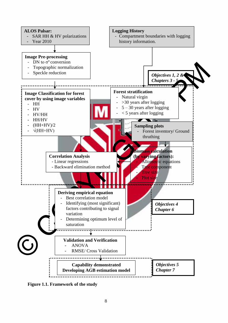
1.7 Research design
The study is designed and outlined to meet the primary aim and the specific
objectives of the study. Figure 1.1 shows the framework of the study. It shows the
connectivity from the data used, parameters and processes involved in the study to
the results, represented by chapters corresponding to the objectives of the study.
© COPYRIG
HT UPM
8
Figure 1.1. Framework of the study
ALOS Palsar:
- SAR HH & HV polarizations
- Year 2010
Image Pre-processing
- DN to σo conversion
- Topographic normalization
- Speckle reduction
Sampling plots
- Forest inventory/ Ground
thruthing
Biomass calculation
(by varying factors):
- Allometric equations
- Tree component
- Tree size
- Plot size
Image Classification for forest
cover by using image variables
- HH
- HV
- HV/HH
- HH/HV
- (HH+HV)/2
- √(HH+HV)
Logging History
- Compartment boundaries with logging
history information.
Correlation Analysis
- Linear regressions
- Backward elimination method
Deriving empirical equation
- Best correlation model
- Identifying (most significant)
factors contributing to signal
variation
- Determining optimum level of
saturation
Validation and Verification
- ANOVA
- RMSE/ Cross Validation
Forest stratification
- Natural virgin
- >30 years after logging
- 5 – 30 years after logging
- < 5 years after logging
Capability demonstrated
Developing AGB estimation model
Objectives 4
Chapter 6
Objectives 5
Chapter 7
Objectives 1, 2 & 3
Chapters 3 - 5
© COPYRIG
HT UPM
9
1.8 Organization of the thesis
The thesis was organized as follows:
Chapter 1 presents an overview of the entire study. It comprises the general
background, problem statements, research questions, aim and objectives, scopes of
the study, significances of the study, research design and organization of the thesis.
The first chapter highlights the needs for continuous research in forest biomass by
using spatial information systems toward sustainable forest management and global
climate balance.
Chapter 2 reviews the issues, challenges and previous studies that have been
conducted worldwide. From the review, research gaps have been identified and the
design of study was constructed based on the findings. Studies that are closely
related to this study are summarised and included in this chapter and arranged in the
form of a review paper. The paper was published in journal of ‘The Malaysian
Forester’.
Chapters 3 to 7 are organized as a series of article papers related to the objectives
and scopes of the study. All the papers have been submitted to reputable journals
and some were published. Others are either accepted for publication or still under
reviews. Because each of these article papers is designed to stand alone, some
redundancy exists. The articles are as follow:
Chapter Title Journal Status during
thesis submission
3
Factors affecting L-band Alos
Palsar backscatter on tropical
forest biomass
Global Journal
of Science
Frontier
Research (D)
14(3): 51 - 63
Published in May
2014
4
Determining L-band saturation
level for aboveground biomass
assessment of dipterocarp forests
in Peninsular Malaysia
Journal of
Tropical Forest
Science 27(3):
1-12
Published in July
2015
5
L-band Alos Palsar for biomass
estimation of Matang
Mangroves, Malaysia
Remote Sensing
of Environment
155: 69 - 78
Published in May
2014
6
Development of empirical
models for estimating
aboveground biomass in logged
forest using L-band SAR
Jurnal
Teknologi
Accepted for
publication
7
Estimating Biomass in Logged
Tropical Forest Using L-Band
SAR (PALSAR) Data and GIS
Sains
Malaysiana
Accepted for
publication in June
2015
Finally, Chapter 8 summarizes the overall findings and concludes the study.
Recommendations on future work of potential use of L-band Alos Palsar and other
similar SAR systems in estimating biomass of forests in Malaysia are also included.
© COPYRIG
HT UPM
123
REFERENCES
Abdul Rashid, A.M., Shamsudin, I., Ismail, P. & Fletcher, S.C. (2009). The Role of
FRIM in Addressing Climate-Change Issues. Research Pamphlet No. 128,
Forest Research Institute Malaysia, Kepong.
Alongi, D.M. (2002). Present state and future of the world's mangrove forests.
Environmental Conservation, 29: 331 – 349.
Amini, J. & Sumantyo, J.T.S. (2009). Employing a method on SAR and optical
images for forest biomass estimation. IEEE Transaction on Geoscience and
Remote Sensing 47(12): 4020 – 4026.
Angelsen, A., Brown, S., Loisel, C., Peskett, C., Streck, C. & Zarin, D. (2009).
Reducing emission from deforestation and degradation (REDD): An options
assessment report. A report prepared for the government of Norway.
Meridian Institute. pp. 100.
Anonymous. 2010. The Economic of Ecosystems and Biodiversity: Ecological and
Economic Foundations. Earthscan, London and Washington.
Anys, H., Bannari, A., He, D.C. & Morin, D. (1994). Texture analysis for the
mapping of urban areas using airborne MEIS-II images. Proceedings of the
First International Airborne Remote Sensing Conference and Exhibition,
Strasbourg, France, Vol. 3: pp. 231-245.
Araújo, T.M., Higuchi, N. & Carvalho, J.A. (1999). Comparison of formulae for
biomass content determination in a tropical rain forest site in the state of
Pará, Brazil. Forest Ecology and Management, 117: 43 – 52.
Asner, G.P. (2001). Cloud cover in Landsat observations of the Brazilian Amazon.
International Journal of Remote Sensing, 22: 3855 – 3862.
Austin, J.M., Mackey, B.G. & Van Niel, K.P. (2003). Estimating forest biomass
using satellite radar: an exploratory study in a temperate Australian
Eucalyptus forest. Forest Ecology and Management, 176: 575 – 583.
Azhar, M. & Shah, N.M. (2003). A Working Plan for the Matang Mangrove Forest
Reserve, Perak: The Third 10-Year Period (2000–2009) of the Second
Rotation. Perak State Forestry Department.
Baccini, A., Laporte, N., Goetz, S.J., Sun, M. & Dong, H. (2008). A first map of
tropical Africa’s above-ground biomass derived from satellite imagery.
Environmental Research Letter, 3: 9 pp.
Baccini, A., Goetz, S.J., Walker, W.S., Laporte, N.T., Sun, M., Sulla, D., Menashe,
Hackler, J., Beck, P.S.A., Dubayah, R., Friedl, M.A., Samanta, S. &
Houghton, R.A. (2012). Estimated carbon dioxide emissions from tropical
© COPYRIG
HT UPM
124
deforestation improved by carbon-density maps. Nature Climate Change, 2:
182–185.
Basuki, T.M., van Laake, P.E., Skidmore, A.K. & Hussin, Y.A. (2009). Allometric
equations for estimating the above-ground biomass in tropical lowland
Dipterocarp forest. Forest Ecology and Management 257: 1684–1694.
Beaudoin, A.L. (1994). Retrieval of forest biomass from SAR data. International
Journal of Remote Sensing, 15: 2777–2796.
Brown, S. & Lugo, A.E. (1990). Tropical secondary forests. Journal of Tropical
Ecology, 6 (1): 1 – 32.
Brown, S. & Lugo, A.E. (1984). Biomass of tropical forests: a new estimate based
on forest. Science, 223: 1290–1293.
Brown, S. & Masera, O. (2003). Supplementary methods and good practice
guidance arising from the Kyoto Protocol, section 4.3 LULUCF
projects.Good Practice Guidance For Land Use, Land-Use Change and
Forestry, Intergovernmental Panel on Climate Change National Greenhouse
Gas Inventories Programme. In Penman, J. et al. (Ed.) (Kanagawa: Institute
for Global Environmental Strategies (IGES)) pp 4.89–4.120.
Brown, S., Gillespie, A.J.R. & Lugo, A.E. (1991). Biomass of tropical forests of
south and Southeast Asia. Canadian Journal of Forest Research, 21: 111-
117.
Burgin, M., Clewley, D., Lucas, R., & Moghaddam, M. (2011). A Generalized
Radar BackscatteringModel Based on Wave Theory for Multilayer
Multispecies Vegetation. IEEE Transactions on Geoscience and Remote
Sensing, 49: 4832 – 4845.
Carreiras, J.M.B, Vasconcelos, M.J. & Lucas, R. (2012). Understanding the
relationship between aboveground biomass and ALOS PALSAR data in the
forests of Guinea-Bissau (West Africa). Remote Sensing of Environment 121:
426–442.
Cartus, O., Santoro, M. & Kellndorfer, J. (2012). Mapping forest aboveground
biomass in the Northeastern United States with ALOS PALSAR dual-
polarization L-band. Remote Sensing of Environment 124: 466–478.
Chambers, J.Q., dos Santos, J., Ribeiro, R.J. & Higuchi, N. (2001). Tree damage,
allometric relationships, and above-ground net primary production in a
tropical forest. Forest Ecology and Management, 152: 73-84.

© COPYRIG
HT UPM
125
Chave, J., Andalo, C., Brown, S., Cairns, M.A., Chambers, J.Q., Eamus, D.,
FoLster, H., Fromard, F., Higuchi, N., Kira, T., Lescure, J.P., Nelson, B.W.,
Ogawa, H., Puig, H., Rie´Ra, B. & Yamakura, T. (2005). Tree allometry and
improved estimation of carbon stocks and balance in tropical forests.
Ecosystem Ecology, 145: 87–99.
Chave, J., Condit, R., Aguilar, S., Hernandez, A., Lao, S. & Perez, R. (2004). Error
propagation and scaling for tropical forest biomass estimates. Philosophical
Transactions of the Royal Society of London, Series B 359: 409 – 420.
Chave, J., Condit, R., Lao, S., Caspersen, J.P., Foster, R.B. & Hubbell, S.P. (2003).
Spatial and temporal variation in biomass of a tropical forest: results from a
large census plot in Panama. Journal of Ecology, 91: 240 – 252.
Chave J., Maxime R.E., Alberto E.B. & other co-authors (2014). Improved
allometric models to estimate the aboveground biomass of tropical trees.
Global Change Biology. gcb.12629: 14p.
Chen, E., Li, Z., Ling, F., Lu, Y., He, Q. & Fan, F. (2009). Forest volume density
estimation capability of ALOS PALSAR data over hilly region. Proceedings
of the International Workshop on Science and Applications of SAR
Polarimetry and Polarimetric Interferometry, PollinSAR. 26-30 January
2009, Frascati, Italy.
Chenli, W., Zheng, N., Xiaoping, G., Zhixing, G. & Pifu, C. (2005). Tropical
Forest Plantation Biomass Estimation Using RADARSAT-SAR and TM Data
of South China. In Liangpei, Z., Jianqing, Z. & Mingsheng, L. (Ed.) Vol.
6043: 61-69. Proceedings of the Fourth International Symposium on
Multispectral Image Processing and Pattern Recognition (MIPPR) 31
October – 2 November, 2005, Wuhan.
Clewley, D., Lucas, R., Accad, A., Armston, J., Bowen, M., Dwyer, J., Pollock, S.,
Bunting, P., McAlpine, C., Eyre, T., Kelly, A., Carreiras, J. & Moghaddam,
M. (2012). An Approach to Mapping Forest Growth Stages in Queensland,
Australia through Integration of ALOS PALSAR and Landsat Sensor Data.
Remote Sensing, 4: 2236-2255.
Clough, B.F. & Scott, K. (1989). Allometric relationships for estimating
aboveground biomass in six mangrove species. Forest Ecology and
Management, 27: 117–127.
Condit, R. (2008). Methods for estimating aboveground biomass of forest and
replacement vegetation in the tropics. Center for Tropical Forest Science
Research Manual. pp 73.
Daniel, C.D., Kauffman, J.B., Murdiyarso, D., Kurnianto, S., Stidham, M. &
Kanninen, M. (2011). Mangroves among the most carbon-rich forests in the
tropics. Nature Geoscience Letters, NGEO1123. 5 pp.
© COPYRIG
HT UPM
126
DeFries, R., Achard, F., Brown, S., Herold, M., Murdiyarso, D., Schmlamadinger,
B. & deSouza, C. (2007). Earth observations for estimating greenhouse gas
emissions from deforestation in developing countries. Environmental Science
Policy, 10: 385–394.
Dobson, M.C., Ulaby, F.T., Le Toan, T. et al. (1992). Dependence of radar
backscatter on coniferous forest biomass. IEEE Transaction on Geoscience
and Remote Sensing, 30(2): 412 – 415.
Englhart, S., Keuck, V., & Siegert, F. (2011). Aboveground biomass retrieval in
tropical forests – The potential of combined X- and L-band SAR data use.
Remote Sensing of Environment, 115: 1260-1271.
Ewel, K.C., Twilley, R.R. & Ong, J.E. (1998). Different Kinds of Mangrove Forests
Provide Different Goods and Services. Global Ecology and Biogeography
Letters, 7: 83 – 94.
FAO. 1973. The timber species of the mixed dipterocarp forests of Sarawak and
their distribution. A study prepared jointly the Forest Department of Sarawak
and the Forestry and Forest Industries Development Project. FAO Working
Paper 21. FAO, Rome.
FAO. 2005. State of the World's Forest. Food and Agriculture Organization of the
United Nations, Rome.
FAO. 2007. The World’s Mangrove 1980-2005. FAO Forestry Paper 153. Food and
Agriculture Organization of the United Nations, Rome.
Foody, G.M., Boyd, D.S. & Cutler, M.E. (2003). Predictive relations of tropical
forest biomass from Landsat TM data and their transferability between
regions. Remote Sensing of Environment, 85: 463 – 74.
Forestry Department Peninsular Malaysia (FDPM). (2011). Annual Report 2010.
Forestry Department Peninsular Malaysia, Kuala Lumpur.
Franklin, S.E., Hall, R.J., Moskal, L.M., Maudie, A.J. & Lavigne, M.B. (2000).
Incorporating Texture into Classification of Forest Species Composition
from Airborne Multispectral Images. International Journal of Remote
Sensing, 21(1): 61 – 79.
Fromard, F., Puig, H., Mougin, E., Marty, G., Betoulle, J.L. & Cadamuro, L. (1998).
Structure, above-ground biomass and dynamics of mangrove ecosystems:
New data from French Guiana. Oecologia, 115(1/2): 39 – 53.
Ghasemi, N., Mahmod Reza, S. & Ali, M. (2011). A review on biomass estimation
methods using synthetic aperture radar data. International Journal of
Geomatics and Geosciences, 1(4): 776 – 788.

© COPYRIG
HT UPM
127
Gibbs, H. K., Brown, S, O’Niles, J. & Foley, J.A. (2007). Monitoring and estimating
tropical forest carbon stocks: making REDD a reality. Environmental
Research Letter, 2: 13 pp.
Gillespie, A.J.R., Brown, S., & Lugo, A.E. (1992). Tropical forest biomass
estimation from truncate extend tables. Forest Ecology and Management, 48:
69 – 87.
Giri, C., Ochieng, E., Tieszen, L.L., Zhu, Z., Singh, A., Loveland, T., Masek, J. &
Duke, N. (2011). Status and distribution of mangrove forests of the world
using earth observation satellite data. Global Ecology and Biogeography, 20:
154 – 163.
Goetz, S., Baccini, A., Laporte, N.T., Johns, T., Walker, W., Kellndorfer, J.,
Houghton, R.A. & Sun, M. (2009). Mapping and monitoring carbon stocks
with satellite observations: a comparison of methods. Carbon Balance and
Management, 4(2): 1 – 7.
Goetz, S. & Dubayah, R. (2011). Advances in remote sensing technology and
implications for measuring and monitoring forest carbon stocks and change.
Carbon Management, 2(3): 231 – 244.
Goh, J.Y, Miettinen, J., Chia, A.S., Chew, P.T. & Liew, S.C. (2013). Biomass
Estimation in Humid Tropical Forest Using a Combination of ALOS
PALSAR and Spot 5 Satellite Imagery. Asian Journal of Geoinformatics,
13(4): 1 – 10.
Gong, W.K. & Ong, J.E. (1990). Plant biomass and nutrient flux in a managed
mangrove forest in Malaysia. Estuarine, Coastal and Shelf Science, 31 (5):
519 – 530.
Guo, Z., Ni, W. & Sun, G. (2009). Analysis of the effect of crown structure changes
on backscattering coefficient using modelling and SAR data. IEEE
Transaction on Geosciences and Remote Sensing, 4: 386 – 389.
Hall, C.A.S. & Uhlig. J. (1991). Refining estimates of carbon released from tropical
land-use change. Canadian Journal of Forest Research, 21: 118 – 131.
Hamdan, O., Khairunnisa, M.R., Ammar, A.A., Mohd Hasmadi, I. & Khali Aziz, H.
(2013). Mangrove carbon stock assessment by optical satellite imagery.
Journal of Tropical Forest Science, 25(4): 554 – 565.
Hamdan, O., Khali Aziz, H., & Mohd Hasmadi, I. (2012). The use of polarized L-
band Alos Palsar for identifying forest cover in Peninsular Malaysia.
Proceedings of the 33rd Asian Conference on Remote Sensing, 1: 263-272.
Hamdan, O., Khali Aziz, H., Shamsudin, I. & Raja Barizan, R.S. (2012). Status of
mangroves in Peninsular Malaysia. Forest Research Institute Malaysia. 153
pp.

© COPYRIG
HT UPM
128
Hamdan, O., Mohd Hasmadi, I. & Khali Aziz, H. (2014). Combination of SPOT-5
and Alos Palsar images in estimating aboveground biomass of lowland
Dipterocarp forest. IOP Conference Series: Earth and Environmental
Science 18: 012016. 6 pp.
Hamdan, O., Nur Laila, C.M., Khali Aziz, H., & Mohd Hasmadi, I. (2013a). L-band
synthetic aperture radar (SAR) response to the tropical forest stands for
carbon stock assessment. In Ibrahim et al. (Ed.). AIP Conference
Proceedings, 1528: 76 – 81.
Hamdan, O., Mohd Hasmadi, I., Khali Aziz, H. & Mohd Hakimi, A.H. (2013b).
Methods for estimating biomass in the tropical forest using remotely sensed
data. In Lai et al. (Ed.) Proceedings of International Forestry Graduate
Students’ Conference, 2 - 4 July 2013, Universiti Putra Malaysia. 122 – 128.
Hamdan, O., Khali Aziz, H., & Abd Rahman, K. (2011). Remotely sensed L-Band
SAR data for tropical forest biomass estimation. Journal of Tropical Forest
Science, 23(3): 318 – 327.
Harrell, P.A., Kasischke, E.S., Bourgeau-Chavez, L.L., Haney, E.M. & Christensen,
N.L. (1997). Evaluation of approaches to estimating aboveground biomass in
southern pine forests using SIR-C data. Remote Sensing of Environment, 59:
223–233.
Heiberger, R. & Neuwirth, E. (2009). R Through Excel. Springer, Verlag.
Held, A., Ticehurst, C., & Lymburner, L. (2003). High resolution mapping of
tropical mangrove ecosystems using hyperspectral and radar remote sensing.
International Journal of Remote Sensing, 24(13): 2739 – 2759.
Henson, I.E. (2005). An assessment of changes in biomass carbonstocks in tree
crops and forests in Malaysia. Journal of Tropical Forest Science, 17(2):
279-296.
Hikmat, A. (2005). Biomass estimation, carbon storage and energy content of three
Virgin Jungle Reserves in Peninsular Malaysia. Media Konservasi 5(2): 1 –
8.
Holmgren, P. (2008). Role of satellite remote sensing in REDD. UN-REDD
Programme, MRV Working Paper 1. UN FAO. Rome.
Houghton, R.A. (2005). Tropical deforestation as a source of greenhouse gas
emissions. In Mutinho & Schwartzman (Ed.) Tropical deforestation and
climate change, Instituto de Pesquisa Ambiental Amazônia (IPAM), Belém,
Brazil.
Houghton, R.A. (1991). Releases of carbon to the atmosphere from degradation of
forests in tropical Asia. Canadian Journal of Forest Research, 21: 132 –
142.

© COPYRIG
HT UPM
129
Hughes, R.F., Kauffman, J.B., Jaramillo, V.J. (1999). Biomass, carbon, and nutrient
dynamics of secondary forests in a humid tropical Region of Mexico.
Ecology, 80 (6): 1892 – 1907.
Huth, A., Martin, D. & Peter, K. (2004). Multicriteria evaluation of simulated
logging scenarios in a tropical rain forest. Journal of Environmental
Management, 71: 321 – 333.
Huth, A., Martin, D. & Peter, K. (2005). Using multi-criteria decision analysis and a
forest growth model to assess impacts of tree harvesting in Dipterocarp
lowland rain forests. Forest Ecology and Management, 207: 215 – 232.
Huth, A. & Ditzer, T. (2001). Long-term impacts of logging in a tropical rain forest -
a simulation study. Forest Ecology and Management, 142: 33 – 51.
Huth, A. & Tietjena, B. (2007). Management strategies for tropical rain forests:
Results of ecological models and requirements for ecological–economic
modelling. Ecological Economics, 62: 207 – 215.
Imhoff, M.L. (1995a). A theoretical analysis of the effect of forest structure on
synthetic aperture radar backscatter and the remote sensing of biomass. IEEE
Transaction on Geoscience and Remote Sensing, 33: 341 – 352.
Imhoff, M.L. (1995b). Radar backscatter and biomass saturation: ramifications for
global biomass inventory. IEEE Transaction on Geoscience and Remote
Sensing, 33: 511 – 518.
IPCC. 2006. IPCC Guidelines for National Greenhouse Gas Inventories. Prepared
by the National Greenhouse Gas Inventories Programme. In H.S. Eggleston,
L. Buendia, K. Miwa, T. Ngara & K. Tanabe (Ed.), Japan Institute for Global
Environmental Strategies.
IPCC. 2007. Climate Change 2007: Mitigation of Climate Change. Contribution of
Working Group III to the Fourth Assessment Report of the
Intergovernmental Panel on Climate Change. In B. Metz, O.R. Davidson,
P.R. Bosch, R. Dave, L.A. Meyer (Ed.). Cambridge University Press,
Cambridge, United Kingdom and New York, NY, USA.
IPCC. 2007. Climate Change 2007: Synthesis Report. Contribution of Working
Group I, II and III to the Fourth Assessment Report of the Intergovernmental
Panel on Climate Change. In Pachauri R.K. et al. (Ed.) IPCC, Geneva.
Jong, W., Chokkalingam, U., Smith J. & Sabogal, C. (2001). Tropical secondary
forests in Asia: introduction and synthesis. Journal of Tropical Forest
Science, 13(4): 563–576.
Jusoff, K. (2008). Managing sustainable mangrove forests in Peninsular Malaysia.
Journal of Sustainable Development, 1: P88.

© COPYRIG
HT UPM
130
Kandaswamy, U., Adjeroh, D.A. & Lee, M.C. (2005). Efficient Texture Analysis of
SAR Imagery. IEEE Transactions on Geoscience and Remote Sensing,
43(9): 2075 – 2083.
Kato, A., Watanabe, M., Kobayashi, T., Yamaguchi, Y., Iisaka, J. (2011).
Monitoring Forest Management Activities Using Airborne Lidar and ALOS
PALSAR. IEEE IGARSS, pp 2318 – 2321. Vancouver, Canada.
Kato, R., Tadaki, Y. & Ogawa, H. (1978). Plant biomass and growth increment
studies in Pasoh forest. Malayan Nature Journal, 30: 211 – 224.
Kenzo, T., Furutani, R., Hattori, D., Kendawang, J.J., Tanaka, S., Sakurai, K.,
Ninomiya, I. (2009a). Allometric equations for accurate estimation of above-
ground biomass in logged-over tropical rainforests in Sarawak, Malaysia.
Journal of Forest Research, 14:365 – 372.
Kenzo, T., Ichie, T., Hattori, D., Itioka, T., Handa, C., Ohkubo, T., Kendawang, J.J.
Nakamura, M., Sakaguchi, M., Takahashi, N., Okamoto, M., Tanaka-Oda,
A., Sakurai, K. and Ninomiya, K. (2009b). Development of allometric
relationships for accurate estimation of above and below ground biomass in
tropical secondary forests in Sarawak, Malaysia. Journal of Tropical
Ecology, 25(4): 371 – 386.
Ketterings, Q.M., Coe, R., van Noordwijk, M., Ambagau, Y. & Palm, C.A. (2001).
Reducing uncertainty in the use of allometric biomass equations for
predicting above-ground tree biomass in mixed secondary forests. Forest
Ecology and Management, 146: 199 – 209.
Komiyama, A., Ong, J.E. & Poungparn, S. (2008). Allometry, biomass, and
productivity of mangrove forests: A review. Aquatic Botany, 89: 128 – 137.
Komiyama, A., Poungparn, S. & Kato, S. (2005). Common allometric equations for
estimating the tree weight of mangroves. Journal of Tropical Ecology, 21:
471 – 477.
Kuenzer, C., Bluemel, A., Gebhardt, S., Quoc, T.V. & Dech, S. (2011). Remote
Sensing of Mangrove Ecosystems: A Review. Remote Sensing, 3: 878 – 928.
Kuplich, T.M. (2000). JERS-1 SAR backscatter and its relationship with biomass of
regenerating forests. International Journal of Remote Sensing, 21: 2513 –
2518.
Kuplich, T.M., Curran, P.J. & Atkinson, P.M. (2003). Relating SAR image texture
and backscatter to tropical forest biomass. IEEE Transaction on Geoscience
and Remote Sensing, 4: 2872 – 2874.
Le Toan, T., Beaudoin, A., Riom, J., & Guyon, D. (1992). Relating forest biomass to
SAR data. IEEE Transaction on Geosciences and Remote Sensing, 30(2):
403 – 411.

© COPYRIG
HT UPM
131
Le Toan, T., Quegan, S., Davidson, M.W.J., Balzter, H. Paillou, P., Papathanassiou,
K., Plummer, S., Rocca, F., Saatchi, S., Shugart, H. & Ulander, L. (2011).
The BIOMASS mission: Mapping global forest biomass to better understand
the terrestrial carbon cycle. Remote Sensing of Environment, 115(11): 2850 –
2860.
Le Toan, T., Quegan, S., Woodward, I., Lomas, M., Delbart, N. & Picard, C. (2004).
Relating radar remote sensing of biomass to modeling of forest carbon
budgets. Climate Change, 76: 379 – 402.
Liesenberg, V. & Gloaguen, R. (2013). Evaluating SAR polarization modes at L-
band for forest classification purposes in Eastern Amazon, Brazil.
International Journal of Applied Earth Observation and Geoinformation, 21:
122 – 135.
Lu, D. (2006). The potential and challenge of remote sensing-based biomass
estimation. International Journal of Remote Sensing, 27: 1297 – 1328.
Lucas, R., Armston, J., Fairfax, R., Fesham, R., Accad, A., Carreiras, J., Kelley, J.,
Bunting, P., Clewley, D., Bray, S., Metcalfe, D., Dwyer, J., Bowen, M.,
Eyre, T., Laidlaw, M. and Shimada, M. (2010). An evaluation of the
PALSAR L-band backscatter – Aboveground biomass relationship
Queensland, Australia: Impacts of surface moisture condition and vegetation
structure. IEEE Journal of Selected Topics in Applied Earth Observations
and Remote Sensing, 3(4): 576 – 593.
Lucas, R., Cronin, N., Lee, A., Witte, C. & Moghaddam, M. (2006). Empirical
relationships between AIRSAR backscatter and forest biomass, Queensland,
Australia. Remote Sensing of Environment, 100: 388 – 406.
Lucas, R., Milne, A.K., Cronin, N., Witte, C., Denham, R. (2000). The potential of
synthetic aperture radar (SAR) data for quantifying the aboveground biomass
of Australia’s woodlands. Rangeland Journal, 22: 124 – 140.
Lucas, R., Mitchell, A.L., Rosenqvist, A., Proisy, C., Melius, A., Ticehurst, C.
(2007). The potential of L-band SAR for quantifying mangrove
characteristics and change: case studies from the tropics. Aquatic
Conservation: Marine and Freshwater Ecosystems, 17(3): 245 – 264.
Lucas, R., Moghaddam, M. & Cronin, N. (2004). Microwave scattering from mixed-
species forests, Queensland, Australia. IEEE Transactions on Geoscience
and Remote Sensing, 42: 2142 – 2159.
Luciani, S., S. Paloscia, P. Pampaloni, G. Schiavon, S. Sigismondi, & Solimini, D.
(1994). Sensitivity of microwave backscattering to crop biomass. pp.1844-
1846. IGARSS '94, Pasadena,
© COPYRIG
HT UPM
132
Luckman, A., Baker, J.R., Kuplich, T.M., Yanasse, C.C.F. & Frery, A.C. (1997). A
study of the relationship between radar backscatter and regenerating forest
biomass for space borne SAR instrument. Remote Sensing of Environment,
60: 1 – 13.
Mazzei, L., Sist, P., Ruschel, A., Putz, F.E., Marco, P., Pena, W. & Ferreira, R.E.
(2010). Above-ground biomass dynamics after reduced-impact logging in the
eastern Amazon. Forest Ecology and Management, 259: 367 – 373.
McGaughey, R.J. (1997). Visualizing forest stand dynamics using the stand
visualization system. Proceedings of the 1997 ACSM/ASPRS Annual
Convention and Exposition; Seattle, WA. Bethesda, MD: ASPRS 4: 248 –
257.
Mermoz, S., Le Toan, T., Villarda, L., Réjou-Méchain, M. & Seifert-Granzin, J.
(2014). Biomass assessment in the Cameroon savanna using ALOS
PALSAR data, Remote Sensing of Environment Doi.
10.1016/j.rse.2014.01.029. In Press.
Mohd Hasmadi, I. & Norizah, K. (2010). Soil disturbance from different mechanised
harvesting in hill tropical forest, Peninsular Malaysia. Journal of
Environmental Science & Engineering, 4(1): 34 – 41.
Morel, A.C., Fisher, J.B. & Malhi, Y. (2012). Evaluating the potential to monitor
aboveground biomass in forest and oil palm in Sabah, Malaysia, for 2000–
2008 with Landsat ETM+ and ALOS-PALSAR. International Journal of
Remote Sensing, 33(11): 3614 – 3639.
Morel, A.C., Saatchi, S.S., Malhi, Y., Berry, N.J., Banin, L., Burslem, D., Nilus, R.,
Ong, R.C. (2011). Estimating aboveground biomass in forest and oil palm
plantation in Sabah, Malaysian Borneo using ALOS PALSAR data. Forest
Ecology and Management, 262: 1786 – 1798.
Mougin, E., Proisy, C., Marty, G., Fromard, F., Puig, H., Betoulle, J.L. & Rudant,
JP. (1999). Multifrequency and multipolarization radar backscattering from
mangrove forests. IEEE Transactions on Geoscience and Remote Sensing,
37(1): 94 – 102.
Narvaes, I.S., Queiroz, A.S. & Santos, J.R. (2007). Evaluation of the interaction
between SAR L-band signal and structural parameters of forest cover. IEEE
Transactions on Geoscience and Remote Sensing, 42: 1607 – 1610.
Nellemann, C, Corcoran, E., Duarte, C.M., Valdés, L., De Young, C., Fonseca, L.,
Grimsditch, G. (Ed). (2009). Blue Carbon. A Rapid Response Assessment.
United Nations Environment Programme, Norway.
Neumann, M., Saatchi, S.S., Ulander, L.M.H., & Fransson, J.E.S. (2012). Assessing
Performance of L- and P-Band Polarimetric Interferometric SAR Data in
Estimating Boreal Forest Above-Ground Biomass. IEEE Transactions on
Geoscience and Remote Sensing, 50: 714 – 726.
© COPYRIG
HT UPM
133
Ni, W., Sun, G., Guo, Z., Zhang, Z., He, Y. & Huang, W. (2013). Retrieval of forest
biomass from ALOS PALSAR data using a lookup table method. IEEE
Journal of Selected Topics in Applied Earth Observations and Remote
Sensing, 6(2): 875 – 886.
Nichol, J.E. & Sarker, M.L.R. (2011). Improved biomass estimation using the
texture parameters of two high-resolution optical sensors. IEEE Transaction
on Geosciences and Remote Sensing, 49(3): 930-948.
Niiyama, N., Kajimoto, T., Matsuura, Y., Yamashita, T., Azizi, R., Abd Rahman, K.
& Nur Supardi, M.N. (2010). Estimation of root biomass based on
excavation of individual root systems in a primary dipterocarp forest in
Pasoh Forest Reserve, Peninsular Malaysia. Journal of Tropical Ecology, 26:
271 – 284.
Norizah, K., Mohd Hasmadi, I., Kamaruzzaman, J. & Alias M.S. (2012).
Operational efficiency of Rimbaka timber harvester in hill tropical forest.
Journal of Tropical Forest Science. 24(3): 379 – 389.
Okuda, T., Mariko, S., Adachi, N., Quah, E.S., Nor Azman, H. & Manokaran, N.
(2003). Effect of selective logging on canopy and stand structure and tree
species composition in a lowland dipterocarp forest in Peninsular Malaysia.
Forest Ecology and Management, 175: 297 – 320.
Ong, J.E., Gong, W.K. & Clough, B.F. (1995). Structure and productivity of a 20-
year-old stand of Rhizophora apiculata Bl. mangrove forest. Journal of
Biogeography, 22(2/3): 417 – 424.
Ong, J.E., Gong, W.K. & Wong, C.H. (2004). Allometry and partitioning of the
mangrove, Rhizophora apiculata. Forest Ecology and Management, 188: 395
– 408.
Paloscia, G., Macelloni, P., Pampaloni, S. & Sigismondi. (1999). The potential of C-
and L- band SAR in estimating vegetation biomass: the ERS-1 and JERS-1
experiments. IEEE Transactions on Geoscience and Remote Sensing, 37(4):
2107 – 2110.
Patenaude, G., Hill, R.A., Milne, R., Gaveau, D.L.A., Briggs, B.B.J. & Dawson,
T.P. (2004). Quantifying forest aboveground carbon content using lidar
remote sensing. Remote Sensing of Environment, 93: 368 – 380.
Pearson, T., Walker, S. & Brown, S. (2005). Sourcebook for land use, land-use
change and forestry projects. Winrock International and the BioCarbon Fund
of the World Bank.
Peregon, A. & Yamagata, Y. (2013). The use of ALOS/PALSAR backscatter to
estimate above-ground forest biomass: A case study in Western Siberia.
Remote Sensing of Environment, 137: 139 – 146.

© COPYRIG
HT UPM
134
Proctor, J., Anderson J.M., Chai, P. & Vallack, H.W. (1983). Ecological studies in
four contrasting rain forest in Gunung Mulu national park, Sarawak. Journal
of Ecology, 71: 237-260.
Proisy, C., Mougin, E., Fromard, F. & Karam, M.A. (2000). Interpretation of
polarimetric radar signatures of mangrove forests. Remote Sensing of
Environment, 71: 56 – 66.
Pulliainen, J.T., Kurvonen, L. & Hallikainen, M.T. (1999). Multi temporal behavior
of L- and C-Band SAR observations of boreal forests. IEEE Transactions on
Geoscience and Remote Sensing, 37(2): 927 – 937.
Putz, F. & Chan, H.T. (1986). Tree growth, dynamics, and productivity in a mature
mangrove forest in Malaysia. Forest Ecology and Management, 17: 211 –
230.
Quinones, M.J. & Hoekman, D.H. (2004). Exploration of factors limiting biomass
estimation by polarimetric radar in tropical forests. IEEE Transaction on
Geosciences and Remote Sensing, 42: 86 – 104.
Rauste, Y. (2005). Multi-temporal JERS SAR data in boreal forest biomass
mapping. Remote Sensing of Environment, 97(2): 263 – 275.
Rauste, Y., Hame, J., Pulliainen, K., Heiska, & Hallikainen, M. (1994). Radar based
forest biomass estimation. International Journal of Remote Sensing, 15(14):
2797 – 2808.
Robinson, C., Saatchi, S., Neumann, M. & Gillespie, T. (2013). Impacts of spatial
variability on aboveground biomass estimation from L-band radar in a
temperate forest. Remote Sensing, 5: 1001 – 1023.
Rosenqvist, A, Shimada, M., Ito, N. & Watanabe, M. (2007). ALOS PALSAR: A
pathfinder mission for global-scale monitoring of the environment, IEEE
Transactions on Geoscience and Remote Sensing, 45(11): 3307 – 3316.
Rosenqvist, A., Shimada, M., Igarashi, T., Watanabe, M., Tadono, T. & Yamamoto,
H. (2003). Support to multi-national environmental conventions and
terrestrial carbon cycle science by ALOS and ADEOS-II–the Kyoto and
carbon initiative. IEEE International on Geosciences and Remote Sensing
Symposium, 3: 1471 – 1476.
Rosenqvist, A., Shimada, M., Suzuki, S., Ohgushi, F., Tadono, T., Watanabe, M.,
Tsuzuku, K., Watanabe, T., Kamijo, S. & Aoki, E. (2014). Operational
performance of the ALOS global systematic acquisition strategy and
observation plans for ALOS-2 PALSAR-2. Remote Sensing of Environment,
DOI: 10.1016/j.rse.2014.04.011. In Press.

© COPYRIG
HT UPM
135
Saatchi, S., Houghton, R., Avala, R., Yu, Y., & Soares, J. V. (2007). Spatial
distribution of live aboveground biomass in Amazon basin. Global Change
Biology, 13: 816 – 837.
Saatchi, S.S., Marlier, M., Chazdon, R.L., Clark, D.B., & Russell, A.E. (2011).
Impact of spatial variability of tropical forest structure on radar estimation of
aboveground biomass. Remote Sensing of Environment, 115(11): 2836 –
2849.
Sandberg, G., Ulander, L.M.H., Fransson, J.E.S., Holmgren, J., & Le Toan, T.
(2011). Land P-band backscatter intensity for biomass retrieval in
hemiboreal forest. Remote Sensing of Environment, 115(11): 2874 – 2886.
Saner, P., Loh, Y.Y., Ong, R.C., & Hector, A. (2012). Carbon stocks and fluxes in
tropical lowland dipterocarp rainforests in Sabah, Malaysian Borneo. Plos
One, 7(1): 11 pp.
Santoro, M., Fransson, J.E.S., Eriksson, L.E.B., Magnusson, M., Ulander, L.M.H.,
& Olsson, H. (2009). Signatures of ALOS PALSAR L-Band Backscatter in
Swedish Forest. IEEE Transactions on Geoscience and Remote Sensing,
47(12): 4001 – 4019.
Santos, J.R., Freitas, C.C., Araújo, L.S., Dutra, L.V., Mura, J.C., Gama, F.F., Soler,
L.S. & Sant’ Anna, S.J.S. (2003). Airborne P-band SAR applied to the
aboveground biomass studies in the Brazilian tropical rainforest. Remote
Sensing of Environment, 87: 482 – 493.
Santos, J.R., Keil, M., Araújo, L.S., Pardi Lacruz, M.S., Krämer, J.C. & Kandler, M.
(2000). Biomass estimation of Forest and savanna transition vegetation zone
by JERS-1 and SIR-C backscatter data. International Archives of
Photogrammetry and Remote Sensing, 33(7): 377 – 381.
Sarker, L.R., Nichol, J., Baki, I.H., Baharin, A., & Alias, A.R. (2013). Forest
Biomass Estimation Using Texture Measurements of High-Resolution Dual-
Polarization C-Band SAR Data. IEEE Transactions on Geoscience and
Remote Sensing, 51(6): 3371 – 3384.
Sarker, L.R., Nichol, J., Baharin, A., Ibrahim, B. & Alias, A.R. (2012). Potential of
texture measurements of two-date dual polarization PALSAR data for the
improvement of forest biomass estimation. ISPRS Journal of
Photogrammetry and Remote Sensing, 69: 146 – 166.
Sessa, R. & Dolman, H. (Ed.) (2008). Terrestrial essential climate variables for
climate change assessment, mitigation and adaptation. Rome: FAO GTOS-
52.
© COPYRIG
HT UPM
136
Shi, J.C., Du, Y., Du, J.Y., Jiang, L.M., Chai, L.N., Mao, K.B., Xu, P., Ni, W.J.,
Xiong, C., Liu, Q., Liu, C.Z., Guo, P., Cui, Q., Li, Y.Q., Chen, J., Wang,
A.Q., Luo, H.J. & Wang, Y.H. (2012). Progresses on microwave remote
sensing of land surface parameters. Science China Earth Science, 55 (7):
1052 – 1078.
Shimada, M. & Ohtaki, T. (2010). Generating Large-scale High-quality SAR
Mosaic Datasets: Application to PALSAR Data for Global Monitoring. IEEE
Journal of Selected Topics in Applied Earth Observations and Remote
Sensing, 3(4): 637 – 656.
Shimada, M., Rosenqvist, A., Watanabe, M. & Tadono, T. (2005). The polarimetric
and interferometric potential of ALOS PALSAR. In Pattier (Ed.). 6p
Proceedings in SAR Polarimetric Interferometry (POLinSAR 2005),
Frascati.
Shimada, M., Isoguchi, O., Tadono, T. & Isono, K. (2009). PLASAR Radiometric
Calibration and Geometric Calibration. IEEE Transaction on Geosciences
and Remote Sensing, 3: 765 – 768.
Simard, M., DeGrandi, G., Saatchi, S. & Mayaux, P. (2002). Mapping tropical
coastal vegetation using JERS-1 and ERS-1 radar data with a decision tree
classifier. International Journal of Remote Sensing, 23(7): 1461 – 1474.
Simard, M., Hensley, S., Lavalle, M., Dubayah, R., Pinto, N. & Hofton, M. (2012).
An empirical assessment of temporal decorrelation using the uninhabited
aerial vehicle synthetic aperture radar over forested landscapes. Remote
Sensing, 4: 975 – 986.
Steininger, M.K. (2000). Satellite estimation of tropical secondary forest
abovgeround biomass data from Brazil and Bolivia. International Journal of
Remote Sensing, 21: 1139 – 1157.
Stern, N. (2006). Stern Review: The Economics of Climate Change. Cambridge
University Press. Cambridge, UK.
Suzuki, R., Kim, Y. & Ishii, R. (2013). Sensitivity of the backscatter intensity of
ALOS/PALSAR to the above-ground biomass and other biophysical
parameters of boreal forest in Alaska. Polar Science, 7(2): 100 – 112.
Symington, C.F. (1943). Foresters’ manual of dipterocarps. Malayan Forest
Records No. 16. Revised by Ashton PS and Appanah, in Barlow HS (ed.)
2004. Forest Research Institute Malaysia.
Vashum, K.T. & Jayakumar, S. (2012). Methods to estimate above-ground biomass
and carbon stock in natural forests - A review. Journal of Ecosystem and
Ecography, 2(4): 1 – 7.

© COPYRIG
HT UPM
137
Walker, S.M., Pearson, T.R.H., Casarim, F.M., Harris, N., Petrova, S., Grais, A.,
Swails, E., Netzer, M., Goslee, K.M. & Brown, S. (2012). Standard
Operating Procedures for Terrestrial Carbon Measurement: Version 2012.
Winrock International.
Walke,r W.S., Stickler, C.M., Kellndorfer, J.M., Kirsch, K.M. & Nepstad, D.C.
(2010). Large-Area Classification and Mapping of Forest and Land Cover in
the Brazilian Amazon: A Comparative Analysis of ALOS/PALSAR and
Landsat Data Sources. IEEE Journal of Selected Topics in Applied Earth
Observations and Remote Sensing, 3 (4): 594 – 604.
Wan Razali, W.M. (2008). Malaysia’s strategic directions and way forward in
sustainable forest management – Climate change scenario. UNDP/GEF Peat
Swamp Forests Project, Kuala Lumpur.
Wang, Y., Davis, F.W. & Melack, J.M. (1993). Simulated and observed backscatter
at P-, L- and C-bands from ponderosa pine stands. IEEE Transaction on
Geosciences and Remote Sensing, 31: 871 – 879.
Watanabe, M., Shimada, M., Rosenqvist, A., Tadono, T., Matsuoka, M., Romshoo,
S.A., Ohta, K., Furuta, R., Nakamura, K. & Moriyama, T. (2006). Forest
structure dependency of the relation between L-band σo and biophysical
parameters. IEEE Transactions on Geoscience and Remote Sensing, 44(11):
3154 – 3165.
Watanabe, M. & Shimada, M. (2006). Relation between coherence, forest biomass,
and L-band σo. IEEE Transaction on Geoscience and Remote Sensing,
44(11): 1651 – 1654.
Whittle, M., Quegan, S., Uryu, Y., Stüewe, M. & Yulianto, K. (2012). Detection of
tropical deforestation using ALOS-PALSAR: A Sumatran case study.
Remote Sensing of Environment, 124: 83 – 98.
Wolter, P.T. & Townsend, P.A. (2011). Estimating forest species composition using
a multi-sensor fusion approach. Remote Sensing of Environment, 115: 671 –
691.
Wright, S.J. (2010). The future of tropical forests. Annals of the New York
Academy of Sciences. Ecological Conservation and Biology, 1195: 1 – 27.