Export of organic carbon in run-off from an Amazonian rainforest blackwater catchment
17
HYDROLOGICAL PROCESSES Hydrol. Process. 20, 2581–2597 (2006) Published online in Wiley InterScience (www.interscience.wiley.com) DOI: 10.1002/hyp.6217 Export of organic carbon in run-off from an Amazonian rainforest blackwater catchment Maarten J. Waterloo, 1 * Sylvia M. Oliveira, 2 Debora P. Drucker, 2 Antonio D. Nobre, 2 Luz A. Cuartas, 3 Martin G. Hodnett, 1 Ivar Langedijk, 1 Wilma W. P. Jans, 4 Javier Tomasella, 3 Alessandro C. de Ara´ ujo, 1 Tania P. Pimentel 2 and Juan C. M´ unera Estrada 2 1 Vrije Universiteit Amsterdam, The Netherlands 2 Instituto Nacional de Pesquisas da Amazˆ onia, Brazil 3 Instituto Nacional de Pesquisas Espaciais, Brazil 4 Alterra, Wageningen University and Research, The Netherlands Abstract: Rainfall, run-off and dissolved and particulate organic carbon concentrations were measured to investigate the hydrological export of organic carbon out of the blackwater Igarap´ e Asu rainforest catchment over a two-year period. Annual rainfall was above average (2442 mm) at 2976 mm in 2002 and below average at 2054 mm in 2003. Surface run-off dominated the flow out of the catchment, with groundwater outflow being negligible. Streamflow totals amounted to 1362 mm in 2002 and 780 mm in 2003. Dissolved organic carbon (DOC) concentrations in rainfall were similar to those measured in rainfall elsewhere in the Amazon Basin at 1Ð2 mg l 1 , leading to atmospheric DOC deposition estimates of 3Ð5gm 2 in 2002 and 2Ð4gm 2 in 2003. Daily average DOC concentrations in run-off ranged from 8 mg l 1 under low flow conditions to 27 mg l 1 during large quickflow events. Suspended sediment (10–2000-µm size fraction) consisted for 28% of carbon and had a median concentration of 4Ð1 mg l 1 . Daily run-off varied between 1Ð2–2Ð5 mm day 1 during dry periods with corresponding organic carbon exports of 0Ð009–0Ð031 g m 2 day 1 . Exports associated with large storms were much higher, reaching a daily maximum of 1Ð02 g m 2 day 1 for a discharge event of 38Ð4 mm. Export of carbon during the wet seasons amounted to 70% of the total. Annual exports in river water were different between the years because of differences in run-off, varying between 26Ð2gC m 2 in 2002 and 11Ð7gCm 2 in 2003. Organic carbon exports were dominated by DOC, with exports in sediment constituting 6–8% of the total. Net carbon export, corrected for rainfall inputs, amounted to 22Ð7 and 9Ð3gm 2 in 2002 and 2003, respectively. The present study indicates that accounting for exports of organic carbon in stream run- off (averaging 19Ð0gm 2 year 1 over the 2 years) would reduce the rainforest sink strength, estimated at 300–400 g m 2 year 1 from eddy covariance measurements, by 5–6% for this blackwater catchment. Copyright 2006 John Wiley & Sons, Ltd. KEY WORDS Amazonia; rain forest; blackwater; run-off; dissolved organic carbon; suspended sediment Received 22 November 2004; Accepted 31 October 2005 INTRODUCTION The Amazon rainforest is the largest contiguous tropical forest ecosystem in the world, covering an area of about 6 ð 10 6 km 2 in Brazil, Bolivia, Colombia, Ecuador, Guyana, Peru, Surinam and Venezuela. It represents a major store of carbon and has been under pressure since the 1970s as a result of deforestation to provide for timber and agricultural land (Fearnside, 1993). The alteration of this large carbon store and changes in *Correspondence to: Maarten J. Waterloo, Faculty of Earth and Life Sciences, Vrije Universiteit, De Boelelaan 1085, 1081 HV Amsterdam, The Netherlands. E-mail: [email protected] Copyright 2006 John Wiley & Sons, Ltd.
-
Upload
independent -
Category
Documents
-
view
3 -
download
0
Transcript of Export of organic carbon in run-off from an Amazonian rainforest blackwater catchment
HYDROLOGICAL PROCESSESHydrol. Process. 20, 2581–2597 (2006)Published online in Wiley InterScience(www.interscience.wiley.com) DOI: 10.1002/hyp.6217
Export of organic carbon in run-off from an Amazonianrainforest blackwater catchment
Maarten J. Waterloo,1* Sylvia M. Oliveira,2 Debora P. Drucker,2 Antonio D. Nobre,2
Luz A. Cuartas,3 Martin G. Hodnett,1 Ivar Langedijk,1 Wilma W. P. Jans,4
Javier Tomasella,3 Alessandro C. de Araujo,1 Tania P. Pimentel2 and Juan C. MuneraEstrada2
1 Vrije Universiteit Amsterdam, The Netherlands2 Instituto Nacional de Pesquisas da Amazonia, Brazil
3 Instituto Nacional de Pesquisas Espaciais, Brazil4 Alterra, Wageningen University and Research, The Netherlands
Abstract:
Rainfall, run-off and dissolved and particulate organic carbon concentrations were measured to investigate thehydrological export of organic carbon out of the blackwater Igarape Asu rainforest catchment over a two-yearperiod. Annual rainfall was above average (2442 mm) at 2976 mm in 2002 and below average at 2054 mm in 2003.Surface run-off dominated the flow out of the catchment, with groundwater outflow being negligible. Streamflowtotals amounted to 1362 mm in 2002 and 780 mm in 2003. Dissolved organic carbon (DOC) concentrations in rainfallwere similar to those measured in rainfall elsewhere in the Amazon Basin at 1Ð2 mg l�1, leading to atmosphericDOC deposition estimates of 3Ð5 g m�2 in 2002 and 2Ð4 g m�2 in 2003. Daily average DOC concentrations in run-offranged from 8 mg l�1 under low flow conditions to 27 mg l�1 during large quickflow events. Suspended sediment(10–2000-µm size fraction) consisted for 28% of carbon and had a median concentration of 4Ð1 mg l�1. Daily run-offvaried between 1Ð2–2Ð5 mm day�1 during dry periods with corresponding organic carbon exports of 0Ð009–0Ð031 gm�2 day�1. Exports associated with large storms were much higher, reaching a daily maximum of 1Ð02 g m�2 day�1
for a discharge event of 38Ð4 mm. Export of carbon during the wet seasons amounted to 70% of the total. Annualexports in river water were different between the years because of differences in run-off, varying between 26Ð2 g Cm�2 in 2002 and 11Ð7 g C m�2 in 2003. Organic carbon exports were dominated by DOC, with exports in sedimentconstituting 6–8% of the total. Net carbon export, corrected for rainfall inputs, amounted to 22Ð7 and 9Ð3 g m�2 in2002 and 2003, respectively. The present study indicates that accounting for exports of organic carbon in stream run-off (averaging 19Ð0 g m�2 year�1 over the 2 years) would reduce the rainforest sink strength, estimated at 300–400 gm�2 year�1 from eddy covariance measurements, by 5–6% for this blackwater catchment. Copyright 2006 JohnWiley & Sons, Ltd.
KEY WORDS Amazonia; rain forest; blackwater; run-off; dissolved organic carbon; suspended sediment
Received 22 November 2004; Accepted 31 October 2005
INTRODUCTION
The Amazon rainforest is the largest contiguous tropical forest ecosystem in the world, covering an area ofabout 6 ð 106 km2 in Brazil, Bolivia, Colombia, Ecuador, Guyana, Peru, Surinam and Venezuela. It representsa major store of carbon and has been under pressure since the 1970s as a result of deforestation to providefor timber and agricultural land (Fearnside, 1993). The alteration of this large carbon store and changes in
* Correspondence to: Maarten J. Waterloo, Faculty of Earth and Life Sciences, Vrije Universiteit, De Boelelaan 1085, 1081 HV Amsterdam,The Netherlands. E-mail: [email protected]
Copyright 2006 John Wiley & Sons, Ltd.

2582 M. J. WATERLOO ET AL.
the carbon turnover rate may affect the global carbon cycle, implying regional and global impacts on climate(Raich and Potter, 1995). Carbon cycling within the Amazonian rain forest ecosystem has therefore been thesubject of intensive research over the past decade.
A forest ecosystem is in a state of equilibrium when the long-term uptake of atmospheric CO2 throughphotosynthesis and subsequent storage in biomass and soil is balanced by releases through plant and soilrespiration, emissions of volatile organic compounds (VOC) (Kesselmeier et al., 2002) and losses of dissolvedand particulate carbon in surface and groundwater flows (McClain et al., 1997; Telles et al., 2003). VOCemissions and exports of carbon via hydrological pathways are perceived small and are therefore usuallyneglected (Malhi and Grace, 2000). Seasonal and inter-annual variations in climatic conditions (e.g. rainfall,temperature, radiation) may lead to variations in both uptake and release of carbon, potentially causing theforest ecosystem to act as a net source or sink, depending on whether the release exceeds the uptake or viceversa. Global atmospheric circulation modelling efforts that take the carbon cycle into account suggest that aglobal increase in temperature, due to increased atmospheric CO2 concentrations from continued fossil fuelburning and deforestation, may potentially lead to increased respiration in the remaining tropical forests. Thiscould change these ecosystems into permanent net sources of carbon to the atmosphere, which in turn wouldlead to enhanced global warming (Cox et al., 2000). While deforestation in the Amazon does represent a netsource of carbon to the atmosphere (Houghton et al., 1998), there are indications that regrowth on abandonedagricultural land and enhanced carbon uptake by undisturbed rainforest constitute net sinks of carbon thatmay presently balance this source to some extent (Houghton et al., 2000).
To assess the natural variations in the carbon cycle, long-term micrometeorological, ecological, hydrologicaland forestry studies were initiated at key locations in the Amazon Basin. These studies are connected to theLarge-Scale Biosphere Atmosphere (LBA) experiment in Amazonia, an international research programme ledby the Brazilian Ministry of Science and Technology. One of the aims of the programme is to study thelong-term carbon cycle of the Amazonian forest and how this cycle would change in response to climatechange (Nobre et al., 1997; Andreae et al., 2002).
Forestry studies in permanent sample plots along an E–W transect across the Amazon Basin suggest thatthe rainforest has consistently formed a small sink �10–70 g C m2 year�1� over the past few decades, perhapsin response to increased atmospheric CO2 concentrations (Phillips et al., 1998; Malhi et al., 1998, 2002). Eddycovariance flux estimates vary widely from a net carbon source of 130 g m2 year�1 over a three-year periodin the Tapajos forest near Santarem (Saleska et al., 2003) to net sinks of 100–700 g C m�2 year�1 at otherflux tower sites in Amazonia, including the present study site near Manaus (de Araujo, 2002; von Randowet al., 2002; Malhi and Grace, 2000; Miller et al., 2004). The estimates from the forestry studies are thereforesupported in general by the eddy covariance flux measurements, but the latter technique suggests much higherrates of uptake over the past few years at some sites. These high eddy covariance flux estimates seem to beunrealistic in view of evidence found in biometric studies (Chambers et al., 2001; Miller et al., 2004), and theeddy covariance flux calculation procedures are therefore still under debate (Kruijt et al., 2004). More recentflux estimates from the Igarape Asu tower converge to a net sink of 300–400 g C m�2 year�1 (B. Kruijt,personal communication, Alterra).
Three types of streams are usually distinguished in the Amazon Basin—clearwater, white-water andblackwater streams (Sioli, 1950). Clearwater streams are low in suspended sediment and dissolved carbon,whereas white-water streams have high sediment concentrations. Both types have a near-neutral pH.Blackwater streams, on the other hand, are low in suspended sediment but are rich in dissolved organicmatter and have a lower pH (about 4–5). The latter streams may export significant amounts of carbon.Because of the lack of long-term discharge data at previous micro-scale study sites, organic carbon exportestimates were based on run-off or drainage rates derived from annual rainfall rates and estimates of theannual evaporation, in combination with measured groundwater or streamwater DOC concentrations. Theseestimates varied between 0Ð2 g C m�2 year�1 for drainage of an upland soil �200 mm year�1� in Paragominasin the eastern Para State of Brazil (Telles et al., 2003) and 2 g C m�2 year�1 for the Barro Branco clearwater
Copyright 2006 John Wiley & Sons, Ltd. Hydrol. Process. 20, 2581–2597 (2006)DOI: 10.1002/hyp

CARBON EXPORT IN RUN-OFF 2583
stream and 40 g C m�2 year�1 for a Campina forest blackwater stream in Central Amazonia, where dischargewas assumed to be 1225 mm year�1 (McClain et al., 1997).
Additional clues about the magnitude of organic carbon exports in streamflow can be obtained from thebiogeochemistry of the main stem and major tributaries of the Amazon river, which have been the focus of anumber of detailed studies in the recent past (Leenheer, 1980; Ertel et al., 1986; Hedges et al., 1986; Richeyet al., 1990; Kuchler et al., 2000; Moreira-Turcq et al., 2003a, 2003b; Benedetti et al., 2003; Mayorga andAufdenkampe, 2002).
Published basin-wide organic carbon export estimates are considerable at 8Ð5 g m�2 year�1 (Richey et al.,1990) and 7Ð7 g m�2 year�1 (Moreira-Turcq et al., 2003b). It is uncertain, however, as to how such basin-wide flux estimates compare with those from micro-scale source areas from which the eddy covariance carbonfluxes are measured. This is because of the possible changes due to physical, chemical and biological processesacting within the larger river channels, which may alter the flux during transport from the source area to thebasin outlet (Ertel et al., 1986; Hedges et al., 1986; Moreira-Turcq et al., 2003a).
Measurements at the Asu catchment indicated that VOC emissions were low at about 0Ð2 g C m�2 year�1
and could therefore be ignored (Stefani, 2003). In blackwater areas, such as those at the Asu flux tower nearManaus, carbon exports in run-off from the footprint area could potentially have a significant effect on thelocal sink strength as inferred from the eddy covariance system. Such exports could not be considered indetail on the scale of the tower flux footprints (about 10 km2) until micro-scale catchment discharge andcorresponding streamwater carbon concentration measurements were available, however.
Against this background, this paper aims to quantify the annual fluxes of organic carbon in rainfall andrun-off in dry and wet years to assess their importance relative to those obtained with the eddy covariancemethod for carbon dioxide. We present such fluxes for the blackwater Igarape Asu catchment over a two-yearperiod. The catchment is in the upwind area of the eddy covariance flux tower and the area of the catchmentis roughly similar to that of the tower footprint (de Araujo, 2002). Because of the similarity in spatial scales,the hydrological fluxes of carbon measured in the catchment may readily be used to improve carbon budgetestimates obtained from the eddy covariance technique.
SITE DESCRIPTION
The blackwater Igarape Asu catchment (2°360S, 60°120W) covers an area of 6Ð8 km2 in the Reserva Biologicado Cuieiras of the Instituto Nacional de Pesquisas da Amazonia (INPA). The site is about 70 km NNW ofthe city of Manaus (3°080S, 60°000W) in Central Amazonia. The area forms part of the Rio Negro Basin�686 810 km2� where the rivers draining the rainforest areas are mostly of the blackwater type. Within theRio Negro Basin, the Rio Branco River forms an exception, draining a drier savanna area and being of thewhite-water type (Sioli, 1950; Hedges et al., 1994; Kuchler et al., 2000; Moreira-Turcq et al., 2003b).
The topography of the research area is that of an incised plateau with a rather flat plateau area (90–105 ma.s.l.) being separated from broad swampy valleys (45–55 m a.s.l.) by moderately steep slopes (15–30°). Thislandform is typical for large parts of Central Amazonia. The catchment drains towards the Rio Cuieiras Riverin the west and includes five headwater catchments draining the plateau area. The Asu stream is a 1Ð5–4Ð3-mwide stream with a depth of 0Ð5–1 m under normal flow conditions. When the water level exceeds 0Ð9 mon the staff gauge, bank overflow occurs at the discharge measurement site and the width increases sharplyto 48 m at the maximum observed water level of 1Ð6 m. The stream bed consists of fine to coarse quartzsand, with very low mineral silt and clay fractions (less than 5%). The elevation of the river at the dischargemeasurement site is about 45 m a.s.l., whereas the micrometeorological tower on the plateau (P34 rain gauge)is at 90 m a.s.l. A map showing the catchment topography and locations of the instrumentation is given inFigure 1.
Three main soil types can be distinguished in the catchment, which have been derived from the underlyingunconsolidated Barreiras formation (Chauvel et al., 1987). These soils are all strongly leached and contain
Copyright 2006 John Wiley & Sons, Ltd. Hydrol. Process. 20, 2581–2597 (2006)DOI: 10.1002/hyp

2584 M. J. WATERLOO ET AL.
9714000
9712000
9710000
808000 810000 812000 814000
1000 km
N
60°W
0°
Manaus
BrazilP34 Raingauge
Discharge stationSoilpit (15 m)PiezometerKsat transectStreamCatchment boundaryElevation point (m a.s.l.)Conopy elevationcontour (m a.s.l.)
Co-ordinates are in UTM (m)
T15
9080100
100
100100 100
100
100
100
100
88P35
92
P26
120
120
120
P31
95
T16
T17
T19
T25T9T1T6
T10
T18
T22T21T20
T24
P34
8080
80
80
8080
95
Figure 1. Location and topographic map of the Igarape Asu research catchment. The latter shows locations of rainfall, discharge andgroundwater instrumentation. The micrometeorological tower supports the P34 rain gauge. Elevation contours represent canopy height
(25–35 m above surface level)
no carbonates. Well-drained soils on the plateau and slopes cover approximately 65% of the catchment. Thesesoils consist of yellowish clay and sand with little variation in colour of the surface horizons and are classifiedas Latossolos vermelho-amarelo (Ferralsols) in the Brazilian soil classification system. Colour changes occurdeeper in the profile (bright white, yellowish brown, brown, purple layers), where sedimentary structuresof the Barreiras formation deposits remain preserved (Chauvel et al., 1987). The valleys are swampy, withwater levels remaining close to the surface (generally at less than 30-cm depth) even during dry periods.These poorly drained soils cover about 35% of the catchment and are distinctly different from the Oxisolsand Ultisols on the slopes and plateau. The surface layer (0–2 m) consists of fluvial deposits of coarse tofine quartz sand and contains significant amounts of fine, dark-coloured particles of organic matter. Belowthis layer a bright white sandy clay layer has been observed, which consists of kaolinite clay and fine tocoarse quartz sand. These soils are classified as hydromorphic Spodosols (Brinkmann, 1985). A gravel layeris sometimes observed at the transition zone in the valley, whereas a hardpan has been observed underlyinga particularly coarse quartz sand surface layer in the campinarana zone further away from the stream. At thetransition from valley to slope, the sandy mineral soil is covered by a thick root mat.
The vegetation consist of dense rainforest with an average canopy height of about 20–30 m in the valleysand about 35 m on the slopes and plateaus (de Araujo, 2002). The forest composition shows considerablespatial variation in relation to topography, soil texture and drainage status of the soil. Terra firme (dry) forestis found in the well-drained parts of the area (higher slope and plateau), whereas more open campinaranaforest of a somewhat lower stature is found on the footslopes and poorly drained valley soils. More detailson the forest species composition in the area has been presented by de Oliveira and do Amaral (2004).
The climate of the region is tropical monsoonal (Koppen Am climate) with an annual average temperatureof 26Ð7 °C and relative humidity of about 80% in Manaus. Wind speeds are low throughout the year and windsblow mainly from the NE to SE directions. Average annual rainfall (1966–1992) at the Ducke rain forestreserve, about 75 km SE of the present site, amounts to 2442 mm, with a standard deviation of 306 mm.Although rainfall occurs throughout the year, seasonal variation exists with higher rainfall between Novemberand May than in the period from June to October.
Copyright 2006 John Wiley & Sons, Ltd. Hydrol. Process. 20, 2581–2597 (2006)DOI: 10.1002/hyp
CARBON EXPORT IN RUN-OFF 2585
METHODS
Rainfall measurements started in May 1999 when a tipping bucket rain gauge (0Ð2 mm resolution,ARG100—Environmental Measurements Ltd, UK) was installed on the a 54-m high tower as part of anautomatic weather station (rain gauge P34 in Figure 1). Because the convective rainfall regime that prevailsin the Amazon generally leads to significant spatial variation in rainfall, even over short distances, threeadditional tipping bucket rain gauges (Rimco, Australia) were installed in a clearing and in two towers alongthe access road in November 2001 and February 2002. The latter gauges were dynamically calibrated and hada resolution of approximately 0Ð2 mm per tip. Data registration occurred at half-hourly intervals, initially withStarlog data loggers (Unidata, Australia) and from July 2002 onwards with miniature, single-channel Tinytagdata loggers (Gemini Data Loggers Ltd, UK). The locations of the rain gauge towers are indicated in Figure 1.Areal estimates of daily rainfall totals over the catchment were obtained with the inverse-distance-squaredmethod including only those rain gauges that were operational on that day.
Measurements of the water level in the Asu stream were initially made through regular manual reading ofa staff gauge installed in May 2001. More detailed water level information became available in December2001, when two ultrasonic Doppler sensors (Starflow model 6526, UNIDATA, Australia) were installed. TheDoppler sensors were placed on metal platforms at the bottom of the stream in the centre of the channel ata distance of 1Ð1 m from each other. In addition to water level data, these sensors also provide stream flowvelocity (integrated depth profile) and temperature data. The Starflow water level data were referenced tocorresponding staff gauge readings on a weekly basis when data were downloaded.
To obtain discharge estimates from the half-hourly water level data a stage–discharge curve was developed.Salt dilution and velocity–area methods (Gregory and Walling, 1973) were used to measure discharge ata range of water levels (0Ð38–1Ð25 m). The higher stage was exceeded only on two occasions with themaximum water level recorded being 1Ð60 m. The salt dilution method involved injecting a 50 l salt solutionwith a known electrical conductivity (EC) into the river and recording the changes in the EC in time ata downstream location where the solution was well mixed with the river water. The mixing process waschecked by injecting uranine, a non-toxic fluorescent indicator, into the stream to visually verify at whatdistance full mixing occurred. EC was measured with an EC meter (WTW Cond 315i, Germany). The saltdilution method worked well as long as the stream remained within its banks. At stages above 0Ð94 m, bankoverflow occurred and the streamflow velocity was then measured with a propeller-type current meter (OttHydrometrie, Germany) at 0Ð5 m intervals along a cross section through the stream. These measurements alsoserved to relate the mean streamflow velocity to the velocities measured by the Doppler sensors. Comparisonbetween the two methods at stages below 0Ð94 m was good. The resulting stage–discharge curve, based on58 measurements, is described by Equation (1), where the water level H is in meters and the discharge Q incubic metres per second. The error associated with the current method of measuring discharge may be in theorder of 10%.
Q D 0Ð919 ð H4Ð256 �1�
r2 D 0Ð99
To assess subsurface flow out of the catchment and dissolved organic carbon (DOC) concentrations ingroundwater, 24 piezometers were installed in the main river valley, in major stream heads and along atopographic transect. The piezometers in the main valley and on the slopes, where the phreatic zone is atless than 5-m depth, consisted of 5-cm diameter PVC tubes and filters (Eijkelkamp Agriresearch Equipment,The Netherlands). The piezometers were installed between May 2001 and February 2002. Three deep wells(down to 50 m below the surface) were installed on the plateau using 20-cm diameter PVC tubes and filters.The locations of the groundwater tubes are shown in Figure 1. Manual measurements made in piezometersT1 and T25 on a weekly to monthly basis provided information about the hydraulic gradient along the riverchannel, which was required to provide estimates of the groundwater flow out of the catchment.
Copyright 2006 John Wiley & Sons, Ltd. Hydrol. Process. 20, 2581–2597 (2006)DOI: 10.1002/hyp

2586 M. J. WATERLOO ET AL.
Estimates of the saturated hydraulic conductivity (Ks) of the topsoil were made with the Hooghoudt augerhole method (Van Beers, 1983). In the valley, a filter (Eijkelkamp Agriresearch Equipment, The Netherlands)was installed in the saturated zone (at a maximum depth of 2 m) and the water was bailed out of the augerhole. The saturated hydraulic conductivity was evaluated from the rate of rise of the water level in the filter.The measurement was repeated three times at each point and the average was taken as the Ks for that point.Measurements were made along three transects through the main valley at the outlet of the catchment, as wellas along additional transects in headwater areas. The distance between sample points along the transects was30 m.
DOC concentrations were measured in situ between February and September 2002 at half-hourly intervalswith a spectrolyser (S::can Messtechnik GmbH, Austria). This instrument is designed for unattended use innatural and industrial environments and has a high process stability to ensure exceptional long-term stability.The system consists of a double-beam ultraviolet and visual range spectrometer (200–745 nm, 3 nm intervals)connected to an internal data logger and powered by an external rechargeable battery pack. DOC is generallydetermined from the absorption at a wavelength of 254 nm, but other wavelengths may also be used. Turbiditymay also be measured by relating the absorption (or scatter) at wavelengths higher than 500 nm to measuredsuspended sediment loads. The absorbance spectra provided by the spectrolyser were calibrated on local watersamples. A first calibration sample (river water) was collected in December 2001 and analysed on a totalorganic carbon (TOC) analyser (Shimadzu, Japan) at Alterra in the Netherlands. Dilutions were used to obtaina 12-point calibration line with minimum and maximum concentrations of 0Ð00 mg l�1 (distilled water) and15Ð7 mg l�1 (undiluted river water), respectively. The regression equation is given by Equation (2), where Arepresents the absorption. Because of the high river water DOC concentrations under stormflow conditions,the spectrolyser data collected between February and June 2002 showed saturation in the wavelengths up to300 nm. A calibration on the absorption at 350 nm (A350nm), rather than at the standard 254-nm wavelength,was therefore used to calculate DOC concentrations for this first period.
DOC D 0Ð905 ð A350nm �2�
r2 D 0Ð97
In June 2002 the path length of the UV–vis beam through the sample was reduced from 35 to 10 mmusing a special insert, which prevented the spectra from saturating at higher DOC concentrations. A secondsampling occurred in July 2002 to calibrate the spectrolyser with the reduced path length. This procedureincluded distilled water, several river water samples collected at different water levels, ponding surface waterand shallow groundwater sampled on the river bank and deep groundwater (plateau area) to span the fullrange of DOC concentrations encountered at the study site �1Ð3–30Ð4 mg l�1�. The samples were preservedwith HgCl2 and analysed on a TOC analyser (model TOC5000A, Shimadzu, Japan) at the Centro de EnergiaNuclear na Agricultura (CENA) in Piracicaba, Brazil. An 11-point calibration on the absorption at 255 nm(A255nm) wavelength was subsequently used to calculate DOC concentrations (in milligrams per litre) fromthe measured absorbances (A in m�1) (Equation 3).
DOC D 0Ð162 ð A255nm C 1Ð243 �3�
r2 D 0Ð98
To check whether any drift occurred, the zero was checked regularly throughout the measurement periodusing distilled water. The error in DOC concentration estimates, as derived from the absorptions and differentcalibrations, was estimated at less than 10%. Measurements made after September 2002 were not reliable, asthe insert had developed a leak, and were discarded.
The EC and temperature of the stream water were measured at half-hourly intervals from November 2001until January 2004 using a conductivity meter with an integrated data logger (WTW Cond 340i, Germany).The instrument was regularly cleaned and calibrated against a standard 0Ð1 M KCl solution.
Copyright 2006 John Wiley & Sons, Ltd. Hydrol. Process. 20, 2581–2597 (2006)DOI: 10.1002/hyp
CARBON EXPORT IN RUN-OFF 2587
The pH of river water was measured with an Argus pH meter (Sentron Europe BV, The Netherlands) witha standard ISFET electrode calibrated against buffers of 4Ð00 and 7Ð00.
A total of 24 water samples for suspended sediment analysis were collected in February and July 2002and in July 2004, including both low and high flow conditions (discharge range 0Ð07–1Ð93 m3 s�1). Sampleswere taken from the centre of the stream, which had a width of about 1Ð5 m and a depth of between 0Ð5 and1Ð2 m (average 0Ð8 m, samples taken at 0Ð4-m depth) at the sampling point. This sampling procedure excludedcoarser bed load, but included the finer quartz sand particles that were observed on the filters. The suspendedsediment load was determined by filtering 1Ð0–1Ð5 l of stream water through a 0Ð45-µm filter (Millipore, USA)of which the dry weight (at 60 °C) had been determined earlier on weighing scales (Sartorius, Germany) witha precision of 0Ð0001 g. The filter was then dried and reweighed to permit the calculation of the suspendedsediment concentration.
To determine the fraction of carbon in suspended sediment, nine sediment samples were collected overseveral days for a range of discharge conditions �0Ð03 m3 s�1 < Q < 0Ð70 m3 s�1� with a 10 µm mesh-widthplankton net (25-cm diameter, Limnos Ltd, Finland) in February 2003. The net was suspended in the centreof the channel and left overnight to collect suspended matter. The filtered sediment and water mixture wastemporarily stored in a glass bottle, dried at 70 °C and then analysed for carbon and nitrogen content on aCHN analyser (type NA 1500 W, Fisons Instruments Serie 2) based on the classical Pregl–Dumas methodat the thematic soil laboratory of INPA. Visual inspection of the samples showed that these contained bothorganic particles and quartz sand grains, which is consistent with the composition of the river bed material.
Unless specified otherwise, the results presented below are based on data collected between January 1,2002, and December 31, 2003. The start of this period is about one month after the transition from dry season(June–November) to wet season(December–May).
RESULTS
Rainfall and run-off
Rainfall was observed on 277 days in 2002 and on 255 days in 2003. Catchment average annual rainfalltotals amounted to 2976 and 2054 mm, respectively. There were 91 days with rainfall above 10 mm and8 days with rainfall above 50 mm in 2002. Such large storms were less frequent in 2003 with daily rainfallexceeding 10 mm on 71 days and 50 mm on 4 days. The distribution of rainfall over the seasons was notmuch different between the two years with 65–68% of the annual rainfall recorded in the first 6 months ofthe year. Maximum daily rainfall occurred in January 2002 and amounted to 148 mm (Figure 2). Overviewsof monthly and annual rainfall totals for 2002 and 2003 are presented in Tables I and II, respectively. Rainfallin 2002 was 534 mm above the long-term annual average for Reserva Ducke, located about 75 km to the SE(2442 mm, 1966–1992), whereas that of 2003 was 388 mm below the long-term average.
Annual stream run-off amounted to 1362 mm in 2002 and was significantly lower at 780 mm in 2003 inresponse to the lower annual rainfall. Run-off during the wetter first six months of the year accounted for63% of the annual total in both years. Observed daily run-off totals ranged from 1Ð1 mm in November 2003,following a period with low rainfall, to 38Ð4 mm after heavy rainfall in April 2003 when the catchment wasalready thoroughly wetted from previous rains. The catchment showed a flashy response to rainfall, withmost water being discharged within a day after the rainfall event as illustrated by the hydrograph shown inFigure 2. Stream run-off exceeded 10 mm day�1 on 19 days in 2002, but only on 3 days in 2003. These largestormflow events accounted for 25% of the annual discharge in 2002 and for only 9% of the annual dischargein 2003. In contrast, there were 238 days with a daily flow of less than 2Ð8 mm (i.e. delayed flow, furtherdiscussed below) in 2002 versus 320 days in 2003. These accounted for 34 and 64% of the river run-off in2002 and 2003, respectively.
A separation of the river flow into delayed and quickflow components (Hewlett and Hibbert, 1967) wasmade on the basis of the observed changes in the hydrograph and in the corresponding records of streamflow
Copyright 2006 John Wiley & Sons, Ltd. Hydrol. Process. 20, 2581–2597 (2006)DOI: 10.1002/hyp

2588 M. J. WATERLOO ET AL.
150
100
50
0J F M A M J J A S O N D J F M A M J J A S O N D
Rai
nfal
l (m
m)
J F M A M J J A S O N D J F M A M J J A S O N D
40
30
20
10
0
Dis
char
ge (m
m) Delayed flow
Quickflow
J F M A M J J A S O N D J F M A M J J A S O N D
1
0.5
0
DO
C e
xpor
t (g
m-2
) Delayed flowQuickflow
Figure 2. Daily rainfall totals, river run-off and DOC exports in delayed flow and quickflow from the Igarape Asu catchment over 2002 and2003
DOC concentrations, EC and temperature during quickflow events. A straight separation line with a slope of0Ð0019 mm day�1 seemed appropriate to accomplish separation. Application of this technique to the long-term streamflow record provided estimates of 711 and 532 mm for the delayed flow components in 2002 and2003, respectively. The difference between corresponding annual quickflow totals was much higher at 651versus 247 mm.
Subsurface flow out of the catchment (Qg) was estimated using Darcy’s equation (Equation 4). In thisequation, L represents the length of the valley cross section through which the groundwater flow occurs (m),KD is the transmissivity of the aquifer �m2 d�1� and dH the change in hydraulic head (in m) over distancedx (in m), i.e. the hydraulic gradient along the channel.
Qg D L ð KD ð dH
dx�4�
Groundwater flow at the discharge measurement site is constrained by the location of the outlet between twonorth–south oriented ridges that lead towards the east–west oriented valley. The hydraulic gradients on theseridges are such that the flow is either to the west of the divides, not flowing into the catchment, or to the eastin which case the groundwater is likely to eventually emerge as delayed flow into the north–south orientedfirst-order streams running parallel to these ridges (see Figure 1). Groundwater outflow at the catchment outletis therefore likely to be restricted to a relatively narrow zone between the two ridges.
The valley aquifer is phreatic and consists of at least two distinct layers with different textures, hydraulicconductivities (Ks) and groundwater DOC concentrations. The surface layer within a distance of about 60 m
Copyright 2006 John Wiley & Sons, Ltd. Hydrol. Process. 20, 2581–2597 (2006)DOI: 10.1002/hyp

CARBON EXPORT IN RUN-OFF 2589
Table I. Monthly and annual totals of rainfall (P), surface run-off (Qs), corresponding DOC fluxes (CP and CQs ), particulateorganic carbon flux (CFP, particle size 10–2000 µm) and the net organic carbon flux (Cexport) out of the Igarape Asu catchment
in 2002
Month P CP Qs CQs CFP Cexport
(mm) �g m�2� (mm) �g m�2� �g m�2� �g m�2�
Jan 382 0Ð45 114 2Ð19 0Ð13 1Ð87Feb 402 0Ð48 150 3Ð13 0Ð17 2Ð82Mar 297 0Ð35 130 2Ð42 0Ð15 2Ð21Apr 370 0Ð44 153 3Ð06 0Ð17 2Ð79May 395 0Ð47 185 3Ð86 0Ð21 3Ð60Jun 183 0Ð22 130 2Ð39 0Ð15 2Ð33Jul 124 0Ð15 80 1Ð05 0Ð09 0Ð99Aug 110 0Ð13 73 0Ð98 0Ð08 0Ð93Sep 224 0Ð27 100 1Ð82 0Ð11 1Ð66Oct 178 0Ð21 96 1Ð58 0Ð11 1Ð48Nov 92 0Ð11 63 0Ð78 0Ð07 0Ð75Dec 221 0Ð26 88 1Ð43 0Ð10 1Ð26Total 2976 3Ð54 1362 24Ð69 1Ð55 22Ð70
Table II. Monthly and annual totals of rainfall (P), surface run-off (Qs), corresponding DOC fluxes (CP and CQs ), particulateorganic carbon flux (CFP, particle size 10–2000 µm) and the net organic carbon flux (Cexport) out of the Igarape Asu catchment
in 2003
Month P CP Qs CQs CFP Cexport
(mm) �g m�2� (mm) �g m�2� �g m�2� �g m�2�
Jan 44 0Ð05 45 0Ð42 0Ð05 0Ð42Feb 171 0Ð20 48 0Ð53 0Ð05 0Ð39Mar 268 0Ð32 73 1Ð02 0Ð08 0Ð79Apr 348 0Ð41 138 2Ð76 0Ð16 2Ð51May 290 0Ð35 103 1Ð72 0Ð12 1Ð49Jun 210 0Ð25 84 1Ð29 0Ð10 1Ð13Jul 118 0Ð14 53 0Ð55 0Ð06 0Ð46Aug 134 0Ð16 50 0Ð57 0Ð06 0Ð47Sep 108 0Ð13 51 0Ð58 0Ð06 0Ð51Oct 59 0Ð07 38 0Ð32 0Ð04 0Ð30Nov 146 0Ð17 52 0Ð62 0Ð06 0Ð51Dec 158 0Ð19 45 0Ð44 0Ð05 0Ð30Total 2054 2Ð44 780 10Ð83 0Ð89 9Ð27
from the river channel consists of a dark grey, poorly drained, sandy soil (fine quartz sand) with fine particulateorganic particles and is 1Ð5–2Ð0-m deep. It has an average Ks of 0Ð8 m day�1 with a standard deviation of0Ð7 m day�1 and a median of 0Ð6 m day�1 (n D 13). As the water level remains within 0Ð2 m of the soilsurface for most of the time, the average depth of this layer can be taken as 1Ð75 m, resulting in a transmissivityof 1Ð1 m2 day�1.
The surface layer is underlain by bright white, loamy sand consisting of quartz sand/gravel and kaoli-nite. The Ks of this sandy layer could be determined only in the main valley near piezometer T9, whereit appeared within 50 cm of the surface. The Ks seems to be in the same order as that of the sur-face layer at 2Ð2�š0Ð5� m day�1 (n D 2). There is no direct information on the thickness of this layer,which would be needed for the estimation of the aquifer cross-sectional area. However, analysis of the
Copyright 2006 John Wiley & Sons, Ltd. Hydrol. Process. 20, 2581–2597 (2006)DOI: 10.1002/hyp

2590 M. J. WATERLOO ET AL.
groundwater flow patterns along the transect suggests that the flow remains rather shallow. The thick-ness of the loamy sand layer was therefore, rather arbitrarily, set to 20 m resulting in a KD value of45 m2 day�1.
The groundwater gradients along and perpendicular to the river channel at the outlet were assessed fromwater level measurements made in piezometers T1 and T25, and T1, T2 and T6, respectively, between Julyand December 2002. Piezometer T25 is about 700 m upstream of T1, whereas T2 and T6 are spaced atdistances of 20 and 70 m south of T1, respectively (see Figure 1). The observed gradients along the riverchannel were low, ranging from 0Ð0031 on August 28 to 0Ð0036 on September 25. The average hydraulicgradient was 0Ð0033 with a standard deviation of 0Ð0001 (n D 8). The gradient along the slope was about 16times higher (0Ð054) than that along the channel, indicating that the bulk groundwater flow would be towardsthe river.
Assuming that groundwater outflow would occur over a cross section of 100 m resulted in an annual outflow0Ð02 mm year�1 for the upper layer and 0Ð8 mm year�1 for the deeper layer. Although the concentration ofDOC in (shallow) groundwater along the river banks was relatively high (52 mg l�1 in piezometer T1), thelimited flow caused a negligible annual DOC export in groundwater of 0Ð04 g m�2.
Fluxes of dissolved organic carbon
DOC concentrations in rainfall depend on storm size (Andreae et al., 1990) and may also show seasonalvariation. To obtain an annual average estimate of the input of DOC in rainfall, 13 non-contaminated (insects)rainfall samples were collected above the forest canopy between February 2002 and March 2003. Thesesamples were composite samples that included dry and wet deposition over multiple rainfall events in bothwet and dry seasons. Measured DOC concentrations ranged from 0Ð5 to 4Ð4 mg l�1. The rainfall weightedaverage DOC concentration was 1Ð2 mg l�1, with a standard deviation of 0Ð9 mg l�1 for a composite rainfallvolume of 643 mm. Combining monthly rainfall totals with the average DOC concentration yielded estimatesfor the input of DOC in rainfall as given in Tables I and II. The average DOC deposition in rainfall over the2-year period amounted to 0Ð008 g m�2 day�1 for an average rainfall rate of 6Ð9 mm day�1. The maximumdaily input was 0Ð176 g m�2.
Reliable full-day, half-hourly river water DOC concentration measurements were made on 122 daysbetween February and September 2002. The dataset included both minimum and maximum observed dailyflows in 2002. Daily average DOC concentrations (weighted by discharge) increased sharply from 9 to14 mg l�1 under delayed flow conditions (Qs < 2Ð8 mm day�1) to 20–27 mg l�1 during large quickflowevents (Qs > 5 mm day�1). The weighted average DOC concentration for these 122 days of measurementswas 15 mg l�1.
The export of DOC on days when DOC concentration measurements were incomplete or not available(October 2002–December 2003) was calculated using the observed relations between daily discharge (Qs)and DOC export (QDOC). This is possible when hydrochemical processes that determine DOC concentrationsdo not vary in time. We verified this using the EC as a proxy. With the low concentrations of inorganicions that prevail in blackwater rivers in this environment (Brinkmann, 1985), EC showed good correlationwith observed DOC concentrations. This is shown in Figure 3, in which the variation in discharge, EC andDOC between June 8 and September 16, 2002 is plotted. The increasing amounts of organic acids enteringthe stream during quickflow events also caused a decrease in the pH from about 4Ð4 under delayed flowconditions to 3Ð8 during peakflows. The variation in daily average stream water EC over 2002 and 2003 isshown in Figure 4. The conductivity of the river water varied between 9 and 15 µS cm�1 under delayed flowconditions and consistently increased to a maximum of 25–34 µS cm�1 during large quickflow events in bothyears, suggesting that there was no change in hydrochemical response between years. Observed daily averageEC values were lower in the dry seasons (18 and 13 µS cm�1 in 2002 and 2003, respectively) than in thecorresponding wet seasons (21 and 19 µS cm�1). The observed variations in DOC concentrations and EC canbe explained by the mixing of water with different signatures. Delayed flow conditions are sustained by deeper
Copyright 2006 John Wiley & Sons, Ltd. Hydrol. Process. 20, 2581–2597 (2006)DOI: 10.1002/hyp
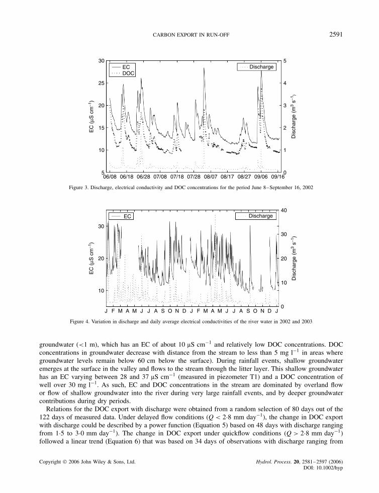
CARBON EXPORT IN RUN-OFF 2591
30
25
20
15
10
5
EC
(µS
cm
−1)
ECDOC
Discharge
06/08 06/18 06/28 07/08 07/18 07/28 08/07 08/17 08/27 09/06 09/16
5
4
3
2
1
0
Dis
char
ge (
m3
s−1)
Figure 3. Discharge, electrical conductivity and DOC concentrations for the period June 8–September 16, 2002
30
20
10
30
20
10
J J JF M MA A S O N D J J JF M MA A S O N D J
EC
(µS
cm
−1)
Dis
char
ge (
m3
s−1)
EC Discharge40
0
Figure 4. Variation in discharge and daily average electrical conductivities of the river water in 2002 and 2003
groundwater (<1 m), which has an EC of about 10 µS cm�1 and relatively low DOC concentrations. DOCconcentrations in groundwater decrease with distance from the stream to less than 5 mg l�1 in areas wheregroundwater levels remain below 60 cm below the surface). During rainfall events, shallow groundwateremerges at the surface in the valley and flows to the stream through the litter layer. This shallow groundwaterhas an EC varying between 28 and 37 µS cm�1 (measured in piezometer T1) and a DOC concentration ofwell over 30 mg l�1. As such, EC and DOC concentrations in the stream are dominated by overland flowor flow of shallow groundwater into the river during very large rainfall events, and by deeper groundwatercontributions during dry periods.
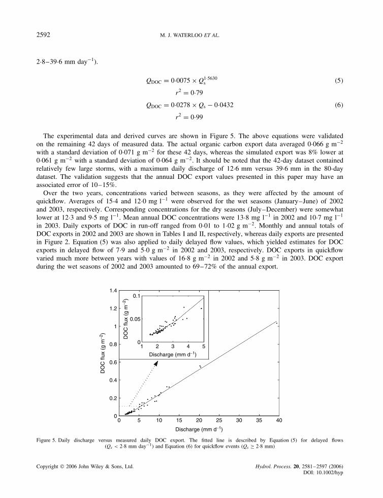
Relations for the DOC export with discharge were obtained from a random selection of 80 days out of the122 days of measured data. Under delayed flow conditions (Q < 2Ð8 mm day�1), the change in DOC exportwith discharge could be described by a power function (Equation 5) based on 48 days with discharge rangingfrom 1Ð5 to 3Ð0 mm day�1). The change in DOC export under quickflow conditions (Q > 2Ð8 mm day�1)followed a linear trend (Equation 6) that was based on 34 days of observations with discharge ranging from
Copyright 2006 John Wiley & Sons, Ltd. Hydrol. Process. 20, 2581–2597 (2006)DOI: 10.1002/hyp
2592 M. J. WATERLOO ET AL.
2Ð8–39Ð6 mm day�1).
QDOC D 0Ð0075 ð Q1Ð5630s �5�
r2 D 0Ð79
QDOC D 0Ð0278 ð Qs � 0Ð0432 �6�
r2 D 0Ð99
The experimental data and derived curves are shown in Figure 5. The above equations were validatedon the remaining 42 days of measured data. The actual organic carbon export data averaged 0Ð066 g m�2
with a standard deviation of 0Ð071 g m�2 for these 42 days, whereas the simulated export was 8% lower at0Ð061 g m�2 with a standard deviation of 0Ð064 g m�2. It should be noted that the 42-day dataset containedrelatively few large storms, with a maximum daily discharge of 12Ð6 mm versus 39Ð6 mm in the 80-daydataset. The validation suggests that the annual DOC export values presented in this paper may have anassociated error of 10–15%.
Over the two years, concentrations varied between seasons, as they were affected by the amount ofquickflow. Averages of 15Ð4 and 12Ð0 mg l�1 were observed for the wet seasons (January–June) of 2002and 2003, respectively. Corresponding concentrations for the dry seasons (July–December) were somewhatlower at 12Ð3 and 9Ð5 mg l�1. Mean annual DOC concentrations were 13Ð8 mg l�1 in 2002 and 10Ð7 mg l�1
in 2003. Daily exports of DOC in run-off ranged from 0Ð01 to 1Ð02 g m�2. Monthly and annual totals ofDOC exports in 2002 and 2003 are shown in Tables I and II, respectively, whereas daily exports are presentedin Figure 2. Equation (5) was also applied to daily delayed flow values, which yielded estimates for DOCexports in delayed flow of 7Ð9 and 5Ð0 g m�2 in 2002 and 2003, respectively. DOC exports in quickflowvaried much more between years with values of 16Ð8 g m�2 in 2002 and 5Ð8 g m�2 in 2003. DOC exportduring the wet seasons of 2002 and 2003 amounted to 69–72% of the annual export.
DO
C fl
ux (
g m
−2)
DO
C fl
ux (
g m
−2)
Discharge (mm d−1)
Discharge (mm d−1)
1.4
1.2
1
0.8
0.6
0.4
0.2
00 5 10 15 20 25 30 35 40
1 2 3 4 5
0.1
0.05
0
Figure 5. Daily discharge versus measured daily DOC export. The fitted line is described by Equation (5) for delayed flows(Qs < 2Ð8 mm day�1) and Equation (6) for quickflow events (Qs ½ 2Ð8 mm)
Copyright 2006 John Wiley & Sons, Ltd. Hydrol. Process. 20, 2581–2597 (2006)DOI: 10.1002/hyp

CARBON EXPORT IN RUN-OFF 2593
Particulate carbon and net carbon exports
The concentration of suspended sediment was determined from 24 samples collected over a range ofdischarge conditions (0Ð07–1Ð9 m3 s�1) in February and July 2002 and in August 2004. Suspended sedimentconcentrations ranged between 1 and 16 mg l�1, but 88% of the values were below 10 mg l�1. Visualinspection of the filters showed that the suspended sediment consisted of fine quartz sand and organic matterparticles, which is consistent with the absence of mineral clay and silt particles in the stream bed. Thespectrolyser UV–vis absorption at 600 nm, which is indicative of absorption of light by suspended solids,indicated that the concentration of suspended sediment generally increased with discharge. However, measuredconcentrations did not show a clear dependence on discharge, and high discharges (>1 m3 s�1) that had beensampled for suspended sediment had concentrations in the lower range of the dataset (<5 mg l�1). It ispossible that differences between events due to antecedent rainfall conditions and hysteresis effects betweenfalling and rising stages prevented the development of a relationship based on the limited number of samplescollected during the present study. The average sediment concentration amounted to 5Ð9 mg l�1 with a standarddeviation of 4Ð6 mg l�1 (n D 24). The median value was 4Ð1 mg l�1. As the population was not normallydistributed, we used the median for calculating annual sediment exports. This resulted in annual sedimentyields of 5Ð59 and 3Ð20 g m�2 year�1 in 2002 and 2003, respectively. The error associated with our sedimentconcentration values may be as high as 50% given the limited number of samples and the large range ofobserved values.
The carbon content of suspended particulate matter (size fraction 10–2000 µm) ranged from 21 to 34%over a range of discharges (0Ð03–0Ð69 m3 s�1), with an average of 28% and a standard deviation of 5%(n D 9). Daily exports of carbon in suspended sediment ranged from 0Ð001 to 0Ð044 g m�2 and averagedto 0Ð003 g m�2 over the whole period. Estimates of the monthly and annual carbon exports in suspendedsediment are given in Tables I and II. Carbon exported in suspended form amounted to 6–8% of the totalexport and the dominant organic carbon export was therefore in dissolved form.
Net carbon exports
Net organic carbon exports in water were calculated as the difference between the organic carbon export indissolved and particulate forms in streamflow and the import in rainfall. Monthly and annual totals are givenin Tables I and II. Exports were highest during the wet season and amounted to 15Ð6 and 6Ð7 g m�2 for 2002and 2003, respectively. The corresponding dry season totals were 7Ð1 and 2Ð6 g m�2.
DISCUSSION
Atmospheric organic carbon deposition in rainfall has not been the subject of extensive research yet inAmazonia. The focus of most rainfall chemistry studies has been on the deposition of nutrients (Lesack andMelack, 1991; Forti and Moreira-Nordemann, 1991; Junk and Furch, 1985; Lesack and Melack, 1991) anddo not include organic carbon deposition rates. DOC concentrations were measured by Andreae et al. (1990)in 13 event-based rainfall samples collected during the wet season at a site on the outskirts of Manaus. Theyobserved a volume weighted mean DOC concentration of 0Ð8 mg l�1, with lower and upper quartiles of 0Ð5 and1Ð8 mg l�1, respectively. These concentrations are similar to those observed in Puerto Rico, where rainfall wasmuch higher at 3530 mm (annual volume weighted mean DOC concentration 1Ð0 mg l�1; (Mcdowell, 1998)),whereas a somewhat higher average (2Ð5 mg l�1) was measured in a Brazilian cerrado (savanna) ecosystemwith an annual rainfall of 1550 mm (Ciglasch et al., 2004). Corresponding annual DOC depositions rangedfrom 1Ð9 g m�2 (Manaus) to 3Ð9 g m�2 (Brazilian Cerrado). Although our estimates are based on a limited setof rainfall samples, the observed concentrations (0Ð5–4Ð7 mg l�1) are similar to those measured elsewhere inthe region. This adds confidence to our approximations for the annual DOC deposition rates of 2Ð4–3Ð5 g m�2.A significant proportion of DOC in rainfall is presumably derived from the scavenging of aerosols in the
Copyright 2006 John Wiley & Sons, Ltd. Hydrol. Process. 20, 2581–2597 (2006)DOI: 10.1002/hyp
2594 M. J. WATERLOO ET AL.
atmosphere during the rainfall formation process (Andreae et al., 1990) and dry deposition on the gaugefunnel. This suggests that a certain fraction of locally produced particulate carbon emissions from the forestto the atmosphere may have been deposited as dry and wet deposition on the rain gauge, implying that therecould be an internal cycle with fluxes into and out of the atmosphere balancing each other to some extent.This suggests that the actual ‘foreign’ atmospheric organic carbon deposition in rainfall may be lower than thevalues presented here. Measured deposition rates are 10–20 times higher than VOC emissions measured at thesame site (0Ð2 g m�2 (Stefani, 2003), suggesting that VOCs may not be considered an important contributorto DOC in rainfall.
Observed DOC concentrations in streamflow were 7–22 times higher than those in rainfall. DOCconcentrations under delayed flow conditions were within the range of those observed in the larger tributariesof the Rio Negro River, in which observed concentrations varied between 2Ð7 mg l�1 in the clearwater RioBranco River to 20Ð6 mg l�1 in the blackwater Rio Araca River (Kuchler et al., 2000). The annual volumeweighted average DOC concentrations observed during the present study (13Ð8 and 10Ð7 mg l�1 in 2002 and2003, respectively) were in the same range as those observed for the Rio Negro River (7–13 mg l�1 (Richeyet al., 1990; Kuchler et al., 2000; Moreira-Turcq et al., 2003b). Our quickflow DOC concentrations, however,were significantly higher reaching values of up to 27 mg l�1. However, even higher concentrations (averaging38 mg l�1) were observed by McClain et al. (1997) in a small blackwater stream draining a 1 km2 catchmentcovered by Campina and Campinarana forests on white sandy soils in Central Amazonia. The presentlyobserved range of concentrations may therefore be considered typical for blackwater streams draining smallterra firme forest catchments in the Rio Negro River Basin. Scale effects, such as spatial and temporalvariation in rainfall and discharge events, as well as differences in the release of DOC from different sourceareas (e.g. spodosols versus oxisols (Klinge, 1966; McClain et al., 1997), may prevent concentrations in thelarger rivers such as the Rio Negro River from reaching the high values presently observed.
High concentrations of DOC in blackwater streams have been attributed to the drainage from Spodosols,which are less capable of adsorption of dissolved organic matter released during the decomposition of litterand roots than Oxisols or Ultisols (Klinge, 1966; Leenheer, 1980; Brinkmann, 1985; McClain et al., 1997).Investigations in the Asu catchment confirm that DOC concentrations in groundwater below well-drainedOxisols and Ultisols on the plateaus and slopes are invariably low (<5 mg l�1) and that these cannotexplain the high DOC concentrations observed in the stream even during delayed flow conditions. HighDOC concentrations were observed in groundwater only in the riparian zone at distances of less than 200 mfrom the stream channel. Groundwater from the plateau and slopes continuously flows to the riparian zonewhere it maintains the water table close to the surface even during extended dry periods (Hodnett et al., 1997).Groundwater DOC concentration apparently increases while travelling through the riparian zone, reaching thevalues observed in the stream during delayed flow conditions. Catchment average exports of DOC amountedto 10Ð8–24Ð7 g m�2 year�1 (Tables I and II), averaging 17Ð8 g m�2 year�1. On the basis of the above wemay assume that a large fraction of DOC exported in the stream is derived from the valley soils, which coverabout 35% of the catchment area, rather than from Oxisols and Ultisols on the slope or plateau. The DOCloss from the Spodosols in the riparian zone could therefore potentially reach values of 31–71 g m�2 year�1
for the observed range of annual discharges (780–1362 mm, Tables I and II). This loss is similar to thatobserved by McClain et al. (1997) for their Campina catchment (about 40 g m�1 year�1 for an estimatedannual discharge of 1125 mm).
Suspended sediment concentrations were invariably low in the Asu River and fell within the range observedfor the blackwater rivers in the Rio Negro Basin (Moreira-Turcq et al., 2003b, 2–14 mg l�1 in tributariesupstream from where the Rio Branco River joins). The carbon fraction in suspended sediment in the Asuriver was somewhat higher than that observed by Moreira-Turcq et al. (2003b) (21–34 vs 15–22%). Thismay be related to the sampling procedure, which excluded particle sizes below 10 µm, and to the absence inthe Asu catchment of fine sediment inputs (e.g. clay) from savanna areas or disturbed forest and agriculturallands that may contribute sediment to the larger tributaries of the Rio Negro Basin. It should be noted that thevalues presented here are based on a limited number of samples covering a wide range of concentrations
Copyright 2006 John Wiley & Sons, Ltd. Hydrol. Process. 20, 2581–2597 (2006)DOI: 10.1002/hyp

CARBON EXPORT IN RUN-OFF 2595
(1–17 mg l�1). The sediment exports should therefore be treated as rough estimates only. The annualparticulate organic carbon flux amounted to 6–8% of the total annual organic carbon export in the Asuriver, which is similar to that observed for the Rio Negro River (Moreira-Turcq et al., 2003b; Richey et al.,1990, 5–9%).
The average organic carbon export from the Rio Negro Basin between 1982 and 1984 has been quantifiedby Richey et al. (1990) at 12Ð6 g C m�2 year�1. The average annual discharge over this period could beinferred from the annual DOC flux and concentration and amounted to 1000 mm year�1. Moreira-Turcq et al.(2003b) did not provide estimates of the organic matter export of the Rio Negro Basin as such, but an estimatecould be obtained by combining the annual average discharge rate (28 400 m3 s�1 or 1304 mm year�1) withthe mean organic carbon concentration (13Ð8 mg l�1). The resulting export averages to 18Ð1 g C m�2 year�1
over the period 1994–2000. This is 50% higher than the export published by Richey et al. (1990), which maybe explained by the 30% higher discharge rate observed during the latter period. Combining the export ratesof Richey et al. (1990) and Moreira-Turcq et al. (2003b) would provide an annual average organic carbonloss of 16Ð5 g m�2 for the Rio Negro River at a discharge of 1213 mm. The observed organic carbon exportin run-off from the Asu catchment is 8% higher at 17Ð8 g m�2 for a somewhat lower average discharge of1145 mm.
The results of this study may be considered representative for areas with blackwater streams drainingSpodosols, which are common in the Rio Negro Basin. Hydrologic exports of organic carbon at the otherLBA tower sites may be much less though, especially where the groundwater is deep (Tapajos tower site) orwhere valleys are V-shaped and have a narrow riparian zone where less DOC is generated (e.g. RondoniaTower site) (McClain et al., 1997; Alvala et al., 2002; Saleska et al., 2003).
At the present site, the hydrological export of very coarse particulate carbon (size fraction >10 mm, i.e.leaves, leaf fragments, woody material, fruits) was studied by Monteiro (2005). Her study included both wetand dry periods and she observed a variation between 6 and 155 µg l�1 for this size fraction. Correspondingorganic carbon concentrations varied between 3 and 74 µg l�1 (Monteiro, 2005). As these concentrations areabout 1000 times lower than those of DOC, organic carbon exports in leaves, fruits and woody material inthe river can safely be ignored.
CONCLUSIONS
The export of organic carbon in streamflow from the Igarape Asu catchment is much higher than the depositionof organic carbon in rainfall. The export of carbon was dominated by the dissolved organic fraction, whichconstituted 92–94% of the total flux. When expressed in grams per square metre, our export values weresimilar to those observed for the Rio Negro Basin as a whole. The inter-annual variation of the hydrologicorganic carbon fluxes was considerable because of the combined impact of increased discharge and higherDOC concentrations during wet years. Inter-annual variation of the eddy covariance fluxes at this site has notbeen evaluated yet. For this blackwater catchment, hydrological organic carbon losses constituted a significantfraction (up to 8% in wet years) of the net atmospheric carbon uptake (300–400 g m�2). The hydrologicalorganic carbon fluxes are too small, though, to explain the discrepancy between eddy covariance carbon fluxestimates and those obtained from biometric assessments. Hydrological organic carbon losses are of similarmagnitude as the biometric net uptake estimates [10–70 g C m2 year�1](Malhi et al., 1998; Malhi et al.,2002; Phillips et al., 1998) and should therefore certainly be taken into account in these studies.
ACKNOWLEDGEMENTS
We would like to thank the field staff Wanderby, Antonio Huxley, Glauco, Julio, Napoleon and Sr Brandaofor their excellent data collection and logistics support during the study. Dr Alex Krusche and Dr Anthony
Copyright 2006 John Wiley & Sons, Ltd. Hydrol. Process. 20, 2581–2597 (2006)DOI: 10.1002/hyp

2596 M. J. WATERLOO ET AL.
Aufdenkampfe from CENA are thanked for their assistance with the calibration of the spectrolyser. Theresearch was possible through support of the European Commission DG Research, which funded theCarbonsink Project (EVK2-CT1999-00023), and the Brazilian Financiadora de Estudos e Projetos (FinEP)funding agency, which funded the complementary Ecocarbon and Monitoramento Hidrometeorologico paraapoiar o planejamento energetico projects. These projects are all part of the Large Scale Biosphere-AtmosphereExperiment in Amazonia (LBA), led by Brazil’s Ministry of Science and Technology.
REFERENCES
Alvala RCS, Gielow R, da Rocha HR, Freitas HC, Lopes JM, Manzi AO, von Randow C, Dias MAFS, Cabral OMR, Waterloo MJ. 2002.Intradiurnal and seasonal variability of soil temperature, heat flux, soil moisture content, and thermal properties under forest and pasturein Rondonia. Journal of Geophysical Research 107(D20): 8043, LBA 10–1–10–20.
Andreae MO, Talbot RW, Berresheim H, Beecher K. 1990. Precipitation chemistry in central Amazonia. Journal of Geophysical Research95(D10): 16 987–16 999.
Andreae MO, de Almeida SS, Artaxo P, Brandao C, Carswell FE, Ciccioli P, Culf A, Esteves JL, Gash JHC, Grace J, Kabat P, Lelieveld J,Malhi Y, Manzi AO, Meixner FX, Nobre AD, Nobre CA, de Lourdes Ruivo MA, da Silva-Dias MAF, Stefani P, Valentini R, vonJouanne J, Waterloo MJ. 2002. Biogeochemical cycling of carbon, water, energy, trace gases, and aerosols in Amazonia: The LBA-EUSTACH experiments. Journal of Geophysical Research 107(D20): 8066, LBA 33–1–33–25.
Benedetti MF, Mounier S, Filizola N, Benaim J, Seyler P. 2003. Carbon and metal concentrations, size distributions and fluxes in majorrivers of the Amazon Basin. Hydrological Processes 17: 1363–1377.
Brinkmann WLF. 1985. Studies on the hydrobiogeochemistry of a tropical lowland forest system. GeoJournal 11(1): 89–101.Chambers JQ, Higuchi N, Tribuzy ES, Trumbore SE. 2001. Carbon sink for a century. Nature 410: 429, Brief communication.Chauvel A, Lucas Y, Boulet R. 1987. On the genesis of the soil mantle of the region of Manaus, Central Amazonia, Brazil. Experientia 43:
234–241.Ciglasch H, Lilienfein J, Kaiser K, Wilcke W. 2004. Dissolved organic matter under native cerrado and pinus caribaea plantations in the
Brazilian savanna. Biogeochemistry 67: 157–182.Cox PM, Betts RA, Jones CD, Spall SA, Totterdell IJ. 2000. Acceleration of global warming due to carbon-cycle feedbacks in a coupled
climate model. Nature 408: 184–187.de Araujo AC, Nobre AD, Kruijt B, Elbers JA, Dallarosa R, Stefani P, von Randow C, Manzi AO, Culf AD, Gash JHC, Valentini R,
Kabat P. 2002. Comparative measurements of carbon dioxide fluxes from two nearby towers in a central Amazonian rainforest: TheManaus LBA site. Journal of Geophysical Research 107(D20): 8090, LBA 58–1–58–20.
de Oliveira AN, do Amaral IL. 2004. Florıstica e fitossociologia de uma floresta de vertente na Amazonia Central, Amazonas, Brazil. ActaAmazonica 34(1): 21–34.
Ertel JR, Hedges JI, Devol AH, Richey JE. 1986. Dissolved humic substances of the Amazon River system. Limnology and Oceanography31(4): 739–754.
Fearnside PM. 1993. Deforestation in Brazilian Amazonia: The effect of population and land tenure. Ambio 22: 537–545.Forti MC, Moreira-Nordemann LM. 1991. Rainwater and throughfall chemistry in a terra firme rainforest–Central Amazonia. Journal of
Geophysical Research 96: 7415–7421.Gregory KJ, Walling DE. 1973. Drainage Basin Form and Process. A Geomorphological Approach. Edward Arnold Publishers: United
Kingdom.Hedges JI, Clark WA, Quay PD, Richey JE, Devol AH, Santos UDM. 1986. Compositions and fluxes of particulate organic material in the
Amazon River. Limnology and Oceanography 31(4): 717–738.Hedges JI, Cowie GL, Richey JE, Quay PD, Benner R, Strom M, Forsberg BR. 1994. Origins and processing of organic matter in the
Amazon River as indicated by carbohydrates and amino acids. Limnology and Oceanography 39(4): 743–761.Hewlett JD, Hibbert AR. 1967. Factors affecting the response of small watersheds to precipitation in humid areas. In Forest Hydrology ,
Sopper WE, Lull HW (eds). Pergamon Press: 275–290.Hodnett MG, Vendrame I, Marques Filho ADO, Oyama MD, Tomasella J. 1997. Soil water storage and groundwater behaviour in a catenary
sequence beneath forest behaviour in Central Amazonia. II. Floodplain water table behaviour and implications for streamflow generation.Hydrology and Earth System Sciences 1(2): 279–290.
Houghton RA, Davidson EA, Woodwell GM. 1998. Missing sinks, feedbacks, and understanding the role of terrestrial ecosystems in theglobal carbon balance. Global Biogeochemical Cycles 12: 25–34.
Houghton RA, Skole DL, Nobre CA, Hackler JL, Lawrence KT, Chomentowski WH. 2000. Annual fluxes of carbon from deforestation andregrowth in the Brazilian Amazon. Nature 403: 301–304.
Junk WJ, Furch K. 1985. The Physical and Chemical Properties of Amazonian Waters and their Relationships with the Biota . PergamonPress: New York; 3–17, chapter Key Environments.
Kesselmeier J, Ciccioli P, Kuhn U, Stefani P, Biesenthal T, Rottenberger S, Wolf A, Vitullo M, Valentini R, Nobre AD, Kabat P, Andreae MO.2002. Volatile organic compound emissions in relation to plant carbon fixation and the terrestrial carbon budget. Global BiogeochemicalCycles 16(4): 73Ð1–73Ð9.
Klinge H. 1966. Podzol soils: a source of blackwater rivers in Amazonia. Atlas do Simposio Sobre a Biota Amazonica 3: 117–126.Kruijt B, Elbers JA, von Randow C, de Araujo AC, Oliveira PJ, Culf A, Manzi AO, Nobre AD, Kabat P, Moors EJ. 2004. The robustness
of eddy correlation fluxes for Amazon rain forest conditions. Ecological Applications 14(4): 101–113.
Copyright 2006 John Wiley & Sons, Ltd. Hydrol. Process. 20, 2581–2597 (2006)DOI: 10.1002/hyp

CARBON EXPORT IN RUN-OFF 2597
Kuchler IL, Miekeley M, Forsberg BR. 2000. A contribution to the chemical characterization of rivers in the Rio Negro Basin, Brazil.Journal of the Brazilian Chemical Society 11(3): 286–292.
Leenheer JA. 1980. Origin and nature of humic substances in the waters of the Amazon River Basin. Acta Amazonica 10: 513–526.Lesack LFW, Melack JM. 1991. The deposition, composition, and potential sources of major ionic solutes in rain of the Central Amazon
Basin. Water Resources Research 27(11): 2953–2977.Malhi Y, Grace J. 2000. Tropical forests and atmospheric carbon dioxide. Trends in Ecology and Evolution 15(8): 332–337.Malhi Y, Nobre AD, Grace J, Kruijt B, Pereira MGP, Culf A, Scott S. 1998. Carbon dioxide transfer over a Central Amazonian rain forest.
Journal of Geophysical Research-Atmospheres 103: 31 593–31 612.Malhi Y, Phillips OL, Baker T, Almeida S, Fredericksen T, Grace J, Higuchi N, Killeen T, Laurance WF, Leano C, Lloyd J, Meir P,
Monteagudo A, Neill D, Nunez PV, Panfil SN, Pitman N, Rudas A, Salom ao R, Saleska S, Silva N, Silveira M, Sombroek WG,Valencia R, Vieira I, Vinceti B. 2002. An international network to understand the biomass and dynamics of Amazonian forests (RAINFOR).Journal of Vegetation Science 13: 439–450.
Mayorga E, Aufdenkampe AK. 2002. The processing of bioactive elements by the amazon river system. In The Ecohydrology of SouthAmerican Rivers and Wetlands , McClain ME (ed.). IAHS Press: Wallingford; 1–24, IAHS Publication No. 6.
McClain ME, Richey JE, Brandes JA, Pimentel TP. 1997. Dissolved organic matter and terrestriallotic linkages in the Central Amazon Basinof Brazil. Global Biogeochemical Cycles 11(3): 295–311.
McDowell WH. 1998. Internal nutrient fluxes in a Puerto Rican rain forest. Journal of Tropical Ecology 14(4): 521–536.Miller SD, Goulden ML, Menton MC, da Rocha HR, de Freitas HC, e Silva Fegueira AM, Dias de Souza CA. 2004. Biometric and
micrometeorological measurements of tropical forest carbon balance. Ecological Applications 14(4): 114–126.Monteiro MTF. 2005. Interacoes dinamica do carbono e nutrientes da liteira entre a floresta de terra firme e o igarapede drenagem na
Amazonia Central. Master’s thesis, Universidade Federal do Amazonas, Manaus, AM, Brazil.Moreira-Turcq P, Seyler P, Guyot JL, Etcheber H. 2003a. Characteristics of organic matter in the mixing zone of the Rio Negro and Rio
Solimoes of the Amazon River. Hydrological Processes 17: 1393–1404.Moreira-Turcq P, Seyler P, Guyot JL, Etcheber H. 2003b. Exportation of organic carbon from the Amazon River and its main tributaries.
Hydrological Processes 17: 1329–1344.Nobre CA, Alves DS, Artaxo P, Brown IF, Dunne T, Gash JHC, Grace J, Hall F, Janetos AC, Kabat P, Keller M, Krug T, Marengo JA,
McNeal RJ, Prince SD, Silva Dias PL, Skole DL, Tomasella J, Victoria RL, Vorosmarty CJ, Wickland D. 1997. The large scale biosphere-atmosphere experiment in Amazonia (LBA) integrated science plan. LBA Project office, Cachoeira Paulista–SP–Brazil.
Phillips OL, Malhi Y, Higuchi N, Laurance WF, Nunez PV, Vasquez RM, Laurance SG, Ferreira LV, Stern M, Brown S, Grace J. 1998.Changes in the carbon balance of tropical forests: Evidence from long-term plots. Science 282: 439–442.
Raich JW, Potter CS. 1995. Global patterns of carbon dioxide emissions from soils. Global Biogeochemical Cycles 9: 23–36.Richey JE, Hedges JI, Devol AH, Quay PD, Victoria RL, Martinelli LA, Forsberg BR. 1990. Biogeochemistry of carbon in the Amazon
River. Limnology and Oceanography 35: 352–371.Saleska SR, Miller SD, Matross DM, Goulden ML, Wofsy SC, da Rocha HR, de Camargo PB, Crill P, Daube BC, de Freitas HC, Hutyra L,
Keller M, Kirchhoff V, Menton M, Munger JW, Pyle EH, Rice AH, Silva H. 2003. Carbon in Amazon forests: unexpected seasonal fluxesand disturbance-induced losses. Science 302: 1554–1557.
Sioli H. 1950. Das wasser in Amazonasgebiet. Forschungen und Fortschritte 26: 274–280.Stefani P. 2003. Emissioni di composti organici volatili di origine biogenica (BVOC) e loro influenza sul bilancio di carbonio in una foresta
tropicale primaria del bacino Amazzonico. PhD thesis, Universita degli studi della Tuscia, Department of Forest Science, Viterbo, Italy.Telles ECC, Camargo PB, Martinelli LA, Trumbore SE, Costa ES, Santos J, Higuchi N, Oliveira RC Jr. 2003. Influence of soil texture on
carbon dynamics and storage potential in tropical forest soils of Amazonia. Global Biogeochemical Cycles 17(2): 1040.Van Beers WFJ. 1983. The auger hole method. Bulletin 1, International Institute for Land Reclamation and Improvement (ILRI), Wageningen,
The Netherlands. Revised Edition, 32 pp.von Randow C, Sa LDA, Gannabathula PSSD, Manzi AO, Arlino PRA, Kruijt B. 2002. Scale variability of atmospheric surface layer
fluxes of energy and carbon over a tropical rain forest in southwest Amazonia. I. Diurnal conditions. Journal of Geophysical Research107(020,8062): 29Ð1–29Ð12.
Copyright 2006 John Wiley & Sons, Ltd. Hydrol. Process. 20, 2581–2597 (2006)DOI: 10.1002/hyp