
Exploring the Location API for J2ME - Dr David Parsons
10
Page 1 of 10 Exploring the Location API for J2ME (pre-print of article in Dr Dobbs Journal, January 2006, 53-8) David Parsons Massey University, Auckland, New Zealand [email protected] 1. Introduction The Java Location API for J2ME TM is intended to run on small client devices such as mobile phones. It integrates generic positioning and orientation data with persistent storage of point of interest (POI) objects known as Landmarks. Although there are now a few phones and software tools, including models and emulators from Ericsson and Nokia, which implement this API, developers wishing to work with it have been constrained by a limited set of options for simulating location data. Both the current Nokia and Ericsson tools limit input to GPS data (e.g. from a log file). To provide a somewhat more interactive approach, this article provides an introduction to the API using a map based simulation environment designed to work easily with the Sun J2ME Wireless Toolkit. Although there are some other Java location APIs in the public domain, these are mostly based on the Mobile Location Protocol published by the Location Interoperability Forum (LIF). This works on the assumption that the system is a device aware cellular network, and that location information is pulled in XML format from a server-hosted API. In contrast, the Location API for J2ME is a client side generic location interface that is intended to work with many different positioning methods. Generic interfaces enable us to implement systems that span multiple sources of location information at the same time. This will become increasingly important as the devices and channels for tracking locations increase, enabling us to aggregate and prioritise different information sets that relate to the same target, as well as being able to choose between multiple methods of determining the location of a single device. This provides a number of advantages including fail-over, indoor/outdoor transparency and a choice between the speed and accuracy trade-offs that could be made between GPS, cellular or other positioning mechanisms. In this article we introduce the object model used in the Location API and look at some simple code examples that you can explore using the map based simulator, which can be freely downloaded. The locations used in the examples described here are based on a map of Massey University’s Auckland campus in New Zealand. 2. The Location API Object Model The Location API object model consists of eleven classes and two listener interfaces (LocationListener and ProximityListener), all in the javax.microedition.location package . Their design approach uses several standard patterns, including Façade, Factory Method, Singleton and Value Object, and standard JavaBeans–style accessors. Of the eleven classes, two are Exception classes (LocationException and LandmarkException) and another four (AddressInfo, Criteria, Orientation, and QualifiedCoordinates) are primarily value objects. Many of the properties of these objects may in practice be unavailable, depending on the location finding technology that is implementing the API, but these properties anticipate likely future developments in mobile networks and devices and the level of location and context detail that they will be able to provide. 2.1 Location related classes Location objects are immutable aggregates of AddressInfo and QualifiedCoordinates objects. Location instances are acquired from a LocationProvider, a façade to the mobile device‟s underlying location information that consists of a factory method (parameterised by a Criteria object) to retrieve a LocationProvider instance, methods to return current or last-known Location objects and methods to register listeners for location and proximity events. The Coordinates class (the superclass of QualifiedCoordinates) encapsulates geometric methods such as calculating the azimuth (angle) and distance between locations. Because the J2ME Wireless Toolkit does not allow new classes to be created in system packages, this implementation uses the alternative package name massey.microedition.location
-
Upload
khangminh22 -
Category
Documents
-
view
6 -
download
0
Transcript of Exploring the Location API for J2ME - Dr David Parsons
Page 1 of 10
Exploring the Location API for J2ME (pre-print of article in Dr Dobbs Journal, January 2006, 53-8)
David Parsons
Massey University, Auckland, New Zealand
1. Introduction
The Java Location API for J2METM
is intended to run on small client devices such as mobile phones. It
integrates generic positioning and orientation data with persistent storage of point of interest (POI) objects
known as Landmarks. Although there are now a few phones and software tools, including models and emulators
from Ericsson and Nokia, which implement this API, developers wishing to work with it have been constrained
by a limited set of options for simulating location data. Both the current Nokia and Ericsson tools limit input to
GPS data (e.g. from a log file). To provide a somewhat more interactive approach, this article provides an
introduction to the API using a map based simulation environment designed to work easily with the Sun J2ME
Wireless Toolkit.
Although there are some other Java location APIs in the public domain, these are mostly based on the Mobile
Location Protocol published by the Location Interoperability Forum (LIF). This works on the assumption that
the system is a device aware cellular network, and that location information is pulled in XML format from a
server-hosted API. In contrast, the Location API for J2ME is a client side generic location interface that is
intended to work with many different positioning methods. Generic interfaces enable us to implement systems
that span multiple sources of location information at the same time. This will become increasingly important as
the devices and channels for tracking locations increase, enabling us to aggregate and prioritise different
information sets that relate to the same target, as well as being able to choose between multiple methods of
determining the location of a single device. This provides a number of advantages including fail-over,
indoor/outdoor transparency and a choice between the speed and accuracy trade-offs that could be made between
GPS, cellular or other positioning mechanisms.
In this article we introduce the object model used in the Location API and look at some simple code
examples that you can explore using the map based simulator, which can be freely downloaded. The locations
used in the examples described here are based on a map of Massey University’s Auckland campus in New
Zealand.
2. The Location API Object Model
The Location API object model consists of eleven classes and two listener interfaces (LocationListener and
ProximityListener), all in the javax.microedition.location package. Their design approach uses several standard
patterns, including Façade, Factory Method, Singleton and Value Object, and standard JavaBeans–style
accessors. Of the eleven classes, two are Exception classes (LocationException and LandmarkException) and
another four (AddressInfo, Criteria, Orientation, and QualifiedCoordinates) are primarily value objects. Many of
the properties of these objects may in practice be unavailable, depending on the location finding technology that
is implementing the API, but these properties anticipate likely future developments in mobile networks and
devices and the level of location and context detail that they will be able to provide.
2.1 Location related classes
Location objects are immutable aggregates of AddressInfo and QualifiedCoordinates objects. Location
instances are acquired from a LocationProvider, a façade to the mobile device‟s underlying location information
that consists of a factory method (parameterised by a Criteria object) to retrieve a LocationProvider instance,
methods to return current or last-known Location objects and methods to register listeners for location and
proximity events. The Coordinates class (the superclass of QualifiedCoordinates) encapsulates geometric
methods such as calculating the azimuth (angle) and distance between locations.
Because the J2ME Wireless Toolkit does not allow new classes to be created in system packages, this implementation uses
the alternative package name massey.microedition.location
Page 2 of 10
The Orientation class is completely separate from the rest of the object model, having no association or
dependency relationships with any other classes. This is presumably because not all devices will be able to
support orientation information. At a minimum, the device must be able to provide a compass azimuth value to
support Orientation objects, with optional support for pitch and roll values. Orientation objects can be derived
either from a factory method or from a parameterised constructor.
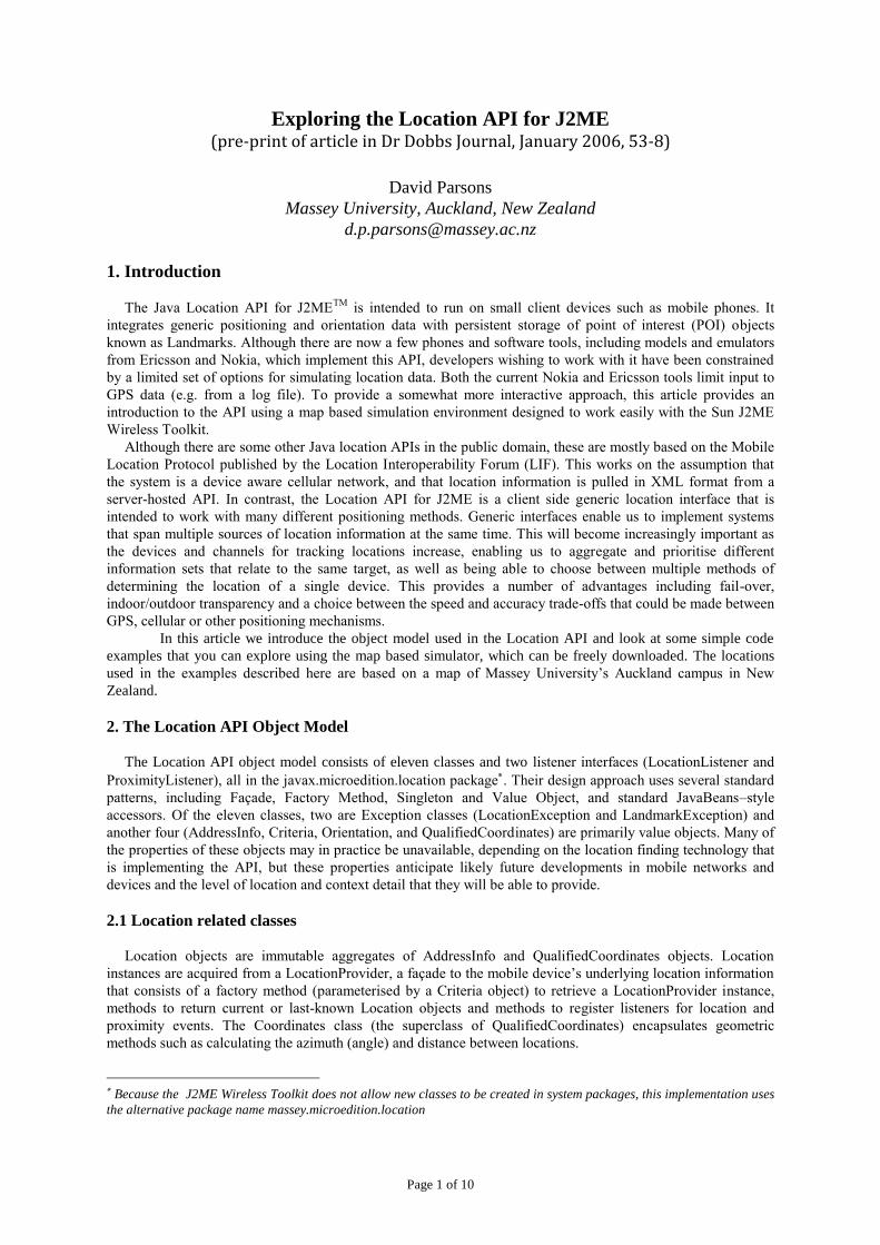
The classes discussed so far encapsulate the subset of the API that is directly related to the acquisition of
location information from whatever underlying technology is available to the device. These are summarised in
Figure 1.
Figure 1: The Location related subset of the API
2.2 A simple location based program
Having introduced those classes that relate to location finding, we will look at a simple MIDlet that displays the
current location of the device on the screen (the complete MIDlet is shown in listing 1). The interaction with the
Location API in this example is very simple. First, we access the LocationProvider using the static factory
method getInstance. The parameter is a Criteria object that can be used to set quality of service parameters,
but in this example we will simply pass a null reference. try
{
locationProvider = LocationProvider.getInstance(null);
}
catch(LocationException e)
{
// handle exception
}
The LocationProvider can now be used to get the current location. The parameter to the getLocation method
is the timeout period.
try {
location = locationProvider.getLocation(20);
}
catch(LocationException e)
{
// handle exception
}
catch(InterruptedException e)
{
// handle exception
}
Once we have a Location object we can use it to find out our current latitude, longitude, altitude, direction and
speed by accessing the QualifiedCoordinates object that is aggregated inside it.
coordinates = location.getQualifiedCoordinates();
A location may also contain an AddressInfo object, with details such as the location’s postal address, phone
number, country, URL etc. However depending on the implementation and context there may not actually be an
Coordinates
QualifiedCoordinates
Location
AddressInfo
LocationProvider creates Orientation
Criteria
configures
Page 3 of 10
AddressInfo associated with a given location. For example, if you are standing in the middle of a field there will
be no AddressInfo data. In the simulator implementation described here, the AddressInfo is always null.
Our current course, speed and altitude are returned from the QualifiedCoordinates object as float
values, while latitude and longitude are returned as doubles. To assist the display of location data, the
Coordinates class includes a method to convert a coordinate object into a String representation in either of two
formats:
Format 1: Degrees, Minutes, and decimal fractions of a minute.
For example, for the double value of the coordinate 61.51d, the formatted string is 61:30:36
Format 2: Degrees, Minutes, Seconds and decimal fractions of a second.
For example, for the double value of the coordinate 61.51d, the formatted string is 61:30.6.
In the example MIDlet we use the second format, selected using the constant field Coordinates.DD_MM_SS.
Alternatively, format 1 can be selected using Coordinates.DD_MM. Here is the fragment of the MIDlet where
the location information is displayed on the screen, using a series of StringItems.
latitude = new StringItem("Latitude: " +
Coordinates.convert(coordinates.getLatitude(), Coordinates.DD_MM_SS), "");
longitude = new StringItem("Longitude: " +
Coordinates.convert(coordinates.getLongitude(), Coordinates.DD_MM_SS), "");
altitude = new StringItem("Altitude: " + coordinates.getAltitude(), "");
direction = new StringItem("Course: " + location.getCourse(), "");
speed = new StringItem("Speed: " + location.getSpeed(), "");
locationForm.append(latitude);
locationForm.append(longitude);
locationForm.append(altitude);
locationForm.append(direction);
locationForm.append(speed);
display.setCurrent(locationForm);
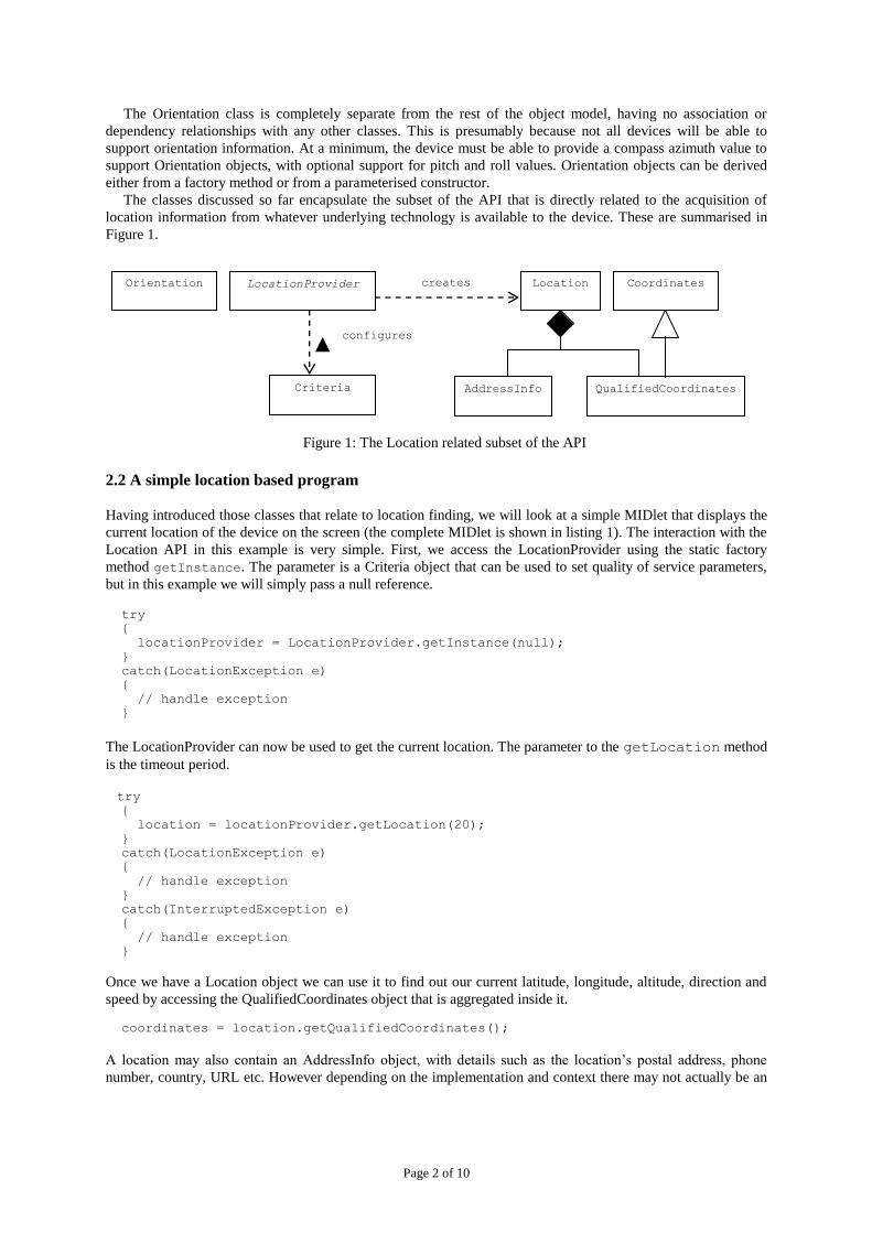
Figure 2 shows a screen dump from the J2ME Wireless Toolkit (version 2.2) with the current location details
being displayed. Instructions for installing and running the simulation environment and example MIDlets are
included in the code download.
Figure 2: Location details displayed by the MIDlet
3. Using the Location and Proximity Listeners
Page 4 of 10
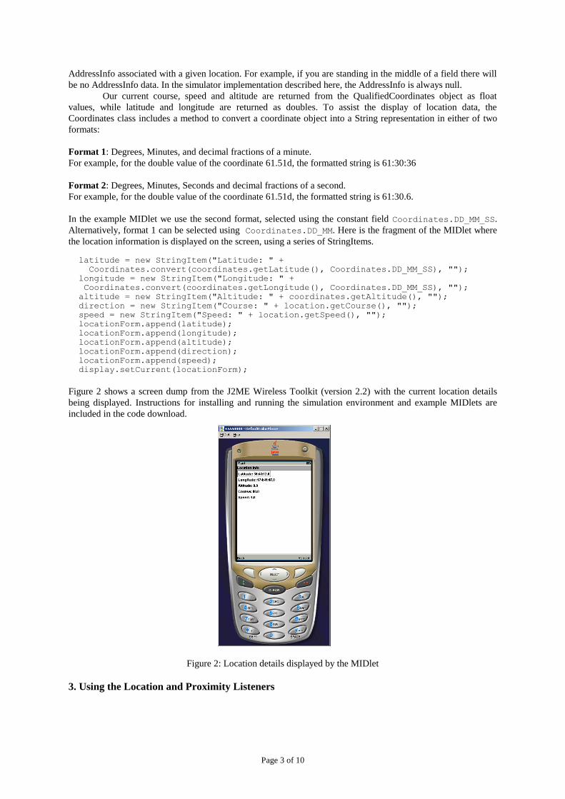
The LocationProvider can register two types of listener; a single LocationListener and/or multiple
ProximityListeners (Figure 3). These listeners help us to create more dynamic location based services that can be
triggered by location related events.
Figure 3. The listener interfaces
3.1 The LocationListener
In our previous example, we used the LocationProvider to find out the current location whenever the ‘refresh’
button was pressed on the phone. This is not a very flexible approach and it would be better if we could
automatically trigger an event whenever the current location changed, without having to make an explicit call to
getLocation. We can achieve this behaviour by using the LocationListener interface, which we can use to
listen for updates to the current location. Only one LocationListener can be registered with the LocationProvider
at any one time, so this listener can therefore act as a kind of Singleton for all components that need location
information. The LocationListener is updated with current location information at specified intervals and it can
expose and process that information in an application specific context to be accessed by other components on
demand. In the next code example, to keep things simple, we make the MIDlet itself the LocationListener (listing
2). In order to listen to location events, our MIDlet has to implement the LocationListener interface:
public class LocationListenerMIDlet extends MIDlet
implements CommandListener, LocationListener
Once the MIDlet implements the LocationListener interface, it can be registered with the LocationProvider as
the current LocationListener via the setLocationListener method. The three parameters to this method are
the listener, the interval between updates, the timeout period and the maximum acceptable age for location
information:
try
{
locationProvider = LocationProvider.getInstance(null);
locationProvider.setLocationListener(this, 20, 10, 10);
}
catch(LocationException e)
{
// handle exception
}
The listener interface contains two methods; locationUpdated and providerStateChanged. The
LocationProvider triggers the locationUpdated method whenever the location changes. The
providerStateChanged method is informed when the state of the LocationProvider changes between its three
possible states, LocationProvider.AVAILABLE, LocationProvider.TEMPORARILY_UNAVAILABLE and
LocationProvider.OUT_OF_SERVICE. In the example MIDlet only the locationUpdated method is
implemented, simply calling the method that refreshes the screen form:
public void locationUpdated(LocationProvider provider, Location location)
{
this.locationInfo();
LocationProvider
LocationListener
locationUpdated providerStateChanged
ProximityListener
proximityEvent
monitoringStateChanged
0..1 0..*

Page 5 of 10
}
With these few changes to the MIDlet, we can now automatically update the location display whenever the
location has changed, without having to press the ‘refresh’ button and do a manual update.
3.2 ProximityListeners
In the previous example we saw how a mobile application can use the LocationListener interface to listen for
updates to the current location. In addition, we can implement the ProximityListener interface, which enables us
to trigger events when we approach specified locations. Unlike the LocationListener, which can have only one
registered instance, the LocationProvider allows us to register multiple ProximityListeners. Our third example
MIDlet (listing 3) adds proximity monitoring to the existing location monitoring:
public class ProximityListenerMIDlet extends MIDlet
implements CommandListener, LocationListener, ProximityListener
This time, when the MIDlet starts up, it registers itself three times so that we can listen for proximity events for
three different locations (in this case three of the buildings on the map used in the simulator, the Study Centre,
the Quadrangle and the Atrium). Each registration requires the listener, the coordinates and the required
proximity radius from these coordinates as parameters.
try
{
locationProvider = LocationProvider.getInstance(null);
locationProvider.setLocationListener(this, 20, 10, 10);
// radius used to trigger proximity alerts
float radius = 100.0F;
// coordinates of the Study Centre
locationProvider.addProximityListener(this, studyCentreCoordinates, radius);
// coordinates of the Quadrangle building
locationProvider.addProximityListener(this, quadrangleCoordinates, radius);
// coordinates of the Atrium
locationProvider.addProximityListener(this, atriumCoordinates, radius);
}
The ProximityListener interface has two methods, monitoringStateChanged and proximityEvent. The
monitoringStateChanged method simply informs listeners whether or not proximity notification is currently
active. The proximityEvent method provides two parameters, the coordinates originally registered with the
LocationProvider and the current location. In our implementation we compare the given coordinates with the
ones we are listening for and select the matching location.
public void proximityEvent(Coordinates coordinates, Location location) {
if(coordinates.equals(studyCentreCoordinates))
{
showStudyCentreProximityAlert();
}
if(coordinates.equals(quadrangleCoordinates))
{
showQuadrangleProximityAlert();
}
if(coordinates.equals(atriumCoordinates))
{
showAtriumProximityAlert();
}
}
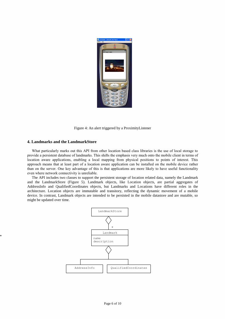
The various alerts simply display an image of the appropriate building. Figure 4 shows the proximity alert for the
Study Centre being displayed on the mobile device. If you find you get excessive thrashing between the location
and proximity listeners both trying to trigger the screen, you can remove the LocationListener code from this
example.
Page 6 of 10
Figure 4: An alert triggered by a ProximityListener
4. Landmarks and the LandmarkStore
What particularly marks out this API from other location based class libraries is the use of local storage to
provide a persistent database of landmarks. This shifts the emphasis very much onto the mobile client in terms of
location aware applications, enabling a local mapping from physical positions to points of interest. This
approach means that at least part of a location aware application can be installed on the mobile device rather
than on the server. One key advantage of this is that applications are more likely to have useful functionality
even where network connectivity is unreliable.
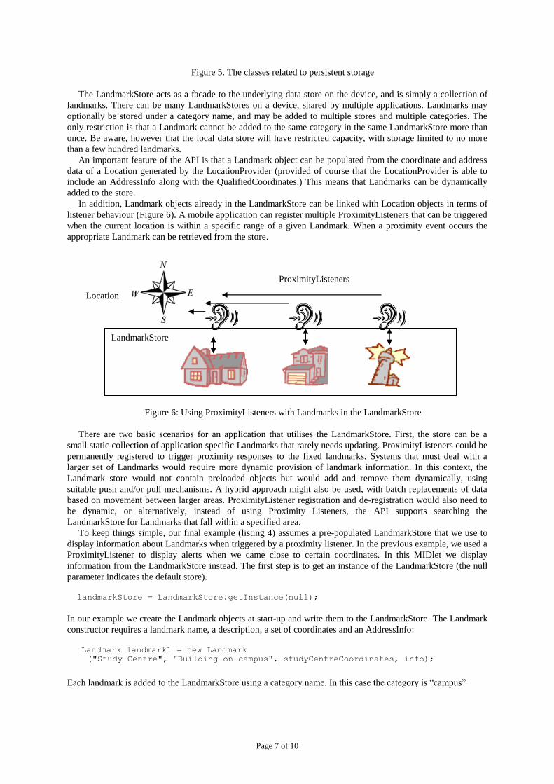
The API includes two classes to support the persistent storage of location related data, namely the Landmark
and the LandmarkStore (Figure 5). Landmark objects, like Location objects, are partial aggregates of
AddressInfo and QualifiedCoordinates objects, but Landmarks and Locations have different roles in the
architecture. Location objects are immutable and transitory, reflecting the dynamic movement of a mobile
device. In contrast, Landmark objects are intended to be persisted in the mobile datastore and are mutable, so
might be updated over time.
QualifiedCoordinates
Landmark
AddressInfo
LandmarkStore
*
name
description
*
Page 7 of 10
Figure 5. The classes related to persistent storage
The LandmarkStore acts as a facade to the underlying data store on the device, and is simply a collection of
landmarks. There can be many LandmarkStores on a device, shared by multiple applications. Landmarks may
optionally be stored under a category name, and may be added to multiple stores and multiple categories. The
only restriction is that a Landmark cannot be added to the same category in the same LandmarkStore more than
once. Be aware, however that the local data store will have restricted capacity, with storage limited to no more
than a few hundred landmarks.
An important feature of the API is that a Landmark object can be populated from the coordinate and address
data of a Location generated by the LocationProvider (provided of course that the LocationProvider is able to
include an AddressInfo along with the QualifiedCoordinates.) This means that Landmarks can be dynamically
added to the store.
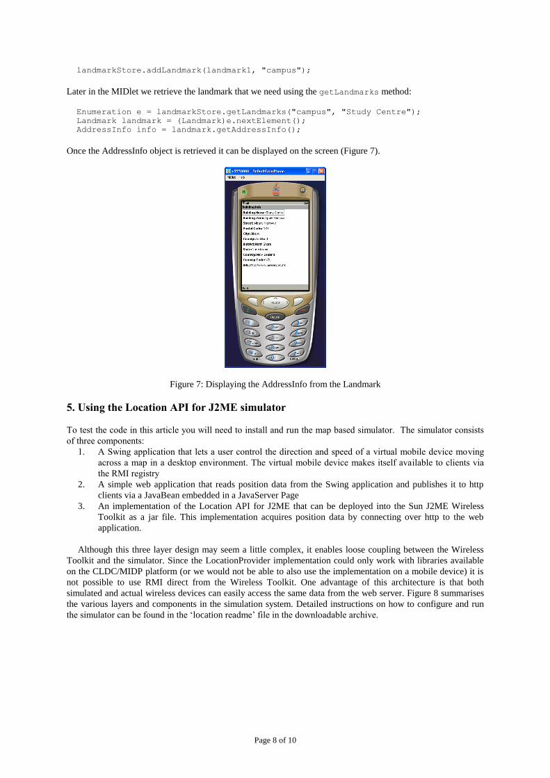
In addition, Landmark objects already in the LandmarkStore can be linked with Location objects in terms of
listener behaviour (Figure 6). A mobile application can register multiple ProximityListeners that can be triggered
when the current location is within a specific range of a given Landmark. When a proximity event occurs the
appropriate Landmark can be retrieved from the store.
Figure 6: Using ProximityListeners with Landmarks in the LandmarkStore
There are two basic scenarios for an application that utilises the LandmarkStore. First, the store can be a
small static collection of application specific Landmarks that rarely needs updating. ProximityListeners could be
permanently registered to trigger proximity responses to the fixed landmarks. Systems that must deal with a
larger set of Landmarks would require more dynamic provision of landmark information. In this context, the
Landmark store would not contain preloaded objects but would add and remove them dynamically, using
suitable push and/or pull mechanisms. A hybrid approach might also be used, with batch replacements of data
based on movement between larger areas. ProximityListener registration and de-registration would also need to
be dynamic, or alternatively, instead of using Proximity Listeners, the API supports searching the
LandmarkStore for Landmarks that fall within a specified area.
To keep things simple, our final example (listing 4) assumes a pre-populated LandmarkStore that we use to
display information about Landmarks when triggered by a proximity listener. In the previous example, we used a
ProximityListener to display alerts when we came close to certain coordinates. In this MIDlet we display
information from the LandmarkStore instead. The first step is to get an instance of the LandmarkStore (the null
parameter indicates the default store).
landmarkStore = LandmarkStore.getInstance(null);
In our example we create the Landmark objects at start-up and write them to the LandmarkStore. The Landmark
constructor requires a landmark name, a description, a set of coordinates and an AddressInfo:
Landmark landmark1 = new Landmark ("Study Centre", "Building on campus", studyCentreCoordinates, info);
Each landmark is added to the LandmarkStore using a category name. In this case the category is “campus”
LandmarkStore
Location
ProximityListeners
Page 8 of 10
landmarkStore.addLandmark(landmark1, "campus");
Later in the MIDlet we retrieve the landmark that we need using the getLandmarks method:
Enumeration e = landmarkStore.getLandmarks("campus", "Study Centre");
Landmark landmark = (Landmark)e.nextElement();
AddressInfo info = landmark.getAddressInfo();
Once the AddressInfo object is retrieved it can be displayed on the screen (Figure 7).
Figure 7: Displaying the AddressInfo from the Landmark
5. Using the Location API for J2ME simulator
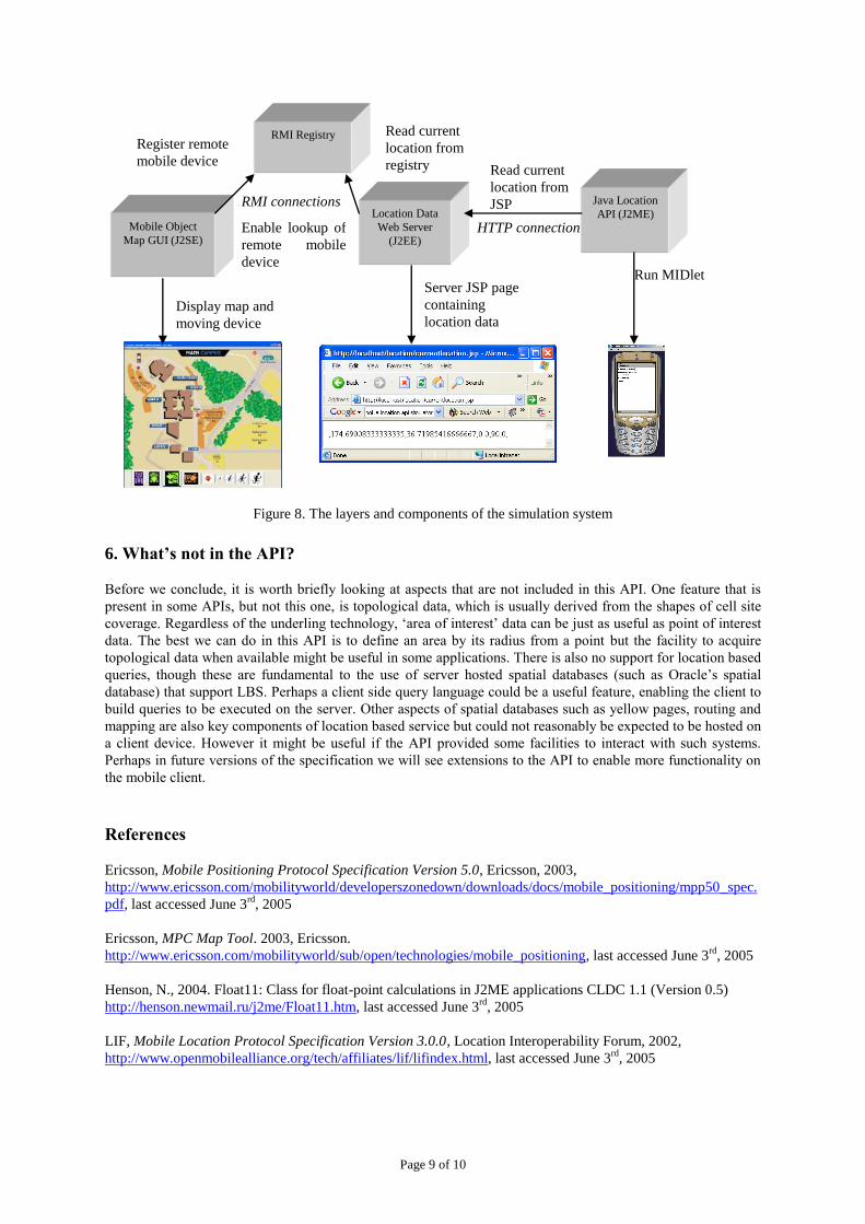
To test the code in this article you will need to install and run the map based simulator. The simulator consists
of three components:
1. A Swing application that lets a user control the direction and speed of a virtual mobile device moving
across a map in a desktop environment. The virtual mobile device makes itself available to clients via
the RMI registry
2. A simple web application that reads position data from the Swing application and publishes it to http
clients via a JavaBean embedded in a JavaServer Page
3. An implementation of the Location API for J2ME that can be deployed into the Sun J2ME Wireless
Toolkit as a jar file. This implementation acquires position data by connecting over http to the web
application.
Although this three layer design may seem a little complex, it enables loose coupling between the Wireless
Toolkit and the simulator. Since the LocationProvider implementation could only work with libraries available
on the CLDC/MIDP platform (or we would not be able to also use the implementation on a mobile device) it is
not possible to use RMI direct from the Wireless Toolkit. One advantage of this architecture is that both
simulated and actual wireless devices can easily access the same data from the web server. Figure 8 summarises
the various layers and components in the simulation system. Detailed instructions on how to configure and run
the simulator can be found in the ‘location readme’ file in the downloadable archive.
…
Page 9 of 10
Figure 8. The layers and components of the simulation system
6. What’s not in the API?
Before we conclude, it is worth briefly looking at aspects that are not included in this API. One feature that is
present in some APIs, but not this one, is topological data, which is usually derived from the shapes of cell site
coverage. Regardless of the underling technology, „area of interest‟ data can be just as useful as point of interest
data. The best we can do in this API is to define an area by its radius from a point but the facility to acquire
topological data when available might be useful in some applications. There is also no support for location based
queries, though these are fundamental to the use of server hosted spatial databases (such as Oracle‟s spatial
database) that support LBS. Perhaps a client side query language could be a useful feature, enabling the client to
build queries to be executed on the server. Other aspects of spatial databases such as yellow pages, routing and
mapping are also key components of location based service but could not reasonably be expected to be hosted on
a client device. However it might be useful if the API provided some facilities to interact with such systems.
Perhaps in future versions of the specification we will see extensions to the API to enable more functionality on
the mobile client.
References
Ericsson, Mobile Positioning Protocol Specification Version 5.0, Ericsson, 2003,
http://www.ericsson.com/mobilityworld/developerszonedown/downloads/docs/mobile_positioning/mpp50_spec.
pdf, last accessed June 3rd
, 2005
Ericsson, MPC Map Tool. 2003, Ericsson.
http://www.ericsson.com/mobilityworld/sub/open/technologies/mobile_positioning, last accessed June 3rd
, 2005
Henson, N., 2004. Float11: Class for float-point calculations in J2ME applications CLDC 1.1 (Version 0.5)
http://henson.newmail.ru/j2me/Float11.htm, last accessed June 3rd
, 2005
LIF, Mobile Location Protocol Specification Version 3.0.0, Location Interoperability Forum, 2002,
http://www.openmobilealliance.org/tech/affiliates/lif/lifindex.html, last accessed June 3rd
, 2005
Java Location
API (J2ME)
HTTP connection Location Data
Web Server
(J2EE)
Mobile Object
Map GUI (J2SE)
RMI Registry
Display map and
moving device
Register remote
mobile device
Read current
location from
registry
Enable lookup of
remote mobile
device
Server JSP page
containing
location data
Read current
location from
JSP RMI connections
Run MIDlet
Page 10 of 10
Loytana, K., JSR-000179 Location API for J2METM
(Final Release), Java Community Process, 2003,
http://jcp.org/aboutJava/communityprocess/final/jsr179/index.html, last accessed June 3rd
, 2005
McGovern, A., 2004. Geographic Distance and Azimuth Calculations. Retrieved 14th June, 2005, from
http://www.codeguru.com/Cpp/Cpp/algorithms/general/article.php/c5115/ last accessed June 3rd, 2005
Nokia, RI Binary for JSR-179 Location API for J2METM
. 2004, Nokia.
http://forum.nokia.com/info/sw.nokia.com/id/e7c4ed92-a6d7-4cbc-8a20-a31b17616ad9/jsr-179-ri-1_0a-
bin(was1_1).zip.html, last accessed June 3rd
, 2005
Oracle, Introduction to Location APIs, Oracle Corporation, 2004,
http://www.oracle.com/technology/sample_code/products/iaswe/iASWE-
LocationSample/doc/LocationAPI.html, last accessed June 3rd
, 2005
Orange, Orange UK Location API. 2004.
http://www.orangepartner.com/site/enuk/tools/orange_network_apis/orangelocationapi/p_orange_uk_location_a
pi.jsp, last accessed June 3rd
, 2005
Redknee, Synaxis-2200™: ELS Release 2.0 Client Interface Specification Document, Redknee Inc., 2002,
http://www.sourceo2.com/O2_Developers/Tools/Location_API.htm, last accessed June 3rd
, 2005
Sun, J2ME Wireless Toolkit. 2004, Sun Microsystems. http://java.sun.com/products/j2mewtoolkit/index.html,
last accessed June 3rd
, 2005