Environmental Science - School of Open Learning
130
SCHOOL OF OPEN LEARNING University of Delhi Editors Prof. Radhey Shyam Sharma Dr. Nibedita Khuntia Ability Enhancement Compulsory Course (AECC) Environmental Science For All UG Courses Semester I /II Study Material : 1 (Lesson 1 to 9)
-
Upload
khangminh22 -
Category
Documents
-
view
3 -
download
0
Transcript of Environmental Science - School of Open Learning
SCHOOL OF OPEN LEARNING University of Delhi
Editors Prof. Radhey Shyam Sharma
Dr. Nibedita Khuntia
Ability Enhancement Compulsory Course (AECC)
Environmental Science
For All UG Courses
Semester I/II
Study Material : 1 (Lesson 1 to 9)
Lesson 1 2 3 4
5 6 7 8 9
Author Dr. MayaDr. NibedDr. NibedDr. Sarth
Dr. AshisDr. RuchDr. PramDr. RajwDr. Neha
Ability E
Stu
ank Pandey dita Khuntiadita Khuntia
hak Malhotr
sh Thomas hi Mishra
mod Kumar want Kaur a Sharma
5, Cava
EnhancemEnvi
(For All U
udy Materia
Prof. RDepartment
Un
Dr. Maha
Un
Le
Title Introduc
a Ecosysta Ecosyst
ra EcosystEcosystNatural Natural Natural BiodiveBiodive
Cou
Dr. JAs
SchoUn
Schoalry Lines, U
ent CompuironmentalUndergradu
Semesteral 1 (Unit: 1
Editors
adhey Shyat of Environniversity of
ANDNibedita K
araja Agraseniversity of
sson Write
ction to Envtem: Structutem: Functiotem: Types tem ServiceResources:Resources:Resources:
ersity ersity Conse
urse Co-ord
Janmejoy Kssociate Prool of Open niversity ofDelhi - 110
ol of Open University o
ulsory Courl Scienceuate Courser I/II 1 – 4; Lesso
s
am Sharmanmental Stuf Delhi
Khuntia en College f Delhi
ers List
vironmentalure of Ecosyon of the Ecof Ecosyste
es : Land Reso: Water Res: Energy Re
ervation Stra
dinator
Khuntia ofessor Learning
f Delhi 0007
Learning of Delhi, De
rse (AECC
es)
n: 1-9)
a udies
l Studiesystem cosystem ems and
ource sources esources
ategies
elhi-110007
C)
Pa1-163148
5972831011
7
age No. 15
6-301-478-58
9-712-823-10304-11819-128
LESSON-1
INTRODUCTION TO ENVIRONMENTAL STUDIES
Dr. Mayank Pandey Assistant Professor,
P.G.D.A.V. College (Eve), University of Delhi
INTRODUCTION
The term Environment is derived from French word ‘Environ’ which literally means ‘surrounding’. Anything and everything which surrounds us i.e. all living beings or biotic components (microbes, plants and animals) and non-living or abiotic components (air, water, sunlight etc.) present in the nature, form the environment. The Environmental Protection Act, 1986 defines Environment as “environment includes water, air and land and the inter- relationship which exists among and between water, air and land, and human beings, other living creatures, plants, micro-organism and property”. Interactions between the biotic and abiotic components lead to a functional ecosystem and sustainable life on the planet earth. We get all the basic goods and services (clean air and water, food, fodder, medicines, raw materials for the industries, tourism etc.) from the environment. It is a well-known fact that the anthropogenic activities and unsustainable consumption of natural resources by the human race have significantly damaged the environment and mother earth and the degradation is still going on at a fast pace. Therefore, it is our responsibility to protect the environment from getting degraded and polluted. Environmental education is indispensable to create environmental awareness which ultimately will lead to environmental conservation.
LEARNING OBJECTIVES
To make the reader aware about the environment, its importance and basic components.
To develop an understanding about the concept, scope and importance of the disciplineEnvironmental Studies
To discuss the concept and necessity of multidisciplinary approach of the subject.
Readers will be aware of the historic milestones of the environmentalism andenvironmental education
To make the readers know about the origin of the concept of ‘Sustainability’ and‘Sustainable Development’.
1. Components of Environment
Planet earth is the only known planet in the universe having diversity of life. As earlier mentioned, life could have been possible on the planet only because of the healthy
‐ 2 ‐
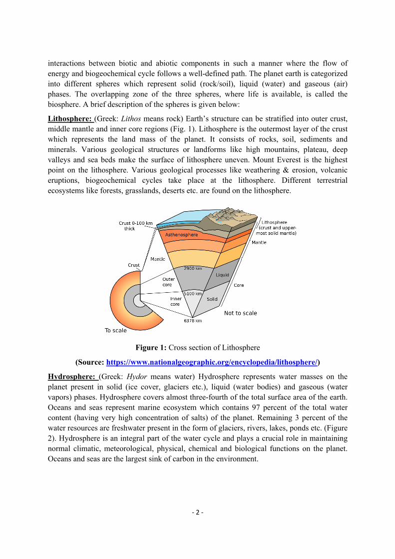
interactions between biotic and abiotic components in such a manner where the flow of energy and biogeochemical cycle follows a well-defined path. The planet earth is categorized into different spheres which represent solid (rock/soil), liquid (water) and gaseous (air) phases. The overlapping zone of the three spheres, where life is available, is called the biosphere. A brief description of the spheres is given below:
Lithosphere: (Greek: Lithos means rock) Earth’s structure can be stratified into outer crust, middle mantle and inner core regions (Fig. 1). Lithosphere is the outermost layer of the crust which represents the land mass of the planet. It consists of rocks, soil, sediments and minerals. Various geological structures or landforms like high mountains, plateau, deep valleys and sea beds make the surface of lithosphere uneven. Mount Everest is the highest point on the lithosphere. Various geological processes like weathering & erosion, volcanic eruptions, biogeochemical cycles take place at the lithosphere. Different terrestrial ecosystems like forests, grasslands, deserts etc. are found on the lithosphere.
Figure 1: Cross section of Lithosphere
(Source: https://www.nationalgeographic.org/encyclopedia/lithosphere/)
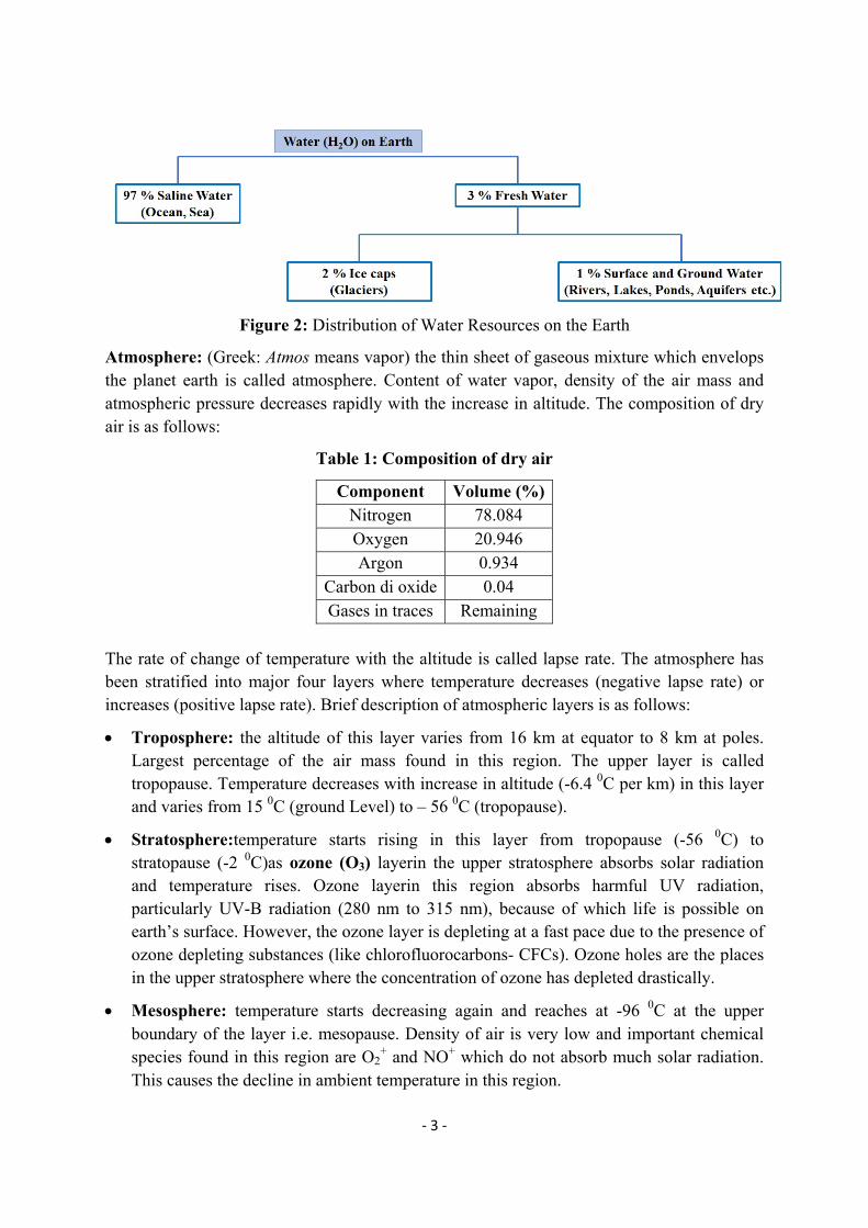
Hydrosphere: (Greek: Hydor means water) Hydrosphere represents water masses on the planet present in solid (ice cover, glaciers etc.), liquid (water bodies) and gaseous (water vapors) phases. Hydrosphere covers almost three-fourth of the total surface area of the earth. Oceans and seas represent marine ecosystem which contains 97 percent of the total water content (having very high concentration of salts) of the planet. Remaining 3 percent of the water resources are freshwater present in the form of glaciers, rivers, lakes, ponds etc. (Figure 2). Hydrosphere is an integral part of the water cycle and plays a crucial role in maintaining normal climatic, meteorological, physical, chemical and biological functions on the planet. Oceans and seas are the largest sink of carbon in the environment.
‐ 3 ‐
Figure 2: Distribution of Water Resources on the Earth
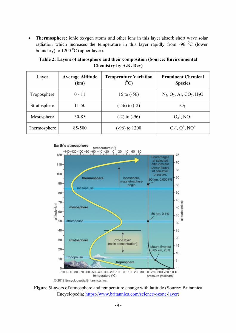
Atmosphere: (Greek: Atmos means vapor) the thin sheet of gaseous mixture which envelops the planet earth is called atmosphere. Content of water vapor, density of the air mass and atmospheric pressure decreases rapidly with the increase in altitude. The composition of dry air is as follows:
Table 1: Composition of dry air
The rate of change of temperature with the altitude is called lapse rate. The atmosphere has been stratified into major four layers where temperature decreases (negative lapse rate) or increases (positive lapse rate). Brief description of atmospheric layers is as follows:
Troposphere: the altitude of this layer varies from 16 km at equator to 8 km at poles. Largest percentage of the air mass found in this region. The upper layer is called tropopause. Temperature decreases with increase in altitude (-6.4 0C per km) in this layer and varies from 15 0C (ground Level) to – 56 0C (tropopause).
Stratosphere:temperature starts rising in this layer from tropopause (-56 0C) to stratopause (-2 0C)as ozone (O3) layerin the upper stratosphere absorbs solar radiation and temperature rises. Ozone layerin this region absorbs harmful UV radiation, particularly UV-B radiation (280 nm to 315 nm), because of which life is possible on earth’s surface. However, the ozone layer is depleting at a fast pace due to the presence of ozone depleting substances (like chlorofluorocarbons- CFCs). Ozone holes are the places in the upper stratosphere where the concentration of ozone has depleted drastically.
Mesosphere: temperature starts decreasing again and reaches at -96 0C at the upper boundary of the layer i.e. mesopause. Density of air is very low and important chemical species found in this region are O2
+ and NO+ which do not absorb much solar radiation. This causes the decline in ambient temperature in this region.
Component Volume (%)Nitrogen 78.084 Oxygen 20.946 Argon 0.934
Carbon di oxide 0.04 Gases in traces Remaining
‐ 4 ‐
Thermosphere: ionic oxygen atoms and other ions in this layer absorb short wave solar radiation which increases the temperature in this layer rapidly from -96 0C (lower boundary) to 1200 0C (upper layer).
Table 2: Layers of atmosphere and their composition (Source: Environmental Chemistry by A.K. Dey)
Layer Average Altitude (km)
Temperature Variation (0C)
Prominent Chemical Species
Troposphere 0 - 11 15 to (-56) N2, O2, Ar, CO2, H2O
Stratosphere 11-50 (-56) to (-2) O3
Mesosphere 50-85 (-2) to (-96) O2+, NO+
Thermosphere 85-500 (-96) to 1200 O2+, O+, NO+
Figure 3Layers of atmosphere and temperature change with latitude (Source: Britannica Encyclopedia; https://www.britannica.com/science/ozone-layer)
‐ 5 ‐
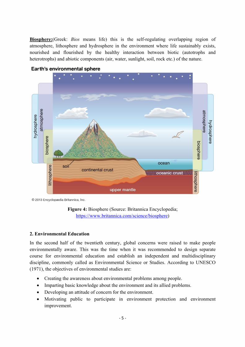
Biosphere:(Greek: Bios means life) this is the self-regulating overlapping region of atmosphere, lithosphere and hydrosphere in the environment where life sustainably exists, nourished and flourished by the healthy interaction between biotic (autotrophs and heterotrophs) and abiotic components (air, water, sunlight, soil, rock etc.) of the nature.
Figure 4: Biosphere (Source: Britannica Encyclopedia; https://www.britannica.com/science/biosphere)
2. Environmental Education
In the second half of the twentieth century, global concerns were raised to make people environmentally aware. This was the time when it was recommended to design separate course for environmental education and establish an independent and multidisciplinary discipline, commonly called as Environmental Science or Studies. According to UNESCO (1971), the objectives of environmental studies are:
Creating the awareness about environmental problems among people.
Imparting basic knowledge about the environment and its allied problems.
Developing an attitude of concern for the environment.
Motivating public to participate in environment protection and environment improvement.
‐ 6 ‐
Acquiring skills to help the concerned individuals in identifying and solving environmental problems.
Striving to attain harmony with Nature. UNESCO and UNEP jointly organized first intergovernmental conference on environmental education in 1977 at Tbilisi, Georgia. The goals of the conference were:
To foster clear awareness of, and concern about, economic, social, political, and ecological interdependence in urban and rural areas;
To provide every person with opportunities to acquire the knowledge, values, attitudes, commitment, and skills needed to protect and improve the environment;
To create new patterns of behavior of individuals, groups, and society as a whole towards the environment.
The categories of environmental education objectives are:
Awareness—to help social groups and individuals acquire an awareness and sensitivity to the total environment and its allied problems.
Knowledge—to help social groups and individuals gain a variety of experience in, and acquire a basic understanding of, the environment and its associated problems.
Attitudes—to help social groups and individuals acquire a set of values and feelings of concern for the environment and the motivation for actively participating in environmental improvement and protection.
Skills—to help social groups and individuals acquire the skills for identifying and solving environmental problems.
Participation—to provide social groups and individuals with an opportunity to be actively involved at all levels in working toward resolution of environmental problems.
Environmental Education in India: India also started taking significant steps to propagate environmental education. At post-graduation level, the environmental education was started by many central and state universities in India during 1985-2000. In 1991, Hon. Supreme Court of India gave historical ruling to implement environmental education at all the levels and gave directions to make Environmental Studies a compulsory paper for all the streams at under-graduate levels in Indian universities. At present, various short-term and regular courses on environment and its various dimensions are being run in various universities in India.
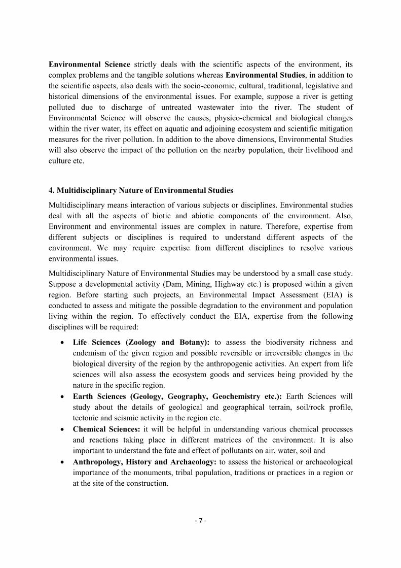
3. Difference between Environmental Science and Environmental Studies
Environmental Studies: Environmental studies is multidisciplinary subject which studies about various dimensions (scientific, social, cultural, economic, political etc.) of the environment, its issues and challenges and tangible solutions in a holistic way. It studies the human-environment interaction and its results at micro and macro level.
‐ 7 ‐
Environmental Science strictly deals with the scientific aspects of the environment, its complex problems and the tangible solutions whereas Environmental Studies, in addition to the scientific aspects, also deals with the socio-economic, cultural, traditional, legislative and historical dimensions of the environmental issues. For example, suppose a river is getting polluted due to discharge of untreated wastewater into the river. The student of Environmental Science will observe the causes, physico-chemical and biological changes within the river water, its effect on aquatic and adjoining ecosystem and scientific mitigation measures for the river pollution. In addition to the above dimensions, Environmental Studies will also observe the impact of the pollution on the nearby population, their livelihood and culture etc.
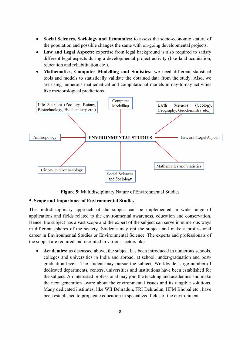
4. Multidisciplinary Nature of Environmental Studies
Multidisciplinary means interaction of various subjects or disciplines. Environmental studies deal with all the aspects of biotic and abiotic components of the environment. Also, Environment and environmental issues are complex in nature. Therefore, expertise from different subjects or disciplines is required to understand different aspects of the environment. We may require expertise from different disciplines to resolve various environmental issues.
Multidisciplinary Nature of Environmental Studies may be understood by a small case study. Suppose a developmental activity (Dam, Mining, Highway etc.) is proposed within a given region. Before starting such projects, an Environmental Impact Assessment (EIA) is conducted to assess and mitigate the possible degradation to the environment and population living within the region. To effectively conduct the EIA, expertise from the following disciplines will be required:
Life Sciences (Zoology and Botany): to assess the biodiversity richness and endemism of the given region and possible reversible or irreversible changes in the biological diversity of the region by the anthropogenic activities. An expert from life sciences will also assess the ecosystem goods and services being provided by the nature in the specific region.
Earth Sciences (Geology, Geography, Geochemistry etc.): Earth Sciences will study about the details of geological and geographical terrain, soil/rock profile, tectonic and seismic activity in the region etc.
Chemical Sciences: it will be helpful in understanding various chemical processes and reactions taking place in different matrices of the environment. It is also important to understand the fate and effect of pollutants on air, water, soil and
Anthropology, History and Archaeology: to assess the historical or archaeological importance of the monuments, tribal population, traditions or practices in a region or at the site of the construction.
‐ 8 ‐
Social Sciences, Sociology and Economics: to assess the socio-economic stature of the population and possible changes the same with on-going developmental projects.
Law and Legal Aspects: expertise from legal background is also required to satisfy different legal aspects during a developmental project activity (like land acquisition, relocation and rehabilitation etc.).
Mathematics, Computer Modelling and Statistics: we need different statistical tools and models to statistically validate the obtained data from the study. Also, we are using numerous mathematical and computational models in day-to-day activities like meteorological predictions.
Figure 5: Multidisciplinary Nature of Environmental Studies
5. Scope and Importance of Environmental Studies
The multidisciplinary approach of the subject can be implemented in wide range of applications and fields related to the environmental awareness, education and conservation. Hence, the subject has a vast scope and the expert of the subject can serve in numerous ways in different spheres of the society. Students may opt the subject and make a professional career in Environmental Studies or Environmental Science. The experts and professionals of the subject are required and recruited in various sectors like:
Academics: as discussed above, the subject has been introduced in numerous schools, colleges and universities in India and abroad, at school, under-graduation and post-graduation levels. The student may pursue the subject. Worldwide, large number of dedicated departments, centers, universities and institutions have been established for the subject. An interested professional may join the teaching and academics and make the next generation aware about the environmental issues and its tangible solutions. Many dedicated institutes, like WII Dehradun, FRI Dehradun, IIFM Bhopal etc., have been established to propagate education in specialized fields of the environment.
‐ 9 ‐
Research & Development: research and post-doctoral works have been going on worldwide to understand the environmental mechanisms and to get cost-effective cutting-edge technologies to mitigate environmental issues and challenges.
Industries: in order to effectively implement the environmental guidelines and technologies and to mitigate the environmental degradation directly or indirectly caused by the industries, a large number of industries have been recruiting environmental engineers/scientists/experts.
Ministries and Agencies: ministry of environment and various environmental agencies & conventions of national and international repute frequently create vacancies for the environmental experts. Few of the examples of such agencies are UNEP, IPCC, CITES, RAMSAR, USEPA etc.
Non-governmental Organizations (NGOs) and Consultancy: a large number of national and international NGOs and consultancies are working as an extended hand to conserve the environment and its various components. Most of the NGOs and consultancies are old and have an experienced workforce. Some of the examples are Bombay Natural History Society, IUCN, Conservation International, World Wide Fund for Nature, Wildlife Trust of India, Centre for Environmental Education, Centre for Science and Environment, Kalpavriksha, Madras Crocodile Bank Trust etc.
Green Journalism: environmental awareness is indispensable for the environmental conservation and media (print, electronic and social media) is the strongest medium to propagate the awareness. Green journalism is the term given when media raises the environmental issues and its practical solutions suggested by the experts of the subject.
Environmental legislation and Green Advocacy: for an effective environmental conservation, it is indispensable to have stringent legislative provision and effective implementation of the same. Legal experts specialized in environmental law may act significantly in environmental conservation.
In the last five decades, Environmental Studies or Environmental Science has emerged as an important multidisciplinary subject dealing with all the aspects of issues and challenges of the environment and it also suggests practical solutions to the environmental problems. The subject is still evolving as the environmental problems are also growing in intensity and magnitude at a fast pace. Anthropogenic activities have created the issues like pollution caused by conventional and emerging pollutants, biodiversity loss, global warming-climate change, growing global energy demands, utmost pressure on the natural resources etc., which are causing serious threats to the life on the planet. Environmental Studies has given tangible solutions to the environmental problems. Some of the prominent fields, which the subject addresses may be summarized as Environmental Education and Ethics, Ecosystem and ecology, Natural Resources Management, Energy Efficiency and Audit, Renewable sources of energy, Global warming-climate change, Biodiversity Conservation, Pollution monitoring and mitigation, Population and Environment, Waste management etc. Hence, it is necessary to make the newer generations aware about the basics and details of the subject.
‐ 10 ‐
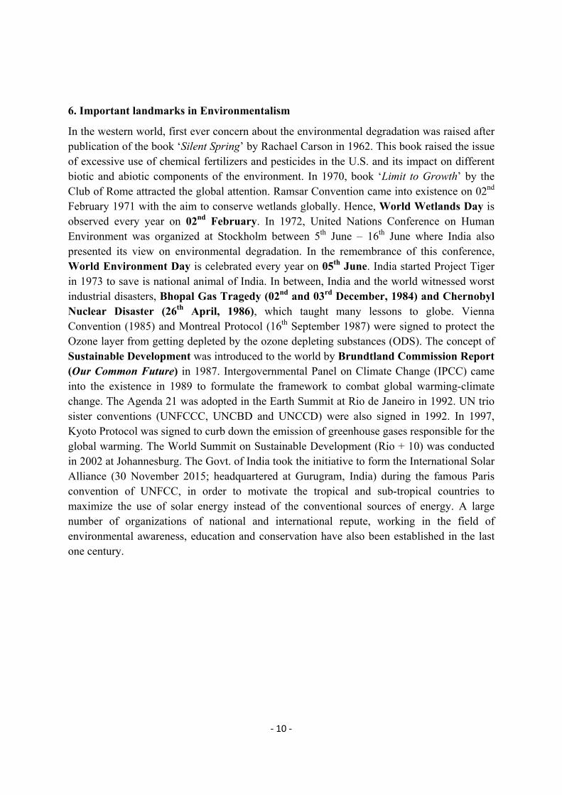
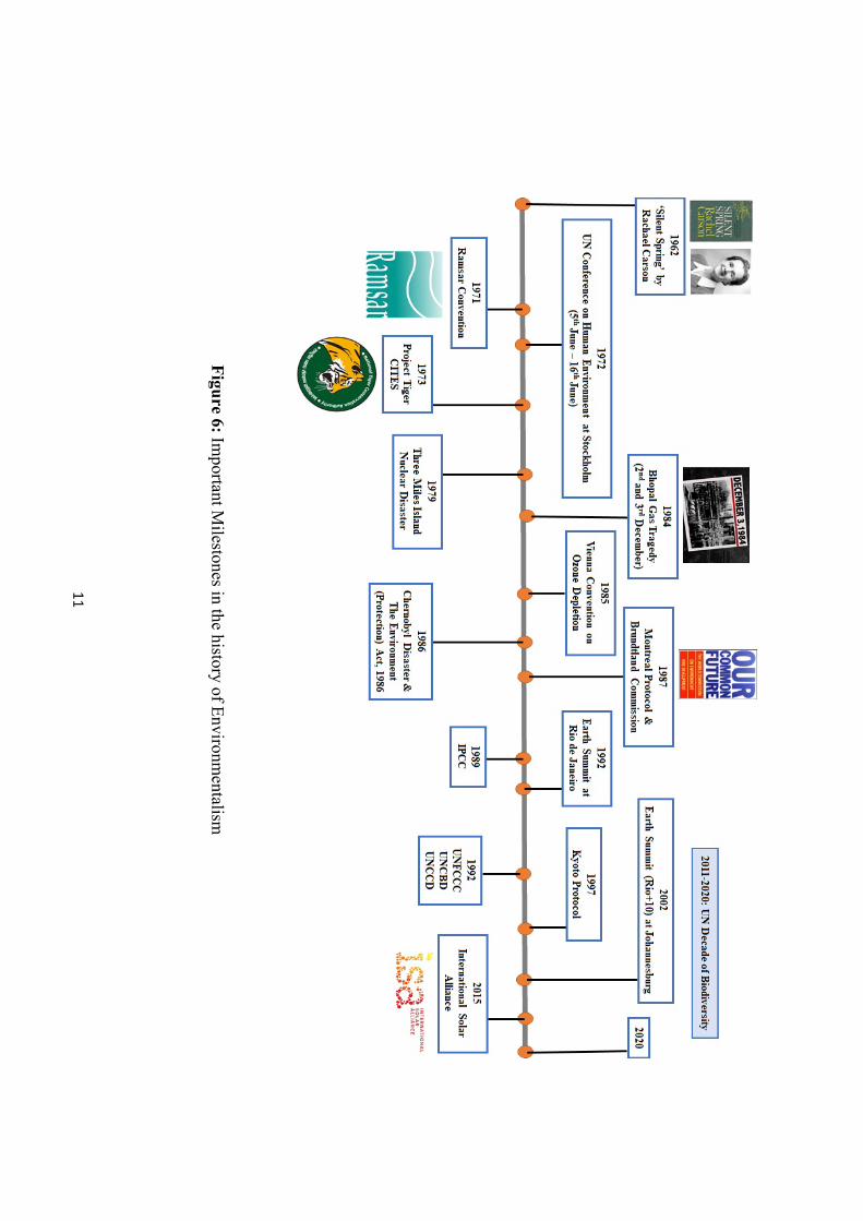
6. Important landmarks in Environmentalism
In the western world, first ever concern about the environmental degradation was raised after publication of the book ‘Silent Spring’ by Rachael Carson in 1962. This book raised the issue of excessive use of chemical fertilizers and pesticides in the U.S. and its impact on different biotic and abiotic components of the environment. In 1970, book ‘Limit to Growth’ by the Club of Rome attracted the global attention. Ramsar Convention came into existence on 02nd February 1971 with the aim to conserve wetlands globally. Hence, World Wetlands Day is observed every year on 02nd February. In 1972, United Nations Conference on Human Environment was organized at Stockholm between 5th June – 16th June where India also presented its view on environmental degradation. In the remembrance of this conference, World Environment Day is celebrated every year on 05th June. India started Project Tiger in 1973 to save is national animal of India. In between, India and the world witnessed worst industrial disasters, Bhopal Gas Tragedy (02nd and 03rd December, 1984) and Chernobyl Nuclear Disaster (26th April, 1986), which taught many lessons to globe. Vienna Convention (1985) and Montreal Protocol (16th September 1987) were signed to protect the Ozone layer from getting depleted by the ozone depleting substances (ODS). The concept of Sustainable Development was introduced to the world by Brundtland Commission Report (Our Common Future) in 1987. Intergovernmental Panel on Climate Change (IPCC) came into the existence in 1989 to formulate the framework to combat global warming-climate change. The Agenda 21 was adopted in the Earth Summit at Rio de Janeiro in 1992. UN trio sister conventions (UNFCCC, UNCBD and UNCCD) were also signed in 1992. In 1997, Kyoto Protocol was signed to curb down the emission of greenhouse gases responsible for the global warming. The World Summit on Sustainable Development (Rio + 10) was conducted in 2002 at Johannesburg. The Govt. of India took the initiative to form the International Solar Alliance (30 November 2015; headquartered at Gurugram, India) during the famous Paris convention of UNFCC, in order to motivate the tropical and sub-tropical countries to maximize the use of solar energy instead of the conventional sources of energy. A large number of organizations of national and international repute, working in the field of environmental awareness, education and conservation have also been established in the last one century.
11
Figu
re 6: Important M
ilestones in the history of Environm
entalism
12
7.Concept of Sustainability and Sustainable Development
It was the global perception that the environmental conservation and economic development cannot be pursued together. With the onset of 1980s, the world started finding the middle path so that the long-term economic development may be pursued without harming the environment. With this aim, the United Nations established World Commission on Environment and Development (WCED), under the chairmanship of Geo Harlem Brundtland (former Prime Minister of Norway) in December 1983. Hence, this commission is commonly known as the Brundtland Commission. The task of the commission was to formulate “A global agenda for change”. Brundtland Commission submitted its report entitled “Our Common Future” in 1987 which gave the concept of Sustainable Development to the world. Report defines Sustainable Development as “development that meets the needs of the present without compromising the ability of future generations to meet their own needs.”
Sustainability (Latin: sustinere means to hold up) is a long-term idea that means making the entire world sustainable. However, sustainable development refers to pathways by which the goal of sustainability and sustainable world can be achieved.
Sustainable Development Goals (SDGs): these are the seventeen goals set as the ‘2030 agenda for sustainable development’. It was adopted by the United Nations state members in 2015 as ‘a blueprint for peace and prosperity for people and planet, now and into the future.’ All the developed and developing countries have been called to achieve the goals by global partnership.
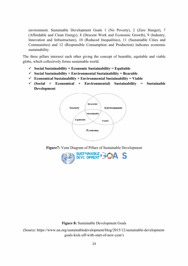
Society, environment and economy, collectively considered as the three pillars of sustainable development. When the three pillars harmonically interact with each other, sustainability and sustainable development is achieved. A brief description of the three pillars is given below:
Environmental Sustainability: it means that we should consume the environmental goods and services in a sustainable manner. Mahatma Gandhi, once rightly said “Earth provides enough to satisfy every man’s need but not everyone’s greed”. The present rate of over-exploitation of natural resources exceeds manifolds the rate of replenishment of the same, which is causing environmental degradation at an exponential rate. Therefore, the natural resources should be utilized sustainably. Sustainable Development Goals 6 (Clean Water and Sanitation), 7 (Affordable and Clean Energy), 13 (Climate Action), 14 (Life below Water) and 15 (Life on Land) indicates environmental sustainability.
Social Sustainability: it defines a society having fair and equal opportunities for its population with gender equality, good health and education facilities and people’s participation in nation building. Sustainable Development Goals 3 (Good Health and Well-Being), 4 (Quality Education), 5 (Gender Equality), 7 (Affordable and Clean Energy), 16 (Peace, Justice and strong Institutions) and 17 (Partnerships for the Goals) indicates social sustainability.
Economic Sustainability: economic sustainability means the equitable distribution of the resources. No one should be deprived of the basic needs to sustain a healthy life. Benefits should be earned from the resources but not at the cost of irreversible loss to the
env(AffInnoComsust
The thrglobe, w
(Source
ironment. ffordable anovation andmmunities) tainability.
ree pillars iwhich collec
Social SustSocial SustEconomica(Social +Developme
Fig
e: https://ww
Sustainablend Clean End Infrastrucand 12 (R
intersect eactively form
tainability tainability al Sustaina
+ Economent
gure7: Venn
Figu
ww.un.org/sgo
e Developmnergy), 8 (Dcture), 10 (
Responsible
ach other gims sustainab
+ Economi+ Environmbility + En
mical + E
n Diagram o
ure 8: Susta
sustainabledoals-kick-off
13
ment GoalsDescent Wo(Reduced IConsumpt
iving the cble world.
ic Sustainamental Sus
nvironmentEnvironme
of Pillars of
ainable Dev
developmenff-with-start-
1 (No Poork and EcInequalities)ion and Pr
oncept of b
ability = Eqstainabilityal Sustaina
ental) Sus
f Sustainabl
velopment G
nt/blog/2015-of-new-yea
overty), 2 conomic Gr), 11 (Sustroduction) i
bearable, eq
quitable = Bearabl
ability = Vistainability
e Developm
Goals
5/12/sustainar/)
(Zero Hunrowth), 9 (Itainable Citindicates ec
quitable and
e iable y = Sust
ment
nable-develo
nger), 7 Industry, ties and conomic
d viable
tainable
opment-
14
QUESTIONS FOR PRACTICE
One-word answer type Question
1. Title of the Brundtland Commission Report was _____________
2. Number of Sustainable Development Goals are _______
3. World Environment Day in observed every year on _________
4. Lowest layer of the atmosphere is _________
5. Bhopal Gas Tragedy took place on _______________
Answers: 1- Our Common Future; 2- Seventeen; 3- 05th June; 4- Troposphere; 5- 02nd – 03rd December, 1984
Match the following
A. Silent Spring 1. Stratosphere
B. Sustainable Development 2. 1972
C. Ozone layer 3. Wetlands Conservation
D. UN Conference on Human Environment 4. Brundtland Commission
E. Ramsar Convention 5. Rachael Carson
Answers: A- 5; B- 4; C- 1; D- 2; E- 3
Short answer type Question
Define sustainable development
Define Biosphere
Long answer type Question
What do you understand by the multidisciplinary nature of Environmental Studies? How the multidisciplinary approach is helpful in solving various environmental problems?
Describe the various components of atmosphere
Discuss Sustainable Development. Write a short note on Sustainable Development Goals.
15
GLOSSARY
Atmosphere: thin blanket of gaseous mixture which envelops the planet and essential for the survival of biotic components on earth
Biosphere: sphere on and around the earth having life
Brundtland Commission: World Commission on Environment and Development, commonly known as the Brundtland Commission, gave the concept of sustainable development to the world.
Environment: Every biotic and abiotic component that surrounds us forms the environment.
Environmental Studies:Environmental studies is multidisciplinary subject which studies about various dimensions (scientific, social, cultural, economic, political etc.) of the environment, its issues and challenges and tangible solutions in a holistic way. It studies the human-environment interaction and its results at micro and macro level.
Hydrosphere: depicts the area on earth covered with water
Lithosphere: solid surface part of the earth
Multidisciplinary: interaction of various subjects or disciplines to address a complex issue or subject
Sustainable Development: development that meets the needs of the present without compromising the ability of future generations to meet their own needs
16
LESSION-2
ECOSYSTEM: STRUCTURE OF ECOSYSTEM
Dr. Nibedita Khuntia Assistant Professor,
Maharaja Agrasen College, University of Delhi.
INTRODUCTION
We are not alone in this world. We share our resources with other life forms. There are non-living things around us as well. Throughout our lifetime we keep on interacting with other living beings and non-living things.
LEARNING OBJECTIVES
After going through this lesson, you will be able to
1. Know the concept, definition and structure of ecosystem.
2. Distinguish between biotic and abiotic components of ecosystem.
3. Explain the different types of ecological pyramids.
4. Understand the term ecological succession.
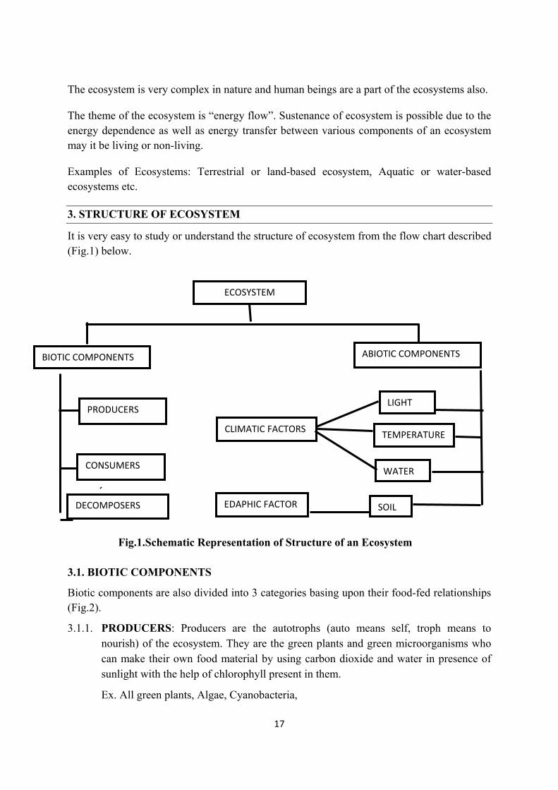
1. CONCEPT OF ECOSYSTEM
Ecosystem is the basic structural and functional unit of the environment. Both the living and non-living component of the nature, when interact with each other to establish a stable living community, it is called as Ecosystem. That means there is a constant exchange of something between these living & non-livings, is called an Ecosystem. Without the living component, establishment of an ecosystem is not possible and vice versa. Both are two sides of a coin or very much complementary to each other.
The study of ecosystem includes complete analysis of the structure, regulation and the role of each and every component functioning there. Once we know it, in detail, the study of the ecosystem and its importance to the equilibrium of environment will be understood easily.
2. DEFINITION OF ECOSYSTEM
The study of all the physical as well as biological processes including the distribution and abundance of living organisms and the interaction in between them with their surrounding environment is known as Ecosystem. In simpler words, if any environmental changes occur in the physical or abiotic factors, they in turn change the type and number of the organisms that is both the plants and the animals, present in that particular area.
17
The ecosystem is very complex in nature and human beings are a part of the ecosystems also.
The theme of the ecosystem is “energy flow”. Sustenance of ecosystem is possible due to the energy dependence as well as energy transfer between various components of an ecosystem may it be living or non-living.
Examples of Ecosystems: Terrestrial or land-based ecosystem, Aquatic or water-based ecosystems etc.
3. STRUCTURE OF ECOSYSTEM
It is very easy to study or understand the structure of ecosystem from the flow chart described (Fig.1) below.
Fig.1.Schematic Representation of Structure of an Ecosystem
3.1. BIOTIC COMPONENTS
Biotic components are also divided into 3 categories basing upon their food-fed relationships (Fig.2).
3.1.1. PRODUCERS: Producers are the autotrophs (auto means self, troph means to nourish) of the ecosystem. They are the green plants and green microorganisms who can make their own food material by using carbon dioxide and water in presence of sunlight with the help of chlorophyll present in them.
Ex. All green plants, Algae, Cyanobacteria,
ECOSYSTEM
BIOTIC COMPONENTS ABIOTIC COMPONENTS
PRODUCERS
CONSUMERS
DECOMPOSERS SOIL
WATER
TEMPERATURE
LIGHT
CLIMATIC FACTORS
EDAPHIC FACTOR
18
3.1.2. CONSUMERS: Consumers are the heterotrophs (hetero-not self troph to nourish) of an ecosystem. They depend on the producers of the nature to get energy. Consumers are also different types like
a) Primary Consumers – They are the herbivores who eat directly the autotrophs / plants. They cannot eat any animals.
Ex. Grasshoppers, Rabbits, Goats.
b) Secondary Consumers – They cannot directly eat the producers of the ecosystem, that is the plants. They can eat only herbivores.
Ex. Frogs, Jackal, Snakes
c) Tertiary Consumers – They are carnivores in nature means they are the meat eaters. Thus, they depend on the secondary consumer for their food. They are the top-level carnivores.
Ex. – Tigers, Lions, Vulture, Kite
3.1.3. DECOMPOSERS: Decomposers are also to some extent heterotrophic in nature. They do not contain chlorophyll, so depend on other material for food and energy. These organisms can grow on the dead and decay materials of the environment. That is why they are known as the decomposers or saprophyte, or scavengers of the nature or they can be called as the detrivores (Detri means dead particulate organic material). They can live in any type of soil with organic waste. They play a very important role for the completion of the Biogeochemical Cycle in the environment.
Ex. Bacteria, Fungi, Earthworm
Sr.No. Type of
Ecosystem
Primary Consumer Secondary Consumer
Tertiary Consumer
1 Grassland Ecosystem
Grasshoppers, Rabbits, Deer, Sheep, Goats etc
Frogs, Lizards, Birds, Snakes
Hawks, Eagle, Tiger Etc
2 Forest Ecosystem
Leafhoppers, Bugs, Flies, Squirrels, Insects, Deer, Fruit bats, Nilgai, Elephants etc.
Birds, Owl, Lizards, Wolves, Jackals, etc.
Tiger, Lion etc
3 Desert Ecosystem
Insects, Rats Birds Camel, Squirrel
Scorpions, Fox, Jackal, Rattle Snakes, Mongoose etc
Snakes, Fox, Striped Hyena, Sand Cats, Viper, Saharan Cheetah, Eagles, Kites etc.
19
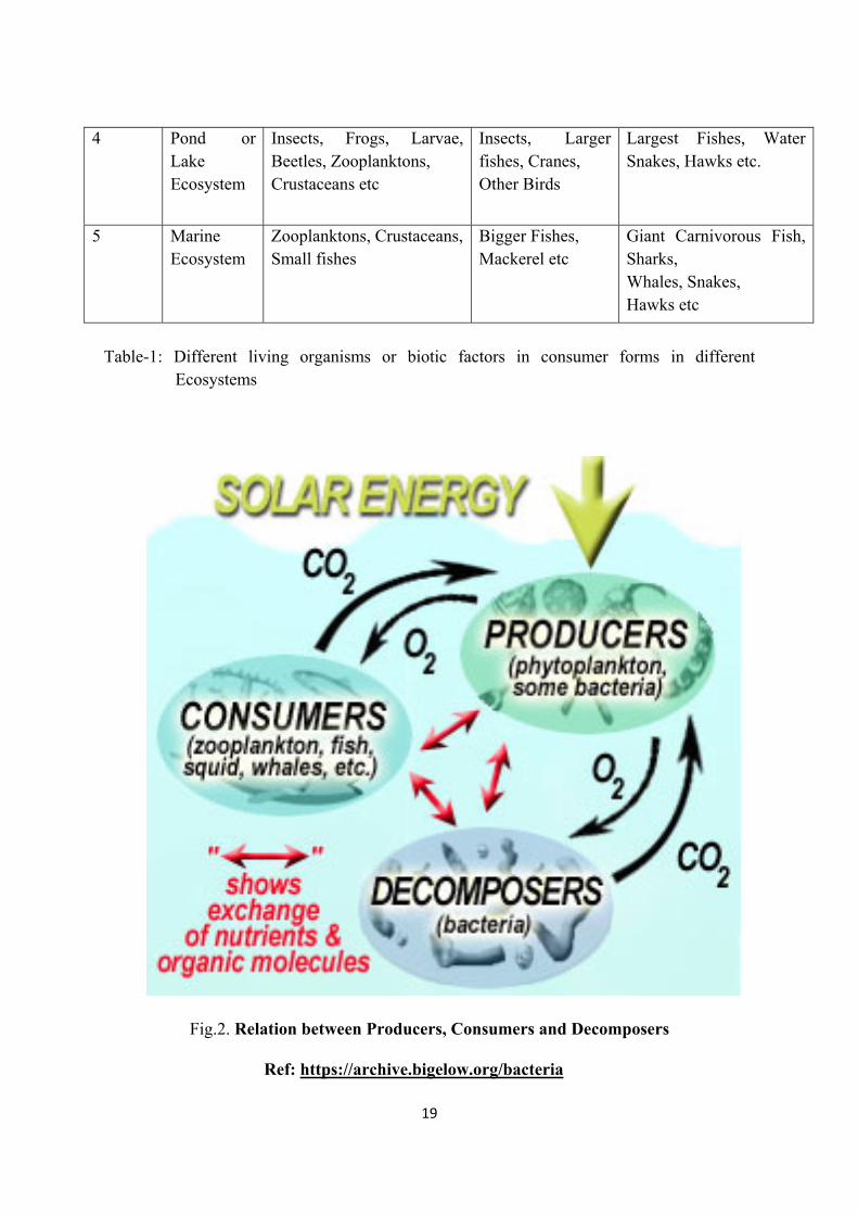
Table-1: Different living organisms or biotic factors in consumer forms in different
Ecosystems
Fig.2. Relation between Producers, Consumers and Decomposers
Ref: https://archive.bigelow.org/bacteria
4 Pond or Lake Ecosystem
Insects, Frogs, Larvae, Beetles, Zooplanktons, Crustaceans etc
Insects, Larger fishes, Cranes, Other Birds
Largest Fishes, Water Snakes, Hawks etc.
5 Marine Ecosystem
Zooplanktons, Crustaceans, Small fishes
Bigger Fishes, Mackerel etc
Giant Carnivorous Fish, Sharks, Whales, Snakes, Hawks etc
20
3.2. ABIOTIC COMPONENTS:
These are the non-living factors in form of solid, liquid or gas found in the nature (ice, water, moisture). They can be categorised into 2 types.
I) Climatic factors
Ex. Light, Temperature, Humidity, Rain etc.
II) Edaphic factors
Ex. Soil, Organic and Inorganic components of the soil, Substratum etc.
Let’s discuss importance of each abiotic factors and their limitations in an ecosystem.
3.2.1. CLIMATIC FACTORS
3.2.1.1. Light – It is an essential factor for all the living organisms like producers, consumers as well as decomposers. In presence of the sunlight plants are able to prepare their food material, which in turn eaten by the heterotrophs & ultimately by the decomposers. Without sun light photosynthesis is not possible thus it is one of the most important abiotic factors of an ecosystem. Quantity as well as quality of light has different impact on different organism. Let’s discuss.
i) Importance of light for plants
a) Chlorophyll production
b) Distribution of plants: The vegetation or the types of plants grow on the earth depends on the amount of sunlight they are getting. Thus the vegetation of temperate, tropical as well as Tundra regions are different from each other.
c) Light thus decides the physiology of the plants of different regions.
d) Temperature: When light increases, temperature also increase and vice versa. When temperature increases rate of transpiration in the plants increases. Thus, the absorption of water from the underground also increases. It clearly explains that temp also plays an important role and decides the type of plants to grow in a particular area.
e) Stomatal Movement: The stomata are present in the leaves of the plants. They control the evaporation of water from a plant body. Thus, by opening and closing, stomata keeps the plant body in a stable physiological status.
f) Duration of Light: During summer and winter months the type of flowers, what we can observe in the nature are different. The basic theory behind it is some plants can bloom in summer months are long day (basing on the exposure to the sun light) plants and some are short day plants (less exposure to sunlight or natural light).
21
ii) Importance of Light for animals
a) Metabolism: Light controls the physiology & metabolism of animals by affecting it’s enzymatic activity.
b) Vision: Without light it is very difficult to see anything. So it is required by all animals.
c) Pigmentation: The process of pigmentation on the skin color depends on the natural light source.
d) Reproduction: Different animals respond to different duration of light exposure for their breeding activities.
e) Circadian Rhythm: Daily response of the animals towards the light condition are known as circadian rhythm. This is an important physiological action of all the living organisms. Thus, it is a light dependent process.
3.2.1.2 Temperature: Temperature affects animals and plants in following ways.
i) Importance of temperature for plants
a) Metabolism: Temperature increase the physiological activity. Thus, the types of plants grow in a desert ecosystem are different from the type of plants of a forest ecosystem and an aquatic ecosystem.
b) On Growth & Development: Different types of plants need different range of temperatures for their growth. Summer growing plants are different from winter season growing plants. This is self-explanatory.
c) Thermal Stratification: Best example is an aquatic ecosystem. The organism growing at surface layer are different as they need more temperature and light than the organisms grow at a deeper level in an aquatic ecosystem.
ii) Importance of Temperature for Animals
Basing on need of the temperature, animals are categorised into two types. Like:
a) Warm-Blooded or Endo- thermic animals
b) Cold – Blooded or Ecto-thermic Animals
Warm blooded animals maintain their body temperature at a constant level. Their body temperature does not change with the environment temperature.
Ex. Mammals, Birds, etc.
The body temperature of the organism when changes with the temperature of the environment, then they are known as Cold Blooded animals.
Ex. Frogs
c) Migration: Temperature is also a factor for migration of animals. It is known as thermal migration. If temperature changes the locomotory animals or birds may change their places for a temporary period & them comeback to their original ecosystem when the weather changes.
22
3.2.1.3. Water: Life is never possible without water. So, water is a very important abiotic factor in an ecosystem. The amount of water present in an area decides the type of ecosystem to be developed there. In this regard sometimes aquatic ecosystems also develop for ex. Pond & Lake ecosystems. If for a longer period of time, due to any reason, a huge amount of water got deposited & replenished repeatedly due to rainfall etc., then through the process of succession an aquatic ecosystem develops and get established there.
Beside for photosynthesis & other metabolic activity plants needs water for circulation of minerals throughout its body.
Water is also an essential requirement of the animals for their metabolic activity.
Water regulates the body temperature of both plants and animals.
Water in forms of rainfall also needed by the ecosystem. It maintains the humidity & content of moisture in the atmosphere. Amount of rainfall also decides the kind of plants to grow over there.
Ex. Deciduous forest, Evergreen forest, Deserts etc.
With the type of vegetation, different types of animals also started living in that particular geographic area.
Water in form of humidity also affects plants and animal lives. Some plants can grow in less humid area where some other plants need more moisture in their environment. Some plants can use atmospheric moisture directly from the environment.
Ex. Epiphytes, Orchids, Lichens, Mosses etc.
Some other needs it in liquid form from underground by the process of absorption.
Ex. Higher plants.
3.2.2. EDAPHIC FACTORS
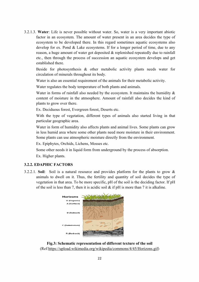
3.2.2.1. Soil: Soil is a natural resource and provides platform for the plants to grow & animals to dwell on it. Thus, the fertility and quantity of soil decides the type of vegetation in that area. To be more specific, pH of the soil is the deciding factor. If pH of the soil is less than 7, then it is acidic soil & if pH is more than 7 it is alkaline.
Fig.3: Schematic representation of different texture of the soil (Ref:https://upload.wikimedia.org/wikipedia/commons/4/45/Horizons.gif)
T
4. ECO
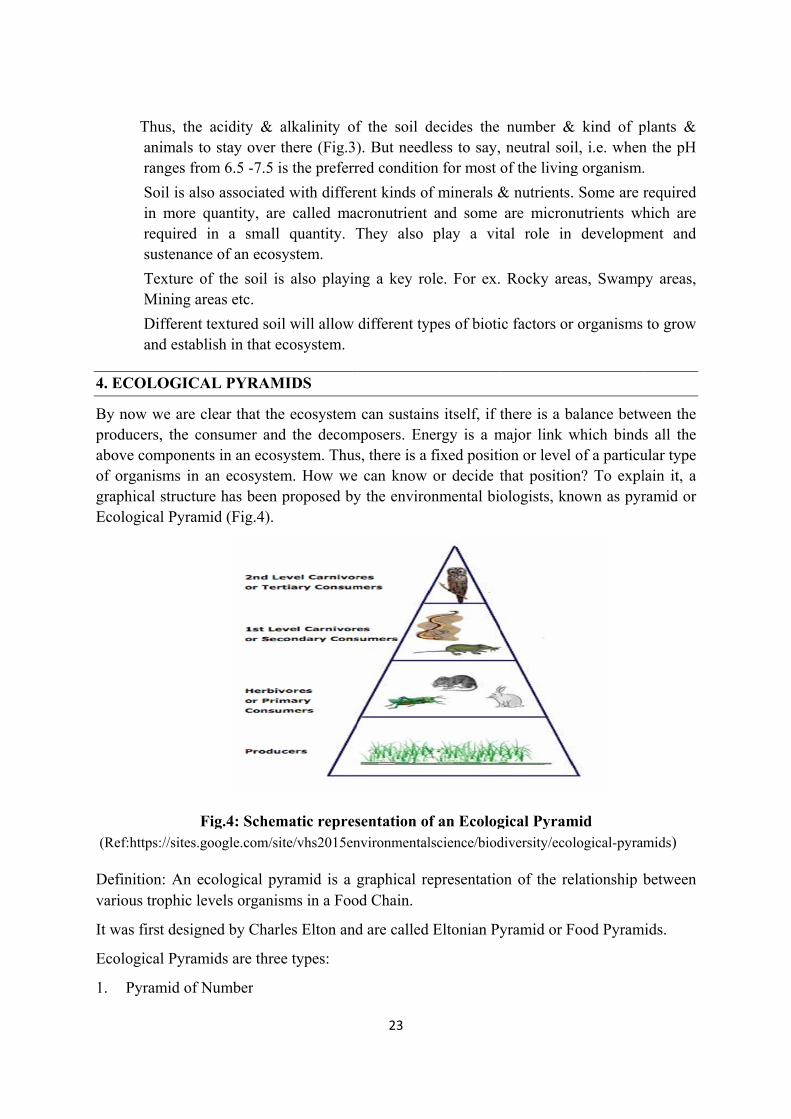
By nowproduceabove cof orgagraphicEcologi
(Ref:htt
Definitivarious
It was f
Ecologi
1. Pyr
Thus, the aanimals to ranges from
Soil is alsoin more qurequired insustenance
Texture of Mining are
Different teand establis
OLOGICAL
w we are cleers, the concomponentsanisms in ancal structureical Pyrami
Fitps://sites.go
ion: An ecotrophic lev
first designe
ical Pyrami
ramid of Nu
acidity & astay over th
m 6.5 -7.5 is
associated uantity, are n a small of an ecosy
the soil is as etc.
extured soil sh in that ec
L PYRAMI
ear that the nsumer ands in an ecosyn ecosysteme has been pd (Fig.4).
g.4: Schemogle.com/sit
ological pyrvels organism
ed by Charle
ds are three
umber
alkalinity ofhere (Fig.3)s the preferr
with differcalled macquantity. T
ystem.
also playin
will allow cosystem.
IDS
ecosystem d the decomystem. Thusm. How weproposed by
matic represte/vhs2015en
ramid is a gms in a Foo
es Elton and
e types:
23
f the soil d). But needred conditio
ent kinds ofcronutrient They also
ng a key ro
different ty
can sustainmposers. Ens, there is a can know
y the enviro
sentation onvironmental
graphical reod Chain.
d are called
decides the less to say,
on for most
f minerals &and some play a vit
ole. For ex.
ypes of bioti
ns itself, if tnergy is a m
fixed positior decide t
onmental bio
f an Ecologlscience/biod
epresentatio
Eltonian Py
number & neutral soiof the living
& nutrients.are micron
tal role in
Rocky are
ic factors or
there is a bmajor link wion or level that positioologists, kn
gical Pyramdiversity/eco
on of the re
yramid or F
& kind of pil, i.e. wheng organism.
. Some are rnutrients wh
developm
eas, Swamp
r organisms
balance betwwhich bindsof a particu
on? To explnown as pyr
mid logical-pyram
elationship b
Food Pyram
plants & n the pH .
required hich are
ment and
py areas,
to grow
ween the s all the ular type lain it, a ramid or
mids)
between
mids.
24
2. Pyramid of Biomass
3. Pyramid of Energy
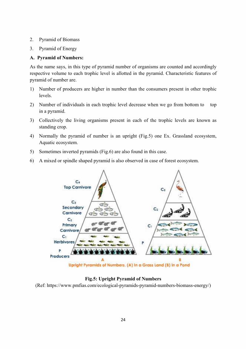
A. Pyramid of Numbers:
As the name says, in this type of pyramid number of organisms are counted and accordingly respective volume to each trophic level is allotted in the pyramid. Characteristic features of pyramid of number are.
1) Number of producers are higher in number than the consumers present in other trophic levels.
2) Number of individuals in each trophic level decrease when we go from bottom to top in a pyramid.
3) Collectively the living organisms present in each of the trophic levels are known as standing crop.
4) Normally the pyramid of number is an upright (Fig.5) one Ex. Grassland ecosystem, Aquatic ecosystem.
5) Sometimes inverted pyramids (Fig.6) are also found in this case.
6) A mixed or spindle shaped pyramid is also observed in case of forest ecosystem.
Fig.5: Upright Pyramid of Numbers
(Ref: https://www.pmfias.com/ecological-pyramids-pyramid-numbers-biomass-energy/)
25
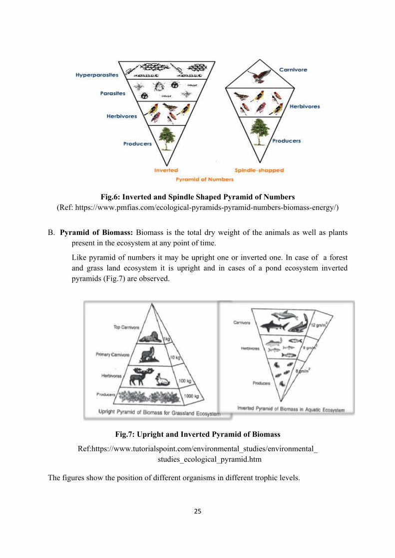
Fig.6: Inverted and Spindle Shaped Pyramid of Numbers (Ref: https://www.pmfias.com/ecological-pyramids-pyramid-numbers-biomass-energy/)
B. Pyramid of Biomass: Biomass is the total dry weight of the animals as well as plants present in the ecosystem at any point of time.
Like pyramid of numbers it may be upright one or inverted one. In case of a forest and grass land ecosystem it is upright and in cases of a pond ecosystem inverted pyramids (Fig.7) are observed.
Fig.7: Upright and Inverted Pyramid of Biomass
Ref:https://www.tutorialspoint.com/environmental_studies/environmental_ studies_ecological_pyramid.htm
The figures show the position of different organisms in different trophic levels.
26
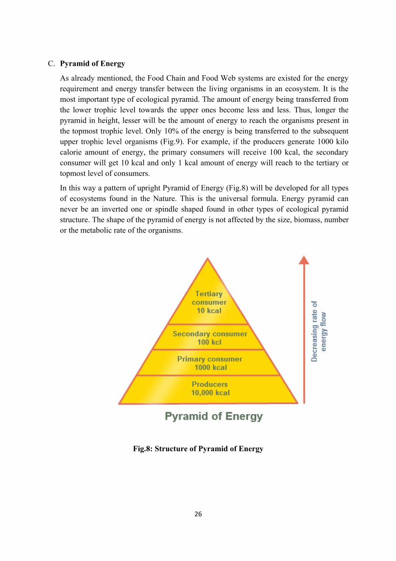
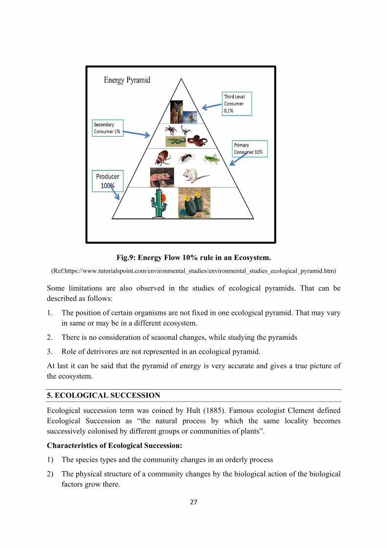
C. Pyramid of Energy
As already mentioned, the Food Chain and Food Web systems are existed for the energy requirement and energy transfer between the living organisms in an ecosystem. It is the most important type of ecological pyramid. The amount of energy being transferred from the lower trophic level towards the upper ones become less and less. Thus, longer the pyramid in height, lesser will be the amount of energy to reach the organisms present in the topmost trophic level. Only 10% of the energy is being transferred to the subsequent upper trophic level organisms (Fig.9). For example, if the producers generate 1000 kilo calorie amount of energy, the primary consumers will receive 100 kcal, the secondary consumer will get 10 kcal and only 1 kcal amount of energy will reach to the tertiary or topmost level of consumers.
In this way a pattern of upright Pyramid of Energy (Fig.8) will be developed for all types of ecosystems found in the Nature. This is the universal formula. Energy pyramid can never be an inverted one or spindle shaped found in other types of ecological pyramid structure. The shape of the pyramid of energy is not affected by the size, biomass, number or the metabolic rate of the organisms.
Fig.8: Structure of Pyramid of Energy
27
Fig.9: Energy Flow 10% rule in an Ecosystem.
(Ref:https://www.tutorialspoint.com/environmental_studies/environmental_studies_ecological_pyramid.htm)
Some limitations are also observed in the studies of ecological pyramids. That can be described as follows:
1. The position of certain organisms are not fixed in one ecological pyramid. That may vary in same or may be in a different ecosystem.
2. There is no consideration of seasonal changes, while studying the pyramids
3. Role of detrivores are not represented in an ecological pyramid.
At last it can be said that the pyramid of energy is very accurate and gives a true picture of the ecosystem.
5. ECOLOGICAL SUCCESSION
Ecological succession term was coined by Hult (1885). Famous ecologist Clement defined Ecological Succession as “the natural process by which the same locality becomes successively colonised by different groups or communities of plants”.
Characteristics of Ecological Succession:
1) The species types and the community changes in an orderly process
2) The physical structure of a community changes by the biological action of the biological factors grow there.
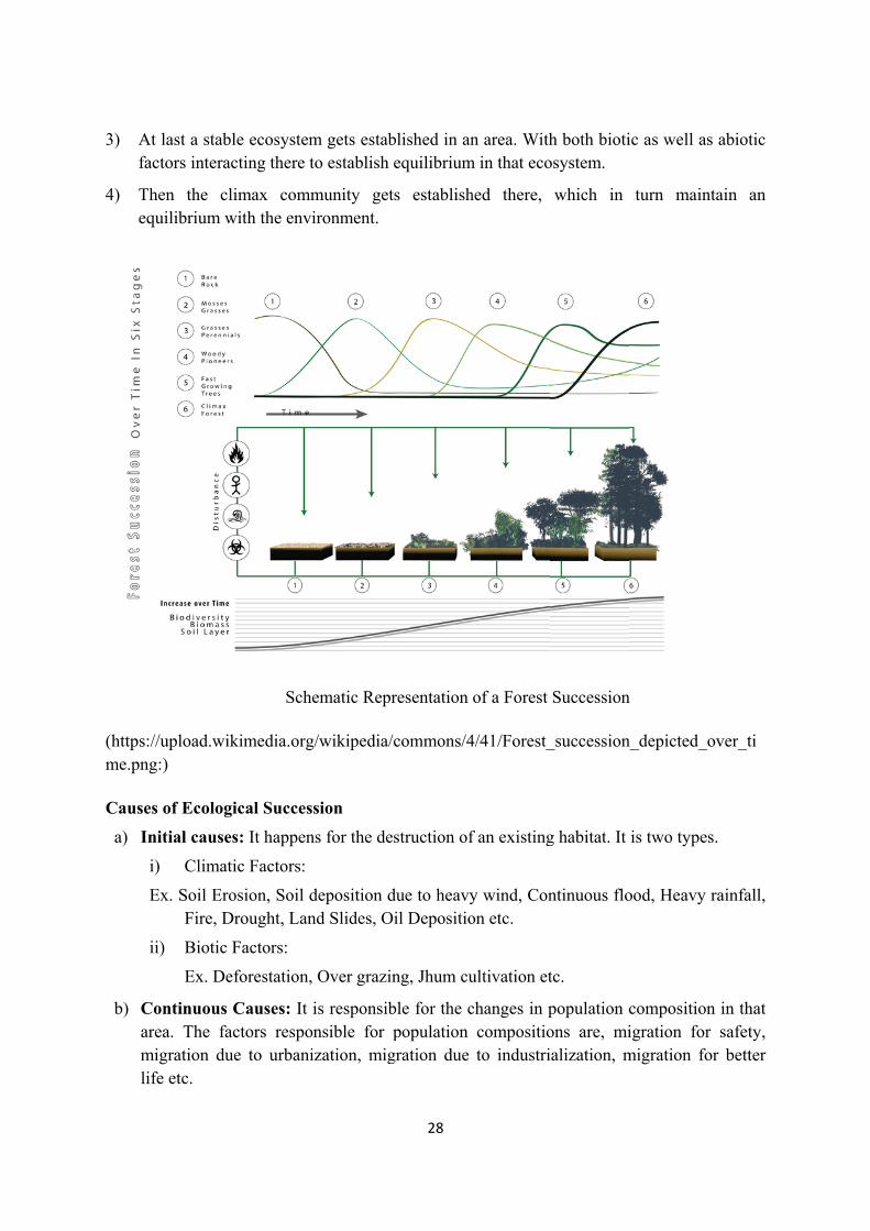
3) At fac
4) Thequ
(https://me.png
Causes
a) In
i)
E
ii
b) Coaremilife
last a stablctors interac
hen the cliuilibrium w
/upload.wik:)
s of Ecologi
itial causes
) Climati
Ex. Soil EroFire, Dr
i) Biotic F
Ex. Def
ontinuous Cea. The facigration duefe etc.
e ecosystemcting there t
imax commwith the envi
Sche
kimedia.org/
ical Success
s: It happen
ic Factors:
osion, Soil drought, Lan
Factors:
forestation,
Causes: It ictors respone to urbaniz
m gets estabo establish
munity getironment.
ematic Repr
/wikipedia/
sion
s for the de
deposition dnd Slides, O
Over grazin
is responsibnsible for pzation, mig
28
blished in anequilibrium
ts establish
resentation
commons/4
struction of
due to heavyil Depositio
ng, Jhum cu
ble for the cpopulation
gration due
n area. Withm in that eco
hed there,
of a Forest
4/41/Forest_
f an existing
y wind, Conon etc.
ultivation et
changes in pcompositioto industri
h both biotiosystem.
which in
Succession
_succession
g habitat. It
ntinuous flo
tc.
population cons are, mialization, m
ic as well as
turn main
n
n_depicted_o
is two type
ood, Heavy
compositionigration formigration fo
s abiotic
ntain an
over_ti
s.
rainfall,
n in that r safety, or better
29
c) Stabilizing Causes: Stabilization of an ecosystem happens due to the climatic condition of that area, availability of minerals, fertility of the land for agriculture as well as growth of different types of producer for a continuous flow of food and energy as discussed earlier.
Types of Ecological Succession
1) Primary succession: It begins from the primitive substation where there was no living factor before.
Ex. Volcanic eruptions, Rocky Areas etc.
2) Secondary Succession: It begins from a previously sustained living matters, but the vegetation got damaged due to any climate factors like flood, fire, acid rain etc.
3) Autogenic Succession: (Auto means self or same, and genic means producing / causing) The developing plant community brings a change in the condition of a particular place, which is not suitable for them, but creates or produces an environment for the growth of a different community. It is a succession driven by biotic components of an ecosystem.
4) Allogenic Succession: (It is caused by abiotic factors) In contrast to autogenic succession, allogenic succession is an abiotic factor driven condition. The habitat of the ecosystem is changed due to volcanic eruption, climate change, comet strike, earthquake, flood, drought etc.
5) Induced Succession: It is a man-made process, developed for the benefit of the humankind.
Ex. Cultivation of Crops in a field.
6) Autotrophic Succession: When a place is rich in inorganic content & poor in organic matter, the development of succession of plants over that area is called as autotrophic succession.
7) Heterotrophic Succession: If a succession begins in an area which is rich in organic contents like forest litter, sewage etc, and dominated by saprophytes like fungi, mushrooms etc is called heterotrophic succession.
8) Retrogressive Succession: Sometimes due to heavy biological or biotic interferences, the succession goes backward instead of progressing. Ex. Forest community changes to a shrub land or grassland or to a barren land due to deforestation and overgrazing.
LEARNING OUTCOME
Ecosystem is the study of living organisms with its surroundings. Thus, it’s an interdependence of biotic and abiotic factors in an area. Presence of only one factor cannot create an ecosystem. In an ecosystem position of different organisms are different. This has been explained through ecological pyramids. The principle of ecological pyramid depends on the food habit of the organisms present in that ecosystem. The development of a new
30
ecosystem on a barren land is known as succession. Sometimes reverse succession also happen that is a well-functioning ecosystem may get destroyed due to some artificial i.e. manmade or due to some natural calamities and gets converted into a barren land.
Some Important Terms used in the Lesson
Allogenic Succession
Autogenic Succession
Autotrophs
Autotrophic Succession
Abiotic Components
Biotic Components
Biomass
Climatic Factors
Decomposers
Detrivores
Ecological Pyramid
Ecological Succession
Ecosystem
Edaphic Factors
Heterotrophic Succession
Heterotrophs
Induced Succession
Primary Succession
Retrogressive Succession
Secondary Succession
PRACTICE QUESTIONS
I. Multiple Choice Questions:
1. Which one of the following is a biotic factor in an ecosystem. a) Oxygen, b) Soil, c) Rocks, d) Lizard
2. ---------------- is an autotroph. a) Fungi, b) Tiger, c) Rabbit, d) Algae
3. Which one of the following is decomposer in an ecosystem. a) Squirrel, b) Insects, c) Earthworms, d) Lizard
Ans-1(d), 2(d), 3(c)
II. Write Short Notes on:
1. Consumers 2. Pyramid of Energy 3. Water as an abiotic factor
III. Long Questions:
1. What do you mean by an Ecosystem.
2. What are the ecological pyramids in an ecosystem.
3. What is succession in an ecosystem. Explain in detail what you know about it.
31
LESSION-3
ECOSYSTEM: FUNCTION OF THE ECOSYSTEM
Dr. Nibedita Khuntia Assistant Professor
Maharaja Agrasen College University of Delhi
INTRODUCTION
Function means the working of a particular ecosystem of a particular area in. It includes the interlinking of organisms, their nutritional requirements, the circulation of nutrients, energy flow, and again decomposition of all the chemicals, both organic as well as inorganic and their release to the atmosphere. Mainly all these activities have been explained under three major categories as follows
1. Biogeochemical Cycle
2. Food chain and Food Web
3. Energy flow in the Ecosystem
4. Productivity
LEARNING OBJECTIVES
After going through this lesson, you will be able to
1. Know the categories and their respective sub-categories of biogeochemical cycle. 2. Understand working of food chain.
3. Distinguish between grazing and detritus food chain.
4. Give schematic representation of food web.
5. Explain energy utilization in an ecosystem.
6. Know the various concepts of productivity.
3.1 BIOGEOCHEMICAL CYCLE
As the name indicates, in an ecosystem, both biological as well as physical components, passing/rolling through the underground and above the ground to complete a cycle. Through Nutrient Cycling various, inorganic and organic compounds are formed and decomposed (normally forty elements are required by the living organisms in the nature). This is also called as nutrient cycles of the ecosystem. "Nature is self-sufficient by nature".
Biogeochemical Cycle has been divided into two major categories like atmospheric and edaphic cycling based on the types of the substance they are dealing with.
32
I) Atmospheric Nutrient Cycle
a) Water Cycle
b) Carbon Cycle
c) Oxygen Cycle
II) Edaphic Nutrients Cycle
a) Nitrogen Cycle
b) Sulphur Cycle
c) Phosphorous Cycle
3.1.1. Atmospheric Nutrient cycle
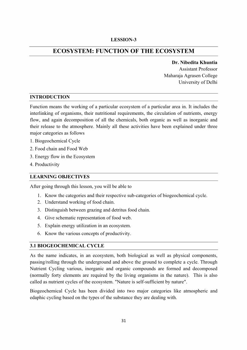
a) Water Cycle: Water is an essential compound for the photosynthesis in plants. Plants absorb water from the underground through the roots, to its upper or aerial parts. This water is used for the process of photosynthesis. Some water gets back to the atmosphere from the plant body through the process of transpiration and some are utilized by the plants for its metabolic activity(Fig.1).
The driving force for a water cycle is the solar radiation which is 15% of the total radiation reaching on the earth. Though the radiation water gets evaporated from the surface of the waterbodies, it comes back to the surface of earth as rain. The above figure clearly teaches us how the cycling of this vital resource occurs on the earth.
Fig.1: The Water Cycle (Ref: https://upload.wikimedia.org/wikipedia/commons /9/94/Water_cycle.png)
33
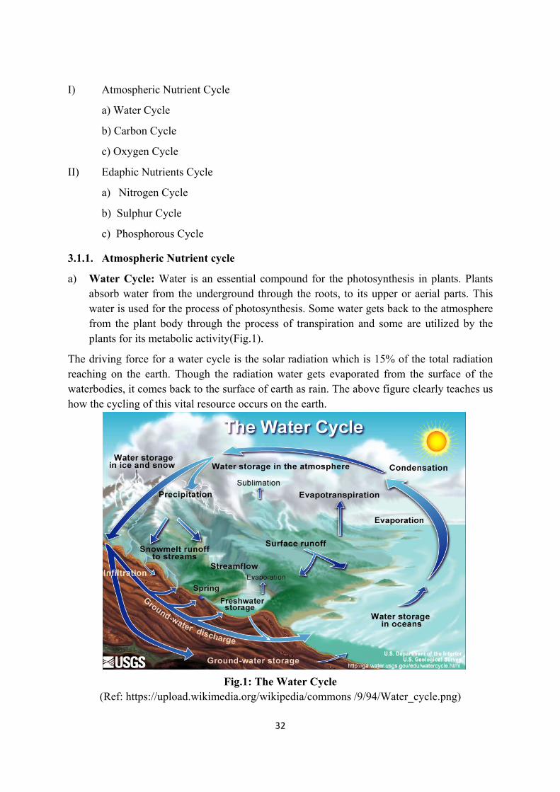
b) Carbon Cycle: Carbon Dioxide is an important gas present in the nature Plants needs it for the process of photosynthesis to prepare the food material that is carbohydrates for its own as well as for heterotrophs. That means it gets locked into the organic matter through the process of photosynthesis. Carbon Dioxide released to the atmosphere by respiration of all the living organisms on the earth. Earth’s Crusts also releases carbon which is present in forms of Calcium Carbonates (CaCO3) and Magnesium Carbonates (MgCO3) which comes from the skeletons of marine organisms in the process of mineralization. By subsequent weathering these Calcium Carbonates and Magnesium Carbonates get mixed with the soil and add to the soil nutrition. In this way ultimately these carbon rich organic matters accumulate in the ecosystems.
Fig.2: Carbon Cycle
(Ref: https://d32ogoqmya1dw8.cloudfront.net/images/clean/literacy/tlp /carbocycle/carbon_cycle_diagram_1466775306722780178.jpg
34
By burning of fossil fuel, coal & wood large amount of carbon dioxide get released to the atmosphere. These carbon dioxides get assimilated by the plants. The animals consume these carbohydrates, that is the photosynthetic products. The carbohydrates consumed, in this way reach to the heterotrophs. When these heterotrophs die, carbon again goes back to earth’s crust. Through the process of respiration also carbon dioxide released from the biotic components to the atmosphere (Fig.2).
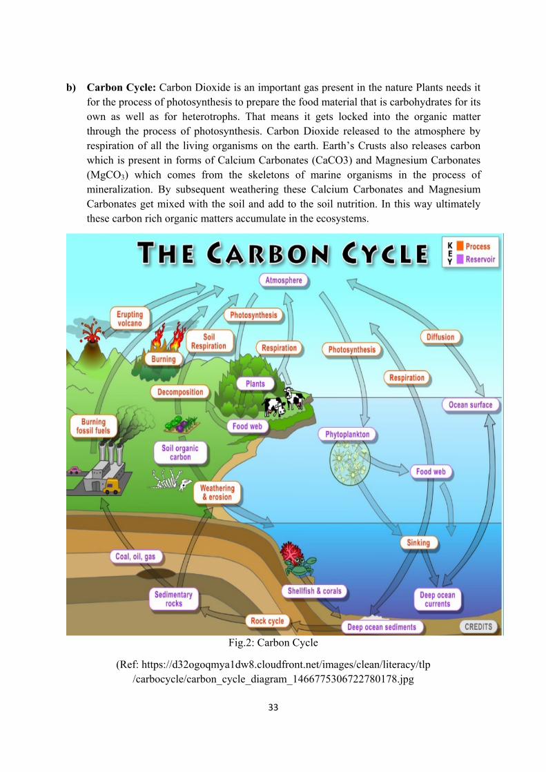
c) Oxygen Cycle: In the atmosphere the dry air contains 20.94% of oxygen. Oxygen is required by all the living organisms for respiration. It is also associated with the moisture content. It is the simplest but inevitable nutrient cycle in the ecosystems (Fig.3) .
Fig.3: Oxygen Cycle (Ref:https://www.universetoday.com/61080/oxygen-cycle)
3.1.2. Edaphic Nutrient Cycle:
a) Nitrogen Cycle: It is a complex cycle occurs in nature through various steps. About 79% of the atmospheric air is Nitrogen. It enters to the biotic world and got assimilate then again goes back to the atmosphere. Following steps are involved for the completion of Nitrogen cycle (Fig.4).
A. Nitrogen enters to the living organisms: Pure nitrogen gas cannot be used by the green plants. Only Nitrate & Ammonium forms of Nitrogen can be utilized by them.
35
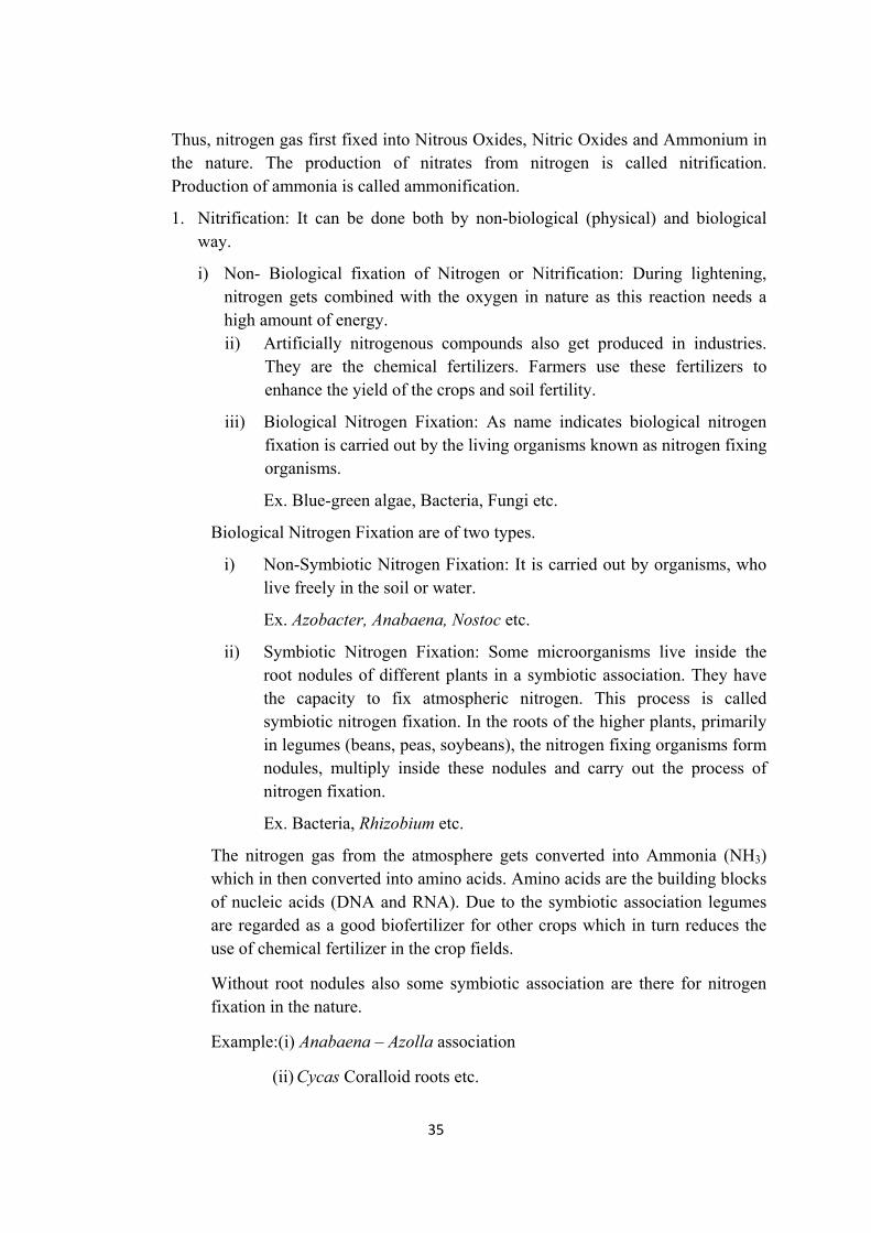
Thus, nitrogen gas first fixed into Nitrous Oxides, Nitric Oxides and Ammonium in the nature. The production of nitrates from nitrogen is called nitrification. Production of ammonia is called ammonification.
1. Nitrification: It can be done both by non-biological (physical) and biological way.
i) Non- Biological fixation of Nitrogen or Nitrification: During lightening, nitrogen gets combined with the oxygen in nature as this reaction needs a high amount of energy. ii) Artificially nitrogenous compounds also get produced in industries.
They are the chemical fertilizers. Farmers use these fertilizers to enhance the yield of the crops and soil fertility.
iii) Biological Nitrogen Fixation: As name indicates biological nitrogen fixation is carried out by the living organisms known as nitrogen fixing organisms.
Ex. Blue-green algae, Bacteria, Fungi etc.
Biological Nitrogen Fixation are of two types.
i) Non-Symbiotic Nitrogen Fixation: It is carried out by organisms, who live freely in the soil or water.
Ex. Azobacter, Anabaena, Nostoc etc.
ii) Symbiotic Nitrogen Fixation: Some microorganisms live inside the root nodules of different plants in a symbiotic association. They have the capacity to fix atmospheric nitrogen. This process is called symbiotic nitrogen fixation. In the roots of the higher plants, primarily in legumes (beans, peas, soybeans), the nitrogen fixing organisms form nodules, multiply inside these nodules and carry out the process of nitrogen fixation.
Ex. Bacteria, Rhizobium etc.
The nitrogen gas from the atmosphere gets converted into Ammonia (NH3) which in then converted into amino acids. Amino acids are the building blocks of nucleic acids (DNA and RNA). Due to the symbiotic association legumes are regarded as a good biofertilizer for other crops which in turn reduces the use of chemical fertilizer in the crop fields.
Without root nodules also some symbiotic association are there for nitrogen fixation in the nature.
Example:(i) Anabaena – Azolla association
(ii) Cycas Coralloid roots etc.
36
B) Ammonification: Ammonification is an important step in the nitrogen cycle. It is the process of production of ammonia (NH3) or ammonium (NH4) compounds from the decomposition action of bacteria on organic matter. Thus, on the death and decay of the plants as well as animals the complex organic compounds are released into the soil where they are again decomposed into simpler compounds by the microorganisms and release energy.
Examples of bacteria – Nitrosomonas bacteria, Nitrosococcus bacteria
Fig.4.: Schematic Representation of Nitrogen Cycle (Ref:https://en.wikipedia.org/wiki/ Nitrogen cycle #/media/File:Nitrogen_Cycle_2.svg)
C) Nitrification: When ammonium gets converted into nitrates, it is called nitrification. Nitrates can be directly absorbed by the plants & incorporated into proteins, nucleic acids & other nitrogenous organic compounds. Some nitrates may be stored in the humus of the soil, immobilized by the bacteria & some may reach into the waterbodies with the runoffs.
2) Nitrogen Gas back to the Atmosphere: Through the process of denitrification nitrogen gas goes back to the atmosphere. Some bacteria are there, who can convert Nitrates (NO3) to Nitrites (NO2).
37
They are called denitrifying bacteria. Ex. Pseudomonas
Ultimately Nitrates, Nitrites & gaseous Nitrogen then released to the atmosphere.
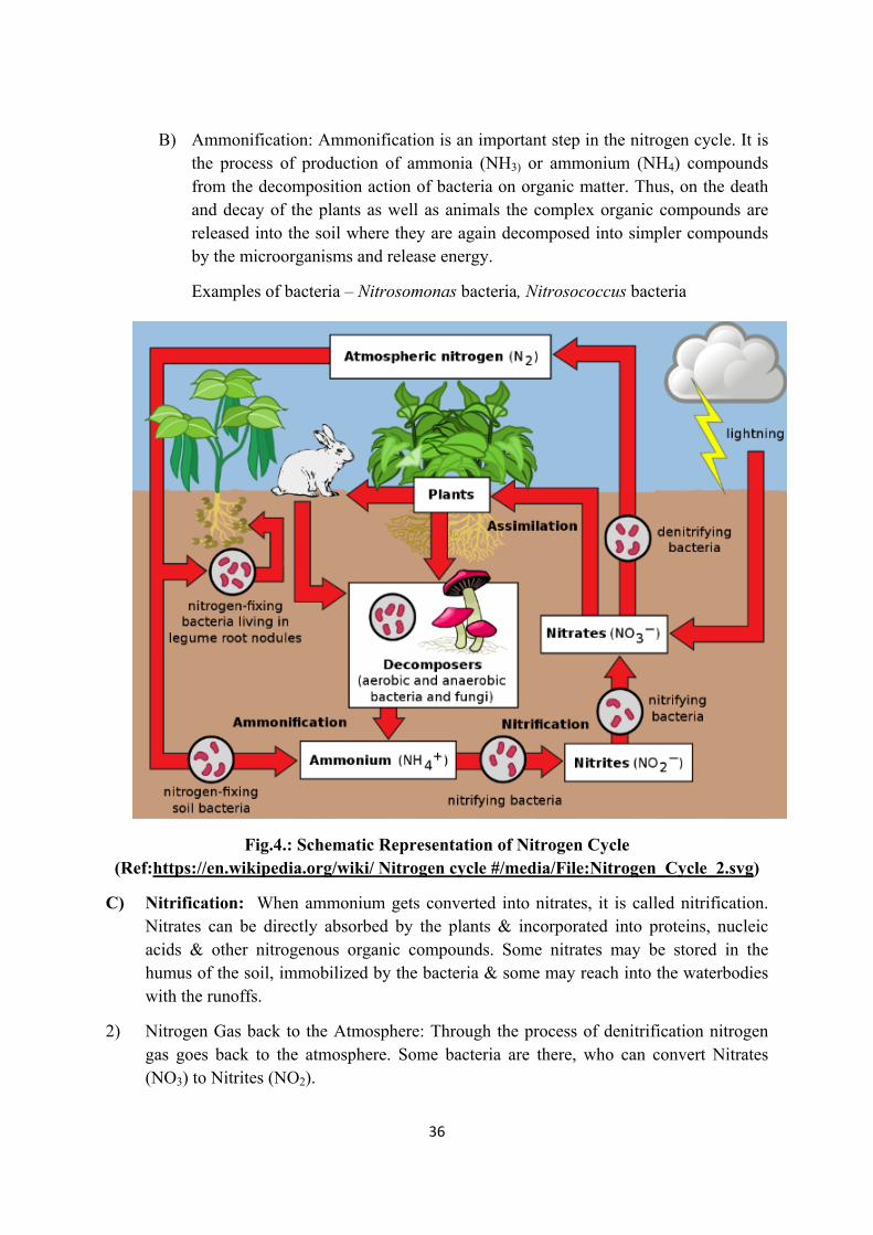
b) Sulphur Cycle
Fig.5: Schematic Representation of Sulphur Cycle
Like other Nutrient Cycles, the movement of sulphur in the biosphere and the underground is called “Sulphur Cycle” (Fig.5). Sulphur Cycle is a sedimentary type of nutrient cycle as the reserve pool is buried underground in rocks, minerals as well as sulphates (SO4) in sea sediments.
Sulphur found in nature in following form.
i) Hydrogen sulphide (H2S)
ii) Sulphur dioxide (SO2)
iii) Sulphates (SO4)
It enters to the living system as
i) Soluble form presents in the soil and pass on to the plants through the plants roots.
38
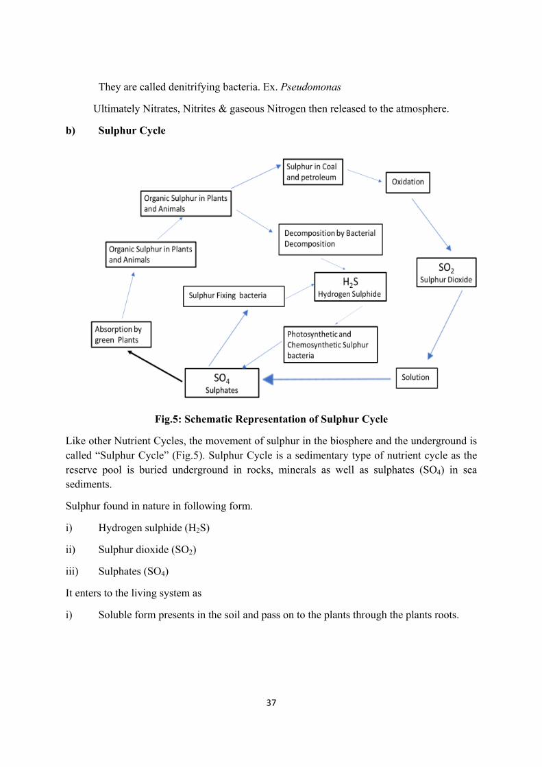
ii) It is assimilated by the plant to synthesize protein, vitamins & same other important products.
Fig.6:Schematic representation of Sulphur Cycle in detail
(Ref:https://en.wikipedia.org/wiki/Sulfur_cycle#/media/File:SulfurCycle_copy.jpg)
iii) Then the above compounds passed to the animal bodies through food chain.
Within plants & animal bodies the organic sulphur decomposed by aerobic bacteria to sulphate (SO4) or hydrogen sulphides (H2S). Hydrogen Sulphides then get converted into elemental sulphur by anaerobic bacteria (these bacteria do not require oxygen).
In this way sulphur gets back to the soil & sulphur cycle gets completed. Sulphur Dioxide (SO2) is also released to the atmosphere by vehicular exhaustion i.e. the burning of fossil fuels (Fig.6).
Example: Petroleum, Coal etc.
j) Phosphorus Cycle: In the ecosystem, more phosphorous is available in plants and animal bodies in comparison to the abiotic system. In abiotic system phosphorous is abundant in rocks and other natural deposits, formed during geological processes. Phosphorous is desired for the structure of DNA, as coenzymes and for the conversion of foods to release usable energy.
It is a simpler cycle.
Roots of the plants absorb Phosphorous present in a soluble form in the soil and assimilate it. Through food chain it then gets transferred to the animal bodies and by the death and decay of the plants and animals, or animal excreta it goes back to the atmosphere (Fig.7).

39
The runoff from the soil and the loss of phosphorous to the sea is greater than the availability of it to the land. Only 60,000 tons of phosphorous is returned to the soil through the birds, fishes of the sea and the algae. A major amount of phosphorus gets lost to the sea.
Fig.7: Schematic representation of Phosphorous Cycle Ref:https://en.m.wikipedia.org/wiki/File:Phosphorus_Cycle_copy.jpg
3.2.1. FOOD CHAIN
Definition: The transfer of food energy from the source in plants through a series of organisms with repeated eating & being eaten is referred to or called as food chain (Odum, 1971).
How Food chain works:
The green plants are the autotrophs or the producer of the ecosystem. With the help of chlorophyll, and by using CO2 and H2O from nature in presence of sunlight the plants can prepare their own food known as carbohydrates. The process is known as photosynthesis
Sunlight
Plants CO2 + H2O + Chlorophyll Carbohydrates
(Photosynthesis Process)
That’s why plants are called autotrophs (auto-self; troph-to nourish)
Thus, plants are the first step in a food chain.
40
The heterotrophs (hetero= other; troph = to nourish) are the organisms who depends on the autotrophs for food and energy.
Heterotrophs are two types – Herbivores and Carnivores
Herbivores are the herb/plant eaters. They can only eat the green plants/autotrophs.
Ex. Grasshoppers, Rabbits, Goats etc.
Carnivores are the meat eaters in an ecosystem. They cannot have the ability to eat herbs.
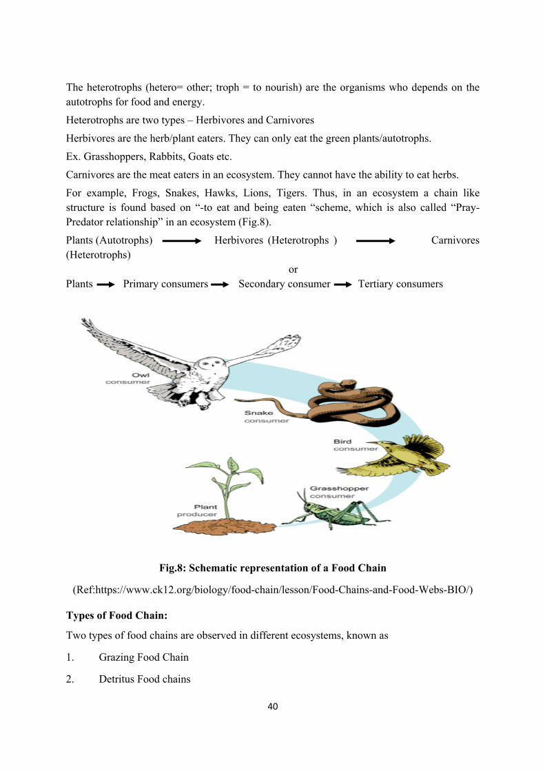
For example, Frogs, Snakes, Hawks, Lions, Tigers. Thus, in an ecosystem a chain like structure is found based on “-to eat and being eaten “scheme, which is also called “Pray-Predator relationship” in an ecosystem (Fig.8).
Plants (Autotrophs) Herbivores (Heterotrophs ) Carnivores (Heterotrophs) or Plants Primary consumers Secondary consumer Tertiary consumers
Fig.8: Schematic representation of a Food Chain
(Ref:https://www.ck12.org/biology/food-chain/lesson/Food-Chains-and-Food-Webs-BIO/)
Types of Food Chain:
Two types of food chains are observed in different ecosystems, known as
1. Grazing Food Chain
2. Detritus Food chains
41
Grazing Food Chain – It is recognized by the starting level organisms of a food chain. They are the living green plants. Then if we see the examples, in a grassland ecosystem the chain will be starting with Greengrass, then Grasshoppers, then Frogs then Snakes then Hawks as shown in the above figure.
Detritus Food Chain – Here the starting point is dead plants or animals. This type of Food chain does not depend on the sunlight.
Ex- Dead plants and animals, Scavengers, Micro organism
This should be noted that the Grazing and Detritus Food Chain perform independent to each other but different parts of a single ecosystem. More energy is transferred in a grazing food chain than in a detritus one. Combinedly the grazing and the detritus Food chain complete the nutrient cycle in an ecosystem.
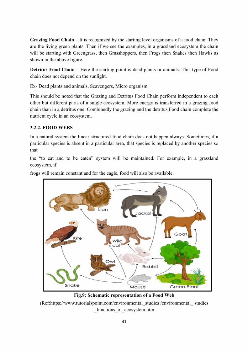
3.2.2. FOOD WEBS
In a natural system the linear structured food chain does not happen always. Sometimes, if a particular species is absent in a particular area, that species is replaced by another species so that
the “to eat and to be eaten” system will be maintained. For example, in a grassland ecosystem, if
frogs will remain constant and for the eagle, food will also be available.
Fig.9: Schematic representation of a Food Web
(Ref:https://www.tutorialspoint.com/environmental_studies /environmental_ studies _functions_of_ecosystem.htm
Additiointercon
Thoughstabilitywill incresultintheir foo
So, the balance
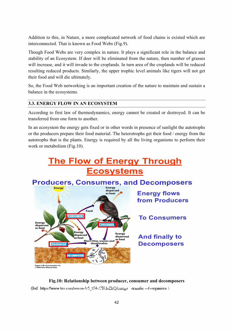
3.3. EN
Accordtransfer
In an ecor the pautotropwork or
on to this, innnected. Th
h Food Weby of an Ecocrease, and ing reduced pod and will
Food Web e in the ecos
NERGY FL
ing to first rred from on
cosystem thproducers prphs that is tr metabolism
Fig.10:
n Nature, a hat is known
bs are very system. If dit will invadproducts. Sidie ultimat
networkingsystems.
LOW IN AN
law of therne form to a
he energy gerepare their the plants. m (Fig.10).
Relationsh
more compn as Food W
complex indeer will bede to the croimilarly, thtely.
g is an impo
N ECOSYS
rmodynamianother.
ets fixed or food materEnergy is r
hip between
42
plicated netWebs (Fig.9)
n nature. It pe eliminatedoplands. In e upper trop
ortant creati
STEM
cs, energy
in other worial. The hetrequired by
n producer
twork of foo).
plays a signd from the nturn area ofphic level a
ion of the na
cannot be c
ords in preseterotrophs gall the livin
r, consumer
od chains is
nificant rolenature, thenf the croplananimals like
ature to ma
created or d
ence of sunget their foong organism
r and decom
s existed w
e in the balan number ofnds will be e tigers will
aintain and s
destroyed. I
light the auod / energy fms to perfo
mposers
which are
ance and f grasses reduced
l not get
sustain a
It can be
utotrophs from the rm their
43
Energy utilization in an ecosystem occurs in two ways.
i) Quantity of solar energy the plants receive from the sun for photosynthesis
ii) Quantity of energy flow occurs from the plants to the consumers.
This behaviour of energy transaction in an ecosystem is known as energy flow.
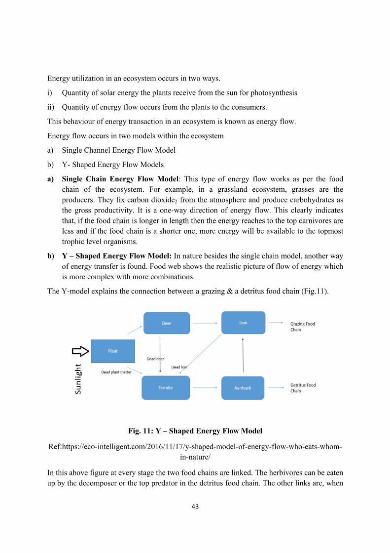
Energy flow occurs in two models within the ecosystem
a) Single Channel Energy Flow Model
b) Y- Shaped Energy Flow Models
a) Single Chain Energy Flow Model: This type of energy flow works as per the food chain of the ecosystem. For example, in a grassland ecosystem, grasses are the producers. They fix carbon dioxide2 from the atmosphere and produce carbohydrates as the gross productivity. It is a one-way direction of energy flow. This clearly indicates that, if the food chain is longer in length then the energy reaches to the top carnivores are less and if the food chain is a shorter one, more energy will be available to the topmost trophic level organisms.
b) Y – Shaped Energy Flow Model: In nature besides the single chain model, another way of energy transfer is found. Food web shows the realistic picture of flow of energy which is more complex with more combinations.
The Y-model explains the connection between a grazing & a detritus food chain (Fig.11).
Fig. 11: Y – Shaped Energy Flow Model
Ref:https://eco-intelligent.com/2016/11/17/y-shaped-model-of-energy-flow-who-eats-whom-in-nature/
In this above figure at every stage the two food chains are linked. The herbivores can be eaten up by the decomposer or the top predator in the detritus food chain. The other links are, when
44
the herbivore or the top predator died. They get decomposed by the decomposer and again used up as nutrients by the plants. In a nutshell, in balanced ecosystem hardly anything goes to the waste. Sometimes, the decomposers are also eaten up by the top predators of grazing food chain.
Ex. Earthworms in a grassland ecosystem can be eaten up by the hawks or eagle.
It is called so, because it looks like the English alphabet ‘Y’.
3.4. PRODUCTIVITY
Concept of Productivity:
The amount of organic matter i.e. the food prepared by a plant is known as productivity. When it is measured at any unit time, it is known as rate of productivity of that ecosystem.
Productivity are of following types
A. Primary Productivity
B. Secondary Productivity
C. Net Productivity
A. Primary Productivity: The productivity is the production capability of a plant. Thus, primary productivity is always associated with the autotrophs or the photosynthetic organisms i.e. the green plants. Some of the microorganisms also can carry out this process and are known as photosynthetic microorganisms.
Thus, primary productivity is the rate of fixation of solar energy from the sun by the photosynthesis activity of the organisms.
Primary Productivity are 2 types
1. Gross Primary Productivity (GPP)
2. Net Primary Productivity (NPP)
1. Gross Primary Productivity: It is the total rate of photosynthesis or food production by a photosynthetic organism. It depends on the chlorophyll content of a plant. Thus, it is calculated as amount of CO2 fixed per gram of chlorophyll per one hour. This can be represented as
GPP = amount of CO2 /gm Chl / hr.
2. Net Primary Productivity (NPP): We know, energy is required for each activity they do, by the living organisms. Thus, for respiration work, plants also need energy. So, the energy what was fixed during photosynthesis is being used here. As a result, the remaining energy after loss in the respiration utilization is known as the Net Primary Productivity. In simple words
NPP = GPP – Respiration energy
B) Secondary Productivity: This is related to the heterotrophs in contrast to the Primary Productivity. Secondary Productivity is the energy stored at consumer level. Ecologist
45
Odum (1971) prefer to use the term assimilation rather than production at this level. Secondary production is not a fixed level of energy utilization of production rather moves from one consumer level to the other through the food chain.
C) Net Productivity: Net Productivity is the storage energy of the consumers. That means it is the energy which remains in the body of the consumer after utilization in respiration or any other work done by the consumer. Thus, it can be measured as the biomass. Net productivity can be expressed as production of carbon mg/meter2/day.
It can then be calculated how much energy per/biomass of the consumer gets in a year.
HOMEOSTASIS
Definition of Homeostasis is “The ability to maintain a constant internal environment in response to the environment changes”. This is an unique principle of biology.
In the same way natural ecosystems are also capable of maintaining their internal regulations i.e. self-regulations or self-maintenance at any point of time. This is called as stable steady state of an ecosystem (Homeo means same, stasis means standing) Odum (1971) defined Homeostasis as the tendency of an natural ecosystem to resist change and to remain in state of equilibrium, which implies that within an ecosystem there is always stays a balance between the production, consumption as well as decomposition and in all the living organisms within a particular ecosystem in a particular time follow this kind of equilibrium.
LEARNING OUTCOME
The abiotic factors in an ecosystem maintains a dynamic role. Different components of the atmosphere, like oxygen, hydrogen, carbon, nitrogen, Sulphur etc. cannot be used by the living organisms in their elemental form. Thus, these elements form different compounds as nutrients for the living world. In that way a cycle of “elements to compounds and again back to elemental form” happens in the nature. That cycle is known as Biogeochemical Cycle.
Each organism has a place in an ecosystem pyramid. That is based on their food habit. This characteristic can be easily understood by the food chain of an ecosystem. But if one of the organisms if absent in an ecosystem. Then some other organism with same kind of food choice will replace that place. Thus, the chain of” to eat and to be eaten” habit remain maintained. So, in instead of only one chain, a web like structure found for the self-sustenance of an ecosystem. That is known as Food Web.
Energy Flow is the theme of the ecosystem. Through different channels energy flow occurs between the producers, consumers and decomposers.
We know that the external environment or climate has an impact on the living organisms, growing in that area. But side by side the Nature also provided a system to them that, the internal environment or the system within the body of the living organisms do not change with the disturbances of the outside environment. This is a gift of the Nature to the biotic factors of an ecosystem and called as Homeostasis.
46
Some Important Terms used in the Lesson
Ammonification
Biogeochemical Cycle
Carbon Cycle
Detritus Food Chain
Edaphic Nutrients Cycle
Energy flow
Food chain
Food Web
Grazing Food Chain
Net Productivity
Nitrification
Nitrogen Cycle
Oxygen Cycle
Phosphorous Cycle
Primary Productivity
Secondary Productivity
Sulphur Cycle
Water Cycle
PRACTICE QUESTIONS
III. Multiple Choice Questions: 1. Pray – Predator relationship is found in a) Food chain, b) Atmosphere c) Rocks, d) Homeostasis
2. ---------------- is a Primary Producer. a) Fungi, b) Tiger, c) Rabbit, d) Green Plant
3. Match the following: A B
a. Autotrophs v. Living organisms
b. Y-Shaped Model w. Carbon Cycle
c. Detritus Food Chain x. Green grasses
d. Biological nitrogen fixation y. Dead and Decay material
e. Atmospheric Nutrient Cycle z. Energy Flow in an Ecosystem
Answers: Q.1.a; Q.2.d; Q.3. a-x; b-z; c-y; d-v; e-w
47
II. Short Questions:
1. Food Chain
2. Food Web
3. Homeostasis
III. Long Questions:
1. What are the nutrient cycle found in an ecosystem.
2. Nitrogen Cycle: Explain in detail.
3. Describe the Food Chain and Food Web in an ecosystem, with proper examples.
4. How energy flows in an Ecosystem.
48
LESSON-4
TYPES OF ECOSYSTEMS AND ECOSYSTEMSERVICES
Dr. Sarthak Malhotra Assistant Professor,
Dyal Singh College (Eve), University of Delhi
INTRODUCTION
Ecosystems can range from small water bodies to an ocean, similarly on land from a patch of woods to a forest. Ecosystems can be natural or anthropogenic (human-created like farmlands). Broadly Ecosystem is classified into terrestrial and aquatic ecosystems, which are further classified into several kinds.
Ecosystem sustains mankind on earth by providing various products and services. There are several kinds of ecosystem services which maintain the basic functioning of the planet.
Due to the exploitation of resources by ever-growing human population ecosystems are getting degraded. Therefore it is essential to understand various concepts of preservation, conservation and restoration of ecosystem.
Learning Objectives
After going through this unit, you will be able to
1. Understand the importance and types of various ecosystems. In addition to this threat to these ecosystems and conservation strategies.
2. Understand concepts of ecosystem services
3. Understand ecosystem preservation and conservation strategies
4. Basics of ecosystem restoration
1. TYPES OF ECOSYSTEMS
Tundra, Forest, Grassland, Desert, Aquatic (ponds, streams, lakes, rivers, oceans, estuaries); importance and threats with relevant examples from India
I. Terrestrial Ecosystems: Diverse kinds of terrestrial ecosystems are present on the earth. Both climate and relative contribution of general plant life-forms (trees, shrubs, and grasses) contributes to the diversity.
1. Forest Ecosystem: Forest ecosystem mainly consists of community of plants, animals and microorganism and their non-living environment functioning collectively to exchange material and energy, where trees, shrubs, climbers and ground cover forms the main component. Due to the expansion of human settlements and industrial areas since the last century, the pristine forest is only left in protected areas like National Parks and Wildlife Sanctuaries. The appearance of different types
49
of forest differs greatly from each other. Each forest type forms a habitat for a community of animals that are specifically adapted to live in it.
Forest ecosystem also consists of abiotic or non-living component which includes factors like temperature, rainfall, topography, soil properties, etc. Due to the variation of these abiotic factors biotic or living components of the forest also vary in different types of forest. Forests also differ in their plant communities in response to the type of soil.
Forest Types in India: Forests in India can be broadly classified into coniferous forests and broadleaved forests. In addition to this, forest is also classified according to the kind of tree species they have which includes evergreen, deciduous, xerophytic or thorn trees, mangroves, etc. Forests are usually named after the most abundant species of trees such as Sal or Teak forests. In many cases, a forest is named after the first three or four most abundant tree species.
Coniferous forests are found in the high-altitude Himalayan mountain ranges. These ranges remain snow-covered for many months of the year with the temperature dipping below zero. These forests usually have tall trees with downward sloping branches so that the snow can slip off the branches. Coniferous forest has trees having needle-like leaves. Many trees are gymnosperms which have cones instead of seeds. Pine and deodar trees are found in the Himalayan coniferous forest.
Many animals are found adapted to these types of forests. Animal species found in coniferous forests include wild goat, sheep and Himalayan black bear. Some rare species of animals are also found in this forest which includes snow leopard, hangul and Himalayan brown bear.
Broadleaf forests are a category of forest further classified into evergreen forests, deciduous forests, thorn forests, and mangrove forests.
Evergreen forests are found in the Western Ghats, North Eastern India and the Andaman and Nicobar Islands. These regions receive a high amount of rainfall during long monsoon period. Evergreen forests in southern India receives two monsoons. Trees in evergreen forest keep shedding some leaves throughout the year instead of having a dedicated dry leafless phase as in a deciduous forest. This is why the evergreen forest appears green throughout the year. Evergreen forests have dense canopy because of a high number of trees are present adjacent to each other with their branches overlapping. Due to this less amount of sunlight reaches the forest floor where some shade loving plants grow. Species richness in the evergreen forest is highest. Several orchids and ferns are found in these forests. High diversity of mammals, reptiles, insects are found adapted to these forests. Some of the animals found in the evergreen forest of North-eastern India, Western Ghats and Andaman and Nicobar Islands include tiger, leopard, sambar, Malabar pied hornbill and tree
50
frogs. Rare animals like Pigmy Hog and Lion tailed macaque are also found in the evergreen forests.
Deciduous forests are found in the regions with a moderate amount of rainfall during the monsoon season. Deciduous forests are found in central highlands and Deccan peninsula. These forests have a specific season in which trees shed their leaves. On the onset of monsoon, they regain their leaves. Appearance of these forest vary with the season. These forests have thick undergrowth as light easily reaches the floor. Teak (Tectona grandis), Sal (Shorea robusta) and Ain (Terminalia elliptica) are some examples of trees found in the deciduous forests of India. Animals like tiger, cheetal, barking deer, flycatchers and hornbills are also found in the deciduous forests of India.
Thorn and scrub forests are found in the semi-arid and arid regions of India. These are regions of low and very low annual rainfall. Here trees are distributed sparsely and are surrounded by grasslands. Xerophytic plants are found in these forests which can survive in the scarcity of water Trees have several adaption-like small leaves, coating wax on their leaves which helps them conserve water. On the other hand, many trees have long and deep roots which helps them access water below the ground. Tree species like Babool (Acacia nilotica), Khejdi ( Prosopis cineraria) and Ber (Ziziphus mauritiana) are a few examples of plants found in thorn forest. Animals like Blackbuck, chinkara, sambar and monitor lizards make the fauna of the thorn forests.
Mangrove forests consist of trees and shrubs found in coastal-intertidal zones in the tropics and subtropics. All these trees grow in areas with low-oxygen soil, where slow-moving waters allow fine sediments to accumulate. In the mangrove forests, there is a dense web of prop roots that gives the impression of trees standing on stilts above the water. This web of prop roots allows the trees to withstand the daily rise and fall of tides. These roots slow the speed of the tidal water, due to this sediment settle out of the water and build up muddy water bottom. Sundarbans in West Bengal is an example of a mangrove forest in India. Mangrove forests help in stabilization of the coastline, prevents erosion from storm surges, currents, waves, and tides. The dense and complicated root system of mangrove forests makes these forests ideal habitat for fish and other organisms.
Forests ecosystem provides us with several products for direct consumption like fruits, medicine, fuelwood. Forest products are also used as raw material for making furniture and construction material for building. Similarly, forest products are also used as raw material for medicines and industrial products. In addition to this, the forest ecosystem also provides us several ecosystem services like purification of air, regulation of climate, prevention of soil erosion.
We are continuously losing our forests. Major threats to the forest ecosystem include deforestation and forest fragmentation due to the ever-increasing urbanization,

51
industrialization and intensive agriculture. In addition to this, overconsumption or exploitation of forest resources, invasive species are also some of the treats to the forest ecosystem. We can conserve the forest ecosystem by afforestation programs, sustainable use of forest resources and making a network of protected areas.
2. Tundra Ecosystem: Tundra ecosystems (arctic tundra) are found in extreme northern latitudes where snow melts seasonally. On the other hand, the alpine tundra is found in the higher elevation of mountains, specifically above the tree line. Winters in arctic tundra are long and severe on the other hand, summers or growing season is short. Precipitation is also poor in the tundra ecosystem and mostly occurs in summers. Tundra ecosystems are characterized by low species richness and low primary productivity. The dominant vegetation is tundra include mosses, lichens, grasses and grass-like sedges. Only dwarf willows, dwarf birches and other dwarf trees found in the tundra. Some of the animals found in tundra includes lemmings, voles, weasels, arctic foxes and snowy owls. Oil and natural gas exploration and military use is harming the tundra ecosystem. In addition to this, climate change is posing a serious threat to the tundra ecosystem. As the temperature is rising, causing the permafrost to melt resulting in replacement of tundra vegetation by coniferous trees.
3. Grasslands: A wide variety of landscapes where the predominant vegetation is grasses and small annual plants present in various climatic conditions are called grasslands. Grasslands have been given different names in different continents like prairies in U.S. Midwest, pampas in South America, steppes in central Eurasia and savannas in Africa. Grasslands are found in regions where rainfall is not adequate to support forest but now as less as to form a desert. Broadly there are two different types of grasslands tropical and temperate.
Tropical grasslands remain warm throughout the year. They have a dry and a rainy season. One of the examples of tropical grassland is Savanna in Africa. Animals like giraffe, zebra, rhinos, lions, hyenas and elephants are found in these grasslands.
Temperate grasslands, on the other hand, receive less rainfall in comparison to tropical grasslands. Grasses of short lengths are usually found in these grasslands. These grasslands also have two seasons growing and dormant. Grasslands have seasonal appearance because of flowering in the rainy season and during the winter season, only underground storage organs and thick stem bases remain.
The examples of grasslands in India include the Himalayan pasture belt that extends till the snowline. They are also found in patches along the coniferous forests or broad-leaved forests. The Himalayan animals need both grasslands and forests as their habitat. Another example is the Terai which has patches of tall grasses interspersed with Sal forest. These grasslands are usually found in the foothills of Himalaya. Another type of grasslands is found along the thorn forest in semi-arid plains of western India, central India and the Deccan. In addition to this, India also
52
has Shola grasslandswhich consist of patches of grasses on hill adjacent to the Shola forests on the Western Ghats, Nilgiris and Annamalai ranges.
Grasslands have been used by humans as pasturelands for their cattle. In addition to this, certain grasses are also a source of fuelwood. They also provide habitats to the pollinators. Having said that grasslands have been degraded severely as they are overused or exploited. Ever-increasing population along with conspicuous patterns of consumption has increased the demand for dairy products, wool and meat. Consequently, increasing the number of cattle’s resulting in overgrazing. Similarly, the expansion of agricultural land has also occurred at the cost of grasslands.
4. Desert Ecosystem: Deserts are the ecosystem which receives less or extremely less (less than 12cm per year) rainfall. Deserts and semi-arid regions in India are found in western India and Deccan Plateau. The climate in these vast tracts is extremely dry. The Thar desert of Rajasthan is the example of a typical desert in India which has sand dunes. Rainfall in these areas is sporadic. Sparse grasses and some shrubs grow in these arid regions. In the adjacent semi-arid regions some species of shrubs and trees like Babool (Acacia nilotica) and khair ( Senegalia catechu) are found.
In addition to the Thar desert, India has two more desert ecosystems. Cold desert is found in Ladakh, which is situated in the high plateau of Himalaya. On the other hand, highly specialized arid regions are found in the Great and Little Rann of Kutch in Gujarat. During the summers these regions have conditions similar to a desert but during the monsoon, these regions get converted into salt marshes because they are low lying areas adjacent to a sea. In terms of bird diversity Greater and lesser flamingos are found in Great Rann of Kutch. Similarly, Little Rann of Kutch is the only region where the wild ass is found in India. highly specialized insects and reptiles are found in the desert and semi-arid regions. These regions are home to several species of rare animals desert cat, desert fox, Indian wolf and birds like the Great Indian Bustard and the Florican.
II. AQUATIC ECOSYSTEMS
Diverse kinds of aquatic ecosystems are present on the earth. Broadly aquatic ecosystems can be classified as freshwater (ponds and lakes i.e. lentic ecosystems; streams and rivers lotic ecosystems i.e. lotic ecosystems), brackish water (estuaries) and salt water (oceans) ecosystems based on the salinity levels of the water.
Ponds and Lakes are called the lentic ecosystems which means stagnant water ecosystems.
1. Pond ecosystem: Ponds are the smallest and simplest aquatic ecosystems. Many pond ecosystems become dry long after the monsoon is over and terrestrial plants grow on it till the arrival of next monsoon. As the monsoon arrives organisms like algae, zooplanktons, insects, snails and worms come out from the bottom of the pond where they spent the dry phase. Slowly large animals like amphibians, crabs and large fishes also return to the ponds. In addition to this now, floating weeds and rooted vegetation
53
at the periphery of ponds also start growing. Now a large number of food chains are formed.
2. Lake ecosystem: Lakes on the other hand function like large permanent ponds as water remains in the lakes throughout the year. Organisms like algae, microscopic animals, both herbivorous and carnivorous fishes form several food chains in the lakes. Fishes like catfish are also found in the lakes which specifically feeds on detritus on the bed of the lakes. These fishes are called bottom feeders. Both ponds and lakes play a crucial role in the conservation of water and biodiversity. Pollution from industries and agricultural field are degrading these ecosystems.
3. Streams and rivers: Streams and riversare the example of lotic water ecosystems which means running water ecosystem. A stream is significantly smaller in size than the river. These ecosystems are open systems, exchanging nutrients and energy with larger areas than lentic ecosystems. In these ecosystem currents is an important ecological factor. Two zones can be identified in these ecosystems which are rapid zone and pool zone. In the rapid zone, the current is fast which cleans the silt and other material from the bottom making it firm and hard. On the other hand, in the pool zone speed of the current is slow, water is deep resulting in the deposition of sand and silt. Here the bottom is soft. Different kinds of organisms are adapted to these two zones. Rivers originate from glaciers on the mountains and carry the sediments enter the plain areas making the soil fertile with sediments before ending into the oceans. Rivers provide water for drinking, domestic purpose, industries and agriculture and power generation to mankind. Pollution originating from the sewage drains (Urban areas), effluent drains (Industries) and agriculture fields are polluting the river ecosystems. In addition to this destruction of floodplains and catchment areas are causing loss of property and life during floods.
4. Estuaries: Estuaries are an example of a brackish water ecosystem where salinity levels are intermediate i.e more than the freshwater ecosystem and less than the saltwater ecosystems. Estuaries, where the rivers enter the ocean. It is a complex ecosystem of high productivity having both salt marshes and mud flat connecting the freshwater communities and oceans. Estuaries have both plankton and detritus-based food webs. Most fisheries are directly or indirectly dependent on this ecosystem.
5. Ocean: Indian ocean, Bay of Bengal and Arabian sea are examples of ocean or marine ecosystems in India. Seventy percent of the earth's surface is covered by oceans. These ecosystems are extremely deep and living organisms occur at all depth even beyond 5000 meters. Although density and diversity of organisms in the ocean in the peripheral zones. All oceans are connected with each other. Oceans have salinity levels much higher (35 parts per 1000 parts of water (by weight) or 3.5%) than the freshwater ecosystems (0.5%). Oceans waters continuously move horizontally by the action of strong winds such as trade winds is called waves. On the other hand, the ocean water also rises and falls by the action of different interactions
54
of gravitational forces exerted between the moon, the Earth and the sun. This vertical movement is called as tides.
Ocean ecosystem consists of several communities like littoral, marine sandy beaches and marine mud flat communities. Estuarine, mangrove and coral reef communities are important both ecologically and economically. In addition to this, Continental shelf (Neritic) Benthos communities, Marine surface Pelagic communities and Deep open benthos communities are also found in oceans. Great diversity of organisms is found in each of these communities.
Littoral communities occur in coastal belts which are continuously affected by waves and tides. Some of the organisms found in these communities include oyster, brancles, limpet and kelp.
Coral reef communities are formed by the symbiotic relationship between coelenterate animal and endozoic algae dinoflagellates. The animals contribute the coral, a colonial structure embedded in calcium carbonates. The animal gives support structure and nutrients to the algae. On the other hand, algae form the food. Coral reefs communities are found in warm waters of tropical and subtropical oceans. These communities have huge species diversity and richness. Some of the organisms in the coral reef communities include sponges, molluscs, crabs and snails. Coral reefs communities in India are found in the Gulf of Kutch, Andaman and Nicobar Islands, Lakshadweep islands, gulf of Munner near Sri Lanka. World’s largest coral reef is called great barrier reef in Australia.
Continental shelf (Neritic) Benthos communities are found below the littoral zone on the bottom. There is variation in the community with changing depth. Since light penetrates in this part of the ocean, it has several organisms like diverse algal communities, fish and crustaceans.
Marine surface Pelagic communities have plankton and large swimming animals that are present in the open waters. These communities are further divided into surface pelagic and deeper water pelagic communities. Organisms in the surface pelagic communities include phytoplankton's (dinoflagellates and diatoms) due to the availability of light. Other organisms existing in these communities include Zooplankton’s (Copepods) shrimp, arrow worms, comb jellies, tunicates, etc.
As not much of the light reaches the marine deep pelagic communities because occur below the lighted surface waters these communities have heterotrophic organisms. The Source of food for these organisms is settling plankton and dead organic particulate matter from the surface water.
6. Deep open benthos communities: These communities are present between the boundary of the continental shelf to the deep oceans. Since light does not reach this region, therefore, only heterotrophic organisms and some bacteria are part of these communities.
55
Ocean ecosystems are a source of marine food for many human communities. In addition to these oceans are also used for travel and transportation of goods. Ocean ecosystems are also threatened by water pollution from sewage drains and industrial drains. Also, waste dumped into the rivers reaches the oceans threating marine life. In addition to this, many ocean communities like coral reefs are getting degraded due to climate change.
2. Ecosystem services (Provisioning, Regulating, Cultural, and Supporting); Ecosystem preservation and conservation strategies; Basics of Ecosystem restoration
Ecosystem services are direct and indirect benefits humans get from nature. These are essential for the maintenance of the basic functioning of earth and consequently supports life on this planet. Changes in ecosystem services can significantly affect the quality of human life on earth. These services can be categorized into four main types
Provisioning services: It includes material and products which we get from nature like fruits, vegetables, crops, honey, fish, marine food, livestock and other food material, freshwater, fuelwood, timber for furniture and construction, fibre, medicines, oil, natural gas, plant material for clothes and genetic resources.
Regulating services: These are the services that humans obtain by the maintenance of the basic functioning of the ecosystem. It includes purification of air and water, climate regulation, flood control, carbon storage, prevention of soil erosion, natural hazard regulation, pollination, pest control and decomposition of waste by microbes. All these processes collectively work making the ecosystem functional, sustainable and resilient to change which in turn supports the life of humans on this planet.
Cultural services: Humans live in nature and constantly interact with it. They change it and in turn are nature changes them. Cultural services are the non-material benefit that contributes to the progress and cultural advancement of people. It includes the role of ecosystems in local, national and global cultures. It also includes spiritual enrichment, intellectual development, recreation aesthetic values and creativity born by interacting with nature like art, music, architecture.
Supporting services: These services include processes which are essential for the sustenance of the ecosystems which in turn sustain life on the planet. It includes processes like biogeochemical cycles, photosynthesis, creation of soils and water cycle. Supporting services are essential for the existence of provisioning, regulating and cultural services.
3. Ecosystem preservation and conservation strategies
Ecological restoration: It is a process of assisting the recovery of an ecosystem that has been partially or completely degraded. In simple words ecological restoration means restoring the ecosystem, to a former state or to an perfect condition. Ecological restoration focuses on the recovery of many aspects of ecosystem which are as following.
56
Health of the ecosystem: purification of air, sequestration of carbon dioxide, filtration of water
Integrity of ecosystem: Species composition and community structure
Sustainability: Resistance and resilience to disturbance
Rehabilitation: It mean returning of a degraded land to a fully functional ecosystem irrespective of its original state but according to a prior landuse plan. Examples of the rehabilitation process are partial recovery of species diversity and ecological complexity, reducing the livestock grazing from riparian zone, allowing natural growth of vegetation or restoring fluvial processes.
Remediation: It is a process in which using physical and biological methods, chemical contaminants are cleaned from polluted ecosystem in order to protect human and ecosystem health.
Reclamation: It is a process by which biotic function and productivity of severely damaged land is restored.
Mitigation: It is defined as restoration, rehabilitation or reclamation process to reduce the effect of the source of degradation
LEARNING OUTCOME (Summary)
Ecosystem is the basic functional unit of nature. There is great diversity of ecosystem present in the nature.
Terrestrial ecosystem includes forests, grasslands and deserts. These ecosystems provide servals products and ecosystem services to mankind. These ecosystems are threatened by deforestation and forest fragmentation due to industrialization, urbanization and expansion of agricultural land.
Aquatic ecosystem is categorized based on salinity level into fresh water and marine water ecosystem. These ecosystems provide us with water for drinking, domestic purpose, industries and agriculture. We also get food from aquatic ecosystems. Pollution from urban areas, agricultural lands and industries are severely polluting the aquatic ecosystems.
In addition to the products ecosystem also provides us with serval services which is essential for the sustenance of the life on the planet. These services inludes Provisioning
Regulating, Cultural and Supporting services.
It is essential to understand the concept of ecological restoration in order to resotre the degraded ecosystems.
57
QUESTIONS
Q1 Which of the following is the predominant vegetation type present in the forest ecosystem?
A. Grasses B. Trees C. Shrubs D. Herbs
Q2 Sundarbans is example of which type of forest?
A. Evergreen forest B. Thorn forest C. Deciduous forest D. Mangrove forest
Q3 Savanna is an example of which of the following ecosystem?
A. Forest B. River C. Grassland D. Desert
Answers
Q1. B. Trees
Q2. D. Mangrove forest
Q3. C. Grassland
Q4. Coral reef communities are present in the following ecosystem?
A. River B. Ocean C. Pond D. Lake
Q5. Following is an example of lentic ecosystem?
A. Lake B. River C. Stream D. Grassland
Answers
Q4. B. Ocean
Q5. A. Lake
Q6. Medicines are an example of which of the following type of ecosystem services?
A. Regulating B. Cultural C. Supporting D. Provisioning
Q7. Biogeochemical cycles are an example of ___________ services.
Answers
Q6. D. Provisioning
Q7. Regulating
GLOSSARY
Mangrove forests consist of trees and shrubs found in coastal-intertidal zones in the tropics and subtropics.
Tundra ecosystems (arctic tundra) are found in extreme northern latitudes where snow melts seasonally and on the high elevation of mountains.
Lentic ecosystem means stagnant water ecosystem e.g. pond and lake.

58
Lotic ecosystem means running water ecosystems e.g. River
Estuaries Estuaries are the region where river meets the ocean and are an example of a brackish water ecosystem.
Biogeochemical cycles These includes nutrient cycles such as carbon cycle, nitrogen cycle, Sulphur cycle and phosphorus cycles.
59
LESSON-5
NATURAL RESOURCES: LAND RESOURCE
Dr. Ashish Thomas Assistant Professor,
Sri Guru Nanak Dev Khalsa College, University of Delhi
INTRODUCTION
Land is one of the most valuable resource for mankind as well as one of nature’s most precious gifts. It is that part of lithosphere that sustains life as well as provides various existential resources to human beings. Land is a mixture of inorganic and organic materials. It provides various kind of resources like food, fibre, medicine, minerals as well as services like agricultural productivity, biological diversity, carbon sequestration etc. The most basic use of land is to support vegetation of various kinds, thereby providing a place for all the terrestrial fauna to exist.
Land resource is under huge threat due to misuse and mismanagement by humans. Various anthropogenic activities have led to land losing its productivity leading and becoming degraded and polluted. Land degradation and soil erosion are impacting the various resources and services that we humans obtain from land. It is impacting our quality of life and in many cases our very survival, as we are directly and indirectly dependent on it. An extreme case of land degradation is desertification wherein semidry regions of world are losing their productive capacity to such an extent that they are becoming barren and desert like due to anthropogenic activities and climate change issues.
LEARNING OBJECTIVES
After going through the lesson, you will be able to
5. Explain the importance, use, threats and problems related to land resource and impact of dams and mines on forest resource
6. Understand concepts of soil erosion, land degradation, desertification and land use change
7. Identify the problems of related land misuse and mismanagement, deforestation
8. Seek solution to address how land resource can be managed in a better and sustainable manner
Land resources: Minerals, soil, agricultural crops, natural forest products, medicinal plants, and forest-based industries and livelihoods
From a human point of view, land resource includes all those aspects and functions of the land, which can be used to fulfil human needs. Humans have been exploiting land for
60
agriculture, mining, grazing animals and settlement purposes. Land resource can be divided into three categories
a. Very stable resources, like relief, geological formations and minerals;
b. Moderately stable resources, like soil and water
c. Very unstable resources, like vegetation and biodiversity
Some of the important resources and services provided by land to humankind are:
a. Minerals: Mineral is a pure inorganic substance that occurs naturally in the earth’s crust. Almost all minerals are found in the earth’s crust. Minerals are non-renewable resources and include metals like iron, copper, aluminium etc and non-metals like phosphates, gypsum, clay, sand etc. Minerals are extremely valuable to humans as they are essential raw material in industries and play a major role in overall development of nation. Minerals available in the earth’s crust can be divided into three categories
i. Metallic minerals like Iron, aluminium, lead, zinc etc
ii. Non-metallic minerals like graphite, felspar, asbestos, limestone etc
iii. Mineral fuels like coal, natural gas, petroleum etc
India is rich in mineral resources and has sufficient quantities of iron, aluminium, titanium copper, lead and zinc ores.
b. Soil: Soil is defined as the outermost thin layer of earth’s crust which serves as the natural medium for growth of plants, providing them a substrate for anchorage and essential nutrients for their growth. Soil is a complex mixture of organic and mineral content which is constantly being formed by the chemical decomposition and mechanical disintegration of rocks. Soil is a renewable resource which is constantly being formed and destroyed, mainly by erosion process. The topmost layer of soil rich in organic matter is called humus and is the most fertile layer. Soil forms a fundamental part of the human environment and is as essential as water. Soil provides the substrate to support the productivity and cycling of biological resources, it is the source of nutrients and water for agricultural and forestry ecosystems and acts as a complex buffer against environmental variability. Soil is very rich in microbial biodiversity and is also a major reservoir of carbon.
Soil across the world varies with respect to its characteristics and properties which forms the basis for its classification. The major soil groups found in India are alluvial soil, black soil, red soil, laterite soil, desert soil and acid soils.
c. Agriculture: The most dominant use of land resource by humans has been in the form of agriculture in order to meet the food demand of the growing world population. Agricultural ecosystems cover nearly 40% of the land surface. The total world land area suitable for cropping is 4.4 billion hectares out of which 1.6 billion hectares is currently under cultivation. Agriculture is the dominant driving force for the economy of a number
61
of world’s developing countries, which includes India as well. Agricultural productivity has increased manifold globally over the last 70-80 years due to increased use of fertilizers and pesticides. But this highly chemical intensive agriculture has also adversely impacted the land and its associated resources.
d. Natural Forest Products: Forest products are materials derived from forests for consumption and profitable use. These mainly include timber, firewood, wood pulp for paper and forage for livestock. There are also other non-wood products that are derived from forests which include nuts, resins, gum, medicinal plants, edible fruits, oils etc which are collectively called as non-timber forest products (NTFPs). These NTFP’s are considered to have relatively lesser negative effects on forest ecosystem. Forest products are used extensively worldwide for a number of purposes including cooking, animal feeding, as medicines for healing, household subsistence, income generation as well as cultural traditions. These products are also an extremely important source of revenue generation for all countries.
e. Medicinal plants:Medicinal plants are valuable natural resources obtained from land (mainly forests) which have been used by human communities since prehistoric times. The immense diversity of medicinal flora in tropical forests is an invaluable source of new pharmaceutical products. About 80% of the world’s developing countries are dependent on these traditional medicinal plants for primary health care. For a majority of people living in rural and urban areas in developing countries, medicinal plants are the only available treatment for various minor and major diseases. Moreover the demand for medicinal plants is continuously on the rise as more people are understanding their importance as compared to the allopathic medicines.
f. Forest based industries and livelihood: Forest have played a significant role in building up the economy of various countries and have provided a means of living to millions of people. Forest serves as a source of raw materials for large, medium and small scale industries. Globally, about two billion people use fuelwood and charcoal as their main source of energy for cooking and for heating their homes. Millions of rural households obtain income by collecting and selling forest products like food, fuel, medicinal plants and construction materials. Many sell timber from their land areas to logging companies, or make and sell furniture and handicrafts. And industrial logging provides employment and earnings for people in countries like Brazil, India, China and Indonesia. Forests also contribute to livelihoods in an indirect manner as they provide soil nutrients and forage for crops and livestock. They also help in pollinating crops, reduce soil erosion, and provide protection from natural disasters. Globally, it is estimated that between about 1.5-2 billion people depend on forests for their livelihoods and income and about 200 million people from indigenous communities are almost fully dependent on forests.
62
3. LAND COVER AND LAND USE CHANGE
Land cover refers to the observed biophysical cover on the surface of the earth whether vegetation, water, bare soil or urban infrastructure. Land cover can be determined either by field survey or by analysing satellite and aerial images. The International Geosphere-Biosphere Programme (IGBP) has categorised land cover into 17 classes that includes different types of forests, woodlands, shrublands, grasslands wetlands and deserts. The global land area is 13.2 billion ha. Of this, 12 percent (1.6 billion ha) is under cultivation, 28 percent (3.7 billion ha) is under forest and 35 percent (4.6 billion ha) comprises grassland and woodland ecosystems. On the other hand, land use is different from land cover. Land use refers to the purpose the land serves, for example, recreation, wildlife habitat, or agriculture. To illustrate this with an example, ‘grassland’ is a term used for land cover, while ‘agricultural land’, a ‘horse ranch’ or a ‘tennis court’ refers to the land use of grassland.
Land use change means the conversion of terrestrial land surface for anthropogenic uses. The use of land of results in changes in structure and functioning of ecosystems. Since the start of human civilization (ca 3500 BC onwards), land has been increasing used for settlements, agricultural purposes, grazing of animals, mining, urbanization and industrialization which have drastically altered the land cover. The rapid and large scale human intervention in converting natural landscapes for our own usage has resulted in devastating effects on both biotic and abiotic components of ecosystem. The increased demand for water, waste disposal and food requirements has resulted in land being used in an unsustainable manner, leading to its degradation. Forest cover and composition, cropland expansion, agriculture intensification, urban development and desertification are key drivers of land use change (UNEP, 2007).
The major environmentalimpacts of land use change are:
Climate Change and global warming
Biodiversity loss
Pollution of various kinds
Large scale deforestation
Land degradation and Desertification
Waste aggregation
All these concerns have greatly impacted human health, well-being and livelihoods.
4. LAND DEGRADATION
Land degradation is defined as the deterioration of the productive capacity of land due to overexploitation by humans. Land degradation affects soil chemistry and soil biodiversity and alters the natural ecological processes and ecosystem of the affected area. Land degradation has put the world’s ecosystems under intense pressure as their capacity to
63
provide vital resources and services is rapidly decreasing. Degraded lands have reduced capacity for supply of goods (food, timber, fibre, fuel etc) for humankind.
The major causes of land degradation are:
a) Deforestation
b) Soil erosion
c) Unpredictable weather patterns or climatic conditions
d) Droughts and floods
e) Modern agricultural practices
f) Soil pollution
g) Increasing urbanization
Land degradation is a major challenge that needs to be addressed quickly, not just to restore the ecosystem and biodiversity of the affected area but also for maintaining economic growth and social structure in human society.
5. SOIL EROSION
Soil erosion is the loss or removal of top layer of soil due to natural physical agents like wind, water and even gravity. As the topmost layer of soil is the most fertile layer, being extremely rich in organic matter and nutrients, erosion leads to reduced productivity of the soil, which in turn results in the soil unable to support vegetation. Soil formation is a very slow process with 1 cm of soil taking 200-300 years to form from the bed rock. Hence frequent soil erosion takes years to restore naturally. When soil erosion is intense, the natural soil profile is destroyed and may never attain its original capacity. Extensive cultivation, overgrazing and deforestation expose the precious top soil to wind and water erosion.
The various natural and anthropogenic (human originated) reasons for soil erosion are:
a) Slope of surface: Soil erosion is more common in hill slopes which gets aggravated with removal of natural vegetation
b) Soil content: Soil with higher content of sand is more prone to erosion as compared to soil with higher clay amount.
c) Weather and climatic conditions: natural factors like high intensity rainfall, floods and droughts also increases soil erosion in affected areas. With global warming and climate change as a major threat, such natural disasters are becoming more frequent leading to soil erosion in many areas
d) Deforestation: Deforestation leads to reduction in tree roots, which performed a major function of holding the soil together. In absence of a strong hold, soil is prone to erosion
e) Extensive agriculture and cultivation: Modern day chemical intensive farming practices lowers soil organic matter levels, soil biodiversity, and also reduces the soil water
64
content, thus making soil prone to erosion. Excessive irrigation also is a major reason for erosion.
f) Overgrazing: In order to feed cattle and cater to the meat and dairy needs of people, large areas of vegetation are exploited for grazing. Thus, overgrazing exposes soil to erosion.
Soil conservation has attained great importance today. The remedial measures suggested to arrest soil erosion include:
a) Erosion control technologies in farming such as no tillage or low tillage, crop rotation, use mulch cover can greatly reduce erosion of soil by water
b) Adoption of terrace farming, contour farming and setting up structures like windbreaks, live fences, sand fences etc reduce the soil erosion in areas that are naturally prone to erosion.
c) Reforestation in areas where large scale vegetation has been removed is an extremely important step as trees are natural binding agents of soil.
6. DESERTIFICATION
Desertification is an extreme case of land degradation in which semidry regions, becomes increasingly arid resulting in loss of water bodies, vegetation and wildlife. It is caused by a variety of factors, which includes both anthropogenic activities as well as climate change.
Desertification is one of the most significant global ecological and environmental problem that we face today. According to UNESCO, one third of the earth’s land surface, categorised as drylands, is facing the threat of desertification. This would ultimately affect the livelihood of millions of people who are dwelling in these regions who are dependent on goods and services provided by these drylands. One of the major problems that arises out of desertification is migration of people towards presumably resource rich regions like cities, in search of better living conditions. However, large scale migration to cities not only causes economic loss of land that could be cultivated, it also puts additional burden to the resource crunch and pollution in cities.
Desertification begins with land slowly getting degraded due to deforestation, overgrazing, modern agricultural practices, increasing urbanization, mismanagement of water resource, exploitation of ground water and destruction of wetland regions . When such degraded land when faces climate change issues, like drought, erratic weather conditions, rainfall deficiency for a continuous period, it results in the land losing its productivity to such an extent that it resembles desert like conditions. Desertification thus leads to loss of farmlands (economic loss), increase in hunger and poverty, social inequality and crowding and overpopulation in towns and cities.
In order the prevent drylands from facing desertification, there is a need for an integrated approach with help from multiple stakeholders. There is a need to implement policies and rules that help in better land and water management, educate and spread awareness among
65
people (especially the farming community), provide all necessary support to farmers and local communities, and formulate and promote sustainable methods of agriculture.
7. DEFORESTATION AND ITS CAUSES
Deforestation is the clearing or permanent removal of forest areas so that it is available for other uses. Deforestation is the root cause for land degradation, soil erosion and desertification. According to the United Nations Food and Agricultural Organization, the annual rate of deforestation is estimated to be about 1.3 million square km per decade. Extensive deforestation has taken place in tropical regions as compared to the temperate forests. The depletion of forest areas not only results in loss of trees, which act as a major carbon sink (storage reservoir), but it also leads to release of billion tons of carbon from the dead and decomposing trees. Both these factors significantly impact global warming and climate change, two of the major challenges faced by humanity today.
Causes of deforestation
Forest lands are cleared mainly to provide for human needs. The major causes or reasons for deforestation are:
a. Agriculture and plantations: The most significant threat to forests are their conversion to agricultural and plantation areas, in order to fulfil the needs of the growing human population. Agriculture is the direct cause for 80 percent deforestation in tropical and subtropical regions. Agriculture patterns have changed significantly since 1950’s, as the focus has shifted to more intense agriculture involving new technology, machinery and chemicals in order to meet human requirements. This agricultural intensification, often called as industrial agriculture, has significantly increased the rate of deforestation, impacted terrestrial and aquatic ecosystems, and resulted in large scale biodiversity loss as well.
b. Urbanization: Urbanization is another major cause of deforestation which is a result of increasing population, capitalism and globalization. Forests are cleared for setting up residential areas, industries, commercial hubs, development projects like roads, railways etc. The clearing of forests for such activities has led to habitat degradation, habitat loss and habitat fragmentation, all of which has significantly impacted the ecosystem and biodiversity.
c. Harvesting wood for use as firewood and timber: Millions of families still rely on fuelwood as an energy source for various household activities (cooking, heating etc) and forests are still the main source of fuelwood. Expanding urbanization has also increased the demand for wood (for use in furniture, industries, sports goods, equipment etc.) resulting in large scale timber extraction from forests.
d. Illegal logging: Illegal logging is very common across various forest regions of the world. Wood is harvested illegally for various purposes, especially decorative and medicinal, and these illegally harvested wood have huge markets in US and Europe.
66
e. Forest Fires: Every year, fires destroy millions of hectares of forests across the world. Forests may catch fire naturally or through humans. Natural forest fire includes an unplanned burning of forest due to lightning, long spell of high temperature and drought which can spread quickly in warm and windy conditions. On the other hand human-induced forest fire results from the unauthorized burning practice of forests for attaining farmland. The recent bush fires that occurred in Australia are a prime example of the destruction caused by forest fires, that not only destroyed thousands of hectares of forests, but also released large amounts of greenhouse gases into the atmosphere.
f. Mining: With increasing demand for metallic resources, mining has become a major economic activity. Large-scale mining operations, especially those using open-pit mining techniques, has resulted in significant deforestation. Mining projects also require construction of new roads, settlements and townships for people working in the mines which results in clearing of more forest areas. Industrial mining operations have thus caused large scale deforestation especially in tropical countries.
8. IMPACTS OF MINING AND DAM BUILDING
Since industrial revolution, mines and dams have become essential drivers for economic growth. The second half of twentieth century has witnessed a massive increase in mining operations and dam constructions, especially in developing countries. Although both mining and dams are of much benefit to human society and development, they have devastating impacts on the environment and people living in the vicinity. It is now well proven that large scale industrial mining and hydroelectric projects destroy ecosystems, cause pollution and impact vulnerable human communities.
The major impacts of mining and deforestation are:
a. Deforestation or loss of vegetation: Both mining and dam construction lead to large scale loss of forests and vegetation. While Industrial mining, especially open pit mining, requires clearing of large areas of forest, large dam construction leads to submergence of huge tracts of forests and vegetation.
b. Pollution: Mining operations result in air, water and soil pollution that impacts the people living in the vicinity of mines. While air pollution is caused due to harmful gases from heavy machinery and equipment and release of toxic gases from inside the mines, water pollution is caused due to mine waste rock and tailings getting mixed with surface and underground water. Air pollution is also caused during construction period of dams when heavy machinery is in use. Dams are also one of the sources of methane gas emissions (greenhouse gas) that is released from the dead and decaying vegetation inside the reservoir.
c. Land degradation and water loss: Mining activities lead to depletion of surface and groundwater supplies as water is extensively used during the processing stage. Groundwater withdrawal can have harmful effect on streams and rivers that are many
67
miles away from the actual mine site. Moreover, mines left open after the mining, can also lead to loss of groundwater through evaporation leaving the area barren and degraded and susceptible to desertification.
d. Siltation: One of the most serious technical problem faced by dam industry is that of siltation, which is the increased deposition of sediments brought along by the river at the bottom of dam reservoir. The sediments gradually accumulate in the reservoir, reducing the ability of the dam to store water, the very purpose for which it was constructed. The intensity of siltation varies depending upon the sediments that a river brings along. The silt laden water also causes abrasion of turbines and other dam components thus reducing their electricity generating efficiency.
e. Impact of ecosystem and Biodiversity loss: Both mining and dams result in deforestation leading to habitat loss and habitat fragmentation thus affecting the biodiversity that dwells in the affected area. Dams submerge large areas of terrestrial ecosystem where reservoirs are formed, while also impacting the aquatic ecosystem due to obstructed/ reduced water flow. Mines also impact terrestrial ecosystems due to clearing of vegetation as well as any aquatic ecosystem that are in the vicinity of the mines due to pollution.
f. Displacement of local and indigenous communities: One of the biggest social problems caused due to large scale mines and dam construction is the way it impacts local and indigenous communities dwelling in those areas. More often than not, these vulnerable communities are victims of injustice as they are not rehabilitated and compensated in an appropriate manner. They have to go through much emotional upheavals as they face the task of being displaced from areas where they have resided for long periods of time. Families loss their traditional ways of livelihoods as they are shifted and have to struggle very hard to find similar living and livelihood conditions in newly displaced area
g. Health problems and social issues: Mining operations have huge health impacts on the people working in mines, as they are constantly exposed to toxic metals, wastes and poisonous gases emanating from the mines. In many countries, mine workers don’t have proper safety gears and work in deplorable conditions. Fatal accidents are also common in mines. The pollution caused due to mines and dams affect people living in nearby villages and towns. Dams and mines also open up remote areas to developers, road builders, loggers, farmers that accelerates deforestation further. Local people also face the problem of people migrating from other regions into the areas that can increase social instability due to issues like unemployment, increase in crimes, shortage of resources etc.
9. STEPS FOR SUSTAINABLE MANAGEMENT OF LAND RESOURCE
a. Afforestation: Planting trees is the one of the best way to overcome the issues of land degradation, soil erosion and desertification. Afforestation as well as reforestation in deforested areas can improve the quality of human life by absorbing pollution and dust from the air, mitigating global warming, establish natural habitats and ecosystems and
68
provide timber and non-timber forest products. They play essential role in diluting the effect of natural disasters and are essential life support systems for local and indigenous communities
b. Forest management: It is essential that our existing forests are managed in a wise and sustainable manner rather than sacrificing them in the name of developmental projects. Governments across the world need enact and implement rules and policies to protect the existing forests and also ensure to increase the forest cover through afforestation and reforestation. It is the responsibility of both government and citizens to protect existing forests from the threats of illegal logging, invasive species, diseases and overutilization. Programs like Joint Forest Management and Social forestry are good models wherein multiple stakeholders have worked together to protect the forests in India and have been able to increase the green cover. The emphasis also should be on use of technology in order to find solutions to various threats on forests.
c. Farming methods: new farming methods need to be constantly devised in order to reduce the usage of pesticides, fertilizers and excessive irrigation. Mixed farming, organic farming, Rice fish farming, developing nano-fertilizers, improving irrigation technology to conserve water, use of mulch and manure, using wild variety of seeds are all ways which can be used to conserve the fertility of soil and improve the agricultural output as well.
d. Water management: Water is an important constituent of soil and very important for soil formation, maintaining soil fertility and preventing soil erosion. Both surface and ground water need to be monitored regularly as loss of ground water makes the soil susceptible to erosion and degradation. Overutilization of ground water needs to be addressed by a co-ordinated effort of both government and the citizens in order to prevent soil erosion, land degradation and desertification. Better irrigation technology, judicious crop management, understanding soil characteristics, reducing surface water pollution are all important steps to proper management of existing water resources.
e. Waste Management: Developing effective solid waste management technologies and practices are important to reduce the dumping of waste in landfills and other areas on land and to reduce the quantity of non-biodegradable and other toxic compounds mixing into the soil.
LEARNING OUTCOME (Summary)
Land provides various resources like minerals, metals, supports vegetation, provides habitat, supports agriculture and stores carbon
Forest cover has decreased drastically, especially in tropical countries, due to various anthropogenic activities like agriculture, industries, urbanization, overgrazing etc.
Since the invention of agriculture, land use has changed considerably. Land is now used or exploited for variety of purpose in order to satisfy the every growing human needs
69
Land degradation is a major problem wherein land is losing its productive capacity. Land degradation affects soil chemistry and soil biodiversity and alters the natural ecological processes and ecosystem of the affected area. A number of anthropogenic causes have been attributed to land degradation
Desertification is an extreme case of land degradation in which semidry regions, becomes increasingly arid resulting in loss of water bodies, vegetation and wildlife. It is caused by a variety of factors, which includes both anthropogenic activities as well as climate change. According to UNESCO, one third of the earth’s land surface, categorised as drylands, is facing the threat of desertification. One of the major problems that arises out of desertification is migration of people towards presumably resource rich regions like cities, in search of better living conditions.
Deforestation is the clearing or permanent removal of forest areas so that it is available for other uses. Deforestation is the root cause for land degradation, soil erosion and desertification. Extensive deforestation has taken place in tropical regions as compared to the temperate forests. The major causes of deforestation are conversion of forest areas for agriculture, plantation and urbanization, illegal logging, forest fires and mining.
Although both mines and dams are of much benefit to human society and development, they have devastating impacts on the environment and people living in the vicinity. Large scale industrial mining and hydroelectric projects destroy ecosystems, cause pollution and have socio economic impact on vulnerable human communities.
It is important to devise steps and strategies for sustainable management of land resource. Afforestation, reforestation, sustainable agricultural practices, water management, Forest management, waste management are important measures to utilize land and the services it renders to humanity for a long period of time.
QUESTIONS
Fill in the blanks
1. a) The _______________ layer of soil is rich in organic matter and is very fertile.
b) Minerals are found in earth’s ____________.
c) Gum, medicinal plants, edible fruits are categorised as ________________ forest products.
Answers: 1. Topmost; 2. Crust; 3. non-timber
Fill in the blanks
2. a) The removal of top layer of soil through action of wind or water is called as _____________.
b) Land cover can be determined by analysing ___________ images.
70
c) Land degradation is the loss of _______________capacity of land due to overexploitation by humans.
d) _______________areas face maximum threat of desertification
e) Desertification can lead to large scale _____________ of people in search of better living conditions.
Answers: a. Soil erosion; b. Satellite; c. Productive; d. Dryland; e. migration
State True or False
1. Forests act as large carbon storage areas (carbon sinks).
2. Forest fires always occur naturally.
3. Dams do not cause any kind of air pollution
4. Mines impact only terrestrial ecosystem
5. Proper Waste management is an important step for preventing land degradation and soil pollution.
Answers: 1. True; 2. False; 3. False; 4. False; 5. True
Long Questions
1. What are the various resources and services provided by land
2. What is land degradation? How does it impact human communities?
3. What is Deforestation? Explain its various causes.
4. Explain how desertification is a major challenge faced by humanity today
5. Briefly explain the environmental and social impact of dams and mines.
GLOSSARY
Deforestation: Deforestation is the clearing or permanent removal of forest areas so that it is available for other uses.
Desertification: Desertification is an extreme case of land degradation in which semidry regions, becomes increasingly arid resulting in loss of water bodies, vegetation and wildlife. It is caused by a variety of factors, which includes both anthropogenic activities as well as climate change.
Land cover: Land cover refers to the observed biophysical cover on the surface of the earth whether vegetation, water, bare soil or urban infrastructure.
Land degradation: Land degradation is defined as the deterioration of the productive capacity of land due to overexploitation by humans. Land degradation affects soil chemistry and soil biodiversity and alters the natural ecological processes and ecosystem of the affected area.

71
Non-timber Forest products: Non-timber forest products (NTFPs) are any product or service other than timber that is produced in forests. They include fruits and nuts, vegetables, fish and game, medicinal plants, resins, essences and a range of barks and fibres such as bamboo, rattans, and a host of other palms and grasses.
Soil erosion: Soil erosion is the loss or removal of top layer of soil due to natural physical agents like wind, water and even gravity.
Reforestation: Reforestation is the re-growing of forests that have previously been cut down using tree species that are native to the geographic area.
Siltation: increased deposition of sediments brought along by the river at the bottom of dam reservoir.
72
LESSON-6
NATURAL RESOURCES: WATER RESOURCES
Dr. Ruchi Mishra Assistant Professor,
Lakshmibai College, University of Delhi
INTRODUCTION
Our planet Earth is known as blue planet because of the water that covers three-fourths of its surface. Water has a remarkable influence on various aspects of structure and function of our planet that includes shaping the continents, moderation of our climate and survival of organisms. Without water, Life on Earth is impossible. All life-forms including bacteria, plants and animals have 60-70% of water by their body weight. We rely on water not only for our convenience and usage but also for our survival. It is essential for ecosystem health. Although Earth has amply of water, most of it is saline and not suitable to drink, agriculture or other purposes. The vast amount of the remaining three per cent of fresh water is locked up out of practical human reach in the form of glaciers, icecaps and deep ground water aquifers. The very small fraction of fresh water that is accessible to us is distributed extremely unevenly in space and time. This results in serious water related problems, including interregional conflict over access and quality, competition between rural, urban and environmental uses, severe human health problems and constraints on economy. Actually, society spends billions of dollars every years to move water from one wet areas to drier areas, to store it for dry periods or to clean otherwise undrinkable sources. Conflicts often arise over water use because one application decreases the amount available for others. Even regions with readily available fresh water have problems maintaining the quality and quantity of water.
The World’s renewable fresh water supply is relatively constant; the average amount of water available per person in1850 was about 43,000 cubic meters per year. By 2014, this figure had dropped to around 5,900 cubic meters per year which may further reduce because of the increase in population. Worldwide, freshwater use is increasing as the population expansion, human activities, and climate change pose increasing pressure on a limited water supply and resulting into a situation where a growing number of countries experience water shortages.
1. The hydrologic cycle and distribution of water
Water exists in any of three forms: solid (ice/snow), liquid (marine/fresh water), and vapor (water vapor/steam). Water continuously circulates through the environment, from the ocean to the atmosphere to the land and back to the ocean by the hydrologic cycle. The result is a balance among water in the ocean, on the land, and in the atmosphere. This way hydrologic cycle inter-related various forms of water available on earth surface and also continually
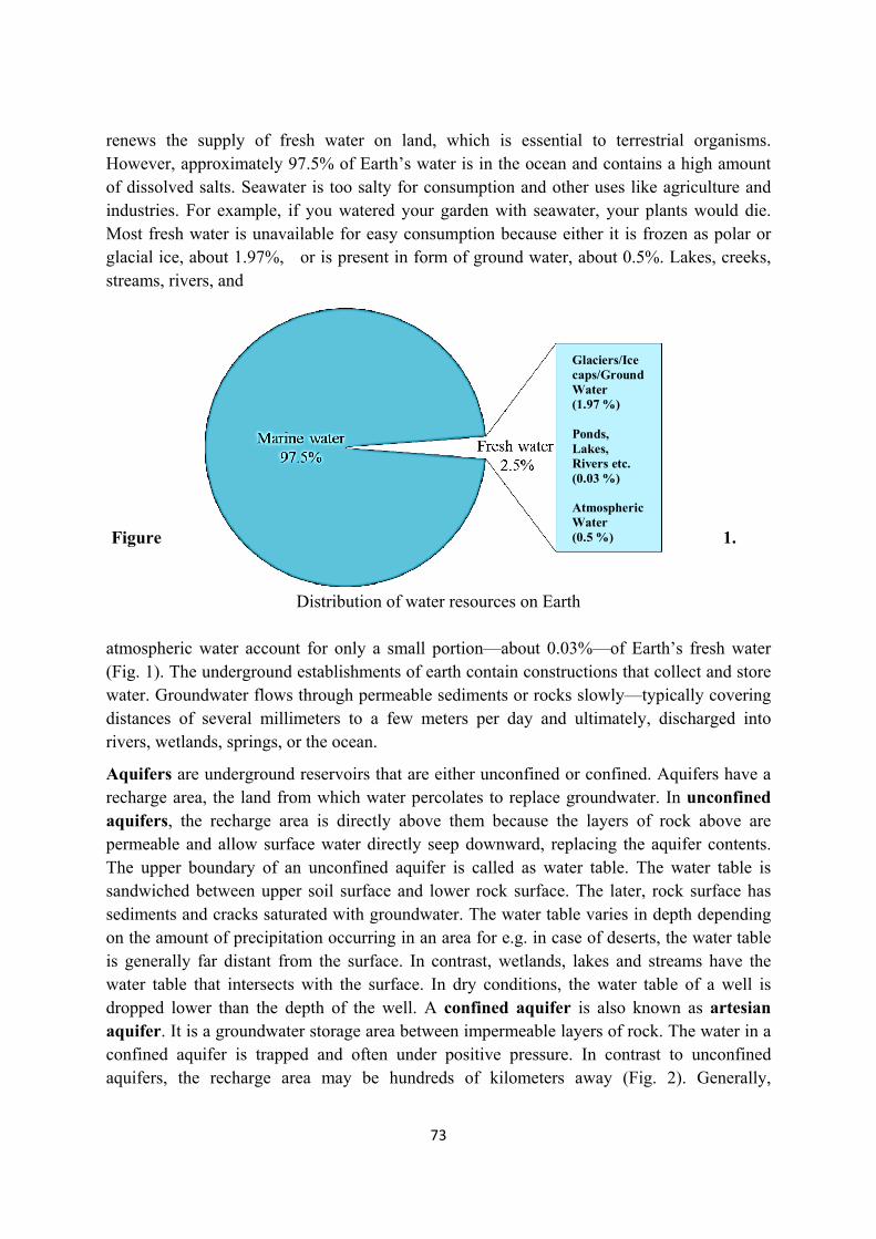
73
Glaciers/Ice caps/Ground Water (1.97 %) Ponds, Lakes, Rivers etc. (0.03 %)
Atmospheric Water (0.5 %)
renews the supply of fresh water on land, which is essential to terrestrial organisms. However, approximately 97.5% of Earth’s water is in the ocean and contains a high amount of dissolved salts. Seawater is too salty for consumption and other uses like agriculture and industries. For example, if you watered your garden with seawater, your plants would die. Most fresh water is unavailable for easy consumption because either it is frozen as polar or glacial ice, about 1.97%, or is present in form of ground water, about 0.5%. Lakes, creeks, streams, rivers, and Figure 1.
Distribution of water resources on Earth atmospheric water account for only a small portion—about 0.03%—of Earth’s fresh water (Fig. 1). The underground establishments of earth contain constructions that collect and store water. Groundwater flows through permeable sediments or rocks slowly—typically covering distances of several millimeters to a few meters per day and ultimately, discharged into rivers, wetlands, springs, or the ocean.
Aquifers are underground reservoirs that are either unconfined or confined. Aquifers have a recharge area, the land from which water percolates to replace groundwater. In unconfined aquifers, the recharge area is directly above them because the layers of rock above are permeable and allow surface water directly seep downward, replacing the aquifer contents. The upper boundary of an unconfined aquifer is called as water table. The water table is sandwiched between upper soil surface and lower rock surface. The later, rock surface has sediments and cracks saturated with groundwater. The water table varies in depth depending on the amount of precipitation occurring in an area for e.g. in case of deserts, the water table is generally far distant from the surface. In contrast, wetlands, lakes and streams have the water table that intersects with the surface. In dry conditions, the water table of a well is dropped lower than the depth of the well. A confined aquifer is also known as artesian aquifer. It is a groundwater storage area between impermeable layers of rock. The water in a confined aquifer is trapped and often under positive pressure. In contrast to unconfined aquifers, the recharge area may be hundreds of kilometers away (Fig. 2). Generally,
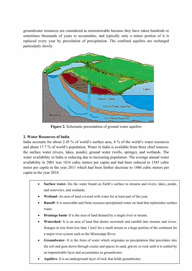
74
groundwater resources are considered as nonrenewable because they have taken hundreds or sometimes thousands of years to accumulate, and typically only a minor portion of it is replaced every year by percolation of precipitation. The confined aquifers are recharged particularly slowly.
Figure 2. Schematic presentation of ground water aquifers 2. Water Resources of India India accounts for about 2.45 % of world’s surface area, 4 % of the world’s water resources and about 17.7 % of world’s population. Water in India is available from three chief sources- the surface water (rivers, lakes, ponds), ground water (wells, springs), and wetlands. The water availability in India is reducing due to increasing population. The average annual water availability in 2001 was 1816 cubic meters per capita and had been reduced to 1545 cubic meter per capita in the year 2011 which had been further decrease to 1486 cubic meters per capita in the year 2018.
Surface water- Itis the water found on Earth’s surface in streams and rivers; lakes, ponds,
and reservoirs, and wetlands.
Wetland- An area of land covered with water for at least part of the year.
Runoff- It is renewable and finite resource precipitated water on land that replenishes surface
water.
Drainage basin- It is the area of land drained by a single river or stream.
Watershed- It is an area of land that drains snowmelt and rainfall into streams and rivers.
Itranges in size from less than 1 km2 for a small stream to a huge portion of the continent for
a major river system such as the Mississippi River.
Groundwater- It is the form of water which originates as precipitation that percolates into
the soil and goes down through cracks and spaces in sand, gravel, or rock until it is settled by
an impenetrable layer and accumulates as groundwater.
Aquifers- It is an underground layer of rock that holds groundwater.
75
a) Surface Water Resources: In our country, the surface flow takes place through 12 major rivers namely Ganga, Yamuna, Indus, Brahmaputra, Cauvery, Godavari, Krishna, Mahanadi, Mahi, Narmada, Pennar and Tapi. The mean annual flow in all the river basins in India is estimated to be 1,869 cubic km. However, due to various geographical and environmental constraints, only about 35 % of the available surface water can be exploited. Water flow in a river depends on the size of the catchment area of the river and rainfall within the catchment area. The precipitation in India has very high spatial variation, and it is mainly concentrated in Monsoon season. Some of the rivers in the country like the Ganga, the Brahmaputra, and the Indus have huge catchment areas. Much of the annual water flow in south Indian rivers like the Godavari, the Krishna, and the Cauvery has been harnessed, but it is yet to be done in the Brahmaputra and the Ganga basins. In addition to rivers, other surface water resources in India include canals, ponds, lakes, tanks, and wetlands. They are distributed unevenly over the country and retaining about 50 % of these inland surface water resources.
b) Groundwater Resources: India has about 432 cubic km of total annual replenishable groundwater resources. The Ganga and Brahmaputra basins have about 45 % of the total replenishable groundwater resources. The groundwater utilization is relatively high in the river basins lying in north-western region and parts of south India. The groundwater utilization is very high in the states of Punjab, Haryana, Rajasthan, and Tamil Nadu. States like Bihar, Gujarat, Uttar Pradesh, Maharashtra and Tripura are utilizing their ground water resources at a moderate rate. However, the utilization of groundwater had been increased over the period of time due to increase in population. If the present scenario continues, the demands for water would definitely require additional supplies and such situation, will act as the deciding factor to development and social, economic and environmental balance all over the world.
c) Lagoons and Backwaters: India has a vast coastline which is the basis for presence of a large number of lagoons and eusteries are present. A lagoon is defined as a water body separated from larger bodies like river by a natural barrier like barrier reefs and island etc. The lagoons in India are very confined in few states like Kerala, Orissa and West Bengal. Although, water is usually brackish in these water resources and is generally used for fishing and irrigation of certain varieties of paddy crops, coconut, etc. However, a backwater can be defines as a water body or a branch of main river that lies alongside the main river or backed up by some kind of obstruction which may be natural or manmade.
3. Water Demand and Utilization
India has traditionally been an agricultural country. Agriculture and its related activities are the leading source of livelihood for about two-third of its population. Besides this, water is also required in large amount for domestic, industrial, energy and other needs. Unlike land, availability of water varies from time to time and place to place in India. Being a monsoon land, the bulk of rainfall is confirmed to a brief period of 3-4 months of monsoon season.
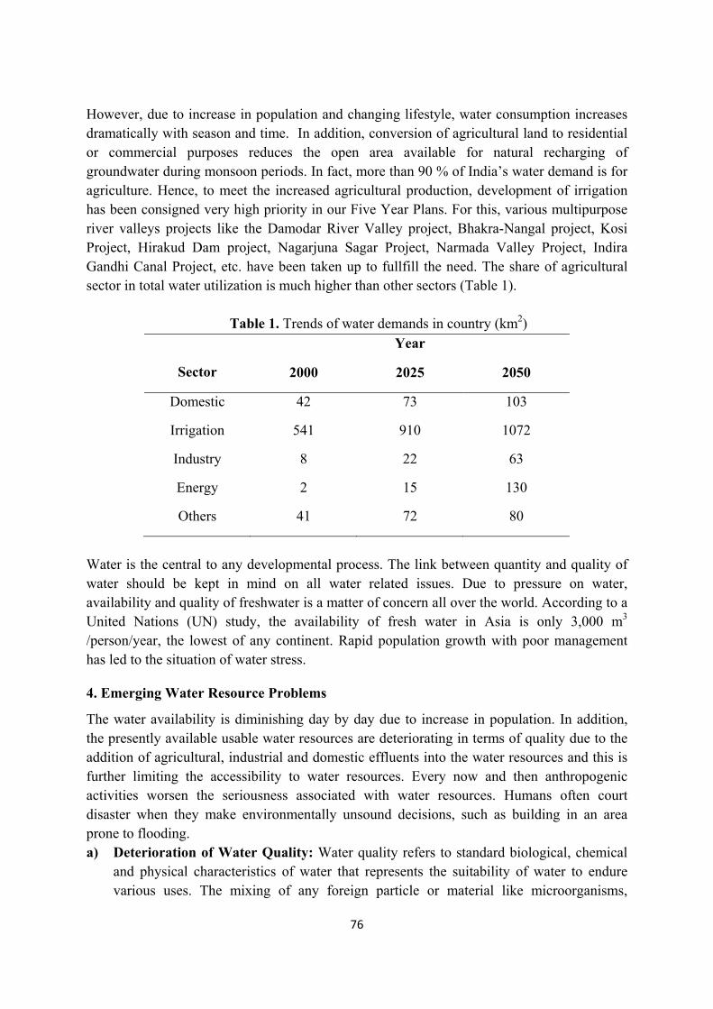
76
However, due to increase in population and changing lifestyle, water consumption increases dramatically with season and time. In addition, conversion of agricultural land to residential or commercial purposes reduces the open area available for natural recharging of groundwater during monsoon periods. In fact, more than 90 % of India’s water demand is for agriculture. Hence, to meet the increased agricultural production, development of irrigation has been consigned very high priority in our Five Year Plans. For this, various multipurpose river valleys projects like the Damodar River Valley project, Bhakra-Nangal project, Kosi Project, Hirakud Dam project, Nagarjuna Sagar Project, Narmada Valley Project, Indira Gandhi Canal Project, etc. have been taken up to fullfill the need. The share of agricultural sector in total water utilization is much higher than other sectors (Table 1).
Table 1. Trends of water demands in country (km2)
Sector
Year
2000 2025 2050
Domestic 42 73 103
Irrigation 541 910 1072
Industry 8 22 63
Energy 2 15 130
Others 41 72 80
Water is the central to any developmental process. The link between quantity and quality of water should be kept in mind on all water related issues. Due to pressure on water, availability and quality of freshwater is a matter of concern all over the world. According to a United Nations (UN) study, the availability of fresh water in Asia is only 3,000 m3
/person/year, the lowest of any continent. Rapid population growth with poor management has led to the situation of water stress.
4. Emerging Water Resource Problems
The water availability is diminishing day by day due to increase in population. In addition, the presently available usable water resources are deteriorating in terms of quality due to the addition of agricultural, industrial and domestic effluents into the water resources and this is further limiting the accessibility to water resources. Every now and then anthropogenic activities worsen the seriousness associated with water resources. Humans often court disaster when they make environmentally unsound decisions, such as building in an area prone to flooding. a) Deterioration of Water Quality: Water quality refers to standard biological, chemical
and physical characteristics of water that represents the suitability of water to endure various uses. The mixing of any foreign particle or material like microorganisms,
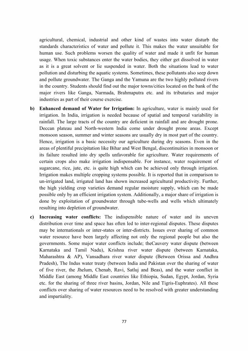
77
agricultural, chemical, industrial and other kind of wastes into water disturb the standards characteristics of water and pollute it. This makes the water unsuitable for human use. Such problems worsen the quality of water and made it unfit for human usage. When toxic substances enter the water bodies, they either get dissolved in water as it is a great solvent or lie suspended in water. Both the situations lead to water pollution and disturbing the aquatic systems. Sometimes, these pollutants also seep down and pollute groundwater. The Ganga and the Yamuna are the two highly polluted rivers in the country. Students should find out the major towns/cities located on the bank of the major rivers like Ganga, Narmada, Brahmaputra etc. and its tributaries and major industries as part of their course exercise.
b) Enhanced demand of Water for Irrigation: In agriculture, water is mainly used for irrigation. In India, irrigation is needed because of spatial and temporal variability in rainfall. The large tracts of the country are deficient in rainfall and are drought prone. Deccan plateau and North-western India come under drought prone areas. Except monsoon season, summer and winter seasons are usually dry in most part of the country. Hence, irrigation is a basic necessity our agriculture during dry seasons. Even in the areas of plentiful precipitation like Bihar and West Bengal, discontinuities in monsoon or its failure resulted into dry spells unfavorable for agriculture. Water requirements of certain crops also make irrigation indispensable. For instance, water requirement of sugarcane, rice, jute, etc. is quite high which can be achieved only through irrigation. Irrigation makes multiple cropping systems possible. It is reported that in comparison to un-irrigated land, irrigated land has shown increased agricultural productivity. Further, the high yielding crop varieties demand regular moisture supply, which can be made possible only by an efficient irrigation system. Additionally, a major share of irrigation is done by exploitation of groundwater through tube-wells and wells which ultimately resulting into depletion of groundwater.
c) Increasing water conflicts: The indispensible nature of water and its uneven distribution over time and space has often led to inter-regional disputes. These disputes may be internationals or inter-states or inter-districts. Issues over sharing of common water resource have been largely affecting not only the regional people but also the governments. Some major water conflicts include; theCauvery water dispute (between Karnataka and Tamil Nadu), Krishna river water dispute (between Karnataka, Maharashtra & AP), Vansadhara river water dispute (Between Orissa and Andhra Pradesh), The Indus water treaty (between India and Pakistan over the sharing of water of five river, the Jhelum, Chenab, Ravi, Satluj and Beas), and the water conflict in Middle East (among Middle East countries like Ethiopia, Sudan, Egypt, Jordan, Syria etc. for the sharing of three river basins, Jordan, Nile and Tigris-Euphrates). All these conflicts over sharing of water resources need to be resolved with greater understanding and impartiality.
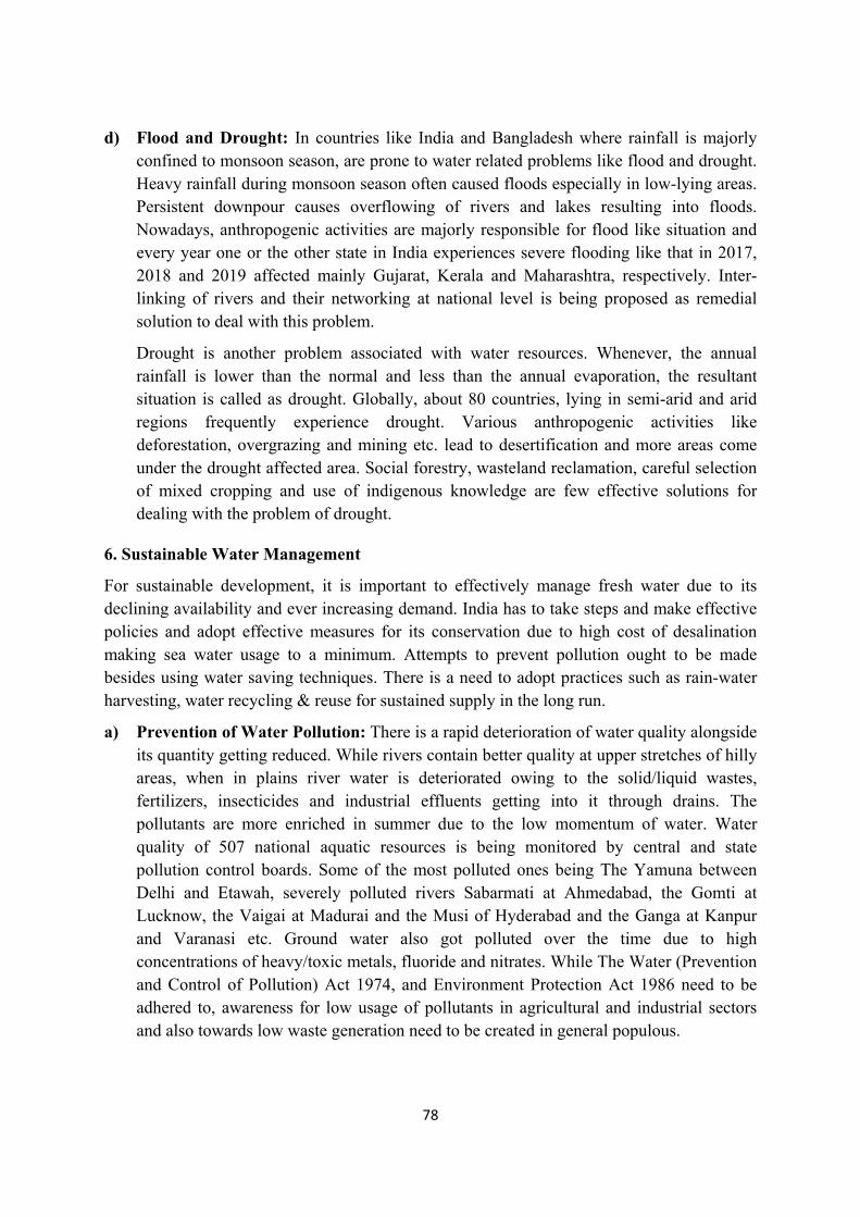
78
d) Flood and Drought: In countries like India and Bangladesh where rainfall is majorly confined to monsoon season, are prone to water related problems like flood and drought. Heavy rainfall during monsoon season often caused floods especially in low-lying areas. Persistent downpour causes overflowing of rivers and lakes resulting into floods. Nowadays, anthropogenic activities are majorly responsible for flood like situation and every year one or the other state in India experiences severe flooding like that in 2017, 2018 and 2019 affected mainly Gujarat, Kerala and Maharashtra, respectively. Inter-linking of rivers and their networking at national level is being proposed as remedial solution to deal with this problem.
Drought is another problem associated with water resources. Whenever, the annual rainfall is lower than the normal and less than the annual evaporation, the resultant situation is called as drought. Globally, about 80 countries, lying in semi-arid and arid regions frequently experience drought. Various anthropogenic activities like deforestation, overgrazing and mining etc. lead to desertification and more areas come under the drought affected area. Social forestry, wasteland reclamation, careful selection of mixed cropping and use of indigenous knowledge are few effective solutions for dealing with the problem of drought.
6. Sustainable Water Management
For sustainable development, it is important to effectively manage fresh water due to its declining availability and ever increasing demand. India has to take steps and make effective policies and adopt effective measures for its conservation due to high cost of desalination making sea water usage to a minimum. Attempts to prevent pollution ought to be made besides using water saving techniques. There is a need to adopt practices such as rain-water harvesting, water recycling & reuse for sustained supply in the long run.
a) Prevention of Water Pollution: There is a rapid deterioration of water quality alongside its quantity getting reduced. While rivers contain better quality at upper stretches of hilly areas, when in plains river water is deteriorated owing to the solid/liquid wastes, fertilizers, insecticides and industrial effluents getting into it through drains. The pollutants are more enriched in summer due to the low momentum of water. Water quality of 507 national aquatic resources is being monitored by central and state pollution control boards. Some of the most polluted ones being The Yamuna between Delhi and Etawah, severely polluted rivers Sabarmati at Ahmedabad, the Gomti at Lucknow, the Vaigai at Madurai and the Musi of Hyderabad and the Ganga at Kanpur and Varanasi etc. Ground water also got polluted over the time due to high concentrations of heavy/toxic metals, fluoride and nitrates. While The Water (Prevention and Control of Pollution) Act 1974, and Environment Protection Act 1986 need to be adhered to, awareness for low usage of pollutants in agricultural and industrial sectors and also towards low waste generation need to be created in general populous.
79
b) Sustainable water use: Sustainable water use refers to the use of water that supports the ability of human society to endure and flourish into the indefinite future without undermining the integrity of the hydrological cycle. The utilization of reclaimed waste-water is an smart option for fulfilling the demand of industries. Similarly, in urban areas water from household drains can be used for gardening. Water used for washing vehicle can also be used for gardening. This would conserve better quality of water for drinking purposes. Currently, recycling of water is practiced on a limited scale. However, we need to encourage the replenishment of water through recycling. United Nations Environment Programme has launched an Integrated Water Resources Management (IWRM) to promote coordination in management and development water, land and related resources. It will help to improve economic and social welfare in a justifiable manner without compromising the sustainability of vital resources.
c) Watershed Management: Watershed management implies the conservation and efficient management surface and groundwater resources especially watershed areas. It comprises storage and prevention of runoff for groundwater recharge through various methods like recharge well, tanks and check dams etc. The main objective of watershed management is maintaining the balance between utilization of natural resources and their demand in society. The accomplishment of watershed development chiefly depends upon participation of local community. The States and Central Governments have started many watershed management programmes in India such as Haryali, Arvary Pani Sansad (Rajasthan), Neeru-Meeru (Andhra Pradesh) etc. It is essential to generate awareness about welfares of watershed development and its management among local communities and this approach will ensured the sustainable availability of water.
d) Rainwater Harvesting: Rain water harvesting is used to capture and store rainwater. It is also helpful to recharge groundwater. It is an eco-friendly and cheap technique for preserving precipitated rain water by guiding it to storage tank or bore well or pits or wells. It increases water availability, sustains ground water table, improves groundwater quality through dilution of contaminants like arsenic, fluoride, phosphates, nitrates etc. It also prevents flooding, soil erosion, and arrests salt water imposition in coastal areas. Now a day, Government is also encouraging the practice of Rainwater harvesting in residential, institutional and commercial areas. In our country, rainwater harvesting was a common traditional practice and is done by various methods in form of storage bodies like Kund or Tanka, ponds, lakes, etc.
e) Dam and its role in water conservation: Storage of water by construction of dams is regarded as an efficient component of water management for irrigation. In India, the high-level demand of water for irrigation can be achieved by building dams of various heights. It has already been done under several river valley projects like Sardar Sarovar Dam project (in Narmada river valley), Nagarjun Sagar Dam Project (in Krishna River valley), Tehri Dam project (in Bhagirathi River valley) etc. The benefits of dam projects include;
80
(i) Generation of hydroelectricity.
(ii) Irrigation and flood control.
(iii) Industrial and municipal water supply.
The canal system from dam can transfer a large amount of water to great distances. The most famous example is the Indira Gandhi canal that brought greenery to the desert areas of Rajasthan. However, mismanagement of water from water reservoir of dams can cause many problems such as;
Unequitable distribution of water in downstream areas
People living close to the water sources grow crops which require heavy irrigation
The sudden or accidental release of water from dam results into flood like situations.
Disturbance of the ecosystem
Since independence more than 700 dam have been constructed. if the government programmes go ahead as scheduled, there will be hardly any free-flowing river left in the country. That is why, environmentalist such as Sundar Lal Bahuguna, Medha Patkar, Chandi Prasad Bhatt and others have opposed the implementation of several river valley projects like Tehri Dam project (Uttarakhand), Sardar Sarovar Dam (Gujrat), Narmada Sagar Dam project (Madhya Pradesh) etc. The reasons for this opposition are due to the social, economic and environmental problems.
Case Study 1- The Cauvery water dispute
Cauvery River has an inter-State basin including its origin in Karnataka and flowing through Tamil Nadu and Puducherry before terminating in Bay of Bengal. The total catchment basin of Cauvery river is 81.155sq.km which distributed among Karnataka (34,273 sq.km), Kerala (2,866 sq.km), Tamil Nadu and Puducherry (44,016sq.km). The dispute over distribution of Cauvery river water is about hundred-year-old. The river water is almost fully utilized by the upstream state, Karnataka and the downstream state, Tamil Nadu. Both the states have increased demand of river water for agriculture and industries. To resolve the issue, the Cauvery Water Dispute Tribunal (CWDT) was constituted in June 2, 1990. CWDT passes an interim order in 1991 directing the Karnataka state to release water from its reservoirs to ensure 205 Thousand million cubic feet (TMC) of water into Mettur reservoir of Tamil Nadu in a water year (1st June to 31 May) with weekly and monthly stipulations. But since 1995, delayed rain and the complex cropping patten in Cauvery basin resulted into a crisis like situation over sharing of the water between these two states. In 2007, The Supreme Court (SC) reserved its decision on the appeals filed by states agsinst CWDT’s final award. The SC on 16 February 2018 delivered its verdict in the Cauvery water dispute, allocating more water to Karnataka state. As directed by SC, The Cauvery Water Management Authority (CWMA) and the Cauvery Water Regulation Committee (CWRC) were created to settle down the century old dispute.
81
LEARNING OUTCOME (Summary)
• The 3/4th of the earth surface is covered by water but only 2.5 % is available fresh water.
• The freshwater resources include surface water and ground water.
• Population explosion, urbanization, industrialization and water pollution are the major causes of water associated problems.
• Rainwater harvesting, watershed management, judicious use of water, construction of dams etc. are the key steps for sustainable water conservation and management.
• The problem of water scarcity can be solved by multipurpose river projects which can fulfil the various objectives like irrigation, hydroelectricity, flood control, fish breeding etc.
EXERCISES
Q. 1. Fill in the blanks with suitable word
a) Earth is also called __________ planet.
b) The main sources of fresh water are _________, _______ , and ________.
c) The underground layer of rock that holds groundwater is called as
d) Sardar Sarovar Dam project is based in _______ river valley.
e) Industrialization is also one of the causes of water ____________.
Answer: (a) Blue; (b) Rivers, lakes, glaciers; (c) Aquifer; (d) Narmada; (e) Scarcity
Q. 2. Multiple Choice Questions (MCQs) and Answers
(a) On which river has Nagarjun Sager Dam been constructed?
i. River Narmada
ii. River Krishna
iii. River Godavari
iv. River Cauvery
(b) How much percentage of the Earth’s Surface is covered with water?
i. About 70% ii. About 90%
iii. About 60% iv. None of these
(c) According to a prediction, nearly 2 billion people will live in absolute water scarcity in the year of
i. 2015 ii. 2020
iii. 2025 iv. 2030
(d) The first & the only state in India which has made Roof Top Rain water Harvesting Structured compulsory to all the across the state is
82
i. Karnataka
ii. Tamil Nadu
iii. Kerala
iv. All of above
(e) The following is the only state where roof top rain water harvesting is made compulsory
i. Bihar
ii. Assam
iii. Tamil Nadu
iv. Maharashtra
Answer: (a) ii; (b) ii; (c) iii; (d) ii; (e) iii
Q. 3. Write short notes on the following.
(a) Rainwater harvesting
(b) Consequences of water scarcity
(c) Sustainable water management
(d) Groundwater resources
(e) Aquifers
83
LESSON-7
NATURAL RESOURCES: ENERGY RESOURCES
Dr. Pramod Kumar Assistant Professor,
Deen Dayal Upadhyay College, University of Delhi
INTRODUCTION
The term Energy was coined by Thomas Young (1737-1829), eighty years after Newton and applied it to what is now called kinetic energy. The term Energy can be defined as the “ability/capacity to do work”. The two laws of thermodynamics describe the behaviour of energy.
The first law states that Energy can neither be created nor destroyed however; it can be transferred from one form to another.
The second law states that some energy is always dissipated into unavailable form i.e. heat energy. There is no spontaneous transformation of energy from one form to another (in context of protoplasm) is 100 percent efficient.
LEARNING OBJECTIVES
After going through the lesson you will be able to
Define energy and identify its different types that exist.
Analyse the energy demand due to growing population, globalization and industrialisation.
List the benefits of using alternate sources of energy sources instead of coal.
Classify different energy resources as renewable or non-renewable.
Describe the difference between renewable and nonrenewable energy resources.
Identify the benefits and disadvantages to using renewable energy resources.
Understand the various forms of conventional energy resources.
Identify the benefits and disadvantages to using conventional energy resources.
Outline the technologies that are used to harness the power of solar energy using case study.
The Energy is required by all living organisms and vegetations for biochemical reactions of their cells. In fact, all living beings operate by means of energy. Energy moves the universe. About 99.8 percent of our energy comes from solar radiation. It is the solar energy that plants use to make food which gets stored in plants as biomass. The consumption of energy is an
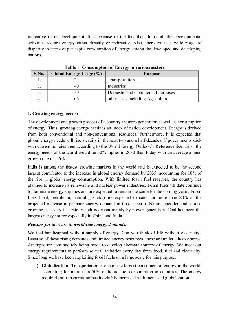
84
indicative of its development. It is because of the fact that almost all the developmental activities require energy either directly or indirectly. Also, there exists a wide range of disparity in terms of per capita consumption of energy among the developed and developing nations.
Table 1: Consumption of Energy in various sectors
S.No. Global Energy Usage (%) Purpose 1. 24 Transportation 2. 40 Industries 3. 30 Domestic and Commercial purposes 4. 06 other Uses including Agriculture
1. Growing energy needs:
The development and growth process of a country requires generation as well as consumption of energy. Thus, growing energy needs is an index of nation development. Energy is derived from both conventional and non-conventional resources. Furthermore, it is expected that global energy needs will rise steadily in the next two and a half decades. If governments stick with current policies then according to the World Energy Outlook’s Reference Scenario - the energy needs of the world would be 50% higher in 2030 than today with an average annual growth rate of 1.6%.
India is among the fastest growing markets in the world and is expected to be the second largest contributor to the increase in global energy demand by 2035, accounting for 18% of the rise in global energy consumption. With limited fossil fuel reserves, the country has planned to increase its renewable and nuclear power industries. Fossil fuels till date continue to dominate energy supplies and are expected to remain the same for the coming years. Fossil fuels (coal, petroleum, natural gas etc.) are expected to cater for more than 80% of the projected increase in primary energy demand in this scenario. Natural gas demand is also growing at a very fast rate, which is driven mainly by power generation. Coal has been the largest energy source especially in China and India.
Reasons for increase in worldwide energy demands:
We feel handicapped without supply of energy. Can you think of life without electricity? Because of these rising demands and limited energy resources, these are under a heavy stress. Attempts are continuously being made to develop alternate sources of energy. We meet our energy requirements to perform several activities every day from food, fuel and electricity. Since long we have been exploiting fossil fuels on a large scale for this purpose.
a) Globalization: Transportation is one of the largest consumers of energy in the world, accounting for more than 50% of liquid fuel consumption in countries. The energy required for transportation has inevitably increased with increased globalization.
85
b) Industrialization, especially in emerging markets: There is a large scale requirement of energy in businesses and factories in the form of both electricity and petroleum-based fuels in order to operate. The energy demand is increased as soon as economies industrialize. In other words Industrialization and Urbanization have multiplied the demand for energy resources several-fold.
c) Increasing wealth especially in emerging markets: With the growth of economy the energy also grow. This leads to increased energy demand and consumption.
d) Rapid growth of human population: It is putting a heavy stress on all resources of energy.
2. Use of alternate sources of energy:
Any energy source which provides alternate to fossil fuel is called alternate source of energy. All the conventional mineral-based energy resources, such as fossil fuels, are exhaustible. It is estimated that if we continue to use coal at the present rate, the available coal reserve will exhaust in the present century itself. India produces petroleum which fulfills only half of our requirement and the remaining half is met by importing from other countries.
3. Major sources of Energy that we use:
The source of energy can be defined as the one which can make available sufficient quantity of energy in a usable form for a longer duration.
4. Renewable and Non-renewable sources of Energy I almost every part of the world, industrialization and agriculture development have increased the requirement of energy on a larger scale and the same can be directly related with the expansion of expansion of possible energy sources. These developments and expansion
Geothermal Biomass
Nuclear PowerFossil fuels
Sources of Energy
Conventional/Non-renewable/Exhaustible Non-Conventional/Renewable/Inexhaustible
Ocean waves Ocean Thermal Tidal
Hydroelectric Hydrogen Ocean Solar Wind
86
particularly in the field of industries as well as agriculture have caused a fall in their supply. Besides, traditional sources of energy have serious environmental concerns as these cause environmental pollution.
Renewable energy sources/ Non-conventional energy sources:
The increasing energy demands have compelled countries all over the world to think of a policy on energy and look into a possibility of having energy system with no or very limited environmental impacts. The deposits of coal and oil will exhaust one day. The energy-crisis has shown that for sustainable development in energy sector, we must replace them by non-polluting renewable sources and conserve them. Efforts are being made to develop new sources of energy. These are called renewable sources of energy and include solar energy, wind energy, ocean energy, geothermal energy, urban waste, agricultural waste, energy plantations etc. These are non-polluting, environmentally clean and socially relevant. Moreover, no nation can afford to depend on only one form of energy there has to be a mix of various forms of energy.
Non-renewable energy sources/ Conventional energy sources:
The resources which have accumulated in nature over a long span o time and cannot be quickly replenished when exhausted are known as Non-renewable energy sources for e.g. Coal, Petroleum, Natural gas, nuclear fuels like uranium and thorium.
Advantages of Renewable sources of Energy:
1. Renewable energy is available in abundant quantity and free to use.
2. Renewable energy has low or zero carbon emissions, therefore they are considered as green and eco-friendly.
3. Renewable energy develops self reliance and minimizes the reliance on any third country for the supply of energy.
4. Renewable sources can cost less than consuming the local electricity supply.
5. Renewable sources of energy help in economy simulations and creating job opportunities, through building such equipments, instruments or plants that provide jobs to many people.
Disadvantages of Renewable sources of Energy:
Though renewable energy has many benefits and advantages but it also has certain limitations
1. High cost of initial investment to set up plant.
2. Non-availability (Solar light only when days are sunny)
3. Loss of biodiversity and forest along with modification of local environment (Dam for hydroelectric energy).
Advantages of Non-renewable sources of Energy:
1. Non-renewable sources of energy are cheaper and easy to use.
87
2. Non-renewable sources release great amount of energy from small amount of resource use (uranium).
Disadvantages of Non-renewable sources of Energy:
1. Non-renewable sources of energy are limited and will end one day. Thus, their prices will keep rising and will not be accessible and available for everyone.
2. Their use is not eco-friendly as they release toxic gases that are creating serious environmental changes.
Table 2: Difference between Renewable and Non-renewable resources
S.No. Renewable resources Non-Renewable resources 1. Resources which can be
renewed/regenerated/replenished again and again within a given span of life are known as renewable resources.
Resources which cannot be renewed/regenerated/replenished again and again within a given span of life are known as renewable resources.
2. The stocks or reserves of these resources are unlimited in nature.
The stocks or reserves of these resources are limited in nature.
3. They are also called inexhaustible resources.
They are also called exhaustible resources.
4. These resources are eco-friendly i.e. they do not cause pollution of environment.
These resources are not eco-friendly i.e. they cause pollution of environment.
5. e.g. Water, Air, Sun etc. e.g. Fossil Fuels: Coal, Petrol, Diesel, Nuclear Fuel etc.
4.1. Renewable Energy
4.1.1. Solar energy
The Sun is considered to be the ultimate source of energy for all other forms of energy either directly or indirectly. The phenomenon occurring inside the sun releasing tremendous amount of energy in the form of heat and light is nuclear fusion. The earth space receives nearly 1.4 KJ/sec/m2 of solar energy.
Advantages:
1. The energy produced from the sun is a renewable source of energy. The power source of the sun is absolutely free.
2. It produces electricity which doesn’t cause pollution of environment.
3. It can be used in remote and isolated areas where there is no power supply.
4. Most solar energy systems have a lifespan of about 30 to 40 years.
5. In majority of the solar energy systems there is hardly any requirement of maintenance during their lifetime, indicating that one need not to put additional money into them.
88
6. Solar energy systems are now being considered and designed to satisfy particular needs. For example, outdoor lighting can be converted to solar.
7. Solar energy has various other applications apart from producing Photovoltaic energy viz. Solar cooker, Solar water heating systems, passive solar heating of homes etc.
Disadvantages:
1. Solar energy can be harnessed only during the daytime or when it is a sunny day. Cloudy skies reduce its effectiveness.
2. Solar energy can be unreliable at times.
3. Amount of sunlight reaching the Earth’s surface varies with location, time of day, time of year and other weather conditions.
4. Transmission remains a barrier that has to be breached.
5. Installation cost is high as:
a. Solar panels, solar cells as well as collectors are comparatively expensive to manufacture.
b. It uses a special grade of Silicon which is expensive.
c. Since silver is used for connecting the cells together it is more expensive.
d. The current produced is DC and to convert it to AC increases the cost.
6. Solar power stations are also very expensive to be built and also, they fail to match the power output similar sized conventional power stations.
7. The large-scale requirement of areas of land in order to capture the solar energy.
8. In order to meet the requirement of energy during the night batteries are charged during the day from solar energy. As a result, the large storage space is required for these large and heavy batteries which need to be replaced at regular intervals.
4.1.2.Wind energy
The high-speed moving winds due as a result of their motion possess lot of energy in them in the form of kinetic energy. Sun is the main driving force for the wind. The wind energy can be captured by making use of windmills. The force of the striking wind is the main driving force that helps the blades of the windmill to rotate continuously. The revolving blades can be utilised to drive a number of machines like electric generators, flour mills and water pumps. Now days a large number of windmills are being installed in clusters known as wind farms that feed power to the utility grid by producing a large amount of electricity. The prominent areas where the winds are strong and steady comprise of the coats, hilly regions mountain passes and ridges in particular, open grasslands are utilised for wind farms. The minimum wind speed that can rotate the blades of a wind generator for satisfactory working is 15km/hr. The largest wind farm of our country is near Kanyakumari in Tamil Nadu generating 380MW electricity. Wind energy is considered to be the second fastest growing source of energy since 1990 and probably be the cheapest source.
89
Table 3: Wind speeds and the performance of the wind turbine Average wind speed (Km/hr) (mph) Performance of Wind turbine
Up to 15 (9.5) No good 18 (11.25) Poor 22 (13.75) Moderate 25 (15.5) Good 29 (18) Excellent
Advantages:
1. The wind is free of cost can be captured efficiently with the help of modern technology.
2. The wind energy could also be used to produce hydrogen by electrolysis of water.
3. It can be used in remote and isolated areas where there is no power supply.
4. It is utilized for par generation, pumping water and other domestic purposes such as threshing, winnowing, cutting wooden logs etc.
5. Wind energy can also be used for battery charging to run generators.
6. It is a decent method of supplying energy to remote areas.
7. Wind farm can be used to generate revenue as they can be tourist attractions.
8. The land beneath the wind turbines can still be used for farming especially in agricultural areas as wind turbines can be very tall and each turbine takes up only a small plot of land.
9. The recurring cost is less.
Disadvantages:
1. The main disadvantage regarding the wind power is down to the winds unreliability factor.
2. Minimum wind speed of 15 km/hr i.e. 4.2 m/s is required in order to rotate the wind turbine.
3. The installer has to face nature’s problems, because wind doesn’t blow all the time i.e. it is not always predictable, therefore, electricity needs to be stored until it is used. There is also requirement of backup systems.
4. There is large scale requirement of multiple wind turbines in order to produce sufficient amount of electricity as a single wind turbine produces much less electricity than the average fossil fuelled power station.
5. The blades of the wind turbine may interfere with television reception or with microwave communication used by various telephone companies.
6. There is large scale requirement of land for installation.
7. The blades of the turbine can kill birds and migrating flocks thereby causing loss of biodiversity.
8. The wind generators are few and give unattractive outlook to the landscapes and are extremely noisy: This disturbs the residence of the area.
90
9. Optimum areas for wind farms are often the open plains, the coast, where the land is expensive.
4.1.3. Hydroelectric energy
Hydropower is defined as “The electricity that is generated from the energy of falling water and running water that can be utilised for various useful purposes. Hydropower has been used in our country from the ancient times for various purposes such as for irrigation and the operation of various mechanical devices, such as watermills, sawmills, textile mills, dock cranes, domestic lifts, power houses and paint making. Hydroelectricity is considered to be most widely used that accounts for nearly 16 % of global electricity generation. The first hydropower station in India was a small hydropower station of 130 KW commissioned in 1897 at Sidrapong near Darjeeling in West Bengal. With the advancement in technologies and increasing requirement of electricity, emphasis was shifted to large sized hydropower stations. Large hydropower projects in India are developed by the Ministry of power, the Government of India. Small and minihydel projects have the potential to provide energy to remote and hilly areas where the extension of grid system is uneconomical. The construction of mini/micro hydel plants with generation capacities between 3 MW and 15 MW are most suitable and avoid the socio-economic and environmental problems as occur during construction of big dams. Applications:Generating Electricity, Flood risk management and Enabling Irrigation.
Advantages:
1. Hydroelectricity is the clean source of energy.
2. The water can also be utilised for irrigation purposes.
3. The water can also be utilised as source of drinking water provides drinking water to people living, particularly in desert of Rajasthan and Gujarat.
4. It is absolutely non-polluting, has a long life, and has a very low operating and maintenance costs, unaffected by inflation.
5. Help in controlling floods and making water available during non-rainy seasons for irrigation and other uses.
6. Once the dam is constructed, it produces electricity at a constant rate.
7. The gates can be opened and closed depending upon the need of electricity.Also, the water saved during the closure of the gates can be utilised when the demand for electricity sis high.
8. Dams and reservoirs are constructed to contribute in production of electricity for many years and decades.
9. The build-up of water in the lake means that energy can be stored until needed, when the water is released to produce electricity.
10. The production of electricity by dam systems doesn’t result in the production of greenhouse gases thereby it does not pollute the environment.
91
Disadvantages:
1. Construction of Dams requires huge investment of money and they need to be constructed to a very high standard.
2. The natural environment gets destroyed as a result of large scale flooding.
3. The dam sites are specially the forest and agricultural areas and get submerged during construction.
4. It causes water logging and siltation.
5. It cause loss of biodiversity and fish population and other aquatic organisms are adversely affected.
6. Displace local people and create environmental problems of rehabilitation and related socio-economic problems.
7. Increases seismicity due to large volume of water impounded.
8. Loss of prime agricultural land (flood plain area). The area beneath the river is most fertile which gets lost as a result of construction of dams.
9. The natural water table is altered as a result of construction of a large dam.
10. The buildings of large dams can cause serious geological damage.
4.1.4. Hydrogen energy
As hydrogen burns in air, it combines with oxygen to form water with liberation of enormous quantity of energy which is 150 kilojoules per gram. Hydrogen possesses the highest calorific value and therefore can serve as an excellent fuel. Hydrogen is a clean fuel and energy storage medium for various applications. The production of hydrogen is occurred by thermal dissociation, photolysis or electrolysis of water. Various organic effluents like distillery, starch etc. can also produce Hydrogen by biological conversions.
Advantages:
1. At present, in the form of liquid hydrogen it is used as a fuel in spaceships.
2. H2 can be used in fuel cell to generate electricity. In fuel cell hydrogen is burnt in air or oxygen in the pressure of an electrolyte to produce electricity.
3. And being very light, it would have to be stored in bulk.
Disadvantages:
1. Hydrogen is highly explosive and inflammable and explosive. Therefore, in order to be used as a fuel it requires safe handling.
2. There is also a great difficulty in storing as well as transporting hydrogen.
4.1.5. Ocean energy
More than 70% of the earth surface is occupied by thereby making them world’s largest solar collector. The ocean forms a vital source of energy. Ocean Tides, produced by gravitational force of sun and moon, possess tremendous amount of energy.
92
Tidal Energy
The rise and fall of water in the oceans is referred to as the high tide and low tide. In order to rotate the turbine, there is a requirement of several meters difference between the high and low tide. This difference in the tides can be exploited to harness tidal energy by constructing a tidal barrage. The sea water will flow into the reservoir of barrage during the high tide turning the turbine and producing electricity by rotating the generators. When the sea level is low during the low tide sea water which was stored in the barrage reservoir flows out into the sea turning the turbine producing electricity by rotating the generators.
The potential of tidal power in India is estimated to be about 15,000 MW. In India, Gulf of Cambay, Gulf of Kutch (1000 MW) and the Sunderban deltas (100 MW), Andaman and Nicobar Islands, Lakshdweep Islands, the coasts of Odisha, Kerala, Tamil Nadu, Karnataka and Maharashtra are the potential tidal power sites. The tidal power sites for harnessing the tidal energy in the world are very few in number. The Bay of Funday, Canada possess a potential of 5,000 MW of power generation with 17-18 m high tides. One of the first modern tidal power mill is located at La Rance, France.
Ocean Wave Energy:
The power of ocean waves, which operates on the principle of oscillating water column, has not been exploited to its full potential except as power supplies for navigational aids. India has initiated wave energy project at Vizhinijam Fishery Harbour near Trivendrum in Kerala as an indigenous effort. It was expected that on the completion, the project would be able to derive an energy output of 4.45 lakh units per year. The project resulted in a strict reality in 1991 when it started generation of electricity to be fed to the grid of Kerala State Electricity Board.
Ocean Thermal Energy:
As sunlight falls on to the surface of the ocean, the upper surface gets warmer while the lower layers have relatively lesser temperature. This temperature difference between the upper and the subsequent lower layers of the ocean can be exploited to generate electricity through Ocean Thermal Energy conversion power plants. In order to produce electricity through OTEC power plant minimum temperature difference between the surface and deeper levels is 20o C.
Advantages:
1. Ocean wave energy and tidal energy is free and clean source of energy.
2. The production of electricity by ocean systems doesn’t result in the production of greenhouse gases thereby it does not pollute the environment.
3. The Energy capturing and conversion mechanism may help protect the shoreline.
4. There is a continuous generation of electricity as tides are active 24 hours a day, 365 days a year.
93
Disadvantages:
1. It causes displacement of wildlife habitats. The barrage systems pose a risk of destruction of ecosystem relying on coming and going of tides. The barrage systems can kill the migrating fishes passing through the turbine.
2. The energy from the oceans can only be harnessed from those areas where there is suitable wave motion or tidal flow. Therefore, cannot be used inland.
3. The energy can be produced during tidal surges only.
4. Recurring cost is high as barrage systems require salt resistant parts.
5. The movement of the large marine animals and ships through the channels on which the barrage is built is disrupted. The frames of the turbines can disrupt the movement of large marine animals and ships through the channels on which the barrage is built.
6. The waves of great intensity can be produced by extreme weather.
4.1.6.Geothermal energy
Geothermal energy is the energy which is produced from the hot rocks present inside the earth. In many places below the surface of the earth high temperature and high pressure steam fields are present. Radioactive materials naturally present inside the rocks produce this heat by the fission process. This energy in the form of steam or hot water either comes out to the ground from the earth’s crust naturally through cracks in the form of natural geysers as in Manikaran, Kullu and Sohana, Haryana. The energy which does not find any place to come out can be taken out by artificially drilling a hole upto the hot rocks and by putting a pipe in it steam or hot water can be gushed out through the pipe at high pressure that will turn the turbine of a generator to produce electricity. Sometimes the steam or boiling water underneath the earth does not find any place to come out. In USA and New Zealand, there are several geothermal plants working successfully.
Advantages:
1. A life time energy resource. Geothermal energy can be used and reused again and again.
2. Geothermal energy is among the cleanest source of energy as it doesn’t burn fossil fuel in order to produce electricity.
3. High heat source: The energy coming from the core of the earth is extremely powerful, that allows geothermal plants to generate electricity.
Disadvantages:
1. In order to harness geothermal energy one needs to find a good spot where there is continuous and substantial amount of steam present that could be trapped into. So, to generate geothermal energy all the areas are not suitable.
2. For setting up of a geothermal energy plant huge capital is required.
3. In order to finalize a geothermal site drilling and testing are required that cost a lot of money.
94
4.1.7.Biomass energy
The organic matter formed by the plants and animals that includes agricultural wastes, crop residues, wood, manure, cattle dung, sewage etc. is referred to as Biomass energy.
Types of Biomass
Agricultural and Industrial waste biomass: Agricultural Crop Residues, Bagasse (Sugarcane Residues), Peanut hulls, Cotton stalks, Coconut shells etc. are few common agricultural wastes that produce energy by burning.
Fishery and poultry waste, animal dung, and even human refuse are also examples of biomass energy. Thirty percent (30%) electricity in Brazil is produced by burning bagasse. Animal dung cakes are used in rural India to produce heat by burning. Agricultural waste, animal dung cakes and wood account for meeting nearly 80% of rural heat energy requirements. Open furnaces called “Chulhas” that usually produce smoke and less efficient (efficiency <8%) are used to burn waste biomass. Presently smokeless chulhas with improved efficiency and a tall chimney are used. The combustion of animal wastes and plant residues produce lot of smoke thereby causing air pollution and produce lot of ash as waste residue. Essential nutrients like N and P are also destroyed when we burn dung it is therefore advisable to convert biomass into bio fuels or biogas.
Energy Plantations: Green plants manufacture their own food by trapping the solar energy trapped through the process known as photosynthesis. In this process solar energy of the sun is converted and converted into biomass energy. The energy from the energy plantations is produced either directly by burning or by converting into fuels by fermentation, or by converting into burnable gas. The examples of energy plantations are crops like sugarcane, sugar beet, sweet sorghum, aquatic weeds like water hyacinth and sea-weeds and carbohydrate rich potato, cereals and fast growing trees like poplar, cottonwood and Leucaena leucocephala, non-woody herbaceous grasses.
Petro-Crops: Some plants or algaeare rich in hydrocarbons and produce oil like substance under high temperature and pressure. This oily substance can actually act as a potential source of energy or may be refined to form gasoline and can be burnt directly in diesel engines. Examples of such petro-crops are oil palms and plants like Euphorbias.
Advantages:
1. It is sensible to use waste materials.
2. The fuel source is cheap.
3. Biomass doesn’t emit additional carbon dioxide (CO2), like fossil fuels.
4. Biomass can be utilised to manufacture variety of fuels (biogas/biofuel/heat) in order to produce electricity.
5. Biomass energy helps in reducing disposal costs.
6. The life of the landfills is increased as a result of this.
95
7. The energy generation from the biomass has negative fuel costs as it uses waste products.
8. It reduces dependence on fossil fuels.
Disadvantages:
1. The main problem for the production of biomass energy is the gathering fuel in sufficient quantities.
2. It is not available all year round.
3. The value of Biocrops is more than the food so it can have detract food production that will result in food shortages and increased prices.
4. Emission of greenhouse gases. It releases pollutants into the atmosphere causing air pollution.
4.2. Non-renewable energy resources:
Fossil Fuels: Fossil fuels principally comprise hydrocarbons. Fossil fuels involve deposits of once living organisms. This may take centuries to form. Fossil fuels for energy provision are of three types: Coal, Oil and Natural gas.
5. Energy contents of coal, petroleum, natural gas and bio gas:
Coal: Coal was formed during the Carboniferous age around 255-350 million years ago, in hot damp regions of the earth. The plants and animals that occurred during this period, along the banks of rivers and swamps, got buried alive or after their death into the soil and due to heat accompanied by pressures gradually got converted into peat and coal over a millions of years of period. The vegetation which was partially decomposed and deeply buried in sedimentary environments got slowly transformed into solid, brittle, carbonaceous rocks commonly known as coal. The coal is the most abundant fossil fuel with a total recoverable resource of about 6,000 billion tonnes in the world. With present rate of consumption, the coal reserves are likely to last during next 200 years and if the use rate increases by 2% per year, then it will last within next 65 years.
Coal reserves are unevenly distributed in the country, with the bulk reserves located in the eastern states of Bihar, West Bengal and Odisha. Central India, including Madhya Pradesh and Andhra Pradesh, also possess sizeable coal reserves of the order of 22 percent of the total. Indian coal is not considered to be the good coal in terms of heat capacity and India accounts for about 5% of the total world’s coal. Bokaro, Jharia, Raniganj, Godavari valley and Singrauli are the major coalfields in India. Anthracite coal is found only in Jammu & Kashmir.
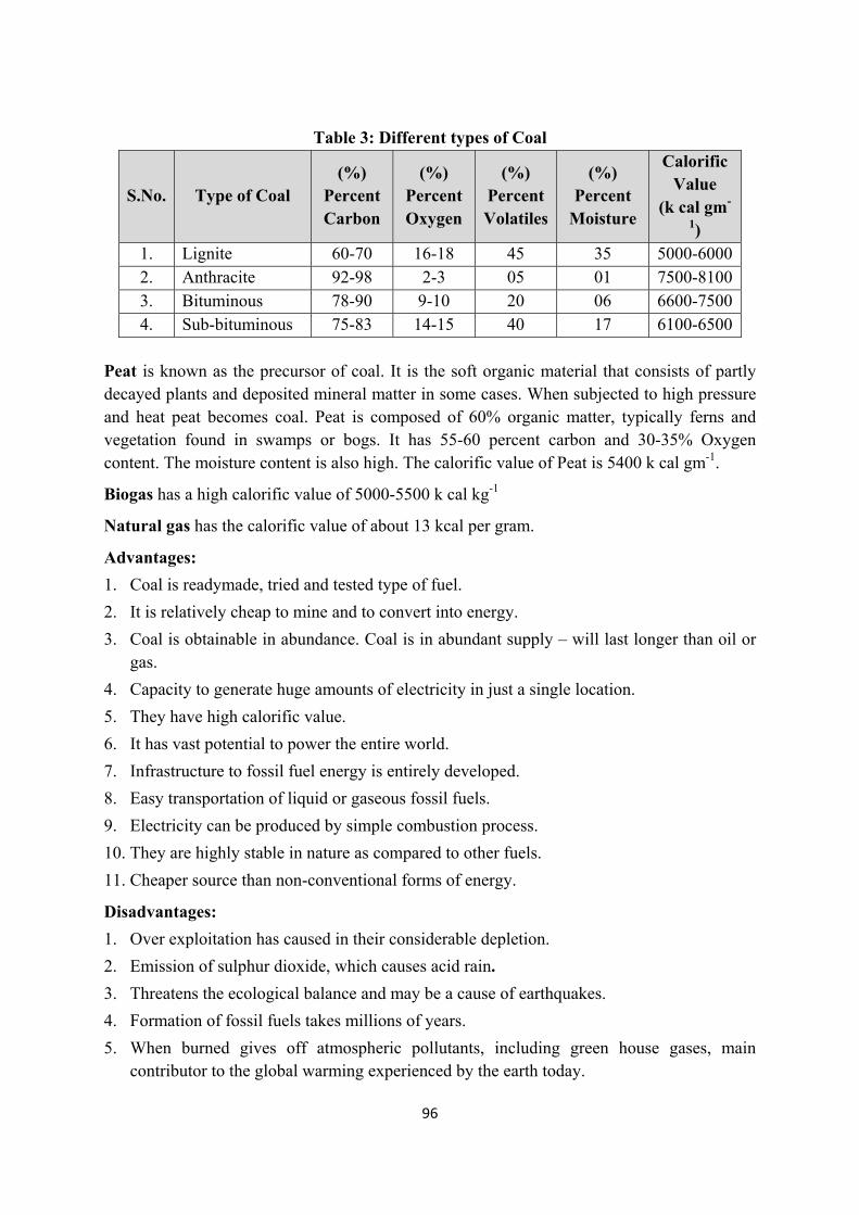
96
Table 3: Different types of Coal
S.No. Type of Coal (%)
Percent Carbon
(%) Percent Oxygen
(%) Percent Volatiles
(%) Percent
Moisture
Calorific Value
(k cal gm-
1) 1. Lignite 60-70 16-18 45 35 5000-60002. Anthracite 92-98 2-3 05 01 7500-81003. Bituminous 78-90 9-10 20 06 6600-75004. Sub-bituminous 75-83 14-15 40 17 6100-6500
Peat is known as the precursor of coal. It is the soft organic material that consists of partly decayed plants and deposited mineral matter in some cases. When subjected to high pressure and heat peat becomes coal. Peat is composed of 60% organic matter, typically ferns and vegetation found in swamps or bogs. It has 55-60 percent carbon and 30-35% Oxygen content. The moisture content is also high. The calorific value of Peat is 5400 k cal gm-1.
Biogas has a high calorific value of 5000-5500 k cal kg-1
Natural gas has the calorific value of about 13 kcal per gram.
Advantages:
1. Coal is readymade, tried and tested type of fuel.
2. It is relatively cheap to mine and to convert into energy.
3. Coal is obtainable in abundance. Coal is in abundant supply – will last longer than oil or gas.
4. Capacity to generate huge amounts of electricity in just a single location.
5. They have high calorific value.
6. It has vast potential to power the entire world.
7. Infrastructure to fossil fuel energy is entirely developed.
8. Easy transportation of liquid or gaseous fossil fuels.
9. Electricity can be produced by simple combustion process.
10. They are highly stable in nature as compared to other fuels.
11. Cheaper source than non-conventional forms of energy.
Disadvantages:
1. Over exploitation has caused in their considerable depletion.
2. Emission of sulphur dioxide, which causes acid rain.
3. Threatens the ecological balance and may be a cause of earthquakes.
4. Formation of fossil fuels takes millions of years.
5. When burned gives off atmospheric pollutants, including green house gases, main contributor to the global warming experienced by the earth today.
97
6. Only a limited supply.
7. Environmentally, mining of coal results in the destruction of wide areas of land. Mining this fossil fuel is also difficult and may endanger the lives of miners. Coal mining is considered one of the most dangerous jobs in the world.
Petroleum
Petroleum is considered to be the lifeline of economy at global level and cleaner than coal. Sixty seven (67%) of the total petroleum reserves are restricted to 13 countries in the world which together form OPEC (Organisation of Petroleum Exporting Countries). Saudi Arabia accounts for twenty five (25%) of the oil reserves. If we continue to use the crude oil at present rate, then the world’s crude oil reserves are expected to be exhausted in next 40 years. In India, crude oil was first recovered from Makum in North East Assam. Later, drilling for crude oil was done at Digboi, Dibrugarh, Narharlatiya and Surma valley in the north east. The oil field also lies around Bay of Cambay, Gujarat. The most important achievement was the exploration of oil in Bombay high on the continental shelf of Maharshtra, located at a distance of 167 km north-west of Mumbai. Recently oil has been located in the off-shore areas of deltaic coasts of Godavari, Krishna, Cauvery and Mahanadi. Oil prospects in India are not so high as coal. But the demands are very high and the country has to import oil from OPEC countries at higher rates.
Natural Gas: Natural gas, a fossil gift from nature, is composed of methane (95%) with small amounts of ethane and propane. Natural gas deposits are accompanied by oil deposits or they may also occur independently. Among the fossil fuels, it is the cleanest source of energy. Natural gas can easily be transported through the pipelines. It burns without smoke and has high calorific value. It can be used as a source of energy for domestic as well as industrial purpose. It can also be used for power generation and as a raw material for petrochemical industries and fertilizer plants. Crude oil refining and fractional distillation plants yield natural gas as a byproduct. About 40% of total natural gas is restricted to Russia followed by Iran (14%) and USA (7%). In India, Natural gas reserves occur in association with oil fields. Some new areas have been discovered in Jaisalmer, Tripura, off-shore area of Mumbai and the Krishna-Godavari Delta.
LPG (liquefied Petroleum Gas): It is widely used as a domestic fuel for cooking, has its main content as odourless butane to which other gases like propane and ethyl mercaptan are added to give fowl smell in order to identify leakage. It is produced by converting petroleum into liquid form under pressure. Indane and Bharat Petroleum are the chief distributing agencies of LPG. LPG emits negligible levels of particles which diesel does and even those emitted are not as toxic as those emitted from diesel. It is an ideal cleanest burning alternative fuel.
CNG (Compressed Natural Gas): The CNG is used as a substitute to petrol and diesel in vehicles. Delhi Transport Corporation (DTC) has totally switched over to CNG where buses aas well as auto rickshaws run on CNG. It has reduced levels of pollution in the city. CNG is a cleaner fuel than diesel, used currently in many cities and long-distance transport across the
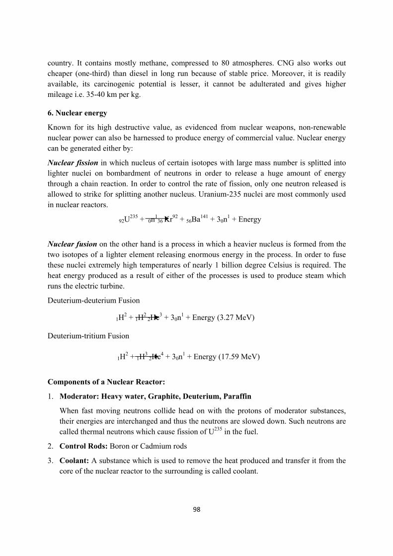
98
country. It contains mostly methane, compressed to 80 atmospheres. CNG also works out cheaper (one-third) than diesel in long run because of stable price. Moreover, it is readily available, its carcinogenic potential is lesser, it cannot be adulterated and gives higher mileage i.e. 35-40 km per kg.
6. Nuclear energy
Known for its high destructive value, as evidenced from nuclear weapons, non-renewable nuclear power can also be harnessed to produce energy of commercial value. Nuclear energy can be generated either by:
Nuclear fission in which nucleus of certain isotopes with large mass number is splitted into lighter nuclei on bombardment of neutrons in order to release a huge amount of energy through a chain reaction. In order to control the rate of fission, only one neutron released is allowed to strike for splitting another nucleus. Uranium-235 nuclei are most commonly used in nuclear reactors.
Nuclear fusion on the other hand is a process in which a heavier nucleus is formed from the two isotopes of a lighter element releasing enormous energy in the process. In order to fuse these nuclei extremely high temperatures of nearly 1 billion degree Celsius is required. The heat energy produced as a result of either of the processes is used to produce steam which runs the electric turbine.
Deuterium-deuterium Fusion
Deuterium-tritium Fusion
Components of a Nuclear Reactor:
1. Moderator: Heavy water, Graphite, Deuterium, Paraffin
When fast moving neutrons collide head on with the protons of moderator substances, their energies are interchanged and thus the neutrons are slowed down. Such neutrons are called thermal neutrons which cause fission of U235 in the fuel.
2. Control Rods: Boron or Cadmium rods
3. Coolant: A substance which is used to remove the heat produced and transfer it from the core of the nuclear reactor to the surrounding is called coolant.
1H2 + 1H
2 2He3 + 30n
1 + Energy (3.27 MeV)
1H2 + 1H
3 2He4 + 30n
1 + Energy (17.59 MeV)
92U235 + 0n
136 Kr92 + 56Ba141 + 30n
1 + Energy
99
4. Shielding: Protected with concrete walls 2-25m thick so that radiations emitted during nuclear reactions may not produce harmful effects on the persons working on the reactors.\
5. Nuclear Fuel: Uranium -235 (U235).
Advantages:
1. Emits very little greenhouse gases and hence does not contribute to global warming.
2. Readily available technology.
3. Generates high quantity of electricity from very small amount of nuclear fuel.
4. Low operating costs.
5. It is able to meet both industrial and domestic needs of energy.
6. Nuclear wastes may be reduced through reprocessing or recycling.
Disadvantages:
1. High installation cost due to radiation containment and procedures.
2. Needs centralized power source with large infrastructure?
3. High known and unknown risks.
4. Requires large construction period.
5. Nuclear fuel is finite source. Uranium may last for only 30 to 60 years.
6. Installation and operation nee high expertise and skill.
7. Mining involves health and other catastrophe.
8. Requires huge amount of water.
9. Disposing spent fuel is a problem. Wastes may last for 200 to 500 years.
10. Target for terrorist activities.
11. Average life span of nuclear reactors is usually 40 to 50 years.
CASE STUDY: THE NATIONAL SOLAR MISSION
The National Solar Mission is also known by the name the Jawaharlal Nehru National Solar Mission is among one of the eighth key National mission’s which comprise India’s National Action Plan on Climate Change (NAPCC). NAPCC was launched on 30th June, 2008 by Dr. Manmohan Singh which identified development of solar energy technologies in the country as a National Mission. In order to promote ecologically sustainable growth and meet the challenge of India’s energy security the national solar mission was launched by Government of India and State Governments as a major initiative. The Government of India approved National Solar Mission on January 11, 2010. As far as India is concerned undoubtedly, solar energy has got tremendous potential to reduce reliance on non-renewable and depleting energy sources as sunshine is available in great intensity and for longer duration per day. Besides, it can also permit decentralized distribution of energy for empowering people at the grassroots level.
100
Keeping in view this vision and the brand name “Solar India”, The National Solar Mission was launched with the prime objective to establish India as a global leader in solar energy, by creating the policy conditions for its diffusion across the country as quickly as possible. The mission was launched following a three phase approach extending till the period of 11th plan and first year of the 12th plan (up to 2012-13) as Phase 1, the remaining 4 years of the 12th Plan (2013-17) as Phase 2 and the 13th Plan (2017-22) as Phase 3.
The mission aims at establishing an enabling environment for solar energy in our country at both the levels centralized and decentralized. During June 2015 the ambitious target of 20,000 MW was revised to 1 lakh MW of grid connected solar power by 2022. There is a provision of midterm evaluation of the progress review of capacity and the targets for the successive phases in order to protect government from the exposure of subsidy. The mission had two well defined purposes: 1. Long term energy security 2. Ecological security.
Environmental impact:
1. Solar energy is environmentally friendly as it has zero emissions while generating electricity or heat. It produces electricity which doesn’t cause pollution of environment.
2. The energy produced from the sun is a renewable source of energy. The power source of the sun is absolutely free.
3. It can be used in remote and isolated areas where there is no power supply.
4. Most solar energy systems have a lifespan of about 30 to 40 years.
LEARNING OUTCOME (Summary)
The Energy is required by all living organisms and vegetations for biochemical reactions of their cells. In fact, all living beings operate by means of energy. Energy moves the universe. About 99.8 percent of our energy comes from solar radiation.
Growing energy needs is an index of nation development. Energy is derived from both conventional and non-conventional resources.
According to the World Energy Outlook’s Reference Scenario - the energy needs of the world would be 50% higher in 2030 than today with an average annual growth rate of 1.6%.
India is among the fastest growing markets in the world and is expected to be the second largest contributor to the increase in global energy demand by 2035, accounting for 18% of the rise in global energy consumption.
With limited fossil fuel reserves, the country has planned to increase its renewable and nuclear power industries.
101
All the conventional mineral-based energy resources, such as fossil fuels, are exhaustible. It is estimated that if we continue to use coal at the present rate, the available coal reserve will exhaust in the present century itself. India produces petroleum which fulfills only half of our requirement and the remaining half is met by importing from other countries.
Any energy source which provides alternate to fossil fuel is called alternate source of energy. India is now promoting many alternate renewable energy sources in order to meet the increasing demands of the increasing population.
EXERCISE
Q.1: Multiple Choice Questions 1. Identify the Non-renewable source of energy from the following
(a) Coal (b) Fuel Cells (c) Wind Power (d) Wave Power.
2. Which of the following is a disadvantage of most of the renewable energy sources? a. Highly polluting b. High waste disposal cost c. Unreliable supply d. High running cost.
3. Natural geysers which operate due to geothermal energy are present in a. Manikaran in Kullu b. Sohana in Haryana c. None of them d. Both of these.
4. Which of the following types of coal has maximum carbon and calorific value? (a) Anthracite (b) Bituminous (c) Lignite (d) Wood Coal.
5. Nuclear energy can be generated by (a) Nuclear Fission (b) Nuclear Fusion (c) Both of these (d) None of these.
6. Out of the following the alternate source of energy is (a) Coal (b) Petrol (c) Diesel (d) Nuclear Fuel.
7. Combustion of bio-gas is possible due to the following component (a) Methane (b) Ethane (c) Propane (d) NO.
8. Our cooking gas contains (a) CNG (b) LPG (c) LNG (d) None.
9. The burning of fossil fuels releases large amount of a. Nitrogen into atmosphere b. Sulphur into atmosphere c. Carbon dioxide into atmosphere d. Oxygen into atmosphere
102
10. The fossil fuel that is derived from the dead remains of plants that grew some 250 million years ago is (a) Petroleum (b) Natural gas (c) Coal (d) LPG.
11. Which is the list of renewable resources? (a) Petroleum, Geothermal, Wind (b) Biomass, Geothermal, Hydropower (c) Natural gas, Wind, Biomass (d) Hydropower, Solar, Wind energy
12. Energy produced from the heat inside the earth is (a) Natural gas (b) Geothermal (c) Petroleum (d) Terrathermal.
13. Energy in the rays from the sun is called (a) Solar Energy (b) Wind Energy (c) Tidal Energy (d) Hydrogen Energy.
14. A liquid fuel that was formed from the ancient remains of sea plants and animals is (a) Natural gas (b) Petroleum (c) Geothermal Energy (d) Coal.
15. A resource that cannot be replaced in a reasonably short time is usually referred to as (a) Renewable (b) Non-renewable (c) Natural (d) Man made.
Answers: 1. A 2. C 3. D 4. A 5. C 6. D 7. B 8. B 9. B 10. C 11. D 12. B 13. A 14. B 15. B Q.2: Fill in the blanks 1. …………………… resources are inexhaustible resources which can be generated within
a given span of time.
2. Ocean tides are produced by gravitational forces of ………….. and ……………..
3. In India …………………… deltas are the tidal power sites.
4. For operating Ocean Thermal Energy Conversion a difference of ……….. 0C is required between surface and deeper water of ocean.
5. …………… Crops are latex containing plants rich in hydrocarbons.
6. Nuclear energy by nuclear fission is generated when certain isotopes are bombarded by …………………………
7. 95% of natural gas is …………………
8. Winds must have a speed of ……………. m/s to turn the turbines efficiently.
9. ………………….. is commonly used as a nuclear fuel in a nuclear reactor.
10. Biogas is principally a mixture of ………………… and ………………
11. ………………… is added to LPG for detection of any leakage.
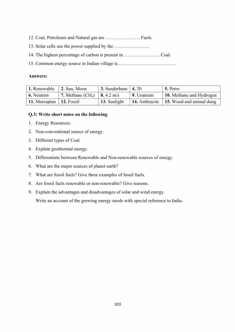
103
12. Coal, Petroleum and Natural gas are …………………. Fuels.
13. Solar cells use the power supplied by the ………………….
14. The highest percentage of carbon is present in ………………….. Coal.
15. Common energy source in Indian village is………………………………. Answers: 1. Renewable 2. Sun, Moon 3. Sunderbans 4. 20 5. Petro 6. Neutron 7. Methane (CH4) 8. 4.2 m/s 9. Uranium 10. Methane and Hydrogen 11. Mercaptan 12. Fossil 13. Sunlight 14. Anthracite 15. Wood and animal dung Q.3: Write short notes on the following
1. Energy Resources.
2. Non-conventional source of energy.
3. Different types of Coal.
4. Explain geothermal energy.
5. Differentiate between Renewable and Non-renewable sources of energy.
6. What are the major sources of planet earth?
7. What are fossil fuels? Give three examples of fossil fuels.
8. Are fossil fuels renewable or non-renewable? Give reasons.
9. Explain the advantages and disadvantages of solar and wind energy.
Write an account of the growing energy needs with special reference to India.
104
LESSON-8
BIODIVERSITY
Dr. Rajwant Kaur Assistant Professor,
S.G.T.B.Khalsa College, University of Delhi
INTRODUCTION
Biodiversity literally means diversity of life that exists on earth. The term biodiversity was given by Walter G. Rosen (1985) as a compound word for the term 'Biological Diversity' originally proposed by Lovejoy (1980) as the number of species in a community. Biodiversity has been defined variously depending upon the objectives of the study. Its definitions vary in their scope from simply referring it to the number of species present in an area, to the variety and variability of life and its processes that exist on earth. It occurs at all the levels of biological organization beginning from the level of population to the level of biosphere. Therefore, it can be defined as the variation and the variability presenting the living world (the biosphere) within and among the populations, species, or the ecosystems. It can be measured at different levels of biological organization. Mostly it is studied at three levels, genetic, species, and ecosystem levels. At each level, it can be studied at any spatial scale viz. small local area, landscape, geographical regions like continents, or the whole earth.
LEARNING OBJECTIVE
After going through the section, you will be able to understand
the term biodiversity.
the difference between genetic, species and ecosystem biodiversity
which are the different biogeographic zones in India and how it has makes India a megadiversity nation
the concept of Biodiversity Hotspots
Levels of biological diversity:
Genetic diversity
It is the variation in the genetic material among organisms of a species. It is found both within as well as between populations of a species. For example, variation within and between populations of humans (Homo sapiens) found in different continents like Asia, and Africa, or various varieties of rice (Oryza sativa), or mango (Mangifera indica). This variation is attributed to the differences in the genetic make-up (nucleotide sequence of DNA)of organisms of species. This involves occurrence of variety of versions of a gene (alleles), and also numerous combinations of different genes among individuals of a species. Sources of this variation include phenomenon like genetic recombination (meiosis, crossing
105
over, and sexual reproduction) and spontaneous mutations in the DNA. Therefore, no two individuals of a population are ever identical (unless they are identical twins); there is always slight difference in their genetic make-up. This variation forms the basis for natural selection and adaptations to changing environmental conditions and therefore, is highly important for survival of a species. Such that, if in future, there is an outbreak of any disease in a crop, all plants will be affected because all are more or less genetically similar. Genetic diversity is also crucial for evolution of new species.
Species diversity
It refers to the variety of species present in a community. However, not all the species present in a community are found in equal proportions; usually a few are relatively more abundant and most are less abundant. Therefore, the species diversity of an area or a community has two components, a) species richness or variety component, that represents the total number of species per unit area (species density), and b) the relative abundance or apportionment component that represents the relative proportion of each species in an area (i.e. number of individuals of each species are also considered to estimate relative abundance of each species over others in an area).The second component is very important to be included while comparing two communities for species diversity. Imagine two communities having equal number of species per unit area for example 5, however community 1 has 10 individuals of each species (total 50 individuals), while community 2 has 30 individuals of one species and 5 individuals of each of the rest four species. So, though the two communities have same species richness but they differ in relative proportion of each species or in other words, community 2 is less even in terms of distribution of species over number of individuals (Fig.1). This property of a community is also called as species evenness.
Species richness is usually calculated as either species density, or by using Margalef’s index(D)
1ln
where S is the total number of species and N is the total number of individuals sampled. There are several indices to calculate species relative abundance component of diversity. For example,
Shannon-Wiener Index (Hˊ)
ˊ ln
And Simpson’s index (L)
Where s is the number of species; pi is the proportion of individuals found in the ith species (i.e. / ; is the number of individuals of ith species, and N is the total number of individuals).These two indices are the most commonly used indices to compute species
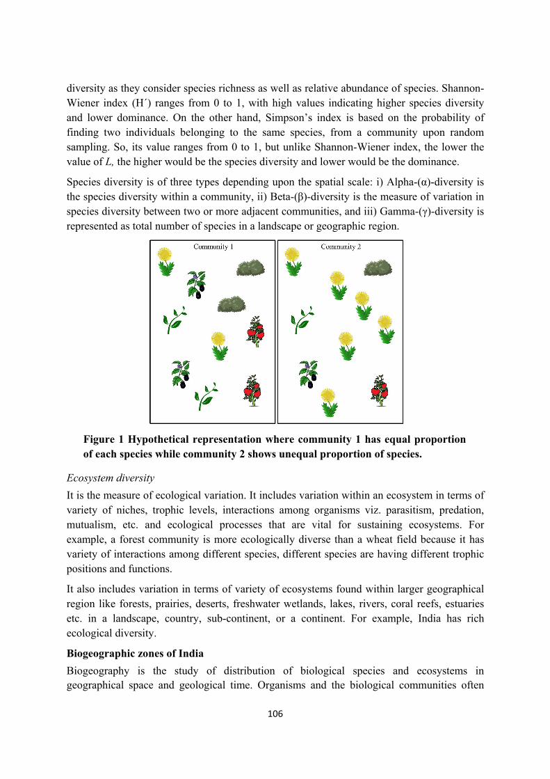
106
diversity as they consider species richness as well as relative abundance of species. Shannon-Wiener index (Hˊ) ranges from 0 to 1, with high values indicating higher species diversity and lower dominance. On the other hand, Simpson’s index is based on the probability of finding two individuals belonging to the same species, from a community upon random sampling. So, its value ranges from 0 to 1, but unlike Shannon-Wiener index, the lower the value of L, the higher would be the species diversity and lower would be the dominance.
Species diversity is of three types depending upon the spatial scale: i) Alpha-(α)-diversity is the species diversity within a community, ii) Beta-(β)-diversity is the measure of variation in species diversity between two or more adjacent communities, and iii) Gamma-(γ)-diversity is represented as total number of species in a landscape or geographic region.
Figure 1 Hypothetical representation where community 1 has equal proportion of each species while community 2 shows unequal proportion of species.
Ecosystem diversity
It is the measure of ecological variation. It includes variation within an ecosystem in terms of variety of niches, trophic levels, interactions among organisms viz. parasitism, predation, mutualism, etc. and ecological processes that are vital for sustaining ecosystems. For example, a forest community is more ecologically diverse than a wheat field because it has variety of interactions among different species, different species are having different trophic positions and functions.
It also includes variation in terms of variety of ecosystems found within larger geographical region like forests, prairies, deserts, freshwater wetlands, lakes, rivers, coral reefs, estuaries etc. in a landscape, country, sub-continent, or a continent. For example, India has rich ecological diversity.
Biogeographic zones of India
Biogeography is the study of distribution of biological species and ecosystems in geographical space and geological time. Organisms and the biological communities often
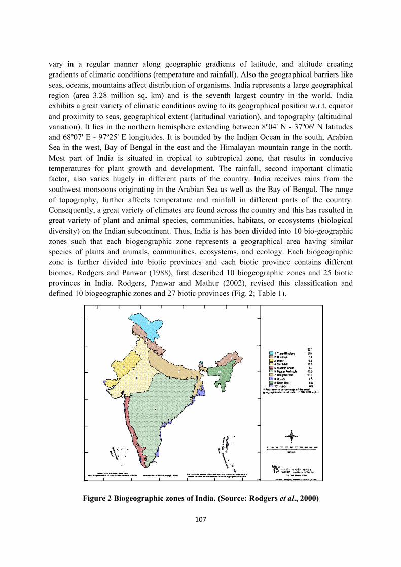
107
vary in a regular manner along geographic gradients of latitude, and altitude creating gradients of climatic conditions (temperature and rainfall). Also the geographical barriers like seas, oceans, mountains affect distribution of organisms. India represents a large geographical region (area 3.28 million sq. km) and is the seventh largest country in the world. India exhibits a great variety of climatic conditions owing to its geographical position w.r.t. equator and proximity to seas, geographical extent (latitudinal variation), and topography (altitudinal variation). It lies in the northern hemisphere extending between 8º04' N - 37º06' N latitudes and 68º07' E - 97º25' E longitudes. It is bounded by the Indian Ocean in the south, Arabian Sea in the west, Bay of Bengal in the east and the Himalayan mountain range in the north. Most part of India is situated in tropical to subtropical zone, that results in conducive temperatures for plant growth and development. The rainfall, second important climatic factor, also varies hugely in different parts of the country. India receives rains from the southwest monsoons originating in the Arabian Sea as well as the Bay of Bengal. The range of topography, further affects temperature and rainfall in different parts of the country. Consequently, a great variety of climates are found across the country and this has resulted in great variety of plant and animal species, communities, habitats, or ecosystems (biological diversity) on the Indian subcontinent. Thus, India is has been divided into 10 bio-geographic zones such that each biogeographic zone represents a geographical area having similar species of plants and animals, communities, ecosystems, and ecology. Each biogeographic zone is further divided into biotic provinces and each biotic province contains different biomes. Rodgers and Panwar (1988), first described 10 biogeographic zones and 25 biotic provinces in India. Rodgers, Panwar and Mathur (2002), revised this classification and defined 10 biogeographic zones and 27 biotic provinces (Fig. 2; Table 1).
Figure 2 Biogeographic zones of India. (Source: Rodgers et al., 2000)
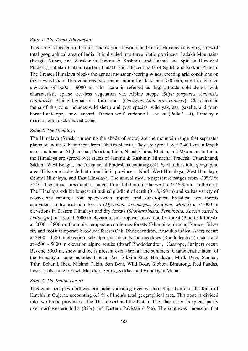
108
Zone 1: The Trans-Himalayan
This zone is located in the rain-shadow zone beyond the Greater Himalaya covering 5.6% of total geographical area of India. It is divided into three biotic provinces: Ladakh Mountains (Kargil, Nubra, and Zanskar in Jammu & Kashmir, and Lahaul and Spiti in Himachal Pradesh), Tibetan Plateau (eastern Ladakh and adjacent parts of Spiti), and Sikkim Plateau. The Greater Himalaya blocks the annual monsoon-bearing winds, creating arid conditions on the leeward side. This zone receives annual rainfall of less than 350 mm, and has average elevation of 5000 - 6000 m. This zone is referred as 'high-altitude cold desert' with characteristic sparse tree-less vegetation viz. Alpine steppe (Stipa purpurea, Artimisia capillaris); Alpine herbaceous formations (Caragana-Lonicera-Artimisia). Characteristic fauna of this zone includes wild sheep and goat species, wild yak, ass, gazelle, and four-horned antelope, snow leopard, Tibetan wolf, endemic lesser cat (Pallas' cat), Himalayan marmot, and black-necked crane.
Zone 2: The Himalaya
The Himalaya (Sanskrit meaning the abode of snow) are the mountain range that separates plains of Indian subcontinent from Tibetan plateau. They are spread over 2,400 km in length across nations of Afghanistan, Pakistan, India, Nepal, China, Bhutan, and Myanmar. In India, the Himalaya are spread over states of Jammu & Kashmir, Himachal Pradesh, Uttarakhand, Sikkim, West Bengal, and Arunanchal Pradesh, accounting 6.41 % of India's total geographic area. This zone is divided into four biotic provinces - North-West Himalaya, West Himalaya, Central Himalaya, and East Himalaya. The annual mean temperature ranges from -30º C to 25º C. The annual precipitation ranges from 1500 mm in the west to > 4800 mm in the east. The Himalaya exhibit longest altitudinal gradient of earth (0 - 8,850 m) and so has variety of ecosystems ranging from species-rich tropical and sub-tropical broadleaf wet forests equivalent to tropical rain forests (Myristica, Artocarpus, Syzigium, Mesua) at <1000 m elevations in Eastern Himalaya and dry forests (Shorearobusta, Terminalia, Acacia catechu, Dalbergia); at around 2000 m elevation, sub-tropical mixed conifer forest (Pine-Oak forest); at 2000 - 3800 m, the moist temperate coniferous forests (Blue pine, deodar, Spruce, Silver fir) and moist temperate broadleaf forest (Oak, Rhododendron, Aesculus indica, Acer) occur; at 3800 - 4500 m elevation, sub-alpine shrublands and meadows (Rhododendron) occur; and at 4500 - 5000 m elevation alpine scrubs (dwarf Rhododendron, Cassiope, Juniper) occur. Beyond 5000 m, snow and ice is present even through the summers. Characteristic fauna of the Himalayan zone includes Tibetan Ass, Sikkim Stag, Himalayan Musk Deer, Sambar, Tahr, Beharal, Ibex, Mishmi Takin, Sun Bear, Wild Boar, Gibbon, Binturong, Red Pandas, Lesser Cats, Jungle Fowl, Markhor, Serow, Koklas, and Himalayan Monal.
Zone 3: The Indian Desert
This zone occupies northwestern India spreading over western Rajasthan and the Rann of Kutchh in Gujarat, accounting 6.5 % of India's total geographical area. This zone is divided into two biotic provinces - the Thar desert and the Kutch. The Thar desert is spread partly over northwestern India (85%) and Eastern Pakistan (15%). The southwest monsoon that
109
brings rain to most parts of India, bypass the Thar desert creating arid conditions. The annual rainfall ranges from < 100 mm in the west to 500 mm in the east. High temperatures, extremely low rainfall and strong winds result in rolling sand dunes in the Thar desert. Desert vegetation includes thorn scrub and grasslands (Acacia, Balanites roxburghii, Zizyphus nimmularia, Capparis decidua, Tecomella, Prosopis cineraria, Salvadora oleoides, Euphorbia caducifolia and grasses like Panicum antidotale, Eleusine sp., Cenchrus sp.). These vegetation support blackbucks, chinkara, quail, and Great Indian bustard. The Great Rann of Kutch lies to the south of Thar desert at transboundary of India and Pakistan, stretching southeast into the Little Rann of Kutch. The Rann of Kutch represent unique ecosystem, the desert wetland or seasonal salt marshes that remain flooded during rainy season and remain dry as salt-flats during rest of the year. It is important as it supports the last population of the endangered Asiatic wild ass (Equus hermionus) and the one of the world's largest breeding colonies of the greater and lesser flamingos (Phoenicopterus ruber and P. minor).
Zone 4: The Semi-Arid
This zone encompasses 16.6 % of the total geographical area of India spreading over the states of Punjab, Haryana, Delhi, eastern Rajasthan, North-West Madhya Pradesh, Gujarat, and small part of southwest Jammu & Kashmir, and Himachal Pradesh also. This zone is divided into two biotic provinces - the Punjab plains, and Gujarat, Rajputana. Topographically, it has plain area, and the ancient Aravalli hill range. Vegetation of this area is basically represented by tropical thorn forests on the hills (with low thorny trees Acacia, Anogeissus, Balanites, Capparis, Grewia, etc.) and grasslands with interspersed trees and shrubs in the plains. Wildlife comprises of larger herbivores- Blackbuck, Chowsingha, Nilgai, and Gazelle, and carnivores- Lions, Cheetah (now extinct), Caracal, Jackal, and Wolf. There is high pressure of livestock and agriculture leading to local extinction of wildlife.
Zone 5: The Western Ghats
This biogeographic zone is divided into two biotic provinces, Malabar plains and the Western Ghat Mountains, both running parallel to the west coast of Indian peninsula, approximately 30-50 km inland eastwards from the Arabian Sea. They lie between 8 °20'N - 20°40'N and 73 °- 77°E, stretching 1600 km north-south beginning from the south of Tapti river valley, Gujarat to Kannyakumari, Tamil Nadu. They traverse the states of Gujarat, Maharashtra, Goa, Karnataka, Kerala, & Tamil Nadu. They are interrupted only by the 30 km Palghat Gap at around 11°N. The northern Western Ghats are also known as Sahyadri ranges. The altitude of the Western Ghats ranges from 35 to 2685 m above MSL and annual rainfall ranges from 2000 to 7000 mm. Anamudi is the highest peak (2695 m) of Indian Peninsula occurring in southern Western Ghats. They act as barriers to the southwest monsoon into the Deccan Plateau as the moisture-laden winds from Arabian Sea rise up to 900-1200 m elevation over the Western Ghats, and become cool and consequently precipitate most of the moisture as heavy rainfall in the windward slopes of these hills and coastal plains. As dry wind crosses the Western Ghats and descends, it gets heated and further becomes drier, thus east side of
110
the Western Ghats and the Deccan Plateau receives very little rainfall (rain-shadow area). Due to tropical position, proximity to sea, and relief (coastal plains and mountains), the Western Ghats have very unique climatic variation leading to an exceptionally high level of biological diversity and endemism. Thus, it is recognized as a UNESCO World Heritage Site and one of the world’s eight ‘hottest hotspots’ of biological diversity. The major vegetation types found in the Western Ghats are tropical evergreen forests, temperate moist deciduous forests, temperate dry deciduous forests, the Sholas, high altitude grasslands, the dry scrub vegetation. This zone has about 4000 plant species accounting 27% of the India's 15000 species, and of these about 1800 plant species are endemic to this zone. Some endemic tree species of this zone are Memecylon, Litsea, Cinnamomum, Syzygium, Grewia, Diospyros, and Dalbergia. The Western Ghats region is also a rich in wild relatives of important crop plants viz. cereals & millets, legumes, tropical & sub-tropical fruits, vegetables, spices & condiments. Important fauna of the region are Asian Elephant, Gaur, Tiger, lion-tailed Macaque, Nilgiri Tahr and Nilgiri Langur.
Zone 6: The Deccan Peninsula
Deccan Paninsula is India’s largest biogeographic region accounting 42 per cent of the total geographical area of India. This zone is divided into 6 biotic provinces- Central Highlands, Chotta Nagpur, Eastern Highlands, Central Plateau, Deccan South. It includes states of Madhya Pradesh, Chhattisgarh, Jharkhand, Orissa, Maharashtra, Karnataka, Telangana, Andhra Pradesh, & Tamil Nadu. It is bordered from north by Vindhya and Satpura ranges, in the east by the Eastern Ghats, and in the west by the Western Ghats. The average elevation is about 600 m, sloping generally eastward and the principal rivers are Godavari, Krishna, and Cauvery that flow from the Western Ghats eastward to the Bay of Bengal. It has an overall semi-arid condition as it falls in the rain-shadow area of the Western Ghats. The vegetation of this zone is mostly dry deciduous forests, with some dry thorn scrub towards west, and moist deciduous forests towards northeast. Important plant species of this zone are Hardwickia binata, Albizia amara, Tectona grandis, Boswellia serrata, Lannea coromandelica, Anogeissus latifolia, Albizia lebbeck, Lagerstroemia parvifolia, Diospyros tomentosa, and Acacia catechu. Important fauna includes Tiger, Chital, Sambar, Nilgai, Chowsingha, Elephant, Wild Buffalo, Hard Ground Swamp Deer,
Gharhial, Rusty Spotted Cat, and Wolf.
Zone 7: The Gangetic Plain
The Gangetic plains are one of the most fertile areas of the world, formed by alluvium brought by Himalayan rivers, Ganges and Brahmaputra and their tributaries. And so are form the robust agricultural lands of the world, and are also one of the most densely populated areas of the world. It accounts for 10.8 % of the total geographical area of India, stretching from the Yamuna river eastwards spreading over mainly the states of Uttar Pradesh, Bihar, West Bengal, and the coastal plain of Orissa. This zone is divided into two biotic provinces- Upper and Lower Gangetic Plains. This zone is topographically homogeneous. Important
111
crops grown in this zone are rice and wheat, which are grown in rotation and others include maize, sugarcane and cotton.
Natural vegetation includes Sal (Shorea robusta) forests along the foothills of Himalaya, and mixed dry decidous forest in the plains. This zone lacks in endemic species. Wildlife has decreased due agriculture expansion and high population density. Some important fauna of the zone includes Nilgai, Blackbuck, and Chinkara, Sambar, and Chital.
Zone 8: The Coasts
India has vast coastline of 7516.6 Km (6100 km of mainland coastline & 1197 km of Indian islands) touching 13 States and Union Territories (UTs). This zone accounts for 2.5% of the India's total geographical area and is divided in three biotic provinces - West Coast, East Coast, and Lakshadweep. The west coast extends from the Gulf of Cambay (Gulf of Khambhat) in the north to Cape Comorin (Kanniyakumari) in the south. The east coast extends from the Ganges river delta in the north to Kannyakumari in the south. The coasts have a diverse set of communities like Mangroves in the estuaries or deltas, sand beaches with distinctive plant communities like Casuarina-Calophyllum-Pandanus, raised coral and rocky coastline, and the marine angiosperm pastures. Wildlife of this zone includes Dungdong and Hump-back Dolphin of estuarine waters, Salt-Water Crocodile and Batagur Basker Turtle of Sunderbans estuary, and Huge soft-shell Estuarine turtle of Utkal-Begal coast.
Zone 9: North-East India
North-East India is the richest biogeographic zone of India in terms of plant communities and endemism. This zone accounts for 5.2 % of the India's total geographical area, and is divided into two biotic provinces - the Brahmaputra Valley (Assam), and the North-East Hills (spread over Nagaland, Manipur, Tripura, Mizoram, Meghalaya and southern part of Assam). This zone is unique as is situated at the confluence of three regions - Indian, Indo-Malayan, and Indo-Chinese regions and is also the meeting place of the Himalaya and the Indian Peninsula. This makes this zone highly rich in biodiversity and endemism. Khasi-Jaintia Hills (Meghalaya) are known to be richest in biodiversity in Asia. Vegetation types found in this zone include tropical and sub-tropical evergreen forest, temperate rain forests, sub-alpine and alpine vegetation. The North-East region (including Eastern himalayas, Arunanchal Pradesh) harbors the richest diversity in orchids, zingibers, yams, rhododendrons bamboos, canes and wild relatives of cultivated plants. More than 8,000 species out of 15,000 (in India) of flowering plants are found in this region. The five insectivorous plant genera including Nepentheskhasiana (endemic) are found in this region. Some important plant species of this North-East India - biogeographic zone specifically include rhododendrons, bamboo, and orchids. Typical fauna of this zone includes Rhinoceros, Buffalo, Elephant, Swamp Deer, Hog Deer, Pygmy Hog, Hispid Hare, Hornbill, and Waterfowl.
112
Zone 10: The Islands
India has two group of islands in its political boundary - i) Andaman and Nicobar Islands located in the Bay of Bengal, and ii) Lakshadweep islands located in the Arabian Sea. The latter one has very little remaining natural vegetation. The Andaman and Nicobar Islands unlike Lakshadweep islands are not much populated and have natural vegetation as Tropical rain forests. This zone accounts for 0.3 % of the total geographical area of the country and is divided into two biotic provinces - Andamans, and Nicobars. This zone (Andaman & Nicobar) stretches 590 km north to south (13º 45' N to 6º 45' N) and consists of 348 islands. The Andamans show biogeographical affinities with Myanmar, and the Nicobars show biogeographical affinities with Indonesia, and South-East Asia. The tropical rain forests here exhibit unique assemblages different from Indian mainland due to its geographical isolation. Some important plant species are Dipterocarpus (tropical rain forests), Terminalia and Lagerstroemia (deciduous and semi-evergreen forests). This zone shows high species richness and endemism for plant and bird species. Some important fauna of this zone are: Andaman pig, Nicobar Macaque, Nicobar tree shrew, Narcodium Hornbill, Nicobar pigeon, Andaman wood pigeon, Nicobar parakeet, marine turtles, fish and coral communities, dolphins and whales.
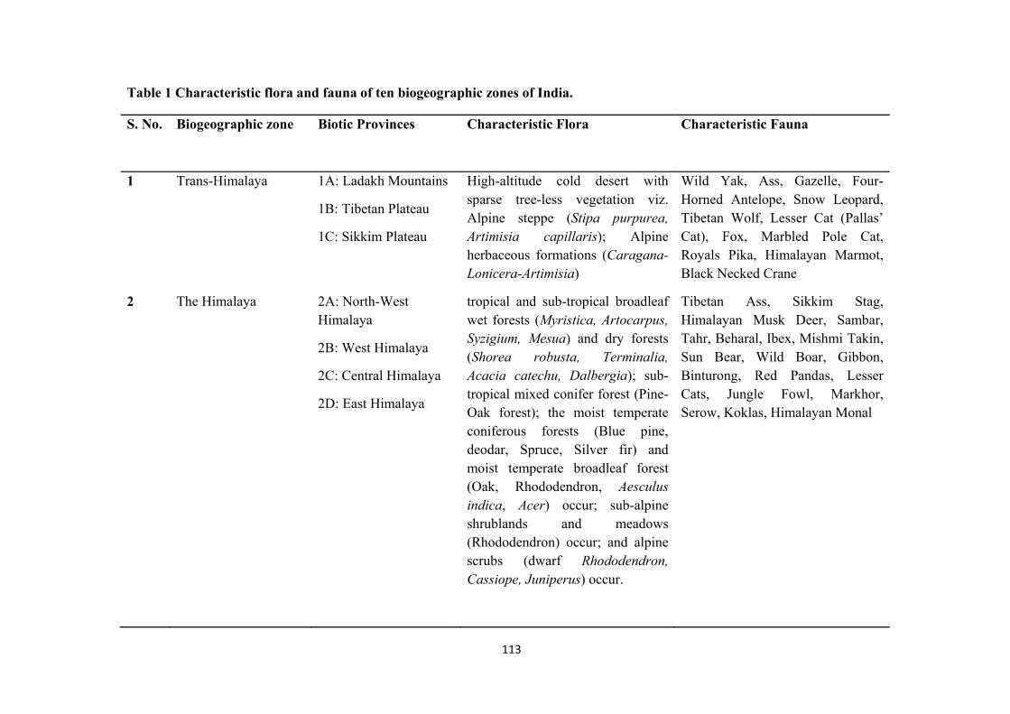
113
Table 1 Characteristic flora and fauna of ten biogeographic zones of India.
S. No. Biogeographic zone Biotic Provinces Characteristic Flora Characteristic Fauna
1 Trans-Himalaya 1A: Ladakh Mountains
1B: Tibetan Plateau
1C: Sikkim Plateau
High-altitude cold desert with sparse tree-less vegetation viz. Alpine steppe (Stipa purpurea, Artimisia capillaris); Alpine herbaceous formations (Caragana-Lonicera-Artimisia)
Wild Yak, Ass, Gazelle, Four-Horned Antelope, Snow Leopard, Tibetan Wolf, Lesser Cat (Pallas’ Cat), Fox, Marbled Pole Cat, Royals Pika, Himalayan Marmot, Black Necked Crane
2 The Himalaya 2A: North-West Himalaya
2B: West Himalaya
2C: Central Himalaya
2D: East Himalaya
tropical and sub-tropical broadleaf wet forests (Myristica, Artocarpus, Syzigium, Mesua) and dry forests (Shorea robusta, Terminalia, Acacia catechu, Dalbergia); sub-tropical mixed conifer forest (Pine-Oak forest); the moist temperate coniferous forests (Blue pine, deodar, Spruce, Silver fir) and moist temperate broadleaf forest (Oak, Rhododendron, Aesculus indica, Acer) occur; sub-alpine shrublands and meadows (Rhododendron) occur; and alpine scrubs (dwarf Rhododendron, Cassiope, Juniperus) occur.
Tibetan Ass, Sikkim Stag, Himalayan Musk Deer, Sambar, Tahr, Beharal, Ibex, Mishmi Takin, Sun Bear, Wild Boar, Gibbon, Binturong, Red Pandas, Lesser Cats, Jungle Fowl, Markhor, Serow, Koklas, Himalayan Monal
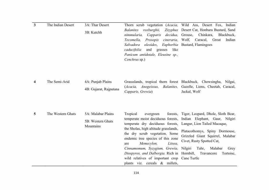
114
3 The Indian Desert 3A: Thar Desert
3B: Kutchh
Thorn scrub vegetation (Acacia, Balanites roxburghii, Zizyphus nimmularia, Capparis decidua, Tecomella, Prosopis cineraria, Salvadora oleoides, Euphorbia caducifolia and grasses like Panicum antidotale, Eleusine sp., Cenchrus sp.)
Wild Ass, Desert Fox, Indian Desert Cat, Honbara Bustard, Sand Grouse, Chinkara, Blackbuck, Wolf, Caracal, Great Indian Bustard, Flamingoes
4 The Semi-Arid 4A: Punjab Plains
4B: Gujarat, Rajputana
Grassslands, tropical thorn forest (Acacia, Anogeissus, Balanites, Capparis, Grewia)
Blackbuck, Chowsingha, Nilgai, Gazelle, Lions, Cheetah, Caracal, Jackal, Wolf
5 The Western Ghats 5A: Malabar Plains
5B: Western Ghats Mountains
Tropical evergreen forests, temperate moist deciduous forests, temperate dry deciduous forests, the Sholas, high altitude grasslands, the dry scrub vegetation. Some endemic tree species of this zone are Memecylon, Litsea, Cinnamomum, Syzygium, Grewia, Diospyros, and Dalbergia. Rich in wild relatives of important crop plants viz. cereals & millets,
Tiger, Leopard, Dhole, Sloth Bear, Indian Elephant, Gaur, Nilgiri Langur, Lion Tailed Macaque,
Platacothomys, Spiny Dormouse, Grizzled Giant Squirrel, Malabar Civet, Rusty Spotted Cat,
Nilgiri Tahr, Malabar Grey Hornbill, Travancore Tortoise, Cane Turtle
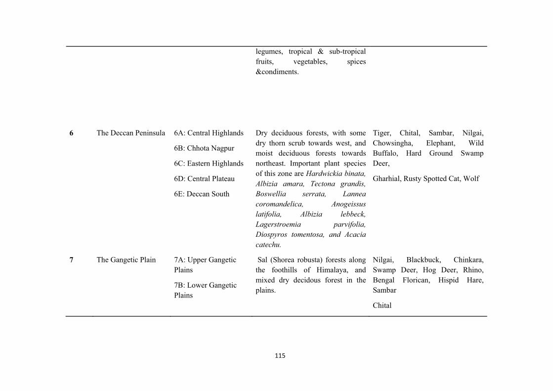
115
legumes, tropical & sub-tropical fruits, vegetables, spices &condiments.
6 The Deccan Peninsula 6A: Central Highlands
6B: Chhota Nagpur
6C: Eastern Highlands
6D: Central Plateau
6E: Deccan South
Dry deciduous forests, with some dry thorn scrub towards west, and moist deciduous forests towards northeast. Important plant species of this zone are Hardwickia binata, Albizia amara, Tectona grandis, Boswellia serrata, Lannea coromandelica, Anogeissus latifolia, Albizia lebbeck, Lagerstroemia parvifolia,Diospyros tomentosa, and Acacia catechu.
Tiger, Chital, Sambar, Nilgai, Chowsingha, Elephant, Wild Buffalo, Hard Ground Swamp Deer,
Gharhial, Rusty Spotted Cat, Wolf
7 The Gangetic Plain 7A: Upper Gangetic Plains
7B: Lower Gangetic Plains
Sal (Shorea robusta) forests along the foothills of Himalaya, and mixed dry decidous forest in the plains.
Nilgai, Blackbuck, Chinkara, Swamp Deer, Hog Deer, Rhino, Bengal Florican, Hispid Hare, Sambar
Chital
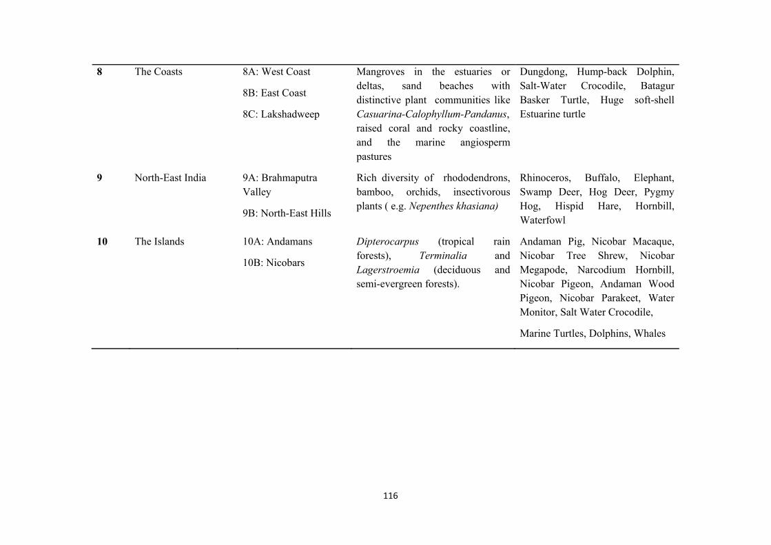
116
8 The Coasts 8A: West Coast
8B: East Coast
8C: Lakshadweep
Mangroves in the estuaries or deltas, sand beaches with distinctive plant communities like Casuarina-Calophyllum-Pandanus, raised coral and rocky coastline, and the marine angiosperm pastures
Dungdong, Hump-back Dolphin, Salt-Water Crocodile, Batagur Basker Turtle, Huge soft-shell Estuarine turtle
9 North-East India 9A: Brahmaputra Valley
9B: North-East Hills
Rich diversity of rhododendrons, bamboo, orchids, insectivorous plants ( e.g. Nepenthes khasiana)
Rhinoceros, Buffalo, Elephant, Swamp Deer, Hog Deer, Pygmy Hog, Hispid Hare, Hornbill, Waterfowl
10 The Islands 10A: Andamans
10B: Nicobars
Dipterocarpus (tropical rain forests), Terminalia and Lagerstroemia (deciduous and semi-evergreen forests).
Andaman Pig, Nicobar Macaque, Nicobar Tree Shrew, Nicobar Megapode, Narcodium Hornbill, Nicobar Pigeon, Andaman Wood Pigeon, Nicobar Parakeet, Water Monitor, Salt Water Crocodile,
Marine Turtles, Dolphins, Whales
117
HOTSPOTS OF BIODIVERSITY
It has been observed that enormous number of species that exists on Earth is concentrated in specific regions. Two-third of the species is found in geographical regions within tropical area (area between Tropic of Cancer and Tropic of Capricorn). This indicates that species are not evenly distributed on this planet. Tropical region is known to possess high species richness (number of species living in a specific location). Biodiversity conservation requires identification of such regions that are habitat of vast number of species. Geographical regions that support number of species and threatened by destruction are known as hotspots.
Hotspots of biodiversity are those places on earth which have high biodiversity and are threatened by human habitation. Term ‘Hotspot of Biodiversity’ was given by British biologist Norman Myers in 1988. Meyer defined hotspot as “a biogeographic region characterized by exceptional levels of endemism and by serious level of habitat loss”.
Hotspots of biodiversity are identified based on following two criteria:-
Area must support at least 1,500 vascular plants (> 0.5% of the world’s total) as endemics. This indicates that area must have a high percentage of plant life found nowhere else on the planet. A hotspot is considered as irreplaceable.
Area must include 30% or less of its original natural vegetation which indicates that it must be threatened.
At present, 36 hotspots have been identified in the world. Though these 36 hotspots together represent only 2.4% of the Earth’s land surface but they are crucial in supporting more than half of the world’s plant species as endemics and nearly 43% of bird, mammal, reptile and amphibian species as endemics. Further, these 36 hotspots provide ecosystem services and livelihood to more than 2 billion people on Earth.
Out of these 36 hotspots, 4 hotspots are found in India. These four hotspots are:
1. Himalaya: Includes the entire Indian Himalayan region (and that falling in Pakistan, Tibet, Nepal, Bhutan, China and Myanmar)
2. Indo-Burma: Includes entire North-eastern India, except Assam and Andaman group of Islands (and Myanmar, Thailand, Vietnam, Laos, Cambodia and southern China)
3. Sundalands: Includes Nicobar group of Islands (and Indonesia, Malaysia, Singapore, Brunei, Philippines)
4. Western Ghats and Sri Lanka: Includes entire Western Ghats (and Sri Lanka)
IUCN RED LIST
IUCN (International Union for Conservation of Nature and Natural Resources) is an international organization which is responsible for assessment of species all across the world. IUCN conducts field survey to monitor species in every country. Based on the survey, IUCN classify plants and animals in different categories. This information about current status of species is published by IUCN in ‘Red Data List’ publication. Red Data List provides
118
information on status, trend and threats of species in order to plan conservation strategies for those species.
The IUCN Red List is a critical indicator of the global extinction risk status of world’s biodiversity. The trend of species population given in Red List serves as an important tool to take prompt actions towards biodiversity conservation and policy change. Such actions further play an important role to protect the natural resources that we need for our survival. Information about range, population size, habitat and ecology, use and/or trade, threats, and conservation provide base for implementing necessary conservation decisions.
IUCN continuously maintain record of population of different species. IUCN classify species for which enough information on population record is available into following categories:
1) Extinct - Extinct species are those species for which no individual is found in geographical locations where that species was found earlier.
2) Extinct in Wild - Extinct in wild include those species which are known only to survive in cultivation, in captivity or as a naturalized population (or populations) well outside the past range.
3) Critically endangered – This category include species for which population is declining at rapid rate and therefore these species are facing extremely high risk of extinction.
4) Endangered – Endangered species are those species which are facing risk of extinction due to habitat loss, poaching and other factors. Such species may become extinct in future, if the threat continues to affect them.
5) Vulnerable – Vulnerable species are those species whose population have been observed to be declining due to on-going threats like habitat loss, deforestation or other factors. Such species may become endangered in near future, if threat continues to adversely their survival rate.
6) Near Threatened – These species do not qualify for critically endangered, endangered or vulnerable categories at present. However, they may soon qualify in threatened category in future.
7) Least Concern – Those species for which number of individuals are abundant are known as least concern
TERMINAL EXCERCISE
Q1. Explain different types of biodiversity.
Q2. How many Biogeographic zones are observed in India?
Q3. What do you mean by Hotspots of biodiversity?
Q4. Expand the term IUCN. Enlist the categories of different species recorded by IUCN. significance of people’s movement for biodiversity conservation.
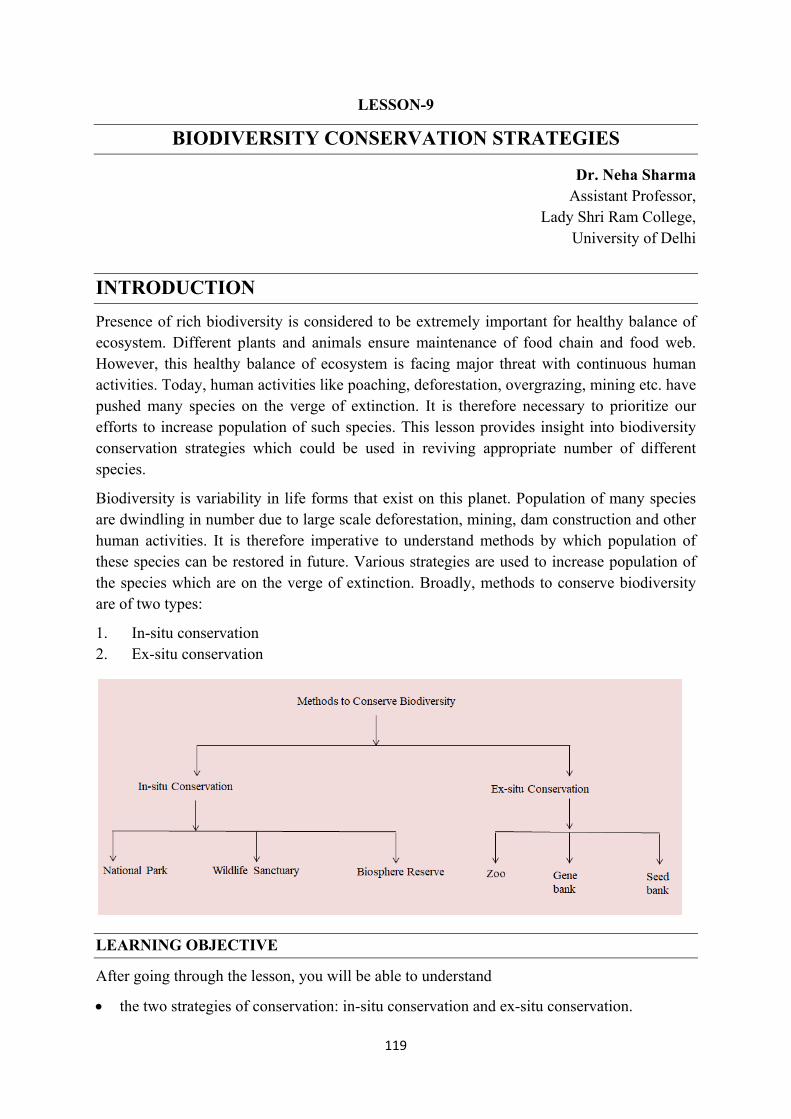
119
LESSON-9
BIODIVERSITY CONSERVATION STRATEGIES
Dr. Neha Sharma Assistant Professor,
Lady Shri Ram College, University of Delhi
INTRODUCTION
Presence of rich biodiversity is considered to be extremely important for healthy balance of ecosystem. Different plants and animals ensure maintenance of food chain and food web. However, this healthy balance of ecosystem is facing major threat with continuous human activities. Today, human activities like poaching, deforestation, overgrazing, mining etc. have pushed many species on the verge of extinction. It is therefore necessary to prioritize our efforts to increase population of such species. This lesson provides insight into biodiversity conservation strategies which could be used in reviving appropriate number of different species.
Biodiversity is variability in life forms that exist on this planet. Population of many species are dwindling in number due to large scale deforestation, mining, dam construction and other human activities. It is therefore imperative to understand methods by which population of these species can be restored in future. Various strategies are used to increase population of the species which are on the verge of extinction. Broadly, methods to conserve biodiversity are of two types:
1. In-situ conservation 2. Ex-situ conservation
LEARNING OBJECTIVE
After going through the lesson, you will be able to understand
the two strategies of conservation: in-situ conservation and ex-situ conservation.
120
Definition and concept of umbrella, keystone, flagship, indicator species,
Difference between species reintroduction and species translocation
A critical viewpoint the two conservation strategies based on contemporary case studies like Project Tiger, Project Elephant, Project Crocodile, Project Vulture, Project Great Indian Bustard.
2. Conservation strategies
2.1 In-situ conservation
It includes methods to conserve species in place of their natural habitat through legal means. In-situ conservation can be divided into following three types:
(i) National Park – National Parks are protected areas in which complete legal protection is provided to ecosystem. Therefore, biotic components as well as abiotic components are protected in these areas through legal means.
National Parks are created on the basis of core-buffer strategy. Core area is central region of national park which is completely prohibited from human activities. Buffer zone is peripheral area of National Park which allows limited tourism.
Example – Jim Corbett National Park (Uttarakhand)
Rajaji National Park (Uttarakhand)
(ii) Wildlife Sanctuary – Wildlife sanctuary is protected area which is created by government in order to conserve a particular species which may be of local, national or international significance.
Wildlife sanctuaries are also created on the basis on core-buffer strategy. Core area is central region of wildlife sanctuary which is completely prohibited from human activities. Buffer region is peripheral region in which activities like tourism, fuelwood collection, and honey collection are allowed.
Example – Chilka Bird Sanctuary (Odisha)
(iii) Biosphere Reserves – These protected areas are based on the concept of including humans in conservation efforts. This concept was formulated during Man and Biosphere (MAB) programme of UNESCO.
Biosphere reserves are protected areas conserve biodiversity and provide livelihood to local communities. Multiple activities like forestry, agriculture, tourism etc. are permitted in peripheral region of Biosphere Reserve.
Example- Nandadevi Biosphere Reserve (Uttarakhand)
Nilgiri Biosphere Reserve (South India)
2.2. Ex-situ Conservation
In this method, plant or animal species are protected in a place which is outside their natural habitat. Ex-situ conservation is done by following methods:
121
(i) Zoo – These are places in which species are kept in artificial enclosures. Zoo serves purpose of educating citizens about wildlife. Various animal breeding programs are also carried out in zoo to increase population of species.
(ii) Gene Bank- Genetic material of any species provides valuable details of its existence. Gene banks are those institutes in which genes of different species are preserved for future use.
NBPGR (National Bureau of Plant Genetic Resources) is an institute which store and preserve genes of plant species.
(iii) Seed bank – Some Institutes are involved in preserving seeds of valuable plant species. These seeds may be used in future, if any plant species becomes extinct.
IARI (Indian Agricultural Research Institute) is seed bank located in Delhi.
3. Terms used for species
(i) Umbrella species – Umbrella species include those species which are very important for maintenance of healthy ecosystem. For example tiger is an umbrella species for forest ecosystem. Presence of top predator like tiger ensures maintenance of population of herbivores and producers.
(ii) Keystone species – Keystone are valuable species for any ecosystem. Absence of keystone species would result in collapse of ecosystem. For example, elephants are considered as keystone species. Elephants require large area to move around and also has requires high amount of food. Presence of elephants in forest indicate that ecosystem is healthy and in good condition.
(iii) Flagship species – Flagship species are those species which are ecologically, culturally, emotionally significant in the society. Government highlight these species of any region in order to improve conservation efforts. For example, tiger is national animal of India. Awareness about presence of tiger in any forest will further enhance effectiveness of conservation efforts. Similarly, people are generally emotionally attached to Panda. Therefore during conservation efforts, government highlight that region has Panda species. This is done to increase effectiveness of conservation strategies.
(iv) Indicator species – Indicator species are those species which are sensitive to variations in climatic conditions. These species respond quickly to any change in temperature or environment, therefore they act as indicator for overall health of ecosystem. For example, lichen and frogs are indicator species
4. Species reintroduction and translocation
4.1 Re-introduction of species
Today, many species are on the verge of extinction which necessitates immediate conservation efforts. This can be done by reintroduction programs which are focused on returning any species back in their known habitat. According to IUCN, "Re-introduction" is an attempt to establish a species in an area which was once part of its historical range, but from which it has been extirpated or become extinct. Re-introduction is necessary to maintain
122
a viable, free-ranging population in the wild of any species, which has become locally or globally extinct in the wild. Re-introduction of species is conducted within the historical range or known natural habitat of species. Such re-introduction programs involve minimal long-term management.
Re-introduction is carried out to meet following objectives:
(i) to enhance the long-term survival of a species
(ii) to re-establish a keystone species in an ecosystem
(iii) to maintain and/or restore natural biodiversity
(iv) to provide long-term economic benefits to the local and/or national economy
(v) to promote conservation awareness
For example, Sariska Tiger Reserve (Rajasthan) faced sharp decline in tiger population during 2004-2008 due to poaching activities. In order to revive tiger population in Sariska Tiger Reserve, eight tigers from Ranthambore were re-introduced in Sariska Tiger Reserve.
3.4.2 Translocation of species
According to IUCN, "Translocation" is deliberate and mediated movement of wild individuals or populations from one part of their range to another. Translocation is an important step to maintain population balance in ecosystem, to reduce human-animal conflicts, to increase or reduce population or for recreational or commercial purpose. This intentional movement of plants and animals from one place and releasing them in another is crucial to improve survival chances of species and to improve biodiversity of region.
For example, few Rhinoceros were translocated from Kaziranga National Park to Manas National Park to increase population of Rhinoceros in Manas National Park.
5. CASE STUDIES
5.1 Project Tiger
Project tiger scheme is an on-going scheme under Ministry of Environment, forest and Climate Change. This scheme is focused on increasing number of tiger population in India. Tiger is national animal of our country and also top predator of terrestrial ecosystem. Tiger is an umbrella species because presence of tiger in forest also ensures appropriate population of herbivores and producer. Despite ecological and national importance of this animal, population has declined sharply because of excessive poaching activities. Tiger population in India was observed to be 1827 in the year 1972. Thus there was need to increase population of this species. Project tiger scheme was launched in 1973 during tenure of Prime Minister Indira Gandhi.
This scheme is focussed on increasing habitat of tiger as a method of in-situ conservation. As a result of this scheme, number of tiger reserves has increased in India. At present, 50 tiger reserves have been established in India. For example, Kanha Tiger Reserve (Madhya Pradesh) is one of the tiger reserves in India. Project tiger scheme has been successful in increasing number of tigers in India. India has 2967 tigers according to 2019 estimate.
123
Despite, Project Tiger scheme, Tiger is still considered as endangered animal. To improve status of this species, strong legal measures are required to curb poaching activities.
5.2 Project Elephant
Elephant is considered as keystone species because this animal requires large area for movement and require high amount of food. Only healthy ecosystem can support Elephants population. Elephants in India are culturally significant because this animal is worshipped as Lord Ganesha. However, elephants are also excessively hunted for their tusk and are considered as endangered species. Elephants have also declined because of human-elephant conflict. This conflict may arise when elephant happen to raid crop field near forest or move into residential area. Development of railway track inside elephant habitat is another reason for decline in their number. Sometimes, elephants collide with fast moving trains which may result in their death.
Project Elephant is an on-going scheme under Ministry of Environment, Forest and Climate Change (Government of India) focused on increasing elephant population in India. This scheme was launched in 1992. Project Elephant aim to increase population of elephants by creation of Elephant reserves as in-situ conservation strategy. It also aims to reduce human-elephant conflict and address welfare of captive elephants.
Project Elephant has been successful in establishing 32 elephant reserves in India. Monitoring of Illegal Killing of Elephants (MIKE) programme has also been implemented under this scheme. Despite this scheme, poaching still remains biggest threat to the population of Elephants in India.
5.3 Project Crocodile
Crocodile is top predator of aquatic ecosystem and helps in maintaining population of fishes and other living organisms present in water bodies. In India, following crocodile species have been observed, but all species are on verge of extinction:
1) Gharial – This is freshwater crocodile which is now critically endangered. Pollution of river is the reason behind decline in number of this species.
2) Mugger – This is also freshwater crocodile which is vulnerable in India. Construction of dams on rivers has resulted in sharp decline of this species.
3) Salt water crocodile – This crocodile used to be very common in coastal areas of Kerala and Tamil Nadu but now it is extinct in these states. Destruction of mangrove vegetation for development of coastal region result in decline of this species. Few members of this species are found in West Bengal and Odisha.
H.R. Bustard had initiated crocodile survey in 1974 which clearly reflected sharp decline in their number. Project crocodile scheme was launched in 1975 to increase population of crocodile species. This scheme was launched by Government of India with support from United Nations Development Programme (UNDP) and FAO. Many crocodile sanctuary like National Chambal Wildlife Sanctuary (Madhya Pradesh) have been established as in-situ conservation strategy for protection of crocodile in natural habitat. Sixteen crocodile rehabilitation centres have been established in India for breeding and rearing programmes.
124
5.4 Project Vulture
Vultures are natural scavengers of ecosystem which feed on dead organisms and help in cleaning of ecosystem. Indian vulture is critically endangered species because population of these species has sharply declined with biomagnification. Diclofenac chemical (painkiller) was injected in cattle to make them work in farm areas for long time duration. After death of cattle, this chemical increased in concentration in Indian vultures. This chemical resulted in immediate death of members of Indian vulture.
Project Vulture was launched by Government of India in 2006 to increase population of Indian vultures. Following methods are used under this programme:
1) Diclofenac has been completely banned for veterinary use in Indian since 2006.
2) In-situ conservation strategy – Vulture Safe Zone (VSZ) have been declared in India. These VSZ are habitat of Indian vulture in which use of any chemical is strictly prohibited by the Indian Government.
3) Ex-situ conservation strategy –Four Vulture Conservation Breeding Centres have been established in India for breeding of this species. These centres are established at Guwahati (Assam), Pinjore (Haryana), Buxa (West Bengal) and Bhopal (Madhya Pradesh).
5.5 Silent Valley Movement
Silent Valley Movement was initiated in 1978 to resist construction of dam on Kunthi river of Silent Valley region, Kerala. Silent valley region through which Kunthi river flows is considered as hotspot of biodiversity.Many eminent environmentalists like Madhav Gadgil opposed to the dam construction in this place because of following reasons:
1) Proposed dam would have resulted in loss of forest cover and endemic species of Silent Valley region
2) Proposed dam on Kunthi River would have resulted in acute water shortage in downstream areas of Kerala. River Bharata also receive water from Kunthi river and was predicted to be completely dry if dam was built on Kunthi river. Farming activity would have adversely affected with this dam construction.
3) Proposed dam would not have provided benefit to the state of Kerala. Electricity generated through this dam was planned to be transferred to neighbouring states of Tamil Nadu and Karnataka.
Later, dam proposal was rejected and Silent Valley region was converted into Silent Valley National Park in 1984.
5.6 Project Great Indian Bustard
Great Indian Bustard is one of the heaviest flying birds with an average weight of 15 to 18 kg. According to the estimate of 1969, the population of the bird was 1260. At that time, this bird was observed in geographical location of 11 states in India. Haryana, Punjab, Odisha, Uttar Pradesh, Tamil Nadu, Madhya Pradesh were known as habitat of Great Indian Bustard.
125
Today, population of bird is below 200 and therefore this bird is placed in the category of critically endangered species. Habitat of this bird is now restricted to Rajasthan, Gujarat, Maharashtra and Karnataka.
Project Great Indian Bustard is considered as an important on-going scheme of our country. This scheme was launched in 2013 to establish conservation breeding centers for vultures across the country. This scheme is also focused on strategies to reduce pressure on habitat of this bird.
5.7 Save Western Ghats Movement
Save the Western Ghats Movement is considered to be landmark event in environment history of our country. Western Ghats cover parts of Gujarat, Maharashtra, Goa, Karnataka, Kerala and Tamil Nadu. This area is well known for rich flora and fauna. Save the Western Ghats Movement of 1986 highlighted urgent need to reduce development process in Western Ghats which threatened ecosystem of this place. In this movement, civil society raised concerns related to impact of development on Western Ghats. Further this movement was effective in generating awareness about environment protection and tribal rights in forest.
During 1987-1988, many local and regional people’s movement organized themselves to march the length of Western Ghats. This was initiated to protest against development activities like dam construction or power station in the areas of Western Ghats.
As a result of this movement, proposed dam in Silent Valley region of Western Ghats was rejected in 1984. Further, Western Ghats Development Programme was initiated by Government of India in 1981 for eco-restoration and conservation of biodiversity in this place.
LEARNING OUTCOME (Summary)
Conservation of species is necessary to maintain balance of healthy ecosystem on earth.
Biodiversity conservation can be done by two methods – In-situ conservation and Ex-situ conservation.
In-situ conservation is the method in which species are conserved in place of natural habitat. This can be done by creating national parks, wildlife sanctuary and biosphere reserves.
Ex-situ conservation is the method to conserve biodiversity outside natural habitat. For example, zoological parks, gene bank and seed bank.
Project Tiger is an on-going scheme under Ministry of Environment, Forest and Climate to restore number of tiger in India. This scheme was launched in 1973.
Project Elephant is an on-going scheme under Ministry of Environment, Forest and Climate Change to increase population of elephants in India. This scheme was launched in 1992 and it focuses on creating elephant reserves to improve population count of this animal.
126
Project Crocodile scheme was launched in 1975 by Government of India to increase population of crocodile species. To facilitate crocodile breeding programmes, sixteen crocodile rehabilitation centres have been established in India.
Project Vulture was launched by Government of India in 2006 to revive population of Indian vultures. Under this scheme, chemical diclofenac was completely banned for veterinary use and many vulture breeding centres were established in India
Silent Valley Movement was initiated in 1978 to resist construction of dam on Kunthi river of Silent Valley region, Kerala. As a result of this movement, Silent Valley region was converted into Silent Valley National Park in 1984.
Project Great Indian Bustard is an ongoing scheme launched in 2013 to establish conservation breeding centers for Great Indian Bustard across the country. This scheme is also focused on strategies to reduce pressure on habitat of this bird.
Save Western Ghats Movement was people’s movement initiated in 1986 to demand restriction on developmental activities in Western Ghats region.
TERMINAL EXCERCISE
Q1. Explain difference between in-situ and ex-situ conservation strategies for biodiversity conservation?
Q2. Explain difference between national park, wildlife sanctuary and biosphere reserve?
Q3. Discuss effectiveness of government schemes for biodiversity conservation.
Q4. Explain significance of people’s movement for biodiversity conservation.
Q5. Explain translocation and reintroduction of species.
Q6. Fill in the blanks
(i) Conservation of species in natural habitat is known as ………..
(ii) Conservation of species outside natural habitat is known as …………
(iii) …………. Is an example of wildlife sanctuary in India.
(iv) …………. Is an example of biosphere reserve in India.
(v) Institute in which genes of different species is preserved is known as…….
(vi) Project Tiger Scheme was initiated by former Prime Minister……in the year….
(vii) Use of chemical ……… resulted in decline of vulture population.
(viii) Heaviest flying bird of India is …….
(ix) ………… is critically endangered species in India.
(x) ……….... is movement in which people marched along the length of Western Ghats in India.
(xi) …………. is the mass movement against dam construction in Kerala.
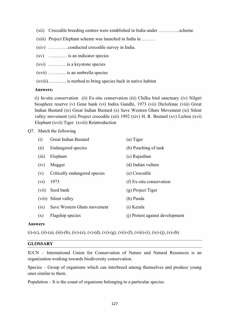
127
(xii) Crocodile breeding centres were established in India under …………..scheme.
(xiii) Project Elephant scheme was launched in India in ………
(xiv) ………….conducted crocodile survey in India.
(xv) ………… is an indicator species
(xvi) …………is a keystone species
(xvii) …………is an umbrella species
(xviii) ………... is method to bring species back in native habitat
Answers:
(i) In-situ conservation (ii) Ex-situ conservation (iii) Chilka bird sanctuary (iv) Nilgiri biosphere reserve (v) Gene bank (vi) Indira Gandhi, 1973 (vii) Diclofenac (viii) Great Indian Bustard (ix) Great Indian Bustard (x) Save Western Ghats Movement (xi) Silent valley movement (xii) Project crocodile (xii) 1992 (xiv) H. R. Bustard (xv) Lichen (xvi) Elephant (xvii) Tiger (xviii) Reintroduction
Q7. Match the following
(i) Great Indian Bustard (a) Tiger
(ii) Endangered species (b) Poaching of tusk
(iii) Elephant (c) Rajasthan
(iv) Mugger (d) Indian vulture
(v) Critically endangered species (e) Crocodile
(vi) 1973 (f) Ex-situ conservation
(vii) Seed bank (g) Project Tiger
(viii) Silent valley (h) Panda
(ix) Save Western Ghats movement (i) Kerala
(x) Flagship species (j) Protest against development
Answers
(i)-(c), (ii)-(a), (iii)-(b), (iv)-(e), (v)-(d), (vi)-(g), (vii)-(f), (viii)-(i), (ix)-(j), (x)-(h)
GLOSSARY
IUCN – International Union for Conservation of Nature and Natural Resources is an organization working towards biodiversity conservation.
Species – Group of organisms which can interbreed among themselves and produce young ones similar to them.
Population – It is the count of organisms belonging to a particular species.

128
Endangered species – These species are categorized under threatened category by IUCN and these species are on the verge of extinction. For example, Tiger, Elephants
Critically endangered species – Those species with considerably low population count and high certainty of becoming extinct are known as critically endangered species. For example, Great Indian Bustard, Indian Vulture