Encyclopedia of African History Vol 2
315
Encyclopedia of africaN HISTORY and CULTURE
Transcript of Encyclopedia of African History Vol 2

Encyclopedia of africaN HISTORY and CULTURE


Encyclopedia of african history
and cultureVolume Ii
African kingdoms
(500 to 1500)
Willie F. Page, Editor
Revised edition by R. Hunt Davis, Jr., Editor
A Learning Source Book

Encyclopedia of African History and Culture,
Copyright © 2005, 2001 by The Learning Source, Ltd.
A Learning Source BookEditorial: Brian Ableman, Edward C. Haggerty, Bertram Knight,
Christopher Roberts, Bodine Schwerin (revised edition), Ismail Soyugenc (revised edition), Anthony Yearwood
Consultant: Emilyn Brown
All rights reserved. No part of this book may be reproduced or utilized in anyform or by any means, electronic or mechanical, including photocopying,
recording, or by any information storage or retrieval systems, without permission in writing from the publisher.
For information contact:
Facts On File, Inc.132 West 31st StreetNew York NY 10001
Facts On File books are available at special discounts when purchased in bulk quanti-ties for businesses, associations, institutions or sales promotions. Please call ourSpecial Sales Department in New York at (212) 967-8800 or (800) 322-8755.
You can find Facts On File on the World Wide Web athttp://www.factsonfile.com
Design: Joan Toro, Joseph Mauro IIIIllustrations: Pam Faessler
Maps: Sholto Ainslie, Dale WilliamsPrinted in the United States of America
VB PKG 10 9 8 7 6 5 4 3 2 1
This book is printed on acid-free paper.
Library of Congress Cataloging-in-Publication Data
Page, Willie F., 1929–Encyclopedia of African history and culture / edited by Willie F. Page; revised edition edited by R. Hunt
Davis, Jr.—Rev. ed.p. cm.
“A Learning Source Book.”Includes bibliographical references and index.ISBN 0-8160-5199-2 ((set ISBN) hardcover)ISBN 0-8160-5269-7 (vol. I)–ISBN 0-8160-5270-0 (vol. II)–ISBN 0-8160-5271-9 (vol. III)–ISBN 0-8160-5200-X (vol. IV)–ISBN 0-8160-5201-8 (vol. V) –ISBN 978-1-4381-2917-4 (e-book)
1. Africa—Encyclopedias. I. Davis, R. Hunt. II. Title. DT3.P27 2005960'.03-—dc22
2004022929

For my wife, Grace,and my sons, Ed and Chris

Editor of First Edition
Willie F. Page is professor emeritus (retired) of Africana studies at BrooklynCollege, in Brooklyn, New York. He is the author of numerous reviews andjournal articles. His published works include The Dutch Triangle: TheNetherlands and the Atlantic Slave Trade 1621–1664.
General Editor of Revised Edition
R. Hunt Davis, Jr., Ph.D., is professor emeritus of history and African studiesat the University of Florida. He received a Ph.D. in African studies from theUniversity of Wisconsin, Madison. Dr. Davis is an expert on the history ofSouth Africa, African agricultural history, and the history of education inAfrica. His published works include Mandela, Tambo, and the African NationalCongress (1991) and Apartheid Unravels (1991), along with numerous articlesand book chapters. He served as director at the University of Florida Centerfor African Studies and is also a past editor of the African Studies Review.
Contributing Editors of Revised Edition
Agnes Ngoma Leslie, Ph.D., outreach director, Center for African Studies,University of Florida
Dianne White Oyler, Ph.D., associate professor of history, Fayetteville StateUniversity
CONTRIBUTORS


ContentsList of Entries
xii
How to Use This Encyclopediaxxviii
List of Images and Maps in This Volumexxx
Introduction to This Volumexxxii
Time Line (400–1513)xxxiv
Entries A–Z1
Glossary253
Suggested Readings257
Index261

xii
List of EntriesA
Aba II Aba Women’s Revolt IVAbacha, Sani VAbba Libanos IIAbbas, Ferhat IVAbdallahi ibn
Muhammad IV Abd Alla ibn Yasin IIAbd al-Mansur IIIAbd al-Mumin IIAbd el-Krim,
Mohamed ben IV Abdikassim Salad Hassan VAbdullahi Burja IIAbdullahi Yussuf Ahmed VAbeokuta III, IVAbidjan III, IV, VAbiola, Mashood VAbo IIIAbomey IIIAborigines’ Rights
Protection Society IV Abu al-Hasan Ali IIAbu Bakr IIAbu Hamed IAbuja VAbuja Accords VAbu Salih (I) IIAbu Salih (II) IIAbusir, pyramids of IAbu Yaqub Yusuf IIAbydos IAbyssinia Iacacia gum IAccra II, III, IV, VAchebe, Chinua IV, VAcheulean Age IAcheulean toolkit IAchimota College IV
Acholi II, IIIAction Front for Renewal
and Development VAdal II, IIIAdamawa IIIAdansi IIIAddis Ababa IV, VAde, King Sunny VAden, Gulf of IIAdowa, Battle of IVAdulis I, IIAfar I, II, IIIAfar Depression Ial-Afghani,Jamal al-Din IV
Afonso I IIIAfrica IAfrican Democratic
Assembly IVAfrican diaspora IVAfrican National
Congress IV, VAfrican Party for the
Independence of Guinea and Cape Verde V
African studies VAfrican Union VAfrikaans III, IV, VAfrikaner Republics IVAfrikaners IV, VAfro-Asiatic languages Iafterlife IAfro-Shirazi Party VAgades IIIAgaja IIIAgaw I, IIAgbor I, IIage grades IAge of Discovery IIAge of Metals I
age sets IAggrey, James E.
Kwegyir IVagricultural revolution Iagriculture I, II, III,
IV, VAhidjo, Ahmadou VAhmad Grañ IIIAhmadu Séku IVAhmose I IAhmosid /Thutmosid
lines IAideed, Mohamed F. VAidoo, Ama Ata VAïr Massif II, IIIAja II, IIIAkan I, II, III, IVAkan gold weights IAkhenaten IAkhetaten IAkil, Chief IIakofena IIAkosombo Dam VAksum I, IIAkure IIAkwamu IIIAkyem II, IIIalafin IIAlexander the Great IAlexandria I, IVAlgeria I, II, III,
IV, VAlgiers III, IV, VAlgiers, Battle of IVAli, Duse Muhammad IVAli, Sunni IIAllada II, IIIAlliance for Patriotic
Reorientation and Construction V
Alliance High School IV

List of Entries xiii
Almohads IIAlmoravids IIalphabets and scripts IAlur IIAlvares, Francisco III Alwa IIAmanitare IAmarna period IAmda Siyon IIAmenhotep I IAmenhotep II IAmenhotep III IAmenirdis I IAmhara I, III, IVAmhara National
Democratic Movement VAmharic I, IIAmin, Idi VAmina, Queen IIIAmnesty International
and Africa VAmratian culture Iamulets IAmun IAmyrtaeus IAnansi Iancestor worship Iancestry Ial- Andalus IIAndrianampoinimerina IIIAnglo-American
Corporation IVAnglo-Ashanti Wars IVAnglo-Boer War IVAnglo-Egyptian
Condominium IVAnglo-Zulu War IVAngola I, II, III,
IV, VAnjouan VAnkaratra range IAnlamani IAnlo IIIAnnan, Kofi VAnsa Sasraku IIIAntalaotra IIIAntananarivo VAntankarana IIIAntemoro IIIanthropology and Africa IV, Vants Iapartheid IV, VApedemak IAqaba, Gulf of IArab coastal trade I, II
Arabic I, IIArab-Israeli Wars IV, VArabs IIArabs, influence of IIArab world
and Africa Varchaeology I, II, III,
IV, Varchitecture I, II, III,
IV, VArguin trading fort IIArk of the
Covenant IArmah, Ayi Kwei Varmies, colonial IVArochukwu oracle II, IIIArsinoe I IArsinoe II IArsinoe III Iart I, II, III,
IV, VArusha Declaration VAsaba IIIAsantewa, Yaa IVAsclepius IAshanti IIAshanti Empire III, IVAsian communities IV, Vasiento IIIAskia dynasty IIIAsmara II, III, VAspelta IAssoumani, Azali VAssyrian Iastronomy IAswan IAswan Dam IV, VAtbara River IAten IAtlantic Charter IVAtlas Mountains Iatmospheric change,
impact of VAudaghost IIAugila IIAustralopithecus Iaware IAwolowo, Obafemi IV, VAwoonor, Kofi VAy IAyawaso IIIAzande IIIAzemmour IIIal-Azhar IIAzikiwe, Nnamdi IV, V
B
ba IBa, Amadou Hampate IV, VBa, Mariama Vbaaskap IVbabalawo IIBabangida, Ibrahim VBaba, Shaikh Sidiyya IV baboons IBack-to-Africa
movements IVBadarian culture IBagamoyo IVBagauda IIBaggara IIBagirmi IIIBahriya Oasis IBakele IIIBaker, Samuel IVal-Bakri IIBalewa, Abubakar
Tafawa IV, VBali IIBamako II, III, IV, VBamana IBambara II, IIIBambatha’s rebellion IVbanana IIBanda II, IIIBanda, Hastings
Kamuzu IV, Vbands and segmentary
society IBandung Afro-Asian
Conference IVBangui IV, VBanjul II, III, VBankole-Bright, H. C. IVBantu Education VBantu expansion I, IIBantu languages IBantustans VBanu Marin IIbaobab tree IBara IIIBarbary Coast I, IIIBarbot, Jean IIIBarghash, ibn Said IVBariba IIBariba metallurgy IIbark fiber IIBarmandana IIBarnard, Christiaan VBarotseland IV

xiv List of Entries
Barre, Mohammed Siad VBarth, Heinrich IVal-Bashir, Omar
Hasan Ahmad Vbasket making IBasutoland IVBatammaliba building
traditions IIIBatn el-Hajjar IBaule IIIBaya IVBayi, Filbert Vbeads Ibeads and jewelry IIBeatrix, Doña IIIBebey, Francis VBechuanaland IVbees IBegho IIIBehdet IBeira IIIBeja I, IIBelgian Congo IVBelgium and Africa IVBello, Ahmadu IV, VBemba IIIBenadir Coast IIIBen Bella, Ahmed IV, VBenguela IIIBenin, Bight of III Benin City III, IV, VBenin Kingdom of II, III, IVBenin, Republic of I, II, III,
IV, VBenue-Congo IBenue River I, IIBerbera IIIBerbers I, II, III, IV, VBerlin Conference IVBeta Israel I, II, III,
IV, VBeti, Mongo VBetsileo I, IIIBetsimisaraka II, IIIBiafra VBigo IIBijago IIIBikila, Abebe VBiko, Steve VBilad al-Sudan IIbiodiversity VBiram IIBirnin Kebbi IIIBisa trading network IIIBismarck, Otto von IV
Bissau II, III, VBito II, IIIBiya, Paul VBlack Consciousness
Movement VBlack Sash Vblacksmiths IBlaize, Richard Beale IVBlue Nile IBlyden, Edward Wilmot IVBobo IIbody adornment IBoers III, IVBoesak, Allan VBokassa, Jean-Bedel VBondelswarts IVBondu IIIBongo, Omar VBonny II, IIIBono II, IIIBook of the Dead Ibook publishing VBoran Oromo IBorder Cave IBorgu IIIBorkou IIBornu IIBosman, Willem IIIBotha, Louis IVBotha, P. W. VBotswana I, II, III,
IV, VBoumedienne, Houari VBourguiba, Habib IV, VBouteflika, Abdelaziz VBrass IIBrava IIIBrazzaville IV, Vbride-wealth IBrink, Andre VBritish East Africa IVBritish Somaliland IVBritish South Africa
Company IVBroederbond IV, VBrong IIbronze IIBronze Age IBuduma IIIBuganda II, III,
IV, VBugangaizi IIBujumbura VBulala II, IIIBullom III
Bunche, Ralph IVBunyoro III, IVBunyoro-Kitara IIBurkina Faso I, II, III,
IV, VBurton, Richard IVBuruli IIIBurundi I, II, III,
IV, VBusa IIIBusaidi III, IVBushmen I, IIBushongo IIIBusia, Kofi IV, VBusoga IIIButhelezi, Mangosuthu
Gatsha VButo IButua IIIBuyoya, Pierre VByzantine Africa I, II
C
Cabinda III, VCabral, Amílcar IV, VCacheu IIICacheu River ICaesar, Gaius Julius ICaesar, Octavian ICahora Bassa Dam VCairo I, II, III,
IV, Vcalabash Icalendar ICamara Laye IV, VCambyses II Icamels ICameroon I, II, III,
IV, VCameroon grassfields ICameroon People’s
Democratic Movement VCanary Islands Icape buffalo ICape Coast III, IVCape Colony III, IVCape Coloured People IV Cape Frontier Wars IIICape of Good Hope IICape Town III, IV, VCape Verde Islands IVCape Verde, Republic of I, II, III,
IV, V

List of Entries xv
Capsian culture Icaravan routes Icaravans IICarthage ICasablanca group VCasamance River IICasely-Hayford, J. E. IVcash crops IV, Vcassava IIIcaste system Icaterpillars Icattle ICattle Killing, The IVcavalry IICentral African Customs
and Economic Union VCentral African
Federation IVCentral African
Republic I, II, III, IV, V
Césaire, Aimé IVCetshwayo IVCeuta IIIChad I, II, III,
IV, VChad, Lake I, IIIChadic languages IChagga IIIChampion, A. W. G. IVChangamire IIChangamire dynasty IIIChari River ICharles V, Emperor IIIcheetah IChemama IIChewa III, IVChico Rei IIIChikamoneka, Julia Vchild rearing IChilembwe, John IVChiluba, Frederick VChimurenga IV, VChina and Africa IV, VChinese trade IIChissano, Joaquim
Alberto VChiwara IChokwe II, III, IVChona, Mathias Mainza VChristianity I, IIChristianity,
influence of II, III, IV, VChurch Missionary
Society IV
Chwezi dynasty IIcinema IV, Vcircumcision Icity-state IIcivets Icivil society Vcivil wars Vclan ICleopatra Iclimate Icloth and textiles I, II, III,
IV, Vclothing and dress I, II, III,
IV, Vcoastal and marine
ecosystems Vcobras Icocoa IVcocoyam Icoelacanth ICoetzee, J. M. V coffee II, IVCold War and Africa IV, Vcolon IVcolonial conquest IVcolonialism, influence of IVcolonial rule IVcommunism and socialism VComoros I, II, III,
IV, VCompaore, Blaise VConakry Vconcessionaire
companies IVCongo IIICongo basin I, IICongo Crisis VCongo, Democratic
Republic of the I, II, III, IV, V
Congo Free State IVCongo,
Republic of the I, II, III, IV, VCongo River IConical Tower IIconservation Vconstructive engagement VConté, Lansana VConvention People’s
Party IV copper I, II, IVCopperbelt IVcopper mines IICoptic ICoptic Christianity II
Copts Icorruption Vcorsairs IIICotonou Vcotton I, II, III, IVcoup d’état Vcowrie shells Icraftspeople IICrete Icrocodiles ICross River IIIcrow ICrowther, Samuel Ajayi IVCrummel, Alexander IVCrusades, the IICuba and Africa VCugoano, Ottobah IIICummings-John,
Constance IV, VCyrene I
D
Daboya IIDacko, David VDadié, Bernard IVDagomba II, IIIDahia al-Kahina IIDahlak Archipelago IIDahomey II, III, IV, VDakar III, IV, VDala Hill IIDamot II, IIIDanakil Depression IDanakil Desert Idance I, IVDangarembga, Tsitsi VDanquah, J. B. IVDar es Salaam III, IV, VDarfur II, III, IV, VDarius I Idate palm IIIDauda, Sarki IIDaud Askia IIIDaura IIDaza IIdebt, foreign VDeby, Idriss Vdeath and dying IDe Beers Consolidated
Mines, Ltd. IVDebo, Lake IIde Brazza, Pierre
Savorgnan IV

xvi List of Entries
Debre Birhan IIDebre Damo IIdecolonization IVde Gaulle, Charles IVdegredados IIIDeir el-Bahri,
Temple of Ideities Ide Klerk, F. W. VDelagoa Bay III, IVde Menezes, Fradique Vdemocratization Vdemotic IDenard, Robert VDendara IDendi IIDenianke dynasty IIIDenkyira IIIDenmark and Africa IIIdeshret IDestour Party IVdevelopment VDhlo-Dhlo IIIDiagne, Blaise IVdiamond mining IVdiamonds IVDiara IIDiarra, Monson IIIDiarra, Ngolo IIIDias, Bartolomeu IIDibbalemi IIDida Galgalla IDike, Kenneth O. V Dingiswayo IIIDinizulu IVDinka II, IIIDiocletian IDiop, Alioune IVDiop, Cheikh Anta IV, VDiop, David IVDiori, Hamani VDiouf, Abdou Vdisease in ancient
Africa Idisease in medieval
Africa IIdisease in modern
Africa Vdisease in precolonial
Africa IIIdisease in colonial
Africa IVdivination Idivine rule I, IIdiwan II
Dja River Idjallaba IIDjeme IDjerid IDjibouti, city of I, VDjibouti, Republic of I, II, III,
IV, V Dodoma VDoe, Samuel Vdogs IDogon IIdomesticated animals I, IIDonatism IIDongola IIIDongola Bend Idonkey Idos Santos,
José Eduardo VDouala IV, VDow, Unity Vdrought and
desertification V Drum IVdrums IDual Mandate IVDube, John L. IVDuBois, W. E. B. IVDurban IV, VDutch East India
Company IIIDutch West India
Company IIIDyakanke IIIDyula I, II,
III, IV
E
eagles IEast African Community VEbola Vebony I, IIIÉboué, Adolphe-
Félix-Sylvestre IV École William Ponty IVecological zones Iecology and
ecological change Veconomic assistance VEconomic Community
of West African States V
economy I, II, III,IV, V
Edfu IEdo I, IIeducation IV, VEfik IIIEgba IIIEgungun IEgypt I, II, III, IV, VEgyptology IV, VEjagham IIIEkiti IIEleni IIEkoi IIIEkpe society IIIEkwensi, Cyprian IV, Velephants IElephantine IElgon, Mount IElizabethville IVElmina IIIEmang Basadi VEngaruka IIEngland and Africa III, IV, VEnnedi I, IIEntebbe Venvironmental issues VEquatorial Guinea I, II, III,
IV, VEquiano, Olaudah IIIEritrea I, II, III,
IV, VEritrean People’s
Liberation Front VEshu IEsna IEthiopia I, II, III,
IV, VEthiopian Highlands IEthiopianism IVEthiopian Orthodox
Church IV, VEthiopian People’s
Revolutionary Democratic Front V
ethnic conflict in Africa Vethnic group Iethnicity and identity IEtosha Pan IIEurope and Africa VEvora, Cesaria VEwaso Nyiro River IEwe II, IIIEwuare IIexploration IIIexports IV, VEyadema, Gnassingbe V

F
Fada-n-Gurma II, IIIFaidherbe, Louis IVfamily I, II, III,
IV, Vfamine and hunger VFang IIFanon, Frantz IVFante II, IIIFante Confederation IVFaras IIfarim IIfarming techniques IFaruk, King IVFashoda IVFasilidas IIIFatimids IIFaye, Safi VFela VFernando Po IIIfestivals I, IIFetha Nagast IIFez II, IIIFezzan I, II, IIIFilippos IIFipa IIIfire Ifishing Ifishing, commercial Vflamingos Iflies IFoccart, Jacques VFoley, Maurice Vfolklore IFon IVfood I, II, III,
IV, Vfood crops IV, Vforeign investment Vforests VFort Hare College IV, VFort Jesus IIIFourah Bay College IVFouta Djallon II, IIIFouta Toro IIIfox IFrance and Africa III, IV, VFreedom Charter IVFreetown III, IV, VFrench Cong IVFrench Equatorial Africa IVFrench Morocco IVFrench Somaliland IVFrench Soudan IV
French Territory of Afars and Issas V
French Union IVFrench West Africa IVFront for Democracy
in Burundi VFrontline States VFugard, Athol VFula IFulani II, III, IVFulani jihads IIIFulfulde Ifuneral customs IFunj IIIFur III
G
Ga-Dangme II, III, Gabon I, II, III,
IV, VGaborone VGabrel-Rufa’el IIGabu II, IIIgalley IGallieni, Joseph IVGama, Vasco da IIGambia, The I, II, III,
IV, VGambia River IIGambia stone circles IIGanda II, IIIGandhi, Mohandas IVGanwa IIGao IIGaramantes IGarvey, Marcus IVGatsi Rusere IIIgazelle IGbagbo, Laurent VGeba River IIGebel Barkal IGebel Silsila IGedi IIGe’ez I, IIgender in colonial Africa IVgender in modern Africa Vgeography Igeology IGerman East Africa IVGermany and Africa IVGerzean culture IGezira Scheme IVGezu III
al-Ghaba IIGhana I, II, III,
IV, VGhana, ancient Ighana, the IIGhana Empire IIGibraltar IGimira IIIGinga IIIgiraffes I, IIGiriama II, IIIGisu IIGiyorgis, St. IIglobal economy,
Africa and the Vgoats IGoba IIGobir II, IIIGojjam IIIgold I, II, III,
IV, VGold Coast IIIGold Coast Cocoa
Holdup IVGold Coast Colony IVGolden Stool IIIGoldie, George IVGondar IIIGonja IIIGordimer, Nadine IV, VGordon, Charles George IVGorée Island IIIGouled Aptidon, Hassan Vgovernment,
systems of I, II, III, IV, V
Gowon, Yakubu VGqunukwebe IIIGrain Coast IIIGreat Boer Trek IIIGreat Kei River IIGreat Lakes region IIIGreat Pyramid IGreat Sphinx IGreat Zimbabwe IIGreco-Roman Period IGreece Igriot IIGriqua IIIGronniosaw, Prince James
Albert Ukawsaw IIIgroundnuts III, IVGudit IIGuéï, Robert VGuelleh Ismail Omar V
List of Entries xvii

xviii List of Entries
Guèye, Lamine IVGugsa, Ras IIIGuinea I, II, III,
IV, VGuinea-Bissau I, II, III,
IV, VGungunyana IV
H
Habré, Hissène VHabyarimana, Juvenal VHadar IHadya IIIHaile Selassie,
Emperor IV, Vhajj IIHamasien IIIHambarketolo IIHamdallahi IIIHani, Chris VHannibal IHanno IHaoulti Iharambee VHarare VHarer II, IIIHarkhuf IHarris, William Wade IVal-Hasan, Mawlai IVHassan II, King VHathor IHausa I, IV, VHausa States II, III Hawara, Pyramid of Ihawk IHawkins, John IIIHaya IIIHead, Bessie Vhealers and diviners Ihealth and healing
in colonial Africa IV health and healing
in modern Africa VHenry the Navigator,
Prince IIHeracleopolis IHerero II, III, IV, VHerihor IHerodotus Iheron IHertzog, J. B. M. IVHierakonpolis Ihieratic I
hieroglyphics Ihighlife IVhigh-water canalization Ihillside terracing IHima IIHimba IIHinda II, IIIhippopotamuses Ihistorical scholarship
on Africa IV, VHittites IHIV/AIDS and Africa VHombori IIHomo erectus IHomo habilis IHomo sapiens IHoremheb IHorn of Africa Ihorse IHorton, James
Africanus Beale IVHorus IHottentot IIIHouphouët-Boigny, Félix IV, Vhuman origins Ihuman rights Vhunter-gatherers IHusseinid dynasty IIIHusuni Kubwa Palace IIHutu II, III, IV, VHyksos IHyrax Hill I
I
Ibadan IV, VIbadan, University of VIbibio II, IIIIbn Battuta IIIbrahim, Abdullah VIdah IIIidolatry IIdris Alawma IIIIdris Katagarmabe IIIal-Idrisi IIIfa I, IIIIfriqiya IIIgala IIIgbo I, II, III,
IV, VIjebu II, IIIIjo II, IIIIlebo IIIle-Ife I, II
Ilesha IIIIlorin III, IVImbangala IIIImhotep IImvo zabaNtsundu IVindependence
movements VIndian Ocean trade IIIndonesian colonists IIindustrialization IV, Vinfrastructure VIngombe Ilede IIIInhambane IIIinitiation rites Iink IInkatha Freedom Party VInland Niger Delta I, IIInscription of Mes IInternational Monetary
Fund Vintertropical convergence
zone Iiron IIIron Age Iironworking II Iru IIIsaias Afewerki VIsandlwana, Battle of IVIshango Bone IIsis IIslam IIIslam, influence of II, III, IV, VIslamic centers
of learning IIIsmail, Khedive IVItalian East Africa IVItalian Somaliland IVItalo-Ethiopian War IVItaly and Africa IVIteso IIIItjawy IItsekiri II, IIIIturi forest IIvorian People’s Front Vivory IIIvory Coast I, II, III, IV, Vivory trade III, IVIyasu I III
J
Jabavu, D. D. T. IVJabavu, John Tengo IVjackal I

List of Entries xix
Jaja IVJama Ali Jama VJameson Raid IVJammeh, Yahya A. J. J. VJawara, Dawda Kairaba VJenne II, IIIJenne-Jeno I, II Jeriba IIjewelry Ijihad II, IVJoachim, Paulin VJohannesburg IV, VJohnson, Samuel IVJonathan, Leabua IV, VJos Plateau IJuba I IJudaism IJudar Pasha IIIJugnauth, Anerood VJugurtha IJuhayna IIJumbe, Sheikh Aboud V
K
ka IKaarta IIIkabaka IIKabarega, Mukama IVKabbah, Ahmad Tejan VKabila, Joseph VKabila, Laurent VKabre IIIKadalie, Clements IVKadesh IKaffa II, IIIKagame, Alexis VKagame, Paul VKagwa, Apolo IVKalahari Desert I, IIKalenjin IIIkalonga IIIKamba II, IIIKampala IV, VKanajeji IIkandake IKanem IIKanem-Bornu II, III, IVKangaba IIKaniaga IIKankan III, IV, VKano II, III, IV, VKano, Aminu VKano Chronicle II
Kanté, Souleymane IV, VKanuri II, IIIKaokoland IIIKaragwe IIKaramanli dynasty IIIKaramojong IIKaramokho Alfa IIIKaranga IIKariba Dam IVKarifa, Mansa IIKarnak, Temple of IKarume, Abeid Amani VKasanje IIIKasavubu, Joseph VKash IKashta IKasonko IIKassala IIIKatagum IIIKatanga III, VKatsina II, IIIKaunda, Kenneth IV, VKawawa, Rashidi
Mfaume VKayibanda, Gregoire VKayor IIIKayra dynasty IIIKazembe IIIKebbi IIIKeino, Kipchoge VKei River IKeita clan IIKeita, Modibo VKeita, Salif VKemet IKenya I, II, III,
IV, VKenya, Mount IKenyan African
National Union VKenyatta, Jomo IV, VKerekou, Mathieu VKerma IKeta II, IIIKetu IIIKhafre’s Pyramid IKhama III IVKhama, Seretse IV, VKhami IIIKharga Oasis IKharijite IIKhartoum I, III, IV, VKhasekhem IKhayr al-Din IVKhaznadar, Mustafa IV
Khoikhoi II, IIIKhoisan languages IKhormusan IKhufu IKibaki, Mwai VKigali II, VKikuyu I, II, III, IV, VKilimanjaro, Mount IKilwa II, IIIKimbangu, Simon IVKimberley IVKimbu IIIKimpa Vita IIIkingdoms and empires II, IVkingdoms and empires
of eastern Africa and the interior II, III
kingdoms and empires of the Horn of Africa III
kingdoms and empires of the Lower Guinea and Atlantic coast II, III
kingdoms and empires of the Maghrib II
kingdoms and empires of Senegambia II
kingdoms and empires of West Africa III
kingdoms and empires of the West African savanna II
Kinjikitile IVKinshasa II, III, Vkinship IVKirina IIKirk, Sir John IVKisama IIIKisangani VKissi IIIKiswahili II, III, IVKitara Complex IIKitchener, Horatio
Herbert IVKiwanuka, Joseph IVKoko, King IVkola nuts IKomenda IIIKonaré, Alpha Oumar VKong IIIKongo II, III, IVKongo Kingdom II, IIIKono IIKonso IIKoran IIKordofan III

xx List of Entries
Kossoi IIKotoko IIKourouma, Ahmadou VKoyam IIIKpengla IIIKrio IVKrobo IIIKru IIIKruger, Paul IVKuba IIIKufuor, John Agyekum VKukiya IIKulango IIIKulibali, Mamari IIIKumasi III, IV, VKumbi Saleh II!Kung IKunta IIIKuomboka Ceremony VKuranko IIKurmina IIKurru IKush IKwahu IIKwararafa IIIKyoga, Lake I, II
L
Laayoune Vlabor I, II, III,
IV, Vlabor unions IV, VLadysmith Black
Mambazo VLagos III, IV, VLa Guma, Alex VLahun, pyramid of ILaikipia Escarpment Ilakes and rivers ILalibela IILalibela, churches of IILalibela, town of IILamu II, IIILamu Archipelago Iland use VLango IIlanguage IVlanguage families Ilanguage usage in
modern Africa VLasta Mountains IIlaw and justice I, II, III,
IV, V
law in colonial Africa IVlaw in modern Africa VLeague of Nations
and Africa IVLeakey, Louis IVLeakey, Mary IV, VLeakey, Richard VLeakeys, the ILebna Dengel IIILegba shrine ILenshina, Alice IV, VLeo Africanus IIIleopard ILeopold II, King IVLeopoldville IVLesotho I, II, III,
IV, Vlesser wives ILessing, Doris IV, VLewanika, Lubosi IVLewis, Samuel IVLiberia I, II, III,
IV, VLibreville VLibolo IIILibya I, II, III,
IV, VLilongwe VLimpopo River I, IIlineage Ilions ILisht, pyramid of Iliteracy IV, Vliterature in
colonial Africa IVliterature in
modern Africa VLivingstone, David IVLoango IIILobengula IVLobi IIIlocusts ILogone River ILome VLome Convention VLondon Missionary
Society IVlost-wax process IILourenço Marques IVLower Egypt ILozi III, IVLualaba River I, IILuanda III, IV, VLuba IILuba empire III
Lubumbashi VLucy ILugard, Frederick IVLulua IIILumpa Church IVLumumba, Patrice IV, VLunda empire IIILunda kingdom IIluntiu-setiu ILuo II, III, IV, VLusaka IV, VLutuli, Albert IVLuvale IIILuxor ILyautey, Louis H. G. IV
M
Maasai I, II, III, IV, V
maat IMaba Diakhou Ba IVMacaulay, Herbert IVMacedonia IMachel, Graça VMachel, Samora VMacina IIIMadagascar I, II, III,
IV, VMafia Island I, IIMaga, Hubert IVMaghan, Mansa IIal-Maghili IIMaghrib I, III,
IV, VMaguzawa II, IIIMahajanga IIIMahdi IIal-Mahdi, Muhammad
Ahmad IVMahdiyya IVMaherero, Samuel IVMahfouz, Naguib VMaimonides IImaize IIIMaji-Maji Rebellion IVMakeba, Miriam VMakeda, Queen
(queen of Sheba) IMakerere University Vmakhzan IIIMakonde IIIMakua IIIMalabo V

List of Entries xxi
Malagasy IIMalaguetta pepper IIIMalan, D. F. IVmalaria VMalawi I, II, III,
IV, VMali, Republic of I, II, III,
IV, VMali Empire IIMalik ibn Anas IIMaliki Sunni doctrine II Malindi II, IIIMallamai IIImamba IMami Wata IVMamluks II, IIIMamprusi II, IIIManan IIMancham, James VMandara IIImandate IVMande I, II, IVMandela, Nelson IV, VMandela, Winnie VMandinka II, IVMane IIIManetho IManyika IIIMao Zedong VMapungubwe IIMaputo III, VMaqurra IIIMarabout War IIIMaranke, John IVMaravi IIIMargai, Milton IVMarinids IIMarka IImarketplaces IIMaroserana IIIMarrakech II, III, IV, VMarra Mountains IMascarene Islands IIIMasekela, Hugh VMaseru VMashinini, Emma VMasinissa IMasire, Ketumile Vmasks IMasmuda IIMasrui IIIMassa IIIMassasi dynasty IIIMassawa IIMasudi, el II
Matamba IIIMatanzima, Kaiser VMatara IMatope IIMatsieng IMau Mau IVMauritania I, II, III,
IV, VMauritius I, II, III,
IV, VMawlay Ismail IIIMazagan IIIMbabane VMbanza Kongo IIMbaye d’Erneville,
Annette IVMbeki, Govan IV, VMbeki, Thabo VMbikusita-Lewanika
Inonge VMbona IIIMboya, Tom IV, VMbundu II, IIIMbuti IMecca IIMedhane Alem IImedicine I, II, III,
IV, VMedina IIMediterranean Sea I, IIMedjay IMeles Zenawi VMemphis IMenabe IIIMende IIIMenelik I IMenelik II IVMenes IMengistu Haile Mariam VMenkaure IMensah, E. T. IVMentuhotep II Imerchants IIMerina III, IVMeroë IMeroë, Island of IMessaoudi, Khalida Vmetallurgy Imetals IMfecane IIIMfengu IIIMiddle Kingdom Imiddle passage IIIMijikenda IIImillet I
Milner, Alfred IVMindouli IIIMineral Revolution IVminerals and metals Vmining III, IV, VMirambo IVmissionaries III, IV, VMkapa, Benjamin VMobutu Sese Seko VMoffat, Robert IVMogadishu II, III, IV, VMogae, Festus VMohammed VI VMoi, Daniel arap VMokele-mbembe IMombasa II, III, IV, VMondlane, Eduardo IV, Vmoney and currency I, II, III,
IV, Vmonkeys Imono-crop economies IVMonophysite Imonotheism I, IIMonrovia IV, VMonrovia group VMoore, Bai T. V Morocco I, II, III,
IV, VMoroni VMosisili, Pakalitha VMossi States II, III, IVMovement for
Democratic Change VMovement for
Multiparty Democracy VMozambican Liberation
Front VMozambican National
Resistance VMozambique I, II, III,
IV, VMozambique Island IIIMphahlele, Ezekiel IV, VMpondo IIIMpongwe IIIMqhayi, S. E. K. IVMshweshwe IIIMsiri IVMswati I IIIMswati III, King VMubarak, Hosni VMugabe, Robert VMuhammad V, King IVMuhammad Abdullah
Hassan IV

xxii List of Entries
Muhammad Ali IIIMuhammad Bano, Askia IIIMuhammad Bello IIIMuhammad ibn IV
Tumart IIMuhammad
Touré, Askia II, IIImultinational
corporations VMuluzi, Bakili VMuminid IImummy IMuradid dynasty IIIMusa I, Mansa IIMuseveni, Yoweri Vmusic I, II, III,
IV, Vmusumba IIIMutesa I, Kabaka IVMutombo, Dikembe VMuzorewa, Abel Vmwami IIIMwanawasa, Levy VMwari IIIMwene Mutapa II, IIIMwinyi, Ali Hassan VMzilikazi III
N
Nabahani dynasty IIINafata IIINaga, temples at INaimbana IIINairobi IV, VNama III, IVNamaland IIINamibia I, II, III, IV, VNana Olomu IVNaod IINaqadah I and II INara IINarmer Palette INasser, Gamal Abdel IV, VNatal IVNational Congress of
British West Africa IVNational Front for the
Liberation of Angola Vnationalism and
independence movements IV
National Liberation Front IV, V
national parks VNational Union for the
Total Independence of Angola V
natural resources III, IV, VNdahura IINdebele IVN’djamena VNdlambe IIINdongo IIINDour, Youssou VNefertiti INegasso Gidada VNégritude IVNekhbet INema IINembe IIneocolonialism and
underdevelopment VNeolithic Age INetherlands
and Africa IIINeto, Agostinho VNew Age IVNew Kingdom INew Partnership for
Africa’s Development Vnewspapers IV, VNewton, John IIINganga, Nakatindi Yeta VNgazargamu II, IIINgbandi IIINgonde III Ngoni IIINgoyo IIINgqika IIINgugi wa Thiong’o VNguni IIINgwaketse IIINiamey II, VNiani IINiger I, II, III,
IV, VNiger-Congo
languages INiger Delta I, IV, VNiger expeditions IIINigeria I, II, III,
IV, VNiger River I, IIINile Delta INile River INile Valley INilo-Saharan
languages I
Nilotes I, II, IIINilotic languages INimeiri, Gaafar VNine Saints IINinetjer INjimi IINkisi INkole II, IIINkomo, Joshua IV, VNkrumah, Kwame IV, VNkumbula, Harry VNobatia IInobles IINok culture Inomads Inomarch INonaligned Movement
and Africa Vnon-government
organizations VNongqawuse IVNorthern People’s
Congress VNorthern Rhodesia IVNouakchott II, VNsibidi writing IIINtaryamira, Cyprien VNtinde IIINtusi IINuba I, IIINubia, Christian IINubia INubian A-Group INubian C-Group INubian X-Group INuer I, IIINujoma, Sam Vnumeration systems INumidia Inumuw IINupe IIINuri INwapa, Flora VNyakyusa IIInyama IInyamakalaw IINyamwezi III, IVNyanza IIINyasaland IVNyerere, Julius IV, VNyika IIINyoro IINzima IIINzinga, Queen IIINzinga Nkuwu III

List of Entries xxiii
O
oasis IObatala Ioba IIObasanjo, Olusegun Obiang, Teodoro VObiri Yeboa IIIObote, Milton IV, VOdinga, Oginga IV, VOduduwa IIOgaden IVOgaden Plain IIIOgboni IIOgoni II, VOgun Ioil IV, Vokapi IOkavango River IOlajuwon, Hakeem VOld Calabar IIIOld Kingdom IOldowan tools IOld Oyo IIOlduvai Gorge IOlorun IOlympio, Sylvanus IVOmani Sultanate IIIOmdurman III Omdurman, Battle of IVoni of Ife IIOnitsha IIIOpokuware II IIIoracle Ioral traditions I, IVOran IIIOrange Free State IVOrange River I, IIIOrganization of
African Unity VOrganization of
Petroleum ExportingCountries V
orisha IOrisha Oko IOrlams IIIOromo I, II, III,
IV, VOrungu IIIOsanyin IOsei Kwadwo IIIOsei Tutu IIIOshogbo IIIOsiris Iostriches I
Osu IIIOttoman Empire
and Africa III, IV Ouagadou-Bida IIOuagadougou II, III, VOubangui-Chari IVOusmane Sembène VOvambo II, IVOvimbundu II, III, IVOvonramwen IVOwo IIOyo Empire IIIOyo Kingdom IIOyoko IIIOyo mesi IIOzolua III
P
pacification IVPalermo Stone Ipalm oil III, IVPan-Africanism IV, VPan-Africanist Congress IV, VPangani IIpantheism Ipapyrus IPare IIIPark, Mungo IIIpartition IVParty for Social Renewal VParty of the Revolution Vpashalik of Timbuktu IIIpastoralism I, IVPatassé, Ange-Felix VPate IIPate Island IIIPaton, Alan IVp’Bitek, Okot VPedi II, IVPelewura, Madam
Alimotu IVPemba Island II, IIIPende IIIPeople’s Rally
for Progress VPereira, Aristides Maria VPersian conquest IPersian traders IIPeters, Karl IVPhalaborwa mines IIIPhoenicians Iphotography IV, VPiankhy I
Pillar and Structure for the Salvationof Madagascar V
pirates IIIPires, Pedro VPlaatje, Sol T. IVPokomo II, IIIPolisario Vpolitical parties and
organizations IV, Vpolitical systems Vpolygamy Ipolytheism Ipombeiro IIIPopo II, IIIPopular Movement for
the Liberationof Angola V
population growth Vporterage IVPort Louis VPorto Novo IIIPortugal and Africa III, IV, VPortuguese Guinea IVpost-colonial state Vpottery I, IIpoverty VPraia Vpraying mantis Iprazos IIIprehistory IPrempeh, Agyeman IVPrésence Africaine IVPretoria IV, Vprophets and prophetic
movements IV, Vprotectorate IVProvisional National,
Defense Council VPtah IPtolemies IPunic Wars IPunt IPygmies Ipyramids Ipython I
Q
Qada culture IQaddafi, Muammar VQadiriyya IIIQattara Depression Iquartzite I

xxiv List of Entries
Quatre Communes IVqueens and
queen mothers IIQuelimane IIIQuran IIQustul I
R
Ra IRabat VRabearivelo,
Jean-Joseph IVRabih bin Fadlallah IVrace and racism IVradio IVradio and television Vrain forest Irainmaker IRamadan IIRamaphosa, Cyril VRamesses I IRamesses II IRamesses III IRano IIRas Dashen IRastafarianism VRatsiraka, Didier VRavalomanana, Marc VRawlings, Jerry Vrecaptives IVred crown IRed Sea IRed Sea trade IIrefugees VReindorf, Carl IVreligion I, II, III,
IV, Vreligion, traditional IRené, France-Albert Vresistance and rebellion IVRéunion Island III, IV, VRevolutionary United
Front Vrhinoceroses IRhodes, Cecil IVRhodesia Vrhythm pounder IRif IVRift Valley IRío de Oro IIrites of passage IRobben Island VRobert, Shaaban IV
Roberto, Holden VRoberts, Joseph J. IVrock art IRodney, Walter VRome IRosetta Stone IRoyal African
Company IIIRoyal Niger Company IVRozwi IIIRuanda-Urundi IVrubber IVRumfa, Sarki IIRuvuvu River IRuzizi River IRwabugiri, Kilgeri IVRwanda I, II, III,
IV, VRwanda Patriotic Front VRuwenzori Mountains I
S
Sabbatarians IISabi River IIISadat, Anwar as- IV, VSadi, Abd al-Rahman IIISadian dynasty IIIsafari VSahara Desert I, IISaharawi VSahel Ial-Sahili IISaho IISakalava IIISakura, Mansa IISaladin IISalisbury IVSalisbury, Robert Lord IVsalt Isalt mining IIsalt trade IISamba, Chéri VSamkange, Stanlake IV, VSamori Touré IVSan I, IIISancho, Ignatius IIISanga IISanhaja Berbers IISankoh, Foday VSankore University IIISantolo IIal-Sanusi, Muhammad
Ali ibn IV
Sao IISão Salvador IIISão Tomé and
Príncipe I, II, III, IV, VSão Tomé City VSaqqara ISarbah, John Mensah IVsarki IISaro-Wiwa, Ken VSassou-Nguesso, Denis VSatire on the Trades Isatyagraha IVSavimbi, Jonas VSayyid Said IIIscarab beetle Iscarification I Schreiner, Olive IVSchweitzer, Albert IVscience I, II, III,
IV, Vscribes Isculpture ISea People Isecret societies Isecretary bird ISed festival ISefuwa II, IIISefwi IIISegu IIISekabaka Kintu IISemitic languages ISemna forts ISena IIISenegal I, II, III,
IV, VSenegalese Progressive
Union VSenegal River I, IISenegambia IIISenegambia
Confederation VSenegambia region IVSenghor, Léopold IV, VSennar IIISenufo IIISerer IISeth ISeti I Isettlers, European IVSeychelles I, II, III, IV, VShafii Sunni doctrine IIShaka IIIShambaa IIIShamba Bolongongo IIIShango I
List of Entries xxv
Shankella IIIsharia II, VSharpeville Vshea butter IShembe, Isaiah IVSheppard, William
Henry IVShiism IIShilluk IIIshipbuilding I, IIShirazi Arabs IIShirazi dynasty IIIShoa III, IV Shona II, IVShona kingdoms IIIShungwaya IIISidamo II, IIISierra Leone I, II, III,
IV, VSierra Leone
People’s Party VSijilmasa II, IIISilla IISimien IIIsisal ISisulu, Albertina VSisulu, Walter IV, VSirius ISithole, Ndabaningi IV, VSiti binti Saad IVSkeleton Coast IIISlave Coast IIIslave rebellions IIIslavery I, III, IVslavery, cultural and
historical attitudes toward III
slavery in South Africa IIIslave trade IVslave trade, expansion
of European involvement in the III
slave trade, the transatlantic III
slave trade on the Swahili Coast III
Smendes ISmenkhare ISmith, Ian VSmuts, Jan Christian IVSobhuza II VSobukwe, Robert IV, Vsocial capital Vsocial structure IISofala II, III
Soga IISoga, John Henderson IVSoga, Tiyo IVSokoto Caliphate III, IVSolomonic dynasty IISomali IISomalia I, II, III,
IV, VSonghai II, IIISongo IIISoninke II, IIIsorghum ISorko IISotho III, IVSouth Africa I, II, III,
IV, VSouth African Students
Organization VSouthern Africa
DevelopmentCommunity V
Southern Rhodesia IV South West Africa IV, VSouth West African
People’s Organization VSoviet Union and Africa IV, VSoweto VSoyinka, Wole IV, VSoyo IIISpain and Africa III, IVSpain and Africa IVSpanish Guinea IVSpanish Morocco IVSpanish Sahara IVSpeke, John Hanning IVspider Ispirit possession Isports and athletics VStanley, Henry Morton IVStanleyville IVstate, role of Vstep pyramid
of Djoser IStone Age Istool, royal IIStrasser, Valentine Vstructural adjustment VSuakin IIIsub-Saharan Africa IISudan, Republic of the I, II, III,
IV, VSudan, the IISudd ISuez Canal IV, VSufism II, III, IV
Sulayman, Mansa IISuliman Solong IIISumanguru IISumbwa IIISundiata IIsustainable
development VSusu II, IIISuswa ISwahili Coast II, III, IVSwazi IIISwaziland I, II, III,
IV, VSwellendam IIISyad, William J. F. IV
T
Tadmakka IIal-Tahtawi, Rifa Rafi IVTallensi ITabora IIITaghaza IITakedda IITallensi ITambo, Oliver IV, VTa-Meri ITananarive IIITandja, Mamadou VTanga IITanganyika IVTanganyika, Lake I, IITangier IIITani, Maame Harris
“Grace” IVTanite ITansi, Sony Labou VTanzania I, II, III,
IV, VTanzanian African
National Union VTa’rikh al-Fattash IIITa’rikh al-Sudan IIITati-Loutard,
Jean-Baptiste VTaung Child Itaxation, colonial IVTaya, Maaouya Ould
Sid Ahmed VTaylor, Charles VTeda IITefnakhte ITegbesu IIITeke III

Tekla Haymonot IIITekrur IITekyiman IIItelecommunications VTenda IIITengella IIIterrorism VTete IIITetisheri ITéwodros II IVThaba Bosiu IIItheater VThings Fall Apart IVThinis IThoth IThuku, Harry IVThulamela IIthumb piano IIThutmose I IThutmose II IThutmose III IThutmose IV ITibesti IIItigil ITigray I, IV, VTigre ITigrinya ITimbuktu II, III, IVTinubu, Madame IVTippu Tip IVTirailleurs Sénégalais IVTiv IVTlemcen II, IIItobacco IIITodd, Garfield VTogo I, II, III,
IV, VTogoland IVTogwa IIITolbert, William VTombalbaye,
François-Ngarta VTondibi, Battle of IIITonga Itopography IToro IITorodbe IIItotemism IToubou IITouré, Ahmed Sékou IV, VTouré, Amadou
Toumani Vtourism Vtowns and cities I, II, III,
IV, V
trade and commerce I, II, III, IV, V
trading stations, European III
Trajan’s Kiosk Itransportation I, II, III,
IV, Vtrans-Saharan
trade routes IITransvaal IVtribes and tribalism VTripoli III, IV, VTripolitania IVtrust territory IVTruth and Reconciliation
Commission Vtsetse flies IITshombe, Moïse VTsirinana, Philibert VTsonga IIItsotsis VTsvangirai, Morgan VTswana I, III, IVTswapong Hills ITuaregs I, II, III,
IV, VTubman, William IV, VTukulor II, IIITukulor empire IVTumbuka IIITunis II, IV, VTunisia I, II, III,
IV, VTunjur IIITunka Manin IIal-Turabi, Hassan
Abd Allah VTurkana, Lake ITurkana Boy ITurner, Henry M. IVTutankhamun ITutsi II, III, IV, VTutu, Desmond VTutuola, Amos IV, VTwa IITwe, Didwo IVTwifo II
U
Ubangi River IUganda I, II, III,
IV, VUghoton III
uhuru IVUitlanders IVujamaa VUli, Mansa IIUmayyad IIUmar Tal IVUmkhonto we Sizwe VUmme, Mai IIUnas Iunilateral declaration
of independence VUnion Miniere IVUnion of South Africa IVUnited Africa CompanyUnited Democratic Front VUnited Gold Coast
Convention IVUnited National
Independence Party IV, VUnited Nations and
Africa IV, VUnited States
and Africa IV, VUniversal Negro
Improvement Association IV
Upper Egypt IUpper Volta IV, VUrabi, Ahmad IVurbanization IV, Vurban life and culture IV, VUserkaf IUsman dan Fodio IIIU Tamsi, Tchicaya IVuzamas II
V
Vaal River IVai II, IIIValley of the Kings IVandals Ivegetation IVenda II, IIIVereeniging, Treaty of IVVerwoerd, Hendrik IV, VVictoria VVictoria Falls IVictoria, Lake I, Vvizier IVolta basin IIIVolta Lake VVolta River I, IIvultures I
xxvi List of Entries

W
Wadai IIIWade, Abdoulaye VWadjkheperre IWafd Party IVWalata II, IIIWali, Mansa IIWallace-Johnson, I.T.A. IVWalls of the Ruler IWalvis Bay III, IV, VWamara IIWangara gold fields IIwaqlimi IIWaqwaq IIwaret Iwarfare and weapons I, II, III,
IV, VWargla IIIWarri IIWaset IWashington, Booker T. IVWassaw IIIWatch Tower Movement IVwater resources Vwater buffalo IWawat IWegbaja IIIWelensky, Roy IVWest African Pilot IVWestern Sahara I, II, III, IV, VWheatly, Phillis IIIwhite crown Iwhite man’s burden IVWhite Nile IWhydah IIIwildlife VWindhoek VWitbooi, Hendrik IVwitchcraft I, IVWitwatersrand IVWolamo IIIWolof II, IV
Wolof Empire II, IIIwomen in
ancient Africa Iwomen in
colonial Africa IVwomen in
independent Africa Vwomen in
medieval Africa IIwomen in
precolonial Africa IIIWorld Bank VWorld War I and Africa IVWorld War II and Africa IVwriting I, II
X
Xhosa II, III, IV, Vxylophone I
Y
Yaji, Sarki IIYala, Koumba VYalunka IIyams IYamoussoukro VYao III, IVYaoundé VYaqub al-Mansur II, IVYatenga IIYejju IIIYekuno Amlak IIYendi Dabari IIIYishaq IIIYitbarek IIYohannes IV IVYoruba I, II, IV, VYorubaland II, IIIYusuf ibn Tashbin II
Z
Za IIZaghawa IIIZaghe IIZagwe dynasty IIZaïre Vzakat IIZambezi River I, IIIZambia I, II, III,
IV, VZamfara IIIZanj IIZanzibar I, II, III,
IV, VZanzibar City IV, VZara Yakob IIZaramo IIIZaria IIIzaribas IVZawaya IIIZazzau IIzebras IZeila II, IIIZemene Mesafint IIIZimba IIIZimbabwe I, II, III,
IV, VZimbabwe African
National Union V
Zimbabwe AfricanPeople’s Union V
Zine El Abidine Ben Ali V
Zinjanthropus Ial-Zubayr, Rahma
Mansur IVZulu III, IV, V
List of Entries xxvii
xxviii
how to use This encyclopediaThis encyclopedia is organized chronologically, dividingthe African past into five major eras. This division servesto make it easier to study the vastness and complexity ofAfrican history and culture. It also allows students andgeneral readers to go directly to the volume or volumesthey wish to consult.
Volume I, Ancient Africa, deals with Africa up to approximately 500 CE (roughly, in terms of classicalEuropean history, to the Fall of the Roman Empire andthe dissolution of the Ancient World on the eve of theemergence of Islam). The volume also includes articleson the continent’s key geographical features and majorlanguage families. In addition you will find articles thatdeal with certain basic aspects of African life that, in essential ways, remain relatively constant throughouttime. For example, rites of passage, funeral customs, thepayment of bride-wealth, and rituals related to spiritpossession are features common to many African soci-eties. Although these features can evolve in different cul-tures in radically different ways, their basic purposeremains constant. Accordingly, rather than try to coverthe evolution of these cultural features in each volume,we offer a more general explanation in Volume I, withthe understanding that the details of these culturaltouchstones can vary widely from people to people andchange over time.
On the other hand there are entries related to keycultural and social dimensions whose changes are easierto observe over time. Such entries appear in each of thevolumes and include architecture, art, clothing and dress,economics, family, music, religion, warfare, and the roleof women.
Volume II, African Kingdoms, focuses on what may beloosely termed “medieval Africa,” from the sixth centuryto the beginning of the 16th century. This is the periodthat witnessed the rise and spread of Islam and, to a less-er degree, Arab expansion throughout much of the north-ern and eastern regions of the continent. It also saw theflowering of some of Africa’s greatest indigenous king-doms and empires. Other Africans, such as the Maasaiand Kikuyu living in and around present-day Kenya, did
not live in powerful states during this time yet developedtheir own dynamic cultures.
Volume III, From Conquest to Colonization, continuesAfrica’s story from roughly 1500 to 1850. During this eraAfrica became increasingly involved with the Atlanticworld due to European maritime exploration and subse-quent interaction through trade and cultural exchanges.This period also included the rise of the transatlanticslave trade, which in turn created the African Diaspora,and the beginnings of European colonization. As a result,it marks a period when the dynamics shaping Africanculture and society began to shift.
Volume IV, The Colonial Era, covers Africa during theyears 1850–1960. This historical period begins withEurope’s conquest of the continent, leading to the era ofcolonial rule. Political control enabled Europe to extendits economic control as well, turning Africa into a vastsupply depot of raw materials. Volume IV also covers therise of nationalist movements and the great struggleAfricans undertook to regain their independence.
Volume V, Independent Africa, deals with the conti-nent since 1960, when Africans began regaining their independence and started to once again live in sovereignstates. (This process, of course, took longer in the south-ern portion of the continent than in other parts.) In common with the rest of the world’s people, however,Africans have faced a host of new and challenging prob-lems, some of which are specific to Africa, while othersare of a more global nature.
In addition to the aforementioned cultural entriesthat appear in all five volumes, there are entries for eachof the present-day countries of the continent as identifiedon the Political Map found at the front of each volume.Readers can thus learn about the key developments in agiven country within a given time period or across theentire span of African history. There are also articles onindividual ethnic groups of Africa in each of the volumes.Since there are more than a thousand identifiable groups,it has been necessary to limit coverage to the major orkey groups within a given period. Thus, a group thatmight be historically important in one period may not be

How to Use This Encyclopedia xxix
sufficiently important, or may not even have existed, in aperiod covered by one or more other volumes. Likewise,there are entries on the major cities of the continent forgiven time periods, including, in Volume V, all the pre-sent national capitals. Another key set of entries commonto all volumes concerns historically important persons. Ingeneral, historians are more readily able to identify theseindividuals for recent periods than for earlier times. As aresult the latter volumes contain more individual bio-graphical entries. An exception here is the case ofAncient Egypt, where historical records have enabled usto learn about the roles of prominent individuals.
In preparing these volumes, every attempt has beenmade to make this encyclopedia as accessible and easy touse as possible. At the front of each volume, readers willfind an introduction and a timeline specific to the histori-cal era covered in the volume. There are also three full-page maps, two of which appear in all five volumes (thecurrent political map and a physical map), and one that isspecific to the volume’s time period. In addition the frontof each volume contains a volume-specific list of the pho-tographs, illustrations, and maps found therein. The Listof Entries at the front of each volume is the same in allvolumes and enables the reader to quickly get anoverview of the entries within the individual volumes, aswell as for the five-volume set. Entries are arranged alphabetically, letter-by-letter within each volume.
Entry headwords use the most commonly foundspelling or representation of that spelling, with other fre-quently used spellings in parentheses. The question ofspelling, of course, is always a major issue when dealingwith languages utilizing an alphabet or a script differentthan that used for English. Changes in orthography andthe challenges of transliteration can produce several vari-ants of a word. Where there are important variants inspelling, this encyclopedia presents as many as possible,but only within the entries themselves. For easy access tovariant and alternate spelling, readers should consult theindex at the end of each volume, which lists and cross-references the alternate spellings that appear in the text.
Each volume contains an index that has references tosubjects in the specific volume, and the cumulative indexat the end of Volume V provides easy access across thevolumes. A cumulative glossary appears in each volumeand provides additional assistance.
The entries serve to provide the reader with basicrather than exhaustive information regarding the subjectat hand. To help those who wish to read further, eachentry is linked with other entries in that volume via cross-references indicated by SMALL CAPITALS. In addition themajority of entries are followed by a See also section,which provides cross-references to relevant entries in theother four volumes. The reader may find it useful to beginwith one of the general articles—such as the ones dealingwith archaeology, dance, oral traditions, or women—or tostart with an entry on a specific country or an historicallyimportant state and follow the cross-references to discovermore detailed information. Readers should be aware thatcross-references, both those embedded in the text andthose in the See also section, use only entry headwordspellings and not variant spellings. For those readers whowish to research a topic beyond the material provided inindividual and cross-referenced entries, there is also aFurther reading section at the end of many entries.Bibliographical references listed here guide readers tomore in-depth resources in a particular area.
Finally, readers can consult the Suggested Readingsin the back of each volume. These volume-specific bibli-ographies contain general studies—such as atlases, histo-ries of the continent, and broad works on culture, society,and people—as well as specialized studies that typicallycover specific topics or regions. For the most part, thesetwo bibliographic aids contain those recently publishedworks that are most likely to be available in libraries, especially well-stocked city and college libraries. Readersshould also be aware that a growing number of sourcesare available online in the form of e-books and other for-mats. The World Wide Web is also a good place to lookfor current events and developments that have occurredsince the publication of this encyclopedia.

xxx
Photographs and Illustrations
A 13-century illustration of a dhow, sailed by Arab coastal traders 16
A 13th-century illuminated Arabic manuscript, Plant with Birds 17
Traditional Nuba, Yoruma, and Somolo houses 21
Traditional Ashanti fertility statuettes 23
Traditional Bambara wood-and-metal door lock from Mali 27
A pre-1500 bronze head of a Benin princess 32
A 19th-century lithograph of the Hagia Sophia in Constantinople 39
A 10th-century Coptic fresco of Adam and Eve 46
A weaver in the Royal Weavers Village of Bonwire in modern Ghana 50
Traditional Dogon houses in the Bandiagara region of Mali 63
A 19th-century Ashanti gold plate 89
The wall of the Great Enclosure in Great Zimbabwe 93
Woodcut (1779) showing pilgrims on the Grand Caravan from Cairo to Mecca 98
A pre-1400 terra cotta portrait head of an Ile-Ife king 106
Arab clock-making system from 1206 113
A 19th-century European view of Kongo people 134
The Church of St. Abba Libanos in Lalibela, Ethopia 139
Traditional carved wooden door in a village in Mali 148
A 19th-century illustration of a Mamluk cavalryman 151
Traditional Mandinka N’Tomo Society mask 152
The Great Mosque in Mecca, with the Kabah at the center, shown in an 1854 print 157
Arab and medieval European traders conducting business 160
A 12th-century wall painting from the Christian basilica at Faras, in Nubia 172
Traditional Bambara pottery from Nigeria 180
A page from a 14th-century Quran 184
List of Images and maps in this volume

List of Images and Maps in This Volume xxxi
Undated woodcut of Saladin (c. 1137–1193), the sultan of Egypt and Syria 192
Pre-1500 Portuguese and Chinese ships 201
Photograph of a dhow 214
A mbira, or thumb piano 219
A mosque in Timbuktu 220
A tsetse fly 225
A 1835 lithograph showing Tuaregs in the Sahara 226
A pre-14th-century bronze head of an unnamed Yoruba king 244
Maps
Africa and the Mediterranean Region: Major Empires and Kingdoms, 400–1500 viii
Political Map of Africa in 2005 CE ix
Physical Map of Africa in 2005 CE x
Portuguese Exploration, 1434–1498 7
Almoravid Empire, c. 1060–1147 13
The Arab Conquest of North Africa, 640–711 18
Empire of Ghana, c. 1000 86
Arab Coastal Trade in 1000 CE 107
The Kingdom of Kanem, c. 1230 119
The Mali Empire, c. 1335 149
The Songhai Empire, c. 1475 208
Africa to Asia Trade Routes, c. 1500 223
Trans-Saharan Trade Routes to 1200 224
xxxii
There is no era in Africa’s history that exemplifies itsgreatness and grandeur more than the medieval, or mid-dle, period, from roughly 500 to 1500 CE. This period is,on the one hand, replete with activity, from the ongoinggreat Bantu expansion—possibly the largest and mostprolonged dispersal of peoples in human history—to thedevelopment of centralized states. It is also an era thatsaw the rise of many of Africa’s most noteworthy king-doms and empires. Some, like Great Zimbabwe, Ghana,and Mali, are well known. Others, however, are less fa-miliar but equally fascinating. There is, for example, Ma-pungubwe, the kingdom that preceded Great Zimbabwe,which, well before the 12th century, grew into an urbancenter with a population of more than 10,000. There alsois the Kongo kingdom of the 14th century, with its com-plex system of royal rule that lasted for almost 200 years,and the Wolof empire, which maintain a rigid, autocraticcaste system and a military so powerful that, by the 16thcentury, it could assemble an army of 10,000 cavalry andmore than 100,000 foot soldiers. Even more remarkablewas the Songhai Empire, which by the 15th and 16thcenturies became the most extensive empire in WestAfrica, controlling even the states that made up the once-dominant empires of Ghana and Mali. This was also theera that saw the emergence and flowering of the city-states of the Swahili coast. There were also less dramaticbut equally important developments such as the expan-sion and consolidation of the Akan in the West Africanforest zone and the emergence of the Luba chiefdoms insouth-central Africa. Such developments led to the emer-gence of significant new states after 1500.
This period is also of great interest because of thefurther links that were established with the world outsideof Africa. It was during these years, for example, thatIslam spread through much of Africa, creating a bondbetween the continent and realms as far away as Spain,Turkey, and Persia. It was also during this medieval peri-od that the great trans-African trade routes developed,carrying African products to the world at large but alsobringing to Africa goods from lands as far away as China.
The rise of these trade routes also caused the growth ofthe fabled cities of Gao, Timbuktu, and Kano, which con-tributed to the mystique that came to surround much ofAfrica. North-south trade and Indian Ocean tradebrought gold, and ivory and other trade goods fromAfrica to markets along the Mediterranean Sea and acrossvast oceans.
While iron, salt, copper, and other, more prosaicitems were the major trade goods within the continentprior to the end of the 15th century, the major itemsought from outside the continent was gold. Gold fromthe West African interior was the foundation of the trans-Saharan trade routes, and gold from the region of today’sZimbabwe helped fuel Indian Ocean trade. Ultimately, thepresence of gold in Africa was a magnet that drewEuropean explorers and merchants to the continent, anevent that would change Africa forever. The 14th centurypilgrimage to Mecca by Mali’s Mansa Musa I attracted theattention of people throughout the whole world. It hasbeen estimated that Mansa Musa assembled between24,000 and 30,000 pounds of gold dust for his hajj, dur-ing which he dispersed so much gold that he almostruined the gold market in Cairo. Tales about the wealthof Mansa Musa I circulated around Europe for more thana century before Prince Henry the Navigator of Portugalcommissioned explorers to find a route to West Africa’scoast. The quest for African gold clearly was one of theprimary motives behind this Portuguese exploration. Thesheer volume of the gold acquired in this effort is stagger-ing, with estimates running to as much as one hundredand 43 tons between the years 1472 and 1696—and thatis for Portugal alone!
Gold, of course, was not the only magnet that drewEuropeans to Africa. Another one—and the one thatscarred the continent, its people, and his history morethan any other—was the traffic in human beings. Thedomestic slave trade in Africa was almost totally over-shadowed by the gold trade during the middle period.And while a thorough discussion of slavery in Africaduring the middle period is not feasible in this introduc-
Introduction To this volume

tion, a few words are necessary to clear up some miscon-ceptions. The vastness of Africa and the diversity of itspeoples make it impossible to list all the various forms ofbondage and servitude that existed. However, scholars ofAfrican culture have isolated a few universal factors, mostof which differed significantly from the brutal form ofslavery practiced in the Americas from the 16th to the19th centuries.
In Africa, slaves traditionally were not chattel, orproperty, and they enjoyed certain rights. (Among themost important of these rights was the right not to be sep-arated from their families.) In general, slaves had beencaptured in war, convicted of a serious crime, or had beenfound guilty of defying or violating traditional mores suchas disrespecting the ancestors. As Basil Davidson, the emi-nent scholar of African history, has noted, the bondagethat was traditionally found in African societies involved akind of enforced service, often by men captured in war oreven by certain lawbreakers—something far different fromthe “plantation slavery” that was put into practice in theAmericas. There even were individuals held in a kind ofdebt bondage, bound for a specified period of time inorder to settle an outstanding debt of some kind. As aresult, as Suzanne Miers and Igor Kopytoff have found, inmany African societies, the distinction between enslaved
and free individuals was so fluid that, in some cases, peo-ple considered to be “slaves” owned slaves themselves,while some individuals considered to be “free” were ableto be bought or sold.
Unfortunately, European observers—and even schol-ars—often did not see or even ignored these complex lev-els of social stratification. As a result, they lumped alltraditional African forms of bondage under the conve-nient term “slavery,” a misstatement as severe as a com-mentator on European medieval or Renaissance historyoverlooking Europe’s complex social strata of serfs, peons,vassals, helots, and villeins and simply calling all of theseindividuals “slaves.” Also ignored (or at least not widelyacknowledged) is the fact that, because slavery was, invarious forms, practiced throughout the world during thisperiod, there actually was a slave trade bringing Europeanand Asian slaves into both North and West Africa at thistime.
While the topic of slavery is crucial to this era—and isvirtually inexhaustible—it is not the focus of this volume.Instead, we have tried to present the full scope of Africanhistory and culture during this period. And it is our hopethat in doing so we can help readers understand andappreciate the grandeur of the continent, its people, andits history.
Introduction to This Volume xxxiii

xxxiv
Time Line (400–1513)400–1400 Ga-Dangme people inhabit south-
eastern area of present-day Ghana
Hutu begin to migrate into areaoccupied by the Twa, around LakeKivu
450 Jenne-Jeno becomes a major settle-ment
c. 500 Taghaza, in central Sahara, becomesmajor point on gold and salt traderoutes
500 Byzantine emperor Justinian takescontrol of northern Africa
500–1000 Bantu speakers displace indigenousTwa people in Rwanda. Migrationsof Bantu-speaking peoples contin-ues through much of central Africa
541 Christian era begins in Nubia
c. 600 Aksumites relocate to Amhara andShoa, in present-day northernEthiopia
Takedda, in present-day Mali,becomes the major trading centerin western Sudan
622 The prophet Muhammad flees fromMecca to Medina; the Hejira (Hijra)marks the start of the Muslimcalendar
c. 650 Muslim Arabs invade northernAfrica
c. 700 Soninke people found al-Ghaba, thetwin city to Kumbi
c. 700 After much resistance, the Berberpeople of North Africa begin toaccept Islam
Kaniaga flourishes in the area ofpresent-day Mali
c. 800 City of Zeila serves as a tradingnexus between Aksum and Arabia
Songhai people found the city ofGao
Beja people begin to take control ofEritrea from Aksumites
c. 800–c. 1846 Sefuwa dynasty rules in Kanemand, later, Kanem-Bornu
850 Bornu is founded in the area ofpresent-day Nigeria
Ile-Ife is established in the south-western region of modern-dayNigeria
900–1100 Audaghost flourishes as the termi-nus of trans-Saharan trade route
900–1240 Ghana Empire flourishes
900–1300 City of Sijilmasa flourishes as atrading center in Morocco
c. 900–c. 1700 Tekrur kingdom flourishes in west-ern Africa

Time Line xxxv
915 The Indian Ocean city of Sofala, theoldest port in southern Africa, isfounded
c. 916–1270 Zagwe dynasty rules in Ethiopia
950 Karanga people establish their king-dom in eastern Zimbabwe
969 Fatimids take power in Egypt
Cairo is founded
970 Mosque of al-Azhar is built in Cairo
c. 1000 Akan peoples migrate toward theGuinea coast.
Bagauda founds the Hausa state ofKano.
Legendary founding of Old Oyo byPrince Oranmiyan
Four trans-Saharan trade routescarry goods across Africa
Kangaba established in westernSudan; it becomes the foundation ofthe Mali Empire
1000–1200 Hausa states are established.
Mombasa founded by Arab mer-chants
Mining of salt begins at Idjil inmodern-day Mauritania.
c. 1050 Barmandana brings Islam to Mali
Sanhaja Berbers found theAlmoravid empire; by 1150 it con-trolls the Maghrib and Muslim Spain
c. 1063 Tunka Manin rules in the GhanaEmpire
c. 1075 Mapungubwe is founded in south-ern Africa
c. 1085–1097 Mai Umme converts Kanem-Bornuto Islam
c. 1100 Tuaregs found a seasonal camp atTimbuktu
c. 1100 Bamako, in Mali, becomes an impor-tant center of Islamic learning
The city-state of Kilwa is foundedalong the Indian Ocean
1100–1200 Golden age of Gedi, a trading cityin present-day Kenya, begins
c. 1119–1159 Zagwe emperor Lalibela overseesconstruction of rock churches in al-Roha (Adefa)
c. 1133 Tuaregs under Chief Akil ruleTimbuktu
1147 The Berber Almohad empire,inspired by Ibn Tumart and led byal-Mumin, supplants the AlmoravidEmpire in the Maghrib and Spain
c. 1150–1270 Jenne is founded near Jenne-Jeno
Kilwa becomes a major trading porton the East African coast
Sumanguru establishes the Kaniagakingdom
1200–1500 Tutsi people migrate, possibly fromthe upper Nile Valley, into Hutulands in present-day Burundi andRwanda
c. 1221–1259 Dibbalemi rules as mai, or king, ofKanem-Bornu in West Africa
1230 Sundiata comes to power in Mali
c. 1235–1250 Sundiata conquers Ghana Empireand founds Mali Empire
1235–1400 Mandinka empire of Mali flourishes
c. 1250 Great Zimbabwe is established insouthern Africa; the Hill Complexand the Great Enclosure are built
1250–1800 Gabu kingdom flourishes in WestAfrica

xxxvi Time Line
1270 Yekuno Amlak overthrows theZagwe dynasty in Ethiopia
1270–1700 Solomonic dynasty rules Ethiopia
1275–1400 Sabbatarians are in conflict with thestate in Ethiopia
1285–1300 Mansa Sakura restores lost glory toMali
c. 1300 Husuni Kubwa Palace is built inpresent-day Tanzania; it is thelargest building in sub-SaharanAfrica at the time
Tanga is established by Persianmerchants as a trading port linkingthe interior of East Africa withlands as far away as China
Wolof people migrate into the areaof present-day Senegal and Gambiaand establish the Wolof Empire
Timbuktu in Mali flourishes as acenter of the trans-Saharan goldand salt trade and as a Muslim cen-ter of learning
1307–1337 Mansa Musa I reigns in Mali
Kongo kingdom is formed
1314–1344 Emperor Amda Siyon expandsChristian Ethiopia
1324 Emperor Mansa Musa I of Malibegins his hajj to Mecca
1341–1360 Mansa Sulayman rules duringheight of Mali Empire’s political andeconomic power
1349–1385 Sarki Yaji becomes the first MuslimHausa king
c. 1350–1400 Chwezi dynasty rules KitaraComplex in East Africa
Buganda founded; it eventuallybecomes the most powerful king-dom in East Africa
c. 1400 Kanem-Bornu enters a period ofdecline
c. 1400 Akan begin to develop organizedstates along the Guinea coast
Bonny becomes an importantAtlantic coast trading center
c. 1400–1590 Songhai Empire flourishes in pre-sent-day eastern Mali and westernNiger
Jenne-Jeno is no longer a function-ing city
The mines at Taghaza in the Saharanear Morocco become the mainsource of salt in West Africa
1404, 1433 Chinese admiral Cheng-Ho voyagesto Africa
1434 The first Portuguese explorers sailpast Cape Bojador in West Africaand began to exploit the region,especially for African captives
1441 Portuguese begin to enslave blackAfricans
1443–1468 Tuaregs regain control of Timbuktu.
1448 Portuguese build the Arguin tradingfort off the West African coast
1448–1450 Bornu becomes a major gold-producing state
c. 1450–1470 Mwene Mutapa state founded insouthern Africa
1450–1600 Lunda kingdom established inCentral Africa
1465 Sarki Muhammad Rumfa makesIslam the official religion of Kano
1468 Sunni Ali captures Timbuktu forthe Songhai Empire
c. 1475–1490 Sunni Ali expands the SonhghaiEmpire

1473–1480 Ewuare the Great rules in the king-dom of Benin
c. 1480 Portugese explorers land on thecoast of the Kongo kingdom
c. 1490 The Changamire empire, later themost powerful Central African king-dom until its fall c. 1830, is estab-lished
Ouagadougou becomes the capital ofthe Mossi states
Nzinga Mbemba, ruler of the Kongokingdom, converts to Christianityand takes the name of Afonso I
1497–1498 Vasco da Gama of Portugal sailsaround the Cape of Good Hope, atthe southern tip of Africa, on hisway to India
1500 Queen Eleni dominates Ethiopianpolitical and religious affairs
Luo-speaking Bito clan foundsBunyoro-Kitara kingdom in EastAfrica
1502 Vasco da Gama establishesPortuguese presence in Mozambiqueand Sofala
c. 1505 Portugese take over Kilwa, the pre-eminent East African trading city formore than 300 years
1513 Askia Muhammad Touré of Songhaicaptures all the Hausa States exceptKano. Songhai Empire reaches itsfullest territorial extent
Time Line xxxvii


Aba A branch of the IBIBIO people and the city in pre-sent-day NIGERIA named after them. The Ibibio are theninth-largest ethnic minority in Nigeria, and the mem-bers of the Aba branch share similar customs with theIGBO, one of Nigeria’s ethnic majorities. The Aba are anagrarian people, but they are also known for their mas-tery of woodcarving. Their villages are organized aroundpaternal lineages and individual spirits. Councils, madeup of the heads of each household, dominate village life.
The city of Aba is located on the Aba River and wasonce a market town for the IGBO people. Excavationshave suggested that the Igbo had settled in the area asearly as the ninth century and remained active tradersuntil the arrival of European explorers toward the end ofthe 15th century.
Abba Libanos One of 11 monolithic churches built inthe 13th century at the city of al-Roha (later called LALI-BELA) in the highlands of northern ETHIOPIA. Thechurches are clustered into two groups and are connectedby elaborate underground tunnels and mazes. Along withAmanu’el (House of Emmanuel), Marqorewos (House ofMercurios), and GABREL-RUFA’EL (House of Gabriel), AbbaLibanos is encircled by a 36-foot (11-m) trench and ispartially detached from the volcanic tuff that surroundsit. Its four walls are freestanding and its roof is connectedto a rock cliff.
King LALIBELA (c. 1119–1159) of the ZAGWE DYNASTY,for whom the city of al-Roha was renamed, is creditedwith commissioning these churches, which remain an ar-chaeological wonder to this day. Tradition claims that ittook Lalibela 24 years to build the 11 churches, although
most archaeologists agree that, on the basis of the im-mensity of the buildings and the meticulous nature of theworkmanship, it had to have taken much longer.
According to legend, Maskal Kabra, Lalibela’s queen,built the church as a monument to Lalibela, following hisdeath. The legend states that she, with the help of angels,completed the church in only one night.
Abd Alla ibn Yasin (Abdallah ibn Yasin) (d. c.1059) Founder of Almoravid reform movement of Islam
Abd Alla ibn Yasin, a Muslim scholar from the SAN-HAJA BERBERS of MOROCCO, was sent by a religious leaderto bring ISLAM to the BERBERS of northern Africa. There hemet resistance to his insistence on the strict observanceof Islamic law, and around 1042 Yasin waged an unsuc-cessful attack on the Berbers. By about 1050, Abd Allaibn Yasin retreated to a ribat, or “fortified place of seclu-sion,” that lay to the south. Followers who learned of theribat and followed him to it came to be known as al-murabitin, meaning “the people of the fortress,” or morecommonly, ALMORAVIDS. Gaining strength as time passed,the Almoravids invaded Morocco around 1056.
Considered extreme by the Juddala Berbers, AbdAlla ibn Yasin later united these and other groups underIslam by declaring a JIHAD, or holy war, against both thenon-Muslim SONINKE of the GHANA EMPIRE and a groupof Berber Muslims whom the Almoravids considered tobe heretics. By the time he died, Abd Alla ibn Yasin hadlaid the groundwork for the Almoravid empire thateventually unified the MAGHRIB area under Islamic Berberrule.
See also: ISLAM, INFLUENCE OF (Vols. II, III, IV, V).
JJJJJJJJJJJJJJJJJ A
1
2 Abd al-Mumin
Abd al-Mumin (Abd al-Mu’min Ibn ‘Ali) (c. 1094–1163) Berber caliph and warrior as well as one of the greatAlmohad leaders of North Africa
In 1117 the young Abd al-Mumin heard the founderof the ALMOHAD movement, MUHAMMAD IBN TUMART
(1080–1130), preach at Mellala. In keeping with Almo-had doctrine, Tumart urged his followers to adhere tostrict Islamic law and to profess their allegiance to thedoctrine of the oneness of Allah. Al-Mumin was sotaken with the Almohad faith that he joined Tumart onhis journey to MARRAKECH. Al-Mumin continued to fol-low Tumart when, sometime later, Tumart declaredhimself the MAHDI (the divinely guided one) and as-serted his opposition to the ALMORAVIDS. So loyal a fol-lower was al-Mumin that he became Tumart’s second incommand after the death of Al-Bashir, Tumart’s desig-nated successor. Upon Tumart’s death in 1130, al-Muminbecame the Almohad leader and assumed the title ofcaliph.
As the new Mahdi, al-Mumin gathered an army andattacked the Almoravids and the Christian knights whoserved them. Al-Mumin’s forces gradually extended theareas under Almohad control, winning a major victory, in1145, near TLEMCEN, a town on the eastern edge of theMoroccan kingdom.
By 1147 al-Mumin had conquered Marrakech andkilled the Almoravid citizens. Rather than abandon thecity, which had become a symbol of Almoravid power andtheology, al-Mumin destroyed its palaces and mosques sothat he could transform the city into the capital and cen-ter of his new Berber empire.
For the next few years, al-Mumin continued conquestsacross North Africa, capturing the city of Constantine andits surrounding areas in 1151. Seven years later, al-Muminconquered TUNISIA and Tripolitania. This made him one ofthe most powerful rulers in North Africa and broughtBerber power in the Muslim world to its peak.
Al-Mumin restructured the governments of hisconquests, replacing the traditional Berber clan systemwith a makhzan (central administration) modeled aftersimilar Muslim governments in al-ANDALUS (southernSpain). To supplement government revenue, al-Muminestablished a land registry. Until his death in 1163, al-Mumin used this income to rebuild mosques in hisnewly conquered cities. Abd al-Mumin was succeededby his son, ABU YAQUB YUSUF.
See also: ISLAM, INFLUENCE OF (Vol. II).
Abdullahi Burja (r. 1438–1452) Ruler of the Hausakingdom of Kano
Abdullahi Burja ruled the Muslim kingdom of KANO,in what is now NIGERIA, and was known for establishingtrade relations with BORNU, a KANURI kingdom south andwest of Lake Chad. Kano had become a tributary state of
Bornu during the reign of Abdullahi Burja’s predecessor,Sarki DAUDA (1421–1438).
See also: HAUSA STATES (Vols. II, III); KANEM-BORNU
(Vols. II, III, IV).
Abu al-Hasan Ali (Ali al-Hasan) (1297–1351)Sultan of Morocco
Abu al-Hasan Ali became king of MOROCCO after thedeath of this father, Abu Said. As king, he led armies intobattle in al-ANDALUS (present-day southern Spain) andALGERIA, winning important victories at Algeciras andGibraltar, in 1333, and at TLEMCEN, in 1337. Ultimately,however, he was forced to retreat from al-Andalus, atwhich time he turned his attention to TUNISIA, where heextended his control by marrying the daughter of an im-portant Tunisian ruler, ABU BAKR (r. 1274–1285). Abu al-Hasan managed to take more lands in Tunisia, includingthe city of TUNIS in 1347. But he soon suffered a majordefeat at Kairouan at the hands of Tunisian forces. Afterthis, Abu al-Hasan returned to Algeria, trying to main-tain his rule. In 1351, however, he was forced to abdicatethe throne in favor of his son, Abu Inan, and died soonthereafter.
See also: MARINIDS (Vol. II).Further reading: Maya Shatzmiller, The Berbers and
the Islamic State: The Marinid Experience in pre-Protec-torate Morocco (Princeton, N.J.: Markus Wiener Publish-ers, 2000).
Abu Bakr (r. 1274–1285) Grandson of Sundiata andruler of the Mali Empire
The great ruler of the MALI EMPIRE, SUNDIATA (r. c.1235–1255) was succeeded by his son, Mansa Uli, whodied in 1270. A dynastic struggle ensued, with the pri-mary candidates for the throne being Sundiata’s sonsMansas WATI and KARIFA, and his grandson, Abu Bakr.Eventually, both Wali and Karifa came to the throne, butneither proved to be either an effective or a long-termruler. Ultimately, Abu Bakr assumed power, ruling untilthe throne was seized by SAKURA (r. c. 1285–1300). Oneof Sundiata’s generals, Sakura went on to restore the em-pire to its former strength and prosperity.
Abu Salih (I) (eighth century) Turkish-born governor ofEgypt
Appointed governor of EGYPT during the Abbasidperiod of Muslim rulers (c. 750–945), Abu Salih re-ported back to the caliphate in Baghdad. While the Ab-bassid caliphs turned their attention to the east andincorporated many non-Arab elements into the Islamicempire, Abu Salih and other Abbassid governors ofEgypt set about emphasizing both law and order and
commercial and intellectual progress. Individual free-doms were restricted by new laws dictating ways of liv-ing, behaving, and dressing. (Doors were left open, forexample, since people caught stealing were summarilyexecuted.) At the same time, the Egyptian rulers of theAbbassid period, like those elsewhere, encouraged thestudy of MEDICINE, mathematics, and astronomy. Eventu-ally, however, the introduction of non-Arab and evennon-Muslim elements into the empire’s armies led to ageneral weakening of the authority of the caliphate. InEgypt, this led to the rise of the MAMLUKS, who eventu-ally seized power.
Abu Salih (II) (Abu el Marakim) (13th century)Armenian author and historian
Although he was not a firsthand witness to the eventshe recorded, Abu Salih used existing documents to com-pile one of the few comprehensive texts of early NorthAfrica history. His writings on Nubia, ETHIOPIA, and theZAGWE DYNASTY provided the foundation for much of ourpresent-day understanding of these regions.
Abu Yaqub Yusuf (Yusuf I) (r. 1163–1184) Berbercaliph of the Almohad dynasty and son of Almohad founderAbd al-Mumin
In 1147 the ALMOHADS, who held a belief in the unityof God, succeeded the ALMORAVID dynasty, which con-trolled most of the MAGHRIB (northwestern Africa) and al-ANDALUS (southern Spain). Yusuf was appointed governorof al-Andalus in 1156 and succeeded his father, ABD AL-MUMIN (c. 1094–1163) as the Almohad caliph in 1163.By 1172 he had crushed the few Almoravid strongholdsin al-Andalus that had managed to survive al-Mumin’sreign. The Almohad conquest of the rest of Muslim Spainsoon followed.
JJJJJJJJJJJJJ
Intellectual activities thrived under Yusuf’s leader-ship, and he supported the study of ART and SCIENCE.The renowned Muslim philosopher Ibn Tufail (d.1185) introduced Yusuf to his student Averroës (IbnRushd) (1126–1198). So impressed was Yusuf withAverroës, that he elected him chief judge and physi-cian. With Yusuf’s help Averroës completed his cele-brated commentaries on Aristotle (384–322 BCE).
JJJJJJJJJJJJJ
Despite Yusuf’s military achievements, he often hadto deal with the opposition of MASMUDA chiefs, who re-sented the fact that al-Mumin had selected his son in-stead of their choice, Abu Hafs Umar (d. c. 1175), to be
the next caliph. Yusuf’s son, Abu Yusuf YAQUB AL-MANSUR
(c. 1160–1199) led the caliphate upon his father’s deathin 1184.
See also: BERBERS (Vols. I, II, III, IV, V).
Accra West African coastal city located on the Gulf ofGuinea. As early as the 13th century, GA-DANGME peoplesettled in the region after traveling down the VOLTA RIVER.Sitting on a high plateau rising approximately 40 feet (12m) above sea level, Accra became a major settlement dur-ing the 15th century. In the 1480s, Portuguese merchantsarrived in the area and began trading with its Ga-Dangmeinhabitants. Accra has since become the largest city andcapital of the present-day country of GHANA.
See also: ACCRA (Vols. III, IV, V); PORTUGAL AND
AFRICA (Vol. III).
Acholi (Shuli, Gang, Acoli) People of UGANDA andthe region named after them; the Acholi also occupiedparts of the modern-day Republic of the SUDAN. Locatedon a plateau, Acholi comprises nearly 11,000 squaremiles (28,490 sq km) of lightly wooded grasslands. Thenumerous rivers that divide the grasslands provide essen-tial water in an otherwise dry climate. The Acholi peoplesspeak a language from the Nilo-Saharan family.
Information about the Acholi people prior to the 17thcentury is sparse. Their ancestors may have arrived asearly as the 11th century, when the area’s historically wetclimate became dry enough to support AGRICULTURE.Riverbanks were natural settlement sites because theyoffered fish, rich farmland, a variety of native trees, andprotection from invaders. The early Acholi may havefaced devastating periods of famine because of the incon-sistent rainfall in the area. Their region receives most ofits rain from April to October, followed by a harsh dryseason.
The ancestors of the modern Acholi were a mix ofcentral Sudanic, eastern Nilotic, and western Nilotic LUO
peoples. Each group retained its own language and estab-lished separate communities throughout the Acholi re-gion. Evidence of early farming throughout eastern andcentral Sudan indicates that the central Sudanic speakers,some of the earliest of eastern farmers, probably settled inAcholi around the second or first century BCE. EasternNilotic speakers migrated to Acholi between 1000 and1600, pushing the central Sudanic people further west. Alimited number of Luo-speaking people probably arrivedin Acholi in the early 15th century, settling on the out-skirts of the region. These three groups of people settledinto small communities throughout Acholi. While thesepeoples were politically and geographically independentof one another, the communities shared many economicand social practices. Collectively they became known as
Acholi 3
the Acholi. Early Acholi settlers were farmers, growingmillet, sesame, sorghum, bulrush millet, and vegetables.
JJJJJJJJJJJJJ
The crops cultivated by the early Acholi, particu-larly eleusine millet (used for FOOD and for makingbeer), are still staples for the many Acholi who livein the region today.
JJJJJJJJJJJJJ
The Acholi relied on two types of IRON hoes to workthe land—a straight stake and an angled stick. The cen-tral Sudanic speakers, who were known as early iron-workers, probably introduced iron tools to the region.Without these implements farming the savanna wouldhave been nearly impossible for the early Acholi. Cultiva-tion required intensive LABOR, and Acholi men did mostof the farming in small groups that worked large plots ofland. The men would also do the fishing and hunting, re-lying on local wild game. Women gathered firewood,picked wild fruits and vegetables, prepared food, madebeer, and cared for the children.
Early Acholi villages were small, lineage-based com-munities dominated by the senior paternal male. How-ever, marriages were always conducted outside the lin-eage. Dowries given to the bride’s family reinforced thepaternal structure of the village. Evidence suggests thatthe Acholi had no formal political structure until the17th century, when chiefdoms were introduced.
See also: LINEAGE (Vol. I); NILO-SAHARAN LANGUAGES
(Vol. I). Further reading: Ronald R. Atkinson, The Roots of
Ethnicity: The Origins of the Acholi of Uganda before 1800(Philadelphia: University of Pennsylvania Press, 1994).
Adal Eastern lowlands of ETHIOPIA bordered by Shoa,ZEILA, the Awash Basin, and Ifat, on the Harer Plateau.Recognized as an important trade center, the region wasoriginally populated by agriculturists and nomadic cattleherders. Later, during the second millennium, it grewinto a defined state inhabited by Muslim traders whocontrolled the trade routes leading from the port of Zeilato Ethiopia’s central regions. By the early 14th century ithad become an independent kingdom led by members ofthe Walashma dynasty who had rebelled against the lead-ers of HARER.
Ethiopian rulers had never been able to resurrect thelevel of trade experienced during the rule of AKSUM. It ap-pears, however, that resumption of trade was a critical taskfor successive generations of Solomonic rulers aligned withthe Ethiopian Orthodox Church. Their lack of success hasbeen attributed to their decision to exercise indirect con-
trol rather than permanent occupation of rebellious Mus-lim-held territories. Therefore, the Walashma, the found-ing members of an Islamic dynasty created in the 12th to13th centuries, continued to grow, moving from DAMOT toShoa, then to Ifat, and ultimately to Adal. This resulted ina succession of raids, and border skirmishes that lastedfrom the 14th to 16th centuries.
By the 15th century Adal leadership had won manyreligious converts, which led to the establishment of astanding army made up of both SOMALI soldiers and AFAR
cavalrymen. Under the leadership of Ahmad GRAÑ (c.1506–1543), whose militant strategies were sanctioned byhis belief in ISLAM, these troops engaged in battles withthe forces of the Christian Ethiopian Empire. These con-flicts lasted until 1445, when the Muslim army was routedby Ethiopia’s noted emperor and military leader ZARA
YAKOB (r. 1434–1468). Despite Zara Yakob’s pursuing Adalforces as far as the Awash River, Adal continued to causeproblems for Ethiopia for several more decades. Duringthe reign of the Baeda Maryam (r. 1468–1478), for exam-ple, two of that Ethiopian leader’s trusted generals werereportedly killed in Adal when they attempted to discour-age a planned attack against Christian regions.
The matter was left unresolved by Maryam’s death,and rulers of Adal attempted to create a new capital citynear Dakar in the Ethiopian Lowlands. An ill-advised raidby Ethiopian emperor Eskender (r. 1478–1494), the sonand royal heir of Baeda Maryam, led to the destruction ofthis capital city in 1478. A counter raid led by SultanShams al-Din ibn Muhammad (r. 1472–1487) immedi-ately followed, resulting in the death or imprisonment ofmost of Eskender’s army. Chronicles written about theyoung emperor’s miraculous escape credited holy inter-vention and led to his building a church known as DebraMeshwa’e to commemorate the sacrifice of his men.
See also: ADAL (Vol. III); ADEN, GULF OF (Vol. II);CHRISTIANITY, INFLUENCE OF (Vols. II, III, IV, V).
Further reading: Richard Pankhurst, The EthiopianBorderlands (Lawrenceville N.J.: The Red Sea Press,1997); Harold G. Marcus, A History of Ethiopia (Berkeley,Calif: University of California Press, 2002).
Adefa See LALIBELA, TOWN OF.
Aden, Gulf of Body of water located between theArabian coast and the Horn of Africa. The coastal region ofthe Gulf of Aden is known to be one of the earliest areas ofArab settlement in northeastern Africa. Even though thecoastal peoples continued to follow their traditional reli-gions into the 10th century, ISLAM probably was estab-lished in the gulf region as early as the eighth century.Little is known about the African peoples who migrated tothe coast of the Gulf of Aden before Arab settlement oc-
4 Adal

curred, but it is thought that they spoke various dialectsof the Eastern Cushitic languages. They may have beenancestors of the SOMALI peoples.
The most important port city on the Gulf of Adenwas ZEILA (modern Saylac), located in the far northwest-ern area of present-day SOMALIA. By the ninth centuryZeila had become an important Arab community fortrade between ETHIOPIA and Arabia. CARAVAN ROUTES
linked Zeila with the Ethiopian kingdoms of the region,including Shoa and Amhara. Traders exchanged IVORY,hides, incense, and captives from Ethiopia and its tradingpartners in the interior for metal products and CLOTH
AND TEXTILES from the Arabian Peninsula.See also: AMHARA (Vols. I, III, IV); ARAB COASTAL
TRADE (Vols. I, II); RED SEA TRADE (Vol. II).
Adulis (modern Zula) Important port city of thekingdom of AKSUM. The Aksumite kingdom reached theheight of its influence from the fourth to the sixth cen-turies, but Adulis remained an important trade centerwell into the eighth century. Strategically located in thenortheastern region of the Ethiopian Highlands, Adulisbecame the center of a network of trade routes emergingfrom the interior regions of the continent.
The fertile land in Adulis and the surrounding Ak-sumite kingdom was well suited for an agrarian ECONOMY.Its location, agricultural success, and diverse populationthat included Semitic immigrants from southern Arabiaenabled the kingdom to grow rapidly after it was foundedin the first century CE. A complex social system soonemerged that centered on a monarchy supported by threeclasses of citizens: the elite, the middle class, and thepeasant class.
JJJJJJJJJJJJJ
As a result of the thriving commercial activity in trad-ing centers like Adulis, Aksum became the first Africankingdom to mint coins of GOLD, silver, and COPPER.
JJJJJJJJJJJJJ
Adulis’s trade contacts extended from Rome to south-ern Arabia, and into SOMALI territory, Meroë, and India.IVORY, gold, emeralds, hippopotamus teeth, rhinoceroshorn, animal hides, tortoiseshell, obsidian, and live ani-mals were the chief exports. Imported goods consisted ofmetal, glass, and ceramic wares, cloth, wine, sugar cane,vegetable oils, and spices. The trade in human captivesalso played a significant part in Adulis’s prosperity, withcaptives arriving from the Nile Valley, Mediterraneancountries, the Horn of Africa, and the East Africancoast. Put up for sale in a carefully supervised market,the captives were shipped across the Red Sea to the
Arabian Peninsula. Late in the sixth century the militaryactivities of Sassinian Persians disrupted Adulis’s RED
SEA TRADE, leading to a decline of Aksumite influenceand, therefore, Adulis’s trading influence.
See also: ARAB COASTAL TRADE (Vols. I, II); ERITREA
(Vol. II).
Afar (Denkel, Danakil, Adalis) Ethnic group pri-marily inhabiting the arid coast and hinterland of theeastern Danakil province in ETHIOPIA, as well as most ofERITREA; also the language these people speak. The Afarhave been described as sedentary pastoralists, and theirhistory dates back to the prehistoric era. Their early set-tlements were established in close proximity to the re-gion’s limited sources of water. Over time, as theirnumbers increased from small, segmented groups to chief-doms, diminishing water supplies led the Afar to repeat-edly clash with neighboring SOMALI clans.
For much of the history of Ethiopia, the Afar re-mained beyond the sphere of Christian culture and influ-ence. This was due to the independence they attained assuppliers of rock salt shaped into bars. Known as amoles,these rock salt bars were so valuable a commodity thatthey were often used as currency and in exchange forGOLD. Another important factor in the Afar’s indepen-dence was their geographical distance from Ethiopia’sseat of government.
The Afar eventually became embroiled in Christian-Muslim conflicts during the 14th century. At that timelarge segments of the population were organized underthe central rule of Islamic sultans based in ADAL. SomeAfar men, however, became a crucial part of the cavalryrecruited by the Christian Ethiopian emperor AMDA SIYON
(r. 1314–1344). In 1329 a Muslim-led combined army ofAfar and Somali troops launched three successive assaultson Amda Siyon’s forces, all of which failed. The Afar-Somali troops subsequently retreated to their region,where they were pursued and eventually conquered byAmda Siyon and his army.
See also: AFAR (Vols. I, III); SALT TRADE (Vol. II). Further reading: Harold G. Marcus, A History of
Ethiopia (Berkeley: University of California Press, 1994).
Agaw (Agau, Agew) An early Cushitic-speaking peo-ple who lived in parts of present-day ETHIOPIA and ER-ITREA. As the original inhabitants of the region, the Agaware considered the ancestors of modern Ethiopians, alongwith the Amhara and Tigray. Their language, also calledAgaw, contributed to the development of the AMHARIC
language. Historically the Agaw were a distinct group ofpeople living in the Amhara, Gojjam, and Shoa regions.After centuries of intermarrying with local people, thetrue Agaw largely disappeared (although a small group
Agaw 5

still lives in Ethiopia today). Groups that trace their her-itage to the Agaw people include the Aweya, Kemant,Kayla, Quarra, Kamta, Kharmir, and Bogos.
Historically the Agaw were small-scale agricultural-ists who had little political influence over ancientEthiopia until the early 12th century. Previously, the an-cient Ethiopian kingdom of AKSUM had dominated RED
SEA TRADE, but by the early ninth century the Aksumites,pressured by BEJA conquests from the north, were forcedto migrate south into Agaw territory. These OrthodoxChristians subdued the Agaw people, established militarysettlements, and implemented a feudal social order.
The Agaw were slow to integrate with the Aksum-ites, rebelling against Aksum during the 10th and 11thcenturies. Aksum eventually quelled the Agaw insur-gence, but its monarchy emerged from the conflict weak-ened. The waning of Aksumite power and the integrationof the Agaw into the greater Ethiopian state continued.Between the 11th and 12th centuries the Agaw gainedcontrol of the Ethiopian royal line. Around 1137 Agawmonarchs known as the ZAGWE DYNASTY established anew Ethiopian capital at al-Roha (or Adefa), later knownas the town of LALIBELA.
With a decline in Red Sea trade, Ethiopia becameisolated from coastal ARABS as well as from inland trad-ing groups. Ties with Egyptians, to the north, also weremostly severed. The Agaw did maintain ties with theEgyptian Church, though. Following the death of LALI-BELA (r. c. 1119–1159), considered the greatest of theAgaw rulers, the Zagwe dynasty faced a period of grad-ual decline. Lalibela’s nephew, Na’akuto Le’ab (r. c.1159–1207), had to abdicate the throne when Lalibela’sdescendant, YITBAREK (r. c. 1207–1247), defeated him.This shift in power weakened the Zagwe dynasty, as didregional opposition from Tigray, Amhara, and Shoa; op-position within the Christian church caused furtherturmoil. In 1270 the Agaw were overthrown by YEKUNO
AMLAK (r. c. 1270–1285), a claimant to the SOLOMONIC
DYNASTY of Ethiopian rulers.
JJJJJJJJJJJJJ
According to one legend, Yekuno Amlak murderedYitbarek in a church in which Yitbarek soughtrefuge. Yekuno Amlak then proclaimed himself theemperor of Ethiopia, and, as a descendant ofSolomon, the restorer of the “rightful” Solomonicrule. The Solomonic dynasty maintained the thronefrom 1270 until the country became a republic in1974.
JJJJJJJJJJJJJ
See also: AGAW (Vol. I); AMHARA (Vols. I, III, IV);GOJJAM (Vol. III); SHOA (Vols. III, IV).
Further reading: Harold G. Marcus, A History ofEthiopia (Berkeley, Calif.: University of California Press,1994).
Agbor IGBO settlement located in southeastern NIGERIA.Little is known about the history of Agbor, although it isthought that its earliest inhabitants may have come fromEDO territory to the west and settled in the region be-tween 4,000 and 5,000 years ago. By the end of the 13thcentury Agbor was a collection of about 20 clans thatwere led by a chief and subsisted mostly through AGRI-CULTURE. By the beginning of the 16th century Agbor waspart of a complex, MARKETPLACE economy that tradedhandicrafts, cloth, and beads with other Igbo villages.
See also: AGBOR (Vol. I).
Age of Discovery Period during which European na-tions launched expeditions in search of riches and territo-ries beyond their immediate boundaries in continentalEurope. During the 15th and 16th centuries, many Euro-pean nations, beginning with Portugal, took part in thesevoyages, some of which were aimed at securing traderoutes to the riches of either the Far East or Africa andsome of which sought to explore the newly found landsof the Americas.
The initial phases of the Age of Discovery were fu-eled by the lucrative trade, in spices and other goods,that had developed between Europe and the Far Eastduring the Renaissance. For many years this trade wasdominated by such powerful, seagoing Italian city-statesas Venice and Genoa. By the early years of the 15th cen-tury, however, other nations, most notably Portugal,began to look for ways to share in the riches offered bythis trade. Also providing motivation to the Portuguesewas their military victory at Ceuta, in MOROCCO, whichby 1414 had made Portugal’s leaders aware of the profitsto be made in African trade. As a result the Portuguese,under the leadership of Prince HENRY THE NAVIGATOR
(1394–1460), initiated a number of important voyagesthat greatly extended European knowledge of the worldat large.
Early Portuguese Voyages of Discovery
1433 Gil Eannes sails around Cape Bojador, the “point of no return” for many early sailors.
1435 Gil Eannes finds evidence of human habitation in anarea located 50 leagues (150 miles/241 km) south ofCape Bojador.
1436 Portuguese reach Río de Oro.1441 Portuguese reach Cape Blanco, bringing two indige-
nous Africans back to Europe.1445 Dinis Dias sails around Cape Verde.
6 Agbor

These Portuguese explorations began as relativelyshort voyages that grew in size and scope until they ulti-mately disproved most of the misconceptions Europeanshad about everything from the distance to the Far East tothe supposedly boiling temperature of the sea to thesouth. By 1418 the Portuguese had established forts, in-
cluding the well-known Elmina, along the African coast,and by the 1440s they had initiated what became thetrade in African captives.
These voyages continued after the death of PrinceHenry and culminated in 1484 with the expedition ofBartolomeu Dias (d. c. 1500) expedition around the CAPE
Age of Discovery 7

OF GOOD HOPE and the successful round-trip journey ofVasco da GAMA (c. 1460–1524) to Calcutta, India. These15th century voyages set the stage for the more extensivePortuguese explorations and settlements that followed inthe next century.
JJJJJJJJJJJJJ
For many years, European sailors were faced with amajor obstacle to any long-range journeys. Theirships, which were equipped with square sails, per-formed well in fair weather. They sailed poorly,however, in bad weather and northward winds—precisely the kind of weather they would encounterwhen traveling back to Europe from a long voyageto the Far East.
The Portuguese eventually solved the problem witha new type of ship, called the caravel, created espe-cially for these long-distance voyages. Small in sizeand light in weight, the caravel was fast. It also hadthree masts, each carrying a triangular, or lateen,sail. These sails, although not as effective in fairweather, were ideal for the winds and conditionsthat prevailed on the voyages home to Europe. So,by sacrificing some speed on the outbound journey,the caravels made it possible for Portuguese sailorsto return home safely.
JJJJJJJJJJJJJ
Although Spanish leaders were committed to their ef-forts to drive the last remnants of Moorish power fromtheir country, they too saw the value in seeking directtrade routes to the East. Unable to afford the more exten-sive explorations of the Portuguese, however, in 1492,Spain ultimately dispatched Christopher Columbus inquest of a shorter, western route to the Far East. Colum-bus did not find that route, but he did open the way tothe Americas. With Columbus’s voyages Spain joined inthe hunt for new routes and new lands to exploit, and bythe early 16th century the English, French, and Dutchfollowed suit.
See also: PORTUGAL AND AFRICA (Vols. III, IV, V);SHIPBUILDING (Vol. II); SPAIN AND AFRICA (Vols. III, IV, V).
Further reading: Carl Hanson, Atlantic Emporium:Portugal and the Wider World, 1147–1497 (New Orleans:University Press of the South, 2001).
agriculture Farming was the primary economic ac-tivity of most African peoples during the sixth through15th centuries. Crops were principally grown for FOOD,and they were primarily the crops that had developedin Africa, such as sorghum, millet, cowpeas, teff, enset,
rice, and yams. In North Africa, on the other hand,farmers grew crops that included wheat, barley, andolives, all of which originated outside the continent butthat had all become well established long before the fifthcentury. These crops remain widely cultivated today. Inaddition Africans grew crops such as COTTON and flax,which were cultivated for their fibers for use in the pro-duction of CLOTH AND TEXTILES. Raising livestock alsowas an important part of agriculture. DOMESTICATED AN-IMALS included cattle, sheep, goats, camels, and fowl,again depending on the region of the continent. Agri-cultural patterns varied. Some people engaged almostexclusively in growing crops, and some were strictlyherders. Other engaged in both growing crops and rais-ing livestock.
The BANANA, an important new crop to Africa thatoriginated in Southeast Asia, made its appearance on thecontinent during the second half of the first millenniumand quickly spread across the tropical regions. In someareas it even replaced yams as the staple food, while inother areas it enabled farming to become established forthe first time. Another important development was thefurther spread of agriculture in sub-equatorial Africa inconnection with the BANTU EXPANSION. To a consider-able extent this was a filling-in process and an expan-sion of nodules of agriculture that had been establishedby the fifth century. Overall, the history of agriculture inthe 1000 years from the sixth through 15th centurieswas largely one of already-established agricultural pat-terns and practices.
See also: AGRICULTURE (Vols. I, III, IV, V); FARMING
TECHNIQUES (Vol. I); MILLET (Vol. I); PASTORALISM (Vols. I,IV); SORGHUM (Vol. I).
Aïr Massif Mountain range located in present-dayNIGER, long associated with the Tuareg ethnic group.With its tallest peak reaching 6,628 feet (2,020 m), themountains of the Aïr Massif rise up in central Niger andstretch northwest toward present-day ALGERIA.
JJJJJJJJJJJJJ
The French word massif translates as “massive” or“solid.”
JJJJJJJJJJJJJ
The mountains, oases, valleys (known as koris), andsurrounding areas that make up the Aïr Massif regionhave been inhabited mostly by the pastoral Tuareg peo-ples from about the 14th century onwards. With theiroriginal kingdom of TAKEDDA located to the west of Aïr,the TUAREGS dominated the region by controlling the localTRANS-SAHARAN TRADE ROUTES and COPPER MINES. The
8 agriculture

copper trade was an especially lucrative business duringthis time, as copper was a common medium of exchangeused throughout western Africa.
During the 15th century the Tuaregs conquered thetrading city of Agades, located on the southern end of theAïr Massif, and made the city the seat of their new king-dom. From Agades the Tuaregs held sway over CARAVAN
ROUTES, along which commodities such as salt and GOLD
were traded.In 1496 the SONGHAI leader Askia MUHAMMAD TOURÉ
(r. 1493–1528) displaced Tuaregs living around a large Aïroasis and established a Songhai settlement. Even thoughthe Songhai Empire later conquered regions around theAïr Massif, including the city of Agades, Tuaregs contin-ued to lay claim to the mountainous region and still re-main in the area to the present day.
See also: AGADES (Vol. III); AÏR MASSIF (Vol. III).
Aja (Adja) Subgroup of the EWE group that establishedseveral powerful kingdoms, including DAHOMEY. Knownfor their expert ironwork, the Aja also engaged exten-sively in trade with the HAUSA STATES and the SONGHAI ofthe Niger River valley.
See also: AJA (Vol. III).
Akan People, region, and language of West Africa. TheAkan speak numerous Akan languages, all of which be-long to the Niger-Congo language family. The early Akanwere agriculturalists. They lived in villages dominated bymatrilineal clans headed by a senior male. The membersof each clan traced their lineage to a common female an-cestor. The head of each clan was responsible for main-taining peace in his clan and for connecting the earthlyrealm to the spiritual world. The early ancestors of theAkan migrated to the Guinea Coast over a period of severalhundred years, beginning about the 11th century.
JJJJJJJJJJJJJ
Oral tradition says that the progenitors of the Akanwere called the Nta (or Ntafo). These ancestorsprobably came from the north, but the various sub-groups of the Akan do not agree on the exact loca-tion. Some groups, like the Akan residents of thepresent-day city of Hani, have origin myths that saythat their descendants fell from heaven or emergedfrom a crack in the earth near Asantemansano.
JJJJJJJJJJJJJ
Why the Akan came to the Guinea Coast is largelyunknown. Most groups believe that they were forced toleave their homeland after an invasion, possibly by FU-
LANI pastoralists. Others speculate that the Akan mayhave originally lived on the outskirts of the GHANA EM-PIRE but left in the 11th century, when ISLAM spreadthrough the region. A refusal to accept the new religionwould have reduced the social position of the Akan in theregion.
The majority of the early Akan peoples probably mi-grated in three phases. The first wave consisted of theGuan, followed by ancestors of the FANTE, and then byTwi-speaking people. The early Akan states founded bythese peoples were established by the end of the 15thcentury. Akan traders established routes between neigh-boring villages and eventually formed a conglomerate ofpowerful states. Their kings pushed the Akan to the fore-front of the GOLD trade. Indeed, when Europeans landedon the Guinea coast in the 15th century, the Akan werealready established as successful traders.
Traditional Akan religion was centered on the wor-ship of one god, Onyame, who created the earth andheavens, but each lineage also recognized lesser gods andancestral spirits.
See also: AKAN (Vols. I, III, IV); AKAN GOLD WEIGHTS
(Vol. I); AKOFENA (Vol. II); ASHANTI (Vol. II); ASHANTI EM-PIRE (Vols. III, IV); BANDA (Vols. II, III); BONO (Vols. II,III).
Further reading: Ivor Wilks, Forests of Gold: Essayson the Akan and the Kingdom of Asante (Athens, Ohio:Ohio University Press, 1993).
Akil, Chief (r. 1433–1468) Tuareg ruler of TimbuktuThe TUAREGS, descendants of the BERBERS, lived in the
region between the trading city of WALATA and the NigerBend, in the western SUDAN. They founded TIMBUKTU as aseasonal camp in the early 12th century.
JJJJJJJJJJJJJ
According to tradition, Timbuktu was named afteran old woman who looked after the camp while theTuaregs were traveling in the Sahara. Her namewas Tomboutou, Timbuktu, or Buctoo, meaning“mother with a large navel.”
JJJJJJJJJJJJJ
During the 14th century, Timbuktu fell under thecontrol of the MALI EMPIRE, and it soon became an im-portant nexus for the trans-Saharan GOLD and SALT
TRADES. As part of the Mali Empire, it also became animportant center for Muslim learning and culture. In1433, however, the city was recaptured by the Tuaregsunder Chief Akil. Although Akil ruled Timbuktu fromthe desert, rather than from within the city itself, hisconquest cost the Mali Empire control over important
Akil, Chief 9

TRANS-SAHARAN TRADE ROUTES and helped contribute tothe empire’s eventual decline.
According to tradition, toward the end of the 15thcentury, Muslims of Timbuktu asked their SONGHAI neigh-bors for assistance in overthrowing Akil. With the assis-tance of Timbuktu’s Muslims, the Songhai army, led bySunni ALI (r. c. 1464–1492) conquered the city without astruggle, taking control of it in 1468. To the dismay ofTimbuktu’s residents, however, Sunni Ali proved to be aneven more ruthless and oppressive ruler than Chief Akil,and one they were unable to so easily overthrow.
akofena A short sword used by AKAN people during rit-ual and political ceremonies. The Akan began to developorganized states along the GUINEA coast as early as 1400,and the akofena became the symbol associated with stateauthority.
The akofena was used in the oath-taking ceremoniesof Akan kings and their subjects as well as on diplomaticmissions. The purpose of the mission was designated by asymbol emblazoned on the knife’s sheath. The akofenaappears often as a symbol in Akan culture. Representedby a pair of crossed swords, it signifies state authority andthe legitimacy of a ruler.
Aksum Kingdom and capital city in ancient ETHIOPIA
that dominated RED SEA TRADE from the third to seventhcenturies. The Aksumite kingdom reached the height ofits power in the middle of the fourth century, under KingEzana (r. c. 320–350 CE). Ezana is remembered as thefirst Aksumite king to be converted to CHRISTIANITY. Helater declared Christianity the official RELIGION of Aksum,in part to solidify relations with Constantine, the Chris-tian emperor of Rome, who controlled trade throughoutthe Hellenic Empire. Several centuries after Ezana, Aksumaligned itself with the Egyptian Christian Church, but thisalliance did not spare the kingdom from a decline inpower that began when the Roman Empire began tocrumble in the fifth century.
In the seventh century Muslim conquests of EGYPT
and North Africa cut off Aksum from its trading partners.When the important trade center of ADULIS fell, the Ak-sumites were forced to abandon their trading lifestyle.Pressured by BEJA attacks from the north, they migratedsouth and settled in the Amhara and Shoa regions. Therethey met resistance from the AGAW, Cushitic-speakingpeople present in Africa from ancient times. The Aksum-ites gradually lost their power, and the Agaw became thenew rulers of Ethiopia, probably as early as the 10th cen-tury, initiating the ZAGWE DYNASTY.
See also: AKSUM (Vol. I).Further reading: Harold G. Marcus, A History of
Ethiopia (Berkeley: University of California Press, 2002).
Akure Major YORUBA city in what is now NIGERIA. Al-though several versions exist, the most common accountof Akure’s early history traces its origins to ILE-IFE, a cityprobably founded during the 11th century (although per-haps as early as the ninth century). According to tradi-tional sources the first Ife king, Asodeboyede, was giventhe title of ajapada, and it was under Asodeboyede’s de-scendants that Akure was established. During a journeyto the kingdom of BENIN, the seventh ajapada, OwaAtakunmasa, stopped in Akure and fathered a child. Thisboy, Ogunja, became the first ruler of Akure. Upon takingthe throne, Ogunja was renamed Deji, which became thehonorary title taken by all subsequent Akure kings.
Akure soon developed into the primary center forBenin trade. IRON casting, particularly of weaponry andtools, was an important aspect of Akure life. An annualfestival in honor of Ogun, the iron god, is still held in thecity today. Aside from trade, AGRICULTURE was an impor-tant means of subsistence for the people, and productsincluded yams, cassava, corn, bananas, palm oil, okra,and pumpkins.
See also: OGUN (Vol. I).
Akyem AKAN people who are concentrated along theGuinea Coast, particularly in present-day GHANA andTOGO. The Akyem speak Twi, a language of the Niger-Congo family. The Abuakwa, Bosume, and Kotoku peo-ples are all members of the Akyem group. With theirAkan relatives, the Akyem migrated to their present loca-tion beginning in the 11th century. By the 15th centurythey had established several cohesive, powerful statesthat thrived on AGRICULTURE and trade.
JJJJJJJJJJJJJ
Akyem elders were elected to village councils andserved as custodians of the sacred lineage stools.These stools were an important part of Akyem soci-ety, representing a symbolic link between thehuman and spiritual realms.
JJJJJJJJJJJJJ
Akyem social order was established by hierarchicalclans that were organized into compact villages ruled by achief. The importance of clan ties was underscored by thetraditional religious beliefs of the Akyem, which centeredon ancestor worship.
See also: AKYEM (Vol. III); ANCESTOR WORSHIP (Vol. I);CLAN (Vol. I); LINEAGE (Vol. I); STOOL, ROYAL (Vol. II).
alafin Traditional YORUBA title of the ruler of the OYO
KINGDOM. According to Yoruba mythology, the first alafin
10 akofena

was Oranmiyan, who supposedly was the grandson ofOyo’s founder, ODUDUWA. Traditionally, the alafin was se-lected with the assistance of obas (chiefs) and the OYO
MESI, or ruling council.The alafin’s power, though great, was not absolute,
and he could be deposed by the people. The exact mecha-nism for this is unclear, with some traditions stating thatan alafin was informed of his fate by the delivery of anempty calabash or parrot’s eggs, and others claiming thatthe prime minister, or basorum, of the Oyo mesi informedthe deposed alafin with the words, “The gods reject you,the people reject you, the earth rejects you.” At thispoint, the rejected leader was obliged to commit suicide.
The mechanism for succession to the throne is equallyunclear. According to some traditions, when an alafindied, his eldest son, known as the aremo, was obliged tocommit suicide. The Oyo mesi then chose a new alafinfrom a group of royal candidates. Other traditions assertthat it was a member of the Oyo mesi, not the king’s son,who committed suicide as a way to encourage the Oyomesi to hesitate before making a decision.
See also: OYO EMPIRE (Vol. III).
Algeria Country in North Africa about 919,600 squaremiles (2,381,800 sq km) in size, bordering the MEDITER-RANEAN SEA to the north, the present-day countries ofNIGER and the Republic of MALI to the south, MAURITANIA
and WESTERN SAHARA to the west, TUNISIA and LIBYA to theeast, and MOROCCO to the northwest. Over the course ofits long and storied history, Algeria has fallen under therule of various peoples, from the Phoenicians to theRomans to the ARABS.
From around the first century BCE to the fifth cen-tury CE, Algeria was controlled by the Roman Empire.With the decline of Rome, though, Algeria fell into thehands of the Vandals, a Germanic people. They, in turn,were overthrown in the sixth century by the Byzantineemperor Justinian (r. 527–565), who sought to restorethe Roman Empire to its past glory. Justinian’s dreams ofa restored and revitalized Roman Empire, however,foundered not long after the establishment of ISLAM, asMuslim ARABS conquered Algeria in the seventh century.The Arabs had a profound influence on Algeria and itsnative BERBERS, many of whom married Arabs. ManyBerbers also adopted Islam as their RELIGION and ARABIC
as their language.Some Berbers, like Queen DAHIA AL-KAHINA (d. c.
705), a high priestess of the Jawara Berber confederation,tried to resist the Arab invasion. But such efforts provedlargely unsuccessful, and Algeria soon became an Arab-ruled province of the UMAYYAD caliphate. By the eighthcentury the Berbers of North Africa had formed Islamicgovernments in a number of kingdoms. These includedboth the Rustamids, who flourished at Tahert in central
Algeria in the eighth and ninth centuries, and the FA-TIMIDS, who rose to power during the early 10th centuryin northeastern Algeria.
Between the 11th and the 13th centuries the AL-MORAVIDS and the ALMOHADS came to power. TheseBerber dynasties, which were centered around Morocco,controlled most of northwestern Africa, and their domin-ion spread across the Strait of Gibraltar to al-ANDALUS
(Muslim Spain). The Almohad capital of TLEMCEN became the reli-
gious and academic center of the dynasty, while the Alge-rian seaports of Annaba and Algiers conducted trade withEuropean cities. The main Algerian exports at this timeincluded fine leather, fabrics, and the famous Barbaryhorses.
See also: ALGERIA (Vols. I, III, IV, V).
Ali, Sunni (Sunni Ali Ber, Ali the Great, SonniAli, Sunni Ali Kolon) (r. c. 1464–1492) Ruler whobuilt the kingdom of Gao into the powerful Songhai Empireduring the second half of the 15th century
Sunni Ali’s place in life began as a matter of chance.Two of the wives of his father, Za Yasiboi, gave birth onthe same night. As was custom, the infants were notbathed until the light of the next day. Sunni Ali was thefirst infant to be washed, thereby gaining the rights of theeldest child. At some point in his youth he was taken tothe MALI EMPIRE, apparently as a hostage. In 1464 he re-turned to the SONGHAI Empire as its ruler, initiating a pe-riod of great expansion for the kingdom.
A member of the Muslim Sunni ruling dynasty of thekingdom of GAO, in the western SUDAN, Sunni Ali was agood administrator. Backed by a strong CAVALRY and anorganized fleet of ships to take control of the Niger River,he began to expand his native kingdom, filling the powervacuum left by the declining Mali empire.
JJJJJJJJJJJJJ
According to the Ta’rikh al-Sudan, an Arab chroni-cle of the history of Sudan, Ali once demanded 30virgin concubines from the port city of Kabara tobe brought to him. The women were making thejourney on foot, and, because they stopped to rest,Sunni Ali ordered that they all be executed.
JJJJJJJJJJJJJ
A great conqueror with a brilliant military mind,Sunni Ali also was a ruthless despot. His reign wasmarked by a series of military campaigns as he expandedthe Songhai Empire and united the western Sudan. In themeantime he also fended off incursions by the neighbor-ing TUAREGS and Mossi and FULANI peoples. He repulsed
Ali, Sunni 11

the Mossi in large part because of his strategic cavalrymaneuvers. The Fulani DENDI region also fell to him.
In 1468 people of the prosperous Sudanese tradingcenter of TIMBUKTU asked for Sunni Ali’s help in over-throwing the oppressive Tuareg Chief AKIL. Ali took ad-vantage of the opportunity to add Timbuktu to hisgrowing empire. The city’s residents found out too latethat Ali’s rule would prove to be even more oppressivethan Akil’s. In the process of liberating the city, Sunni Alidisplayed a tyrannical nature, killing many of the Muslimresidents who failed to fully support his efforts againstthe Tuaregs.
In 1473 Sunni Ali took the important merchant cityof JENNE, located at the junction of the Bani and Nigerrivers, after a protracted battle that, according to Arabhistories of the region, lasted more than seven years.Sunni Ali continued to expand and strengthen his em-pire, failing only in his attempts to subjugate the Mossipeople to the south of Gao. In 1492 Sunni Ali died, ap-parently by drowning, under uncertain circumstances. Atthe time of his death the Songhai Empire was the largestin West Africa.
JJJJJJJJJJJJJ
The Muslim scholars and historians of the Sudannever forgave Sunni Ali for the devastation hewrought on Timbuktu or his treatment of the city’sMuslim clergy. As a result many of the survivingaccounts of Sunni Ali cast him as an unjust andcapricious despot, and an impious and unworthyMuslim. In contrast, the Songhai viewed him as anearly mythical warrior-king. They praised him forbeing both an inspiring leader on the battlefieldand a strong political administrator.
JJJJJJJJJJJJJ
Sunni Ali’s importance in history was minimized bythe scholars and historians of the time. One of the rea-sons may have been that the Muslim scholars probablydid not look favorably upon a king who, although he pro-fessed to follow the ways of ISLAM, still clung to some tra-ditional African ways, even incorporating elements oftraditional Songhai RELIGION with Muslim rituals.
See also: KINGDOMS AND EMPIRES (Vols. II, IV); KING-DOMS AND EMPIRES OF THE WEST AFRICAN SAVANNA (Vol. II).
Allada (Alladah, Arda, Ardah) Kingdom in pre-sent-day Republic of BENIN. Prior to being incorporatedinto the kingdom of DAHOMEY in the 18th century, Alladawas ruled by the Agassuvi (“children of the Agassu”) eth-nic group. They probably migrated from present-dayTOGO to the Allada region in the 15th century.
JJJJJJJJJJJJJ
Oral tradition traces Allada’s origin to the kingdomof Tado. Supposedly, the founder of the universe di-vided Tado into separate kingdoms, giving one toeach of two brothers. The first brother establishedthe kingdom of Ife, the home of the YORUBA people,while the other founded Tado. According to legend,the King of Tado had several daughters, one ofwhom was seduced by a wild panther and had anexceptionally strong son. His children tried to takecontrol of the Tado throne but failed, so they mi-grated eastward and established Allada.
JJJJJJJJJJJJJ
Allada became an important center for Europeantraders, especially the Portuguese.
See also: ALLADA (Vol. III).
Almohads Muslim Berber dynasty that controlledNorth Africa and al-ANDALUS (Spain) during the 12thand 13th centuries. The Almohad dynasty began as amovement of religious and social reform led by MUHAM-MAD IBN TUMART (c. 1080–1130). Under the leadershipof Tumart’s successor, ABD AL-MUMIN (c. 1094–1163), theAlmohads dismantled the preceding ALMORAVID dynasty.Tumart’s followers were known as Almohads (al-muwah-hidun), meaning “unitarians,” or “those who believe inthe unity of God.”
Tumart was a member of the MASMUDA, a Berber con-federation of the Atlas Mountain region, in southern MO-ROCCO. After studying Islamic thought, Muhammad ibnTumart came to the conclusion that the reigning Al-moravid dynasty had strayed too far from traditional Is-lamic law. When he failed to win support in the importantcity of MARRAKECH, he returned to the Atlas Mountains in1120 and began to gain a following among ARABS andBerbers. He proclaimed himself the MAHDI (“the one whois divinely guided”) and created an advisory council madeup of his 10 oldest followers. Later, ibn Tumart formed anassembly of 50 leaders from various North African groups.In 1125, under his leadership, the Almohads began to at-tack the Almoravids in such major Moroccan cities asMarrakech and Sus.
After Muhammad ibn Tumart’s death in 1130, hissuccessor, Abd al-Mumin, named himself caliph of theAlmohads. Tumart had appointed many of his relativesto powerful positions and established the Almohad dy-nasty as a traditional monarchy. By 1147 Abd al-Muminhad successfully defeated the Almoravids, capturingmost of the MAGHRIB, including Marrakech, the futureAlmohad capital. By the end of al-Mumin’s reign, theAlmohads had gained control of the entire Maghrib in
12 Allada

addition to conquering much of al-ANDALUS (MuslimSpain and parts of Portugal).
Following al-Mumin’s death in 1163, his son ABU
YAQUB YUSUF (r. 1163–1184) and grandson, Abu YusufYAQUB AL-MANSUR (r. 1184–1199), controlled the Almo-had dynasty during the height of its power. Under al-Mansur, the Almohads captured Seville and the rest ofMuslim Spain. Then, during Yaqub’s reign, the Almohadsfought off Christian crusaders in Spain and put down re-bellions in their eastern Arab provinces. In contradictionof the puritanical Tumart, Yaqub built a number of richlyornamented monuments. Eventually the Almohads putaside Tumart’s teachings altogether.
By the early 13th century the strain of fighting bothChristian crusaders abroad and Arab rebels at homeproved too much for the Almohads. In 1212 the unitedforces of the Spanish kings of Castile, Aragón, andNavarre defeated the Almohad army in the Battle of LasNavas de Tolosa. By 1232 the Almohads had lost controlof Spain. Another group of Berbers, the MARINIDS, suc-ceeded the Almohads in North Africa. The Marinids tookthe last Almohad stronghold, Marrakech, about 1271.
See also: ATLAS MOUNTAINS (Vol. I); CRUSADES, THE
(Vol. II); ISLAM (Vol. II); ISLAM, INFLUENCE OF (Vols. II,III, IV, V).
Further reading: Michael Brett and ElizabethFentress, The Berbers (Malden, Mass.: Blackwell Publish-ing, 1997); Julia Clancy-Smith, ed., North Africa, Islam,and the Mediterranean World: From the Almoravids to theAlgerian War (Portland, Ore.: Frank Class, 2001).
Almoravids Muslim Berber dynasty that ruled MO-ROCCO and al-ANDALUS (Muslim Spain) in the 11th and12th centuries; the term Almoravid is Spanish for the ARA-BIC al-murabitun, meaning “monks” or “the people of thefortress.”
The Almoravid movement developed early in the11th century among the SANHAJA BERBERS of the WESTERN
SAHARA, a confederation of the Lamtuna, Djodala, andMessufa peoples. The Lamtuna made up the ruling classwithin the clan and held all important administrative andmilitary positions. During the 11th century, Sanhajancontrol over TRANS-SAHARAN TRADE ROUTES was threat-ened from the south by the GHANA EMPIRE and from thenorth by the infiltration of Zanatah BERBERS into southernMOROCCO. About 1048 Yahya ibn Ibrahim al Jaddali, aleader of the Lamtuna people, returned from his HAJJ. Ac-companying him back from this pilgrimage to the holycity of MECCA was a Moroccan scholar, ABD ALLAH IBN
YASIN (d. c. 1059), who, he hoped, would institute reli-gious reforms that would increase the unity and power ofthe Sanhaja people.
At first ibn Yasin focused on increasing the level ofIslamic knowledge and practice among his followers. By
1054, however, the focus of the Almoravid movementshifted from religious reform to military conquest. Afterconsolidating their control over SIJILMASA, in 1056, theAlmoravids invaded Morocco. In 1059 ibn Yasin waskilled during an attack on the Barghawata confederationon the Moroccan coast. Abu Bakr ibn Umar (d. c. 1087)became the new leader of the Almoravids. Military ex-pansion continued, with Abu-Bakr and his forces pushinginto the interior and those of Abu-Bakr’s cousin, YUSUF
IBN TASHBIN (d. c. 1106) moving north through Moroccoand Spain.
Soon the Spanish Muslims appealed to the Almo-ravids for help in fighting off military advances by Chris-tian forces. The efforts of the Almoravids were successful,and the Almoravids became masters of the whole of Mus-lim Spain up to the Ebro River. They also conquered Mo-rocco and the MAGHRIB as far east as Algiers. They hadreligious influence over their territories and controlled
Almoravids 13
the region’s lucrative GOLD trade. The capital of their ex-panded empire was MARRAKECH.
Although it was not an entirely peaceful time, NorthAfrica thrived both economically and culturally duringthe Almoravid period, which lasted until 1147. TheLamtuna ruled forcefully, and as the empire grew, so didabuses of power, and many Berber groups resented theoften oppressive dynasty. One of these, the ZenataBerbers of North Africa, unified and, calling themselvesthe ALMOHADS, declared a JIHAD against the Almoravids.In 1147 the Almohads took Marrakech, bringing an endto the Almoravid Empire, and by 1172 they controlled allof Muslim Spain.
See also: ISLAM, INFLUENCE OF (Vols. II, III, IV, V).Further reading: Michael Brett and Elizabeth Fen-
tress, The Berbers (Malden, Mass.: Blackwell Publish-ing,1997); Julia Clancy-Smith, ed., North Africa, Islam, andthe Mediterranean World: From the Almoravids to the Alge-rian War (Portland, Ore.: Frank Class, 2001).
Alur Nilotic-speaking people related to the LUO. TheAlur primarily inhabited parts of present-day UGANDA andDemocratic Republic of the CONGO. Historians suggestthat the Alur originally inhabited what is now the Repub-lic of the SUDAN. Probably during the late 14th century,they migrated south, supplanting the rulers of theCHWEZI DYNASTY, who ruled over the KITARA COMPLEX ofkingdoms and smaller chiefdoms. The Alur consideredeach individual household to be a self-sustaining eco-nomic unit. Although they were agriculturalists, the Alurrelied more on raising cattle, bananas, and root cropsthan on seed AGRICULTURE.
Alwa (Alwah) Southernmost of the three kingdoms ofChristian NUBIA, with its central area in the old heartlandof Meroë, south of the sixth cataract on the Nile River.Its capital was Soba, which is near the modern city ofKhartoum. Alwa came under the influence of CHRISTIAN-ITY when the Byzantine missionary Longinus baptized itsking in 580 CE. Alwa continued as a strong state until the16th century. Soba was also a bishopric, with six individ-ual bishops having been identified by name. As late as the10th century an Arab writer described Soba as a city withfine houses and buildings, including churches. Thebishop reported to the patriarch of Alexandria. Alwa wasa diverse city despite its Christian majority, and a numberof Muslims lived in a separate quarter of the town. Alwasurvived as a Christian island for centuries. Eventually,however, repeated Arab attacks weakened it until it col-lapsed. By 1523 a Jewish traveler described Soba as a citylargely in ruins with its people living in huts.
See also: BYZANTINE AFRICA (Vols. I, II); CHRISTIAN-ITY, INFLUENCE OF (Vols. II, III, IV, V).
Amda Siyon (Amda Tsyon) (r. 1314–1344) Chris-tian emperor of Ethiopia
Emperor Amda Siyon was a celebrated Christianruler whose reign in ETHIOPIA resulted in the expansionof the kingdom into the southern highlands and formerAGAW strongholds near Lake Tana. He was also noted forusing military force to subdue a number of rebellionsthat took place in the Muslim states of ADAL, Ifat, andDawaro during the 14th century. These rebellionsstemmed from Amda Siyon’s demands for tribute fromthose Muslim states, in return for which he offered thema degree of autonomy.
Amda Siyon’s policy toward these Muslim statesoften had disastrous results, however. One example in-volved an alliance that developed between Sultan Ad-DinII (fl. c. 1328) of Ifat and a government official namedHaydara, who had been appointed by Amda Siyon andstationed in Dawaro during the latter part of the 14thcentury. The two plotted to topple Amda Siyon, going sofar as to murder the emperor’s servants and seize the ex-pensive goods they were carrying. In retaliation, AmdaSiyon torched Dawaro, killing the men and taking womenand children as prisoners.
See also: SOLOMONIC DYNASTY (Vol. II).
Amharic Afro-Asiatic language of the Southern Semiticbranch. Amharic is distantly related to the Cushitic lan-guages and is the national language of ETHIOPIA. The pre-decessor to Amharic was GE’EZ, the original language ofthe Ethiopian Christian Church. Early Amharic, knownas Agaw, emerged around the ninth century as the lan-guage of the AGAW people. Both the Agaw and their lan-guage combined Semitic and Kushite ancestral roots.Songs and poems, the first written records of the Amhariclanguage, did not surface until the 14th century.
See also: AMHARIC (Vol. I); KUSH (Vol. I).
al-Andalus (bilad al-Andalus) Region of theIberian Peninsula also known as Muslim Spain. Althoughthe origin of the word Andalus is unknown, the namefirst appeared around 716. In the early eighth centurySpain was a Visigoth kingdom, having been unified dur-ing the late sixth century when the Visigoths took controlof the native Ibero-Celtic and invading Germanic peo-ples. This Visigoth kingdom was torn apart by constantfeuds between the NOBLES and serfs and was ripe for con-quest when Musa ibn Nusayr (c. 640–715), an Arableader who had just captured parts of northern Africa,sent an army to invade the coastal kingdom. Beginning in711 Musa was able to take most of the peninsula, secur-ing Arab access to Spain. Within a few years he crossedthe Pyrenees and also captured Avignon, Arles, Lyons,and Narbonne (areas in present-day France).
14 Alur

The eighth-century boundaries of al-Andalus ran allthe way to Galicia in the northwestern part of the penin-sula. Within the Arab army, made up of both ARABS andtheir African Berber allies, tensions began to arise. Asmore non-Arab BERBERs migrated to al-Andalus, the Arabposition weakened. Internal conflict among rival Arabclans exacerbated the problem. Nonetheless, the Arabsmanaged to convert many of the native Andalusians toISLAM, although the Arabs considered these new converts(muwalladun) inferior in social rank.
For 30 years the Arabs controlled al-Andalus underthe authority of 30 short-lived emirs. In 755 theUmayyads, under the leadership of Abd al-Rahman ibnMuawiya (known as “The Immigrant”), overthrew theArabs and established the UMAYYAD dynasty at Córdoba.The Umayyads would rule for the next 300 years. The onlygreat leaders during this period were the founder of the dy-nasty, Abd al-Rahman (r. c. 756–788), Abd al Rahman III(r. c. 961–978), and al-Mansur (d. c. 1002). Arab, Berber,and peasant rebellions plagued the remainder of Umayyadrule. At the same time, the Christians (Mozarabs) who in-habited al-Andalus and neighboring areas offered minimalresistance to Umayyad rule.
In the 10th century the Umayyads had to confrontthe FATIMIDS, religious reformers who were advancingalong the coast of MOROCCO. Despite internal conflict, theBerbers and Christians rallied to keep the radical reform-ers out of their country.
In 1031 the Umayyad reign ended with the death ofHisham III. Ruling regents divided al-Andalus into nu-merous city-states that remained intact for 60 years, al-beit in a condition of constant disarray. By 1085 theSpanish king, Alfonso VI (1040–1109), had taken advan-tage of al-Andalus’s weakened political position andbegan to reconquer parts of the country. At the sametime, the ALMORAVIDS penetrated the area and recruitedBerbers to join their cause. Under the leadership of YUSUF
IBN TASHBIN (r. c. 1061–1106) they defeated King Alfonso,but the remaining Andalusians were slow to accept theirnew leaders. Ultimately, after 10 years of battle, theAlmoravids conquered Muslim Spain.
Fifty years later the ALMOHADS, another Muslim group,conquered al-Andalus. The Almohads controlled al-An-dalus until 1212, when the army of Pope Innocent III de-feated them at the Battle of Las Navas de Tolosa. By end ofthe 13th century Muslim Spain was confined to the south-ern kingdom of Granada, and the powerful Christian king-doms of Aragón and Castile forced the Islamic inhabitantsof al-Andalus to convert or be persecuted.
See also: ISLAM, INFLUENCE OF (Vols. II, III, IV, V).
Angola Southwestern African country some 476,200square miles (1,233,358 sq km) in size that is bordered onthe west by the Atlantic Ocean, to the north and east by
the Democratic Republic of the CONGO, to the south byNAMIBIA, and to the southeast by ZAMBIA.
Archaeological discoveries in the Angolan regionhave been limited, but evidence suggests that peoplemay have inhabited the area since the Late Stone Age(40,000 to 3200 BCE). Between 1000 BCE and 500 CE,Bantu-speaking peoples moved into the region. Histor-ically the Bantu were fishermen and farmers, using IRON
tools to clear forests and plant their traditional crops ofyams and cocoyams. Limited livestock herding and POT-TERY manufacturing soon spread throughout the region.
The inhabitants of Angola were isolated from the restof world until the 15th century. The MBUNDU played acentral role in the commercial development of the Angolaregion, building the kingdom of Angola on the southernedge of the KONGO KINGDOM. Prior to the 15th century theMbundu were salt traders, but during the late 15th cen-tury they developed extensive commercial ties with thePortuguese, who had landed on the Angolan coast. Partlydue to their early contact with the Portuguese, Angola be-came an important trading center in the 16th century.
See also: ANGOLA (Vols. I, III, IV, V); SALT TRADE
(Vol. II); SLAVERY (Vols. I, II, III, IV).
Arab coastal trade Trade between Arabs and coastalAfrica, especially along the Red Sea coast, can be tracedback to the first century bce. At first extensive, Arabcoastal trade declined from the third to seventh centurieswith the fall of Rome, warfare in ETHIOPIA, and internalconflict among African groups.
In the seventh century, Arab trade along coastal Africaincreased dramatically with the rise of ISLAM. The declineof AKSUM as a trading center provided an open market forthe renewed flood of Arab immigrants who settled inEthiopia under the direction of the Muslim prophetMuhammad (570–632). He encouraged his followers tomigrate to Ethiopia to avoid discrimination in MECCA.Many settled along the coastal regions and revived RED SEA
TRADE and INDIAN OCEAN TRADE. Between 639 and 705,Muslim Arabs captured EGYPT, LIBYA, TUNISIA, and muchof the African coastline along the MEDITERRANEAN SEA.During this period of increasing Arab dominance, tradebetween eastern Africa, Arabia, and the Persian Gulf in-creased. Some of the Arabs settled among the Swahili pop-ulation of coastal trading towns and ZANZIBAR island. Inthis way, the SWAHILI COAST became an important centerfor Middle Eastern trade.
By the 11th century Islam had spread inland acrossthe Sahara along the trade routes, which increasingly in-volved Arab as well as Berber merchants. These caravanroutes transported GOLD, salt, honey, CLOTH AND TEXTILES,BEADS AND JEWELRY, and other goods from the African in-terior to the Arab-dominated coastal ports. Along theway, Islam spread to the HAUSA STATES, KANEM-BORNU, and
Arab coastal trade 15

neighboring kingdoms of the interior. Over the next fewhundred years, they incorporated the ARABIC language,particularly in terms of its connections with Islam, andArab customs into their own cultures.
JJJJJJJJJJJJJ
In the 12th century SHIRAZI ARABS, merchants fromIran, began mixing with indigenous Bantu-speakingpeoples along Africa’s eastern coast, thereby start-ing the Swahili culture. KISWAHILI, the language theyspoke, incorporated many words from Arabic.
JJJJJJJJJJJJJ
As Arab trade increased, knowledge of Africa’s trea-sures expanded overseas, sparking interest from othercountries. By the 16th century increasing competitionfrom Portuguese traders ultimately led to the decline ofArab coastal trade in the Indian Ocean.
See also: ADEN, GULF OF (Vol. II); ARAB COASTAL
TRADE (Vol. I); PERSIAN TRADERS (Vol. II); PORTUGAL AND
AFRICA (Vol. III).
Arabic Semitic language spoken in much of NorthAfrica and the Middle East. As the sacred language ofISLAM, it is a major unifying characteristic of the Arabpeople. Semitic languages have existed for thousands ofyears, but the widespread use of Arabic did not occuruntil the seventh century with the rise of Islam.
As the holy language of all Muslims, Arabic is spo-ken extensively in Islam-dominated regions like NorthAfrica and the Middle East. According to Islamic doc-trine, the QURAN was revealed to the prophet Muham-mad (560–632) in Arabic. Prior to the Quran, Arabichad not yet developed into a standardized written form.Those who spoke the Semitic precursor to the Arabiclanguage had not established a universal language, soseveral varieties of early Arabic developed simultane-ously. As the Arabian empire expanded, the need to stan-dardize the Arabic language became imperative, and,after the Arab conquest of North Africa in the seventhand eighth centuries, much of the region adopted classi-cal Arabic as the dominant language.
During the first few centuries after the introductionof Islam, many non-Arabic languages in Muslim territo-ries virtually disappeared. Arabic became the language ofreligious, political, and scholarly discourse. In EGYPT,Arabic had begun to replace the native Coptic language asearly as the 10th century, and by the 14th century the onlysurviving Coptic speakers were limited to rural areas. AsArabic spread along the Nile from northern Egypt throughthe western SUDAN to present-day CHAD, four distinctEgyptian dialects emerged: Upper Egyptian, Middle East-ern, CAIRO, and Delta Arabic.
JJJJJJJJJJJJJ
Spoken Arabic is more guttural than Western lan-guages, with the words formed at the back of themouth and throat. Like Hebrew, another Semitic lan-guage, Arabic is written from right to left. The basicsentence structure of Arabic presents a verb followedby its subject and object. The standard Arabic alpha-bet has 28 consonants and three vowels. Each conso-nant and vowel is written by placing dots above orbelow one of eight shapes that form the Arabicscript. Simple nouns and verbs are typically repre-sented by three-consonant roots attached to variousvowels. The meaning of words is derived from a com-bination of vowels attached to any standard root.Prefixes or suffixes are attached to these basic rootand vowel combinations to make more complicatednouns or verbs. Nouns and adjectives have multipleplural patterns with many irregular formations. Verbsare more standard, with simple alterations in stemsused to conjugate and change their meaning.
JJJJJJJJJJJJJ
16 Arabic
This illustration from a 13th-century manuscript owned by thesultan of Oman shows the kind of dhow, or ship, that Arabcoastal traders used to sail up and down the Indian Ocean coastof Africa. © Arne Hodalic/Corbis

Arabic spread through Africa along trade routes andin conjunction with the spread of Islam. In many placesArabic coexisted with local languages; in other regionslanguages mixed to form new dialects. For example, theKISWAHILI language, spoken by traders along Africa’s eastcoast beginning in the 12th or 13th century, has a Bantustructure but borrows many words from Arabic.
See also: ARABIC (Vol. I); ISLAM, INFLUENCE OF (Vols.II, III, IV, V).
Arabs The ancient and modern peoples who inhabit theArabian Peninsula; the name Arab, in ARABIC, means“speaker of Arabic,” underlining the common bond andsymbol of cultural unity Arab peoples share.
Before the rise of ISLAM the early Arabs were no-madic, Semitic pastoralists who herded sheep, goats, andcamels in the harsh environment of the ArabianPeninsula. Islam brought together the desert-dwelling,nomadic Bedouins with the town dwellers and farmerswho lived at the oases to form a missionary force of greatfervor and purpose. These oases served as centers ofcommerce and trade. The caravan routes that broughtGOLD and spices from Arabia to northern and southernAfrica became conduits for the spread of Islam. Today,the word Arab may name any number of people fromNorth Africa, EGYPT, the Republic of the SUDAN, theArabian Peninsula, Syria, and Iraq who speak a commonlanguage and often share a common RELIGION, culture,and customs. Not all Arabs are Muslims; about 5 percent
Arabs 17
Arabic became the language of business and religion in Africa wherever Islam gained a foothold. This illuminated manuscript, Plant withBirds, by Abdullah ibn al-Fadl, was created in 1222. © Burstein Collection/Corbis

are Christian, Jewish, animist, or Druze, which is an 11th-century offshoot of Islam.
Further reading: Gerald Butt, The Arabs: Myth andReality (New York: I. B. Tauris, 1997); Jan Retsö, TheArabs in Antiquity: Their History from the Assyrians to theUmayyads (New York: Routledge, 2003).
Arabs, influence of ARABS came to the continent ofAfrica as early as the first century BCE. They crossed theRed Sea and established trading kingdoms along the east-ern coast and Horn of Africa. These early trading king-doms exported GOLD, IVORY, honey, and captives. InETHIOPIA, Arab traders intermarried with the local inhabi-tants and a new race, the Aksumites, emerged to establisha powerful trading empire at AKSUM. Around the sametime, other Arabs crossed the Red Sea at the Strait ofMandeb, where they settled farther south along the coast.The sub-Saharan coastal region was an ideal location toestablish trade routes to the African interior. Despite sub-stantial early Arab settlement along the east coast, fewArabs immigrated to the western coast, perhaps becauseBERBERS already dominated that region of Africa.
Like the Greeks and Romans before them, early Arabimmigrants were actively involved in the slave trade.Nubian and Abyssinian captives were the most common,but various other captives were also sold abroad.
The impact of these early Arab traders on Africa wasmore than economic. Their native Semitic language andSabaean RELIGION were gradually integrated into the locallanguages and religions. In many places they introducedbasic WRITING and building techniques. Most early Arabswere nomadic pastoralists. This lifestyle, combined witha trade ECONOMY, hastened the penetration of the Arabculture to new areas of Africa.
Ties between Africa and Arabia increased in the sixthcentury when Aksum conquered the Christian Arab stateof Yemen. By the end of the century a new wave of Arabsbegan to migrate to Africa at the recommendation of theprophet Muhammad (570–632). Around 615, Muham-mad encouraged his followers, facing persecution inMECCA, to migrate to ETHIOPIA. Despite the domination ofCHRISTIANITY in Ethiopia at this time, the Ethiopian kingElla Saham (r. c. early 600s) was receptive to the new im-migrants, and the two religions were able to coexist formany centuries. For the most part the Christians re-mained in the central highlands, and the nomadic Mus-lims resided in the northern and western lowlands.
The seventh century brought a renewed influx ofMuslim Arabs to Africa. They conquered EGYPT at the endof the century and incorporated high-ranking officialsfrom the Egyptian court into their political system. Arabsentered the continent through Egypt and dispersedthroughout the northern parts of Africa. By 705 they had
18 Arabs, influence of

overtaken LIBYA, Nubia, Northwest Africa, ByzantineNorth Africa, TUNISIA, the Mediterranean coast from theGulf of Sirte to the Atlantic, and parts of the interior.The renewed interest in Africa also meant an increase inthe number of African captives shipped abroad. Prior tothe spread of ISLAM, the Arab slave trade was small. AsMuslim power grew, the need for slaves increased, bothon the African continent and abroad. Slaves were usedfor manual LABOR, domestic work, military conquests,and as concubines.
With control of Nubia (modern-day Republic of theSUDAN), Arabs were able to penetrate the African interiorfor the first time. The Baqt, a treaty signed in 651, estab-lished trade relations between Arabs and Nubians and en-sured peace between the Muslims and Christians in theregion. ARAB COASTAL TRADE continued to flourish, and bythe 13th century many nomadic Arabs had penetrated in-land to the Middle Nile Valley. By the 15th century power-ful Muslim kingdoms emerged in the region, includingFunj, Tagali, and DARFUR. As in other regions, a diverseculture developed as Arabs and Nubians intermarried.
Like the Nubians, the North Africans largely acceptedtheir Arab conquerors. Ironically, Arabia had enlistedthousands of Africans to conquer North Africa. The BanuHilal and Banu Salim, two of the larger Arab groups, ruledover the native Berber people by the eighth century andestablished the Muslim kingdoms of Idrisis, Murabitin,and Muahadin.
In West Africa, Arab MERCHANTS, scholars, and trav-elers from the seventh century onward led the formationof several powerful Muslim communities. Islam was firstaccepted by the upper class in this area, thus facilitatingthe spread of the religion to the rest of the population. Bythe 11th century Arab traders moving along TRANS-SAHA-RAN TRADE ROUTES leading to the western Sudan hadbrought Islam to the Upper Niger, the HAUSA STATES, andKANEM-BORNU regions in the African interior. Between the13th and 16th centuries the West African kingdoms ofMALI and SONGHAI also emerged as Muslim states. Arabinfluence was increasingly evident in native literature andpoetry. The first written forms of such languages as Hausaappeared in ARABIC script, and Islamic doctrine was inte-grated into traditional religious customs.
Despite this widespread integration of Islam intoAfrican culture, indigenous populations did not simplybecome Arab. Rather, they adopted the Arab religion andlanguage for religious purposes and often for trade prac-tices while retaining the core of their traditional system.In many areas Islam did not spread as quickly among peo-ple in the countryside, who held on to traditional beliefslong after town dwellers embraced Islam. The dominanceof Arabs in the overseas trade markets soon sparked inter-national interest in Africa. European traders arrived in thelate 15th and early 16th centuries and took over much ofthe Arab territories in Africa.
See also: ALPHABETS AND SCRIPTS (Vol. I).Further reading: Susan L. Douglass, ed., Rise and
Spread of Islam, 622-1500 (Detroit: Gale Group, 2002);Patricia Risso, Merchants and Faith: Muslim Commerce andCulture in the Indian Ocean (Boulder, Colo.: WestviewPress, 1995); Elizabeth Savage, A Gateway to Hell, aGateway to Paradise: The North African Response to theArab Conquest (Princeton, N.J.: Darwin Press, 1997).
archaeology Many of the most important African ar-chaeological sites related to the medieval period are asso-ciated with the rise of powerful African states, whichresulted from conquest, trade, and migration. Some of therichest archaeological deposits of the continent have beenfound in the YORUBA states of West Africa, where popula-tions were densest. For example, ILE-IFE in southwestNIGERIA was one of the most formidable city-states in theregion. It is thought that approximately 20 early city-states were organized and ruled by dynasties that tracedtheir descent from Ife’s founding hero, ODUDUWA.
Artifacts recovered from the Ife site suggest the ex-tent of its role as both a governmental force and a centerof industry and trade. As a center of government, for ex-ample, Ife controlled surrounding farming settlements,which provided the city with FOOD and other goods in re-turn for governmental and military protection. Similarly,the city was an important location for the production ofIRON and glass, examples of which have been found inabundance. Archaeological discoveries have also borneout traditional views that Ife was involved in the creationof brass and BRONZE, the most notable examples of whichwere produced at the important brass works during the11th and 12th centuries.
Another important medieval site was Igbo Ukwu,also in present-day Nigeria. Items found there date backas far as the ninth century and have done much to add tothe archaeological record. The excavation at Igbo Ukwu,which took place about 1960, was conducted at severalcompounds and led to the recovery of a royal burial site,the origins of which have largely remained shrouded inmystery. The individual recovered in a wood-lined cham-ber was seated and wearing a crown and beaded neck-laces. Archaeologists have indicated that other itemssurrounding the figure—including a ceremonial staff—could be considered royal regalia.
Beginning in 1977 major fieldwork was carried out atthe one-time trading center of JENNE, situated within theINLAND NIGER DELTA in the present-day Republic of MALI.This site has yielded innumerable artifacts—especiallyremnants of POTTERY and beads—and has the unusualdistinction of having been built on a preexisting town,which is also known as Jenne or JENNE-JENO (Old Jenne).Although Jenne was abandoned in the 15th century, it isknown to have been an important trading center at which
archaeology 19

kola nuts and GOLD were frequently exchanged. Althoughwork continues at the site, progress has been made diffi-cult by annual flooding, which erodes the soil and washesaway artifacts.
JJJJJJJJJJJJJ
The recovery in Ife of crucibles (vessels used formelting materials at high temperatures) indicatesthat IRONWORKING was important to Ife even in thecity’s early days. Likewise, the discovery of moldedglass beads, at the deepest levels of the archaeolog-ical digs as well as in burial sites, suggests the ex-tent to which glass-making was a major activity ofthe city. Archaeologists have found evidence thatthese beads were traded both locally and in long-distance transactions.
JJJJJJJJJJJJJ
Archaeological sites have also been explored in EastAfrica, where artifacts dating back to the ninth and 10thcenturies confirm the rise of the city-states along theSWAHILI COAST, including the town of Manda in the LamuArchipelago. Consisting of nearly 50 acres, Manda flour-ished between the ninth and 11th centuries. Its popula-tion of approximately 5,000 reportedly lived in housesmade of blocks of coral solidified by lime mortar. Evi-dence of a surrounding wall and the recovery of glazedpottery give some indication of its wealth, derived fromthe INDIAN OCEAN TRADE.
One of the most prosperous of the Swahili city-stateswas KILWA, where archaeological excavations have un-earthed evidence that COPPER coins were being mintedthere by the 13th century. Here, as in the Lamuarchipelago, prosperity apparently was linked to mer-chant traders. Small CARAVANS carried trade goods—in-cluding COTTON cloth, glass beads, and luxury items—tothe interior regions of East Africa. The trade caravans re-turned with, among other goods, gold dust and copperingots. By the end of the 13th century Kilwa’s rulingHasan dynasty was replaced by the Mahdali dynasty,founded by al-Hasan ibn Tulut. This dynasty remained inpower until the arrival of Portuguese traders late in the15th century. Archaeologists have identified the Mahdalirulers’ cliff-top residence, the HUSUNI KUBWA PALACE, thatincluded a bathing pool, reception court, apartments, anda warehouse.
See also: ARCHAEOLOGY (Vols. I, III, IV, V); ARCHI-TECTURE (Vols. I, II, III, IV, V); LAMU ARCHIPELAGO (Vol. I).
Further reading: Graham Connah, African Civiliza-tions: An Archaeological Perspective (New York: Cam-bridge University Press, 2001); David W. Phillipson,African Archaeology (2nd ed.; New York: Cambridge Uni-versity Press, 1993); Thurstan Shaw [et al.], eds., The Ar-
chaeology of Africa: Foods, Metals, and Towns (New York:Routledge, 1993).
architecture Precolonial Africa’s traditional housingstructures have been called the most complex in theworld. Contributing to this complexity are the widerange of styles that were in common use and the variousbuilding materials that were employed by the hundredsof ethnic groups that populate the continent. Traditionalbuilding methods took into account a people’s culturaland religious beliefs and needs. Other building styles de-veloped as a result of migratory patterns or were influ-enced by interaction with other peoples through trade.
The earliest homesteads were often constructed in re-sponse to the environment. The materials used reflectedharmony with nature rather than a depletion of naturalresources. In CAMEROON, for example, the Mousgoumpeople living on the floodplains near the Shari River tradi-tionally constructed houses with incised decoration, thatresembled overturned mud pots. It is believed that thisstyle and its design helped prevent erosion of the house.Similarly, in the grass valleys of Cameroon, the traditionalhomesteads of the Mileke people were made of squarerooms with a peaked roof made of thatch or local grasses.Such houses were frequently built and rebuilt as neededand reflected the permanence of community among newgenerations.
Since the FAMILY unit was responsible for building thehomestead, houses could be custom-built to place empha-sis on cultural, social, and economic identity. A home-stead, therefore, typically consisted of many buildings,with each building functioning as a kitchen, bedroom,storage hut, or granary. A fence or wall often surroundedthe compound. Stylistically, however, homesteads variedgreatly across regions, and at least 20 or more regionalstyles or categories have been identified. Noted differ-ences included size and use of building materials. For ex-ample, the Nuba, who inhabit the hills of the Kordofanregion of what is now the Republic of the SUDAN, oncebuilt traditional homesteads made of red clay and gravelwith thatched roofs. Several buildings served as sleepingrooms, a storeroom with grinding stones, and enclosuresfor animals.
Similarly, the traditional cliff dwellings of the DOGON,who live in isolation on the Bandiagara Escarpment inpresent-day MALI, reflected their religious beliefs. Ancientand medieval Dogon villages were laid out in the form of anommo, the ancestral “first humans” made by their creatorgod. The smithy and men’s houses formed the head; thehouses of clan leaders were the chest; the women’s houseswere its hands; its genitals were an altar and a heavygrinding bowl; and the feet were shrines to the gods. Theelaborately carved doors on their buildings ritually pro-tected community FOOD supplies and sacred objects.
20 architecture

Cultural identity was also important to the Batam-maliba of TOGO, whose name literally means “peoplewho are the architects.” They decorated their houseswith the same scarification patterns worn by Batammal-iba women. The Pende people of the lower Congo Riverregion placed carved figures called tungunlungu, repre-senting the female ancestry of the clan, in front of thehouse of the chief, who succeeds to the throne by matri-lineal descent.
Also prominent among the housing styles of Africawere circular designs, such as the ones used by the Somoloof the upper VOLTA RIVER. Their circular homesteads varied,but some were multilevel structures of mud, with a palmfrond roof supported by posts. Each household had its owncourtyard and a house or room for members of the ex-tended family, as well as kitchens, storerooms, and grindingrooms. Other circular styles included the domical, or bee-hive, a cylinder-shaped house topped by a thatched coneroof, which, if wide, might be supported by surroundingpoles. There were also long, gable-roofed houses with ad-joining portions, which found most often in central Africa.
The rectangular building was present in Africa froman early period and often reflected the wealth or the highsocial status associated with urbanized areas. In theforests of GHANA and western NIGERIA various groups, in-cluding the AKAN, YORUBA, and EDO, constructed theirhouses as a type of rectangular compound. Houses withopen doors faced a large courtyard with a number ofother smaller intersecting yards to let in air and light.
A distinctive feature of these homesteads was thesunken courtyard known as an impluvium. This featurewas also found in the excavation of ancient houses inEGYPT and Kush.
Quadrangular-style buildings made of mud housedthe large extended family of the king or local chief andincluded rooms for wives and children and workroomsfor making craft items. These buildings were surroundedby a continuous wall, important in the protection of thecity. Islamic influences also accounted for the rectangularhomes of 14th-century Mali. When Mansa MUSA I (r. c.1313–1337) returned from MECCA with Abu Ishaq AL-SAHILI, a poet-architect from Grenada in al-ANDALUS
(Muslim Spain), he reportedly introduced the use of sun-dried or baked mud brick. These bricks made it easier tocreate and maintain rectangular buildings of several sto-ries. Other rectangular housing styles influenced byIslamic techniques included the clay box with a domestructure found throughout the SUDAN. In the 15th cen-tury, in KANO, a city in northern Nigeria, the Hausa createdmany high-domed structures. Built without blueprints andwith simple tools, such buildings used imported timberarches to buttress the high interior ceilings. Four distinc-tive spires marked the exterior.
See also: ARCHITECTURE (Vols. I, III, IV, V); BATAM-MALIBA BUILDING TRADITIONS (Vol. III); GREAT ZIMBABWE
architecture 21
1. Nuba-style houseThe Nuba of what is now the Republic of the Sudan traditionallybuilt dwellings made of a number of buildings set in a ring pat-tern, with walls connecting the individual structures. The build-ings provided living and storage space and sometimes pens fordomesticated animals.
2. Yoruba-style houseThe Yoruba people of what is now Nigeria traditionally builtdwellings along one large courtyard and sometimes secondarycourtyards. These courtyards let in light and helped to collectrainwater. Elaborately carved pillars served as roof posts. Roomswere used for living, storage, and cooking space.
3. Somolo-style houseThe Somolo of present-day Burkina Faso traditionally built multi-story houses with mud brick walls and roofs thatched with palmleaves. These dwellings had as many as 20 rooms, including liv-ing quarters, storage rooms, kitchens, and grinding rooms.
(Vol. II); HUSUNI KUBWA PALACE (Vol. II); LALIBELA,CHURCHES OF (Vol. II).
Further reading: Nnamdi Elleh, African Architec-ture: Evolution and Transformation (New York: McGraw-Hill, 1996).
Arguin trading fort Fifteenth-century trading postbuilt by the Portuguese off the Saharan west coast (present-day MAURITANIA). Portuguese traders had been active in thearea as early as the 1440s, and they built the Arguin Islandfort in 1448, hoping to capitalize on the West Africancoastal trade. The island was located in rich fishing watersthat supported a large seal population. The Portuguese sentfish, sealskins, and oils back to Europe and simultaneouslybegan to establish trade contacts with various Arab and no-madic peoples from the African continent.
Another reason for the choice of Arguin as the loca-tion for the trading fort was so that the Portuguese mightintercept some of the goods carried by the GOLD caravanson their way to MOROCCO. Gold, however, was not theonly reason for Arguin’s prosperity. From the time theyfirst arrived, the Portuguese raided coastal communitiesin order to secure African captives for the slave trade. Bythe end of the 15th century Arguin was a flourishingtrading center at which the Portuguese exchanged cloth,luxury goods, and horses for gold and other items.
See also: AGE OF DISCOVERY (Vol. II); CARAVANS (Vol.II); PORTUGAL AND AFRICA (Vols. III, IV, V).
Further reading: D. Birmingham, Trade and Empirein the Atlantic, 1400–1600 (New York: Routledge, 2000).
Arochukwu Oracle (Arochuku) The authoritythrough whom Chukwu, the supreme god of the Aro peo-ple, spoke. Well before the arrival of Europeans in the16th century, Arochukwu was an Aro trading settlement,located about 60 miles (96.5 km) from the coast in whatis now southern NIGERIA. The Arochukwu Oracle was es-tablished as the final judge in all disputes among the Aro,an IGBO subgroup. The oracle, therefore, provided the Arowith tremendous power, which they used to organize a lu-crative trade network. Through their successful trading ef-forts, the Aro became the primary merchant class ofIgboland, helping them to accrue wealth and power thatcontinued to increase even after the arrival of Europeans.The process continued well into the 16th century.
art During much of Africa’s history, art, especially in theregions south of the Sahara, was designed to reflect all as-pects of life. Many of these works were highly functional,including such items as BEADS AND JEWELRY, POTTERY,household furnishings, cups and spoons, CLOTH AND TEX-TILES, and even certain types of weaponry.
Other works gained importance or value because theywere created with certain methods of production or in ac-cordance with particular religious beliefs, cultural practices,or inspirations. Products like these frequently are basedupon societal myths as well as on both FAMILY and regionalhistory. One of the best-known forms of such art is the vari-ous masks used for initiation rites and FESTIVALS, as well asfor the ceremonies and activities of secret societies. Othersuch art forms include sculptured figures linked to ancestorveneration, ritual objects, shrines, and burial displays.
JJJJJJJJJJJJJ
The LUBA people of the Congo traditionally madewooden memory boards, known as lukasa, whoseshape, beadwork, and engravings were codes thatexpressed ancient myths, clan lineage, and medici-nal formulas.
JJJJJJJJJJJJJ
One of the most fascinating examples of this tradi-tional art is produced by the BOBO people, in present-dayBURKINA FASO, who still make traditional leaf masks basedon ancestral practices and beliefs that regard leaves as arevelation of the creator god, Wuro. Similarly, KONGO
groups like the Pende traditionally make small IVORY faces,which are worn as pendants and which represent vener-ated figures.
JJJJJJJJJJJJJ
Archaeological excavations at Igbo Ukwu have un-earthed a wealth of artwork associated with a for-mer palace and adjoining temples. Of the nearly800 bronze sculptures recovered at that site, manywere naturalistic and stylized images of deities, an-cestor figures, and totem animals. Others involvedforms, symbols, and styles linked to the rituals ofreigning kings and their lineage clans. Radiocarbondating methods have dated some of this recoveredart to the ninth century.
JJJJJJJJJJJJJ
Wood, stylized with seashells, beads, or feathers, wasby far the most widely used material for these worksmade in accordance with long-standing traditions. Stylesvaried greatly from region to region and were influencedby their intended use. Those objects associated with theDOGON of the MALI EMPIRE, for instance, have always beeninvested with symbols that convey the people’s spiritualbeliefs. These beliefs are extended to the Grand Maskworn at celebrations of renewal every 60 years. The mak-ing of the Grand Mask required appropriate prayers and
22 Arguin trading fort

offerings to the tree that was used for the mask’s wood, aswell as protective measures taken by the individual whochopped it down. Another traditional art form of theDogon involved the ancestor figure with raised arms.Preserved in the caves of the Bandiagara Escarpment,these figures have been dated by radiocarbon methods tothe 15th century. The upraised arms on these figures havebeen interpreted by some to be either a symbolic appealfor rain or a gesture associated with rites of harvest.
Other artworks, and ones that are perhaps evenmore widely associated with the middle centuries, makeup the body of art created to acknowledge the formalityand rank associated with divine kingship. With the ad-vent of the Iron Age, artists appear to have been sup-ported and commissioned by the rulers of the state.These artists increasingly turned to IRON, BRONZE, andCOPPER for their durability. These metals also were de-sirable because they potentially offered a number of dif-ferent results, depending upon which methods wereused. Bronze, copper, and brass were often melted and
shaped in casts, in open molds, or through the LOST-WAX
PROCESS, also known as ciré perdue.In addition, steel and iron were forged and ham-
mered. As a result, in some regions, metalwork was placedwithin a ritual context, largely under the domain of localBLACKSMITHS. BAMBARA blacksmiths, or NYAMAKALAW, forexample, were organized into special clans responsible formaking iron sculpture. Their power, known as NYAMA, wasassociated with the gods. In order to harness nyama, thenyamakalaw fashioned small protective iron amulets, thecreation of which became one of their specialities.
The YORUBA, considered by many to have been themost prolific producers of sculptured art in Africa, cre-ated works that honored their kings as well as the deitiesthat were known as orishas. At ILE-IFE, the city-state as-sociated with the beginnings of Yoruba culture, natural-istic sculptures in terra-cotta and bronze have beenrecovered. These sculptures appear to have been madebetween the 12th and 15th centuries. This Yoruba art in-fluenced the neighboring kingdom of BENIN at somepoint during or shortly after the 15th century, leading tothe production of a brilliant range of commemorativeartwork in that state as well. Although numerous de-tailed plaques and naturalistic busts of human figureshave been recovered from excavation of sites related tothis former kingdom, little is known of these sculpturesoriginal context except that the busts likely representedformer reigning kings, or obas.
See also: AKAN (Vols. I, II, III, IV); ART (Vols. I, III,IV, V); INITIATION RITES (Vol. I); MASKS (Vol. I); SECRET SO-CIETIES (Vol. I).
Further reading: Rosalind J. Hackett, Art and Reli-gion in Africa (London: Cassell, 1996); Laure Meyer, Artand Craft in Africa (Paris: Terrail, 1995); Jocelyn Murray,ed., Cultural Atlas of Africa (New York: CheckmarkBooks, 1998).
Ashanti (Asante) Subgroup of the AKAN people whohave long lived in regions of present-day GHANA, TOGO,and IVORY COAST. The Kumasi, Mampong, Bekwai,Kokofu, Nsuta, Dwaben, Effiduase, Asokore, Ejisu,Bonwire, Assumigya, and Senfi are all Ashanti peoples.They speak a Twi subset of the Niger-Congo languagefamily.
Ashanti life prior to the 16th century is known onlythrough oral history. Several versions of their beginningsexist, but they all concur that the Ashanti were originallypart of a unified Akan clan that included the FANTE,Wassaw, and other Twi-speaking peoples. It is probablethat an invading group forced the Akan people to fleesouth toward the forest. They eventually migrated to thecoast and settled in small villages.
Sometime along their journey to the coast, the Akansplit into two groups, the Ashanti and the Fante. Accord-
Ashanti 23
These Ashanti fertility statuettes, now in the Musée Nationale desArts Africains et Océaniens, in Paris, were created in a traditionalAshanti style. To enhance her fertility, a woman would carry one ofthese statuettes on her back, nurturing it and bathing it as if it were areal child. © Archivo Iconografico, S.A./Corbis

ing to one legend, FULANI invaders destroyed their cropfields, forcing the Akan to forage for FOOD. They col-lected fan and shan, two types of edible wild plants. Thetwo groups then separated and were henceforth called theFan-dti and Shan-dti (dti means “to eat”).
Another oral history attributes the splitting and nam-ing of the Akan people to a dispute with a ruling king.According to this version, a group of loyal subjects of-fered the king some fan out of tribute, while a group ofrebellious subjects attempted to poison the king with thedeadly herb asun. The groups derived their names fromtheir offerings to the king, Fan-ti and Asun-ti.
Still another version attributes the split to a dispute be-tween two factions of the Akan. In this version, one groupleft the kingdom and became known as the Fa-tsiw-fu (peo-ple who cut themselves from the main body). The Akanwho remained rejected a request by the king to restorepeace among the two groups. As a result the latter becameknown as the Asua-tsiw-fu (people who refused to listen).
The Ashanti traditionally organized themselves intomatrilineal clans. Their primary means of subsistence wasfarming, but they were also known as master weavers,potters, and metalworkers. They practiced ancestor wor-ship, but the traditional religion centered on the worshipof a single deity known as Onyame.
See also: ANCESTOR WORSHIP (Vol. I); ASHANTI EMPIRE
(Vols. III, IV); GOLDEN STOOL (Vol. III); WASSAW (Vol. III).Further reading: Ivor Wilks, Forests of Gold: Essays
on the Akan and the Kingdom of Asante (Athens, Ohio:Ohio University Press, 1993).
Asmara (Asmera) City established as the capital ofERITREA during the 14th century. According to traditionalfolklore, the name Asmara symbolizes unity, a testimonyto the efforts of local women who worked together tobring an end to the bloodshed among their warring vil-lages. Historically, Asmara functioned as an importanttrading port during the time when it was part of the for-mer kingdom of AKSUM. After that, Asmara may have de-clined for a brief period. It was later restored through theefforts of Emperor ZARA YAKOB (1434–1468), becoming avibrant, cosmopolitan city that attracted traders fromArabia, Europe, and India.
See also: ASMARA (Vols. III, IV); RED SEA TRADE (Vol. II).
Audaghost (Awdaghost, Awdaghust) ImportantWest African commercial center during the ninth through11th centuries. Audaghost was a town bordering thesouthwestern SAHARA DESERT and was the terminus of oneof the main TRANS-SAHARAN TRADE ROUTES. As a primarytrade town within the GHANA EMPIRE, it attracted NorthAfrican merchants, who took advantage of the lucrativeGOLD trade controlled by Ghana’s kings.
Despite its location, Audaghost had an abundant sup-ply of water. This allowed for widespread AGRICULTURE
and animal husbandry, enhancing its role as an importanttrade center. As a result Audaghost was a wealthy townwhose residents lived in relative luxury. By the end of the11th century, it had been incorporated into the GhanaEmpire. During the 11th and 12th centuries, however, asGhana’s power was declining, new trade routes to the eastdiminished Audaghost’s importance.
Augila (Aujila, Aoudjila) North African commer-cial trading center that flourished during the height ofARAB COASTAL TRADE. Located near ancient Cyrenaica inLIBYA, Augila was a Berber settlement, largely shaped bythe extensive Arab trade routes that passed through itover the centuries. Before the arrival of the ARABS in theseventh century, Augila supported traditional patrilinealclans (qabila). Clan leaders (sheikhs) served as the polit-ical heads of the villages. Although exposed to CHRIS-TIANITY in the sixth century, Augila was more extensivelyinfluenced by ISLAM. The first contact with Muslimsprobably occurred in 641 when Arab invaders conqueredthe North African coast. Islam quickly took root inplaces like Augila, thus facilitating Arab trade in theseareas.
Augila was an important stop along the trade routeconnecting trade cities near Lake Chad, in the interior, toCAIRO, a central Fatimid commercial center. This sametrade route also served as a Muslim pilgrimage road,which helped to spread Islam throughout North Africa.Through slavery, humans were the primary trade com-modity, although cloth and leather were also sought fromthe Sahara interior.
See also: CYRENE (Vol. I); MEDITERRANEAN SEA (Vol.II); TRANS-SAHARAN TRADE ROUTES (Vol. II).
al-Azhar Mosque and university in EGYPT and an an-cient center of Islamic and Arabic studies. The mosque ofal-Azhar was built in central CAIRO in 970, shortly afterthe FATIMIDS came to power in 969. Although the originof the mosque’s name is uncertain, it is believed to belinked to Fatima al-Zahra, the daughter of the ProphetMUHAMMAD (c. 570–632).
Al-Azhar was originally used as a place for religiousworship and Islamic celebrations of the Ismaili-Shiite sect.Soon after its construction, however, the Fatimid caliphestablished a halaqa, or tutoring circle, which quickly be-came the basis for Azharite education at al-Azhar. UnderFatimid rule the university became a focal point for theteaching of Islamic law and theology, as well as of the ARA-BIC language. Al-Azhar was financially supported by theFatimid caliphs, who were interested in spreading Ismaili-Shiite doctrine throughout Egypt. When the Ayyubids
24 Asmara

took hold of Egypt, during the 12th century, al-Azhar’steachings were changed over to Sunni teachings, and itlost its importance as a place of learning in the Islamicworld. After 1250, under the leadership of Mamluk vice-sultan Izz al-Din Aydmer, al-Azhar’s importance was re-
vived, and it attracted a large number of scholars, makingthe university a center of teaching for the Islamic worldonce again.
See also: ISLAMIC CENTERS OF LEARNING (Vol. II);MALIKI SUNNI DOCTRINE (Vol. II.)
al-Azhar 25

babalawo The highest ranking of the YORUBA priests.babalawo, who are known as “the fathers of the myster-ies,” are priests of the oracle divinity Orunmila in theYoruba faith, which developed its recognizable forms by500 CE.
The Yoruba practice Ifa is a divination system that uti-lizes priests like the babalawo to connect with differentgods. As one of those gods, Orunmila is an important partof Yoruba daily life. He is consulted before an individualstarts any major project. The Yoruba believe that only thebabalawo can connect spiritually with Orunmila. Throughthe babalawo the Yoruba can ascertain Orunmila’s wishesand act accordingly.
To become a babalawo, a Yoruba man must spendseveral years studying Ifa divination. During his appren-ticeship, he learns the sacred chants and recitations thatwill be used to summon Orunmila and the other gods. Ababalawo apprentice abstains from certain foods andlives an ascetic life to prepare for his role as priest. TheYoruba believe that purity allows the babalawo to con-nect with the divine through prayer. If the babalawosuccumbs to evil, Orunmila may become angry and callfor his death.
Once initiated, the babalawo traditionally dresses inwhite to symbolize his purity. He wears a palm-fibercharm and carries a fly whisk. For ritualistic ceremonies,hewill also shave his head. At the beginning of a ceremonyfor a client, the babalawo sits on a mat in front of a tradi-tional divining board. He then scatters a thin layer of spe-cial dust, iyerosun, on the board and invokes Orunmila bytapping on the tray and chanting. When the spirit has beensummoned, the babalawo takes 16 sacred palm nuts (Ikin)in his left hand and passes as many as he can into his right.
Depending on the number of nuts remaining in his lefthand, he will make a mark on the dusted board. The pro-cess is repeated eight times, until a pattern emerges in thedust. By reading the pattern, the babalawo interprets Orun-mila’s wishes and passes the message to his client. After hehas interpreted Orunmila’s message, the babalawo recom-mends the appropriate ritualistic sacrifice that will pleasethe gods and solve his client’s problem.
Bachwezi See CHWEZI DYNASTY.
Baganda See GANDA.
Bagauda (c. 1000) Founder of the Kano kingdomBagauda was the first in a long line of sarkis, or kings,
who ruled the KANO kingdom and served as both politicaland spiritual leaders. According to lore, Bagauda’s grandfa-ther, Bayajida (or Bayajidda), was the common ancestor ofthe founders of the Hausa states. The traditional “Song ofBagauda” gives some insight into the history of the Kanokingdom, but most of what is known about Bagauda hasbeen attained from the KANO CHRONICLE, which was writ-ten down in the Hausa language around 1890.
Baggara (Bakara, Baqqara) Pastoral group of peoplewho have long inhabited the region from Lake Chad tothe Nile River, an area that comprises the modern-daycountries of CHAD, CENTRAL AFRICAN REPUBLIC, andRepublic of the SUDAN. Baggara—from the Arabic baqqara,
JJJJJJJJJJJJJJJJJJB
26
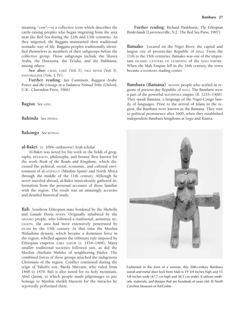
Bambara 27
meaning “cow”—is a collective term which describes thecattle-raising peoples who began migrating from the areanear the Red Sea during the 12th and 13th centuries. Asthey migrated, the Baggara maintained their traditionalnomadic way of life. Baggara peoples traditionally identi-fied themselves as members of their subgroups before thecollective group. Those subgroups include the ShuwaArabs, the Hawazma, the Ta’isha, and the Habbania,among others.
See also: CHAD, LAKE (Vol. I); NILE RIVER (Vol. I);PASTORALISM (Vols. I, IV).
Further reading: Ian Cunnison, Baggara Arabs:Power and the Lineage in a Sudanese Nomad Tribe (Oxford,U.K.: Clarendon Press, 1966).
Bagisu See GISU.
Bahinda See HINDA.
Bakongo See KONGO.
al-Bakri (c. 1094–unknown) Arab scholarAl-Bakri was noted for his work in the fields of geog-
raphy, RELIGION, philosophy, and botany. Best known forthe work Book of the Roads and Kingdoms, which dis-cussed the political, social, economic, and cultural envi-ronment of al-ANDALUS (Muslim Spain) and North Africathrough the middle of the 11th century. Although henever traveled abroad, al-Bakri meticulously gathered in-formation from the personal accounts of those familiarwith the region. The result was an amazingly accurateand detailed historical study.
Bali Southern Ethiopian state bordered by the Shebelleand Ganale Doria rivers. Originally inhabited by theSIDAMO people, who followed a traditional, animistic RE-LIGION, the area had been extensively penetrated byISLAM by the 15th century. At that time the MuslimWalashma dynasty, which became a dominant force inthe region, rebelled against the tributary rule imposed byEthiopian emperor ZARA YAKOB (r. 1434–1468). Manysmaller traditional societies followed suit, as did theMuslim chieftain Mahiko of neighboring Hadya. Thecombined forces of these groups attacked the indigenousChristians of the region. Conflict continued during thereign of Yakob’s son, Baeda Maryam, who ruled from1468 to 1478. Bali is also noted for its holy mountain,Abul Qasim, to which people made pilgrimages to payhomage to Muslim sheikh Hussein for the miracles hereportedly performed there.
Further reading: Richard Pankhurst, The EthiopianBorderlands (Lawrenceville, N.J.: The Red Sea Press, 1997).
Bamako Located on the Niger River, the capital andlargest city of present-day Republic of MALI. From the11th to the 15th centuries, Bamako was one of the impor-tant ISLAMIC CENTERS OF LEARNING of the MALI EMPIRE.When the Mali Empire fell in the 16th century, the townbecame a BAMBARA trading center.
Bambara (Bamana) MANDE people who settled in re-gions of present-day Republic of MALI. The Bambara werea part of the powerful MANDINKA empire (fl. 1235–1400).They speak Bamana, a language of the Niger-Congo fam-ily of languages. Prior to the arrival of Islam in the re-gion, the Bambara were known as the Bamana. They roseto political prominence after 1600, when they establishedindependent Bambara kingdoms at Segu and Kaarta.
Fashioned in the form of a woman, this 20th-century Bambarawood-and-metal door lock from Mali is 19 3/4 inches high and 151/8 inches wide (47.7 cm high and 38.5 cm wide). It utilizes meth-ods, materials, and designs that are hundreds of years old. © NorthCarolina Museum of Art/Corbis
JJJJJJJJJJJJJ
The people who make up the Bambara did not referto themselves as such. The name Bambara means“infidel” or “unbeliever,” reflecting the fact thatthey staunchly resisted ISLAM after the Muslimleader SUNDIATA (d. 1255) came to power in the13th century. Though many were nominally con-verted to Islam, most Bambara continued to prac-tice their traditional RELIGION based on ancestorworship. They also worshiped a creator god, Ngala(sometimes called Bemba), and several lesser godsrelated to air, fire, water, and earth.
JJJJJJJJJJJJJ
Early Bambara society centered on AGRICULTURE, ani-mal husbandry, and trade. The Bambara are recognized asone of the first groups to develop advanced plowing tech-niques. Their staple crops included rice, millet, andsorghum.
See also: ANCESTOR WORSHIP (Vol. I); BAMAKO (Vol.II); BAMANA (Vol. I); BAMBARA (Vol. III); CHIWARA (Vol. I);KAARTA (Vol. III); MALI EMPIRE (Vol. II); NUMUW (Vol. II);NYAMA (Vol. II); NYAMAKALAW (Vol. II); SEGU (Vol. III).
banana Vitamin-rich fruit that is a staple crop grownin present-day ETHIOPIA, CENTRAL AFRICAN REPUBLIC,CAMEROON, GUINEA, NIGERIA, and UGANDA, among othertropical countries. It is from the genus Musa and thefamily Musaceae. Native to India and China, the bananawas introduced to Africa by East Coast traders—eitherby Indonesian MERCHANTS, or Arab merchants who hadobtained it from the Indonesians—during the secondhalf of the first millennium. By the 10th century it hadspread to the African interior and replaced the yam inmany areas as the staple FOOD. Knowledge of the bananapresumably spread from the Pare Mountains to the east-ern interior. In the West, it spread from MALAWI and theZambezi River basin through the CONGO BASIN and WestAfrica.
Simultaneous with the spread of the banana, revolu-tionary agricultural techniques emerged to accommodateits production. Highland planting, used in places likeeastern TANZANIA, was a system of regulated irrigationand manure fertilization that produced a superior bananacrop. In other regions of Africa, agricultural techniquessimilar to highland planting were developed indepen-dently of the Tanzanian methods.
Several types of bananas have been cultivated inAfrica since their introduction more than 1,000 years ago.The Cavendish, or dwarf, banana is found in southernAfrica; the plantain is grown in warm coastal regions; andthe common banana (M. sapientum) is found throughout
the continent. The banana plant flourishes in loose, well-drained soil and humid climates like those of tropicalAfrica.
Growing up to 30 feet (9 m) high, the banana plantis a giant shrub with an underground stem called a rhi-zome. Above ground, the stem forms a false trunk of leaf-stalk bases and resembles a tree trunk. Towering 10 to 20feet (3 to 6 m) tall, the trunk is topped by many largeleaves measuring 10 to 11 feet long (3 to 3.5 m). A floweremerges from the top of the plant that bends to theground, heavy with clusters of fruit. Each cluster, knownas a hand, has 50 to 150 individual bananas.
The banana plant does not require pollination to bearfruit. Therefore, fruit production is essentially continuousafter the first harvest. When the first crop matures, in 10to 15 months, the plant is cut to the ground to regrow.The stem sprouts several new growths, some of which arepruned, while others are allowed to grow into matureplants. Within six months a new banana crop will beready to harvest, and the cultivation process is repeatedthroughout the life of the plant.
When ripe, bananas are an excellent source of potas-sium, carbohydrates, and vitamins C and A. For this rea-son they were an important addition to the early Africandiet. Most varieties are eaten raw, except the plantain,which must be cooked. A plantain has the highest starchcontent of banana fruits because it does not becomesweet when it ripens like other varieties. Today, most ba-nanas are picked when green and sent to distributioncenters for final ripening to ensure freshness for shippingthroughout Africa and abroad. Although it has beengrown in Africa for hundreds of years, the banana re-mains an important staple of African FOOD production.
Banda AKAN trading state located in the forest zone ofpresent day GHANA. Banda reached its height of influence inthe 14th and 15th centuries. Banda was probably foundedaround the same time as the founding of the neighboringAkan state of BONO. Though little is known about theBanda kingdom before the 17th century, it is referred to inARABIC texts from the 14th century, and it is likely that thekingdom emerged in the 13th century, along with develop-ment of the West African GOLD trade.
Banda was ruled from the city of Begho, a forest tradecenter located in the southern region of the kingdom. Bythe 15th century DYULA traders had established settle-ments in Begho to take advantage of the important traderoutes between the Akan states and the MALI EMPIRE.During the 16th century the gold trade in the area wascurtailed considerably and, though Begho would remainan active commercial center, the Banda kingdom nolonger wielded influence in the area.
See also: BANDA (Vol. III); BEGHO (Vol. III); WAN-GARA GOLD FIELDS (Vol. II).
28 banana
Banjul Present-day capital city of The GAMBIA, located atthe mouth of the GAMBIA RIVER. Archaeological evidencesuggests that the coastal area around Banjul was inhabitedas early as 750. Portuguese explorers visited the area inthe 15th century, and British traders followed soon after.
See also: BANJUL (Vols. III, V); PORTUGAL AND
AFRICA (Vols. III, IV, V).
Bantu expansion Massive movement of Bantu-speak-ing peoples across subequatorial Africa. This process tookplace over a couple of millennia. The origins of Bantu-speaking people can be traced to the border region of pre-sent-day NIGERIA and CAMEROON beginning about 1000BCE. At that time they began to migrate to the surround-ing savanna regions and tropical rain forests. They settledalong the GABON coast, where they initially split into twodistinct groups, the Western and Eastern Bantu.
The reasons for the split and subsequent expansionare unclear. Early historians speculated that they coincidedwith advances in IRON technology, but new theories placemore emphasis on the introduction of new crops. Othertheorists believe that the Bantu expansion was driven bypressure from encroaching neighbors, or that they wereforced to migrate in response to changing climatic condi-tions in the Sahara. The Western Bantu moved toward AN-GOLA, while the Eastern Bantu headed southeast towardthe Great Lakes region. The bulk of Bantu expansion oc-curred during the first millennium CE.
The Bantu-speaking peoples prospered in their newterritories, adapting to the region and local customs.Although most of the Bantu dispersion had occurred bythe 11th century, the Bantu speakers continued to mergewith native groups. Organized Bantu towns and king-doms began to emerge, replacing the early loose associa-tions. In the Indian Ocean coastal areas, Bantu speakersdeveloped more complex societies as they came in con-tact with Arab traders. Shungwaya, an extinct Bantukingdom along the East African coast, reached its heightfrom the 12th to 15th centuries. The success of the king-dom of Shungwaya indicates that the Eastern Bantu wereprospering by the 12th century.
Three distinct Bantu groups emerged along the east-ern coast: the Sabaki, Waseuta, and Ruvu. These groups,particularly the Sabaki, intermixed with and influencedthe local hunters and gatherers. Farther to the south, theWaseuta were known for integrating Indonesian cropsinto their traditional planting techniques. The Ruvu splitinto two groups, the East Ruvu and the West Ruvu. TheEast Ruvu inhabited the lush lowlands, enabling them togrow the same Indonesian crops as their Waseuta neigh-bors. In contrast, the West Ruvu subsisted on grains andlivestock due to the drier climate. At the same time sev-eral Bantu groups settled along the southern edge of theeastern coast near Lake Nyasa. Between 1100 and 1600,
the Kilapwa and Songea Bantu migrated throughout theregion, absorbing local populations along the way. In thearea around Lake Victoria, Bantu-speaking peoples settledbetween Mara and the Kavirondo Gulf. A second groupsettled further to the south, near Mount Elgon.
Further inland, in KENYA and TANZANIA, scatteredBantu groups had settled among the Nilotic and SouthernCushitic people by the 12th century. Their willingness toshift from traditional root crops to the millet and sorghumof the native inhabitants allowed the Bantu population toincrease rapidly. By the 16th century major expansionsand diversification in these areas occurred among theTakama Bantu. The Bantu in the mountain regions ofKilimanjaro and Kenya were responsible for the develop-ment of highland AGRICULTURE that could support an es-sential new crop, the BANANA. Closer to the Great Lakes,the Bantu intermixed with pastoralists.
The expansion of the East Bantu-speaking peoplescontinued pushing to the south. The Shona (or their im-mediate ancestors) were responsible for developing themajor state centered at GREAT ZIMBABWE. Located on thecentral plateau inland from the coastal lowlands, it thrivedfrom about 1100 until 1450. The southern-most Bantuspeakers were the Nguni sub-group, with the Xhosa, whosettled in what today is the Eastern Cape Province of SouthAfrica.
The Bantu expansion came to a halt when it reachedland that was unsuitable for rain-fed agriculture and insuf-ficient to support grazing. It did not, for example, extendinto the more arid regions of southern Africa such asKaroo and the Namib Desert.
There were too many Bantu-speaking subgroups tochart them all in detail. Each developed its own customsand traditions as it intermixed with local peoples. As a re-sult, Bantu speakers are connected by the language theyspeak, and not by social, economic, or religious customs.
See also: BANTU EXPANSION (Vol. I); BANTU LAN-GUAGES (Vol. I).
Further reading: Christopher Ehret, An AfricanClassical Age: Eastern and Southern Africa in World His-tory, 1000 BC to AD 400 (Charlottesville, Va.: Universityof Virginia Press, 1998).
Banu Marin See MARINIDS.
Banyoro See NYORO.
Bariba (Borgawa) Ethnic group of the Borgu regionin present-day northern Republic of BENIN and NIGERIA.In precolonial times Bariba was best known for its IRON-WORKING. The Bariba are one of the three subgroups ofthe Bargu (the Borgo and Borgenci being the other two)
Bariba 29

that speak a Voltaic dialect belonging to the Niger-Congolanguage family. Early Bariba people may have been theWasangari. The Wasangari were precolonial raiders ofBatonum, Mokole, Boko, and FULANI descent. Other theo-ries attribute Bariba ancestry solely to the Batonum.
Traditional Bariba dwellings were mud-brick struc-tures organized around a courtyard that served as thekitchen. The Bariba were accomplished CRAFTSPEOPLE,sometimes recognizable by their unique woven hats(which some older Bariba still wear today), but they weremostly known for their work with metal.
The Bariba ethnic group still has a presence in re-gions of Nigeria and the Republic of Benin and also inparts of BURKINA FASO and TOGO.
See also: BARIBA METALLURGY (Vol. II); NIGER-CONGO
LANGUAGES (Vol. I).
Bariba metallurgy Metalworking techniques of theBARIBA, an ethnic group that inhabited the Borgu regionin NIGERIA and and present-day Republic of BENIN. Due tothe abundance of IRON ores found just beneath the earth’ssurface in Borgu, IRONWORKING was common in tradi-tional Bariba societies. For the Bariba, ironworking in-volved mining, ore preparation, fuel collection, furnacebuilding, smelting, refining, and smithing.
Mining was a FAMILY affair that occurred over a pe-riod of several months in order to build a reserve largeenough for smelting. The most common fuels used by theBariba were slow-burning hardwoods, which were placedin termite clay furnaces where smelting techniques wereused to separate the iron from slag. The iron was thenworked by a smith, who was held in high esteem inBariba culture.
Like other groups, the Bariba considered metalwork-ing a sacred rite, so elaborate ceremonies accompaniedthe smithing process. They believed that knowledge ofironworking was passed to smiths from God through anearthly intermediary. This intermediary existed in theform of a sea crab, which the Bariba believed lived in theanvil of the smith’s forge. The Bariba often sacrificedgoats out of respect for the crab, and they believed thatanyone who touched the smithing tools would be cursedwith illness.
See also: METALLURGY (Vol. I); METALWORKING (Vol. I).
bark fiber The soft inside layer of the protective outercovering of trees. For centuries, it has been woven into alight, versatile cloth throughout Africa. The history ofbark fiber production is not clear. Archaeological evidencesuggests that it originated in Central Africa and movedeast into KENYA, TANZANIA, MOZAMBIQUE, and MALAWI.While it is unknown when bark fiber production began,the most prolific periods of bark cloth production on
record occurred in the 18th and 19th centuries, beforeEuropeans brought substantial amounts of their own clothto Africa. By the mid-20th century bark fiber productionhad virtually disappeared in favor of more durable andeasily obtainable European cloth.
Bark cloth was typically produced by harvesting theinner bark of Ficus and Brachystegia trees. Both of thesetrees could survive only in the wet regions of Africa, sobark cloth was not made in the desert regions. The treeswere easy to cultivate and matured quickly. They wereready to harvest only three years after planting. The firstharvest always yielded poor quality fiber, but by its fourthharvest, the tree reached its prime. Trees could be har-vested for 20 to 30 years if the bark was stripped annuallyto prevent the healing skin from becoming too stiff.
Many African peoples practiced a bark harvestingritual. Those who participated in the harvest had toabide by strict rules. For instance, the cutter was not al-lowed to drink anything or have any oil on his body be-fore cutting. It was considered bad luck if he perspiredon the bark, and he had to wash the bark in cold water ifthe tree had an unusually large amount of sap. To pre-vent the trunk from drying, the cutter worked in theearly morning or late afternoon. He would cut a horizon-tal slash around the base and top of the trunk and thenmake a vertical cut down the length of the tree. He couldthen peel off the bark in large rectangular sections. InUGANDA, a harvester covered the tree trunk with animaldung and wrapped it in BANANA leaves to accelerate thehealing process.
The harvested bark was soaked in water for severaldays until it was soft enough to remove the inner barkfibers. A wood mallet was then used to beat the barkpulp, which caused the fibers to intertwine. After foldingand pounding the cloth numerous times, the cloth makerwould wring out the excess water and set the cloth out todry. The cloth would then be stretched and kneaded byhand for several hours, making it soft and pliable. Thebest cloths were thin, yet strong, and relatively free fromholes or patches.
By the time the cloth was finished, the bark fibershad become tightly intertwined into the fabric. Althoughit was not particularly strong, good bark cloth could beused for a variety of purposes. Many peoples used it asclothing, particularly for cloaks. It was also used to makeburial shrouds. For instance, the bodies of dignitaries insouthern Uganda would be wrapped in 50 or 60 of thecloths in preparation for burial. It could also be sewn intosacks to store grain, salt, or personal belongings. Manygroups made lightweight bedding or floor mats from thecloth. The European settlers used it to make cushion cov-ers and roofs for temporary shelters. Today, with moderntechnology, the arduous process of turning bark fiber intocloth is a dying African ART.
See also: CLOTH AND TEXTILES (Vols. I, II, III, IV, V).
30 Bariba metallurgy

Barmandana (Baramendena) (fl. c. 1050) Muslimruler who brought Islam to the Mali Empire during the 11thcentury
Barmandana, a MANDINKA king, governed the MANDE-speaking peoples of the MALI EMPIRE as a mansa, or ap-pointed caste leader. His position eventually evolved intothat of a king.
JJJJJJJJJJJJJ
During Barmandana’s rule, Mali suffered a debili-tating drought. According to legend, a visitor to theMandinka court advised Barmandana that his con-version to ISLAM would bring rain. So the mansaadopted the faith and, so the story goes, the rainsfell, thus encouraging several of Barmandana’s sub-jects to convert also. The mansa didn’t force any ofhis subjects to accept Islam, however. Instead,many Mandinka maintained their old beliefs, enjoy-ing a religious freedom that was maintained forhundreds of years.
JJJJJJJJJJJJJ
Mali, which during Barmandana’s rule was a subordi-nate kingdom to the powerful GHANA EMPIRE, was servedwell by his conversion to Islam (even though most of thepeople of his kingdom continued to practice their tradi-tional, non-Muslim RELIGION). Mali’s status as a Muslimkingdom helped it to become incorporated into the de-veloping Sudanic and TRANS-SAHARAN TRADE ROUTES,which were controlled by Islamic interests. Within a fewcenturies after Barmandana’s rule, Mali would be themost powerful empire in West Africa.
See also: ISLAM, INFLUENCE OF (Vol. II, III, IV, V).
Basoga See SOGA.
Batoro See TORO.
beads and jewelry Items often used in Africa fortrade and body ornamentation. Although many Africangroups used them differently, beads and jewelry were animportant part of both special rituals and daily life.Beads often decorated clothing, jewelry, sheaths forstaffs, masks, and various religious objects. Dependingon custom, jewelry was made in a variety of styles andmaterials. Items made of GOLD, silver, COPPER, cowrieshells, IVORY, beads, and clay have been found in differ-ent parts of Africa. To gain a broader understanding ofpractices throughout Africa, the individual groups mustbe explored.
A rich display of bone, BRONZE, ivory, and gold jew-elry as well as glass beads was found at archaeologicalsites of the IGBO culture in present-day NIGERIA, in WestAfrica. It is thought that these materials were imported inthe eighth century from lands in the ancient GHANA EM-PIRE Early Berber traders probably brought them to thearea. The Ghana Empire, located in the western SUDAN,was a powerful and wealthy kingdom, with vast suppliesof gold, ivory, and silver. Intricate bracelets, necklaces,and pendants have been found at early sites in the region.Stylistic similarities between early Ghanaian jewelry andthat of neighboring kingdoms indicate extensive contactbetween early Sudanese civilizations.
The SAO people of the Chari Delta near Lake Chadgot their inspiration from Mediterranean and Nilotictraders. Their copper, silver, and clay jewelry has an in-ternational flair that emerged sometime in the 10th cen-tury. In the region of present-day Democratic Republic ofthe CONGO, Bantu speakers made copper wire bracelets,copper beads, and ivory necklaces as early as the eighthand ninth centuries. For many of the semi-nomadic peo-ple of the African interior, jewelry was made from materi-als more easily obtainable like shells and beads. Althoughcontact with coastal traders influenced the jewelry stylis-tically, it was not until ARABS penetrated the African inte-rior in the ninth century that jewelry began to reflectexternal influences.
Around the same time, the ASHANTI of present dayGHANA, along the Gold Coast, prospered as gold traders.Masks, pendants, and jewelry were produced in largequantities. They were primarily used in religious cere-monies and worn by royalty. Gold rings on chains werepopular among aristocrats. Beads, prevalent in Ashantisociety, decorated ceremonial items like masks and wereeven used as currency in the early SALT TRADE and othertransactions.
Some African peoples like the FULANI of West Africaused decorative body painting as a form of jewelry. Theyalso braided cowrie shells, silver, or beads in their hair anddecorated their garments with chains. Copper anklets wereworn to indicate the age and status of the wearer.
See also: COWRIE SHELLS (Vol. I); CRAFTSPEOPLE
(Vol. II); MASKS (Vol. I); MONEY AND CURRENCY (Vol. I, II,III, IV, V).
Beja Ethnic group, also known as Hedareb nomads, lo-cated in the eastern Republic of the SUDAN, and parts ofERITREA, ETHIOPIA, and EGYPT. For much of their history,the Beja were considered “pagans,” and they were one ofthe few groups to resist both CHRISTIANITY and ISLAM.However, as early as the sixth century, some Beja did be-come Christians when the regions of Ethiopia andEritrea they inhabited made up the Christian kingdomof AKSUM.
Beja 31

When it was discovered that Beja territories heldmany GOLD mines, Muslim rulers in what is now Iraq dis-patched troops to the region. After a few skirmishes,these troops subdued the Beja and forced them to pay an-nual tribute in gold. By the 14th century most Beja hadbeen converted to Islam, primarily as a result of frequentintermarriage with the ARABS who settled in the region.Despite their embrace of Islam, however, many Bejagroups continued to practice their traditional beliefs.
See also: BEJA (Vol. I).Further reading: Harold G. Marcus, The History of
Ethiopia (Berkeley, Calif.: University of California, 1995);The Diagram Group, Peoples of North Africa (New York:Facts On File, 1997); Antonio L. Palmisano, Ethnicity:The Beja as Representation (Berlin: Arabische Buch, 1991).
Benin, Republic of Country in coastal West Africameasuring approximately 43,500 square miles (112,700sq km) that shares borders with NIGER and BURKINA FASO
to the north, TOGO to the east, the Atlantic Ocean to thesouth, and NIGERIA on the west. During the medieval pe-riod, the history of the northern regions of Benin was tiedto the wider trends in the history of the western Sudanicbelt. Northern Benin became a center of large-scale ironmaking because of its rich and readily exploitable de-posits of IRON ore plus the large quantities of trees thatmade excellent charcoal for smelting. These resources ledthe BARIBA people to develop their renowned BARIBA MET-ALLURGY.
Perhaps as early as the 12th century the AJA, whowere an EWE-speaking people, moved from what is nowTogo into the southern part of the country. Their princi-ple village, ALLADA, emerged by the 16th century to be-come the capital of the area’s most powerful state. Thatkingdom, also known as Great Arda, was ruled by a kingaided by a body of elders, who wielded considerable po-litical power. In the early 17th century a political disputewithin the royal family led to the founding of the statethat became DAHOMEY.
See also: BENIN, REPUBLIC OF (Vols. I, III, IV, V).
Benin, kingdom of Ancient EDO state located in pre-sent-day southern NIGERIA. (The Benin kingdom shouldnot be confused with the present-day country of the samename.) For nearly 3,000 years Edo peoples have inhab-ited a large area west of the Niger River in what is nowthe Benin province of southern Nigeria. Originally, sin-gle-family settlements dominated the area; however,about the fifth century, village communities formed toprovide families with greater defense and allow themmore efficient use of natural resources.
While these communities developed a network oftrade routes, successful villages grew into towns. One
such town, Benin, evolved into a hereditary monarchyruled by a king, or OBA, and a court of hereditary chiefs,called UZAMAS. Benin remained a small Edo state until the15th century, when, sometime after 1480, it was con-quered by EWUARE (c. 1440–1480), a great warrior chief.Ewuare rebuilt the destroyed city around a centrally lo-cated grand royal palace. In the palace he housed theskilled artisans who created the ART for which Benin isknown today.
During his reign Ewuare instituted the law of pri-mogeniture, by which the son’s reign would follow thatof his father. Ewuare also expanded the borders ofBenin, creating a sprawling kingdom by conqueringneighboring peoples. There is some debate as towhether Ewuare was still oba when Portuguese MER-CHANTS arrived late in the 15th century, but, in any case,Benin was powerful enough to maintain peaceful andcooperative trade with the Europeans.
32 Benin, Republic of
This bronze head of an unnamed princess was made in the kingdomof Benin (c. 1360 to 1500). It is displayed at the Fogg Art Museum inCambridge, Massachusetts. © Burstein Collection/Corbis

JJJJJJJJJJJJJ
Benin art from the 14th, 15th, and 16th centuries iswidely regarded as some of the best African artfrom that period. Artisans and CRAFTSPEOPLE werecommissioned by the obas to create detailed BRONZE
castings in the likenesses of celebrated royal familymembers. These bronze sculptures also had distinc-tive markings that helped the royal FAMILY to recordits history. Other interesting items made by Benin’sartists included IVORY carvings, bronze bells, andspecial hip or belt masks, which were worn by theobas during special ceremonies.
JJJJJJJJJJJJJ
See also: BENIN, KINGDOM OF (Vol. III, IV); BENIN,BIGHT OF (Vol. III); BENIN CITY (Vol. III, IV, V); NIGER
DELTA (Vol. I); NIGER RIVER (Vol. I).
Benue River Longest tributary of the Niger River, inWest Africa. During the medieval period, the Benue wasan important water highway for the TRANSPORTATION oftrade goods and people. The Benue originates in thehighlands of northern CAMEROON and flows into centralNIGERIA. The fertile triangular region around the conflu-ence of the two rivers has been home to a number of peo-ples, including the Nupe and Kwararafa (who establishedtwo of the minor HAUSA STATES), IGALA, Igbira, and Jukun.During the 14th and 15th centuries, these peoples wereable to take advantage of the ideal farming conditions tocarry on trade with the YORUBA states downstream andwith the land CARAVANS that brought goods to and fromthe SUDAN to the north.
See also: KWARARAFA (Vol. III); NUPE (Vol. III).
Berbers Ethnic group of northwest Africa and theSahara who established ruling dynasties that controlledmuch of North Africa and southern Spain from the 11thcentury to the 13th century. In the fifth century theBerbers constituted two distinct groups: agriculturalistswho settled along the southern coast of the MEDITER-RANEAN SEA, and nomadic pastoralists who lived in themountain passes and on the steppes of northern Africa.As early as the fifth century some of the Berbers wholived along the coast had become MERCHANTS and tradedtheir agricultural goods and foodstuffs for manufacturedMediterranean goods.
The Berbers of the interior were largely assimilatedby invading Arab Muslims beginning in the seventhcentury. By the 10th century Fatimid Berbers controlledmuch of EGYPT and the Red Sea coast, and the SANHAJA
BERBERS controlled vast areas of the Sahara. By the 11th
century practically all of the Berbers of North Africa hadconverted to ISLAM. From the 11th to the 13th centuriesthese Islamic Berber clans dominated North Africa.Their most powerful ruling dynasties were the FATIMIDS,ALMORAVIDS, ALMOHADS, MARINIDS, Zayyanids, andHafsids.
At the height of its power, the Berber empire in-cluded the African regions of MOROCCO, ALGERIA, LIBYA,EGYPT, and northern NIGER. They also controlled most ofsouthern Spain, an area they called al-ANDALUS. Berber-controlled cities in Africa included TUNIS, MARRAKECH,TLEMCEN, and al-Qahira (CAIRO) in the north, and TIM-BUKTU and AUDAGHOST, trans-Saharan trade centers of thewestern SUDAN. By the end of the 13th century Berber dy-nasties no longer held sway in the western Sahara, butthe Berber people did assimilate into the Islamic Arabculture that assumed power in the region.
JJJJJJJJJJJJJ
During the 14th and 15th centuries many of thetrading routes in the Sudan were run by a semi-no-madic people called TUAREGS, who claim descentfrom the original Berber clans of North Africa.
JJJJJJJJJJJJJ
See also: BERBERS (Vols. I, III, IV, V); NOMADS (Vol. I);SAHARA DESERT (Vols. I, II).
Further reading: Michael Brett and Elizabeth Fen-tress, The Berbers (Cambridge, Mass: Blackwell, 1996).
Beta Israel (Falasha) Ethiopian agriculturalists wholong practiced the Jewish faith. The origins of the Beta Is-rael are unclear, and the many legends about their begin-nings often conflict. However, it is clear that they werepracticing their faith within various parts of ETHIOPIA
well before the beginning of the Common Era. The Beta Israel subscribe to religious and cultural
practices similar to Judaism; their name, Beta Israel,means “House of Israel.” They practice an ancient biblicalform of Judaism, guided by the Orit (the Pentateuch, orfirst five books of the bible, translated into GE’EZ), butpossess none of the post-biblical laws and interpretationscollected in the Talmud. However, unlike conventionalJewish practice, they pray in Ge’ez, the ancient Ethiopianvernacular and liturgical language, and practice bothmale and female circumcision.
In the second half of the 12th century the legend ofPrester John—a Christian priest who ruled over a vastempire in the East—began to circulate throughoutEurope. In some versions of this legend, Prester John’skingdom is identified with Ethiopia (called Abyssinia atthe time). Rumors based on these legends claimed that
Beta Israel 33

the Beta Israel were at constant war with Prester John andthat their armies were advancing on Rome.
JJJJJJJJJJJJJ
Various traditions explain the origins of the BetaIsrael. One holds that they are an AGAW people whowere converted to Judaism before the ancientEthiopian kingdom of AKSUM was Christianized inthe fourth century. The contrary tradition holds thatthey are Jewish migrants from EGYPT, possibly con-nected to the house of Dan (the fifth of the TwelveTribes of Israel descended from the 12 sons ofJacob) who entered Ethiopia early in the commonera. The word falasha means “stranger,” “exile,” or“immigrant” in Ge’ez and characterizes the distinc-tiveness of the Beta Israel within Ethiopian culture.
JJJJJJJJJJJJJ
Although there is evidence that the Beta Israel werepersecuted for assisting the Agaw, who resisted the rule ofAKSUM (c. 900–1000), few facts are known about the BetaIsrael until the Christian emperors of the SOLOMONIC DY-NASTY began persecuting them in the 14th and 15th cen-turies. They had begun to be regarded as an identifiablegroup during Ethiopia’s Heroic Age that began c. 1270,when many legends about Ethiopia’s past began to takeform. In the following century they had grown into apopulous and prosperous community numbering in themany thousands.
By the 15th century ruling Ethiopian monarchs suchas ZARA YAKOB (r. 1434–1468) and his son Baeda Maryam(r. 1468–1478) were actively engaged in warfare againstthe Beta Israel. These organized massacres led to heavylosses among the Beta Israel.
See also: BETA ISRAEL (Vols. I, III, IV, V).Further reading: Steven Kaplan, The Beta Israel
(Falasha) in Ethiopia: From Earliest Times to the TwentiethCentury (New York: New York University Press, 1992).
Betsimisaraka Ethnic group of the island of MADAGAS-CAR, located off East Africa. Primarily fishers, traders andfarmers, the Betsimisaraka lived along a narrow section ofthe eastern Madagascar coast. Their ancestors were a mixof African, Malayo-Indonesian, and Arab peoples whospoke the West Austronesian language of MALAGASY. Thisdiverse group of people became known as the Betsimis-araka, which translates literally as “the inseparable multi-tude.” Before establishing their own kingdom in the early18th century, the Betsimisaraka were pirates, sailors,whalers, and fishermen.
See also: BETSIMISARAKA (Vol. III); INDONESIAN
COLONISTS (Vol. II).
Bigo (Bigo bya Mugenyi) Archaeological site inpresent-day UGANDA, dating to the 14th and 15th cen-turies, known for its massive earthworks. Located on theKatonga River, Bigo was probably one of the capitals ofthe rulers of the CHWEZI DYNASTY, who ruled the KITARA
COMPLEX of chiefdoms. Archaeological evidence points toits origins around the mid-14th century. Excavations re-vealed that the site’s inhabitants raised a substantial num-ber of cattle and abandoned the area in the mid-16thcentury when the Nilotic-speaking LUO people encroachedon their territory.
Bigo is best known as the site of large earthworksbuilt and occupied between about 1350 and 1550. Thelongest of these vast ditches stretch for approximately 6.5miles (10.5 km). In many places carved from solid rock,the earthworks are up to 20 feet (6.1 m) deep and 30 feet(9.1 m) wide. The purpose for these earthworks is notfully understood, but they clearly required a large LABOR
force to construct.Further reading: J. E. G. Sutton, Ntusi and Bigo:
Farmers, Cattle-herders and Rulers in Western Uganda, AD1000–1500 (Nairobi, Kenya: British Institute in EasternAfrica, 2000).
Bilad al-Sudan Expression in ARABIC meaning “Landof the Blacks.” Bilad-al Sudan was the term generallyused by ARABS to describe the area south of the Sahara inwestern Africa and located above the forest belt. ISLAM
came to Africa in the seventh and eighth centuries. TheDyago dynasty of the kingdom of TEKRUR converted toIslam in 850 and were the first black people to becomeMuslims. Their territory was given the name Bilad-alSudan by Islamic geographers and historians.
JJJJJJJJJJJJJ
In geography, the term the SUDAN refers to the stripof semiarid land between the lower edge of theSahara and the equatorial rain forests, as well asthe region south of the Sahara in the present-dayRepublic of the SUDAN.
JJJJJJJJJJJJJ
The introduction of Islam led to increased trade,wealth, and literacy in western Africa. Within this dy-namic setting, the three great empires of GHANA, MALI,and SONGHAI developed. The work of Muslim scholars ofthe time has allowed a great deal to be known about thehistory of Bilad-al Sudan prior to the era of Europeancontact and exploitation that became prevalent after1500.
See also: ISLAM, INFLUENCE OF (Vol. II, III, IV, V); SA-HARA DESERT (Vols. I, II).
34 Betsimisaraka

Biram One of the seven independent HAUSA STATES lo-cated between the Niger River and Lake Chad. Accordingto Hausa oral traditions, Biram was founded and ruled bya man named Biram, the son of Bayajida and the princessMagira, of Bornu. As with the other Hausa states, Biramwas an important trading center. It was also the originalseat of the Hausa government.
Bissau Important port city of the MALI EMPIRE from the13th to the 15th centuries. Located at the mouth of theGEBA RIVER on the Atlantic Ocean, Bissau was populatedprimarily by the Balanta, Fula, and Manjaca peoples.Bissau’s ECONOMY was based on AGRICULTURE because ofits warm, rainy climate. Local crops included yams, beans,kola nuts, millet, rice, and other grains.
See also: BISSAU (Vols. III, IV); GUINEA-BISSAU (Vols.I, II, III, IV, V); PORTUGAL AND AFRICA (Vols. III, IV, V).
Further reading: Walter Hawthorne, Planting Riceand Harvesting Slaves: Transformations Along the Guinea-Bissau Coast, 1400–1900 (Portsmouth, N.H.: Heinemann,2003).
Bito (Babito) Nilotic people who established severalEast African kingdoms, including the influential BUNYORO
state. The LUO-speaking ancestors of the Bito originallyinhabited the southern areas of the present-day Republicof the SUDAN, living peacefully along the Bahr al-Ghazaltributary of the White Nile, where they grew millet andraised cattle.
During a period that extended from the seventh tothe 11th centuries, some of these Luo-speaking pastoral-ists migrated toward the Agoro Mountains, where theyintermarried with the local people and lived as huntersand farmers. After an outbreak of disease devastated theirlivestock, many Luo migrated across the Nile. Accordingto oral traditions, it was these Luo who, in the latter 14thcentury, headed south to the Great Lakes region of inte-rior East Africa. At that time the chiefdoms of the region,known collectively as the KITARA COMPLEX, were ruled byWAMARA, a king of the CHWEZI DYNASTY, who had only re-cently come to power. Despite attempts by Wamara to in-tegrate them into the local governing structures, the Luoimmigrants never fully assimilated. Political unrest be-tween the people living in Kitara was exacerbated by a se-vere famine, leading to the end of Chwezi rule and therise of the Luo.
According to some traditions, a military commanderwho was appointed to office by Wamara ultimately killedthe Chwezi king. This commander, Kagoro, founded thenew state of BUNYORO, also called Bunyoro-Kitara. Kagorowas followed by Owiny I and then by Prince Rukidi.Rukidi’s ruling clan was probably the first Luo group tobe officially recognized as Bito people, or Babito. The Bito
rulers encountered much hostility from the Bantu speak-ers within their new kingdom and were eventually forcedto move their capital to BUGANGAIZI. As their power in-creased, they expanded their territory south into TORO
and even claimed parts of the HINDA states of NKOLE andRWANDA. In addition, Rukidi’s brother moved east to foundBUSOGA, thereby creating another Bito kingdom.
In Bunyoro, the people under Bito rule continued topractice agriculture and raise livestock. They were opento various forms of RELIGION and emphasized loyalty tothe king above all else. At first, kings were given almostdivine status and were freed from such traditional prac-tices as appointing tribal chiefs according to heredity.Instead the kings were able to make autonomous deci-sions regarding the kingdom. However, before long, theBito returned to their traditional government structures,relying more on hereditary rights and clan lineage thanon a centralized political power.
See also: BITO (Vol. III); CLAN (Vol. I); LINEAGE (Vol.I); PASTORALISM (Vols. I, IV).
blacksmiths See BLACKSMITHS (Vol. I); CRAFTSPEOPLE
(Vol. II); IRON (Vol. II); IRONWORKING (Vol. II); NUMUW
(Vol. II); NYAMAKALAW (Vol. II).
Bobo (Bwa) Ethnic group of the Volta River basin inWest Africa. The Bobo are a subgroup of the Mossi peo-ples who settled in areas of present-day BURKINA FASO andIVORY COAST. Prior to the 15th century the DYULA estab-lished a trade settlement in Bobo territory, south ofJENNE. Called Bobo-Dioulasso, it was part of a network oftrade routes that connected it with OUAGADOUGOU, thecapital of the GHANA EMPIRE and the center of the WestAfrican GOLD trade.
JJJJJJJJJJJJJ
The Bobo have long been known as excellentCRAFTSPEOPLE and artists. Their traditional masks,some of which measure 6 feet high, are popularitems on the modern African ART market.
JJJJJJJJJJJJJ
Like other Mossi people, the Bobo lived in au-tonomous, village communities dominated by paternallineages and maintained using a caste system.
See also: MOSSI STATES (Vols. II, III, IV).
Bonny Atlantic port city located in NIGERIA. Bonnyserved as the capital of the kingdom of Bonny beginningin the 1400s, and it was the primary trading center of the
Bonny 35

IJO people. In 1505 the Portuguese captain PachecoPereira reported a “large village of some 2,000 dwellings,”which has been identified as Bonny. The name of the cityis derived from Ibani, the local name of the area.
See also: BONNY (Vol. III).
Bono People and state located west of the VOLTA RIVER
in what is now the country of GHANA. Bono was foundedin the first half of the 15th century by the FANTE, a sub-group of the AKAN people, who occupied the forests ofcoastal Ghana. Bono contained numerous GOLD fields,and quickly developed into a major supplier in the trans-Saharan gold trade. Bono’s capital, Bono-Mansu, was anactive stop on the trade route from the northern city ofJENNE.
JJJJJJJJJJJJJ
The kings of Bono, and especially Obunumankoma,who reigned from 1450 to 1475, are thought tohave increased Bono’s gold production by intro-ducing advanced mining technology to the Akanfields.
JJJJJJJJJJJJJ
The original Fante founders of Bono were not con-verts to ISLAM. However, Muslim DYULA traders in Bonoand the neighboring kingdoms of BANDA and Begho wereinstrumental to the prosperity of the region. During thelate 15th and 16th century some rulers of Bono wereMuslims.
See also: BEGHO (Vol. III); BONO (Vol. III).
Borkou (Borku) Southeastern SAHARA DESERT regionlocated in CHAD, between the Tibesti Massif and theEnnedi Plateau. The most important settlement in the re-gion is the oasis town of Faya. Although the harsh cli-mate made life difficult, a small number of nomadicARABS, BERBERS, and TEDA people populated the area, per-haps as early as the seventh century. By the 13th centuryBorkou was crossed by TRANS-SAHARAN TRADE ROUTES
that linked West Africa with Cyrenaica, in LIBYA. Muslimpilgrims en route to MECCA from West Africa also passedthrough the region.
See also: CYRENE (Vol. I); TIBESTI (Vol. III).
Bornu Early kingdom in present-day NIGERIA. Foundedabout 850 on the southwestern shores of Lake CHAD,Bornu was originally inhabited by the SAO, a groupknown for their trans-Saharan trading activities. As earlyas the 11th century, Bornu came under the control of the
the mais, or kings, of the SEFUWA dynasty from the neigh-boring kingdom of KANEM, with its capital at NJIMI, east ofLake Chad. Under the Sefuwa rulers, Bornu’s borders ex-panded. Trade routes north brought great wealth to thekingdom, and the CITY-STATE of KANO, to the west, evenpayed tribute. By about 1240 both Bornu and Kanem hadlargely been converted to Islam, and the combined king-doms became known as the trading empire of KANEM-BORNU. About 1488 the Sefuwa moved their capital fromNjimi to NGAZARGAMU, in Bornu.
Botswana Present-day landlocked country of approxi-mately 231,800 square miles (600,400 sq km) in south-ern Africa that is located on the African Plateau.Botswsana is bordered by present-day ZAMBIA, ZIMBABWE,NAMIBIA, and SOUTH AFRICA. Botswana is mostly semiariddesert and sparse savanna. The terrain is dominated bythe Okavango Swamp to the northwest, rocky hill rangesto the east, and the KALAHARI DESERT to the south. Otherthan the Chobe, Okavango, and LIMPOPO rivers, no otherdependable water source exists in Botswana. Thus thecountry is sparsely inhabited, albeit by diverse groups ofpeople. Approximately half of the population is ethnicTswana, while the remainder is composed of Kgalagadi,Ngwato, Tswapong, Birwa, and Kalanga peoples.
The early inhabitants of Botswana were the nomadicSan and KHOIKHOI peoples, both of whom were pastoral-ists whose ancestors lived in the region for thousands ofyears. Bantu-speaking people migrated to the area aroundthe first century CE. Settling throughout Botswana, by theeighth century the Bantu speakers migrated as far east asthe Kgalagadi region. By the 13th century new kingdomshad been established at Gabane to the south and in theTsodilo Hills to the north.
The most numerous people in Botswana, the Tswana,migrated to present-day SOUTH AFRICA in the 11th and12th centuries. They established dynasties near the VaalRiver, where they farmed and raised cattle. These semi-nomadic people did not establish extensive permanentsettlements in Botswana until the 18th century.
See also: BANTU EXPANSION (Vols. I, II); BANTU LAN-GUAGES (Vol. I); BOTSWANA (Vols. I, III, IV, V); PASTORAL-ISM (Vols. I, IV); SAN (Vols. I, III); TRANSVAAL (Vol. IV);TSWANA (Vols. I, III, IV).
Brass (Nembe) Kingdom or chiefdom located in pre-sent-day NIGERIA at the convergence of the Niger andBrass rivers, in the Niger Delta. Originally a fishing vil-lage called Nembe, Brass was founded in the 12th centuryby NEMBE people (an IJO subgroup). By the middle of the15th century, the Nembe people had a monarchy, and inthe 17th century the port became a slave-trading centerknown to Europeans as Brass.
36 Bono

Brong West African ethnic group and the region thatthey occupy in present-day GHANA. A subgroup of theAKAN people, the Brong traditionally have lived in regionsof present-day IVORY COAST and the Brong region ofGhana. Their language, Twi, belongs to the Kwa branch ofthe NIGER-CONGO family. Archaeological evidence suggeststhat the early inhabitants of the Brong region were pas-toralists who also engaged in a limited amount of agricul-ture. The chief components of Brong civilization, whichemerged from the sixth to 11th centuries, included MET-ALWORK, urban development, long-distance trade, and theformation of a state-based political system.
See also: AHAFO (Vol. III); BRONG (Vol. III); PAS-TORALISM (Vol. I).
bronze Alloy of COPPER and tin used in metalworkingthroughout Africa. The use of copper alloys developed inthe northern regions of the continent, but by the fifthcentury coppersmithing technology had spread into SUB-SAHARAN AFRICA via TRANS-SAHARAN TRADE ROUTES.
Due to its softness and scarcity, copper was primarilyused for decorative objects. Bronze, on the other hand,was a much harder metal, so it was often used to makeweapons and tools. Bronze was not used exclusively forpractical purposes, though. Archaeological evidence indi-cates that as early as the ninth century, peoples of GUINEA
and CAMEROON were casting bronze ornaments using theLOST-WAX PROCESS.
See also: BENIN, KINGDOM OF (Vol. II); BRONZE AGE
(Vol. I).
Buganda Early East African kingdom established bythe GANDA people near Lake VICTORIA, in present-dayUGANDA. Founded near the end of the 14th century,Buganda became the most powerful kingdom in EastAfrica in the 19th century.
Modern historians refer to the clans that settled inthe Buganda area from the 13th to the 16th century asmaking up the Kintu complex, a collection of looselyaligned, multiethnic states that also included Busoga andBugisu, on the western slopes of Mount Elgon. Thesepeoples established settlements as they migrated south-ward from their homelands in what is now northwesternUganda. According to Ganda oral tradition, the people ofBuganda were first united under a kabaka (king) calledSEKABAKA KINTU. However, some historians believe thatthe first Buganda king was a prince named Kimera (fl.early 15th century), a member of the LUO-speaking BITO
aristocracy who was sent from the neighboring kingdomof BUNYORO, to the west.
Buganda social structure was based on paternal lin-eages. Regional chiefs served beneath the king, who ac-quired his wealth and power largely by raiding weaker
neighboring kingdoms. The inhabitants of Buganda,sometimes called the Baganda, relied primarily on AGRI-CULTURE for their livelihood. They grew bananas, in par-ticular, which were a major source of nourishment andwere used to make beer. Buganda reached the height ofits power in the 19th century.
JJJJJJJJJJJJJ
Ganda oral tradition says that Sekabaka Kintu (aname meaning “First Man”) and his wife, Nambi,not only founded Buganda along the shores of LakeVictoria, but also made the first cattle and BANANA
plants in the region.
JJJJJJJJJJJJJ
See also: BUGANDA (Vols. III, IV, V); BUSOGA (Vol. III).Further reading: M. S. M. Semakula Kiwanuka, A
History of Buganda from the Foundation of the Kingdom to1900 (New York: Africana Pub. Corp., 1972).
Bugangaizi Early kingdom of the Great Lakes regionof East Africa. During the 10th and 11th centuriesBantu-speaking agriculturalists migrated to the regionin large numbers, forming several small kingdoms, in-cluding Bugangaizi. By about 1250 several other small,Bantu-speaking kingdoms had emerged as offshoots ofBugangaizi. During the 14th century these small pas-toral kingdoms were ruled by NDAHURA, the semimythi-cal first king of the CHWEZI DYNASTY. Over the nexthalf-century, he and his Chwezi successors united theregion’s many kingdoms into what is now called the KI-TARA COMPLEX. By the early 15th century, however, mostof Kitara, including Bugangaizi, had fallen under thecontrol of LUO-speaking pastoralists, who had invadedfrom the north.
See also: BANTU EXPANSION (Vol. I).
Bulala (Boulala) Nomadic people from the areaaround Lake Fitri, east of Lake CHAD, who invadedKanem in the 14th century. The Bulala took advantage ofKanem’s weakened SEFUWA dynasty, whose kings, or mais,had ruled the KANEM-BORNU trading empire since aboutthe 10th century. Without a strong and unified militaryforce defending it, the kingdom was especially vulnera-ble. Bulala attacks forced the Kanem mai, or king, Umaribn Idris (r. 1382–1387), to abandon his capital at NJIMI,east of Lake Chad. He subsequently led his Kanuri-speak-ing Kanembu people to settle in Bornu, on the westernshore of Lake Chad. After ousting the Sefuwa mai, theBulala ruled Kanem into the early 16th century, when theSefuwa rulers retook their original kingdom.
Bulala 37

Bunyoro (Bunyoro-Kitara) Kingdom of the NYORO
people in present-day UGANDA. The early Nilotic-speak-ing ancestors of the Nyoro probably arrived in the regionduring the eighth century. Once there they mixed withBantu-speaking people who arrived from the west aboutthe same time. The new groups that emerged from thiscultural mix spoke Bantu and grew BANANAS as well assorghum and other grains in their small villages. Theyalso raised cattle.
Eventually the villages grew into a collection of smallstates. According to local oral histories, in the mid-14thcentury these states came under the control of rulers ofthe CHWEZI DYNASTY, who founded a loosely organizedempire that became known as the KITARA COMPLEX.During the reign of the second Chwezi king, WAMARA, theKitara complex was invaded from the north by Nilotic LUO-speaking pastoralists. Although the Chwezi and Nyoro tra-ditions do not agree on exactly what happened next, it isclear that the Luo ultimately overthrew the Chwezi kingand established their own monarchy in Bunyoro; some ofthe former Chwezi subjects were incorporated intoBunyoro. The Luo rulers of Bunyoro imposed many oftheir own traditions, but they did adopt the Bantu lan-guage spoken in the region.
By 1500 the BITO clan of the Luo was well establishedas the Bunyoro aristocracy. Bito members also leftBunyoro to conquer other settlements in the region andeventually founded the states of BUGANDA and TORO, aswell as Buruli and Busoga.
See also: BUNYORO (Vols. III, IV); BUSOGA (Vol. III).Further reading: David Lee Schoenbrun, A Green
Place, a Good Place: Agrarian Change, Gender, and SocialIdentity in the Great Lakes Region to the 15th Century(Portsmouth, N.H.: Heinemann, 1998).
Burkina Faso Landlocked West African country ofsome 105,900 square miles (274,300 sq km) bordered bypresent-day Republic of BENIN, IVORY COAST, GHANA,Republic of MALI, and TOGO. Lying on a sloping plateau,Burkina Faso’s terrain includes extensive plains, low hills,and high savannas, as well as a northern desert. Apartfrom Stone Age axes that have been found in the north,the region’s first inhabitants left few clues as to who theywere and how they lived. The most widely accepted the-ory is that they were agriculturalists who settled the sa-vanna west of the Mouhoun (Black Volta) River, perhapsaround 1100.
By the 13th century the ancestors of the Mossi peo-ple began migrating into the area from the east. By 1500they were joined by horsemen from the north who subju-gated the peoples they found in the region. From thesegroups eventually arose the MOSSI STATES.
See also: BURKINA FASO (Vols. I, III, IV, V); KING-DOMS AND EMPIRES (Vol. II); UPPER VOLTA (Vols. IV, V).
Burundi Landlocked country in east-central Africa,some 10,700 square miles (27,700 sq km) in size, bor-dered by RWANDA to the north, TANZANIA to the east andsouth, and Lake TANGANYIKA and the DemocraticRepublic of the CONGO to the west.
With its rich volcanic soils, Burundi saw a steadygrowth of AGRICULTURE as practiced by Bantu-speakingfarmers in the years between 500 and 1500. The use ofIRON for weapons and tools steadily increased amongthese people, who were the ancestors of the modernHUTU. With forests providing plenty of wood for makingthe charcoal used to smelt the iron, Burundi quickly wason the way to becoming one of the most densely popu-lated parts of the continent. Paradoxically, the clearing ofland for farming and the felling of the forests for makING
charcoal opened up the region for pastoralism. This ulti-mately paved the way for TUTSI pastoralists to move intoBurundi with their herds. By the 17th century the Tutsihad established the Burundi kingdom with themselves asthe ruling elite.
See also: BURUNDI (Vols. I, III, IV, V).
Byzantine Africa Region of North Africa, includingEGYPT and part of present-day LIBYA, that belonged to theByzantine Empire from the third century CE until the riseof ISLAM, in the seventh century. Africa held an importantplace in the scheme designed by Byzantine emperor Jus-tinian (r. 527–565) for reuniting the Roman Empire anddriving out the Germanic Vandals, who had invadedAfrica near the end of the fourth century. While Jus-tinian’s own invasion attempt was unsuccessful, his gen-eral, Belisarius, later succeeded. In 533 Belisarius landedin North Africa and within a year had destroyed the Van-dal kingdom.
Justinian and his wife, Theodora (c. 502–548), wereinstrumental in the construction, and particularly thedecoration, of churches in Byzantine Africa as well as inthe reestablishment of Christian orthodoxy. Little isknown of Byzantine Africa after the death of Justinian.The power of the military in the provinces grew, and be-tween 585 and 591 a new official, the exarch, was placedin charge. The court of Constantinople tended to neglectAfrica because of the more immediate dangers on theeastern and Balkan borders, and the exarch functioned asthe court’s deputy in Africa. In 610 Heraclius (575–641),son of the ruling exarch, sailed from Carthage to Greecein revolt against the unpopular emperor Phocas (r.602–610). Heraclius succeeded Phocas the same year.
Africa still held some importance to the empire in theearly seventh century. The Persians had overrun much ofthe eastern part of the empire, including Egypt, and at onepoint reached the walls of Constantinople. Only Africa ap-peared able to provide the resources and recruits neededto keep the empire secure. Heraclius briefly entertained
38 Bunyoro

leaving Constantinople to return to Carthage but, heed-ing popular sentiment within the capital, decided to stay.
The rise of Islam, however, ended the Persian threatand also removed Egypt from Byzantine rule. MuslimArab armies invaded Persia and defeated the Persianarmy in 637. In 639 Arab Muslims invaded Egypt, and by642 they had captured Alexandria, the capital. Soon after
losing Alexandria, the Eastern Roman Empire was nolonger a force in Africa.
See also: BYZANTINE AFRICA (Vol. I); CAESAR, OCTA-VIAN (Vol. I); CHRISTIANITY (Vol. II).
Further reading: Averil Cameron, Changing Culturesin Early Byzantium (Brookfield, Vt.: Variorum, 1996).
Byzantine Africa 39
The Byzantine basilica called Hagia Sophia in Constantinople was once one of the premier churches in Christendom and the administra-tive headquarters of the Church in Africa. The building, which dates to around 535, became a mosque after the fall of Byzantium to theOttomans. It is shown here in a lithograph by Louis Haghe (1826–1885), as based on a drawing by Chevalier Caspar Fussati. © HistoricalPicture Archive/Corbis

Cairo Capital of EGYPT and largest city in Africa. Cairowas officially founded in 969. Prior to this, the city had avariety of names—Memphis, Heliopolis, Babylon, al-Fustat, al-Qataei, and al-Askar being just a few of them.During its history it has been governed by an equally longlist of rulers, from the ancient Egyptians, Greeks, andRomans to the ARABS, Turks, French, and British.
About 5,000 years ago, Menes, the legendary pharaohwho united the kingdoms of Upper and Lower Egypt, sup-posedly founded the city of Memphis, approximately 15miles (24 km) south of modern-day Cairo. In 525 BCE, in-vading Persians established a fort, called Babylon, north ofMemphis, from which they controlled Egypt. Babyloniandomination continued until the arrival of Alexander theGreat in 332 BCE. The region later fell under the rule of theRomans. The arrival of Islamic Arabs, around 640 CE, led tothe founding of the town of al-Fustat, the seed from whichcontemporary Cairo sprang.
In 969 the FATIMIDS invaded Egypt from what is nowTUNISIA. A new walled city called al-Mansuriyah was estab-lished northeast of the existing settlements. In 973 theFatimid caliph al-Muizz (c. 931–975) renamed the city al-Qahirah, or Cairo, making it the capital of a dynasty thatlasted for 200 years. Al-Qahirah and al-Fustat coexisteduntil 1168, when al-Fustat was set on fire during the CRU-SADES. Eventually the Crusaders were defeated by anIslamic army from Syria. Their commander, the famousSALADIN (1137–1193), founded the Ayyubid dynasty,which claimed Cairo for the seat of its rule.
Under Saladin, Cairo became a thriving metropolis.He constructed mosques, palaces, colleges, hospitals, anda fortress, named the Citadel, which has remained one ofCairo’s most important landmarks. After his death, Saladin
was succeeded by male family members until the rule ofShagaret-el-Dorr (c. 1250), a Mamluk who was the wife ofthe last Ayyubid sultan, al-Saleh. One of three women everto rule Egypt, Shagaret-el-Dorr had a great influence onCairo. After her murder in 1260, Cairo became the capitalof the Mamluk empire with Baybars I as sultan.
By 1340 Cairo was at its height, with nearly 500,000people living in an area five times larger than the originalFatimid walled city. Under the MAMLUKS, Cairo became thegreatest city of Africa, Europe, and Asia Minor. The city’sal-AZHAR University was the undisputed center of Islamicscholarship. Cairo also was an important link in the lucra-tive East-West spice trade. This was also the period duringwhich many of Cairo’s architectural masterpieces werebuilt.
In 1348 Cairo’s population was decimated by plagues,including the infamous Black Death that later swept acrossEurope. Decline set in soon after. Another blow came in1497, when Vasco da GAMA’S (c. 1460–1524) voyage fromPortugal to India broke Cairo’s spice-trade monopoly.Then, in 1517, the Turks conquered Cairo.
See also: CAIRO (Vols. I, III, IV, V); MEMPHIS (Vol. I);OTTOMAN EMPIRE (Vol. III).
Further reading: André Raymond, Arab Cities in theOttoman Period: Cairo, Syria, and the Maghreb (Burlington,Vt.: Ashgate/Variorum, 2002); André Raymond, Cairo (Cam-bridge, Mass.: Harvard University Press, 2000).
Cameroon Modern-day country in western CentralAfrica approximately 183,600 square miles (475,500 sq km)bordering CHAD, CENTRAL AFRICAN REPUBLIC, Republic ofthe CONGO, GABON, EQUATORIAL GUINEA, NIGERIA, and the
JJJJJJJJJJJJJJJJJC
40

Gulf of Guinea. The region that became Cameroon wasoccupied by various peoples, including the Sudanic-speaking SAO and FULANI, and the Bantu-speakingDYULA, FANG, and Mileke, during the fifth through the15th centuries.
Between the ninth and 15th centuries, the Sao estab-lished a kingdom that covered large parts of northernCameroon and Nigeria. The Fulani, a Muslim people whofirst came to Cameroon in the 11th century, lived on theAdamawa Massif. They dominated the peoples inhabitingthe valleys of the Logone, Kebbi, and Faro river valleys,converting many of them to ISLAM.
The Mileke lived in the area that is now western andsouthern Cameroon. They were mainly farmers whose sta-ple crops include corn and taro. Like other Bantu-relatedgroups, they migrated to Cameroon from equatorial Africa.
See also: BAMENDA GRASSFIELDS (Vol. III); BANTU MI-GRATIONS (Vols. I, II); CAMEROON (Vols. I, III, IV, V).
Further reading: Mario Azevedo, ed., Cameroon andChad in Historical and Contemporary Perspectives (Lewis-ton, Me.: E. Mellen Press, 1988); Tambi Eyongetah andRobert Brain, A History of the Cameroon (London: Long-man, 1974).
Cape of Good Hope Though not the southernmostpoint on the African continent (that honor lies with CapeAgulhas some 170 miles [280 km] to the east), the Capeof Good Hope was the point at which the cold waters ofthe Atlantic Ocean met the warmer waters of the IndianOcean. The Cape received its name (Cabo da BoaEsperança, in Portuguese) in 1488, when the Portugueseexplorer Bartolemue Dias (c. 1450–1500) rounded it onhis search for a new sea route to India. Today, the Cape ispart of a nature preserve and national park.
Cape Verde Islands Archipelago 1,560 square miles(4,040 sq km) in size, located in the Atlantic Ocean, 385miles (620 km) from the coast of present-day SENEGAL.Consisting of 10 islands and five islets, Cape Verde is his-torically associated with the Portuguese olive trade to theAmericas. Cape Verde was discovered, in 1460, by thePortuguese navigators Diogo Gomes and António deNoli. There is little evidence to support the assertion thatthe islands were inhabited before the European arrival,although it is believed that the Moors may have soughtsalt here in previous centuries. In 1462 the first settlersarrived and founded the oldest European city in the trop-ics, Ribeira Grande. A governor and bishop were installedon the island of Santiago to administer to political andspiritual affairs.
Under the Charter of 1466, Portuguese settlers wereallowed to trade freely with the Upper Guinea coastalcities, from Senegal to SIERRA LEONE. After securing trad-
ing posts on the islands, settlers began to establish tradingsettlements on the African mainland. As a result, the set-tlers merged with the African societies with whom theytraded, taking African wives and establishing trading al-liances with the leaders and local traders. These alliancesgave rise to a new society called lancados, European orhalf-caste traders, who became acculturated in the Africancommunities.
Although fishing and cane farming were establishedas principle industries early on, Cape Verde’s limited rain-fall, frequent droughts, and significant soil erosion were,and are still, incompatible with large-scale crop cultiva-tion. Instead, grazing, subsistence farming, and fishingsupplemented a limited BANANA and SALT TRADE. Muchmore significant to the islands’ economy was their loca-tion, which made Cape Verde a logical point of departurefor trade between Africa and the Americas.
See also: CAPE VERDE, REPUBLIC OF (Vols. I, III IV,V); PORTUGAL AND AFRICA (Vols. III, IV, V).
caravans Traders and others traveling together for mu-tual safety with their baggage and other goods throughdifficult or dangerous terrain. In Africa, the caravan ismost often associated with trans-Saharan trade, althoughcaravans were used on trade routes throughout Africa.Muslim pilgrims also traveled to MECCA in caravans.
The earliest animals used to cross the desert mayhave been pack oxen, as depicted in Saharan rock art,dating from before 4000 BCE, found at Tassili in ALGERIA.The record here is unclear, however, because many schol-ars question the validity of using those paintings to estab-lish historical fact. Reliable sources indicate that theArabian camel, introduced into North Africa in the firstcentury CE, became, by the fifth century, the pack animalof choice among the Berber nomads. Although it could notcarry much more than a pack ox, the camel could maintaina steady pace over longer distances and travel withoutwater for up to 10 days. The camel’s broad, splayed feetgave it secure footing when walking on shifting sand, andit was able to endure both the extreme heat of the desertday and the chilling cold of the desert night.
Loads of 350 pounds (160 kg) or more were equallydivided and loaded onto a camel’s back. Strings of 40 ormore camels were tethered together by a rope from eachcamel’s nose ring to the saddle of the camel in front.Commonly, three or four strings of camels traveledabreast, moving at a speed of 2 to 3 miles (3 to 5 km) perhour for 10 to 14 hours daily, often at night for protectionfrom the heat. It was a two-month journey, under the di-rection of a caravan chief with the assistance of localguides, to travel the TRANS-SAHARAN TRADE ROUTE from SI-JILMASA in North Africa to WALATA in the MALI EMPIRE.Caravans taking this route often made a stopover at theTaghaza salt mines in the desert. Many caravans were lost
caravans 41
to raiders or the elements. Gaining or keeping control ofthe staging areas were important goals of all the tradingempires of West Africa.
The size of the trans-Saharan caravans was signifi-cant. Caravans averaged 1,000 camels. The Tunis-bornArab historian Ibn Khaldun (1332–1406), who wrote adefinitive history of Muslim North Africa, records cara-vans of 12,000 camels between West Africa and Egypt.The largest caravans were involved in the all-importantsalt trade or in taking Muslim pilgrims on pilgrimage toMecca in Saudi Arabia, one of the most important spiri-tual duties of the observant Muslim. These pilgrim cara-vans had to arrive in Mecca on the prescribed eighth dayof Dhu al Hijjah, the last month of the Muslim year.
See also: TRANSPORTATION (Vol. II).Further reading: Edward William Bovill, The
Golden Trade of the Moors: West African Kingdoms in the14th Century (London: Oxford Univ. Press, 1968); Paul E.Lovejoy, Salt of the Desert Sun: A History of Salt Productionand Trade in the Central Sudan (New York: CambridgeUniv. Press, 1986).
Casamance River River located in the coastal flood-plain region of West Africa between present-day coun-tries of The GAMBIA and GUINEA-BISSAU. The river is 160miles (257 km) long and flows to the west, emptying intothe Atlantic Ocean. During the period prior to Europeancolonization, the land on either side of the river was pop-ulated by the Balanta, the DYULA, and the Felupe peoples.During the 1500s Portuguese explorers sailed throughthe estuaries and inlets of the river to penetrate inland,thereby transforming the Casamance River into a thor-oughfare for the exchange of goods and ideas betweenthe two civilizations.
See also: GUINEA-BISSAU (Vol. III); PORTUGAL AND
AFRICA (Vols. III, IV, V); SLAVERY (Vol. III).
cassava Edible starchy tuber also called manioc, man-dioc, and yucca. Along with maize (corn), tobacco, andpeanuts, it originally came from the Americas and was in-troduced to Africa about 1500. Cassava is cultivatedthroughout SUB-SAHARAN AFRICA and is used to makeflour, breads, and fufu, a gelatinous food common in WestAfrica. Cassava, which also is cultivated in East Africa,has long been a staple in the diet of African peoples.
Cassava, unlike millet and other grain CROPS, is easyto cultivate, which usually leads to a successful harvest.The plant itself is perennial and has palm-shaped leaves.It can thrive in dry areas and can grow in alkaline soil orin acidic mud banks along rivers. It is an extremelyadaptable species and comprises many different varieties.Certain species produce a sugar derivative that containscyanide (hydrocyanic acid). The poison, which is manu-
factured by a system of grating, pressing, and heating theroots, is used as the toxin on poison darts and arrows.
cavalry Military branch whose members ride horses inbattle. In Africa, horses were traded via the TRANS-SAHA-RAN TRADE ROUTES from North Africa and the Middle Eastto the western SUDAN, where the region’s empires andkingdoms used horses in their military conquests.
JJJJJJJJJJJJJ
African cavalry units often came from the highestlevels of society. The cavalry of the MALI EMPIRE, forexample, was an elite corps of the military, andmembership was reserved for the aristocracy. Themembers of the cavalry were called the ton-tigi, or“quiver and bow bearers.”
The powerful SONGHAI Empire of the 15th centuryalso possessed an impressive cavalry, with as many as10,000 horse-mounted soldiers. Because of the highcost of the horses (each horse was equivalent in costto 10 captives), the Songhai cavalry, too, was com-posed only of members of the aristocracy.
JJJJJJJJJJJJJ
At the start of the 12th century, horses were broughtfrom areas north of the SAHARA and traded for GOLD andIVORY. By the end of the century, however, they werebeing bred in the Niger River valley.
Near Lake Chad, in NJIMI, the capital of the kingdomOF KANEM-BORNU, North African merchants traveled tothe city to trade for horses during the 15th century. Thesehorses were referred to as “war horses” since they werelarger and stronger than the ones owned and bred inother parts of the the empire. It is reported that the mai,or king, of Kanem had a cavalry of more than 40,000horses, which illustrates the enormous impact of tradeupon Kanem-Bornu’s prosperity.
See also: HORSES (Vol. I); WARFARE AND WEAPONS
(Vol. II).
Central African Republic Landlocked, equatorial,Central African country, some 240,300 square miles(622,400 sq km) in size, that is bordered on the north byCHAD, on the east by the Republic of the SUDAN, on thesouth by the Democratic Republic of the CONGO and theRepublic of the CONGO, and on the east by CAMEROON.During the fifth through 15th centuries the population ofthe Central African Republic was made up of farmerswho followed a shifting pattern of slash-and-burn AGRI-CULTURE. They belonged to extended family clans and
42 Casamance River

lived for the most part in isolated and small villages.Gradually trade linked these villages, leading to the largerstates that began to emerge until the 16th century.
See also: CENTRAL AFRICAN REPUBLIC (Vols. I, III, IV, V).Further reading: Tamara Giles-Vernick, Cutting the
Vines of the Past: Environmental Histories of the CentralAfrican Rain Forest (Charlottesville, Va.: University Pressof Virginia, 2002).
Chad Country in western Central Africa approximately496,000 square miles (1,284,6000 sq km) in size. This re-gion of Africa is marked by the Tibesti Massif to thenorth, Lake Chad to the west, the savannas of the Sahelto the south, and is separated into two distinct northernand southern regions by the Chari River. It is bordered bythe modern country of LIBYA to the north, NIGER to thewest, EQUATORIAL GUINEA to the southwest, the CENTRAL
AFRICAN REPUBLIC to the south, and Republic of theSUDAN to the east.
Because of the importance of Lake Chad, the regionsaw many kingdoms and conquests during its history. Inthe eighth century, BERBERS migrated into the area inorder to escape the droughts of the Saharan borderlands.By the 11th century, Muslim ARABS from the north hadbegun regularly raiding the area for captives, establishingISLAM as they came and went. As a result Arab culturegradually superseded the native African ones and under-mined the autonomy of the local kingdoms.
JJJJJJJJJJJJJ
Kanem, located to the northeast of Lake Chad, wasa kingdom originally made up of nomadic peopleswho spoke Nilo-Saharan languages and were domi-nated by the ZAGHAWA people. Local oral traditionssay that the Arab Sayf ibn Dhu Yazan united thesepeople and began the SEFUWA dynasty, which ruledKanem, and, at times, the larger KANEM-BORNU em-pire, from the ninth century to the 19th century.
JJJJJJJJJJJJJ
See also: CHAD (Vols. I, III, IV, V); CHAD, LAKE (Vols.I, III).
Further reading: Mario Azevedo, ed., Cameroon andChad in Historical and Contemporary Perspectives (Lewis-ton, Me.: E. Mellen Press, 1988).
Changamire (15th century) Ruler of Mwene Mutapastate, located in what is now Zimbabwe
During the middle of the 15th century the Bantu-speaking KARANGA people created a powerful kingdomthat eventually came to include the majority of the
southern part of present-day ZIMBABWE. The kingdom’sruling dynasty, the founding of which is variously as-cribed to the warrior kings Mutapa or Nyatsimba, suc-cessfully dominated the region for a number of years. Inthe late 15th century King Matope expanded the king-dom significantly. By the time Matope’s son Mokombocame to the throne in 1480, however, the MWENE MU-TAPA, as the ruler was known, faced increasing unrestamong the kingdom’s various provincial governors andother vassals. The kingdom, too, became known asMwene Mutapa.
JJJJJJJJJJJJJ
Mwene mutapa, the title used by Changamire’srulers, means “master pillager.” Instead of beingconsidered an insult, the term was thought of as atitle of respect.
JJJJJJJJJJJJJ
Ultimately, in about 1490, one of Mokombo’s gover-nors, CHANGAMIRE, led a full-scale insurrection. Accord-ing to various legends, Changamire believed thatMokombo wanted to kill him, and, in response, led agroup of soldiers to Mokombo’s capital, GREAT ZIMBABWE.There the majority of Mokombo’s soldiers deserted him,leaving only a handful of guards and courtiers to defendhim. Entering the royal quarters, Changamire quickly be-headed Mokombo with a single blow of his sword andproclaimed himself king.
Changamire then attempted to make his positionmore secure by trying to have all 22 of Mokombo’s chil-dren killed. One of the princes escaped, however, and,four years later, led an army against Changamire. Thebattle that resulted apparently lasted for several days untilChangamire was killed by the young prince.
Mokombo’s son then became the mwene mutapa.While much of the country recognized Mokombo’s au-thority, a number of Changamire’s supporters resisted.Strife between the two factions continued for a number ofyears, with Changamire’s allies eventually establishing asmall, independent kingdom centered around the rem-nants of the city of Great Zimbabwe. During this period,both mining and the GOLD trade suffered significantly,which apparently led the Portuguese to take more directcontrol of the region. By the beginning of the 16th cen-tury, power had begun to pass to the Portuguese, andeven the kingdom of the mwene mutapa fell under Por-tuguese domination.
See also: CHANGAMIRE DYNASTY (Vol. III); INDIAN
OCEAN TRADE (Vol. II); MWENE MUTAPA (Vol. III); ROZWI
(Vol. III).Further reading: David N. Beach, The Shona and
Zimbabwe, 900–1850 (Gwelo, Zimbabwe: Mambo Press,
Changamire 43

1980); Innocent Pikirayi, The Zimbabwe Culture: Originsand Decline in Southern Zambezian States (Walnut Creek,Calif.: AltaMira Press, 2001).
Chemama Region and river valley on the northernbank of the SENEGAL RIVER in present-day MAURITANIA. Itwas part of the MALI EMPIRE during the 14th century, andlater, in the 16th century, became part of the HAUSA STATES.A biologically diverse region, Chemama has a complexecosystem created by the annual flooding of the SenegalRiver. Its land has rich alluvial soils that have long sup-ported farming and herding.
Chinese trade Despite reports of the presence ofChinese traders in Africa as early as the seventh centuryBCE, Chinese trade did not begin in earnest until the ex-peditions of Cheng-Ho (1371–1433) between 1405 and1433. Cheng-Ho, a grand admiral of the Chinese navy,commanded a large squadron of ships that landed on theSWAHILI COAST at the port of KILWA in East Africa. The rel-atively late arrival of the Chinese to Africa is explained bythe fact that it was not until after the 11th century thatChinese vessels sailed south or west of the Indonesian is-land of Java. Then, in 1402, a Korean map was publishedthat included an outline of southern Africa.
JJJJJJJJJJJJJ
The ships in Cheng-Ho’s fleet were up to 500 feetlong (152.4 m), making them five times larger thanany of the Portuguese-made vessels that arrived atthe same East African port in the early 16th cen-tury. The squadron was equally large in number.On previous voyages, which had gone to ports inSoutheast Asia and the Red Sea, Cheng-Ho hadcommanded fleets of up to 62 ships, carrying asmany as 27,800 men.
JJJJJJJJJJJJJ
The African products that Cheng-Ho brought back—including GOLD, amber, IVORY, and captives—were highlyvalued in China. It is reported that in 1417 he returnedwith a delegation from Malindi who presented the royalcourt at Beijing with a giraffe.
Chinese trade was dominated by the import of porce-lain in East Africa. Pieces created during the rule ofChina’s Song dynasty have been documented through ex-cavation in several homes of wealthy Swahili traders dur-ing the period. Bluish white, Ming porcelain arrived inthe 15th century at the port of GEDI. Chinese trade—along with Persian, Arab, and Indian trade—contributedboth to the cultural and economic development of
Swahili civilization in the 15th century. By the end of the15th century, however, China returned to a policy of iso-lation. From that time on, trade with Africa was curtailed.
Chokwe (Cokwe, Ciokwe, Bajokwe) Bantu-speaking Central African people. A mixture of many in-digenous and immigrant peoples, they trace their originsto the Mbuti, hunter-gatherers who came under thedemonstration of agricultural by Bantu-speakers aboutthe sixth or seventh century. Around 1500 the Chokwecame under the rule of the LUNDA KINGDOM when a disin-herited Lunda prince moved west into the area straddlingpresent-day ANGOLA, Democratic Republic of the CONGO,and ZAMBIA. Conquering the people in his path, theprince created a kingdom for the Chokwe people.
See also: CHOKWE (Vol. III); LUNDA EMPIRE (Vol. III);MBUTI (Vol. I).
Christianity The religion based on the teachings ofJesus Christ; Judaism, Christianity, and ISLAM, are theworld’s three great monotheistic religions. Chapter 2 ofthe Gospel of St. Matthew, the first book of the NewTestament of the Christian Bible, records the flight of theholy family from Judea in Palestine into EGYPT to keepthe infant Christ from falling into King Herod’s hands.Although this visit, otherwise undocumented, antedatedChristian missionary activity by several hundred years, itpoints to the long-term connection between Africa andChristianity.
Doctrinal disputes were frequent in the early days ofthe Christian Church. Some, like Arianism, originated inAfrica. Others arose elsewhere but soon engulfed the uni-versal church. The patriarch of Rome, the pope, was be-ginning to emerge as the central authority of the church inthe West, but patriarchates also existed in Constantinople,Jerusalem, Antioch, and Alexandria, and each patriarch,or bishop of the highest rank, jealously guarded his pre-rogatives. Dogma and doctrine were shaped and refined aschurch leaders convened in ecumenical councils, includ-ing the Council of Nicea in 325 (at which the NiceneCreed, or statement of beliefs, was developed), the Coun-cil of Constantinople in 381, and the Council of Chal-cedon in 451. These ecumenical councils, attended by thebishop from every local church, determined the officialposition of the universal church on the major theologicaldisputes of the period.
Donatism and Pelagianism The church in NorthAfrica in the fifth century continued to be embroiled inits own internal disputes, some stemming from theologyand others from juridical concerns that had originated inearlier centuries. Donatism and Pelagianism remained is-sues in the North African Church and in the church atlarge. The Donatist schism between Rome and large seg-
44 Chemama

ments of the church in North Africa persisted until therise of Islam in the seventh century effectively ended ameaningful Christian presence in the region. Many histo-rians believe that these internal theological and politicaldisputes turned the church’s energies inward, not just inAfrica but across the whole Byzantine Empire, and leftthe empire in a diminished position to temper the inroadsmade by Islam in the seventh century.
JJJJJJJJJJJJJ
Donatism, which had persisted since the third cen-tury, was based on disagreements on the question ofwhether an unworthy minister may worthily admin-ister the sacraments. The African Church took theposition, condemned by the church at large, thatthe minister himself had to be holy. Rome’s positionwas that the validity of the sacraments came fromGod, not man.
The Pelagian heresy, prompted by the teachings ofthe early fifth-century British monk Pelagius, cen-tered on the more speculative matters of free will,predestination, original sin, and divine grace.
JJJJJJJJJJJJJ
Arianism The Arian heresy, which arose in Egypt inthe third century, dominated the Greek-speaking EasternChurch in the fourth century and then spread through theWestern Church, remaining a force in Europe until theeighth century. The Vandals who invaded North Africafrom Europe in the fourth century and captured Carthagewere Arian Christians. The Visigoths who established alarge empire in what is now Spain and France, were alsoArian Christians as were the Germanic groups that sackedRome in the late fifth century. Their cause was both politi-cal and theological.
Monophysitism The Council of Chalcedon of 451,which affirmed traditional beliefs in the dual nature ofChrist as god and man, alienated Monophysite believers inEgypt and Syria, who held that Christ had a single, divinenature. During the next 250 years the Byzantine emperorsand patriarchs sought to reconcile the Monophysites but invain. The Armenian Apostolic Church, Coptic OrthodoxChurch, Ethiopian Orthodox Church, and Syrian Ortho-dox Church were formed in schism with Constantinople,the city that was the center of the church in the EasternRoman Empire, and were outside the mainstream of Chris-tian thought.
From the seventh century on, many, but not all,members of the Coptic Church converted rather than suf-fer the periodic bouts of persecution waged by Islamicrulers. Nevertheless the Coptic Church has remained in-tact to modern times. Similarly, in Nubia, Christians were
pressured to adopt Islam, but after a brief standoff theyretained their right to Christian worship.
The Ethiopian Orthodox Church The church inEthiopia, though sometimes beset by its Muslim neigh-bors, kept its independence but became a church turnedin on itself, with few influences from the outside world.Although its bishops were named by the Coptic Church ofEgypt (a practice that ended in the 20th century), neitherchurch was in communion with the main centers ofChristianity in Rome or Constantinople because of theiradherence to Monophysite beliefs. The Ethiopian Church’smain contact with the outside Christian world wasthrough the Ethiopian monastery in the holy city ofJerusalem. Since the late 1100s, this group has maintainedcontrol of a chapel in Jerusalem’s Church of the HolySepulchre, thought by believers to be the burial place ofJesus Christ.
The kingdom of AKSUM established Christianity as itsstate religion in the fourth century. Surrounded by re-gions in which traditional African religion flourished, theEthiopian Orthodox Church remained highly conserva-tive. Christian beliefs won converts through interactionwith local populations, and its rites and religious prac-tices were infused with traditional African elements. Forinstance, many of Ethiopia’s monasteries attracted priestswho were highly politicized and outspoken advocates onbehalf of the poor. The church celebrated the Virgin Maryin keeping with its belief in the divine nature of Christbut also recognized many martyred saints. Church offi-cials were known for performing exorcisms to rid thepopulation of evil spirits. A widespread belief held thatthese spirits were kept at bay by amulets containingprayers and formulas carried in little books or leathercases. These were worn around the neck or arms by localpopulations as well as by visiting Islamic merchants, whoheld similar beliefs. The observance of fasts, feasts, andJewish practices related to diet were also among theChristian practices of Ethiopia. Ethiopia’s imperial leader-ship resisted the advance of Islam through its powerfulalliance and support by the church. After Aksum declinedin the seventh and eighth centuries, subsequent leader-ship maintained Christian traditions in the face of re-peated clashes involving the establishment of powerfulMuslim states within its interior.
Christianity began to spread southward fromEthiopia in the 12th and 13th centuries, but only slowly,because of Arab naval supremacy in the Indian Ocean. Itremained for missionaries from Europe to return Chris-tianity to a greater level of importance, but that did notoccur until the colonial era.
See also: CHRISTIANITY (Vol. I); COPTIC CHRISTIANITY
(Vol. II); DEBRE DAMO (Vol. II); GUDIT (Vol. II); KONGO
KINGDOM (Vol. III); LALIBELA (Vol. II); MONOPHYSITE (Vol.I); NINE SAINTS (Vol. II); NUBIA, CHRISTIAN (Vol. II); SAB-BATARIANS (Vol. II); ZAGWE DYNASTY (Vol. II).
Christianity 45

This 10th-century fresco of Adam and Eve from the Old Testament is in the Coptic Museum in Cairo, Egypt. © Gianni Dagli Orti/Corbis
46 Christianity

Further reading: John Baur, 2000 Years of Christian-ity in Africa: An African History, 62–1992 (Nairobi, Kenya:Paulines, 1994); Elizabeth Isichei, A History of Christian-ity in Africa: From Antiquity to the Present (Grand Rapids,Mich.: W. B. Eerdmans Pub. Co., 1995); Adrian Hastings,The Church in Africa: 1450–1950 (New York: Oxford Uni-versity Press, 1994); John S. Mbiti, African Religions andPhilosophy, 2nd ed. (Oxford, U.K.: Heinemann Educa-tional Publishers, 1989).
Christianity, influence of Between the fifth and15th centuries, the influence of CHRISTIANITY was strongin North Africa, EGYPT, Nubia, and ETHIOPIA until the riseof ISLAM and all but nonexistent in SUB-SAHARAN AFRICA.Despite the decline of Christian influence during this pe-riod, many events that happened in the early centuries ofthe church in Africa had long-term repercussions for theChristian Church outside Africa.
Christian culture in the fifth century kept Africa incontact with the broader world of Mediterranean culturein the same way that Islam in the eighth century placedAfrica in the cultural orbit of Muslim Baghdad and Dam-ascus in the Middle East. In the fifth century, however,Rome and Constantinople were the dominant culturaland religious influences in the region. The major figuresof the church in Africa in previous centuries, notably St.Augustine (354–430), the bishop of Hippo Regius (mod-ern Annaba, Algeria), near Carthage, influenced religiousthought throughout the Christian world. As the fifth cen-tury began, the church in Africa faced the same questionsabout its core beliefs that challenged the Church at large.
The Church in Sub-Saharan Africa UntilPortugal’s attempt to introduce Christianity into sub-Saharan Africa during the reign of Prince HENRY THE NAVI-GATOR (1394–1460), indigenous Christianity existedprimarily in North Africa and along the eastern regions ofthe continent—in Egypt, Nubia, and Ethiopia. Besidesbeing motivated by religious zeal to Christianize thelands south of the Sahara, Prince Henry, some authoritiesconclude, may have been attempting to outflank ISLAM,Europe’s main rival, from the rear as well as gain a politi-cal and commercial foothold in the region. These at-tempts at conversion, though successful in such places asthe KONGO KINGDOM, had no long-term results, andChristianity vanished almost without a trace in these re-gions until missionaries returned in the 1800s.
The Church in North Africa From the end of thesecond century, Carthage had its own bishop, and NorthAfrican Christianity was in the mainstream of theWestern Church centered in Rome.
Throughout the fourth and fifth centuries, the NorthAfrican Church was beset by Pelagianism and the schismcaused in 311 by the Donatists, which was to last untilRoman Africa fell to Islam in the mid-seventh century.
Pelagianism, the doctrine preached by the fifth-centuryBritish monk Pelagius, denied the orthodox doctrine oforiginal sin and the need for God’s grace. St. Augustinewas its fiercest opponent. Pelagianism was condemnedby the Council of Carthage in 418 and finally disap-peared by 529.
At its height, Donatism, a separatist movement ledby a North African bishop named Donatus (d. 355), heldthe allegiance of 500 bishops in North Africa; theDonatists successfully exploited the differences betweenthe wealthy Latin-speaking peoples in the coastal citiesand the poor Punic-speaking people in the hinterlandsby, among other ways, celebrating the liturgy in Punicrather than in Latin. The Donatist schism survived intothe seventh century.
The Arab invasions of North Africa (640–711) effec-tively ended the presence of Christianity in North Africa.Christianity had never taken root among the Berber peo-ples in the west, and Islam had no greater success at thistime. Early Arab rulers in North Africa made few effortsto convert the hinterlands; it took more than a centuryfor Islam to spread beyond the coastal towns. As long asthey paid tribute to local Arab rulers, the BERBERS wereleft alone.
The Church in Egypt COPTIC CHRISTIANITY wasstrongly influenced by the Monophysite belief in the sin-gle divine nature of Jesus Christ. In 451 the Council ofChalcedon, a meeting of important church leaders, de-clared Monophysitism a heresy, leading the Coptic Churchto break with Rome and establish the Coptic OrthodoxChurch, with the patriarch of Alexandria as its head.Popular feelings ran high. In Alexandria, a group ofMonophysite monks was boiled in oil in front of thecathedral. There were bloody uprisings among the peo-ple, and the dispute about the single or dual nature ofJesus Christ raged on for years. These internal conflictsvery likely weakened Egypt and the empire and left bothless able to resist the single-minded threat of Islam. Bythe sixth century, three distinct Monophysite churcheshad developed, the Jacobite Church of Syria, theOrthodox Church in Armenia, and the Coptic Church inEgypt and Ethiopia.
After the Muslims invaded Egypt in 639, the CopticChurch used the opportunity to assert its independencefrom Constantinople, its rival, and set up an autonomousMonophysite Church under the patriarch of Alexandria.The Coptic Church, however, moved to the periphery ofEgyptian life because the majority of Egyptians convertedto Islam.
The Church in Ethiopia Ethiopia was converted inthe fourth through sixth centuries by Monophysite mis-sionaries from the Coptic Church of Egypt. When thepower of AKSUM waned, other Ethiopian states arose in thehighlands; of their history, little is known. Through theirinfluence, some of the characteristic features of Ethiopian
Christianity, influence of 47

Christianity began to emerge, including its emphasis onits alleged Old Testament roots and its strong identifica-tion with Zion. Like the Egyptian Coptic Church, fromwhich it received most of its metropolitans, or heads ofchurch, the Ethiopian Church had a strong monastic tra-dition, and its monasteries were centers of learning.Ethiopia’s isolation at this point in its history, and not thetraditionally held descent from a lost tribe of Israel, maybe the factor that led the church to link itself so closely inlife and worship to the Old Testament.
During the 11th and 12th centuries kings of theZAGWE DYNASTY built many churches in honor of theChristian religion, the most famous of which are the un-derground stone churches at the capital city of al-Roha,later renamed the town of LALIBELA after the builder-kingof the same name. The Zagwe kings traced their ancestryto the daughter of the last Aksumite king, from whom theZagwe rulers usurped the throne. The church legitimizedtheir seizure of power, it is thought, in return for sizabledonations. Yemrehana Christos (r. c. 1039–1079), Lalibela(r. c. 1119–1159), and Na’akuto Le’ab (r. c. 1159–1207),three renowned church builders who were members ofthis dynasty, were canonized by the Ethiopian Church.
The Ethiopian Church traces its stewardship of oneof the chapels in the Church of the Holy Sepulchre, thereputed burial site of Jesus Christ, in Jerusalem, to a giftfrom the Egyptian sultan SALADIN (c. 1137–1193) to KingYemrehana Christos and the Christians of Ethiopia.
The successor of Yemrehana Christos, his cousinHarbe I (r. c. 1079–1119), attempted to break the de-pendence of the Ethiopian Church on the CopticChurch by demanding that the Ethiopian bishop AbbaMika’el ordain more bishops, a privilege Abba Mika’elsaid was restricted to the patriarch of Alexandria. Withmore bishops, Harbe thought, the Ethiopian Churchcould consecrate an archbishop and free itself fromEgypt. Although Muslim authorities in Egypt supportedHarbe’s move, the patriarch did not, warning that itcould cause hostility between Muslims and Christians.The issue was dropped, and Egypt continued to namethe head of the Ethiopian Church until 1959, whenEthiopian emperor Haile Selassie (1892–1975) finallymade the break.
The Church and the Byzantine Empire TheByzantine emperor Justinian I (r. 527–565), a strong de-fender of religious orthodoxy, attempted to unite theChurch across the empire. Under his absolute power, theChurch was to achieve its greatest influence in the East.Among his accomplishments in religious matters, hemade sure that the bishops of all the major centers ofChristianity—Rome in Italy, the empire’s capital at Con-stantinople, Antioch in southern Turkey, Alexandria inEgypt, and Jerusalem in Palestine—were officially giventhe title of patriarch, with extensive privileges and an of-ficial income.
The rise of Islam in the following century, however,drastically lessened the authority of Alexandria, Antioch,and Jerusalem as centers of Christianity. With the loss tothe ARABS of these patriarchates and the marginalizationof their influence in the Christian world, religious powerbecame more concentrated in the hands of their ancientrivals, Rome and Constantinople. Eastern Christianitycentered ever more strongly on Constantinople as thechurch in the East and West drifted culturally and politi-cally apart. As Europe drifted more deeply into its DarkAges (c. 400–1000), learning and culture, at an ebb inEurope, centered on and flourished in Constantinople,which finally broke with Rome in 1054. The eastern por-tion became known as the Orthodox Church; the westernbranch, the Catholic Church.
The Church in Nubia Christian missionaries con-verted Nubia in the sixth century. Theodora (497–548),the wife of the Byzantine emperor Justinian I, was anoutspoken defender of Monophysite doctrines, althoughthe emperor himself was orthodox in his beliefs. In 543,at Theodora’s request and at the request of the EgyptianCoptic Church, the monk Julian traveled to NOBATIA, oneof the three kingdoms that made up the Nubia of the day.By 580 the last of the three kingdoms of Nubia were con-verted. Christian NUBIA left the world a substantiallegacy of religious art and architecture from this period.The Nubian church, however, had little effect on thechurch at large.
By 652 a Muslim army captured the CITY-STATE ofDongola, the last Christian stronghold in Nubia, andforced it to pay tribute to Egypt. In a highly unusual movefor the time, the Muslim conquerors and the NubianChristians lived under a treaty, called a bakt, that guaran-teed a strong measure of autonomy and religious freedomto Nubia. Dongola remained Christian until the 14th cen-tury, and another Nubian city, ALWA, remained Christianuntil the 16th century, when each fell to the OttomanEmpire.
See also: CHRISTIANITY, INFLUENCE OF (Vols. III, IV,V); BYZANTINE AFRICA (Vol. II); LALIBELA, CHURCHES OF
(Vol. II); MAQURRAH (Vol. II).Further reading: John Baur, 2000 Years of Christian-
ity in Africa: An African History, 62–1992 (Nairobi, Kenya:Paulines, 1994); Elizabeth Isichei, A History of Christian-ity in Africa: From Antiquity to the Present (Grand Rapids,Mich.: W. B. Eerdmans Pub. Co., 1995); Adrian Hastings,The Church in Africa: 1450–1950 (New York: Oxford Uni-versity Press, 1994).
Chwezi dynasty (c. 14th–15th century) Line of semi-mythical rulers that came to prominence in the KITARA
COMPLEX of chiefdoms, in present-day western UGANDA.According to oral tradition, the founder of the Chweziclan was NDAHURA, the leader of the BUGANGAIZI chief-
48 Chwezi dynasty

dom. About the middle of the 14th century Ndahuracame to rule much of the Kitara Complex by appointinglocal chiefs to represent him in the outlying areas.
The Chwezi dynasty was in power for a relativelyshort period. Its kingdoms were characterized by smallpopulations with a sophisticated system of government.The elite class, mostly cattle-owning pastoralists, and thecommon people, mostly agriculturalists, were subject todifferent laws. The burden of tribute and taxation fellheavier on the farmers.
Although the oral traditions do not agree, Ndahurawas probably captured while invading a neighboring terri-tory and, upon his release, he migrated far from the king-dom to avoid disgrace. A second Chwezi ruler, Mulindwa,may have had a brief reign before Ndahura’s son, WAMARA,was chosen to assume leadership of the Chwezi clan.Wamara attempted to integrate several migrating ethnicgroups into his kingdom. However, these groups, espe-cially the LUO-speakers from the north, never fully ac-cepted Chwezi authority. This political unrest may havebeen exacerbated by severe famine and disease among thelocal livestock.
Chwezi tradition says that one of Wamara’s militarycommanders, Kagoro, massacred Wamara and the rest ofthe Chwezi clan, bringing and end to the dynasty.(However, the HINDA royal clan of the future states ofNKOLE, BURUNDI, and KARAGWE claimed that they de-scended directly from Wamara.) Soon the BUNYORO state,ruled by the pastoralist BITO clan, supplanted most of theformer Chwezi kingdoms.
For their heroic qualities and their ability to unitethe disparate kingdoms of the Kitara complex, Ndahura,Wamara, and other Chwezi chiefs are still much reveredamong certain ethnic groups living in present-dayUganda and TANZANIA.
city-state Political, social, and territorial system inAfrica in which a city governs its surrounding regions;city-states generally are the smallest system of organiza-tion as compared to kingdoms and empires. In Africa, thepopulations of such cities and their neighboring regionsusually were of a common culture and were united underthe leadership of a sovereign king.
The HAUSA STATES of NIGERIA and the city-states ofthe YORUBA are among the most notable examples of thissystem. In each case the city-state was run by a sophisti-cated system of cultural and political codes. A mothercity, DAURA for the Hausa city-states and ILE-IFE for theYoruba, served as the locus for all activities.
Historically, city-states often evolved into larger king-doms or empires by means of the acquisition of new terri-tories. (This usually was accomplished through militaryconquest.) KANEM-BORNU in the land of present-dayCHAD, for example, emerged from two independent city-
states, KANEM and BORNU. The 13th-century city-state ofGREAT ZIMBABWE in southern Africa is another example ofa powerful city-state, although it was abandoned by 1450and did not evolve into a larger political and social struc-ture. The city-states of the SWAHILI COAST, united in cul-ture and language but politically autonomous, are yetanother example of the importance of city-states inAfrican history and culture.
See also: KINGDOMS AND EMPIRES (Vol. II).
cloth and textiles Usually made by loom, cloth andtextiles were used to make CLOTHING AND DRESS as well asfor ceremonial purposes. In parts of Central and WestAfrica the finest cloth was even used as currency. Unfor-tunately, because of the climate and the fragility of cloth,few African textiles of any substantial age have survivedto the present time.
JJJJJJJJJJJJJ
All loom-woven cloth, no matter its origins, is cre-ated in similar ways. The long parallel threads thatrun lengthwise in a piece of cloth are called thewarp. The warp threads are attached to both thebase and the top of the loom. The warp is usuallymade up of two separate sets of alternating threadsthat are moved apart to allow a cross thread to bepassed between them by means of a device called ashuttle. The cross threads are called the weft or thewoof. Using different colors of thread in the weftcreates a design. The development of the heddle isconsidered the most important single advance inloom technology. Its origin is not known. A heddleis a device that separates the warp threads so thatthe shuttle can be inserted and passed betweenthem. The width of the cloth is determined by thewidth of the loom but, narrow strips of cloth canbe sewn together to produce wider sheets.
JJJJJJJJJJJJJ
Of the two main types of looms used in Africa, theoldest is the pit loom, which may have been used origi-nally in Arabia. A pit loom utilizes a frame built over apit, into which extend the treadles used to separate thewarp threads. The weaver’s hands are thus left free to op-erate the shuttles. The other common loom is called aheddle loom, which, in its earliest forms, used movablerods to separate the warp threads to either side of themain sheet of cloth. Both the narrow-strip loom and thevertically mounted, single-heddle loom were probably de-veloped in Africa.
Some of the earliest fragments of pit-loom cloth dateback to about the ninth-century and were produced by the
cloth and textiles 49

IGBO people in what is now NIGERIA. Elsewhere, in parts ofCAMEROON and throughout East Africa, simple groundlooms were widely used. Vertical heddle looms were usedin what is now the Democratic Republic of the CONGO.These were used to produce raffia cloth from palm frondfibers. In West Africa, in the area of present-day Republicof MALI inhabited by the DOGON people, fragments ofloom-woven cloth dating from the 11th century werefound in burial caves along the Bandiagara cliffs. Somehistorians think that the need to supply West African con-verts to ISLAM with appropriate religious attire helpedspread weaving technologies throughout the region.
Some types of cloth were exchanged in internal tradewith other African peoples, but most were kept to satisfydomestic needs. Fine cloth, including Chinese silk, wasbrought to North and East Africa by Arab traders andsold to inland peoples. In some cases the silk was unrav-eled and the threads were combined with local cloth tomake the garments of a high-ranking individual.
Kinds of Cloth Embroidered raffia cloth, madefrom the leafstalks of a number of varieties of palm trees,was once produced across Central Africa. For example,the Kuba people, who lived between the Kasai andSankuru rivers in what is now the Democratic Republicof the Congo, produced long raffia dance skirts and em-broidered cloth panels for court ceremonies and rituals.Generally it was only the Kuba men who were allowed tooperate the looms to make raffia cloth. In other regionsthroughout Africa, grass cloth was handwoven into boldgeometric patterns and used to make baskets, head-dresses, and other objects.
In addition to raffia, cloth was made from otherfibers. Prior to the advent of weaving, textiles were madefrom tree bark. Among the notable examples of bark-cloth producers were the GANDA people of what is nowUGANDA, who wore tree bark cloth during ceremonies tohonor ancestors. COTTON, too, was grown locally andspun into thread for weaving. In North Africa and theSahel, camel hair and sheep hair were spun and woven tomake cloth. Jute and flax were used in West Africa.
JJJJJJJJJJJJJ
Gender roles often defined weaving and other oc-cupations. In SUB-SAHARAN AFRICA, sculptors andblacksmiths were most often men, but potters werewomen. The weavers who used the double-heddlenarrow strip looms and Central African raffia loomswere men, whereas it is thought that femaleweavers, especially among the YORUBA and the Igbopeoples, most often used single-heddle looms,which were propped vertically against a housewall. The single-heddle loom was used to producewider cloths. Among the Yoruba and the SONINKE,indigo dying was women’s work, yet among theHausa, males did the dyeing. There are also reli-gious overtones to the work. Among the Yoruba,cloth was taken to a dyer called an aloro, who wasbelieved to work under the protection of the OR-ISHA (minor divinity) Iya Mapo.
JJJJJJJJJJJJJ
Designs African weavers often wove intricately pat-terned fabrics, but they also made plain cloth for dailywear. The plain cloth was decorated in a variety of ways.The most common were dyeing, embroidering, or sewingon contrasting fabrics. Vegetable dyes were used as color-ing agents. Indigo plants produced a deep blue color;kola nuts and the bark of camwood and redwood treesproduced reddish brown colors. A variety of other plantsand tree barks were used to produce greens, yellows, andblacks. Cloth was sometimes dyed by using a dye-resis-tant substance such as cassava paste or wax with which
50 cloth and textiles
A weaver in the Royal Weavers Village of Bonwire, near Kumasiin modern Ghana, demonstrates how cloth was woven on the tra-ditional heddle loom. The long threads are the warp. © OwenFranken/Corbis

to draw a pattern on the cloth. Then, when the fabric wasdipped into the dye the treated portions did not acceptthe color, and the pattern emerged. Soninke women ap-plied the paste with a comb to produce wavelike designs.The BAMBARA applied the paste to produce a speckled pat-tern. Other fabrics were colored by tie-dyeing, a processin which raffia thread was used to tie off patterned bun-dles of the fabric, keeping the dye from penetrating them.
In North Africa, Arab and Berber patterns appearedin textile designs. Sub-Saharan Africa had its own indige-nous designs, the most famous of which was the richlytextured kente cloth. It dates back to the 12th centuryand was first worn by the king of the GHANA EMPIRE. Thename of this cloth comes from an ASHANTI word thatmeans "basket," after its resemblance to the texture of awoven basket. Kente cloth was traditionally made of silkobtained in trans-Saharan trade and, later, in the IndianOcean coastal trade. The traditional bogolonfini fabric, ormud cloth, made by Bambara women of ancient Maliused colors and designs seen also in TIMBUKTU and othercities of the MALI EMPIRE. Garments made of this clothwere worn in ceremonies marking birth, coming of age,marriage, and death. The first indigenous printed fabric,the adinkra cloth made by the Ashanti, was not produceduntil the early 1800s.
The Cloth Trade Between the fifth and 15th cen-turies, commercial cloth production was important insome parts of Africa. In fact, weavers and dyers formedguilds in TUNISIA as early as the 10th century. By the 15thcentury the Kofar Mata dye pits in the Hausa state ofKANO, the oldest in Africa, were known to Europeantraders along the Mediterranean coast. Their cloth wasfrequently transported along the TRANS-SAHARAN TRADE
ROUTES. The distinctive blue veil that male TUAREGS tradi-tionally wore was made from cloth purchased from Hausatraders.
Kuba raffia cloth appeared in 16th-century Europeanmarkets, brought there by Portuguese traders. In south-ern Africa the presence of imported cloth, probably theresult of contact with Arab traders along the IndianOcean, was noted at MAPUNGUBWE and GREAT ZIMBABWE
prior to 1450. A local cloth-making tradition was likely,but few details exist. It is known that by the 1530s thePortuguese controlled all the trade exits to the coast atthe mouth of the Zambezi River, on Africa’s southeastcoast. There, at trade fairs run by the Portuguese, largeamounts of IVORY and GOLD from the interior werebartered for beads and cloth.
See also: CLOTH AND TEXTILES (Vols. I, III, IV, V).Further reading: Duncan Clarke, The Art of African
Textiles (San Diego, Calif.: Thunder Bay Press, 1997); JohnPicton and John Mack, African Textiles (London: BritishMuseum, 1989); Irmtraud Reswick, Traditional Textiles ofTunisia and Related North African Weavings (Seattle, Wash.:University of Washington Press, 1985).
coffee Beverage brewed from the roasted and groundseeds of a tropical evergreen plant. Coffee is valued for,among other things, its stimulating properties, which arederived from caffeine, an alkaloid that is present in greencoffee.
According to a popular legend, the stimulating ef-fects of coffee were first discovered in ETHIOPIA when agoatherd observed the effects the plant’s berries had onhis goats. Although exactly when the plant and its effectswere discovered is unknown, its origins are believed to liein Africa, possibly in the city of KAFFA (hence, the wordcoffee). From there the plants apparently were brought tosouthern Arabia, where they were cultivated as early as1200. In the years that followed, coffee was used as ev-erything from a food to a medicine before it finally be-came a popular beverage.
See also: COFFEE (Vol. IV).
Comoros Volcanic archipelago in the western IndianOcean, some 840 square miles (2,180 sq km) of land sur-face, that is located between MOZAMBIQUE and the islandof MADAGASCAR off the southern East African Coast. Theearliest human inhabitants were of Malay-Polynesian de-scent who settled on the islands by 500 CE or perhapseven earlier. Africans from the East African mainlandsubsequently settled on the islands, as did Arabs and peo-ple from Madagascar.
The Comoros, a group of islands that derive theirname from the Arabic word kamar or kumr, meaning“moon,” became a major center of trade and Islamic cul-ture with the rise of the Shirazi dynasty in the 15th and16th centuries. Legend has it that seven brothers set sailfrom the Persian town of Shiraz, perhaps as early as the12th century, and landed at KILWA and PEMBA, on the EastAfrican coast, and on the islands of Njazidja and Nzwani.They encountered mangrove and palm-laden islands withdiverse wildlife, including lemurs, tortoises, and whales,which were hunted for food and other uses. The Shirazisultans established colonies, which they soon extended toinclude the other islands of the Comoros, Mwali andMayotte. They also introduced to the islands Arabic tech-niques of cotton weaving, rice cultivation, and buildingwith coral, as well as the Persian solar calendar. The Araband African populations mixed to form the city-states onEast Africa’s SWAHILI COAST.
See also: COMOROS (Vols. I, III, IV, V).
Congo basin Area in tropical wester Central Africathat is drained by the Congo River. The basin covers1,600,000 square miles (4,100,000 square kilometers)and occupies most of present-day Democratic Republic ofthe CONGO and the Republic of the CONGO, as well asparts of northern ANGOLA, western ZAMBIA, TANZANIA, and
Congo basin 51

southern CENTRAL AFRICAN REPUBLIC. The basin consistsof an intricate system of tributaries and channels, whichare surrounded by dense tropical rain forest. In ancienttimes, the area was inhabited by Mbuti people. Between500 and 150 BCE, Bantu-speaking peoples brought IRON
technology to the region and established fishing andfarming communities along the river.
In the period prior to European colonization, the re-gion was dominated by various empires, which oftentraded in goods such as COPPER and IVORY. The KONGO
KINGDOM (after which the river is named) was founded inthe 14th century, with boundaries extending over modernANGOLA, between the Congo and Loge rivers and fromthe Cuango River to the Atlantic. This kingdom was ledby a king elected from the descendants of Wene, thefounding ruler.
See also: CONGO (Vol. III); CONGO BASIN (Vol. I);CONGO RIVER (Vol. I); MBUTI (Vol. I).
Congo, Democratic Republic of the (Congo-Kinshasa; formerly Zaïre) Large country in westernCentral Africa measuring approximately 905,400 squaremiles (2,345,000 sq km). It is bordered by the CENTRAL
AFRICAN REPUBLIC, the Republic of the SUDAN, UGANDA,RWANDA, BURUNDI, TANZANIA, ZAMBIA, ANGOLA, and theRepublic of the CONGO. The country has a narrow outletto the Atlantic at the mouth of the CONGO RIVER, which,along with the UBANGI RIVER, makes up the country’s east-ern border with the Republic of the Congo. The MitumbaMountain Range runs along the country’s eastern edge,bordering the RIFT VALLEY.
By the late first millennium CE there were agricul-tural settlements dotting the land throughout most theCongo. Although some new crops were later introduced,those associated with the BANTU EXPANSION constitutedthe basis of AGRICULTURE. The technique of shifting culti-vation allowed fields to lie fallow for long stretches toallow the regeneration of the soil. As the size of the popu-lation grew, so did trade. By about 900, mining of the richCOPPER deposits of the Copperbelt that extends on bothsides of the Congo-Zambia border began to get underway.Mining and its related commercial activity led to the ap-pearance in the southern savanna of cowrie shells andother goods from the Indian Ocean. In the early cen-turies, the pattern was that of relay trade, that is fromcommunity to community. By the 14th century, however,a huge trading network linked the SWAHILI COAST withthe Copperbelt region, which in turn was tied with atrading network stretching to the Atlantic coast.
With the growth of trade, the nature of the societiesin the Congo began to diverge. People living in the tropi-cal rain forest lived largely in small-scale segmentary so-cieties structured around lineages or clans. Often thepolitical organization did not extend above the village
level, but a powerful leader occasionally could group sev-eral villages together to create a small state. By contrast,states became the characteristic political system of thesouthern savanna.
About 1000 CE the technologically sophisticated Ka-toko and SANGA cultures emerged in the LUALABA RIVER
basin in the Katanga region of southwestern Congo.Modern LUBA oral traditions see this as the ancestral areafor the emergence of the Luba kingdom in the 15th cen-tury. By 1450 or so, along the upper Kasai River theLUNDA KINGDOM was taking shape. Along the Atlantic andastride the lower Congo River, the KONGO KINGDOM
began gaining power after 1400. When the Portugueseencountered this well-organized state in 1483, it had apopulation of about 500,000 people and covered an areaapproximately 250 miles (420 km) wide and another 250miles north to south.
See also: CONGO, DEMOCRATIC REPUBLIC OF THE
(Vols. I, III, IV, V).
Congo, Republic of the (Congo-Brazzaville)Equatorial African country, approximately 131,900square miles (341,600 sq km) in size and occupying thenorthern portion of the CONGO BASIN. To its north areCAMEROON and the CENTRAL AFRICA REPUBLIC, while theUBANGI RIVER and the CONGO RIVER, which are major riverhighways, constitute its western and southern borderwith the Democratic Republic of the CONGO (except forthe small Cabinda enclave inland from the Atlantic). Thecoastal Atlantic plain gives way to the southern or NiariRiver basin, which in turn rises to the sandy Central, orTéké, Plateau. The Central Plateau gives way to theCongo Basin, which constitutes nearly half of the coun-try. Astride the equator, most of the country consists oftropical forests.
As with the dense tropical-forest regions of theneighboring Democratic Republic of the Congo, the peo-ple of the tropical rain forest lived in small-scale segmen-tary societies structured around lineages or clans. Oftenthe political organization did not extend above the villagelevel, but at times a powerful leader would be able togroup together several villages and create larger chief-doms. In this way kingdoms eventually emerged in theareas closest to the Atlantic Ocean. The largest of these,the Tio kingdom, was located inland on the CentralPlateau. Its origins lay in smaller chiefdoms that began todevelop by about 1200. By the 15th century acceptanceof a common kingship united the otherwise autonomousrulers over the various Tio territories. About the sametime, the Loango kingdom was emerging among the Vilipeople stretching along the Atlantic coastal plain fromthe mouth of the Congo River northward into the area ofpresent-day GABON. The KONGO KINGDOM was the third ofthe powerful kingdoms to emerge in the area, though its
52 Congo, Democratic Republic of the

core area was on the south side of the Congo River. It be-came the most centralized of the three kingdoms andevolved into a full-fledged state.
See also: CONGO, THE REPUBLIC OF (Vols. I, III, IV, V).Further reading: Jan Vansina, Paths in the Rain-
forests (Madison, Wisc.: Univ. of Wisconsin Press, 1990).
Conical Tower Stone structure located in the GreatEnclosure of the GREAT ZIMBABWE ruins. Great Zimbabweis a stone ruin located in the southeastern region of pre-sent-day ZIMBABWE on the Zimbabwe plateau. Lying tothe south of the Hill Complex, the Great Enclosure is thelargest single structure in ancient SUB-SAHARAN AFRICA.Construction of the Great Enclosure and the ConicalTower began in the 12th century and took more than acentury to finish. Both were built with mortarless stoneconstruction. The Conical Tower is 33 feet (10 m) highand 16 feet (5 m) in diameter. One scholar has describedit as one of precolonial Africa’s most remarkable struc-tures. Its purpose is unknown, but many experts havetheorized that it was a symbolic grain bin or a phallussymbol. The Great Enclosure is made of an outer wallthat is 820 feet (250 m) in circumference with a heightreaching as much as 80 feet (25 m). An inner wall runsbeside the outer wall, forming the narrow, long passagethat leads to the Conical Tower.
See also: ARCHITECTURE (Vol. II).
copper A reddish mineral that, when processed, is anextremely ductile metal. Copper is readily found in its freemetallic state in nature and has a long history as a pre-cious metal in Africa. Copper was mined throughout SUB-SAHARAN AFRICA in the medieval period in the kingdomsof the western Sudan, in the Hausa kingdoms of present-day NIGERIA, in the kingdom of GREAT ZIMBABWE in south-ern Africa, and in the region known as the Copperbelt ofpresent-day ANGOLA and ZAMBIA.
Copper was used throughout Africa for making BEADS
AND JEWELRY for the elites and for use as money in theform of small bars, or ingots. About 1000 CE the Copper-belt was the first place in Africa that circulated copper in-gots as a form of money. Smaller pieces of copper served aseveryday currency. In the 14th century, Mansa MUSA (c.1307–1337) of the MALI EMPIRE mined red copper atTAKEDDA and then exported it to the south, where it wasexchanged weight-for-weight for GOLD. Throughout Africa,copper was traded and exchanged for other goods, includ-ing salt and COTTON.
See also: AGE OF METALS (Vol. I); COPPER (Vols. I,IV); COPPER MINES (Vol. II); COPPERBELT (Vol. IV).
Further reading: Eugenia W. Herbert, Red Gold ofAfrica: Copper in Pre-colonial History and Culture (Madi-son, Wis.: University of Wisconsin Press, 1984).
copper mines During the period prior to Europeancolonization, copper was mined throughout Africa, fromthe MAGHRIB in the north to the northeastern Transvaal insouthern Africa. In southern Africa there is evidence ofcopper mining from the eighth century at the site ofPhalaborwa in the northeastern Transvaal. TAKEDDA wasthe main center of copper mining in the eastern Maghrib;its copper was exported to the MALI EMPIRE, HAUSA STATES,KANEM-BORNU, and central SUDAN. By the 14th century,Takedda was a thriving mining center for copper.
In southern Central Africa, the main mining centerin the 15th century was Chedzurgwe, a site at the heart ofthe Copperbelt in present-day ZAMBIA. Another majorcopper mine of the region was Urungwe, which wasworked by the people of Ingombe Ilede. Their copper wassold to people throughout the region from north of theZambezi River to the peoples of the lower valley.
See also: COPPER (Vol. I, ); COPPERBELT (Vol. IV); IN-GOMBE ILEDE (Vol. III); MINING (Vol. III).
Coptic Christianity The Christian Church in Egyptbefore and after the Arab conquest of the seventh century.Tradition has it that Mark, one of the four Evangelists,brought CHRISTIANITY to EGYPT in the first century duringthe reign of the Roman Emperor Nero (37–68 CE) and es-tablished the Patriarchate of Alexandria in 61. The CopticChurch (from the ARABIC word qubt, which means “Egyp-tian”) expanded over the next three centuries, despiteRoman persecution of Christian converts throughout theempire. The year 202 started almost a century of Romanpersecution of Coptic Christians, culminating in a bloodymassacre in 284 at the start of the reign of the emperorDiocletian (245–305). In 313, the emperor Constantinethe Great (c. 288–337) granted freedom of worship to allreligions in the Roman Empire. By the late fourth century,Christianity had become the official religion of the em-pire. Among the Coptic Church’s contribution to theChurch at large was the work of the theologians St.Athanasius (293–373) and St. Cyril the Great, who waspatriarch of Alexandria from 412 to 444.
Monasticism Christian monks such as the Bene-dictines are credited with preserving Western civiliza-tion during the Dark Ages in Europe. The monasticmovement got its start in Egypt in about 291 when St.Anthony of Thebes (251–356) went into the desert tolive a life of prayer and fasting as a hermit. In 320 aCoptic monk named St. Pachomius organized the firstmonastery, eventually establishing nine monasteries formen and two for women. Among the most important arethe monasteries of St. Catherine, St. Paul, and St. Anthonyand those at Wadi Natrun and Sohaag. Pachomius’smonastic regulations became the model on which all othermonastic rules, especially St. Benedict’s and St. Basil’s, weremodeled.
Coptic Christianity 53

The Coptic Break with Rome Before the fifthcentury, a single Christian Church existed, with Rome asits epicenter but with many local differences in language,liturgy, and sometimes theology. Beginning in the fifthcentury, the churches in the Eastern Roman Empirebegan to drift away from the authority of Rome and thechurch in the West. The MONOPHYSITE beliefs of theCoptic Church led to the first schism between East andWest.
Coptic Christianity emphasized belief in the singledivine nature of Christ, as opposed to the more widelyaccepted belief that Christ had both human and divinenatures. Adherence to this belief led to the persecution ofthe Copts by Roman authorities and eventually to thecondemnation of Monophysite beliefs in 451 by theCouncil of Chalcedon, the fourth ecumenical council ofthe Christian Church. The Coptic Church broke with theauthority of the Roman Church and established the Cop-tic Orthodox Church, its head the patriarch of Alexandria.The church in Ethiopia also adhered to Monophysite be-liefs and split with Rome to form the Ethiopian OrthodoxChurch. Apart from these differences, however, theByzantine Empire’s rule over Egypt remained relativelystable until the coming of ISLAM. In 639, Arab Muslimsinvaded; by 642 they had captured Alexandria, the capi-tal. Islam transformed Egypt, which gradually adoptedthe Arabic language and converted from Coptic Chris-tianity to Islam.
See also: BYZANTINE AFRICA (Vol. II); CHRISTIANITY,INFLUENCE OF (Vols. IV, V).
Further reading: Jill Kamil, Christianity in the Landof the Pharaohs: The Coptic Orthodox Church (New York:Routledge, 2002).
cotton An important crop and trading commodity. InAfrica, cotton has long been cultivated, primarily formaking CLOTH. Cotton also was an important commoditythat was traded among different populations, similar tothe trading of COPPER or GOLD. In the MOSSI kingdoms (c.1450–1500) south of the Niger bend in West Africa,weaving was an important economic activity that led di-rectly to the development of trade with its neighboringkingdoms. In this case, cotton strips were used as freightmerchandise between traders. Cubits of cotton alsoserved as a standard of currency in trade between north-ern Africa, which supplied salt from the Sahara, andlands to the south, which supplied kola nuts and gold.The SONGHAI Empire (c. 1400–1591) also cultivated cot-ton. Because of the abundance of indigo in the savannaregion, the Songhai were known for their dyeing tech-niques. The HAUSA STATES, in what is now NIGERIA, alsoused indigo dyeing techniques on the cotton fabrics theyproduced.
See also: COTTON (Vols. I, III, V).
craftspeople It is difficult to define a segment ofAfrican society as “craftspeople,” because more oftenthan not, the individuals who created handicrafts func-tioned also as artists, priests, historians, and storytellers.They created goods ranging from useful but unremark-able baskets and wooden cups to the sacred and mysteri-ous masks and musical instruments that were used inelaborate ceremonies.
For many African peoples, like the ASHANTI, BAM-BARA, and DOGON of West Africa, arts and crafts were con-sidered a sacred means by which to express mysticalpower or religious belief, and craftspeople and their ob-jects were seen as mediums for the messages of the godsand spirits. In these cultures, skilled artisans were highlyregarded members of society.
JJJJJJJJJJJJJ
In the kingdom of BENIN, the igbesanmwan, a guildof IVORY carvers, were given special quarters in theroyal palace compound of King EWUARE (C.1440–1480). Some groups, like the GANDA ofBUGANDA, rewarded their craftspeople with govern-ment positions and large expanses of land.
JJJJJJJJJJJJJ
Some African societies, however, did not hold theirartisans in such high esteem. In parts of ETHIOPIA andamong certain ethnic groups in West Africa, the highlystratified WOLOF society, for instance, craftspeople wererelegated to the lower strata of society and were not al-lowed to marry outside of their castes. The Amhara ofEthiopia associate leather workers, weavers, and ironworkers with the evil eye.
See also: ART (Vols. I, II, III); BARIBA METALLURGY
(Vol. II); BARK FIBER (Vol. II); BLACKSMITHS (Vol. I); CASTE
SYSTEM (Vol. I); IRON WORKING (Vol. II); LOST-WAX PRO-CESS (Vol. II); MASKS (Vol. I); NYAMAKALAW (Vol. II);SCULPTURE (Vol. I).
Crusades, the Christian religious and military move-ment initiated against Muslim rulers of the Holy Land be-tween 1095 and 1291. This series of military expeditionssought to restore Christian control to lands important inthe life of Jesus Christ. Although the Crusades, which oc-curred in eight successive phases, were a major preoccu-pation of the European monarchs and affected many partsof the Muslim world, they spent very little time onAfrican soil. It was not until 1146, during the SecondCrusade, that the Muslim city of TRIPOLI, in present-dayLIBYA, was seized by a force of Sicilian Normans. (A cru-sader state called the County of Tripoli was establishedduring this time period, but it was located in the Middle
54 cotton

East and not in North Africa, between the crusader king-dom of Jerusalem to the south and the crusader Princi-pality of Antioch and the County of Edessa to the north.)The occupation of Tripoli in North Africa lasted onlyuntil 1158.
Africa’s major contribution to the Crusades was in theperson of SALADIN (c. 1137–1193), the Muslim sultan of
EGYPT before and during the Third Crusade (1191). Hisarmies, fighting in the Middle East, captured Jerusalem in1187, bringing to an end the Christian Franks’ 88-yearoccupation of the holy city.
See also: CHRISTIANITY (Vol. II); CHRISTIANITY, IN-FLUENCE OF (Vol. II).
Crusades, the 55

Daboya Important source of salt on the White VoltaRiver in the region that is in northern GHANA. Near theend of the 15th century Daboya fell into the hands of thegrowing kingdom of DAGOMBA, whose rulers were eagerto take control of the SALT TRADE from the DYULA, whosehold on trade from the area was weakening. In 1464, in-vasions by the SONGHAI Empire forced Dagomba to moveits capital from near Daboya to a site further east.
da Gama, Vasco See GAMA, VASCO DA.
Dagomba Gur-speaking people of Dagbon, a kingdomthat flourished in the northern part of present-day GHANA.The Dagomba people emerged after the local Gur peoplewere conquered by horse-mounted invaders in the middleof the 14th century. According to tradition, a warrior bythe name of Nyagse conquered the indigenous people andexecuted their priests (tindamba), religious leaders who hadextensive authority. The new rulers adopted the native lan-guage, Dagbane, and called the kingdom Dagbon. Nyagseestablished an aristocratic caste system in which social sta-tus was acquired through competition, although childrencould not gain status higher than their father’s. For theroyal class, descent from a certain grandfather was mostimportant. Thus, the royal lineage of the Ya-Na, or chief,was preserved in Dagomba society. The Dagomba royal linestill hails only from the Ya-Na.The Dagomba retainedmuch of the Gur culture. Like the Gur, their primarymeans of subsistence was farming, with millet, sorghum,peanuts, and yams their main crops.
See also: CASTE SYSTEM (Vol. I); DAGOMBA (Vol. III).
Dahia al-Kahina (Queen Dahia, al-Kahinah)(unknown–c. 705) Seventh-century Algerian queen of theJawara Berbers remembered for her strong resistance to in-vading Islamic Arabs
Known by her Arabic name al-Kahina (the priestess),Queen Dahia ruled a Jawara kingdom located in the east-ern regions of the Aurés Mountains of ALGERIA. Legendsays that Dahia and her people had been converted to theJewish faith, and it was due in part to this adherence toJUDAISM that she so intensely resisted the Muslim ARABS
who invaded North Africa in the mid-seventh century.Al-Kahina inherited the battle against Islamic rule
from Kuseila (d. 688), or Kuysayla, the chief of theAwraba peoples, who was himself a leader of the SANHAJA
BERBERS in the central MAGHRIB. The battle for the regionbegan as early as 670 when advancing Arab armies in-vaded the northern region of the continent, then knownas IFRIQIYA. Initially, Kuseila, like thousands of otherBERBERS, embraced the Islamic faith, even assisting Mus-lim armies in their conquest of many local towns for-merly governed by Berber chieftains. After an Arabicgovernor invaded and plundered Kuseila’s homeland ofTLEMCEN, however, Kuseila sought revenge. Taking thetitle of governor, he organized armed resistance againstany further absorption into the growing Islamic empire.
By about 687, the Berber kingdom established byKuseila bordered Queen Dahia al-Kahina’s territory. UponKuseila’s death, about 688, she joined the battle, and by698 she had become a formidable force, successful at driv-ing Arab armies from the region. After suffering a stunningdefeat in 701, Arab forces regrouped, adding convertedBerbers to their ranks. The Arab army, led by Hassan ibnan-Nu’man, advanced on northern Africa again. In 705, a
JJJJJJJJJJJJJJJJJD
56
major battle took place near Carthage, in modern-dayTunisia, during which al-Kahina was killed.
JJJJJJJJJJJJJ
Queen Dahia al-Kahina supposedly used a“scorched-earth” policy in her efforts to resist theMuslim invaders. She ordered her capital, Baghaya,to be burned to the ground rather than let it betaken by Hassan and his forces.
JJJJJJJJJJJJJ
See also: ISLAM (Vol. II); CARTHAGE (Vol. I); QUEENS
AND QUEEN MOTHERS (Vol. II).Further reading: Ivan Van Sertima, ed., Black Women
in Antiquity (New Brunswick, N.J.: Transaction Publishers,1997).
Dahlak Archipelago The largest of several islandssituated off the Red Sea coast of MASSAWA in today’s east-ern ERITREA. Approximately 32 miles (51.2 km) long and18 miles (28.8 km) wide, Dahlak’s history as a commer-cial trading center extends back to the time of Roman oc-cupation in Northeast Africa. The Dahlak Islands havealso been cited as one of several trade routes that intro-duced Islam into the Horn of Africa. During the eighthcentury Arabian merchants dominated the markets ofDahlak, using religious ties to exclude Greeks and othertraders. During this same period, Aksum’s primary port ofADULIS was destroyed by ARABS in retaliation for raids thatAksumite rulers orchestrated in southern Arabia.
Noted for their pearls and exotic tortoiseshell, theDahlak Islands were well known by the ninth century,when the Arabian geographer al-Yaqubi described theDahlak Islands as the primary trading port of ETHIOPIA.However, by the 16th century intermittent skirmishesover the control of trade at Dahlak and other Ethiopianports escalated between Muslims and the Amhara noblesof the SOLOMONIC DYNASTY.
See also: AKSUM (Vols. I, II); ARAB COASTAL TRADE
(Vol. II); RED SEA TRADE (Vol. II).
Dahomey (Danxome, Danhome) Kingdom ofWest Africa located between the Niger River and the At-lantic Ocean, in the southern part of the present-day Re-public of BENIN. Little is known of Dahomey prior to the17th century, but evidence suggests that the region wasinhabited by the AJA people, agrarian EWE speakers whomigrated there during the 12th and 13th centuries.
See also: ABOMEY (Vol. III); AGAJA (Vol. III); ALLADA
(Vols. II, III); DAHOMEY (Vol. III, IV, V); PORTO NOVO (Vol.III); WHYDAH (Vol. III).
Dala Hill Early capital of the KANO kingdom of NIGERIA.Dala Hill was the home of the Dala people, members ofthe Medi subgroup of the Kuri people. Although the dateof the founding of Kano is unknown, Dala Hill served asits capital until about the year 1000. Kano was capturedby the Habe people at the end of the 10th century and be-came one of the true HAUSA STATES. For a brief period thename Dala Hill was changed to Sheme, but by 1100 it hadchanged again to Kano City.
Damot Kingdom originally located south of the BlueNile River; until the late 13th century, the territory in-cluded Wolamo and the entire Shoa Plateau. Damot’smost famous king was Motolomi, who ruled during the13th century. The Damot monarchy was very similar tothe kingdom of KAFFA. Its hierarchical structure includedsubordinate kings and other members of the royalty, aswell as various palace officials and governors, all ofwhom answered to a king whose rule was supreme.
About 1316–1317, Damot was conquered by AMDA
SIYON (c. 1314–1344) of the Christian kingdom, to thenorth. As a result, for the next two centuries Damot waspart of this Christian Ethiopian kingdom, although itmanaged to retain much of its traditional RELIGION. TheDamot kingdom fell into further decline towards the endof the 16th century when the OROMO forced the people ofDamot across the Blue Nile. By the 17th century the king-dom was completely absorbed and became a sub-districtof the region of Gojjam.
See also: DAMOT (Vol. III); GOJJAM (Vol. III).
Dangme (Adangme, Adangbe) See GA-DANGME.
Darfur Mountainous region in the modern Republic ofthe SUDAN situated between Wadai, to the west, andKordofan, to the east. Darfur is populated by sedentarypeoples and nomads of Arabian origin, including the BAG-GARA. Prior to 1200, Darfur was fairly isolated from itsneighbors, and there was an absence of trade. The regionwas governed by the Daju, who lived in the central JebelMarra massif and established the first known dynasty inthe area after dominating the local peoples. Though theDaju rulers had ARABIC names and came from the east,their tradition holds that they were not of Arab origin.
Migrations from the east began around 1350, alongthe Darb al-Arbin, or Forty Days Road. There is evidencethat some trading took place at this time between Darfurand EGYPT. During the migrations, incoming Arab no-mads brought new breeds of cattle and new pastoralpractices. One group of people, the Tunjur, arrived inDarfur and pushed the Daju southward. The Tunjur as-sumed power in Darfur in a peaceful fashion. They may
Darfur 57

have come from Nubia and been aided and influenced byArab nomads, whose language the Tunjur adopted. Somehistorians believe that the Tunjur had come fromTUNISIA.
Around 1450, the Tunjur ruler, Shau, was deposed byhis half-brother, Dali, who made many political changesin Darfur. He instituted a new legal system, which waslater recorded in the Kitab Dali, or “Book of Dali,” and hedivided Darfur into five provinces.
JJJJJJJJJJJJJ
A visitor to the eastern SUDAN around 1500 wrotean account of the founding of a kingdom by a run-away slave that may be the story of Dali, thefounder of the Kayra dynasty, or of his father. Theaccount reports that in Gaoga, which some histori-ans believe to be Darfur, a servant murdered hismaster, stole the master’s goods and weapons, andran away to be protected by his nearby relatives.The servant later acquired wealth through raidingand became a powerful ruler.
JJJJJJJJJJJJJ
See also: DARFUR (Vols. III, V); NUBIA (Vol. I).Further reading: P. M. Holt and M. W. Daly, A
History of the Sudan: From the Coming of Islam to thePresent Day (New York: Longman, 2000); R. S. O’Fahey,State and Society in Dar Fur (New York: St. Martin's Press,1980).
Dauda, Sarki (r. 1421–1438) Islamic ruler in KanoDuring Dauda’s reign, KANO became a tributary state of
the BORNU kingdom. Unlike previous periods of Kano’s his-tory, Dauda’s reign was characterized by an increase in com-mercial activities and trade. A newly established TRANS-SAHARAN TRADE ROUTE brought prosperity to the area,along with its CARAVANS of salt and agricultural products.This peaceful prosperity and the flourishing of Muslim cul-ture contributed to the increasingly cosmopolitan popula-tion of HAUSALAND.
See also: KANEM-BORNU (Vols. II, III, IV); YAJI, SARKI
(Vol. II).
Daura Ancient settlement in northern NIGERIA, ruled byqueens during the ninth and 10th centuries. As a CITY-STATE, Daura became the first of the seven original HAUSA
STATES. According to legend, Abuyazid, a prince ofBaghdad, Iraq, became famous for aiding the sultan ofBORNU and was given the name Bayajida by the people ofBornu. When the sultan became jealous and plottedagainst Bayajida, the prince fled and eventually came to
the town of Daura. There he gained renown by slaying asnake that had prevented the townspeople from drawingwater from a well. As a reward, he married Daurama, thequeen of Daura, and ruled with her. Their son, Bawo, hadsix sons, who went on to found the Hausa people. Thesesons also founded the remaining six of the seven originalHausa states, which became emirates named BIRAM,GOBIR, KANO, KATSINA, RANO, and ZAZZAU.
Daura, whose name means “blacksmith,” was peo-pled primarily with farmers and artisans. In addition, itwas located on the savanna at the intersection of roadsleading to Katsina, Kano, Zango, and territories in pre-sent-day NIGER. As a result it became an important centerfor trade, with salt and potash arriving from the SAHARA
DESERT, and human captives, leather, and cloth comingfrom the south.
Further reading: M. G. Smith, The Affairs of Daura(Berkeley, Calif.: University of California Press, 1978).
Daza Saharan ARAB nomads who settled in the north-western areas of present-day CHAD. These central Africanpeople are part of the Dazaga clan of the TEDA ethnicgroup. Due to the arid climate and sandy terrain of theirhomelands, the Daza are primarily nomadic cattle herders.Historically they relied on limited amounts of trade aswell as village raids to supplement their nomadic life-style. In the 16th century they were forced by Ottomanrulers to give up much of their nomadic lifestyle, longbefore the arrival of the French and Italian colonists inthe 19th century.
See also: OTTOMAN EMPIRE (Vol. III); TIBESTI (Vol. III);TOUBOU (Vol. II); TRANS-SAHARAN TRADE ROUTES (Vol. II).
Debo, Lake Body of water located in the central regionof present-day Republic of MALI, on the Niger River be-tween Mopti, to the south, and TIMBUKTU, to the northeast.Lake Debo is part of the network of lakes, creeks, and back-waters that join the Niger River. Lake Debo was one of theboundaries of the SONGHAI Empire, which prospered fromthe 14th to the 16th centuries.
Debre Birhan (Mountain of Light) Former king-dom in northeast ETHIOPIA associated with the medievalrule of ZARA YAKOB (r. 1434–1468). The kingdom report-edly gained its name from bright stars visible from itshigh perch on the Ethiopian plateau. During the 14 yearsEmperor Yakob lived at Debre Birhan, he transformed theisolated region into a renowned center of cultural and lit-erary achievement. Much of this cultural renaissance hasbeen attributed to Yakob, who wrote many religious textsduring his reign. Historians also cite the infusion of cul-ture generated by the building of the king’s palace and
58 Dauda, Sarki
surrounding structures. Many artisans, both from withinand outside Ethiopia, were attracted to the region. AfterZara Yakob’s death, in 1468, the site fell into disuse butwas eventually reclaimed and restored by later successorsof the SOLOMONIC DYNASTY.
Further reading: Harold G. Marcus, A History ofEthiopia (Berkeley, Calif.: University of California Press,1994).
Debre Damo Monastic region of ETHIOPIA situated eastof Adowa, in the TIGRAY highlands. Founded during thefifth century by Abba Aregawi, one of the Syrian monksknown as the NINE SAINTS, Debre Damo still remains anactive place of worship. Access to the site is the same asin ancient times: monks and visitors use a rope to scalethe steep cliff on which the original monastery wasfounded. Despite these limitations, over several centuriesthe positive efforts of the monks attracted to Debre Damomany devout Christians, who worked to establish a self-sustaining refuge by creating adjoining buildings and cul-tivating the grounds.
Debre Damo’s remarkable architecture also providesan important glimpse of the distinctive style of the an-cient kingdom of AKSUM. One of the earliest churchesbuilt in the region by King Gebra-Masqal during the sixthcentury was constructed of stone and wood with an inte-rior ceiling pattern of cross-beams. The interior of thischurch and other churches in the region characteristicallyhave small recessed areas, archways, and carvings of ani-mals, plants, and abstract forms. Large crucifixes, com-plemented by intricate borders, dominate the church.
JJJJJJJJJJJJJ
A feature of the old Aksumite churches is their pat-terned windows and doors, many of which recallthe towering stelae of the region. This corroboratesa general belief that Aksum’s stelae were tombs or“spiritual houses” built for deceased kings.
JJJJJJJJJJJJJ
See also: CHRISTIANITY, INFLUENCES OF (Vol. II);ETHIOPIA (Vol. I); GIYORGIS, ST. (Vol. II); ZAGWE DYNASTY
(Vol. II).Further reading: Harold G. Marcus, A History of
Ethiopia (Berkeley, Calif.: University of California Press,1994). Taddesse Tamrat, Church and State in Ethiopia,1270–1527 (Oxford, U.K.: Clarendon Press, 1972).
Dendi Region in the northwestern part of present-dayNIGERIA that is the original home of the SONGHAI people.Dendi also refers to the name of these people, a sub-
group of the Bariba people, and the language they speak.The Songhai people, who emerged from the Dendi re-gion of Nigeria near the Niger River, are thought to havedescended from the ZA kingdom of the eighth century.By about 800, and possibly earlier, the Songhai hadmoved north, establishing the prosperous trading city ofGAO. Eventually, the MALI EMPIRE took control of bothGao and the Dendi region. When Sunni ALI (r. c.1464–1492) began the great expansion of the SonghaiEmpire about 1465, he regained control of the Dendi re-gion, and the Songhai people once again inhabited theirhomeland.
The SORKO people, who also speak a Songhai lan-guage, were known to have lived, fished, and traded inthe Dendi region. The FULANI lived in the Dendi regionduring the time when Sunni Ali reconquered it for theSonghai Empire.
Diara (Zara) SONINKE kingdom of the ancient GHANA
EMPIRE of West Africa. Diara was influenced by Muslimtraders, known as the DYULA, as early as the eighth cen-tury, when it appears that many of the MANDE-speakingSoninke natives converted to ISLAM. In the 11th centurythe ALMORAVIDS gained control of Diara. They also tookAUDAGHOST, a Saharan trade center to the north of Diara,and most of the Ghana Empire. Toward the end of the 15thcentury Diara fell to SONGHAI invaders.
See also: SUDAN, THE (Vol. II); SONGHAI (Vol. III).
Dias (Diaz), Bartolomeu (c. 1450–1500) Portuguesenavigator and explorer
Dias is considered by many historians to be the mostimportant of the Portuguese explorers who explored theAtlantic Ocean during the 15th century. His voyages tookhim along the coast of Africa and across the Atlantic tothe coast of Brazil. Rounding the Cape of Good Hope atthe southern tip of Africa in 1488, he helped to openIndia to Portugal’s commercial ventures by showing hisking, John II (1455–1495), that a sea route to India waspossible. Portugal then had the opportunity to controlthe shipment of trade goods from the East. These goodshad previously been transported by caravan to Europethrough Muslim-held lands.
See also: PORTUGAL AND AFRICA (Vols. III, IV, V).Further reading: Eric Axelson, Congo to Cape:
Early Portuguese Explorers (New York: Barnes & Noble,1973).
Dibbalemi, Mai (Dunama Dibbalemi, Dab-balemi) (r. c. 1210–1248) Ruler of Kanem-Bornu
The SEFUWA Mai (or King) Dibbalemi led the KA-NURI people, a nomadic group that had migrated into
Dibbalemi, Mai 59

KANEM, northeast of Lake Chad, around 1100. Born intoKanem’s ruling dynasty, Dibbalemi, like other Kanurikings, was considered divine.
JJJJJJJJJJJJJ
Kanem means “south” in the Kanuri language.
JJJJJJJJJJJJJ
Dibbalemi mobilized Kanem’s considerable militaryforces, including more than 40,000 horses, in his effortsto establish a trading empire. Declaring a JIHAD, or holywar, against Kanem’s neighboring states, he successfullyconquered the surrounding areas and gained control ofthe lucrative TRANS-SAHARAN TRADE ROUTES north of LakeChad. As a result, CARAVANS traveling between the centralSUDAN and North Africa had to pass through Kanuri terri-tory. The commercial activity that developed from thistransformed the lifestyle of the previously nomadicKanuri. Becoming more sedentary, the Kanuri began tofocus on trade.
These conquests also encouraged Dibbalemi to fur-ther increase his empire’s territory through military ac-tion. Dibbalemi expanded his territory from east of LakeChad to the north, adding Kawar and the FEZZAN region.He also expanded the empire eastward to Wadai, west-ward to Bornu and KANO, and south to the Adamawagrasslands, in present-day CAMEROON. At its height, Dib-balemi’s territory, called the KANEM-BORNU or Kanuri em-pire, extended from LIBYA to Lake Chad to the HAUSA
STATES.Dibbalemi’s reign was both long and effective. In ad-
dition to his military successes, he established diplo-matic relationships with sultans in North Africa. Adevout Muslim, he was concerned with promoting reli-gious observances among his people and established aspecial hostel in CAIRO for those making the pilgrimageto MECCA.
To encourage and reward his military leaders,Dibbalemi gave commanders authority over the peoplethey conquered. This system of power sharing, whichhelped motivate his armed forces, ultimately provedproblematic because commanders attempted to passtheir positions on to their sons. As a result these postsevolved into a new hereditary ruling class. Dibbalemiwas able to control this during his lifetime, but after hisdeath, dynastic feuds developed. These soon degener-ated into civil war. People in the outlying districtsstopped paying tribute, and the great empire Dibbalemibuilt began to break apart.
Further reading: Augustin F. C. Holl, The DiwanRevisited: Literacy, State Formation and the Rise of KanuriDomination (AD 1200–1600) (New York: Distributed byColumbia University Press, 2000).
Dinka Pastoralist people, closely related to the Nuer,who since the 10th century have inhabited an area onboth sides of the White Nile in what is now the Republicof the SUDAN. The Dinka speak a language of the NILOTIC
subgroup of the NILO-SAHARAN family; they are subdi-vided into independent peoples, including the Agar,Aliab, Bor, Rek, and Malual, each of which is segmentedinto smaller political patrilineal clans with great auton-omy. They are an intensely religious people whose ritualsand practices permeate everyday life.
Dinka Religion The Dinka religious system isbased on the pervasive relationship between the deity andhumans, one that influences every facet of Dinka life.Among the Dinka, the deity is recognized as Nhialic orNhial, which has been translated as “the sky.” Access toNhialic is accomplished through spirit possession.
Three primary ancestor figures also represent an im-portant aspect of the Dinka belief system. One, known asDeng, is the founder of the Dinka nation. As in other reli-gions that assign qualities of the natural world to specificdeities, Deng is associated with thunder and lightning.He is also worshiped at a large shrine known as LuakDeng. Other important deities are Garang, who repre-sents men, and Abuk, a female deity. These latter deitieshave often been compared to the myth of Adam and Eveassociated with the Judeo-Christian tradition. In the ori-gin stories of the Dinka, which were created centuries be-fore the birth of Jesus, Nhialic warns the people aboutforbidden fruit and its consequences.
Many lesser deities are recognized by the Dinka andare divided into warrior or priestly clans. Described astotemic spirits, they included ring, or “flesh,” the spiritsthat give voice to members of the priestly clans. Thesepriests, known as Masters of the Fishing Spear, derivetheir powers from Aiwel, or Ayuel, or Longar, who wasthe heroic figure of Dinka myths. The priests are recog-nized by their symbolic fishing spears, which are consid-ered the sacred tool of Longar, who, their myths explain,was conceived in the river. He was also credited withleading the Dinka to the site of their present nation.
According to Dinka origin myths, Longar, following along period of drought, attempted to persuade the Dinkaelders to relocate to new lands. Unfortunately, he failed.In retaliation, he refused to find more water sources andsimply traveled away from the region. At some point theDinka attempted to follow him, and, when they encoun-tered obstacles such as mountains and rivers, they beganto seek out his assistance. Longar apparently refused atfirst, even going so far as to kill several Dinka as they at-tempted to cross the river. Finally, however, a member ofthe priest clan wrestled his spear away. It was at thispoint that Longar began to stop fighting and started tohelp them across, giving his fishing spears to the firstmen to cross the river. These men formed the first mem-bers of the priest clan.
60 Dinka

One of the most important elements of worshipamong the Dinka is the large number of animal sacrificesthey dedicate to their gods. The Dinka view bulls or oxenas significant gifts from Nhialic, which are returned tohim through the act of sacrifice. It has been said that eachof their cattle receives a name and its memory is pre-served in the naming process of newborn calves. Spearmaster priests are responsible for maintaining traditionalacts of worship and prayer. They voluntarily relinquishtheir hold of the title when they grow too old to reign.Dinka traditions called for them to give a final consulta-tion before being buried alive.
See also: NUER (Vols. I, III); PASTORALISM (Vol. I);RELIGION (Vol. I).
Further reading: Francis Mading Deng, Africans ofTwo Worlds;: The Dinka in Afro-Arab Sudan (New Haven,Conn.: Yale University Press, 1978); Francis MadingDeng, Dinka Cosmology (London: Ithaca Press, 1980).
disease in medieval Africa In ancient Africa, wherethe majority of peoples lived at a distance from eachother and were connected by trade only sporadically, dis-ease tended to be local and seasonal. Parasitical infectionscaused by Echinococcus larvae in the feces of domestic an-imals, schistosomes from infected lakes, and Leishmaniafrom sand flies were common; the sickness they causedvery likely lessened during the dry season and duringtimes of drought. However, as Africa became less localthrough trade contacts with other regions and the worldoutside, the migration of peoples inside Africa, and thedevelopment of larger communities, the diseases thatpeople faced also changed.
North Africa In the sixth century bubonic plague,which existed in northern Africa as early as the fourthcentury BCE, swept from EGYPT through Syria and AsiaMinor all the way to Italy. Records do not show if theplague penetrated SUB-SAHARAN AFRICA at this time.However, the sixth-century epidemic was the same highlycontagious disease of the lymph glands, known as theBlack Death, that originated in Mesopotamia and provedfatal to roughly 25 million people in 14th-centuryEurope.
Sub-Saharan Africa Beginning in the third centuryBCE and continuing through colonial times, migrationsacross the African interior broadened the scope of previ-ously isolated diseases. The BANTU EXPANSION that beganin the first millennium facilitated the spread of diseasesto the susceptible inhabitants of central Africa. Some ofthese early African people acquired disease through con-tact with animals that were often their domestic stock.Called zoonoses, diseases spread by animals have beenprevalent throughout the history of Africa. Rabies, try-panosomiasis, leishmaniasis, yellow fever, trichinosis,and anthrax are all spread via infected animals.
One of the most common parasite-caused diseases inAfrica is trypanosomiasis, or sleeping sickness, an infec-tion transported by the blood-sucking TSETSE FLY. Thislarge fly thrives only in sub-Saharan Africa, where it feedson wild animals, cattle, and humans. Living in the blood,lymph nodes, or cerebrospinal fluid, trypanosomiasis in-fects the host and usually causes death within a few days.For centuries, sleeping sickness has limited the amountof animal husbandry in sub-Saharan Africa, thus inhibit-ing the growth of both precolonial and colonial settle-ments in the area.
Changes in Lifestyle As peoples abandoned theirnomadic lifestyle to live in settled, agrarian societies, dis-ease became more prevalent. Prior to the emergence ofAGRICULTURE, small nomadic groups of people helpedkeep disease at bay because a pathogen had fewer hoststo infect; an outbreak of a deadly virus was essentially re-stricted to the handful of nomads or animals it infected,and once the last surviving host died, so did the disease.As people became more settled, infectious parasites andmicrobes were able to reproduce at rapid speeds beforekilling their hosts and moving on to new, healthy victims.Thus, the natural balance between life and death was dis-rupted, and pathogens often emerged as the victors.
JJJJJJJJJJJJJ
Malaria is a parasitic disease, transmitted by femalemosquitoes, that has been common to Africa sinceprecolonial times. It often results in kidney failure,coma, and death.
The malaria parasite (Plasmodium) has existed formillions of years. With the advent of agriculturalsocieties, malaria was able to pass quickly through-out densely populated communities. In tropicalAfrica, the long history of the disease enabled theindigenous populations to develop a genetic muta-tion to combat the parasite. The sickle-cell gene,which emerged by the seventh century, providedprotection against malaria, but was itself deadly. Ifinherited from both parents, the gene usuallycaused death from severe anemia. Those who haveonly one parent with the gene can survive with in-creased immunity to malaria. Thus, the sickle-celltrait emerged only in those parts of Africa wheremalaria was common, particularly the westernparts of the continent.
JJJJJJJJJJJJJ
Disease thrived in these close-knit communities,where viruses such as smallpox were spread by daily con-tact among their members. The increased populationdensity had disrupted the natural cycle of life and death
disease in medieval Africa 61

between humans and diseases. Disease-carrying hosts, es-pecially mosquitoes, multiplied as forests were cleared forcrops. Outbreaks shortened the immediate labor supply,making simple but crucial tasks like clearing fields orharvesting the crops difficult. Adding to the devastation,a poor crop yield could cause food shortages, which inturn led to malnutrition and an increased susceptibility tonew diseases.
Finally, the development of Arab and European tradeprovided new conduits for transmitting old and new dis-eases. Coastal people, who had the most contact with for-eigners, quickly developed a tolerance for many of thenew diseases, but those who lived further inland weredevastated by unfamiliar pathogens. Foreign tradersbrought home with them diseases previously limited tothe African continent, such as malaria.
A similar case of immunity among Africans can befound in a separate malaria strain that kills only children.Evolution has made adults resistant to the disease, butyoung children are very susceptible. However, after a pro-longed period away from the infected regions, adults losetheir immunity. These types of genetic evolution havebeen very important in shaping African civilization.Without immunity, Africans would not have survived inthe areas where diseases were most common.
See also: DISEASE IN ANCIENT AFRICA (Vol. I) DISEASE
IN THE COLONIAL PERIOD (Vol. III).
divine rule Practice of worshiping monarchs as gods.The concept of divine kingship, which existed as far backas the pharaohs of ancient EGYPT, was a popular form ofgovernment throughout Africa from the fifth through the15th centuries
The ZANJ of southeast Africa called their king WAQLIMI,which means “son of the great god.” Among the pastoralShilluk of Malakal, located near the White Nile, the prac-tice of electing kings who claimed divine rule was basedon the moral order established by their mythic founder,Nyikang. It was believed that the spirit of Nyikang passeddown from king to king. The YORUBA chose kingsthrough Ifa divination because it represented the voice oftheir ancestors. Their kings were considered an essentiallink between the people, their ancestors, and their spiri-tual deities.
By the ninth century the practice of divine kingshipwas common among other African societies as well.The SEFUWA dynasty of KANEM-BORNU established theroyal mai line of divine kings. To maintain their divineimage, the mais always spoke from behind a screen tokeep themselves from having direct contact with theirpeople.
In the West African forest, the WOLOF and SERER peo-ple elected their kings to positions of divinity. Once theygained power, the kings were protected by tribal taboos.
Similarly, the Shona people of ZIMBABWE worshiped theirkings like gods, bestowing elaborate gifts upon them.Among many Bantu-speaking peoples, divine kingshipwas closely intertwined with social and religious customslike fertility and ancestor worship.
See also: ANCESTOR WORSHIP (Vol. I); DIVINE RULE
(Vol. I); GOVERNMENT, SYSTEMS OF (Vol. II).Further reading: Basil Davidson, The Lost Cities of
Africa (New York: Little, Brown, 1987); E. Bolaji Idowu,African Traditional Religions: A Definition (New York:Orbis Books, 1973); Robert Farris Thompson, Flash of theSpirit (New York: First Vintage Books; Random House,1984).
diwan (divan, dewen) Islamic financial and adminis-trative system first used in the seventh century during theArab conquest by Umar I (r. 634–644), the second caliphto succeed the prophet Muhammad after ABU BAKR (r.1274–1285).
Members of the diwan, mostly Arab rulers (includingMuhammad’s descendants) and warriors, were paid ashare of the state’s plunder and taxes (called jizya), in theform of a pension. The income was separated into twocategories: movable and immovable. Movable funds werethose distributed after setting aside 20 percent for thestate’s immovable reserve.
The diwan took on a bureaucratic significance inlater years. By the end of the seventh century its meaningencompassed all levels of government infrastructure. Theterm was used similarly by Iranians and, in the 16th cen-tury, by Mughal Indians and the Ottoman Empire.
djallaba Word from ARABIC meaning “traders;” oftenused to describe merchants from eastern savanna regionsof the SUDAN. The djallaba were instrumental in the de-velopment of trade with the Sultanate of Fur, one of theIslamic kingdoms of the Sudan.
See also: DARFUR (Vols. II, III, IV, V); TRANS-SAHA-RAN TRADE ROUTES (Vol. II); FUR SULTANATE (Vol. III).
Djibouti Modern East African coastal country some9,000 square miles (23,300 sq km) in size that is on theStrait of Mandeb. Djibouti was an important Arab tradestate until the 16th century. Bounded by ERITREA, ETHIOPIA,Somaliland, and the Gulf of Aden, Djibouti is a smallcountry populated by a diverse group of people. The ma-jority of the native people were AFAR, or SOMALI of the Issaclan. The Afars, concentrated in the north and westernparts of Djibouti, traditionally were nomadic people, aswere the Somalis to the south.
The livelihood of Djibouti’s inhabitants has been dic-tated by the area’s dry climate and barren terrain. Saltwater
62 divine rule

basins are found amid the arid, volcanic plateaus in south-ern and central Djibouti, lightly wooded mountains dom-inate the northern landscape, and coastal plains line theeastern shore. Temperatures rise to 106º F (41º C) in thesummer, with lows of only 84º F (29º C) in the winter.With a scant 5 inches (12.7 cm) of rainfall each year, theclimate is largely unsuitable for agriculture or animalhusbandry. Less than 1 percent of Djibouti is arable, andonly 9 percent can sustain livestock. Flora is limited tothorn scrub and grasses in the desert, although themountains do support some date palms, castor-oil palms,tamarind, and euphoria. Fauna includes jackals, an-telopes, hyenas, gazelles, and ostriches.
Strategically located at the junction of the Red Seaand the Indian Ocean, Djibouti has been an importantlink between Africa and the Middle East for thousands ofyears. The earliest SEMITIC speakers migrated from theMiddle East to Ethiopia via Djibouti in prehistoric times.Even the primary occupation of the Afar and Somali peo-ple, nomadic pastoralism, was introduced to Djibouti viathe Strait of Mandeb.
As an important access point to the Middle East, theDjibouti region was enticing to many early settlers. TheAfar people first settled in the countryside around thethird century BCE, although Somali Issa settlementswould push them to the north in the ninth century CE.Prior to the arrival of Muslim missionaries in 825, anArab and Persian trade town bordering present-dayDjibouti was established. Called ZEILA, the town becamea successful silver and slave export center. Its successgave rise to the extended Abyssinian kingdom of ADAL,which encompassed much of present-day Djibouti. Zeilawas named the capital of Adal.
By the ninth century ISLAM had penetrated the Africancoast via Zeila. Muslim Adal eventually gained its inde-pendence from Christian Abyssinia, but it would face on-going battles with the Christians for many years to come.From the 13th to the 16th centuries, this religious strug-gle weakened Adal and allowed western invaders to con-quer the kingdom late in the 16th century.
See also: ARAB COASTAL TRADE (Vol. II); DJIBOUTI
(Vol. III); RED SEA TRADE (Vol. II).
Dogon West African people concentrated in southernMALI and northern BURKINA FASO; they speak Dogon, aGur dialect of the Niger-Congo family of languages. Oralhistory suggests that the Dogon probably fled their origi-nal homeland between the 10th and 13th centuries be-cause they refused to convert to ISLAM. However,archaeological evidence, coupled with the fact that theyspeak the Gur language, indicates that the Dogon had amuch earlier presence in their current home.
Even today, the Dogon are primarily farmers andhunters. They settle in secluded areas and grow millet as
a subsistence crop. These areas have historically beenshared with FULANI pastoralists who exchange dairyproducts for Dogon grains and produce.
Dogon society centers around extended patrilinealfamilies, with an occupational class structure that placesfarmers at the top of the hierarchy. In the absence of cen-tralized authority, a hogon, or headman, provides religiousand judicial leadership for the village. His authority isweak, however, as all decision-making power rests with acouncil of elders.
Traditional Dogon religion focuses on the belief inone creator—Amma. Ancestor worship also plays an im-portant role in the Dogon faith. A comprehensive mythol-ogy dictates the order of the universe and the Dogon’splace in that order.
While today nearly 35 percent of the Dogon peopleconsider themselves Muslim, their isolated location has
Dogon 63
The cliffside village of Irel in the Bandiagara region of Republic ofMali shows the traditional dwellings of the Dogon people. TheDogon fled to the Bandiagara escarpment in 1490 to escape an in-vading army from the Mossi state of Yatenga. © Charles & JosetteLenars/Corbis

left them relatively untouched by outside influences. There-fore, their cultural and religious traditions have remainedintact.
See also: ANCESTOR WORSHIP (Vol. I); NIGER-CONGO
LANGUAGES (Vol. I); ORAL HISTORY (Vol. I).Further reading: Geneviève Calame-Griaule, Words
and the Dogon World (Philadelphia: Institute for the Studyof Human Issues, 1986); Stephenie Hollyman and WalterE. A. van Beek, Dogon: Africa's People of the Cliffs (NewYork: Harry N. Abrams, 2001).
domestic animals Animals that are integrated intohuman society. The existence of domesticated animals inAfrica can be traced to early Neolithic civilizations whenthe natural supply of wild animals became insufficient tofeed local populations. Wild animals were subsequentlybred in captivity to increase the food supply. The only an-imals actually domesticated on the African continentwere the guinea fowl, cat, donkey, and shorthorn cattle.Other species, like the domestic dog, pig, and chicken,arrived in Africa from other countries.
JJJJJJJJJJJJJ
In many areas diseases limited the spread of domes-tic animals. Trypanosomiasis, a deadly diseasespread by the TSETSE FLY, limited the sustainability ofdomestic animals in much of southern Africa.
JJJJJJJJJJJJJ
In order for an animal to be domesticated, it mustsubmit to human ownership, and some animals adapt tocaptivity more easily than others. Thus, animals like an-telope are difficult to domesticate, whereas fowl, cats anddogs, pigs, goats, donkeys, horses, and cattle have a hightolerance for humans.
Fowl Archaeological evidence indicates that domes-tic chickens from India and Asia were in Africa by 800CE. They were probably bred from the red jungle fowl.Early Malaysian traders may have introduced the chickento coastal Africa, where it was able to spread quicklythroughout the continent. Although 16th-century Por-tuguese explorers named the guinea fowl, native peopleshad domesticated them long before. In the western partsof the continent, the helmeted guinea fowl was bred incaptivity, and peoples of eastern Africa raised a breed ofguinea fowl as well.
Cats and Dogs Domestic cats were bred from thecommon wildcat that thrived throughout much of Africa.Even after domestication, the housecat would breed withthe wildcat, making the separation of the species difficult.Dogs arrived on the African continent several thousandyears ago from western Asia and Europe, where they were
bred from wolves. Dogs had many uses in traditionalAfrican societies. Although some dogs were human com-panions, others were eaten or used in ritual ceremonies.They were also raised for their hides or bred as hunters.
Goats Goats were also brought to North Africa fromAsia and had dispersed throughout the southern parts ofthe continent by the fourth century CE. Dwarf goats,raised for their meat and hides, evolved in western Africaand the SUDAN, while short-eared varieties multiplied insemiarid zones. Other prominent domestic goat varietiesinclude the red Sokoto, whose valuable hide is used tomake Moroccan leather, and the small East African goat.
Pigs Descendants of the wild boar, pigs were popularin ancient EGYPT but never became major factors in theAfrican ECONOMY. Although European settlers broughtnew varieties in the 15th century, African pig populationsremained small because they were vulnerable to disease.
Donkeys, Horses, and Camels The domesticdonkey was probably first bred by the Egyptians from itswild counterpart native to North Africa and Arabia, pos-sibly as early as 4000 BCE. Domestic horses have longbeen present in Africa, but their numbers have been lim-ited because—in contrast to camels—they do not adaptespecially well to the arid Saharan climate, and they aresusceptible to many diseases in SUB-SAHARAN AFRICA.
The lineage of camels is unknown because wildspecies have long been extinct. Domestic camels playedan important role in making the previously uninhabitabledesert regions suitable for limited agriculture and trade.The one-humped camel was probably brought to north-ern Africa from Arabia more than 5,000 years ago. Withits tolerance for desert conditions, the camel thrived inthe Sahel and northern KENYA. But due to the camel’s sus-ceptibility to trypanosomiasis, it was not able to survivein rainy climates where the tsetse fly thrived.Nonetheless, more camels are found in Africa than any-where else in the world, and they have long been raisedfor milk, meat, and TRANSPORTATION.
Cattle Among domesticated animals, cattle, prizedfor their hides, meat, milk, and manure, have had thegreatest social and economic impact on Africa. Domesticcattle in the arid North African regions include long- andshorthorn varieties as well as the Asian zebu, mostlyfound in ETHIOPIA. The Asian zebu interbred with localvarieties to create the common sanga variety. Despite thepresence of several deadly diseases in this region, morecattle are raised here than anywhere else on the conti-nent. Several regional tribes, including the DINKA, Nuer,and Shilluk, virtually worship their cattle.
In western Africa, the large number of trypanosomia-sis-carrying flies makes the area uninhabitable to manycattle breeds. The N’Dama and West African shorthairbreeds were able to cope with the disease and made upmost of the cattle population. Pastoralists and agricultur-alists raised these and a limited number of dwarf cattle.
64 domestic animals

Cattle populations in the Sahel and central Africa aresmaller in number. In the Sahel, a region including partsof the present-day countries of BURKINA FASO, CHAD,Republic of MALI, MAURITANIA, NIGER, and SENEGAL, thearid climate and frequent drought make the region un-suitable to many types of cattle. Zebu cattle are found inlimited numbers, but camels are much more common. Incentral Africa, some zebu and sanga varieties were nativeto the area, but most cattle arrived much later withEuropean settlers. A similar phenomenon occurred in thesouthern regions of Africa, where precolonial breedswere limited to sanga cattle. With the arrival of Europeancoastal explorers in the late 15th century, new breedswere introduced and intermixed with indigenous herds.
Sheep Domestic sheep from Asia were abundant inancient Egypt and early North African kingdoms. Next tocattle, they are the most important domesticated animalsin Africa, although their lifespan is often abbreviated dueto their susceptibility to disease. The three principalAfrican sheep varieties are the thin-tail, fat-tail, and fat-rump. Thin-tailed sheep have been present on the conti-nent for several thousand years. In the savanna regionsdominated by cattle-herders, species of sheep called theSudanese Desert, the FULANI, and the Tuareg prevail.
To the west, where agriculture is the primary eco-nomic activity, West African dwarf and Nilotic sheep arecommon. In the Sahel region, thin-tailed sheep thrive inthe semiarid desert. This thin-tailed variety is prized notjust for its coarse wool coat; it also provides an abundantsupply of milk and meat to native pastoralists. The re-lated fat-tailed variety has also inhabited the African con-tinent for several millennia. They are used primarily fortheir milk, although their heavy tail has long been cov-eted as a source of thick, oil-like fat used in traditionalcooking. The most common fat-tailed varieties are foundin present-day Ethiopia and parts of East, central, andsouthern Africa. Fat-rumped sheep, prized for their fattymeat, as well as their hides and milk, are more prevalentin arid parts of the continent. They are also excellentsources of wool.
See also: CAMELS (Vol. I); CARAVANS (Vol. II); CATTLE
(Vol. I); CAVALRY (Vol. II); DOGS (Vol. I); GOATS (Vol. I);HORSES (Vol. I); PASTORALISM (Vol. I).
Donatism North African theological position withinCHRISTIANITY that held that the clergy who administeredthe sacraments had to be holy themselves. This doctrinewas at odds with the Church in Rome that took the posi-
tion that the sacraments came from God, not man, andthus God, not the individual administering the sacra-ments, made them holy. Rome considered Donatism as aheresy. This dispute, which erupted about 300 CE, led to asplit between North African Christian BERBERS, who werethe principal adherents of Donatism, and Rome. This reli-gious schism weakened Roman North Africa in the faceof, first, the Vandal invasion (c. 430 CE) and then the in-roads made by ISLAM in the seventh century. Donatismdisappeared from North Africa along with the disappear-ance of Christianity as the Berbers converted to Islam.
Dyula (Douala, Jula, Diula, Wangara, Kangan)MANDE-speaking traders who prospered in West Africafrom the 14th through the 16th centuries. Dyula tradingactivities go back as far as the GHANA EMPIRE (as early asthe eighth century CE). The MANDINKA called them Dyula,which means “Muslim trader,” but West African ARABS
knew them as Wangara. By the 14th century the termDyula was widely used to name the many differenttraders—Malinke, BAMBARA, and SONINKE—who weredoing business across the African savanna. The Dyulaheld prosperous commercial trade routes from SENEGAL toNIGERIA and from TIMBUKTU to the northern IVORY COAST.Eventually they became agents, brokers, and financiers.
They primarily traded in GOLD, salt, and kola nuts,but, as their trading networks grew, the Dyula moved intogoods such as livestock, cloth, COPPER, silver, IVORY,beads, and glass. They also played a significant role in thetrade from the western SUDAN to northern Africa, andtheir commercial expertise allowed them to trade withEuropean MERCHANTS, who arrived in the 16th century.Besides being excellent merchants, they excelled in thearts. In their communities, Dyula traders usually sepa-rated themselves from their peasant neighbors, althoughthey were themselves often treated as second-class citi-zens in some of the towns in which they settled.
As converts to ISLAM, the Dyula spread their religionto the various communities in which they settled. Theseincluded the SONGHAI trade centers of Timbuktu, JENNE
and GAO, as well as to many BARIBA and Hausa towns. Asa result they contributed enormously to the expansion ofIslam in West Africa.
See also: DYULA (Vols. I, III); GHANA, ANCIENT (Vol.I); MALI EMPIRE (Vol. II).
Further reading: George E. Brooks, Landlords andStrangers: Ecology, Society, and Trade in Western Africa,1000–1630 (Boulder, Colo.: Westview Press, 1993).
Dyula 65

66
economy Subsistence agriculture continued to expandin Africa in the 1000 years after 500 CE and came to consti-tute the basis of the economy for most African societies.Farming was the most important form of AGRICULTURE, butherding was also an important activity. The availability ofwater sources and grazing land determined whether a pas-toral group pursued a stationary or a nomadic form of sub-sistence. Among many of these peoples, cattle raisingbecame the dominant means of meeting their subsistenceneeds, while for others camels were the main animals.Sheep and goats were also important in some societies. Inaddition to providing meat and dairy products for humanconsumption, cattle were used as currency, as bride-wealth, and as a means of settling debts. In this way cattlebecame a determining factor in social stratification.
Shelter Thatched-roof homes provided shelter forpeople in wetter, heavily forested areas; mud and claystructures did the same for people in more arid climates.Some Africans, however, had more elaborate buildings. Inthe trading cities of the SWAHILI COAST, for example, well-to-do merchants lived in fine houses and also helped fi-nance elaborate mosques, such as the one in KILWA.Similarly, in JENNE, located near the Inland Niger Delta inpresent-day Republic of MALI, the local Muslim rule over-saw the construction of the Great Mosque, made fromadobe, in the 13th century. About the same period, theMAMLUKS, who ruled over EGYPT from their capital atCAIRO, presided over a major expansion of the city’s eco-nomic activity.
Natural Resources Settling in close proximity tofertile fields and mineral deposits often was the means foracquiring immense power. The GHANA EMPIRE was a per-fect example of the exploitation of both types of re-
sources. Because of its proximity to the WANGARA GOLD
FIELDS and its taxation of commercial traffic on the traderoutes, Ghana received immense revenues without anysubstantial capital outlay. This wealth facilitated the pro-duction of IRON tools, which in turn provided the king-dom with a distinct advantage in agricultural production.These high agricultural yields provided the GHANA EMPIRE
with an additional source of revenue apart from the goodsthat flowed along the TRANS-SAHARAN TRADE ROUTES.
Trade The gold and SALT TRADE, which developed inlater years between Sahara merchants and the empires ofGhana, MALI, and SONGHAI, was crucial for three reasons.First, it was the source of tremendous wealth for the rulersof these ancient empires. Second, because salt was scarcein the western regions of the SUDAN and gold was so abun-dant, salt assumed a higher value than gold. Third, due tothe secrecy associated with the location of the Wangaragold fields, trade was conducted by dumb barter. In thisprocess, merchants did not actually meet face to face butinstead left appropriate amounts of goods in a prescribedplace in exchange for the gold. In North Africa cities suchas SIJILMASA became major economic centers as a result ofthe burgeoning trans-Saharan trade that expanded intoother goods well beyond the trade in gold and salt.
Art and Crafts Artists, BLACKSMITHS, and other crafts-people and artisans increased their contribution to theAfrican economy as the population grew and the economyexpanded on the basis of trade and agricultural productiv-ity. While the art and goods produced often had functionalpurposes, decorative aspects were also important.
See also: ECONOMY (Vols. I, III, IV, V).Further reading: Ralph A. Austen, African Eco-
nomic History (Portsmouth, N.H.: Heinemann, 1987).
JJJJJJJJJJJJJJJJJJE
Edo (Bini) People of the southern part of present-dayNIGERIA who once ruled the historic kingdom of BENIN
from c. 1400 to c. 1800. Prior to the colonial era the Edo,also called the Bini, made their living from farming, hunt-ing, and trading their wares, eventually becoming one ofthe first African groups to trade with the Portuguese.They were also known for their intricate IVORY andBRONZE sculptures and plaques, which adorned, amongother places, the palace of the oba, or king, and portrayedBenin’s distinguished history. Other traditional skills werepassed down through the generations, such as wood-working, metal arts, and the weaving of ceremonialCLOTH AND TEXTILES.
The Edo speak the Kwa language of the NIGER-CONGO LANGUAGE family and have historically been ruledboth religiously and politically by their oba. The first oba,Eweka, was the son of Prince Oranmiyan of ILE-IFE, whoarrived during the 13th century to govern the Edo peo-ple. It is traditionally believed that the Edo became dis-contented with the ruling dynasty of the semi-mythicalkings known as the ogisos. The most celebrated oba, how-ever, was EWUARE (c. 1440–1480), who extended thepower and size of the kingdom of Benin and introducedthe idea of a hereditary line of succession to the throne.
While today many of the Edo practice either ISLAM orCHRISTIANITY, there are many who still practice the tradi-tional religion, which is based on allegiance to their gods,heroes, ogisos, and spirits of the afterlife.
See also: EDO (Vol. I).Further reading: R. E. Bradbury, The Benin King-
dom and the Edo-speaking Peoples of South-Western Nigeria(London: International African Institute, 1964).
Egypt Present-day nation in the northeastern part of theAfrican continent approximately 386,700 square miles(1,001,600 sq km). Egypt is bordered by the MEDITER-RANEAN SEA, the Red Sea, and the modern-day countriesof Israel, the Republic of the SUDAN, and LIBYA. The char-acter of Egypt changed radically with the rise of ISLAM inthe Arabian Peninsula. Before the year 1000, Egypt hadbeen both Arabized and Islamized.
For thousands of years, Egypt has been an influentialforce on the African continent, as its ancient history at-tests. With the division of the Roman Empire in the latefourth century, Egypt became part of the ByzantineEmpire, and by the fifth century Egypt had been subdi-vided into numerous provinces under local authority.However, political unrest soon led to a more centralized,authoritarian government. At the same time, the rapidspread of CHRISTIANITY led to conflict with adherents ofthe traditional religion.
The tenuous Byzantine grip on power ended around639. At this time Arab Muslims invaded Egypt and forcedthe Byzantine rulers to retreat from Egypt to Anatolia
(present-day Turkey). The Muslim conqueror, Amr ibnal-As (d. 663), established the new Egyptian capital at al-Fustat. In general, non-Muslims were tolerated, althoughthey were required to pay special taxes. Around 668 anew Muslim dynasty, the Umayyads, took the throne.During their reign, Muslim Arab immigrants arrived inlarge numbers.
Around 750 power in the region shifted to the SunniMuslim Abbasid dynasty. From their capital in Baghdad,Iraq, the Abbasids ruled Muslim North Africa for morethan 150 years. In 868 Turkish slaves united underAhmad ibn Tulun (868–884) and overthrew the Abbasids.Tulun’s reign was short-lived, as power shifted back to theAbbasids by 905. The FATIMIDS, a Shiite Muslim sect, cap-tured Egypt in 969. They established their capital at CAIRO
and conquered much of the Arabian Peninsula and NorthAfrica.
Although the Fatimid rulers (969–1141) espoused anesoteric branch of Islam called Ismaili Shiism, the majorityof Egyptians adhered to the orthodox Sunni branch andwere generally tolerant of the dwindling number of CopticChristians and Jews in the population. Ismaili Shiism wasa religious and political movement that stressed esotericknowledge and distinguished between the ordinary be-liever and the initiate. The Fatimid desire to propagatethese beliefs and the development of al-Azhar mosqueand university made Egypt a center of Islamic scholarshipand missionary activity during this period.
Fatimid power in Egypt lasted more than 200 yearsuntil a Syrian army commander, SALADIN (c. 1137–1193),overthrew the dynasty in 1171. Saladin reestablished anAbbasid allegiance and formed the Ayyubid dynasty(1171–1250).
The Rise of the Mamluks The Ayyubid dynasty re-turned Egypt to Sunni Islam. Determined to build upEgypt’s independent military strength, they took intotheir military service large numbers of Turkish slavescalled MAMLUKS (from the Turkish word for “slave”). TheMamluks exploited a palace feud to put one of their owninto power, and in 1250 began the Mamluk Period, whichlasted until 1517. The non-Arab, non-Muslim Mamlukssaved Egypt from Mongol attacks, defeating the invadersin 1260 at Ayn Jalut, near Nazareth in modern-day Israel.Mamluk strength made Egypt a stable country and an im-portant center of the ARABIC-speaking world. Accompany-ing this growth, however, was a diminution of the rightsof Coptic Christians, who were openly persecuted. Somehistorians believe that the Mongols’ use of Christian aux-iliaries in battle may have turned the Mamluks againstChristianity.
Mamluk power began to decline after the plague, adisease known in Europe as the Black Death, beset Egyptin 1348 and often thereafter. Egypt’s commercial rivals,the Portuguese, began to dominate trade with India in theearly 1500s after a sea route around Africa to the Far East
Egypt 67

68 Ekiti
was discovered in 1498. Even the strong Mamluk sultanQait Bay (r. 1468–1496), who built a fort at Alexandriafrom the stones of the city’s ancient lighthouse of Pharos,could not preserve Egypt’s freedom. The land was besetby Turkish attacks from Anatolia and Azerbaijan near theBlack and Caspian Seas.
By the end of the 15th century the Portuguese haddisplaced Egyptians as the dominant sea traders in the re-gion. And, as internal conflict among the Mamluks in-creased, Turkish Ottomans easily conquered Egypt in1517. Although the Ottomans retained ultimate authorityover the Egyptian people, the Mamluks continued theiradministrative authority for the next 200 years.
See also: EGYPT (Vols. I, III, IV, V).Further reading: Alfred Joshua Butler, The Arab
Conquest of Egypt and the Last Thirty Years of the RomanDominion 2d ed. (Oxford, U.K.: Clarendon Press, 1978);Thomas Phillip and Ulrich Haarmaan, eds., The Mamluksin Egyptian Politics and Society (New York: CambridgeUniversity Press, 1998).
Ekiti Ethnic group related to the YORUBA located in pre-sent-day southwestern NIGERIA and known for their fre-quent conflicts with the kingdom of BENIN. The Ekitiwere an agrarian group who lived in a patrilineal societybased on the ilu, or town, which was headed by variouschiefs from each village. The kingdom was ruled by theoba, or king, who held powers such as the ability to ad-minister punishment and give out honors to his people.The power of the oba was kept in check, however, by acouncil of chiefs who acted as advisers on both palaceand village matters.
The Ekiti trace their origins to ODUDUWA, the founderof the first Yoruba city of Ife. They believe that one ofOduduwa’s sons migrated from Benin and establishedtheir capital and first kingdom of Ado. In the 15th cen-tury the kingdoms of Oye, Ikole, Ido, Ise, Ijero, Otun,Emure, Obo, Itaji, Effon, Ikere, Okemesi, Ogotun, Ise,Ara, and Isan developed when competing ruling factionsbroke away from Ado to form their own settlements.
The Ekiti people began their long history with thekingdom of Benin when their kingdoms became tribu-taries during the reign of EWUARE (r. c. 1440–1480).Until the colonial era in the 19th century the kingdomsof the Ekiti periodically went back and forth betweenbeing ruled by Benin and regaining their independence.
Eleni (Elleni, Illeni, Ileni) (c. 1468–c. 1522) (r. c.1507–1516) Regent and queen mother of Ethiopia
Born a Muslim princess in the Ethiopian town ofHadya, Eleni married Baeda Maryam (r. 1468–1478) andbegan to have an impact on ETHIOPIA when her husbandcame to power.
During her time as Baeda Maryam’s itege (chief wife),she converted to CHRISTIANITY and wrote two works onthe subject, all the while managing to continue good rela-tions with the Muslim world. Known for her gentlenessand intelligence, Eleni continued to be influential afterthe death of her husband and acted as either a respectedadviser or a regent for the subsequent four young rulersof Ethiopia.
During the reign of Eskender (1478–1494), anotherEthiopian faction under the rule of Amda Michael at-tempted to gain control of the country. They were over-thrown, however, by Empress Eleni and some of heraristocratic allies. Eskender’s son and successor, AmdaSiyon, (not to be confused with the earlier emperor of thesame name) was a young boy when he came to power anddied after a reign of only six months.
After Amda Siyon’s death, another of Baeda Maryam’ssons, Naod (r. 1494–1508), came to power. When Naoddied, Eleni was instrumental in securing the throne forher grandson, Lebna Dengel (r. 1508–1540), for whomshe served as regent for about the first half of his reign.
Initially, Eleni was also a powerful force in the rela-tions between Ethiopia and Portugal, sending envoys c.1509 to King Manuel (1469–1521), laden with gifts andexpressing her country’s desire to form an alliance withPortugal to defeat the Moors. The party sent in return byKing Manuel did not arrive until 1520, though, and bythen Eleni’s influence was fading. By this time LebnaDengel had become known as a greedy and despotic rulerand, disregarding Eleni’s prior call to action, he did noth-ing to ensure the alliance with Portugal, thereby dimin-ishing the authority of Ethiopia’s SOLOMONIC DYNASTY inthe region.
See also: CHRISTIANITY, INFLUENCE OF (Vol. II);LEBNA DENGEL (Vol. III); PORTUGAL AND AFRICA (Vols. III,IV, V).
Further reading: Taddesse Tamrat, Church andState in Ethiopia, 1270–1527 (Oxford, U.K.: ClarendonPress, 1972).
Engaruka City in the northern part of present-day TAN-ZANIA that, from the 14th to the 17th centuries, possessedone of the best systems of effective irrigation. Engarukawas originally inhabited by farmers who built stonehouses and devised an intricate irrigation system. Usinggravitational force, they directed the water of theEngaruka River into inland waterways. This irrigationsystem, the earliest of its kind so far discovered in Africa,was enhanced by highly advanced aqueducts, sluices, andtrenches, some with slopes of 1 degree or less, whichwere used to help channel the water flow.
The builders of the irrigation system also constructedstone terraces to aid in the cultivation of their land.These terraces were used to prevent erosion by acting as a
break on the steep slopes, which lowered the amount ofsediment the water would carry down to the farmland.
Little is known about the people of Engaruka, whoprobably spoke a Cushitic language. In time, a decreasein the annual rainfall led to deforestation and overgraz-ing, which changed the area in significant ways. As a re-sult the land was no longer easily cultivated, and theinhabitants migrated from the area.
See also: FARMING TECHNIQUES (Vol. I); HILLSIDE
TERRACING (Vol. I).
Ennedi Region in the northeastern part of present-dayCHAD, known for its ancient rock art. Stone, cave, andcliff paintings dating back to as early as 6000 BCE havebeen found on the massif of the Ennedi region. The typesof rock art have changed considerably over time, with dif-ferent colors and styles used in the representation of ani-mal species, dress, and weaponry, but they are generallyclassified into three periods: Archaic, Bovine, andDromedary (or Equine).
The ART of the Archaic Period, which ended around2000 BCE, consists mainly of depictions of animals andhuman figures wearing loincloths and jewelry and carry-ing clubs and sticks. Art from later in the Archaic Periodalso shows life scenes, including dancing, running, andwomen carrying baskets on top of their heads.
The Bovine Period, extending from 2000 BCE to 1000CE, represents a significant change in the rock art ofEnnedi. To a great extent this is due to the domesticationof cattle and sheep as well as to the emergence of dogs ascompanions. Since these animals are consistently de-picted as being healthy-looking and plentiful in number,it has been suggested by some scholars that the appear-ance of these domestic animals during this period islinked to climatic changes that brought about a generalincrease in prosperity in the area.
Human figures from the Bovine Period are shown aswearing more elaborate jewelry than the figures from theearlier Archaic Period. This ornamentation includes adorn-ments for the ears and head as well as more extensive gar-ments, such as headdresses, robes, and long, full skirts.Their weaponry also was more sophisticated, with spears,shields, and curved clubs all being depicted. The lifescenes increased in scope as well, with depictions of con-tainers filled from grain harvests, women in conversationor dancing, and musicians playing instruments.
The third period of Ennedi rock art ranges from theyears 1000 to about 1700 and is called the Dromedary, orEquine, Period because camels, and later, horses, arewidely represented. During this era, art initially wasabundant, only beginning to decline with the introduc-tion of ISLAM about the 11th century. The human figuresfrom the Dromedary Period are less like hunters andmore like warriors, using shorter spears and adding
spikes to the bridles and tails of their horses. As the pe-riod went on, the art became increasingly stylized, losingthe realism of the previous eras.
It has been estimated that, over the centuries, therehave been 15 or more styles of rock art in the Ennedi re-gion, each differing in its depiction of humans, animals,and daily life.
See also: ROCK ART (Vol. I).
Equatorial Guinea Country in tropical west-centralAfrica, some 10,800 square miles (28,000 sq km) in sizethat is made up of a mainland coastal enclave of RíoMuni and five Atlantic Ocean volcanic islands. Rio Munifeatures coastal plains and interior hills, and it bordersCAMEROON to the north and GABON to the east. Thelargest island is Fernando Po (now Bioko), which isabout 780 square miles (2,030 sq km) in size and, alongwith the small islands of Corisco and Great and LittleElobey, lies in the Gulf of Guinea about 100 miles (161km) northwest of the mainland part of the country. Thepresent-day capital city of Malabo is on Bioko. The coun-try’s fifth island, Annobon, is also small and is 350 miles(563 km) southwest of mainland Equatorial Guinea.
As in the rest of tropical west-central Africa, thefarming population gradually expanded between 500 and1500 CE. A dramatic new development took place in thelast quarter of the 15th century, when Portuguese explor-ers began working their way down the coast of the west-ern side of the continent. In 1472 Portuguese navigatorFernando Po came upon the island that initially wascalled Formosa (beautiful) but eventually was to bear hisname. He also explored the coastal mainland. Portugalgained formal recognition of its claims to the areathrough the Treaty of Tordesillas with Spain in 1494. Inthe meantime Portuguese planters had already estab-lished sugar plantations on both Fernando Po andAnnobon, hoping to profit from the rich volcanic soilsand the supply of slave labor from the mainland.
See also: EQUATORIAL GUINEA (Vols. I, III, IV, V);FERNANDO PO (Vol. III).
Eritrea Country some 46,830 square miles (121,200 sqkm) in size located on the Red Sea, northeast of ETHIOPIA,in the Horn of Africa. Eritrea also shares borders with theRepublic of the SUDAN, in the far northwest, and with DJI-BOUTI, to the south. Southern Eritrea was the site of partof the Aksumite kingdom, which flourished about 400 to600 CE. The most important Aksumite port, ADULIS (mod-ern Zula), was located in Eritrea.
In the eighth century Muslim traders began to settlein Eritrea. From the ninth through the 13th centuries,Eritrea was controlled by the BEJA, a nomadic group alsoknown as the Hedareb. During this time, AKSUM dimin-
Eritrea 69

ished in power and later came under the control of rulersof the ZAGWE and SOLOMONIC dynasties.
See also: ARAB COASTAL TRADE (Vol. II); ASMARA (Vol.II); BEJA (Vol. I); ERITREA (Vols. I, III, IV, V); GE’EZ (Vols. I,II); RED SEA TRADE (Vol. II); TIGRAY (Vols. I, IV, V).
Ethiopia Country in northeastern Africa approximately435,100 square miles (1,126,900 sq km) bordered by pre-sent-day ERITREA, SOMALIA, DJIBOUTI, KENYA, and the Re-public of the SUDAN. Following the expansion of ISLAM inthe seventh century, the Christian kingdom of AKSUM
went into a decline, and by the middle of the ninth cen-tury Red Sea and INDIAN OCEAN TRADE had been takenover—initially by the Persians and later by Arabic Mus-lims. At that time, remnants of the kingdom regrouped inthe southern interior, where a semblance of Christianrule continued until the 10th century. The kingdom wasthen destroyed by an alliance of Muslim, Bejan, and AGAW
rebels led by Queen GUDIT (d. c. 970). Her open defianceof Christian rule was rumored to have culminated in thedeath of the last reigning king of Aksum.
Rise of the Zagwe Dynasty Few records are avail-able to give a complete view of the disarray that followed.However, it is clear that a new ruling class, comprised pri-marily of Agaw-speakers who professed Christian beliefs,became known as the ZAGWE DYNASTY. The rise of thispowerful ruling clan has been attributed to the value of theland they held and to their ability to create a FOOD surplus.Arranged marriages and tributary taxes added to the king-dom’s wealth, which remained within the hands of the rul-ing elite. In power from as early as 916 to 1270, the Zagwekings eventually established a capital city at al-Roha(Adefa). Located to the south, less than 240 miles (400km) from the former kingdom of Aksum, this capital waslater renamed the town of LALIBELA in honor of its most fa-mous ruler, King LALIBELA (r. c. 1119–1159).
The Zagwe kings openly traded with Muslim MER-CHANTS, but they reportedly set strict guidelines for thosemerchants’ attempts to win converts to the Islamic faith.The groups most critical of the Zagwe were concentratedamong the AMHARA, as well as in TIGRAY and the northernhighlands of Eritrea. These groups were also the most re-sistant to Islamic conversion. The elite class that devel-oped among these groups was extremely vocal in theircondemnation of the Zagwe kings, whom they consid-ered usurpers of the throne that they believed belongedto the SOLOMONIC DYNASTY traditionally thought to havebeen founded by Menelik I, supposedly the son of KingSolomon and Makeda, the queen of Sheba (c. 10th cen-tury BCE).
Supported by the Ethiopian Christian Church, a pow-erful group of Amhara nobles seized the Zagwe throne in1270. This restored the Solomonic Dynasty, bringing topower King YEKUNO AMLAK (r. 1270–1285) and helping
the Ethiopian Church to amass both land and wealth.Considered a legitimate heir to the throne, Amlak re-asserted the original Christian character of Ethiopia, ush-ering in a period that many historians describe as a heroicor chivalrous age of warrior kings that included AMDA
SIYON (r. 1313–1344), Dawit I (r. 1380–1409), and ZARA
YAKOB (r. 1434–1468).Centered in the Amhara region in the central high-
lands, this imperial kingdom was ruled by the EthiopianChurch and men whose exploits were chronicled by theirclosest advisers and royal scribes. In many instances, ref-erences are made to their royal queens or consorts, whonot only participated in warfare but also had highly visi-ble roles as state diplomats and administrators, media-tors, and writers. Many of these queens also wereChristian devotees known for their piety and good works.
However, the Solomonic dynasty was not without in-ternal problems. After Amlak’s death in 1285, his royaldescendants engaged in their own battles for control wellinto the 16th century. To control succession rights, all butduly appointed sons were permanently imprisonedwithin a royal prison situated on an inaccessible moun-tain. By some reports, this prison fortress also suppliedpotential candidates for the throne when an unexpecteddeath occurred. Other problems of the dynasty includedcenturies of Christian and Muslim conflicts.
Christian-Muslim Conflicts As the first of theSolomonic rulers, Amlak was able to extend his direct con-trol over the northern highlands, the outlying Muslimstates, and traditional societies to the south and east byusing what historians describe as a “mobile kingdom,” ortent city. In each region he settled, Amlak was supportedby tribute. This led to grievances among the growing num-ber of Muslim settlements. As Muslim trading sites ex-panded into city-states, Islamic conversion grew strongeramong the SEMITIC and Cushitic speakers. By the ninthcentury Islam had gained a solid foothold along the south-ern coast of ADEN, the East African coast, and neighboringsocieties. This was accomplished largely through the ef-forts of Arab merchants.
One of the most persistent problems faced by Ethi-opian monarchs was the kingdom of Ifat, also known asWifat or Awfat, which was reportedly ruled by descen-dants of the prophet Muhammad. Established in the 12thcentury, Ifat became one of the richest Islamic city-statesbecause of its close proximity to the trade between theport city and the country’s central regions. This positionalso allowed Ifat’s rulers to incorporate many traditionalsocieties, including pastoralists and nomadic herders.Ironically, the first sultan of Ifat was Umar Ibn Dunya-Huz (d. 1275), appointed by King Amlak.
Other Muslim strongholds included Dawaro west ofHarer, Sharka in Arusi, as well as BALI and Hadeya. Theconflicts which arose from these established sultanates,or Muslim kingdoms, was based in part on their objec-
70 Ethiopia

tions to demands for tribute. However, because they gen-erally were allowed to maintain their local chieftainciesand cultural religious practices, they inevitably attemptedto organize rebellions against their Amharic overlords.
See also: ETHIOPIA (Vols. I, III, IV, V); HARER (Vol. III).Further reading: Donald Crummey, Land and Society
in the Christian Kingdom of Ethiopia: From the Thirteenth tothe Twentieth Century (Urbana, Ill.: University of IllinoisPress, 2000); Harold G. Marcus, A History of Ethiopia(Berkeley, Calif.: University of California Press, 1994);Richard Pankhurst, History of Ethiopian Towns from theMiddle Ages to the Early Nineteenth Century (Philadelphia:Coronet Books, 1985); Taddesse Tamrat, Church and Statein Ethiopia, 1270–1527 (Oxford, U.K.: Clarendon Press,1972).
Etosha Pan Extensive salt pan of approximately 1,900square miles (4,920 sq km) located in northern NAMIBIA.By 1500 Etosha was inhabited by the HERERO and OVAMBO
ethnic groups. The Herero were generally pastoralists,and the Ovambo were farmers and hunters. Bands of no-madic hunter-gatherers also roamed the area.
JJJJJJJJJJJJJ
It is from the dry season that Etosha, meaning“place of mirages,” gets its name. The intense heatreflects off the greenish white expanse of flat landand mirages make it seem as if the animals search-ing for water are iridescent and walking on air.
JJJJJJJJJJJJJ
Consisting of both salt and clay that is hard but richin minerals, the Etosha Pan harbors an abundance offauna during both the dry and wet seasons, as well as rela-tively seasonal and area-specific vegetation. The animals,including roan antelopes, zebras, elephants, leopards andblack rhinoceroses, use the outcroppings of mineral-ladenclay as a salt lick to nourish themselves during the de-manding heat of the dry season. During the wet season,however, the vegetation flourishes and a wealth of birdspecies, including the pink flamingo, flock to the Pan andadd color to the extensive landscape.
See also: GEOGRAPHY (Vol. I); PASTORALISM (Vol. I);HERERO (Vols. III, IV, V).
Ewe Ethnic group located on the Guinea Coast in WestAfrica. The ancestors of the Ewe probably migrated fromthe OYO area of NIGERIA during the 15th century and setup villages in areas of modern-day GHANA, TOGO, andRepublic of BENIN. These villages were based on the prin-ciple of frome (lineage), in which the eldest male in the
family acted as a judge, administrator, family representa-tive to the village, and even the religious connection tothe spirits of the dead. The power surrounding thesecommunities remained decentralized, however, and thevillages tended to band together only during a war orother intense strife.
While some of the Ewe who lived along the riversand coastline were strictly farmers, historically manywere known to use their crops for trade as well as for sus-tenance. The Ewe were also known to be skilled potters,blacksmiths, and weavers.
The Ewe traditionally have spoken variations of theEwe language, which is a dialect of the Kwa languagebranch of the Niger-Congo language family. Their reli-gion is based on allegiance to Mawa, their god of cre-ation, and Trowo, a series of minor gods whom the Eweworship and from whom they gain direction for theirdaily lives.
See also: ANLO (Vol. III); AJA (Vols. II, III); CLAN (Vol.I); DAHOMEY (Vol. II, III); EWE (Vol. III); LANGUAGES (Vol.I); LINEAGE (Vol. I); NIGER-CONGO LANGUAGES (Vol. I).
Ewuare (Ewuare Ne Ogidigan, Ewuare theGreat) (c. 1440–1480) Oba, or king, of the West Africankingdom of Benin
Generally regarded as the most powerful and influen-tial ruler of the kingdom of BENIN, Ewuare the Great wasknown as the oba who successfully expanded his king-dom’s territory and created a hereditary line of successionto the throne. Ruling from about 1473 to around 1480,Ewuare built many roads and surrounded EDO, his capi-tal, with an extensive arrangement of protective moatsand walls. He also is credited with changing the politicalstructure from that of the UZAMAS, a powerful group ofchiefs based on heredity, to that of selected chiefs knownas the “town” chiefs and the “palace” chiefs. Throughtheir taxation of the towns within the kingdom, thesetwo groups of chiefs supplied the oba with his income,which usually consisted of such provisions as yams andpalm oil. Under Ewuare’s new political structure, any freeman could vie for titles of power and seniority.
JJJJJJJJJJJJJ
In Benin oral tradition, Ewuare is a larger-than-lifefigure. He is associated with the leopard and theviper, two animals that he believed foretold his des-tiny as a powerful and opportunistic ruler.
JJJJJJJJJJJJJ
Beyond his political stature, Ewuare was also known asone of the greatest warrior kings of Benin. According to leg-end, he won more than 200 battles and assumed control of
Ewuare 71

each town he captured. His stature was made even greaterby his reputation as an innovator—or even a magician—inthe use of herbs for medicinal purposes.
Ewuare was eventually succeeded by a long line ofpowerful obas including his son Ozolua and his grandson
Esigie, both of whom continued Ewuare’s tradition ofstrong central authority in matters of religion, politics,and economics.
See also: BENIN, REPUBLIC OF (Vol. I, III, IV, V); DI-VINE RULE (Vol. II); OZOLUA (Vol. III).
72 Ewuare

73
FJJJJJJJJJJJJJJJJJJ
Fada-n-Gurma (Gurma, Fada Ngourma) King-dom considered one of the MOSSI STATES, located near thenorthern bend of the NIGER RIVER, in present-day BURKINA
FASO. About the beginning of the 16th century Fada-n-Gurma came under the rule of the warrior Mossi people,along with the four other main states of YATENGA, MAM-PRUSI, DAGOMBA, and OUGADOUGOU. The Mossi wereknown for their cavalry forces and their resistance toIslam, which made them a threat to the surroundingMuslim kingdoms, such as the SONGHAI Empire, through-out the 16th century.
family As African societies continued to develop overthe first and early second millennia CE, families both as-sumed new roles and continued familiar ones. These roleshad to do with their social as well as their economic func-tions. In addition to providing comfort and support, fami-lies served to socialize children. Within these familieschildren learned not only about the culture and values oftheir societies but the various forms of LABOR necessaryfor family continuity over the generations. For example,children in farming cultures learned good agriculturalpractices by working alongside their parents in the fields.The sons of blacksmiths, on the other hand, learned theskills and secrets of the profession. One reason thatAfrican societies placed great value on large families wasfor the labor they provided. Indeed, for most families thebest way to insure a sufficient work force to meet eco-nomic needs was by producing a large number of chil-dren. Another way was through marriage, which broughtboth productive and reproductive labor into the family.
Because of the dual value of women, many societiespracticed bride-wealth, which compensated the family ofthe bride for the loss of her labor. For wealthy and pow-erful families, polygamy served to expand a family’s so-cial, political, and economic standing. The spread ofISLAM in Africa from the seventh century onward intro-duced some new elements into African families. For ex-ample, Islamic law allowed men to have up to four wivesand gave full family recognition to the children of suchmarriages versus the children born outside legal unions.
The economic role of the family flowed readily out ofits social role. As one author has written, “African fami-lies are family businesses.” As businesses they could relyon members that had come to the family both by birthand through marriage. This dimension of African familiesgreatly facilitated the expansion of TRADE AND COMMERCE
on the African continent in the period following the fifthcentury. For example, families involved in trade stationedfamily members at key points on the TRANS-SAHARAN
TRADE ROUTES to insure the safe purchase, sale, and trans-port of goods.
See also: BRIDE-WEALTH (Vol. I); FAMILY (Vols. I, III,IV, V); POLYGAMY (Vol. I).
Further reading: Mario Azevedo, “The AfricanFamily,” in Mario Azevedo, ed., Africana Studies: A Surveyof Africa and the African Diaspora (3rd ed.; Durham, N.C.:Carolina Academic press, 2004).
Fang Bantu-speaking people living in parts of WestAfrica. The Fang inhabit the areas of CAMEROON southof the Sanaga River, mainland EQUATORIAL GUINEA, and

the forests of the northern half of GABON south to theOgooue River estuary. The earliest Fang groups mi-grated to the area before the arrival of the Portuguese inthe 15th century, but the history of these peoples priorto that time is unclear.
The Fang speak a Niger-Congo language. Among thevarious Fang groups, there are three main linguistic divi-sions. The first, the Beti, is found in the north of the areainhabited by the Fang, and is spoken by the Yaounde, orEwondo, and Bene. The second is Bulu, which is spokenby the Bulu, Fong, Zaman, and Yelinda. The third groupis known as the Fang, which is spoken in the south bythe Fang, Ntumu, and Mvae.
Some groups of the Fang, including the Balu, havetraditionally been nomadic farmers, rotating their cropsand moving on an annual basis in order to avoid soil ero-sion. Their traditional farming implement is the hoe, andtheir staple crops have included cassava and corn.
The Fang traditionally lived in bark houses arrangedin a pattern along a straight central throughway. The vari-ous Fang subgroups belong to patriarchal clans and sharesimilar political systems. Each village has a leader who isa descendant of the founding family of that village. Theleader often serves as a judge in disputes and leads reli-gious rituals.
Traditional Fang religion involves the honoring ofancestors, who are believed to wield powers in the after-life. Even the skulls and bones of deceased leaders are be-lieved to influence the fortunes of the family.
Fang ART consists of simple masks and figures. Typicalof this is a bieri, a carved box containing the skeletal re-mains of ancestors. Some authorities believe the figures tobe abstract portraits of the deceased ancestors, while oth-ers suggest that they are meant to protect the ancestralspirit from evil. Fang masks are worn by entertainers, aswell as by sorcerers involved in hunting and meting outpunishment. The masks are painted white and are detailedwith black outlines.
See also: ANCESTOR WORSHIP (Vol. I); FERNANDO PO
(Vol. III); MASKS (Vol. I); NIGER-CONGO LANGUAGES (Vol. I).
Fante (Fanti) West African ethnic group locatedalong the coastal regions of present-day GHANA. TheFante and the ASHANTI are the major subgroups of theAKAN ethnic group, and both speak a Niger-Congo lan-guage called Akan. It is thought that the ancestors ofmost of the coastal peoples, including the Fante, mi-grated west from regions around Lake Chad and theBENUE RIVER. They first crossed the lower Niger River andthe VOLTA RIVER, then moved through the forest into whatis modern-day Republic of BENIN and TOGO before reach-ing the coast. The Fante migration through the forest issupported by the connection between Akan and the Twilanguage of the forest peoples. The final leg of Fante mi-
gration to the coast was probably from the north, nearTekyiman, in central Ghana. When the Portuguese ar-rived in the 1470s, the Fante were one of the establishedAkan kingdoms along the Guinea Coast, with their capi-tal at Mankessim.
Like other coastal peoples, the Fante lived in an au-tonomous kinship society. Their kings and queen heldcentralized power with the help of a priest who oversawclan rituals and ceremonies. In the 15th century Fantesociety was largely organized around the production andtrading of GOLD, which was mined in the region. Theyalso traded captives with the MANDE and HAUSA peoplesto the north and east.
JJJJJJJJJJJJJ
All able-bodied Fante men were expected to bemembers of their kingdom’s asafo, a military groupthat defended against invasion. Organized by patri-lineage, the asafo was a common feature of Akan so-cieties. Fante women could also be members of theasafo, and some even were respected war captains.
JJJJJJJJJJJJJ
See also: AKAN (Vol. III); ASHANTI EMPIRE (Vol. III);FANTE (Vol. III).
Faras Settlement along the banks of the Nile Riverbelow the second cataract in Lower Nubia; it rose in im-portance during the period from the third century BCE tothe fourth century CE. When Meroë ruled the region,Faras became the seat of one of the six bishoprics ofChristian NUBIA and the site of a major cathedral. The listof bishops at Faras numbered at least 29, with the firstdating from the third decade of the seventh century andthe last to the end of the 12th century. The cathedral,which was begun in the second half of the seventh cen-tury, was built of stone. Even more remarkable than theconstruction were the 67 frescoes that decorated its walls.These unique pieces of art point to the existence of a well-developed school of Christian Nubian mural painters bythe late eighth century. The last of the frescoes dates tothe 14th century.
The site of Faras was inundated by Lake Nasser,which was formed in 1970 with the completion of theAswan High Dam in upper EGYPT. Fortunately for poster-ity, a team of Polish archaeologists excavated Faras be-tween 1960 and 1964. In the process, they uncovered thecathedral and its frescoes, which drifting sands had hid-den from sight for centuries. The frescoes have thus beenpreserved in museums in Poland and the Republic of theSUDAN.
See also: NUBIA (Vol. I); ASWAN DAM (Vols. IV, V).
74 Fante

festivals 75
farim Titled leaders of the MALI EMPIRE, which flourishedin West Africa from the 13th through the 15th centuries.Farim, meaning “ruler,” refers to the representatives of theruling power in the small states throughout the MaliEmpire. Farim is equivalent to the title farma given to theleaders dispatched by Mali’s mansa, or emperor, to repre-sent his power in the widely dispersed outposts of the em-pire. The farim had power over the local chiefs in thestates where they ruled. The decline of the empire in the16th century increased the farim’s autonomy, and theyeventually ruled their states without allegiance to themansa.
Fatimids Ruling dynasty of EGYPT from 969 to 1171.The Fatimids were Shiite Muslims who, early in the 10thcentury, came to the eastern MAGHRIB region of NorthAfrica from Arabia. Claiming to be descended from Fa-tima, the daughter of the prophet Muhammad, they be-lieved that they were the legitimate spiritual leaders ofSHIISM, a sect of Islam that broke with the Sunni-led Ab-basid caliphs of Baghdad, in present-day Iraq. The Fa-timids converted many BERBERS during their conquests ofNorth Africa and soon controlled most of TUNISIA and AL-GERIA. They also wrested Egypt from the rule of Baghdad.In 969, under Caliph al-Muizz, the Fatimids establishedtheir capital at al-Qahira (CAIRO).
Initially, the Fatimids enjoyed great prosperity inEgypt, especially as the country’s ruling class. They con-trolled Egyptian AGRICULTURE and collected great revenuefrom taxes generated by Mediterranean trade and RED SEA
TRADE. A major part of their success depended on a thriv-ing textile industry that developed under the direct con-trol of the caliphs. Through the extensive trade ofCOTTON and linen, MERCHANTS and caliphs alike grewwealthy.
Taxation was the main source of government in-come, but the Fatimid tax system was rife with corrup-tion and contributed to the dynasty’s downfall. Bypaying a certain sum to the caliph, for example, FatimidBerbers were allowed to become “landlords” of the NileValley, with the right to institute unlimited taxes of theirown. The Berbers frequently failed to pay the caliph,however, leaving him unable to pay for even the upkeepof his army. By the mid-12th century the situation haddeteriorated to the point that soldiers were looting thecountryside. At the same time, violence among MAM-LUKS, Berbers, and Sudanese disrupted trade and farm-ing, leading to further weakening of Fatimid power. Inthe 1160s Christian crusaders from western Europewere on the verge of overrunning the Fatimids but werethwarted by SALADIN (c. 1137–1193), an army leaderfrom Kurdistan. When the last Fatimid caliph, al-Adid,died in 1171, the vizier Saladin became ruler of Egyptand founded the Ayyubid dynasty.
JJJJJJJJJJJJJ
Though devout Muslims, the Fatimids maintainedpeaceful relations with Christian and Jewish tradersearly in their rule. This contributed to their pros-perity, as the riches that would be spent wagingwars were used instead to glorify ISLAM. The situa-tion changed, though, toward the end of the 11thcentury, when European Christians launched thefirst of several CRUSADES to reclaim the Holy Land.
JJJJJJJJJJJJJ
See also: ISLAM, INFLUENCE OF (Vol. II); MAHDI (Vol. II).Further reading: Michael Brett, The Rise of the Fa-
timids: The World of the Mediterranean and the Middle Eastin the Fourth Century of the Hijra, Tenth Century CE(Boston: Brill, 2001).
festivals Festivals are a long-standing tradition inAfrica, and they often have been used to reinforce cul-tural values and to unify a community around commongoals. Festivals have also served as traditional markers forsignificant rites of passage. The earliest festivals may havebeen initiated to mark the advent of agricultural seasons,including the success of a harvest or, as in ancient Egypt,to acknowledge the annual inundation of nourishing siltfrom the Nile River. In farming communities south of theSahara, seasonal harvest celebrations like the new yamfestivals, were held by many societies with widespreadvariation. These festivals frequently were marked by thewearing of specific colors and masks as well as by dancemovements that were dictated by a specific tempo andstyle of drumming. Singing on the part of the spectatorswas another common feature.
The IGBO of NIGERIA, for example, traditionally incor-porated many symbolic rituals into their yam festival,which marked the beginning of a new year. The festival,which dates back to antiquity, is still held yearly. In prepa-ration, the homes of the Igbo are cleaned and painted inthe traditional colors of white, yellow, and green, whilethe remnants of former harvests are discarded. One of theprimary objectives of the festival is to honor the earthgoddess Asase Yaa as well as the ancestors of specific clanlineages. As a result, the event begins with the sacrifice ofthe new yams to the regional deities and ancestors. This isfollowed by a feast that includes palm wine and the popu-lar regional dish known as yam foo-foo.
Among the other societies with a long history of har-vest festivals are the KAMBA and KIKUYU of KENYA, theShilluk of present-day Republic of the SUDAN, the Shonaof ZIMBABWE, and the Sonjo of TANZANIA.
Another type of festival was historically held in theancient city of ILE-IFE, where special priestesses held a
time-honored festival that stretched over several weeks.Dominated by women, the celebration began with thedecoration of a special shrine to the orisha of sickness anddisease, Babaluaye. The painters of the shrine werewomen, and the special colors of the deity—red, black,and white—were applied. In addition, all objects withinthe shrine were thoroughly cleansed. The women thenchanted, danced, sang, and painted in a sacred perfor-mance known among the YORUBA as Oro.
The FANTE of Cape Coast in central GHANA tradition-ally have held an annual Oguaa-Afahye festival that alsois noteworthy. Meaning “the adorning of new clothes,”this 17-day purification festival involves the ritual sacri-fice of a cow to obtain the blessings of the 77 gods ofOguaa (the Cape Coast). Among the rituals is a proces-sion (durbar) of the chiefs and major warrior societies.
Among the most important rites of many Africanfestivals are those that honor the ancestors of a group. Along-standing tradition of offering gifts is maintained inmany of these celebrations because this is believed tosolidify the reciprocal relationship between humans andthe spiritual world. In addition, festivals of this typeoften call for the reenactment of origin myths. Some ofthese festivals, like one celebrated by the EDO people ofpresent-day Republic of BENIN, trace the arrival of thefirst inhabitants into the region. Other festivals, some ofwhich involve animal sacrifice, honor specific deities.The Efutu, in present-day Ghana, have traditionallyheld a deer hunt as part of their annual festival. Theirobjective is to honor their most important deity, PenkyeOut, who is considered to be the guardian of the people.Similarly, Ntoa, the spirit of Brong Ahafo, an AKAN stateof West Africa, is honored at their annual Apoo festivalthrough a special dance involving the use of ritualswords. This dance apparently symbolizes the origin ofthe nation’s female founder, who is believed to haveemerged from a cave near the Basuaa River. Other high-lights of the festival include verbal dueling competitionsbetween groups ordinarily divided by social rank or eco-nomic status.
One of the most important functions of festivals hasbeen the recognition of divine kingship. Among theAkan, the Akwasidae festival honors the royal ancestorswho were traditionally “enstooled,” meaning that theywere installed in the office of kingship. These stools,which came to embody the essence of the king, have beennoted in rites of the odwira festival, which traditionallywas held by the ASHANTI between August and September.In this festival, all the royal stools are purified, startingwith the “First Paramount Stool” and proceeding untilevery stool, one by one, is purified. Specially inscribedbrass bowls called kuduo, highly revered by the king, arealso part of the festival activities. Believed to have firstoriginated among the Akan during the 15th century, thekuduo most likely came from the northern Islamic cities
as a result of trans-Saharan trade. During the festival theyhold water that is sacred and used to symbolically purifythe souls of the reigning monarchs.
See also: DIVINE RULE (Vols. I, II); MUSIC (Vol. I); OR-ISHA (Vol. I); RELIGION, TRADITIONAL (Vol. I); STOOL,ROYAL (Vol. II).
Further reading: Anthony Ephirim-Donker, AfricanSpirituality: On Becoming Ancestors (Trenton, N.J.: AfricaWorld Press, 1998); Robert B. Fisher, West African Reli-gious Traditions (Maryknoll, N.Y.: Orbis Books, 1998);Mary H. Noote, Secrecy: African Art that Conceals and Re-veals (New York: Museum for African Art, 1993); Ben-jamin C. Ray, African Religions: Symbol, Ritual andCommunity (Upper Saddle River, N.J.: Prentice Hall, 1999).
Fetha Nagast (Judgment of Kings) Codified lawsdeveloped in ETHIOPIA between the 14th and 15th cen-turies. The Fetha Nagast made up a body of laws adaptedfrom the COPTIC CHURCH of EGYPT and modified for civiluse during Ethiopia’s medieval period. Judges were ap-pointed by the ruling king or emperor and served underthe direction of provincial governors. Responsible forcases involving civil suits, land disputes, and moneydebts, the defendants and their accusers usually sat on ei-ther side of the judge with an array of witnesses, jurors,and onlookers.
Local judges were sometimes passed over in favor of ahigher court judge known as a wambar. These officialswere capable of dispensing justice in the form of flog-gings, imprisonment, or when necessary, the deathpenalty. In the case of failure to repay debts, moneylenders and those who owed them money were chainedtogether and imprisoned until witnesses could be called toverify the facts or for terms of repayment to be arranged.
See also: LAW AND JUSTICE (Vol. II).Further reading: Harold G. Marcus, A History of
Ethiopia (Berkeley, Calif.: Univ. of California Press, 1995).
Fez City in north-central MOROCCO, on the banks of theWadi Fes River. The eastern bank was settled by Idris I,around 789, and the western bank was settled in 809 byIdris II. Idris I used a silver and gold pick axe, called a fasin ARABIC, to mark the boundaries of the city, hence thecity’s name. These two parts of the city were merged inthe 11th century under the rule of the ALMORAVIDS.
Located on the trade routes that connected areassouth of the SAHARA DESERT to the Atlantic Ocean, Fezhad a busy market, or souk, and became an busy com-mercial center. There are more than 100 mosques in Fez,including some of the oldest and holiest shrines in NorthAfrica. Pilgrims traveled long distances to visit the tombof Idris II (r. c. 803–828). The al-Qarawiyin Mosque, theoldest and one of the largest mosques in northern Africa,
76 Fetha Nagast

is located in the old city. Also in the old city, which isknown as the Medina, is the mosque of Mawlay Idris, thecity’s founder, which is considered so sacred that non-Muslims and animals may not approach its entrance.
Residents during this period enjoyed a rich and var-ied existence. Scholars, for example, came to Fez to studyat al-Qarawiyin University, which was founded in 859. Itis one of the oldest institutions of higher learning in theworld. A new section of the city, called Fes el-Jedid, wasfounded by the MARINIDS in the 13th century. They alsobuilt the Royal Palace and adjacent Great Mosque, knownfor its distinctive minaret. The Jewish quarter, called theMellah, south of the Royal Palace, was home to the city’sJewish goldsmiths, silversmiths, and jewelers.
Traditional crafts flourished in Fez, including leather,POTTERY, jewelry, wrought IRONWORKING, and carpets.Different districts of the city became known for particularspecialties, and professional guilds ensured that the qual-ity of these goods remained first-rate. Up until moderntimes, this was the only place in the world to buy one ofthe most familiar items of Muslim dress in the MiddleEast: the brimless, round, red felt hat, known as a fez.
See also: FEZ (Vol. III); ISLAMIC CENTERS OF LEARNING
(Vol. II).Further reading: Titus Burckhardt, Fez: City of
Islam (Cambridge, U.K.: Islamic Texts Society, 1992).
Fezzan (Fezan) Saharan region of LIBYA. Fezzan isamong the most scenic areas of the SAHARA DESERT.Known in ancient times to both the Greeks and Romans,it was conquered in 666 by the ARABS, under whom ISLAM
replaced Christianity throughout the region.Fezzan was on the TRANS-SAHARAN TRADE ROUTES
that connected the MEDITERRANEAN SEA with the SUDAN.Caravans carrying GOLD, IVORY, and slaves from the west-ern Sudan to markets on the Mediterranean regularlypassed through Fezzan, stopping at the oases along theway. Arabs ruled Fezzan until the 10th century, when theregion regained its independence under various nativeBerber dynasties, who were supported by the FATIMIDS inEGYPT. In the 13th century the king of KANEM-BORNU, anAfrican Muslim trading empire in the Lake Chad basin,invaded Fezzan from the south, and the KANURI rulers ofthe Bornu kingdom maintained control over the impor-tant trade routes until the early 16th century.
Filippos (c. 1314–1341) Abbot of the early Christianmonastery of Asbo in Ethiopia
As CHRISTIANITY expanded through ETHIOPIA in the13th and 14th centuries, monasteries emerged as the pri-mary vehicles for the expansion. One of the more impor-tant monastic groups was the House of Tekla Haymanot.Tekla Haymanot (c. 1270–1285) was a Christian reformer
who founded a monastic community called Asbo in hishometown of Shoa. (A famous 18th-century Ethiopianking was also named Tekla Haymanot.) Shoa had becomean important center of the Christian state, so Asbo wasable to win the support of both Egyptian bishops and theEthiopian emperor, Amda Siyon.
Abba Filippos, the abbot of Asbo in the mid-14thcentury, led a revolt against two Ethiopian emperors,AMDA SIYON (r. c. 1314–1344) and his successor, SayfaArad, also known as Newaya Christos (r. c. 1344–1372).Although Christian, the emperors still adhered to the age-old practice of polygamy. Filippos won the support of alarge number of Tekla-Haymanot followers, but he wassoon captured by the emperors and sent into exile. Withtheir leader in exile, Filippos’s followers left Shoa and set-tled in surrounding areas in the central highlands withlittle Christian influence. In this way Abba Filippos’s re-bellion played an important role in the spread of TeklaHaymanot Christianity throughout Ethiopia.
Further reading: Taddesse Tamrat, Church andState in Ethiopia, 1270–1527 (Oxford, U.K.: ClarendonPress, 1972).
Fouta Djallon (Futa Jalon) Mountainous region inwhat is now west-central GUINEA, covering an area ofmore than 30,000 square miles (77,000 sq km), and thesite of FULANI migration from the 13th to 15th centuries.The terrain of Fouta Djallon is mostly stepped sandstoneplateaus with trenches and gorges. At 5,046 feet (1538m), its highest point is Mount Loura (Tamgue) near theborder with present-day Repbublic of MALI. The centralplateau of the Fouta Djallon gives rise to the majority ofthe rivers of Upper Guinea, including the Gambia, theSenegal, and the Niger.
The region is named after the YALUNKA (Djallonke)ethnic group, its early inhabitants. The nomadic Fulanipeople, who had been moving south in search of grassand water for their cattle, settled in the region in the 13thcentury. In the 15th century, a second wave of Fulani, re-sisting assimilation into the sedentary peoples with whomthey had been living in the GHANA EMPIRE and TEKRUR,began their great migration through the grasslands of theSUDAN, eventually reaching as far east as Adamawa in east-ern NIGERIA. By the 15th century a large number of Fulanihad settled in Fouta Djallon.
See also: FOUTA DJALLON (Vol. III); GHANA (Vol. I);NIGER RIVER (Vol. I).
Fulani (Fulbe, Peul, Pulo) West African people liv-ing in the sub-Saharan savanna and grasslands, from LakeChad to the Atlantic Ocean coast. The Fulani were one ofthe few pastoralist groups of West Africa, and their liveswere organized around their herds.
Fulani 77

78 Fulani
JJJJJJJJJJJJJ
The ethnic group referred to here as the Fulani callthemselves Fulbe. Fulani is the Hausa name of thesepeople and the name by which they are knowngenerally in English. In Fulfulde, the Fulani lan-guage, the singular of Fulbe is Pulo. Hence, theFulani are called the Peul in French historical liter-ature, which is abundant because of French colo-nization in West Africa in the 19th century.
JJJJJJJJJJJJJ
Until the 11th century the Fulani lived primarily onthe outskirts of the GHANA EMPIRE. As Ghana’s power de-clined in the 12th century, some Fulani people mergedwith the local settled population who had formed a new Is-lamic state called TEKRUR. The union of these two groups,the Fulani and the people of Tekrur, formed the TUKULOR,who spoke Fulfulde, the Fulani language. However, a largesegment of the population chose instead to preserve theirpastoral and religious traditions and migrated east. By the15th century, after years of migration to the south and east,the Fulani had settled in the FOUTA DJALLON massif, FoutaToro, the Bundu region of present-day GUINEA, and MACINA
in present-day Republic of MALI.
The Fulani then began intermarrying with the no-mads and other herdspeople of the Sahel region underthe rule of the MALI EMPIRE. The Fulani remained inde-pendent from the Mali Empire in terms of their socialand political customs, but they were required to payrent on their grazing lands and to render military ser-vices to the local authorities. By the beginning of the16th century the Fulani migration had reached the re-gion of the HAUSA STATES and KANEM-BORNU, in present-day NIGERIA.
The social organization of the Fulani was determinedby each autonomous clan, which had a leader or head-man. Descent was partrilineal, and these lineage groupsformed the basis of social organization. Because the Fulaniwere nomadic, they lived in small populations throughoutthe regions of West Africa and were never a dominantpopulation themselves. The Fulani merged with otherpopulations during this migration and gave rise to themany different groups who were all known as Fulani. As agroup, the Fulani displayed distinct physical similarities,such as lighter skin, long, straight hair, and aquiline fea-tures. They also shared a common moral code known aspulaaku.
See also: CLAN (Vol. I); FULANI (III, IV); FULFULDE
(Vol. I); LINEAGE (Vol. I); PASTORALISM (Vol. I); TUKULOR
EMPIRE (Vol. IV).

79
Gabon Coastal country in western Central Africa mea-suring approximately 103,300 square miles (267,500 sqkm). Present-day Gabon borders CAMEROON, the Republicof the CONGO, the Atlantic Ocean, and the mainland ofEQUATORIAL GUINEA. After the 12th century the Gabonarea was extensively settled by Bantu-speaking groups, in-cluding the Mpongwe and the Orungu. Evidence of earliersettlers includes spearheads dating back to c. 7000 BCE.Little, however, is known about these early inhabitants.
See also: GABON (Vols. I, III, IV, V); MPONGWE (Vol.III); ORUNGU (Vol. III).
Further reading: K. David Patterson, The NorthernGabon Coast to 1875 (Oxford, U.K.: Clarendon Press,1975).
Gabrel-Rufa'el One of 11 underground churches ex-pertly carved out of rock in the mountain town of LALI-BELA (originally called al-Roha) in north-central ETHIOPIA
in the early 13th century.See also: ABBA LIBANOS (Vol. II); GIYORGIS, ST. (Vol. II);
LALIBELA, CHURCHES OF (Vol. II); MEDHANE ALEM (Vol. II).
Gabu (Kaabu, Quebu) Kingdom of West Africa,founded in the mid-13th century and lasting nearly sixcenturies, until it fell to FULANI attacks, in 1867. Gabuwas founded by General Tiramakhan Traore, a subject ofthe famed MANDINKA emperor SUNDIATA (d. 1255) of theMALI EMPIRE. Gabu’s first emperor, or mansa, was MansaSama Coli, who was said to be either Traore’s son orgrandson. Other historians credit Mansa Sama Coli him-self, and not Traore, with founding Gabu.
The Mali Empire used Gabu to extend its influenceinto the SALT, GOLD, and slave trades along the coast.Gabu was well situated for this purpose. Kansala, locatedon the present-day border between GUINEA-BISSAU andSENEGAL, was the capital of the three royal provinces ofGabu. Pachana province bordered the headwaters of theGeba River. Jimara province was on the GAMBIA RIVER.Both of these rivers flow into the Atlantic Ocean. Thethird province, Sama, was located near the CASAMANCE
RIVER in the southern region of what is now Senegal.While Gabu was still a secondary kingdom of the
Mali Empire, provincial governors had considerable localauthority. Each had his own army and symbolic wardrums. If there was no heir to succeed, a new king waschosen from the eldest leaders of these provinces. In timeof war, command of these armies could be given over tothe king. The mansa was considered sacred. In contrast tothe system of inheritance that prevailed for people oflesser rank, the royal line of succession was matrilineal,or from a mother’s side, rather than patrilineal, or from afather’s side.
By 1500 most of the Mali Empire had come underthe control of the SONGHAI Empire, which stretched fromthe Atlantic Ocean to what is now central NIGERIA. De-spite its powerful neighbor, however, Gabu was able tomaintain its independence and even expand.
See also: GABU (Vol. III).
Ga-Dangme (Ga, Ga-Adangme, Ga-Dangbe)Ethnic group located in the southern regions of the pre-sent-day countries of GHANA and TOGO. In the 13th cen-tury the closely related Ga and Dangme people probably
JJJJJJJJJJJJJJJJJ G

80 Gama, Vasco da
migrated together from present-day NIGERIA, settling insmall villages and subsisting mainly through hunting,foraging, and some AGRICULTURE. They eventually devel-oped IRON technology, which helped them increase theircrop yield. Villages subsequently became bigger, and bythe 15th century the Ga-Dangme had developed complexsocial structures.
Recent archaeological finds suggest that, prior to1400, the Ga-Dangme had settled in Accra Plains,Gbegbe, Little Accra, Lolovo, Ladoku, and Shai. They or-ganized themselves into small states with the capital orcontrolling town, known as an akutso, situated on thecoast. Village economy was supported by coastal fishingand, in the inland regions, by the cultivation of cropssuch as yams, oil palms, and plantains.
Ga-Dangme society reflected patrilineal kinship ties.Great emphasis was placed on the circumcision of boys,particularly the first-born male. In addition, each patri-lineal group, known as a we, was considered a politicalgroup, ranking its members by birth order and genera-tional standing. Ritual authority among the Ga-Dangmewas embodied in the village priest and the council of el-ders, who represented secondary, but no less important,leadership to the reigning chief. Among their various re-sponsibilities, these village leaders directed the harvestingof crops, officiated during the celebration of a successfulyear of fishing, and performed rites of passage, such asmale initiation and ritual planting of millet. One of themost prominent of these public ceremonies was the Ho-mowo Festival, which called for special rites and songs,both known as kpele.
Ga-Dangme women, who acted as trade intermedi-aries between the coastal and inland populations, heldsome rights in Ga-Dangme society. They were able tosucceed to public office and own property based on in-heritance. Marriage was traditionally initiated and negoti-ated by the male’s family. After marriage, women lived intheir own compounds, which generally belonged to thehusband’s we.
Within the framework of RELIGION, the Ga-Dangmerecognized a supreme being, whose omniscient presencehas been equated with a natural, unseen life force. Astrong belief in life after death has always been an influ-ential factor among the Ga-Dangme as well, and has tra-ditionally been symbolized in lavish funerary customs,one of the most important rites in their society. Theirbelief system maintains that, after death, the deceasedmust successfully cross a river to reach the land of thedeparted. Reaching this goal is dependent upon the rit-uals performed by the living. In addition, male and fe-male mediums are often “called” by the gods to channeldivine communications. Suitable candidates were gener-ally isolated from society to the point of dissolving mar-ital ties. While in a trance-like state called spiritpossession, Ga-Dangme mediums have been known to
participate in extraordinary feats of endurance thatcould not be accomplished otherwise.
See also: ACCRA (Vols. II, III, IV, V); CIRCUMCISION
(Vol. I); GA-DANGME (Vol. III); SPIRIT POSSESSION (Vol. I).Further reading: D. K. Henderson-Quartey, The Ga
of Ghana (London: D. K. Henderson-Quartey, 2002);Marion Kilson, Kpele Lala: Ga Religious Songs and Sym-bols (Cambridge, Mass.: Harvard University Press, 1971).
Gama, Vasco da (c. 1460–1524) Portuguese navigatorwho founded the colonies of Mozambique and Sofala inAfrica
In 1497 da Gama was commissioned by King ManuelI of Portugal (1469–1521) to sail from Portugal to Indiaby way of the CAPE OF GOOD HOPE at the southern tip ofAfrica. The purpose of the expedition was to establish asea trade route from western Europe to the East. Forhundreds of years, caravans from the East had broughtthe spices and riches of the Orient to the tables and finehouses of Europe, but these caravan routes across Asiawere now a monopoly of the Muslims. In a first-of-its-kind voyage by a European, da Gama arrived in Callicut,the most important trading center in southern India, onMay 20, 1498. His voyage made the small country ofPortugal a major commercial power and initiated a pe-riod of extensive European exploration and expansion.Along his route to India, da Gama stopped in MOZAM-BIQUE, MOMBASA, MALINDI, and ZANZIBAR. Unable to estab-lish a trade center in India, da Gama returned to Portugalin 1499.
A second expedition was commissioned in 1502 withthe goal of asserting Portuguese authority over parts ofEast Africa. It was on this journey that da Gama estab-lished Mozambique and SOFALA, which the Portugueseruled until 1729.
After establishing Portuguese sovereignty in EastAfrica, da Gama continued his commercial efforts inIndia. In 1524, King John III (1502–1547) appointedhim the Portuguese viceroy to India. He died threemonths after assuming his new position.
See also: AGE OF DISCOVERY (Vol. II); PORTUGAL AND
AFRICA (Vol. III).Further reading: Eric Axelson, Congo to Cape:
Early Portuguese Explorers (New York: Barnes & Noble,1973).
Gambia, The Small country in West Africa approxi-mately 4,360 square miles (11,290 sq. km) in size, situ-ated midway between the Tropic of Cancer and theequator. With the exception of its eastern coastline, TheGambia is completely surrounded by SENEGAL. One of thesmallest countries in present-day Africa, The Gambia’sterrain is a mostly flat. The country is essentially a nar-

row strip of land 15 to 30 miles (25 to 48 km) in widthflanking the banks of the GAMBIA RIVER.
Scholars have long been puzzled by the hundreds ofstone circles found in the area. Most of the circles arecylindrical in shape with flat tops, although some aresquare and taper upwards. Made from a relatively com-mon stone known as laterite, they are remarkably uni-form in size. Most circles are made up of 10 to 24 stonesranging from between 2 and 8 feet (0.6 and 2.5 m) talland 1 and 3 feet (0.3 and 1 m) in diameter. The largeststones weigh about 10 tons (10.1 m tons) each.
Studies undertaken at Wassu and N’jai Kunda sug-gest that the GAMBIA STONE CIRCLES, which date to some-where between 640 and 860, most likely were the burialmounds of important chiefs or kings. V-shaped stones, itis thought, indicate that two members of a family died onthe same day and were buried together. A small stonestanding close to a larger one possibly means that a childwas buried with a parent.
See also: GAMBIA, THE (Vols. I, III, IV, V). Further reading: Charlotte A. Quinn, Mandingo
Kingdoms of the Senegambia: Traditionalism, Islam, and Eu-ropean Expansion (Evanston, Ill.: Northwestern UniversityPress, 1972); Donald W. Wright, The World and a VerySmall Place in Africa: A History of Globalization in Niumi,the Gambia (Armonk, N.Y.: M. E. Sharpe, 2004).
Gambia River A 700-mile-long (1,126-km-long) riverin West Africa that originates in the highlands of FOUTA
DJALLON in present-day GUINEA and flows west to the At-lantic Ocean. It has two large tributaries, the Sandougouand the Sofianiama, and smaller creeks, or bolons, that in-clude the Bintang, which joins the river at its southernend. In the middle region of the Gambia River, manysmall islands have formed, including Elephant and Mc-Carthy islands.
In the period prior to European colonization, thepastoralist FULANI people lived near the Gambia River,having migrated to the area bordering the river around1000 in search of grazing land for their cattle. In the 12thor 13th century the WOLOF people, whose language is inthe same family as the Fulani’s, migrated as far west asthe Atlantic coast following the fall of the GHANA EMPIRE.
In 1455 Alvise Ca’da Mosto (1432–1488), a Venetianexplorer and trader in the service of Prince HENRY THE
NAVIGATOR (1394–1460) of Portugal, was the first Euro-pean to visit the Gambia River. He sailed 150 miles (241km) inland but turned back when he found the inhabi-tants hostile. The second European to investigate theGambia River was Diogo Gomes (d. 1484), a Portuguese-born explorer whom Prince Henry sent in 1456 to ex-plore the coast of West Africa. He sailed as far south asthe GEBA RIVER. On his way home, he sailed 200 miles(322 km) up the Gambia until he reached the market
town of Cantor (modern Kuntaur), which was under therule of the MALI EMPIRE. The Portuguese closely guardedthe information that Gomes’s expedition reported regard-ing the area.
JJJJJJJJJJJJJ
Geologists note that the high saline content of theGambia’s waters have contributed to the formationof 100-foot-high mangrove swamps in the lower in-land regions of the river. These swamps have longbeen the home of diverse wildlife including hip-popotamuses and crocodiles. Hundreds of wildbirds, including the heron, sunbird, and hawk, alsolive within the swamplands, as does the deadlyTSETSE FLY, which breeds in its waters. Some regionsthat border the Gambia have used its enriched silt,or sediment left by annual flooding, for the cultiva-tion of rice and peanuts. Oil palm trees, an impor-tant dietary source and trade item, have also beenfound growing wild in the valley regions of theriver as well.
JJJJJJJJJJJJJ
The Gambia River has long been considered excep-tional for its ease of navigation. Unlike other Africanrivers, which frequently hindered navigation with rockoutcroppings, rapids, or waterfalls, the Gambia providedeven large sailing vessels with a navigable waterway thatallowed entry into the interior of the region. This provedadvantageous to the other European traders who arrivedin the 16th century.
Gambia stone circles Clusters of stone pillars foundin the Senegambia region along Africa’s western coast.The stone circles of Senegambia, which are located northof the GAMBIA RIVER, are actually a series of sites extend-ing over more than 11,583 square miles (30,000 sq km)from Farafenni in the east toward Tambacounda in SENE-GAL. Generally known as megaliths, Greek for “largestones,” the circular clusters are most concentrated at Di-alloumbere, where 54 circles consisting of two or threepillars each were erected. Some pillars measure 26 feet (8m) across and 3 to 7 feet (1 to 2 m) high. At other sites,they stand nearly 10 feet (3 m) high. Many of the pillarshave rounded tops, while others were sculpted with acup-like shape, possibly created to hold offerings. Thedifferent shapes, sizes, and styles of the pillars, and thefact that some stones are dressed or worked, are what firstled archaeologists to suspect that the megaliths were builtby a number of different groups at various times.
Scientists at the University of Dakar in Senegal haveconfirmed this theory by using carbon-dating methods to
Gambia stone circles 81

gain an approximate idea of the age of the megaliths.They have determined that the oldest stone pillars werelocated at Sine and Saloum in Senegal and date back tothe fourth century. In the region of N’jai Kunda, in TheGAMBIA, the stone pillars date back to c. 750, a time whenIRON smelting was widespread. Since the stones are madeof laterite, scientists have suggested a probable connec-tion to iron making.
Based on archaeological evidence and recovered ma-terials, the earliest burials within the stone circles mayhave initially been limited to the DYULA population, themost ancient inhabitants of the region, who may havebeen present when the circles were first created. Most ar-chaeologists agree that the site became an exclusiveburial ground for kings, chiefs, and priests at some pointin history, with the sizes of the stones corresponding torank. There is a possibility that some of the groups thatbuilt the megaliths to honor their rulers were linked bysimilar cultural practices regarding royalty. These groundsare believed to hold the remains of kings associated withthe WOLOF or MALI EMPIRES, or the smaller coastal king-doms established at Walo, Kayor, Baol, Sine, and Sa-loum. During the 11th century, when Islamic rulersgoverned the Senegambia region, they too were report-edly buried in this fashion. In some ways, the megalithsof Gambia compare with those types found in centralAfrica and the MAGHRIB. However, as Africa’s smallest re-public, Gambia is notable for having the greatest num-ber of stone megaliths.
Ganda (Baganda, Luganda, Waganda) Bantu-speaking people who, today, are the largest ethnic groupin UGANDA. According to oral tradition, the founder ofthe Ganda was a semimythical figure named SEKABAKA
KINTU, a member of the BITO clan living in northwesternUganda around 1400. When the Bito moved to the shoresof Lake VICTORIA, they founded the kingdom of BUGANDA.
See also: GANDA (Vol. III).
Ganwa Ruling descendants of TUTSI royalty in BURUNDI;also known as the “ruling princes.” Burundi was one of sev-eral lake-district kingdoms that existed between the 11thand the 18th centuries that included BUGANDA, BUNYORO-KITARA, RWANDA, Burundi, Buha, and Buzinza. Abundantrainfall and fertile soil led to ample harvests, and trade be-tween the various kingdoms brought in additional wealth.As a result the region attracted one of the highest popula-tion densities of any region south of the Sahara.
Burundi, Rwanda, and their neighboring areas wereoriginally inhabited by the TWA people, who are believedto have occupied the region for as long as 70,000 years. Itis believed that Bantu-speaking HUTU migrated into thearea later, perhaps as early as the fifth or sixth centuries.
Although it has not been possible to determine exactlywhen the Hutu arrived, it is clear that they certainly werein place by the 11th to 14th centuries, at which time theTutsi also invaded Burundi. Subsequently, the Twa wereeffectively marginalized by both the Hutu and Tutsi, andthe Tutsi eventually gained preeminence over both theTwa and Hutu.
Once they had settled in the area, the Tutsi estab-lished a well-organized feudal system, within which theGanwa served as a political arm of the Tutsi royals. TheTutsi maintained social control by demanding cattle aspayment for their field labor and agricultural products.This practice, which resulted in a highly complex soci-ety, ensured that the Tutsi would not be limited to thesingle—and socially inferior—role of farmers. Throughtheir participation in this system, many Hutu rose in sta-tus to become healers or judges, positions usually heldby Tutsi pastoralists. The interchangeable roles of thepeoples created a common social identity, known as kwi-hutura, which was based on shared work patterns and re-ligious worship as well as a shared language known asKirundi. Intermarriage between the two groups also wascommon.
In spite of these interconnections, however, thewealthiest cattle holders were traditionally Tutsi. Theroyal title also remained in their hands, and a series ofdynastic families developed that were ruled by themwami, or king, and the queen mother. Under the Tutsisystem, the Ganwa received their power directly fromthe mwami, who made them responsible for controllingthe land and ruling the provinces. The Ganwa alsoserved as military leaders. Because so much of their au-thority came directly from the mwami, competitionamong the Ganwa was intense, often leading to fiercepower struggles.
See also: BURUNDI (Vol. III); TWA (Vol. I).
Gao (Kawkaw) Important city of the SONGHAI king-dom and empire, located on the Niger River at the south-ern tip of the SAHARA DESERT, bordering ALGERIA, BURKINA
FASO, and TIMBUKTU. The development of Gao has beendifficult to trace, and the historical evolution of the areais not clear. It is believed, however, that the city of Gaowas founded as either a fishing center in the seventh cen-tury or by Berber traders engaged in the GOLD trade. Intime, it became one of the first great trading bases inWest Africa. By the early 11th century Gao had becomean important city within the Songhai kingdom, as well asa thriving center for trans-Saharan trade. The Songhaicontinued to rule the city for almost 500 years, and iteventually became the Songhai capital.
In the early 14th century Gao was annexed into theMALI EMPIRE, only to return to Songhai rule less than 50years later. When MOROCCO took control of Gao, in 1591,
82 Ganda

the city permanently disengaged itself from Songhai con-trol and fell into decline soon thereafter.
See also: GAO (Vol. III); NIGER RIVER (Vol. I); TRANS-SAHARAN TRADE ROUTES (Vol. II).
Geba River A river situated at BISSAU, the coastal cityand capital of present-day GUINEA-BISSAU. The Geba and itstributary, the Colufe River, are notable for having sup-ported agricultural activities by groups such as the FULANI,MANDINKA, and Balanta in the period prior to Europeancolonization. The river fostered the region’s developmentas a center of trade because of its ease of navigation and ac-cess to the ocean. Following Portuguese exploration andsettlement beginning around 1450, the river soon becamethe chief means of TRANSPORTATION for thousands of cap-tives destined for overseas markets.
See also: GOLD (Vol. II); GUINEA (Vol. III); PORTUGAL
AND AFRICA (Vol. III); SLAVERY (Vols. II, III).
Gedi Walled CITY-STATE situated along the coast ofKENYA. Africa’s eastern coast, also called the SWAHILI
COAST, has been an active trading region for centuries.According to the Greek sailing guide, Periplus of the Ery-threan Sea, written in approximately the second centuryCE, commercial trade in the region dates back 2,000years or more. Commerce most likely began with in-digenous inhabitants of the coast trading with those ofthe interior for items ranging from agricultural produceto salt and IRON tools. POTTERY also was apparentlytraded, and recovered remnants indicate that it was pro-duced prior to the arrival of Arab settlers. Unglazed,with minimal decoration or color, these early forms ofpottery have a marked resemblance to those types pro-duced in various regions of central Africa as well as in ZIM-BABWE and MAPUNGUBWE, in present-day SOUTH AFRICA.Cooking pots with distinct fingernail designs have alsobeen recovered at Gedi and may have been an early tradeitem. Their designs were similar to those made by theGIRIAMA.
Between 500 and 800, trading had become well es-tablished within the interior. Seagoing trade, which wasassociated with MERCHANTS from Arabia, Persia, andIndia, also was well established. The latter merchants andtraders, who came to refer to the region and its popula-tion as al-ZANJ, or “the Blacks,” subsequently settled inthe region. Glazed earthenware from as far away as Chinasuggests that these people expanded their commercialtrading links quite far. To support this expanding trade,hundreds of independent ports flourished along the3,000-mile coastline that stretched from MOMBASA, in thenorth, to SOFALA in the south. Some of these ports, likeGedi, became permanent city-states, but many otherslasted only a brief time before being abandoned.
During the golden age between the 12th and 13thcenturies, Swahili traders exported a wide range of itemsthat included GOLD, IVORY, ambergris, tortoiseshell, leop-ard skins, sandalwood, and hard ebony woods. Thesewere traded with merchants from the Middle East,Greece, Asia, and Europe. Enslaved individuals were alsopart of the trade, destined for the overseas markets of theArabian Peninsula, Iraq, and India, where their labor wasused for agricultural expansion.
A mere 10 miles from MALINDI, Gedi developed into amajor city under Islamic rule. The cultural mix formed byARABIC- and Bantu-speaking populations took many forms,including a distinctive language known as KISWAHILI. Al-though the word swahili is Arabic for “the coast,” the lan-guage was primarily Bantu; however, it had strong Arabicelements, including its alphabet and many borrowedwords and phrases. Swahili societies formed a class struc-ture that consisted of ruling families of mixed Arabic andAfrican ancestry. Within the main population were tran-sient groups of merchants, buyers, and seamen.
Although largely in ruins today, the architectural styleof Gedi was once a testament to a great culture. A largeenclosing wall surrounded a former palace with court-yards, a large mosque, and many smaller ones, as well asmany large houses and pillars said to be grave markers.These extensive ruins have contributed to the region’scurrent status as a national monument.
Traditional forms of Swahili MUSIC have survived aswell. One of the most distinctive forms is taarab, de-scribed as a poetic song that infuses Arabic and Indianmelodies. Played on an oud, an Arabic type of lute, andthe darbuk, a leather-topped drum with a pottery bottom,taarab was originally performed at such rites of passageas wedding ceremonies and male circumcision rites, aswell as female initiation ceremonies.
After Vasco da GAMA (c. 1460–1524) arrived at thecoast in 1498, a shift in power led to the Portuguese seiz-ing Mombasa and establishing a monopoly over INDIAN
OCEAN TRADE. As part of their conquest of the coastal city-states, they built Fort Jesus at Mombasa along with a cus-tomhouse on nearby Pate Island. Although Swahili trademerchants tried to resist Portuguese rule, they were forcedto abandon their activities in many of the Swahili portcities for a period. Portuguese attempts to align them-selves with the city of Malindi against Mombasa failed,but it was not until the late 17th century that Portuguesepolitical dominance was broken, largely by a series of con-flicts involving the imam of Oman.
See also: ARAB COASTAL TRADE (Vol. II); CHINESE
TRADE (Vol. II); FORT JESUS (Vol. III); INDIAN OCEAN TRADE
(Vol. II); PERSIAN TRADERS (Vol. II); PORTUGAL AND AFRICA
(Vols. III, IV, V); SLAVERY (Vols. II, III); SWAHILI COAST
(Vol. III).Further reading: Mark Horton and John Middle-
ton, The Swahili: The Social Landscape of a Mercantile So-
Gedi 83

ciety (Malden, Mass.: Blackwell Publishers, 2000);Michael N. Pearson, Port Cities and Intruders: The SwahiliCoast, India, and Portugal in the Early Modern Era (Balti-more: Johns Hopkins University Press, 1998).
Ge’ez (Geez) Afro-Asiatic language primarily associ-ated with liturgical documents and literature of ETHIOPIA.Ge’ez is still used in liturgical celebrations of the Ethi-opian Orthodox Church. Ge’ez, among Africa’s earliestwritten languages, is the source of an extensive body ofreligious and historical writings. Sometimes identified asLessana Ge’ez (the language of the free), Ethiopians con-sider Ge’ez a classical language because of its antiquityand the fact that it reflects the evolution of culture in thenorthern highlands. Although Ge’ez may have incorpo-rated some indigenous elements of Cushitic speech pat-terns, its written form is largely attributed to Sabaean orSemitic ARABS who migrated from the southern ArabianPeninsula. Traders and agriculturists, the Sabaeans settledin the highlands during the first millennium BCE.
The early structural form of Ge’ez reportedly differedfrom other Semitic languages. It is written in a cursivescript and is read from left to right. Ancient Ge’ez, likeancient Hebrew, had no letter forms for vowels; instead, itrelied on small marks next to consonants to indicate thevowel sound to be used. By the second century CE, thisscript had developed sufficiently to include letter formsfor vowels.
During the fourth century Ge’ez was largely associ-ated with the Ethiopian Church. The resulting body of re-ligious works emphasized stories of Christian saints,religious poetry, sacred law, and rituals. MONOPHYSITE
monks translated the Bible into Ge’ez between the fifthand seventh centuries, and religious scholars note thatthe apocryphal books of the Bible—the Book of Enoch,Book of Jubilees, and others—were translated into Ge’ezas well. These translations may represent one of the fewcomplete versions of these ancient texts in the world, animportant contribution to biblical studies.
The language of Ge’ez also played an important rolein the royal kingdom of AKSUM, appearing, for example,on numerous inscriptions, coins, stelae, and monumentscreated between the fourth and ninth centuries.
Ge’ez ceased to be used as a spoken language by 1200but it was preserved until the 19th century as an officialvehicle for religious writings. In addition, its widespreadinfluence has had a direct bearing on the development ofmany of Ethiopia’s modern languages including Tigrinya,Tigray, and AMHARIC.
See also: GE’EZ (Vol. I); WRITING (Vols. I, II).
al-Ghaba The non-Muslim section of KUMBI SALEH,which was the capital of the GHANA EMPIRE and location
of the palace of the king. Sometimes referred to as one ofthe “twin cities” of Kumbi Saleh, al-Ghaba traces its his-tory to about 700 CE and the arrival of SONINKE peoplesunder the leadership of a kaya maghan (lord of the gold).The twin to al-Ghaba, called Kumbi, was located morethan 3 miles (4.8 km) away at the time Kumbi Saleh wasfirst established.
Never intended as a commercial center, al-Ghababoasted no marketplace but instead was comprised of themud and thatch homes of non-Muslim residents of KumbiSaleh and the grand timber and stone palace of the king.Al-Ghaba, a name that means “woods” or “forest,” was in-deed surrounded by woodlands. According to legend, thearea was once prohibited to ordinary people because theforest was the provenance of the snake spirit OUAGADOU-BIDA. Each year, it was here that sorcerers would sacrifice ayoung virgin girl in order to appease the god. Al-Ghabastood also as a symbol of religious tolerance: AlthoughKumbi Saleh was segregated along religious lines, nativeGhanaians and Muslims peacefully coexisted here untilabout 1040, when a Muslim leader attempted to convertnon-Muslims by force. After a decade of struggle theMuslims took control of the entire city.
Ghana Present-day coastal West African country, some92,100 square miles (238,500 sq km) in size, that bordersBURKINA FASO to the north, TOGO to the east, the AtlanticOcean to the south, and IVORY COAST to the west. It hasthree distinct ECOLOGICAL ZONES—the coastal plains thatgive way to the rain forest that in turn give way to sa-vanna woodlands in the northern part of the country.
By 500 CE the foundations were in place for theemergence of states and urban life in Ghana. The begin-nings of the exploitation of the GOLD fields of centralGhana provided a new impetus for long-distance tradeand contributed to the further development of TRANS-SA-HARAN TRADE ROUTE Around the middle of the first mil-lennium CE the AKAN began moving from the savannawoodlands of northern Ghana deeper into the rain forest.By 1500 they fully occupied the rain forest areas, wherethey developed the gold fields. They also establishedstates, the first of which was the city-state of BEGHO intheir original woodland area. It was founded about 1000CE and became a major hub for the trade routes that con-nected the forest Akan communities with the westernSUDAN and the Sahara. A series of small Akan states cen-tered on a large village began to emerge. Their economieswere based on AGRICULTURE that now included the BA-NANA as a new FOOD crop and the production of kola nutsand gold for trade.
By 1200 CE or so, towns also began to emerge amongthe people along the lower reaches of the VOLTA RIVER,most notably among the GA-DANGME. Further north, newpolitical developments took place in the 14th century.
84 Ge’ez

Ghana Empire 85
Gur-speakers, who had earlier established Dagbon, fell toCAVALRY forces that established DAGOMBA, while MAMPRUSI
also emerged in northern Ghana about the same time.ISLAM played an increasing role in the life of these north-ern Ghanaian states, and it also spread southward alongthe trade routes into the forest zone among the Akan.
The arrival of the Portuguese on the coast in the late15th century provided new trade opportunities for boththe coastal people and those of the interior. The Por-tuguese were particularly eager to obtain gold as well asivory and pepper, and they had important trade items, in-cluding cloth, metal wares, and guns, to offer in exchange.Indeed, due to the plentiful trade in gold, the Europeanssoon called the coast the Gold Coast. In 1482 the Por-tuguese began construction of a trading castle namedElmina, which means “the mine,” to better tap this trade.During this early period, the Akan, who needed additionallabor for clearing the forests, imported slave laborers,whom they purchased from the Portuguese for gold. ThePortuguese also introduced important new crops from theAmericas, particularly cassava, groundnuts (peanuts), andmaize (corn), that were well suited for the agriculturalconditions of the area.
See also: GHANA (Vols. I, III, IV, V).
ghana, the Official title for the succession of rulingkings of ancient Ghana. Called Ouagadou by its people,the GHANA EMPIRE flourished from the seventh throughthe 13th centuries. Although the origins and use of thetitle are not definitely known, the term ghana was a title ofprestige that may have come from the MANDE language inwhich the word ghana means “warrior king.” Kingship inancient Ghana was based on matrilineal descent and tradi-tionally passed to the son of the king’s sister. As a result,women were often referred to as “king-makers” becausethey were in full charge of rearing children. Successorswere installed as kings following a number of prescribedceremonies held in a specially appointed sacred grove.
Based on the descriptions of Islamic historians, includ-ing al-BAKRI (c. 11th century), as well as early travelers inthe region, the ghana ruled in sumptuous surroundingsthat included a domed palace that housed the royal familyand members of the court. The king was reportedlyadorned with golden bracelets and a gilded cap encased ina turban of the finest cloth. He was guarded by members ofthe state’s large standing army, whose swords and shieldswere also trimmed in gold.
Both at court and in his travels the king retained alarge entourage of official drummers, dancers, and jestersthat served as a source of entertainment and as a meansof heralding his appearance when he toured the king-dom. Among the king’s many functions was the responsi-bility of serving as the nation’s highest-ranking judge. Healso created policy, presided over land disputes and capi-
tal cases, and addressed complaints. When necessary, theghana was also responsible for leading the nation in war.
Rulers in ancient Ghana were entombed within largeearthen mounds in the same sacred grove in which theywere officially installed. Prior to entombment, however,they apparently lay in state for several days on a largewooden bier lined with special carpets and cushions. Oneof the most important traditions surrounding the death ofthe ghana was that all of the eating and drinking vesselsused by the king during his lifetime were filled with offer-ings and placed by his side. Along with those were placedinnumerable household comforts, including his servants.The traditional belief was that servants and householdamenities should be made available to the king during hisjourney to the beyond.
See also: DIVINE RULE (Vols. I, II).
Ghana Empire (c. 900–1240) Ancient empire of WestAfrica that thrived, along with the empires of MALI,KANEM-BORNU, and SONGHAI, along the Niger River. Theeconomic prosperity of the Ghana Empire was based ontrade in, among other items, IVORY, GOLD, and kola nuts.The word ghana means “warrior king” and was the titlegiven to the rulers of the original kingdom whoseSONINKE name was Ouagadou. Kaya Maghan (lord of thegold) was another title for these kings. Ancient Ghanawas one of the earliest Sudanic kingdoms of West Africa,with its original geographic borders established withinthe western part of present-day Republic of MALI and thesoutheastern part of MAURITANIA. The modern-day coun-try of GHANA, situated 500 miles (805 km) to the south-east, named itself after ancient Ghana.
A great deal of mystery has surrounded the origins ofancient Ghana. Archaeological findings, oral traditions,and a thorough reassessment of accounts of the empiremade by Arabic historians and cartographers have led tothe current hypothesis that Ghana emerged as a CITY-STATE as early as the third century. It apparently wasfounded by SONINKE peoples as an arm of their extensivetrading networks.
JJJJJJJJJJJJJ
Ghana’s original name, Ouagadou, derives from thename of the ancient Soninke god, OUAGADOU-BIDA,who was considered the guardian of the nation.Bida took the form of a snake.
JJJJJJJJJJJJJ
The Soninke established KUMBI SALEH, which was lo-cated at the edge of developing TRANS-SAHARAN TRADE
ROUTES, as the area’s first capital city. Trade, along with astrong agricultural base, contributed to the early wealth

of the empire. A diverse number of ethnic groups existedwithin the capital, including BERBERS and, later, variousIslamic groups. The EWE, MANDE, and ancestors of theGA-DANGME were also inhabitants of early Ghana.
By the eighth century North African traders hadspread word of Ghana’s prominence as the “land of gold”across vast international territories. Its reputation contin-ued to grow after the 10th century, when the kingdom ofGhana conquered the important Saharan trading centerof AUDAGHOST and began to emerge as an empire. Severalsmall kingdoms to the north and south—includingTEKRUR, SILLA, DIARA, and KANIAGA—also were conqueredand became vassal states. The kings of these states werepermitted to continue individual rule over their respec-tive kingdoms, while the ruler of Ghana maintained cen-tralized control over the empire.
At this point Ghana’s wide-ranging trade network,which had been accumulating vast wealth from the cara-van trade, expanded to include items such as salt, gold,COPPER, horses, and human captives. Many of these cap-tives were enslaved and put to work in the gold minesthat were located to the south. Slaves were also used foragricultural labor, which led to the production of evengreater quantities of such crops as millet, sorghum, andCOTTON.
JJJJJJJJJJJJJ
Much of Ghana’s wealth came from the taxes that itcollected on trade. A donkey- or camel-load of cop-per, for example, reportedly was taxed at a rate ofapproximately half an ounce (14 grams) of gold.General merchandise apparently was taxed at therate of 1 ounce (28 grams) of gold per load. Thesetaxes made it possible for Ghana to maintain a stand-ing army of as many as 200,000 warriors, which wasused to provide MERCHANTS with security and safepassage along the trade routes.
JJJJJJJJJJJJJ
Ghana’s proximity to the gold-producing regions ofBambuk, Bure, and Wangara placed it in the unique posi-tion of controlling vast amounts of the gold being trans-ported north by caravan. Although great amounts of goldwere transported out of the region, there were also strictpolicies that helped reserve solid gold nuggets for theking. A certain amount of gold dust was also reserved forthe regional population. In addition Ghana controlled thetrade to the south, especially the trade in salt, which wasa rare and highly prized item in West Africa.
86 Ghana Empire

By the 11th century Kumbi Saleh had developed tothe point that the state was reportedly divided betweentraditional Ghanaian rulers and Islamic merchants whowere invited to participate in the day-to-day affairs of theroyal court. This era also saw the first stages of the crum-bling of Ghana’s infrastructure as a result of trading rival-ries and internal conflicts. There is some speculation thatbecause Ghana never fully embraced ISLAM, religious con-flicts also had a role in this social disintegration.
However most of the causes and details of the finalwaning of Ghana’s empire still remain unclear. It appearsthat Ghana’s great wealth attracted competitors bent onloosening the empire’s hold on trade. Led by a radicallydevout Muslim known as ABD ALLA IBN YASIN (d. c. 1059),BERBERS calling themselves ALMORAVIDS attacked Ghana’scapital in the 11th century. Some reports claim that theAlmoravids destroyed the Ghana Empire, while others as-sert that the Ghanaians converted to Islam and joined theAlmoravid movement in order to spread Islam in Africa.It is not clear whether the Almoravids completely de-stroyed the capital or gained an appreciable measure ofpolitical and economic control over its inhabitants.
JJJJJJJJJJJJJ
Ancient Ghana was rich in gold and blessed withan abundance of rain. According to Soninke legend,this prosperity was bestowed upon the land by thegod Ouagadou-Bida, who took the form of a snake.In return for Bida’s generosity, a virgin was sacri-ficed in his honor each year. The days of glory sup-posedly ended under the rule of ancient Ghana’sseventh king, when the lover of the sacrificial virginslaughtered the snake during the annual ceremony.In retribution, Ouagadou-Bida dried up the landand moved all the gold to Bure on the Upper NigerRiver. With the Ghana empire in ruins, the peoplewere forced to leave their impoverished and barrenhomeland. Many Soninke clans trace their ancestryto this legend.
JJJJJJJJJJJJJ
A number of feudal states rose within the void left bythe Ghana Empire’s demise, including the SUSU kingdom,in the northern part of the former empire, and the smallKANGABA state, in the area that soon was part of the grow-ing MALI EMPIRE. The Susu kingdom launched a secondattack against Ghana about 1203. It has been reportedthat the Susu ruler, Sumanguru, successfully capturedKumbi Saleh, thus bringing a violent end to Ghana’s eco-nomic and military power. Two decades later, in about1240, SUNDIATA (d. 1255), the leader of the Kangaba, ini-tiated a successful attack against Sumanguru and gainedcontrol of the area’s gold trade. Remnants of the former
kingdom of Ghana were then incorporated into the MaliEmpire founded by Sundiata.
See also: GHANA, ANCIENT (Vol. I); KINGDOMS AND
EMPIRES (Vol. II); KINGDOMS AND EMPIRES OF THE WEST
AFRICAN SAVANNA (Vol. II); SLAVERY (Vol. II); WANGARA
GOLD FIELDS (Vol. II).Further reading: Nehemia Levtzion, Ancient Ghana
and Mali (New York: Holmes and Meier Pub., 1973).
giraffes The world’s tallest mammals. The giraffe’s ap-pearance has made it the frequent subject of comment,even among Africa’s diverse and unusual animal king-dom. In the 14th century Arab historian and philosopherIbn Khaldun (c. 1332–1400) documented the startled re-action of the royal court at TUNIS when a giraffe was pre-sented to the ruling sultan from the mai, or king, of theKANEM-BORNU empire. The Chinese admiral Cheng Ho(1371–1433), who led a series of expeditions to Africa’sIndian Ocean coast between 1405 and 1433, returned toChina in 1417 with a delegation from MALINDI, who pre-sented the royal court at Beijing with a giraffe.
See also: CHINESE TRADE (Vol. II).
Giriama Ethnic group of the northeast coast of KENYA.Inhabitants of relatively isolated areas, the Giriama re-portedly have occupied this region of Kenya since the be-ginning of the common era. Primarily farmers whosupplanted their ECONOMY by hunting, fishing, and rais-ing livestock, they eventually played a prominent role inproviding grain to the ships involved in the transatlanticslave trade.
Although this part of the African coast was stronglyinfluenced by ISLAM in the 10th century, the Giriama ap-parently were less affected by this than were neighboringpeoples. They retained many of their own linguistic formsand cultural modes of expression, including their distinc-tive POTTERY, which was decorated with fingernail de-signs. The Giriama were also noted for creating graveposts with intricately designed tops.
See also: GIRIAMA (Vol. III); KENYA (Vol. III); MOM-BASA (Vols. II, III); SLAVERY (Vols. II, III).
Gisu (Bagisu) Bantu-speaking people of present-dayUGANDA and KENYA; descended from the Luhya people,they speak a Western-Bantu language called Luluyia.From the time of the BANTU EXPANSION, the Gisu people,also known as Bagisu, have lived primarily around MountElgon, along the Uganda-Kenya border. While their soci-ety traditionally has been organized through paternal lin-eages, they generally have been less cohesive than theneighboring KARAMOJONG, Teso, and Soga peoples. TheGisu political structure is based on clans, with each clan
Gisu 87

having an elder known as umwami we sikoka, or “chief ofthe clan.” These leaders, whose job it was to preserve theclan and maintain law and order within it, generally wereselected from among the richest members of the group.In spite of their fairly long history, the Bagisu remaineddivided, with no single clan or clan leader gaining anylong-lasting prominence.
In Gisu culture the circumcision of young men re-mains one of the most basic rituals. Generally performedas part of an initiation into adulthood, the circumcisionritual also represents the young man’s availability formarriage.
See also: BANTU LANGUAGES (Vol. I); CLAN (Vol. I);LINEAGE (Vol. I).
Giyorgis, St. (St. George) Rock-hewn church situ-ated at the town of LALIBELA (formerly al-Roha) in theLasta Mountains of ETHIOPIA. The architectural splendorof St. Giyorgis Church has been credited to King LALIBELA
(c. 1119–1159) of the ZAGWE DYNASTY. Lalibela’s rock-hewn churches grew out of the king’s religious visions inwhich, he claimed, he was instructed to build structuresthat represented a “New Jerusalem.” He reportedly builttwo groups of churches, both considered to be monoliths,over a period of 25 years.
According to legend, after the completion of thesechurches Lalibela had a dream in which St. George, Ethi-opia’s patron saint, scolded him for not building a churchin his name. Lalibela’s promise to honor the saint resultedin a monumental structure that sources say was built byworkers recruited from EGYPT.
The site where Beta Giyorgis (House of St. George)was built was first hollowed out in what has been de-scribed as a perfect cube. The three-tiered church wasthen sculpted from a rock pedestal within the center andshaped in the form of a religious cross. The church, mea-suring approximately 39 feet (12 m) high, had an adjoin-ing courtyard surrounded by stone walls. In them aremany small, sculpted caves, which over the centurieshave served as homes to monks and priests as well astombs for the dead.
See also: ABBA LIBANOS (Vol. II); ARCHITECTURE (Vol.II); GABREL RUFA’EL (Vol. II); GIYORGIS, ST. (Vol. II); LALI-BELA, CHURCHES OF (Vol. II); MEDHANE ALEM (Vol. II).
Further reading: Marilyn Heldman, et. al. AfricanZion: The Sacred Art of Ethiopia (New Haven: Yale Univer-sity Press, 1993); Richard Pankhurst, The Ethiopians: AHistory (Malden, Mass.: Blackwell Publishers, 2001).
Goba Ancient site noted for its rock-hewn church, lo-cated within the southeastern state of Bali, or Bale, inETHIOPIA. Ethiopian sources maintain that Goba’s churchwas built in an ancient tradition that predates the rock-
hewn churches credited to King LALIBELA of the ZAGWE
DYNASTY (r. c. 1119–1159 CE). Similar rock churcheshave been found in such regions as AKSUM, TIGRAY, andERITREA. The Ethiopian sources maintain that these edi-fices were built by Christian communities whose faithmoved them to build churches able to withstand the rav-ages of time.
See also: LALIBELA, CHURCHES OF (Vol. II).Further reading: Richard Pankhurst, The Ethiopian
Borderlands: Essays in Regional History from Ancient Timesto the End of the 18th Century (Lawrenceville, N.J.: TheRed Sea Press, 1997).
Gobir One of the HAUSA STATES established between the10th and 13th centuries. In the Hausa-speaking regionsof northern NIGERIA, several towns came to be the origi-nal Hausa settlements. These sites included Gobir, KANO,ZAZZAU, and KATSINA, among others. Most historicalknowledge concerning these sites has come from therecorded observations of Islamic travelers in the region.According to their descriptions, Gobir and the other siteswere part of a feudal system of walled towns called birnis.These birnis were regarded as ruling capitals governed bya sirki, a local ruler who controlled a number of armedhorsemen. The towns were able to develop as a result ofintensive AGRICULTURE that took place outside the walls.Crops probably flourished as a result of undergroundwater sources. Within the walled town itself, market-places were established. There also were centers in whichCRAFTSPEOPLE—blacksmiths, tanners, weavers, brewers,musicians, and ritual specialists—plied their trades.
The town of Gobir also has been mentioned in rela-tion to the adaptation of Islamic teachings, which firstbegan in the 14th to 15th centuries. Until that time thewalled towns had continued to develop without interfer-ence but with a limited export market. By the 16th cen-tury trade routes established by TUAREGS had developedto such a degree that Hausa traders were able to incorpo-rate their COTTON and leather goods into the NorthAfrican and overseas trade markets. In addition, tradingin the Sahara region led to a political alliance between theHausa and the Tuaregs, who received a tax on tradeitems. In turn, the Tuaregs established a Gobir represen-tative in their territory to serve as the sultan of Agades.
See also: AGADES (Vol. III); GOBIR (Vol. III).
gold Gold was obtained by mining or panning in severallocations throughout Africa from ancient days throughprecolonial times. Gold was used by kings and traders tobuy goods and services from other parts of the knownworld and was also used locally for adornment.
In EGYPT, gold was found in some abundance alongstreams in Nubia and Kush. Gold sources in non-Egyptian
88 Giyorgis, St.

Africa included the area of the headwaters of the Nigerand Senegal Rivers, in what is now the countries ofGUINEA and Republic of MALI. In the eighth and ninth cen-turies, gold was mined in southeast ZIMBABWE by means ofexcavations in the form of steps, or stopes. The ores werethen crushed by pounding stones. Gold became importantpolitically and economically in SUB-SAHARAN AFRICA as atrade item in the seventh century. African kings knew thattheir fame and wealth depended on precious metals, andthey took measures to control the export of gold. Arabtravelers and traders were forbidden to enter areas wheregold was found lest they divulge the locations of the goldfields.
Located in the western SUDAN, near the great bend ofthe Niger River, the ancient GHANA EMPIRE became an im-portant part of the trans-Saharan trade. The kingdom laynorth of the region of WANGARA, which was rich in gold,and south of the salt mines of Taghaza. Ancient Ghanathus became the intermediary—the place where salt, rarein West Africa, was traded for gold.
In Ghana, by tradition all gold nuggets belonged tothe king, and gold dust belonged to the people. The king
carefully controlled the flow of gold. Because the loca-tions of the gold fields were kept secret, merchants fromNorth Africa had to come to designated places on theborder and leave their goods. Buyers of goods broughtgold and left it beside the goods. The sellers returned andeither took the gold or left it; if the gold was left, the buy-ers returned and added more gold. The process was re-peated until the buyers accepted the amount offered bysellers by taking away the gold.
By about 950, Ghana’s ruler was described as therichest in the world. He was known as the kaya maghan,or “lord of the gold.” A visitor to court wrote that the em-peror had a receipt for 42,000 gold dinars, obtained fromtrade. A dinar was a coin that represented the sovereigntyof certain North African rulers. The gold from Ghana wasone of the most prized forms of currency in trans-Africantrade.
The rulers of the MWENE MUTAPA kingdom, in pre-sent-day ZIMBABWE, also had titles related to gold. Namedafter its ruler, Mwene Mutapa controlled many of themines supplying gold for the southern African gold trade.The title mwene mutapa, meaning “master pillager,” was areference to the king’s ability to amass gold-wealth. Themwene mutapas used their gold to purchase Chinese porce-lain, brocades, silks, and other luxuries for their courts.They also purchased fine weapons, which added to theirstature.
Mansa MUSA I (r. c. 1307–1337), the ruler of the MALI
EMPIRE, used gold to hire architects, writers, and priests.In 1324 he made a pilgrimage to MECCA, taking with himgreat amounts of gold, which he circulated so freely thatthe value of the Egyptian dinar was depressed for severalyears.
The gold of Africa became the lifeblood of trade,which brought new goods to sub-Saharan Africa fromAsia and Europe. In the 14th century African gold be-came the basis for Europe’s currency.
The Sources of Gold Although gold was producedon a large scale to meet the demands of northern tradersand overseas markets from an early period, it played aprominent role in local regions as well.
During the rule of Georgios I (c. 856–915), a Nubianmonarch in the Dongola region in present-day Republicof the SUDAN, foreign trade included gold and IVORY. Thegold was extracted from mines situated near Abu Hamedand became the focus of armed conflicts betweenGeorgios’s forces and Arab-led armies.
Among West African gold producers was the GHANA
EMPIRE, where the metal was panned at the Bambuk andBure gold fields, situated to the south of Ghana near thehead of the Niger and Senegal rivers. Based on the writ-ten sources of early Arabic traders, gold was produced ona rather large scale during the eighth and ninth centuries.According to these accounts, alluvial panning was opti-mal between January and May.
gold 89
This 19th-century Ashanti gold plate is on display in a museum inGhana. The plate gives testimony to the historical importance ofgold in the African economy. Gold from the gold fields of Bureand Akan were important in trans-Saharan trade. © Charles &Josette Lenars/Corbis
Other gold mines in West Africa included Lobi, inpresent-day BURKINA FASO. The Lobi gold mine helped toestablish JENNE-JENO as a prominent trading depot be-tween the 14th and 16th centuries. The WANGARA GOLD
FIELDS, located south of the MALI EMPIRE in a place not yetidentified by scholars, was the source of the gold thathelped SUNDIATA (d. 1255) enrich his growing empire.
JJJJJJJJJJJJJ
The method of alluvial panning was common inareas where swollen rivers and tributaries wouldrecede, leaving behind gold dust and nuggets. Thispractice, still in use today, was shrouded in mysteryfor centuries, and as a result, a number of erro-neous myths circulated. There were beliefs thatgold represented a type of agricultural product thatgrew as a result of rainfall. Others believed that thegold traveled underground with the help of ants.One official in the North African city of TUNIS evenproposed that wells be dug from MOROCCO to WestAfrica to extract the gold there. Because mineswere always subject to collapse or other dangers, itis thought that many belief systems and rituals de-veloped in response. These rituals may in fact havebeen the actual mystery that the gold miners soughtto preserve from outsiders.
JJJJJJJJJJJJJ
Gold mining also took place in various regions ofsouthern Africa. One of the largest producers of gold wasGREAT ZIMBABWE, where the mines and methods of extrac-tion were concealed from outside traders. The resultingmyths generated by the Portuguese included the notionthat a permanent labor force lived within the mines, in-cluding whole families that raised children there. Whilethese accounts were highly exaggerated, entire familiesapparently carried out panning and working with the ore.
Gold ore was in fact very near the earth’s surface interritories stretching from the Mazoe River, in the north-east region of Zimbabwe, to the LIMPOPO RIVER in thesouthwest. Alluvial gold was found in tributaries of theZambezi River as well. Men were responsible for diggingthe gold ores retrieved, in some cases, from more than100 feet (30 m) below the surface. A method of alter-nately heating and cooling the ore was then used to splitit, at which point women were often responsible for ex-tracting the gold from the ore. Combined techniqueswere used as well. For example, IRON picks could be usedto collect ore, which was then crushed with a rock. Thecrushed rock could then be panned in order to retrievethe gold. Many historians surmise that these mining ac-tivities may have represented an alternative, seasonalmeans of supplementing family earnings.
The African Gold Trade There is little doubt thatgold was one of the most highly valued commodities inAfrica. Between the eighth and 16th centuries, much ofAfrica’s gold was produced in West Africa and was trans-ferred to the ports of North Africa by means of camelCARAVANS. After leaving these northern ports, the gold fig-ured prominently in the economies of India, Arabia, andthe Far East. The archaeological finds in West Africa ofRoman-era weights for gold confirms the prominence ofthe gold trade to Europe as well and dates it back as faras the fourth century CE. The use of gold within Africaalso was significant, especially in the building of theSudanic empires, such as Ghana, Mali, Songhai, andKANEM-BORNU.
Once gold was exchanged for goods, the importanttask of transporting the gold came next. The develop-ment of a complex set of procedures provided checksand balances for the gold-producing countries as wellas northern MERCHANTS. One aspect of these proceduresinvolved the use of standardized weights, reportedly in-troduced to West African regions by Arab traders. Inlater centuries the use of gold weights was subse-quently adapted and developed by the ASHANTI, in pre-sent-day Ghana. They created highly distinctive figuresand symbolic shapes to weigh gold. Significantly, it wasalso in this century that the Islamic world began tomint gold for currency. It was therefore necessary formen such the 10th-century Arab traveler el-MASUDI tomake accurate maps of the locations of the gold-bear-ing regions along with the routes used by merchants.Two of the better known routes were the road fromTaghaza-Timbuktu and the route that passed throughWargla, TAKEDDA, and GAO.
The TRANSPORTATION of gold was often a dangerousproposition. On the trade routes, the transporters werefaced with both the possibility of robbery and the veryreal chance of being stranded without water in the desert.The difficulties associated with transporting gold wereunderscored by the archaeological discovery of an entiregold caravan that perished in the Sahara centuries ago.The demise of the transporters was possibly the result ofa surprise sandstorm but could have been caused by anynumber of reasons.
There are many conflicting views as to the amount ofgold carried by these caravans. On one hand, the archae-ological evidence suggests that 30 to 40 camels at a timemight have been used to carry between 2 and 3 tons ofthe unrefined gold dust that Islamic traders called tibr.On the other hand, many historians maintain that thisfigure is too low, given the documented significance ofthe gold trade. To facilitate the transfer of gold receivedfrom the inland caravans, the gold was usually convertedinto ingots, or solid bars, at the trade depots of Timbuktuor SIJILMASA. The gold was then ready for transport tonorthern ports such as CAIRO. Merchants who purchased
90 gold
the gold in its refined state offered to the northern trans-porters a return trade of COPPER, brassware, sword blades,and textiles.
The gold trade also effectively linked the eastern orSWAHILI COAST with other parts of southern Africa. Forexample, the gold trade south of the Zambezi Riverreached its height between the 12th and 15th centuries. Areported one-and-a-half tons of gold were extracted fromthe gold-producing regions of Zimbabwe and made itsway to KILWA, one of the numerous city-states thatformed the trade network of the Swahili coast. By the16th century, the gold trade in the region had shifted toPortuguese traders, who exchanged cloth, IVORY, andother items. For reasons that are not entirely clear, thegold trade declined in the area by 1500. It is possible thatthe mines had been exhausted.
Although it is impossible to determine the exactamounts of gold exported from Africa in the precolonialperiod, estimates of the gold traded during the first mil-lennium of the common era range from around 7,000pounds (3,175 kg) up to 18,000 pounds (8,165 kg).
See also: ARAB COASTAL TRADE (Vol. II); CHINESE TRADE
(Vol. II); GOLD (Vols. I, III, IV, V); KUSH (Vol. I); MINING
(Vol. III); SOFALA (Vol. II); WANGARA GOLD FIELDS (Vol. II).Further reading: Ralph Austin, Africa’s Economic
History (London: James Currey Ltd., 1996).
government, systems of Contemporary Western-style governments, divided into executive, judicial, andlegislative branches, did not exist in the Europe or thetraditional African societies of the medieval period. MostEuropean governments, including the government ofPortugal, the country with the closest links to Africa inthe 15th century, were monarchies headed by a king or anemperor. Sometimes they had a judiciary system, butrarely was there a formal or regularized legislature. In tra-ditional African societies of the time, the governing of thekingdom was the duty of the chief or king. Islamic gov-ernment inside and outside Africa was also monarchic,with no formal legislative bodies and with a system of re-ligious law called SHARIA.
Non-Muslim Stateless Societies Some tradi-tional, non-Islamic African societies were loosely orga-nized or had no defined governing bodies. Sociologistssometimes refer to these types of societies as stateless.The TWA of central East Africa, for example, lacked an or-ganized government, making it impossible for them todefend their territory against the HUTU agriculturalistswho moved into their territory in the fifth through the11th centuries. The seminomadic Nuer of what is todaythe Republic of the SUDAN also maintained a society withminimal government. Their movement over vast areasand their constant struggle for subsistence left them littletime to be concerned about a central, organizing body.
Such stateless societies were generally organized ac-cording to age sets and lineage, the latter being a systemunder which the older members of a clan established andmaintained the rules of conduct between group members.The clan leaders were responsible for conducting ritualceremonies, raids, and trade with other groups.
Non-Muslim Monarchies When IRON tools be-came widespread in the early part of the first millennium,agriculturalist groups discovered that it was possible tooccupy one area or region for an extended period of time.These settled, or sedentary, societies found it necessary toorganize themselves in a more structured way than peo-ple who were (or had been) hunter-gatherers and no-madic pastoralists. Though they still relied on age setsand lineages, they also organized their groups into hierar-chies that were most often led by a clan headman.
If the headman became powerful enough, he wouldassume the title of chief or king (the African title oftenmeant the equivalent of “the head man of the men” in thelocal tongue) and the society took on the aspects of a king-dom with a monarch. Monarchies were widely distributedthroughout Africa. Among the larger, better known exam-ples were the ASHANTI, GANDA, and KONGO.
JJJJJJJJJJJJJ
Though most African societies were run by kings,some kingdoms were run by very capable femalemonarchs, whose power was equal to that of aking. Examples of these include ELENI, of ETHIOPIA,and DAHIA AL-KAHINA, of ALGERIA. Other womenruled as regents, governing a kingdom until themale inheritor of the throne reached a suitable age.
JJJJJJJJJJJJJ
The chief or king always had a number of associateswho shared the role of ruling the general population; thebigger the population, the more associates he might have.These aides most often included relatives, respectedheadmen from other lineages, the primary wife, diviners,healers, and military advisers.
As the leader of his people, the king had certain re-sponsibilities, which included settling disputes, leadingthe group in the planting and harvesting of crops, con-trolling the importing and exporting of economic goods(in societies that traded), and, of course, the importanttask of producing male heirs to the throne. For this lastduty, a king would often take multiple wives.
Under a monarchy based on lineage, a king rarelyhad to worry about rebellions, or what we today wouldcall coups d’etat, from within his own group. The meth-ods of government in traditional societies did not changequickly. The standard hierarchy of governing monarchs
government, systems of 91

did change, though, when monarchies arose whose powerwas based on military might rather than lineage. This de-velopment caused tension between lineage head men andmilitary leaders, since the military chiefs were a threat tothe traditional authority of the patriarchs and clan elders,whose right to rule depended on their supposed connec-tion to the spirits of their ancestors.
JJJJJJJJJJJJJ
In the agriculturalist societies of much of SUB-SAHA-RAN AFRICA, it was the responsibility of the chiefs todistribute FOOD in their villages. As a result theyusually maintained large stores of foodstuffs forthemselves, even when food was scarce for the restof the people. Corpulence, then, became a sign ofprestige, and the fatter the chief was, the morepowerful an image he was able to project to hispeople and to foreign visitors.
JJJJJJJJJJJJJ
Whether military monarchs or lineage headmen, thekings of African societies could generally control the af-fairs of their kingdoms through the use, or even just thethreat, of force. Many kings, even those who did notmaintain a military, would surround themselves with loyalarmed retainers. In non-Islamic African societies duringthis period, there are no examples of kingdoms that weregoverned according to a written body of laws, or constitu-tion. Instead, the rules of government were based on con-vention, passed down by village elders.
Islamic Government In Islamic societies of thetime, the governments were theocracies rather thanmonarchies, run by religious leaders rather than kings.(Though non-Islamic kings commonly held their positionsby rights of DIVINE RULE, their secular duties kept theirkingdoms from being considered theocratic.) For Muslimleaders, the laws of government are to be found in the sa-cred writings of ISLAM: the QURAN and the Sunna.
The Quran leaves some rules of government open tointerpretation, and, in practice, Muslim law is supple-mented by regulations derived from local custom. Indeed,within the wider Muslim world, the Sunni branch ofIslam, dominant in North Africa, often differed with theShiites over matters of law and governance. These differ-ing viewpoints meant that Muslim governments, thoughbased on common principles, were not always consistentin their interpretations of the Quran, and the effects oflocal customs varied greatly.
The North African empires that were governed byIslamic BERBERS—including the ALMORAVIDS and ALMO-HADS—were true theocracies. The conflicts among thesegroups were generally created by their different interpre-tations of Quranic law.
The Islamic kingdoms of Sub-saharan Africa weremore diverse than the Saharan empires. Since Islam pene-trated these kingdoms along trade routes, it was commonfor kings to convert to Islam primarily so that their king-doms could participate in trade with Muslim traders. As aresult, kingdoms like ancient Ghana were governed bykings who were avowed Muslims but ruled their subjectsaccording to conventional, or customary, law.
JJJJJJJJJJJJJ
The title caliph was given to the titular head of theentire Islamic world. Below the caliph were localsovereigns who, from the 11th century, in Africa aswell as in other regions of Islam, generally bore thetitle sultan. Provincial governors and military lead-ers were given the title emir, a designation alsosometimes adopted by rulers of independent states.Sheik (sheikh) is an Arabic title of respect accordedto chiefs, heads of villages, and males in other posi-tions of influence.
JJJJJJJJJJJJJ
See also: AGE SETS (Vol. I); GHANA, ANCIENT (Vol. I);GOVERNMENT, SYSTEMS OF (Vols. I, III, IV, V); ISLAM, INFLU-ENCE OF (Vol. II); QUEENS AND QUEEN MOTHERS (Vol. II).
Further reading: Peter J. Schraeder, African Politicsand Society: A Mosaic in Transformation (New York: St.Martin’s Press, 1999).
Great Kei River River in the eastern Cape Province ofpresent-day SOUTH AFRICA. The Great Kei River originatesat the junction of the White Kei and Black Kei riverssoutheast of Queenstown. From that point it flows nearly140 miles (224 km) toward the southeast, eventuallydraining into the Indian Ocean. It has several tributaryrivers, including the Tsomo. A number of early Xhosa-speaking chiefdoms, including the Galeka and theThembu, developed in the 15th and 16th centuries.
See also: MPONDO (Vol. III); SOUTH AFRICA (Vol. III);XHOSA (Vol. III).
Great Zimbabwe City in the southeastern region ofpresent-day ZIMBABWE that was the heart of a major trad-ing empire between 1100 and 1450. Population estimatesvary, but at its height, the people living in or aroundGreat Zimbabwe numbered between 11,000 and 18,000.By 1450 the region could no longer support its popula-tion; the site was abandoned and now lies in ruins. Oraltradition refers to a shortage of salt, but it is thought thatthe land was no longer suitable for AGRICULTURE andsources of wood for cooking and building had dwindled.
92 Great Kei River

Built by the Late Iron Age ancestors of the Bantu-speaking SHONA people, Great Zimbabwe is one of some300 known stone enclosure sites on the ZimbabwePlateau. The name Zimbabwe in Bantu probably means“stone building,” although it has also been taken tomean, very appropriately, “sacred house” or “ritual seat ofa king.” The ruins cover nearly 1,800 acres (728.5hectares) and are divided into a hilltop complex and avalley complex. The site of Great Zimbabwe was wellchosen to support a large city. The Zimbabwe Plateau of-fered a wide range of seasonal grazing land for the cattlethat were the core of the region’s economy. Game, espe-cially elephants for the IVORY trade, was abundant; thesoil was fertile and suited to AGRICULTURE; and timber,too, was in plentiful supply. From its location at the headof the Sabi River valley, the city could control passage be-tween the gold fields of the western plateau and the trad-
ing city of SOFALA on the coast; in the 12th and 13th cen-turies, taxes levied on the trading CARAVANS were a majorsource of Great Zimbabwe’s revenue. Its rulers ate fromporcelain made in China and Persia. Its artisans producedfine GOLD and COPPER jewelry and ornaments for the kingand royal court as well as for trade.
When, in the late 1500s, Portuguese traders began tohear rumors of Great Zimbabwe’s existence, they thoughtit was a city of the legendary queen of Sheba or the bibli-cal city of Ophir, from which the queen of Sheba raisedgold for the Temple of Solomon in Jerusalem. Unwilling toadmit the city’s sub-Saharan African origin and arguingthat these peoples had no history of building in stone, latervisitors to the ruins surmised that Phoenicians, Arabs,Egyptians, or even the fabled Christian king, Prester John,had built Great Zimbabwe. The fact is, however, that un-like other regions of Africa where stone suitable for build-ing is scarce, the Zimbabwe Plateau offers an abundanceof stone outcroppings that have weathered into layers eas-ily split into building blocks. The fact that Zimbabweanbuilders used no mortar to join the stone blocks indicatesto archaeologists that these builders originated their owntechniques for handling stone and are not indebted toArab builders for their methods. Some 200 stone ruinscan be found on the Zimbabwe Plateau, a memorial tothese builders’ craft. Stone was used whenever buildersneeded to create a structure of considerable size; ordinarydwellings were still made in traditional fashion of driedmud with a pole and thatch roof.
From its perch atop a granite dome, the Hill Com-plex, started about 1250, overlooks the rest of Great Zim-babwe. Construction of the Valley Complex began in theearly 1300s, about the same time as construction of theouter wall of the Hill Complex.
JJJJJJJJJJJJJ
All significant entrances and exits of the GreatEnclosure were designed to ensure that access to andfrom the complex could be easily monitored. As afurther security measure, the long, narrow passage tothe Conical Tower allows only single-file movement.
JJJJJJJJJJJJJ
Lying to the south of the Hill Complex, the GreatEnclosure was the largest single structure in ancient SUB-SAHARAN AFRICA. The Great Enclosure is made of an outerwall that is 820 feet (250 m) in circumference with aheight reaching as much as 80 feet (24 m). An inner wallruns beside the outer wall, forming the narrow, long pas-sage that leads to the Conical Tower. The Conical Toweris 33 feet (10 m) high and 16 feet (9 m) in diameter. Itspurpose is unknown, but many experts have theorizedthat it was a symbolic grain bin.
Great Zimbabwe 93
The wall of the Great Enclosure in Great Zimbabwe is 33 feet (10 m)high,16 feet (5.5 m) thick at its widest point, and more than 800 feet(244 m) in circumference. The tapered wall is broader at the basethan at the top. © Colin Hoskins; Cordaiy Photo Library Ltd./Corbis

94 griot
Researchers theorize that the original structures inthe Hill Complex may have been intended for defense,but they point out that the high walls of the later struc-tures offer no access to the top from which to hurlweapons or repel invaders. The walls may simply havebeen meant to impress people with the prestige andpower of the king. Inside the Valley Complex was thepalace of the king, where he and the court lived in luxury.Inside both the Hill Complex and the Valley Complex, ar-chaeologists have found remains of mud-brick structuresthat may have matched the stone buildings in distinction.
See also: ARCHITECTURE (Vol. II); SALT TRADE (Vol.II); SHONA KINGDOMS (Vol. III).
Further reading: David N. Beach, The Shona andZimbabwe, 900–1850 (Gwelo, Zimbabwe: Mambo Press,1980); Peter S. Garlake, Great Zimbabwe (Harare,Zimbabwe: Zimbabwe Pub. House, 1985).
griot Oral historian or “praise singer” trained to recitethe history, myths, and cultural beliefs associated with akingdom, village, or individual lineage. No one has beenable to say with any degree of certainty when griots firstcame into being, but it appears that they were certainlypresent in many regions of Africa prior to the period ofEuropean colonization, perhaps associated with the riseof city-states.
One of the earliest references made concerning griotsoccurred in Mali. After traveler IBN BATTUTA (1304–1369visited the royal court of the MALI EMPIRE in 1352, hewrote of the man known as Dugha, the king’s royal griot.Wearing a symbolic bird mask, Dugha stood before theking and recited the story of his predecessors, their ac-complishments, and family history. However, Battuta, astaunch Muslim, was unable to see past appearances orprotocol to understand Dugha’s actual function, whichentailed lengthy recitations. Details concerning births,deaths, members of the royal family, the results of variouswars, achievements of the king and his predecessors, andcountless myths associated with the original founders oftheir society were also important aspects woven into therepertoire of the griot.
Counterparts of the griot in West Africa were knownin the eastern SUDAN as wali. In some Islamized NorthAfrican regions they were called marabouts. More oftenthan not, griots were single men who traveled without re-straint. Their freedom was often weighed against respon-sibilities that ranged from simple to extraordinarilycomplex. For example, some griots were relegated to thecategory of a public musician-singer and played the kora,a small percussive instrument. Griot styles varied fromregion to region and sometimes included backgroundsingers who also played musical instruments. In other re-gions such as present-day GAMBIA, griots performed spe-cial chants.
At public events griots often created songs designedto invoke memories and emotions surrounding specificincidents or circumstances of the past. At other times,songs were related to experiences unfolding at the mo-ment, such as rites of passage including baptisms, initia-tions, and funerals.
JJJJJJJJJJJJJ
The range of the griots’ artistry often included audi-ence participation, and many historians havelikened the call and response between griot and au-dience to modern day African-American churchtraditions.
JJJJJJJJJJJJJ
It should be noted that the griots who performed forthe public were often denied recognition beyond theircaste. Reasons for this are not fully understood but mayhave been influenced by the class stratification of WestAfrican kingdoms. Within the WOLOF and SERER societies,griots were among the lowest echelon, which also in-cluded blacksmiths, butchers, leatherworkers, and otherCRAFTSPEOPLE. These individuals were never able to riseabove their occupations, which were positions usuallypassed on from father to son.
In contrast, griots who were part of the royal king-doms of West Africa gained recognition, fame, and wealthbut had much more complex responsibilities. Among theBAMBARA, griots were known as dyeli-faama meaning“royalty.” They were also considered custodians or “keep-ers of words.” In addition to the ability to entertain, theyserved as court historians, teachers, and mediators duringdisputes and trading transactions. They helped to facili-tate political marriages by bringing together not onlybride and groom but entire families. They kept historyalive for the king, members of the court, and royal de-scendants by narrating their entire genealogy. Among theAKAN, the griot performed for local inhabitants when anew king was installed. This enabled them to judge theking’s abilities and virtues based on the oral recitationgiven by the griot.
Griots therefore embodied the entire history of a peo-ple and, when able to pass their craft on to youngermembers of the caste, formed a continuous oral traditionthat could be preserved for many generations. In manyinstances, modern griots’ presentations have aided ar-chaeologists and historians in significant ways, helpingthem to interpret the reconstruction of physical remnantsof the past or supplying missing aspects about the lifeand culture of ancient and medieval Africa.
See also: MUSIC (Vol. II); ORAL TRADITIONS (Vol. I). Further reading: Robert B. Fisher, West African Re-
ligious Traditions (New York: Orbis Books, 1998).

Guinea 95
Gudit (Judith, Yodit, Esato) (d. c. 970) Ethiopianqueen who seized the Aksumite throne
Very little is known about Queen Gudit beyond scat-tered references in ancient texts and oral history. It is anaccepted fact that she was violently opposed to theMonophysite beliefs of the Ethiopian Christian Churchand orchestrated the destruction of the Aksumite kingdomin the late 10th century. Her followers razed churches andkilled hundreds of Christian followers. Gudit’s origins havebeen traced to the kingdoms in the country’s southern re-gion, specifically to DAMOT. It is believed that she was anAGAW speaker from the southwest whose reign either ush-ered in or influenced the rise of the ZAGWE DYNASTY (c.12th century), who, like her, were originally Agaw speak-ers. She may also have been associated with the BETA IS-RAEL (Falasha), since rumors persist that she was thedaughter of their leader, Gideon.
Following the destruction of AKSUM, Queen Guditmaintained a 40-year rule over a region historians believemay actually have been Aksum. Islamic texts have re-ported how after claiming the throne, her co-ruler,known only by the title of Habani, was forced into exilein Shoa, where he died circa 970. Other sources that men-tion the queen include a letter sent by the last Aksumiteking to church officials in Alexandria, EGYPT, that pleadedin vain for their intercession.
See also: MONOPHYSITE (Vol. I); QUEENS AND QUEEN
MOTHERS (Vol. II); SHOA (Vols. III, IV).Further reading: Richard Pankhurst, The Ethiopians:
A History (Malden, Mass.: Blackwell Publishers, 2001).
Guinea Modern-day country on the Atlantic coast ofWest Africa that is some 95,000 square miles (246,100 sqkm) in size and is bordered by GUINEA-BISSAU and SENE-GAL to the north, Republic of MALI to the north and east,IVORY COAST to the east, LIBERIA and SIERRA LEONE to thesouthwest, and the Atlantic Ocean to the west. The namewas also used to describe the coast of West Africa southof the western SAHARA DESERT. Guinea once includedwhat European traders labeled the Gold Coast (present-day GHANA).
JJJJJJJJJJJJJ
The name Guinea is possibly derived from a Berberword meaning “land of the blacks.”
JJJJJJJJJJJJJ
Metal objects, especially IRON pieces from perhaps asearly as 200 BCE have been found throughout Guinea, butit was GOLD that became the region’s most valuable prod-uct, especially with the development of TRANS-SAHARAN
TRADE ROUTES. Many peoples have dwelled within Guinea’s
boundaries, the largest groups being the MANDE-speakingMANDINKA and SUSU and the Fulfulde-speaking FULANI.
Geography and Peoples Lower Guinea makes upthe alluvial coastal plain that borders the Atlantic Oceanfrom present-day Ivory Coast, across Ghana, TOGO, and theRepublic of BENIN to NIGERIA. Its earliest inhabitants werereportedly the Baga and the Nalu peoples, who were laterdisplaced by the Susu and the Mandinka. The forest re-gion, nearest to the Sierra Leone and Liberia borders, wasinhabited by the Kpelle (Grerz), the Loma (Toma), and theKissi peoples, who lived in relatively small villages. Theforested Guinea highlands, which peak at the NimbaRange, are approximately 5,780 feet (1,752 m) above sealevel. The Niger River originates in this dense forest, wherethe region’s heaviest rainfall occurs. Archaeologists believethat yams, oil palms, and other crops were cultivated in thesoutheast part of the highlands by 100 BCE. Rice wasgrown in the swampy areas; elsewhere, kola nuts, mangos,and COFFEE were grown.
Rising some 3,000 feet (914 m) above the coastalplains at the headwaters of the GAMBIA RIVER, the moun-tainous FOUTA DJALLON region of Middle Guinea becameprominent during the 15th and 16th centuries. Althoughthe Fulani appear to have been present in this regionfrom an early date, by at least the 15th century they werejoined by additional Fulani migrants, many of whomwere converts to ISLAM from Senegal. In the 18th centurythe Fulani developed what has been described as a theo-cratic state steeped in Islamic RELIGION and culture.
Upper Guinea, or the northeastern plains, was largelyinhabited by the Mandinka. This region’s characteristicgrasslands supported a number of income-producingtrees such as the baobab and the shea. The central area ofUpper Guinea gives strong evidence of millet cultivationas early as 1000 BCE. To ensure successful harvests, manyregional farmers created ancestral stone figures in humanand animal likenesses. These figures, known as nomoli,were sometimes made of steatite or granite and were as-sociated with fertility rites. They have been recovered byarchaeologists in open fields and at sites that may haveonce been family or community shrines.
Archaeologists have also been able to create a linkbetween early forms of metallurgy and the growth ofGuinea’s early city-states. Iron-smelting appears to havebeen actively done from at least 200 BCE to create a widenumber of tools and perhaps some ritual objects.
Political Developments Three gold-trading em-pires developed in the West African savanna and con-trolled much of Guinea: Ghana, Mali, and Songhai. TheGHANA EMPIRE (c. 900–1240) dominated the region be-tween the third and 11th centuries. It was succeeded bythe MALI EMPIRE (c. 1235–1400), whose most prominentCITY-STATE in the northeast region was NIANI. A majortrading center situated along a tributary of the NigerRiver, Niani engaged in the gold, salt, and kola nut trade.

96 Guinea-Bissau
The SONGHAI Empire (c. 1375–1591) was the third promi-nent kingdom that arose in the region.
By the 15th century word of Guinea’s gold had at-tracted Portuguese traders. Their caravels—sturdy,oceangoing ships with high sterns and broad bows—en-abled the Portuguese to overcome the complex naviga-tional problems associated with the west coast of Africa,and they soon made contact with groups of the interiorregions. The Portuguese found Guinea’s rich resourcesand location highly advantageous to trade, and in the16th century the region supplied them with many cap-tives. In later centuries the French, English, and Dutchalso participated in trade in the area.
See also: GUINEA (Vols. I, III, IV, V); KINGDOMS AND
EMPIRES OF THE LOWER GUINEA COAST (Vol. II); KINGDOMS
AND EMPIRES OF THE WEST AFRICAN SAVANNA (Vol. II); KISSI
(Vol. III); NIGER RIVER (Vol. I); PORTUGAL AND AFRICA
(Vols. III, IV, V); SLAVERY (Vols. I, III. IV).Further reading: George E. Brooks, Landlords and
Strangers: Ecology, Society, and Trade in Western Africa,1000–1630 (Boulder, Colo.: Westview Press, 1993).
Guinea-Bissau Small, tropical West African country,some 14,100 square miles (36,500 sq km) in size, that ismade up mostly of a coastal plain that rises to the sa-vanna in the interior. It shares borders with SENEGAL tothe north and GUINEA to the east and south, while itswestern border fronts on the Atlantic Ocean.
A Growing trade, which evolved out of the expand-ing coastal farming population and the demand for salt inthe interior, led to increased interaction with the wider
world by the 13th century. One specific impetus was thebreak-up of the GHANA EMPIRE, which led to mass migra-tions from the interior to the coast. In the mid-1200s,under the influence of the expanding MALI EMPIRE, thekingdom of GABU was founded. Mali’s control of Gabuhelped it to establish control over the trade routes run byDYULA traders from the interior to the coast. These traderoutes thus linked the people of Guinea-Bissau via thewestern SUDAN and the TRANS-SAHARAN TRADE ROUTES tothe Mediterranean and to EGYPT, the Middle East, and be-yond. In addition to facilitating the exchange of goods,trade also helped facilitate the introduction of new ideas,including ISLAM.
Guinea-Bissau had thus been in contact with thewider world via land routes for several centuries before thearrival of the Portuguese in the middle of the 15th century.Beginning in the 1440s, the Portuguese began to trade withGuinea-Bissau, opening up sea-borne trade. The Por-tuguese MERCHANTS were particularly interested in secur-ing slave labor for the development of the CAPE VERDE
ISLANDS, where they had established colonies. They alsosought GOLD, IVORY, and pepper. Later they also soughtskilled CRAFTSPEOPLE to develop a weaving and dyeing in-dustry to take advantage of the COTTON and indigo thatthey were growing on the islands’ plantations. On themainland, a Luso-African population known as lançadosemerged who facilitated trade between the Portuguese andthe local population. The Portuguese did not establishtrading posts as such until as late as 1600, when theybegan to face competition from other European powers.
See also: GUINEA-BISSAU (Vols. I, III, IV, V); PORTU-GAL AND AFRICA (Vols. III, IV, V).

hajj (hadjdj, hadj) Pilgrimage to the holy city ofMECCA located in present-day Saudi Arabia. The hajj isthe fifth of the five pillars, or fundamental duties, ofISLAM; every believer, both male and female, who is physi-cally and financially able is expected to make the hajj atleast once in his or her lifetime. The leaders of theMuslim kingdoms in SUB-SAHARAN AFRICA were known totake this religious duty seriously. Mansa MUSA (d. 1332),who ruled the MALI EMPIRE from 1307 to 1332, undertooka famous hajj to Mecca in 1324 that had the further effectof bringing the wealth of Mali to the attention of theMuslim world. Similarly, Askia MUHAMMAD TOURÉ (r.1493–1528), ruler of the SONGHAI Empire, made the hajjin 1495, two years after he ascended the throne.
The pilgrimage to Mecca—the city where the QURAN,the holy book of Islam, was revealed to the prophetMuhammad (570–632)—serves as a unifying force in theMuslim world. Rich and poor, ruler and ruled are ex-pected to perform this holy ritual. The hajj begins on theseventh day of Dhu al-Huijjah, the last month of theIslamic year, and ends on the 12th day. According to tra-dition, the prophet Muhammad himself established therituals the pilgrims follow.
The first part of the ritual begins when the pilgrim,or hajjiyy, is 6 miles (10 m) outside of Mecca. At thispoint, the pilgrim enters a state of holiness known asihram and puts on an ihram garment made of two piecesof seamless white cloth, which will be worn for the rest ofthe journey. Until the second part of the ritual, pilgrimsmay not cut their hair or nails and must refrain from sex-ual activity and any impurity.
Upon entering Mecca, the pilgrims walk around theshrine in the Great Mosque, known as Kabah, seven
times, and then, going inside, proceed to the Black Stone,which they must kiss or touch. The rituals commemorateIbrahim and his son Ismail’s rebuilding of a shrine firsterected at the site by Adam, the scriptural father of thehuman race. (This story suggests the likelihood that theKabah antedates Islam as a site of pilgrimage.) The pil-grims then bend down to pray in the direction of theMagam Ibrahim and the Kabah, after which they runseven times between two small hills, Mount Safa andMount Marwah.
JJJJJJJJJJJJJ
When Muslims pray, it is toward the Kabah thatthey turn. In 622 Muhammad fled from Mecca toMedina in present-day Saudi Arabia to escape per-secution. Muslims date the start of the Muslim erafrom this event, called the hegira (ARABIC for“flight”). Muslim dates are often preceded by theinitials AH, which stand for Anno Hegirae, Latin for“In the year of the Hegira.” Muhammad died, forexample, in AH 10, or 632 CE.
When Muhammad returned from Medina and cap-tured Mecca in 628, he had the pagan idols in thebuilding surrounding the Kabah destroyed. Thebuilding has been a major site of Muslim piety eversince.
JJJJJJJJJJJJJ
The second phase of the ritual begins on the eighthday of the month and ends on the 12th day. During this
JJJJJJJJJJJJJJJJ H
97

98 Hambarketolo
period, the pilgrims visit the shrines of Jabar ar-Rahmah,Mina, and Muzadalifah outside Mecca. On the eighthday they pass through Mina and Muzadalifah and endtheir day ascending the mountain named Jabar ar-Rahmah. On the ninth day, the pilgrims spend the day inprayer, performing the ritual of wuquuf, or “standing”;then they go to Muzadalifah and stay the night. On the10th day, the pilgrims return to Mina, where they gatherstones to be used in a later ritual. They sacrifice an ani-mal to commemorate Ibrahim’s sacrifice. The pilgrims’heads may then be shaved. They then throw seven stonesthey have gathered at the pillars (called Jamarat) of Mina,symbolically reenacting Ismail’s stoning of the devil.Once these rituals have been performed, the hajj is offi-cially over. At this point the pilgrims usually shave theirheads, and then they return to Mecca, where they willonce again circle the Kabah before returning home. Amuslim who does the hajj is entitled forever after to addthe title al-hajj to his name.
Further reading: F. E. Peters, The Hajj (Princeton,N.J.: Princeton University Press, 1994).
Hambarketolo City located in the upper Niger Deltain a region located in what is the present-day Republic ofMALI. Based on archaeological evidence, historians believethat Hambarketolo was part of a 100-acre (40.5-hectare)town complex that included JENNE-JENO. Both of thesesites show that by the fifth century the towns had ratherdeveloped societies, used cemeteries, used a sophisticatedsystem of AGRICULTURE, and traded with other cultures.Excavations have uncovered beads from Rome and COP-PER and GOLD imported from distant mines. The regionhad access to major river channels and possessed excel-lent soil for growing rice.
The excavations at Hambarketolo and Jenne-Jeno areimportant. Findings from these sites revealed that com-plex social structures, urban settlements, and trading eco-nomies existed at an earlier date than previously thought.Before these discoveries, it was believed that the ARABS
brought this type of social organization and trading to thethe Sahel during the seventh and eighth centuries asTRANS-SAHARAN TRADE ROUTES developed.
See also: NIGER DELTA (Vols. I, IV, V).
Making the hajj, or pilgrimage to Mecca, located in modern Saudi Arabia, is an important duty of every observant Muslim. Pilgrims on theannual Grand Caravan from Cairo to Mecca, shown here in a woodcut from 1779, often numbered in the thousands. © Hulton-DeutschCollection/Corbis
Harer (Harar, Harrar) Capital of ADAL, a Muslimstate in ETHIOPIA. The market town of Adal was originallyestablished during the seventh century by Muslim Arabmigrants. Located atop a plateau in the Chercher Moun-tains, Harer thrived as the capital of the state until 1577,when it was overthrown by Christian Ethiopians.
See also: ARAB COASTAL TRADE (Vols. I, II); HARER
(Vol. III); ISLAM, INFLUENCE OF (Vols. II, III, IV, V).
Hausa States (Hausaland) Collectively, the seventrue Hausa States (Hausa Bakwai) and the seven illegiti-mate Hausa States (Banza Bakwai), in what is now NIGE-RIA and NIGER. Hausa villages in the region can be tracedback as far as the fifth and sixth centuries, although itwas not until about the early 11th century that they cametogether in states ruled by semidivine kings. Hausa leg-ends trace the origin of the kingdoms to Prince Bayajidaof Baghdad, but scholars believe that these stories are anattempt on the part of the Hausa, after ISLAM began to fil-ter into the region in the late 1300s, to align themselveswith what they perceived to be the mainstream of history.
Each Hausa state played a specialized role based onneed and location. RANO and KANO, the “chiefs of indigo,”grew COTTON and produced fine CLOTH AND TEXTILES forexport to other Hausa states and regions beyond Hausa-land’s borders. Kebbi, one of the lesser Hausa states, wasthe original seat of government. ZAZZAU, the “chief ofslaves,” supplied LABOR. KATSINA and DAURA were the“chiefs of the market” because they were important stopsfor the CARAVANS that brought salt from the Sahara as wellas cloth, leather, and slave traders from the south. GOBIR
was the “chief of war,” protecting the Hausa States fromboth BORNU and the neighboring states of the GHANA EM-PIRE. Each of the Hausa cities was a walled city ruled by aking. A considerable rivalry existed among the states overland and control of trade routes, leaving them open to pe-riodic attacks from KANEM-BORNU and SONGHAI.
JJJJJJJJJJJJJ
According to Hausa oral history, Prince Bayajidajourneyed from Baghdad (in what is now Iraq) toBornu, near Lake Chad, at the request of its king.After a poor welcome, Prince Bayajida left Bornuand traveled west until he came upon a city ruled byQueen Daura. Prince Bayajida killed the snake thatwas terrorizing the city and then took Queen Dauraas his bride. Daura bore him a son, Bawogari, whosesix sons would become the chiefs of the first sixHausa states—Kano, Daura, Gobir, Zazzau, Katsina,and Rano. A son by another wife was the founder ofthe seventh Hausa state, BIRAM.
JJJJJJJJJJJJJ
Islam came to Hausaland in the 1300s, but its progresswas slow and mainly limited to the cities. Rural Hausapeople maintained their traditional religion and their beliefin a semidivine monarchy. However, in the 1450s, as a re-sult of increasing desertification in northern Africa, largenumbers of FULANI people began migrating into Hausa ter-ritory in search of land to support their cattle. MostlyMuslims, the Fulani set up Islamic schools throughoutHausaland and ultimately dominated their new territory.By the early 1800s all power was in their hands.
See also: AGADES (Vol. III); HAUSA (Vols. I, IV, V);HAUSA STATES (Vol. III); KEBBI (Vol. III); KINGDOMS AND
EMPIRES (Vols. I, II, IV); KWARARAFA (Vol. III); ZAMFARA
(Vol. III); ZARIA (Vol. III).
Hedareb See BEJA.
Henry the Navigator, Prince (1394–1460) Por-tuguese prince whose sponsorship of voyages of explorationbegan Europe’s Age of Discovery and Portuguese expansioninto Africa
Portuguese maritime exploration began in 1420 withvoyages along the Atlantic coast of MOROCCO and contin-ued, after 1441, with voyages along the West Africancoast as far south as SIERRA LEONE. Henry himself neverset foot in West Africa or sailed on one of the many voy-ages he sponsored, but he bears the title “navigator” inhonor of the developments in SHIPBUILDING, cartography,and navigation that took place during his lifetime. Thethird son of King John, Henry never assumed the throne,mostly because he never wanted to rule. His eldest brother,Duarte, became king in 1433 and ruled until 1438. Thevoyages that Henry sponsored are often seen as part of agrand scheme to outflank ISLAM, one of the major religiouspolitical forces of his day, by establishing contact withlands below Muslim North Africa and also by establishingdirect contact with Asia.
Early Portugal and Africa Portugal, with its capi-tal at Lisbon, is a small country along the Atlantic coastof the Iberian Peninsula, which it shares with Spain.Portugal became an independent monarchy in 1139.
Portuguese contact with Africa began early in its his-tory. The region of the Iberian Peninsula that Portugalnow occupies became Christian in the third and fourthcenturies. In 406 it was captured by the Vandals, a Ger-manic people who were forced out in 416 by the Visig-oths (another Germanic people) at the instigation ofRome. The Vandals fled to North Africa and established ashort-lived Kingdom of the Vandals (428–534). Whenthe Muslims invaded Spain in 711, Berber soldiers occu-pied central Portugal and Galicia to the north. TheUMAYYAD dynasty under Abd ar-Rahman I (fl. 750–788)established its capital at Córboba in Spain in 756. By
Henry the Navigator, Prince 99

1037, following rebellions by local lords against the Cór-boba caliphate, about three-quarters of the Iberian Penin-sula, including Portugal, was divided into 10 constantlyfeuding emirates. By 1142, during the reign of Ali ibnYusuf (1106–1142), most of the Iberian Peninsula hadbeen annexed by the expansionist ALMORAVID dynasty ofMorocco, and the union between Spain and Africa wasconsolidated. The Almoravids, however, were being pres-sured on two sides: in the Iberian Peninsula by a period ofChristian reconquest that began at Saragossa in 1118 andin North Africa by the revolt of the ALMOHADS in 1125. In1139 Alphonso I (c. 1109–1185) became the first king ofPortugal, winning independence from the kingdom ofLeón in 1139 and capturing the city of Lisbon from theMuslims in 1147. In the rest of Spain, however, Muslimdomination persisted. Under ABU YAQUB YUSUF (r. 1163–1184) and his successor, Abu Yaqub Yusuf al-Mansur (r.1184–1199), Muslim Spain reached the height of itspower. Muslim rule in Spain did not end until 1492, aftera long period of conflict between Muslims and Christians.
The Development of Commercial Interests Ac-quiring direct control of trade was a major concern in theEuropean nations of Prince Henry’s day, since goods fromthe Far East usually passed through the hands of Muslimtraders before reaching Western Europe. The famed Vene-tian trader, adventurer, and traveler Marco Polo (c.1254–1324) had already traveled overland to China andIndia between 1271 and 1295 by way of the caravan routesacross Asia. In 1428 Henry read a copy of Il Milione (Themillion), known in English as The Travels of Marco Polo,that his brother Pedro had brought back from a trip acrossEurope. By that time he had already begun his sponsorshipof African exploration.
Prince Henry and Africa Henry’s personal con-tact with Africa began in 1415 when, as a young man, hebecame governor of the city of Ceuta in Morocco after heconvinced his father, King John, to attack it as a way forhim and his brothers, Pedro and Duarte, to win theirspurs as knights. In 1419 he returned home, retired fromcourt, and formed a small princely court of his own atSagrès, at the southern tip of Portugal, attracting seafar-ers, shipbuilders, and instrument makers. In 1420 he be-came Grand Master of the Order of Christ, a secularpapal order that had replaced the Knights Templar. Fundsmade available by the Order of Christ for the conversionof pagan lands provided Henry with the monies he usedto finance his expeditions; for this reason, the sails of hisships always bore a red cross. Starting in 1420, PrinceHenry began to sponsor voyages along the Atlantic coastof Morocco.
By 1434 voyages sponsored by Prince Henry hadsailed past Cape Bojador on the Atlantic coast of Africa, apoint beyond which it had once been thought no shipcould ever sail. After 1438, looking for additional sourcesof funding for his voyages and basing his hopes on infor-
mation from the Muslims at Ceuta, Henry hoped to finda source of African GOLD. In 1441 one of his captains re-turned from West Africa with gold dust and captiveAfricans. By 1448 his ships had sailed as far south as theGAMBIA RIVER, and trade in the region had increased.Henry then ordered the building of Portugal’s first trad-ing outpost, the ARGUIN TRADING FORT, on Arguin Islandoff the coast of modern-day MAURITANIA. In 1450 theking of Portugal granted Henry the sole right to sendships and trade with the GUINEA coast. Despite this pro-vision, so great was Henry’s investment in his voyagesthat he died penniless.
See also: AGE OF DISCOVERY (Vol. II); CEUTA (Vol.III); PORTUGAL AND AFRICA (Vols. III, IV, V).
Herero Bantu-speaking ethnic group that settled in re-gions of present-day BOTSWANA, southern ANGOLA, andNAMIBIA. Subgroups of the Herero include the HIMBA,Tijimba, and Mbanderu. Their oral tradition indicatesthat the Herero originated in the Great Rift Valley in EastAfrica. Cattle-keeping nomads and hunter-gatherers atthe time of their migration, the Herero are unique amongthe peoples of southern Africa in recognizing both patri-lineal and matrilineal descent. The roles of chief andpriest, however, descended only through the male line.Traditional Herero RELIGION was based on animism andthe honoring of ancestors.
See also: ANCESTOR WORSHIP (Vol. I); BANTU EXPAN-SION (Vols. I, II); HERERO (Vol. III, IV, V); PASTORALISM
(Vol. I); RIFT VALLEY (Vol. I).
Hima (Bahima) Related to the TUTSI, the cattle-own-ing upper class in several Bantu-speaking states located inthe southern part of present-day UGANDA. Originally theHima’s Nilotic ancestors were pastoralists who survivedalmost exclusively on the products of their cattle. How-ever, between the 10th and 14th centuries, they slowlymigrated south into the Great Lakes region and peacefullyassumed political control of a number of widespread, agri-culturally based, Bantu-speaking settlements.
The HINDA clan made up the ruling aristocracy of theHima caste. By the end of the 15th century Hima groupshad established several chiefdoms in the area that becameknown as the KITARA COMPLEX. Hima chiefs called mu-gabes maintained their power by collecting tributes fromlocal sub-chiefs.
See also: PASTORALISM (Vol. I, IV).
Himba (Ovahimba) Bantu-speaking people who be-long to the HERERO ethnic group. By the mid-16th cen-tury the Himba had migrated to the region known todayas Kaokoland, in northwestern NAMIBIA.
100 Herero

The Himba are nomadic pastoralists who are depen-dent upon their cattle. They are a politically decentralizedethnic group that recognizes both patrilineal and matrilin-eal systems of kinship and descent. The RELIGION of theHimba centers around the god Nyadami (sometimescalled Karunga or Huku). They believe that Nyadami isthe creator of the world but does not interfere withhuman activities.
JJJJJJJJJJJJJ
The Himba practice the divination of future or pastevents through the inspection of animal entrails.
JJJJJJJJJJJJJ
The Herero believe in a spiritual force known asmakuru, which leads the hierarchy of ancestors, who havethe ability to make their presence felt in the lives of theirdescendants. Rituals revolving around sacred fire, whichsymbolizes the continuity between the dead (ancestors)and the living (descendants), are other important reli-gious practices of the Himba.
See also: ANCESTOR WORSHIP (Vol. I); BANTU EXPAN-SION (Vols. I, II); DIVINATION (Vol. I); KAOKOLAND (Vol.III); PASTORALISM (Vols. I, IV).
Hinda (Bahinda) Royal clan of the cattle-owningHIMA caste of East Africa. As early as the 14th centuryHinda aristocrats monopolized political power in a num-ber of loosely organized states of the East African interior.The origins of the Hinda clan, also known as theBahinda, are unclear. Their oral tradition claims that theydescended directly from Wamara, the last ruler of theCHWEZI DYNASTY. In the latter half of the 14th century,Chwezi kings ruled the KITARA COMPLEX and dominatedthe surrounding Bantu-speaking chiefdoms in what isnow western UGANDA. By the beginning of the 15th cen-tury, however, the Chwezi dynasty had been overthrownby LUO-speaking pastoralists. For years, Hinda and Luorulers vied for political supremacy of the Kitara region.However the diversity of the inhabitants made the regiondifficult to control, and it was not until about 1500, withthe rise of the Luo state of BUNYORO, that the region coa-lesced into a centralized state.
The ruling BITO clan forced the Hinda to move to thesouth, where they came to control a number of Bantu-speaking agricultural states, including NKOLE, BURUNDI,KARAGWE, Kyamutwara, and Ihangiro. In some kingdoms,including Nkole and Burundi, Hinda were also known asTUTSI. Hinda aristocrats also formed states in the north-western regions of what is now TANZANIA.
See also: BANTU LANGUAGES (Vol. I); BANTU EXPAN-SION (Vols. I, II); HAYA (Vol. III); PASTORALISM (Vols. I, IV).
Hombori Mountain range near TIMBUKTU in the south-eastern region of the present-day Republic of MALI; alsothe name of a city in the Hombori Mountains. The high-est point in Mali is Hombori Tondo, which has an alti-tude of 3,789 feet (1,155 m). It is a rugged and sparselandscape that gradually slopes westward toward theNiger River valley. To the southeast, the highlands end insteep cliffs.
The Hombori Mountains are home to the DOGON
people who moved there sometime between the 10th and15th centuries to preserve their culture and traditions inthe face of advancing Muslim invaders. The Dogon cuthomes and burial caves out of the cliffs and also con-structed small huts at the base of the cliffs using stonewalls topped with straw roofs.
See also: NIGER RIVER (Vols. I, III).
Husuni Kubwa Palace Immense palace built inKILWA, an Islamic CITY-STATE on the East African coast, inpresent-day southern TANZANIA. At the time of its con-struction in the late 13th or early 14th century, the HusuniKubwa Palace, with more than 100 rooms, was the largestsingle building in SUB-SAHARAN AFRICA.
Husuni Kubwa Palace was probably built around thetime that the Kilwa throne was taken by the Shirazi Arableader Abu al-Mawahib. At that time Kilwa was the mostprosperous of the trading centers on the SWAHILI COAST,trading cloth and glass, and controlling the GOLD tradewith SOFALA, farther south along the East African coast.The city’s riches were reflected in the splendor of itspalace, whose design served as a model for the later dwel-lings of notables in Kilwa.
The ARCHITECTURE of the building was of an Arabicstyle and reflected a change in building materials in the13th century from coral and mortar to stone. The palacehad extensive ARABIC inscriptions and displayed new ar-chitectural features, including columns, cupolas, orna-mental bas-reliefs, semicylindrical vaults, and carvedwooden doors. The rooms in the palace were long, nar-row, and parallel and did not have much light, since theylacked windows on the courtyard. There was a space thatwas probably a pool, and the back corner of the palacehad indoor toilets.
See also: ARAB COASTAL TRADE (Vols. I, II).
Hutu (Bahutu, Wahutu) Bantu-speaking agricul-tural people who live in RWANDA and BURUNDI. The Hutufirst came to the Rwanda-Burundi area during the BANTU
EXPANSION, which occurred mainly from about 500 BCE to1000 CE. That they spoke Bantu indicates that they musthave come from Central Africa. The Hutu, who werefarmers, took over the land from the TWA, who were ac-complished hunters and potters.
Hutu 101
102 Hutu
The Hutu’s new land was temperate, with a year-round temperature of about 70˚ F (20˚ C) and above.Their settlements were mostly in the mountains near hillsand fertile valleys that were good for growing crops. Theonly major drawback of this type of land was that rainfallwas uncertain.
The Hutu worshiped clan deities, and their religiouspractices also included animism, the belief that naturalphenomena have souls. The social and political structureof the Hutu was kinship-based. Large family clans wereruled by clan chiefs called bahinza. The Hutu formedsmall kingdoms around a hill or a group of neighboringhills. This system of government worked well for admin-istering work and settling disputes at a local level.
Around 1400 the TUTSI moved south from the NileRiver and invaded Hutu lands. A Nilotic-speaking people,the Tutsi were warriors and pastoralists who came insearch of better grazing land for their cattle. The nonmili-tant, agragian Hutu soon became vassals to the Tutsi
lords, a social organization that used the strengths of eachgroup. The Hutu cared for the Tutsi’s cattle and used themanure to fertilize their fields. Tutsi military might pro-tected both Tutsi and Hutu villages. The two culturesgradually became integrated, with the Tutsi adopting theBantu language of the Hutu. Some historians believe thatthe Tutsi also adopted the clan system of governmentfrom the Hutu; others, however, assert that the Tutsibrought this type of government with them and intro-duced it to the Hutu system. Regardless, the Hutu wereruled by a succession of mwamis, or Tutsi kings. The so-cial order included HIMA and IRU castes, with the mostlyTutsi Hima caste being socially and politically superiorand having wealth and high status. The Iru caste, on theother hand, made up mostly of Hutu and Twa people, wassocially inferior. By the 15th century larger states beganto emerge, some of which eventually grew to includemore than 1 million subjects.
See also: HUTU (Vols. I, III, IV, V); MWAMI (Vol. III).

103
Ibibio Ethnic group located in present-day southeastNIGERIA. The Ibibio speak Efik-Ibibio, a language belong-ing to the Kwa branch of the Niger-Congo family of lan-guages. Different subgroups of the Ibibio include theIbibio proper, Efik, Enyong, Eket, Andonio-Ibeno, andAnnang. The first written records of the Ibibio date fromthe 1800s, but it is certain that they were present in thearea before that time. There is no strong, single traditionof origin among the Ibibio, but Efik oral tradition assertsthat the original home of all Ibibio people was the AkwaAkpa, or the western bank of the Cross River; the An-doni-Ibeno claim to have migrated from ancestral home-lands in CAMEROON.
JJJJJJJJJJJJJ
The Ibibio believe in an earth deity named Ala,who is celebrated during the Ogbom ceremony,which is performed for eight weeks in the middle ofthe year. The ceremony is supposed to encouragefertile crops and childbirth.
JJJJJJJJJJJJJ
The Ibibio are primarily agricultural people, cultivat-ing traditional crops like yams, cocoyams, and cassava.They were also known as accomplished CRAFTSPEOPLE,sculptors, and wood carvers (especially for masks). EarlyIbibio villages were ruled by village elders known as EkpeNdem Isong and the heads of extended family. Rich malemembers of the village could become members of theEkpe society, which granted them social status and politi-cal power. Ekpe society members acted as messengers of
their ancestors (ikan) and enforced the decisions of vil-lage leaders. The highest rank of Ekpe society, amama,often controlled most of a village’s wealth. Ibibio peoplehave long honored their ancestors, particularly those whoachieve high social status during their lives.
See also: IBIBIO (Vol. III).
Ibn Battuta (Shams ad-Din) (c. 1304–c. 1369) Arabtraveler and author of the Rihlah, an important historicalrecord of the Muslim world during his time
The Rihlah, which translates as “Travels” or “Jour-ney,” chronicles the visits Ibn Battuta made, over a periodof 25 to 30 years, to almost every Muslim country of histime as well as to many adjacent non-Muslim territories.Describing his adventures and brushes with death, it alsoincludes details about the social, cultural, and politicallife of the places he visited, including China, Sumatra,Ceylon, Arabia, Syria, EGYPT, East Africa, and TIMBUKTU.Adhering to a self-imposed rule never to travel the sameroute twice, Ibn Battuta covered approximately 75,000miles (120,700 km) by land and sea.
Abu Abdullah Ibn Battuta, also known as Shams ad-Din, was born in Tangier, in present-day MOROCCO. Hiswell-educated family included several Muslim judges,and Ibn Battuta received a traditional juristic and literaryeducation in his native town of Tangier. He left there in1325, at the age of 21, to make his pilgrimage to MECCA
and continue his studies there. Instead of pursuing a career in the law, however, Ibn
Battuta decided to see as many parts of the Muslim worldas possible. Unlike his contemporaries, who traveled forsuch practical reasons as trade, pilgrimage, and educa-
JJJJJJJJJJJJJJJJJJ I

104 al-Idrisi
tion, Ibn Battuta traveled for the pleasure of seeing newplaces, learning about new countries, and meeting newpeople. He made a living from his scholarly status andlater from his increasing fame as a traveler. Thanks to thegenerosity of the kings, sultans, and princes he met onhis travels, at times he lived surrounded by luxury. Onmore than one occasion, however, he lost everything heowned and had to survive on almost nothing until hecould regain the favor of another ruler.
Toward the end of his travels, Ibn Battuta befriendedSultan Muhammad, the ruler of Delhi, who appointed himthe qadi, or judge, of that city. He held the post for severalyears before finally returning to his native Morocco in1353. Toward the end of that year, he dictated his reminis-cences at the sultan’s request. Ibn Battuta’s story was intro-duced to the Western world in 1829 with a translation ofan abridged text of the Rihlah.
Further Reading: Noel King, Ibn Battuta in BlackAfrica (Princeton, N.J.: Marcus Weiner Publishers, 1994).
al-Idrisi (Abu Abdallah Muhammad ibn Mu-hammad ibn Abdallah ibn Idris al-Qurtubi al-Hasani) (c. 1100–1165) Arab geographer, cartographer,and author of the most important geographical text written inthe 12th century
Al-Idrisi was born in Sabtah (present-day Ceuta),MOROCCO, to an aristocratic family that traced its ances-try to the prophet Muhammad. He was educated inCórdoba, in al-ANDALUS (Muslim Spain), and traveledthroughout Europe, England, and the Mediterranean.About 1145 al-Idrisi moved to Palermo at the invitationof Roger II of Sicily, himself an amateur geographer. It isbelieved that al-Idrisi spent the rest of his life in Sicily,working first under the patronage of Roger II and thenunder that of Roger’s son, William I. Among al-Idrisi’s ac-complishments were the making of a world map that di-vided the earth into seven horizontal climate zones andthe construction of a planisphere made of silver and en-graved with a detailed map of the world. His masterwork,though, was the Kitab nuzhat al-mushtaq, also known asKita Rujar (The book of Roger). The study was publishedin 1154, shortly before the death of Roger II.
Al-Idrisi’s text is a unique combination of Islamic andEuropean scholarship and the results of al-Idrisi’s owntravels and research. The book offers the era’s most com-prehensive look at the geography of the world and is es-pecially accomplished in the study of the Mediterraneanand central North Africa. Kitab nuzhat al-mushtaq is strik-ing in its detail, derived in part from al-Idrisi’s interviewswith travelers, sailors, and fellow cartographers. Somescholars fault al-Idrisi for his weak handling of knownscientific data and for his less-than-accurate descriptionof the geography of the Baltic area. Despite these cri-tiques, the treatise, with its rich descriptions and dy-
namic prose, is considered a classic. The world map itcontained was used hundreds of years later by Columbus.
In addition to his groundbreaking work in geography,al-Idrisi was interested in the natural sciences, studiedmedicinal plants, had a familiarity with several languages,and wrote poetry.
See also: ISLAM, INFLUENCE OF (Vol. II, III, IV, V);ISLAMIC CENTERS OF LEARNING (Vol. II).
Ifriqiya Early name for the region of the MAGHRIB thatincludes present-day LIBYA, TUNISIA, and ALGERIA south ofthe MEDITERRANEAN SEA. Muslims invaded the region inthe seventh century, calling their newly conquered landIfriqiya. Over the next centuries, various dynasties ruledIfriqiya, including the Aghlabites, the FATIMIDS, and theZeirids.
See also: ARABS (Vol. II); ISLAM, INFLUENCE OF (Vol. II).
Igala A people of present-day NIGERIA, related to theYORUBA who inhabit the left bank of the Niger Riverwhere it meets the BENUE RIVER. The Igala speak a Kwadialect of the Niger-Congo family of languages.
JJJJJJJJJJJJJ
Igala oral tradition tells of Ayagba, or Ajagba, anoutsider of royal descent who was raised by a leop-ard and came to the city of Idah. Upon his arrival,he settled a heated dispute between two men andwas immediately proclaimed the new ata, or king,of the region. Ayagba subsequently became thechief of the clan that would become the Igala.
JJJJJJJJJJJJJ
The Igala probably separated from the Yoruba peoplewho lived across the Niger River, to the west. They werean agricultural people who cultivated crops such as yams,maize, cassava, millet, and beans in the fertile triangularregion of the Niger-Benue river confluence. Some tradi-tions, though, link the Igala to the IGBO and the Jukun
Between the 12th and 14th centuries nine Igala set-tlements, known as the Igala Mela, moved toward greatereconomic and military unity as the kingdom of BENIN
began to make advances into their territory. The Igala ata,or king, was considered divine and held absolute powerover the kingdom. Traditionally the Igala also ruled overtwo other peoples, the Bassa Nge and the Bass Nkome,who are found by the Benue River. The Igala traded alongthe Niger and Benue rivers, exchanging items such asIVORY, BEADS AND JEWELRY, and textiles. They fought andlost a territorial war against Benin in 1516, then made at-tempts to expand into Lokoja, Idoma, and Igboland.
See also: DIVINE RULE (Vol. II); JUKUN (Vol. III);NIGER CONGO LANGUAGES (Vol. I); NIGER RIVER (Vol. I);ORAL TRADITION (Vol. I).
Igbo (Ibo) People living chiefly in the southeastern re-gion of present-day NIGERIA who speak the Igbo language.Archaeological evidence indicates that traditional Igbocustoms and traditions are more than 1,000 years old.Considered one of the largest stateless societies, the Igbodid not unite into a single kingdom as many of theirneighbors did despite plenty of FOOD, a dense population,and substantial trade. Instead, they lived in small au-tonomous communities scattered over a wide geographi-cal area. There were five main cultural groups: theOnitsha (northern), the Abakaliki (northeastern), theCross River (eastern), the Owerri (southern), and the Ika(western). The Igbo language evolved into several dis-tinct versions among these various Igbo communities,some of which were far apart from each other.
The Igbo were independent and democratic, with nocentralized government and no dynasties of hereditarylineages. Except for the eastern Igbo, who tended to formlarger units, usually referred to as clans, their largest po-litical unit was the village group, a federation of severalvillages, encompassing on average about 5,000 people.Each village group shared a common market and meetingplace. The leadership of each village group was entrustedto a village council made up of lineage heads, elders, andother influential and wealthy men. With no hereditaryaristocracy, any Igbo man could become council leaderthrough personal success. All Igbo men participated inimportant decisions that affected the village group.Decisions had to be unanimous, so even the young menin the village group were empowered politically. Womenwere not included in this political arena, although theyplayed an essential role in the Igbo ECONOMY, growingmuch of the food and participating in the commercial lifeof the village.
Except for the northeastern groups, most Igbo livedin rain forest country. They were subsistence farmers, andthere was a distinct gender-based division of LABOR in thefields, with the men in charge of yam cultivation, whichwas the Igbo’s staple crop. The yam harvest was a time forgreat celebration. The women grew all the other crops, in-cluding cassava, taro, melon, okra, pumpkin, beans, and,after the Portuguese introduced it from the Americas, corn(maize). The Igbo also kept some livestock, which was avalued commodity that added to the owners’ prestige inthe community and was mostly for ritual use in sacrifices.Land was owned communally by groups of kinsmen andwas made available to individuals for farming and build-ing. An Igbo village consisted of a cluster of huts belong-ing to individual household units, usually of the samepatrilineage.
Traditional Igbo religion included belief in a creatorgod, an earth goddess, and many other deities and spirits.Most Igbo religious practices revolved around ancestorworship. The Igbo believed that their ancestors couldprotect and help them with everyday life, and they reliedon oracles and divination to receive messages from thespirit realm. But if their dead ancestors were angry, theIgbo believed that these restless spirits could causetremendous trouble in the village. The Igbo had secretmen’s societies, which were called mmo among the north-ern Igbo. (Other Igbo groups had similar societies, butwith different names.) The mmo conducted many ritualsto appease these spirits and held elaborate funeral cere-monies to show their respect for their more recently de-parted kinsmen.
See also: IGBO (Vols. I, III, IV, V).
Ijebu The name of a people and their kingdom, foundin southwest NIGERIA. The Ijebu are related to the YORUBA
and, like other Yoruba people, are believed to have comefrom the central SUDAN in a series of migrations thatbegan as early as 700. By the 16th century, when theyfirst appear in written records, the Ijebu had for centuriesdominated the trading routes between the ports of LagosLagoon and the area where Ibadan is now located. TheIjebu were renowned for their woven cloth, which theytraded mostly with other Yoruba peoples.
The capital of the Ijebu kingdom was Ijebu-Ode, lo-cated between Benin City and Shagamu. Ijebu-Ode wasthe home of the awujale, the Ijebu spiritual and politicalleader. In the early 16th century a Portuguese sailornamed Pereira described Ijebu-Ode as being “very large”and with “a great moat.”
See also: ABEOKUTA (Vols. III, IV); IJEBU (Vol. III).
Ijo (Ijaw) Ethnic group found throughout the NigerRiver Delta region of NIGERIA. The Ijo speak a languagethat belongs to the Niger-Congo family of languages. TheIjo never formed a unified kingdom but rather settled incity-states, including BRASS (or NEMBE), BONNY, and OldCalabar. The Ijo occupied the forest around the NigerDelta but were widely respected for their mastery of thewater. They were very capable boat handlers whose econ-omy was based on fishing and some trade.
The original homeland of the Ijo people varies ac-cording to tradition. One claims that they are originallyfrom Ogobiri and, hence, have always lived in the NigerDelta. Another tradition claims that they came fromEGYPT. A third tradition, that of the Brass, claims that theymigrated from kingdom of BENIN. According to the Brasstradition, a Benin king sent a group of soldiers on an ex-pedition accompanied by the king’s son. When the princewas killed, these soldiers were afraid to return and settled
Ijo 105

in the delta. BRONZE objects found in the area supportthis claim.
Ijo clans were governed by village assemblies knownas the amagula, which were led by the oldest member ofthe village, called the ama-okosowei. A younger manknown as the ogulasowei, or spokesman, usually carriedout the decisions of the assembly. Each clan had a highpriest, known as the pere, who conducted rituals honoringa local deity. Among the Ijo of the western and centraldelta, a single common ancestor often unified clans. In theeast, clans were linked more by language and culture.
Out of small settlements, the Ijo developed a numberof city-states, each led by a different king. By around1500, when the first European written records of the areaappear, these Ijo states were thriving and conductingtrade among themselves. Shortly after making contactwith Europeans, the Ijo began trading with them as well,exporting products from the Niger Delta, including palmoil, for manufactured goods.
See also: CALABAR (Vol. III); CLAN (Vol. I); IJO (Vol.III); NIGER-CONGO LANGUAGES (Vol. I); NIGER DELTA (Vols.I, IV, V); PALM OIL (Vols. III, IV).
Ilebo Town and river port in the central western regionof present-day Democratic Republic of the CONGO, lo-cated near the junction of the Kasai and Sankura rivers.Prior to the year 1000 the region to the east of the Kasaiwas inhabited by the TWA people. Between around 1000and 1500, however, people from the KUBA ethnic groupbegan to migrate into the area from their previous home-land north of the Sankura River. Eventually the Kubapeople absorbed the Twa population and transformedtheir numerous small villages into an empire of sorts thatwould flourish in the 17th century.
The Kuba economy around Ilebo was based on fish-ing and farming, with their major crops being maize andmillet. Ilebo was also an important trading center forhigh-quality Kuba cloth, especially raffia cloth, whichwas greatly valued throughout Central Africa and evenused as currency in some villages.
Ile-Ife (Ife) City in southwestern NIGERIA that is recog-nized as the oldest settlement of the YORUBA people. It isthought that Ile-Ife was established around 850. Accord-ing to Yoruba tradition, Ile-Ife was founded by a legendaryancestor named ODUDUWA, who subjugated 13 nearby set-tlements and established a monarchy. Oduduwa’s descen-dants would later leave the city to form Yoruba’s sixkingdoms—Ila, Ketu, Oyo, Owu, Popo, and Sabe—as wellas the kingdom of BENIN.
By the 10th and 11th centuries Ile-Ife was a flourish-ing city with a lavish court for its ruler, who was knownas the oni. In addition to his political leadership, the oniwas also considered the spiritual leader of all the Yoruba.Although Benin and Oyo were more powerful cities, Ile-Ife was revered for its religious and cultural importance,especially its ART and sculpture. The artists of Ile-Ife werefamous for their naturalistic terra-cotta sculptures ofhuman heads, which were used to honor the oni, and aresaid to share traits with Nok sculpture, the work of aWest African culture that flourished between 650 BCE and200 CE. Ile-Ife was also renowned for its BRONZE castings,which were made using the LOST-WAX PROCESS, the sametechnique used by the ancient Greeks.
JJJJJJJJJJJJJ
According to tradition, Benin’s king was over-thrown in a revolt and replaced by an Ile-Ife princenamed Oranmiyan. Based on this story, a customemerged whereby the king of Benin would be de-capitated after death and buried in Ile-Ife in a sa-cred enclosure known as the orun oba ado. A headsculpted out of brass would be sent to Benin, whereit would be placed on the altar of royal ancestors.
JJJJJJJJJJJJJ
106 Ilebo
This terra-cotta portrait head of an Ile-Ife king dates from be-tween the 12th and the 14th centuries. It is 10 inches (26.7 cm)high. © Kimbell Art Museum/Corbis

Ile-Ife reached the height of its power early in the14th century, but by the 15th century Benin and Oyo hadbegun to assume much of the commercial and culturalinfluence that had previously been Ile-Ife’s.
See also: CRAFTSPEOPLE (Vol. II); ILE-IFE (Vol. I); NOK
CULTURE (Vol. I); OLD OYO (Vol. II); OLORUN (Vol. I);YORUBALAND (Vols. II, III).
Indian Ocean trade Goods have long been exchangedacross the Indian Ocean, the large body of water that bor-ders the East African coast south of SOMALIA. Trade on theIndian Ocean allowed contact between the African citiesand faraway places like Arabia, southern Persia, and India,whose MERCHANTS sailed on wooden vessels known asdhows. Items of trade included exotic goods such as IVORY,rhinoceros horn, and tortoiseshell, and also more utilitar-ian goods like tools, glassware, and wheat.
Beginning about 700, Arab traders arrived on Africa’seast coast south of present-day Somalia. They named theland the “Land of al-ZANJ” (Zanj was a name given to theregion’s black inhabitants). In the 10th century Arabtraders also shipped GOLD from SOFALA in MOZAMBIQUE.Excavations conducted in the town of Manda, near LAMU,on the coast of KENYA, revealed that people living there inthe ninth century were prosperous and heavily influencedby Persian culture. There may have also been an IRON-smelting industry in Manda.
Indian Ocean trade resulted in human migration.Between the second and 10th centuries Indonesians set-tled in MADAGASCAR and brought to Africa bananas and acanoe known as the ngalawa. Meanwhile some Arabtraders founded communities on the African coast or onnearby islands, bringing ISLAM with them. At ZANZIBAR aninscription describing the construction of a mosque bySheikh as-Sayyid Abu Imran Musa ibn al-Hasan ibnMuhammad indicates the establishment of a large Muslimsettlement by the early 12th century. During this time theMuslim traders intermarried more readily with the localpopulations of the trade centers that dotted the coast.KISWAHILI became the trade language along the EastAfrican coast. Kiswahili is the maternal tongue of theSwahili, a loose association of East African coastal ethnicgroups. Swahilized ARABS who lived on the coast from theHorn of Africa to MOZAMBIQUE used Kiswahili as the lin-gua franca for trade. This present-day, distinctly Bantulanguage reflects borrowed words from Arab regions,Persia (present-day Iran), India, and China.
Other trading posts along the Indian Ocean includedRhapta and MAFIA ISLAND, in present-day TANZANIA, andMOGADISHU, in present-day Somalia. By the 13th centuryMogadishu competed for trading dominance with KILWA,which was located in southern Tanzania and ruled by theSHIRAZI ARABS, a powerful trading dynasty that controlledZanzibar and PEMBA ISLAND.
See also: ARAB COASTAL TRADE (Vol. II); CHINESE
TRADE (Vol. II); INDONESIAN COLONISTS (Vol. III); OMANI
SULTANATE (Vol. III); SWAHILI COAST (Vols. II, III, IV);TRADE AND COMMERCE (Vols. I, II, III, IV, V).
Indian Ocean trade 107
108 Indonesian colonists
Indonesian colonists People who settled the islandof MADAGASCAR, off the southern coast of East Africa,during the first millennium. Although linguistic evidencesuggests that they may have arrived several centuries ear-lier, it is clear from archaeological evidence that Indone-sian colonists had arrived in Madagascar by the 10thcentury, at the very latest. How and when they came tothe island is still a topic of debate among historians andscholars.
According to one theory, the Indonesian colonistsstopped in India, Arabia, and eastern Africa along the way,absorbing local customs and traditions from all of theseplaces. This resulted in a mesh of Indian, Arabian, andAfrican cultures that helped shape the development ofMadagascar. Other historians account for this mixture ofcultures with the theory that the Indonesian migrationswere followed by separate migrations from other regions.
The language spoken by most of the inhabitants isMALAGASY, a member of the Malayo-Polynesian family oflanguages and related to the Maanyan language of Bor-neo. Malagasy contains many loan words from Sanskrit,ARABIC, and Bantu that linguists believe have been part ofthe language for a long time. Their presence may indicatecontact with the speakers of these languages while takinga coastal route from India, along the Indian Ocean, andalong Africa, on their voyage to the island. Other re-searchers posit a direct route from Indonesia. However,the Bantu elements may also have entered the languagebecause of an earlier Bantu presence on the island, per-haps as early as 700. Arab and African influences after the14th century may also account for the presence of Arabicwords. Supporting the two-route theory is the fact thatthe people of the interior plateau exhibit many Indone-sian genetic traits, whereas the coastal peoples have moreAfrican and Arab traits.
See also: BANANA (Vol. II).
iron The production of iron implements, mostly weap-ons and agricultural tools, significantly affected manyaspects of African AGRICULTURE and trade, as well as itsART, culture, and history. The archaeological discoveryof slag heaps, the remnants of iron production, indi-cates that during the first millennium CE, iron wasbeing used along IVORY COAST as well as in Bahili inpresent-day CHAD and in Koulikoro in the modern-dayRepublic of MALI.
Iron swords and spears were used in West Africafrom an early date. The SONINKE people, founders of an-cient Ghana and the eventual GHANA EMPIRE, probablyhad the benefit of an advanced iron-making technology,giving them the superior weaponry they needed to seizebetter grazing lands from neighboring peoples. By the13th century southern Africa had developed a prosperoustrade in iron ore, with raw iron being shipped from SO-
FALA to locations as far away as India, across the IndianOcean. Higher-quality Portuguese iron implements beganarriving in Africa by the 15th century, however, and themore sophisticated products quickly transformed notonly the native Africa iron industry but also the balanceof power among many kingdoms.
See also: IRON AGE (Vol. I); IRONWORKING (Vol. II).
ironworking Ironworking was introduced into Africaat various times, beginning, in ancient EGYPT and else-where, as early as the second millennium BCE. Opinionsvary among scholars as to whether ironworking waslearned from other cultures or whether African ironwork-ing developed without outside influence. Archaeologistslong held that the smelting of iron spread by a process ofdiffusion from a single point, probably in an area locatedin present-day Turkey. Recent research, however, basedon differences in the slag heaps found in Europe and inAfrica, indicates that smelting may have occurred inde-pendently in Africa.
Generally the ironworking process began with themined iron ore being heated to temperatures of 1470º to1650º F (800º to 900º C). The shape of the actual fur-naces varied widely in design and shape. The Chewa ofZAMBIA and the SHONA of ZIMBABWE both used furnacesshaped like domes. In East and Central Africa, however,ironworking furnaces generally were made with shafts orwith open hearths. Regardless of their shapes, the iron-work often was done near forested areas, since trees wereneeded to provide the necessary firewood and coal for theflames of the furnaces.
The iron produced frequently needed to be hardened,and this generally was done by means of a complex pro-cess of hammering the raw iron and heating it with char-coal. The iron that was produced could then be forgedinto tools, weapons, or even ornaments by BLACKSMITHS,who, because of the importance of their jobs, held a highplace in many iron-producing societies.
See also: BARIBA METALLURGY (Vol. II); NUMUW (Vol.II); NYAMAKALAW (Vol. II).
Iru (Bairu) Caste of agriculturalists in some states inthe region west of Lake VICTORIA, in the southwesternpart of present-day UGANDA. Mostly Bantu-speaking HUTU
people, the members of the Iru caste were the subjects ofthe pastoralist HIMA caste in NKOLE society. Iru alsoserved the cattle-owning royalty of BUNYORO-KITARA, thekingdom that dominated much of what is now Uganda,from the 16th century to the 19th centuries. Iru generallygrew millet and lived in settlements of about 40 home-steads. In exchange for Iru services, Hima warriors de-fended the grazing land and protected Iru villages fromattack by outsiders.
Islam Religion based on the teachings of the seventh-century Arab prophet Muhammad (570–632). Originat-ing in Arabia, Islam soon spread throughout northern andSUB-SAHARAN AFRICA (as well as the Middle East and Asia).
Islamic Theology Islam, ARABIC for “submission toGod,” is one of the world’s three major monotheistic reli-gions. Muslims believe in a solitary, omnipotent God (inArabic, Allah), who created and sustains the universe.Belief in more than one god is rejected. Allah’s divinitydoes not extend to any person and, as a result, in Islamictheology Allah has no equal.
In Islamic belief, Allah plays four primary roles withrespect to the universe and humankind: creator, sus-tainer, guide, and judge. As creator, Allah brought theworld into being. As sustainer, Allah is obligated to main-tain the world that he created. As guide, Allah teacheshumanity proper moral and spiritual conduct. As judge,Allah will punish or reward individuals, communities,and nations on the basis of their actions.
According to Islamic thought, Allah created the uni-verse as an act of mercy. Every element of this creationhas been instilled with certain rules that govern its be-havior. So while the universe is independent in that ev-erything has its own inherent rules of conduct, it is notself-governing because the behavior has been set and lim-ited by Allah. The universe, therefore, is harmonious andprovides the ultimate proof of Allah and his oneness.
Violations in nature have occurred in the form ofmiracles. Allah, for example, saved Ibrahim from the fire,Noah from the flood, and Moses from the pharaoh. Islamrecognizes these prophets and their miracles. However,Muhammad is considered to be the final and most perfectof the prophets. His miracle is the QURAN.
Although Muslims have developed sects that varysomewhat in their faith and practices, all Muslims adhereto certain central beliefs in addition to the belief in Allah.Most Muslims regard Muhammad as the last (and mostperfect) of a line of prophets that includes Adam, Noah,Moses, and Jesus, among others. Muslims hold that Godput humans—and especially Muslims—on earth in orderto reform it. The struggle to do so, both individually andas a society, is known as JIHAD. Muslims stress the impor-tance of FAMILY and fidelity in marriage, and consider ittheir duty to benefit humanity and improve human soci-ety. Muslims also believe in final judgment, a day whenGod will reward (through admission to the Garden, orHeaven) or punish (by consigning to Hell) individualsaccording to their deeds during life.
In order to keep central in their minds their obliga-tion to serve Allah throughout their lives on earth,Muslims perform five duties, together known as thePillars of Islam. A public profession of faith—using thewords, “There is no God but Allah and Muhammad is hisProphet”—marks a Muslim’s membership in the Islamiccommunity. Every day Muslims say five prayers (known
as salah), intoned at different times of day and accordingto strict observation of ritual (e.g., facing MECCA).Muslims also have a duty to pay ZAKAT to help the poor.(Originally, zakat was a tax on the rich used not only torelieve poverty but also to support efforts to gain con-verts and to wage holy war.) The fourth duty of allMuslims is to fast during the daylight hours throughoutRamadan, the ninth lunar month of the Muslim calendar.(Anyone who cannot fast during Ramadan—due to ill-ness, pregnancy, military service, or other unavoidablereasons—must do so for a month at the earliest opportu-nity.) The fifth duty is a pilgrimage (HAJJ) to Mecca,which must be completed at least once in the lifetime ofeach Muslim.
JJJJJJJJJJJJJ
Muhammad, a rich merchant in Mecca (in mod-ern-day Saudi Arabia), believed himself to be cho-sen by Allah (God) as the Arab prophet of a newreligion. Muhammad received revelation of Allah’sword through the angel Gabriel. He began preach-ing in 610 but was scorned and ridiculed by Mec-cans. In 622 he left for Yathrib (later MEDINA, SaudiArabia), where he was accepted as a prophet. Theyear 622 marks the beginning of the Muslim calen-dar. Islam rapidly attracted converts among Arabpeoples. Growing in numbers, Muslims declaredwar against Mecca, conquering the city in 630. Bythe time Muhammad died two years later, he hadbuilt the foundations for a long-lasting IslamicArab kingdom.
JJJJJJJJJJJJJ
History of Islam Within a few centuries afterMuhammad’s death, Islam had spread throughout NorthAfrica, as well as sub-Saharan Africa, MADAGASCAR, andAsia. This expansion, which took place from the sevenththrough the 11th centuries, resulted primarily from threefactors: Arab military conquests, the migration of Arabtraders, and Sufi missionary work.
From the seventh to the 10th centuries Muslimsfrom Arabia invaded and conquered lands throughoutNorth Africa. The first Arab invaders conducted militarycampaigns from a base in EGYPT from 642 to 669. Thefirst Islamic dynasty, the UMAYYADS (661–750), operatingfrom their capital city of Damascus, later recognized thestrategic importance of using the Syrian army to establisha Mediterranean presence. The Umayyads established abase in TUNISIA in 670 and launched many military expe-ditions from there. In 682, after establishing an alliancewith Kusayla, the Berber leader in ALGERIA and a convertfrom CHRISTIANITY to Islam, the Umayyads conqueredMOROCCO, where ARABS would remain in power for 150
Islam 109

years. By 711 the Umayyads controlled the MAGHRIB (pre-sent-day Morocco, Algeria, Tunisia, and LIBYA), establish-ing a new province they called IFRIQIYA.
By the middle of the eighth century Arabic Muslimshad created a powerful empire that spread as far west asthe Atlantic Ocean and into Morocco, MAURITANIA, andSENEGAL. In conquering African lands, the Muslim empirewon many converts from both Christianity and indige-nous religions, forcing both Islam and the Arabic lan-guage upon the vanquished. Arab Muslims treated theseAfrican converts to Islam poorly, imposing heavy taxes onall and enslaving some. Oppressed, the BERBERS eventu-ally rebelled against Arab rule—but never against Islam.Around 740, Kharijites, an egalitarian sect of Muslimsthat believed that good works, rather than faith alone, de-fined Islamic life, led a revolt against the Arabs in theMaghrib. The Kharijites founded a number of short-livedMuslim tribal kingdoms before the Abbasids (750–1258),a second dynasty that succeeded the Umayyads, reestab-lished authority over Ifriqiya. West of Ifriqiya, the centralMaghrib was ruled by the KHARIJITE Rustumid imamsfrom 761 until the early 10th century.
The Spread of Islam throughout Africa In 909FATIMIDS, leaders of a sect of Muslims called the IsmailiShiites, conquered most of North Africa, imposing Shiiterule on Egypt and the Maghrib. The Muslim warrior SAL-ADIN (c. 1137–1193), who deposed the Fatimid caliphsand founded the Ayyubid dynasty, in 1171, restored thesupremacy of the more orthodox Sunni Islam throughoutNorth Africa.
Beyond geographical and political conquest, anotherfactor that helped spread Islamic influence through Africawas the spice trade. The Middle East had long been animportant location along the trade routes from Africa toAsia. With the rapid spread of Islam, Muslims eventuallycontrolled the spice trade. Breaking from the previoustradition of buying spices from local MERCHANTS and sell-ing them nearby, Muslim traders eliminated the interme-diaries by traveling the whole trade routes themselves.While traveling these routes, Muslim traders also spreadthe word of God as heard by Muhammad.
In East Africa, traders (as well as settlers and mis-sionaries) from the Arabian Peninsula won many con-verts. Arab merchants also married into African familiesand began converting communities from within. In WestAfrica, Berber traders from the Maghrib, after convertingto Islam, spread the religion south along the trade routesof the SENEGAL RIVER and the Niger River. By the begin-ning of the 11th century they were joined by the SONINKE
people of Mauritania, who themselves had converted toIslam and then carried the word farther south and east.
The third influence that helped spread Islam was themovement of Sufi missionaries after the 12th century.The Sufis—Muslim mystics—won many converts toIslam as they moved westward across North Africa and
later through sub-Saharan Africa. Since SUFISM toleratedthe preservation of local religious customs and beliefsalongside the adoption of Islam, the Sufi vision of Islamseemed less threatening than that of Arab invaders. As aresult Sufism spread quickly, and Africans, especially inthe countryside, came to revere Sufi holy men, bowing totheir moral authority and wise judgment.
The spread of Islam through military force, trade, andmissionaries had a greater impact on North Africa thananywhere else on the continent. By the mid-11th centurythe Maghrib had been ruled by Muslims—either Arabs orEgypt’s Fatimid dynasty—for 350 years, and the majorityof indigenous North Africans had adopted this new faith.Islam became even more entrenched in North Africa withthe rise of two major Muslim dynasties that ruled over aunified Maghrib from the 11th to the 13th century: theALMORAVIDS (c. 1060–1147) and the ALMOHADS (c. 1147–c. 1271).
A militant Islamic movement, the Almoravids arosefrom the Saharan Muslims in Mauritania around 1035.The cause of religious reform helped unify the disparategroups. By 1042 Almoravids had launched a jihad againstheretics and nonbelievers. The Almoravids invaded Mo-rocco in 1056, founded MARRAKECH as their capital in1062, crushed the GHANA EMPIRE by 1076, and estab-lished an Islamic empire that stretched from Mauritaniato Algiers by 1082. Conquests north, east, and south en-abled the Almoravids to gain control of the GOLD tradethroughout the region and to force Islam upon its neigh-bors. By 1110 the Almoravids ruled all of al-ANDALUS
(Muslim Spain) as well. After gaining power the Al-moravids set up a political state that strictly applied theprinciples of Islam in all judicial and ethical matters.
Yet the narrow and restrictive rule of these applica-tions of Islamic law gave rise to revolutionary movements.The Almohads, Islamic reformers who stressed the unityof God and urged a return to the Quran and the traditionsof the prophet Muhammad, began organizing in the AtlasMountains around 1120. Within five years Almohads hadbegun attacking Moroccan cities under Almoravid control.Between 1140 and 1158, the Almohads wrested all powerfrom the Almoravids and conquered Morocco and all ofNorth Africa west of Egypt. Muslim Spain, too, had fallenunder their rule by 1172.
The Almohad dynasty ultimately broke up into fac-tions. By 1269 the Almohads had been ousted from Mar-rakech, ending the rule of a united Maghrib by a Muslimdynasty. The Maghrib was divided into three separateMuslim states ruled by Berbers: the MARINIDS in Morocco;the Hafsid in Tunisia, eastern Algeria, and Tripolitania;and the Zayyanids in western Algeria. Under these Mus-lim rulers, who no longer imposed a single dogma on thepeople, Islamic culture and religion flourished. The rulerserected new mosques and colleges in their capital cities,which quickly became renowned as places to study Islam.
110 Islam

Muslims have long emphasized the importance of ed-ucation. Universities in both Africa and the Middle East,originally founded as places to study Islam and train reli-gious leaders, soon became centers for the study of litera-ture, philosophy, mathematics, MEDICINE, and SCIENCE aswell. Al-AZHAR, for example, founded in CAIRO during the10th century by the Fatimid dynasty, is still one of themost important centers for Islamic studies in the world.
Today, Muslims still make up the vast majority ofArabic-speaking people in North Africa, from Mauritaniato Sudan. Islam remains the primary religion of the peo-ples of GUINEA, SENEGAL, The GAMBIA, Mauritania, Mo-rocco, Republic of MALI, Algeria, Tunisia, NIGER, Libya,Egypt, Republic of the Sudan, DJIBOUTI, SOMALIA, and theisland of ZANZIBAR. In addition, large populations of Mus-lims reside in GHANA, NIGERIA, CHAD, ERITREA, ETHIOPIA,and Tanzania.
See also: ISLAM, INFLUENCE OF (Vols. II, III, IV, V);ISLAMIC CENTERS OF LEARNING (Vol. II).
Further reading: John L. Esposito, ed., The OxfordHistory of Islam (New York: Oxford University Press, 2000).
Islam, influence of ISLAM held great political, reli-gious, and social prestige in Africa from the sevenththrough the 15th centuries. After the death of the prophetMuhammad in 632, Islam became highly influential inAfrica. The traditions, or Sunna, of the prophet formed thecornerstone of Islam, governing worship, the law, educa-tion, and the promotion of a worldwide Islamic commu-nity. The mission to spread the truth of Islam began in theseventh century, the century of the hijira, or flight fromMecca, by Muhammad. Dar al-Islam, or Islamic expan-sion, became a holy obligation and the religion spreadfrom Arabia to the Atlantic coast of MOROCCO and Spain.
Arab trading communities gathered significant knowl-edge about the interior regions of Africa. In the territorieswhere the message of Islam was carried, Arab proselytiz-ers encountered ethnic groups with deeply entrenchedtraditional beliefs as well as others who were Christians orJews. The primary reasons given for the widespread ap-peal of Islam included its simple teachings, identificationwith the ruling class, and relief from forced tribute in ex-change for the less burdensome taxation levied by Islamconquerors. Non-Muslims were forced to pay a djizya, orpoll tax, which built the newly installed Islamic state trea-sury. This in turn supported those carrying the word ofIslam.
Egypt and Nubia In 642 Egypt became the firstAfrican country to convert to Islam. Egypt may have beenespecially susceptible to conversion because the rule ofthe Byzantine Empire in Africa was oppressive and cor-rupt. The ARABS established the capital city of CAIRO nearthe ruins of the ancient city of Memphis, although notwithout some resistance from the departing Byzantine
government. The resulting influx of Arabic Bedouins intothe region led to intermarriage and the dominance of ARA-BIC culture and language. However, small groups of CopticChristians and Jews have been able to retain their reli-gious practices up to modern times.
Islam spread from the north into Nubia where, in theeighth century, nomadic Arabs settled between the NileValley and the shores of the Red Sea. Attempts to conquerNubia were militarily rebuffed. The bakt, or treaty, of 652stabilized social and trade relations between Islamic Egyptand the Nubian regions of Noba (Nobatia), Makurra (Mak-ouria), and ALWA (Alodia), collectively known as ChristianNUBIA. In the neighboring BEJA region, a stronghold of tra-ditional religion, intermarriage among Arab and Beja rul-ing families created powerful lineage networks known asthe hadariba and ababda. Most Beja converted to Islam bythe 14th century but maintained their traditional practicesas well.
North Africa In the MAGHRIB Arabs met renewedresistance from the Byzantine forces as well as theBERBERS. They entered into extended battles, defeating theByzantine navy and combating various Berber groups,such as the Jarawa, led by legendary DAHIA AL-KAHINA
(575–702). Some Berber peoples along the coast openlyadopted Islam but reverted to their original religion manytimes—a recurring theme in Africa. To solidify the reli-gion among the Berber population, imprisoned youngNOBLES were reportedly freed and encouraged to embraceIslam and join the Arab army. By the eighth century Islamand Arabic culture was widespread. This Islamized Berberarmy was reportedly responsible for the Arab conquest ofSpain in 711.
However, even when the tenets of Islam were ob-served, Arab domination did not necessarily follow. TheIslamized Berbers in regions including IFRIQIYA and Mo-rocco cultivated KHARIJITE doctrines, which, although Is-lamic, espoused democracy along with puritanical andfundamentalist practices. The Berber belief in frugalitygave religious authority to their opposition to the luxuryof the Arabic overlords. By the 10th century the IslamicFATIMIDS had destroyed many of the Kharijite states andestablished an empire in Egypt.
Sub-Saharan Africa At approximately the sametime, Islam spread to regions south of the Sahara. Long-distance trade forged commercial contacts between theMERCHANTS of the north and the rulers of kingdoms,TOWNS AND CITIES of the SUDAN and West Africa. After ini-tial exposure to Islam, Africans from these regions oftentransmitted the teachings of Islam to members of theirpopulation. The primary converts at these early urban siteswere members of the royal hierarchy as well as traders ex-posed to the outside world. Other converts were attractedby Islamic rites that seemed similar to their own religiouspractice, such as belief in divination, use of charms andamulets, and praying to bring rain.
Islam, influence of 111

The coexistence of Islam with traditional African reli-gion occurred in the ancient GHANA EMPIRE and its succes-sor empires of Mali and SONGHAI. It was long thought thatthe Almoravid conquest in 1076 resulted in Ghana’s forcedadoption of Islam. However some historians now suggestthat Islam was introduced through a social alliance ratherthan conquest and even then only to the Ghanaian rulerand not the entire population. This view is based onGhana’s long-standing trade contacts with North Africaand the fact that they were among the first to establishseparate quarters for Islamic merchants in their city. It isalso believed that the Islam first brought to the GhanaEmpire was of the Kharijite type established centuries ear-lier in the Maghrib. However, these theories throw large-scale migration and resistance by groups of SONINKE intoquestion. It is known that the Soninke who embracedIslam were largely from the merchant class known as theWangara (or DYULA). They spread the religion further intothe Sudanic savanna regions by establishing commercialnetworks in the Sahel and tropical forest regions.
In the MALI EMPIRE, Islam was first practiced amongthe rulers who descended from SUNDIATA (d. 1255) dur-ing the 13th century. Sundiata’s son Mansa ULI (d. 1270)was the first known member to have journeyed to MECCA
and established the pilgrimage as a yearly tradition. Thebuilding of mosques and schools proliferated under therule of Mansa MUSA I (r. c. 1307–1337) and Mansa SULAY-MAN (r. c. 1341–1360). Returning from his HAJJ (pilgrim-age) to Mecca in 1324–25, Mansa Musa I visitedal-AZHAR University in Cairo to convince Islamic clericsto join him in instituting the new Sankore University ofTIMBUKTU. As a result, the region generated Islamic reli-gious leaders known as the Torodbe. Another group toembrace the religion included the Hausa, who became ac-tively involved in commercial trade and, along with theDyula, carried Islam west, to the Gold Coast regions.
However not all African kingdoms south of the Sa-hara embraced Islam. From the lower SENEGAL region toLake Chad, and particularly among the BAMBARA of Maliand the MOSSI STATES situated near the Niger bend, resis-tance was strong. After the Mossi, centered in what isnow BURKINA FASO, began to expand, they incurred thewrath of Askia MUHAMMAD TOURÉ (1493–1528). A de-vout Muslim, Touré made annual pilgrimages to Meccaand used Islam as a unifying force in his vast kingdom.Already angered by the refusal of the Mossi to convert, in1497 he launched an unsuccessful JIHAD, or holy war.The Mossi, however, maintained their traditional prac-tices until the 17th century.
See also: ALMORAVIDS (Vol. II); ARCHITECTURE (Vols.II, III, IV, V); CHRISTIANITY (Vols. I, II); GOLD TRADE (Vol.II); ISLAM, INFLUENCE OF (Vols. III, IV, V).
Further reading: Ali A. Mazuri, The Africans: A TripleHeritage (Boston: Little, Brown, 1986); Kevin Shillington,History of Africa (New York: St. Martin’s Press, 1995).
Islamic centers of learning While Europe wasemerging from its Dark Ages (c. 400–1000), Muslim cul-ture and scholarship were rising toward their height. Themajor centers of learning in the Islamic world were atBaghdad in Iraq, CAIRO in EGYPT, and at Córdoba andToledo in Spain. The Moorish kingdom of al-ANDALUS
ruled large territories within the Iberian Peninsula from711 to about 1492. (Moor is from the Latin word Maurus,meaning “inhabitant of Mauritania” or “Moroccan.”) Thereare scholars who believe that the European Renaissance ofthe 14th–16th centuries had its roots in the Moorish re-naissance in Spain. Islamic scholars in Spain and the Mid-dle East made significant contributions to astronomy,MEDICINE, mathematics, and other secular fields. Islamicscholars in West Africa were more religion-directed andcontributed to the development of Islamic law.
The major centers of Islamic learning in Africa wereat Cairo and at TIMBUKTU, GAO, KANO, and KATSINA inWest Africa. Centers of trade often became centers oflearning. Funded in the 10th century by the Fatimid dy-nasty, the university of al-AZHAR, which is attached to theal-Azhar Mosque in Cairo, may be the world’s oldest in-stitution of higher learning; it is still in operation today,as it was in the 10th century, as a major Muslim theologi-cal school. Al-Azhar first taught Shiite doctrine, but whenthe Ayyubid dynasty came to power in Egypt in the late12th century, al-Azhar became a center of the more tradi-tional Sunni doctrine, which the vast majority of obser-vant Muslims follow.
JJJJJJJJJJJJJ
The regular subjects of study in the 10th to 15thcenturies at al-Azhar University included grammar(nahw), literary style and rhetoric (balaghah), logic(mantiq), and the study of the QURAN. The latter in-cluded study of the Sunna, the body of traditionalMuslim social and legal custom and practice, andfiqh, or jurisprudence, considered the most impor-tant subject in the curriculum. In classic Islamicthought, the four sources of Islamic law, or SHARIA,were called the usul al-fiqh. These were the Quran;the Sunna; ijma, or the consensus of scholars; andqiyas, or finding analogies with past practices andbeliefs as guides to solve a present problem.
JJJJJJJJJJJJJ
Ever since Islam’s first appearance in West Africa, theulama, or religious scholars, the leaders of prayer in themosques, and the reciters of the Quran have been indige-nous Africans. Thus, the mosque and the school attachedto it, with living quarters for resident and itinerant schol-ars, was an important feature of a major Islamic Africancity and a point of contact with the Muslim world out-
112 Islamic centers of learning

side. The university at the Sankore Mosque in Timbuktuon the Niger River became second only to al-Azhar as themost important center of Islamic learning in Africa. Itscadre of clerics had been drawn for al-Azhar Universityby Mansa MUSA (r. c. 1307–1337) in 1325. This univer-sity attracted the sons of the local elite and scholars re-putedly from as far as the Arabian Peninsula. Itsgraduates were widely respected and influential.
As was true of other Muslim universities, Sankorewas made up of several independent schools, each run bya single master, or imam. Students associated themselveswith a single teacher and studied with him in the opencourtyard of the mosque or at a private residence. As thenumber of students increased, topics of study extendedbeyond the Islamic sciences of Quranic interpretation(tafsir), doctrinal theology (tawid), jurisprudence (fiqh),and the sources of the law (usul) to include secular stud-ies also.
It is thought that at its height, as many as 25,000 stu-dents studied at the Sankore Mosque in a 10-year program
that covered astronomy, medicine, history, cartography,mathematics, and Islamic sciences. Visiting non-Muslimtraders and travelers were encouraged to meet the scholarsin residence and were often converted to Islam.
The fortunes of the school depended on political re-alities. The SONGHAI leader Sunni ALI (r. 1464–1492), re-viled as a tepid Muslim, almost an infidel, by the Muslimclerics of Timbuktu, persecuted the scholars of Sankorewhen he wrested Timbuktu from the MALI EMPIRE early inhis reign. Under his successor, the fervent Muslim AskiaMUHAMMAD TOURÉ (r. 1493–1538), Sankore once againthrived. When the northern Muslim kingdom of Moroccocaptured Timbuktu from the Songhai Empire in the early1590s, however, Sankore’s best scholars were deported,and the school never regained its former importance.Around the same time, the Moroccans also took controlof Gao, the capital of the Songhai Empire.
Traders brought Islam to Kano, one of the HAUSA
STATES, in the 14th century, during the reign of Sarki YAJI
(r. 1349–1385). A mosque was built and a court estab-lished to hand down judgments in religious matters. Bythe time Sarki RUMFA (1463–1499) came to power, Islamwas firmly rooted in Kano. Scholars connected withSankore are thought to have opened schools in Kano toteach and preach Islam.
The Hausa state of Katsina had become a seat oflearning in the 1400s. Both Katsina and Kano were knownto have been visited by the famed 15th-century Muslimtheologian al-MAGHILI from Tuat, in present-day ALGERIA,who wrote his influential treatise about Islamic govern-ment, The Obligation of Princes, during his stay at SarkiRumfa’s court late in the 15th century.
Itsekiri Ethnic group and kingdom located in what istoday southern NIGERIA. Legend states that the kingdomof Itsekiri was founded by a former prince of the king-dom of BENIN named Ginuwa (or Iginua), who moved tothe Niger Delta area of WARRI in the 15th century afterbeing passed over as a potential OBA (king) of Benin.Evidence suggests, however, that the precursors to theItsekiri peoples were of YORUBA origin and had already es-tablished a society based on AGRICULTURE and fishing bythe 11th century.
By the time the Portuguese came into contact withItsekiri in the 15th century, the inhabitants were skilledin trading their coastal wares with their inland neighbors.The kingdom thereafter became a significant center forEuropean trade—even surpassing the powerful kingdomof Benin in importance—with commodities such as fish,palm oil, salt, and slaves.
The kingdom of Itsekiri was ruled by the olu, orking, who exercised priestly functions and headed a cen-tralized government with a large governing council. Thecouncil, which included an ologbotsere, or military com-
Itsekiri 113
This manuscript illumination of a clock-making system from Al-Dzajari’s Book of Knowledge of Mechanical Processes, created in1206, is on display at the Topaki Library in Istanbul, Turkey. It givesevidence of the flourishing of Islamic science after the year 1000and shows the type of books that would have been available toscholars throughout the Muslim world. © Gianni Dagli Orti/Corbis

114 ivory
mander, and an iyasere, or prime minister, acted in con-junction with the olu to decide important legislative mat-ters. Succession to the throne could be from either thematrilineal or patrilineal side, so long as descent fromGinuwa could be claimed, therefore ensuring descentfrom the original oba of Benin as well.
The Itsekiri people, who share their origins withother groups such as the Yoruba and EDO, mainly practicea traditional religion based on worship of a creator-god,Ortise, and other lesser gods such as Umale Okun, thegod of the sea.
See also: ITSEKIRI (Vol. III); LINEAGE (Vol. I); NIGER
DELTA (Vols. I, IV, V); SALT TRADE (Vol. II); SLAVERY (Vols.I, II, III, IV, V).
ivory Dentin harvested from elephant tusks that haslong been prized for its color, texture, and durability.Ivory has been an important trade commodity throughoutmuch of African history. It has been considered a luxuryitem since ancient Egyptian times, when it was carvedinto small sculptures, jewelry, and a variety of other deco-rative items. As Muslim ARABS began settling in northernAfrica during the seventh and eighth centuries, the ivorytrade continued to flourish. Arab MERCHANTS obtainedivory from sub-Saharan market towns such as KUMBI-SALEH, the capital city of the GHANA EMPIRE, as well asfrom TIMBUKTU and GAO. In exchange for this prized item,peoples from south of the Sahara were able to obtain salt,silk, COPPER, and weaponry from Arab traders.
By the 12th century a renewed demand for Africanivory developed in Europe. Ivory was exported to Europe
via North African port towns, and later, along the westerncoast by Portuguese traders. At the same time, the ivorytrade developed along the SWAHILI COAST in eastern Africa.The Swahili coast received its ivory supply from the inte-rior, particularly from kingdoms in present-day KENYA,TANZANIA, and MOZAMBIQUE. The primary recipient of EastAfrican ivory was India.
See also: ELEPHANTS (Vol. I); INDIAN OCEAN TRADE
(Vol. II); IVORY TRADE (Vol. III, IV); SALT TRADE (Vol. II);TRANS-SAHARAN TRADE ROUTES (Vol. II).
Ivory Coast (Côte d’Ivoire) West African country,approximately 124,504 square miles (322,465) sq km) insize, that is bordered to the east by GHANA, to the west byLIBERIA and GUINEA, to the north by the Republic of MALI
and BURKINA FASO, and to the south by the Gulf ofGuinea. Although reports of North African trade CARA-VANS operating in the area of Ivory Coast date to Romantimes, little is definitively known of the original popula-tion of the region. According to some scholars, the earli-est inhabitants were probably small-statured peoples whowere eventually pushed out or absorbed into subsequentpopulations. By the second millennium, however, the areahad come under the partial control of various Sudanic em-pires, particularly the MALI EMPIRE, which occupied thenorthwestern corner of the region during the early 14thcentury. Searching for IVORY and African captives, Por-tuguese explorers began visiting the region by the 15thcentury.
See also: IVORY COAST (Vols. I, III, IV, V); PORTUGAL
AND AFRICA (Vol. III, IV, V).

Jenne (Djenné) City between Mopti and Segu in pre-sent-day Republic of MALI; it replaced the nearby ancientcity of JENNE-JENO as a commercial center when the lattercity went into decline and was abandoned around 1400.Jenne is located near the Niger and Bani rivers, its loca-tion providing a direct connection by water to the city ofTIMBUKTU. This geographical placement attracted tradersfrom throughout West Africa as well as the SUDAN. It wasat the head of the trade routes from the GOLD mines atBitou, in present-day IVORY COAST, and was an importantcenter of the SALT TRADE.
JJJJJJJJJJJJJ
The often-photographed Great Mosque of Jenne, isnot the original one. The first Great Mosque wasbuilt in the 13th century by Koy Konboro, Jenne’sfirst Muslim ruler, who erected the mosque on thesite of his former royal palace. This building fell intoruin and was replaced in the early 19th century.
JJJJJJJJJJJJJ
Jenne was captured by SONGHAI emperor Sunni ALI (r.c. 1464–1492), who transformed Songhai from a king-dom to an empire. A Muslim city since its foundation,Jenne became an Islamic center of learning in the 1600s.
See also: ISLAMIC CENTERS OF LEARNING (Vol. II);JENNE (Vol. III).
Jenne-Jeno Ancient African city, inhabited from around200 BCE to 1400 CE, located in the western SUDAN, in what
is present-day Republic of MALI. Jenne-Jeno is a mound,located about 2 miles (3 km) from the modern city ofJENNE. According to oral tradition, Jenne-Jeno was theoriginal settlement of the town of Jenne. Excavations ofthe mound in the 1970s and 1980s have provided informa-tion about life in Jenne-Jeno.
By around 450 Jenne-Jeno had grown into a settle-ment that covered about 62 acres (25 hectares). The ex-cavations indicate that the houses of this time were builton foundations of puddled mud, or tauf. There were alsoorganized cemeteries, with human remains buried in urnsas well as in simple pits.
From 450 to 850 much painted POTTERY was made atJenne-Jeno. The population grew during this period, andJenne-Jeno expanded to cover an area of about 82 acres(33 hectares). This expansion was probably due to the de-velopment of trade routes along the border between thedry savanna and the region to the south. The success ofboth the COPPER and GOLD trades in and around Jenne-Jeno probably led the city to become the center of thelocal government. One of the neighboring towns, HAMBAR-KETOLO, was connected to Jenne-Jeno by means of anearthen dike, and the two towns may have functioned asone. In the ninth century cylindrical bricks replaced thetauf foundations. The cylindrical bricks were also used toconstruct a city wall 12 feet (3.7 meters) wide and morethan a mile (1.6 km) long that surrounded the town.
The presence of rectilinear houses and brass suggestthat Jenne-Jeno had contact with North African Muslimsin the 11th and 12th centuries. The people of Jenne-Jenoprobably converted to ISLAM in the 13th century, but urnburial continued into the 14th century, suggesting thatnot all the residents had embraced the Muslim faith.
JJJJJJJJJJJJJJJJJJ
J
115
116 Jeriba
JJJJJJJJJJJJJ
Excavations of Jenne-Jeno reveal that IRON, copper,and BRONZE adornments were produced in the areaby middle of the first millennium. The absence ofnatural iron ore deposits in the INLAND NIGER DELTA
region indicates that Jenne-Jeno was involved inlong-distance trade long before the arrival ofMuslim traders in the eighth century.
JJJJJJJJJJJJJ
In the 13th century the nearby town of Jenne, (mod-ern Djenné) was founded and became a center of trade be-tween the central and western Sudan and the tropicalforests of GUINEA. Jenne became a great center of trade ingold, slaves, and salt. The city was conquered in 1468 bySONGHAI and later became a center of Muslim learning.
Jenne’s rise seems to have coincided with Jenne-Jeno’s decline. By 1400 Jenne-Jeno was completely de-serted. One theory to explain the desertion is that the dryclimate started to become even drier around 1200, andthere was no longer enough water for crops and herds.Another explanation is that people converted to Islamand moved to neighboring Jenne. Whatever the reasons,the decline of Jenne-Jeno was gradual and took placeover a period of about 200 years.
See also: JENNE-JENO (Vol. I); TRANS-SAHARAN TRADE
ROUTES (Vol. II).
Jeriba Ancient city in the western SUDAN. Jeriba was thelocation from which SUNDIATA (r. 1235–1255), the 13th-century MANDINKA ruler, established the MALI EMPIRE.
jihad (jehad) Muslim holy war or struggle againstthose labeled “infidels.” In North Africa the religious re-former MUHAMMAD IBN TUMART (d. 1130) proclaimed him-self the MAHDI, a messianic leader expected to initiate aperiod of righteousness, and called for moral reform and areturn to fundamental Muslim beliefs. Ibn Tumart thenwaged a series of military campaigns that led to the fall ofthe ALMORAVIDS, the ruling dynasty of a Berber state inpresent-day MOROCCO and the establishment, in c. 1120,of the ALMOHAD dynasty. In earlier years an Almoravidjihad against nonbelievers within the GHANA EMPIRE, lo-cated across the desert to the south, led to the capture in1076 of Ghana’s capital city of KUMBI SALEH. The fall ofKumbi Saleh initiated the period of Ghana’s decline.
The concept of jihad is rooted in the QURAN, the holybook of ISLAM, and its practice goes back to the seventhcentury and the earliest days of Islamic conversion and
expansion. The laws defining jihad are laid out in theQuran and the Hadith (sayings), which instruct Muslimsto wage war on nonbelievers who refuse to convert toIslam. One of the most important of the laws is that ashahid, a Muslim who has perished during combat, is con-sidered a martyr. It is believed that the shahid is revered inparadise for sacrificing his life for Islam. Because jihad is areligious struggle its laws forbid unnecessary pillaging orthe slaughter of women, children, religious leaders, thesick, the elderly, and anyone else not directly involved inthe war.
After the death of prophet Muhammad in 632, the firstjihad was launched by Muhammad’s successor and father-in-law, Caliph ABU BAKR (c. 573–634), also called as-Siddiq(the Upright). During this period the major targets of thejihad were polytheists. (Because Jews and Christians weremonotheistic and were considered to be people of thebook, they were given a certain amount of immunity byearly Islam. Instead of being killed, they were allowed toconvert or at least submit to Islamic rule and pay a tax,called the jizya.) During the next two years the jihad be-came a war of conquest. Arab forces under the secondcaliph, Umar I (c. 586–644) the Caliphate spread intoMesopotamia and Syria and began the conquest of Iranand EGYPT.
See also: FULANI JIHADS (Vol. III); SOKOTO CALIPHATE
(Vols. III, IV); USMAN DAN FODIO (Vol. III).
Judaism See BETA ISRAEL (Vols. I, II, III, IV, V); JUDAISM
(Vol. I); MONOTHEISM (Vols. I, II).
Juhaynah (Juhayna, Juhaina, Djoheina) Largegroup of pastoralist peoples of present-day CHAD andeastern parts of the Republic of the SUDAN. The Juhaynahcome from the upper portion of the eastern Sahara, nearAswan. By the 1400s they had migrated south into thethe eastern Sudan, introducing ISLAM as they mixed andintermarried with local Nubians. Later the Juhaynahspread around the Nile River valley, converting local peo-ples they encountered as they moved.
The northern Juhaynah consider themselves ARABS,since they speak ARABIC, and they practice Islam almostexclusively. Some groups inhabiting the portion of theSudan farther to the south, though, prefer to be calledAfricans and are either Christian or remain faithful to theirtraditional African religions. Primarily a nomadic people,the Juhaynah are divided into subgroups, including theKababish, BAGGARA, Kawahla, and Shukriyah, who maketheir living herding either cattle or camels.
See also: ASWAN (Vol. I); DARFUR (Vols. II, III); NILE
RIVER (Vol. I); NOMADS (Vol. I); PASTORALISM (Vols. I, IV).

kabaka Title given to the king of the GANDA people ofBUGANDA. According to Ganda tradition, in the 14th cen-tury the legendary ruler SEKABAKA KINTU became the firstGanda kabaka. As kabaka he held supreme authority.However, he was not considered divine or sacred, nor washe associated with any gods. He was, instead, simply amonarch who reigned over his people in a feudal-like sys-tem of government.
Chiefs appointed by the kabaka ruled over the vari-ous regions of the kingdom, and the kabaka had full au-thority to dismiss, promote, or transfer these chiefs.Chiefs, therefore, tended to remain extremely loyal to thekabaka. However, the kabaka did not rely on this loyaltyalone. Rather, he appointed another group of officers, themutongole, as lesser chiefs, who were given authority overlarge estates and their people and who were used by thekabaka to spy on the greater chiefs.
Because the Ganda people did not practice primo-geniture, an elder senior counselor selected the kabakafrom among men whose father or grandfather had been akabaka. Once selected, the kabaka ruled for life, since thesystem provided no way to depose him.
See also: GOVERNMENT, SYSTEMS OF (Vol. II).
Kaffa (Kafa, Kefa) African kingdom established inthe forested mountain range of southwestern ETHIOPIA.Kaffa, known for its abundant rainfall, lush vegetation,and unusual animal species, is probably the area whereCOFFEE was first cultivated for export.
It is thought that Arab farmers first cultivated thecoffee plant and brewed a beverage called qahwah, whichbecame so popular that the plant and its beans quickly
became lucrative export items. Other trade items in Kaffaincluded cattle, horses, musk, and IVORY, along withmanufactured cloth, IRON spears, and daggers.
JJJJJJJJJJJJJ
The discovery of coffee’s stimulating effects havebeen explained by a popular Ethiopian legend in-volving a young goatherd named Kalid. The storytells how Kalid observed the animated behavior ofhis goats after they consumed the red berries of aplant that grew on the mountain slopes. When theyoung boy tasted the plant, he also became ani-mated, so he brought the beans to a nearbymonastery. The monks there discovered the invigo-rating properties of a brew made from the roastedbeans and felt that it could help them stay alert dur-ing the long hours that they spent praying. One ofthe monks then took a coffee plant to Lake Tana,where it was cultivated and came into widespreaduse by local people.
JJJJJJJJJJJJJ
The indigenous people of Kaffa, believed to havebeen the Minjo, relied on hereditary rule to establishtheir kings, who took the title tato. One of their earliestknown rulers was Minjo Tato, who became king in 1390.Crowned rulers in Kaffa were reportedly subject to thecontrol of the Mikrichos, a council of governing priestswho controlled succession to the throne. From the capitalcity situated at Andrachi, the tato and council of priestsdominated the border states, eventually establishing an
JJJJJJJJJJJJJJJJJ K
117

empire made up of the regions of Jimma, Kulo, Konta,Koshya Mocha, and Enareya. These states were populatedby ethnic groups that included the SIDAMO and OROMO.Forced to pay tribute to the tato, these groups eventuallyinitiated widespread rebellion in the region. During the15th century Emperor ZARA YAKOB (r. 1434–1468) pro-moted CHRISTIANITY in the region, but after his death theinfluence of the Christian faith diminished and tradi-tional religious practices were restored.
See also: KAFFA (Vol. III).Further reading: Harold G. Marcus, A History of
Ethiopia (Berkeley, Calif.: University of California Press,1994).
Kalahari Desert Vast, arid region located in present-day BOTSWANA, NAMIBIA, and SOUTH AFRICA inhabited bythe !Kung San people and by Bantu-speaking peoples sincethe first millennium. The Kalahari lacks permanent surfacewater, and the only landforms that rise above the uni-formly level plain are occasional outcroppings of old rockthat form hills in the northwest, southeast, and southwestregions.
While technically not dry enough to be classified as adesert, the Kalahari is largely unsuitable for any form ofAGRICULTURE. Its early inhabitants subsisted by hunting,foraging, and some herding of cattle. Due to the severeclimate, little has changed in the Kalahari since before theperiod of European colonization. In the late 1400s andearly 1500s the Kalahari was a barrier to the eastward ex-pansion of the pastoral HERERO people and the agricultur-alist OVAMBO people. The increasing competition forarable and grazing land between these peoples wouldlead to a series of bitter wars between them during the1800s.
See also: !KUNG (Vol. I); LANGUAGE FAMILIES (Vol. I);SAN (Vols. I, III).
Further reading: Jurgen Schadeberg, The San of theKalahari (South Africa: Protea Book House, 2002).
Kamba East and Central African Bantu speakers whohave long inhabited the highland regions of KENYA. TheKamba are related to the KIKUYU ethnic group, and theytrace their ancestral homeland to the plains below MountKilimanjaro. In the 16th century the powerful MAASAI
people forced the Kamba to flee and settle in their presentlocation. Traditionally agriculturalists, the Kamba havealso maintained substantial herds of cattle, sheep, andgoats. They were also shrewd MERCHANTS, later control-ling the coastal trade of Kenya for many years because oftheir access to IVORY from the interior.
Kamba society is patrilineal, with extended familiesliving on large homesteads. Several homesteads form avillage. No chieftains dominate Kamba society; rather, in-
dividuals are organized into age sets with the eldest mem-bers forming village councils. The traditional religion ofthe Kamba people focuses on the belief in a supreme godand ancestral spirits.
See also: AGE SETS (Vol. I); ANCESTOR WORSHIP (Vol.I); INDIAN OCEAN TRADE (Vol. II); KAMBA (Vol. III);SWAHILI COAST (Vols. II, III, IV).
Further reading: Mwikali Kieti and Peter Coughlin,Barking, You'll be Eaten: The Wisdom of Kamba Oral Liter-ature (Nairobi, Kenya: Phoenix Pub., 1990); JosephMuthiani, Akamba from Within: Egalitarianism in SocialRelations (New York: Exposition Press, 1973); D. J. Pen-will, Kamba Customary Law: notes taken in the MachakosDistrict of Kenya Colony (Nairobi, Kenya: Kenya Litera-ture Bureau, 1986).
Kanajeji (r. c. 1390–1410) Ruler of the Kano kingdomFrom around the end of the 14th to the beginning of
the 15th centuries, Kanajeji was SARKI, or king, of KANO,one of the prominent HAUSA STATES. Under Kanajeji theinhabitants of Kano were a mixture of both converts toISLAM and adherents of the local indigenous religion.Kanajeji is best known for introducing IRON helmets,chain mail, and lifidi (protective armor for horses) to theKano armies, all of which aided them in their aggressivesouthward expansion of the kingdom during his reign.
See also: CAVALRY (Vol. II).
Kanem Kingdom centered on Lake Chad. Originallyfounded by Duguwa and Zaghawa people, with their cap-ital at Manan, Kanem came under the rule of the SEFUWA
mais, or kings, in the early 11th century. The mais ruledover a mostly KANURI-speaking population from their cap-ital at NJIMI, east of Lake Chad. By the middle of the 13thcentury, Kanem controlled most of the Lake Chad area.Kanem’s traders worked TRANS-SAHARAN TRADE ROUTES tothe FEZZAN, in present-day LIBYA, as well as routes to theGOLD-bearing forest regions to the west. In the 14th cen-tury the BULALA people invaded Kanem, forcing theSefuwa mai to move his capital to BORNU, southwest ofLake Chad. In the 15th century, still under Sefuwa rule,Bornu and Kanem essentially constituted one large tradingempire known as KANEM-BORNU.
See also: ZAGHAWA (Vol. III).
Kanem-Bornu Large trading empire that was made upof the separate kingdoms of KANEM and BORNU and wascentered on Lake Chad. At various times during their his-tories, Kanem and Bornu were separate states; at othertimes they were merged. In general, the histories of thecountries are so closely aligned that they are usually dis-cussed together.
118 Kalahari Desert

According to records kept by Arab scholars, the king-dom of Kanem existed prior to the ninth century. Origi-nally confined to the northeastern shore of Lake Chad, itssubjects were a mixture of pastoral TOUBOU, Berber,Duguwa, and Zaghawa peoples. The kingdom of Bornu,on the other hand, was located southwest of Lake Chad.Founded by about 850 CE, Bornu was dominated by theSAO people, who were trans-Saharan traders.
The kings, or mais, who led Kanem ruled with thehelp of a council of peers, although the people apparentlyconsidered their kings to be deities. According to thekingdom’s oral traditions, the mais were descendants ofSayf Ibn Dhu Yazan, a charismatic Arab who migrated toLake Chad from the Sahara. He is generally consideredthe first ruler of the SEFUWA dynasty, which soon estab-lished dominion over the Lake Chad region, includingmost of Bornu. From the start, however, Kanem-Bornuwas based more on trade than on military might. Its origi-nal capital was NJIMI, located northeast of Lake Chad.With its strategic location, Njimi became a crossroads fortrade routes passing from North Africa, EGYPT, and theNile Valley to SUB-SAHARAN AFRICA.
About the 10th century, ARABS brought ISLAM to thearea, and by the end of the next century Kanem’s SefuwaMai UMME (r. c. 1085–1097) had abandoned his people’sindigenous RELIGION and converted to Islam. This associa-tion with Islam brought Kanem-Bornu into contact with
the Arab world and its ideas, but the extent of this influ-ence was limited, as the KANURI people under Sefuwa rulerefused to completely abandon their ancient beliefs.
For the next two centuries Kanem’s kings enlargedthe kingdom through warfare, using NOBLES and slavestrained as soldiers to do the fighting. Mai Dunama DIB-BALEMI (r. 1221–1259), also of the Sefuwa dynasty, over-saw the greatest growth of Kanem. Dibbalemi’s reignmarked the beginning of diplomatic ties with NorthAfrican kings, and it also saw the establishment of lodg-ings in CAIRO for Kanem’s Muslims traveling to MECCA. Inaddition, Dibbalemi declared jihads in order to subdueneighboring states.
Eventually Kanem’s empire extended as far west asthe Niger River, east to Wadai (now part of easternCHAD), and north into the SAHARA DESERT. This huge area,from Lake Chad to the HAUSA STATES, was directly in thepath of those wanting to trade in North Africa, an enor-mous strategic advantage to Kanem. Another result ofthis accumulation of land and power was that the localKanembu people became increasingly settled, exchangingtheir nomadic lives for sedentary ones. In time, however,dynastic disputes and other problems caused a decline,and by the late 13th century the Kanem-Bornu empirehad begun to lose control of much of its territory.
Dibbalemi’s death about 1259 also brought into theopen a struggle for control among his sons, eventually
Kanem-Bornu 119

leading to armed strife. The peoples in the outlying king-doms of Kanem-Bornu saw no reason to continue to paytaxes to a preoccupied and chaotic government, and thepower of the mai dissipated.
In the late 1300s, with Kanem waning, the empire’sinternal struggles escalated. Around 1380 the BULALA
people, who had chafed under the control of Kanem, re-belled. They fought aggressively until Kanem’s leader, MaiUmar ibn Idris (r. c. 1382–1387), had no choice but toleave his capital at Njimi and move to the western shoreof Lake Chad. The Bulala killed five of the six mais be-tween 1376 and 1400, leaving the kingdom in disarray.This period also led to warfare between the armies of theleaders who hoped to ascend to the throne.
This internal strife marked the emergence of Bornu asthe region’s primary power. For the next several centuries,Bornu dominated the Kanem-Bornu alliance. Bornu rulers,like those of Kanem, were converts to Islam. Also like theKanem mais, the Bornu leaders retained some indigenouspractices. In the Bornu culture women had significantpower; the queen mother, for example, advised the sittingking and enjoyed chief-like status. Mais, for their part, wereelected by a group of elders and given divine status, an in-digenous system that predated the people’s conversion toIslam. Like Kanem before it, Bornu thrived on trade.Among Bornu’s exports were slaves, eunuchs, livestock,saffron-dyed cloth, and salt.
The early years of the 15th century saw yet more tur-bulence in the kingdom. Between c. 1400 and 1472 therewere at least 15 different mais. Finally, Mai Ali Gaji (r.late 15th century) stabilized the Kanem-Bornu region andsolidified control of the outlying areas. He also estab-lished a new capital in NGAZARGAMU. Located west ofLake Chad, it was the first real capital of Kanem-Bornusince the Bulala captured Njimi.
See also: CHAD, LAKE (Vols. I, III); NILE VALLEY (Vol.I); NIGER RIVER (Vols. I, III) KANEM-BORNU (Vols. III, IV).
Further reading: Ronald Cohen, The Kanuri ofBornu (Prospect Heights, Ill.: Waveland Press, 1987).
Kangaba Ancient city in the western SUDAN, believed tohave been established before 1000, that became part ofthe great MALI EMPIRE. Located on the Upper Niger River,Kangaba was inhabited by the MANDINKA (also calledMandingo), a West African people who spoke a MANDE
language and who acted as mediators in the GOLD trade ofthe area. In the 13th century SUMANGURU (d. c. 1235), theruler of neighboring KANIAGA, invaded Kangaba. Mandinkaoral tradition says that Sumanguru killed all of the royalheirs but one, SUNDIATA (d. c. 1255), who could not walkand was not seen as a threat. Sundiata, whose name means“hungry lion,” went into exile, where he learned to walkand became an expert hunter and horseman. He then re-turned to Kangaba. Aided by a coalition of Mandinka
chieftains as well as by the support of his people, Sundiatawon the Battle of KIRINA in 1235 and restored Kangaba toits people.
In the coming years, Sundiata and his successors ex-panded the region they ruled, which came to be knownas the Mali Empire. Ultimately, it comprised most of pre-sent-day SENEGAL, The GAMBIA, and Republic of MALI.Parts of modern BURKINA-FASO, GUINEA, NIGER, and MAU-RITANIA also fell within his empire’s borders.
The Mali Empire remained strong until it grew toolarge to be controlled by its military resources. GAO re-belled around 1400, TIMBUKTU was taken by the TUAREGS,and the MOSSI STATES, in the southern reaches of the em-pire, refused to obey the Mali ruler. As a result, by about1550 Mali had declined as a political power.
Kaniaga (Diafunu) Kingdom of the SUSU, a sub-groupof the MANDE-speaking SONINKE, located in present-dayRepublic of MALI. Kaniaga was a thriving chiefdom by theeighth century, and it remained a major power as thetrans-Saharan trade ECONOMY reached its peak after theninth century.
In the 13th century Kaniaga was ruled by SUMAN-GURU (d. c. 1235), a despotic leader who lost his king-dom to SUNDIATA (r. 1235–1255), the MANDINKA warriorand chief. Kaniaga was then incorporated into the MALI
EMPIRE.See also: KIRINA (Vol. II); TRANS-SAHARAN TRADE
ROUTES (Vol. II).
Kano Capital of the Kano state in present-day northernNIGERIA; historically one of the larger and more powerfulof the ancient HAUSA STATES. An 11-mile (17 km) wall en-circled the city of Kano. The wall was from 30 to 50 feet(9 to 15 m) high and up to 40 feet (12 m) thick in someplaces. Along the wall there were 13 gates with entrancetowers that served as portals into the city within, whichincluded the town, the palace, fields, and a pond. Thetown was divided into 14 neighborhoods of various eth-nicities each with its own leader.
The Kano area boasts a rich past dating back hun-dreds of years. According to tradition, Kano was probablyfounded in the late 10th century by BAGAUDA, a descen-dant of Bayajida, the legendary Hausa forefather. Growingtrade in the area quickly helped Kano become an impor-tant commercial center. ISLAM, introduced to Kano byway of the MALI EMPIRE, was adopted in the mid-14thcentury and has remained the dominant religion.
Kano’s prosperity sparked long-lasting rivalries withother Hausa states, particularly with neighboring KATSINA,which was the largest and most politically influentialstate in Hausaland. As a result of the rivalries, through-out its history Kano was forced to become a tributary
120 Kangaba

state of several regional powers, including BORNU, of theKANEM-BORNU empire, to the west, as well as the SONG-HAI Empire.
See also: CITY-STATE (Vol. II); JUKUN (Vol. III); KANO
(Vols. III, IV, V).Further reading: M. G. Smith, Government in Kano,
1350–1950 (Boulder, Colo.: Westview Press, 1997).
Kano Chronicle Document that traces the history ofthe Hausa State of KANO, an important CITY-STATE andemirate in present-day northern NIGERIA. Many historiansconsider the chronicle to be not only a critical account ofKano itself but also the most important native history ofthe Hausa people. Written during the 19th century, it isbelieved to be the oldest written record of the area, and itis said to document the ancient kingdom from about theyear 1000 to the early 20th century.
The chronicle follows the developments of Kano,from its founding as one of the Hausa Bakwai (the seventrue HAUSA STATES) in the 10th century by its first king,BAGAUDA. It traces the growth of the kingdom, its deal-ings and competition with the other Hausa city-states,and the introduction of ISLAM to the city by 14th-centuryreligious scholars from the MALI EMPIRE.
Kanuri People who have lived in the Lake Chad regionfor about 1,000 years; also the language spoken by thisgroup. Languages related to Kanuri include TEDA, Daza,and Kanembu. By 1100 the Kanuri were settled through-out the KANEM kingdom. During the 13th century Kanemwas led by Mai Dunama DIBBALEMI (r. c. 1210–1259),who converted the kingdom to Islam.
Much of the commercial traffic that went to northernAfrica passed through Kanem. In light of the military andcommercial activity in their territory, the Kanuri subse-quently abandoned their nomadic lifestyle to adopt amore sedentary one based on trade. Near the end of the14th century, however, Kanem was invaded from the eastby the BULALA people. The Kanuri subsequently aban-doned their capital at NJIMI and moved in large numbersto BORNU, on the western shore of Lake Chad. About 1488the SEFUWA king, or mai, Ali Gaji (r. c. 1473–c. 1503), es-tablished NGAZARGAMU, in Bornu, as the new Kanuri cap-ital. At the peak of its success,the Kanuri trading empireof KANEM-BORNU dominated the territory from present-day southern LIBYA to Lake Chad and as far west as theHAUSA STATES.
See also: KANURI (Vol. III).Further reading: Ronald Cohen, The Kanuri of
Bornu (Prospect Heights, Ill.: Waveland Press, 1987);Agustin F. C. Holl, The Diwan Revisited: Literacy, State for-mation and the Rise of Kanuri Domination (AD 1200–1600)(New York: Columbia University Press, 2000);
Karagwe East African chiefdom located west of LakeVictoria, near the modern border of UGANDA and TANZA-NIA. According to oral histories, in the 14th century theBantu-speaking Sita clan ruled Karagwe (then called Bun-yambo). At that time, the kingdom was considered partof the KITARA COMPLEX, a collection of chiefdoms ruled bykings of the CHWEZI DYNASTY. At the beginning of the15th century, however, the Chwezi rulers were over-thrown by invading LUO-speaking pastoralists. Displacedby these Luo newcomers, the royal chiefs of the HINDA
clan, former Chwezi subjects, moved south and took con-trol of a number of kingdoms, among them Karagwe. Ac-cording to oral history, Ruhinda, a wealthy Hinda chiefand, by some accounts, the brother of WAMARA, the lastChwezi king, founded Karagwe. The kingdom became aregional center of Hinda culture by the 17th century.
Karamojong (Bakaramoja, Ikaramojong) Niloticpastoralists from East Africa whose lineage can be linkedwith the Jie, Teso, Dodoth, Labwor, and Turkana peoples.The seminomadic Karamojong are one of the largest eth-nic groups in UGANDA. From about 1000 to 1600 theirancestors migrated south from areas in present-daysouthern ETHIOPIA and Republic of the SUDAN. The exactorigins of the Karamojong are unknown, but their oraltradition points to either KAFFA or possibly the OmoRiver valley as their original homeland. They first movedtoward a plateau in western KENYA that they called MoruApolon and then continued on to locations north ofMount Elgon. The area in which they subsequently set-tled became known as the Karamoja region.
For centuries the Karamojong have engaged almostexclusively in cattle herding, the traditional form of sub-sistence. Despite drought and disease, over the centuriesthe Karamojong have been able to raise substantial herdsfor their milk, meat, and blood. Their entire culture cen-ters around these prized animals that not only providenourishment but also serve as a symbol of social status.
See also: PASTORALISM (Vols. I, IV).Further reading: Bruno Novelli, Karimojong Tradi-
tional Religion: A Contribution (Kampala, Uganda: Com-boni Missionaries, 1999).
Karanga Bantu-speaking people who have lived in theeastern region of present-day ZIMBABWE since around 950;the rulers of the great MWENE MUTAPA empire, whichflourished from c. 1450 to c. 1650, were SHONA peoples, asubgroup of the Karanga. Beginning about the middle ofthe 10th century, the Karanga inhabited the area longknown as the Acropolis, supplanting the indigenousKhoisan-speaking peoples. In time the Karanga estab-lished trading networks that reached as far as the IndianOcean. Their trade items included GOLD, IVORY, and salt.
Karanga 121

The center of the Karanga empire was located in thevalley below the Acropolis known as the Great Enclosureor GREAT ZIMBABWE, meaning “stone dwelling.” This mas-sive compound, which was built about 1200, includedthe CONICAL TOWER, small houses, and a surroundingwall of granite block that measured 32 feet (10 m) highand 800 feet (244 m) long.
About 1420, however, the Karanga abandoned GreatZimbabwe, probably because the city had grown so largethat the surrounding land could no longer support it. Bythe beginning of the 16th century the Karanga empirehad moved north, toward the Zambezi River, and hadevolved into the MWENE MUTAPA state, which dominatedthe region for the next 200 years.
See also: CHANGAMIRE (Vol. II); ROZWI (Vol. III).Further reading: Aenease Chigweder, The Karanga
Empire (Harare, Zimbabwe: Books for Africa, 1985);Michael Gelfand, An African's Religion: The Spirit of Nya-jena; Case History of a Karanga People (Cape Town, SouthAfrica: Juta, 1966).
Karifa, Mansa (Khalifa) (c. 13th century) Minorking of the Mali Empire
Karifa was one of several sons of SUNDIATA (r.1235–1255), the founder of the MALI EMPIRE, and thebrother of Mansa ULI (r. 1255–1270), Sundiata’s succes-sor. After the death of Mansa Uli, Karifa and his brotherWATI (also known as Wali) fought for control of the em-pire. Both had short reigns that left the empire weak-ened and in disarray. After Karifa’s death powereventually passed to ABU BAKR (r. c. 1274–1285), Sundi-ata’s grandson, who ruled until being overthrown bySAKURA (d. c. 1300).
Kasonko Site along the Katonga River, in the grass-lands of what is now western UGANDA, known for its an-cient ditches, or earthworks. The earthworks at Kasonkowere dug by people under the rule of the CHWEZI DY-NASTY. Like the neighboring BIGO and Munsa earthworks,which also date from the 14th or 15th centuries, the Ka-sonko ditches measure more than 10 feet (3 m) deep.Due to the absence of archaeological evidence at Ka-sonko, the purpose of the ditches remains unclear. How-ever, excavations at Bigo and Munsa suggest that thestructures there served some sort of agricultural or pas-toral function. Some speculate that the earthworks formeda monument around which the local people would gatherto worship hero spirits.
Katsina City and emirate in present-day north-centralNIGERIA, near the border with NIGER; one of seven majorHAUSA STATES, dating back to the 11th century. For hun-
dreds of years, Katsina played a vital role as a center oftrade, culture, politics, and RELIGION.
Katsina’s history can be traced to the 10th or 11thcentury, when it was founded and named after Kacina, aprincess of the CITY-STATE of DAURA, some 50 miles (80km) to the east. Katsina began as a walled-in communitythat, over time, added other walled-in sections for newarrivals. This gave the city a unique architectural struc-ture that reflected its growth and diversity.
See also: KATSINA (Vol. III).Further reading: Gretchen Dihoff, Katsina: Profile
of a Nigerian City (New York: Praeger Publishers, 1970).
Keita clan Traders from the upper Niger Valley whoruled over the West African MALI EMPIRE. The Keita, origi-nally from lower Niger, were MANDE-speaking traders. In1235, under SUNDIATA (r. 1235–1255), they defeated thearmies of SUMANGURU (d. 1235) of KANIAGA and gainedcontrol of the newly formed kingdom of Mali. Over thenext 200 years the Keita-led Mali Empire expanded east-ward, conquering the important trans-Saharan trade citiesof TIMBUKTU, JENNE, and GAO. At the height of its powerthe empire expanded over much of present-day SENEGAL,The GAMBIA, and Republic of MALI, as well as parts ofMAURITANIA, NIGER, BURKINA FASO, and GUINEA.
One of the clan’s best known members was Sundiata.A MANDINKA warrior known as the “Lion Prince,” Sundi-ata was the founder and first ruler of the Mali Empire.According to legend, Sundiata miraculously overcame achildhood disability that made him unable to walk. Helater became one of the most powerful princes in theKeita clan.
The Mali Empire flourished under the rule of Sundi-ata’s descendants, who continued the Keita clan’s domi-nance. Mansa MUSA I (r. 1312–1337), one of Sundiata’srelatives, encouraged the institution of ISLAM as the impe-rial religion of Mali. Musa was recognized as the Islamicruler, or caliph, of West Africa, and he used his power toconsolidate Mali’s imperial authority. Under Musa’s influ-ence, trade flourished, new GOLD reserves were discov-ered, and Timbuktu became an important center forIslamic education.
By 1430 Keita control over Mali began to decline.When the autonomous kingdoms in the Mali confederacyasserted their independence, Mali’s armies were unable tobring them back under control. By the close of the 15thcentury the kingdom of SONGHAI had captured what re-mained of the Mali Empire.
Kenya East African country approximately 224,900square miles (582,488 sq km) in size, bordering theIndian Ocean and sharing borders with ETHIOPIA, theRepublic of the SUDAN, UGANDA, TANZANIA, and SOMALIA.
122 Karifa, Mansa

Present-day Kenya has been home to more than 30different peoples. One of the earliest groups to inhabit theregion were the KHOIKHOI, who subsisted primarily byhunting and foraging. Other early residents includedCushite agriculturalists and Nilotic peoples, who mi-grated to areas in western Kenya from their homelands inthe SUDAN. Kenyan chiefdoms prior to the era of Euro-pean colonization were largely decentralized, with mostgroups practicing AGRICULTURE and animal herding, al-though both internal and coastal trade played an impor-tant role. FOOD, cattle, salt, IRON tools, and POTTERY werecommon trade commodities.
Limited commercial activity along the Kenyan coastgreatly expanded with the arrival of Arab traders, whocame in greater numbers beginning in the 11th century.IVORY, GOLD, beads, cloth, rhinoceros horns, tortoiseshell,and slaves were valued export items at Arab markets.
As the ARABS intermarried with the coastal people, anew ethnic group, the Swahili, emerged. Beginning in the12th century the Swahili dominated Kenyan coastal trade,and by the 15th century the port town of MOMBASA wasone of the most important trading centers along the EastAfrican coast.
When Portuguese merchants arrived in the late 15thcentury, they aligned themselves with the Swahili in anattempt to gain control of coastal trade. However, tensionbetween the Portuguese and Swahili soon developed, andin 1529 the Portuguese gained autonomous control overthis portion of the East African coast.
JJJJJJJJJJJJJ
The word swahili is derived from the ARABIC wordsahel, meaning “coast.” The Swahili, then, wereknown as the “people of the coast.” The sameArabic word is used to name the southern border ofthe Sahara, the Sahel.
JJJJJJJJJJJJJ
See also: INDIAN OCEAN TRADE (Vol. II); KENYA (Vols.I, III, IV, V); PORTUGAL AND AFRICA (Vol. III, IV, V);SWAHILI COAST (Vols. II, III, IV).
Further reading: Karega-Munene, Holocene For-agers, Fishers and Herders of Western Kenya (Oxford, U.K.:Archaopress, 2002); Robert M. Maxon and Thomas P. Of-cansky, Historical Dictionary of Kenya (Lanham, Md.:Scarecrow Press, 2000); Robert Pateman, Kenya (NewYork: Marshall Cavendish, 1998).
Keta Coastal town located on the Gulf of Guinea in pre-sent-day GHANA, between the mouth of the VOLTA RIVER
and the border with present-day TOGO. As early as 1475Keta was an important trade center of the Anlo people, a
subgroup of the EWE. When European traders arrived inthe latter half of the 15th century, Keta, which means“head of the sand” in Ewe, was a prominent Atlantic coastmarket for the trading of GOLD, silver, IVORY, and spices.
See also: ANLO (Vol. III); KETA (Vol. III).Further reading: Emmanuel Kwaku Akyeampong,
Between the Sea & the Lagoon: An Eco-social History of theAnlo of Southeastern Ghana, c. 1850 to Recent Times(Athens, Ohio: Ohio University Press, 2001).
Kharijite Fundamentalist Muslim sect to which manyNorth African BERBERS converted during the eighth cen-tury. Originally the Kharijites, or Khariji sect, supportedAli (r. 656–661), the fourth caliph and son-in-law ofthe prophet Muhammad (c. 570–632). This was duringthe civil war in Arabia between Ali’s supporters and theUmayyads over control over the Caliphate, often calledthe Arab Empire. Unlike Shiites, the Karijites held thatanyone, even a servant, rightfully could be electedcaliph if he was pious and morally pure. For their fanat-ical devotion to Ali’s cause and puritanical, deeply fun-damentalist beliefs, the Kharijites have been called theearliest Islamic sect. The movement was suppressed inits native Abbasid Caliphate, in present-day Iraq, duringthe seventh century but, in more moderate forms, itspread to eastern Arabia, North Africa, and easternAfrica—carried by missionaries and believers—where itsurvives even today.
Kharijite doctrines were appealing to the non-Arabic-speaking Berber peoples in North Africa because theyseemed to offer alternatives to Arab political dominationof the Muslim world and allow rebellion against a rulerwhen the ruler acted in an unrighteous manner. Berberresentment against the ARABS stemmed in part from theway Berber warriors were treated when they served in theMuslim armies that invaded Spain in 711. They weretreated as malawi, or clients, of the Arab states, paid lessfor their services, not allowed to share in the spoils, all ofwhich went to Arabs, and forced to offer human tribute—slaves, especially female slaves—to the Arab rulers.
In 740 the Berbers rebelled against Arab rule inTangier, in MOROCCO. By 742 they had taken all of pre-sent-day ALGERIA. At the same time, all of Tripolitania, inpresent-day northwest LIBYA, was won over to Kharijitecontrol by the conversion of the Berber peoples who livedin the region.
In 750 the Abbasid dynasty (r. 750–1278) overthrewthe reigning UMAYYAD caliph in Damascus, moved thecapital to Baghdad in present-day Iraq, and turned thefocus of the Caliphate eastward, toward Persia. For thefirst time, the Caliphate did not rule over the entireMuslim world. In EGYPT, North Africa, and Spain, localdynasties claimed the status of caliph, or ruler, of thelocal Muslims. In North Africa four separate Muslim
Kharijite 123

states claimed power, one of which nominally acceptedAbbasid authority and three of which rejected it outright.The only state in Berber hands was the relatively insignif-icant state of the Banu Midrar, in Morocco. Their princi-pal town, SIJILMASA, was primarily a trading community.The Banu Midrar fell to the FATIMIDS in 909.
See also: ANDALUS, AL- (Vol. II); ISLAM, INFLUENCE
OF (Vols. II, III, IV, V).Further reading: Aziz A. Batran, Islam and Revolu-
tion in Africa (Brattleboro, Vt.: Amana Books, 1984).
Khoikhoi (Khoe Khoe, Namaqua, Khoi, Hot-tentots) Khoisan-speaking pastoralists of southernAfrica. Seminomadic herders, the Khoikhoi have inhab-ited present-day NAMIBIA for the majority of the secondmillennium. Descendants of an ancient Ethiopian people,the Khoikhoi migrated south to what is now Namibia inthe 14th century, later moving on to the Cape of GoodHope, in present-day SOUTH AFRICA. They subsisted byhunting, gathering, and raising sheep, cattle, and goats.Their handicraft skills included POTTERY, basketry, weav-ing, and metalworking.
When the Portuguese arrived in 1488, the Khoikhoiresponded aggressively, killing dozens of the foreign in-vaders. In retaliation the Portuguese slaughtered theKhoikhoi in large numbers several years later. By the mid-17th century European settlers had forced the Khoikhoifrom their Cape homeland.
See also: KHOIKHOI (Vol. III); KHOISAN LANGUAGES
(Vol. I); PASTORALISM (Vols. I, IV); PORTUGAL AND AFRICA
(Vols. III, IV, V).Further reading: Alan Barnard, Hunters and Herders
of Southern Africa: A Comparative Ethnography of theKhoisan Peoples (New York: Cambridge University Press,1992); Emile Boonzaier, et al., The Cape Herders: A His-tory of the Khoikhoi of Southern Africa (Athens, Ohio:Ohio University Press, 1996); Richard Elphick, Khoikhoiand the Founding of White South Africa ( Johannesburg,South Africa: Ravan Press, 1985).
Kigali Capital city of present-day RWANDA, located inthe rural highlands along the Ruganwa River. During thelate 15th century Kigali served as a major trade center ofthe separate TUTSI monarchies that soon unified as theRwanda kingdom.
Kikuyu East Africa people living mostly in present-dayKENYA; also the language these people speak. Today num-bering 4 million, the Kikuyu make up the largest per-centage of Kenya’s population. Although a well-definedKikuyu ethnic group emerged only in the 17th century, itis theorized that the clans that made up the Kikuyu peo-
ple began moving into present-day Kenya from present-day southern SOMALIA during the great BANTU EXPANSION
of the first millennium. The merging of multiple culturesproduced an eclectic mix of Kikuyu rituals over the cen-turies. From the Thagicu the Kikuyu adopted ceremonialdances and initiation rites, which became common inKikuyu culture. Young men and women were fully inte-grated into the social circles of the village, called itura,after circumcision and clitoridectomy ceremonies. Aftertheir initiation males became warriors, and the females’social responsibilities increased to include duties beyondthe village proper.
JJJJJJJJJJJJJ
According to oral tradition, Ngai, the Kikuyu god,commanded Gikuyu, the forefather of the Kikuyu,to build his home near Mount Kenya. Gikuyu set-tled in the center of the land. It was full of fig trees,so he named it the Tree of the Building Site(Mukurue wa Gathanga). Ngai sent Gikuyu a wife,Mumbi, who bore Gikuyu nine daughters. Alongwith one other child, these women became theprogenitors of the 10 ancestral clans of the Kikuyu.
JJJJJJJJJJJJJ
As early as the eighth century the proto-Kikuyugroups practiced clearing their woodlands for AGRICUL-TURE. Preparing land to sustain a single FAMILY requiredapproximately 150 days of LABOR, so groups of menjoined together to accelerate the process. These smallgroups (mbari) would clear a large plot of land and thendivide it among themselves. Once the land was cleared,the mbari served as the political leaders of the area. Therevered elders in each mbari were given the most power.Subsequent settlers (ahoi) could not become members ofthe ruling mbari council.
Famine was often a major problem in East Africa.Kikuyu agriculture suffered from the arid climate, andregular harvest failure affected the local mbari communi-ties. Approximately every 70 years a major catastrophestruck that extended beyond the local mbari, and thesesevere famines resulted in massive death throughout theKikuyu lands.
From the Thagicu the proto-Kikuyu learned irriga-tion techniques that became vital to their expandingagricultural ECONOMY. Combined with their enterpris-ing spirit, irrigation allowed them to produce enoughFOOD to sell to neighboring people, such as the KAMBA
and MAASAI. They initially grew bananas, yams, millet,and sorghum. (Maize, cassava, and rice became impor-tant items in the 19th century, when the Kikuyu tradedwith European MERCHANTS.)
See also: KIKUYU (Vols. I, III, IV, V).
124 Khoikhoi

Further reading: E. N. Mugo, Kikuyu People: A BriefOutline of their Customs and Traditions (Nairobi, Kenya:Kenya Literature Bureau, 1982); Godfrey Muriuki, Peopleround Mount Kenya: Kikuyu (London: Evans Bros., 1985);David P. Sandgren, Christianity and the Kikuyu: ReligiousDivisions and Social Conflict (New York: P. Lang, 1989).
Kilwa (Kilwa Kisiwani) One-time trading center onthe East African coast. ARABS and MERCHANTS from theIranian plateau established Kilwa as a trade center in thelate 10th century. Spurred by a demand for GOLD andIVORY, Kilwa became the preeminent coastal trading cityin eastern Africa by about 1200. Kilwa was able to gaincontrol of the gold exports from SOFALA, a port city southof the mouth of the Zambezi River, through whichMWENE MUTAPA gold flowed. By the end of the 15th cen-tury a series of internal struggles had greatly weakenedthe city’s economic power. When the Portuguese seizedKilwa in 1505, Swahili traders responded by using otherports; within 10 years the city’s role as a principal gold-trading center was greatly diminished.
See also: ARAB COASTAL TRADE (Vol. II); HUSUNI
KUBWA PALACE (Vol. II); KILWA (Vol. III); PORTUGAL AND
AFRICA (Vols. III, IV, V); SHIRAZI ARABS (Vol. II); SWAHILI
COAST (Vols. II, III, IV).
kingdoms and empires Historical records and thearchaeological study of the ruins of palaces, mosques,royal cemeteries, and walled enclosures indicate that asubstantial number of kingdoms and empires flourishedin Africa between the fifth and the 15th centuries. Akingdom is a large territory or political unit that has amonarchical form of government usually headed by aking or queen. An empire, on the other hand, consists ofa number of states or territories united by conquest or bydiplomatic means and ruled by a central sovereign au-thority. Before the period of European colonization,Africa had many kingdoms, some large, most small, butusually inhabited by a single people or by a dominantcattle-raising people and a subject agriculturalist people.The major indigenous empires of West Africa encom-passed vast territories and many different peoples under asingle ruler.
In the lands of North Africa, collectively known asthe MAGHRIB (“West,” in ARABIC), empires flourished be-tween 534 and 1554: first Byzantium and then, after therise of ISLAM, the Caliphate, the empires of the AL-MORAVIDS and the ALMOHADS, and the Ottoman Empire.In SUB-SAHARAN AFRICA, both kingdoms under local ruleand empires under central rule flourished. By the 11thcentury ancient Ghana had transformed itself from akingdom into an empire and began the process that cul-minated in 1464 with the rise of SONGHAI, the largest in-
digenous empire in the history of Africa. The kingdomsand empires of Africa were often highly complex andstratified societies that developed from modest begin-nings as obscure villages, as commercial centers or depotsestablished along trade routes, or as agricultural settle-ments. Although each was governed by its own political,social, and cultural beliefs, interregional trading probablyexposed groups to different practices.
JJJJJJJJJJJJJ
Dynastic rule was a feature of some African king-doms. A dynasty is a series of rulers from the sameFAMILY or a select group that maintains ruling au-thority over several generations. The royal line ofthe Christian kingdom of ETHIOPIA offers one suchexample. Known as the SOLOMONIC DYNASTY, itdates back allegedly to the marriage, about the 10thcentury BCE, of the Jewish king Solomon and themythical Queen Makeda (queen of Sheba). Accord-ing to Ethiopian legend, the son of this union, Mene-lik I, was considered the first dynastic ruler of thenation. The rulers of the ZAGWE DYNASTY gainedcontrol beginning in the 10th century, but they wereviolently overthrown by the Solomonic warrior kingYEKUNO AMLAK (r. 1270–1285), who restored the dy-nasty to power.
JJJJJJJJJJJJJ
The Importance of Diversification and Special-ization Many kingdoms evolved because, once popula-tions became self-sustaining, areas of specialization couldbe developed. One segment of the population wouldserve as an agricultural LABOR force to raise crops for sus-tenance and trade while others developed specializedskills and thus generated additional sources of income tobolster the ECONOMY. Specialists often included CRAFTS-PEOPLE, artists, and ironworkers, who all produced arti-cles for trade. Specialized skills might also include theability to perform religious rites as a way to reinforce an-cient moral codes and religious values. Armies capable ofdefending the kingdom’s resources represented anotherform of specialization. The kingdoms of ILE-IFE, GREAT
ZIMBABWE, and KONGO show the effect of diversificationand specialization on the development of kingdoms.
The 12th-century YORUBA kingdom of ILE-IFE in pre-sent-day NIGERIA was noted for its agricultural success inproducing yams and oil palms and in raising livestock.Ile-Ife expanded as a result of cooperative work and thejoining of villages. It had a central ruler or king and aprofoundly important religious focus that fostered manyareas of specialization, including the production of artis-tic metalwork. The layout of Ile-Ife, which included aroyal compound on the city’s interior and the farming
kingdoms and empires 125

community on the outskirts, served as one of severalearly models for the cosmopolitan CITY-STATE.
The kingdom of Great Zimbabwe (c. 1100–1450) insouthern Africa developed in a way similar to that of Ile-Ife, with farming serving as an important base. AlthoughMAPUNGUBWE was the first kingdom in the region, GreatZimbabwe was the most notable, spread over 2.8 squaremiles (7.2 sq km) of open woodland and encircled byhills. Like Ile-Ife, the city of Great Zimbabwe was en-closed by a large wall, known as the Great Enclosure,which measured nearly 40 feet (12 m) high and had acircumference of approximately 800 feet (244 m).Equally notable were the odd shaped boulders thatmarked Great Zimbabwe’s Hill Complex as a site of reli-gious activities.
During the 15th century the KONGO KINGDOM greweven larger than Zimbabwe. The Kongo kingdom hadlandholdings of approximately 200,000 square miles(517,997 sq km) and a population estimated at between 4and 5 million people. This large region was made up ofsix small states, each headed by a chief, who in turn wasgoverned by the king, known as the manikongo. TheKongo people were primarily an agricultural society, butthey also developed many diversified specialties that in-cluded weaving, ironwork, and the LOST-WAX PROCESS ofcasting metal. The goods they produced became valuabletrade items.
The Importance of Trade The ability to engage inlarge-scale trade was also a common factor in many self-sustaining nations. The empire that began as the king-dom of KANEM, for example, was directly impacted byTRANS-SAHARAN TRADE ROUTES. In the early 1200s it de-veloped lucrative trade networks that included sendinglarge shipments of salt from Bilma, Agram, and otherneighboring regions into the Sahel. Kanem also suppliedalum to EGYPT and countries in the Maghrib, along withelephant tusks, ostrich feathers, live GIRAFFES, embroi-dered garments, and IRON weapons.
The most expansive trade links usually developedwithin regions that were in close proximity to the coast.Trade explains the rise in eastern Africa of the SWAHILI
COAST region, which included approximately 170 city-states. These states extended along the coast from thesouthern region of present-day SOMALIA to present-dayMOZAMBIQUE.
See also: KINGDOMS AND EMPIRES OF EASTERN AFRICA
AND THE INTERIOR (Vols. II, III); KINGDOMS AND EMPIRES OF
EQUATORIAL AFRICA (Vol. II); KINGDOMS AND EMPIRES OF
THE LOWER GUINEA AND ATLANTIC COAST (Vols. II, III);KINGDOMS AND EMPIRES OF THE MAGHRIB (Vols. II, III);KINGDOMS AND EMPIRES OF SENEGAMBIA (Vol. II); KINGDOMS
AND EMPIRES OF THE WEST AFRICAN SAVANNA (Vol. II).Further reading: G. T. Stride and Caroline Ifeka,
Peoples and Empires of West Africa (New York: AfricanaPublishing Corporation, 1971).
kingdoms and empires of eastern Africa andthe interior There are two parts to the story of EastAfrica. One part traces the development of the Swahilitrading states along the Indian Ocean coast that developedas a result of pre- and post-Islamic Arab trade. These mer-cantile city-states were wholly directed toward the sea andcommerce and, until the 19th century, had little direct po-litical impact on inland peoples; they were mainly transferpoints for IVORY, GOLD, and other trade goods to their finaldestinations outside Africa. The second part records therise of the inland kingdoms that resulted from the migra-tion of Bantu-speaking peoples into the region.
Arab Coastal Kingdoms The East African coastwas known to Greek and Roman traders of the first cen-turies CE. Arab traders settled in the region and intermar-ried with the local peoples, but there is no record of theirliving anywhere but in existing fishing and trading com-munities. The rise of ISLAM in the seventh and eighth cen-turies helped boost INDIAN OCEAN TRADE and the Arabpresence along the coast. In the eighth century Shiiterefugees from the Arabian Peninsula who were fleeingpersecution by the dominant Sunni sect settled along theEast African coast. They also intermarried with the localpeoples, learned their language, and began trading withthe rest of the Muslim world. Arab writers of the timecalled this portion of the coast the “Land of ZANJ.” By the13th century ARABS had also successfully establishedcolonies along the eastern coast, including MOGADISHU,LAMU, MOMBASA, KILWA, PATE, and SOFALA, where theytraded slaves, ivory, and gold.
JJJJJJJJJJJJJ
African ivory, easier to carve than ivory from India,was especially prized in China and even in India,where it was used to make ceremonial objects andsword hilts.
JJJJJJJJJJJJJ
The city-states along the coasts were commercial ri-vals but rarely military rivals. One historian notes thatuntil the Portuguese arrived in the 15th century, there islittle record of piracy. Relations with the inland peopleswere generally good, as well, since it was to the advan-tage of the commercial states to stay on good terms withthose who provided the goods that made their citiesprosperous. There were occasional attacks from inland,often in retaliation for cattle raids or slave raids stagedby rulers of the coastal cities, notably the sultans ofKilwa. These sultans gained their wealth from the Sofalagold trade to the south, and they did not fear risking asmall portion of their wealth if it might eventually returngreater gains. Leaders of other coastal cities were morecautious.
126 kingdoms and empires of eastern Africa and the interior

The Arab coastal cities never developed any kind ofcentral authority or transformed themselves into a unitedkingdom or trading empire. They maintained their inde-pendence until the early 1500s when the Portuguesebegan a systematic conquest of the East African coast.
Linguistic and archaeological evidence and the oraltraditions of the modern peoples of the region providemost of the information available about the kingdoms ofthe interior before the 19th century.
Kingdoms of the East African Interior Withsome exceptions, the East African interior is the story ofpeoples rather than kingdoms. Governance was local—byclan or village—rather than by central authority. Innorthwestern TANZANIA, for example, the Bantu-speakingSukuma and Nyamwezi peoples were governed by chiefscalled ntemi, whose duties were as much religious as po-litical. This style of governance spread southward to in-clude the Nyamwaga, the Hehe, the Safwa, and otherpeoples of the region. The other inhabitants of the regionwere the Nilotic, or Nilo-Saharan-speaking, peoples whomoved into the northern and northwestern parts of EastAfrica under pressure from the Cushitic OROMO peoplesfrom the Horn of Africa. They, as well as the Oromo,lacked a tradition of kingship; individual leaders wereless important than the elders of the clans. Exceptions oc-curred where Nilotic peoples established dominance overpeoples who previously evolved a form of political leader-ship. Such a kingdom was founded by the LUO people atthe beginning of the 15th century, displacing an earlierkingdom ruled by the CHWEZI DYNASTY that had flour-ished in the lake region.
JJJJJJJJJJJJJ
The lake region, Great Lakes region, and interlacus-trine (meaning “between the lakes”) region are thenames given to the area of land between LakesAlbert, Victoria, Tanganyika, Kyoga, and Edward.
JJJJJJJJJJJJJ
The Chwezi rulers were known for their develop-ment of several sites, including KASONKO, Mubende, BIGO,Bugoma, Kibengo and Munsa, in what is now westernUGANDA. At Bigo are the remains of an extensive earthenand stone channel network more than 6 miles (9.6 km)long that is thought to have encompassed both the capitaland an ample grazing pasture for herds of cattle. Theseditches also indicate that the Chwezi were sufficientlywell-organized to field large teams of laborers to con-struct such a system.
In the early 15th century, Nilotic LUO-speaking peo-ple from present-day Republic of the SUDAN took overmost of the KITARA COMPLEX, a region first unified by theChwezi Dynasty during the 15th century. As the Luo in-
vaders established a new kingdom called BUNYORO-KI-TARA, HINDA clan leaders, who claimed to be direct de-scendants of the Chwezi rulers, moved south to establishTUTSI monarchies in regions already inhabited by Bantu-speaking HUTU farmers.
Further south are the ruins of an extensive city calledGREAT ZIMBABWE, after which the present-day country ofZIMBABWE is named. At its peak between the years 1100and 1450, Great Zimbabwe supported a population esti-mated between 10,000 and 20,000 people in the city andthe surrounding valley. Built by the Bantu-speakingSHONA people and supported by a local economy basedon AGRICULTURE and cattle, Great Zimbabwe was the cen-ter of a flourishing trading empire that sent gold andother trade goods as far east as the Arab trading towns onthe Indian Ocean coast. There is some speculation basedon the monoliths and sculptures found in the ruins thatthe city was also a religious center. By about 1450, how-ever, the balance of trade had shifted to the north, andthe city was abandoned. It is thought that local resources,including salt, had dwindled to dangerously low levels.
South of Great Zimbabwe, on the borders of present-day ZIMBABWE, BOTSWANA, and SOUTH AFRICA, lay the cityof MAPUNGUBWE, claimed by some to be South Africa’sfirst urban center. Having started as a large village, itrapidly developed into a town of perhaps 10,000 people.Mapungubwe was abandoned during the 12th century,very possibly because trade routes to the coast shiftednorthward and became dominated by Great Zimbabwe asthat city grew into its prime. Both Great Zimbabwe andMapungubwe, like other settlements of the Bantu speak-ers, were generally ruled by chiefs who had considerablepower but who had to consult the elders on matters ofimportance. These settlements were highly stratified ac-cording to age, wealth, and gender.
Further south, in the Transvaal region of present-daySouth Africa, the Bantu speakers called Sotho-Tswanabegan to gather into larger settlements in the 13th and14th centuries. The Fokeng and the Rolong were two of anumber of powerful dynastic chiefdoms that started toemerge in the region. The Fokeng chiefdoms spread south-ward, and the Rolong chiefdoms spread over lands con-trolled by peoples of the KALAHARI DESERT, who eitheraccepted Rolong rule or moved further west across theKalahari. The Rolong cities developed as centers of farm-ing, cattle raising, and commerce and featured a stronglyhierarchical social structure. At its height in the late 16thcentury, Taung, the capital of the Rolong chiefdoms, hada population of as many as 15,000 to 20,000 people. Thegreat kingdom of the Zulu peoples, so closely associatedwith this region in the popular mind, did not rise untilthe 18th century.
See also: KINGDOMS AND EMPIRES (Vols. II, IV);KINGDOMS AND EMPIRES OF EASTERN AFRICA AND THE INTE-RIOR (Vol. III); SWAHILI COAST (Vols. II, III, IV).
kingdoms and empires of eastern Africa and the interior 127

kingdoms and empires of the Lower Guineaand Atlantic coast In West Africa the Lower Guineacoast was home to several important kingdoms. Belowthe GAMBIA RIVER lived the MANDE, among the last peopleto settle along the coast. The kingdom of GABU, whichthey founded around 1250 in what is now GUINEA-BISSAU,was originally a tributary state of the MALI EMPIRE andprovided Mali, which controlled the GOLD-producing re-gions of the upper SENEGAL RIVER and the upper NigerRiver, with access to the sea. The Gabu kingdom heldpower over various indigenous, non-Mande chiefdoms,such as the Kokoli, the Biafada, the Niumi, and theBadibu, that it conquered and reduced to servitude. Con-tributing to Gabu’s autonomy in the late 15th and early16th centuries was the weakening of Mali by attacks fromthe growing SONGHAI Empire. The Gabu state surviveduntil the 19th century.
Farther down the Lower Guinea coast were the king-doms of BIGO, BONO, BENIN, ILE-IFE, OYO, Nri, Ganeboafo,and AKAN. They evolved from the cultures of coastal peo-ples such as the Akan, the BRONG, the GA-DANGME, theEDO, and the peoples of YORUBALAND, whose success wasintrinsically linked to the development of IRON technol-ogy. This technology enabled them to produce morecrops and the appealing trade goods that brought themprosperity.
JJJJJJJJJJJJJ
The Brong developed a site at Bigo between 965and 1125 along the coast of what became modernGHANA. Bigo was a trading center from the 11thcentury onwards and reached its peak in the 14thcentury. At its height, 5,000 people lived in thecompounds within the settlement. Archaeologicalevidence indicates that the city was divided intofive different districts soon after the establishmentof the permanent trade route to JENNE in the firsthalf of the 15th century. Little else is known aboutBigo other than that leadership fell to clan leadersrather than to any central authority. Trade wasmore important than political life.
JJJJJJJJJJJJJ
Bono, located where the forest and the savanna meet,was a center of trade for the region, especially for goldand kola nuts (prized as a nonalcoholic stimulant byMuslims), which Mande traders from the north soughtout for the Arab trade. Bono quickly dominated nearbysettlements. Bigo and Bono gave rise to the Akan king-doms of the 15th century.
Prior to 1400 the Ga-Dangme settled such sites asGbegbe, Little Accra, Prampram, and Lolovo. These settle-ments supplanted Ladoku and Shai, which had emerged
between 600 and 1400. Life in these newer settlementsrevolved around pastoralism, fishing, the production ofsalt, and the cultivation of crops.
The YORUBA people established both Ile-Ife and Oyo.According to tradition, Ile-Ife was ruled by ODUDUWA,who founded it in the 11th century. Ile-Ife became one ofthe first kingdoms south of the Sahel. The sovereignpower of the king was based on common territorial resi-dence, common law, and his authority over the variousYoruba-speaking states. The city-states that made up thekingdom were organized around one city and its sur-rounding villages. Archaeological evidence suggests thatthe Ile-Ife dynasty was overthrown in the 16th century.This evidence includes the disappearance of potsherdfloors—found throughout the kingdom from the 12th tothe 16th century—that suddenly vanished from the localARCHITECTURE.
The Oyo kingdom, which is believed to have evolvedat approximately the same time that Oduduwa foundedIle-Ife, was another major center. There the Yoruba tradedwith peoples of the Sahel and the forest region. It becamea substantial city by the 14th century but did not reachits zenith of imperial power until the 17th century.
The other major kingdom, Benin, was located south-east of Ile-Ife and became a kingdom in the 12th century.In the 14th century the people of Benin asked the king ofIle-Ife to send them a prince. The rule of the prince, whowas named Oranyan, was limited by the powers of thelocal chiefs, known as UZAMAS. It is not clear whether ornot the uzamas were allies of the king of Ile-Ife becausethe fourth ruler of Oranyan’s dynasty battled with theuzamas to gain more power. He ultimately succeeded andupon his victory built a palace in his own honor and es-tablished titles as grants rather than birthrights. The uza-mas did not concede, however, and still exercised theirpower until the 15th century, when an autocracy was in-stalled under the leadership of EWUARE (r. 1440–1480).
Under Oba (King) Ewuare, the city of Benin was re-named Edo. During his rule, which lasted from 1440 to1473, the political organization of the empire was cre-ated. Three groups of titled chiefs—the uzamas, thepalace chiefs, and the newly created title of town chiefs—were responsible for Edo’s leadership. During this period,Ewuare conquered the eastern and southern Yoruba terri-tories, thereby consolidating the neighboring regions intohis empire. Ewuare maintained Edo’s independence fromEuropean control and established a peaceful relationshipwith the Portuguese upon their arrival to the region in1472.
By the end of the 15th century at least 12 small king-doms of coastal peoples, including Afutu and Gomoa,could be counted among the major kingdoms of Beninand Oyo. These major kingdoms held the reins of tradewith other states in the region, a factor that made it veryeasy for the Portuguese to tap into the vast trading net-
128 kingdoms and empires of the Lower Guinea and Atlantic coast

work by establishing an economic relationship with afew major kingdoms.
Atlantic Coast Kingdoms Kingdoms south of theequator on Africa’s west coast originated with Bantu speak-ers and flourished between the 13th and 17th centuries.The kingdoms of Loango and KONGO had governmentsthat were generally built on clan structures. AGRICULTURE,cattle-raising, and trade were the important elements intheir economies. Toward the end of the 15th century, thekingdom of Loango, north of the Congo River, was settledby the Bantu-speaking Vili people.
To the south of the Congo River lay the KONGO KING-DOM, which was formed by Bantu-speaking peoples in the14th century. It occupied an area stretching into what isnow ANGOLA and the Democratic Republic of the CONGO.
The Kongo kingdom was ruled by a king, the mani-kongo, who was elected by a council of the ruling elite andpresided over lesser kings and local hereditary governors.The manikongo ruled over a network of settlementsspread out over a large geographical area. By the 14thcentury a sophisticated trading system with widely ac-cepted currencies, including raffia cloth and shells, gavethe various settlements of the Kongo kingdom a sense ofunity.
See also: GOLD COAST (Vol. III); GABU (Vol. III);KINGDOMS AND EMPIRES (Vols. II, IV); PORTUGAL AND
AFRICA (Vol. III, IV, V).
kingdoms and empires of the Maghrib The his-tory of North Africa is almost entirely that of empiresrather than kingdoms. From 428 until 534, the Kingdomof the Vandals, founded by invading Germanic warriors,supplanted the Western Roman Empire in the lands bor-dering the MEDITERRANEAN SEA. In 534 present-day ALGE-RIA and TUNISIA were subsumed into the ByzantineEmpire, whose dominion lasted until 675, when all ofNorth Africa fell to Muslim invaders and became part ofthe Caliphate, or Arab Empire. This included the Berberkingdoms of FEZZAN and LIBYA, in central North Africa. In909 Algeria and Tunisia came under the control of the FA-TAMIDS, who ruled the region until 1015, and then theHammadid dynasty, which ruled from 1015 until 1152.The empires of the ALMORAVIDS, centered in present-dayMOROCCO, and the Berber ALMOHADS contended for do-minion from 1152 until 1360, when the Almohad empiregained firm control and united the MAGHRIB for the firsttime under a single ruler. The region remained underAlmohad control until it became part of the OttomanEmpire in 1554.
From the fifth to 14th centuries and later, the citiesof the Maghrib were the African end points of the vasttrans-Saharan networks of trade routes that broughtGOLD, foodstuffs, and METALWORK from SUB-SAHARAN
AFRICA for shipment to Europe, the Middle East, and
other lands that ringed the Mediterranean. The Africangoods were traded for European textiles, COPPER, beads,jewelry, and other items.
See also: ISLAM, INFLUENCE OF (Vols. II, III, IV, V);KINGDOMS AND EMPIRES (Vols. II, IV); OTTOMAN EMPIRE
(Vol. III); TRANS-SAHARAN TRADE ROUTES (Vol. II).
kingdoms and empires of Senegambia Arab his-torians of the 10th and 11th century writing about theSENEGAL RIVER mention a number of black African statesalong its banks, the most important of which wereTEKRUR and SILLA, just up river from the salt-exportingcoastal town of Awil. It is thought that Tekrur, foundedby the ancestors of the TUKULOR people, was establishedas early as the first century CE. By the 10th and 11th cen-turies it had become an orderly kingdom with a largearmy and an important commercial center, shipping GOLD
and salt to North Africa in exchange for wool, COPPER,and BEADS AND JEWELRY, among other items. The localECONOMY depended on farming, raising cattle, camels,and goats, and weaving the cloth that gave Tekrur consid-erable fame. Tekrur was one of the first kingdoms inwestern Africa to accept ISLAM and became for a time thestaging area for a JIHAD, or holy war, against non-Muslimelements of the SANHAJA BERBERS, who were persecutingMuslim missionaries.
By the 11th century the GHANA EMPIRE, located fur-ther inland between the Niger and Senegal rivers, was themost important power in West Africa and had incorpo-rated Tekrur as a semi-independent state within its em-pire. Eventually Tekrur joined forces with the militantIslamic force later known as the ALMORAVIDS in a war thatled to the conquest in 1076 of Ghana’s capital at KumbiSaleh. Ghana’s fall, however, did not increase Tekrur’spower. The FULANI and WOLOF peoples, among others,carved kingdoms from Tekrur territory and weakened it.The WOLOF EMPIRE, originally a confederation of small,independent village-states in Walo, eventually consistedof the states of Kayor, Baol, and Walo and the formerSERER states of Sine and Saloum, the rulers of each ac-knowledging kinship with the Wolof ruler, known as theburba jolof.
The Wolof system of government, based on individ-ual wealth and the preservation of personal privilege andpower, became one of the most autocratic systems of gov-ernment in West Africa. Hereditary griots sang the praisesof the divine leader and their aristocratic masters andtransmitted the history of the people from generation togeneration. A rigid caste system was in place, made up ofroyalty, nobility, free persons, and a class of forced labor-ers. Military service was an important element in Woloflife. In the early 16th century the Wolof empire couldfield an army of 10,000 CAVALRY and 100,000 foot sol-diers. Islam made almost no inroads in this society, which
kingdoms and empires of Senegambia 129

owed its achievements to few outside influences. The em-pire began to decline in the 16th century when Kayor,one of its constituent states, asserted its independence.
The former Serer states were similar to the Wolof em-pire in their deification of the king, or bur, and their rigidclass structure. At the top was an influential warrior classfrom which rulers, soldiers, judges, and tax collectorswere selected; at the bottom were those bound to domes-tic and agricultural service. The underclass did contributeto the growth of the Serer states, though, through theiradvanced farming techniques, which included crop rota-tion and the swampland cultivation of rice. The Sererstates vigorously resisted conversion to Islam.
See also: KINGDOMS AND EMPIRES (Vols. II, IV);SENEGAMBIA (Vol. III); SENEGAMBIA REGION (Vol. IV).
kingdoms and empires of the West African sa-vanna The West African savanna was home to the threegreat empires of Africa before 1450 (GHANA, MALI, andSONGHAI), as well as numerous smaller, often tributary,kingdoms.
Ghana Empire One of the oldest states in WestAfrica, founded according to some scholars as early as300 CE, ancient Ghana was a powerful GOLD-tradingkingdom situated between the SENEGAL RIVER and theNiger River, 500 miles (805 km) northwest of the pre-sent-day nation of GHANA. Originally called OUAGADOU byits SONINKE founders, the kingdom later adopted thename Ghana, or “war chief,” after the title of the ruler,who enjoyed semidivine status as both king and chiefpriest of all the traditional cults.
By 1068 Ghana was the largest and wealthiest state inWest Africa. The capital, KUMBI SALEH, was the most impor-tant trading center of the region, where salt, horses, andluxury goods from North Africa were exchanged for gold,ostrich feathers, IVORY, and other goods. The GHANA col-lected customs duties on all these goods. Kumbi-Saleh wasactually two connected towns: Kumbi-Saleh proper was theMuslim section, with commercial areas, 12 mosques, andmany North African merchants and Muslim scholars inresidence. Set apart from this was the royal city, where thepalace of the ghana was located. Buildings there were con-structed in the traditional mud-and-thatch style, in con-trast with the stone buildings of the Muslim quarter.Between these two were the houses of Soninke common-ers. ISLAM was the religion of the commercial class, but, ascommonly happened in many African societies, mostSoninke practiced their traditional religion.
To govern the empire, which included many non-Soninke peoples, two types of provincial governmentswere used. In Soninke regions, the governor was often aclose relative or friend of the ghana; in non-Soninkeprovinces, the governor was the local ruler selected ac-cording to local custom and confirmed in office by the
ghana. In return, after mutual exchanges of honors and ex-pensive gifts, the ghana provided protection, the rule of law,and opportunities for trade. An important factor that en-abled ancient Ghana to extend its borders was its militaryprowess. In the 11th century Ghana could field an army of200,000 infantry and CAVALRY. The Soninke probablylearned early on how to work IRON. Their well-equippedarmy carried metal swords and hurled iron-tipped spearsand arrows at foes armed sometimes only with wooden warclubs and stones.
JJJJJJJJJJJJJ
The rituals of the royal court were both splendid andrigid. The ghana held audiences inside a magnificentpavilion of state, which was guarded by armed war-riors bearing shields and swords decorated with goldand by the king’s constant companions, dogs in col-lars made from gold and silver. No petitioner was al-lowed to address the ghana directly. Non-Muslimpetitioners approached the ghana on all fours, withdirt sprinkled on their shoulders. On tours of hiskingdom, wild animals were driven into a town inadvance of the ghana’s arrival, to signify his powerover man and beast.
JJJJJJJJJJJJJ
Ghana fell in 1076 after a 14-year JIHAD, or holy war,led against it by the SANHAJA BERBERS, Muslim neighborsto the north who founded the Almoravid empire andwere bent on purifying the “pagan” Soninke people ofGhana. Undoubtedly they were also interested in gainingcontrol of the gold trade. Although this takeover wastemporary and Ghana reasserted control over the empireat the beginning of the 12th century, Ghana never fullyrecovered from the Almoravid invasion. Internal discon-tent, fueled by rivalries between client states as well asthe desire of local chiefs to stop paying tribute to thecentral government may have been contributing factors.This was compounded by the fact that during the 11thand 12th centuries new gold fields and trade routesmade Ghana less important to the gold trade. By the13th century Ghana had lost its trading power and dis-persed into small states. The power vacuum in the re-gion was filled by the rise of the SUSU kingdom, also awarrior state ruled by a high priest-king. Susu acquiredmuch of the territory of Ghana and existed until it fell,in 1235, to the rising power of the MALI EMPIRE.
Mali Empire Mali, founded in the 13th century bythe MANDINKA prince SUNDIATA (r. 1235–1255), becameheir to the Ghana Empire and the largest empire in WestAfrica up to that time. While Ghana was supreme, theMandinka lived in scattered settlements between the upperreaches of the Senegal and Niger rivers. The Mandinka city
130 kingdoms and empires of the West African savanna

of KANGABA was founded in response to the despotic ruleof the Susu king SUMANGURU (r. c. 1220), whose tyrannyforced merchants to flee from Kumbi, thereby ruining theformer capital of Ghana as a trading center. Sundiata’sforces crushed the Susu at the battle of KIRINA, razedKumbi, and destroyed all resistance within the kingdomof Susu. Sundiata then molded the conquered lands intoan empire by restoring them to the rule of their rightfulkings, not as independent monarchs but as sub-kingsunder his authority. In this way Sundiata became the firstmansa (king) of Mali. He built up the region as an agri-cultural center, with COTTON as the prime crop. He cap-tured the WANGARA GOLD FIELDS and diverted the goldtrade through the city of NIANI, which attracted mer-chants from North Africa. The gold trade, plus the repu-tation Sundiata built for law and justice, made Maliprosper.
JJJJJJJJJJJJJ
A mansa of Mali was expected to give expensivepresents to his followers. Victorious warriors weregiven anklets, bracelets, necklaces, and other giftsand ornaments. The most distinguished received anenormous pair of trousers—the wider they were,the more esteemed was the wearer.
JJJJJJJJJJJJJ
Dynastic disputes and power struggles following thedeath of Sundiata’s son Mansa ULI (r. 1255–1270) left thekingdom in disarray until the most important ruler ofMali, Mansa MUSA I (1312–1337), came to power. He re-stored order and, because of his famed pilgrimage, orHAJJ, to MECCA (1324–26), he advertised the power andextent of his empire throughout the African and Muslimworlds. Mansa Musa was a strict Muslim who establishedISLAM as the religion of the nobility and commercial class.Under his rule, the city of TIMBUKTU became an importantcenter of trade as well as Muslim scholarship and law,adding further to the renown of Mali. This adherence toIslam also helped Mansa Musa consolidate his empire.Although his position as a semidivine priest-king of theMandinka people might have worked to his disadvantagein the many non-Mandinka areas of Mali, when the rulersof those areas converted to Islam, they had a religiousobligation to obey him as long as he acted justly. Thus heachieved unity and extended the greatness of his empire.
Mali’s decline was gradual and was brought on by acombination of weak rulers and frequent struggles forpower. By late in the 14th century, however, Mali had suf-fered substantial blows from which it never recovered,first at the hands of the MOSSI STATES, which capturedTIMBUKTU in the late 1330s, and then from SONGHAI,which rebelled and gained its independence in the 1460s.
The BERBERS and TEKRUR nibbled at its western flanks.After 1464 all that remained was the Mandinka home-land. Songhai became the dominant power in the region.The Mali Empire continued its gradual decline until themid-17th century.
The Mossi States The Mossi states were located tothe southeast of Mali. By the 16th century five Mossistates had formed in the region of the upper VOLTA RIVER.These included OUAGADOUGOU, YATENGA, Nanumba, MAM-PRUSI, and DAGOMBA. Ouagadougou became the Mossicapital about 1495, when the first king, called the moghonaba, reigned. These states managed to maintain their in-dependence until the 19th century when they fell toFrench colonial forces.
The Songhai Empire After Songhai declared its in-dependence from Mali, it rapidly surpassed Mali in sizeand became the largest empire of West Africa. The origi-nal peoples of the area were the Da, who were farmers,the Gow, who were hunters, and the SORKO, fishermenwhose boats gave them great mobility along the NigerRiver. The Sorko established a tyrannical dominance overthe Gow and the Da that lasted until sometime between690 and 850, when nomadic Zaghawa invaders from theLake Chad region overran the Sorko, established the ZA
dynasty, and began the Songhai state. The first importantZa ruler was KOSSOI (r. c. 1000), who converted to Islamand moved the capital to the city of GAO, which wascloser to the TRANS-SAHARAN TRADE ROUTES. Gao gradu-ally attracted merchants from North Africa and became amajor commercial center. The success of Gao made it at-tractive to Mali, whose army captured the unfortified cityduring the 13th century.
Not yet a military power, Songhai chafed under Ma-lian rule. It gained its independence after the death ofMali’s Mansa Musa I (d. 1337) but was mainly involvedin fending off attacks from neighboring Mandinka, Mossi,and Tuareg peoples. The kingdom expanded slowly untilthe reigns of the warrior Sunni ALI (c. 1464–1492) andAskia MUHAMMAD TOURÉ (r. c. 1493–1528), who usurpedthe throne in 1493 and ruled until 1538. It was underSunni Ali and Askia Muhammad that the Songhai Empireacquired most of its vast territory.
By all accounts Sunni Ali was a tepid Muslim, a factthat incurred the wrath of the ulama, Timbuktu’s reli-gious leaders, who considered him an infidel. However,as a semidivine king in the minds of traditional believers,Sunni Ali was all-powerful. Sometimes arbitrary or sav-agely cruel, he was also an outstanding soldier and strate-gist. His cavalry, according to Songhai oral tradition,never lost a battle. His large fleet of war canoes both pro-tected the empire and helped it expand along the Niger.Sunni Ali captured JENNE in 1473, giving Songhai accessto the gold resources of the region. In 1483, at the battleof Jiniki To’oi, he shattered the power of the Mossi butnever incorporated them into the empire. Perhaps to
kingdoms and empires of the West African savanna 131
break the Muslim hold on trans-Saharan trade, he openedthe empire to the Portuguese, allowing them to set up atrading outpost at Wadan, near the Atlantic coast.
Askia Muhammad, in contrast, was a devout Muslim.To solidify his power, he won the loyalty of his fellowMuslims with royal patronage and attention to their reli-gious needs. To gain the support of the rural Songhaipeople, he made no attempt to convert them to Islam andallowed the Songhai chief priest to hold a high office inhis government. He reorganized the government, deftlycombining decentralization and strong central controland encouraged trade and education. In 1499 he began tosend his armies westward. By 1507 his territorial con-quests extended as far as Galam, at Mali’s westernmostborder, near TEKRUR. By 1513 he had marched southeastinto the HAUSA STATES and plundered all its major citiesexcept for KANO, which offered fierce resistance. He at-tacked the sultanate of Aïr (on the AÏR MASSIF) in an at-tempt to defeat the TUAREGS and control Hausa trade. Hissuccess did not last, however. His allies, especially theHausa state of Kebbi, rebelled, and the Hausa states onceagain became free.
JJJJJJJJJJJJJ
Hausaland, located to the southeast of Songhai, wasa group of large and small city-states that arose be-tween the 10th and 11th centuries. Kano, KATSINA,Kebbi, Kwararafa, Nupe, and ZAZZAU (with its capi-tal of Zaria) were among the most notable.Although these states were unified culturally, theynever established themselves as a kingdom or em-pire. When Kebbi broke free from Songhai in 1516,it assumed control over most of Hausaland.
JJJJJJJJJJJJJ
In the last decade of Askia Muhammad’s life and forthe 50 years that followed, Songhai was shaken by dynas-tic struggles. By 1591 it was past its prime. That year, theSonghai army was defeated by the firearm-bearing forcesof MOROCCO at the battle of Tondibi, near the Songhai cap-ital of Gao. The collapse of Songhai was immediate. Mo-roccans occupied Gao, Timbuktu, and Jenne and estab-lished a local government at Timbuktu. The Moroccanvictories all but destroyed trans-Saharan trade. Law andorder in the region collapsed. The Tuaregs, the Mandinka,the Fulani, and the Mossi raided the lands of their formeroverlords, and the Moroccans themselves were more inter-ested in taking what gold they found in Songhai citiesthan in developing large-scale commercial ventures. Inthis way, the fall of Songhai caused the economic collapseof the region.
Kanem-Bornu The empire of KANEM-BORNU (some-times called the KANURI empire, after its founding people)
lay to the east and north of Songhai. Kanem-Bornu estab-lished its own sphere of influence to the north, across theSahara, far distant from Mali and Songhai. The kingdomof KANEM, founded by the nomadic Kanuri people,emerged around 800 CE and built its wealth on its domi-nation of the trade routes to FEZZAN and Tripoli on theMediterranean coast, to CAIRO in EGYPT, and to the Arabtraders of East Africa. It exported gold, ivory, and otherproducts in exchange for, among other items, salt, COP-PER, and horses. It is thought that by the 11th centuryKanem had largely converted to Islam. By 1230, led bymais (kings) of the SEFUWA dynasty, it had expanded itsterritory as far north as Waddan, more than 1,000 miles(1,610 km) from its capital at NJIMI.
Pressured for years by attacks from the nomadic BU-LALA people to the east, the people of Kanem fled west,abandoning much of their Saharan territory. The Sefuwamai founded their new capital in BORNU about 1386. Fora time Bornu and Bulala-dominated Kanem were separatestates, but in 1526 Bornu regained control of its formerlands. One can properly speak of the trading empire ofKanem-Bornu after this time. Kanem-Bornu forged tradelinks with its neighbors, once again dominated the traderoutes to North Africa, and competed with Songhai to ex-pand into the Tuareg sultanate of Aïr and into the HausaStates. When Songhai collapsed in 1591, Kanem-Bornuwas the most powerful empire in West Africa.
See also: ISLAM, INFLUENCE OF (Vols. I, II, III, IV, V);KINGDOMS AND EMPIRES (Vol. II, IV); KINGDOMS AND EM-PIRES OF WEST AFRICA (Vol. III).
Further reading: Khephra Burns, Mansa Musa: TheLion of Mali (San Diego, Calif.: Harcourt Brace & Co.,2001); Nehemia Levtzion, Ancient Ghana and Mali (Lon-don, Methuen, 1973); Carol Thompson, The Empire ofMali (New York: Franklin Watts, 1998).
Kinshasa Important trading center, located on theCongo River about 320 miles (515 km) from the AtlanticOcean, in present-day Democratic Republic of the CONGO.Although little is known about the early settlement ofKinshasa, by the 14th century it had become one of themost important ports of the KONGO KINGDOM.
See also: CONGO RIVER (Vol. I); KINSHASA (Vols. III,V); CONGO (Vol. III).
Kirina Ancient MANDE city in present-day Republic ofMALI. In the 13th century Kirina was the site of an impor-tant battle between the SUSU and Mande. The earlyMande inhabitants of southwestern Mali united undercentral rule in the 12th century. In the early 13th century,however, Mande peoples, including the Camara, Keita,Konate, and Traore clans, were confronted by Susu in-vaders. Under the leadership of SUNDIATA (r. 1235–1255),
132 Kinshasa

the united Mande defeated the Susu, who were led bySUMANGURU (r. c. 1220), at the Battle of Kirina. The vic-tory not only became a symbol of ancient Mali’s emergingpower but, since the Susu leadership had been anti-Muslim, it also enabled ISLAM to spread southward intothe SUDAN.
See also: KEITA CLAN (Vol. II); MALI EMPIRE (Vol. II).
Kiswahili Language spoken among the various groupsalong Africa’s Indian Ocean coast in regions of present-daySOMALIA, KENYA, TANZANIA, UGANDA, MOZAMBIQUE, and theCOMOROS (countries whose shores collectively make upthe SWAHILI COAST). Though it is difficult to ascertain in-formation on the early development of Kiswahili, lan-guage historians believe that a form of proto-Kiswahilimay have been spoken by trading communities in the re-gion as early as the ninth century.
True Kiswahili did not emerge until the 13th century,when extensive coastal trade between Arab and AfricanMERCHANTS required a common tongue in which to con-duct business. Early Kiswahili was a Bantu-based lan-guage that had many borrowed words—up to 50 percentin some poetic forms—from the ARABIC language. Theearliest written forms of true Kiswahili are probably EastAfrican folk tales written in Arabic script in the early17th century.
JJJJJJJJJJJJJ
Kiswahili stands out among African languages be-cause it appears as a written language a few hun-dred years prior to the arrival of Europeans.
JJJJJJJJJJJJJ
In many East African coastal communities, Kiswahiliserved as the main language or, at the very least, as a sec-ond language. Today, it is considered one of the 12 majorlanguages of the world.
See also: ARAB COASTAL TRADE (Vol. II); INDIAN
OCEAN TRADE (Vol. II); KISWAHILI (Vol. III); LANGUAGE
FAMILIES (Vol. I).Further reading: Rocha Chimerah, Kiswahili: Past,
Present, and Future Horizons (Nairobi, Kenya: NairobiUniversity Press, 2000).
Kitara Complex Collective name for kingdoms andsmaller chiefdoms located in the Great Lakes region ofpresent-day northwest UGANDA. The term complex is usedto emphasize the multiethnic nature of the region as wellas to point to the varied traditions, both ritual and politi-cal, that characterized the region. Sometimes referred toas an empire, the Kitara Complex traced its roots to the
middle of the first millennium CE, when Nilotic peoplesmigrated to the region from what is now the Republic ofthe SUDAN. During the 10th and 11th centuries largenumbers of Bantu-speaking agriculturalists began movinginto the region from the west, joining the Nilotic pas-toralists. The mixing of these cultures led to the rise ofthe Tembuzi kings, who reigned until the middle of the14th century. Tembuzi rulers were succeeded by a newline of rulers, the CHWEZI DYNASTY, which established thefirst semi-centralized system of government in the KitaraComplex.
According to oral tradition, the greatest ruler of thisperiod was the semimythical warrior king, NDAHURA.Ndahura eventually expanded his holdings and trans-formed them into an empire extending over much of theGreat Lakes region of East Africa, as far south as present-day RWANDA. However, Ndahura had difficulty maintain-ing control over his empire. He was succeeded by his sonWAMARA, who endured an equally unstable reign. ForWamara, the biggest obstacle to stability was the massiveimmigration into the Kitara Complex of LUO-speakingpastoralists from the north. Striving to appease them,Wamara gave many high-level posts to the leaders of thenew arrivals. The immigrants were not satisfied, however,and they ultimately rose in rebellion, overthrowing theChwezi aristocrats. Soon the Luo, led by their own aristo-cratic BITO clan, founded Bunyoro (also known as BUNY-ORO-KITARA), as well as a number of other states,including TORO and parts of NKOLE and BUGANDA. Fortheir part the HINDA, a clan of aristocrats from the formerChwezi states of the Kitara Complex, moved south tofound new states.
See also: BUNYORO (Vols. III, IV).
Kongo (Bakongo) Bantu-speaking people of present-day ANGOLA, Republic of the CONGO, and Democratic Re-public of the CONGO. Several groups, including the SUSU,Pombo, Solango, and Ashiluanda make up the Kongopeople. They all speak the Bantu language of Kikongo.
Kongo ancestors lived in the Congo forest, in CentralAfrica. In the 14th and 15th centuries, the Kongo devel-oped a loose confederation of local states that would be-come the KONGO KINGDOM. The coastal Kongo region wassparsely populated, but the central area was lush withrich soil and was densely populated. AGRICULTURE be-came the predominant subsistence activity of these earlyKongo people.
See also: KONGO (Vols. III, IV).Further reading: Wyatt MacGaffey, Religion and So-
ciety in Central Africa: The BaKongo of Lower Zaire(Chicago: University of Chicago Press, 1986); Robert Far-ris Thompson and Joseph Cornet, The Four Moments ofthe Sun: Kongo Art in Two Worlds (Washington, D.C.: Na-tional Gallery of Art, 1981).
Kongo 133
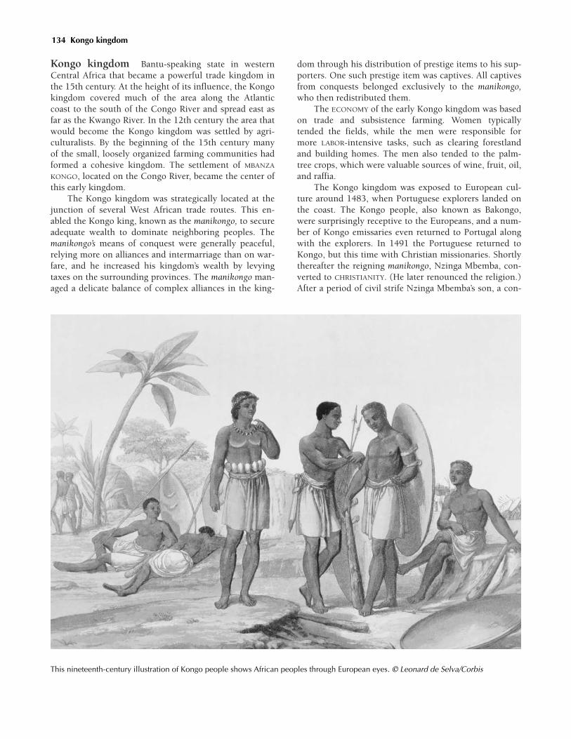
Kongo kingdom Bantu-speaking state in westernCentral Africa that became a powerful trade kingdom inthe 15th century. At the height of its influence, the Kongokingdom covered much of the area along the Atlanticcoast to the south of the Congo River and spread east asfar as the Kwango River. In the 12th century the area thatwould become the Kongo kingdom was settled by agri-culturalists. By the beginning of the 15th century manyof the small, loosely organized farming communities hadformed a cohesive kingdom. The settlement of MBANZA
KONGO, located on the Congo River, became the center ofthis early kingdom.
The Kongo kingdom was strategically located at thejunction of several West African trade routes. This en-abled the Kongo king, known as the manikongo, to secureadequate wealth to dominate neighboring peoples. Themanikongo’s means of conquest were generally peaceful,relying more on alliances and intermarriage than on war-fare, and he increased his kingdom’s wealth by levyingtaxes on the surrounding provinces. The manikongo man-aged a delicate balance of complex alliances in the king-
dom through his distribution of prestige items to his sup-porters. One such prestige item was captives. All captivesfrom conquests belonged exclusively to the manikongo,who then redistributed them.
The ECONOMY of the early Kongo kingdom was basedon trade and subsistence farming. Women typicallytended the fields, while the men were responsible formore LABOR-intensive tasks, such as clearing forestlandand building homes. The men also tended to the palm-tree crops, which were valuable sources of wine, fruit, oil,and raffia.
The Kongo kingdom was exposed to European cul-ture around 1483, when Portuguese explorers landed onthe coast. The Kongo people, also known as Bakongo,were surprisingly receptive to the Europeans, and a num-ber of Kongo emissaries even returned to Portugal alongwith the explorers. In 1491 the Portuguese returned toKongo, but this time with Christian missionaries. Shortlythereafter the reigning manikongo, Nzinga Mbemba, con-verted to CHRISTIANITY. (He later renounced the religion.)After a period of civil strife Nzinga Mbemba’s son, a con-
This nineteenth-century illustration of Kongo people shows African peoples through European eyes. © Leonard de Selva/Corbis
134 Kongo kingdom
vert who adopted the Christian name Afonso I(1506–1543), came to the throne. Admiring Portuguesematerial culture, especially firearms, Afonso requestedthat the Portuguese king send him firearms, mercenaries,teachers, and artisans to teach the Bakongo their Euro-pean trades. During Afonso’s reign, the Portuguese tookadvantage of their friendly relationship with the Kongokingdom, trading extensively at Kongo markets up anddown the Atlantic coast. In time they were able to under-mine the manikongo’s ability to distribute prestige goodsby directly trading such goods at the local markets. Inthis way the Portuguese destroyed the alliances that themanikongo held in balance.
By the beginning of the 16th century Portugal hadbegun pressuring the people of Kongo into supplyingthem with captives taken from surrounding villages. Inreturn, the Portuguese traded firearms, and they also as-sisted the Bakongo in the continuing warfare thatstemmed from the raids that they instigated.
See also: AFONSO I (Vol. III); KONGO KINGDOM (Vol.III); PORTUGAL AND AFRICA (Vols. III, IV, V).
Further reading: Anne Hilton, The Kingdom ofKongo (New York: Oxford University Press, 1985);Manuel Jordán, The Kongo Kingdom (New York: FranklinWatts, 1998). Kenny Mann, Kongo Ndongo: West CentralAfrica (African Kingdoms of the Past) (Minneapolis,Minn.: Dillon Press, 1996)
Kono People who have long occupied eastern regions ofpresent-day SIERRA LEONE; their language belongs to thefamily of Niger-Congo languages. Primarily rice farmers,the Kono also have grown palm oil, cassavas, millet, andgroundnuts (peanuts), among their subsistence crops.For centuries, they have practiced a form of AGRICULTURE
known as slash-and-burn, or shifting, cultivation. Thisinvolves establishing new farms every year betweenDecember and March, when hot, dry winds blow fromthe SAHARA DESERT. By cutting the brush of their formerhomesteads and burning it, the Kono create a thin layerof ash that fertilizes the land for future crops. These prac-tices also helped bring the forest environment under theircontrol by scaring off wild animals and, according toKono belief, placating unseen forces.
Along with farming, raising livestock and producingsuch traditional handicrafts as woven cloth, leatherwork,baskets, and POTTERY supplemented the ECONOMY. Ageand patrilineal ties have been two important elements ofKono society. Traditionally, only a select number of mar-ried men could receive farmland from village elders andrise to a position of social recognition.
See also: CLOTH AND TEXTILES (Vol. II); FARMING
TECHNIQUES (Vol. I), NIGER–CONGO LANGUAGES (Vol. I).Further reading: Kris L. Hardin, The Aesthetics of
Action: Continuity and Change in a West African Town,
(Washington, D.C.: Smithsonian Institution Press, 1993);Robert Thomas Parsons, Religion in an African Society: AStudy of the Religion of the Kono People of Sierra Leone inits Social Environment with special reference to the Functionof Religion in that Society (Leiden, Netherlands: E. J. Brill,1964).
Konso Cushitic-speaking ethnic group of present-dayETHIOPIA, KENYA, and UGANDA. Related to the OROMO, theKonso are made up of Garati, Takadi, and Turo peoples,all of whom have long inhabited the Ethiopian High-lands. The group’s patrilineal society is largely egalitarian.AGRICULTURE historically has been the traditional meansof subsistence, but they also raise cattle and goats.
JJJJJJJJJJJJJ
Traditional Konso RELIGION centers on Waga, thesky god, who supposedly manifests his authoritythrough village elders. Konso woodworkers areknown for their statues, called waga, that com-memorate the deeds of Konso warrior heroes.
JJJJJJJJJJJJJ
Further reading: C. R. Hallpike, The Konso ofEthiopia: A Study of the Values of a Cushitic People (Ox-ford, U.K.: Clarendon Press, 1972).
Kossoi (early 11th century) Early ruler of the SonghaiEmpire in West Africa
Little is known about Kossoi, the dia (king) of theearly SONGHAI kingdom. He is thought to have convertedto ISLAM in 1009 or 1010, becoming the first in a line ofMuslim Songhai rulers. Although Dia Kossoi converted,the customs of the royal court remained traditional andtherefore non-Muslim. During his reign Kossoi movedthe capital of his empire to GAO. Gao then became an im-portant city for both Muslims and the Songhai people,serving as an Islamic center of learning and a major com-mercial center, especially for GOLD and the SALT TRADE.
See also: ISLAMIC CENTERS OF LEARNING (Vol. II).
Kotoko Ethnic group of West Africa that is descendedfrom the SAO ethnic group. Mostly Muslims, the Kotokoruled a large kingdom in present-day CAMEROON and NIGE-RIA until the 15th century. After that, they became subjectsof the KANURI trading empire of KANEM-BORNU.
Kukiya (Kukya, Kaw Kaw) Earliest city of the SONG-HAI people. Located on the Niger River, Kukiya eventually
Kukiya 135

became the capital of the Songhai Empire. Kukiya was lo-cated in what is presently NIGERIA, down the Niger Riverfrom the city of GAO. Kukiya was the Songhai people’sfirst major city, existing well before they acquired moreterritory and became recognized as an empire. When itbecame the capital of the Songhai Empire, Kukiya pros-pered as the rulers acquired more and more territory.Between 1000 and 1100, Songhai’s rulers moved the capi-tal to Gao, but when the MALI EMPIRE conquered Gaoabout 1300, the weakened Songhai moved back toKukiya. They remained there until the 1400s, when theSonghai recaptured Gao after the fall of the Mali Empire.
Arab reports of Kukiya dating back to around theyear 1000 CE state that COTTON, millet, and wheat weregrown in the area. The land was said to be so fertile nearthe river that farmers could plant and harvest twice in agrowing season. The catches of the SORKO fishermen werealso known to be significant to the city. GOLD was foundin the area around this time as well.
Kumbi Saleh (Koumbi Saleh, Koumbi Salih,Kumbi Salih) Capital of the GHANA EMPIRE, the firstgreat trading empire in West Africa. Kumbi Saleh was lo-cated 200 miles (322 km) north of the city of BAMAKO, inpresent-day Republic of MALI.
During the 11th century Ghana was widely known asthe “land of GOLD,” and Kumbi Saleh—sometimes calledsimply Kumbi—was the empire’s capital. The most im-portant desert trading town of the time, Kumbi Saleh be-came a commercial and intellectual center. Its populationgrew to between 15,000 and 20,000 people, makingKumbi Saleh perhaps the biggest West African city of itstime.
Like other cities of its era, Kumbi Saleh was made upof two towns. One town, called al-Ghana (the wordghana being the king’s title), was the home of the king.Al-Ghana was fortified with strong walls that enclosedthe king’s palace. The MANDE-speaking SONINKE people,who founded the Ghana Empire in the sixth century,lived away from the king’s royal quarters in Kumbi’s sec-ond town. This second town, which was larger, was hometo Muslim traders and included as many as 12 mosques.About 6 miles (10 km) apart, the two towns were sur-rounded by farms that provided FOOD for the large popu-lation.
Trade was the lifeblood of the city, and gold was theempire’s principal commodity. Ghana’s MERCHANTS
brought gold from the southern part of the empire toKumbi, where it was traded, often for salt, which camefrom the SAHARA DESERT to the north. CARAVANS travelingalong the TRANS-SAHARAN TRADE ROUTES also brought food,which was exchanged for such locally produced goods asCOTTON, cloth, metal ornaments, and leather products.Regardless of the commodities involved, however, the king
taxed trade, which brought the empire enormous wealthand great quantities of natural resources.
JJJJJJJJJJJJJ
With an abundance of wealth, Ghana’s rulers couldindulge themselves. TUNKA MANIN, for example,who was caliph of Ghana from about 1065, putglass windows in his palace. He even maintained aprivate zoo stocked with elephants and GIRAFFES.
JJJJJJJJJJJJJ
Attacks from the ALMORAVIDS, a militant Muslim reli-gious group from present-day MOROCCO, began to weakenthe empire during the 11th century. In order to expandtheir territories and convert the indigenous peoples toISLAM, the Almoravids declared a JIHAD, or holy war,against their neighbors. Led by Abu Bakr (d. c. 1087), theAlmoravids invaded Ghana, seizing Kumbi in 1076. TheAlmoravids forced many of the SONINKE to convert toIslam, but the Soninke’s military and religious activitiesdisrupted trade, making the Almoravid empire difficult tocontrol. In 1087 the Soninke regained control of Kumbi.They tried to rebuild their empire, but a number of stateshad adopted Islam and others were forming separate king-doms, all of which prevented the empire from beingreestablished. By 1203 Kumbi Saleh was under the controlof one of these kingdom-states. King SUMANGURU (r. c.1220), chief of the KANIAGA people called the SUSU, over-threw the Soninke king and ruled Kumbi Saleh for a shorttime. The city finally was destroyed by the Mande em-peror SUNDIATA (r. 1235–1255), in 1240.
Kuranko (Koranko, Kouranko) West African eth-nic group of MANDE descent. Related to the MANDINKA,the Kuranko were, and still are, a mixed group in a reli-gious sense, with some converting to ISLAM, and otherspracticing non-Muslim religions. They were a loosely or-ganized group who had settled in the forests of present-day GUINEA. Beginning in the 15th century, however, they,along with the neighboring VAI and Kano peoples (not ofthe Hausa confederation), were driven from their home-land by migrating Mandinka traders and warriors; theyeventually settled in the forests of present-day SIERRA
LEONE.Further reading: Michael Jackson, Paths toward a
Clearing: Radical Empiricism and Ethnographic Inquiry(Bloomington, Ind.: Indiana University Press, 1989).
Kurmina One of the two provinces, along with DENDI,that comprised the SONGHAI Empire, which flourished inthe 15th century. Kurmina, the western province of the
136 Kumbi Saleh

empire, was considered more important than southeasternprovince of Dendi. The ruler of Kurmina, called the kur-mina fari or kanfari, was second in power to the Songhaiemperor. The kurmina fari was generally the crown princeof the region and ruled the territory west of TIMBUKTU.Kurmina was very important because of the many traderoutes that crossed it, and its administration required strongleadership. To that end, the kurmina fari maintained a pow-erful army that not only kept peace in the region but alsowas used to keep the power of the Songhai monarch incheck.
Kwahu (Akwahu, Kwawu, Quahoe) Ethnicgroup of present-day GHANA; also a plateau region in thatsame area. The Kwahu, a Twi-speaking subgroup of the
AKAN people, inhabited Ghana’s Kwahu Plateau as earlyas the 11th century. Archaeological evidence from thearea suggests that these people hunted, fished, and raisedsome cattle. It is known that most Akan groups were in-volved in the West African GOLD trade, as well. Archaeol-ogists also have found items that indicate that Kwahuartists were skilled woodcarvers and made elaborate fu-nerary ceramics.
Kyoga, Lake Body of water located in present-day cen-tral UGANDA. Between the 11th and 14th centuries, the KI-TARA COMPLEX, one of East Africa’s earliest state systems,formed in the area between lakes Albert, Kyoga, andVictoria.
See also: KYOGA, LAKE (Vol. I).
Kyoga, Lake 137
labor From the sixth through 15th centuries patterns oflabor in Africa continued along previously establishedlines. Africans were increasingly farmers and herders, forthe most part producing their own FOOD through AGRI-CULTURE.
While growing crops and raising livestock providedAfricans with greater control over their food suppliesthan did the preceding hunting-and-gathering modes ofexistence, agricultural labor was in many ways more de-manding. Indeed, the biggest constraint to agriculturalproduction was a shortage of labor. Partly for this reasonand partly because of the nature of the soils and rainfallpatterns, African agriculture was extensive rather than in-tensive in nature. Except in highly favored environmentslike the Nile Valley, in most regions there simply was notenough labor available to engage in intensive agriculturalpractices.
In addition to agriculture there were more special-ized forms of labor. As IRON metallurgy continued to ex-pand during this era, blacksmiths became increasinglyimportant in many African societies. Other crafts such asbasketry and POTTERY making were important at the locallevel. States such as GREAT ZIMBABWE, with its massivestone walls, and the kingdom of BENIN, with its extensivesystem of earth walls, engaged in major building projectsof a “public works” nature. Such projects required skilledartisans as well as a large number of unskilled laborers.Likewise, the fine houses, mosques, and other buildingsof the cities of the SWAHILI COAST required both skilledCRAFTSPEOPLE and builders.
The Swahili cities were built around trade. The shipsthat carried the INDIAN OCEAN TRADE required large num-bers of sailors and supported a merchant class, while the
trade CARAVANS into the East African interior requiredlarge numbers of porters. Similarly the TRANS-SAHARAN
TRADE ROUTES depended on the skills of those who man-aged the camels that were the beasts of burden for thedesert. This trade connected with the shipping of theMediterranean, which again employed large numbers ofsailors as well as stevedores to load and offload the shipsin North Africa’s port cities.
Although warfare was a feature of African politicalrelationships, most African states in this period did notdeploy professional armies. The states of North Africa,however, were an exception. During the Abbasid era,which lasted from about 750 to 945, rulers employed rig-orously trained professional soldiers knows as MAMLUKS.These continued as the professional soldiery after the endof the Abbasid caliphate, and in the 13th century theyseized control of EGYPT to become that country’s rulers.
See also: LABOR (Vols. I, III, IV, V).
Lalibela (c. 1119–1159) Ethiopian king known for di-recting the construction of the stone churches at the townthat bears his name
Lalibela was the most famous king of the ZAGWE DY-NASTY, which ruled in northern ETHIOPIA during the 10ththrough the 13th centuries. His reign was marked by sev-eral accomplishments, including the construction of a se-ries of churches carved out of volcanic rock.
The Zagwe kings were devout Christians who claimedto be descended from biblical ancestors. They identifiedthemselves with Moses, who, according to them, came intoAbyssinia and married the king’s daughter, an Ethiopianwoman.
JJJJJJJJJJJJJJJJJJL
138
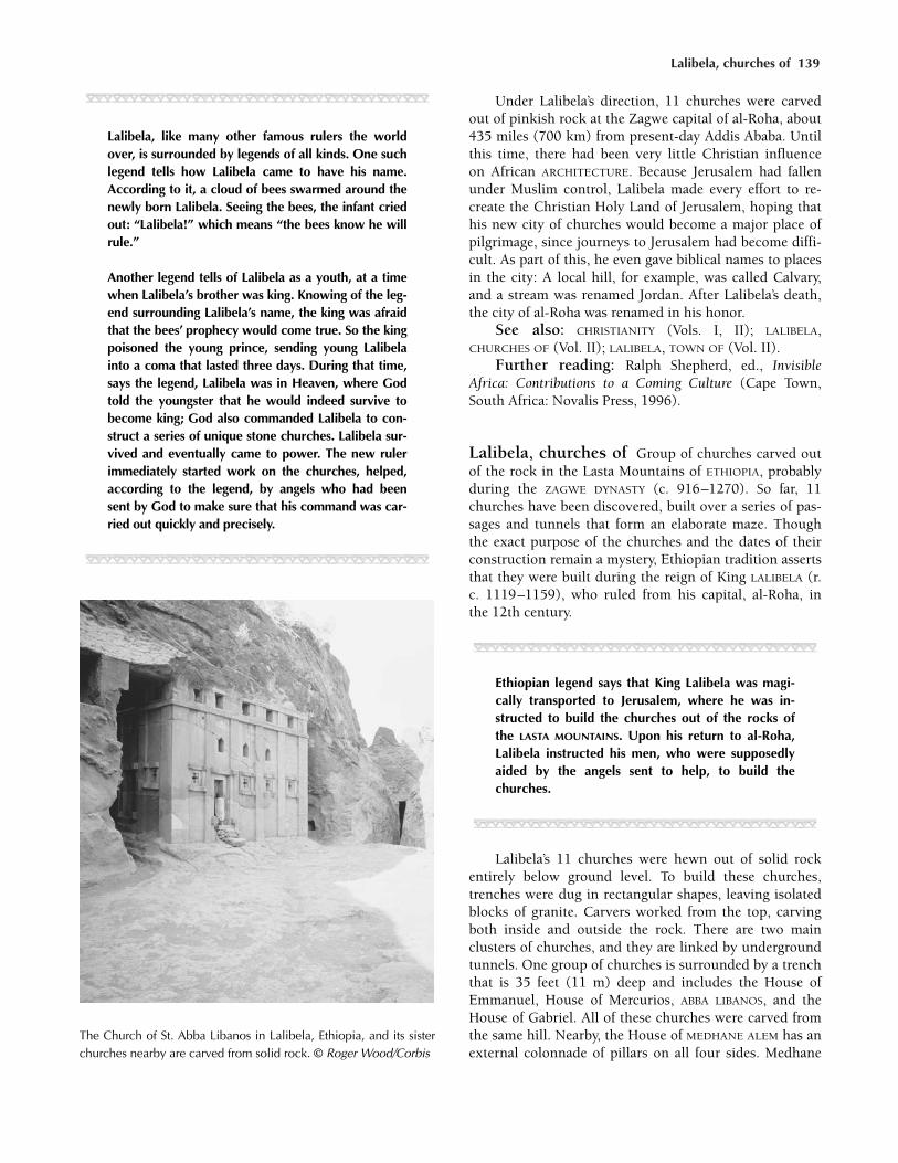
Lalibela, churches of 139
JJJJJJJJJJJJJ
Lalibela, like many other famous rulers the worldover, is surrounded by legends of all kinds. One suchlegend tells how Lalibela came to have his name.According to it, a cloud of bees swarmed around thenewly born Lalibela. Seeing the bees, the infant criedout: “Lalibela!” which means “the bees know he willrule.”
Another legend tells of Lalibela as a youth, at a timewhen Lalibela’s brother was king. Knowing of the leg-end surrounding Lalibela’s name, the king was afraidthat the bees’ prophecy would come true. So the kingpoisoned the young prince, sending young Lalibelainto a coma that lasted three days. During that time,says the legend, Lalibela was in Heaven, where Godtold the youngster that he would indeed survive tobecome king; God also commanded Lalibela to con-struct a series of unique stone churches. Lalibela sur-vived and eventually came to power. The new rulerimmediately started work on the churches, helped,according to the legend, by angels who had beensent by God to make sure that his command was car-ried out quickly and precisely.
JJJJJJJJJJJJJ
Under Lalibela’s direction, 11 churches were carvedout of pinkish rock at the Zagwe capital of al-Roha, about435 miles (700 km) from present-day Addis Ababa. Untilthis time, there had been very little Christian influenceon African ARCHITECTURE. Because Jerusalem had fallenunder Muslim control, Lalibela made every effort to re-create the Christian Holy Land of Jerusalem, hoping thathis new city of churches would become a major place ofpilgrimage, since journeys to Jerusalem had become diffi-cult. As part of this, he even gave biblical names to placesin the city: A local hill, for example, was called Calvary,and a stream was renamed Jordan. After Lalibela’s death,the city of al-Roha was renamed in his honor.
See also: CHRISTIANITY (Vols. I, II); LALIBELA,CHURCHES OF (Vol. II); LALIBELA, TOWN OF (Vol. II).
Further reading: Ralph Shepherd, ed., InvisibleAfrica: Contributions to a Coming Culture (Cape Town,South Africa: Novalis Press, 1996).
Lalibela, churches of Group of churches carved outof the rock in the Lasta Mountains of ETHIOPIA, probablyduring the ZAGWE DYNASTY (c. 916–1270). So far, 11churches have been discovered, built over a series of pas-sages and tunnels that form an elaborate maze. Thoughthe exact purpose of the churches and the dates of theirconstruction remain a mystery, Ethiopian tradition assertsthat they were built during the reign of King LALIBELA (r.c. 1119–1159), who ruled from his capital, al-Roha, inthe 12th century.
JJJJJJJJJJJJJ
Ethiopian legend says that King Lalibela was magi-cally transported to Jerusalem, where he was in-structed to build the churches out of the rocks ofthe LASTA MOUNTAINS. Upon his return to al-Roha,Lalibela instructed his men, who were supposedlyaided by the angels sent to help, to build thechurches.
JJJJJJJJJJJJJ
Lalibela’s 11 churches were hewn out of solid rockentirely below ground level. To build these churches,trenches were dug in rectangular shapes, leaving isolatedblocks of granite. Carvers worked from the top, carvingboth inside and outside the rock. There are two mainclusters of churches, and they are linked by undergroundtunnels. One group of churches is surrounded by a trenchthat is 35 feet (11 m) deep and includes the House ofEmmanuel, House of Mercurios, ABBA LIBANOS, and theHouse of Gabriel. All of these churches were carved fromthe same hill. Nearby, the House of MEDHANE ALEM has anexternal colonnade of pillars on all four sides. Medhane
The Church of St. Abba Libanos in Lalibela, Ethiopia, and its sisterchurches nearby are carved from solid rock. © Roger Wood/Corbis

Alem is also the largest church, measuring 109 feet (33m) long, 77 feet (23 m) wide, and 35 feet (11 m) deep.The House of St. GIYORGIS is shaped like a cross, whilethe House of Golgatha is thought to contain Lalibela’stomb.
Recent archaeological excavations of the site indicatethat the style of the construction is very similar to ancientAksumite ARCHITECTURE, which would date the construc-tion of the buildings to centuries before the Zagwe dy-nasty. An earlier construction date is also suggested bythe architectural anomaly of the churches, which are notfacing east, as would have been customary of religious ar-chitecture. This detail suggests that the buildings mightnot have been places of worship at all, and were perhapspalaces or royal residences for people of the Aksumiteculture. However, the site was revered as a religious one,so much so that it was referred to as “New Jerusalem”after Lalibela’s death.
See also: ARCHAEOLOGY (Vols. I, II, III, IV, V).Further reading: Irmgard Bidder, Lalibela: The
Monolithic Churches of Ethiopia, Rita Grabham-Hortmann,trans (New York: Praeger 1959).
Lalibela, town of (Adefa, Edessa, al-Roha)Ethiopian town that was the capital of the ZAGWE DY-NASTY for 300 years. Lalibela was originally called al-Roha, but the town was renamed after the famous12th-century Zagwe king who oversaw the constructionof 11 massive rock-hewn churches there. Al-Roha wasalso known to some as Adefa (sometimes spelled Edessa)because of its proximity to that nearby city. The remark-able rock churches made al-Roha a religious center and aplace of pilgrimage over the centuries.
The Zagwe dynasty (r. c. 916–1270) was made up ofa line of fiercely Christian kings who ruled most of north-ern and central ETHIOPIA from the 10th through the 13thcenturies. Their capital city, al-Roha, was nestled safely inthe LASTA MOUNTAINS. The Zagwe were descended fromthe AGAW people and led nomadic military lives. Theirstrong belief in CHRISTIANITY led them to erect manychurches and monasteries. An early Zagwe king, Yemra-hana Christos (c. 1039–c. 1079), built one of the finestcave churches of Lasta. But of all their buildings, themonolithic churches of Lalibela remain the most impres-sive. The Zagwe dynasty had come to an end by the closeof the 13th century, replaced by the SOLOMONIC DYNASTY,a line of rulers who claimed to be descendants of KingSolomon of Israel and Makeda, the queen of Sheba.
See also: LALIBELA, CHURCHES OF (Vol. II)
Lamu Oldest town in present-day KENYA, as well as aport, island, and archipelago in the same region. Knownas a distribution center in the GOLD, IVORY, spice, and
slave trades, the area was settled by immigrants fromArabia in the late 12th century.
By the 15th century the islands of the archipelago,particularly PATE, had become centers of trade betweenAsia and Africa. Portugal, seeing the area’s strategic eco-nomic value, began to exert influence over the islands. Bythe end of the 15th century Portugal had a firm grip oncommerce in the region and continued its dominanceuntil the 17th century.
See also: ARAB COASTAL TRADE (Vol. II); INDIAN
OCEAN TRADE (Vol. II); LAMU (Vol. III); PORTUGAL AND
AFRICA (Vols. III, IV, V); SWAHILI COAST (Vols. II, III, IV).Further reading: Patricia Romero, Lamu: History,
Society, and Family in an East African Port City (Princeton,N.J.: M. Wiener, 1997).
Lango Large ethnic group of that, during the 15th cen-tury, settled in what is now UGANDA; also the language ofthese people. Unlike their Bantu-speaking neighbors, theLango were part of a Nilotic migration and spoke LUO, alanguage that evolved into Lango.
Lango society was very decentralized, and conflictswere settled by a council of elders from the various clans.Traditionally the Lango were governed by nonhereditarychiefs, called rwot, who oversaw the hereditary chiefs.Relations between different groups were controlled bykinship, and descent was patrilineal. Typical Lango vil-lages were small, and the villagers practiced pastoralismand also grew millet and sorghum.
Traditional Lango RELIGION revolves around a creatorwhom they call Jok. They practice ancestor worship andbelieve that every person has a guardian spirit that mustbe ritually freed from the body after death. They also be-lieve in a shadow self or soul, which is thought to jointhe creator after the person dies.
See also: ANCESTOR WORSHIP (Vol. I); CLAN (Vol. I);GOVERNMENT, SYSTEMS OF (Vol. II); LINEAGE (Vol. I); PAS-TORALISM (Vol. I).
Lasta Mountains Range located in southern ETHIOPIA
that was the site of al-Roha, the capital of the ZAGWE DY-NASTY, which ruled from the 10th through the 13th cen-turies. Al-Roha, renamed the town of LALIBELA in the13th century to honor the great Zagwe emperor of thesame name, is known for its monolithic churches, whichwere carved out of the rock in the mountains’ highlands.
See also: LALIBELA, CHURCHES OF (Vol. II).
law and justice The concepts of law and justice var-ied greatly from group to group in Africa between thefifth and 15th centuries, but all societies had rules that itsmembers thought it right to obey.
140 Lalibela, town of

Non-Muslim Law and Justice in Traditional Societies In most traditional societies of non-MuslimAfrica, the responsibility for maintaining the rules of con-duct and the right to exercise judgment in disputes wereassumed by the headmen of the social group. Laws werenever preserved in written form but instead were incor-porated into the social customs through example andpractice.
Sometimes, as in the case of the Kuba, an ethnicgroup of Central Africa, the headmen constituted a kindof court whose job it was to examine disputes, recall cus-tomary law, and then make rulings based on consensus.The IGBO, who have inhabited parts of present-day south-ern NIGERIA for more than 1,000 years, long had a similarsystem. The okpara, or oldest male member of a lineagegroup, conferred with other lineage headmen and thenexercised the authority of his judgment over younger,lower-ranking individuals.
JJJJJJJJJJJJJ
The KAMBA people carried out a judgment calledkingolle, whereby a member of the society wouldbe condemned to death by the ranking elders whoreviewed his case. In most instances, the offendingindividual was accused of a heinous crime likehomicide or incest. However, there are cases ofkingolle in Kamba lore that tell of a man who failedto pay back his debts, and another of a man whowas remiss in his duties as a father and husband.Usually a close relative of the offender would ap-prove of the kingolle judgment and promise not toavenge the death.
JJJJJJJJJJJJJ
Among societies that were large enough to constitutekingdoms, judging disputes was one of the prerogativesof the chief or king. In cases in which the king held hispower through military might (rather than through lin-eage ties), he might designate a special judge to help himsettle disputes. This judge usually would be a wise, re-spected elder whose authority was based on his age andexperience. Despite his position, though, the judge typi-cally did not have the power to exercise the punishmenthe recommended. Instead, he would give his opinion,and the ultimate decision was left to the king.
The concept of an organized “police force” to enforcethe laws was foreign to most traditional societies. Still,some chiefs employed armed retainers who kept themsafe and maintained peaceful relations in the kingdom.Usually the mere presence of a chief (or one of his familymembers or wives) would be enough to keep the peace.For this reason many chiefs who practiced polygamywould install a wife in a village that was in upheaval.
JJJJJJJJJJJJJ
Among pastoralists like the Nuer of the Republic ofthe SUDAN, the judgment in homicide cases mightbe paid in heads of cattle. Generally the personwho owed the debt did not volunteer the cattle,but when the cattle were taken by the representa-tives of the offended, the theft would not be con-tested.
JJJJJJJJJJJJJ
Muslim Law and Justice Prior to the spread ofISLAM, ARABIC-speaking North African peoples did nothave a formal legal system, but they did have long-stand-ing customary laws that guided their actions. After theseventh century CE, the concept of law and justice inmany areas of North Africa was defined by the religioustenets of Islam, a religion that spread westward fromArabia. The system of Islamic law, called SHARIA, is basedon the QURAN and the Sunna, texts based on the wordsand deeds of the prophet Muhammad. Since Muhammadwas an Arab, the sharia actually incorporated manytenets of Arab customary law. In this way, the law thatcame to rule Muslim theocracies in parts of North Africaand the SUDAN was not that different from the law thatwas already in place. With Islam’s emphasis on literacy,however, it became much more highly codified.
Eventually, differing interpretations of the Quran andSunna led to the division of Islam into its major sects.For members of the Maliki Sunni sect of Islam, the mostimportant legal interpretation of the Quran was presentedby their founder, MALIK IBN ANAS (c. 715–795), a great ju-rist (legal scholar) and Islamic holy man. Differing inter-pretations of the Quran also led to the North Africanreform movements that created the dynasties of the AL-MORAVIDS and ALMOHADS.
In the West African Muslim states, Islamic law had adifferent aspect. Often peoples in these states would nom-inally convert to Islam, which would allow them to partic-ipate more actively in the lucrative GOLD trade, which wasalso tied into the region’s crucial SALT TRADE. These com-mercial ventures were run mostly by Muslim traders, suchas the DYULA.
See also: CLAN (Vol. I); DIVINE RULE (Vols. I, II);GOVERNMENT, SYSTEMS OF (Vols. I, II, III, IV, V); ISLAM, IN-FLUENCE OF (Vols. I, II, III, IV, V); LAW AND JUSTICE (Vols.I, III, IV, V); MALIKI SUNNI DOCTRINE (Vol. II).
Leopard’s Kopje See MAPUNGUBWE.
Lesotho Small, mountainous country, 11,716 squaremiles (30,344 sq km) in area, that is wholly surrounded
Lesotho 141

by present-day SOUTH AFRICA; more than 80 percent of thecountry lies at least 5,905 feet (1,800 m) above sea level.
The origins of present-day Lesotho (pronouncedlesutu and meaning “the country of the Sotho people”) liewith King Mshweshwe (1786–1870) and his founding ofthe Sotho kingdom of Basutoland in the early 1830s.
Until the end of the 16th century the region was pop-ulated by Khoisan people. At that time the Sotho migratedinto the region seeking the high grasslands for their herds.The Sotho intermarried with the Khoisan, formed smallchiefdoms, and began trading grain and hides for IRON
tools.See also: BASUTOLAND (Vol. IV); KHOISAN LANGUAGES
(Vol. I); MSHWESHWE (Vol. III); SOTHO (Vols. III, IV).Further reading: Peter Becker, Hill of Destiny: The
Life and Times of Moshesh, Founder of the Basotho (Harlow,U.K.: Longmans, 1969); Scott Rosenberg, Richard F. We-isfelder, and Michelle Frisbie-Fulton, Historical Dictio-nary of Lesotho (Lanham, Md.: Scarecrow Press, 2004).
Liberia Independent republic on the Atlantic coast ofWest Africa 43,000 square miles (111,370 sq km) in area,bordered by the present-day countries of SIERRA LEONE,IVORY COAST, and GUINEA. Although Liberia was the onlyblack state in Africa to avoid European colonial rule,from an African perspective, the creation of Liberia wasvery much a case of colonial conquest.
There were 16 ethnic groups that made up Liberia’sindigenous population, including the Kpelle, Bassa, Gio,Kru, Grebo, Mano, Krahn, Gola, Gbandi, Loma, Kissi,VAI, and Bella. While the early settlers in the area wereprobably Mel-speaking relatives of the Kissi, Kruan, andGola groups, the 15th century saw migrations into the re-gion by members of such MANDE-speaking peoples as theLoma, the Mende, and the Bandi. The Kpelle, who settledin central and western Liberia, make up the largest ethnicgroup today. They moved into the region from theAfrican interior in the 16th century. The Vai, who begantheir migration from the MALI EMPIRE, arrived about thesame time, displacing Grebo people as they made theirway to the coast. The Vai moved into the Cape Mount re-gion, residing among the existing Gola inhabitants.Coastal peoples like the Bassa and the Kru were there tomeet European explorers and traders when they first ar-rived. In fact the Kru became involved with Europeantrade both as traders and as sailors.
In 1461 Portuguese sailor Pedro de Sintra was thefirst European to explore the Liberian coast. From thattime forward the peoples of Liberia engaged in tradingwith Europeans for goods such as GOLD, spices, IVORY,dyewoods, and Malaguetta pepper, the highly prizedcommodity that became a major trade item and gaveLiberia its nickname of the Grain Coast. However, theMande- and Mel-speaking chiefdoms in the northern part
of the region sought to profit from the slave trade andconducted raids into the interior to trade for firearms,knives, jewelry, and liquor. In 1602 the Dutch and theEnglish established trading ports around Cape Mount.
See also: LIBERIA (Vols. I, III, IV, V); MALAGUETTA
PEPPER (Vol. III); GRAIN COAST (Vol. III).Further reading: G. E. Saigbe Boley, Liberia: Rise
and Fall of the First Republic (New York: McMillan, 1983);D. Elwood and Svend E. Holsoe Dunn, Historical Dictio-nary of Liberia (Metuchen, N.J.: Scarecrow Press, 1985).
Libya North African country located on the MEDITER-RANEAN SEA, that is approximately 680,000 square miles(1,770,000 sq km) in size. It is bordered by present-dayTUNISIA, ALGERIA, NIGER, CHAD, the Republic of the SUDAN,and EGYPT. Between the fifth and 15th centuries the strate-gic geographical location of Libya between the Mediter-ranean to the north, the Sahara to the south, and itseastern border with Egypt, made it an important trade re-gion, as well as a key entry point for the dissemination ofISLAM into SUB-SAHARAN AFRICA.
In the seventh century, Arab armies brought Islamto North Africa with the objective of conquering thevast continent. By the middle of the century ARABS con-trolled Tripolitania, the ancient Roman province on theMediterranean coast, and proceeded to extend their in-fluence westward into the region they called IFRIQIYA.During this period Libya was controlled first by aMuslim dynasty of emirs called the Aghlabids, and thenby the Fatimid dynasty, which ruled from CAIRO. Theregion of Cyrenaica came under the control of the Arabsat this time as well. Despite the Arab dominance,Cyrenaica maintained its close political and economicties with Egypt. (The Egyptian influence had begun inthe fourth century when Christians in Cyrenaica cameunder the influence of the Egyptian Coptic Church.) Itwas Bedouin Arab chiefs, however, who maintained realpolitical and economic control over Cyrenaica by taxingthe CARAVANS of pilgrims and MERCHANTS on their wayto Egypt.
Islam arrived at FEZZAN, located in the interior of thecountry, 20 years after it had reached Cyrenaica. The peo-ples of this region lived in oasis communities developedalong the TRANS-SAHARAN TRADE ROUTES between the cen-tral SUDAN and the Mediterranean Sea. The Islamic KHARI-JITE rulers established an Islamic theocracy at the oasiscity of Zawilah, which guaranteed Islamic control of animportant arm of the trans-Saharan trading route.
During the 11th century a massive influx of Hilaliansmoved into Tripolitania and Cyrenaica after being forcedout of Egypt by drought, famine, and the political turmoilcaused by the FATIMIDS. One Bedouin Arab group, theBanu Salim, resided in Tripolitania for the next two cen-turies. These migrations marked a linguistic shift for the
142 Liberia

BERBERS, who had previously maintained their linguisticand cultural autonomy but now began to adopt the lan-guage of the Arab-speaking Muslim elite.
In the 13th century the Muslim Hafsids established adynasty that would last three centuries. Under their rule,Tripolitania developed into a thriving Mediterranean trad-ing center. This period of prosperity lasted until Christianand Muslim powers began to compete for control of theimportant Libyan seaports.
By the 14th century the Fezzan region was the north-ernmost boundary of the kingdom of KANEM-BORNU,which stretched as far as Wadai in the east. By controllingZawilah in the Fezzan, Kanem-Bornu was guaranteed animportant route to the Mediterranean coast for the SALT
TRADE.See also: CYRENE (Vol. I); LIBYA (Vols. I, III, IV, V).Further reading: Ronald B. St. John, Historical Dic-
tionary of Libya (Lanham, Md.: Scarecrow Press, 1998);Christides Vassilios, Byzantine Libya and the March of theArabs Towards the West of North Africa (Oxford, U.K.: J. &E. Hedges, 2000).
Limpopo River A 1,100-mile (1,770-km) river lo-cated in southeast Africa that passes through the present-day countries of SOUTH AFRICA, BOTSWANA, ZIMBABWE, andMOZAMBIQUE before emptying into the Indian Ocean. Theword Limpopo may come from the Sotho word meaning“river of the waterfall.” Its main tributary is the OlifantsRiver, which flows into the Limpopo about 130 miles(209 km) from its mouth, just north of Maputo, inMozambique. The upper portion of the river is known asthe Crocodile (Krokodil) River. The lower portion watersMozambique’s fertile agricultural region.
As early as the eighth century the Limpopo was animportant artery connecting trade routes between the in-terior of southern Africa and the towns on the SWAHILI
COAST. These connections made it possible for peoples ofthe interior to participate in INDIAN OCEAN TRADE. For in-stance, Africans brought IVORY, animal skins and, later,GOLD and COPPER from the interior and traded thesegoods for Arab wares. Archaeological finds at interiorsites—in Botswana, GREAT ZIMBABWE, and present-daySouth Africa—attest to the vast distances traveled byIndian Ocean trade goods.
Before the fifth century the fertile valley between theLimpopo and Zambezi rivers was populated by theKHOIKHOI, whose culture did not reach its zenith until be-tween the 11th and 15th centuries, after they converted topastoralism from being nomadic hunter-gatherers. About1100, Bantu-speaking peoples, including the Sotho, Chopi,and Tsonga, moved into the lower valley of the Limpopo.The SHONA, VENDA, and Shaba peoples also populated theregion between the middle Zambezi and the Limpopo be-fore the 15th century.
In 1498 Portuguese explorer Vasco da GAMA saw theLimpopo River for the first time and renamed it the Es-piritu Santo (Holy Spirit) River.
See also: LAKES AND RIVERS (Vol. I); MAPUTO (Vols. III,V); PORTUGAL AND AFRICA (Vols. III, IV, V); SHONA KING-DOMS (Vol. III); ZAMBEZI RIVER (Vols. I, III).
lost-wax process Method of hollow metal castingthat dates to approximately 3000 BCE. Also known by theFrench term ciré perdue, this type of casting was used inAfrica during the 13th and 14th centuries, most notablyby the YORUBA of present-day NIGERIA and the inhabitantsof the kingdom of BENIN. Art historians consider theBRONZE sculptures of these peoples to be masterpieces.The strikingly realistic Yoruba and Benin sculptures por-trayed kings and other members of the aristocracy, inwhose tombs many of the sculptures were placed. Imagesof nature were also important subjects for the Benin andYoruba sculptors
The lost-wax process, still in use today, begins with awax mold that is encased between two heat-proof layers.The wax is melted and drained off, and the resulting hol-low form is filled with molten metal, which assumes thedesired form of the original wax mold. This process isalso used to cast bronze sculptures using clay models. Inthis case a figure or shape is made out of beeswax andthen covered in liquid clay and cooked over a fire. Theheat of the flames dissolves the wax, and the wax is thenreplaced by empty space. At this point, tin and COPPER,which are the alloys used to make bronze, are melted andthen poured into the cavity of the hardened clay. Oncethe object has cooled, the clay is knocked away from themetal and the bronze sculpture is cast.
See also: ART (Vols. I, II, III, IV, V); CRAFTSPEOPLE
(Vol. II); METALLURGY (Vol. I).
Lualaba River Headstream of the Congo River, lo-cated entirely in present-day Democratic Republic of theCONGO. The river is about 1,100 miles (1,770 km) long.Archaeological discoveries indicate that several Iron Agegroups had settled along the banks of the Lualaba towardthe end of the first millennium. Excavation sites atKatoto and SANGA produced evidence of cultures thatwere involved in trade and small-scale mining.
The lakes formed by the Lualaba River created an im-portant link for trade between the Shaba peoples of thesavanna with peoples of the LUBA and LUNDA kingdoms,located to the west of the Lualaba. The region betweenthe Lualaba and the Luapula rivers contained salt minesand COPPER deposits, which were mined, refined, and ex-ported to the coastal regions by the kingdoms.
See also: CONGO RIVER (Vol. I); LAKES AND RIVERS
(Vol. I); SALT MINING (Vol. II).
Lualaba River 143

144 Luba
Luba (Baluba) Ethnic group of present-day ZAMBIA
and the Democratic Republic of the CONGO. The Luba areregarded as one of the earliest peoples to practice IRON-WORKING in Central Africa. Their ancestors were farmerswho, as early as 400 CE, inhabited the Lake Kisale regionin what is now Katanga Province of the DemocraticRepublic of the Congo.
Oral tradition mentions Luba chiefs in MALAWI andZambia, but very little is known about their early history.The area in which the Luba lived was well suited to thegrowth of powerful chiefdoms. The COPPER mines of theKatanga region were nearby; the soil was fertile and goodfor growing crops, especially cereals; nearby woodlandsprovided hunting grounds; waterways were an excellentsource of fish; and ease of movement through the savannastimulated trade. The Luba were an agricultural peoplewhose communities slowly grew into small trading andfarming chiefdoms. Between 1300 and 1400 they cameunder the sway of the Nkongolo dynasty, which, in turn,was conquered in the early 1400s by Ilunga Kalala, whomoral tradition describes as a fierce hunter. Ilunga Kalalaexpanded the kingdom’s boundaries and took control ofthe Katanga copper mines and the trade routes to EastAfrica. Later in the 15th century, members of the Lubaaristocracy left the kingdom and moved west, where theycentralized their power among the Lunda people, begin-ning the ascendency of the LUNDA KINGDOM.
See also: LUBA EMPIRE (Vol. III); LUNDA EMPIRE (Vol.III); MINING (Vols. I, II, III, IV, V).
Further reading: Thomas Q. Reefe, The Rainbowand the Kings: A History of the Luba Empire to 1891(Berkeley, Calif.: University of California Press, 1981).
Lunda kingdom Monarchy in Central Africa on theupper Kasai River. The area is within the boundaries ofpresent-day ANGOLA and the Democratic Republic of theCONGO. Some histories place the foundation of the king-dom of the influential Bantu-speaking Lunda around1450, when members of LUBA aristocracy—disappointedin their failed attempts to gain power in their ownland—moved southwest into Lunda territory. Other his-tories suspect an earlier starting date for the kingdombut note that the Lunda state remained a loose confeder-ation and did not develop strong centralized governmentuntil about 1450.
The Luba newcomers married into the families of theLunda chieftains. Initially they made no major changes in
Lunda political structures; they simply collected tributefrom their Lunda subjects. In time, however, the Lubachiefs began centralizing their authority, paving the wayfor the emergence of the Lunda empire that became amajor regional trading state from the 16th through the19th centuries.
JJJJJJJJJJJJJ
The Lunda kingdom practiced “perpetual kingship,”whereby a new king assumed the identity of theone he replaced. In essence, the successor to thetitle became the previous king. Through perpetualkingship, alliances and agreements could remain inforce from generation to generation because theywere made by the “same” king.
JJJJJJJJJJJJJ
See also: BEMBA (Vol. III); BISA TRADING NETWORK
(Vol. III); KASANJE (Vol. III); KATANGA (Vols. IV, V);KAZEMBE (Vol. III); LUBA EMPIRE (Vol. III); LUNDA EMPIRE
(Vol. III); PORTUGAL AND AFRICA (Vols. III, IV, V).
Luo (Lwo, Lwoo, Dholuo, Kavirondo) Pastoral-ist people of the Great Lakes region of East Africa whosteadily migrated there from the Nilotic SUDAN, perhapsas early as the late 14th century. Their language, Luo, be-longs to the Chari-Nile branch of the family of Nilo-Saha-ran languages.
Luo society, governed by clan leaders and bound byties of patrilineal kinship and marriage, was traditionallydecentralized. The people lived in scattered homesteadsand survived by hunting, fishing, farming, and cattle herd-ing. Unlike many of their neighbors, they did not practicecircumcision or group themselves in age sets. Their tradi-tional RELIGION, still practiced by some today, is animist.
As they moved into what is now western UGANDA, theLuo displaced the people living in the KITARA COMPLEX ofstates, who were under the rule of the CHWEZI DYNASTY.The Luo reorganized Kitara as the kingdom of BUNYORO-KITARA, and, led by the aristocratic BITO clan, they estab-lished a number of kingdoms north and west of LakeVICTORIA, including Buddu, BUGANDA, Buruli, and Busoga.
See also: AGE SETS (Vol. I); BUNYORO (Vols. III, IV);LUO (Vols. III, IV, V); NILO-SAHARAN LANGUAGES (Vol. I);NKOLE (Vols. II, III); PASTORALISM (Vol. I, IV).

Maasai (Masai) Nomadic people of present-day cen-tral KENYA and northern TANZANIA. The Maasai ethnicgroup emerged around 500 BCE along the Nile River;however, it was not until the 16th century that they mi-grated into Kenya and Tanzania. As the Maasai movedthrough the Great Rift Valley of Kenya, they found thehighland region inhabited by numerous pastoral groups.In order to open up pastures for their herds, the Maasaiforced the local peoples from their lands. As a result theybecame a feared group that ultimately gained control overmuch of East Africa’s best grazing lands.
Maasai society was based on age sets, which were es-tablished for military purposes. In the system of age sets,children, young adults, and elders each had their ownduties and responsibilities. Young boys were given exten-sive military training because they were expected to serveas soldiers during their young-adult years. Their job wasto guard the herds and secure grazing lands. Unlike manyother African societies, Maasai society did not operateunder a centralized authority, such as a monarch. Instead,it were organized into villages made up of several ex-tended families and governed by a council of elders.
See also: AGE SETS (Vol. I); MAASAI (Vols. I, III, IV,V); PASTORALISM (Vols. I. IV); RIFT VALLEY (Vol. I).
Madagascar Indian Ocean island country of 226,700square miles (587,200 sq km), the fourth-largest island inthe world, located 242 miles (390 km) across the Mozam-bique Channel from present-day Mozambique, on thesouthern coast of East Africa. The present-day country ofMadagascar is made up of the island of Madagascar andseveral much smaller islands that surround it.
Although significantly closer to Africa than to Asia orthe islands of the Pacific, the first inhabitants of thismountainous island were probably INDONESIAN COLONISTS,who arrived by sea between 400 and 900. To account forthe Bantu influence on the island, anthropologists theorizethat en route to Madagascar in the ninth or 10th centuries,a second wave of Indonesian emigrants picked up Bantu-speaking peoples along the East African coast. It is alsopossible that the country’s Bantu influence came with thearrival of Antalaotra traders in the 11th century. TheseARABS, Bantu speakers, and Persians, (a cultural mixtureknown as MALAGASY), engaged in extensive trade with Ara-bia and the African coast.
Portuguese traders arrived in 1500, but they werenot successful at colonizing the islands. By the middleof the 16th century three Malagasy groups, the Ante-moro, Sakalava, and Merina, had developed monarchies.None of these groups, however, was able to dominatethe greater part of the country until the Merina, operat-ing from the central highlands, conquered many of theneighboring kingdoms almost 200 years later.
See also: ANTALAOTRA (Vol. III); ANTEMORO (Vol.III); INDIAN OCEAN TRADE (Vol. II); MADAGASCAR (Vols. I,III, IV, V); MERINA (Vols. III, IV).
Mafia Island Island located off of TANZANIA on theEast African coast, south of ZANZIBAR. For centuries, pos-sibly as long as two millennia, ARABS and Persians tradedfrom the port of Mocha, which is now located withinpresent-day Yemen, down the African coast as far asMOZAMBIQUE, and including MADAGASCAR, ZANZIBAR, andMafia Island. Though KILWA was the major port on the
JJJJJJJJJJJJJJJJ M
145

146 Maghan, Mansa
Indian Ocean, Mafia Island was an important stop onthe trade route.
According to the Kilwa Chronicle, the Mwera peoplelived on the island but were ruled by Muslim settlersfrom Songo Songo before Arab rule. This chronicle alsorecords that the SHIRAZI ARABS bought the island of Kilwaaround 975. The reigning sultan sent his son Bashat torule Mafia Island. Kua and Kisimani, two ancient townsbuilt around 1000 that are now in ruins, may have beenfounded by Bashat. For centuries the Shirazi were power-ful in this area at the same time that ISLAM was being in-troduced throughout eastern Africa.
As was the case with much of the East African coast,the first Europeans to arrive were the Portuguese, led byexplorer Vasco da GAMA (c. 1460–1524), in about 1498.Within seven years Arab control was minimized, and thePortuguese claimed Mafia Island, along with much of thecoast, as their own. The ARABIC name for the island,Morfiyeh, or Manifiyah, meaning “archipelago,” remainedin use. Scholars speculate that the name Mafia could alsobe derived from the KISWAHILI words mahali pa afya, mean-ing “healthy dwelling place.”
See also: INDIAN OCEAN TRADE (Vol. II); MAFIA IS-LAND (Vol. I).
Maghan, Mansa (r. 1337–1341) Son of Mansa Musa Iand short-term leader of the Mali Empire
Son of empire builder Mansa MUSA I (r. 1307–1337),Mansa Maghan assumed control of the MALI EMPIRE afterhis father’s death. Little is known about Maghan’s rule,but at the time he came to the throne, Mali was a power-ful and prosperous nation. Brief references to Maghan byscholars make it clear that he was not able to lead withthe same ability as his father, which led to invasions ofMali’s territories, including GAO.
al-Maghili (late 15th century) Arab cleric from the Saha-ran oasis region of Tuat, in present-day Algeria
As a young man Muhammad al-Maghili was aNorth African Muslim scholar known for persecutingJews. Around 1490 he left Tuat and traveled south toAgades, TAKEDDA, KANO, KATSINA, and GAO, where heconverted many people to ISLAM. His primary goal wasto get Muslim rulers to apply the teachings of Islam tostate rule. He stressed the need for a militant foreignpolicy, limited or nonexistent taxation, and a good ad-visory board. During this time sharifs gained socialprominence in Muslim society because al-Maghili ada-mantly encouraged states to respect them and compen-sate them generously. (Sharif, an ARABIC word meaning“noble” or “high born,” is a title of respect given tomembers of the prestigious Hashim clan, of which theprophet Muhammad was a member.) Al-Maghili’s work
played an important role in shaping the early HAUSA
STATES, particularly the areas from Lake Chad to themiddle Niger River.
In his Obligations of Princes, al-Maghili outlined histeachings. This work was commissioned by Sarki RUMFA
(r. 1463–1470) of Kano, one of the first rulers in earlyHausaland to accept Islam. Rumfa commissioned al-Maghili to write guidelines for princely behavior so thathe could better serve his people. A few years later AskiaMUHAMMAD TOURÉ (r. c. 1493–1528), a Muslim leaderwho took control of the SONGHAI Empire at the end of the15th century, also called upon al-Maghili for guidance.For Askia Muhammad, al-Maghili wrote a treatise calledAnswers to the Questions of the Emir al-Hadjdj Abdullah ibnAbu Bakr. Askia Muhammad commissioned al-Maghili tohelp him face the challenge of ruling a largely non-Mus-lim population, although it seems he did not heed muchof al-Maghili’s advice.
Despite al-Maghili’s efforts, Islam did not penetratemore than a handful of small states, and it was almost100 years after his death that al-Maghili’s teachingsreached the height of their influence.
See also: ISLAM, INFLUENCE OF (Vols. II, III, IV, V).Further reading: John O. Hunwick, Shari’a in Song-
hay: The Replies of Al-Maghili to the Questions of Askia Al-Hajj Muhammad (Oakville, Conn.: David Brown BookCompany, 1985).
Maghrib (Maghreb) Region of Northwest Africaalong the MEDITERRANEAN SEA; it extends from the AtlasMountains to the coast and includes present-day MO-ROCCO, ALGERIA, TUNISIA, and part of LIBYA. The Maghribwas originally inhabited by BERBERS. However, after theARABS conquered EGYPT in 642, they extended their mili-tary campaign west into the Maghrib, which they also re-ferred to as Bilad al-Maghrib, or “Lands of Sunset.” Thefirst capital of the Maghrib was Al-Qayrawan (Kairouan),founded just south of TUNIS by Uqbah Ibn Nafi (SidiOkba), who was in charge of the Arab army that occupiedTUNISIA in 670. Uqbah’s successful military campaigns anddramatic death in battle made him a legendary hero of theMuslim conquest of the Maghrib.
The Maghrib became a province of the Arab Muslimempire in 705. ISLAM spread rapidly among the Berbers,and by the 11th century it had replaced CHRISTIANITY inalmost all of the Maghrib. But the Berbers were not con-tent under Arab rule, which was often oppressive andbenefited only the Arab ruling class. The Arabs tookBerber captives, especially women, which further infuri-ated the population.
In the ninth century the Berbers rebelled against theArabs, fragmenting the Maghrib into separate Muslimstates. The uprising was not a total success, however. Inthe end, only the small principality of SIJILMASA, in south-

ern Morocco, was ruled by Berbers, who came from theBanu Midrar confederation. The other states remainedunder Arab rule.
This changed during the 11th century, when the AL-MORAVIDS came to power. This Muslim Berber dynastyruled Morocco and al-ANDALUS (Muslim Spain) in the11th and 12th centuries and unified the Maghrib for asecond time. The Almoravids were succeeded by the AL-MOHADS, Zenata Berbers who declared a successful JIHAD,or holy war, against the Almoravids, ending their empire.
See also: MAGHRIB (Vols. I, III, IV, V).
Maguzawa Ethnic group that has long inhabited theregion south of KANO, one of the HAUSA STATES. Alsocalled the Maguje, the Maguzawa probably settled in thearea even before the founding of Kano by Sarki (King)BAGAUDA, around 1000. Though the Maguzawa share theHausa culture and language, they historically have distin-guished themselves from other Hausa people by rejectingISLAM. In fact the name Maguzawa probably evolved fromthe ARABIC word majus, meaning “pagan.”
Mahdi According to Islamic prophesies dating toaround 680, the Mahdi is a messiah-like deliverer who isto arrive shortly before “the end of time” to restore justiceand spread ISLAM throughout the world. The word mahdimeans “enlightened” or “one who is divinely guided.”The prophet Muhammad is reported to have promisedthat a descendant from his family would come to earthseven to nine years before the end of the world. This per-son would bring equity and justice to a world that would,at the time, be filled with neither. While some believethat Muhammad said that the Mahdi would bring peopleto God through Islam, others dispute this part of theprophecy.
Over the last two millennia several people have iden-tified themselves as the Mahdi. Ubayd Allah, who de-clared himself the first Fatimid caliph in 909, is one ofthe best known. During the seventh century followers ofIslam split into two factions, the SUNNI and the Shiites.Then, about 900, Shiite Muslims converted the KutamaBERBERS of LIBYA to Islam, which led to war betweenShiites and Sunni Muslims in Libya over territory. Thevictorious Shiites installed Ubayd Allah, also known asUbaidalla Said, as their political leader and imam. (Theimam was the Shiite religious leader, believed to be thesuccessor of the prophet Muhammad.) Berbers assertedthat Ubayd Allah was the Mahdi, and the city of Mahdiawas so-called in his honor.
Later, in the 12th century, the Shiite MUHAMMAD IBN
TUMART (c. 1080–1130) emerged as the leader of the AL-MOHADS. As a reformer of the established order, ibn Tumartwas believed to be the Mahdi by many of his followers.
See also: AL-MAHDI, MUHAMMAD AHMAD (Vol. IV);FATIMIDS (Vol. II); MALIKI SUNNI DOCTRINE (Vol. II); SHIISM
(Vol. II).
Maimonides (Musa ibn-Maimon) (1135–1204)Jewish physician and philosopher
Moses Maimonides has been called the most impor-tant figure in medieval Judaism. Son of a rabbi, he wasborn in Córdoba in al-ANDALUS (Muslim Spain) in 1135.The full freedom of RELIGION that the people of Córdobaenjoyed was abrogated in 1148 when Córdoba fell to thefundamentalist ALMOHADS of MOROCCO, who demandedthat all nonbelievers submit to ISLAM or leave the city.For 11 years, Maimonides’ family remained in the city,secretly practicing Judaism while living as Muslims. In1159 they decided to flee Spain and move to FEZ inNorth Africa. Maimonides continued his religious stud-ies at Fez and also began to study medicine. Fez, alsounder Almohad rule, was no more welcoming to Jewsthan Córdoba was. Thus Maimonides moved to Palestinein 1165 but soon left for EGYPT, where Jews were ac-corded freedom of religion. Maimonides stayed until hisdeath in 1204.
In Egypt, he was at first the rabbi, or religious leader,of the Jewish community of al-Fustat (now CAIRO), theEgyptian capital. In need of money to support himself, healso became court physician to Sultan SALADIN (c.1137–1193), the Egyptian leader who was victorious overthe English monarch Richard the Lion-Hearted (1157–1199) in the Third Crusade (1189–92). Maimondes alsoserved as a physician to Saladin’s elder son, Sultan al-Malik al-Afdel.
It is as a writer and philosopher that Maimonides hashad his greatest impact. At the age of 23 he wrote, in ARA-BIC, a commentary on Jewish law, the Kitab al-Siraj. In He-brew he wrote a major codification of Jewish law, theMishne Torah (The Torah reviewed), which he completedin 1178. He also translated many Arabic medical texts intoHebrew, making them accessible for subsequent transla-tion into Latin. Maimonides’ most famous and influentialbook, written in Arabic and completed in 1191, was hisphilosophical work, Dalalat al-Hai’ran, or The Guide ofthe Perplexed, in which he tried to reconcile logic andfaith.
Further reading: Kenneth Seeskin, Searching for aDistant God: The Legacy of Maimonides (New York: Ox-ford University Press, 2000).
Malagasy Ethnic group of the island of MADAGASCAR;also the language they speak. Malagasy dialects evolvedexclusively on Madagascar, beginning with the arrival ofthe Malayo-Polynesian peoples who first colonized theisland, perhaps as early as the fifth century CE. By the
Malagasy 147

10th century the original INDONESIAN COLONISTS hadmixed with Bantu-speaking peoples from the Africanmainland, and the Malagasy language subsequentlyadopted many Bantu words. The diverse mix of Africanand Indonesian peoples established several agriculturalchiefdoms on the island and also practiced animal hus-bandry and fishing.
After the 10th century Malagasy culture began to re-flect the influence of the East African SWAHILI COAST
kingdoms that were active in INDIAN OCEAN TRADE. Be-cause of their influence, Malagasy came to include manyARABIC words as well. In the early 16th century Por-tuguese explorers visited Madagascar and came into con-tact with the Malagasy kingdoms of the Antemore,Antaisaka, and Merina. Fortunately for the Malagasy, thePortuguese were more interested in establishing strong-holds on the East African mainland than they were on an
offshore island and, therefore, never conquered or colo-nized Madagascar.
See also: BETSIMISARAKA (Vols. II, III); PORTUGAL
AND AFRICA (Vols. III, IV, V).
Malawi Present-day southeastern African country ap-proximately 45,700 square miles (118,400 sq km) in size,bordered by the present-day countries of TANZANIA,MOZAMBIQUE, and ZAMBIA. During the BANTU MIGRATION
small groups of Bantu speakers gradually moved into theregion and intermarried with the indigenous peoples. TheBantu speakers brought with them new technology interms of ironworking and agricultural techniques. In the12th century the Maravi peoples, for whom Malawi isnamed, migrated to the region.
See also: MALAWI (Vols. I, III, IV, V); MARAVI (Vol. III).Further reading: Owen J. M. Kalinga and Cynthia
A. Crosby, Historical Dictionary of Malawi (Lanham, Md.:Scarecrow Press, 2001).
Mali, Republic of Present-day West African nationapproximately 478,800 square miles (1,233,400 sq km) insize, stretching north into the SAHARA DESERT, where itshares borders with ALGERIA and MAURITANIA. Other coun-tries bordering Mali include (east to west) NIGER, BURKINA
FASO, IVORY COAST, GUINEA, and SENEGAL. Mali derives itsname from the MALI EMPIRE, which thrived from the 13thcentury into the early 16th century.
See also: MALI, REPUBLIC OF (Vols. I, III, IV, V).Further reading: Pascal James Imperato, Historical
Dictionary of Mali (Lanham, Md.: Scarecrow Press, 1996);Carol Thompson, The Empire of Mali (New York:Franklin Watts, 1998).
Mali Empire Empire in western Africa that flourishedfrom the mid-13th century through the 15th century. Atits zenith, Mali commanded not only the entirety of theancient GHANA EMPIRE but surrounding territories fromthe coast of the Atlantic Ocean on the west to TADMAKKA
on the east. As the empire of Ghana (c. 900–1240) de-clined, the once prosperous land became the target of in-vaders. Among those was the legendary MANDINKA leaderSUNDIATA (r. 1235–1255), considered the first unifyingking of Mali. Tradition holds that Sundiata (which means“the hungering lion”) was a sickly boy who grew into apowerful ruler through sheer determination and remark-able skill. In 1230, after wresting control of Mali fromSUMANGURU (d. c. 1235), king of the SUSU, Sundiata wasdeclared the undisputed king of Mali. At the time ofSundiata’s death in 1255, Mali was a greatly expanded,thriving empire. Sundiata had revived the GOLD trade andthe SALT TRADE, started a rich agricultural system, and de-
148 Malawi
This carved wooden door in in the village of Ogdol in Mali followsan ancient tradition of symbolically decorated doors. © Charles &Josette Lenars/Corbis
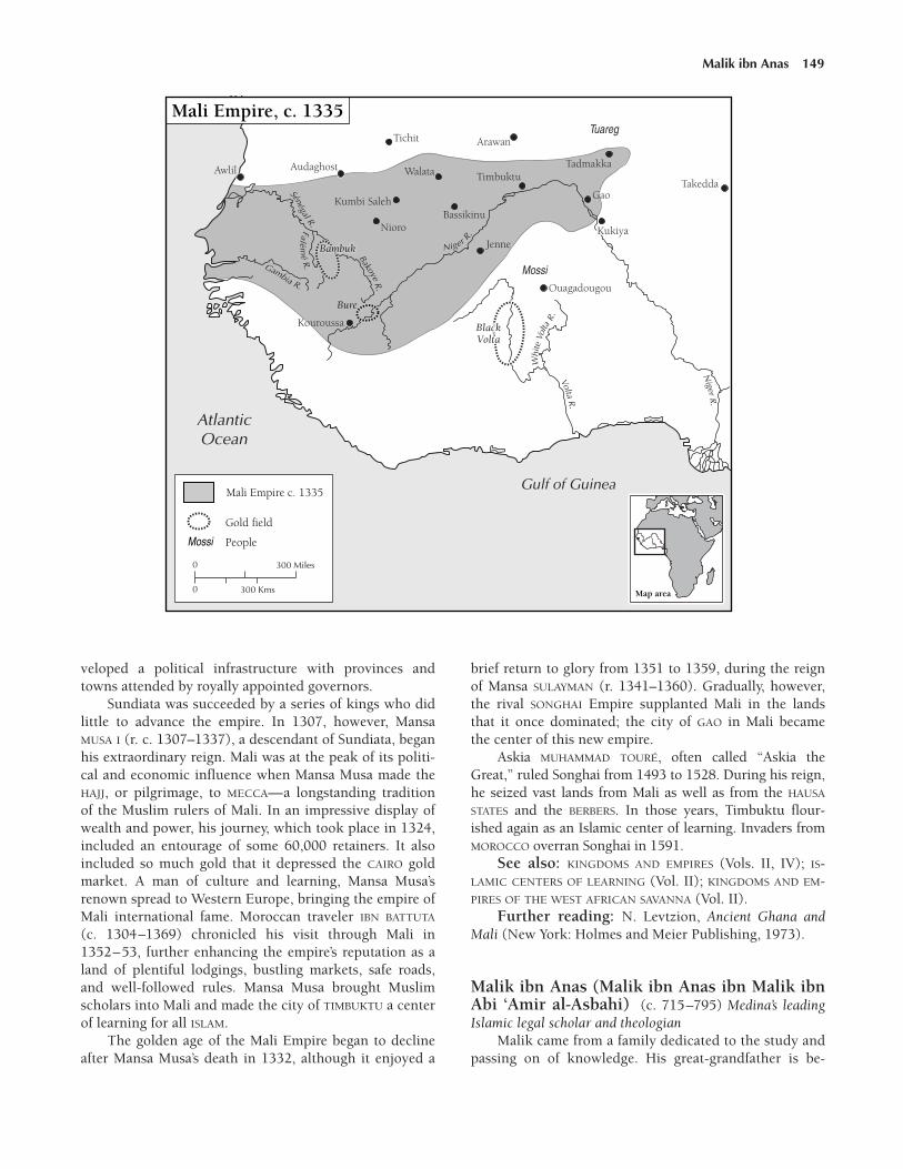
veloped a political infrastructure with provinces andtowns attended by royally appointed governors.
Sundiata was succeeded by a series of kings who didlittle to advance the empire. In 1307, however, MansaMUSA I (r. c. 1307–1337), a descendant of Sundiata, beganhis extraordinary reign. Mali was at the peak of its politi-cal and economic influence when Mansa Musa made theHAJJ, or pilgrimage, to MECCA—a longstanding traditionof the Muslim rulers of Mali. In an impressive display ofwealth and power, his journey, which took place in 1324,included an entourage of some 60,000 retainers. It alsoincluded so much gold that it depressed the CAIRO goldmarket. A man of culture and learning, Mansa Musa’srenown spread to Western Europe, bringing the empire ofMali international fame. Moroccan traveler IBN BATTUTA
(c. 1304–1369) chronicled his visit through Mali in1352–53, further enhancing the empire’s reputation as aland of plentiful lodgings, bustling markets, safe roads,and well-followed rules. Mansa Musa brought Muslimscholars into Mali and made the city of TIMBUKTU a centerof learning for all ISLAM.
The golden age of the Mali Empire began to declineafter Mansa Musa’s death in 1332, although it enjoyed a
brief return to glory from 1351 to 1359, during the reignof Mansa SULAYMAN (r. 1341–1360). Gradually, however,the rival SONGHAI Empire supplanted Mali in the landsthat it once dominated; the city of GAO in Mali becamethe center of this new empire.
Askia MUHAMMAD TOURÉ, often called “Askia theGreat,” ruled Songhai from 1493 to 1528. During his reign,he seized vast lands from Mali as well as from the HAUSA
STATES and the BERBERS. In those years, Timbuktu flour-ished again as an Islamic center of learning. Invaders fromMOROCCO overran Songhai in 1591.
See also: KINGDOMS AND EMPIRES (Vols. II, IV); IS-LAMIC CENTERS OF LEARNING (Vol. II); KINGDOMS AND EM-PIRES OF THE WEST AFRICAN SAVANNA (Vol. II).
Further reading: N. Levtzion, Ancient Ghana andMali (New York: Holmes and Meier Publishing, 1973).
Malik ibn Anas (Malik ibn Anas ibn Malik ibnAbi ‘Amir al-Asbahi) (c. 715–795) Medina’s leadingIslamic legal scholar and theologian
Malik came from a family dedicated to the study andpassing on of knowledge. His great-grandfather is be-
Malik ibn Anas 149

lieved to have been a companion of the prophetMuhammad (c. 570–632). The Muwatta is Malik’s mostfamous work. It is heralded as being the foundation onwhich Islamic law is built and consists of Malik’s inter-pretation of the doctrines and discussions of Muham-mad and his companions and followers, as well as themost respected legal scholars of the city of MEDINA inwhat is today Saudi Arabia. The word muwatta means“the approved,” and the work was so named because itwas accepted by 70 of Malik’s contemporaries in Med-ina. The title also means “the clear book” in that it canbe understood by anyone interested in attaining knowl-edge. Ash-Shafii, Malik’s most renowned student, de-clared that besides the QURAN, the Muwatta was themost important book in the world.
Malik was so respected and admired in his time thatat the end of the UMAYYAD dynasty (c. 660–750), whenthe caliph, Abu Jafar al-Mansur, was trying to usurp polit-ical control from his rival Muhammad ibn Abdallah, thepeople of Medina sought Malik’s advice as to where theirloyalties should lie. Malik reasoned that allegiance toMansur was not binding because it had been given underforce. Malik eventually paid for his frankness: after secur-ing power, Mansur executed Muhammad and had Malikbeaten for his disloyalty during the rebellion.
In honor of their teacher, Malik’s students formed theMaliki sect, which began in Medina but flourishedthroughout North and West Africa and in much ofArabia. Tradition, reason, and tolerance were the hall-marks of Malik’s philosophy and the ideology of thosewho followed him.
See also: MALIKI SUNNI DOCTRINE (Vol. II).Further reading: Mansour H. Mansour, The Maliki
School of Law: Spread and Domination in North and WestAfrica 8th to 14th Centuries C.E. (Bethesda, Md.: Austinand Winfield Publishers, 1994).
Maliki Sunni doctrine One of four Sunni schools ofIslamic law. Sunni ISLAM is the mainstream, traditionalistbranch of the Muslim faith and also its largest. The Ma-liki sect is one of the four major orthodox Sunni sectsand the one dominant in North and West Africa.
Sunnites, as the follower of Sunni law are called, be-lieve that the rightful successors of the prophet Muham-mad (c. 570–632) were the first four caliphs (a title, fromthe Arabic kalifa, meaning “successor,” given to the civiland religious head of the Muslim state that came intobeing following Muhammad’s death). These were ABU
BAKR (c. 573–634), Muhammad’s close companion andadviser, and the three caliphs that immediately followed.According to the Sunni, all caliphs thereafter were re-quired to be descendants of Muhammad, although inpractice they accepted the authority of any ruler whomaintained order and promoted Islam, whatever his ori-
gins. In contrast, the minority Shiite sect of Islam, whichfollowed the tenets of Shiism, believes that authority be-longs solely to Muhammad’s son-in-law, the fourth caliph,Ali, and his descendants. Disagreements regarding thesource of political, and ultimately spiritual, power out-lasted the end of the Caliphate in the 13th century.
The Hanafi, the Shafii, and the Hanbali are the threeother orthodox Sunni sects. Each sect acknowledges threesources of Islamic law: the QURAN; the Sunna, or thewords and deeds of Muhammad; and qiyas, or reasoningby analogy to similar situations at the time when Muham-mad lived. The sects differ only in the amount of empha-sis they give each legal source. The Maliki school,founded by MALIK IBN ANAS (c. 715–795) and centered inMEDINA, is the dominant Sunni sect in North and WestAfrica. Malik, an eighth-century imam, or religious leader,wrote the earliest surviving Muslim book of laws, theMuwatta. Malik’s writings focus on practicing Islam in ac-cordance with the Sunna of Muhammad. His followers es-tablished a school of fiqh, or religious law, called theMaliki Madhhab that is modeled after his teachings.
By the 13th century Islam had spread throughoutmuch of Africa. Shortly thereafter, the ALMOHADS an-nounced a return to the Maliki school of Islam. Maliki re-mains the most widely practiced sect of Islam in Africatoday.
Further reading: Mansour H. Mansour, The MalikiSchool of Law: Spread and Domination in North and WestAfrica 8th to 14th Centuries, C.E. (Bethesda, Md.: Austinand Winfield Publishers, 1994).
Malindi Settlement on the SWAHILI COAST that was animportant source of IRON ore in Africa as early as the11th century. Like other East African coastal towns,Malindi attracted a large number of Arab, Persian, andIndian MERCHANTS. Although iron ore was the primaryexport, seashells, pearls, turtle shells, and fish were alsotraded in Malindi. The goods imported included glassbeads, painted ceramic tiles, and POTTERY.
See also: ARAB COASTAL TRADE (Vol. II); MALINDI
(Vol. III); PERSIAN TRADERS (Vol. II).
Mamluks Members of an elite military unit made up ofcaptives enslaved by Abbasid or other Islamic rulers toserve in Middle Eastern and North African armies. Theterm mamluk, or mameluke, from an ARABIC word thatmeans “one who is owned,” has been used to describe theyoung children who were removed from their homelandsto serve the Abbasid dynasty caliphs in North Africa fromabout 750 to 945. Rigorously trained as mounted horse-men and skilled archers, the Mamluks became powerfulsoldier-kings who enforced the payment of tax revenuesto the ruling class. Many Mamluks were converted to
150 Maliki Sunni doctrine

ISLAM and rose to positions of great influence and evenroyalty. Although guaranteed their freedom at age 18, theMamluks were still restricted by their enslaved status andwere unable to pass their status as soldier-kings orlandowners on to their descendants. In the 13th centurythe Mamluks seized power and established a Mamlukstate that encompassed Arabia, Syria, EGYPT, and parts ofLIBYA and Nubia.
See also: MAMLUKS (Vol. III).
Mamprusi (Manprusi, Mampruli, Dagbamba)People who inhabit the region between the White Voltaand Nasia rivers in present-day GHANA and BURKINA FASO;they established a West African kingdom during the 14thcentury. The Mamprusi speak a language of the Gurbranch of the Niger-Congo language family. Known as theDagbamba in ancient times, the Mamprusi changed theirname to avoid confusion with the neighboring DAGOMBA.
Traditional Mamprusi society was patrilineal, with astrong emphasis on ancestor worship. Their agriculturalECONOMY focused on hoe cultivation to produce millet,corn, and yams. Hunting and fishing were a secondarymeans of subsistence. Mamprusi, like most of the king-doms south of the Niger bend, also participated in ex-change along TRANS-SAHARAN TRADE ROUTES.
JJJJJJJJJJJJJ
According to oral tradition, Na Gbewa, the son of asemimythical figure named Kpogonumbo, was thefounder of the Mamprusi kingdom. The threeyoungest sons of Na Gbewa led the three kingdomsof Mamprusi, Nanumba, and Dagomba.
JJJJJJJJJJJJJ
See also: MAMPRUSI (Vol. III); MOSSI STATES (Vols. II,III, IV); NIGER-CONGO LANGUAGES (Vol. I).
Manan Pre-Islamic capital of the ancient KANEM king-dom, located in the Lake Chad region. Historical evi-dence suggests that the ancestors of Kanem’s SEFUWA
dynasty of rulers were the Duguwa, relatives of theZaghawa people, who established their capital at Mananas far back as the sixth century. Nearly 100 years later,the Sefuwa mais, or kings, took control of Kanem andmoved the capital to NJIMI. Sefuwa oral tradition, how-ever, maintains that Manan remained the capital until the13th century. This probably reflects changes in Sefuwaoral history that took place shortly after their conversionto ISLAM. These changes probably represent an attempt bythe Sefuwa to establish a clear hereditary claim to Manan,which was the supposed birthplace of 13th-centuryMuslim sultans.
See also: CHAD, LAKE (Vols. I, III); KANEM-BORNU
(Vols. II, III, IV); ZAGHAWA (Vol. III).
Mande (Manding, Mandingo, Mandingue)Language group of West Africa that includes the BAMBARA
(Bamana), SONINKE, SUSU, and MANDINKA peoples.Mande-speaking people are credited with introducingAGRICULTURE, IRONWORKING, and advanced political sys-tems to western Africa. They are divided into two groups,the Mande-tan and the Mande-fu.
The Mande-tan inhabited the region surrounding theupper Niger River. This area includes parts of present-dayGUINEA, LIBERIA, Republic of MALI, SIERRA LEONE, and SENE-GAL. The Mande-tan traditionally established strict hierar-chical class structures, with farmers holding the highestrank in society. In contrast, CRAFTSPEOPLE and other arti-sans were of lower social rank.
Mande 151
The Mamluk rulers of Egypt (r. 1250–1517) were descended froman elite force of fighters of Turkish, Afghan, Balkan, and Circassianorigin whom the Ayabbid sultans of Egypt (r. 1099–1250) boughtout of slavery as children, trained, and put into royal service. This19th-century illustration gives a very romantic view of a Mamlukcavalryman. © Gianni Dagli Orti/Corbis
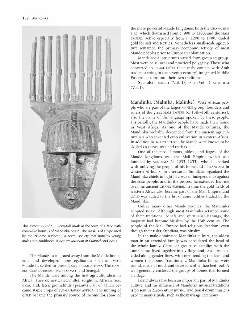
The Mande-fu migrated away from the Mande home-land and developed more egalitarian societies MostMande-fu settled in present-day BURKINA FASO, The GAM-BIA, GUINEA-BISSAU, IVORY COAST, and Senegal.
The Mande were among the first agriculturalists inAfrica. They domesticated millet, sorghum, African rice,okra, and, later, groundnuts (peanuts), all of which be-came staple crops of SUB-SAHARAN AFRICA. The mining ofGOLD became the primary source of income for some of
the more powerful Mande kingdoms. Both the GHANA EM-PIRE, which flourished from c. 900 to 1200, and the MALI
EMPIRE, active especially from c. 1200 to 1400, tradedgold for salt and textiles. Nonetheless small-scale agricul-ture remained the primary economic activity of mostMande peoples prior to European colonization.
Mande social structures varied from group to group.Most were patrilineal and practiced polygamy. Those whoconverted to ISLAM (after their early contact with Arabtraders starting in the seventh century) integrated MiddleEastern customs into their own traditions.
See also: MILLET (Vol. I); SALT (Vol. I); SORGHUM
(Vol. I).
Mandinka (Malinka, Malinke) West African peo-ple who are part of the larger MANDE group; founders andrulers of the great MALI EMPIRE (c. 13th–15th centuries);also the name of the language spoken by these people.Historically, the Mandinka people have made their homein West Africa. As one of the Mande cultures, theMandinka probably descended from the ancient agricul-turalists who invented crop cultivation in western Africa.In addition to AGRICULTURE, the Mande were known to beskilled CRAFTSPEOPLE and traders.
One of the most famous, oldest, and largest of theMande kingdoms was the Mali Empire, which wasfounded by SUNDIATA (r. 1235–1255), who is creditedwith unifying the people of his homeland of KANGABA inwestern Africa. Soon afterwards, Sundiata organized theMandinka chiefs to fight in a war of independence againstthe SUSU people, and in the process he extended his ruleover the ancient GHANA EMPIRE. In time the gold fields ofwestern Africa also became part of the Mali Empire, andGOLD was added to the list of commodities traded by theMandinka.
Unlike many other Mande peoples, the Mandinkaadopted ISLAM. Although most Mandinka retained someof their traditional beliefs and spiritualist leanings, themajority had become Muslim by the 13th century. Thepeople of the Mali Empire had religious freedom, eventhough their ruler, Sundiata, was Muslim.
In the male-dominated Mandinka culture, the oldestman in an extended family was considered the head ofthe whole family. Clans, or groups of families with thesame name, lived together in a village, and LABOR was di-vided along gender lines, with men tending the farm andwomen the home. Traditionally, Mandinka homes wereround, made of mud, and covered with a thatched roof. Awall generally enclosed the groups of homes that formeda village.
MUSIC always has been an important part of Mandinkaculture, and the influence of Mandinka musical traditionsis present in 21st-century music. Traditional drum music isused in many rituals, such as the marriage ceremony.
152 Mandinka
This almost 22-inch (52-cm)-tall mask in the form of a face withcomb-like horns is of Mandinka origin. The mask is of a type usedby the N’Tomo (Ndomo), a secret society that initiates youngmales into adulthood. © Bowers Museum of Cultural Art/Corbis
Mapungubwe City located in what is now ZIMBABWE,just south of where the Shashe (Sashi) and the Limpoporivers meet. About 1075 a great influx of the Leopard’sKopje people, a Bantu-speaking group, emigrated fromtheir site northwest of Mapungubwe, where they estab-lished a sophisticated community that thrived culturally,politically, and economically. Though they were a pastoraland agricultural society, the majority of their wealth camefrom the local and long-distance trading of GOLD, IRON,COPPER, IVORY, livestock, and BEADS AND JEWELRY. LocalCRAFTSPEOPLE also produced and traded fabric, ceramics,bone tools, and sculptures. Spindle whorls, which wereused as weights for weaving, were first introduced in thispart of Africa.
The social structure of Mapungubwe was three-tiered. At the top of the political ladder were the chiefs orkings, who lived in stone houses high up on the hill. Thesecond tier was occupied by their wives and associates,who lived nearby but separate. The third tier, the major-ity of the population, was made up of the peasants—craftspeople and laborers who were dependent on theelite. This system in which the aristocracy lived isolatedfrom their subjects is one of the earliest found in south-ern Africa.
Initially there was much debate about the origin ofthe Mapungubwe inhabitants. Archaeologists who exca-vated sites in and around the region were slow to ac-knowledge the influence that the Leopard’s Kopje peoplehad on the area, for they felt that the society they wereuncovering was so complex that it must have been heav-ily influenced by Muslims from the northern or easternparts of Africa. But later discoveries of skeletal and cul-tural remains proved that the people of Mapungubwewere of sub-Saharan African descent. Between the 13thand 14th centuries the people of Mapungubwe headednorth to GREAT ZIMBABWE for better trading resources andwealth.
Maqurrah Christian kingdom on the upper Nile Riverwith its capital at Dongola. One of three Nubian king-doms, Maqurrah was Christianized between 543 and 575CE by a missionary named Julian and his successor,Longinus. From religious texts it would appear that thepeople were enthusiastic in embracing CHRISTIANITY.Christian churches were built along the Nile, and an-cient temples were converted into Christian places ofworship. By the seventh century Maqurrah had absorbedits neighboring kingdom, NOBATIA. After this missionaryeffort, there is little known about Christianity in thisarea until the Muslim ARABS spread southward into theupper Nile region after their invasion of Egypt, in 639.The Muslims marched south into Maqurrah, laying siegeto the town before capturing it and destroying the Chris-tian cathedral. At that time, the king of Maqurrah asked
for an armistice. The Arabs, who had suffered heavylosses themselves, agreed. According to the treaty, the twogroups established a working relationship in which theywould engage in trade but not settle in each other’s terri-tory. This relationship lasted for 600 years and was benefi-cial to both parties; the Arabs gained a secure southernborder, and Maqurrah was able to maintain itself as an in-dependent entity.
See also: CHRISTIANITY, INFLUENCE OF (Vols. I, II),DONGOLA (Vol. III); EGYPT (Vols. I, II), NILE RIVER (Vol. I);NUBIA (Vol. I); NUBIA, CHRISTIAN (Vol. II); ISLAM, INFLU-ENCE OF (Vol. II).
Marinids Berber people who conquered the ALMOHADS
in the 13th century. The Marinids, also called the BanuMarin, ruled MOROCCO and other parts of North Africauntil the early 15th century. The Marinids were a no-madic group of Zanatah BERBERS. During the early part ofthe 13th century they began to migrate into northeasternMorocco from ALGERIA, as the Almohad empire slowlyweakened. In 1248 the Marinid sultan Abu Yahya con-quered the Almohad towns of FEZ, Taza, Meknes, Sale,and Rabat. Fez was rebuilt as the Marinid capital. Duringthe reign of Abu Yusuf Yaqub (1258–1286), who was un-related to the earlier Almohad ruler of the same name,MARRAKECH and the remaining Almohad-ruled lands ofthe High Atlas region came under Marinid rule. With thecapture of Marrakech in 1269, the Almohad dynasty ef-fectively came to an end.
By the beginning of the 15th century the Marinid dy-nasty was in chaos. After failed attempts under ABU AL-HASAN ALI (1297–1351) to reconquer Christian Spain andto expand their territory in North Africa, Marinid re-sources were depleted. In Morocco they were overtakenby a related branch of people known as the Wattasids,who ruled until Fez was captured by the Sadian sharifs in1548.
Marka (Marca, Merca) Indian Ocean port city lo-cated in present-day SOMALIA. Arab traders founded thecity in the 10th century, but by the 13th century SOMALI
immigrants had settled extensively throughout the area.Soon, the Somalis became involved in inland trade via thecaravan routes from the African interior. Although theIndian Ocean coastline of Somalia does not have goodharbors, Marka and the nearby towns of Brava and MOGA-DISHU are suitable ports. For this reason the stretch ofcoast where these towns are situated became known asthe Benadir Coast, from the Persian word bandar, whichmeans “port.”
See also: ARAB COASTAL TRADE (Vol. II); BENADIR
COAST (Vol. III); BRAVA (Vol. III); INDIAN OCEAN TRADE
(Vol. II).
Marka 153

marketplaces There is little evidence to suggest thatmarketplaces were a regular feature of village life in mostregions of SUB-SAHARAN AFRICA between the fifth and theeighth centuries. It is thought, however, that it was com-mon for small villages to create marketplaces to facilitatebarter between peoples living in close proximity. Later, asvillages evolved in sub-Saharan Africa, peoples like theIGBO of present-day NIGERIA set up complex systems oforganized markets that would be held on a regular basis,perhaps at intervals of four, 10, or 20 days, depending onthe season. The commodities usually traded at these vil-lage marketplaces were local crops and foodstuffs andhandmade items like baskets or jewelry. People who hadno goods to trade would often barter for items by offeringtheir LABOR in fair exchange.
Village markets existed primarily to balance the FOOD
surpluses and deficits between neighboring villages. Untilabout the eighth century these local markets rarelyplayed a role in long-distance trade, the exception beingthe local market that possessed rare items of high value—like beads or shells—or large volumes of less exceptionalgoods, such as certain grain crops. In these cases, goodsmight travel through a complex trade network run byprofessional merchants. The goods moved along with themerchants from village to village before eventually find-ing their way to a larger regional marketplace.
Village markets were also differentiated by function.For example, in seaside villages such as Yoff, in SENEGAL,a large marketplace traditionally would open when fish-ermen returned to shore with their catches. Hundreds ofwomen would be involved in buying fish in bulk andthen cleaning and preparing them for the village market-place. In villages that had a mosque, the mosque servedas a social center for the men, and the marketplace hadthe same function for the women. Many villagers visitedthe market once a day, if not more often, to obtain thegoods they needed.
The larger regional markets usually developed alongtrade routes or near centers of government. In theseplaces, unlike in the villages, there were always laborersfor hire and accommodations for the traders and theirpack animals.
A public market or market district in North Africawas called a souk, the ARABIC word for “MARKETPLACE.”In the larger cities such as TUNIS, these would also havebeen places to import and export goods from theMediterranean region. Visitors to the souk in 13th-cen-tury FEZ in MOROCCO would smell bread being made andsold, see piles of olives, peppers, and spices for sale, andbe able to buy goods made from leather produced at thenearby tannery or purchase a variety of silk, COTTON, orwoolen thread dyed in town. All of this took place withinsight of the Qarawiyin Mosque and theological school,which was founded in 859 and is one of the oldest uni-versities in the world.
Marrakech (Marrakesh) City in west-central MO-ROCCO, on the fertile Haouz Plain. Marrakech has longbeen one of the principal commercial centers of Morocco.The old section of the city, called the medina, was sur-rounded by a large palm grove and featured fortified wallsthat were built in the 12th century. The medina is alsoknown as the “red city,” because its buildings and ram-parts, built during the Almohad period, are made frombeaten clay of a rusty color. The heart of the medina is theJema al-Fna square, a busy souk, or MARKETPLACE. Nearbyis the 12th-century Koutoubia Mosque with its 253-foot(77-m) high minaret. Other buildings of historic signifi-cance include the 16th-century Sadi Mausoleum, the18th-century Dar el-Beda Palace (now a hospital), and the19th-century Bahia royal residence. Much of the medina isstill surrounded by 12th-century walls.
The city was founded in 1062 by YUSUF IBN TASHBIN
(r. 1061–1106), the leader of the militant religious Mus-lim reformers called the ALMORAVIDS. As the Almoravidmovement shifted its emphasis from promoting ISLAM toengaging in military conquest, the empire came to in-clude territory as far east as ALGIERS as well as parts ofSpain up to the Ebro River. Although it was not an en-tirely peaceful time for the region, North Africa bene-fited economically and culturally during the Almoravidperiod.
In 1147 Marrakech was captured by the ALMOHADS,who between 1152 and 1160 were able to conquer all ofthe eastern MAGHRIB. Then, in 1269, Marrakech passedinto the hands of the MARINIDS, who moved their capitalto FEZ, in northern Morocco. New caravan routes began tobypass Marrakech, and the city suffered economically. Bythe time the Sadian dynasty seized control of the city in1525, it was a poor place, largely in ruins. The Sadian dy-nasty revitalized Marrakech, making it the new capital ofsouthern Morocco. By the end of the 16th century Mar-rakech was once again the leading city of Morocco, cultur-ally and economically, with about 60,000 inhabitants.
See also: MARRAKECH (Vols. III, IV, V); SADIAN DY-NASTY (Vol. III).
Masmuda Group of sedentary BERBERS from MOROCCO
who established the Almohad dynasty. In the 12th and13th centuries the Almohad dynasty stretched fromNorth Africa to Spain. The dynasty’s founder, MUHAMMAD
IBN TUMART (c. 1080–1130), was recognized by theMasmuda as the messiah-like figure known as the MAHDI,meaning “righteous leader.”
The Masmuda lived in the High Atlas region ofsouthern Morocco. Unlike nomadic Berbers, the Mas-muda settled in permanent homes, farmed the land, anddomesticated animals. The Masmuda were devout Mus-lims who often spoke both ARABIC and their native Berberdialect.
154 marketplaces

The ALMOHADS, like the Almoravids who precededthem, were Berbers. The Almohad founder, Muhammadibn Tumart, was a Masmuda leader who sought to re-form the excesses of the ALMORAVIDS. After studying incities like Baghdad and MARRAKECH but failing to gainsupport, ibn Tumart returned to his home, where histeachings became popular among his fellow Masmuda.With their support, ibn Tumart began a rebellion againstthe ruling Almoravids by attacking their centers inMarrakech and Sus.
After ibn Tumart’s death, his successor, ABD AL-MUMIN
(c. 1094–1163), expanded the Almohad dominion to in-clude Spain. Al-Mumin, who did not belong to theMasmuda, changed the Almohad leadership into a tradi-tional monarchy based on heredity. As a result al-Muminfought with Masmuda chiefs for control of the dynasty.Between the pressures of unrest at home and long warsagainst Christian crusaders in Spain, the Almohad empirecollapsed in the middle of the 13th century.
See also: ISLAM, INFLUENCE OF (Vol. II).Further reading: Michael Brett and Elizabeth Fen-
tress, The Berbers (Malden, Mass.: Blackwell Pub., 1997).
Massawa (Metsewwa, Mitsiwa) Vital port city innorthern ERITREA, extending from the region’s coast to theneighboring islands of the DAHLAK ARCHIPELAGO. DuringAksumite rule in the early Christian era, Massawa pro-vided an essential link between MERCHANTS of the RED
SEA TRADE and the exotic export items they sought in theinterior of ETHIOPIA. It is thought that in the early part ofthe eighth century, Muslims captured Massawa and theentire Dahlak Archipelago, subsequently destroying themainland city of ADULIS in reprisal for raids that theAksumite rulers had made on southern Arabia.
Arab traders in Ethiopia made it impossible for AKSUM
to resume its former status in the lucrative Red Sea trade.However, under the ZAGWE DYNASTY (c. 916–1270) trad-ing briefly flourished, perhaps as a result of mutual coop-eration between the Zagwe rulers and the early Muslimsettlers in the region. By the time the SOLOMONIC DYNASTY
reclaimed the Ethiopian throne about 1270, these Muslimsettlements had developed into formidable city-states thatdominated trade in Massawa and other ports along theEthiopian coast.
Despite the attempts of several Solomonic rulers torestore control over trade, it was not until the mid-15thcentury that Emperor ZARA YAKOB (r. 1434–1468) wassuccessful in regaining dominance. He accomplished thisby organizing military units and keeping a watchful ad-ministration on the region.
See also: TRADE AND COMMERCE (Vol. II).Further reading: Jean Doresse, Ethiopia (New York:
Frederick Ungar Publishing Company, 1959); Harold G.Marcus, A History of Ethiopia (Berkeley, Calif.: University
of California Press, 1994); Richard Pankhurst, TheEthiopian Borderlands (Lawrenceville, N.J.: The Red SeaPress, 1997).
Masudi, el (Masudi, Abd al-Hasan Ali ibn al-Husayn; Mas’udi, al-; Mas’udi, al-Fustat; al-Mas’udi, Abu al-Husayn ‘Ali ibn al-Husayn)(888–957) Arab writer and traveler
Masudi was born in Baghdad, in present-day Iraq,and exhibited a great capacity for learning from a youngage. Not wanting to rely only on books and teachers forhis knowledge, he chose to wander most of his life, learn-ing about things firsthand and from those he met on histravels. He visited the east coast of Africa, Armenia, theCaspian Sea, China, India and the Indus Valley, Iran,Oman, Russia, Spain, Sri Lanka, and Syria before finallyretiring to EGYPT about 947.
Masudi was a prolific writer and chronicler of all ofthe knowledge he gained on his travels. Though themanuscripts no longer exist, it is known that he wrote atleast 20 titles, including volumes on Muslim beliefs andeven one on poisons. It was his historical works, how-ever, that earned him the title “Herodotus of the Arabs.”Covering the breadth of world history, Akhbar az-zaman(The history of time) filled 30 volumes.
As a follow-up to this ambitious work, Masudi wroteKitab al-awsat, a companion work probably covering his-tory from a chronological standpoint. Masudi’s best-known work, however, was Murujadh-dhahab was ma’adinal’jawahir (The meadows of gold and the mines of gems).This work covered the same material as the previous twobooks but in far less detail, only 132 pages, thereby mak-ing it more accessible and readable. The book began withthe creation of the world and covered a wide range of top-ics, everything Masudi deemed intriguing or of use, in-cluding reflections on the geography, climate, economies,calendars, RELIGION, literature, customs, and history of thevarious places he had visited. He described weather condi-tions, oceans, and the solar system as well. Masudi’s finalwork was Kitab at-tanbih wa al-ishraf (The book of notifi-cation and verification) written in the year before hisdeath. In it Masudi revised and recapitulated his earlierworks.
See also: HERODOTUS (Vol. I); IBN BATTUTA (Vol. II).
Matope (d. 1480) Ruler of the Mwene Mutapa kingdom insouthern Africa in the 15th century
Little is known of Matope’s life. He left the throne tohis son Mokombo, whose rule became a period of unrest.Finally in 1490, Changa, the governor of the southern andcentral provinces of the MWENE MUTAPA kingdom, rebelledagainst Makombo, declared the provinces independent,and named them the Rozwi kingdom. Changa added the
Matope 155

ARABIC title amir (commander) to his name and has be-came known to historians as CHANGAMIRE. The Rozwikingdom is often called Changamire, after the Changamiredynasty, which was founded by Changa’s son ChangamireII. Changamire eventually became the greatest power inCentral Africa until its fall, in 1830.
See also: CHANGAMIRE DYNASTY (Vol. III), ROZWI
(Vol. III).
Mauritania Present-day country of northwesternAfrica, approximately 398,000 square miles (1,030,800 sqkm) in size and bordered by ALGERIA, Republic of MALI,SENEGAL, and WESTERN SAHARA. As early as the third cen-tury, BERBERS from North Africa migrated into Mauritania.Many of the indigenous inhabitants were enslaved, whileothers were integrated into a feudal system. The Berberssucceeded in monopolizing trade in the Western Saharaover the next few centuries. Three dominant Berberclans, the Lamtuna, Messufa, and Djodala, formed an al-liance known as the Sanhaja Confederation. By the ninthcentury the SANHAJA BERBERS administered all trade be-tween KUMBI SALEH, AUDAGHOST, TIMBUKTU, and the saltmines of the northwestern Sahara.
In the late 10th century the armies of the Ghana Em-pire captured Audaghost, greatly cutting into the Berbertrade monopoly. By the middle of the 11th century the AL-MORAVIDS, who had organized in the coastal Mauritaniancapital of NOUAKCHOTT, conquered most of the SaharanBerbers and converted them to the Maliki Sunni school ofISLAM. The Almoravids also gained control of the westernSahara trade network established by the Berbers. Theyruled Mauritania well into the 13th century.
During the mid-13th century ARABS from NorthAfrica moved west. For nearly four centuries they foughtwith the region’s established Berber inhabitants, until fi-nally gaining control over them by the middle of the 17thcentury.
See also: ISLAM, INFLUENCE OF (Vols. II, III, IV, V);MALIKI SUNNI DOCTRINE (Vol. II); MAURITANIA (Vols. I, II,III, IV, V); SALT MINING (Vol. II).
Mauritius Island nation in the Indian Ocean, spreadover 720 square miles (1,870 sq km) and situated ap-proximately 500 miles (805 km) east of MADAGASCAR. Itincludes the inhabited island of Rodrigues, 350 miles(563 km) to the northeast, as well as scattered coralatolls, including Cargados Carajos and Agalega. In the10th century ARABS discovered the island, and it beganto appear on maps by about 1500 under its Arabicname, Dina Arobi. While Arabs visited, they did not stay.The Portuguese arrived in the 16th century, bringingwith them monkeys and rats. However, they also did notsettle or develop the island. From 1638 to 1710 it was
colonized by the Dutch, who named it after Prince Mau-rice of Nassau.
See also: MAURITIUS (Vols. I, III, IV, V); NETHER-LANDS AND AFRICA (Vol. III).
Further reading: Auguste Toussaint, History ofMauritius (London: Macmillan, 1977).
Mbanza Kongo (Mbanza Congo) Capital city ofthe KONGO KINGDOM during the early 15th century. Thissouthwest African town, originally inhabited by theKONGO people, became an important trade port for earlyPortuguese explorers. As early as 1490, Portuguese mis-sionaries arrived at Mbanza Kongo. The Portuguese thenimported masons, carpenters, and artisans, enabling themto build a large town in a few years.
In 1491 Nzinga Mbemba, the son of the Kongo kingNzinga Nkuwu, was greatly influenced by the Portuguesemissionaries. He converted to CHRISTIANITY and changedhis name to Afonso I. Nzinga Mbemba succeeded his fa-ther to the throne around 1505 and ruled for nearly 40years as the Christian king of Mbanza. Portuguese cus-toms were integrated into Kongo society along with theChristian religion. Mbanza Kongo was renamed São Sal-vador, in 1534.
See also: AFONSO I (Vol. III); PORTUGAL AND AFRICA
(Vols. III, IV, V); SÃO SALVADOR (Vol. III).
Mbundu Bantu-speaking ethnic group of ANGOLA, inCentral Africa. They are sometimes called the NorthMbundu or Kimbundu to distinguish them from a relatedMbundu-speaking group, who call themselves OVIM-BUNDU in their own language.
The North Mbundu descended from three distinctBantu-speaking groups who arrived in what is now An-gola during the 15th century. They introduced severaltechnologies to the region, including IRONWORKING, newagricultural techniques, and superior hunting methods.In the absence of a centralized political system, NorthMbundu society was organized around loose clan affilia-tions. However, toward the end of the 15th century theemergence of the powerful KONGO KINGDOM to the northforced the North Mbundu to centralize their leadership.They aligned themselves with the king of the Ndongopeople, who were building an agricultural and trade king-dom at Kubasa.
The North Mbundu capitalized on their location tocontrol the coastal trade routes, which brought them intocontact with the Portuguese MERCHANTS who arrived onthe coast around the same time that the Kongo kingdomemerged.
See also: CLAN (Vol. I); MATAMBA (Vol. III); MBUNDU
(Vol. III); NDONGO (Vol. III); PORTUGAL AND AFRICA (Vols.III, IV, V).
156 Mauritania

Mecca City in what is now Saudi Arabia, located ap-proximately 50 miles (80 km) from the Red Sea. BecauseMecca is the birthplace of the prophet Muhammad (c.570–632), the city is of central importance to the religionof ISLAM. In the seventh century, during the lifetime ofMuhammad, Mecca was an important commercial center,bustling with trade from the CARAVANS crossing theArabian Peninsula. Born into the influential Qaraysh fam-ily, Muhammad preached a monotheistic doctrine andsought to reform traditional Arab religious and social life.He quickly gained followers and became a threat toMecca’s established leadership. In 622 he accepted an in-vitation to go to the city of Yathrib, later known as MED-INA, where he successfully spread his teachings.
In 630, after a series of conflicts between rival sectsin the city of Mecca, Muhammad returned to Mecca, ac-companied by 10,000 troops. He quickly consolidatedand expanded his power, and by his death in 632, he hadbecome the spiritual and political leader of all Arabia.
By the end of its first century of existence, Islam hadexpanded westward into Africa and east and north intoAsia. As time passed, however, the focal points of Islamicpower moved as well, and by the ninth century the majorcenters of Islamic influence were located in EGYPT andIndia, far from Mecca and Medina.
JJJJJJJJJJJJJ
Muhammad’s move from Mecca to Medina in 622is called the Hegira (Hijra). The year of this moveis considered the beginning of the Islamic era andis commemorated by the annual Muslim pilgrim-age to Mecca. According to Islamic doctrine, thispilgrimage, or HAJJ, is the duty of every trueMuslim and is to be completed at least once duringeach believer’s lifetime. The hajj takes place be-tween the eighth and the 13th days of the lastmonth of the Muslim year, and annually bringsmore than 2 million pilgrims to the city of Mecca.Among the many rituals and observances that arepart of the hajj is each pilgrim’s passage aroundthe Kabah, the rectangular brick structure that theMuslim faithful believe was built by Ibraham andhis son, Ismail.
JJJJJJJJJJJJJ
Medhane Alem The largest of the undergroundchurches carved out of rock in the LASTA MOUNTAINS ofnorth-central ETHIOPIA. In the 12th century, LALIBELA, a
Medhane Alem 157
In the holy city of Mecca in Saudi Arabia, the Great Mosque, with the Kabah at the center, was the focal point of the devout Muslim’shajj. Thousands of the faithful are shown present in this 1854 print. © Corbis

devout Christian king belonging to the ZAGWE DYNASTY,directed the construction, or excavation, of the churches.Among the other churches are Golgatha, St. GIYORGIS andABBA LIBANOS.
medicine The approach of traditional African med-icine to restoring good health has been described as acombination of finding both the right cure along with thedisease’s underlying cause. In many traditional Africansocieties, illness or premature death was viewed either aspart of a larger, hidden problem within the FAMILY orcommunity or as something associated with other, un-seen forces. These possibilities inform the work of tradi-tional healers, many of whom made extraordinary effortsto heal the ill. The efforts of these healers included every-thing from divination and intuitive knowledge to specialrites and ceremonies. Another source of traditional cures,herbal remedies, were drawn from a vast knowledge ofherbs and roots. Some of the ingredients used were gath-ered in the wild, some were cultivated, and others, suchas fats or milk from DOMESTICATED ANIMALS, were com-monly found in the home.
Traditional treatments might involve healing bath so-lutions, inhaled or ingested potions, or the fumigation ofthe sick person’s home with special sprays. Someone witha fever might receive cooling substances made of water,plant essence, and ash. Incisions might be made to theskin so that medicine could be applied. Some healersused specially prepared medicine bundles that were in-tended to work as a type of charm. Beyond these physicaltreatments, one of the most potent aspects of medicaltreatment within many societies was the spoken word,which represented an important part of traditional heal-ing; ritual chants and incantations were often used as partof the regimen.
The art of divination was also essential in the role ofmedicine and was considered the first step in under-standing the underlying cause of illness. The results ofthe divination process might identify that cause as misdi-rected anger, envy, or even a deliberate act meant to in-flict harm on another member of the community.
Divination might also be used to detect the effectsof witchcraft, which many societies believed to be aprime cause of illness. Once the cause of an ailment orillness was identified, the healing medicine was dis-pensed. This could be done in a variety of ways. Often,special rites or ceremonies—sometimes including danc-ing and drumming—might be part of the process.Patients also might be asked to wear amulets containingcertain protective medicines. The ASHANTI of present-day GHANA, for example, have traditionally worn a per-sonal talisman, called a nsuma, that they believe hasbeen made with the assistance of divinities known col-lectively as the Abosom.
Members of other societies often stored medicinewithin wooden carvings that appeared at first glance tobe works of ART. Known as “power objects,” these weremainly depictions of human figures. Some of these heldmedicines that were meant to remain hidden from pub-lic view, while others were meant to inflict harm uponunsuspecting members of the community. Other carvedforms were made especially for public display. Thesewere filled with or surrounded by medicine and thenplaced on shrines or used in rituals. For example,medicines were routinely applied to the masks of theKomo Society, a group associated with the BAMBARA ofpresent-day Republic of MALI. The mask, in turn, wasthought to be able to transmit healing at specially orga-nized rites. The Bambara also used large sacred sculp-tures called boliw as repositories for their potentmedicines.
Similarly many societies of Central Africa usedwooden sculptures as a part of the healing process. Amongthe KONGO people, for example, sculptures known as nkisiwere used to magnify the healing properties of traditionalmedicines. Kongo healers typically inserted herbal reme-dies, known as bwanga, into the head or abdomen of oneof these figures. Thus, it was believed, the herbs weretransformed into more potent forms of medicine knownas mankishi. Peoples who used such methods, such asthe Songye, often claimed that knowledge of this type ofmedicine was given to the first humans by their supremebeing.
JJJJJJJJJJJJJ
In some regions of southern Africa, divining“bones” were used to diagnose and treat illness.These items, which often consisted of an assort-ment of special stones, shells, nuts, or other sacredobjects, were usually thrown onto a flat surface.The patterns that formed were then “read” by ahealer, who was then able to determine the appro-priate treatment.
JJJJJJJJJJJJJ
Medicine also played an important role in societiesthat ascribed to DIVINE RULE. Inserted into the crown orroyal headdress of ruling kings, certain medicines wereconsidered an essential protective agent. YORUBA kings,for example, had medicine sewn into the top portion oftheir crowns, always hidden beneath beads or a symbolicbird perched at the top. It was generally believed thatherbal medicines aligned the king’s divine power with theorisha, the pantheon of spiritual deities who embodiedthe life-force referred to as ashe. The Yoruba also buriedspecial medicines, known as oogun, under shrines dedi-cated to specific deities.
158 medicine
JJJJJJJJJJJJJ
The Haalpulaaren people of northern SENEGAL prac-tice a unique form of traditional healing. They wereorganized in lineage groups, each with its own spe-cial expertise in a certain craft. These crafts thendetermined an individual’s status as healer. For ex-ample, BLACKSMITHS treated external burns and ab-scesses, while members of the societies who wereweavers of cloth used specially tied knots to allevi-ate the pain of headaches and toothaches.
JJJJJJJJJJJJJ
See also: DIVINATION (Vol. I); MEDICINE (Vols. I, III,IV, V); ORISHA (Vol. I); WITCHCRAFT (Vol. I).
Further reading: Rosalind J. Hackett, Art and Reli-gion in Africa (London: Cassell, 1996); John S. Mbiti,African Religions and Philosophy (London: Heinemann Ed-ucational Publishers, 1999).
Medina Sacred city located in western Saudi Arabia,110 miles (180 km) east of the Red Sea and 200 miles(320 km) north of MECCA. The prophet Muhammad (c.570–632) fled to Medina in 622 but returned in triumphto Mecca in 630. His remains are buried in Medina, mak-ing it one of the holiest places of Muslim pilgrimage.Originally called Yathrib, the city came to be known asMadinat an Nami (the city of the Prophet), which waslater shortened to Medina, ARABIC for “the city.”
Muhammad’s monotheistic beliefs met with great op-position in his native city of Mecca. In 622 he and his fol-lowers were forced to leave the city, and they choseYathrib to be the administrative center of the new Muslimcommunity. This flight, known as the Hegira (Hijra),marks the beginning of the Islamic calendar.
Despite constant conflict with the Meccans, Muham-mad continued his attempts to unify the Arab people, andhis teachings attracted a great following. As a result,Mecca began to decline as prominent citizens moved toYathrib to follow ISLAM.
In 630 Muhammad and 10,000 of his disciples seizedMecca, and by 632 all of Arabia was united under Islam.While leading the annual pilgrimage to Mecca in 632,however, Muhammad died in Medina, before he couldappoint an heir. This provoked a major crisis among hisfollowers and later led to dynastic disputes that broughtschism and civil war. Muhammad was buried in Medina,and a mosque was subsequently built around his grave.His daughter, Fatima, and Omar, the second caliph of theMuslim empire, are also buried within the mosque.
For nearly 30 years after Muhammad’s death, Medinaremained the capital of the Islamic community, serving asthe administrative, cultural, and intellectual center of the
Muslim empire. Years later it became a primary center forthe legal discussions that codified Islamic law.
See also: ISLAM, INFLUENCE OF (Vols. II, III, IV, V);MALIKI SUNNI DOCTRINE (Vol. II); SHIISM (Vol. II).
Mediterranean Sea Body of water that provided akey link between the African continent, southern Europe,and the Middle East. Prior to the seventh century north-ern Africa and the Mediterranean Sea were controlled bythe Byzantine Empire. Although a handful of Mediter-ranean coastal towns were still under Byzantine influenceat the beginning of the seventh century, the arrival ofArab Muslims put an end to Byzantine rule. On a quest tospread ISLAM, these Arab immigrants used military forceto dominate ancient coastal towns and establish newMuslim cities. EGYPT was the first access point of the Arabconquests as they made their way west, into the MAGHRIB.As a result the Mediterranean became an essential factorin the introduction of Islamic culture to Africa.
Equally important was the rapid economic growth inthe area sparked by the Arab interest in Mediterraneantrade. TRANS-SAHARAN TRADE ROUTES linked the Mediter-ranean coast with the African interior, where export goods,such as GOLD and slaves, were in high demand. The influxof gold into Western Europe enabled countries like Spain,which had previously relied solely on silver, to diversifytheir currencies and increase their financial stability. In ad-dition, the growth of Mediterranean trade brought ad-vances in SHIPBUILDING technology and sparked interest inareas as diverse as geography, banking, and astronomy.Partly because of this economic prosperity, Islam was fullyincorporated into Mediterranean coastal towns by the 11thcentury and gradually began to spread southward alongthe trans-Saharan trade routes.
For the next several hundred years the Mediterraneanfigured prominently in shaping North Africa’s history. Itwas as often the site of power struggles as it was a busytrade center. The Muslim ALMORAVIDS, centered in MO-ROCCO, dominated the western Mediterranean in the late11th century and supplanted the UMAYYAD dynasty, whichhad ruled al-ANDALUS (Muslim Spain) since 756. (Spainhad been invaded and conquered by Berber Muslim forcesin 711.) At the same time, Christian crusaders attemptedto wrest the Holy Land from its Muslim rulers. Control ofmuch of the Mediterranean coastline passed to the ALMO-HADS, another Muslim reform group, in the late 12th cen-tury. Over the next 300 years, Christians and Muslimsbattled for control of Mediterranean trade and coastaldominance. Toward the end of the 15th century the Chris-tians temporarily conquered the Mediterranean under thearmies of the Spanish monarchs Ferdinand of Aragón andIsabella of Castile. Important North African port citiesunder Spanish control included Melilla, Oran, Ténès, Al-giers, Bidjaya, and Tripoli.
Mediterranean Sea 159
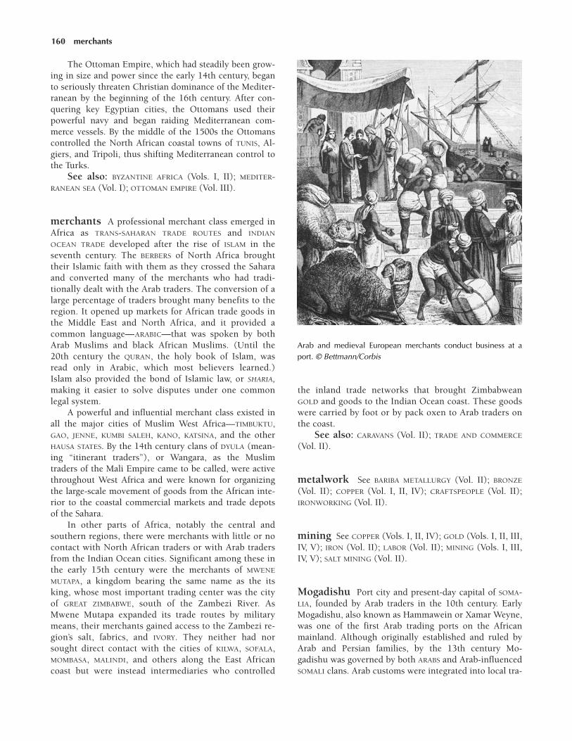
The Ottoman Empire, which had steadily been grow-ing in size and power since the early 14th century, beganto seriously threaten Christian dominance of the Mediter-ranean by the beginning of the 16th century. After con-quering key Egyptian cities, the Ottomans used theirpowerful navy and began raiding Mediterranean com-merce vessels. By the middle of the 1500s the Ottomanscontrolled the North African coastal towns of TUNIS, Al-giers, and Tripoli, thus shifting Mediterranean control tothe Turks.
See also: BYZANTINE AFRICA (Vols. I, II); MEDITER-RANEAN SEA (Vol. I); OTTOMAN EMPIRE (Vol. III).
merchants A professional merchant class emerged inAfrica as TRANS-SAHARAN TRADE ROUTES and INDIAN
OCEAN TRADE developed after the rise of ISLAM in theseventh century. The BERBERS of North Africa broughttheir Islamic faith with them as they crossed the Saharaand converted many of the merchants who had tradi-tionally dealt with the Arab traders. The conversion of alarge percentage of traders brought many benefits to theregion. It opened up markets for African trade goods inthe Middle East and North Africa, and it provided acommon language—ARABIC—that was spoken by bothArab Muslims and black African Muslims. (Until the20th century the QURAN, the holy book of Islam, wasread only in Arabic, which most believers learned.)Islam also provided the bond of Islamic law, or SHARIA,making it easier to solve disputes under one commonlegal system.
A powerful and influential merchant class existed inall the major cities of Muslim West Africa—TIMBUKTU,GAO, JENNE, KUMBI SALEH, KANO, KATSINA, and the otherHAUSA STATES. By the 14th century clans of DYULA (mean-ing “itinerant traders”), or Wangara, as the Muslimtraders of the Mali Empire came to be called, were activethroughout West Africa and were known for organizingthe large-scale movement of goods from the African inte-rior to the coastal commercial markets and trade depotsof the Sahara.
In other parts of Africa, notably the central andsouthern regions, there were merchants with little or nocontact with North African traders or with Arab tradersfrom the Indian Ocean cities. Significant among these inthe early 15th century were the merchants of MWENE
MUTAPA, a kingdom bearing the same name as the itsking, whose most important trading center was the cityof GREAT ZIMBABWE, south of the Zambezi River. AsMwene Mutapa expanded its trade routes by militarymeans, their merchants gained access to the Zambezi re-gion’s salt, fabrics, and IVORY. They neither had norsought direct contact with the cities of KILWA, SOFALA,MOMBASA, MALINDI, and others along the East Africancoast but were instead intermediaries who controlled
the inland trade networks that brought ZimbabweanGOLD and goods to the Indian Ocean coast. These goodswere carried by foot or by pack oxen to Arab traders onthe coast.
See also: CARAVANS (Vol. II); TRADE AND COMMERCE
(Vol. II).
metalwork See BARIBA METALLURGY (Vol. II); BRONZE
(Vol. II); COPPER (Vol. I, II, IV); CRAFTSPEOPLE (Vol. II);IRONWORKING (Vol. II).
mining See COPPER (Vols. I, II, IV); GOLD (Vols. I, II, III,IV, V); IRON (Vol. II); LABOR (Vol. II); MINING (Vols. I, III,IV, V); SALT MINING (Vol. II).
Mogadishu Port city and present-day capital of SOMA-LIA, founded by Arab traders in the 10th century. EarlyMogadishu, also known as Hammawein or Xamar Weyne,was one of the first Arab trading ports on the Africanmainland. Although originally established and ruled byArab and Persian families, by the 13th century Mo-gadishu was governed by both ARABS and Arab-influencedSOMALI clans. Arab customs were integrated into local tra-
160 merchants
Arab and medieval European merchants conduct business at aport. © Bettmann/Corbis

ditions, and many Somalis converted to ISLAM because ofthe influence of these ruling families.
The GOLD trade from southern Africa made the cityprosperous, but leather, timber, pitch, and civet muskwere also shipped abroad. Captives from the interiorquickly became an important commodity, along with live-stock and IVORY.
The strong influence of Islam was in evidence in the13th century, when Fakhr al-Din established the first sul-tanate of Mogadishu. As the city’s international promi-nence grew in the 15th century, political power shifted tothe Muzaffar dynasty. Although the Muzaffar rulers wereable to fend off Portuguese invaders, they could not resistthe great influx of the Hawaya, a group of indigenousSomali nomads. Cut off from the interior, Mogadishu,along with the port cities of MARKA and Brava to thesouth, lost much of its trade. By the end of the 16th cen-tury Mogadishu was falling into a state of rapid decline.
See also: BENADIR COAST (Vol. III); INDIAN OCEAN
TRADE (Vol. II); MOGADISHU (Vols. III, IV, V).
Mombasa City in present-day KENYA that is the largestport in East Africa. Established as a trade center by ArabMERCHANTS in the 11th century, Mombasa quickly be-came a prominent marketplace for GOLD, IVORY, andslaves. It soon surpassed the coastal city of KILWA in im-portance, becoming East Africa’s premier commercialcenter by the 15th century.
Portuguese explorer Vasco da GAMA (c. 1460–1524)visited Mombasa in 1498, and several years later thePortuguese captured the city in an effort to control IN-DIAN OCEAN TRADE.
See also: ARAB COASTAL TRADE (Vol. II); MOMBASA
(Vols. III, IV, V); SLAVERY (Vol. II); PORTUGAL AND AFRICA
(Vol. III).
monotheism Belief in one god, as typified by religionsintroduced to Africa like Judaism, CHRISTIANITY, andISLAM. Unlike pantheistic religious traditions, which arecommon throughout SUB-SAHARAN AFRICA, monotheisticreligions center on one god, who actively intervenes withhumankind. This god typically sets moral standards andis worshiped as the supreme creator. Monotheists oftenconsider other religions intolerable, a fact that has re-sulted in friction between religious groups throughoutmuch of African history.
The monotheistic religions commonly found in Africadiffer in their interpretation of the supreme authority ofthe one god. The oldest of the three great monotheistic re-ligions, Judaism, centers on the belief in an all-powerfulcreator sustained and revealed through human action.While early Jews tolerated the existence of other gods,monotheistic principles came to dominate Judaism as it
developed. Christianity, which emerged from Judaism,adheres to monotheistic principles as expressed in theOld Testament of the Bible. Catholicism and manyProtestant denominations express their belief in a HolyTrinity of three persons in one God: the Father, the Son,and the Holy Spirit, as set forth in the New Testament ofthe Bible in the Gospel of St. Matthew and St. Paul’sLetter to the Corinthians.
JJJJJJJJJJJJJ
The concept of a single god may have originated inAfrica during the reign of the pharaoh AkhenatenIV (c. 1379–1364 BCE), known also as AmenhotepIV. Akhenaten replaced the traditional worship ofAmun with rites honoring Aten and the innovationthat Aten was to be the only god. The so-calledAmarna Period that he initiated was a time of reli-gious and political turmoil in Egypt.
JJJJJJJJJJJJJ
In contrast to Judaism and Christianity, Islam, whichbegan in the seventh century, is a purely monotheistic RE-LIGION. Muslims strictly deny the validity of other reli-gions, believing that Allah (the ARABIC word for “God”) iseternal and unequaled and is the creator, sustainer, andrestorer of the world. Islam views Adam, Noah, Moses,and Jesus Christ, among others, as members of a longline of prophets ending in Muhammad, whose revelationsconsummate and supercede the work of the prophetswho preceded him.
See also: AKHENATEN (Vol. I); PANTHEISM (Vol. I);MONOTHEISM (Vol. I).
Morocco Country along the coast of North Africa, withthe MEDITERRANEAN SEA to the north, the Atlantic Oceanto the west, WESTERN SAHARA to the south, and ALGERIA tothe east; officially known in the present day as theKingdom of Morocco. The Atlas Mountains in centralMorocco separate the fertile coastal plain to the northfrom the Sahara Desert to the south.
The BERBERS, the indigenous people of Morocco, arean ancient group who were subjected to the invasions ofa succession of foreign powers. The Mediterranean coastof Africa was under Roman rule until the area was in-vaded by the Vandals in 429 and later by Byzantium in533. Although CHRISTIANITY spread throughout Moroccoduring Roman times, only pockets survived the Arab in-vasion that began in the seventh century.
Muslim ARABS came to Morocco around 685, replac-ing Christianity with ISLAM. (A few areas with Jewishpopulations were allowed to keep their RELIGION.) ARABIC
influence extended beyond religious reform, eventually
Morocco 161
including the written language that has remained the pri-mary language of business and culture ever since.
The Berbers did not accept Arab rule, however, andthere were many conflicts between the two groups. In788 Morocco became an independent state under theroyal family of the sharif (descendant of the Prophet)Idris ibn Abd Allah, who was invited there by Ishaq ibnAbd al-Hamid, the chief of the Berber Awraba confedera-tion, to lend religious authority to al-Hamid’s rule. Araband Berber dynasties succeeded the Idrisids. The firstwere the ALMORAVIDS (1062–1147), a Berber Muslim dy-nasty that united the country through religious reformand military conquests. They were succeeded by the AL-MOHADS (1147–1258). Morocco became the center of theAlmohad empire, which included modern-day ALGERIA,TUNISIA, LIBYA, and large areas of Spain and Portugal.
The Marinid dynasty (1259–1550) seized control ofMorocco from the Almohads, but they could not entirelyunify the country. The Berbers and Arabs continued theircivil war, and the region was thrown into disorder.
See also: BYZANTINE AFRICA (Vols. I, II); MARINIDS
(Vol. II); MOROCCO (Vols. I, III, IV, V).
Mossi States (Moshe, Moose, Mohe, Mosi)Confederation of states located in present-day BURKINA
FASO that organized under a single leader around 1500.The Mossi States included MAMPRUSI, DAGOMBA, NANUMBA,Tenkodogo, OUAGADOUGOU, YATENGA, and FADA-N-GURMA.The Mossi peoples have long spoken the Moré language(also called Voltaic). Their traditional religious rites in-volved nature worship and the honoring of ancestors.Their political system was a hierarchical one headed by amogho naba, or great king, who resided in the capital city,Ougadougou.
According to tradition, the early ancestors of theMossi people came to the VOLTA RIVER basin from the eastas early as the 13th century. Other sources indicate that,about the year 1500, horsemen from northern reaches ofwhat is now GHANA conquered the farming peoples of thearea, including the DOGON, Lela, Nuna, and Kurumba.The conquerors and the conquered thus formed the MossiStates, also known as the Mossi kingdom, with the con-querors adopting the language of the area but retainingtheir own traditions.
In the early days of the kingdom, Mossi cavalryfought with the neighboring Mali and SONGHAI empiresfor control of the middle Niger River. The Mossi raidswere unsuccessful, and Songhai remained in control ofthe lake region of the middle Niger.
AGRICULTURE was an important part of the Mossieconomy, and people raised crops both for their own con-sumption and for trade. Leather workers, smiths, andother artisans were common as well. Located along thetrade routes between the desert and forest, the Mossi also
were active in trade between the forest states and citieson the Niger River.
Mossi society traditionally was based on a feudal sys-tem, headed by the mogho naba, who surrounded himselfwith NOBLES, officials, bodyguards, and pages. The moghonaba’s many wives were kept secluded, with eunuchs theonly males in attendance. Division chiefs were the moghonaba’s advisers, with the next government level being thevillage chiefs, who had power over the commoners andslaves.
See also: ANCESTOR WORSHIP (Vol. I); KINGDOMS AND
EMPIRES (Vols. II, IV); MOSSI STATES (Vols. III, IV).
Mozambique Present-day country on the southerncoast of East Africa. Mozambique borders SOUTH AFRICA,ZIMBABWE, ZAMBIA, MALAWI, and TANZANIA. The islandcountry of MADAGASCAR is located in the Indian Ocean, offof Mozambique’s coast. Because of its abundant natural re-sources, including GOLD, IVORY, COPPER, and IRON,Mozambique has been an important trade region since themiddle of the first millennium.
Mozambique originally referred to the site of a coastalsettlement occupied by Bantu-speaking peoples as early asthe third century. Various groups also settled also in thehighlands west of Mozambique along the ZimbabwePlateau during the expansion of Bantu-speaking peoplesfrom western Central Africa to the south and east. Thesepeople brought with them IRON technology and knowl-edge of grain cultivation, which enabled them to sustainan agrarian and pastoral economy in their new home.Among the numerous Bantu-speaking settlers, those inthe southeast (the Chopi, Tonga, and Tsonga) formed co-hesive village units; those who settled along the ZambeziRiver (the Barue, Maravi, Makua-Lomue, and SHONA) didnot organize structured political units. Other Bantu-speaking peoples, like the Makonde and Yao to the north,lived in virtual isolation.
These Bantu speakers lived as simple farmers andherders until the arrival of Arab traders in the eighth cen-tury. The ARABS exchanged Middle Eastern products, in-cluding beads, POTTERY, textiles, glass, and salt, forAfrican goods like gold, ivory, and rhinoceros horn. Arabtrade was the dominant economic activity along much ofthe Zambezi River by the 15th century.
Early in the 15th century the KARANGA, a subgroupof the Shona, rose to power in the central regions of whatis now Mozambique. The state founded by these people,known as the MWENE MUTAPA kingdom, attempted toconquer much of the Zambezi valley, leading to politicalunrest among the smaller Bantu-speaking kingdoms inthe region.
In 1498 the Portuguese arrived and became heavilyinvolved in the gold and ivory trades. After securing thecoast, the Portuguese headed into the central regions of
162 Mossi States
Mozambique, bringing Christian missionaries with them.Eventually they would dominate the region, setting up afeudal political structure and establishing a wide-rangingtrade ECONOMY.
See also: MAKUA (Vol. III); MAPUTO (Vols. III, IV);MARAVI (Vol. III); MOZAMBIQUE (Vols. I, III, IV, V); PORTU-GAL AND AFRICA (Vols. III, IV, V); YAO (Vols. III, IV); ZAM-BEZI RIVER (Vols. I, III).
Muhammad ibn Tumart (1080–1130) Islamic reli-gious leader, self-proclaimed Mahdi, and founder of theAlmohad dynasty in Morocco in the 12th century
Born in 1080, ibn Tumart was a member of the MAS-MUDA group of BERBERS of the Atlas Mountain region ofsouthern MOROCCO. After returning from a pilgrimage toMECCA, in 1117, he began to preach a doctrine advocatingthe social and religious reformation of the Almoravid dy-nasty. Ibn Tumart believed in the unity of God and strictadherence to the doctrines of ISLAM.
Declaring himself MAHDI (righteous leader), he initi-ated a JIHAD, or holy war, against all Muslims who dis-agreed with him. His extreme beliefs did not win himmany friends, however, and his admonitions angeredmany local Almoravid rulers. In fact, in MARRAKECH, ibnTumart was very nearly executed after an argument withlocal Muslim scholars.
Ibn Tumart returned to the Atlas Mountains in 1122,having failed to gain much support in Marrakech. Oncehome, he began gaining followers among the Masmuda.Ibn Tumart’s supporters began the Almohad rebellion in1125 with attacks on the centers of Almovarid power, thecities of Sus and Marrakech. Ibn Tumart died in 1130 andwas succeeded by his lieutenant, ABD AL-MUMIN (r.1130–1163), who was able to defeat the Almoravid dy-nasty. By the end of al-Mumin’s reign, the ALMOHADS
controlled much of Africa and Spain.
JJJJJJJJJJJJJ
Although ibn Tumart founded the Almohad move-ment that rejected Almoravid rule, the MUMINID dy-nasty is named after his successor, Abd al-Mumin,under whose direction the Almohads began toflourish, in the middle of the 12th century.
JJJJJJJJJJJJJ
Muhammad the prophet See ISLAM.
Muhammad Touré, Askia (Muhammad ibnBakr Ture; Muhammad I) (r. c. 1493–1528) Ruler ofthe Songhai Empire
After assuming the throne of the SONGHAI Empire in1493, Muhammad Touré embarked on a campaign tomake Islam the state religion and to consolidate hispower. These efforts occupied the bulk of his long reign.
See also: MUHAMMAD TOURÉ, ASKIA (Vol. III).
Muminid (Mu’minid) Period of Almohad rule inNorth Africa and Spain under the leadership of ABD AL-MUMIN (r. 1130–1163), a caliph of the Berber Almohaddynasty, and his successors. Al-Mumin conqueredAlmoravid North Africa and united the BERBERS under asingle rule.
The Muminid dynasty was founded shortly after thedeath in 1130 of MUHAMMAD IBN TUMART (c. 1080–1130),the Muslim religious reformer and military leader whoseteachings laid the foundation for the Almohad empire inNorth Africa and Spain (1130–1269). Without their influ-ential leader, the ALMOHADS, whose name, in ARABIC,means “those who affirm the unity of God,” fell into a briefperiod of decline. By 1133, however, al-Mumin, a QumiyaBerber who had been ibn Tumart’s trusted lieutenant, hadregrouped his people and renewed ibn Tumart’s revoltagainst the Almoravid empire. At that time, the Almoravidempire, dominated by the SANHAJA BERBERS, controlled MO-ROCCO and western ALGERIA as far as Algiers and all ofMuslim Spain.
Al-Mumin gained control over key Berber traderoutes, greatly increasing Almohad wealth. These new re-sources enabled al-Mumin to capture the city of MAR-RAKECH from the ALMORAVIDS in 1147 and make it theAlmohad capital. Within a few years, al-Mumin domi-nated all of the MAGHRIB. In 1158–59 Abd al-Mumin con-quered TUNISIA and Tripolitania, extending Berber rule toall of North Africa west of EGYPT. The Almoravids contin-ued to resist Almohad domination, however, and during arevolt in 1163, Abd al-Mumin was killed.
Al-Mumin’s son ABU YAQUB YUSUF (r. 1163–1184)succeeded him. He forced the surrender of Muslim Sevillein 1172 and extended Almohad rule across Islamic Spain.However, a series of rebellions during his rule and afailed attempt to conquer the independent Muslim king-dom of Murcia in southwestern Spain stalled Almohadexpansion.
Upon Abu Yaqub Yusuf’s death, his son, Abu YusufYAQUB AL-MANSUR (r. 1184–1199), inherited the throne.Abu Yusuf Yaqub faced mounting opposition from theBanu Ghaniya, who were the descendants of the Al-moravid leader YUSUF IBN TASHBIN (r. c. 1061–1106), inthe central Maghrib. The Almohads eventually lost theeastern half of the Maghrib to the raiding Almoravids.
When Yaqub al-Mansur died in 1199, Almohadpower passed to the fourth Muminid leader, Abu Abdal-lah Muhammad al-Nasir (r. c. 1205). Al-Nasir staged anoffensive against the Banu Ghaniya in the early 13th cen-
Muminid 163
tury, soundly defeating them in 1210. At the same time,Christian armies embarked to reclaim Spanish territoriesfrom the Muslims, forcing the Muminids to withdrawfrom Spain around 1212. Al-Nasir died shortly thereafter.
JJJJJJJJJJJJJ
In 1194 Abu Yusuf Yaqub headed north, across theMEDITERRANEAN SEA, in order to conquer Spain. HisAlmohad forces captured many Christian territories,earning him the title al-mansur (the victorious).
JJJJJJJJJJJJJ
In 1213 al-Nasir’s son, al-Mustansir, took control ofthe empire and faced increasing resistance from theChristians, the Banu Ghaniya, and the Banu Marin, orMARINIDS. Upon al-Mustansir’s death in 1227, the Mu-minid dynasty fell into disarray. By 1230 the Almohadshad lost control of the rest of the Maghrib, and the Mu-minid dynasty came to an abrupt end.
Musa I, Mansa (r. c. 1307–1337) Muslim ruler of theMali Empire
One of the most important Muslim rulers of theMALI EMPIRE, Mansa Musa I played a key role in the ex-pansion of ISLAM into West Africa. He was also responsi-ble for much of the expansion of the west African GOLD
trade to the eastern parts of North Africa and the SUDAN.In addition, although he did not force Islam on his peo-ple, he was responsible for the construction of numerousmosques, and he encouraged the spread of Islamic learn-ing throughout his empire. Because of this, during hisreign the city of TIMBUKTU developed into a majorIslamic center of learning.
Mansa Musa I as Ruler Based on evidence pre-sented by Arab scholars, Mansa Musa I was one of themost widely known rulers of ancient Mali and perhapsthe most famous person in all of the western Sudan. Hisrule lasted from roughly 1307 until his death in 1337.During this time the influence of Mali grew, and its gov-ernment experienced greater development than it hadunder any of its former rulers. Mansa Musa I was also theleader who developed Mali’s diplomatic relations withEGYPT and MOROCCO, sending ambassadors to both na-tions and receiving their consuls in return.
Mansa Musa’s governance was equally commendablein that he administered justice fairly and impartially. Justas important, because of his strong religious faith, he alsoinsisted on qualities of fairness and equity in his high-ranking subordinates. He traveled extensively throughouthis own empire and abroad, most notably in his famouspilgrimage to MECCA, which was conducted in such splen-dor that it is still discussed today.
The Hajj of Mansa Musa I A devout follower ofIslam, Mansa Musa set out for Mecca to fulfill the Islamiccommandment that the faithful must make a pilgrimage,or HAJJ, to Mecca, the birthplace of their religion. MansaMusa’s journey began in 1324, in the seventeenth year ofhis reign, with his departure from NIANI, on the UpperNiger River, and lasted until 1325.
Mansa Musa’s entourage for the journey was, accordingto all accounts, enormous. According to some witnesses hetraveled with up to 60,000 courtiers and 12,000 servants.Leading the procession were at least 500 servants, each car-rying a staff made from more than 4 pounds (1.8 kg) ofgold. Behind them came Mansa Musa himself, on horse-back. His chief wife also was part of the procession, and shebrought along as many as 500 servants of her own. Beyondthis, there were as many as 100 camels—each carrying 300pounds (136 kg) of gold—as well as thousands of MansaMusa’s subjects. Even the slaves and servants were welldressed for Mansa Musa’s pilgrimage. According to most ac-counts, they were dressed in the finest silks available, andmany apparently wore ornate brocaded clothing.
As Mansa Musa traveled to WALATA (in present-dayMAURITANIA) and Tuat (now in ALGERIA), he and his ret-inue caused a sensation. His dazzling riches, which camefrom an area that was little known to North Africans, cre-ated a surge of interest in both Mansa Musa and his king-dom. The fact that he greeted his hosts both generouslyand graciously intrigued and pleased people even more.
In CAIRO Mansa Musa finally met with the Mamluksultan al-Malik an-Nasir. (Musa was so devoted to his re-ligious duties that he had been reluctant to take the timeto meet with the sultan.) Mali’s ruler proved to be an ex-tremely generous guest, heaping gold upon the sultanand his other hosts.
JJJJJJJJJJJJJ
The amount of gold Mansa Musa bestowed on oth-ers, particularly in Cairo, was so great that he de-pressed the market in the metal and caused a majordecrease in the price of gold that lasted for at leasta dozen years. According to the Arab historian al-Umari, the people of Cairo were still telling storiesof their mysterious visitor’s wealth and generositywhen, more than a decade later, al-Umari visitedthe city. Mansa Musa’s generosity eventually hurthim, though, and had negative effects on the goldmarket, as well. For although he had brought ahuge amount of gold with him on his pilgrimage, itstill was not enough to cover his enormous ex-penses and largesse. As a result he was forced totake out loans—at extremely high rates of inter-est—in order to pay for his return to Mali.
JJJJJJJJJJJJJ
164 Musa I, Mansa

After Cairo, Mansa Musa continued on to Mecca tocomplete his hajj. Musa’s entourage returned to Mali withan ARABIC library. It also brought with it many Islamicscholars who went on to help create Muslim schools inthe empire. Equally important, Mali’s king brought backwith him the famous architect al-SAHILI, who set aboutbuilding mosques in both GAO and Timbuktu that influ-enced generations of builders.
Ultimately, Mansa Musa’s pilgrimage changed theway the world thought about Mali—and Africa. In 1339,four years after his return, Mali began appearing onArabic maps. Indeed, by 1375 at least one cartographerincluded on a map an illustration of a clearly wealthyking carrying gold. In the wake of Mansa Musa’s hajj,trade between Mali and Egypt soared, and as news of theriches and splendor of the king’s entourage reached theMiddle East and Europe, Mali became an object of fasci-nation. The curious, the greedy, and the devout all wereattracted to Mali, transforming it into a center for every-thing from Islamic scholarship to trade.
See also: ISLAMIC CENTERS OF LEARNING (Vol. II);KINGDOMS AND EMPIRES (Vols. II, IV); KINGDOMS AND EM-PIRES OF THE WEST AFRICAN SAVANNA (Vol. II).
Further reading: Akbarall Thogbani, Mansa Musa:The Golden King of Mali (Dubuque, Iowa: Kendall/HuntPublishing, 1998).
music Music has long been acknowledged as a majorcomponent of daily life in Africa, a presence in every-thing from religious worship and work routines to chil-dren’s games, funerals, and rites of passage. Among thequalities that have marked African music as both timelessand yet constantly changing are its adaptability and inno-vation, traits that have been influenced by the internalgrowth of kingdoms and city-states as well as by the im-pact of trade, travel, and migration. During Africa’s me-dieval period, greater emphasis appears to have beenplaced on musical performance and on individual singers,dancers, and storytellers. Along with the praise songs ofthe GRIOT, classical forms of poetry developed and wereaccompanied by music played on a number of instru-ments. Among the most notable were forms developed inRWANDA and YORUBALAND that relied on rhyme, rhythm,and tone to convey their meanings.
Drums and drum music were most commonly foundin the woodland areas. One of the most popular drums toemerge was the dundun, an instrument that came intowidespread use among the YORUBA of present-day south-western NIGERIA at some time between the 14th and 15thcenturies. Known as the “talking drum” because of itsability to closely imitate human language, the dundun,which had an hourglass shape, was made of a doublemembrane. It was played with a curved stick, and adjust-ments to its membrane covering, which was held in place
by leather, produced a rise and fall in pitch. The iya-ilu,or “mother drum,” was another popular drum. It wasoften used for recitals and praise songs, as well as for an-nouncing visitors to the kingdom. The kings of UGANDA
were known to organize their own drumming ensembles,each made up of at least three to four drummers.
Although the drum held a central place throughoutAfrica’s long history, with the advent of the Iron Age, awider variety of musical instruments developed. This inturn generated an even wider variation in tone, pitch, anddistinctive rhythmic patterns. These patterns, ranging fromsimple beats to more complex interlocking sound designs,were usually established and maintained by a masterdrummer. Diversity in instrumentation is corroborated bythe ART that has survived from royal palaces, by the writ-ings of Arabic travelers in Africa, and by archaeologicalevidence. Royal plaques from ILE-IFE and the kingdom ofBENIN, for example, depict musicians playing instru-ments—flutes and horns categorized as aerophones—made from the horns of animals. Also pictured are bowlutes that belong to the category of instruments known aschordophones, as well as calabash rattles and iron bells.
Archaeologists have recovered bells of a similar typefrom western and southern regions of Africa, includingsingle and double iron bells without clappers that are be-lieved to have originated among Kwa-speakers in WestAfrica. It is thought that these bells were transported intoCentral Africa by migrating Bantu-speakers. Another bell,the ogan, or double bell, was important to musicians inFON society. Their music was noteworthy for the develop-ment of a distinctive time-line pattern known as toba,which has remained an identifiable feature of the region’smusic for centuries.
JJJJJJJJJJJJJ
Time-line patterns are generally described as a briefsingle note produced by striking a bell, drum, orcalabash or by clapping the hands. They are thebasis for creating great variation or improvisationin African music.
JJJJJJJJJJJJJ
The rulers of BUGANDA had a specialized form of im-provisational music known as akadinda. Similar to theway in which drummers created interlocking rhythms,this form of music was played by an ensemble of groupsmade up of two sets of two to three players each.
Other groups with a long tradition of musicality in-clude the Mbuti of central Africa and the SAN of present-day SOUTH AFRICA. (The music of both groups was docu-mented by European observers as early as the 15th cen-tury.) Known as hocketing, their music involved havingeach player use flutes or trumpets to play single notes in
music 165

repeated rotation. Depending on the number of musi-cians in the ensemble, the music became what musicolo-gists describe as polyphonic, or textured, in pattern. Sim-ilar techniques were used later in the traditional choralarrangements of the Zulu people.
Migration clearly played an important role in the de-velopment of regional music, although that role is still notfully understood. For example, historians of music pointout many marked similarities between the vocal chants ofthe Gogo, from the central region of TANZANIA, and thecomparable style of the MAASAI in present-day KENYA.Other comparisons include the use of xylophone instru-ments by both the Makonde of present-day northernMOZAMBIQUE—who play a log xylophone known as thedimbila—and the instrument known as the jomolo, whichis played by the Baule people of IVORY COAST.
See also: ARCHAEOLOGY (Vols. I, II, III, IV, V); DANCE
(Vol. I); FESTIVALS (Vols. I, II); FUNERAL CUSTOMS (Vol. I);MUSIC (Vols. I, III, IV, V).
Further reading: Robert B. Fisher, West African Re-ligious Traditions (Maryknoll, N.Y.: Orbis Books, 1998);Samuel A. Floyd Jr., The Power of Black Music (New York:Oxford University Press, 1995).
Muslim law See ISLAM; LAW AND JUSTICE; SHARIA.
Muslims See ISLAM.
Mwene Mutapa (Mwene Matapa, Mwene Mu-tabe, Monomotapa, Mwenenutapa, Mbire) King-dom in southern Africa ruled by a line of monarchs whotook the title mwene mutapa. The dominion of the mwenemutapa (a term meaning “master pillager” or “ravager ofthe land”) extended from the Zambezi River to theLIMPOPO RIVER, in ZIMBABWE and MOZAMBIQUE. Legend at-tributes the founding of the Mwene Mutapa dynasty toMbire, a semimythical 14th-century ruler from the LakeTANGANYIKA area. (The Mwene Mutapa kingdom is some-times called the Mbire kingdom.) The kingdom proper,however, was formed in the 15th century by Nyatsimba, aleader of the KARANGA subgroup of the SHONA. Nyatsimbawas the first ruler to bear the title of mwene mutapa.
Soon after its establishment Mwene Mutapa began toprosper. The kingdom maintained an army, which en-abled it to secure tribute payments from nearby peoples,among them the Uteve and Manyika. With its influencegrowing, Mwene Mutapa was able to take advantage of itsposition along the trade route between the southernAfrican interior and the Indian Ocean. The territory hadplenty of laborers and was rich in GOLD deposits and salt,and by the end of the 15th century Mwene Mutapa wasgrowing wealthy by trading these commodities with MER-CHANTS along the SWAHILI COAST.
See also: INDIAN OCEAN TRADE (Vol. II); MWENE MU-TAPA (Vol. III); PORTUGAL AND AFRICA (Vols. III, IV, V);PRAZOS (Vol. III); SHONA KINGDOMS (Vol. III); ZAMBEZI
RIVER (Vols. I, III).
166 Muslim law

167
Namibia Present-day country located on the south-western coast of Africa and measuring about 318,300square miles (824,400 sq km). Namibia is bordered byANGOLA, BOTSWANA, and SOUTH AFRICA. Although the areais rich in GOLD and gemstones and is today the world’slargest source of diamonds, its history has been more in-fluenced by its harsh climate and its two vast deserts—the Namib, on the coast, and the Kalahari, to theeast—than by its natural riches.
The nomadic San people are the oldest inhabitantsof the area, having settled there as early as 8000 BCE.The San later converged with the Khoi peoples to formthe ethnic group known as the KHOIKHOI. The great ex-pansion of Bantu-speaking peoples, which took placelargely between 1000 BCE and 1000 CE, brought new peo-ples into the area, including the HERERO and OVAMBO.When these Bantu-speaking peoples reached Namibia,they eventually drove out the Khoikhoi, who foundrefuge in the KALAHARI DESERT. As elsewhere in SUB-SAHA-RAN AFRICA, the Bantu speakers’ ability to displace suchindigenous populations as the Khoikhoi was probablydue to their knowledge of IRONWORKING, which led totheir more sophisticated production of both tools andweapons.
See also: SAN (Vols. I, III); NAMIBIA (Vols. I, III, IV, V).Further reading: John Mendelsohn, The Communal
Lands in Eastern Namibia (Windhoek, Namibia: RAISON,2002).
Naod (r. 1494–1508) Ethiopian emperorThe brother of Ethiopian emperor Eskender (r. 1478–
1494), Naod was part of a succession of underaged rulers
who came to the throne during a period of great turmoil inwhich Christian power declined within ETHIOPIA.
Upon the death of Eskender the army passed thecrown to the late emperor’s six-year-old son, Amda Siyon II,only to have a rival faction within the army elevate Naodto the throne. This created a schism among the adminis-trators of the monarchy that accelerated the decline thathad begun during the 1470s. The internal conflict left theempire vulnerable. During the reign of Naod’s son, LebnaDengel (r. 1508–1540), Muslim invaders occupied muchof the empire, bringing about the decline of the once-powerful Ethiopian Christian empire.
See also: LEBNA DENGEL (Vol. III).
Nara (Nera, Barea, Bareya) Small ethnic grouppopulating the region near Juba, in ETHIOPIA, and thesouthern region of the present-day Republic of theSUDAN. Although sometimes referred to as Barea, theNara themselves consider that term to be pejorative.From an early time the Nara have lived as farmers withina patrilineal society. Their language belongs to the Nilo-Saharan language family, which includes thousands ofNilotic and Nubian dialects and languages.
Part of a stateless society, the Nara were divided andregulated by a caste system that held that the practition-ers of certain crafts, such as IRONWORKING and othertrades, were inferior. In contrast, those who belonged torecognizable familial clans attained initiation, which in-cluded scarification and tooth modification for men andwomen. Male initiates subsequently entered age sets.
In the 13th and 14th centuries the Nara were alsonoted as skilled archers. They figure prominently in the
JJJJJJJJJJJJJJJJ N

chronicles of Ethiopian emperor AMDA SIYON (r. 1314–1344) as a crucial part of his military force.
See also: CLAN (Vol. I); LINEAGE (Vol. I); NILO-SAHA-RAN LANGUAGES (Vol. I); SCARIFICATION (Vol. I).
Ndahura (fl. 14th century) Semimythical founder of theChwezi dynasty
According to oral traditions, beginning with a smallchiefdom known as BUGANGAIZI, Ndahura created an em-pire that came to include BUNYORO, TORO, BUGANDA, andRWANDA, as well as other settlements in the interlacus-trine region. Treated as a demigod by his subjects,Ndahura ruled from his capital on Mubende Hill, in theeastern part of Kitara.
Lacking any established governmental officials orstructure, Ndahura was forced to rule his extensive em-pire through appointed agents, whose job it was to paytributes and keep IRON, salt, and cattle flowing throughthe region. Ndahura was captured while attacking arival state, and although his people probably wouldhave invited him back to rule again, he instead choseself-imposed exile. The instability that plagued Ndahuracontinued during the reigns of other rulers of theCHWEZI DYNASTY, including his son and successor, WA-MARA. Today Ndahura and the Chwezi chiefs are stillvenerated as ancestors in parts of UGANDA.
See also: BUNYORO-KITARA (Vol. II); KITARA COMPLEX
(Vol. II).
Nema Town located in the southwestern corner of pre-sent-day MAURITANIA. In the 13th and 14th centuriesNema was an active trading center of the MALI EMPIRE.Along with WALATA and TIMBUKTU, Nema was a popularstop for MERCHANTS traveling the TRANS-SAHARAN TRADE
ROUTES of the western region of the SUDAN.By the beginning of the 15th century Mali was in de-
cline. Invading Tuareg nomads were able to wrest controlof Nema from the once-great empire. The TUAREGS, whocame from the Aïr and Adrar regions of the Sahara, to theeast of Nema, also took control of Walata and Timbuktuduring this period, effectively marking the end of theMali Empire as a power in the region.
Nembe Ethnic group of the southern Niger Delta re-gion. It is thought that the Nembe, who are probably re-lated to the IJO, migrated to the area some time around1200 and had established a monarchy by about 1400. TheNembe absorbed and adopted the cultural practices ofless organized groups in the area, including the ITSEKIRI,whose war god, Ogidiga, became the state god of theNembe in the late 15th century.
See also: NIGER DELTA (Vols. I, IV, V).
Ngazargamu (Gazargamu) Beginning in the 15thcentury, the capital of the KANEM-BORNU trading empire,near Lake Chad. KANEM, to the northeast of Lake Chad,and the neighboring kingdom of BORNU, to the west, hada shared history that dated back to the 13th century,when Bornu was a tributary state of Kanem. The originalKanem capital was the city of NJIMI, but about 1488 theSEFUWA mai (king) Ali Gaji established a new capital atNgazargamu, in Bornu. The city remained the capital forSefuwa rulers for the next three centuries.
See also: NGAZARGAMU (Vol. III).
Niamey Capital city of present-day NIGER, located onthe north bank of the Niger River, in the arid southwestpart of the country. Archaeological evidence shows thatthe area of Niamey was settled by groups from variouskingdoms, including both the SONGHAI people of theTAKEDDA kingdom and the KANURI people of KANEM-BORNU. Niamey began as a small settlement of mostly agri-culturalist nomads, including the Maouri, Zerma, andFULANI. By the 11th century it had become an importanttrade center for agricultural goods.
Niamey’s location on the Niger River made it an idealpoint from which to conduct commerce between theTRANS-SAHARAN TRADE ROUTES, to the north, and the heav-ily populated areas of present-day NIGERIA, downstreamto the south.
See also: NIAMEY (Vol. V); NIGER RIVER (Vols. I, III).
Niani Key center of trade and business of the MALI EM-PIRE. Niani was located near the confluence of the Nigerand Sankarani rivers. It thrived in an area that was nearthe Bure GOLD mines and that also was good for farming.Rice, beans, yams, onions, grains, and COTTON wereamong the commonly grown crops. The area was denselypopulated, having at least 100,000 inhabitants in the14th century.
Although Niani was a bustling commercial city dur-ing the rule of SUNDIATA (r. 1235–1255), it was duringthe later rule of Mansa MUSA I (r. 1307–1332) that thecity reached its pinnacle as a trading center for the entirewestern region of the SUDAN. Scribes, judges, guild chiefs,and treasury officials managed their daily affairs in Niani,while gold, salt, and kola nuts were exchanged at themarket. The SONGHAI raided Niani early in the 15th cen-tury and added the city to their expanding empire.
Niger Landlocked present-day country approximately458,075 square miles (1,186,414 sq km) in size that is bor-dered to the north by ALGERIA and LIBYA, to the east byCHAD, to the south by NIGERIA and the Republic of BENIN,and to the west by BURKINA FASO and the Republic of MALI.
168 Ndahura

The region was controlled during this period by the sa-vanna trading empire of KANEM-BORNU, which reigned fromthe 10th through the 13th centuries. The Romans sent ex-peditions to the AÏR MASSIF in the eleventh century CE. TheTUAREGS moved into the region in the 11th century andestablished a state centered at Agades on the TRANS-SAHA-RAN TRADE ROUTES that linked EGYPT with the MERCHANTS
in present-day Libya. The region was also a center ofmining tin and salt. In the 14th century Agades was con-quered by the MALI EMPIRE and then, in 1515, by theSONGHAI Empire.
See also: AGADES (Vol. III); KINGDOMS AND EMPIRES OF
WEST AFRICA (Vol. III); NIGER (Vols. I, III, IV, V).
Nigeria Large West African country, 356,699 squaremiles (923,768 sq km) in size, located on the Atlanticcoast and bounded by the present-day nations of CHAD,CAMEROON, NIGER, and the Republic of BENIN. The domi-nant ethnic groups in Nigeria are the Hausa-speaking FU-LANI in the north, the YORUBA in the southwest, and theIGBO in the southeast, near the Niger Delta.
From the eighth to the 16th centuries civilizationsappeared in the region as people moved from the sa-vanna. While the Yoruba appear to have been indigenousto the area, the ancestors of the Igbo moved into the re-gion. By the 14th century these groups had formed statesocieties, the Yoruba-speaking state of the OYO KINGDOM
and the EDO-speaking state of the kingdom of BENIN.These states dominated the region beginning in the 15thcentury. Benin was strong until the 17th century and Oyodominated the Yoruba speakers of present-day southwest-ern Nigeria and their neighbors in DAHOMEY, located inpresent-day Benin. The Igbo, on the other hand, devel-oped a stateless society. While urban in nature, Igbo ad-ministration originated with elders from each family ofeach community, who made the decisions by consensus.
In the north the state of KANEM-BORNU was formingaround Lake CHAD in the seventh or eighth century CE.By the 11th century its SEFUWA rulers had converted toISLAM and were participating in the trans-Saharan trade.Kanem-Bornu pushed westward to control its competi-tion as their neighbors, the HAUSA STATES (BIRAM, DAURA,GOBIR, KANO, KATSINA, RANO, and ZAZZAU) attempted tojoin in the lucrative trans-Saharan trade. These statespaid tribute to Kanem-Bornu, which dominated them. Inthe 16th century the SONGHAI Empire conquered the area.However, Kanem-Bornu returned as the chief state of theregion. The northern region did not have direct contactwith Europeans until the 19th century.
The Portuguese were the first Europeans to visit thecoastal region of what is now Nigeria, and they set uptrade relationships to purchase legitimate items and agri-cultural products, including palm oil. They also endeav-ored to purchase captive Africans for slave labor in their
New World colonies. The incipient trade in captives flour-ished, as African middlemen in the interior responded torising demand on the coast.
See also: NIGERIA (Vols. I, III, IV, V); PORTUGAL AND
AFRICA (Vols. III, IV, V); SLAVE TRADE, EXPANSION OF EURO-PEAN INVOLVEMENT IN (Vol. III); SLAVE TRADE, THE
TRANSATLANTIC (Vol. III); TRANS-SAHARAN TRADE ROUTES
(Vol. II).
Nilotes A northeastern African people dating back tothe Late Iron Age, Nilotes were established as a people byabout 1000 CE in the southeastern sudanic belt. Theirlanguages belonged to the Nilo-Saharan group, and theirsocial organization was based on kinship. They were no-mads and pastoralists who moved with their herds orflocks. It is believed that they migrated into East Africa asa result of drought, overpopulation, or, possibly, an in-crease in the size of their herds.
An early migration of the Nilotes took place fromaround 200 BCE to 1000 CE. At that time the southernNilotes (known as the Paranilotes), who were ironwork-ers, cereal farmers, and pastoralists, moved into the high-lands east of Lake VICTORIA. About the same time, otherironworkers, who spoke Bantu languages, moved into thearea from the southwest. The region was already peopledby Kushites, who used stone tools. The Kushites were ab-sorbed by the Paranilotes, and the merger gave rise to theKalenjin people of the Kenyan highlands. After about1000 CE the Kalenjin extended their range, intermarryingwith other peoples as they spread. The Elgeyo, Nandi, andPokot peoples came into being from these mergers.
See also: KALENJIN (Vol. III); NILO-SAHARAN LAN-GUAGES (Vol. I); NILOTES (Vols. I, III).
Nine Saints Syrian monks credited with establishingthe first monasteries in ETHIOPIA. Toward the end of thefifth century the Council of Chalcedon expelled the ninemen from Syria. At issue was a theological dispute. Thesaints, whose beliefs were called Monophysite, held thatChrist had one divine nature; the council, in contrast, as-serted that Christ was both human and divine.
Although there is some dispute over whether or notthe saints ever actually traveled to Ethiopia, their sup-posed works in spreading the Christian gospel have beenimmortalized in numerous folk traditions. According tothese traditions, the saints were given shelter by the rulersof AKSUM, after which they were able to practice theirMonophysite beliefs. They then followed a path of self-im-posed isolation in monasteries they built in the country’snorthern highlands. Known as abunas, the monks werecredited with translating Greek scripture into Ethiopia’snational language of GE’EZ. Their religious devotion alsohas been linked to elements of mysticism.
Nine Saints 169

The most noted of the monks was Za Mikael Aragaw,who built the monastery known as DEBRE DAMO. Also ofnote was ABBA LIBANOS, who lived and practiced his faithfor seven years at a site deep in the interior region of MAS-SAWA. His monastery, known as Debre Libanos, wasgranted significant amounts of land by the Aksumite stateand subsequent rulers in the region and has remained anactive church for centuries.
See also: CHRISTIANITY (Vols. I, II); CHRISTIANITY, IN-FLUENCE OF (Vol. II); MONOPHYSITE (Vol. I).
Further reading: Harold G. Marcus, A History ofEthiopia (Berkeley, Calif.: University of California Press,1994).
Njimi One-time capital city of KANEM, located northeastof Lake Chad. According to legend, a palace was built atthe nomad village of Njimi, which became the first capitalof Kanem during the mid-ninth century. The traditiongoes on to state that the KANURI people of the area, whowere of mixed Zaghawa, TOUBOU, and Berber ancestry,constructed the palace of red bricks, a technique they sup-posedly borrowed from the people of the Nile.
One reason for the establishment of the capital atNjimi may have been its proximity to the FEZZAN, an areaof oases on the TRANS-SAHARAN TRADE ROUTES. Kanemmanaged to establish dominance over the trade routesand traded slaves, GOLD, and IVORY for salt, horses, andmetal items.
The Kanuri were ruled by a king, or mai, who wasconsidered divine. The mai was the head of a feudal soci-ety of regional governors. In return for the privilege ofholding land, local chiefs were loyal to the king and pro-vided him with tribute and soldiers. The area that wasgoverned from Njimi included present-day southernCHAD, northern CAMEROON, southern LIBYA, and parts ofNIGERIA and NIGER.
The religion of ISLAM came to Njimi via the traderoutes as early as the 10th century. In the 11th centuryMai UMME (r. 1085–1097), one of the first rulers of theSEFUWA dynasty, converted to Islam, using the religion tohelp him unify the kingdoms around Lake Chad. In the14th century the BULALA people attacked Kanem from theeast, forcing the Sefuwa mai to abandon Njimi and movehis capital to BORNU, on the other side of Lake Chad.
See also: CHAD, LAKE (Vols. I, III); KANEM-BORNU
(Vols. II, III, IV).
Nkole (Ankole, Nkore, Ankore, Nyankole)Bantu-speaking people who inhabit the area between LakesEdward and VICTORIA, in southwestern UGANDA; also thename of their kingdom. The Nkole people were formed bytwo distinct ethnic groups who came to share a commonlanguage and similar cultures: the pastoralist TUTSI and the
agricultural HUTU. Nkole society was divided into twocastes; the lords, or HIMA, were mostly Tutsi, and the un-derclass, or IRU, was mostly made up of Hutu.
Around the beginning of the 15th century, Tutsigroups migrated south, driven from their lands by LUO-speaking invaders from the north. Finding suitable pas-ture for their cattle, the Tutsi settled throughout Nkole,living in villages and surviving almost exclusively on theproducts of their herds. The Hutu were the descendantsof the original Bantu-speaking people who moved intothe area during the first millennium. They lived in per-manent settlements of 40–100 homesteads, where theycultivated various crops, including millet. Although theTutsi and the Hutu of Nkole shared a common culture,they were forbidden to intermarry.
See also: NKOLE (Vol. III).
Nobatia Christian kingdom on the upper Nile River withits capital at Pachonas. One of three Nubian kingdoms lo-cated in the middle Nile River that was Christianizedbetween 543 and 575 CE by a missionary named Julianand his successor, Longinus. From religious texts it wouldappear that the people were enthusiastic in embracingCHRISTIANITY. Christian churches were built along the Nileand ancient temples were converted into Christian placesof worship. By the seventh century Nobatia was absorbedby its neighbor MAQURRAH. After this missionary effort,there is little known about Christianity in this region ofthe middle Nile until the Muslim ARABS spread southwardinto the upper Nile region after their invasion of EGYPT in639 CE. The Muslims marched south into Maqurrah andNobatia and captured Maqurrah’s capital after laying siegeto the town and destroying the Christian cathedral. How-ever, the Arabs had suffered heavy losses. At that pointthe king of Maqurrah asked for an armistice and theArabs agreed. According to the treaty, the two groups es-tablished a working relationship in which they wouldtrade and not settle in the other’s territory.
See also: CHRISTIANITY, INFLUENCE OF (Vols. II, III,IV, V); NILE RIVER (Vol. I); NUBIA, CHRISTIAN (Vol. II).
nobles Members of an aristocratic class whose status isusually determined by lineage. Within many of the KING-DOMS AND EMPIRES of Africa that developed between theyears 900 and 1500, a class of hereditary nobles devel-oped who served as counselors to the king, as in theWOLOF and the SERER states, and who were often respon-sible for choosing the next king, often from among theirown class.
In the GHANA EMPIRE (c. 800–1240) and its successorstates, the MALI EMPIRE (c. 1200–1500) and the SONGHAI
Empire (c. 1464–1591), the king was considered divineor semidivine, and he often ruled in an autocratic or
170 Njimi

despotic manner. Local government—in provinces anddistricts—was often in the hands of the royal or aristo-cratic families, who enjoyed privileges not available tocommoners. In the HAUSA STATES, for example, the nobil-ity was exempt from taxation, thus placing a greater bur-den on the less privileged.
See also: GOVERNMENT, SYSTEMS OF (Vol. II); KING-DOMS AND EMPIRES (Vol. II); SOCIAL STRUCTURE (Vol. II).
Nouakchott Capital of the present-day country MAURI-TANIA, in West Africa. In the 11th century Nouakchottwas the site of the monastery, or place of religious retreat,from which the Muslim ALMORAVIDS set off for their con-quest of Africa and Spain and the eventual establishmentof the Almoravid empire (1056–1147).
The monastery, or ribat, was built by the 11th-cen-tury theologian ABD ALLA IBN YASIN (d. c. 1059), whohad returned with Yahya ibn Ibrihim, the leader of theSANHAJA BERBERS, when the latter completed his HAJJ toMECCA, in 1035. It was the intent of ibn Ibrihim and hisfollowers to establish a place of worship for the mem-bers of the former Sanhaja Confederation. (This group,established in the ninth century, wished to practice amore orthodox form of ISLAM than was practiced byother Islamic groups in Mauritania.) In time ibn Yasinand his followers—who were called murabitum, or “menof the ribat”—launched a JIHAD, or holy war, against theformer Sanhaja members who failed to practice Islamwith the zeal and fervor of ibn Yasin’s followers. Thisholy war has been viewed as the beginning of theAlmoravid movement.
See also: NOUAKCHOTT (Vol. V).
Ntusi Site of a large Iron Age trading center from about1100 to 1400, located in the Masaka district of present-day western UGANDA, in the Great Lakes region of EastAfrica. The relationship between Ntusi and the archaeo-logical site at BIGO, 6 miles (10 km) farther south, is notyet understood. Bigo is the best-known earthwork com-plex in western Uganda. It features a system of concentricditches 6.5 miles (10.4 km) in diameter, some of it hewnfrom rock, enclosing what is thought to be a large cattle-grazing area on a riverbank. Archaeologists believe thatthe site served as both a royal capital, probably for thekings of the CHWEZI DYNASTY, as well as a well-defendedcattle enclosure.
Ntusi is important to archaeologists for large moundsof domestic debris resulting both from grain cultivationand cattle raising found there. POTTERY and bones foundin two mounds at the site, called the Ntusi male and fe-male mounds, are as deep as 13 feet (4 m). Ntusi also fea-tures man-made basins, or bwogoro, which were probablyused to water cattle. Both Bigo and Ntusi suggest that the
distinction between pastoralists and agriculturalists, whichare typical of this region, began hundreds of years ago.
Nubia, Christian The Christian religion arrived inNubia in approximately 541 CE. Situated along the NileRiver and site of the ancient kingdom of Kush (c. 2000BCE–c. 300CE), Nubia had long been a meeting point be-tween Africa and the rest of the Mediterranean region.Little, however, is known about the years between the fallof Kush and the rise of ISLAM in the seventh century. Theregion was inhabited by a people called the Nobatae,whose origins are uncertain but whose customs and craftsshow links to Meroë. The Nobatae occasionally alliedthemselves with one of the nomadic peoples of the desertto attack Roman towns in Upper Egypt, but they were al-ways defeated.
Christian missionaries in the sixth century broughtNubia back into contact with the outside world. At thatpoint, Nubia was divided into three kingdoms, NOBATIA
(Nobadia), MAQURRAH (Makuria), and ALWA (Alwah),with capitals at Pachoras, Dongola, and Soba, respec-tively. In 543 the Monophysite monk Julian traveled toNobatia at the request of both the Egyptian CopticChurch and the Empress Theodora of Byzantium. Be-cause Nobatia was relatively close to Christian EGYPT,conversion occurred rapidly. Maqurrah, which was lo-cated further from Egypt, between the third and fifthcataracts of the Nile, was converted by monks fromChaldedon, in 560. Possibly because it was the farthestfrom Egyptian influence, the kingdom of Alwa, locatedabove the fifth cataract, was the last of the three king-doms to convert, in 580. Churches were built and ancienttemples rededicated to Christian worship. At this point,Nubia’s history again becomes obscure.
After the death of the prophet Muhammad, in 632,Arab armies burst forth from Arabia in search of land andconverts to Islam. Egypt was invaded in 639. In 652 aMuslim army captured Dongola, capital of the combinedkingdoms of Maqurrah and Nobatia. Dongola was forcedto pay tribute to Egypt but remained Christian until the14th century. Alwa was Christian until the 16th century.
The treaty, called a bakt, that ended conflict withEgypt in 652 was without precedent in the Muslim world.It was both a truce between Egypt and Nubia and anonaggression pact that guaranteed each country safetyfrom attack, allowed the free passage of ARABS throughNubia as travelers but not as settlers, and required each toextradite fugitives from the other. Nubia also pledged theupkeep of a mosque in Dongola for use by visiting Mus-lims. By the terms of the bakt, Nubia sent the governor ofAswan, Egypt, 360 slaves a year, and in turn Nubia wouldreceive specified quantities of foodstuffs and trade goods.This treaty was renegotiated in 835, in an unprecedentedmeeting between the caliph of Egypt and the head of a
Nubia, Christian 171

subject state—felt to be a diplomatic coup for the Nu-bians—when Nubia could not afford the demands of thebakt. Tribute became payable every third year.
In subsequent centuries trade with Islamic Egyptbrought prosperity to Nubia. The Nubians sent GOLD,IVORY, ebony, ostrich feathers, and slaves, while import-ing textiles, glassware, glazed POTTERY, and other valu-able items. At the same time, the Nubians were making
an elaborate pottery of their own, decorated with designslike those found on illuminated manuscripts. Brightlycolored murals and paintings on church walls were also afeature of the art of Christian Nubia.
When the Mamluk sultans came to power in Egypt,in 1250, they repudiated the terms of the bakt and made anumber of raids into Nubia, none of which led to anylong-term conquest. In the two centuries that followed,
This 12th-century wall painting shows Queen Martha of Nubia, the Virgin and Christ Child, and an unnamed martyr. It is in the Christianbasilica at Faras, formerly the capital of the Nubian kingdom of Nobatia. This area was flooded when the Aswan Dam was built and LakeNasser formed. © Roger Wood/Corbis
172 Nubia, Christian

however, mass migrations of nomadic peoples from Egyptand the Arabian Peninsula changed the population andpolitical balance in the region. The kingdom of Maqurrahwas splintered into a series of petty chiefdoms ruled byArab warlords. Geography preserved Nobatia to thenorth; the harshness of its desert location deterred Arabinvaders. A small Christian kingdom named Dotawo re-mained in existence in the region until the end of the15th century, when it, too, disappeared from history.
See also: COPTIC CHRISTIANITY (Vol. II); DONGOLA
(Vol. III); KUSH (Vol. I); MAMLUKS (Vol. II).
numuw Name for the caste of blacksmiths among theBAMBARA people, a MANDE subgroup of the upper Niger re-gion of present-day Republic of MALI. The Bambarablacksmiths created IRON tools and pieces of ceremonialART that played an important role in their culture. Tradi-tionally, the Bambara divided themselves into castes basedon occupation; marriage with someone outside one’s castewas forbidden. The Bambara recognized two broad castesof farmers and artisans. The artisan caste, which includedleather workers, weavers, and poets as well as black-smiths, was called collectively NYAMAKALAW, or “handlersof power.” Although most of their time was taken up inthe practice of their craft, they also had to maintain smallsubsistence plots to grow food.
The Bambara believed that a life force or spiritualpower called NYAMA imbued everything in the universe.Nyama was especially strong among blacksmiths, who in-herited it from their ancestors (a defense of the caste sys-tem) and used it to transform the objects they made atthe forge. The blacksmith’s activities were surrounded byrituals of prayer, meditation, and sacrifice. The people be-lieved that the blacksmith put nyama into the knives,hoes, altar figures, hunting charms, and other objects hemade, thus transforming energy into matter. Such powerhad the blacksmith that it was believed that he could cureinfertility in a woman who joined him in prayer and med-itation at his forge.
The Bambara blacksmiths also carved a variety of rit-ual masks and sculptures made from wood. The masksrepresented gods or ancestors, and only the blacksmithwas thought to possess the spiritual power and knowl-edge to transform the wood for its new purpose. Theiranimal-head designs were sometimes abstract and some-times very naturalistic; however, the masks of the KomoSociety, the secret society of blacksmiths, were formlessshapes of mud, horn, and animal parts applied over asimple frame. The Komo Society supervised importantrituals, such as when new age sets were created or whencircumcisions were performed.
See also: AGE SETS (Vol. I); CASTE SYSTEM (Vol. I);CIRCUMCISION (Vol. I); NIGER RIVER (Vols. I, III); SECRET
SOCIETIES (Vol. 1).
nyama According to BAMBARA belief, the life force orspiritual power that fills everything in the universe. Bam-bara artisans of the 1200s and later were thought to imbuethe practical and ritual objects they made with this power,causing these artisans to be called NYAMAKALAW, or “han-dlers of power.” blacksmiths, or NUMUW, were thought tobe especially powerful nyamakalaw.
See also: RELIGION, TRADITIONAL (Vol. I).
nyamakalaw BAMBARA sorcerers, leather workers,bards, and blacksmiths (NUMUW) who formed the artisancaste; they were trained to utilize NYAMA, the life force orspiritual power that Bambara people believe fills every-thing in the universe. The word nyamakalaw means “han-dlers of nyama.”
The nyamakalaw were trained throughout their livesto control the power of nyama. Everything produced bythe nyamakalaw was considered ART, whether it be thetools of the blacksmith, the spells of the sorcerer, the sad-dles of the leather worker, or the music of the bard. TheBambara believed that nyama shaped all of nature, and,likewise, the nyamakalaw had to learn how to shapenyama, whether for art or for healing. The nyamakalawmarried only within their own caste because it was be-lieved that the power to shape nyama passed from gener-ation to generation.
See also: RELIGION, TRADITIONAL (Vol. I).
Nyoro (Banyoro, Bunyoro, Kitara) Bantu-speak-ing people who live in BUNYORO, east of Lake Albert inthe Great Lakes region of present-day UGANDA. Whetheras part of the Chwezi-ruled KITARA COMPLEX or as theBITO-ruled Bunyoro state, Nyoro chiefs dominated the re-gion from the middle of the 14th century until the begin-ning of the colonial era, in the 19th century.
The early Nyoro people lived in a region in the fertilehills of East Africa. Little is known about the ancestors ofthe Nyoro, though they probably were a combination ofNilotic peoples and Bantu speakers who arrived in the re-gion during the first millennium. They lived peacefully asfarmers, subsisting mainly on millet and sorghum. Smallbanana groves were kept to make beer. Each familytended small plots of farmland and may have raised asmall number of cattle. Individual family homes were notorganized in structured villages, but the early Nyoro set-tled within close proximity of one another.
By the middle of the 14th century, Nyoro territorymade up part of the Kitara Complex, a collection of chief-doms first ruled by NDAHURA, the founder of the CHWEZI
DYNASTY. Around the beginning of the 15th century, how-ever, the Chwezi were deposed by LUO-speaking pastoral-ists, who moved into the region and lived among theearlier Bantu-speaking migrants. These later arrivals were
Nyoro 173

ruled by the BITO aristocracy, the people often named byNyoro traditions as the true founders of Bunyoro. UnderBito leadership, Bunyoro grew into the most powerfulkingdom in the region. Its kings often conquered outly-
ing villages and installed Bito representatives, therebyforming new states that paid great tribute to Bunyoro.
See also: MILLET (Vol. I); PASTORALISM (Vols. I, IV);SORGHUM (Vol. I).
174 Nyoro

175
oba Yoruba term referring to a local ruler, be it king orchief. It was applied to local chieftains in the OYO KINGDOM,in NIGERIA. In the Oya kingdom, the oba was responsiblefor all local government in the towns and provinces. Otherissues of the kingdom were handled by the ALAFIN, or king,and the ruling council, which was called the OYO MESI.
Oduduwa Semimythical ruler and founder of the an-cient Nigerian kingdom of ILE-IFE. YORUBA oral traditionstell how Oduduwa, the son of the supreme god, Olorun,founded the kingdom of Ife during the 11th century. Hethen sent his sons (or, as some legends say, grandsons) torule over the kingdom of BENIN and the kingdoms ofOyo, Ila, Popo, Sabe, Owu, and Ketu, in YORUBALAND.According to other traditions, Oduduwa is considered thepatriarch of Ife but not necessarily the founder of theYoruba peoples themselves.
See also: OLORUN (Vol. I); RELIGION, TRADITIONAL
(Vol. I); YORUBALAND (Vol. III).
Ogboni Secret society of the OYO KINGDOM. Accordingto the traditions of Oyo’s YORUBA people, the Ogboni werespiritual leaders who rendered judgment in cases ofbloodshed and other civil strife. Called Osugbu, in IJEBU,the Ogboni also were responsible for reviewing decisionsmade by the OYO MESI, or ruling council.
See also: SECRET SOCIETIES (Vol. I).
Ogoni Ethnic group from the delta region of present-day NIGERIA. Archaeological and linguistic evidence indi-
cates that the Ogoni have fished and farmed in theirhomeland, called Ogoniland, for more that 500 years.From early on the Ogoni practiced endogamy—marriagewithin the group—almost exclusively. This led to relativeisolation for the Ogoni, but it also protected them frombeing preyed upon by European and African slave tradersin later centuries.
See also: OGONI (Vol. V).
Old Oyo (Katunga) Original site of the OYO KING-DOM, in southwestern Nigeria. According to a number oftraditional sources, Old Oyo was founded by PrinceOranyan, the son or grandson of the semimythical rulerODUDUWA. According to these legends, the prince wassent to rule the kingdom of BENIN during the 11th cen-tury and, upon his arrival, placed his capital at the city ofOyo. Other oral legends, however, say that the region’sinitial settlers were members of a YORUBA clan, who cameto the area between the eighth and 11th centuries.
See also: EGBA (Vol. III); OYO EMPIRE (Vol. III).
oni (ooni) of Ife Title of the religious and politicalleader of ILE-IFE, the first capital of the YORUBA kingdom.The oni was believed to be the earthly representative of theYoruba god Olorun. The position was elective, and the oniwas chosen from among the aristocracy, which followedpatrilineal descent. The oni resided in a walled palace lo-cated far from his subjects. Throughout his reign, the peo-ple of Yoruba did not see the oni. Therefore, officials, chiefs,and state leaders were delegated to oversee the lower levelsof government.
JJJJJJJJJJJJJJJJJ O

176 Oromo
Much of the sculpture of Ife was a tribute to the oni,as the position evolved into one of cultural importance.Among the various roles of the oni was the responsibilityof handing over the traditional sword of justice, calledOranyan’s Victory Sword (Ida Ajase or Ida Oranyan), tothe new ALAFIN, or king, of Oyo. (Oranyan was the son orgrandson of ODUDUWA, the legendary first king.)
According to Ife tradition, all Yoruba kingdoms weresubject to the authority of the oni, as commanded byOduduwa upon founding the Ife kingdom, which at thetime was called Ile-Ife. Whether the oni had the absolutepower that the people of Ife claim is uncertain.Eventually settlements such as the OYO KINGDOM and thekingdom of BENIN broke away and established themselvesas autonomous states. Many of these states patternedtheir governments after the Ife monarchy.
See also: OLORUN (Vol. III).
Oromo (Galla) Ethnic group descended from a pas-toral people in southern ETHIOPIA, near KENYA; also, thelanguage spoken by these people. The Oromo language be-longs to the Eastern Cushitic branch of the Afro-Asiaticlanguage group. Early Cushitic speakers migrated to north-ern Kenya around 1000 and are assumed to be the ances-tors of the Oromo and the SOMALI people in this area. Untilthe 16th century the Oromo, whom the Portuguese latercalled the Galla (a term now considered pejorative), lived amostly pastoral existence according to their traditional sys-tem of age sets, called gada, which was made up of 11 gen-erational grades in a 40-year cycle.
Starting in the 16th century the Oromo changedfrom their traditional social patterns and began an exten-sive expansion into northern regions of Ethiopia. Skir-mishes and all-out wars between Muslims and EthiopianChristians from 1520 to 1543 had left the EthiopianPlateau open to expansion. By 1600 the Oromo were sowidespread throughout Ethiopia that the Ethiopian em-peror Sarsa Dengel (r. 1563–1597) controlled only ER-ITREA, Tigray, Gondar, and portions of Gojjam, Shoa, andWelo.
See also: AGE GRADES (Vol. I); AGE SETS (Vol. I); GOJ-JAM (Vol. III); GONDAR (Vol. III); OROMO (Vols. I, III, IV, V);PASTORALISM (Vols. I, V); SHOA (Vol. III).
Ouagadou See GHANA EMPIRE.
Ouagadou-Bida (Wagadu-Bida) Mythical serpentfrom West African folklore. The legend of Ouagadou-Bidadescribes how the GHANA EMPIRE (c. 800–c. 1200 CE) be-came rich in GOLD. The story is from the Epic of the Dausi,one of several surviving narrative poems composed andrecited by traveling storytellers.
As with any oral history, the story of Ouagadou-Bida,commonly known as Bida, has different versions. For ex-ample, sometimes Bida is referred to as a dragon thatarose from the desert sands, other times as a serpent orthe offspring of a king. But although the details may vary,the allegory is the same.
The first part of the myth describes the origin of thecity of Ouagadou. As Dinga, the leader of the SONINKE peo-ple, lay dying, he sent for his oldest son. But it was theyoungest son, Lagarre, who came to his dying father’s bed.Dinga told Lagarre to find nine jars of water; the person towash in them would become king. Next, Dinga asked hisson to find the drum Tabele, take it into the northerndesert, and strike it. Lagarre carefully followed his father’sinstructions, and upon striking the drum, a city rose out ofthe sand of the desert, encircled by the dragon Bida.(Another version of the myth describes the birth of the ser-pent Bida from the first marriage of King Dinga.)
Lagarre bargained with Bida to gain entrance to thecity. He promised that every year a beautiful young girlwould be sacrificed in its honor. In return Bida agreed toscatter gold over the city. This was the city of Ouagadou,the beginning of the GHANA EMPIRE.
The tradition of human sacrifice continued for threegenerations, during which time the people of Ghana en-joyed tremendous prosperity, which they attributed toBida. Then, according to tradition, one year came whenthe time for the annual sacrifice arrived and a girl hadbeen chosen, the girl’s fiancé, a brave, young Soninkewarrior, could not bear to have his beloved die. He hidhimself near where the serpent lived and waited. WhenBida appeared, the Soninke warrior cut off his head. Thesevered head flew out of the kingdom to the town ofBambuk, where the people suddenly found their pocketsfull of gold.
The serpent, however, did not die. Its magical powerswere so strong that it grew another head. The warrior cutoff this second head, and the same thing happened again.Finally, after the warrior had cut off Bida’s seventh head,the serpent’s powers were exhausted, and it died. TheSoninke warrior had saved his fiancée and the two ofthem rode away together. Soon after, however, the king-dom suffered a devastating drought. Animals died, andcrops would not grow. The people knew that withoutBida, their good fortune had ended. They fled with theirbelongings and became nomads, and the empire of Ghanahad come to an end.
See also: WANGARA GOLD FIELDS (Vol. II).
Ouagadougou (Wagadugu) Largest and most pow-erful of the West African Mossi states of the Upper VOLTA
RIVER region, in present-day BURKINA FASO. Ouagadougouexisted as early as around 1050. During the 14th century,prior to the emergence of the Mossi people, Ouagadougou

Owo 177
was captured by warrior-traders during a period of con-quest in which they also destroyed TIMBUKTU and at-tacked both WALATA and Banko. Like many of the futureMossi states, Ouagadougou at that time was an AGRICUL-TURE-based society that also participated in both localand long-distance trade. By the end of the 15th century,the kingdom had come under the rule of the first Mossimogho naba (or “great king,” as the supreme leader wascalled).
According to Mossi oral history, the kingdoms thatbecame the MOSSI STATES were unified, around the year1500, by invading horsemen riding north from what isnow GHANA. They conquered the southern region of theUpper Volta and assimilated with their Gur or MANDE-speaking subjects. Eventually a distinctive Mossi societyemerged, with the invaders as chiefs and the conquered ascommoners. Together they dominated the states of MAM-PRUSI, DAGOMBA, Tenkodogo, FADA-N-GURMA, Nanumba,Ouagadougou, and YATENGA.
According to oral tradition the original Mossi ances-tor was Tohajie. It is said that his grandson, Na Gbewa,had three sons, who formed the kingdoms of Mamprusi,Dagomba, and Nanumba. Na Gbewa also had a daughter,named Yanenga, who was so esteemed as a combatantthat her father refused to allow her to marry. Ignoring herfather’s orders, Yanenga stole away and married Riale, aMANDINKA prince, with whom she had a son named Oue-draogo (or Wedraogo).
Later the leaders of the rival Ninisi and Ziri king-doms tried to win over Ouedraogo, an accomplished war-rior, by bestowing upon him a wife. Ouedraogo, however,gave the wife to his son Zoungrana, for whom she bore ason named Oubri. Eventually, Oubri conquered the cityof Ouagadougou and became the first mogho naba. InMossi tradition, Oubri shares the title of founder of Oua-gadougou with his grandfather, Ouedraogo, who died be-fore the final conquest of the Mossi capital.
JJJJJJJJJJJJJ
According to Mossi tradition, all those eligible forkingship had to be descended from Ouedraogo andOubri. The Mossi of Ouagadougou believed theirking, the mogho naba, to be superior to all otherrulers.
JJJJJJJJJJJJJ
Ovambo (Owambo) Bantu-speaking people, originallyfrom Central Africa, who migrated to regions of present-day NAMIBIA and ANGOLA in the 14th century. Oshindongaand Oshikwanyama are the two major languages of theseven groups that make up the Ovambo people. Thesegroups include the Eunda and Ukolonkazi (considered
to be one group), the Ondonga, the Ombarantu, theUkwaluizi, the Ongandjera, the Ukwanyama, and theUkwambi.
The Ovambo traditionally lived off the land asherders and farmers, with sorghum and millet their pri-mary crops. Although each family worked its own sectionof land, which could be anywhere from 15 to 50 acres (6to 20 ha), each family also was part of a larger farmingcommunity made up of several hundred people andheaded by a king.
Ovambo religion focused on a main god, who wasnamed Ilunga. According to Ovambo traditions, shortlyafter creating the world, Ilunga lured the first man andwoman out of a termite hill. The couple had three chil-dren, two sons and a daughter. The Ukwanyama trace theirlineage to the eldest son, Kanzi; the Ondonga believedthemselves descendants of the second son, Nangombe.
See also: OVAMBO (Vol. IV).
Ovimbundu An ethnolinguistic grouping that emergedduring the 16th century in the central highlands of AN-GOLA. The Ovimbundu originally spoke several Bantu lan-guages that evolved into the language they speak now,MBUNDU. The Ovimbindu are related to the nearbyMbundu, who are often called the North Mbundu or theKimbundu, in order to distinguish the two.
Before the 16th century the Ovimbundu existed inseparate subgroups. Of the 14 distinct Ovimbundu king-doms that have been identified, Fetu (Feti) is believed tobe the earliest settlement. Excavations have radiocarbon-dated this site to late in the first millennium. Later migra-tion among the emerging coastal and interior kingdomsin western Africa created a shared, pastoral Ovimbunduidentity during the 16th century. Though today the Ovim-bundu are the largest ethnolinguistic group in Angola,historical information on them before the 16th century issparse.
See also: OVIMBUNDU (Vols. III, IV).
Owo YORUBA town located in the present-day state ofOndo, in southwestern NIGERIA. Oral tradition states thatthe semimythical god ODUDUWA had a son named Owo,who died in the town of Upafa after conquering the localruler. Owo’s son then established the town at its present-day site and named it in honor of his father. Legendsnotwithstanding, archaeological evidence indicates thatthe town of Owo was inhabited by Yoruba people fromthe 15th century or earlier. The artistic culture of Owowas closely linked to the kingdoms of ILE-IFE and BENIN,and its created works of art in terra cotta and IVORY thatrivaled the output of those two powerful kingdoms.
A distinctive feature of Owo was its elaborate palace,adorned with silver doors, finely carved veranda posts,

178 Oyo kingdom
beaded, silk wall hangings, and royal gables known askobi, said to have been the invention of the 15th-centuryruler Oluaso. Another distinctive feature of Owo was itswalls. A triple wall encircled the town, and an additionalwall surrounded the perimeter of the palace.
Oyo kingdom YORUBA kingdom located in the savan-nas on the edge of the rain forest in the southwest of pre-sent-day NIGERIA; progenitor of the powerful Oyo empireof the 17th and 18th centuries. Linguistic evidence indi-cates that Oyo was established some time before the year1000, during a wave of immigration into the region. Thecity of OLD OYO, the capital of the kingdom, had a favor-able location for trade, but the Oyo kingdom was only aminor power in the region from the time of its foundingwell into the 16th century. In 1550 Oyo fell to the forcesof the neighboring kingdoms of Borgu and Nupe and didnot rise to become a major state until 1650.
During the 15th century, and perhaps earlier, goodscame into Old Oyo from every direction, carried alongthe many trails and trade routes that converged at thiscentrally located town. The local soil was fertile enoughto support both herding and farming, and a wide varietyof foodstuffs and craftworks were traded at Old Oyo. The
primary business very possibly was commerce in horses.When the Oyo empire began to expand in the years after1650, much of Oyo’s military success resulted from itsrenowned cavalry.
The centralized government of Old Oyo was led byan ALAFIN, or king, who was the spiritual as well as politi-cal leader of the kingdom. Considered ekeji orisa, or a“companion to the gods,” the alafin held vast powers. Acouncil, called the OYO MESI, which was made up of chiefsfrom seven regions and provinces, served to keep thealafin in check. In addition the Oyo mesi was responsiblefor naming successors to the throne.
See also: BORGU (Vol. III); EGBA (Vol. III); NUPE (Vol.III); OYO EMPIRE (Vol. III).
Oyo mesi Ruling council of the OYO KINGDOM, whichwas a minor state in precolonial YORUBALAND. Tradition-ally, the Oyo mesi had power over the affairs of state. Italso acted to select the next ruler upon the death of theexisting king, or ALAFIN. Along with the basorum, orprime minister, and the people as a whole, the Oyo mesialso had the power to depose a ruling alafin and forcehim to commit suicide.
179
Pangani Town located on the northern coast of present-day TANZANIA, at the mouth of the Pangani River. In theeighth century Pangani became a slave-trading center.Muslim ARABS traded their Arabian goods for African cap-tives, and then transported them by Indian Ocean andRED SEA TRADE routes to North Africa.
See also: ARAB COASTAL TRADE (Vol. II); INDIAN
OCEAN TRADE (Vol. II); SLAVE TRADE ON THE SWAHILI
COAST (Vol. III); ZANJ (Vol. II).Further reading: Mark Horton and John Middleton,
The Swahili: The Social Landscape of a Mercantile Society(Malden, Mass.: Blackwell Publishers, 2000); ChapurukhaM. Kusimba, The Rise and Fall of Swahili States (WalnutCreek, Calif.: AltaMira Press, 1999).
Pate Trade center located on Pate Island, off the coast ofKENYA. Pate was founded about 1300 as a SWAHILI COAST
city-state. Along with Faza, Siyu, and Shanga, Pateformed an Indian Ocean trading empire that exchangedGOLD, captives, and IVORY for cloth and weapons. ThePortuguese gained control of the area in 1498.
See also: INDIAN OCEAN TRADE (Vol. II); PATE ISLAND
(Vol. III); PORTUGAL AND AFRICA (Vol. III).Further reading: Mark Horton and John Middleton,
The Swahili: The Social Landscape of a Mercantile Society(Malden, Mass.: Blackwell Publishers, 2000); ChapurukhaM. Kusimba, The Rise and Fall of Swahili States (WalnutCreek, Calif.: AltaMira Press, 1999).
Pemba Island Small island in the Indian Ocean off thecoast of TANZANIA, just north of ZANZIBAR. Known as
Kanbalu in the period prior to European colonization,Pemba was originally inhabited by the ZANJ, which is thethe ARABIC name for the Bantu-speaking peoples who in-habited coastal East Africa. By 1100 Muslim MERCHANTS
had begun settling in the area, and although their lineageis unclear, these migrants probably were descended fromArabo-Persian and Benadir coastal peoples. They eventu-ally intermarried with the local Zanj, adopting elements oftheir culture at the same time that they introduced ISLAM
to the island.See also: INDIAN OCEAN TRADE (Vol. II); PEMBA IS-
LAND (Vol. III); PORTUGAL AND AFRICA (Vol. III); SWAHILI
COAST (Vols. II, III, IV).Further reading: Mark Horton and John Middleton,
The Swahili: The Social Landscape of a Mercantile Society(Malden, Mass.: Blackwell Publishers, 2000); ChapurukhaM. Kusimba, The Rise and Fall of Swahili States (WalnutCreek, Calif.: AltaMira Press, 1999).
Persian traders Like the ARABS, the Persians wereamong the first settlers of the African coast, havingclaimed EGYPT as part of their empire as early as the sixthcentury BCE. Persia, a vast empire to the northeast of theArabian Peninsula, sent traders to Africa via the MEDITER-RANEAN SEA as well as the Red Sea. They exchanged cloth,incense, and spices for African captives, GOLD, IVORY,IRON, rhinoceros horns, and animal skins. Evidence sug-gests that African captives were present in Persia in theseventh century. By that time Persia’s empire includedports in Arabia and what is now Iraq, allowing it to domi-nate sea trade in the Arabian Sea and along the Gulf ofAden, north of the Horn of Africa.
JJJJJJJJJJJJJJJJJJ P
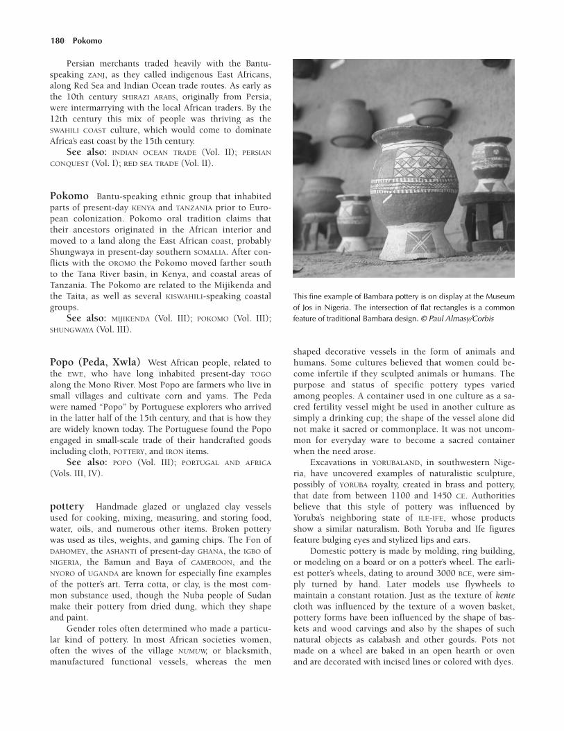
180 Pokomo
Persian merchants traded heavily with the Bantu-speaking ZANJ, as they called indigenous East Africans,along Red Sea and Indian Ocean trade routes. As early asthe 10th century SHIRAZI ARABS, originally from Persia,were intermarrying with the local African traders. By the12th century this mix of people was thriving as theSWAHILI COAST culture, which would come to dominateAfrica’s east coast by the 15th century.
See also: INDIAN OCEAN TRADE (Vol. II); PERSIAN
CONQUEST (Vol. I); RED SEA TRADE (Vol. II).
Pokomo Bantu-speaking ethnic group that inhabitedparts of present-day KENYA and TANZANIA prior to Euro-pean colonization. Pokomo oral tradition claims thattheir ancestors originated in the African interior andmoved to a land along the East African coast, probablyShungwaya in present-day southern SOMALIA. After con-flicts with the OROMO the Pokomo moved farther southto the Tana River basin, in Kenya, and coastal areas ofTanzania. The Pokomo are related to the Mijikenda andthe Taita, as well as several KISWAHILI-speaking coastalgroups.
See also: MIJIKENDA (Vol. III); POKOMO (Vol. III);SHUNGWAYA (Vol. III).
Popo (Peda, Xwla) West African people, related tothe EWE, who have long inhabited present-day TOGO
along the Mono River. Most Popo are farmers who live insmall villages and cultivate corn and yams. The Pedawere named “Popo” by Portuguese explorers who arrivedin the latter half of the 15th century, and that is how theyare widely known today. The Portuguese found the Popoengaged in small-scale trade of their handcrafted goodsincluding cloth, POTTERY, and IRON items.
See also: POPO (Vol. III); PORTUGAL AND AFRICA
(Vols. III, IV).
pottery Handmade glazed or unglazed clay vesselsused for cooking, mixing, measuring, and storing food,water, oils, and numerous other items. Broken potterywas used as tiles, weights, and gaming chips. The Fon ofDAHOMEY, the ASHANTI of present-day GHANA, the IGBO ofNIGERIA, the Bamun and Baya of CAMEROON, and theNYORO of UGANDA are known for especially fine examplesof the potter’s art. Terra cotta, or clay, is the most com-mon substance used, though the Nuba people of Sudanmake their pottery from dried dung, which they shapeand paint.
Gender roles often determined who made a particu-lar kind of pottery. In most African societies women,often the wives of the village NUMUW, or blacksmith,manufactured functional vessels, whereas the men
shaped decorative vessels in the form of animals andhumans. Some cultures believed that women could be-come infertile if they sculpted animals or humans. Thepurpose and status of specific pottery types variedamong peoples. A container used in one culture as a sa-cred fertility vessel might be used in another culture assimply a drinking cup; the shape of the vessel alone didnot make it sacred or commonplace. It was not uncom-mon for everyday ware to become a sacred containerwhen the need arose.
Excavations in YORUBALAND, in southwestern Nige-ria, have uncovered examples of naturalistic sculpture,possibly of YORUBA royalty, created in brass and pottery,that date from between 1100 and 1450 CE. Authoritiesbelieve that this style of pottery was influenced byYoruba’s neighboring state of ILE-IFE, whose productsshow a similar naturalism. Both Yoruba and Ife figuresfeature bulging eyes and stylized lips and ears.
Domestic pottery is made by molding, ring building,or modeling on a board or on a potter’s wheel. The earli-est potter’s wheels, dating to around 3000 BCE, were sim-ply turned by hand. Later models use flywheels tomaintain a constant rotation. Just as the texture of kentecloth was influenced by the texture of a woven basket,pottery forms have been influenced by the shape of bas-kets and wood carvings and also by the shapes of suchnatural objects as calabash and other gourds. Pots notmade on a wheel are baked in an open hearth or ovenand are decorated with incised lines or colored with dyes.
This fine example of Bambara pottery is on display at the Museumof Jos in Nigeria. The intersection of flat rectangles is a commonfeature of traditional Bambara design. © Paul Almasy/Corbis

JJJJJJJJJJJJJ
Gourds provided convenient vessels to tie onto acamel and send off by caravan. Pottery in SUB-SAHA-RAN AFRICA was often made in the shape of a gourdfor this same purpose.
JJJJJJJJJJJJJ
North Africa also developed a pottery-making tradi-tion, especially in the creation of fine pottery and in themore practical production of the two-handled amphora,or jug, that was often used for transporting olive oil.Early on the olive oil trade was centered near Carthage,in southern TUNISIA, and along the northern slopes of theAurès and Bou Taleb mountains. By the fourth centuryAfrica was exporting olive oil in amphorae to all parts ofthe Roman Empire. Widespread Mediterranean trade inpottery lasted until the Islamic invasion of North Africa,in the eighth century, at which time pottery making be-came once again a mainly local craft.
During this period, North African pottery was alsomaking its way into sub-Saharan Africa, due in part to theintroduction of the camel, which made long-distancetrade more feasible. North African–made pottery thatdates back as far as the third century CE has been foundin the Niger Valley.
Some art historians find evidence of classic Greek andRoman shapes in the pottery of the BERBERS, whose two-handled jugs resemble classical amphorae. Making potteryfor domestic use was women’s work in Berber society andoften followed a prescribed ritual for the completion ofeach stage, from determining a favorable day to chooseand knead the clay to the final firing and decorating.
Islamic Pottery The Islamic cultures of the MiddleEast, especially the cities of Damascus and Baghdad arewell regarded for their sophisticated forms of pottery.Most of the major innovations in Islamic pottery origi-nated there and not in Africa. A key exception, however,was the rediscovery in ninth-century EGYPT and Iraq of atin glaze that had once been used in ancient Egypt buthad been lost for centuries. The use of this glaze, whichcreates a grayish white opaque surface, was motivated bythe growing popularity in the late eighth and early ninthcentury of imported Chinese porcelain, which was cre-ated by a process that Chinese potters kept secret. Egyp-tian and Iraqi potters used a fine white clay and the newtin glaze to create a close replica of the Chinese original.
Luster painting of pottery also originated in Egypttoward the end of the ninth or early in the 10th century.This decorative technique, first used by Egyptian glass-blowers in pre-Islamic times, uses silver and COPPER ox-ides and a second firing to lay down a very thin, shinysurface, more often than not colored ruby red. Many ex-amples of this luster-painted pottery have been found in
excavations at Bahnasa/Oxyrhynchus, in Egypt, and alsoat Samarra, near Baghdad. By the middle of the 10th cen-tury this technique added colors that ranged from yellow-ish green to golden green and added birds, animals, andeven human figures to the design. Luster painting becameeven more refined and sophisticated during the Fatimidperiod in Egypt (969–1171) and spread into Syria andNorth Africa from Egypt and Iraq.
JJJJJJJJJJJJJ
The tin glaze technique spread from Egypt toEurope by way of al-ANDALUS (Muslim Spain) in the13th century and is the basis for the fine Italianmaiolica, French faience, and Dutch delft ware ofthe 15th to 18th centuries.
JJJJJJJJJJJJJ
Other Imports Chinese ceramics and glass beadsfrom about 1050 to 1200 have been found at MAPUN-GUBWE, the predecessor of GREAT ZIMBABWE, in southernAfrica. According to written records from the time, thesegoods entered Africa as part of INDIAN OCEAN TRADE. TheARABS were also the main intermediaries between Chinaand Europe in the ceramic trade until the 16th century.They had sole control over the shipping routes along theMediterranean coast of Egypt and to Persia, India, andChina. The main port for this activity was CAIRO. The Por-tuguese would not discover these sea routes until the1600s, when they began to take over the porcelain trade.
Western and Eastern Africa Authorities believethat West African pottery traditions that began in theEarly Iron Age persisted into the Late Iron Age and eveninto the 19th century. In eastern ZAMBIA, however, thereappears to be a break in tradition, possibly associated withthe migration of Bantu-speaking peoples across the conti-nent. Pottery produced in the Lungwebungu and Luangatraditions (so-called from the rivers of the same names)frequently take the form of necked pots and shallowbowls, often with tapered rims instead of the thicker rimsand beveled lips of earlier pottery. In another break withtradition, these vessels were apparently crafted by womeninstead of men.
Pottery remnants unearthed at Gokomere Missionnear Great Zimbabwe indicate the development of an-other pottery tradition made up of stamped and groovedware. Pottery in the Gokomere tradition has been foundas far south as the LIMPOPO RIVER and dates from the thirdthrough the ninth centuries. Pottery found in an originaldig site in ZIMBABWE, called Leopard’s Kopje I, containsexamples of the Gokomere tradition. However, pottery ina different site, Leopard’s Kopje II, contains little in theGokomere tradition and instead shows stylus-made de-signs. Undecorated beakers found there represent a new
pottery 181

182 pottery
pottery. Figurines of women, domestic animals, and cattlemade from white clay figure prominently at this site,whose contents date to the 10th and 11th centuries.Enlarged buttocks and other features of the female fig-urines suggest a KHOIHKOI influence.
The SHONA people, the expert builders in stone whofounded Great Zimbabwe, have a long tradition of pro-
ducing decorative pottery, which may represent a fusionof the techniques used by both the San and Bantu-speak-ing peoples. However, the discovery at Great Zimbabweof Ming dynasty (1368–1644) pottery from China alsoindicates that Great Zimbabwe had extensive trade.
See also: POTTERY (Vol. I); SCULPTURE (Vol. I).

183
queens and queen mothers Female rulers of achiefdom, kingdom, or empire. The words queen andqueen mother do not always reflect the many characteris-tics and responsibilities of the African woman who held aprominent place in the court of a king.
Queens As in European cultures, the queen wasusually the wife of the king. (In many polygamous Africancultures, the title was given only to the first, or primary,wife of the king. The primary wife was the one who wouldbear the future king.) But she might also be the mother ofthe king, the sister of the king, or even a regent—an indi-vidual who manages a kingdom’s affairs until a young in-heritor of the throne is old enough to rule. Since Africankingdoms usually developed in patrilineal societies, wherethe older men held the positions of leadership, it was un-usual for women to assume positions of power equal tothat of a king. Still, throughout Africa there are numerousexamples of women who became powerful rulers in theirown right.
Queen GUDIT of ETHIOPIA is one of the more remark-able female figures in African history. Although the de-tails of her reign are lacking, it is known that she was acapable military commander who led her warriors to vic-tory over the Christian kingdom of AKSUM.
In such cultures as the AKAN and ASHANTI of WestAfrica, the Loango of Central Africa, and the NYORO ofUGANDA, the women related to the sitting king tradition-ally were given the status of chiefs, with all of the atten-dant responsibilities and respect associated with such aposition.
Queen Mothers The most important female in akingdom was sometimes called the “queen mother.” Thistitle, however, did not always fit the true nature of her re-
lationship to the king. In some kingdoms the womanholding the title of queen mother may have been the king’ssister, grandmother, or a respected female elder such asthe former king’s primary wife (who was not always thereigning king’s biological mother). Whatever her actualrelationship to the king, the queen mother neverthelessrepresented a strong link to the king’s royal line andtherefore was often regarded as both a sacred entity and akeeper of genealogical history.
Queen mothers held considerable power and impor-tance as they regularly served their kings and kingdomsas advisers, emissaries, and politicians. Queen mothersare prominent in the histories and lore of such diversegroups as the Akan peoples of GHANA, the TUAREGS of thearid plains of north-central Africa, and the LUBA of south-ern Central Africa.
JJJJJJJJJJJJJ
In many cases, the histories of queen mothers haverelied on oral traditions, some of which have beensubstantiated by pictorial documentation of womenfigures in both religious and royal splendor. An11th-century drawing depicts Martha, a Nubianqueen mother, dressed in royal garb and beingwatched over by the Virgin Mary.
JJJJJJJJJJJJJ
Beyond being highly regarded for their secular wis-dom, queen mothers sometimes had either a religious ormythical importance. They even held male rights and au-thority to confirm their chief-like status. In addition,
JJJJJJJJJJJJJJQ
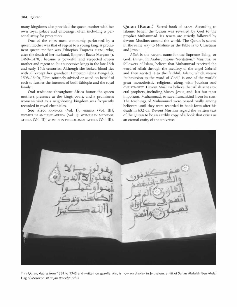
184 Quran
many kingdoms also provided the queen mother with herown royal palace and entourage, often including a per-sonal army for protection.
One of the roles most commonly performed by aqueen mother was that of regent to a young king. A promi-nent queen mother was Ethiopia’s Empress ELENI, who,after the death of her husband, Emperor Baeda Maryam (r.1468–1478), became a powerful and respected queenmother and regent to four successive kings in the late 15thand early 16th centuries. Although she lacked blood tieswith all except her grandson, Emperor Lebna Dengel (r.1508–1540), Eleni routinely advised or acted on behalf ofeach to further the interests of both Ethiopia and the royalfamily.
Oral traditions throughout Africa honor the queenmother’s presence at the king’s court, and a prominentwoman’s visit to a neighboring kingdom was frequentlyrecorded in royal chronicles.
See also: KANDAKE (Vol. I); MERINA (Vol. III);WOMEN IN ANCIENT AFRICA (Vol. I); WOMEN IN MEDIEVAL
AFRICA (Vol. II); WOMEN IN PRECOLONIAL AFRICA (Vol. III).
Quran (Koran) Sacred book of ISLAM. According toIslamic belief, the Quran was revealed by God to theprophet Muhammad. Its tenets are strictly followed bydevout Muslims around the world. The Quran is sacredin the same way to Muslims as the Bible is to Christiansand Jews.
Allah is the ARABIC name for the Supreme Being, orGod. Quran, in Arabic, means “recitation.” Muslims, orfollowers of Islam, believe that Muhammad received theword of Allah through the mediacy of the angel Gabrieland then recited it to the faithful. Islam, which means“submission to the word of God,” is one of the world’sgreat monotheistic religions, along with Judaism andCHRISTIANITY. Devout Muslims believe that Allah sent sev-eral prophets, including Moses, Jesus, and, last but mostimportant, Muhammad, to save humankind from its sins.The teachings of Muhammad were passed orally amongbelievers until they were recorded in book form after hisdeath in 632 CE. Devout Muslims regard the written textof the Quran to be an earthly copy of a book that exists asan eternal entity of the universe.
This Quran, dating from 1334 to 1345 and written on gazelle skin, is now on display in Jerusalem, a gift of Sultan Abdulah Ben AbdalHag of Morocco. © Bojan Brecelj/Corbis

The Oral Tradition The Quran was originally in-tended to be a spoken text. According to tradition, Muham-mad, while in a heavenly trance, received the Quran fromthe angel Gabriel a few verses at a time over the years 610through 632, the year Muhammad died. Thus, the teach-ings of the Quran follow the events of his life. Each timeMuhammad awoke from his trance, he repeated Allah’srevelations in Arabic to his followers. Legend states thatscribes recorded the revelations on paper, palm-leaves,stone, or other objects that were on hand. Muhammad’sfollowers then memorized the passages and recited themto other ARABS.
Shortly after Muhammad’s death, Muslims grew con-cerned that the recited passages would be forgotten. In633, Zayd ibn Thabit, a contemporary of Muhammad,compiled a written record of the revelations. Thabitrecorded as many versions of each revelation as he couldfind. Several other versions of the Quran were compiled atthe same time, but only Thabit’s text was considered pure.A few years later Uthman, the reigning caliph, askedThabit to edit his version of the Quran. The official versioncame about from Thabit’s efforts to verify his documentagainst those of oral scribes as well as other versions of thewritten text. Thus the Quran is the earliest existing workof Arabic literature.
Reverence for the Quran Understood to be theauthoritative word of Allah, the Quran serves as the codeof ethics for Islamic life and the highest authority inIslamic law. Believers firmly adhere to its teachings andtreat the book itself with reverence. Muslims never carryit below the waist and always purify their hands beforetouching it. The Arabic text of the Quran is consideredsacred and non-translatable because it is the direct Wordof God. Almost all Muslims, even the illiterate, memorizeat least portions of the text, and often the complete text.The proper recitation of the Quran is considered an art.The Quran remains the most widely circulated book in itsoriginal language. Muslims began to translate the Quraninto other languages in the early twentieth century.
The passages in the Quran prescribe a Muslim’s reli-gious, social, and commercial commitments. It requiresdaily prayers, urges the practice of charity and brotherlylove, and teaches that Muslims must be humble in spirit,temperate, and just. Upon death all people face finaljudgment by Allah. Those who have lived their lives ac-cording to the Quran will live in eternal paradise, butthose who have sinned will suffer.
The Structure and Language of the Quran Thebody of the Quran is divided into 114 chapters, or surahs.The first chapter is a prayer ( fatihah). The remaining chap-ters are revelations from the oral tradition. Chapters varywidely in length and content. Some chapters deal with onesubject, while others address several topics. The text fol-lows a rough chronology in that longer chapters corre-sponding to events that took place late in Muhammad’s life
are generally found at the end of the book. Each chapterincludes a title, which may not be directly related to thesubject of the text, and an indication of where the revela-tions occurred, usually the cities of MECCA and MEDINA.Each chapter also contains a traditional prayer, or bas-malah. During the holy month of RAMADAN, the chaptersare rearranged into 30 segments, to correspond with eachday of the month. A segment of the Quran is then recitedduring each day of the month.
The verses, or ayats, that make up the chapters arealso diverse in their composition. When Allah speaks, thefirst person plural form (we) is used. Verses that corre-spond with Muhammad’s early life are shorter than thosefound later. This early writing follows a form reminiscentof the rhymed prose used by ancient soothsayers, orkahins. Later chapters contain verses with a more complexsentence structures and embellished style. The versesplace emphasis on the lessons learned from an eventrather than on the narrative aspects of the revelation.
The dialect chosen for the Quran has significantly in-fluenced Arabic linguistic studies. In ancient Iraq scholarsat Basra established grammatical rules for the Arabic lan-guage based on the word structures found in the Quran.Scholars in neighboring Kufa also studied linguistic issuesin the Quran, although they were more interested in ex-ceptions to grammatical rules. The interest in the structureof the Quran has been an important means of preservingthe classic Arabic language over time.
Historical Interpretations of the Quran Severaltheological disputes have arisen regarding the content ofthe Quran. Scholarship that focuses on tafsir, or interpre-tation of the Quran, has existed for centuries. The pas-sages themselves and the literature surrounding the life ofMuhammad (Hadith) are used to illuminate meaning fromthe revelations. Historically, orthodox Muslims rejectedany interpretations that could not be supported by Hadithliterature.
Medieval tafsir focused on two important works. Thefirst, written by al-Tabari (839–923), was an encyclopedicvolume summarizing the different interpretations of theQuran. The second, and more popular, volume was theKashshaf of Zamakhshari (1075–1143), a liberal scholarfrom the Mutazilite branch of Islam. This work becamethe standard for traditional tafsir scholarship.
The different branches of Muslim thought used tafsirscholarship to support their doctrines. The Mutaziliteschallenged the idea that the Quran exists independentlyfrom Allah. Relying on logical arguments borrowed fromGreek philosophy to support their theory, the Mutazilitespropounded the belief that Allah in fact created theQuran, arguing that, if the Quran is independent of Allah,then something eternal other than Allah exists and Allahcould not be the sole God of eternity. Thus Allah musthave created the Quran, or his power as the single rulerof eternity would be challenged. Orthodox Muslims re-
Quran 185

186 Quran
ject the Mutazilite view in favor of the traditional ideathat the Quran itself is eternal.
By the 19th century the revival of ancient interpreta-tions of the Quran had replaced the more radical views.The modernists revived ancient texts in a quest to revealan untainted Islamic faith. They also sought to link mod-ern SCIENCE with the ancient teachings of the Quran. Tothat end, some passages were loosely interpreted to fitwith popular notions of humanity, science, and culture.
The Quran and Muslim Law The Quran, Allah’srevelation to Muhammad, lies at the center of Islam. Hismessage was delivered to Muhammad by the angel Gabriel.Since Allah is the author of the Quran, its language is con-sidered perfect. For this reason, believers read and learnthe Quran in the original Arabic. In simple terms, theQuran is a set of rules that governs humankind. As a re-sult, in Islam, there traditionally is no differentiation be-tween church and state; RELIGION and social membershipare one and the same. Therefore, Islamic law consists ofboth legal and moral mandates.
Islamic law, sometimes called SHARIA, is derived fromseveral sources. The primary source is the Quran. A secondsource, called the Sunna, consists of rules of conduct set bythe prophet Muhammad and complements the Quran.Because the Sunna was transmitted orally and not writtendown until the ninth century, it is not considered infallible.The values set forth in the Quran and the Sunna, though,are considered to be Allah’s will and are to be strictly ad-hered to in all aspects of a Muslim’s life—religious, social,economic, and political.
Stating that humans are the noblest of Allah’s crea-tures, the Quran sees the purpose of humanity in servingAllah and reforming the earth into an ethical social sys-tem devoid of evil. However the Quran also criticizes hu-mans for being proud, petty, closed-minded, andself-centered creatures that will, by their nature, prevent
good from spreading to others. The Quran instructs hu-mans to overcome this pettiness, as Allah promises pros-perity to those generous to the less fortunate.
Humanity’s biggest sin, according to the Quran, is itsoverwhelming pride. By not recognizing the limitationsset for them by Allah, humans become guilty of position-ing themselves alongside God. In general, the Quran sug-gests, humanity only turns to Allah for help when theuniverse has failed it. This attitude violates the most sa-cred tenet of Islam, that God is one, with no partner andno equal. Only by transcending this petty behavior, there-fore, can people develop taqwa, the internal ability to dis-tinguish right from wrong. Humans possess free will, soIslamic practice does not simply involve obeying Allahbut rather accepting the deity’s mandates, which are trans-mitted through the prophets who show all creatures the“straight path.”
Islam recognizes prophets from the Hebrew scrip-tures and the New Testament, as well as some extra-bib-lical characters. As a result, Muhammad is seen as theculmination of a long line of prophecy. He is, however,clearly the most important prophet, as his message fromAllah resulted in the Quran. Prophets, even Muhammad,are considered to be human, but they are the most per-fect examples of humanity. Holding no place in divinity,each prophet’s message is believed to have been sentfrom the same divine source, Allah. Therefore, one mustbelieve in the message of every prophet because to rejectone is to deny the truth of Allah. The messages of theprophets guide individuals in their struggle to follow thewill of Allah.
See also: GOVERNMENT, SYSTEMS OF (Vol. II); ISLAM,INFLUENCE OF (Vols. II, III, IV, V); ISLAMIC CENTERS OF
LEARNING (Vol. II); LAW AND JUSTICE (Vol. II).Further reading: Thomas Wyatt, ed., and N.J. Da-
wood, trans., The Koran (New York: Penguin, 1990).

187
Ramadan Ninth month of the Muslim calendar; be-lieved to be the month during which the QURAN wassent down from heaven as a guide for Muslims to gainsalvation. People across the Islamic world fast duringthe entire month of Ramadan, concentrating on theirfaith and spending less time concerned with their every-day lives.
During Ramadan, Muslims follow strict restraints asthey fast. They do not eat or drink during daylight hours,and physical pleasures such as smoking and sexual rela-tions are also forbidden. Many Muslims also go to themosque and pray for several hours. At the end of the daythe fast is broken with a prayer, and the severe restrictionsare lifted until the following dawn. It is customary forMuslims to visit with family and friends when they arenot fasting. The Fast of Ramadan ends with a three-daycelebration during which gifts are exchanged and familiesgather to pray and feast.
See also: ISLAM (Vol. II); ISLAM, INFLUENCE OF (Vols.II, III, IV, V).
Rano One of the seven true HAUSA STATES (called HausaBakwai) located east of SONGHAI, between the Niger Riverand Lake Chad. Other Hausa states established in the10th through the 13th centuries under the trading empireof KANEM-BORNU included BIRAM, DAURA, KATSINA, ZAZ-ZAU, KANO, and GOBIR.
Rano and Kano were dubbed the “chiefs of indigo” be-cause the great plains of these states were conducive to themass production of COTTON, which was woven and dyedbefore being exported to the other Hausa kingdoms, aswell as to many lands beyond.
Red Sea trade Arab-dominated transport of captives,salt, GOLD, IVORY, and other goods via the Red Sea to andfrom Arabia and Asia. Beginning in the eighth centuryMuslim ARABS engaged extensively in Red Sea trade. Theyarrived in North Africa eager to spread Islamic doctrineand to sell and procure captives for forced LABOR. Salt,gold, and ivory were also traded, but the demand for cap-tives outpaced those goods. Female captives usually be-came concubines and servants in Arabia.
Captives were procured from Asia, Europe, the NileValley, the Horn of Africa, and from the East African coastby local kings who raided neighboring villages and by pi-rates on the high seas. In Africa, captives were sold to bro-kers at local market towns in exchange for COTTON, spices,perfumes, and horses. From market towns the captivestraveled on foot across the savanna to the coast. Personskidnapped at sea were brought to trading ports. When cap-tives arrived at such Red Sea ports as ADULIS, MASSAWA, andSuakin, they were put up for sale there. Captives were alsoshipped across the Red Sea to the Arabian Peninsula andAsia. Red Sea trade reached its height from the 12th to16th centuries.
See also: ARAB COASTAL TRADE (Vol. II); INDIAN
OCEAN TRADE (Vol. II); PERSIAN TRADERS (Vol. II); SALT
TRADE (Vol. II); SLAVERY (Vol. II); SUAKIN (Vol. III).
religion Between the fifth and 15th centuries, African re-ligious practices continued with few major changes inmany parts of the continent, especially south of the Sahara.In cultures that practiced traditional religions, elders andritual specialists, including priests, oracles, medicine men,and prophets, continued time-honored rituals in their at-
JJJJJJJJJJJJJJJJJ R

188 Río de Oro
tempts to engage with and understand the supernaturalworld. The values and knowledge associated with the rit-uals of traditional religions gradually evolved, however,as they were passed down from generation to generation.
During the first half of the first millennium, in parts ofNorth Africa and in the interior regions along the Red Seacoast, the monotheistic religion of CHRISTIANITY began tospread. By the beginning of the sixth century, however,Christianity began to lose much of its influence in Africa.The various heads of the Eastern churches had previouslydeferred to Rome’s authority. Beginning in the fifth century,however, numerous disputes among Church leaders re-sulted in schisms that led to the founding of such indepen-dent sects as COPTIC CHRISTIANITY and the OrthodoxChurch in ETHIOPIA.
Not long after, the first converts to ISLAM began mov-ing westward from the Arabian peninsula into NorthAfrica. With military backing and an agenda to drive non-believers from the territory, these Arabic-speakingMuslims moved swiftly, conquering lands and gainingconverts as they went. Islam was used as a unifying forceby the Arab UMAYYAD (661–750), FATAMID (909–1171),and Ayyubid (1171–1250) dynasties, all of which ruledover vast regions of North Africa. Other powerful, mili-tant North African dynasties, including the ALMORAVIDS
(1062–1140) and the ALMOHADS (1140–1269), called forwidespread JIHAD to force conquered people to convert toIslam. Their jihads were waged in North Africa and as farnorth as present-day Spain, across the Mediterranean Sea.
JJJJJJJJJJJJJ
Between 1095 and 1291, European Christian sol-diers waged the CRUSADES against Muslim forces.This succession of military expeditions to the MiddleEast had little effect on the history of Africa.
JJJJJJJJJJJJJ
During the same period, in contrast to the strict, mili-tant Islam encouraged by the leaders of Almoravid andAlmohad dynasties, a more personalized and mystical formof Islam, SUFISM, became popular in North Africa. In largepart, African converts were more open to Sufism becauseof its tolerance of syncretism, or the combination of newand old beliefs. For the same reason, Sufism found numer-ous converts in sub-Saharan Africa, as well. Sufis often or-ganized into brotherhoods that were led by revered holymen, whose moral authority and wise judgment earnedthem a loyal following.
By the middle of the eighth century Islam was makinginroads into areas south of the Sahara, beginning withinareas of present-day SENEGAL and MAURITANIA. In the fol-lowing centuries, Arab Muslim traders won many convertsamong West African peoples, such as the SONINKE, who
previously practiced traditional religion. In many cases,conversion to Islam was required in order to participate inthe lucrative trade of GOLD and the equally important SALT
TRADE. Islam also brought with it a respect for literacy andeducation, since the religion is accessed through the read-ing of the QURAN, the Muslim holy book.
Islam was connected with trade in East Africa, aswell. Muslim Arab merchants won many converts amongindigenous Africans in the port cities along the SWAHILI
COAST. Arab traders also married into African families andbegan converting communities from within.
In the 12th and 13th centuries Christian missionariesbegan spreading their teachings southward from Ethiopia.This was a slow process, however, primarily because of thedominance of Islam along the Indian Ocean coast. Towardthe end of the 15th century the arrival of European mer-chants on the shores of southern Africa presaged the ar-rival of European Christian missionaries, who later had aprofound effect on Africa.
See also: AROCHUKWU ORACLE (Vol. II); BABALAWO
(Vol. II); CHRISTIANITY, INFLUENCE OF (Vols. I, III, IV, V);DIVINE RULE (Vols. I, II); ISLAM, INFLUENCE OF (Vols. I, III,IV, V); NINE SAINTS (Vol. II); RELIGION (Vols. I, III, IV, V);RELIGION, TRADITIONAL (Vol. I).
Río de Oro Berber trade region in present-day WESTERN
SAHARA, situated between Cape Blanco and Cape Bojador.Due to its unsuitable climate for AGRICULTURE, the area de-veloped into a thriving marketplace in which Berber MER-CHANTS sold GOLD dust to Portuguese traders. The firstPortuguese ships passed Cape Bojador in 1434, and Río deOro in 1436.
See also: BERBERS (Vol. II); HENRY THE NAVIGATOR,PRINCE (Vol. II); PORTUGAL AND AFRICA (Vol. III); SPAIN
AND AFRICA (Vols. III, IV, V).
al-Roha See LALIBELA, TOWN OF.
Rumfa, Sarki (Muhammad Rumfa) (r. 1463–1499)Ruler of the Hausa state of Kano
During his long reign Sarki Rumfa made ISLAM the of-ficial religion of KANO, one of the seven “original” HAUSA
STATES. Islam had already been practiced in Kano beforeMuhammad Rumfa became SARKI, or local ruler, in about1463, but under his rule Muslim scholars became part ofthe government and ARABIC writing was again practiced.Sometimes force was used to ensure that the laws ofIslam were followed. Even though Sarki Rumfa was a de-vout Muslim, he may have practiced some traditional rit-uals. This type of Islam, in which some traditional ritualswere still practiced along with orthodox Muslim prac-tices, was typical throughout Hausaland and other areas

Rwanda 189
of Africa at this time. Compromise in religious matterswas often necessary to maintain the sarki’s power andkeep nonbelievers from rebelling. To strengthen his au-thority, Sarki Rumfa made marriage alliances with influen-tial non-Muslim subjects.
Sarki Rumfa considered himself caliph, a title that pro-claimed him both the political and the Muslim spiritualleader of Kano. The most famous of scholars that SarkiRumfa embraced in his kingdom was the fiery al-MAGHILI,adviser to several rulers in the SUDAN. This Muslim re-former set about to firmly establish Islamic practices andlaw in Kano, and he established Muslim courts and recom-mended Muslim judges for appointment. Sarki Rumfa’s re-quest that al-Maghili write about Islamic governmentprompted the famous book, Obligation of the Princes. Al-Maghili was a believer in JIHAD, or holy war, even againstother Muslims if they practiced Islam half-heartedly.
Sarki Rumfa was one of the most important rulers ofKano. Trade flourished under his rule, and to ensure thatKano would continue to prosper from its trans-Saharantrade, Muhammad Rumfa began a war with the competingkingdom of KATSINA. He also established the Kurmi market.
Rwanda Country in eastern Central Africa measuring9,600 square miles (24,900 sq km) that borders on theDemocratic Republic of the CONGO to the west, TANZANIA
to the east, BURUNDI to the south, and UGANDA to thenorth. Located south of the equator, its capital and largestcity is KIGALI.
The TWA, who make up one percent of the contem-porary population, were the first to inhabit Rwanda. Theywere displaced by the HUTU, Bantu-speaking migrantswho arrived about 1000 CE. However, in the 14th or 15thcentury another group, the TUTSI, migrated into the areaand gained dominance over the Hutu. Initially they estab-lished several states, but by the 18th century a singleTutsi-ruled state occupied most of present-day Rwanda.The Tutsi, who were cattle herders, constituted a minor-ity while the Hutu, who were farmers, made up the ma-jority. However, the ownership of cattle and the Tutsi’sprowess as warriors put them at a higher position in thesocial hierarchy.
See also: RWANDA (Vols. I, III, IV, V).

190
Sabbatarians In ETHIOPIA , a dissident group of 14th-century monks whose ideology challenged the imperialauthority of church and state. Headed by Abba, or Father,Ewostatewos (c. 1273–1352), the monks adopted a criti-cal stand against the moral attitudes of state rulers andchurch officials. Chief among their grievances was the en-slavement and sale of men, women, and children toArabian, Sudanese, and Egyptian traders. They also advo-cated a return to the tenets of the Bible, insisting on ob-serving Saturday as the traditional day of Sabbath.
The Sabbatarians’ refusal to accept financial offeringsor to pay tribute to the state incurred the wrath of offi-cials from both church and state. Ewostatewos and hisfollowers were subsequently barred from church andstate positions, and eventually they were driven fromtheir towns. Isolated in the northeastern region encom-passing the highlands of ERITREA, they created numerouscommunities in which they practiced their principlesthrough missionary work. They built their own churchesand won many converts. The best-known of their monas-teries was Debre Bizen. Ewostatewos, who reportedlytraveled to the Middle East, achieved sainthood upon hisdeath, which occurred in Armenia.
The strength and prosperity of the Sabbatarian move-ment attracted the attention of state officials again, in1400. Brought to court by Emperor Dawit I (1380–1412),their new leader voiced the group’s refusal to conform tostate dictates. Despite imprisonment, the Sabbatariansclung to their beliefs, which were subsequently adapted bylarge segments of the population. Forced by popular de-mand to release the dissidents in 1403, Dawit allowedthem to return to their beliefs and activities until his suc-cessor took office.
Sahara desert World’s largest desert. Parts of theSahara, such as the Libyan and the Arabian deserts, haveseparate names. The northern rim of the desert that cen-ters on modern MOROCCO, ALGERIA, TUNISIA, and some-times LIBYA, is often called the MAGHRIB (in ARABIC, “thewest”). The Maghrib encompassed much of Roman Africabesides EGYPT and was the first region of Africa to acceptISLAM during the seventh century. Sahel, meaning “bor-der,” is the Arabic-derived name for the semiarid fringe ofthe Sahara that stretches from MAURITANIA, in the west, toCHAD, in the east. Between 450 and 1450 the Sahel sawthe growth of the African empires of GHANA, MALI, andSONGHAI. The inhabitants of the Sahel are sometimescalled Sudanese, from the Arabic word meaning “black.”
At the start of the first millennium the Sahara, fromthe Arabic word for “desert,” was a wilderness of sandsparsely populated by nomads and isolated farmers whowere confined to oases on the desert’s fringe. Despite theunforgiving terrain, farmers developed agricultural tech-niques that werer well suited to the Sahara’s arid condi-tions. Oasis gardens were tended by hand hoe andirrigated with spring water or water brought to the sur-face with primitive wells. Water made possible the culti-vation at the larger oases of fruits and vegetables and anarray of grains, including wheat, barley, and millet. Figtrees and grapevines blossomed in the hard conditions,and date palms grew at nearly every oasis.
The Fifth Through the 15th Centuries In thefifth century the main inhabitants of the western Saharawere BERBERS, whose descendants are the Berber-speakingTekna people of present-day Morocco and WESTERN SA-HARA. Originally agriculturalists before they entered thedesert, the Berbers became nomadic to protect themselves
JJJJJJJJJJJJJJJJJJS

from the anarchy and strife that resulted from the fall ofRoman Africa to the Vandals in 430. By the ninth centurythe Berbers had developed a warlike reputation for theirfrequent raids on CARAVANS as well as for their ongoingfeuds with rival groups. In the 14th century Arab peopleswho had swept across North Africa from Egypt after therise of ISLAM began to settle in the Sahara. From 1400 to1700 the ARABS and the Berbers formed alliances and in-termarried. In many regions the Arabic language all butreplaced the Berber languages, and most Berber peopleswere converted to Islam. By the 18th century mostBerbers claimed Arab descent. The TUAREGS were thelargest group of Berber speakers in the desert. Theyroamed the region from the Niger bend to the Azbenhighlands in what is now NIGER.
Not until the European nations carved up Africa inthe 19th century did the western Sahara come under thecontrol of any central authority. The rule of the RomanEmpire, which ended in the fifth century, never extendedinto the desert. Only the south Moroccan BerberAlmoravid dynasty (1061–1147), which originated as areligious movement that preached Islamic puritanism,ever held power over the region. In the 11th century theALMORAVIDS conquered the western Maghrib and al-AN-DALUS (southern Spain) and ruled them for a century.
In the eastern Sahara the primary inhabitants werethe TEDA people, who are closely related in language andculture to the DAZA people, who live south of the Sahara.The Teda inhabited the Kufra Oasis in Libya and were astrong presence in the FEZZAN. They also inhabited theTibesti and the ENNEDI Mountains in the desert proper.
The sub-Saharan kingdoms of ancient Ghana and thenomadic Zaghawa people of CHAD probably had an earlystrong presence in the desert. In the east, during the 13thcentury, the KANEM-BORNU trading empire ruled the cen-tral Sahara as well as the Fezzan until 1591, when thesultan of Morocco captured TIMBUKTU.
Pastoralism and Trade The two pillars of the ECON-OMY in the desert were pastoralism and trade. The primaryanimals raised were sheep, goats, and camels. Whencamels were introduced into the desert, in the first cen-turies of the common era, regular trade became possible.Unlike most other pack animals, camels could work effi-ciently for several days without water or nourishment.Most oasis settlements were connected with the traderoutes and with the local pastoral population.
The major trade item was salt, and the Tuareg SALT
TRADE continues even to the present day. Large slabs ofsalt could be extracted from the mines at TAGHAZA (be-tween Mali and Morocco) and transported by camel tothe south, where it was exchanged for millet or otherfoodstuffs. The main products carried north along thecaravan routes were GOLD, spices, and leather. Weapons,horses, paper, and CLOTH AND TEXTILES were transportedsouth. The oases through which the caravans passed ei-
ther provided MARKETPLACES for these foreign traders orcollected tolls and tribute. The monies passed into andsupported the local economy.
See also: CAMELS (Vol. I); SAHARA DESERT (Vol. I);SUB-SAHARAN AFRICA (Vol. II); TRANS-SAHARAN TRADE
ROUTES (Vol. II); ZAGHAWA (Vol. III).Further reading: Gianni Guadalupi and Paolo No-
varesio, The Sahara Desert: From the Pyramids of Egypt tothe Mountains of Morocco (Cairo, Egypt: American Uni-versity in Cairo Press, 2003).
al-Sahili (Abu Ishaq as-Sahili Tuwajjin, AbuIshaq al-Sahili, Abu-Ishaq Ibrahim-es-Saheli)(early 14th century) Architect and poet employed by MansaMusa I of the Mali Empire
Originally from Granada, in al-ANDALUS (southernSpain), al-Sahili was brought to the MALI EMPIRE in theyear 1324 by Mansa MUSA I (r. c. 1307–1337) who was re-turning from a pilgrimage to MECCA. Al-Sahili designed amosque in the city of GAO and built another mosque anda palace in TIMBUKTU. His buildings in Mali representedan early northern, or Andalusian, influence on Africandesign and ARCHITECTURE that became apparent in thestyle of later Arabic structures from areas as diverse asMOROCCO and the SWAHILI COAST.
Saho (Shaho, Afar-Saho) Eastern Cushitic dialectand the collective name used for a number of pastoralgroups living in the desert region bordered by the RedSea, the MASSAWA escarpment, and the southern high-lands of ETHIOPIA. Saho speakers make up diverse groupsthat include the Irob people, in northeastern Tigray, andnomadic groups such as the Asaorta and Hadu. Before thespread of ISLAM in the eighth century, little was knownabout the character of Saho society except for its warlikereputation. They reportedly launched numerous attackson the Christian societies of the highlands. It has alsobeen noted that they followed an ancient tradition ofelecting their rulers based on an age-grade system.
After Islam penetrated into the Horn of Africa, theprevalence of rock salt, a much coveted trade item, at-tracted Muslim MERCHANTS to the Saho region. Saho in-habitants reportedly used camels to bring the salt up fromthe coastal region to the highlands near Massawa, whereArab merchants used these animals for the internal andexport trade markets.
The Arab merchants eventually intermarried withmembers of the Saho population, converting them to theMuslim faith. However, it appears that many Saho con-verts chose to practice SUFISM, an Islamic form of mysti-cism. An even smaller number of Saho, such as theMinifere in the southern region of ERITREA, were con-verted to CHRISTIANITY by the AMHARA.
Saho 191
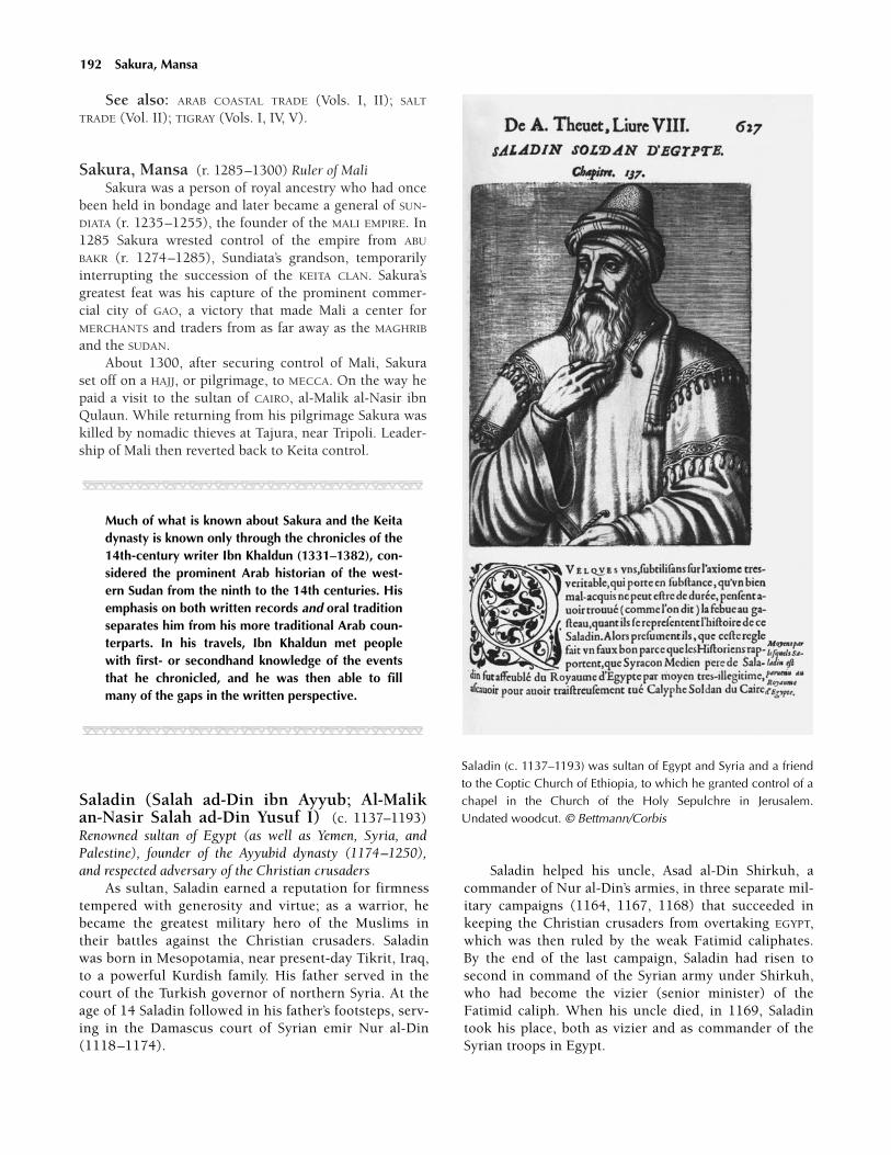
See also: ARAB COASTAL TRADE (Vols. I, II); SALT
TRADE (Vol. II); TIGRAY (Vols. I, IV, V).
Sakura, Mansa (r. 1285–1300) Ruler of Mali Sakura was a person of royal ancestry who had once
been held in bondage and later became a general of SUN-DIATA (r. 1235–1255), the founder of the MALI EMPIRE. In1285 Sakura wrested control of the empire from ABU
BAKR (r. 1274–1285), Sundiata’s grandson, temporarilyinterrupting the succession of the KEITA CLAN. Sakura’sgreatest feat was his capture of the prominent commer-cial city of GAO, a victory that made Mali a center forMERCHANTS and traders from as far away as the MAGHRIB
and the SUDAN.About 1300, after securing control of Mali, Sakura
set off on a HAJJ, or pilgrimage, to MECCA. On the way hepaid a visit to the sultan of CAIRO, al-Malik al-Nasir ibnQulaun. While returning from his pilgrimage Sakura waskilled by nomadic thieves at Tajura, near Tripoli. Leader-ship of Mali then reverted back to Keita control.
JJJJJJJJJJJJJ
Much of what is known about Sakura and the Keitadynasty is known only through the chronicles of the14th-century writer Ibn Khaldun (1331–1382), con-sidered the prominent Arab historian of the west-ern Sudan from the ninth to the 14th centuries. Hisemphasis on both written records and oral traditionseparates him from his more traditional Arab coun-terparts. In his travels, Ibn Khaldun met peoplewith first- or secondhand knowledge of the eventsthat he chronicled, and he was then able to fillmany of the gaps in the written perspective.
JJJJJJJJJJJJJ
Saladin (Salah ad-Din ibn Ayyub; Al-Malikan-Nasir Salah ad-Din Yusuf I) (c. 1137–1193)Renowned sultan of Egypt (as well as Yemen, Syria, andPalestine), founder of the Ayyubid dynasty (1174–1250),and respected adversary of the Christian crusaders
As sultan, Saladin earned a reputation for firmnesstempered with generosity and virtue; as a warrior, hebecame the greatest military hero of the Muslims intheir battles against the Christian crusaders. Saladinwas born in Mesopotamia, near present-day Tikrit, Iraq,to a powerful Kurdish family. His father served in thecourt of the Turkish governor of northern Syria. At theage of 14 Saladin followed in his father’s footsteps, serv-ing in the Damascus court of Syrian emir Nur al-Din(1118–1174).
Saladin helped his uncle, Asad al-Din Shirkuh, acommander of Nur al-Din’s armies, in three separate mil-itary campaigns (1164, 1167, 1168) that succeeded inkeeping the Christian crusaders from overtaking EGYPT,which was then ruled by the weak Fatimid caliphates.By the end of the last campaign, Saladin had risen tosecond in command of the Syrian army under Shirkuh,who had become the vizier (senior minister) of theFatimid caliph. When his uncle died, in 1169, Saladintook his place, both as vizier and as commander of theSyrian troops in Egypt.
192 Sakura, Mansa
Saladin (c. 1137–1193) was sultan of Egypt and Syria and a friendto the Coptic Church of Ethiopia, to which he granted control of achapel in the Church of the Holy Sepulchre in Jerusalem.Undated woodcut. © Bettmann/Corbis

As vizier, Saladin quickly placed fellow Kurds in po-sitions of power and reorganized Egypt’s military forces.By 1171 he had seized power in Egypt from the Fatimidcaliphate in the name of the emir. When Nur al-Din died,in 1174, Saladin claimed the throne of Egypt for himself.
As sultan, Saladin founded the Ayyubid dynasty,using his military forces to seize control of Syria (leftleaderless at the death of Nur al-Din), conquer Yemen,and expand his empire westward as far as present-dayTUNISIA. He used both diplomacy and military strength inan attempt to unite all Muslim territories in Egypt,Palestine, Syria, and northern Mesopotamia.
An ardent student of Sunni Muslim theology in hisyounger days, Saladin (whose full name means “righ-teousness of the faith, Joseph, son of Job”) restored thesupremacy of the Sunni faith throughout his realm.Devoted to the cause of spreading and strengtheningSunni Islam, Saladin waged a JIHAD, or holy war, againstthe Christian crusaders who had invaded and conqueredparts of the Holy Land.
Saladin set out to capture the Latin kingdom ofJerusalem, which had been occupied by Frankish (Latin-Christian) crusaders since 1099, and to drive the cru-saders from Africa. To accomplish this end, Saladin firstseized Aleppo, Syria, in 1183, and Mosul, Iraq, in 1186.He then consolidated his growing kingdom by capturingmany cities from Muslim rivals.
On July 4, 1187, Saladin led Muslim forces in crush-ing an army of Christian crusaders in a furious battle atHattin, in northern Palestine. By year’s end he had alsoretaken the city of Jerusalem—which Muslims, who callit Bayt Quds (the House of Holiness) regarded as holy be-cause Muhammad stopped there on his journey toHeaven—as well as most of the cities of the Latin king-dom of Jerusalem. His failure to recapture the coastalfortress of Tyre, however, gave the crusaders both a refugeand a base from which to launch the Third Crusade(1189–1192).
In 1189 King Richard I (the Lion-Hearted) of Eng-land led the Christian armies in their attempt to recap-ture Jerusalem from the Muslims (whom the Europeanscalled Saracens). The two opposing leaders admired eachother for their gallantry and mercy as well as their skill inbattle and mastery of their troops. Saladin’s armies pre-vailed, limiting Richard’s crusaders to the conquest of thefortress of Acre, in 1191. A year later Saladin negotiatedan end to the battles. The armistice agreement, known asthe Peace of Ramla, conceded to the Christians only asmall strip of land on the coast between Tyre and Jaffa.Muslims retained control of Jerusalem.
His battles won, Saladin returned to Damascus,where he died less than six months later. With his deaththe Ayyubid dynasty became fractured and factionalizedyet continued to rule Egypt until 1250.
See also: ISLAM, INFLUENCE OF (Vol. II).
Further reading: Yaacov Lev, Saladin in Egypt(Boston, Mass.: Brill, 1998); Geoffrey Regan, Lionhearts:Saladin, Richard I, and the Era of the Third Crusade (NewYork: Walker, 1999).
salt mining Process of excavating salt from the earthor collecting it from surface deposits. As far back as thebeginning of the 10th century the mining of salt was amajor factor in the African ECONOMY. The earliest knownsalt mine was at Idjil, in present-day MAURITANIA, whichwas worked from the 10th to the 15th centuries. Anotherproductive mine was at TAGHAZA, in the SAHARA DESERT,near MOROCCO. Taghaza served as the main source of saltin western Africa from before the 15th century until itwas destroyed in the 16th century and replaced by themines at nearby Taghza al Ghizlan. Other important salt-mining areas in Africa were the Kisama region of present-day ANGOLA, in southern Africa, and the AFAR region ofpresent-day SOMALIA, in the Horn of Africa.
In Taghaza, salt was prepared for the market by cut-ting it into large 200-pound (90.7 kg) blocks that werestored 10 to 15 feet (3 to 4.5 m) below the surface untilthey were shipped. Blocks were then taken from the mine,packed two per camel, and sent to TIMBUKTU or someother major trade and distribution center. Once there thesalt was dispersed throughout western Africa.
The conditions for the workers in Taghaza were terri-ble by any standard. As reported by Arab traveler IBN BAT-TUTA in 1353, the mine was controlled by the farba musa,or king, of the Berber Massufa people, and it was workedsolely by people who labored only for his profit. LocalFOOD supplies were scarce, and provisions such as camelmeat, millet, and dates all were brought from elsewhere.In contrast to food, salt was so abundant that both thelocal mosque and the workers’ living quarters were madefrom rock salt.
By the end of the 15th century, after being the mainsource of salt in the trans-Saharan economy for nearly500 years, the salt of Taghaza was virtually depleted. Thesize of the bars and the quality of the salt they containedhad diminished. Salt was being shipped in bars half theweight of those 150 years before, and they were thin andprone to falling apart.
Kisama, in northern Angola, was the major salt minein southern Africa. In the 15th century Europeans com-mented on how the miners excavated the salt and thencarefully packed it into blocks that measured about 23-inches (60-cm) wide. From there the blocks were takenup the Kwanza River, where they were sold or distributedthroughout the CONGO BASIN.
The Afar region, in Somalia, became the dominantcenter of salt production in northeastern Africa. A volcaniceruption 2,000 years earlier had cut off a section of theocean, turning it into a saltwater lake. This area, which
salt mining 193
eventually became the Danakil salt pans, spanned morethan 100 miles (161 km) and lay 37 feet (60 m) belowthe sea. Every year the pans filled with rainwater. Minerswould then break and mold the deposits into bars 7inches (18 cm) in length. Other deposits were mined inshallow ditches.
The Uvinza salt pans in what is today TANZANIA werea major source of salt in eastern Africa for 1,500 years.Ugogo, in central Tanzania, was another source of salt,but its product was inferior to that of Uvinza.
See also: KISAMA (Vol. III); SALT (Vol. I); SALT TRADE
(Vol. II); SLAVERY (Vol. II).
salt trade Salt, along with GOLD, slaves, and horses,was a major commodity in trans-Saharan and intra-African trade. The main sources of salt in western Africawere the mines at Idjil, in MAURITANIA, and at TAGHAZA, inthe SAHARA DESERT, near the Moroccan border. In south-ern Africa, in what is now ANGOLA, the salt market atKabaso, which was adjacent to the salt mines at Kisama,grew into a major commercial center. A fourth major cen-ter, with profits going to the local Aksumite rulers asearly as the 12th century, was the Danakil salt pans in theAFAR region of SOMALIA, in the Horn of Africa.
Salt was valued for health reasons (the body must re-place the salt it loses in perspiration) and was needed toflavor and preserve FOOD. The salt trade existed on bothlocal and long-distance levels. Farmers obtained the saltthey needed locally, but this salt was often of poor quality.Better-quality salt, if locally available, was transported tonearby markets, where it was bartered for other products.The best-quality salt, desired by the wealthy, was the rocksalt mined at the larger production centers, such as Idjiland Taghaza; bars of this salt were strong enough to betransported by CARAVANS across long distances. By con-trast, sea salt obtained by solar evaporation in placesalong the Atlantic coast did not travel well in the humidclimate of West Africa.
JJJJJJJJJJJJJ
The Arab traveler Leo Africanus (1485–1554) re-ported that the best salt was often bought for itsequivalent weight in gold.
JJJJJJJJJJJJJ
By 1000 CE four major TRANS-SAHARAN TRADE ROUTES
had been established. The first two trade routes were inwestern Africa and were monopolies under the control ofthe rulers of the GHANA EMPIRE and its successor states,the MALI EMPIRE and the SONGHAI Empire. Both traderoutes began in SIJILMASA in MOROCCO. One led to Taghazaand then to AUDAGHOST; the other went south to TIM-
BUKTU and GAO. Another heavily traveled trade routepassed through the FEZZAN, connecting TUNIS and Tripoliwith the HAUSA STATES and BORNU. A less-frequented routelinked West and Central Africa to the Nile Valley. In re-turn for salt, the kingdoms of West Africa sent Malaguettapepper, acacia gum, kola nuts (prized for their caffeinecontent), leather goods, cloth from Hausaland, and slavesdestined for the Mediterranean and Arabian markets.Cargoes were taxed en route and at both ends of the jour-ney. Still, despite the cost of transport and the risk of theloss of caravans to bandits, the trade was immensely prof-itable, with a value estimated at several hundred thousandounces of gold annually.
Rock salt from Kisama in northern Angola waswidely distributed throughout the CONGO BASIN, withtraders journeying nearly a month to obtain it. The saltwas carried overland and by canoe from the Kisamamines to the town of Kabaso along the Kwanza River onits route to market. The land along this river was tradi-tionally ruled by the MBUNDU people.
Salt from Uvinza, in present-day TANZANIA, was tradedwithin an area extending from the southern end of LakeNyanza to the southern end of Lake TANGANYIKA and fromthe eastern Congo to the Ruaha Valley.
See also: KISAMA (Vol. III); SALT (Vol. I); SALT MIN-ING (Vol. II).
Sanga Town in Central Africa located along the LUAL-ABA RIVER, in what is today the Democratic Republic ofthe CONGO. It is significant for its necropolis, or burialground, built by an Early Iron Age civilization, otherwiseunknown, that thrived there from around 800 to 1000 CE.Excavations at Sanga suggest that the people who inhab-ited the area practiced hunting, fishing, and farming.AGRICULTURE flourished due to the richness of the landand climatic conditions that were ideal for the cultivationof sorghum, millet, oil palms, and bananas. The peoplehad established IRON smelting by around 1000 CE, andthis development had a profound impact on agriculturalpractices. In turn, surplus crop production enabled thepeople of Sanga to seek profit through trade.
The CRAFTSPEOPLE of Sanga were accomplishedironsmiths, creating items like needles, bells, and tools,but their greatest advances were made in copper-smithing. COPPER was purchased from local traders inexchange for grains, fish, salt, palm oil, and other re-gional products. Also, after the farming season was over,Sanga craftspeople themselves would set out with largecontingents of workers to seek copper ore. Much ofwhat they brought back to Sanga was used to beautifyand honor the bodies of the deceased. Corpses wereadorned with bracelets and anklets fashioned from fi-brous copper wiring, and necklaces were fashioned frombeads and thicker wiring. Rings, pendants, and shells
194 salt trade

were also common funerary items. Recent excavationsat Sanga unearthed vast accumulations of copper buriedalongside the tombs, which suggests that the metal wascollected for commercial purposes as well as for funeralpractices.
See also: IRON AGE (Vol. I).
Sanhaja Berbers Nomadic peoples of western NorthAfrica. During the eighth and ninth centuries ARABS re-ferred to the inhabitants of the western Sahara as Anbiya,but that name was changed in the 10th century toSanhaja. The Sanhaja were known to wear veils over theirfaces and loose-fitting, flowing garments. They producedno crops, choosing to live on wild dates and various camelproducts, moving frequently and becoming masters of thewestern Sahara’s harsh environment.
Though the Sanhaja were not traders, they becamepowerful by controlling TRANS-SAHARAN TRADE ROUTES
and commercial centers, collecting taxes and tributes,and acting as paid guides and sentinels. During the 10thcentury the chiefs of the Sanhaja Berbers became one ofthe most powerful Saharan rulers. His title was “Sanhajaof the AUDAGHOST,” but there is little evidence to indicatethat he was ever a permanent resident of that Sudanictrade center. It is more likely that he governed the regionfrom a desert camp north of Audaghost proper.
Sanhaja chiefs maintained diplomatic and trade rela-tions with the rulers of the GHANA EMPIRE. Because hecontrolled the SALT TRADE, the Sanhaja ruler held theupper hand in these relationships. His power was recog-nized both near and abroad, and virtually all the leadersof the western SUDAN paid heavy taxes to him.
JJJJJJJJJJJJJ
The Sanhaja rulers were so influential that theycould determine the balance of power in the west-ern Sudan. According to one story, a Sanhaja chiefhelped decide the outcome of a dispute betweentwo Ghanaian provinces, Masin and Awgham. Thechief supplied Masin with more than 50,000 camels,allowing the Masin to overwhelm the unsuspectingAwgham.
JJJJJJJJJJJJJ
By the middle of the 10th century the Sanhaja main-tained a heavy political and military presence in Ghana.Despite their influence, though, the people of Audaghostfavored the ruler of the Ghana Empire, indicating, per-haps, a shift in regional power. Details regarding this pe-riod remain uncertain and highly debated.
The Sanhaja Berbers were made up of two powerfulgroups, the Juddala and the Lamtuna. The two formed a
union, possibly through intermarriage, that eventually splitwhen the Juddala fell out with the teachings of the Mus-lim cleric ABD ALLA IBN YASIN (d. c. 1059). Following a pe-riod of 120 years of infighting and discord between theJuddala and the Lamtuna groups, a new leader, Muham-mad Tarashna al-Lamtuna, emerged. When he died, hisin-law (sihr), Yahya ibn Ibrahim, of the Juddala, becamethe new Sanhaja leader.
JJJJJJJJJJJJJ
The history of the Sanhaja in the western Sudan israther incomplete. The Arab historian al-BAKRI (c.1094), who documented many of the events in theregion during the 10th and 11th centuries, had fewdetails of the situation regarding Audaghost’s shiftto the Ghana Empire. In the 14th century the Arabhistorian ibn Abi Zar collaborated with Ibn Khal-dun on a history of the western Sahara during theeighth through the 11th centuries. Their historywas considered the definitive version until recently,but modern scholars now dismiss Abi Zar’s historyas revisionist.
JJJJJJJJJJJJJ
Prior to the close of the ninth century there was noevidence of either ISLAM or rule of law being practiced bythe Sanhaja. Muslim traders in the MAGHRIB broughtIslam to the region in the mid-10th century. The Sanhajachief Muhammad Tarashna was probably the first to con-vert, and became known as an emir, the name for aMuslim ruler, rather than simply a chief.
Muhammad Tarashna was highly regarded for hisparticipation in a JIHAD and for carrying out a HAJJ, or pil-grimage, to MECCA. A succession of devout Sanhaja emirs,including Umar, his son Yahya ibn Umar, and Abu Bakrall followed the example of Muhammad Tarashna.
Yahya ibn Umar was the emir who brought the de-vout Islamic holy man Abd Alla ibn Yasin to the Sanhaja.Ibn Yasin’s teachings were popular among many of theSanhaja Berbers, but his extremist approach regardingpurity and conversion created conflict among the Juddalaelders. As a consequence ibn Yasin retreated to a Muslimmonastery, where he founded the Almoravid movement.When ibn Yasin returned to secular society, he foundsympathizers among the Lamtuna. With the help ofYahya ibn Umar and Yahya’s brother, Abu Bakr, the AL-MORAVIDS ultimately gained control of the Sanhaja confed-eration by about the year 1056. The new movement wasfounded in the Moroccan city of MARRAKECH, north of theAtlas Mountains, which indicated that the Almoravidswere less interested in controlling the desert regions ofthe western Sudan and would concentrate instead onareas farther to the north.
Sanhaja Berbers 195

196 Santolo
The Almoravids eventually controlled much of westernNorth Africa and southern Spain, also known as al-ANDALUS, until about 1147. At that time the Zenata andMASMUDA Berbers—rivals of the Sanhaja—unified them-selves against the Almoravids. Their resistance becameknown as the Almohad movement. By 1172 the ALMOHADS
had taken control of much of the former Sanhaja Almoravidterritories, including all of al-Andalus (southern Spain).
Further reading: Michael Brett and Elizabeth Fen-tress, The Berbers (Malden, Mass.: Blackwell Pub., 1997).
Santolo City in the HAUSA STATES in northern NIGERIA.Santolo was located in a fertile area and benefited frommigration from nearby areas beset by famine, as well asfrom trade with MERCHANTS from the western SUDAN andthe SAHARA DESERT. One of the walled cities of Hausaland,Santolo managed to keep its sovereignty, unlike manycities in the area that fell to neighboring kings. As a re-sult, when ISLAM began spreading in the area in the late14th century, the city became a prime target for attack byMuslim converts. Sarki YAJI (r. 1349–1385), from the cityof KANO, southeast of Santolo, fought alongside MuslimWangarawa to subdue Santolo. Muslim accounts of thebattle depict the encounter as a holy war. Santolo’s tradi-tional RELIGION was repressed with the hope that ISLAM
would replace the ancient religion as part of the victori-ous sweep of Islam through Hausaland. Yaji’s soldiers andtheir Muslim reinforcements were successful in destroy-ing Santolo, but Islam was not as firmly established in theregion as its adherents had hoped.
Sao (So) Sudanic people who settled south of LakeChad as early as circa 500 CE. The Sao were the original in-habitants of the region that became part of the kingdom ofBORNU, around 850. According to Sao legend their ances-tors were successful elephant hunters and trans-Saharantraders. It is believed that the Sao introduced copper-smithing to the central SUDAN. Due in part to their knowl-edge of metallurgy, the Sao civilization flourished from theninth through the 15th centuries.
After the founding of Bornu (c. 850), the Sao main-tained close trading ties with the neighboring KANURI
people of KANEM. Despite the fact that they spoke differ-ent languages and practiced different religions, the twogroups coexisted relatively peacefully. Early in the 13thcentury, however, the SEFUWA dynasty mai, or king,Dunama DIBBALEMI (r. c. 1210–1248) declared an IslamicJIHAD against the Sao. During their raids, the Kanuri tookSao captives, forcing them into servitude or trading themfor horses and other goods from North Africa. By the endof the 15th century the Sao had been supplanted by theKOTOKO people, leaving an incomplete history that is in-formed mostly by oral tradition.
JJJJJJJJJJJJJ
Forge remnants and artifacts, including ornamentsmade of BRONZE, an alloy of copper and tin, indi-cate that the Sao were accomplished metalsmiths.Archaeological evidence also suggests that theyused COPPER as currency in the 14th century, in ad-dition to GOLD and cowrie shells.
JJJJJJJJJJJJJ
See also: CHAD, LAKE (Vols. I, III); KINGDOMS AND
EMPIRES (Vol. II); KINGDOMS AND EMPIRES OF THE WEST
AFRICAN SAVANNA (Vol. II).
São Tomé and Príncipe Present-day country madeup of two large islands—São Tomé and Príncipe—and anumber of smaller islets located off the coast of GABON,in the Gulf of Guinea. Measuring about 390 squaremiles (1,010 km) in all, São Tomé and Príncipe is thesmallest country in Africa. It is believed that São Toméwas uninhabited until after 1400. Portuguese MER-CHANTS were the first outsiders to visit Príncipe, late inthe 15th century.
See also: SÃO TOMÉ AND PRÍNCIPE (Vols. I, III, IV, V).
sarki Name given to the leaders of the HAUSA STATESLO-CATED in an area that is now present-day northern NIGE-RIA. Sarki is a term similar in meaning to the KANEM-BORNU mai and the SONGHAI askia. According to the sarkisystem of leadership, kings were determined by heredity.The sarki was considered sacred and was responsible forthe overall welfare of his people. He possessed absolutepower but generally shared it with a select group of offi-cials and advisers to whom he was usually related. Thesarki was at the top of the social pyramid of influence,with the village chief (sarkin gari) below him and thefamily clan (gida) at the base.
See also: ABDULLAHI BURJA (Vol. II); DAUDA, SARKI
(Vol. II); RUMFA, SARKI (Vol. II); YAJI, SARKI (Vol. II).
Saylac See ZEILA.
science Some scientific knowledge is theoretical. In tra-ditional societies, however, scientific knowledge is oftenpractical and is achieved by trial and error; it does notnecessarily require a full understanding of basic principlesin order to reach a desired result. An herbal healer, for in-stance, can effect a cure without understanding the phar-maceutical properties of the botanical items in a poulticeor a rub.

In the fifth through the 15th centuries there weretwo types of science in Africa: one based on the work ofArab and Muslim physicians and scientists in the cos-mopolitan world of Islamic culture, the other a more tra-ditional, applied science in SUB-SAHARAN AFRICA.
North Africa and Egypt The ISLAMIC CENTERS OF
LEARNING in the MAGHRIB and in such cities as TIMBUKTU
and GAO, in West Africa, tended to focus their academicattention on Islamic theology and law. The major ad-vances in physics, chemistry, MEDICINE, astronomy, math-ematics, and other areas of investigation that have givenMuslim science its deserved reputation for accomplish-ment tended to be made in other parts of the Arab world,notably at Damascus, in present-day Syria, at Baghdad, inpresent-day Iraq, at Córdoba and Toledo, in what is todaySpain, and, to a lesser extent, at CAIRO, in EGYPT. Thesecities were the sites of extensive libraries. Modern West-ern science is indebted to the work of Arab and Muslimscientists, who not only preserved the ancient Greek, Per-sian, and Hindu texts by translating them into ARABIC butalso added to them extensively. The common use of Ara-bic throughout Islamic lands made those writings anddiscoveries accessible to a broad base of peoples.
JJJJJJJJJJJJJ
Many ancient Greek scientific works were pre-served by Monophysite monasteries in Egypt andSyria, where the Greek texts had been translatedinto Syriac, in the fourth century. These texts fellinto Arab hands in the seventh century.
JJJJJJJJJJJJJ
Islamic scientific study sometimes had religious pur-poses. The QURAN praised medicine as being close to God,and the movement of the stars and planets was believed toindicate God’s will for humans. Astronomy could alsohelp determine the direction of prayer (devout Muslimsface east to MECCA when they pray) and the correct dateand time on which RAMADAN, the most sacred month inthe Muslim calendar, should begin. Mathematics wasneeded to solve problems related to the Islamic law of in-heritance. The expansion of science led, in Africa, to thefounding of important hospitals, among them, in 832, theQayrawan hospital in TUNISIA, in which female nurses fromWest Africa worked, reportedly, for the first time in Arabichistory; the al-Fusta hospital in Cairo, in 872; the Mar-rakech hospital in MOROCCO, with aqueducts that broughtin water, in 1190; and the al-Mansuri hospital, also inCairo, which reportedly served 4,000 patients a day andwas open to rich and poor alike, in 1284.
Not all who wrote in Arabic were Muslims. One ofthe most important scientists in 10th-century Africa wasthe Jewish physician Ishaq al-Israili, or Isaac Judaeus (c.
832–932), who was born in Egypt and worked in TUNIS.His treatises on fevers, simple drugs and nutrients, andurine were later translated into Latin and influencedEuropean medicine.
In the first half of the 11th century lived Ibn Yunis ofCairo, considered by some the greatest astronomer andtrigonometrician of his time. Working in Cairo at the sametime was Ibn al-Haitham, the most important physicist thatIslamic science produced. He did important work measur-ing the specific gravity of objects and calculating the speedof light. He also did research in optics. Masawaih al-Mar-dini, or Mesue the Younger (915–1015), first worked inBaghdad and then moved to Cairo, where he died at theage of 90. He wrote extensively on purgatives and emet-ics, and his textbook on pharmacy became, in Latintranslation, the standard text on pharmacy in the West.Arguably the most significant figure in African Islamicscience was Ibn el Nafis (1208–1288), head of al-MansuriHospital in Cairo and the dean of the School of Medicinethere. He made important discoveries regarding the phys-iology of the human circulatory system.
After the 12th century Islamic science in the Westbegan to stagnate and decline; in the east, it remained vig-orous into the 15th century. The reasons given for the de-cline include a religious reaction to trends perceived in thewritings of such scientists as al-Razi (1149–1209) or inthe works of Ibn Rushd (1126–1198). Known in the westas Averroës, this highly influential religious philosopherfrom MARRAKECH tried to reconcile Islamic thought withGreek philosophy and stressed reason over faith. However,ISLAM is faith-based and sees itself as being in contact withthe eternal. In this view, nature contains signs of God’swill; unearthing those signs brings a believer closer toGod. A science that is not anchored in faith seemed worth-less, if not dangerous, to pursue.
JJJJJJJJJJJJJ
The class A star Sirius, or the Dog Star, in the con-stellation Canis Major, figures strongly in DOGON
myths because its position in the sky customarilyregulated their AGRICULTURE. It is the only star towhich Dogon tradition gave a name. Although theirmyths contain astronomical data about Sirius (theexistence of an invisible companion star, Sirius-B)that they could not have gathered by naked-eye ob-servation, various explanations have been offeredto account for this fact. The most cogent is that theDogon, with a talent shared by many other tradi-tional peoples, seamlessly absorbed modern dataabout Sirius, in the form of interesting new stories,into their traditional myths because of the star’s im-portance to their people.
JJJJJJJJJJJJJ
science 197

198 Sefuwa
Sub-Saharan Africa As in most traditional regionsof the world, scientific study in sub-Saharan Africa mayhave begun with simple applications, such as the process-ing and preservation of FOOD or the brewing of palm wineand grain-based beers. The clearly visible stars, comets,and movement of planets helped to regulate agricultureand led to the widespread development of solar-based cal-endars among a diverse number of people, including theDogon, the AKAN, and the early city-states of Hausalandand BORNU. These calendars included lunar cycles, mathe-matical formulas detailing the best times for planting, thedirection of seasonal winds, and necessary periods ofseed germination.
A great deal of information concerning scientificknowledge in West Africa has come from firsthand ac-counts by Arabic travelers. The use of an astrolabe (aprimitive sextant in wide use in the Islamic world) andcompass in nautical expeditions by Arabian navigatorswas prominently mentioned. Records indicate that Chi-nese navigators were using a magnetic compass circa1000 CE, European navigators by 1187, and the ARABS by1220. It is unknown whether use of the compass devel-oped simultaneously in these places or whether it was in-troduced by one culture and transmitted to the others.
Other navigation systems were also in use. TheMANDINKA, for example, navigated the far reaches of thedesert by using the rising and setting of the Sun, thestars, and a compass as a guide. The art of navigationalong with surgery and astronomy were all taught atTimbuktu in ancient Mali, financed by the fourteenthemperor Abubakari II (1307–1311). Descriptions of hismagnificent palace include mention of numerous doctorsand other learned people within the royal court. A highvalue was apparently placed on books transported to thecourt from the Barbary Coast as well.
See also: ARABS, INFLUENCE OF (Vols. II, III) ASTRON-OMY (Vol. I); SCIENCE (Vols. I, III, IV, V).
Sefuwa (Saifawa, Sayfawa) African dynasty ofkings, known as mais, who ruled the the KANEM-BORNU
trading empire, around Lake Chad. From the ninththrough 19th centuries, the Sefuwa dominated parts ofpresent-day southern CHAD and LIBYA, northern NIGERIA
and CAMEROON, and eastern NIGER. Their roots can betraced to the Kanembu people who set up their capital atNJIMI. At the close of the 11th century ISLAM was adoptedas the state RELIGION by Mai UMME (r. 1085–1097). Aftera series of invasions by the BULALA people, in 1396 KingUmar al-IDRISI moved the Kanembu capital to BORNU, onthe southwestern shore of Lake Chad. Almost a centurylater Mai Ali Gaji chose NGAZARGAMU as his capital city.He eventually conquered the Bulala and reclaimed Njimifor the Sefuwa. The most notable of the Sefuwa kings wasMai Idris Alawma (r. c. 1570–1603). It was during his
reign that the dynasty reached the height of its militarypower and economic prosperity.
See also: CHAD, LAKE (Vols. I, III); IDRIS ALAWMA
(Vol. III); SEFUWA (Vol. III).Further reading: Augustin F. C. Holl, The Diwan
Revisited: Literacy, State Formation and the Rise of KanuriDomination (AD 1200–1600) (New York: Columbia Uni-versity Press, 2000).
Sekabaka Kintu (Kebaka Kintu, Kintu) Mythicalfounder of the Bantu-speaking Kintu clans of BUGANDA.The Kintu clans migrated to the area around LakeVictoria between about 1100 and 1400. They settled inthe area to the south of Lake KYOGA and established sev-eral small kingdoms, including Buganda. It is uncertainwhether a man named Kintu actually existed, but tradi-tion holds that he was the only inhabitant of Bugandauntil Ggulu, or God, sent his daughter, Nnambi, to marryKintu and populate the region. Kintu means “first man”in the Buganda Bantu language.
Senegal Present-day country in West Africa that sharesborders with MAURITANIA, the Republic of MALI, GUINEA,and GUINEA-BISSAU, and almost completely surrounds TheGAMBIA. The SENEGAL RIVER separates it from Mauritania.Senegal is Africa’s westernmost country and covers ap-proximately 76,000 square miles (196,800 sq km). Thecountry has an Atlantic Ocean coastline that measuresabout 330 miles (531 km).
As early as the ninth century the pastoralist FULANI
and TUKULOR peoples of the TEKRUR kingdom inhabitedthe Senegal River valley. During the 10th, 11th, and 12thcenturies the Tukulor, who converted to ISLAM in the 11thcentury, became prosperous trans-Saharan traders andbroke away from the declining GHANA EMPIRE. By the endof the 13th century, though, the Tekrur state fell withinthe sphere of influence of the larger, more powerful MALI
EMPIRE.During the 1300s the WOLOF EMPIRE supplanted
Tekrur. The empire was made up of five coastal king-doms—the Wolof states of Walo, Kayor, and Baol, and theSERER kingdoms of Sine and Saloum.
The Portuguese reached Cape Verde in 1444 and ex-plored the Senegalese coast in 1445, but no formal Euro-pean settlement was built in Senegal until the Frenchopened a trading post at the mouth of the Senegal River,in 1638.
See also: SENEGAL (Vols. I, III, IV, V).
Senegal River Waterway in present-day SENEGAL thatempties into the Atlantic Ocean. In the period beforeEuropean colonization the Senegal River served as a

source of water for farming and as an avenue for trade withthe interior. As early as the 11th century, according to Arabaccounts, the river was used to transport salt from Ganjoron the coast to be exchanged for GOLD from the kingdomsupriver. Ganjor’s salt mines provided the WOLOF EMPIRE ofKayor with a consistent source of wealth.
See also: SALT TRADE (Vol. II); SENEGAL RIVER (Vol. I).
Serer Ethnic group that inhabited regions of present-day SENEGAL; also the language they speak. During the11th century the Serer migrated to their territory betweenthe Lower Senegal and the Lower Gambia rivers.
JJJJJJJJJJJJJ
Serer legends indicate that they once lived as farnorth as the valley of the SENEGAL RIVER.
JJJJJJJJJJJJJ
The Serer were agriculturalists who resisted mount-ing pressures from their more powerful neighbors—theMuslim TUKULOR, WOLOF, and MANDE—to convert toISLAM. In the 12th or 13th century the Serer formed thesmall kingdom of Sine, and by the end of the 15th cen-tury they had founded the kingdom of Saloum. BothSerer states were absorbed into the Wolof empire, whichdominated the region in the 14th and 15th centuries. TheSerer were known for their adherence to a traditional ani-mist RELIGION, and even today only a few people amongthem have converted to either Islam or CHRISTIANITY.
Seychelles Island country measuring approximately 180square miles (470 sq km) located off mainland Africa,north of MADAGASCAR and east of MOMBASA, KENYA. Victoriais the capital and largest city. The country is made up of115 islands, of which Mahe, which covers about 59 squaremiles (153 sq km), is the largest. Approximately 85 per-cent of the population lives on Mahe Island. Other majorislands are Praslin and La Digue. There are mainly twotypes of islands, granite and coral. Most of the 40 islandsare granitic with hills of up to 3,000 feet (914 m) highwhile the remaining islands are coralline. These islands areflat and have no fresh water. Most of the population liveson the granitic islands. Seychelles has well-developed coralreefs on the east coast because of the southwest tradewinds and equatorial current. The islands are home tomany plants, birds, and fish that are not found anywhereelse in the world.
Not much is known about the Seychelles before theninth century, and what little there is is contained in Arabcharts and maps. The islands first appeared, in the ninthcentury, on Arab charts, where they were known as the
“Tall Islands.” A few centuries later the ARABS referred toSeychelles as Zarin (the Sisters). A Portuguese map from1544 records them as the “Seven Sisters.”
See also: SEYCHELLES (Vols. I, III, IV, V).
Shafii Sunni doctrine One of four schools of Islamiclaw, or SHARIA. It deals with matters of faith and morals,behavior and manners, and practical daily matters. Assources of guidance and rulings, it includes the QURAN,the Sunna (the sayings of the prophet Muhammad) andqiyas (or reasoning by analogy to similar situations dur-ing the Muhammad’s lifetime). The ARABIC word fiqh(meaning “knowledge” or “understanding”) refers to thelegal rulings of Muslim scholars, based on sharia and isthe third source of guidance rulings for an observantMuslim. The science of fiqh developed when an expand-ing ISLAM had to face and resolve issues not explicitlycovered in the Quran or the Sunna. The rulings of Islamiclaw categorize actions in one of five ways: prescribed, rec-ommended, permissible, disliked, and unlawful. Furtherdistinctions exist within each category.
Two Sunni schools of law have been dominant inAfrica: the Shafii school, dominant in East Africa and theneighboring Arabian Peninsula, and the MALIKI SUNNI
DOCTRINE in North and West Africa. The Shafii school oflaw is named for its founder, Muhammad ibn Idris al-Shafii (767–819), who was a pupil of MALIK IBN ANAS (c.713–c. 795), the founder of the Maliki school. However,Shafii began to believe in the overriding authority of thetraditions from the life of the prophet and gave themequal authority with the Sunna.
See also: ISLAM, INFLUENCE OF (Vols. II, III, IV, V).
sharia Islamic law. Sharia comprises the rules by whicha Muslim society is organized and governed. It is based onwritings found in the QURAN, the Islamic holy book, aswell as the complementary texts of the Hadith and Sunna.Although these books do not specifically present codifiedlaws, Muslims believe that their sacred words present thedivine will of Allah to humanity. Because of this, the regu-lations related to personal, political, and legal conduct areall intertwined.
In a legal sense the tenets of sharia were basically de-fined by Muslim scholars within two centuries of thedeath of the Prophet Muhammad, in 632 CE. Sharia hasits roots in Arab customary law, with some features bor-rowed from Roman and Jewish law, as well. Islamic ju-risprudence, called fiqh, is divided into the interpretationof the sacred texts and the practical application of themethods discovered therein.
According to the Quran, human actions can be classi-fied under five categories: prescribed, recommended, per-missible, disliked, and unlawful. By studying the Quran
sharia 199
devout Muslims have long believed that they can developtaqwa, the innate ability to determine right from wrong.Taqwa has traditionally guided Muslims to lead lives thatfollowed the “straight path.” However, in many situationsregarding questions of law and justice, the words of theQuran have historically been open to vastly different in-terpretations.
After ISLAM took hold in parts of West Africa, it wasnot uncommon for Islamic legal regulations to run con-trary to the longer-standing customary laws of a society.In the GHANA EMPIRE (c. 800–1240), for example, shariawas seen as helpful as a guide to legal matters regardingtrade, but the Quran was generally not accepted as abso-lute authority in situations outside of that arena. WhenQuranic law disagreed with customary law—which wasoften—the arbiters of justice usually followed custom-ary law.
See also: ISLAM, INFLUENCE OF (Vols. II, III, IV, V);LAW AND JUSTICE (Vol. II); SHARIA (Vol. V).
Shiism Smaller of the two major branches of ISLAM; itsadherents are called Shiites and today represent aboutone-tenth of all believers. The majority of Muslims aremembers of the Sunni branch. Shiism is the majority faithin modern Iran and Iraq and has followers in East Africaas well as in the Middle East, India, and Pakistan.
Shiites and Sunnis differ on various religious practicesbut most especially in their belief regarding the identity ofthe proper successors of the prophet Muhammad. Histori-cally, the Shiites were the shiah, or “partisans,” of Muham-mad’s son-in-law, Ali, whose direct descendants, Shiitesbelieved, were the only ones qualified to be caliph, thetemporal and spiritual ruler of the growing Muslim em-pire. The Sunnis, on the other hand, were willing to ac-cept as caliph anyone who would rule according to theprecepts of Islamic law, regardless of lineage. The crisis ofsuccession became a major cleft in the Muslim world asearly as around 660. Another major difference betweenthe two groups is that Shiites believe that the QURAN wascreated by humans and that it is not eternal, whereas or-thodox Sunnis believe that the Quran was created by Godand thus is eternal.
A subgroup within the Shiites is called the“Twelvers.” They believe that, including Ali, 12 rightfuldescendants of Muhammad existed as religious leaders, orimams, of the people and that the twelfth imam, theHidden Imam, did not die but still exists on a metaphysi-cal plane and will return at the end of the world to begin anew era for humankind. Belief in the Hidden Imam hasevolved into belief in the MAHDI, a leader who Muslimsbelieve will rise and usher in a reign of righteousness.Self-styled Mahdis have often been proclaimed in Muslimcommunities; most important among them in precolonialAfrica were Ubayd Allah, founder of the FATIMIDS (c. 909),
in EGYPT, and MUHAMMAD IBN TUMART (c. 1080–1130),leader of the ALMOHADS, in MOROCCO.
See also: ISLAM, INFLUENCE OF (Vol. II, III, IV, V).
shipbuilding In Africa oceangoing and river-bornevessels have been used for thousands of years for trade,transportation, and war.
Sub-Saharan Africa The ancient Africans of SUB-SA-HARAN AFRICA did not go to sea. Coastal trade, both on theAtlantic coast in the west and the Indian Ocean coast tothe east, was in the hands of Arab traders, as was most ofthe shipping on the MEDITERRANEAN SEA to the north. Verylittle is known about the kinds of vessels that the Africanpeople used on the rivers that transverse Africa south ofthe SAHARA DESERT. The rivers were used for fishing aswell as for TRANSPORTATION, local trade, and war. TheSONGHAI Empire had both a standing army and a navy;Sunni ALI (d. 1492), its first emperor and a major expan-sionist, captured the Tuareg-held trading city of TIMBUKTU,on the Niger River, in 1468. He then used his fleet of warcanoes to expand Songhai along the Niger. Askia MUHAM-MAD TOURÉ (d. 1538), Sunni Ali’s great successor as em-peror of Songhai, also relied on his navy as an instrumentof conquest and control. With the help of its fleet, Songhaibecame the most extensive colonial empire in West Africa.The size and appearance of the vessels in the Songhai fleethas not been recorded. If they followed a pattern used bythe Bijogo people of what is now GUINEA-BISSAU, theprows, or fronts, of the vessels may have been carved intothe shapes of traditional masks.
Chinese Oceangoing Ships The largest vessels tohave visited Africa before 1500 were not from Europebut from China during the time of the Ming dynasty(1368–1644). The Emperor Yongle (r. 1403–1424) sentseven expeditions to Southeast Asia, the Persian Gulf,the Indian Ocean, and the east coast of Africa between1405 and 1433. All were headed by Admiral Cheng-Ho(1371–1433), whose name is also rendered as Zheng-He,who commanded a fleet of merchant ships and warshipsthat were in some cases 500 feet (152 m) long andweighed 1,500 tons (1,515 metric tons). By comparison,the oceangoing European ships of the time were 100 feet(30.5 m) long and weighed perhaps 500 tons (505 met-ric tons). Cheng-Ho’s ships had many masts, a featurefound on Chinese ships for centuries, and were dividedinto as many as 13 watertight compartments. By compar-ison, Portuguese shipbuilders introduced a second mastfor the first time when they produced the caravel, theoceangoing ship that became Portugal’s standard vesselfor exploration and trade in the late 1300s. Watertightcompartments were not a feature of European-built shipsuntil the 19th century.
Arab and European Advances It is impossible toseparate the arts of navigation, naval architecture, and
200 Shiism

sail technology; each plays an important role in the de-sign and use of a ship. The earliest sailors stayed withinsight of land. Without maps and charts or the ability todetermine the direction of sail, mariners felt safer hug-ging the coast. The Chinese discovered the magnetizedneedle in the eighth century. By the 11th century a formof the mariner’s floating compass was in use, developedeither by the ARABS or by the Europeans. In the 14th cen-tury both Arab and Portuguese navigators had developeddevices to help in celestial navigation, or navigation by thestars; these were the cross-staff and, later, the astrolabe,which were used to determine latitude based on a knownstar’s altitude above the horizon. With these devices andthe astronomical information gathered by Islamic as-tronomers and mathematicians—knowledge that was ac-cessible to Europeans as well—ship captains were betterequipped to find their way across oceans, without the aidof a landmass to guide them.
JJJJJJJJJJJJJ
By the 16th century advances in European ship-building methods made European ships equal orbetter than their Chinese counterparts. In addition,not long after Cheng-Ho’s voyages, the Chinese dis-mantled their fleet and entered a period of isola-tionism, shunning all foreign contact.
JJJJJJJJJJJJJ
Another important advance in sailing technologywas the development of the sternpost rudder, placedamidship, which made it easier to steer a large vessel inbad weather than the traditional steering oar that ex-tended from the starboard (the right or steor, “steeringpaddle”) side of the vessel. The Chinese had used stern-post rudders since the first century; this rudder style didnot appear in Europe until the 14th century.
The type and positioning of sails is also important.Going out to sea in a ship totally dependent on oars isdangerous. Galleys powered only by rowers were a fea-ture of the Mediterranean region but not in the coastaltrade. Venturing out of sight of land required sails, andthe best sails were the ones that maximized maneuver-ability and let the ship sail into the wind. The earlyEuropean ships, a good example of which is the oceango-ing Viking long ship, had a single square sail mounted ona mast. Such a sail needed to have the wind behind it topropel a ship forward. A major Arab contribution to sail-ing technology was the development of the triangular, orlateen, sail, which is used even today on oceangoing andlake-borne dhows. The lateen sail allowed the ship totravel along any course, no matter the direction of thewind. The Arab ships that followed the monsoon windsand associated currents from Africa and southern Arabia to
India used this style of sail well before the sixth century.Arab traders are known to have traveled as far south as SO-FALA in present-day MOZAMBIQUE in pursuit of goods. Therise of ISLAM in the seventh century gave impetus to the in-troduction of the lateen sail into Mediterranean waters,where it became used on larger, more powerful ships con-
1. CaravelPortuguese development of the caravel, with its lateen sail andcenter-mounted rudder, made long voyages of exploration possi-ble. Some caravels also mounted a square sail, which enabledthem to take advantage of tailwinds.
2. Junk and caravelChinese ships in the years 1200 to 1500 far surpassed whatEuropean shipbuilders constructed. The treasure ships of AdmiralCheng-Ho, who visited the Indian Ocean coast of Africa as farsouth as Kilwa in the early 15th century, weighed 1,500 tons(1,515 metric tons) or more; in comparison, a Portuguese caravelwas a third or less its size.
shipbuilding 201

structed by Syrian and Greek shipbuilding techniques.The Arabs to the south lacked the money and the sup-plies of wood to adopt the Mediterranean methods of hullconstruction, and their fleets fell into decline in the 13thcentury.
Portuguese Vessels The earliest Portuguese vesselsof exploration were fishing vessels. Most European shipsup to that time were clinker-built; that is, their hulls wereconstructed of overlapping boards. If sail-powered, theyhad square sails mounted on a single mast. The galleysused in the Mediterranean by Genoa, Venice, and theTurks had limited carrying space for provisions and cargoand were unsuited for oceangoing exploration.
In the 15th century a new type of caravel, of 50 to 60tons (50.1 to 60.1 metric tons), was introduced. Its smoothhull was made of fitted boards. Its lateen sails, mounted ontwo, three, or sometimes four masts (the fourth mast car-rying a square sail), enabled it to sail into the wind andmade it capable of great speed. The caravel’s broad-beamed hull had substantial space for cargo and provi-sions, and its tall forecastle and stern castle enabled theship to withstand heavy seas. The caravel is the ship thatopened Africa to the Portuguese. Almost all of Portugal’svoyages of exploration in the 15th century were madeaboard caravels.
When longer voyages of exploration began, such aswhen Vasco da GAMA (c. 1460–1524) sailed to Callicut, aseaport in southwest India, in 1498, voyagers used arounder, heavier ship, the three-masted, square-rigged car-rack. (A square-rigged ship has its main sails set at rightangles to the masts, in the fashion of most later Europeanships.) These carracks were armed with cannons, proba-bly swivel-mounted or breech-loading deck guns locatedin the raised stern castles and forecastles of the ships.Shipboard artillery gave the Portuguese, and later theSpanish and French explorers, a strong advantage overtheir Muslim foes in the East.
JJJJJJJJJJJJJ
The Niña and the Pinta, two of Christopher Colum-bus’s ships, on his voyage to the New World in1492, were caravels.
JJJJJJJJJJJJJ
See also: AGE OF DISCOVERY (Vol. II); ARAB COASTAL
TRADE (Vol. II); INDIAN OCEAN TRADE (Vol. II); SHIPBUILD-ING (Vol. I).
Shirazi Arabs Group of immigrants believed to haveoriginated in Persia and settled the East African coastduring the 12th to 15th centuries. The Shirazi Arabs weretraders who had come from the Iranian town of Shiraz.
(See map in this volume, page 107.) Small numbers ofShirazi traders are thought to have visited the EastAfrican coast as early as the 10th century. By the 12thcentury larger groups began to immigrate to Africa.
Beginning in the second half of the 12th century theShirazi settlers made their way to eastern Africa, particu-larly to the coastal towns of MOGADISHU and KILWA, aswell as to PEMBA, MAFIA ISLAND, the COMOROS, and LAMU
Island. They soon formed a powerful dynasty that con-trolled much of the important trade in the northwesternarea of the Indian Ocean. By the 15th century the Shirazihad extended their rule to MOMBASA and ZANZIBAR, wherethey ruled primarily through an organization of indepen-dent city-states. At the same time, other large groups ofShirazi Arabs came to the Comoros, where they intro-duced the Islamic faith and turned the islands into an im-portant center of trade.
See also: ARAB COASTAL TRADE (Vol. II); INDIAN
OCEAN TRADE (Vol. II); KISWAHILI (Vols. II, III, IV); SHI-RAZI DYNASTY (Vol. III); SWAHILI COAST (Vols. II, III).
Shona Ethnic group that has lived in the area of pre-sent-day ZIMBABWE for more than 1,000 years. Predomi-nantly farmers, the Shona grew maize, millet, sorghum,sweet potatoes, and pumpkins and raised chickens, cat-tle, and sheep. About 600 CE Shona ancestors built GREAT
ZIMBABWE and other walled cities in the region. More re-cently they have lived in small, scattered communitiesmade up of extended families. The Shona language isone of the Bantu languages, and the Shona probablymoved into the Zimbabwe area some time late during thegreat expansion of Bantu-speaking peoples (c. 1000BCE–c. 1500 CE).
See also: BANTU EXPANSION (Vols. I, II); MAPUNGUBWE
(Vol. II); SHONA (Vol. IV); SHONA KINGDOMS (Vol. III).
Sidamo People and region of southern ETHIOPIA. It is as-sumed that the Sidamo are one of the patriarchal groupsthat migrated from central Ethiopia between the 10th and15th centuries. There is little written or recorded informa-tion about their culture during the period of their migra-tion. However, anthropologists and archaeologists havebeen able to cull some information from the thousands ofmassive stelae (large vertical stones or pillars with inscrip-tions or patterns serving as commemoratives or shrines),which they left behind.
The Sidamo cultivated several crops, including en-sete, or “false banana,” and some grains, vegetables, andspices. Researchers believe that the harvest was an impor-tant part of Sidamo culture, with many traditions and rit-uals built around it.
As early as the middle of the ninth century ISLAM hadpenetrated the Horn of Africa. The Sidamo, along with
202 Shirazi Arabs
other groups located between the Gulf of ADEN and theBlue Nile, were converted in large numbers. (TraditionalSidamo religious belief was animistic.) Soon thereafter,Islamic culture became the center of both spiritual andeconomic life in southern Ethiopia.
During the 12th and 13th centuries ISLAM was at itsheight in the Sidamo region. Tensions mounted, though,when ruling Muslim sultans began to encroach on Chris-tian Ethiopia, which was in the process of passing fromZagwe to Solomonic rule. Fighting lasted to 1340, andeventually the Muslim states were defeated by the Ethi-opian Christian empire. As a result of this history theSidamo population came to represent the different influ-ences of three belief systems: traditional animism, Islam,and CHRISTIANITY.
See also: CHRISTIANITY, INFLUENCE OF (Vol. II);SIDAMO (Vol. III).
Sierra Leone Present-day country measuring about27,700 square miles (71,700 sq km) located in West Africa.It is bordered by GUINEA to the north and east, LIBERIA tothe south, and the Atlantic Ocean in the west. The com-paratively small country of Sierra Leone was occupied byfishing and agrarian peoples as early as 2500 BCE. Its laterinhabitants, possibly ancestors of the Limba people, wereknown to be working iron by the seventh century. Themain precolonial inhabitants of Sierra Leone were theTemne, the Bullom (or Sherbro), and the Limba, whofished, herded cattle, and/or grew such crops as rice andyams. Palm oil and salt were also sought after for house-hold uses and as trading commodities.
These groups, as well as sporadic bands of mande-speaking peoples who migrated to Sierra Leone from in-land in the 15th and 16th centuries, generally tended toform small independent kingdoms ruled by a chief and acouncil of subchiefs. Religious authority was held by se-cret societies, such as the women’s Sande or Bundu andthe men’s Poro Society, which were responsible for mar-riage preparation, curing the sick, and military trainingand education of the village’s young people.
Muslim traders introduced ISLAM into the northernpart of Sierra Leone; it soon spread through the rest ofthe region.
In 1460 Pedro da Sinta, the first Portuguese sailor tovisit the region, named it Serra Lyoa (later corrupted toSierra Leone), after the rugged “lion mountains” he sawaround the fine natural harbor. From the 15th centuryon, European traders came together on the Sierra Leonecoast to exchange their manufactured goods for Africanproducts, including IVORY. The area in which they con-ducted their markets would later become Freetown, themodern capital.
See also: PORTUGAL AND AFRICA (Vols. III); SECRET
SOCIETIES (Vol. I); SIERRA LEONE (Vols. I, III, IV, V).
Sijilmasa City in southeast MOROCCO, important for itslocation along ancient TRANS-SAHARAN TRADE ROUTES.From the 10th to the 14th centuries Sijilmasa, which an-cient scholars and writers called the “city of GOLD,” was acity of great power and wealth.
Sijilmasa was originally established as a city of AGRI-CULTURE and trade during the eighth century. Foundedin an oasis near the SAHARA DESERT, Sijilmasa was lo-cated between the Muslim, Mediterranean, and WestAfrican worlds, which made it a strategic point for eco-nomic and political control along the trans-Saharan goldtrade routes. This was especially true for the routes thatconnected Sijilmasa to the GHANA EMPIRE, Tuat, GAO,and TIMBUKTU.
In its early history Sijilmasa was an independentCITY-STATE ruled first by the Banu Wasul and then by theBanu Midrar. The city quickly benefited from its strategiclocation, particularly through the trade route toAUDAGHOST. In the 11th century several groups fought forcontrol of Sijilmasa, and around 1054 the ALMORAVIDS (c.1056–1147), BERBERS from the western Sahara, took holdof the city. The Almoravids, as well as their successors theALMOHADS (c. 1130–1269), used Sijilmasa’s wealth andimportance to spread the Islamic RELIGION and build anempire that controlled much of what is now Morocco, AL-GERIA, and Spain.
Under the Almoravids and during subsequent peri-ods of Berber control, Sijilmasa became an even greatercity. Capital of the empire, it was the center of a vast eco-nomic system. It was at this time, during the first half ofthe 14th century, which is generally considered theheight of Sijilmasa’s power and glory, that Arab writersdescribed the city as one of the most impressive and fa-mous in the world.
After the Berber leadership came to an end in the late14th century, there was another period of civil strife, dur-ing which the MARINIDS fought for control of Sijilmasa. Acivil war in 1393 led to the destruction of the city’s wallsand many of its architectural achievements. At this timemany of the people living in the city moved out intosmaller villages in the surrounding countryside. After thistime Sijilmasa is still mentioned in various writings, butit was no longer the center that it had once been.
See also: SIJILMASA (Vol. III).Further reading: Julian Clancy-Smith, ed., North
Africa, Islam, and the Mediterranean World: From the Al-moravids to the Algerian War (Portland, Ore.: Frank Cass,2001).
Silla Trading kingdom located in the valley of the SENE-GAL RIVER, in the western SUDAN. The agricultural king-dom of Silla came into existence about the 11th century.Like the kingdom of TEKRUR, Silla was inhabited by thepastoral FULANI peoples. According to the Arab writer al-
Silla 203

BAKRI, Silla’s main crops during this period were COTTON
and sorghum. In addition, Silla, along with Tekrur, heldsway over the Senegal River trade routes, where they wereknown mostly for commerce in GOLD.
slavery Scholars have long debated the extent of slaveryin Africa prior to the coming of Europeans in the 15thcentury. Some have argued that it was practically nonexis-tent, while others claim that many societies had classes ofmasters and enslaved individuals. Although ARABIC-speak-ing travelers and writers have provided a glimpse of theSaharan and Red Sea slave trades, SUB-SAHARAN AFRICA of-fers a major challenge. This has generally been attributedto a lack of written records and reliance instead on oraltraditions. However, one fact that is generally accepted byscholars of African history is that slavery within the conti-nent had very little in common with the massive kidnap-ping and subjugation that characterized the transatlanticslave trade.
Slavery in Africa, sometimes referred to as “forcedservitude,” was a well-regulated social institution. Therights of the enslaved were defined and governed by tra-dition. The enslaved were often procured through pur-chase or as captives in land disputes or regional wars.Also, individuals could be reduced to bondage for failureto settle a debt (debt bondage) or for violation of somecultural taboo. Technically, these forms of bondage can-not be called slavery, mainly because debt bondage had afixed termination point and did not necessarily involvethe children of the bondsperson. There existed manyother forms of bondage throughout Africa that have in-accurately been lumped under the general category ofslavery. Thus the number of slaves in Africa during anyperiod of time is impossible to estimate with any degreeof accuracy.
JJJJJJJJJJJJJ
The North African slave trade was not a one-wayphenomenon, as slaves were transported across theSahara in both directions. Europeans and Asianswho were enslaved found themselves in NorthAfrica as well as sub-Saharan Africa.
JJJJJJJJJJJJJ
While those in servitude were at the bottom of the so-cial ladder, they were not chattel (i.e., they could not besold indiscriminately and they could not be separatedfrom their families). Domestic servants could not be pun-ished with impunity, and masters suffered severe penaltiesif it was found that they mistreated them. Servants could,and did, rise above their station by industry and diligencewith or without the approval of their masters. They often
married into their masters’ families and some became richand powerful. In many cases it was impossible to know bysimple observation if a person was a servant. Their dress,duties, demeanor, and speech were the same as the freepersons’ with whom they were associated.
Two examples include the IGBO, mainly a patrilinealsociety that consisted of NOBLES, peasants, and those whowere either partially or fully in servitude. Usually those insemi-servitude were individuals given to creditors as col-lateral. Those who were in full servitude were more likelyto be strangers to the village. Referred to as Ohu or Oru,they were used to perform domestic tasks. Senegambiansocieties, also patrilineal, were structured in a slightly dif-ferent way. They consisted of a free population and twogroups that were outside mainstream society but whichnonetheless cultivated their own wealth and power. Thefirst were caste groups that included blacksmiths, griots,woodworkers, and potters, and the second group con-sisted of people in servitude who were sub-stratified.Many individuals from this class took on the skills ofthose who held them in bondage. It was not unusual forindividuals of both the caste and those in servitude groupsto accumulate greater wealth than those who were techni-cally free but poor because of their status as herders.
In the western SUDAN servitude was often tied to eco-nomic expansion. Some scholars argue that in this region,women were preferred to men and sometimes purchasedfor as much as one- to two-thirds more. Generally theywere valued for their reproductive capabilities and theirrole as concubines among the elite, including the house-holds of Islamic marabouts and MERCHANTS. Women inservitude also produced agricultural products for use bythe armies as well as wealthy households, thereby freeingnoble women from agricultural and domestic tasks.
See also: LABOR (Vols. I, II, III, IV, V); SLAVERY (Vols.I, III, IV, V).
Further reading: I. Kopytoff and S. Miers, Slavery inAfrica: Historical and Anthropological Perspectives (Madi-son, Wisc.: University of Wisconsin Press, 1977).
social structure The anthropologists who study classand social arrangement in Africa from around 500 to1500 generally map ways in which power was organizedwithin the three main sociopolitical structures that ex-isted at the time: clans, kingdoms, and empires. Withinthese three social structures, a system of rank, or hierar-chy, generally existed that divided the members into fourdivisions: elders, freepersons, slaves, and NOBLES.
The role of elder served as a hierarchical structureprimarily in clan societies, but it did so without creatingstrictly defined classes. The clan was mainly a biologi-cally linked group that occupied a more or less clearly de-fined territory. The clan itself was dedicated to fulfillingits FOOD needs through hunting or AGRICULTURE.
204 slavery

Within a clan, the system of hierarchy usually wasbased on precedence, antecedence, or a combination ofthese. A group might establish precedence, for example,by clearing an unoccupied territory and establishing theirhomes and fields there. This traditionally was accom-plished in accordance with a particular ceremony betweenthe clan and the land’s tutelary spirits.
Once this precedence was established, all groupscoming into the area were obligated to acknowledge theoriginal group’s primacy in order to maintain peaceful re-lations. To accomplish this, new families sent representa-tives to meet in council with the original families. (Thefirst families generally presided over these councils.) Thiscouncil then delegated various duties among the families,including divination, rituals, or even warfare.
Antecedence, the other principle upon which clan hi-erarchies were based, passed power through a hierarchybased on kinship. The elders of the clan, who possessedthe most power, passed that power down to their juniorrelatives. (Upon entrance into the clan, each new mem-ber was invested with the powers of an elder.) However,final authority always belonged to the elders, who, inturn, were subject to the ancestors, who had negotiatedfor the clan’s land with its tutelary spirits. The role ofelder was the provenance of the oldest males; however,elder females were in many societies allowed to partici-pate in a debate.
Warfare and the demand for laborers established slaves,or more accurately, a servile class, as part of the socialstructure in such kingdoms as Mali, Kongo, and the king-doms of the western and central SUDAN. Kingdoms or em-pires like these usually were an amalgamation of clans inwhich the central figure, the king, governed with the helpof a council. The king was often the religious head as well,although various clans were allowed to retain particularcustoms.
Kingdoms such as Mali that grew into empires gener-ally had an aristocracy. Rank among the nobility was de-termined by the king, and a hereditary aristocracy was acommon feature of such societies.
See also: CLAN (Vol. I); LINEAGE (Vol. I); SLAVERY
(Vols. I, II, III, IV).
Sofala Ancient East African harbor and trading CITY-STATE, in what is now MOZAMBIQUE, first inhabited byBantu-speaking people in about 400 CE. The city and sea-port of Sofala, located south of present-day Beira, at theend of the Great Rift Valley, became one of the first har-bors in southern Africa on the Mozambique Channel.Though the harbor is no longer usable and the ancienttown is gone, the port was once large enough to accom-modate approximately 100 trading ships.
After the arrival of Bantu-speaking people, the areaprospered. From about 915 on, ARABS traded salt, metal
wares, cloth, and other goods for GOLD, IVORY, and otherAfrican commodities. Sofala was one of several cities onthe Mozambique coast using the KISWAHILI language tofacilitate trade in and around Africa. Starting in about theyear 1000, Muslims from Persia moved into Sofala andintroduced ISLAM into this area. Trade between EastAfrica, Arabia, and India prospered, as did trade amongthe East African coastal states and offshore islands. Withthe spread of Islam throughout Africa, the Muslim sul-tanate of KILWA rose to prominence in what is now TANZA-NIA. Between 1300 and 1500 Sofala became one of Kilwa’simportant southern outposts.
The Portuguese first arrived in roughly 1480, whenPero da Covilha passed through Sofala and proved to hisPortuguese king that the Indian Ocean does indeed flowinto the Atlantic Ocean at the CAPE OF GOOD HOPE.
JJJJJJJJJJJJJ
A Portuguese writer who traveled with Vasco daGAMA (c. 1460–1524) in the early 1500s wrote anarrative about Sofala and, believing Sofala to bethe legendary land of Ophir, as described by thebiblical Solomon, he claimed that Queen Makeda(queen of Sheba) had lived there. Scholars nowknow that Sofala was not Ophir and not the homeof the queen of Sheba.
JJJJJJJJJJJJJ
About 1505 Portuguese settlement began with thebuilding of a fort. In a few short years, by the early 16thcentury, the Portuguese had seized control of Sofala, aswell as the lucrative gold trade. The city remained a portfor three to four more centuries, though its importancedeclined. The great harbor eventually became obstructedby a sandbar as the harbor filled with silt.
Once one of the most important seaports on theIndian Ocean, the old city of Sofala is gone, but todayNova Sofala on the Mozambique Channel is a reminder ofthe once-great harbor. At one time, the coastal areaaround the seaport city of Sofala was also called Sofala; inMozambique today, the province of Sofala includes thiscoastal area.
See also: INDIAN OCEAN TRADE (Vol. II); MAKEDA,QUEEN (Vol. I); PORTUGAL AND AFRICA (Vols. III, IV, V);SOFALA (Vol. III); SWAHILI COAST (Vols. II, III, IV).
Soga (Busoga) People of present-day UGANDA. TheSoga people have inhabited the Great Lakes region ofUganda since about the 14th century. Oral traditions,however, push their arrival back further, possibly to asearly as the 13th century. According to these traditions,the Soga originated with a central figure named SEKABAKA
Soga 205

KINTU, who traveled into the area with bananas, grain,and cattle and founded the Soga clans.
The Soga speak a Bantu language and are known asan agricultural people. They have traditionally operated insmaller divisions of clans, called nda, that claim descent toa particular ancestor through their paternal line. The tra-ditional RELIGION of the Soga peoples was based on thehonoring of ancestral spirits and the worship of naturalfeatures of the earth, such as trees, rivers, and hills.
Prior to the period of European colonization the Sogawere organized into independent states rather than into asystem ruled by one main source of political power. Suc-cession to power in these states was generally patrilineal.Since the eligible princes often held some of the samepower as the state ruler, the common classes of the Sogawere often instrumental in choosing the particular princethey saw fit to raise to supreme leadership. There wasalso a hierarchy of tribal members—some royalty andsome commoners—who were given chiefly authority bythe state ruler and performed such functions as collectingtribute, organizing the armies in times of war, and actingas an administrative council.
See also: CLAN (Vol. I).
Solomonic dynasty Line of rulers that governedETHIOPIA from 1270 until the 1700s; traditionally ac-cepted as descended from Menelik I, the son of KingSolomon of Israel and Queen Makeda (commonly knownas the queen of Sheba). Tradition holds that the dynastyhad virtually unbroken rule throughout Ethiopian his-tory. Historians, however, believe that the dynasty actu-ally began in 1270 with the emperor YEKUNO AMLAK,who, with the support of the Ethiopian Church, over-threw the ZAGWE DYNASTY, which had ruled Ethiopiasince sometime during the 10th century.
The legend of the Ethiopian rulers’ descent from thebiblical King Solomon is part of the rich tapestry ofEthiopian history. In the 14th century the Ethiopian textknown as the Kebra Nagast (Glory of Kings) legitimizedthe claim with a retelling of the famous biblical story ofKing Solomon and Queen Makeda. According to the leg-end, Makeda traveled from Ethiopia to Jerusalem to meetwith and learn from the famously wise King Solomon.While there, she and Solomon became lovers, and, whenshe returned to Ethiopia, she bore their son, who eventu-ally became King Menelik I.
Beginning with Yekuno Amlak, in 1270, the Solo-monic kings formed a strong alliance with the EthiopianOrthodox Church, and, after several successful campaigns,gained control over what had for some time been Muslimterritory. The struggle with the Muslims proved to be aback-and-forth affair, however. In the 16th century a Mus-lim JIHAD, or holy war, ultimately took territory back fromthe Christian forces.
The link to King Solomon provided a strong founda-tion for Ethiopian national unity. In fact, despite the factthat the dynasty officially ended in 1769 with EmperorIyaos, Ethiopian rulers continued to trace their connec-tion to the famous dynastic line right up to the last 20th-century emperor, Haile Selassie (1892–1975).
See also: HAILE SELASSIE (Vols. IV, V); MAKEDA,QUEEN Vol. I); MENELIK I (Vol. I).
Further reading: Donald Crummey, Land and Soci-ety in the Christian Kingdom of Ethiopia: From the Thir-teenth to the Twentieth Century (Urbana, Ill.: Univ. ofIllinois Press, 2000); Taddesse Tamrat, Church and State inEthiopia, 1270–1527 (Oxford, U.K.: Clarendon, 1972).
Somali Nomadic East African pastoralists who lived inwhat is now SOMALIA and parts of northwestern KENYA,DJIBOUTI, and the Ogaden region of eastern ETHIOPIA.While there is the question as to whether the ancestors ofthe Somali originated in the Arabian Peninsula or possi-bly the highlands of Ethiopia, the Cushitic-speakingSomali peoples had immigrated and settled in present-day Somalia by about the 10th century.
The Somali were converted to ISLAM by the 1300s,probably by ARABS from across the Red Sea. Oral tradi-tions among the Somali trace their Arab connection backto the 10th century, when, it is said, two Arab sheiks,Darood Ismail and Ishaq, married two women of the an-cient Dir ethnic group from the Gulf of ADEN and becamethe forebears of two of the major subgroups of Somalipeoples, the Darood and the Ishaq.
Somali rer, or clans, are self-contained groups of fam-ilies that claim descent from a common ancestor. ASomali owes allegiance both to his clan and to the looselyknit group of clans that his rer belongs to. In the 13thcentury a system known as diya (blood compensation),based on Islamic law, was instituted to make reparationsand resolve blood feuds without resorting to more vio-lence. The basis of this payment system is still practiced.
By the 14th century the nomadic Somali were locatedin parts of Ethiopia; in the 15th century their migrationscontinued into the arid region of the Ogaden, causing thedisplacement of the resident pastoral OROMO peoples. In acommon pattern found throughout Africa, Islam tookhold in a highly orthodox way in the larger urban centersalong the coast. In the countryside, however, orthodoxand traditional beliefs were intermingled.
The Somalis’ advantageous location on the Horn ofAfrica, along the Indian Ocean, made them the interme-diaries between Arab coastal traders and the peoples ofthe interior. The centuries prior to the colonial era saw amarked increase in trading activities, notably Somali in-volvement in INDIAN OCEAN TRADE.
See also: ARAB COASTAL TRADE (Vols. I, II); CLAN
(Vol. I); RED SEA TRADE (Vol. II); ZANJ (Vol. II).
206 Solomonic dynasty

Somalia, Republic of Country measuring approxi-mately 246,000 square miles (637,100 sq km), located innortheastern Africa. It borders DJIBOUTI to the northwest,KENYA to the southwest, and ETHIOPIA to the west.Located north of the equator between the Gulf of ADEN
and the Indian Ocean, Somalia, together with Ethiopiaand Djibouti, is referred to as the Horn of Africa. MO-GADISHU is the country’s capital city and main port. Thecountry has also been known as Somaliland.
There is archaeological evidence that parts of Somalia,including the coastline, were inhabited by about 100 CE.Its original settlers were the Kushites, who migrated fromsouthern Ethiopia. From the second to the seventh cen-turies, some parts of Somalia belonged to the Ethiopiankingdom of AKSUM. Persians and ARABS started developingtrading posts along the Gulf of Aden and the IndianOcean in the seventh century. It was at this time that thepeople of the area came into contact with Arab traderswho had arrived by way of the Red Sea and the IndianOcean. As a result of increased contact with these Arabs,the indigenous people were converted to ISLAM. In the10th century Somalia’s population included SOMALI no-mads and pastoral OROMO from southwest Ethiopia. Forthe next 900 years the Somalis spread throughout theHorn of Africa. Meanwhile Arab activities in the area in-creased. It was during the 1300s that the Arabs estab-lished the city that would later be known as Mogadishu,which started as a trading station. Later, Mogadishu ac-quired the popular reputation of being a “party town” forArab seamen. The Arabs also established ZEILA on theHorn of Africa, and it became a busy trading area untilthe 17th century. In the 15th and 16th centuries Somaliaand Ethiopia were engaged in constant battles. In1530–31, Ahmad Grañ (c. 1506–1543), a Muslim Somalileader, conquered much of Ethiopia, and Ethiopia wascompelled to ask Portugal for intervention.
See also: ARAB COASTAL TRADE (Vols. I, II); BENADIR
COAST (Vol. III); SOMALIA (Vols. I, III, IV, V).
Songhai (Songhay, Songhray) West African empireand people located mostly in present-day eastern MALI andwestern NIGER, flourishing between around 1400 and1591. Songhai was the largest empire ever created in thewestern and central SUDAN. At the height of its expansion,in the early 16th century, it stretched west to the border ofpresent-day SENEGAL, north beyond the salt-mining city ofTAGHAZA, in the Sahara, and east to include the HAUSA
STATES and the sultanate of Aïr. It also spread as far southas BORNU and the MOSSI STATES, formerly the norhernboundaries of the old MALI EMPIRE (c. 1200– c. 1400),which Songhai replaced.
Conflicting models exist about the origins ofSonghai, making the history of the empire’s first centuriesobscure. According to one model, around the early 11th
century the ZA people, Malian in origin, ruled the city ofGAO on the north bank of the Niger River. In 1080, it isthought, the ZAGHE, a dynasty of Almoravid Berbertraders, from their stronghold in nearby Gao-Sané, seizedcontrol of Gao with little violence and intermarried ex-tensively with the MANDE-speaking Za population. Theirassimilation was so great that by the middle of the 13thcentury the Zaghe considered themselves Za and adoptedthe name as their own. By the 1300s the region wasfirmly under the rule of the Mali Empire. In the early1400s the Za were invaded by large groups of SORKO war-riors who, according to this interpretation, were the origi-nal Songhai, from Kebbi to the southeast. These attacksled to Mali’s loss of Gao and the rise to power of SunniALI (r. c. 1464–1492), the founder of the Songhai Empire.
A conflicting model places the hunter-fisher Sorko(by language a Songhai people) in the region as early asthe seventh century. Their settlement at Gao was on theother side of the Niger from the trade routes and wasthus protected from attack by BERBERS. The Sorko had tieswith the nearby town of KUKIYA, a settlement of the Za—by language also a Songhai people—who began to domi-nate the right, or southern, bank of the Niger, on whichGao was built.
The location of Gao near the caravan routes, how-ever, led to the development of trading relationships withthe now Islamized Berber MERCHANTS and the establish-ment of the Berber settlement of Gao-Sané, on the oppo-site bank of the Niger from Gao, to promote trade in salt,slaves, grain, and cloth. By the beginning of the 11th cen-tury King KOSSOI (r. c. 1000) and the Gao court had con-verted to ISLAM and even shared a common place ofprayer with their Berber allies. The kingdom began togain importance as a trading center. Late in the 11th cen-tury Almoravid Berbers seized control of Gao-Sané butsoon became assimilated into the existing Berber popula-tion or drifted off into the desert. By the 12th century Gaoand Gao-Sané had become united in what later becameknown as Old Gao. By 1300 the Za had fallen and Maliruled Gao. The vacuum left by Mali’s decline allowed thedescendants of the Za from Kukiya to rise to power in Gaoby the middle of the 15th century. By warring against suchother peoples as the Mossi and MANDINKA, Songhai beganto expand its territories.
The Songhai Empire truly flourished during the reignof Sunni Ali. Known as a powerful but ruthless ruler, Aliconquered the trading centers of TIMBUKTU and JENNE, in-creasing the size of the Songhai Empire to include muchof Mali and parts of what is now NIGER and NIGERIA. Herelied on his highly mobile CAVALRY and naval control ofthe Niger River to build his empire.
At that time Islam was still the RELIGION of the citydwellers and had not gained many rural converts. SunniAli incurred the wrath of Muslim clerics, or ulama, fortolerating paganism, which was how the clerics regarded
Songhai 207

the people’s traditional beliefs, and for not supporting atheocratic form of government, which would have placedSonghai directly and fully under Muslim law and ulamaauthority. Although his government, unlike Mali’s, washighly centralized, Sunni Ali favored a more traditionalbalance of power in which the interests of Muslim andnon-Muslims were heeded.
Upon Sunni Ali’s death, Songhai was taken over by theMuslim general Askia MUHAMMAD TOURÉ (r. 1493–1528),who created a centralized government, continued the ex-pansion of the kingdom, and increased the importance ofsome of its major cities as trading, religious and educa-tional centers. The Songhai Empire remained powerfuluntil the late 16th century under the ASKIA DYNASTY, asuccession of Muhammad Touré’s descendants.
See also: KINGDOMS AND EMPIRES (Vols. II, IV);KINGDOMS AND EMPIRES OF THE WEST AFRICAN SAVANNA
(Vol. II); SALT TRADE (Vol. II); SONGHAI (Vol. III); TRANS-SAHARAN TRADE ROUTES (Vol. II).
Soninke (Sarakole, Serahuli, Marka, Wakore)Northern MANDE peoples (in contrast to the southernMande, or Malinke) who founded many of the cities andkingdoms that comprised the ancient GHANA EMPIRE,originally called Ouagadou, in West Africa. Early Soninkepeoples developed IRON tools that allowed them to estab-lish thriving farming communities. The founding of an-
cient Ghana, perhaps as early as 200 CE, may in facthave been a response by the Soninke farming commu-nities to the threat of raids by BERBERS of the westernSahara.
Originally, the Soninke were not converts to ISLAM
but had established close, generally peaceful trading con-tacts with Muslim GOLD traders as early as the eighthcentury. The trans-Saharan gold trade was extremely lu-crative, and through time Muslims came to possess pres-tigious administrative positions in the Ghanaian highcourt. The majority of the Soninke population practiceda traditional polytheism, but the ascension of Muslims inthe ruling structure of the kingdom encouraged many toconvert.
JJJJJJJJJJJJJ
It is speculated that Soninke, a name that thefounders of Ghana would not have called them-selves, comes from “Sonni.” The Sonni were a peo-ple who became a ruling dynasty of the SONGHAI
kingdom of GAO in the 14th century. In the late15th century the Sonni were chased from Gao byAskia MUHAMMAD TOURÉ (c. 1493–1528) , and thename Soninke may have been used to designate the“fugitive Sonni.”
JJJJJJJJJJJJJ
208 Soninke

By the middle of the 11th century the kingdom ofGhana was at its height of power, and the Soninke con-trolled an area that stretched from the SENEGAL RIVER inthe west to the Niger River in the east, and from JENNE inthe south to the important trans-Saharan trade outpost ofAUDAGHOST, to the north.
In 1055 Audaghost was raided by the ALMORAVIDS, adynasty of SANHAJA BERBERS led by Abu Bakr (d. c. 1087).This act led to a period of unrest that came to a head, in1076, when the Almoravids conquered the Ghanaian cap-ital of KUMBI SALEH and began a large-scale conversion ofthe Soninke people to Islam. From the time of the Al-moravid conquest of Ghana to the middle of the 12thcentury, the Soninke lost their control over the Ghaniangold trade and began to be torn by internal dissent andcivil war. Many of the Soninke groups that rejected Islammigrated south and west, away from Kumbi Saleh, andeast to the fertile lands along the Niger valley.
By the beginning of the 13th century a large percent-age of the Soninke who had remained in Ghana wereMuslims, but their kingdom had weakened to the pointthat they were defenseless against an invasion from thesouth by the SUSU people, led by their vehemently anti-Muslim leader SUMANGURU (d. c. 1235).
See also: SONINKE (Vol. III).
Sorko SONGHAI fishermen who lived and worked in theNiger River valley during the time of the Songhai Empire,providing TRANSPORTATION to traders on the river. TheSorko were among the inhabitants of one of the largestAfrican empires of precolonial times, the Songhai Empire,located in what is presently the Republic of MALI. As oneof the groups of Songhai, the Sorko may have been de-scended from the people of the ZA kingdom, which ruledthe area from around 800 to 1300. They subsisted byfishing in the Niger River and lived in small communitiesin the river valley. The Songhai Empire became a tradingpower, and the Sorko capitalized on the GOLD and SALT
TRADE by controlling transportation on the Niger Riverduring this time. Though ISLAM was introduced in theSonghai Empire, perhaps as early as the latter half of the11th century, most Sorko people did not convert.
South Africa Present-day country covering about470,700 square miles (1,219,100 sq km) that is borderedby the Atlantic Ocean to the west, the Indian Ocean tothe east and south, the countries of BOTSWANA and ZIM-BABWE to the north, NAMIBIA to the northwest, andMOZAMBIQUE and SWAZILAND to the northeast.
The oldest indigenous people in the region that isnow South Africa are the San, who were present whileSouth Africa was still in the midst of the last Ice Age,some 20,000 years ago. With no hereditary leaders, they
lived in fluid bands whose numbers would vary fromabout 20 to 50 members, depending on the availability ofFOOD. Descendants of the original San still live in theKALAHARI DESERT.
About 2,000 years ago the cattle-raising KHOIKHOI peo-ple migrated southward, perhaps from Botswana, and set-tled mainly in the southern coastal region. This Khoikhoimigration put pressure on the hunter-gatherer San. SomeSan made their peace with the Khoikhoi, intermarryingand becoming full members of the Khoikhoi community;other San fled to less hospitable desert or mountainousareas; still others turned to brigandage and raided theherds of the intruders.
As Bantu-speaking peoples migrated into their lands,beginning during the fifth to eighth centuries, the Khoikhoiengaged in extensive trade, bartering their fat-tailed sheepand cattle for the IRON and COPPER they used to make tools,weapons, and bodily adornments. Sources record that theKhoikhoi even traded with the coastal peoples of present-day Mozambique to obtain dagga (cannabis), which theygrew and used for trade. Although they were pastoralists,Khoikhoi settlements often numbered several hundredpeople and featured a more hierarchical style of leadershipthan San settlements, which had one chief elder governingin consultation with other elders. Groups, however, re-sponded flexibly to new circumstances; as the Khoikhoimoved in search of better pastureland, patrilineal bandsoften broke away to start their own communities.
The southward migration of the Nguni, a cluster ofBantu-speaking peoples perhaps from the CONGO BASIN,started as early as the fifth century. This second influx ofpeoples is best regarded not as a sudden invasion but asthe slow, southward movement of farmers in search ofnew farmland and grazing land. In a common pattern,the Bantu speakers sometimes shared resources andsometimes went to war for resources with the people theyencountered. Intermarriage was common. At times eventhe Bantu languages commingled with the local tongues.Unique to the Nguni branch of the Bantu language familyare imploded clicking sounds, which became part of theNguni tongue through intermarriage with the Khoikhoi,whose language is a click language.
The Bantu-speaking peoples who moved into SouthAfrica in the Early Iron Age first settled in low-lyingareas, such as river valleys and the coastal plain, whichresponded well to slash-and-burn AGRICULTURE. From the11th century they began to settle the grasslands north ofthe Drakensberg Mountains and on the interior plateau,where they began to build villages of stone and assume amore settled lifestyle. Cattle-raising increased in socialand economic importance at this time. Cattle grew to be aconcrete and highly visible sign of wealth; they were usedas a source of milk and hides but rarely as a source ofmeat and were generally killed only at ceremonial occa-sions. The most important uses of cattle were as bride-
South Africa 209

210 stool, royal
wealth, or lobola, paid to the FAMILY of a man’s new wife,and as tribute paid as the result of war.
The Bantu-speaking people were also very successfulfarmers, a factor that allowed their settlements to growlarger and more numerous than those of their San orKhoikhoi neighbors. Hunting and domesticated herds ofsheep and goats provided meat; those who lived on thecoast fished and gathered shellfish. Their farms suppliedbeans, sorghum, millet, and melons, along with otherproduce. In this way the Bantu-speaking peoples man-aged to maintain an ongoing supply of food despite thethreat of drought, crop failure, and famine.
Some Bantu speakers’ settlements were quite large.Archaeologists have found evidence of seventh-centuryvillages of several thousand people each. One, at Toutswein present-day Botswana, consisted of cultivated landsand cattle pastures. Evidence suggests that the inhabi-tants worked iron and traded with peoples as far distantas the Indian Ocean coast.
Starting about 800 CE Arab traders in search of IVORY
and other exotic products established small trading townson the coast of present-day TANZANIA and Mozambique.The beads they offered in trade have been found in vil-lages in the interior. The LIMPOPO RIVER, which today sep-arates northern South Africa from Botswana and Zim-babwe, became a conduit for trade between the coastalregions and the interior. Many large Bantu-speaking com-munities arose around the beginning of the 11th centuryjust south of the Limpopo River. The most important ofthese were the city-states of Bambandyanalo and MAPUN-GUBWE. In addition to extensive farming and cattle rais-ing, the residents of these states produced fine GOLD andcopper work and engaged in considerable long-distancetrade.
JJJJJJJJJJJJJ
Mapungubwe has been called South Africa’s firstcity. It was founded in about the year 1000, proba-bly as a trading town, and was abandoned around1200, when GREAT ZIMBABWE, to the north, began todominate local trade. At its height, the populationof Mapungubwe reached 10,000. The wealthy livedup the hill at the center of the city, and the com-moners lived in the valley below. Archaeologistshave unearthed lavish burial goods, including agold rhinoceros, from the graves of the wealthy.
JJJJJJJJJJJJJ
In general, those peoples who settled inland tended tocluster around trading towns that were near sources ofwater. Those who settled the coastal plains lived in smaller,more scattered towns and moved often to find new grazingland. By 1600 all of present-day South Africa had been set-
tled. The coast was inhabited by Nguni, one of whose mostfamous clans became the mighty Zulu people, the largestethnic group in contemporary South Africa; the north,west, and south had been settled by other Bantu-speakingpeoples, the Sotho and their westerly branch, the Tswana.The west and southwest was populated by Khoikhoi-speaking peoples. Portuguese travelers and shipwreckedsailors reported encountering large towns and relativeprosperity.
See also: ARAB COASTAL TRADE (Vols. I, II); BANTU EX-PANSION (Vols. I, II); BRIDE-WEALTH (Vol. I); CATTLE (Vol.I); NGUNI (Vol. III); SAN (Vols. I, III); SOTHO (Vols. III, IV);SOUTH AFRICA (Vols. I, III, IV, V); ZULU (Vols. III, IV, V).
Further reading: Leonard Thompson, A History ofSouth Africa (New Haven, Conn.: Yale Univ. Press, 2001).
stool, royal Symbol of the power of a chief or king;thought by some traditional believers to be the repositoryof the king’s spirit or soul. In other cultures, the stoolwould be the equivalent of a crown. Only royalty andother figures of high social stature have the right to sitduring rituals or other court ceremony.
Many of the peoples of West Africa, including thoseof the powerful empires of ancient GHANA, MALI, andSONGHAI, as well as smaller kingdoms such as TEKRUR andthose of YORUBALAND, believed that their kings possessedboth secular and religious authority over their subjects.The royal stool was a reminder that members of the royalfamily once sat on the backs of subjects during theirhighly ritualized court ceremonies.
Among the AKAN people of present-day GHANA, anew king carved a stool for himself as part of his coro-nation ceremony. The stool was the symbol of his au-thority while he was alive; on his death, his stool wasblackened and kept at the shrine of his ancestral spirit.Each lineage group had an ancestor shrine containingblackened stools.
Use of a royal stool and a war stool among the GA-DANGME of the Gold Coast of West Africa has been tracedto 1610. The Portuguese explorer Diogo Cão noted in1487 the use of an IVORY royal stool by the king of theKongo at his capital at Mbanza.
Among the LUBA and Songye peoples of present-dayDemocratic Republic of the CONGO, the stool was tradi-tionally designed so that the ruler’s feet never touchedthe ground, thereby protecting him from illness. Thestool itself was carved with a human figure holding upthe seat, a sign that the ruler had power over his people.If a usurper stole the king’s stool, he could claim the au-thority that went with it. Accordingly, royal stools werealways safeguarded by trusted officials and rarely usedin public.
See also: DIVINE RULE (Vols. I, II); GOLDEN STOOL
(Vol. III); OSEI TUTU (Vol. III).

sub-Saharan Africa Term used to describe the part ofthe African continent that lies south of the great SAHARA
DESERT. Sub-Saharan Africa begins where the southernedge of the Sahara meets the SUDAN (between approxi-mately 15˚ and 18˚ N latitude) and stretches to the CAPE
OF GOOD HOPE, at the southern tip of SOUTH AFRICA.
Sudan, the An inexact term for the geographical areajust south of the Sahel, or southern borderland of the SA-HARA DESERT; not to be confused with the modern countryknown as the Republic of the SUDAN. Arab geographersand historians from the eighth century describe a landsouth of the Sahara as BILAD AL-SUDAN, or “Land of theBlacks.” Originally Bilad al-Sudan referred to the trade re-gion that contained the southern ends of TRANS-SAHARAN
TRADE ROUTES; northern ends were controlled by Arabtraders. Early trade items in the Sudan included shells,IVORY, beads, salt, cloth, GOLD, slaves, and kola nuts.
The Sudan is often broken into three areas: the west-ern Sudan, the central Sudan, and the eastern, or Nilotic,Sudan. The western Sudan includes the coastal regionaround the mouth of the SENEGAL RIVER to west of theNiger bend. Important kingdoms of western Sudan in-cluded the GHANA EMPIRE, the MALI EMPIRE, with its im-portant trade center at TIMBUKTU, the SONGHAI Empire,with its capital at GAO, and the MOSSI STATES.
The central Sudan includes the region west and northof Lake Chad. Kingdoms of the central Sudan includedKANEM-BORNU and the HAUSA STATES. The FULANI, a pas-toralist people who also settled in parts of the westernSudan, ruled over areas from Lake Chad to the AtlanticOcean.
The eastern Sudan begins around the hills nearENNEDI and extends eastward to include DARFUR and theexpanse of land around the White Nile and Blue Nilerivers. Some geographers and historians stretch the east-ern Sudan all the way to the Red Sea, which would makethe coastal trading kingdom of AKSUM, near the Red Sea,an eastern Sudanic kingdom.
See also: DYULA (Vols. I, II, III, IV); KINGDOMS AND
EMPIRES OF THE WEST AFRICAN SAVANNA (Vol. II); SAHEL
(Vol. I); TAKEDDA (Vol. II); TA’RIKH AL-SUDAN (Vol. III).
Sudan, Republic of the Country measuring approx-imately 966,800 square miles (2,504,000 sq km) locatedin northeastern Africa. It is bordered by EGYPT and LIBYA
to the north, ETHIOPIA and ERITREA to the east, CHAD andthe CENTRAL AFRICAN REPUBLIC to the west, and KENYA,UGANDA, and the Democratic Republic of the CONGO tothe south. The Republic of the Sudan is the largest coun-try in Africa. The city of KHARTOUM is the capital.
In the seventh century Sudan was made up of small,independent kingdoms and principalities. The oldest of
these were Nubia south of the First Cataract of the Nile,the Makoritae at Old Dongola, and the kingdom of theAlodaei around Soba on the Blue Nile. The Makoritae andNubians later merged to form the kingdom of MAQURRA.About 600 CE Arab Muslims conquered Egypt and con-trolled Nubia. This led to an influx of Arab MERCHANTS
and Muslim religious leaders. By the early 1500s the lastof the Christian North had come under Muslim control.In the 1500s Black Muslims called Funj conquered a largepart of Sudan. At the same time many African groups, in-cluding the DINKA, Shilluk, Nuer, and Azande, settled incentral and southern Sudan.
See also: SUDAN, REPUBLIC OF THE (Vols. I, III, IV, V).
Sufism Ascetic and mystical movement within ISLAM.Two central concepts in Sufism are tawakkul and dhikr,which refer to the believer’s need for total reliance onGod (Allah) and perpetual remembrance of God. TheSufi’s desire is to achieve a direct personal experience ofGod by creating feelings of divine intoxication andrestoration during prayer. The rise of the Sufi move-ment is explained by some authorities as an organizedattempt among pious Muslims to add a spiritual dimen-sion to what believers felt was a growing secularismamong Muslims during the early UMAYYAD dynasty.From their capital in Damascus, Syria, the Umayyadsruled the Arab empire, also known as the Caliphate, be-tween about 661 and 750.
The Sufi Rifaiyya order, named after its founder, Alial-Rifai (1106–1182), was extremely widespread, with ad-herents in EGYPT, Syria, Palestine, and elsewhere in theNear East. Members of this order became famous for theirextreme practices, such as eating live snakes and handlingfire. The Shadhiliyya order, named after its founder, Abuel-Hasan Ali al-Shadhili (1196–1258), became popular inNorth Africa, Arabia, and Syria because of its tolerance ofsyncretism, or a combination of new and old beliefs,among converts.
Through the efforts of Sufi missionaries, Islam wasextended into SUB-SAHARAN AFRICA; they met with successbecause they were more willing than the strictly dogmaticadherents of Islam to integrate aspects of traditional in-digenous religions into their religious practices.
See also: ISLAM, INFLUENCE OF (Vols. II, III, IV, V);RELIGION (Vol. II); SUFISM (Vols. III, IV).
Sulayman, Mansa (Sulayman Nar) (r. 1341–1360)Muslim ruler of the ancient Mali Empire
According to tradition Sulayman should have becomeruler of the MALI EMPIRE when his brother, Mansa MUSA I,died in 1337. Mansa Musa broke with tradition, however,and left the kingdom to his son. As a result Sulayman hadto wait four years to take the throne.
Sulayman, Mansa 211

JJJJJJJJJJJJJ
Medieval traveler IBN BATTUTA (c. 1304–c. 1369)called Sulayman “a miserly king” because he failedto greet the arriving traveler with a customary hos-pitality gift in a timely manner. However, Sulaymanapparently was not miserly in other areas, since IbnBattuta also described one of Sulayman’s opulentpalaces as a “most elegant” building.
Elsewhere, Ibn Battuta noted a ceremony involvingSulayman that included hundreds of people, MUSIC,and much fanfare. It was further noted that no com-mon person was allowed to speak to Sulayman.Instead, the commoner spoke to an interpreter, whoin turn spoke to another, who was then allowed toaddress the ruler.
JJJJJJJJJJJJJ
During Mansa Sulayman’s reign Mali was at its safestand most powerful, able to expand its trade and to con-vert many neighboring people to ISLAM. Both MansaMusa and Mansa Sulayman increased the scope of Islamin the empire by encouraging the development of Islamiclearning and by supporting the building of mosques.
Sulayman died in 1360. The civil war that was foughtto determine his successor ultimately was won by Mari-Djata II, a ruler whose reign nearly ruined the kingdom.Sulayman’s death, therefore, is often considered to markthe beginning of the decline of the empire of Mali.
Sumanguru (Sumanguru Kante, Sumaoro Kante)(d. c. 1235) Ruler of the kingdom of Kaniaga, in what isnow southwestern Republic of Mali
The leader of the Kante clan, a group of SUSU people,Sumanguru conquered several small Susu states that hadonce paid tribute to the GHANA EMPIRE, which was then indecline. Sumanguru molded these states into a singlekingdom called KANIAGA. About 1203 he captured KUMBI
SALEH, Ghana’s capital. It is thought that the ambitiousSumanguru hoped to gain control over the profitable traderoutes to Muslim-controlled North Africa.
According to many accounts, Sumanguru was a crueland tyrannical ruler. His inability to maintain order causeddiscontent among the SONINKE people, who began to leavethe region. In addition, Sumanguru’s strict adherence to tra-ditional Susu religious practices alienated Muslim traders,who soon abandoned Kumbi and established JENNE andWALATA as important trading centers.
Around 1235 the MANDINKA king, SUNDIATA (r.1235–1255) challenged and defeated Sumanguru in theBattle of KIRINA, in present-day Republic of MALI. This vic-tory led to the foundation of what became the vast MALI
EMPIRE, which began a period of rapid expansion underSundiata’s leadership.
Sundiata (Mari Diata, Mari Jata) (r. 1235–1255)Conqueror of the Ghana Empire and founder of the MaliEmpire
About 1203 the small SUSU kingdom of KANIAGA, underthe leadership of SUMANGURU (d. c. 1235), successfully in-vaded and conquered KUMBI SALEH, the weakened capital ofthe once-powerful GHANA EMPIRE. However, Sumanguru’sgreed ultimately led to Kaniaga’s downfall. As king he over-taxed commerce and caused most of the traders to leave theterritory and migrate about 100 miles (161 km) north toWALATA.
After occupying Ghana, Sumanguru turned hisarmies against the nearby small kingdom of Mali, locatedto the east of Ghana. According to traditional tales andlegends, Sumanguru killed the princes of Mali, sparingonly one, the handicapped Sundiata. During a period ofintense training and study, Sundiata overcame his disabil-ity and organized an army of his own, which was madeup mostly of hunters whose respect he had earned by hisbravery and skill.
Sundiata ultimately embarked on a campaign of con-quest and seized several small states near Mali, includingWANGARA, Labe, and the BAMBARA kingdom. With eachconquest he annexed the conquered army to his own,thus building a sizable military force within a relativelyshort time. By 1234 he was ready to challenge the Susu forprimacy in the western SUDAN. He returned home in tri-umph and was immediately viewed as a threat by Suman-guru, who, in 1235, fought with Sundiata. Sumanguruwas killed at the decisive battle of KARINA (near modernKoulikoro). In 1240 Sundiata seized and razed the city ofKumbi and conquered all of what remained of the GhanaEmpire.
While Sundiata did not lead another expedition ofconquest after 1240, he proved to be an able leader. In-deed, through the wise utilization of his army and gener-als, Sundiata directed the kingdom of Mali to become theMALI EMPIRE. This successful period of growth lasted untilhis death, about 1255.
See also: KINGDOMS AND EMPIRES (Vols. II, IV); KING-DOMS AND EMPIRES OF THE WEST AFRICAN SAVANNA (Vol. II).
Sunni See MALIKI SUNNI DOCTRINE.
Susu (Soso, Soussou, Soosoo) MANDE-speakingethnic group that dominated the GHANA EMPIRE for a briefperiod in the 12th and 13th centuries. The Susu settledthroughout parts of present-day GUINEA, SIERRA LEONE,and SENEGAL.
212 Sumanguru

As Ghana’s regional power disintegrated toward theend of the 12th century, the Susu, operating from theircapital at Susu, north of BAMAKO, began to dominate theSoninke people who populated the southern provinces ofthe declining empire. According to Susu oral tradition, aSusu king named Kemoko united his people with thepeople of KANIAGA, creating a union that ruled the regionfor nearly 50 years. Kemoko’s son, SUMANGURU (r. c.1203–1235), continued the conquest of the regions oncecontrolled by Ghana.
JJJJJJJJJJJJJ
The Susu people were animists who largely resistedconversion to ISLAM, even as Muslims began to main-tain a strong presence in the SONINKE provinces.Sumanguru proved to be an especially ardent be-liever, beheading as many as nine of the Muslimkings who opposed his rule. Today, however, about85 percent of the Susu in Africa are devout Muslims,having been converted by the FULANI in the 18thcentury.
JJJJJJJJJJJJJ
The Susu reign was short-lived, as the MANDINKA
king, SUNDIATA (d. 1255), triumphed over Sumanguru’sforces around 1235. By 1240 Sundiata had conquered allthe territory that had been controlled by the Susu just afew decades prior.
See also: SUSU (Vol. III).
Swahili Coast Area along the East African shorelineon the Indian Ocean that developed an interconnectedtrading society between the eighth and 15th centuries.The Swahili Coast extends, at a width varying from 12.4to 124 miles (20 to 200 km) over a distance of 1,864miles (3,000 km), from 1º N, in southern SOMALIA, to 25ºS, at the mouth of the LIMPOPO RIVER (roughly, from MO-GADISHU, in Somalia, to Cape Delgado, in MOZAMBIQUE).
The major communities were Shanga and Manda, aswell as the island communities of PATE, Siyu, Faza, andLAMU, which represented the northern reaches of the re-gion. South of these, near the Tamu River, were the main-land communities of Shaka and Urgwana, with MALINDI,MOMBASA, Vumba, and Utondwe occupying the centralcoast. Further to the south, representing the other end ofthe area, lay KILWA and ZANZIBAR.
The history and culture of the Swahili Coast alwayshave been interrelated with its geography and ecology.For one reason, this is because the land has never beenmore than marginally arable, and even the narrow strip ofland that can be used for AGRICULTURE produces satisfac-tory yields only at the expense of intense LABOR. Over the
centuries, the basic regional crop has been rice, with theregion’s poor relying more on millet, sorghum, cassava,and maize. As a result of these conditions, the people ofthe coast always have tended to be small-time farmers oreven just gardeners rather than full agriculturalists.Fishing and trade have been the mainstay of the regionaleconomy.
Beyond this, the topography effectively divides theregion into two distinct but related areas. The first is theseacoast proper, which has been the location of the vari-ous merchant communities for which the Swahili Coastis famous. These towns, built primarily of one form ofstone or another, have long been inhabited by a mixedpopulation that has looked to the sea for its livelihood.Beyond this, between the coast and the vast interior, waswhat have long been known as the “hinterlands.” Theselands served as a buffer between the coast and the inte-rior, and its peoples not only helped protect the coastalcommunities from hostile attacks from inland popula-tions but also served as intermediaries in the activetrade that went on between the interior and the coast.
Language, People, and Culture The name Swahilimeans “people of the coast” and derives from the ARABIC
word sahel, meaning “coast.” Swahili represents a collec-tion of diverse and widely scattered peoples who share acommon history and RELIGION but who are especiallyclosely related because of their shared language, KISWAHILI.Swahili culture and the Kiswahili language spread through-out the region through trade and migration.
The people of the Swahili Coast have been, for cen-turies, the product of a mixture of ethnic groups and cul-tures. The original population probably was made up ofhunter-gatherers. They were followed, long before the be-ginning of the common era, by pre-Bantu, Cushitic -speak-ing pastoralists, the people who probably constructed thefirst permanent settlements in the region. After them,probably during the first or second century, came Bantu-speaking groups from the northwestern Congo.
Early Swahili communities around the ninth centurygenerally consisted of villages located along the coast oron small islands just off the coast. Farming, including thecultivation of crops like sorghum, millet, bananas, andsugarcane, and fishing were the main means of subsis-tence. There was also some small-scale trade of POTTERY
and IRON tools between neighboring villages. Despitetheir proximity to the coast, these villages were not yetable to conduct extensive overseas trade. Commercial ac-tivity was generally restricted to exchanges of goodswithin the local complex of villages.
Another early model of Swahili culture is the cultureof the SHIRAZI ARABS of the northeastern African coast.They dominated coastal trade along the Indian Oceanfrom the eighth to 11th century. Their proximity to theocean also allowed them to gradually develop an interna-tional maritime economy that separated them from their
Swahili Coast 213

214 Swahili Coast
inland counterparts. Upon their arrival in Kilwa, off thecoast of Zanzibar, the Shirazi offered gifts to, and begantrading with, the original Bantu-speaking mainland in-habitants, whom earlier Arab traders had called ZANJ, or“Blacks.”
Glass beads unearthed in BOTSWANA, on the Zim-babwe Plateau, and at various sites in SOUTH AFRICA offerevidence that trade with the interior started as early asthe eighth century.
During the first half of the second millennium, Swa-hili trade rapidly expanded to include captives, GOLD,IVORY, and leopard skins, which were exchanged mostly forArab glass, pottery, and gold. Later, Swahili trade expandedfurther to include African hardwoods like sandalwood andebony. Trade routes at this time extended as far east asChina and India. As a result, a few Swahili Coast familiesbecame wealthy, claiming royal titles and authority.
JJJJJJJJJJJJJ
Although little evidence exists of the widespreadpenetration of ISLAM among the Shirazi, the groupwas known to invoke forms of Islamic ritual andmagic to prevent the previous landowners from re-claiming their land. These practices and rituals be-came models for future Swahili groups in theirdealings with existing landowners.
JJJJJJJJJJJJJ
The development of Swahili culture was subject totension between village and town life. Early Swahilicommunities were homogeneous and agrarian, withmost members either related or familiar enough thatdisputes could generally be resolved through informaldiscussions by elders. However, as maritime trade de-veloped, once-small coastal farming communities weresteadily replaced or absorbed by larger towns. Thesecommunities became diverse urban centers, attractingmigrants from a variety of ethnic and occupational back-grounds. Local and egalitarian ideals gave way to classand status-based institutions, which led to conflict be-tween old and new inhabitants. Yet, these competinggroups were mutually bound by the framework of theSwahili culture and language.
This mixture of diverse groups began to emerge as arecognizable entity—the Swahili—about 1100, with thegeneral acceptance of Islam and the appearance ofKiswahili, the modern Swahili language. The variousgroups within the Swahili mix are diverse socially, politi-cally, and economically. But they have, over time, beenamalgamated quite successfully, primarily through mar-riage, patronage, and conversion to Islam.
Islam was widely adopted by the culture around theturn of the 12th century, especially along the Somali
coast. The influence of the religion was widespread andtranscended local governing bodies. Although several im-portant Swahili commercial city-states, including Kilwa,SOFALA, Malindi, and Mogadishu, became rich and pow-erful trading centers, there is no indication that any ofthese cities ever aspired to become an empire or possessunilateral authority.
Political Organization The many towns up anddown the Swahili Coast never really united into a singlestate. Instead, they formed a network of independentcommunities, each with its own government, trade rela-tionships, and so on. Except for Lamu, which was gov-
The triangular lateen sail of the dhow, a common sight up anddown the Swahili Coast, enabled the ship to steer into the wind.Arab traders used ships of this type to pursue Indian Ocean trade.© David G. Houser/Corbis
erned by a type of oligarchy, each town was ruled by itsown king or queen. These monarchs had limited powers,which involved trade and economic affairs as well as gov-ernment and justice. It frequently fell upon the monar-chs, for example, to bring together the various partiesinvolved in both single business deals and long-termtrade agreements. These kings and queens were so in-volved in their community’s economic life, in fact, thatthey often housed—within the ground floors of theirpalaces—goods that were being warehoused before orafter shipment.
Like the monarch, those holding other positions ofauthority often obtained these positions through heredity.However, they were awarded in ways that would helpmaintain the balance of the various ethnic groups withinthe community.
Trade The backbone of the Swahili Coast’s econ-omy was long based on trade. Swahili traders mastereda mercantile network that stretched from the Africaninterior to Arabia, India, and beyond, dealing in every-thing from gold, ivory, and slaves to textiles, ironwork,and even Chinese porcelain. Throughout the centuries,however, the Swahili functioned primarily as brokersand intermediaries, as facilitators rather than as pri-maries in the countless dealings with which they wereinvolved.
JJJJJJJJJJJJJ
One of the more interesting facets of Swahili cul-ture was its ironwork, which included both carbonsteel and cast iron as well as more familiar iron-work. Dating back to at least the 10th century,Swahili ironwork was described in detail by sev-eral Arab geographers, historians, and scientists.Swahili smiths carried out the smelting process inbowl furnaces, where the raw ore was melted andrefined. Using small crucibles, the smiths thenheated the “bloom,” as it was called, until it wasliquefied.
The refined iron was then cooled and, often,transported elsewhere for finishing. There, inother towns and villages, it was forged into the de-sired shapes. As it did elsewhere, the creation ofiron remained, among the Swahili, a specializedactivity, often shrouded in mystery. But, given thecommercial orientation of Swahili culture, it is notsurprising that their sophisticated ironwork gaverise to a prosperous trade.
JJJJJJJJJJJJJ
The trading system maintained by the Swahili wasbased, essentially, on personal rather than market, polit-
ical, or corporate relationships. As a general rule, eachmerchant established a relationship with an “oppositenumber,” someone, like himself, who had wealth, socialposition, honor, and even the trust and respect of hisfellow citizens. Helping them do this was the fact that,regardless of where they might be located, the tradingpartners tended to have much in common with their op-posite numbers. Swahili Coast merchants shared a com-mon religion and culture (Islam), they had commonvalues, and they even employed common business prac-tices. In addition, many of these relationships were long-lasting, frequently being cemented through marriage andFAMILY ties.
The trade carried out by the Swahili was complex,ranging from simple coastal voyages and exchanges totrips taking them to India, Southeast Asia, and beyond.To begin with, Swahili trade had to be organized on thebasis of the prevailing monsoon winds. The northeastmonsoon, which runs from approximately November toMarch, leads to hot, dry, rainless weather. This providedthe perfect weather and winds needed to carry ships fromIndia and Arabia to the shores of East Africa. This seasonwas followed by a period of heavy rainfall, lasting fromApril to June. During this period, only limited coastalsailing was possible. Finally, there was the season of thesoutheast monsoon. Lasting from July to September, itwas the time when ships could make the voyage northand east, carrying African goods to far away markets inArabia and Asia.
In truth, however, even with the knowledge of thisseasonal pattern, sailing was never easy. The dates forthe different monsoons varied from year to year. As a re-sult timely and reliable shipping required careful plan-ning, as well as experience. Otherwise, cargoes could roton board a becalmed ship. Or, equally ruinous, shipscould get stranded, leaving cargoes unable to be deliv-ered at one end of the voyage and unable to be pickedup at the other.
The actual sailing done by the Swahili captains andMERCHANTS was equally complex. But the Swahili solvedtheir problems with skill and knowledge rather than withmachinery and technology, maneuvering their simple la-teen-sailed ships across remarkable distances. They navi-gated the coast of East Africa the same way, usingexperience rather than compasses and other instrumentsas their guide.
See also: SWAHILI COAST (Vol. III, IV).
Swaziland (Kingdom of Swaziland) SouthernAfrican country measuring approximately 6,700 squaremiles (17,400 sq km) and bordered to the north, west,and south by SOUTH AFRICA and to the east by MOZAM-BIQUE. Archaeological evidence indicates that, by about100 BCE, ironworking, Bantu-speaking people had begun
Swaziland 215

216 Swaziland
settling in coastal villages near Maputo, in present-daysouthern Mozambique. However, it wasn’t until about300–400 CE, during the middle of the period of BANTU
EXPANSION, when agricultural peoples moved into the
higher elevations of the Swaziland region. Despite thismigration, the area remained sparsely populated untilthe 18th century.
See also: SWAZILAND (Vols. I, III, IV, V).

Tadmakka (Tadmekka, Es-Souk) Trading townin West Africa. Tadmakka’s strategic location along theTRANS-SAHARAN TRADE ROUTES between GAO, on theNiger River south of the Sahara, and Tarablus al-Gharb(modern Tripoli), on the coast of the MEDITERRANEAN
SEA, helped the city maintain its importance while it wassubject to the rule of the Mali Empire. Trade CARAVANS
traveled from east to west and from north to south alongthe various routes that crossed the Sahara, passingthrough Tadmakka on their way. The region surroundingTadmakka was also known for its SALT MINING.
Taghaza Important salt-mining village in the centralSAHARA DESERT, located in present-day MALI, close to theMauritanian border. Because salt was an important tradecommodity, as early as 500 CE Taghaza became a majorpoint in the GOLD and SALT TRADE. Originally the TaghazaSALT MINING operations were controlled by the MassufaBerber people. However, in the early 14th century, underthe reign of Mansa MUSA I (r. 1307–1337), the MALI EM-PIRE took control of the Taghaza region and the traderoutes leading to the mines from the south.
About 1352 IBN BATTUTA, the famous Muslim traveler,visited Taghaza. He described the village as an unattractive,desolate place of sand, with salty water and no trees. He re-ported that houses were built from blocks of rock salt, withroofs of camel skins. He also described how salt was minedalmost exclusively by slaves, whose work was dangerousand exhausting.
In the 15th and 16th centuries the SONGHAI Empire,which displaced the Mali Empire as the major power inthe region, extended its dominance into the desert and
appointed a governor in Taghaza. Rule later would passto MOROCCO when the Songhai Empire fell in 1591.
See also: SLAVERY (Vol. II).
Takedda (Takadda, Tigidda, Azelik) Major trad-ing center in the western SUDAN beginning in the seventhcentury. With the expansion of the MALI EMPIRE duringthe 14th century, Takedda also became a major site forthe mining of red copper, which was exported fromTakedda throughout West Africa.
During the ninth century Takedda was a center forMuslim missionaries from North Africa seeking to con-vert the peoples of the western Sudan to ISLAM. Takeddawas also a trading center at the start of one of the mainTRANS-SAHARAN TRADE ROUTES. The route originated inTakedda and ran north through Ghat, in present-dayLIBYA. From there it continued on to Wargla, in present-day northern ALGERIA, thereby linking the MAGHRIB withthe Sudan. Along the trade route that ran east-to-westthrough Takedda, GOLD was brought from the WANGARA
GOLD FIELDS of the GHANA EMPIRE. In the 10th century Takedda was ruled by SANHAJA
BERBERS. Unlike the Sanhaja rulers, however, the ordinaryinhabitants of the city were of Tuareg descent and werefollowers of Islam. Later, merchants from the Mali Em-pire, located to the west, traded extensively at Takedda.Indeed, it was Mali’s ruler Mansa MUSA I (r. 1307–1337)who apparently realized the vast income potential ofTakedda’s COPPER resources. Sold to various peoples tothe south, the city’s red copper added to Mansa Musa’s al-ready considerable fortune and helped finance his archi-tectural endeavors and other projects.
JJJJJJJJJJJJJJJJJJT
217

218 Tanga
Meanwhile, Takedda was where gold was shaped intobars and sold at wholesale prices. Copper also was a fa-miliar commodity, sold at rates based upon the weight ofgold. The buyers came from a vast area. In parts of theSudan, for example, small pieces of Takedda copper wereused as currency. Elsewhere, there is evidence that copperfrom Takedda was transported as far south as present-dayNIGERIA, to YORUBA and the IGBO territories. The Igboneeded the copper to make the BRONZE alloy they used tocreate statues. Takedda copper also reached as far east asEGYPT, where it was exchanged for cloth.
Tanga Port city in present-day TANZANIA, located on theIndian Ocean’s Pemba Channel. Although archaeologicalevidence suggests settlements in the area dating back tothe Early Iron Age (c. 1000 BCE), Tanga proper was not es-tablished until the 14th century, when it was founded byPERSIAN TRADERS. Along with the other ports along theSWAHILI COAST, Tanga was part of an extensive trading linkbetween the interior of East Africa and lands as far awayas China. Evidence of the extensive nature of this trade in-cludes the elaborate GOLD decorations in the homes oflocal MERCHANTS and the presence of Chinese porcelain.
See also: CHINESE TRADE (Vol. II); INDIAN OCEAN TRADE
(Vol. II).
Tanganyika, Lake Freshwater lake located on the bor-der between present-day TANZANIA and the DemocraticRepublic of the CONGO. Various nomadic clans of Bantu-speaking hunter-gatherers lived on the eastern shores ofLake Tanganyika before the 15th century. Archaeologicalevidence suggests that the ancestors of the Lega peoplelived on the eastern shores of the lake during this period,as well as on the shores of Lake Kivu, to the north. Thesepeoples lived in socio-political structures known as bwami,which constituted a collective moral and political author-ity that later gave rise to concepts of kingship.
See also: GREAT LAKES REGION (Vol. III); LAKES AND
RIVERS (Vol. I); RIFT VALLEY (Vol. I); TANGANYIKA, LAKE
(Vol. I).
Teda (Toda, Todaga, Todga, Tuda, Tudaga)Ethnic group of the Tibesti Massif in modern-day north-ern CHAD. The Teda live a solitary existence in the moun-tainous plateaus of the remote Tibesti, close to the TRANS-SAHARAN TRADE ROUTES. They are divided into a numberof clans with no central authority.
Historically the Teda were nomadic pastoralists whoalso raised crops such as dates and grains. However, beforethe period of European colonization, they extracted pay-ment from the CARAVANS that crossed their isolated landsand served as a conduit for captives being exported to
EGYPT, the MAGHRIB, and IFRIQIYA, in TUNISIA. A seventh-century Arab chronicle mentions the region, but sourcesdo not mention the Teda people living there until the 13thcentury. It is speculated that the Teda migrated into whatis now Chad from desert oases in LIBYA and further west inthe SUDAN. The Teda are Muslims whose conversion oc-curred during the early days of ISLAM. The DAZA people,also trans-Saharan traders, are a Teda subgroup.
See also: PASTORALISM (Vol. I); SLAVERY (Vol. II);TIBESTI (Vol. III).
Tekrur (Takrur) Kingdom and empire (c. 900–1700)established by the TUKULOR people in the valley of theSENEGAL RIVER. Though the Tukulor established a power-ful Islamic kingdom in western Africa, the state was con-trolled first by the GHANA EMPIRE and then by the MALI
EMPIRE. The Tukulor people first inhabited the SenegalRiver valley about 800, supplanting the FULANI, thoughsome Fulani people settled in Tekrur and became Tukulor.In the 11th century the Tukulor became the first people ofthe Senegal River area to convert to ISLAM, and the Tekrurkingdom became known as an Islamic state.
Tekrur came under the control of the Ghana Empireafter the SONINKE people gained control around the year700. During the decline of the Ghana Empire (c. 1100 toc. 1200) Tekrur declared its independence, as did otherGhana states. After the fall of the Ghana Empire, Tekrurwas conquered by the Mali Empire, around 1300, whenthe rulers who succeeded SUNDIATA (r. c. 1235–1255) fol-lowed his practice of expanding the kingdom.
See also: KINGDOMS AND EMPIRES (Vols. II, IV); KING-DOMS AND EMPIRES OF THE WEST AFRICAN SAVANNA (Vol.II); WOLOF EMPIRE (Vol. III).
Tenkodogo See MOSSI STATES.
Thulamela Archaeological site that lies within theboundaries of the modern Kruger National Park in SOUTH
AFRICA. Important skeletal remains and other artifactshave been found at Thulamela, which takes its namefrom the VENDA language and means “place of birth.” Thefirst occupants apparently came to the site during the13th century, and it was populated, at times densely, untilthe mid-1600s.
Among the early discoveries at Thulamela were aGOLD bracelet and beads dating from 1240 to 1630. Later,two skeletons were uncovered. The first belonged to a fe-male who was approximately 43 –50 years of age and inapparently good health when she died. The other was of aman, possibly a ruler. It is thought that his body, follow-ing Venda custom, was allowed to decompose in anotherarea before being moved to this site.

One of the important finds at the site was a smallgong. Made from two metal triangles, it is similar to agong found at GREAT ZIMBABWE. This, in addition to vari-ous POTTERY and gold objects found at Thulamela, hasled scholars to believe that, as early as the 13th century,sub-Saharan trade links connected areas as far apart assouthern and western Africa.
thumb piano Musical instrument found all over Africathat is also known variously as the mbira, sanza, likembe,and timbrh. The thumb piano apparently was invented bythe KHOIKHOI about 1,000 years ago. Since then it hasspread to most of SUB-SAHARAN AFRICA. It is especially im-portant to the SHONA peoples of present-day ZIMBABWE.
A thumb piano is made by fastening five to 28 metalor wooden strips to a wooden soundboard. During per-formances it is often placed inside a gourd, or geze,which acts as an amplifier. It can be played on its own,but during some celebrations as many as 20 are played atonce—all delivering different overlapping melodies. Thewooden board is held with both hands and, as the namesuggests, played with the thumbs.
Thumb piano songs have neither an end nor a begin-ning. The musician, usually a man, starts when he hearsthe melody. If there is more than one musician, each doesthe same, waiting for the melody to take him over andone by one starting when each feels it. Usually themelodies are cyclical, and the musician changes thesound slightly each time he plays the melody. In this waythe thumb piano player is a lot like a jazz improviser.
Shells and bottle caps are often attached to thethumb piano, creating a vibrating sound that may soundlike static to the Western ear. The desired effect, however,is quite the opposite, as the vibrating is supposed to clearthe mind of thoughts and worries and allow the MUSIC tofill the consciousness of the listener.
There are many ways of tuning a thumb piano, theonly rule being that if two musicians are playing together,their instruments must be tuned the same. Pitch can bechanged by adjusting the free ends of the strings or by in-creasing or decreasing their length.
Today the thumb piano serves as an essential part ofpopular African music. In fact, it is unusual for a mbirasong—a Zimbabwean genre that takes its name from theinstrument—not to have a thumb piano playing through-out. Traditionally, it is the bridge between human andspiritual worlds and at the center of the Shona religion.The thumb piano is used to bring rain in drought, stoprain in floods, chase away spirits, and cure illnesses.After a Shona chief’s death, the mbira is played straightfor one week. The spirits of ancestors are called by play-ing their favorite songs, and it is through this traditionthat some Shona songs have been popular for as long as500 years.
Timbuktu (Timbuctu, Tombouctou) Major tradecity located in the central region of present-day Republic ofMALI, near the Niger River, at the southern edge of the SA-HARA DESERT. Timbuktu began in the 11th century as a sea-sonal camp for Tuareg nomads. The GOLD trade and itsgrowth as a major commercial center helped Timbuktu be-come an important city by the 14th century, when it be-came part of the MALI EMPIRE. At that time it served as thebeginning and ending point for CARAVANS crossing theSahara desert. Timbuktu’s location near the Niger Riveralso allowed for trade by water through the port of Kabara,which was linked to the city by a series of canals. InTimbuktu’s markets, salt and cloth from North Africa weretraded for gold and for captives. IVORY, COPPER, horses, andother luxury goods were also traded there.
With the decline of the Mali Empire, by 1433 the TU-AREGS had regained Timbuktu. They ruled the city from
Timbuktu 219
The mbira, or thumb piano, has several tongues, or keys, thatcan vibrate freely. The body of the thumb piano is often a gourd.© Peter Johnson/Corbis

outposts in the desert rather than within the city itself, de-manding excessive tributes and periodically attacking thecity for plunder. Tuareg control had little effect on the day-to-day trade and the learning occurring within Timbuktu it-self, which continued at a rapid pace. The Tuareg heldTimbuktu until 1468, when they were driven from the cityby Sunni ALI (d. 1492), the leader of the SONGHAI Empire.
JJJJJJJJJJJJJ
The Great Mosque, known as Djinguereber, and theMadugu Palace were built by Mansa MUSA I afterhis great pilgrimage to Mecca in 1324. During the1400s and 1500s, more mosques were built, andTimbuktu became known as an Islamic center oflearning, with more than 100 schools teaching theQuran. The university at the Sankoré mosque wasstaffed with well-trained Islamic scholars from asfar away as Mecca and Egypt and had as many as25,000 students, one-quarter of Timbuktu’s popula-tion at the time.
JJJJJJJJJJJJJ
Because of its remoteness, Timbuktu was an almostmythical place to Europeans, who did not actually see ituntil 1826. Most of the information Europeans did haveabout the city came from the account written by el HasanBen Muhammad el-Wazzan-Ez-Zayyati, also known as LeoAfricanus (1485–1554). A former slave who was freed byPope Leo X (1475–1521), he was commissioned to writehis account of a trip he had taken as a teenager, around theturn of the 16th century. He described thatch and clayhuts as well as the Great Mosque and Madugu. The wealthof the inhabitants and the abundance of trade goods werepoints of special emphasis, with details being given on ev-erything from clothing, FOOD, and livestock to the inhabi-tants’ love of MUSIC and dancing. Leo Africanus alsooutlined the nature of the royal court, WRITING of its rulerand the armies under his control. He also described howenemies—including children—were sold into SLAVERY.
See also: ISLAMIC CENTERS OF LEARNING (Vol. II); LEO
AFRICANUS (Vol. III); TIMBUKTU (Vols. III, IV).
Tlemcen (Tilimsan) City located in northwesternALGERIA. The Islamic history of the city dates back to theeighth century, when newly Islamized BERBERS, who be-came adherents to the egalitarian, anti-Arab KHARIJITE
movement that had spread to North Africa from theMiddle East, founded the theocratic kingdom of Agadir,which is translated as “fortress.”
In the 11th century the ALMORAVIDS led by YUSUF IBN
TASHBIN (1062–1106) claimed Agadir as their new capital,calling it Tlemcen. Over the next decade, Tlemcen grew
into a center of considerable religious, educational, andcultural importance.
JJJJJJJJJJJJJ
Yusuf ibn Tashbin is credited with commissioningthe Great Mosque of Tlemcen, which was begun in1082 but not finished until 1136. Combining de-signs from both al-ANDALUS and Iran, this remark-able mosque measures approximately 165 feet (50m) by 200 feet (60 m).
JJJJJJJJJJJJJ
Throughout its history, Tlemcen was occupied byvarious North African Berber dynasties who hoped toprofit from its location as a center along TRANS-SAHARAN
TRADE ROUTES. By the 13th century Tlemcen became the
220 Tlemcen
Shown is a recent photograph of one of Timbuktu’s mosques, theoldest mosques in West Africa, dating back to the 14th century.Such structures were centers of religious study and scholarship aswell as houses of prayer. © Wolfgang Kaehler/Corbis

center of a kingdom controlled by the Abd al Wadid, orZayyanid, dynasty (r. 1236–1550), the Berber dynastythat succeeded the Almohad empire in northwesternAlgeria. In 1299 it was taken by the MARINIDS (r. c. 1300–c. 1500), the Berber dynasty that supplanted the ALMO-HADS in MOROCCO. The Marinid leader, Abu Yaqub (d.1307) (not to be confused with the Almohad caliph ofthe same name), built a new capital nearby and called ital-Mansura. This town was considered the new center ofthe Tlemcen kingdom and all trade was redirectedthrough it. However, when Abu Yaqub died, the Marinidsretreated from al-Mansura, and the Zayyanids reclaimedtheir city and demolished the Marinid capital.
The struggle for dominance over Tlemcen continuedover the next 50 years until the victorious Marinids onceagain set their capital at al-Mansura. In the 15th centuryanother Berber dynasty, the Hafsids (r. c. 1300–1600) ofIFRIQIYA (in TUNISIA and eastern Algeria), fought theMarinids for Tlemcen. By the 16th century, however, thecity was ruled by the Ottoman Turks, who allowed it tofall into ruin.
See also: TLEMCEN (Vol. III).
Toro (Batoro, Tooro) Kingdom located south ofBUNYORO in the Great Lakes region of East Africa. Thepeople of Toro, who are also called the Batoro, live in ahigh plateau between Lake Mobutu and Lake Edward, inpresent-day UGANDA. The first settlers in the area wereprobably Nilotic-speaking pastoralists, who migratedthere from the north as early as the fourth century CE.During the 10th and 11th centuries Bantu-speaking agri-culturalists arrived from the west. It is thought that someof these groups very quickly created small states, and theToro tradition of a central government headed by a royalfamily dates from this time.
The Batoro consider themselves descendants of thelegendary Tembuzi kings, who are credited with creatingthe earliest political organization in the area. In the 14thcentury the CHWEZI DYNASTY of kings overthrew the Tem-buzi but were themselves succeeded by rulers of the BITO
clan, a Nilotic, LUO-speaking group to whom today’s Ba-toro trace their ancestry. Under both the Chwezi and Bitorulers, Toro society was sharply divided into two castes,the wealthy pastoralist HIMA and the agriculturalist IRU.
See also: PASTORALISM (Vols. I, IV).
Toubou (Tubu) Nomadic pastoralists and agricultur-alists of the central SUDAN; also the language they speak.Some Toubou claim to be related to the BERBERS, althoughthe fact that the Toubou speak a Nilo-Saharan languageand the Berbers an Afro-Asiatic language fails to supportthis assertion. The Toubou are related to the TEDA peopleof the Tibesti Mountains, in northern CHAD.
The Toubou probably came to the central Sudan fromthe Nile Valley about the seventh century. Upon their ar-rival they joined with local Kanembu speakers to createthe kingdom of KANEM. Linguistically, the Toubou areclosely related to the Kanembu.
During the 13th century, the Toubou had to contendwith their regional rivals, the TUAREGS, and ultimatelylost much of their control over the Kanem SALT TRADE. Inlater years the Toubou continued their agricultural prac-tices, supplementing their income by levying tariffs onCARAVANS in exchange for safe passage along the TRANS-SAHARAN TRADE ROUTES.
See also: KANEM-BORNU (Vols. II, III, IV); KINGDOMS
AND EMPIRES (Vols. II, IV); KINGDOMS AND EMPIRES OF THE
WEST AFRICAN SAVANNA (Vol. II); SALT MINING (Vol. II).
towns and cities Although EGYPT has historicallybeen depicted as Africa’s primary urbanized center, re-cent scholarship has confirmed that a number of regionsin SUB-SAHARAN AFRICA had comparable degrees of ur-banization. Popular misconceptions about these regionshave included depictions of vast desert or jungle tractswith isolated villages of simple thatch houses or huts.However, these images do not take into account the im-pact of import-and-export trading, the influence of RELI-GION and culture, or the changing perspectives of Africansocieties. In addition, rather than using size, population,or structure as the defining criteria, modern historiansdescribe a town or city as a centralized site under the ju-risdiction of a king or ruler. From these centers, rulerscontrolled all government policy making, various socio-cultural activities, early forms of industry, and even theorganization of military units. These centers often de-pended on the LABOR of people who resided in the townor, sometimes, in outlying areas. For example, citizensmight be responsible for supplying crafts or crops forthe region’s FOOD supply and trade, on which the rulersrelied.
One of the earliest and most common ways in whichcities and towns developed was through the growth andorganization of trade and associated industries. By the11th century, for example, KUMBI SALEH had become oneof the most prominent capital cities of the ancient GHANA
EMPIRE, noted in particular for its production of GOLD.Built in stone, the city stood in the southeastern region ofmodern-day MAURITANIA and at its peak had a populationof more than 15,000 people. The city was described byArab geographer al-BAKRI (b. c. 1094) as having a mainthoroughfare nearly 40 feet (12.2 m) in width, an Islamiccenter, residences made of stone and acacia wood, and awalled “royal town,” some 6 miles (9.7 km) away thatconsisted of a palace and conical huts.
During the period prior to European colonization,the western SUDAN produced a number of small trading
towns and cities 221

centers that eventually grew into the important townsand cities of TIMBUKTU, GAO, and JENNE. (Archaeologicalevidence indicates that Jenne was built sometime be-tween the ninth and 10th centuries and that Timbuktuwas built slightly before.) These centers showed strongIslamic influence, including educational and religiouscenters and an architectural style that has been describedas box-under-a-dome (a style that became the model formany buildings in West Africa).
Typically, African Islamic towns included mosqueswith minarets, or towers, that were used for calling thefaithful to prayer. There were also embankments for de-fense and gated walls that led to the outer regions andthe city’s cemeteries. The densest population clusterswere concentrated near rivers, agricultural sites, andtrading centers. Unlike some of the river and agricul-tural communities, a number of these trading townssurvived even into modern times, having sustainedthemselves through commerce with the outlying farms,even after the decline of the trans-Saharan trade in the16th century.
Between 800 and 1500, INDIAN OCEAN TRADE led tothe founding of a number of port cities and towns alongAfrica’s eastern coast. From MOZAMBIQUE in the south toSOMALIA on the Horn of Africa, these cities, which in-cluded SOFALA, GEDI, ZANZIBAR, and KILWA, became partof the Swahili culture. They were inhabited by a mix ofindigenous Bantu speakers, Omani ARABS from the Ara-bian Peninsula, and SHIRAZI ARABS from Persia (present-day Iran). In line with this, villages made of mud bricks,bamboo, and palm leaves gave way to brick and stonebuildings built by wealthy Islamic MERCHANTS. Each ofthese cities had its central ruler, or sultan, who headedan autonomous governmental council of elders culledfrom the community’s wealthiest families. When thenoted traveler IBN BATTUTA (1306–1369) visited Kilwa inthe 14th century, he described it as being one the mostbeautiful and well-constructed towns in the world, ele-gantly built and inhabited by people noteworthy fortheir religious devotion and piety.
Walled towns and cities were fairly common in boththe western and eastern regions of Africa, the walls hav-ing practical as well as political purpose. Walls, for ex-ample, provided controlled entryways and gates, whichgave inhabitants security from theft and vandalism.Gates also enabled cities to collect tolls from outsiders.Beyond this, walls afforded privacy to the ruling king,his court, and the city’s priests, so that governmental andritual activities might be kept from view by outsiders.Abeokuta and BENIN CITY are two notable examples ofcities whose common features included a royal com-pound, a designated ceremonial site, and a central MAR-KETPLACE in which trade could be conducted. Elsewherein Africa, methods other than the construction of wallswere used to create many of these same benefits for
towns. Deep trenches, surrounding moats, or even thick-ets were all used to notable effect.
For the most part African cities and towns—likecities and towns the world over—developed by extendingtheir influence beyond their own borders. For example,radiocarbon testing done at the site of the circular walledcity of ILE-IFE, in present-day NIGERIA, has confirmed thatit existed as far back as the ninth century. Archaeologistsmaintain that this city began as an extended family com-pound, from which the early rulers of Ife and their de-scendants moved to create many new kingdoms anddynasties. These expansionist policies were carried out byboth conquest and the peaceful absorption of smaller vil-lages. Its ethnic lineage and religious cohesion solidifiedIfe, which was considered highly traditional in its per-spective and operation. In this way, a deep sense ofshared values and beliefs were the foundations of thecity’s growth and influence. In addition, the local CRAFTS-PEOPLE attracted traders and visitors to the city.
See also: ARCHAEOLOGY (Vols. II); ARCHITECTURE
(Vol. II); FESTIVALS (Vol. II); GREAT ZIMBABWE (Vol. II);SWAHILI COAST (Vols. II, III); TOWNS AND CITIES (Vols. I,III, IV, V).
Further reading: Richard W. Hull, African Citiesand Towns before the European Conquest (New York:Norton, 1976).
trade and commerce Between the fifth and 15thcenturies, lively trading activity regularly occurred inAfrica. Throughout SUB-SAHARAN AFRICA local and re-gional MARKETPLACES bustled with the exchange of every-day items such as clothing and seasonal food products. InNorth Africa luxury goods such as GOLD, silver, copper,perfumes, and spices were transported thousands of milesby CARAVANS along the trade routes that criss-crossed theSahara desert. At the Mediterranean coastal termini ofthese trading routes, ARABIC-speaking merchants con-ducted bustling trade with Europeans.
On the Red Sea and along East Africa’s SWAHILI
COAST, Arabic-speaking merchants exchanged Africangoods, such as exotic animals, skins, and IVORY, for Asiangoods, such as fine CLOTH AND TEXTILES and porcelain.The African goods traveled as far east as China. Greatrevenues generated by this maritime trade createdwealthy merchant families that wielded political powerboth in Arabia and in Africa.
As the 15th century came to a close Portuguese mer-chants began to establish trading forts as they exploredall along the sub-Saharan African coast, both in the eastand the west. This presaged the influx of European ex-plorers and traders that would change the face of Africaforever in the years to come.
See also: ARAB COASTAL TRADE (Vol. II); ARGUIN
TRADING FORT (Vol. II); CHINESE TRADE (Vol. II); INDIAN
222 trade and commerce

transportation 223
OCEAN TRADE (Vol. II); MEDITERRANEAN SEA (Vol. II);MONEY AND CURRENCY (Vols. I, II, III, IV, V); PERSIAN
TRADERS (Vol. II); RED SEA TRADE (Vol. II); SALT TRADE (Vol.II); TRADE AND COMMERCE (Vols. I, III, IV, V); TRADING STA-TIONS, EUROPEAN (Vol. III); TRANS-SAHARAN TRADE ROUTES
(Vol. II).
transportation The forms of transportation used inAfrica from the fifth through the 15th centuries varieddepending on the terrain of the region. ThroughoutSaharan Africa, pack animals, such as camels and don-keys, were relied upon to transport both goods andpeople through the harsh desert environment. Whileevidence suggests that the region’s inhabitants were fa-miliar with wheeled transport as early as the last fewcenturies BCE, there is no doubt that such vehicles, es-pecially when laden with cargo, often proved ineffectiveon the sandy terrain.
Camels were introduced to the Saharan trade routesby the fifth century CE. They proved to be the best modeof transport in the desert, as they could travel great dis-tances with very little rest or water. In West Africa andother non-desert areas, goods such as kola nuts werecarried to market by human porter, and the ox was thecommon beast of burden.
JJJJJJJJJJJJJ
Evidence from rock paintings and the writings ofthe Greek historian Herodotus (c. 484–425 BCE)has been brought forth to support a theory thatchariots were used in the desert as early as 2000BCE. He wrote of how the Garamantes people ofLIBYA used chariots to attack their Ethiopian rivalsin the desert. The depiction of chariots—generallylight, two-wheeled versions with tracks that seemto point to the Niger bend—in rock paintings foundin Tassili and southern MOROCCO has led many tobelieve in the existence of chariot routes across thedesert. However, to many scholars the lightness ofthe chariots, their relative uselessness for carryingheavy trade items across sandy terrain, and the lackin the Sahara of the skeletal remains of horses con-temporaneous to the time of the paintings all serveto cast doubt on the chariot theory.
JJJJJJJJJJJJJ
In North Africa, the use of horses dates to the 17thcentury BCE. Although the exact date of their appearance inSUB-SAHARAN AFRICA is unknown, horses probably crossedthe Sahara as early as 2,500 years ago. According to the

writer al-Muhallabi, by the late 10th century horses werewidely used throughout the SUDAN, the area between theSahara desert and the tropical forests of West and CentralAfrica. In West Africa, in the 12th century, mounted sol-diers greatly contributed to empire building. In expansivestates like the MALI EMPIRE, for example, mounted armies,or CAVALRY, easily covered more terrain than foot soldiers.This allowed them to strike quickly when attacking neigh-boring peoples. All this meant that, throughout the conti-nent, the horse was a symbol of wealth and prestige.
Many cultures in Africa relied heavily on water trans-port. This was specially true for those with access to theNiger River, which was a major transportation route thatflowed from the highlands of West Africa and through thewestern Sudan, before emptying into the Bight of Benin,on the Gulf of Guinea. For centuries, dugout canoes havebeen used on the rivers and coasts of West Africa. A 6,400-year-old canoe, the second-oldest known boat in theworld, was found by well diggers at the town of Dujuna,in present-day northeastern NIGERIA. (The oldest boat wasunearthed in the Netherlands.) It is estimated that this 25-foot (8-m)-long canoe could carry five to ten camel loadsof salt, an important trade item throughout most of Africa.Portuguese sailors traveling up West African rivers in theearly 16th century reported seeing dugout canoes 80 feet(25 m) long carrying passengers and crew that numbered
more than 100. With the invention of the IRON saw, evenlarger vessels were built. It is likely that war canoes similarto the trade canoes the Portuguese saw were used by theSONGHAI Empire to extend its domination over other king-doms that border the Niger.
Along the eastern coast Arab traders used shipscalled dhows. These sailing vessels featured triangular la-teen sails that accorded the traders great maneuverabilitywhile sailing into the wind. Such vessels were used inboth INDIAN OCEAN TRADE and ARAB COASTAL TRADE in thesixth century and later.
See also: CAMELS (Vol. I); CARAVANS (Vol. I); GARA-MANTES (Vol. I); HORSES (Vol. I); LAKES AND RIVERS (Vol.I); SHIPBUILDING (Vols. I, II); TRANSPORTATION (Vols. I, III,IV, V); TRANS-SAHARAN TRADE ROUTES (Vol. II)
trans-Saharan trade routes Routes across the SA-HARA that trade CARAVANS followed to bring goods fromsellers to potential buyers. The major trans-Saharan cara-vans in the ninth through the 12th centuries started fromKUMBI SALEH, in ancient Ghana, from TIMBUKTU and GAO,in Mali, and further east, from the HAUSA STATES andKANEM-BORNU. Goods from Kumbi Saleh were carriednorth across the desert to SIJILMASA, in MOROCCO. Goodsfrom Timbuktu often went by way of the salt mines at
224 trans-Saharan trade routes
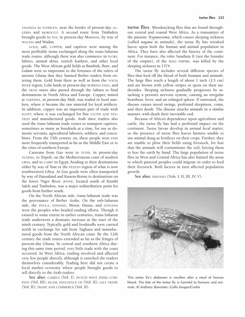
TAGHAZA to TLEMCEN, near the border of present-day AL-GERIA and MOROCCO. A second route from Timbuktubrought goods to FEZ, in present-day Morocco, by way ofWALATA and Wadan.
GOLD, salt, COPPER, and captives were among themost profitable items exchanged along the trans-Saharantrade routes, although there was also commerce in IVORY,fabrics, animal skins, ostrich feathers, and other localgoods. The West African gold fields at Bambuk, Bure, andGalam were so important to the fortunes of the rulers ofancient Ghana that they banned Berber traders from en-tering them. Gold from there as well as from the VOLTA
RIVER region, Lobi lands in present-day BURKINA FASO, andthe AKAN states also passed through the Sahara to finaldestinations in North Africa and Europe. Copper, minedat TAKEDDA, in present-day Mali, was traded in local mar-kets, where it became the raw material for local artifacts.In addition, copper was an important part of trade withEGYPT, where it was exchanged for fine CLOTH AND TEX-TILES and manufactured goods. Arab slave traders alsoused the trans-Saharan trade routes to transport captives,sometimes as many as hundreds at a time, for use as do-mestic servants, agricultural laborers, soldiers, and concu-bines. From the 15th century on, these people were evermore frequently transported as far as the Middle East or tothe cities of southern Europe.
Caravans from Gao went to TUNIS, in present-dayTUNISIA, to Tripoli, on the Mediterranean coast of modernLIBYA, and to CAIRO in Egypt, heading to their destinationseither by way of Tuat or the FEZZAN region of what is nowsouthwestern Libya. At Gao goods were often transportedby way of Hausaland and Kanem-Bornu to destinations onthe lower Niger River. JENNE, located south of KumbiSaleh and Timbuktu, was a major redistribution point forgoods from further south.
On the North African side, trans-Saharan trade wasthe provenance of Berber Arabs. On the sub-Saharanside, the DYULA, SONINKE, Mossi, Hausa, and SONGHAI
were the peoples who headed trading efforts. Though itexisted to some extent in earlier centuries, trans-Saharantrade underwent a dramatic increase at the start of theninth century. Typically gold and foodstuffs were carriednorth in exchange for salt from Taghaza and manufac-tured goods from the North African coast. By the 12thcentury the trade routes extended as far as the fringes ofpresent-day Ghana. In central and southern Africa dur-ing this same time period, very little trade with the coastoccurred. In West Africa, trading involved and affectedvery few people directly, although it enriched the tradersthemselves considerably. Trading here did not create alocal market economy where people brought goods tosell directly to the Arab traders.
See also: CAMELS (Vol. I); DUTCH WEST INDIA COM-PANY (Vol. III); ISLAM, INFLUENCE OF (Vol. II); SALT TRADE
(Vol. II); TRADE AND COMMERCE (Vol. II).
tsetse flies Bloodsucking flies that are found through-out central and coastal West Africa. As a transmitter ofthe parasite Trypanosoma, which causes sleeping sickness(called nagana in animals), the tsetse fly has wreakedhavoc upon both the human and animal population inAfrica. They have also affected the history of the conti-nent. For instance, the ruler Sundiata II (not the founderof the empire), of the MALI EMPIRE, was killed by thesleeping sickness in 1374.
The tsetse fly includes several different species offlies that feed off the blood of both humans and animals.The large flies reach a length of about 1 inch (2.5 cm)and are brown with yellow stripes or spots on their un-dersides. Sleeping sickness gradually progresses by at-tacking a person’s nervous system, causing an irregularheartbeat, fever, and an enlarged spleen. If untreated, thedisease causes mood swings, profound sleepiness, coma,and then death. The disease attacks animals in a similarmanner, with death their inevitable end.
Because of Africa’s dependence upon agriculture andcattle, the tsetse fly has had a profound impact on thecontinent. Tsetse larvae develop in animal fecal matter,so the presence of tsetse flies leaves farmers unable touse animal dung as fertilizer on their crops. Further, theyare unable to plow their fields using livestock, for fearthat the animals will contaminate the soil, forcing themto hoe the earth by hand. The large population of tsetseflies in West and Central Africa has also limited the areasto which pastoral peoples could migrate in order to feedtheir livestock. Both factors in turn affected populationgrowth.
See also: DISEASES (Vols. I, II, III, IV, V).
tsetse flies 225
This tsetse fly’s abdomen is swollen after a meal of humanblood. The bite of the tsetse fly is harmful to humans and ani-mals. © Anthony Bannister; Gallo Images/Corbis

Tuaregs Seminomadic ethnic group that has inhabitedthe SAHARA DESERT and Sahel for centuries; they claim tobe descendants of the BERBERS. From the rise of ISLAM
until the beginning of the period of European coloniza-tion, the Tuaregs exercised a strong influence upon thetrans-Saharan trade in the southern Sahara.
After the Arab invasion of North Africa in the sev-enth century, the Tuaregs, like many other indigenouspeoples, were converted to Islam. As a result their tradi-tional clan system of matrilineal descent switched to a pa-triarchal system, and their traditional religious practiceswere replaced by Islam. Despite their conversion, how-ever, the Tuareg maintained many of their own culturaltraditions, including their language, written script, andclass structure. The latter divided Tuareg society into fiveranks, with warriors and religious figures at the top of the
hierarchy and slaves and descendants of slaves at the bot-tom. They also maintained several of their traditional reli-gious practices, most notably a religious ceremony thatcentered around asking a viper to foretell events. Thesnake remained an important symbol within Tuareg folk-lore as a sign of both good and evil.
As the Arab invasion continued, the Tuaregs mi-grated to the south, moving into the western and centralSUDAN. There they organized themselves into politicalclan structures known as kels, each of which was led by achief. Some of these clans engaged in frequent raids onother groups, using these raids as an opportunity to ac-quire slaves and exact tribute. These same kels, as well asother Tuareg groups, also continued to carry on their tra-ditional pastoralist activities, combining them with agri-cultural pursuits and participation in trans-Saharan trade.
This 1835 lithograph gives an idealized view of Tuaregs in the Sahara. © Christel Gerstenberg/Corbis
226 Tuaregs

Throughout this period the Tuareg eschewed perma-nent settlements. Preferring to live primarily as nomads,.they set up temporary camps that could be easily takendown and transported to their next destination. TIM-BUKTU, which was founded by the Tuaregs during the12th century, was originally just such a camp settlementthat the Tuaregs had used during their travels throughthe region.
By the 14th century the Tuaregs had gained controlover TAKEDDA, an important trading center and COPPER
mining area located west of the AÏR MASSIF, on the fringesof the MALI EMPIRE. The acquisition of Takedda gave theTuaregs far more power in the region. It also gave themincreased revenues from TRANS-SAHARAN TRADE ROUTES
that connected the western SUDAN with trade depots inMorocco and Algeria. By the end of the 14th century,though they gained Takedda, the Tuaregs ceded control ofTimbuktu to the Mali Empire.
By the 15th century their increased population ledthe Tuaregs to establish a more complex class system.This new system, which had important similarities to theexisting class system they maintained, made distinctionsbetween slaves, the descendants of slaves, peoples whopaid tributes to the Tuaregs (usually other ethnic groupsthey had raided), and the Tuareg noble class. By this time,too, the various kels had established vast power in the re-gion, due in large part to their control over portions ofthe trans-Saharan trade routes. With this increased powerthe Tuaregs began to establish a kingdom, with several kelleaders creating a seat for that kingdom in AGADES, orAgadez, in present-day NIGER.
Facing competition from the HAUSA STATES as well asthe nomadic FULANI of Sokoto, the Tuaregs attempted toconsolidate and centralize their increased power over thesouthern Sahara. This attempt was successful and, in1433, they recaptured Timbuktu and took control overthe trans-Saharan GOLD and SALT TRADE centered in thatcity. The Tuaregs’ power, however, never matched the cen-tralized authority exercised by the kingdoms of KANEM-BORNU and the Hausa. Yet they remained an influentialforce in the southern Sahara for many years to come.
See also: SOKOTO CALIPHATE (Vol. III); TUAREGS
(Vols. I, III, IV, V).
Tukulor (Tukolor, Toucouleur) West AfricanMuslim people who live in what is now SENEGAL and inadjacent regions in present-day Republic of MALI. This re-gion was occupied by the ancient GHANA EMPIRE from thefourth to the 11th centuries and then by the MALI EMPIRE
in the 13th century. The Tukulor speak Fulfulde, a lan-guage of the West Atlantic branch of the Niger-Congofamily, and are related to the SERER and WOLOF peoples.
The Tukulor were converted to ISLAM during the 11thcentury, as were other peoples of the western SUDAN.
When the Ghana Empire fell, in 1076, the Tukulor and agroup of nomadic Fulani formed a new kingdom, TEKRUR,which lasted into the 1700s. Tekrur was generally gov-erned by non-Tukulor rulers.
The Tekrur kingdom was rooted in the Islamic beliefsof its people. The SOCIAL STRUCTURE was hierarchical,highly stratified, and based upon patrilineal groups. TheTukulor also practiced polygyny. Their economy wasbased on AGRICULTURE, cattle raising, and fishing.
See also: FULFULDE (Vol. I); TUKULOR (Vol. III); TUKU-LOR EMPIRE (Vol. IV).
Tunis Strategic port located on the MEDITERRANEAN SEA
in the present-day country of TUNISIA. The history of Tunisgoes back to the first millennium BCE and the Phoeniciansettlement of North Africa. However, the city did notbegin to rise to prominence until the Arab conquests thatbegan in the seventh century, at which time the city be-came a vital commercial and military stronghold.
During the eighth century the Arab leader Hassanibn Numan used Tunis as the base for his military cam-paigns against Berber resistance to the west. The subse-quent influx of ARABS to the region helped transformTunis into a cosmopolitan center that attracted a diversepopulation of MERCHANTS, scholars, and bureaucrats. Asthe terminus of the trans-Saharan trade route, Tunis be-came a major center for commerce between Africa, theMiddle East, and Europe.
Because it was both a point of strategic importanceand the origin of Arab attacks on Berber strongholds,Tunis frequently became embroiled in the military cam-paigns that marked the next centuries of North Africanhistory. During the 10th, 11th, and 12th centuries thecity was frequently involved in the struggles for controlof the western Sahara, or MAGHRIB, between warring fac-tions of the ALMOHADS, the MARINIDS, the Zayyanids, andthe Hafsids.
Later, during the 13th century, when the BerberHafsids came into power, Tunis was revitalized as a royalcity replete with mosques, palaces, and schools. Underthe Hafsids, the city maintained its significant role inthe trade between the Mediterranean and the trans-Saharan routes, leading to a period of great prosperity.By the 14th century, however, battles between theHafsids and their rivals, the Zayyanids, erupted, withthe main issue being control over Tunis and its trade.Although the Hafsids were able to rule the city until the16th century, control over Tunis ultimately passed firstto Spain and then, by the end of that century, to theOttoman Empire.
See also: ARAB COASTAL TRADE (Vol. II); GRECO-ROMAN PERIOD (Vol. I); OTTOMAN EMPIRE (Vol. III); PHOENI-CIANS (Vol. I); TRANS-SAHARAN TRADE ROUTES (Vol. III);TUNIS (Vols. IV, V).
Tunis 227

Tunisia North African country measuring approxi-mately 60,000 square miles (155,400 sq km) that bordersthe MEDITERRANEAN SEA to the north and east, LIBYA to thesoutheast, and ALGERIA to the west. The site of the power-ful merchant city of Carthage, Tunisia fell under the con-trol of the Vandals and BYZANTINE AFRICA before beingseized by invading Muslim ARABS, near the end of the sev-enth century. The region then became a province of anIslamic empire that was expanding rapidly across NorthAfrica, from east to west.
In time, however, the region’s indigenous BERBERS
chafed under the harsh control of their Islamic overlords,and by the end of the 12th century a Berber dynastyknown as the ALMOHADS had taken back much of the re-gion, including the Mediterranean coast. In the 13th cen-tury a group of Berbers called Banu Marin, or MARINIDS,took control of Tunisia and much of the rest of theMAGHRIB, holding sway into the 15th century.
See also: TUNISIA (Vols. I, III, IV, V).
Tunka Manin (r. c. 1063–unknown) King of the an-cient Ghana Empire
Ruling from the capital city of KUMBI SALEH, theSONINKE king, Tunka Manin, was the most powerfulleader of the GHANA EMPIRE during the 11th century. Heassumed kingship upon the death of his maternal uncle,King Basi, in 1063.
Most of what is known about Tunka Manin comesfrom the accounts of the Arab scholar al-BAKRI (D. C.1095) from around 1068. Relying on the reports of Arabtraders who witnessed the grandeur of Ghana’s empire,al-Bakri wrote detailed descriptions of the king, his mag-nificent court, and the imposing Ghanaian army number-ing more than 200,000 warriors. According to al-Bakri,Tunka Manin was widely respected by both his subjectsand foreigners, and Ghana flourished under his rule.
Tunka Manin was able to increase the wealth andpower of his empire by controlling trade and levyingtaxes on the great amounts of salt and GOLD that passedthrough his territory. His tight grip on power eventuallyloosened around 1073 when the ALMORAVIDS, invadingNorth African Muslims, began to conquer northern andeastern parts of his kingdom, converting many of his sub-jects to ISLAM.
See also: SALT TRADE (Vol. II).
Tutsi (Batusi, Batutsi, Tussi, Watusi, Watutsi,Hima) Ethnic group that today lives primarily in BU-RUNDI and RWANDA, in the highlands of central EastAfrica. Prior to the 15th century the pastoralist Tutsi mi-grated to the region, probably from the southern SUDAN,in search of new land on which to raise their cattle. Theseearly Tutsi were closey related to the cattle-owning HIMA
caste that emerged in states such as NKOLE and TORO, inpresent-day UGANDA, near Lake Victoria. In fact, depend-ing on the kingdom, Tutsi were often called Hima andvice-versa.
JJJJJJJJJJJJJ
Although archaeological evidence makes it clear thatthe Tutsi had not settled in the area prior to the 15thcentury, Tutsi legend puts the founding of Rwandaon a par with the birth of civilization itself. Themajor Tutsi clans claim to have descended from amythical ancestor, Gihanga, the founder of severaldynasties including the Sindi, Nyakarama, Shambo,Ega, Sita, Ha, Shingo, KONO, and Hondogo.
JJJJJJJJJJJJJ
Partly due to the wealth provided by their vast herdsof cattle, the Tutsi rather quickly established dominionover the HUTU and TWA, the original inhabitants of the re-gion. The Tutsi were overwhelmingly superior warriorsand, perhaps precisely for that reason, the shift in powerfrom the Hutu to the Tutsi was largely peaceful. Althoughthe Tutsi assumed the language and culture of the Hutu,what eventually developed was a feudal system in whichthe Tutsi formed an aristocracy and the Hutu took on therole of the peasantry.
Eventually, the Hutu and Twa adopted many aspectsof Tutsi culture, including the Tutsi system of govern-ment in which the mwami (king) was the supreme ruler,wielding both political and religious power. The mwami,thought by the Tutsi to be divinely chosen, was usually aTutsi. However, another social group, the GANWA, actedas ruling princes and served as intermediaries betweenthe mwami and the other Tutsi. Also aiding the Tutsi intheir dominion over the Hutu and Twa was their largerphysical stature. Whereas the Hutu are generally small,muscular people, and the Twa are especially diminutive,it is not uncommon for a Tutsi male to stand over 7 feet(2.1 m) tall.
Over time there was much intermarriage between theTutsi and the other ethnic groups in the region. Therealso was a change of status as cattle were lost or acquired.So, as a result, it eventually became more difficult to dis-tinguish between Tutsi and Hutu.
See also: TUTSI (Vol. III, IV, V).
Twa (Batwa, Gwa) Subgroup of the Mbuti (who aresometimes referred to by the term Pygmy), an ethnicgroup of equatorial Africa. During the fifth through the15th centuries the Twa inhabited territory around LakeKivu, in what is now RWANDA, BURUNDI, and the Demo-cratic Republic of the CONGO.
228 Tunisia

JJJJJJJJJJJJJ
When the HUTU first encountered the Twa, they be-lieved that the diminutive people possessed magicalpowers. As a result the Twa received gifts in ex-change for their supposed powers, which wereused to maintain the rule of the Hutu kings. Twapeople functioned as storytellers, mystics, dancers,and musicians in the king’s court.
JJJJJJJJJJJJJ
The seminomadic Twa had occupied the Lake Kivuregion for thousands of years before the first major in-flux of Hutu settlers. Though there is evidence of Hutumigration to the area as early as the first century CE, itwasn’t until the fifth century that the Hutu began to mi-grate in great numbers. By the 11th century the Twawere being incorporated into Hutu society, and they es-tablished a cooperative agricultural relationship. Twa ar-tisans also produced excellent POTTERY that was valuedby the Hutu.
Despite being included in Hutu society, the Twawere given lower social standing, probably because oftheir different appearance and cultural practices. By the15th century the TUTSI—an aristocratic, warrior peo-ple—had begun to dominate the region occupied by theHutu and Twa agriculturalists. Under Tutsi domination,the Twa became even more segregated from larger society
than they had been under the Hutu, and this marginal-ization continued into the European colonial period,which began toward the end of the 16th century.
See also: HUNTER-GATHERERS (Vol. I); MBUTI (Vol. I).
Twifo Term that describes the Twi-speaking peoplesthat populated the forest region of present-day GHANA be-ginning in the 15th century. The Twi language is relatedto the languages of the ASHANTI, AKYEM, AKWAMU, SEFWI,NZIMA, and FANTE. The early Twifo, who probably mi-grated from the area that is now northern Ghana, lived insmall clan groups, providing for themselves by means ofAGRICULTURE and fishing. Eventually, though, they becameskilled traders. Because of their strategic location betweenthe coast and the GOLD-producing forest regions, TwifoMERCHANTS were able to participate in the SALT TRADE aswell as the gold trade. Other items that moved throughTwifo markets included luxury goods like BEADS AND JEW-ELRY and cloth.
The increase in trade had an enormous impact on theTwifo, for in addition to the sudden creation of vast wealth,they also grew in number and developed more complexpolitical structures. Because of this, when the Portuguesearrived in the mid-15th century, they preferred dealingwith the Twifo over other cultures in the region. It isthrough this early Twifo culture that the later AKAN andAshanti kingdoms traced their ancestry.
See also: PORTUGAL AND AFRICA (Vols. III, IV).
Twifo 229

230
Uganda East African country measuring approximately91,100 square miles (236,000 sq km) that borders theRepublic of the SUDAN to the north, KENYA to the east,TANZANIA and RWANDA to the south, and DemocraticRepublic of the CONGO to the west. Kampala is the largestcity in Uganda and is also the country’s capital.
Bantu-speaking people migrated from the west intowhat is now modern Uganda between 1000 BCE and 1000CE. During the course of this gradual resettlement, theyhoned their AGRICULTURE and IRON technology. At thesame time they established a sophisticated system of gov-ernment under which they were ruled by clan chiefs. TheBantu speakers, however, held a military and political dis-advantage compared to the groups of Nilotic pastoralistswho invaded the region beginning in the 10th century.
The Bantu speakers and their Nilotic-speaking over-lords developed a two-tiered hierarchy in which theherders secured the region from external aggression andthe agriculturalists became the laborers and food produc-ers. This upper class, called HIMA in certain Ugandankingdoms, incorporated some of the existing politicalpractices into their own system of government.
The first state to emerge from this system was the KI-TARA COMPLEX, a collection of chiefdoms that was ruled,albeit briefly, by the CHWEZI DYNASTY. Beginning in themiddle of the 14th century, NDAHURA, the Chwezi king,or mulama, delegated palace officials and chiefs to helprun the kingdom. By the beginning of the 15th century,however, the Chwezi dynasty had been replaced by rulersfrom the BITO clan, an aristocratic group of LUO-speakingpastoralists who invaded from the north. The Bito con-quered a number of kingdoms in the Kitara region and
established Bunyoro, also known as BUNYORO-KITARA, themost powerful Bito state between the 16th and the 19thcenturies. At its height Bunyoro-Kitara and the Bito clancontrolled a number of smaller states, including Bukoli,Bugwere, Bulamogi, TORO, Busoga, Bugabula, Kiziba, andparts of NKOLE and RWANDA. Eventually these kingdomsrebelled against the Bito empire, leading to the decline ofBunyoro-Kitara in the 1800s.
See also: UGANDA (Vols. I, III, IV, V).Further reading: Christopher Wrigley, Kingship and
State: The Buganda Dynasty (New York: Cambridge Uni-versity Press, 1996).
Uli, Mansa (r. 1255–1270) Son of Sundiata and ruler ofthe Mali Empire
One of several sons of SUNDIATA (r. 1235–1255), thefounder of the MALI EMPIRE, Mansa Uli came to thethrone following the death of his illustrious father. Dur-ing his reign he continued Sundiata’s policy of expandingMANDINKA territory. However, dynastic disputes betweenhis brothers KARIFA and WATI followed Mansa Uli’s deathand left the empire weakened and in disarray until theearly 14th century.
Umayyad Muslim dynasty, based in Damascus, Syria,that ruled the Arab Empire, or Caliphate, a territory thatextended from the Arabian Peninsula through North Africaand into Spain during the seventh and eighth centuries.The caliph had both religious and secular authority overbelievers and was seen as the successor to the prophet
JJJJJJJJJJJJJJJJJU
uzamas 231
Muhammad. Bringing an end to the civil war of 656–61that followed the murder of Uthman (r. 644– 656), thethird caliph, Muawiya (c. 602–680), was victorious overMuhammad’s son-in-law and later the fourth caliph, Ali(r. 656–661). Muawiya then established the Umayyaddynasty.
During Umayyad rule ARABIC was made the officiallanguage of the Arab Empire, accompanying an extensiveArabization of the financial system and civil administra-tion. The eight governors who ruled over the MAGHRIB
from 697 to 740 and promulgated these policies eventu-ally brought about changes in the politics and culture ofthe region. This achievement was especially notable giventhe brief span of Umayyad rule. Cultural biases led someArabs, despite the injunctions of the QURAN and the sym-pathetic actions of many other ARABS toward the BERBERS,to treat the indigenous Berbers as social and even racialinferiors. This pattern continued even as more and moreBerbers converted to ISLAM, leading to resentment of theArabs by the indigenous population.
Further reading: G. R. Hawting, The First Dynastyof Islam: The Umayyad Caliphate AD 661–750 (New York:Routledge, 2000).
Umme, Mai (Dunama bin Hummay, Umme-Jimi, Mai Humai) (r. 1085–1097) Sefuwa king
The second SEFUWA king, Mai Umme, was a followerof the teachings of Muhammad bin Mani. During the late
11th century Umme converted the people of KANEM-BORNU to ISLAM. One of the more important results of thisconversion was that the Zaghawa people, the originalfounders of the KANEM kingdom, cut themselves off fromKanem-Bornu and headed east.
During his lifetime Umme traveled to MECCA on twooccasions, but he perished in EGYPT before completing histhird pilgrimage. His son, Dunama I (1092–1150), waswith him on his HAJJ and was crowned shortly after his fa-ther’s death.
See also: ISLAM, INFLUENCE OF (Vols. II, III, IV, V);ZAGHAWA (Vol. III).
uzamas Hereditary local chiefs of the EDO-speakingpeoples of the kingdom of BENIN, in what is now NIGERIA.The uzamas reached the zenith of their power in the pe-riod from the 11th to the 14th centuries, ruling local vil-lages and serving as members of the royal council thatadministered the kingdom. Traditionally, the uzamas alsowere responsible for selecting the king of Benin.
The uzamas lost power during the reign of EWUARE
(r. 1473–1480), who incorporated the uzamas into a new,more centralized monarchy. The power of the uzamas wascounterbalanced by the creation of a new hierarchy ofpalace chiefs and town chiefs. The dilution of the uzamaspower created a rift between the them and the monarchy.
See also: GOVERNMENT, SYSTEMS OF (Vols. I, II, III).
232
Vai (Vei) MANDE people living in what is now LIBERIA
and SIERRA LEONE. Called the Gallinas (chickens) byearly Portuguese explorers because of their domesticatedfowl, the Vai were farmers, fishers, expert metalworkers,and active traders. Along with their Mande-speakingneighbors, the Vai migrated south from their homelandsin present-day Republic of MALI and GUINEA severalthousand years ago. During the 15th century the Vai ofthe Sierra Leone region merged with the indigenousKONO people.
See also: VAI (Vol. III).
Vasco da Gama See GAMA, VASCO DA.
Venda (Bavenda) Bantu-speaking people living in theregion between the Limpopo and Zambezi rivers, southof ZIMBABWE, in the eastern half of what is now SOUTH
AFRICA. They migrated into the area from the Great Lakesregion to the north. The Venda capital city, founded dur-ing the 13th century by the legendary king Toyandou,was at Dzata, in the Njelele valley of the ZoutpansbergMountains. The ruins of Dzata can still be seen today. Inthe colonial period the Venda fought off Zulu attempts toconquer them, and they were among the last of the peo-ples in the region to succumb to European domination.
Venda culture was defined by patrilineal inheritance,polygamy, clan totems, and circumcision. They dependedon hunting and gathering, trade with neighboring groups,and the mining of COPPER and IRON. The Lembaa are aVenda-speaking Jewish people claiming descent from theBETA ISRAEL.
Victoria, Lake The continent’s largest lake, located inEast Africa. Numerous peoples have inhabited the lake’scoastal regions since the middle of the first millennium,but it seems that the first influential group was a Bantu-speaking population that lived on the northwestern coastof the lake as early as the 10th century before migratingfurther south during the 16th century. In the 12th centurya wave of Bantu speakers settled on the eastern shores ofthe lake, from Mara in the south to the Kavirondo Gulf inthe north. These settlers acculturated with the Nilotic andCushitic pastoralists who already lived in the region. TheBantu-speaking farmers adopted some of the local prac-tices, such as male and female circumcision. The ancestorsof the Haya and Zinza peoples inhabited the southwesternshore of the lake during the 13th century. SouthernCushitic peoples lived on the eastern and southern shoresof the lake during the 12th century but were replaced bythe Sukuma peoples on the southern shore by the 16thcentury.
See also: VICTORIA, LAKE (Vols. I, V); BANTU EXPAN-SION (Vols. I, II).
Volta River Thousand-mile (1,600-km) river system inpresent-day GHANA, formed from the confluence of theBlack Volta and the White Volta rivers. Before the 16thcentury several powerful kingdoms emerged in the Voltabasin. The river’s name, given by Portuguese explorers inthe 15th century, means “turn,” after its twisting course.
Beginning around 1260 Diamare people from the eastinvaded long-established communities along the Volta.For the next 200 years intermittent raids were carried outthroughout the region, and by 1480, because of ease of
JJJJJJJJJJJJJJJJJV

Volta River 233
transport and local trade, numerous riverside kingdomshad emerged. These came to include the MOSSI STATES ofDAGOMBA, MAMPRUSI, OUAGADOUGOU, and YATENGA, all ofwhich were well established by the middle of the 16thcentury.
JJJJJJJJJJJJJ
The adjective used to describe the peoples and lan-guages originating in the Volta River region is Voltaic.
JJJJJJJJJJJJJ

Wagadu See OUAGADOU.
Walata (Oualata) Major center of trade in the early11th century, located on the edge of the Sahara, in what ispresently MAURITANIA. Walata was an important stop onthe TRANS-SAHARAN TRADE ROUTES between the upperNiger River region and MOROCCO. Walata was one of twocities that replaced the Ghanaian imperial capital ofKUMBI SALEH as a major trading center of the area. Nearthe beginning of the 13th century, SUMANGURU (d. c.1235), the reportedly cruel founder of the KANIAGA king-dom, conquered Kumbi. This caused traders, MERCHANTS,and even the native SONINKE people to leave the city.They established new trading settlements at Walata andJENNE. By about 1230 Walata had become a main centerof commerce in this part of Africa. During one period itwas perhaps the best-known caravan stop on the Saharatrade routes. About 1480 Sunni ALI (r. c. 1464–1492),ruler of the SONGHAI Empire, took control of Walata,adding this great city to his vast kingdom.
See also: GHANA EMPIRE (Vol. II); WALATA (Vol. III).Further reading: Timothy Cleaveland, Becoming
Walata: A History of Saharan Social Formation and Trans-formation (Portsmouth, N.H.: Heinemann, 2002).
Wamara Son and successor of Ndahura, founder of theChwezi dynasty that briefly ruled the Kitara Complex ofkingdoms in present-day Uganda.
Archaeological evidence suggests that Chwezi rule inKitara was limited to the 14th century. However, becausemuch of the information about Kitara and the CHWEZI DY-NASTY comes from oral traditions, there is debate over
what is fact and what is mythology. Many local legendsare associated with the Chwezi kings and chiefs, whowere widely revered and thought to have mystical pow-ers. Even today Chwezi ancestors are revered in parts ofUGANDA and neighboring TANZANIA.
JJJJJJJJJJJJJ
Many legends are associated with the Chwezi kingsand chiefs, who were revered as sons of God andthought to have mystical powers. It was said, forexample, that these individuals wandered withoutfear and that their eyes were as bright as the Sun.
JJJJJJJJJJJJJ
Following traditions, it is generally accepted thatthere were three Chwezi kings who ruled over Kitara:NDAHURA, Mulindwa (about whom there is little informa-tion), and Ndahura’s son, Wamara. Ndahura founded thefirst Chwezi dynasty but abdicated the throne after he wascaptured in battle. Convinced that he had disgraced histitle and his subjects, Ndahura asked his subjects, some-times called the Bachwezi (“people of the Chwezi”), toelect a successor to the throne from among his children.Although the Bachwezi probably would have welcomedNdahura back, they respected his decision and chose hiseldest son to be their king.
Upon taking the throne, Wamara moved his capitalfrom Mubende Hill to Bwera, where he divided the statesin the Kitara Complex among his brothers and chosen as-sociates. Under Wamara, Kitara was faced with constantstrife and social unrest. This was mainly due to the influx
JJJJJJJJJJJJJJJJW
234
Waqwaq 235
of immigrants to the region, especially waves of LUO-speaking pastoralists, who came south from the southernSUDAN in search of suitable pastures for their herds.
The growing number of diverse subjects proved to bea discontented lot, but Wamara tried to appease them. Heattempted, for example, to integrate them within the king-dom, giving members of different ethnic groups prominentpositions in the government. However, the new arrivals re-sented the Chwezi kings for demanding exorbitant tributepayments. The Chwezi dynasty met its end with the rise ofthe Luo-speaking BITO clan. One tradition says that theChwezi rulers were forced to move south to found newstates. Another widely accepted tradition says that, follow-ing a famine and an epidemic that struck the region’s cat-tle, one of Wamara’s appointed generals, Kagoro, staged acoup, during which the Chwezi aristocracy was wiped out.
See also: DIVINE RULE (Vols. I, II).
Wangara See DYULA.
Wangara gold fields Regions in western Africa thatprovided the DYULA, or Wangara, traders with the re-sources to become the largest commercial brokers be-tween the 1300s and 1500s. Based on the accounts of 13thcentury observers and on recent geological surveys, it iscommonly believed that the main Wangara gold fieldswere located in Bambuk, Bure, and other forested regionsof present-day GHANA and IVORY COAST. Bambuk is nearthe SENEGAL and Faleme rivers, and Bure lies between theNiger and Tinkisso rivers, southeast of Bambuk.
Despite the importance of GOLD in the trans-Saharantrading economy, there is limited information about wherethe metal was mined and the way in which it was pro-cessed. To avoid competition the savvy Dyula managed tomaintain secrecy regarding the location of their gold fields.They even went so far as to practice dumb barter, a methodof commerce in which neither party ever met face to face.The Dyula would place their merchandise at the side of ariverbank and then retreat while the interested parties paidfor their goods. A Dyula trader would rather face deaththan reveal the source of his people’s wealth. Even royaltyrespected this secrecy. Had they not, they would have suf-fered the repercussions of the Dyula‘s withholding trade.
See also: TRANS-SAHARAN TRADE ROUTES (Vol. II).
waqlimi Title that the ZANJ of East Africa gave their king.The term waqlimi, or wafalme, comes from the phraseMorwa wa ka Limi and means “Son of the Supreme Lord.”Although al-Zanj, meaning “blacks,” was the term ARABS
used to describe all Africans, it came to refer more specifi-cally to the group of people who lived south of the SOMALI
region of the Horn of Africa on the Indian Ocean coast.
In 943 the famous Arab geographer el MASUDI, whohad sailed as far south as the island of PEMBA (Kanbalu),described the Zanj system of government in his book,The Meadows of Gold and Mines of Gems. He noted thatthe Zanj elected the waqlimi as a divine representativewho was entrusted with leading the kingdom justly.
JJJJJJJJJJJJJ
The Zanj were a spiritual people, although they didnot subscribe to an organized RELIGION. Their namefor God was Mkalanjalu. According to the ninth-century Arab author al-Jahiz, Zanj sermons weredelivered before the waqlimi by holy men, illustrat-ing the interconnectedness of government and reli-gion in Zanj society.
JJJJJJJJJJJJJ
The idea of justice was extremely important to theZanj. The waqlimi’s role was considerable in this systembecause he was in charge not only of his own army,which was substantial, but also of the armies of all thelesser kings or chiefs within the empire. This was not aneasy task considering that the Zanj’s interests were inGOLD MINING and trading—ventures that were notori-ously rife with corruption in some areas of East Africa. Ifthe Zanj people felt that the waqlimi had failed to performhis duty of dispensing justice then he was no longer the“son of God,” and they could put him to death and endhis line of succession to the throne.
See also: DIVINE RULE (Vol. II).
Waqwaq People who settled the islands called Kun-lun, which were later renamed the land of Waqwaq byArab sailors in the 10th century. There is some debate asto the exact location of the islands and the origin of thepeople. One group of Waqwaq is believed to have inhab-ited a region in Southeast Asia near China. The other ap-pears to have settled along the East African coast prior tothe age of intensive Arab exploration in the area startingin the 10th century. This second group of Waqwaq settledprimarily in MADAGASCAR, the PEMBA Islands, and on themainland from the modern border of KENYA and TANZA-NIA to as far south as SOFALA. Arab geographers claimedthat the Waqwaqs were of Indonesian descent, but to addfurther confusion, the name Waqwaq is also synonymousin some accounts with Khoisan.
It is generally accepted that the Waqwaqs came toAfrica early in the common era. They prospered throughGOLD MINING and became ruthless traders. Around 945they invaded Pemba, called Kanbalu at the time, in an in-famous attack that is described in The Book of the Wondersof India. The Waqwaqs came in 1,000 ships, and their

journey to Kanbalu, they claimed, took almost a year, asthey subjugated several coastal towns and villages alongthe way.
Kanbalu was of interest to the Waqwaqs for two rea-sons. First, they were after goods to trade with China.These included IVORY, ambergris (perfume made fromwhales), frankincense, myrrh, panther skins, tortoise-shell, and, most important, the ZANJ people whom theycaptured and forced into servitude. Second, the Muslimsposed a serious threat to the Waqwaqs. Not only did theWaqwaqs want to prevent ARABS from infiltrating theirgold and IRON mines but they also wanted to hinder thelongstanding Muslim dominance of local trade.
The Waqwaqs were a powerful force and managedfor a time to impede some Muslim activities. Ultimately,however, they were no match for the Arabs, who hadfirmly established themselves in the area by the end ofthe 10th century. As East Africa increasingly converted toISLAM in the 11th century, the Waqwaq trading empirecollapsed.
See also: ARAB COASTAL TRADE (Vol. II); INDIAN
OCEAN TRADE (Vol. II); SLAVERY (Vols. II, III, IV).
warfare and weapons Although the details of earlyAfrican warfare are vague, by 1200 distinct military tac-tics had emerged throughout the continent. The severityof warfare depended largely on the size, governmentstructure, and location of the communities involved.
The earliest known conflicts occurred betweenloosely organized peoples like the DINKA, Nuer, MAASAI,and San. Although their villages, with their elder-domi-nated SOCIAL STRUCTURE, usually lacked a clear hierar-chical system, these communities were able to organizeinto bands during warfare. Bands (groups of related no-madic or foraging peoples) and groups of agriculturalistsoften raided neighboring villages, but they seldom en-gaged in long battles. Few people died in these conflictsbecause of the limited killing power of their weapons,which were generally just modified hunting and farmingtools. This early warfare tended to center on domesticdisputes, such as conflicts over cattle, land, LABOR, or so-cial status. Opponents were never really defeated; ratherthey were simply kept at bay for a period of time.
In the seventh century Arab Muslim armies fromSaudi Arabia advanced westward across the Red Sea andinto EGYPT, first establishing a base of operations atCAIRO. Mounted on horseback and armed with strongiron swords—as well as religious fervor—they quicklyconquered weakly defended agricultural villages in thehinterland. Along the coast they faced stiff Byzantineopposition, which included naval ships, but even theByzantines eventually fell to the overwhelming Arabforces. Although they also faced fierce resistance fromindigenous BERBERS in present-day ALGERIA and MO-
ROCCO, by the beginning of the eighth century MuslimARABS had conquered nearly all of North Africa. Theyalso crossed the Straight of Gibraltar and conquered thesouthern part of Spain. In the west the Muslim expan-sion southward was limited only by the forbidding envi-ronment of the SAHARA DESERT. In the east, however, theexpansion was forestalled by the armies of MAQURRAH,in Christian NUBIA. In addition to fighting with as muchreligious fervor as the invading Muslim armies, Nubia’sChristian armies were made up of highly skilled archerswho had a tactical advantage over their sword-wielding,horse-mounted enemies.
From the eighth through the 10th centuries Abbasiddynasty rulers in North Africa maintained armies of well-trained MAMLUKS, who were used for protection as well asto enforce Islamic law throughout the realm. By the 13thcentury, however, the Mamluks had established their ownIslamic state, spread over most of Egypt and parts of pre-sent-day LIBYA.
In the northern parts of SUB-SAHARAN AFRICA horseswere used extensively in the cavalries of the Ghana, Mali,and SONGHAI empires as early as the ninth century be-cause they could survive in the savanna climate. CAVALRY
forces could be large; Ghana, for example, could field asmany as 200,000 armed horsemen. To the west onlysmaller horses could survive, so the cavalries were depen-dent on hand-to-hand combat with sabers and attackswith javelins and bows. Coastal areas of West Africa, suchas Senegambia and the Gold Coast, organized armies thatused handheld weapons in combination with tactical sup-port from archers. In present-day ANGOLA loosely orga-nized infantries were made up of soldiers highly skilled inhand-to-hand combat who relied on their ability to dodgeweapons rather than utilize shields.
At GREAT ZIMBABWE (c. 1200–1450 CE), an Iron Ageempire that flourished in the southeastern part of modernZIMBABWE, archaeologists have found iron tools, but thesecould be ceremonial or hunting implements. Becausecommunities south of the Sahara were generally smalland scattered, it is likely that any disagreement led to thedispersal of peoples rather than to conflict.
See also: WARFARE AND WEAPONS (Vols. I, III, IV, V).
Warri Capital city and port of the ITSEKIRI kingdom ofsouthern NIGERIA. Founded in the late 15th century,Warri was situated just south of the kingdom of BENIN, inthe western Niger Delta region. According to oral tradi-tion, a prince of Benin named Ginuwa, or Igunwa, whowas proving to be unpopular at home, was sent to Warriby his father, Oba Olua. Once in Warri, Ginuwa estab-lished the Itsekiri kingdom and assumed the name Olu,in honor of his father. Ginuwa’s was succeeded by hissons, Ijijen and Irame, who led Warri and the Itsekirikingdom to great political and economic success.
236 warfare and weapons

JJJJJJJJJJJJJ
Itsekiri tradition holds that ghosts, called imale, oc-cupied the region before the arrival of Ginuwa.
JJJJJJJJJJJJJ
The Itsekiri traded salt, clay pots, and palm oil withother peoples of the Niger Delta. They also traded largeamounts of CASSAVA flour with the Portuguese MER-CHANTS who began visiting the delta city-states in thesecond half of the 15th century. Because of their strongtrading ECONOMY, the Itsekiri were influential through-out southern Nigeria, and their customs were practicedamong both the Liama and Soku communities. TheNEMBE people of the Niger Delta adopted the Itsekirigod Ogidiga.
After the 15th century the Portuguese attempts to es-tablish Catholic missionaries in the Niger Delta regionwere more successful in Warri than in any of the otherneighboring kingdom.
See also: ITSEKIRI (Vol. III); PALM OIL (Vols. III, IV);PORTUGAL AND AFRICA (Vols. III, IV, V).
Wati, Mansa (c. 13th century) Son of Sundiata andminor ruler of the Mali Empire
Following the death of Mansa ULI (r. 1255–1270), dy-nastic disputed broke out between Wati and his brotherKARIFA. Both had brief, troubled reigns that left the MALI
EMPIRE weaker than it had been at the death of its founder,SUNDIATA (r. 1235–1255). Following the death of Karifa,power passed to Sundiata’s grandson, ABU BAKR (r.1274–1285), who ruled until being overthrown by SAKURA
(d. c. 1300).
Western Sahara North African country measuringapproximately 103,000 square miles (266,800 sq km)that borders on MOROCCO to the north, ALGERIA to thenortheast, and MAURITANIA to the south and east. Theentire western part of Western Sahara borders on theAtlantic Ocean. The largest city is Laayoune, which is alsothe capital.
Western Sahara is mostly low desert land that re-ceives very little rainfall, making permanent AGRICULTURE
impossible. In the eighth and ninth centuries rival Zenataand Sanhaja Berber confederations controlled much ofnorthwest Africa, including what is now the country ofWestern Sahara. By the 10th century Muslim ARABS hadswept across North Africa, converting many in the regionto ISLAM. Berbers accepted the new religion as a tool forsocial organization, but, unlike other North Africangroups, they rejected ARABIC, the language of Islam, infavor of their own Berber language, called Tamazight.
With its inhospitable climate, the Western Sahara re-gion remained sparsely populated, even along the coast. Tothe east the Islamized Zenata and Sanhaja groups contin-ued to make their living by acting as guides and guards fortraders who transported GOLD, ostrich feathers, and otherluxury items along the TRANS-SAHARAN TRADE ROUTES run-ning from the western SUDAN to depots in Morocco andAlgeria.
In the 13th and 14th centuries Yemeni Arab tribes in-vaded Sanhaja territories after being expelled from south-ern Morocco by the ALMORAVIDS. Known as the Maqil andled by a tribe called Hassan, these invaders eventuallymixed with the local Sanhaja Berbers. The language ofthe Maqil, called Hassaniya, reflected the combination ofArabic and Berber tongues. This mixed group evolvedinto the Saharawi people of present-day Western Sahara.Saharawi still speak Hassaniya.
In 1434 Portuguese navigators sailed down theAfrican Atlantic coast as far south as Western Sahara’sCape Bojador. However, since the area was sparsely set-tled and offered few prospects for trade, the region re-mained free of European influence until the 19th century.
See also: WESTERN SAHARA (Vols. I, III, IV, V).
Wolof People, originally of FULANI origin, who mi-grated to the SENEGAL and the GAMBIA region (Senegam-bia) in the 1300s. The Wolof settled among the Jolofpeople and gradually began to set up the states that ulti-mately formed the WOLOF EMPIRE. The first of these statesto organize was Jolof, and by the 15th century their ex-tensive kingdom included Kayor, Walo, Baol, and theSERER states of Sine and Saloum. Wolof society adhered toa strict class structure that was divided into three majorgroups: freeborn, low-caste or unfree, and slaves. Each ofthese groups had its own hierarchical system. Included inthe freeborn (jambur, in Wolof), in order of importance,were royalty, NOBLES, clerics, and peasants. The low-casteor unfree (nyenyo) were the working class made up of la-borers (blacksmiths, jewelers, tanners, and cobblers) andCRAFTSPEOPLE (griots or praise-singers, weavers, andother artisans).
Although the blacksmiths and griots were from alower class, their positions earned them a certain amountof respect. The upper class required the services of theGRIOT, and his was the only position from which a mem-ber of the low caste could speak frankly to the freebornwithout suffering serious repercussions. The blacksmithwas an important member of society because he built in-struments of warfare. The slaves (jam) were defined as allowned persons, though there was a distinction betweenthose who were born into SLAVERY, those who werebought, and those who were captured. The social posi-tion of the slave depended on the position of his owner.For instance, if the slave was owned by a member of the
Wolof 237

freeborn, he could be given an honorable position thatmight surpass the low caste. Although moving from casteto caste was possible, it was uncommon. Intermarriagesbetween castes were rare.
In 1455 Cada Mosto, a Venetian writer, described theWolof system of government. He noted that the leader ofall the Wolof states was called the burba jolof, and, al-though each state was given autonomy over its king-doms, allegiance to the empire concerning economic andsecurity issues was expected.
ISLAM came to the Wolof region between the 11thand the 16th centuries. The lower castes were more will-ing to convert than were those of the royalty or nobility,but Wolof rulers often would feign conversion to main-tain control over their Muslim subjects. The Wolof em-pire declined in the 16th century when the states beganto fragment.
See also: SENEGAMBIA (Vol. III); WOLOF (Vol. IV)WOLOF EMPIRE (Vol. III).
Further reading: Samba Diop, The Oral History andLiterature of the Wolof People of Waalo, Northern Senegal(Lewiston, N.Y.: E. Mellen Press, 1995).
Wolof empire Five states in the West African regionof SENEGAL and The GAMBIA (also called Senegambia) thataccepted the dominion of the WOLOF state of Jolof duringthe 14th through the 16th centuries The first burba jolof,or king, of the Wolof empire is said to have beenNdiadiane Ndiaye of Jolof, who assumed power in thelate 1300s. He was able to unite his state with the threeother Wolof states in the region (Kayor, Baol, and Walo)and two states (Sine and Saloum) of the neighboringSERER people that had large Wolof minorities.
The Wolof empire was more a voluntary confedera-tion than a highly centralized kingdom. The rulers of theother states elected the burba jolof and voluntarily paidhim tribute for the upkeep of his royal dignity. Beyondthat they were free to rule their states independently, al-though they were expected to cooperate with the burbajolof in matters of defense, trade, and taxation.
Heredity was not the important factor in the choiceof a ruler; lineage, however, was. The rulers of the indi-vidual Wolof states had to be descendants of the foundersof their individual states and must have been born of anoble woman. The burba jolof had to be a descendant ofNdiadiane Ndiaye himself in the male line of succession.Once appointed, the burba jolof and the lesser kings ofthe other states underwent elaborate installation ritualsthat, it was thought, gave them magical powers and madethem divine.
Since it was the nobility who elected the burba jolof,they saw to it that he ruled as they wanted, or they re-moved him from the throne. The burba jolof was given anarmy over which he had control, and if his soldiers were
powerful enough, they could sometimes prevent the kingfrom being dethroned. The people of the lower stations ofsociety had no political power.
The responsibilities of a Wolof leader were spiritualas well as political. He was seen as a divine representativeand, as such, was the link between his subjects and theirancestors. Despite the fact that the king could be easilyoverthrown, he was highly esteemed and treated with theutmost respect by all those under him. The authority ofthe burba jolof and the lesser kings depended on theirpersonal wealth and power. All had private armies andoften acted autocratically and in their own best interestbecause there was often no need to maintain a commonfront. When rulers appeared in public, they were accom-panied by a large retinue of courtiers and warriors.
Starting in 1444 Portuguese MERCHANTS began enter-ing the Wolof empire to develop a profitable trading part-nership, and this turn of events led to conflict among theWolof states. Kayor was the first of the states to breakaway from the empire, doing so about 1556. Kayor de-clared its independence, thereby cutting off the inlandJolof state from access to the sea and European trade. Theleader of Kayor, whose name is lost to history, then cap-tured the neighboring Wolof state of Baol, repulsed an in-vading army from Jolof, and killed the burba. The otherWolof rulers refused to accept Kayor’s dominion and cre-ated independent local states.
See also: PORTUGAL AND AFRICA (Vols. III, IV, V);SENEGAMBIA (Vol. III); WOLOF EMPIRE (Vol. III).
women in medieval Africa The history of womenin Africa is elusive at best, and, as a result, researchersfrequently have had to rely on nonconventional sourcesin order to reconstruct it. These sources increasingly haveincluded oral tradition, mythology, and findings associ-ated with archaeological excavations. Because of this,many historians have found it useful to look for certainthemes that recur from period to period or from region toregion, rather than following a strict chronology.
For example, with the rise of ISLAM and the shift to-ward more complex city-states, new divisions along genderlines began to appear in many African societies. Aroundthe same time, many female networks were formed, appar-ently to meet the needs of female members of society aswell as to create autonomous means of generating income.Among the most important of these networks were initia-tion rites and secret societies, both of which ultimatelyserved to transmit a society’s culture and RELIGION.
Religion was an arena in which women could gainpower, although in many societies it was only malepriests who were able to lead most ceremonies. However,many women were noted for their ability to serve as spiritmediums, which frequently led to greater and more signif-icant responsibilities for women as a whole group. In the
238 Wolof empire

Great Lakes region, for example, the CHWEZI DYNASTY em-ployed priestesses who led a women’s ceremony known askubandwa. This rite of passage, which represented a “mar-riage” between young girls and specific deities, served asan important method for transferring traditions from gen-eration to generation.
The middle centuries also afforded women opportu-nities to move beyond narrow domestic roles. As a resultthey often generated wealth through nonagriculturalforms of LABOR. Because trade was already fairly well-es-tablished, women generally placed more emphasis on theproduction of items such as textiles. In what is nowSOUTH AFRICA, for example, women of the Inka peopleearned revenue from their skills as weavers and, likeSHONA women, also worked in early MINING operations.Other women supplemented agricultural work with formsof labor dictated by the length of the lean times betweendwindling FOOD supplies and the new harvest. Afikpowomen, a subgroup of the IGBO of NIGERIA, traditionallymade pots that were sold in the larger cities of Calabar orthe communities bordering the Cross River. Female net-works were the basis of women’s dominance in theMAKETPLACE. Agricultural produce, cooked items, cloth,beads, and many other types of crafts were all sold to visit-ing traders or at the local markets. This source of incomenot only benefited the women themselves but also figuredsignificantly in the urbanization process of West and Cen-tral Africa.
The formation of city-states that took place duringthe medieval and subsequent periods appears to havelessened the influence of matriarchal societies. This haslargely been attributed to the influence of Islam, with itsemphasis on patrilineal descent, especially in the selec-tion of political and religious leaders. Noteworthy in thisregard were the women of the early SWAHILI COAST cul-ture, whose activities became more regulated as a resultof the gender inequality that accompanied religious con-version and the resulting Arabization.
In spite of the spread of Islam, however, there weremany groups that maintained long-standing traditions ofpowerful female leadership and networks. The MANDE
and YORUBA societies of West Africa were prime examplesof this. Women leaders among the Yoruba were known asiyalode, and one of their primary responsibilities was theprotection of market women. Elsewhere the TUAREGS ofthe western Sahara, who had developed their own tradi-tion of indigenous feudalism and rituals well before theirconversion to Islam, also maintained the notion of femaleindependence and matrilineal inheritance.
In royal societies, such as those developed by theAKAN of present-day GHANA, a long line of queen moth-ers, referred to as the ohemma, maintained and exercisedpower on the basis of their relationship to the king.Considered female kings, their divinity stemmed fromtheir ability to bring forth kings. As such, these women
ruled informal networks of family clans that includedboth men and women. The queen mother’s symbol, aknotted cloth tied around a long staff, has been notedamong Tuareg women rulers as well. In contrast, queenmothers of the LUBA people of present-day southeasternDemocratic Republic of the CONGO, although aware ofthe secrets associated with powerful rule, could not berulers outright. Instead, as wives and mothers, they re-mained in the background, serving primarily as coun-selors to the king.
See also: INITIATION RITES (Vol. I); KANDAKE (Vol. I);ORAL TRADITIONS (Vols. I, IV); QUEENS AND QUEEN MOTH-ERS (Vol. II); SECRET SOCIETIES (Vol. I); WOMEN IN AN-CIENT AFRICA (Vol. I); WOMEN IN COLONIAL AFRICA (Vol.IV); WOMEN IN INDEPENDENT AFRICA (Vol. V); WOMEN IN
PRECOLONIAL AFRICA (Vol. III).Further reading: Iris Berger and E. Francis White,
eds., Women in Sub-Saharan Africa (Bloomington, Ind.: In-diana University Press, 1999); Catherine Coquery-Vidrovitch, African Women: A Modern History (Boulder,Colo.: Westview Press, 1997); Ivan Van Sertima, ed., BlackWomen in Antiquity (New Brunswick, N.J.: TransactionPublishers, 1997).
writing About a century before the beginning of thecommon era the Semitic Sabaean people of southern Ara-bia introduced a system of writing. Commonly referred toas Sabaean script, this system evolved into the Ethiopicwriting system, Africa’s oldest alphabet. (It is still in usetoday.) The Ethiopic writing system gave rise to manyvariations, including GE’EZ, AMHARIC, Tigray, and Tigrinya.
JJJJJJJJJJJJJ
Of particular interest are the Nsibidi and Mendestyles of African writing. Nsibidi script is the writ-ing system of the Ejagham people of NIGERIA. It isfound on tombstones, secret society buildings, cos-tumes, ritual fans, headdresses, and textiles. Mendescript, the writing system of the Mende people ofmodern-day SIERRA LEONE, is considered one of themore artistic examples of written language, with itsmany curlicues and figures.
JJJJJJJJJJJJJ
The oldest existing examples of Ge’ez writing dateback to around the fourth century CE, though the roots ofthe language date to pre-Christian times. There are trans-lations of the Bible in Ge’ez from between the fifth andseventh centuries. Ge’ez further modified Sabaean scriptand used different vowel sounds to create syllables. Ge’ezand subsequent Ethiopic writing systems are read exclu-sively left to right (like English), unlike other Semitic
writing 239
languages, which are read right to left. Ge’ez script was incommon use until about the seventh century. After that itwas used only for religious purposes, in writings and ob-servances in the Ethiopian Orthodox Church.
The oldest examples of Amharic writing are songsand poems that date back to the 14th century. Amharicincluded additional characters to represent sounds ac-quired from Cushitic languages and further modified theEthiopic alphabet (which they called fidel or feedel) to in-clude 33 consonant characters. Amharic has seven vowelsounds. Each consonant character can form seven sylla-bles, depending on which vowel sound is used, soAmharic has a total of 231 syllables.
A completely different writing system arrived inAfrica with the Muslim invasion, which began around646 when Arab Muslims conquered EGYPT. The Muslimswere an intensely religious people and their religious
texts were written using the ARABIC alphabet. Their influ-ence quickly extended across northern Africa andthroughout the continent as the Muslim world expandedthrough military victories. Until that time African writingsystems were localized. But as ISLAM spread throughoutAfrica, so did the Arabic language. Literacy increased asmore and more Africans converted to Islam. At first,many Africans became bilingual, able to speak both theirmother tongues and Arabic. Later they began using theArabic alphabet to write their own languages. Now Arabicscript is one of the most common scripts for writing Afri-can languages.
See also: ALPHABETS AND SCRIPTS (Vol. I); DEMOTIC
(Vol. I); EJAGHAM (Vol. III); HIERATIC (Vol. I); HIEROGLYPH-ICS (Vol. I); LANGUAGE FAMILIES (Vol. I); NSIBIDI WRITING
(Vol. III); WRITING (Vol. I).
240 writing

241
Xhosa Bantu-speaking people of present-day SOUTH
AFRICA who inhabited the region for several centuries beforethe arrival of European colonists in the 16th century. TheXhosa, whose roots are traced to a number of easternNguni ethnic groups, moved south across the Kei River
to establish themselves as the southernmost of the Ngunipeoples. Highly retentive of their cultural systems andtraditions, they were prosperous and prolific pastoralists.
See also: GREAT KEI RIVER (Vol. II); NGUNI (Vol. III);XHOSA (Vols. III, IV, V).
JJJJJJJJJJJJJJJJJJJJJJJ X

Yaji, Sarki (r. 1349–1385) Ruler of Kano; believed to bethe first Muslim Hausa king
Sarki Yaji was one of a series of kings, or sarkis, whoruled in Hausaland during the 14th century. The king ofthe major Hausa kingdom of KANO, Yaji saw the introduc-tion of ISLAM to the region. Evidence suggests that Yajiwas helped by pro-Islamic groups in his takeover of San-tolo, a “pagan” city to the southeast of Kano. However,even though Yaji captured Santolo, ending its role as acenter of traditional worship, the spread of Islam was notvery successful overall in the HAUSA STATES at that time.This was primarily because the sarkis often allowed sub-ject populations to follow their own local beliefs ratherthan be fully subject to Islam. It can be argued, however,that the sarkis had no choice, reliant as they were on thecooperation of their followers, some of whom refusedconversion to the new religion. Sarkis did not rule withthe same undisputed authority enjoyed by SONGHAI rulersat the height of their power.
After Yaji’s death, his son, KANAJEJI, became SARKI ofKano. Reigning from 1390 to 1410, Kanajeji restored tra-ditional religious practices after Kano was defeated by an-other Hausa city-state. It was not until the mid-15thcentury that Islam again became dominant in the region.
Yalunka (Dialonke, Jallonke) A people of MANDE de-scent who were among the earliest inhabitants of the FOUTA
DJALLON highlands in what is now GUINEA. The Yalunkaprimarily resided in the northern and eastern regionsamong the Temne, Baga, Daebe (Bari), and Fula, where theyhunted and worked the land. Although, more often thannot, they coexisted peacefully with these groups, friction
sometimes arose between the various clans. The Yalunkabecame increasingly hostile as more immigrants contin-ued to move into the region. These tensions mounted inthe 15th century when the immigrants, particularly thenewly converted Fula, started bringing their Islamic RELI-GION with them.
The Yalunka speak a MANDINKA language that is verysimilar to the SUSU language. In fact, they are so closely re-lated to the Susu, who live in the coastal regions of south-ern Guinea, that some historians think of the Yalunka andthe Susu as the same people.
Yaqub al-Mansur (Abu Yusuf Ya’qub Ibn ‘abdal-Mu’min al-Mansur, Ya’qub II) (c. 1160–1199)Third king of the Almohad Muminid dynasty, which ruledNorth Africa and Spain from 1184 to 1199
At the age of 24, Yaqub al-Mansur succeeded his pop-ular father, ABU YAQUB YUSUF (r. 1163–1184), and took theAlmohad throne. Unfortunately, Yaqub’s reign was not aspeaceful as his father’s.
JJJJJJJJJJJJJ
After serving as his father’s vizier, Yaqub seemed theobvious choice as his successor, though this senti-ment was not shared by his brother Umar, who laterbetrayed him and was executed for his disloyalty.
JJJJJJJJJJJJJ
Almost immediately upon Yaqub’s taking power, in-ternal difficulties arose among his MASMUDA clan and rival
JJJJJJJJJJJJJJJJJJY
242

BERBERS in the central MAGHRIB and IFRIQIYA. One of theserival clans, the Banu Ghaniya, began to take lands in theeastern part of the Almohad empire, near TUNISIA. TheGhaniya rebellion lasted several years and, although theALMOHADS eventually recovered all the territory they lost,the revolt took its toll on the empire.
In 1194 Yaqub turned his attention to al-ANDALUS—Arab territory in what is now southern Spain—in order tocheck the advances of the Portuguese and Castilians onAlmohad territories. Castilian king Alfonso VIII had ledhis troops to take Seville, but was surprised when Yaquband Pedro Fernandez de Castro, a longtime rival of KingAlfonso, joined forces. With Fernandez de Castro’s back-ing, the Almohads successfully defended their territory, fi-nally winning a decisive victory at Alarcos, in 1195. Afterthis battle, Yaqub was known to the Almohads as al-Mansur, which means “one made victorious by God.”With renewed confidence, al-Mansur made his waythrough southern parts of the Iberian Peninsula, con-quering Toledo, Madrid, Alcalá, and Cuenca.
JJJJJJJJJJJJJ
The strong Almohad interest in artistic and intellec-tual culture waned during al-Mansur’s rule. Instead,he encouraged adherence to strict Islamic doctrine,which, Yaqub felt, had been rather slack during thereigns of both his father, Yusuf I, and grandfather,ABD AL-MUMIN.
JJJJJJJJJJJJJ
Al-Mansur is remembered for his stellar militaryleadership and for bringing glory to the Almohad empire.The great caliph was succeeded by his son Muhammadal-Nasir, whom al-Mansur had named his successor uponreturning to his capital at MARRAKECH after his victoriesin al-Andalus.
Further reading: Roger Le Tourneau, The AlmohadMovement in North Africa in the Twelfth and ThirteenthCenturies (Princeton, N.J.: Princeton Univ. Press, 1969).
Yatenga One of the independent West African statesthat made up the the MOSSI STATES, which flourished be-tween about 1500 and 1895 at the headwaters of theVOLTA RIVER. Named after Naba Yadega (r. 12th century),a OUAGADOUGOU prince and the grandson of Naba Oubri,Yatenga was founded about 1170 but did not become oneof the Mossi states until the mid-16th century.
According to traditional tales, before King Yadegaruled Yatenga the region was dominated by Rawa, the sonof Ouedraogo, founder of the Mossi peoples. Rawa suc-cessfully took over this area, which included Zandoma,by allowing its people, the Ninsi, religious autonomy. The
DOGON, another group in the region, were not so easilypacified and moved north to the Bandiagara cliffs.
Upon the death of Ouagadougou’s Naba Nyingnemdo,Yadega’s younger brother Koudoumie took advantage ofthe fact that Yadega was engaged in battle elsewhere andclaimed the throne. When Yadega discovered this betrayal,he tried to fight for his throne but found Koudoumie’sforces too strong. With the help of his sister, Pabre, whostole the royal charms of Ouagadougou to use on Yadega’sbehalf, Yadega retreated to Gourcy, where he founded thecapital of Yatenga. The royal charms, ownership of whichwas believed to ensure a successful reign, served Yadegawell, as Yatenga eventually gained independence fromOuagadougou. By the 16th century Yatenga had become animportant Mossi state, sending warriors along the Nigerbend to plunder the towns of JENNE, Sarafere, TIMBUKTU,and WALATA.
Yekuno Amlak (Yekuno Amlahk, Yekuno Amiak,Yekunno-Amlak) (r. c. 1270–1285) Solomonic ruler ofEthiopia
Yekuno Amlak, a nobleman from AMHARA, overthrewthe ZAGWE DYNASTY in 1270. He was supported by theEthiopian Orthodox Christian Church, specifically by in-fluential monks from an island monastic school locatedin Lake Hayq. Yekuno Amlak claimed to be a direct de-scendant of King Solomon and Queen Makeda (queen ofSheba) through their son, Menelik I, who was the firstemperor of Ethiopia.
The reign of Yekuno Amlak and his descendants be-came known as the SOLOMONIC DYNASTY, as they allclaimed Solomonic descendancy even though the unionitself is most likely a legend. During the 15 years YekunoAmlak ruled, his empire widened in influence, continu-ing the spread of CHRISTIANITY southward and reachingout for contact with Europe and the Middle East. He so-lidified control of his empire, primarily by keeping hiscourt mobile—traveling to areas in need of overseeingrather than establishing a permanent capital. He also suc-cessfully defended it against surrounding pagan andMuslim groups. One of his greatest triumphs was againstthe Muslim state of Ifat, the defeat of which was importantto controlling trade routes.
See also: MAKEDA, QUEEN (Vol. I); MENELIK I (Vol. I).
Yitbarek (r. c. 1207–1247) Emperor of the Zagwe dy-nasty of Ethiopia
Yitbarek was a descendant of King LALIBELA (r. c.1119–1159), the most famous king of the ZAGWE DY-NASTY and the monarch responsible for the carving ofchurches from solid rock at the Zagwe capital of al-Roha(which, in his honor, is now the town of LALIBELA).Despite King Lalibela’s shows of devotion, the church, es-
Yitbarek 243

pecially the monastic leaders, continued to favor the pre-vious SOLOMONIC DYNASTY of AKSUM, both duringLalibela’s life and after his death.
Yitbarek’s reign lasted from 20 and 40 years. It is pos-sible that Yitbarek was succeeded by another Zagwe king,Mairari (r. c. 1247–1262), but it is also believed that hereigned until 1270, when he was killed by YEKUNO AMLAK
(r. 1270–1285), a prince from Shoa. Amlak’s claim to le-gitimacy was based on his supposed descent from KingSolomon and Queen Makeda (queen of Sheba).
One theory about Yitbarek’s death and the subsequentfall of the Zagwe dynasty holds that Yitbarek succumbedbecause the church backed Yekuno Amlak’s claim of de-scent from King Solomon Another version says that amonk named Yasus Moa convinced Yekuno Amlak that hehad an ancestral right to the throne. According to this leg-end, Yitbarek retreated to Gaynt, where he sought refugeat the church of Qirqos. He was soon discovered byYekuno Amlak and assassinated at the altar.
Yoruba General term used to describe the language,peoples, and kingdoms of YORUBALAND. The Yoruba in-habit parts of present-day NIGERIA, Republic of BENIN,parts of GHANA, SIERRE LEONE, and TOGO. They speak acommon Yoruba language (in the Kwa group of theNiger-Congo languages), and share a common culturebut never became a single, unified political group in thesame way as, for instance, the MANDINKA founders of theMALI EMPIRE did.
The Yoruba were a highly urbanized people in pre-colonial times, forming numerous kingdoms of varyingsizes that were ruled by different kings who bore thehereditary title oba and were considered the descendantof the founding oba. Each oba was assisted by a council ofchiefs, usually six, whose positions were also hereditary.The oba lived in a palace at the center of the town withthe compounds of the various FAMILY groups surroundingit. Farmland surrounded these urban centers.
The most important precolonial Yoruba state was theOYO KINGDOM, which did not expand to become an em-pire until after 1550 and, as one of the largest states ofWest Africa, dominated the neighboring states of Repub-lic of BENIN and DAHOMEY. The city of ILE-IFE—in Yorubatradition, the birthplace of humanity—remained an im-portant religious center. The kings of Ife still traditionallybear the title oni, meaning “this one,” the person whomthe gods have chosen as ruler.
According to Yoruba tradition, the Yoruba peoplehave their origins with the earth itself. The supremebeing, Olorun, sent a lesser god named Obtala to createland upon the water. Olorun instructed him to placesome pieces of IRON upon the water and then empty asnail shell full of soil onto them. Oblata was then to re-lease a rooster with five toes to scratch the soil and make
it become land. There are two versions of the myth. Inone, Obatala does as instructed. In the other version, hebecomes drunk, and the task must be finished byODUDUWA. Oduduwa plants on the land a seed that growsinto a huge palm tree with 16 branches. These branchesare said to symbolize the original kingdoms of theYoruba. The place where creation is purported to havetaken place is called Ife and has remained a sacred city forthe Yoruba.
Probably closer to actual events is a second mythabout Yoruba beginnings in which an invading group ledby Oduduwa defeats the people already living at Ile-Ife,who are led by Obatala. Either way, Oduduwa claims therole of the founder of the Yoruba.
AGRICULTURE was the predominant way of life, grow-ing such crops as cocoa, yams, corn, millet, CASSAVA, COT-TON, plantains, peanuts, peas, and beans on a rotatingbasis. The market ECONOMY was mainly controlled bywomen, and their status was determined by their placewithin this system. This complex economy eventually al-lowed for an arts culture to develop, and the Yoruba be-came well-known CRAFTSPEOPLE. Craft work includedmetalsmithing, most notably BRONZE casting; sculpture in
244 Yoruba
This bronze head of an unnamed king from Yorubaland is of a stylethat goes back to before the 14th century. © Paul Almasy/Corbis

IVORY, wood, brass, and terra-cotta; weaving; beadwork-ing0; glassmaking; leather working; and cotton spinning.The brass and bronze that Yoruba craftspeople used wasan important trade item; their constituent metals, COP-PER, tin, and zinc, were imported from North Africa orfrom mines in the Sahara and in West Africa.
The Yoruba also developed the literary arts, construct-ing short stories, proverbs, poetry, and myths, manytelling the tales of the deities and spirits that make up thepantheon of their traditional religion. The supreme beingis called Olorun. Others are Shango, the god of thunder;Ogun, the god of iron; and Eshu, the trickster.
JJJJJJJJJJJJJ
Moremi is one of the celebrated deities of theYoruba. She earned her place through loyalty to herpeople and her own unselfishness. According to leg-end, the Yoruba were being beset by IGBO raiders.The Igbo, dressed in frightful costumes, wanted todrive off the inhabitants of Ile-Ife and then burn andsack the city. With the people helpless against theenemy, Moremi turned to the spirit, or orisha, of theEsinminrin River for help. Following its advice,Moremi allowed herself to be taken captive by theIgbo in order to learn their ways. She found that theraiders were merely people dressed in palm leaves.When she escaped, she passed this information onto the Yoruba, who were then able to defeat theirenemy easily. Of course, advice from an orisha hasits price. Moremi was forced to sacrifice her onlyson, Oluorogbo, but through this sacrifice, shegained immortality for herself.
JJJJJJJJJJJJJ
See also: DIVINATION (Vol. I); ESHU (Vol. I); OLORUN
(Vol. I); ORISHA (Vol. I); RELIGION , TRADITIONAL (Vol. I);SHANGO (Vol. I); NIGER-CONGO LANGUAGES (Vol. I);YORUBA (Vols. I, IV, V).
Further reading: Nike S. Lawal, Matthew N. O.Sadiku, and Ade Dopamu, eds., Understanding Yoruba Lifeand Culture (Trenton, N.J.: Africa World Press, 2004);Robert Smith, Kingdoms of the Yoruba (Madison: Univer-sity of Wisconsin Press, 1988).
Yorubaland Region in present-day southwestern NIGE-RIA in which, during the 11th through the 17th centuries,several city-states flourished. The most notable of thesestates were ILE-FE, the OYO KINGDOM, and IJEBU. Ife wasthe first YORUBA capital and, according to oral tradition,the place at which Olodumare, the god of the sky, createdhumankind. All royal lineage had to be descended fromthe mythical ODUDUWA, who subsequently founded Ife.
Oduduwa’s sons and grandsons were believed to havefounded the other Yoruba states.
Migration to the area began about 700 and increasedsteadily over the next three centuries. Various clans andpeoples assimilated or clashed, and by the year 1000, sev-eral state-like communities were established throughoutthe region. These were primarily agricultural societies,which, in later years, profited from both local and long-distance trade, including the trade in captives.
JJJJJJJJJJJJJ
The EDO-speaking people of Benin, who sharemany political and religious traditions and an in-tertwined history with the neighboring Yoruba,began to develop their monarchial system of gov-ernment around the same time that Ife was devel-oping its own. As in Yoruba tradition, the ruler ofthe kingdom of BENIN was also called the OBA, andalso traced his origins back to the god Oduduwa.By the 16th century Benin’s area of control ex-panded eastward to the Niger River and westwardto the Lagos Lagoon as well as to areas directly tothe north and south.
JJJJJJJJJJJJJ
In the 14th century OLD OYO began to usurp the po-litical dominance of Ife and became an important tradingstate. However, territorial conflicts with Borgu and theNupe kingdom forced the Oyo people into an exile fromwhich they did not recover until the early 17th century.However, Oyo eventually became the most powerful of allthe Yoruba kingdoms.
Renowned the world over are the Yoruba BRONZE,brass, and COPPER castings that evidence use of the LOST-WAX PROCESS, and terra-cotta sculptures that often werecreated as tributes to Ife gods and kings.
See also: OYO EMPIRE (Vol. III); YORUBALAND (Vol. III).
Yusuf ibn Tashbin (Yousef ibn Tashbin, Yusufibn Tashfin) (r. c. 1061–1106) Almoravid ruler who es-tablished Marrakech as the capital of Morocco
Ruler of the Almoravid dynasty from about 1061 to1106, Yusuf ibn Tashbin succeeded Abu Bakr al-Lamtuni,the close associate of ABD ALLAH IBN YASIN (d. c. 1059),the founder of the Almoravid movement. Ibn Tashbin as-sumed power in 1062, designating himself amir al-mus-limin (commander of the Muslims). That same year hefounded the city of MARRAKECH, which remained the cap-ital of MOROCCO until the year 1147.
Under ibn Tashbin’s leadership, the ALMORAVIDS werean unstoppable force whose holdings extended north andeast beyond present-day Morocco and ALGERIA. In 1086,
Yusuf ibn Tashbin 245

after the Muslims in al-ANDALUS (today’s southern Spain)solicited his help, ibn Tashbin led his armies across theMediterranean Sea and into Spain, defeating Alfonso VI ofCastile and León at the Battle of al-Zallaqah. Ultimately
ibn Tashbin’s forces went on to take control of the rest ofal-Andalus. After his death in 1106, Yusuf ibn Tashbinwas succeeded by his son, Ali.
246 Yusuf ibn Tashbin

Za Line of SONGHAI-speaking people possibly MANDE inorigin, whose ancient court was located at the town ofKUKIYA, on the Niger River; they ruled GAO from about1100 to 1300. The Za dynasty was originally establishedat the town of Kukiya, and its influence spread and led tothe establishment of the town known as Old Gao, on thebanks of the Niger River.
There is historical evidence to suggest that the SORKO
people established a camp on the right, or southern, bankof the Niger as early as the eighth century. (The Sorko,whose ECONOMY was primarily based on fishing, were abranch of the Songhai people.) Eventually, this camp be-came the town of Gao. Later, BERBERS established a mer-chant camp on the river’s left, or north, bank. From herethey traveled to Gao to exchange salt from the Sahara forcaptives and grain. With good access to TRANS-SAHARAN
TRADE ROUTES, in time this camp developed into the townof Gao-Sané.
The Za rulers of Kukiya, who had dealings with theSorko of Gao, prospered from this trade. As they becamemore powerful they extended their reign to the surround-ing area. The Za eventually moved their base of operationsto Gao in order to better control trade with the Berbers.As a result Gao became an important trading center.
Originally, the Za practiced an animistic religion thatinvolved the worship of natural spirits such as the river,earth, and wild animals. When the Za converted to ISLAM,about the year 1000, they retained a number of their orig-inal beliefs, integrating them into their new religion.
About 1100 the Za moved across the river to the leftbank and established a royal court at what would come tobe known as Old Gao. From there the Za presided overthe area’s trans-Saharan trade and ruled the economy,
which was agriculturally based. The Berbers of Gao-Sané,also known as the ZAGHE and the Sunni, took over OldGao, intermarrying with the Mande Za and adopting thetitle of Za.
About 1300 the MALI EMPIRE conquered Gao, and theZa were forced back to the old Songhai town of Kukiya.The last descendant of the Sunni dynasty, Sunni ALI , tookthe throne in 1464, a date which is also considered to bethe beginning of the Songhai Empire. Sunni Ali was a ca-pable warrior-king who greatly expanded his territory,and during his time the Songhai reclaimed Gao, whichbecame the center of a revitalized Songhai state. Thusthe descendants of the original Za came to rule Gaoagain a few centuries later. After the reign of Sunni Ali,his son was ousted by Askia MUHAMMAD TOURÉ (r. c.1493–1528), who made Songhai the largest empire inWest Africa.
See also: NIGER RIVER (Vols. I, III); SALT TRADE (Vol. II).
Zaghe Dynasty that came to power about 1080 in OldGao on the left, or north, bank of the Niger River. De-scended from the BERBERS, the Zaghe were ancestors ofthe rulers of the SONGHAI state. Trade brought the BerberMERCHANTS who were the ancestors of the Zaghe to theSORKO fishing camp of GAO, on the right, or southern,bank of the Niger River. Gao was probably establishedabout 700 CE. Trading salt from the Sahara for grain, cap-tives, and CLOTH AND TEXTILES, these merchants eventu-ally settled and established a base of operations on theleft, or north, bank of the Niger River. Called Gao-Sané,this location was chosen because it was directly con-nected to TRANS-SAHARAN TRADE ROUTES.
JJJJJJJJJJJJJJJJJ Z
247
The Sorko-Za dynasty that ruled Gao also establisheda new capital on the left bank around 1100, which be-came the important trading center of Old Gao. The Zagheof Gao-Sané were Muslim, and some historians believethat the Zaghe worshiped in common with their Zaneighbors of Old Gao, who had been converted to ISLAM
around 1000. The Zaghe eventually took over Old Gao ina mostly nonviolent struggle, ultimately intermarryingwith the Za. By the 13th century the Zaghe had adoptedthe title of Za.
When the MALI EMPIRE conquered Gao, about 1300,the Zaghe moved downriver to the old Songhai town ofKUKIYA, where they again rose to power as the Sunni dy-nasty. In the 15th century Sunni ALI (r. 1464–1492), thelast Songhai ruler, reclaimed Gao and made it the centerof the expanded Songhai Empire.
See also: NIGER RIVER (Vols. 1, III).
Zagwe dynasty (c. 10th century–1270) Line of rulerswhose capital was located in the LASTA MOUNTAINS, inETHIOPIA. In the 10th century, during the decline of thekingdom of AKSUM, Zagwe kings rose to power. Althoughwritten sources in this period are scarce, the Zagwes havebeen portrayed as part of an elite class, the progeny of in-termarriage between colonizing Aksumite military offi-cials and indigenous AGAW speakers.
Part of the Zagwe dynasty’s power came from its largearmy, which helped it spread CHRISTIANITY by colonizingother regions. The building of monasteries concentratedtheir power and included influential sites such as DebreBizan and Debre Maryam.
JJJJJJJJJJJJJ
Much of what is known about the Zagwe period isderived from the surviving ARCHITECTURE of thechurches built under Zagwe direction. YemrehanaChristos (r. c. 1039–1079) built several importantChristian churches. King Harbe I (r. c. 1079–1119),Christos’s cousin and successor, tried to end theage-old practice of the Egyptian Church appointingthe head of the Ethiopian Orthodox Church. Duringnegotiations with the Egyptian Church, ETHIOPIA
faced a severe drought that ravaged the countrywith famine and fire. Harbe interpreted thesecatastrophes as heavenly signs that he should notbreak with the Egyptian Church, so the ChristianAgaws remained dependent on EGYPT for anotherseven centuries.
JJJJJJJJJJJJJ
In the southern regions of Gojjam and Shoa, popula-tions that included the people of Amhara received Chris-
tian instruction and later became formidable opponentsto Zagwe rule. King LALIBELA (r. 1119–1159), known forhis Christian piety, expressed his devotion by becoming aprolific builder of numerous rock churches, constructedin the Zagwe capital of al-Roha (later renamed the townof LALIBELA, in his honor). Some historians believe thatLalibela’s spiritual goal was to pay tribute to Jerusalem bycreating an imitation. Others, however, have commentedthat the construction of Lalibela’s churches was shown tohim in a dream. To accomplish his goal Lalibela recruitedboth local workers and others from as far away as EGYPT
and Jerusalem. Using only hammers and chisels, theseworkers fashioned 11 churches from volcanic rock. Tothis day these buildings, which include St. GIYORGIS andMEDHANE ALEM, rate among the architectural wonders ofthe world.
Overall the Zagwe kings were denied recognition aslegitimate heirs to the Ethiopian throne and historicallyhave been categorized as usurpers. Despite the contro-versy surrounding their rule, however, the Zagwe dy-nasty probably remained in power for more than 300years. Their longevity resulted from their practice ofappointing governing officials who were either wellknown or directly related by blood to the monarchy.These officials were given large tracts of land and al-lowed to exact tribute from their subjects. The Zagwereinforced this form of rule by annual visits to variousregions of the kingdom.
One of the significant factors in their rule was the de-velopment of trading routes through the Lasta Mountainsto the Muslim trading ports along the coast. This tradeand the empowerment it afforded to Muslim settlers out-raged Ethiopian church officials. According to Ethiopiantraditions, rebellions against Zagwe rule began in theChristian province of Shoa, led by YEKUNO AMLAK (r.1270–1285). Imprisoned by YITBAREK (r. c. 1207–1247),Yekuno Amlak escaped, gathered his forces, and success-fully diverted trade from the Lasta Mountains.
Eventually Yekuno Amlak killed Yitbarek and claimedthe title of emperor. He won the support of the EthiopianOrthodox Church and created allies among the ChristianTigray by claiming descent from King Solomon and QueenMakeda (queen of Sheba). Yekuno Amlak’s rule markedwhat is generally regarded as the restoration of the SOLO-MONIC DYNASTY.
See also: CHRISTIANITY, INFLUENCE OF (Vols. II, III,IV, V); RED SEA TRADE (Vol. II); TIGRAY (Vol. I).
Further reading: Harold G. Marcus, A History ofEthiopia (Berkeley, Calif.: University of California, 1994).
zakat Islamic practice of giving alms to the poor. Amongthe Five Pillars of Faith of ISLAM is the requirement tomake an annual contribution to the needy. This may takethe form of sadaqah, which is a free-will offering, or zakat,
248 Zagwe dynasty
which requires that Muslims annually contribute two anda half percent of their wealth to the poor.
See also: ISLAM, INFLUENCE OF (Vols. II, III, IV, V).
Zambia Country in southern Africa measuring approxi-mately 290,600 square miles (752,700 sq km) that bordersthe Democratic Republic of the CONGO and TANZANIA tothe north, MALAWI and MOZAMBIQUE to the east, ZIMBABWE,NAMIBIA, and BOTSWANA to the south and ANGOLA to thewest. Lusaka is Zambia’s present-day capital and largestcity. Starting about the beginning of the common era, LateStone Age inhabitants of Zambia began to be overrun bymigrating peoples, most likely Bantu speakers, who werefirmly established in the region by about 800. Their wayof life involved AGRICULTURE and livestock, MINING andmetalworking, and POTTERY making. The metalworkingitself, primarily with IRON, may have enhanced the abilityof these people to change to an agrarian society, since irontools, such as the ax, allowed slash-and-burn agricultureto transform forests and woodlands into farmlands. COP-PER was also worked by the metalsmiths into ingots orcross shapes that were used for currency. It was also usedfor jewelry. There is evidence that copper, along with iron,was a traded commodity—most likely for items, such assalt, which were difficult to get in the area. Around 800the first traces of political divisions emerged, probablyspurred on by the need to control trade routes and to pro-tect mineral resources. The making of COTTON thread wasadded to the list of cultural accomplishments around theyear 1000. Pipe smoking also appeared at around thesame time. Cattle husbandry increased as well on the Ba-toka Plateau.
By 1300 an even more economically complex societyhad evolved. Excavations at Ingombe Ilede, at the junc-tion of the Kafue and Zambezi rivers, have uncovered dis-tinct class differences among burial practices. Some ofthose buried, presumably the NOBLES, had elaborate jew-elry incorporating GOLD, glass beads, and seashells. Thesewould have had to come through trade from as far awayas Zimbabwe and the east coast of Africa.
Eventually, this trade led to Zambia’s first contact withEuropeans, and the domination of INDIAN OCEAN TRADE bythe Portuguese beginning in the late 1400s would eventu-ally lead to Zambia’s colonization by foreign powers.
See also: BANTU EXPANSION (Vols. I, II); PORTUGAL AND
AFRICA (Vols. III, IV, V); SALT TRADE (Vol. II); ZAMBIA (Vols.I, III, IV, V); ZAMBEZI RIVER (Vols. I, III).
Zanj (Zandj, al-Zanj, al-Zandj) Bantu-speakingpeople who lived along the Juba and Shebelle rivers ofpresent-day SOMALIA. Little is known about these EastAfrican coastal people before the arrival of Islam. Arabhistorians Ibn al-Fakih and al-IDRISI (c. 1100–1165) men-
tion the Zanj as early rulers of the eastern coast. They en-gaged in commerce with ARABS, Persians, and Indians,probably trading tortoiseshell and small amounts of GOLD.According to al-Idrisi, early Zanj territory included the set-tlements of Badhuna, Karkuna, MALINDI, MOMBASA, and al-Banas. It is possible the Zanj were also living somewhere inal-Kumr. These settlements were among the first in Africato be exposed to ISLAM. Muslim missionaries arrived inthe eighth century, but a distinct Islamic kingdom did notemerge until around the 14th century with the rise of theSWAHILI COAST culture.
In pre-Islamic times the Zanj traded slaves to Arabia,Persia, Mesopotamia, and Iraq. These slaves were usuallycaptured in raids, but sometimes kings would sell subjectswho had violated cultural norms. About 750, Muslim in-vaders conquered the Zanj, reducing them to servitude.This Muslim Arab state soon became one of the largesttraffickers of Zanj, who were used as servants, concu-bines, CRAFTSPEOPLE, soldiers, or hard laborers.
The Zanj slaves revolted in 689. Although small, thisrebellion was followed by a more substantial uprising in694. The leader of the Zanj, Riyah (called the “lion of theZanj”), led a group of revolutionaries in a series of battlesthat posed a considerable threat to the local Muslim army.One hundred years later, more than 10,000 Zanj wereslaughtered by Caliph Abu Abbas al-Saffah’s army. In 869Zanj laborers launched their largest revolt. Led by an Arab,Ali ibn Muhammad, also known as Sahib al-Zanj (Master ofthe Zanj), this 14-year rebellion eventually turned into apolitical insurrection against the Muslim caliphate. Thosewho participated in the revolt included the Zanj proper, theKharmatiyya, the Nuba, the Furatiyya, and the Shuridjiyya.
Early in the revolution the Zanj captured and de-stroyed part of al-Ubulla. They soon conquered Djubbaand an important port center, Basra. Proceeding north,they gained control of Wasit, Numaniya, and Djardjarayabut were unable to advance further. In 883 their capital,Mukjtara, was captured by an Abassid prince, and theZanj slaves were again suppressed.
See also: NUBA (Vol. I); SLAVE REBELLIONS (Vol. III).
Zanzibar Island in the Indian Ocean, off the coast ofEast Africa, that was a major center of trade in precolo-nial Africa. The relative proximity of Zanzibar to theMiddle East and India contributed to its importance as atrading center in this part of the world. Separated fromAfrica by only 22 miles (35 km) and located off the coastof what is now TANZANIA, the island of Zanzibar was con-veniently located along popular routes for INDIAN OCEAN
TRADE. With a landmass measuring approximately 640square miles (1660 sq km), this low island has beenhome to many peoples. The original inhabitants probablywere the Bantu-speaking people whose descendants havelong lived on the island.
Zanzibar 249

Persians were the first foreigners to visit and inhabitZanzibar, perhaps as early as the seventh century. Theydid not, however, retain a distinct ethnic group of theirown but instead blended into the African population. Bythe 12th century ARABS established an important presenceon the island as well, creating trade settlements, owningland, and dealing in the trade of captives to and from theAfrican mainland for export to Arabia, India, and othereastern regions.
Vasco da GAMA (C. 1460–1524) was the first Euro-pean to visit Zanzibar, in 1499. Within a few short yearsafter his arrival, the Portuguese conquered this territoryand subjected it to their rule.
See also: PERSIAN TRADERS (Vol. II); PORTUGAL AND
AFRICA (Vols. III, IV, V); SWAHILI COAST (Vols. II, III, IV);ZANZIBAR (Vols. I, III, IV, V).
Zara Yakob (Zar’a Yaeqob) (r. 1434–1468) Ethiopianking best known for his military achievements and church re-forms
Ruler of a tributary state made up of central ETHI-OPIA, Zara Yakob established for himself the title of bahrnegash, which means “ruler of the lands by the sea.” Thetitle referred to jurisdiction over the north, includingHamasien, Seraye, and the peninsula of Bur. As ruler of aChristian state, Zara Yakob felt threatened by the sur-rounding Islamic states. He warred against them and, in1445, defeated the sultanate of ADAL and its Muslim al-lies. This fear of ISLAM may have also spurred his sendingEthiopian monks to the Conciliate of Firenze (1439–1443), thus aligning himself with Rome and initiatingEthiopia’s first contact with western Europe.
As emperor Zara Yakob was the head of Ethiopia’sChurch, he appointed bishops and initiated church re-forms. With the aid of an inquisitor and a network ofspies, he hunted down and executed the leaders of hereti-cal sects as well as innocents who had been falsely ac-cused. Taking the title “Exterminator of the Jews,” hetried, unsuccessfully, to wipe out the Jewish group knownas the Falasha, or BETA ISRAEL. In 1450 Zara Yakob called acouncil and settled a schism in the church by acceptingthe observation of the Sabbath.
During Zara Yakob’s mostly peaceful reign, literatureand the arts were able to flourish. Zara Yakob contributedto this by writing several books of theology.
See also: CHRISTIANITY, INFLUENCE OF (Vols. II, III,IV, V).
Zazzau One of the original Hausa Bakwai, or seventrue HAUSA STATES; it’s capital was the city of Zaria, thename by which Zazzau was later known. Zazzau’s func-tion as the southernmost of the seven Hausa city-stateswas to capture people from neighboring villages for the
slave trade that thrived in other Hausa states, especiallyKANO and KATSINA. Saharan CARAVANS traveled south toZazzau to exchange much-needed salt for captives,cloth, grain, and other products. Zazzau was convertedto ISLAM about 1456. As related by Leo Africanus, theMoroccan traveler who chronicled the history of theSONGHAI Empire, Askia MUHAMMAD TOURÉ (d. 1538), theexpansionist emperor of Songhai, captured Zazzau, in1512, and made it part of his growing empire.
See also: LEO AFRICANUS (Vol. III); ZARIA (Vol. III).
Zeila (Seylac, Zayla) Trading port in present-daynorthwest SOMALIA, on the Gulf of ADEN. Even prior to thespread of ISLAM in the seventh century, Arab traders fromBaghdad, in present-day Iraq, referred to the existence ofZeila, citing it as a lucrative marketplace. The port hadgrown into a town of significant size with a large Muslimpopulation by the 12th century.
Geographer al-IDRISI (c .1100–1165) described Zeilaas an international marketplace that attracted traders fromaround the world. The city’s markets offered GOLD, horses,IVORY, musk, and other rare commodities and manufac-tured items brought from the interior regions of ETHIOPIA.Men, women, and children destined for servitude in for-eign markets were sold at Zeila as well.
See also: ARAB COASTAL TRADE (Vol. II); RED SEA
TRADE (Vol. II) SLAVERY (Vol. II); ZEILA (Vol. III).
Zimbabwe Country in southern Africa measuring ap-proximately 150,900 square miles (390,800 sq km) thatborders ZAMBIA to the north, MOZAMBIQUE to the east,SOUTH AFRICA to the south, and BOTSWANA to the west.Harare is its capital and largest city. Based on archaeologi-cal findings and numerous paintings found in caves androck shelters, Zimbabwe has one of the oldest establishedrecords of human settlement in Africa. The earliestknown groups to inhabit the region were the KHOIKHOI,who were primarily hunter-gatherers. They were followedby Bantu-speaking SHONA pastoralists who migrated tothe area between the second and fifth centuries. Theirskills in GOLD mining as well as in IRON smelting andother forms of metalwork were well established by thefourth century. The Shona, in particular, were noted fortheir ability to build in dry stone, and the name Zimbabwemeans “stone building” in the Shona language. The namewas chosen for the modern country in memory of the an-cestral city of GREAT ZIMBABWE and the culture that ruledan empire based there.
Archaeological evidence, including the ruins of stonecattle kraals and other enclosures, suggests that cattlewere of primary importance to the Shona. In fact, cattleapparently formed the basis not only for individualwealth but also for early forms of class structure.
250 Zara Yakob

By the 12th century the Shona dominated the region,having pushed the Khoikhoi south into regions withinpresent-day South Africa or, if they remained in Zim-babwe, marginalizing them within outlying areas. As a re-sult the early success of Zimbabwe was primarily theresult of Shona trading networks. Trade was essential tothe growth and development of early Shona states. How-ever, it was the monopoly some states held in the goldand IVORY trade that actually led to the centralization ofpower. The most powerful Shona states traded with MER-CHANTS associated with both the SWAHILI COAST king-doms, along the east coast of Africa, and the INDIAN
OCEAN TRADE. The prosperity that resulted led to an un-usual hierarchy of wealthy kingdoms and empires, as wellas smaller confederated chieftancies.
The first Shona city in the region was MAPUNGUBWE,which archaeologists believe rose to prominence around1075. From its early days, Mapungubwe exhibited aspectsof a class structure that ultimately became an essential fea-ture of Zimbabwe culture. Archaeologists have discoveredthat the royal palace was built at the top of a hill and thatthe king lived apart from his people. Wealthy inhabitants’
desire for goods may have led to artistic specialization inthe production of ceramic POTTERY, cotton cloth, and jew-elry. (Gold served as the most important status symbol ofthe empire, and gold artifacts have been recovered fromnumerous graves of the ruling elite.)
Great Zimbabwe, which includes the Hill Complex,CONICAL TOWER, and Great Enclosure, was perhaps themost notable example of Shona wealth and power.Although there are conflicting reports as to when the cityfirst rose to prominence, it appears that Great Zimbabwemay have been built while Mapungubwe still existed.Regardless, Great Zimbabwe was established by the mid-dle of the 13th century. However, by the middle of the15th century it had been abandoned.
See also: CATTLE (Vol. I); PASTORALISM (Vols. I, IV);ROCK ART (Vol. I); SHONA KINGDOMS (Vol. III); ZIMBABWE
(Vols. I, III, IV, V).Further reading: Thomas N. Huffman, Snakes &
Crocodiles: Power and Symbolism in Ancient Zimbabwe(Johannesburg, South Africa: Witwatersrand UniversityPress, 1996).
Zimbabwe 251


253
Glossaryagriculturalists Sociological term for “farmers.”
agro-pastoralists People who practice both farming andanimal husbandry.
alafin Yoruba word for “ruler” or “king.”
Allah Arabic for “God” or “Supreme Being.”
Americo-Liberian Liberians of African-American ancestry.
ancestor worship Misnomer for the traditional practiceof honoring and recognizing the memory and spirits ofdeceased family members.
al-Andalus Arabic term for Muslim Spain.
animism Belief that inanimate objects have a soul or lifeforce.
anglophone English speaking.
apartheid Afrikaans word that means “separateness”; aformal system and policy of racial segregation and politi-cal and economic discrimination against South Africa’snonwhite majority.
aphrodesiac Food or other agent thought to arouse orincrease sexual desire.
askia Arabic word meaning “general” that was applied tothe Songhai kings. Capitalized, the word refers to adynasty of Songhai rulers.
assimilados Portuguese word for Africans who hadassimilated into the colonial culture.
Australopithicus africanus Hominid species that branchedoff into Homo habilis and A. robustus.
Australopithicus anamensis Second-oldest species of thehominid Australopithicus.
Australopithicus ramadus Oldest of the apelike, hominidspecies of Australopithicus.
Australopithicus robustus A sturdy species of Australop-ithicus that came after A. africanus and appears to havebeen an evolutionary dead end. Australopithecus robustusroamed the Earth at the same time as Homo habilis.
balkanization The breaking apart of regions or units intosmaller groups.
barter Trading system in which goods are exchanged foritems of equal value.
bey Governor in the Ottoman Empire.
Bilad al-Sudan Arabic for “Land of the Blacks.”
bride price The payment made by a groom and his fami-ly to compensate the bride’s father for the loss of her ser-vices because of marriage.
British Commonwealth Organization of sovereign statesthat were former colonies under the British Empire.
caliph Title for Muslim rulers who claim to be the secu-lar and religious successors of the Prophet Muhammad.
caliphate Muslim state ruled by a caliph.
caravel A small, maneuverable ship used by the Por-tuguese during the Age of Discovery.
caste A division of society based on wealth, privilege,rank, or occupation.
circumcision The cutting of the clitoris (also called cli-torectomy or clitoridectomy) or the prepuce of the penis;a rite of passage in many African societies.
cire perdu French for “lost wax,” a technique used tocast metals.

clan A group that traces its descent from a commonancestor.
conflict diamonds Gems that are sold or traded extra-legally in order to fund wars.
conquistadores Spanish for “conquerors”; term used todescribe the Spanish leaders of the conquest of theAmericas during the 1500s.
constitutional monarchy State with a constitution thatis ruled by a king or queen.
customary law Established traditions, customs, or prac-tices that govern daily life and interaction.
degredados Portuguese criminals who were sent to Africaby the Portuguese king to perform hazardous duties relat-ed to exploration and colonization.
dhow Arabic word for a wooden sailing vessel with a tri-angular sail that was commonly used to transport tradegoods.
diaspora Word used to describe a large, readily distin-guishable group of people settled far from their ancestralhomelands.
divination The interpretation of supernatural signs, usu-ally done by a medicine man or priest.
djembe African drum, often called “the healing drum”because of its use in healing ceremonies.
emir A Muslim ruler or commander.
emirate A state ruled by an emir.
endogamy Marriage within one’s ethnic group, asrequired by custom or law.
enset Another name for the “false banana” plant com-mon in Africa.
ethnic group Term used to signify people who share acommon culture.
ethno-linguistic Word used to describe a group whoseindividuals share racial characteristics and a commonlanguage.
eunuch A man who has been castrated (had his testiclesremoved), generally so that he might be trusted to watchover a ruler’s wife or wives.
francophone French speaking.
government transparency Feature of an open society inwhich the decisions and the policy-making process ofleaders are open to public scrutiny.
griot Storyteller, common in West African cultures, whopreserves and relates the oral history of his people, oftenwith musical accompaniment.
gross domestic product (GDP) Total value of goods andservices produced by a nation’s economy, within thatnation. GDP is measured within a certain time frame,usually a year.
gross national product (GNP) Total value of goods andservices produced by the residents of a nation, both withinthe nation as well as beyond its borders. Like GDP, GNP ismeasured within a certain time frame, usually a year.
hajj In Islam, a pilgrimage to Mecca.
hajjiyy “Pilgrim” in Arabic.
hegira Arabic for “flight” or “exodus”; generally used todescribe the move of the Muslim prophet Muhammadfrom Mecca to Medina.
hominid Biological term used to describe the variousbranches of the Hominidae, the family from which mod-ern humans descend according to evolutionary theory.
ideology A coherent or systematic way of looking athuman life and culture.
imam A spiritual and political leader of a Muslim state.
imamate The region or state ruled by an imam.
indigénat Separate legal code used by France in its judi-cial dealings with the indigenous African population ofits colonies.
infidel Term used as an epithet to describe one who isunfaithful or an unbeliever with respect to a particularreligion .
infrastructure Basic physical, economic, and social facili-ties and institutions of a community or country .
Janissary From the Turkish for “new soldier,” a memberof an elite Ottoman military corps.
jebel “Mountain” in Arabic.
254 Glossary

kabaka The word for “king” in Babito and Bugandacultures.
kemet Egyptian for “black earth.”
kora Small percussion instrument played by some griots.
kraal Enclosure for cattle or a group of houses surround-ing such an enclosure.
lineage A group whose individuals trace their descentfrom a common ancestor; usually a subgroup of a largerclan.
lingua franca Common language used by speakers of dif-ferent languages.
Luso-African Word that describes the combinedPortuguese and African cultures, especially the offspringof Portuguese settlers and indigenous African women.(The Latin name for the area of the Iberian Peninsulaoccupied by modern Portugal was Lusitania.)
madrasa Theological school for the interpretation ofIslamic law.
Mahdi Arabic word for “enlightened one,” or “righteousleader”; specifically, the Muslim savior who, in Islamicbelief, is to arrive shortly before the end of time.
mamluk Arabic for “one who is owned”; capitalized, it isa member of an elite military unit made up of captivesenslaved and used by Islamic rulers to serve in MiddleEastern and North African armies.
mansa Mande term for “king” or “emperor.”
marabout A mystical Muslim spiritual leader.
massif A mountainous geological feature.
mastaba Arabic for an inscribed stone tomb.
matrilineal Relating to descent on the maternal, ormother’s, side.
medina Arabic word for the old section of a city.
megaliths Archaeological term meaning “large rocks”;used to describe stelae and such features as cairns andtumuli that mark important places or events for manyancient cultures.
mestizo Adjective meaning “of mixed blood.”
mfecane Zulu word meaning “the crushing.” When capi-talized, the word refers to the nineteenth-century Zuluconquests that caused the mass migration of peoples insouthern Africa.
microliths Archaeological term meaning “small rocks”;used to describe sharpened stone blade tools of Stone Agecultures.
Monophysite Related to the Christian tradition thatholds that Jesus Christ had only one (divine) nature.
Moor An Arab or Berber conqueror of al-Andalus (MuslimSpain).
mulatto The offspring of a Negroid (black) person and aCaucasoid (white) person.
mwami Head of the Tutsi political structure, believed tobe of divine lineage.
negusa negast “King of kings” in Ethiopic; traditionaltitle given to the ruler of Ethiopia.
neocolonialism Political or economic policies by whichformer colonial powers maintain their control of formercolonies.
Nilotic Relating to peoples of the Nile, or Nile Riverbasin, used especially to describe the languages spokenby these peoples.
Nsibidi Secret script of the Ekoi people of Nigeria.
oba Yoruba king or chieftain.
pasha A high-ranking official in the Ottoman Empire.
pashalik Territory or province of the Ottoman Empiregoverned by a pasha.
pass book A feature of apartheid-era South Africa, passbooks were identification documents that black Africans,but not whites, were required by law to carry at all times.
pastoralists People whose livelihood and society centeron raising livestock.
patriarch Male head of a family, organization, or society.
patrilineal Relating to descent through the paternal, orfather’s, side.
poll tax A tax of a fixed amount per person levied on adults.
Glossary 255

polygyny The practice of having more than one wife orfemale mate at one time.
prazeros Portuguese settlers in Africa who held prazos.
prazos Similar to feudal estates, parcels of land in Africathat were leased to Portuguese settlers by the Portugueseking.
primogeniture A hereditary system common in Africa bywhich the eldest child, or more commonly, the eldest son,receives all of a family’s inheritance.
proverb A short popular expression or adage. Proverbsare tools for passing on traditional wisdom orally.
pygmy Greek for “fist,” a unit of measurement; used todescribe the short-statured Mbuti people.
qadi Arabic for “judge.”
Quran (also spelled Koran) Arabic for “recitation,” andthe name of the book of Muslim sacred writings.
ras A title meaning “regional ruler” in Ethiopia.
rondavel Small, round homes common in southern Africa.
salaam Arabic for “peace.”
sarki Hausa word for “king.”
scarification Symbolic markings made by pricking, scrap-ing, or cutting the skin.
secret society Formal organizations united by an oath ofsecrecy and constituted for political or religious purposes.
shantytowns A town or part of a town consisting mostlyof crudely built dwellings.
sharia Muslim law, which governs the civil and religiousbehavior of believers.
sharif In Islamic culture, one of noble ancestry.
sheikh (shaykh, sheik) Arabic word for patrilineal clanleaders.
sirocco Name given to a certain type of strong wind inthe Sahara Desert.
souk Arabic word for “market.”
stelae Large stone objects, usually phallus-shaped,whose markings generally contain information importantto those who produced them.
stratified Arranged into sharply defined classes.
stratigraphy The study of sequences of sediments, soils,and rocks; used by archaeologists to determine theapproximate age of a region.
sultan The king or sovereign of a Muslim state.
sultanate The lands or territory ruled by a sultan.
syncretism The combining of religious beliefs to form anew religion.
taboo (adj.) forbidden by custom, usually because of thefear of retribution by supernatural forces; (n.) a prohibi-tion based on morality or social custom.
tafsir Arabic for “interpretation,” especially as regardsthe Quran.
taqwa In Islam, the internal ability to determine rightfrom wrong.
taro Another name for the cocoyam, an edible tubercommon throughout Africa.
tauf Puddled mud that, when dried, serves as the foun-dation for some homes in sub-Saharan Africa.
teff A grass native to Africa that can be threshed to pro-duce flour.
theocracy Government of a state by officials who arethought to be guided by God.
ulamaa Islamic learned men, the inheritors of the tradi-tion of the prophet Muhammad.
vizier A high-ranking official in a Muslim state, esp.within the Ottoman Empire.
256 Glossary

257
Abu-Lughod, Janet L. Before European Hegemony: TheWorld System A.D. 1250–1350. New York: Oxford Univer-sity Press, 1989.
Abun-Nasr, Jamil M. A History of the Maghrib in the Is-lamic Period. New York: Cambridge Univ. Press, 1987.
Ajayi, J. F. A. and Crowder, Michael, eds. History of WestAfrica. Vol. 1, 3rd ed. Burnt Mill, Harlow, Essex, UK: Long-man, 1985. Vol 2. 2nd ed. Burnt Mill, Harlow, Essex, UK:Longman, 1987.
Anderson, Martha G., and Christine Mullen Kreamer.Wild Spirits, Strong Medicine: African Art and the Wilder-ness. New York: Basic Civitas Books, 1999.
Awolalu, Omosade. Yoruba Beliefs and Sacrificial Rites.New York: Longman, 1979.
Baur, John. 2000 Years of Christianity in Africa: An AfricanHistory, 62–1992. Nairobi, Kenya: Paulines, 1994.
Beach, David N. The Shona and Zimbabwe, 900–1850: an Out-line of Shona History. Gwelo, Zimbabwe: Mambo Press, 1980.
Berens, Penny, Candy Malherbe, and Andy Smith. TheCape Herders: A History of the Khoikhoi of Southern Africa.Emile Boonzaier, ed. Athens: Ohio Univ. Press, 1998.
Birmingham, David and Phyllis M. Martin , eds. Historyof Central Africa. 2 vols. New York: Longman, 1983.
Bovill, Edward William. The Golden Trade of the Moors:West African Kingdoms in the 14th Century, 2nd ed. Lon-don: Oxford University Press, 1968.
Brett, Michael, and Elizabeth Fentress. The Berbers (ThePeople of Africa). Malden, Mass.: Blackwell Pub., 1997.
Brooks, George E. Landlords and Strangers: Ecology, Soci-ety, and Trade in Western Africa, 1000–1630. Boulder,Colo.: Westview Press, 1993.
Brooks, Miguel F., trans. and ed. Kebra Nagast [The Gloryof Kings]. Lawrenceville, N.J.: Red Sea Press, 1998.
Bulliet, Richard W. The Camel and the Wheel. Cambridge,Mass.: Harvard University Press, 1975.
Butler, Alfred Joshua. The Arab Conquest of Egypt and theLast Thirty Years of the Roman Dominion, 2d ed. P. M.Fraser, ed. Oxford: Clarendon Press, 1978.
Buxton, David. The Abysinnians. New York: Praeger Pub-lishers, 1970.
Chauveau, Michel. Egypt in the Age of Cleopatra. Ithaca,N.Y.: Cornell University Press, 2000.
Chami, F. A. The Tanzanian Coast in the First Millennium AD.Uppsala, Sweden: Societas Archaeologica Upsaliensis, 1994.
Connah, Graham, ed. Transformations in Africa: Essays onAfrica’s Later Past. Uppsala, Sweden: Societas Archaeolog-ica Upsaliensis, 1994.
Curtin, Philip D. The Rise and Fall of the Plantation Com-plex, 2nd ed. New York: Cambridge Univ. Press, 1998.
DeCorse, Christopher R. An Archaeology of Elmina: Africansand Europeans on the Gold Coast, 1400–1900. Washington:Smithsonian Institution Press, 2001.
Duffy, James. Portuguese Africa. Cambridge, Mass.: Har-vard University Press, 1959.
El Fasi, M., ed. Africa from the Seventh Century to theEleventh Century. Vol. 3, UNESCO General History ofAfrica. Berkeley, Calif.: Univ. of California Press, 1988.
Elleh, Nnamdi. African Architecture: Evolution and Trans-formation. New York: McGraw-Hill, 1996.
Ephirim-Donkor, Anthony. African Spirituality. Trenton,N.J.: Africa World Press, 1998.
Suggested Readings

Esposito, John L., ed. The Oxford History of Islam. NewYork: Oxford University Press, 2000.
Fisher, Robert B. West African Religious Traditions. Mary-knoll, N.Y.: Orbis Books, 1998.
Garlake, Peter S. Great Zimbabwe, rev. ed. Harare, Zim-babwe: Zimbabwe Pub. House, 1985.
Garrard, Timothy F. Akan Weights and the Gold Trade.London: Longmans, 1980.
Hall, Martin. Farmers, Kings, and Traders: The People ofSouthern Africa 200–1860. Chicago: University of ChicagoPress, 1990.
Hilton, Anne. The Kingdom of Kongo. Oxford: OxfordStudies in African Affairs, 1985.
Hiskett, Mervyn. The Course of Islam in Africa. Edin-burgh: Edinburgh University Press, 1994.
_____. The Development of Islam in West Africa. New York:Longman, 1984.
Holt, Peter Malcolm, and M. W. Daly. The History of theSudan, from the Coming of Islam to the Present Day, 4th ed.New York: Longman, 1988.
Horton, Mark. Shanga: The Archaeology of a Muslim Trad-ing Community on the Coast of East Africa. London: TheBritish Institute in Eastern Africa, 1996.
Ifeka, Caroline, and G. T. Stride. Peoples and Empires of WestAfrica. New York: Africana Publishing Company, 1971.
Isichei, Elizabeth Allo. A History of the Igbo People. NewYork: St. Martin's Press, 1976.
_____. A History of Nigeria. London: Longmans, 1983.
Kallen, Stuart. The Lost Kingdoms of Africa: Black AfricaBefore 1600. Edina, Minn.: Abdo & Daughters, 1990.
Kimambo, I. N., and Temu, A. J. A History of Tanzania.Nairobi: East African Publishing House, 1969.
Kusimba, Chapurukha M. The Rise and Fall of the SwahiliStates. Walnut Creek, Calif.: Altamira Press, 1999.
Law, Robin. The Horse in West African History: The Role ofthe Horse in the Societies of Pre-colonial West Africa. NewYork: Oxford University Press, 1980.
Levine, D. N. Wax and Gold: Tradition and Innovation inEthiopian Culture. Chicago: Univ. of Chicago Press, 1965.
Levtzion, Nehemia. Ancient Ghana and Mali. New York:Holmes and Meier Publishing, 1973.
Lovejoy, Paul E. Transformations in Slavery: A History ofSlavery in Africa, 2nd ed. New York: Cambridge Univer-sity Press, 2000.
Mansour, H. Mansour. The Maliki School of Law: Spreadand Domination in North and West Africa 8th to 14th Cen-turies, C.E. Bethesda, Md.: Austin and Winfield Publish-ers, 1994.
Marcus, Harold G. A History of Ethiopia. Berkeley: Uni-versity of California Press, 1994.
McCarthy, Justin. The Ottoman Turks: An Introductory His-tory to 1923. New York: Longman, 1997.
McIntosh, Roderick J. The Peoples of the Middle Niger. Ox-ford, U.K.: Blackwell Publishers, 1998.
McIntosh, Susan Keech. Excavations at Jenne-Jeno, Ham-barkatolo, and Kanianga: The 1981 Season. Berkeley: Uni-versity of California Press, 1995.
Middleton, John. The World of the Swahili. New Haven,Conn.: Yale University Press, 1992.
Miers, Suzanne and Igor Kopytoff. Slavery in Africa: His-torical and Anthropological Perspectives. Madison: Univer-sity of Wisconsin Press, 1977.
Miller, Joseph C. Kings and Kinsmen: Early Mbundu Statesin Angola. Oxford: Clarendon Press, 1976.
Mudenge, S. I. G. A Political History of Munhumutapa,c. 1400–1902. Harare: Zimbabwe Publishing House,1988.
Niane, Djibril Tamsir, ed. Africa from the 12th to the 16thCentury, Vol 4. UNESCO General History of Africa. Berke-ley, Calif.: University of California Press, 1984.
Northrup, David. Africa's Discovery of Europe: 1450 to1850. New York: Oxford University Press, 2002.
Nurse, Derek, and Thomas Spear. The Swahili: Reconstruct-ing the History and Language of an African Society,800–1500. Philadelphia: Univ. of Pennsylvania Press, 1985.
Ojo, G. J. Afolabi. Yoruba Culture: A Geographical Analy-sis. London: University of London Press, 1966.
Pankhurst, Richard. History of Ethiopian Towns from theMiddle Ages to the Early Nineteenth Century. Philadelphia:Coronet Books, 1985.
258 Suggested Readings
_____. The Ethiopian Borderlands. Lawrenceville, N.J.:The Red Sea Press, 1997.
Parry, J. H. The Age of Reconnaissance. Berkeley: Univer-sity of California Press, 1982.
Pearson, Michael N. Port Cities and Intruders: The SwahiliCoast, India, and Portugal in the Early Modern Era. Balti-more, Md.: Johns Hopkins University Press, 1999.
Peters, F. E. The Hajj. Princeton, N. J.: Princeton Univer-sity Press, 1994.
Phillipson, D. W. Ancient Ethiopia: Aksum, Its Antecedentsand Successors. London: British Museum Press, 1998.
Pouwels, Randall Lee. Horn and Crescent: Cultural Changeand Traditional Islam on the East African Coast, 800–1900.New York: Cambridge University Press, 1987.
Quarcoopome, Tno West African Traditional Religion.Ibadan, Nigeria: African Universities Press, 1987.
Reefe, Thomas Q. The Rainbow and the Kings: A History ofthe Luba Empire to 1891. Berkeley: University of Califor-nia Press, 1981.
Scarr, Deryck. Slaving and Slavery in the Indian Ocean.Hampshire, UK.: Palgrave, 1998).
Schoenbrun, David Lee. A Green Place, a Good Place:Agrarian Change, Gender, and Social Identity in the GreatLakes Region to the 15th Century. Portsmouth, N.H.:Heinemann, 1998.
Shaw, Thurstan, Paul Sinclair, Bassey Andah, and AlexOkpoko, eds. The Archaeology of Africa: Food, Metals andTowns. London and New York: Routledge, 1993.
Sweetman, David. Women Leaders in African History. Ex-eter, N.H.: Heinemann, 1984.
Taddesse Tamrat. Church and State in Ethiopia,1270–1527. Oxford: Clarendon Press, 1972.
Thogbani, Akbarall. Mansa Musa: The Golden King ofMali. Dubuque, Iowa: Kendall/Hunt Publishing, 1998.
Thomas-Emeagwali, Gloria, ed. Science and Technology inAfrican History with Case Studies from Nigeria, SierraLeone, Zimbabwe and Zambia. Lewiston, N.Y.: The EdwinMellen Press, 1992.
Thornton, John. Africa and Africans in the Making of theAtlantic World, 1400–1800. New York: Cambridge Univ.Press, 1998.
Van Sertima, Ivan. They Came Before Columbus: TheAfrican Presence in Ancient America. New York: RandomHouse, 1976.
_____, ed. Blacks in Science: Ancient and Modern. NewBrunswick, N.J.: Transaction Publishers, 1983.
Vansina, Jan. The Children of Woot: A History of the KubaPeoples. Madison: University of Wisconsin Press, 1978.
_____. Paths in the Rainforests. Madison: University ofWisconsin Press, 1990.
Welsby, Derek A., The Medieval Kingdoms of Nubia: Pa-gans, Christians and Muslims along the Middle Nile. Lon-don: British Museum Press, 2002.
Wright, Donald R. The World and a Very Small Place inAfrica. Armonk, N.Y.: M.E. Sharpe, 1997.
Wyatt, Thomas, ed. The Koran. Translated by Dawood, N.J. New York: Penguin, 1990.
Suggested Readings 259


261
AAba 1Abba Libanos 1Abbasid dynasty
Abu Salih (I) 2–3Egypt 67Islam 110Kharijite 123, 124Mamluks 150
Abd Alla ibn Yasin 1Almoravids 13Nouakchott 171Yusuf ibn Tashbin 245
Abd al-Mumin xxxvic, 2Abu Yaqub Yusuf 3Almohads 12–13Masmuda 155Muminid 163
Abd al-Rahman ibnMuawiya 15
Abdullahi Burja 2Abu al-Hasan Ali 2Abu Bakr 2
Abu al-Hasan Ali 2Almoravids 13jihad 156Mansa Karifa 122Kumbi Saleh 136Maliki Sunni doctrine
150Abu Salih (I) 2–3Abu Salih (II) 3Abu Yaqub (Marinid) 221Abu Yaqub Yusuf (Almohad)
3Almohads 13Muminid 163
Accra 3Acholi 3–4Adal 4
Afar 5Harer 99Zara Yakob 250
Aden, Gulf of 4–5Adulis 5
Aksum 10Afar 5
salt mining 193–194salt trade 194
Alfonso I (king of Kongo)xxxviiic, 134–135
Africa, Physical Map (2005CE) ixm
Africa, Political Map (2005CE) viiim
Africa and theMediterranean Region:Major Empires andKingdoms (400–1500)viim
Africa to Asia trade routes(c. 1500) 223m
AgadesAïr Massif 9Tuaregs 227
Agaw 5–6Aksum 10Amda Siyon 14Amharic 14
Agbor 6Age of Discovery xxxviiic,
6–8, 7mBartolomeu Dias 59Henry the Navigator 99
Aghlabids 142agriculture 8
Aba 1Acholi 3–4Adulis 5Agaw 6Agbor 6Akan 9Akure 10Akyem 10Alur 14Angola 15Audaghost 24Bambara 28banana 28Bantu expansion 29Benue River 33Beta Israel 33Bissau 35Buganda 37Burundi 38coffee 51Democratic Republic of
the Congo 52
INDEXcotton 54disease in medieval
Africa 61–62domesticated animals 65economy 66Engaruka 68–69Equatorial Guinea 69Etosha Pan 71family 73Fatimids 75festivals 75Ga-Dangme 80Ganwa 82Geba River 83Ghana 84, 85Gobir 88Great Zimbabwe 92, 93Guinea 95Hambarketolo 98Hutu 102Ibibio 103Igala 104Igbo 105Ilebo 106Iru 108Itsekiri 113Kenya 123Kikuyu 124kingdoms and empires
125, 126Kongo kingdom 134Kono 135Konso 135Kukiya 136labor 138Mande 152Mossi States 162Niamey 168Niani 168Ouagadougou 177Ovambo 177Popo 180Sahara desert 190Sanga 194science 197, 198Serer 199Sidamo 202Sijilmasa 203Silla 203–204
South Africa 209, 210Swahili Coast 213tsetse flies 225Twifo 229Uganda 230Yoruba 244Yorubaland 245Zambia 249
Ahmad ibn Tulun 67Aïr Massif 8–9Aja 9, 32Akan xxxvic, xxxviic, 9
akofena 10Akyem 10Ashanti 23–24Banda 28Brong 37Fante 74festivals 76Kwahu 137royal stool 210Twifo 229women in medieval
Africa 239Akhenaten IV 161Akil, Chief xxxvic, 9–10, 12akofena 10Aksum viim, xxxvc, 10
Adal 4Adulis 5Agaw 6Arab coastal trade 15Arabs, influence of 18Asmara 24Beja 31Christianity 45Debre Damo 59Eritrea 69–70Ethiopia 70Gudit 95Yitbarek 244
Akure 10Akyem 10Ala 103alafin 10–11
oni of Ife 176Oyo kingdom 178Oyo mesi 178
Alexandria viim, 68
Bold page numbers indicate main entries. Page numbers followed by the letter c refer to a timeline; the letter f refers to illustrations;and the letter m indicates a map.

262 Index
al-Azhar 24Islam 110Juhaynah 156Kiswahili 133Malagasy 148Quran 184, 185trade and commerce
222Umayyad 231
Arabic alphabet 240Arabic Muslims 70Arabs xxxvc, xxxvic,
17–18Algeria 11al-Andalus 15Chad 43Dahia al-Kahina 56–57Daza 58Egypt 67Indian Ocean trade 107Islam, influence of 111ivory 114Juhaynah 156Kenya 123Kharijite 123Mafia Island 145Maghrib 146Maqurrah 153Mauritius 156Mogadishu 160Morocco 161–162Mozambique 162Nobatia 170Red Sea trade 187Sahara desert 191shipbuilding 201–202Sofala 205Republic of the Sudan
211Tunis 227Tunisia 228Waqwaq 236warfare and weapons
236Western Sahara 237Zanzibar 250
Arabs, influence of 18–19,18f
archaeology 19–20Angola 15art 22Bigo 34Gambia stone circles
81–82Hambarketolo 98churches of Lalibela
140music 165Ntusi 171pottery 180–182Thulamela 218–219towns and cities 222Zimbabwe 250–251
Archaic Period 69archery 167–168
architecture 20–22, 21f. Seealso Lalibela, churches of
Conical Tower 53Gedi 83Great Zimbabwe 93Husuni Kubwa Palace
101labor 138Lalibela (king) 139Njimi 170Owo 177–178towns and cities 222Zagwe dynasty 248
Arguin trading fort xxxviic,22, 100
Arianism 45Armenia 3Arochukwu Oracle 22Aro people 22art 22–23
Abu Yaqub Yusuf 3kingdom of Benin 33Ennedi 69Fang 74Ile-Ife 106numuw 173nyamakalaw 173Owo 177
artisans. See craftspeoplearts and crafts
Aba 1beads and jewelry 31craftspeople 54economy 66Fez 77kingdoms and empires
126Kono 135pottery 180–182Yorubaland 245Zimbabwe 251
Ashanti 23–24beads and jewelry 31festivals 76gold trade 90Twifo 229
Ashanti fertility statuettes23f
Ashanti gold plate 89fAsia, trade routes to (c.
1500) 223mAskia Muhammad 132Asmara 24Asodeboyede 10astronomy 197Aswan High Dam 74Atlantic coast kingdoms
129Audaghost xxxvc, 24, 195Augila 24Averroës
Abu Yaqub Yusuf 3science 197
Ayagba 104Ayn Jalut 67
Alfonso VIII (king ofCastile) 243
Alfonso VI (king of Castileand León)
al-Andalus 15Yusuf ibn Tashbin 246
Algeria viiim, 11Abu al-Hasan Ali 2Dahia al-Kahina 56–57Tlemcen 220
Ali, Sunni xxxviic, 11–12Chief Akil 10Islamic centers of learn-
ing 113Jenne 115Songhai 207–208Songhai Empire 131Timbuktu 220Walata 234Za 247
Allada 12, 32Allah 109alluvial panning 89, 90Almohads viim, xxxvic,
12–13Abd al-Mumin 2Abu Yaqub Yusuf 3Almoravids 14al-Andalus 15Henry the Navigator
100Islam 110jihad 156Maghrib 147Maghrib kingdoms and
empires 129Marinids 153Marrakech 154Masmuda 155Mediterranean Sea 159Morocco 162Muminid 163Sijilmasa 203Tunisia 228Yaqub al-Mansur 242,
243Almoravid Empire (1055–1146) xxxvic, 13m
Almoravids 13m, 13–14Abd Alla ibn Yasin 1Algeria 11Almohads 12al-Andalus 15Fez 76Ghana Empire 87, 130Henry the Navigator 100Islam 110jihad 156Kumbi Saleh 136Maghrib 147Maghrib kingdoms and
empires 129Marrakech 154Mauritania 156Mediterranean Sea 159
Morocco 162Muminid 163Nouakchott 171Sahara desert 191Sanhaja Berbers
195–196Senegambian kingdoms
and empires 129Sijilmasa 203Soninke 209Tlemcen 220Tunka Manin 228Yusuf ibn Tashbin
245–246Alur 14Alwa 14, 171Amda Michael 68Amda Siyon xxxviic, 14
Afar 5Damot 57
Amda Siyon (son ofEskender) 68
Amhara xxxvcEthiopia 70Yekuno Amlak 243
Amharic 5, 14Amharic writing 240Amr ibn al-As 67ancestors 76al-Andalus xxxvic, 14–15
Abu al-Hasan Ali 2Abu Yaqub Yusuf 3Almohads 12, 13Almoravids 13Berbers 33Islam 110Islamic centers of learn-
ing 112Maimonides 147Sanhaja Berbers 196Yaqub al-Mansur 243Yusuf ibn Tashbin 246
Angola viiim, 15Bantu expansion 29Lunda kingdom 144Mbundu 156Ovambo 177Ovimbundu 177salt trade 194
animals 41Anlo 123antecedence 205Arab coastal kingdoms
viim, 126–127Arab coastal trade 15–16,
16f, 107mArabs, influence of 19Augila 24transportation 224
Arab conquest of NorthAfrica (640–711) 18m
Arabia xxxvcArabic 16–17, 17f
Algeria 11Arab coastal trade 16

Index 263
Ayyubid dynastyal-Azhar 25Egypt 67–68Islam 110Saladin 193
al-Azhar xxxvic, 24–25Cairo 40Islamic centers of learn-
ing 112, 113
Bbabalawo 26Baeda Maryam 4Bagauda xxxvic, 26, 120Baggara 26–27Bakongo 134, 135al-Bakri 27
Sanhaja Berbers 195towns and cities 221Tunka Manin 228
Bali 27balls 165Bamako xxxvic, 27Bambara 27–28, 27f
griot 94numuw 173nyama 173nyamakalaw 173
Bambara wood-and-metaldoor lock 27f
banana 28agriculture 8Bantu expansion 29Buganda 37
Banda 28Banjul 29Bantu expansion xxxvc, 29
agriculture 8Democratic Republic of
the Congo 52disease in medieval
Africa 61Hutu 101–102Kikuyu 124Malawi 148Namibia 167Shona 202South Africa 209Swaziland 216
Bantu-speaking peoplexxxvc
Angola 15Atlantic coast kingdoms
129Bantu expansion 29Botswana 36Chokwe 44Fang 73–74Gabon 79Ganda 82Herero 100Himba 100–101Hinda 101Hutu 101–102Kalahari Desert 118
Kamba 118kingdoms of the East
African Interior 127Kongo 133Madagascar 145Malagasy 148Mbundu 156Mozambique 162Nyoro 173–174Ovambo 177Ovimbundu 177Soga 206South Africa 209, 210Swaziland 215–216Lake Tanganyika 218Toro 221Uganda 230Venda 232Lake Victoria 232Xhosa 241Zanj 249Zimbabwe 250
Banu Ghaniya 243Bariba 29–30Bariba metallurgy 30, 32bark fiber 30Barmandana xxxvic, 31Bayajida, Prince 99beads and jewelry 31
copper 53Twifo 229
Bedouins 17Beja xxxvc, 31–32
Agaw 6Eritrea 69
Benin, kingdom of viim,32–33, 32f
Akure 10art 23craftspeople 54Ekiti 68Ewuare 71–72Lower Guinea kingdoms
and empires 128Nigeria 169Oduduwa 175Old Oyo 175oni of Ife 176Owo 177uzamas 231Yorubaland 245
Benin, Republic of viiim, 32Allada 12Bariba 29, 30Dahomey 57Yoruba 244
Benin City 222Benue River 33Berbers xxxvc, xxxvic, 33.
See also Sanhaja BerbersAbd al-Mumin 2Abu Yaqub Yusuf 3Algeria 11Almohads 12, 13Almoravids 13
al-Andalus 15Augila 24Chad 43Dahia al-Kahina 56Donatism 65Fatimids 75Fezzan 77Islam 110Kharijite 123, 124Libya 143Maghrib 146–147Marinids 153Masmuda 154–155Mauritania 156merchants 160Morocco 161–162pottery 181Sahara desert 190–191Sijilmasa 203Taghaza 217Tlemcen 220, 221Toubou 221trans-Saharan trade
routes 225Tuaregs 226Tunis 227Tunisia 228Umayyad 231warfare and weapons 236Western Sahara 237Yaqub al-Mansur 242Zaghe 247
Beta Israel 33–34, 250Betsimisaraka 34Bida. See Ouagadou-BidaBigo 34
Lower Guinea kingdomsand empires 128
Ntusi 171Bilad al-Sudan 34, 211Bini. See EdoBiram 35Bissau 35, 83Bito xxxviiic, 35
Bunyoro 38Hinda 101Nyoro 173, 174Toro 221Uganda 230
Black death. See plagueblacksmiths
art 23economy 66numuw 173
Bobo 22, 35Bonny xxxviic, 35–36Bono 36, 128Book of Knowledge of
Mechanical Processes (Al-Dzajari) (manuscript illu-mination) 113f
Borkou 36Bornu viim, xxxvc, xxxviic,
36Abdullahi Burja 2
Kanem-Bornu (empire ofKanem) 120
Kanuri 121Sao 196
Botswana viiim, 36Bovine Period 69Brass (kingdom) 36brick
architecture 21Njimi 170
Brong 37, 128bronze 37
archaeology 19art 23kingdom of Benin 33Edo 67Ile-Ife 106lost-wax process (ciré
perdue) 143Sao 196Takedda 218Yoruba 244
bubonic plague. See plagueBuganda xxxviic, 37
music 165Sekabaka Kintu 198
Bugangaizi 37Bulala 37
Kanem 118Kanem-Bornu (empire of
Kanem) 120, 132Bunyoro 38
Bito 35Nyoro 173
Bunyoro-Kitara viim,xxxviic, 230
Burkina Faso viiim, 38art 22Dogon 63Fada-n-Gurma 73Mamprusi 151Mossi States 162Ouagadougou 176
Burundi viiim, xxxvic, 38Ganwa 82Hutu 101Tutsi 228
Busoga 35bwami 218Byzantine Africa xxxvc,
38–39, 39fAlgeria 11Tunisia 228
Byzantine EmpireChristianity 48Egypt 67Maghrib kingdoms and
empires 129Mediterranean Sea 159warfare and weapons
236
CCabinda viiimCa’da Mosto, Alvise 81

264 Index
Cairo viim, xxxvic, 40al-Azhar 24economy 66Egypt 67Fatimids 75trans-Saharan trade
routes 225caliph 92camels
caravans 41, 42domesticated animals 64Sanhaja Berbers 195transportation 223
Cameroon viiim, 20, 40–41Canary Islands viiimcanoes 224Cape of Good Hope 41
Age of Discovery 7Vasco da Gama 80
Cape Verde viiimCape Verde Islands 41caravan routes
Gulf of Aden 5Aïr Massif 9Arabs 17Ivory Coast 114
caravans 41–42archaeology 20gold trade 90Kumbi Saleh 136Sahara desert 191Tadmakka 217Teda 218Timbuktu 219Toubou 221trade and commerce
222trans-Saharan trade
routes 224, 225Zazzau 250
caravel 201fAge of Discovery 8shipbuilding 202
Casamance River 42cassava 42cats 64cattle
domesticated animals64–65
Karamojong 121South Africa 209–210Zimbabwe 250–251
cavalry 42Sunni Ali 11, 12transportation 224warfare and weapons
236celebrations 187celestial navigation 201Central Africa viiimCentral African Republic
viiim, 42–43Chad viiim, 43
Borkou 36Daza 58
Ennedi 69Juhaynah 156Teda 218
Chad, Lake viimChad 43Kanem-Bornu (empire of
Kanem) 119Kanuri 121
Changamire xxxviiic, 43–44chariots 223Chemama 44Cheng-Ho xxxviic, 44China xxxviic, 200–201Chinese trade 44, 181Chokwe 44Christian Ethiopian Empire
xxxviicAdal 4Amda Siyon 14Filippos 77Sidamo 203
Christianity 44–47, 46fAfar 5Aksum 10Alwa 14Beja 31Byzantine Africa 38Coptic Christianity
53–54the Crusades 54–55Debre Damo 59Donatism 65Egypt 67Eleni 68Ethiopia 70Filippos 77jihad 156Juhaynah 156Kaffa 118Kongo kingdom 134Lalibela, town of 140Maqurrah 153Mbanza Kongo 156Mediterranean Sea 159monotheism 161Nine Saints 169–170Nobatia 170Nubia, Christian 171religion 188Sabbatarians 190Yekuno Amlak 243Zagwe dynasty 248
Christianity, influence ofxxxvc, xxxviiic, 47–48
Christians 75Chukwu 22churches. See also Lalibela,
churches ofByzantine Africa 38Goba 88Lalibela (king) 139
Chwezi dynasty xxxviic,48–49. See also KitaraComplex
Alur 14
Bigo 34Kasonko 122kingdoms of the East
African Interior 127Kitara Complex 133Ndahura 168Toro 221Uganda 230Wamara 234–235women in medieval
Africa 239city-state 49
Daura (Hausa States)58
Gedi 83Ghana Empire 85Ijo 106Sijilmasa 203women in medieval
Africa 239clans
Akan 9Akyem 10Ashanti 24Atlantic coast kingdoms
129Republic of the Congo
52Fang 74Fulani 78Ga-Dangme 80Hutu 102Ijo 106Kamba 118Keita clan 122Nara 167social structure
204–205class structure. See social
structurecloth and textiles 49–51,
50fagriculture 8bark fiber 30Edo 67Fatimids 75Hausa States 99trade and commerce
222trans-Saharan trade
routes 225clothing and dress 49coffee 117coins
Adulis 5archaeology 20
Columbus, Christopher 8Comoros viiim, 51compass, magnetic 201Congo, Democratic
Republic of the viiim, 52Alur 14beads and jewelry 31Ilebo 106Kinshasa 132
Lualaba River 143Luba 144Lunda kingdom 144Sanga 194Lake Tanganyika 218
Congo, Republic of theviiim, 52–53
Congo basin 51–52, 194Congo River viim, 51–52Conical Tower 53, 122copper 53
archaeology 20Sao 196Yoruba 245Zambia 249
copper mines 53Aïr Massif 9Takedda 217
copper tradeAïr Massif 9Jenne-Jeno 115Takedda 218trans-Saharan trade
routes 225Coptic Christianity 53–54
Christianity in Egypt47
Egypt 67Fetha Nagast 76
cotton 54agriculture 8Hausa States 99Rano 187Zambia 249
craftspeople 54Bariba 30beads and jewelry 31kingdom of Benin 33Bobo 35economy 66Gobir 88Ibibio 103labor 138nyama 173nyamakalaw 173Sanga 194Yoruba 244
crops 42crucibles 20Crusades, the 54–55
Cairo 40Fatimids 75Saladin 192, 193
currencyAdulis 5archaeology 20copper 53cotton 54
Cushitic languagesEthiopia 70Oromo 176Saho 191
Cushitic-speaking peoplesKonso 135Somali 206
Index 265
DDaboya 56Dagomba 56Dahia al-Kahina 11, 56–57Dahlak Archipelago 57Dahomey 57
Aja 9Allada 12Yoruba 244
Dala Hill 57Dali 58Damot 57Darfur 57–58Dauda, Sarki 58Daura 58, 99Daza 58Debo, Lake 58Debre Birhan 58–59Debre Damo 59, 170debt bondage 204Dendi 12, 59dhow 16f, 214f, 224Diara 59Dias, Bartolomeu 59
Age of Discovery 7–8Cape of Good Hope 41
Dias, Dinis 6Dibbalemi, Mai xxxvic,
59–60Kanem-Bornu (empire of
Kanem) 119Kanuri 121Sao 196
Dinka 60–61disease in medieval Africa
61–62domesticated animals
64tsetse flies 225
divinationHimba 101medicine 158
divine rule 62Mai Dibbalemi 60medicine 158Njimi 170royal stool 210women in medieval
Africa 239diwan 62djallaba 62Djenné. See JenneDjibouti viiim, 62–63Dogon 63–64, 63f
architecture 20art 22–23Hombori 101science 197Yatenga 243
dogs 64domesticated animals 8, 64Donatism 65
Christianity 44–45Christianity in North
Africa 47
donkeys 64door with carvings (Ogdol,
Mali) 148fDromedary (Equine) Period
69drums 165Dyula 65
Banda 28Bobo 35Gambia stone circles 82Wangara gold fields 235
EEannes, Gil 6earthworks 122East Africa viiim, xxxvic,
xxxviic, xxxviiicSofala 205Toro 221Lake Victoria 232
ecological zones 84economy 66
Adulis 5family 73kingdoms and empires
125Kongo kingdom 134Kono 135Mali Empire 148–149Mamprusi 151Mossi States 162Sahara desert 191salt mining 193–194Senegambian kingdoms
and empires 129Warri 237Yoruba 244
Edo 67Agbor 6kingdom of Benin 32Ewuare 71festivals 76Yorubaland 245
Egypt viim, viiim, xxxvic,67–68
Abu Salih (I) 2–3Agaw 6Aksum 10Arabic 16Arabs, influence of 18al-Azhar 24, 25Cairo 40Christianity, influence of
47Coptic Christianity 53divine rule 62Faras 74Fatimids 75gold 88–89ironworking 108Islam, influence of 111Islamic pottery 181Maimonides 147Nubia, Christian
171–173
Persian traders 179Saladin 192–193science 197towns and cities 221trans-Saharan trade
routes 225Egyptian dialects 16Ekiti 68elders 204, 205Eleni xxxviiic, 68, 184eleusine millet 4Ella Saham 18Elmina, Fort
Age of Discovery 7Ghana 85
Engaruka 68–69Ennedi 69Equatorial Guinea viiim, 69Equine Period 69Eritrea viiim, xxxvc, 69–70
Afar 5Agaw 5Asmara 24Dahlak Archipelago 57Massawa 155Sabbatarians 190
EskenderAdal 4Eleni 68
Ethiopia viim, viiim, xxxvic,xxxviic, xxxviiic, 70–71.See also ChristianEthiopian Empire
Abu Salih (II) 3Adal 4Afar 5Agaw 5, 6Aksum 10Amda Siyon 14Amharic 14Arab coastal trade 15Arabs, influence of 18Beta Israel 33, 34Christianity, influence of
47–48Debre Birhan 58–59Debre Damo 59Eleni 68Fetha Nagast 76Goba 88Gudit 95Kaffa 117churches of Lalibela
139–140Lalibela, town of 140Lasta Mountains 140Naod 167Nara 167Nine Saints 169–170Oromo 176Sabbatarians 190Saho 191Sidamo 202–203Solomonic Dynasty 206Yekuno Amlak 243
Zagwe dynasty 248Zara Yakob 250
Ethiopian Orthodox ChurchAdal 4Agaw 6Christianity 45Christianity 48Ethiopia 70Ge’ez 84Yekuno Amlak 243Zagwe dynasty 248
Ethiopic writing system 239Etosha Pan 71Europe
Age of Discovery 6–8shipbuilding 201
Ewe 9, 71Eweka 67Ewostatewos 190Ewuare xxxviiic, 71–72
kingdom of Benin 32Edo 67Ekiti 68uzamas 231
exploration 99–100Ezana (king of Aksum) 10
FFada-n-Gurma 73family 73
architecture 20, 21art 22Bariba metallurgy 30Islam 109Kikuyu 124kingdoms and empires
125Mandinka 152social structure
204–205Swahili Coast 215Yoruba 244
famine 124Fang 73–74Fante 74
Bono 36festivals 76
Faras 74Far East trade 6, 8farim 75farming. See agricultureFatima 75Fatimids viim, xxxvic, 75
al-Andalus 15al-Azhar 24, 25Berbers 33Cairo 40Egypt 67Islam 110Libya 142Maghrib kingdoms and
empires 129Saladin 192
Fernandez de Castro, Pedro243

266 Index
festivals 22, 75–76Fetha Nagast 76Fez 76–77
Maimonides 147marketplaces 154trans-Saharan trade
routes 225Fezzan 77, 142, 143Filippos 77, 190Fipa viimfishing
Ijo 105Ilebo 106Sorko 209
folklore. See mythologyfood
agriculture 8Ashanti 24banana 28cassava 42coffee 51Ethiopia 70government 92Kikuyu 124marketplaces 154salt trade 194science 198women in medieval
Africa 239Fouta Djallon 77, 242fowl 64France 198frescoes 74
Adam and Eve 46ffruit 28Fulani 77–78
Akan 9Sunni Ali 11Ashanti 24beads and jewelry 31Cameroon 41Fouta Djallon 77Gambia River 81Senegal 198the Sudan 211Tekrur 218Tuaregs 227Wolof 237
Fulfulde language 227funerary items 194–195
GGabon viiim, 29, 79Gabrel-Rufa’el 79Gabu viim, xxxvic, 79, 128Ga-Dangme xxxvc, 79–80
Accra 3Lower Guinea kingdoms
and empires 128royal stool 210
Galla. See OromoGama, Vasco da xxxviiic, 80
Age of Discovery 8Limpopo River 143Mafia Island 146
shipbuilding 202Zanzibar 250
Gambia, The viiim, xxxviic,29, 80–81
Gambia River 81Gambia stone circles 81,
81–82Ganda 82
craftspeople 54kabaka 117
Ganwa 82, 228Gao xxxvc, 82–83
Sunni Ali 11Kossoi 135Mansa Sakura 192Songhai 207trans-Saharan trade
routes 224, 225Za 247Zaghe 247, 248
Geba River 83Gedi xxxvic, 83–84Ge’ez 84
Amharic 14writing 239–240
geography, study of 104al-Ghaba xxxvc, 84Ghana viiim, xxxvc, 84–85
Accra 3Akyem 10Banda 28Bono 36Brong 37Daboya 56Dagomba 56Fante 74Ga-Dangme 79ghana, the 85Guinea 95Keta 123Kwahu 137Lower Guinea kingdoms
and empires 128Mamprusi 151Ouagadougou 177trans-Saharan trade
routes 225Twifo 229Volta River 232–233
ghana, the 85Ghana Empire viim, xxxvc,
xxxvic, 85–87, 86mAkan 9Almoravids 13Audaghost 24Barmandana 31beads and jewelry 31Diara 59Dyula 65economy 66Fulani 78ghana, the 85gold 89Guinea 95Guinea-Bissau 96
Islam, influence of 112jihad 156Kumbi Saleh 136Ouagadou-Bida 176Sanhaja Berbers 195Senegambian kingdoms
and empires 129sharia 200Soninke 208–209Sundiata 212Susu 212Tekrur 218towns and cities 221Tukulor 227Tunka Manin 228West African savanna
kingdoms and empires130
Gihanga 228giraffes 87Giriama 87Gisu 87–88Giyorgis, St. 88goats 64Goba 88Gobir 88gold xxxiii, 88–91, 89f
Afar 5Arguin trading fort 22Beja 32economy 66Fante 74Ghana 84Ghana Empire 86Guinea 95Henry the Navigator
100Indian Ocean trade 107Keita clan 122Kumbi Saleh 136Mansa Musa I 164Ouagadou-Bida 176Takedda 217, 218Tanga 218Thulamela 218
gold mines xxxviicgold 89–90Mande 152trans-Saharan trade
routes 225Wangara gold fields 235Waqwaq 235
gold trade xxxvc, xxxviic,90–91
Akan 9Chief Akil 9Almoravids 14Arab coastal kingdoms
126Audaghost 24Banda 28Bono 36Ghana Empire 130Jenne 115Jenne-Jeno 115
Kilwa 125Kwahu 137Mali Empire 131Mogadishu 161Senegambian kingdoms
and empires 129Sijilmasa 203Soninke 208Taghaza 217Takedda 218Timbuktu 219towns and cities 221trans-Saharan trade
routes 225Tuaregs 227Tunka Manin 228Twifo 229
Gomes, Diogo 81gong 219gourds 181government
Atlantic coast kingdoms129
kingdom of Benin 32city-state 49Fetha Nagast 76Ijo 106Itsekiri 113–114kabaka 117kingdoms of the East
African Interior 127Oyo mesi 178Swahili Coast 214–215Toro 221towns and cities 221Tuaregs 226Tutsi 228Twifo 229Wolof 238Wolof empire 238
government, systems of91–92
Abd al-Mumin 2divine rule 62diwan 62
Gran 4Grand Mask 22–23Great Enclosure xxxvic
Conical Tower 53Great Zimbabwe 93,
93fGreat Kei River 92Great Lakes region
Bantu expansion 29Bugangaizi 37Kitara Complex 133Ntusi 171Soga 205–206
Great Mosque (Jenne) 66Great Mosque (Mecca, Saudi
Arabia) 157fGreat Mosque (Timbuktu)
220Great Mosque (Tlemcen)
220

Index 267
Great Zimbabwe viim,xxxvic, 92–94, 93f
Bantu expansion 29Changamire 43gold 90Karanga 122kingdoms and empires
126kingdoms of the East
African Interior 127pottery 181, 182Shona 202warfare and weapons
236Zimbabwe 251
griot 94, 237Gudit 70, 95Guinea viiim, xxxvic,
xxxviic, 95–96Akan 9akofena 10Ewe 71Fouta Djallon 77Kuranko 136Yalunka 242
Guinea-Bissau viiim, 96Guinea Coast 10Gur
Dagomba 56Dogon 63
HHafsids
Libya 143Tunis 227
Hagia Sophia(Constantinople) 39f
hajj xxxviic, 97–98, 98fMali Empire 149Mecca 157Mansa Musa I 164–165Mansa Sakura 192
Hambarketolo 98, 115Harer 4, 99Hattin, Battle of 193Hausaland 58Hausa States viim, xxxvic,
xxxviic, xxxviiic, 99Abdullahi Burja 2Aja 9Biram 35Daura 58Gobir 88Kano 120–121Katsina 122Maguzawa 147Rano 187Santolo 196sarki 196trans-Saharan trade
routes 224Tuaregs 227Sarki Yaji 242Zazzau 250
heddle loom 50, 50f
Hegira xxxvc, 157Hehe viimHenry the Navigator (prince
of Portugal) 6, 7, 99–100herding. See also pastoralism
Baggara 26–27Fulani 77, 78Kalahari Desert 118Kenya 123Khoikhoi 124Ovambo 177Tutsi 228
Herero 100Etosha Pan 71Himba 100–101Kalahari Desert 118
Herodotus 223Hill Complex xxxvic
Conical Tower 53Great Zimbabwe 93
Hima 100Hinda 101Hutu 102Iru 108Nkole 170Toro 221Tutsi 228
Himba 100–101Hinda 100, 101historians
Abu Salih (II) 3al-Bakri 27griot 94Ibn Battuta 103–104el Masudi 155
historical documents 121Hombori 101horses
cavalry 42domesticated animals 64transportation 223–224warfare and weapons
236hospitals 197housing 21f
architecture 20Dogon dwellings 63fFang 74
Husuni Kubwa Palacexxxviic, 20, 101
Hutu xxxvc, xxxvic,101–102
Burundi 38Ganwa 82Nkole 170Rwanda 189Tutsi 228Twa 229
IIbibio 1, 103Ibn Battuta 103–104
Mali Empire 149salt mining 193Mansa Sulayman 212
Taghaza 217towns and cities 222
Ibn Khaldun 192Ibn Tumart. See Muhammad
ibn Tumartal-Idrisi 104, 250Ifat, kingdom of
Ethiopia 70Yekuno Amlak 243
Ife viimkingdoms and empires
125–126Lower Guinea kingdoms
and empires 128Ife king (Yorubaland) 244fIfriqiya 104, 242Igala 104–105Igbo 105
Aba 1Agbor 6Arochukwu Oracle 22festivals 75slavery 204Takedda 218Yoruba 245
Igbo Ukwuarchaeology 19art 22
Ijebu 105Ogboni 175Yorubaland 245
Ijo 105–106Ilebo 106Ile-Ife 106–107
Akure 10archaeology 19, 20art 23festivals 75–76music 165Oduduwa 175oni of Ife 175Owo 177towns and cities 222Yoruba 244Yorubaland 245
Ile-Ife king 106fIndian Ocean viiimIndian Ocean trade xxxvc,
107, 107mArab coastal kingdoms
126Arab coastal trade 15archaeology 20Comoros 51Ethiopia 70Vasco da Gama 80Gedi 83Limpopo River 143Marka 153Pate 179pottery 181Shirazi Arabs 202Sofala 205towns and cities 222transportation 224
Zambia 249Zanzibar 249Zimbabwe 251
Indonesian colonists 108,145
industry 221iron 108
Acholi 4Akure 10Angola 15Bariba metallurgy 30Republic of Benin 32Burundi 38economy 66Ga-Dangme 80Gambia stone circles 82Kanajeji 118Malindi 150Namibia 167numuw 173Soninke 208Uganda 230Yoruba 244Zambia 249
ironworking 108Bariba 29Bariba metallurgy 30Swahili Coast 215
irrigationbanana 28Engaruka 68–69
Iru 108Hutu 102Nkole 170Toro 221
Ishaq al-Israili (IsaacJudaeus) 197
Islam 109–111. See alsoShiism; Sufism
Abd Alla ibn Yasin 1Adal 4Gulf of Aden 4Afar 5Akan 9Aksum 10Algeria 11Sunni Ali 12Almoravids 13Alwa 14Amda Siyon 14Arab coastal kingdoms
126Arabic 16, 17Arabs 17Arabs, influence of 19Bali 27Bambara 28Barmandana 31Beja 32Berbers 33Bilad al-Sudan 34Byzantine Africa 39Chad 43the Crusades 54–55Djibouti 63

268 Index
Islam (continued) Dyula 65economy 66Egypt 67Ennedi 69Eritrea 69Ethiopia 70Fatimids 75Ghana Empire 130hajj 97–98Hausa States 99Henry the Navigator 99Jenne 115jihad 156Juhaynah 156Kanajeji 118Kanem-Bornu (empire of
Kanem) 119, 120Kano 120Keita clan 122Kharijite 123–124Kossoi 135al-Maghili 146Maghrib 146–147Mahdi 147Maimonides 147Mali Empire 131Maliki Sunni doctrine
150Mamluks 150–151Mandinka 152Mecca 157Medina 159Mediterranean Sea 159Mogadishu 160, 161monotheism 161Morocco 161–162Muhammad ibn Tumart
163Nigeria 169Njimi 170Nobatia 170Nouakchott 171Nubia, Christian
171–173Quran 184–186Ramadan 187religion 188Sarki Rumfa 188–189Sanhaja Berbers 195Sefuwa 198Senegambian kingdoms
and empires 129Somali 206Songhai 207–208Songhai Empire 131,
132Soninke 209Mansa Sulayman 212Susu 213Swahili Coast 214, 215Takedda 217Teda 218Tekrur 218Timbuktu 220
Tuaregs 226Tukulor 227Tunka Manin 228Umayyad 231Mai Umme 231Western Sahara 237Wolof 238women in medieval
Africa 238writing 240Sarki Yaji 242Yalunka 242Yaqub al-Mansur 243Yusuf ibn Tashbin 245zakat 248–249Zanj 249Zara Yakob 250Zeila 250
Islam, influence of xxxvc,xxxvic, xxxviic, 111–112
al-Andalus 14–15Arab coastal trade
15–16Augila 24Comoros 51Ethiopia 70–71family 73Gobir 88Jenne-Jeno 115, 156Libya 142Mansa Musa I 164–165Sahara desert 190, 191Santolo 196science 197Sidamo 202–203Sierra Leone 203Sijilmasa 203towns and cities 222
Islamic centers of learningxxxvic, xxxviic, 112–113,113f
Chief Akil 9al-Azhar 24–25Bamako 27Cairo 40Fez 77Islam 111science 197Timbuktu 220
Islamic empireTunisia 228Umayyad 230–231
Islamic government 92Islamic law and justice 141.
See also shariaIslam 110Maliki Sunni doctrine
150Quran 185, 186Shafii Sunni doctrine
199Ismaili Shiism
al-Azhar 24, 25Egypt 67Islam 110
Itsekiri 113–114, 236–237ivory 114
art 22Edo 67Owo 177trade and commerce 222Yoruba 245
Ivory Coast viiim, 114
JJenne xxxvic, 115
Sunni Ali 12archaeology 19–20economy 66Jenne-Jeno 156Songhai Empire 131towns and cities 222trans-Saharan trade
routes 225Jenne-Jeno xxxvc, xxxvic,
xxxviic, 115–116archaeology 19Jenne 115
Jeriba 116Jerusalem viim, 193jewelry. See beads and jew-
elryJews and Judaism
Beta Israel 33–34Dahia al-Kahina 56Egypt 67Fatimids 75Fez 77jihad 156al-Maghili 146Maimonides 147monotheism 161Zara Yakob 250
jihad 116Abd Alla ibn Yasin 1Almoravids 14Islam 109Kumbi Saleh 136Muhammad ibn Tumart
163Saladin 193Sao 196Senegambian kingdoms
and empires 129Judah viimJudaism. See Jews and
JudaismJuhaynah 116junk (ship) 201fJustinian xxxvc
Algeria 11Byzantine Africa 38Christianity and the
Byzantine Empire 48
Kkabaka 117Kabaso 194Kaffa 117–118, 121Kalahari Desert 118, 167
Kamba 118festivals 75law and justice 141
Kanajeji 118, 242Kanem xxxvc, 118
Bulala 37Chad 43Kanuri 121kingdoms and empires
126Manan 151Njimi 170Toubou 221
Kanem-Bornu (empire ofKanem) viim, xxxvc,xxxvic, xxxviic, 118–120,119m
Mai Dibbalemi 59–60Kotoko 135Ngazargamu 168Niger 169Nigeria 169Sefuwa 198trans-Saharan trade
routes 224Mai Umme 231West African savanna
kingdoms and empires132
Kangaba viim, xxxvic, 120Kaniaga xxxvc, xxxvic, 120
Sumanguru 212Sundiata 212
Kano xxxvic, xxxviic,120–121
Abdullahi Burja 2architecture 21Bagauda 26Dala Hill 57Sarki Dauda 58Hausa States 99Islamic centers of learn-
ing 113Kanajeji 118Kano Chronicle 121Sarki Rumfa 188–189Sarki Yaji 242
Kano Chronicle 26, 121Kanuri 77, 121Karagwe 121Karamojong 121Karanga xxxvic, 121, 162Karifa, Mansa 2, 122Kasonko 122Katsina 122
Hausa States 99Islamic centers of learn-
ing 113Kano 120
Keita clan 122kel 226, 227Kenya viiim, xxxvic,
122–123Bantu expansion 29Gedi 83
Index 269
Lalibela (king of Zagwe dy-nasty) xxxvic, 138–139
Abba Libanos 1Ethiopia 70churches of Lalibela 139Yitbarek 243Zagwe dynasty 248
Lamu 140Lango 140languages
Akan 9Amharic 14Ge’ez 84Igbo 105Kanuri 121Kikuyu 124Kiswahili 133Mande 151–152Yoruba 244
Las Navas de Tolosa, Battle ofAlmohads 13al-Andalus 15
Lasta Mountains 140Medhane Alem
157–158Zagwe dynasty 248
lateen sail 201, 214flaw and justice 140–141
Fetha Nagast 76waqlimi 235
Lebna Dengel 68Lega people 218legends. See mythologyLeo Africanus
salt trade 194Timbuktu 220
Lesotho viiim, 141–142Liberia viiim, 142, 232Libya viiim, 142–143
Augila 24Fezzan 77transportation 223trans-Saharan trade
routes 225Limpopo River 143literature 245Loango Kingdom viimlooms 49, 50lost-wax process 143
art 23Yorubaland 245
Lower Guinea coast 128Lualaba River 143Luba 144
art 22Lunda kingdom 144royal stool 210
Lunda kingdom xxxviic,144
Luo 144Acholi 3Alur 14Bito 35Hinda 101Karagwe 121
kingdoms of the EastAfrican Interior 127
Kitara Complex 133
MMaasai 118, 145Madagascar viiim, 145
Betsimisaraka 34Indian Ocean trade 107Indonesian colonists
108Malagasy 147–148
Mafia Island 145–146Maghan, Mansa 146al-Maghili 146, 189Maghrib viim, xxxvic,
146–147Almohads 12–13Almoravids 13Fatimids 75Ifriqiya 104Islam 110Islam, influence of 111kingdoms and empires
125Sahara desert 190Tunis 227Yaqub al-Mansur 242
Maguzawa 147Mahdali dynasty 20Mahdi 147
Almohads 12jihad 156Muhammad ibn Tumart
163Shiism 200
Maimonides 147mais 119Makeda (queen of Sheba)
206Malagasy 147–148
Betsimisaraka 34Indonesian colonists
108Jenne-Jeno 115
malaria 61, 62Malawi viiim, 148Mali viiimMali, Republic of xxxvc,
xxxvic, 148archaeology 19architecture 20Bamako 27Bambara 27Lake Debo 58Dogon 63Hambarketolo 98Hombori 101Jenne 115Kirina 132numuw 173Songhai 207Sumanguru 212Taghaza 217Takedda 217
Giriama 87Gisu 87Kamba 118Karamojong 121Kikuyu 124Lamu 140Maasai 145Mombasa 161Pokomo 180
Keta 123Kharijite 123–124
Islam 110Libya 142Tlemcen 220
Khoikhoi viim, 124Kenya 123Namibia 167South Africa 209thumb piano 219Zimbabwe 250, 251
Kigali 124Kikuyu 124–125
festivals 75Kamba 118
Kilwa viim, xxxvic, xxxviiic,125
archaeology 20economy 66Husuni Kubwa Palace
101kingdoms and empires
125–126, 170–171. Seealso specific kingdoms andempires
kingdoms and empires ofeastern Africa and the inte-rior 126–127
kingdoms and empires ofthe Lower Guinea andAtlantic coast 128–129
kingdoms and empires ofthe Maghrib 129
kingdoms and empires ofSenegambia 129–130
kingdoms and empires ofthe West African savanna130–132
kingdoms of the East AfricanInterior 127
kingship, divine 76Kinshasa 132Kirina 132–133
Kangaba 120Mali Empire 131
Kisamasalt mining 193salt trade 194
Kiswahili 133Arab coastal trade 16Gedi 83Swahili Coast 213, 214
Kitara Complex xxxviic,133
Alur 14Bugangaizi 37
Bunyoro 38Chwezi dynasty 48Hima 100Karagwe 121kingdoms of the East
African Interior 127Lake Kyoga 137Luo 144Nyoro 173Uganda 230
Kivu, Lake xxxvc, 228, 229Kongo 133
art 22medicine 158
Kongo kingdom xxxviic,xxxviiic, 134–135, 134f
Angola 15Atlantic coast kingdoms
129Republic of the Congo
52–53kingdoms and empires
126Kinshasa 132Kongo 133Mbanza Kongo 156
Kongo people 134fKono 135Konso 135Kossoi 135Kotoko 135Kuba 106Kukiya 135–136
Za 247Zaghe 248
Kumbi Saleh 136al-Ghaba 84Ghana Empire 130jihad 156Sundiata 212towns and cities 221trans-Saharan trade
routes 224Tunka Manin 228
Kuranko 136Kurmina 136–137Kushites 207Kwahu 137Kyoga, Lake 137
Llabor 138
family 73Igbo 105Red Sea trade 187women in medieval
Africa 239Lalibela, churches of xxxvic,
139–140, 139fAbba Libanos 1Gabrel-Rufa’el 79St. Giyorgis 88Medhane Alem 157–158Zagwe dynasty 248
Lalibela, town of 6, 140

270 Index
Mali, Republic of (continued)Timbuktu 219Tukulor 227
Mali Empire viim, xxxvic,xxxviic, 148–149, 148f,149m
Abu Bakr 2Chief Akil 9Sunni Ali 11Barmandana 31Bissau 35cavalry 42Dendi 59economy 66farim 75Fulani 78Gabu 79Gao 82griot 94Guinea 95–96Guinea-Bissau 96Islam, influence of 112Jeriba 156Kangaba 120Mansa Karifa 122Keita clan 122Kukiya 136Mansa Maghan 146Mandinka 152Mansa Musa I 164–165Nema 168Niani 168Mansa Sakura 192Songhai Empire 131Mansa Sulayman
211–212Sundiata 212Tadmakka 217Taghaza 217Takedda 217Tekrur 218Timbuktu 219transportation 224tsetse flies 225Tuaregs 227Tukulor 227Mansa Uli 230Mansa Wali 237West African savanna
kingdoms and empires130–131
Za 247Zaghe 248
Malik ibn Anas 149–150Maliki Sunni doctrine 150Malindi viim, 150Mamluks 150–151, 151f
Cairo 40economy 66Egypt 67–68Fatimids 75Nubia, Christian
172–173warfare and weapons
236
Mamprusi 151Manan 151Mande 151–152
Bambara 27Dyula 65Kirina 132, 133Kuranko 136Lower Guinea kingdoms
and empires 128Mandinka 152numuw 173Ouagadougou 177Soninke 208Susu 212Vai 232Yalunka 242
Mandinka xxxvic, 152,152f
Barmandana 31Kangaba 120Mali Empire 130–131science 198Yalunka 242
al-Mansur. See Yaqub al-Mansur
al-Mansura 221Manuel (king of Portugal)
Eleni 68Vasco da Gama 80
Mapungubwe xxxvic, 153kingdoms of the East
African Interior 127pottery 181South Africa 210Zimbabwe 251
Maqurrah 153Nobatia 170Nubia, Christian 171,
173Republic of the Sudan
211Marinids 153
Almohads 13Fez 77Marrakech 154Tlemcen 221Tunisia 228
Marka 153marketplaces 154
Agbor 6Río de Oro 188towns and cities 222trade and commerce
222women in medieval
Africa 239Marrakech 154
Abd al-Mumin 2Almohads 12Almoravids 14Yusuf ibn Tashbin 245
Martha (queen of Nubia)172f
Maryam, Baeda 68mask (Mandinka) 152f
Masmuda 154–155Abu Yaqub Yusuf 3Almohads 12Muhammad ibn Tumart
163Yaqub al-Mansur 242
Massawa 155, 191Masudi, el 155, 235Matope 155–156Mauritania viiim, xxxvic,
156Arguin trading fort 22Nema 168Nouakchott 171salt mining 193towns and cities 221
Mauritius viiim, 156Mbanza Kongo 134, 156Mbemba, Nzinga xxxviiic,
134mbira. See thumb pianoMbundu 156
Angola 15Ovimbundu 177
Mbuti 228Mecca viim, xxxvc, xxxviic,
157, 157fhajj 97–98Medina 159
Medhane Alem 157–158medicine 158–159Medina viim, xxxvc, 159
Malik ibn Anas 150Mecca 157
Mediterranean Sea viim,159
Arab coastal trade 15Tunis 227
Mende script 239Menelik I 206merchants 160, 160f
Berbers 33Dyula 65Ethiopia 70Islam 110Kiswahili 133Pemba Island 179Swahili Coast 215towns and cities 222trade and commerce 222
metalart 23bronze 37copper 53
metallurgyGuinea 95ironworking 108lost-wax process 143Sao 196
metalworkingBariba metallurgy 30bronze 37
militaryFante 74Ghana Empire 130
millet 4mining 53Mogadishu viim, 160–161,
207Mombasa viim, xxxvic, 161monarchies, non-Muslim
91–92monasticism 53money. See currencyMonophysite
Ge’ez 84Gudit 95science 197
MonophysitismChristianity 45Christianity in Nubia 48Coptic Christianity 54Nine Saints 169
monotheism 161Moors 8Moremi 245Morocco viiim, xxxvc,
161–162Abu al-Hasan Ali 2Age of Discovery 6Almoravids 13Fez 76–77Islam 110jihad 156Kharijite 123Marrakech 154Sijilmasa 203Songhai Empire 132Taghaza 217transportation 223trans-Saharan trade
routes 225Yusuf ibn Tashbin 245
mortuary ritualsJenne-Jeno 115Sanga 194–195Thulamela 218
mosqueseconomy 66Fez 76–77Timbuktu 220
Mossi States viim, xxxviiic,162
Sunni Ali 11–12Fada-n-Gurma 73Ouagadougou 177West African savanna
kingdoms and empires131
Yatenga 243Mozambique viiim, xxxviiic,
162–163, 205Muawiya 231Muhammad ibn Idris al-
Shafii 199Muhammad ibn Tumart
xxxvic, 163Abd al-Mumin 2Almohads 12jihad 156

Index 271
Ewe 71Gobir 88Hausa States 99Ibibio 103Igala 104Igbo 105Ijebu 105Ijo 105–106Ile-Ife 106–107Itsekiri 113–114Kano 120Katsina 122Kukiya 136oba 175Ogoni 175Owo 177Oyo kingdom 178transportation 224Yorubaland 245
Niger River viim, 224Nile River viim, 170Nilo-Saharan languages
Acholi 3Alur 14Dinka 60
Nilotes 169Nilotic peoples
Bito 35kingdoms of the East
African Interior 127Kitara Complex 133
Nine Saints 59, 169–170Njimi 118, 170Nkole 170Nobatia 170, 171, 173nobility
farim 75Ghana Empire 130
nobles 170–171nomadism
Arabs 17Baggara 27Beja 31Berbers 33Daza 58Fulani 78Himba 101Teda 218Tuaregs 227Twa 229
North Africa xxxvc, viiimAbd al-Mumin 2agriculture 8Algeria 11Almohads 12Almoravids 14Arabs, influence of 19Augila 24Byzantine Africa 38–39Christianity 47disease in medieval
Africa 61Islam 109–110Islam, influence of 111Maghrib 129
Marinids 153marketplaces 154Morocco 161–162pottery 181Sanhaja Berbers 195science 197
Nouakchott 171Nsibidi script 239Nta 9Ntusi 171Nuba 20Nuba-style house 20, 21fNubia viim, xxxvc
Abu Salih (II) 3Arabs, influence of 19Christianity, influence of
48Islam, influence of 111Maqurrah (Christian
kingdom) 153Nubia, Christian 171–173,
172fAlwa 14Faras 74
Nuer 141numuw 173Nur al-Din 192, 193nyama 173
art 23numuw 173nyamakalaw 173
nyamakalaw 173art 23nyama 173
Nyatsimba 166Nyoro 38, 173–174
Ooba 175
kingdom of Benin 32Edo 67Ekiti 68Ewuare 71–72Yoruba 244Yorubaland 245
Oduduwa 175Ekiti 68Ile-Ife 106Owo 177Yoruba 244Yorubaland 245
Ogboni 175Ogoni 175Ogunja 10Old Oyo xxxvic, 175
Oyo kingdom 178Yorubaland 245
olive oil 181oni of Ife 175, 244, 244foral history 94oral traditions
griot 94queens and queen moth-
ers 183, 184Quran 185
Mahdi 147Masmuda 154, 155
Muhammad (prophet ofIslam) xxxvc
Arab coastal trade 15Arabs, influence of 18hajj 97Islam 109Mahdi 147Maliki Sunni doctrine
150Mecca 157Medina 159Muslim law and justice
141Quran 184–186
Muhammad Tarashna 195Muhammad Touré, Askia
xxxviiic, 163Aïr Massif 9Islamic centers of learn-
ing 113al-Maghili 146Songhai 208Songhai Empire 131
al-Mumin. See Abd al-Mumin
Muminid 163–164Musa I, Mansa xxxviic,
164–165architecture 21gold 89Keita clan 122Mali Empire 131, 149Taghaza 217Takedda 217Timbuktu 220
Musa ibn Nusayr 14music 165–166
Gedi 83griot 94Mandinka 152thumb piano 219
musical instruments 219Mutazilites 185–186mwami 228Mwene Mutapa xxxviic, 166
Changamire 43gold 89Karanga 121, 122Kilwa 125Matope 155–156merchants 160
mythologyAbba Libanos 1Agaw 6Akan 9Chief Akil 9alafin 10–11Allada 12Ijo 105–106Kaffa 117Lalibela (king) 139Ndahura 168Ouagadou-Bida 176
Ouagadougou 177Owo 177Sekabaka Kintu 198Tutsi 228Wamara 234Yatenga 243Yoruba 244Yorubaland 245
NNa Gbewa 177Namibia viiim, 167
Etosha Pan 71Khoikhoi 124Ovambo 177
Naod 167Nara 167–168natural resources 66navigation
science 198shipbuilding 201
Ndahura 168Bugangaizi 37Chwezi dynasty 48–49Kitara Complex 133
Ndiadiane Ndiaye 238necropolis 194Nema 168Nembe 36, 168Ngazargamu 168
Kanem-Bornu (empire ofKanem) 120
Kanuri 121Nguni viim, 241Niamey 168Niani 168Niger viiim, xxxviic,
168–169Aïr Massif 8Akure 10Hausa States 99Niamey 168Songhai 207
Niger-Congo languageEdo 67Ewe 71Fang 74Fante 74Igala 104Ijo 105
Niger Delta 168Nigeria viiim, xxxvc, 169
Aba 1Abdullahi Burja 2archaeology 19Arochukwu Oracle 22Bariba 29, 30Benin, kingdom of 32Bonny 35–36Bornu 36Brass (kingdom) 36Daura 58Dendi 59Edo 67Ekiti 68

272 Index
Oranmiyan xxxvicalafin 11Ile-Ife 106
OranyanOld Oyo 175oni of Ife 176
Oromo 176Damot 57Pokomo 180Republic of Somalia
207Ottoman Empire
Egypt 68Mediterranean Sea 160Tunis 227
Ottoman Turks 221Ouagadou
kingdoms and empires130
Ouagadou-Bida 176Ouagadou-Bida 85, 87, 176Ouagadougou xxxviiic,
176–177Ovambo 177
Etosha Pan 71Kalahari Desert 118
Ovimbundu 177Owo 177–178Oyo kingdom viim, 178
alafin 10–11Ewe 71Lower Guinea kingdoms
and empires 128Nigeria 169oba 175Ogboni 175Old Oyo 175oni of Ife 176Oyo mesi 178Yoruba 244Yorubaland 245
Oyo mesi 178alafin 11Oyo kingdom 178
Ppack animals
caravans 41transportation 223
Pangani 179pastoralism
Baggara 26–27Dinka 60domesticated animals
64Fulani 77–78Karamojong 121Khoikhoi 124Nilotes 169Sahara desert 191Senegal 198Somali 206South Africa 209Tutsi 228
Pate 179
PelagianismChristianity 44–45Christianity in North
Africa 47Pemba Island 179, 236Persians xxxviic, 250Persian traders 179–180,
218pigs 64pilgrimage
Augila 24Bali 27Borkou 36caravans 41, 42Fez 76Medina 159
plaguedisease in medieval
Africa 61Egypt 67
plantations 69Plant With Birds (Abdullah
ibn al-Fadl) (illuminatedmanuscript page) 17f
Po, Fernando 69poetry 165Pokomo 180political structure 229Popo 180Portugal xxxviic, xxxviiic
Accra 3Age of Discovery 6–8Angola 15Arab coastal trade 16kingdom of Benin 32Cape Verde Islands 41Bartolomeu Dias 59Edo 67Egypt 67–68Eleni 68Equatorial Guinea 69exploration (1434–1498)
7mFante 74Vasco da Gama 80Gambia River 81Gedi 83Ghana 85Great Zimbabwe 93Guinea 96Guinea-Bissau 96Henry the Navigator
99–100iron 108Itsekiri 113ivory 114Kenya 123Khoikhoi 124Kilwa 125Kongo kingdom
134–135Lamu 140Liberia 142Lower Guinea kingdoms
and empires 128–129
Madagascar 145Mafia Island 146Mbanza Kongo 156Mombasa 161Mozambique 162–163Nigeria 169Pate 179Río de Oro 188shipbuilding 200, 202Sofala 205Songhai Empire 132trade and commerce 222transportation 224Twifo 229Warri 237Wolof empire 238Yaqub al-Mansur 243Zanzibar 250
Portuguese exploration(1434–1498) 7m
pottery 180–182, 180fAngola 15archaeology 19Gedi 83Jenne-Jeno 115Nubia, Christian 172Thulamela 219Twa 229
Prester John 33–34
QQait Bay 68queens and queen mothers
183–184Dahia al-Kahina 56–57women in medieval
Africa 239Quran 184–186, 184f
Arabic 16Islam 109Islamic centers of learn-
ing 112Islamic government 92jihad 156Muslim law and justice
141Ramadan 187Shafii Sunni doctrine
199sharia 199–200Shiism 200Timbuktu 220
RRamadan 187Rano 99, 187Red Sea trade 187
Adulis 5Agaw 6Aksum 10Arab coastal trade 15Arabs, influence of 18Ethiopia 70Fatimids 75Massawa 155
religion 187–188. See alsoIslam
Akan 9Aksum 10Arabs 17–18Arabs, influence of 18babalawo 26Bambara 28Christianity 44–45Dinka 60–61Dogon 63–64Edo 67Ewe 71Fang 74Ga-Dangme 80Himba 101Ibibio 103Igbo 105Itsekiri 114Juhaynah 156Kanajeji 118Kanem-Bornu (empire of
Kanem) 119Kuranko 136Lango 140Luo 144monotheism 161Ovambo 177Santolo 196Serer 199Soninke 208Tuaregs 226women in medieval
Africa 238–239Yoruba 245Za 247
Renaissance, the 6Río de Oro 188rock art
Ennedi 69transportation 223
Roger II (king of Sicily)104
Roman EmpireAksum 10Algeria 11Byzantine Africa 38–39Coptic Christianity 53,
54Egypt 67
Rome viimroyalty
ghana, the 85royal stool 210
Rumfa, Sarki xxxviic,188–189
Rwanda viiim, xxxvc,xxxvic, 189
Hutu 101Kigali 124Tutsi 228
SSabaean script 239Sabbatarians xxxviic, 190

Index 273
Shiism 200Egypt 67Fatimids 75Islam 110Mahdi 147
shipbuilding 159, 200–202,201f
ships 44Shirazi Arabs 202
Arab coastal trade 16Mafia Island 146Persian traders 180Swahili Coast 213–214
Shoa xxxvcShona 202
Karanga 121pottery 182thumb piano 219Zimbabwe 250, 251
Shungwaya 29Sidamo 27, 202–203Sierra Leone viiim, 203
Kono 135Kuranko 136Vai 232
Sijilmasa xxxvc, 203Almoravids 13economy 66trans-Saharan trade
routes 224Silla 203–204slash-and-burn cultivation
Kono 135South Africa 209
slave revolts 249slavery xxxiii–xxxiv, 204
Adulis 5Mamluks 150–151social structure 205Wolof 237–238Zanj 249
slave trade xxxiii–xxxiv,xxxviic
Arabs, influence of 18,19
Arguin trading fort 22Augila 24Fante 74Geba River 83Ghana Empire 86Giriama 87Kanem-Bornu (empire of
Kanem) 120Nigeria 169Pangani 179Persian traders 179Red Sea trade 187Sabbatarians 190Zanj 249Zazzau 250Zeila 250
sleeping sickness (try-panosomiasis)
disease in medievalAfrica 61
domesticated animals 64tsetse flies 225
Soba 14social structure 204–205
Akyem 10Bobo 35Buganda 37city-state 49Democratic Republic of
the Congo 52Republic of the Congo
52craftspeople 54Dagomba 56Damot 57Dogon 63Fante 74Fulani 78Ga-Dangme 80Ganwa 82Gisu 87–88griot 94Hutu 102Ibibio 103Igbo 105Kamba 118Kikuyu 124Lango 140Luo 144Maasai 145Mamprusi 151Mande 151–152Mapungubwe 153Mossi States 162Nara 167nobles 170–171numuw 173queens 184Rwanda 189sarki 196slavery 204Soga 206Somali 206Swahili Coast 214–215Tuaregs 226–227Tukulor 227Tutsi 228Twa 229Venda 232Wolof 237–238
Sofala xxxvc, xxxviiic, 125,205
Soga 205–206Solomonic Dynasty xxxviic,
206Agaw 6Beta Israel 34Eleni 68Eritrea 70Ethiopia 70kingdoms and empires
125Massawa 155Yekuno Amlak 243Yitbarek 244
Sahara desert 190–191Borkou 36Fezzan 77Taghaza 217Timbuktu 219trans-Saharan trade
routes 224Tuaregs 226
al-Sahili 21, 191Saho 191–192Sakura, Mansa xxxviic, 2,
192Saladin 192–193, 192f
Cairo 40the Crusades 55Egypt 67Fatimids 75Islam 110
salt xxxviicEtosha Pan 71Saho 191
salt mining xxxvic, xxxviic,193–194
Tadmakka 217Taghaza 217
salt trade xxxvc, xxxviic,194
Afar 5Chief Akil 9Angola 15beads and jewelry 31Daboya 56economy 66Jenne 115Kumbi Saleh 136Sahara desert 191Sanhaja Berbers 195Senegal River 199Senegambian kingdoms
and empires 129Taghaza 217Toubou 221trans-Saharan trade 225Tuaregs 227Tunka Manin 228Twifo 229Zazzau 250
SanNamibia 167South Africa 209
Sanga 194–195Sanhaja Berbers xxxvic,
195–196Abd Alla ibn Yasin 1Almoravids 13Berbers 33Ghana Empire 130Mauritania 156Takedda 217Western Sahara 237
Sankore Mosque 113Santolo 196Sao 196
beads and jewelry 31Bornu 36
Cameroon 41Kotoko 135
São Tomé and Príncipeviiim, 196
sarki 196, 242Sarsa Dengel 176Sassinian Persians 5scholarship, Arabic
al-Bakri 27al-Idrisi 104
scholarship, IslamicAbu Yaqub Yusuf 3Bilad al-Sudan 34Egypt 67al-Maghili 146Malik ibn Anas
149–150el Masudi 155Quran 185–186science 197Timbuktu 220
scholarship, Jewish 147science 3, 196–198Sefuwa xxxvc, 198
Bornu 36Bulala 37divine rule 62Kanem 118Manan 151Mai Umme 231
Sekabaka Kintu 198kabaka 117Soga 205–206
Semitic languagesArabic 16–17Djibouti 63Ethiopia 70Ge’ez 84
Senegal viiim, xxxviic, 198medicine 159Serer 199Tukulor 227
Senegal River viim,198–199
Chemama 44Silla 203–204Tekrur 218
SenegambiaGambia stone circles 81,
82Wolof 237Wolof empire 238
Serer 130, 199Seychelles viiim, 199Shafii Sunni doctrine 199Shams al-Din ibn
Muhammad 4sharia 199–200
Muslim law and justice141
Quran 186Shafii Sunni doctrine
199sheep 65shelter 66

274 Index
Sufism 211Islam 110religion 188Saho 191
Sulayman, Mansa xxxviic,211–212
Sumanguru xxxvic, 212Kangaba 120Kaniaga 120Keita clan 122Kumbi Saleh 136Mali Empire 131Sundiata 212Walata 234
Sundiata xxxvic, 212Abu Bakr 2Bambara 28Ghana Empire 87Islam, influence of 112Jeriba 156Kangaba 120Kaniaga 120Keita clan 122Kirina 132–133Mali Empire 130,
148–149Mandinka 152Niani 168Sumanguru 212Susu 213Tekrur 218Mansa Uli 230
Sundiata II 225Sunna
Islam, influence of 111Quran 186
Sunni IslamMahdi 147Maliki Sunni doctrine
150Saladin 193Shafii Sunni doctrine
199Shiism 200
Susu 212–213Kaniaga 120Kirina 132, 133Yalunka 242
Swahili Coast 213–215, 214fArab coastal trade 15archaeology 20Democratic Republic of
the Congo 52economy 66gold trade 91ivory 114kingdoms and empires
126Limpopo River 143Malagasy 148Malindi 150Pate 179Tanga 218trade and commerce 222Zimbabwe 251
Swahili culture 222Swahili people 123Swaziland viiim, 215–216
TTadmakka 217Tado 12Taghaza xxxvc, xxxviic,
217salt mining 193trans-Saharan trade
routes 225Takedda xxxvc, 217–218
Aïr Massif 8Tuaregs 227
Tanga xxxviic, 218Tanganyika, Lake viim, 218Tanzania viiim, xxxviic
Bantu expansion 29Engaruka 68–69Maasai 145Pangani 179Pokomo 180salt mining 194Tanga 218Lake Tanganyika 218
tato 117–118taxation
Abd al-Mumin 2economy 66Ewuare 71Fatimids 75Ghana Empire 86Great Zimbabwe 93Kumbi Saleh 136Sanhaja Berbers 195
Teda 218Daza 58Toubou 221
Tekla-Haymanot 77Tekrur viim, xxxvc, 218
Bilad al-Sudan 34Fulani 78Senegambian kingdoms
and empires 129Tukulor 227
Thulamela 218–219thumb piano 219, 219fTigray
Debre Damo 59Ethiopia 70
Timbuktu xxxvic, xxxviic,219–220, 220f
Chief Akil 9, 10Sunni Ali 12Jenne 115Mali Empire 131, 149towns and cities 222trans-Saharan trade
routes 224Tuaregs 227
Tiramakhan Traore 79Tlemcen 220–221
Abd al-Mumin 2Abu al-Hasan Ali 2
Somali 206Afar 5Marka 153Republic of Somalia
207Somalia viiimSomalia, Republic of 207
Gulf of Aden 5Mogadishu 160–161Zeila 250
Somolo-style house 21, 21fSonghai viim, xxxvc,
xxxviic, xxxviiic, 207–208,208m
Aïr Massif 9Aja 9Chief Akil 10Sunni Ali 11, 12cavalry 42Dendi 59economy 66Fada-n-Gurma 73Gao 82–83Jenne 115kingdoms and empires
125Kossoi 135Kukiya 135–136Kurmina 136–137Mali Empire 131Askia Muhammad Touré
163shipbuilding 200Sorko 209Taghaza 217transportation 224West African savanna
kingdoms and empires131–132
Za 247Zaghe 247
Soninke xxxvc, 208–209Abd Alla ibn Yasin 1Diara 59Ghana Empire 85, 130iron 108Islam, influence of 112Kaniaga 120Kumbi Saleh 136Sumanguru 212Tekrur 218Tunka Manin 228
Sonni 208Sorko 209Sotho-Tswana 127South Africa viiim, xxxvic,
209–210Great Kei River 92kingdoms of the East
African Interior 127Lesotho 141–142Thulamela 218Venda 232Xhosa 241
Southern Africa viiim
Spain xxxvic. See also al-Andalus
Age of Discovery 8Muminid 163–164
spice trade 110stateless societies, non-
Muslim 91stool, royal 210sub-Saharan Africa xxxviic,
211cassava 42Christianity, influence of
47disease in medieval
Africa 61Fulani 77–78gold 89government 92Islam 109Islam, influence of
111–112kingdoms and empires
125marketplaces 154pottery 181science 198shipbuilding 200slavery 204Sufism 211thumb piano 219towns and cities 221trade and commerce 222transportation 223trans-Saharan trade
routes 225warfare and weapons
236Sudan, the viim, xxxvc,
xxxvic, 211Acholi 3Chief Akil 9Alur 14architecture 21Bilad al-Sudan 34djallaba 62economy 66griot 94Jenne 115Jeriba 156Juhaynah 156Kangaba 120Niani 168slavery 204Songhai 207Takedda 217Toubou 221towns and cities 221transportation 224Tuaregs 226Tutsi 228
Sudan, Republic of theviiim, 211
Bito 35Darfur 57–58Nara 167

Index 275
Algeria 11trans-Saharan trade
routes 225Togo viiim
Akyem 10architecture 21Ga-Dangme 79Popo 180
Tohajie 177Tordesillas, Treaty of 69Toro 221Toubou 221towns and cities 221–222trade and commerce xxxiii,
xxxvic, xxxviic, xxxviiic,222–223, 223m. See alsoIndian Ocean trade; salttrade
Aba 1Accra 3Gulf of Aden 5Adulis 5Afar 5Age of Discovery 6Aja 9Chief Akil 9Aksum 10Akyem 10Allada 12Arab coastal kingdoms
126Arab coastal trade
15–16Arabs 17Arabs, influence of 18,
19Arguin trading fort 22Asmara 24Audaghost 24Banda 28Benue River 33Bonny 35–36Bornu 36Cape Verde Islands 41caravans 41–42Casamance River 42cavalry 42Chinese trade 44cloth and textiles 51Democratic Republic of
the Congo 52Congo basin 52copper 53cotton 54Dahlak Archipelago 57Daura 58Dendi 59Mai Dibbalemi 60disease in medieval
Africa 62djallaba 62Dyula 65economy 66Egypt 67–68Eritrea 69
Ethiopia 70family 73Fatimids 75Fez 76Gabu 79Gao 82Geba River 83Gedi 83Ghana Empire 85–86Gobir 88gold 89Great Zimbabwe 92, 93Guinea-Bissau 96Hambarketolo 98Hausa States 99Henry the Navigator
100Igala 104iron 108Islam 110ivory 114Ivory Coast 114Jenne 115Jenne-Jeno 156Kaffa 117Kamba 118Kanem-Bornu (empire of
Kanem) 119, 120, 132Kano 120Kanuri 121Karanga 121Keita clan 122Kenya 123Keta 123Kigali 124Kilwa 125kingdoms and empires
126kingdoms of the East
African Interior 127Kiswahili 133Kongo kingdom 134,
135Kumbi Saleh 136labor 138Lamu 140Liberia 142Lower Guinea kingdoms
and empires 128–129Lualaba River 143Mafia Island 145–146Maghrib kingdoms and
empires 129Mande 152Mapungubwe 153Marka 153marketplaces 154Massawa 155Mauritania 156Mbundu 156Mecca 157Mediterranean Sea 159merchants 160Mombasa 161Mozambique 162–163
Mwene Mutapa 166Nema 168Niamey 168Niani 168Niger 169Nigeria 169Ntusi 171Pate 179Sahara desert 191Mansa Sakura 192Santolo 196Sao 196Senegambian kingdoms
and empires 129Shirazi Arabs 202Sierra Leone 203Sijilmasa 203Silla 203–204Sofala 205Songhai 207Soninke 208South Africa 209, 210Swahili Coast 213–215Takedda 217, 218Tanga 218Timbuktu 219towns and cities
221–222trans-Saharan trade
routes 224–225Tuaregs 226Tunis 227Tunka Manin 228Twifo 229Volta River 232–233Walata 234Wangara gold fields 235Waqwaq 236Warri 237Wolof empire 238Yekuno Amlak 243Yorubaland 245Za 247Zaghe 247Zambia 249Zanj 249Zanzibar 249Zeila 250Zimbabwe 251
trade routesArabic 17Berbers 33Bobo 35Bono 36Dahlak Archipelago 57economy 66Vasco da Gama 80Guinea-Bissau 96Jenne 115Kanem-Bornu (empire of
Kanem) 119Kongo kingdom 134Zagwe dynasty 248
trade routes, Africa to Asia(c. 1500) 223m
transportation 223–224Benue River 33gold trade 90Sorko 209
trans-Saharan trade routesxxxvc, xxxvic, xxxviic,224m, 224–225
Aïr Massif 9Chief Akil 10Almoravids 13Arabs, influence of 19Audaghost 24Barmandana 31Borkou 36caravans 41–42cavalry 42Sarki Dauda 58Mai Dibbalemi 60economy 66family 73Fezzan 77Ghana 84Guinea 95Guinea-Bissau 96Kanem 118Kaniaga 120kingdoms and empires
126Maghrib kingdoms and
empires 129Mediterranean Sea 159Niamey 168Njimi 170salt trade 194Sanhaja Berbers 195Sijilmasa 203the Sudan 211Tadmakka 217Takedda 217Tlemcen 220Toubou 221transportation 223Tuaregs 227Tunis 227Walata 234Za 247Zaghe 247
travelersIbn Battuta 103–104el Masudi 155
Tripoli viim, 54–55trypanosomiasis. See sleep-
ing sicknesstsetse flies 225, 225f
disease in medievalAfrica 61
domesticated animals 64Gambia River 81
Tswana 36Tuaregs xxxvic, xxxviic,
226–227, 226fAïr Massif 8–9Chief Akil 9Sunni Ali 11, 12Berbers 33

276 Index
Wolof empire 238Senegal 198Senegambian kingdoms
and empires 129–130women in medieval Africa
238–239cloth and textiles 50festivals 75–76Ga-Dangme 80government 91Igbo 105Kanem-Bornu (empire of
Kanem) 120Kikuyu 124Kongo kingdom 134marketplaces 154pottery 180queens and queen moth-
ers 183–184Yoruba 244
woodcarvingAba 1art 22
writing 239–240Arabs, influence of 18,
19Kiswahili 133
XXhosa 241
YYadega 243Yahya ibn Umar 195Yaji, Sarki xxxviic, 196,
242Yalunka 77, 242Yaqub al-Mansur 242–243
Abu Yaqub Yusuf 3Almohads 13Muminid 163
Yatenga 243Yekuno Amlak xxxviic,
243Agaw 6Ethiopia 70Solomonic Dynasty 206Yitbarek 244Zagwe dynasty 248
Yemen 18Yitbarek 243–244
Agaw 6Zagwe dynasty 248
Yoruba 244–245, 244fAkure 10alafin 10–11archaeology 19architecture 21art 23babalawo 26divine rule 62Ekiti 68festivals 76Ijebu 105Ile-Ife 106–107
Itsekiri 113Lower Guinea kingdoms
and empires 128medicine 158music 165Nigeria 169Oduduwa 175Ogboni 175Old Oyo 175oni of Ife 175, 176Oro festival 76Owo 177women in medieval
Africa 239Yorubaland 245
Yorubaland viim, 245Oyo kingdom 178pottery 180Yoruba 244
Yoruba-style house 21fYusuf ibn Tashbin 245–246
Almoravids 13al-Andalus 15Marrakech 154Tlemcen 220
ZZa 207, 247Zaghe 247–248Zagwe dynasty xxxvic,
xxxviic, 248Abu Salih (II) 3Agaw 6Christianity in Ethiopia
48Eritrea 70Ethiopia 70kingdoms and empires
125Lalibela, churches of
139–140Lalibela, King 138–139Lalibela, town of 140Massawa 155Sidamo 203Yekuno Amlak 243Yitbarek 243, 244
zakat 109, 248–249al-Zallaqah, Battle of 246Zambia viiim, 249
Luba 144pottery 181
Zanj 249divine rule 62Pemba Island 179Persian traders 180waqlimi 235Waqwaq 236
Zanzibar viim, 249–250Zara Yakob 250
Adal 4Asmara 24Bali 27Beta Israel 34Debre Birhan 58–59
Tuaregs (continued) Nema 168Takedda 217Timbuktu 219–220Toubou 221women in medieval
Africa 239Tukulor 227
Fulani 78Senegal 198Tekrur 218
Tunis 227Abu al-Hasan Ali 2trans-Saharan trade
routes 225Tunisia viiim, 228
Abd al-Mumin 2Abu al-Hasan Ali 2Tunis 227
Tunka Manin xxxvic, 136,228
Turks 68Tutsi xxxvic, 228
Burundi 38Ganwa 82Hima 100Hutu 102Kigali 124Nkole 170Rwanda 189
Twa xxxvc, 228–229Ganwa 82Ilebo 106Rwanda 189Tutsi 228
Twelvers 200Twifo 229Twi language
Akyem 10Fante 74Twifo 229
UUbayd Allah 147Uganda viiim, 230
Acholi 3–4Alur 14Bigo 34Buganda 37Bunyoro 38Ganda 82Gisu 87Hima 100Iru 108Karamojong 121Kasonko 122Kitara Complex 133Lake Kyoga 137Lango 140Nkole 170Ntusi 171Soga 205–206Toro 221
ulama 112Uli, Mansa 131, 230
Umar I 156Umayyad 230–231
Algeria 11al-Andalus 15Egypt 67Henry the Navigator
99–100Islam 109–110Malik ibn Anas 150Sufism 211
Umme, Mai xxxvic, 231Uvinza
salt mining 194salt trade 194
uzamas 71, 231
VVai 232Vandals viim
Algeria 11Maghrib kingdoms and
empires 129Venda 218, 232Victoria, Lake viim, 232
Buganda 37Iru 108
Volta River 232–233Bobo 35Mossi States 162Ouagadougou 176Yatenga 243
WWalashama 4Walata 234walled cities 222wall of the Great Enclosure
(Great Zimbabwe) 93fWamara 234–235
Bito 35Chwezi dynasty 49Hinda 101Kitara Complex 133
Wangara gold fields 235economy 66Takedda 217
waqlimi 62, 235Waqwaq 235–236warfare and weapons 236
iron 108Nara 167–168
Warri 236–237Wati, Mansa 237
Abu Bakr 2Mansa Karifa 122Uli, Mansa 230
weaver 50fWest Africa viiim, xxxvc,
xxxvic, xxxviicAkan 9Songhai 207–208
Western Sahara viiim, 188,237
Wolof viim, xxxviic, 81,237–238

Index 277
Kaffa 118Massawa 155
Zayd ibn Thabit 185Zayyanid (Berber) dynasty
221, 227
Zazzau 99, 250Zeila xxxvc, 7m, 107m,
250Gulf of Aden 5Djibouti 63
Zimbabwe viiim, xxxvic,250–251
Changamire 43gold 89Great Zimbabwe 92–93
Karanga 121Mapungubwe 153pottery 181Shona 202thumb piano 219