ECORP-Proposal-Greilich-Ranch.pdf - City of Plymouth, CA
123
Proposal for the Preparation of an Environmental Impact Report for Development of the Greilich Ranch Subdivision and 49er Village RV Resort Expansion Project Submitted by: ECORP Consulting, Inc. 2525 Warren Drive Rocklin, CA 95677 Submitted to: City of Plymouth 9426 Main Street Plymouth, CA 95669 November 2021
-
Upload
khangminh22 -
Category
Documents
-
view
2 -
download
0
Transcript of ECORP-Proposal-Greilich-Ranch.pdf - City of Plymouth, CA

Proposal for the Preparation
of an Environmental Impact
Report for Development of
the Greilich Ranch
Subdivision and 49er Village
RV Resort Expansion Project
Submitted by:
ECORP Consulting, Inc.
2525 Warren Drive
Rocklin, CA 95677
Submitted to:
City of Plymouth
9426 Main Street
Plymouth, CA 95669
November 2021

2525 Warren Drive ● Rocklin, CA 95677 ● Tel: (916) 782-9100 ● Fax: (916) 782-9134 ● www.ecorpconsulting.com
A. COVER LETTER November 19, 2021
(P21-650) Erin Ventura, Planning Director City of Plymouth P.O. Box 429 Plymouth, CA 95669
Subject: Response to Request for Proposal (RFP) for the Preparation of an Environmental Impact Report for Development of the Greilich Ranch Subdivision and 49er Village RV Resort Expansion Project in the City of Plymouth
Dear Ms. Ventura;
ECORP Consulting, Inc. (ECORP), a private corporation, is pleased to provide our proposal for the Preparation of an Environmental Impact Report for Development of the Greilich Ranch Subdivision and 49er Village RV Resort Expansion Project in the City of Plymouth. Since 1987, ECORP has provided a wide range of environmental and planning services, including technical studies for biological, cultural, air quality, noise and water resources; entitlement support; preparation of the full range of documents required under the California Environmental Quality Act (CEQA); permit negotiation and liaison with regulatory agencies; mitigation design; construction monitoring; and compliance reporting. In addition to the Rocklin office, ECORP has four other offices in California, located in Santa Ana, Redlands, San Diego and Chico, with a total of ten Senior CEQA Project Managers and several Associate Planners on staff. ECORP CEQA practitioners have extensive experience in preparing and managing project-specific EIRs for residential projects, including residential planned unit developments and multifamily housing projects; mixed-use projects, including transit-oriented development projects; retail commercial projects and warehouses; institutions such as schools, churches, and cemeteries; recreational facilities; vineyards and cannabis projects; and industrial developments. EIRs have been prepared for Specific Plans, General Plan Amendments/Rezones, major subdivisions, and Conditional Use Permits (CUPs). ECORP staff has prepared Programmatic EIRs for General Plan Updates and Master Plan Updates as well. Finally, ECORP has also prepared a number of EIRs and technical studies for all types of public works projects and public facilities, including culvert maintenance and repair projects, road and guardrail maintenance projects, roadway repair and life-cycle enhancement projects, bridge replacements and repairs, pipeline replacement and repair projects, and replacement of facilities and structures including water and wastewater infrastructure. ECORP is versed in tiering from programmatic documents as well as the use of Addenda, Supplemental EIRs, Subsequent EIRs, and Categorical Exemptions. ECORP CEQA practitioners are up to date on recent changes to CEQA and the CEQA Guidelines regarding Vehicle Miles Traveled (VMT) analyses as well as recent case law and legislation. ECORP has a large bench of in-house subject matter experts with extensive experience in preparing most required technical studies in support of CEQA documentation, as well as extensive experience

City of Plymouth November 19, 2021 Page ii of iii
2525 Warren Drive ● Rocklin, CA 95677 ● Tel: (916) 782-9100 ● Fax: (916) 782-9134 ● www.ecorpconsulting.com
in conducting peer reviews. We have a group of over 25 natural resources specialists comprising species experts, wetlands specialists, fisheries biologists, and regulatory specialists in our Rocklin office. The Rocklin office of ECORP has six cultural resources specialists including a Senior Architectural Historian, and the Director of ECORP’s cultural resources group, Lisa Westwood. Ms. Westwood, a Registered Professional Archaeologist (RPA), has assisted in the development of Assembly Bill 52 (AB 52), assisting the Governor’s Office of Planning and Research and members of the Legislature in addressing implementation in terms of process, documentation, and coordination with Senate Bill 18 (SB 18) and Section 106 NHPA consultation. In addition, the ECORP Rocklin office has a hydrogeologist and water quality specialists, and the Chico office has an Air Quality, Greenhouse Gas, and Noise group. ECORP staff have provided expert witness testimony for a variety of issue areas. To supplement our project team, we have added three firms with specialized knowledge and expertise in Amador County. GHD, Inc. will provide traffic impact analysis, ENGEO Incorporated will provide geology/soils and hazards & hazards materials support, and RRM Design Group will provide visual simulations. Our Project Manager, Chris Stabenfeldt, AICP, has 37 years of experience as a CEQA/NEPA project manager and program manager for clients and projects throughout California. Mr. Stabenfeldt recently served as project manager for several projects in Amador County including water infrastructure projects for the Amador Water Agency and Pine Grove Community Services District and is very familiar with local conditions and issues of concern. He has managed preparation of environmental documents and associated technical studies for a wide range of development projects involving entitlement requests for use permits, tentative maps, rezones, specific plans, and general plans. He has extensive experience working for local government, including projects in Amador, Yolo, Colusa, Calaveras, Sacramento, San Joaquin, Merced, Glenn, Butte, Shasta, Placer, El Dorado, Sutter, Yuba, Tehama, Plumas, Lassen, Modoc, Sierra, Siskiyou, Shasta, Mendocino, Lake, Sonoma, Napa, Nevada, and Trinity counties. I am authorized to bind ECORP for this contract and our proposal is good for a period of 60 days, subject to extension by request of City. Thank you for this opportunity to present our proposal. If you have questions or would like to discuss our proposal further, please contact me or Chris Stabenfelt (Project Manager) at: David Krolick, Vice President ECORP Consulting, Inc. 2525 Warren Drive, Rocklin, CA 95677 Phone: (916) 782-9100 Fax: (916) 782-9134 Email: [email protected]
Chris Stabenfeldt, AICP, Project Manager ECORP Consulting, Inc. 2525 Warren Drive, Rocklin, CA 95677 Phone: (916) 782-9100 Fax: (916) 782-9134 Email: [email protected]
Sincerely, ECORP Consulting, Inc.
David Krolick, Vice President Attachment(s)

Proposal for the Preparation of an Environmental Impact Report for Development of the Greilich Ranch Subdivision and 49er Village RV Resort Expansion Project in the City of Plymouth November 19, 2021
iii
Table of Contents A. Cover Letter ......................................................................................................................... i B. Project Team ....................................................................................................................... 1
Company Overview .............................................................................................................................................................. 1ECORP Consulting, Inc. ............................................................................................................................................ 1ENGEO Incorporated ................................................................................................................................................ 3GHD, Inc. ....................................................................................................................................................................... 3RRM Design Group ................................................................................................................................................... 4
Key Personnel ......................................................................................................................................................................... 5C. Detailed Statement ........................................................................................................... 10
Project Understanding ..................................................................................................................................................... 10Overall Problem/Task ....................................................................................................................................................... 11General Approach .............................................................................................................................................................. 12Work Plan/Scope of Work .............................................................................................................................................. 12
Task A: Project Initiation Meeting ................................................................................................................... 12Task B: Review of City Documents and Data Collection ........................................................................ 12Task C: Conduct/Attend Scoping Session/Project Description ........................................................... 13Task D: Preparation of Notices and Documentation (CEQA) ............................................................... 13Task E: Project Management ............................................................................................................................. 13Task F: Technical Studies ..................................................................................................................................... 14
Task F1: Air Quality and Greenhouse Gas Emissions Assessment Memorandum ...........................14 Task F2: Peer Review of Biological Resource Assessment .........................................................................15 Task F3: Peer Review of Previous Cultural Resources Study ....................................................................15 Task F4: Energy Consumption Analysis ............................................................................................................15 Task F5: Noise Impact Memorandum ...............................................................................................................16 Task F6: Traffic (GHD)...............................................................................................................................................17 Task F7: Visual Impact Assessment/Visual Simulations (RRM Design Group) (Optional Task) ..21 Task F8: AB 52 Tribal Coordination Support ...................................................................................................22 Task F9: Water Supply Assessment ....................................................................................................................23 Task F10: Hydrology and Water Quality Assessment..................................................................................24 Task F11: Phase 1 Site Assessment (ENGEO) ..................................................................................................26 Task F12: Geology and Soils Technical Report ..............................................................................................27 Task F13: Paleontological Record Search and Findings Memorandum ...............................................28
Task G – Attend and Present at Community, Planning Commission and City Council Meetings .................................................................................................................................................................... 28Task H – Prepare Administrative Draft EIR .................................................................................................... 28Task I –Draft EIR and Mitigation, Monitoring, and Reporting Plan (MMRP) ................................... 31Task J– Response to Comments (RTC) ........................................................................................................... 32Task K –Final EIR (FEIR) ......................................................................................................................................... 32

Proposal for the Preparation of an Environmental Impact Report for Development of the November 19, 2021 Greilich Ranch Subdivision and 49er Village RV Resort Expansion Project in the City of Plymouth
iv
Project Schedule ................................................................................................................................................................ 33Proposed Program Components ................................................................................................................................. 33Additional Information .................................................................................................................................................... 33References ............................................................................................................................................................................ 34
ECORP Consulting, Inc. ......................................................................................................................................... 34Rector Reservoir Bypass Valve Project EIR, Napa County – California Department of General Services, Real Estate Services Division, CalVet ...............................................................................................34 EIR for the Gill Women's Medical Center, San Joaquin County – Gill Women's Medical Center .............................................................................................................................................................................35 Hidden Grove Project EIR, Placer County – Town of Loomis.....................................................................36 Kidder Creek Orchard Camp Zone Change (Z-14-01) and Use Permit (UP-11-15) Environmental Impact Report (EIR) – Siskiyou County ...............................................................................36 EIR for the Hemphill Diversion Structure Project, Placer County – Nevada Irrigation District ...37 Sugar Pine Project Water Right Permit Extension and Radial Gates Installation EIR/EIS, Foresthill, Placer County – Foresthill Public Utility District .......................................................................38 IS/MND for the Blue Ravine Road Affordable Housing Project, Sacramento County – City of Folsom ...........................................................................................................................................................................38 West Sacramento Avenue Property Permanent Supportive Housing Project EA, Yolo County – City of West Sacramento ....................................................................................................................................39 Easton Research Park West CEQA IS/MND, Sacramento County – Easton Development Co., LLC ...................................................................................................................................................................................40 Vineyards at Ukiah EIR, Mendocino County – County of Mendocino ..................................................40 Environmental Services Retainer, Northern and Southern California Region – Department of General Services, Real Estate Services Division .............................................................................................41 Placer Vineyards Specific Plan Project, Placer County – The MacDiarmid Company .....................43 Biological, Cultural and Regulatory Permitting Support for the Marble Valley Project Site, El Dorado County – Parker Development ............................................................................................................43 Cordova Hills Specific Plan Biological Resources, LIDAR Studies, and Regulatory Permitting, Rancho Cordova, Sacramento County – Cordova Hills, LLC .....................................................................44 Rio Del Oro Project Biological Resource Assessments, California Rapid Assessment Methodology, Lidar, and Permitting, Rancho Cordova, Sacramento County – Elliott Homes ...45
ENGEO ........................................................................................................................................................................ 46CA High Speed Rail (San Francisco to Merced Segments) – Multiple Counties ..............................46 Upper West Side Development – Sacramento County ..............................................................................46
GHD ............................................................................................................................................................................. 47On-Call Traffic Modeling/Engineering Services, Amador County – Amador County Transportation Commission (ACTC) ...................................................................................................................47 Main Street/Shenandoah Road Safe Route to School Active Transportation Program Grant Application Assistance and PS&E, Amador County – City of Plymouth ..............................................47 State Route 49/Main Street Roundabout, Amador County – City of Plymouth ....................................48
RMM ............................................................................................................................................................................ 48

Proposal for the Preparation of an Environmental Impact Report for Development of the Greilich Ranch Subdivision and 49er Village RV Resort Expansion Project in the City of Plymouth November 19, 2021
v
Cal Fire San Luis Obispo Unit Headquarters Visual Simulations, San Luis Obispo – Cal Fire-San Luis Obispo County Fire Department .......................................................................................................48 Dana Reserve Specific Plan Visual Simulations, San Luis Obispo – NKT Nipoma Properties, LLC ...................................................................................................................................................................................49
Example EIRs ........................................................................................................................................................................ 49 Insurance ............................................................................................................................................................................... 49 City’s Standard Professional Servcies Agreement ................................................................................................. 49
Proposed Fee and Payment Schedule .................................................................................... 50 List of Figures Figure 1. Organization Chart................................................................................................................................................ 6 List of Tables Table 1 – Proposed Schedule ............................................................................................................................................ 33 List of Attachments Attachment A – Resumes of Key Personnel Attachment B – Proof of Insurance

Proposal for the Preparation of an Environmental Impact Report for Development of the Greilich Ranch Subdivision and 49er Village RV Resort Expansion Project in the City of Plymouth November 19, 2021
1
B. PROJECT TEAM Company Overview ECORP Consulting, Inc.
ECORP Consulting, Inc. (ECORP) assists our public and private clients with a wide range of environmental services including technical studies for biological, cultural, air quality, noise and water resources; land use planning; and regulatory compliance with the California Environmental Quality Act (CEQA), National Environmental Policy Act (NEPA), Clean Water Act, federal and state Endangered Species Acts (ESAs), National Historic Preservation Act (NHPA), and other laws and regulations. ECORP can provide support over the life of a project from initial baseline studies; to environmental planning and review, permit negotiation, liaison with resource agencies, and mitigation design; and through to construction monitoring and compliance reporting. ECORP brings to our clients an experienced team of CEQA and NEPA specialists, environmental permitting specialists, environmental analysts, terrestrial and aquatic biologists, wetland specialists, air quality/greenhouse gas/noise analysts, archaeologists/cultural resource specialists, architectural historians, geohydrologists and geographic information system (GIS) specialists.
Founded in 1987, ECORP has offices in Rocklin, Chico, Santa Ana, Redlands, and San Diego with a total of more than 140 employees. ECORP is committed to excellent service and client satisfaction. To ensure the success of our clients’ projects, we use a combination of well-tested practices. We build the best team for the job, drawing from our own professionals and a large network of relationships with other technical and scientific experts. We use a carefully honed project management approach based on a client-focused, responsive, and results-driven philosophy. We implement real quality control provided by seasoned technical professionals as peer reviewers and editors.
ECORP’s environmental documentation and compliance experience includes the full range of CEQA and NEPA documents and experience with the regulatory requirements of Sections 401, 402, 404 and 408 of the Clean Water Act; Sections 7 and 10 of the ESA; California Endangered Species Act (CESA); Sections 106 and 110 of the NHPA; Section 1600 et seq. of the California Fish and Game Code; Porter-Cologne Water Quality Control Act; California Coastal Act; and Coastal Zone Management Act. We have well established working relationships with regulatory agency staff including the U.S. Army Corps of Engineers (USACE), U.S. Fish and Wildlife Service (USFWS), California Department of Fish and Wildlife (CDFW), Regional Water Quality Control Boards (RWQCB), and California Office of Historic Preservation. These agencies recognize our permit application documents to be of the highest quality based on our consistent technical excellence and thorough understanding of regulatory processes.
Proposal for the Preparation of an Environmental Impact Report for Development of the November 19, 2021 Greilich Ranch Subdivision and 49er Village RV Resort Expansion Project in the City of Plymouth
2
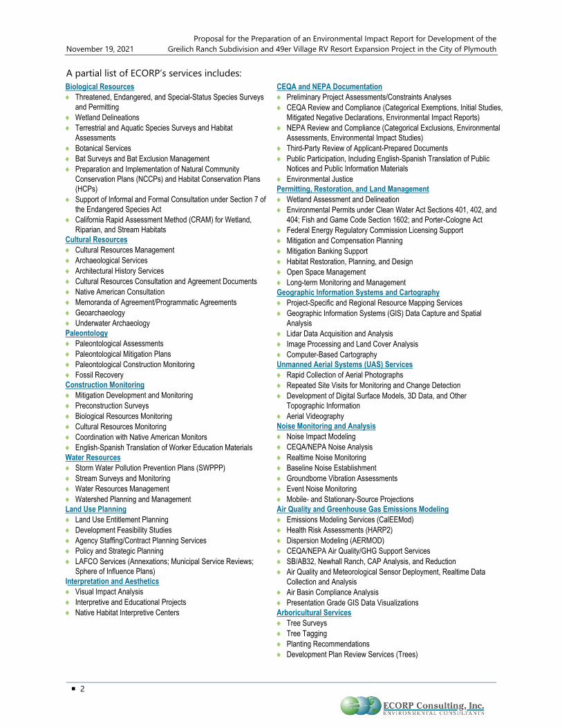
A partial list of ECORP’s services includes: Biological Resources ♦ Threatened, Endangered, and Special-Status Species Surveys
and Permitting ♦ Wetland Delineations ♦ Terrestrial and Aquatic Species Surveys and Habitat
Assessments ♦ Botanical Services ♦ Bat Surveys and Bat Exclusion Management ♦ Preparation and Implementation of Natural Community
Conservation Plans (NCCPs) and Habitat Conservation Plans (HCPs)
♦ Support of Informal and Formal Consultation under Section 7 of the Endangered Species Act
♦ California Rapid Assessment Method (CRAM) for Wetland, Riparian, and Stream Habitats
Cultural Resources ♦ Cultural Resources Management ♦ Archaeological Services ♦ Architectural History Services ♦ Cultural Resources Consultation and Agreement Documents ♦ Native American Consultation ♦ Memoranda of Agreement/Programmatic Agreements ♦ Geoarchaeology ♦ Underwater Archaeology Paleontology ♦ Paleontological Assessments ♦ Paleontological Mitigation Plans ♦ Paleontological Construction Monitoring ♦ Fossil Recovery Construction Monitoring ♦ Mitigation Development and Monitoring ♦ Preconstruction Surveys ♦ Biological Resources Monitoring ♦ Cultural Resources Monitoring ♦ Coordination with Native American Monitors ♦ English-Spanish Translation of Worker Education Materials Water Resources ♦ Storm Water Pollution Prevention Plans (SWPPP) ♦ Stream Surveys and Monitoring ♦ Water Resources Management ♦ Watershed Planning and Management Land Use Planning ♦ Land Use Entitlement Planning ♦ Development Feasibility Studies ♦ Agency Staffing/Contract Planning Services ♦ Policy and Strategic Planning ♦ LAFCO Services (Annexations; Municipal Service Reviews;
Sphere of Influence Plans) Interpretation and Aesthetics ♦ Visual Impact Analysis ♦ Interpretive and Educational Projects ♦ Native Habitat Interpretive Centers
CEQA and NEPA Documentation ♦ Preliminary Project Assessments/Constraints Analyses ♦ CEQA Review and Compliance (Categorical Exemptions, Initial Studies,
Mitigated Negative Declarations, Environmental Impact Reports) ♦ NEPA Review and Compliance (Categorical Exclusions, Environmental
Assessments, Environmental Impact Studies) ♦ Third-Party Review of Applicant-Prepared Documents ♦ Public Participation, Including English-Spanish Translation of Public
Notices and Public Information Materials ♦ Environmental Justice Permitting, Restoration, and Land Management ♦ Wetland Assessment and Delineation ♦ Environmental Permits under Clean Water Act Sections 401, 402, and
404; Fish and Game Code Section 1602; and Porter-Cologne Act ♦ Federal Energy Regulatory Commission Licensing Support ♦ Mitigation and Compensation Planning ♦ Mitigation Banking Support ♦ Habitat Restoration, Planning, and Design ♦ Open Space Management ♦ Long-term Monitoring and Management Geographic Information Systems and Cartography ♦ Project-Specific and Regional Resource Mapping Services ♦ Geographic Information Systems (GIS) Data Capture and Spatial
Analysis ♦ Lidar Data Acquisition and Analysis ♦ Image Processing and Land Cover Analysis ♦ Computer-Based Cartography Unmanned Aerial Systems (UAS) Services ♦ Rapid Collection of Aerial Photographs ♦ Repeated Site Visits for Monitoring and Change Detection ♦ Development of Digital Surface Models, 3D Data, and Other
Topographic Information ♦ Aerial Videography Noise Monitoring and Analysis ♦ Noise Impact Modeling ♦ CEQA/NEPA Noise Analysis ♦ Realtime Noise Monitoring ♦ Baseline Noise Establishment ♦ Groundborne Vibration Assessments ♦ Event Noise Monitoring ♦ Mobile- and Stationary-Source Projections Air Quality and Greenhouse Gas Emissions Modeling ♦ Emissions Modeling Services (CalEEMod) ♦ Health Risk Assessments (HARP2) ♦ Dispersion Modeling (AERMOD) ♦ CEQA/NEPA Air Quality/GHG Support Services ♦ SB/AB32, Newhall Ranch, CAP Analysis, and Reduction ♦ Air Quality and Meteorological Sensor Deployment, Realtime Data
Collection and Analysis ♦ Air Basin Compliance Analysis ♦ Presentation Grade GIS Data Visualizations Arboricultural Services ♦ Tree Surveys ♦ Tree Tagging ♦ Planting Recommendations ♦ Development Plan Review Services (Trees)
Proposal for the Preparation of an Environmental Impact Report for Development of the Greilich Ranch Subdivision and 49er Village RV Resort Expansion Project in the City of Plymouth November 19, 2021
3
ENGEO Incorporated
ENGEO Incorporated (ENGEO) is an award-winning, employee-owned California Corporation of more than 350 geotechnical and civil engineers, geologists, environmental scientists, water resources experts, field representatives, laboratory testing specialists, and supporting staff, serving clients in California and abroad for 50 years. ENGEO has served many iconic and highly visible projects with complex engineering and geologic challenges such as compressible soil, expansive soil, unstable terrain, rockfall, landslides, and seismic hazards.
ENGEO professionals share an absolute commitment to providing practical and constructible solutions based on good science and sound engineering. They accomplish this by first understanding their clients’ business and their objectives, applying appropriate methodologies, and promoting open and collaborative communication with the design team. Their innovation, creativity, and practicality help their clients achieve milestones on schedule and with cost savings. The results we accomplish on complex projects earn the acclaim and respect of leading consultants and academics in the engineering field.
ENGEO serves many types of projects from EIR stage through construction including parks and recreation, civic structures, transportation, flood control, water storage, conveyance and treatment, industrial facilities, healthcare, education, energy, manufacturing, ports, harbors, waterfront development, residential, mixed-use communities, and urban development.
Core Services:
♦ Geotechnical Engineering
♦ Environmental Engineering
♦ Engineering Geology
♦ Water Resources & Hydrology
♦ Construction-Phase Testing & Observation
♦ Special Inspection & Materials Testing
♦ Stormwater Management
♦ GIS/GPS
♦ Geologic Hazard Abatement Districts (GHADs)
♦ Entitlement & Permitting Support
GHD, Inc.
GHD, Inc. (GHD) provides transportation planning and engineering, environmental, advisory, digital, and construction services to their clients. Operating globally and delivering services locally, they are able to offer clients the ability to develop a working relationship with their local staff while having access to their global experience base. Put simply, they work where their clients work. Their business model is to work internationally and deliver locally.
Established in 1928, GHD is a wholly-owned subsidiary - a privately held international engineering firm owned by their people and operating across five continents. They are one of the world’s leading

Proposal for the Preparation of an Environmental Impact Report for Development of the November 19, 2021 Greilich Ranch Subdivision and 49er Village RV Resort Expansion Project in the City of Plymouth
4
professional services companies operating in the global markets of Transportation, Water, Energy & Resources, Environment, and Property & Buildings. Their people can offer decades of knowledge, as well as a deep understanding of the challenges facing businesses and communities today. They deliver projects with high standards of safety, quality, and ethics across the entire asset value chain. Driven by a client-service led culture, they connect the knowledge, skill, and experience of their people with innovative practices, technical capabilities, and robust systems to create lasting community benefits.
GHD has an excellent performance record with municipal and government agencies throughout California. Many of GHD’s past and current projects include the following transportation services:
♦ Traffic Engineering
♦ Transportation Planning/Design
♦ Motorized and Non-Motorized
♦ Complete Streets/Streetscape Design
♦ Civil Engineering
♦ Landscape Architecture/Wayfinding
♦ Roundabout Planning/Design
♦ Construction Management
♦ Land/Construction Surveying
♦ Public Outreach & Interagency Coordination
Over the years in the area of transportation planning, GHD has been given the opportunity to prepare circulation elements for City and County General Plans and Specific Plans and for Regional Transportation Plans.
GHD specializes in transportation planning and engineering services. We routinely provide local agencies with comprehensive transportation planning services ranging from Circulation Element Updates to Traffic Impact Analysis. These services include:
♦ Travel Demand Modeling
♦ Identification of Improvement Needs
♦ Facility Cost Estimates
♦ Capital Improvement Programs (CIP)
♦ Traffic Impact Fee Programs
♦ Transportation Finance
Their involvement in the preparation of these regional transportation plans and circulation elements ranged from developing traffic models to forecasting future travel and circulation improvement requirements to preparing the entire circulation element document. Many of these projects also included coordination of associated Environmental Impact Reports (EIRs).
RRM Design Group
RRM Design Group (RRM) exists because they love creating environments people enjoy. That is what got them into the business over 45 years ago, and it is why they continue to thrive today. Their architects and landscape architects, engineers, surveyors, and planners work with their clients and their communities to create the parks their children play in, the roads they drive down on their way to work, the neighborhoods they come home to, and the fire stations that keep their communities safe.

Proposal for the Preparation of an Environmental Impact Report for Development of the Greilich Ranch Subdivision and 49er Village RV Resort Expansion Project in the City of Plymouth November 19, 2021
5
Their work culture emphasizes collaboration, frequent communication, and accessibility. They are a close partner with their clients, helping them understand and navigate through the project lifecycle. Whether your project is public or private, commercial or residential, they listen, they design, and they deliver. On time. On budget. Since 1974.
RRM’s planning and landscape architecture group takes projects from concept and elevates them into a simulated visual reality. Visual simulations provide the public the ability to visualize a concept drawing before it is constructed. With over 50 completed visual simulations, RRM’s expertise has been well-utilized on architectural, streetscape, and corridor projects.
These simulations are typically provided in a three-dimensional before-and-after series of images from multiple perspectives They are a useful tool throughout the design process as they identify design challenges earlier on and can be continuously updated throughout the design process.
Their professionals utilize a wide range of technical expertise, and software platforms to accurately depict the project. RRM’s project experience ranges from small-scale private projects to large scale developments and public improvements. The depth of experience in our staff promotes an exceptional effectiveness in creative project solutions, great visual graphics, and the ability to maintain great client relationships, which is evidenced through our numerous implemented projects across the state.
Core Disciplines
♦ Architecture
♦ Civil Engineering
♦ Landscape Architecture
♦ Structural Engineering
♦ Surveying Planning
Key Personnel As the Project Manager, Chris Stabenfeldt, AICP, will provide the leadership and close coordination with the City and all other parties needed to successfully complete the project. This project management team will ensure proactive communication and competence of all analyses and deliverables through a rigorous quality assurance/quality control (QA/QC) process. The ECORP team organization chart (Figure 1) outlines how the ECORP team will be structured for the City project. Please see Attachment A for full resumes of team members. Provided below is a description of key individuals assigned to this contract and their roles, responsibilities, and relevant experience.

Proposal for the Preparation of an Environmental Impact Report for Development of the November 19, 2021 Greilich Ranch Subdivision and 49er Village RV Resort Expansion Project in the City of Plymouth
6
Figure 1. Organization Chart
Chris Stabenfeldt, AICP – Project Manager/Principal Environmental Planner. Mr. Stabenfeldt is a certified planner, team and project manager and environmental analyst with more than 37 years of professional environmental and planning consulting experience, including more than ten years at ECORP. As Project Manager, he will be the primary point-of-contact with the City. He will maintain the master schedule and direct the team to successfully complete preparation of the EIR. He has managed comprehensive and complex environmental documents and planning projects for public agencies and private sector clients including documentation and related compliance activities under NEPA and CEQA throughout the west. He has a strong multidisciplinary background and has conducted technical studies in noise, air quality, geology, hydrology, infrastructure analysis, and land use policy assessment.
Mr. Stabenfeldt recently served as project manager for several projects in Amador County including water infrastructure projects for the Amador Water Agency and Pine Grove Community Services District and is very familiar with local conditions and issues of concern. As demonstrated in his

Proposal for the Preparation of an Environmental Impact Report for Development of the Greilich Ranch Subdivision and 49er Village RV Resort Expansion Project in the City of Plymouth November 19, 2021
7
resume, he has managed preparation of environmental documents and associated technical studies for a wide range of development projects involving entitlement requests for use permits, tentative maps, rezones, specific plans, and general plans.
Michelle Wilson – Assistant Project Manager/CEQA Task Manager/Senior Environmental Planner/Senior Biologist. Ms. Wilson is a Senior Environmental Planner/Senior Biologist with more than 27 years of experience, specializing in both CEQA and NEPA compliance, permitting, water quality, and biological services. She recently joined ECORP and previously worked for another environmental consulting firm, as a Senior Planner with Santa Barbara Planning & Development, and as a permitting specialist for the oil and gas industry. Since 1997, she has authored and managed more than 30 CEQA, NEPA, or joint documents including numerous Environmental Impact Reports (EIRs) for multi-family and mixed-use development projects, commercial developments, recreational projects, industrial projects, and General Plan Updates. Ms. Wilson has processed major CUPs, development plans, tract maps, lot line adjustments, rezones/General Plan Amendments, land use permits, coastal development permits, Williamson Act withdrawals, and California Government Code Section 65402 determinations. While with Santa Barbara County she staffed the Board of Architectural Review and Historic Landmarks Advisory Commission.
Jeremy Adams – Cultural Resources Task Manager/Senior Architectural Historian. Mr. Adams is a Cultural Resources Manager and Senior Architectural Historian with 11 years of experience in developing cultural resources management strategies and leading the implementation of cultural inventories, evaluations, effects analysis, and preparation of mitigation documents. He holds a Master of Arts degree in History (Public History), a Bachelor of Arts degree in History, and he meets the Secretary of the Interior's Professional Qualification Standards for Architectural History and History. Mr. Adams serves as principal investigator for all architectural history components of projects and is well versed in the practical application of the laws and regulations of Section 106 of NHPA and CEQA. He is highly skilled at historical research and analysis and is familiar with numerous archives, libraries, museums, and other historical repositories throughout California. He has prepared historic contexts, property histories, and carried out architectural site documentation for buildings, structures, and historical landscapes. He has also prepared built-environment impact assessments and has developed mitigation measures for CEQA and Section 106 projects. In addition, he has carried out all three versions of Historic American Buildings Survey (HABS), Historic American Engineering Record (HAER), Historic American
Client Comment Regarding Jeremy Adams
“I have worked with Jeremy on a large water storage project for the last several years. Jeremy is a consummate professional, easy to work with and is always accessible. I have found him to be very responsive to both emails and phone calls. Jeremy follows through with assigned tasks, meeting deadlines and the quality of the work product has always been superior. I have the upmost confidence in Jeremy’s abilities and knowledge and rely heavily on his expertise in guiding the District through the AB52 process.”
— Doug Roderick P.E. Senior Engineer
Nevada Irrigation District

Proposal for the Preparation of an Environmental Impact Report for Development of the November 19, 2021 Greilich Ranch Subdivision and 49er Village RV Resort Expansion Project in the City of Plymouth
8
Landscapes Survey (HALS) documentation, developed educational interpretive panels, has completed Caltrans Standard Environmental Reference documents, multiple versions of Finding of Effect documents, and has evaluated numerous historic-age buildings and properties, as well as assisted lead agencies with State Historic Preservation Officer (SHPO) consultation. As the manager of ECORPs cultural resources department in Rocklin, he has led numerous cultural resources studies and is the principal investigator and author for multiple architectural history studies.
Andrew Kopania, Ph.D., P.G., C.H. – Water Resources Task Manager. Dr. Kopania is known for his broad experience in hydrogeologic investigation and analysis to support a wide range of projects throughout California. He has developed groundwater and surface-water monitoring programs, conducted technical studies, prepared hydrology and water quality analyses for permitting efforts, negotiated NPDES and other permits with various regulatory agencies, and prepared regulatory compliance documents. Over the past 31 years, Dr. Kopania has been involved in technical studies and permitting for hundreds of projects in California. In particular, Dr. Kopania has been involved with groundwater and water-quality assessments to support CEQA and NEPA reviews on over 100 projects.
He is a California-licensed Professional Geologist and Certified Hydrogeologist with more than 30 years of experience in subsurface investigations, technical report preparation, regulatory compliance and agency negotiation, and litigation support/expert witness services. Project and client types have included industrial and manufacturing facilities, solid waste landfills, petroleum pipelines, municipal and state agencies, water purveyors, agricultural operations, and commercial and residential developments. He provides both breadth and depth to permitting, technical evaluation, and regulatory compliance for clients in all regions of California.
Keith Kwan – Biological Resources/Regulatory Permitting Task Manager. Mr. Kwan has more than 30 years of experience as a wildlife biologist and wetland ecologist. He specializes in avian ecology, wetland delineations and wetland ecology, special-status species ecology, environmental impact assessment, regulatory compliance, and project management. He also has expertise in conducting biological resources assessments; bird censuses; special-status species surveys; general biotic inventories; and biodiversity monitoring of created, restored, and existing terrestrial habitats of California.
Mr. Kwan has expertise in delineation of Waters of the U.S. and has delineated over a hundred sites throughout California, Nevada, and Colorado. He also has expertise in annual grassland and oak woodland communities, having conducted hundreds of wetland and biological resource evaluations related to site development, impact assessment, CEQA compliance, Clean Water Act (CWA) 404 compliance, and CDFW 1602 compliance.
His expertise in avian ecology includes numerous breeding bird surveys, nest monitoring, and pre-construction clearance surveys in support of various local, state and federal regulations (e.g., CEQA, CDFW 1602). He has developed studies utilizing focal-survey and point-count methodologies to

Proposal for the Preparation of an Environmental Impact Report for Development of the Greilich Ranch Subdivision and 49er Village RV Resort Expansion Project in the City of Plymouth November 19, 2021
9
assess bird use. He has been an active birdwatcher throughout California and has participated in National Audubon Society Christmas Bird Counts for more than 30 years.
Mr. Kwan administers QA/QC for many of the biological resources reports produced in the Northern California region, including wetland delineations, special-status species assessment and survey reports, arborist survey reports, biological assessments, and Section 404 mitigation and compliance reports. He also has expertise in identification and field sampling of federally listed vernal pool branchiopods.
Seth Myers – Air Quality/Greenhouse Gases/Noise Task Manager. With 14 years of experience as an environmental planner and air quality/noise analyst, Mr. Myers is involved in the preparation of a full range of CEQA and NEPA environmental compliance and review documents including EIRs. He has extensive expertise conducting air quality, greenhouse gas emissions, and noise analyses and has a comprehensive working knowledge of the associated regulatory environment. He is proficient in the use of CalEEMod, EMFAC2017, AERMOD, SoundPLAN, the Roadway Construction Model, the Federal Highway Administration (FHWA) Highway Traffic Noise Prediction Model, and other industry standard emissions and noise modeling tools. In addition to typical land use development proposals, Mr. Myers specializes in the analysis of infrastructure projects. Such projects pose unique challenges to conducting technical emissions and noise-related modeling since they vary so widely as to outpace traditional model default options. Seth’s years of experience and exposure to dozens of technical analyses for a variety of project types have provided him the know-how to adequately replicate all the proposed actions involved with a specific development project in order to disclose the most representative predictions and estimates.
Jeffrey Swager, GIS Task Manager. Mr. Swager has more than 15 years of experience in the field of Environmental Science, Ecology, and GIS. His experience includes managing GPS data collection, GIS database design, data management, computer-based cartography, geoprocessing/spatial analysis, and field data collection. Mr. Swager has extensive knowledge in the use of ESRI ArcGIS and Trimble GPS products, as well as data integration into popular formats such as AutoCAD, Google Earth, Google Maps, and Garmin MapSource. Mr. Swager has worked on projects throughout California and its communities. Mr. Swager’s work has covered a wide array of topics including jurisdictional delineations, special-status species, and
Client Comment Regarding ECORP’s GIS Capabilities
“ECORP Consulting’s Geospatial team did a great job on our project. Their analysis-based GIS/lidar approach for assessing our natural resources produced accurate and reliable results, saved us time and money over traditional mapping techniques, and allowed us to demonstrate consistency with a particularly challenging oak canopy ordinance with utmost precision. The GIS team is extremely knowledgeable and efficient in completing any task you give them and I recommend them to anyone.”
— Andrea Howard Parker Development Company
El Dorado Hills

Proposal for the Preparation of an Environmental Impact Report for Development of the November 19, 2021 Greilich Ranch Subdivision and 49er Village RV Resort Expansion Project in the City of Plymouth
10
cultural resources, many in support of large infrastructure projects, specific plans, and regional conservation efforts.
Shawn Munger, PG, CHG (ENGEO) – Geology/Soils and Hazards & Hazards Materials Task Manager. Since 1985, Mr. Munger has been managing groundwater supply evaluations, hydrogeologic studies, chemical assessments, Phase I and II Site Assessments, UST site investigations, risk-based corrective action (RBCA), VOC remediation, and agricultural impact evaluations. He serves as Principal-in-Charge or Project Manager with extensive expertise in environmental and hazardous materials projects involving groundwater, hydrology, contaminant fate and transport, and complex remediation programs. A renowned expert in his field, Shawn has successfully solved many difficult environmental challenges to achieve desired project outcomes.
Makinzie Clark – Transportation Task Manager (GHD). Ms. Clark will serve as the Transportation Task Manager. She has seven years of experience working with dozens of agencies throughout California. She is a transportation planner and provides support on a variety of local and regional planning efforts, including general plan circulation elements, traffic impact fee studies, corridor studies, and infrastructure needs assessments. She is skilled in developing multimodal and safety assessments to create conceptual plans for transportation improvements. Makinzie also has experience utilizing GIS, Synchro, SimTraffic, Sidra, HCS, REMIX, Replica, and StreetLight Data.
Chris Dufour, PLA, LEED AP – Visual Simulations Task Manager (RRM). In the 20 years Mr. Dufour has worked with RRM’s visual simulation group, he has been relied on for his expertise in support of a broad array of private and public projects working with both developers and environmental review agencies. His skills in all aspects of a project, from photography and 3D modeling through to final composition, have made him an invaluable team member on many simulation efforts, including projects such as the Pismo Beach Office Complex, Laetitia Vineyards Ag Cluster, and California Valley Solar Farm. Mr. Dufour’s technical skills with multiple software packages allow him to bring a broad range of tools to the table.
C. DETAILED STATEMENT Project Understanding The proposed project includes approximately 167 acres situated west of SR 49, north of Zinfandel Parkway, and south of the Amador County Fairgrounds. The proposed project will be subdivided into the following components: Greilich Ranch Subdivision (115.5 acres), and the 49er Village RV Resort Expansion (44.9 acres).
The planned Greilich Ranch Subdivision includes:
♦ 234 single-family residential lots
♦ Common areas
♦ Open space

Proposal for the Preparation of an Environmental Impact Report for Development of the Greilich Ranch Subdivision and 49er Village RV Resort Expansion Project in the City of Plymouth November 19, 2021
11
♦ Retention Basins
♦ Landscaping and greenways
♦ Underground utilities
The planned 49er Village RV Resort Expansion includes:
♦ 214 additional RV and vacation sites
♦ 4,900-square-foot clubhouse
♦ Guest pool area
♦ Patio and meeting areas
♦ Showers and restrooms
♦ Underground utilities
The project applicant seeks numerous entitlements from the City to support the project development including amendments to the city’s General Plan and Zoning Maps, approval of a Tentative Subdivision Map and approval of a Conditional Use Permit and Development Agreement. In support of the application, the applicant has prepared a Biological Resource Assessment, a Cultural Resource Evaluation, preliminary traffic information and is in the process of completing other technical studies to support the application including preliminary plans for the resort expansion and subdivision, exhibits and text describing the entitlement requests, a draft Development Agreement, a tree removal plan, a drainage study an update to the water master plan, a preliminary water plan, sewer system details and an updated traffic study.
Overall Problem/Task ECORP understands that a wealth of existing information exists for the Project including several technical studies and application materials. Existing information and analysis will be used to the maximum extent feasible as appropriate to complete the EIR for the Project. However, based upon our preliminary review, additional analysis is proposed to address recommendations in existing studies, address comments received during previous scoping efforts for the project, and complete the technical analyses required to finalize the impact analysis for each issue area.
ECORP proposes to conduct a peer review of all applicant prepared documentation to determine its adequacy to support the EIR and will note any deficiencies that need to be addressed. The ECORP team will also prepare stand along technical studies to support the analysis and conclusions contained in the EIR. Specific studies will address Geology/Hazardous Waste, Air Quality, Greenhouse Gas, Energy, Noise, Traffic, Paleontology, Hydrology and Water Quality, Water Supply and tribal consultation. We have provided visual simulations as an optional task. A detailed description of the proposed technical studies is included in the Work Plan/Scope of Work presented below. ECORP will use existing information and research to address all other issue areas covered in the EIR.

Proposal for the Preparation of an Environmental Impact Report for Development of the November 19, 2021 Greilich Ranch Subdivision and 49er Village RV Resort Expansion Project in the City of Plymouth
12
General Approach ECORP recognizes that the project represents a significant development for the City of Plymouth and will garner considerable attention from the local community, nearby neighborhoods including Zinfandel Ridge and local and regional regulatory entities. Based in the level of detail available ECORP proposes to prepare a Project level EIR for the project. In order to ensure comprehensive and defensible environmental documentation, it will be imperative to develop a detailed project description to support the document and associated technical studies including identification of any offsite improvements needed to support the development, including the proposed connection to Old Sacramento Road. ECORP will work closely with the City to fully define all project components and ensure that the public is fully informed as to all potential issues associated with development of the project.
To achieve these goals, ECORP proposes frequent communication with the City and the project applicant to ensure that all parties are informed as to the status of project tasks, consensus can be achieved for any problems that may arise and that a complete and defensible environmental record is developed for the project. Using this method will allow the project team to keep the project on track and avoid delays and redundant work efforts moving forward.
Work Plan/Scope of Work Task A: Project Initiation Meeting
ECORP’s management team will attend a combined start-up meeting and site visit with staff from the City (as well as other project team members), to discuss project objectives and characteristics. The site visit will be used as a means of refining the project description, discussing the schedule, establishing procedures for data gathering and focusing the analysis on pertinent issues. The meeting will be attended by ECORPs Project Manager and Assistant Project Manager. Approximately eight (8) hours of meeting time and travel time from ECORP’s Rocklin office are assumed for the site visit. ECORP will also attend a project initiation meeting with Agencies with permitting authority over the project to review project characteristics, confirm CEQA documentation approach and solicit comments on the proposed project. This is assumed to be a virtual meeting.
Task B: Review of City Documents and Data Collection
Utilizing the project description developed in support of the NOP as a starting point, ECORP will coordinate with the City to review all existing planning and environmental documentation pertinent to the project and site including (but not limited to) the application package including technical studies, City Ordinances, the General Plan, and the Zoning Code. ECORP will also review any additional documents, notes, and comments from the City’s previous scoping meetings. ECORP will develop a list of relevant documents that will be utilized to support the EIR and will note any deficiencies or gaps based on our proposed scope of work and materials anticipated from the applicant.

Proposal for the Preparation of an Environmental Impact Report for Development of the Greilich Ranch Subdivision and 49er Village RV Resort Expansion Project in the City of Plymouth November 19, 2021
13
Task C: Conduct/Attend Scoping Session/Project Description
ECORP will help coordinate with the City to plan and attend one scoping session for the public at City Hall. This meeting will be scheduled following the release of a second Notice of Preparation as listed in Task D. The City previously conducted a pre-scoping meeting in July 2021 and will provide ECORP with comments and notes from that session for their review. ECORP will prepare a summary of the verbal and written comments made at the scoping session as well as the written comments submitted in response to the notices. After the scoping session, ECORP will work with the City to draft a project description. Coordination for this task will be by telephone and/or email. The project description shall include:
♦ Project setting: a description of the project’s regional and local location, environmental setting, local transportation system, land use designations, and surrounding land uses. Maps showing the regional and specific location of the project will be included in this section.
♦ Project background: a description of the project’s history and requested entitlements to support development of the project.
♦ Project objectives: the goals, objectives, and need for the project
♦ Project characteristics: A detailed description of project elements will be developed utilizing the information provided in the application materials provided by the developer. All elements of the project will be defined including the tentative subdivision map, revised preliminary plans, the conceptual Entry modifications proposed for the RV resort, the proposed circulation system, all proposed utility improvements both on and off-site, dedicated open space and recreational elements. Other project details to be addressed include a project implementation schedule and sequencing/phasing and construction details as available. Site layout maps and elevations shall be provided by the applicant or their consultants in .pdf format.
♦ Project Approvals: list of project approvals required by the City and other agencies.
Task D: Preparation of Notices and Documentation (CEQA)
ECORP will work closely with the City to prepare and submit all CEQA-required notices and documents, including a Notice of Preparation (NOP), the AB 52 Consultation Notice, Notice of Completion (NOC), Notice of Availability (NOA) and Notice of Determination (NOD) at the appropriate timeframe. ECORP will coordinate with the City to orchestrate mailing of the CEQA Notices to public agencies, filing with the County Clerk, and electronic filling at the State Clearinghouse. ECORP will also assist the City with on-site notices and legal notices in the newspaper. It is our understanding that ECORP will prepare the notices and the EIR documents, and the City will provide the notice list and will pay the publishing fees.
Task E: Project Management
Ongoing consultation and coordination with appropriate agencies, City staff, the applicant and other project team members will be conducted during the preparation of the EIR. This task includes

Proposal for the Preparation of an Environmental Impact Report for Development of the November 19, 2021 Greilich Ranch Subdivision and 49er Village RV Resort Expansion Project in the City of Plymouth
14
project management and coordination time between ECORP, the City, the applicant and other applicable agencies. ECORP will attend bi-weekly project team meetings over the one-year project timeline for a total of 24 meetings. It is assumed these meetings will be held via conference call and will require approximately one (1) hour each. ECORP’s Project Management team, key environmental staff, and members of ECORP’s team that may be needed to address specific issues will participate in the project team meetings/conference calls. This task also includes approximately 2 hours per week for coordination with the project team, meeting agendas, meeting minutes, and other ongoing management activities.
Task F: Technical Studies
The following technical surveys and technical memoranda will be provided by the ECORP team for the Proposed Project. It is assumed that additional data required to support and document answers to all other CEQA checklist items can be obtained from existing documentation (i.e., General Plan and associated environmental documentation, floodplain maps, previous environmental documentation in the vicinity of the project site, technical studies prepared for the project and other standard environmental references), consultation with project staff, or information being prepared separately by the project team or other consultants. ECORP and our teaming partners will prepare technical studies addressing Air Quality/GHG, Energy, Biological Resources (peer review only), Cultural Resources (peer review only), Noise, Traffic, Visual Simulations (optional), Water Supply, Hydrology/Water Quality, Geologic Hazards and a Phase 1 Environmental Site Assessment. ECORP will also provide Tribal Consultation support as described in more detail below. Information from these studies will be used to inform the analysis and conclusions in appropriate chapters of the EIR.
Task F1: Air Quality and Greenhouse Gas Emissions Assessment Memorandum
The assessment of air quality and greenhouse gas emissions will quantify short-term (i.e., construction) and long-term (i.e., operational) emissions generated by the Proposed Project using the California Emissions Estimator Model version 2020.4.0 (CalEEMod) software. CalEEMod is a statewide land use emissions computer model designed to quantify potential pollutant emissions associated with a variety of land use projects. The Project is located within Amador County, which is under the jurisdiction of the Amador Air District (AAD). The AAD has not formally adopted thresholds of significance for the evaluation of proposed projects that are subject to CEQA review. Therefore, air pollutant significance thresholds will be based on a combination of California Health and Safety Code Section 40918 and Amador Air District’s Rule 500, depending on the pollutant. Project emissions will also be evaluated against the significance thresholds established in neighboring El Dorado County for comparison purposes. ECORP proposes to evaluate potential air quality and GHG emission-related impacts in a technical memorandum. The analysis will be supported by modeling documentation, which would be included as an appendix to the technical memorandum.

Proposal for the Preparation of an Environmental Impact Report for Development of the Greilich Ranch Subdivision and 49er Village RV Resort Expansion Project in the City of Plymouth November 19, 2021
15
Task F1 Deliverables:
♦ One (1) electronic version of both the draft and final Air Quality and Greenhouse Gas Emissions Impact Assessment Memorandum.
Task F2: Peer Review of Biological Resource Assessment
ECORP Consulting, Inc. (ECORP) will conduct a peer review of the Biological Resources Assessment (BRA) prepared for the applicant. The scope of work will include a review of existing biological information in the region and documentation available specific to the Project. It is assumed that the previous BRA addresses all relevant issues needed for a complete evaluation under CEQA including, wetlands, sensitive habitat and species, movement corridors etc.
A summary of the findings will be incorporated into a memorandum. The memorandum will provide the results of the peer review and recommendations, if required, for compliance with the California Environmental Quality Act (CEQA) review document. Review of potential impacts to biological resources will be assessed using the CEQA Appendix G Checklist. If necessary, ECORP will make recommendations as to additional documentation needed from the authors of the BRA to ensure that all impacts are fully evaluated. Based on site conditions, mitigation measures will be recommended and permitting required to support the project will be identified.
Task F2 Deliverables:
♦ ECORP will submit the peer review memorandum report within 60 days of contract execution and notice to proceed electronically as a PDF. ECORP will address one round of comments on the report, if necessary.
Task F3: Peer Review of Previous Cultural Resources Study
The scope of work includes a review of the cultural resources technical study previously prepared for the Project Area for compliance with CEQA, and preparation of a peer review memo report.
ECORP’s peer review study will be conducted by or under the direct supervision of a Registered Professional Archaeologist who meets the Secretary of the Interior’s Professional Qualifications Standards for prehistoric and historic archaeology. The memo will identify any deficiencies in the previous Cultural Resources Study and provide recommendations as to appropriate mitigation based on site conditions and industry standards.
Task F3 Deliverables:
♦ ECORP will submit the peer review memo report within 60 days of contract execution and notice to proceed. ECORP will address one round of comments on the report, if necessary.
Task F4: Energy Consumption Analysis
To better integrate the energy analysis with the rest of CEQA, the Governor’s Office of Planning Research (OPR) has added relevant questions regarding potential energy impacts to the sample

Proposal for the Preparation of an Environmental Impact Report for Development of the November 19, 2021 Greilich Ranch Subdivision and 49er Village RV Resort Expansion Project in the City of Plymouth
16
environmental checklist in Appendix G of the CEQA Guidelines. ECORP proposes to analyze Project energy consumption in the body of the EIR, where potential impacts related to Project energy consumption will be assessed against OPR’s proposed standards of significance; i.e., whether the Project result in the wasteful, inefficient, or unnecessary consumption of energy, or wasteful use of energy resources; and, whether the Project would conflict with an applicable plan for renewable energy or energy efficiency. There are no established thresholds of significance, statewide or locally, for what constitutes a wasteful, inefficient, and unnecessary consumption of energy for a proposed mixed-use residential land use project. Therefore, for the purposes of this analysis, the amount of energy necessary for Project implementation will be quantified and compared to that consumed in Amador County as a whole.
ECORP proposes to evaluate energy consumption impacts in the body of the Draft EIR. Where appropriate, the analysis would be supported by modeling documentation, which would be included as an appendix to the Draft EIR.
Task F4 Deliverables:
♦ One (1) electronic version of both the draft and final Energy Consumption Assessment Draft EIR section.
Task F5: Noise Impact Memorandum
The evaluation of noise impacts associated with the Project will be completed by Senior-level staff members who are noise experts. In order to establish the existing ambient noise levels currently experienced at the Project site, and thus noise/land use compatibility, ECORP will first conduct up to two (2) long-term (24-hours) baseline noise measurements at the site in order to obtain a general representation of the existing ambient noise currently experienced in the area. In addition to the 24-hour measurement, ECORP will also conduct up to five (5) short-term (15 minutes) measurements in the Project vicinity surrounding the site in order to establish the existing ambient noise levels currently experienced in the areas surrounding the Project. The applicable noise standards for the Project Area (i.e., City of Plymouth General Plan Noise Element) will be discussed as these standards will be the basis for the Project impact determination and whether mitigation is necessary.
Construction would occur during implementation of the Proposed Project. Noise levels from construction sources will be analyzed using the Federal Highway Administration Roadway Construction Noise Model and based on the anticipated equipment to be used. In order to evaluate the potential health-related effects (physical damage to the ear) from construction noise, construction noise will be evaluated in terms of hourly equivalent continuous noise levels (Leq) and the frequency of occurrence at the nearby noise-sensitive residences. In addition to construction noise, an analysis of vibration impacts will be prepared based on the California Department of Transportation’s vibration analysis guidance.
The evaluation of the Project’s contribution to noise increases over existing conditions will be addressed. The predominate sources of onsite noise include automobile circulation on internal

Proposal for the Preparation of an Environmental Impact Report for Development of the Greilich Ranch Subdivision and 49er Village RV Resort Expansion Project in the City of Plymouth November 19, 2021
17
roadways, common residential neighborhood noises such as landscaping equipment and dogs barking, and RV maneuvering and recreational activities associated with the proposed RV resort. The analysis of onsite noise will rely on the SoundPLAN 3D noise model, which will be used to calculate the propagation/spread of onsite Project noise levels from onsite Project operations. The SoundPLAN 3D noise model predicts noise levels based on the location, noise level, and frequency spectra of the noise sources as well as the geometry and reflective properties of the local terrain, buildings and barriers. A noise contour graphic will be prepared to depict the noise levels at the surrounding receptors. The modeling results and noise contour graphics will be discussed and summarized in the analysis.
Another major source of noise associated with the Project would be offsite automobile traffic. Potential noise impacts from vehicular traffic will be assessed using the U.S. Federal Highway Traffic Noise Prediction Model (FHWA-RD-77-108). The 24-hour weighted Day-Night Average (DNL) will be presented in a tabular format. ECORP will require the completed Traffic Impact Assessment to complete the evaluation of offsite traffic noise.
ECORP proposes to evaluate noise impacts in a technical memorandum. Where appropriate, the analysis would be supported by modeling documentation, which would be included as an appendix to the memorandum.
Task F5 Deliverables:
♦ One (1) electronic version of both the draft and final Noise Impact Assessment Memorandum.
Task F6: Traffic (GHD)
The traffic study will be performed by GHD as described in the scope provided below.
Assumptions:
The following tasks have been created based on Project information provided by the City including Project land use and circulation assumptions. Additional information is requested of the City:
♦ The City of Plymouth Transportation Impact Study Guidelines
♦ The Amador County Transportation Commission (ACTC) Travel Demand Model
♦ The City of Plymouth Vehicle Miles Travelled (VMT) guidelines if available.
Data Collection: To provide a database of existing and future conditions, GHD will work with City staff to obtain other pertinent transportation data, including road improvement plans. Traffic data collection will be scheduled for the up to five intersection locations and three roadway locations, to be confirmed with the City. Traffic counts at study intersections will be collected on a typical weekday (Tuesday, Wednesday, or Thursday) for both the AM and PM peak hour periods. Average daily traffic (ADT) counts along study roadways will be collected for a 24-hour period on a typical weekday.

Proposal for the Preparation of an Environmental Impact Report for Development of the November 19, 2021 Greilich Ranch Subdivision and 49er Village RV Resort Expansion Project in the City of Plymouth
18
[If Caltrans or the City should request or require additional peak hour intersection LOS analysis, such analysis could be added to our proposed Scope of Work with additional authorization.]
Intersections: To be determined.
Roadways: To be determined.
Due to the current low traffic patterns associated with shelter-in-place orders and social distancing related to Covid-19, current traffic counts may not reflect typical travel demand. GHD will use ADT counts and Caltrans traffic census data to adjust 2021 traffic count data, if necessary.
Estimate Project Trip Generation: The Project will be evaluated in one phase including both the Greilich Ranch subdivision and the 49er Village RV Resort expansion projects. The total number of vehicle trips expected to be generated by the proposed project will be estimated. Local trip generation data will be obtained from the latest Trip Generation Manual published by the Institute of Transportation Engineers. Project trip generation volumes will be estimated for weekday and peak hour conditions.
Directional Trip Distribution and Assignment: Trip distribution assumptions will be developed using the ACTC travel demand model. Based on an analysis of the trip making characteristics of the proposed project and area demographics, the directional trip distribution of the project generated traffic will be estimated. The project trips will be assigned to all study intersection locations based on determined trip distribution patterns.
Deliverable: Memorandum of Assumptions Prior to completion of the following tasks, GHD will prepare a detailed Memorandum of Assumptions that documents all technical assumptions that will be used to complete the traffic study. Additionally, the memorandum will include a graphic that illustrates existing lane geometrics and control and traffic volumes. The memorandum will be submitted for review and comment to both the City and Caltrans.
General Plan Consistency: A level of service (LOS) analysis will be prepared and provided as a separate memorandum. LOS will be evaluated against adopted General Plan thresholds for the City of Plymouth. Improvements needed to maintain adopted LOS thresholds will also be identified for consideration as project conditions of approval, consistent with the General Plan.
GHD will obtain and review available existing files and databases from the City pertaining to all applicable transportation infrastructure, including bicycle, pedestrian, and transit facilities. Based upon the information gathered and the input provided by City staff, GHD will perform a comprehensive multimodal transportation and safety analysis of the street network in the study area to determine existing traffic operations and identify existing connectivity, accessibility, and safety issues. The analysis will take into consideration all road users, including bicyclists, pedestrians, and transit users.
Vehicular Operations (Existing and Cumulative Conditions): The analysis will provide an evaluation of Existing and Cumulative (2040) peak hour LOS vehicular operations with and without

Proposal for the Preparation of an Environmental Impact Report for Development of the Greilich Ranch Subdivision and 49er Village RV Resort Expansion Project in the City of Plymouth November 19, 2021
19
the proposed project based upon information provided in the Memorandum of Assumptions. GHD will utilize the ACTC travel demand model to determine if the proposed circulation system is sufficient to accommodate future (20 year) traffic and is consistent with the City’s General Plan.
Circulation and Site Access Assessment: GHD will review the proposed roadway and intersection configurations of the future internal and public streets to ensure they meet the City’s design standards and future circulation needs. GHD will review the site plan access driveways to determine appropriate measures are in place to address potential queues that could interrupt traffic flow.
Safety Assessment: The analysis will also include transportation safety using history crash data from either the City’s crash database (such as Crossroads) or through SWITRS and TIMS. GHD will establish appropriate units of analysis within the study area (street segments and intersections) and aggregate available crash data to prepare a historical collision map. GHD will identify notable crash trends, such as factors associated with increased crash severity, factors associated with bicycle and pedestrian crashes, and a crash rate analysis to compare to statewide averages for similar facilities.
Multimodal Connectivity Assessment: Bicycle, pedestrian, and transit connectivity will be assessed using existing databases of transportation assets, such as sidewalk coverage, ADA ramps, transit stops and shelters, streetlights, crosswalks, and other pedestrian or transit amenities, as provided by the City. GHD will provide a high-level assessment of existing multimodal connectivity and accessibility within the study area.
Improvements for General Plan Consistency: The proposed project’s contribution to any LOS deficiencies, relative to adopted General Plan thresholds, will be quantified by comparison of “No Project” to “Plus Project” conditions at the study locations. In coordination with City staff, intersection improvements required to maintain adopted General Plan LOS thresholds, or reduce proportional project contributions towards deficiencies identified in previous Existing Plus Project and Cumulative Year Plus Project conditions will be quantified for weekday peak hour conditions.
VMT Analysis: GHD will utilize OPR guidance and the City’s guidelines (if available) and policies to deliver a CEQA transportation analysis consistent with the provisions of SB 743 to determine potential impacts associated with the Project land use (per the site plan provided to GHD), as well as to identify mitigations to potential impacts associated with increased VMT.
GHD will collaborate with ECORP to ensure that VMT estimates for the project are prepared consistently with other document sections, such as GHG and air quality. If these estimates must diverge, GHD will work with the environmental consultant to defensibly explain the methodological reasons for variances between CEQA air quality sections and VMT estimates. The Following tasks present alternative approaches to determination of the Project impact associated with increased VMT.
Establish Countywide VMT Average: As a means of addressing the requirements of SB 743, GHD will develop a VMT script for the Amador County Travel Demand Model (TDM) to produce the
Proposal for the Preparation of an Environmental Impact Report for Development of the November 19, 2021 Greilich Ranch Subdivision and 49er Village RV Resort Expansion Project in the City of Plymouth
20
existing average Countywide VMT efficiency metric for residential trip making. This VMT efficiency metric will form the basis for establishing Countywide VMT thresholds. The Amador County TDM is a stand-alone trip-based model that models vehicular travel only within Amador County; and utilizes static assumptions with respect to travel between the Sacramento region and Amador County, as well as the San Joaquin Valley and Amador County. For this reason, the VMT application shall apply a separate methodology for external-internal (XI) and internal-external (IX) VMT, discussed below. The VMT will be calculated using a trip-based methodology for all traffic analysis zones (TAZs) for the County and all gateway1 locations, with the following result:
1. Residential VMT per Capita
♦ The residential VMT will be calculated for all home-based trip productions; and
♦ The population will be based on the numbers of residential units and persons per household (2020 US Census).
External Trip Length Methodology: To account for VMT associated with one trip ‘end’ occurring outside of Amador County, the gateway vehicular volumes (one half) will be tabulated. The appropriate trip lengths for these vehicle trips will be estimated. Due to Amador County being located on the border of Sacramento and just outside the San Joaquin County area, and the limitations of the respective regional models to properly reflect trips made to, from and within Amador County, external trip lengths will be estimated by utilizing observed origins and destinations from the Replica platform. These trip lengths will be applied to all modelled internal-external and external-internal (IX and XI) trips, by direction and by purpose (home-based only) at major model gateways.
The use of observed origins and destinations to inform external trip lengths will apply to baseline conditions only. VMT application for future scenarios will require the development of future gateway average trip lengths which are not considered part of this scope of work.
Establish Countywide VMT Threshold: As a means of addressing the requirements of SB 743 and using the tools developed in the previous task, GHD will develop the existing average Countywide VMT per capita as well as a proposed Countywide VMT per capita threshold. This VMT per capita threshold will ultimately form the basis for establishing the occurrence of a significant transportation impact or lack thereof. As mentioned previously, the proposed VMT per Capita threshold would be applicable to evaluating transportation impacts for existing plus project conditions. GHD will present this information and obtain feedback from the client and Amador County.
Evaluate VMT for Residential Project: GHD will evaluate VMT per service population for the Project (residential units and RV resort), consistent with the project description for which trip generation is analyzed. GHD will analyze the average trip length of the TAZ in which the project is located and will estimate the VMT per capita for the residential project according to the trip generation result and the average trip length. GHD will complete the evaluation of whether the Project would result in a significant impact.

Proposal for the Preparation of an Environmental Impact Report for Development of the Greilich Ranch Subdivision and 49er Village RV Resort Expansion Project in the City of Plymouth November 19, 2021
21
Alternative High Level VMT Evaluation with Statewide Model. As an alternative the baseline VMT per capita discussed above could feasibly be estimated from the California Statewide Travel Demand Model (CSTDM), which has a base year of 2010. A drawback of this approach is that Amador County is likely to be represented by a scant number of TAZs and the resulting evaluation of the Project VMT per Capita would reflect this coarseness. A secondary drawback is that there would be no value add to the Amador County TDM moving forward. If desired by the Client to perform the VMT evaluation with the CSTDM and not with the Amador County TDM, prior Task 4 would not be performed and would be supplanted with this task with the following subtasks.
Establish Countywide VMT average: GHD will use the CSTDM with Statewide Baseline VMT per Capita calculated with outputs from the CSTDM. Average trip length information will be derived from the CSTDM, for the TAZ in which the Project is proposed.
Establish Project VMT average: GHD will estimate Project Residential VMT using the Project trip generation and average trip length. GHD will estimate the project VMT per capita, based on the estimated Project population, which will be discussed with the Client.
Evaluate VMT for Residential Project: GHD will evaluate VMT per service population for the Project relative to the CSTDM Statewide average and determine whether the Project would result in a significant impact.
VMT Mitigation Measures: Capital projects, contributions towards capital projects, and contributions towards City and regional travel demand management program improvements will be identified with the goal of reducing any identified CEQA project impacts relative to the guidelines utilized by the City. These mitigation measures will be reviewed with ECORP to ensure compatibility with other document sections and recommendations.
Governing Board Meeting: GHD will attend up to two (2) governing board meetings relevant to the VMT metrics. GHD assumes the meetings will be held virtually.
Task F6 Deliverable:
♦ VMT Analysis Memorandum (Draft & Final)
♦ GHD will also work with ECORP to provide VMT analysis results for the environmental document.
♦ General Plan Consistency Memorandum (Draft & Final)
Task F7: Visual Impact Assessment/Visual Simulations (RRM Design Group) (Optional Task)
Computer Modeling – Site: RRM will develop one computer model of the two project sites. Based on current site plans to be provided by the Client, RRM will generate a three-dimensional computer model of the proposed project site within the limits of the pre-approved vantage points. This model will be the basis for developing the visual simulations developed in the next task. The model will be developed only in areas visible from the vantage points selected.

Proposal for the Preparation of an Environmental Impact Report for Development of the November 19, 2021 Greilich Ranch Subdivision and 49er Village RV Resort Expansion Project in the City of Plymouth
22
Based on a review of the RFP, RRM assumes no existing three-dimensional computer model files exist for the project. RRM will provide typical residential building type models for the subdivision portion. The RV resort will be depicted based on Applicant design information. If minimal information is provided, RRM will base the design on the existing RV Park. An optional task is provided below for any additional building modeling required if pre-existing models are not available.
Visual Simulations: RRM will make one site visit to take 35mm digital photographs of the site’s existing conditions from the pre-approved vantage points. RRM assumes three visual simulations will be required to depict the project as discussed in the addenda portion of the project RFP.
These vantage points will be revised or confirmed by the Client prior to the site visit. It is assumed that these vantage points will be taken from the ground plane perspective (as opposed to bird’s-eye view).
RRM will match the views of the computer-generated model (created in the previous task) to those of the electronic photos taken at the vantage points. Together with the rendered model views, renderings will be created to illustrate the post-construction conditions based on typical construction methods generally used.
Computer Modeling – Buildings (Optional): RRM Architecture will create detailed, textured three-dimensional computer models of the building shells. Models will be created based on footprints and levations to be provided by the Client for both of the project sites. Assumed building types will include single-family-style homes, community building, and RV office building.
The building models will be utilized as part of the overall computer model developed in Task A. The cost provided below allows for up to five building model designs. Additional service authorization will be required for additional building models.
This task is not required if the applicant is able to provide design models (source file data).
Task F7 Deliverable:
♦ One (1) electronic computer model of the project site
♦ The final before-and-after graphics will be compiled into a booklet format and will include a brief description of the process used to create the graphics. The booklet will also have a key map illustrating where each photograph was taken.
♦ Five (5) computer building models for single-family style homes, community building, and RV office building.
Task F8: AB 52 Tribal Coordination Support
ECORP will assist the City of Plymouth in consulting with California Native American tribes under Assembly Bill 52 (AB 52). ECORP will draft all required notification letters, coordinate tribal meetings, maintain the AB 52 administrative record, and provide technical support to the City in determining whether or not Tribal Cultural Resources will be significantly impacted by the project. ECORP will document the consultation process and comments discussed and advise the City on how to come to a conclusion to the consultation, as specified by AB 52.

Proposal for the Preparation of an Environmental Impact Report for Development of the Greilich Ranch Subdivision and 49er Village RV Resort Expansion Project in the City of Plymouth November 19, 2021
23
This cost estimate is provided on a time and materials, “best efforts” basis. If the consultation requests from the tribes will require more effort that will exceed the budget provided herein, then a contract amendment would be required to complete the scope and AB 52 consultation.
Task F8 Deliverable:
♦ Draft AB52 letters
Task F9: Water Supply Assessment
The proposed project would obtain its water supply from the City of Plymouth. With the exception of several groundwater wells that can be used for emergency supply, the City of Plymouth obtains its water supply from the Amador Water Agency (AWA). To evaluate the adequacy of the available water supply for the project, ECORP will prepare a Water Supply Assessment (WSA) consistent with the requirements of California Senate Bill (SB) 610, SB 221, and subsequent additions in SB 1262, that modified California Water Code Sections 10910 through 10915. The WSA will be prepared in accordance with the October 2003 Guidebook for Implementation of Senate Bill 610 and Senate Bill 221 of 2001 to Assist Water Suppliers, Cities, and Counties in Integrating Water and Land Use Planning, published by the California Department of Water Resources.
Our scope of work to prepare the WSA includes the following:
♦ Determination of SB 610 applicability and format of the assessment;
♦ Documenting the source of the water supply, based on consultation with City and AWA staff and existing documentation;
♦ Identifying adjacent water systems and the status of SGMA implementation in Amador County, per SB 1262 requirements;
♦ Documenting project demand for the next 20 years, based on information provided by the applicant and City methodologies (e.g. Water System EDUs);
♦ Documenting dry year supply for a single dry year and for multiple dry years; and
♦ Presenting findings consistent with the applicable Water Code sections for acceptance by the City and for inclusion in the CEQA analysis.
In accordance with SB 610 and the Water Code, much of the WSA will rely on existing planning and compliance documents from the City of Plymouth and AWA. Examples of documents that may be relevant and will be reviewed for this scope of work include the City of Plymouth Water Master Plan, agreements between the City and AWA related to water supply and transmission pipelines, AWA's Long-Term Needs and Water Supply Study, the most recent Mokelumne/Amador/Calaveras Integrated Regional Water Management Plan Update, water planning documents to be provided by the applicant, and other relevant City of Plymouth and AWA documents related to water supply, water rights, and allocations.

Proposal for the Preparation of an Environmental Impact Report for Development of the November 19, 2021 Greilich Ranch Subdivision and 49er Village RV Resort Expansion Project in the City of Plymouth
24
The WSA will be prepared in coordination with, and will be used to support, various parts of the EIR, including components of the Hydrology and Water Quality, Public Services, and Utilities/Service Systems sections.
Task F9 Deliverable:
♦ Water Supply Assessment report to be an appendix to the EIR
Task F10: Hydrology and Water Quality Assessment
ECORP will evaluate potential hydrology and water quality impacts associated with each component of the proposed project as necessary to address CEQA Guidelines Appendix G criteria and applicable initial study guidelines pertaining to hydrology and water quality where relevant to the project. These criteria will include, at a minimum, whether the project would:
a) Violate any water quality standards or waste discharge requirements or otherwise substantially degrade surface or ground water quality.
b) Substantially decrease groundwater supplies or interfere substantially with groundwater recharge such that the project may impede sustainable groundwater management of the basin.
c) Substantially alter the existing drainage patterns of the site or area, including through the alteration of the course of a stream or river or through the addition of impervious surfaces, in a manner which would:
i. Result in substantial erosion or siltation on- or off-site;
ii. Substantially increase the rate or amount of surface runoff in a manner which would result in flooding on-or off-site;
iii. Create or contribute runoff water which would exceed the capacity of existing or planned stormwater drainage systems or provide substantial additional sources of polluted runoff; or
iv. Impede or redirect flood flows.
d) In flood hazard, tsunami, or seiche zones, risk release of pollutants due to project inundation.
e) Conflict with or obstruct implementation of a water quality control plan or sustainable groundwater management plan.
Surface water runoff and the potential for erosion or siltation will be addressed through analysis of the difference between current runoff conditions across the proposed project site with those that would exist under project conditions. That analysis will be conducted in accordance with Amador County Guidelines for Grading and Erosion Control. ECORP’s scope will include a peer review of the applicant’s drainage study and assumes that the results of that study will be appropriate for the environmental analysis. The proposed project would appreciably increase the area of impervious surfaces. Therefore, if potentially significant impacts are identified, mitigation measures and

Proposal for the Preparation of an Environmental Impact Report for Development of the Greilich Ranch Subdivision and 49er Village RV Resort Expansion Project in the City of Plymouth November 19, 2021
25
mitigation monitoring will be provided consistent with City and County erosion control requirements, including applicable best management practices (BMPs).
The City of Plymouth would supply water for the proposed project through its agreement with Amador Water Agency. Evaluation of the adequacy of that supply is addressed in our scope discussion for the Water Supply Assessment. The City of Plymouth has several groundwater wells that can provide emergency water supplies. Thus, the hydrology analysis, in conjunction with the Public Services and Utilities sections of the EIR, will assess the potential for the proposed project to increase the possibility that emergency use of the City’s water supply wells may occur. If the analysis indicates a potential for increased use of the supply wells, then the hydrology analysis will also consider whether that use would substantially decrease groundwater supplies available to the City and other nearby groundwater users, if any.
The hydrology and water quality analysis will assess the potential for project-related activities of conditions to impact water quality. Potential effects on water quality could occur during construction, for example from grading and soil disturbance, or from use of fuels and other chemicals by construction equipment. The long-term potential for increased runoff due to the proposed project and possible water quality effects will also be evaluated.
To address the full suite of Appendix G criteria related to hydrology and water quality, our analysis will consider:
♦ baseline meteorological information on rainfall and evaporation, available from public sources;
♦ surface water runoff characteristics of the site under baseline and proposed project conditions, including flow volumes and rates for key storm events;
♦ evaluation of the potential for the project to affect water quality, both in terms of runoff from the site and any percolation to groundwater; and
♦ identification of mitigation measures that would avoid or reduce potentially significant impacts associated with groundwater or surface-water hydrology or quality, including information regarding any proposed or required monitoring of hydrology and water quality conditions and actions to be taken based on the result of such monitoring.
Where mitigation is needed, ECORP will identify appropriate mitigation measures and any mitigation monitoring that would be necessary to verify performance of the mitigation measure and reduction of the potential impact to less than significant. Recommended performance standards will be identified in the environmental analysis, if necessary, consistent with applicable County policies and procedures.
Task F10 Deliverable:
♦ Hydrology and Water Quality Assessment report to be an appendix to the EIR.

Proposal for the Preparation of an Environmental Impact Report for Development of the November 19, 2021 Greilich Ranch Subdivision and 49er Village RV Resort Expansion Project in the City of Plymouth
26
Task F11: Phase 1 Site Assessment (ENGEO)
To support the Hazards and Hazardous Material section of the EIR, ENGEO will prepare a Phase I Environmental Assessment in general conformance with the standards and practices set forth in 40 CFR Part 312 and ASTM 1527-13 “Standard Practice for Environmental Site Assessments” and USEPA “Standards and Practices for All Appropriate Inquires”, 40 CFR Part 312.
The following will be included in the Phase 1:
♦ Review available environmental documents.
♦ Review publicly available and practically reviewable standard local, state, tribal, and federal environmental record sources, including a government records database report prepared by Environmental Data Resources (EDR), to evaluate hazardous materials information regarding the Property and nearby sites.
♦ Review publicly available and practically reviewable standard historical sources, aerial photographs, Sanborn Fire Insurance Maps, and physical setting sources for the history of development at and near the Property.
♦ Visit the Property to observe site use and current conditions, check for evidence of potential environmental conditions, and check for the storage, use, production, or disposal of hazardous or potentially hazardous materials.
♦ Conduct written or oral interviews with present and/or past owners, operators and/or occupants of the Property and government officials.
♦ Prepare a report documenting our findings, opinions and conclusions regarding potential Recognized Environmental Conditions.
It is requested that the City provides data on the Property that you may have available. These data include such items as the title report, chain-of-title, and other prepared legal descriptions of the Property.
A title company should be requested to provide information regarding environmental liens and activity use limitations (AUL). If this information is not available, the lien and AUL information can be provided for an additional fee of $200 per parcel. If the environmental lien and AUL search is not conducted as part of the report, it would be listed as a “data gap.”
Two environmental questionnaires will be submitted to the City and the Key Site Manager for completion. The Key Site Manager can be the current Property owner, owner representative, or other person having good knowledge of the uses and physical characteristics of the Property.
Task F11 Deliverable:
♦ Phase 1 Site Assessment report to be an appendix to the EIR.

Proposal for the Preparation of an Environmental Impact Report for Development of the Greilich Ranch Subdivision and 49er Village RV Resort Expansion Project in the City of Plymouth November 19, 2021
27
Task F12: Geology and Soils Technical Report
To support the Geology and Soils portion of the EIR, ENGEO will prepare a Geology and Soils Technical Report. The technical report will include review of the following resources.
♦ Historic aerial photographs
♦ Historic topographic maps
♦ Geologic maps and reports
♦ USDA soil maps
♦ Available existing geotechnical data
♦ Available groundwater data
♦ FEMA flood maps
♦ Mineral resource reports
♦ Paleontological reports and museum records
Additionally, we will visit accessible areas of the site to observe surface conditions. No subsurface exploration is proposed.
Our technical report will include a summary of the following related to the proposed development.
♦ Project elements
♦ Geologic formations
♦ USDA soil units
♦ Seismic hazards
• Faulting (surface rupture) • Seismic ground shaking • Secondary seismic hazards including liquefaction and lateral spreading
♦ Geologic hazards
• Landslides • Soil erosion or loss of top soil • Unstable soil including compressible soil • Regional subsidence • Expansive soil • Soil corrosion • Shallow groundwater, including data from the records review • Naturally Occurring Asbestos (NOA)
♦ Flooding hazards
• FEMA flood maps • Seismically induced flooding (dam failure inundation) • Mineral Resources

Proposal for the Preparation of an Environmental Impact Report for Development of the November 19, 2021 Greilich Ranch Subdivision and 49er Village RV Resort Expansion Project in the City of Plymouth
28
ENGEO will describe the effects of the hazards and resources listed above related to the project and describe potential mitigation measures. ENGEO will prepare an administrative draft of the Geology and Soils Technical Report for review by the project team. The report will include figures depicting the site boundaries with the geology, pertinent geologic hazards, and resources. It is assumed one round of comments on the administrative draft and then produce a final report. The report will be signed by a licensed California Geotechnical Engineer and a Certified Engineering Geologist.
Task F12 Deliverable:
♦ Geology and Soils Technical Report to be an appendix to the EIR.
Task F13: Paleontological Record Search and Findings Memorandum
ECORP Consulting, Inc. will request a records search for paleontological resources to determine if known fossils have been reported for the project area. Sources of records to be sought may include the University of California Museum of Paleontology, the Natural History Museum of Los Angeles County, Sierra College Natural History or other institutions as appropriate and applicable. The results of the records search combined with a review of regional geologic maps and existing literature on paleontological resources for the region will be described in a brief letter memorandum and provided as an attachment to the CEQA document, if necessary. If the results indicate a high sensitivity for paleontological resources, a survey and/or monitoring by a qualified paleontologist may be required as mitigation.
Task F13 Deliverable:
♦ Paleontological Findings Memorandum to be an appendix to the EIR.
Task G – Attend and Present at Community, Planning Commission and City Council Meetings
ECORP will attend the public scoping meeting that should take place during the public review of the EIR. The ECORP Project Manager will provide materials for the presentation and will assist the City in addressing questions and concerns from the public during the meeting. Additionally, ECORP will coordinate with the City to prepare staff reports and presentations for up to five (5) Planning Commission and/or City Council meetings regarding the information, analysis, findings, and recommendations contained in the environmental document, including one public meeting/hearing for adoption of the EIR.
Task G Deliverable:
♦ Staff Reports presentation materials
Task H – Prepare Administrative Draft EIR
The methodology for the technical analyses of key issues such as traffic, air quality/greenhouse gas, energy consumption, biological resources, cultural resources, water supply, hydrology/water quality, paleontology, hazards and noise are presented separately under Task G of this proposal. The

Proposal for the Preparation of an Environmental Impact Report for Development of the Greilich Ranch Subdivision and 49er Village RV Resort Expansion Project in the City of Plymouth November 19, 2021
29
following provides a detailed description of other key work items to be undertaken in preparation of the Administrative Draft EIR (ADEIR).
The ADEIR will include all sections required by CEQA, including: (1) summary of impacts and mitigation measures; (2) project objectives; (3) project description; (4) setting [existing condition discussions for both the physical environment and regulatory context], impacts and their significance both before and after implementation of identified mitigation, and mitigation measures [project-specific and cumulative] for each environmental issue; (5) CEQA-required sections; and (6) alternatives analyses. Each individual technical section contains a description of the methods of analyses and standards of significance used to determine the significance of each identified impact, including a discussion of the specific cumulative context for each issue item.
Environmental Setting/Impact Analyses/Mitigation Measures: The setting sections of the EIR will focus on site-specific information describing the conditions relevant to the project site and will summarize, as appropriate, regional setting information obtained from existing documentation and appropriate site reconnaissance. The setting discussions will have descriptions of the regulatory context, as applicable, for each technical issue. Relevant City of Plymouth General Plan and any applicable regional plan policies will be presented in the Setting sections or consolidated into separate appendices. Any inconsistencies of the proposed project and relevant land use policies will be identified. It will be assumed for the purpose of the analysis that the project will comply with all applicable federal, state, and county standards, regulations and ordinances.
Cumulative Impacts: The review of all technical issue areas will include an evaluation of cumulative impacts associated with implementation of the proposed project in combination with other reasonably foreseeable development activities. The EIR will include a review of the City of Plymouth General Plan, and any other relevant planning documents to provide an adequate context for the evaluation of cumulative impacts that will meet the requirements of CEQA. The list of reasonably foreseeable projects will be developed in coordination with the City.
Alternatives Analysis: The EIR will include a comparative analysis of a reasonable range of alternatives to the proposed project. A table that compares impacts of the proposed project to each alternative will be provided and included in the Summary of Impacts and Mitigation Measures chapter of the EIR. In addition to the proposed project, up to two additional alternatives will be evaluated, not including the No Project Alternative. The alternatives assessment will include a discussion of alternatives that were considered but eliminated from full review in the EIR. This section will briefly describe each of these alternatives, list screening criteria used to eliminate these alternatives from further review in accordance with CEQA Guidelines and explain why the alternative was appropriate for elimination.
Other Sections required by CEQA: The EIR will include other sections as required by the guidelines including a Summary of Effects Not Found to be Significant as well as evaluation of the following topics:

Proposal for the Preparation of an Environmental Impact Report for Development of the November 19, 2021 Greilich Ranch Subdivision and 49er Village RV Resort Expansion Project in the City of Plymouth
30
Aesthetics: The analysis will address the alteration of visual characteristics from the development of the proposed project, and the potential for increases in light and glare on adjacent uses within the vicinity of the project site.
Agriculture and Forestry Resources: The analysis will evaluate potential direct and indirect effects on the existing surrounding agricultural uses that could result from implementation of the proposed project. This section will also discuss conversion of the property from agricultural uses to urban.
Air Quality: The analysis will address short-term construction-related and long-term operations related increases in criteria air pollutants and precursors (e.g., reactive organic gases [ROG], oxides of nitrogen [NOX], respirable particulate matter [PM10], and fine particulate matter [PM2.5]).
Biological Resources: The analysis will evaluate potential direct and indirect impacts on biological resources, including riparian habitat, special-status fish, and other terrestrial and aquatic resources, that could result from implementation of the proposed project.
Cultural Resources and Tribal Cultural Resources: Utilizing the previous Cultural Study prepared for the site, any tribal or other cultural resources that are known or have the potential to occur on the project site will be assessed, and the potential impacts that may occur to known and unanticipated resources because of project implementation will be evaluated. The EIR will also document the results of required consultation and any agreements on mitigation measures for California Tribal Cultural Resources.
Energy: The levels of electricity, natural gas, propane, gasoline, and diesel consumed in the construction and operation of the project will be estimated, and whether the project would result in the wasteful use of energy will be determined.
Geology and Soils: The analysis will evaluate the potential for project-related construction and operations to cause impacts related to geology and soils, including mineral resources, which could result from the development of the proposed project.
Greenhouse Gases and Climate Change: The analysis will evaluate the project’s consistency with California’s GHG reduction goals and related regulations and policies and will determined whether project generated GHG emissions would be result in a cumulatively considerable contribution to the global impact of climate change.
Growth Inducement: The analysis will evaluate the project’s direct and indirect impacts on economic and/or population growth including the construction of additional housing, in the project vicinity.
Hazards and Hazardous Materials: The analysis will address the potential for project-related construction and operations to create significant hazards to the public and the environment through use of hazardous materials or cause reasonably foreseeable upset and accident conditions involving the release of hazardous materials.

Proposal for the Preparation of an Environmental Impact Report for Development of the Greilich Ranch Subdivision and 49er Village RV Resort Expansion Project in the City of Plymouth November 19, 2021
31
Hydrology and Water Quality: The analysis will describe the existing drainage and water quality conditions of the site, and provide a description of the applicable regulatory environment, and evaluate the project’s hydrology and water quality impacts including” short-term construction related effects; permanent stormwater changes’ impacts to surface water quality’ impacts to groundwater quality and quantity; and cumulative on- and off-site impacts.
Land Use: The analysis will describe the existing and proposed land uses in the project area and evaluate the potential inconsistencies between the proposed project and the applicable General Plan and zoning. The analysis will focus on changes in land use, land use compatibility, and general plan consistency, to the extent that potential General Plan conflicts may lead to physical impacts on the environment.
Noise and Vibration: The analysis will include information on the location of existing sensitive receptors, ambient noise levels, and natural factors that relate to the attenuation thereof. Noise and vibration impacts that would be anticipated to occur with construction and operational activities associated with the proposed project will be assessed.
Public Services and Recreation: The analysis will address the potential impacts on public services as a result of the proposed project. Public services include fire protection, law enforcement, schools, parks and recreation, and libraries.
Transportation: The analysis will include a Traffic Study. The traffic study will analyze the increase in vehicle traffic, and Level of Service and Vehicle Miles Travelled impacts to streets and intersections potentially impacted by the project.
Utilities and Service Systems: The analysis will address the potential for environmental affects as a result of the proposed project’s increased impact on water supply, distribution, and treatment; wastewater collection, conveyance, and treatment; solid waste collection and disposal; and electricity and natural gas.
Summary Chapter: ECORP will prepare a Project Summary Chapter in accordance with CEQA Guidelines and include a brief description of the project, potential areas of controversy, project alternatives, and a summary table of impacts and mitigation measures identified in the ADEIR.
Task H Deliverables:
♦ 3 hard copies of the ADEIR (spiral bound and duplex copied)
♦ One PDF file and one Word file of the complete ADEIR
Task I –Draft EIR and Mitigation, Monitoring, and Reporting Plan (MMRP)
Following City review of the ADEIR, ECORP will coordinate with City staff to review comments, receive direction, and discuss revisions. The City will be responsible for consolidating all City staff comments on the ADEIR. ECORP will revise the ADEIR and submit one electronic copy of the draft EIR to the City/agencies for final review. We anticipate the review of the draft will result in minor changes.

Proposal for the Preparation of an Environmental Impact Report for Development of the November 19, 2021 Greilich Ranch Subdivision and 49er Village RV Resort Expansion Project in the City of Plymouth
32
These revisions will be incorporated into a DEIR ready for printing and public circulation. The print ready DEIR will be provided to the City for final review and approval. ECORP will coordinate with the City to prepare a circulation list for the DEIR, submit one electronic copy to the State Clearinghouse, and produce 10 hard copies and one electronic copy for the City’s use. As stated in Task D, ECORP will prepare the required Notice of Availability (NOA) and Notice of Completion (NOC). The City will file a copy of the NOA at the County Clerk. ECORP will electronically submit the document/notices to the Office and Planning and Research in order to initiate the review period for the EIR.
Task I Deliverables:
♦ 10 copies of the DEIR with appendices (spiral bound and duplex copied)
♦ 10 compact disks containing PDF file of the complete DEIR with appendices
♦ 1 electronic copy of the DEIR, NOA and NOC via email
Task J– Response to Comments (RTC)
Following the public review period, ECORP will prepare draft responses to comments and an administrative draft of the Final EIR (AFEIR). The AFEIR will include a list of commenters, responses to comments, summary of DEIR text changes, a project summary, and revised summary table. For costing purposes it was assumed that approximately 20 comment letters will be received with approximately 100 distinct comments total. A contract modification may be necessary If the volume of comments is substantially higher than described above.
The AFEIR will also include the draft Mitigation Monitoring and Reporting Program (MMRP) for review. ECORP will update the MMRP to include any revisions made to mitigation measures identified in the DEIR. The MMRP will include the mitigation measures, assignment of responsibility, and relationship to project phasing, implementation timing, and reporting procedure.
Task J Deliverables:
♦ One hard copy of the AFEIR with MMRP and Appendices (Spiral Bound and Duplex Copied) and one PDF and word file of the AFEIR
Task K –Final EIR (FEIR)
ECORP will coordinate with City staff to receive direction and to discuss revisions to the AFEIR. City staff will be responsible for consolidating all City staff comments on the AFEIR. Upon receipt of staff comments, ECORP will revise the AFEIR document and submit a Screen check Final EIR (FEIR) to the City for review. Final revisions from that review will be included in the FEIR. Copies of the FEIR will be submitted to the City for distribution. ECORP will prepare the Notice of Determination (NOD). It is assumed that the City will prepare the Findings of Fact/Statement of Overriding Considerations and will distribute the NOD and FEIR.
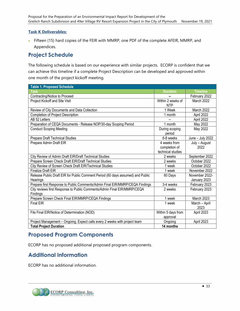
Proposal for the Preparation of an Environmental Impact Report for Development of the Greilich Ranch Subdivision and 49er Village RV Resort Expansion Project in the City of Plymouth November 19, 2021
33
Task K Deliverables:
♦ Fifteen (15) hard copies of the FEIR with MMRP, one PDF of the complete AFEIR, MMRP, and Appendices.
Project Schedule The following schedule is based on our experience with similar projects. ECORP is confident that we can achieve this timeline if a complete Project Description can be developed and approved within one month of the project kickoff meeting.
Table 1. Proposed Schedule Task Duration Timeline Contracting/Notice to Proceed -- February 2022 Project Kickoff and Site Visit Within 2 weeks of
NTP March 2022
Review of City Documents and Data Collection 1 Week March 2022 Completion of Project Description 1 month April 2022 AB 52 Letters -- April 2022 Preparation of CEQA Documents - Release NOP/30-day Scoping Period 1 month May 2022 Conduct Scoping Meeting During scoping
period May 2022
Prepare Draft Technical Studies 6-8 weeks June – July 2022 Prepare Admin Draft EIR 4 weeks from
completion of technical studies
July – August 2022
City Review of Admin Draft EIR/Draft Technical Studies 2 weeks September 2022 Prepare Screen Check Draft EIR/Draft Technical Studies 2 weeks October 2022 City Review of Screen Check Draft EIR/Technical Studies 1 week October 2022 Finalize Draft EIR 1 week November 2022 Release Public Draft EIR for Public Comment Period (60 days assumed) and Public Hearings
60 Days November 2022- January 2023
Prepare first Response to Public Comments/Admin Final EIR/MMRP/CEQA Findings 3-4 weeks February 2023 City reviews first Response to Public Comments/Admin Final EIR/MMRP/CEQA Findings
2 weeks February 2023
Prepare Screen Check Final EIR/MMRP/CEQA Findings 1 week March 2023 Final EIR 1 week March – April
2023 File Final EIR/Notice of Determination (NOD) Within 5 days from
approval April 2023
Project Management – Ongoing. Expect calls every 2 weeks with project team Ongoing April 2023 Total Project Duration 14 months
Proposed Program Components ECORP has no proposed additional proposed program components.
Additional Information ECORP has no additional information.
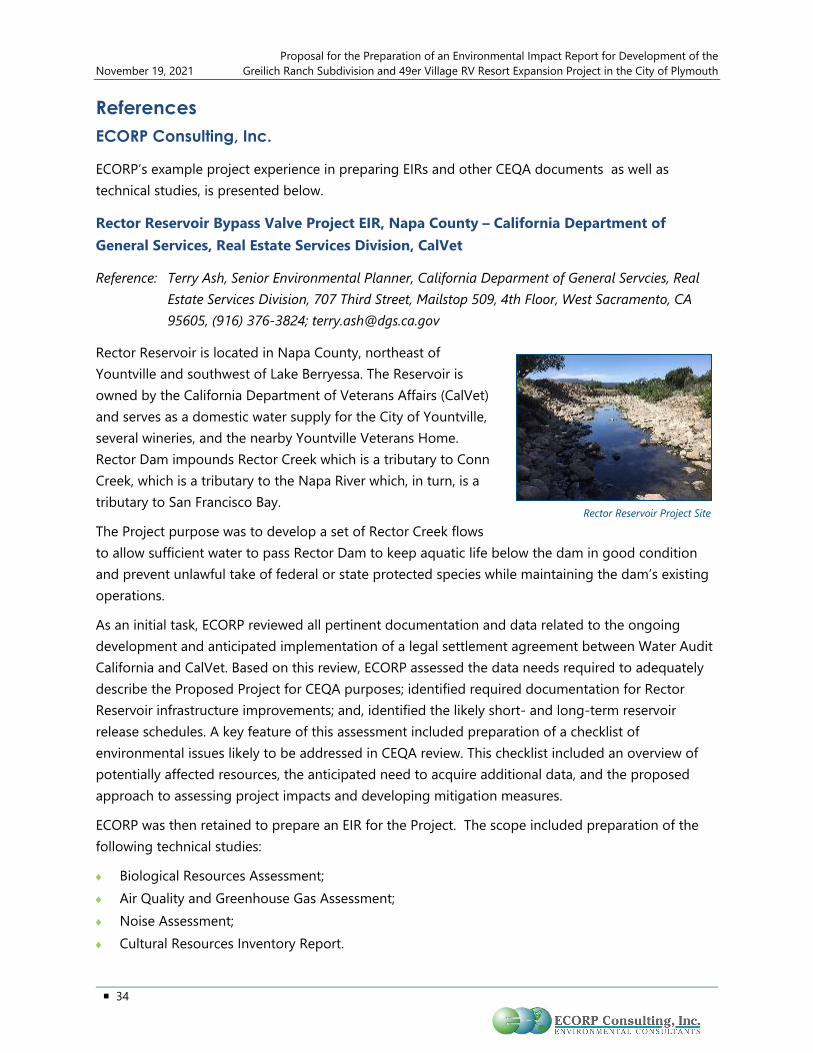
Proposal for the Preparation of an Environmental Impact Report for Development of the November 19, 2021 Greilich Ranch Subdivision and 49er Village RV Resort Expansion Project in the City of Plymouth
34
References ECORP Consulting, Inc.
ECORP’s example project experience in preparing EIRs and other CEQA documents as well as technical studies, is presented below.
Rector Reservoir Bypass Valve Project EIR, Napa County – California Department of General Services, Real Estate Services Division, CalVet
Reference: Terry Ash, Senior Environmental Planner, California Deparment of General Servcies, Real Estate Services Division, 707 Third Street, Mailstop 509, 4th Floor, West Sacramento, CA 95605, (916) 376-3824; [email protected]
Rector Reservoir is located in Napa County, northeast of Yountville and southwest of Lake Berryessa. The Reservoir is owned by the California Department of Veterans Affairs (CalVet) and serves as a domestic water supply for the City of Yountville, several wineries, and the nearby Yountville Veterans Home. Rector Dam impounds Rector Creek which is a tributary to Conn Creek, which is a tributary to the Napa River which, in turn, is a tributary to San Francisco Bay.
The Project purpose was to develop a set of Rector Creek flows to allow sufficient water to pass Rector Dam to keep aquatic life below the dam in good condition and prevent unlawful take of federal or state protected species while maintaining the dam’s existing operations.
As an initial task, ECORP reviewed all pertinent documentation and data related to the ongoing development and anticipated implementation of a legal settlement agreement between Water Audit California and CalVet. Based on this review, ECORP assessed the data needs required to adequately describe the Proposed Project for CEQA purposes; identified required documentation for Rector Reservoir infrastructure improvements; and, identified the likely short- and long-term reservoir release schedules. A key feature of this assessment included preparation of a checklist of environmental issues likely to be addressed in CEQA review. This checklist included an overview of potentially affected resources, the anticipated need to acquire additional data, and the proposed approach to assessing project impacts and developing mitigation measures.
ECORP was then retained to prepare an EIR for the Project. The scope included preparation of the following technical studies:
♦ Biological Resources Assessment; ♦ Air Quality and Greenhouse Gas Assessment; ♦ Noise Assessment; ♦ Cultural Resources Inventory Report.
Rector Reservoir Project Site

Proposal for the Preparation of an Environmental Impact Report for Development of the Greilich Ranch Subdivision and 49er Village RV Resort Expansion Project in the City of Plymouth November 19, 2021
35
CEQA services included preparation of an Initial Study, Notice of Preparation, Environmental Impact Report (EIR), and Mitigation Monitoring and Reporting Plan (MMRP). The final EIR, including response to comments and a final MMRP was recently completed and CalVet has certified the EIR and approved the project. ECORP is currently processing the California Department of Fish and Wildlife 1602 Permit for the project.
EIR for the Gill Women's Medical Center, San Joaquin County – Gill Women's Medical Center
Reference: Stephanie Stowers, Senior Planner, San Joaquin County Community Development Department, 1810 East Hazelton Avenue, Stockton, CA 95205, (209) 468-3124; [email protected]
ECORP has been retained to prepare an EIR and related technical studies for a new birthing center and hospital located just north of the City of Stockton in San Joaquin County. The proposed Gill Women’s Medical Center Project would include a Phase 1 Office of State Health Planning and Development (OSHPD) 1 Hospital and full-service women’s Alternative Birthing Center facility and Phase 2 OSHPD 1 Hospital and associated medical office building. The Project is proposed on an approximately 42.4-acre site located northeast of the West Lane/Eight Mile Road intersection in San Joaquin County, north of the City of Stockton. The Project is proposed in two phases over approximately 10 years.
Phase 1 development would include a 36,000-plus square-foot (sq. ft.) single story Women’s Medical Center. The Women’s Medical Center would be designed to OSHPD 1 Hospital standards, would be equipped with 12 beds, and would provide labor and delivery focused services, including alternate birthing options, and hospital emergency room services. The facility would be permitted and licensed by the California OSHPD as a general acute-care hospital with a duly constituted governing body with overall administrative and professional responsibility and an organized medical staff providing 24-hour inpatient care, including the basic services.
Phase 1 site improvements would include 282 onsite parking stalls and onsite storm water detention areas. Potable water and wastewater collection and treatment would be provided by proposed onsite well and septic system. The onsite well would be a Small Public Water System (SPWS) per County Environmental Health Department standards.
Phase 2, to be completed within 10 years of Project approval, would include a 60,000-plus sq. ft. two story medical office building, a 140,000-plus sq. ft. three-story 100 bed hospital expansion designed
Proposed Gill Women’s Medical Center

Proposal for the Preparation of an Environmental Impact Report for Development of the November 19, 2021 Greilich Ranch Subdivision and 49er Village RV Resort Expansion Project in the City of Plymouth
36
to OSHPD 1 Hospital standards, an emergency helipad landing area, and 4,000-plus sq. ft. physical plant building.
ECORP has completed preparation of an Administrative Draft EIR and the document is currently being reviewed by San Joaquin County staff.
Hidden Grove Project EIR, Placer County – Town of Loomis
Reference: Mary Beth Van Voorhis, Town Planner, Town of Loomis, Public Works Department, 3665 Taylor Road, Loomis, CA 95650, (916) 652-1840; [email protected]
ECORP has been selected by the Town of Loomis to prepare an Environmental Impact Report (EIR) and required technical studies for the proposed Hidden Grove Project. The Project is the subdivision of approximately 61.6 acres of land currently consisting of seven parcels. The Project proposes 319 residential units in five residential areas identified as medium density, medium-high density, and high density residential in the Town’s General Plan land use diagram. The residential units include 120 apartments and 199 single family homes. The Project also includes 12.5-acres of open space, 1.3-acres of parkland, 0.8-acres of Town Center Commercial, and internal roadways.
The Project site had been previously approved by the City Council for development of the Village at Loomis Project in 2018. However, circumstances did not allow this project to proceed. The approval process for the project included the analysis of environmental impacts resulting in an EIR. While similar, the Proposed Project is different in key areas including the number of housing units, commercial square footage, proposed land uses, and the inclusion of a road through the proposed open space. Many of the technical studies provided for the original EIR are out of date or are not consistent with the Proposed Project, but some of the information provided in that document is still relevant to the current Project and can facilitate a quick start to the Proposed Project.. ECORP will prepare the Project Description, Initial Study, NOP, Air and Greenhouse Gas Assessment, Health Risk Assessment, Biological Resources Assessment, Cultural Resources Assessment, Noise Assessment, as well as coordinate the preparation of hydrological analysis and traffic analysis in support of the EIR. All impacts areas identified in CEQA Guidelines Appendix G will be addressed in the Initial Study as part of the CEQA process. Key issue areas that may pose significant impacts to the environment are anticipated to include Air Quality and Greenhouse Gases, Biological Resources, Cultural Resources, Hydrology, Noise, and Traffic/Transportation, will be mitigated as much as possible in the EIR.
Kidder Creek Orchard Camp Zone Change (Z-14-01) and Use Permit (UP-11-15) Environmental Impact Report (EIR) – Siskiyou County
Reference: Kirk Skierski, Deputy Director- Planning, County of Siskiyou, 806 South Main Street, Yreka, CA 96097, (530) 841-2100; [email protected]
ECORP was retained to prepare an EIR and related technical studies for expansion of an existing recreation camp. The Proposed Project included a request to expand the use of the site and requires a new use permit (UP-11-15). The Project also included a request for a zone change (Z-14-
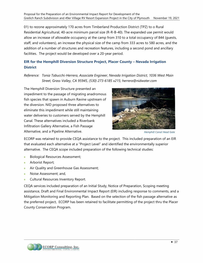
Proposal for the Preparation of an Environmental Impact Report for Development of the Greilich Ranch Subdivision and 49er Village RV Resort Expansion Project in the City of Plymouth November 19, 2021
37
01) to rezone approximately 170 acres from Timberland Production District (TPZ) to o RuralResidential Agricultural, 40-acre minimum parcel size (R-R-B-40). The expanded use permit wouldallow an increase of allowable occupancy at the camp from 310 to a total occupancy of 844 (guests,staff, and volunteers), an increase the physical size of the camp from 333 acres to 580 acres, and theaddition of a number of structures and recreation features, including a second pond and ancillaryfacilities. The project would be developed over a 20-year period.
EIR for the Hemphill Diversion Structure Project, Placer County – Nevada Irrigation District
Reference: Tonia Tabucchi-Herrera, Associate Engineer, Nevada Irrigation District, 1036 West Main Street, Grass Valley, CA 95945, (530) 273-6185 x215; [email protected]
The Hemphill Diversion Structure presented an impediment to the passage of migrating anadromous fish species that spawn in Auburn Ravine upstream of the diversion. NID proposed three alternatives to eliminate this impediment while still maintaining water deliveries to customers served by the Hemphill Canal. These alternatives included a Riverbank Infiltration Gallery Alternative, a Fish Passage Alternative, and a Pipeline Alternative.
ECORP was retained to provide CEQA assistance to the project. This included preparation of an EIR that evaluated each alternative at a “Project Level” and identified the environmentally superior alternative. The CEQA scope included preparation of the following technical studies:
♦ Biological Resources Assessment;♦ Arborist Report;♦ Air Quality and Greenhouse Gas Assessment;♦ Noise Assessment; and,♦ Cultural Resources Inventory Report.
CEQA services included preparation of an Initial Study, Notice of Preparation, Scoping meeting assistance, Draft and Final Environmental Impact Report (EIR) including response to comments, and a Mitigation Monitoring and Reporting Plan. Based on the selection of the fish passage alternative as the preferred project, ECORP has been retained to facilitate permitting of the project thru the Placer County Conservation Program.
Hemphill Canal Head Gate

Proposal for the Preparation of an Environmental Impact Report for Development of the November 19, 2021 Greilich Ranch Subdivision and 49er Village RV Resort Expansion Project in the City of Plymouth
38
Sugar Pine Project Water Right Permit Extension and Radial Gates Installation EIR/EIS, Foresthill, Placer County – Foresthill Public Utility District
Reference: Hank White, General Manager, Foresthill Public Utility District, P.O. Box 266, Foresthill, CA 95631, (530) 367-2511; [email protected]
ECORP is supporting Foresthill Public Utility District (FPUD) and the USFS in preparing a joint EIR/EIS and related technical studies to increase storage at Sugar Pine Reservoir by installing radial gates in the spillway. The increase in storage is approximately 3,000 AF. The proposed gate installation, reservoir expansion, and the replacement federal recreational facilities affected by that expansion will require a Special Use Permit from the Tahoe National Forest, within which the reservoir is located.
FPUD’s Sugar Pine Dam and Reservoir is located on North Shirttail Creek, tributary to the North Fork American River. The project was built in 1982 to provide water supply to the Foresthill Divide area. FPUD holds a permitted water right and has filed a request for extension of time to put water to use.
The key to the evaluation for the EIR/EIS is a project simulation model, developed by ECORP and used to evaluate water supply benefits and downstream effects. The model uses physical characteristics of the system, water rights limitations, and operates the project according to consumptive demands and downstream release requirements.
The Proposed Project is intended to increase regional self-reliance, manage and prepare for dry periods, expand water storage capacity, provide safe water for both local and distant communities, increase flood protection, and follows directives to prepare for climate change. The project will help implement state initiatives to address the state’s water supply reliability and ecosystem health by increasing storage and making surplus water available to downstream users and resources through water transfers. ECORP is currently preparing the Final EIR/EIS for the project and it is expected to be considered for approval early in 2022.
IS/MND for the Blue Ravine Road Affordable Housing Project, Sacramento County – City of Folsom
Reference: Steven Banks, Principal Planner, City of Folsom, Public Works & Community Development Department, 50 Natoma Street, Folsom, CA 95630, (916) 355-7274; [email protected]
ECORP was retained by the City of Folsom for CEQA documentation assistance. The project site is located near the southwest corner of the intersection of Blue Ravine Road and Oak Avenue Parkway in the City of Folsom. The proposed project involves development of a 72-unit rental apartment complex (100% affordable). The project would be located on a 3.5-acre portion of a 10.11-acre parcel identified as a portion of APN 071-1240-001. The project would include a swimming pool and
Sugar Pine Dam Spillway

Proposal for the Preparation of an Environmental Impact Report for Development of the Greilich Ranch Subdivision and 49er Village RV Resort Expansion Project in the City of Plymouth November 19, 2021
39
tot lot and supporting infrastructure including parking, utilities, and road frontage and access improvements. The project would consist of 18 one-bedroom units, 36 two-bedroom units, and 18 three-bedroom units. Unit sizes would range from roughly 754 sq. ft. for the one-bedroom units, 1,024 sq. ft. for the two-bedroom units and 1,276 sq. ft. for the three-bedroom units.
The following technical studies were conducted for this project: Air Quality, Noise Assessment, and Transportation Analysis. All other studies were completed using readily available resources. Air Quality and Noise Assessments were done by RCH Group. The Traffic Analysis was done by MCO engineers and included project initiation, existing conditions, construction year no project, construction year plus project, cumulative no project, cumulative plus project, and a site review plan.
ECORP staff compiled the technical studies, as well as other relevant information, into an IS/MND. After public comment, a final document was created and adopted by the City.
West Sacramento Avenue Property Permanent Supportive Housing Project EA, Yolo County – City of West Sacramento
Reference: David Tilley, Principal Planner, City of West Sacramento, 1110 West Capitol Avenue, Sacrament, CA 95691, (916) 617-4645; [email protected]
ECORP was retained by The City of West Sacramento (City) for the completion of the NEPA EA in support of the City NEPA compliance for HUD funding. The proposed project would construct up to 85 units of permanent supportive housing for homeless persons with mental and/or physical disabilities that require ongoing case management and counseling to successfully maintain stable housing. This affordable housing development will target individuals at the 30- and 40-percent Area Median Income (AMI) levels.
The Yolo County Department of Health and Human Services will provide onsite case management to coordinate medical and behavioral health services. Social and recreational opportunities onsite will complement direct social services by creating a community and peer support network. Any residents in danger of losing their housing will receive intensive housing stability counseling. The proposed project will provide the local resources necessary to house the most medically vulnerable homeless individuals in our community.
The City has partnered with Mercy Housing, a non-profit developer, for this project. The City will be using Community Development Block Grant (CDBG) funding to acquire a portion of the land being used for the project (APN 067-270-007) and demolish the existing buildings located on the parcel. The activities associated with CDBG funding are anticipated to begin early 2019 with full construction beginning in early 2020. The proposed project would consist of approximately 34 studios and 51 one-bedroom units, with an overall gross building area of approximately 65,000 sq. ft. The project required investigation into hazardous/unknown soil contaminant from previous onsite auto-mechanic facility, as well as, regulation 24 CFR Part 51 dealing with compliance with the Acceptable Separation Distance requirements under the standard of thermal radiation for people.

Proposal for the Preparation of an Environmental Impact Report for Development of the November 19, 2021 Greilich Ranch Subdivision and 49er Village RV Resort Expansion Project in the City of Plymouth
40
Easton Research Park West CEQA IS/MND, Sacramento County – Easton Development Co., LLC
Reference: David Hatch, Easton Development Co., LLC, One Easton Place, Folsom, CA 95763, (916) 351-8533; [email protected]
ECORP was retained to prepare a CEQA IS/MND for the proposed Easton Research Park West industrial development Tentative Subdivision Map located on the southwest corner of Folsom Boulevard and Hazel Avenue/Nimbus Road in the City of Rancho Cordova. Proposed site development includes 1.5 million square feet of general light industrial and warehousing on 9 lots, with associated parking areas and internal streets, based on a conceptual site plan that was prepared to support the Tentative Subdivision Map application. ECORP prepared technical studies to support the CEQA IS/MND including a Biological Resource Assessment, Cultural Resources Inventory and Report, Noise Assessment, and an Air Quality/Greenhouse Gas/Health Risk Assessment. The environmental document and the Tentative Subdivision Map were approved by the City of Rancho Cordova City Council on November 15, 2021.
Vineyards at Ukiah EIR, Mendocino County – County of Mendocino
Reference: Ignacio (Nash) Gonzalez, Interim Director, County of Mendocino Planning and Building Services, 501 Low Gap Road, Room 1440, Ukiah, CA 95482, (707) 234-6650; [email protected]
The applicant, Guillon, Inc., proposes a multi-phase Vesting Tentative Subdivision Map and Development Agreement to subdivide two parcels composed of 23.62 acres into 123 parcels to allow for a total of 123 primary dwelling units and up to 20 secondary residential units (accessory dwelling units) at buildout, as well as a 1.8-acre linear park, a 0.40-acre neighborhood park and a 0.40-acre parcel reserved for storm water management. The project is located in the unincorporated area of Mendocino County approximately 1.65 miles north of the City of Ukiah town center.
The project also includes a proposed General Plan Amendment to change the existing land use designation from AG (Agricultural Lands) to SR (Suburban Residential), a Rezone to change the existing zoning from AG-40 (Agricultural Lands: 40 acre minimum parcel size) to R-1 (Single-Family Residential) and apply the PD (Planned Development) zoning Combing District overlay to the entire site to allow reduced lot sizes and flexibility in lot design.
ECORP, is providing all services required for CEQA compliance, including preparation of the EIR, peer review of all technical reports, and public meetings and noticing.

Proposal for the Preparation of an Environmental Impact Report for Development of the Greilich Ranch Subdivision and 49er Village RV Resort Expansion Project in the City of Plymouth November 19, 2021
41
Environmental Services Retainer, Northern and Southern California Region – Department of General Services, Real Estate Services Division
Reference: Daniel O’Brien, Environmental Services Unit, California Department of General Services, 707 Third Street, 4th Floor, Mailstop 4-509, West Sacramento, CA 95605, (916) 376-1600; [email protected]
In 2012, ECORP was selected by the Department of General Services, Real Estate Services Division (DGS/RESD) to provide environmental services in support of state projects in 48 counties extending from Fresno to the Oregon border. In 2018, ECORP was selected to provide environmental services for the 12-county southern region. More than 60 task orders have been completed, including:
♦ CEQA IS/MND and supporting biological resources andcultural resources technical studies for the proposedsedimentation ponds for the water treatment plant at theSonoma Developmental Center, Sonoma County
♦ CEQA support to RWQCB for preparation of an EIR for proposed Waste Discharge Requirementsfor the Napa River and Sonoma Creek Watersheds, Napa County
♦ Biological and archaeological monitoring for the California Highway Patrol (CHP) communicationtower at Keller Peak in the San Bernardino National Forest, San Bernardino County
♦ CEQA IS/MND and supporting biological resources, cultural/paleontological resources (includingNative American consultation), air quality/greenhouse gases, and noise studies for thereplacement of the existing California Department of Forestry and Fire Protection (CAL FIRE)Potrero station, San Diego County
♦ Hazardous materials testing (asbestos and lead) in association with proposed improvements tothe School for the Deaf located in the City of Riverside, Riverside County
♦ CEQA IS/MND and supporting technical studies for the Auberry California Conservation Corp(CCC) Center Renovation, Fresno County
♦ Biological preconstruction surveys, biological and cultural resources construction monitoring forthe CAL FIRE Badger Forest Fire Station Replacement, Tulare County
♦ CEQA IS/MND and technical studies Ukiah CCC Center Replacement Project, Mendocino County
♦ Focused EIR for the California Veterans Affairs Rector Reservoir Instream Flow Project, NapaCounty
♦ CEQA IS/MND and technical studies, CAL FIRE Prado Helitak Base Replacement Project, SanBernardino County
ECORP provided CEQA support on several CAL FIRE facilities in
northern California for DGS RESD

Proposal for the Preparation of an Environmental Impact Report for Development of the November 19, 2021 Greilich Ranch Subdivision and 49er Village RV Resort Expansion Project in the City of Plymouth
42
♦ CEQA documentation and supporting technical studies for the CHP Leviathan PeakTelecommunication Tower, Alpine County.
♦ Professional regulatory expert services for review and comment on CHP CommunicationsFacilities Project Truckee Area Office EIR, Nevada County
♦ Historic preservation services (HABS recordation), Department of Food and Agriculture Building,1220 N. Street, Sacramento County
♦ Franchise Tax Board (FTB) constraints analysis for FTB 10-Year Facilities Master Plan- FTBButterfield Campus, Sacramento County
♦ CEQA MND addendum and supporting technical studies for the proposed CCC Delta ServiceDistrict Center Relocation/Construction Project Stockton, Stanislaus County
♦ CEQA documentation and supporting technical studies including AB 52 Native Americanconsultation for the proposed Beiber Fire Station and Helitack Base Relocation Project, CAL FIRE,Lassen County
♦ CEQA IS/MND and supporting technical studies for the proposed San Mateo-Santa Cruz UnitHeadquarters (UHQ) Auto Shop Relocation Project, CAL FIRE, Santa Cruz County
♦ CEQA IS/MND and supporting technical studies for the proposed Altaville Fire Station Auto ShopReplacement Project, CAL FIRE, Calaveras County
♦ CEQA IS/MND and supporting technical studies for the proposed Hoadley Peak CommunicationsTower, DMV, Trinity County
♦ CEQA IS/MND and supporting technical studies for the proposed Vina Helitack BaseReplacement Project, CAL FIRE, Tehama County
♦ CEQA and NEPA documentation and supporting technical studies for the California Central CoastVeterans Cemetery, Cal Vet, Fort Ord, Monterey County
♦ CEQA documentation and supporting technical studies for the proposed Butte Fire Station/UnitHeadquarters – Replacement Project, Butte County
♦ Updated historic building evaluation and impact assessment for the San Francisco Civic Centerbuilding, San Francisco County
♦ Cultural and Historic Resources Evaluation of Mercury Cleaners Building, Sacramento County
♦ EDD Stockton and EDD Vallejo historic building evaluations, Solano County
♦ Arborist survey of Capitol Park in Sacramento, Sacramento County
♦ Resources Building historic evaluation, Sacramento County
♦ Yountville Veterans Home Historic District record update and cultural resources and architecturalhistory evaluation, Napa County
♦ Hugh M. Burns Building architectural evaluation, Fresno County
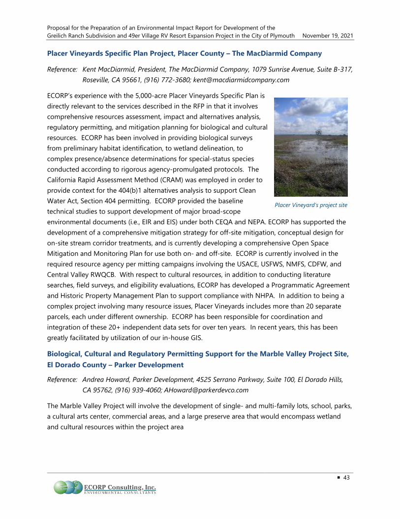
Proposal for the Preparation of an Environmental Impact Report for Development of the Greilich Ranch Subdivision and 49er Village RV Resort Expansion Project in the City of Plymouth November 19, 2021
43
Placer Vineyards Specific Plan Project, Placer County – The MacDiarmid Company
Reference: Kent MacDiarmid, President, The MacDiarmid Company, 1079 Sunrise Avenue, Suite B-317, Roseville, CA 95661, (916) 772-3680; [email protected]
ECORP’s experience with the 5,000-acre Placer Vineyards Specific Plan is directly relevant to the services described in the RFP in that it involves comprehensive resources assessment, impact and alternatives analysis, regulatory permitting, and mitigation planning for biological and cultural resources. ECORP has been involved in providing biological surveys from preliminary habitat identification, to wetland delineation, to complex presence/absence determinations for special-status species conducted according to rigorous agency-promulgated protocols. The California Rapid Assessment Method (CRAM) was employed in order to provide context for the 404(b)1 alternatives analysis to support Clean Water Act, Section 404 permitting. ECORP provided the baseline technical studies to support development of major broad-scope environmental documents (i.e., EIR and EIS) under both CEQA and NEPA. ECORP has supported the development of a comprehensive mitigation strategy for off-site mitigation, conceptual design for on-site stream corridor treatments, and is currently developing a comprehensive Open Space Mitigation and Monitoring Plan for use both on- and off-site. ECORP is currently involved in the required resource agency per mitting campaigns involving the USACE, USFWS, NMFS, CDFW, and Central Valley RWQCB. With respect to cultural resources, in addition to conducting literature searches, field surveys, and eligibility evaluations, ECORP has developed a Programmatic Agreement and Historic Property Management Plan to support compliance with NHPA. In addition to being a complex project involving many resource issues, Placer Vineyards includes more than 20 separate parcels, each under different ownership. ECORP has been responsible for coordination and integration of these 20+ independent data sets for over ten years. In recent years, this has been greatly facilitated by utilization of our in-house GIS.
Biological, Cultural and Regulatory Permitting Support for the Marble Valley Project Site, El Dorado County – Parker Development
Reference: Andrea Howard, Parker Development, 4525 Serrano Parkway, Suite 100, El Dorado Hills, CA 95762, (916) 939-4060; [email protected]
The Marble Valley Project will involve the development of single- and multi-family lots, school, parks, a cultural arts center, commercial areas, and a large preserve area that would encompass wetland and cultural resources within the project area
Placer Vineyard’s project site

Proposal for the Preparation of an Environmental Impact Report for Development of the November 19, 2021 Greilich Ranch Subdivision and 49er Village RV Resort Expansion Project in the City of Plymouth
44
ECORP conducted a wetland delineation for the 2,230-acre Marble Valley property. The investigation involved the identification and mapping of all wetlands and other Waters of the United States. The map was subsequently verified (and reverified) by the USACE. A biological assessment was also conducted for the property. The investigation involved analyses of onsite conditions (e.g., soils descriptions), and the characterization of vegetative communities as well as an assessment of potentially occurring special-status plant and wildlife species. In addition, aerial imaging was used to identify, type, and quantify tree canopy. Cultural resources surveys are also being conducted on the Marble Valley site, to determine potential impacts and/or sites for preservation.
Data collected during the above investigations will be used to support an EIR for the proposed project, as well as Clean Water Act, Section 404 permitting and Section 7 Consultation with the USFWS.
Cordova Hills Specific Plan Biological Resources, LIDAR Studies, and Regulatory Permitting, Rancho Cordova, Sacramento County – Cordova Hills, LLC
Reference: Ron Alvarado, Cordova Hills Partners, 5241 Arnold Avenue, McClellan, CA 95652, (916) 922-7600
ECORP was retained by Cordova Hills, LLC to provide services related to biological resources, cultural resources, and regulatory permitting for the proposed Cordova Hills Project. The proposed project consists of a master-planned community in the County of Sacramento, California, south of the City of Folsom and east of the city of Rancho Cordova. The Cordova Hills property is approximately 2,668 acres and is comprised mainly of annual grasslands interspersed with a variety of seasonally inundated wetlands. These wetlands include both vernal pools and seasonal wetlands, as well as other Waters of the U.S. The Cordova Hills Project is located within USFWS's Mather Core Recovery Area, and the federally listed vernal pool fairy shrimp, vernal pool tadpole shrimp, and Sacramento Orcutt grass occur on the property. The Mather Core Recovery Area, originally planned as a critical habitat unit, contains some of the highest quality vernal pool habitat in the region, and is subject to a variety of regulatory constraints.
ECORP has conducted numerous biological resource surveys and assessments in support of the project, including wetland delineations, wetland and watershed assessments, special-status species surveys (including assessment and guideline-level surveys for federally listed large branchiopods and early and late season rare plant surveys), vegetation community mapping, and on-site and off-site preserve and mitigation planning. ECORP representatives served as liaisons to the USACE during the wetland delineation verification process. ECORP prepared and submitted a Section 404 Individual Permit application and Section 7 Biological Assessment for the project. ECORP has facilitated numerous meetings with staff from USACE, U.S. Environmental Protection Agency, USFWS, Central Valley RWQCB, and the County of Sacramento.
Tree Canopy Analysis

Proposal for the Preparation of an Environmental Impact Report for Development of the Greilich Ranch Subdivision and 49er Village RV Resort Expansion Project in the City of Plymouth November 19, 2021
45
ECORP was instrumental in developing a compensatory mitigation proposal for impacts to Waters of the U.S. and special-status species, including habitat preservation, enhancement, restoration, and creation. ECORP served as liaison during negations with the County of Sacramento and South Sacramento Habitat Conservation Plan (SSHCP). SSHCP staff and ECORP worked together to design an on-site wetland and habitat preserve system that would meet the anticipated requirements of the SSHCP and the Project. Additionally, ECORP provided high-level peer review of the Project's joint EIR/EIS and attended public meetings and hearings for the Project.
Rio Del Oro Project Biological Resource Assessments, California Rapid Assessment Methodology, Lidar, and Permitting, Rancho Cordova, Sacramento County – Elliott Homes
Reference: Price Walker, Elliott Homes, 340 Palladio Parkway, Suite 521, Folsom, CA 95630, (916) 984-1300; [email protected]
ECORP was retained by Elliott Homes and Easton Development Company to conduct a wide variety of biological resource surveys and assessments and prepared various management plans for the Rio Del Oro Project in the City of Rancho Cordova and Sacramento County. The Rio Del Oro Project is a 3,800-acre proposed master-planned community consisting of high, medium and low density residential, retail, commercial, office, light-industrial, park, schools, wetland preserve and open space.
ECORP has conducted numerous biological resources surveys and assessments in support of the Project, including wetland delineations, wetland and watershed assessments using CRAM and Light Detection and Ranging (lidar) to map microtopography, special-status species assessments, vegetation community mapping, and on-site preserve planning. ECORP representatives served as liaisons to the USACE during the wetland delineation verification process. ECORP prepared and submitted a Section 404 Individual Permit application, Section 404(b)(1) Alternatives Analysis, Section 401 Water Quality Certification application, 1602 Notification of Lake or Streambed Alteration, and Section 7 Biological Assessment. ECORP prepared an operations and management (O&M) Plan for the planned open space, Valley elderberry longhorn beetle O&M Plan, Legenere Mitigation Plan, and Wetland Mitigation Plan. ECORP facilitated numerous meetings with staff from the USACE, EPA, USFWS, Central Valley RWQCB and the County of Sacramento.

Proposal for the Preparation of an Environmental Impact Report for Development of the November 19, 2021 Greilich Ranch Subdivision and 49er Village RV Resort Expansion Project in the City of Plymouth
46
ENGEO CA High Speed Rail (San Francisco to Merced Segments) – Multiple Counties
ENGEO prepared Technical Reports for Geology, Soils, and Seismicity, as well as for Hazardous Materials to support the project EIR. ENGEO also prepared the EIR sections and impact statements for these topics. The HSR project spans many terrains, geologic formations, geologic hazards, and areas with potential hazardous materials exposure. Planned rail infrastructure includes: at-grade, cuts, embankment, viaduct, cut and cover, overpasses, and extensive tunneling in the coastal mountains. In addition, stations are planned at select cities. Hazards identified included active faults, landslides, seismically induced flooding, liquefaction, compressible soil, naturally occurring asbestos, and landfill gasses. The project spans many properties with a wide variety of land uses. The project involved extensive coordination and communication from the many stakeholders and the project team.
Upper West Side Development – Sacramento County
ENGEO prepared a geology and soils technical report and a Phase I Environmental Site Assessment to support the proposed development Environmental Impact Report (EIR) as it relates to geology, soils, seismicity, mineral resources, paleontological resources, and hazardous materials. The project included an approximately 2,000-acre proposed development within the Natomas Basin a roughly 83-square-mile topographically low area in Sacramento County. The proposed development includes residential, commercial, school, parks, canals, basins, streets, and utilities.

Proposal for the Preparation of an Environmental Impact Report for Development of the Greilich Ranch Subdivision and 49er Village RV Resort Expansion Project in the City of Plymouth November 19, 2021
47
GHD On-Call Traffic Modeling/Engineering Services, Amador County – Amador County Transportation Commission (ACTC)
Continuing a strong working relationship after preparing the City of Jackson Circulation Study and Impact Fee Update, GHD has been retained repeatedly for ACTC’s On- Call contract since August 2014. Over that time, we have been available to share our transportation experience and expertise for several “meet and confer” calls to address transportation related issues as they arise. To date, we have completed the following:
♦ Provide Countywide Transportation Trends and Count Estimates through Streetlight.
♦ Prepare Main Street/Shenandoah Road Safe Route to School ATP Grant Application
♦ Revise the traffic model to incorporate Tier 1 improvements into the RTP and conduct Synchro LOSAnalysis.
♦ Update and refine Nexus Study for Regional Transportation Mitigation Fee program.
♦ Model testing of alternative improvements in the Jackson area with and without the Wicklow Wayand Sutter Street extensions.
♦ Refine roadway LOS calculations using HCM-based capacity adjustment system that incorporatesnatural and built environment factors like grade, lane width, shoulders width, and deviations fromdesign standards.
♦ Sketchup Visualizations of the proposed Amador City Park & Ride improvements and midblockcrosswalk.
Main Street/Shenandoah Road Safe Route to School Active Transportation Program Grant Application Assistance and PS&E, Amador County – City of Plymouth
GHD was hired by Amador County Transportation Commission to put together an Active Transportation Program (ATP) grant for the 3rd Cycle of the program. Work to prepare this grant included providing conceptual engineering plan of the proposed improvements, an estimate, a benefit/cost analysis, and developing the project schedule. GHD staff also assisted ACTC in the preparation of the written grant and review of the entire grant. Staff also coordinated with the City of Plymouth and the Elementary and Charter School staff. GHD wrote questionnaires for the school to provide to their students/families about current walking and biking barriers and used that information to develop a project that would remove those barriers.

Proposal for the Preparation of an Environmental Impact Report for Development of the November 19, 2021 Greilich Ranch Subdivision and 49er Village RV Resort Expansion Project in the City of Plymouth
48
Subsequently, the project as awarded the ATP grant and GHD was hired by the City of Plymouth to take the project through the environmental, PS&E, Right of Way/Utility, and construction phases of the project, including preparation of all the grant paperwork. The project is currently wrap- ping up the environmental and preliminary engineering phases and has requested CTC allocation of funds to move into PS&E and Right of Way. A portion of the project lies within the County's right of way, and therefore, coordination with the County is also included in this project.
State Route 49/Main Street Roundabout, Amador County – City of Plymouth
In May of 2014, GHD stepped in to assist the City of Plymouth in delivering the State Route (SR) 49/Main Street Roundabout. This project is not only a high priority for the City, but also for the region and Caltrans District 10. This was a fast-track project that has federal and Caltrans SHOPP funding. GHD was hired based on our roundabout expertise and extensive experience delivering projects through Caltrans and federal funding processes. GHD evaluated and refined the preliminary roundabout concept developed during PS&E and modified the design to reduce right of way impacts and improve operations and safety. GHD provided turn-key project management and design services to deliver the PS&E, surveying, environmental permit- ting, and right of way services. GHD has provided support to the City for all Local Assistance paperwork. Construction was completed in 2018.
RMM Cal Fire San Luis Obispo Unit Headquarters Visual Simulations, San Luis Obispo – Cal Fire-San Luis Obispo County Fire Department
RRM worked with ECORP to provide a series of before and after visual simulations for the proposed campus improvements at the existing Cal Fire site on Highway 1 in San Luis Obispo County. RRM worked with ECORP to analyze the potential visual impacts for the project from various vantage points
Existing Proposed

Proposal for the Preparation of an Environmental Impact Report for Development of the Greilich Ranch Subdivision and 49er Village RV Resort Expansion Project in the City of Plymouth November 19, 2021
49
surrounding the site. RRM modeled the existing and proposed improvements utilizing 3D computer modeling software, and developed renderings using current photography as a backdrop to depict the proposed improvements to the project.
Dana Reserve Specific Plan Visual Simulations, San Luis Obispo – NKT Nipoma Properties, LLC
Dana Reserve is vision for a new homestead neighborhood in Nipomo, California. We worked directly with the owner of this land, whose family has held the ranch for over five generations. His hope and vision for these neighborhoods was to bring a California ranch home ownership lifestyle to many. From a central park that highlights the heritage oak groves, to the miles of dedicated equestrian trails, and pedestrian connectivity to local neighborhood commercial.– Dana Reserve’s vision is California living at its finest.
Example EIRs ECORP has provided three example EIRs on the attached USB drive to this proposal. The examples are for the following Projects:
♦ Kidder Creek Orchard Camp Zone Change (Z-14-01) and Use Permit (UP-11-15) EnvironmentalImpact Report (EIR) – Siskiyou County
♦ EIR for the Hemphill Diversion Structure Project, Placer County – Nevada Irrigation District
♦ Sugar Pine Project Water Right Permit Extension and Radial Gates Installation EIR/EIS, Foresthill,Placer County – Foresthill Public Utility District
ECORP also incuded a full project description in the references above.
Insurance Please find ECORP’s proof of insurance in Attachment B.
City’s Standard Professional Servcies Agreement ECORP has no proposed modifications to the City’s standard Professional Services Agreement (PSA and/or insurance requirements.

Proposal for the Preparation of an Environmental Impact Report for Development of the November 19, 2021 Greilich Ranch Subdivision and 49er Village RV Resort Expansion Project in the City of Plymouth
50
PROPOSED FEE AND PAYMENT SCHEDULE Per the RFPs requirements, ECORP has provided a copy of our proposal fee and payment schedule in a separate, sealed envelope.

LIST OF ATTACHMENTS
Attachment A – Resumes of Key Personnel Attachment B – Proof of Insurance

ATTACHMENT A
Resumes of Key Personnel Order of Presentation:
1. Chris Stabenfeldt, AICP – Project Manager/Principal Environmental Planner2. Michelle Wilson – Assistant Project Manager/CEQA Tas Manager/Senior Environmental
Planner/Senior Biologist3. Jeremy Adams – Cultural Resources Task Manager/Senior Architectural Historian4. Andrew Kopania, Ph.D., R.G., C.H. – Water Resources Task Manager5. Keith Kwan – Biological Resources/Regulatory Permitting Task Manager6. Seth Myers – Air Quality/Greenhouse Gas/Noise Task Manager7. Jeffrey Swager – GIS Task Manager8. Shawn Munger, PG, CHG – Geology/Soils and Hazards & Hazards Materials Task Manager
(ENGEO)9. Makinzie Clark – Traffic Task Manager (GHD)10. Chris Dufour, PLA, LEEP AP – Visual Simulations Task Manager (RRM)11. James McLaughlin – Staff Environmental Planner12. Mark Morse – Senior Environmental Planner13. Amberly Morgan – Senior Environmental Planner14. Matteo Rodriguez – Associate Environmental Planner15. Rosemary Worden – Staff Environmental Planner16. Lourdes Gonzalez-Peralta – Biological Resources QA/QC17. Molly Enloe – Principal Biologist18. Lisa Westwood, RPA – Cultural Resources QA/QC19. Theadora Fuerstenberg, RPA – Senior Archaeologist20. Caroline Hinkelman – GIS Specialist21. Paul Cottingham, CEG – Geologist (ENGEO)22. Todd Tregenza, AICP – Transportation Project Director (GHD)23. Kamesh Vedula, PE, TE – Senior Traffic Engineer (GHD)24. Jill Hough, PTP – Travel Demand Modeling (GHD)

Chris Stabenfeldt, AICP Project Manager/Principal Environmental Planner Mr. Stabenfeldt is a certified planner, team and project manager and environmental analyst with more than 37 years of professional environmental and planning consulting experience, including over ten years at ECORP. As Project Director, he will have overall responsibility for ensuring the project team meets deadlines and will be responsible for quality control. He has managed comprehensive and complex environmental documents and planning projects for public agencies and private sector clients including documentation and related compliance activities under NEPA and CEQA for projects throughout the west. He has a strong multidisciplinary background and has conducted technical studies in noise, air quality, geology, hydrology, infrastructure analysis, and land use policy assessment. Mr. Stabenfeldt has extensive experience managing the environmental compliance process for public agency clients throughout California. He is currently preparing or has previously completed environmental documentation for numerous development projects for jurisdictions throughout California including rezones, tentative and subdivision maps, conditional use permits, specific plans and general plan updates. He also has extensive experience preparing CEQA and NEPA documentation for infrastructure projects including bridges, new roadways, trails, water and sewer infrastructure, water pipeline replacements, levee improvements, storm drainage facilities, dam modifications, parks and public facilities.
Education B.A. Environmental Studies, University of California Santa Barbara
MCRP Coursework, City and Regional Planning, California Polytechnic University, San Luis Obispo
Registrations, Certifications, Permits and Affiliations American Institute of Certified Planners
American Planning Association
Association of Environmental Professionals
Professional Experience EIR for the Gill Medical Center, San Joaquin County – Gill Medical Center. Serving as Project Manager. ECORP has been retained to prepare an EIR and related technical studies for a new birthing center and hospital located just north of the City of Stockton in San Joaquin County. The proposed Gill Medical Center Project would include a Phase 1 Office of State Health Planning and Development (OSHPD) 1 Hospital and full-service women’s Alternative Birthing Center facility and Phase 2 OSHPD 1 Hospital and associated medical office building. The Project is proposed on a ± 42.4-acre site located northeast of the West Lane/Eight Mile Road intersection in San Joaquin County, north of the City of Stockton. The Project is proposed in two phases over approximately 10 years.
Easton Research Park West CEQA IS/MND, Sacramento County – Easton Development Co., LLC. Serving as Project Manager. ECORP has been retained to prepare a CEQA IS/MND for the proposed Easton Research Park West industrial development Tentative Subdivision Map located on the southwest corner of

Chris Stabenfeldt, AICP (Continued) Page 2 of 3
Folsom Boulevard and Hazel Avenue/Nimbus Road in the City of Rancho Cordova, CA. Proposed site development includes 1.5 million square feet of general light industrial and warehousing on 9 lots, with associated parking areas and internal streets, based on a conceptual site plan that has been prepared to support the Tentative Subdivision Map application. ECORP is preparing technical studies to support the CEQA IS/MND including a Biological Resource Assessment, Cultural Resource Inventory and Report, Noise Assessment and an Air Quality/Greenhouse Gas/Health Risk Assessment.
Rio Mesa Boulevard Project EIR, Madera County. Served as the Environmental Program Manager for the Project. The Proposed Project would construct a new north-south roadway consistent with a secondary arterial (4-lane undivided). The project would serve the greater Tesoro Viejo Development and is included in the circulation element. Originally, ECORP prepared and circulated an IS/MND; however, due to the design changes and anticipated controversy the project has been elevated to an EIR. The project will also require acquisition of resource agency permits, mitigation monitoring and reporting program implementation, and construction monitoring.
West Sacramento Avenue Property Permanent Supportive Housing Project EA, Yolo County – City of West Sacramento. Project Manager in charge of the completion of the NEPA Environmental Assessment in support of the City NEPA compliance for Housing and Urban Development (HUD) funding. The project will construct up to 85 units of permanent supportive housing for homeless persons with mental and/or physical disabilities that require ongoing case management and counseling to successfully maintain stable housing. This affordable housing development will target individuals at the 30% and 40% Area Median Income (AMI) levels. The project required investigation into hazardous/unknown soil contaminant from previous onsite auto-mechanic facility, as well as, regulation 24 CFR Part 51 dealing with compliance with the Acceptable Separation Distance requirements under the standard of thermal radiation for people.
Northern California Region On-Call Contract for Environmental Services, Northern California – California Department of General Services (CDGS), Real Estate Services Division (RESD). Program Manager for the DGS, RESD Northern California Region Environmental Services on-call contract. which encompasses 48 counties. During the three-year contract he oversaw the completion of over 40 task orders for a wide range of development and infrastructure projects located throughout the North State.
Pilot Hill Ranch Specific Plan EIR, El Dorado County – County of El Dorado County. Project Manager in charge of the EIR for 1,814 acres in a rural area of El Dorado County creating 920 residential lots, commercial uses, a golf course, a tourism-oriented commercial center, a community park, an elementary school site, and 1,107 acres of open space. Key project issues included regional circulation, water demand/availability, wastewater disposal and land use compatibility with surrounding rural neighborhoods.
Cinnabar Planned Development EIR, El Dorado County – County of El Dorado. Project Manager in charge of this project which involved a planned development within an 8,800-acre parcel adjacent to the Cosumnes River. Development was planned in clustered neighborhoods with the majority of the site retained in open space. Impacts on biological and cultural resources and the provision of water to serve the project were key issues.

Chris Stabenfeldt, AICP (Continued) Page 3 of 3
Metro Air Park EIR, Sacramento County – County of Sacramento. Project Manager for preparation of the EIR. The project involved a mixed-use development east of the Sacramento International Airport; uses included a business park, commercial center, and recreational amenities, including an 18-hole golf course. Key issues included impacts to endangered species, drainage, and traffic.
Mendocino County General Plan Update and EIR, Mendocino County – County of Mendocino. Project Director for the comprehensive update of the County General Plan and associated environmental documentation. The general plan had not been updated since 1988. Facilitated countywide workshops to solicit input from local citizens and was the key point of contact with the county over an eight-year period. Key issues included tension between economic development and resource conservation, protection of agricultural resources, limited surface and groundwater resources within the county and alternative energy sources.
Gray’s Crossing Specific Plan EIR, Placer County – Town of Truckee. Project Manager for the EIR for 600 residential units, retail center, mixed-use village, destination resort golf course and related clubhouse, a school site, and open space.
East Area Specific Plan EIR, Sacramento County – City of Galt. Project Manager for managing the specific plan EIR which covered 2,200+ acres and represented a proposed 40% increase in the town’s population. Key issues included provision of services and transportation impacts.
Southwest Redevelopment Area EIR, Shasta County – City of Anderson. Project Manager for the project. The EIR addressed a redevelopment area covering much of the community’s commercial districts at a programmatic level.
General Plan EIR, Lassen County – County of Lassen. Project Manager for the project. The EIR was prepared concurrently with the draft general plan, evaluating the draft goals, policies, and implementation measures. Specific mitigation strategies were incorporated as policy directives prior to finalization and adoption of the general plan.
Orland General Plan Update and Mitigated Negative Declaration (MND), Glenn County – City of Orland. Project Manager for the preparation of a comprehensive update of the Orland General Plan and associated MND. The general plan was updated in response to growing demand for affordable housing. The update included extensive community outreach.
Kern County Mendiburu Springs Specific Plan EIR, Kern County – County of Kern. Project Manager for the project. Project involved development of a residential neighborhood in close proximity to an airport. Key issues included safety and noise concerns associated with operation of the airport.
Stanford Ranch General Development Plan Amendment EIR, Placer County – City of Rocklin. Project Manager for the project. The project involved an amendment to the existing development plan for a major planned community. Key issues included preservation of prehistoric and historic resources and oak woodland loss.
Michelle Wilson Assistant Project Manager/Senior Environmental Planner/Senior Biologist Ms. Wilson is a senior environmental planner/senior biologist with more than 27 years of experience, specializing in both CEQA and NEPA compliance, permitting, water quality, and biological services. She recently joined ECORP this year, but has worked in environmental consulting, as a Senior Planner with Santa Barbara Planning & Development, and permitting specialist for the the oil and gas industry. Ms. Wilson has processed major conditional use permits (CUPs), development plans, tract maps, lot line adjustments, rezones/General Plan Amendments, land use permits, coastal development permits, Williamson Act withdrawals, and California Government Code Section 65402 determinations, and has experience at preparing Section 4(f) evaluations, FONPAs, supporting Section 106 consultations, as well as applying for resource agency permits and approvals (Section 10/404 permits, Section 401 Water Quality Certifications, 1600 Streambed Alteration Agreements, Coastal Consistency Determinations, California State Lands Commission leases, NPDES permits, and section 7 consultations with USFWS and NMFS). Education B.A., Environmental Science (Biology) & Minor in Resource Management, University of California, Berkeley Registrations, Certifications, Permits and Affiliations Roadway Worker Protection (RWP) Trained (Caltrain) – 2016-present Association of Environmental Professionals (AEP) – 2006-present San Luis Obispo Chamber of Commerce, Economic Development Committee – 2016-2019 Member of NOAA and the National Parks Service’s Channel Islands Naturalist Corps – 2008 Member of the Channel Islands National Marine Sanctuary Advisory Council – 2007-2008 Staffed Board of Architectural Review South, Santa Barbara County – 2008 Staffed Historic Landmarks Advisory Commission, Santa Barbara County – 2008 Professional Experience Senior Staff Planner, Various Projects, Santa Barbara County – Santa Barbara County Planning and Development Department (2004-2008). As a senior planner working for Santa Barbara County’s Planning and Development Department, Development Review South Division, prepared multiple Mitigated Negative Declarations and managed multiple EIRs pursuant to CEQA for a variety of residential, commercial, and mixed-use projects, including the Cate School Expansion Project EIR, the Westmont College Master Plan Update EIR, follow-on CEQA documents for the Music Academy of the West project, the Hourigan Tract Map (in Goleta), Williamson Act withdrawal for Bixby Ranch, and a 65402 Consistency Determination for a new 3 MG tank and associated infrastructure for the Carpinteria Valley Water District. The Westmont College EIR was litigated and upheld. Permits processed included rezones, tract maps, lot line adjustments, conditional use permits, development plans, agricultural preserve contracts, coastal development permits, and land use permits.
EIR for the Alexan 436-Unit Multi-Family Residential Specific Plan, General Plan Amendment, Zoning Code Amendment near Metro Light Rail, City of Monrovia, Los Angeles County – Trammel

Michelle Wilson (Continued) Page 2 of 2
Crow Residential (2019-2020). EIR Project Manager and author for an EIR to adopt General Plan and Zoning Code amendments to change the land use designation for 9.6 acres of land from “Manufacturing” to Planned Development – Area 27 (PD-27) for transit-oriented mixed-use development adjacent to Metro’s Gold light rail line. The project includes a Specific Plan, Vesting Tract Map, and Conditional Use Permit to allow the construction of a new 436-unit, five-story apartment complex with an eight-level (seven stories) parking structure. Assisted in coordinating consultation with Metro and the California Public Utilities Commission (CPUC) to address concerns with pedestrian safety near the light rail at-grade crossing adjacent to the project and other right-of-way concerns.
EIR for the Arroyo at Monrovia Station Specific Plan, 302-Unit Mixed-Use Apartment Complex near Metro Light Rail, City of Monrovia, Los Angeles County – MW Investment Group, LLC (2019-2020). EIR Project Manager and author for an EIR to adopt Zoning Code amendments to change the land use designation for 2.90 acres of land from “Planned Development” to “Specific Plan,” and approve a Specific Plan, Vesting Tentative Tract Map, and Conditional Use Permit to construct of a new transit-oriented, mixed-use residential/commercial development consisting of 302 apartment units, including 15 very low income units and 3 live/work units, and 7,080 square feet of commercial space in a five-story (6-level) building with an eight-level (seven story) parking structure adjacent to Metro’s Gold light rail line.
San Luis Square Mixed-Use Development, CEQA Infill Exemption Support, City of San Luis Obispo, San Luis Obispo County – The Obispo Company (2015). As a contract planner to The Obispo Company, prepared documentation in support of a Class 32 infill exemption under CEQA for a mixed-use development in downtown San Luis Obispo comprising three 4-story buildings with 19,792 square feet of commercial space, 62 residential units, 36 hotel rooms, and a 2-story parking garage. Key issues included impacts on visual character, potential impacts on an adjacent historic structure, and a requirement for a permanent dewatering system for the underground portion of the parking garage.
Beechwood Specific Plan EIR, 911-Unit Residential Development, City of Paso Robles, San Luis Obispo County – Firma Consultants (2018). Provided support in preparing certain sections of the EIR for the project including the hazards chapter, air quality chapter, and land use chapter. Key issues include adjacent PG&E power lines, wetlands and other sensitive biological issues, and a requirement for a Water Supply Assessment.
The Merkantile Mixed-Use Development, City of Solvang, Santa Barbara County – Firma Consultants (2016). Prepared the staff report including CEQA findings for the proposed Merkantile Mixed-Use Development Project for the City of Solvang. Project included a Development Plan application to remove an existing shopping center comprising 39,282 square feet and two apartment units and rebuild a new shopping center comprising 41,429 sq. ft. commercial retail space and eight one-bedroom residential units on a 3.9-acre property.
Cannabis Application Completeness Reviews and Peer Reviews of Technical Studies, Sonoma County – Sonoma County Planning Division (2018).

Jeremy Adams Cultural Resources Task Manager/Senior Architectural Historian Mr. Adams is a Cultural Resources Manager and Senior Architectural Historian with 10 years of experience in developing cultural resources management strategies and leading the implementation of cultural inventories, evaluations, effects analysis, and preparation of mitigation documents. He holds a Master of Arts degree in History (Public History), a Bachelor of Arts degree in History, and he meets the Secretary of the Interior's Professional Qualification Standards for Architectural History and History. Mr. Adams serves as principal investigator for all architectural history components of projects and is well versed in the practical application of the laws and regulations of Section 106 of the NHPA and CEQA. He is highly skilled at historical research and analysis and is familiar with numerous archives, libraries, museums, and other historical repositories throughout California. He has prepared historic contexts, property histories, and carried out architectural site documentation for buildings, structures, and historical landscapes. He has also prepared built-environment impact assessments and has developed mitigation measures for CEQA and Section 106 projects. In addition, he has carried out all three versions of HABS/HAER/HALS historical documentation, developed educational interpretive panels, has completed Caltrans SER documents, multiple versions of Finding of Effect documents, and has evaluated numerous historic-age buildings and properties, as well as assisted lead agencies with SHPO consultation. As the manager of ECORPs cultural resources department in Rocklin, he has led numerous cultural resources studies and is the principal investigator and author for multiple architectural history studies.
Education M.A., History (Public History), California State University, Sacramento
B.A., History, California State University, Chico
Professional Experience Cultural Resources Inventory and Evaluation Report, Raley’s Dock Replacement and Rice Mill Pier Rehabilitation Project, Yolo County – GHD. Architectural Historian responsible for architectural inventory of Raley’s dock and Rice Mill Pier, including historical research, architectural assessment and impact review, and architectural history evaluation of the Rice Mill Pier. ECORP conducted a pedestrian survey, prehistoric research and analysis, and made recommendations for continued environmental compliance for the project. Mr. Adams prepared a finding of effect for the potential adverse effect to the adjacent Old Sacramento Historic District for the USACE and supported SHPO consultation for the project.
The Village of Marble Valley Specific Plan, El Dorado County. Architectural Historian responsible for the Section 106 evaluation of limestone mining operations on the Marble Valley property. Two limestone quarries and an entire lime works industrial complex were utilized during the latter half of the nineteenth century. Intensive archival research, historic property site documentation utilizing DPR 523 forms, and an eligibility evaluation were conducted to complete Section 106 NRHP eligibility recommendations for the lime works complex.

Jeremy Adams (Continued) Page 2 of 2
The Rivers Phase 2, West Sacramento, Yolo County - City of West Sacramento (2015-Ongoing). Cultural Resources Task Manager responsible for managing implementation of the cultural resources inventory and Finding of Effect for the project. The Project required an updated records search, Sacred Lands File Search with the Native American Heritage Commission, and a State Lands Commission Shipwreck Database Search. The updated records search concluded that resources were in close proximity to the project and may be impacted. ECORP prepared a Finding of Effect for the USACE to make a determination of effect.
Jackson Township Specific Plan, Excelsior Estates Project, Sacramento County – Tsakopoulos Investments (2014-Ongoing). Assistant Cultural Resources Manager responsible for coordination and management of a cultural resources inventory and evaluation technical study. To support the USACE 404 permit for the project, coordinated an archaeological inventory, records search, and evaluated a historic-age residence located within off-site improvement areas. The project also required coordination with project engineers and regulatory managers.
Lateral 6.2 and Madera Canal Bridges Evaluation Reports, Tesoro Viejo Specific Plan, Fresno County (2015). Architectural Historian responsible for the inventory and evaluation of Lateral 6.2 of the Madera Canal that travels through the Tesoro Viejo Specific Plan area. Also responsible for the inventory and evaluation of multiple pedestrian and farm access bridges across the historic Madera Canal. The project required a site visit to document the bridges, Lateral, and setting, as well as extensive archival research at local repositories and evaluations of resources against the NRHP and CRHR. Two separate letter reports of the findings were prepared.
Folsom South of US Highway 50 Specific Plan Project, HAER Rhoades Branch Ditch, Sacramento County (2014). Architectural Historian responsible for preparation of HAER documentation for an historic mining ditch including management of a photographer subconsultant, which required extensive and very detailed archival research and analysis, multiple site visits and a written report following the National Parks Service archival-quality documentation process.
Folsom South of US Highway 50 Specific Plan Project, HAER Keefe-McDerby Ditch, Sacramento County (2014). Architectural Historian responsible for preparation of HAER documentation for an historic mining ditch including management of a photographer subconsultant, which required extensive and very detailed archival research and analysis, multiple site visits, and a written report following the National Parks Service archival-quality documentation process.
Architectural History Inventory and Evaluation of Villa Park High School Modernization Project, Orange County – PlaceWorks, Inc.. Architectural Historian responsible for developing the strategy for inventory and archival research of Villa Park High School and supervising the evaluation of the school, including QA/QC. In support of CEQA, the proposed modernization project required the recordation of each historic-age building located on the school property. The field effort included recording 10 buildings and structures on DPR 523 records, including archival research. Directed the evaluation of the school and its buildings against the CRHR eligibility criteria.

Andrew Kopania, Ph.D., R.G., C.H. Water Resources Task Manager
Over 30 years of experience in subsurface investigation, hydrogeology, and environmental engineering, including computer modeling of contaminant fate and transport, permitting and environmental impact assessment (CEQA/NEPA), sustainable groundwater management evaluations, expert witness services, investigation and remediation of contaminated soils and ground water, CERCLA RI/FS and RD/RA, and extensive experience in negotiations with state and federal agencies. Dr. Kopania has served as lead hydrogeologist, project manager, and technical advisor on a wide range of projects throughout California and North America.
Education D. Env., Environmental Science and Engineering, University of California, Los Angeles. Dissertation title:
Geologic Heterogeneity and Ground-water Contamination: Guidelines for Determination of Significance to Investigation and Remediation
M.S., Geology, University of Michigan, Ann Arbor
B.S., Geology, with Honors, University of California, Los Angeles
Registrations, Certifications, Permits and Affiliations California Registered Geologist (No. 4711)
California Certified Hydrogeologist (No. 31)
National Groundwater Association
Association of Ground Water Scientists and Engineers
Professional Experience Water Resources Evaluation & Development
♦ Conducted hydrogeologic and water supply evaluations for the proposed expansion of the SGI Ione Quarry west of Ione in Amador County. The scope of work included overseeing well installation, electronic monitoring of water level data, and assessment of hydrologic conditions. Site-specific parameters were used in conjunction with Amador County Erosion and Sediment Control Guidelines to estimate runoff from existing and proposed overburden stockpiles, and to identify appropriate mitigation measures. Pumping and water level data were used to evaluate the adequacy of the existing water supply and to determine the overall effect on the groundwater basin. Dr. Kopania also prepared a detailed water balance to determine the rate at which storm water runoff and direct rainfall would accumulate in the expanded quarry and the final stable water elevation within the excavation. The water balance along with site-specific water quality and leaching potential data were used to estimate the water quality within the reclaimed mine pit. These evaluations were compiled into a detailed Hydrology and Water Quality Evaluation Report that identified baseline conditions, project effects,

Dr. Andrew Kopania, R.G., C.H. (Continued) Page 2 of 3
potential impacts, and appropriate mitigation measures to support the environmental review of the project.
♦ Directed a significant multi-year due diligence evaluation of water resources, hazardous materials, and mining conditions for the purchase of the 16,000-acre Rancho Arroyo Seco in western Amador County near Ione. Dr. Kopania coordinated the work of multiple consultants and presented the findings to the prospective purchasers, investors, and legal counsel. Evaluation work included drilling of groundwater monitoring wells; collection of soil, water, and dust samples; assessment of potential flood-prone areas; and monitoring of residual effects of historic and current mining activities.
♦ Performed a third-party technical review for Amador County Planning Department of conditions at the Lincoln Mine near Sutter Creek. Due to complaints from residents in Sutter Creek regarding reduced flows from springs, Dr. Kopania completed a detailed evaluation of hydrologic conditions at the Lincoln Mine, assessed conditions at the spring, interviewed mine staff and local residents, reviewed existing studies and documents, and prepared a third-party expert report for Amador County. Dr. Kopania also presented the findings to the Amador County Board of Supervisors at a hearing to consider whether the Lincoln Mine was complying with permit requirements and mitigation measures.
♦ Provided support to the Amador County Environmental Health Department related to water quality concerns in the vicinity of the Sutter Pines Mobile Home Park east of Jackson. Environmental Health staff retained Dr. Kopania to conduct an analysis of geologic conditions and water quality data to identify the potential causes and geographical extent of naturally-occurring radionuclides in water supply wells in the vicinity of the mobile home park. Dr. Kopania identified geologic deposits that were potentially responsible for the elevated radionuclide levels and the potential extent of those deposits so that Environmental Health staff could conduct a broader sampling of groundwater supply wells in the area to define the extent of the impact.
♦ Conducted detailed multi-year analysis for Nevada Irrigation District to assess potential impacts on groundwater levels and water supplies related to proposed changes in flows within gold-rush era canals in the Sierra Nevada foothills. To minimize water losses due to leakage, evaporation, and other factors, canal flows were planned to be rerouted through newly-installed pipelines. Neighbors were concerned about the potential loss of groundwater supplies due to the reduction or elimination of flows within the canals. To support the environmental review and identify the potential impacts of reduced flows in the canals, Dr. Kopania conducted a study over three successive water years to measure the changes in groundwater levels related to local rainfall and irrigation, fluctuations in canal flows and deliveries, and other factors. The study involved instrumenting numerous private wells and project-specific piezometers with pressure transducers and dataloggers to measure water levels several times per day over the three-year period and the collection of water samples for water quality analysis. The study determined that the primary control over groundwater levels was the percolation of local rainfall and that changes in canal flows only had a very minor influence on groundwater availability. This very minor influence could be readily mitigated by maintaining a minimal base flow in the canals during certain critical times of the year to avoid any undesirable impacts on neighboring properties.
♦ Prepared the hydrology and water quality evaluation and prepared the Water Supply Assessment for a proposed women’s medical center in San Joaquin County, California. Dr. Kopania compiled and

Dr. Andrew Kopania, R.G., C.H. (Continued) Page 3 of 3
analyzed applicable data and information to assess the potential impacts of the multi-phase development of the medical center project in the location of an existing vineyard. Specific areas of evaluation included the adequacy of the water supply, impact of the project on other water users, water quality concerns regarding the historic use of the property and the proposed new use, flooding concerns, and the impacts of adding significant new impervious surfaces at the project site. These evaluations were part of the hydrology and water quality section of the EIR prepared for the project. Dr. Kopania also contributed to the utilities and service systems section of the EIR related to the adequacy of water supply, waste water treatment, and storm water control systems for the proposed medical center project.
♦ Prepared SB 610 Water Supply Assessments for more than 20 projects throughout California, including mining projects, educational and training facilities, infrastructure projects, solar energy generation facilities, and major development sites. The assessments were prepared in accordance with California Water Code requirements and identified the available supply, project water demands, available supply in single and multiple dry-year conditions, and assessed the sufficiency of supply for the proposed life of the projects.
Permitting/CEQA/NEPA
♦ Conducted peer review of permit application documents including drainage studies, groundwater analyses, hydrology reports, and Reclamation Plans and prepared technical documents including Water Supply Assessments and CEQA Hydrology and Water Quality studies for over 75 mining projects throughout California, including the San Emidio project in Kern County.
♦ Provided permitting assistance, evaluation of potential environmental impacts, and preparation of resource sections on surface water, groundwater, water quality, geology, and hazardous materials for Environmental Impact Reports and Environmental Impact Statements for over 85 projects, including:
Water supply projects Water resource evaluation projects Manufacturing and processing facilities Major residential and commercial development projects Hazardous materials remediation projects Wetland restoration and construction Highway construction projects Agricultural operations

Keith Kwan Biological Resources/Regulatory Permitting Task Manager Mr. Kwan has more than 30 years of experience as a wildlife biologist and wetland ecologist. He specializes in avian ecology, wetland delineations and wetland ecology, special-status species ecology, environmental impact assessment, regulatory compliance, and project management. He also has expertise in conducting biological resource assessments, bird censuses, special-status species surveys, general biotic inventories, and biodiversity monitoring of created, restored, and existing terrestrial habitats of California.
He has expertise in delineation of waters of the U.S. and has delineated over a hundred sites throughout California, Nevada, and Colorado. He also has expertise in California’s Central Valley annual grassland and oak woodland communities, having conducted hundreds of wetland and biological resource evaluations related to site development, impact assessment, California Environmental Quality Act (CEQA) compliance, Clean Water Act (CWA) 404 compliance, and California Department of Fish and Wildlife (CDFW) 1602 compliance.
His expertise in avian ecology includes numerous breeding bird surveys, nest monitoring, and pre-construction clearance surveys in support of various local, state and federal regulations (e.g. CEQA, CDFW 1602). He has developed studies utilizing focal survey and point-count methodologies to assess bird use. He has been an active birdwatcher throughout California and has participated in National Audubon Society Christmas Bird Counts for more than 30 years.
He administers Quality Assurance/Quality Control for many of the biological reports produced in the Northern California office, including wetland delineations, special-status species assessment and survey reports, arborist survey reports, biological assessments, Section 404 mitigation and compliance reports. He also has expertise in identification and field sampling of federally-listed vernal pool branchiopods.
Education B.S., Biological Sciences, Emphasis in Biological Conservation; California State University, Sacramento
Registrations, Certifications, Permits and Affiliations Yolo County HCP/NCCP Qualified Biologist. Valid through 12-31-2023.
Society of Wetland Scientists American Ornithological Society Western Field Ornithologists Raptor Research Foundation The Wildlife Society
Professional Experience Vineyard Crossing Vesting Tentative Map Subdivision Planned Development, Mendocino County – County of Mendocino (2018). Lead Biologist and primary author who conducted field reconnaissance, literature review, and prepared a Biological Resources Assessment. Vineyard Crossing is a proposed residential development. ECORP was retained to perform CEQA consulting services.

Keith Kwan (Continued) Page 2 of 2
Placer Vineyards Specific Plan, Placer County – Placer Vineyards Owner's Group (Ongoing). Project Task Manager for burrowing owl surveys, tricolored blackbird habitat mapping, and wetland delineations. ECORP has conducted technical studies and resource mapping and has compiled studies prepared by others to support environmental analysis under CEQA and NEPA, and to support resource permitting through the U.S. Army Corps of Engineers, the U.S. Fish and Wildlife Service, NOAA Fisheries, CDFW, the Regional Water Quality Control Board, and the State Historic Preservation Office.
West Capitol Avenue Property, Yolo County – City of West Sacramento (2018). Lead Biologist and primary author who conducted field reconnaissance, literature review, and prepared a Biological Resources Assessment. The proposed project would construct approximately 86 units of permanent supportive housing for homeless persons with mental and/or physical disabilities that require ongoing case management and counseling. ECORP was retained to perform CEQA consulting services.
Woodland Calwest Development Project, Yolo County – Lennar Homes of California, Inc. (2016-2017). Lead Biologist who performed the preconstruction raptor nesting surveys prior to the construction of Phase 1, 2, 3 and 4. An active red-tailed hawk nest was found in the vicinity of the Project prior to Phase 1. Coordinated field monitoring efforts of the active nest during Project construction and provided liaison between the City of Woodland Planning Staff and the developer. The preconstruction raptor nesting survey and nest monitoring were performed in compliance with CEQA documentation. ECORP was retained to perform preconstruction raptor nesting surveys and nest monitoring for the proposed Calwest Development Project within the City of Woodland.
Heidrick Ranch Project, Yolo County – Lennar Homes of California, Inc. (2016). Lead Biologist for the project. ECORP was retained to perform a preconstruction nesting survey for the proposed Heidrick Ranch Development Project within the City of Woodland. This survey specifically targeted bird protected under the Federal Migratory Bird Treaty Act, including raptors. The preconstruction bird and raptor nesting survey were performed in compliance with California Environmental Quality Act documentation. No active nests were found.
Mace Ranch Elementary School, Yolo County – Davis Joint Unified School District (2003). Project Biologist who conducted burrowing owl (Athene cunicularia) passive relocation and coordinated mitigation measures with the California Department of Fish and Wildlife (CDFW). As required by CDFW, the site was monitored over several days to determine if individuals were successfully relocated. The burrowing owls that had occupied the proposed school site were successfully relocated to adjacent protected lands within the City of Davis. Conducted the CDFW-required environmental worker awareness training prior to all construction personnel and on-site monitoring during the initial phases of mass grading.
Folsom Plan Area Specific Plan, Sacramento County – Multiple Owners (2015). Survey Lead coordinating field efforts, and field surveyor. ECORP conducted Valley needlegrass grassland vegetation community surveys within the Folsom Plan Area Specific Plan. These surveys were performed in compliance with mitigation measures required under CEQA for the Folsom South of U.S. Highway 50 Specific Plan Project. The properties surveyed included Carpenter Ranch, Folsom 138, Westland Eagle, Mangini Ranch, Prairie City Road Business Park, and Hillsborough. Needlegrass grasslands were found throughout the Specific Plan area.

Seth Myers Air Quality/Greenhouse Gases/Noise Task Manager With 15 years of experience as an environmental planner and air quality/noise analyst, Mr. Myers is involved in the preparation of a full range of CEQA and NEPA environmental compliance and review documents including environmental impact reports. He has extensive expertise conducting air quality, greenhouse gas emissions, and noise analyses and has a comprehensive working knowledge of the associated regulatory environment. He is proficient in the use of CalEEMod, EMFAC2017, AERMOD, SoundPLAN, the Roadway Construction Model, the Federal Highway Administration (FHWA) Highway Traffic Noise Prediction Model, and other industry standard emissions and noise modeling tools. In addition, Mr. Myers prepares implementation documents and programs such as zoning ordinance updates, design review programs, and planning program guidelines. As a certified arborist (ISA #WE-7501A), Mr. Myers also provides landscape and irrigation plan review for development and public works projects and performs hazardous tree assessments.
Education B.A., Environmental Studies and Planning (Minor in Biology), Sonoma State University
Registrations, Certifications, Permits and Affiliations Certified Arborist, International Society of Arboriculture (WE 7501A)
California Native Plant Society
Professional Experience East Covell Bike Path Project, Yolo County – City of Davis (2020). The Project proposes the construction of a shared-use pedestrian and bicycle path within the Covell Boulevard right-of-way between J Street and Pole Line Road in the city of Davis. The Project would connect to an existing sidewalk at the northeast corner of the Covell Boulevard/J Street/Cannery Avenue intersection and run approximately 0.36 mile east to the Covell Boulevard/Pole Line Road intersection. Analyzed the environmental topic areas of air quality, greenhouse gas emissions, energy consumption, and noise.
North Dixon Annexation Area Project, Solano County – Solano County LAFCO (2014). Prepared the greenhouse gas impact analysis to identify and quantify the greenhouse gas emissions of the proposed Project. This analysis assesses the project’s potential to result in a significant greenhouse gas impact by determining its consistency with strategies for reducing greenhouse gas emissions as identified in the Solano County Climate Action Plan, which contains measures and actions necessary to reduce greenhouse gas emissions throughout the county.
Noise Element Update, Planning Commission Noise Demonstration, Solano County – County of Solano (2017). Conducted a demonstration on the fundamentals of noise and noise analysis to the

Seth Myers (Continued) Page 2 of 2
Planning Commission as part of the County Noise Element Update. The demonstration showed how noise measurements are conducted as well as the effect of various noise sources over distances.
2340-2344 Cottage Way Well Project, Sacramento County (2020). Analyzed the noise-related effects associated with the installation of a water well and associated 150 horsepower water pump, as well as a backup/emergency diesel generator located in a residential neighborhood in unincorporated Sacramento County. This assessment was prepared as a comparison of predicted Project noise levels to noise standards promulgated by the County of Sacramento General Plan Noise Element and Municipal Code.
Aerojet Waste Consolidation Unit Project, Sacramento County (2020). Analyzed the topics of air quality, greenhouse gas emissions, energy consumption and noise for the construction of a Class II Landfill that involves the hauling of up to 1,000,000 cubic yards of waste soil and employment of a large fleet of offroad construction equipment. Controversial issues include the Project emission of air pollutants and greenhouse gas emissions. Modeled emissions from offroad equipment and ground disturbance were modeled using the California Emissions Estimator Model (CalEEMod), version 2016.3.2 and emissions generated from Project haul truck trips are estimated with the use of the 2017 version of the EMission FACtor model (EMFAC).
Contract Arborist Services, Sacramento County – City of Elk Grove Planning Department (2007, 2009). Served as interim city arborist for the purpose of providing landscape and irrigation plan review for development and public works projects on two separate contracts. Completed plan checks, field reviews, hazardous tree assessments, staff reports, and conditions of approval. Other duties consisted of assisting the City in processing and reviewing all aspects of landscape and irrigation plans, which include adherence to the City’s Zoning Code, Tree Preservation Ordinance, and Water Conservation Ordinance.
Planning Staff, Glenn County – City of Orland Planning Department (2010–Ongoing). Serves as a contract planner for the City of Orland, in Glenn County, preparing the necessary public documentation of behalf of the City, including development plan reviews, noticing requirements, draft resolutions and ordinances, and CEQA and NEPA requirements.
Eastvale Planning Contract Staff Assistance, Riverside County – City of Eastvale (2010-2016). Served as a contract planner for the City of Eastvale preparing air quality, greenhouse gas emissions, and noise impact analysis for CEQA requirements. In addition to the 2012 General Plan EIR, assisted with the preparation of dozens of environmental documents for the City, including initial studies, exemptions, addendums, and EIRs. Further, managed other consultants, prepared peer review of other environmental documents, and provided technical direction to applicants.
Wildomar Planning Contract Staff Assistance, Riverside County – City of Wildomar (2010-2016). Served as a contract planner for the City of Wildomar preparing air quality, greenhouse gas emissions, and noise impact analysis for CEQA requirements. In addition to the 2015 General Plan EIR, assisted with the preparation of dozens of environmental documents for the City since its incorporation in 2008, including initial studies, exemptions, addendums, and EIRs. Further, managed other consultants, prepares peer review of other environmental documents, and provides technical direction to applicants

Jeffrey Swager GIS Task Manager Mr. Swager has sixteen years of experience in the field of Environmental Science, Ecology and Geographic Information Systems (GIS). His experience includes Geographic Information Systems (GIS) database design, data management, computer-based cartography, geoprocessing/spatial analysis; Global Navigation Satellite Systems (GNSS) data collection; and app-based field data collection. Mr. Swager has extensive knowledge in the use of ESRI ArcGIS suite of products and GNSS products from Trimble, EOS and Juniper, as well as data integration into popular formats such as AutoCAD, Google Earth, QGIS, Google Maps and Garmin MapSource. Mr. Swager has worked on projects throughout California and Nevada for both private and public clients. Mr. Swager’s work has covered a wide array of topics including jurisdictional delineations, special-status species and cultural resources, many in support of large infrastructure projects, specific plans and regional conservation efforts.
Mr. Swager has over eight years of experience managing the mapping department. Mr. Swager manages budgets, coordinates workload and oversees the day to day operation of the department. The department is structured so that staff have an opportunity to work across multiple projects and disciplines.
Education
M.A.Sc., Environmental Management with specialization in GIS: Lincoln University, Christchurch, New Zealand
B.S., Ecology & Evolution: University of California, Santa Barbara
B.A., Environmental Studies: University of California, Santa Barbara
Professional Experience Placer Vineyards Specific Plan, Placer County – Placer Vineyards Owner’s Group. The ±5,000 acre Placer Vineyards Specific Plan is a proposed mixed-use development project in western Placer County. ECORP’s involvement includes comprehensive resource assessment, impact and alternatives analysis, regulatory permitting, and mitigation planning for biological and cultural resources. Mr. Swager has served as GIS analyst on the project. His duties have included detailed GIS analysis involving impacts to biological and cultural resources potentially affected by the development.
Raley’s Dock Replacement & Rice Mill Pier Rehabilitation Project, Yolo County – City of West Sacramento. GIS analyst in support of a pier rehabilitation and dock replacement project. Duties included post-processing field collected GPS, integration into a project database and map production. Mr. Swager worked with project team to acquire, evaluate and utilize provided engineering data to analyze and quantify impacts associated with project.

Jeffrey Swager (Continued) Page 2 of 2
The Village of Marble Valley Specific Plan, El Dorado County. Principal The Marble Valley project will involve the development of single- and multi-family lots, school, parks, a cultural arts center, commercial areas, and a large preserve area that would encompass wetland and cultural resources within the project area.
Central El Dorado Hills Specific Plan, El Dorado County. GIS analyst for the Pedregal and Executive Golf Course projects, which later joined and became the Central El Dorado Hills Specific Plan Project.
Amoruso Ranch Specific Plan. The ±782 acre Amoruso Property is a proposed mixed-use development project that is as part of the City of Roseville’s Amoruso Ranch Specific Plan. Mr. Swager’s role is lead GIS Analyst, and he has been involved in providing GIS assistance for permitting strategies and the development of regulatory permit documents to support 401 and 404 permits as well as consultation with the U.S. Fish and Wildlife Service.
Folsom Plan Area Specific Plan, Sacramento County – Folsom South Area Group. Lead GIS analyst for a proposed 3,502 - acre mixed-use specific plan area. Duties have included GIS map production, database management and impact analysis associated with every phase of the project. Mr. Swager has successfully compiled and maintained biological and cultural resources GIS databases compiled from multiple public and private sources. Mr. Swager has been involved in the project since its inception in 2005 and has been the main GIS analyst for the specific plan owners group. Mr. Swager works closely with internal PMs and external project engineers to ensure that spatial data is accurate and easily distributed throughout the project team.
California Central Coast Veterans Cemetery Project at Former Fort Ord, Monterey County – California Department of General Services, Real Estate Division. Mr. Swager provided GIS support for the proposed California Central Coast (CCC) Veterans Cemetery Project - Phase 1 (Project). Mr. Swager provided mapping support to the field staff who were responsible for mapping vegetation and sensitive rare plant species. Mr. Swager also provided analysis and maps to be included in the CEQA IS/MND and Biological Assessment (BA).
CEQA Services for Construction of Solar Energy Facilities at California State Prisons/Hospitals – SunEdison. GIS Analyst for cultural and biological survey reports for parcels on state prison properties where photovoltaic solar energy facilities will be constructed. Responsibilities include GPS data post-processing, map creation and impact analysis for Wasco State Prison, California State Prison Corcoran, California State Prison Solano, California State Prison Sacramento, California Men’s Colony San Luis Obispo, Atascadero State Hospital, Central California Women’s Facility Chowchilla, Correctional Training Facility Soledad, Salinas Valley State Prison, Pleasant Valley State Prison, and Coalinga State Hospital.
On-Call CEQA Services, Kern County – Kern County Planning Department. On-call contract, responsible for the preparation of early consultation packages, Initial Studies, Negative Declarations, Mitigated Negative Declarations, and Mitigation Monitoring Plans for projects throughout the unincorporated area of the County. Assisted county planners by creating standard GIS figures for inclusion into CEQA documents.

SHAWN MUNGER, PG, CHG Principal
Since 1985, Shawn has been managing groundwater supply evaluations, hydrogeologic studies, chemical assessments, Phase I and II Site Assessments, UST site investigations, risk-based corrective action (RBCA), VOC remediation, and agricultural impact evaluations. He serves as Principal-in-Charge or Project Manager with extensive expertise in environmental and hazardous materials projects involving groundwater, hydrology, contaminant fate and transport, and complex remediation programs. A renowned expert in his field, Shawn has successfully solved many difficult environmental challenges to achieve desired project outcomes. SELECT PROJECT EXPERIENCE California High Speed Rail (San Francisco to Merced Segments)—Multiple Counties, CA Principal in Charge. Shawn oversaw the Hazardous Materials Technical Report and preparation of the corresponding section of the EIR. The HSR linear corridor spans many terrains, geologic formations, geologic hazards, and areas with potential hazardous materials exposure. Planned rail infrastructure includes: at-grade, cuts, embankment, viaduct, cut and cover, overpasses, and extensive tunneling in the coastal mountains. The project spans many properties with a wide variety of land uses. The project involved extensive coordination and communication from the many stakeholders and the project team. Upper West Side Development—Sacramento County, CA Principal in Charge. Shawn oversaw the Phase I Environmental assessment to support the project EIR. The report addressed a variety of potential environmental concerns based on former land uses. The project included an approximately 2,000-acre proposed development within the Natomas Basin a roughly 83-square-mile topographically low area in Sacramento County. The proposed development includes residential, commercial, school, parks, canals, basins, streets, and utilities. Grandpark, Natomas Project—Sacramento, CA Project Manager. Shawn oversaw Phase I and II Environmental assessments addressing a variety of potential environmental concerns based on former land uses. The 5,675-acre Grandpark Specific Plan is to include a broad range of land uses consisting of residential, commercial and office, open space, recreation, schools, and parks. Because portions of the site lie within the 200-year floodplain, much of
EDUCATION BS Geology University of California, Davis 1985 EXPERIENCE Years with ENGEO: 36 Years with Other Firms: 0 REGISTRATIONS & CERTIFICATIONS Certified Hydrogeologist, CA 413 Professional Geologist, CA 5810 Certified Environmental Manager, NV 1332 HAZWOPER 40 Hour Training, CA 100830513934 HAZWOPER 8 Hour Training, CA 180720576014 SPECIALIZATIONS • Environmental Assessments and
Remediation • Environmental Restoration • Water Quality Studies • Water Wells/Hydrogeology

SHAWN MUNGER, PG, CHG
the site will be raised by excavating a central drainage corridor with flood control embankments along the perimeter. The corridor will consist of a central lake with elevated overbank areas potentially designated for recreational/open space that will be inundated during high water events. Hanover Cannery Park Project No. 14-473—San Jose, CA Principal in Charge. Shawn provided principal oversight and review of the Phase I ESA, and soil, groundwater, and soil gas sampling. The historical use of the site resulted in chlorinated solvent impacts to groundwater and soil gas. Results were communicated to the client as well as the oversight regulatory agency to come with the proposed remediation. The project consists of redeveloping an approximately 9-acre commercial/industrial property listed on the California Regional Water Quality Control Board’s GeoTracker database as an open site assessment cleanup program site. Elevated concentrations of VOCs (specifically PCE and TCE) have been previously detected in soil, groundwater, and soil gas at the property. Former Valet Cleaners Environmental Consulting Services—Grass Valley, CA Principal in Charge. Shawn continues to provide project management and oversight for the remediation of this former dry cleaning facility impacted with chlorinated solvents. The project site is occupied by a former dry cleaning facility and an adjoining active retail suite. At the request of the CRWQCB, soil and groundwater investigations commenced at the site in 1997 after chlorinated solvents were detected in groundwater beneath the down gradient neighboring property. In 2009 a subsurface assessment was conducted beneath the dry cleaner suite using state-of-the-art MIP technology which confirmed that a release of chlorinated solvents occurred at the site. A CAP is currently being implemented to remediate groundwater impacts in the source area located beneath the dry cleaner suite and adjoining retail suite. Gold Rush Ranch and Golf Resort—Sutter Creek, CA Principal in Charge. Shawn provided principal oversight during the preparation of a Preliminary Endangerment Report, including soil, groundwater and surface water sampling. The project site consists of 945 acres of undeveloped land located near the City of Sutter Creek, California. The proposed development plan for the site involves the Gold Rush Ranch and Golf Resort, which includes an 18-hole championship golf course, 1,334 new homes, a commercial center, and open space. The client has entered into a VCA with the Department of Toxic Substances Control (DTSC) to address historic mine tailings at the site. A PEA was prepared to evaluate human health risks associated with elevated arsenic in tailings, soil, and surface water at the site. The PEA was approved by DTSC in 2009. Based on the findings of the PEA, a removal action workplan (RAW) will be prepared to address the human health risks associated with the arsenic impacts. Highlands Ranch—Antioch, CA Principal in Charge. Shawn provided oversight, data analysis, and collaboration with RWQCB personnel. The project site consists of a 140-acre portion of the former Chevron Los Medanos Tank Farm located in Pittsburg, California. The site was historically occupied by 24 crude oil tanks and four wax ponds. Remediation of the crude oil tank and wax pond locations was conducted according to a remedial action plan (RAP) and oversight was provided by the CRWQCB. Remediation was performed over a period of four months and consisted of excavating approximately 110,000 cubic yards of impacted soil and placing the material in windrows for ex-situ bioremediation.

Makinzie Clark | Transportation Project Manager
T 916.245.4211 | E [email protected] www.ghd.com
Makinzie Clark Transportation Project Manager
Location Sacramento, CA
Experience 7 years
Qualifications/Accreditations – MS, Environment and Sustainable Development, University College London, England, 2013 – BA, Sociology (Minor: Environmental Systems and Society), University of California, Los Angeles, CA, 2011
Relevant experience summary Makinzie Clark is a transportation planner with seven years of experience working with dozens of agencies throughout California. She provides support on a variety of local and regional planning efforts, including general plan circulation elements, traffic impact fee studies, corridor studies, and infrastructure needs assessments. She specializes in performing multimodal and safety assessments to develop conceptual plans for transportation improvements. Makinzie also has experience utilizing GIS, Synchro, SimTraffic, Sidra, HCS, REMIX, Replica, and StreetLight Data.
Twentynine Palms Specific Plan Transportation Planner City of Twentynine Palms | Twentynine Palms, CA Conducted an extensive multimodal connectivity and safety assessment to determine circulation improvement needs for the specific plan area. Developed planning-level corridor design concepts along SR 62 and local arterials to include pedestrian and bicycle enhancements. Utilized REMIX software to draft illustrations of preferred concepts.
Sutter Creek Circulation Element Update Transportation Planner City of Sutter Creek | Sutter Creek, CA GHD prepared the General Plan Setting and Circulation Element update for the City of Sutter Creek to provide a comprehensive assessment of existing transportation conditions and bring the City into compliance with current California State Law, including AB 1358 and SB 743.
City of Arcata Strategic Infill Redevelopment Plan & Long-Range Planning Services Transportation Planner City of Arcata | Arcata, CA Prepared conceptual layouts of multimodal improvements in the “Mobility” section of the Gateway Area Plan, including conversion of roadways to couplets with Class IV bicycle facilities. Assisted with development of Circulation Policies.
City of Arroyo Grande General Plan Circulation Element Update & Traffic Impact Fee Update Transportation Planner City of Arroyo Grande | Arroyo Grande, CA Performed intersection and roadway capacity analysis at key locations Citywide to assist in determining the Capital Improvement Projects associated with the City’s Traffic Impact Fee. Updated the City’s Circulation Map which identifies multimodal improvements for long-range planning.
Greentree Traffic Operations & VMT Transportation Planner City of Vacaville | Vacaville, CA Assisted with the preparation of a traffic study, including documentation of project trip generation, vehicle miles travelled (VMT) analysis, site plan and circulation analysis, safety assessment, and intersection operation analysis.
Marina Village Traffic Operations & VMT Transportation Planner City of Suisun City | Suisun City, CA Assisted with the preparation of a traffic study, including documentation of project trip generation, vehicle miles travelled (VMT) analysis, site plan and circulation analysis, safety assessment, and intersection operation analysis.

Makinzie Clark | Transportation Project Manager
T 916.245.4211 | E [email protected] www.ghd.com
Clearlake Walmart Traffic Impact Study Transportation Planner Amir Gholami, ESA, Price Consulting Services, Raney Planning & Management | Clearlake, CA Assisted with project analysis and assessment of impacts and mitigation measures.
The Point (Cottonwood) Subdivision Traffic Impact Analysis Report Transportation Planner Shasta Red, LLC | Shasta County, CA Assisted with project analysis and assessment of impacts and mitigation measures.
Eureka Broadway Multimodal Corridor Plan Transportation Planner City of Eureka | Eureka, CA Conducted an extensive multimodal connectivity and safety assessment to determine circulation improvement needs for the corridor plan area. Developed planning-level concepts for corridor improvements along 3 miles of US 101 in Eureka, CA and evaluated benefits using a variety of analysis-driven performance measures. Performed performance-based analysis to evaluate benefits of the Plan to ensure consistency with the 2018 Comprehensive Multimodal Corridor Plan Guidelines and the SB 1 Solutions for Congested Corridors Program Guidelines from the CTC. Utilized REMIX software to draft illustrations of preferred concepts.
Reverse Triangle Transportation Area Plan Transportation Planner Fresno Council of Governments | Fresno, CA Assisted with the preparation of a comprehensive transportation plan for 9,500 acres of developed and undeveloped land within the Reverse Triangle Transportation Area in Fresno County. Recommendations focused on providing safe and accessible multimodal connections to existing residential communities within the primarily industrial area as new development occurs. Performed analysis and community outreach to identify transportation infrastructure improvements and mobility service programs and strategies in line with Caltrans Smart Mobility Framework. Performed performance-based analysis to evaluate benefits of the Plan to ensure consistency with the 2018 Comprehensive Multimodal Corridor Plan Guidelines and the SB 1 Solutions for Congested Corridors Program Guidelines from the CTC.
SR 49 Commercial Gateway Corridor Study Transportation Planner Calaveras Council of Governments | San Andreas, CA Prepared the draft plan document proposing both short- and long-term Complete Streets improvements along SR 49 and Mountain Ranch Road, including identification of priority areas for improved pedestrian crossings, traffic control, and bicycle facilities. Prepared the plan to document in an effective manner the existing conditions, current planning documents, the public participation process, complete street elements, the alternatives analyzed including Level of Service (LOS) and bicycle LTS, and the proposed preferred alternative along the corridor.
Halcyon Road Complete Streets Plan Transportation Planner City of Arroyo Grande | Arroyo Grande, CA Prepared the draft plan document proposing buffered bike lanes along Halcyon Road, safer access for pedestrians and schoolchildren, a road diet, a roundabout, and multi-modal access throughout the central corridor through the City. Prepared the plan to document in an effective manner the existing conditions, current planning documents, the public participation process, complete street elements, the alternatives analyzed including Level of Service (LOS) and bicycle LTS, and the proposed preferred alternative along the corridor.
Sonoma Valley Capacity Threshold Study Transportation Planner Sonoma County | Sonoma County, CA Evaluated overall capacity of the Sonoma Valley roadway system, particularly during concurrent events such as industry-wide winery events, and seasonal traffic. Performed rural roadway capacity and safety analyses, including geometric design assessment, bicycle facility assessment, roadway LOS analysis, and collision analysis. Identified physical and programmatic measures, including travel demand management recommendations to improve circulation and safety.

RESUME CHRIS DUFOUR PLA, LEED APIn the 21 years Chris has worked with RRM’s visual simulation group, he has used his expertise on a broad array of private and public projects working with both developers and environmental review agencies. Chris’ skills in all aspects of a project, from photography and 3D modeling through to final composition, have made him an invaluable team member on many simulation efforts, including projects such as the Pismo Beach Office Complex, Laetitia Vineyards Ag Cluster, and California Valley Solar Farm. Chris’s technical skills with multiple software packages allow him to bring a broad range of tools to the table.
RELEVANT PROJECTS• California Valley Solar Farm, Santa
Margarita, CA• Cal Fire San Luis Obispo Unit
HQ Visual Simulations, San Luis Obispo, CA
• Froom Ranch Specific Plan, San Luis Obispo, CA
• Highland Ranch Ag Cluster, San Luis Obispo County, CA
• Laetitia Vineyard Agricultural Clustering, Arroyo Grande, CA
• McKenna College Visual Simulations, Claremont, CA
• PG&E Diablo Canyon PP Visual Simulations, Avila Beach, CA
• Pismo Beach Office Complex, Pismo Beach, CA
• Rancho Palos Verde EIR Visual Simulations, Rancho Palos Verdes, CA
• Silverdes Visual Simulations, Rolling Hills Estates, CA
• Topaz Solar Farm, Hayward, CA• Twin Lakes Beachfront
Improvements, Santa Cruz, CA• Ventura County Medical Center
Visual Simulations, Ventura, CA • Westlake Village Commercial
Center, Westlake Village, CA
EDUCATION• Bachelor of Science, Landscape
Architecture, Cal Poly San Luis Obispo
ACCREDITATIONS • LICENSES • AFFILIATIONS• Landscape Architect, CA, No. 4993• Leadership in Energy and
Environmental Design Accredited Professional (LEED AP)
CREATINGENVIRONMENTSPEOPLEENJOY
Project Role
VISUAL SIMULATIONS SPECIALIST & MAIN POINT OF CONTACT
3765 South Higuera St., Ste. 102San Luis Obispo, CA 93401p: (805) 543-1794f: (805) 543-4609 [email protected]
Experience
21 YEARS OF EXPERIENCE

James McLaughlin Staff Environmental Planner Mr. McLaughlin has more than 25 years of professional experience in environmental planning, technical report preparation, and regulatory compliance, including more than 7 years of project management. His expertise is in Environmental Project Management of transportation, infrastructure, trails, fire fuel load reduction, and development projects with environmental budgets valued at up to $100, 000. He has prepared multiple CEQA and NEPA documents involving coordination of multi-disciplinary technical studies and project teams, and performing efficient internet, phone, and written data searches, as well as preparation of Environmental Permits to comply with local, regional, state, and federal regulations. He is well versed in conducting mitigation monitoring and plan and specification reviews during construction and post-construction phases of projects to ensure compliance with CEQA and other environmental permit requirements.
Education B.A., Liberal Studies, Geology Option, California State University at Hayward
Registrations, Certifications, Permits and Affiliations Member of Association of Environmental Professionals, Superior California Chapter
Professional Experience Hot Springs Creek Road Bridge Replacement Project, Alpine County – Alpine County (2016-2020). As Environmental Planner, prepared CEQA Draft Initial Study and Mitigated Negative Declaration for a rural road bridge replacement project. Also prepared technical memorandums using Caltrans format, including a noise technical memorandum, visual impact assessment memorandum, and Water Quality Assessment Report, to support a NEPA Categorical Exclusion. Prepared permit applications for the Corps (Section 404 – Nationwide Permit), the Central Valley Regional Water Quality Control Board (Section 401 – Water Quality Certification), and the CDFW (Section 1602 – Streambed Alteration Agreement).
Modoc County Road 86 Bridge over Rush Creek Replacement Project, Modoc County – Modoc County (2017-2018). As Environmental Planner, prepared the CEQA Draft Initial Study and Mitigated Negative Declaration for a rural road bridge replacement project and identified suitable mitigation. Also prepared permit applications to the Corps (Section 404–Nationwide Permit 14), the Central Valley Regional Water Quality Control Board (Section 401–Water Quality Certification), and the CDFW (Section 1602–Streambed Alteration Agreement).
Proposition 40 Calaveras Big Trees State Park Fire Fuels Reduction Project, Calaveras County – State of California, California Conservation Corps (2015). As CCC’s in-house Environmental Planner, worked cooperatively with CCC managers, bond analysts, and CAL-FIRE foresters to review bond applications for fire fuels reduction project for compliance with bond-specific guidelines criteria, CEQA, and other environmental permit requirements. Identified and obtained environmental clearance for environmentally sensitive and/or difficult projects.
James McLaughlin (Continued) Page 2 of 2
Prepared CEQA Notices of Exemption for projects where CCC is the CEQA lead agency. Managed and coordinated with sub-consultants and state agency staff in conducting technical studies to support the CEQA Notice of Exemption. Tracked CEQA document status and developed and provided CEQA training to CCC staff.
Franklin Blvd./Elk Grove Blvd. Intersection Widening and Bus Turnouts Initial Study-Mitigated Negative Declaration, Sacramento County – City of Elk Grove (2009-2012). As Environmental Project Manager, prepared the CEQA Mitigated Negative Declaration involving extensive public and regulatory agency comments, a CEQA IS-MND Addendum, and coordinated the lengthy and complex environmental permitting process for this project involving expansion of turning lanes at this intersection and widening a portion of Franklin Blvd. near an existing culvert over a drainage channel. This project required the City to obtain right-of-way from an adjacent parcel under a current conservation easement for preservation of vernal pool and other threatened and endangered species as part of a national wildlife refuge.
Sheldon Road/SR 99 Interchange Reconstruction Project EIR/EA, Sacramento County – City of Elk Grove (2006-2009). As Environmental Planner, wrote sections of the EIR/EA and assisted in obtaining environmental permits, including an Individual 404 Permit, a 401 Water Quality Certification, a 1602 Streambed Alteration Agreement, and a Section 7 Biological Opinion for vernal pool species and Valley elderberry longhorn beetle. Also was Task Manager for Mitigation Monitoring and Reporting and Permit Compliance during the 2-year project construction, performing weekly mitigation monitoring in support of the CEQA/NEPA document and environmental permits.
Laguna Creek Trail, Camden Spur Project, Sacramento County – City of Elk Grove (2011-2012). As Environmental Planner, prepared Initial Study/Mitigated Negative Declaration for a 0.6-mile Class I Bikeway connecting a gap between two existing trail segments through open space and including a pedestrian bridge over Laguna Creek. Worked with biologists to analyze and propose mitigation measures for impacts to vernal pool crustaceans, giant garter snake, and other federal and State and sensitive and protected species.
Upper Feather River Hydroelectric Relicensing EIR, Butte and Plumas Counties – Pacific Gas & Electric Company (2017). As Environmental Analyst, prepared the Public Utilities, Recreation, and Hazardous Materials and Waste sections of the Draft EIR for upgrades and changes in operation to PG&E’s hydroelectric facilities on the Upper Feather River from Lake Oroville to Lake Almanor.
Professional Development Courses/Training
2019 NEPA Essentials Workshop, Association of Environmental Professionals.
2008-2016 Several short courses in Environmental Planning and Natural Resources Management (CEQA, NEPA, Environmental Permitting, Water Quality, etc.), University of California Davis Extension Program, Sacramento, CA.

Mark Morse Senior Environmental Planner
Mr. Morse has more than 30 years of experience, including serving as Environmental Coordinator for the City of Roseville for over 20 years. He has both public and private sector experience conducting environmental analysis in compliance with the California Environmental Quality Act (CEQA) and National Environmental Policy Act (NEPA). As Roseville Environmental Coordinator, he oversaw CEQA compliance for all City programs and improvements including transportation, water, recycled water, wastewater, drainage/flood control, electric, and park and recreation capital improvement projects. He has overseen preparation of numerous environmental documents and supporting technical studies in accordance with CEQA and NEPA including environmental impact reports/environmental impact statements, initial studies/environmental assessments, negative and mitigated negative declarations/finding of no significant impact (FONSI), categorical exemptions, and preliminary environmental assessment reports (for Caltrans). He also has extensive experience with the preparation of specific plan EIRs and has led several natural resource agency early consultation processes for large scale specific plan development projects. He is intimately familiar with resource agency permit processes and requirements and routinely oversees state and federal permitting for infrastructure and land development projects. Mr. Morse is also experienced establishing open space preserves in accordance with regulatory requirements and reviewing and approving preserve operation and management plans, conservation easements and deed restrictions. His project management experience includes a wide range of projects as well as extensive Caltrans and resource agency coordination.
Education B.A., Environmental Studies, University of California Santa Barbara
Registrations, Certifications, Permits and Affiliations Association of Environmental Professionals (AEP)
Representative Professional Experience Industrial Boulevard Bridge Replacement Project, Placer County – City of Roseville (2016). CEQA/NEPA Project Manager for the City of Roseville. The project included replacement of an existing structurally deficient 2-lane bridge over the North Branch of Pleasant Grove Creek in the City of Roseville. The project included preparation of a CEQA Initial Study/Mitigated Negative Declaration and NEPA FONSI based on technical studies. The project also required the following state and federal permits: U.S. Army Corps of Engineers (USACE) 404 Permit; Regional Water Quality Control Board (RWQCB) 401 Permit; California Department of Fish and Wildlife 1602 Permit. Key issues included creek hydraulics, cultural resources and swallow nesting.
Oak Ridge Drive Bridge Replacement Project, Placer County – City of Roseville (2016). CEQA/NEPA Project Manager for the City of Roseville. This project included the replacement of an existing 2-lane bridge over Linda Creek in a residential neighborhood in the City of Roseville. Public outreach and

Mark Morse (Continued) Page 2 of 2
community workshops were key components of the project. The project included preparation of a CEQA Initial Study/Mitigated Negative Declaration and NEPA FONSI based on technical studies. The project also required the following state and federal permits obtained: USACE 404 Permit; RWQCB 401 Permit; CDFW 1602 Permit. Key issues included, community concerns, construction noise and creek hydraulics.
Roseville Road Improvement Project, Placer County – City of Roseville (2014). Project Manager who oversaw preparation of the CEQA initial study/mitigated negative declaration and related state and federal permitting for related seasonal wetland impacts (Section 404 and 401 permits). This project included reconstruction and realignment of approximately 1,500 feet of Roseville Road to eliminate a dangerous curve with high accident history.
Reserve Drive Extension Project, Placer County – City of Roseville (2010). CEQA/NEPA Project Manager for the City of Roseville. Oversaw preparation of the initial study/mitigated negative declaration and related state and federal permitting. This project included an approximately 1,400-foot southerly extension of Reserve Drive to connect with Berry Street. The project included right-of-way acquisition and USACE Section 404 and Regional Water Quality Board Section 401 Permitting for seasonal wetland impacts.
Dry Creek Greenway East Trail Project, Placer County – City of Roseville (2018 - Present). The project involves a 4.25-mile multi-use trail along Dry, Linda and Cirby Creeks from downtown Roseville to the City’s eastern boundary, including: a trail head parking lot on Riverside Avenue; up to eight bridges; retaining walls and related amenities. Served as CEQA/NEPA Project Manager for the City of Roseville in 2017 and 2018. This included oversight of the CEQA draft EIR and participation in public outreach meetings. It also included extensive coordination with Caltrans District 3 Local Assistance Staff including preparation of a PES form, several technical studies and Section 7 Consultation with USFWS and NMFS for NEPA compliance. The project is currently in final design and Mr. Morse now serves as the ECORP project manager for related permitting and final design support. This includes updating the original USFWS BA, completing related Section 7 consultation for VELB, and obtaining the anticipated NEPA CE from Caltrans. This also includes preparation of an arborist report, updating existing wetland delineation information, preparing a new Aquatic Resources Delineation and obtaining the following permits to facilitate 2022 construction: USACE Section 404, RWQCB Section 401, CDFW Section 1602, CVFPB Flood Encroachment Permit.
Downtown Bridges and Bike Trail Project, Placer County – City of Roseville (2017). While with the City of Roseville, served as the CEQA/NEPA Technical Lead and oversaw state and federal permitting for the project. The project included approximately 1,000 feet of new infill Class 1 Bike Trail along Dry Creek in downtown Roseville and Royer Park connecting two existing trails and a new fire station. The project included the refurbishment and repositioning of the historic Ice House Pedestrian Bridge, replacement of the flood damaged “Library bridge” and construction of a new bridge connecting downtown and Royer Park. CEQA documentation was provided by the City’s Downtown Specific Plan. The project required extensive coordination with Caltrans District 3 Local Assistance Staff and state and federal permitting, including USACE Section 404, RWQCB Section 401, CDFW Section 1602, CVFPB Flood Encroachment Permit

Amberly Morgan Senior Environmental Planner
With over 12 years of experience in the industry, including two in the public sector, Ms. Morgan has experience in providing analysis and findings for various levels of California Environmental Quality Act (CEQA) and National Environmental Policy Act (NEPA) documents such as environmental impact reports, initial study/mitigated negative declarations, categorical exemptions, preliminary environmental assessment reports (Caltrans), and findings of no significant impact. Ms. Morgan also has extensive experience preparing and reviewing technical studies to support preparation of CEQA/NEPA documents (e.g., visual impact assessments, community impact assessments, farmland conversion reports, hydrology/water quality studies, biological opinions, natural environment studies). Her project level/management experience includes various transportation, wind turbine, and development projects, as well as extensive Caltrans coordination.
Education B.A., Environmental Studies, minor in Biological Science, California State University, Sacramento
A.S,. American River College
Registrations, Certifications, Permits and Affiliations Association of Environmental Professionals
Representative Professional Experience Fourteenth Street/Villanova Drive Corridor Improvements – City of Davis (2018). Served as the Environmental Project Manager/NEPA Technical Lead for the City as a sub consultant to Alta Planning and Design. The project proposes to rehabilitate a roadway/pedestrian corridor. Physical improvements will include the construction of sidewalks, curbs, gutters, raised pedestrian islands, adjustment of existing utilities to finish grade, pavement markings and striping, flashing beacons and signage, buffered Class 2 bicycle lanes, speed tables, isolated areas of roadway structural section repair, asphalt concrete pavement grinding, and an asphalt concrete overlay. Other improvements may include the reconstruction of traffic signal detector loops and landscape irrigation. The project requires preparation of a Preliminary Environmental Study form, Caltrans approved technical memorandums, and a Phase I ISA. A Categorical Exemption is expected to be prepared for CEQA, while a NEPA Categorical Exclusion will be prepared by Caltrans District 3 Local Assistance staff. The project also involves coordination with City Capitol Improvement Project staff and the project engineers. The project will also require consultation with Caltrans District 3 Local Assistance Staff.
Beaudry – Routier Class IV Bikeway Project, Sacramento County – City of Rancho Cordova (2017). Served as the Environmental Project Manager/NEPA Technical Lead for the City as a sub consultant to Psomas Engineering. The project proposes to close gaps in the bikeway from the Lincoln Village and Bradshaw Woods residential areas to the River Bend Parkway and recreational area. The project involved

Amberly Morgan (Continued) Page 2 of 2
the preparation of a Preliminary Environmental Study form and Caltrans technical studies, Phase I and II - ISA. A Categorical Exemption was prepared for CEQA, while a NEPA Categorical Exclusion was prepared by Caltrans District 3 Local Assistance staff. The project also involved coordination with City Public Works staff and a project engineer. The project required consultation with Caltrans District 3 Local Assistance Staff.
CCWD Ebbetts Pass Reach 1 Water Transmission Pipeline Capital Improvements Project, Calaveras County – Calaveras County Water District. Assisted in the preparation of environmental documentation under CEQA for the proposed project, which includes the replacement of 24,000 feet of eight-inch diameter pipeline located within and adjacent to State Route 4 within Caltrans right-of-way. A portion of the alignment near Hunter Dam Road falls within lands administered by the Stanislaus National Forest. CCWD anticipates utilizing funding by USDA Rural Development and that NEPA documentation will be prepared internally by USDA and/or USACE. Technical studies prepared by ECORP will be structured to be NEPA compliant and will support preparation of the NEPA documents by the Federal Lead Agencies. The CEQA documentation focuses on impacts associated with construction of the pipeline. The key project issues revolve around near-term nuisance issues (i.e. noise, air quality, traffic delays) and resource issues (i.e. biological resources, cultural resources, Waters of the U.S).
Four Solar Projects CEQA Documentation and Supporting Technical Studies, Statewide – California Department of General Services, Real Estate Division as a subcontractor to Ecoplexus. Assistant Project Manager responsible for preparation of IS/MNDs for five potential solar sites to be located throughout California. She was also responsible for subsequent CEQA documentation including production and distribution of IS/MNDs and public notices; supporting technical studies for air quality/climate change, biological resources, and cultural resources were also prepared. Mitigation implementation and construction monitoring services were also provided. All five projects are will be constructed before the end of 2019.
On-call Support for their Capital Improvement Programs – City of Elk Grove and City of Rancho Cordova,. Ms. Morgan provided support to both the City of Elk Grove and Rancho Cordova for environmental clearance of project within their CIP Program. Served as a project manager for a wide variety of project including: streetscape, drainage operation and maintenance, intersections and roadway improvements or realignments, ADA compliance for curb ramps, etc. A wide variety of technical studies and environmental documentation were completed as a part of the on-call contracts for both CEQA and/or NEPA compliance.
Old Town Elk Grove Streetscape Project Phase 2, Sacramento County – City of Elk Grove (2016). Served as Project Manager/NEPA Technical Lead for the City. The project involved streetscape and infrastructure improvements to Elk Grove Boulevard including curb, gutter, sidewalk, bicycle lanes, and landscaping. The project required the preparation a Preliminary Environmental Study Form along with multiple technical studies. The project CEQA environmental documentation on this project is an IS/MND and is Categorically Excluded under NEPA. The project required extensive coordination with Caltrans District 3 Local Assistance Staff.

Matteo Rodriquez Associate Environmental Planner
Mr. Rodriquez has two years of experience with the California Environmental Quality Act (CEQA) team and gaining the knowledge required of a project manager. Upon joining ECORP, he was able to make an immediate impact through his experience working with naturally occurring asbestos (NOA). He has provided analysis and findings for various levels of CEQA and National Environmental Policy Act (NEPA) documents such as environmental impact reports, initial study/mitigated negative declarations, categorical exemptions, and findings of no significant impact. He also has experience reviewing technical studies to support preparation of CEQA/NEPA documents (e.g., visual impact assessments, hydrology/water quality studies, biological opinions, natural environment studies, Phase I ESA and Title V Environmental Hazards Review).
Education
B.S., Environmental Studies and Political Science, Santa Clara University
Professional Experience
Sugar Pine Reservoir, North Shirttail Creek, Placer County – Foresthill Public Utilities District (FPUD) (2015-Ongoing). Assistant Environmental Planner for the FPUD project that recently transferred 2,000 AF of water stored in Sugar Pine Reservoir to the Santa Clara Valley Water District. ECORP prepared the analysis to evaluate the water supply available for transfer without putting FPUD at risk. In addition, ECORP met with the U.S. Bureau of Reclamation to discuss timing of delivery to minimize environmental impacts and to negotiate a refill agreement. To monitor the status of Folsom Flood Control Operations, ECORP developed a tool that automatically downloads storage data for French Meadows, Hell Hole, Union Valley and Folsom Reservoirs, calculates the allowable Folsom Reservoir storage and compares that to actual Folsom Reservoir storage, identifying when FPUD can refill Sugar Pine Reservoir. The ECORP team is assisting the management team with the preparation of the environmental documentation as required by the Warren Act in support of the petition for the temporary change in place of use submitted to the State Water Resources Control Board.
E. George to Lake Wildwood Backbone Extension Pipeline Project, Nevada County – Nevada Irrigation District (NID) (2018-2019). Assisted in drafting the IS/MND for CEQA documentation. ECORP was retained by NID to provide complete environmental documentation under CEQA for the proposed NID Elizabeth George to Lake Wildwood Backbone Extension Pipeline Project. Leg A of the proposed project involves installation of over 5 miles of new 16 to 20-inch underground pipe primarily in existing roadways with two cross country segments. The project is intended to provide back up to the Lake Wildwood Water Treatment Plant and extend service to parcels along the pipeline alignment. The CEQA documentation focused on impacts associated with construction of the pipeline. ECORP worked with NID staff to design the Project to avoid the need for permits. Additionally, ECORP prepared a Biological Resource Assessment

Matteo Rodriquez (Continued) Page 2 of 2
and wetland delineation. ECORP also prepared a cultural resources inventory including a field survey and provided AB 52 consultation support.
Naturally Occurring Asbestos Monitor, Calaveras Dam Replacement Project (CDRP) in Santa Clara and Alameda Counties – SCA Environmental, Inc. (2016-2018). Naturally Occurring Asbestos Monitor, coordinating air quality sampling throughout the CDRP construction site in the Sunol Hills. ECORP operated in a hazardous construction environment, submitting daily asbestos filtration samples to Analytical Labs San Francisco’s laboratory. Maintained the mechanical wellbeing of air pumps and batteries, providing hardware and sampling design repairs when required. Coordinated with the construction management team about changes to sample scheduling, haul truck routes, and various related projects (i.e. database presentation, land use activity, environmental conservation activities). ECORP also worked with environmental scientists to develop plans that better protected native species living in the construction area from disturbance.
Water Conservation Intern, Santa Clara County– Santa Clara Valley Water District (2014-2015). Assistant Environmental Planner for the implementation of the various Water Conservation Rebate Programs, including the highly popular Landscape Rebate Program. Located in San Jose, the Santa Clara Valley Water District provides Silicon Valley safe, clean water for a healthy life, environment, and economy. He assisted district residents who called via the Water Conservation Hotline, ushered applicants through the approval process, scheduled appointments for the intern and senior level staff, and proposed rebate program improvements. Outside the office, ECORP met Santa Clara County residents to conduct house call inspections and approve water-saving landscaping projects.

Rosemary Worden Staff Environmental Planner Ms. Worden offers a keen interest in environmental studies, earth resources and horticulture. She has experience in conducting air quality, greenhouse gas emissions, energy noise analysis, and health risk assessments and has a comprehensive understanding of environmental regulatory framework. This is paired with a working knowledge of CalEEMod, AERMOD, SoundPLAN, the Roadway Construction Model, the Federal Highway Administration (FHWA) Highway Traffic Noise Prediction Model, and other industry standard modeling tools. She has excellent analytical, reasoning, research skills and thrives on challenges and the opportunity to learn.
Education B.S., Environmental Science (Energy & Earth), California State University, Chico
Registrations, Certifications, and Affiliations San Joaquin Valley Air Pollution Control District Regulation VIII Dust Control Certification
Professional Experience Corridor Improvement Project, Yolo County – Alta Planning and Development (2019). Emissions/ Noise Analyst in charge of preparing an air quality, greenhouse gas emissions and noise impact analysis for a sidewalk improvement project in The City of Davis. The project was proposed to improve sections of sidewalk and bike lanes for the safe and sustainable movement of residence in the community. The project site is adjacent to Davis High School and multiple residence. Due to the location and high levels of construction noise that was determined using the Roadway Construction Model, mitigation was needed during constructing to reduce noise to levels deemed acceptable in the City of Davis General Plan.
13131 Los Angeles Street Industrial Project EIR, Los Angeles County – The City of Irwindale Community Development Department (2019). Emissions/Noise Analyst in charge of analyzing the air quality, greenhouse gas emissions and noise impact for the development of a 528,710 square foot warehouse building that would accommodate approximately 557 heavy-duty truck trips per day. The primary environmental issue was the proximity of the project site to residences. CalEEMod was used to accurately calculate emissions associated with the construction and operations of the project. The analysis was prepared with the requirements provided by the South Coast Air Quality Management District. Additionally, due to the number of heavy-duty trucks that would be visiting the site daily, a health risk assessment was conducted analyzing the Project impact on nearby residence through the use of AERMOD. The SoundPLAN 3D noise model was used to model operational noise while the FHWA Highway Traffic Noise Prediction Model was used to predict traffic noise increase as a result of the Project.
S. Oregon Ready Mix, Siskiyou County – County of Siskiyou (2019). Emissions/Noise Analyst in charge of analyzing the air quality, greenhouse gas emissions and noise impact for the rezoning and development of 34.4 acres of undeveloped land. The project proposed the rezoning from non-prim agriculture to light industrial and the creation of a contractor’s yard, 4,000 square foot shop/office building, concrete washout basin, and truck

Rosemary Worden (Continued) Page 2 of 2
parking/storage. SoundPLAN 3D noise model was used to model the construction and operational noise associated with the project.
Temecula Winery and Hotel, Riverside County – LA Life Regional Center (2018-2019) Emissions/Noise Analyst in charge of preparing both an emissions assessment and noise report for the development of a winery and hotel located on 21.92 acres of undeveloped agricultural land. CalEEMod was used to accurately calculate emissions associated with the construction and operations of the project. The analysis was prepared with the requirements provided by the South Coast Air Quality Management District. During operations the winery would be subject to events with amplified music, SoundPLAN 3D noise model was used to model these events and the effect this would have on the nearby single-family residence.
Moreno Valley Amphitheater Project, Riverside County – Architerra Design Group (2019). Emissions/Noise Analyst in charge of analyzing the air quality, greenhouse gas emissions and noise impact for a 600-seat amphitheater in Moreno Valley. The project site is located in an urban area and is encompassed by City Hall, commercial/mix use buildings and multiple residence. The noise generated from events occurring at the amphitheater, some with amplified music, was of primary concern. To accurately represent the effect this would have on the nearby land uses SoundPLAN 3D noise model was used to replicate amplified music events and ensure levels fell within what is acceptable in the Moreno Valley General Plan.
Concar Passage, San Mateo County – David J. Power & Associates, Inc. (2019). Greenhouse Gas Analyst in charge of analyzing the greenhouse gas emissions associated with the demolition of an existing 165,000 square foot retail strip center and adjoining surface parking along with the construction of 961 residences and mixed-use buildings. CalEEMod was used to accurately calculate emissions associated with the demolition, constructions and operations of the project to ensure they fall within the appropriate threshold of significance.
Whitney Ranch Chevron and Carwash, Placer County – Tera Properties, LLC. (2019). Emissions/Noise Analyst in charge of preparing both an emissions assessment and noise report for the construction of a gas station, convenience store, car wash and retail store in the City of Rocklin. The issue of primary concern was the close proximity of residences to the project site. The projected dispersion of diesel particulate matter was modeled uses the AERMOD dispersion software and the associated health risks computations were performed to determine the risk of developing an excess cancer risk calculated on a 70-year lifetime basis, 30-year, and 9-year exposure scenarios, and based on the standardized equations contained in the U.S. EPA Human Health Evaluation Manual and the OEHHA Guidance Manual.
Doty North Canal Siphon #1 Replacement Project, Placer County – Nevada Irrigation District (2019). Emissions/Noise Analyst in charge of preparing both an emissions assessment and noise report for the removal and replacement of a canal siphon in the Doty Ravine located in rural Placer County. The existing siphon was built in 1940 and requires replacement to maintain raw water delivery reliability and meet the District’s ultimate demands. CalEEMod was used to accurately calculate emissions associated with the removal of the old siphon and implementation of the new one. The analysis was prepared with the requirements provided by the Placer County Air Pollution Control District.

Lourdes (Rugge) Gonzalez-Peralta Biological Resources QA/QC Ms. Gonzalez-Peralta is a Project Manager with more than 22 of experience as Wildlife Biologist and more than 13 years of experience as an environmental consultant. She specializes in the preparation of regulatory permit applications for a range of project types, including residential and commercial development, road construction/widening, and bridge replacements. She is proficient with the provisions of Sections 401 and 404 of the Clean Water Act (CWA), Sections 1601-1603 of the California Department of Fish and Wildlife (CDFW) Code, the California Environmental Quality Act (CEQA), the National Environmental Policy Act (NEPA), the federal Migratory Bird Treaty Act (MBTA), and the state of California and federal Endangered Species Acts. She is also experienced with many local ordinances and policies protecting natural resources in California, and with survey protocols established by state and federal regulatory agencies, including the U.S. Fish and Wildlife Service (USFWS), CDFW, and the U.S. Army Corps of Engineers (USACE). Her experience includes project management together with budget management, data collection, technical writing and editing, regulatory document preparation, and client representation.
In addition to her work as a regulatory compliance project manager, she has extensive experience conducting freshwater fish and stream bio-assessments for permitting of water development projects, including FERC Exhibit E documentation (hydroelectric relicensing). She also has extensive experience identifying aquatic special-status species such as the California tiger salamander (Ambystoma californiense) and California red-legged frog (Rana aurora draytonii). In addition, she specialized in evaluation of impacts of man-made structures on raptor populations, in particular wind development areas and power poles and lines. She developed a field-protocol to conduct fatality surveys as well as to evaluate fatality rates for raptor and non-raptor species.
Education M.S., Conservation and Wildlife Biology, California State University, Sacramento
B.S., Biological Sciences and Ecology, National Autonomous University of Mexico City, UNAM, Mexico
Registrations, Certifications, Permits and Affiliations American Fisheries Society, International Fisheries Session, Past President
AFS California Nevada Chapter, International Fisheries Committee Chair
AFS Mexico Chapter, Founder member
Mexican Fisheries Society, Founder member
American Ornithological Union – Member since 1991
The Raptor Society – Member since 1997
Pacific Seabird Group – Member since 1987
Western Bat Working Group

Lourdes (Rugge) Gonzalez-Peralta (Continued) Page 2 of 2
Professional Experience Placer Vineyards Specific Plan Environmental Services, Placer County – Placer Vineyards Owners Group (Ongoing). Associate Project Manager in charge of this complex Programmatic Agreement between USACE and 24 applicants for a 5,000 acre specific plan project. Provided technical assistance to the RWQCB, USACE and USFWS. Responsible for preparing regulatory compliance documents including Sections 401, 404, and 404(b)(1) of the CWA, 1600 Lake and Streambed applications.
The Village of Marble Valley Specific Plan, El Dorado County – Parker Development Company (2012–Ongoing). Associate Project Manager for this Project and responsible for preparing regulatory compliance documents for the USFWS, USACE, RWQCB, and CDFW. These documents include Sections 401, 404, and 404(b)(1) of the CWA, 1600 Lake and Streambed applications. Served as liaison between USACE, County of El Dorado, project proponent, and Environmental Impact Report preparer (ICF). The Marble Valley project will involve the development of single- and multi-family lots, school, parks, a cultural arts center, commercial areas, and a large preserve area that would encompass wetland and cultural resources within the project area.
Rio Del Oro, Sacramento County – Elliott Homes (2002–Ongoing). Associate Project Manager in charge of preparing regulatory compliance documents for the USFWS, USACE, RWQCB, and CDFW. These documents include Sections 401, 404, and 404(b)(1) of the CWA, 1602 Master Lake and Streambed Alteration Agreement. In addition, served as liaison between USACE and the City of Rancho Cordova for completing California Environmental Quality Act mitigation requirements and assisted in the creation of a full wetland mitigation plan and negotiated mitigation proposal with USACE, attained Biological Opinion from USFWS, and attained approval for the on-site preserve area. The 3,829-acre Rio del Oro project is a master-planned community consisting of high, medium and low density residential, retail/commercial, office, park, schools, wetland preserve and open space. The purpose of the community plan is to construct a master-planned residential development consistent to serve the growing population of the Sacramento region.
Folsom Plan Area Specific Plan, Sacramento County – Folsom South Area Group (Ongoing). Associate Project Manager responsible for preparing regulatory compliance documents for the for the USFWS, USACE, RWQCB, and CDFW. These documents include Sections 401, 404, and 404(b)(1) of the CWA, 1602 Master Lake and Streambed Alteration Agreement. In addition, served as liaison between USACE and the City of Folsom for completing California Environmental Quality Act mitigation requirements. The Folsom Plan Area Specific Plan is a 3,502-acre proposed mixed-use specific plan area.
Alvarez Property, Sacramento County – Winn Communities, Inc. (2014-Ongoing). Project Manager responsible for preparing regulatory compliance documents for the USFWS, USACE, RWQCB and CDFW. These documents include Sections 401, 404, and 404(b)(1) of the CWA, 1600 Lake and Streambed applications. The purpose of the proposed Project is to develop high-density housing with the appropriate supporting facilities and infrastructure within the Sacramento County and as part of the North Vineyard Station Specific Plan (Plan). As currently designed, the Project development will include the construction of 94 single-family lots, a park site and landscape corridors along the major road (Waterman Road) through the development.

Molly Enloe Principal Biologist
Ms. Enloe has more than 30 years of experience as a biological resource professional, specializing in endangered species and wetland compliance, biological assessment, CEQA/NEPA documentation, and environmental remediation. She has conducted surveys for special-status species such as western burrowing owl, California spotted owl, San Joaquin kit fox, blunt-nosed leopard lizard, desert tortoise, California tiger salamander, Swainson’s hawk, valley elderberry longhorn beetle, and vernal pool crustaceans. Ms. Enloe has prepared biological resource evaluations and impact assessments for a wide variety of projects, including land use plans, commercial and residential developments, transportation and infrastructure projects, and recreational facilities. She has performed numerous biological reconnaissance-level surveys, implemented mitigation and monitoring programs, and performed environmental data analysis and evaluation for projects throughout California and parts of Nevada. Ms. Enloe worked intimately with the Department of Defense as a full-time contractor for 21 years, providing program management and expert-level technical consulting services for their natural resources and environmental remediation programs. Prior to that, Ms. Enloe spent 10 years in environmental consulting as a biological resources, endangered species, and environmental documentation specialist.
Education B.S., Environmental and Systematic Biology, California Polytechnic State University, San Luis Obispo
Masters level coursework in ecology and environmental science, California State University, Sacramento
Registrations, Certifications, Permits and Affiliations Member, Sacramento-Shasta Chapter of The Wildlife Society
Professional Experience
Natural Resources Program Manager/Environmental Remediation Consultant, Western Region – Air Force Civil Engineer Center (2000-2021). Onsite Program Manager in charge of overseeing all natural resources documentation and compliance activities, including endangered species consultations, wetland permitting, biological field surveys, and biological monitoring of construction and environmental remediation projects at Air Force bases in northern, central and southern California. Responsible for regulatory agency coordination, public interface, worker environmental awareness training, and incident response. Conducted surveys and environmental monitoring for wetlands and vernal pools, western burrowing owl, Swainson’s hawk, California tiger salamander, western pond turtle, and desert tortoise. Coordinated over 30 formal and informal endangered species consultations on behalf of the Air Force and provided oversight of their basewide wetland delineation updates. Also served as the Action Officer for the McClellan Air Force Base Ecological Sites cleanup project. This project was established to address environmental remediation of ecologically sensitive areas where contaminant releases from prior Air Force

Molly Enloe (Continued) Page 2 of 2
activities had resulted in potential environmental risk. Provided oversight and technical consulting services for all aspects of the project, from remedial investigation through project implementation. Monitored all field activities for protection of sensitive biological resources and species, and to ensure cleanup activities were performed in accordance with the adopted remedial action plans and specifications. Provided technical consulting services for a variety of other remediation projects as well, including cleanup of lead-contaminated soil and sediment at a former skeet range, detection and removal of munitions debris at a discarded military munitions site, soil vapor extraction of volatile organic compounds (VOCs) from underground tank and sewer line releases to subsurface soil, and pump-and-treat remediation of VOCs and perfluorinated compounds in groundwater.
Heavenly Ski Resort Master Plan EIR/EIS/EIS, El Dorado County. Responsible for preparation of the vegetation, wildlife and fisheries portions of the EIR/EIS/EIS, evaluating potential impacts of the Heavenly Ski Resort Master Plan build-out on state and federally listed species, species proposed for listing, and species designated as sensitive by the USDA Forest Service, Lake Tahoe Basin Management Unit. Conducted a wide range of biological surveys, including forest carnivore infrared camera surveys, spotted owl transect and calling stations surveys, and northern goshawk surveys.
Cool Village EIR, El Dorado County. Project manager responsible for preparation of the EIR for this multi-phase commercial development project involving several components: rezone of the property from Exclusive Agriculture to General Commercial; development of Phase I facilities, including a 25,000-square-foot grocery store with 11,600 square feet of attached commercial and retail space, an additional 23,500 square feet of detached commercial space, and 7,600 square feet of office space; and approval of the Phase II, III, and IV preliminary development plans for future build-out of additional commercial, office and light industrial uses.
Yardbirds Center EIR, Sonoma County. Project manager for an EIR evaluating a General Plan Amendment allowing for the development of up to 185,000 square feet of retail uses and approximately 3.1 acres of medium-density residential development in the City of Santa Rosa. Significant issues and environmental impacts related to the project included potential conflicts with the City’s General Plan; extensive grading and slope stabilization required to develop the site; reduced traffic levels of service and degradation of air quality; potential noise impacts to adjacent residential areas from project construction and operation; and changes in the visual and aesthetic qualities of Mendocino Avenue (Old Redwood Highway).
Rocklin Civic Center EIR, Placer County. Project manager responsible for preparing the EIR for expansion of the existing City of Rocklin Civic Center and development of surrounding properties with residential and commercial uses. The proposed plan was designed to incorporate several existing quarry lakes and mining artifacts into an active recreational and cultural interpretive center.
Tracy Urban Management Plan EIR, San Joaquin County. Prepared various sections of this EIR evaluating the build-out of 72,775 acres of land within and surrounding the City of Tracy in San Joaquin County. Authored the EIR report sections on biological resources, soils and geology, agriculture, cultural resources, aesthetic resources, land use, and public utilities. Key species of concern addressed in the biological resources section included Swainson’s hawk, San Joaquin kit fox, and burrowing owl.

Lisa Westwood, RPA Cultural Resources QA/QC Ms. Westwood is a Registered Professional Archaeologist with 26 years of cultural resource management experience. She exceeds the Secretary of the Interior’s Professional Qualifications Standards for prehistoric and historical archaeologist and serves as principal investigator for cultural resources services required for compliance with Section 106 of the National Historic Preservation Act and CEQA. Her technical areas of expertise include advanced Section 106 compliance and consultation, cultural resources laws and regulations, preparation and negotiation of agency agreement documents (Programmatic Agreements and Memoranda of Agreement), space heritage, human bone (osteological) identification and analysis, and archaeology. She is well versed in impact assessment and development of mitigation measures for CEQA and Section 106 projects, including on-call and task-order based contracts. She is recognized by the private and public sector for her ability to build consensus among stakeholders and solve complex problems quickly and effectively and is a member of the department of anthropology faculty at California State University-Chico and Butte College.
Education M.A., Anthropology, Eastern New Mexico University, Portales
B.A., Anthropology and Pre-medicine, University of Iowa, Iowa
Registrations, Certifications, Permits and Affiliations Registered Professional Archaeologist, No. 11692
State of Nevada Antiquities Permit-Principal Investigator (Statewide, non-federal lands)
Bureau of Land Management, California Archaeological Investigations Permit-Principal Investigator
Bureau of Land Management, Nevada Cultural Resource Use Permit-Principal Investigator
San Diego County Riverside County, and Orange County Approved Archaeologist
Professional Experience Assembly Bill 52 Compliance, Statewide. Contributed to the negotiation of the bill language and developed an agency and planner training workshop that has been delivered and presented over 100 times. Developed formal Standard Operating Procedures for the County of San Bernardino, County of Contra Costa, City of Folsom, City of Belvedere, County of Placer, City of Carlsbad, City of Yuba City, and City of Roseville for a more legally defensible program of compliance. In addition, responsible for guiding agency clients through project-specific tribal consultation under AB 52 and SB 18, often for the City of Folsom and City of Yuba City.
Marble Valley Specific Plan Project, El Dorado County (2012-Ongoing). Principal investigator and cultural resources task manager responsible for the cultural resources survey and evaluations of the specific plan area, and co-author of technical reports. Served as liaison between the US Army Corps of Engineers,

Lisa Westwood, RPA (Continued) Page 2 of 2
County of El Dorado, project proponent, EIR preparer (ICF) and Native American tribes (Shingle Springs Band of Miwok Indians, United Auburn Indian Community, and Wilton Rancheria) in the negotiation of avoidance/impact plans for cultural resources and coordinated and managed overall cultural resources compliance for the project area.
Tesoro Viejo Specific Plan, Madera County (2014-Ongoing). Principal Investigator responsible for coordinating the Section 106 consultation on behalf of the developer, in collaboration with the US Army Corps of Engineers and US Bureau of Reclamation. This includes ensuring no conflicts between the Section 106 process and the outcomes of the CEQA process, including its subsequent legal proceedings, which resulted in a Settlement Agreement when the EIR was challenged (ECORP was not involved in the CEQA process or the legal challenges to the project). Also responsible for a Cultural Resources Management Plan.
Central El Dorado Hills Specific Plan Project and Pedregal Project, El Dorado County (2007-Ongoing). Principal investigator and cultural resources task manager responsible for the cultural resources compliance work and completion of the cultural resources inventories and evaluations of significance for the Pedregal and Executive Golf Course projects, which later joined and became the Central El Dorado Hills Specific Plan Project. Served as liaison between the US Army Corps of Engineers, County of El Dorado, project proponent, EIR preparer (ICF) and Native American tribes (Shingle Springs Band of Miwok Indians, United Auburn Indian Community, and Wilton Rancheria) in the negotiation of avoidance/impact plans for cultural resources and coordinated and managed overall cultural resources compliance for the project area.
Folsom Plan Area Specific Plan, Sacramento County (2008-Ongoing). Principal Investigator, responsible for overseeing and directing the entire Section 106 NHPA compliance process for the 3,500-acre Specific Plan Area, which will affect several gold mining districts and prehistoric sites. She was responsible for negotiating and designing a complex compliance strategy that allowed for projects within the specific plan area to proceed independently of one another, through the preparation of a Programmatic Agreement with a Historic Properties Management Plan and Synthesis. Under her direction, ECORP has completed, or is in the process of completing, inventory, evaluation, and effect determinations for properties within the specific plan area, in compliance with the Programmatic Agreement. Also serving as a liaison between the US Army Corps of Engineers, State Historic Preservation Officer, and the applicants.
City of Yuba City Tribal Consultation and Policy Support, Sutter County (2017-Ongoing). Authored standard operating procedures for the City in complying with cultural and tribal cultural resources. Providing technical support to the City’s planning division to track and manage all tribal consultation requirements under AB 52 and SB 18, including the specific Plans and several developments.
Millerton New Town Specific Plan, Fresno County (2014-2016). Project manager and principal investigator responsible for developing and implementing a Section 106 compliance strategy in coordination with the US Bureau of Reclamation (long term water transfer and inclusion), and for serving as a liaison and third-party negotiator between the developers and the local tribes in working out a settlement agreement regarding impacts to tribal resources. Also carried out an Extended Phase 1 study and geoarchaeological assessment, prepared a cultural resources management plan that redesigned the project to avoid tribal cultural resources and resulted in no historic properties affected.

Theadora Fuerstenberg, RPA Senior Archaeologist Ms. Fuerstenberg is a registered professional archaeologist with more than 18 years of consulting experience, specializing in Historic-era California, Prehistoric central, southeastern, northern coastal California, and the Great Basin. She meets the Secretary of the Interior's Professional Qualification Standards for prehistoric and historic archaeology. Her principal professional abilities include supervising the identification and treatment of cultural resources and preparation of technical documents as required for compliance with the California Environmental Quality Act (CEQA), the National Environmental Policy Act (NEPA), and Sections 106 and 110 of the National Historic Preservation Act (NHPA); conducting archival and background research; directing large and complex archaeological survey and archaeological excavations; directing and performing laboratory analysis of prehistoric and historic-era collections; and writing research designs, management plans, and reports for archaeological and cultural resource management projects. Additionally, she regularly facilitates client/agency compliance with AB52 and Section 106. She manages large and complex projects daily which entail client communication, tracking dozens of staff, and various tasks including budgets and expenses.
Education
M.A. Cultural Resource Management, Sonoma State University B.A., Anthropology, University of Minnesota Registrations, Certifications, Permits and Affiliations
Register of Professional Archaeologists Society for American Archaeology Society for California Archaeology Sacramento Preservation Society Women in Transportation Seminar Professional Experience
Cultural Inventory and Evaluation for City of West Sacramento Permanent Supportive Housing Project, Yolo County – Department of Housing and Urban Development (HUD) (2018). Principal Investigator for a cultural study in support of CEQA, Section 106, and NEPA compliance on a parcel in West Sacramento. The project included a cultural resources inventory survey, resource identification, evaluation of several buildings, and consultation support to assist the City of West Sacramento in obtaining permits for permanent supportive housing. Led all field and research efforts and prepared the report of findings.
Village 1 Development Project in Lincoln, Placer County – 1450 Village 1 LLC (2018-2019). Principal Investigator and Project Manager responsible for cultural resource strategies for CEQA, NEPA, and Section. 106 compliance for several 30+ acre parcels in the Village 1 Specific Plan area. Worked with developers, agencies, and tribes to come up with various options for compliance with state and federal regulations, assisted design teams in creative avoidance of cultural resources, and managed the work of other environmental compliance staff in support of obtaining the requisite permits within a preferred timeline.

Theadora Fuerstenberg, RPA (Continued) Page 2 of 2
Strategies included identification of cultural resources and boundaries, creative avoidance measures, and collaborative approaches to design and mitigation.
Paseo Serreno Cultural Inventory, Excavation, and Evaluation, Madera County – Canyon Springs Shopping Center LLC (2018-2019). Principal Investigator responsible for oversight of the cultural resource study for The Paseo Serreno Property, a 400+ acre project area slated for the development of a residential community. Duties include oversight of and participation in a field survey, resource recording, test excavation, data analysis, resource evaluation, and report preparation. The ECORP team assured the study was conducted pursuant to and in compliance with CEQA, NEPA, and Section 106 regulations.
The Vintage Property Cultural Inventory, Excavation, and Evaluation, San Benito County – Confidential Client (2018). Principal Investigator responsible for oversight of the cultural resource study for The Vintage Ranch Property, a 200+ acre project area slated for the development of a residential community. Duties include oversight of and participation in a field survey, resource recording, test excavation, data analysis, resource evaluation, and report preparation. The ECORP team assured the study was conducted pursuant to and in compliance with CEQA, NEPA, and Section 106 regulations.
Mangini Ranch Development Project Data Recovery Excavations, Sacramento County – Westland Capitol Partners LP (2017). Senior Archaeologist responsible for analysis and interpretation of archaeological data recovery excavation sat three historic era archaeological sites in Sacramento County. Responsible for analyzing and interpretation all data and authoring the report of findings as a mitigation measure for Section 106 and CEQA compliance, in accordance with a Programmatic Agreement and Historic Properties Treatment Plan for the greater development area.
Amoruso Ranch Development Project, Placer County – Brookfield California Landholdings, LLC (2017-2018). Senior Archaeologist responsible for overseeing and updating Section 106 compliance for several development parcels in Placer County. Reviewed all previous work done in support of compliance for multiple parcels over several hundred acres, identified the gaps in compliance, and prepared a memo detailing the past and current cultural efforts for CEQA, NEPA, and 106 compliance. Assisted in preparation of the Environmental Impact Report for CEQA compliance Environmental. Impact Statement for NEPA compliance.
Folsom Corporate Yard, Sacramento County – Ascent Environmental, Inc. (2017). Senior Archaeologist responsible for background research, data analysis, and report preparation of cultural resources test excavation results and evaluations of 12 archaeological sites within the Folsom Corporate Yard development parcel in Sacramento County. Led project organization, field updates and excavation efforts, data analysis, background research, and report preparation for CEQA and Section 106 compliance.
Hidden Hills Housing Development Project and Leavell Housing Development Project, Placer County – Confidential Client (2015-2016). Principal Investigator on two 100-acre parcels for housing development projects with multiple prehistoric archaeological sites in Placer County and oversaw archaeological investigations for Section 106 compliance. Duties include supervising pedestrian survey, field test excavations, laboratory work and evaluations. Assisted the U.S. Army Corps of Engineers in consultation and facilitation of the Memorandum of Agreement, site treatment plans for mitigating adverse effects, preparing the research design, and preparing and executing data recovery plans. Led report writing and preparation.

Caroline Hinkelman GIS Specialist Ms. Hinkelman is a Wildlife Biologist and GIS Analyst with more than 13 years of experience. Her professional experience includes conducting nesting bird and raptor pre-construction surveys, wetland bank surveys, biological construction monitoring, special-status species surveys, National Environmental Policy Act (NEPA) report writing, and stormwater erosion control inspections. In addition, her cartography background includes the use of ArcGIS software, creating project maps, developing mapping standards, and analyzing project impacts. Additionally, he geographic information system (GIS) analyst experience includes using extensions for Geocoding data for address matching, Map Production Atlas Systems for large scale map production, and Spatial Analyst for various techniques for data analysis.
Education B.S. Aquaculture, Fisheries and Wildlife Biology, Clemson University
Registrations, Certifications, Permits and Affiliations California Endangered Species Act, Native Plant Protection Act, Plant Voucher Collecting Permit No.
2081(a)-15-113-V
California Department of Fish and Wildlife, Scientific Collecting Permit number SCP-13398
GIS Certification Institute, certification in-process for GIS Professional
NorCal URISA, participating member since 2017
Society of Conservation GIS, participating member since 2014
Sacramento GIS User Group, participating member since 2014
The Wildlife Society, membership, participating member since 2010
Professional Experience Westside and Pedregal Development Projects, Placer County – Serrano Associates, LLC. GIS Specialist in charge of creating maps for the Individual 404 permit and 404 Certification. Analyzed wetlands and waters data for impacts and mapping areas to be preserved. The Westside Project and Pedregal Project are two infill developments under the Central El Dorado Hills Specific Plan.
Impacts Analysis at Amoruso Ranch, Placer County – Brookfield. GIS Specialist who analyzed wetlands and waters data for direct and indirect impacts for the Individual 404 permit and the 401 Certification. Additional maps were created for vernal pool fairy shrimp impacts, no-action alternatives, offsite alternatives, development phasing, and offsite mitigation properties. ECORP was retained for environmental permitting for a 695-acre specific development plan in Western Placer County.
Caroline Hinkelman (Continued) Page 2 of 2
Folsom Plan Area Specific Plan, Sacramento County – RCH Group. Biologist who performed preconstruction nesting surveys for migratory birds and raptors. The surveys included dawn re-emergence on-site surveys and a ½ mile raptor nesting survey.
Tesoro Viejo, San Joaquin County – Tesoro Viejo Development Group. GIS Specialist who created and managed wetlands and waters data for development avoidance. Figures were created for California Tiger Salamander habitat based on information from Vollmar Natural Lands Consulting. In addition, ArcGIS Online Collector App maps were created and updated on a weekly basis for field surveys and construction monitoring. ECORP was retained for biological construction monitoring and construction mapping.
General Plan Land Use Data, Calaveras County – Calaveras County Water District (CCWD). GIS Specialist who utilized General Plan Land Use data to create agriculture lands to determine water supply needs for the CCWD. CCWD retained ECORP to evaluate the system for water rights usage. The process involved multiple operators with the Stanislaus watershed.
Repairs of Existing Facilities of the Oroville Wildlife Area (OWA) Flood Stage Reduction, Sutter County – Sutter Butte Flood Control Agency (SBFCA). Biologist in charge of assisting preconstruction nesting bird and raptor surveys, identifying species and locating nests within the project area. SBFCA plans to improve the connectivity of the Feather River to its historic floodplain, reduce flood stages within the main channel, provide more frequently inundated floodplain rearing habitat for salmonids, and reduce the extent of invasive plant species.
Flood Risk Management Project Reaches 14-16 and Laurel Avenue, Sutter County – SBFCA. Biologist in charge of construction biological monitoring. Monitoring included clearing the site of all wildlife and confirming no nesting birds were in the line of daily construction activities; walking the site throughout the construction activities and documenting all wildlife including bird nest; and communicating with the construction crew if any birds, nest, or wildlife were the construction area.
Migratory Bird Treaty Act Nesting Bird Preconstruction Survey for Folsom Ranch Sewer Improvement Plans, Sacramento County – Mangini Improvement Company, Inc. Biologist who performed pre-construction nesting surveys for migratory birds and raptors. The surveys included dawn re-emergence on-site surveys and a ½ mile raptor nesting survey.
FAA Wildlife Hazard Assessment Surveys, Marin and Napa Counties – Marin County Airport and Napa County Airport. Biologist and GIS Specialist for the project. Performed twice monthly wildlife surveys and twice annually mammal trapping and spotlighting surveys on airport properties. The monthly surveys have eleven established monitoring locations onsite and four established monitoring locations offsite. During the survey, identified species of birds, raptors, evidence of mammals, and any other wildlife hazards to the airport. The mammal trapping included setting Sherman traps in three different habitats to determine the prey base on the airport property. Spotlighting was conducted thirty minutes after sunset to assess the predator base on the airport property. Additionally, managed GIS data for wildlife observations on airport property for a FAA Wildlife Hazard Management Plan. Additional maps were created for T&E species locations and prey trapping locations.

PAUL J. COTTINGHAM, CEG Associate
Paul brings 18 years of experience leading geotechnical and geologic investigations, and manages earthwork construction projects. Paul's geotechnical/geologic experience includes air photo interpretation, geomorphologic mapping, geologic mapping, creating geologic cross sections, characterization and logging subsurface soil/rock conditions, geophysical interpretation, CPT interpretation, and development of geotechnical recommendations for flood control projects. Paul's management of earthwork construction projects has included diligent oversight of field staff providing testing and observation for monitoring earthwork construction. Paul provides expert engineering solutions for problems that arise during construction and prepares construction-related documents. SELECT PROJECT EXPERIENCE California High Speed Rail (San Francisco to Merced Segments)—Multiple Counties, CA Project Manager. Paul provided client communication, internal resource management, research, report preparation, and quality assurance review. ENGEO prepared Technical Reports for Geology, Soils, and Seismicity, as well as for Hazardous Materials to support the project EIR. ENGEO also prepared the EIR sections and impact statements for these topics. The HSR project spans many terrains, geologic formations, geologic hazards, and areas with potential hazardous materials exposure. Planned rail infrastructure includes: at-grade, cuts, embankment, viaduct, cut and cover, overpasses, and extensive tunneling in the coastal mountains. Hazards identified included active faults, landslides, seismically induced flooding, liquefaction, compressible soil, naturally occurring asbestos, and landfill gasses. The project involved extensive coordination and communication from the many stakeholders and the project team. Upper West Side Development—Sacramento County, CA Project Manager. Paul provided client communication, internal resource management, research, report preparation, and quality assurance review. ENGEO prepared a geology and soils technical report and a Phase I Environmental Site Assessment to support the proposed development Environmental Impact Report (EIR) as it relates to geology, soils, seismicity, mineral resources, paleontological resources, and hazardous materials. The project included an approximately 2,000-acre proposed development within the
EDUCATION BS Geology Humboldt State University 2002 EXPERIENCE Years with ENGEO: 18 Years with Other Firms: 0 REGISTRATIONS & CERTIFICATIONS Professional Geologist, CA 8320 Certified Engineering Geologist, CA 2505 SPECIALIZATIONS • Geologic Hazard Evaluation • Geomorphology • Geotechnical/Geologic
Instrumentation • Grading Project Management • Landslide Investigations and
Repairs • Levee Analyses • Seepage Evaluation • Seismic Instrumentation • Subgrade Stabilization AFFILIATIONS AEG Association of Engineering Geologist

PAUL COTTINGHAM, CEG
Natomas Basin a roughly 83-square-mile topographically low area in Sacramento County. The proposed development includes residential, commercial, school, parks, canals, basins, streets, and utilities. Shell Martinez Crude Tank Replacement Project—Martinez, CA Senior Geologist. Paul performed research and prepared a geotechnical feasibility report to support the project EIR. The purpose of the desktop study was to describe potential geologic hazards, geotechnical constraints and feasibility for planning purposes. The study addressed geologic hazards including Liquefaction, ground shaking, slope stability, expansive soils, compressible soil, and soil erosion or loss of top soil. The project included decommissioning and removal of existing equipment and associated structures as well as modifications to existing equipment and piping systems at the Shell oil refinery. These project components included upgrades to the following components: OPCEN Hydrocarbon and Flexigas Flares, Clean Fuels Flare, Delayed Coker Unit, Hydrogen Plants, Heavy Gasoline Hydrotreater, Flexicoker Unit, Distillates Saturation Unit, Hydrocracker Unit, Gas Oil Hydrotreater, Crude Unit, Vacuum Flasher Unit, and Naphtha Stabilizer Column. Plymouth Waste Discharge Area—Plymouth CA Project Manager. Paul provided geologic research, scoping of geotechnical exploration, preparation of the geotechnical design documents, and management of construction observation. The project includes a new effluent spray field with a 20-foot deep cut, earth berms to contain a 25-year flood event within the effluent area, a new effluent irrigation pump station, and new pipelines. The berms are up to 8 feet tall and constructed with onsite soil. The project also includes disinfection and pumping facilities, an electrical panel canopy structure, CMU screening wall, and two new sodium hypochlorite storage tanks. Baltimore Ravine Project—Auburn CA Project Manager. Paul provided geologic mapping, oversight of the subsurface exploration, coordination of geophysical surveys, and prepared the preliminary geotechnical report for early stage planning purposes. The project included 281 acres located south of 1-80, north of Indian Hill Road, and west of Auburn-Folsom Road. The proposed development included residential, retail, and professional office. The plan included large cuts into bedrock and a bridge over the famous Bloomer railroad cut. Geotechnical challenges included characterizing the excavatability of multiple geologic formations and historic mine hazards. Sierra Oaks Estates—Colfax CA Senior Geologist. Paul provided geologic oversight of the subsurface exploration, and preparation of the geotechnical design documents. The hillside residential development includes the construction of 34-single-family house lots, underground utilities, and roadways. Offsite improvements consisted of underground utilities constructed and tested in accordance with Placer County requirements. Onsite improvements consisted of keyways, subdrains, benched fills, underground utilities and roadway construction. Butler and Kalfsbeek Properties—Dunnigan, CA Project Manager. Paul performed extensive document review, aerial photo review, geologic mapping, and developed geotechnical recommendations as a part of a geotechnical feasibility study for preliminary planning. Findings revealed a mapped Holocene fault at the base of the Dunnigan Hills and concluded that there was likely no Holocene fault rupture and further exploration was recommended to confirm the condition. The project consisted of an approximately 700 acre site proposed for development in Dunnigan, California.

Todd Tregenza | Transportation Project Director
T 916.245.4216 | E [email protected] www.ghd.com
Todd Tregenza AICP Transportation Project Director
Location Sacramento, CA
Experience 15 years
Qualifications/Accreditations – BS, Community and Regional Development, University of California, Davis, CA, 2007 – American Institute of Certified Planners (AICP) Certified Planner #29678
Relevant experience summary Todd Tregenza has 15 years of professional experience in various areas of transportation consulting with an emphasis on transportation planning projects. He has assisted dozens of agencies on short- and long-range planning efforts, including the development of travel demand models, general plan circulation elements, specific plans and master plans, corridor studies, capital improvement programs, nexus and fee studies, transportation operational analyses, and impact analyses. Todd’s experience spans public and private sector work for a broad range of projects that require circulation, safety, and operational analysis from a transportation perspective. He also has extensive experience as an on-call transportation planner for local agencies, assisting in the preparation of transportation studies and grant applications, performing peer reviews of impact studies, and developing California Environmental Quality Act (CEQA) impact analyses for development projects of all sizes.
Transportation Capital Improvement Program, Circulation Element, and Traffic Impact Fee (TIF) Update Project Manager City of Galt | Galt, CA Managing preparation of third consecutive update to the City’s AB 1600 TIF and nexus study, concurrent with a focused updated to the City’s Circulation Element. Led update to capacity needs assessment based on full buildout of the City’s General Plan with an updated 2020 travel demand model. As part of this contract, also developed low-VMT screening maps and SB 743 policies to guide the City’s development review.
Amador County Transportation Commission Travel Demand Model, Capital Improvement Program and Impact Fee Study Project Manager, Transportation Planner Amador County Transportation Commission | Jackson, CA This project was funded through a Caltrans Community Based Transportation Planning grant. ACTC sought to develop a local City of Jackson subarea model within the regional model. Led an intensive review of underlying data in the regional model and identified issues with the distribution of socioeconomic data within the City’s boundaries. The local area land uses data was recompiled at the parcel level and distributed within a refined TAZ structure that increased the modeling detail
of the City. Future socio-economic data was obtained from the ACTC Plan model and processed into inputs compatible with the model structure to determine whether alternative improvements such as road diets and complete streets would be sufficient to support 20-year traffic forecasts. Developed a CIP and proposed a TIF schedule for ACTC Board adoption.
Sutter Creek Circulation Element Update Project Manager City of Sutter Creek | Sutter Creek, CA This update includes active transportation and safety improvements, new policies, including VMT policies for SB 743 compliance, and updated forecasts. Also, included was a robust virtual engagement strategy to manage public outreach during the ongoing COVID-19 pandemic. In coordination with Amador County Transportation Commission (ACTC), “big data” was acquired to establish baseline travel demand.
City of Turlock General Plan Update Transportation Planner City of Turlock | Turlock, CA Responsible for preparation of the Circulation Element update, including policies and planned improvements. Assisted in the preparation of the CEQA document for the update, including all technical analysis for the transportation and alternatives sections of the EIR. As part of the General Plan update, responsible for development of new Travel Demand Model, updated to

Todd Tregenza | Transportation Project Director
T 916.245.4216 | E [email protected] www.ghd.com
current conditions, used to evaluate proposed land use and circulation alternatives. Technical analysis included various traditional and new performance metrics such as vehicle-miles traveled, vehicle hours traveled, volume-to-capacity ratio, and delay.
Plymouth Comprehensive Development Impact Fee Update Project Manager City of Benicia | Benicia, CA Managed the preparation of transportation impact fee update for the City. Led evaluation of various fee structures that could address VMT, and defensible methodologies for incorporating bicycle and pedestrian projects, without using LOS, from the Solano Transportation Authority regional ATP. Oversaw revisions to the Solano Napa Activity-Based Model travel demand model to better reflect anticipated land use growth.
Arroyo Grande Circulation Element, CIP, and TIF Update Project Manager City of Arroyo Grande | Arroyo Grande, CA Managed preparation of adopted 2021 Arroyo Grande Circulation Element Update. Project includes update of City’s Capital Improvement Program and Transportation Impact Fee programs, using a local area model developed and maintained by GHD that has been updated to be consistent with the most recent version of the SLOCOG regional model. The City’s Transportation Impact Analysis Guidelines were also updated to include VMT policies and guidelines in compliance with SB 743.
South County Circulation Study and TIF Update Project Manager County of San Luis Obispo | San Luis Obispo County, CA Responsible for preparing a circulation study, including a CIP, nexus, and fee study. The South County / Nipomo area Travel Demand Model was comprehensively updated to reflect current baseline conditions and future adopted general plan land uses. Baseline socio-economic data was aggregated at the parcel level using GIS data obtained from the County in addition to field surveys and observations. The TAZ structure was also modified to be consistent with the boundaries of the community’s two distinct fee areas. Utilized the model to forecast general plan buildout conditions, establish nexus and regional share, develop a CIP, and propose a fee schedule.
Templeton Circulation Study and TIF Update Project Manager County of San Luis Obispo | San Luis Obispo County, CA Prepared a Circulation Study, including a CIP, Nexus, and Fee Study. Comprehensively updated Templeton
Community Travel Demand Model to current baseline conditions. Baseline socio-economic data was aggregated at the parcel level using GIS. TAZ structure was comprehensively overhauled to increase the resolution of the model and to be consistent with the boundaries of the community’s three distinct fee areas. Utilized the model to forecast general plan buildout conditions, establish nexus and regional share, develop a CIP, and propose a fee schedule.
Avila Beach Drive Capacity Metric and Threshold Study Project Manager County of San Luis Obispo | Avila Beach, CA Managed the Avila Circulation Study, CIP, and TIF Update. The County of San Luis Obispo re-quested an evaluation of the adopted roadway capacity metric and service thresholds on Avila Beach Drive. Assessed the prior policy and made recommendations to the County how to capture more effectively the unique travel characteristics of Avila Beach Drive. The assessment considered three years of annual directional traffic data collected in 15-minute intervals, evacuation capacity, event traffic and seasonal fluctuations, various methodologies for assessing capacity, and policies adopted in other communities subject to similar recreational traffic.
City of American Canyon Travel Demand Model and Circulation Element (with TDM Policies), and Citywide Traffic Circulation Study, Traffic Calming Program Transportation Planner City of American Canyon | American Canyon, CA Responsible for base and future year modeling and capacity analysis; circulation improvement identification, objectives, goals, and policies preparation; and preparation of exhibits and circulation element document. Reviewed existing GIS data sets; developed GIS base mapping, graphics, and GIS data set exports; and performed GIS spatial analysis.
Dry Creek Valley Capacity Threshold Study Project Manager County of Sonoma | Sonoma County, CA Evaluated overall capacity of the Dry Creek Valley roadway system, particularly during concurrent events, such as cycling events, industry-wide winery events, and seasonal tasting. Performed rural roadway capacity and safety analysis, including geometric design assessment, bicycle facility assessment, roadway level of service analysis, and collision analysis. Identified physical and programmatic measures to improve circulation and safety.
Kamesh Vedula | Senior Traffic Engineer
T 916.918.0622 | E [email protected] www.ghd.com
Kamesh Vedula PE, TE Senior Traffic Engineer
Location Roseville, CA
Experience 21 years
Qualifications/Accreditations – MS, Transportation, Kansas State University, Manhattan, KS, 2004 – BS, Civil Engineering, Nagarjuna University, Bapatla, India, 2000 – Civil Engineer, CA #79926 – Traffic Engineer, CA #2546
Kamesh Vedula has over 21 years in the disciplines of transportation engineering, planning, and modeling. His present roles include Principal-in-Charge, Business Development, Project Manager, and Transportation Operations Leader, depending on project needs. He oversees the workload balance of the transportation planning / engineering group and coordinates with other groups and regions to level staff resources. Kamesh is an Intersection Control Evaluation (ICE) specialist, completing numerous ICE projects within a majority of Caltrans Districts and conducting ICE analyses training classes in Caltrans District 11 and Headquarters. His project management experience includes Caltrans Project Study Report-Project Development Support (PSR-PDS), Project Approval / Environmental Documents (PA/ED), ICE studies, roundabout planning / design, advanced roundabout operations analyses / design, complete streets studies, corridor studies, traffic impact studies, and traffic safety studies. Kamesh oversees daily operations including team meetings, scheduling, invoicing, and client coordination through active communication. He contributes to business development through conference attendance, positioning with clients and strategic teaming partners, preparation of qualifications and proposals, and interviews for proposed projects.
City of Galt General Plan Update, Citywide Traffic Model, Citywide CIP, Traffic Impact Fee Update, Citywide Traffic Circulation Study Traffic Engineer City of Galt | Galt, CA Prepared base year and initial year 2035 model projections and assisted with design year forecasts and traffic operations analysis.
Franklin Beachwood Transportation Circulation Study and Traffic Impact Fee Update Lead Transportation Modeler County of Merced | Merced County, CA Responsible for creating the Franklin-Beachwood model that is nested within the MCAG regional model. Specific responsibility was to guide the final calibration of the sub-area model.
City of Ukiah Citywide Traffic Circulation Study, Circulation Element Update, and Capital Improvement Traffic Engineer City of Ukiah | Ukiah, CA
Performed the traffic engineering for the citywide traffic model of 235 TAZ’s based on the parcel boundaries and the proposed model network. Performed a comprehensive study of existing and future (year 2030) transportation conditions and multimodal needs to update the Circulation Element of their General Plan document.
Downtown Redding Community-Based Transportation Study Engineer City of Redding | Redding, CA Assisted with the project meetings, circulation, and congestion plan. Involved in inventory of the existing private and public parking and responsible for identifying the existing conditions, peak hour traffic operations, and website public engagement.
City of American Canyon Circulation Element Update and Citywide Traffic Circulation Study Traffic Engineer City of American Canyon | American Canyon, CA Responsible for year 2025 model projections, roadway improvements, and cost estimates.

Kamesh Vedula | Senior Traffic Engineer
T 916.918.0622 | E [email protected] www.ghd.com
City of Arroyo Grande Circulation Element Update Phase I Traffic Engineer City of Arroyo Grande | Arroyo Grande, CA Responsible for base year and initial year 2025 model projections utilizing TransCAD software.
Lake County Traffic Model, Capital Improvement Program, and Traffic Impact Fees Traffic Engineer County of Lake | Lake County, CA Preparation of the base year and year 2025 model projections.
Healdsburg Avenue Bridge over Russian River Citywide Travel Demand Model (TDM) Traffic Engineer City of Healdsburg | Healdsburg, CA Performed work on the TDM for the traffic analysis that evaluated various traffic control solutions on the west side of the Healdsburg Avenue Bridge at the Healdsburg Avenue / Front Street intersection. The TDM was not a stand-alone TDM, but rather a nested City-level refinement to the Sonoma County Transportation Authority. The TDM was created to simulate existing and future travel demand essential to establish the capacity requirements for the Healdsburg Avenue Bridge structure. Five signalized traffic control options were analyzed under future conditions turning movement volumes.
2011 Transportation Capital Improvement Program and Traffic Impact Fee Update and TDM Traffic Engineer City of Oroville | Oroville, CA Prepared the design year forecasts and assisted with the traffic operations analysis.
2014 Avila Circulation Study and Traffic Impact Fee Update Traffic Engineer County of San Luis Obispo | San Luis Obispo County, CA Responsible for building the base year and future year models consistent with the XX and IX trip information from the regional TDM.
City of Galt Citywide Capital Improvement Program, Citywide Traffic Circulation Study, and Traffic Impact Fee Update Traffic Engineer City of Galt | Galt, CA
Prepared base year and initial year 2030 model projections, assisted with the design year forecasts, and assisted with the traffic operations analysis.
Ukiah Citywide Preliminary Impact Fee Estimates Traffic Engineer City of Ukiah | Ukiah, CA Prepared the Impact Fee estimates for the Capital Improvement Program (CIP) by creating the Ukiah Valley Area Plan (UVAP) 300 Transportation Analysis Zone (TAZ) TDM using TransCAD software to accurately forecast both daily and peak hour travel demands. A $31 million CIP was prepared for use in a preparing a transportation fee program update.
City of Jackson Capital Improvement Project, Traffic Model and Transportation Impact Fee Update Traffic Engineer Amador County Transportation Commission | Jackson, CA Prepared the base year and initial year 2035 model projections, assisted with the design year forecasts, and assisted with the traffic operations analysis.
2014 South County Circulation Study and Traffic Impact Fee Update Traffic Engineer County of San Luis Obispo | South County, CA Responsible for extracting the XX and IX trips from the regional TDM and overseeing calibration of the base year model.
South County Nipomo Area Traffic Model and Impact Fee Update Traffic Engineer County of San Luis Obispo | San Luis Obispo County, CA Responsible for extracting the XX and IX trips from the regional TDM and calibration of the base year model.
Templeton On-Call Transportation Planning Services Traffic Engineer County of San Luis Obispo | San Luis Obispo County, CA Responsible for preparation of transportation operations report in support of the PSR.

Jill Hough | Senior Transportation Planner /
T 925.849.1014 | E [email protected] www.ghd.com
Jill Hough PTP Senior Transportation Planner /
Qualifications/Accreditations – BS, Civil Engineering, Carnegie Mellon, Pittsburgh, PA – Course Certifications, R Programming, Exploratory Data Analysis, Statistical Inference, Data Science Toolbox, and
Regression Models (MOOC’s), Johns Hopkins University, Baltimore, MD, 2016 – Certified Professional Transportation Planner
Relevant experience summary Jill Hough has a seasoned track record with over 33 years of excellent managerial and analytical skills. She specializes in developing effective solutions for improved transportation accessibility, mobility, and sustainability relative to improvements to transit facilities and services; multimodal infrastructure, Transit-Oriented Developments and Master Plans; and is adept at working with agencies to develop and fully implement their SB 743 Vehicle Miles Traveled policies under a wide variety of nuanced complex scenarios. She is an accomplished member of TRB Transportation Planning Analysis and Application Committee, responsible for presiding over technical panel presentations and reviewing research papers on emerging mobility modes and other innovative transportation applications and data analysis.
Menlo Park Traffic Impact Analysis Guideline Update Senior Transportation Planner and Travel Demand Forecasting Lead City of Menlo Park | Menlo Park, CA Directed the process and completed the analytical data generation for calculation of citywide, as well as all parts of the City and the region using the City’s travel demand model; and worked closely with City staff in establishing a Vehicle Miles Traveled (VMT) evaluation framework for purposes of CEQA analyses of future development and adoption of Senate Bill (SB) 375.
Santa Clara Valley Transportation Authority (SCVTA) Model Application for BART Extension (Full Project) to San Jose Senior Transportation Planner and Travel Demand Forecasting Lead SCVTA | Santa Clara County Developed / implemented heuristics within Santa Clara Valley Transportation Authority models to minimize unlikely travel patterns/decisions. Example: Improved model parameters to minimize customers choosing a long bus ride (25-30 minutes) to subsequently ride Caltrain or light rail for less than 15 minutes; resulted in vastly improved quality and dependability of models and more defensible CEQA transportation and CEQA air quality results.
Palo Alto Comprehensive Plan Update, CEQA Traffic Analysis Senior Transportation Planner and Travel Demand Forecasting Lead City of Palo Alto | Palo Alto, CA Developed specialized analytics with complex proprietary software to evaluate alternatives for a long-term planning horizon; and improved analytics for calculating greenhouse gas emissions. Result was increased productivity and establishing firm differentiation within the marketplace.
The State Route (SR) 262 (Mission Boulevard) Cross-Connector Improvements Project Project Manager, Travel Demand Forecasting Lead Alameda County Transportation Commission | Alameda County, CA Working with conceptual drawings from an engineering team, leading the strategic transportation planning and forecasting of transportation patterns in this highly congested corridor of Fremont in order to improve transportation mobility through multi-modal improvements to transportation infrastructure. The forecast commute patterns include commuting via alternate modes and will be evaluated for its effect on vehicle miles traveled (as a proxy for reduced greenhouse gas emissions). Also responsible for presenting the results of these efforts to a team of highway, transportation, and traffic engineers across local and regional stakeholders.
Location Concord, CA
Experience 33 years

Jill Hough | Senior Transportation Planner /
T 925.849.1014 | E [email protected] www.ghd.com
Analysis of Transit-Oriented Development (TOD) Case Studies at Santa Clara Valley Transportation Authority Light Rail Stations Project Manager Santa Clara Valley Transportation Authority | San Jose, CA Led studies of TOD analyses at the Cottle, Branham, Almaden, and Tamien Light Rail Stations, focused on meeting California Environmental Quality Act (CEQA)-related transportation and vehicle miles traveled-related greenhouse gas emissions performance goals for development. Worked with the Santa Clara Valley Transportation Authority to define specific proposed TDM measures at each site and led the transportation and parking data analyses.
Evaluation of Transit-Oriented Communities (TOC’s) Strategies for BART Phase II Extension (28thStreet / Alum Rock, Downtown San Jose, and Santa Clara) Stations Project Manager BART | San Francisco Bay, CA Led transportation data analysis to analyze effects of economic development strategies and urban planning concepts for large TOC’s at future BART stations designed to meet TOD policy; resulting forecast of reduction on single-occupant vehicles and increase in mobility for the BART stations. The approach also addressed accessibility planning for the future BART stations.
San Francisco International Airport (SFO) Annual Development Plan Environmental Impact Report (EIR) Travel Demand Forecasting Lead SFO | San Francisco, CA Developed an analytical framework to evaluate SFO’s passenger annual development program relative to future transportation parking infrastructure needs. A critical component of the parking analysis was to evaluate the effects of transportation network companies on future parking needs. To address this, implemented a data-driven transportation planning framework to forecast Transportation Network Company (TNC) usage – and showed that increases in TNC usage would be significant with important implications to critical decisions about investment in expensive parking infrastructure.
Marina Village VMT Evaluation Senior Transportation Planner City of Suisun City | Suisun City, CA Developed the analyses of VMT for near term and long-term scenarios for a residential mixed-use development in the City of Suisun City.
Fresno Council of Governments Reverse Triangle Transportation Area Plan Senior Transportation Planner Fresno Council of Governments | Fresno, CA Responsible for the Transportation Demand Management (TDM) plan recommendations to support the areawide transportation plan.
Model Application for DMB Saltworks Project Project Manager, Travel Demand Forecasting Lead City of Redwood City | Redwood City, CA Developed customized model application package (Redwood City) to evaluate traffic operations resulting from new development of 20,000 proposed households. The project featured innovative TDM programs (some units would be marketed as one-car or zero-car); and performed customized refinement of auto ownership models to account for this.
Sunnyvale Transportation Impact Studies Project Manager City of Sunnyvale | Sunnyvale, CA Developed a growing practice in the application of travel demand forecast models and traffic engineering studies for development projects. Examples included the Peery Park Specific Plan (CEQA traffic analysis) and Lawrence Station Area Plan in Sunnyvale and the Apple Campus II Transportation Section of the EIR.

ATTACHMENT B
Proof of Insurance

SHOULD ANY OF THE ABOVE DESCRIBED POLICIES BE CANCELLED BEFORETHE EXPIRATION DATE THEREOF, NOTICE WILL BE DELIVERED INACCORDANCE WITH THE POLICY PROVISIONS.
INSURER(S) AFFORDING COVERAGE
INSURER F :
INSURER E :
INSURER D :
INSURER C :
INSURER B :
INSURER A :
NAIC #
NAME:CONTACT
(A/C, No):FAX
E-MAILADDRESS:
PRODUCER
(A/C, No, Ext):PHONE
INSURED
REVISION NUMBER:CERTIFICATE NUMBER:COVERAGES
IMPORTANT: If the certificate holder is an ADDITIONAL INSURED, the policy(ies) must have ADDITIONAL INSURED provisions or be endorsed.If SUBROGATION IS WAIVED, subject to the terms and conditions of the policy, certain policies may require an endorsement. A statement onthis certificate does not confer rights to the certificate holder in lieu of such endorsement(s).
THIS CERTIFICATE IS ISSUED AS A MATTER OF INFORMATION ONLY AND CONFERS NO RIGHTS UPON THE CERTIFICATE HOLDER. THISCERTIFICATE DOES NOT AFFIRMATIVELY OR NEGATIVELY AMEND, EXTEND OR ALTER THE COVERAGE AFFORDED BY THE POLICIESBELOW. THIS CERTIFICATE OF INSURANCE DOES NOT CONSTITUTE A CONTRACT BETWEEN THE ISSUING INSURER(S), AUTHORIZEDREPRESENTATIVE OR PRODUCER, AND THE CERTIFICATE HOLDER.
OTHER:
(Per accident)
(Ea accident)
$
$
N / A
SUBRWVD
ADDLINSD
THIS IS TO CERTIFY THAT THE POLICIES OF INSURANCE LISTED BELOW HAVE BEEN ISSUED TO THE INSURED NAMED ABOVE FOR THE POLICY PERIODINDICATED. NOTWITHSTANDING ANY REQUIREMENT, TERM OR CONDITION OF ANY CONTRACT OR OTHER DOCUMENT WITH RESPECT TO WHICH THISCERTIFICATE MAY BE ISSUED OR MAY PERTAIN, THE INSURANCE AFFORDED BY THE POLICIES DESCRIBED HEREIN IS SUBJECT TO ALL THE TERMS,EXCLUSIONS AND CONDITIONS OF SUCH POLICIES. LIMITS SHOWN MAY HAVE BEEN REDUCED BY PAID CLAIMS.
$
$
$
$PROPERTY DAMAGE
BODILY INJURY (Per accident)
BODILY INJURY (Per person)
COMBINED SINGLE LIMIT
AUTOS ONLY
AUTOSAUTOS ONLYNON-OWNED
SCHEDULEDOWNED
ANY AUTO
AUTOMOBILE LIABILITY
Y / N
WORKERS COMPENSATIONAND EMPLOYERS' LIABILITY
OFFICER/MEMBER EXCLUDED?(Mandatory in NH)
DESCRIPTION OF OPERATIONS belowIf yes, describe under
ANY PROPRIETOR/PARTNER/EXECUTIVE
$
$
$
E.L. DISEASE - POLICY LIMIT
E.L. DISEASE - EA EMPLOYEE
E.L. EACH ACCIDENT
EROTH-
STATUTEPER
LIMITS(MM/DD/YYYY)POLICY EXP
(MM/DD/YYYY)POLICY EFF
POLICY NUMBERTYPE OF INSURANCELTRINSR
DESCRIPTION OF OPERATIONS / LOCATIONS / VEHICLES (ACORD 101, Additional Remarks Schedule, may be attached if more space is required)
EXCESS LIAB
UMBRELLA LIAB $EACH OCCURRENCE
$AGGREGATE
$
OCCUR
CLAIMS-MADE
DED RETENTION $
$PRODUCTS - COMP/OP AGG
$GENERAL AGGREGATE
$PERSONAL & ADV INJURY
$MED EXP (Any one person)
$EACH OCCURRENCEDAMAGE TO RENTED
$PREMISES (Ea occurrence)
COMMERCIAL GENERAL LIABILITY
CLAIMS-MADE OCCUR
GEN'L AGGREGATE LIMIT APPLIES PER:
POLICYPRO-JECT LOC
CERTIFICATE OF LIABILITY INSURANCEDATE (MM/DD/YYYY)
CANCELLATION
AUTHORIZED REPRESENTATIVE
ACORD 25 (2016/03)
© 1988-2015 ACORD CORPORATION. All rights reserved.
CERTIFICATE HOLDER
The ACORD name and logo are registered marks of ACORD
HIREDAUTOS ONLY
10/4/2021
AssuredPartners of California Insurance Services, LLCdba: Owen-Dunn Insurance Services1455 Response Road, Suite 260Sacramento CA 95815
916-993-2700 [email protected]
STATE COMPENSATION INSURANCE FUND 35076ECORCON-01 RSUI Indemnity Company 22314
ECORP Consulting, Inc.2525 Warren DriveRocklin CA 95677
Westchester Surplus Lines Insurance Co 10172ACE American Insurance Company 22667
2106491026
C X 4,000,000X 100,000
10,000
4,000,000
4,000,000X
Y Y G71832193 001 10/1/2021 10/1/2022
4,000,000
Deductible 10,000D 1,000,000
X
X X
Y Y H08475210001 10/1/2021 10/1/2022
B X 5,000,000X
NHA252546 10/1/2021 10/1/2022
5,000,000
A X
N
Y 910702121 7/1/2021 7/1/2022
1,000,000
1,000,000
1,000,000C Pollution Liability
Professional Liability-Retroactive Date: 8/1/1998
Y Y G71832193 001 10/1/2021 10/1/2022 Aggregate/Each CondAggregate/Each ClaimPoll Ded $10,000
4,000,0004,000,000Prof Ded $10,000
Equipment Floater - Carrier: Massachusetts Bay Insurance Company - NAIC #: 22306 - Policy #THFH782815 - Effective 10/1/2021 - 10/1/2022 - ScheduledEquipment: $11,676 - Leased/Rented Equipment: $25,000 - Deductible: $1,000, ACVFOR PROPOSAL PURPOSES ONLY30 Day Notice of Cancellation applies on the Workers' Compensation, Pollution/Professional Liability policies per endorsements - to be issued by the carriers.Notice of Cancellation provisions apply per terms and conditions of the attached endorsement(s).General Liability Additional Insured applies per terms and conditions of the attached endorsement(s).Per Project Aggregate applies per terms and conditions of the attached endorsement.Primary Wording for General Liability applies per terms and conditions of the attached endorsement.See Attached...
SAMPLE2861 Pullman StreetSanta Ana CA 92705
ACORD 101 (2008/01)The ACORD name and logo are registered marks of ACORD
© 2008 ACORD CORPORATION. All rights reserved.
THIS ADDITIONAL REMARKS FORM IS A SCHEDULE TO ACORD FORM,FORM NUMBER: FORM TITLE:
ADDITIONAL REMARKS
ADDITIONAL REMARKS SCHEDULE Page of
AGENCY CUSTOMER ID:LOC #:
AGENCY
CARRIER NAIC CODE
POLICY NUMBER
NAMED INSURED
EFFECTIVE DATE:
ECORCON-01
1 1
AssuredPartners of California Insurance Services, LLC ECORP Consulting, Inc.2525 Warren DriveRocklin CA 95677
25 CERTIFICATE OF LIABILITY INSURANCE
General Liability Waiver of Subrogation applies per terms and conditions of the attached endorsement.Auto Liability Additional Insured applies per terms and conditions of the attached endorsement(s).Primary Wording for Auto Liability applies per terms and conditions of the attached endorsement.Auto Liability Waiver of Subrogation applies per terms and conditions of the attached endorsement.Workers Compensation Waiver of Subrogation applies per terms and conditions of the attached endorsement.Pollution Liability Additional Insured applies per terms and conditions of the attached endorsement(s).Primary Wording for Pollution Liability applies per terms and conditions of the attached endorsement.Pollution Liability Waiver of Subrogation applies per terms and conditions of the attached endorsement.Excess Liability follows form.

G71832193 001

ECORP Consulting, Inc.
G71832193 001 10/01/2021

DA-13115a (06/14) Page 1 of 1
WAIVER OF TRANSFER OF RIGHTS OF RECOVERY AGAINST OTHERS
WAIVER OF TRANSFER OF RIGHTS OF RECOVERY AGAINST OTHERS
THIS ENDORSEMENT CHANGES THE POLICY. PLEASE READ IT CAREFULLY.
This Endorsement modifies insurance provided under the following:
BUSINESS AUTO COVERAGE FORMMOTOR CARRIERS COVERAGE FORM
AUTO DEALERS COVERAGE FORM
We waive any right of recovery we may have against the person or organization shown in the Schedule below because ofpayments we make for injury or damage arising out of the use of a covered auto. The waiver applies only to the person ororganization shown in the SCHEDULE.
SCHEDULEAny person or organization for whom you are required in a written contract or agreement, with such writtencontract or agreement signed prior to commencement of operations, to waive any right of recovery we may haveagainst the person or organization, but only for “bodily injury” or “property damage” to which this insuranceapplies if the “accident” is caused by a) you, while using a covered “auto”, or b) any other person, while using acovered “auto” with your permission.
079
H08475210001

ENV-7124 (03-14) Includes copyrighted material of Insurance Services Office, Inc., with its permission
©Chubb. 2016. All rights reserved.
Page 1 of 2
DESIGNATED PROJECT(S) GENERAL AGGREGATE LIMIT ENDORSEMENT – ALL PROJECTSCONTRACTUAL LIMITATION
THIS ENDORSEMENT CHANGES THE POLICY. PLEASE READ IT CAREFULLY.
THIS ENDORSEMENT MODIFIES INSURANCE PROVIDED UNDER THE FOLLOWING:
COMMERCIAL GENERAL LIABILITY COVERAGE PART
Schedule
Designated Project General Aggregate Limit: $ 3,000,000
Maximum Designated Projects General Aggregate Limit: $ 6,000,000
A. For those sums which the insured becomes legally obligated to pay as damages caused by bodily injury orproperty damage under SECTION I, COVERAGE A, BODILY INJURY AND PROPERTY DAMAGE LIABILITY:
1. A separate Designated Project General Aggregate Limit applies to each project away from premisesowned by or rented to you provided the separate Designated Project General Aggregate Limit is requiredin a contract signed by you and executed prior to commencement of the project, and that limit, shown inthe Schedule above, is equal to the amount of the General Aggregate Limit shown in the Declarations.
2. Regardless of the number of designated projects covered under this policy, the Maximum DesignatedProject(s) General Aggregate Limit shown in the Schedule above is the most we will pay for all bodilyinjury or property damage or medical expenses arising from all projects away from premises owned byor rented to you.
3. The Designated Project General Aggregate Limit is the most we will pay for the sum of:
a. Damages under SECTION I, COVERAGE A, BODILY INJURY AND PROPERTY DAMAGELIABILITY, for each designated project, except damages because of bodily injury or propertydamage included in the products-completed operations hazard; regardless of the number of:
(i). Insureds;
(ii). Claims made or suits brought; or
(iii) Persons or organizations making claims or bringing suits;
and
b. Medical expenses under SECTION I, COVERAGE C, MEDICAL PAYMENTS applicable to thesame designated project. The Each Occurrence limit shown in the Declarations for MEDICALPAYMENTS shall continue to apply.
G71832193 001

ENV-7124 (03-14) Includes copyrighted material of Insurance Services Office, Inc., with its permission
©Chubb. 2016. All rights reserved.
Page 2 of 2
4. Subject to 3 above, any payments made as respects a designated project shall reduce the DesignatedProject General Aggregate Limit for that designated project and the Maximum Designated ProjectsGeneral Aggregate Limit. Such payments shall not reduce:
a. The General Aggregate Limit shown in the Declarations, nor
b. Any other Designated Project General Aggregate Limit for any other project away from premisesowned by or rented to you, subject to 2.above.
B. For those sums which the insured becomes legally obligated to pay as damages caused by bodily injury orproperty damage which cannot be attributed only to ongoing operations at any single designated project awayfrom premises owned by or rented to you:
1. Any payments made under
a. SECTION I, COVERAGE A, BODILY INJURY AND PROPERTY DAMAGE LIABILITY, or
b. SECTION I, COVERAGE C. MEDICAL PAYMENTS
shall reduce the amount available under the General Aggregate Limit or the Products-Completed OperationsAggregate Limit, whichever is applicable; and
2. Such payments shall not reduce any Designated Project General Aggregate Limit or the MaximumDesignated Projects General Aggregate Limit.
C. When coverage for liability arising out of the products-completed operations hazard is provided, any paymentsfor damages because of bodily injury or property damage included in the products-completed operationshazard will reduce the Products-Completed Operations Aggregate Limit, and not reduce the General AggregateLimit or any Designated Project General Aggregate Limit or the Maximum Designated Projects GeneralAggregate Limit.
D. If the applicable designated project has been abandoned, delayed, or abandoned and then restarted, or if theauthorized contracting parties deviate from plans, blueprints, designs, specifications or timetables, the project willstill be deemed to be the same project for the purpose of establishing the Designated Project Aggregate Limit forthat project.
The provisions of Limits of Insurance (SECTION III) not otherwise modified by this endorsement shall continue to apply
All other terms and conditions remain unchanged.

G71832193 001

ENV-3143 (03-05) Includes copyrighted material of Insurance Services Office, Inc. with its permission Page 1 of 1
G71832193 001
G71832193 001

G71832193 001

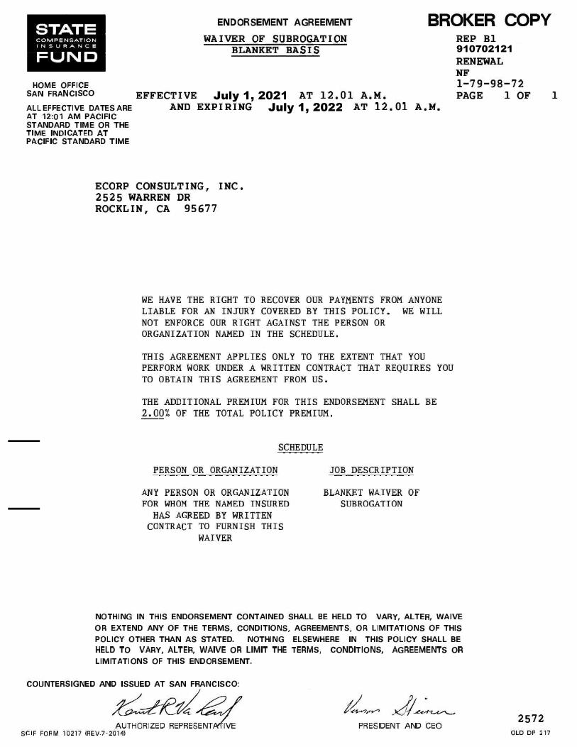
910702121
July 1, 2021 July 1, 2022

G71832193 001
G71832193 001
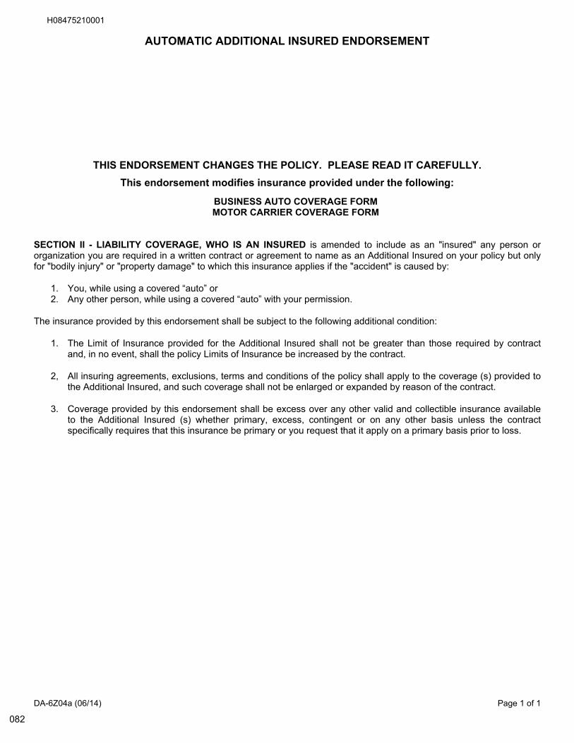
DA-6Z04a (06/14) Page 1 of 1
AUTOMATIC ADDITIONAL INSURED ENDORSEMENT
AUTOMATIC ADDITIONAL INSURED ENDORSEMENT
THIS ENDORSEMENT CHANGES THE POLICY. PLEASE READ IT CAREFULLY.
This endorsement modifies insurance provided under the following:
BUSINESS AUTO COVERAGE FORMMOTOR CARRIER COVERAGE FORM
SECTION II - LIABILITY COVERAGE, WHO IS AN INSURED is amended to include as an "insured" any person ororganization you are required in a written contract or agreement to name as an Additional Insured on your policy but onlyfor "bodily injury" or "property damage" to which this insurance applies if the "accident" is caused by:
1. You, while using a covered “auto” or2. Any other person, while using a covered “auto” with your permission.
The insurance provided by this endorsement shall be subject to the following additional condition:
1. The Limit of Insurance provided for the Additional Insured shall not be greater than those required by contractand, in no event, shall the policy Limits of Insurance be increased by the contract.
2, All insuring agreements, exclusions, terms and conditions of the policy shall apply to the coverage (s) provided tothe Additional Insured, and such coverage shall not be enlarged or expanded by reason of the contract.
3. Coverage provided by this endorsement shall be excess over any other valid and collectible insurance availableto the Additional Insured (s) whether primary, excess, contingent or on any other basis unless the contractspecifically requires that this insurance be primary or you request that it apply on a primary basis prior to loss.
082
H08475210001