Economic, social and environmental impact of land consolidation in Galicia
13
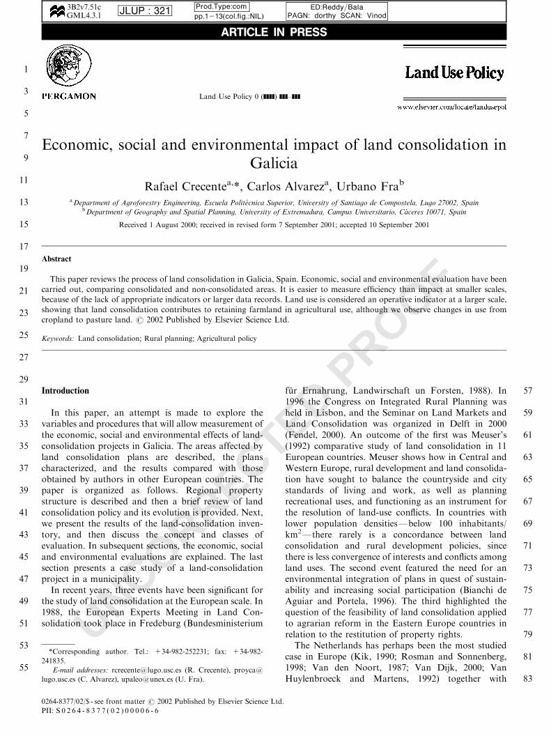
UNCORRECTED PROOF Land Use Policy 0 (]]]]) ]]]–]]] Economic, social and environmental impact of land consolidation in Galicia Rafael Crecente a, *, Carlos Alvarez a , Urbano Fra b a Department of Agroforestry Engineering, Escuela Polit ! ecnica Superior, University of Santiago de Compostela, Lugo 27002, Spain b Department of Geography and Spatial Planning, University of Extremadura, Campus Universitario, C ! aceres 10071, Spain Received 1 August 2000; received in revised form 7 September 2001; accepted 10 September 2001 Abstract This paper reviews the process of land consolidation in Galicia, Spain. Economic, social and environmental evaluation have been carried out, comparing consolidated and non-consolidated areas. It is easier to measure efficiency than impact at smaller scales, because of the lack of appropriate indicators or larger data records. Land use is considered an operative indicator at a larger scale, showing that land consolidation contributes to retaining farmland in agricultural use, although we observe changes in use from cropland to pasture land. r 2002 Published by Elsevier Science Ltd. Keywords: Land consolidation; Rural planning; Agricultural policy Introduction In this paper, an attempt is made to explore the variables and procedures that will allow measurement of the economic, social and environmental effects of land- consolidation projects in Galicia. The areas affected by land consolidation plans are described, the plans characterized, and the results compared with those obtained by authors in other European countries. The paper is organized as follows. Regional property structure is described and then a brief review of land consolidation policy and its evolution is provided. Next, we present the results of the land-consolidation inven- tory, and then discuss the concept and classes of evaluation. In subsequent sections, the economic, social and environmental evaluations are explained. The last section presents a case study of a land-consolidation project in a municipality. In recent years, three events have been significant for the study of land consolidation at the European scale. In 1988, the European Experts Meeting in Land Con- solidation took place in Fredeburg (Bundesministerium f . ur Ernahrung, Landwirschaft un Forsten, 1988). In 1996 the Congress on Integrated Rural Planning was held in Lisbon, and the Seminar on Land Markets and Land Consolidation was organized in Delft in 2000 (Fendel, 2000). An outcome of the first was Meuser’s (1992) comparative study of land consolidation in 11 European countries. Meuser shows how in Central and Western Europe, rural development and land consolida- tion have sought to balance the countryside and city standards of living and work, as well as planning recreational uses, and functioning as an instrument for the resolution of land-use conflicts. In countries with lower population densitiesFbelow 100 inhabitants/ km 2 Fthere rarely is a concordance between land consolidation and rural development policies, since there is less convergence of interests and conflicts among land uses. The second event featured the need for an environmental integration of plans in quest of sustain- ability and increasing social participation (Bianchi de Aguiar and Portela, 1996). The third highlighted the question of the feasibility of land consolidation applied to agrarian reform in the Eastern Europe countries in relation to the restitution of property rights. The Netherlands has perhaps been the most studied case in Europe (Kik, 1990; Rosman and Sonnenberg, 1998; Van den Noort, 1987; Van Dijk, 2000; Van Huylenbroeck and Martens, 1992) together with ARTICLE IN PRESS 1 3 5 7 9 11 13 15 17 19 21 23 25 27 29 31 33 35 37 39 41 43 45 47 49 51 53 55 57 59 61 63 65 67 69 71 73 75 77 79 81 83 3B2v7:51c GML4:3:1 JLUP : 321 Prod:Type:com pp:1213ðcol:fig::NILÞ ED:Reddy=Bala PAGN: dorthy SCAN: Vinod *Corresponding author. Tel.: +34-982-252231; fax: +34-982- 241835. E-mail addresses: [email protected] (R. Crecente), proyca@ lugo.usc.es (C. Alvarez), [email protected] (U. Fra). 0264-8377/02/$ - see front matter r 2002 Published by Elsevier Science Ltd. PII:S0264-8377(02)00006-6
Transcript of Economic, social and environmental impact of land consolidation in Galicia
UNCORRECTED PROOF
Land Use Policy 0 (]]]]) ]]]–]]]
Economic, social and environmental impact of land consolidation inGalicia
Rafael Crecentea,*, Carlos Alvareza, Urbano Frab
aDepartment of Agroforestry Engineering, Escuela Polit!ecnica Superior, University of Santiago de Compostela, Lugo 27002, SpainbDepartment of Geography and Spatial Planning, University of Extremadura, Campus Universitario, C !aceres 10071, Spain
Received 1 August 2000; received in revised form 7 September 2001; accepted 10 September 2001
Abstract
This paper reviews the process of land consolidation in Galicia, Spain. Economic, social and environmental evaluation have been
carried out, comparing consolidated and non-consolidated areas. It is easier to measure efficiency than impact at smaller scales,
because of the lack of appropriate indicators or larger data records. Land use is considered an operative indicator at a larger scale,
showing that land consolidation contributes to retaining farmland in agricultural use, although we observe changes in use from
cropland to pasture land. r 2002 Published by Elsevier Science Ltd.
Keywords: Land consolidation; Rural planning; Agricultural policy
Introduction
In this paper, an attempt is made to explore thevariables and procedures that will allow measurement ofthe economic, social and environmental effects of land-consolidation projects in Galicia. The areas affected byland consolidation plans are described, the planscharacterized, and the results compared with thoseobtained by authors in other European countries. Thepaper is organized as follows. Regional propertystructure is described and then a brief review of landconsolidation policy and its evolution is provided. Next,we present the results of the land-consolidation inven-tory, and then discuss the concept and classes ofevaluation. In subsequent sections, the economic, socialand environmental evaluations are explained. The lastsection presents a case study of a land-consolidationproject in a municipality.In recent years, three events have been significant for
the study of land consolidation at the European scale. In1988, the European Experts Meeting in Land Con-solidation took place in Fredeburg (Bundesministerium
f .ur Ernahrung, Landwirschaft un Forsten, 1988). In1996 the Congress on Integrated Rural Planning washeld in Lisbon, and the Seminar on Land Markets andLand Consolidation was organized in Delft in 2000(Fendel, 2000). An outcome of the first was Meuser’s(1992) comparative study of land consolidation in 11European countries. Meuser shows how in Central andWestern Europe, rural development and land consolida-tion have sought to balance the countryside and citystandards of living and work, as well as planningrecreational uses, and functioning as an instrument forthe resolution of land-use conflicts. In countries withlower population densitiesFbelow 100 inhabitants/km2Fthere rarely is a concordance between landconsolidation and rural development policies, sincethere is less convergence of interests and conflicts amongland uses. The second event featured the need for anenvironmental integration of plans in quest of sustain-ability and increasing social participation (Bianchi deAguiar and Portela, 1996). The third highlighted thequestion of the feasibility of land consolidation appliedto agrarian reform in the Eastern Europe countries inrelation to the restitution of property rights.The Netherlands has perhaps been the most studied
case in Europe (Kik, 1990; Rosman and Sonnenberg,1998; Van den Noort, 1987; Van Dijk, 2000; VanHuylenbroeck and Martens, 1992) together with
ARTICLE IN PRESS
1
3
5
7
9
11
13
15
17
19
21
23
25
27
29
31
33
35
37
39
41
43
45
47
49
51
53
55
57
59
61
63
65
67
69
71
73
75
77
79
81
83
3B2v7:51cGML4:3:1 JLUP : 321 Prod:Type:com
pp:1213ðcol:fig::NILÞED:Reddy=Bala
PAGN: dorthy SCAN: Vinod
*Corresponding author. Tel.: +34-982-252231; fax: +34-982-
241835.
E-mail addresses: [email protected] (R. Crecente), proyca@
lugo.usc.es (C. Alvarez), [email protected] (U. Fra).
0264-8377/02/$ - see front matter r 2002 Published by Elsevier Science Ltd.
PII: S 0 2 6 4 - 8 3 7 7 ( 0 2 ) 0 0 0 0 6 - 6
UNCORRECTED PROOF
Germany. The studies developed in the latter by theLehrstuhl f .ur Bodenordnung und Landentwicklunghave been abundant, and the perspective of Schlosser(1999) with a historical review of the rural developmentpolicy and the evaluation of land-consolidation projectsthrough a comparative analysis of consolidated andnon-consolidated areas is comparable to the oneadopted here. The north of Portugal, a neighboringarea to Galicia with some common features, but withfewer projects and a smaller area, has been reviewed byauthors such as Coelho et al. (1996), Monke et al. (1992)and Unwin (1988). In Spain there have been fewanalyses, but Alario (1991) and Crecente (1998) havestudied Castilla y Le !on and Galicia, respectively.The literature review reveals a shift in goals and
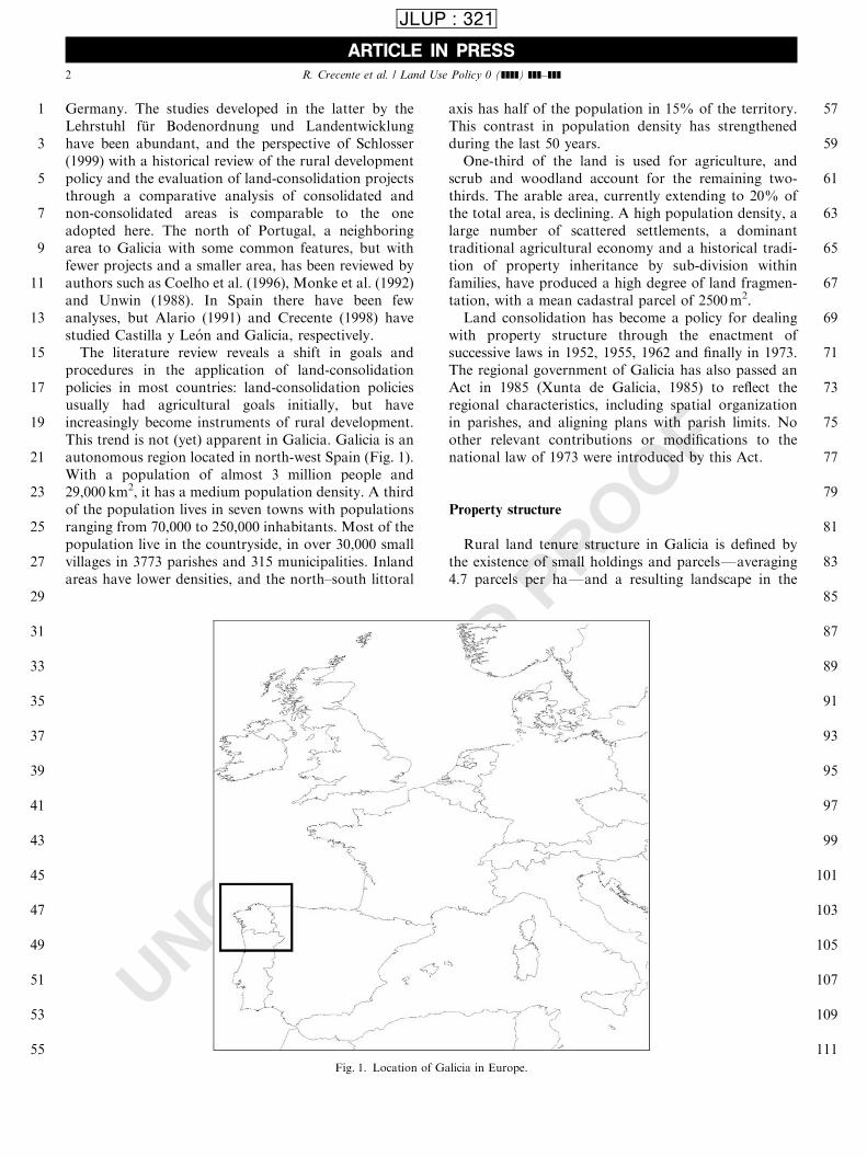
procedures in the application of land-consolidationpolicies in most countries: land-consolidation policiesusually had agricultural goals initially, but haveincreasingly become instruments of rural development.This trend is not (yet) apparent in Galicia. Galicia is anautonomous region located in north-west Spain (Fig. 1).With a population of almost 3 million people and29,000 km2, it has a medium population density. A thirdof the population lives in seven towns with populationsranging from 70,000 to 250,000 inhabitants. Most of thepopulation live in the countryside, in over 30,000 smallvillages in 3773 parishes and 315 municipalities. Inlandareas have lower densities, and the north–south littoral
axis has half of the population in 15% of the territory.This contrast in population density has strengthenedduring the last 50 years.One-third of the land is used for agriculture, and
scrub and woodland account for the remaining two-thirds. The arable area, currently extending to 20% ofthe total area, is declining. A high population density, alarge number of scattered settlements, a dominanttraditional agricultural economy and a historical tradi-tion of property inheritance by sub-division withinfamilies, have produced a high degree of land fragmen-tation, with a mean cadastral parcel of 2500m2.Land consolidation has become a policy for dealing
with property structure through the enactment ofsuccessive laws in 1952, 1955, 1962 and finally in 1973.The regional government of Galicia has also passed anAct in 1985 (Xunta de Galicia, 1985) to reflect theregional characteristics, including spatial organizationin parishes, and aligning plans with parish limits. Noother relevant contributions or modifications to thenational law of 1973 were introduced by this Act.
Property structure
Rural land tenure structure in Galicia is defined bythe existence of small holdings and parcelsFaveraging4.7 parcels per haFand a resulting landscape in the
ARTICLE IN PRESS
1
3
5
7
9
11
13
15
17
19
21
23
25
27
29
31
33
35
37
39
41
43
45
47
49
51
53
55
57
59
61
63
65
67
69
71
73
75
77
79
81
83
85
87
89
91
93
95
97
99
101
103
105
107
109
111Fig. 1. Location of Galicia in Europe.
R. Crecente et al. / Land Use Policy 0 (]]]]) ]]]–]]]2
JLUP : 321
UNCORRECTED PROOF
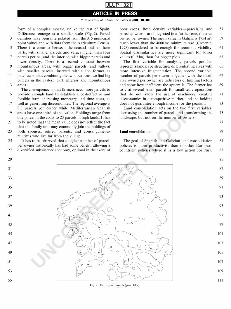
form of a complex mosaic, unlike the rest of Spain.Differences emerge at a smaller scale (Fig. 2). Parceldensities have been interpolated from the 315 municipalpoint values and with data from the Agriculture Census.There is a contrast between the coastal and southernparts, with smaller parcels and values higher than fourparcels per ha, and the interior, with bigger parcels andlower density. There is a second contrast betweenmountainous areas, with bigger parcels, and valleys,with smaller parcels, inserted within the former aspatches; so that combining the two locations, we find bigparcels in the eastern part, interior and mountainousareas.The consequence is that farmers need more parcels to
provide enough land to establish a cost-effective andfeasible farm, increasing monetary and time costs, aswell as generating diseconomies. The regional average is8.3 parcels per owner while Mediterranean Spanishareas have one-third of this value. Holdings range fromone parcel in the coast to 23 parcels in high lands. It hasto be noted that the mean value does not reflect the factthat the family unit may commonly join the holdings ofboth spouses, retired parents, and consanguineousrelatives who live far from the village.It has to be observed that a higher number of parcels
per owner historically has had some benefit, allowing adiversified subsistence economy, optimal in the event of
poor crops. Both density variablesFparcels/ha andparcels/ownerFare integrated in a further one, the areaowned per owner. The mean value in Galicia is 1754m2,much lower than the 4000m2 minimum size (Crecente,1998) considered to be enough for economic viability.Spatial dissimilarities are more significant for lowervalues (0–5 ha) than for bigger plots.The first variable for analysis, parcels per ha,
represents landscape structure, differentiating areas withmore intensive fragmentation. The second variable,number of parcels per owner, together with the third,area owned per owner are indicators of limiting factorsand show how inefficient the system is. The farmer hasto visit several small parcels for small-scale operationsthat do not allow the use of machinery, creatingdiseconomies in a competitive market, and the holdingdoes not guarantee enough income for the peasant.Land consolidation acts on the two first variables,
decreasing the number of parcels and transforming thelandscape, but not on the number of owners.
Land consolidation
The goal of Spanish and Galician land-consolidationpolicies is more productivist than in other Europeancountries’ policies where it is a key action for rural
ARTICLE IN PRESS
1
3
5
7
9
11
13
15
17
19
21
23
25
27
29
31
33
35
37
39
41
43
45
47
49
51
53
55
57
59
61
63
65
67
69
71
73
75
77
79
81
83
85
87
89
91
93
95
97
99
101
103
105
107
109
111Fig. 2. Density of parcels (parcel/ha).
R. Crecente et al. / Land Use Policy 0 (]]]]) ]]]–]]] 3
JLUP : 321
UNCORRECTED PROOF
development. In other countries, this policy is under theprovisions of spatial physical planning (Van Den Brink,1999; Van Den Noort, 1987), and incorporates improve-ments to landscape and natural conditions: for exampleenvironmental impact assessment is required in land-consolidation projects (Sonnenberg, 1996). The basicobjective in Spain is still to increase farmer income bychanging the parcel structure and infrastructures, and isunderstood as a sectoral planning tool (Crecente andAlvarez, 2000). In The Netherlands land consolidationhas evolved from optimization of land use to a form ofrural planning through land development (Sonnenberg,1996) by means of the Land Development Act of 1985.It incorporates measures to improve environment,landscape and recreation (Rosman and Sonnenberg,1998), and to develop alternative strategies in thepreparation phase in order to integrate plans in nationaland regional policies. The multifunctional approachadopted in the second phase of the evolution of land-consolidation policies (Van Lier, 2000) considers thecountryside as an area with multiple values (mainlyrelated to nature and landscape) added to foodproduction, and this is reflected in the plans, whichintroduce non-agricultural objectives. Moreover, thetop-down perspective of a policy does not take intoconsideration the specifics of the site, and the bottom-upperspective does not appraise global and larger-scalegoals. Therefore, both have to merge in spatial planningpolicies, including land consolidation.
Inventory and characterization
Comprehension and evaluation are difficult tasks, fora number of reasons. The great number of land-consolidation plans, along with the large number ofparcels and owners involved in every procedure, the longduration of each plan and of the whole process, thespatial indefinition of some plansFareas in severalparishes and parishes with several areasFand the non-existence of an adequate information support other thantraditional paperwork. There are data for the wholecountry only until 1989, when the responsibility of theIRYDAFthe now-discontinued agency responsible forland consolidationFwas transferred to the regionalgovernments. This made it necessary for the presentstudy to collect basic data, and makes it difficult tocompare processes in different regions. It has also beenobserved that after the transfer, the rate of projectapproval (Alario, 1991) was reduced, but the remainingareas may be more difficult to consolidate.We may simplify the present state of land consolida-
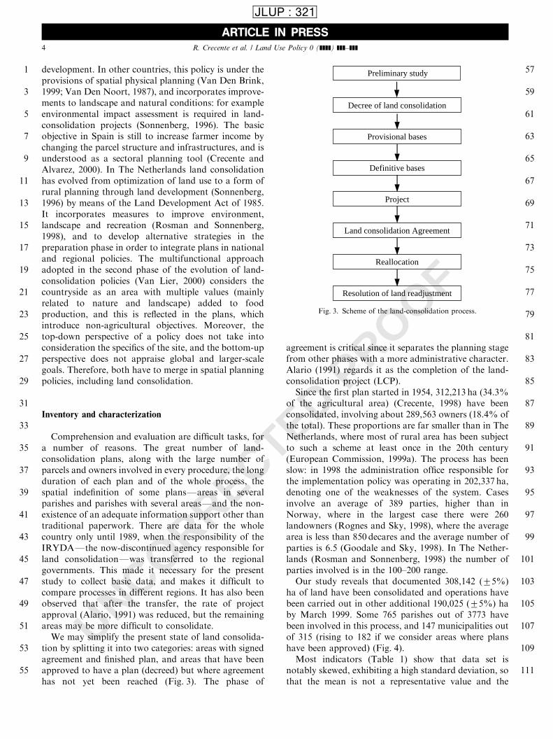
tion by splitting it into two categories: areas with signedagreement and finished plan, and areas that have beenapproved to have a plan (decreed) but where agreementhas not yet been reached (Fig. 3). The phase of
agreement is critical since it separates the planning stagefrom other phases with a more administrative character.Alario (1991) regards it as the completion of the land-consolidation project (LCP).Since the first plan started in 1954, 312,213 ha (34.3%
of the agricultural area) (Crecente, 1998) have beenconsolidated, involving about 289,563 owners (18.4% ofthe total). These proportions are far smaller than in TheNetherlands, where most of rural area has been subjectto such a scheme at least once in the 20th century(European Commission, 1999a). The process has beenslow: in 1998 the administration office responsible forthe implementation policy was operating in 202,337 ha,denoting one of the weaknesses of the system. Casesinvolve an average of 389 parties, higher than inNorway, where in the largest case there were 260landowners (Rognes and Sky, 1998), where the averagearea is less than 850 decares and the average number ofparties is 6.5 (Goodale and Sky, 1998). In The Nether-lands (Rosman and Sonnenberg, 1998) the number ofparties involved is in the 100–200 range.Our study reveals that documented 308,142 (75%)
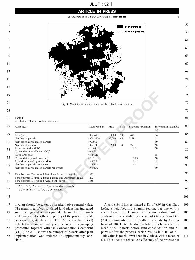
ha of land have been consolidated and operations havebeen carried out in other additional 190,025 (75%) haby March 1999. Some 765 parishes out of 3773 havebeen involved in this process, and 147 municipalities outof 315 (rising to 182 if we consider areas where planshave been approved) (Fig. 4).Most indicators (Table 1) show that data set is
notably skewed, exhibiting a high standard deviation, sothat the mean is not a representative value and the
ARTICLE IN PRESS
1
3
5
7
9
11
13
15
17
19
21
23
25
27
29
31
33
35
37
39
41
43
45
47
49
51
53
55
57
59
61
63
65
67
69
71
73
75
77
79
81
83
85
87
89
91
93
95
97
99
101
103
105
107
109
111
Decree of land consolidation
Definitive bases
Provisional bases
Land consolidation Agreement
Reallocation
Resolution of land readjustment
Project
Preliminary study
Fig. 3. Scheme of the land-consolidation process.
R. Crecente et al. / Land Use Policy 0 (]]]]) ]]]–]]]4
JLUP : 321
UNCORRECTED PROOF
median should be taken as an alternative central value.The mean area of consolidated land plans has increasedsince the regional act was passed. The number of parcelsand owners reflects the complexity of the procedure and,consequently, its duration. The Reduction Index (RI)reflects the technical quality or efficiency of the groupingprocedure, together with the Consolidation Coefficient(CC) (Table 1), shows the number of parcels after planimplementation was reduced to approximately one-sixth.
Alario (1991) has estimated a RI of 8.09 in Castilla yLe !on, a neighbouring Spanish region, but one with avery different relief, since flat terrain is dominant incontrast to the undulating surface of Galicia. Van Dijk(2000) comments on the results of a study by Ooster-baan of 104 Dutch land-consolidation schemes with amean of 5.2 parcels before land consolidation and 2.2parcels after the process, which results in a RI of 2.4.This value is much lower than in Galicia, with a mean of6.1. This does not reflect less efficiency of the process but
ARTICLE IN PRESS
1
3
5
7
9
11
13
15
17
19
21
23
25
27
29
31
33
35
37
39
41
43
45
47
49
51
53
55
57
59
61
63
65
67
69
71
73
75
77
79
81
83
85
87
89
91
93
95
97
99
101
103
105
107
109
111
Fig. 4. Municipalities where there has been land consolidation.
Table 1
Attributes of land-consolidation areas
Attributes Mean/Median Max Min Standard deviation Information available
(%)
Area (ha) 509/347 3000 20 478 86
Number of parcels 4358/3209 32,000 64 3879 68
Number of consolidated-parcels 699/562 60
Number of owners 389/314 2300 4 299 68
Reduction index (RI)a 6.1/5.4 3.5 60
Consolidation coefficient (CC)b 90.0/90.5
Parcel area (ha) 0.14/0.10 68
Consolidated-parcel area (ha) 0.71/0.51 0.63 60
Extension owned by owner (ha) 1.46/0.95 1.42 68
Number of parcels per owner 11.6/10.4 6.4 68
Number of consolidated-parcels per owner 1.93/1.82 60
Time between Decree and Definitive Bases passing (days) 1833
Time between Definitive Bases passing and Agreement (days) 1293
Time between Decree and Agreement (days) 2355
aRI ¼ P=Pc; P=parcels, Pc=consolidated-parcels.bCC ¼ ½P=Pc� � 100=½P=O�; O=owners.
R. Crecente et al. / Land Use Policy 0 (]]]]) ]]]–]]] 5
JLUP : 321
UNCORRECTED PROOF
a longer consolidation tradition and bigger initial plots,since the average resulting parcel was 8.09 ha comparedwith 0.71 ha in Galicia.Despite this, the duration of the three basic phases has
to do more with social and psychological factors thanwith technical ones. The phase with a higher technicaland objective complexity is the first, reaching ‘BaseApproval’ with an inventory of property structure,valuation and parcel. This involves searches to identifyland ownership.
Evaluation
Evaluation is a component of the planning processthat may be accomplished at different stages: selectingamong planning options (ex ante evaluation), mid-termevaluation (monitoring) and final evaluation of achievedgoals (ex post evaluation). Responsibilities for itsimplementation should also belong to authorities incharge of the different planning stages (DirectorateGeneral for Agriculture, 1999). Usually, those preparingthe rural development plan address the ex ante evalua-tion and those managing rural development programsaddress mid-term and ex post. The final evaluation has amajor interest in relation to land consolidation andparticularly for the design of new plans. It has beendefined as the ‘‘judgement of the value of a publicintervention with reference to criteria and explicitstandards (e.g. its relevance, its efficiency)’’ (EuropeanCommission, 1999c).The evaluation of specific land-consolidation projects
adopting an ex ante perspective has been the subject ofstudy for several authors (Van Huylenbroeck andMartens, 1992; Van Huylenbroeck et al., 1996) whohave considered economic, social and environmentalvariables in order to choose among several rankedalternatives, but the regional global perspective hasgenerally been neglected.Van Huylenbroeck et al. (1996) have adopted a
multicriteria analysis, integrating three standard meth-ods and perspectives: economic through Cost-benefitAnalysis (CBA), environmental through EnvironmentalImpact Assessment (EIA) and social through SocialImpact Study (SIS). Its goal is to evaluate and comparealternatives, measuring the potential relevant effectsand, based on the assessment, decide on LCP execution.It has been applied to Portuguese and Flemish casestudies. Both cases have similarities with the conditionsof this area: the property structure of the first and theproduction structure of the second. But the oppositefactors differentiate this area from the other two.Production structure cannot be compared to thePortuguese case, where crop farming is dominant, andthe property structure is very different from the Flemish
case (96.4% and 72.0% of holdings, respectively, areunder 20 ha (Eurostat, 1997).Land tenure is a key issue regarding spatial develop-
ment, and land consolidation is a fundamental instru-ment for structural change. Like other policies withspatial implications, it has collateral effects, which arevaried and are not easy to identify or to measure.There is no specific methodology that is generally
accepted for the evaluation of land-consolidation plans.Some evaluations have applied only quantitative para-meters regarding state of implementation, number ofconsolidated parcels or number of owners (Isla and Soy,1998). The types of intervention of Structural Funds forAgriculture and Rural Development (European Com-mission, 1999c) basically apply to rural infrastructures(including land consolidation), farm diversification,production rationalization and environmental measures.Indicators for surveillance and evaluation of StructuralFunds of the European Union in Spain specificallyaddress achievement analysis and information aboutprogram completeness. This includes, on the one hand,financial accomplishment regarding investment and, onthe other, physical planning fulfillment regarding thetransformed area, length of built roads and volume ofsaved water. However, these indicators do not allow usto measure the impact on other policies, for example onenvironmental impact or rural development.Spain is in an initial phase in the use of evaluation and
hence in the quality of organization (European Com-mission, 1999c). Thus, it is seen as a constraint and as ananswer to regulatory obligations, exclusively limited tothe framework of Structural Funds, and far from apolicy of public demonstration of effectiveness in the useof public funds.This lack is also expressed through the support that
National and European Research, Technology andDevelopment (RTD) Programs give to areas related toevaluation. Priority areas in the RTD Spanish Program(Presidencia del Gobierno, 1999) are:
Agriculture
* Impact of the Common Agricultural Policy (CAP) onprediction systems
* Socioeconomic issues of rural development* Socioeconomic impact of the CAP
Environment
* Effects of the environmental policy on socioeconomicdevelopment
The European Union RTD 5th key action foragriculture, fishing, forestry and rural development,has common objectives (European Parliament, 1999):
* New systems of agriculture production, integratedproduction, diversification
ARTICLE IN PRESS
1
3
5
7
9
11
13
15
17
19
21
23
25
27
29
31
33
35
37
39
41
43
45
47
49
51
53
55
57
59
61
63
65
67
69
71
73
75
77
79
81
83
85
87
89
91
93
95
97
99
101
103
105
107
109
111
R. Crecente et al. / Land Use Policy 0 (]]]]) ]]]–]]]6
JLUP : 321
UNCORRECTED PROOF
* Integrated and sustainable rural development, in-cluding the objective of the pursuit of methods toassess related European policies.
Planning processes and structural actions are exam-ples of evaluation that may contribute within a frame-work, concepts and practice.A multicriteria evaluation refers to the direct or
indirect multiple effectsFeconomic, social and envir-onmentalFof land-consolidation plans on territory. Anevaluation of this kind has to identify, quantify, valueand compare the positive and negative effects of theformer variables. Van Den Noort (1987) understands itsmeasurement as a function of the economic, social,landscape and nature effects, but recognizes that weightcoefficients of each factor introduce personal bias,reflecting the fact that, ultimately, the choice amongoptimal solutions is political.Comparative evaluation relates to the need to
consider the situation without land consolidation andits evolution compared to a situation with landconsolidation. Non-consolidated lands are comparedto others that have gone through this change, or thesame space before and after the process. Both methodshave some problems: the first requires the two areas tobe similar, and the second is very difficult because of thelong duration of the process. Van Dijk (2000) says expost evaluation has been little used, and is seen byJanssen and Rietveld (1985) as a tool to find discre-pancies between past and present priorities and expecta-tions in order to improve plan implementations on thebasis of these conclusions. They have adopted the samemulticriteria evaluation to measure the wide range ofeffects of the Ziewent-Harreveld land reallotment plan(The Netherlands), comparing them with those derivedfrom a no-action alternative in a neighbouring and verysimilar area to the former non-consolidated case, andtwo additional policies with emphasis on agriculture orlandscape.Sectoral evaluation applied to land consolidation
comprehends three constituents and corresponding in-dicators: economic, social and environmental evaluation.In order to carry out these three evaluations, a
geographic information system has been used as a toolto synthesize and integrate the spatial dimension, asproposed in relation to Structural Funds (EuropeanCommission, 1999c). Rosman and Sonnenberg (1998)have developed models to improve information accessand generate a set of solutions for plans by using thissame tool.
Economic evaluation
Van Den Noort (1987) cites an average rate of returnto Dutch economy of 9% and investments of 7000/8000
guilders per ha, reduced to 8% when considering costsof government services and to 7% when taking intoaccount the effects of levy policy for milk production.He estimates returns to farmers to be much higher,explaining their support for land-consolidation policies.An adequate indicator to assess this economic impact
is the volume of public investment in the developmentand implementation of land-consolidation plans, butthere is no data source from which this volume can beidentified directly. Diseconomies derived from propertyfragmentation, increasing transportation costs, or lackof mechanization, derived from the former, have beenmentioned, and their economic dimension has beenmeasured (Lopez, 1997) and estimated to represent 55%of farming costs in Galicia.Land consolidation changes parcel shape, size and
distance, saving time and triggering innovation by wayof mechanization, although Van Dijk (2000) says theprocess also has another sequence: open markets bringcompetence. This calls for reducing production costsFmainly labourFwith mechanization, and henceadapting parcels for mechanization.The degree of parcel scattering measures the distance
among the parcels owned by a farmer. Comparison ofthis indicator before and after land consolidation willdemonstrate the success of the performance in terms ofpotential time savings for vehicles using the local roadnetwork (Isla and Soy, 1998). We have studied thisvariable in two municipalities (Ribadeo and Trabada)and compared it within each one in the situations withand without consolidation.The municipality of Ribadeo, in the north-east of the
region, has been a testing area. During the 1960s and1970s there were arable land-consolidation plans, andtoday new ones are demanded for forested land. Themunicipality of Trabada will be analyzed to measureand compare the degree of clustering for each holder inconsolidated and non-consolidated areas, and in con-solidated areas before and after the operation.The degree of parcel clustering per owner is measured
as the addition of the Euclidean distances from eachparcelFits centroidFto the mean center of all theparcels (Table 2). We should notice that this meancenter is the hypothetical location of the farm house,which is never the case in practice, and that trips to
ARTICLE IN PRESS
1
3
5
7
9
11
13
15
17
19
21
23
25
27
29
31
33
35
37
39
41
43
45
47
49
51
53
55
57
59
61
63
65
67
69
71
73
75
77
79
81
83
85
87
89
91
93
95
97
99
101
103
105
107
109
111
Table 2
Reduction of distances with land consolidation
Total distance
before consolidation
(m)
Total distance
after consolidation
(m)
Reduction
Ribadeo 3164 2597 20%
Trabada 7274 1568 80%
R. Crecente et al. / Land Use Policy 0 (]]]]) ]]]–]]] 7
JLUP : 321

UNCORRECTED PROOF
every parcel depend on the crop, season, and thenumber of operations that have to be done.A further indirect indicator has been tested, in order
to measure the economic impact of the process. We havetried to see the differences between five municipalitieswith consolidated and five with non-consolidated areasregarding subsidies for cattle and sheep farm in 1997and 1998, the only years for which data are available. Itis expected that consolidated areas would be moredynamic, developing a higher activity, demanding moreequipment and generating higher incomes. Analysisshows that data from two years are insufficient and themunicipal scale is inappropriate for a spatial interpreta-tion.
Social evaluation
The social effects of a land-consolidation project havebeen taken into consideration more recently than theeconomic effects, partly because of the difficulty ofgathering data (Goodale and Sky, 1998) and alsobecause the main criteria used for reallotment areconcentrating the plots and reducing the mean distancebetween farmhouses and plots (Kik, 1990). These areessentially economic goals. They have been studied fromdiverse points of view, while some authors considerdistribution effects (Van Huylenbroeck et al., 1996),King and Burton (1989) measured the importance offarmer values and motivations using questionnaires, andGoodale and Sky (1998) propose how social variablescan be introduced in the LCP planning process.King and Burton (1989) have found that not only
economic values condition farmer behaviour. Making asatisfactory income is the most important, but the nextfour are pride of ownership, contentment, dowry andfamily tradition. They conclude that any policy of ruralstructural change will depend on rural value systems. Aland-consolidation project in Galicia is not initiatedwithout a demand from a critical number of farmers in acommunity, and there is higher demand than availabilityfrom administration to accomplish projects. There isalways a personal and social conflict between innovationand values, altering the ‘‘yrelationship between aperson and social spacey’’ (Goodale and Sky, 1998,p. 266). At the regional scale, data are available only fora few variables: we will analyze population changes.Population densities increase towards the coast from
the east and southeast, where we find values of 20inhabitants per km2, compared to the regional mean of78 inhabitants per km2. The western urban corridorrunning north-south from the city of A Coru *na to Vigohas the higher densities and is an area of attraction forpopulation movements.During the period 1960–1991, there has been a general
population growth, hiding the difference between
growth in the western part and decline in the easternupland part. These local processes have to do withmigration from an isolated countryside where villagesoften lack facilities to more accessible regional towns,better equipped and with a high standard of living.The processes that took place between 1981 and 1991
had a decisive role in defining the whole period. At thebeginning of the 1970s, people went from small villagesto potential district inland villages and then, when thesefailed to retain population and to provide a goodstandard of living, they moved to other successfuldistrict villages and to regional towns.Up to the 1980s, growing areas were relatively well
distributed and even spatially dominant in the regionalcontext, but during the 1980s growth and decrease zonesbecame very differentiated and decrease became domi-nant.The evolution of population at the parish scale has
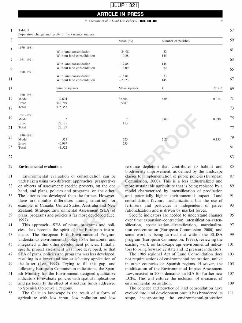
been studied, comparing change in this variable inparishes of the same municipality with and withoutconsolidation processes, applying a variance analysisacross three periods: 1970–1991, 1970–1981 and 1981–1991.The mathematical model proposed considers the
effects of different factors on population change asadditive, in order to perform a variance analysis, and isrepresented by the equation:
DPjðiÞ ¼ mp þ LCi þ ejðiÞ
where DP is the change of population in any of the threestudied periods in parishes j for two levels i; with andwithout land consolidation; mp is the mean populationchange for the included parishes in a period; LCi is theland-consolidation factor for the two levels (with andwithout land consolidation); and ejðiÞ is the sum of otherfactors. For the variance analysis, the number ofavailable cases (Table 3) for each time varies, and theclassifying variable is DP in 1970–1981, 1981–1991 and1970–1991.The results of the analysis show that with an a ¼ 0:05;
we may reject the null hypothesis of the absence ofinfluence of land consolidation (LCi) on demographicchange in the period 1970–1981 but not in the other twostudied periods. In other words, there is a significanteffect from land consolidation in the period 1970–1981,but other factors have also had effects on populationevolution.This has been also observed by Van Huylenbroeck
et al. (1996), who concluded that LCP can be aninstrument not only to allow an acceptable income butalso to give ‘‘yincentives to farmers so that they remainon the land’’ after comparing farmer attitudes in areaswith and without LCP, because its effects go beyond theimprovement of farm structure.
ARTICLE IN PRESS
1
3
5
7
9
11
13
15
17
19
21
23
25
27
29
31
33
35
37
39
41
43
45
47
49
51
53
55
57
59
61
63
65
67
69
71
73
75
77
79
81
83
85
87
89
91
93
95
97
99
101
103
105
107
109
111
R. Crecente et al. / Land Use Policy 0 (]]]]) ]]]–]]]8
JLUP : 321
UNCORRECTED PROOF
Environmental evaluation
Environmental evaluation of consolidation can beundertaken using two different approaches, perspectivesor objects of assessment: specific projects, on the onehand, and plans, policies and programs, on the other.The latter is less developed than the former. However,there are notable differences among countries: forexample, in Canada, United States, Australia and NewZealand, Strategic Environmental Assessment (SEA) ofplans, programs and policies is far more developed (Lee,1997).This approachFSEA of plans, programs and poli-
ciesFhas become the spirit of the European instru-ments. The European Fifth Environmental Programunderstands environmental policy to be horizontal andintegrated within other development policies. Initially,specific project assessment was more developed, so thatSEA of plans, policies and programs was less developed,resulting in a lower and non-satisfactory application ofthe latter (Lee, 1997). Trying to fill this gap, andfollowing European Commission indications, the Span-ish Ministry for the Environment designed qualitativeindicators to evaluate policies with spatial implicationsand particularly the effect of structural funds addressedto Spanish Objective 1 regions.The Galician landscape is the result of a form of
agriculture with low input, low pollution and low
resource depletion that contributes to habitat andbiodiversity improvement, as defined by the landscapeclasses for implementation of public policies (EuropeanCommission, 2000). This is a less industrialized andmore sustainable agriculture that is being replaced by amodel characterized by intensification of productionand potentially higher environmental impact. Landconsolidation favours mechanization, but the use offertilizers and pesticides is independent of parcelrationalization and is driven by market forces.Specific indicators are needed to understand changes
over time: expansion–contraction, intensification–exten-sification, specialization–diversification, marginaliza-tion–concentration (European Commission, 2000), andsome work is being carried out within the ELISAprogram (European Commission, 1999a), reviewing theexisting work on landscape agri-environmental indica-tors to bring forward 22 state and 12 pressure indicators.The 1985 regional Act of Land Consolidation does
not require actions of environmental restoration, unlikein other countries or Spanish regions. However, themodification of the Environmental Impact AssessmentLaw, enacted in 2000, demands an EIA for further newLCPs. This will enforce the inclusion of measures ofenvironmental restoration.The concept and practice of land consolidation have
evolved into land development once it has broadened itsscope, incorporating the environmental-protection
ARTICLE IN PRESS
1
3
5
7
9
11
13
15
17
19
21
23
25
27
29
31
33
35
37
39
41
43
45
47
49
51
53
55
57
59
61
63
65
67
69
71
73
75
77
79
81
83
85
87
89
91
93
95
97
99
101
103
105
107
109
111
Table 3
Population change and results of the variance analysis
Mean (%) Number of parishes
1970–1981
With land consolidation 24.98 32
Without land consolidation �10.28 145
1981–1991
With land consolidation �12.85 145
Without land consolidation �13.09 52
1970–1991
With land consolidation �18.81 33
Without land consolidation �23.23 145
Sum of squares Mean squares F Pr > F
1970–1981
Model 32,604 32,604 6.05 0.014
Error 942,749 5387
Total 975,353
1981–1991
Model 2 2 0.02 0.890
Error 22,125 113
Total 22,127
1970–1991
Model 525 525 2.25 0.135
Error 40,997 233
Total 41,522
R. Crecente et al. / Land Use Policy 0 (]]]]) ]]]–]]] 9
JLUP : 321

UNCORRECTED PROOF
perspective (Rosman, 1999) in those countries with alonger tradition in this policy. Van den Brink (1999)calls this the regional level of land-consolidationcontribution.In Galicia, nature conservation has not been a
priority, either in retrieving cropland from cultivationor transferring its management to a conservationorganization. The Act 10/1985 does not prescribe anymeasure and its potential application will depend on theperson in charge of the project. This could be consideredas flexibility from the point of view of Janssen andRietveld (1985), but this is not the spirit of the Act.Flexibility is a principle adopted to deal with the changeof priorities in the course of the implementation of theproject, resembling a process approach.At the LCP scale, we exclusively find specific examples
of application of sustainability policies with a functionalscope, assigning parts of the planned area to conserva-tion and landscape improvement, as in Gra *na-Campo,Prado God !ons and Barcia de Mera in the municipalityof O Covelo. After an environmental diagnosis, someforested areas have been excluded, projected roads havebeen re-aligned in order to avoid fragmentation andobstruct watercourses and, finally, actions of restorationby plantations and bioengineering techniques wereproposed, an implementation of what Van Den Brink(1999) calls the functional and measure levels.Spanish administration suggests the overlapping of
land-consolidation plans with natural protected areas asan indicator of the effects of land consolidation onbiodiversity (Ministerio de Medio Ambiente, 1998). Theobstacle to accomplish this is the lack of geo-referencedcartography of both variables, of well-defined locationof natural protected areas and of maps of land-consolidation plans. With the information available,12 parishes where LCPs and protected areas coincidewere identified, adding to an area of 7789 ha, but realaffected area is unknown.Evaluation of specific LCPs should not be developed
during their performance but after their life cycle, oncethe planned effects of the project have taken effect. Landuse is a suitable environmental indicator, the expressionof the result of human activity and natural resourceutilization. As an indicator it has the required criteria(Ministerio de Medio Ambiente, 1996), for example tohave scientific validation, be representative, changesensitive, data accurate, relevant, understandable, pre-dictive, comparable, cost-efficient, and have spatiallocation and goals. Land use was also proposed as anindicator by different authors (Van Huylenbroeck et al.,1996), administrations and organizationsFCanada,The Netherlands, Sweden, OCDE, European Union,UN Economic Commission for Europe (Ministerio deMedio Ambiente, 1996)Fto measure the environmentalstate of natural resources, the human pressure appliedon them, the degree of response of administrations to
detected problems and, finally, to help in the decision-making process.Land-use change has been compared in neighbouring
relatively homogeneous areas with and without land-consolidation processes.
A case study: land consolidation in Trabada
This municipality may be considered as a test area forthe whole region by the Regional Agriculture Admin-istration for evaluating the impact of land-consolidationpolicy on production, land tenure and landscape.Of the municipal area, 36% has been consolidated
and another 33% is being added through three newplans. In this second stage, two new consolidationperspectives were introduced: private and forest landconsolidation, both conditioned by the fact that theremaining land use is mainly forest.Identification of land-use change has been made
through photo-interpretation of images from flights in1957, 1991 and 1996. Land use in 1957 shows theexistence of three dominant areas: native forest, farm-land and scrub.Native forest, located mainly in the south-east, was
composed of oak and chestnut, and was used forfirewood and chestnut crops until population numbersbegan to decrease. Pinus pinaster was then introducedfor wood production in locations with medium slopesand altitudes higher than 200m. The third forestelement was composed of riparian species, locatedwhere water is a limiting factor for agriculture as wellas along parcel limits. Farmland (25% of municipality)was located in lowlands in the south-east, used forpasture as well as for self-consumption cropsFcorn,Brassica, potatoFthat produced until the end ofsummer. Cattle raising was important and every farmhad dairy or meat production. This land was veryproductive, highly valuable and, by tradition, dividedwhen inherited from parents. The result was a veryfragmented and parceled space, dominated by anagricultural system of subsistence sustained by intensivemanpower without mechanization and chemicals. Un-win (1988) describes similar conditions in the neighbour-ing area of north-west Portugal. Despite the influence ofscattered habitat and a self-sufficient economic system,inheritance is, however, the main factor, something alsoobserved by Coelho et al. (1996) in this same area ofPortugal.The most important form of land cover was scrub
(40%), located on all kinds of slope, altitude and terrainaspect (Table 4). It was used for collecting animalbedding and then obtaining manure, rich in nitrogen tofertilize arable land and, occasionally, for grazing.Scrub and arable land uses show a high fragmentation
in landscape spatial unitsFtessellae. In comparison,
ARTICLE IN PRESS
1
3
5
7
9
11
13
15
17
19
21
23
25
27
29
31
33
35
37
39
41
43
45
47
49
51
53
55
57
59
61
63
65
67
69
71
73
75
77
79
81
83
85
87
89
91
93
95
97
99
101
103
105
107
109
111
R. Crecente et al. / Land Use Policy 0 (]]]]) ]]]–]]]10
JLUP : 321
UNCORRECTED PROOF
native forest has lower values of fragmentation, acircumstance that has assured its survival.For the period 1991–1996 we observe some changes,
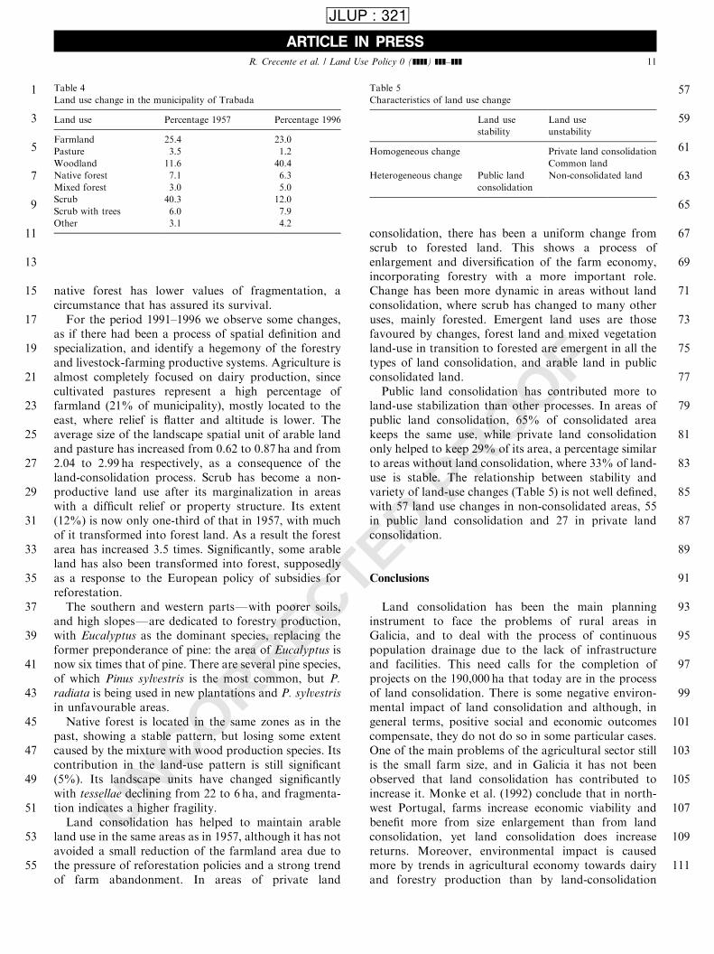
as if there had been a process of spatial definition andspecialization, and identify a hegemony of the forestryand livestock-farming productive systems. Agriculture isalmost completely focused on dairy production, sincecultivated pastures represent a high percentage offarmland (21% of municipality), mostly located to theeast, where relief is flatter and altitude is lower. Theaverage size of the landscape spatial unit of arable landand pasture has increased from 0.62 to 0.87 ha and from2.04 to 2.99 ha respectively, as a consequence of theland-consolidation process. Scrub has become a non-productive land use after its marginalization in areaswith a difficult relief or property structure. Its extent(12%) is now only one-third of that in 1957, with muchof it transformed into forest land. As a result the forestarea has increased 3.5 times. Significantly, some arableland has also been transformed into forest, supposedlyas a response to the European policy of subsidies forreforestation.The southern and western partsFwith poorer soils,
and high slopesFare dedicated to forestry production,with Eucalyptus as the dominant species, replacing theformer preponderance of pine: the area of Eucalyptus isnow six times that of pine. There are several pine species,of which Pinus sylvestris is the most common, but P.
radiata is being used in new plantations and P. sylvestris
in unfavourable areas.Native forest is located in the same zones as in the
past, showing a stable pattern, but losing some extentcaused by the mixture with wood production species. Itscontribution in the land-use pattern is still significant(5%). Its landscape units have changed significantlywith tessellae declining from 22 to 6 ha, and fragmenta-tion indicates a higher fragility.Land consolidation has helped to maintain arable
land use in the same areas as in 1957, although it has notavoided a small reduction of the farmland area due tothe pressure of reforestation policies and a strong trendof farm abandonment. In areas of private land
consolidation, there has been a uniform change fromscrub to forested land. This shows a process ofenlargement and diversification of the farm economy,incorporating forestry with a more important role.Change has been more dynamic in areas without landconsolidation, where scrub has changed to many otheruses, mainly forested. Emergent land uses are thosefavoured by changes, forest land and mixed vegetationland-use in transition to forested are emergent in all thetypes of land consolidation, and arable land in publicconsolidated land.Public land consolidation has contributed more to
land-use stabilization than other processes. In areas ofpublic land consolidation, 65% of consolidated areakeeps the same use, while private land consolidationonly helped to keep 29% of its area, a percentage similarto areas without land consolidation, where 33% of land-use is stable. The relationship between stability andvariety of land-use changes (Table 5) is not well defined,with 57 land use changes in non-consolidated areas, 55in public land consolidation and 27 in private landconsolidation.
Conclusions
Land consolidation has been the main planninginstrument to face the problems of rural areas inGalicia, and to deal with the process of continuouspopulation drainage due to the lack of infrastructureand facilities. This need calls for the completion ofprojects on the 190,000 ha that today are in the processof land consolidation. There is some negative environ-mental impact of land consolidation and although, ingeneral terms, positive social and economic outcomescompensate, they do not do so in some particular cases.One of the main problems of the agricultural sector stillis the small farm size, and in Galicia it has not beenobserved that land consolidation has contributed toincrease it. Monke et al. (1992) conclude that in north-west Portugal, farms increase economic viability andbenefit more from size enlargement than from landconsolidation, yet land consolidation does increasereturns. Moreover, environmental impact is causedmore by trends in agricultural economy towards dairyand forestry production than by land-consolidation
ARTICLE IN PRESS
1
3
5
7
9
11
13
15
17
19
21
23
25
27
29
31
33
35
37
39
41
43
45
47
49
51
53
55
57
59
61
63
65
67
69
71
73
75
77
79
81
83
85
87
89
91
93
95
97
99
101
103
105
107
109
111
Table 4
Land use change in the municipality of Trabada
Land use Percentage 1957 Percentage 1996
Farmland 25.4 23.0
Pasture 3.5 1.2
Woodland 11.6 40.4
Native forest 7.1 6.3
Mixed forest 3.0 5.0
Scrub 40.3 12.0
Scrub with trees 6.0 7.9
Other 3.1 4.2
Table 5
Characteristics of land use change
Land use
stability
Land use
unstability
Homogeneous change Private land consolidation
Common land
Heterogeneous change Public land
consolidation
Non-consolidated land
R. Crecente et al. / Land Use Policy 0 (]]]]) ]]]–]]] 11
JLUP : 321
UNCORRECTED PROOF
policies. Landscape impact is significant, though en-dogenous evolution soon recovers most of the originalvalues. We conclude this paper by suggesting thatinefficiencies may be corrected through the revision ofprocedures, and particularly the Galician Act of LandConsolidation in the following directions:
* Simplify and speed up processes that are tooprotracted, learning from techniques applied in otherEuropean countries with similar policies. In Galicia,projects take 10 years or more; in Norway, forexample, the average is 2.4 years (Rognes and Sky,1998).
* Incorporate social demands and social participationof rural population regarding infrastructure plan-ning.
* Coordinate land-consolidation policy with spatialplanning.
* Improve selection of areas to be planned making useof social and technical criteria.
* Integrate environmental variables, through environ-mental assessment and restoration.
* Introduce spatial information tools to developprojects, in order to make the update process moreflexible, automatic, accurate and of easy interactionwith spatial planning.
The different situation of agricultural productiontodayFalthough not the structureFdemands an adap-tation to new circumstances. The demands have beentranslated into several regional parliamentary initiativesbut these have not yet succeeded in developing a newlaw, modifying the present law or adopting innovativepolicies for land tenure and land development.European countries with a stronger land-consolida-
tion process are those with longer traditions and firmerintegration with other spatial policies. The Netherlandshad 348,000 ha under preparation in 1995 (Sonnenberg,1996) 1million ha under implementation, accounting fora 50% of the cultivated land area, according to Van denBrink (1999). As a result, the country has farms that aremore adaptable to market conditions and CAP reformsas well as a better adjustment between agriculture andenvironmental and spatial policies.
Uncited References
European Commission (1999b).
Acknowledgements
This paper is the result of the work supported by theresearch grant PGIDT 99AGR29101 of the Xunta deGalicia and a project commissioned by the Agriculture
Department of this autonomous government. Thecomments of the editor and referees on an earlierversion of this paper are much appreciated and havebeen mostly incorporated.
References
Alario, M., 1991. Significado espacial y socioecon !omico de la
concentraci !on parcelaria en Castilla y Leon. Ministerio de
Agricultura, Santiago.
Bianchi de Aguiar, F., Portela, J., 1996. Sintese de ideias-chave do
Encontro Ordenamento Rural Integrado. Lavoura Moderna 6,
130–131.
Bundesministerium f .ur Ernahrung, Landwirschaft un Forsten, 1988.
Europaische fachtagung flurbereingung. BELF, Fredeburg.
Coelho, J.C., Portela, J., Pinto, J.A., 1996. A social approach to land
consolidation schemes. A Portuguese case study: the Valenca
project. Land Use Policy 13 (2), 129–147.
Crecente, R., 1998. La concentraci !on parcelaria en Galiciavalidaci !on
como instrumento de planificacion rural.. Universidad de Santiago
de Compostela, Santiago.
Crecente, R., Alvarez, C., 2000. Una revisi !on de la concentraci !on
parcelaria en Europa. Revista de Estudios Agrosociales y
Pesqueros 187, 221–273.
Directorate General for Agriculture, 1999. Evaluation of rural
development programmes’ 2000–2006 supported from the Eur-
opean agricultural guidance and guarantee fund. Guidelines.
Working Paper VI/8865/99-Rev, European Commission.
European Commission, 1999a. Agriculture, environment, rural devel-
opment: facts and figures. A challenge for agriculture. European
Communities, Luxembourg.
European Commission, 1999b. The EU compendium of spatial
planning systems and policies. The Netherlands. Regional Devel-
opment Studies, 28K. European Commission, Luxembourg.
European Commission, 1999c. Evaluating socio-economic programs.
MEANS Collection. Vol. 1, Evaluation design and management.
Vol. 2, Select and use of indicators for monitoring and evaluation.
Vol. 3, Principal evaluation techniques and tools. Vol. 4, Technical
solutions for evaluation within a partnership framework. Vol. 6,
Glossary of 300 concepts and technical terms. European Commis-
sion, Luxembourg.
European Commission, 2000. Indicators for the integration of
environmental considerations in the Common Agriculture Policy.
COM(2000) 20 final.
European Parliament, 1999. Decision No 182/1999/EC of the
European Parliament and of the Council of 22 December 1998
concerning the fifth framework programme of the European
Community for research, technological development and demon-
stration activities (1998 to 2002).
Eurostat, 1997. Regionen. Statistisches Jahrbuch. Eurostat, Luxem-
burg.
Fendel, E.M. (Ed.), 2000. Proceedings of UDMS 2000. 22nd Urban
and Regional Data Management Symposium. Including the
Proceedings of the Seminar on Land Markets and Land
Consolidation in Central Europe. Urban Data Management
Society, Delft.
Goodale, M.R., Sky, P.K., 1998. Owner’s relationships to property
and land consolidation: a social approach. Kart Og Plan 4, 264–
268.
Isla, M., Soy, A., 1998. Synthesis of interim evaluation of the Objective
5b Regions in Spain (1994–1996). Working Paper ARINCO 97.
ES.06.001UE, European Commission.
ARTICLE IN PRESS
1
3
5
7
9
11
13
15
17
19
21
23
25
27
29
31
33
35
37
39
41
43
45
47
49
51
53
55
57
59
61
63
65
67
69
71
73
75
77
79
81
83
85
87
89
91
93
95
97
99
101
103
105
107
109
111
R. Crecente et al. / Land Use Policy 0 (]]]]) ]]]–]]]12
JLUP : 321

UNCORRECTED PROOF
Janssen, R., Rietveld, P., 1985. Multicriteria evaluation of land-
reallotment plans: a case study. Environment and Planning A 17,
1653–1668.
Kik, R., 1990. A method for reallotment research in land development
projects in The Netherlands. Agricultural Systems 33, 127–138.
King, R., Burton, S., 1989. Land ownership values and rural structural
change in Cyprus. Journal of Rural Studies 5 (3), 267–277.
Lee, N., 1997. Evaluacion ambiental estrat!egica aplicada a pol!ıticas,
planes, y programas. In: Peinado, M., Sobrino, I. (Eds.), Avances
en evaluaci !on de impacto ambiental y ecoauditor!ıa. Trotta,
Madrid.
Lopez, D., 1997. Obras inherentes al proceso de concentraci !on
parcelaria. Red de caminos. Consideraciones de dise *no. In:
Crecente, R., Cuesta, T. (Eds.), Curso practico sobre la
concentraci !on parcelaria. COIAG, Lugo.
Meuser, F.J., 1992. Europaische Fachtagung Flurbereingung 1988.
Analyse der Ergebnissie. Technische Universitat Munchen,
Munchen.
Ministerio de Medio Ambiente, 1996. Indicadores ambientales. Una
propuesta para Espa *na. MIMAN, Madrid.
Ministerio de Medio Ambiente, 1998. Indicadores para el seguimiento
y evaluaci!on de los Fondos Estructurales. MIMAN, Madrid.
Monke, E., Avillez, F., Ferro, M., 1992. Consolidation policies and
small-farm agriculture in northwest Portugal. European Review of
Agricultural Economy 19 (1), 67–83.
Presidencia del Gobierno, 1999. Plan Nacional de investigaci !on
cient!ıfica, desarrollo e innovaci !on tecnol !ogica (2000–2003). Minis-
terio de Presidencia, Madrid.
Rognes, J., Sky, P.K., 1998. Mediation in the Norwegian land
consolidation courts. North America Series, Working Paper, 14.
University of Wisconsin, Madison.
Rosman, F.B., 1999. Sustainability as a principle in spatial develop-
ment? Questions for policy and education. In: Dixon-Gough, R.W.
(Ed.), Land Reform and Sustainable Development. Ashgate,
Aldershot, pp. 178–192.
Rosman, F.B., Sonnenberg, J., 1998. New method for the design of the
reallocation plan in land consolidation projects. In: XI FIG
International Congress. Commission 7 cadastre and land manage-
ment. FIG.
Schlosser, F., 1999. Landliche Entwicklung im Wandel der Zeit.
Zielsetzungen und Wirkungen. Bayerisches Staatsministerium fur
Ernahrung, Landwirtschaft und Forsten, Munchen.
Sonnenberg, J., 1996. The European dimensions and land manage-
mentFpolicy issues (land readjustment and land consolidation as
tools for development). In: Land Management in the Process of
Transition. FIG Commission 7, Budapest.
Unwin, T., 1988. The propagation of agrarian change in North-West
Portugal. Journal of Rural Studies 4 (3), 223–238.
Van Den Brink, A., 1999. Sustainable development and land
consolidation. In: Dixon-Gough, R.W. (Ed.), Land Reform and
Sustainable Development. Ashgate, Aldershot, pp. 61–68.
Van Den Noort, P.C., 1987. Land consolidation in The Netherlands.
Land Use Policy 5, 11–13.
Van Dijk, T., 2000. Effects of land consolidation in practice analysis of
post-war experience in The Netherlands. In: Fendel, E.M. (Ed.),
Proceedings of 22nd Urban and Regional Data Management
SymposiumFSeminar on Land Markets and Land Consolidation
in Central Europe, Delft, TU Delft.
Van Lier, H.N., 2000. Land use planning and land consolidation in the
future in Europe. Zeitschrift fur Kulturtechnik und Landentwick-
lung 41, 138–143.
Van Huylenbroeck, G., Coelho, J., Pinto, P.A., 1996. Evaluation of
land consolidation projects (LCPs): a multidisciplinary approach.
Journal of Rural Studies 12 (3), 297–310.
Van Huylenbroeck, G., Martens, L., 1992. The average value
ranking multi-criteria method for project evaluation in regional
planning. European Review of Agricultural Economics 19,
237–252.
Xunta de Galicia, 1985. Act 10/85 of Land Consolidation in
Galicia.
ARTICLE IN PRESS
1
3
5
7
9
11
13
15
17
19
21
23
25
27
29
31
33
35
37
39
41
43
45
47
49
51
53
55
57
R. Crecente et al. / Land Use Policy 0 (]]]]) ]]]–]]] 13
JLUP : 321