Distribution of deep-sea black shales of Cretaceous age in the eastern Equatorial Atlantic from...
14
Distribution of deep-sea black shales of Cretaceous age in the eastern Equatorial Atlantic from seismic profiling E. John W. Jones a, ⁎ , Grant R. Bigg b , Itsuki C. Handoh c , Fivos Spathopoulos a a Department of Earth Sciences, University College London, Gower Street, London WC1E 6BT, UK b Department of Geography, University of Sheffield, Winter Street, Sheffield S10 2TN, UK c School of Applied Mathematics, University of Sheffield, Hounsfield Road, Sheffield S3 7RH, UK Received 11 January 2006; received in revised form 23 October 2006; accepted 12 December 2006 Abstract The presence of thick (∼ 200 m) carbonaceous shales of Cretaceous age in the deep waters of the eastern Equatorial Atlantic was first revealed by drilling at DSDP sites 367 and 368 near the Cape Verde Islands. More recent seismic investigations show that black shales are widely distributed in this region. In the Gambia Basin they are associated with a group of seismic reflectors lying at depths of 400–600 m below the sea floor. These can be traced southwards from the drill sites into the Sierra Leone Basin and eastwards beneath the African continental rise to depths at which ambient temperatures fall within the oil generation window. In the Gambia Basin the reflectors continue westwards from the Cape Verde Archipelago before terminating on Turonian oceanic basement (∼ 92 Ma). South of the Guinea Fracture Zone near 10° N extension of the same seismic sequence on to younger oceanic crust indicates that deep-sea carbonaceous deposits formed close to the present equator as late as the early Campanian (∼ 80 Ma), long after a series of oceanic anoxic events in the Aptian–Albian (OAE1) and over the Cenomanian–Turonian boundary (OAE2) led to widespread accumulation of black shales. This late period of deposition may correspond to the more locally developed OAE3. High surface productivity in equatorial upwelling zones during the late Cretaceous probably played an important role in delivering large amounts of organic carbon to the sea floor when meridional movement of deep water between the South and North Atlantic was restricted by closely-spaced, east–west fracture zones. In some areas seismic data show that the black shales level out rather than drape pre-existing topography, implying significant downslope transport of organic-rich material from upwelling cells near the African margin. © 2007 Elsevier B.V. All rights reserved. Keywords: Atlantic Ocean; Black shales; Seismic profiling; Cretaceous 1. Introduction The history of sedimentation in the deep-water basins between West Africa and Brazil is important to our understanding of the development of the complex pathway between the North and South Atlantic. While the upper parts of the sedimentary column have been extensively investigated for evidence of changes in tropical circulation, climate and sediment input during the Quaternary and Cenozoic (e.g. Mienert et al., 1988; Francois and Bacon, 1991; Höll and Kemle-von Mücke, 2000) the nature and distribution of the Mesozoic sed- iments in this region are poorly known. Few sediments Palaeogeography, Palaeoclimatology, Palaeoecology 248 (2007) 233 – 246 www.elsevier.com/locate/palaeo ⁎ Corresponding author. Tel.: +44 207 679 2381; fax: +44 207 383 3577. E-mail addresses: [email protected] (E.J.W. Jones), [email protected] (G.R. Bigg), [email protected] (I.C. Handoh), [email protected] (F. Spathopoulos). 0031-0182/$ - see front matter © 2007 Elsevier B.V. All rights reserved. doi:10.1016/j.palaeo.2006.12.006
Transcript of Distribution of deep-sea black shales of Cretaceous age in the eastern Equatorial Atlantic from...
laeoecology 248 (2007) 233–246www.elsevier.com/locate/palaeo
Palaeogeography, Palaeoclimatology, Pa
Distribution of deep-sea black shales of Cretaceous age in the easternEquatorial Atlantic from seismic profiling
E. John W. Jones a,⁎, Grant R. Bigg b, Itsuki C. Handoh c, Fivos Spathopoulos a
a Department of Earth Sciences, University College London, Gower Street, London WC1E 6BT, UKb Department of Geography, University of Sheffield, Winter Street, Sheffield S10 2TN, UK
c School of Applied Mathematics, University of Sheffield, Hounsfield Road, Sheffield S3 7RH, UK
Received 11 January 2006; received in revised form 23 October 2006; accepted 12 December 2006
Abstract
The presence of thick (∼200 m) carbonaceous shales of Cretaceous age in the deep waters of the eastern Equatorial Atlanticwas first revealed by drilling at DSDP sites 367 and 368 near the Cape Verde Islands. More recent seismic investigations show thatblack shales are widely distributed in this region. In the Gambia Basin they are associated with a group of seismic reflectors lying atdepths of 400–600 m below the sea floor. These can be traced southwards from the drill sites into the Sierra Leone Basin andeastwards beneath the African continental rise to depths at which ambient temperatures fall within the oil generation window. In theGambia Basin the reflectors continue westwards from the Cape Verde Archipelago before terminating on Turonian oceanicbasement (∼92 Ma). South of the Guinea Fracture Zone near 10° N extension of the same seismic sequence on to younger oceaniccrust indicates that deep-sea carbonaceous deposits formed close to the present equator as late as the early Campanian (∼80 Ma),long after a series of oceanic anoxic events in the Aptian–Albian (OAE1) and over the Cenomanian–Turonian boundary (OAE2)led to widespread accumulation of black shales. This late period of deposition may correspond to the more locally developedOAE3. High surface productivity in equatorial upwelling zones during the late Cretaceous probably played an important role indelivering large amounts of organic carbon to the sea floor when meridional movement of deep water between the South and NorthAtlantic was restricted by closely-spaced, east–west fracture zones. In some areas seismic data show that the black shales level outrather than drape pre-existing topography, implying significant downslope transport of organic-rich material from upwelling cellsnear the African margin.© 2007 Elsevier B.V. All rights reserved.
Keywords: Atlantic Ocean; Black shales; Seismic profiling; Cretaceous
1. Introduction
The history of sedimentation in the deep-water basinsbetween West Africa and Brazil is important to our
⁎ Corresponding author. Tel.: +44 207 679 2381; fax: +44 207 3833577.
E-mail addresses: [email protected] (E.J.W. Jones),[email protected] (G.R. Bigg), [email protected](I.C. Handoh), [email protected] (F. Spathopoulos).
0031-0182/$ - see front matter © 2007 Elsevier B.V. All rights reserved.doi:10.1016/j.palaeo.2006.12.006
understanding of the development of the complexpathway between the North and South Atlantic. Whilethe upper parts of the sedimentary column have beenextensively investigated for evidence of changes intropical circulation, climate and sediment input duringthe Quaternary and Cenozoic (e.g. Mienert et al., 1988;Francois and Bacon, 1991; Höll and Kemle-von Mücke,2000) the nature and distribution of the Mesozoic sed-iments in this region are poorly known. Few sediments

234 E.J.W. Jones et al. / Palaeogeography, Palaeoclimatology, Palaeoecology 248 (2007) 233–246
of this age have been collected from exposures on theseabed and only a small number of wells penetrated thebase of the Cenozoic cover during the Deep-Sea DrillingProject and the Ocean Drilling Program. The mostcomplete Mesozoic sections in the eastern EquatorialAtlantic come from DSDP sites 367 and 368 near theCape Verde Islands where late Jurassic and Cretaceoussediments were cored (Fig. 1; Lancelot et al., 1977b,c).Shorter sequences were recovered from DSDP sites 13and 366 on and near the Sierra Leone Rise (Fig. 1;Maxwell et al., 1970; Lancelot et al., 1977a). Drillingfurther east in the Gulf of Guinea resulted in the re-covery of Mesozoic sediments as old as Albian fromthe Côte d'Ivoire–Ghana margin (Mascle et al., 1996).In the western Equatorial Atlantic Mesozoic sedimentshave been drilled on the Demerara Rise (Hayes et al.,1972; Erbacher et al., 2004a,b,c,d), the Ceara Rise(Perch-Nielsen et al., 1977) and near the foot of the
Fig. 1. Bathymetry of the eastern Equatorial Atlantic showing DSDP/ODP sitfrom IBCEA (1999) and Hunter et al. (1983). Along the African margin the 20depths the isobath contour interval is 500 m. Positions of seismic reflection prat DSDP sites 367 and 368 are shown by the dashed lines. Solid track linesreproduced in Figs. 3–9. GP — Guinea Plateau.
continental rise off northeastern Brazil (Maxwell et al.,1970).
A major finding during drilling near the Cape VerdeIslands off West Africa and off the margin ofnortheastern South America was the discovery of thickcarbonaceous shales of Cretaceous age in water depthsof over 3000 m. These were laid down during lateAptian–early Turonian time when similar accumula-tions were being formed elsewhere in the Atlantic and inother oceanic basins (Schlanger and Jenkyns, 1976;Jenkyns, 1980; Arthur et al., 1990; Bralower et al.,1993). Organic carbon-rich deposits have been recov-ered from the deep-water basins off other parts of Africain the North and South Atlantic (Tissot et al., 1980;Brumsack and Lew, 1982; Brumsack, 1986; Kuhnt andWiedmann, 1995; Lüning et al., 2004; Kolonic et al.,2005), from the western North Atlantic (Ewing andHollister, 1972; Dillon et al., 1986; Herbin et al., 1987)
es 13, 366, 367, 368 and 660. Selected bathymetric contours are drawn0 m, 1000 m, 2000 m and 3000 m isobaths are plotted. In greater waterofiles used to map the distribution of Cretaceous black shales recoveredlabelled 1–7 from north to south indicate locations of seismic sections
235E.J.W. Jones et al. / Palaeogeography, Palaeoclimatology, Palaeoecology 248 (2007) 233–246
and from the Gulf of Mexico (Summerhayes andMasran, 1984; Herbin et al., 1984). The high organiccarbon content of the shales has promoted discussion oftheir possible role as a petroleum source rock beneaththe Atlantic margins (e.g. Tissot et al., 1980; Wagnerand Pletsch, 1999; Davidson, 1999; Macdonald et al.,2003; Lüning et al., 2004).
The origin of these deposits has been the subject ofmuch debate. Discussion has concentrated on the rel-ative importance of increased carbon flux resulting fromhigh primary productivity and greater input of terrestrialhigher plant material (Parrish and Curtis, 1982; Habib,1983; Roth, 1986; Parrish, 1995; Kuypers et al., 2002;Robinson et al., 2004) and the mechanisms that preserveorganic carbon in oceanic sediments (McCoy andZimmermann, 1977; Fischer and Arthur, 1977; Demai-son and Moore, 1980; Bralower and Thierstein, 1984;Tyson, 1987; Herbin et al., 1987; Arthur and Sageman,1994; Sinninghe Damsté and Köster, 1998). Severalepisodes of carbonaceous shale deposition, which havebeen termed Oceanic Anoxic Events (OAEs; Schlangerand Jenkyns, 1976; Arthur and Schlanger, 1979;Jenkyns, 1980) occurred during the Cretaceous:
(i) in the Aptian–Albian (OAE1)(ii) over a brief (b1 Ma) period at the Cenomanian–
Turonian boundary (OAE2)(iii) during Coniacian–Campanian time when more
local accumulations developed (OAE3)
This paper focuses on the Cretaceous carbonaceousshales of the eastern EquatorialAtlantic north of the St PaulFracture Zone (Fig. 1). We first use regional seismicreflection profiles tied to deepwater drill-sites to determinetheir area of deposition. The distribution of the black shalesis then examined in relation to the age of the oceaniclithosphere in order to place constraints on the timing ofdeposition and its relation to oceanic anoxic events andpast patterns of upwelling. The positions of the seismicprofiles, which were acquired by the vessels Atlantis II,Charles Darwin, Glomar Challenger, Kane, Shackletonand Vema, are plotted in Fig. 1 together with nearby drill-sites. Some of the profiles have been used previously forinvestigations of regional structure and for positioning drillsites near the African continental margin and Cape VerdeIslands (Emery et al., 1975; Lancelot et al., 1977a,b,c;Jones, 1987; Ruddiman et al., 1988; Jones et al., 1995;Jones, 2003; Ali et al., 2003). Those seismic sectionswhich are considered representative of the regionaldataset are indicated by thicker track lines and arenumbered 1–7 from north to south. These profiles arereproduced in later figures.
2. Deep-water sediments at DSDP Sites 367 and 368
Carbonaceous shales have been sampled at two drill-sites seaward of the African margin in the easternEquatorial Atlantic (Fig. 1). Lying approximately250 km west of the continental slope, DSDP 367 issituated near the centre of the Gambia Basin in a waterdepth of 4748 m. Site 368 is located in 3366 m of wateron the northeastern side of the thick sedimentary apronsurrounding the Cape Verde Islands. Lithologic sum-maries are shown in Fig. 2, together with short seismicreflection profiles through the drilling positions.
Resting on the basaltic basement at site 367 are lateJurassic–early Cretaceous (Oxfordian/Kimmeridgian–early Aptian) limestones, marls and claystones (Fig. 2a;Lancelot et al., 1977b). Above lie thick carbonaceousshales and clays of late Aptian–early Turonian ageinterbedded with silt turbidites. Total organic carbon(TOC) contents in the shale section fall in the range of0.5–44%, with many samples commonly having organic-carbon concentrations of more than 10% (Gardner et al.,1977; Brumsack, 1986;Herbin et al., 1986). The sequencepasses upwards into late Cretaceous–early Cenozoicterrigenous silty clays. The Eocene section consists ofclays with cherts and porcellanites. Later deposits aredominated by marls intercalated with sandy turbiditeswhich increase in abundance upwards.
Carbonaceous shales of probable Albian–Turonianage were sampled from the basal section of hole 368where they have been intruded by early Miocene(∼19 Ma) dolerites (Fig. 2b; Lancelot et al., 1977c).TOC concentrations in the shales range from ∼1 to 7%.The overlying section ismade up of late Cretaceous–earlyMiocene clays, claystones and shales in part depositedfrom turbidity currents originating along the Africanmargin before a Miocene uplift of the Cape Verde Rise.The Eocene section contains porcellanite layers and chertnodules. Post-Miocene sediments consist of marls andcarbonate ooze.
The short seismic profile through DSDP 367 (Fig. 2a)shows prominent sub-bottom reflectorswhich are labelled1–3. A mean seismic velocity of 2 km s−1 in thesedimentary cover places reflector 3 at a depth of 1150 m,the level at which the junction between basalts and UpperJurassic sediments was encountered during drilling.Reflector 2 marks the top of the late Aptian–earlyTuronian black shales which are imaged as a sequence ofhorizontal reflectors. The section lacking strong andcontinuous seismic returns immediately above corre-sponds to late Cretaceous–early Cenozoic silty clays. Themost prominent marker at shallower depths, labelledreflector 1, is a chert-rich section within Eocene clays.
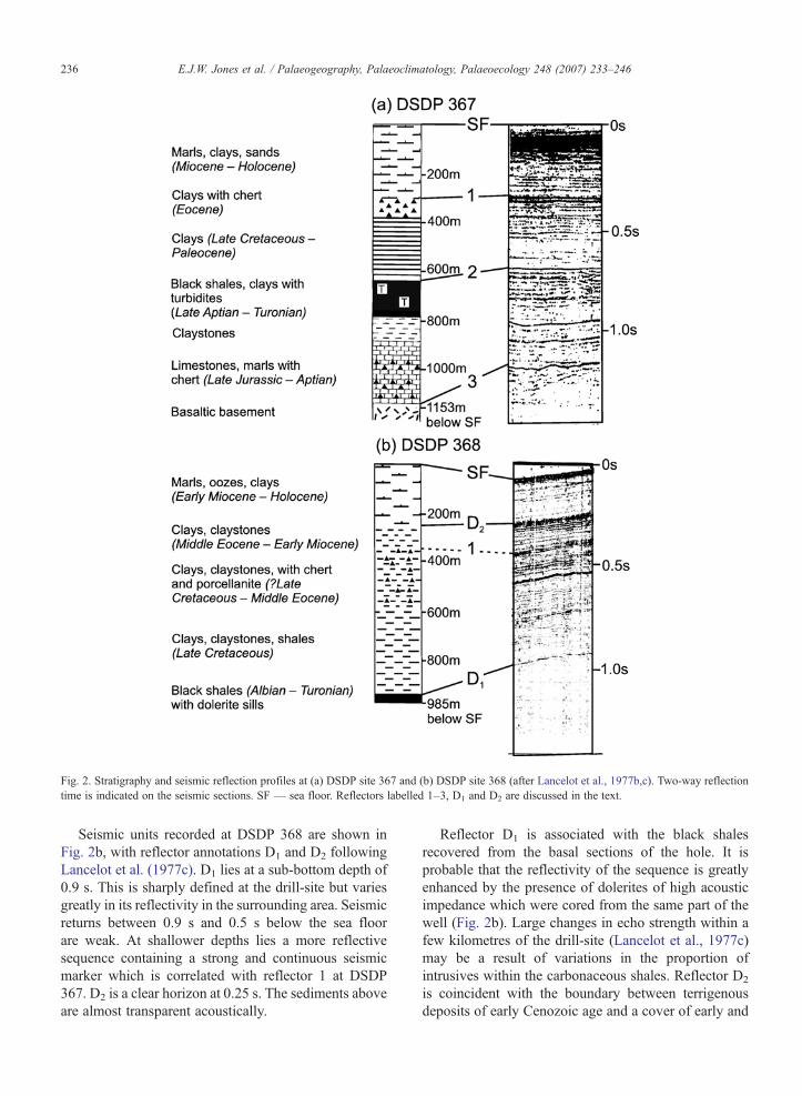
Fig. 2. Stratigraphy and seismic reflection profiles at (a) DSDP site 367 and (b) DSDP site 368 (after Lancelot et al., 1977b,c). Two-way reflectiontime is indicated on the seismic sections. SF — sea floor. Reflectors labelled 1–3, D1 and D2 are discussed in the text.
236 E.J.W. Jones et al. / Palaeogeography, Palaeoclimatology, Palaeoecology 248 (2007) 233–246
Seismic units recorded at DSDP 368 are shown inFig. 2b, with reflector annotations D1 and D2 followingLancelot et al. (1977c). D1 lies at a sub-bottom depth of0.9 s. This is sharply defined at the drill-site but variesgreatly in its reflectivity in the surrounding area. Seismicreturns between 0.9 s and 0.5 s below the sea floorare weak. At shallower depths lies a more reflectivesequence containing a strong and continuous seismicmarker which is correlated with reflector 1 at DSDP367. D2 is a clear horizon at 0.25 s. The sediments aboveare almost transparent acoustically.
Reflector D1 is associated with the black shalesrecovered from the basal sections of the hole. It isprobable that the reflectivity of the sequence is greatlyenhanced by the presence of dolerites of high acousticimpedance which were cored from the same part of thewell (Fig. 2b). Large changes in echo strength within afew kilometres of the drill-site (Lancelot et al., 1977c)may be a result of variations in the proportion ofintrusives within the carbonaceous shales. Reflector D2
is coincident with the boundary between terrigenousdeposits of early Cenozoic age and a cover of early and
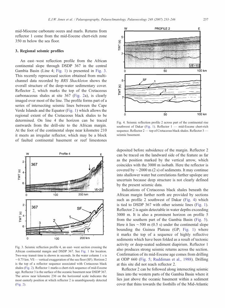
Fig. 4. Seismic reflection profile 2 across part of the continental risesouthwest of Dakar (Fig. 1). Reflector 1 — mid-Eocene chert-richsequence. Reflector 2— top of Cretaceous black shales. Reflector 3—seismic basement.
237E.J.W. Jones et al. / Palaeogeography, Palaeoclimatology, Palaeoecology 248 (2007) 233–246
mid-Miocene carbonate oozes and marls. Returns fromreflector 1 come from the mid-Eocene chert-rich zone350 m below the sea floor.
3. Regional seismic profiles
An east–west reflection profile from the Africancontinental slope through DSDP 367 in the centralGambia Basin (Line 4; Fig. 1) is presented in Fig. 3.This recently reprocessed section obtained from multi-channel data recorded by RRS Shackleton shows theoverall structure of the deep-water sedimentary cover.Reflector 2, which marks the top of the Cretaceouscarbonaceous shales at site 367 (Fig. 2a), is clearlyimaged over most of the line. The profile forms part of aseries of intersecting seismic lines between the CapeVerde Islands and the Equator (Fig. 1) which allows theregional extent of the Cretaceous black shales to bedetermined. On line 4 the horizon can be tracedeastwards from the drill-site to the African margin.At the foot of the continental slope near kilometre 210it meets an irregular reflector, which may be a blockof faulted continental basement or reef limestones
Fig. 3. Seismic reflection profile 4, an east–west section crossing theAfrican continental margin and DSDP 367. See Fig. 1 for location.Two-way transit time is shown in seconds. In the water column 1 s is∼0.75 km. VE— vertical exaggeration of the sea floor (SF). Horizon 2is the top of a reflector sequence associated with Cretaceous blackshales (Fig. 2). Reflector 1 marks a chert-rich sequence of mid-Eoceneage. Reflector 3 is the surface of the oceanic basement near DSDP 367.The arrow near kilometre 230 on the horizontal scale indicates themost easterly position at which reflector 2 is unambiguously detected(Fig. 2).
deposited before subsidence of the margin. Reflector 2can be traced on the landward side of the feature as faras the position marked by the vertical arrow, whichcoincides with the 3000 m isobath. Here the reflector iscovered by∼2000 m (2 s) of sediments. It may continueinto shallower water but correlations further upslope areuncertain because deep structure is not clearly definedby the present seismic data.
Indications of Cretaceous black shales beneath theAfrican margin further north are provided by sectionssuch as profile 2 southwest of Dakar (Fig. 4) whichis tied to DSDP 367 with other seismic lines (Fig. 1).Reflector 2 is again detectable in water depths exceeding3000 m. It is also a prominent horizon on profile 5from the southern part of the Gambia Basin (Fig. 5).Here it lies ∼500 m (0.5 s) under the continental slopebounding the Guinea Plateau (GP; Fig. 1) whereit marks the top of a sequence of highly reflectivesediments which have been folded as a result of tectonicactivity or deep-seated sediment diapirism. Reflector 1also produces strong seismic returns across the section.Confirmation of its mid-Eocene age comes from drillingat ODP 660 (Fig. 5; Ruddiman et al., 1988). Drillingat this site did not reach reflector 2.
Reflector 2 can be followed along intersecting seismiclines into the western parts of the Gambia Basin where itlies just above the oceanic basement within a sedimentcover that thins towards the foothills of the Mid-Atlantic
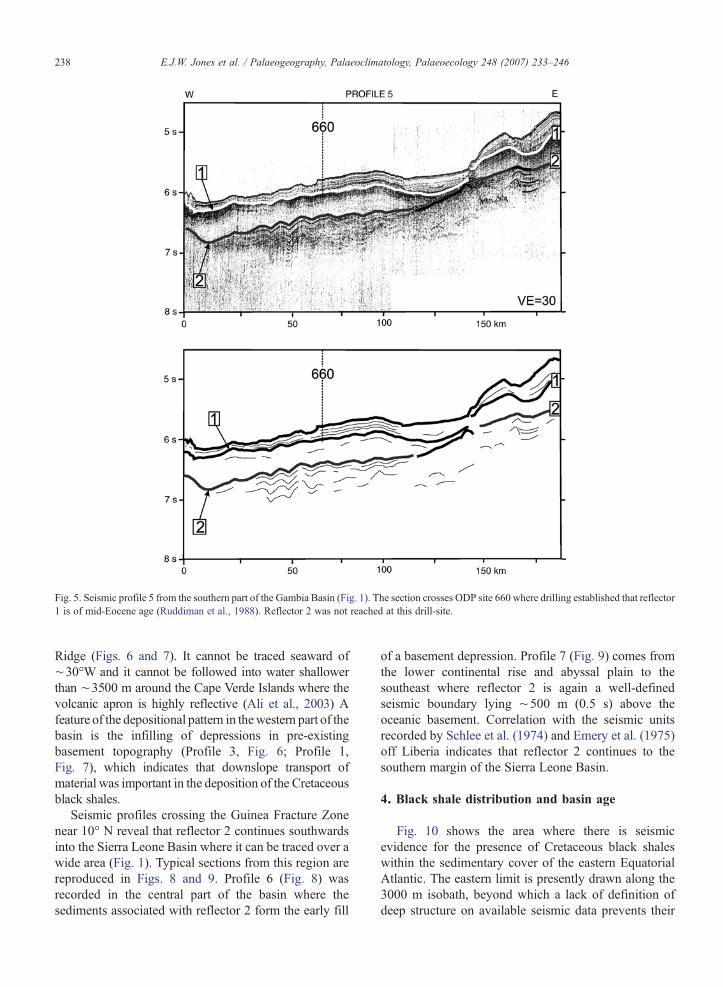
Fig. 5. Seismic profile 5 from the southern part of the Gambia Basin (Fig. 1). The section crosses ODP site 660 where drilling established that reflector1 is of mid-Eocene age (Ruddiman et al., 1988). Reflector 2 was not reached at this drill-site.
238 E.J.W. Jones et al. / Palaeogeography, Palaeoclimatology, Palaeoecology 248 (2007) 233–246
Ridge (Figs. 6 and 7). It cannot be traced seaward of∼30°W and it cannot be followed into water shallowerthan ∼3500 m around the Cape Verde Islands where thevolcanic apron is highly reflective (Ali et al., 2003) Afeature of the depositional pattern in thewestern part of thebasin is the infilling of depressions in pre-existingbasement topography (Profile 3, Fig. 6; Profile 1,Fig. 7), which indicates that downslope transport ofmaterial was important in the deposition of the Cretaceousblack shales.
Seismic profiles crossing the Guinea Fracture Zonenear 10° N reveal that reflector 2 continues southwardsinto the Sierra Leone Basin where it can be traced over awide area (Fig. 1). Typical sections from this region arereproduced in Figs. 8 and 9. Profile 6 (Fig. 8) wasrecorded in the central part of the basin where thesediments associated with reflector 2 form the early fill
of a basement depression. Profile 7 (Fig. 9) comes fromthe lower continental rise and abyssal plain to thesoutheast where reflector 2 is again a well-definedseismic boundary lying ∼500 m (0.5 s) above theoceanic basement. Correlation with the seismic unitsrecorded by Schlee et al. (1974) and Emery et al. (1975)off Liberia indicates that reflector 2 continues to thesouthern margin of the Sierra Leone Basin.
4. Black shale distribution and basin age
Fig. 10 shows the area where there is seismicevidence for the presence of Cretaceous black shaleswithin the sedimentary cover of the eastern EquatorialAtlantic. The eastern limit is presently drawn along the3000 m isobath, beyond which a lack of definition ofdeep structure on available seismic data prevents their
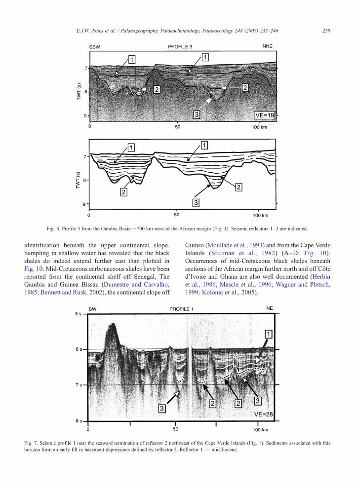
Fig. 6. Profile 3 from the Gambia Basin ∼700 km west of the African margin (Fig. 1). Seismic reflectors 1–3 are indicated.
239E.J.W. Jones et al. / Palaeogeography, Palaeoclimatology, Palaeoecology 248 (2007) 233–246
identification beneath the upper continental slope.Sampling in shallow water has revealed that the blackshales do indeed extend further east than plotted inFig. 10. Mid-Cretaceous carbonaceous shales have beenreported from the continental shelf off Senegal, TheGambia and Guinea Bissau (Dumestre and Carvalho,1985; Bennett and Rusk, 2002), the continental slope off
Fig. 7. Seismic profile 1 near the seaward termination of reflector 2 northwhorizon form an early fill in basement depressions defined by reflector 3. Re
Guinea (Moullade et al., 1993) and from the Cape VerdeIslands (Stillman et al., 1982) (A–D; Fig. 10).Occurrences of mid-Cretaceous black shales beneathsections of the African margin further north and off Côted’Ivoire and Ghana are also well documented (Herbinet al., 1986, Mascle et al., 1996; Wagner and Pletsch,1999; Kolonic et al., 2005).
est of the Cape Verde Islands (Fig. 1). Sediments associated with thisflector 1 — mid-Eocene.
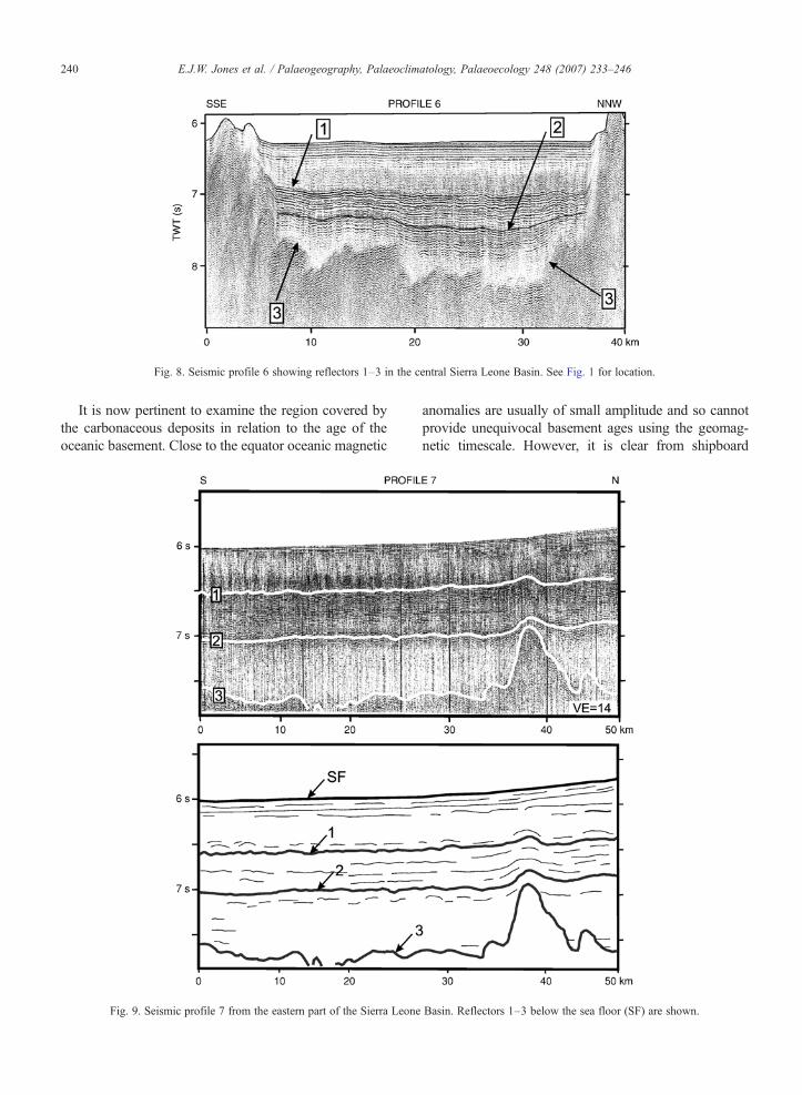
Fig. 8. Seismic profile 6 showing reflectors 1–3 in the central Sierra Leone Basin. See Fig. 1 for location.
240 E.J.W. Jones et al. / Palaeogeography, Palaeoclimatology, Palaeoecology 248 (2007) 233–246
It is now pertinent to examine the region covered bythe carbonaceous deposits in relation to the age of theoceanic basement. Close to the equator oceanic magnetic
Fig. 9. Seismic profile 7 from the eastern part of the Sierra Leone
anomalies are usually of small amplitude and so cannotprovide unequivocal basement ages using the geomag-netic timescale. However, it is clear from shipboard
Basin. Reflectors 1–3 below the sea floor (SF) are shown.

Fig. 10. Area of deep-water Cretaceous black shales (shaded) indicated by seismic data. Regions of uncertain seismic correlation near the Cape VerdeIslands (CV) are shown by question marks. Cretaceous carbonaceous shales have been found on Maio in the Cape Verde Islands (A), in continentalshelf boreholes at positions B and C, and at the seabed on the southern margin of the Guinea Plateau (D). The present 3000 m and 4000 m isobaths areshown. M-series magnetic anomalies (∼125–155 Ma) near the Cape Verde Islands and anomalies 34 (∼84 Ma) and 33r (∼80 Ma) to the west aretaken from Cande et al. (1989). Anomalies M0 (∼125 Ma), 34 (∼84 Ma), 33r (∼80 Ma) and 31 (∼68 Ma) to the south are plotted from Jones et al.(1995). SLR — Sierra Leone Rise. GFZ — Guinea Fracture Zone.
241E.J.W. Jones et al. / Palaeogeography, Palaeoclimatology, Palaeoecology 248 (2007) 233–246
bathymetry and satellite altimetry that the pattern of base-ment lineations associated with the opening of the SouthAtlantic, as mapped byCande et al. (1988), continues northof the equator as far as theGuinea Fracture Zone near 10°N(Jones, 1987).
Using stage poles obtained from South Atlantic sprea-ding patterns, tectonic flow lines have been derived todefine the directions of platemotions during the opening ofthe Atlantic between 10° N and 10° S (Jones et al., 1995).Fig. 10 shows the positions of the stratigraphic upper limitsof magnetochrons C31 (∼68 Ma; late Maastrichtian;Gradstein et al., 2004), C34 (∼84Ma; Santonian) and M0(∼125 Ma; early Aptian) and the lower boundary of C33(labelled 33r: ∼80 Ma; early Campanian) on flow linessouth of the Guinea Fracture Zone. Anomalies determined
from ship-recorded data further north are taken fromCande et al. (1989). Near the Cape Verde Islands thesespan the late Jurassic–early Cretaceous M-series fromM25 (∼155 Ma, late Oxfordian) to M0 and record theearly spreading history off Africa before the opening of theSouth Atlantic. Magnetic anomaly 34 occurs west of theCape Verde Islands. South of the Guinea Fracture Zoneanomaly M0 is found along the African continental slopeindicating that sea-floor spreading began during the earlyAptian, as suggested previously by Sibuet and Mascle(1978).
Reflector 2 can be traced on seismic profiles extending∼500 km west of the Cape Verde Islands where it termi-nates on Turonian (∼92 Ma) oceanic basement betweenmagnetic anomalies M0 and 34 (Fig. 10). The striking
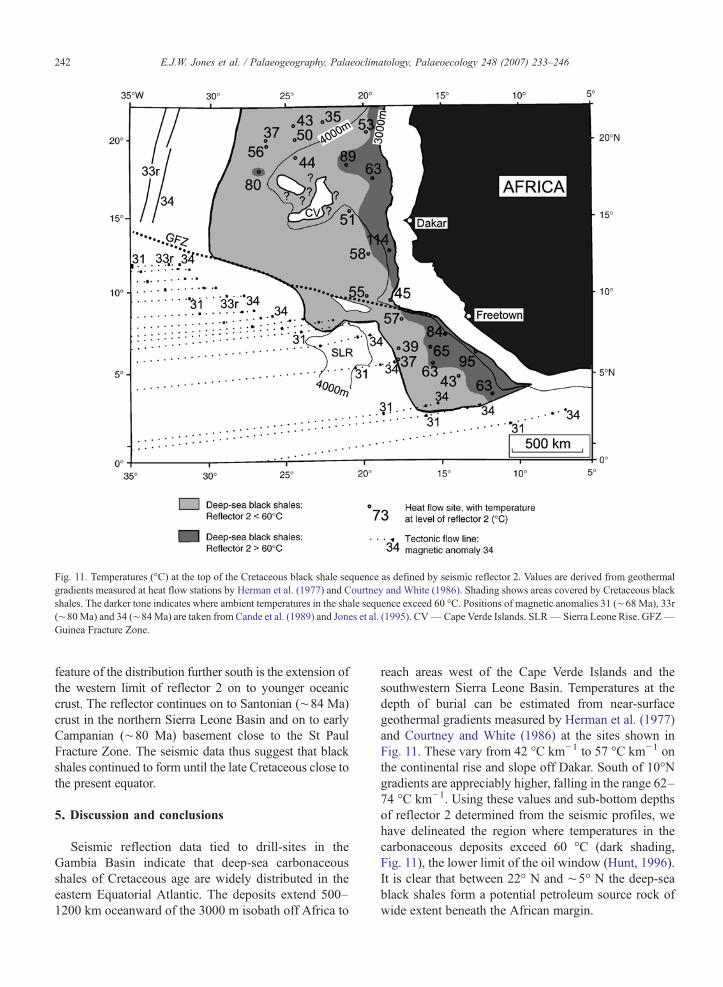
Fig. 11. Temperatures (°C) at the top of the Cretaceous black shale sequence as defined by seismic reflector 2. Values are derived from geothermalgradients measured at heat flow stations by Herman et al. (1977) and Courtney and White (1986). Shading shows areas covered by Cretaceous blackshales. The darker tone indicates where ambient temperatures in the shale sequence exceed 60 °C. Positions of magnetic anomalies 31 (∼68 Ma), 33r(∼80Ma) and 34 (∼84Ma) are taken from Cande et al. (1989) and Jones et al. (1995). CV—Cape Verde Islands. SLR— Sierra Leone Rise. GFZ—Guinea Fracture Zone.
242 E.J.W. Jones et al. / Palaeogeography, Palaeoclimatology, Palaeoecology 248 (2007) 233–246
feature of the distribution further south is the extension ofthe western limit of reflector 2 on to younger oceaniccrust. The reflector continues on to Santonian (∼84 Ma)crust in the northern Sierra Leone Basin and on to earlyCampanian (∼80 Ma) basement close to the St PaulFracture Zone. The seismic data thus suggest that blackshales continued to form until the late Cretaceous close tothe present equator.
5. Discussion and conclusions
Seismic reflection data tied to drill-sites in theGambia Basin indicate that deep-sea carbonaceousshales of Cretaceous age are widely distributed in theeastern Equatorial Atlantic. The deposits extend 500–1200 km oceanward of the 3000 m isobath off Africa to
reach areas west of the Cape Verde Islands and thesouthwestern Sierra Leone Basin. Temperatures at thedepth of burial can be estimated from near-surfacegeothermal gradients measured by Herman et al. (1977)and Courtney and White (1986) at the sites shown inFig. 11. These vary from 42 °C km−1 to 57 °C km−1 onthe continental rise and slope off Dakar. South of 10°Ngradients are appreciably higher, falling in the range 62–74 °C km−1. Using these values and sub-bottom depthsof reflector 2 determined from the seismic profiles, wehave delineated the region where temperatures in thecarbonaceous deposits exceed 60 °C (dark shading,Fig. 11), the lower limit of the oil window (Hunt, 1996).It is clear that between 22° N and ∼5° N the deep-seablack shales form a potential petroleum source rock ofwide extent beneath the African margin.

243E.J.W. Jones et al. / Palaeogeography, Palaeoclimatology, Palaeoecology 248 (2007) 233–246
An unexpected feature of the depositional pattern isthe variation in age of the oceanic basement at theseaward limit of the carbonaceous shales (Fig. 10). Nearthe Cape Verde Islands the seismic reflector marking thetop of the sequence is restricted to sea floor which isTuronian or older. Coverage of the shales is thusconsistent with their formation during oceanic anoxicevents (OAEs) which occurred in Aptian–Albian time(OAE1) and across the Cenomanian–Turonian transition(OAE2) (Schlanger and Jenkyns, 1976). However, theextension of the same seismic sequence on to youngeroceanic basement in the Sierra Leone Basin (Fig. 10)indicates that the top of the reflector series is diachronousand that black shale deposition continued near thepresent equator for more than 10Ma after OAE2, ceasingduring the early Campanian. The deposits in the SierraLeone Basin may therefore be associated, at least in part,with the less extensive OAE3 and the accumulation oflate Santonian–early Campanian black shales on theCôte d’Ivoire–Ghana margin to the east (Wagner andPletsch, 1999; Wagner, 2002) and on the Demerara Riseto the west (Erbacher et al., 2004a,b,c,d). Whetherindividual OAE events can be distinguished in seismicdata in the Gambia and Sierra Leone Basins requiresfurther investigation by high-resolution reflection pro-filing and drilling.
A major factor that may have led to an extendeddepositional period south of the Guinea Fracture Zone ishigh surface productivity associated with equatorialupwelling. The importance of high productivity in theformation of carbonaceous deposits in the deep oceanhas been emphasised by many workers (e.g. Demaisonand Moore, 1980; Summerhayes, 1981; Parrish andCurtis, 1982; Roth, 1986; Parrish, 1995; Kuypers et al.,2002; Wagner, 2002; Robinson et al., 2004). Recentnumerical experiments to simulate Atlantic palaeocircu-lation provide strong evidence for vigorous upwelling inthe equatorial region through much of the Cretaceous.Both the Parallel Ocean Climate Model of the NationalCenter of Atmospheric Research (Poulsen et al., 2001)and a reduced-gravity model that considers the ocean astwo homogeneous layers (Handoh et al., 1999, 2001)indicate strong upwelling off West Africa and northeastSouth America during the mid-Cretaceous. Upwellingwas also a prominent feature of circulation in the lateCretaceous (Handoh et al., 2003), with broad cellsextending across the equatorial gap between Africa andSouth America.
The presence of closely-spaced east–west fracturezones in the equatorial region may also have been a vitalfactor in promoting the formation of deep-watercarbonaceous deposits long after the last pronounced
OAE in the Cretaceous. Between the RomancheTransform on the equator and the Guinea Transform at10° N lie the St Paul, Grand Cess, Cape Palmas, FourNorth and Sierra Leone fracture zones which divided theequatorial region into narrow transverse basins duringthe Cretaceous (Behrendt et al., 1974; Sibuet andMascle, 1978; Jones et al., 1995). The submarinetopography associated with the shear motions betweenthe African and South American plates probablyfavoured high carbon production in the upper ocean byenhancing upwelling and primary productivity near theyoung and shallow fracture zone ridges and, also, carbonpreservation in poorly oxygenated bottom sediments inthe narrow equatorial basins by restricting meridionaldeep-water transfer between the South and NorthAtlantic. The entry of oxygenated deep water into theequatorial region from the South Atlantic probablyterminated the formation of black shales. Drillingevidence from the Côte d'Ivoire–Ghana margin andDemerara Rise (Wagner, 2002; Erbacher et al., 2004a,b,c,d) and the seismic data from the Sierra Leone Basinsuggests this occurred in the early Campanian.
Seismic data also reveal that downslope transport ofsedimentary material was important in the formation ofcarbonaceous deposits in the equatorial region. Theblack shales fill topographic depressions within oradjacent to upwelling zones along the African margindefined by the numerical models of Poulsen et al. (2001)and Handoh et al. (2003) for the mid-and late-Cretaceous(Figs. 6–8). Similar indications of infilling of oceanicbasement lows by Cretaceous carbonaceous shale unitscan also be seen in reflector geometries recorded onseismic profiles from the Western Atlantic (Ewing andHollister, 1972). Direct evidence for sediment reworkingin the Gambia Basin comes from the presence of derivedplant material and turbidite layers within the black shalesection of DSDP 367 (Lancelot et al., 1977b; Gardneret al., 1977; Dean et al., 1984). Downslope transport ofcarbonaceous material from a continental margin whichwas subject to intense upwelling has been identified inmany areas including NW Africa (Embley, 1976; VonRad et al., 1979) and SW Africa (Summerhayes et al.,1979; Embley andMorley, 1980; Dean et al., 1984; Stowand Dean, 1984). The process is clearly important fordistributing carbon-rich material in deep water, withrapid burial by turbidites promoting efficient preserva-tion of organic carbon (Arthur et al., 1984). The export oforganic carbon to the deep ocean by downslope transportwas probably enhanced when the continental marginswere close to the seismically-active Africa–SouthAmerica plate boundary during the early opening ofthe equatorial gateway.
244 E.J.W. Jones et al. / Palaeogeography, Palaeoclimatology, Palaeoecology 248 (2007) 233–246
Acknowledgements
We thank the scientific parties and crews of RRSCharles Darwin and RRS Shackleton for their help inrecording many of the seismic reflection profiles used inthis study. We are also indebted to the Lamont-DohertyEarth Observatory, the Woods Hole OceanographicInstitution and the US Navy Oceanographic Office forproviding seismic sections recorded from the vesselsAtlantis II (WHOI), Robert D. Conrad (LDEO), Kane(USNOO) and Vema (LDEO). Katharine Giles, RobertPotter and Carmen Solana kindly gave assistance withcomputing at UCL. John Sunderland and Graham Hydenof TGS-NOPEC provided help with seismic interpreta-tion.We aremost grateful toY. Lancelot and T.Wagner fortheir comments on an early draft of the manuscript and totwo anonymous referees for their thorough and construc-tive reviews. The study was supported by grants from theNatural Environment Research Council and NATO.
References
Ali, M.Y., Watts, A.B., Hill, I., 2003. A seismic reflection profile studyof lithospheric flexure in the vicinity of the Cape Verde Islands.J. Geophys. Res. 108 (B5), 2239. doi:10.1029/2002JB002155.
Arthur, M.A., Sageman, B.B., 1994. Marine black shales: depositionalmechanisms and environments of ancient deposits. Ann. Rev.Earth Planet. Sci. 22, 499–551.
Arthur, M.A., Schlanger, C.O., 1979. Cretaceous “oceanic anoxicevents” as causal factors in the development of reef-reservoiredgiant oil fields. Am. Assoc. Pet. Geol. Bull. 63, 870–885.
Arthur, M.A., Dean, W.E., Stow, D.A.V., 1984. Models for thedeposition of Mesozoic–Cenozoic fine-grained organic–carbon-rich sediments in the deep sea. In: Stow, D.A.V., Piper, D.J.W.(Eds.), Fine-Grained Sediments: Deep-Water Processes and Facies.Geol. Soc. Lond. Spec. Publ., vol. 15, pp. 527–560.
Arthur, M.A., Jenkyns, H.C., Brumsack, H.-J., Schlanger, S.O., 1990.Stratigraphy, geochemistry, and paleoceanography of organic-richCretaceous sequences. In: Ginsburg, R.N., Beaudoin, B. (Eds.),Cretaceous Resources, Events and Rhythms. NATO ASI SeriesC304. Kluwer Academic, Dordrecht, pp. 75–120.
Behrendt, J.C., Schlee, J., Robb, J.M., 1974. Geophysical evidence forthe intersection of the St. Paul, Cape Palmas, and Grand Cessfracture zones with the continental margin of Liberia, West Africa.Nature 248, 324–326.
Bennett, K.C., Rusk, D., 2002. Regional 2D seismic interpretation andexploration potential of offshore deepwater Sierra Leone andLiberia, West Africa. Lead. Edge 21, 1118–1124.
Bralower, T.J., Thierstein, H.R., 1984. Low productivity and slow deep-water circulation in mid-Cretaceous oceans. Geology 12, 614–618.
Bralower, T.J., Sliter, W.V., Arthur, M.A., Leckie, R.M., Allard, D.,Schlanger, S.O., 1993. Dysoxic/anoxic episodes in the Aptian–Albian(earlyCretaceous). In: Pringle,M.S., et al. (Ed.), TheMesozoic Pacific:Geology, Tectonics and Volcanism. Geophys. Monogr. Ser., vol. 77.AGU, Washington, pp. 5–37.
Brumsack, H.-J., 1986. The inorganic geochemistry of Cretaceous blackshales (DSDPLeg 41) in comparison tomodern upwelling sedimentsfrom the Gulf of California. In: Summerhayes, C.P., Shackleton, N.J.
(Eds.), North Atlantic Palaeoceanography. Geol. Soc. Lond. Spec.Publ., vol. 21, pp. 447–462.
Brumsack, H.-J., Lew, M., 1982. Inorganic geochemistry of AtlanticOcean sediments with special reference to Cretaceous black shales.In: von Rad, U., Hinz, K., Sarnthein,M., Seibold, E. (Eds.), Geologyof the Northwest African Continental Margin. Springer-Verlag,Berlin, pp. 661–685.
Cande, S.C., LaBreque, J.L., Haxby, W.F., 1988. Plate kinematics ofthe South Atlantic: Chron C34 to Present. J. Geophys. Res. 93,13479–13492.
Cande, S.C., LaBreque, J.L., Larson, R.L., Pitman, W.C., Golou-chenko, X., Haxby, W.F., 1989. Map of magnetic lineations of theworld’s ocean basins (Scale 1:27,400,000 at the Equator). Amer.Assoc. Petrol. Geol., Tulsa.
Courtney, R.C.,White, R.S., 1986. Anomalous heat flow and geoid acrossthe Cape Verde Rise: evidence for dynamic support from a thermalplume in the mantle. Geophys. J. R. Astron. Soc. 87, 815–867.
Davidson, I., 1999. Tectonics and hydrocarbon distribution along theBrazilian South Atlantic margin. In: Cameron, N.R., Bate, R.H.,Clure, V.S. (Eds.), The Oil and Gas Habitats of the South Atlantic.Geol. Soc. Lond. Spec. Publ., vol. 153, pp. 133–151.
Dean,W.E.,Arthur,M.A., Stow,D.A.V., 1984.Origin and geochemistry ofCretaceous deep-sea black shales and multicolored claystones, withemphasis on Deep Sea Drilling Project Site 530, Southern AngolaBasin. Init. Repts. Deep Sea Drill. Proj., vol. 75. U.S. GovernmentPrinting Office, Washington D.C., pp. 819–844.
Demaison, J.G., Moore, G.T., 1980. Anoxic environments and oilsource bed genesis. Am. Assoc. Pet. Geol. Bull. 64, 1179–1209.
Dillon,W.P., Manheim, F.T., Jansa, L.F., Pálmason, G., Tucholke, B.E.,Landrum, R.S., 1986. Resource potential of the western NorthAtlantic Basin. In: Vogt, P.R., Tucholke, B.E. (Eds.), The Geologyof North America. The Western North Atlantic Region. Geol. Soc.Amer., vol. M, pp. 661–676.
Dumestre, M., Carvalho, F.F., 1985. The petroleum geology of theRepublic of Guinea Bissau. Oil Gas J. 83, 180–191.
Embley, R.W., 1976. New evidence for the occurrence of debris flowdeposits in the deep sea. Geology 4, 371–374.
Embley, R.W., Morley, J.J., 1980. Quaternary sedimentation andpaleoenvironmental studies off Namibia (SWAfrica). Mar. Geol. 36,183–204.
Emery, K.O., Uchupi, E., Phillips, J., Bowin, C., Mascle, J., 1975.Continental margin of western Africa: Angola to Sierra Leone.Am. Assoc. Pet. Geol. Bull. 59, 2209–2265.
Erbacher, J., Mosher, D.C., Malone, M.J., et al., 2004a. Drilling probespast carbon cycle perturbations on the Demerara Rise. Eos, Trans.Am. Geophys. Union 85 (57), 63.
Erbacher, J., Mosher, D.C., Malone, M.J., et al., 2004b. Site 1257.Proc. Ocean Drill. Program (Init. Repts.), vol. 207. Ocean DrillingProgram, College Station, pp. 1–111. CD-ROM.
Erbacher, J., Mosher, D.C., Malone, M.J., et al., 2004c. Site 1258.Proc. Ocean Drill. Program (Init. Repts.), vol. 207. Ocean DrillingProgram, College Station, pp. 1–117. CD-ROM.
Erbacher, J., Mosher, D.C., Malone, M.J., et al., 2004d. Leg 207summary. Proc. Ocean Drill. Program (Init. Repts.), 207. OceanDrilling Program, College Station, pp. 1–89. CD-ROM.
Ewing, J.I., Hollister, C.D., 1972. Regional aspects of deep sea drilling inthewesternNorthAtlantic. Init. Repts. Deep SeaDrilling Proj., vol. 11.U.S. Government Printing Office, Washington D.C., pp. 951–973.
Fischer, A.G., Arthur, M.A., 1977. Secular variations in the pelagicrealm. In: Cook, H.E., Enos, P. (Eds.), Deep Water CarbonateEnvironments. Soc. Econ. Paleontol. Mineral. Spec. Publ., vol. 25.Tulsa, Okla, pp. 19–50.
245E.J.W. Jones et al. / Palaeogeography, Palaeoclimatology, Palaeoecology 248 (2007) 233–246
Francois, R., Bacon, M.P., 1991. Variations in terrigeneous input into thedeep equatorial Atlantic during the past 24,000 years. Science 251,1473–1476.
Gardner, J.V., Dean, W.E., Jansa, L., 1977. Sediments recovered fromthe Northwest African continental margin, Leg 41, Deep SeaDrilling Project. Init. Repts. Deep Sea Drill. Proj., vol. 41. U.S.Government Printing Office, Washington D.C., pp. 1121–1134.
Gradstein, F., Ogg, J., Smith, A., 2004. A Geologic Time Scale 2004.Cambridge University Press. 589 pp.
Habib, D., 1983. Sedimentation-rate-dependent distribution of organicmatter in the North Atlantic Jurassic–Cretaceous. Init. Repts. DeepSea Drilling Proj., vol. 76. U.S. Government Printing Office,Washington D.C., pp. 781–794.
Handoh, I.C., Bigg, G.R., Jones, E.J.W., Inoue, M., 1999. An oceanmodeling study of the Cenomanian Atlantic: equatorial paleo-upwel-ling, organic-rich sediments and the consequences for a connectionbetween the proto-North and South Atlantic. Geophys. Res. Lett. 26,223–226.
Handoh, I.C., Bigg, G.R., Inoue, M., 2001. Use of a reduced-gravitymodel to evaluate present and past primary productivity in thetropical open ocean. Limnol. Oceanogr. 46, 1632–1641.
Handoh, I.C., Bigg, G.R., Jones, E.J.W., 2003. Evolution of upwelling inthe Atlantic Basin. Palaeogeogr. Palaeoclimatol. Palaeoecol. 202,31–58.
Hayes, D.E., Pimm, A.C., Benson, W.E., Shipboard Party, 1972. Sites143 and 144. Init. Repts. Deep Sea Drilling Proj., vol. 14. U.S.Government Printing Office, Washington D.C., pp. 283–338.
Herbin, J.P., Deroo, G., Roucaché, J., 1984. Organic geochemistry ofLower Cretaceous sediments from site 535, Leg 77, Florida Straits.Init. Repts. Deep Sea Drilling Proj., vol. 77. U.S. GovernmentPrinting Office, Washington D.C., pp. 459–475.
Herbin, J.P., Montadert, L., Müller, C., Gomez, R., Thurow, J.,Wiedmann, J., 1986. Organic-rich sedimentation at the Cenoma-nian–Turonian boundary in oceanic and coastal basins in the NorthAtlantic and Tethys. In: Summerhayes, C.P., Shackleton, N.J. (Eds.),North Atlantic Palaeoceanography. Geol. Soc. Lond. Spec. Publ.,vol. 21, pp. 389–422.
Herbin, J.P., Müller, C., de Graciansky, P.C., Jacquin, F., Magniez-Jannin, F., Unternehr, P., 1987. Cretaceous anoxic events in theSouth Atlantic. Rev. Bras. Geocienc. 17, 92–99.
Herman, B.M., Langseth, M.G., Hobart, M.A., 1977. Heat flow in theoceanic crust bounding western Africa. Tectonophysics 41, 61–77.
Höll, C., Kemle-von Mücke, S., 2000. Late Quaternary upwellingvariations in the eastern equatorial Atlantic Ocean as inferred fromdinoflagellate cysts, planktonic foraminifera, and organic carboncontent. Quat. Res. 54, 58–67.
Hunt, J.M., 1996. Petroleum Geochemistry and Geology, 2nd Edition.WH Freeman, New York, pp. 128–137.
Hunter, P.M., Searle, R.C., Laughton, A.S., 1983. Bathymetry of theNortheast Atlantic: Sheet 5. Scale 1:2.4 million. UK HydrographicDepartment, Taunton.
IBCEA (International Bathymetric Chart of the Eastern Atlantic), 1999.Sheets 1.08–1.10. Scale 1:1 million. Service Hydrographique etOcéanogaphique de laMarine and IntergovernmentalOceanographicCommission (UNESCO), Paris.
Jenkyns, H.C., 1980. Cretaceous anoxic events: from continents tooceans. J. Geol. Soc. ( Lond. ) 137, 171–188.
Jones, E.J.W., 1987. Fracture zones in the equatorial Atlantic and thebreakup of western Pangea. Geology 15, 533–536.
Jones, E.J.W., 2003. Seismic evidence for pervasive deformation ofoceanic sediments in the Eastern Equatorial Atlantic. Geo Mar.Lett. 23, 102–109.
Jones, E.J.W., Cande, S.C., Spathopoulos, F., 1995. Evolution of a majoroceanographic pathway: the Equatorial Atlantic. In: Scrutton, R.A.,Stoker, M.S., Shimmield, G.B., Tudhope, A.W. (Eds.), TheTectonics, Sedimentation and Palaeoceanography of the NorthAtlantic Region. Geol. Soc. Lond. Spec. Publ., vol. 90, pp. 199–213.
Kolonic, S., Wagner, T., Forster, A., Sinninghe Damsté, J.S., Walsworth-Bell, B., Erba, E., Turgeon, S., Brumsack, H.-J., El, H., Tsikos, H.,Kuhnt, W., Kuypers, M.M.M., 2005. Black shale deposition on thenorthwest African shelf during the Cenomanian/Turonian oceanicanoxic event: Climate coupling and global organic carbon burial.Paleoceanography 20, PA 1006. doi:10.1029/2003PA000950.
Kuhnt, W., Wiedmann, J., 1995. Cenomanian–Turonian source rocks:Paleobiogeographic and paleoenvironmental aspects. In: Huc, A.Y.(Ed.), Paleogeography, Paleoclimate, and Source Rocks. AAPGStudies in Geology, vol. 40, pp. 213–231.
Kuypers, M.M.M., Pancost, R.D., Nijenhuis, I.A., Sinninghe Damsté,J.S., 2002. Enhanced productivity led to increased organic carbonburial in the euxinic North Atlantic basin during the lateCenomanian oceanic anoxic event. Paleoceanography 17, 1051.doi:10.1029/2000PA000569.
Lancelot, Y., Seibold, E., Shipboard Party, 1977a. Site 366: SierraLeone Rise. Init. Repts. Deep Sea Drilling Proj., vol. 41. U.S.Government Printing Office, Washington D.C., pp. 21–161.
Lancelot, Y., Seibold, E., Shipboard Party, 1977b. Site 367: CapeVerde Basin. Init. Repts. Deep Sea Drilling Proj., vol. 41. U.S.Government Printing Office, Washington D.C., pp. 163–232.
Lancelot, Y., Seibold, E., Shipboard Party, 1977c. Site 368: CapeVerde Rise. Init. Repts. Deep Sea Drilling Proj., vol. 41. U.S.Government Printing Office, Washington D.C., pp. 233–326.
Lüning, S., Kobnic, S., Belhadj, E.M., Belhadj, Z., Cota, L., Barić, G.,Wagner, T., 2004. Integrated depositional model for the Cenoma-nian–Turonian organic-rich strata in North Africa. Earth-Sci. Rev.64, 51–117.
Macdonald, D., Gomez-Perez, I., Franzese, J., Spalletti, L., Lawver, L.,Gahagan, L., Dalziel, I., Thomas, C., Trewin, N., Hole, M., Paton,D., 2003. Mesozoic break-up of SW Gondwana: implications forregional hydrocarbon potential of the southern South Atlantic.Mar. Pet. Geol. 20, 287–308.
Mascle, J., Lohmann, G.P., Clift, P.D., Shipboard Party, 1996. Proc.Ocean Drilling Progr., (Init. Repts.). Ocean Drilling Program,College Station, vol. 159. 616 pp.
Maxwell, A.E., von Herzen, R.P., Shipboard Party, 1970. Init. Repts.Deep Sea Drilling Proj., vol. 3. U.S. Government Printing Office,Washington D.C. 806 pp.
McCoy, F.W., Zimmermann, H.B., 1977. A history of sedimentlithofacies in the South Atlantic Ocean. Init. Repts. Deep SeaDrilling Proj., vol. 75. U.S. Government Printing Office,WashingtonD.C., pp. 1074–1079.
Mienert, J., Curry, W.B., Sarnthein, M., 1988. Sonostratigraphicrecords from equatorial Atlantic deep-sea carbonates— paleocea-nographic and climatic implications. Mar. Geol. 3, 9–20.
Moullade, M., Mascle, J., Benkhelil, J., Cousin, M., Tricart, P., 1993.Occurrence ofmarinemid-Cretaceous sediments along theGuineanslope (Equamarge II cruise): their significance for the evolution ofthe central Atlantic African margin. Mar. Geol. 110, 63–72.
Parrish, J.T., 1995. Paleogeography of organic-rich rocks and thepreservation versus production controversy. In: Huc, A.-Y. (Ed.),Paleogeography, Paleoclimate and Source Rocks. Amer. Assoc.Petrol. Geol. Studies in Geology, vol. 40, pp. 1–20.
Parrish, J.T., Curtis, R.L., 1982. Atmospheric circulation, upwelling,and organic-rich rocks in the Mesozoic and Cenozoic eras.Palaeogeogr. Palaeoclimatol. Palaeoecol. 40, 31–66.
246 E.J.W. Jones et al. / Palaeogeography, Palaeoclimatology, Palaeoecology 248 (2007) 233–246
Perch-Nielsen, K., Supko, P.R., Shipboard Party, 1977. Site 354: CearaRise. Init. Repts. Deep Sea Drilling Proj., vol. 39. U.S. GovernmentPrinting Office, Washington D.C., pp. 45–99.
Poulsen, C.J., Barron, E.J., Arthur, M.A., Peterson, W.H., 2001.Response of the mid-Cretaceous global ocean circulation to tectonicand CO2 forcings. Paleoceanography 16, 576–592.
Robinson, S.A., Williams, T., Bown, P.R., 2004. Fluctuations inbiosiliceous production and the generation of Early Cretaceousoceanic anoxic events in the Pacific Ocean (Shatsky Rise, OceanDrilling Program Leg 198). Paleoceanography 19, A4024.doi:10.1029/2004PA001010.
Roth, P.H., 1986. Mesozoic palaeoceanography of the North Atlanticand Tethys Oceans. In: Summerhayes, C.P., Shackleton, N.J.(Eds.), North Atlantic Palaeoceanography. Geol. Soc. Lond. Spec.Publ., vol. 21, pp. 299–320.
Ruddiman, W., Sarnthein, M., Baldauf, J., Shipboard Party, 1988. Site660. Proc. Ocean Drilling Progr., (Init. Repts.), vol. 108. OceanDrilling Program, College Station, pp. 327–407.
Schlanger, S.O., Jenkyns, H.C., 1976. Cretaceous oceanic anoxicevents: causes and consequences. Geol. Mijnb. 55, 179–184.
Schlee, J., Behrendt, J.C., Robb, J.M., 1974. Shallow structure andstratigraphy of Liberian continental margin. Am. Assoc. Pet. Geol.Bull. 58, 708–728.
Sibuet, J.C., Mascle, J., 1978. Plate kinematic implications of Atlanticequatorial fracture zone trends. J. Geophys. Res. 83, 3401–3421.
Sinninghe Damsté, J.S., Köster, J., 1998. A euxinic southern NorthAtlantic Ocean during the Cenomanian/Turonian oceanic anoxicevent. Earth Planet. Sci. Lett. 158, 165–173.
Stillman, C.J., Furnes, H., LeBas, M.J., Robertson, A.H.F., Zielonka, J.,1982. The geological history of Maio, Cape Verde Islands. J. Geol.Soc. ( Lond. ) 139, 347–361.
Stow, D.A.V., Dean, W.E., 1984. Middle Cretaceous black shales atsite 530 in the southeastern Angola Basin. Init. Repts. Deep Sea
Drill. Proj., vol. 75. U.S. Government Printing Office, WashingtonD.C., pp. 809–817.
Summerhayes, C.P., 1981. Organic facies of middle Cretaceous blackshales in the deep North Atlantic. Am. Assoc. Pet. Geol. Bull. 65,2364–2380.
Summerhayes, C.P., Masran, T.C., 1984. Organic facies of Cretaceoussediments from Deep Sea Drilling Project Sites 535 and 540, EasternGulf of Mexico. Init. Repts. Deep Sea Drilling Proj., vol. 77. U.S.Government Printing Office, Washington D.C., pp. 451–457.
Summerhayes, C.P., Bornhold, B.D., Embley, R.W., 1979. Surficialslides and slumps on the continental slope and rise off South WestAfrica: A reconnaissance study. Mar. Geol. 31, 265–277.
Tissot, B., Demaison, G., Masson, P., Delteil, J.R., Combaz, A., 1980.Paleoenvironment and petroleum potential of Middle Cretaceousblack shales in Atlantic Basins. Am. Assoc. Pet. Geol. Bull. 64,2051–2063.
Tyson, R.V., 1987. The genesis and palynofacies characteristics ofmarine petroleum source rocks. In: Brooks, J., Fleet, A.J. (Eds.),Marine Petroleum Source Rocks. Geol. Soc. Lond. Spec. Publ.,vol. 26, pp. 47–67.
Von Rad, U., Cepek, P., von Stackelberg, U., Wissman, G., Zobel, B.,1979. Cretaceous and Tertiary sediments from the northwest Africanslope (dredges and cores supplementingDSDP results).Mar. Geol. 29,213–312.
Wagner, T., 2002. Late Cretaceous to early Quaternary organicsedimentation in the eastern Equatorial Atlantic. Palaeogeogr.Palaeoclimatol. Palaeoecol. 179, 113–147.
Wagner, T., Pletsch, T., 1999. Tectono-sedimentary controls onCretaceous black shale deposition along the opening EquatorialAtlantic Gateway (ODP Leg 159). In: Cameron, N.R., Bate, R.H.,Clure, V.S. (Eds.), The Oil and Gas Habitats of the South Atlantic.Geol. Soc. Lond. Spec. Publ., vol. 153, pp. 241–265.