Quantitative risk analysis for landslides? Examples from Bíldudalur, NW-Iceland
Upload
independentCategory
view
1download
0
RESEARCH ARTICLE
Different communities, different perspectives: issues affectingresidents’ response to a volcanic eruption in southern Iceland
Deanne K. Bird & Guðrún Gísladóttir &
Dale Dominey-Howes
Received: 28 January 2010 /Accepted: 18 February 2011 /Published online: 7 April 2011# Springer-Verlag 2011
Abstract This research investigates residents’ knowledgeand perception of the Katla volcano and emergencyresponse procedures in all rural and urban communitieslocated in the eastern and southern Katla hazard zones.Using a questionnaire survey conducted in 2008, wedemonstrate that there is an apparent difference betweenrural and urban communities' knowledge and perceptions,and identify some of the issues influencing residents’perspectives and behaviour. All rural and most urbanresidents have an accurate knowledge of Katla, theproposed warning system and emergency response plan.Urban residents perceived the emergency response plan tobe appropriate. In comparison, rural residents did notperceive the emergency response plan as appropriate. Ruralresidents stated that they would personally assess thesituation before deciding on a course of action independent
of the proposed plan. Livelihood connections and inheritedknowledge affect rural residents’ ability and willingness tocomply with the recommended procedures. Factors such ashazard knowledge, sense of community and attachment toplace indicate that rural residents are more resilient tovolcanic hazards. Based on our findings we recommendthat emergency management agencies consider issues suchas personal responsibility, neighbourliness and communityinvolvement and cooperation, to develop and implementmore appropriate volcanic risk mitigation strategies. In lightof the recent Eyjafjallajökull eruptions, we provide a briefdiscussion on the 2010 emergency response. Although ourfindings are Iceland-specific, our recommendations may beapplied internationally to other volcanic and disaster-proneregions.
Keywords Attachment to place . Local knowledge . Trust .
Preparedness . Katla . Eyjafjallajökull
Introduction
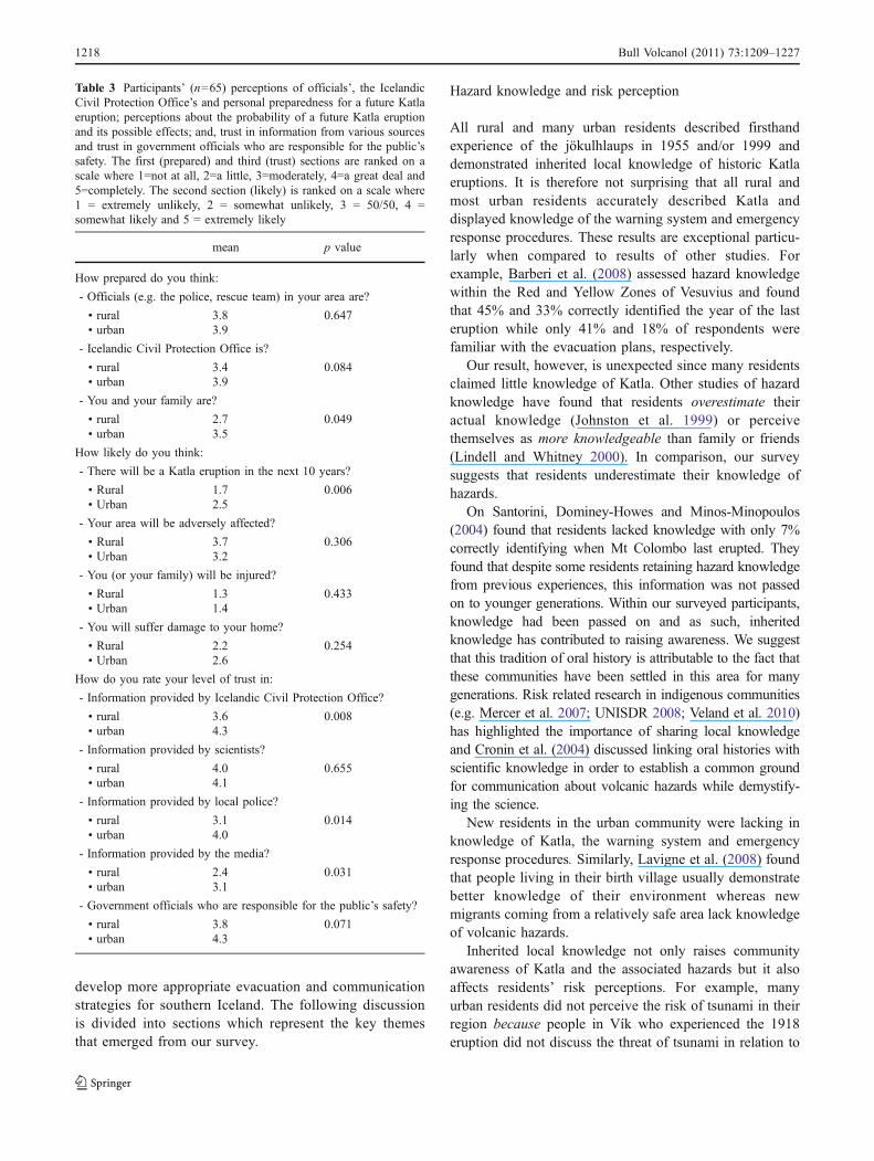
Volcanic risk mitigation strategies in southern Iceland haveundergone revision since 2002. The motivation for thiseffort is the ongoing risk posed by the Katla volcano(Guðmundsson and Gylfason 2005; Russell et al. 2009;Sturkell et al. 2008, 2009) (Fig. 1). Katla is considered asone of the most hazardous volcanoes in Iceland because itproduces catastrophic jökulhlaups (glacial outburst floods)and it lies in close proximity to inhabited regions on thesouth coast (Guðmundsson et al. 2007).
High levels of seismicity and crustal deformation duringthe past decade suggest that Katla is in a heightened state ofactivity and an eruption, without prolonged precursorysignals, is expected in the near future (Sturkell et al. 2008,
Editorial responsibility: H. Delgado Granados
Electronic supplementary material The online version of this article(doi:10.1007/s00445-011-0464-1) contains supplementary material,which is available to authorized users.
D. K. Bird (*) :G. GísladóttirDepartment of Geography & Tourism,Faculty of Life and Environmental Sciences,Earth Science Institute, University of Iceland,101 Reykjavík, Icelande-mail: [email protected]
D. K. BirdRisk Frontiers, Department of Environment & Geography,Faculty of Science, Macquarie University,North Ryde, NSW 2109, Australia
D. Dominey-HowesAustralian Tsunami Research Centre and Natural HazardsResearch Laboratory, School of Biological,Earth & Environmental Sciences, University of New South Wales,Sydney, NSW 2052, Australia
Bull Volcanol (2011) 73:1209–1227DOI 10.1007/s00445-011-0464-1
2009). Tremendous stress is thus placed on emergencymanagement agencies tasked with the responsibility ofdeveloping volcanic risk mitigation strategies. For a worst-case scenario, it is estimated that there will be only 1–1.5 hto execute evacuations and road closures (Guðmundsson etal. 2008). As the possibility of a major subglacial eruptionincreases with time, Katla presents a significant hazard tothe surrounding population (Russell et al. 2009), includingthe increasing number of tourists who frequent the adjacentareas (Bird 2009; Bird et al. 2010; Guðmundsson et al.2008) and to aircraft on international flight paths that passover southern Iceland (Sturkell et al. 2009).
Volcanic risk mitigation strategies, namely evacuationand communication plans, for the eastern and southernhazard zones were developed in 1973 by regional andnational officials from the Icelandic Civil Protection Officewithout proper consideration of the social context of theregion (Jóhannesdóttir and Gísladóttir 2010). Based on thereport edited by Guðmundsson and Gylfason (2005), itappears that the recently revised plans were developedsimilarly. This is against recommendations in the interna-tional literature of the past decades (e.g. Barclay et al. 2008;Chester et al. 2002; Cronin et al. 2004; Dibben and Chester1999; Mileti et al. 2004; Paton et al. 2008; Tobin 1999,among others) that are for a more thorough approach tovolcanic risk mitigation, in which social investigationscomplement physical assessments, to reduce the riskassociated with disasters.
In light of this omission, social studies were carried outto provide a more comprehensive evaluation of risk.Jóhannesdóttir (2005) conducted open, in-depth interviewswith 28 residents from Álftaver and Vík in 2004 while Bird
et al. (2009) explored perceptions of emergency responseprocedures among residents in all communities in thewestern hazard zone in 2006. Jóhannesdóttir (2005) showedthat Vík residents were more confident in the plan(developed in 1973) while Álftaver residents did notconsider the plan appropriate to their community. Bird etal. (2009) showed that despite living in a jökulhlaup hazardzone, some residents did not perceive that their homescould be at risk, and would therefore not obey officialevacuation orders.
No assessment, however, encompassed all communitieslocated in the southern and eastern hazard zones, despitehistoric jökulhlaups, tephra, lightning and in some instan-ces, tsunami (Guðmundsson et al. 2008) affecting theseregions. In this paper we explore some of the issues thatmight influence residents’ behaviour and their ability torespond to volcanic risk mitigation strategies.
Residents from the rural communities of Álftaver,Meðalland and Sólheimar and the urban community ofVík were the focus of the survey conducted in 2008. Thesecommunities are situated in the district of Vestur-Skaftafellssýsla. While the town of Vík might not beconsidered as ‘urban’ internationally, it is regarded as oneof Iceland’s ‘urban nuclei’ (Statistics Iceland 2010). An‘urban nucleus’ is defined by Statistics Iceland (2009) as atown, village or other area with more than 200 residentsliving in “houses standing in the vicinity of one another”. In2008, 278 people were registered as living in Vík. Wetherefore classify Vík as ‘urban’ for this study.
In addition to the rural/urban classification, thesecommunities may further be categorised by their vulnera-bility to different volcanic hazards. For example, properties
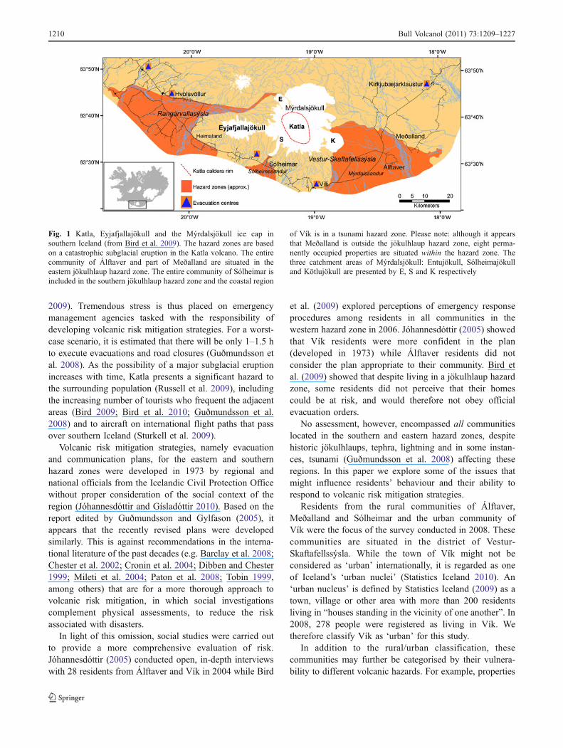
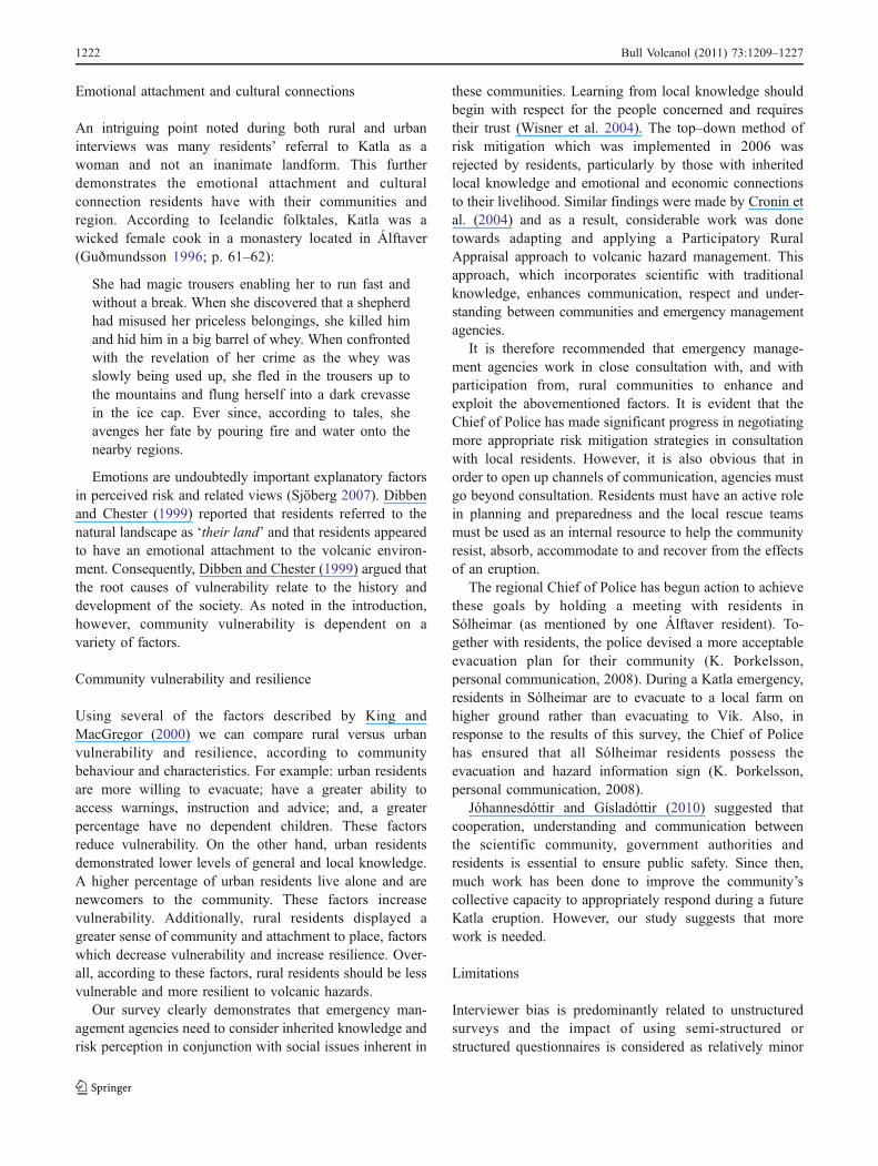
Fig. 1 Katla, Eyjafjallajökull and the Mýrdalsjökull ice cap insouthern Iceland (from Bird et al. 2009). The hazard zones are basedon a catastrophic subglacial eruption in the Katla volcano. The entirecommunity of Álftaver and part of Meðalland are situated in theeastern jökulhlaup hazard zone. The entire community of Sólheimar isincluded in the southern jökulhlaup hazard zone and the coastal region
of Vík is in a tsunami hazard zone. Please note: although it appearsthat Meðalland is outside the jökulhlaup hazard zone, eight perma-nently occupied properties are situated within the hazard zone. Thethree catchment areas of Mýrdalsjökull: Entujökull, Sólheimajökulland Kötlujökull are presented by E, S and K respectively
1210 Bull Volcanol (2011) 73:1209–1227
located in the rural communities of Álftaver, Meðalland andSólheimar will be evacuated because of the risk fromjökulhlaups whereas the properties in the low lying coastalurban area of Vík will be evacuated due to the risk fromtsunami.
Not only is this social assessment essential in light of theconflicts revealed by Jóhannesdóttir (2005) and Bird et al.(2009) but it also: (1) provides the first investigation ofresidents’ knowledge and perception of Katla, associatedvolcanic hazards and revised emergency response plans inall communities located in the eastern and southern hazardzones, and (2) considers residents’ knowledge and percep-tion from both rural and urban communities facilitatingcomparison between the two groups.
Of significance in assessing current risk, the police forcein southern Iceland was restructured after the 2006evacuation exercise. Amendments to the Police Act No.90 and the Act on District Executive Power No. 92 (Lög nr 46/2006) amalgamated the police districts of Rangárvallasýsla andVestur-Skaftafellssýsla. Consequently, the RangárvallasýslaChief of Police now governs Vestur-Skaftafellssýsla fromHvolsvöllur, >100 km east of Álftaver. This may have seriousimplications for regional risk mitigation as the Chief of Policeis responsible for implementing an evacuation, and trust insuch institutions is an important factor in influencing riskperceptions and response to evacuation orders (Poortinga andPidgeon 2003).
In addition to trust, other factors play an important rolein influencing people’s perceptions. For example, theperception of risk and assessment of hazard by communi-ties is influenced by their relationships with their physicaland social environments (Oliver-Smith 1996). Blong (1984)suggested that rural communities that are ‘closer to earth’generally perceive natural hazards more realistically than dourban communities. Conversely, Fortmann and Kusel(1990) argued that residential status had no such effectsince rural and urban communities are not homogenous.Similarly, Bogner and Wiseman (1997) found no differencebetween rural and urban students’ attitudinal and behaviouralperspectives towards nature. Marotz-Baden and Colvin(1986) showed, however, that rural rather than urbanresidents are more likely to take control of stressful situationsand adopt coping strategies.
The dynamic nature of society means that manycommunities are in a state of flux as people and businessesmove in or out of the area and different issues spark publicdebate (Tobin 1999). King and MacGregor (2000) identi-fied ‘one person households’ and ‘newcomers to thecommunity and migrants’ among specific groups of peoplelikely to be highly vulnerable to hazards. Risk mitigationefforts therefore need to recognise and accommodate thesevulnerabilities in order to increase resilience and minimisethe detrimental effects of hazards in a community. To be
resilient, communities must have the internal resourcesnecessary to resist, absorb, accommodate and recover fromthe effects of hazardous events in a timely and efficientmanner (UNISDR 2009; p. 10).
King and MacGregor (2000) described the requiredcommunity behaviour and characteristics, which reducevulnerability as: the ability and willingness of residents toevacuate; community involvement; an ability to accesswarnings, instruction and advice; having no dependents;and, general and local knowledge, among others. Also,sense of community and attachment to place are importantaspects of cohesion within a society which in turn, leads togreater resilience. Therefore, examining the concepts of‘community’ and ‘vulnerability’ as functional key elementsof risk management encourages the development of moreeffective strategies and greater community participation(Buckle 1999).
It is therefore the purpose of this paper to investigateÁlftaver, Meðalland, Sólheimar and Vík residents’ knowledge,perceptions and characteristics in order to compare differencesand explore how these might impact on their behaviour prior toand during a future volcanic crisis. We achieve this via aquestionnaire measuring hazard knowledge, risk perception,proposed behaviour when faced with a Katla eruption andvarious aspects of trust and preparedness. To provide contextto our research, we first describe the volcanological setting andevacuation and communication plans for an eruption insouthern Iceland. Given the recent eruption of Eyjafjallajökullin 2010 and its close proximity to Katla, the backgrounddiscussion is given in relation to both volcanoes.
Background
Volcanological setting
The Katla and Eyjafjallajökull central volcanoes lieapproximately 25 km apart on the southern coast of Iceland(see Fig. 1). Both volcanoes are well monitored byscientists at the Icelandic Meteorological Office (IMO)and the Earth Science Institute at the University of Icelandvia GPS, Continuous GPS, InSAR and optical levelling tiltstations in addition to a nationwide network of seismometers(Sigmundsson et al. 2009).
The well documented post-1500 AD historic record ofKatla indicates eruptions twice a century, with the lastconfirmed eruption in 1918. Minor eruptions, however,which did not break the glacier surface, are thought to beresponsible for small, sudden jökulhlaups in 1955 and 1999(Guðmundsson and Gylfason 2005). Prior to 2010, themuch less active Eyjafjallajökull volcano had erupted twicein the last 1,100 years, in 1612 and from 1821 to 1823.These eruptions, and crustal deformation and increased
Bull Volcanol (2011) 73:1209–1227 1211
levels of seismicity from 1991 to 1999, have eitherpreceded or occurred in conjunction with activity in Katla(Sturkell et al. 2003).
Sturkell et al. (2003) suggest that Katla has a 5 km widemagma chamber sitting at a shallow depth of 1.5 kmbeneath sea level or 3 km below the topographical surfaceof the Mýrdalsjökull icecap. The elliptical caldera is 14 kmlong, 600–750 m deep (Björnsson et al. 2000) and is overlainby 590 km2 of ice which constitutes Mýrdalsjökull(Björnsson and Pálsson 2008). Katla eruptions are able topenetrate the 400 m of ice cover and produce catastrophicjökulhlaups that can reach a peak discharge rate of 100,000–300,000 m3 s−1 within a few hours (Björnsson 2002). Heavytephra fallout and lightning hazards also affect communitiesup to 30 km from the eruption site (Larsen 2000).
In comparison, volcanic hazards associated with pastEyjafjallajökull eruptions (prior to 2010) have had lessimpact with only small to medium jökulhlaups (Guðmundssonand Gylfason 2005) and very fine-grained tephra depositsrarely found more than 10 km from the crater (Larsen et al.1999). The Eyjafjallajökull volcano rises 1,651 m above sealevel (Davies et al. 2010), is elongated in an east–westdirection and its elliptical 2.5 km wide summit crater iscovered by a 200 m thick icecap, which is also namedEyjafjallajökull (Sturkell et al. 2009). The two Eyjafjallajökulleruptions in 1612 and from 1821 to 1823 were explosive andprobably occurred at the summit crater (Larsen et al. 1999).Despite the risk that Eyjafjallajökull poses to farms at the baseof the southern flank of the volcano (Sturkell et al. 2003),much more interest in emergency management was given tothe very active and more hazardous Katla volcano prior to the2010 eruptions.
Unlike the previous two eruptions of Eyjafjallajökull, the20 March 2010 eruption was located on the flank along afissure at Fimmvörðuháls in between the Mýrdalsjökull andEyjafjallajökull icecaps (Sigmundsson et al. 2010). Thisinitial phase produced spectacular fire-fountain activity andlava flows, attracting many domestic and internationalonlookers. As soon as the “Fimmvörðuháls” flank eruptionwas declared over on 13 April 2010 the subglacial eruptionof Eyjafjallajökull began. This explosive eruption, whichcommenced on 14 April 2010, first resulted in mediumsized jökulhlaup flooding to the north, small jökulhlaupflooding to the south (ICP 2010) and considerable ash fall(<2 mm size fraction component of tephra) to the east andeast–southeast within the vicinity of the crater (Davies et al.2010).
The tephra that was ejected during the first few days ofthe subglacial “Eyjafjallajökull” eruption had a highproportion of very fine-grained ash that reached highaltitudes in the atmosphere and drifted with the prevailingnorth-westerly to westerly winds, causing air traffic to begrounded in many countries throughout Europe (Davies et
al. 2010). The continuing eruption also produced lightning,gas emissions and lava flows within close proximity of thecrater, and heavy sound blasts were heard especially to thesouth and east of the volcano (IMO 2010).
By 23 May 2010, eruptive activity was minimal, nofurther ash fall or lightning was detected and the noise fromthe volcano had ceased (IMO 2010). Other hazards such aslahars, rockslides and the remobilisation of ash, however, arecontinuing to cause havoc to areas around Eyjafjallajökull atthe time of writing, and the eruption had not been declaredover.
Evacuation and communication plans for an eruptionin southern Iceland
Following increased seismic activity during the 1990’s inEyjafjallajökull and Katla, the regional Chief of Police andcivil protection committee requested a volcanic hazardassessment to investigate the possible threat to localcommunities. The hazard assessment, which was approvedin July 2003, included a flood-simulation model based ongeomorphological and sedimentological investigations.This model was used to assess jökulhlaup hazards forcommunities in the western, southern and eastern regions inrelation to a Katla and Eyjafjallajökull eruption. Since Katlawas determined as posing the most significant risk to theregion, the jökulhlaup hazard zones were constructed basedon a catastrophic Katla eruption.
Overall it was determined that the western, southern andeastern jökulhlaup hazard zones for a Katla eruptionencompass approximately 1,000 km2, 40 km2 and350 km2 and contain approximately 1,900, 53 and 500residents respectively (Guðmundsdóttir et al. 2010). Inorder to facilitate the evacuation of these residents, anengineering consultancy company was contracted to inves-tigate travel times and traffic delays (Sigthorsson et al.2006). This was done for a number of scenarios based ondifferent reaction and preparation times, summer and winterconditions and, the number of travellers in the area.
Based on the information from the flood and trafficsimulation models, evacuation strategies were revised andupdated for communities in the southern and eastern hazardzones. To test the efficacy of the Katla plans, a full-scaleevacuation exercise was held on the 25 March 2006 inÁlftaver, Meðalland, Sólheimar and Vík.
If a Katla eruption is determined as imminent, theIcelandic Civil Protection Office notifies residents via arecorded voice message to their landline or a shortmessaging service (sms) to their mobile phone. Oncereceived, residents in Álftaver and Meðalland will have30 min to prepare to evacuate to Kirkjubæjarklaustur,residents in Sólheimar will have 15 min to prepare toevacuate to Vík and, residents in Vík will have 30 min to
1212 Bull Volcanol (2011) 73:1209–1227
prepare to evacuate to their local evacuation centre. To aidtheir evacuations, residents were issued with an ‘Evacua-tion and Hazard Information Sign’ that lists instructions for‘house evacuation’, ‘precautions due to subglacial erup-tions’ and ‘precautions due to lightning’ (for further details,see Fig. 2 in Bird et al. 2009).
Evacuation plans for an Eyjafjallajökull eruption werenot completed until the first eruption began on 20 March2010. Our study, which was conducted in 2008, thereforefocuses on Katla. In light of the recent Eyjafjallajökulleruptions, however, a brief analysis of the emergencyresponse in 2010 is provided after discussion of our surveyresults.
Methods
Face-to-face questionnaire interviews
Questionnaires were administered face-to-face with localresidents from April to September 2008. We endeavouredto sample one key decision maker from every permanenthousehold located in the hazard zones in Álftaver, Meðalland,Sólheimar and Vík. Initial contact was established by phoneor direct approach (i.e. door knocking). Interviews wereconducted by Bird and Gísladóttir in the participants’ homeor place of work. Many residents who were approached toparticipate in the survey had family or friendship connectionswith Gísladóttir.
To meet University ethical requirements potentialparticipants were given an introductory letter beforeinterviewing commenced. This letter described the natureof the research, what was required of the participant and theproposed use of data. Participants were given the opportu-nity to withdraw from the survey at any time withoutconsequence. None exercised this right.
A total of 66 interviews were conducted with residents.This involved nine out of 10 permanent households inÁlftaver, five out of eight permanent households inMeðalland,five out of six permanent households in Sólheimar and 47 outof 62 permanent households in Vík. An overall response rate of77% was achieved. Residents’ reasons for not participating inthe survey included health issues and unavailability (14%) orlack of interest (9%).
Based on the questionnaire instrument used by Bird et al.(2009), our questionnaire consisted of five sections with atotal of 53 open and closed format questions. Section topicswere as follows:
1. participant demographics,2. knowledge and perception of Katla, jökulhlaup (for
Álftaver, Meðalland and Sólheimar residents) or tsunami(for Vík residents),
3. knowledge and perception of emergency communicationand evacuation plans,
4. personal use of media sources for acquiring hazardinformation (e.g. use of the Icelandic Civil ProtectionOffice website (www.almannavarnir.is), the EWIS—near-real time earthquake web-viewer website (drifandi.vedur.is/) and the Icelandic Meteorological Officewebsite (www.vedur.is)), and,
5. perceived personal and official preparedness for aKatla eruption, the possibility of a future Katlaeruption and its effects and personal trust in hazardinformation.
An electronic copy of the questionnaire is available fromthe lead author on request.
The interviews were conducted in either English orIcelandic and responses were translated from Icelandic toEnglish (by Gísladóttir) at the time of interview. Partic-ipants were given the opportunity for open, unstructureddiscussion during and after the administration of thequestionnaire.
Questionnaire data were transferred into SPSS® 17.0(Statistical Package for Social Science) and MicrosoftWord®. SPSS data were coded and analysed usingfrequency and cross-tabulation tables and participants wereassigned to either the rural group (Álftaver, Meðalland andSólheimar (n=19)) or the urban group (Vík (n=47)).Results were assessed for statistically significant differencesbased on p values using Fischer’s exact (2-sided) chi-squaretest for 2×2 tables (e.g. yes/no response), Pearson (2-sided)chi-square test for other tables (i.e. multiple response) andindependent samples t-tests (Pallant 2007). We consideredp<0.01 as highly significant and 0.01<p<0.05 as signifi-cant. If survey participants (total n=66) did not respond to aparticular question, because it was not applicable to them orthey chose not to (i.e. non-response), then the number ofrespondents (n) is given for that question.
0
25
50
75
100
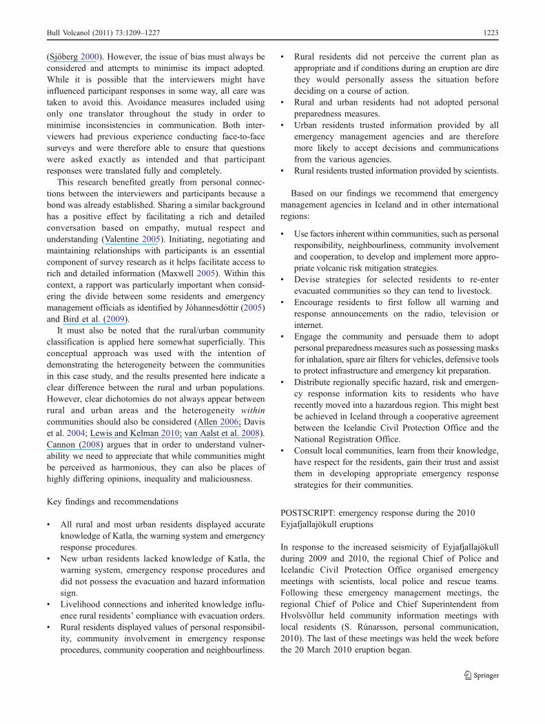
Correctlydescribed
Katla
Correctlydefined
jökulhlaup ortsunami
Believed theirregion couldbe affected
Knowledge ofthe eruption
warningsystem
Knowledge ofemergencyprocedures
Per
cent
Rural Urban
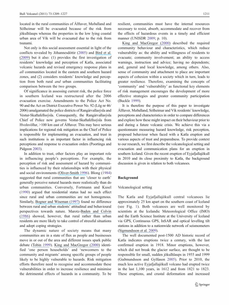
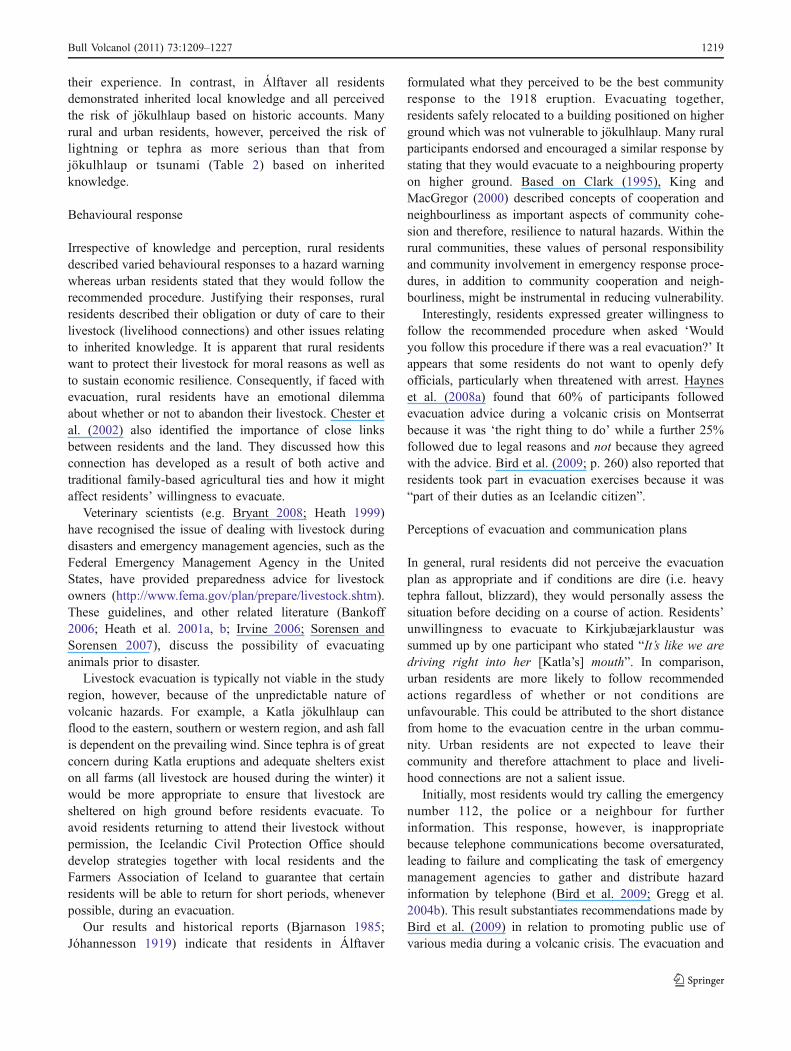
Fig. 2 Percent of participants who: correctly described Katla,correctly defined jökulhlaup or tsunami, believed the region wherethey live could be affected by a jökulhlaup or tsunami (n=65), statedknowledge of the eruption warning system and stated knowledge ofthe emergency procedures they need to follow
Bull Volcanol (2011) 73:1209–1227 1213
All data were transferred to QSR NVivo 8® for coding inorder to compare, contrast and link open-response data withclosed-response. All qualitative data was coded by taggingsections of text which related to specific categories. Thesecategories relate to issues raised by Jóhannesdóttir (2005)and Bird et al. (2009). Links between open-responseanswers, additional comments and closed-response answersare identified and presented for each section in the results.The results are then challenged or supported by the broaderliterature on volcanic risk perception and behaviouralresponse in the discussion section which follows the results.
Results
Nearly all residents offered us a warm welcome and manywere very appreciative of being given the opportunity toshare their thoughts and opinions. When informed of thequestionnaire’s topic, many residents declared “I don’t knowanything about Katla”. However, many homes containedlandscape paintings and photographs of Mýrdalsjökull andthe surrounding region.
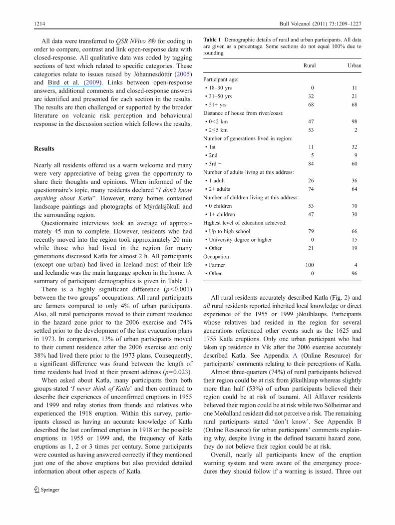
Questionnaire interviews took an average of approxi-mately 45 min to complete. However, residents who hadrecently moved into the region took approximately 20 minwhile those who had lived in the region for manygenerations discussed Katla for almost 2 h. All participants(except one urban) had lived in Iceland most of their lifeand Icelandic was the main language spoken in the home. Asummary of participant demographics is given in Table 1.
There is a highly significant difference (p<0.001)between the two groups’ occupations. All rural participantsare farmers compared to only 4% of urban participants.Also, all rural participants moved to their current residencein the hazard zone prior to the 2006 exercise and 74%settled prior to the development of the last evacuation plansin 1973. In comparison, 13% of urban participants movedto their current residence after the 2006 exercise and only38% had lived there prior to the 1973 plans. Consequently,a significant difference was found between the length oftime residents had lived at their present address (p=0.023).
When asked about Katla, many participants from bothgroups stated ‘I never think of Katla’ and then continued todescribe their experiences of unconfirmed eruptions in 1955and 1999 and relay stories from friends and relatives whoexperienced the 1918 eruption. Within this survey, partic-ipants classed as having an accurate knowledge of Katladescribed the last confirmed eruption in 1918 or the possibleeruptions in 1955 or 1999 and, the frequency of Katlaeruptions as 1, 2 or 3 times per century. Some participantswere counted as having answered correctly if they mentionedjust one of the above eruptions but also provided detailedinformation about other aspects of Katla.
All rural residents accurately described Katla (Fig. 2) andall rural residents reported inherited local knowledge or directexperience of the 1955 or 1999 jökulhlaups. Participantswhose relatives had resided in the region for severalgenerations referenced other events such as the 1625 and1755 Katla eruptions. Only one urban participant who hadtaken up residence in Vík after the 2006 exercise accuratelydescribed Katla. See Appendix A (Online Resource) forparticipants’ comments relating to their perceptions of Katla.
Almost three-quarters (74%) of rural participants believedtheir region could be at risk from jökulhlaup whereas slightlymore than half (53%) of urban participants believed theirregion could be at risk of tsunami. All Álftaver residentsbelieved their region could be at risk while two Sólheimar andone Meðalland resident did not perceive a risk. The remainingrural participants stated ‘don’t know’. See Appendix B(Online Resource) for urban participants’ comments explain-ing why, despite living in the defined tsunami hazard zone,they do not believe their region could be at risk.
Overall, nearly all participants knew of the eruptionwarning system and were aware of the emergency proce-dures they should follow if a warning is issued. Three out
Table 1 Demographic details of rural and urban participants. All dataare given as a percentage. Some sections do not equal 100% due torounding
Rural Urban
Participant age:
▪ 18–30 yrs 0 11
▪ 31–50 yrs 32 21
▪ 51+ yrs 68 68
Distance of house from river/coast:
▪ 0<2 km 47 98
▪ 2≤5 km 53 2
Number of generations lived in region:
▪ 1st 11 32
▪ 2nd 5 9
▪ 3rd + 84 60
Number of adults living at this address:
▪ 1 adult 26 36
▪ 2+ adults 74 64
Number of children living at this address:
▪ 0 children 53 70
▪ 1+ children 47 30
Highest level of education achieved:
▪ Up to high school 79 66
▪ University degree or higher 0 15
▪ Other 21 19
Occupation:
▪ Farmer 100 4
▪ Other 0 96
1214 Bull Volcanol (2011) 73:1209–1227
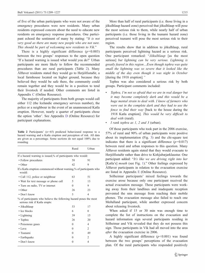
of five of the urban participants who were not aware of theemergency procedures were new residents. Many urbanresidents expressed concern about the need to educate newresidents on emergency response procedures. One partici-pant echoed the sentiment of many by stating: “It is notvery good as there are many new people who are not sure.This should be part of welcoming new residents to Vík.”
There is a highly significant difference (p=0.003)between the two groups’ responses to the open question‘If a hazard warning is issued what would you do?’ Urbanparticipants are more likely to follow the recommendedprocedures than are rural participants (Table 2). ManyÁlftaver residents stated they would go to Herjólfsstaðir, alocal farmhouse located on higher ground, because theybelieved they would be safe there, the community couldremain together and they would be in a position to tendtheir livestock if needed. Other comments are listed inAppendix C (Online Resource).
The majority of participants from both groups would calleither 112 (the Icelandic emergency services number), thepolice or a neighbour in the event of an unannounced Katlaeruption. However, nearly a quarter of participants chosethe option ‘other’. See Appendix D (Online Resource) forparticipant explanations.
More than half of rural participants (i.e. those living in ajökulhlaup hazard zone) perceived that jökulhlaup will posethe most serious risk to them, while nearly half of urbanparticipants (i.e. those living in the tsunami hazard zone)perceived tsunami will pose the most serious risk to theirregion.
The results show that in addition to jökulhlaup, ruralparticipants perceived lightning hazard as a serious risk.One participant remarked: “Jökulhlaup [as the mostserious] but lightning can be very serious. Lightning isgreatly feared in this region…Even though tephra was quitesmall the lightning was so severe that it looked like themiddle of the day even though it was night in October[during the 1918 eruption].”
Tephra was also considered a serious risk by bothgroups. Participant comments included:
& Tephra, I’m not so afraid that we are in real danger butit may become completely dark and this would be ahuge mental strain to deal with. I know of farmers whowere out in the complete dark and they had to use thefence to find their way [back to the house during the1918 Katla eruption]. This would be very difficult todeal with (rural).
& I rank tephra as 1, 2 and 3 (urban).
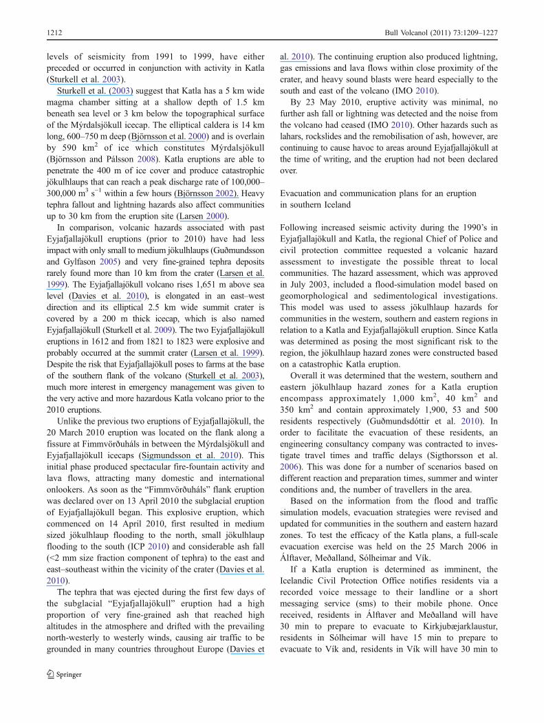
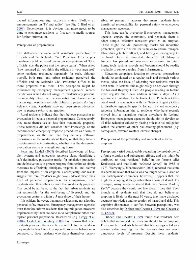
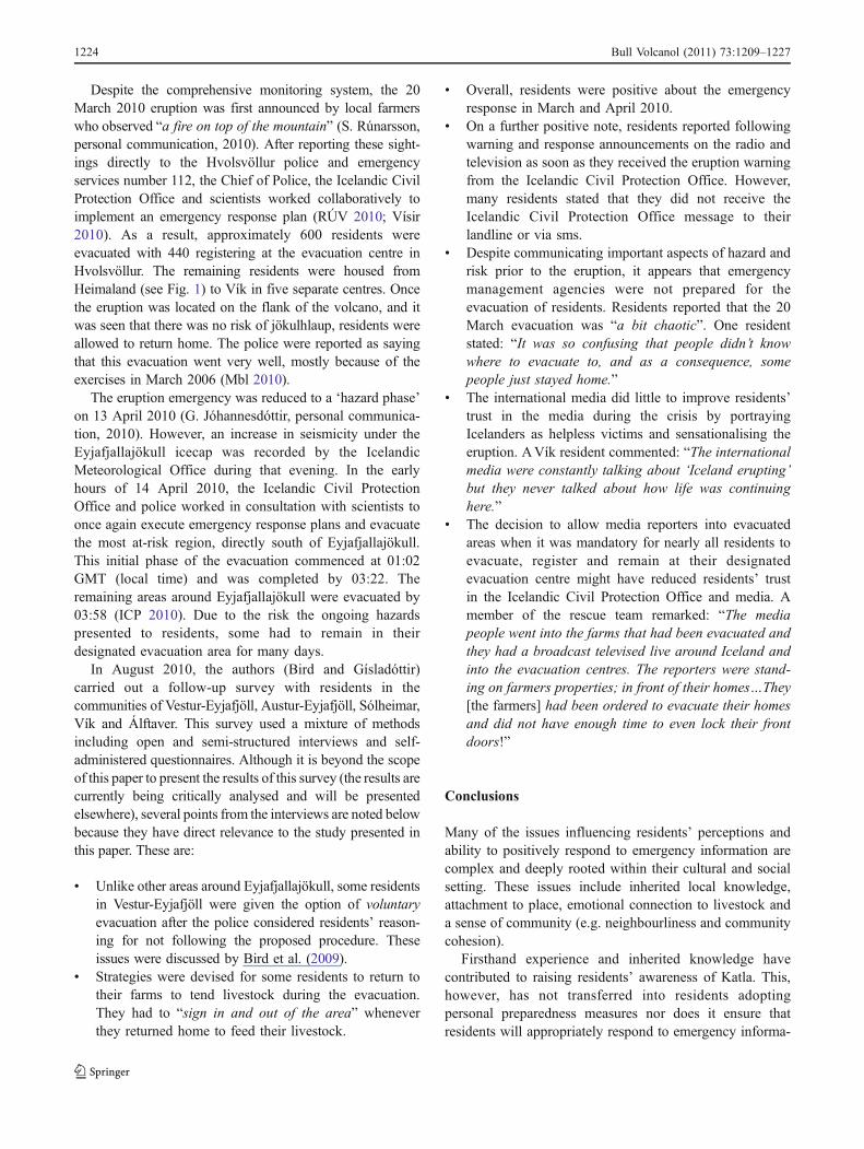
Of those participants who took part in the 2006 exercise,57% of rural and 90% of urban participants were positiveabout its implementation (Fig. 3) and the chi-square testindicates that there is a significant difference (p=0.017)between rural and urban responses to this question. ManyÁlftaver residents again stated that they would evacuate toHerjólfsstaðir rather than drive to Kirkjubæjarklaustur. Oneparticipant added: “It’s like we are driving right into her[Katla’s] mouth (see Fig. 1).” Other feelings expressed byÁlftaver participants in relation to the evacuation exerciseare listed in Appendix E (Online Resource).
Sólheimar participants’ mixed feelings towards theexercise arose because only one participant received theactual evacuation message. These participants were work-ing away from their landlines and inadequate receptionprevented the sms message from reaching their mobilephones. The evacuation message also failed to reach oneMeðalland participant, while another expressed concernabout releasing livestock.
When asked if 15 or 30 min was enough time tocomplete the list of instructions on the evacuation andhazard information sign several participants residing inSólheimar and Vík revealed that they do not possess thissign. Those participants in Vík had all moved into the areaafter the evacuation exercise in 2006.
A highly significant difference (p<0.001) was foundbetween the two groups’ perceptions of the evacuationplan. Of the rural participants who responded positively
Table 2 Participants’ (n=65) predicted behavioural response to ahazard warning and a Katla eruption and perception of risk. All dataare given as a percentage. Some sections do not equal 100% due torounding
Rural Urban
If a hazard warning is issued,% of participants who would:
• Follow procedures 58 91
• Other 42 9
If a Katla eruption commenced without warning,% of participants whowould:
• Call 112, police or neighbour 63 51
• Wait for text message or phone call 5 13
• Turn on radio, TV or internet 0 9
• Other 26 23
• Don’t know 5 4
% of participants who believe the following hazard poses the mostserious risk if Katla erupts:
• Jökulhlaup 53 17
• Ice blocks 6 0
• Lightning 39 15
• Tephra 26 20
• Poisonous gases 0 4
• Lava 0 2
• Tsunami 0 49
• Earthquake 0 2
• Don’t know 0 4
Bull Volcanol (2011) 73:1209–1227 1215
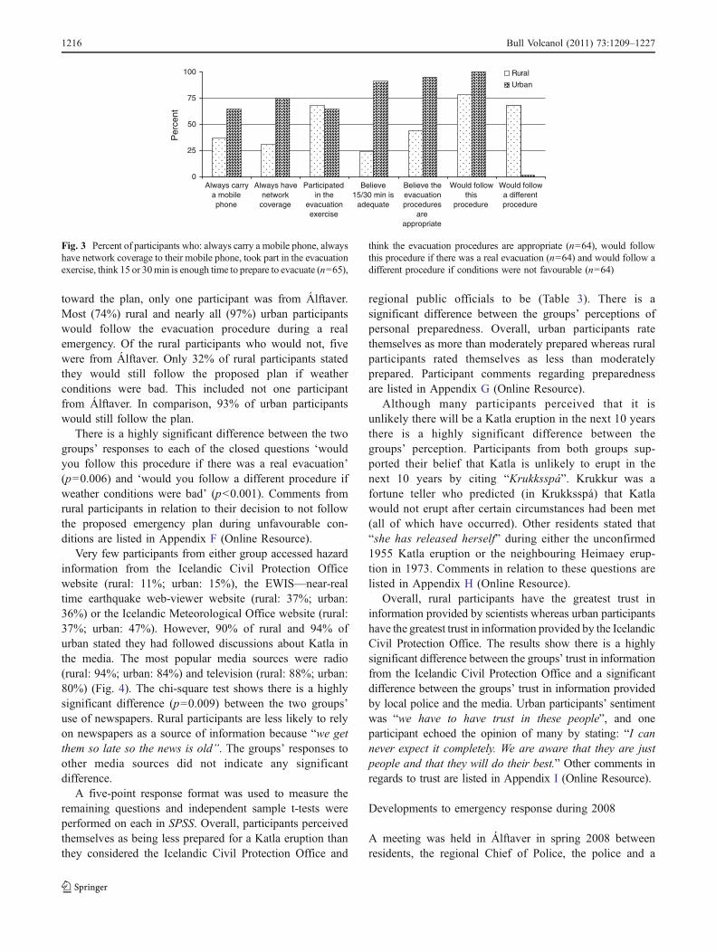
toward the plan, only one participant was from Álftaver.Most (74%) rural and nearly all (97%) urban participantswould follow the evacuation procedure during a realemergency. Of the rural participants who would not, fivewere from Álftaver. Only 32% of rural participants statedthey would still follow the proposed plan if weatherconditions were bad. This included not one participantfrom Álftaver. In comparison, 93% of urban participantswould still follow the plan.
There is a highly significant difference between the twogroups’ responses to each of the closed questions ‘wouldyou follow this procedure if there was a real evacuation’(p=0.006) and ‘would you follow a different procedure ifweather conditions were bad’ (p<0.001). Comments fromrural participants in relation to their decision to not followthe proposed emergency plan during unfavourable con-ditions are listed in Appendix F (Online Resource).
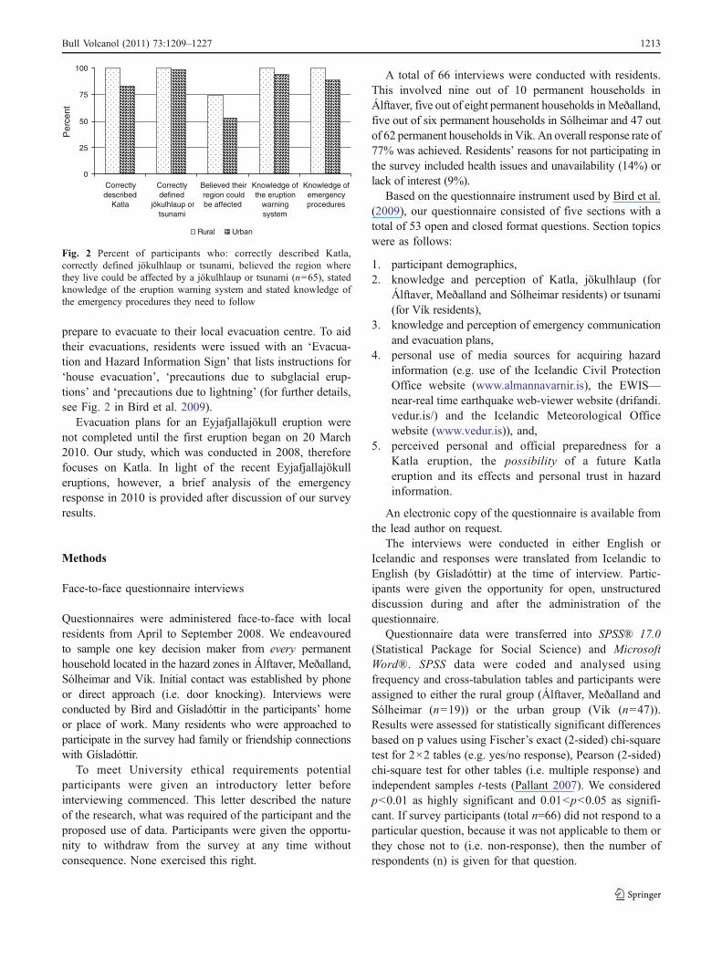
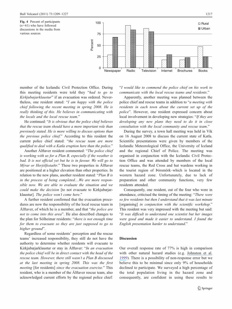
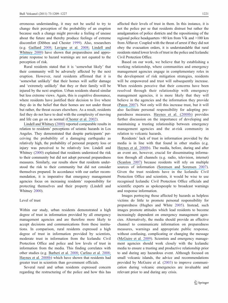
Very few participants from either group accessed hazardinformation from the Icelandic Civil Protection Officewebsite (rural: 11%; urban: 15%), the EWIS—near-realtime earthquake web-viewer website (rural: 37%; urban:36%) or the Icelandic Meteorological Office website (rural:37%; urban: 47%). However, 90% of rural and 94% ofurban stated they had followed discussions about Katla inthe media. The most popular media sources were radio(rural: 94%; urban: 84%) and television (rural: 88%; urban:80%) (Fig. 4). The chi-square test shows there is a highlysignificant difference (p=0.009) between the two groups’use of newspapers. Rural participants are less likely to relyon newspapers as a source of information because “we getthem so late so the news is old”. The groups’ responses toother media sources did not indicate any significantdifference.
A five-point response format was used to measure theremaining questions and independent sample t-tests wereperformed on each in SPSS. Overall, participants perceivedthemselves as being less prepared for a Katla eruption thanthey considered the Icelandic Civil Protection Office and
regional public officials to be (Table 3). There is asignificant difference between the groups’ perceptions ofpersonal preparedness. Overall, urban participants ratethemselves as more than moderately prepared whereas ruralparticipants rated themselves as less than moderatelyprepared. Participant comments regarding preparednessare listed in Appendix G (Online Resource).
Although many participants perceived that it isunlikely there will be a Katla eruption in the next 10 yearsthere is a highly significant difference between thegroups’ perception. Participants from both groups sup-ported their belief that Katla is unlikely to erupt in thenext 10 years by citing “Krukksspá”. Krukkur was afortune teller who predicted (in Krukksspá) that Katlawould not erupt after certain circumstances had been met(all of which have occurred). Other residents stated that“she has released herself” during either the unconfirmed1955 Katla eruption or the neighbouring Heimaey erup-tion in 1973. Comments in relation to these questions arelisted in Appendix H (Online Resource).
Overall, rural participants have the greatest trust ininformation provided by scientists whereas urban participantshave the greatest trust in information provided by the IcelandicCivil Protection Office. The results show there is a highlysignificant difference between the groups’ trust in informationfrom the Icelandic Civil Protection Office and a significantdifference between the groups’ trust in information providedby local police and the media. Urban participants’ sentimentwas “we have to have trust in these people”, and oneparticipant echoed the opinion of many by stating: “I cannever expect it completely. We are aware that they are justpeople and that they will do their best.” Other comments inregards to trust are listed in Appendix I (Online Resource).
Developments to emergency response during 2008
A meeting was held in Álftaver in spring 2008 betweenresidents, the regional Chief of Police, the police and a
0
25
50
75
100
Always carrya mobilephone
Always havenetwork
coverage
Participatedin the
evacuationexercise
Believe15/30 min is
adequate
Believe theevacuationprocedures
areappropriate
Would followthis
procedure
Would followa differentprocedure
Per
cent
Rural
Urban
Fig. 3 Percent of participants who: always carry a mobile phone, alwayshave network coverage to their mobile phone, took part in the evacuationexercise, think 15 or 30min is enough time to prepare to evacuate (n=65),
think the evacuation procedures are appropriate (n=64), would followthis procedure if there was a real evacuation (n=64) and would follow adifferent procedure if conditions were not favourable (n=64)
1216 Bull Volcanol (2011) 73:1209–1227
member of the Icelandic Civil Protection Office. Duringthis meeting residents were told they “had to go toKirkjubæjarklaustur” if an evacuation was ordered. Never-theless, one resident stated: “I am happy with the policechief following the recent meeting in spring 2008. He isreally thinking of this. He believes in communicating withthe locals and the local rescue team.”
He continued: “It is obvious that the police chief believesthat the rescue team should have a more important role thanpreviously stated. He is more willing to discuss options thanthe previous police chief.” According to this resident thecurrent police chief stated: “the rescue team are morequalified to deal with a Katla eruption here than the police.”
Another Álftaver resident commented: “The police chiefis working with us for a Plan B, especially if the weather isbad. It is not official yet but he is in favour. We will go toMýrar or Herjólfsstaðir.” These two properties in Álftaverare positioned at a higher elevation than other properties. Inrelation to the new plans, another resident stated: “Plan B isin the process of being completed…We are more respon-sible now. We are able to evaluate the situation and wecould make the decision [to not evacuate to Kirkjubæjar-klaustur]. The police won’t come here.”
A further resident confirmed that the evacuation proce-dures are now the responsibility of the local rescue team inÁlftaver, of which he is a member, and that “the police arenot to come into this area”. He also described changes tothe plan for Sólheimar residents: “there is not enough timefor them to evacuate so they are just supposed to go tohigher ground”.
Regardless of some residents’ perception and the rescueteams’ increased responsibility, they still do not have theauthority to determine whether residents will evacuate toKirkjubæjarklaustur or stay in Álftaver: “In an evacuationthe police chief will be in direct contact with the head of therescue team. However, there still wasn’t a Plan B discussedat the last meeting in spring 2008. This was the firstmeeting [for residents] since the evacuation exercise.” Thisresident, who is a member of the Álftaver rescue team, alsoacknowledged current efforts by the regional police chief:
“I would like to commend the police chief on his work tocommunicate with the local rescue teams and residents.”
Apparently, another meeting was planned between thepolice chief and rescue teams in addition to “a meeting withresidents in each town about the current set up of thepolice”. However, one resident expressed concern aboutlocal involvement in developing new strategies: “If they aredeveloping any new plans they need to do it in closeconsultation with the local community and rescue team.”
During the survey, a town hall meeting was held in Víkon 16 August 2008 to discuss the current state of Katla.Scientific presentations were given by members of theIcelandic Meteorological Office, the University of Icelandand the regional Chief of Police. The meeting wasorganised in conjunction with the Icelandic Civil Protec-tion Office and was attended by members of the localrescue teams, the Red Cross and hut wardens working inthe tourist region of Þórsmörk–which is located in thewestern hazard zone. Unfortunately, due to lack ofpreparation and other community functions, very fewresidents attended.
Consequently, one resident, out of the four who were inattendance, criticised the timing of the meeting: “There wereso few residents but then I understand that it was last minute[organising] in conjunction with the scientific workshop.”This resident was very impressed with the meeting but said:“It was difficult to understand one scientist but her imageswere good and made it easier to understand. I found theEnglish presentation harder to understand.”
Discussion
Our overall response rate of 77% is high in comparisonwith other natural hazard studies (e.g. Johnston et al.1999). There is a possibility of non-response error but webelieve this to be minimal since only 9% of householdsdeclined to participate. We surveyed a high percentage ofthe total population living in the hazard zone andconsequently, are confident in using these results to
0
25
50
75
100
Newspaper
Per
cent
Rural
Urban
Radio Television Internet Brochures Books
Fig. 4 Percent of participants(n=61) who have followeddiscussions in the media fromvarious sources
Bull Volcanol (2011) 73:1209–1227 1217
develop more appropriate evacuation and communicationstrategies for southern Iceland. The following discussionis divided into sections which represent the key themesthat emerged from our survey.
Hazard knowledge and risk perception
All rural and many urban residents described firsthandexperience of the jökulhlaups in 1955 and/or 1999 anddemonstrated inherited local knowledge of historic Katlaeruptions. It is therefore not surprising that all rural andmost urban residents accurately described Katla anddisplayed knowledge of the warning system and emergencyresponse procedures. These results are exceptional particu-larly when compared to results of other studies. Forexample, Barberi et al. (2008) assessed hazard knowledgewithin the Red and Yellow Zones of Vesuvius and foundthat 45% and 33% correctly identified the year of the lasteruption while only 41% and 18% of respondents werefamiliar with the evacuation plans, respectively.
Our result, however, is unexpected since many residentsclaimed little knowledge of Katla. Other studies of hazardknowledge have found that residents overestimate theiractual knowledge (Johnston et al. 1999) or perceivethemselves as more knowledgeable than family or friends(Lindell and Whitney 2000). In comparison, our surveysuggests that residents underestimate their knowledge ofhazards.
On Santorini, Dominey-Howes and Minos-Minopoulos(2004) found that residents lacked knowledge with only 7%correctly identifying when Mt Colombo last erupted. Theyfound that despite some residents retaining hazard knowledgefrom previous experiences, this information was not passedon to younger generations. Within our surveyed participants,knowledge had been passed on and as such, inheritedknowledge has contributed to raising awareness. We suggestthat this tradition of oral history is attributable to the fact thatthese communities have been settled in this area for manygenerations. Risk related research in indigenous communities(e.g. Mercer et al. 2007; UNISDR 2008; Veland et al. 2010)has highlighted the importance of sharing local knowledgeand Cronin et al. (2004) discussed linking oral histories withscientific knowledge in order to establish a common groundfor communication about volcanic hazards while demystify-ing the science.
New residents in the urban community were lacking inknowledge of Katla, the warning system and emergencyresponse procedures. Similarly, Lavigne et al. (2008) foundthat people living in their birth village usually demonstratebetter knowledge of their environment whereas newmigrants coming from a relatively safe area lack knowledgeof volcanic hazards.
Inherited local knowledge not only raises communityawareness of Katla and the associated hazards but it alsoaffects residents’ risk perceptions. For example, manyurban residents did not perceive the risk of tsunami in theirregion because people in Vík who experienced the 1918eruption did not discuss the threat of tsunami in relation to
Table 3 Participants’ (n=65) perceptions of officials’, the IcelandicCivil Protection Office’s and personal preparedness for a future Katlaeruption; perceptions about the probability of a future Katla eruptionand its possible effects; and, trust in information from various sourcesand trust in government officials who are responsible for the public’ssafety. The first (prepared) and third (trust) sections are ranked on ascale where 1=not at all, 2=a little, 3=moderately, 4=a great deal and5=completely. The second section (likely) is ranked on a scale where1 = extremely unlikely, 2 = somewhat unlikely, 3 = 50/50, 4 =somewhat likely and 5 = extremely likely
mean p value
How prepared do you think:
- Officials (e.g. the police, rescue team) in your area are?
• rural 3.8 0.647• urban 3.9
- Icelandic Civil Protection Office is?
• rural 3.4 0.084• urban 3.9
- You and your family are?
• rural 2.7 0.049• urban 3.5
How likely do you think:
- There will be a Katla eruption in the next 10 years?
• Rural 1.7 0.006• Urban 2.5
- Your area will be adversely affected?
• Rural 3.7 0.306• Urban 3.2
- You (or your family) will be injured?
• Rural 1.3 0.433• Urban 1.4
- You will suffer damage to your home?
• Rural 2.2 0.254• Urban 2.6
How do you rate your level of trust in:
- Information provided by Icelandic Civil Protection Office?
• rural 3.6 0.008• urban 4.3
- Information provided by scientists?
• rural 4.0 0.655• urban 4.1
- Information provided by local police?
• rural 3.1 0.014• urban 4.0
- Information provided by the media?
• rural 2.4 0.031• urban 3.1
- Government officials who are responsible for the public’s safety?
• rural 3.8 0.071• urban 4.3
1218 Bull Volcanol (2011) 73:1209–1227
their experience. In contrast, in Álftaver all residentsdemonstrated inherited local knowledge and all perceivedthe risk of jökulhlaup based on historic accounts. Manyrural and urban residents, however, perceived the risk oflightning or tephra as more serious than that fromjökulhlaup or tsunami (Table 2) based on inheritedknowledge.
Behavioural response
Irrespective of knowledge and perception, rural residentsdescribed varied behavioural responses to a hazard warningwhereas urban residents stated that they would follow therecommended procedure. Justifying their responses, ruralresidents described their obligation or duty of care to theirlivestock (livelihood connections) and other issues relatingto inherited knowledge. It is apparent that rural residentswant to protect their livestock for moral reasons as well asto sustain economic resilience. Consequently, if faced withevacuation, rural residents have an emotional dilemmaabout whether or not to abandon their livestock. Chester etal. (2002) also identified the importance of close linksbetween residents and the land. They discussed how thisconnection has developed as a result of both active andtraditional family-based agricultural ties and how it mightaffect residents’ willingness to evacuate.
Veterinary scientists (e.g. Bryant 2008; Heath 1999)have recognised the issue of dealing with livestock duringdisasters and emergency management agencies, such as theFederal Emergency Management Agency in the UnitedStates, have provided preparedness advice for livestockowners (http://www.fema.gov/plan/prepare/livestock.shtm).These guidelines, and other related literature (Bankoff2006; Heath et al. 2001a, b; Irvine 2006; Sorensen andSorensen 2007), discuss the possibility of evacuatinganimals prior to disaster.
Livestock evacuation is typically not viable in the studyregion, however, because of the unpredictable nature ofvolcanic hazards. For example, a Katla jökulhlaup canflood to the eastern, southern or western region, and ash fallis dependent on the prevailing wind. Since tephra is of greatconcern during Katla eruptions and adequate shelters existon all farms (all livestock are housed during the winter) itwould be more appropriate to ensure that livestock aresheltered on high ground before residents evacuate. Toavoid residents returning to attend their livestock withoutpermission, the Icelandic Civil Protection Office shoulddevelop strategies together with local residents and theFarmers Association of Iceland to guarantee that certainresidents will be able to return for short periods, wheneverpossible, during an evacuation.
Our results and historical reports (Bjarnason 1985;Jóhannesson 1919) indicate that residents in Álftaver
formulated what they perceived to be the best communityresponse to the 1918 eruption. Evacuating together,residents safely relocated to a building positioned on higherground which was not vulnerable to jökulhlaup. Many ruralparticipants endorsed and encouraged a similar response bystating that they would evacuate to a neighbouring propertyon higher ground. Based on Clark (1995), King andMacGregor (2000) described concepts of cooperation andneighbourliness as important aspects of community cohe-sion and therefore, resilience to natural hazards. Within therural communities, these values of personal responsibilityand community involvement in emergency response proce-dures, in addition to community cooperation and neigh-bourliness, might be instrumental in reducing vulnerability.
Interestingly, residents expressed greater willingness tofollow the recommended procedure when asked ‘Wouldyou follow this procedure if there was a real evacuation?’ Itappears that some residents do not want to openly defyofficials, particularly when threatened with arrest. Hayneset al. (2008a) found that 60% of participants followedevacuation advice during a volcanic crisis on Montserratbecause it was ‘the right thing to do’ while a further 25%followed due to legal reasons and not because they agreedwith the advice. Bird et al. (2009; p. 260) also reported thatresidents took part in evacuation exercises because it was“part of their duties as an Icelandic citizen”.
Perceptions of evacuation and communication plans
In general, rural residents did not perceive the evacuationplan as appropriate and if conditions are dire (i.e. heavytephra fallout, blizzard), they would personally assess thesituation before deciding on a course of action. Residents’unwillingness to evacuate to Kirkjubæjarklaustur wassummed up by one participant who stated “It’s like we aredriving right into her [Katla’s] mouth”. In comparison,urban residents are more likely to follow recommendedactions regardless of whether or not conditions areunfavourable. This could be attributed to the short distancefrom home to the evacuation centre in the urban commu-nity. Urban residents are not expected to leave theircommunity and therefore attachment to place and liveli-hood connections are not a salient issue.
Initially, most residents would try calling the emergencynumber 112, the police or a neighbour for furtherinformation. This response, however, is inappropriatebecause telephone communications become oversaturated,leading to failure and complicating the task of emergencymanagement agencies to gather and distribute hazardinformation by telephone (Bird et al. 2009; Gregg et al.2004b). This result substantiates recommendations made byBird et al. (2009) in relation to promoting public use ofvarious media during a volcanic crisis. The evacuation and
Bull Volcanol (2011) 73:1209–1227 1219
hazard information sign explicitly states: “Follow allannouncements on TV and radio” (see Fig. 2 Bird et al.2009). Nevertheless, it is obvious that more needs to bedone to encourage residents to first turn to media sourcesfor further information.
Perceptions of preparedness
The difference between rural residents’ perception ofofficials and the Icelandic Civil Protection Office’s pre-paredness could be biased due to our interpretation of ‘localofficials’ (i.e. the police and the rescue teams). When asked‘how prepared do you think the officials in your area are?’some residents responded separately for each, althoughoverall, both rural and urban residents perceived theofficials and the Icelandic Civil Protection Office to bemore prepared than them. This perception might beinfluenced by emergency management agencies’ recom-mendations which do not assign to residents any personalresponsibility. Based on the evacuation and hazard infor-mation sign, residents are only obliged to prepare during avolcanic crisis. Residents have not been given advice onhow to prepare prior to an eruption.
Rural residents indicate that they believe possessing anevacuation kit equals personal preparedness. Consequently,they rated themselves as less than moderately prepared.These residents did not consider their knowledge of therecommended emergency response procedures as a form ofpreparedness, or the fact that they actively followeddiscussions in the media about Katla, or that they have apredetermined safe destination, whether it is the designatedevacuation centre or a neighbouring house.
Perry and Lindell (2008) described knowledge of localalert systems and emergency response plans, identifying asafe destination, possessing masks for inhalation protectionand defensive tools to protect property from tephra as simplemeasures to effectively anticipate, respond to, and recoverfrom the impacts of an eruption. Consequently, our resultssuggest that rural residents might have underestimated theirlevel of personal preparedness. In comparison, urbanresidents rated themselves as more than moderately prepared.This could be attributed to the fact that urban residents arenot responsible for the well-being of livestock and theevacuation centre is within a 5 min drive of their home.
It is evident, however, that most residents are not adoptingpersonal safety measures. Emergency management agenciesmust therefore inform residents that any mitigation measuresimplemented by them are done so to complement rather thanreplace personal preparation. Researchers (e.g. Gregg et al.2004a; Lindell and Whitney 2000) have shown that whenresidents perceive officials to be responsible for preparednessthey might be less likely to adopt self protective behaviour ascompared to those residents who deem themselves respon-
sible. At present, it appears that many residents havetransferred responsibility for personal safety to emergencymanagement agencies.
This issue can be overcome if emergency managementagencies engage the community and persuade them toadopt simple, effective measures prior to an eruption.These might include: possessing masks for inhalationprotection, spare air filters for vehicles to ensure transpor-tation during tephra fall out, and having an emergency kiton hand. Once the immediate threat of jökulhlaup ortsunami has passed and residents are allowed to returnhome, tools such as shovels and brooms should be readilyavailable to remove tephra from infrastructure.
Education campaigns focusing on personal preparednessshould be conducted on a regular basis and through variousmedia. Also, the issue of educating new residents must bedealt with. In Iceland, this might easily be achieved throughthe National Registry Office. All people residing in Icelandmust register their new address within 7 days. As agovernment initiative, the Icelandic Civil Protection Officecould work in conjunction with the National Registry Officeto distribute regionally specific hazard, risk and emergencyresponse information kits to residents who have recentlymoved into a hazardous region anywhere in Iceland.Emergency management agencies should aim to develop anall-risks reduction culture by placing volcanic risk mitigationwithin the context of other risk-creating phenomena (e.g.earthquakes, extreme weather, climate change).
Perceptions of the probability and impacts of a Katlaeruption
Perceptions varied considerably regarding the probability ofa future eruption and subsequent effects, and this might beattributed to rural residents’ belief in the fortune tellerKrukksspá, and that Katla ‘released herself’ in 1955 or1973. Worryingly, Jóhannesdóttir (2005) reported that someresidents believed that Katla was no longer active. Based onour participants’ comments, however, it appears that thismight be a coping strategy rather than a form of denial. Forexample, many residents stated that they “never think ofKatla” because they could not live there if they did. Eventhough rural residents said that they do not believe aneruption is likely in the next 10 years, they have displayedaccurate knowledge and perception of hazard and risk. Thiscognitive dissonance, a conflict between perceptions, wasalso described by Dibben and Chester (1999) and Chester etal. (2002).
Dibben and Chester (1999) found that residents heldbeliefs that minimised their concern about a future eruption.For example, residents believed that hot springs acted as arelease valve ensuring that the volcano does not reachdangerous levels of pressure. Despite these residents’
1220 Bull Volcanol (2011) 73:1209–1227
erroneous understanding, it may not be useful to try tochange their perception of the probability of an eruptionbecause such a change might provoke a feeling of uneaseabout the future and thereby produce feelings of extremediscomfort (Dibben and Chester 1999). Also, researchers(e.g. Gaillard 2008; Lavigne et al. 2008; Lindell andWhitney 2000) have shown that preparedness and appro-priate response to hazard warnings are not equated to theperception of risk.
Rural residents stated that it is ‘somewhat likely’ thattheir community will be adversely affected by the nexteruption. However, rural residents affirmed that it is‘somewhat unlikely’ that their homes will suffer damageand ‘extremely unlikely’ that they or their family will beinjured by the next eruption. Urban residents shared similarbut less extreme views. Again, this is cognitive dissonance,where residents have justified their decision to live wherethey do in the belief that their homes are not under threatbut rather, the threat occurs elsewhere. As a result, residentsfeel they do not have to deal with the complexity of movingand life can go on as normal (Chester et al. 2002).
Lindell andWhitney (2000) reported comparable results inrelation to residents’ perceptions of seismic hazards in LosAngeles. They demonstrated that despite participants’ per-ceiving the probability of a damaging earthquake asrelatively high, the probability of personal property loss orinjury was perceived to be relatively low. Lindell andWhitney (2000) explained that residents understood the riskto their community but did not adopt personal preparednessmeasures. Similarly, our results show that residents under-stood the risk to their community but did not considerthemselves prepared. In accordance with our earlier recom-mendation, it is imperative that emergency managementagencies focus on increasing residents’ responsibility forprotecting themselves and their property (Lindell andWhitney 2000).
Level of trust
Within our study, urban residents demonstrated a highdegree of trust in information provided by all emergencymanagement agencies and are therefore more likely toaccept decisions and communications from these institu-tions. In comparison, rural residents expressed a highdegree of trust in information provided by scientists,moderate trust in information from the Icelandic CivilProtection Office and police and low levels of trust ininformation from the media. This finding correlates withother studies (e.g. Barberi et al. 2008; Carlino et al. 2008;Haynes et al. 2008b) which have shown that residents hadgreater trust in scientists than government officials.
Several rural and urban residents expressed concernregarding the restructuring of the police and how this has
affected their levels of trust in them. In this instance, it isnot the police per se that residents distrust but rather theamalgamation of police districts and the repositioning of theregional police headquarters >80 km from Vík and >100 kmfrom Álftaver. Coupled with the threat of arrest if they did notobey the evacuation orders, it is understandable that ruralresidents stated lower levels of trust in the police and IcelandicCivil Protection Office.
Based on our work, we believe that by establishing aworking relationship, where communities and emergencymanagement agencies engage in complementary roles inthe development of risk mitigation strategies, residentswill be empowered and trust will subsequently increase.When residents perceive that their concerns have beenresolved through their relationship with emergencymanagement agencies, it is more likely that they willbelieve in the agencies and the information they provide(Paton 2007). Not only will this increase trust, but it willalso facilitate personal responsibility for adopting pre-paredness measures. Haynes et al. (2008b) providesfurther discussion on the importance of developing andmaintaining a trusting relationship between emergencymanagement agencies and the at-risk community inrelation to volcanic hazards.
Residents’ lack of trust in information provided by themedia is in line with that found in other studies (e.g.Haynes et al. 2008b). The media, before, during and afteran event are, however, crucial for disseminating informa-tion through all channels (e.g. radio, television, internet)(Scanlon 2007) because residents will rely on multiplesources of information (Sorensen and Sorensen 2007).Given the trust residents have in the Icelandic CivilProtection Office and scientists, it would be wise to userecognised Icelandic Civil Protection Office officials andscientific experts as spokespeople to broadcast warningsand response information.
Images portraying those affected by hazards as helplessvictims do little to promote personal responsibility forpreparedness (Hughes and White 2005). Instead, suchimages promote attitudes which lead residents to becomeincreasingly dependent on emergency management agen-cies. Alternatively, the media should provide an effectivechannel to communicate information on preparednessmeasures, warnings and appropriate public response,without confusing, complicating or changing the message(McGuire et al. 2009). Scientists and emergency manage-ment agencies should work closely with the Icelandicmedia to ensure a trusting and productive relationship priorto and during any hazardous event. Although focused onsmall volcanic islands, the advice and recommendationsprovided by McGuire et al. (2003) to improve communi-cation during volcanic emergencies are invaluable andrelevant prior to and during any crisis.
Bull Volcanol (2011) 73:1209–1227 1221
Emotional attachment and cultural connections
An intriguing point noted during both rural and urbaninterviews was many residents’ referral to Katla as awoman and not an inanimate landform. This furtherdemonstrates the emotional attachment and culturalconnection residents have with their communities andregion. According to Icelandic folktales, Katla was awicked female cook in a monastery located in Álftaver(Guðmundsson 1996; p. 61–62):
She had magic trousers enabling her to run fast andwithout a break. When she discovered that a shepherdhad misused her priceless belongings, she killed himand hid him in a big barrel of whey. When confrontedwith the revelation of her crime as the whey wasslowly being used up, she fled in the trousers up tothe mountains and flung herself into a dark crevassein the ice cap. Ever since, according to tales, sheavenges her fate by pouring fire and water onto thenearby regions.
Emotions are undoubtedly important explanatory factorsin perceived risk and related views (Sjöberg 2007). Dibbenand Chester (1999) reported that residents referred to thenatural landscape as ‘their land’ and that residents appearedto have an emotional attachment to the volcanic environ-ment. Consequently, Dibben and Chester (1999) argued thatthe root causes of vulnerability relate to the history anddevelopment of the society. As noted in the introduction,however, community vulnerability is dependent on avariety of factors.
Community vulnerability and resilience
Using several of the factors described by King andMacGregor (2000) we can compare rural versus urbanvulnerability and resilience, according to communitybehaviour and characteristics. For example: urban residentsare more willing to evacuate; have a greater ability toaccess warnings, instruction and advice; and, a greaterpercentage have no dependent children. These factorsreduce vulnerability. On the other hand, urban residentsdemonstrated lower levels of general and local knowledge.A higher percentage of urban residents live alone and arenewcomers to the community. These factors increasevulnerability. Additionally, rural residents displayed agreater sense of community and attachment to place, factorswhich decrease vulnerability and increase resilience. Over-all, according to these factors, rural residents should be lessvulnerable and more resilient to volcanic hazards.
Our survey clearly demonstrates that emergency man-agement agencies need to consider inherited knowledge andrisk perception in conjunction with social issues inherent in
these communities. Learning from local knowledge shouldbegin with respect for the people concerned and requirestheir trust (Wisner et al. 2004). The top–down method ofrisk mitigation which was implemented in 2006 wasrejected by residents, particularly by those with inheritedlocal knowledge and emotional and economic connectionsto their livelihood. Similar findings were made by Cronin etal. (2004) and as a result, considerable work was donetowards adapting and applying a Participatory RuralAppraisal approach to volcanic hazard management. Thisapproach, which incorporates scientific with traditionalknowledge, enhances communication, respect and under-standing between communities and emergency managementagencies.
It is therefore recommended that emergency manage-ment agencies work in close consultation with, and withparticipation from, rural communities to enhance andexploit the abovementioned factors. It is evident that theChief of Police has made significant progress in negotiatingmore appropriate risk mitigation strategies in consultationwith local residents. However, it is also obvious that inorder to open up channels of communication, agencies mustgo beyond consultation. Residents must have an active rolein planning and preparedness and the local rescue teamsmust be used as an internal resource to help the communityresist, absorb, accommodate to and recover from the effectsof an eruption.
The regional Chief of Police has begun action to achievethese goals by holding a meeting with residents inSólheimar (as mentioned by one Álftaver resident). To-gether with residents, the police devised a more acceptableevacuation plan for their community (K. Þorkelsson,personal communication, 2008). During a Katla emergency,residents in Sólheimar are to evacuate to a local farm onhigher ground rather than evacuating to Vík. Also, inresponse to the results of this survey, the Chief of Policehas ensured that all Sólheimar residents possess theevacuation and hazard information sign (K. Þorkelsson,personal communication, 2008).
Jóhannesdóttir and Gísladóttir (2010) suggested thatcooperation, understanding and communication betweenthe scientific community, government authorities andresidents is essential to ensure public safety. Since then,much work has been done to improve the community’scollective capacity to appropriately respond during a futureKatla eruption. However, our study suggests that morework is needed.
Limitations
Interviewer bias is predominantly related to unstructuredsurveys and the impact of using semi-structured orstructured questionnaires is considered as relatively minor
1222 Bull Volcanol (2011) 73:1209–1227
(Sjöberg 2000). However, the issue of bias must always beconsidered and attempts to minimise its impact adopted.While it is possible that the interviewers might haveinfluenced participant responses in some way, all care wastaken to avoid this. Avoidance measures included usingonly one translator throughout the study in order tominimise inconsistencies in communication. Both inter-viewers had previous experience conducting face-to-facesurveys and were therefore able to ensure that questionswere asked exactly as intended and that participantresponses were translated fully and completely.
This research benefited greatly from personal connec-tions between the interviewers and participants because abond was already established. Sharing a similar backgroundhas a positive effect by facilitating a rich and detailedconversation based on empathy, mutual respect andunderstanding (Valentine 2005). Initiating, negotiating andmaintaining relationships with participants is an essentialcomponent of survey research as it helps facilitate access torich and detailed information (Maxwell 2005). Within thiscontext, a rapport was particularly important when consid-ering the divide between some residents and emergencymanagement officials as identified by Jóhannesdóttir (2005)and Bird et al. (2009).
It must also be noted that the rural/urban communityclassification is applied here somewhat superficially. Thisconceptual approach was used with the intention ofdemonstrating the heterogeneity between the communitiesin this case study, and the results presented here indicate aclear difference between the rural and urban populations.However, clear dichotomies do not always appear betweenrural and urban areas and the heterogeneity withincommunities should also be considered (Allen 2006; Daviset al. 2004; Lewis and Kelman 2010; van Aalst et al. 2008).Cannon (2008) argues that in order to understand vulner-ability we need to appreciate that while communities mightbe perceived as harmonious, they can also be places ofhighly differing opinions, inequality and maliciousness.
Key findings and recommendations
& All rural and most urban residents displayed accurateknowledge of Katla, the warning system and emergencyresponse procedures.
& New urban residents lacked knowledge of Katla, thewarning system, emergency response procedures anddid not possess the evacuation and hazard informationsign.
& Livelihood connections and inherited knowledge influ-ence rural residents’ compliance with evacuation orders.
& Rural residents displayed values of personal responsibil-ity, community involvement in emergency responseprocedures, community cooperation and neighbourliness.
& Rural residents did not perceive the current plan asappropriate and if conditions during an eruption are direthey would personally assess the situation beforedeciding on a course of action.
& Rural and urban residents had not adopted personalpreparedness measures.
& Urban residents trusted information provided by allemergency management agencies and are thereforemore likely to accept decisions and communicationsfrom the various agencies.
& Rural residents trusted information provided by scientists.
Based on our findings we recommend that emergencymanagement agencies in Iceland and in other internationalregions:
& Use factors inherent within communities, such as personalresponsibility, neighbourliness, community involvementand cooperation, to develop and implement more appro-priate volcanic risk mitigation strategies.
& Devise strategies for selected residents to re-enterevacuated communities so they can tend to livestock.
& Encourage residents to first follow all warning andresponse announcements on the radio, television orinternet.
& Engage the community and persuade them to adoptpersonal preparedness measures such as possessing masksfor inhalation, spare air filters for vehicles, defensive toolsto protect infrastructure and emergency kit preparation.
& Distribute regionally specific hazard, risk and emergen-cy response information kits to residents who haverecently moved into a hazardous region. This might bestbe achieved in Iceland through a cooperative agreementbetween the Icelandic Civil Protection Office and theNational Registration Office.
& Consult local communities, learn from their knowledge,have respect for the residents, gain their trust and assistthem in developing appropriate emergency responsestrategies for their communities.
POSTSCRIPT: emergency response during the 2010Eyjafjallajökull eruptions
In response to the increased seismicity of Eyjafjallajökullduring 2009 and 2010, the regional Chief of Police andIcelandic Civil Protection Office organised emergencymeetings with scientists, local police and rescue teams.Following these emergency management meetings, theregional Chief of Police and Chief Superintendent fromHvolsvöllur held community information meetings withlocal residents (S. Rúnarsson, personal communication,2010). The last of these meetings was held the week beforethe 20 March 2010 eruption began.
Bull Volcanol (2011) 73:1209–1227 1223
Despite the comprehensive monitoring system, the 20March 2010 eruption was first announced by local farmerswho observed “a fire on top of the mountain” (S. Rúnarsson,personal communication, 2010). After reporting these sight-ings directly to the Hvolsvöllur police and emergencyservices number 112, the Chief of Police, the Icelandic CivilProtection Office and scientists worked collaboratively toimplement an emergency response plan (RÚV 2010; Vísir2010). As a result, approximately 600 residents wereevacuated with 440 registering at the evacuation centre inHvolsvöllur. The remaining residents were housed fromHeimaland (see Fig. 1) to Vík in five separate centres. Oncethe eruption was located on the flank of the volcano, and itwas seen that there was no risk of jökulhlaup, residents wereallowed to return home. The police were reported as sayingthat this evacuation went very well, mostly because of theexercises in March 2006 (Mbl 2010).
The eruption emergency was reduced to a ‘hazard phase’on 13 April 2010 (G. Jóhannesdóttir, personal communica-tion, 2010). However, an increase in seismicity under theEyjafjallajökull icecap was recorded by the IcelandicMeteorological Office during that evening. In the earlyhours of 14 April 2010, the Icelandic Civil ProtectionOffice and police worked in consultation with scientists toonce again execute emergency response plans and evacuatethe most at-risk region, directly south of Eyjafjallajökull.This initial phase of the evacuation commenced at 01:02GMT (local time) and was completed by 03:22. Theremaining areas around Eyjafjallajökull were evacuated by03:58 (ICP 2010). Due to the risk the ongoing hazardspresented to residents, some had to remain in theirdesignated evacuation area for many days.
In August 2010, the authors (Bird and Gísladóttir)carried out a follow-up survey with residents in thecommunities of Vestur-Eyjafjöll, Austur-Eyjafjöll, Sólheimar,Vík and Álftaver. This survey used a mixture of methodsincluding open and semi-structured interviews and self-administered questionnaires. Although it is beyond the scopeof this paper to present the results of this survey (the results arecurrently being critically analysed and will be presentedelsewhere), several points from the interviews are noted belowbecause they have direct relevance to the study presented inthis paper. These are:
& Unlike other areas around Eyjafjallajökull, some residentsin Vestur-Eyjafjöll were given the option of voluntaryevacuation after the police considered residents’ reason-ing for not following the proposed procedure. Theseissues were discussed by Bird et al. (2009).
& Strategies were devised for some residents to return totheir farms to tend livestock during the evacuation.They had to “sign in and out of the area” wheneverthey returned home to feed their livestock.
& Overall, residents were positive about the emergencyresponse in March and April 2010.
& On a further positive note, residents reported followingwarning and response announcements on the radio andtelevision as soon as they received the eruption warningfrom the Icelandic Civil Protection Office. However,many residents stated that they did not receive theIcelandic Civil Protection Office message to theirlandline or via sms.
& Despite communicating important aspects of hazard andrisk prior to the eruption, it appears that emergencymanagement agencies were not prepared for theevacuation of residents. Residents reported that the 20March evacuation was “a bit chaotic”. One residentstated: “It was so confusing that people didn’t knowwhere to evacuate to, and as a consequence, somepeople just stayed home.”
& The international media did little to improve residents’trust in the media during the crisis by portrayingIcelanders as helpless victims and sensationalising theeruption. AVík resident commented: “The internationalmedia were constantly talking about ‘Iceland erupting’but they never talked about how life was continuinghere.”
& The decision to allow media reporters into evacuatedareas when it was mandatory for nearly all residents toevacuate, register and remain at their designatedevacuation centre might have reduced residents’ trustin the Icelandic Civil Protection Office and media. Amember of the rescue team remarked: “The mediapeople went into the farms that had been evacuated andthey had a broadcast televised live around Iceland andinto the evacuation centres. The reporters were stand-ing on farmers properties; in front of their homes…They[the farmers] had been ordered to evacuate their homesand did not have enough time to even lock their frontdoors!”
Conclusions
Many of the issues influencing residents’ perceptions andability to positively respond to emergency information arecomplex and deeply rooted within their cultural and socialsetting. These issues include inherited local knowledge,attachment to place, emotional connection to livestock anda sense of community (e.g. neighbourliness and communitycohesion).
Firsthand experience and inherited knowledge havecontributed to raising residents’ awareness of Katla. This,however, has not transferred into residents adoptingpersonal preparedness measures nor does it ensure thatresidents will appropriately respond to emergency informa-
1224 Bull Volcanol (2011) 73:1209–1227
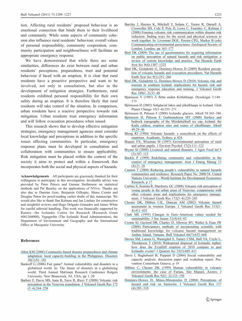
tion. Affecting rural residents’ proposed behaviour is anemotional connection that binds them to their livelihoodand community. While some aspects of community cohe-sion also influence rural residents’ behaviour, overall valuesof personal responsibility, community cooperation, com-munity participation and neighbourliness will facilitate anappropriate emergency response.
We have demonstrated that while there are somesimilarities, differences do exist between rural and urbanresidents’ perceptions, preparedness, trust and potentialbehaviour if faced with an eruption. It is clear that ruralresidents have a proactive perspective and want to beinvolved, not only in consultation, but also in thedevelopment of mitigation strategies. Furthermore, ruralresidents exhibited personal responsibility for their ownsafety during an eruption. It is therefore likely that ruralresidents will take control of the situation. In comparison,urban residents have a reactive perspective towards riskmitigation. Urban residents trust emergency informationand will follow evacuation procedures when issued.
This research shows that to develop effective mitigationstrategies, emergency management agencies must considerlocal knowledge and perceptions in addition to the specificissues affecting communities. In particular, emergencyresponse plans must be developed in consultation andcollaboration with communities to ensure applicability.Risk mitigation must be placed within the context of thesociety it aims to protect and within a framework thatincorporates both the social and physical aspects of hazards.
Acknowledgements All participants are graciously thanked for theirwillingness to participate in this investigation. Invaluable advice wasprovided by Peter Petocz and Gunnar Stefánsson on statisticalmethods and Pat Bazeley on the applications of NVivo. Thanks arealso due to Damian Gore, Benjamin Gillespie, Shane Cronin andDouglas Paton for proof-reading earlier drafts of this manuscript. Wewould also like to thank Ilan Kelman and Jan Lindsay for constructiveand insightful reviews and Hugo Delgado Granados and James Whitefor careful editorial handling. This work was financially supported byRannís—the Icelandic Centre for Research (Research Grant#081260008), Vegagerðin (The Icelandic Road Administration), theDepartment of Environment and Geography and the InternationalOffice at Macquarie University.
References
Allen KM (2006) Community-based disaster preparedness and climateadaptation: local capacity-building in the Philippines. Disasters30(1):81–101
Bankoff G (2006) Fair game? Animal vulnerability and disasters in aglobalized world. In: The future of disasters in a globalizingworld, Third Annual MaGrann Research Conference RutgersUniversity. New Brunswick, NJ, USA, pp 1–20
Barberi F, Davis MS, Isaia R, Nave R, Ricci T (2008) Volcanic riskperception in the Vesuvius population. J Volcanol Geoth Res 172(3–4):244–258
Barclay J, Haynes K, Mitchell T, Solana C, Teeuw R, Darnell A,Crosweller HS, Cole P, Pyle D, Lowe C, Fearnley C, Kelman I(2008) Framing volcanic risk communication within disaster riskreduction: finding ways for the social and physical sciences towork together. In: Liverman DGE, Pereira CPG, Marker B (eds)Communicating environmental geoscience. Geological Society ofLondon, London, pp 163–177
Bird DK (2009) The use of questionnaires for acquiring informationon public perception of natural hazards and risk mitigation: areview of current knowledge and practice. Nat Hazards EarthSyst Sci 9(4):1307–1325
Bird DK, Gisladottir G, Dominey-Howes D (2009) Resident percep-tion of volcanic hazards and evacuation procedures. Nat HazardsEarth Syst Sci 9(1):251–266
Bird DK, Gisladottir G, Dominey-Howes D (2010) Volcanic risk andtourism in southern Iceland: implications for hazard, risk andemergency response education and training. J Volcanol GeothRes 189(1–2):33–48
Bjarnason V (1985) Á flótta undan Kötluhlaupi. Dynskógar 3:149–173
Björnsson H (2002) Subglacial lakes and jökulhlaups in Iceland. GlobPlanet Change 35(3–4):255–271
Björnsson H, Pálsson F (2008) Icelandic glaciers. Jökull 58:365–386Björnsson H, Pálsson F, Guðmundsson MT (2000) Surface and
bedrock topography of the Mýrdalsjökull ice cap, Iceland: theKatla caldera, eruption sites and routes of jökulhlaups. Jökull49:29–46
Blong RJ (1984) Volcanic hazards: a sourcebook on the effects oferuptions. Academic, Sydney, p 424
Bogner FX, Wiseman M (1997) Environmental perception of ruraland urban pupils. J Environ Psychol 17(2):111–122
Bryant SJ (2008) Livestock and natural disasters. J Agric Food Inf 8(3):107–113
Buckle P (1999) Redefining community and vulnerability in thecontext of emergency management. Aust J Emerg Manag 13(4):21–26
Cannon T (2008) Reducing people’s vulnerability to natural hazardscommunities and resilience. Research Paper No. 2008/34. UnitedNations University—World Institute for Development EconomicsResearch, p 17
Carlino S, Somma R, Mayberry GC (2008) Volcanic risk perception ofyoung people in the urban areas of Vesuvius: comparisons withother volcanic areas and implications for emergency manage-ment. J Volcanol Geoth Res 172(3–4):229–243
Chester DK, Dibben CJL, Duncan AM (2002) Volcanic hazardassessment in western Europe. J Volcanol Geoth Res 115(3–4):411–435
Clark ME (1995) Changes in Euro–American values needed forsustainability. J Soc Issues 51(4):63–82
Cronin SJ, Gaylord DR, Charley D, Alloway BV, Wallez S, Esau JW(2004) Participatory methods of incorporating scientific withtraditional knowledge for volcanic hazard management onAmbae Island, Vanuatu. Bull Volcanol 66(7):652–668
Davies SM, Larsen G, Wastegård S, Turney CSM, Hall VA, Coyle L,Thordarson T (2010) Widespread dispersal of Icelandic tephra:how does the Eyjafjöll eruption of 2010 compare to pastIcelandic events? J Quatern Sci 25(5):605–611
Davis I, Haghebaert B, Peppiatt D (2004) Social vulnerability andcapacity analysis: discussion paper and workshop report. Pro-vention Consortium Geneva, p 19
Dibben C, Chester DK (1999) Human vulnerability in volcanicenvironments: the case of Furnas, São Miguel, Azores. JVolcanol Geoth Res 92(1–2):133–150
Dominey-Howes D, Minos-Minopoulos D (2004) Perceptions ofhazard and risk on Santorini. J Volcanol Geoth Res 137(4):285–310
Bull Volcanol (2011) 73:1209–1227 1225
Fortmann L, Kusel J (1990) New voices, old beliefs: forestenvironmentalism among new and long-standing rural residents.Rural Sociol 55:214–232
Gaillard J-C (2008) Alternative paradigms of volcanic risk perception:the case of Mt. Pinatubo in the Philippines. J Volcanol Geoth Res172(3–4):315–328
Gregg CE, Houghton BF, Johnston DM, Paton D, Swanson DA(2004a) The perception of volcanic risk in Kona communitiesfrom Mauna Loa and Hualalai volcanoes, Hawai’i. J VolcanolGeoth Res 130(3–4):179–196
Gregg CE, Houghton BF, Paton D, Swanson DA, Johnston DM(2004b) Community preparedness for lava flows from MaunaLoa and Hualalai volcanoes, Kona, Hawai’i. Bull Volcanol 66(6):531–540
Guðmundsdóttir B, Rúnarsson SK, Gylfason ÁG (2010) GIS andlinked databases as a tool in evacuating the local population inexpansive rural areas in the face of natural catastrophes. In: GINorden Workshop 2010 (22nd Nordic GIS Conference) Selfoss,Iceland, p 12
Guðmundsson AT (1996) Katla: the wicked witch. In: Volcanoes inIceland. Vaka-Helgafell, Reykjavík, pp 61–67
Guðmundsson MT, Gylfason ÁG (2005) Hættumat vegan eldgosa oghlaupa frá vestanverðum Mýrdalsjökli og Eyjafjallajökli. Ríki-slögreglustjórinn, Reykjavík, p 210
Guðmundsson MT, Höganadóttir P, Kristinsson AB, Guðbjörnsson S(2007) Geothermal activity in the subglacial Katla caldera,Iceland, 1999–2005, studied with radar altimetry. Ann Glaciol45(1):66–72
Guðmundsson MT, Larsen G, Höskuldsson Á, Gylfason ÁG (2008)Volcanic hazards in Iceland. Jökull 58:251–268
Haynes K, Barclay J, Pidgeon N (2008a) Whose reality counts?Factors affecting the perception of volcanic risk. J VolcanolGeoth Res 172(3–4):259–272
Haynes K, Barclay J, Pidgeon N (2008b) The issue of trust and itsinfluence on risk communication during a volcanic crisis. BullVolcanol 70(5):605–621
Heath SE (1999) Animal management in disasters. Mosby Year Book,St Louis, p 320
Heath SE, Beck AM, Kass PH, Glickman LT (2001a) Risk factors forpet evacuation failure after a slow-onset disaster. J Am Vet MedAssoc 218(12):1905–1910
Heath SE, Kass PH, Beck AM, Glickman LT (2001b) Human and pet-related risk factors for household evacuation failure during anatural disaster. Am J Epidemiol 153(7):659–665
Hughes P, White PB (2005) Bushfires and the media: a preliminaryliterature review. Media Studies Program, La Trobe UniversityMelbourne, p 24
ICP (2010) Eruption at the Eyjafjallajökull volcanic system, Alman-navarnadeild, http://www.almannavarnir.is/displayer.asp?cat_id=413 accessed: 15 April 2010
IMO (2010) Update on activity: Eruption in Eyjafjallajökull,Iceland, Icelandic Meteorological Office, http://en.vedur.is/earthquakes-and-volcanism/articles/nr/1884 accessed: 21 March2010
Irvine L (2006) Animals in disasters: issues for animal liberationactivism and policy. Anim Lib Philos Policy IV(1):1–16
Jóhannesdóttir G (2005) Við tölum aldrei um Kötlu hér mat íbúa áhættu vegna Kötlugoss. In: Department of Geology and Geog-raphy. University of Iceland, Reykjavík, p 103
Jóhannesdóttir G, Gísladóttir G (2010) People living under threat ofvolcanic hazard in southern Iceland: vulnerability and riskperception. Nat Hazards Earth Syst Sci 10(2):407–420
Jóhannesson G (1919) Kötlugosið 1918. Frásagnir úr Vík, ogHeiðardal í Mýrdal, Hjörleifshöfða, Skaftártungu, Álftaveri,Meðallandi og Síðu. Bókaverzlun Ársæls Árnasonar, Reykjavík,p 72
Johnston DM, Bebbington MS, Lai C-D, Houghton BF, Paton D(1999) Volcanic hazard perceptions: comparative shifts inknowledge and risk. Disaster Prev Manag 8(2):118–126
King D, MacGregor C (2000) Using social indicators to measurecommunity vulnerability to natural hazards. Aust J Emerg Manag15(3):52–57
Larsen G (2000) Holocene eruptions within the Katla volcanic system,south Iceland: characteristics and environmental impact. Jökull49:1–28
Larsen G, Dugmore A, Newton A (1999) Geochemistry of historical-age silicic tephras in Iceland. Holocene 9(4):463–471
Lavigne F, De Coster B, Juvin N, Flohic F, Gaillard J-C, Texier P,Morin J, Sartohadi J (2008) People’s behaviour in the face ofvolcanic hazards: perspectives from Javanese communities,Indonesia. J Volcanol Geoth Res 172(3–4):273–287
Lewis J, Kelman I (2010) Places, people and perpetuity: communitycapacities in ecologies of catastrophe. ACME Int E-J Crit Geogr9(2):191–220
Lindell MK, Whitney DJ (2000) Correlates of household seismichazard adjustment adoption. Risk Anal 20(1):13–26
Marotz-Baden R, Colvin PL (1986) Coping strategies: a rural-urbancomparison. Fam Relat 35(2):281–288
Maxwell JA (2005) Qualitative research design: an interactiveapproach. Sage, Thousand Oaks, p 175
Mbl (2010) 500 yfirgefið heimili sín, Morgunblaðið, http://mbl.is/mm/frettir/innlent/2010/03/21/500_yfirgefa_heimili_sin/ accessed: 21March 2010
McGuire WJ, Solana MC, Kilburn CRJ, Sanderson D (2003)Communication during volcanic emergencies: an operationsmanual for the Carribean. Department for International Develop-ment (DFID) Project R7406: Protecting small islands byimproving forecasting and warning. Benfield Greig HazardResearch Centre (BGHRC), p 36
McGuire WJ, Solana MC, Kilburn CRJ, Sanderson D (2009)Improving communication during volcanic crises on small,vulnerable islands. J Volcanol Geoth Res 183(1–2):63–75
Mercer J, Dominey-Howes D, Kelman I, Lloyd K (2007) Thepotential for combining indigenous and western knowledge inreducing vulnerability to environmental hazards in small islanddeveloping states. Environ Hazards 7(4):245–256
Mileti D, Nathe S, Gori P, Greene M, Lemersal E (2004) Publichazards communication and education: the state of the art.Natural Hazards Informer, Issue 2 Boulder, p 13
Oliver-Smith A (1996) Anthropological research on hazards anddisasters. Annu Rev Anthropol 25(1):303–328
Pallant J (2007) SPSS survival manual: a step-by-step guide to dataanalysis using SPSS version 15. Open University Press,Berkshire, p 335
Paton D (2007) Preparing for natural hazards: the role of communitytrust. Disaster Prev Manag 16(3):370–379
Paton D, Smith L, Daly M, Johnston D (2008) Risk perception andvolcanic hazard mitigation: individual and social perspectives. JVolcanol Geoth Res 172(3–4):179–188
Perry RW, Lindell MK (2008) Volcanic risk perception and adjust-ment in a multi-hazard environment. J Volcanol Geoth Res 172(3–4):170–178
Poortinga W, Pidgeon NF (2003) Exploring the dimensionality of trustin risk regulation. Risk Anal 23(5):961–972
Russell AJ, Duller R, Mountney NP, Anders Schomacker JK, Kurt HK(2009) Volcanogenic Jökulhlaups (Glacier Outburst Floods) fromMýrdalsjökull:0020impacts on proglacial environments. In: vander Meer JJM (ed) The Mýrdalsjökull ice cap, Iceland: glacialprocesses, sediments and landforms on an active volcano.Elsevier Science, Amsterdam, pp 181–207
RÚV (2010) Information on eruption, RÚV, http://www.ruv.is/frett/eldgos-fimmvorduhalsi accessed: 21 March 2010
1226 Bull Volcanol (2011) 73:1209–1227
Scanlon J (2007) Unwelcome irritant or useful ally? The mass mediain emergencies. In: Rodríguez H, Quarantelli EL, Dynes RR(eds) Handbook of disaster research. Springer, New York, pp413–429
Sigmundsson F, Geirsson H, Hooper AJ, Hjaltadottir S, Vogfjord KS,Sturkell EC, Pedersen R, Pinel V, Fabien A, Einarsson P,Gudmundsson MT, Ofeigsson B, Feigl K (2009) Magma ascentat coupled volcanoes: Episodic magma injection at Katla andEyjafjallajökull ice-covered volcanoes in Iceland and the onset ofa new unrest episode in 2009. In: American Geophysical UnionFall Meeting 2009. San Francisco, abstract #V32B-03
Sigmundsson F, Hreinsdóttir S, Hooper A, Árnadóttir T, Pedersen R,Roberts MJ, Óskarsson N, Auriac A, Decriem J, Einarsson P,Geirsson H, Hensch M, Ófeigsson BG, Sturkell E, SveinbjörnssonH, Feigl KL (2010) Intrusion triggering of the 2010Eyjafjallajökull explosive eruption. Nature 468 (18 Novem-ber):426-430
Sigthorsson IH, Gudmundsson AT, Marteinsdottir F, Nielsen T (2006)Evacuation plan for volcanic eruptions in the Katla caldera inIceland. Geophys Res Abstr 8(05254)
Sjöberg L (2000) The methodology of risk perception research. QualQuant 34(4):407–418
Sjöberg L (2007) Emotions and risk perception. In: PreferenceElicitation Group workshop on Risk perception, attitudes, andbehavior University of Barcelona, p 16
Sorensen JH, Sorensen BV (2007) Community processes: warningand evacuation. In: Rodríguez H, Quarantelli EL, Dynes RR(eds) Handbook of disaster research. Springer, New York, pp183–199
Statistics Iceland (2009) Population 1 December, Hagstofa Íslands, þann27-1-2009 http://www.statice.is/vorulysingar_en/v_transporter.asp?filename=V00111.htm accessed: 17 February 2011
Statistics Iceland (2010) Urban nucleui and zip codes, Statistics Iceland,http://www.statice.is/Statistics/Population/Urban-nuclei-and-zip-codes accessed: 27 May 2010
Sturkell E, Sigmundsson F, Einarsson P (2003) Recent unrest andmagma movements at Eyjafjallajökull and Katla volcanoes,Iceland. J Geophys Res 108(B8):2369
Sturkell E, Einarsson P, Roberts MJ, Geirsson H, Gudmundsson MT,Sigmundsson F, Pinel V, Guðmundsson GB, Ólafsson H,Stefánsson R (2008) Seismic and geodetic insights into magmaaccumulation at Katla subglacial volcano, Iceland: 1999 to 2005.J Geophys Res 113
Sturkell E, Einarsson P, Sigmundsson F, Hooper A, Ófeigsson BG,Geirsson H, Ólafsson H (2009) Katla and Eyjafjallajökullvolcanoes. In: van der Meer JJM (ed) The Mýrdalsjökull icecap, Iceland: glacial processes, sediments and landforms on anactive volcano. Elsevier Science, Amsterdam, pp 5–21
Tobin GA (1999) Sustainability and community resilience: the holygrail of hazards planning? Glob Environ Change B EnvironHazards 1(1):13–25
UNISDR (2008) Indigenous knowledge for disaster risk reduction:good practices and lessons learned from experiences in the Asia-Pacific Region. United Nations International Strategy for DisasterReduction: Asia and Pacific Bangkok, p 84
UNISDR (2009) United Nations international strategy for disaster riskreduction: UNISDR Terminology on Disaster Risk Reduction(2009), United Nations International Strategy on Disaster RiskReduction (UNISDR), http://www.unisdr.org/eng/terminology/terminology-2009-eng.html accessed: 6 May 2009
Valentine G (2005) Tell me about…: using interviews as a researchmethodology. In: Flowerdew R, Martin D (eds) Methods in humangeography. Pearson Education Limited, England, pp 110–127
van AalstMK, Cannon T, Burton I (2008) Community level adaptation toclimate change: the potential role of participatory community riskassessment. Glob Environ Change 18(1):165–179
Veland S, Howitt R, Dominey-Howes D (2010) Invisible institutionsin emergencies: evacuating the remote Indigenous community ofWarruwi, Northern Territory Australia, from Cyclone Monica.Environ Hazards Hum Policy Dimens 9:197–214
Vísir (2010) Ein umfangsmesta rýmingaraðgerð á Íslandi—myndskeið,Vísir, http://visir.is/article/20100321/FRETTIR01/943450068accessed: 21 March 2010
Wisner B, Blaikie P, Cannon T, Davis I (2004) At risk: naturalhazards, people’s vulnerability, and disasters. Routledge, NewYork, p 471
Bull Volcanol (2011) 73:1209–1227 1227
Copyright © 2022 FDOKUMEN