Depositional sequences, diagenesis and structural control of the Albian to Turonian carbonate...
22
Research paper Depositional sequences, diagenesis and structural control of the Albian to Turonian carbonate platform systems in coastal Fars (SW Iran) Benoit Vincent a, *, 1 , Frans S.P. van Buchem b, 1 , Luc G. Bulot c , Mahmoud Jalali d , Rudy Swennen e , A.S. Hosseini d , Darius Baghbani d a Cambridge Carbonates Ltd,1 rue de varoux, 21120 Marey-sur-Tille, France b Maersk Oil Esplanaden 50, 1263 Copenhagen, Denmark c Aix-Marseille University, UMR CNRS 7330 CEREGE, Centre St Charles, Case 67, 3 place Victor Hugo,13331 Marseille Cedex 03, France d NIOC R&D, No. 22, Negar Street, Vali-Asr Avenue, Vanak Square, Tehran,19698-13771, Iran e KUL Leuven, Celestijnenlaan 200 E B-3001 Heverlee, Belgium article info Article history: Received 19 September 2014 Received in revised form 11 February 2015 Accepted 13 February 2015 Available online 26 February 2015 Keywords: Cenomanian Turonian Sarvak Sequences Carbonates Diagenesis Tectonics SW Iran abstract This study covers a 300 km long, NE/SW oriented transect including five outcrop sections, and provides new biostratigraphic data and a sequence stratigraphic interpretation of the Albian, Cenomanian and Turonian sediments (Kazhdumi and Sarvak Formations) present in Coastal Fars (SW Iran). Two different carbonate depositional systems are distinguished, one for the Albian and one for the Cenomanian/ Turonian. During the Albian eustatic control was the dominant factor influencing sedimentation, while during the Cenomanian and Turonian large and small scale tectonics were dominant. This resulted in significant thickness variations and local diagenetic overprint of the sequence boundaries. Regional correlations were established constrained by ammonite data, as well as sedimentological and sequence stratigraphic considerations. In the Albian interval, including the Kazhdumi Formation and re- dated Mauddud Member, three 3rd order sequences have been distinguished. The depositional system consists of muddy carbonate ramps, rich in orbitolinid benthic foraminifers, which laterally interfinger with green marls. Albian deposits are present throughout the area and vary in thickness from 100 to 160 m. Subaerial exposure has only been observed on top of the Albian-3 sequence (Top Mauddud Member). In the upper part of the succession, which is of Cenomanian/Turonian age, the depositional system changed to rudist-rimmed carbonate platforms surrounding local organic-rich, intra-shelf basins. The thickness in this interval varies greatly, from 0 to 300 m, which was controlled by both large scale (Qatar- Fars high) and local scale (salt domes) tectonic processes. In this tectonically active setting, three Cen- omanian and one Turonian 3rd order sequences have been distinguished. Several sequence boundaries show evidences for long-lasted subaerial exposures (up to 13 Ma), with the local preservation of soil sequences and continental deposits. The expression of these exposures varies laterally considerably, and macroscopic evidences are sometimes lacking. Petrographic and C & O stable isotope investigations supplement classic sedimentology to reveal the record of these exposures. © 2015 Elsevier Ltd. All rights reserved. 1. Introduction The mid Cretaceous AlbianeCenomanianeTuronian time inter- val is characterised on the Arabian plate by the presence of extensive shallow water carbonate deposits as well as the presence of organic-rich intrashelf basins which form the key components of some of the world's most prolific petroleum systems (e.g. Murris, 1980). Well-known reservoirs of this stratigraphic interval * Corresponding author. Tel.: þ33 645084016. E-mail addresses: [email protected] (B. Vincent), frans. [email protected] (F.S.P. van Buchem), [email protected] (R. Swennen). 1 Previously at IFP Geology-Geochemistry Division, 1-4 ave de Bois pr eau, 92852 Rueil-Malmaison, France. Contents lists available at ScienceDirect Marine and Petroleum Geology journal homepage: www.elsevier.com/locate/marpetgeo http://dx.doi.org/10.1016/j.marpetgeo.2015.02.018 0264-8172/© 2015 Elsevier Ltd. All rights reserved. Marine and Petroleum Geology 63 (2015) 46e67
-
Upload
independent -
Category
Documents
-
view
1 -
download
0
Transcript of Depositional sequences, diagenesis and structural control of the Albian to Turonian carbonate...

lable at ScienceDirect
Marine and Petroleum Geology 63 (2015) 46e67
Contents lists avai
Marine and Petroleum Geology
journal homepage: www.elsevier .com/locate/marpetgeo
Research paper
Depositional sequences, diagenesis and structural control of theAlbian to Turonian carbonate platform systems in coastal Fars(SW Iran)
Benoit Vincent a, *, 1, Frans S.P. van Buchem b, 1, Luc G. Bulot c, Mahmoud Jalali d,Rudy Swennen e, A.S. Hosseini d, Darius Baghbani d
a Cambridge Carbonates Ltd, 1 rue de varoux, 21120 Marey-sur-Tille, Franceb Maersk Oil Esplanaden 50, 1263 Copenhagen, Denmarkc Aix-Marseille University, UMR CNRS 7330 CEREGE, Centre St Charles, Case 67, 3 place Victor Hugo, 13331 Marseille Cedex 03, Franced NIOC R&D, No. 22, Negar Street, Vali-Asr Avenue, Vanak Square, Tehran, 19698-13771, Irane KUL Leuven, Celestijnenlaan 200 E B-3001 Heverlee, Belgium
a r t i c l e i n f o
Article history:Received 19 September 2014Received in revised form11 February 2015Accepted 13 February 2015Available online 26 February 2015
Keywords:CenomanianTuronianSarvakSequencesCarbonatesDiagenesisTectonicsSW Iran
* Corresponding author. Tel.: þ33 645084016.E-mail addresses: benoit@cambridgecarbonates
[email protected] (F.S.P. van Buchem), ru(R. Swennen).
1 Previously at IFP Geology-Geochemistry Division,Rueil-Malmaison, France.
http://dx.doi.org/10.1016/j.marpetgeo.2015.02.0180264-8172/© 2015 Elsevier Ltd. All rights reserved.
a b s t r a c t
This study covers a 300 km long, NE/SW oriented transect including five outcrop sections, and providesnew biostratigraphic data and a sequence stratigraphic interpretation of the Albian, Cenomanian andTuronian sediments (Kazhdumi and Sarvak Formations) present in Coastal Fars (SW Iran). Two differentcarbonate depositional systems are distinguished, one for the Albian and one for the Cenomanian/Turonian. During the Albian eustatic control was the dominant factor influencing sedimentation, whileduring the Cenomanian and Turonian large and small scale tectonics were dominant. This resulted insignificant thickness variations and local diagenetic overprint of the sequence boundaries.
Regional correlations were established constrained by ammonite data, as well as sedimentological andsequence stratigraphic considerations. In the Albian interval, including the Kazhdumi Formation and re-dated Mauddud Member, three 3rd order sequences have been distinguished. The depositional systemconsists of muddy carbonate ramps, rich in orbitolinid benthic foraminifers, which laterally interfingerwith green marls. Albian deposits are present throughout the area and vary in thickness from 100 to160 m. Subaerial exposure has only been observed on top of the Albian-3 sequence (Top MauddudMember).
In the upper part of the succession, which is of Cenomanian/Turonian age, the depositional systemchanged to rudist-rimmed carbonate platforms surrounding local organic-rich, intra-shelf basins. Thethickness in this interval varies greatly, from 0 to 300 m, which was controlled by both large scale (Qatar-Fars high) and local scale (salt domes) tectonic processes. In this tectonically active setting, three Cen-omanian and one Turonian 3rd order sequences have been distinguished. Several sequence boundariesshow evidences for long-lasted subaerial exposures (up to 13 Ma), with the local preservation of soilsequences and continental deposits. The expression of these exposures varies laterally considerably, andmacroscopic evidences are sometimes lacking. Petrographic and C & O stable isotope investigationssupplement classic sedimentology to reveal the record of these exposures.
© 2015 Elsevier Ltd. All rights reserved.
.co.uk (B. Vincent), [email protected]
1-4 ave de Bois pr�eau, 92852
1. Introduction
The mid Cretaceous AlbianeCenomanianeTuronian time inter-val is characterised on the Arabian plate by the presence ofextensive shallow water carbonate deposits as well as the presenceof organic-rich intrashelf basins which form the key components ofsome of the world's most prolific petroleum systems (e.g. Murris,1980). Well-known reservoirs of this stratigraphic interval

B. Vincent et al. / Marine and Petroleum Geology 63 (2015) 46e67 47
include the Natih Formation in Oman, the Mishrif Formation in theUAE, the Mauddud and Khatiyah Formations in Qatar, and theSarvak Formation in Iran (e.g. Al-Sharhan and Narin,1997; Sharlandet al., 2001; Bordenave and Hegre, 2005).
Sequence stratigraphic studies of these rocks that were carriedout in tectonically quiet areas, established a framework of 3rd orderdepositional sequences that can be confidently correlated at thescale of the eastern Arabian plate (e.g. van Buchem et al., 1996,2002, 2010; Immenhauser et al., 1999; Raven et al., 2010; Razinet al., 2010; Sharp et al., 2010). This sequence stratigraphic frame-work, calibrated in time, was recently used by van Buchem et al.(2011) to propose a revised correlation between these lithostrati-graphic units on the Eastern Arabian Plate. In addition, van Buchemet al. (2011) proposed a distinction between two different deposi-tional systems: the Albian depositional system, characterized bythe development of low-angle, orbitolinid-dominated, muddyramp systems (Orbitolina Limestones in the Kazhdumi Formationin Iran, and Mauddud Formation in Oman and Kuwait), and theCenomanian/Turonian system, characterized by rudist rimmedplatforms surrounding organic-rich intrashelf basins (e.g. upperpart of the Sarvak, Mishrif and Natih Formations). This paper pro-vides further evidence for this depositional model.
The importance of tectonic activity during the Cenomanian/Turonian interval is well known (e.g. Ricou, 1971; Ala, 1974;Setudehnia, 1978; Stonely, 1981 Piryaei et al., 2010, 2011) and haslocally significantly overprinted the expression of the 3rd orderdepositional sequences. Setudehnia (1978) already demonstratedthe large differences in preservation of the Sarvak Formation inWestern Iran,which varies fromamaximumthickness in theorderof900 m in the Ahwaz area to total absence in the Coastal Fars area. Amajor tectonic control during the Cenomanian-Campanian was theobduction of the ocean crust which took place along the south-eastern and eastern margins of the Arabian plate, and led to (a) there-activation of regional deep-seated normal fault systems thatseparated large-scale regionally uplifted and subsiding terrainswithin the plate, and (b) local salt tectonic uplift, notably above thePre-Cambrian Hormuz salt basin.
This paper focuses on the Albian to Turonian succession, exposedin the coastal Fars area, where the influence of both local salt tec-tonics as well as regionally uplifted terrains (Qatar-Fars High) can beobserved in a number of seismic scale outcrops. The purpose of thispaper is threefold, firstly to refine the understanding of the timingand scale of the syn-sedimentary tectonic activity, secondly toevaluate its impact on the expression of the depositional sequences,and thirdly to document the diagenetic and sedimentologicalexpression of the sequence boundaries in this setting.
2. Geological setting
The Zagros Mountain chain, which stretches along a SEeNWtrend throughout SW Iran, is the result of a complex, multi-phased,geodynamic evolution that affected the eastern margin of theArabian plate from the Late Cretaceous to the Neogene. Thisdeformation phase started with the obduction of Neo-Tethys oceanfloor sediments during the Late Cretaceous, and continued until theNeogene, resulting in final closure of the Neo-Tethys and forelandbasin deformation in a compressional regime in the Late Miocene,when the Arabian and Central Iranian plates collided (e.g. Alavi,1991; Wennberg et al., 2007). Several tectonic units are distin-guished in the SEeNW oriented belt and the study area is locatedsouthwest of the suture zone near the front of the Zagros folding(Fig. 1), where the Zagros is subdivided in two large structuralzones separated by the High Zagros Fault. Superposed on thispattern are additional N/S oriented main basement-rooted faults(the Kazerun and Hendijan Fault systems) that were active at
various times throughout the geological history, and separate theFars province from the faster subsiding Dezful Embayment andLurestan areas in the North-West (Fig. 1). The presence of Pre-Cambrian salts of the Hormuz Formation, limited to the West bythe Kazerun Fault system, strongly influenced the nature of tectonicdeformation in Fars (Fig. 1).
ThecoastalFarsprovince is located in thenorthernextensionof theaxis of the Qatar-Fars arch, a deep-seated tectonic structure that datesback to the Pre-Cambrian and has influenced sedimentation eversince (e.g. van Buchem et al., 2011). The orientation of this structure isparallel to the Kazerun and Hendijan Fault systems (Fig. 1).
The study area is located in a relatively low accommodation zone,compared to the high accommodation areas in Khuzestan and Lure-stanprovince. For instance, in large parts of coastal Fars theupper partof the Sarvak Formation (Cenomanian/Turonian) is absent, whereasrocks of this age can reach a thickness of up to 1200 m in Khuzestanarea in the North (James andWynd, 1965; Setudehnia, 1978). Duringthe Cretaceous, the coastal Fars area consisted for most of the time ofshallow water carbonate platforms (Fahliyan, Dariyan, Sarvak, IlamFormations; Fig. 2) which experienced several episodes of subaerialexposures of regional extent. During the Albian, carbonate sedimen-tation was interrupted by a phase of intrashelf marl deposits (Kazh-dumi Formation; e.g. James andWynd,1965).
3. Material and methods
Five outcrop sections were studied, from NNW to SSE: Kuh-e-Khormuj, Kuh-e-Khartang, Kuh-e-Namak, Kuh-e-Asaluyeh, andKuh-e-Gach (Fig. 1; Table 1). The Khormuj and Khartang sections arelocated on the northwestern flank of the Qatar-Fars high, whereasAsaluyeh and Namak sections are located on the structure. The Gachsection is located on the southeastern flank of the structure.
Sedimentological logs were measured at the decimeter scale,and sequence stratigraphic interpretations were made followingthe sequence definition of Vail et al. (1991). Biostratigraphic sam-ples were taken at 1.5 m intervals. Microfossil determination wascarried out by A. Hosseini, and where applicable the biozonation ofWynd (1965) was used.
The diagenetic investigations were made at the macroscopicscale in the field, and on thin-sections using classical optical mi-croscope and cathodoluminescence equipment. Several sedimen-tological and diagenetic elements (pebbles, cements) were sampledwith a dentist microdrill under a binocular for carbon and oxygenstable isotope analysis (d13Ccarb, d18Ocarb), in order to investigate thediagenesis associated with sequence boundaries. In addition, a totalof 255 carbon isotope analyses of bulk matrix micrites were carriedout in 4 sections for chemostratigraphic and diagenesis purpose(Table 2): Khormuj (116), Asaluyeh (88 samples), Gach (42 samples),andNamak (9). All sampleswere analyzed at the Institute ofGeologyand Mineralogy, University of Erlangen-Nürnberg, Germany. Pow-ders were reactedwith 100% phosphoric acid at 75 �C using a Kiel IIIonline carbonate preparation line connected to a ThermoFinnigan252mass spectrometer. Isotopic values are reported in the standardd-notation in per mil relative to V-PDB (Vienna Pee Dee Belemnite)by assigning a d13C value of þ1.95‰ and a d18O value of �2.20‰ toNBS19. Reproducibility was checked by replicate analysis of labo-ratory standards and is better than ±0.02‰ (1s) for carbon isotopeand ±0.05‰ (1s) for oxygen isotope.
4. Sedimentology and stratigraphy
4.1. Depositional environments
The sedimentary facies description is based on macroscopic andmicroscopic observations on the faunal content and lithology, and
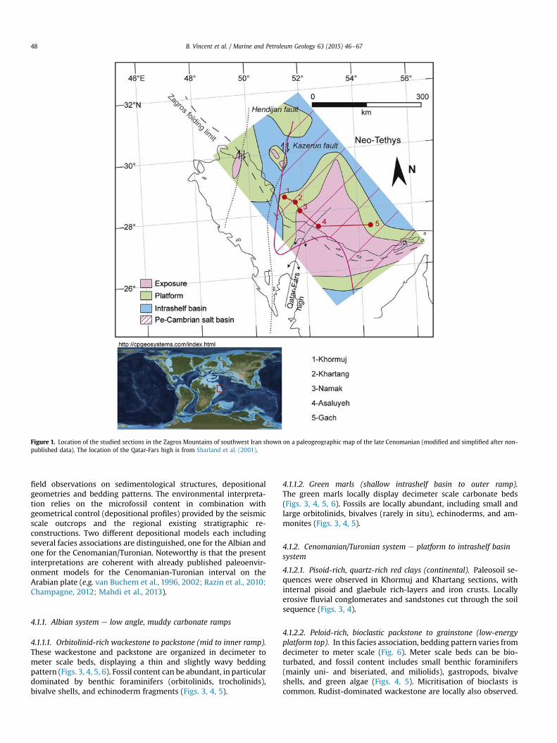
Figure 1. Location of the studied sections in the Zagros Mountains of southwest Iran shown on a paleogeographic map of the late Cenomanian (modified and simplified after non-published data). The location of the Qatar-Fars high is from Sharland et al. (2001).
B. Vincent et al. / Marine and Petroleum Geology 63 (2015) 46e6748
field observations on sedimentological structures, depositionalgeometries and bedding patterns. The environmental interpreta-tion relies on the microfossil content in combination withgeometrical control (depositional profiles) provided by the seismicscale outcrops and the regional existing stratigraphic re-constructions. Two different depositional models each includingseveral facies associations are distinguished, one for the Albian andone for the Cenomanian/Turonian. Noteworthy is that the presentinterpretations are coherent with already published paleoenvir-onment models for the Cenomanian-Turonian interval on theArabian plate (e.g. van Buchem et al., 1996, 2002; Razin et al., 2010;Champagne, 2012; Mahdi et al., 2013).
4.1.1. Albian system e low angle, muddy carbonate ramps
4.1.1.1. Orbitolinid-rich wackestone to packstone (mid to inner ramp).These wackestone and packstone are organized in decimeter tometer scale beds, displaying a thin and slightly wavy beddingpattern (Figs. 3, 4, 5, 6). Fossil content can be abundant, in particulardominated by benthic foraminifers (orbitolinids, trocholinids),bivalve shells, and echinoderm fragments (Figs. 3, 4, 5).
4.1.1.2. Green marls (shallow intrashelf basin to outer ramp).The green marls locally display decimeter scale carbonate beds(Figs. 3, 4, 5, 6). Fossils are locally abundant, including small andlarge orbitolinids, bivalves (rarely in situ), echinoderms, and am-monites (Figs. 3, 4, 5).
4.1.2. Cenomanian/Turonian system e platform to intrashelf basinsystem
4.1.2.1. Pisoid-rich, quartz-rich red clays (continental). Paleosoil se-quences were observed in Khormuj and Khartang sections, withinternal pisoid and glaebule rich-layers and iron crusts. Locallyerosive fluvial conglomerates and sandstones cut through the soilsequence (Figs. 3, 4).
4.1.2.2. Peloid-rich, bioclastic packstone to grainstone (low-energyplatform top). In this facies association, bedding pattern varies fromdecimeter to meter scale (Fig. 6). Meter scale beds can be bio-turbated, and fossil content includes small benthic foraminifers(mainly uni- and biseriated, and miliolids), gastropods, bivalveshells, and green algae (Figs. 4, 5). Micritisation of bioclasts iscommon. Rudist-dominated wackestone are locally also observed.

Figure 2. Revised AlbianeSantonian lithostratigraphic scheme of the Fars province. Notable changes were made compared to James and Wynd (1965) based on age revision fromcollected ammonites (see the text for explanations).
B. Vincent et al. / Marine and Petroleum Geology 63 (2015) 46e67 49
This facies association illustrates a relatively low energy platformtop environment.
4.1.2.3. Rudist grainstone to rudstone (high-energy platform margin).Two main kinds of bedding patterns characterize this facies asso-ciation. Decimeter to meter scale beds, displaying cross-beddingwith bed sets at the meter scale (Fig. 3), are interpreted asstacked sandwave units. Larger scale clinoformswith a depositionalprofile of 35e90 m (Fig. 7), correspond to prograding platformmargin foresets. Bioclasts consist mostly of rudist debris, withadditional echinoderm fragments, undetermined bioclasts, andsmall benthic foraminifers (Fig. 3).
4.1.2.4. Bioclastic mudstones and wackestone (toe of platform marginslope). The bedding pattern consists of thin, cm-scale, parallel bedswith undulating bed tops (Figs. 3, 4, 6, 7). The lithology varies frommarl to mudstone and wackestone with oysters, undeterminedbivalves, rare echinoderm, orbitolinid fragments, as well as bryo-zoans. Thalassinoides burrows are common, and furrow and scourfeatures indicate storm influence.
4.1.2.5. Grey marls (intrashelf basin). These uniform and mm-laminated marls and argillaceous mudstones contain ammonites,nautiloids, and planktonic foraminifers. Minimum water depth is
Table 1Coordinates of outcrop sections studied in this work.
Sections Latitude Longitude
Khormuj N28�39021000 E51�2401400
Khartang N28�3105600 E51�4500900
Kuh-e-Namak N28�1501600 E51�46038000
Kuh-e-Asaluyeh N27�3505600 E52�3103100
Kuh-e-Gach N27�3404600 E54�3000600
estimated at around 80e90m, based on laterally existing clinoformgeometries (Fig. 7).
4.2. Sequence stratigraphic framework
The sequence stratigraphic framework was established takinginto account biostratigraphic constraints (ammonites, benthic for-aminifers), carbon isotope stratigraphy, the evolution of the depo-sitional system, and the regional tectono-stratigraphic context.Interpretation of sequence stratigraphy, and used terminology,follow general principles (e.g. Mitchum and van Wagoner, 1991;Homewood et al. 1992; Strasser et al. 1999; Catuneanu, 2006).First the time constraints are presented, followed by the descriptionof the depositional sequences.
4.2.1. Biostratigraphy and chemostratigraphyA significant number of ammonites were encountered in the
studied sections. The ammonites found in the Kazhdumi Marls andOrbitolina Limestones were already reported in Vincent et al.(2010a,b), and are summarized in Table 3. An abundant faunafound in the Sarvak Formation of the Khartang section is for thefirst time reported and described here (Fig. 3). Othermore scatteredassemblages were found in the other sections (Table 3). Thesefindings are of fundamental stratigraphic significance for the datingof the lower part of the Sarvak Formation (the Mauddud Member).Stratigraphically significant species are illustrated in Figure 8.
In the Khartang section an ammonite faunawas collected from a40 m thick succession of marls and nodular limestone alternationsat the base of the Ahmadi Member which overlays the carbonatesof the MauddudMember (Figs. 4, 6). Most beds are fossiliferous butthe fauna is more abundant at four different levels. The lower levels(KHA S01, KHA S02) lie about 15 m above the top Mauddud andcontain exclusively Utaturiceras gr. vicinale (Stolizka). Ten metersabove, another level (KHA S03) is characterized by abundant

Table 2Stable isotope results.
Khormuj section Asaluyeh section Gach section
Bulk curve Xtra profile Figure 16
d13C(‰ vPDB)
d18O(‰ vPDB)
d13C(‰ vPDB)
d18O(‰ vPDB)
d13C(‰ vPDB)
d18O(‰ vPDB)
d13C(‰ vPDB)
d18O(‰ vPDB)
d13C(‰ vPDB)
d18O(‰ vPDB)
d13C(‰ vPDB)
d18O(‰ vPDB)
1.67 �5.51 2.03 �3.84 2.48 �5.04 1.58 �3.47 3.10 �4.29 1.38 �6.391.94 �5.14 2.05 �3.88 2.86 �5.61 1.22 �3.72 3.18 �4.45 1.53 �6.211.85 �5.32 1.98 �4.23 2.32 �5.21 1.16 �3.87 2.89 �4.27 1.76 �5.851.79 �5.27 2.10 �3.60 2.27 �5.49 1.51 �3.54 3.11 �4.39 0.53 �5.081.74 �5.47 1.63 �4.37 1.96 �5.83 1.42 �3.56 2.77 �4.37 �0.56 �5.261.96 �5.29 2.14 �3.76 1.82 �6.17 1.45 �3.51 2.59 �4.43 �1.13 �8.421.86 �5.38 1.86 �3.88 2.25 �5.88 1.53 �3.53 2.91 �4.00 1.91 �6.001.64 �5.47 1.79 �4.40 �1.15 �5.34 0.52 �4.03 2.77 �4.11 1.98 �6.481.82 �5.38 1.82 �3.96 �4.37 �5.01 0.75 �3.69 2.33 �4.21 1.89 �5.601.21 �5.98 2.05 �3.66 0.88 �3.73 2.93 �4.69 1.72 �4.721.13 �5.98 1.69 �4.31 Soil elements (Fig. 15) 0.84 �3.97 2.82 �4.30 1.61 �3.630.63 �5.38 2.14 �3.99 d13C
(‰ vPDB)d18O(‰ vPDB)
0.17 �4.35 2.45 �4.36 1.44 �4.14
1.34 �5.46 1.53 �4.57 �7.76 �4.51 0.40 �4.13 2.35 �4.23 0.68 �4.771.50 �5.23 2.05 �3.82 �8.82 �4.87 0.76 �4.14 2.63 �4.34 0.64 �5.131.44 �5.31 2.34 �4.28 �7.41 �5.83 1.36 �4.44 3.12 �4.91 0.11 �3.461.75 �4.19 1.96 �3.92 �8.68 �5.12 1.39 �4.41 3.26 �4.00 �1.52 �4.271.67 �4.54 2.36 �3.48 1.37 �4.69 3.24 �3.91 0.33 �5.081.38 �5.00 2.22 �4.55 1.95 �5.33 3.19 �4.04 1.10 �4.001.59 �4.91 2.06 �4.62 1.52 �4.56 3.16 �4.72 0.72 �3.771.54 �5.19 2.10 �4.27 0.88 �4.60 3.18 �4.46 0.33 �4.311.59 �5.59 2.67 �3.79 1.30 �4.59 3.33 �4.08 0.58 �4.351.58 �5.50 1.88 �4.81 1.10 �4.42 3.01 �4.09 0.12 �4.391.24 �5.63 2.72 �4.32 2.05 �3.88 3.09 �4.01 0.35 �5.741.14 �5.68 2.59 �4.52 1.51 �3.84 2.97 �4.63 0.42 �4.880.66 �5.27 2.52 �4.46 1.78 �3.64 2.82 �4.22 0.86 �4.580.51 �4.91 2.27 �4.62 1.60 �4.11 2.61 �4.08 0.58 �3.840.75 �5.26 2.41 �4.36 3.05 �4.51 2.83 �4.55 0.63 �4.91�1.07 �5.39 2.22 �4.64 1.08 �3.97 2.64 �4.35 0.75 �5.070.92 �4.14 1.87 �4.70 1.02 �4.02 2.69 �4.19 0.86 �4.840.49 �5.03 1.60 �4.77 1.78 �4.24 2.33 �4.37 1.33 �4.921.12 �5.32 1.45 �4.69 2.96 �3.44 2.70 �3.69 1.61 �2.170.98 �5.54 1.29 �4.08 2.05 �3.43 2.52 �3.90 2.10 �3.211.12 �5.07 1.15 �4.55 1.54 �4.18 2.38 �3.88 2.14 �3.291.06 �5.80 1.53 �3.36 2.12 �4.64 2.58 �4.001.11 �5.38 1.20 �3.82 1.82 �3.78 2.72 �4.160.90 �5.16 �2.89 �4.61 2.18 �4.66 2.35 �4.151.20 �5.55 0.67 �4.58 2.14 �4.19 3.26 �4.341.17 �5.06 1.33 �2.85 3.56 �4.30 3.09 �5.201.21 �5.20 1.36 �3.85 1.89 �4.52 2.75 �6.070.85 �4.08 2.19 �3.81 2.64 �4.31 3.43 �5.271.24 �5.06 1.77 �4.41 3.44 �4.31 1.30 �3.281.17 �5.73 2.24 �4.44 3.40 �4.18 1.07 �3.200.93 �5.46 2.96 �4.15 3.60 �4.180.95 �5.42 3.94 �4.20 3.11 �4.411.03 �5.18 3.04 �4.52 2.89 �4.67 Namak section1.70 �3.61 2.68 �4.00 3.05 �4.30 d13C
(‰ vPDB)d18O(‰ vPDB)
1.65 �3.94 2.59 �3.96 3.05 �4.04 2.33 �3.461.29 �3.57 2.49 �4.29 3.00 �4.30 2.53 �3.851.25 �4.45 1.38 �4.82 3.02 �4.12 2.05 �4.21.35 �4.33 0.33 �4.74 2.59 �4.13 2.22 �4.112.42 �3.99 1.13 �4.51 2.65 �3.97 2.46 �4.222.10 �4.14 �1.36 �4.41 2.67 �4.33 2.81 �4.151.70 �4.62 2.17 �3.82 2.9 �4.132.24 �3.69 2.67 �3.88 2.98 �4.522.25 �3.94 3.00 �4.09 3.21 �3.92
B. Vincent et al. / Marine and Petroleum Geology 63 (2015) 46e6750
Utaturiceras gr. vicinale and Sharpeiceras schlueteriHyatt. The fourthlevel (KHA S04) occurs about 10 m below the Sarvak limestone cliff(Figs. 4, 6) and is dominated by Sharpeiceras. This fauna indicatesthe Early CenomanianMantelli Zone. Utaturiceras has been reportedto occur in the lower part of the Cenomanian in South India,Madagascar, the Middle East, southern England, Germany andJapan (see Matsumoto et al., 2003 for discussion). Whenwell dated(Lewy and Raab, 1978; Wiedmann and Schneider, 1979; Wiedmannet al., 1989;Wright and Kennedy,1996; Matsumoto et al., 2003), the
genus is characteristic of the lowermost part of the Early Cen-omanian (Carcitanense Subzone). Sharpeiceras schlueteri Hyatt firstappears in the upper part of the Carcitanense Subzone and ranges tothe upper part of the Dixoni Zone (Wright and Kennedy, 1987). Theoverlap between Utaturiceras and Sharpeiceras suggests that KHAS03 represents the upper part of the Carcitanense Subzone whileKHA S04 correlates with the Saxbii Subzone. It should be noted thatGale et al. (1996) suggested that a Schueteri Subzone should beintroduced in the Mantelli Zone between the Carcitanense zubzone

Figure 3. Sedimentological log of the Khormuj section, with sequence stratigraphic interpretation and bulk carbonate d13C curve (legend on Fig. 4).
B. Vincent et al. / Marine and Petroleum Geology 63 (2015) 46e67 51
and the Saxbii Subzone. This interval most likely correlates with therange of Sharpeiceras schlueteri at Khartang.
Orbitolinids were also used to date the lower part of the studiedsuccession (Orbitolina Limestones and Kazhdumi Formation).These results were previously reported in Vincent et al. (2010a,b)and Schroeder et al. (2010).
Bulk d13C curves were constructed along the Khormuj, Asaluyeh,and Gach sections (Figs. 3, 5) to provide an independent correlationtool in addition to the biostratigraphic constraints. C isotope stra-tigraphy is very explicit in specific time intervals, such as theworldwide recognized C positive excursion associated with theCenomanianeTuronian OAE (Oceanic Anoxic Event) 2 (e.g. Jenkyns,

Figure 4. Sedimentological log of the Khartang section, with sequence stratigraphic interpretation and bulk carbonate d13C curve.
B. Vincent et al. / Marine and Petroleum Geology 63 (2015) 46e6752
2010). The latter positive excursion is clearly identified in the upperpart of the Khormuj (Fig. 3) and Gach (Fig. 5) sections. This is anelement of correlation, locally and at the scale of the Arabian plate(e.g. Vahrenkamp, 2013), but not a direct accurate dating markersince the positive excursion extends from the Late Cenomanian tothe Early Turonian (Elrick et al., 2009; Erba, 2004). Still, it boundsup the Sarvak Formation in an interval where indicative fauna areextremely rare.
4.2.2. Depositional sequencesA total of seven large-scale sequences are distinguished in the
studied area, three in the Albian, three in the Cenomanian and onepossibly of early Turonian age. Based on their duration they classify
as 2nd and 3rd order sequences (sensu Vail et al., 1991). Detailedinformation about the individual stratigraphic sections is providedin Figures 3, 4, and 5, whereas regional correlations are shown inFigure 9. They are described hereafter.
The latest Aptian and Albian sequences are represented by thedominantly marly Kazhdumi Formation, which includes from baseto top (1) the condensed iron-rich sandstones of the ‘BurganSandstone equivalent’ (sensu James and Wynd, 1965), (2) theOrbitolina Limestones, and (3) the limestones of the MauddudFormation. The large scale sedimentological evolution of this in-terval starts with shallow water, orbitolinid-rich wackestone at thebase to yellow/green marls of the Kazhdumi Formation in themiddle, showing a gradual increase in carbonate rich beds

Figure 5. Sedimentological log of the Asaluyeh, Gach, and Namak sections, with sequence stratigraphic interpretation and bulk carbonate d13C curve (legend on Fig. 4).
B. Vincent et al. / Marine and Petroleum Geology 63 (2015) 46e67 53

Figure 6. Overviews of Khormuj (A), Khartang (B), and Namak (C) sections, with thepositions of the main sequence boundaries.
Figure 7. Remarquable sedimentary features and architectures in the Khormuj section.A e Onlaps of shallow marine carbonates above the SB 3 are later eroded (toplaps) bydeeper marine carbonates B e Onlaps of shallow marine carbonates above the SB 3,and overview of the development of the sequence Ce-3 including the 80 m thickrudist-rich prograding wedge of the Sarvak platform. The downlap surface marks theMFS of the sequence Ce-3; C e Overview of the sequence Tu, bounded by two expo-sures described in detail in the text.
B. Vincent et al. / Marine and Petroleum Geology 63 (2015) 46e6754
culminating in the muddy, orbitolinid and trocholinid-richwackestone of the Mauddud Formation at the top. This overallevolution is very clearly expressed in the weathering pattern ofthese formations in the Khormuj section (Fig. 3). Within this overallevolution three large-scale depositional sequences aredistinguished.
4.2.2.1. Latest Aptian/Early Albian (Alb-1) sequence. The basal unitof the studied interval is formed by the ‘Burgan Sandstone
equivalent’, a 5 m-thick bed of iron-rich, locally glauconitic, silici-clastic deposits observed in the Khormuj and Khartang sections. Inthe other sections this sequence is absent and only represented by ahardground surface. The siliciclastic unit marks a sharp break withthe carbonate sedimentation of the underlying Dariyan Formation,and is interpreted as a strongly condensed shallow marine deposit.No age dating is at present available for this unit.

Table 3List of the stratigraphically significant ammonite fauna collected in the differentsections with their stage and zone attributions.
Section Sample Species Stage Zone
Khormuj KOJ 03A Knemiceras cf. syriacum(intermediate form)
Middle Albian
KOJ 05 Knemiceras cf. dubertreti Middle AlbianKhartang KHA 02B Oxytropidoceras sp. Middle Albian
KHA 04B Knemiceras gr. syriacum Late Albian CristatumKHA S01 Utaturiceras gr. vicinale early Early
CenomanianKHA S02 Utaturiceras gr. vicinale early Early
CenomanianKHA S03 Utaturiceras gr. vicinale Early
CenomanianSharpeicerasKHA S04 Sharpeiceras Early
CenomanianNamak NAM V02 Knemiceras syriacum Late Albian Cristatum
NAM V03c Knemiceras gr. uhligi Late Albian InflatumNAM V04 Knemiceras uhligi Late Albian InflatumNAM V05 Knemiceras uhligi Late Albian Inflatum
Asaluyeh ASL GB 05 Knemiceras syriacum Late Albian CristatumASL RS 01 Knemiceras syriacum Late Albian Cristatum
Gash GASH 01 Knemiceras persicum late EarlyAlbian/earlyMiddle Albian
Mammillatum/Dentatus
B. Vincent et al. / Marine and Petroleum Geology 63 (2015) 46e67 55
A similar lithological unit in a comparable stratigraphic positionhas been observed offshore Qatar, where it is associated with thelast phase of the siliciclastic infill of a large incised valley systems(Raven et al., 2010). Raven et al. (2010) and van Buchem et al. (2010)have interpreted this unit as a separate, strongly condensedsequence of latest Aptian/Early Albian age. In the absence of paly-nological age dating of the ‘Burgan Sandstone equivalent’, andbased on the strong lithological resemblance and comparablestratigraphic position, both units are believed to be time equivalent,and thus of latest Aptian and earliest Albian age.
4.2.2.2. Middle/early Late Albian (Alb-2) sequence. The basalsequence boundary is formed by the top surface of the iron-richsands, which is iron oxi/hydroxide-crusted, and shows no
Figure 8. Stratigraphically significant ammonite fauna Photos 1/2: Utaturiceras gr. vicinaleKhartang section, samples KHA S03-04.
evidence for subaerial exposure. The upper sequence boundary is aslightly iron oxi/hydroxide-crusted surface topping an upwardthickening trend of carbonate beds, and abruptly overlain by yel-low/green marls. Uncertainty about the exact position of thisboundary exists in the Gach section (Fig. 9).
A clear expression of the typical facies and bedding patternevolution of this sequence is observed in the expanded Khormujsection (Figs. 3 and 6). The basal part is formed by orbitolinid-richwackestone and packstone with occasional ammonites, overlain bygreen fossiliferous marls with large orbitolinids and ammonites,whereas in the upper part of the sequence thickening-up carbonatebeds return. This sequence shows a variation in thickness from amaximum of 100 m in Khormuj (Fig. 3) to a minimum thickness of50 m in Gach (Fig. 5).
Age control provided by the ammonites, shows that oldest units,of Early/Middle Albian age (Knemiceras persicum Collignon andKnemiceras syriacum von Buch), are represented by the OrbitolinaLimestone units at the base in the Khormuj and Khartang sections,and a basal yellow/green marl unit in the Gach Section (Fig. 5). Thebasal sediments of this sequence in Assaluyeh have been dated asearly Late Albian age (Knemiceras syriacum von Buch and Knemi-ceras subcompressum Hyatt). A regional onlap pattern onto theQatar-Fars high is thus suggested. Whereby regional deposition ofthe yellow/green Kazhdumi marls was established in the region inthe (Early part?) of the Late Albian (Fig. 9).
4.2.2.3. Late Albian (Alb-3) sequence. The basal sequence boundaryis described above. The top sequence boundary is represented bythe top surface of the Mauddud Formation (surface 1; Fig. 9). Thissurface has different expressions throughout the region, varyingfrom an iron oxi/hydroxide-crusted surface, overlain by Ahmadimarls in the Khormuj and Khartang sections, to a weathered sub-aerial exposure surface representing a long hiatus (Cenomanianand Turonian) in Namak and Asaluyeh. Further details about thissurface are provided below.
This sequence shows a lateral variation in facies. It is entirelycarbonate dominated in the northern sections, whereas in thesouthern sections it is marly at the base and subsequently cleaning
from the Khartang section, samples KHA S01-02 Photos 3/4: Sharpeoceras from the

Figure 9. A e High resolution correlation between the 5 sections from the top Daryian Formation up to the top Sarvak Formation, i.e. from the Albian to the Turonian. Noteworthy is the relative continuity of the Mauddud platform inthe sequence Ce 1 over the panel, whereas the Cenomanian Sarvak-related sequences are absent on the axis of the Qatar-Fars high (Namak and Asaluyeh). B e Correlation between the two external sections of the transect, Khormuj andGach, supported by bulk d13C curves. Despite variable sedimentation rate, comparable patterns are observed in the d13C curves on each side of the arc.
B.Vincent
etal./
Marine
andPetroleum
Geology
63(2015)
46e67
56

B. Vincent et al. / Marine and Petroleum Geology 63 (2015) 46e67 57
up to a carbonate facies. A typical element of the carbonate facies isthe high concentration of the orbitolinid and trocholinid benthicforaminifers. A decimeter to meter scale horizontal bedding isobserved, but no cross-bedding. This sequence varies in thicknessfrom 50 m in Khormuj, to 95 m in Asaluyeh, and 30 m in Namak.The overall depositional model is a low-angle muddy ramp.
The age of this sequence is interpreted as middle Late Albian tolate Late Albian, which is based on the ammonites found below andabove this sequence (see detailed information provided in thebiostratigraphy section above).
The Cenomanian/Turonian rocks are represented by the middleand upper part of the Sarvak Formation. Three Cenomanian se-quences and one possibly Early Turonian sequence are distin-guished. These are well preserved in the Khormuj and Khartangarea, which is used as reference, while they are poorly preserved inthe Gach section, and entirely absent in the Asaluyeh and Namaksections (Fig. 9).
4.2.2.4. Early Cenomanian sequence (Ce-1). The basal sequenceboundary corresponds to the top surface of the Mauddud Forma-tion (surface 1) and is described above. The top sequence boundary(surface 2; Fig. 9) is expressed as a facies change, locally overlayinga hardground.
The Khormuj and Khartang sections show a very similar faciessuccession, starting with a marly, fossiliferous (ammonite-rich inthe case of Khartang) facies at the base, evolving into grainstoneand packstone, locally with cross-beddings (in Khormuj, withdecimeter bedsets), in the upper part of the sequence. This evolu-tion is interpreted as an overall shallowing-up trend from a muddyintrashelf basin setting to a grainy shallow water carbonate plat-form setting. Regionally, this sequence shows significant variationsin thickness, ranging from approximately 100 m in the Khormujand Khartang area, to complete absence in the nearby Namak andAsaluyeh sections.
The age of this sequence is Early Cenomanian based on theammonite fauna present in the Khartang section (see above).
4.2.2.5. Middle Cenomanian sequence (Ce-2). The basal sequenceboundary is described above. The upper sequence boundary (sur-face 3) is erosional and marks a sharp facies change in the Khormujsection, and is a hardground also marking a sharp facies change inthe Khartang section (Fig. 4).
In Khormuj, the facies is a coarse grainstone with steep-angled,tangential cross-bedding and a depositional relief in the order of25 m. In nearby Khartang no large scale cross-bedding wasobserved, and the succession is slightly thinner and muddier too,suggesting a more internal, intra-platform setting.
Correlationwith the Gach section is uncertain. A 25 m thick unitof marls and limestones is present above the Mauddud Formation(Fig. 5) of which the exact biostratigraphic attribution is uncertain,microfossils giving a broad Cenomanian age. However, low d13Cvalues between þ0.5‰ and þ1‰, with a negative isolated data(�1.5‰) located in the trangressive facies (Figs. 5, 9) are recorded inthis unit. A very similar d13C pattern characterizes the Ce-2sequence in the Khormuj section where d13C values also rangebetween þ0.5‰ and þ1‰ with a negative point (�1.1‰) alsolocated in the transgressive phase (Figs. 3, 9). This similarity mayindicate a contemporaneous deposition. Understanding the originof such low d13C value above sequence boundaries in transgressivefacies is far beyond the scope of this work. However, reducingconditions in the transgressive interval are attested in the Gachsection by the presence of pyrite, and one could easily imagine aninput of d13C depleted carbonate generated as a by-product ofsulfate reduction (e.g. Dickson et al., 2008). Another explanationcould be the input of 12C-rich carbonate ions from microbial
degradation of organic matter, often present in the transgressiveargillaceous facies in the area (unpublished data).
4.2.2.6. Late Cenomanian sequence (Ce-3). The basal sequenceboundary is described above. The top sequence boundary (surface4) is a distinctly developed subaerial exposure surface, except in theGach sectionwhere it corresponds to stacked hardgrounds and ironcrusts (Fig. 5). It is described more in depth in the next section.
The sequence boundary is overlain and onlapped by a 10m thickunit of channelized shallow-marine, miliolid-rich packstone, whichare subsequently truncated by the overlying intrashelf basinalfacies (Fig. 7). A well-developed interval of deeper marine intra-shelf basinal facies represents the trangressive systems tract inboth the Khormuj and Khartang sections (Figs. 3, 4). The upper partof the sequence is represented in the Khormuj section by a spec-tacular 90 m thick, rudist-rich unit of prograding clinoforms. Theseare interpreted as the coarse grained margin of the carbonateplatform, and suggest that the intrashelf basin was at least90 m deep (Fig. 7). In the Khartang section, the sequence has acomparable thickness, but here no evidence for large scale clino-forms have been observed. In contrast, the succession is charac-terized by decimeter and meter-scale horizontal bedding andshows an overall coarsening upward trend. The environment isinterpreted as a more internal platform setting.
This sequence is inferred to be of Late Cenomanian age.
4.2.2.7. Early (?) Turonian sequence (Tu-1). The top sequenceboundary (surface 5) is a distinctly developed subaerial exposuresurface, except in the Gach section, where it only appears as anintensively bioturbated surface (Fig. 5). From a geochemical point ofview, in both Khormuj and Gach sections, the positive d13C peak ofthe OAE2 is followed by a sharp shift to lighter values (Figs. 3, 5).The top surface is further described in the next section.
The sequence starts with a package of paleosoils, which is 4 mthick in the Khormuj area, and 1 m thick in the Khartang section(Figs. 3, 4, 9). This is overlain by open marine carbonates, marking arelative rise in sea level.
Based on the biostratigraphic attribution of Wynd (1965) apossible Turonian age is suggested for this sequence in bothKhormuj and Khartang. Supporting evidence for this age comesfrom the bulk d13C curve of the Khormuj section, which shows aremarkable consistent positive peak in the shallow-marine car-bonates above the paleosoil reaching aboutþ4‰ (Fig. 3). Such highvalues were reported all around the world, characterizing the OAE2event, but again tend to extend between the Late Cenomanian andthe Early Turonian. In the Gach section, a 10 m thick unit is tenta-tively attributed to the Tu-1 sequence (Figs. 5, 9). The biostrati-graphic attribution is uncertain but a Turonian age is possible. Thed13C curve shows, a consistent positive peak up to about þ3.5‰ inthe shallow-marine carbonates of the regressive part of thesequence, a very similar pattern to what is observed in Khormujsection (Figs. 5, 9).
4.2.2.8. Mid Turonian/Coniacian exposure and Santonian flooding.The top boundary of Tu-1 sequence is overlain in the Khormujsection by a pluri-meter thick paleosoil package which containsfluvial micro-conglomerates and pisoliths (Fig. 4 and see below),and in the Khartang section by a 4 m thick conglomerate (Fig. 4).These deposits are abruptly overlain by deep marine marls andargillaceous limestone with oysters and planktonic foraminifers ofthe Surgah Formation. The first dated beds above the flooding are ofSantonian age. A similar transgression is observed in the Gachsection, but here the overlaying marls are of Campanian age (GurpiFormation; Fig. 9). This means that at least most of the Turonianand the Coniacian are absent, or extremely condensed in

Figure 10. Khormuj section e late Cenomanian paleosoil sequence associated with the SB4 Photo 1: Lower part of paleosoil sequence. Note the olive gray dominant color. Photo 2:Upper part of the paleosoil sequence, with a pisoid-rich level (P, below the dashed black line). Note the red dominant color. Photo 3: Detail of the iron pisoid-rich layer in thepaleosoil sequence. Photo 4: Subvertical tube-like cemented feature (arrow) interpreted as fossilized roots. (For interpretation of the references to colour in this figure legend, thereader is referred to the web version of this article.)
B. Vincent et al. / Marine and Petroleum Geology 63 (2015) 46e6758
dominantly continental deposits, on the northwestern flank of theQatar-Fars high (Khormuj and Khartang), which corresponds to ahiatus of at least 3 Ma. On the southeastern flank (Gach) the hiatusincludes the Santonian, suggesting a non-deposition and/orcondensation of at least 7 Ma.
On the axis of the Qatar-Fars high, the stratigraphic record iseven less complete. In both Namak and Asaluyeh sections, all theCenomanian and Turonian sequences are absent, and all thesequence boundaries from 1 to 5 are stacked at the top of theMauddud (Figs. 5, 9). The late Albian shallow-marine carbonates ofthe latter formation are immediately capped by deep water argil-laceous limestone with planktonic foraminifers giving a Santonianage (Fig. 5). This represents a hiatus of at least 13Ma.
5. Expressions of sequence boundaries
In this section the diagenetic expression of two of the abovedefined sequence boundaries is presented in detail. These havebeen chosen for the presence of clear evidence for subaerialexposure and their importance in understanding the overall evo-lution of the depositional system.
They were studied in detail in the Khormuj section where theyare best expressed and easily accessible. Additional observationsweremade in several other sections, however in these locations theexpression was more subdued, and has less clear sedimentological,petrographic, or geochemical expression.
5.1. Surface 4: top Ce-3 sequence boundary (Sarvak Formation)
The Cenomanian 3 Sequence is overlain by a several meter thickinterval of fine grained siliciclastics in the Khormuj section (Fig. 3).The succession is composed of 4 units and develops above a 25 cmthick transition zone beginningwith severely altered limestone andending with nodules of chalky limestone floating in a clay matrix.The first unit corresponds to a 2.05 m thick bed of olive gray clayswith minor amount of silt (Fig. 10, photo 1). The second unit is a25e30 cm thick pisoid-rich red to brick-red colored layer (Fig. 10,
photos 2, 3), overlain by a third unit of 25e30 cm thick olivegreen gray clayey silt. The last unit corresponds to a 1 m thick siltyclay interval with a mottled color distribution becoming moreconsistently red to brick-red to the top (Fig. 10, photo 2). Some sub-vertical calcified features are interpreted as root traces also occur inthis overall interval (Fig. 10, photo 4). Five samples were taken forclay fraction analysis, and all of them with the exception of thesample taken in the upper meter contain only kaolinite. The up-permost sample is still dominated by kaolinite but also revealedtraces of illite and smectite.
This thick siliciclastic succession is interpreted as evidence for amajor period of soil development, alternating colors reflectingoxygenated vs. reducing conditions, with possibly the super-position of several paleosoils. The almost exclusive kaolinitemineralogy is indicative of a tropical weathering profile, causingthe formation of authigenic clay minerals as alteration product ofweathered aluminum-silicates (e.g. Chamley, 1989). While thetopmost 2 samples of the underlying sequence display slightlydepleted bulk d13C, one sample taken about 4m below the paleosoilcontact displays a very negative value (�2.89‰; Fig. 3). Thisprobably illustrates a heterogeneous recrystallization of the lime-stone below the top surface involving light carbon from the soilzone CO2 (e.g. Allan and Matthews, 1982; Joachimsky, 1994).
In the Khartang section, the same stratigraphic interval corre-sponds to a 1m thick of red to brick red clays overlying the iron oxi/hydroxide-crusted top surface of the underlying sequence (Fig. 11,photos, 1, 2).
In the Gach section, this sequence boundary is more difficult toplace with accuracy, since several iron oxi/hydroxide-crusted sur-faces and 3 purple-stained hardgrounds are stacked in a 3 m thickrudist-rich boundstone bedset (Fig. 11, photo 7). The surfaces 3 and4 are stacked within the following succession:
� a 40 cm thick rudist boundstone immediately overlays a firsthardground. It is itself overlain by a 40 cm thick coralgalboundstone, without well-expressed surface between the twolayers. The uppermost 10 cm of the unit correspond to a shell-

Figure 11. Expression of the main sequences boundaries in Khartang, Namak, Asaluyeh, and Gach sections Photo 1: Khartang section e Sequence Tu bounded by SB 4 and SB 5.Photo 2: Khartang section e Overview of the red paleosoil developed above at the SB 4 above the top Ce 3 sequence. Note the thick oxidized iron crust capping the limestone. Photo3: Khartang section e Thick fluvial conglomerate unit above the SB 5 and the top Sarvak. Photo 4: Khartang section e Detail on the Fe oxi-hydroxide-rich polygenic conglomeratewith faint cross-bedding. Photo 5: Namak section e Top Mauddud surface stacking SB 1 to 5. The pitted aspect illustrates either a weakly evolved epikarst or a simple bioturbatedsurface. Photo 6: Asaluyeh section e Top Mauddud surface stacking SB 1 to 5. The surface is irregular and the limestone are intensively chalkified. Photo 7: Gach section e
Condensed interval with 3e4 purple stained hardgrounds in rudist boundstone, corresponding to the stack of SB 3 and SB 4. Photo 8: Gach section e Sharp top Sarvak surface, i.e. SB5. It consists of a simple bioturbated surface on top of shallow-marine carbonates. (For interpretation of the references to colour in this figure legend, the reader is referred to theweb version of this article.)
B. Vincent et al. / Marine and Petroleum Geology 63 (2015) 46e67 59
and algae-rich packstone capped by a hardground which dis-plays abundant borings, filled with overlying grainy material,
� a new coralgal boundstone with a thickness of 40 cm developsabove. It is capped by a purple hardground also displayingabundant perforations,
� laying on the previous hardground, another 60 cm thick rudistboundstone is present. The top of this boundstone consists of aFe crust,
� a 90 cm thick miliolid-rich grainstone overlays the crust. Nosurface has been distinguished on the top of this grainstonewhich is overlain by a last rudist boundstone of 40 cm thick. Thisboundstone is capped by a third purple hardground, very similarto the previous.
Noteworthy is the absence of significant rudist dissolution, aswell as the consistent low but positive and increasing bulk d13Cvalues in this interval (Fig. 5). Despite any petrographic investiga-tion was made in this zone, these observations may indicate theabsence of exposure and continuous marine conditions.
5.2. Surface 5: top Tu-1 sequence boundary
The top of the Sarvak platform displays another complex suc-cession in the Khormuj section illustrated in Figure 12. Aboveintensively altered rudist-rich limestone, this succession iscomposed of two main sets: (1) a layer of variegated red brown

Figure 12. Correlation between 2 high resolution logs of the continental succession at SB 5 in the Khormuj section. The micro-conglomeratic unit is clearly erosive and removedvariable thickness of the underlying soil sequence.
Figure 13. Simplified sketch explaining the differential record of the paleosoil sequence and the micro-conglomerates at the SB 5, i.e. the Middle Turonian Unconformity of Sharlandet al. (2001). Early faulting observed in the field created some depressions were the entire continental succession is best preserved. However, soil development occurred everywhereprior to faulting (see explanation in the text).
B. Vincent et al. / Marine and Petroleum Geology 63 (2015) 46e6760

Figure 14. Khormuj Turonian (SB 5) paleosoil micro-photographs Photos 1/2: Incident light microphotographs illustrating: the complexity of the pisoid internal nature, thecomplex zonation patterns, the difference in crystallinity of the Fe oxi/hydroxides reflected in the difference of reflectance, as well as the way the different pisoids are gluedtogether. Note the internal early micro-fractures (F) and reworking features on the pisoids. Photo 3: Detail of internal cracks/micro-fractures inside pisoids under cath-odoluminescence (CL). The cracks are cemented by a zoned bright luminescent calcite. Photo 4: Opaque Fe oxi/hydroxide-rich “pseudo-nodules” of which some are fractured. Photos5/6 (PL, polarized light/CL): Sparitic pebbles in the micro-conglomerate. The central one possesses a nicely zoned luminescence fabric. Zonations are cut at the fragment edgesillustrating an early erosion and transport. Photos 7/8 (PL/CL): Microsparitic brown to bright luminescent pebble with zoned bright yellow calcite cemented cracks. These pebblesmay be interpreted as crystallaria. (For interpretation of the references to colour in this figure legend, the reader is referred to the web version of this article.)
B. Vincent et al. / Marine and Petroleum Geology 63 (2015) 46e67 61
colored clays with locally the presence of pisoid-rich levels espe-cially at the base of the layer, (2) a bed of conglomerate reworkingpebbles from the underlying clays and altered Sarvak limestone.The latter coarse grained bed shows an erosive basal contact withthe underlying clays which consequently display a variable thick-ness (Fig. 12). Locally the conglomerates immediately lie on thepisoids just above the Sarvak limestone (Fig. 13). On the contrary,the clay layer is particularly well developed and/or preserved infault-related depressions, which directly indicates a period of sig-nificant tectonic activity (Fig. 13).
A high resolution study of the siliciclastic succession reveals 5main units (Fig. 12). Above a layer of clay-rich nodular limestone,the unit 1 corresponds to beige colored clays (>50 cm thick),
generally devoid of carbonate components, with pisoids. Verylocally some coarse crystalline rudist relicts occur in this lithology.The following dark red to brick red clayesilt unit 2 (80e120 cmthick), sometimes displays Fe oxi/hydroxide concretionary features.The latter locally display tube-like outline resembling root features.Within the matrix locally some irregular Fe oxy/hydroxide clasts/nodules are floating. They sometimes are composite, i.e. clast inclast, sometimes with the development of real pisoids (Fig. 14,photos 1, 2). The impression arises here that this could be a prod-uct of a kind of ferralitisation/bauxitisation process. Locally somesmall pebbles, less than 2 cm in length are floating in the matrix.Typical are the presence of zoned bright luminescent calcitecemented cracks inside and around the pebbles and pisoids (Fig. 14,

Figure 16. Stable isotope profiles in topmost Sarvak limestone, below the SB 5 in theKhormuj section. Noteworthy is the absence of continental deposits (paleosoil, micro-conglomerates) above the extremely recrystallized Sarvak limestone (thin sectionphoto), immediately overlain by Surgah marls/argillaceous limestone. Despite thisabsence clear soil evidence is visible on the d13C profile (see the text for furtherexplanation).
B. Vincent et al. / Marine and Petroleum Geology 63 (2015) 46e6762
photo 3). Pisoids and pebbles are surrounded by circumgranularcalcite-filed cracks (Fig. 14, photos 1, 2). Furthermore some frac-tures occur with slickenslide-like features. Whether the latterrelate to pedogenesis is unclear. The unit 3 is similar to the previousunit but is less reddish colored, and more homogeneous (30 cmthick, at maximum). This unit is locally eroded by the overlyingcoarse grained deposits (Fig. 12). Here some “pseudo-nodules”occur with, in the center, some pisoid-like structures surroundedby a Fe oxi/hydroxide rim and somewhite colored material. In thin-section most of the “pseudo-nodules” are opaque (Fig. 14, photo 4).Under cathodoluminescence they are either bright or dullluminescent.
Unit 4 corresponds to the first bed of the coarse grained suc-cession. It is a micro-conglomeratic unit (up to 120 cm thick)consisting of flat to irregularly rounded, sometimes aligned pebbles(Fig. 12). They are somewhat elongated, 2 cm in length andmaximum 1 cm in diameter. The term “pebbles” is used here todescribe reworked and transported clasts, which are very compa-rable to the clasts described in the previous units, however thelatter seem to have been formed in situ. Pisoids are also common atthe base of this unit. The pebble alignment gives rise to some faintcross-bedding as well as some parallel bedding. Locally imbricationfeatures between pebbles occur as well as pebbles incision struc-tures between individual sets. Some calcite cement has beenrecognized filling the former interparticle pore-space, but thematrix between the pebbles consists of red clay in the uppermostpart of the unit. In thin section different type of pebbles can berecognized: (1) microsparitic dull luminescent, dark brown semi-tonon-transparant pebbles which are crosscut with nicely zonedoften bright luminescent calcite cracks, (2) sparitic pebbles withnicely zoned luminescence fabric, howeverwhich clearly have beeneroded and transported since the zonations are cut at the fragmentedges (Fig. 14, photos 5, 6), (3) micritic/microsparitic brown tobright luminescent with calcite cemented cracks resembling crys-tallaria (Fig. 14, photos 7, 8). Especially noteworthy is that brightyellow zoned luminescent pebbles regularly occur next to dullluminescent pebbles, illustrating the high degree of mixing of thedifferent pebbles. Some of these pebbles seem to consist of car-bonate mudstone with faint cracks and thus could correspond toglaebules (e.g. Allen, 1986). Above this thick bed, the unit 5 consistsof more thin-bedded poorly sorted micro-conglomerates, withsome cross-bedded “pebble-stone” with faint channel-type in-cisions (Fig. 12).
Units 1 to 3 are interpreted as remains of a paleosoil horizon.This is mainly based on the presence of glaebules with
Figure 15. d18O/d13C cross-plot of the SB 5 soil elements and some carbonates of theuppermost Sarvak Sequence Tu in the Khormuj section. Note the classical fast carbonrock-buffering compared to oxygen along a meteoric water line.
circumgranular cracks and crystallaria (e.g. Sehgal and Stoops,1972), as well as the existence of root-like features. In order toconfirm the pedogenetic nature of the in situ “pseudo-nodules” inunit 3, which are comparable to the ones present in the lower units,one “pseudo-nodule”was analyzed with regard to its stable carbonand oxygen isotopic composition. The d13C signature of �7.76‰ isin line with a pedogenetic origin whereby the depleted signaturepoints to involvement of soil-derived CO2. The units 4 and 5 areinterpreted as subaerial fluvial deposits of products of soil erosion,where glaebules and other weathering products from former soilsare reworked. Noteworthy is the virtual absence of quartz grains inthese units, supporting the weathering of carbonate dominatedlithologies in the hinterland. Different pebbles were analyzed withregard to their stable carbon and oxygen isotopic composition(Fig. 15). The d13C of these pebbles varied from �8.82 to �7.41‰.This signature is clearly in line with a pedogenetic origin wherebythe depleted signature, as already mentioned above, points toinvolvement of soil derived CO2. Also the d18O signaturewith valuesof �4.87 to�5.83‰ points to involvement of meteoric water, as forthe in-situ pseudo-nodule (Fig. 15).
In an attempt to infer whether the limestone below thesequence boundary corresponding to the surface 5 were affected byprocesses in relation to exposure and paleosoil development, plugssampled every 50 cm over an interval of 5 m, were analyzed forstable isotope analysis (Fig. 16). Notice that on the selected profilethe Sarvak limestone is not covered by a paleosoil, the Surgah de-posits starting immediately above the Sarvak altered limestone

Figure 17. Stable isotope profiles in topmost Mauddud limestone, below the SB 1-5 inthe Namak section. Any macroscopic exposure evidence was observed in the field, andno clear isotopic evidence neither, except possibly the continuous slight upwarddecrease of the d13C (see the text for further explanation).
B. Vincent et al. / Marine and Petroleum Geology 63 (2015) 46e67 63
(Figs. 13, 16). The d18O in the sampled limestone variesbetween �5‰ and �6.2‰, which compared with Turonian marinesignatures (e.g. Veizer et al., 1999) clearly is depleted. The mostlikely explanation is that the limestone recrystallized due to theinfiltration of meteoric water; indeed the top Sarvak microfacies isextremely crystalline, and identifying allochems is almost impos-sible. However, considering the tectonic history of the Zagros range,similar oxygen isotope values and petrographic characteristicscould reflect “simple” recrystallization during burial. The d13C ofthe limestone below 1 me1.5 m away from the top surface varybetween þ1.8‰ and þ3.0‰ (Fig. 16). The latter are in line with theearly Turonian marine signature (e.g. Veizer et al., 1999), and thusindicate that despite a strong recrystallization, the d13C signature ofthe limestone was not affected. However the d13C signature in theuppermost 1 m of limestone is clearly depleted (<�1‰; Fig. 16).The latter can best be explained by the infiltration of soil derivedCO2 (e.g. Allan and Matthews, 1982; Joachimsky, 1994). Despite theabsence of conclusive field evidences of paleosoil development inthe studied profile (Fig. 16), stable isotope recorded the existence ofpaleosoil(s) at the top Sarvak, which has been eroded prior to thedeposition of later deep marine sediments. A similar abrupt shift tolight d13C values is also observed in the bulk d13C curve (Fig. 3),which samples come from a profile with awell-developed paleosoilsequence. This means that the structuration of the top Sarvakoccurred after the development of a continuous continental suc-cession, at least at a local scale.
In the Khartang section, also on the northern flank of the Qatar-Fars high, the outcrop quality did not allow to study the top Sarvakzone in detail. However, there is no evidence of paleosoil above thetop Sarvak, which is quite sharp and much less recrystallized thanin Khormuj (i.e. allochems are clearly recognizable). Above theshallow-marine limestone, a 4 m thick Fe oxi/hydroxide-richpolygenic conglomerate with faint cross-bedding shows mudclasts, reworked pisoids, and reworked fragments of shallow-marine limestone (Fig. 11, photos, 3, 4). This conglomerate isinterpreted as a fluvial to fluvio-deltaic deposit.
In the Gach section, the Turonian unconformity is less well-expressed despite it represents a longer gap in sedimentation. Asharp contact between bioturbated (Thalassinoides burrows)shallow-marine limestone and planktonic foraminifer-rich marlsillustrates a rapid flood in a continuously marine environment(Fig. 11, photo, 8). Neither karst nor paleosoil evidence wereobserved, but a shift to lighter d13C values, not negative(around þ1‰), nevertheless does occur below the surface (Fig. 5).While the shift to negative d13C values is related to the exposure-related diagenesis alteration in Khormuj, the downward shift inthe Gach section may be an effect of early marine diagenetic pro-cesses as described by Dickson et al. (2008). However, this shiftcould also illustrate the worldwide recorded decrease of the d13Cmarine signal in the Turonian after the OAE2 event (e.g. Elrick et al.,2008).
In the Asaluyeh section, the Turonian unconformity correspondsto the stack of the surfaces 1 to 5 and represents a more than 10Mahiatus, but it only appears as an irregular erosive surface (Fig. 11,Photo 6) which could be interpreted as a weakly developed epi-karst. However, apart a strong alteration (“chalkification”) of theunderlying limestone, no real evidence of karst (abundant vugs,caves, geopetal silts,...) or long lasted exposure was observed.Moreover, the bulk d13C curve does not show any apparent alter-ation except a slight decrease in the 10 uppermost meters belowthe surface (Fig. 5).
In the Namak section, the same >10 Ma hiatus (surfaces 1e5)corresponds to a sharper surface however displaying a pittedaspect (Fig.11, Photo 5), andwhich could either be aweakly evolvedepikarst, or more simply a bioturbated surface. Some biomolds are
present, but not significantly enlarged, which is not a clear evidencefor an exposure on top. More critical is the patchy erratic distri-bution of chalky to tight limestone in the top 30 m of the MauddudFormation. Such a pattern could reflect a possible karst-relatedalteration. Similarly to what was done in Khormuj, plugs sampledevery 50 cm over an interval of 3 m below the surface, wereanalyzed for stable isotope analysis (Fig. 17). The d18O which variesbetween�3.85 and�4.52‰, is depleted with respect to the marineCenomanian signature (e.g. Veizer et al., 1999). Some alteration bymeteoric water is a likely explanation, but burial recrystallizationcould also explain such depletion. All samples possess a positived13C signature, which varies between þ2.05 and þ3.21‰,compatible with Cenomanian marine d13C values (e.g. Veizer et al.,1999). However, the d13C curve displays a consistent continuousdecrease of about 1‰ from the base of the profile up to the topMauddud surface, i.e. the Turonian unconformity (Fig. 17). More-over, the latter surface corresponds to a positive shift ofabout þ0.5‰ in both the d13C and d18O curves (Fig. 17). Low d13Cvalues below a surface are not necessarily evidence of exposure-related modifications (Dickson et al., 2008), but the consistentpattern of both d13C and d18O along a 3 m thick interval mayprobably not be explained only by sulfate reduction processes innormal marine conditions. Indeed, the Namak stable isotope

B. Vincent et al. / Marine and Petroleum Geology 63 (2015) 46e6764
pattern can be best explained by a palaeokarst and/or paleosoil-related alteration, the uppermost and highly altered zone havingbeen eroded during following marine transgression. A similarconclusion can be proposed for the Asaluyeh section. Immenhauserand Rameil (2011) recently warned about a too fast interpretationof such surfaces, but the duration of the hiatus and the isotopeprofile in Namak support the idea of a critically important surfacewhich is not only a submarine bioturbated starved surface. Indeed,it is also difficult to imagine the development of paleosoils andfluvial micro-conglomerates in Khormuj and Khartang, and not onthe axis of the Qatar-Fars high.
6. Discussion
6.1. Sequence stratigraphy
An essential contribution to the stratigraphy of NW Iran pre-sented in this paper is the improved dating of the Mauddud plat-form, which has been problematic in the past using benthicbiozones (Setudehnia, 1978). The earliest Cenomanian age obtainedfor the transgressive interval overlaying the Mauddud Member,places it in the latest Albian. The combination of the age dating, thechange in depositional system frommuddy orbitolinid/trocholinid-rich ramp in the Mauddud to the rudist-rich rimmed platformsabove, and the well-developed transgressive event, support thecorrelationwith the plate-wide recognized transgression MFS K110of Sharland et al. (2001). It makes the Mauddud Formation incoastal Fars time equivalent to, for example, the Mauddud Forma-tion in Lurestan (Sharp et al., 2010) and Iraq, and the Natih F and GMembers in Oman (van Buchem et al., 2011).
The marls and muddy carbonate ramps of the Albian sequences,represented by the Kazhdumi Formation and Mauddud Member,are present along the entire coastal Fars transect and show modestvariations in thickness. Evidence of a positive relief in the Asaluyeh/Namak area during deposition of the Alb-2 sequence is provided bythe thickness variation (100e50 m) and the gradual onlap of theKazhdumi marls on the Dariyan platform (Vincent et al., 2010a,b).First deposits of the Kazhdumi Formation are of early to middleAlbian age in Khormuj and Gach, and of late Albian age in Khartangand Asaluyeh (Fig. 18). The thickness of the Alb-3 sequence,including the Mauddud platform, shows little thickness variationalong the transect (30e40 m). Within the Mauddud a lateral vari-ation in the sedimentary facies is however observed, indicating aslightly shallower, more confined depositional environment in theAsaluyeh and Namak sections, and deeper water environments
Figure 18. Stratigraphic model based on the correlation of the 5 studied sections, at the SB 5Turonian along the panel after the end of the Mauddud platform (above SB 1). The multiphas(see the text for further explanation). Note the stacking of all the CenomanianeTuronian s
along the flanks of the Qatar-Fars high, notably in the marly Gachsection (Fig. 18). These observations indicate that the Albian was atime of relative tectonic quiescence in this area.
The tectonically quiet Albian sedimentation is in strong contrastwith the Cenomanian/Turonian deposition, when dramatic varia-tions in thickness developed ranging from 350 m in Khormuj tototal absence in Namak and Asaluyeh. Recent work in Interior Farsby Piryaei et al. (2010, 2011) reported thickness variations from 150to 450 m for the same number of Cenomanian and Turonian se-quences, and Razin et al. (2010) reported a total thickness of 400 m.This range corresponds to the thickness reported for the Cen-omanian/Turonian Natih Formation in Oman, which is approxi-mately 350 m. It thus appears that a thickness in the 300e400 mrange is representative for this succession in the southeastern partof the Arabian Plate. Thickness reduction or total absence isattributed to slower relative subsidence or uplift. In the studiedarea a distinction can be made for the Asaluyeh outcrop, which issituated on the northern tip of the large, NeS oriented anticlinalstructure of the Qatar-Fars arch. Since there is no Cambrian saltpresent over the latter structure, regional tectonic uplift is heldresponsible for the absence of the Cenomanian and Turonian strata.In the case of Namak the situation is different; here a salt plug isdefinitely acting, and visible on geological maps and outcrops.Based on the absence of evidence of erosional products, and thegood preservation of the Albian Mauddud carbonates, it is assumedthat these areas were relative highs and did not receive any sedi-ment during Cenomanian and Turonian times. This does imply thattectonic uplift and probably compression started already in theearliest Cenomanian in the Coastal Fars area.
It is important to note that at the scale of the Arabian Plate, thethree Cenomanian sequences, and possibly the Turonian sequence,are correlatable and have a very similar stratigraphic architecture(High Zagros: Razin et al., 2010; interior Fars: Piryaei et al., 2010,2011; Lurestan: Sharp et al., 2010; Oman: van Buchem et al.,2002). It comprises shallow water carbonate platforms, with aforaminifer and bivalve-dominated interior part, and rudist rud-stone and grainstone dominating rims that in downslope(50e100 m) direction grade into intrashelf basinal wackestone andmudstone that are locally organic-rich (van Buchem et al., 2011).What is apparent from all these studies, however, is that the loca-tion and extent of the Albian, Cenomanian and Turonian intrashelfbasins shifts through time. This has significant implications for thedistribution of both reservoir and source rocks. Another charac-teristic stratigraphic feature are the subaerial exposure surfaces ontop of the Cenomanian Ce-3 and the Turonian Tu sequences.
. Noteworthy is the extreme partitioning of sedimentation during the Cenomanian ande rise of the Qatar-Fars high in the regional geodynamic setting explains this complexityequence boundaries on the Qatar high.

B. Vincent et al. / Marine and Petroleum Geology 63 (2015) 46e67 65
Bauxite and soil development were observed at these surfaces inseveral locations in Iran (James and Wynd, 1965; Hajikazemi et al.,2010; Razin et al., 2010; Sharp et al., 2010), but much less in thesouthern part of the Arabian plate, despite some exposures arereported in the UAE (Champagne, 2012; Deville de Periere et al.,2011), and has been attributed to the impact of the beginning ofobduction and the possible development of a foreland bulge (e.g.Hollis, 2011).
To summarize, both in the Albian and in the Cenomanian/Turonian, well expressed depositional sequences have beenrecognized which are attributed to known eustatically-controlled3rd order sea level variations. From the earliest Cenomanian on-wards, this pattern is locally overprinted by strong tectonic activity,acting at both the regional and local scale. A key tectonic factor inthis is the distribution of the Cambrian Hormuz salts and thepresence of a long term structural high, extending from coastal Farsto the Qatar (Fig. 1), which has been active at different periodsthroughout the Phanerozoic (van Buchem et al., 2011). Noteworthyis that the endmost Cenomanian to early Turonian period, knownas the highest long term sea-level for the Cretaceous (Haq, 2014),corresponds in the study area to the record of some of the mostbeautiful examples of exposures at the scale of the Arabian plate,which emphasizes the role of tectonics on the sedimentary suc-cession. The termination of the carbonate platforms happened inthe Turonian and Coniacian with the onset of ophiolite obduction(e.g. Burchette, 1993; Baaske et al., 2006).
6.1.1. Impact of diagenesis on reservoir propertiesNear the CenomanianeTuronian boundary, a widespread
exposure is recorded on the northwestern flank of the Qatar-Farshigh at the top of the Sequence Ce-3 (surface 4; Fig. 9). It is al-ways difficult to consider outcrops as good diagenetic and petro-physical analogues to subsurface reservoirs. However, in theKhormuj and Khartang sections no extensive cementation wasobserved below the paleosoils. The underlying limestone is inten-sively recrystallized, but they also display abundant non-pluggedmolds and vugs, as well as a patchy “chalky” aspect, demon-strating the alteration of the micrite texture. Moreover, they displaylimited chemical compaction features (stylolites, solution seams),probably because of an early mineral stabilization duringfreshwater-related eogenesis, a phenomenon known to efficientlypreserve primary porosity in limestone below exposure surfaceduring burial (Wagner and Matthews, 1982; Moore, 2002; Buddet al., 1995; Melim et al., 2002; Heydari, 2003; Dewever et al.,2007). Exposure-related diagenesis may have preserved and/orenhanced reservoir properties in the highstand of the Sequence Ce-3, potentially over a considerable area (Fig. 18). On the southeasternflank of the Qatar-Fars high, no evidences of exposures wereobserved.
The Sequence Tu displays shallow marine carbonates on thenorthwestern flank of the high, where it is bounded by two expo-sure surfaces, whereas the carbonates are significantly deeper onthe southeastern flank (Fig. 18). Sediment loading-related subsi-dence and eustatic variations may explain the shallow marinesedimentation in Khormuj and Khartang, whereas a structuralflexure may be invoked to explain the deeper deposits in Gach. Thelarge geographical extension of the exposure associated to thesurface 5 on the northwestern flank of the high is explained by aregional uplift of the Qatar-Fars structure. Compressional move-ments due to ophiolite obduction can easily be invoked to explainthis uplift at the end of the Cenomanian since other evidences ofthis tectonic activity were already reported on the Arabian plate(see discussion above).
The paleogeography at the surface 5, above the Sequence Tu, issimilar to that at surface 4, with widespread continental record on
the northwestern flank and marine highly condensed deposits onthe southeastern flank (Fig. 18). Exposure-related diagenesis wasalso similar to what has been observed below surface 4 in Khormuj,with a significant preservation and/or enhancement of the reser-voir properties of the affected possibly early Turonian limestone(Fig.18). This positive role of this exposure has also been reported inUpper Sarvak subsurface reservoirs of the Dezful embayment, tothe north of the study area (Taghavi et al., 2006).
Noteworthy is that on the axis of the Qatar-Fars high, the po-tential reservoirs are located in the early Cenomanian Mauddudshallow-marine carbonates (Fig. 18). The depositional facies of theMauddud platform, dominated by mud-supported orbitolinid-richtextures (Fig. 5), are less favorable than the Sarvak grain-supportedrudist-rich facies. However, similarly to what has been observed inthe Sarvak below the late Cenomanian and early Turonian expo-sures, the uppermost Mauddud shallow-marine carbonates inNamak and Asaluyeh sections display a patchy “chalky” alteration,and also limited chemical compaction features. Despite the evi-dences of exposure at the top Mauddud are not obvious, it never-theless seems that exposure-related diagenesis altered thelimestone and preserved and/or enhanced reservoir properties.Except if fractured, the Mauddud resulting reservoirs would bedominated by microporosity and display high porosity but low tomoderate permeability. On the contrary, the Sarvak reservoirs, maybe less porous than the Mauddud, would definitely potentially bemore permeable due to the occurrence of interconnectedmacroporosity.
This different behavior of mud-supported versus grain-supported textures affected by meteoric diagenesis in the Cen-omanianeTuronian is well illustrated by Hollis (2011), at the scaleof the Arabian plate. Deville de Periere et al. (2011) demonstrate theimpact of the Top Mishrif Unconformity, which is equivalent to theTop Sarvak surface, on the development of microporous reservoirsin offshore UAE. Closer to the study area in southern Iraq, Mahdiet al. (2013) report the influence of the Mishrif Disconformity(equivalent to surface 4), and the Khasib-Mishrif Unconformity(equivalent to surface 5) on the enhancement/preservation ofreservoir properties in the shallowmarine carbonates equivalent tothe top sequences Ce-3 and Tu.
7. Conclusions
The following conclusions are drawn from this study:
� New dating of the Mauddud Member places it in the latestAlbian, and makes it thus time-equivalent, for example, to theMauddud Formation in Iraq and the Natih F and G Members inOman;
� Two Albian, three Cenomanian and one Turonian 3rd order se-quences have been distinguished in Coastal Fars, which corre-late well to time-equivalent sequences reported from otherparts of Iran and the Arabian Plate;
� The Albian period is characterized by tectonic quiescence,whereas the Cenomanian/Turonian interval is characterized bydramatic thickness variations (350e0m)which are attributed toboth regional (Qatar High) and local (salt plugs) tectonic uplifts;
� The tectonic activity in the Cenomanian and Turonian, a periodof global high relative sea-level, lead to widespread subaerialexposures at the scale of southwest Iran, like in other places ofthe Arabian plate. Exposure(s) associated with two keysequence boundaries in the end Cenomanian and Turonian(surfaces 4 and 5) display variable expressions at the macro-scopic scale in the field (which can be applied to core-scale aswell), from thick paleosoil sequences to sharp slightly pittedsurfaces, with no direct link with the estimated duration of the

B. Vincent et al. / Marine and Petroleum Geology 63 (2015) 46e6766
sedimentary hiatus. Thorough petrographic and stable isotopeinvestigation are even necessary to demonstrate the record ofexposures in questionable surfaces;
� Long-lasted (more than 1Ma) exposures with thick soil devel-opment and/or karst alteration modify significantly the d18O ofthe underlying carbonate through a thick interval, but on thecontrary do not modify deeply the d13C signature except in theuppermost 2 m below the surfaces. Consequently, the bulk d13Cof shallow marine carbonate can be used as a constraining toolfor sequence stratigraphic correlations. The positive d13Cexcursion associated with the OAE2 characterizes the Turonian3rd order sequence;
� Although no direct poroperm measurement were performed inthis study, a comparison with published data at the scale of theArabian plate shows that the diagenetic alterations associatedwith the exposures in the Cenomanian and Turonian may haveimpacted significantly the reservoir properties below the se-quences boundaries, enhancing and/or preserving poroperm inall kind of facies.
Acknowledgments
The results presented in this paper are part of an industry-financed research project that was carried out in close coopera-tion between the Institut Français du Petrole (IFPEN) and theExploration Directorate of the National Iranian Oil Company in2004 and 2005. The following colleagues of the NIOC areacknowledged for their assistance in the acquisition of field data:M. Abbasalinia, M. Alahyari, A. Ashgari, A.R. Ashrafzadeh, Dr. H.Assilian, H. Bahrami Zadeh, A. Faizi, A. Fakoori, B. Fonooni, A. M.Jamali, M. Kavoosi, A. Khosravi Sereshki, M. Maleki, D. Morsalnejad,B. Motamedi, A.-R. Piriaei, Dr. F. Taati, M. Yavari. Themanagement ofExploration, Mr. Mohaddes and Mr. Zadeh-Mohammadi areacknowledged for their support during the project and thepermission for publication. The supporting oil companies areacknowledged for discussions of the results. Part of the stableisotope analyses was carried out in the laboratory of Prof. M. Joa-chimsky (Erlangen University; Germany). Jean Borgomano and oneanonymous reviewer are acknowledged for their comments thatenhanced the manuscript.
References
Ala, M.A., 1974. Salt diapirism in southern Iran. AAPG Bull. 58, 758e770.Alavi, M., 1991. Sedimentary and structural characteristics of the paleo-Tethys
remnant in NE Iran. Geol. Soc. Am. Bull. 103, 983e992.Allan, J.R., Matthews, R.K., 1982. Isotope signatures associated with early meteoric
diagenesis. Sedimentology 29, 797e817.Allen, J.R.L., 1986. Pedogenic calcrete in the Old Red sandstone facies (Late Silurian-
Early Carboniferous) of the Anglo-Welsh area, southern Britan. In: Wright, V.P.(Ed.), Paleosoils. Their Recognition and Interpretation. University Press,Princeton, pp. 58e86.
Alsharhan, A.S., Narin, A.E.M., 1997. Sedimentary Basins and Petroleum Geology ofthe Middle East. Elsevier, Amestrdam, p. 843.
Baaske, U.P., Mutti, M., HAIN, M., De Marchi, N., Bertozzi, G., 2006. Control of deep-seated salt tectonics and eustacy on the stratigraphic architecture of Mid-Cretaceous carbonate strata in the central Arabian Gufl, Offshore Iran: aseismic sedimentological study. In: Geo 2006 Middle East Conference andExhibition, 27e29 Mach, Manama, Bahrain.
Bordenave, M.L., Hegre, J.A., 2005. The influence of tectonics on the entrapment ofoil in the Dezful embayment, Zagros foldbelt, Iran. J. Pet. Geol. 28 (4), 339e368.
Burchette, T.P., 1993. Mishrif Formation (Cenomanian-Turonian), Southern ArabianGulf: carbonate platform growth along a cratonic basin margin. In: Simo, J.A.T.,Scott, R.W., Masse, J.P. (Eds.), Cretaceous Carbonate Platforms, AAPG Mem., 56,pp. 185e200.
van Buchem, F.S.P., Simmons, M.D., Droste, H.J., Davies, R.B., 2011. Late Aptian toTuronian stratigraphy of the eastern Arabian Plate e depositional sequencesand lithostratigraphic nomenclature. Pet. Geosci. 17, 211e222.
van Buchem, F.S.P., Baghbani, D., Bulot, L.G., Caron, M., Gaumet, F., Hosseini, A.,Kayvani, F., Schroeder, R., Swennen, R., Vedrenne, V., Vincent, B., 2010. Barre-mian e Lower Albian sequence stratigraphy of southwest Iran (Gadvan, Dariyan
and Kazhdumi formations) and its comparison with Oman, Qatar and theUnited Arab Emirates. In: van Buchem, F.S.P., Al-Husseini, M.I., Maurer, F.,Droste, H.J. (Eds.), BarremianeAptian Stratigraphy and Hydrocarbon Habitat ofthe Eastern Arabian Plate, GeoArabia Special Publication 4, Gulf PetroLink,Bahrain, 2, pp. 503e548.
van Buchem, F.S.P., Razin, P., Homewood, P.W., Philip, J.M., Platel, J.M., Roger, J.,Eschard, R., Desaubliaux, G.M.J., Boisseau, T., Leduc, J.-P., Labourdette, R.,Cantaloube, S., 1996. High resolution sequence stratigraphy of the Natih For-mation (Cenomanian/Turonian) in northern Oman: distribution of source rocksand reservoir facies. GeoArabia 1 (1), 65e91.
van Buchem, F.S.P., Razin, P., Homewood, P., Oterdoom, H., Philip, J., 2002. TheCenomanian Turonian carbonate petroleum system of northern Oman (NatihFormation) e a stratigraphic organization of carbonate ramps and organic-richintra-shelf basins. Am. Assoc. Pet. Geol. Bull. 86, 21e53.
Budd, D., Saller, A., Harris, P., 1995. Unconformities and Porosity in Carbonate Strata.In: AAPG Memoir, vol. 63. American Association of Petroleum Geologists, Tulsa,p. 313.
Catuneanu, O., 2006. Principles of Sequence Stratigraphy. Elsevier, New York, p. 386.Chamley, H., 1989. Clay Sedimentology. Springer-Verlag, p. 623.Champagne, J., 2012. Diagen�ese associ�ee aux discontinuit�es s�edimentaires
�emersives (Formation Natih, Oman). Bordeaux University, p. 449 (unpublishedPhD thesis).
Deville De Periere, M., Durlet, C., Vennin, E., Lambert, L., Bourillot, R., Caline, B.,Poli, E., 2011. Morphometry of micrite particles in cretaceous microporouslimestones of the Middle East: Influence on reservoir properties. Mar. Pet. Geol.28, 1727e1750.
Dewever, B., Breesch, L., Mezini, A., Swennen, R., 2007. Sedimentological and marineeogenetic control on porosity distribution in Upper Cretaceous carbonate tur-bidites (central Albania). Sedimentology 54, 243e264.
Dickson, J.A.D., Wood, R.A., Bu Al Rougha, H., Shelb, 2008. Sulphate reductionassociated with hardgrounds: lithification afterburn! Sed. Geol. 205, 34e39.
Elrick, M., Molina-Garza, R., Duncan, R., Snow, L., 2008. C-isotope stratigraphy andpaleoenvironmental changes across OAE2 (mid-Cretaceous) from shallow-water platform carbonates of southern Mexico. EPSL 277, 295e306.
Erba, E., 2004. Calcareous nanofossils and Mesozoic Oceanic Anoxic Events. Mar.Micropaleontol. 52, 85e106.
Gale, A.S., Kennedy, W.J., Burnett, J.A., Caron, M., Kidd, B.E., 1996. The Late Albian toEarly Cenomanian Succession at Mont Risou near Rosans (Drome, SE France):an Integrated Study (Ammonites, Inoceramids, Planktonic Foraminifera, Nan-nonfossils, Oxygen and Carbon Isotopes). Cretac. Res. 17, 515e606.
Hajikazemi, E., Al-Aasm, I.S., Coniglio, M., 2010. Subaerial expoure and meteoricdiagenesis of the Cenomanian-Turonian Upper Sarvak Formation, southwesternIran. In: Leturmy, P., Robin, C. (Eds.), Tectonic and Stratigraphic Evolution ofZagros and Makran during the Mesozoic-Cenozoic, Geol. Soc. London, Spec.Pub., 330, pp. 252e272.
Haq, B.U., 2014. Cretaceous eustacy revisited. Glob. Planet. Changes 113, 44e58.Heydari, E., 2003. Meteoric versus burial control on porosity evolution of the
Smackover Formation. AAPG Bull. 87, 1779e1797.Hollis, C., 2011. Diagenetic controls on reservoir properties of carbonate successions
within the Albian-Turonian of the Arabian plate. Pet. Geosci. 17, 223e241.Homewood, P., Guillocheau, F., Eschard, R., Cross, T.A., 1992. Corr�elations Haute
R�esolution et Stratigraphie G�en�etique: Une D�emarche Int�egr�ee. Bull. Cent. Rech.Explor. Prod. Elf-Aquitaine 16, 357e381.
Immenhauser, A., Rameil, N., 2011. Interpretation of ancient epikarst features incarbonate successions e a note of caution. Sed. Geol. 239, 1e9.
Immenhauser, A., Schlager, W., Burns, S.J., et al., 1999. Late Aptian to late Albian sea-level fluctuations constrained by geochemical and biological evidence (NahrUmr Formation, Oman). J. Sediment. Res. 69, 434e446.
James, G.A., Wynd, J.G., 1965. Stratigraphic nomenclature of Iranian oil consortium,Agreement area. AAPG Bull. 49 (12), 2182e2245.
Jenkyns, H.C., 2010. Geochemistry of Oceanic Anoxic Events. Geochem. Geophys.Geosys. 11, Q03004. http://dx.doi.org/10.1029/2009GC002788.
Joachimsky, M.M., 1994. Subaerial exposure and deposition of shallowing upwardsequences: evidence from stable isotopes of Purbeckian peritidal carbonates(basal Cretaceous), Swiss and French Jura mountains. Sedimentology 41,805e824.
Lewy, Z., Raab, M., 1978. Mid-Cretaceous stratigraphy of the Middle East. Ann. Mus.Hist. Nat. Nice 4, XXXII.1eXXXII.20.
Mahdi, T.A., Aqrawi, A.A.M., Horbury, A.D., Sherwani, G.H., 2013. Sedimentologicalcharacterization of the mid-Cretaceous Mishrif reservoir in southern Meso-potamian Basin, Iraq. GeoArabia 18 (1), 139e174.
Matsumoto, T., Nishida, T., Toshimitsu, S., 2003. Early Cenomanian (Cretaceous)ammonoids Utaturiceras and Graysonites from Hokkaido, North Japan. Bull.Geol. Surv. Jpn. 54, 131e159.
Melim, L.A., Wespthal, H., Swart, P.K., Eberli, G.P., Munnecke, A., 2002. QuestioningCarbonate Diagenetic Paradigms: Evidence from the Neogene of the Bahamas.IAS 1998 Meeting, p. 27.
Mitchum, R.M., Van Wagoner, J.C., 1991. High-frequency sequences and theirstacking patterns: sequence-stratigraphic evidence of high-frequency eustaticcycles. Sediment. Geol. 70, 131e160.
Moore, C.H., 2002. Carbonate Diagenesis and Porosity. In: Developments in Sedi-mentology, 46Elsevier, Amsterdam, p. 338.
Murris, R.J., 1980. Middle East: stratigraphic evolution and oil habitat. A.A.P.G. Bull.64, 597e618.

B. Vincent et al. / Marine and Petroleum Geology 63 (2015) 46e67 67
Piryaei, A., Reijmer, J.J.G., Van Buchem, F.S.P., Yazdi-Moghadam, M., Satouni, J.,Danelian, T., 2010. The influence of Late Cretaceous tectonic processes onsedimentation patterns along the northeastern Arabian Plate margin (FarsProvince, SW Iran). In: Leturmy, P., Robin, C. (Eds.), Tectonic and StratigraphicEvolution of the Zagros and Makran during the MesozoiceCenozoic, GeologicalSociety, London, Special Publications, 330, pp. 211e251.
Piryaei, A., Reijmer, J.J.G., Borgomano, J., van Buchem, F.S.P., 2011. Late Cretaceoustectonic and sedimentary evolution of the Bandar Abbas Area, Fars Region,southern Iran. J. Pet. Geol. 34, 157e180.
Raven, M.J., van Buchem, F.S.P., Larsen, P.-H., Surlyk, F., Steinhart, H., Cross, D.,Klem, N., Emang, M., 2010. Late Aptian incised valleys and siliciclastic infill atthe top of the Shu’aiba Formation (Block 5, offshore Qatar). In: vanBuchem, F.S.P., Al-Husseini, M.I., Maurer, F., Droste, H.J. (Eds.), Barre-mianeAptian Stratigraphy and Hydrocarbon Habitat of the Eastern ArabianPlate, GeoArabia Special Publication 4, Gulf PetroLink, Bahrain, 2, pp. 469e502.
Razin, P., Taati, F., van Buchem, F.S.P., 2010. Sequence stratigraphy of Cen-omanianeTuronian carbonate platform margins (Sarvak Formation) in the HighZagros, SW Iran: an outcrop reference model for the Arabian Plate. In: vanBuchem, F.S.P., Gerdes, K.D., Esteban, M. (Eds.), Mesozoic and Cenozoic Car-bonate Systems of the Mediterranean and the Middle East e Stratigraphic andDiagenetic Reference Models, Geological Society, London, Special Publications,329, pp. 187e218.
Ricou, L.E., 1971. Le croissant ophiolitique peri-Arabe. Une ceinture de nappes misesen place au Cr�etac�e superieur. In: Rev. G�eogr. Phys. et Geol. Dyn, XIII,pp. 327e350.
Schroeder, R., van Buchem, F.S.P., Cherchi, A., Baghbani, D., Vincent, B.,Immenhauser, A., Granier, B., 2010. Revised orbitolinid biostratigraphic zona-tion for the BarremianeAptian of the eastern Arabian Plate and implications forregional stratigraphic correlations. In: van Buchem, F.S.P., Al-Husseini, M.I.,Maurer, F., Droste, H.J. (Eds.), BarremianeAptian Stratigraphy and HydrocarbonHabitat of the Eastern Arabian Plate, GeoArabia Special Publication 4, GulfPetroLink, Bahrain, 1, pp. 49e96.
Sehgal, J., Stoops, G., 1972. Pedogenic calcite accumulation in arid and semi-aridregions of the indo-gangetic alluvial plain of erstwhile punjab (India). Theirmorphology and origin. Geoderma 8 (1), 59e72.
Setudehnia, A., 1978. The Mesozoic sequence in S.W. IRAN and adjacent areas. J. Pet.Geol. 1, 3e42.
Sharland, P.R., Archer, R., Casey, D.M., Davis, R.B., Hall, S.H., Heward, A.P.,Horbury, A.D., Simmons, M.D., 2001. Arabian Plate Sequence Stratigraphy. In:GeoArabia Special 2. Gulf Petro Link, Bahrain, p. 371.
Sharp, I., Gillespie, P., Morsalnezhad, D., Taberner, C., Karpuz, R., Verges, J.,horbury, A., Pickard, N., Garland, J., Hunt, D., 2010. Stratigraphic architectureand fracture-controlled dolomitization of the Cretaceous Khami and Bangestangroups: an outcrop case study, Zagros Mountains, Iran. In: van Buchem, F.S.P.,Gerdes, K.D., Esteban, M. (Eds.), Mesozoic and Cenozoic Carbonate Systems ofthe Mediterranean and the Middle East e Stratigraphic and Diagenetic Refer-ence Models, Geological Society, London, Special Publications, 329,pp. 343e396.
Stonely, R., 1981. The geology of Kuh-e- Dalneshin area of southern Iran and itsbearing on the evolution of southern Tethys. J. Geol. Soc. Lond. 138, 509e526.
Strasser, A., Pittet, B., Hillgartner, H., Pasquier, J.-B., 1999. Depositional sequences inshallow carbonate-dominated sedimentary systems: concepts and definitions.Sediment. Geol. 128, 201e221.
Taghavi, A.A., Mork, A., Emadi, M.A., 2006. Sequence stratigraphically controlleddiagenesis governs reservoir quality in the carbonates Dehluran field, south-west Iran. Pet. Geosci. 12, 115e126.
Vahrenkamp, V., 2013. Carbon-isotope signatures of Albian to Cenomanian(Cretaceous) shelf carbonates of the Natih Formation, Sultanate of Oman.GeoArabia 18 (3), 65e82.
Vail, P.R., Audemard, F., Bowman, S.A., Eisnet, P.N., Perez-Cruz, C., 1991. Signatures oftectonics, eustasy and sedimentology e an overview-. In: Einsele, G., Ricken, W.,Seilacher, A. (Eds.), Cycles and Events in Stratigraphy. Springer, Berlin/Heidel-berg/New York, pp. 617e659.
Veizer, J., Ala, D., Azmy, K., Bruckschen, P., Buhl, D., Bruhn, F., Carden, G.A.F.,Diener, A., Ebneth, S., Godderos, Y., Jasper, T., Korte, C., Pawelleck, F.,Podhala, O.G., Strauss, H., 1999. 87Sr/86Sr, d13C and d18O evolution of phanero-zoic seawater. Chem. Geol. 16, 59e88.
Vincent, B., van Buchem, F.S.P., Bulot, L.G., Immenhauser, A., Caron, M., Baghbani, D.,Huc, A.Y., 2010a. Carbon-isotope stratigraphy, biostratigraphy and organicmatter distribution in the Aptian e Lower Albian successions of southwest Iran(Dariyan and Kazhdumi Formations). In: van Buchem, F.S.P., Al-Husseini, M.I.,Maurer, F., Droste, H.J. (Eds.), BarremianeAptian Stratigraphy and HydrocarbonHabitat of the Eastern Arabian Plate, GeoArabia Special Publication 4, GulfPetroLink, Bahrain, 2, pp. 139e197.
Vincent, B., Swennen, R., Jalali, M., Baghbani, D., van Buchem, F.S.P., 2010b. Regionalunconformities in the Cenomanian and Turonian limestone of southwest Iran(Sarvak Formation): sub-aerial exposures, diagenetic patterns and impact onreservoir properties. In: EAGE 2nd Arabian Plate Workshop, Abu-Dhabi January2010.
Wagner, P.D., Matthews, R.K., 1982. Porosity preservation in the Upper Smackover(Jurassic) carbonate grainstone, walker creek field, Arkansas e response ofpaleophreatic lenses to burial processes. J. Sediment. Petrol. 52, 03e18.
Wennberg, O.P., Azizzadeh, M., Aqrawi, A.A.M., Blanc, E., Brockbank, P., Lyslo, K.B.,Pickard, N.P., Salem, L.D., Svana, T., 2007. The Khaviz anticline: an outcropanalogie to giant fractured Asmari Formation reservoirs in SW Iran. In:Lonergan, L., Jolly, R.J.H., Rawnsley, K., Sanderson, D.J. (Eds.), Fractured Reser-voirs, Geol. Soc. London, Spec. Pub. 270, pp. 23e42.
Wiedmann, J., Schneider, L., 1979. Cephalopoden und Alter der Cenoman-Transgression von Mülheim-Broich, SW-Westfalen. In: Wiedmann, J. (Ed.),Aspekte der Kreide Europas, IUGS ser. A, 6, pp. 645e680.
Wiedmann, J., Kaplan, U., Lehmann, J., Marcinowski, R., 1989. Biostratigraphy of theCenomanian of NW Germany. In: Cretaceous of the Western Tethys, Pro-ceedings of the 3rd International Cretaceous Symposium, Tübingen 1987,pp. 931e948.
Wright, C.W., Kennedy, W.J., 1987. The Ammonoidea of the Lower Chalk. Part 2.Palaeontogr. Soc. Monogr. 573, 127e218.
Wright, C.W., Kennedy, W.J., 1996. The Ammonoidea of the Lower Chalk, Part 5.Palaeontogr. Soc. Monogr. 320e403.
Wynd, J.G., 1965. Biofacies of the Iranian Consortium e Agreement Area, Report1082. N.I.O.C. Report, Unpublished.