Department of Main Roads New South Wales, 1960-61
163
6/ 1961 PARLIAMENT OF NEW SOUTH WALES REPORT OF THE COMMISSIONER FOR MAIN ROADS FOR THE Year ended 30th June, 1961 Ordered to be printed, 22 November, 1961 Wholly set up and printed in Australia by VICTOR C . N . BLIGHT, GOVERNMENT PRINTER, SYDNEY, NEW SOUTH WALES 1962 P 65387—1 1961—132 L009515
-
Upload
khangminh22 -
Category
Documents
-
view
0 -
download
0
Transcript of Department of Main Roads New South Wales, 1960-61

6/
1961
P A R L I A M E N T OF N E W S O U T H W A L E S
R E P O R T
O F T H E
COMMISSIONER FOR MAIN ROADS
F O R T H E
Year ended 30th June, 1961
Ordered to be printed, 22 November, 1961
Wholly set up and printed in Australia by
VICTOR C . N . BLIGHT, G O V E R N M E N T PRINTER, S Y D N E Y , N E W S O U T H W A L E S
1962
P 65387—1 1961—132
L009515

DEPARTMENT OF MAIN ROADS, N.S.W.
THIRTY-SIXTH ANNUAL REPORT of the
COMMISSIONER FOR MAIN ROADS For Year ended 30th June, 1961
TABLE OF CONTENTS
Submission
GENERAL REVIEW Progress with Country Road and Bridge Works Progress with Metropolitan Road and Bridge Works Metropolitan Expressways Developmental Roads Tourist Roads . . . . Possible Toll Road between Sydney and Newcastle Proposal for a National Road System Road Needs and their Financing
FINANCE Receipts and Payments—Road Funds Sydney Harbour Bridge—
Financial Position Capital Cost Introduction of Mechanical Aids in Toll Collection Volume of Traffic . . .;
Rates of Financial Assistance to Councils
LEGISLATION Main Roads (Amendment) Act, 1960
OPERATIONS Country Road Construction—
State Highways Trunk and Ordinary Main Roads Developmental Roads
County of Cumberland Road Construction Bridge and Ferry Construction—
General Principal Works Completed during the Year Principal Works in Progress at beginning of Year and not Completed Principal Works Commenced during the Year but not Completed
Bitumen Surface Treatment Maintenance of Roads—
Country Main Roads County of Cumberland Main Roads
Maintenance of Sydney Harbour Bridge Railway Level Crossings on Main Roads Traffic Service Materials Testing and Research Plant and Motor Vehicles Instruction in Plant Maintenance and Operation Regulation of Weights of Loads on Main Roads . . . . . . Employment and Industrial Employment of Female Officers

Page PLANNING
Classification of Roads 79 Road Traffic Surveys 79 Planning for Development of Main Roads Systems in Sydney, Newcastle and Wollongong 83 Widening of Rural Road Reserves . . . . . . . . . . . . 84 Widening of Metropolitan Main Roads 84 Country Road Location, Aerial Photography and Photogrammetry . . 85
MISCELLANEOUS Publications 86 Business Management Consultants . . . . . . . . . . 86 Lack of Price Competition among Bitumen and Bitumen-Emulsion Suppliers . . . . 86 National Association of Australian State Road Authorities . . . . . . . . . . 87 Australian Road Research Board 88 Visitors from Overseas . . . . . . . . . . . . . . . . . . . . 89 International Roads Federation Regional Conference, Sydney, 1961 . . 89 Mission Abroad . . . . . . . . . . . . . . 90 Army Supplementary Reserve Unit, Royal Australian Engineers . . 90 Acknowledgments . . . . . . , . , . 90
APPENDICES Appendix
No. 1 County of Cumberland Main Roads Fund—Statement of Receipts and Payments—
(A) General Purposes 93 (B) Special Purposes 93
2 Country Main Roads Fund—Statement of Receipts and Payments— (A) General Purposes . . . . . . . . 94 (B) Special Purposes 94
3 Developmental Roads Fund—Statement of Receipts and Payments.. . . . . 95 4 Sydney Harbour Bridge Account—
Income and Expenditure Account . . . . . . . . . . 95 Reserve Account . . . . . . . . . . 96 Balance Sheet 96
5 Statement of Revenue and Expenditure for the five years ended 30th June, 1961— County of Cumberland Main Roads Fund . . . . . . . 96 Country Main Roads Fund . . . . . . 97 Developmental Roads Fund. . 98 Total All Roads Funds 98
5A Loan Capital Transactions . o . . . . 98 6 Summary of Loan Liabilities to the State Treasury—Main and Developmental
Roads Funds 99 7 County of Cumberland Main Roads Fund—General Purposes—Summary of
Expenditure on Construction and Reconstruction Works . . 100 7A County of Cumberland Main Roads Fund—Special Purposes—Summary of
Expenditure on Construction and Reconstruction Works 109 8 Country Main Roads Fund—General Purposes—Summary of Expenditure on
Construction and Reconstruction Works . . . . . . 110 8A Country Main Roads Fund—Special Purposes—Summary of Expenditure on
Construction and Reconstruction Works . . . . . . . . . . 131 9 Developmental Roads Fund—Summary of Expenditure on Construction and
Reconstruction Works . . . . 133 10 County of Cumberland Main Roads Fund—Payments for Maintenance and
Minor Improvement of Main Roads, Bridges and Ferries—Work by Councils.. 136 10A County of Cumberland Main Roads Fund—Maintenance and Minor Improvement
of Main Roads, Bridges and Ferries—Work by Department . . . . . . 137 11 Country Main Roads Fund—Payments for Maintenance and Minor Improvement
of Main Roads, Bridges and Ferries—Work by Councils . . . . . . 139 11A Country Main Roads Fund—Maintenance and Minor Improvement of Main
Roads, Bridges and Ferries—Work by Department . . . . . . . . 142 12 Proclamation of Main Roads . . .". 146 13 Declaration of Secondary Roads . . . . - - 147 14 Proclamation and Deproclamation of Developmental Roads . . . . . . 147 15 Proclamation and Deproclamation of Developmental Works • 148 1 5A Naming and Re-naming of Roads . . . . . . . . . . . . - - 150 16 Mileage of Main, Secondary and Developmental Roads in New South Wales . . 150 17 Distribution between the Department and Councils of Responsibility for Care and
Control of Roads at 30th June, 1961 151

D E P A R T M E N T O F M A I N R O A D S
Commissioner: H. M. S H E R R A R D
Assistant Commissioner: J. A. L. S H A W
P R I N C I P A L O F F I C E R S
Assistant Chief Engineer : K. E. Blacket
Bridge Engineer : A. J. Clinch
Plant Engineer : A. M. Short
Principal Land Surveyor : V. F. Rhodes
Engineer for Road Widenings : A. H. Moroney
HEAD OFFICE
Chief Engineer : C. A. Hawkins
Deputy Chief Engineer : F. W. Laws
Executive Engineer: C. Binns
Investigations Officer: L. W. Burgess
Advance Planning Engineer: H. James
Engineer for Specifications and Technical Instructions:
Engineer for Country Councils Works:
F. F. Stewart
Assistant Secretary J. H. Fleming
J. C. Rudd
Supply Officer:
L. Flack
Secretary : R. S. Johnston
Property Officer:
Assistant Chief Engineer : T. Coulter
Highways Engineer ; H. C. Macready
Design and Urban Planning Engineer:
M. V. Douglas
Traffic Service Engineer • R. E. Johnston
Materials and Research Engineer :
E. F. Mullin
V. F. Rhodes
Personnel Officer : C. E. Griffiths
Chief Accountant: W. W. Weir
Accountant: R. W. Cairns
Principal Legal Officer : J. A. McCaffrey
DIVISIONAL OFFICES
Division Metropolitan Central Illawarra Lower Northern North Eastern Upper Northern North Western Central Western Murray Darling Central Murray South Western South Coast Southern
Headquarters Milson's Point Chatswood Wollongong Newcastle Grafton . . Glen Innes Tamworth Parkes Broken Hill Deniliquin Wagga Wagga Bega Goulburn
Divisional Engineer R. W. P. Hirt A. H. Kemp G. J. King N. F. Hatcher W. J. C. Orr G. B. Cranna G. H. Linton R. E. Playford B. J. Sexton L. R. Derrin A. F. Schmidt R. Fitzhardinge K. Jordan

DEPARTMENT OF MAIN ROADS, NEW SOUTH WALES
Sydney, 17th November, 1961
THE HONOURABLE THE MINISTER FOR HIGHWAYS, SYDNEY.
Section 6 of the Main Roads Act requires that the Commissioner for Main Roads shall present an annual report and statement of accounts to Parliament through the Minister.
I now have pleasure in submitting through you the Thirty-sixth Annual Report, including statement of accounts.
The report covers the period from the 1st July, 1960, to 30th June, 1961, though a few matters referred to are carried beyond the latter date for convenience and completeness of record.
H. M. SHERRARD, Commissioner for Main Roads.

DEPARTMENT OF MAIN ROADS, NEW SOUTH WALES
ANNUAL REPORT of the
COMMISSIONER FOR MAIN ROADS
Year ended 30th June, 1961
G E N E R A L R E V I E W
PROGRESS WITH COUNTRY ROAD AND BRIDGE WORKS
Good progress was again made by Councils and the Department of Main Roads in the bitumen surfacing of country Main Roads, a further 687 miles being completed during the financial year ending 30th June, 1961. Of this length, 240 miles were on State Highways and 447 miles on Trunk and ordinary Main Roads. The work in all cases included the reconstruction or strengthening of the roadway.
The total mileage of bitumen and other dustless surfaces on Main Roads in New South Wales, both Country and Metropolitan, is now 8,904 miles, comprising 39-9 per cent of the total mileage of the Main Roads system (see map at back of this report). The mileages and percentages on the two principal classes of Main Roads are as follows:—State Highways 4,094 miles out of 6,497, i.e., 63*0 per cent; Trunk Roads and ordinary Main Roads 4,810 miles out of 15,813, i.e., 30*4 per cent.
The proportion of each of the State Highways which is bitumen surfaced is shown on the diagram on page 11.
One of the Department's objectives has been to complete the bitumen surfacing of a direct road link between Sydney and Adelaide by mid-1962. Progress during the past year appears to make it beyond doubt that, subject to weather conditions, this objective will be attained, comprising a bitumen surface throughout the Sturt Highway from Tarcutta (on the Hume Highway) to Mildura (Victoria), a distance of about 375 miles. From Mildura to Adelaide, a distance of 250 miles, the Sturt Highway is already bitumen surfaced.
During the past year, the new road constructed by the Department between Grafton and Glen Innes, linking coast and tablelands, was opened to traffic by the Premier of New South Wales, the Hon. R. J. Heffron, M.L.A. This marked

10
the culmination of effort, in separate periods extending over about twenty years, in providing a new road over a length of 73 miles, passing through some of the most rugged mountain country in northern New South Wales.
During the year the reconstruction and bitumen surfacing over a total distance of 77 miles of the Trunk Road linking Queanbeyan and Bateman's Bay, providing an improved link from Canberra on the Monaro tableland to the south coast of New South Wales, was brought close to completion after three years work by the three Councils concerned and the Department of Main Roads. This road also passes through mountainous country. Where the Trunk Road crosses the Clyde River at Nelligen a bridge is about to be built to replace a ferry. A special contribution which will amount to about a quarter of the total cost, was made by the Commonwealth Government towards the work on this Trunk Road by reason of its relation to Canberra.
Other large road works in progress in the country during the past financial year included the construction of the new route of the Pacific Highway between Karuah and Bulahdelah, the reconstruction of the Prince's Highway between Eden and the Victorian border, the construction of a road alternative to the Pacific Highway between Calga and Ourimbah (on the Sydney-Newcastle section), the rebuilding of lengths of deteriorated pavement on the Hume, New England and Pacific Highways, and the reconstruction and bitumen surfacing of long lengths of State Highways in the Western part of the State.
A large programme of country bridge construction was in progress during the year. As a result, 50 bridges and 63 large box culverts equivalent to bridges were brought to completion. Among these was the Hume Highway bridge over the Murray River at Albury, which was opened by the Premier of New South Wales. Included among large bridges under construction in the Country at the end of the financial year were the following:—Ballina Street bridge over the Richmond River at Lismore, bridge over the Richmond River on the Pacific Highway near Ballina, bridge over the Hastings River on the Pacific Highway near Port Macquarie, bridges over the Darling River at Tilpa and Louth, and bridge over the Macquarie River near Trangie.
Progress was made during the year on the preparation of plans for a bridge 2908 ft. long over the Clarence River on the Pacific Highway near Maclean. This will be a work of considerable magnitude, being exceeded in length only by the Sydney Harbour Bridge and the bridge over the Murrumbidgee River at Gundagai. It is anticipated that tenders will be invited during 1962. (See diagram below.)
FROM W00DBURN TO GRAFTON -2908' horizontal Length of deck
During recent years the Department of Main Roads has been actively engaged in fixing longitudinal sheeting planks to the decks of timber bridges on country State Highways, and this work is now almost completed. (See illustration on page 55). Timber bridges in the past were mainly constructed with a deck of transverse planking. Such planking is pushed back and forth by the rear wheels of vehicles as they pass, with the result that planks loosen, and wear and riding qualities for traffic deteriorate. In addition, impact occurs which can loosen a timber bridge and substantially increase the cost of its maintenance. Noise from rattling planks can be a cause of great discomfort to those living nearby. With the Department's financial assistance, Councils are, in many instances, placing longitudinal sheeting on timber bridges on Trunk and ordinary Main Roads. Few new bridges on Main Roads are built of timber, but where a timber design is required, the decking planks are now placed longitudinally.

Q UT IE

3L ^S^&Goondiwindi
s 4- +
GOODOOGJ
4. —11 - 4- j^jg^Muncjindi Angledool Bonshaw>
TabulamlCasjnol
Tenterfield
.Murwillumbah
lullumbimby IByronBay
'Ballina
Moree
'Brewarrina
CWterenebri
[Walgett
Wafalda
Maclean
Barraba" Carinda
>namble
Boggabril
Gunneda^
"Coo n aba ra bran
[Bingara j j n v e r e ? ! f ^ l e n l n r i e s
Guyra
^Armidale ^fCtornc
.. ... —Uralla .Manilla
Ulmarra .Grafton
t o f f s Harbour
Nambucca
JValcha
rngan
Tamwor
Juirindi Wannen. Silgandr
^empsey
^Port Macquarie Wauchope
Tottenham
ilgunnia
Dunedoo
Gulgong^
[Wellington.
^Coolah
^assilis
Merriwa
Coriaobplin
[PeakHillj
>arkMe°s,0n91
.Murrurundi
luswel! brook
Dunqog.
ISSNCO
Wingham] Taree
'Newcastle
Forbe* thurst
Andlethar .eeton
^along
lemora
CootaVundra
Blayney] iowindr
JrenfeJlJwS^owra V
^ithgow
C Penrith
Camden j
kGosford
/ S Y D N E Y
roung-^^^z^QrookweilJ jorowav
[Bulli R B O W r a l J f ( W o l l o n 9 o n 9
hYass,
/agga W a g g g M G U N D A 9 | L
jnningN Kiama Soulburn
NOWRAL
.Urana 1
Jorowa
CulcairnN
Albury
Tumut CANBERRA!
J AUST. /
) CAPITAL̂
ITERR™ \ [Tumbarumba ( t1
^Kiandra\ J >
Iraidwood. iUlladulla
x
[Cooma
limmitabelj
Bateman's Bay
jMoruya
Narooma
Bombala
.Beg a
Eden
NEW SOUTH WALES S H O W I N G
TYPES OF C O N S T R U C T I O N O N MAIN R O A D S
S C A L E OF M I L E S 20 0 20 40 60
Date of Map - June 1361 A3846
Deot, of Main Roads. NSW

11
Diagram showing proportion bitumen surfaced on each State Highway

12
PROGRESS WITH METROPOLITAN ROAD AND BRIDGE WORKS
During the past year, new pavement construction accomplished in the metropolitan area was the equivalent of about 39 miles of road 20 feet wide. The work done was principally in providing wider carriageways on the Prince's, Hume, Great Western and Pacific Highways, and on State Highway No. 13 (Woodville Road, Church Street, and Pennant Hills Road).
A programme of pavement restoration following removal of tram tracks was carried out. Of a total mileage of 72 miles of tram tracks originally in the carriageways of Main Roads, 62 miles had been restored at the end of June, 1961, as a result of several years' work. Part of the cost has been met by the Department of Government Transport.
Further progress was made with the installation of median dividers in six-lane roads, and this work is now more than half accomplished in respect of existing six-lane roads. It is a valuable safety measure both for pedestrians and other road users. Further, together with lane marking, it results in smoother traffic flow and gives some increased traffic capacity where traffic flow is about equal in both directions.
A substantial programme of channelising additional metropolitan intersections was carried out during the year, extension of this work to some important intersections having been made possible by the elimination of trams. (See photographs on pages 47 and 49.)
This is a period of extensive metropolitan bridge construction. Large bridges in hand during the year included a six-lane concrete arch bridge, 1,900 ft. long, having a main span of 1,000 ft., across the Parramatta River at Gladesville (see photograph on page 59), a four-lane steel and concrete bridge 749 ft. long across the Lane Cove River at Fig Tree, (see photograph on page 59) a four-lane prestressed concrete bridge 620 ft. long across the Parramatta River at Silverwater, (see photograph on page 59) and a six-lane prestressed concrete bridge 300 ft. long across Cook's River at Tempe on the Prince's Highway.
At the Gladesville Bridge, the main thrust blocks were completed by 30th June, 1961, and work was at an advanced stage on the abutments and piers for the approach spans, and on the construction of the piles foundations across the river to support the falsework to carry the arch ribs.
Plans for a six-lane prestressed concrete bridge 1,662 ft. long to be built across George's River at Taren Point were completed by the Department's bridge design staff during the year, and tenders for the work were invited in July, 1961. (See photograph on page 52.) In the first place the bridge will mainly serve the Cronulla district, and will relieve the existing congestion at the nearby,three-lane bridge over George's River at Tom Ugly's Point. Later the new bridge will be incorporated in the planned Southern Expressway.
During the year the Department received a report from a British firm of consultants on the bridging of Middle Harbour at Sugarloaf Point, Castlecrag. The report was obtained so that the Department would be aware of what will be involved in the construction and financing of the bridge, and of any special difficulties which may exist at the site. As a result it appears that while the bridge and its approach roads will be costly, there are no technical difficulties which cannot be overcome. (See illustration on page 52.) The main problem will likely be that of financing the work when the time comes to build it, but this will likely not occur for a number of years.

13
The sites of the more important bridges in the Metropolitan area, both existing and proposed, are shown on the map below.
METROPOLITAN EXPRESSWAYS An expressway is an arterial road built generally in such a way that there
will .be no access from abutting properties, no pedestrian traffic, and no cross traffic except by overbridge or subway. By avoiding such hindrances to movement, a single lane on an expressway can carry as much traffic as several lanes in a city street. Further, accidents on expressways per million vehicle miles are only half those on ordinary roads. The objective of the Department of Main Roads in recommending construction of urban expressways is to increase traffic safety, to reduce street congestion, and to secure for the community the economies which result from a free flow of traffic. The planned metropolitan expressways and their extensions into the country, including connections to Newcastle and Wollongong, are shown on maps on pages 14 and 15.
The extension of the Cahill Expressway from near the Sydney Conservatorium to Sir John Young Crescent was in progress throughout the past year, the work being carried out by the Sydney City Council, partly by contract and partly by day labour. It is being financed to the extent of 50 per cent from Sydney Harbour Bridge funds, because to a large degree it serves as an improved approach to the Sydney Harbour Bridge. Of the remainder, 25 per cent is being provided by the State Government and 25 per cent by the Sydney City Council.
During the year, plans for the Warringah Expressway between the Sydney Harbour Bridge and Miller Street, North Sydney, were advanced by the Department's American consultants to a stage that permitted the boundaries of land required to be determined. Resumption action was then put in hand in respect of part of the area, and such action will be extended step by step over the

14
Planned expressways near the central business area of Sydney
^ f l M B Cahiil Expressway extention under construction
Route of Warringah Expressway along which land acquisitions are proceeding

15
General routes of Expressways planned for the metropolis and their extensions into the country

/
DEVELOPMENTAL ROADS Since the inception of the Main Roads Act in 1925, a total of 4,577 miles
of road has been proclaimed as Developmental. In addition, 160 Developmental Works have been proclaimed.
A road or a road work is proclaimed as " Developmental", and cost of construction met by the Department of Main Roads, provided—(a) it is not already constructed, and (b) its construction will lead to development warranting the expenditure involved.
Developmental Roads and Works have proved of considerable value in stimulating rural production, and in improving the economic position of settlers. In addition, settlers obtain quicker and surer access to health and other community services and have greater opportunities for social intercourse, thereby improving conditions of rural life.
The work required to complete the construction of existing Developmental Roads and Works is estimated to cost between three and four million pounds. Further roads continue to be proclaimed Developmental as there is no slackening of the demand and of the need for developmental road construction.
TOURIST ROADS During the year, a new provision in the Main Roads Act became effective,
whereby roads may be proclaimed as " Tourist Roads ", and thereby become eligible for financial assistance in respect of maintenance and construction from the Department of Main Roads. A large number of applications was subsequently received from Councils, and some have already been recommended for proclamation.
New South Wales is especially well endowed in respect of both coastal and mountain resorts. Many of these are little developed because of the inadequacy of access. The new provision in the Main Roads Act will make it possible for this situation gradually to be corrected by the Councils concerned. Consideration will also be given to assisting the trustees of National Parks in the improvement of road access which is their responsibility.
balance of the land required. The acquisitions of land are being financed from Sydney Harbour Bridge funds, as the expressway provides an improved approach to the bridge.
The design and construction of the first length of the Warringah Expressway is a work of considerable difficulty by any standards, on account of the steepness and irregularity of the ground contour and because of the dense building development existing over most of the site. By selecting expressways in the inner areas for first construction, an effort is being made to deal with the urgent problems of inner area congestion and the consequent economic waste that results. The selection of expressways in outer suburban areas would have given a much greater mileage for a given expenditure, but would not yield such great economic benefits.
The urban expressways being built in Sydney are comparable with urban expressways being built in United States cities and to some extent in European cities. They are not comparable with the rural expressways in the United States, or with the British M. 1 expressway, which is a rural expressway, and does not enter a city. Urban expressways planned for Sydney are designed to serve the predominating traffic movements in the metropolitan area. To do this successfully they must generally serve the central business area, which is normally the principal focus of peak hour traffic flows.
Progress was made during the year by the Department's American consultants in the review of proposals for eastern and western expressways and in the study of two overpass proposals. They carried out an origin and destination traffic survey in the inner part of the metropolitan area. The consultants were given an additional task, namely, to report on proposals which have been made for roads involving tunnels under Pott's Point and Darling Point peninsulas.
16

17
POSSIBLE TOLL ROAD BETWEEN SYDNEY AND NEWCASTLE
In March, 1960, the Department of Main Roads advertised that during the following six months it would be prepared to receive offers for the location, design, construction, maintenance and operation of a toll road connecting the arterial road systems of Sydney and Newcastle. Subsequently, the time for the receipt of offers was extended to the end of December, 1960. Two offers of significance were received, and have subsequently been under consideration. Discussions have taken place with representatives of those making the offers.
PROPOSAL FOR A NATIONAL ROAD SYSTEM
In 1956* a proposal was announced by the Hon. J. B. Renshaw, M.L.A., then Minister for Local Government and for Highways in New South Wales, for the designation of a system of roads of National significance, disregarding State boundaries, which would link the principal regions and centres of population throughout the Commonwealth. Financing the improvement of the roads over a period of 15 years was suggested using petrol tax revenue retained by the Commonwealth Government.
This proposal was placed before a subsequent annual meeting of representatives of Australian State Road Authorities. These authorities, now known, when acting together, as the National Association of Australian State Road Authorities, at their last annual meeting held in Hobart in 1960, decided to prepare estimates of cost for bringing such a national system of inter-regional roads up to an appropriate standard. The system of roads now under consideration by the Association (see map below) resembles, but is not entirely the same as that originally proposed by New South Wales.
* See P . 15, 32nd Annual Report, 30th June, 1957.
p 65387—2

18
ROAD NEEDS AND THEIR FINANCING The needs survey undertaken by the Department of Main Roads and
reported last year indicated that to carry out a reasonable and needed programme of Main Roads works during the next ten years would require a revenue about 60 per cent greater than that in sight from present sources at current tax levels.
In the latter part of 1960, the Minister for Local Government and for Highways, the Hon. P. D. Hills, M.L.A., convened a conference of representatives of road user organisations and of local government bodies, to consider the proposed ten-year programme* and its financing. The programme was accepted by those present as being satisfactory. The conference then addressed itself to the problem of raising the additional funds required to carry out the programme.
Motor fuel taxation appeared to be regarded by most, if not all, of those present, as the most suitable means of raising much of the additional revenue required, because it was considered fair in its incidence, is paid gradually rather than in a lump sum, and is easy and cheap to collect.
However, fuel tax can be imposed only by the Commonwealth Government. The Conference urged that the Commonwealth Government be approached to provide increased funds for all roads, if necessary imposing an additional fuel tax which would be returned in full to the States, in addition to continuing the present system of road grants. The Conference suggested that the practical limit of funds, additional to expected ordinary revenues, that could be provided during a period of ten years from sources other than fuel tax was £155 m. (about 75 per cent of the amount needed), made up as follows:—
Source State Government Grants Revenue from taxes (under State Co-ordination
Act) on vehicles operating in competition with the Department of Railways
Motor vehicle drivers' (and riders') licences— increase of 200 per cent from £1 to £3
Finance from private, local or overseas sources for toll roads and bridges
Loan moneys Motor vehicle tax—increase of 25 per cent on all
vehicles other than those with a carrying capacity of more than 4 tons and excluding omnibuses
At the end of the financial year these suggestions were receiving consideration.
If additional funds for expenditure on Main Roads are not provided, the effect will be that road and bridge reconstruction and improvement will not be speeded up. Conditions on some important roads will deteriorate because traffic volume will increase much ahead of the facilities to handle it with safety and convenience. Greater congestion will become evident in the metropolitan area, and also on the State Highways extending out from Sydney for 100 to 150 miles. Periods of congestion will be more frequent. The more the congestion, the more the accident liability.
On some of the State Highways and other important Main Roads in the country not yet bitumen surfaced, dust and surface roughness, especially in summer and early autumn, are at times most pronounced. These conditions adversely affect the safety and comfort of road users and cause deterioration of vehicles. This situation has come about as a result of the insufficiency of funds to enable the Department of Main Roads to keep road improvement in step with * Full details of the needs survey and its findings have been published in the joural " Main Roads " for June
and September, 1961.
Amount £-millions
50
10
30
20 20
25
£155 millions

19
traffic growth. The principal reason for this situation is the loss in the value of money in post-war years, and the fact that motor taxation rates have not been adjusted to correspond. During the sixteen years since the ending of World War II the £ has lost about 12s. 6d. of its 1939-1945 value, i.e., nearly three pounds are required now to do the same work as one 1939-1945 pound (see diagram below).
FALL IN THE PURCHASING POWER OF
THE £ S I N C E 1945
1945/46 4 7 / 4 8 4 9 / 5 0 5 l / 5 2 5 3 / 5 4 5 5 / 5 6 5 ? / 5 8 5 9 / 6 0
Another reason is that less of the State's share of the funds provided by the Commonwealth Government goes to Main Roads than formerly. This is by virtue of a provision in the Commonwealth Aid Roads Act which requires that at least 40 per cent of Commonwealth financial aid to the States shall be spent on roads which are not Main Roads. The situation is that although the Main Roads of New South Wales comprise only about 18 per cent of the total mileage of roads in the State, they carry about 75 per cent of the total vehicle miles. Recent traffic surveys show that of all roads in New South Wales carrying from 20 to 100 vehicles a day, 10 per cent of the non-Main Roads were bitumen surfaced, whereas Main Roads carrying these volumes of traffic have only 3-4 per cent of their mileage bitumen surfaced. In the case of roads carrying from 100 to 200 vehicles a day, the corresponding percentages are 38-8 per cent for non-Main Roads and 23-1 per cent for Main Roads. About fifty bitumen surfaced side roads feed into Main Roads in New South Wales which are not yet bitumen surfaced on account of lack of funds.
Reference has been made to this anomalous situation in previous reports and it is relevant to quote from the published remarks of a Shire President in northern New South Wales in regard to this matter—
" I have been giving C.A.R. Grants a lot of thought. The Shire Engineer . . . says it will not be long before . . . Shire runs out of roads which are economical to place bitumen on . . . The main roads are the worst in the Shire."

20
F I N A N C E
RECEIPTS AND PAYMENTS
The tables hereunder provide a summary of the financial operations of the Roads Funds during the year ended 30th June, 1961. Details appear in Appendices 1 to 3 of this Report.
(A) General Purposes
County of Cumber
land Main Roads Fund
Country Develop ComparaHeading
County of Cumber
land Main Roads Fund
Main Roads
mental Roads Total tive Total
for
County of Cumber
land Main Roads Fund Fund Fund 1959-60
RECEIPTS
Motor vehicle taxation (State) ; Charge on heavy commercial goods vehicles under Road
Maintenance (Contribution) Act, 1958 (State) . . . . Road Transport and Traffic Fund (State) Grant under the Commonwealth Aid Roads Act, 1959 Portion of petrol taxation paid to the State under the
Commonwealth Aid Roads Act, 1954-56 Levy on councils under Section 11 of Main Roads Act,
1924-1960 (id. in the £ on U.C.V. of rateable land) Contribution by Councils Miscellaneous
Total Receipts £
PAYMENTS
Maintenance and minor improvements of roads and bridges
Construction and reconstruction of roads and bridges .. Land acquisition Administrative expenses Purchase of land and buildings for administration and
operation Loan charges—interest, exchange, management and
flotation expenses Miscellaneous
Total Payments £
£ £ £ £ £
1,783,331 7,133,325 8,916,656 8,527,395
703,132
1,522,637
2,812,528
5,890,549 586,000
3,515,660
7,999,186
3,145,034 178,048
7,144,5«0
275,029
1,784,163 40,027
129,199 34,688 99,636
1,784,163 74,715
228,835
1,531,110 .118,012 247,735
5,962,489 15,970,726 586,000 22,519,215 21,166,943
1,054,493 3,997,813
901,968 215,150
5,003,462 9,858,602
112,052 697,525
524,929 6,057,955
14,381,344 1,014,020
912,675
6,285,909 12,054,128
520,486 824,203
80,398 322,884 403,282 264,049
16,673 38,077
210,565 71,797
227,238 109,874
202,439 78,214
6,304,572 16,276,887 524,929 23,106,388 20,229,428
Statement (A) sets out those receipts which constitute the Department's regular sources of revenue and which are available for carrying out the normal purposes of the Main Roads Act.
Total Receipts at £22,519,215 compare with £21,166,943 for 1959-60, the increase of £1,352,272 being equal to 6-4 per cent. All principal items of receipt were at a higher level in 1960-61. Individual items are commented on below.
State Motor Vehicle Taxation is the principal item of the Department's revenue. During the year 1960-61 receipts from this source amounted to £8,916,656 compared with £8,527,395 for the previous year. The increase of £389,261 in 1960-61 equals 4-6 per cent. A change occurred during the year in the method followed by the State Treasury in transferring this revenue to the Department's funds with the result that cash for 12-̂ months was received. The

21
additional half month of revenue amounted to £350,134 and if, for the purpose of comparing the current year's revenue with that of the previous year, this additional amount is excluded, the increase in Motor Taxation revenue is 0*5 per cent instead of 4-6 per cent as quoted above. The smallness of this revenue increase was due principally to the fact that the 50 per cent rebate in taxation rates extended to intrastate hauliers (other than primary producers) as from 1st January, 1960, operated for the whole year 1960-61 as against five months of the previous year and also in a lesser degree to the dampening effect of Commonwealth Government economic measures on motor vehicle sales during the latter half of the year. Taxation rates were not altered during the year. Motor vehicle registrations in New South Wales (30th June, 1961) increased by 6 per cent over the registrations at 30th June, 1960.
Road Maintenance {Contribution) Act, 1958—The charge on heavy commercial goods vehicles under this Act yielded £370,626 or 11-8 per cent more than in the previous year. Since the Act came into force on 1st May, 1958, revenue from charges has increased substantially (from £2,385,111 in 1958-59 to £3,515,660 in 1960-61).
Road Transport and Traffic Fund—The revenue of this fund is derived principally from the proceeds of motor vehicle registration fees and drivers and riders' licence fees. The fund meets administration costs of the Department of Motor Transport, the cost of Police services in the control of traffic and the cost of certain traffic facilities. The balance then remaining in the Fund at the 30th June each year is transferred to the Country Main Roads Fund. During 1960-61 charges against the Road Transport and Traffic Fund absorbed all cash available so that the Country Main Roads Fund did not receive any money from this source.
'Commonwealth Aid Roads Acts—The grant under the 1959 Act available for expenditure on Main and Developmental Roads amounted to £7,999,186 compared with £7,144,580 for the year 1959-60. The increase of £854,606 equals 12 per cent. This State qualified for the supplementary grant during 1960-61 and provided it can continue to do so during the currency of the Act the annual grants will increase by a fixed amount (though at a reducing percentage rate) until the Act expires on 30th June, 1964. Part of the total grant is applied to works other than those on Main and Developmental Roads and these are referred to in the Special Purposes section which commences on page 23.
Levy on councils under Section XI of the Main Roads Act and contributions by councils—Contributions by land-owners through councils, principally to the County of Cumberland Fund, totalled £1,858,878 in 1960-61 compared with £1,649,122 for 1959-60. The increase of £209,756 (12-7 per cent) was mainly due to higher land values in the County of Cumberland to which the rate levy under Section XI of the Main Roads Act applies.
Payments—Total payments from all three Funds, viz. £23,106,388, exceeded those of the previous year by £2,876,960. The outstanding increase was for the construction and reconstruction of roads and bridges on which works £2,327,216 more was expended than in the previous year. The Department's objective is to be able to allocate an increasing proportion of the funds available for permanent improvement as compared with the routine maintenance of Main Roads. The cost of land acquisition also increased substantially as a consequence of the acquisition of properties affected by future road plans, as well as land required for current proposals.

22
Diagrams hereunder show the source of receipts and distribution of payments of the two Main Roads Funds for the year 1960-61. In the case of the Country area, contributions by councils towards the cost of Main Roads works do not pass through the Department's accounts, and thus are not shown on the corresponding diagram.
C O U N T Y O F C U M B E R L A N D M A I N R O A D S F U N D 1 9 6 0 - 6 1
COUNTRY MAIN ROAOS FUND 1 9 6 0 - 6 1
R E C E I P T S ' P A Y M E N T S

23
(B) Special Purposes
Heading County of
Cumberland Main Roads
Fund
Country Main
Roads Fund
Total Comparative Total
for 1959-60
RECEIPTS £ £ £ £
150,000 150,000 275,000 425,000 400,000
Expressways— State Government—contribution from Loan Funds—
Cahill Expressway from the Conservatorium to Sir John Young Crescent 275,000 275,000 250,000
Sydney Harbour Bridge Account— Cahill Expressway from the Conservatorium to
623,000 623,000 350,000 145,000 145,000 12,000
State and Commonwealth Governments—Grants for stimulation of employment 25,000 25,000 125,000
Commonwealth Government—Grants for works on Main 75,000 75,000 113,750
Commonwealth Government—Portion of Grant under Commonwealth Aid Roads Act, 1959 for—
(a) Works connected with transport by water . . 200,000 200,000 200,000 (b) Public Vehicles Fund 21,800 ' 87,200 109,000 109,000 (c) Rural roads, bridges and ferries other than
main roads 1,274 238,601 239,875 300,000 286,670 286,670 180,405
Department of Motor Transport—For cost of access to and roadworks within checking stations at—
17 17,000 17,000 16,000
Ku-ring-gai Park Trust—for cost of construction of roadways 5,000 5,000
Total Receipts £ 1,238,074 1,187,471 2,425,545 2,206,172
PAYMENTS
Maintenance of roads, bridges and ferries—Other than 79,511 79,511 66,105
Construction and reconstruction— Main Roads and bridges 356,645 531,551 888,196 548,479 Roads and bridges—Other than Main Roads . . . . 15,266 310,528 325,794 83,017
Expressways— Cahill Expressway—Construction from the Con
servatorium to Sir John Young Crescent 860,000 860,000 600,000 111,964 111,964 11,097
City Expressways—Survey, investigation, planning 133,219 133,219 9,749
Maintenance and construction of unclassified roads in the 17,025 17,025 56,768
Department of Motor Transport—For Public Vehicles Fund 2l',800 87,200 109,000 109,000 Department of Public Works—For expenditure on works
200,000 200,000 200,000 State Treasury—Repayment of principal and Sinking Fund
320 48,496 48,816 45,981 Construction of access to and roadworks within checking
stations for Department of Motor Transport— 157
28,971 28,971 8,973
1,528,185 1,274,311 2,802,496 1,739,326
Statement (B) shows the moneys received during the year for special purposes. These funds come to the Department for the purpose of carrying out special works or for work which could not normally be undertaken from ordinary revenue.
Cash received during the year at £2,425,545 (1959-60 £2,206,172) increased mainly due to money which became available for expressways leading to the Sydney Harbour Bridge. The various items of receipt are commented on below.
Provision by the State Government—The State Government provided £425,000 from loan money (a) to assist the Department in financing the cost of constructing the new bridge over the Parramatta River at Gladesville (Main Road No. 165) (£150,000) and (b) as part cost of the construction of bridges (i) over the Hastings River at Blackman's Point on State Highway No. 10 (£100,000), (ii) over the Richmond River at Ballina Street, Lismore, on State Highway No. 16 (£100,000), and (iii) over the Mann River at Jackadgery on Main Road No. 511 (£75,000). The loan allocation of £425,000 is repayable by the sinking fund method over a period of fifty-three years.

24
During the year construction of an extension of the Cahill Expressway in the City of Sydney was continued by the Sydney City Council under the supervision of the Department of Main Roads. The cost is being shared as to one-half by the Sydney Harbour Bridge Account and as to one-quarter each by the State Government and the Sydney City Council. Up to the 30th June, 1961, cash amounting to £1,648,000 had been received for this work—£575,000 from the State Government and £1,073,000 from the Sydney Harbour Bridge Reserve Account. The City Council is contributing its share directly towards the cost.
Expressways—A further sum of £145,000 was transferred from the Sydney Harbour Bridge Account for the acquisition of land for the Warringah Expressway.
Grant for the relief of unemployment—A special grant of £300,000 was approved during the year 1958-59 to provide road work, mainly on Main Roads for coal miners unemployed in the Cessnock area. The grant of £300,000 is being found half each by the State and Commonwealth Governments. An amount of £275,000 was received by the Department up to 30th June, 1960 and £25,000 during 1960-61.
Grants by the Commonwealth Government—During the year 1957-58 special contributions were agreed to by the Commonwealth Government for the reconstruction of State Highway No. 19 (Australian Capital Territory to Cooma) and Trunk Road No. 51 (Queanbeyan to Bateman's Bay). The contributions are £100,000 and £300,000 respectively. Advances totalling £325,000 were received up to 30th June* 1960 and a final payment of £75,000 was received during 1960-61. The Commonwealth contributions were supplemented by larger sums from the Department's revenue and in the case of Trunk Road No. 51 also by contributions from the Councils of the Shires of Yarrowlumla, Tallaganda and Eurobodalla.
Except for certain special items which appear in the above statement the Department's share of the State's grant under Section 7 (1) of the Commonwealth Aid Roads Act, 1959, is shown in the General Purposes statement. The special items referred to consist of amounts allocated (a) £200,000 for works connected with transport by water—Section 7 (3) of the Act, and (b) £109*000 for the Public Vehicles Fund. Payments to the Public Vehicles Fund had been made during the years 1957-58 and 1958-59 from the State's receipts under the Commonwealth Aid Roads (Special Assistance) Act, 1957, but this Act expired on 30th June, 1959, and the State Government decided that the Department should make the annual payment of £109,000 from the Commonwealth Aid Roads Grant during the five years commencing on the 1st July, 1959. Under Section 7 (2) of the Act a sum of £239,875 was received for expenditure on unclassified roads in the unincorporated area of the Western Division and on rural roads (including bridges and ferries) which are not Main Roads.
Contributions by Other Departments and Bodies—Contributions amounting to £286,670 were received during the year. The principal contribution (£162,920) came from the Department of Public Works and the Department of Railways for work on Main Roads Nos. 295 and 568, necessary in connection with the construction of an inner harbour at Port Kembla. Other contributions included £50,000 from the Department of Public Works towards the cost of constructing Tourle-street bridge in the City of Newcastle and £20,000 from the Water Conservation and Irrigation Commission towards the cost of deviating Trunk Road No. 68 in connection with the Menindee Water Storage Scheme.
Road vehicle checking stations—The Department of Motor Transport has constructed a station on the Pacific Highway at Berowra to facilitate the checking of road transport vehicles. The Department of Main Roads accepted responsibility for constructing pavements giving access to and within this station, the funds (£33,000) being provided by the Department of Motor Transport.

25
SYDNEY HARBOUR BRIDGE
Financial Position
The complete accounts relating to the Bridge for the year 1960-61 are set out in Appendix No. 4. The result of the operations during the year are summarised as follows:—
Income from 1st July, 1960, to 30th June, 1961 . . Expenditure from 1st July, 1960, to 30th June,
1961 Excess of income over expenditure for the year
1960-61
£
1,654,443
1,529,001
125,442
This result may be compared with the results of the previous four years from the following table:—
Item 1956-57 1957-58 1958-59 i 1959-60 1960-61
Total since Bridge was opened on 19th March
1932
INCOME
Road tolls on vehicles Railway passenger tolls Omnibus passenger tolls Rents Contributions by Councils Other
Total Income £
EXPENDITURE
Loan Charges— Interest Exchange , Sinking Fund Management expenses Flotation expenses
Total loan charges £
Maintenance, lighting and cleaning bridge and approaches
Widening roadway on the western side of Bradfield Highway at the southern toll-gates
Improvement at intersections of Alfred and Kent streets with Bradfield Highway..
Provision of traffic facilities Cost of collecting road tolls Provision of new toll-offices and toll-gates,
including alteration of existing structures Alterations to archways for occupation by
tenants Other
Total Expenditure £
Surplus for the year £
803,012 136,095 18,763 24,820
"740
983,430
241,630 12,924 98,000
1,009 41,106
394,669
144,771
8,160
5,428 85,283
6,744
6,220 5,338
656,613
326,817
836,897 139,908
17,641 25,206
1,660
.021.312
246,770 11,808
101,968 820
42,221
403,587
150,055
30,038
8,854 11,647 85,214
12,400
8,061
709,856
311,456
891,985 147,825
15,840 24,644
"934
1,079,311 146,335 17,911 22,125
"525
1,081,228 1,266,207
252,720 13,315
106,600 1,035
46,750
258,900 12,620
112,920 690
41,340
420,420
140,057
3,526-
46 15,379
109,136
59,030
59 9,711
426,470
183,719
31,176 150,691
64,291
1,547 12 s830
1,470,760 141,149 16,125 25,504
"905
1,654,443
790,690 43,650
164,520 3,080
46,110
750,312 870,724
330,916 395,483
1,048,050
252,900
29,297 161,860
7,292
14,789 14,813
.529,001
125,442
13,295,488 3,488,040
878,878 362,452 734,405
10,074
18,769,337
8,459,480 945,454
1,861,828 53,835
217,527
11,538,124
2,082,196
34,672
8,900 127,272
1,178,258
180,384
160,090 172,153
15,482,049
3,287,288
Credit.

26
INCOME E X P E N D I T U R E £1,654.443 £1,529,001
ROAD TOLLS 117.
Compared with the year 1959-60 total income increased by £388,236 (31 per cent).
A slight fall occurred in Railway and Omnibus passenger tolls, but road tolls at £1,470,760 showed a substantial increase (36 per cent) compared with the sum of £1,079,311 received during 1959-60. The additional income from road tolls arose principally from the new toll charges which were introduced on 4th April, 1960 and to a lesser degree from the higher volume of traffic.
Expenditure increased steeply during 1960-61 to £1,529,001. The previous year's expenditure was £870,724. The increase was due chiefly to higher charges in respect of the loan debt and higher maintenance expenditure. During the year the State Treasurer, in terms of the Sydney Harbour Bridge (Further Works) and Main Roads (Amendment) Act, 1960, fixed the proportion of the capital cost of the Circular Quay overhead Roadway and of the Cahill Expressway between the western boundary of Macquarie Street and the northern boundary of Conservatorium Road which is chargeable to the Sydney Harbour Bridge Account at £2,256,471. This sum became an addition to the capital debt of the Sydney Harbour Bridge and is repayable by the sinking fund method. Arrears of interest, sinking fund contributions etc. had accumulated for a number of years in respect of this new capital item and these arrears, together with the amount due for 1960-61, were charged against the Sydney Harbour Bridge Account during the current year. The total of loan charges for 1960-61 was £1,048,050 compared with £426,470 in the previous year—an increase of £621,580. It is expected that the future charge will be about £570,000 per annum. The cost of maintaining, lighting and cleaning the bridge and approaches rose from £183,719 in 1959-60 to £252,900 in 1960-61. The increase is accounted for mainly by special expenditure, namely steam cleaning of the pylons, preparation for floodlighting, reconditioning of footways and fire protection. In addition the repainting programme was expanded.
The higher expenditure for 1960-61 absorbed the whole of the additional income and also reduced the size of the surplus usually achieved. The final result for 1960-61 was a surplus of £125,442 compared with £395,483 in the previous year.
The proportions of the several items of income and expenditure for the year 1960-61 are shown by the diagram below.
S Y D N E Y H A R B O U R B R I D G E 1960-61

27
The progress cost of converting the area of the bridge previously used by trams for use by road traffic was stated in the previous Annual Report as £990,917. A credit of £2,252 during 1960-61 reduced this cost to £988,665.
Appropriations were made during the year from the Sydney Harbour Bridge Account and the Reserve Account for expressway work. These consisted of £623,000 for the construction of the Cahill Expressway from the Conservatorium to Sir John Young Crescent and £145,000 for the cost of resumptions on the Warringah Expressway.
The amount of cash and securities held in the Reserve Account at the beginning of the year was £2,365,216. Interest received and accrued during the year consisted of (a) £200 allowed by the Treasury on the uninvested balance of cash held in the Reserve Account and (b) £109,673 from investments. The total of accumulated funds was thus £2,475,089. A withdrawal of £95,000 was made during the year as a contribution towards the cost of extending the Cahill Expressway from the Conservatorium of Music to Sir John Young Crescent. The balance of the Reserve Account at 30th June, 1961, was £2,380,089, comprising £2,342,035 invested principally in Commonwealth securities, accrued interest £20,527 and cash £17,527.
Capital Cost The capital cost of the Sydney Harbour Bridge to 30th June, 1961, and
the sources of finance were as follows:—
Capital Cost Sources of Finance
Main and approach spans . . Contribution to expenditure
on Circular Quay Overhead Roadway
Contribution to expenditure on Cahill Expressway . .
Acquisition of land and property 854,153
Less: Transfer to Department of Railways . . 47,613
£ 7,135,804
1,218,997*
1,037,474*
806,540
Capitalised interest and exchange in respect of loan moneys spent to the date the bridge was opened
Miscellaneous expenses
1,494,988
93,061
£11,786,864
£ Repayable loan funds provided by the
State 10,110,751 Contributions by councils to the date the
bridge was opened 1,327,466 Interest accrued on the council's contrib
utions to the date the bridge was opened 337,978
Miscellaneous 10,669
£11,786,864
* During the year, in terms of the Sydney Harbour Bridge (Further Works) and Main Roads (Amendment) Act, 1960, the loan debt of the bridge was increased by these amounts. The debt was further varied by a reduction of
£47,613 in respect of land transferred to the Department of Railways.
The loan funds amounting to £10,110,751 used for the construction of the bridge and approach roads are being repaid by the sinking fund method and the net liability outstanding at 30th June, 1961, was £8,166,090. Details are shown in the following statement.
EXPENDITURE ON CONSTRUCTION FUNDS APPLIED IN LIQUIDATION OF CAPITAL DEBT
General Loan Account Contributions by shires and muni
cipalities, together with interest accrued thereon, to the date the bridge was opened 1,665,444
Unemployment Relief Fund 10,664 Public Works Fund 5
10,110,751
1,676,113
£11,786,864
To 30th June,
1960 £
1960-61 Total
Contributions by shires and municipalities, together with interest accrued thereon, to the date the bridge was opened 1,665,444
Sinking Fund 1,931,345 23,985* 1,665,444 1,955,330
£3,620,774
* Sinking Fund payments due for the years 1958-59 and 1959-60 and 1960-61 totalling £384,040 were deferred.

28
Introduction of Mechanical Aids in Toll Collection
During the year a contract was let for the supply and installation of toll registration equipment at the tollgates. This should be in operation before the end of 1961. Instead of tickets being issued by the collectors the amount of toil paid will be flashed on an indicator clearly visible to vehicle drivers.
Volume of Traffic
It is estimated that during 1960-61 road vehicle crossings of the Bridge totalled 29,725,000, including 499,000 crossings by omnibuses. The approximate number of rail and omnibus passengers and the proportion of revenue provided by the users of each class of transport were as follows:—
Particulars
Number Toll Percentage
of Total Toll Revenue
Particulars Vehicles Passengers
revenue Percentage
of Total Toll Revenue
Road vehicles (excluding omnibuses and exempt vehicles) 28,387,000
£
1,470,760
Per cent.
90-20
Railway passengers 25,097,000 143,649 8-81
Omnibus passengers 14,706,000 16,125 0-99
RATES OF FINANCIAL ASSISTANCE TO COUNCILS
The rates at which financial assistance is granted by the Department to Municipal and Shire Councils for approved road and bridge works are as follows:—
County of Cumberland The Department has responsibility for the full cost of all works of both
maintenance and construction on the carriageways of proclaimed Main Roads. On proclaimed Tourist Roads and declared Secondary Roads, the cost
of maintenance and construction is normally shared equally between the Department and the Councils concerned.
Country The Department has responsibility for the full cost of works of both
maintenance and construction on the carriageways of State Highways. In respect of work on the carriageways of other classes of Main Roads,
the Department assists Councils to the following extent:—
Trunk Roads Main Roads per cent. per cent.
For road construction and maintenance and bridge maintenance a grant of . . . . . . . . . . 75 6 6 | of the approved cost.
For bridge construction a grant of . . 100 75 of the approved cost.
In towns, the Department's responsibility in respect of Main Roads is generally limited to a carriageway width of 20 ft.
The Department normally meets the full cost of construction of proclaimed Developmental Roads and Developmental Works, the Council accepting responsibility for subsequent maintenance.
On proclaimed Tourist Roads, the cost of maintenance and construction is shared equally between the Department and the Council concerned.

29
L E G I S L A T I O N
The Main Roads (Amendment) Act, 1960 assented to on the 1st December, 1960—
(a) provided for the distribution of the moneys for Main Roads and other purposes provided under the Commonwealth Aid Roads Act, 1959, and was made to operate from the 1st July, 1959.
(b) enabled the Commissioner to recommend proclamation as a Tourist Road any public road, or any road or proposed road that is or will be within a Public Reserve, which in the opinion of the Commissioner will assist in making accessible areas or districts used or likely to be used by tourists and where the Commissioner has decided that any work of construction or maintenance is necessary thereon he may grant assistance to the Council (which is defined to include Trustees where the road is within a Public Reserve) for the work to an extent not exceeding one-half the cost of the work or more in the case of special circumstances; the Governor may authorise the Commissioner to carry out the work. Payment shall be made from the County of Cumberland Main Roads Fund or the Country Main Roads Fund according to the situation of the Tourist Road.
(c) provided for payment for a period of four years commencing on 1st July, 1960, to the University of New South Wales of an amount not exceeding £200,000 for the acquisition or construction of buildings or the acquisition of equipment, furnishings and fittings for the carrying out of Highway and Traffic Research, such payment to be made in equal proportions from the County of Cumberland Main Roads Fund and the Country Main Roads Fund.

30
O P E R A T I O N S
COUNTRY ROAD CONSTRUCTION
State Highways
Details of road construction expenditures in the Country during the past year are listed in Appendices Nos. 8 and 8A.
The principal construction works on Country State Highways during the year were as follows:—
State Highway No. 1—Princes Highway.
The Department continued by day labour the construction of a new road to by-pass the principal shopping and business centre of Wollongong. It commences from the Prince's Highway at North Wollongong and will rejoin the Prince's Highway a little south of its junction with the Mt. Keira Main Road. At the commencement of the year, the northern section of the new road, from North Wollongong to Foleys Lane had been completed and was in use by traffic. (See photograph on page 31.) During the year, the construction, including a bitumen surface, of the section from Foleys Lane to Phillips Avenue, a length of 1 -24 miles, was completed.
The reconstruction and channelisation of the junction of the Prince's Highway and Five Islands Road (Main Road No. 295) at Unanderra were completed by the Department.
Pavement reconstruction and strengthening were continued by the Department on a number of lengths between Bateman's Bay and Burrill Lake.
With the completion of a bridge over Double Creek, (see photograph on page 55) the full length (8-16 miles) of the reconstructed and bitumen surfaced deviation between Alsop's Creek and Bega was made available to traffic.
Reconstruction work was completed south of Eden between 1*40 miles and 3-44 miles and a bitumen surface provided. (See photograph on page 31.) Between 28-0 miles and 35*0 miles reconstruction work was continued.
State Highway No. 2—Hume Highway.
The general improvement and strengthening of this Highway were continued. At South Picton, the construction of a climbing lane for slow moving traffic was in progress. At Little Hanging Rock and at Berwick Orchard, 21 miles and 24 miles south of Mittagong, the alignment of the Highway was being improved by the construction of short deviations. At Paddy's River the construction of a climbing lane was completed.
Between Goulburn and Gundagai, strengthening and reconstructing weak and deteriorated lengths of bitumen surfaced gravel pavement were continued by day labour. Pavement and structure widening and improvements to alignment and grading were effected in the course of the work. Selected lengths totalling 4-28 miles were completed during the year and work was in progress on other lengths totalling 2*70 miles.

31
Commencement of alternative route to the Prince's Highway to by-pass the principal shopping and business centre of Wollongong, portion of which was recently opened to traffic
Reconstructed length of the Hume Highway six miles south of Holbrook. A climbing lane has been provided for slow-moving traffic
32
Similar work was also in progress between Gundagai and Albury. South of Tarcutta, reconstruction work over a length of 5-16 miles was nearing completion including the provision of 1-33 miles of climbing lanes. South of Holbrook, a total length of 8-67 miles was completed, including 1-40 miles of climbing lanes. (See photograph on page 31).
Construction of earthworks and culverts on a deviation immediately west of Bega was nearing completion and provision of a gravel pavement was in progress. The deviation, 4-76 miles in length will eliminate an unsatisfactory length of the Highway. It was commenced by contract but is being completed by the Department by day labour.
South of Tumut, reconstruction preparatory to bitumen surfacing, of a length of 2-25 miles on the ascent of Talbingo Mountain was completed by Tumut Shire Council for the Department. Council was also carrying out similar work above this on an adjacent length of 213 miles.
The reconstruction and bitumen surfacing of the Highway westward from Tumut to its junction with the Hume Highway, a length of 29-6 miles, were brought to completion with the work by the Department on the final length of 1 -8 miles.
At the end of the year, the Highway had been reconstructed and bitumen surfaced from its commencement at Bathurst to 27 miles west of Grenfell, an additional 12 miles having been completed by the Weddin Shire Council for the Department. (See photograph on page 33.) Similar work was also in progress by Council to 33 miles west of Grenfell.
Reconstruction and bitumen surfacing were completed by the Department on a further length of 6-4 miles between Marsden and West Wyalong. Reconstruction and the provision of a gravel pavement were also completed on a further 2-0 miles. West of West Wyalong, Bland Shire Council continued with reconstruction and bitumen surfacing for the Department to 35-5 miles, a length of seven miles being completed during the year. Similar work west of Weethalle was commenced also by Council.
West of Rankin's Springs, reconstruction and bitumen surfacing of the Highway between 11-75 miles and 13-75 miles were being carried out for the Department by Carrathool Shire Council.
West of Hay, Waradgery Shire Council commenced reconstruction towards Goolgowi, twenty miles being completed during the year, of which 11 miles were bitumen surfaced.
The Department continued the widening of the narrow bitumen pavement west of Narromine towards Trangie. During the year, the widened bitumen was extended by a length of 4-35 miles to 21-45 miles west of Narromine.
Reconstruction, preparatory to bitumen surfacing, was carried out by the Department between 1-0 mile and 16-0 miles north of Nyngan.
State Highway No. 4—Snowy Mountains Highway
State Highway No. 6—Mid-Western Highway
State Highway No. 7—Mitchell Highway
North of Bourke towards Barringun, the bitumen surface was extended by the Department from 150 miles to 180 miles.

Reconstruction and bitumen surfacing of the Mid-Western Highway 19 miles west of Grenfell
Reconstructed and widened section of the New England Highway seven miles south of Tamworth

34
State Highway No. 8—Barrier Highway
On behalf of the Department, Bogan Shire Council extended the bitumen surface from 8-87 miles to 17-87 miles from Nyngan towards Cobar.
The Department continued its programme of reconstruction and bitumen surfacing westwards from Cobar and eastwards from Broken Hill. The bitumen surface was extended from 100 miles to 200 miles west of Cobar and substantial progress was made with reconstruction, preparatory to bitumen surfacing between 25 0 miles and 340 miles east of Broken Hill and between 200 miles and 25 0 miles west of Cobar.
State Highway No. 9—New England Highway
The principal work in progress was the continued strengthening of old deteriorated lengths of bitumen surfaced gravel pavement. Work carried out was mainly between Murrurundi and Wallabadah and south of Tamworth between 6 0 miles and 9 0 miles and totalled about five miles. (See photograph on page 33.) Improvements to alignment and grading were effected in the course of the work.
State Highway No. 10—Pacific Highway
Between Calga, about 10-8 miles north of the Peat's Ferry Bridge, and Ourimbah, about 7-4 miles north of Gosford, the Department has under construction a road alternative to the existing route of the Pacific Highway. Portion of the new route follows the existing Calga-Central Mangrove road for a distance of 9-2 miles to a point 1-5 miles south of Central Mangrove, and the balance of the new road, from near Central Mangrove via Somersby to Ourimbah, a distance of 11 miles, is generally on a new location and will be a controlled access road planned ultimately to form part of an expressway between Sydney and Newcastle. Reconstruction and bitumen surfacing of the existing road from Calga towards Central Mangrove had already been completed by the Department in the previous year and earthworks between Central Mangrove and Ourimbah were in progress by day labour and contract.
Between Newcastle and Hexham, a four-lane divided carriageway was provided over a total length of 2-6 miles. The work was carried out in two sections; a length of 1-5 miles between Maud Street, Mayfield and Ferry Road, Sandgate, by Newcastle City Council on behalf of the Department and a length of 1-1 miles south from the junction with the New England Highway by the Department. At the junction of the Pacific Highway and the New England Highway, the Department was working on channelisation of the intersection.
Work continued on the construction of the new route of the Pacific Highway between a point 12 miles north of Raymond Terrace via Karuah, Bulahdelah and Nabiac to Taree, a distance of 79 miles. During the year, a bitumen surface was provided over a length of 8-4 miles from the bridge over the Karuah River at Karuah to the turn-off to Tea Gardens. (See photograph on page 33.) Earthworks and a gravel pavement were also completed over a further four miles between the turn-off to Tea Gardens and Viney Creek. Between Viney Creek and Bulahdelah, a distance of 30 miles, construction of the new route was in progress by the Department.
The approaches to the bridge being constructed over the Hastings River near Blackman's Point were in progress by day labour and contract. They necessitate new road construction six miles in length; four miles on the southern side of the river and two miles on the northern side.
The Department continued its programme of strengthening and improvement of deteriorated pavement and at the close of the year a further 19 miles had been reconstructed between Eungai and the Queensland Border
The Oxley Highway 11 miles east of Gilgandra following reconstruction and bitumen surfacing

36
principally in the Richmond-Tweed district. Most of the reconstruction followed existing alignment and grading, minor improvements being carried out to curves and crests.
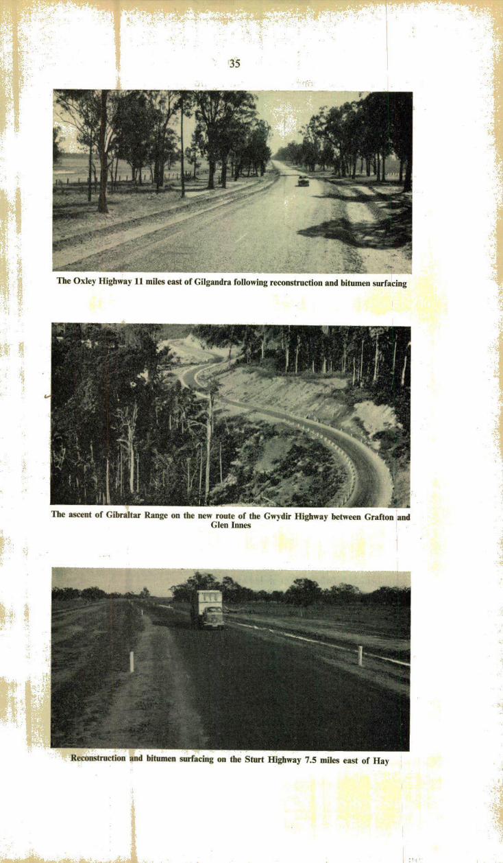
State Highway No. 11—Oxley Highway
On behalf of the Department, Walcha Shire Council completed the work of reconstruction and bitumen surfacing of the length of three miles between Walcha Road at 12-4 miles and Chimney Swamp Creek at 15-4 miles west of Walcha.
Between Mullaley and Coonabarabran the Coonabarabran Shire Council, on behalf of the Department, strengthened and bitumen surfaced a length of one mile between 38 0 miles and 39 0 miles east of Coonabarabran and commenced the work of realignment and reconstruction between 32 0 miles and 38-0 miles east of Coonabarabran, preparatory to bitumen surfacing. Completion of this work will provide a continuous bitumen pavement between Tamworth and Coonabarabran.
Between Belar Creek and Bidden Creek at 500 miles and 13-3 miles east of Gilgandra respectively, the Department continued reconstruction and bitumen surfacing. At the close of the year, lengths totalling 21 miles had been provided with a dustless surface. Reconstruction of the remainder of this section was in hand.
Closer to Gilgandra, the Shire Council completed for the Department the reconstruction and bitumen surfacing of the length between 5 0 miles and Bidden Creek at 13-3 miles, except for the approaches to the new bridge being built over Bulga Creek. (See photograph on page 35).
In Warren Shire, the Council commenced reconstruction, on the Department's behalf, preparatory to bitumen surfacing, of the section 3 0 miles to 7-5 miles approximately from Warren towards Gilgandra.
^ State Highway No. 12—Gwydir Highway
** The new route of the Gwydir Highway between Grafton and Glen Innes was completed and opened to traffic (9th December, 1960). The new road, 73 miles long, leaves the old route of the Highway four miles west of South Grafton and rejoins it 21 miles east of Glen Innes. This road passing through mountainous country is one of the largest individual road projects ever undertaken by the Department of Main Roads. (See photograph on page 35).
Between Moree and Tellarago, Boomi Shire Council completed for the Department, reconstruction between 17 0 miles and 20-2 miles and provided a bitumen surface between 12-21 miles and 20-20 miles.
State Highway No. 14—Sturt Highway
A further 10-9 miles of reconstruction and bitumen surfacing carried out by the Department from Darlington Point westward during the year extended the dustless surface west of Narrandera to 48-9 miles.
The bitumen surfacing by Waradgery Shire Council on behalf of the Department, of a length of four miles between 47 0 miles and 51 0 miles west of Hay, completed the reconstruction and bitumen surfacing of the Sturt Highway between Hay and Balranald.
East of Hay, the Department carried out reconstruction over a length of 19-30 miles and provided a dustless surface over 16-65 miles of this length. (See photograph on page 35.) Reconstruction of a further length of 20 miles towards Narrandera was also in hand by the Department.

37
State Highway No. 16—Bruxner Highway.
Tenterfield Shire Council completed for the Department reconstruction and bitumen surfacing between 16 00 miles and 19-76 miles east of Tenterfield. (See photograph on page 38.) Similar work by Council was also in progress between 22 0 miles and 24 0 miles east of Tenterfield.
State Highway No. 17—Newell Highway
The Department continued the reconstruction and bitumen surfacing of this Highway north of Jerilderie. Reconstruction work, preparatory to bitumen surfacing, was carried out over a length of 19-5 miles to a point about four miles south of Morundah. The bitumen surface on the Highway was extended a further 7-7 miles to a point 32-2 miles north of Jerilderie.
South of Narrandera, reconstruction was carried from 7-0 miles to 13-0 miles and the dustless surface was extended to 9-5 miles.
Reconstruction work and the provision of a dustless surface were completed by Jemalong Shire Council for the Department between 8 0 miles and 12-3 miles south of Forbes.
Continuing the reconstruction of the Highway north of Narrabri, the Department completed the length from 12-0 miles to Edgeroi at 14*8 miles and provided a bitumen surface. North of Edgeroi, through which the Highway had been previously bitumen surfaced, reconstruction between 15-2 miles and 18 0 miles north of Narrabri was completed by the Department.
North of Moree, Boolooroo Shire Council, on behalf of the Department, provided a bitumen surface from 2-68 miles to 6-91 miles.
State Highway No. 18—Castlereagh Highway ,
On behalf of the Department, Gilgandra Shire Council completed the reconstruction and bitumen surfacing of the Highway between 9-35 miles and 16-25 miles north of Gilgandra.
The Department continued the reconstruction and bitumen surfacing of the Highway between Coonamble and Walgett. During the year, the bitumen surface was extended from 140 miles to 240 miles north of Coonamble and reconstruction, preparatory to bitumen surfacing, was in progress to 43 0 miles north of Coonamble. South of Walgett, the Department commenced reconstruction between 4 0 miles and 100 miles.
State Highway No. 19—Monaro Highway
On behalf of the Department, Cooma Municipal Council completed the construction and bitumen surfacing of a deviation of the Highway over a length of about two miles. This eliminated two railway level crossings from the route of the Highway in approach to Cooma.
Between Balranald and Euston, the bitumen surface was extended from 12 0 miles to 29-0 miles east of Euston and substantial progress was made on reconstruction, preparatory to bitumen surfacing between 29-0 miles and 37 0 miles east of Euston. (See photograph on page 38).
It is expected that a bitumen surface will have been provided over the full length of this Highway during the financial year commencing 1st July, 1961. Completion of this work will give a direct fully bitumen-surfaced route from Sydney to Adelaide via the Hume and Sturt Highways.

38
The Sturt Highway between Balranald and Euston where reconstruction and bitumen surfacing are nearing completion
Reconstructed and bitumen surfaced pavement on the Bruxner Highway 17 miles east of Tenterfield
Reconstruction and bitumen surfacing completed east of Bateman's Bay by Eurobodalla Shire Council on the Canberra—Bateman's Bay Trunk Road

39
South of Cooma, Monaro Shire Council completed reconstruction for the Department between 12-0 miles and 15 0 miles and commenced construction of the deviation at Flat Rock between 9-24 miles and 12 00 miles.
State Highway No. 22—-Silver City Highway
Between 18-5 miles and 306 miles south of Broken Hill, a deviation, located so as to avoid watercourses to the greatest possible extent, was completed and bitumen surfaced.
Trunk and Ordinary Main Roads
Details of expenditure on these roads in the country are listed in Appendices Nos. 8 and 8A.
The principal works undertaken during the year were as follows:—
Trunk Road No. 51—Queanbeyan-Batemari's Bay
The Department of Main Roads and the Yarrowlumla, Tallaganda and Eurobodalla Shire Councils are reconstructing this Trunk Road to provide an all-weather dustless route from Queanbeyan to the Coast near Bateman's Bay. The reconstruction generally follows along the line of the old road, but improvements are being effected to curvature, width, etc. throughout the length. The Department has been carrying out by day labour the work required on the more mountainous section of the road over a total length of approximately 21 miles. The remainder of the road work, about 56 miles, is being carried out by the three Councils, mainly by contract. It is anticipated that the whole work including bitumen surfacing will be completed early in 1962 with the exception of a large bridge over the Clyde River at Nelligen, for which a contract was let after the close of the financial year.
East of Queanbeyan, Yarrowlumla Shire Council carried out reconstruction of various lengths by day labour and contract. A total length of 8-8 miles was provided with a bitumen surface, the principal section being between 17-7 miles and 22-4 miles from Queanbeyan.
In Tallaganda Shire, Council had in hand by contract and day labour the reconstruction of lengths totalling 7-3 miles. Bitumen surfacing was completed between 19-5 miles and 22-3 miles west of Braid wood.
In Tallaganda and Eurobodalla Shires, construction of the new formation was completed by the Department between Nelligen Creek and the Mongarlowe River at 7-75 miles and 28 00 miles west of the Prince's Highway respectively. This included a major deviation to avoid two crossings of Currawan Creek west of Nelligen. A dustless surface was provided between 8-50 miles and 12-75 miles from the Prince's Highway.
Between Bateman's Bay and Nelligen at 4-5 miles, Eurobodalla Shire Council carried out reconstruction and provided a dustless surface. (See photograph on page 38.) At the close of the year, Council was carrying out reconstruction over a length of two miles immediately west of Nelligen.
Trunk Road No. 54—Goulburn-Ilford
Reconstruction and bitumen surfacing between 15-6 miles and 16-3 miles south of Bathurst were completed by Abercrombie Shire Council by day labour. North of Bathurst, reconstruction and bitumen surfacing between 12 0 miles and 14-0 miles were completed by Turon Shire Council by day labour and similar work between 140 miles and 15-0 miles was in progress.

40
Parkes—Condobolin Trunk Road near Bogan Gate following reconstruction and bitumen surfacing by Goobang Shire Council
Trunk Road No. 55—Marrangaroo-Mullaley
A further 3-1 miles of reconstruction and bitumen surfacing were completed north of Mudgee by day labour and contract by the Cudgegong Shire Council to extend the bitumen surface to 7-3 miles north of Gulgong. In addition, a total of "85 of a mile of new bitumen surfacing was completed between 12-0 miles and 15-0 miles north of Mudgee on the approaches to four new reinforced concrete box culverts. The provision of a bitumen surface between Mudgee and Gulgong is now complete. South of Coolah, reconstruction between 11-5 miles and 17-6 miles was completed by Coolah Shire Council by day labour and similar work was in hand between 17-60 miles and 22-76 miles.
Trunk Road No. 57—Condobolin-Albury
Lachlan Shire Council substantially completed by day labour, reforming, draining and gravelling between 36-0 miles and 48-0 miles from Condobolin towards Tullamore.
Reconstruction and bitumen surfacing carried out by the Stroud Shire Council between Stroud and Gloucester on the Booral—Taree Trunk Road

41
Trunk Road No. 6\—Orange-Cobar
Goobang Shire Council commenced by contract and day labour reconstruction, preparatory to bitumen surfacing, of the section 5-06 miles to 15 00 miles from Parkes towards Condobolin. Council also completed the reconstruction and bitumen surfacing of the section 20 00 miles to 22-83 miles from Parkes (near Bogan Gate) (see photograph on page 40.) During the year, Jemalong Shire Council placed a bitumen surface on the section 45. 13 miles to 46-80 miles west of Parkes which had been constructed and primed with tar during the previous year. In addition, on the section 37-28 miles to 41-97 miles, construction of 17 concrete box culverts was in progress by contract and Council had commenced construction of several causeways by day labour. This work was being carried out preparatory to surfacing with bitumen. On the section 67-0 miles to 77-0 miles from Condobolin towards Cobar, Bogan Shire Council proceeded by day labour and contract with the work of pavement formation and provision of culverts and causeways. Cobar Shire Council completed reconstruction and bitumen surfacing by day labour and contract between 2-34 miles and 5 00 miles south of Cobar and also a length of -35 of a mile through the village of Nymagee.
Trunk Road No. 62—Scone-Coolah
Scone Shire Council completed by day labour reconstruction, including realignment and bitumen surfacing, between 7-0 miles and 9-4 miles west of Scone.
Merriwa Shire Council completed by contract and day labour reconstruction of the section 26-6 miles to 27-1 miles west of Merriwa and had in hand by day labour the reconstruction, including realignment, of the section from 25 0 miles to 26-6 miles west of Merriwa.
Trunk Road No. 66—Menindee-Broken Hill
Reconstruction and bitumen surfacing were completed by the Department between 12-76 miles and 31-30 miles east of Broken Hill thus providing a bitumen surface over 45 miles of the total length of 69 miles between Broken Hill and Menindee.
Trunk Road No. 63—Tamworth- Yetman
Four railway level crossings were eliminated from the route of this Trunk Road by the construction by Manilla Shire Council of deviations between 13-20 miles and 15-10 miles and between 23-70 miles and 24-65 miles north of Tamworth. Council also reconstructed the length between 9-2 miles and 10-8 miles to give improved alignment. North of Barraba, reconstruction and bitumen surfacing between 3-0 miles and 6-7 miles were carried out by Barraba Shire Council which also had in hand similar work between 6-7 miles and 9 0 miles north of Barraba. South of Bingara, bitumen surfacing of the section between 13-26 miles and 18-08 miles, reconstructed in the previous year, was carried out by Bingara Shire Council. North of Bingara, Council completed reconstruction and bitumen surfacing between 2-21 miles and 6-67 miles. South of Yetman, Ashford Shire Council completed a further length of reconstruction between 6-50 miles and 8-98 miles.
Trunk Road No. 59—Mundowey-Jerilderie
Urana Shire Council reconstructed and bitumen surfaced a length of 6-5 miles from 6-3 miles to 12-8 miles west of the boundary of Lockhart Shire. West of Urana, reconstruction work was carried out on a number of lengths.
42
Trunk Road No. 68—Mungindi-Wentworth
East of Brewarrina, the raising of the road formation over several lengths subject to flooding between 6-0 miles and 17-0 miles was carried out by Brewarrina Shire Council. Between Bourke and Louth, Darling Shire Council formed and gravelled the lengths between 11-8 miles and 16-3 miles and between 17-2 miles and 21-5 miles from Bourke. Council also carried out clearing between 39-5 miles and 49.0 miles from Bourke. Between Wilcannia and Menindee, the Department continued the construction by contract and day labour of a deviation 42 miles in length around the area to be flooded by the Menindee Lakes Water Storage Scheme. During the year, formation work was completed on a further 32 miles of the deviation and gravelling was carried out on selected lengths to facilitate travel in wet weather. North of Wentworth, reconstruction and bitumen surfacing were completed by Wentworth Shire Council by contract and day labour between 0-27 of a mile and 5-43 miles.
Trunk Road No. 72—Willow Tree-Narrabri
Liverpool Plains Shire Council completed by day labour the reconstruction and bitumen surfacing between 10-5 miles south of Gunnedah at Curlewis and 15 0 miles. Namoi Shire Council completed by day labour the reconstruction and bitumen surfacing from 13-5 miles south of Narrabri at Turrawan to 240 miles south of Narrabri at Baan Baa thus completing the bitumen pavement between Gunnedah and Turrawan.
Trunk Road No. 73—Walcha-Inverell
Walcha Shire Council completed by day labour reconstruction and bitumen surfacing of the section from 3-6 miles to 5 0 miles north of Walcha and had in hand the reconstruction, preparatory to bitumen surfacing, of a further section 5-0 miles to 7-5 miles north of Walcha. Uralla Shire Council completed reconstruction from 4-25 miles to 8-25 miles north of Uralla and strengthening and surfacing with bitumen from 47-3 miles to the Guyra Shire boundary at 48-2 miles north of Uralla. Guyra Shire Council completed reconstruction, prior to bitumen surfacing, over King's Gap between 5-38 miles and 7-25 miles north of Bundarra.
Trunk Road No. 74—Armidale-Grafton
Continuing with the work of realignment, reconstruction and bitumen surfacing Dumaresq Shire Council completed work during the year between 22-5 miles and 25-0 miles east of Armidale at Woolomombi. Further realignment and reconstruction were well advanced between 25-5 miles and 26-9 miles at the junction with Trunk Road No. 75. Nymboida Shire Council completed reconstruction and bitumen surfacing by day labour of further sections on the Mountain Pass between 50-55 miles and 55-55 miles from Grafton. Council also completed reconstruction and bitumen surfacing of a short section between 21 -50 miles and 21 -75 miles from Grafton. This work involved a minor deviation and replacement of two substandard timber bridges by concrete culverts.
Trunk Road No. 16—Raleigh-Ebor
Bellingen Shire Council completed reconstruction and bitumen surfacing by day labour between 40-83 miles and 44-10 miles west of the Pacific Highway. This completed the bitumen surfacing of this road within Bellingen Shire. Nymboida Shire Council was reconstructing and bitumen surfacing between 44-10 miles and 48-93 miles west of the Pacific Highway. This is the full length of Trunk Road No. 76 within the Shire.

43
Trunk Road No. 79—Goulburn-Braidwood
Reconstruction between 20-5 miles and 23-5 miles from Braidwood was in progress by Tallaganda Shire Council by day labour. Bitumen surfacing was provided between 19-3 miles and 22-3 miles by contract to Council during the year.
Trunk Road No. 80—Narrandera-Mossgiel
Leeton Shire Council completed reconstruction and bitumen resurfacing of a total length of 2-55 miles by day labour and contract. In Wade Shire, Council completed construction of a deviation about half a mile long approximately six miles west of Griffith. In Carrathool Shire, Council by day labour and contract carried out reconstruction and bitumen surfacing between 1.0 mile and 5.7 miles north-west of Tabbita.
Trunk Road No. 83—Grafton- Woodenbong
I ' A Between 6-73 miles and 8-53 miles north of Grafton, Copmanhurst Shire
Council completed reconstruction and bitumen surfacing by day labour. Between 39-6 miles and 42-9 miles north of Grafton, the Department commenced reconstruction and bitumen surfacing by day labour.
Trunk Road No. 84—Bowning-Temora
Between 15-6 miles and 18-3 miles east of Yass, reconstruction by Goodradigbee Shire Council by day labour and contract was in progress. East of Temora, Narraburra Shire Council completed reconstruction and bitumen surfacing by day labour and contract between 6-3 miles and 11 -6 miles.
fti -tie:'- I
Trunk Road No. %5—Tumut-Jingellic
Tumut Shire Council completed reconstruction and bitumen surfacing of two lengths between 0-26 of a mile and 2-26 miles and 5-23 miles and 8-63 miles south of Batlow by day labour and contract. Tumbarumba Shire Council completed reconstruction and bitumen surfacing of the section 1-53 miles to 5-42 miles north of Tumbarumba, and reconstruction to basecourse stage of the section 12 0 miles to 13-6 miles (at Laurel Hill). The work was carried out by day labour and contract.
Trunk Road No. 87—Coolac-Cootamundra
Jindalee Shire Council completed by day labour reconstruction and bitumen surfacing between 8 0 miles and 11-8 miles south of Cootamundra. The full length of this Trunk Road is now surfaced with bitumen.
! til.
Trunk Road No. 88—Cross Roads-Albion Park
Wingecarribee Shire Council commenced reconstruction by day labour between 0-2 of a mile and 2-0 miles east of Moss Vale. Between 9-10 miles and 11 -40 miles east of Moss Vale, Council completed reconstruction and bitumen surfacing by day labour and contract.

44
Trunk Road No. 90—Booral-Gloucester-Taree
With the exception of short lengths totalling about one mile in the approaches to large structures, a bitumen pavement is now available between Stroud and 5-4 miles north of Gloucester, and for a distance of 15-8 miles west of Taree. (See photograph on page 40.) The length of gravel pavement remaining between Gloucester and Taree was 21 -2 miles. During the past financial year 11-1 miles of bitumen pavement were completed by the Stroud Shire Council and 3-15 miles by Manning Shire Council.
Main Road No. 125—Albury-Urana
With the completion of 4-6 miles of bitumen surfacing north of Burrumbuttock by Hume Shire Council, and 10-1 miles by Culcairn Shire Council, a bitumen surface now exists for practically the full distance between Albury and Rand, only two minor deviations remaining to be done.
Main Road No. 243—Gundagai-Grong Grong
During the year, Illabo Shire Council completed by day labour and contract reconstruction and bitumen surfacing between 11-20 miles and 18-15 miles east of Junee and between 5-8 miles and 12-3 miles west of Junee. Coolamon Shire Council carried out similar work by day labour and contract between 0-22 and 3-22 miles east of Coolamon.
Main Road No. 253—Hartley-Jenolan Caves-Bathurst
The Department continued the reconstruction and bitumen surfacing of the section of this road leading from the Great Western Highway at Hartley to Jenolan Caves. During the year, bitumen surfacing was completed between 2-8 miles and 5 0 miles and between 7 0 miles and 9 0 miles, thus providing a continuous length of bitumen surface to 9 0 miles from the Great Western Highway.
Main Road No. 321—Rankin's Springs-Griffith-Jerilderie
Carrathool Shire Council commenced by day labour reconstruction of a length of three miles southwards from the commencement of this Main Road at the Mid-Western Highway near Rankin's Springs. Between 5 0 miles and 8-0 miles north of Griffith, Wade Shire Council commenced reconstruction work and at the close of the year had provided a bitumen surface over half of this length. North of Darlington Point, Carrathool Shire Council carried out, by contract and day labour, reconstruction and bitumen surfacing between 12-53 miles and 14-28 miles. South of Darlington Point, Murrumbidgee Shire Council completed reconstruction and bitumen surfacing by day labour and contract between 5-0 miles and 7-0 miles.
Main Road No. 387—Temora- Yenda
Narraburra Shire Council completed reconstruction and bitumen surfacing between 3-3 miles and 9-2 miles west of Temora. West of Ardlethan, Coolamon Shire Council commenced construction of a deviation at 4-83 miles adjacent to the Narrandera Shire boundary. This work, in conjunction with similar work to be undertaken by Narrandera Shire Council, will eliminate the railway level crossing at Kamarah from the route of this Main Road. Reconstruction and bitumen surfacing between 0-4 of a mile and 2-8 miles east of Barellan and between 0-2 of a mile and 5-2 miles west of Barellan were completed by Narrandera Shire Council.

Main Road No. 503—Wilberforce-Putty-Singleton
The Department continued its programme of extending the bitumen surfacing of this road and during the year reconstructed and sealed a further 6-25 miles south of Singleton. With the exception of short lengths totalling 16-6 miles, the full length of this road between Wilberforce and Singleton, a distance of 105 miles, has been bitumen surfaced.
Buchanan-Tarro Road
To provide quicker traffic movement between Cessnock and Newcastle, the Councils of these Cities are constructing a new road nine miles long linking Buchanan on the Kurri Kurri-Wallsend Main Road and Tarro on the New England Highway. At the close of the year a gravel pavement had been provided on seven miles of the new road. The cost of the work is being shared by the State Government and the Department of Main Roads.
Developmental Roads
Details of works and expenditure on Developmental Roads and Developmental Works are listed in Appendix No. 9. Reference to these works appears also on page 16 in the General Review Section of this Report.
COUNTY OF CUMBERLAND ROAD CONSTRUCTION
State Highways, Main Roads and Secondary Roads
Details of road construction expenditures in the County of Cumberland in the past twelve months are listed in Appendix No. 7.
The principal works undertaken in the County of Cumberland during the year were:—
State Highway No. 1—Prince's Highway
Restoration of the abandoned tramway area between Cleveland Street and St. Peters was completed by Sydney City Council.
Pavement widening to provide a six-lane divided carriageway between Forest Road and Spring Street, Banksia, was in progress. Between Rocky Point Road and Park Road, Kogarah, reconstruction and pavement widening were also in progress. A kerbed median was provided between May Street, St. Peters and Cook's River; Gertrude Street and Forest Road, Arncliffe; Park Road and King George's Road, Blakehurst; and Townson Street and George's River Bridge.
State Highway No. 2—Hume Highway
Reconstruction and pavement widening from The Boulevarde to Cook's River, Enfield, was in progress. Channelisation of the intersection of the Highway and Waterloo Road, Chullora, was in progress. Pavement widening from the railway overbridge to Rookwood Road, to provide a six-lane divided carriageway, was completed. Between Johnston Road and Woodville Road, Landsdowne, construction of two additional lanes, to provide a six-lane divided carriageway, was also completed. Channelisation of the intersection of the Highway with Scott Street, Liverpool, was completed together with widening of the pavement

to a six-lane divided carriageway between Scott Street and Terminus Street. At Terminus Street and further south at the Cross Roads, construction of channelised intersections was in progress.
State Highway No. 5—Great Western Highway
Pavement widening to provide a six-lane divided carriageway between Raymond Street and Marion Street, Harris Park, and the construction of a divided carriageway between Station Street and Blacktown Road, Pendle Hill, were in progress.
Over various sections of the Highway in Lawson and Woodford where the Blue Mountains City Council had constructed new kerbing and guttering, the Department carried out construction of kerb side lanes and provided a new surfacing with asphaltic concrete from kerb to kerb. The Department commenced reconstruction on an improved alignment over a length of half a mile between Bullaburra and Boddington Hill. Construction of new approaches to the railway underbridge at Leura was commenced by the Department to improve alignment.
State Highway No. 10—Pacific Highway
Pavement widening to provide a six-lane divided carriageway between Highfield Road, Killara, and Bushlands Avenue, Gordon; between Telegraph Road and Turramurra Overbridge and between Duff Street and Pearce's Corner, Wahroonga, was in progress. Construction of a kerbed median zone from Victoria Cross, North Sydney, to Longueville Road, Lane Cove, was completed. Between Pearce's Corner and Hornsby, the Department commenced pavement widening to provide a six-lane divided carriageway. At the intersection of the Highway and Jersey Street, Asquith, construction of a channelised intersection and the provision of new ramps to the railway overbridge were completed.
State Highway No. 13—Woodville Road, Church Street and Pennant Hills Road
Reconstruction and pavement widening to provide a six-lane divided carriageway were in progress between Chiltern Road, Guildford and Merrylands Road, Granville. Channelisation of the intersection of Church Street, Albert Street and Pennant Hills Road at Parramatta North was completed. Full width construction was completed from Isabella Street to Sutherland Road, Parramatta North and from Evans Road to Mobbs Park, Carlingford. Between McArthur Street and Gollan Avenue, Parramatta North, full width construction was also completed by the Baulkham Hills Shire Council on behalf of the Department. On the last mile of Pennant Hills Road to its junction with the Pacific Highway, full width construction was carried out for the Department by Hornsby Shire Council.
Main Road No. 139—Blaxland Road and Beecroft Road
Full width construction between Great North Road and Beattie Avenue was completed for the Department by Ryde Municipal Council, and between Lyne Road and Copeland Road by Hornsby Shire Council.
Main Road No. 154—Bringelly Road
The construction of a deviation from the Great Western Highway via Parker Street, Penrith, was in progress.
Main Road No. 155—Castlereagh Road
Penrith City Council carried out further pavement widening from the Great Western Highway towards Richmond.

Channelised intersection of Military Road and Spit Road at Spit Junction
Restoration of abandoned tramway area and installation of kerbed median in Falcon Street, North Sydney
Pavement widening and provision of kerbed median in Bunnerong Road, Matraville

Main Road No. 160—Old Northern Road
Between Castle Hill and Rogan's Hill, strengthening and pavement widening to provide for four lanes of traffic were carried out by Baulkham Hills Shire Council for the Department.
•
Main Road No. 164—Miller Street, Falcon Street, Military Road, Spit Road, Condamine Street, Pittwater Road, Barrenjoey Road
Channelisation of the intersection of Falcon Street and Merlin Street and of Military Road and Laycock Street was carried out by the North Sydney Municipal Council and Mosman Municipal Council carried out channelisation of Military Road and Spit Road at Spit Junction. (See photographs on page 47.) Restoration of abandoned tramway area between Spit Junction and Parriwi Road was completed by the Mosman Municipal Council and the Department. In Sydney Road between Dudley Street and Angle Street, Balgowlah, pavement widening in cement concrete to six lanes was in progress. Provision of a six-lane divided carriageway at Dee Why Shopping centre was completed and similar work was in progress between Nareen Parade and Namona Street, North Narrabeen.
Main Road No. 165—Victoria Road
Reconstruction and pavement widening to provide a divided six-lane carriageway between White Bay and Iron Cove Bridge were completed. Construction of kerbside lanes from Endeavour Road, West Ryde, to Marsden Road, Ermington was in progress by Ryde Municipal Council for the Department.
Main Road No. 167—Canterbury Road
Reconstruction of the pavement in cement concrete was in progress by Canterbury Municipal Council between King George's Road and Warren Parade, Punchbowl. Reconstruction at the intersection of The River Road and Turvey Street with Canterbury Road, was completed by Bankstown Municipal Council. The work included the provision of traffic islands. Council also had in hand for the Department reconstruction and pavement widening to provide a divided six-lane carriageway between The River Road and Chapel Road.
Main Road No. 171—Bunnerong Road and Anzac Parade
Widening of the pavement to provide six lanes with a kerbed median w a 6 nearing completion between Maroubra Bay Road and Flint Street, Pagewood, and between Perry Street and Bunnerong Creek. (See photograph on page 47).
Main Road No. Ml—Oxford Street
Reconstruction and pavement widening to provide a divided sixlane carriageway between Paddington Town Hall and Centennial Park were commenced.
Main Road No. 177—Queen Street, Campbell town
Reconstruction of the road pavement of Queen Street, Campbelltown, was completed between Broughton Street and Allman Street. Unsatisfactory steep crossfall was eliminated.

Pavement widening and provision of kerbed median in Port Hacking Road near the Prince's Highway, Sylvania
Channelised intersection of Epping Road and Delhi Road, Ryde r65387--t

Main Road No. 191—Lane Cove Road
Ryde Municipal Council completed a deviation of this Main Road between Quarry Road and Bridge Road to link up two sections of Lane Cove Road which replaced the old route via Wicks Road. (See photograph on page 49.) Council also completed the provision of a third lane on this road from Bridge Road to Epping Road.
Main Road No. 194—General Holmes Drive-Ramsgate Road
Kerbing of the median strip with pavement width adjustment between O'Dea Avenue and Grand Parade was completed. Kogarah Municipal Council completed the construction of kerbside lanes between the Prince's Highway and The Promenade.
Main Road No. 227—Port Hacking Road-Kingsway
Construction of a divided six-lane carriageway from the Prince's Highway to Bellingara Road was nearing completion by Sutherland Shire Council. (See photograph on page 49.) Council also completed construction of kerbside lanes on various lengths between Caringbah and Cronulla.
Main Road No. 315—The Boulevarde-Coronation Parade
Reconstruction between Nicholson Street and Redmyre Road was being carried out by Strathfield Municipal Council by contract. Construction of a kerbside lane between the Hume Highway and George's River Road was completed by contract.
Main Road No. 328—Warringah Road
Pavement widening to provide a six-lane divided carriageway between Ryrie Avenue and Maxwell Parade, Forestville, was in progress. Widening of the pavement from Forest Way to Hilmer Street, including Forest Way junction, was completed.
Main Road No. 373—Epping Road
Construction of an additional two lanes of pavement to provide a divided carriageway between Delhi Road and Wicks Road was completed. (See photograph on page 49.) A kerbed median was provided from Centennial Avenue to Fraser Street, Lane Cove.
Main Road No. 395—Lyons Road
Reconstruction of kerbside lanes in concrete from Russell Street to Great North Road was being carried out by Drummoyne Municipal Council by contract.
Main Road No. 400—Military Road-Bradley's Head Road
The restoration of the abandoned tramway area between Middle Head Road and the northern gates to Taronga Zoological Park was completed. From this point to Athol Wharf, Mosman Municipal Council completed reconstruction including restoration of abandoned tramway area, and a bus turning area at the wharf.

Main Road No. 530—Oliver Street
Warringah Shire Council commenced, by contract, the construction of a deviation of this Main Road between Pittwater Road and Oliver Street, Harbord.
Main Road No. 537—Blacktown Road
Pavement widening and strengthening were completed from Richmond for a distance of 2-7 miles towards Rooty Hill. Blacktown Municipal Council had in hand reconstruction and pavement widening from Bell's Creek to Marsden Park.
Secondary Road No. 2014—Bexley Road
Construction of kerbside lanes on sections between Forest Road and Bexley North was completed by Rockdale Municipal Council.
Secondary Road No. 2032— West Botany Street
Construction of kerbside lanes from Prince's Highway to Bay Street was in progress by Rockdale Municipal Council.
BRIDGE AND FERRY CONSTRUCTION
During the financial year 1960-61, 50 new bridges, wholly or mainly financed by the Department of Main Roads were opened to traffic. The bridges are situated generally on Main or Developmental Roads, but several are on unclassified roads at sites where the Department had responsibility. Fourteen bridges were at sites not previously bridged, and 36 were replacements of old bridges. In addition, 63 concrete box culverts having a waterway width of 20 feet or more, and regarded as equivalent to bridges, were completed.
A further 80 bridges were under construction on Main and Developmental Roads at the end of the financial year.
Of the completed bridges 15 were on State Highways, 10 on Trunk Roads, 15 on ordinary Main Roads and 10 on Developmental Roads or unclassified roads. The Department constructed four of the bridges by direct labour and a further 16 were built by contract under the supervision of the Department. The remaining 30 bridges were erected under the supervision of Councils, seven by day labour and 23 by contract.
Two other bridges were constructed on Main Roads by the Water Conservation and Irrigation Commission, one over a new irrigation channel and the other over a creek now used as a drainage channel for an irrigation area. The cost of the former was borne wholly by the Commission, and the cost of the latter mainly by the Department.
Two overbridges were constructed on Main Roads by the Department of Railways which bore seventy-five per cent of the cost, with the Department of Main Roads meeting the remainder.
Of the 63 large culverts constructed, 19 were on State Highways, 18 on Trunk Roads, 22 on Main Roads and four on Developmental Roads and unclassified roads; ten of the total number were built by the Department's forces, 12 by contract under the supervision of the Department, 13 by Council's day labour forces and 28 by contract under the supervision of Councils.

Model of prestressed concrete bridge to be built across the George's River at Taren Point
Artist's impression of concrete bridge to be built across Tarban Creek between the Gladesville and Fig Tree bridges
Artist's impression of bridge proposed to be built later over Middle Harbour at Sugarloaf Point, Castlecrag, on the route of the Warringah Expressway

53
Principal Works Completed during the Year
Narira Creek—State Highway No. I—Prince's Highway
A three-span bridge with a reinforced concrete substructure and prestressed concrete superstructure, 225 feet long, was built by day labour by the Department at Cobargo. The new bridge replaced an old narrow timber beam bridge.
Double Creek—State Highway No. \—Prince's Highway
An eight-span steel and reinforced concrete bridge 451 feet long was built by day labour by the Department at 42-42 miles south of Narooma. The new bridge has a carriageway width of 28 feet and replaced a low-level timber beam bridge subject to flooding. (See photograph on page 55.)
Cook's River—State Highway No. 2—Hume Highway
In conjunction with the widening of the Highway, the Department carried out by day labour the widening from 45 feet to 66 feet of the carriageway of this bridge at Strathfield. An additional footway 5 feet wide was also provided.
Jerrawa Creek—State Highway No. 2—Hume Highway
A four-span reinforced concrete bridge, 100 feet long, was built by the Department by contract. The new bridge replaced an old narrow structure.
Murrumbidgee River—State Highway No. 2—Hume Highway
A footway 606 feet long was added to the main spans of the bridge over the Murrumbidgee River at Gundagai. The work was carried out by the Departme^, by day labour.
Murray River—State Highway No. 2—Hume Highway
On the Hume Highway at Albury, a bridge consisting of three prestressed concrete spans of 100 feet each supported on cellular piers on piles, which was started by contract in 1957, was completed by the Department by day labour. The old timber beam and truss bridge at this site is to be retained for a stock crossing.
Mudies Creek—State Highway No. 9—New England Highway
A five-span prestressed concrete bridge at 4-5 miles east of Singleton was built by the Department by day labour. The new bridge, which is 150 feet long, replaced an old single span timber bridge and raises the road above normal flood level.
Richmond River—State Highway No. 10—Pacific Highway
A new 16-vehicle ferry vessel with steel hull was put into service at Burns Point. The service at peak periods is now operated by two 16-vehicle vessels operated in parallel.

54
Main Creek—State Highway No. 12—Gwydir Highway
A five-span steel girder and reinforced concrete bridge was built by the Department by day labour at approximately 18 miles west of South Grafton. The bridge is 302 feet long and is on the new route of the Gwydir Highway.
Jackadgery Creek—State Highway No. 12—Gwydir Highway
A four-span reinforced concrete bridge with prestressed girder units was built by the Department by day labour. The new bridge is 120 feet long and is 26 miles west of South Grafton on the new route of the Gwydir Highway.
Dandahra Creek—State Highway No. 12—Gwydir Highway
A five-span steel girder and reinforced concrete bridge at approximately 42-8 miles west of South Grafton was built by the Department by day labour. The new bridge is 285 feet long and is situated on the new route of the Gwydir Highway between Grafton and Glen Innes.
Hollingsworth Creek—State Highway No. 16—Bruxner Highway
A three-span high-level steel girder and reinforced concrete bridge was built by Lismore City Council for the Department by contract. The new bridge is 117 feet long and replaced an old timber bridge liable to submergence in time of flood.
Hall's Creek—State Highway No. 17—Newell Highway
The Department built by day labour a four-span reinforced concrete bridge 120 feet long. This bridge, which was constructed on a deviation of the Highway 3-5 miles south of Moree, replaced an old timber bridge on the original route.
Gil Gil Creek—State Highway No. 17—Newell Highway
Boolooroo Shire Council constructed for the Department by contract a seven-span reinforced concrete bridge 24 miles north of Moree. The new bridge is 165 feet long.
Deep Creek—Trunk Road No. 51
A four-span reinforced concrete bridge 100 feet long was built by Yarrowlumla Shire Council by contract. The new bridge replaced a narrow timber bridge on poor alignment.
Colombo Creek—Trunk Road No. 59
At the Urana—Jerilderie Shire boundary the Urana Shire Council built by contract a five-span reinforced concrete and prestressed concrete bridge on driven concrete piles. The new bridge, which is 150 feet long, replaced an old timber bridge.
Coolah Creek—Trunk Road No. 62
A single span Callendar-Hamilton truss bridge at Coolah was built by contract by Coolah Shire Council. The new bridge is 127 feet long and replaced an old timber structure.

Longitudinal sheeting planks, as illustrated above, are being fixed to the decks of timber bridges on Main Roads to improve riding qualities, eliminate noise and reduce maintenance cost
Interconnecting Channel—Trunk Road No. 66
The Water Conservation and Irrigation Commission completed the construction of a steel girder and reinforced concrete bridge 430 feet long over the interconnecting channel between Lake Menindee and Lake Pamamaroo, 8 miles west of Menindee. The bridge was designed by the Department, and the full cost of the work was met by the Water Conservation and Irrigation Commission.
Gwydir River—Trunk Road No. 73
Three reinforced concrete and steel girder spans to replace the old timber beam approach spans to the Bundarra Bridge were built by the Department by day labour. The length of the new spans is 131 feet.
Bendick Murrell Creek—Trunk Road No. 78
A six-span reinforced concrete bridge, 120 feet long, was built by Burrangong Shire Council by contract. The new bridge replaced a causeway.
New steel and concrete bridge over Double Creek north of Bega on the Prince's Highway

56
Goulburn River—Main Road No. 208
The Department built by contract a six-span steel truss and reinforced concrete bridge 576 feet long at Sandy Hollow. The new bridge replaced an old timber truss bridge damaged by floods. (See photograph on page 57.)
Houlaghan's Creek—Main Road No. 243
A four-span reinforced concrete bridge 100 feet long and supported on driven piles was built by Illabo Shire Council by contract. This bridge replaced an old timber structure.
Mirrool Creek—Main Road No. 321
The Water Conservation and Irrigation Commission on behalf of Wade Shire Council built a four-span prestressed concrete bridge at 8-5 miles south of Griffith. The new bridge is 100 feet long and replaced an old timber structure.
Namoi River—Main Road No. 343
Namoi Shire Council built by contract a three-span steel and reinforced concrete bridge 200 feet long at 1 -5 miles west of Wee Waa. The new bridge, which includes one 120 feet steel truss span, replaced an old timber structure.
Port Kembla Rail Line—Main Road No. 568
A six-span steel and concrete bridge, 225 feet long, was built by the Department of Railways to replace the level crossing at this location.
Tangaratta Creek—Developmental Road No. 1034
A five-span reinforced concrete bridge was built by Peel Shire Council by contract at 9 miles from Tamworth. The new bridge is 150 feet long and replaced a worn-out timber structure.
Namoi River—Developmental Road No. 1167
A six-span reinforced concrete, steel and timber bridge was built by Namoi Shire Council by contract at Harparary, 6 miles east of Baan Baa. The new bridge is 396 feet long and replaced an old low-level structure.
Reynold's Bridge—Trunk Road No. 83
Kyogle Shire Council built by contract a seven-span reinforced concrete bridge at approximately 12-5 miles north of Casino. The new bridge is 140 feet long and replaced an old low-level timber culvert subject to flooding from the Richmond River.
Alderley Creek—Trunk Road No. 90
A four-span steel girder and reinforced concrete bridge at 2 miles north of Booral was built by Stroud Shire Council by contract. The new bridge is 180 feet long and replaced an old timber bridge.

57
•
1 J-TT
Steel and concrete bridge over the Goulburn River at Sandy Hollow on the Muswellbrook-Mudgee Main Road
Middlebrook Creek—Developmental Road No. 1233
Nundle Shire Council built by day labour a four-span timber beam bridge at 7 miles from Nundle. The bridge is 103 feet long and eliminated an open crossing.
Bakers Creek—Developmental Work No. 3114
A three-span timber beam bridge 105 feet long was built by Nambucca Shire Council by contract.
Murrumbidgee River at Mundarlo (Tenandra Bridge).
The Department built by contract a ten-span reinforced and prestressed concrete girder low level bridge. The new bridge is 291 feet long and replaced a timber bridge damaged by flood.
Prestressed concrete bridge over the Mann River at Jackadgery on the new route of the Gwydir Highway between Grafton and Glen Innes

Bundaburrah Creek at Turner's Crossing
Jemalong Shire Council built by day labour and contract a composite steel and concrete bridge 631 feet long. Four spans of the old Iron Cove Bridge were used in the construction of this bridge which spans a previously unbridged crossing and will provide access from the south to Forbes in times of flood.
Principal Works in Progress at Beginning of Year and not Completed
Cook's River at Tempe—State Highway No. 1—Prince's Highway
A new contract was let by the Department for the construction of a prestressed concrete bridge 300 feet long with a carriageway width of 60 feet and two footways, and work was commenced. This followed the termination of an earlier contract for the construction of the bridge. The bridge will replace an old three-lane timber beam structure which is inadequate for traffic requirements.
Black Creek—State Highway No. 9—New England Highway A four-span steel and concrete bridge at 1-5 miles west of Branxton is
being built by the Department by contract. The new bridge is 229 feet long and will replace an old timber beam bridge. Completion was delayed by steel shortage.
Bluff River—State Highway No. 9—New England Highway
The Department is building by day labour a five-span reinforced concrete bridge at 10-77 miles south of Tenterfield. The new bridge is 260 feet long and will replace an old timber bridge.
Ironbark Creek—State Highway No. 10—Pacific Highway
Duplicate four-span steel girder and concrete bridges, each to carry two lanes of a divided carriageway, are being built by the Department by contract. The new bridges are 512 feet long and will replace a temporary two-lane structure. Work was delayed by steel shortage.
Hastings River—State Highway No. 10—Pacific Highway
A new seventeen-span bridge, comprising seven steel truss spans, including a possible future lift span, and ten plate girder spans is being built near Port Macquarie by the Department by contract. This bridge when completed will be 1535 feet in length and will replace the existing ferry service at this location.
Mann River—State Highway No. 12—Gwydir Highway
A nine-span prestressed concrete bridge 938 feet long was being built by the Department by contract at Jackadgery. The new bridge is on the new route of the Gwydir Highway between Grafton and Glen Innes and replaces a low-level timber structure. (See photograph on page 57.)
Richmond River—State Highway No. 16—Bruxner Highway
A ten-span steel truss and girder and reinforced concrete bridge is being built by the Department by contract at Ballina Street, Lismore. The new bridge is 688 feet long and is located on the new route of the Bruxner Highway through Lismore.

Erecting falsework for the concrete arch bridge being built over the Parramatta River at Gladesville
Prestressed concrete beam bridge in course of erection over the Parramatta River at Silverwater

Camp Creek—State Highway No. 16—Bruxner Highway
Ashford Shire Council is building by contract a four-span timber beam bridge at 8-1 miles north of Texas. The new bridge will be 100 feet long and will span a previously open crossing.
Pine Creek—State Highway No. 22—Silver City Highway
The Department is building by contract a ten-span steel girder bridge 400 feet long at 30 miles south of Broken Hill.
Billabong Creek—Trunk Road No. 61
A three-span composite steel and concrete bridge 171 feet long was being built by the Department by contract. The new bridge is located on the boundary between Parkes Municipality and Goobang Shire and will replace an old timber structure.
Stephens Creek—Trunk Road No. 66
The Department is building by contract a ten-span steel girder bridge 32 miles east of Broken Hill at Quondong. The new bridge is 400 feet long and will replace an old timber beam bridge.
Menindee Billabong—Trunk Road No. 68
A four-span steel girder bridge is being built by the Department by contract 6 miles south of Menindee. The new bridge will be 160 feet long and will replace an old timber structure.
Baker's Creek—Trunk Road No. 74
Dumaresq Shire Council is building by contract a five-span reinforced concrete and steel bridge to eliminate an open crossing at 15-5 miles east of Armidale. The new bridge will be 225 feet long. Work was delayed by steel shortage.
Sandy Creek—Trunk Road No. 83
Tomki Shire Council is building a four-span reinforced concrete bridge 120 feet long at approximately 11-6 miles south of Casino. The work is being done partly by day labour and partly by contract, and the bridge will replace a timber structure.
Little Murray River—Main Road No. 119
A four-span low-level timber bridge with concrete substructure is being built at 7-06 miles west of Dorrigo by Bellingen Shire Council by day labour. The bridge will be 144 feet long and will replace a timber structure destroyed by flood.
Boor along Creek—Main Road No. 124
Uralla Shire Council was building by contract a six-span reinforced concrete and steel bridge 270 feet long 16 miles west of Armidale. This bridge will eliminate an open crossing.

Moredun Creek—Main Road No. 135
Guyra Shire Council has constructed by day labour an eight-span timber beam bridge 243 feet long. Construction of approaches has not yet been completed. The new bridge is on the Guyra-Tingha Section of this road and replaces an old timber structure.
Doon Doon Creek—Main Road No. 142
A three-span steel girder and reinforced concrete bridge 170 feet long is being built by Tweed Shire Council by contract at 39-9 miles north of Lismore to replace a timber structure destroyed by floods.
Parramatta River at Gladesville, Sydney—Main Road No. 165
The construction by contract to the Department of the new concrete arch bridge continued during the year. The total length of this bridge is 1,900 feet, with a main span consisting of a concrete arch 1,000 feet long, and has a carriageway width of 72 feet with two footways. The bridge will replace the existing old two-lane steel truss bridge with opening span. (See photograph on page 59.) M •
Lane Cove River, Fig tree, Sydney—Main Road No. 166
The construction by contract to the Department of a steel girder and concrete bridge 749 feet long with carriageway 48 feet wide and one footway was continued. The new bridge will replace an old narrow 2-lane steel girder structure. (See photograph on page 59.)
Mangrove Creek—Main Road No. 225
A five-span prestressed concrete girder bridge 283 feet long is being built by Gosford Shire Council by contract to replace an old timber structure at this location.
Macquarie River—Main Road No. 347
The Department is building by contract a four-span composite steel and concrete bridge with two Callendar-Hamilton truss spans at Gin Gin near Trangie.
The new bridge will be 329 feet long and will replace an old timber structure.
Parramatta River at Silverwater, near Rydalmere—Main Road No. 532
The construction by contract to the Department of a prestressed concrete beam bridge 652 feet long with dual carriageways each 26 feet 6 inches wide, median strip 6 feet wide and two footways, was continued. This bridge will provide an additional crossing of the Parramatta River and will link the industrial areas on the south to the residential areas on the north side of the river. (See photograph on page 59.)
Murrumbidgee River—Developmental Work No. 3096
A ten-span low-level timber beam bridge 343 feet long is being constructed at Jugiong by Demondrille Shire Council by contract.

Darling River at Tilpa
The Department is building by contract a steel girder, steel Callendar-Hamilton truss and reinforced concrete bridge 407 feet long to replace a ferry at this location.
Principal Works Commenced during the Year but not Completed
Shadrack's Creek—State Highway No. 1—-Prince's Highway
A three-span steel and concrete bridge 116 feet long is being constructed by the Department by day labour. The new bridge will replace an open crossing at 3 miles south of Eden.
Wingecarribee River—State Highway No. 2—Hume Highway
The Department is building by contract a three-span reinforced concrete bridge at Berrima. The bridge is 238 feet long and will replace an old timber structure.
Muttama Creek—State Highway No. 2—Hume Highway
A six-span steel girder and reinforced concrete bridge is being built at Coolac by the Department by contract. The new bridge is 310 feet long and will replace an old single-lane timber structure.
Eastern Creek—State Highway No. 5—Great Western Highway
The Department is building by contract a three-span steel and concrete bridge 120 feet long to replace an old structure at this location.
Evans Plains Creek—State Highway No. 5—Great Western Highway
The Department is building by day labour a five-span prestressed concrete girder bridge at Dunkeld. The new bridge will be 227 feet long and will replace an old narrow timber structure.
Sandy Creek—State Highway No. 9—New England Highway
A three-span steel and concrete bridge 147 feet long is being built by the Department by day labour about 2 miles north of Muswellbrook. The new bridge replaces a single-lane timber structure.
Ourimbah Creek—State Highway No. 10—Pacific Highway
A three-span steel and concrete bridge 135 feet long is being constructed by the Department by contract to replace a single-lane timber bridge. The contract also includes two culverts in the approaches and one at Windy Drop Down Creek about 200 yards north of the new bridge.
Fernbank Creek—State Highway No. 10—Pacific Highway
The Department is building by contract a six-span steel and reinforced concrete bridge 343 feet long over a flood channel in the approach to the new bridge over the Hastings River.

Balickera Channel—State Highway No. 10—Pacific Highway
The Department is building by contract a three-span prestressed concrete deck bridge 115 feet long over the new water supply channel under construction by the Hunter District Water Board about 8 miles north of Raymond Terrace. The cost of the structure is being met by the Board.
Richmond River—State Highway No. 10—Pacific Highway
An eight-span prestressed concrete bridge 736 feet long, including a 83 feet steel vertical lift span, to replace the Burns Point Ferry at Wardell near Ballina is being built by the Department by contract.
Upper Warrell Creek—State Highway No. 10—Pacific Highway
The Department almost completed by day labour the construction of a four-span steel and reinforced concrete bridge 192 feet long at 33-3 miles north of Kempsey. The new bridge replaces an old timber structure.
Bonville Creek—State Highway No. 10—Pacific Highway
A four-span steel girder and reinforced concrete bridge 180 feet long at 32-2 miles north of Macksville is being constructed by the Department by contract to replace an old timber structure.
Ten Mile Creek—State Highway No. 17—Newell Highway
A five-span reinforced concrete and steel bridge 192 feet long is being built by the Department by contract 20 miles north of Narrabri to eliminate an open crossing.
Brick Kiln Creek—State Highway No. 21—Cobb Highway m
The Department is building by contract a seven-span reinforced concrete bridge with prestressed girders. The bridge is 210 feet long and replaces an old timber structure.
Cabbage Tree Creek—Trunk Road No. 51
A four-span reinforced concrete bridge 156 feet long using prestressed concrete girders is being constructed by the Department by day labour 16 miles from the Prince's Highway.
Smith's Rivulet—Trunk Road No. 62
The Department is building by contract a three-span reinforced concrete prestressed girder bridge 300 feet long at Merriwa. The new bridge will replace a worn-out timber bridge.
Hunter River—Main Road No. 101
An eight-span plate web girder and concrete deck bridge 643 feet long is being built by the Department by contract at Maitland (Belmore Bridge). The new bridge is just upstream of the old Belmore Bridge, which it will replace.

Dingo Creek—Main Road No. 109
Manning Shire Council is building by contract a three-span reinforced concrete and steel bridge, 180 feet long to replace a low-level timber bridge at Rocky Falls.
Muddy Lake—Main Road No. 217
Lake Macquarie Shire Council is building by day labour a four-span precast prestressed concrete girder bridge 100 feet long at one mile north of Dora Creek. The new bridge will replace an old timber bridge.
Wallis Creek—Main Road No. 223
A three-span steel and concrete bridge 136 feet long is being constructed by Greater Cessnock City Council by contract. The bridge will replace an old timber structure.
Gilmandyke Creek—Main Road No. 252
Abercrombie Shire Council is building by contract a three-span prestressed concrete bridge 105 feet long to replace an old timber bridge at this location.
Gilmore Creek—Main Road No. 279
A bridge of five concrete slab spans supported on driven piles is being built by contract by Tumut Shire Council. The new bridge is 125 ft. long and replaces an old low-level timber bridge.
Erina Creek—Main Road No. 336
The Department is building by contract a three-span steel and concrete bridge 136 feet long to replace an old narrow timber structure at 1-5 miles from Gosford.
Big Jack's Creek—Main Road No. 358
A five-span reinforced concrete bridge 150 feet long is being built by Murrurundi Shire Council by contract to eliminate an open crossing at 9-6 miles from Willow Tree.
Parramatta River at O'Connell Street, Parramatta (Rings Bridge)
Construction by contract to the Department was commenced on a new prestressed concrete bridge 300 feet long with a carriageway width of 28 feet and one footway. The bridge replaces an old, narrow timber truss bridge over the river in the City of Parramatta.
Darling River at Pooncarie
A five-span steel girder, steel Callendar-Hamilton truss and reinforced concrete bridge 314 feet long is being built by the Department by contract to replace a ferry at this location.

65
The distribution of these mileages over the various classes of Main Roads is as follows:—
Nature of Work State Highways
Other Main Roads
Declared Secondary
Roads Total
183 399 1 583
2. Bitumen resurfacing—
(b) Plant mix resurfacing 240
13 211
23 1 4
452 40
3. Restoration of bitumen surface on pavements after reconstruction 53 37 1 91
4. Tar priming or light sealing 57 48 .... 105
Totals 546 718 7 1,271
MAINTENANCE OF ROADS
Country Main Roads
Favourable weather conditions prevailed in most of the State during the year, and Main Roads were able generally to be maintained in a satisfactory condition. However, heavy rains experienced in the southern and south-eastern areas of the State caused difficulties. In some inland areas maintenance of smooth riding on gravel pavements could not be achieved under dry conditions existing there. Some Main Roads in the Bourke-Brewarrina area were affected by flood waters brought down by the river systems from Queensland and also by localised heavy rain when 10 inches fell during three days.
An earth tremor on 22nd May, 1961, caused a heavy fall of rock on Trunk Road No. 88—Macquarie Pass—near Robertson. Traffic was unable to use the road for one week. Remedial work included the blasting away of the unstable rock base and the construction of cemented stone retaining walls.
The rapid increase during recent years in the number of vehicles using some Main Roads has caused deterioration of the edges of the narrower bituminous pavements, and in consequence increased costs for the maintenance of shoulders. Only in isolated cases has it been possible to provide for the widening of narrow bitumen pavements. Cement stabilised loam and gravel are often used for patching the damaged edges of bituminous sealed pavements, and have proved generally successful and economical.
p 65387—5
BITUMEN SURFACE TREATMENT
The total length of bitumen or other dustless surface on the Main Roads system as at 30th June, 1961, was 8,987 miles.
Bitumen or tar surface treatment was carried out during the year by Councils and the Department on a total of 1,271 miles of Main Roads. This work comprised:—
(i) Initial bitumen surfacing of 583 miles of road pavement. (ii) Re-surfacing of 492 miles of existing bitumen surfaced roads. (iii) Restoration of the bitumen surface on 91 miles of road pavement
which had been reconstructed following deterioration of an earlier similar surface.
(iv) Priming or temporary light tar sealing of 105 miles of road surface preparatory to bitumen and stone aggregate surfacing later.

Some reconditioning of bitumen surfaced pavements was carried out by surface enrichment with bitumen emulsion. In some instances where aggregate in the surface of bituminous pavements had become slippery, due to the polishing action of traffic, spraying with petroleum tar and covering with sand were carried out as a corrective.
On the north coast the grassed shoulders of the heavily trafficked Pacific Highway were mowed regularly to preserve the full width of the carriageway for traffic. In this and other districts grass in some instances was cut back by grading the shoulders. Chemicals have been used for growth retardation and sterilisation alongside protection fencing and guide posts.
Bituminous pavements in the country are mainly of the flush seal type. On the more heavily trafficked roads close to the Sydney metropolitan area and in the Wollongong and Newcastle areas, bituminous concrete in a thin layer is increasingly used as a more durable alternative to the flush seal, and one that can be applied with less inconvenience to traffic.
County of Cumberland Main Roads
Main Roads in the County of Cumberland were maintained in a satisfactory condition during the year. Maintenance was carried out both by the Department's own organisations and by Councils on behalf of the Department.
One of the principal features of Main Road maintenance in the metropolitan area is periodical pavement light re-sheet with bituminous concrete. The output of dense graded bituminous mixtures from the Department's modern plant at Granville again exceeded the outputs of previous years. A total of 140,000 tons was produced, partly for construction work and partly for maintenance work. Deliveries were made to nearer areas in the Central, Lower Northern and Illawarra Divisions as well as throughout the Metropolitan Division. Strict laboratory control of the quality of the mix was maintained.
SYDNEY HARBOUR BRIDGE MAINTENANCE
Painting
During the year steelwork to a total area of 120,000 square yards was painted. Most of this was normal two-coat work, but isolated sections were cleaned and primed with red lead in addition. The area completed represents about 20 per cent of the total, which is 586,400 square yards, or 121 acres.
The current repainting, which is the bridge's third since its opening in 1932, is expected to be completed within the next twelve months.
Steelwork
Normal maintenance, checking and testing of steelwork members, rivets, expansion joints, cranes, lifts, etc., continued during the year.
Work is in progress on the provision of steel rigging brackets on the outer stringers (eastern side) of both the north and south approach spans. These brackets will permit the erection of stages for the maintenance of areas rendered temporarily inaccessible by the recent conversion of the tramway area to roadway.

Reconstruction of Footways
The eastern footway deck was reconstructed in concrete during the year and similar work on the western footway was commenced.
Electrical Work
The re-wiring of all the main circuits on the bridge was completed.
Floodlighting of Bridge
The Department engaged a firm of consulting engineers to advise it on the flood lighting of the eastern face of the main arch span and pylons. Following tests, a scheme of lighting comprising 176 individual lights with beams directed along the various members was adopted and the installation was commenced.
Steam Cleaning Pylons and Piers
A contract was let for the steam cleaning of the 34,000 square yards of granite facing of the pylons and piers. This is the first cleaning since the bridge was opened in 1932, and is successfully restoring the original fight grey appearance. Altered conditions on the bridge, including the removal of trams and the elimination of iron brake-shoe dust from trains will reduce the tendency to further staining of the stonework.
Traffic Facilities
During the year, 1,437 disabled vehicles were removed from the bridge, its approaches, and the Cahill Expressway. Details of breakdowns were as follows:—
Cause Week days Week-ends Total Percentage Lack of petrol 464 123 587 41-0 Mechanical breakdown 517 126 643 44-7 Flat tyres 108 39 147 10-2 Accidents 41 7 48 3-3
Abandoned vehicles 10 2 12 0-8
Totals 1,140 297 1,437 1000
The radio telephone equipment, installed to allow immediate communication between the police and tow trucks for the expeditious removal of disabled vehicles from the bridge, has also proved a valuable aid in directing police to the scenes of accidents or hold-ups, and enables the police to advise the base station immediately if an ambulance is required.
i
RAILWAY LEVEL CROSSINGS ON MAIN ROADS
Elimination of Level Crossings
During the year, fourteen railway level crossings were eliminated from Main Roads.
Two level crossings on the Monaro Highway (State Highway No. 19) at 1*0 and 2-0 miles north of Cooma, were eliminated from the Highway by a deviation constructed at full cost to the Department.

68
Three crossings on the Tamworth-Barraba section of Trunk Road No. 63, one at 24-4 miles north of Tamworth, and two at 13-4 miles and 14-4 miles north of Manilla were eliminated by deviations, the cost of which was shared by Councils and the Department.
A level crossing on Castlereagh Road (Main Road No. 155) at West Penrith was eliminated by construction of an underpass, the cost of which was shared by the Department of Railways and the Department of Main Roads.
Two level crossings on the Wee Waa-Burren Junction Road (Main Road No. 343) at 1 -2 miles and 1 -8 miles west of Wee Waa were eliminated from the Main Road by construction of a deviation, the cost of which was shared by Council and the Department.
A level crossing on Springhill Road, Wollongong (Main Road No. 568) a short distance south of Coniston railway station has been eliminated by two six-lane overbridges on the new route of the road. This work was part of the Port Kembla Inner Harbour works and the Department met a quarter of the cost.
Four crossings on Main Road No. 234 between its junction with the Mitchell Highway (State Highway No. 7) and Cumnock have been eliminated from the Main Road by re-routing the Main Road to other existing roads.
A crossing of the Wagga Wagga-Holbrook Road (Main Road No. 211) at Mangoplah is no longer in use by rail traffic following closure of the Mangoplah-Westby section of the The Rock-Westby Branch railway line.
At the end of the year, there were 457 railway level crossings on Main Roads throughout the State, comprising 382 on New South Wales Government railways, 62 on privately-owned railways, and 13 on Victorian Government railways.
A total of 103 railway level crossings have been eliminated from Main Roads since the Main Roads Act came into effect in 1925.
Improvement of Safety Conditions at Level Crossings
During the year, improvements were effected by the Department and Councils at a number of level crossings with a view to providing increased safety. Such improvements often involved a minor deviation of the road and re-location or widening of the crossing, to permit realignment of the road approaches and so provide better visibility of approaching rail traffic.
With a view to the improvement of level crossing protection by relatively inexpensive means, a trial is being made at several crossings of the use of signs additional to those provided for in the Australian Standard Road Signs Code. From comment so far received it appears that the additional warning, consisting of reflectorised width markers and reflectorised " Railway " and Crossing signs, gives an improved indication of the position of a level crossing, and particularly, of the width available to road traffic at the crossing.
The Department of Railways had installed automatically-operated flashing light signals and warning bells at the level crossing at Toronto on Main Road No. 317. The cost of this work was met in the first instance from the Level Crossing Fund and later recouped by the Railway Department to the extent of one-third of the cost and Council and the Department of Main Roads to the extent of two-thirds of the cost. In two cases of crossings over privately-owned railway lines—one on the Pacific Highway at Hexham and one on the Silver City Highway in Broken Hill—the owners have installed flashing light signals and warning bells.

69
TRAFFIC SERVICE
Action taken by the Department during the past year, either directly or in co-operation with Councils or other Departments, to provide for or promote the safer and more convenient movement of traffic on Main Roads included:—
Bus Stops
Additional bus bays have been provided on Main Roads not paved full width between kerbs so that buses may stop clear of moving traffic. Seventy-three bus bays were constructed on Metropolitan Main Roads which included Mona Vale Road, Forest Road, Pittwater Road, Epping Road and Windsor Road. Sixteen bus bays were provided on Main Roads in Newcastle and Wollongong.
Trunk Climbing Lanes on Hills
To facilitate overtaking on hills of slow vehicles such as semi-trailers and towed caravans, a third lane was added to the existing two lane pavement on a number of hills on the Hume and Pacific Highways. Much more of this type of work is required.
Median Strips
Further lengths of narrow (3 feet wide) kerbed median strips were constructed during the year on heavily trafficked six-lane roads which were originally designed as undivided roads. Except for a length on the Pacific Highway in Belmont, all the work done was in the County of Cumberland, and was situated on State Highways, on General Holmes Drive and on Epping Road. (See photographs on pages 47 and 49.)
Warning Signs
Action is being taken to replace all remaining old type warning signs on Main Roads throughout the State, (i.e. not reflectorised or those studded with catseye reflectors) with modern retro-reflective type signs.
Advisory Speed Signs
The use of " Advisory " speed signs at curves on State Highway No. 2 (Hume Highway) between Camden and Berrima has resulted generally in a reduction of accidents on this section of road.
These signs have now been erected on the following lengths of important road:—
State Highway No. 2—Hume Highway—From Cross Roads near Liverpool to the Federal Highway (south of Goulburn).
State Highway No. 3—Federal Highway. State Highway No. 4—Snowy Mountains Highway—From Cooma to
Adaminaby. State Highway No. 10—Pacific Highway—From Mt. Colah to
Hawkesbury River Bridge. State Highway No. 19—Monaro Highway—From A.C.T. to 9M. south
of Cooma. Main Road No. 286 —From the Snowy Mountains Highway to
Jindabyne.
70
Marking of Lanes on Wide Roads
About 100 miles of lane lines have now been painted in the County of Cumberland. These have generally been restricted to sections of State Highways and Main Roads where medians have been provided, at intersections having speed change lanes and on hills with climbing lanes. An additional 70 miles of lane lines are scheduled for painting in the Sydney Metropolitan area.
Channelisation of Intersections
A total of 25 intersections was channelised during the year by means of traffic islands. The major items were:—
State Highway No. 1—Prince's Highway—at the intersection with the Arterial Road at 52-1M. from Sydney.
State Highway No. 1—Prince's Highway—at the intersection with Main Road No. 295 at 54.64M. from Sydney.
State Highway No. 2—Hume Highway—at the intersection with Scott Street, Liverpool.
State Highway No. 5—Great Western Highway—at the intersection with Castlereagh Street at Penrith.
State Highway No. 10—Pacific Highway—at the intersection with Jersey Street at Asquith.
State Highway No. 13—Church Street and Macquarie Street, and channelisation for a progressive signal system in Church Street, Parramatta.
State Highway No. 13—Church Street—Pennant Hills Road (Main Road No. 184) and Albert Street, North Parramatta.
Main Road No. 164 —Military Road and Spit Road, Spit Junction. (See photograph on page 47).
Main Road No. 165 —Victoria Road and Commercial Road, Rozelle. Main Road No. 167 —Canterbury Road, Milperra Road, The River
Road, Turvey Street, Bankstown. Main Road No. 373 —Epping Road, Longueville Road (Main Road No.
166) and Parklands Avenue, Lane Cove.
In addition, work has commenced on the construction of traffic islands at three other intersections. Designs have been approved for another forty-eight and six others have been laid out in temporary materials and are under observation.
Surveys have been made with a view to erecting " Advisory " speed signs on the following further lengths:—
State Highway No. 1—Prince's Highway—Sydney to Wollongong. State Highway No. 2—Hume Highway—From the Federal Highway to
Yass. State Highway No. 4—Snowy Mountains Highway—Adaminaby to
Kiandra. State Highway No. 5—Great Western Highway—Sydney to Bathurst. State Highway No. 10—Pacific Highway—Hawkesbury River Bridge to
Gosford. Main Road No. 184 —Windsor Road—Parramatta to Mt. Victoria. Main Road No. 516 —Bell to Lithgow.

Accident Analysis and Investigation
Quarterly statements, for twelve months up to 31st March, 1961, of accidents on all State Highways and on Main Roads within the County of Cumberland were received from the Department of Motor Transport. This information is proving to be of considerable value in the investigation of the relationship between road conditions and accident rates. Accident information for State Highways lying outside the County of Cumberland has been compared with traffic volumes and a relationship between volumes and accident rates has been established. Several sections of road have been pinpointed as having apparently higher accident rates than average and these are being investigated in detail.
As in the past, locations or sections of road where accidents have occurred which may be partly attributable to road conditions have been investigated and appropriate steps taken to minimise future accident occurrence.
Width Markers on Bridges
With a view to minimising the risk of vehicles hitting handrails on narrow bridges the Department has made some trial installations of width marker boards, the purpose of which is to provide better delineation of the bridge structure and the width available to traffic. The marker boards are 36 in. high by 18 in. wide with black and white diagonal stripes. The white stripes are reflectorised. The trials are continuing with a view to adoption of a standard type of width marker.
Marking on Low Clearance Underpasses
The Department has in the past erected signs indicating the clearance available at road underpasses of railways where the vertical clearance is 15 feet or less. In conjunction with the Department of Railways the Department is now testing various methods of marking the face and underside of underpasses with a view to better delineation of the clearance available. Tests are in hand at the following locations:—
State Highway No. 5—Great Western Highway—at Leura. Minimum clearance 14 ft. 8 in.
Trunk Road No. 55—at Wallerawang. Arch bridge—clearance varies between 15 ft. 9 ins. and 9 ft.
Main Road No. 255 —at Tarana. Arch bridge—clearance varies between 13 ft. and 8 ft.
Main Road No. 315 —at Strathfield—clearance 14 ft. 6 ins. Main Road No. 574 —at Dundas—clearance 12 ft. 8 ins.
At the underpass on State Highway No. 9 at Muswellbrook where the clearance varies from 12 ft. to 12 ft. 6 ins. arrangements have been made for neon signs, stating the available clearance, to be erected to supplement existing advance warning signs and markings on the railway bridge face.
Publication of Road Signs Code
During the year the Standards Association of Australia published a revised edition of the Road Signs Code. This publication resulted from a long and close review, by Committees with wide representation, of the existing and desirable practices for signing and marking roads. Apart from representation on the Committees, the Department assisted by providing drawings for a number of

72
signs. The Department will conform to the recommended Code of practice with few minor exceptions, but regards the stated sizes of signs as a minimum and where considered advisable will provide larger signs.
Co-operation in Traffic Matters
The Department was represented during the year at a number of conferences with the Police and other Departments on matters of mutual concern affecting the safety and efficient movement of traffic on Main Roads. Solutions to many traffic problems resulted from these conferences. The working party, set up by the City of Sydney Roadways Planning Conference to examine a Police plan for improvement of traffic movement in the central business area of the City of Sydney, continued its operations during the past year. Departmental officers were included in this working party.
MATERIALS TESTING AND RESEARCH
Divisional and Field Testing
The number of samples tested during the year in the Department's country laboratories increased from 37,769 to 39,982. Tests for outside bodies and persons included in these figures, numbered 333.
New divisional laboratories were opened at Tamworth and Broken Hill; a small laboratory for testing of hot mix was established at Mittagong. A laboratory was established adjacent to the new arch bridge under construction at Gladesville for the testing of high class concrete associated with prestressed concrete work. A mobile laboratory of a size suitable for towing behind a utility truck was put into use in the Lower Northern Division for field testing.
Determination of moisture content of soils and aggregates is now undertaken in the field by saturating the soil or aggregate sample with methanol and drying by burning until the weight is constant.
A pan type concrete mixer was installed at Gladesville bridge laboratory for the mixing of batches of concrete for experimental purposes. A more uniform mix is achieved with this type of mixer than with the drum type.
Central Laboratory
Like Divisional laboratories, the Central Testing Laboratory undertakes routine tests on soils, gravels, aggregates and concrete. In addition it undertakes routine tests on bitumens, steels, paints, tar cement and oils, special tests on a variety of substances supplied under contract to the Department such as the glass beads used in traffic lines and tests on new types of materials to determine whether they may have a use in the Department's works.
The number of tests undertaken last year at the three metropolitan laboratories, Central Testing, Metropolitan Maintenance Depot at Rosehill and the concrete laboratory at Gladesville Bridge, was 18,674 as against 9,445 in the previous year. Tests for outside bodies and persons amounted to 1,126. During the year 4,866 concrete cylinders were crushed at Gladesville and 5,344 at Central Laboratory, a total of 10,210.
New items of equipment installed last year in the Central Testing Laboratory include an automatic ductility machine which replaced a 30-year old manual one, three extensometers for strand, rod and creep testing, a Metier K7 electric balance, a pH meter, a battery-operated sensitive thermometer for taking quick temperature readings on road and other surfaces, a one inch and three inch diameter diamond core drill and two recording hygrometers.

73
Research
Principal investigations in progress during the year included the following:—
Bitumen
Laboratory work required in association with the review of D.M.R. form 466, Fluxing of Binders, has proceeded. A new fluxing chart for R90 bitumen fluxed with kerosene has been prepared. Other studies included the effect of anti-foaming compounds on the properties of bitumen, the stripping properties of aggregates and preparation of specifications for petroleum tars.
Tests were undertaken to check the rate of evaporation of kerosene from R90 bitumen fluxed with kerosene. Evaporation was found to be reasonably rapid in the first 24 hours after mixing but thereafter, the rate slowed down and at the end of 40 days, approximately 40 per cent of the kerosene was still present in the bitumen.
Bitumen Aggregate Mixtures
Tests extending over three years were completed during the year for the purpose of comparing the density of bituminous mixes developed under traffic with densities developed in the laboratory. The results showed that laboratory compaction is not sufficiently severe to achieve the density ultimately obtained in a road under traffic compaction. Samples taken from the road at various times during the trials showed that a bituminous mix is relatively open after it is laid and rolled but that traffic closes the surface pores quickly and after the following summer the voids are reduced by 40 to 60 per cent. Over the next two years there is a gradual decrease in voids under the action of traffic.
Another series of laboratory tests showed that the degree of compaction achieved in bituminous mixes was the same whether the material was allowed to cool and be reheated before compaction or whether it was compacted while hot. This is important as the voids in a mix after laboratory compaction are taken as an indication of the suitability of the mix and if a delay in compaction was critical in determining the voids, a more rigid method of control would have to be installed.
Soil Stabilization
During the year two extensive investigations were completed into the stabilizing of soils using lime and lime-fly ash mixtures. The results from the lime tests showed that it was possible to reduce the plasticity of certain clays, black soils and pavement materials.
Tests using lime-fly ash mixture on a number of clays and plastic surface course gravels were promising. The use of fly ash as an ingredient in stabilizing work often enables the amount of lime to be reduced and still the same soil strength to be achieved. Field trials using lime-fly ash mixtures were considered to show that Sydney clay can be stabilized and that the depth of clay so treated may be regarded as equivalent to pavement, and the depth of imported pavement material required correspondingly reduced.
As well as plastic materials lime-fly ash mixtures have been used to stabilize silts and to bind fine sands.
Steel Strand
With a number of prestressed concrete bridges under construction the Department's need to test high tensile strength steel, strand and bars, has grown considerably and is likely to increase. In testing steel for prestressed work, it

74
is the stress/strain relationship on which emphasis is placed rather than the breaking stress. Considerable difficulty has been experienced in the gripping of specimens in the jaws of the testing machine as the quality of the steel under test approaches that in the grips. Neither local nor overseas information could be found on how to grip specimens in the jaws of the machine. Two members of the Department's staff have been able to devise methods of securing firmly, high tensile steel in the testing machine.
PLANT AND MOTOR VEHICLES
Major items of plant purchased during the year included 22 motor graders, 17 crawler tractor-dozers, 1 wheeled tractor-dozer, 2 wheeled tractor-scrapers, 8 wheeled tractors, 9 loaders, 5 tractor-compressors, 15 power-operated multi-tyred rollers, 18 vibrating rollers, a grid roller, an aggregate spreader and a machine for boring earth and rock for bridge foundations. (See photographs on page 75.)
Approximately half of a new plant replaced similar items beyond economical repair, and the remainder comprised new types of plant purchased to improve efficiency of working.
Plant items and motor vehicles beyond further economical repair were sold at three auction sales held at the Department's Central Workshop, Granville.
Plant Inspectors carried out regular inspection of plant throughout the State and assisted field fitters in general plant maintenance work.
Requirements for plant, in excess of that owned by the Department, were met by hiring.
Field Workshops
New workshops were established at Picton, Ballina and Nyngan and a travelling workshop was sent to Walgett.
Central Workshop
Numerical strength of personnel increased by 15 per cent; this was necessitated by a slight increase in plant repair work and a larger increase in new work undertaken. The workshop provided carpenters, electricians and plumbers to carry out maintenance on properties owned by the Department and to carry out alterations to domestic services affected by road widening.
The machine purchased for boring holes in which concrete bridge piles or columns can be placed, has to be transported by road. An undercarriage with 32 wheels was designed and constructed so that the machine can be towed by one of the Department's heavy prime movers.
A steel-wheeled 6-ton road roller was converted from a water cooled diesel drive to an air cooled diesel drive as a trial.
A 6-ton truck chassis was fitted with a 1,000-gallon water tank and was converted to special slow speed drive for road watering and for towing a machine which mixes road materials in situ. The special drive comprised a second gearbox of the same type placed behind the truck gearbox with a safety device to ensure that no more than normal engine torque entered the second gearbox.
A heat exchanger was developed to overcome heating of the oil in the torque converters of large diesel driven ferry vessels. To overcome a high rate of wear and tear on electric starting equipment on short ferry crossings, an imported hydraulic starter was fitted to one large ferry vessel.

Grid roller—used for compacting formation and pavements and for breaking down soft rock for pavement material. Can be ballasted to give total weight between 15,000 and 30,000 lb.

76
Forty bitumen sprayers owned by Councils, the Department and contractors were tested for performance and compliance with the Department's requirements for bitumen spraying. A new set of testing troughs which involves much less calculation has been designed and constructed for use next spraying season.
INSTRUCTION IN PLANT MAINTENANCE AND OPERATION
The Department's Plant Instructors visited all its construction and maintenance works during the year in order to train plant operators and others in the maintenance and operation of plant.
The number of plant operators employed by the Department on the various works throughout the State was about 390. Each operator was given instruction in the care, operation and maintenance of the plant item he normally operates. In the course of this work Plant Instructors visited 63 centres. In some instances a centre was visited twice during the year, when additional instruction was considered desirable because of the new types of plant in use. In all there were 590 occasions on which operators received instruction. The main groups instructed were as follows:—
Grader Operators 153 Tractor-dozer Operators 140 Vehicle Drivers 59 Compressor Operators 59 Roller Drivers 69 Loader Operators 88
REGULATION OF WEIGHTS OF LOADS ON MAIN ROADS
Ordinance No. 30c under the Local Government Act, 1919, limits the gross load and individual axle loads imposed on road formations, pavements, structures and ferry vessels, by vehicles using Main Roads.
The following tabulation summarises action taken during the year in the administration of the Ordinance:—
Vehicles stopped for checking 38,986 Vehicles reported as overloaded 4,679 Notices of overloading issued 4,640 Prosecutions authorised 2,736 Number of cases heard by Courts 2,328 Total penalties inflicted £51,784 Maximum penalty (£200) 1 Average penalty including all costs required to be £22
met by the defendant, per case. Permits issued for individual non-divisible loads 2,065
exceeding Ordinance limitations, involving a gross tonnage of 75,518.
Permits issued for series of nondivisible loads 55 exceeding Ordinance limitations involving a gross tonnage of 106,461.

77
Of the total number of vehicles stopped, 4,679 or approximately 12 per cent were found to be overloaded in contravention prescribed load limitations.
The following summarises the extent of overloading found in these 4,679 vehicles:—
Percentage Overload 0-10 Per cent.
10-20 Per cent.
20-30 Per cent.
30-50 Per cent.
Over 50 Per cent.
No. of vehicles reported— (i) Vehicles travelling interstate 750 977 238 134 26
(ii) Vehicles travelling within the State 852 1,154 335 165 48
Overloading on the drive axle of two-axled rigid vehicles accounted for 34 per cent of the total prosecutions instituted. The fitting of an additional rear axle to provide a tandem assembly would enable many such vehicles to be operated in conformity with the load limitations.
Many vehicle operators, transport interests, manufacturers and importers availed themselves of the Department's offer to supply information regarding the application of the Ordinance limits to particular types of vehicles. Numerous copies of a " Guide to Load Limitations under Ordinance No. 3 0 c " were distributed.
Applications for permission to transport non-divisible loads over Main Roads on special purpose vehicles, such as low loader combinations fitted with multiple axle-tyre assemblies totalled 2,120. This represents an increase of 292 over the previous twelve months.
During the year a special endeavour was made to reduce the amount of money outstanding in respect to unpaid fines arising out of prosecutions for overloading infringements. To this end, arrangements were made with the Police Department for an officer to proceed to Queensland and as a direct result an amount of £4,395 was collected. Arrangements have been made for similar visits to South Australia and Victoria.
EMPLOYMENT AND INDUSTRIAL
The number of wages employees (including contractors' employees) engaged on the maintenance and construction of all Main Roads and construction of Developmental Roads by the Department of Main Roads and Councils at the 30th June, 1961 was 7,798 as compared with 8,070 as at 30th June, 1960. Variations in the numbers of employees engaged on State Highways, Trunk and Main Roads are shown in the diagram appearing on page 78.
No major industrial dispute occurred during the year.
EMPLOYMENT OF FEMALE OFFICERS
In the service of the Department of Main Roads it has been established as a policy that there shall be no discrimination in respect of sex in the employment of staff. Female applicants, whether for technical work, or for clerical or general work are considered equally with male applicants.

00
8 0 0 0
M E N E M P L O Y E D ON C O N T R A C T S U N D E R D I R E C T S U P E R V I S I O N O F T H E D E P A R T M E N T
M E N E M P L O Y E D BY T H E D E P A R T M E N T ON D A Y - L A B O U R W O R K S V777A M E N E M P L O Y E D O N D A Y - L A B O U R I C O N T R A C T W O R K
U N D E R D I R E C T S U P E R V I S I O N O F C O U N C I L S
V A R I A T I O N IN N U M B E R OF E M P L O Y E E S E N G A G E D ON S T A T E H I G H W A Y S . T R U N K & M A I N R O A D S

79
P L A N N I N G
CLASSIFICATION OF ROADS
The mileage of proclaimed Main Roads in the State at the 30th June, 1961 totalled 22,310 made up as follows:—
State Highways 6,497 Trunk Roads 4,162 Ordinary Main Roads . . 11,651
Details of these mileages are shown in Appendix No. 16.
During the year, ten roads were proclaimed as Developmental Roads and eight works as Developmental Works. Particulars of these are shown in Appendices Nos. 14 and 15.
Following application by the Councils concerned, sixteen Developmental Roads were deproclaimed, wholly or in part, during the year. Construction of these roads to the stage necessary for developmental purposes had been completed some time previously and the Councils desired subsequently to improve them further. Details of these roads are shown in Appendix No. 14.
The system of Main Roads at the 30th June, 1961, is shown on the map at the back of this report.
ROAD TRAFFIC SURVEYS
County of Cumberland
Twenty-six permanent automatic counting stations have been in operation throughout the year in the County of Cumberland. The number is unchanged from last year. Table 1 sets out the annual average daily traffic volumes recorded at each station and at ferries on Main Roads for the calendar year ending 31st December, 1960.
Traffic is counted separately for each direction at the following stations:— (1) Great Western Highway at Ashfield Park. (2) Great Western Highway at Clyde. (3) Hume Highway at Bass Hill. (4) General Holmes Drive at Cook's River.
The data from the permanent stations is analysed to determine daily, weekly and monthly variations of traffic flow, and this information is used to expand short counts at other locations.
Table No. 1—Traffic on Main Roads in County oj Cumberland
Location Annual Average
Daily Traffic 1960
Permanent Automatic Counting Stations
Prince's Highway—State Highway No. 1— Tempe Bridge over Cook's River Tom Ugly's Bridge over George's River Railway Bridge, Loftus Top of Bulli Pass
37,700 44,400
9,960 6,170

80
Location Annual Average
Daily Traffic 1960
Permanent Automatic Counting Statfo/M1—-continued
Hume Highway—State Highway No. 2— Just east of Railway Overbridge, Ashfield Opposite Public School, Bass Hill Just north of Cross Roads, Liverpool
Great Western Highway—State Highway No. 5— Opposite Ashfield Park, Ashfield Railway Level Crossing, Clyde Eastern Creek Bridge, Wallgrove Victoria Bridge, Penrith
Pacific Highway—State Highway No. 10— Railway Overbridge, Berowra Peat's Ferry Bridge over Hawkesbury River
Woodville Road—State Highway No. 13— Railway Level Crossing, Villawood
Mona Vale Road—Main Road No. 162— Just North of Pacific Highway, Pymble
Sydney Road—Main Road No. 164— The Spit Bridge over Middle Harbour
Victoria Road—Main Road No. 165— Glebe Island Bridge over Rozelle Bay Gladesville Bridge over Parramatta River
Newbridge Road—Main Road No. 167— Milperra Bridge over George's River
Windsor Road—Main Road No. 184— Just west of Showground Road, Kellyville
General Holmes Drive—Main Road No. 194— Brighton Bridge over Cook's River
Concord Road—Main Road No. 200— Ryde Bridge over Parramatta River
Warringah Road—Main Road No. 328— Roseville Bridge over Middle Harbour
Heathcote—Holsworthy Road—Main Road No. 512— Just west of Woronora Bridge at Heathcote , At Liverpool Bridge over George's River
Pyrmont Bridge Road— Pyrmont Bridge over Darling Harbour
FERRIES
Ordinary Main Roads— Berowra Waters at Berowra Hawkesbury River at Sackville Hawkesbury River at Webb's Creek Hawkesbury River at Wiseman's Ferry George's River at Taren Point
16,350 22,045 12,000
35,000 38,100 11,300 6,560
7,350 6,570
14,600
9,400
30,400
29,200 32,700
11,250
6,500
31,200
30,500
15,150
2,460 13,730
38,000
100 150 75
180 1,030
To enable more detailed information to be obtained than has been available in the past as to the variation of traffic flow, counters recording in quarter-hour volumes have been established for at least twelve months at a number of locations. One such recording counter was placed on the Pacific Highway at Hawkesbury River during 1959-60 and this has now completed twelve months operation, and is being retained for another year to enable further data to be collected. Other recording counters which have completed twelve months' operation were located on:—
(a) Great Western Highway at Nepean River, Penrith. (b) Hume Highway at Crossroads, near Liverpool. (c) Prince's Highway at Waterfall. (d) Windsor Road at Kellyville.
Table No. 1—Traffic on Main Roads in County oj Cumberland—continued

81
The daily variations in traffic at these locations have now been determined and the recording units have been established at four new sites. The sites are:—
(a) Forest Road, Arncliffe. (b) Canal Road, St. Peters. (c) Bondi Road, Bondi. (d) Wakehurst Parkway near Middle Creek.
From the counters at the last four stations hourly and daily variations in traffic can be established for a home-to-work route, an industrial route, a combined home-to-work and recreational route and a predominantly weekend recreational route, respectively.
A comprehensive traffic volume survey in the County of Cumberland covering State Highways, Main Roads, Secondary Roads and some of the more important local roads near their junctions with Main Roads, was completed during the year. In connection with this survey, during 1960-61 recording counters were installed temporarily at 84 locations and non-recording counters at 482 locations. The survey data has been analysed and the results will be published. Traffic flow diagrams showing some results of the survey are reproduced at the end of this Annual Report.
Country
Four new permanent automatic counting stations were established during the year. These are located on:—
(1) the Pacific Highway at the bridge over Wallamba River at Nabiac. (2) the Gwydir Highway at nine miles east of Glen Innes. (3) Trunk Road No. 83 at the bridge over the Clarence River at Grafton. (4) Main Road No. 286 at Kosciusko State Park Information Centre.
A semi-permanent installation has also been made for a period of twelve months on Main Road No. 503, the Singleton-Putty Road, at Howe's Valley.
Counts were also made at the intersection of the new and old routes of the Gwydir Highway before and after the opening of the new road.
Table No. 2 sets out the results obtained from permanent counting stations and ferries in the country for the calendar year ended 31st December, 1960.
Table No. 2—Traffic on Main Roads in Country Areas
Location Annual Average
Daily Traffic 1960
Permanent Automatic Counting Stations
Prince's Highway—State Highway No. 1— South of Kiama North of Bega
Hume Highway—State Highway No. 2— North of Mittagong South of Yass North of Holbrook
Snowy Mountains Highway—State Highway No. 4— West of Bega
Great Western Highway—State Highway No. 5— Near Meadow Flat
Barrier Highway—State Highway No. 8— East of Cobar
2,815 510
3,740 2,160 1,200
239
2,380
269
p 65387—6

82
Location Annual Average
Daily Traffic 1960
Permanent Automatic Counting Stations
Mew England Highway—State Highway No. 9— East of Singleton , South of Tamworth South of Glen Innes
Pacific Highway—State Highway No. 10— Swansea Hexham Bridge South of Bulahdelah South of Grafton
Oxley Highway—State Highway No. 11— West of Tamworth
Sturt Highway—State Highway No. 14— East of Alfred Town (near Wagga Wagga)
Newell Highway—State Highway No. 17— North of Parkes
Riverina Highway—State Highway No. 20— East of Deniliquin
Silver City Highway—State Highway No. 22— South of Broken Hill
Forster-Tuncurry Bridge—Main Road No. I l l
FERRIES
Pacific Highway—State Highway No. 10-Hastings River at Blackman's Point Richmond River at Burn's Point . . . Clarence River at Harwood
Trunk and ordinary Main Roads— Clyde River at Nelligen—Trunk Road No. 51 Hunter River at Raymond Terrace—Main Road No. Hunter River at Stockton—Main Road No. 108 Richmond River at Woodburn—Main Road No. 147 Richmond River at Coraki—Main Road No. 149 Clarence River at Bluff Point—Main Road No. 152 Murray River at Barmah—Main Road No. 391 Macleay River at Smithtown—Main Road No. 556
104
1,860 1,074
802
5,000 5,392 1,551 1,190
676
756
502
573
163
2,238
80S 850
1,186
225 321
3^305 162 126 110
54 346
Traffic Surveys for Other Authorities
During the year traffic counts have been carried out by the Department to meet the special requirements of other authorities. These have included:—
(i) A count in the vicinity of Kingsford Smith Airport for the Department of Civil Aviation.
(ii) A count in Church Street, Parramatta, before and after the introduction of co-ordinated traffic signals for the Department of Motor Transport.
Special Traffic Surveys
In co-operation with the Police Department, observations were made from a helicopter of traffic movement on Main and other roads leading to the Sydney Showground and nearby Randwick Racecourse during the 1961 Easter holiday period. These observations were supplemented by ground surveys. The results of the survey are being supplied to the Police Department, Departments of Government and Motor Transport, Sydney City Council, Randwick Municipal Council, Australian Jockey Club and Royal Agricultural Society.
Table No. 2—Traffic on Main Roads in Country Areas—continued

83
Traffic Surveys by Divisional Staff
In addition to the general survey work, counts have been made by divisional office staff at a number of special locations, particularly in connection with intersection designs.
PLANNING FOR DEVELOPMENT OF MAIN ROADS SYSTEM IN SYDNEY, NEWCASTLE AND WOLLONGONG
Sydney
The Department's proposals for the development of the Main Road system in the County of Cumberland, most of which are included in the County of Cumberland Planning Scheme, provide both for the establishment of new routes and for the widening of existing roads.
The new routes proposed are mostly freeways, i.e., roads without frontage access, and with cross-traffic carried under or over the through traffic by means of bridges. These routes include four major freeways leading to the south, south-west, west and north which in purpose will supplement the present State Highway routes viz:—Prince's Highway, Hume Highway, Great Western Highway and Pacific Highway respectively. Freeways planned by the Department within the County of Cumberland total 147 miles.
The preparation of geometric designs, at least in outline, is necessary to determine accurately the extent of the land required to accommodate the new roads, so that property owners may be informed whether or not their properties are affected and so that vacant land needed for road purposes may be acquired as early as practicable. In carrying out this work, it has been necessary firstly to prepare accurate detailed base plans, generally with contours, on which to draw the outline designs. To date base plans on which to place designs for 133 miles of freeways have been completed. Outline designs have been completed for the greater part of this mileage, and the design of further lengths is in progress.
During the year over 51,000 written replies were forwarded to property owners or their legal representatives in response to enquiries regarding the effect of the Department's road proposals on individual properties.
Newcastle
Proposals by the Department for the development of the Main Roads system in Newcastle and surroundings have been incorporated in the Northumberland County District Planning Scheme.
The department is responsible for the determination of the land boundaries for the widening of the existing State Highways and a Trunk Road and for certain new routes included in the Scheme. The total length involved in these is about 108 miles, of which approximately half is on existing routes and half on new routes. The determination of those boundaries for which the Department is responsible is about 87 per cent complete and investigations are proceeding on the remaining lengths. The Planning Scheme provides for control of development on the areas required in the future for road purposes.
Wollongong
The principal new route in the Department's Main Road proposals for the area extends from Bulli generally along a line to the east of the Prince's Highway and then passing to the west of the Highway at North Wollongong. It again crosses the Prince's Highway south of the main business area. It passes to the east of Dapto and continues south beyond the City boundary.

84
From North Wollongong to its southern termination, this new route will be a controlled access road. From Bulli to North Wollongong normal frontage access will be available on those sections where it has been necessary to follow existing streets, elsewhere access being controlled.
Between Thirroul and the southern boundary of the City of Greater Wollongong, the expressway and the widening of existing road reserves involve the determination of new boundaries on about 57 miles of present and future main roads. Of this length the Department is responsible for the determination on 41 miles of which 29 miles are complete.
WIDENING OF RURAL ROAD RESERVES
The Department is engaged in increasing the width of road reserve on State Highways in the Country, and on Main Roads generally in the rural parts of the County of Cumberland. The objective is to secure a width of not less than two chains, generally reduced to 1J chains through settled areas and highly developed, valuable land, and increased to three chains or more where the terrain is difficult, where divided carriageways may be required in the future, and where preservation of roadside trees or special provision for stock movement is desirable.
Land development, by subdivision and building, which continues to occur throughout the State, especially near the coast, makes the work of widening a most important part of the Department's activities. Widening will ensure that future road requirements can be met without delay and without calling for demolition or shifting of homes, shops, farm buildings, etc. Widening will also reduce the adverse effects of ribbon development on through traffic, and so enable a greater return to be obtained, in safety and convenience, from the public investment in the construction of modern carriageways.
Widening schemes have been approved during the past twelve months period in respect of 53 miles of State Highways and other Main Roads in the Country, and on 10 miles of rural Main Roads in the County of Cumberland.
WIDENING OF METROPOLITAN MAIN ROADS
Many of the Main Roads in the metropolitan area have been realigned to facilitate ultimate widening. A number of re-aligned roads are in process of being widened now by the Department which is acquiring the strips of land required for the purpose. During the past year the principal roads on which property was being acquired for widening purposes were as follows:—
Prince's Highway in the Municipality of Rockdale from Banksia through Rockdale shopping area and extending to President Avenue.
Victoria Road in the Municipality of Drummoyne from Iron Cove Bridge to the approaches to the new Gladesville Bridge.
New South Head Road in the Municipality of Woollahra at Rose Bay shopping centre.
Pacific Highway between Mowbray Road and Leonard Street, Hornsby in the Municipalities of Willoughby and Ku-ring-gai and Shire of Hornsby.
Woodville Road, Granville, in the City of Parramatta. Hume Highway in the Municipalities of Strathfield and Liverpool. Great Western Highway in the Municipality of Holroyd.

85
Sydney Road, Balgowlah, in the Municipality of Manly between French's Forest Road and Angle Street.
Barrenjoey Road, Mona Vale to Newport Beach in the Shire of Warringah. Port Hacking Road and The Kingsway from Sylvania to Caringbah
in the Shire of Sutherland. Warringah Road, Forestville, in the Shire of Warringah.
COUNTRY ROAD LOCATION, AERIAL PHOTOGRAPHY AND PHOTOGRAMMETRY
During the year preliminary photographic investigation of lengths totalling approximately 300 miles was carried out in connection with proposals for new roads and for improvements to the location of existing roads prior to their reconstruction or the provision of new bridges. This figure includes 20 miles of State Highways on which some limited investigation had previously been made. Investigations in progress included the following:—
Proposed freeway route between Dapto and Shellharbour. (Part of a proposed future freeway between Wollongong and Kiama.)
Deviation of the Snowy Mountains Highway between the Tumut River and Talbingo to avoid the proposed Blowering Dam Storage area.
Proposed future route of Trunk Road No. 68 between Wilcannia and Louth.
Aerial photography of lengths totalling about 500 miles covering mainly the route of various State Highways, was carried out during the year, either by arrangement with the Department of Lands or by private contract. This photography was flown to a scale suitable for use in the preparation of contour plans by photogrammetry, and for the investigation of schemes for widening the existing road reserves. In addition, small-scale aerial photography covering approximately 655 miles along classified Main Roads was obtained from other State Departments and the Commonwealth Department of Air. The total length of Main Roads covered by aerial photography now amounts to about 9,700 miles.
Preparation of contour plans by photogrammetry covering about 18J miles of various routes in rural areas and about 7 miles of major routes in the Sydney Metropolitan area, was carried out during the year partly by the Department of Lands and partly by private contract.

86
M I S C E L L A N E O U S
PUBLICATIONS
Various technical and administrative instructions and guides are prepared and issued by the Department to its own staff and to Municipal and Shire Councils. These include standard specifications and drawings, details of which are listed in each issue of the Department's Journal " Main Roads", administrative bulletins and technical manuals.
The bulletins and manuals issued by the Department are as follows:— Bulletins—•
General Conditions of Assistance to Councils. Miscellaneous Activities on Main Roads. Guide to Main Roads Administration. Proclaimed Main Roads—Schedule of gazetted descriptions.
Manuals— No. 1—Plant. No. 2—Survey and Design. No. 3—Materials. No. 4—Roadside Trees. No. 5—Explosives. No. 6—Bridge Maintenance. No. 7—Road Maintenance.
The publication of the Department's quarterly Journal, " Main Roads ", was continued throughout the year. The journal is widely distributed both in Australia and overseas and provides a medium for the dissemination of information regarding progress and policies in relation to Main and Developmental Roads, new design and construction practices and other matters of road interest, including the history of road development in New South Wales.
BUSINESS MANAGEMENT CONSULTANTS
A firm of business management consultants, which had been reporting on some aspects of the Department's administrative organising and office practice, during the past financial year reported on the Department's procedure in relation to the handling of mail, correspondence and records, and also examined the duties of the more senior officers, and prepared descriptions of these responsibilities. Previously the firm had examined the Department's procedure in relation to purchasing and stores. The work done has been helpful in improving office efficiency.
LACK OF PRICE COMPETITION AMONG BITUMEN AND BITUMEN-EMULSION SUPPLIERS
For a number of years past, there has been no effective price competition among annual tenders received by the Department of Main Roads in respect of the supply of both bitumen and bitumen-emulsion.

87
In the case of bitumen, each year identical prices are submitted by two local firms. Further, each firm will only undertake to supply a little over half the full quantity of material required. In this way the Department is forced to split its order between the two firms, and cannot endeavour to stimulate competition by placing all the order with one firm.
In the case of bitumen-emulsion, a somewhat similar situation exists. Tenders are received each year from five firms. In each case four firms put in identical tenders, and one firm tenders a slightly lower price. The firms take it in turn to put in the lower price, which results in each firm in turn getting the Department's annual order. This way of tendering has the result that if the Department wished to endeavour to stimulate competition by giving all the order to one firm over several years, it could do so only by paying a price in the second and succeeding years higher than the lowest tendered price.
NATIONAL ASSOCIATION OF AUSTRALIAN STATE ROAD AUTHORITIES
The Twenty-Third Regular Annual Meeting of the National Association of Australian State Road Authorities was held in Hobart, Tasmania, early in November, 1960. The meeting was attended by the heads of the State Road Authorities of the six States and the head of the Commonwealth Department of Works, which is the road authority for Commonwealth Territories.
The National Association of Australian State Road Authorities meets each year to secure harmony of outlook throughout Australia in respect of roads, including uniformity of practice in design and operational aspects. It aims at improving road building methods. The Association assembles material necessary in the formulation of road policies, including statistics and maps about Australian roads, their condition, the traffic they carry and their financing.
The Association also serves as the Australian Organising Committee of the Permanent International Association of Road Congresses. This Association has its headquarters in Paris, France, and is controlled by a Permanent International Commission. Its objective is to promote progress in the design, construction and maintenance of roads.
At its meeting in Hobart, the National Association of Australian State Road Authorities dealt with matters which had come forward during the year from its specialist Committees and, among other subjects, the Association reviewed information on the financial needs for the Australian road system, this action culminating during the year in the issue of a brochure describing aspects of the National problem of Australia's road needs and a ten-year plan to meet such needs.
This meeting also gave consideration to the defining of an inter-regional Australian road system comprising routes connecting all capital cities and principal regions of population to each other, with a minimum two lane pavement. It agreed to ascertain what work to meet reasonable traffic needs would be outstanding, together with its cost after the expiry of the period covered by the current Commonwealth Roads Legislation—June, 1964. (See map on page 17.)
During the year, the Association issued a fourth number of a publication entitled " Technical Road Notes " and also a booklet entitled " Specifications for Highway Bridge Construction". In addition, a brochure " Australian Roads " was issued.
An exhibition of photographs of Australian road works was prepared and displayed at a conference of the International Road Federation, Sydney, 1961.
The Secretarial work of the Association is carried out by the Department of Main Roads, New South Wales, each of the constituent Authorities contributing towards the cost of the work involved.

88
AUSTRALIAN ROAD RESEARCH BOARD
The Australian Road Research Board was established in March, 1960, by the National Association of Australian State Road Authorities to co-ordinate, encourage and arrange for research work into such problems as cheaper and better road surfaces, traffic flows, road safety, planning to meet future needs, and the economics of road transport.
It is intended that the Board will hold periodical conferences or symposiums for the presentation and discussion of papers on road research, publish the results of road research, and make grants for carrying out road research to Road Authorities, Universities, the Commonwealth Scientific and Industrial Research Organisation, and similar bodies.
The members of the Board comprise the Commissioner for Main Roads, New South Wales; Chairman of the Country Roads Board, Victoria; Commissioner of Main Roads, Queensland; Commissioner of Highways, South Australia; Commissioner of Main Roads, Western Australia; Director of Public Works, Tasmania; and Director-General, Commonwealth Department of Works. A Director is responsible to the Board for the management of operations, and he is assisted by a staff of engineering and scientific personnel. By courtesy of the Victorian Country Roads Board, the offices of the Australian Road Research Board have been established in the new head office building of the Country Roads Board, which is situated at Kew, a suburb of Melbourne.
The finances of the Board are provided by contributions from the various State Road Authorities, each contributing to annual budgets for approved road research works proportionally to the percentage payments to the States adopted by the Commonwealth Government in the Commonwealth Aid Roads Act operating at the time.
During the year, the Board set up an Australian Road Research Advisory Council to advise it on the organisation of research projects. The following persons accepted the invitation of the Board to serve on the Advisory Council for the periods shown:—
State Road Authorities: Mr. T. M. Coulter, Assistant Chief Engineer, Department of Main Roads, New South Wales—3 years.
Commonwealth Department of Works (Airfields): Mr. A. S. Reiher, Chief Road and Aerodrome Engineer—3 years.
Commonwealth Scientific and Industrial Research Organisation: Dr. G D. Aitchison, Officer-in-Charge, Soil Mechanics Section—2 years.
Commonwealth Department of Shipping and Transport: Mr. C. V. Gray, First Assistant Secretary—3 years.
Australian Universities: Professor J. H. Lavery, Professor of Civil Engineering, University of Queensland—2 years.
Australian Local Government: (a) City: Mr. H. M. Bubb, City Engineer and Surveyor, Adelaide
City Council—2 years. (b) Country: Mr. H. Drake, Shire Engineer, Shire of Mulwaree,
Goulburn, New South Wales—2 years.
Australian Road Users: Mr. J. M. Collins, Manager, M. Collins & Sons Pty. Ltd., Sydney—2 years.
Traffic Engineering and Control: Mr. D. J. Davies, Traffic Engineer, Main Roads Department, Western Australia—3 years.

89
The first meeting of the Advisory Council was held at the Board's office, Kew, Victoria, early in February, 1961, under the chairmanship of the Director of the Board, Mr. D. F. Glynn, when it made various recommendations to the Board.
During the year, the Board proceeded with the appointment of staff, and took preliminary action towards the organisation of a first Biennial Conference, to be held at the Australian Academy of Science Building, Canberra, from Monday, 10th September to Friday, 14th September, 1962. !
VISITORS FROM OVERSEAS
As in previous years, the Department, at the request of Commonwealth Authorities, agreed to provide study facilities for overseas engineers visiting Australia as Fellows nominated under the Colombo Plan.
Visiting engineers during the 12 months ended 30th June, 1961 were as follows:—
i
Mr. V. Promsaka: Highway Engineer in Technical Division of Thai Highway Department, Thailand. The period of Mr. Promsaka's visit was 17 weeks.
Mr. D. A. David: Assistant Engineer—Roads and Bridges, Gal Oya Development Board, Ceylon—4 weeks.
Mr. Win Kyu: Executive Engineer, Public Works Department, Shan State Government, Burma—4 weeks.
Mr. S. Lwin: Assistant Geologist, Geological Department, Burma—2 weeks.
Mr. A Chulachumbok: District Engineer in charge of Bangkok District (Construction and Maintenance), Highway Department, Thailand— 2 weeks.
Mr. A. Goco: Designing Division, Bureau of Public Highways, Manila— 3 weeks.
Mr. S. A. Swami: Senior Scientific Officer of the Central Road Reserve Institute, India—3 weeks.
Mr. P. R. Baranda: Senior Civil Engineer, Bureau of Public Highways, Manila—8 weeks.
Mr. E. D. Manalo: Construction Engineer, Bureau of Public Highways, Manila—2 weeks.
The programmes provided for the nine (9) Fellows included field inspections of road and bridge works, the study of the Department's design methods and Laboratory and testing procedure.
INTERNATIONAL ROADS FEDERATION REGIONAL CONFERENCE, SYDNEY, 1961
Road development in Australia was greatly stimulated during the year by the holding in Sydney in February-March, 1961, of a Regional Conference of the International Road Federation. This attracted 86 persons from overseas, and 341 from all States of the Commonwealth and created world-wide interest. The selection of Australia as the site of the Conference was due to the active advocacy of the Australian Road Federation.

90 The National Association of Australian State Road Authorities arranged
a striking display of enlarged photographs of Australian roads which formed a central feature at the Conference meeting place. The Association also supplied copies of its brochure " Australian Roads " for distribution among those present at the Conference. The Department of Main Roads played an active part in both instances. At the invitation of the Federation, a paper on financing a national road system was presented by the Commissioner for Main Roads, New South Wales. The Department arranged, after the Conference, a day road tour to the Blue Mountains for a number of overseas delegates.
MISSION ABROAD
During the year, the Department's Assistant Designing Engineer for Bridges, Mr. A. S. Middlehurst, was sent abroad to study and report on bridge design practice, including latest developments in prestressed concrete construction; pre-casting as applied to small concrete bridge structures; elevated structures for expressways and bridging of expressways; equipment for exploring bridge foundations; and foundation methods for large bridges over deep water.
During his mission abroad, which covered a period of five months, Mr. Middlehurst visited England and Europe and represented the Department at the Sixth Congress of the International Association for Bridge and Structural Engineering held in Stockholm. His return journey was made via the United States of America.
ARMY SUPPLEMENTARY RESERVE UNIT ROYAL AUSTRALIAN ENGINEERS
The eleventh annual camp of the 21 Construction Regiment, a unit sponsored jointly by the Department of Main Roads, the Metropolitan Water, Sewerage and Drainage Board and the Department of Public Works, was held at Holsworthy during the two weeks ending 12th May, 1961. On this occasion, 109 Construction Squadron, sponsored by the Snowy Mountains Hydro-Electric Authority, was also in camp with the Regiment.
During the first week of the camp, one half of the Regiment was given intensive military training in order to assist officers and non-commissioned officers to qualify in examinations held at the end of the camp. The remaining squadrons, during this period, undertook project training including erection of field machines associated with engineering construction works. The training programmes for each half of the Regiment, were alternated during the second week. In addition, a Driving and Maintenance Course was provided to instruct twenty of the Regiment's drivers in Army methods of vehicle operation, servicing and convoy drill. This course included a two-day bivouac during which " unditching ", map reading, convoy procedure and road reconnaissance were practised. Control of the convoy was maintained by wireless communication, correct radio procedure being part of the training.
ACKNOWLEDGMENTS
In concluding this report on the activities of the Department for the financial year ended 30th June, 1961,1 desire to thank the Hon. P. D. Hills, M.L.A., for his continued consideration.
The Department's thanks go also to all Municipal and Shire Councils throughout the State for their co-operation in the common task of maintaining and constructing Main Roads under their care, and of constructing Developmental

91
Roads. The Department especially thanks those Councils who have undertaken maintenance and other work on the Department's behalf on Country State Highways and on Main Roads in the County of Cumberland.
I desire also to record the Department's appreciation of the co-operation and assistance of other State Instrumentalities and of Government Departments. Similar grateful reference is made to the Executive Committees of the Local Government and Shires Associations, the Cumberland County Council and other planning bodies and the Road Authorities of other States.
i
I thank the Press, both country and metropolitan, for their assistance in publicising the work being done by Councils and by the Department in improving the Main Roads of the State.
i Finally, I express my appreciation of the satisfactory work done by the
Department's officers and employees during the past year, and thank them for their continued loyalty, co-operation, and devotion to duty.
H. W. SHERRARD, Commissioner for Main Roads.

93
Appendix No. 1
C O U N T Y O F C U M B E R L A N D M A I N R O A D S F U N D
STATEMENT OF RECEIPTS A N D PAYMENTS FOR THE Y E A R E N D E D 3 0 T H J U N E , 1 9 6 1
(A) General Purposes
RECEIPTS £
To Motor vehicle taxation (State) in accordance with the Main Roads Act, 1924-60 1,783,331
„ Charge on heavy commercial goods vehicles under the Road Maintenance (Contribution) Act, 1958 (State) 703,132
„ Grant under Commonwealth Aid Roads Act, 1959 1,522,637 ,, Contributions by Councils (£d. in £ on U.C.V.) in accordance
with Section 11 of the Main Roads Act, 1924-60 1,784,163 ,, Contributions by Councils towards maintenance and construction
of Main and Secondary Roads 40,027 „ Contribution by other departments and bodies towards the
maintenance and construction of Main and Secondary R o a d s . . 30,967 „ Other 98,232
Total Receipts 5,962,489
Balance at 1st July, 1960 526,213
£6,488,702
PAYMENTS £
By Maintenance and minor improvement o f roads and bridges—
Work by Councils 196,667* „ Department 857,8261"
Construction and reconstruction of roads and bridges—-
Work by Councils 95,322 „ Department 3,902,491
1,054,493
3,997,8131 901,968 ,, Land acquisition ,
,, Administrative expenses 215,150 ,, Purchase of land and buildings for administration and operation 80,398
Interest, exchange, management and flotation expenses on loans 16,673 „ Other 38,077
Total Payments 6,304,572
Transfers to and refunds from Special Purposes Accounts in respect of finance for Operating Accounts, Suspense Accounts and Reserve Accounts
Balance at 30th June, 1961
119,667
6,424,239
64,463
£6,488,702
For details see Appendix No . 10. t For details see Appendix No . 10A. X For details see Appendix N o . 7.
(B) Special Purposes
RECEIPTS £
To State Government—Loan Funds—Repayable 150,000 ,, Expressways—
State Government—Contribution from loan Funds— £
Cahill Expressway from the Conservatorium to Sir John Young Crescent.. 275,000
Sydney Harbour Bridge Account— Cahill Expressway from the Conservat
orium to Sir John Young Crescent.. 623,000
898,000 Warringah Expressway—Resumptions 145,000
1,043,000 ,, Commonwealth Government—Portion of grant under
Commonwealth Aid Roads Act, 1959 21,800 ,, Commonwealth Government—-Portion o f grant paid to the
State under Commonwealth Aid Roads Act, 1959 for expenditure on rural roads 1,274
,, Department of Motor Transport—For cost of access to and roadworks within the checking station at Berowra 17,000
,, Ku-ring-gai Park Trust—For cost of construction of roadways 5,000
Total Receipts 1,238,074
„ Balance at 1st Julv, I960 1,293,401
£2,531,475
PAYMENTS £
By Construction and reconstruction—Main Roads and bridges— Work by Department 356,645*
,, Construction and reconstruction—Roads and bridges other than Main Roads— £
Work by Councils 1,274 „ Department 13,992
15,266 ,, Expressways—
Cahill Expressway—construction from the Conservatorium to Sir John Young-crescent—Work by Sydney City Council 860,000*
Warringah Expressway—Land acquisition. . I l l ,964 City Expressways—-Survey, investigation,
planning and design 133,219 1,105,18
„ Department o f Motor Transport—For Public Vehicles Fund. . 2 i ,803 ,, State Treasury—Payment of Sinking Fund on loans 320 ,, Construction of access to and roadworks within the checking 0
station at Berowra for the Department of Motor Transport 28,971
Total Payments 1,528,185
,, Net transactions of Operating Accounts, Suspense Accounts, and transfers to and from the County of Cumberland Main Roads Fund in respect of finance for Reserve Accounts and investigations etc., City Expressways 7,825
1,536,010
„ Balance at 30th June, I96i 995,465
£2,531,475
* For details see Appendix No . 7A.
H. M. SHERRARD, W. W. WEIR, Commissioner for Main Roads. Chief Accountant, Department of Main Roads.
The books and accounts of the Department of Main Roads have been examined and audited in accordance with the provisions of the Audit Act, 1902-53.
The above statement, in my opinion, is a correct record of the receipts and payments of the County of Cumberland Main Roads Fund during the year ended 30th June, 1961.
W. J. CAMPBELL, Sydney, 26th October, 1961. Auditor-General of New South Wales.
APPENDICES

94
Appendix No. 2
C O U N T R Y M A I N R O A D S F U N D
STATEMENT OF RECEIPTS A N D PAYMENTS FOR THE Y E A R E N D E D 3 0 T H J U N E , 1 9 6 1
(̂ 4) General Purposes
R E C E I P T S £
Tp Motor vehicle taxation (State) in accordance with the Main Roads Act, 1924-60 7,133,325
„ Charge on heavy commercial goods vehicles under the Road Maintenance (Contribution) Act, 1958 (State) 2,812,528
„ Grant under Commonwealth Aid Roads Act, 1959 5,890,549 „ Contributions by councils towards maintenance and con
struction of Main Roads 34,688 „ Contributions by other departments and bodies towards
maintenance and construction of Main Roads 43,052 „ Other 56,584
Total Receipts 15,970,726
Transfers to and refunds from Special Purposes Accounts in respect of finance for Operating Accounts, Suspense Accounts and Reserve Accounts 215,140
16,185,866
„ Balance at 1st July, 1960 228,640
£16,414,506
P A Y M E N T S £ £
By Maintenance and minor improvement of roads and bridges—
Work by Councils 2,315,847* „ Department 2,687,615t
5,003,462 „ Construction and reconstruction of roads and
bridges— Work by Councils 3,046,994
,, „ Department 6,811,608 . 9,858,602J
„ Land acquisition 112,052 ,, Administrative expenses 697,525 ,, Purchase of land and buildings for administration and oper
ation 322,884 ,, Interest, exchange, management and flotation expemes on
loans 210,565 „ Other 71,797
Total Payments 16,276,887
„ Balance at 30th June, 1961 137,619
£16,414,506
For details see Appendix N o . 11. t For details see Appendix N o . 11 A. % For details see Appendix N o .
(B) Special Purposes
R E C E I P T S
To State Government—Loan Funds—Repayable „ State and Commonwealth Governments—Grants for stim
ulation of employment in the Newcastle District „ Commonwealth Government—Grants for work on Main
Roads ,, Commonwealth Government—Portion of grant under
Commonwealth Aid Roads Act, 1959 „ Commonwealth Government—Portion of grant paid to the
State under Commonwealth Aid Roads Act, 1959 for expenditure on rural roads, bridges and ferries
„ Other departments and bodies—Contributions
Total Receipts
„ Balance at 1st July, 1960
£ 275,000
25,000
75,000
238,601 286,670
1,187,471
1,361,762
£2,549,233
P A Y M E N T S £ £
By Maintenance of roads, bridges and ferries— Other than Main Roads—
Work by Councils 1,613 „ „ Department 77,898
79,511 „ Construction and reconstruction—
Main Roads and bridges— Work by Councils 164,011
„ „ Department 367,540 531,551*
Roads and bridges—Other than Main Roads— Work by Councils 199,493
„ „ Department 111,035 310,528*
„ Maintenance and construction of unclassified roads in the Western Division 17,025
„ Department of Motor Transport—For Public Vehicles Fund. . 87,200 „ Department of Public Works—Expenditure on works con
nected with transport by water 200,000 ,, State Treasury—Repayment of principal and payment of
Sinking Fund on loans 48,496
Total Payments 1,274,311
,, Net transactions of Operating Accounts, Suspense Accounts and transfers to and from the Country Main Roads Fund in respect of finance for Reserve Accounts, including temporary advance from State Treasury £150,000 990,254
2,264,565
„ Balance at 30th June, 1961 284,668
£2,549,233
* For details see Appendix No. 8A.
H. M. SHERRARD, Commissioner for Main Roads.
W. W. WEIR, Chief Accountant, Department of Main Roads,
The books and accounts of the Department of Main Roads have been examined and audited in accordance with the provisions of the Audit Act, 1902-53.
The above statement, in my opinion, is a correct record of the receipts and payments of the Country Main Roads Fund during the year ended 30th June, 1961.
Sydney, 26th October, 1961. W. J. CAMPBELL,
Auditor-General of New South Wales.

95
Appendix No. 3
DEVELOPMENTAL ROADS F U N D
STATEMENT OF RECEIPTS A N D PAYMENTS FOR THE Y E A R E N D E D 3 0 T H J U N E , 1 9 6 1
R E C E I P T S
To Receipts under Section 7 (2) of the Commonwealth Aid Roads Act, 1959
£
586,000
P A Y M E N T S £
By Construction and reconstruction of Developmental Roads and Works—
Work by Councils 416,344 „ „ Department 108,585
£
524,929*
£
524,929*
„ Balance at 1st July, 1960 38,407 „ Balance at 30th June, 1961 99,478 38,407 99,478
£624,407 £624,407
* For details see Appendix No . 9.
H. M. SHERRARD, Commissioner for Main Roads
W. W. WEIR, Chief Accountant, Department of Main Roads.
The books and accounts of the Department of Main Roads have been examined and audited in accordance with the provisions of the Audit Act, 1902-1953.
The above statement, in my opinion, is a correct record of the receipts and payments of the Developmental Roads Fund during the year ended 30th June, 1961.
W. J. CAMPBELL, Sydney, 26th October, 1961. Auditor-General of New South Wales.
Appendix No. 4
SYDNEY HARBOUR BRIDGE ACCOUNT
(Section 7 ( 1 ) of the Sydney Harbour Bridge (Administration) Act, No. 3 2 , 1 9 3 2 - 6 0 )
INCOME A N D E X P E N D I T U R E A C C O U N T FOR THE Y E A R E N D E D 3 0 T H J U N E , 1 9 6 1
E X P E N D I T U R E £
To Maintenance, lighting and cleaning bridge and approaches . . 252,900 ,, Provision of traffic facilities 29,297 „ Cost of collecting road tolls 161,860 „ Provision of new toll offices and toll-gates including alterations
to existing structures 7,292 „ Loan charges 1,048,050 „ Administrative expenses 12,116 ,, Alteration to archways for occupation by tenants 14,789 ,. Other 2,697
1,529,001
,, Balance being excess of income over expenditure transferred to Appropriation Account 125,442
£1,654,443
I N C O M E £
By Road tolls 1,470,760 „ Railway tolls 141,149 „ Omnibus tolls 16,125 „ Net rents from properties 25,504 „ Other 905
£1,654,443
A P P R O P R I A T I O N A C C O U N T FOR THE Y E A R E N D E D 3 0 T H J U N E , 1 9 6 1
E X P E N D I T U R E
To Construction of additional roadway— Conversion of area previously used by
tramways „ County of Cumberland Main Roads Fund
(Special Purposes Account) for— (a) Contribution towards cost of con
struction of Cahill Expressway from the Conservatorium to Sir John Young-crescent
(6) Warringah Expressway—Resumptions
Balance at 30th June, 1960—Accumulated deficiency
528,000 145,000
2,252*
673,000
670,748
44,968
£715,716
I N C O M E
By Excess of income over expenditure transferred from Income and Expenditure Account
,, Balance at 30th June, 1961—Accumulated deficiency
£
125,442
125,442
590,274
£715,716
• Credit.

96
Appendix No. 4—continued
SYDNEY HARBOUR BRIDGE RESERVE ACCOUNT
(Section 9 of the Sydney Harbour Bridge (Administration) Act, No. 32, 1932-60)
INCOME A N D E X P E N D I T U R E A C C O U N T FOR THE Y E A R E N D E D 30TH J U N E , 1961
E X P E N D I T U R E
To County of Cumberland Main Roads Fund (Special Purposes Account) for—
Contribution towards cost of construction of CahiJl Expressway from the Conservatorium to Sir John Young Crescent
„ Balance at 30th June, 1961
95,000
2,380,089
£2,475,089
I N C O M E £ £
By Interest accrued during 1960-61 on— Balances at State Treasury 200 Investments 109,673
109,873
„ Balance at 30th June, 1960 2,365,216
£2,475,089
SYDNEY HARBOUR BRIDGE ACCOUNT
(Section 7 (1) and 9 of the Sydney Harbour Bridge (Administration) Act, No. 32, 1932-60)
B A L A N C E SHEET AS AT 30TH J U N E , 1961
L I A B I L I T I E S
Reserve Account Sundry Creditors—
State Treasury—Sinking Fond and Flotation expenses Other
£ 2,380,089
972,080 28,689
£3,380,858
A S S E T S £
Cash in hand 10.275 Cash in State Treasury 346,676
Sundry D e b t o r s -Commissioner for Railways on account of
railway tolls (5,736 Commissioner for Government Transport on
account of omnibus tolls 5,330 Other 6,950
Stock on hand Furniture, fittings and equipment 3,491
Less Depreciation 1,745
Reserve A c c o u n t -Cash at State Treasury 17,527 Sundry Debtors for interest on Invested
Funds and on balance of Reserve Account at State Treasury 20.527
Invested Funds 2,342,035
Accumulated deficit at 30th June, 1961
H. M. SHERRARD, Commissioner for Main Roads.
£
356,951
23,016 23,782
1,746
,380,089
590,274
£3,380,858
W. W. WEIR, Chief Accountant, Department of Main Roads.
The books and accounts of the Department of Main Roads in relation to the Sydney Harbour Bridge have been examined and audited in accordance with the provisions of the Audit Act, 1902-1953.
This balance sheet, in my opinion, correctly sets out the financial position of the Sydney Harbour Bridge as at 30th June, 1961, according to the best of my information and the explanations given to me and as shown by such books and accounts.
Sydney, 26th October, 1961. W. J. CAMPBELL,
Auditor-General of New South Wales.
Appendix No. 5
S T A T E M E N T O F R E V E N U E A N D E X P E N D I T U R E F O R T H E F I V E Y E A R S E N D E D 30TH J U N E , 1961
C O U N T Y OF C U M B E R L A N D M A I N R O A D S F U N D
(A) General Purposes
Heading 1956-57 1957-58 1958-59 1959-60 1960-61
R E
Charge on heavy commercial goods vehicles under Road Maintenance (Contribution) Act, 1958 (State)
£
V E N U E
1,577,108
949,044 959,385
35,930
£
1,656,753
28,196 1,179,785 1,104.212
46,130
£
1,630,237
477,022 1,300,983 1,366,062
62,328
£
1,705,479
629,007 1,440,588 1,547,046
134,930
£
1,783,331
703,132 1,522,637 1,824,190
129,199
Total £
£
V E N U E
1,577,108
949,044 959,385
35,930
£
1,656,753
28,196 1,179,785 1,104.212
46,130
£
1,630,237
477,022 1,300,983 1,366,062
62,328
£
1,705,479
629,007 1,440,588 1,547,046
134,930
£
1,783,331
703,132 1,522,637 1,824,190
129,199
Total £ 3,521,467 4,015,076 4,836,632 5,457,050 5,962,489
E X P E N D I T U R E
Maintenance and minor improvement of roads and bridges . . . . Construction and reconstruction of roads and bridges Land acquisition Administrative expenses Purchase of land and buildings for administration and operation Interest, exchange, management and flotation expenses on loans Other
Total
1,056,470 1,982,224
280,414 135,454 42,738
1,058,446 2,433,983
252,251 139,339 45,180
937,358 2,138,705
298,992 174,503
37,995
1,010,769 3,683,315
460,565 209,782
32,956 6,400
28,349
1,054,493 3,997,813
901,968 215,150
80,398 16,673 38,077 1,916 24,376 17,658
1,010,769 3,683,315
460,565 209,782
32,956 6,400
28,349
1,054,493 3,997,813
901,968 215,150
80,398 16,673 38,077
3,499,216 3,953,575 3,605,211 5,432,136 6,304,572

97
Appendix No* 5—continued
STATEMENT OF R E V E N U E A N D E X P E N D I T U R E FOR THE FIVE Y E A R S E N D E D 3 0 T H JUNE* l96l^continued
C O U N T Y OF C U M B E R L A N D M A I N R O A D S FUND—continued
(B) Special Purposes
Heading 1956-57 1957-58 1958-59 1959-60 1960-61
£ £ £ £ £
R E V E N U E
Expressways— 50,000
J 00,000 250,000 362,000
21,800 16,000
275,000 768,000
23,074 22,000
50,000 J 00,000
250,000 362,000
21,800 16,000
275,000 768,000
23,074 22,000
50,000 J 00,000
250,000 362,000
21,800 16,000
275,000 768,000
23,074 22,000
250,000 362,000
21,800 16,000
275,000 768,000
23,074 22,000
250,000 362,000
21,800 16,000
275,000 768,000
23,074 22,000
Total i £ 150,000 649,800 1,088,074 150,000 649,800 1,088,074
E X P E N D I T U R E <
Construction and reconstruction— 93,355 356,645
Construction and reconstruction— Roads and bridges other than Main Roads
93,355
15 266 150,000 620,846
21,800 8,973
1,105,183 21,800 28,971
150,000 620,846 21,800
8,973
1,105,183 21,800 28,971
620,846 21,800
8,973
1,105,183 21,800 28,971
620,846 21,800
8,973
1,105,183 21,800 28,971
150,000 744,974 1,527,865 150,000 744,974 1,527,865
C O U N T R Y M A I N R O A D S F U N D
(A) General Purposes
Heading 1956-57 1957-58 | 1958-59 1959-60 1960-61
Rt
Charge on heavy commercial goods vehicles under Road Maintenance (Contribution) Act, 1958 (State)
£
V E N U E
6,367,475
3,796,176 11,813 74,855
£
6,646,857
112,783 4,619,141
15,519 118,316
£
6,711,778
1,908,089 5,112,266
18,865 76,713
£
6,999,964
2,516,027 5,554,021
102,076 112,805
£
7,133,325
2,812,528 5,890,549
34,688 99,636
E X P E
£
V E N U E
6,367,475
3,796,176 11,813 74,855
£
6,646,857
112,783 4,619,141
15,519 118,316
£
6,711,778
1,908,089 5,112,266
18,865 76,713
£
6,999,964
2,516,027 5,554,021
102,076 112,805
£
7,133,325
2,812,528 5,890,549
34,688 99,636
E X P E
10,250,319 11,512,616 13,827,711 15,284,893 15,970,726
E X P E N D I T U R E
5,118,054 4,777,623
70,564 426,602
61,242 171,242
228
5,007,195 5,589,248
83,472 474,759
78,570 184,067 44,053
4,9i0,516 6,913,665
73,050 531,242
95,418 190,789
37,464
5,275,140 7,915,209
59,919 614,421 231,094 196,039 49,865
5,003,462 9,858,602
112,052 697,525 322,884 210,565
71,797
Purchase of land and buildings for administration and operation
N D I T U R E
5,118,054 4,777,623
70,564 426,602
61,242 171,242
228
5,007,195 5,589,248
83,472 474,759
78,570 184,067 44,053
4,9i0,516 6,913,665
73,050 531,242
95,418 190,789
37,464
5,275,140 7,915,209
59,919 614,421 231,094 196,039 49,865
5,003,462 9,858,602
112,052 697,525 322,884 210,565
71,797
N D I T U R E
5,118,054 4,777,623
70,564 426,602
61,242 171,242
228
5,007,195 5,589,248
83,472 474,759
78,570 184,067 44,053
4,9i0,516 6,913,665
73,050 531,242
95,418 190,789
37,464
5,275,140 7,915,209
59,919 614,421 231,094 196,039 49,865
5,003,462 9,858,602
112,052 697,525 322,884 210,565
71,797
10,625,555 11,461,364 12,752,144 14,341,687 16,276,887
(B) Special Purposes
Heading 1956-57 1957-58 1958-59 1959-60 1960-61
Rr
£
V E N U E
36,500 192,286
£
453,750 386,500 186,003
£
307,500 230,000 147,575
£
388,750 587,200 180,422
£
100,000 525,801 286,670
Rr
228,786 1,026,253 685,075 1,156,372 912,471
E X P E N D I T U R E
Maintenance of roads, bridges and ferries—Other than Main Roads Construction and recoristfuctiofi—Main Roads and bridges Construction and reconstruction of roads and bridges—Other than Main
Roads • Maintenance and construction—Unclassified roads in the Western Division . . Department of Motor Transport—Public Vehicles Fund Department of Public Works—Works connected with transport by water Construction—Other than roads and bridges
Total £
353,945 30,586
662,718 60,775
438,634 66,105
455,124 79,511
531,551
42,190 53,278 45,169
53,752 26,655
83,017 56,768 87,200
200,000 157
310,528 17.025 87,200
200,000 100,000 10,000
100,000 24,360
83,017 56,768 87,200
200,000 157
310,528 17.025 87,200
200,000
396,135 901,751 704,176 948,371 1,225,815
F 65387—7

98
Appendix No. 5—continued
STATEMENT OF R E V E N U E A N D E X P E N D I T U R E FOR THE F I V E Y E A R S E N D E D 30TFI J U N E , 1 9 6 1 — continued
DEVELOPMENTAL R O A D S F U N D
Heading 1956-57 1957-58 1958 -59 1959 -60 1960-61
R E V E N U E
Commonwealth Aid Roads Acts £ | 383,300
£
383,300 383,300 425,000
£
586,000
E X P E N D I T U R E
Construction and reconstruction of Developmental Roads and Works £ | 328,038 344 ,614 414,656 | 455,605 524,929
T O T A L A X L R O A D S F U N D S
(A) General Purposes
Heading 1956-57 1957-58 1958 -59 1959 -60 | 1960 -61
£ £ £ £ 1 £ R E V E N U E
7,944,583 8,303,610
140,979 6,182,226 1,119,731
164,446
8 ,342 ,015
2 ,385 ,111 6,796,549 1,384,927
139,041
8,705,443
3,145,034 7,419,609 1,649,122
247 ,735
8 ,916,656
3,515,660 7,999,186 1,858,878
228 ,835
Charge on heavy commercial goods vehicles under Road Maintenance (Contribution) Act, 1958 (State)
7,944,583 8,303,610
140,979 6,182,226 1,119,731
164,446
8 ,342 ,015
2 ,385 ,111 6,796,549 1,384,927
139,041
8,705,443
3,145,034 7,419,609 1,649,122
247 ,735
8 ,916,656
3,515,660 7,999,186 1,858,878
228 ,835
5,128,520 971,198 110,785
8,303,610
140,979 6,182,226 1,119,731
164,446
8 ,342 ,015
2 ,385 ,111 6,796,549 1,384,927
139,041
8,705,443
3,145,034 7,419,609 1,649,122
247 ,735
8 ,916,656
3,515,660 7,999,186 1,858,878
228 ,835
5,128,520 971,198 110,785
8,303,610
140,979 6,182,226 1,119,731
164,446
8 ,342 ,015
2 ,385 ,111 6,796,549 1,384,927
139,041
8,705,443
3,145,034 7,419,609 1,649,122
247 ,735
8 ,916,656
3,515,660 7,999,186 1,858,878
228 ,835 Other
5,128,520 971,198 110,785
8,303,610
140,979 6,182,226 1,119,731
164,446
8 ,342 ,015
2 ,385 ,111 6,796,549 1,384,927
139,041
8,705,443
3,145,034 7,419,609 1,649,122
247 ,735
8 ,916,656
3,515,660 7,999,186 1,858,878
228 ,835
5,128,520 971,198 110,785
8,303,610
140,979 6,182,226 1,119,731
164,446
8 ,342 ,015
2 ,385 ,111 6,796,549 1,384,927
139,041
8,705,443
3,145,034 7,419,609 1,649,122
247 ,735
8 ,916,656
3,515,660 7,999,186 1,858,878
228 ,835
£ 14,155,086 15,910,992 19,047,643 21,166,943 22 ,519 ,215
E X P E N D I T U R E
Maintenance and minor improvement of roads and bridges . . . . 6,174,524 7,087,885
350,978 562,056 103,980 171,242
2,144
6,065,641 8,367,845
335,723 614,098 123,750 184,067 68,429
5,847,874 9,467,026
372,042 705,745 133,413 190,789
55,122
6,285,909 12,054,129
520,484 824,203 264,050 202,439
7 8 , 2 1 4
6,057,955 14,381,344
1,014,020 912 ,675 403 ,282 227 ,238 109,874
Construction and reconstruction of roads and bridges 6,174,524 7,087,885
350,978 562,056 103,980 171,242
2,144
6,065,641 8,367,845
335,723 614,098 123,750 184,067 68,429
5,847,874 9,467,026
372,042 705,745 133,413 190,789
55,122
6,285,909 12,054,129
520,484 824,203 264,050 202,439
7 8 , 2 1 4
6,057,955 14,381,344
1,014,020 912 ,675 403 ,282 227 ,238 109,874
6,174,524 7,087,885
350,978 562,056 103,980 171,242
2,144
6,065,641 8,367,845
335,723 614,098 123,750 184,067 68,429
5,847,874 9,467,026
372,042 705,745 133,413 190,789
55,122
6,285,909 12,054,129
520,484 824,203 264,050 202,439
7 8 , 2 1 4
6,057,955 14,381,344
1,014,020 912 ,675 403 ,282 227 ,238 109,874
Purchase of land and buildings for administration and operation Interest, exchange, management and flotation expenses on loans Other
6,174,524 7,087,885
350,978 562,056 103,980 171,242
2,144
6,065,641 8,367,845
335,723 614,098 123,750 184,067 68,429
5,847,874 9,467,026
372,042 705,745 133,413 190,789
55,122
6,285,909 12,054,129
520,484 824,203 264,050 202,439
7 8 , 2 1 4
6,057,955 14,381,344
1,014,020 912 ,675 403 ,282 227 ,238 109,874
£ 14,452,809 15,759,553 16,772,011 20,229,428 23,106,388
(B) Special Purposes
Heading 1956-57 1957-58 1958 -59 1959 -60 1 9 6 0 - 6 1
£ £ £ £ £
R E V E N U E
State and Commonwealth Governments—Grants State Government (contribution from loan funds) and transfer from Sydney
Harbour Bridge Account—for Expressways Commonwealth Government—Commonwealth Aid Roads Acts Other departments and bodies—Contributions
Total £
36,500 192,286
228,786
386,500 186,003
1,026,253
307,500
150,000 230,000 147,575
835,075
388,750
612,000 609,000 196,422
1,806,172
Maintenance of roads, bridges and ferries—Other than Main Roads Construction and reconstruction—Main Roads and bridges
,, „ ,, —Roads and bridges other than Main Roads. Construction of Expessways Maintenance and reconstruction—Unclassiefid roads in the Western Division Department of Motor Transport—Public Vehicles Fund Department of Public Works—Works connected with transport by water . . . Construction—Other than roads and bridges
E X P E N D I T U R E
" 353,945
Total £
42,190
396,135
100,000
1,043,000 548,875 308,670
2 ,000,545
30,586 662,718
53,278
45 ,169
60,775 438,634
53,752 150,000 26 ,655
66,105 548,479
83 ,017 620,846
56,768 109,000 200,000
9 ,130
7 9 , 5 1 1 888,196 325,794
1,105,183 17,025
109,000 200,000
28,971 100,000
10,000 100,000 24,360
66,105 548,479
83 ,017 620,846
56,768 109,000 200,000
9 ,130
7 9 , 5 1 1 888,196 325,794
1,105,183 17,025
109,000 200,000
28,971
901,751 854,176 1,693,345 2,753,680
Appendix No. 5 A
L O A N C A P I T A L T R A N S A C T I O N S
Heading 1956-57 1957-58 1958 -59 1959-60
£ £ £ £
300,000 100,000
740 45 ,241
150,000 150,000
£
300,000 100,000
740 45 ,241 38,677 39,966 42 ,717
£
300,000 100,000
740 45 ,241
1 9 6 0 - 6 1
Loan money received from the State Government County of Cumberland Main Roads F u n d . . Country Main Roads Fund
Repayments—Principal and Sinking Fund— County of Cumberland Main Roads F u n d . . Country Main Roads Fund
150,000 275,000
320 48 .496

99
Appendix No. 6
SUMMARY OF L O A N LIABILITIES TO THE STATE T R E A S U R Y — M A I N A N D DEVELOPMENTAL R O A D S F U N D S
Particulars
County of Cumberland Main Roads
Fund
Country Main Roads Fund
Section 21 (3, 3A and 3B) of Main Roads
Act, 1924-1960
Developmental Roads Fund
Section 21 (8) of Main Roads Act, 1924-1960
Total
G R O S S L I A B I L I T Y A S S U M E D — Prior to 1st July, 1960
£
300,000 150,000
£
6,212,652 275,000
£
1,724,520
£
8,237,172 425,000
Total to 30th June, 1961
R E P A Y M E N T OF P R I N C I P A L A N D S I N K I N G F U N D C O N T R I B U T I O N — Prior to 1st July, 1960—
„ Commonwealth Government under Financial Agreement and Federal Aid Roads and Works Agreement
Total prior to 1st July, 1960
During 1960-61—
£
300,000 150,000
£
6,212,652 275,000
£
8,237,172 425,000
Total to 30th June, 1961
R E P A Y M E N T OF P R I N C I P A L A N D S I N K I N G F U N D C O N T R I B U T I O N — Prior to 1st July, 1960—
„ Commonwealth Government under Financial Agreement and Federal Aid Roads and Works Agreement
Total prior to 1st July, 1960
During 1960-61—
£450,000 £6,487,652 £1,724,520 £8,662,172 Total to 30th June, 1961
R E P A Y M E N T OF P R I N C I P A L A N D S I N K I N G F U N D C O N T R I B U T I O N — Prior to 1st July, 1960—
„ Commonwealth Government under Financial Agreement and Federal Aid Roads and Works Agreement
Total prior to 1st July, 1960
During 1960-61—
740
188
1,439,150
560,288
23,501
130,549
1,463,391
691,025
Total to 30th June, 1961
R E P A Y M E N T OF P R I N C I P A L A N D S I N K I N G F U N D C O N T R I B U T I O N — Prior to 1st July, 1960—
„ Commonwealth Government under Financial Agreement and Federal Aid Roads and Works Agreement
Total prior to 1st July, 1960
During 1960-61—
£928 £1,999,438 £154,050 £2,154,416
Total to 30th June, 1961
R E P A Y M E N T OF P R I N C I P A L A N D S I N K I N G F U N D C O N T R I B U T I O N — Prior to 1st July, 1960—
„ Commonwealth Government under Financial Agreement and Federal Aid Roads and Works Agreement
Total prior to 1st July, 1960
During 1960-61— 320 842
48,496 11,450
48,816 16,517 „ Commonwealth Government under Financial Agreement . . . .
Total during 1960-61
To 30th June, 1961—
„ Commonwealth Government under Financial Agreement and Federal Aid Roads and Works Agreement
Total to 30th June, 1961
320 842
48,496 11,450 4,225
48,816 16,517 „ Commonwealth Government under Financial Agreement . . . .
Total during 1960-61
To 30th June, 1961—
„ Commonwealth Government under Financial Agreement and Federal Aid Roads and Works Agreement
Total to 30th June, 1961
£1,162 £59,946 £4,225 £65,333
„ Commonwealth Government under Financial Agreement . . . .
Total during 1960-61
To 30th June, 1961—
„ Commonwealth Government under Financial Agreement and Federal Aid Roads and Works Agreement
Total to 30th June, 1961
1,060
1,030
1,487,646
571,738
23,501
134,774
1,512,207
707,542
„ Commonwealth Government under Financial Agreement . . . .
Total during 1960-61
To 30th June, 1961—
„ Commonwealth Government under Financial Agreement and Federal Aid Roads and Works Agreement
Total to 30th June, 1961 £2,090 £2,059,384 £158,275 £2,219,749
Appendix No. 7
C O U N T Y O F C U M B E R L A N D M A I N R O A D S F U N D — G E N E R A L P U R P O S E S
S U M M A R Y OF E X P E N D I T U R E O N C O N S T R U C T I O N A N D R E C O N S T R U C T I O N W O R K S
City, Municipal or Shire Area Road No .
Greater Wollongong D o do
Kogarah D o D o D o
D o Marrickviile Marrickville and Rockdale Rockdale
D o D o D o
Sutherland D o D o D o D o D o D o
D o D o D o
Sydney D o D o D o D o D o D o
Location of Work Class of Construction Constructing Authority
Expenditure from Department's Funds Location of Work Class of Construction Constructing
Authority To 30th June, I960 1960-61 To 30th June, 1961
1 | | £ £ £
Woodlands Creek Woodlands Creek Bridge Rocky Point-road to Park-road
do do do Park-road to King Georges-road North-western side of the northern end of Georges River
Bridge. Northern approach to Georges River Bridge May-street to Cook's River Bridge Cook's River at Tempe Cook's River Bridge at Tempe Forest-road to Spring-street West Botany-street to Ryde-street Marshall-avenue to President-avenue Georges River Bridge to Port Hacking-road' Port Hacking-road to Young-street, Sylvania Opposite Brownbuilt Pty. Ltd Intersection with Holt-street Intersection with Harley-street Intersection with Hotham-road and Waratah-street 18m. to 26m. south of Sydney and intersection with Main Road
No . 393. Park-road to President-avenue
do do do Intersection with Waratah-street Intersection with Main Road No. 167 at Newtown Bridge Intersection with Secondary Road N o . 2005 Newtown Bridge Cleveland-street to Carillon-avenue Carillon-avenue to Erskineville-road Erskineville-road to Newtown Bridge Newtown Bridge to May-street
STATE H I G H W A Y S P R I N C E ' S H I G H W A Y
Reinforced concrete box culvert Approaches , Widening , Reconstruction Median strip Adjustment of kerb and gutter
Median strip , Reconstruction , Prestressed concrete bridge Southern approach Widening
do Median strip Construction of second carriageway . . ,
do do do do . . . Stormwater drainage Improvement
do Reconstruction Improvement ,
Correction of shoulder crossfall Kerb and gutter , Improvement , Reconstruction Channelisation , Improvement of kerb line Restoration of abandoned tramway area
do do do do do do do do do do do do
Department do do do do do
do do do do do do do do do do do do do do
do Council
do Department
do Council
do do do do
445
49,864 14,304 15,339 66,563
48
54,535 2,140 1,200
10,883
14,800 6,425
9,287 8,460
21,807 33,244
5,320 3
1,369 26,498 18,159
11 38,066
3,546 2,078
623* 4,042 1,050*
404 64
3,532 1,143
398 55
125 341
1,326 200
7,521 19,676
29 11,403
£216,434
9,732 8,460
21,807 33,244
5,320 3
1,369 76,362 32,463 15,350
104,629 3,594 2,078
53,912 6,182
150 404
64 3,532 1,143
398 55
125 11,224
1,326 200
7,521 19,676 14,829 17.828
O O
Ashfield D o
Bankstown D o D o D o D o D o D o D o
Bankstown and Fairfield Camden Fairfield
Milton-street to Wetherill-street Ashfield Town Hall Roberts-road to Rookwood-road Fenwick-street to Johnston-road Fenwick-street to Wycombe-street Miller-road to Woodville-road Rookwood-road to Johnston-road Intersection with Woodville-road and Henry Lawson-drive Intersection with Alan-street Intersection with Waterloo-road and Lawford-street Lansdowne Bridge over Prospect Creek Opposite intersection with Edward-street Prospect Creek to Main Road No . 534
H U M E H I G H W A Y
Widening of pavement and restoration of footway Stormwater drainage Kerbside lanes and kerb and gutter Kerbside lanes Construction of second carriageway
do do do Closing gaps in median strip Overhead signal structure Stormwater drainage Channelisation Approaches Widening curve and kerb and gutter Construction of second carriageway
Council Department
do do do
Department do do
Council . . do
Department Council Department
3.456
22,442 48,833 18,197 66,845
91,580
96,602
197* 135
60,950 647 652
23,568 2,389
36 260 500
2,484 543
3,499
3,259 135
83,392 49,480 18,849 90,413
2,389 36
260 500
94,064 543
99,501
Credit

Appendix No. 7—continued
C O U N T Y OF C U M B E R L A N D M A I N R O A D S F U N D — G E N E R A L PURPOSES—continued
Summary of Expenditure on Construction and Reconstruction Works—continued
City, Municipal or Shire Area Road N o . Location of Work
|
Class of Construction Constructing Authority
Expenditure from Department's Fnuds
T o 30th June, I960 1960-61
Liverpool
D o D o D o D o D o D o D o
Strathfield D o
Cabramatta Creek to Goulburn-street, Liverpool and at bridge over railway line at Warwick Farm.
Goulburn-street to Elizabeth-street, Liverpool Scott-street to Terminus-street. Liverpool Terminus-street, Liverpool to Cross Roads Intersection with Main Road No . 177 at Cross Roads Intersection with Hoxton Park-road and Mill-road Bridge over railway line at Warwick Farm Roach's Culvert, 4m. south of Liverpool Mintaro-street to Cook's River Bridge Cook's River Bridge, 9.5m. from Sydney (Bloodhouse Bridge)
STATE HIGHWAYS—continued H U M E HIGHWAY—c o n t i n u e d
Construction o f second carriageway including approaches to overbridge.
Construction of second carriageway do do do do do do do do
Reconstruction do
Duplication Reinforced concrete culvert Reconstruction Widening
Department
do do do do do do do do do
10,832
58,537
' V, 612
4,473
25,465 3,340
To 30th June, 1961
39,867
11,411 40,071
1,240* 24,851
816 4,473* 1,255
41,753 13,568
£263,345
50,699
69,948 40,071
2,372 24,851
816
1,255 67,218 16,908
G R E A T W E S T E R N H I G H W A Y
Ashfield Ashfield, Burwood and Drum-
moyne. Blacktown
D o Blue Mountains
D o do D o do D o do D o do D o do
D o do D o do D o do D o do
D o d o
Drummoyne D o
Holroyd D o D o D o D o
Leichhardt . . Parramatta
D o D o
State Highway N o . 2 to Dobroyd-parade Median strip Dobroyd-parade to Regatta-road do
Bridge over Eastern Creek at Eastern Creek Eastern Creek Bridge Curve at bridge over railway line at Lapstone N o . 1 Bridge over railway line at Linden Linden Hazelbrook Woodford to Lawson Woodford, Lawson and 2m. west of Bullaburra (Boddington
Hill). Bullaburra to Boddington Hill Jamieson Creek at Wentworth Falls Bridge over railway line at Leura 4.32m. to 4.38m. east of Katoomba, 1.2m. to 1.38m. and 6.3m.
to 7.5m. west of Katoomba. Southern side, Charles-street to Henry-street, Lawson, The
Mall, Leura and on the northern side, adjacent to Memorial Park, Blackheath.
Intersection with Arlington-street Intersection with Harris-road Steele-street to Chester-street Station-street to Wyena-street Wyena-street to Blacktown-road Toongabbie Creek, 16.21 m. from Sydney Intersection with Coleman-street Johnston's Creek to Crystal-street Granville subway •
do do Raymond-street to Early-street
Reinforced concrete bridge Approaches Improvement Railway overbridge Culvert under railway line Safety ramp Premix surface course . . . Third lane
Reconstruction Reinforced concrete box culvert and approaches Deviation Widening shoulders
Kerbside lanes
Improvement of kerb radius Improvement Widening Construction of second carriageway
do do do do . . . . Reinforced concrete pipe culvert Stormwater drainage and kerb and gutter Median strip Median strip and prows Drainage Reconstruction and widening
Department do
do do do do do do do do
do do do do
do
do Council Department
do do do do do do do
Council
3,934
16,077 24,951
1,792
14,896 14,580
19,856
' 3,102
945
36,402 12,096 10,578 2,646 4,263
2,864 2,313
18,623 5,465 2,648
302 134
4,247 19,999 5,063
21,488 18,486 4,904 3,352
1,100
495 210 476
81,808 5,441
10 6*
957 1,551
14,713 11,111
2,864 6,247
18,623 5,465
18,725 25,253
1,926 4,247
34,895 19,643
21,488 38,342 4,904 6,454
2,045
495 210 476
118,210 17,537 10,588 2,640 5,220 1,551
14,713 11,111
• Credit

Appendix No. 7—continued
C O U N T Y OF C U M B E R L A N D M A I N R O A D S F U N D — G E N E R A L PURPOSES—continued
Summary of Expenditure on Construction and Reconstruction Works—continued
City, Municipal or Shire Area Road Location of Work Class of Construction Constructing Authority
Expenditure from Department's Funds City, Municipal or Shire Area N o . Location of Work Class of Construction Constructing
Authority To 30th June, 1960 1960-61 T o 30th June, 1961
£
Penrith D o D o D o D o D o D o
Northern side, Evans-street to King-street, Penrith Intersection with Main Road N o . 155 Kingswood Northern side, easterly from King-street for a distance of 0- 18m Near intersection with Melbourne-street 0m. to 0-27m. east of Penrith High School Near King-street, Penrith
STATE HIGHWAYS—continued
G R E A T W E S T E R N HIGHWAY—c o n t i n u e d
Kerbside lanes Reconstruction Kerb and gutter
do do do do do do
Improvement of stormwater drainage
Department do
Council do do do do
6,107 590 572
1,292 9,245
12 233
23 366 139
£239,064
7,399 9,835
584 233
23 366 139
Hornsby D o D o D o D o D o D o D o D o
Ku-ring-gai D o D o D o D o D o
D o D o D o D o D o D o D o
North Sydney D o
D o D o
North Sydney, Lane Cove and WiUoughby.
Willoughby
Intersection with Main Road N o . 161 at Hookham's Corner. . Intersection with Main Road N o . 332 Intersection with Jersey-street and at Asquith shopping centre. Mount Colah to Berowra Bridge over railway line at Mount Ku-ring-gai Pearces' Corner to Crescent-avenue 2-78m. to 3-18m. north of Berowra Intersection with Waitara-avenue South of Hornsby shopping centre Boundary-street to Clanville-road, Roseville Beaconsfield-parade to Wolseley-road, Lindfield Merriwa-street, Gordon to 100 yards west Highfield-road to Bushlands-avenue, Gordon Warrigal-road to Robini-street, Turramurra Telegraph-road, Pymble to Warrigal-road and Robini-street
to DufF-street, Turramurra. Duff-street to Heydon-avenue, Warrawee Neringah-avenue to Bundarra-avenue, Wahroonga Bridge over railway line at Pymble
do do do Intersection with Moree-street, Gordon Intersection with Redleaf-avenue, Wahroonga Highfield-road to Bushlands-avenue, Gordon Falcon-street, Crows Nest to St. Leonards railway s t a t i o n . . . . Intersection with Miller-street, North Sydney and Falcon-
street, Crows Nest. Alfred-street to Walker-street, North Sydney Intersection with Miller-street, North Sydney Miller-street, North Sydney to Falcon-street, Crows Nest and
St. Leonards railway station to Longueville-road, Gore Hill.' Mowbray-road, Chatswood to Boundary-street, Roseville
P A C I F I C H I G H W A Y
Reconstruction do
Reconstruction and widening Third lane Construction Construction of dual carriageway . Third lane Reconstruction and kerb and gutter Kerbside lanes Reconstruction and widening
do do do do do do do do do do do do
Reconstruction, widening and median strip
Reconstruction and widening Reconstruction, widening and median strip Widening Approaches Improvement of stormwater drainage Traffic islands Resheeting with asphaltic concrete Restoration of abandoned tramway area . Traffic islands
Kerb and gutter Stormwater drainage Restoration of abandoned tramway area .
Reconstruction
Department do do do do do do
Council do
Department do do do do do
do do do do do do do do do
Council do
Department
do
9,361 23.349 13,560
6,000 37,791 10,192
1,688 11,753 28.912
46,366 15,714
13,224
61,492
17,394
973 2,653
42,691 43
31,253 53,852 12,579
361 6,000*
800 3,399 2,548
47,258 18,343 42,193
10,750 4,206 3,861
17,550 516 280
1,373 533
1,821
500 500
16,320
737
£311,893
973 12,014 66,040 13,603 31,253 53,852 12,579
361
8
38,591 13,591 4,236
59,011 47,255 42,193
10,750 4,206
50,227 33,264
516 280
1,373 13,757
1,821
500 500
77,812
18,131
Credit

Appendix No. 7—continued
C O U N T Y OF C U M B E R L A N D M A I N R O A D S F U N D — G E N E R A L PURPOSES—continued
Summary of Expenditure on Construction and Reconstruction Works—continued
City, Municipal or Shire Area Road N o . Location of Work Class of Construction Constructing
Authority
Expenditure from Department's Funds
City, Municipal or Shire Area Road N o . Location of Work Class of Construction Constructing
Authority T o 30(h June, 1960 1960-61 T o 30th June, 1961
1 1 £ | £ | £
Auburn D o D o D o
D o Bankstown
D o D o
Baulkham Hills D o D o D o D o D o D o D o D o D o
Blacktown D o D o D o
Baulkham Hills D o D o D o D o D o
Holroyd Hornsby
D o D o
Parramatta D o D o D o D o D o D o
D o D o
D o
190 532 532 532
532 167 167 190 156 160 160 160 160 160 184 184 184 184 184 184 515 537
Thompson's Corner to Aiken-road, West Pennant Hills Adjacent to Nos. 191 and 193 Pennant Hills-road, Carlingford Intersection with Main Road No . 373 Adjacent to Nos. 770 and 772 Pennant Hills-road, Carlingford Intersection with Baker-street, Carlingford Intersection with Felton-road and Jenkins-road, Carlingford . , Railway level crossing at Granville Intersection with Main Road No . 156 at Thompson's Corner . . Thompson's Corner to Pennant Hills Observatory Hill to Pearce's Corner Merrylands-road to Chiltern-road, Guildford Near railway level crossing at Granville Intersection with D'Arcy-street, Parramatta Macquarie-street to Phillip-street, Parramatta Intersection with Main Road N o . 184 Isabella-street to Sutherland-road Southern side, Burnside-street to McArthur-street and northern
side, Sutherland-avenue to McRoberts-avenue. Southern side, Evans-road to Mobbs Park Western side, Post Office-street to Mobbs Hill and eastern
side, Keeler-street to Main Road N o . 158. Concrete bridge over Lowes Creek
St. Hilliers-road Adjacent to Harco Steel Fabricators Pty. Ltd Adjacent to J. S. Booth Pty. Ltd Auburn-Lidcombe Businessman's Club at southern approach
to bridge over Parramatta River at Silverwater. Bridge over Parramatta River at Silverwater Intersection with Main Road N o . 190 and Gibson-avenue . . . . Mavis-street to Calidore-street State Highway No. 2 to Rickard-road Intersection with Main Road No. 160 Intersection with Hill-street, Baulkham Hills Dural Round Corner Lot C, Dural Intersection with Cross-street, Baulkham Hills Intersection with Poole-street, Kellyville Intersection with Main Road No . 160 at Baulkham Hills Main Road No. 160 west to Main Road No . 157 Excelsior-avenue, Windsor Caddies Creek to McGrath's Hill Northmead to Baulkham Hills 0m. to 1 09m. south of State Highway N o . 5 Bell's Creek, Marsden Park
STATE HIGHWAYS—continued S T A T E H I G H W A Y N O . 13
Western kerbside lane Kerb and gutter Improvement Kerb and gutter Stormwater drainage Construction Adjustment of public utilities
do do do do do do do do do
Construction of second carriageway Stormwater drainage Traffic islands Repairs to kerb and gutter Channelisation Kerbside lanes and kerb and gutter Kerbside lanes
Kerbside lane . Kerbside lanes
Widening
Total State Highways
O R D I N A R Y M A I N R O A D S Kerb and gutter
do do do do
Access
Southern approach Reconstruction and channelisation Construction of second carriageway Kerbside lanes Reconstruction, drainage and subsidiary works Kerb, gutter and drainage Kerb and gutter
do do Drainage easement Stormwater drainage Improvement Reconstruction Reconstruction and widening Deviation Bitumen surfacing Kerbside lanes .* • • • Reconstruction and bitumen surfacing Prestressed reinforced concrete box culvert . . .
Council do do do do
Department do do do do do
Council Department Council Department
do do . . . .
do do
do
4,000 68
29,496 958
2 5 1
5,532
961 2*
730 24
348 109 872 624 249
5,341 192,956
8* 588 152
3,307 12,868 3,697
6,099 4,829
537
£234,281
£1,265,017
Council do do do
do do do do do do do do do do do
Department do do do do do do
154
18,839 40,847 25,000 10,000 28,669
13,299
16,640 34,867
1 61 36
151
1,046 4,979 5,000
282 1,752
43 L 246 427 190 93 64
510 37,284
1,011 568
43,362 17,732 14,274
4,961 66
730 24
348 109 872 624 249
5,341 222,452
950 588 403
3,307 12,868 3,697
6,099 4,829
6,069
155 61 36
151
19,885 45,826 30,000 10,282 30,421
431 246 427 190 93 64
13,809 37,284 17,651 35,435 43,362 17,732 14,274
o
• Credit

Appendix No. 7—continued
C O U N T Y OF C U M B E R L A N D M A I N R O A D S F U N D — G E N E R A L PURPOSES—continued
Summary of Expenditure on Construction and Reconstruction Works—continued
City, Municipal or Shire Area Road N o . Location of Work Class of Construction Constructing
Authority
Expenditure from Department's Funds City, Municipal or Shire Area Road
N o . Location of Work Class of Construction Constructing Authority
To 30th June, 1960 1960-61 To 30th June, 1961
I I 1 1 £ £ 1 £ Blue Mountains
D o Botany
D o Botany and Randwick Botany
D o D o D o
Botany and Rockdale Botany
D o Burwood Camden Campbelltown
D o D o
Canterbury D o D o D o D o D o D o D o D o
Co lo Concord Drummoyne and Hunters Hill Drummayne
D o D o
Fairfield
Greater Wollongong Hornsby
D o D o D o D o
Hunters Hill D o D o D o
Hunters Hill and Lane Cove D o do do
Hurstville D o D o D o D o
184 570 170 170 171 183 183 183 194 194 344 344 315 154 177 177 177 167 167 167 167 167 167 549 549 549 570 200 165 165 395 395 534
185 139 161 332 366 373 166 166 166 166 166 166 168 168 168 168 168
Intersection with Main Road N o . 516 at Bell Bridge over railway line at Springwood to State Highway N o . 5. Gardener's-road to Chelmsford-avenue Harcourt-parade to Macintosh-street Kingsford to La Perouse Botany-road to Bunnerong-road Alexandra Canal to Botany-road Intersection with Kent-road 1.1m., 1.3m., and 1.9m. south of Lords-road Cook's River to Lords-road Smith-street to Denison-street Southern side, Frogmo re-street to Mascot Bowling Club Bridge over Cook's River 2.6m. to 5'6m. from Narellan Broughton-street to Allman-street Intersection with Main Road N o . 178 1.39m. from State Highway N o . 2 Canterbury railway station to Fore-street Warren-parade to Victoria-street, Punchbowl Victoria-street to Lyon-avenue. Punchbowl Opposite Nicholas-avenue, Hurlstone Park Intersection with Princess-street, Campsie Intersection with Bonds-road, Punchbowl Green Hills-street to Beaufort-street Burwood-road to Coronation-parade Green Hills-street to Coronation-parade Boundary of the Blue Mountains City towards Yarramundi Killoola-street to Ryde Bridge Parramatta River at Gladesville New bridge over Parramatta River at Gladesville Great North-road and Lyons-road Great North-road near intersection with Lyons-road, Fivedock. Church-street to Hill-street and Levuka-street to Cumberland-
street Toxeth-avenue to The Grove, Austinmer Devlins-street to Lyne-road lm. to 1.5m. from Dural 4.42m. to 4.64m. from Galston Bridge over railway line at Mt. Colah Intersection with Main Road No . 139, Langston Place Mary-street to James-crescent Prince Edward-street to Tarban-street Intersection with Pitt-street New bridge over Lane Cove River at Hunters Hill Lane Cove River at Figtree Existing bridge over lane Cove River at Hunters Hill Bridge-street to King Georges-road ." Henry Lawson Drive to Park-street Intersection with Treacy-street Remway-avenue to Old Forest-road Intersection with access-road to Chamberlain's subdivision
north of Lugarno-parade.
O R D I N A R Y M A I N ROADS—continued Reconstruction Kerb and gutter Restoration of abandoned tramway area Median strip Alteration to existing median strip Restoration of abandoned tramway area Median jiggle bar Kerb, gutter and footpath Gutter crossings and hard standing area Bitumen surfacing Deviation Kerb and gutter Footway Ashphaltic sheeting Reconstruction
do Reinforced concrete box culvert Reconstruction Construction in concrete
do do Kerb and gutter Improvement Stormwater drainage Reconstruction
do Adjustment of public utilities Reconstruction and bitumen surfacing . . Kerbside lanes Reinforced concrete arch bridge Southern approach Improvement of intersection Stormwater drainage Kerb and gutter
do do Reconstruction Deviation Improvement of curve Improvement of alignment Improvement Widening Kerb and gutter Restoration of footway, kerb and gutter Southern approach Steel and concrete bridge Widening
do Reconstruction and widening Improvement Kerb and gutter Construction
Department Council Department
do do do do do do do do
Council Department Council Department
do do
Council do do do do do do do
Department Council
do Department
do Council
do do
do do do do do do
Department Council
do Department
do do
Council do do do do
9,100
390 41,004
15,694 7,534
197 87
27,000 10,587
855
52,062 30,000
54,352 55,367 17,306 7,069
15,175 1,115
4,953
372 48,106 14,221
3,101 2,900 7,100
183
5,368 18,653
9,594 3,428
1,531 155
21,666 181
1,271 162* 336 418
15 72*
13,055 11*
112 71*
35,432 3,552
10,637 814
7,279 112 29 74
140 4,569" 3,832*
482 982 719
567,961f 55,786
206 380 302
101 282
1,004 120
1,368* 2,154* 5,358
22* 60
18,933 175,584
2,395 2,168
679 1,000
500 1,000
10,631 155
21,666 181
1,661 40,842
336 418
15 15,622 20,589
186 199
26,929 46,019
3,552 11,492
814 59,341 30,112
29 74
140 49,783 51.535 17,788
8,051 15,894
569,076 55,786
5,159 380 302
473 48,388 15,225
3,221 1,532 4,946 5,358
161 60
24,301 194,237
2,395 11,762 4,107 1,000
500 1,000
O 4*.
Credit t For additional expenditure see Appendix N o . 7A

Appendix No. 7—continued
C O U N T Y OF C U M B E R L A N D M A I N R O A D S F U N D — G E N E R A L PURPOSES—continued
Summary of Expenditure on Construction and Reconstruction Works—continued
City, Municipal or Shire Area Road N o . Location of Work Class of Construction Constructing
Expenditure from Department's Funds
City, Municipal or Shire Area Road N o . Location of Work Class of Construction Authority
T o 30th June, 1960 1960-61 To 30th June, 1961
1 1 1 £ 1 <
Kogarah . . . D o D o
Ku-ring-gai . D o D o D o D o
Lane Cove . . . D o D o D o D o
Leichhardt . . . Liverpool . . .
D o D o . . .
D o D o D o . . . D o . . .
Manly D o D o D o D o D o D o
Marrickville , Mosman
D o D o D o D o
D o
North Sydney D o D o D o
Parramatta D o D o D o D o D o D o
Penrith D o D o
194 315 315 162 162 162 162 328 166 166 166 373 373 165 154 167 512
535 535 535 578 159 164 164 164 164 397 397 167 164 164 400 400 400
400
164 164 164 164 158 158 165 165 309 309 574 154 154 155
State Highway N o . 1 to The Promenade Intersection with Grosvenor-road, South Hurstville Near Arrowsmith Park Intersection with Main Road N o . 529 St. Ives Shopping Centre Adjacent to No . 230 Mona Vale-road, St. Ives Adjacent to No . 147 Mona Vale-road, St. Ives Intersection with Rowe-street Intersection with Beatrice-street Cope-street to Lihon-street Northern approach to bridge over Lane Cove River at Figtree. Longueville-road to Centennial-avenue Centennial-avenue to Frazer-street White Bay to Iron Cove 11.28m. to 13.59m. from State Highway No . 2 . . Devil's Elbow Bridge over George's River at Liverpool and intersection with
Main Road No . 167. South Creek Intersection with Main Road N o . 515 at Cecil Park 2.58m. to 5.26m. from Main Road No . 515 Terminus-street, Liverpool Intersection with Raglan-street Bridge over Middle Harbour at The Spit
do do do do Ethel-street to Angle-street, Balgowlah Intersection with Main Road N o . 397 at Balgowlah Intersection with Brook-road Opposite Dalwood Homes Near Livingstone-road, Petersham Creraorne Junction to Spit Junction Intersection with Main Road N o . 400 at Spit Junction . . . Middle Head-road to Whiting Beach-road Near Queen-street Upper gates of the Taronga Zoological Park to Taronga Park
Ferry Wharf. Taronga Park Ferry Wharf to the Lower gates of the Taronga
Zoological Park. Adjacent to No . 257 Military-road, Cremorne Adjacent to No . 309 Military-road, Cremorne Intersection with Merlin-street and Laycock-street Near Berry-street Adjacent to Carlingford Rural School Terry-road to State Highway No . 13 Southern side, Hudsons Pty. Ltd. to 400 feet east Near John-street Adjacent to Metropolitan Maintenance Depot, Granville . . Opposite George-street Pedestrian crossing adjacent to Dundas Public School 200 feet south of Maxwell-street to Nepean District Hospital Nepean District Hospital 0.15m. to 1.35m. and 1,75m. to 1.95m. north of State Highway
N o . 5.
O R D I N A R Y M A I N ROADS—continued Kerbside lanes and kerb and gutter Reconstruction Kerb and gutter Improvement
do Access Filling to final levels Temporary footway Stormwater drainage Kerbside lane , Resheeting with asphaltic concrete Deviation Median strip Widening Strengthening and resheeting with asphaltic concrete Deviation Approaches and intersection
Reinforced concrete bridge Reconstruction
do do
Traffic islands Northern approach Bitumen surfacing northern approach Construction Clearing and preliminary excavation Improvement Widening and kerb and gutter Restoration of abandoned tramway area
do do do do Reconstruction and widening , Restoration of abandoned tramway area Drainage Restoration of abandoned tramway area and construction of
bus turning area at the Wharf. Pedestrian walk
Bitumen surfacing between old and new alignment do do do do do
Improvement Renewal of kerb Kerb and gutter Improvement to stormwater drainage Widening and reshaping shoulders Bitumen surfacing shoulders Reconstruction of damaged bitumen pavement Kerbside lane ". Bitumen surfacing shoulders Deviation Deviation of access road Reconstruction
Council do do
Department Council
do do do do
Department do do do do
Council Department
do
Council Department Council
do do
Department do do
Council do do do do
Department do do
Council . .
do
do do do do do
Department do do do do do do
Council . . do
10,000
" ' 4 8 1
210 40
144,279
173,533 15,000
1,615 90,912
11,500 4,328
87,926 5,000
480 255,042
6,392 15,029 13,055
314 16,392
31,066
150
i35
3,600 15.000
1,032 500 119*
2,129 495
60 20 64
1 712 920
2,750 2,310
93,416 3,192* 4,965
22,645
283* 6,714 5,170 1,808*
91* 1,761 2,342
26,672 12,878*
29 123
8* 6,508
944 11,241
814 2,461
2,300
200 65
200 280 135*
6,199 361
10 1,094 2,712"
30 24,563
287 548
11,032 500 362
2,129 495
60 20
274 41
712 920
147,029 2,310
266,949 11,808 6,580
113,557
11,217 11,042 93,096
3,192 389
256,803 8,734
41,701 177
29 123 306
22,900 944
11,241 814
33,527
2,300
200 215 200 280
6,199 361
10 1,094 2,712
30 24,563
3,887 15,548
O
* Credit

Appendix No. 7—continued
C O U N T Y OF C U M B E R L A N D M A I N R O A D S F U N D — G E N E R A L PURPOSES—continued
Sumrnary of Expenditure on Construction and Reconstruction Works—continued
City, Municipal or Shire Area Road N o . Location of Work Class of Construction Constructing
Authority
Expenditure from Department's Funds
City, Municipal or Shire Area Road N o . Location of Work Class of Construction Constructing
Authority To 30th June, I960 1960-61 To 30th June, 1961
1 1 1 £ | £ O R D I N A R Y MAIN ROADS—continued
Penrith D o D o D o D o
Randwick D o D o D o D o D o D o D o
Rockdale D o D o
Ryde D o D o
D o D o D o D o D o D o D o D o D o D o D o D o D o D o D o D o
Strathfield D o D o D o
Sutherland D o D o D o D o D o
Sydney D o
Warringah D o D o D o D o
155 155 155 536 536 171 171 171 171 317 327 327 327 194 194 194 139 139 139
139 139 139 162 162 162 162 162 165 165 165 165 165 200 373 373 315 315 315 318 227 227 227 227 227 512 172 193 162 164 164 164 164
0.35m. north of State Highway No . 5 do do do do
Lambridge and Upper Castlereagh Byrnes Creek at 7.57m. south of State Highway N o . 5 . State Highway No . 5 at St. Marys to Cecil Park Maroubra Bay road to Flint-street Perry-street to Bunnerong Creek Yarra Junction to La Perouse Junction
do do do do Intersection with Kyogle-street, Maroubra. Brook-street to Arden-street, Coogee Allison-road to Coogee Bay-road , Wansey-street to Bradley-street, Randwick O'Dea-street to Bruce-street, Brighton-le-sands King-street to Duke-street, Brighton-le-sands Intersection with Bay-street, Brighton-le-sands Lane Cove road to Great North road Great North road to Terry's Creek Intersection with Balaclava-road, Vimiera-road and
avenue, Eastwood. Inkerman-road to Terry-road, Denistone Bridge over Terry's Creek
do do do « . . . . Near Myra-avenue Adjacent to N o . 280 Lane Cove-road, North Ryde Eastern side, south of intersection with Cox's-road Quarry-road to Bridge-road Bridge-road to Epping-road Intersection with Linton-avenue Endeavour-road to Marsden-road Old Punt road to Pearson-street Opposite Anzac-avenue Near St. Anne street Northern approach to Ryde Bridge Wicks-road to Delhi-road Near Blenheim-road Mount-street to Chiswick-street Redmyre-road to Nicholson-street Intersection with Redmyre-road Overbridge at Marlborough-road, Flemington State Highway N o . 1 to Bellingara-road Bellingara-road to Parraweena-road The Six Ways to Kareena-road Kareena-road to Wiliarong-road Bridge over Gwawley Creek 3.8m- to 5.3m. from State Highway No . 1 Victoria-street to Queen-street, Paddington Near Septimus-street Intersection with Powder Works-road, Mona Vale Cross-street to Pine-street, Brookvale Bridge over Manly Creek, Manly Vale May-road to Fisher-road, Dee Why Dee Why Shopping Centre
Ball-
Railway bridge over the road Underpass to eliminate railway level crossing Widening and improvement of two curves Reinforced concrete box culvert and approaches Reconstruction Widening and median strip Construction of second carriageway Widening Restoration of abandoned tramway area Stormwater drainage
do do Restoration of abandoned tramway area Reconstruction of median strip and adjacent eastern side lane. Reconstruction of median strip and adjacent lanes
do do do do do Traffic islands Kerbside lanes
do do Channelisation
Improvement to stormwater drainage Protection fencing , Approaches Bus stopping place Stone pitching of batter Widening Deviation Reconstruction Stormwater drainage Kerbside lanes and kerb and gutter Reconstruction Median strip and widening Batter and concrete retaining wall . . , Median strip Reconstruction Relocation of bus stopping place Kerbside lanes Reconstruction Stormwater drainage Footway Construction of dual carriageway . . .
do do do Construction of second carriageway
do do do Approaches Bitumen surfacing Reconstruction and widening . . . . Improvement
do Construction of second carriageway Widening , Construction of second carriageway Improvement to stormwater drainage
Department do
Council Department
do do do do do
Council do
Department do do do
Council do do do
do do do do do do do do do do
Department do do do do
Council Department Council
do do do do do do do
Department do
Council Department Council Department
do Council
9,561 10,762 9,893
169,811 18,967 68,033
6,639
1,000 25,590 34,969
3,416 112
49,378 48,836
31,000 11,403 2,596
444 5,235
14,568 650
43,467 30,000
1,200 105,251
62,398 7,563 5,978
1,390
31,449
80
24,155 23,380
5,013 7,223 8,738
18,644 13,387 11,461
197 800 498
6,701 7,956
30,892 10,652
1,000* 2,403 1,441
100
466 72
379* 3
78 2,350 1,199
716* 530 171
3,079 720 706
3,956 10,063
20* 14,727 4,374
101 382
1,574 1,380
480 1,878
533* 461
20,798 196 658
3,952 6,173
11,362 42
24,155 32,941 15,775 17,116
178,549 37,611 81,420 11,461
197 800 498
6,701 7,956
37,531 10,652
27,993 36,410
100
466 72
3,037 115
78 2,350
50,577 48,120
530 31,171 14,482
3,316 1,150 9,191
24,631 630
58,194 34,374
101 1,582
106,825 1,380
480 64,276
7,030 6,439
20,798 1,586
658 35,401
6,173 11,362
122
O
Credit

Appendix No. 7—continued
C O U N T Y OF C U M B E R L A N D M A I N R O A D S F U N D — G E N E R A L PURPOSES—continued
Summary of Expenditure on Construction and Reconstruction Works—continued
Road N o .
Location of Work Class o f Construction Constructing Authority
Expenditure from Department's Funds
City, Municipal or Shire Area Road N o .
Location of Work Class o f Construction Constructing Authority
To 30th June, 1960 1960-61 To 30th June, 1961
1 1 - 1 £ * 1
Warringah . D o D o D o D o . D o D o
D o D o D o D o D o D o D o D o D o D o D o D o D o
D o
D o D o D o D o
Willoughby Windsor . .
D o . . D o . .
Wotlondilly D o
Woollahra D o D o D o D o D o D o
Ashfield . . D o
Canterbury D o D o
164 164 164 164 164 164 164
164 164 164 164 164 164 164 174 328 328 328 328 328
328
328 328 397 529 191 184 184 537 177 179
172 172 172 173 173 339 339
2018 2028 2014 2014 2014
Hadleigh-avenue, Collaroy to Narrabeen •. Intersection with Main Road N o . 397 Bridge No. 2 over Narrabeen Lagoon
do do do do Bridge No . 3 over Narrabeen Lagoon Between N o . 2 and N o . 3 Bridges over Narrabeen Lagoon . . N o . 3 Bridge over Narrabeen Lagoon to Namona-avenue,
North Narrabeen. Namona-avenue to Warriewood-road, Warriewood Adjacent to Narrabeen Girl's High School Western side, Elimatta-road to Jenkins-street, Mona Vale . . . . North of Coles-parade, Newport Beach Northern end of Newport Shopping Centre Avalon-parade to Central-road, Avalon Nabilla-avenue to Pittwater Park, Palm Beach Bungan-street to Park-street, Mona Vale Forrestville to Beacon Hill Intersection with Main Road No . 397 Intersection with Main Road N o . 529
do do do do Intersection with Main Road N o . 529 to Hilmer-street, French's
Forest. North-western corner o f the intersection with Willandra-road,
Dee Why. Near N o . 7 Warringah-road, Brookvale Selected lengths at Narraweena Mirool-street to Wimbledon-avenue, North Narrabeen 2.21m. to 2.71m. north o f Main Road No. 328 Intersection with Fullers-road, Chatswood Bridge over Hawkesbury River at North Richmond Opposite Hawkesbury District Hospital Rickaby's Creek to Bourke-street, Richmond 24.4m. to 26.4m. from State Highway No. 2 0m. to 1.9m. and 2.8m. to 3.3m. from Main Road N o . 177 at
Appin. Intersection with Ocean-street, Woollahra
do do do do Adjacent to No . 48 Oxford-street, Paddington Intersection with Ocean-street to 358 feet Intersection with Russell-street, Vauclause Intersection with Victoria-road, Double Bay Intersection with O'Sullivan-road, Rose Bay
O R D I N A R Y M A I N ROADS—continued Construction of second carriageway Filling , Reinforced concrete bridge Approaches Reinforced concrete bridge Construction of second carriageway
do do do do . . . ,
Near Nowraine-street, Summer Hill Northern side, Lackey-street to State Highway N o . 2 . William-street to Calbina-road, Earlwood. Evaline-street to Claremont-street, Campsie Intersection with Main Road N o . 549
Filling low lying area Widening and bitumen surfacing
do do do Amplification of concrete pipe culvert Widening Deviation Widening Kerb and gutter Construction of second carriageway Widening Widening inside curve Traffic islands Widening
Improvement to sight distance
Improvement to stormwater drainage Treatment of shoulders with calcium chloride . Widening Reconstruction of damaged bitumen pavement Reconstruction Widening approaches Widening Reconstruction and bitumen surfacing Strengthening Widening and strengthening
Restoration of abandoned tramway area do do do do
Stormwater drainage Widening and regrading Reconstruction Traffic islands Improvement
Total—Ordinary Main Roads
S E C O N D A R Y R O A D S Stormwater drainage Widening and kerb and gutter Widening Kerbside lanes Traffic islands
Department do do do do do do
do do do
Council Department
do do
Council . . Department
do do do do
do
do do
Council . . Department
do do do do
Council . . do
do Department Council
do Department Council
do
Council do do do do
211,476
11,196 11,131 31,690 11.893
51,118
784 7,347
19,008 2,008
1 4 9
4,450 9,226
67
556 2,412 6,000
576 1,475
1,044 281
97 82*
504 28,749 39,558
4,205 4,153 2,600 1,144 2,402 4,044
29 116
94,998 1.104
14,802 223
53
14
363 235
1,624* 418*
26 117
1,160 27,993 17.000 3,000
67* 155 160
6.644 544
60 57
£1,785.550
90 1,000
20 214 243
212,520 281
11,293 11,049 32,194 40,642 39,558
4,205 4,153 2,600 1,144 2.402
55,162 29
900 102,345
20,112 16,810
223 202
14
363 235
2,826 8,808
26 117
1,160 27,993 17,000 3,000
155 160
7,200 2,956 6,060
57
90 1.000
596 1.689
243
O
Credit

Appendix No. 7—continued
C O U N T Y OF C U M B E R L A N D M A I N R O A D S F U N D — G E N E R A L PURPOSES—continued
Summary of Expenditure on Construction and Reconstruction Works—continued
City, Municipal or Shire Area ^ d | Location of Work
1
Class of Construction Constructing Authority
Expenditure from Department's Funds
City, Municipal or Shire Area ^ d | Location of Work
1
Class of Construction Constructing Authority
To 30th June, I960 1960-61 To 30th June, 1961
I I 1 I 1 £ 1 £ £
Canterbury D o D o
Hornsby D o
Ku-ring-gai Leichhardt . . Manly
D o Marrickville .
D o D o
Mosman North Sydney
D o Penrith Ryde Sydney Willoughby
D o
2021 2040 2050 2016 2035 2043 2042 2025 2025 2021 2021 2021 2051 2019 2019 2048 2024 2011 2045
2045
Northern side] Main-street to Woolcott-street, E a r l w o o d - . . . Trevenar-street to the boundary of Ashfield Munic ipal i ty . . . . Canterbury-road to Josephine-street, Riverwood Bridge over the railway line at Bridge-street 0m. to 0-5m. from Main Road No . 160 Benaroon-avenue to Warrimoo-avenue, St. Ives Opposite North Annandale Public School Rosedale and Lauderdale-avenues, Fairlight North-western corner of the intersection with Margaret-street.. Smith-street to Rich-street Warren-road to Cooks River Bridge Intersection with Sydenham-road N o . 29 Parriwi-road, Mosman Curve west of Ben Boyd-road, Neutral Bay Bannerman-street, Neutral Bay Cambridge Park to Lambridge Corner Western side, Lincoln-street to Raymond-street, Marsfield Intersection of Lawson Square and Gibbons-street, Redfern. . Western side, Robert-street to McCIelland-street, East Will
oughby. South-eastern corner of the intersection with Marana-road,
Northbridge.
S E C O N D A R Y ROADS—continued Kerbside lane Widening Reconstruction Widening Reconstruction
do Pedestrian refuge Regrading Widening
do Restoration of abandoned tramway area Bitumen surfacing Stone batter wall Improvement Improvement of stormwater drainage Construction Kerb and gutter Traffic signals Kerb and gutter
Guard rail
Total—Secondary Roads
Council do do
Department Council
do do
Council do do do do do do do do do do do
do
1,900 1,920
31,568 19,985
154 3,429
6,523 5,475
11,000 44
242
55 70
4,250 14,256
1,622 2,635
5 1,289
499 4
255* 58
338 125
1,173 1,762
2 200 380
79
£30,114
1,955 1,990
35,818 34,241
1,622 2,635
159 4,718
499 6,527 5,220
58 338 125
1,173 12,762
46 200 622
79
O OO
Auburn and Parramatta Parramatta
D o
D o
D o
Sutherland
Parramatta River at Silverwater Bridge over Parramatta River at Silverwater Ring's Bridge over Parramatta River at O'Connell-street,
Parramatta Gasworks Bridge over Parramatta River at Harris-street,
Parramatta. do do do do do do
R O A D S OTHER T H A N M A I N R O A D S Prestressed concrete bridge Northern approach Reinforced and prestressed concrete bridge
Main Road N o . 393 to Wattamolla Beach.
Reconstruction o f reinforced concrete deck and steel and concrete approach spans.
Bitumen surfacing of approaches and lowering level of northern approach.
Reconstruction and bitumen surfacing
Total—Roads other than Main Roads
Department do do
do
do
d o
50,557
18,123
2,027
8,037
222,958 6,948
70,172
184
708
9,788
£310,758
222,958 57,505 70,172
18,307
2,735
17,825
S U M M A R Y
State Highways 1,265,017 Ordinary Main Roads 1,785,550 3,050,567 Secondary Roads . 30,114 Roads other than Main Roads , 310,758
3,391,439
Survey, design, supervision, planning, adjustment to properties etc 606,374
Total shown in Receipts and Payments Statement—Appendix N o . 104) 3,997,813
Credit

Appendix No. 7A
C O U N T Y O F C U M B E R L A N D M A I N R O A D S F U N D — S P E C I A L P U R P O S E S
S U M M A R Y OF E X P E N D I T U R E O N C O N S T R U C T I O N A N D R E C O N S T R U C T I O N W O R K S
City, Municipal or Shire Area. Road Location of Work Class of Construction Constructing Authority
Expenditure from Department's Funds City, Municipal or Shire Area. N o . Location of Work Class of Construction Constructing
Authority To 30th June, 1960 1960-61 To 30th June, 1961
1 1 « £
O R D I N A R Y M A I N R O A D S
Drummoyne and Hunter's Hill.i 165 I Parramatta River at Gladesville J Concrete arch bridge I Department I 93,355 [ 356,645* | 450,000
R O A D S OTHER T H A N M A I N R O A D S
Hornsby Apple Tree Bay-road Improvement Department 1,992 1,992 D o Bobbin Head Improvement of parking area do 12,000 12,000
Sutherland Access road to Bundeena Bitumen surfacing Council 1,274 1,274 Sydney The Conservatorium to Sir John Young-crescent Extension of Cahill Expressway do 750,000 860,000 1,610,000
£875,266
S U M M A R Y £
Ordinary Main Roads 356,645
Roads other than Main Roads 875,266 Total shown in Receipts and Payments Statement—Appendix N o . 1{B)
* For additional expenditure see Appendix N o . 7

Appendix No. 8
C O U N T R Y M A I N R O A D S F U N D — G E N E R A L P U R P O S E S
S U M M A R Y OF E X P E N D I T U R E O N C O N S T R U C T I O N A N D R E C O N S T R U C T I O N W O R K S
City, Municipal or Shire Area Road N o . Location of Work Class of Construction Constructing
Expenditure from Department's Funds
City, Municipal or Shire Area Road N o . Location of Work Class of Construction Authority
To 30th June, 1960 j 1960-61 To 30th June, 1961
I I 1 1 £ 1 £ £
iiurobodalla D o
Greater Wollongong D o do D o do D o do D o do D o do D o do D o do
D o do D o do D o do
Imlay • D o D o D o D o D o
Mumbulla D o D o D o D o
Shoalhaven D o D o
Greater Wollongong. D o do D o do D o do D o do D o do D o do D o do D o do D o do D o do
Narooma to Tilba Burrill Lake to Bateman's Bay Intersection with Main Road N o . 513 Junction with Main Road N o . 295 Bridge over Cabbage Tree Creek at Fairymeadow Byarong Creek 2.33m. south of Wollongong Bridge over American Creek at Figtree Balgownie School Lane to Towradgi Creek Towradgi Creek to Bellambi level crossing Balgownie School Lane to Elliott's-road
Exeter-road to Smith-street North Wollongong Park-road, Bulli to Woodlands' Creek George-avenue, Bulli to Rothery-road, Corrimal Yowaka River to Palestine Creek Palestine Creek at 36.1m. south of Bega Jigamy Creek at 30.2m. south of Bega Shadracks Creek at approximately 3m. south of Eden Saltwater Creek to 1.44m. south of Eden 1.44m. south of Eden to the border of Victoria Alsop's Creek to Bega Coopers Gully at 2m. north of Bega Narira Creek at Cobargo Double Creek at 6.7m. north of Bega Cobargo to Brogo River Intersection with Braidwood-road North-street to Kelandee-street, Nowra Bridge over Bomaderry Creek, Bomaderry Creek Bridge to
Nowra Bridge.
STATE H I G H W A Y S P R I N C E ' S H I G H W A Y
Bitumen surfacing Reconstruction of damaged pavement Reconstruction and bitumen surfacing Reconstruction and widening Approaches Widening reinforced concrete bridge Footway Improvement and widening Construction and bitumen surfacing of kerbside lanes Construction of kerbside lanes including drainage works,
kerbing and guttering. Construction of kerbside lanes
do do do Construction of eight bus stopping places Bitumen surfacing Reinforced concrete bridge
do do do Steel and concrete bridge Reconstruction and bitumen surfacing
do do do do Reconstruction Reinforced concrete bridge
do do do do do do
Bitumen surfacing Improvement Relocation of water main Footway \ Footpath f
N O R T H - S O U T H A R T E R I A L R O U T E — W O L L O N G O N G S E C T I O N
State Highway N o . 1 to Foley's-road Foley's-road to Gipps-road Gipps-road to Phillips-avenue Phillips-avenue to State Highway N o . 1 Bridge over Gipps-road, Gwynneville Reserve-street, Keiraville Francis-street, Gwynneville Fairy Creek, North Wollongong Northfield's-lane to Main Road N o . 513 link road Northfield's-lane to Murphy's-lane local service road Phillips-avenue to Fisher-street, access road
Construction do do do
Approaches Reinforced concrete bridge Deviation Diversion Construction
do do
Department do do do do do do
Council do do
do do do
Department do do do do do do do do do do do
Council Department
Department do do do do do do do do do do
8,322 56,926 43,869
2,067 30,676 2,802
11,586 4,000 9,628
8,398
16,377 19,209 20.092
149,826 36,360
211,564 21,414 72,022 83.614
1,100
40,922 5,295
26,189
7,861
2.009
155 34,246
108 6,630
154 18.239
972 1,215 1,500 1,215*
1,093 680
1,400 18,502
333* 524
18,546 17,433* 40,834 26,351
411 28,939
7,289 101
1,564 2,490
3,523
£196,485
7,230 19,396 67,371 21,936 10,397 23,918
1,359 6,417 3,873 4,141 1,572
£167,610
8,477 91,172 43,977
8,697 30,830 21,041
972 12,801 5,500 8,413
9,491 680
1,400 34,879 18,876 20,616 18,546
132,393 77,194
237,915 21,825
100,961 90,903
101 2,664 2,490
3,523
48,152 24,691 93,560 21,936 10,397 23,918
1,359 14,278 3,873 4,141 3,581
* Credit

Appendix No. 8—continued
C O U N T R Y M A I N R O A D S F U N D — G E N E R A L PURPOSES—continued
Summary of Expenditure on Construction and Reconstruction Works—continued
Constructing Authority
Expenditure from Department's Funds
City, Municipal or Shire Area Road N o .
Location of Work Class of Construction Constructing
Authority To 30th June, 1960 1960-61 To 30th June, 1961
Albury : D o
D o Camden Demondrille
Demondrille, Goodradigbee, Gundagai, Gunning and Yass.
Goodradigbee D o
Gundagai D o D o
Gunning D o
D o Holbrook Holbrook, Hume and Kyeamba Hume Mittagong
D o Mulwaree
D o Wingecarribee
D o D o D o D o D o
Wollondilly Yass D o
Murray River at Albury Flood channel in approach to bridge over the Murray River at
Albury. Young-street to Hume-street Argyle-street from Elizabeth-street to Murray-street Reedy Creek at 7.5m. and Five Mile Creek at 12.6m. from
Demondrille. Full length within the council areas
11.67m. to 12.24m. west of Yass Binalong-road junction and culvert at Bookhara 1.54m. to 2.96m. south of Gundagai Bridge over the Murrumbidgee River at Gundagai Muttama Creek at Mingay 43.82m. to 44.41m. south of Goulburn Jerrawa Creek at 16m. and Hovell's Creek at 15.5m. east of
Yass. Bridges over Jerrawa and Hovell's Creeks Bridge over Yarra Yarra Creek at 35.25m. south of Holbrook Full length within the Shire Bowna Creek at 3.3m. north of Table Top Fitzroy Crossing to Cutaway Creek 37.85m. to 38.66m. from Camden 14.5m. west of Goulburn 12.03m. to 21.98m. east of Goulburn Wingecarribee River at Berrima 2.9m. north of Moss Vale Curve at Little Hanging Rock, 4.25m. south of Moss Vale 5.2m. south of Moss Vale at Hanging Rock 6.85m. to 7.25m. south of Moss Vale 9.78m. to 10.35m. south of Moss Vale 51.5m. to 52.35m. south of Sydney O'Brien's Creek at 1.5m. east of Yass Bridge over O'Brien's Creek at 1.5m. east of Yass
STATE HIGHWAYS—continued H U M E H I G H W A Y
Reinforced concrete bridge Reinforced concrete bridges
Deviation Reconstruction Reinforced concrete box culverts
Reconstruction of damaged bitumen pavement
Regrading Improvement Raising formation and gravelling Footway Steel and concrete bridge Realignment Reinforced concrete bridges
Approaches do
Reconstruction of damaged bitumen pavement Timber beam bridge Reconstruction and strengthening Deviation Reconstruction of crest Heavy drainage of concrete sections Steel and concrete bridge Reinforced concrete box culvert Improvement Deviation
do Third lane
do Reinforced concrete bridge Approaches
Department do
Council do
Department
do
do do do do do do do
do do do do do do
Council do
Department Council Department
do do do do do do
190,605
3,000 4,522
837,588
6,570
5,648
622,555
67,876 3,951
965 5,641
4,443 3,335
37,792 47,253
3,000* 475
3,029
79,819
2,652 91
10,645 15
46,390 4,402
12,777
14,263 6,576
134,331 750
26,685 87
3,700 27
18,642 120*
31,265 6,382 4,585 2,624 1,860
339 788
£495,124
228,397 47,253
4,997 3,029
917,407
2,652 91
10,645 15
46,390 4,402
19,347
19,911 6,576
756,886 750
94,561 4,038 3,700
27 19,607
5,521 31,265
6,382 9,028 5,959 1,860
339 788
Gundagai D o
Mumbulla Tumut
D o D o D o
State Highway No . 2 to the boundary of Tumut Shire 4.8m. to 9.3m. from State Highway N o . 2 0.1m. to 4.1m. from State Highway N o . 1 12m. to 14.24m. from State Highway No . 2 14.24m. to I6.24m. from State Highway No . 2 16.24m. to 20.75m. from State Highway No . 2 Mount Talbingo ascent, 57-2m. to 61 -58m. from State Highway
N o . 2.
S N O W Y M O U N T A I N S H I G H W A Y
Realignment and reconstruction Strengthening and bitumen surfacing Reconstruction Reconstruction and bitumen surfacing
do do do do do do do do do do do do
Department do do
Council do do do
11,800 13,503 2,647
5,000
2,932 8,763
23,571 3,073 2,657 5,940
14,500
£61,436
14,732 22,266 26,218
3,073 2,657 5,940
19,500
* Credit

Appendix No. 8—continued
C O U N T R Y M A I N R O A D S F U N D — G E N E R A L PURPOSES—continued
Siurimary of Expenditure on Construction and Reconstruction Works—continued
City, Municipal or Shire Area Road No . Location of Work. Class of Construction Constructing
Authority
Expenditure from Department's Funds City, Municipal or Shire Area Road
No . Location of Work. Class of Construction Constructing Authority
To 30th June, I960 1960-61 To 30th June, 1961
Blaxland D o
Lett River, 82.25m. to 83.15m. from Sydney. 7m. to 8m. east of Lithgow
STATE HIGHWAYS—continued G R E A T W E S T E R N H I G H W A Y
(Third Lane Department do
14,957 160* 4 ,964
£4,804
Bland D o . . . . Do.
Carrathool Lyndhurst Waradgery Waugoola Weddin . .
D o D o
8.91m. to 22.82m. east of West Wyalong 28m. to 35m. west of West Wyalong 39m. to 47m. west of West Wyalong H.75m. to 13.75m. west of Rankin's Springs 5.21m. t O ' 5.57m. east of Blayney 5m. t o 35.6m. east of the boundary of Hay municipality. 10.87m. to 14.9m. east, of Cowra 15m. to 27m. west of Grenfell 27m. to 38m. west of Grenfell 12.75m. west of Grenfell
M I D - W E S T E R N H I G H W A Y
Reconstruction, and bitumen surfacing do d o do do do do do do do do do do
Elimination, of curves Reconstruction and bitumen surfacing
do do do d o Bitumen surfacing Strengthening and bitumen surfacing . Reinforced concrete box culvert
Department Council
do d o d o do do do do do
48,080-15,000
4,483 15,530
145,000 31,148
4V200 4,750. 2,000
93,100 1*2,994 23,408 24,000
500
£341,100
Abercrombie Bogan Canobolas Darling
D o
Dubbo Molong Timbrebongie and Warren Wellington
D o
Evan's Plains Creek west of Bathurst Nyngan to Byrock U.4m. to 14.6m. east of Orange 15m. to 18.56m. north of Bourke 15m. to 20.2m.; 34m. to 35.8m.; 45m. to 48m.; 58m. to 62m
70m. to 71m.; south of Bourke. Intersection with State Highway N o . 17 Weeke's Corner at Coreseus-street, Molong Narromine to Nyngan 17.15m. to 27.3m. south of Wellington 0.31m. to 2.19m.; 3.6m. to 4.5m.; north of Wellington
M I T C H E L L H I G H W A Y
Reinforced1 concrete, bridge Reconstruction and bitumen surfacing Reconstruction of damaged bitumen pavement Reconstruction and bitumen surfacing Gravelling
Improvement Improvement of alignment Reconstruction and widening Reconstruction of damaged bitumen pavement Reconstruction
Department: do
Council . . Department
do
Council . ;
do Department Council
do
1,444: 11,851
1,000 3,465
131,141 2,300
13,883 142,392
1,664* 33,449
8,118
450 131
58,959 5,000
11,000
£271,718
Bogan Cobar
D o D o
Central Darling
Broken Hill . . D o
17-87m. to 26m. west of Nyngan 0m. to 10m. west of Cobar 10m. to 20m. west of Cobar 20m. to 30m. west of Cobar Timber bridges Nos . 2, 3 and 4 over Tallyawalka Creek between
7.28m. and 8m. east of Wilcannia 20m. to 25m. east of Broken Hill 25m. to 35m. east of Broken Hill
B A R R I E R H I G H W A Y
Strengthening and bitumen surfacing . Reconstruction and bitumen surfacing
do do do do do do do do
Reconstruction
Reconstruction and bitumen surfacing do do do do
Council Department
do do do
do do
68,228 71,266 30,650
87,038
43,275
25,000 1,008*
72,439 28,649
878*
297* 52,426
£176,331 * Credit

Appendix No. S^continued
C O U N T R Y M A I N R O A D S F U N D — G E N E R A L PURPOSES—continued
Summary of Expenditure on Construction and Reconstruction Works—continued
Road No .
Class of Construction Constructing Authority
Expenditure from Department's Funds
City, Municipal or Shire Area Road No . Location of Work Class of Construction Constructing
Authority To 30th June, 1960 1960-61 To 30th June, 1961
Armidale D o D o
Cockburn D o D o D o D o
Dumaresq D o D o
Murrurundi D o
Murrurundi and Tamarang. . D o do
Muswellbrook D o
Patrick Plains D o D o D o D o D o
Peel Severn
D o Tamarang
D o Tenterfield Uralla
0.4m. to 0.98rh. north of Armidale Kentucky-street overbridge Stephen's Creek bridge in Marsh-street 34.25m. to 36m. north of Tamworth 38.68m. to 41m. north of Tamworth 41m. to 44.1m. north "of Tamworth Bridge over Sandy Creek, 10.5m. north of Tamworth Lahey's Creek 19m. north of Tamworth. 9m. to 11m. north of Armidale 4m. south of Armidale 66.3m. to 66.8m. south Of Tamworth 13.95m. to 14.62m. south of Scone 16.93m. to 17.46m. north of Scone Colly Creek 44m. south of Tamworth Bridge over Colly Creek 44m. south of Tamworth 0.057m. south of Bell-street to Francis-street, Muswellbrook. Sandy CrCek 2m. north of Muswellbrook Mudies Creek 4.5m. south of Singleton Bridge over Mudies Creek 4.5m. south of Singleton Doughboy Hollow 2m. south of Singleton Bridges over Doughboy Hollow 2m. south of Singleton Black Creek 1.5m. west of Branxton Bridge over Black Creek 1.5m. west of Branxton Boundary of Nundle Shire to boundary of Tamworth City 10.34m. to 10.62m. south of Glen Innes 14.34m. to 15.44m. north of Glen Innes 19.2m. to 23.6m. north of Murrurundi Sugarloaf Hill 30.60m. to 32.03m. north of Murrurundi . . . Bluff River 11.24m. south of Tenterfield 59.34m. to 60.08m., 62.09m. to 63.11m. north of Tamworth .
STATE HIGHWAYS—continued
N E W E N G L A N D H I G H W A Y
Reconstruction of damaged bitumen pavement Widening Approaches Reconstruction Reconstruction and bitumen surfacing
do do do do Approaches Reinforced concrete box culvert Realignment Elimination of sharp crest Reconstruction and bitumen surfacing . . . . . . Reconstruction and realignment
do do do Reinforced concrete bridge Approaches Deviation Timber beam bridge Reinforced concrete bridge Approaches Two reinforced concrete bridges Approaches Steel and concrete bridge Approaches Reconstruction of damaged bitumen pavement Reconstruction and bitumen surfacing
do do do do Reconstruction Reconstruction of passing places Reinforced concrete bridge Improvement of two crests
Council do do
Department do do do do
Council do do
Department do do do do do do do do do do do do do do do do do
Council
5*587 852
33,755 18,163 16,662 10,013
5,986 7,290
21,528 14,479 6,730 8,850
12,172
5,469 19,000
25,580
8,000 145* 309*
4,146* 18,163* 31,693
46 7,080 1,134 1,309* 1,309
254* 35
616 2,371 5,096 5,191
26,937 10,689
9,128 1,745 4,027 2,871
90,278 337
5,109 38,000
620 18,690 2,301
£248,977
8,000 5,442
543 •29,609
48,355 10,059
7,080 7,120 5,981 1,309
21,274 14,514 7,346
11,221 5,096 5,191
26,937 10,689 9,128 1,745
16,199 2,871
90,278 5,806
24,109 38,000 26,200 18,690 2,301
Ballina, Tintenbar and Wobd-burn.
Bellingen D o
Coffs Harbour D o D o
Gosford D o D o
Gosford, Wyong and Lake Macquarie.
Hastings D o D o
Length within the shires
16.88m. to 21.33m. north of McGraths Creek Dalhousie Creek 18m. north of Macksville Railway underpass 0.50m. north of Coffs Harbour . . . . 1.60m. to 3.10m., Coffs Harbour to Kororo turnoff Bonville Creek 7.45m. south of Coffs Harbour Mount White Intersection with Developmental Road N o . 1160 at Calga Railway overbridge at Lisarow Peat's Ferry to Belmont
Hastings River at Blackman's Point Bridge over Hastings River at Blackman's Point Bridge over Hastings River at Blackman's Point
P A C I F I C H I G H W A Y
Reconstruction of damaged bitumen pavement
do do do "do do Reinforced concrete culvert Deviation Reconstruction Bridge and approaches Accesses and unloading facilities Reconstruction Approaches Reconstruction of damaged bitumen pavement
Steel and concrete bridge Southern approach Southern approach-fencing
Department
do do do do do do do do do
do do do
222,056
24,554 7,850
13,121
5,208 8,224
18,540 235,116
140,166 481
106,846
78,533 . 223*
5,469 17,216 26,383
115 72
136 189
182,151t 80,801
2,634
328,902
103,087 7,627
18,590 17,216 26,383
5,323 8,296
18,676 235,305
322,317 81,282
2,634
Credit t For additional expenditure see Appendix N o . 8A

Appendix No. 8—continued
C O U N T R Y M A I N R O A D S F U N D — G E N E R A L PURPOSES—continued
Summary of Expenditure on Construction and Reconstruction Works—continued
City, Municipal or Shire Area Road Location of Work Class of Construction Constructing Authority
Expenditure from Department's Funds City, Municipal or Shire Area No . Location of Work Class of Construction Constructing
Authority To 30th June, 1960 1960-61 T o 30th June, 1961
£ £
Hastings
D o D o D o
Kempsey and Macleay . . . .
Kempsey D o
Lake Macquarie D o D o D o D o
Maclean D o
Macleay , Manning
D o D o D o D o D o
Nambucca D o D o D o
Newcastle D o D o D o D o D o
Port Stephens D o
Port Stephens and Stroud Stroud
D o D o D o D o D o
Taree Tweed
D o D o D o
Tweed, Byron and Tintenbar Woodburn
Fernbank Creek in southern approach to bridge over Hastings River at Blackman's Point.
Bridge over Hastings River at Blackman's Point do do do do do do do do do do
Total length of three miles between 4.10m. and 4.93m.; 10.85 m. and 15.10m.; 15.38m. and 17.10m. north of Kempsey; and Gilis Crossing from the boundary of the municipality of Kempsey to 0.48m. north.
Macleay River at Kempsey Bridge over Macleay River at Kempsey Charlestown Hill between Scenic-road and Charlestown . . . . 12.3m. to 13.2m. from North Belmont 16.12m. to 16.42m. from Gateshead Cain's Hill between Gateshead and Dudley-street, Charlestown Ida-street to Dudley-street, Charlestown Harwood Ferry 3.7m. to 10m. north of Maclean Clybucca Creek 14m. north of Kempsey Talawahl Creek 5.9m. north of Nabiac Bridge over Talawahl Creek 5.9m. north of Nabiac Koorainghat Creek 11,5m. north of Nabiac Bridge over Koorainghat Creek 11.5m. north of Nabiac . . . . Bungwhal Creek 11.6m. south of Taree Bridge over Bungwhal Creek 11.6m. south of Taree Upper Warrell Creek 3.5m. south of Macksville Bridge over Upper Warrell Creek south of Macksville Macksville to McGrath's Creek Cooper-street from Wallace-street to Boundary-street Bridge over Styx Creek at Tighes Hill, Newcastle Ironbark Creek 2.09m. south of Hexham Ironbark Creek to Hexham Intersection with State Highway N o . 23 Scenic-road to Stewart-avenue Maude-street, Mayfied to Wallsend-road, Sandgate Chinaman's Flat to Elkin-avenue, Raymond Terrace Bridge over Ballickera Channel 8m. north of Raymond Terrace Karuah River at Karuah Karuah to Bulahdelah Coolongolook River at Wootton Bridge over Coolongolook River at Wootton Bulga Creek 4.75m. north of Karuah Bundabah Creek 7.75m. north of Karuah 0m. to 12.42m. Viney Creek to Bulahdelah Bridge over Manning River at Taree Ledday's Creek 4m. from Murwillumbah 3.55m. from Murwillumbah on Stock Route Bridge over Terranora Creek at Boyd's Bay Overhead bridge at Burringbar Full length within the shires 19.4m. to 19.55m. and 24.25m. to 25.84m. north of Maclean
STATE HIGHWAYS—continued P A C I F I C HIGHWAY—con t inued
Reinforced concrete bridge
Five reinforced concrete box culverts in southern approach . . Three reinforced concrete box culverts in northern approach Northern approach Reconstruction of damaged bitumen pavement
Steel and concrete bridge Approaches Third lane Reconstruction of damaged bitumen pavement Improvement Third lane Kerbside Lanes , Improvement of approaches , Reconstruction of damaged bitumen pavement Lengthening of timber beam bridges Reinforced concrete bridge Approaches Reinforced concrete bridge Approaches Reinforced concrete bridge Approaches Reinforced concrete bridge Approaches Reconstruction and bitumen surfacing Reconstruction Prestressed concrete central span Steel and concrete bridge Dual carriageway Reconstruction Deviation Dual carriageway Reconstructing and widening Approaches -Steel and concrete bridge Reconstruction and bitumen surfacing Reinforced concrete bridge Approaches Reinforced concrete bridge
do do do Reinforced concrete box culverts Provision of guard rails Reinforced concrete box culvert Overhead timber beam bridge Footway
do Reconstruction of damaged bitumen pavement
do do do do do
Department
do do do do
do do do do do do do
Council do
Department do do do do do do do do do
Council Department
do do
Council do do
Department do do do do do do do do do do do do
Council Department Council
9,641
425,897 77,750 21,586 37,959 14.040
3,000
12,849 6,361 7,733
27,325 7,349 9,406 3,804
811 4,990
44,000
' 2,264
281,175 25,719
6,534 12,774 13,459 4,155
7,021 3,688
500 375,257
22,440
35,940
33,654 24,259
6,219 31,044
35,701 1,237 2,798
61,017 3,716
57,829 15,420
184* 14,630
3,850 17
905 379*
1,107 325
2,942 16,539 2,481 5,034 2,855
10,762 36,650
111,134 2,450 1,000
31,785t 32
570 43
174,019 520* 676
1,330* 2,495 9,090 2,464 3,535
7 1,835
168* 95,772
333*
Credit t For additional expenditure see Appendix N o . 8
\

Appendix No. 8—continued
C O U N T R Y M A I N R O A D S F U N D — G E N E R A L PURPOSES—continued
Summary of Expenditure on Construction and Reconstruction Works—continued
City, Municipal or Shire Area Road No . Location of Work Class of Construction Constructing
Authority
Expenditure from Department's Funds
City, Municipal or Shire Area Road No . Location of Work Class of Construction Constructing
Authority To 30th June, 1960 1960-61 To 30th June, 1961
Wyong D o D o D o
Wyong and Lake Macquarie.
Intersection with Main Road No . 509 at Kanwal Wallarah Creek to Frazer Park Intersection with Vales Point-road Bridges over Ourimbah Creek 4.32m. south of Wyong and
Windy Drop Down Creek 4.19m. south of Wyong. 3.74m. to 8.74m. south of Swansea and 0.56m. to 0.96m. north
of Swansea.
STATE HIGHWAYS—continued P A C I F I C H IGHWAY— c o n t i n u e d
Improvement Improvement of curves Improvement Approaches
Bitumen surfacing
Department do do do
do
6,830 7,489 3,204
5,416 30,499
6,585 2,399
3,704
Coonabarabran D o D o D o D o D o D o
Gilgandra and Coonabarabran Gilgandra Hastings
D o Tamworth Walcha
D o D o D o
3.67m. to 7.5m.; 8.1m. to 9.2m.; south of Coonabarabran. 2.64m. to 9m. east of Coonabarabran 14m. to 19m. east of Coonabarabran 19m. to 23.96m. east of Coonabarabran 23.96m. to 30.76m. east of Coonabarabran 30.76m. to 38m. east of Coonabarabran Bridge over Jack Hall's Creek 8m. from Coonabarabran. Bidden Creek at 13.15m. to 53m. east of Gilgandra 2m. to 13.28m. east of Gilgandra 50m. to 56.5m. west of State Highway N o . 10 Wauchope Cemetery to Main Road No . 112 Bridge over Timbumburrie Creek Wilson's Creek at 14.39m. east of Walcha 18.75m. to 19.35m. east of Walcha 12.41m. to 15.44m. west of Walcha 15.44m. to 16.03m. west of Walcha
O X L E Y H I G H W A Y
Reconstruction and bitumen surfacing do do do do do do do do do do do do do do do do do do do do
Approaches Reconstruction and bitumen surfacing Strengthening and bitumen surfacing . Reconstruction and bitumen surfacing Reconstruction Raising western approach Reinforced concrete bridge Improvement Strengthening and bitumen surfacing . Reconstruction
Council do do do do do do
Department Council Department
do do
Council do do do
29,745 35,409
24,965 39,349
140,915 17,000
70,752
3,000 4,770 8,000
1,376* 2,938*
970 789
12,442 25,261
34 142,031 27,000
5,721 39,867 12,000 11,549
54* 8,900
54
£282,250
Boomi D o
Moree D o
Severn D o D o D o
Yallaro
12.2m. to 17m. west of Moree 17m. to 20.5m. west of Moree Mehi River at Moree Bridge over the Mehi River at Moree 3m. to 5.8m. east of Glen I n n e s . . . . 5.8m. to 7.84m. east of Glen Innes . . 9.05m. to 10.03m. east of Glen Innes 11.2m. to 21.47m. east of Glen Innes 7.5m. to 10.3m. west of Warialda
G W Y D I R H I G H W A Y
Reconstruction and bitumen surfacing do do do do
Steel and concrete bridge Approaches Reconstruction and bitumen surfacing
Widening
do do do do do do do do do do do do
Council do
Department Council
do do do
Department Council
18,255 5,700
106,829 2,550
21,017 15,351
7,674
2,550 9,300
26* 1,400 1,534
298* 8,700 6,867
348
20,805 15,000
106,803 3,950
22,551 15,053 8,700 6,867 8:022
£30,375
Balranald D o D o
1.56m. to 12m. east of Euston 12m. to 29m. east of Euston . . 29m. to 47m. east of Euston . .
S T U R T H I G H W A Y
Reconstruction and bitumen surfacing do do do do do do do do
Department do do
57,301 22,151
3,382 99,756 29,665
60,683 121,907 29,665
Credit

Appendix No. 8—continued
C O U N T R Y M A I N R O A D S F U N D — G E N E R A L PURPOSES—continued
Summary of Expenditure On Construction and Reconstruction Works—continued
City, Municipal or Shire Area Road N o . Location of Work Class of Construction Constructing
Authority
Expenditure from Department's Funds City, Municipal or Shire Area Road
N o . Location of Work Class of Construction Constructing Authority
To 30th June, 1960 1960-61 To 30th June, 1961
1 I | £ 1 £ I £
Kyeamba Murrumbidgee
D o D o
Murrumbidgee and Narrandera Narrandera . . . . . . . . .
D o D o
Urana Wagga Wagga ;
Wakool Waradgery
D o Wentworth and Balranald
Ashford . . Casino
D o Lismore . .
D o .. D o . .
Tenterfield D o D o D o D o D o
Tomki . Yalta roi
State Highway N o . 2 to Lower Tarcutta Creek Bridge 24.1m. to 44m. east of Hay 38m. to 56m. west of Narrandera 56m. to 65m. west of Narrandera 21m. to 38m. west of Narrandera 7m. to 13m. south of Narrandera 11m. to 21m. west of Narrandera 60.25m. to 62.58m. west of Wagga Wagga 35m. to 44m. north of Jerilderie Near Pearson-street 20.1rh. to 31.1m. east of Balranald 4.8m. to 24.1m. east of Hay 39m. to 51.09m. west of Hay 5.7m. to 24.9m. west of Euston
lm. to 10.9m. east of the boundary of Yallaroi S h i r e . . . Old bridge over the Richmond River at Casino New bridge over the Richmond River at Casino Railway underpass at South Lismore Richmond River at Ballina-street Lismore Hollingsworth Creek, lm. west of Lismore 8.6m. to 10.6m. west of Tenterfield 7m. to 14.26m. east of Tenterfield 14.26m, to 15.3m. east of Tenterfield 15.3m. to 19.3m. east of Tenterfield 19.3m. to 22.1m. east of Tenterfield 22.1m. to 30m. east of Tenterfield 2,4m. to 9.3m. east of Casino 6.65m. to 9.87m. west of the boundary o f Ashfofd Shire
S T A T E H I G H W A Y S — continued
S T U R T HIGHWAY—c o n t i n u e d
Reconstruction of damaged bitumen pavement Reconstruction and bitumen surfacing
do do do do do do do do
Strengthening and bitumen surfacing Reconstruction and bitumen surfacing
do do do do do do do do do do do do
Reinforced concrete box culvert Reconstruction and bitumen surfacing
do do do do do do do do
Deviation
B R U X N E R H I G H W A Y
Concrete causeways Demolition Approaches Deviation Steel and concrete bridge Steel and concrete bridge and approaches Reconstruction and bitumen surfacing . ,
do do do do do do do do do do do do do do do do do do do do
Reconstruction and damaged bitumen pavement Causeways
Department do do do do do db do do do
Council Department Council . . Department
Council Department Council
do Department Council
do do do do do do do do
52,317
76,633 3,388
2,200 47,856
53,686 9.846
2,300 3,295 6,018
30,305 31,600 19,300 9,500
25,940
860* 2,948
112,428 21
20,163 54,773
1,094* 1,389
69,182 586*
2,031 147,053 32,200
1,418*
£571,033
3,950 11,430
1,000 895
7,807t 23,390
1,250 712
1,450 22,800
6,696 10,850
1,644* 3,000
£93,586
51,457 2,948
112,428 21
143,382 54,773 75,539
4,777 69,182
1,614 49,887
147,053 85,886
8,428
7,202 11,430
1,000 3,195
11,102 29,408
1,250 31,017 33,050 42,100 16,196 10,850 24,296
3,000
0\
Bland Boolooroo
D o D o D o D o D o
Jemalong D o
Jerilderie D o D o
0m. to 1.66m. south of State Highway N o . 6 Croppa Creek at 42.5m. north of Moree Hall's Creek at 4.5m. south of Moree Bridge over Hall's Creek at 4.5m. south of Moree 2.68m. to 6.73m. north of Moree 5m. to 27m. south of Moree Gil Gil Creek at 24.01m._north of Moree 8m. to 12.28m. south of Forbes 19.6m. to 20.7m. south of Forbes Billabong Creek lm. north of Jerilderie 1.1m. to 3.29m. north of Jerilderie 3.29m. to 20m. north of Jerilderie ;
N E W E L L H I G H W A Y
Reconstruction and bitumen surfacing . . . Reinforced concrete bridge and approaches Reinforced concrete bridge Approaches Reconstruction and bitumen Surfacing . . . Reconstruction Reinforced concrete bridge and approaches Reconstruction Strengthening and bitumen surfacing Timber beam bridge Deviation Reconstruction and bitumen surfacing . . -.
Council do
Department Council
do Department Council
do do
Department do do
7,928 20,000
6,609
12,400
12,500
7,604 119,238
653 1,800 7,606 8,550 3,660
600 7,550
22,000 9,500
29 1*
4,860*
8,581 21,800 14,215 8,550 3,660
600 19,950 22,000 22,000
29 7,603
114,378
* Credit f For additional expenditure see Appendix No . 8A

Appendix No. 8—continued
C O U N T R Y M A I N R O A D S F U N D — G E N E R A L PURPOSES—continued
Surnrnary of Expenditure on Construction and Reconstruction Works—continued
Road No . Location of Work Class of Construction Constructing
Authority
Expenditure from Department's Funds
City, Municipal or Shire Area Road No . Location of Work Class of Construction Constructing
Authority To 30th June, 1960 1960-61 To 30th June, 1961
1 1 1 £ £
Jerilderie and Urana D o do
Moree Namoi
D o Narrabri Narrandera
D o Narrandera and Urana . . . Peak Hill and Timbrebongie
20m. to 35m. north of Jerilderie 30m. to 33.7m. north of Jerilderie 0m. to 0.35m. south of Moree Northern boundary of Narrabri Municipality to the southern
boundary of Boolooroo Shire. Ten Mile Creek 20m. north of Narrabri Narrabri Creek Bridge at Narrabri 2.5m. and 2.75m. south of Narrandera 2.5m. to 4m. south of Narrandera 4m. to 7m. south of Narrandera 10.98m. to 40.48m. north of Peak Hill
S T A T E H I G H W A Y S — c o n t i n u e d
N E W E L L H IGHWAY— c o n t i n u e d
Reconstruction and bitumen surfacing Deviation Deviation including bitumen surfacing Reconstruction
Reinforced concrete bridge Footway Reinforced concrete culverts Reconstruction and bitumen surfacing
do do do do do do do do
Department do do do
do do do do do do
45,959 15,889
1,900 163,481
11,401 3,855
231,743
102,281 6
200 120,067
9,655 4,301
646 15,668
12 9,485
£319,408
Coonamble
D o D o D o
Gilgandra Walgett . .
D o D o D o
D o
Coonamble Shire to the northern boundary of Gilgandra Shire
1.25m. to 11.46m. north of Coonamble 4m. to 24.6m. south of Coonamble 24.6m. south of Coonamble 9.35m. to 16.19m. north of Gilgandra Nugol Swamp 25.1m. south of Walgett 15m. south of Walgett to the boundary of Coonamble Shire . . 4m. to 10m. south of Walgett 8.6m. to 16m. north of Walgett
31.19m. to 38.36m. north of Walgett
C A S T L E R E A G H H I G H W A Y
Reconstruction and bitumen surfacing including reinforced concrete box culverts.
Reconstruction and bitumen surfacing Bitumen surfacing Reinforced concrete box culvert Strengthening and bitumen surfacing Timber beam bridge and approaches Reconstruction Reconstruction and bitumen surfacing Raising formation of black soil sections and strengthening
with loam. Reconstruction and bitumen surfacing
Department
do do do
Council do do
Department do
do
134,361
81,195
7,336
11,738 25,870
1,169
9,065
197,805 21,904
70 26,000 "1,363* 3,363
73,017 30,622
4,873
£365,356
Bibbenluke Cooma . . . Monaro
D o
D o Yarrowlumla
D o
Shoemaker's Creek, 26.4m. south of Nimmitabel 70.53m. to 70.81m. south of Canberra
Bredbo Bridge (50m.) to Umaralla Bridge (59.51m.) south of Canberra.
9m. to 12m. from Cooma 11.38m. and I1.95m. from Cooma 12m. to 15m. from Cooma 23.25m. to 28m. south of Canberra
do do do do
M O N A R O H I G H W A Y
Reinforced concrete box culvert Deviation to eliminate railway level crossing Reconstruction
Reconstruction and bitumen surfacing \ Reinforced concrete culverts , . / Reconstruction and bitumen surfacing Reconstruction and deviation Bitumen surfacing . . . ,
Council do do
do do
Department Council
9,248 78,064
25,473
4,573 16,668
1,250
2,500 17,000 4,800 7,500
£54,291
* Credit

Appendix No. 8—continued
C O U N T R Y M A I N R O A D S F U N D — G E N E R A L PURPOSES—continued
Summary of Expenditure on Construction and Reconstruction Works—continued
City, Municipal or Shire Area Road Location of Work Class of Construction Constructing Expenditure from Department's Funds
City, Municipal or Shire Area N o . Location of Work Class of Construction Authority To 30th June, 1960 1960-61 To 30th June, 1961
I I 1 ' £ £ £
Berrigan D o
Berrigan and Corowa . . Corowa
Carrathool Deniliquin
D o D o
Waradgery Windouran
D o
Wentworth Murray Darling Division
D o do D o do
Newcastle D o
Tenterfield D o
Level crossing 1.5m. west of Berrigan lm. to 2m. east of Berrigan 11.4m. to 13m. east of Berrigan 26.1m. to 35m. east of Berrigan
36m. north of Booligal Brick Kiln Creek 1.5m. from the Victorian border Bridge over Brick Kiln Creek 1.5m. from the Victorian border Lagoon 0.5m. south of Deniliquin Post Office 0m. to 10m. south of Hay 2.75m. to 7m. south of Hay 21m. to 28.5m. north of Deniliquin 28.5m. to 33.85m. north of Deniliquin
Dareton Hotel 18.5m. to 32m. south of Broken Hill 74.6m. to 88.1m. south of Broken Hill Pine Creek 30m. south of Broken Hill
Moore-street, Birmingham Gardens Southern approach to bridge over the railway line at Sandgate . .
33.79m. to 36.09m. north of Tenterfield. 57.89m. to 59.17m. north of Tenterfield.
S T A T E H I G H W A Y S — c o n t i n u e d
R I V E R I N A H I G H W A Y
Deviation to improve alignment Deviation
do Reconstruction and bitumen surfacing
C O B B H I G H W A Y
Reinforced concrete box culvert Prestressed concrete bridge Approaches Reinforced concrete box culvert Reconstruction to base course Bitumen surfacing Reconstruction and bitumen surfacing
do do do do
Department do do do
Department do do
Council do
S I L V E R C I T Y H I G H W A Y
Improvement to curve Deviation and bitumen surfacing Gravelling Steel and concrete bridge
Department do do do
S T A T E H I G H W A Y N O , 23
Temporary ro-te Reinforced concrete bridge and approaches
M O U N T L I N D S A Y H I G H W A Y
Council do
d o d o do do
12,486 6,855 4,965
89,020
1,401
28,374
2,509 82,058 20,617 20,323
Total—State Highways
2,618* 11,441 2,741 8.325*
£3,239
2,557 20,086
3,631 21
9,500 3,577*
17,975
£50,193
1,451 52,455
481 33,724
£88,111
4,500 3,070
£7,570
1 do 1 12,027 | 11,915
528 2,102
£2,630
£5,221,476 £5,221,476
9,868 18,296
7,706 80,695
2,557 20,086
5,032 21
9,500 24,797 17,975
3,960 134,513 21,098 54.047
4,500 3,070
12,555 14,017
Credit

Appendix No. 8—continued
C O U N T R Y M A I N R O A D S F U N D — G E N E R A L PURPOSES—continued
Summary of Expenditure on Construction and Reconstruction Works--continued
City, Municipal or Shire Area Road Location of Work Class of Construction Constructing Expenditure from Department's Funds
City, Municipal or Shire Area No- Location of Work Class of Construction Authority To 30th June, 1960 1960-61 To 30th June, 1961
£ £
T R U N K A N D O R D I N A R Y MAIN R O A D S
Abercrombie D o D o D o
Ashford D o D o D o
Balranald - • D o
Barraba D o D o D o D o
Bega Bellingen
D o D o D o D o D o
Berrigan D o
Bingara
D o D o
Bland Blaxland
D o Do D o D o
Bogan . . . . D o . . . . D o . . . . D o . . . . D o . . . .
Boolooroo Boomi
D o D o D o
Boorowa D o D o
Boree . . , D o . . , D o . . .
54 252 252 252
63 63
187 187 67 67 63 63 63 63
360 273
76 76 76
119 119 119 331 564
63
63 63 57
253 292 531 531 531
61 204 204 424 424 232 232 232 367 367
56 241 248
61 61 61
13m. to 15.5m. south of Bathurst •13.62m. to 14.63m. south of Bathurst 16m. to 17.26m. south of Bathurst Gilmondyke Creek 27m. south of Bathurst 4m. to 6.5m. south of Yetman 6.5m. to 9m. south o f Yetman 27.3m. to 29.7m. north of Inverell 29.7m. to 32.7m. north of Inverell 1.5m. to 6.4m. south of State Highway No . 14 6.4m. to 11.5m. south of State Highway N o . 14 10.87m. to 12.4m. south of Barraba 0.86m. to 2.56m. north of Barraba 3.28m. to 6.71m. north of Barraba 6.71m. to 10.89m. north of Barraba Horton River at Upper Horton Om. to 0.7m. from State Highway N o . 1 14.75m. to 18.12m. west of Dorrigo Mountain pass 21.1m. west of State Highway N o . 10 Burdett Park Creek 4.6m. west of State Highway No . 10 Little Murray River 7m. from Dorrigo Cutbank Creek 8.89m. from Trunk Road No . 76 Deep Creek I m. from Dorrigo lm. to 4m. east of Berrigan 5.5m. to 8.9m. north of Berrigan 2.2m. to 6.45m. north of Bingara 6.45m. to 11.60m. north of Bingara 19.77m. to 24.8m. north of Barraba 24.8m. to 29.1m. north of Barraba 34.6m. to 40.9m. north of Temora 2.85m. to 12m. from State Highway N o . 5 0m. to 0.95m. and 6.9m. to 7.8m. from State Highway N o . 5 . 9.14m. to 10.14m. from State Highway No. 5 10.14m. to 11.35m. from State Highway No . 5 13.35m. to 14.25m. from Cullen Bullen railway station 67m. to 77m. from Condobolin Box Cowal 7m. from Nyngan 8.9m., 27.75m., and 29.8m. from Nyngan 16m. to 17.38m. and 19.58m. to 20.38m. from Coolabah 23.76m. to 30.9m. from Coolabah 13m. to I9m. north of Moree 26m. to 31m. north of Moree • 32.44m. to 34m. north of Moree 1 32.18m. to 32.39m. north of Moree J 69.5m. to 74.25m. north of Moree
7.24m. to 9m. south of Boorowa Back Creek 8.6m. from Boorowa Reinforced concrete box culvert and approaches
Reconstruction and bitumen surfacing do do do do do do do do
Precast concrete bridge Reconstruction and bitumen surfacing
do do do do do do do do do do do do do do do do do do do do do do d o do do d o do do do do do do do do do do
Reinforced concrete bridge Reconstruction and bitumen surfacing .
do do do do Improvement and widening Armco pipe culvert Timber beam bridge and approaches . . . Timber beam bridge
do do Reconstruction and bitumen surfacing
do do do do do do do do \
Culverts / ' Reconstruction and bitumen surfacing
do do do do do do do do do d o do do do do do do do do do do do do do do do do do do
Culverts and causeways Reinforced concrete box culvert Reinforced concrete box culverts Gravelling Clearing, forming and culverts Reconstruction and bitumen surfacing
do do do do do do do do do do do do
do do do do
lm. to 3.62m. east of Boorowa 19.08m. to 26.6m. west of Orange. 32.41m. to 36.5m. west of Orange. 15.6m. from Orange
Reconstruction and bitumen surfacing Draining, strengthening and bitumen surfacing Strengthening and bitumen surfacing Concrete box culvert
Council do do do do do do do do do do do do do do do do do do do do do do do do
do do do
Department Council
do do do do do do do do do do
7,700 3.000
7,400
6,000
13,750 3,500 9,886 6,908 4,000
26,351 2.000
10,000
5,150 11,037 18,339
100,231
3,000
3,400
' "219
10,000
11,796
33,296 10,497
3.604
455 3,000 2,000 9,000
22* 7,800 1,494 7,450 1,225 5,213
402 246*
7,600 3,746 3,202* 2,000
10,990 3,650
150 3,100 4,380 1,175 8,000
328* 4,650 6,625
45* 1,683*
66,501 3,000 2,000 2,000 1,153 3,000 4,000 2,915 2,100 2,000 9,950 1,750*
5,550 646
1,204* 5,100 8,500 6,888 1,578
769
Credit

Appendix No. 8—continued
C O U N T R Y M A I N R O A D S F U N D — G E N E R A L PURPOSES—continued
Summary of Expenditure on Construction and Reconstruction Works— -continued
City, Municipal or Shire Area Road Location of Work Class of Construction Constructing Authority
Expenditure from Department's Funds City, Municipal or Shire Area N o . Location of Work Class of Construction Constructing
Authority To 30th June, I960 1960-61 To 30th June, 1961
£ £ £
T R U N K A N D O R D I N A R Y M A I N ROADS—continued Boree
D o . . . . D o . . . . D o . . . . D o . . . .
Brewarrina
D o D o D o
Broken Hill . . . Burrangong . . ,
D o D o D o D o
Byron D o
Canobolas D o D o D o D o D o D o D o D o
Carrathool D o D o D o D o
Centra] Darling D o D o
Cobar D o D o D o D o D o
D o D o
Cockbum Coffs Harbour
D o D o D o D o
Colo
237 310 377 377 377
68
68 70
425 577
78 78
239 239 241
65 65
237 237 237 245 245 245 245 573 573
80 80
244 410 418
68 68 68 61 61
407 410 411 416
419 421
63 151 151 151 540 540 503
35.23m. to 37.14m. from Orange 4.3m. to 6.3m. from the boundary of Waugoola Shire J 41m. west of Orange 48.31m. to 50.71m. west of Orange Approaches to bridge over Boree Creek at Cudal 8.8m. to 9.6m., 16.9m. to 17.5m., 20.5m. to 21.1m., 21.6m.
to 22m. and 26m. to 27m. east of Brewarrina 6m., 11m., 14.8m.and I6.6m. east of Brewarrina
I3.7m. to 18.3m. and 20.1m. to 25.6m. west of Brewarrina 1.1m. to 4. lm. south of Brewarrina 0m. to 22m. west of Weilmaringle Rockwell-street to Trunk Road No. 66 Wambanumba Creek 13m. north of Young Bendick Murrell Creek 18.5m. north of Young 5.7m. to 7.2m. north of Young 7.2m. to 9.09m. north of Young 1,1m. to 4.1m. east of Young 32.47m. to 32.87m. from Lismore Railway level crossings 0.75m. east of Bangalow 1.86m. to 4.42m. and 6m. to 6.27m. east of Orange 4.42m. to 6m. east of Orange 3.11m. to 3.44m. west of Orange lm. to 2m. from the boundary of Lyndhurst Shire 2m. to 3.74m. from the boundary of Lyndhurst Shire 3.74m. to 4.81m. from the boundary of Lyndhurst Shire 4.81m. to 6m. from the boundary of Lyndhurst Shire 1.94m. to 3.91m. north of Orange 3.91m. to 6m. north of Orange 6.4m. to 9.4m. from the boundary of Wade Shire 9.4m. to 14.15m. from the boundary of Wade Shire 0m. to 1.6m. from Wade-street, Carrathool 5m. to 6.9m. from Main Road No . 501 23.2m. to 33.5m. north of Trunk Road N o . 80 Deviation 0m. to 41.7m. north of Trunk Road N o . 66
do do do do do do Menindee Billabong 2.32m. to 5m. south of Cobar Within the village of Nymagee Within the town of Cobar Within the village of Mount Hope Within the town of Euabalong North end of Main Road No . 416 to junction with State High
way No. 8. Within the village of Nymagee Within the town of Cobar 5.2m. to 5.6m. north of Tamworth Maston's Corner 46.6m. south of Grafton 46.24m. to 47.33m. south of Grafton 42.56m. to 43.7m. from Karangai 0m. to 0.42m. and 1.88m. to 2.12m. north of Sawtell 2.12m. to 2.88m. north of Sawtell 40.9m. to 59.6m. from Windsor
Reconstruction and bitumen surfacing Realignment and box culvert Reconstruction and bitumen surfacing Bitumen surfacing Raising formation
Pipe culverts Realigning, reforming and gravelling Strengthening and bitumen surfacing Clearing, forming and draining Reconstruction Three reinforced concrete box culverts and approaches Reinforced concrete slab bridge Reconstruction and bitumen surfacing
do do do do do do do do
Realignment do
Reconstruction and bitumen surfacing do do do do
Deviation Reconstruction and bitumen surfacing
do do do do do do do do do do do do do do do do do do do do do do do do do do d o do do do do do
Raising formation and gravelling . •. Raising formation and gravelling selected sections Formation and culverts Gravelling Steel and concrete bridge Reconstruction and bitumen surfacing Bitumen surfacing
do do do do do do
Deviation
Reconstruction and bitumen surfacing Bitumen surfacing Reconstruction Deviation Strengthening and bitumen surfacing Reconstruction and bitumen surfacing
do do do do do do do do do do do do
Council do do do
do
do do do do do do do do do do do do do do do do do do do do
Council do do do do
Department do do
Council do do do do do
do do do do do do do do
Department
1,698 8,956
400
7,600
8,617 13,253 2,000 1,000
" 8,500
6,837
3,539 828
4,057 4,363
8,484 6,000
13,640 2,158
256
3,733
1,695 666
1,667
1,600 2,200
3,200 125,641
16,000 208
1,124 500
5,325
97 6,000 2,000
235 255*
11,255 3,039 5,000
62 3,014 3,390 8,664
78* 3,050
60 2,500
72 123
3,000 699*
3,000 16,000
3,000 940
1,400 12,656t 12,306}
705 8,000
338 411 300
54 113
443 210*
4,471 67
1,263 2,500 3,770 1,700
540
16,000 1,906
10,080 900
5,325
7,697 6,000 2,000 8,852
12,998 13,255 4,039 5,000 8,562 3,014 3,390 8,664 6,759 3,050 3,599 3,328 4,129 4,486 3,000 7,785 9,000
16,000 3,000
940 1,400
26,296 14,464
961 8,000
338 4,144
300 1,749
779
443 1,457 4,471 1,667 3,463 2,500 3,770 4,900
126,181
to o
Credit + For additional expenditure see Appendix N o . 8A

Appendix No. 8—continued
C O U N T R Y M A I N R O A D S F U N D — G E N E R A L PURPOSES—continued
Summary of Expenditure on Construction and Reconstruction Works—continued
City, Municipal or Shire Area Road N o . Location of Work Class of Construction Constructing:
Authority
Expendil
T o 30th June, I960
ure from Departmen
1960-61
*s Funds
To-30th June, E96B
I
1 | 1 £ 1 £ 1 £
Conargo . . . . . . D o
Condobolin . . . D o
Coolah D o D o D o D o , D o D o D o D o Do D o D o , D o D o D o D o D o D o D o
Coolamon D o D o D o
Coonabarabran D o D o D o D o D o D o D o Do. D o D o
C o o n a m b l e . . . . Copmanhurst
Copmanhurst- and- Tomki-Copmanhurst
D o r>o . . . . . . . . . . .
Corowa D o _
Crookwell . D o
Cudgegong D o
552 552-
57 57 55' 55 55 55 55 55 55' 55' 55 62. 62' 7.7 77' 77 77
205: 205 334 396 240' 243 243: 387 129' 129-129' 1-29: 129 12? 129 334. 396 396 396 205
83 and 150 83-
151 151 151 1-31 550
376 376
55 55
10.04m. to 12.5m. from Deniliquin 12.5m. to 16.4m. from Deniliquin 1.1m. to 2.1m. south of Condobolin Murrie Creek lm. from Condobolin 6.4m. to 9.7m. south of Coolah 9.7m. to 10.78m. south of Coolah 10.78m. to 13.71m. south of Coolah 13,71m. to 17.59m. south of Coolah 17.59m. to 22.75m. south of Coolah lm. south of Coolah Vaughan's Gully 2.8m. north of Coolah. Coolah Creek 10m. south of Coolah 5.2m. south of Coolah Coolah Creek 0.3m. east of Coolah Bridge over Coolah Creek 0.3m. east of Coolah. 0.79m. to 2.83m. east of Dunedoo 2.83m. to 4.45m. east of Dunedoo 4'.45m. to. 5.52m. east of Dunedoo 0.81m. to 4.81m. east of Mendooran . . . . . -Castlereagh River at Mendooran .......... Bridge over Castlereagh River at Mendooran ., Sand Creek 6.8m. from Mendooran Weetaliba Creek 9.8m. from Trunk Road N o . 55 ........... 28m. to 34.15m. north of Coolamon 0.25m. to 8.85m. west of Coolamon-avenue. 0.22m.. to 3.22m. east of Coolamon ., 0m..to 4.83m., west of Ardlethan 0m. to.4.8m. north of Coonabarabran 7.7m., to 9.8m. north of Coonabarabran 1-1.4m. to 14.75m.. north.of Coonabarabran 14..75m. to 18m. north of Coonabarabran 0.26m.. to. 8.62m. east of Coonabarabran 8.62m. to 10:65m. east of Coonabarabran.............. Yearinan. Creek 9.46m.. north of Coonabarabran................. 9.85m. to. 17.5m. south o f Coonabarabran..... 4m. to 8.2m. south of Coonabarabran 1-1.15m. to 15.5m. south of Coonabarabran 15.5m. to 19.9m. south of Coonabarabran , 0m. to 0.5m. from State Highway N o . 18 4.53m. north of Grafton on Main Road No . 150 to 8.53m.
Trunk Road No . 83. 39.6m. to 42.9m, north of Grafton 5.06m. to 5.84m. north of Grafton Boorman's Creek 11.5m. north of Grafton 9.25m. north of Grafton—Boothby's, deviation 7.42m. to 10.12m. north o f State Highway N o . 20 2.5m. to 6.01m. and 21.85m. to 23.3m. west of Main Road N o .
299.. 5m. to 8m. south of Crookwell 8m. to 11.06m. south of Crookwell. Oakey Creek 3m. south of Mudgee Mullamuddy Creek 8m. south of Mudgee
T R U N K A N D O R D I N A R Y MAIN ROADS—continued Reconstruction and bitumen surfacing
do do do do Strengthening and bitumen surfacing Timber beam bridge Reconstruction and bitumen surfacing
do do do do do do do do do do do do do do do do
Reinforced concrete box culvert and approaches do do do do do
Reinforced concrete bridge Reinforced concrete box culvert Steel and reinforced concrete bridge Approaches Reconstruction and bitumen surfacing
do do do do do do do do do do do do
Steel and reinforced concrete bridge Approaches Timber beam bridge and approaches Reinforced concrete box culvert and approaches Reconstruction and bitumen surfacing Gravelling, bitumen surfacing and culverts . . . . Reconstruction and bitumen surfacing
do do do do do do do do do do do do do do do do do do do do do. do do d o do do do do
Timber beam bridge and approaches . Reconstruction and bitumen surfacing. Bitumen surfacing-Reconstruction and bitumen surfacing
do- do do do, do do do do
do do do do do do. do. do do do do do
Timber beam bridge and approaches . do do do
Reconstruction and bitumen surfacing do do do
do do do do do do
Reinforced concrete bridge Steel and concrete bridge . .
Council do do do do d o d o d o d o d o do do d o do dod o d o d o do
Department Council
do do do do d o do-dodo dod o dodo, d o d o dodo do do
do do do do do do. d o
do do
Department do
2,000
1,661 18,081
5,336 14,978;
4,700 5,560
36,757
16,463 10,985
12,000 119,276
5,220 8,729
8,000 15;019
10,016
10,000 4,648 8,672 6,585 6,208
18,929 2,000
2,000 562
5,300
2,700 6,617 3,840 4,096
5.000
23.047 3,699
4,700 6,500
157 157*
2,564 922
7,750 18,639
264 115*
2* 22,000
1,967 3,653
13,649 160 767
4,757 9,214
680 246
• 19 6V115 3,102 1,015> fr,400 5,000
603 2,560 2,274* 5,912 2,594* 2,034 5,878
172 1,284
12,500 966 744
26,643 13,797
900 872* 145* 202
8,143
9,000 10,000
961* 15,621
6,700 6,500 1,818
17,924 2,564 6,258
22,728 18,639
264 4,585 5-,558
22,000 1,967
40,410 13,649 16,623 11,752 4,757
21,214 119,956
5,466 8,748 6,115
11,102 16,034 6,400 5,000
10,619 2,560 7,726
10,560 6,078 8,619
12,086 19', 101
3,284 12,500
2,966 1,306
31,943 13,797 3,600 5,745 3,695 4,298 8,143
14,000 10,000 22,086 19,320
* Credit + For additional expenditure see Appendix N o . 8A

Appendix No. 8—continued
C O U N T R Y M A I N R O A D S F U N D — G E N E R A L PURPOSES—continued
Summary of Expenditure on Construction and Reconstruction Works--continued
City, Municipal or Shire Area Road Location of Work Class of Construction Constructing Expenditure from Department's Funds
City, Municipal or Shire Area No . Location of Work Class of Construction Authority To 30th June, 1960 1960-61 To 30th June, 1961
1 T R U N K A N D O R D I N A R Y M A I N ROADS—continued
Cudgegong D o D o D o D o D o D o D o D o
Culcairn D o D o D o ,
Darling D o ,
D o D o
D o Demondrille
D o D o
Dumaresq D o D o D o
Dungog D o D o
Eurobodalla D o D o D o D o
Goobang and Parkes do do
Goobang D o D o D o
Goodradigbee D o D o
Gosford D o D o
D o D o D o D o
55 55 55 55 55 55
214 214 216 125 125 125 211
68 68
404 421
425 84
381 381
74 74 74 75
101 128 289
51 51 51 51 51 61 61 61 61
233 350
84 84
278 225 225 225
225 336 349 580
Bridge over Mullamuddy Creek 8m. south of Mudgee 4m. to 7.5m. north of Gulgong 10.1m. to 12.15m. north of Mudgee 4.2m. north of Gulgong Bridge over Cudgegong Creek at Cudgegong 14.6m. north of Guigong 6.1m. to 7m. north of Mudgee 7.5m. north of Mudgee 2.78m. to 3.42m. south of Trunk Road N o . 55 0m. to 6.15m. from the boundary of Urana Shire 6.15m. to 10.15m. from the boundary of Urana Shire 10.6m. to 16.9m. from the boundary of Hume Shire 0.15m. in Kyeamba Shire to 1.5m. in Culcairn Shire Bourke to Brewarrina 11.8m. to 16.3m., 17.2m. to 21.5m. and 39.5m. to 49m. from
Bourke towards Louth 106.4m. to 112.8m. from Bourke 6.7m. to 10.25m., 10.5m. to 12.05m. and 14m. to 15.5m. from
Bourke. 15.3m. to 16.6m. and 16.9m. to 26.65m. north of B o u r k e . . . . 2.06m. to 8.24m. west of Harden 1.8m. to 3.85m. and 4.53m. to 5.10m. south of Murrumburrah.. 5.10m. to 9m. south of Murrumburrah 22.2m. to 24.4m. and 25.21m. to 26.31m. east of Armidale Baker's Creek 15.9m. east of Armidale Bridge over Baker's Creek 15.9m. east of Armidale Oakey Creek 32m. east of Armidale 11.2m. to 12.6m. south of Dungog 6.5m. to 7.5m. east of the boundary of Patrick Plains S h i r e . . . . Phillip's Creek 3m. north of Dungog Nelligen Creek to Mongarlowe River Cabbage Tree Creek State Highway N o . I to Nelligen Nelligen to Nelligen Creek State Highway N o . 1 to Wallaga Lake Bridge Billabong Creek 1.9m. from Parkes Billabong Creek Bridge 1.9m. from Parkes 5.05m. to 15.95m. west of Parkes 20m. to 20.82m. west of Parkes Goobang Creek 5.5m. from Parkes Crooked Creek 11.9m. from Parkes 9.1m. to 15.57m. west of Yass 15.57m. to 18.5m. west of Yass 1.57m. to 3.7m. from Yass lm. to 4.5m. from Wiseman's Ferry 4.5m. to 7m. from Wiseman's Ferry 0m. to 2.5m. from Developmental Road N o . 1160 at Central
Mangrove. Mangrove Creek 27.5m. from Gosford Erina Creek 1.5m. from Gosford West-street, Umina to the foot of Mount Ettalong By-pass Gosford business centre
Approaches Reconstruction and bitumen surfacing
do do do do Reinforced concrete box culvert Footway Reinforced concrete box culvert and approaches Strengthening and bitumen surfacing Reinforced concrete box culvert Reconstruction and bitumen surfacing
do do do do
Gravelling D o
do do
Gravelling Reconstruction and bitumen surfacing
do do do do do do do do do do do do
Reinforced concrete bridge Approaches Reinforced concrete bridge Deviation Construction of damaged bitumen p a v e m e n t . . . . Reinforced concrete bridge and approaches Construction Steel and concrete bridge Reconstruction Reconstruction and bitumen surfacing
do do do do Reinforced concrete bridge Approaches Bitumen surfacing
do do Timber beam bridge and approaches Reinforced concrete box culvert and approaches Reconstruction and bitumen surfacing
do do do do do do do do do do do do do do do do
do do do do Reinforced concrete bridge and approaches Reinforced concrete bridge Reconstruction and bitumen surfacing
do do do do
Council do do do do do do do do do do do do do do
do do
do do do do do do do do do do do
Department do
Council do do
Department Council
do do do do do do do do do
do do
Department Council
do
10,635 4,315
400
2,500 1,189 1,000
24,218
10,000 19,000
7,000
3,000 1,000 7,486
112,573
10,402
25,500
8,500 6,000
2,800
5,405 6,614
2,000 12,000
912 109* 150
2,000 3,200 3,000 3,000
10,000 6,000 1,158 3,477
129* 7,129
3,310 4,220
49 5,873
119 10,000 20,000 20,000
4,500 1,762 5,289 4,109
159* 134,879t
17,252 l ,500f
31,500t 10,593
6,195 6,000 6,000
17,000 5,000 3,677 5,136
14,000 294
1,079* 6,000
625* 10,000
312 339*
2,360
2,000 12,000 11,547 4,206
550 2,000 3,200 3,000 3,000
10,000 8,500 2,347 4,477
24,089 7,129
3,310 4,220
10,049 24,873
7,119 10,000 20,000 20,000
4,500 1,762 8,289 5,109 7,327
247,452 17,252
1,500 31,500 10,593 16,597 6,000 6,000
17,000 5,000 3,677
30,636 14,000 8,794 4,921 6,000
2,175 10,000
312 5,066 8,974
•Credit f For additional expenditure see Appendix N o . 8A

Appendix No. 8—continued
C O U N T R Y M A I N R O A D S F U N D — G E N E R A L PURPOSES—continued
Summary of Expenditure on Construction and Reconstruction Works--continued
City, Municipal or Shire Area Road Location of Work Class of Construction Constructing Expenditure from Department's Funds
City, Municipal or Shire Area N o . Location of Work Class of Construction Authority To 30th June, 1960 1960-61 To 30th June, 1961
1 £
Grafton Greater Cessnock . .
D o do D o do D o do D o do D o do
Greater Wollongong D o do D o do D o do D o do D o do D o do D o do
D o do D o do D o do
Gundagai D o D o
Gundurimba D o D o D o D o
Gunning D o D o D o
Guyra D o D o D o D o D o
Holbrook D o D o D o
Hume Illabo
D o
D o D o D o D o D o D o
Imlay
83 195 218 218 220 220 220 295 295 522 522 568 568 568
568 and 581 568 581 581
87 243 280
65 146 147 148 544 241 241 249 249
73 73
135 135 135 135 284
, 284 331 384 125
57 243
243 243 243 243 243 243 274
Alummy Creek at Dobie-street, Grafton. Bridge over the railway line at Pelaw Main 11.29m. to 12.76m. south of Cessnock 12.76m. to 13.69m. south of Cessnock 11.8m. to 13.8m. south of Cessnock Om. to 0.35m: north of Branxton Deep Creek 4.3m. south of Cessnock Port Kembla, including intersection with Main Road N o . 568 Flinders-street to Darcy-street, Port Kembla 3.25m. to 5.12m. from Main Road N o . 295 Windang Bridge over Lake lllawarra Bridges Nos . 2 and 3 over the railway line near Elder-street . Corner of Swan and Ellen-streets 0.08m. north of Main Road No . 295 at Cringilla to 1.32m. . 1.32m. north of Main Road N o . 295 at Cringilla to 2.84m. .
T R U N K A N D O R D I N A R Y M A I N ROADS—continued Pipe culvert and embankment Approaches Reconstruction and bitumen surfacing Reconstruction Reconstruction and widening Reconstruction Steel and reinforced concrete bridge Reconstruction
do Widening and strengthening Reconstruction of substructure in cement concrete Construction Improvement of intersection Construction of dual carriageway
do do do
Crown-street to BurelH-street Crown-street to Swan-street Drainage Channel near Swan-street Mooney Mooney Creek 2m. north o f Coolac 2.4m. to 4.08m. from State Highway N o . 2 0.88m. to 3.97m. from State Highway N o . 2 4.24m. to 4.7m. from State Highway No . 16 at Lismore 14.2m. to 14.39m. from State Highway N o . 10 9.34m. to 9.64m. from Woodburn 3.1m. to 9m. and 12.02m. to 13.55m. from Lismore 3.79m. to 4.92m. and 5.29m. to 8.65m. from Lismore Spring Creek 22.4m. from Gunning , 5.5m. to 7.1m. from State Highway No . 2 0.25m. to 18.1m. and 18.75m. to 19.5m. south of Gunning . . Fairfield Bridge over Gundaroo Creek 5.33m. to 7.23m. north of Bundarra Watercourse at Stanborough 14.15m. south of Inverell 8.2m. to 10.32m. east of Guyra 10.32m. to 14.82m. east of Guyra 14.82m. to 19m. east of Guyra 33.2m. to 38.7m. west of Guyra 4.12m. to 7.48m. west of the boundary of Tumbarumba Shire 7.48m. to 9.1 lm. west of the boundary of Tumbarumba Shire 0.2m. east of Holbrook 39.39m. to 40.63m. from Wagga Wagga 20.27m. to 24.83m. north of Albury Combaning Turnoff to the boundary of Narraburra Shire . . . 2.9m. to 6.75m. east of Junee Wantiool Creek 7.1m. east of Junee 6.75m. to 11.2m. east of Junee 11.2m. to 18.15m. east of Junee 12.75m., 13.75m., 14.65m. and 15.5m. east of Junee 7.1m. to 9.7m. west of Junee 5.8m. to 12.3m. west of Trunk Road N o . 57 Houlaghan's Creek at Old Junee Om. to lm. from State Highway N o . 1
Reconstruction and bitumen surfacing do do do do
Reinforced concrete bridge Reinforced concrete box culvert Reconstruction and bitumen surfacing
do do do do Reconstruction Deviation Reconstruction and bitumen surfacing
do do do do do do do do
Reinforced concrete culvert and approaches Reconstruction and bitumen surfacing
do do do do . Test boring of foundations Realignment Reinforced concrete box culvert and approaches Reconstruction and bitumen surfacing
do do do do do do do do
Minor improvement to alignment and replacement of culverts Reconstruction and bitumen surfacing
do do do do Reinforced concrete box culvert Reconstruction and bitumen surfacing
do do do do do do do do do do do do "\
Reinforced concrete culvert J Reconstruction and bitumen surfacing
do do do do Improvement to curves Reconstruction and gravelling Reconstruction and bitumen surfacing Reinforced concrete bridge Reconstruction and bitumen surfacing
Council do do do do do do do do do do
Department Council
do do
do do do do do do do do do do do do do do do do do do do do do do do do do do do
do do do do do do do do
2,195 3,723
19,836
3,192
31,378
33,885 11,382
1,120 39,359 32,101
8,000
4,000
18,609
2,400 7,000
8,000 4,100
3,000 10,000 2,000
6,000 5,098
12,300 8,487
10.810
3,333 4,667
4,000 4,834
434 502*
1,277* 13,277 2,508f 3,502 6,000 2,660t l,200f
10,123 578
17,814 523t 620t
14,200t
970 3,867 2,600t 1,500 1,000 6,000 7,708
500 1,747 3,402 3,200
196* 57
5,138 333
12,322 5,000 1,261 9,967
13,523 10
1* 5,001 1,900 7,438
14,772 2,610*
512* 487
"9,594 735* 594*
10,341 11,000
1,000
2,629 3,221
18,559 13,277
5,700 3,502 6,000
34,038 1,200
10,123 34,463 29,196
1,643 39,979 46,301
970 3,867 2,600 9,500 1,000
10,000 7,708
500 1,747
22,011 3,200 2,204 7,057 5,138
333 12,322
5,000 9,261
14,067 13,523
3,010 9,999 7,001 1,900
13,438 19,870
9,690 7,975
11,297 9,594 2,598 4,073
10,341 15,000
5,834
Credit f For additional expenditure see Appendix N o . 8A

Appendix No. 8—continued
C O U N T R Y M A I N R O A D S F U N D — G E N E R A L PURPOSES—continued
Summary of Expenditure on Construction and Reconstruction Works—continued
City, Municipal or Shire Area Road No . Location of Work Class of Construction Constructing
Authority
Expenditure from Department's Funds City, Municipal or Shire Area Road
No . Location of Work Class of Construction Constructing Authority
T o 30th June, 1960 1960-61 T o 30th June, 1961
1 1 £ 1 £ 1 £ JemaJong
D o D o D o D o D o D o
Jerilderie Jindalee
D o Kiama
Kyeamba D o
Kyogle D o D o D o D o D o D o D o
Lachlan Lake Macquarie
D o do D o do D o do D o do D o do
D o do D o do D o do
Leeton.
do do do
Lismore Liverpool Plains
D o D o D o
Lockhart. D o . D o . D o .
D o
Lyndhurst D o D o
Macintyre D o
T R U N K A N D O R D I N A R Y M A I N ROADS—continued 56 61
236 350 377 377 377 564
87
235 266
211 384
83 83 83
141 141 361 361 544
57 217 217 217 217 217 325
392 527 527
80
65 72 72 72 72 57
370 370 370
370
390 390 390 134 134
1.25m. west of Gooloogong to the boundary of Boree Shire . . 37.27m. to 41.86m. from Parkes 0m. to 2.8m. south of Trunk Road N o . 56 2.37m. to 4.68m. from Forbes 1.58m. to 3.13m. west of Eugowra 3.96m. to 9.89m. west of Forbes 5.25m. west of Eugowra 0m. to 5m. from State Highway No . 17 2.75m. south of Cootamundra to the boundary of Gundagai
Shire. 3.45m. to 8.5m. from Cootamundra Bridge over Minnamurra River at Jamberoo and intersection
with Main Road N o . 264. 26m. from Wagga Wagga to the boundary of Culcairn Shire 32.15m. to 34.44m. from Wagga Wagga 26.28m. to 28.41m. from Casino River scour 33.1m. from Casino Reynold's 12.5m. north of Casino 0.26m. to 0.57m. and 3.83m. to 5.19m. north of Kyogle 0.57m. to 3.83m. north of Kyogle •. 13.3m. to 19.14m. from Woodenbong Peacock Creek at Bonalbo 4.23m. at Trunk Road N o . 83 to 8.46m. from Kyogle 36.4m. to 49.1m. from Condobolin Rathmines-road to Wangj Wangi Cooranbong to Morisset Boundary of Newcastle City to Cross Roads Stockyard Creek 3m. south of Toronto Muddy Lake near Dora Creek State Highway No . 10 at North Belmont to Prince-street and
from Cowlishaw-street, Redhead to Jewell's Swamp Capper's Creek 4m. from Dora Creek Valentine to Belmont 0.49m. to 0.82m. from Warner's Bay 5.33m. to 6.33m. and 7.23m. to 7.63m. west, 0.5m. to 0.65m.
east of Leeton. 0.78m. to 1.3m. east of Lismore 11m. to 18m. north of Gunnedah 4.45m. to 8m. south of Gunnedah 8m. to 10.4m. south of Gunnedah 10.4m. to 16m. south of Gunnedah For 4.6m. between 29m. and 36m. south of Wagga Wagga 0m. to 7.04m. from the boundary of Narrandera Shire 0.27m. to 31.27m. from the boundary of Narrandera Shire 16.95m. to 20.95m. from the boundary of Narrandera Shire
13.95m. to 20.95m. from the boundary of Narrandera Shire.
20.95m. to 30.75m. and 31.75m. to 36.36m. from the boundary of Narrandera Shire.
0.97m. to 3.1m. south of Blayney 3.1m. to 4.36m. south of Blayney 4.36m. to 6.51m. south of Blayney 2.45m. north to 0.75m. south of Delungra Sheep Station Creek 1.5m. south of Delungra
Reconstruction and bitumen surfacing. do do do do
Reconstruction Reconstruction and bitumen surfacing .
do do do do Strengthening and bitumen surfacing Reinforced concrete box culvert Reconstruction and bitumen surfacing .
do do do do
do do do do Approaches and alteration to intersection
Reconstruction and bitumen surfacing do do do do do do do do
Deviation Timber beam bridge and approaches Reconstruction and bitumen surfacing
do do do do do do do do
Steel and reinforced concrete bridge and approaches Reconstruction and bitumen surfacing ,
do do do do Bitumen surfacing of Power House deviation Reconstruction and bitumen surfacing Reconstruction Reinforced concrete box culvert Reinforced concrete bridge , Reconstruction and bitumen surfacing
Reinforced concrete bridge and approaches Reconstruction and bitumen surfacing
do do do do Reconstruction of damaged bitumen pavement
do do do do Reconstruction and bitumen surfacing
do do do do do do do do do do do do
Reconstruction of damaged bitumen pavement Reconstruction and bitumen surfacing 8 reinforced concrete box culverts and a reinforced concrete slab Reconstruction, gravelling and culverts \ Bitumen surfacing /
Reconstruction and bitumen surfacing
do do do do do do do do do do do do do do do do
Timber beam bridge and approaches
Council do do do do do do do do
do do
do do do do do do do do do do do do do do do do do
do do do do
do do do do do do do do
do
do
do do do do do
5,000 3,500 1,600 2,000
12,052
5,521 10,800
78
9,105 28,040 38,019
1.1Q8 22,54,8
2,000 3,528
41,536 25,268 26,130
10,950 7,000 3,580
13.249
6,570
3,000 7,350
2,000 3,000 5,666 5,000 2,000
10,000 2,280 2,000
12,000
15,000 1,512
221 221* 758
7,300 20,102 16,704 2,304* 6,059 3,053 5,330 7,000
217 389
8,302 361*
5,000 1,480
1,500 1,157 2,000
10,000
7,500 1,994* 1,049*
326 48,043
2,099 4,874
159*
399*
2,750
327* 1,000 5,365
222 3,850
2,000 8,000 9,166 6,600 4,000
10,000 2,280 2,000
12,000
15,000 13,564
221 5,300
11,558 7,300
20,180 16,704
6,801 34,099 41.072
5.330 7,000 1,325
22,937 10,302 3,167 5,000 1,480.
1,500 1,157 2,000
10,000
7,500, 39,542 24,219 26,456 48,043 13,049 11,874
3.421
12,850
2,750
6,243 1,000 8,365 7,572 3,850
r o
Credit

Appendix No. 8—continued
C O U N T R Y M A I N R O A D S F U N D — G E N E R A L PURPOSES—continued
Summary of Expenditure on Construction and Reconstruction Works—continued
City, Municipal or Shire Area Road N o . Location of Work Class of Construction. Constructing
Authority
Expenditure from Department's Funds
To 30th June, 1960 1960-61 To 30th June, 1961
Maciiityre . . . . DO D o
Maclean
D o Macleay
D o D o , DO
Maitland D o
Manilla DO D o D o Dd
Manning . . . . D o D o
D o . . . . D o D o
Merriwa D o
Mitchell Mittagong . . . . Molong
D o D o
Mulwaree . . . . D o D o . . . . D o D o D o D o D o
Mumbulla . . . . Murray
D o Do D o
Murrumbidgee D o D o
Murrumburrah Murrurundi Muswellbrook
D o D o
135 136 187 152
152 75
198 198 198 218 218
63 63 63 63
357 90 90
109
111 112 192
62 62
543 263 233 234 234
54 54 79 79 79 79 79
256 273 341 388 388 391 321 321 321 381
72 208 208 208
13.15m. to 14.05m. south of Inverell 4m. to 6m. and 11.15m. to 11.99m. north of Inverell 10.2m. to 11.75m. north of Inverell 0.02m. to 0.34m. and 0.72m. to 1.06m. frdrh State Highway
No. 10 at Maclean. 2.1 lm. to 3.95m. from State Highway No . 10 at Maclean 5.63m. to 7.45m. from Kempsey.-. 14.6m. to 16.6m. east of Kempsey. 16.6m. to 19m. east of Kempsey Pola Creek 1.5m. from Kempsey . . . ; 0.6m. to 1.35ni. south of State Highway N o . 9 1.35m. to 1.7m. south of State Highway No . 9 32m. to 35.25m. north of Tamworth 8.75m. to 10.84m. north of Manilla 13.2m. to 15.1m. north of Manilla Near Church-street, Manilla Trunk Road N o . 63 to bridge over Manilla River •. 0m. to 3m. from the village of Burrell Creek Belbora Creek 16.5m. from Gloucester. . The boundary of Wingham Municipality to Wherrol Flat
turnoff. Bridge over the Wallamba River between Forster and Tuncurry Mount George turnoff to Burrell Creek Level Crossing 0.75m. east of Wingham Smith's Rivulet at Merriwa 25m. to 26.58m. West of Merriwa 20.6m. to 22.6m. north of The Rock Post Office 5.96m. to 7.68m. from Main Road No . 260 Rocky Ponds at Baldry 6.8m. to 7.76m. from Larras Lee 7.76m. to 8.8m. and 9.16m. to 9.75m. from Larras Lee 5.6m. to 6.49m. north of Goulburn Sooley Creek 5.5m. north of Goulburn Tarago to the boundary of Tallaganda Shire 15.38m. to 18.85m. and 19.45m. to 21.35m. from Goulburn. . Boro Creek 27.8m. from Goulburn 23.2m. south o f Goulburn 24.1m. south of Goulburn 13.96m. to 16.19m. north of Goulburn 1.7m. to 3.7m. from Bega 41.2m. to 43.2m. from Moama 3.25m. to 8.47m. west of Deniliquin 23.3m. to 30.7m. west of Deniliquin 0m. to 4.5m. east of State Highway N o . 21 0.25m. to 5m. south of Darlington Point 5m. to 7.6m. south of Darlington Point 7.6m. to 12.4m. south of Darlington Point 0.54m. to 1.81m. from Trunk Road No . 84 State Highway No . 9 to the boundary of Tamarang Shire Goulburn River at Sandy Hollow Bridge over the Goulburn River at Sandy Hallow 6.9m. to 9.76m. and 10m. to 10.96m. from Muswellbrook
T R U N K A N D O R D I N A R Y M A I N ROADS—continued Reconstruction and bitumen surfacing
do do do do do do do do do do do do
do do do do do do do do
Gravel resheeting Reconstruction and bitumen surfacing Reinforced concrete bridge and approaches Reconstruction and bitumen surfacing Reconstruction and realignment of damaged bitumen pavement Reconstruction and bitumen surfacing
do do do do Deviation and bitumen surfacing Reinforced concrete box culvert Reconstruction and bitumen surfacing
do do do do Reinforced concrete box culvert and approaches Reconstruction and bitumen surfacing
Tuncurry approach Reconstruction and bitumen surfacing Improvement , Reinforced concrete bridge Reconstruction to base course Reconstruction and bitumen surfacing Relocation, construction and bitumen surfacing Timber beam bridge and approaches Strengthening and bitumen surfacing Reconstruction, bitumen surfacing and Culvert at 9.43m. Reconstruction and bitumen surfacing Reinforced concrete slab bridge Reconstruction and bitumen surfacing
do do do do Reinforced concrete box culvert and approaches . . . . Reinforced concrete box culvert Reinforced concrete box culvert and approaches . . . . Reconstruction and bitumen surfacing . . -.
do do do do Realignment, reconstruction and loaming Realignment and bitumen surfacing Reconstruction and loaming Reconstruction and bitumen surfacing
do do do do do do do do do do do do do do do do
Reconstruction of damaged bitumen pavement Steel and concrete bridge Approaches Reconstruction and bitumen surfacing
Council do do do
do do do do do do do do do do do do do do do
do do
Department do
Council do do do do do do do do do do do do do do do do do do do do do do do
Department do
Council
7,107
3,000
9,402
15,668 7,300 7,800
15,116
2,000
8,663 18,200 4,578
5,000 5,000 7,000 4,900
5,900 6,000 9,573
2,600 6,000 7,285
1,200 3,500 4,273
10,540
10,850 426
4,750 3,801
10,975 9,500
48* 9,000
92 1,925 1,502
33 6,000
13,379 1,216 1,000 3,000 5,900 6,000
211 668
11 46,501
7,500 1,100 6,146 1,505 3,000 5,500
97* 12,476
391 4,000 4,600
453 1,476* 2,597 3,000
15* 8,808
808* 7,000 1,194 6,700 3,000 3,000 3,525
72,281 13,976 10.000
10,850 7,533 4,750 6,801
10,975 9,500 9,354 9,000
15,760 9,225 9,302
15,149 6,000
13,379 3,216 1,000 3,000 5,900 6,000
8,874 18,868 4,589
46,501 7,500 6,100
11,146 8,505 7,900 5,500 5,803
18,476 9,964 4,000 4,600 3,053 4,524 9,882 3,000 1,185
12,308 3,465 7,000
11,734 6,700 3,000 3,000 3,525
72,281 13,976 10,000
t o
Credit

Appendix No. %—continued
C O U N T R Y M A I N R O A D S F U N D — G E N E R A L PURPOSES—continued
Summary of Expenditure on Construction and Reconstruction Works—continued
City, Municipal or Shire Area Road Location of Work Class of Construction Constructing Expenditure from Department's Funds
City, Municipal or Shire Area No . Location of Work Class of Construction Authority To 30th June, 1 9 6 0 | 1960-61 To 30th June, 1961
1 1
Muswellbrook D o
Nambucca . . . D o D o D o D o D o
Namoi D o D o D o D o D o D o D o
Narraburra D o D o D o D o
D o Narrandera .
D o
Newcastle . . . D o D o D o D o
Nundle Nymboida
D o D o D o D o D o D o D o D o D o
Oberon D o D o
Orange D o D o
Patrick Plains D o do
D o do
208 209 118 118 118 533 533 533
72 72 72 72
127 343 343 343
84 84
241 241 387
387 243 387
188 223 316 326 105
74 74 74 74 76
511 511 511 511 511 253 256 558 237 526 573 181 181
213
T R U N K A N D O R D I N A R Y M A I N ROADS—continued 13.45m. from Muswellbrook 27.35m. to 31.92m. south of Muswellbrook 8.62m. to 9.87m. from Macksville 9.87m. to 10.23m. from Macksville 0m. to 2m. north of Macksville Bridge 2.1m. to 4m. west of Macksville 6m. to 14.5m. west of Macksville 18.47m to 19.18m. west of Macksville 13m. to 21.27m. south of Narrabri 21.27m. to 27m. south of Narrabri 4.17m. to 10.76m. from Turrawan towards West Narrabri 17.5m. south of Narrabri Dangar-street, Pilliga 18.8m. to 23m. west of Wee Waa Namoi River 15m. west of Wee Waa Bridge over the Namoi River 15m. west of Wee Waa 2m. to 6.1m. east of Temora 6.1m. to 11.5m. east of Temora 1.5m. to 4.5m. east of Temora Narraburra Creek 12.9m. east of Narraburra 1.2m. to 7.1m. west of Arian Park and lm. to 2.9m. west of
Temora. 3.5m. to 9.8m. west of Temora Grong Grong to the boundary of Coolamon Shire 13m. to 15.39m. and 16m. to 17.79m. west of boundary of
Coolamon Shire. State Highway No. 10 to Rifle-street, Adamstown Stormwater drain near Regan-street, Adamstown Turton-road to Royal-road Bridge over Throsby Creek at Hannell-street, Wickham . . . . Stormwater channel near Australia-road 23m. to 25.61m. south of Tamworth 19.3m. to 21.5m. and 21.7m. to 22m. from Grafton 21.5m. to 21.7m. from Grafton 24.3m. to 25.03m. from Grafton 50.55m. to 52.55m. and 55m. to 55.55m. from Grafton 46.9m. to 48.93m. from State Highway N o . 10 Purgatory Creek to Camp Creek 3.87m. to 9.3m. and 10.72m. to 12m. west of South Grafton Dandahra Creek 42m. west of South Grafton Jackadgery Creek 29.38m. from South Grafton Mann River at Jackadgery 1.35m. to 5m. from bridge over Fish River at O'Connell 3.95m. to 6.73m. from Oberon 0.77m. to 1.57m. from Oberon Main Road N o . 526 to the boundary of Canobolas Shire . . . . State Highway N o . 7 to the boundary of Canobolas Shire State Highway N o . 7 to the boundary of Canobolas Shire . . 9.65m. to 11.7m. and 12. lm. to 14.3m. from Main Road N o . 503 11.7m. to 12.1m. and 14.3m. to 16.93m. from Main Road N o .
503. Deviation from Mount Thorley to Warkworth
Reinforced concrete box culvert Reconstruction and bitumen surfacing Strengthening and bitumen surfacing
do do do do River Bank protection Strengthening and bitumen surfacing Reconstruction and bitumen surfacing
do do do do do do do do do do do do
Deviation Reinforced concrete box culvert Reconstruction and bitumen surfacing Reconstruction Timber beam bridge Approaches , Reconstruction and bitumen surfacing
do do do do . . . . do do do do . . . .
Reinforced concrete bridge and approaches Reconstruction and bitumen surfacing . . .
do do do do do do do do do do do do
Third lane Reinforced concrete culvert Reconstruction and bitumen surfacing Redecking in concrete Reinforced concrete bridge . . . . . . . Reconstruction and bitumen surfacing
do do do do do do do do do do do do do do do do do do do do
Construction Forming, gravelling, culverts and subsidiary works Steel and concrete bridge Reinforced concrete bridge Prestressed concrete bridge Reconstruction and bitumen surfacing
do do do do Strengthening and bitumen surfacing Reconstruction and bitumen surfacing Reconstruction Strengthening and bitumen surfacing
do do do op Reconstruction and bitumen surfacing
Bitumen surfacing
Council do do do do do do do do do do do do do do do do do do do do
do do do
do do do do do do do do do do do
Department do do do do
Council do do do do do do do
do
2,000
417 5,915 1,600
48,520
' 4,000
43,535 2,000
10,592
11,800 2,000
1,201
7,500 12,800
12,600 1,218 3,400
86,984 29,195 37,431
6,023 55,203
9,000
3,279
660 10,570
2,860
1,279 9,941 1,100 3,500
900 125
1,941 3,900
48,857 3,906
453 3,320 6,140 7,949 1,588 2,770
339 12,426
5,400 3,000
446
11,500 1,203
15,000
2,500 785
14,000 1,242* 1,709 9,000
136 7,589
66 20,000
7,250 169,153
40,969 6,940
16,051 89,486t
1,680 6,000 4,066
65* 1,749
65 2,039
14,000
37*
1,279 9,941 3,100 3,500 1,317 6,040 3,541 3,900
48,857 52,426
453 7,320 6,140 7,949
45.123 4,770
10,931 12,426
5,400 3,000
15,446
11,500 13,003 17,000
2,500 1,986
14,000 6,258
14,509 9,000
12,736 8,807 3,466
20,000 7,250
256,137 70,164 44,371 22,074
144,689 10,680 6,000 4,066 3,214 1,749
725 12,609 14,000
2,823
Credit t For additional expenditure see Appendix N o . 8A

Appendix No. 8—continued
C O U N T R Y M A I N R O A D S F U N D — G E N E R A L PURPOSES—continued
Summary of Expenditure on Construction and Reconstruction Works—continued
City, Municipal or Shire Area Road No . Location of Work Class of Construction Constructing
Authority
Expenditure from Department's Funds
City, Municipal or Shire Area Road No . Location of Work Class of Construction Constructing
Authority T o 30th June, 1960 j 1960-61 T o 30th June, 1961
1 1 1 £ 1 £ I £ T R U N K A N D O R D I N A R Y M A I N ROADS—continued
Patrick Plains D o do D o do D o do D o do
Peel D o D o
Port Stephens D o do
D o do D o do
Queanbeyan . D o
Rylstone D o
Scone D o D o D o
Severn D o D o D o D o
Shellharbour . Shoalhaven . . .
D o . . . Snowy River .
D o D o D o D o
Stroud D o D o D o D o D o D o D o D o D o D o D o
Talbragar . . . D o
Tallaganda . D o D o D o
213 213 503 503 503 130 130 130 108 108
301 302
51 51
215 215
62 105 105 105 136 136 382 382 511 522 293 293 286 286 286 287 394
90 90 90 90 90 90
110 111 111 111 111 111 206 206
51 51 51 51
Redmanvale Creek 15.6m. from Singleton Warkworth high level bridge 4m. south of Singleton 16.1m. to 18m., and 34.1m. to 35.5m. from Singleton Parsons Creek 16m. from Singleton 26.75m. to 27.52m. and 28.76m. to 29.76m. south of Tamworth Anstey's Creek 21m. south of Tamworth Bridge over Anstey's Creek 2 lm. south of Tamworth Tilligerry Creek 15.5m. from Newcastle Main Road No . 517 to Tilligerry Creek, 14.1m. to 14.9m., and
15.85m. to 16.9m. from Nelson's Bay 5.9m. to 7.3m. from Main Road No . 101 at Woodville 2.5m. to 4.8m. from Main Road No. 108 at Williamtown Intersection with Crawford and Moore-streets 0.67m. to 1.5m. west of Queanbeyan 5.32m. to 6.23m. south of Rylstone 0.2m. to 2.5m. north of Rylstone 6.96m. to 9.39m. west of Scone Deviation between Gundy and Beiltrees 4.4m. to 7.36m. east of Scone Omadale Brook 41.2m. from Scone 4m. to 8m. west of Deepwater 0.5m. to 2m. west of Emmaville 4.37m. to 7.27m. west of Glen Innes 5.08m. west of Glen Innes Gibraltar Range deviation Mary-street Bridge at 8.12m 2.47m. to 2.49m. from State Highway N o . 1 Bridge over Broughton Creek 4.8m. from Bomaderry 14.3m. at Jindabyne to 31m. at Mount Kosciusko 28.09m. to 32.59m. from Cooma and Rushe's Creek Bridge. . Ironpot Creek 28.15m. from Cooma State Highway No . 4 to Main Road No . 286 at Berridale 9.1m. to 10.1m. from Berridale Stroud-road to Weismantle Weismantle to the boundary of Gloucester Shire Near the boundary of Gloucester Shire Alderly Creek, 2m. north of Main Road N o . 110 Bridge over Alderly Creek, 2m. north of Main Road N o . 110 Spring Creek, lm. south of the boundary of Gloucester Shire Emu Creek, 3.6m. west of Bulahdelah Town of Forster lm, to 10m. south of Forster Tiona to Bungwahl 5.32m. to 8.9m. east of State Highway N o . 10 Wallamba River between Forster and Tuncurry 0.04m. to 3.02m. north east of Dubbo 10.38m. to 13.15m. east of Dubbo 0.3m. to 7.25m. west of Braidwood 17.05m. to 19.56m. west of Braidwood 19.56m. to 22.6m. west of Braidwood 20.85m. to 21.2m. west of Braidwood
Reinforced concrete bridge Bitumen surfacing of approaches Improvement to alignment Reconstruction and bitumen surfacing Extension of bridge Reconstruction and bitumen surfacing Reinforced concrete bridge Approaches Timber beam bridge and approaches Reconstruction of damaged bitumen pavement
Reconstruction and bitumen surfacing do do do do
Reconstruction do do
Reconstruction and bitumen surfacing do do do do
Strengthening and bitumen surfacing Reconstruction and bitumen surfacing Reinforced concrete box culvert Bitumen surfacing
do do do do
Reinforced concrete box culvert and approaches Construction Reconstruction Widening, reconstruction and sealing Western approach Reconstruction, improvement and third lane Deviation and approaches Reinforced concrete bridge Bitumen surfacing Gravelling and bitumen surfacing Reconstruction and bitumen surfacing
do do do do Cement modification of gravel pavement Reinforced concrete bridge Approaches Reinforced concrete box culvert Timber beam bridge Deviation Reconstruction and bitumen surfacing Bitumen surfacing Widening, formation and improvement Reinforced concrete bridge Reconstruction and bitumen surfacing
do do do do do do do do do do do do do do do do
Drainage and reshaping
Council do do
Department Council
do do do do do
do do do do do do do do do do do do do do
Department Council
do do
Department Council
do do do do do do do do do do do do do do
Department Council
do do do do do
9,000 2,688
114,001 6,500
9,298 3,180
9,600
5,000 27,576
918 14,257
1,800
718,384 10,869 6,683 3,240
16,464 20,000
2,034 9,470
21,000 9,611
10,000
7,275 9,100
18,000 6,880
15,000 334,148
5,000
8,325 7,250
10,000 1,300
911* 426*
1,000 89,851
666* 12,000
307* 307
1,468 4,968
2,908 4,433
800 438 400
6,000 12,700
3,895* 7,895
179 2,250
273 740
4,500 223,111
810 4,567
24* 18,939
1,769* 4,000 8,531
531* 4,000*
31,000 40,575 16,677 8,000 6,000 3,000 6,400 2,000 4,000
575* 646
52 5,000 l ,066f
420*f 3,8 50f
250f
8,089 2,262 1,000
203,852 5,834
12,000 8,991 3,487 1,468 4,968
4,384 4,433
800 438
10,000 6,000
17,700 23,681
8,813 14,436 2,250 2,073
740 4,500
941,495 11,679 11,250
3,216 35,403 18,231 4,000 8,531 1,503 5,470
52,000 50,186 26,677
8,000 6,000
10,275 15,500 20,000 10,880 14,425
334,794 5,052 5,000 9,391 6,830
13,850 1,550
lO
* Credit t For additional expenditure see Appendix N o . 8A

City, Municipal "or Shire Area Road N6-.
Appendix No. 8—continued
C O U N T R Y M A I N R O A D S F U N D — G E N E R A L PURPOSES—continued
Summary of Expenditure on Construction and Reconstruction Works—continued
Location of Work Class of Construction Constructing Authority
Expenditure from Department's Funds
To 30th June, 1960 1960-61 To 30th June, 1961
Tallaganda D o D o
Tamarafig . . D o D o D o
Temora . . . . Terania . . . .
b o . . . . D o . . . . D o . . . .
Timbrebongie D o b o D o
Tintenbar . . D o
Tomki . . . . D o D o . . . . D o . . . .
Tumbarumba D o D o D o D o D o D o
Tumut . . . . D o . . . . D o . . . . DO . . . . D o
D o D o
Turon . . . . D o
Tweed . . . . D o D o D o
Ulmarra . . . . D o D o
Uralla . . . . D o D o D o D o D o D o
51 51 79 72 72
126 130
57 65
142 142 306
89 347 347 572 555 555
83 83 83
544 85 85 85 85
281 282 282
85 85 85 85 85
279 280
54 255 142 142 142 399 151 151 151 73 73 73 73 73 73 73
-5m. to 9m. east of Braidwood 9m. to 9.5m. east of Braidwood 20.46m. to 22.5m. north of Braidwood 8.85m. to 12m. north of Quirindi 12m. to 16.9m. north of Quirindi 0.97m. to 4.49m. east of Quirindi 0.95m. to 3.5m. north of Quirindi 0.6m. to 1.6m. north of Temora 8.9m. to 9.65m. north east of Lismore 14.6m. to 15.7m. north of Lismore 15.7m. to 16.07m. north of Lismore Repentance Creek, 19.01m. north of Lismore 1.43m. to 3.09m. south of Narromine Macquarie River at Gin Gin Bridge over Macquarie River at Gin Gin 0.56m. to 3.7m. north of Narromine 2.5m. to 3.49m. north west of Wardell 9.05m. to 10.55m. north west of Wardell 9.2m. to 11.04m. south of Casino Sandy Creek U.6m. south of Casino Bridge over Sandy Creek 11.6m. south of Casino 12.17m. to 13.86m. west of Lismore Murray River at Jingellic 2.45m. to 5m. west of Tumbarumba 1.53m. to 14.57m. north of Tumbarumba Horse Creek at Rippling Waters, 17.4m. west of Tumbarumba Murray River at Tintaldra lm. to 2m. east of Tumbarumba Tumbarumba Creek at Tooma Gilmore Creek, 2m. south of Gilmore 8.75m. to 12.1m. south of Tumut 23m. to 25.5m. south of Tumut 15.4m. to 17.4m. south of Gilmore 2) .82m. to 23.77m. south of Gilmore Gilmore Creek at Tumut lm. to 2.22m. south of Adelong 14m. to 15m. north of Bathurst 0m. to 0.7m. south of State Highway N o . 5 Snake Creek, 29.8m. from Lismore Doon-Doon Creek, 39.86m. from Lismore 35.06m. to 36.39m. from Lismore 11m. to 16m. from Main Road No. 143 8.73m. to 12.23m. and 27.92m. to 28.03m. south of Grafton. . 12.23m. to 17.28m. south of Grafton Lurcock's Creek 29.54m. south of Grafton Bridge over Gwydir River at Bundarra Steel approach spans to bridge over Gwydir River at Bundarra Gwydir River at Yarrowyck 4.25m. to 8.25m. north of Walcha 2.6m. to 4.5m. south of Uralla 4.5m. to 6.5m. south of Uralla 8.56m. north of Uralla
T R U N K A N D O R D I N A R Y MAIN ROADS—continued Reconstruction and bitumen surfacing
do do do do do do do do do do do do do do do do do do do do
Widening and bitumen surfacing Deviation and bitumen Surfacing Reconstruction of damaged bitumen pavement Reconstruction and bitumen surfacing
do do do do Reinforced concrete box culvert and approaches Reconstruction and bitumen surfacing Steel truss bridge Approaches Strengthening and bitumen surfacing Reconstruction and bitumen surfacing
do do do do do do do do
Reinforced concrete bridge Approaches Reconstruction and bitumen surfacing . . . . Steel and reinforced concrete bridge Gravelling and bitumen surfacing Reconstruction and bitumen surfacing . . . . Reinforced concrete box culvert Steel and reinforced concrete bridge Reconstruction and bitumen surfacing . . . . Timber beam bridge , Reinforced concrete slab bridge Reconstruction and bitumen surfacing . . . .
do do do do . . . . do do do do . . . . do do do do . . . .
Reinforced concrete bridge and approaches Reconstruction and bitumen surfacing . . . .
do do do do . . . . do do do do . . . .
Timber beam bridge Timber beam bridge and approaches Realignment Improvement of curves Strengthening and bitumen surfacing . . . .
do do do do . . . . Reinforced concrete pipe culvert Steel approach spans Approaches
do Reconstruction and bitumen surfacing
do do do do do do do do
Reinforced concrete box culvert
Council do do do do do do do do do do do do
Department do
Council do do do do do do
Department Council
do do
Department Council
do do do do do do do do do do do do do do do do do
Department Council
do do do do do
2,000 22,757 35,347
3,000
4,000
9,450
42,930
6,996 10,891
120,333 5,250 9,000 4,500
108,898 1,643 6,509
14,625 9,000
14,618 7,000
3,902 4,000
4,177
' 4,923
lO.OOO
2,300 9,640
10,000 11,000
2l ,000f 6,420t
12,000 307 *
1,015* 8,000 1,322
676 4,640 3,240 4,040
15,375 2,500
22,13-1 5,993 6,000 7,000
258* 1,1.14*
11,700 4,000
10,500 4,710
27* 23,500
280* 1,750
12* 280
5,000 3*
675* 5,675 4,003
16,000 5,500 4,000 2,500
138* 14,000
1,031 5,800
89 10,029
32 8,138 1,170 2,800* 5,500
982 1,750 2.800
21,000 6,420
14,000 22,450 34,332 11,000
1,322 4,676 4,640
12,690 4,040
15,375 2,500
65,061 5,993 6,000 7,000 6,738 9,777
11,700 4,000
10,500 125,043
5,223 32,500
4,220 110,648
1,631 6,789 5,000
14,622 8,325
20,293 11,003 16,000' 9,402 8,000 2,500 4,039
14,000 5,954 5,800
10,089 10,029 2,332
17,778 1,170
21,900 5,500
10,982 12,750
2,800
N> CO
Credit f For additional expenditure see Appendix N o . 8A

Appendix No. 8—continued
C O U N T R Y M A I N R O A D S F U N D — G E N E R A L PURPOSES—continued
Summary of Expenditure on Construction and Reconstruction Works—continued
City, Municipal or Shire Area Road Location of Work Class o f Construction Constructing Expenditure from Department's Funds
City, Municipal or Shire Area N o . Location of Work Class o f Construction Authority T o 30th June, I960 1960-61 To 30th June, 1961
! i I £ £ £
Uralla . . D o
Urana D o D o D o D o
Wakool . . D o D o D o
Walcha D o
Walgett . . D o D o D o
Waradgery
D o D o
Warren D o
Waugoola . . . D o
Weddin D o
Wellington D o D o D o D o D o
Wentworth D o D o
Windouran . D o
Wingecarribee D o D o D o D o D o
Wollondilly . Woodburn
D o Wyong
D o Yallaroi
D o
124 124
59 59
125 131 131 319 319 319 386
73 73 68 68
127 127 319
319 514 202 303 310 576 236 236 206 353 353 573 573 573
68 68 68
296 296
261 261 259 145 149 509 509
63 63
T R U N K A N D O R D I N A R Y M A I N ROADS—continued Boar a long Creek, 16.3m. west of Armidale Bridge over Booralong Creek, 16.3m. west of Armidale . . . 6.3m. to 25.9m. west of boundary of Lockhart Shire Colombo Creek at the boundary of Jerilderie Shire Wallandool Creek at Mahonga 10m. to 13m. south of Urana 13m. to 16.1m. south of Urana Thule-street to Gonn-street, Barham 7.28m. to 10.8m. north of Barham 39.55m. to 43.44m. north of Barham 6.75m. to 10.75m. north of Swan Hill 3.56m. to 5.04m. north of Walcha 5.04m. to 7.5m. north of Walcha 8.8m. to 15.5m. and 16.5m. to 20.2m. north of Walgett 20.2m. to 28.6m. north of Walgett 0m. to 0.25m. west of Walgett Dangar Bridge over Barwon River 4.6m. from Walgett . . . Lignum Creek, 18.62m. and I8.79m. from the boundary of
Windouran Shire. Gum Creek 14.3m. from the boundary of Windouran Shire 0.87m. to 4.18m. west of Hay 30m. to 32m. north of Warren 8.2m. to 13.2m. north of Warren 10.75m. to 15.75m. north of Cowra Lachlan River at Wyangala Dam 2.21 m. to 4.72m. north of State Highway N o . 6 4.72m. to 6.21m. north of State Highway N o . 6 Soda Crossing near Muronbong , 0m. to 2.76m. north of Stale Highway N o . 7 Bridge over Spicers Creek at Saxa Crossing 46m. to 49.95m. north of State Highway No . 7 50.21m. to 53.99m. north of State Highway N o . 7 54.17m. to 55.2m. north of State Highway No . 7 Rufus River at outlet from Lake Victoria 0.26m. to 3m. north of Wentworth 3m. to 6.5m. north of Wentworth 13.9m. to 17.25m. from Deniliquin , 17.25m. to 22.55m. from Deniliquin 0.2m. to 2m. east o f Moss Vale 2.6m. to 4m. east of Moss Vale 4.65m. to 5.13m. from Cross Roads 17.7m. to 20m. from Cross Roads 0.92m. to 3m. from Trunk Road No . 88 8.25m. to 9.28m. from Trunk Road No . 88 13m. to 17m. west of State Highway N o . 2 3.77m. to 4.88m. from Woodburn -10.25m. to 11.05m. from State Highway N o . 10 The Gap, 5.7m. to 6m. from State Highway N o . !0 Cross-street to Dunleigh-street, Toukley 7.4m. to 12m. north of Warialda Warialda Creek, 5m. from Warialda
Reinforced concrete bridge . . . . . . . Approaches Reconstruction and bitumen surfacing Prestressed concrete bridge Reinforced concrete box culvert Reconstruction and bitumen surfacing
do do do do do do do do do do do do do do do do do do do do do do do do do do do do
Improvement and gravelling Gravelling Gravelling and bitumen surfacing Restoration of embankment and northern approach Timber beam bridges
Timber beam bridge Reconstruction and bitumen surfacing
do do do do do do do do
Strengthening and bitumen surfacing Steel and timber bridge Strengthening and bitumen surfacing Bitumen surfacing Reinforced concrete box culvert Reconstruction and bitumen surfacing Approaches Reconstruction and bitumen surfacing
do do do do do do do do
Reinforced concrete bridge
do do do do do do do do do do do do do do do do do do do do do do do do do do do do do do do do do do do do
Reconstruction of damaged bitumen pavement Strengthening and bitumen surfacing Reconstruction of damaged bitumen pavement Restoration Reconstruction and widening Reconstruction and bitumen surfacing Temporary bridge and approaches
Council do do do do do do do do do do do do do do do do do
do do do do do do do do do do do do do do
Department Council
do do do do do do do do do
Department Council " . .
do do do do do
10,000
9..000 8,605
8,171 9,500
500 2,000
14,998
' 3,000
" 5,000
1,000
12,000
6,000
'2,000
2,594
4,617 9,757
6,615
7,499 15,900
4,820
"2,000
' V,848
l'2,400
10,000 3,000
17,250 20,100
2,000 1046
1,468 3,416
638 1,738*
15,500 8,000 3,000 1,707 9,838
616* 616
1,386
2,237 8,200 6,290 9,000
15,000 2,000
614* 614
1,421 4,000
500 14,000 19,799 2,635*
387 10,898 9,067
887* 10,887 2,200 5,000
213* 6,830 5,000
117* 28,287
6,811 7,000
349 500
8,919 200
20,000 3,000
17,250 20,100
2,000 10,046 10,073
3,416 8,809 7,762
16,000 10,000 3,000
16,705 9,838 2,384
616 6,386
3,237 8,200 6,290
21,000 15,000
2,000 5,386
614 3,421 4,000 3,094
14,000 19,799
1,982 10,144 10,898 9,067 5,728
10,887 2,200 5,000 7,286
22,730 5,000 4,703
28,287 8,811 7,000 2,197
500 21,319
200
Credit

Appendix No. 8—continued
C O U N T R Y M A I N R O A D S F U N D — G E N E R A L PURPOSES—continued
Summary of Expenditure on Construction and Reconstruction Works—continued
City, Municipal or Shire Area Road No . Location o f Work Class o f Construction Constructing
Authority
Expenditure from Department's Funds
T o 30th June, 1960 1960-61 T o 30th June, 1961
1 1 1 ' 1 £ 1 £ 1 *
T R U N K A N D O R D I N A R Y M A I N ROADS—continued Yarrowlumla
D o D o D o D o D o D o D o D o D o
Yass Young Murray Darling Division
D o do
51 51 51 51 51 51 51 51 52
278 78 66 66
3m. to 3.98m. from Queanbeyan 2m. to 3.98m. from Queanbeyan 3.98m. to 5.85m. from Queanbeyan 10.59m. to 11.42m. from Queanbeyan 11.53m. to 13m. from Queanbeyan 17.7m. to 24.2m. from Queanbeyan Deep Creek, 21.1m. from Queanbeyan Bridge over Deep Creek, 21.1m. from Queanbeyan. Turallo Creek near Bungendore Bridge over Turallo Creek near Bungendore 1.4m. to 2.9m. south of Queanbeyan 1.57m. to 2.57m. from Yass Bridge over railway line at Zouch-street 12.87m. to 31.5m. east of Broken Hill Stephen's Creek at Quondong
Reconstruction Bitumen surfacing Reconstruction and bitumen surfacing Deviation Reconstruction and bitumen surfacing Reconstruction Reinforced concrete bridge Approaches Reinforced concrete bridge Approaches Reconstruction Reconstruction and bitumen surfacing Erection of footway Reconstruction and bitumen surfacing Steel and concrete bridge
Council
do do do do do do do do do do do
Department do
7,453
10,000
11,534
2,000
273 5,423
15.154
Total—Trunk and Ordinary Main Roads
2,369*t
3,500f 3,000t 5,800t
20,750t 11,000
1,000 2,000 1,5001 5,500
48 21*
157,706 1.027
£3,591,326
5,084
13,500 3,000 5,800
32,284 11,000
1,000 2,000 1,500 7,500
48 252
163,129 16,181
Gosford I I
10.56m. to 13.67m. from Developmental Road N o . 1264. R O A D S OTHER T H A N M A I N R O A D S
. I Construction | Department 42.882 65,740 108,622
S U M M A R Y £ £ State Highways f* i£M« Trunk and Ordinary Main Roads 3,591,326 Roads other than Main Roads St*74? „ Miscellaneous 51.106 8 £ & & * Supervision, adjustments to properties, etc 928,954
Total as shown in Receipts and Payments Statement—Appendix N o . 2L4) £9,858,602
Credit t For additional expenditure see Appendix 8A

Appendix No. 8A
COUNTRY MAIN ROADS FUND—SPECIAL PURPOSES
Summary of Expenditure on Construction and Reconstruction Works
City, Municipal or Shire Area Road Location o f Work Class of Construction Constructing Expenditure from Department's Funds
City, Municipal or Shire Area N o . Location o f Work Class of Construction Authority To 30th June, 1960 1960-61 To 30th June, 1961
1 £ £ £
Hastings . . Newcastle . . Port Stephens
Lismore 16
Hastings River at Blackman's Point Maude-street, Mayfield to Wallsend-road, Sandgate Ballickera Channel 8m. north of Raymond Terrace..
Richmond River at Ballina-street, Lismore
STATE H I G H W A Y S P A C I F I C H I G H W A Y
Steel and concrete bridge Construction o f dual carriageway Reinforced concrete bridge and culverts
B R U X N E R H I G H W A Y
Steel and concrete bridge
Total—State Highways
Department Council . . Department
Department
15,000 100,000t 23,215t
2.200
£125,415
59,937
£185,352
100,000 38,215
2,200
59,937
T R U N K A N D O R D I N A R Y M A I N R O A D S
Camden and Wollondilly Central Darling Eurobodalla
D o D o
Greater Cessnock D o do
Greater Wollongong
D o do D o do D o do D o do
D o do D o do . . . . D o do D o do
Lake Macquarie D o do
Nymboida Tallaganda
D o D o D o D o D o
Yarrowlumla
D o ' . D o D o D o D o
259 68 51 51 51
195 220 295
295 568 568
568 and 581 568 568 568 581 217 217 511
51 51 51 51 51 51 51
51 51 51 51 51
66 . Camden and Burragorang 0m. to 41.7m. north o^ Trunk Road No, Nelligen Creek to Mongarlowe River State Highway No . 1 to Nelligen Nelligen Creek to Nelligen K u m Kurri to Mulbring 11.8m. to 13.8m. south of Cessnock Main Road N o . 568 to Flinders-street, Port Kembla, including
intersection with Main Road N o . 568. Flinders-street to Darcy-street Port Kembla Bridges Nos . 2 and 3 over the railway line near Elder-street 0.08m. north of Main Road N o . 295 at Cringilla to 1.32m 1.32m. north of Main Road N o . 295 at Cringilla to 2 .84m. .
Main Railway line near Coniston Comer of Swan and Ellen-streets Allen's Creek at Cringilla Drainage channel near Swan-street Dora Creek to Wangi Wangi Morisset to Wyee Mann River at Jackadgery 0.3m. to 7.25m. west of Braidwood 17.05m. to 19.5m. west of Braidwood 19.5m. to 22.6m. west o f Braidwood 20.85m. to 21.2m. west of Braidwood 5m. to 9m. east of Braidwood 9m. to 9.5m. east of Braidwood 2m. to 3.98m. from Queanbeyan 3m. to 3.98m. from Queanbeyan 17.7m. to 23.9m. from Queanbeyan 3.98m. to 4.81m. from Queanbeyan 10.59m. to 11.42m. from Queanbeyan 11.53m. to 13m. from Queanbeyan Bridge over Turallo Creek at Bungendore
Restoration of pavement following failure under coal traffic. Deviation Construction Reconstruction Reconstruction and bitumen surfacing
do do do do Reconstruction and widening Reconstruction
do Construction Construction of dual carriageway
do do do
Improvement of level crossing Improvement of intersection Dual concrete bridges Reinforced concrete bridge Bitumen surfacing. Reconstruction and bitumen surfacing Prestressed concrete bridge Strengthening and bitumen surfacing Reconstruction and bitumen surfacing
do do do do Drainage and reshaping Reconstruction
do Gravelling and bitumen surfacing Reconstruction
d o , Reconstruction and bitumen surfacing Deviation Reconstruction and bitumen surfacing Approaches
Total—Trunk and Ordinary Main Roads
Council Department
do Council
do do do do
do Department Council
do
do do do do do do
Department Council
do do do do do do
560,653 7,688
98,267
58,500 6,386
81,084
49,845 101,825
83,353
6,136 2,926
35,403
30,000 10,500
7,250 10,000
1,300
6,649 11,534 7,500
72 40,I68t 12,223
1,500 31,500
2,512 19f
9,106 •
3,000t 78,012f
4,205t 37,868f
150 80f
1,224 6,500t 5,371 4,000
75,000t 433f 420*f
3,850t 250t
lO.OOOt 6,420f 2,369»t 8,750f 3,500f l.OOOt 5,800t l.SOOf
£346,200
560,725 47,856
110,490 1,500
31,500 55,988
6,405 90,190
3,000 127,857 106,030 121,221
6,286 3,006
36,627 6,500
35,371 14,500 75.000
433 6,830
13,850 1,550
10,000 6,420 4,280
20,284 11,000
1,000 5,800 1,500
* Credit t For additional expenditure see Appendix N o . 8

Appendix No. 8A—continued
C O U N T R Y M A I N R O A D S F U N D — S P E C I A L PURPOSES—continued
Summary of Expenditure on Construction and Reconstruction Works—continued
City, Municipal or Shire Area Road No . Location of Work Class of Construction Constructing
Authority
Expenditure from Department's Funds
To 30th June, I960 1960-61 To 30th June, 1961
1 1 I 1 « 1 « 1 «
Central Darling . , , Gosford
D o ;;
Greater Cessnock . . Gundagai and Illabo
D o do Jemalong Lake Macquarie . .
F>o do
D o do
Manning Nambucca
D o •Newcastle
D o Tumbarumba Wyong
D o '"'
R O A D S OTHER T H A N M A I N ROADS Dailing River at Tilpa 10.57m. to 10.63m. from Somersby Connecting road from Main Road N o . 225 near Somersby to
Ourimbah. Buchanan to the boundary of the City of Newcastle Murrumbidgee River at Tenandra Bridge over the Murrumbidgee River at Tenandra Bundaburrah Creek at Turner's Crossing on New Grenfell-road Rutley's-road from Main Road N o . 217 south of Morisset to
Wyee Creek near Vales Point power station site, with spur to Ramsgate Village.
Railway bridge at Dora Creek
Dora Creek to Morrisset and from Morisset to Mandalong Junction.
0m. to 3.6m. from State Highway No . 10 Upper Warrell Creek-road
Snaky Creek on Upper Warrell Creek-road Tarro to the boundary of Greater Cessnock City Leneghans Flat between Thornton and Minmi Murray River at Indi State Highway N o . 10 to Vales Point power station site Vales Point power station site to Wyee Creek
Steel and reinforced concrete bridge Construction
do
do Reinforced concrete slab span bridge Approaches Steel bridge on concrete piers Construction
Conversion of bridge'for use by road traffic and construction of approaches.
Reconstruction and bitumen surfacing
do do do do Construction of alternative flood free route of State Highway
N o . 10. Timber beam bridge Construction Deviation and reinforced concrete bridge Steel and concrete bridge Strengthening and bitumen surfacing Construction and bitumen surfacing
Department do do
do Department Council
do do
do do do
Department Council
do
7,000 6,229
28.500 20,000
45,000
4,900
7.000
2,343 5,000 7,000
Total—Roads other than Main Roads
26.152 23,958 26,952
103.408 25,066
700 5,377
10,046
10,974*
34,631
12,934 91
1,989 32,000
5.000 8.906 1,291 3,000
£310,527
26,152 23,958 26,952
110,408 31.295
700 33,877 30,046
34,026
34,631
12.934 4,991
1,989 39,000
5.000 11,249
6.291 10,000
S U M M A R Y £ £
State Highways 185,352 Trunk and Ordinary Main Roads 346,200 531,552 Roads other than Main Roads 310,527
Total shown in Receipts and Payments Statement—Appendix N o . 2(B) £842,079
Credit

Appendix No. 9
DEVELOPMENTAL ROADS F U N D
Summary of Expenditure on Construction and Reconstruction Works
Work Constructing
Expenditure from Department's Funds City, Municipal or Shire Area or Location of Work Class of Construction Constructing City, Municipal or Shire Area Road Location of Work Class of Construction Authority 1
N o . Authority
To 30th June, 1960 1960-61 j To 30th June, 1961
Ashford D o D o D o D o
Barraba Bellingen
D o D o D o
Berrigan
D o
Bland Blaxland and Oberon
Blue Mountains Brewarrina Boorowa Canobolas Carrathool
Cobar Cockburn Colo Coolah
D o D o D o
Coonabarabran . . . D o D o D o D o
Coonamble Copmanhurst
D o Crookwell Demondrille Dumaresq Dungog Gloucester
D o D o D o D o
Goobang D o
Goodradigbee Gosford
D o Grafton
1250 1250 1257 1260 3040 1208 1134 1134 1134 1134 1172
1172
1029 1276
1195 3123 1058 1219 1018
1262 1093 3154 1181 1189 1255 3131 1170 1232 1232 1232 1269 1269 1179 1179 3134 1252 1244 1128 1150 1150 1150 1150 1150 1249 3136 1234 1160 1264 1253
Approximately 6m. from Trunk Road N o . 63 to Ottley's Creek Rocky D a m to Blue Knobby Myall Creek to Retford Springs Section 0m. to 3.37m 0m. to 3m. west of Main Road No . 187 Ottley's Creek 11.5m. from Yetman 14m. to 16m. from Barraba Section 0.94m. to 1.55m North Branch of the Bellingen River at Darkwood Crossing. . North Branch of the Bellingen River at Bros' Crossing North Branch of the Bellingen River at Sky's Crossing Within the Shire Culverts at 4.95m. and 5.21m. and causeway at 7.2m. from
Tocumwal 3m. to 4.14m., 5m. to 5.61m. and 7.25m. to 8.5m. from
Tocumwal. Weethalle to Kikoira Main Road No . 253 at Hampton to Main Road No . 255 near
Oberon. 4m. to 5m. from Blackheath Bogan River at Charlton 13.5m., 16.47m., 20.65m., and 26.65m. from Reid's Flat Om. to 0.68m. and 2m. to 2.85m. from Clifton Grove Langtree Siding to Developmental Road No . 1068
46.8m. to 58.8m. north of Tilpa 2.7m. to 4.2m. west of Attunga Webb's Creek 0.25m. from Main Road No . 181 5.06m. to 9.6m. south of Dunedoo 6m. to 7m. east of Piambra 0m. to 6.8m. west of Trunk Road No . 55 Bridge over Castlereagh River at Beni Crossing 4.03m. to 9.63m. east of Mollyan State Highway No . 11 to Garrawilla ; 8.41m. to 10.41m. from Trunk Road N o . 55 10.41m. to 13.57m. from Trunk Road No . 55 Timor Rock to the western boundary of Coonabarabran Shire 16.5m. to 25m. west of Coonabarabran 2.36m. north of Barrett's Creek 2.91m. to 4.59m. north of Barret's Creek 0m. to 2.46m. from Mulgowrie Creek 0m. to 7.8m. from State Highway No . 2 4.12m. to 7.27m. at the boundary of Guyra Shire 22.35m. from Gresford Gloucester River at Gloucester Wet crossings at 27.25m. and 27.8m. north of Gloucester. Little Manning River at Leslie's Crossing 14.75m. to 15.58m. north of Gloucester 16.5m. to 17.5m. north of Gloucester 8.33m. to 10.61m. north Bogan Gate Genaren Creek 5.4m. north of Main Road No . 354 Micalong Creek .". 0.75m. to 4.5m. from Central Mangrove Developmental Road No . 1160 to Main Road N o . 2 2 5 . . . 2m. south of South Grafton to State Highway No . 10 at 2.4m.
north of South Grafton.
Construction Concrete causeways Construction
do Concrete causeways Deviation Timber beam bridge
do do do do do do
Flood damage repairs
do do do Forming and loaming
Concrete causeway and pipe culverts Reconstruction and bitumen surfacing
Construction Steel and concrete bridge and approaches Drainage structures Construction Forming full length and gravelling or loaming of approximately
three miles. Clearing, forming and draining Reconstruction Steel and reinforced concrete bridge Construction
do do
Extension Construction
do do do
Formation Construction Timber beam bridge Construction
do do do
Deviation Timber beam bridge and approaches Deviation to eliminate crossings Timber beam bridge and approaches Construction
do do
Timber beam bridge -do " do do
Construction Construction of connecting road Gravelling and bitumen surfacing
Council do do do do do do do do do
do do
do Department
Council do do do do
do do do do do do do do do do do do do do do do do do do do do do do do do do do do
Department Council
13,500 5,300 7,500
1,600 15,993 5,906
450
3,550
215
7,000 2,000
1,300 1,653 1,258
9,628
6,100
4,230 9,164
30,008 6,000
11,647 58,514 25,499
2 3 7 ' 1,168*
29* 7,300
7 157
5,906* 3,406 3,000
45*
352 198
1,785 38,622
4,000 6,000 1,465
812* 35*
16,000 1,500
10,000 6,600
177 54*
6,134 679*
1,121 1,500 3,900
25,631 10,000
40* 2,500 7,000 1,000 6,500 3,840
115* 115
10,000 4,000 8,000 4,000 8,000 2,000 3,000
31,649 380
13,263 4,132 7,471 7,500 1,607
16,150
3,406 3,000
405
3,902 198
2,000 38,622
4,000 12,000
1,465 6,188 1,965
16,000 1,500
10,000 7,900 1,830 1,204 6,134 8,949 1,121 7,600 3,900
25,631 10,000 4,190
11,664 7,000 6,518 6,500 3,840
29,893 6,115
10,000 4,000 8,000 4,000 8,000 2,000
14,647 90,163 25,879
Credit

Appendix No. 9—continued
DEVELOPMENTAL R O A D S FUND—continued
Summary of Expenditure on Construction and Reconstruction Works—continued
City, Municipal or Shire Area Work
Location of Work Class of Construction Constructing Authority
Expenditure from Department's Funds City, Municipal or Shire Area Road
N o . Location of Work Class of Construction Constructing
Authority To 30th June, 1960 1960-61 T o 30th June, 1961
Greater Cessoock Guyra Hastings
D o D o
Holbrook Jemalong Kyogle Lachlan
D o Liverpool Plains Lyndhurst
Macintyre Maclean
D o
D o
Macleay D o D o
Manning D o
Mitchell Molong
D o D o D o
Mumbulla Murray
D o Murrurundi
D o
Muswellbrook Nambucca
D o
Namoi D o
Nundle Nymboida
D o Oberon and Abercrombie Patrick Plains Peel
D o
Port Macquarie D o do
3053 1254 1261 1273 3-107 1230 1199 3082 1006 1006 3076 1248
3045 1049 1245
1245
3080 3080 3151 1150 1150 3067 1174 1174 1174 1176 1221 1236 1236 1243 3014
3111 1075 3101
1167 1242 1233 1256 1256 3122 3098 1034 1233
3144 3145
9.49m. to 12.16m. north of Kalnura Om. to 3.28m. east of Tubbamurra-road junction 8.3m. to 11.5m. south of State Highway No . 11 0m. to 3m. from Deep Creek Bridge 2.5m. to 4.5m. from Main Road N o . 112 Yarrara Creek 3.14m. from Main Road N o . 331 23m. to 27.06m. from Main Road N o . 377 Grady's Creek-road 0m. to 10.6m. from Main Road N o . 371 towards Burgooney. . 36.5m, to 39.3m. from Main Road N o . 371 towards Burgooney 11.9m. to I6.9m. from Breeza 1.2m. to 3.13m. north of Panura Swallow Creek 1.43m. north of Panura Swanbrook Creek 3.12m. from State Highway N o . 12 3.63m. to 5.34m. from Tullymorgan Om. to 3.34m. from State Highway N o . 10 near .Mororo
Bridge via Wombah to Iluka. 3.34m. to 4.7m. from State Highway No . 10 near Mororo
Bridge via Wombah to Iluka. 6.8m. to 8.3m. from Trunk Road N o . 75 Peterson's Creek State Highway No . 10 to Crescent Head Cundle Flat to Lower Tigrah Within the Shire 25.9m. to 39.25m. from Wagga Wagga Little River at Obley Culvert over Chain of Ponds Creek 32.4m. from Dubbo . . . . 38.9m. and 40.74m. from D u b b o 4m. to 5.75m. from Myrangle 2.46m. to 3.79m. from State Highway N o . 4 Om. to 7.5m. from Colligen Creek turn-off 7.5m. to 10.4m. from Colligen Creek turn-off 0m. to 2m. from Issac's Creek Miller's Creek 13.5m. from State Highway N o . 9 at Willow
Tree. Moody's Crossing over Martindale Creek 8.3m. to 9.5m. from Main Road N o . 533 0m. to 0.48m. from Developmental Road N o . 1075 at approx
imately 12m. from Taylor's Arm. 19.6m. to 21.25m. from Baan Baa 9.8m. to 15.7m. from State Highway N o . 17 Middlebrook Creek 14m. from Nundle Main Creek 21.17m. from Grafton 12m. to 18m. west of Grafton Isabella River 35m. south of Oberon Doyle's Creek between Jerry's Plains and Martindale Tangaratta Creek 1.5m. from State Highway N o . 11 0.35m. to 3m. from State Highway N o . 9 near Boiling D o w n
Creek. Granite-street extension Cathie Creek-road to Lake-road
Construction do
Construction and gravelling Construction
do Reinforced concrete bridge and approaches Gravelling Earthworks, gravelling and culverts Construction Forming and gravelling Construction
do \ Timber beam bridge f Low level timber beam bridge Construction
do . . . . . . . . .
do
do Timber beam bridge Reconstruction Deviation and. river crossing Flood damage repairs Reconstruction of formation and construction of causeways . . Timber beam bridge Flood damage repairs Concrete pipe culverts Construction -
do do do
Reconstruction Three span concrete bridge and approaches
Timber beam bridge and approaches Construction
do
do do
Timber beam bridge Steel and concrete bridge Construction Low level timber beam bridge Prestressed and reinforced concrete bridge Timber beam bridge Construction <
D o Reconstruction and gravelling
Council do do do do do do do do do do
do do do do
do
do do do do do do do do do do do do do do do
do do do
do do do
Department do
Council . . Department Council . .
do
do do
36,482
5,704 5,599 2,612
23.943 8,602
14,142
21,065
7,212 1.650
15,463 100
3,000
130 1,233 9,970 8,177 7,350
850
4,700 3.500 3,000
3,160 6,650 6,431 6,941
97,073
3.000
4,000 6,000 3,378 5,000 2,860
112 298*
96 49
3.000 84
3,300 2,840 5,475
585
4,560
930* 181*
7,000 459
17 5,000 5,000
10 482* 663*
1,297* 246* 500
10,100 9,794
17* 102 46
36 63*
12,144 46,148 22,664
6,000 20,609
3,455 3,000
2,300 5,300
40,482 6,000 3,378 5,000 8,564 5,711 2,314
24,039 8,651 3,000
14,226 3.300 2,840 5,475
21,650
4,560
6,282 1,469 7,000
15,922 117
8,000 5.000
140 751
9,307 6,880 7,104
500 10,100 10,644
4,683 3,602 3,046
3.196 6,587
18,575 53,089
119,737 6,000
20,609 6,455 3,000
2,300 5,300
4 ^
• Credit
Appendix No. 9—continued
D E V E L O P M E N T A L R O A D S FLTND—continued
Summary of Expenditure on Construction and Reconstruction Works—continued
Work Constructing
Authority
Expenditure from Department's Funds
City, Municipal or Shire Area or Road
Location o f Work Class of Construction Constructing
Authority — N o . To 30th June, 1960 1960-61 T o 30th June, 1961
Scone D o D o D o
Severn Stroud
D o D o
Talbragar D o
Tamarang Tenterfield
Terania D o
Tomki D o
Tumbarumba D o D o D o D o
Tumut Turon Tweed Ulmarra
D o Wakool
D o D o D o D o D o D o D o
Walcha D o D o
Warren Waugoola Yallaroi
D o
D o D o
1109 1109 1109 1259 3118 1110 3083 3116
1135 3140 1267
112 and 3113 1085 1085 1129 1132 1143 1143 1171 1171 1265
1215 3127 3109 3129 3129 1106 1146 1236 1236 1239 1239 1239 1240 1227 1227 1227 3087 1058 1183 1183
1183 1250
10.7m. to 11.4m. from Main Road N o . 105 II.4m. to 12.67m. from Main Road No . 105 12.67m. to 16.67m. from Main Road N o . 105 4.15m. to 4.85m. from intersection with Dartbrook-road . . 0m. to 2m. north of Rangers Valley Myall River at Battle's Crossing 2m. from Bulahdelah Bunyah Creek 8m. west of State Highway N o . 10 0m. to 2m. from Horse Creek 2.1m. from Horse Creek 13m. to 15.46m. from Little River Bridge Macquarie River at Troy BlackviHe to Main Road No . 129 at Dimby Well Om. to 2.5m. south of Billirimba-raad 6m. south of Billirimba-road 0.85m. to 1.54m. south of Cawongla Blaney Bridge 6m. south of Main Road No . 141 Knight's Crossing 4m. from Casino Pelhcan Creek 6.75m. from Casino Mannus Creek at Rosewood 0.36m. to 1.36m. and 1.72m. to 1.82m. from Rosewood Tooma River at Greg Greg •. Approaches to Towong Bridge Main Road N o . 282 at Paddy's Creek to 12m. at O'Hares
Crossing. 11.53m. to 13.16m. from State Highway N o . 4 Turon River at Turondale 2.4m. west of railway level crossing 0.38m. to 2.03m. from Sherwood Creek towards Palm Creek 2.03m. to 4.04m. from Sherwood Creek towards Palm Creek 6.15m. to 11.85m. from Main Road No . 319 5.9m. to 10.25m. from Main Road No . 319 Cockran Creek to the boundary o f Murray Shire Rangemore to the boundary of Murray Shire 0m. to 8.14m. from Main Road No . 319 8.14m. to 14.35m. from Main Road No . 319 Developmental Road N o . 1146 to Trunk Road No . 67 Om. to 15.7m. from Main Road No . 319 3m. to 5m. east of Topdale 5m. to 6.62m. east of Topdale 6.62m. to 8m. east of Topdale Macquarie River at Willan Corah . . . Wattle Creek 2m. from the boundary of Boorowa Shire 6m to 7 3m. and 9.38m. to 10.88m. east of North Star 8.24m. to 8.79m. east of Yetman and 3.59m. to 5.59m. west of
North Star. 5.59m. to 12.34m. west of North Star 0m to 2.72m. from the boundary of Ashford Shire
Construction do do do
Causeways, culverts and approaches Timber beam bridge and approaches
do do do do Construction Reinforced concrete box culvert Construction Timber beam bridge Construction
do Concrete causeway Construction Replacement with a reinforced concrete pipe culvert Timber beam bridge and approaches
do do do do Timber beam bridge Construction Steel and concrete bridges. '. Flood damage repairs Construction
do Timber beam bridge Timber beam bridge and approaches Construction
do do
Forming, gravelling and culverts Clearing and forming Construction
do do
Culverts and causeways Construction
do do do
Reinforced concrete bridge; Reinforced concrete box culvert Construction
do
do do
Council do do do do do do
do do do do do do do do do do do do do do
do do do do do do do do do do do do do do do do do do do do
do do
Total expenditure on road construction . . Payments to councils for long service leave Miscellaneous
11,638 1,362
8,360 7.955
2,000
9,067
Vi'i4S
4,500 4,000
15,297
5,500
2,705 9,400
4,300 2,985 2,000
5,000 3.120
9,282 10,522 6,500
10,000
5,745 4,049
Total shown in Receipts and Payments Statement—Appendix N o . 3
1,135 1,135*
630 8,200 5,200
4 257
4,560 6,564 7,500 5.805 1,960 4,169 6,014
137* 6,044
78* 959*
1,769 1,500
19,500
3,750 7,840
556 3
8,000 126* 225* 764
7,000 58
2,673 2,500
172 1.618* 3,080
.8,118 2,879* 4,000
273 5,705
13,000 6,000
575,911 124
51,106*
£524,929
1,135 10,503
1.992 8,200 5,200 8,364 8,212 4,560 8.564 7.500 5.805 1,960
13,236 6,014
11,011 6.044 4,422 3,041
17,066 1,500
25,000
3,750 7,840 3,261 9,403 8,000 4,174 2,760 2.764 7.000 5,058 5,793 2,500 9,454 8,904 9,580 8,118 7,121 4.000 6.018 9,754
13,000 6.000
Credit
136
Appendix No. 10
COUNTY OF CUMBERLAND MAIN ROADS F U N D
City, Municipal or Shire Area State Highways
Ordinary Main Roads
Secondary Roads
Ashfield Auburn Bankstown . . . Baulkham Hills Blacktown Blue Mountains Botany Burwood Camden Campbelltown . Canterbury . . . Colo Concord Drummoyne Fairfield Hornsby Hunter's Hill . Hurstville Kogarah Ku-ring-gai . . . Leichhardt Liverpool Manly Marrickvilie . . . Mosman North Sydney , Parramatta . . . Penrith Randwick Rockdale Ryde Strathfield . . . Sutherland Sydney Warringah Waverley Willoughby . . . Wollondilly . . , Woollahra
280
2,217
2,301'
£ 86*
4,111 10,000 19,720 8,000
614 5*
22* 2,131 5,340
Yl',496 1,940
671 1,200
17,332
' Y,879 3,554 4,446
"'766 742*
"336 224*
' 5,098 389
20,703 10,889
312 16,289 6,834 8,874 2,268
629 3,667
17
£ 1,299
614* 15
433
11,705
148*
6,132* 3,082
87*
720
* " 4 i * 1,396
746* 5,856
81*
1,103
4,838 118*
£196 £168,354 £22,480
Allowances to councils for administration and supervision
Total shown in Receipts and Payments Statement—Appendix No. 1 (A) £
* Credit.
PAYMENTS FOR M A I N T E N A N C E A N D M I N O R IMPROVEMENT OF M A I N R O A D S , B R I D G E S A N D FERRIES
D U R I N G THE Y E A R 1960-61
Work by Councils

137 l
Appendix No. 10A
C O U N T Y O F C U M B E R L A N D M A I N R O A D S F U N D i
Road No. Location of Work Amount Total
STATE HIGHWAYS
Prince's Highway— May-street, St. Peters to the northern boundary of the City of
Greater Wollongong at Waterfall Northern boundary of the City of Greater Wollongong to Main
Road No. 185 at Thirroul (County of Cumberland boundary) . . Major bridges on council controlled length
Hume Highway— State Highway No. 5 (Great Western Highway) at Ashfield to
Prospect Creek including Lansdowne Bridge Prospect Creek to Leppington Corner at the western boundary
of Liverpool City Leppington Corner to the Nepean River at Camden including
Camden Bridge (County of Cumberland boundary)
Great Western Highway— Johnston's Creek, Annandale, to the eastern boundary of Black-
town Shire Eastern boundary of Blacktown Shire to the eastern boundary of
Blaxland Shire at Victoria Pass
Pacific Highway— Alfred-street, North Sydney, to Pearce's Corner at State Highway
No. 13 (Pennant Hills-road) Wahroonga Hookham's Corner at Main Road No. 161 (Galston-road) to the
Hawkesbury River, including Peat's Ferry Bridge
State Highway No. 2 (Hume Highway) at Carramar to the southern junction with State Highway No. 5 (Great Western Highway) at Parramatta and from the northern junction with State Highway No. 5 to McArthur-street, North Parramatta and from Bett-ington-road, Dundas to Carlingford-road, Carlingford
Total—State Highways
42,019
28,473 45
17,849
12,635
9,211
24,336
50,504
8,779
46,258
70,537
39.695
74,840
55,037
20,357
£260,466
ORDINARY MAIN ROADS Bridge over the railway line at Epping to Main Road No. 373
(Carlingford-road) Major bridges on council controlled lengths Main Road No. 184 at Windsor to 5.25m. south of State Highway
No. 5 (Great Western Highway) Main Road No. 184 to 2.5m. south of Richmond Main Road No. 165 (Victoria-road) at Ermington to State Highway
No. 13 (Pennant Hills-road) Major bridges'on council controlled length Samuel-street, Mona Vale to First Rocks, St. Ives Major bridges on council controlled length Main Road No. 184 to the main entrance of Richmond Air Force
Station Narrabeen Lagoon to Beach-road, Palm Beach, including Narrabeen
Bridges Major bridges on council controlled length Glebe Island Bridge to Pitt water-road, Gladesville, including Glebe
Island Bridge Main Road No. 158 (Marsden-road) Ermington to State Highway
No. 13 (Pennant Hills-road) State Highway No. 10 (Pacific Highway), Lane Cove to Main Road
No. 165 (Victoria-road), Gladesville South-eastern side from Old Canterbury-road, Canterbury to Princess-
street, Canterbury and thence full width to Georges River, including Milperra Bridge
George's River to Main Road No. 512 at Liverpool Major bridges on council controlled length
do do do do do do do do
Gardiner's-road to Bumborah Point road, Bunnerong Major bridges on council controlled lengths Allison-road, Randwick to La Perouse Northern side from Jersey-road, Woollahra, to Queen-street and thence
full width to Main Road No. 340 (Bronte-road), Bondi Junction . . Main Road No. 162 (Mona Vale-road), Terrey Hills, to the western
end of General San Martin drive near McCarr's Creek
2,456 30
7,784 1,889
6,428 174
34,270 159
99
32,570 15,635
40,891
8,670
5,153
13,344 3,805
204 8
21 1,971
335 3,804
595
3,949
M A I N T E N A N C E A N D M I N O R IMPROVEMENT OF M A I N R O A D S , B R I D G E S A N D FERRIES D U R I N G THE Y E A R 1960-61
i
Work by Department

138
Maintenance and Minor Improvement of Main Roads, Bridges and Ferries during the Year 1960-61—continued
Work by Department—continued
Location of Work Amount
ORDINARY MAIN ROADS—continued
Main Road No. 171 (Bunnerong-road), Matraville to Prince Henry Hospital
Om. at State Highway No. 2 (Hume Highway) to 1.4m. at the southern boundary of Liverpool City at Cross Roads
Cross Roads to the southern boundary of Campbelltown Municipality at 16.91m. south of State Highway No. 2 and from the western boundary of the City of Greater Wollongong (26.4m.) to State Highway No. 1 (Prince's Highway) (30.13m.)
Main Road No. 177 at Campbelltown to State Highway No. 2 (Hume Highway) at Narellan
Main Road No. 184 at McGrath's Hill to Webb's Creek Ferry Main Road No. 184 at Windsor to the Hawkesbury River including
Hawkesbury River Bridge Anzac-parade, Kingsford to State Highway No. 1 (Prince's Highway),
Sydenham State Highway No. 13 (Pennant Hills-road) Parramatta to Hunt's
Creek at the northern boundary of Parramatta City, including Hunt's Creek Bridge
Hunt's Creek to State Highway No. 5 (Great Western Highway) at Mount Victoria
State Highway No. 1 (Prince's Highway) at Helensburgh to State Highway No. 1 at Thirroul
Major bridges on council controlled length do do do do
Botany-road, Mascot to Cook's River, Kyeemagh, including Cook's River Bridge
Ramsgate-road, Ramsgate, to and including Taren Point Ferry . . . Major bridges on council controlled length Main Road No. 181 at Wiseman's Ferry Village to Wiseman's Ferry State Highway No. 5 (Great Western Highway) to Department of
Main Roads workshop at Granville State Highway No. 2 (Hume Highway), Enfield to Broadarrow-road,
Beverly Hills Main Road No. 171 (Bunnerong-road), Matraville to Marine-parade.
Maroubra Anzac-parade, Moore Park, to Belmore-road, Randwick Bridge over Middle Harbour at Roseville to Main Road No. 164
(Pittwater-road), Brookvale, including Roseville Bridge Main Road No. 171 (Bunnerong-road), Matraville to Sutherland-
street, Mascot Entrance to Ku-ring-gai Chase at 4m. north of State Highway No. 10
(Pacific Highway) at Turramurra to Mount Colah Lodge Gates Longueville-road, Lane Cove, to Lane Cove River, including Lane
Cove River Bridge Major bridges on council controlled length State Highway No. 1 (Prince's Highway) at Loftus to Main Road No
185 to Bald Hill and from State Highway No. 1 at Waterfall to Main Road No. 393 at Upper Causeway
Montauban-avenue to Main Road No. 164 at Narrabeen Major bridges on council controlled length State Highway No. 1 (Prince's Highway) at Heathcote to Deadman's
Creek at the boundary of Liverpool City Deadman's Creek to State Highway No. 2 (Hume Highway) at
Liverpool Om. at State Highway No. 1 (Prince's Highway) at the top of Bulli
Pass to 0.4m. at the County of Cumberland boundary State Highway No. 2 (Hume Highway) at Liverpool to State Highway
No. 5 (Great Western Highway) at Eastern Creek Main Road No. 184 at Bell to the eastern boundary of Blaxland Shire Main Road No. 174 (McCarr's Creek road) at McCarr's Creek to
Main Road No. 174 near Terrey Hills, including McCarr's Creek Bridge
Badgery's Creek to Main Road No. 154 Main Road No. 535 to State Highway No. 5 (Great Western Highway)
at St. Mary's South Creek to Main Road No. 184 at Richmond, including South
Creek Bridge Main Road No. 155 at Agnes Banks to the Nepean River Main Road No. 165 (Victoria-road), Rydalmere, to Main Road No.
158 (Marsden-road) Dundas
£
304
6,867
15,172
3,798 8,439
543
1,097
238
49,828
17,907 9
1,262
3,997 34,134
7,544 773
961
3,863
364 12,062
9,550
2,219
1,248
4,359 315
23,425 10,887
187
12,378
5,454
63
8,833 666
6,329 427
1,277
5,485 561
6,192
Total—Ordinary Main Roads £453,261
Appendix No. 10A—continued
C O U N T Y OF C U M B E R L A N D M A I N R O A D S FUND—continued

139
Appendix No. 10A—continued
C O U N T Y OF C U M B E R L A N D M A I N R O A D S FUND—continued
Maintenance and Minor Improvement of Main Roads, Bridges and Ferries during the Year 1 9 6 0 - 6 1 — continued
Work by Department—continued
Location of Work Amount
SECONDARY ROADS
Major bridges on council controlled length do do do do do do do do do do do do
Total—Secondary Roads
£ 23
127 249
6,058
SUMMARY State Highways Ordinary Main Roads
Secondary Roads Bridges and ferries not on classified roads Supervision, testing laboratory working expenses (net), traffic striping,
signposting, suspense accounts, etc
260,466 453,261
Total as shown in Receipts and Payments Statements—Appendix No. 1 (A)
Appendix No. 11
\ C O U N T R Y M A I N R O A D S F U N D
PAYMENTS FOR M A I N T E N A N C E A N D M I N O R IMPROVEMENT OF M A I N R O A D S , B R I D G E S A N D FERRIES < D U R I N G THE Y E A R 1 9 6 0 - 6 1
• Work by Councils
Trunk and City, Municipal or Shire Area State Highways Ordinary Total City, Municipal or Shire Area
Main Roads
£ £ £
10,398 12,184 22,582 1,141
" i o o 1,141
2,127 " i o o 2,227 7,514 14,328 21,842
834 1,749 2,583 350 16,000 16,350
9,435 9,435 . . . . 10,320 10,320
8,320 8,320 12,867 10.597 23,464 . . . . 5,800 5,800
5,000 10,537 15,537 12,743 12,743
' 6,000 17,368 23,368 1,000 500 1,500
44,228 6,900 51,128 11,474 9,987 21,461
15,000 15,000 1,050 1,050
19,000 19,000 ' 5,545 975 6,520
12,300 , 12,300 ' 2,000 10,239 12,239 .... 6,454 6,454 . . 796 796 8,000 11,000 19,000 7,418 21,211 28,629 1,694 1,283 2,977
24,500 24,500 " " 4 2 17,808 17,850
9,489 9,489 7,834 7,834

140
Trunk and City, Municipal or Shire Area State Highways Ordinary
Main Roads Total
Colo Conargo Condobolin Coolah Coolamon Cooma • Coonabarabran Coonamble Cootamundra Copmanhurst Corowa Cowra Crookwell , Cudgegong Culcairn Darling Demondrille Deniliquin Dubbo Dumaresq Dungog Eurobodalla Forbes Gilgandra Glen Innes Gloucester Goobang Goodradigbee Gosford Goulburn Grafton Greater Cessnock Greater Wollongong Gundagai Gundurimba Gunnedah Gunning Guyra Hastings Holbrook Hume Illabo Imlay Inverell Jemalong Jerilderie Jindalee Junee Kempsey Kiama Kyeamba Kyogle Lachlan Lake Macquarie . . Leeton Lismore Lithgow Liverpool Lockhart Lyndhurst Macintyre Maclean Macleay Maitland Manilla Manning Merriwa Mitchell Mittagong Molong Monaro Moree Mudgee Mullumbimby Mulwaree
1,600 408
13,825
636
8,536 427
17,408
3,421 17,519
83
10,600 100 100 445
"900
10,267 606
' 4,823
682 10,000
2,258
' 3,443
' 1,857
15,367
' 4,423 6,535
13,640
' '2,600
14,000 16,000 6,048
22,115
9,482 5,200 2,600
27,371 5,990
25,607 19,494
599 7,417 8,637
19,000 12,882 6,548
13,000 5,800
499 68
11,289 13,300 11,133
59 2,000
595 4,100
10,000 3,600
18,026 777
1,116 18,101 24,106
3,104 13,741
730 14,459 13,637 2,500 9,590 9,951 6,677 9,433 1,617
19,000 6,395
10,700 2,132
773 7,412
101 20,476 47,041 31,652 3,436 4,021
366 10,504 14,480 5,982
13,963 7,354
17,738 6,834 5,426
18,833 28,596 12,320 11,961 8,000
975 230 530 614
19,180
9,482 5,200 2,600
27,371 7,590
408 39,432 19,494
599 7,417 8,637
636 19,000 12,882
6,548 13,000 5,800 9,035
495 28,697 13,300 11,133 3,480
19,519 678
4,100 10,000 14,200 18,126
877 1,561
18,101 25,006
3,104 24,008
1,336 14,459 18,460 2,500 9,590 9,951 6,677 9,433 2,299
29,000 6,395
10,700 2,132
773 7,412
101 22,734 47,041 35,095
3,436 5,878
366 25,871 14,480 10,405 20,498 20,994 17,738 8,834 5,426
18,833 28,596 12,320 11,961 22,000 16,975 6,278
530 614
41,295
Appendix No. 11—continued
C O U N T R Y M A I N R O A D S FUND—continued
Payments for Maintenance and Minor Improvement of Main Roads, Bridges and Ferries during the Year 1960-61—continued
Work by Councils—continued

141 Appendix No. 11—continued
C O U N T R Y M A I N R O A D S FUND—continued
Payments for Maintenance and Minor Improvement of Main Roads, Bridges and Ferries during the Year 1960-61—continued Work by Councils—continued
Trunk and Total City, Municipal or Shire Area State Highways Ordinary Total
Main Roads
Mumbulla Murray Murrumbidgee Murrumburrah Murrurundi Muswellbrook Municipality Muswellbrook Shire Nambucca Namoi Narrabri Narraburra Narrandera Narromine Newcastle Nundle Nymboida Nyngan Oberon Orange Parkes Patrick Plains Peel Port Macquarie Port Stephens Queanbeyan Quirindi Rylstone Scone Severn Shellharbour , Shoalhaven Snowy River Stroud Talbragar Tallaganda Tamarang Tamworth Taree Temora Tenterfield Municipality . . Tenterfield Shire Terania Timbrebongie Tintenbar Tomki Tumbarumba Tumut Turon Tweed Ulmarra Uralla Urana Wade Wagga Wagga Wakool Walcha Walgett Waradgery Warren Waugoola Weddin Wellington Wentworth Windouran Wingham Wingecarribee Wollondilly Woodbur Wyong Yallaroi Yarrowlumla Yass Young
2,891
"271*
4,302 1,000
' 2,ioi
12,200 4,379
12,578 206
542
17,i09
' 1,800
14,785
3,385 2,077
2,704 1,908
' 2,146 49,927
7,712 2,380
17,000
10,114
600 8,150
19,290 6,000
21,293 2,000 2,598 7,029
16,331 106
8,620
10,547
' 9,778 4,523
£627,544 Allowances to councils for administration and supervision etc.
8,156 6,607 1,542
409 3,926
20 11,789 4,024
16,882 400
12,103 4,593
40 13,750
6,196 14,071
12,000 2,000
' 9,670 8,003
105 20,956 4,000 1,313
12,832 14,000 7,472 8,285 8,480 8,000
39,115 5,334
13,000 13,087
200 200 596
' 2,260 21,560
5,639 6,740 8,658 8,238
12,900 9,865
16,451 5,768
12,284 5,820 5,739
886 20,496
1,250 44,450 12,132 9,000
12,000 3,533
14,450 8,545 5,460
500 22,782
8,479 6,111 4,578 6,817
14,300 210*
2,100
£1,629,404
Total shown in Receipts and Payments Statement—Appendix No. 2 (A)
• Credit

142
Appendix No. 11A
COUNTRY MAIN ROADS F U N D
Location of Work Amount Total
STATE HIGHWAYS
Prince's Highway— Main Road No. 185 at Thirroul (County of Cumberland boundary)
to Fairy Creek and from Main Road No. 186 to Burrill Lake including Burrill Lake Bridge
Burrill Lake to Bega River at Bega Bega River to the Victorian border including Bega Bridge
Hume Highway— Nepean River at Camden to Uringilla Creek at the eastern boundary
of Mulwaree Shire Length within the City of Goulburn, excluding the concrete section
from 2.74m. to 3.47m. from the eastern boundary of the City Eastern boundary of Gunning Shire to Jugiong Jugiong to the western boundary of Gundagai Shire at 6.39m.
north of Tarcutta Western boundary of Gundagai Shire to the northern boundary
of Albury Municipality at 38.73m. south of Holbrook
Federal Highway— Eastern boundary of Gunning Shire at 19m. south-west of Goulburn
to the northern boundary of the Australian Capital Territory
Snowy Mountains Highway— Tathra Wharf to the top of Brown Mountain at the eastern boundary
of Monaro Shire (37.3m. west of Bega) lm. west of Cooma to the western boundary of Snowy River
Shire at 9m. north of Kiandra Southern boundary of Gundagai Shire to State Highway No. 2
approximately 12m. north of Tarcutta
Great Western Highway— Eastern boundary of Blaxland Shire to State Highways Nos. 6 and
7 at Bathurst
Mid-Western Highway— State Highway No. 7 to the western boundary of the City of
Bathurst Cemetery-road in West Wyalong to the eastern boundary of Bland
Shire Major bridges on council controlled length
Mitchell Highway— State Highway No. 6 to the western boundary of the City of
Bathurst Railway crossing approximately 0.5m. west of State Highway No. 17
at Dubbo to the western boundary of Warren Shire Eastern boundary of Bogan Shire to Coolabah excluding the length
within Nyngan Municipality Coolabah to Bourke Bourke to the border of Queensland
Barrier Highway— 30.97m. east of Cobar to the boundary of Broken Hill district at
115.13m. west of Cobar (Yoree Tank) excluding 0.8m. through the town of Cobar
Yoree Tank to the border of South Australia at Cockburn (30.61m. west of Broken Hill) excluding 6.2m. through the City of Broken Hill and 0.4m. through the town of Wilcannia
New England Highway— Hunter River at Hexham to Wallis Creek including Hexham and
Wallis Creek bridges Mount Pleasant-street, Maitland to the southern boundary of Scone
Shire Southern boundary o f Scone Shire to the southern boundary of
Nundle Shire Northern boundary of Nundle Shire to southern boundary of Uralla
Shire excluding the City of Tamworth 30.89m. south of Glen Innes near Llangothlin railway station to
48.8m. north of Glen Innes near Bluff Rock railway station . . Major bridges on council controlled length
98,857 44,484 34,702
66,095
4,985 68,735
48,353
44,537
24,881
36,754
1,143
420
13,140 519
301
34,359
10,190 15,476 30,997
19,100
35,988
8,475
57,434
44,822
23,692
45,648 881
178,043
232,705
10,632
62,778
35,118
14,079
91,323
55,088
180,952
M A I N T E N A N C E A N D M I N O R IMPROVEMENT OF M A I N R O A D S , B R I D G E S A N D FERRIES D U R I N G THE Y E A R
1960-61
Work by Department

143
Appendix No. 11A—continued
Location of Work Amount Total
STATE HIGHWAYS—continued
Pacific Highway— Peats Ferry Bridge to Cut Rock Creek at the northern boundary
of Gosford Shire (4.9m. north of Gosford) including Cut Rock Creek Bridge ..............................
Cut Rock Creek to Highfields-parade, Highfields Iron Bark Creek to Lathra-street, Raymond Terrace, including
Iron Bark Creek Bridge 0.6m. south of Main Road No. 110 to Manning River at Taree
Old boundary of Taree Municipality at Chatham to the Hastings River including Blackman's Point Ferry
Hastings River to the northern boundary of Macleay Shire Northern boundary of Macleay Shire to the bridge over the railway
at approximately lm. north of Main Road No. 151 Approximately lm. north of Main Road No. 151 to the southern
boundary of Maclean Shire Harwood ferry on the Clarence River Main Road No. 153 at Woodburn to the southern boundary of
Ballina Municipality including Burn's Point Ferry on the Richmond River and from North Creek Canal at 1.52m. north of Ballina to Skinner's Creek at the southern boundary of Byron Shire, including North Creek Canal Bridge
Southern boundary of Byron Shire to the border of Queensland . . Major bridges on council controlled length
Oxley Highway— State Highway No. 10 to the western boundary to Hastings Shire Eastern boundary of Cockburn Shire to State Highway No. 9 at
Bendemeer Belar Creek at approximately 9m. west of Coonabarabran to
Bidden Creek approximately 13m. north-east of Gilgandra . . . . 15.35m. east of Nevertire to State Highway No. 7 at Nevertire . . Major bridges on council controlled length
Gwydir Highway— Old Main Road No. 511 (deproclaimed) at Dalmorton turn-off to
56.68m. east of Glen Innes at Camp Creek Major bridges on council controlled length
Sturt Highway— State Highway No. 2 near Lower Tarcutta to 38m. west of Narran
dera Eastern boundary of Balranald Shire to the Murray River at
Mildura, including Mildura Bridge but excluding 1.3m. through the town of Balranald
Eastern boundary of Waradgery Shire (24.13m.) to the boundary of Hay Municipality at 4.8m. east of Hay
Barton Highway— Northern boundary of the Australian Capital Territory to State
Highway No. 2 near Kirkton Bruxner Highway—
State Highway No. 10 near Ballina to 1.85m. west at Emigrant Creek, including Emigrant Creek Bridge
Western boundary of Casino Municipality to the Clarence River at Tabulam including Tabulam Bridge
Major bridges on council controlled lengths
Newell Highway— Murray River to the railway crossing at Morundah, including
Tocumwal Bridge Railway crossing at Morundah to the Murrumbidgee River at
Narrandera, including Narrandera Bridge Southern boundary of Goobang Shire at 10.96m. south of Parkes
to the southern boundary of Parkes Municipality and from 1.07m north of Parkes to the southern boundary of Gilgandra Shire excluding the length within Dubbo Municipality
Northern boundary of Narrabri Municipality to the southern boundary of Boolooroo Shire . Major bridges on council controlled lengths
Castlereagh Highway— Length within Coonamble Shire Southern boundary of Walgett Shire to the border of Queensland
excluding approximately lm. through the town of Walgett . . . .
31,044 59,413
9,249 65,236
67,143 41,540
22,869
60,237 31,863
38,098 29,580
6,258
37,948
1,785
5,530 9,450 6,040
4,016 10,556
44,637
29,161
4,371
731
21,737 532
25,236
1,350
23,387
9,586 287
28,058
39,251
462,530
60,753
14,572
78,169
17,107
23,000
59,846
67.309
C O U N T R Y M A I N R O A D S FUND—continued
Maintenance and Minor Improvement of Main Roads, Bridges and Ferries during the Year 1960-61—continued
Work by Department—continued

144
Appendix No. 11A—continued
Road No. Location of Work Amount Total
STATE HIGHWAYS—continued
Monaro Highway— £ £
7,699
Riverina H i g h w a y -Murray River at and including Bethanga Bridge to Main Road No.
131 at 42.11m, west of Albury but excluding the lengths 1.05m. to 2.84m. east and 0.0m. to 2.05m. west of State Highway No. 2 at
Main Road No. 131 to the boundary of Deniliquin Municipality 12,378
18,185 30,563 30,563
Cobb Highway— Murray River to the boundary of Deniliquin Municipality at
Boundary of Ivanhoe District at 12m. Tank to State Highway No . 8
34,396 19,885
1,783 56,064 56,064
Silver City Highway— State Highway No. 14 at Buronga to the boundary of Broken Hill
district at 104.66m. north of Wentworth, including spur to Abbotsford Bridge but excluding the length between the bridge
Boundary of Broken Hill district to the border of Queensland at Worri Gate excluding the length between 3.7m. south and 3.31m
20,674
29,513 50,187 50,187
Mount Lindesay Highway— Major bridges on council controlled length . . . . 4,129
Total—State Highways £1,792,646 £1,792,646
TRUNK ROADS
54 D o do do do 55 Do do do do 56 Do do do do 57 Do do do do 62 D o do do do 63 Do do do do
Major bridges on council controlled length
Boundary of Central Darling Shire (55.4m.) to the boundary of Broken Hill City at 2.5m. east of Broken Hill
68 D o do do do 70 D o do do do 72 Do do do do 74 D o do do do 75 Do do do do 77 D o do do do 79 D o do do do
State Highway No. 8 at 2.2m. west of Broken Hill to Silverton at 14.32m
Major bridges on council controlled length D o do do do
Foot of Macquarie Pass at 7.54m. to the turn-ofT to Mount Murray and Mittagong at 12.38m. west of State Highway No. 1
2,736 6,272
112 79
1,452 111
12,748
4,097 7,893 8,049 4,687 2,160 2,276 8,487
638 5,925
2,551 1,800
72
7,431
Total—Trunk Roads £79,576
C O U N T R Y M A I N R O A D S FUND—continued
Maintenance and Minor Improvement of Main Roads, Bridges and Ferries during the year 1960-61—continued
Work by Department—continued

145
Appendix No. 11A—continued
Road No. Location of Work Amount
ORDINARY MAIN ROADS
101 102 103 104 105 108 112 127 128 138 142 143 145 147 148 150 151 152 179 181 197 198 205 208 209 217 220 221 226 233 237 244 248 249 253
256 259
261
272 286
293
298 307 314 319 321 329 336 347 357 369 386 391 399 403 405
423 428 429
433 435 437 502
Major bridges on council controlled 1 Do do do do D o do do do
Major ferries do do do Major bridges do do do Major ferries do do do Major bridges do do do
Do do do do D o do do do D o do do do D o do do do D o do do do D o do do do
Major ferries do do do Major bridges and ferries on council Major bridges on council controlled 1
Do do do do Do do do do D o do do do D o do do do D o do do do
Major bridges and ferries on council Major bridges on council controlled 1
D o do do do D o do do do D o do do do D o do do do D o do do do D o do do do Do do do do D o do do do D o do do do D o do do do D o do do do
State Highway No. 5 at Hartley to Main Road No. 520 Major bridges on council controlled length
D o - do do do Southern boundary of Camden Municipality at 2.65m. to 20.05m. west
of StateHighway No. 2 at Camden 0m. at State Highway No. 1 to the northern boundary of Shoalhaven
Shire at 19.08m Major bridges on council controlled length Snowy River at Jindabyne, including Jindabyne Bridge, to the summit
of Mount Kosciusko State Highway No. 1 to Bomaderry railway station and branch road
to railway goods yard Major bridges on council controlled length . Main Road No. 261 to Cambewarra Lookout Major bridges on council controlled length
D o Do D o D o Do D o
Major ferries on council controlled length Major bridges on council controlled length
D o do do do D o do do do D o do do do
Main Road No. 429 at Wanaaring to the border of South Australia at Hawker Gate
Major bridges on council controlled length D o do do do
State Highway No. 22 at 35m. north of Broken Hill to Kayrunnera.. Northern boundary of Central Darling Shire to the western boundary
of Darling Shire at Willara Crossing (Paroo River) Major bridges on council controlled length Northern boundary of Central Darling Shire to Willaroy Major bridges on council controlled length Main Road No. 513 at Wollongong to Main Road No. 179 near
Wilton
do do do do do do do do do do do do do do do do do do
£ 5,179
2 222
12,395 17
165,887 5,427
229 1,786
424 6
77 650
17,029 20,593
926 6,719 4,840 7,380
902 37
14,293 101 121 973 152 42
2,211
208* 4,130
392 4,043 2,522
64 12,982 5,029
3
25,267
11,614 8,670
28,663
5,074 781 232
1,411 6,284
429 876
60 171
1,108 3,125 6,413 4,443
217 4,175
7,824 12,630
294 3,632
519 150 319
21,016
5,506
* Credit
p 65387—10
C O U N T R Y M A I N R O A D S FUND—continued
Maintenance and Minor Improvement of Main Roads, Bridges and Ferries during the Year 1960-61—continued
Work by Department—continued

146
Appendix No. 11A—continued
Road No. Location of Work Amount Total
503
511 513
516
572 575
ORDINARY MAIN ROADS—continued
Main Road No. 182 at Wilberforce to the southern boundary of Patrick Plains Shire
Southern boundary of Patrick Plains Shire to Parson's Creek at 16m. south of Singleton, including Parson's Creek Bridge
Major bridges on council controlled length State Highway No. 1 at the top of Bulli Pass to State Highway No. 1
at North Wollongong Main Road No. 184 at Bell to the southern boundary of the City of
Lithgow Major bridges on council controlled length
D o do do do
£
33,351
24,494 2,912
4,954
5,166 5,210
420
Total—Ordinary Main Roads £534,987
SUMMARY
State Highways Trunk Roads Ordinary Main Roads
Supervision, testing laboratory working expenses (net), traffic striping, signposting, suspense accounts etc
Total as shown in Receipts and Payments Statement-Appendix No. 2(A)
1,792,646 79,576
534.987 2,407,209
280,406
£2,687,615
Appendix No. 12
PROCLAMATION OF MAIN ROADS 1960-61
During the year the following new Main Roads and alteration of existing Main Roads were proclaimed:—
By Government Gazette of 12th August, I960, State Highway No. 22 was named Silver City Highway and the branch road to the Abbotsford Bridge over the Murray River at Curlwaa was proclaimed part of State Highway No. 22.
By Government Gazette of 4th November, 1960, a length of Main Road No. 259 was deproclaimed. Following the completion of Warragamba Dam part of Main Road No. 259 between Burragorang and Yerranderie was flooded. Main Road No. 259 now terminates at Nattai River Hall.
By Government Gazette of 13th January, 1961, the road from the Federal Highway (State Highway No. 3) near Sutton generally southerly via Queanbeyan and the Tharwa-road to the boundary of the Australian Capital Territory near Letchworth excluding part within the Australian Capital Territory was proclaimed Trunk Road No. 52. The road from Trunk Road No. 52 at Queanbeyan generally southerly to the Australian Capital Territory boundary near Royalla, previously part of Trunk Road No. 52, was reproclaimed Main Road No. 584.
By Government Gazette of 27th January, 1961, the route of the Gwydir Highway (State Highway No. 12) was altered following the completion of the construction of the new route between Grafton and Glen Innes via Ramornie and Jackadgery. The new route was previously Main Road No. 511.
By Government Gazette of 17th February, 1961, the road from the Snowy Mountains Highway (State Highway No. 4) at Muniong via Middlingbank to the Cooma-Jindabyne-road (Main Road No. 286) at Berridale was proclaimed Main Road No. 585. Main Road No. 287 between Adaminaby and Jindabyne was deproclaimed by the same proclamation.
By Government Gazette of 3rd March, 1961, the description of Main Road No. 150 was amended following the construction of a deviation of Trunk Road No. 83 to eliminate a railway level crossing north of Koolkhan. The short length of road previously forming part of Main Road No. 150 between Carr's Creek Junction and Koolkhan now forms part of Trunk Road No. 83.
By Government Gazette of 19th May, 1961, the description of Main Road No. 173 was amended to exclude a proposed road at Watson's Bay.
By Government Gazette of 23rd June, 1961, the description of Main Road No. 234 was amended to eliminate a number of railway crossings between Larras Lee and the Nora Creek turn-off. The new route follows the Nora Creek-road from Molong to Cumnock and thence via Baldry to Trewilga.
C O U N T R Y M A I N R O A D S FUND—continued
Maintenance and Minor Improvement of Main Roads, Bridges and Ferries during the Year 1960-61—continued
Work by Department—continued

147
Appendix No. 13
DECLARATION OF SECONDARY ROADS 1960-61
During the year the following new Secondary Roads and alterations to existing Secondary Roads were declared:—
By Government Gazette of 28th October, 1960, the road from Sydenham Railway Overbridge, via Marrickville-road and Buckley-street to Sydenham-road was declared a Secondary Road as a branch of Secondary Road No. 2007.
By Government Gazette of 9th December, 1960, the road from the intersection of Augustus-street and James-street (Secondary Road No. 2046) Leichhardt via Augustus-street and a proposed bridge over Hawthorne Canal to Dobroyd-parade, Dobroyd Point, thence via Dobroyd-parade and a deviation to Martin-street, thence via Wattle-street to Parramatta-road (Great Western Highway—State Highway No. 5) Ashfield was declared Secondary Road No. 2056.
By Government Gazette of 27th January, 1961, Secondary Road No. 2008 was extended via Joyce-drive to Lords-road (Main Road No. 194) Mascot.
By Government Gazette of 16th June, 1961, the road from the intersection of Albert-road with Raw Square (Main Road No. 315) near Strathfield railway station via Albert-road, Elva-street, Beresford-road, Broughton-road, Arthur-street and Church-street to Olympic-drive (Main Road No. 190) Lidcombe was declared Secondary Road No. 2057.
Appendix No. 14
PROCLAMATION OF DEVELOPMENTAL ROADS 1960-61
During the Year the following new Developmental Roads and extension of existing Developmental Roads were proclaimed
Shire Area Date of Proclamation
Road No. Description
Peel
Bland and Carrathool .
Liverpool Plains
Blaxland and Oberon .
Goodradigbee
Wentworth
Cobar
D o
Manning and Hastings .
Walcha
Murrumbidgee
Darling and Brewarrina
1-7-60
4-11-60
6-1-61
27-1-61
27-1-61
10-3-61
10-3-61
7-4-61
7-4-61
21-4-61
19-5-61
19-5-61
1275
1220
1277
1276
1280
1278
1177
1279
1281
1282
1283
1284
Werris Creek Station-road, from the Werris Creek-Tamworth-road (Main Road No. 130) approximately one mile north of Werris Creek via Shire Road No. 45 for approximately 2.5m. thence northerly and easterly to Shire Road No. 64.
From the northern boundary of Narrandera Shire generally northerly to the Mid-Western Highway (State Highway No. 6) between Euratha and Taleeban railway station.
Mullaley-Boggabri Stock Route from Developmental Road No. 1112 generally northerly to the boundary of Namoi Shire including the crossing of Cox's Creek.
From the Oberon-Tarana-road (Main Road No. 225) at Oberon, generally easterly to the Hartley-Jenolan Caves-road (Main Road No. 253) near Hampton.
From Main Road No. 278, approximately 10m. west of Wee Jasper generally northerly for approximately 3.5m.
From Silver City Highway (State Highway No. 22) near 183 Dam, via Aston to the western approach to the bridge over the Darling River at Pooncarie.
From the Western Division boundary generally south-westerly via Booramugga and Sussex, to the Barrier Highway (State Highway No. 8) near Boppy Mount.
From Developmental Road No. 1263 at " Keewong " easterly to Shire Road No. 12 at the south-western corner of " Warbreccan ".
From Main Road No. 109 at Elands, generally north-easterly and easterly for approximately 13m. to Main Road No. 112. approximately 4.75m. south-west of Comboyne.
From Developmental Road No. 1209 near Nowendoc generally southerly across the Nowendoc River and thence generally south-easterly to Carson's Forestry-road.
That part of the road along the western side of the Coleambally Canal, from the Sturt Highway (State Highway No. 14) approximately 26m. west of Narrandera generally south westerly for approximately 10m. to the Morundah-road.
From the Bourke-Brewarrina-road (Trunk Road No. 68) at "Rossmore" near " Beemery" approximately 16.5m. east of Bourke, via the Mount Oxley-road for approximately 2m thence generally easterly and south-easterly to Tarcoon railway siding.

148
Appendix No. 14—continued
DEPROCLAMATION OF DEVELOPMENTAL ROADS 1960-61
During the year the following Developmental Roads were deproclaimed or partly deproclaimed
Municipal or Shire Area
Date of Proclamation
Road No. Description
Coolamon
Casino and Tomki
Macintyre
Ulmarra
Timbrebongie . . .
Illabo
D o
Stroud
Wellington Nymboida
Boorowa
Tomki
Talbragar
Coonabarabran
Eurobodalla
Jerilderie
Cudgegong . . .
4-11-60
11-11-60
11-11-60
6-1-61
6-1-61
6-1-61
6-1-61
13-1-61
13-1-61 27-1-61
27-1-61
27-1-61
3-2-61
3-2-61
3-2-61
24-3-61
28-4-61
1155
1132
1119
1157
1162
1114
1021
1110
1007 1256
1058
1125
1174
1170
1206
1241
1037
From the Narrandera-Junee-road (Main Road No. 243) at Matong northerly via Cowabbie to the Coolamon-Ardlethan-road (Main Road No. 240) at approximately 12.5m. from Ardlethan.
Part of the Spring Grove-road from the Casino-Bentley-road generally easterly to the road junction within Portion 43, Parish of Tomki, County of Rous.
From the boundary of Inverell Municipality south-westerly for approximately 2.6m.
Part of the road from Glenreagh to Sherwood Creek being a length of about lm. commencing about 2m. from Glenreagh and including the ascent and descent of Sherwood Gap and the crossing of Middle Creek.
From Tomingley to the Bulgandramine Bridge over the Bogan River.
From the Junee-Cootamundra-road (Trunk Road No. 78) at Illabo generally southerly to the Junee-Gundagai-road (Main Road No. 243) at Eurongilly.
From Junee Reefs toward Combaning to the boundary of Narraburra Shire.
From the Pacific Highway to a point approximately lm. northwest of Bulahdelah.
From Geurie to Arthurville. The proposed new road from Main Road No. 511 at
approximately 15.5m. from South Grafton near Ramornie generally westerly crossing Cattle Creek, Main Creek and Purgatory Creek to Main Road No. 511 at approximately 26m. near Jackadgery.
From the boundary of Waugoola Shire at Mount Collins to Reid's Flat.
From Trunk Road No. 83 generally westerly to the road junction on the northern boundary of Portion 46, Parish of Shannon, County of Rous.
From the boundary of Molong Shire generally northerly to a point approximately 22m. from Dubbo.
From a point approximately lm. west of Main Road No. 396 at Binnaway generally westerly to Main Road No. 334 at New Mollyan.
From Batehaven at a point approximately 3m. from the Prince's Highway (State Highway No. 1) to Dunn's Creek-road turn-off approximately 4.3m. from the Prince's Highway.
From Mairjimmy railway siding generally westerly via Central Coree to the boundary of Conargo Shire at the south-eastern corner of Portion 147, Parish of Blackwood, County of Townsend.
From the Gulgong-Wellington-road about lm. west of Goolma, thence north-westerly via Lambing Hill toward Dubbo to the boundary of Wellington Shire.
Appendix No. 15
PROCLAMATION OF DEVELOPMENTAL WORKS 1960-61
During the year the following Developmental Works or extension of existing. Developmental Works were proclaimed
Macleay
Warren
Gloucester
1-7-60
15-7-60
30-12-60
3151
3021
3152
(a) That portion of the Kempsey-Crescent Head-road between the Pacific Highway (State Highway No. 10) at South Kempsey and the Seale-road turnoff (Developmental Road No. 1266) and
(b) The necessary box and pipe culverts between the Seale-road turnoff and Crescent Head.
Reshaping and raising the road and construction of causeways and pipe culverts where required on the Booka-road from Main Road No. 424 northerly along the southern side of Marra Creek to the Carinda-Brewarrina-road at Billybingbone Bridge.
Construction of the road from Peach Tree Cutting on Developmental Road No. 1150 at approximately 30.6m. north of Gloucester to Carson's Forestry-road at approximately 3.6m. from the Barnard River crossing. (Developmental Work 3139).

149
Appendix No. 15—continued
Colo .
Illabo
Bingara and Guyra
Tomki
Greater Cessnock and Gosford.
Colo
Ashford
Stroud
Lockhart
Gloucester
Dungog . . .
30-12-60
30-12-60
30-12-60
30-12-60
27-1-61
10-3-61
7-4-61
7-4-61
21-4-61
28-4-61
28-4-61
3154
3155
3156
3157
3053
3158
3159
3160
3161
3162
3163
Construction of a bridge over Webb's Creek on the road from Webb's Creek Ferry to Greens-road.
Construction of pipe culverts and approaches at 4.8m., 5.1m., 5.35m. and 5.65m. and a pipe culvert and floodway at 6m. from Wantabadgery on the River-road.
Construction of a low level bridge over the Gwydir River near Copeton on the shire boundary.
Construction of the road from the south-eastern end of Rambaldini's-road to the north-western end of Gore's-road.
Construction of part of the Calga-Kulnura-Bucketty-road from a point approximately 8m. north of Kulnura northerly for approximately 1.5m.
Construction of bridges over Wright's Creek and the stream crossing at 0.6m. from St. Albans on the road from Wiseman's Ferry to St. Alban via Wright's Creek.
Construction of a low level bridge over the Macintyre River at Bed well Downs.
The following works on Herival's-road— (1) Widening of formation and the provision of gravel pavement
throughout the length to 3m. from State Highway No. 10 to the junction of Holden's-road.
(2) The provision of necessary drainage structures between State Highway No. 10 and the junction of Holden's-road.
Construction of 5.44m. of the Mundawaddera Soldiers Settlement-road from the south-western corner of the portion 142, Parish of Mundawaddery, County of Mitchell northerly to the south-eastern corner of Portion 25, Parish of Mundawaddery thence westerly and southerly to the northernmost corner of Portion 96, Parish of Edgehill, County of Mitchell.
Construction of a low level bridge over the Barrington River on the Kia Ora-road approximately 2.6m. north of Gloucester.
Construction of a road from a point approximately 3.5m. west of Dungog on the road to Osborne's Hill westerly for approximately 7m. to a point on the Bingleburra-road approximately 7m. east of Main Road No. 128 at East Gresford.
m. ch.
20
40
3 00
5 35
7 00
DEPROCLAMATION OF DEVELOPMENTAL WORKS
During the year the following Developmental Works were deproclaimed or partly deproclaimed
City or Shire Area
Date of Proclamation
Work No.
15-7-60 3021
Hastings 3-2-61 3091
24-3-61 3041
Hastings and Manning .. 7^-61 3106
7^4-61 3107
Description
Construction of the Nyngan-Marra Creek-Brewarrina-road from the Carinda-road at approximately 1.3m. east of Billybingbone Bridge for a distance of approximately 7.8m. southerly.
Construction of the road from the Pacific Highway (State Highway No. 10) for approximately 5m. south of the junction with the Oxley Highway (State Highway No. 11) south-easterly for approximately 4m. to the road from Grants Head to Lake Cathie Entrance.
Construction of the Upper Duck Creek-road, between 5m. 4000ft. and 7m. 5241ft. from Main Road No. 361 at Old Bonalbo.
Construction of a road from Main Road No. 109 at Elands generally north-easterly for approximately 4.25m.
Construction of a road from Main Road No. 112 approximately 3.75m. south-west of Comboyne generally westerly for a distance of approximately 5m.
PROCLAMATION OF DEVELOPMENTAL WORKS 1960-61
During the year the following Developmental Works or extension of existing Developmental Works were proclaimed

150
Appendix No. 15A
Shire Area Date of Proclamation
Road No. Description Name
Wentworth 12-8-60 22 The road from the Sturt Highway (State Highway No. 14) at Buronga, via Wentworth, Broken Hill, Euriowie, Cobham Lake and Tibooburra to the Queensland border at Warri Gate with a branch to Abbotsford Bridge over the Murray River at Curlwaa.
Silver City Highway. 12-8-60 22 The road from the Sturt Highway (State Highway No. 14) at Buronga, via Wentworth, Broken Hill, Euriowie, Cobham Lake and Tibooburra to the Queensland border at Warri Gate with a branch to Abbotsford Bridge over the Murray River at Curlwaa.
Silver City Highway.
Appendix No. 16
MILEAGE OF MAIN, SECONDARY A N D DEVELOPMENTAL ROADS IN NEW SOUTH WALES
At 30th June
1957 1958 1959 1960 1961
County of Cumberland Area— 193 193 194 194 194 649 650 649 650 652
Total all Main Roads 842 843 843 844 846
76 82 86 87 92 14 14 14 14 14
Total all Classified Roads 932 939 943 945 952
Country Area— 6,333 6,315 6,310 6,309 6,303 4,191 4,180 4,180 4,181 4,162
11,128 11,106 11,090 11,077 10,999
Total All Main Roads 21,652 21,601 21,580 21,567 21,464
2,627 2,684 2,773 2,850 2,948
Total all Classified Roads 24,279 24,285 24,353 24,417 24,412*
Total for whole S t a t e -6,526 6,508 6,504 6,503 6,497 4,191 4,180 4,180 4,181 4,162
Ordinary Main Roads 11,777 11,756 11,739 11,727 11,651
Total all Main Roads 22,494 22,444 22,423 22,411 22,310
76 82 86 87 92 2,641 2,698 2,787 2,864 2,962
Total all Classified Roads 25,211 25,224 25,296 25,362 25,364*
* In addition to the above, the Department is responsible for the full Cost of works on unclassified roads in the unincorporated area of the Western Division; the length of these roads totalled 971 miles at 30th June, 1961.
NAMING A N D RE-NAMING OF ROADS
During the Year the following Roads were named

151
Appendix No. 17
1. Roads which are the responsibility of the Departmen of Main Roads (a) Where work was carried out by the Department—
State Highways Trunk and Ordinary Main Roads in the Eastern and Central
Divisions, other than the County of Cumberland . . . . Ordinary Main Roads in the County of Cumberland . . . . Unincorporated area of the Western Division—
Trunk and Ordinary Main Roads Unclassified roads
Where work was carried out for the Department by Councils— State Highways Ordinary Main Roads in the County of Cumberland
Roads which are the responsibility of councils assisted by the Depart ment of Main Roads—
Trunk and Ordinary Main Roads, other than in the County o Cumberland
Total
(b)
County of Cumberland* Country Total
miles miles miles
183 3,847 4,030
345 230 230
345
480 971
480 971
11 307
2,456 2,467 307
14,451 14,451
846 22,435 23,281
* County of Cumberland refers to the area defined in Part IV, Section 9 of the Main Roads Act 1924-60.
DISTRIBUTION BETWEEN THE DEPARTMENT A N D COUNCILS OF RESPONSIBILITY FOR CARE A N D CONTROL OF ROADS AT 30TH JUNE, 1961, IN ACCORDANCE
WITH THE PROVISIONS OF THE MAIN ROADS ACT, 1924-60

K E Y M A P F O R A N N U A L A V E R A G E D A I L Y T R A F F I C F L O W D I A G R A M S . 1 9 6 0
S Y D N E Y AND
D I S T R I C T
SHOWING MAIN ROAD SYSTEM
BASE HAPS FOR FLOW DIAGRAMS PREPARED BY CUMBERLAND COUNTY COUNCIL.


1 ^>
£ A Ml ~ |
m i l t * v
S . H . S
M M -
S . K 5
" 7 I * S . R 2 M 9
JU
AAD.T. (1960) VOLUMES SHOWN THUS:
LESS THAN 1.000 VEHS:
MORE 1000 VEHS :
IMRS1S
Under 100 vehs 100 - 250 •• 251 - 500-~^ V
501 - 750 751 - 1000
10.000 20.000
130,000
CREYSTA
COil 1
UN«» 1
i ii l >> Control Point Nos shown thus: 50-51.
Scale. 1 2 miles

M R 3 4 0 '
Control Point Nos shown thus: 01-01.
l l p J S c a l e . 0 1 2 MILES
. _ L 1 1 i 2 MILES
. _ L

M.R.154
' S . K 2 n ifl
AAD.T. (1960) VOLUMES SHOWN THUS: Under 100 vehs
LESS THAN 1.000 VEHS:
100 - 250 \ 251 - 500
501 - 750 .751 - 1.000 i : o u b i t t v
MORE THAN 1.000 VEHS :
10,000 20,0'
[30,000
Control Point Nos shown thus: 85-21.
Scale. 1 2 miles
J4.R.178
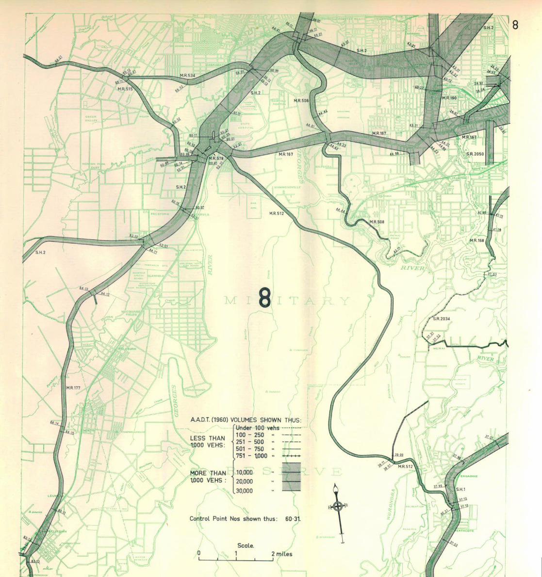

AAD.T.0960) VOLUMES SHOWN THUS: "Under 100 vehs 100 - 250 -251 - 500 -501 - 750 -751 - 1000 -
LESS THAN 1000 VEHS:
MORE THAN 1000 VEHS :
10.000 20.000
L 30.000
Control Point Nos shown thus: 23-61
0 2 miles _i l

Scale. 0 1 2 miles
_i

V* * 1 1 *.MOi I K
11
fa
AAD.T. (1960) VOLUMES SHOWN THUS: 'UnoV 100 v«hs 100 - 250 -251 - 500 -501 - 750 -
.751 - 1000 -
LESS THAN 1000 VEHS:
MORE THAN WOO VEHS :
10.000 20.000 30.000
Control Point Nos shown thus: 77-11
Seal*. 1 2 miles
i i L

Q U B E
Date oF Map June I9QI