Dehradun: a Gazetteers being volume I of the District ...
309
DEHRA DUN. A GAZETTEER, BBtira VOLUME I 01 tub DISTRICT GAZETTEERS OF THE UNITED PROYINCES OF AGRA AND OUDH. ALLAHABAD: Printed by W. 0. Abel, offg. Superintendent, Government Press. 1911. Pries Bs. 2.8-0 (3«. 8c?.)
-
Upload
khangminh22 -
Category
Documents
-
view
0 -
download
0
Transcript of Dehradun: a Gazetteers being volume I of the District ...
DEHRA DUN.
A GAZETTEER,
BBtira
VOLUME I
01 tub
DISTRICT GAZETTEERS OF THE UNITED PROYINCES OF AGRA AND OUDH.
ALLAHABAD:
Printed by W. 0. Abel, offg. Superintendent, Government Press.
1911.
Pries Bs. 2.8-0 (3«. 8c?.)
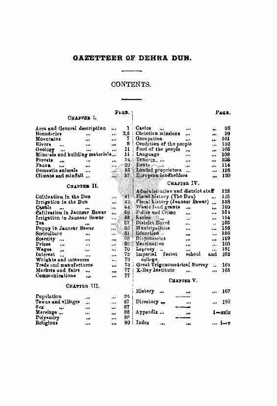
GAZETTEER OF DEHRA DUN.
CONTENTS.
Paqh. i Pash. CHAPT2B I. 1
Area and General description *•* 1 i Castes ... ... »*• 95 Boundaries 2,5 Christian missions ... 99 Mountains ... 7 Occupation •*• 101 Rivers ... ... 8 Condition of the peoplo 102 neology ... ••• 11 Food of the people ... iM 105 Minerals and building material 8.,. 11 Language • IS 108 Forests 14 i Tenures^ ... „. ioa Fauna ... ... 30 t Rents ... ... s*» 114 Domestic animals ... 85 i Landed proprietors ... 118 Climate and rainfall ... 37 European landholders •It 120
Chapteb 11. Chapter IV.
Admin iteration and district staff 123 Cultivation in the Dun 41 Fiscal history (The Duu) 125 Irrigation in the Dun *•• 43 Fiscal history (Jaunsar Bawar) 138 CtB&ls ... ... *•• 44 Waste lund grants ... 160 gnllivation in Jaunsar Bawar ••• 60 Police and Crime 161 Irrigation in Jaunsar Bawar ass 63 j Excise 154 Tea ♦ ♦a 67 District Board 165 Poppy in Jaunrar Bawar ««s 60 Municipalities ... 156 Sericulture 61 Education . 166 Scarcity ... ... 08 Dispensaries ... 159 Prices ... IS* 60 I Vaccination 160 Wages *•* 70 Leprosy .. 161 Interest ... 72 Imperial forost school and 162 Weights and measures 73 college. Trade and manufactures «•« 73 1 Great Trigonometrical Survey 164 Markets and fairs ... • M 77 | X-Ray Institute • •• 165 Communications ... 77 I
1 Chapter V.
Chapter III. 1 History ... • IS 167
Population ... o A __
Towns and villages ... 87 Direotory ,M ... • IS 195 Sox 87 -
Marriage ... 88 | Appendix ... ... 1—xxix Polyandry ... 80 , -
Religions m 90 ! Index ... SSI i-*r
PREFACE.
It was perhaps the intention of Mr. E. T. Atkinson to write, as an appendix to his Himalayan Gazetteer published in 1884, a general description of the Dehra
Dun districb. This project, if entertained, was never carried out, and the old Gazetteer contains very little of
value for the purposes of nay task. There is much useful
information in Mr. G. 14. C. Williams’ Memoir of the Dun published in 1876 and 1 have fully drawn upon it but its interest is now chiefly historical, such has been the extraordinary progress of the district in the last 25
or 30 years, I was therefore peculiarly fortunate in finding Mr. G. K. Dampier in charge of the Dun when the revision of the Gazetteer was undertaken. As
Settlement Officer and afterwards as Superintendent
he had acquired a great store of information which he
readily placed at mv disposal. To him I am very
deeply indebted and without his assistance this book could hardly have been written. My acknowledgements
are also due to Mr. G. Flowers, C.S., and Mr, H. G.
Smith, C.S., Assistant Superintendents, to Mr. R. C. Milward, Mr. H. G. Billson and P. Sadanand Gairola, Divisional Forest Officers, to Mr. P. Denehy, Assistant
Engineer in charge of the Dun canals, and to the
Secretaries of the Dehra aud Mussooree municipalities.
Pilibhit : )
October 1910, H. G. W.
GAZETTEER OF DEHRA DUN.
REFERENCES.
Manuscript reports in the district office.
Settlement report: A. Ross.
Settlement report: C. Daniell.
Settlement report: F. Baker.
Settlement report: G. R. Dampier.
Forest working plans by various authors.
Sir H. M. Elliot’s Indian Historians.
Brigg’a Ferishta.
Dow’s Ferishta.
Haunts and Hobbies of an Indian Official: M. B. Thornhill.
Report on the Tenures of Mussooree: E. H. Ashworth.
Memoir of the Dun: G. R. C. Williams.
Laws of the non-regulation provinces: Whalley.
CHAPTER I,
General Features.
Dehra Dun is the most northerly district of the Meerut divi¬
sion of the United Provinces. It covers an area of 13193 square
miles between 77° 35' and 78° 20' east longitude, and 29° 57'
and 31° 2' north latitude, and comprises two district tracts, the
Dun proper, which is an open valley enclosed by the Siwalik bills
and the outer scarp of the Himalayas, and the hill pargana of
Jaunsar-Bawar, a wedge of mountain and gorge thrust between the
Sirmur and Tehri States, and attached to the north-west corner of
the Dun.
The Dun is an irregular parallelogram in shape with its longer
axis lying almost due north-west and south-east; and its existence
like that of the other well-known Duns is due to the presence of the
Siwalik hills. Here they are a well-marked range extending along
the entire south-western border of the Dun. To the south they
present a steep face scarred by frequent precipices. On the north
a long gentle declivity slopes inwards and forms a longitudinal
shallow valley terminated by the outer range of the Himala¬
yas. The Siwaliks are in fact the obstacle which coniines the
detritus swept down by torrents from the greater mountains on the
north, so that the resultant valley is considerably raised above the
level of the great plains to the south. It is to this elevation of the
land at their northern base that the Siwaliks owe their tame and
"insignificant appearance when viewed from a point within the
Dun, The deposits of the Dun having their origin in the Himala¬
yas consist of heavy boulders or gravel clothed with a thin covering
of good soil, which naturally exhibits frequent outcrops of its rocky
subsoil. Of Duns in general Mr. Atkinson* writes “ The drainage
of these valleys usually collects along their longitudinal axis and
either falls into some larger streams that cross them, or less fre¬
quently finds an independent exit for itself into the plains by a
sudden bend to the south through a break in the outer range.
Area and General Descrip. tion.
The Dun. Physio, graphy.
•Gassettor ol the Himalayan Districts.
Bound- arios.
•J Dehra Dun district.
Owing to the considerable elevation of the Duns above the plains,
down to the level of which the drainage finds its way in a very
short distance, the unconsolidated strata that form the floor of
these valleys are constantly cut through to a great depth by water¬
courses. Consequently the surface, though often presenting an
apparent level for several miles together, is frequently broken into
steppes, which, on the whole, are tolerably level but at different
heights, the one above the other. This phenomenon is not uncom¬
mon, and is constantly observed along the rivers that are eroding
their banks. To the same causes also is to be attributed the prac¬
tical impossibility of procuring water by means of wells in the
Duns, a difficulty which maiuly arises from the thorough dessication
of the gravelly soil by th j deep drainage.” These observations
apply with certain modifications to the Dehra Dun. The drainage
of the valley is born..; by two rivers rising at no great elevation a
few miles south of Dehra and flowing east into the Ganges and
west into the Jumna respectively. The drainage fall is therefore
not so abrupt as in similar formations where it is carried steeply
through a break in the Siwaliks direct to the plains. The surface
of the Dun undergoes constant changes. A multitude of 'rates or
torrents pours down from the Himalayan hills during the rainy
season : they carry with them an immense volume of water, which
continuously undermines their containing banks and thus the stream
beds widen until they cover a very large space. Next year the
torrent will select for its main channel a new portion of its wide
bed, and the process of erosion will bo carried on in a new direc¬
tion.
Incomparably the most striking physical features of the valley
are the marvellous natural boundaries within which it is enclosed_
the Himalaya mountains, the Siwalik hills, and the rivers Ganges and
Jumna. The Himalayas arid Siwaliks are always in view and can
never be forgotten by the most casual visitor. The Ganges and the
Jumna are not such conspicuous features in the landscape, and their
rushing streams may only impress a close observer from their
banks. But their names are as well known as the mountains from
which they rise, and arc inseparably’ connected with the history
and religion of the peoples of India’from the remotest times up to
now. Of no other district in India can it be more truly said that
General Features. 3
the names of its boundaries are better known than the name of the
district itself. *
The Dun is apparently a single valley but in reality it
belongs to two groat river systems, those of the Ganges and the
Jumna. The water parting runs along the Asarori Pass road up
to Majra and thence in an almost straight line through Dehra
cantonments to Rajpur and Laudour. The ground falls each way
with a nearly uniform gradient of from 34 to 42 feet in a mile.
Owing to tho greater amount of debris brought down from the
incomparably greater drainage area of the Himalayas, the main
drainage line is much nearer to the Siwaliks than the Himalayas.
Therefore the torrents from the latter range are more important
than those from the former. The Dun is well wooded and its
surface is pleasantly diversified, while possessing few eminences
of note. The exceptions arc the Nagsidh and Kalanga hills, both
near Dehra. The beauty of tho scenery has aroused the enthusiasm
of many visitors. “ The scenery of these mountain dales, ” writes
the author of the Imperial Gazetteer, “ can hardly be surpassed
for picturesque beauty oven among the lovely slopes of the massive
chain to which they belong. The perennial streams nourish a fresh
aud luxuriant vegetation, whilst the romantic hills to the south
and the sterner mountains on the north give an exquisite variety
to tho landscape.” “ The general aspect of the Dun ”, to quote the
words of Mr, Baker, a former Superintendent, “ is perhaps better
known than that of any other district in these provinces, and
henco its beauties have attained a celebrity second only to Kashmir
itself.” Mr. Baker refers to tho view of the Dun from the
Mussooree Mall so familiar to visitors sojourning in that sanitarium.
Near Dehra the scenery has been somewhat spoilt by the rapid
spread of cultivation and the cutting down of the sal trees that used to
line the high batiks'of the numerous ravines in the neighbourhood.
In tho Eastern Dun the Himalayas rise abruptly from the
valley, and there are consequently fewer of the long sloping
plateaux that form such a marked characteristic of tho western
sub-division. Tho surface of the centre of the valley is diversified
by two isolated hills that rise not far from Dehra. The southern of
these Nagsidh, is clearly an off-shoot of the Siwaliks, while the
* F, Baker, Settle meet Beport, 1886.
General descrip¬ tion.
Character! istics of
the East¬ ern and Western Duns,
4 Dehra Dun district.
northern—Kalanga, famous in the annals of the Gurkha war—is an
outlier of tho lower Himalayas. Both hills are divided from the
parent ranges by rivers, Nagsidh by the Suswa and the Kalanga
hill by the Song. Between the Nagsidh hill and the confluence
of the Song, the Suswa, and the Jakhan, is a fairly open stretch of
country. East of this tract the land is occupied chiefly by Govern¬
ment forests and large half drained swamps where only the almost
fever-proof Mahra can subsist. The soil is, except in the hill and
submontane tracts, a clay, tending to loam in the west of the
pargana. It is on the whole richer than that of the Western
Dun, but on the other hand the climate is less favourable. The
result has been a comparative retardation of development. For
many years tho large estates of tho Eastern Duii waged an unequal
war with the malaria which killed off their cultivators and tho
wild beasts that devoured their crops. Considerable progress has
been made of recent years, especially since the opening of the
railway. The wide swamps which at one time covered so much of
the pargana have entirely disappeared except near the confluence
of the Suswa, the Song and the Jakhan and in the riverain delta
between Raiwala and Rikhikesh near the Ganges. The climate has
greatly improved with the draining of the swamps and the thinning
of the forests.
In the Western Dun the country assumes a more open aspect.
The lower slopes of the Himalayas rise at a more gentle gradient,
and the Government forests are fewer in number and less obtru¬
sive. In former days the banks of the ravines occupied by
mountain torrents were covered with sal forest, but 6f late years
owing to keen demand for building timber in Dehra these banks
have been much denuded. Largo patches of forest however still
remain and somo of the more enlightened landlords are now
studying the principles of forest conservation. The Asan, de¬
scribed in more detail elsewhere, drains the whole of the valley except
the small portion to the extreme east which lies within the basin of
the Suswa. The main drainage line is considerably nearer to the
Siwaliks than to the Himalayas, so that there is but a narrow strip
of cultivated land between the south bank of the Asan and "the
Siwaliks. The Western Dun contains four well-defined tracts.
The first, which may be called the river tract, comprises the land to
General Features. 6
the east of the Dehra-Asarori road lying round the source of the
Suswa, and the shelving land on both sides of the Asan from its
source to its confluence with the Jumna. The second tract consists
of the uplands on the crest of the ridge whore the town of Dehra
stands—a fine, well-irrigated and very fertile plateau defined by the
Tons river on the west, the Asan and Suswa on the south, and
the Rispana on the east. The third is a similar triangle of rich
laud at the north-western extremity of the district watered by the
Katapathar canal. Between these two and north of the riverain
land fringing the Asan is the submontane tract. This consists of
a striking series of parallel plateaux bounded on east and west by
hill torrents. To the south these plateaux slope gently down towards
the Asan. The summits are occupied by village sites and stony
unirrigated Holds, the sides where not too steep are clothed
with valuable sal forest, while in the beds of the torrents are plots
of rice-land irrigated by smalt canals taken from the upper course
of the torrent. These torrents rise in the outer slopes of the
Himalayas and except in the rains maintain an underground
course not reappearing until they roach the valley of the Asan.
The intervening portion of their course presents to the view
nothing but an arid stretch of sand and boulders widening grad¬
ually as the height of their retaining banks diminishes with the
southern slope of the plateaux. Just before the Asan is reached
these torrents, now unconfined, spread themselves far and wide,
often causing much damage by carving for themselves new courses
through the low-lying fields that fringe the northern bank of the river.
Jaunsar-Bawar, the hill appanage of the Dun (with which it
has physically and historically no connection), is in shape
roughly an oval with its major axis lying north and south. Its
natural boundaries are ulr&OSt as "Weil marked as those of the Dun.
The Tons sweeps round from the north-east and encircles the
northern vertex of the oval, and finally with a course trending in the
mam soutn 101ns the Jumna near is. alii. On the north it separates
the pargana from Tehri and ou the east from Jubal and Sirmur.
The Jumna with its affluent, the Riknargadb, divides it from Tehri
on the east and from the Dun.on the south. A small comer of
the pargana lies across the Tons, between it and the states of
Raiengarh, Taroch and Jubal.
Jaunsar- Bawar .
6 Dehra Dun district.
The term Jaunsar-Bawar! denotea too once distinct parganas,
and three natural sub -divisions: first .Taunsar. bounded on the
north by Lokhandi, on the east by tho Jumna, and on the west
by tho Tons as far as tho junction ; it thero fore consists of a triangular
tract, having its apex at iiaTsi with a length from north to south
of 18 miles; next Lokhandi with a length of five miles-but extend¬
ing from east to west over tho breadh of the pargana : then Bawar
with a length of Sen mites and occupying all the northern third
of the oval. Deoghar, the trans-Tons portion of tho pargana, is an
irregularly shaped piece of land much indented by native states.
Jaunsar-Bawar consists entirely of a succession of mountain and
gorge. Tho great physical feature of the pargana is the ridge
separating the drainage area of the Tons from that of tho Jumna.
Commencing from Haripiir-Boas Jaeai Kalsi, it runs west, of
Chakrata Deoban, and thcncc in a north-easterly direction to tho
Karamba peaks atiove Lokar. At Bairat, where the Mussooree
road joins this ridge, there is a peak having an elevation of *7,399
feet above the sea and further north, near Kyawa, another having an
elevation of 6,558 feet. Then comes Deoban, 9,331 feet, another
peak 8,730 feet, whence the range trends to the north-cast, continued
in Bajamuri, 9,536 feet, aud three other peaks, 9,200, 9,533 and
10,075 feet, respectively, when it enters Tehri aud loses itself in
the spurs of Bandarpuneh. From the main range, ridges are
given off on either side towards the great rivers. Each of these
ridges also grves off lateral spurs, the hollows between which form
the beds of torrents that feed the numerous tributary streams
of the Jumna on tho east and tho Tons on the west. Even in the
hills, Jaunsar-Bawar has the character of being one of tho wildest
and most rugged tracts, affording naturally very little level ground,
and that only in small patches, Tho mountains are peculiarly
rough and precipitous, thero is much cliff and rock and few
villages, so that the cultivation is necessarily small and very labori¬
ous. The whole rock almost is limestone, which no doubt giyas
the massy. Irregular character to the mountains. The ravines
MS, aa 8 rule, deep and sudden in their descents often ending fa-
dark chasms, sometimes wooded, but, as often. exhibiting bare faces
of precipitous rock, covered here and there with a fine wiry
grass.
General Features, 7
The mountains of the district are the .Himalaya and the Moun-
Siwalik ranges. These titles arc misnomers : the term Himalaya is tams'
properly only applied to tho highest range covered with eternal
snow, while tho native historians always use the word Siwalik to
designate the outer and lower ranges of the Himalayas, as well as
the quite distinct chain to which modern custom has limited the use
of the name. The word Siwalik was formerly explained as being
equivalent to Sawalakh; that is to say the range of 125,000 peaks.
But it is now recognized as a derivative from tho name of the god
Siva. Similarly parts of the Dun are said to be in the region parti¬
cularly sacred to the god, and known from his famous temple at
Kedarnath as the Kedarkhand. The Siwaliks (to adopt the modern The
limited use of tho name) extend along the entire southern border ®'waliks'
of the Dun, from the Jumna to the Ganges, running parallel with
the Himalayas and at an average distance of about 20 miles
from them. Although hardly more than hills in elevation—few
peaks exceed 3,000 feet—they display in miniature all the
features of the grandest mountains. In passing through them
from the south one beholds an endless succession of sharp, towering
peaks, nearly perpendicular precipices and a very maze of little
valleys, and during the season of the rains through each small
valley there runs a little mountain torrent. The aspect of the
range viewed from the north is less imposing. From the drainage
line of the Asan and tho Song-Suswa, the ground rises southward
by uniformly easy slopes to within about a mile of the main ridge,
when alone the gradient becomes steep. At the extreme south-east
corner of the district where the range is pierced by the Ganges
it expands into a mountain knot known as the Motichor
hill.
The Siwaliks nowhere present a well-defined single ridge. Nu¬
merous long and high subordinate ridges run out in every direc¬
tion, very often sweeping suddenly round and assuming a direction
parallel to tho main ridge and by their size obscuring it: so that
the chain of the Siwaliks at first sight appears an inextricably con¬
fused mass of ridges, spurs and peaks. This peculiar conformation
is most conspicuously developed in the western portion of the
range. The lower slopes are covered with dense sal forest and
a few stunted pines are to bo found on the high ridges.
8 Dehra Dun district.
The Himala¬ yas.
Rivers. The Gan¬ ges.
Asan,
The Siwaliks are quite distinct from the Himalayan system and
embody a much older geological formation, being composed of
conglomerates and sandstones. The sandstone is for tho most
part so soft as hardly to deserve the name of stone. Easily cut by
the falling rain or running water, flaking off from exposure to the
atmosphere, it has in the course of ages been moulded by the
elements into its present fantastic forms.
On the north and north-east the horizon is bounded by tho
Mussooree range, which opposite the town of Dehra bends back
and encloses a portion of the valley in an immense amphitheatre.
This range forms here the outer scarp of the Himalayan system
and culminates in the Landaurpeak, 7,459 feet high, andTopTiba,
which attains an elevation of 8,565 feet. To the south, a number
of minor ridges reach away towards the Dun. These spurs and
the lower slopes of the main ridge, once thickly clad with forest, are
now much denuded. In the small villages situated at the foot
of tho hills the forests have been cut and sold to charcoal burners.
In tho submontane tract however there are some tine private forests.
Higher up on the south aspect the vegetation is less luxuriant,
but tho loftier crests are well wooded with oaks and rhododendrons.
Much of the ridge is occupied by the buildings of the Landour and
Mussooree sanitaria.
The Ganges impinges upon the Dun at Tapoban and flowing
in a south-westerly course with a moderately rapid current passes
Rikhikesh, near which it receives the Chaudanawa Rao, dry ex¬
cept in tho rains. About ten miles lower, a little above the famous
Raiwala camping ground, it receives the waters of the Song and
the Suswa, the two main rivers of the Eastern Dun. Thence
distributing its waters into several streams encircling wooded
islands, it leaves the district near Hardwar after forming for about
20 miles the boundary between the Dun and British Garhwal.
The Asan rises in a clayey dip to the west of the Asarori-Dehra
road at an elevation of over 2,000 feet and after a north-westerly
course of about 26 miles falls into the Jumna below Ram pur Mandi.
It drains the whole of the Western Dun and receives on either
bank mountain torrents, which rise in the Siwaliks or the Hima¬
layas. The chief of its tributaries is the eastern Tons rising in
in the hill below Mussooree.
General Features, 9
The Suswa rises in a clayey depression near the source of the Suswa,
Asan but to the east of the Asarori-Dehra road. It flows south¬
east, draining the Eastern Dun aud receiving, like the Asan, the
minor streams rising in the hills to the north and south. The first
affluents of any importance to join the Suswa are the Rispana
Rao and the Bindal river. Both are dry for nine months in the
year, but during the rains they carry a considerable volume of water.
A short distance below Kansrao the Suswa receives the waters of
the Song. This river rises in Tehri and after running parallel to
the Dun for some miles in a north-west direction unites with the
Bandal river near Maldeota. Here it breaks, in a wide gorge,
through the last line of the outer scarp of the Himalayas and sweeps
round the base of the block of hills on which Dwara village stands.
At this point it receives the Bakli river. Thence Lho combined waters
flow in a south-eastorly direction until they meet the Suswa. A
mile or two below the junction of the Song and the Suswa, a third
torrent of importance, the Jakhau Rao, is received. From this
point onward to the Ganges, the bulk of the water uow-a-days flows
in the Song. The Suswa maintains a parallel course at short
distances with a much reduced volume of water. The portions of
the Eastern Dun north of these river to tho east of the Tirsal Forest,
and the khadar of these rivers themselves, are a network of streams,
and it is often difficult to distinguish the main rivers from their
tributaries.
The Jumna rises in Tehri Garhwal in tho mass of peaks known The
as Bandarpunch or Jamuotri. Its basin is separated from that of Jumntt
the Ganges by a great ridge having its origin in the same group
of peaks and terminating near Barkan da in tho Mussooree range.
It enters the district at a point in Jchal Bondar, twelve and a half
miles due east of Deoban, there receiving the small stream called
the Riknargadh which divides Bawar from Rama Serai in the
Rawain pargana of Tehri State. Eight miles lower down it
receives another similar stream, the Khutnugadh, which flows
through the Mohna aud Bawar (chats, being at this point 90
feet wide, four or five deep, and not fordable. The Jumna pursues
a generally southerly course for about 20 miles as far as the
south-east corner of the pargana: thonce it turns west and is after
a course of about seven miles joined by the Amlawa, a stream
10 Dehra Dun district.
Tho Western Tons.
which rises at the southern base of the Deoban mountain and waters
a triangular valley formed by two lofty ridges, the one running
north-west from Bairat and the other north-east from the Naga peak
(6,743 feet) a few miles west of Bairat, and both meeting in a
point at Deoban itself. Two miles further to the west, below the
iron suspension bridge on the Chakrata road, it receives the waters
of tho western Tons. Thence entering the valley of the Dun, 110
miles from its source, the Jumna flows over a succession of rapids
with a descent of about 19 feet a mile and travelling in a
south-westerly direction receives near Rampur Mandi the waters
of the Asan, debouching upon the plains near Badshah Mahal in the
Saharanpur district, an old hunting seat of the kings of Delhi.
Tho currents of the Ganges and Jumna are much too swift for
safe navigation except at one or two points where ferries exist.
Their economic value is in this district comprised in tho cheap car¬
riage they afford to timber felled in the hill forests : while the
Jumna is also tapped at Katapathar and its surplus waters distri¬
buted over portions of tbe Western Dun by a canal bearing the
name of the village at its head.
The chief affluent of the Jumna in tho district is the Tons.
This stream rises north of the Jamuotri peak in the Harki Dun
and first issues as a stream called Supin. After a westerly course
of 30 miles it receives tho waters of the Rupin, a rapid torrent,
and from this point the united stream is called the Tons. Nineteen
miles lower down it is joined by the Pabar, which marks for
some distance the boundary between lthat Deoghar and the adjoin¬
ing native states. This is a large and rapid stream and, after a
course of some 58 miles through Bashahr, it falls into the Tons
between the villages of Raigi and Koti, in khat Bawar. A small¬
er tributary, the Kunigadh, rising at the north-east corner of khat
Bawar, joins the Tons at the northern apex of the pargana. From
this point to its junction with the Pabar the Tons pursues a course
nearly south-west: thence it turns almost due south between
khats Bawar and Deoghar until it again reaches the border of the
pargana a few miles above Sangota bridge. From this point its
course trends south in an elliptical curve with the concavity turned
towards the pargana, between which and the Sirmur state it forms
the boundary as far as Kalsi where it joins the Jumna. At the
General Features. 11
confluence the Tons i3 by far the larger, broader and deeper and
carries about three times the volume of water : but the Jumna
having the more illustrious origin, in the snowy range is in popular
estimation the more important stream, and has given its name to
the united rivers. The basin of the Tons is separated from that
of the Jumna by the mountain ridge traversing the pargana from
north to south, already described.
The area of the Dohra Dun, proper, is in the sub-Himalayan Geology,
upper tertiary series, and comprises the Siwalik range on the south
composed in its lower and southernmost parts of middle Siwalik
soft sandstones or sandroek with a few thin mammalian fossil¬
bearing conglomerates, and along its crest, of thick upper Siwalik
conglomerates; all of which are of fresh-water origin and dip at
low angles under the flat surface of the Dun. The latter is a broad
expanse of recent gravels and consolidated fans of sub-angular
scree-material derived from the higher ranges. The north edge
of tho Dun shows further exposures of the middle and upper
Siwaliks in a narrow zone at the foot of the higher hills, bent
into sharp reversed folds with faulting against the older Himalayan
series. This is the line of the main boundary fault, and it is
distinguishable from Kalsi, via Pharsila on the Jumna, to near
Rajpur. From that point it is hidden under the gravels of the
Dun as far as near Rikhikesh on the Ganges.*
The older, much contorted, outer Himalayan rocks include
the slates and dark-gray limestones or dolomites of the Mussooree
ridge, the Jaunsar series of dark slates, quartzites, fine volcanic
ashes and basic traps, the Dcoban massive limestone, which comes
above the latter and forms much of the rugged elevated country
to the north of Chakrata, and finally tho Mandhalia conglomerates
and Bawar quartz-schists, which lie flatly above both of the latter
series, either normally or complicated by thrust planes. All these
older rocks have proved unfossiliferous and are probably very old.f
11 The Siwaliks contain carbonate of lime, selenite and pyrites. Minerals
The minerals hitherto found in the Mussooree range are calcareous
* See H. B. Medlicott, Geology of Sub-Himalayan Ranges between the Ganges and Ravee, Memorandum, Geological Survey of India, Volume III, Part 2.
t See R. D. Oldham, Geology of Jaunsar, Records, Geological Survey of India, Volume XVI, Part 4.
Dehra Dun district. 12
tufa, frequently iron shot, calcareous sinter, white, brown and
yellow calcareous spar in the primitive form, and sulphate of
barytes, nodules of noble serpentine associated with hornblende
slate, glassy actynobite and earthy gypsum. The remains of iron
mines exist near the village of Kathapathar at the debouche of tho
Jumna from the mountains, but they have never yielded revenue
to the Government although the people of the village used to work
them from time to time.” “ The metals found in Jaunsar-Bawar are
load, antimony, and copper, but the mines of Kanda have not yet
been explored, still less worked, an anticipation fondly cherished half
a century ago by Major Young. Neither is a copper mine near Kalsi
on the banks of the Amlawa worked. ” So wrote Mr. Williams
in 1874, and but little" progress has been made since his time.
Until a few years ago nothing had been exploited save the lime¬
stone boulders in river beds or other deposits. These were consi¬
dered the property of tho zamindars who made fair profits by
exacting a royalty from the contractors they permitted to work
the limestone on their estates. In March 1900 the Forest depart¬
ment began selling tufaceous limestone at a royalty of Rs. 5 per
hundred cubic feet: until the opening of the railway in that year
this form of limestone had been either unknown or neglected. The
forest contractors, however, found that they could not compete
with the zamindars’ contractors who paid smaller dues. The set*
tlemenfc engagements wore examined and found to reserve to the
Government the full control of mines. To this the zamindars
replied that boulder deposits were not mines. It was eventually
decided that a licence fee of Rs. 50 a year should be levied for the
remaining period of the current settlement from each mine or lean
which had not existed when the settlement agreements had been
signed, with a proportionate rebate if tho outturn should be less
than 200 tons in any year. The zamindars’ objections were so
far upheld that surface boulders were declared not to be quarries,
and were therefore not subject to the new orders. On the revision
of the settlement in 1904 all quarries were declared the property
of the Government. Two quarries are worked in the Western Dun
and two in the Eastern Dun. A two years’ contract of the latter in
1908 brought m Rs. 1,100. Gold washing still employs a few
people on tho Jumna river. The metal occurs in the sands of the
General Features, 18
river in barely remunerative quantities. The matrix has yeb to be
discovered,
Major-General Beresford Lovett, R.E., C.S.I., C.B., (now re¬
tired), has been granted an exploring licence by the Government
in certain lands between Kalsi and the Jalauta bridge, on either
side of the Jumna. Samples of hematite iron ore found in
Busaru were sent to England and examined by Mr. F. W. Habord,
metallurgical expert to the India Office. The ore was favourably
reported on. It was found to certain 65 per cent, of pure iron and
was moreover said to be in every way suited for electric smelting.
Ironstone was discovered by General Beresford Lovett also at
Lohari, Runkar and Gaski: copper at Ponaha, antimony at Baula
and zinc at Palan. To provide the power for his smelting works,
General Lovett proposes to harness the Jumna, which within the
limits of the land covered by his exploring concession appears
admirably suited for the purpose. The river has a fairly heavy
fall and at Tangri Tiba and Jalauta forms semi-elliptical loops
round narrow necks of land. At Tangri Tiba is to be erected a weir
provided with sluice gates, designed to impound water to a level
of 18 feet above the ordinary low water level. The neck of the
promontory here is to be tunnelled, and the tunnel is to be
continued down the right bank of the river by a flume to the
Jalauta neck, and through it by another tunnel. A power house
is to be established 228 feet below the level of the canal. The
power can be used locally for smelting ores, or transmitted
to Shaharanpur or elsewhere to work factories and the like
The scheme is at present in its infancy; but as soon as prac¬
ticable a company will be formed to work out General Lovett’s
ideas.
The cost of building materials varies considerably with the
locality; but it may be said that all rates have become heavier since
the boom in the building trade which commenced after the opening of
the railway in 1900. In Mussooree in particular the rates for labour
and materials have advanced substantially since the great earthquake
of 1905. Masons and carpenters who were glad to get 8 annas a
day now easily command Re. 1. Lime has risen from Rs. 40 to
Rs. 60 and Rs. 65 for a hundred maunds, wood is dearer and good
qualities are becoming seareer. First-class bricks in Dehra cost
Jaunsar- Bawar scheme.
Building ■ materials.
14 Dehra Dun district.
Fof 3EtH.
Rs. 12 or Rs, 14 a thousand, and first-class brick work in the Dun
costs Rs. 26-8-0 a hundred cubic feet, but the cost of carriage from
the Dun is so great that the prevailing rates in Mussooree for arching,
in which work alone bricks are generally used, rises to Rs. 80 or Rs. 90
per hundred cubic feet. In Mussooree good well-bonded masonry
costs from Rs. 22 to Rs. 25 a hundred cubic feet, and where stone
and bajri have to be carried from a distance the rates rise propor¬
tionately, Floors on the lower story are almost always of concrete,
used both in Mussooree and in the Dun. In Mussooree the rate is
Rs. 10 a hundred square feet. In the Dun terraced flooring costs
Rs. 10, flat brick over three inch concrete Rs. 12, and brick-on-edge
over three inch concrete Rs. 15 a hundred square feet. In double¬
storied houses in Mussooree the rate for the upper wooden floors
amounts to Rs. 43 a hundred square feet. In the hills roofs are
usually of corrugated iron lined with chir planks, and the cost is 7
annas a square foot. The use of slates is apparently not recognized
by the public works department: the weight is probably prohibi¬
tive. In the Dun tiles are used and the cost varies betweon
Rs. 8-8-0 in the case of country tiles, and Rs. 15 a hundred square
feet in the case of Allahabad tiles.
The Garhwal rajas derived a considerable revenue from the
Dun forests in pre-British days. The chief item was an excise
on forest products. This excise was collected at posts erected at
the passes of the Siwaliks. In 1809-10 the amount realized was
Rs. 16,000 and in tho following year Rs. 15,200, of which over
onc-third was absorbed in paying the collecting establishment.
On the British occupation—through a not unnatural confusion of
ideas—this excise was abolished with th e transit duties exacted at
tho same posts. In 1819 Mr. Moore, tho Collector of Saharanpur,
revived tho duos on forest produce, which for the three years
1819—1821 averaged Rs. 4,000 a year: in 1822 one Surjan Negi
farmed the dues for four years at Rs. 5,000 a year. In 1825 the
dues were leased for Rs. 8,500, out of which only Rs. 2,500 were
realized. No attempt was made at forest conservation. The next
Political Agent, Major Young, offered the right of levying the forest
duties to public competition by auction. The experiment was
fully justified by tho results, giving a revenue of Rs. 6,425 for the
ghats on the Jumna and the Ganges and of Rs. 9,595 for the passes
General Features. 15
to the plains, or a total of Rs. 16,020. The duties were farmed at
these rates for the years 1830-31 to 1832-33, when another auction
sale gave an income for three years longer of Rs. 25,345 a year.
In 1839 Major Young proposed to divide the forests into twenty different lots to be leased for forty years : the annual rent agreed
upon to be paid into the treasury; the lessee to bring under
cultivation at once all land capable of cultivation. Certain forests
however—Bengala, Rambaha and Thano—were to be retained by
the Government for the use of the public works department.
Nothing appears to have come of this proposal, for in 1839 the
forest dues wore again leased for five years: on this occasion to
Atmagir, a mahant of Hardwar, for Rs. 33,500. Mr. Williams
writes of the period 1839—1843 “ Every one continued to hack
and hew away at the trees as he pleased, only paying certain dues
to the farmer, in the event of the wood being exported. The latter
made his own arrangements to secure the collections at the different
passes. Reckless waste was inevitable, and the fine sal forests
began to disappear rapidly. The absence of conservancy was
absolute. The district still abounded in fine trees 100 or 200 years
old and upwards. All these fell before the axe, and probably the
rest would have gone with them had the roads been a little
better. The consequences of this bad system are most perceptible
in the western Dun.” In 1844 Mr. Vansittart, the Superintend¬
ent, “ having ascertained that Atmagir was in receipt of about
Rs. 80,000 a year, discontinued the bass and kept the collections in
his own hands. This arrangement lasted till the year 1855, when
the forest department was established. In the interval the
revenue from this source varied from Rs 80,000 to Rs. 100,000, an
income dearly purchased, for the destruction was something incal¬
culable.” The forest department instituted in 1855, concentrated
its energies on tho collection of revenue without making any
attempt at systematic conservancy: it was in fact nothing but a
forest revonue collecting agency. The effect of this neglect became
apparent in 1867, when the revenue reached the low figure of
Rs. 23,332. In 1864 regular forest operations commenced under
Mr. F. Williams C.S.I.,^Commissioner of the Meerut division.
Mr. Williams devoted his attention to a survey of the forests, to mak¬
ing roads and securing and defining the rights of the Government
10 Dehra Dun district.
Rights.
and individuals. This was no easy task owing to the neglect of former
years which permitted the growth of prescriptive rights by lapse
of time. It was not until 1877 that the forests were properly
demarcated. The village forests included those not reserved by the
department and those found within the boundaries of largo waste¬
land grants. They were declared to be the property of the zamin-
dars of the villages to which they appertained and were first assessed
to revenue by Mr. Daniell in 1864. Since then they have always
been included in the assets of villages at settlement, and revenue
has been regularly demanded on their account. This portion of
the question will be discussed later in its bearings on the fiscal
history of the district. It is sufficient to note here that private
forests assessed to revenue cover an area of about 80 square miles.
Of the free system of fellings prevalent up to 1864, Mr. O’Calla¬
ghan, deputy conservator of forests, writes in 1878 “ There can
be no doubt that sal, tun and sissu (shisham) were the trees chiefly
felled, for even now there i3 no demand for any other kinds of tim¬
ber ; and when I entered the department in 1854 the ground was
everywhere studded with stumps of those trees.” It was necessary
to impose restrictions gradually, therefore ; and no real conserva¬
tion was attempted until after the close of the seventh decado of
last century. All that was valuable had already been cut and
since then the main duty of the forest department has boon to
find a market for the unsound and mis-shapen trees left after the
destruction of the forests, and to encourage reproduction and
foster the new generation.
During the early years of conservancy the forest department
denied that the villagers possessed any rights of any description.
The Government however called for a report from the Superinten¬
dent, Mr. H. G. Ross, who took a very different view of the matter.
Ho described the most extensive prescriptive “ rights ” of grazing
as having existed from time immemorial and he produced much
evidence in support of his contention. The forest department
however preferred to call the grazing facilities enjoyed by the people
“privileges.’’ In 1875 orders were passed for an enquiry into
the nature and extent of these rights or privileges.* A list, admit¬
tedly incomplete, was drawn up of privileged or right-holding
* Resolution no, 8044 of the 18th Febru ary.
General Features, 17
villages, but no attempt was made to determine the number of
cattle which each village was entitled to graze. It was however
decided that no grazing rights existed in the Siwalik forests of
the Eastern Dun, Rights over the Western Dun Siwalik forests
were recognized in some cases. In 1878 the Forest Act became law
and in 1879 the reserves were duly notified but the formal enquiry
into rights contemplated by Chapter II of the Act was not under¬
taken. Mr. Ross, the Superintendent, however hurriedly prepared
a list of villages which he deemed entitled to special grazing
facilities. His report was followed by notification no. 702 of 1880.
The forest department were so far successful in the battle of
terms that “ rights ” were not admitted, but the villages included
in Mr, Ross’s list were permitted to exercise certain “ privileges. ”
Mr, Ross had from the first recognized the inadequacy of his enquiry
and later when he became Settlement Officer the Government
on his representation authorized him byG. O. no. 156F/99—4 of
14th May 1884 to prepare amended lists of villages with the cattle entitled to graze and to incorporate them in the record-of-rights.
The forest department entered a strong protest against the
procedure adopted. The conservator pointed out, with justice,
that the only proper course to take was to have a regular forest settle¬
ment made under the provisions of Chapter II of the Forest Act.
These protests were however overruled, the Government holding
that for all practical purposes the question of rights and privileges
had been solved by the formal entry of the rights or privileges
enjoyed by each village in the wajib-ul-arz.* Mr. Ross’s lists of
grazing rights which were far more extensive then that contained
in notification no. 702 were communicated to the forest depart¬
ment. They never appear to have been enforced. Privileges
continued to bo regulated by notification no. 702, full fees being
demanded in the case of all cattle grazed in excess of the head
specified in that list. Up to 1891 the Government appears to have
adhered to its decision that the revised lists prepared by Mr. Ross
constituted the authoritative record of grazing rights in the Dun
forests. After that date the real position occupied by these lists
became obscured until in 1895 they were entirely discarded, and
the old and inaccurate list of privileges contained in notification
G. 0. po, 7.F-99—9, of the 9th January 1885.
2
18 Dehra Dun district,
Working plans.
no. 702 was by notification no. 262-XIV-540 of the 24th April
1895 erected into the charter of grazing rights in the Dun.
In 1902 certain zamindars accused of grazing cattle in excess
of the number privileged by notification no. 702 pleaded the
record-of-rights defence and wero acquitted. The Government
therefore ordered the grazing clauses to be omitted from the
engagements to be taken at the approaching settlement. The
result was that the only remaining rights were those conveyed
by. the admittedly faulty notification of 1880. The question
was re-opened by Mr. Dampier, the Settlement Officer, in 1905..
In the result the Government adhered to the view adopted
in notification no. 262 of 24th April 1895, which confirmed the
rights conveyed by notification no. 702 of 1880 but appointed a
forest settlement officer to enquire into additional rights not
conveyed by that notification.* This officer found that no rights
existed in the villages not included in notification no. 702, but
recommended a few villages for grazing at privileged rates. His
proposals were accepted.
In the forests of the Malkot reserve a formal enquiry was
made as required by law in 1890-92, and it was found that no
grazing rights existed.!
In 1887 Mr. Fernandez, of the Forest School, drew up a work¬
ing plan for the management of the Dehra Dun division, as it was
then called. This working plan was sanctioned for fifteen years
only, and has now been superseded. The Dehra Dun division in¬
cluded all forests situated writhin the limits of the Dehra tahsil: that
is to say it comprised forests which may for convenience be divided
into a three-fold classification—those clothing the slopes of tho
Siwalik Hills ; those in tho valley; and those on tho southern
slopes of the Mussooree range. Mr. Fernandez describes the
forests on the Ambari hill in the north-west corner of the Dun
near the point where the Jumna issues from the hills, the Chand-
pur forest near Sahasp'ur, an important village in the centre of
the Western Dun, tho Dholkot forest, on the Dehra-Rampur-
Mandi road about 71 miles from the latter place, tho Jumna forest skirting the banks of that river, the Timli forest on the northern
* G. O. no. 155/XIV—26 of the 15th March 1905.
f Notification* nos. 606F of 18th July 1892 and 582F of 4th July 1893,
General Features. 19
slopes of the Siwaliks enclosing Timli village and its hamlet, Chari-
bali, the Sherpur forest east of tho Timli forest, and beyond it
again the Chandrabani forest : all these situated in the Western
Dun. In the easterly portion of the valley arc the Ramgarh forest
between the Suswa and tho main watershed line of the Siwaliks,
tho Bullawala forest in the centre of the Eastern Dun, equi-distant
from Dahra, Asarori, and the Ganges river, the Nagsidh forest
covering the hill of that name, the Kansrao forest so called
from a rao of that name, the Motichor forest at the south¬
east corner of the district extending as far as Hardwar, the
Malkot forest occupying the whole of the Kalimati hill, most
of the Birasi hill, and the western face of the Maidan hill together
with some islands and a part of the bank of the Song river, the
Thano forest to the south of the Malkot forest, the Tirsal forest
extending from the confluence of the Suswa and the Jakhan rivers
northwards up to Tehri-Garhwal, and from the right bank of the
Jakhan eastwards as far as Rikhik ;sh, the Tapoban forest, a small
strip of land in a gorge of the Ganges about a mile above Rikhi-
kesh and finally the Birbhaddar forest midway betweeen Rikhi-
kesh and Gohri, consisting chiefly of river islands. Mr. Fernandez’s
general conclusions were that the crop was poor : but reproduction
was usually good, aud he proscribed a method of treatment which
would remove the old deformed trees and make way for the
development of tho young growth : and though from a sylvicul¬
tural point of view this could not bo done too soon, still it was
necessary to study tho labour supply and the timber market.
Ho therefore proposed to spread tho work of removing unsound
and damaged trees over 15 years. On the expiry of this period
the sal stock was found to be materially improved, and in 1903 a
new system of operations was devised by Mr, Milward and Mr.
Jackson. The forests wore considered in five classes—sal forests,
hill forests, shisham forests, miscellaneous and bamboos : while the
first were further sub-divided according to their development. Only
a small proportion of the whole area under sal was found fit for
treatment by tho selection system, viz, the Tirsal forests : the
majority were left for improvement by the removal of inferior trees,
Nearly 10,000 acres were set apart to be coppiced for fuel, and
gpme 5,000 acres for experimental treatment by the “ uniform ’’
20 Dehra Dun district.
Manage¬ ment,
Fire- proteoion*
and “ group ” methods. The hill and shisham forests are exploited
by selection fellings and the bamboos are cut over in alternate
years. The produce is exported to the timber markets of Saharan-
pur, Meerut and Jwalapur, a suburb of Hardwar. The rapidly
expanding town of Dehra also absorbs a large quantity of building
timber. Sal is usually sawn into rafters six or eight feet in
length, scantlings ton to twelve feet in length, four inches deep
and five inches wide, metre gauge sleepers six feet long, eight and a
half inches wide and four and a half inches deep. Sal timber in the
round is chiefly exported in the form of tors which are rough-hewn
poles twelve to fifteen feet in length and six to twenty-four inches
in girth, without sap wood. Shisham commands a good price for
cart wheels and furniture, but the supply is limited. Fuel is
produced from coppiced forests for the use of the towns of Dehra,
Hardwar and Kankhal. Bamboos are first collected at Jwalapur
and thence distributed in the plains according to the demand.
Minor forest produce comprises limestone, elsewhere described,
grasses, gums, honey, wax, horns and hides.
The Dehra Dun Forest division was created in 1878 ; but in
1905 with the abolition of the school circle that division and the
Saharanpur division were amalgamated into one, now known as
the Siwalik division, though the management of each portion still
follows a separate working plan. The area of the forests now
amounts to 289 square miles. The average yield of recent years
has been 223,641 cubic feet of timber, 956,640 cubic feet of
firewood and charcoal, 610,810 bamboos: the revenue has averaged
Rs. 1,29,825 and the expenditure Rs. 52,014, leaving a surplus of
Rs. 77,811. The division is under the management of a Deputy
Conservator stationed at Dehra Dun, and for facility of administra¬
tion the forests have been divided into four ranges, the Jumna,
Malhan, Lachhiwala-Ramgarh and Ganges-Tirsal ranges.
The whole of the forests are now protected against fire. The
conditions in the Dun make fire-protection easy and materially
assist in ensuring the success of the operations. The summer is
short and the atmosphere is humid, and it is only in exceptionally
dry years that any considerable fires occur. Dry stream beds are very
common and they act as natural fire-lines, while the forests are in
very few cases remote from villages, the inhabitants of which arq
General Features. 21
bound in return for their grazing concessions to assist in extin¬
guishing fires. The cost of protection is at present only four pies
an acre.
It is known that in the earlier days of tho British occupation the
country on either side of the main ridgo was thickly covered with
noble forests of deodar, and it is along it and its spurs that the
existing forests occur. Those that have been placed in the charge
of the forest department are for administrative purposes divided
into five ranges : Deoban, Riknar, Bawar, Deoghar and the River
range. The last it should be explained is concerned chiefly with
the commercial part of the department. It exists in fact to facili¬
tate tho work of flotation on the Tons and Jumna. The Deoban
range derives its name from the double peak (9,331 feet) which
towers above Chakrata. The immediate vicinity of the mountain
now contains but little deodar for which it was once noted, but a few
scattered plantations have been formed. The lower south and east
faces are well clothed with oak, chiefly ban and moru. The top is
bare towards the south but for the rest is clothed with kharshu.
Below this near the summit spruce and silver fir are found
But the glory of Jaunsar- Bawar is its virgin forests of deodar: on.
the Lokhandi spur, the Bodhyar, Mashak and Kotikanasar forests :
on the spur between the Binal and Shili streams, the Konaiu
forest: around the head of the Dharagadh, the Tutwa Maura and
Lakhau forests, and to the west of them the Kathian, Koti and Panch
Koti forests. To the west of the Tons is the Murach forest, But
besides these, large forests of oak, fir, spruce and scattered patches
of deodar fringe all the ridges, and clothe the sides both of the main
range and of the lateral spurs, and to the south ear Kalsi are
sal and less important subordinate species. Of the Bodhyar forest,
Colonel Pearson, Conservator, wrote in 1869The basin or valley
in horizontal area may perhaps be about two miles in width by
one in depth ; but the numerous ravines and spurs with run down
from the main ridge must give a much larger superficial area of
forest. The rocks are limestones, and very precipitous, and the
ravines are full of a rich deposit of decayed vegetable matter, in
which the deodar seems to spring up with great vigour wherever it.
has a chance, and thousands upon thousands of young seedlings may¬
be seen coming up, literally as thick as corn in a field.” But, except
Forests. Jaunsar- Bawar.

22 Dehra Dun district.
in places where the forest had been closed, the seedlings were not per¬
mitted to come to maturity, as many hundreds of .sheep from the
neighbouring villages came to graze, and by nibbling off the heads
of the young shoots, reduced them to the condition of furze bushes.
Bodhyar has been closed to grazing for about 35 years. It is a
particularly pure piece of deodar forest, largely the result of
planting in the last 20 years,
Mashak is situated on the north or opposite side of the main
Lokhandi spur to Bodhiyar. The ridge itself on that side is covered
with scattered patches of deodar, intermingled with cypress on
the higher ridges, and firs- (chiefly spruce, mixed with some
silver firs and chir) lower down. There are also oaks and
rhododendrons. Mashak is a mixed deodar forest of purely natural
origin. Eastward towards Deoban the forests get' thicker, and
numerous patches of deodar are found among the firs and
oaks. All along, however, the spruce fir predominates. On the
northern side of the main Lokhandi spur there is at Kanasar
a little forest, the nucleus of which is round a temple in a
beautiful glen, about half-way between Lokhandi-ghat and Deoban,
overlooking one of the feeders of the Binalgadh. Immedi¬
ately above thc~deodars at Koliadhar there is one of the finest and
most noblo forests of silver fir and spruce to bo seen anywhere.
The side of the limestone hill, covered with a rich vegetable
deposit, is somewhat steep, and the trees are all giants; and
the forest underneath thorn being perfectly clear and free from
undergrowth presents a very noble appearance. In a few places
some young deodars (of which species a very few old trees are mixed
with the firs) are springing up under the shade of the silver firs, to
the supersession apparently of the proper offspring of the latter. Re¬
turning to Deoban, and following the main ridge northwards to the
Karamba peak, deodar is found scattered here and there, sometimes
in considerable quantities, especially on the west side of the range,
and in the ravines, which are very precipitous, running down into the
head streams of the Binalgadh. After running for about six miles
along the east side of the ridge, a steep path leads down through
a forest of oaks and maple, with some firs, to a spur running
down from the main ridge between the affluents of the Banar-
gadh and Shiligadh. On this spur is situated the village of
General Features. 2b
Konain and around and above it is a fine deodar forest. Along
the main range leading down to this spur, and on the grassy
elopes which run up to the Karamba peak from its base, some
exceedingly noble deodar trees are to be seen. These stand in
clumps of five or six (more or less) in number, for the most part on
little spurs or other places where a deeper deposit of earth remains
than the steep slope of the hillside usually admits of. The deodar
forest between Konain and Karamba has a considerable admixture
of firs on the higher slopes, and kail (pinus excelsa) lower down.
The destruction from burning the jungle for khil or temporary
cultivation has here been very great. Crossing the Sbiligadh
stream, and ascending by a very steep path the next main spur,
which separates the Dharagadh valley from that of the Shiligadh,
and the pargana of Jaunsar from Bawar, the forests at the head
of the Dharagadh, known by the names of Tutwa and Lakhau,
are entered. These are the finest and most extensive of all the
deodar forests in the pargana.
The forests in the hill portion of the district were until History.
1860 much neglected. Little or no restrictions were placed
upon their utilization by the surrounding villages. In 1860,
however the title ■ of the Government to all waste lands was
formally declared at the settlement* and the forests over which
each Jchat or group of villages had rights were roughly delim¬
ited. These rights consisted of grazing, collecting dry wood
for fuel and cutting timber for domestic or agricultural pur¬
poses. Forest conservancy may be said to have commenced
in Jaunsar-Bawar when Mr. F. Williams, Commissioner of Meerut,
was appointed Conservator of Forests for his division. In 1863
it was ordered f that no wooded land in the possession of
the Government should be alienated without reference to the
forest department. In June 1863 the Jaunear forests wore
inspected by Mr. (afterwards Sir D.) Brandis, in company
with Mr. Williams and Mr, Melvill, the Superintendent of the
Dun.
•Some of tho tayanat or headmen at first refused to accept the settlement unless they were given absolute control ever tho forests: but, finding opposi¬
tion useless, gave in. fG. O, no, 146N., dated the 16th August 1863,
24 Dehra Dun district.
In 1864 the Commissioner’s proposals regarding the Jaunsar
forests were approved,* The cutting of deodar was forbidden.
Building timber was not to be taken except with the permission
of the deputy conservator and in localities approved by him. In
1865 Mr. Williams discovered that the forests were being com¬
mercially exploited by the peoplo : this he prohibited. No regular
conservancy establishment was maintained, with the result that
his orders—-except in the case of deodar—had little effect. In 1868
Colonel G. F. Pearson, M.S.C., was appointed Conservator of
Forests for the North-West Provinces, and the rules began to be
more stringently enforced. In 1869 Sir W. Muir, Lieutenant-
Governor, directed three classes of forests to be formed. Tho first
class was denominated closed government forests: they consisted
chiefly of deodar. In these the villagers were allowed no rights
whatevor. The second class was open government forests. These
contained mixed trees: the villagers were allowed rights of fuel
and grazing, and on certain conditions building timber. With
the permission of the department they might also extend cultiva¬
tion into the forests. Tho third class was made over entirely
to the villagers for their own use, with the reservation of the
Government’s superior right, that is to say, sale or alienation of
forest land was forbidden. The third class included all waste land
lying outside forests of the first and second classes. These orders
were carried into effect in 1872, when the demarcation of the
forests was completed by the Superintendent of the Dun and the
Forest Officer.
Later, however, Sir W. Muir toured through the pargana and
in deference to the complaints of the people mollified to sorno extent
the rules for forests of the second class and made over those of the
third class to tho peoplo absolutely. He also ordered that any
waste land, ever likely to be wanted by the department, should be
demarcated and taken over at once. The result of the demarca¬
tion showed 15,718 acres of first class forests, 76,559 acres of
second class forests and 165,575 acres of third class or village
forest.
The third class forests have been much diminished since they
were made over to the zamindars, This is partly due to the
* O. O. no. 12N of 6Ui May 1864.
General Features. 25
natural recklessness of the hill villager in dealing with timber,
and partly to a fear that if the forests are maintained in good con¬
dition the forest department might be tempted to take them
over, A few of the more intelligent headmen have started forest
conservancy in their khats, but the majority are afraid to do
so.
The rights of the villagers in second class forests have never Rights,
been the subject of a regular forest settlement, conducted under
the provisions of chapter II of the Forest Act. They are enumer¬
ated in the forest clauses of the record of rights drawn up for each
khat in 1873 by Mr. Ross, but have been considerably modified
by agreements or executive orders of a later date.
Each khat receives from the second class forest a definito
amount of timber including ringals aud torehwood annually instead
of the undefined amount which the rocord-of-rights originally
granted to it (v. G. O. 21 of the 9th January 1879). The
villagers have the right of taking dry wood for fuel for their own
use from second class forests. They can graze their animals in
tho second class forests situated in their own Ichals and also under
certain conditions in thoso situated in other khats. The working
plan drawn up by Mr, Cluttcrbuok in 1901 provides for the regular
opening and closing of compartments in rotation, but before any
block can be closed one month’s notice must be given to the villagers
affected and the Superintendent’s sanction must be obtained. If
the villagers consider that insufficient provision has been made
for their grazing, they can appeal to tho Superintendent, who can
veto the proposed closure. In tho original record-of-rights no limit
was fixed to the head of cattle that might be grazed. In 1887-89,
at the instance of the forest department, an enumeration of tho
villagers’ cattle was carried out, and the numbers which each village
might graze was definitely fixed (v. G. O. no. 261/F-610—29,
dated the 2nd April 1889), No effect was given to these orders
till 1902, and the question of their modification, with the object of
abolishing the annual census they entail, is now under discussion,
The villagers exercise other minor right over grass, dead leaves
for litter, building stones, ringals and the like. The department
also allows tho villagers to lop trees for fodder and to cut cerain
shrubs for fences.
26 Dehra Dun district.
Descrip tion.
The tem¬ perate or Chir zone.
The sub- alpine or deodar zone.
In tho original wajib-ul-arz it is nob stated that any permission
is required from the forest department for the lopping of green
trees for fodder. The matter was referred to the Government in
1903-04, which decided * that tho forest department had the
right to regulate lopping and directed that the record-of-rights
should be so amended as to make this clear to the people. Tho
actual amendment introduced into tho record-of-rights by the
district authorities was scarcely as explicit as it might have been
and many of the sayavas still contend that they are entitled to
lop for their reasonable requirements without permission of the
forest department. Tho cutting of inferior species of trees for
hedging purposes and the breaking up of new land in the forest
are acts which can only be done with the permission of the forest
officer.
The forests of Jaunsar-Bawar may conveniently be divided.
into four zones. The first or sub-tropical includes only the Kalsi
forests which occupy the slopes near the Tons-Jamna junction up
to about 4,000 feet elevation. Sal is the most important species
though it occurs only on a comparatively small aroa and attains
to no great size. Tho remaining miscellaneous species—technically
known as kukat—aro of but little value except in so far as they
constitute the fuel supply of the Chakrata cantonment.
The second or temperate zone extends from 3,000 feet to 6,500
feet elevation. Chir (pmns longifolia) is found throughout this
zone on suitable aspects. In tho lower half of the zone it is
generally pure : but in the upper half, specially on cold aspects, it is
mixed with the ban oak (quercus incana). Between 5,000 feet
and 6,500 feet ban often occurs, mixed with rhododendron (bur an#)
and ayar (pier is ovalifolia), and without chir.
The third and most valuable zone extends from 6,500 feet to
about 9,000 feet elevation. Deodar (cedrus Libani bar.
deodara) is found in suitable situations throughout. It is however
irregularly distributed : in places it occurs almost pure but generally
it is mixed with spruce (peciea morinda), kail (pinus excels a),
moru (quercus dilitata), ban, and occasionally with kharshu (q.
semicar pifulia) and silver fir {alias pindrow). Its favourite eleva¬
tion is between 7,500 and 8,500 feet. In many parts of the zone no
* G. 0. no. 636/XIV—77, Jstod the Zlst November X904,
General Features. 21
deodar is found, the other species above-mentioned forming the
principal stock generally as mixed forest but some times in pure
patches.
The Alpine zone occupies elevations above 9,000 feet. It is
stocked with Icharshu, oak, spruce, and silver fir in ever-varying
density and proportion. The kharshu prefers the warmer aspects
and the firs the colder.
The division of Jaunsar-Bawar is in the charge of a deputy
conservator stationed at Chakrata, with cold weather head quarters
at Kalsi. The division comprises five ranges, each managed by
a forest ranger. The remaining conservancy establishment consists
of three deputy rangers and thirty-seven forest guards.
All the local requirements of the villages are supplied free.
The only marketable produce throughout all ranges is timber. At
present only deodar, kail, chir, and, in the Deoban range, some
spruce, find a sale. The Chakrata demand for fuel is also met out
of the Deoban range. Resin can be extracted and exported with
profit from all parts of the pine forests. Export to the plains of timber
is by flotation down the Tons, Pabar and Jumna. The timber is
caught at Dakpathar boom. Thence it is rafted down the Jumna to
Tajawala and thence by the Western Jumna Canal to the railway
at Jagadhri or to Delhi. Deodar fellings arc made on the selection
system. Where deodar predominates it is felled in groups, but
where it is found in mixed forest, by single trees : in the latter case
openings around seeding deodars are made by felling trees of other
species. The chir forests are felled ou what is known as D’Arey’s
method of successive regeneration fellings. Both deodar and chir
when not required for local building purposes are usually exported in
tho shape of sleepers. Efforts are also being made to start a market
for spruce timber in the Dun, where it might bo used for tea chests.
Two turpentine stills work at Kalsi for about two or three
months each year. The resin treated is tho produce of chir pines
in the interior of the division. The average annual outturn is
about 1,200 gallons of turpentine and 500 maunds of colophony.
The factory is thus on a somewhat small scale: large consumers
therefore prefer to deal with producers capable of meeting all their
requirements : so that there is some difficulty in finding a market
for the turpentine and colophony produced.
The Al- pin ■ or Jcharthit zone.
Manage, me nt.
Exploita¬ tion.
Turpen¬ tine.
28 Dekra Dun district.
Trees.
Oaks.
The habitat of the principal forest trees has already been indi¬
cated. Tho chief tree of the southern forests is tho sai (shorea
robusla). It clothes tho slopes and crest of the Siwaliks and is
the dominant species throughout the private forests of the Dun,
and it is also to bo found on tho foot-hills of the Himalayas.
Beyond the Jumna near Kalsi it runs a long way back into the
interior, extending far up the valleys of the minor affluents of the
Jumna; but the trees in this tract are never so fine as those in tho
forests of the Dun. The natives dislike the sal near their cultiva¬
tion, alleging that it introduces white-ants. Locally the sal affords
timber for building purposes and for agricultural implements, and
the larger trees are cut into sleepers or scantlings and so exported
to the timber marts of the plains. Associated with the sal are
found the balcli? gosam,2 kaldu,8 sain* and sandan5. The
latter is in value second only to the sal. The balcli, called elsewhere
the dhauri, yields a heavy tough though somewhat fissile wood : it is
much prized for axo-handies, cart-axles and the like. The wood of
tho gosam is used for similar purposes : it takes a fine polish. The
haldu is fairly abundant. The wood is yellow, moderately hard
and oven-grained. It displays no annual rings and there is
no heart wood. It seasons well, takes a good polish and is durable,
though somewhat liable to warp and crack: it is therefore most in
request for furniture making. The sain yields useful wood. The
tun6 is found up to about 3,000 feet; it is a valuable tree and its
wood is especially prized by tho furniture-makers of the plains.
The chir7 is the principal component of the forest up to about
6,000 feet, though it can exist up to 7,200 on a south aspect. It is
usually found alone, for it appears to have the power of driving out
all other vegetation from the tract it occupies. The chir yiolds a
useful inside building timber in default of deodar; while vast
quantities of trees are exported in the shape of sleepers, and torches
are cut out of the living wood, Trees are tapped for resin, which
is distilled to produce turpentine.
The ban8 oak, though it flourishes from about 4,000 feet upwards
constitutes the bulk of the forest between 6,000 and 8,000 feet,
1 Anogeissus latifolia i Sclileicbera trijuga.
8 Adina cord.ifoiia, 1 Terminaliii tormentoia.
e Ougeoia daltergoides. * Cedrela toona. 7 Pina* longifolia. s Quercus iucana,
General Features. 29
beyond the limits of the chir pine. The tree usually attains no
great height. The wood is hard and gnarled ; it is used for
agricultural implements and fuel, and it produces an excellent
charcoal. The tree is common (within its habitat) throughout
the hills. Associated with it is usually found the tree rhododen¬
dron useless except for fuel, and in damper situations the ringal
bamboo. These flourish up to over 9,000 feet. The ringals are woven into mats and baskets, and are also exported to the plains
to be made into pens, pipe-stems and fishing rods. The ringal
occurs in clumps rising to about 15 or 20 feet at the apex
and containing as many as one hundred shoots. Above 8,000
feet the ban gives place to tho hardier oaks the moru 1 (else¬
where called the tilonj) and the kharshu.* The wood of these
trees is similar to that of the ban, and is used for the same purposes.
The horse chestnut and the sycamore also occur along with these
oaks.
The habitat of the various conifers has already been indicated.
Tho most important of all is the deodar® also called locally the
Jcyun. Its wood has a high reputation for durability and power
of resisting insects and dry rot. It is, where procurable, tho most
appreciated building timber of the hills and is in great demand
for the doors and roofs of temples, k ing—as its name suggests —a
sacred tree. The deodar is believed to be indigenous only west
of the Ganges. The fine deodar forests have been much abused
in the past but now no tree can be cut without the permission
of the forest department. The kail4 or chil, the blue or
five-leaved pine, the mor inda6 or silver fir, the rai6 or spruce,
all have their value as timber whore accessible. That yielded
by the kail is very good and second only to the deodar among
the coniferous timbers of these forests. The drawback to it
however is its knotty nature, since this species even when grown
close cannot clear itself of side branches, which persist for many
years after they have died. Tho resin surpasses that of the cHr
in both quantity and quality, but the colophony is inferior. The
needles are eaten by cattle, sheep and goats, especially when
young. Tho spruce grows to an immense size. Trees in Jaunsar
3 Quercus dilitufca, 4 Pinui excelsa. * Quercus aeraicarpifolis, 0 Picea morinda. * Cedrus de^dara, 8 Abies webbian*.
Conifers.
30 Dehra Dun district.
Others.
Fruit troes.
Fauns.
have been measured as much as 25 feet in girth and 215 in
.height: they would probably be 700 or 800 years old. Tho wood
of the spruce is used for tea chests and packing cases, cut into
planks, or as fuel. Silver fir attains a great size, girths of 26 feet
and heights abovo 200 feet having been recorded in the forests
near Mandali: the trees were probably over 800 years old. The
wood is not nearly so good as spruce, being shorter in the fibre,
lighter and altogether weaker.
The remaining species found in the hill forests do not demand
a detailed description. They are cypress, yow, box, sycamore,
horse chestnut, walnut, wild pear, holly, poplar, willows, hazel, alder
and elm.
The district appears to admirably adapted to the growth of
all the finer kinds of fruit, but it is a curious fact that fruit-growing
as an industry has made no progross. A few private persons, like
Messrs. Mackinnon and Campbell have good orchards con¬
taining apple, pear and peach trees. Similarly in the Dun the little
plots of gardens attached to the houses of the pensioner class
are usually planted with mangoes, guavas aud lichies. All the best
fruit of every class is imported from the plains in the case of
Iudian fruit and from other hill districts in the case of English fruit.
In tho Dun and up to an altitude of about 3,000 feet in the hills
the mango and jamun of the plains are very common. Higher,
tho wild apple, pear, medlar, cherry, apricot, pluin and peach
flourish. Oranges, lemons, plantains and pomegranates grow up
to a moderate altitude in all the hill valleys. The walnut is
found both wild and cultivated. Other wild fruits much appreci¬
ated by the natives are the cornel which boars a red coloured sub¬
acid pulpy fruit, two kinds of figs, the barberry, the rasp, the
blackberry and tho hazel.
The district in the past must have been singulary rich in animal
life, including game of all sorts. It has, however, for the last
generation been very heavily shot over and the rapid extension of
cultivation has greatly reduced the harbour once afforded by the
forests to game. Nothing but the most drastic closing of forests
to shooting and the appropriation of spacious blocks as sanctuaries
would restore the famous shooting grounds of the past. The
elephant is found wild in the Siwalik hills, In the past they
General Features- 31
used to ba caught in pits, a most wasteful method, for not only
were tho elephants themselves often injured by the fall, but
grazing cattle were frequently lost in the pits meant for elephants.
Now however the elephant enjoys the protection of the Govern¬
ment and is never shot unless he be a rogue, proclaimed under
Act VI of 1879. Kheddas are held from time to time under license
from tho Government by the Maharaja of Balrampur. The last
khedda took place in the cold weather of 1904-05. Tigers are
met with occasionally in the Siwaiiks and Tirsal, and a few have been
known to find their way up to tho forests of Jaunsar-Bawar.
Leopards are not uncommon throughout the district. Hyaenas
are met with in the Dun, which of late has been overrun by wild
dogs. The common sloth bear of the plains (wrsus labiatun)
is found in tho Siwaiiks and the lower slopes of the Himalayas.
The black bear (ursus torquatus) is not uncommon: his range
extends from the highest altitudes down to about 3,000 feet’. He
is a good tree-climber and frequently plunders wild bees’ nests.
His favourite food is however the millet known as mandua, though
at times he will, in default of more savoury provender, feed on
acorns and other jungle fruit, and is even occasionally carnivorous.
In winter he hibernates, especially in the lower hills, and is in fact
rarely seen except in the autumn. Among the deer tribe the sambhar or jarao is tho most widely Corvidae,
distributed. He is found from the Siwaiiks to the mountain
jungles of Jaunsar-Bawar. The hill sambhar is a more massive
beast than his plains congener and carrijs very heavy horns. He is
however not easily brought to hag as his home is in the middle of
donso forest where stalking and beating are alike difficult. The
chital or spotted deer is tho commonest of all its tribe : it is found
only in tho more level parts of the Dun and Siwalik forests, whereas
the jarao more affects the hills. Tho chital ordinarily roams about
in herds of ten or twenty. But with continuous destruction of
game large herds become progressively fewer. Even in the thick
Tirsal forest it is rare to come across herds of more than six
or seven. The pretty little four-horned deer is occasionally met
with. Tho parha or hog-deer is frequent near the Ganges khadar.
In the hills is found the kakar or barking deer, about
two feet high, bright chestnut in colour with forked horns
32 Dehra Dun district,
Goats.
Others,
Bird3.
rising from long pedicles. It derives its name from its cry,
which is like the bark of a dog, and is usually heard in the
morning and evening. The upper jaw of the male is armed with
sharp canine teeth with which it can inflict severe wounds. The
musk deer is seldom found below 8,000 feet, and it is everywhere
rare. The hair is very coarse and very brittle and the hind legs are
longer than the fore leg3. Both sexes arc destitute of horns, but
the males have long slender tusks in the upper jaw, sometimes
throe inches long. The musk pod is found in an abdominal gland.
The gural or Himalayan chamois is found in the Siwaliks and
the outer Himalayan range : it delights in steep slopes not too thickly
covered with pine. It usually congregates in parties of throe or
four. The average horn measurement is about six inches. The
sarao is somewhat larger than the gural, and is a strange uncouth
beast. It is very shy and affects dense jungles clothing precipitous
rocks. Its great accomplishment is the ease with which it can gallop
down hill. It is found from 3,000 feet to 9,000 feet and is almost
extinct now. It was never common.
The wild pig is found throughout the district. In the hills it
inhabits oak forests chiefly. The mongoose and hare are confined
to the Dun, though stray specimens of the latter aro occasionally,
found in the hills. The porcupine is found both in the plains and
hills. Foxes are of two kinds : the ordinary small grey fox of the
plains, and the large handsome hill fox. Pine-martens and otters
cause much destruction among game and fish respectively, and
the former has been known to kill all the inhabitants of a hen
house in a single night. The fur of the latter made into a cravat
is considered a specific against goitre and caps made of it are much
admired. Among monkeys are found the mischievous erubescent
rhesus, and the Himalayan langur, a large and peaceable beast,
subsisting chiefly on acorns and other jungle fruits. The caracal
(felis caracal) or syahgosh is also found in the Dun, but it is rare.
It is usually known as the red lynx.
All the birds of the plains arc found in the Dun. Among game
birds may be mentioned the black partridge, the grey partridge,
the pea-fowl, jungle fowl, florican, snipe (four kinds), quail (several
kinds), wood-cock, bittern, kalij pheasant, duck, teal and goose.
Wood-cocks are not common, Among other birds worthy
General Features. S3
of note are the black, brown, and fish eagle, the common
vulture and several other varieties—kites, hawks, adjutants and cranes.
In the hills many well-known European species are to be met
with: thrashes, water ouzels, yellow and pied wagtails, swallows,
swifts, kingfishers, wood-peckers, cuckoos, tree-creepers, shrikes,
robins, red-starts and warblers of many kinds. The kalij pheasant
is found up to about 6,000 feet: the chir and koklas up to about
10,000 feet. The habitat of the monal is between 8,000 and ,12,000
feet. Among partridges the ehakor is very common and the peora is
found occasionally in denser forests. Birds of prey—eagles, hawks,
falcons and vultures—abound.
Several species of lizards are found in the district. The goh Reptiles.
(varanas bengalensis) grows to 4 feet and more. The bloodsucker
occurs in the hills up to about 4,000 feet, It attains a length of 16
inches. In the summer the males have the body red, the head
and neck yellowish picked out with red. Frogs and toads are
common. The crocodile (magar) inhabits the Ganges and Jumna
rivers and occasionally finds its way inland. Among snakes the
most imposing is the python, found measuring 25 or 30 feet
in the Dun, where it is occasionally met with in the neighbourhood
of the swamps. Of the rest, the commonest is the harmless rat-
snake or dhaman of the plains: it grows to seven feet and more.
The cobra is common: it is too well known to require description.
Russell’s viper is the only venomous viperine snake found in the
district. It is common in the hills, where it attains a length of 54
inches. The characteristic feature is a broad arrow-mark on the
head formed by two pale lines from the snout over the eyes to the
temporal region. The trimeresurus monticola occurs rarely in the
Siwaliks, and is one of the handsomest of the arboreal species. Its
length seldom exceeds three feet, and it is easily recognized by its
bright green colour and the great size of its head compared with
its neck and body. The karait is very rare. The king cobra or
hamadryad has been killed in the Eastern Dun.
The rivers abound with fish. The Ganges and the Jumna contain Fish,
some very heavy mahsir. The smaller streams swarm with Indian
trout (barilius bola). Other genera of frequent occurrence are the
saul, chal, giri, kalabans and the gunch or fresh water shark, The
3
34 Dehra Dun district,
native authorities enumerate in all twenty-four species, All classes
of the people including Brahmans readily eat fish, which forms an
important adjunct to the ordinary food stocks. The common me¬
thods of taking fish are however uneconomic in the extreme. The
mahsir swarm up tho Asan, Song and Suswa to breed in April and
like the salmon they push their way up to the most exiguous brooks.
The gravid fish fall an easy prey to the poacher. They are clubbed
or speared in the shallows: or caught in nets, in baskets, in tempo¬
rary eruives or by hooks fastened in great numbers to lines.
Those that escape to perform their reproductive functions run the
same risks on tho return journey, while tho fry are caught in nets
of minute mesh. In Dehra Dun the mountain torrents when they
burst from the hills have three or four different beds of which one
only carries water after the rains. The poacher selects a suitable
spot where two such beds are in close proximity. He fixes nets
across the stream about a mile below the spot selected. The stream
is then turned into the old bed: and the original stream is left dry
oxcept for a few deop pools, in which the fish take refuge. Those
that attempt to escape downstream arc taken in tho net. Tho
pools of the old bed are then taken in hand. The poacher removes
all the fish he wants and loaves the rest to perish slowly as the
water dries up. Dead fry bo a depth of six or eight inches have
been seen lying in the bottom of tho pools.
In 1867 tho Dun Fish Protection Association was formed
by a few enthusiastic anglers. They wished to have prohibited
the use of nets with a mesh smaller than 1£ inches between
knots ; dams; and poison ; and they recommended that a system
of licences should be initiated, The Government apparently
sympathised. It claimod the right of user of the water in virtue
of its supreme title to rivers and forests, but was doubtful if its
rights included fisheries ; which it appears the zamindars arrogated.
All the zamindars were then asked to subscribe to the measures for
fish-protection advocated by the Government, and fair progress was
made, but, as far as can be discovered from the somewhat scanty
recoi’ds on tho subject, the European landlords objected. The
Association apparently wished the Government to take over the
private rights and then lease them to tho Association, but the
project seems to havo failed. The only protective measure adopted
General Features. 35
about this time was the imposition of an octroi duty of Re. 1 on
every mahsir weighing loss than 41bs. imported into tho Dehra
Municipality.
Tho Dehra Dun Fishing Association was formed at Mussooree
in 1887. Tho Association leases from the Siwalik divisional forest
officer parts of the Song, Suswa and Asan rivers, for the use of its
members, who pay an annual subscription of Rs. 15. Angling with
rod and line only is permitted and mahsir weighing less than lib.
and Indian trout weighing less than Jib. are to be returned to the
water. The Association maintains two fishing bungalows, one on
the Song 1J miles from Rikhikesh Road railway station, and the
other at Kulhal near the junction of the Asan and Jumna rivers.
The secretary considers that the preserved waters are now to be
considered merely breeding sanctuaries : sport has greatly declined
of late years, owing partly to the great increase of irrigation
which has diminished the volume of water in the rivers to such
an extent that good pools are very scarce, partly to the fact that
there are several intervening stretches of the rivers held by riparian
owners who will neither themselves protect them from wholesale
netting and consequent destruction of all fry, nor lease them to the
Association,
Tho indigenous cattle of the Dun are described as poor.
Most villages maintain vast herds of cattle far in excess of their
needs for field work, more in fact than even the magnificent pas¬
tures of the Dun can carry. They therefore seldom get enough to
eat while for a month or two before the burst of the monsoon they
endure semi-starvation. In addition to these disadvantages tho
cattle are never stall fed and thus they contract disease from stand¬
ing out all day in the damp forests. The best of the plough cattle
are imported from the districts below the Siwaliks. Cattle-breeding
has been tried, but the result was not a success. The malaria 'at
the end of the rains is generally alleged to be tho cause.
But if the Dun cattle are poor, the hill cattle are popularly
said to be pooror still, Small no doubt they are, but big heavy
plough cattle would be ill-adapted to the conditions which prevail
in the hills, where, to exist on the rocky precipitous pastures, an
animal must be as agile as a goat. It may safely be assumed that
the hill cattle serve their purpose in the plough. The cows are
Dehra Dun Dishing Associa¬ tion.
Domestio animals.
36 Dehra Dun district,
Climate i The Dun,
wretched milkers, and—in addition to their functions as the
mothers of bullocks—their chief rason de etre would appear to be
the production of manure. The cattle are usually kept at night in
the goth under the dwelling house or in separate cowsheds. They
are littered with oak leaves and at the end of the year, or possibly
more often the shed is cleared out and its contents taken to the
fields. Fodder consists chiefly of grass carried in from the more
precipitous hillsides by the women, leaves and straw. Salt is never
given. The cattle graze among the stubble of harvested fields, in
the forests, or in village pastures. Fodder is seldom preserved, but
hillsides that arc too steep for safe grazing act as a natural
reserve. Surplus straw is stacked upon trees near the homestead
and consumed as required. In the summer the villagers
of the neighbourhood drive their cattle up to the great
forests on the higher hills : there they make a more or less
permanent cattle station, not leaving it until the rains have
well set in. A curious custom obtains with regard to cattle
in Jaunsar-Bawar. The people buy bull calves from the plains
and after keeping them for a season on their hill pastures
sell them again in the plains at an enhanced price ; the bullocks
are supposed to be hardened by their sojourn. In the hills as well
as in the Dun buffaloes are kept as milch animals and despite their
unwieldy bulk they do nob appear to find conditions uncongenial.
Sheep and goats are reared in considerable quantities chiefly for
their meat, of which all hillmen and most dwellers in the Dun
gladly partake. The Jaunsaris also weave coarse blankets out
of the wool.
The use of ponies was unknown in the hills before the British
occupation. The true hill pony is rare. The ordinary inferior pony
of the plains is much used both for transporting grain and other
goods to the hill sanitaria and beyond, and for collecting the
potatoes and other valuable crops grown in Jaunsar-Bawar.
The Dun itself is not remarkable for its horses or ponies. The
climate is however very congenial to them, and Dehra has been
selected as the summer head quarters of the Viceroy’s stables. It is
also tho summer head quarters of more than one racing stable.
The temperature of any given locality within the district
depends very largely upon its altitude. Great variations, therefore,
General Features. 37
are to be expected in a district which contains within its limits the
lofty peaks of the outer Himalayan range as well as the Dun with
conditions approximate to those of the plains. A second factor of
hardly less importance is the rainfall, which in its turn depends
upon the state of the atmosphere resulting from tho nature of the
country it overlies. The Dun might from its elevation be expected
to enjoy a more temperate climate than that of the adjoining plains
districts : and in point of fact only the months of May and June are
at all oppressive. Generally it may be said that the climate of
Dehra Dun differs from that of the plains in that its temperature
is, owing to its elevation, lower, while the wooded range of the
Siwaliks partly suppresses and partly moistens tho scorching winds
that blow during the hot weather in the plains. The climate
therefore is very favourable and has made Dehra a favourite resort
of retired English officials and other settlers.
The order of the three seasons in the plains of Upper India
the cold, the hot and the rainy is followed in the Dun and also in
the hills. After the close of the rains at the end of September or
beginning of October the sky is serene and the atmosphere trans¬
parent. Owing to the absence of cloud and the rapidly diminishing
proportion of water vapour, the air is very diathermanous, that is,
permits the free passage of heat from the sun to the earth in the
daytime, and in the calm nights that prevail at this season the
radiation of heat into space goes on so rapidly that the earth’s
surface and the air resting on it become very cold before morning.
The mouths of October and November are thus characterized not
only by clear skies and calms, but by a great temperature range and
heavy dews at night. These conditions prevail through the greater
part of December and towards the end of that month, and in the
beginning of January the exposed thermometer sometimes falls
several degrees below freezing, About the end of December and
January and February, however, clouds often interfere with the free
radiation of heat at night, and the daily range of temperature for
these months is less on the average than that of November. Bain
generally falls now, and the cloudy wrather often lasts for some
weeks. Local tradition says the winter rains do not finally clear
until snow falls on Bhadraj, a large hill rising immediately above
the Dun to the west of Mussooree, When rain falls in the Dun
38 Dehra Dun district.
snow often falls at Mussooree and on the hills below it. After a
heavy fall of snow the view from the Dun is very beautiful. Except
on the tops of the hills, however, the snow soon melts and in two
or three days disappears. Mr. Williams mentions that in February
1814 snow lay on the ground for two whole days at Dehra itself,
aud in January 1905 at the time of the famous frost several showers
of sleet fell. It seldom, falls lower down than Jharipani, the well-
known resting place between Rajpur and Mussooree. In March and
April the temperature rises rapidly, though the increasing heat is
often tempered by thunderstorms. During May and the first half
of June the temperature continues to increase, and as the rains
approach the range of temperature diminishes and for the last
few days before the rains set in the nights are sometimes insuffer¬
ably hot and close, The hot winds which rage in the plains below
were never felt in the Dun until tho last few years, when tho tea
plantations in the Western Dun have suffered from their influence.
Except at the time of greatest heat a cool breeze generally comes
down from the hills at night. In tho cold weather months also
there is less air in motion than in the plains, and the keen cutting
winds which are sometimes experienced there are unknown.
Tho climate of the Dun, though said by some to be relaxing,
is pleasant to live in. The heat sets in much later than in the
plains, and never, reaches the same intensity. There is almost
an English spring, and the rains are by no means unpleasant.
As a rule there is a good downfall once a day, and the air is
always cool. The marsh tract of the Eastern Dun is very feverish and
tho Mahras spend most of their time in lands or elevated platforms
in their fields. Dehra itself is somewhat feverish in August and
September, -when the rains are drying up. But the inhabitants have
themselves to blame to a great extent for this. The station is full
of small compounds, which are planted with fruit trees such as
mangoes aud lichies. The free circulation of the air is much imped¬
ed and insanitary conditions are set up. In the existing state of the
municipal law nothing can be done to remedy this evil. Still the
fever does not assume the deadly form it has in the plains, and,
on the whole, the extremes of heat and cold being much less,
the climate is decidedly more favourable for the health of
Europeans.
General Features. 39
The climate of the Mussooree range and tho Jaunsar-Bawar The Hills,
pargana is less constant than than of the Dun : a natural circum¬
stance in so diversified a country. In the valleys of the Jumna and
Tons and their feeders, from March to the end of October, excepting
during or shortly after heavy rain the heat is always excessive.
In the cold weather the climate is more pleasant in the valleys
than on tho hills except during or shortly after rain, when they
are liable to be shrouded in heavy mist. In open situations
above tho valleys the climate is more equable though the heat is
always excessive in May and June. From 5,000 feet upwards
the temperature is more moderate, and above 6,000 feet tho climato
is European except for the solar heat. In winter the higher
peaks are under snow—on a north aspect—until April. In Mus-
sooree the thermometer during the winter sometimes records over
■20 degrees of frost and European residents aro glad to resort to the
less rigorous climate of Dehra.
Lying between two ranges of hills and itself fairly well Bainfall.
wooded, the Dun in most years enjoys a sufficient rainfall. The
average annual precipitation is now however much less than
it used to be. For the ten years ending 1897 the mean rainfall
was 94 inches ; for the succeeding decade it was only 78 inches.
Disafforestation and tho extension of cultivation are possible
causes, but a diminished rainfall has been observed also in the
neighbouring hill districts.
The local variations are great. The heaviest rainfall is recorded
at Rajpur (108 inches) and Mussooree (87 inches.) This is due to
their position with regard to the outer intercepting range of
bills, Dehra itself has an average of 70 inches in the year, Kalsi
on the Jumna 62, and Chakrata 73. No rain-gauge station in the
district reports a decennial average of less than 60 inches. This
amount of precipitation is vastly in excess of that occurring in an
average plains district, but it is not more than the porous and
thirsty nature, of the soil requires.
CHAPTER II.
Agriculture and Commerce,
The cultivator in the Dun follows, broadly speaking, the methods Cultiva.
which experience has approved in the plains. The chief differen* The
tiating factors are that he tills a country with a colder climate ■Dun'
and consequently a later harvest. His cattle are poor and feeble,
and he himself is unskilful, and, by reason of the malarial fever
prevalent in certain parts of the district, impatient of toil and
hardship. The soil is also on the average much poorer than in the
plains. The result is that cultivation in the Dun is on the
whole less paiustaking than in the plains : fields are not kept so
clean, and the crop is therefore less abundant. The most
important point of all however is that well-irrigation is very rarely
possible owing to the extreme depth of the spring level: and the
cultivator is accordingly dependent upon canals constructed either
by the Government or by private agency. The rainfall, however,
is heavy and this fact to a certain ex tent counteracts the disadvant¬
ages arising from the absence of well-irrigation.
The system of cultivation within the Dun varies with the
natural divisions of the country, the class of the soil and irriga-
tional facilities. In fixing rent rates, settlement officers have
always been guided by these circumstances. The first found its
expression in the formation of different circles, A village other¬
wise of undoubted fertility is much prejudiced if it should happen
to be situated in a malarious tract, or be liable to inundation, or
to erosion, or to the depredations of wild animals. The impor¬
tance of the second factor is not less obvious. Three classes of soil
are recognized in the Dun : these are, raunsili, a good loam ;
dakar, a good clay; sankra, an inferior loam or clay of little depth
and mixed with stones. These classes of soil are natural and
are the result of the weathering of their parent subsoils. A fourth
class is also recognized: it is called goind, by which term is
signified the rich heavily manured soil, of whatever composition,
surrounding the village site.
Dehra l)un district. 2
Throughout the district there are two harvests—the kharif sown in June, or a little earlier in the hills, and reaped in September
and October, and the rabi sown in October and reaped in March
in the Dun, and in April or May in tho hills. The chief crops of
the former harvest are rice, mandua and jhangora or sonk, with
the pulses urd and kulath. These are grown throughout tho
district. Maize is not uncommon in the Dun, being chiefly found
in the bar a* or small plots of highly cultivated lands immediately
adjoining the homestead. But the old custom, which provided
that a certain proportion of land under maize should pay no rent,
is no longer observed. In the hills another millet, china, is a
favourite crop after a period of scarcity: it is one of the 60-days’
crops, and therefore comes to hand rather earlier than the main
crops. Another important crop is tor which resembles tho arhar of
the plains, grown in tho Dun and the lowest hills. It is as a rule
most luxuriant, but, unlike arhar, it is an autumn and not a spring
crop: so it benefits by the rain and, apart from this, it throws down
long strong roots to a great depth. It is subject to a somewhat ob¬
scure withering disease. There arc numerous kinds of rice grown,
both inferior and superior. Of the inferior class, the commonest
kinds are arjuna and nahka. The superior qualities are bansmati,
the best of all, ram jawain, nayadhan, transplanted arid cultivated
in small terraced and irrigated bods, called kyar is. The inferior
kinds are sown in March, April and May before the rains, and are
independent of irrigation. Choiai (amaranth) is peculiar to the
hills, and is usually grown at altitudes beyond the upper limit of
other kharif crops. The chief rabi crops are barley, wheat and
mustard. The harvests become later as greater altitudes are
reached. Thus at 6,000 feet the spring harvest does not ripen
until May, and at 7,000 feet until June. Sugarcane is grown
in the best class of villages round Dehra, both in the Eastern
and tho Western Dun, in the triangle of rich land to the
west of the Dun and occasionally in the submontane tract,
but it is of no economic importance. It is often damaged
by frost. Irrigated rice and wheat are certain crops. Even unirri-
gated rice is seldom a failure in the Dun, unless it be grown on
sanlcra land; but in the hills it is considered rather precarious, and
Agriculture and Commerce. i
the cultivator is not disappointed if he reaps an eight annas crop.
On rich dakar land, unirrigated crops can stand long breaks in the
monsoon, but generally speaking unirrigated crops are precarious.
Tor and mandua seldom fail together: if one fails, the other
flourishes as a rule. Field statistics for the Chakrata tahsil are
not recorded. In the Dehra tahsil "wheat covered 6G per cent., barley
about 9 per cent,, gram and other pulses 11 per cent., and oats, a
crop of increasing importance, 7 per cent. Ofthe kharif crops rice
covQrs about one-third of the total area, while mandua, til and
tea combine to make up nearly another third.
On good well irrigated land the standard rotation of crops is
transplanted rice, followed either by peas and barley, or, if manure
is available in sufficient quantities, by wheat. Where the soil is
poorer, but water plentiful, as, for instance in the khadar lands in
the river beds, a single crop of transplanted rice is grown. In
the dry stony uplands of both parganas the rotation is, on manured
land or where the soil is unusually good, coarse rice and wheat, and
on ordinary unmanured lands tor, followed after a year’s interval
by a double crop of wheat aud mandua. In the very worst land
the wheat crop is omitted altogether as a rule. The tor is sown
because it has the property of enriching the impoverished soil, in
addition to its inherent value as a food crop.
The third factor is irrigation, the most important of all. De¬
spite the copious rainfall the soil of the Dun is so porous that
without irrigation no good cultivation is possible. The Dun exhibits
all the well-known characteristics of the Bhabar. Most of the
streams dive into the earth at the foot of the hills and do not
emerge again until they reach the lowest drainage line occupied by
the beds of the Asan and Song and Suswa rivers.
Mr. Shore’s famous well near the Magistrate’s kachahri deserves
some notice. When Mr. Shore was first posted to the district, he
was informed that to sink a well was quite impossible. Almost
his first official act was to ask for au office establishment and money
to make a well. Both were granted and the well, 228 feet deep,
wa3 completed at a cost exceeding Rs. 11,000, Another well
exists in the old Gurkha lines 175 feet deep. Both are now disused.
Mr. Shore in 1827 reports eight others. Tradition affirms that
Najib-ud-Dau!a, the enlightened governor who administered the
Rotation of crops.
Irriga¬ tion.
Wells.
44 Dehra Dun district.
Canals.
Dan in. the middle of the eighteenth century, sank many wells,:
most however have disappeared if they ever existed. Wells are not
used for irrigation purposes in the Dun except in one or two
villages bordering on Hardwar. Drinking water wells are in use at
Thajhra, Sahaspur, Fatehpur, Ajabpur, Majra, Raiwala and a few
other villages ; also in the tea estates of Arcadia, East Hopetown
and Mohkampur.
It is obvious from a consideration of tho geological character of
the Dun, which renders the profitable construction of wells impos¬
sible, that the very existence of all villages, except those near a
perennial stream, depends upon the canals which intersect the
valley. The Government canals, now five in number, present many
points of contrast with the great irrigation works of the plains,
compared with which they are indeed the merest runnels. Four
out of the fivo obtain thoir supply from springs of local origin, the
volume of which is proportionate to the preceding rains and
snowfall on tho Mussooree hills. A defective rainfall, while it
increases the demand for canal water, at the same time diminishes
the supply, so that it is especially in years when irrigation is most
urgently needed that the canals fail. Irrigation is from these causes
erratic, having varied in recent years from a maximum of 23,306
acres in 1902 to a minimum of 14,370 in 1905, Variability is, it
may be said, in some degree the characteristic of all canal irriga¬
tion in India, but the smaller the capacity of a canal the more
acutely the fluctuation of the supply is felt. Thus, in July 1908,
before the burst of the monsoon, the supply in one canal fell to 2
cusecs, a volume too small for profitable distribution. And at the
same time, such is the dry and porous nature of the soil, an
acre of land in the Dun requires three or four times the amount
of water that would suffice for the same area in the plains.
The rabi irrigated area is the larger, with a maximum of 15,300
acres in 1902 against a mimimum of 6,484 acres in 1905, and it is
the crop which is moat affected by a bad monsoon, or a scanty snow¬
fall in the adjoining hills. It is also greatly affected by the late
autumn and winter rains, as a few inches in September and the
usual Christmas rains will enable tho ordinary crops to bo grown
without the aid of canal water. The kharif area on the other hand
is little affected by the vagaries of tho monsoon or snowfall.

Agriculture and Commerce. 45
The value of the Dun canals is not to be measured only by the
increased fruitfulness of the fields they irrigate. To many villages
they carry down water in sufficient quantity for drinking purposes,
though not for irrigation; and so people are able to live on and
cultivate land which would otherwise, for lack of drinking water ,
be barren. Again, a tenant obtaining three or four acres of canal
irrigated land will cultivate ten or twelve acres of dry land ; but for
the canal the whole would be left uncultivated.
The earliest British administrators found the ancient Rajpur
canal in existence and soon turned their attention to the possibility
of constructing canals in other parts of the Dun. In 1823, Lieuten¬
ant de Bude was deputed to make a canal survey with a view to
the construction of new canals and the repair of those that had
been allowed to fall into a state of docay. The older canals had
been so grievously neglected that many villages, which had depended
upon them for their water-supply, had been deserted by the inhabit¬
ants. In 1826, a water-tax was imposed on thejgardens of Dehra,
the money so collected being applied to the repairs of the canal.
At the same time steps were taken to discourage the establishment
of mills on its upper course, whereby the water-supply of the station
and bazar had been seriously diminished. Later, under Colonel
Young’s administration, Captain Cautley and Captain Kirko (also
adjutant of the Sirmur Battalion) were placed in charge of the
canals. Improvements and extensions gradually came into existence
and in 1867, Mr. Daniell, the settlement officer, reported the total
area irrigated by the Government canals to be 8,085 acres, and
calculated that Rs. 4,747 of his new revenue were attributable to
the canals. By 1885 the Dun had 67 miles of canals, which had
cost in all Rs. 6,36,989, and in this year' the irrigated area
was 12,553 acres; and the revenue they produced amounted to
Rs, 56,517, from water-rates and mill-rents. At the present time
there are about 83 miles of canal in the Dun and the area com¬
manded is 42,784 acres, though the area actually irrigated averages
only about 20,000 acres. As will be seen later, however, the value
of these figures depends upon the meaning attached to the word
“ irrigated.”
Starting from tho extreme west of the Duu, the first canal
js the Katapathar canal, so called from the village at its head. Kata¬ pathar canal.
46 Dehra Pun district,
Bijaipur canal,
This canal is the least susceptible to the vagaries of local rainfall,
for it taps the Jumna with its inexhaustible sources in the heart
of the snowy mountains. This water-course, designed by Captain
(afterwards Sir P.) Cautley in 1810-41, was nob completed
until 1847. It irrigates the fertile triangle of land bounded by
the Jumna and Asan rivers, and the Sahaspur-Ambari road. The
canal now consists of four branches, Dhakrani, Telpura-Fate.hpur,
Pirthipur and Lakhaupur, and the construction of two more,
the Jiwangarh and Jamankhata minors," is proposed. In 1896,
the canal head, which had been destroyed by a very heavy
flood, was renewed, and at the same time a feeder channel from
the Khala river was made. The object in view was to
obtain a temporary supply of water from the Khala should the
head works be again swept away, but, as a freshot on the Khala
lasts only a few hours, it has never worked. The new head was
unfortunately built too near the Jumna river and it was carried
away by a very high flood in 1902. The present head was built
in 1903 and, being a good distance from the main stream, it
appears to be safe ; but it is difficult to keep the supply channel
between the Jumna and the canal head clear of d6bris, and to this
end a scouring sluice and grill are to be laid down. The upper
course of the Katapathar canal, that is to say the first 31 miles
of it, is not in good case. It is carved out of the almost vertical
side of a hill, and the canal itself is lined with non-hydraulic lime.
The same material has been used in the construction of the aque¬
ducts and other important works, with the result that the masonry
has perished. The consequent leakage is'[very serious and
amounts to 21 per cent, of the total volume.
Proceeding eastwards, the next canal, after an’interval of about
20 miles, is the Bijaipur canal which takes off from the eastern
Tons beneath the village of Bijaipur. It was designed by Captain
Cautley in 1837 to irrigate the triangular tract between the Tons,
the Asan and the Bindal river close to Dehra. The work was
commenced in October 1839 and finished in a year. All the waters
of the Tons river are deflected into this canal, which bifurcating
at the village of Garhi, just behiud the Dehra cantonments, into
two branches, the Kaulagir running south-west and the Kaunli
trending in a generally southerly direction, irrigates the greater

Agriculture and Commerce. 47
part of the Dehra plateau, the total area commanded being 5,303
acres. This canal was in 1905 furnished with new head works
provided with scouring sluices and grills, and thus it is possible
to maintain a full and continuous supply of water during the
rains (when water is in great demand for growing the finer
qualities of rice) while at the same time bouldors and shingle
are excluded. Before tho new head was constructed, the supply
of water was maintained by means of temporary dams thrown
across the stream. These wore washed away with every freshet
and, while much recurring expenditure had to be incurred, tho
water supply was not regular.
The earliest of all tho Dun canals is the ancient Rajpur canal,
taking off from the Rispana Rao and bringing its water along tho
crest of tho water-parting as far as the town of Dehra. Tradition
refers tho construction of this canal to Rani Karnavati and her
consort, Ajbu Kuar, who administered from the ancient capital
at Nawada the sub-Himalayan territories of the rajas of Garhwal.
Later, tho work of maintaining and repairing this canal was
entrusted to the mahants of the temple of Guru Ram Rai in
Dehra, In 1817, Mahant Har Sewak claimed full proprietary rights
over the canal, a claim which the Board of Commissioners, accepting
the old tradition, disallowed on tho ground that the Rani had
lived previous to the existence of Nanak Shah to whom the temple
was originally dedicated. Later again, the ubiquitous Sirmur
battalion undertook tho repairs of the water-course. Originally,
the Rajpur canal was designed to convey drinking water to the
town of Dehra, and though later improvements so increased the
supply that it was used for irrigating a few village lands it now
shows signs, according to the latest settlement report, of reverting
to its ancient condition as an aqueduct for the sole benefit of the
capital of the district, though now its water is used less for
drinking purposes than for the irrigation of flower gardens and
lawns in the Dehra civil station. The canal now consists of two
branches, the Dehra branch supplying the town and civil station
and the Dharampur branch, which conveys an inadequate supply
to some villages to the south of Dehra.
Beyond the Rispana Rao, on the western confines of tho Eastern
Dun, is the Kalanga canal, It was constructed in 1859-60,
Rajpur canal.
Kalanga canal.
48 Dehra Dun district.
Jakhan canal.
Present condition.
and derived its name from the proximity of its early head
works to the famous Kalanga hill. Its new head works, con¬
structed in 1907 after the pattern approved in the case of the
Katapathar and Bijapur canals, are situated considerably higher
up the Song river in Tehri territory. It irrigates a fairly fertile
tract of country lying between the Song on the north and the
Nagsidh forest on the south. The total area commanded by
the main canal and its fivo branches is 4,494 acres. Much
good work has been done of recent years towards extending the
irrigation of the Kalanga canal, and it is now considered to
be equal to any demand that may bo made on it. In 1899, a
new masonry channel was constructed with the object of tap¬
ping the Song in its higher reaches, and this project has greatly
increased the volume of water delivered by the canal. In 1902,
the Balawala and Nathuawala minors were made. Owing to the
stony nature of the soil their development has been very slow,
but they have done good service in supplying water for domestic
purposes. The cultivators at first refrained from using water for
irrigation. The district was being settled when the minors were
made, and the cultivators hoped by this temporary self-denial to
profit in the future by having their land assessed at dry rates. The
area irrigated by the two minors is gradually extending and now
amounts to 716 acres.
Next in order, after a long interval, comes the Jakhan canal
constructed in 1863-64. It taps the Jakhan Rao, an affluent of the
Suswa, in the hills above Bhogpur, and irrigates the stony tract of
land lying between Bhogpur and the north-west boundary of the
Tirsal forest. The total area commanded by the main canal and
its five branches is 2,562 acres, while the maximum and average
areas irrigated are respectively 1,978 and 1,498 acres.
It is not easy to determine exactly what the increase of irri¬
gated area has been during the last twenty-five years. At the
recent settlement the canal department figures showed a decrease of
3,414 acres. The settlement officer, Mr. Dampier, reported a
decrease of 7,399 acres or 41 per cent, during the period of the ex¬
pired settlement. Comparisons are somwhat vitiated by the fact that
the settlement year was abnormally wet, and very little irrigation
was therefore found necessary. The methods of classification
Agriculture and Commerce, 49
adopted at the preseat and the past settlement differed widely. In
1884, Mr. H, G. Ross, the settlement officer, followed the classifica¬
tion adopted by the Canal department, which regarded as irrigated
all land which derives any water, however exiguous in quantity,
from the canal. The expansion of the irrigated area was also
temporarily arrested by the adoption of new water rates in 1902,*
by which the rates for broadcast and irrigated rice were assimilated.
This new schedule came into force just two years before the
inception of settlement proceedings. Complaints were numerous
and the enquiries made by the settlement officer led him to doubt
whether the cultivator could with profit continue to pay the full
water-rate for fields which get only an occasional sprinkling and
therefore produced a rice very inferior to the bansmati and
kaulpataa for which the Dun is famous. He therefore only rated
as irrigated fields which had been effectively irrigated since the
introduction of the new water-rates, and which were therefore
certain to be irrigated in future. This difference in classifica¬
tion accounts for the greater portion of the apparent docrease.
Apart however from the question of classification, there is
undoubtedly an insufficient supply of water in tho Dun canals for the
work they are now called upon to perform. The canals themselves
have been greatly extended and improved of recent years. The
more important works have been briefly described already, and in
addition many of the canals have been remodelled on a system which
it is expected will result in a more equable distribution of the
water. It was formerly postulated that masonry distributaries were
a necessity in order to prevent the very great loss from percolation
natural in so porous a soil as the Dun, This theory has now been
exploded by tho experiments conducted by Mr, Denehy, the
Assistant Engineer in charge of the Dun Ganals. Masonry channels,
unless lined with hydraulic lime and stone, deteriorate very rapidly.
The country is infested with land crabs which, in order to get at
the water, bore through the ordinary boulder masonry set in white
lime. The ruined channels arc now being replaced by open
earthwork channels with a reduced gradient of two feet in the
mile and furnished with a series of small falls. The Kalanga canal
and portions of the Bijaipur and Katapathar canals have already
* G. G. O. no. 993C.W.I. of 27th August 1902,
4
50 Dehra Dun district.
Private canals.
Cultiva¬ tion : Jaunsar* Bawar.
been remodelled on these principles with the best of results. But
though a juster distribution of the water has been rendered possible
the supply has not been increased. The Katapathar canal is pre¬
judiced by the unsatisfactory condition of its upper course. A
project for realigning and remodelling this at a cost of Rs. 3,00,000
has been submitted to the Government. For the Bijaipur canal it
was proposed to dam the river Tons above the present head
works at a cost of some three lakhs; this project has however
been abandoned as not feasible. The waters of the Raj pur
canal now rarely proceed beyond Dehra itself, and the rich
and ancient villages at the tail of the canal are suffering in
consequence. For the benefit of these villages it has been
proposed by Mr. Denchy to carry an additional supply channel
from the Kalanga canal across the Rispana Rao. This project,
which involves much difficult engineering, would cost about two
lakhs of rupees.
The tracts outside the influence of the Government canals are,
where possible, irrigated by canals made by private persons at their
own expense, They arc far too numerous to bo dealt with indivi¬
dually. They fall into throe classes—first, those derived from hill
torrents liko thcSuarna, the Nira Nadi and the Gahna Nadi: second,
those derived from perennial springs ; and third, those derived from
perennial rivers like the Asau, the Rc, the Song and the Suswa.
The first class are the least satisfactory. Dependent on the rain¬
fall, the variations in which they faithfully reflect, hill streams cannot
but be regarded as a precarious source of irrigation. Moreover,
they are subject to sudden floods, which, sweeping down’ their bed,
frequently cut away largo slices of the rich alluvial land and destroy
the very canals which they arc supposed to feed. The second
class are more reliable, their only drawback being usually tho
somewhat exiguous supply of water that they afford, especially in
the hot weather. The third class are usually not only quite as
good as but often better than the government canals. They
afford a more copious supply of irrigation to the villages affected
and naturally at a lower cost.*
Cultivation in the hill-tract of the Dehra tahsil and through¬
out the Jaunsar-Bawar pargana is of two descriptions—permanent
* Settlement report, G. E. Dampiev.
Agriculture and Commerce. 51
and intermittent. Mr. Ross adopted a different classification ;
“ Rice is grown in terraced beds made along the edges of all rivers
and streams, but seldom at levels over 3,000 feet, although some
few are as high as 4,000 or 4,500 feet: another style, and the most
general is that of terraces rising one above the other up the hill¬
side. All these terraces have to be supported by stone retaining
walls varying from a height of four to ten feet. The expense of
making these walls is very great in time and trouble, because the
cultivators make the walls themselves. A landslip or an extra
heavy thunder-shower will sometimes wash away a whole hillside
of these terraces, thus either ruining the unfortunate cultivator or
involving him in fresh work for years to come. Whenever
there is any good land, these terraced fields exist. There are very
many little isolated plots where fresh terraces can bo made and
cultivation increased, but within village bounds there is nowhere
a block of good untilied land in one place sufficiently large to
form a separate village. The third style of cultivation is carried
out where the tops of the hills form small tablelands, round and
smooth. Khcits that have many such hill-tops are considered tho
most favoured: the soil is aways good and crops better than in the
terraced lands,” The hills however contain very little naturally
level ground, and terraced cultivation is therefore the rule. The
fields are made by building up stones into a wall at the lower
part of the slope and excavating the upper part until the whole
becomes approximately level. As however the soil is very thin
on most hillsides, the effect of carrying out tho whole of this oper¬
ation at once would be to bury the soil under tho stones. Usually,
a small wall is built up and a small excavation made during tho
first year, the operation being completed in the course of time by
weather, tilth and diluvion from higher fields. Mr. Ross’s class¬
ification can hardly be called scientific. The rice lands are in
reality terraced fields capable of being irrigated, while ho has
ignored unterraced cultivation carried out on fairly steep hillsides,
and called Ichil katla in the Dun hill tract and khil in the Jaunsar-
Bawar pargana, The terraced fields are the backbone of the
hill cultivation, As observed by Mr, Ross, the operation is extreme¬
ly costly and is generally assumed to swallow up four years’
profits. Mr, Dampier remarks ; “ The fields vary in width. On
52 Dthra Dun district.
the top of the hill, or where the slope of the hill is gentle, the width
is considerable and the terracing but slight. Where it is sharp, the
width of the field is often less than the height of the terrace that
supports it. In some of the Malkot villages the amount of labour
that must have been expended in producing a few square feet
of level arable land is incredible. These terraced fields when
once constructed are very carefully looked after. They are lavishly
manured and, when water is available, or in years when the rains
are good, produce very fair crops. The additions to this perman¬
ent cultivation are necessarily small as most of the land that
could be profitably treated in this fashion has long' ago been dealt
with.” The intermittent cultivation consists of small patches of hill¬
sides cleared of shrubs and grass, usually by fire, and, as the hill¬
sides are usually too steep for the plough, roughly dug over with
an implement resembling a small pick axe and called a katlar.
These patches are cultivated for a year or so and then left fallow,
both to recuperate and also for tho sake of the coarse grass which
they produce. Khil cultivation is seldom manured: the land is
considered to be sufficiently refreshed by the burning of tho grass
and occasional scrub, tho ashes ef which are spread over it.
Owing to tho slope of tho land the quantity of seed sown
is small compared with that necessary in terraced fields. The
great objection to this system of cultivation is that it disintegrates
tho hillsides and causes slips, which often seriously damage the
more valuable terraced fields at the foot of the hill. Its value lies in
the consideration that, unlike the terraced cultivation, it requires
no initial expenditure of capital, and once the seed has been sown
tho land receives no further attention until the harvest is reaped.
Agriculture here as elsewhere is affected by three important
factors : the composition of the soil, the position of the field, that
is to say its height above sea-level and its aspect, and the irriga-
tional facilities. Upon the height of the field depends the season
of seed-time and harvest, and, to a lesser extent, the kinds of
crops that can be raised. Tho aspect is of still greater importance,
for land with a north aspect naturally retains moisture better
than land exposed to the continuous heat of the sun : while the soil
not being so subject to the force of the monsoon rains is usually
thicker and richer on the northern slopes. Even where the soil
Agriculture and Commerce. 53
on the northern, slope is actually inferior its productiveness will
still in most cases bo superior to that of the southern slopes.
Recognizing these facts, settlement officers have never attempted
any elaborate classification of the natural soils. In the hill tract
of the Dehra tahsil Mr. Dampier contented himself with a single
soil class—sankra : where affected by its proximity to the homestead
or the cattle sheds, and by consequence heavily manured, it was
denominated goind and rated accordingly.
Viewed from the irrigational standpoint fields are divided into J™ga-
four classes—terraced, levelled and irrigated land called kyari;
not levelled or properly terraced, but irrigated, called singar and
existing in a few khala only; unirrigated permanent fields called
•ukari ; and khil. Wells do not exist. Irrigation is from canals—
locally called kule—constructed in every case at the expense of the
zamindars. Water is carried often from immense distances and over
most impracticable ground, from small rivulets or springs. The
streams arc dammed by means of temporary diagonal obstructions,
made of stones and tree branches, which direct the water into
channels carried along the contour line of the hillside. The length
of the channel depends upon the relative height of the field to be '
irrigated above the bottom of the valley and the fall of the
stream. As the rapidity of the fall varies, generally speaking,
inversely as the quantity of the water in the stream it will
be seen that in the case of a large river the canal must be
made much larger to reach a spot at a given distance above the
valley than in the case of a small scream. As the amount of land
in any given spot which could be irrigated by one canal is more¬
over, generally, comparatively small, there is no object in taking
water from a large river, nor indeed do the cultivators usually
possess the engineering skill necessary in dealing with a great
force of water. A further objection to irrigation from large streams
is that, owing to the difference between their flood level and low
water level, a canal has to be taken for a considerable distance in
the earlier part of its course below flood level, and, as huge bould¬
ers are brought down by the river in flood, the result is that this
portion of the canal is often entirely destroyed. The Tons and
the Jumna are therefore seldom or never utilized within the hills.
A favourite stream for irrigation is one about ten miles in length,
54 Dehra Dun district.
Manure.
System oE cultiva¬ tion.
issuing if possible from high hills. This will contain a supply of
water sufficient for the land commanded and at the same time the
fall will bo sufficiently rapid to admit of a short canal. As the
channel of the stream is scoured deeper and deeper by the annual
rains it becomes necessary to make the dam higher in order to
raise the water to the level of the canal, and finally the head works
may have to be shifted higher up the stream : or, as an alternative,
the irrigation is abandoned. Small huh are sometimes taken
along precipitous rocks in wooden troughs made out of the
trunks of chir trees. The same plan is adopted when torrent beds
have to be crossed. Land is watered by the flow alone. Irrigation
by lift is entirely unknown, nor arc any mechanical methods of
raising water practised. Many of the kuls turn one or more water¬
mills during their course. These do not, as in Kumaon, pay any
rent to the Government, though the zamindars occasionally exact a
small ground-rent of Re. 1 or Rs. 2 a year on mills set up by people
of other villages.
Manure is usually applied to the land immediately before
it is sown. Leaf mould from the. forests is to a certain extent
utilized, but the commonest form of manure is cow-shed litter.
Tho cattle are bedded on dry oak leaves, which are removed with
the droppings every two or three months and stored in a conveni¬
ent place. In the rains, dry loaves not being available, fresh oak
or other leaves are used and replaced every two or three days. All
lands arc more or less manured : tho only exception is in tho case of
khil, already mentioned.
To prepare tho land for seed it is first of all ploughed, once in
the case of coarse kharif crops such as jhangora and mandua, and
twice in the case of others. At the second ploughing the manure
is mixed into the soil, which is then levelled, tho clods being broken
with "a long-handled wooden mallet. In the caso of the kharif
crops a wooden harrow is applied to remove the weeds after the crop
has attained a height of four or six inches. Rico is usually first
sown in beds.and transplanted after the monsoon has broken. The
favourite irrigated rice of the hill is kaulpatae and somebanamati
in lower situations. The agricultural operations pursued in the hills
do not differ in most essentials from those approved by plain cul¬
tivators. With his narrow fields, the hill man is an exponent of
Agriculture and Commerce. 55
close rather than broad cultivation, but he is less successful in
dealing with the larger fields of the Dun. The cattle are small
and poor; not perhaps a serious disadvantage, because heavy
cattle would be of little use in a region where khud-climbing
is a necessary accomplishment, and further because the cattle in
the hills have comparatively a very much smaller amount of
work to do than the cattle of the plains. They plough and
harrow the land only and know nothing of drawing carts or
raising water from wells • so that strong and valuable cattle would
eat their heads off if introduced into the hills. Another point of
difference is the greater necessity for heavy and persistent manur¬
ing. The cow-sheds are usually erected close to the fields to avoid
the trouble of carrying manure a long distance. Everything that
can possibly be converted iuto manure is turned to account. The
stalks of mandua, cholai and the like are left standing in the fields,
only the heads being taken to the threshing floor, If fodder is
scarce the cattle are turned in to graze : otherwise the stalks are
ploughed into the land. Rice stalks, and even bhusa, beyond actual
requirements, are spread out in the kyaris, burnt down and then
flooded with water, the. soluble part of the ashes thus being assim¬
ilated into tho soil. This custom is by no means universal and
only obtains where fodder is plentiful.
In singar, where a one year’s rotation without any fallow has Rotation,
been adopted, the kharif crop is mandua or cholai and the rabi
wheat, barley or tobacco. In ukhari land the ordinary rotations
cover a period of two years. The standard rotation begins with
mandua sown in May and reaped in October. Tim land lies fallow
until the May of the second year when rice is sown, followed in
October by barley or wheat. For the standard rotation the village
lands are divided into two parts : half is sown with mandua and
^nd the other half with rice. The first half then lies fallow during
the rabi season and the second half is sown with wheat or barley.
Next year the process is reversed. A second well-recognized
rotation begins with til, followed by masur, then kharif pulses, and
finishing with a period of five months’ fallow.
The irrigated land (kyari) lying as it does at the bottom of a
valley is as a rule the warmest in the village. Moreover, there is
no risk if the rice is somewhat late, as it is protected by irrigation
56 Dehra Dun district.
Special crops-
against any damage which might ] befall late dry rice should the
rains como to an early close. For this reason it is always possible
in irrigated land to grow two crops, one of wheat and one of rice, in
the year and as the rice is a deep-rooted crop and the wheat a short-
rooted crop while the silt carried down by the kuls constitutes in
itself a dressing of the land, this rotation leaves little to be desired.
The wheat however is often not in itself very valuable, the land
being too damp and cold for it; and it also has a prejudicial effect
on the quality and yield of the rice, so that it is sometimes omitted
altogether.
The compounds of the less well-to-do settlers in Dehra and
the lands of certain villages near the suburbs of that town are the
scene of tho operations of an energetic body of market gardeners.
Tho lands are all watered from the Rajpur canal or the Bijaipur
canal, and the middens of Dehra afford a copious supply of manure
of every kind. There arc also market gardens as far away as Shahpur
on the Dchra-Fatehpur road. The recent extension of Dehra and
Mussooree has given a great impetus to the industry. All manner
of vegetables are produced. Potato cultivation in the Mussooreo
hills is an old established industry. It is said in fact that Mussooree
owes it 3 foundation to tho excellent potatoes produced there, which
greatly commended themselves to the Irish commandant of tho
Sirmur battalion in the early twenties, A high standard is
maintained by the importation of English seed from time to time
and the cultivators, besides supplying the Mussooree and Dehra
markets, do a considerable trade with the plains. In Jaunsar-
Bawar potatoes are grown either on the high tablelands or on
virgin soil, preferably near oak forests. The existence of the canton¬
ment of Chakrata provides a great incentive to the increased
cultivation of potatoes, and there is also a considerable trade with
Saharanpur. The Jaunsaris in almost all cases require the whole
of, their ordinary food crops for home consumption, and they theie*
Fore depend upon valuable crops such as turmeric, ginger,
chillies and opium forjthe payment of their revenue, Turmeric
and ginger arc the most paying crops in the whole of the pargana;
they are grown on the high hills and tablelands and also in the
valleys where there is good irrigable land, A few square yards of
turmeric or ginger will support a whole family. Chillies are grown
Agriculture and Commerce. 57
in considerable quantities -all over the pargana. Opium takes the
place of these crops in khats unsuited to their cultivation. If it
escapes hail and severe thunderstorms it is a most paying crop,
but it is very risky and requires much manure. Tobacco and
onions are grown in small quantities for home consumption. The
large sugarcane known as paunda is not infrequent both in the
Dun and the hills in favourable situations; it is eaten in its
natural state as a fruit: it demands careful manuring and copious
irrigation. Indigenous vegetables are cultivated in all parts of the
district. The commonest are the baigan or egg plant, the muli, a
giant white radish, bhindis, various scandent beans and carrots.
The arwi or ghuiya is a very common plant in the Dun and the
lower hills. Pumpkins and gourds of various kinds grow wild or are
cultivated, and form a most important adjunct to the staple food
crops, as they come to hand during the rather difficult weeks that
precede the kharif harvest. Melons are planted in the khadars by
the banks of the rivers in the Dun.
Before 1840 a Government tea plantation had been started Toa-
at Kaulagir near Dehra under the management of Dr. Jameson of
the Saharaupur Gardens. The farm covered 400 acres of good
soil composed of clay and vegetable matter, with a slight mixture
of sand resting on the usual shingly sub-soil.
In 1851, Mr. R. Fortune, who had been deputed to China by
the Court of Directors, inspected the Kaulagir estate. He reported
the plants to be poor, the land flat and unsuitable, and he con¬
demned irrigation, apparently on the ground that it is not neces¬
sary in China. The leaf, he said, was plucked too early, and the hot
winds of April, May and June were very prejudicial to the plant.
Nevertheless, the London brokers reported in flattering terms
on a sample sent to them in 1846. The tea was found to be as
well made as China tea and similar to the blackish curled Tetsang
variety. The smell was like that of China tea but deficient in
fragrance. This was probably due to some defect in firing. The
colour of the infusion was described as bright and good; the taste
good and strong. The expanded leaf resembled the finer teas from
China. The aroma was like that of good China tea: and
the sample on the whole was declared to be as good as Chinese
tea.
58 Dehra,Dun district.
Ifc was doubted at first it’ the Dun tea could over compete
with the product of the Assam and Bengal gardens, which were
situated so much nearer the Calcutta market : and it was there¬
fore hoped that it would in time to some extent displace the Chin¬
ese tea favoured by the people of Central Asia.
Progress iu the popularisation of the tea industry was at first
very slow, and by 1817 only eight acres were under tea. The
result naturally did not encourage imitation, but in 1853-54 four or
fivo natives and three or four Europeans began experimenting in
tea. The result was disastrous, for all failed ; and while failure in
the case of the natives, who were zamindars, meant only a pecu¬
niary loss, to the Europeans who had sunk all their money in the
venture it meant ruin. The causes of failure were various. The
planters were quite ignorant of the nature of the tea plant and
the treatment it required ; all imagined that they had merely to
sow the seed and reap a golden harvest. Few possessed any
reserve of capital sufficient to cany them over the years of initial
experiment and loss: they could not subsist without an immediate
return on their capital which was in the nature of things impos¬
sible. Very large areas were planted in the period that should
have been devoted to experiments on a small scale. None had the
least knowledge of the process of manufacturing the wet leaf.
A few had engaged Chinese workmen, apparently with the idea
that every Chinaman knows intuitively the whole science of tea
culture. Another result of this premature boom of tea was that
the crafty native planted his worst land with inferior tea-bushes
and sold the resultant “ tea estate ” for a great price to the san¬
guine European speculator. Few speculators were however more
sanguine than Dr. Jameson himself. In 1857, he calculated that
there were in the Dun 100,000 acres capable of bearing tea,
which with a yield of lOOlbs. an acre would produce 10
million pounds a year. By 1863-64, however, the total area
under tea was only 1,700 acres and in 1872 the area was 2,000
acres, with a total yield of 207,828lbs. Thus the average outturn
per acre exceeded even Dr, Jameson’s estimate. The govern¬
ment estate however continued to bo worked with fluctuating
success for many years and, in 1867, when the industry was firmly
established, it was sold to the Eaja of Nahan for £20,000. By
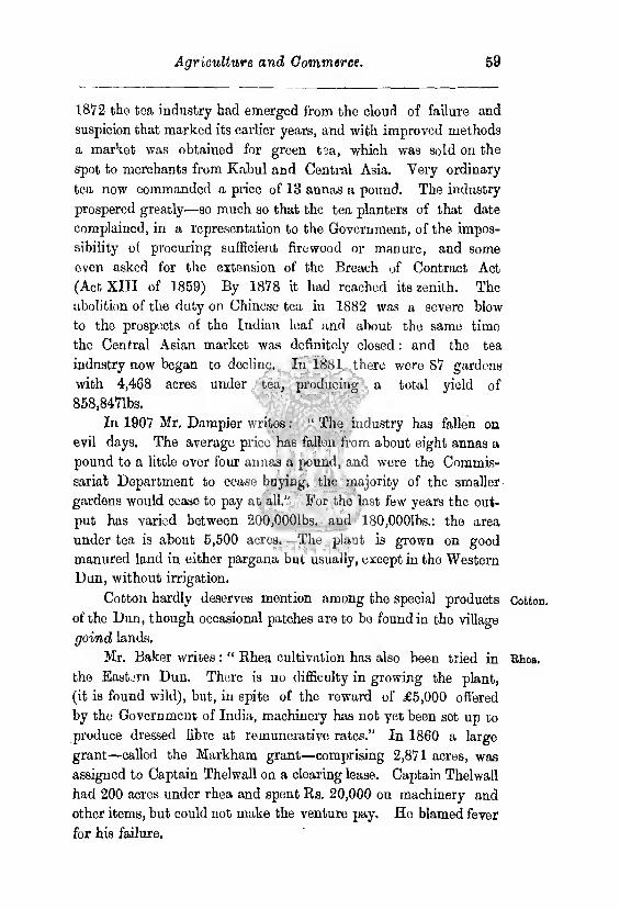
Agriculture and Commerce. 59
1872 the tea industry had emerged from the cloud of failure and
suspicion that marked its earlier years, and with improved methods
a market was obtained for green tea, which was sold on the
spot to merchants from Kabul and Central Asia. Very ordinary
tea now commanded a price of 13 annas a pound. The industry
prospered greatly—so much so that the tea planters of that date
complained, in a representation to the Government, of the impos¬
sibility of procuring sufficient firewood or manure, and some
even asked for the extension of the Breach of Contract Act
(Act XIII of 1859) By 1878 it had reached its zenith. The
abolition of the duty on Chinese tea in 1882 was a severe blow
to the prospects of the Indian leaf and about the same time
tho Central Asian market was definitely closed: and the tea
industry now began to decline. In 1881 there were 87 gardens
with 4,468 acres under tea, producing a total yield of
858,8471bs.
In 1907 Mr. Dampier writes: “ The industry has fallen on
evil days. The average price has fallen from about eight annas a
pound to a little over four annas a pound, and were the Commis¬
sariat Department to cease buying, the majority of the smaller
gardens would ceaso to pay at all." For the last few years the out¬
put has varied between 200,0001bs. and 180,0001bs.: tho area
under tea is about 5,500 acres. The plant is grown on good
manured land in either pargana but usually, except in tho Western
Dun, without irrigation.
Cotton hardly deserves mention among the special products Cotton,
of the Dun, though occasional patches are to be found in the village
goind lands.
Mr. Baker writes : “ Rhea cultivation has also been tried in Rho».
the Eastern Dun. There is no difficulty in growing the plant,
(it is found wild), but, in spite of tho reward of £5,000 offered
by the Government of India, machinery has not yet been set up to
produce dressed fibre at remunerative rates.” In 1860 a large
grant—called the Markham grant—comprising 2,871 acres, was
assigned to Captain Thelwall on a clearing lease. Captain Thelwall
had 200 acres under rhea and spent Rs. 20,000 on machinery and
other items, but could not make the venture pay. He blamed fever
for his failure.

60 Dehra Dun district.
Hemp.
Agave fibre.
Poppy.
Hemp, like rhea, was the subject of early experiments made
by Captain Kirke in. 1840, which after a brief interval of success
failed conclusively.
Colonel Rennie in 1903-05 attempted an experimental
agave plantation on a disused camping ground at Mihun near
Ambari, but the plants were nearly all killed by the severe frost of
1905 and the experiment was not repeated.
The cultivators of Jaunsar-Bawar enjoy the privilege of culti¬
vating the poppy, unrestricted by the rules framed by tho excise
department. The earliest records show that poppy cultivation
has probably existed from the days before the British occupation.*
In 1850 no restrictions had been placed upon the cultivators ; but
subsequently they were ordered, in the interest of the revenue,
to sell only to foreign merchants. In the same year, Mr, A. Ross,
the Superintendent of the Dun, proposed to sell the monopoly of
dealing in opium raised in Jaunsar-Bawar to a Kalsi contractor ;
but the Government was unablo to agree to his suggestion. In
1861, Mr. Wiutle, a sub-deputy opium agent, on leave in Mus-
sooroe, noticed tho cultivation; he reported that the opium pro¬
duced was sold by the Jaunsaris to itinerant merchants, who in their
turn disposed of it to the hill states. He suggested the extension of
poppy cultivation into the Dun and proposed to post a sub-deputy
agent at Dehra. In 1866 Mr. Sladon, the Superintendent,
again raised the question, but tho Lieutenant-Governor refused
to interfere. In 1876, it was proposed to impose a licence fee of
Rs. 2 an acre: Mr. H. G. Ross vehemently opposed it, chiefly on
the ground that the impost would annihilate the margin of profit,
and also because if carried into effect a revision of the settlement
would be necessary. Since that date proposals, usually emanating
from the excise department, have been made periodically for the
prohibiting or regulating of the cultivation of the poppy. The
local officers have in all cases set their face against any change and
the Government has accepted their views. Tho poppy, they point
out, grows in places climatically unsuited to ginger and turmeric,
and like them it is a crop on which tho cultivator depends for the
money to pay his revenue. The privilege of growing the plant
•Major Young, in charge of the Dnn from 1828 to 1841, called upon to explain his failure to send an indont for opium, replied that his district was supplied from the liills north of Dehra,

Agriculture and Commerce, 61
unrestrictedly is very highly prized by the Jaunsari, who is most
scrupulous not to give any cause for its withdrawal. No case of
smuggling into the plains has ever been detected : and the bulk of
the drug is not consumed locally except as a medicine, its
destination is the hill states, and the revenue does not suffer from
the continuation of the indulgence. The area under poppy, which
is grown in 14 out of the 35 khats, has not increased appreciably;
it is now 193 acres as against 185 recorded at Mr. Ross’s settlement
of Jaunsar-Bawar. The juice is collected in the ordinary way,
and is not relined or manufactured. The drug is, therefore,
very crude and not appreciated by the dwellers in the plains. The
average yield is not large : it amounts to two or two and a half seers
per acre, which gives a total annual outturn of about 400 seers.
The Jaunsari soils it at Rs. 8 or Rs. 10 a seer, a fact which accounts
for his refusal to accept the excise department’s offer of Rs. 5 a
seer. The Government has again renewed the privilege of the
Jaunsaris in respect of the cultivation of opium for the remain¬
der of period of the existing settlement.
Captain Hutton of Mussooroc, in 1856, having discovered the Soricul-
existence of wild silk-spinning insects, invoked the assistance of the Early
Local Government which, in 1858, proposed that he should be allow- llistoi'y.
ed to undertake the plantation of mulberry trees near M ussooree.
His salary was to be Rs. 200 a month, with an allowance of
Rs. 3,000 a year for three years to cover expenses. At the end of
the term, it was stipulated, a full report should bo submitted.
These proposals were accepted by the Government of India in Juno
1858, but in 1859 Captain Hutton reported that the experiment
could not succeed. He based his opinion on two grounds : firstly,
the wild mulberry tree, propagated by cuttings, is of slow growth
and would require double or treble the term allowed in order to
attain a growth fit to feed silkworms, while the quick-growing
Chinese plant was not appreciated by bombyx mori, the sub¬
ject of his experiment: secondly, the worms were wild and intract¬
able though yielding good silk. At the same time, though admitting
the failure of his experiment, he advocated further attempts. The
Local Government refused to sanction a further trial.
In 1863 Captain Hutton had been making breeding experi¬
ments with the bombyx mori He noticed that wild worms were
Dehra Dun district.
Captain Murray in the Dun.
Mr. H. G. Ross,
much darker in colour than domesticated worms, besides being
stronger and healthier. He therefore selected the darkest colour
of his stock and bred only from them. In the result he claimed
to have improved the breed and again asked for government
assistance, which was refused on the ground that the interest taken
in silk in Europe was great and that Captain Hutton’s experi¬
ments had probably been anticipated : and, if not, that they were
unimportant. It was probably at this stage of his experience that
Captain Hutton wrote: “ Where the speculator possesses more
money than brains, the best possible way to equalise the two will
be to attempt silk cultivation with Chinese worms in the North-
Western Provinces of India.”
In Dehra Dun the morus sinensis had been introduced from
the Saharanpur gardens in 1850. In 1867 Captain Murray began
experimenting with seed obtained from Bengal, He produced 3501bs.
of dry cocoons and Gibs, of eggs. This poor result was due to
drought and tho lateness of the season when the worms wore hatched
out. But he had convinced himself that sericulture was possible,
and, after 1868, he contented himself with merely maintaining and
improving his breed. His cocoons increased in size, and it is
stated that he obtained 400 grains of silk from 300 dried cocoons
weighing 1,740 grains. The silk was valued in Calcutta at Rs. 18
and Rs. 19 a seer. The colour and the quality were prouounced to
be good: tho thread was dirty and uneven. The yield is extraordi¬
narily good and has in fact never been surpassed.
In 1873 Mr. H. G. Ross, the Superintendent of the Dun, took
up sericulture with characteristic energy. He had been making
successful private experimeuts and had noticed the luxuriant
growth of mulberry trees in the district. He proposed to the Gov¬
ernment that he should be allowed to start an experimental silk
farm in order to demonstrate that cocoons of a superior quality
could bo raised with profit in the Dun. His proposals were accept¬
ed and ho was authorized by tho Government to employ two
Bengalis skilled in rearing silkworms. So gfoat was the pro¬
gress made that, in 1874, Mr. Ross was able to report that in tho
opinion of the experts cocoons raised in the Dun for six years in
succession were as good as first class Italian. He had been able
to find a market for his produce at Rs. 120 a maund as against
Agriculture and Commerce. 63
Rs. 90 to Rs, 100—the Calcutta price for tho best Bengal cocoons.
Samples sent to Italy wore favourably received and Signor Gavino,
representing the Rubatino3 at Genoa, offered five shillings a pound
for 10,0001bs. Further, a Calcutta broker having seen the eggs
produced prophesied a diversion to the Dun of part of the trade
in silk seed. The Government therefore, in 1874, sanctioned the
opening of the Sericulture Farm, and Mr. Ross leased for five
years a plot of 80 acres from the American Methodist Missionary
Society.
A sample of the produce of the new farm was, in 1875, pro¬
nounced by Messrs. Gillanders, Arbuthnot & Co,, of Calcutta, to be
of excellent quality, with a yield twice that of Bengal cocoons, and
in the same year Mr. Ross asked for the engagement of some
Japanese silk workers. Soed from Japan was also received.
In 1876 Mr. Ross, having left tho most careful directions for
tho conduct of the farm, went on leave to England. On his return
six months later, he found his cherished project almost wrecked by
his locum tenens, Mr. Barstow, who had allowed the mulberry trees
to wither. Mr. Barstow even reported on 13th September 1876
that the experiment was a failure and should be discontinued.
Mr. Ross found that his directions had boon neglected in every
particular. The eggs hatched from the cocoons in 1876 were
mishandled and all had died. A few eggs, which had fallen from
their receptacles, were swept up from the ground and placed in
a ghaia. There they thrived, and, with these and some seed
imported from Italy, Mr. Ross made a now start. The farm, after
this temporary sot-back continued to prosper and, in 1879, tho
experiment was officially pronounced a success. The only object
of the Government had been bo discover whether the silk industry
could succeed in tho Dun.
Proposals were now made by Mr. Lopper. on behalf of Messrs.
Lister & Co., of Manningham near Bradford, to take over tho gov¬
ernment establishment. Neighbouring planters had agreed to
pub down cuttings of mulberries on their estates, and Mr. Ross
had already planted the road-sides and canal banks. The moru8
mnlt icavilis was found to be the most suitable food-supplier for the
silkworms. Mr. Lepper now proposed to introduce Kashmiris to
teach the villagers of the Dun how to rear silkworms, but he
Govern¬ ment Seri¬ culture, Farm.
Subse¬ quent mis¬ manage- ment.
Mr. Lop- per.
64 Dehra Dun district.
Lister grant.
stipulated later that the villagers must return to him all cocoons
produced. It is an axiom of tho silk industry that breeding by
unskilful persons inevitably has the result of causing disease among
the worms. Mr. Lepper agreed to bring out from Europe an
experienced reefer, and he hoped to have 5,000 acres of land under
mulberries. For tho remainder of the season the government
rearing sheds were made over to Mr. Lepper, who now brought
down his promised Kashmiris, four in number. It was decided
to extend the industry into the villages; three lakhs of cuttings
were put down and the established plants delivered to the villagers.
Mr. Lopper took over tho government sheds at Amliwala and
elsewhere. Mr. Lepper was a man of sanguine and liberal temper.
He succeeded in popularising the cottage industry in a marvel¬
lously short time by paying for cocoons at a liberal rate,
and offering prizes for specially good produce. He now pre¬
pared to prosecute sericulture on a much larger scale. The
government establishments he pronounced to bo much too
small for anything but experiments, and, in 1880, he began negoti¬
ating for a large grant of land for the exploitation of the industry.
The opinion of Mr. Buck,* the Director of Agriculture, who was
a member of tho committee appointed to settle the terms of tho
grant on tho suitablity of the Dun for silk culture, may be quoted.
He held that Mr Ross’s experiments had proved “ that healthy
silkworms of a good class can be successfully reared and that silk
of a superior quality to any hitherto obtainable in the Bengal
presidency can bo produced in the Dun. The advantages possess¬
ed by the Dun which have conduced to these results are two
(1) That the eggs of tho silkworm can bo sent to tho neigh¬
bouring hills where, the coolness of the climate prevents their
being hatched at a time when food is deficient, and the tempera¬
ture of the plains, in which the mulberry tree grows, is too warm
for the healthy growth of the silkworm.
(2) That at the period when young mulberry leaves are found
and eggs brought down to be hatched the climate of the Dun is
very favourable to tho production of worms of strong constitution. ”
In 1881 a grant of 3,471 acres was assigned to Messrs. Lister
& Co,, at Majri in the Eastern Dun. It was provided that “ bond
* Afterwards Sir Edward Buok.
Agriculture and Commerce. 65
fide silk operations shall be commenced ■within five years from the
date of signing the deed of grant. Bond fide silk operations are
understood to moan tho having not loss than 50 acres of land
under mulberry and the having spent Rs. 4,000 on building and
on irrigation channels. At the end of ten years, provided that
the grantees have ten per cent, of the assessable area under three-
year-old mulberry trees, they may retain the whole grant on con¬
dition that they turn out not less than 100 maunds of green
cocoon annually, ” and the annual production of that quantity of
cocoon was made a condition to their remaining proprietors. Other
conditions provided for the resumption of the grant by the Gov¬
ernment on default by the grantees : the right of purchase at
an upset price being reserved to the grantees in certain circum¬
stances. Mr. Loppor proved himself a capable and energetic
manager. He planted three villages on tho estate, and built a
wall to protect the mulberry bushes from tho depredations of deer.
He, like Mr. Ross, considered cottage cultivation essential to the
success of the scheme; he deprecated the introduction of direct
management as costly and inefficient. The cordial relations that
had existed between Mr. Leppor and tho cultivators did not con¬
tinue after his departure. In 1882 Captain Murray became
manager. He found himself compelled by tho state of the market
to pay only Rs. 20 a maund for cocoons as against the Rs. 40
paid by Mr. Lepper. The latter price was probably not justified;
but a judicious outlay of capital over the popularisation of the
industry would have been profitable in the end. In 1883, the
Superintendent was despondent of success. He reported that at
the reduced price of Rs. 20 or Rs. 22 a maund there was no profit.
The natives demanded not eggs but half-grown worms, while the
mulberry trees were still small and leaf scarce. About this time,
Mr. Lister himself paid a visit to the Duu auci was so disgusted
with the slovenly methods of the cottago cultivators that he intro¬
duced direct management. Captain Murray, in 1884, produced
l,0761bs. of green cocoons out of 15Joz. of seed. This was a most
creditable result, but he was discharged a little later because he did
not show the expected profit. He was succeeded by Mr. Herdon.
The latter’s management was not successful. He began in an
ambitious manner by laying down a vast quantity of seed, without
5
Dehra Dun district.
Causes of failure.
considering the amount of leaf available for the food of the expected
worms. The result was that he either starved his worms or squan¬
dered money by carting leaf from distant plantations. His
mulberry plantations were utterly stripped and many trees died. He
erected an expensive filature for reeling the cocoons on the spot.
When he left he was able to show 800 acres of mulberry and 27 large
rearing sheds; but his management had resulted in the sinking of
more capital than the concern could carry, and, worst of all, he
dispersed the three villages planted by Mr. Lepper. In 1889, Mr.
Farrant, the manager, was sent to Europe to learn the most recent
French methods. But the venture was in a bad way and silk
cultivation was actually pretermitted during the year 1893. It was
resumed again later, but the outturn between the years 1898 and
1901 was extremely poor, and, finally, in 1902, the grant was
resumed for default in respect of the clause of tho deed providing
for the yearly production of 100 maunds of green cocoon. Chaudhri
Shib Ram bought in as much as was absolutely resumed for
Rs. 25,000 and the grantees sold him also the portion amounting
to 971 acres to which they were entitled under the terms of the
grant.
The venture never had a fair chance. To Mr. Lister, afterwards
Lord Masham, it was a very unimportant adjunct to his vast
business and, after it began to oat up capital, he was anxious
to get rid of it. He was unablo to devote much personal attention
to so distant an enterprise. The erection of the filature and
the cessation of cottage cultivation were false steps. Their result
was foreseen by Mr. Ross, the parent of the scheme. It would
probably have paid better bo have sent the cocoons to Europe
to be reeled. The managers were too frequently changed and
too little supervised. At the same time, there were difficulties
in the way of cottage cultivation. The cottagers were unwilling
to risk their money and labour in a speculative enterprise:
the managers could not guarantee them a remunerative price for
the cocoons they delivered. And it must have been difficult to
prevent the cottagers from retaining a portion of cocoons they
had reared for the production of seed : a procedure which invariably
leads to deterioration if not disease. At the same time, Mr, Ross's
experiments were conclusive only as to the success which might
Agriculture and Commerce. 67
bo expected to await cottage cultivation: and Mr. Lister was
probably ill-advised to base his hopes of success under direct
management on experiments devoted to an entirely different
object.
Experiments were made in 1898 and 1899 with the North
China moth antheraea perugi by the divisional forest officer
of Jaunsar-Bawar. In its native country it feeds on two oaks,
quercus robur and quercus dcnlata and the problem was to
rear it on one of the Himalayan oaks. The cocoons were received
in December 1897 and sent to Chakrata, many of the moths
having already emerged in transit. Soon, one by one, they all
came out and, after pairing, the females began to lay eggs and,
eventually, from these eggs worms hatched out in April and
May. They were first tried at Chakrata and fed on leaves of
the ban oak, quercus ineana, and moru oak, quercus
dilitata, but they did not succeed on this food. They were
tried with the high level oak, quercus semicarpifolia, which
fortunately seemed to suit them. As the temperature at Chak¬
rata was too high and the food trees too far away they were
moved to Deoban, and after undergoing the usual moults 182
of them spun cocoons. These were kept throughout the autumn
and winter months at Deoban, and were brought down to
Chakrata in the middle of March 1899. One hundred moths
hatched out between the 6th and 17th April, and eggs were
laid shortly afterwards. These eggs were kept at Chakrata to
hasten the process of hatching, and as the worms hatched
out they were put upon leaves of kharshu oak (brought down
daily from Deoban) and were then transferred to Deoban them¬
selves. Six hundred and forty-five larvae hatched, out of which
390 were still alive and hoalthy at Deoban on the 1st July,
the rest having either died in transit between Chakrata and
Deoban or after arrival at the latter place. The experiments
carried out showed that tho insect cannot be successfully cultivated
in-Jaunsar except at considerable trouble. They do not thrive
on either moru or ban oak and rearing them in the kharshu
forests is never likely to be taken up to any great extent by the
Jaunsaris on account of the distance from their villages of such
forests.
Bilk in Jaunsar- Bawar.
68 Dehra Dun district.
Scarcity. The Dun and the hill pargana both enjoy an unusually copious
rainfall, and owing to their physical configuration it is seldom
that the monsoon is an entire disappointment. In addition
to this climatic advantage, owing to which complete failure of crops has been hitherto unknown, considerable tracts of the Dun
are insured against crop failure by the canals, and there has at all
times been an abundant demand for labour on the tea plantations,
at Mussoorie and Landour, and in the forest department,
while masons, carpenters and general labourers can command
high wages in Mussooree and Dehra, consequent upon the sudden
development of the building trade in those stations. Owners
of draught bullocks or pack ponies can make a steady income
in the transport of goods up to Mussooree or Chakrata. The
district is therefore by natural and artificial causes very strongly
insured against the consequences of a crop failure. The fact that the
jhampanies and porters of Landour and Mussooree and the coolies of
the forest department are for the greater part imported from
Garhwal and the Punjab, respectively, is strong evidence of the
material prosperity of the agricultural community. Occasionally
one or more superfluous members of a large family takes
service either in a hill station or in the forest department, but
the motive is simply to earn enough money to pay the revenue or
the rent as the case may be.
In 1861 the crops were poor, but the distress nowhere went
beyond a scarcity, and the famine works on the road through
the Mohaud Pass amply sufficed to meet the wants of all those
needing relief. Most of the workers came from the Saharanpur
and other districts.
In 1897 famine was declared in the lower Icka ts of Jaunsar-
Bawar The needs of the able-bodied were met by the offer of
work on a number of paths. These cost in all Rs. 8,537, of which
Rs. 3,324 came out of the funds of the district board, the Gov¬
ernment undertaking the remainder. In all 37,361 units were
relieved and Rs. 4,379 were advanced as takavi. No gratuitous
relief was administered.
The existence of scarcity was officially recognized towards the
end of January 1908 in the Chakrata tahsil, and, in April,
in the hill and submontane portions ot the Dehra tahsil. The
Agriculture and Commerce. 69
Dun valley itself was not affected. In 1907 a scanty monsoon had
resulted in a very unsatisfactory autumn, harvest. By November
the land was dry and thirsty, and many fields would not admit the
plough. Seed, \vh to sown, germinated badly and the rabi harvest
of 1908 was a total failure. Naturally, those villages in Chakrata
which had had the worst kharif suffered most at the rabi. Tho
provisions of the Famine Code were found unsuitable to the
conditions of the hills. It was thought for one thing not desirable
to collect large numbers of workers with their dependants on
large public works where arrangements for sanitation and the supply
of drinking water would be exceedingly difficult; nor was it
expected that the hillman would work at any great distance
from his home. The distress was mot by the opening of 78
civil works, costing in all Rs. 26,212. The sympathies of the more
wealthy hillmen were enlisted, and they readily offered all possiblo
assistance. Practically all the works were in charge of non-officials,
who received payments in advance, accounts being settled when the
quantity of work done had been measured. The wage paid was
found sufficient to provide also for the families of the workers,
and gratuitous relief was granted to only 520 persons altogether.
Their doles were also in most cases distributed by the sayanae
of khats or of villages.
Some 30 years ago the Dun was more than self-supporting, prices,
so that there was little demand except in the larger towns for
food grains. Food produced beyond the immediate needs of
the producer was therefore either stored against bad years or
else sold at very cheap rates. The economic conditions of
the Dun gradually altered—the result of colonisation and
development, the expansion of Dehra and Mussooree and the
gradual evolution of a population, partly at least industrial. The
change is now complete and tho corn lands of the district now
no longer suffice for tho needs of the population. Imports from
without arc therefore necessary and in time of scarcity prices
rise enormously. A comparison between the present prices
current and those of the sixties is apt to be misleading. The
staple food grains are wheat, barley, rice (“ common ” and
“ best ”) and mandua. The average rate per rupee of each for the decade 1861 to 1870 was 19 seers for wheat, 27£ seers for barley, 14
70 Dehra Dun district.
Wages.
for common rice, 7| for the best,and 23§ for mandua. For the year
1906-07 the average price of each was according to tho season 9 to 12
seers, 10 to 14 soers, 7£ to 9 seers, 6J to 7 seers and 10 to 13 seers.
1896-97 was in the plains a famine year—a fact which naturally
drove up prices in the Dun. In 1904 tho prices were 17 seers,
25 seors, 9 seers, 5 to 5.1 seers, 22 to 24 seers : and in 1907, another
famine year, 8 or 9 seers, 13 seers, 6| to 8 seers 2| seers and
15 seers. The recorded prices in the Jaunsar-Bawar pargana
are still more deceptive : there, in the best of years, the ordinary
land-holding cultivator has little beyond his ordinary needs,
the landless men, usually koltaa or serfs, are maintained by their
masters and the ill-supplied cultivator buys from the rare well-
euppliod man at prices much lower than those prevailing at
Kalsi or Chakrata. The markets in fact do not exist for the
convenience of the ordinary agriculturist, but for those members
of society who have nothing to do with tho land : that is to say,
the professional, official and menial classes. It would therefore
be most misleading to attempt any conclusions from fluctuations
in prices at the markets.
Labour is in a very strong position in Dehra Dun, and the
labourer naturally exacts the highest possible price, which, in sympa¬
thy, with the rise in the rates of food grains, has risen enormously of
late years. Some interesting facts are on record. As a result of
his Jaunsar-Bawar settlement operations in 1829, Colonel Young
proposed to spend Rs. 3,600, a year on road-making. The
chauntras and syanas offered in exchange for Rs. 3,000 to keep
300 men daily at the work for a period of eight mouths: that is
to say at a monthly wage of Re. 1-4-0 each. This offer is probably
not a trustworthy indication of the state of tho labour market,
for the construction of tho road was to the advantage of
the people and they were probably ready to serve at some¬
thing considerably less than current rates. Also there are few,
if any, free labourers dependent solely on labour for their sub¬
sistence iu the pargana. Labourers are either serfs of the zamin-
dars or else poor cultivators who eke out a precarious livelihood by
taking to odd jobs at slack times. Tho local labour market is
thus precarious and irregularly supplied. From 1822 to 1824, a master-mason in the Dun could command Rs. 6 a month, a
Agriculture and Commerce, 71
bricklayer Rs. 5 a month, an adult coolie 1J anna and a
boy coolio 1 anna a day. In 1829 coolies’ wages occasionally
reached 2 annas a day. In 1872, an ordinary field-labourer
was getting 2 annas a day or its equivalent in grain and coolies
annas a day.
In 1886 Mr. Baker, the settlement officer, noted the wages
paid on tea gardens. The season lasts from the middle of March
to the middle of December and a large amount of labour is
required, but the supply was generally sufficient. Many of the
coolies were not natives of the Dun. Men were getting two annas
a day, women an anna and a half and boys one anna. The
planters have recognized the advantages of having a large number
of coolies ready to meet any call and they therefore let a consi¬
derable portion of their land to tenants who grow their own crops,
principally cereals. Rents are pitched low, but the tenants are
bound in return for this concession to work as coolies for fixed
periods.
In the forests, labour is supplied chiefly from Delhi and the
neighbouring Panjab districts: but hillmen arc now showing a
tendency to take up the work. The ordinary rates are : for felling,
one anna a tree: for sawing sal scantlings four inches by five
inches, eight annas per score of running feet: for sawing metre-
gauge sleepers four annas each. The unskilled labour is supplied
by local as well as hill coolies who get a daily wage of three to
three and a half annas. In the villages, field-labourers are almost
always paid in kind : reapers are invariably so paid ; the rates are
nominally five seers of grain a day for an adult male cooly and
three or four for a woman. In Jaunsar-Bawar the supply of
labour is as already explained small and travellers find volunteer
coolies scarce even at the rate of four or five annas for a day’s
march. The fact that the day’s work often finishes up ten miles
or more from the cooly’s home makes this form of labour
unpopular. The public works department can however secure
inferior coolies’ labour at from 2J to annas a day. Work
on roads is well suited to the genius of the Jaunsari, No fixed
task is imposed and the immediate supervision is in the hands of
a fellow hillman who shares his easy notions of the dignity of
labour. In the Dun throe annas a day is the current rate in the
12 Debra Dun district.
Interest.
district and 4 annas a day at Debra. A mistri can command
Rs. 20 to Rs. 25 a month, and a mason or carpenter 8 to 14
annas a day. Blacksmith’s wages are somewhat higher. A syce
gets from Rs. 7 to Rs. 9 a month, sometimes more. It is
almost impossible to get any servant, even a coolie, on less than
Rs. 6 per mensem, which is practically the minimum wage
of the district. Mussoorcc and Landour attract a large floating
population of porters and jhampanis, These are required by
the municipality to take out licences and to observe certain rules
regarding the rates of pay and the obligations subsisting between
the employer and the employe. The standard load is however
not defined. A cooly is allowed six annas for the transport of
a load from Mussooree to Raj pur, a journey which a strong, active
man can easily perform twice a day and ho often gets a few
annas bakhshish as well. Within the municipal limits coolies
working by time can earn eight annas for ten hours’ work and
a proportionately smaller sum for a shorter period. The work is
therefore highly remunerative and not on the whole laborious.
The coolies are for the greater part inhabitants of the surrounding
hill districts aud states, though a few come from Doti on the Nepal
border. Generally speaking, the local hillmcn confine themselves
to the quick transport of dandies and packages of moderate bulk :
the Dotials who are often men of enormous strength prefer to
handle heavy goods, and therefore take much longer over the
journey. The tea planters of the Dun being dissatisfied with the
state of the labour market made an effort to havo extended to the
district Act XIII of 1859, the Breach of Contract Act, legalising
penal contracts. They were unsuccessful in their efforts, but the
Act was extended to Mussooree and Landour in 1859,* and to
Chakrata in 1869j*.
Tho custom with regard to loans in Jaunsar-Bawar is thus
described in the Dastar-ul-Avuil: “ As regards interest the debtor
has to give eight pakka seers of corn at each harvest (called hut)
for each rupee until the original sum is paid up. If the debtor
becomes insolvent, the creditor takes the original amount and
foregoes the lut or takes double the principal in coin. With
* Notification 3385, of 16 th August,
t Notification 782A, of 25th November.
Agriculture and Commerce- 73
regard to tho grain debts, the custom is that for one year the
original is increased by ono-half, and in the second year the accu¬
mulated amount or whatever remains unpaid of it is increased by
one-half in other words compound interest at 50 per cent, is
taken, the deorha of the plains. But in the case of insolvency the
demand of the money-lender is limited to thrice the original
loan.
In the Dun there is no fixed rates of interest, 12 per cent, and
sometimes less is common where the security is good. On
the other hand, where the security is slight, the rates may go up
to as much as 75 per cent., though it seldom rises beyond 37
The standard measure of capacity in Jaunsar-Bawar is as in Weights
Garhwal the patha. A pat ha of wheat weighs exactly two seers: Measures
rice about If seers. Tho standard of square measures is also the
patha: as in the case of the measure of capacity the basis of
calculation is the patha of wheat. A patha of land is the amount
that can be sown by one patha of wheat. Sixteen pathas make
one don and twenty dons one khar.
In the towns and bazars of the Dun the ordinary paklca seer of
SO tolas is used. In the villages the Icachha seer and its subdivision
or multiples are in use : it is half the pakka seer. The units of
measure are the Icachha bigha and biswa ; 51 Icachha bighas are
equivalent to one acre. The pakka bigha is unknown. The
chain of 22 yards is also used.
The trade of the Dun follows two channels: firstly, between Trade,
the valley and the plains and secondly, between it and the hills.
The exports to the plains are principally timber, bamboos, lime,
charcoal, catechu, tine rice (bansmati), potatoes, tea, and munj
and babar grass. In return the Dun receives hardware of all
sorts, cotton cloth, blankets, salt, sugar, food grains, tobacco,
dried fruits, spices and sheep. All these again are sent on to tho
hills. From the hills come coarse blankets (lohi), rico, ginger,
turmeric, red pepper, ringal in various forms, pens, pipe-stems or
fishing-rods, walnuts, apricots, honey, wax, lac, gum, resin, timber
and potatoes. Opium from Jaunsar-Bawar is no longer exported
to the plains.
Lime is the chief export of the Dun. In 1908, 456,996 Exports,
mauncls classified as stone and lime, left the district by the railway,
u Dehrd Dun district.
and, as the building stone of the district is not usually worth export¬
ing, it may bo assumed that nearly all this quantity was lime.
The local public works department rate is Rs. 40 to Rs. 50 for 100
local (or 150 government) maunds. The trade is therefore very
valuable. It naturally received a great impetus from the opening
of the railway in 1900. The limestone is obtained by quarrying
in a few cases, but generally speaking vast quantities of boulders
brought down in the rains from the Himalayas are collected in
the dry river bods when the floods subside.
In the Eastern Dun stones are collected in a pit of about 1,000
cubic feet capacity with a narrow sliding hole about 3 feet
in diameter to admit air. The bottom is filled with common
boulders upon which firewood is stacked, and the mouth of the
pit is covered with limestones arranged in a conical form so as to
allow of a draught of air passing through below. The wood
is then set on fire and, as the heap sinks, fresh limestones are
placed on the top. About 300 maunds of stones are burnt
in each pit giving an outturn of about 200 maunds of lime.
These pits are called k-utlas and each burning takes a week
or more.
Iu the Western Dun the process is rather different. Advant¬
age is taken of the high banks that bund the beds of the Tons
and Bindal rivers, A semi-circular excavation is made in the
bank and filled with limestone and fuel iu alternative layers. Such a
kiln is capable of turning out about 250 maunds of lime at a
single firing.
Next in importance to lime is forest produce of various
descriptions. The methods by which timber is disposed of have been
already described in the first chapter. Among minor forest produce
the most important are the babar and munj grasses. The term
babar is indiscriminately applied to two different plants—eriopho-
rwn, which is a sedge and ischoemum, which is a grass. The fibre
is woven into string for charpoys or into ropes of larger calibre much
appreciated in the hills where hemp is scarce. Pulped, it is converted
into paper. Munj is a handsome grass which attains a height of from
eight to twelve feet. It is, like babar, used for the manufacture of
string, rope and paper. In addition, it is also woven into
matting, which is said to be capable of resisting the attacks of white
Agriculture and Commerce. 75
ants. The stouter stalks aro, under the name of airki, used as a
thitch for carts in wet weather; it swells with rain and offers
an impervious surface. It is also used for the manufacture of cheap
chairs, stools and couches. Charcoal, prepared from the coarser trees
of the jungle, also finds a ready market in the plains. The fino
kind of rice kown as bansmati is almost the only food-grain exported
to the plains. It is much appreciated in the plains and is a favourite
form of gift sent by sojourners in the Dun to friends and relatives
on the plains. Turmeric, besides its use as a condiment, yields
a yellow dye and has also medicinal properties, Ginger and
chillies find a ready market at Kalsi, the hillman often taking
food-grain in whole or part exchange ; thcnco they are exported by
road to Dehra and so to the plains by rail. The trade in limo
and tea has already been described. Coarse blankets called lohi
are woven by the hillmen from the wool of' their sheep and goats,
and those in excess of local requirements are disposed of through
the bauia middleman. In the upper khata most of the people
keep bees, their hives being a mere hole in the house wall : they
sell the honey and the wax. The honey of wild boes is also collect¬
ed. It jjj dark-coloured and unpalatable, but is consumed oagerly
by the cattle for whom it takes the place of the gur occasionally
administered in the plains. Walnuts and apricots are grown in
most villages and the produce is disposed of oither to less favoured
neighbours or to the shopkeepers at Chakrata or Kalsi, A few
fruit gardens in Mussoorce do a fair trade in the produce of
English grafted fruit trees, such as plum, apple, pear, and the
like, which are sold locally. The ringal is brought down to be cut
into pipe-stems or reed-pons. The remaining export of importance,
turpentine, is also a product of the forests : the manufacture has
been described earlier. In return for these commodities, the Dun
receives hardware of all sorts, cotton and woollen cloths, salt, sugar,
food grains, tobacco, dried fruits and live stock.
A somewhat primitive form of barter exists in Jaunsar-Bawar
hardly perhaps to bo dignified with the name of trade. Special
products of fortunate Ichuts such as oil-grains, spices, onions, and
the like, are taken by others who need them on payment of ordin¬
ary food-grains. The supply of salt, sugar and cloth for one year
is usually carried up from Kalsi, Chuharpur or Dehra itself by the
76 Dehra Dun district.
Manufac¬ tures.
hillmen who descend from their homes in the early autumn, bring¬
ing down for sale their own produce, especially the valuable
revenue-paying crops already described—ginger, turmeric and
chillies. These they sell or exchange for the commodities of which
they stand in need. Every inhabitant of Jaunsar-Bawar performs
this journey at least once a year and, when scarcity prevails, his im¬
ports include also food-grains, purchased for cash, and his journeys
become more frequent. Cattle-dealing, which consists in buying
and re-selling plains bull-calves, needs no further discription.
Dehra Dun is almost entirely an agrarian district. Its few
manufactures are designed for the most part to meet local demands.
There are three breweries which are described elsewhere : they
employ in all only 169 men. The Himalayan Glass Works were
established at Rajpur in 1904 : they went into liquidation in 1908,
and have since been bought up by a wealthy Punjab merchant
and a Dehra bania. They have again started work on a small scale.
A number of Austrian workmen were imported to teach the native
the art of mixing tho materials, heating tho furnaces, annealing
and glass-blowing. At the. outset the Company appears to have
contemplated making various glass vessels, bottles and the like,
but the outturn of these articles was small, and, as it was necessary
to train the workers, the Company confined itself chiefly to the
preliminary stages. It therefore taught its employes to mako glass
bricks. These were sold to manihars who melted them and
produced their well-known glass bangles. The causes of failure
appear to have been weak European supervision, over establish¬
ment, heavy capital outlay and slackness on the part of the
Austrian workmen.
The latest of all the Dun enterprises is the Sansa Dhara
Mineral Water Company, which is trying to secure a market for
the waters of the Sansa Dhara (or Sahasradhara) spring near
Rajpur,which possesses certain medicinal properties. The Company
is in its infancy and at present nothing can be said of its work or
chances of success. Kunwar Balbir Singh owns rice and flour¬
mills, and Seth Lachhmi Chand, who trades under the title of tho
Himalayan Rice and Oil Mills, has a very fair business.
There are eight printing presses in Dehra and Mussooree, tho
Gurkha, Amin, Grand Himalayan, Shri Swami, Dehra Times,
Agriculture and Commerce, 77
Mussooree Times and Mofassilite, Mussooree Star and Mussooree
Echo; and live newspapers. The Voice of the Dun, the Mussooree
Times and the Echo are published gratis weekly. They are cheap
advertisement sheets enlivened with local, political or social news.
The other papers are of no importance.
Sahaspur and Annfield (Chuharpur) in the Western Dun,
Rajpur, Doiwala and Bhogpur in the Eastern Dun contain small
bazars, but the real mart for most of the Debra tahsil is Dehra
itself. Tho inhabitants of the south-east corner of the district deal
with Hardwar in the Saharanpur district. None of these markets
have a fixed market day. In the hills Mussooree and Chakrata
during the season, and Kalsi throughout tho year, are the only
markets. Kalsi is a much decayed town and has been practically
superseded by the Nahan Maharaja’s newly established market at
Chuharpur. Rajpur at tho foot of the hills was once a place
of some importance, but it is now overshadowed by its neighbours,
Dehra and Mussooree, to the south and north,
A list of the fairs held in the district will be found in the
appendix. None of them are numerically or commercially
important. The wares exposed are the ordinary pedlar’s
stock-in-trade—bangles, armlets, combs, looking-glasses and
the like. The largest of all is the Jhanda mela held in front
of the temple of Guru Ram Rai at Dehra in Chait. The fair
derives its name from the huge new flag which is annually
hoisted. The crowd seldom exceeds 3,000, of whom many are
Punjab Sikhs. A fair in honour of Bharatji, the brother of Rama
and Lachhman, is held at Rikhikesh on the Basant Panchami:
it is chiefly attended by pilgrims from Hardwar, and the concourse
is never great. Another religious gathering of the devout, chiefly
from Garhwal and Tehri, assembles at Rikhikesh on the occasion of
the Holi, and a third is the Dikhauti occurring in April usually.
Some 600 people collect at Raiwala on the Ganges in honour of
the Basanti Devi: most belong to tho Saharanpur, Bijnor and
Dehra Dun districts.
The communications of the district have vastly improved of
late years. The railway since 1900 runs into Dohra itself, thus
obviating the necessity of the long journey by road from Saharan¬
pur, The lino enters the district by a tunnel near Hardwar. The
Markets.
Fairs.
Communi - cations: Railways,
78 Dehra Dun district
Boads,
intermediate stations within the district are Rikhikesh Road,
Doiwala and Harrawala. The original proposal was to carry the
railway as far as Jakhan—half-way up to Rajpur, but, owing to the
short-sighted views of the Raj pur hotel-keepers, who petitioned
against the railway being brought up so near to Rajpur and
the outcry raised in Dohra about the destruction of the amenities
of the station that would result from the passage of the railway
through it, tho lino was never carried further than Dehra.
This is now admitted to have been a mistake. Unless the Indian and
Colonial Development Company are able to execute their project for
an electric tramway from Dehra to Mussooroo, it would certainly
be desirable to extend the railway to the foot of the hill near
Rajpur. The engineering difficulties would not be great.
The great trade routes connecting Dehra with the plains are
the Rurki-Dehra-Rajpur-Landour roads and the Saharan-
pur-Chakrata road. The first was cleared and widened by
Mr. Shore about 1823, chiefly by convict-labour. It enters the
district by the Mohand Pass, and thence descends by a moderate
incline past Asarori, a former outpost and toll-house, eight miles
from Dehra. Thence up to Dehra the road runs over fairly level
country as far as tho Bindal river, which is now crossed by a bridge,
It was formerly often a cause of delay to travellers by reason of the
heavy and sudden floods which sweep down its bed in the rains.
Above Dehra and as far as Rajpur, the road carries a very heavy
traffic, especially during the Mussooree season. This section has
been widened at great expense, but the surface is by no means always
in good condition, nor is the road, though widened, broad enough
for the traffic it has to carry. Heavy carts are often compelled to
plough their way through the unmetalled berms of the road,
and are responsible for tho clouds of dust that stifle the
traveller in the hot weather. At Rajpur heavy carts and carriages
stop, but a good bridle path bitiurcating at Barlowganj brings the
traveller to Mussooroo or Landour, and baggage and heavy goods are
transported either by special light carts on the hill cart-road,
or by coolies or mules on the bridle path.
The Saharanpur-Chakrata military road was the natural sequel
of the establishment of the cantonment in Chakrata, It was made
in 1873, It enters the district by the Timli pass and, skirting
Agriculture and Commerce. 79
the northern slopes of the Siwalik Hills, descends gently to the
Asan River which it crosses near Fatehpur. Thonce it turns
north-east as far as Kalsi. Here a fine bridge carries it across
the Jumna. From Kalsi the road winds up the Amlawa
River, which it crosses at Saiah, fifteen miles from Chakrata.
The total distance between Kalsi bridge and Chakrata is 28|
miles. From Saiah a bridle path runs up to Chilmori Nock and
Kailana, thus shortening the road to Chakrata by somo six miles.
The military road was constructed at vast expense in spite of the
vehement opposition of Mr. H, G. Ross, the then Superintendent,
who pointed out most justly that for the money that was to be
lavished on this road it would be possible to construct a railway
into Dehra and a metalled road thence to Chakrata. His
views did not find acceptance then but have been justified by the
result. Since the Dehra Railway and the rest camp were opened,
practically all the troops come into Dehra and march from there to
Chakrata. The traffic on this expensive road has therefore dwindled
to tho smallest proportions and a large part of it has been
made over to the civil authorities. From Kalsi to Chakrata
traffic has always boon slight except twice a year, when tho troops
move up and down. And now that the railway has superseded
the road as a means of communication with tho plains the
Saharanpur-Fatehpur soction is almost entirely deserted so that in
the result only tho portion between Fatehpur and Chakrata is of
any practical benefit to the district.
The third connecting link between the plains and tho Dun
is the Dehra-Hardwar road. Formerly this road used to leave
the district by the Motichor Rao and was not available for
cart or carriage traffic. Mr. Shore, therefore, diverging from the
old track at Kansrao, carried the road down the right bank of the
Suswa river and under the shoulder of tho Siwaliks above
Hardwar. The bridge over the Suswa, at Kansrao, was swept
away by a flood in 1874 and has never been rebuilt. The road
is metalled only for the first ten miles out of Dehra as far
as Lachhiwala, and its utility is greatly impaired by the
gap at Kansrao, The road has, however been to a certain extent
superseded by the railway as far as traffic is concorned, but it must
for many years yet afford the cultivator a cheaper form of carriage
80 Dehra Dun district.
Internal communi¬ cations : (a) West¬ ern Dun.
for his goods to and from Dohra than the railway. It also
acts as a feeder road to tho various railway stations cn
route. A road runs from Dehra along the right hank of the Asan River
as far as Rampur Mandi. It may be considered an extension of the
Hardwar-Dehra road. It carries most of the traffic of the Western
Dun, and lies conveniently for many of the larger grants in that
pargana. The chief villages which it traverses are Sahaspur and
Fatehpur where it crosses the Chakrata-Saharanpur road : as far
as tho latter place it is raised, bridged and metalled throughout,
and from Fatehpur to its termination at Rampur Mandi on the
Jumna it is unmetalled and in indifferent order, especially near
tho Jumna. The railway as far as Dehra, this road as far as
Fatehpur and thence the military road, form now the recognized
way of reaching Chakrata fronythe plains. Some miles of the total
distance can be avoided if the traveller leaves the road just beyond
Dhaki about five miles east of Fatehpur and follows an unmet¬
alled road as far as Ambari on the Fatehpur-Kalsi section of the
military road. From Sahaspur a sixth-class road (not metalled
or raised but cleared only) proceeds north-east to Horawala at the
foot of the hills. Thence a bridle-path ascends to Mussooree, thus
affording direct communication between tho Western Dun and the
hills. An alternative preferred by those living further east in the
pargana is from Jhajhra to Dunga by a fourth-class road and
thence up the hill. Dunga itself is connected with Dehra, ten
miles away, by a sixth-class road. Roads of some parochial impor¬
tance are that connecting Banjarawala village, about three miles
south of Dehra, with Dharmpur, where it meets the Dehra-Hardwar
road at a point about two miles oast of Dehra, the Dehra-Silakua
road, running parallel with the Dehra-Rampur Mandi road, at a
distance of two miles from it, and ultimately joining it at Silakua,
and the Dehra-Kaonli-Shahpur road.
A broad forest road runs all the way along the base of the
Siwaliks from Asarori to Dharmawala on the Timli-Fatehpur section
of the Chakrata-Saharanpur road, passing the bungalows of Kar-
wapani and Sabhawala. Karwapani is connected with Dehra by
a sixth-class road which crosses the Asan by a ford a few miles north
of the bungalow.
Agriculture and Commerce. 81
The importance of the railway to the Eastern Dun has been' W Ea§t
briefly not'd. Much of this portion of tho district is unfortunately erB
severed from tho railway by the river Song, bridged only a little
way above Gohri. Tho Ilardwar-Lachhmanjhula road is thronged
during the months of April and May with pilgrims on the first
stages of the journey to the Garhwal shrines. It has, however, little
economic importance except so far as a certain profit accrues frppj
letting out carts to pilgrims. It also affords an outlet for the
produce of the south-western pat tin of the Garhwal district which
carry on some trad.: with Rikhikesh and Hardwar. The road
terminates at the Chandanawa Rao just above Rikhikesh : thence
it is continued by a bridle-path following the right bank of the
Ganges as for as Laehhmaujhula.
The main routes to the Eastern Dun are a sixth-class road
from Dehra duo east to Raipur, thence a sixth-class road running
mainly along the bed of the Song to Thano, and from there across
the Jakhan Rao to Bhogpur; a fourth-class road from Lachhiwala on
the Dohra-Hardwar road straight across the Song and Jakhan
Rao (with a branch from Doiwala railway station) to the Rani-
pokhri grant, and thence vid Barkot to Rikhikhesh. The latter
section is now being made; it will be completed beforo the end
of 1909 and will then replace tho existing bridle-path from
Barkot to Rikhikesh.
Ranipokhri grant is connected on the north with Bhogpur by
the Jakhan canal bank road and on the south with the Dohra-
Hardwar road by an unmetalled forest track running to Kansrao
vid Galar Paras. A branch forest line skirts the northern slopes
of the Siwaliks from Kansrao to Asarori. Raiwala and Bhopat-
wala both on the banks of the Ganges are joined by another sixth-
class track.
The Chakrata military road and the Saiah-Chakrata bridle- HiI1 roft^
path have already been noticed. The next road-in importance is
the Mussooree-Simla road. This leaves tho Waverley road not far
from the Charloville Hotel. From the western boundary of
Mussooreo as far as the Jumna the road lies within the territory
of the Raja ofTohri. The first stage is Sainji, nine miles, where
there is a small inspection bungalow above tho lower reaches of the
Kimpti river. The famous falls can be seen from the road a few
6
82 Dehra Bun district.
miles beyond the boundary. From Sainji the road drops down
to the Jumna at Jalauta where a fine suspension bridge has been
erected. Thence a steep climb of about a mile brings the traveller
to the picturesque village of Lakhwar, six miles, where a new dak
bungalow has been recently established. Thence the road winds up
the ridge past Nagthat, seven miles, a district board inspection
house, to Churanipani d&k bungalow, five miles—a fine view of the
snows is obtained from this point. From here to Chakrata is a
distance of nine miles : the road enters the cantonment by Chilmeri
Neck. Minor roads constructed in the famine of ] 908 take off from
the main Mussooree-Chakrata road at various points along its course
between Laneckphwar and Chakrata.
To the north of Chakrata from Morrow’s Neck the road
bifurcates. The lower Simla road follows a route through Jadi
village, where there is a district board inspection bungalow, then,
passing near Bodhyar forest rest house below Lokhandi Peak, it
gradually drops to the Tons river at Sangota, 18f miles from
Morrow’s Neck. Another district board inspection house stands at
Kawakhara, a mile short of the river. It then goes on through Jubal
state and is, it is believed, in a poor state of repair in those terri¬
tories. This route is shorter by at least two marches than the other
route by what is called the upper Simla road. This road passes
through Deoban, 3 miles from Morrow’s Neck, then keeping at an
average height of 8,000 to 9,000 feet goes along tho main water-
parting of the Tons and Jumna, passing close to the peaks of
Bajamara 9,536 feet, Tarara 9,533 feet and Karamba 10,075 feet.
At Karamba Neck it is usual to leave the Simla road, 13£ miles from
Morrow’s Neck, and pass the night at the forest bungalow of Mundali,
2J miles down the spur. The main road however passes along the
ridge above Mundali and thence gradually falls to Jakhnilani,
25J miles from Morrows’ Neck. Close to this road, half a mile
farther on, is the Kathyan forest rest house and thence' the road
descends gradually to Tiuni on the Tons, 39 J miles. Here there is
a suspension bridge and a forest bungalow. Thence the road
rises after crossing the Tons to Pushrargadh and then leaves
British territory at a point 43 miles from Morrows’ Neck. An im¬
portant road, diverging from those above mentioned, is the road
from K'ailaaa down Pathiadhar to Dungiaragadh and thence
Agriculture and Commerce. 88
over Ghora ghati and round by Nadh village up to the main water*
parting of the Tons and Jumna. It joins the upper Simla road at Lokar between Mundali and Kathyan.
There is also a bridle-road, much used in the cold weather, from
Saiah over Phedul and into the Tons valley at Kawanu. Thence
crossing the Tons at Minus bridge it passes through Jubal territory
on the right bank, entering British territory again where it crosses
the Shalun river close to Sangota. Thence it runs to Tiuni, 42
miles from Saiah. An important branch road also goes up the
Tons from the 34th mile on the upper Simla road and is passable
for mules as far as Datmir village in Tehri-Garhwal, about 30
miles higher up. Another branch road, passable for mules, leaves
the Simla road at Tiuni bridge and goes up the Pabar valley to
Roru and Hatkoti. This is the. route to Simla that is usually
taken.
The old Simla road runs along the crest of the Mussooree range,
past Cloud End up to the top of Bhadraj ; thence it drops very
steeply through the hamlets of Baler to the Jumna, which is
spanned by a small suspension bridge at Punaha. Thonco the road
rises almost equally steeply through the lower Ichate of Jaunsar-
Bawar to Chakrata and so to Deoban. At Deoban there was a
d&k bungalow since converted into a forest inspection house.
From Deoban the old road drops steeply down Durani Dhar to Binal-
gadh. It follows this stream nearly as far as Bandrauli and then
takes the Tons valley left bank across Dharagadh to Tuini. It is
little used as its alignment is bad and the valley it traverses is
very hot in the summer.
The pargana contains a large number of other communications
made and maintained by the district board or the forest depart¬
ment. A complete list will be found in the appendix.
The Dehra Dun district is unusually well provided with Bunga-
bungalows. The district board now maintains only four staging
bungalows—at Kalsi and Chakrata on the Dehra-Chakrata road and
Lakhwar and Chauranipani on the Mussooree-Chakrata road. On
the latter road there are also district board inspection bungalows at
Saioji and Nagthat. On the section of the road beyond Chakrata,
and between it and the Sangota bridge, where it leaves the district,
there are district board inspection bungalows at Jadi, about
84 Dehra Dun district,
Ferries.
Cine wiles from Chakrata and afc Kawakhera above Sangota.
Inspection bungalows belonging to the public works department
have been established at Rikhikesh on the pilgrim road, at
Asarori on the Dehra-Saharanpur road, at the Tons bridge and
and at Sahaspur on the Dehra-Rampur Mandi road and at Dehra
itself. There are only two district board inspection bungalows
in the Dun, one at Kansrao and the other at Dhalipur on the
river near Rampur Mandi. There are canal bungalows at Ambari in
the north-west corner of the Dun on the Katapathar canal, at Bhog-
pur at the head of the Jakhan canal in the Eastern Dun, and at
Raipur on the Kalanga canal. The forest department have rest
houses at Rampur Mandi, Sabhawala, Karwapani, Phanduwala,
Lachhiwala, Gular Tappar. Parduni, Barkot, Thano and Kansrao in
the Dun, and at Kalsi, Deoban, Bodhyar, Koti Kanasar, Konain,
Mundali, Kathyan, Tiuni, Molta, Nadh, Buina Tach, Karog, Arakot,
Chachpur and Murach. The bungalows at Thadyar and Ringali,
although actually situated just across the border in the Tehri leased
forests, are for all intents and purposes inspection bungalows for
the Chakrata tahsil. The Military Works department maintain
a dftk bungalow at Fatohpur, and inspection bungalows at Kalsi,
Saiah and Chakrata. Tho Oudh and Rohilkhand railway have
an inspection bungalow near Raiwala, and the Dehra Dun Fishing
Association have bungalows at the Song bridge and at Kulhal,
a lovely spot near the confluence of the Asan and tho Jumna.
The district contains only two ferries of importance, that at
Gohri across the Ganges between the Dun and the Garhwal district,
and that at Rampur Mandi on the Jumna river at the terminus of
the great west road. The latter alone is managed by the Dehra
Dun district board. It connects the district with Sirmur territory
and produces an annual income of about Rs. 600. The larger rivers
in the hills are bridged wherever necessary, and the rest are too
small to offer any obstacle to the traveller.
CHAPTER III.
The People.
For information'on the subject of previous estimates we are
indebted to Mr. Williams’s Memoir. Ho writes—
“ A rough census taken immediately after the conquest set
down the population at 17,000 or thereabouts. Another
followed in the year 1823 giving a total 20,179, to whom
Mr. Shore, writing in 1827, added 4,100 persons belong¬
ing to the Sirmur Battalion, besides 250 attached to the courts
and jail, in all 24,529 ; without counting about 1,000 hillmen who
came down every cold weather to seek employment, and as many
more who come from the plains to cut bamboos and timber, to
make limo or hath and for other mercantile purposes. He attri¬
buted the paucity of childron to the slaughter of the adult males
during tho Gurkha invasion, and to the extensive practice of female
infanticide, designed to save good-looking females from falling into
the hands of tho invaders. Hence the district was full of old
widows and young unmarried men under thirty years of age.
Tho only place then approaching to anything like a town was
Dohra, containing 518 houses and 2,126 inhabitants. Guru Ram
Rai had, says tradition, raised it from the rank of a village,
whereas Jakhau and Nawada, once flourishing towns, had degene¬
rated into mere hamlets.
In 1847-48 the population is supposed to have been 32,083,
consisting of 23,390 Hindus and 8,693 Muhammadans. No census
was taken in 1853. That of 1865 shows a total of 66,299 which is
more than double the population estimated by Mr. A. Ross, and
more than treble tho figures adopted by Mr. Shore. The large hill
stations of Mussooree and Landour were however omitted from the
above calculation, and Dohra is given as tho only town in tho dis¬
trict containing moro than 2,000 inhabitants, viz. 6,847, although
Rajpur is said to have had a population of 2,285 in December 1865,
while Landour and Mussooree contained at the same period no fewer
than 3,112 inhabitants : Sll Europeans and 2,801 natives. Strange
Popula¬ tion of the Dun.
Mr. Ross’ calcula¬ tions 1865.
86 Dehra Dun district.
Popula¬ tion of Jaunsar- Bawar.
Of the Diet riot.
Census of 1901.
Immigru tion.
to say, in spite of increased traffic Rajpur now (1874) appears
to have a population of only 1,959, Dehra numbering 7,316 and
the two hill stations 3,048.”
In 1827 Major Young estimated the population of Jaunsar-
Bawar at 23,228 souls or about the .same as that of the Dun.
According to a statement quoted above, attached to Mr. A. Ross’s
report of the 30th April 1849 it fell to 17,278 in 1834 and rose to
] 9,471 in 1848, but the return published in the statistics of the North-
Western Provinces, gives a higher estimate, viz. 24,684. According
to the census report of 1865 the population had then risen to 36,532.
These calculations give totals of 47,757 for 1827, 56,767 for 1848
and 102,831 for 1865, the first year in which a really accurate census
was attained. Tho earlier figures are clearly unreliable, pointing
as they do to an altogether incrodible rate of increase. From
1865 onwards the population shows a satisfactory annual progress.
In 1872 it was 116,945, in 1881, 144,070 and in 1891,
168,135.
Tho last consus took place in 1901. The total population was
then ascertained to be 178,195. The area of the district is 1,193
square miles and the donsity of the population is therefore 149
persons to the square mile. Thus Dehra Dun is after the three
Himalayan districts of Naini Tal, Almora and Garhwal, the most
thinly populated in the provinces.
Jaunsar-Bawar, with an area of 483 square miles and a total
population of 51,101 shows a density of nearly 106, while the Dun
has a population of 127,094 spread over 710 square miles, a density
of 179. The proportion of uninhabited land is however very large.
The forests, Government and private, occupy altogether 369 square
miles in the Dun aud in Jaunsar-Bawar: the former ulone cover 155
square miles. The present population therefore shows an increase of
10,060 over that of 1891, or nearly 6 per cent.
Of the total number of 178,195 enumerated in Dehra
Dun 138,106 were born in the district. Tho remaining 40,089
are foreigners. Of these 29,390 arc immigrants from other
districts or states within the United Provinces, 9,999 had come
from other provinces in India, chiefly from the Panjab,
6,352, and from Nepal, 2,214 (soldiers of Gurkha regiments
stationed in Dehra and their familes), 300 from Europo and the
The People. 81
remainder from unspecified sources. The census statements
only show tho emigration from Dehra Dun to other districts in
the United Provinces: the population lost in this way is 3,067.
While it is impossible to record the number of emigrants to other
parts of the world, they are probably not numerous: and the
balance of immigration over emigration is certainly greatly in favour
of the district. It is of interest to note that the stream of im¬
migration has been greatly reduced in volume since 1891 when
55,398 foreigners were enumorated.
The avorage excess of deaths over births as deduced from the vital
vital statistics is 1*77 per thousand, and during the ten years 8tatiatio*-
preceding 1901, 43,403 births and 46,301 deaths were recorded.
In this district as elsewhere in the provinces deaths are usually more
accurately reported than births. In Jaunsnr-Bawar the collecting
agency consist of but twelve patwaris for the whole of the pargana.
Roads are few and bad, and many villages by consequence difficult
of access and liablo to be but rarely visited by the patwari. It
would therefore be unsafe to assume, on the evidence of the vital
statistics above, the decay of the indigenous population.
The towns whose populations are separately shown in the census- Towns and
returns are Dehra (28,095), Mussoorce (4,741 in the winter and viUagoa*
14,639 in the summer), Landour (1,720 and 3,711), Chakrata (1,250
and 5,417), Rajpur (2,900) and Kalsi (760). Two of these are purely
cantonments and their population has no direct bearing upon a survey
of the progress of the district. In addition there are 416 villages.
The district contains in all 40,121 houses.
The census returns show 102,826 males and 75,369 females.
Tho population of females to males is thus extremely small: small¬
er in fact than in any other district of the provinces. The census
report ascribes the paucity of females to immigration. If this
explanation were correct, we should expect to find a larger
percentage of males among the immigrants than among the total
resultant population. This however is not the case. The 40,089
immigrants enumerated in 1901 consisted of 22,974 males and
17,115 females. No satisfactory explanation has been offered for
the great excess of males over females. It is certain that femalo
infanticide does not now exist in the district. At the same time it
is true that immediately after the British occupation of the Dun the
88 Dehva Dun district.
population was found to contain an abnormally large proportion of
young children and ancients. For over 60 years before that period
the Dun had been exposed to almost continuous raids by bands of
Sikh, Qujar and Gurkha marauders. These pillaged the country,
massacred the males or sold them into slavery and carried off the
handsomest of the females to adorn their zenanas. Thus to keep
daughter was in a peculiar degree to offer a hostaget to fortune ;
id even if female infanticide did not ensue daughters were liable
to bo neglected in infancy, and wives who repeatedly gave birth to
girls to be repudiated. But as a matter of fact the practice of female
infanticide is abundantly established from Mr. Shore’s earliest
reports. The causes which resulted in the disproportion of the sexes
a century ago have now ceased to exist, and the explanation of the
phenomenon must be sought elsewhere. As regards the Dun it
may be suggested, though without offering the suggestion as an
explanation, that the physical conditions of the Dun are peculiar
and do not occur elsewhere in the provinces : and as regards the
hill pargana it has been tentatively observed elsewhere that though
its conditions do not differ in any essential from those of the
neighbouring Tehri state and the British district of Garwhwal,
where the females outnumber the males, still the greater pressure
of the population on the land has given rise to the custom of
polyandry: polyandry in its turn from the reverse of the physio¬
logical law which produces an excess of female offspring in polygyn-
ous animals causes more males than females to be produced. Pro¬
portionately the excess of males over females is greater in the Dun
than in the hill pargana; but the numerical disparity is found
among all classes and castes and in every territorial division of the
district, with the sole exception of the native Christian community.
The census figures receive strong confirmation from the vital statis¬
tics of the last ten years, during which 25,523 boys have
been born and only 19,880 girls. The female population how¬
ever possesses stronger vitality, for the total excess of female
deaths over female births for the same period is only 115, whereas
in the case of males the excess is 2,885. It would appear therefore
that as years go on the sexes will tend towards numerical equality,
Fifty-six thousand two hundred and fifty-four married men
and 39,611 married women were enumerated in Dehra Dun.
The People. 89
Eliminating accidentals, this points to the presence of polyandry—
which is admittedly prevalent in Jaunsar-Bawar among all classes.
The custom is also traceable in one village at least in the Dehra
tahsil, namely Binhar, the large group of hamlets that cluster on the
slopes of Bhadraj.
From a memorandum prepared by Major Campbell, formerly
cantonment magistrate of Chakrata,* the principal features of the
system appear to be as follows :—The husbands must all be sons of
the same mother or by the same set of husbands. The advantages of
the system are locally said to lie in the fact that land does not become
subdivided and quarrels are prevented. When the eldest brother Polyand-
is at home he shares a bed with the wife, and in his absence the ry>
next eldest brother takes his place, and so on. The other brothers
have to take their opportunity of approaching the wife in the day¬
time in the fields, A brother may take a separate wife and in
such a case, may continue to enjoy the common wife as well, if the
other brothers do not object. Or, he may separate, and obtain his
share of the family property, bub if children have been born his share
is reduced. It sometimes happens that a household has several
wives in common. One case was reported in which the family
consisted of eight brothers, six being sons of one mother, and two of
another. The family first married three wives who were possessed
in common, but subseqently one of them took another wife. Later
the six full brothers appropriated the first three wives and the
other two sons the new wife. There is no prohibition on the
marriage at the same time of two sisters, though this is rare, and a
specific reason was given in one case, viz. that the first wife bore
only daughters. Polyandry is usually said to be the effect of an
excess of males over females, and it is certain that there is such
an excess in Jaunsar-Bawar where there are only 814 females to
1,000 males, and the excess is still more marked in the birth-rate
which gave during three years ending 1900 only 762 females per
1,000 males. It has been said that polyandry generally results
from female infanticide, but there is no trace of this ever having
existed in Jaunsar-Bawar. A considerable number of females are
said to be married to persons in the Tehri Sbato and in Garhwal,
and there does not appear to be any excess of unmarried women.
For the oenitu report of 1901.
90 Dehra Dim distHot.
Religions.
Hindu¬ ism,
From this brief account it will appear that the polyandry of Jaunsar
resembles the patriarchal system of Tibet, and not the matriarchal
system of the Nairs of Southern India. This appears more clearly
from the customs of inheritance. If a man dies his brother or
brothers succeed. If there are no brothers surviving the son takes
all. Failing a son, the widow takes, but only for her lifetime,
and she forfeits this right if she marries again in a village other
than the one her deceased husbands belonged to. If there is no
brother or son, and the widow is disinherited, first cousins on the
father’s side, if there be any, may succeed.
The vast majority of the population are Hindus. They number
148,275. Muhammadans are next in numerical importance : they
amount to 24,661. There are 3,134 Christians, the majority
being Europeans. Aryas follow to the number of 1,355, and after
them Sikhs (459) and Jains (303). In Jaunsar-Bawar the pre¬
dominance of Hinduism over all other religions is still more marked.
Out of the total population of 51,101 no less than 49,838 are
described as Hindus: there are 984 Mussulmans and 279
“ others.”
The upper classes of Hindus in the Dun worship the orthodox
five gods and exhibit no peculiarities of religious observance that are
not shared by their brethren below the Siwaliks. Kama has a local
celebrity, for he and his brother, Lachhman, performed austerities at
Rikhikesh and Tapoban on the banks of the Ganges, and temples in
these two villages have been erected in honour of Bharatji, a third
brother of the two heroes. In the rural tract the classical gods are
as is usual elsewhere neglected in favour of the village godlings. The
shrines of some or all of the seven mothers (mata) of disease are
among the most frequently met with in the villages, especially those
of Sitala Devi. Shrines of Masan, the god of cemeteries, are occa¬
sionally found in conjunction with these mata temples. A few shrines
of Bhure Singh, one of three snake gods who have a considerable
vogue in the Panjab are common in the Dun. Rude temples erected
to the Pandava brothers (also connected by legend with the Dun)
are very common in the submontane and hill villages. They are
easily recognizable by the small clubs deposited on them ; these are
Used by the worshippers in the mimic dance performed in honour
of the heroes. Famous shrines of the more orthodox Kali or Devi
The People. SI
are found at Raj pur aad Santaurgarh, a hamlet of Guljwari: the
latt3r is a landmark for miles ia the Dun.
In Jauasar the orthodox worshippers of the five great gods are
few. The great majority of the people reverence Mahasu or Parsu
Ram, the sixth incarnation of Vishnu. A famous temple to this latter
deity exists at Lakhamandal. To the east of the pargana the snake
is adored. Mahasu however is the great god of the pargana and de¬
serves a detailed notice.
In Jaunsar-Bawar there are four deities known collectively as
the Mahasu deotas, Basak, Pibasak, Buthiya or Baitha and Chalta
or Chalda. The first three abide in temples dedicated to them at
Hanoi in Ichat Bawar, at Tahnu in khat Panjgaon and at Anwar. The
fourth or Ghalta Mahasu took up his residence at Bairat in khat Kuru
and moves from khat to khat as occasion arises. These deities came
from Kashmir somo four or five hundred years ago in this wise
Una Bhat lived in village Maindrath and had a large family of rela¬
tives and dependants. At this time, a demon named Kirbir Dana
made his appearance at the confluence of the Tons and Jumna
near Kalsi and day by day ate some of Una’s people until only
Una, his three sons and one daughter remained, Una fled to the
forests of the Jumna and wandered about from place to place seeking
means to destroy the demon and revenge the death of his relatives.
One night the deota Mahasu appeared to him in a dream and said:—•
“ Be of good cheer, O Una, proceed to Kashmir where the four
Mahasus dwell and invoke their aid ; they will destroy the demon,
for no one else can.” Una set out for Kashmir the next day and
arrived at the place where the watchman of Mahasu lay fast asleep
with two great iron clubs some hundred maunds in weight beside
him. No one could approach Mahasu without the watchman’s per¬
mission, so Una took up one of the clubs and placed it at the foot
of the sleeping watchman, who soon awoke and demanded the name
of the intruder and his business. Una at once answered:—“ Mamu,
I am thy nephew.” The watchman replied:—“ Bhai, you are not
my nephew, but as you have chosen to address me what has brought
you here V’ Una told his story and the watchman dissuaded him
from attempting the perilous journey, but finding Una resolved to
proceed, gave him some rice and lentils and told him that he should
first reach the forest of Ghagti and if troubled by storms a handful
Religions; Jauiuar. Bawar.
Mahasu,
92 Vehra Dun district.
of the rice and lentils sprinked in the air would cause the storm to
abate. He would next reach Kanani Tal, the lake of Kanana, into
which he was to spit and throw soma of his hair. If his saliva
turned into cowries and his hair into snakes, he would know that
he was in the miracle-working land of Kashmir, There were but
two dwellings in the great plain, one of the Mahasus and the
other of Kelu Bir, an attendant and athlete. On Saturday he
was to hide himself in Kelu Bir’s house and about ten at night
the four Mahasus might be soon arriving in palanquins and retir¬
ing to their house to rest. Early in the morning the Mahasus
went out to the sound of drums: first Basak to hold his court,
then Pibasak, then Baitha and then Chalta. When the last came
out Una should go to him and lay his case before him and be
guided by his advice. Una followed the instructions of the watch¬
man and his petition was favourably received by the Mahasus, who
eventually told him to return to his own country and they would
destroy Kirbir, Chalta gave Una a handful of rice, an earthen
vessel and his own staff, and told him that when hungry he need only
strike the staff on tho earth and water would come forth with which
the rice might be prepared for food. This, too, would prove that
Mahasu was with him, and if in addition when ho arrived at Main-
drath he threw some of the rice into the Tons Kirbir could do him
no harm. On the first Sunday after his arrival ho should yoke an
unbroken heifer to a plough and have it driven by an unmarried boy
who had never before driven a plough, and he would find that the
plough would turn to gold and tho share to silver. He should then
plough five furrows, in each of which a stono image would be found
representing tho four Mahasus and their mother, Deolari. Una on
his return did as directed and tho images appeared in the furrows,
Basak appeared first with his thigh transfixed by the ploughshare,
then came Pibasak with a wound in his ear and then Baitha with
his eye injured.* Chalta alone appeared sound and free, and hence
the three first remain in the temples dedicated to them whilst Chalta
is able to move about. Deolari, tho mother, appeared in tho fifth
furrow and a temple to her name was erected in the field, Una wor¬
shipped the Mahasus and ordered his youngest son to serve them.
He obeyed and became a Deopujari. The second son was directed
* They are «e repreieated m the temple*.
The People. 98
to strike a gong and became a Rajput, whilst the third became
a musician or Bajgi.* Than the Mahasus formed a garden
and filled it with narcissus plants from Kashmir to serve as
offerings to them on festivals. Una then built houses for Kelu
Bir, Kadasiri Bir, Sakrar Bir, and sixty-four other Birs, who
attended tha Mahasus, The Mahasus then sought for Kirbir, but
as he did not appear Sakrar was sent to seize him, and was pro¬
mised a loaf and a sweetmeat on every sankrant shonldhe be success¬
ful. Kirbir still remained at large and Kelu Bir was then sent with
a promise of four times the amount of offerings and that goats
sacrificed to the Mahasu should be killed at the door of his house, f
Kelu killed Kirbir and hung up his head in Mahasu’s temple,
Basak and Pibasak took GarhwalJ as their share, and Jaunsar-
Bawar fell to Baitha and Chalta. The temples to the Mahasus in
Jaunsar were built by the zamindars long after Una’s time. There
are temples to Sangru at Mandhan in khat Koru and Udpalta,
whence he is carried about Ichat? Semalta, Udpalta, Koru and Seli.
The temples of the Mahasus are now served by Sarsuti Brahmans
and the offerings consist of male kids, coins, rice, water and narcissus
flowers.
The origin of the Mahasu as given by Hamilton and reproduced
by Mr. Williams is rather different. Hamilton supposes him to
be of Scythian descent and relates that according to Brahmanical
tradition, at a remote era of time, a man ploughing in the pargana
of Bucan saw a snako which erecting itself before him said:
“ I am sent by the divinity : raise near this place an image to be
worshipped, call it tho Mahasu deota and it will reveal to you
laws that are to be obeyed.” On learning this vision of the culti¬
vator some Brahmans made an image and placed it in the field
where the snako had appeared, and after some time had elapsed,
it was inspired to give them the following instructions, the obser¬
vance of which secures the devout from the evils of the present world
and insures their happiness in the next, viz.:—1st, never to sleep
in a bed with four legs; 2nd, never to drink pure milk. Butter
milk is permitted, but it is meritorious to abstain from eating the
butter, it being more praiseworthy to burn it at the places
•These names are borne by their descendants to the present day. + These customs are still observed. J Templet exist at Bijoli and in Bawain.
64 Ddhra Dun district.
appointed for the worship of the Mahasu deota or demi-god; 3rd,
always to sacrifice the finest goats at the demi-god’s shrine and
if similar sacrifices elsewhere be abstained from, so much the
better. The abstinence from milk enjoined by the Mahasu con¬
nects the Jaunsaris, according to Mr. Atkinson, with the people in
the Indus valley to the present day and with the old Kators of
Chitral: the latter of whom the same authority on somewhat slender
evidence identifies with the Katyuris of the Almora district.
Of the original four Mahasus introduced from Kashmir two,
Basak and Pibasak, are said to have migrated to Tehri. The
remaining two Ohalta and Baitha still exercise a most important
influence over the daily life of the Jaunsari. According to Major
Young the head quarters of the god were situated at Uuoni,* ten
miles north of Bawar in the Tehri-Garhwal state. The temple
contains two idols, one of which was stationary while the other was
the travelling or Chalta Mahasu. The god when on circuit
observed both state and etiquette. His palanquin was invariably
accompanied by a train of 60 or 70 men and dancing girls ;
but he never visited a village unless he received an invitation
through his vizier, at that time the headman of Bawar. The
terror inspired by the god, however, always procured him tho
necessary invitation. If a village had suffered a misfortune the
god was requested to pay a visit. He attended seated in a
palanquin surrounded by silver vessels followed by his own
retinue to which all chance idlers invariably attached them-
selves. The throng was fed for one day by the inviting village
and kept for six months by collections levied on the khats in the
division, who were also obliged to furnish their quota of ghi and
goats. Tho god used to divide his favours between Jaunsar-
Bawar and the neighouring hill state of Jubal, residing in each for
twelve years alternately. His exactions ruined the superstitious
inhabitants : so much so that Major Young reported that they
were unable to pay the revenue. He therefore interdicted the
levy of contributions within British terriory and ordered the vizier
to accept no more invitations from any village in the pargana.
The power of the god was not however broken by these sum¬
mary proceedings. Both Mr. Cornwall and Mr. H. G. Ross
•A mUtake for Hanoi os the Tehri border.
The People. 65
describe his malign influence over the whole pargana of Jaunsar-
Bawar. Cases are commonly decided by compurgation in his
temple, to which the parties proceed and swear to the righteous¬
ness of their cause. Any misfortune which may afterwards occur
is attributed to the wrath of the god against the perjurer,, with
the result that the land which was the subject of the dispute is
given up and lies permanently waste as under a curse. If a vil¬
lager has a grudge against an enemy he takes a clod out of his
field and lays it on Mahasu’s altar with prayers and offerings : and
if the owner of the field afterwards falls into any trouble he
imagines it to bo due to the displeasure of the god and abandons the
field. Persons between whom oaths have been passed and their
descendants are permanently out of caste; they can have no
dealings of any sort, though personally they may be on excellent
terms ; and as the people are naturally prone to litigation such
excommunication is common, and proceeds to such a degree that
the children of whilom enemies may not even attend the same
Bchool. The hillmen of Jaunsar share a characteristic with all
dwellers in countries where the forces of nature are obtrusive:
they are extremely superstitious. All misfortunes are believed to be
due to the machinations of one or other of their devil gods ; and in
Mr. Ross’s time the people of Chijal, being afflicted with small-pox,
burnt down four hundred deodar trees as a sacrifice.
The three most important castes of the districts are the
Rajputs, Ohamars and Brahmans in the order named. The
Chamars need little discussion: they are to a man immi¬
grants from the plains at a fairly recent date, and they re¬
main faithful to their traditional occupations—leather-working and
general drudgery. The Rajputs and the Brahmans account for
21 per cent, and II per cent, respectively of the total popula¬
tion. . The actual figures are 32,228 and 16,648. They may be
roughly divided into highlanders and lowlanders, and the latter
again into old inhabitants and newcomers. The highlanders
And the old inhabitants of the Dun, that is to say, all the
first-class and one subdivision of the second-class, are of pure bill
origin. They share the disability which attaches to all hill Brah¬
mans and Rajput3 in being regarded rather lightly by the twice-
born of the plains.
Hindus Castes.
96 Dehra Dun district.
Rajputs,
Brah¬ man*,
Few of the famous Raj pub subdivisions occur in the district.
The Chauhans and the Panwars are exceptions, but the members
of these clans only numbered 2,179 and 1,335 respectively.
Next come the Pundirs numbering 1,268, a circumstance which
appears to demand some explanation. At the census of 1891
only one Ptmdir —and ho a Mussulman—was discovered. Whether
the clan has immigated largely or whether the indigenous
Rajputs have arrogated to themselves a social position to which
they have no claim, cannot be definitely stated. The Panwars on the
other hand have declined by over 40 per cent. Of the remaining
Rajput clans the Rawats alone in Delira Dun are of any
numerical importance ; 608 have been recorded. In the Kumaun
division they are usually considered to be of hill or Khasiya origin,
and there can he little doubt that the Dun Rawats are the descend¬
ants of colonies from Garhwal. They arc not found in the hill
pargana.
In the hills the Chauhans number 4,229 and the Tomars 4,373,
and here as in the Dun the great mass of the Rajput population
js classed as “ others,” a term which includes Negis and Bishts—
clans well known in the Kumaon division. Mr. Williams, relying
on a somewhat slight verbal similarity would connect the N egis
with the Nagas. Neg however means a perquisite—Negi, a man
who gets perquisites: hence, par excellence, an officer of the
Government. Bisht means noble or respectable : and Rawat a ruler.
The names Negi, Bisht and Rawat therefore denote occupa¬
tions. They are the titles borne by various minor officers of the
Hindu government. The Rawats, believing that respectability
comes from the plains, would derive their origin from Rawatpur
and other villages near Cawnpore.
The “ others ” are chiefly Khasiyas. This is perhaps not the
place to enter on a long disquisition as to the original home, history
and ethnology of this people. It is enough to say that they are
generally regarded as immigrants from without India, but prior in
point of time to the Indo-Aryans. They have by stress of circum¬
stance become Hindus, Buddhists or Mussalmans, and wherever
they are found there too are found their helots, the Dorns.
The hill Brahmans are divided as in Garhwal into Gangaris and
Sarolas, The former are, as their name suggests, the dwellers by
The People. ST
the Ganges river, and the latter acquired a certain importance by
providing cooks for the royal family of Srinagar. Mr. Williams
remarks that the Gangaris will eat meat and drink spirits while the
Sarolas will not; and that the former are numerous whib the latter
are decaying. Tin chief subdivisions of the Gangaris are tho
Kukretis, Ghildyals and Dubhals: and of the Sarolas, Thaplyals and
Nautyals. The names of these subdivisions aro in most cases
local, being derived from villages in Tchri or British Garhwal grant*
ed to their predecessors by the Rajas. The plains Brahmans are
for the greater part Sarsuts (Saraswatias) and Gaurs. Of the
Sarsuts Mr. Dampi n' writes : “Although now holding many of the
plains’ villages in the district, these Sarsut Brahmans are undoubt¬
edly hill Brahmans in their origin, being the d 'semdants of colo¬
nists from Tehri. They are inter-related with many Tehri families
and claim to hold offices at the Tehri court- It is true that they
allege that they originally came from th e plains to the court of
Tehri as do also the Rawat Rajputs of Ajabpur, but tho evidence
on which this claim is based is of the slightest.’* The claim to a
plains’ origin is in fact made by all tribes, and the Saraswatias are
common in the neighbouring districts of the Meerut division : they
derive thoir name from the lost river Saraswati in Rajputana. It
is most probable that their ancestors originally immigrat’d to tho
hills at the invitation of the Rajas or followed in the train of one of
the band of adventurers who from time to time established them¬
selves in Garhwal from the hills. They descended in course of time to
the plains as opportunity offered. The Sarsut Brahmaus are by far
the most important subdivision of Brahmans in the Dun. Somo
of their clans are Nautal, Dubhal and Kukreti, all of which occur
also in the Garhwal district. Until recently they monopolised all
the minor Government posts such as patwariships and petty
clerkships.
The Doms are probably the descendants of autochthons sub-
jugated by the Khasiyas. In the bills and in the Dun they com¬
prise all classes who do menial and more or less degrading duties,
such as are performed by separate occupational cast s in the plains.
They are a much depressed race, seldom cultivate and practically
never own land. From their ranks are derived the kcltus and halis,
bound to tho service of men of higher caste. These have fcCt
l
Dehra Dun district.
Mahara.
Others.
UR
emerged from the state of slavery in which at one time all the
Dorns lived. Subdivisions of the caste, keeping themselves more
or less apart, are Lohars, Chamars, Orhs or carpenters, Bhuls,
or oilmen, and Aujis or tailors : they must not be confused
with the castes bearing some of those names in the plains. The
Dom naturally prefers to be called by the name of his sub-casta.
Thus in 1891 there were recorded 18,438 Doms: in 1901 this num¬
ber had sunk to 8,160. But the Lohars increased from 2,701 to
4,522 : the Koris from 4,444 to 11,792 ; the Chamars from 16,493 to
21,343; the Darzis from 220 to 1,512. These are quite impossible
rates of increase, and it is obvious that the blacksmith, weaving,
leather-working and tailoring Doms of 1891 have become Lohars,
Koris, Chamars and Darzis in 1901. The local code of Jaunsar-Bawar
expressly prohibits Doms from holding land either as tenants or as
zamindars, and though this prohibition is no longer recognized by our
courts it affords an index of the low popular estimate of the tribe.
Tho Mahars or Mahras of the Eastorn Dun deserve a little notice.
In 1891 599 Mahars were pnumera tod ; but they had disappeared in
1901 as a separate caste, their claim to be considered Rajputs
having apparently been recognized by the census enumerators.
Mr. Baillie writes : “ Tho Mahras are the aboriginal inhabitants and
occupy all the unhealthy villages in the Eastern Dun, where no
one else can live. These are also Rajputs and are closely allied to
the Bhoksas of the Rohilkhand Tarai and the Tharus of the
Oudh Tarai. They are of settled habits, dwellers in swamps and cul¬
tivators of rice, and are proof against malaria.” They aro timid
and distrustful of strangers, and Mr. Ross records that they are
good sportsmen and capture a certain quantity of fish and game
Their villages differ entirely from those of the ordinary plains¬
man, being built in one or more sets of houses in parallel lines.
Banias number 8,454, and are chiefly Rastogis : and Bajgis num¬
ber 5,818. The latter are a somewhat debased tribe of musicians found
in the hill and submontane villages. In Jaunsar-Bawar they are, like
the Doms, considered unfit to own or till land. In the Dun they
consider themselves indigenous. They reverence the Nag Raja as
their tribal god, but also make oblations to Devi and Nar Singh.
Their usual occupation is singing and dancing, and they are
frequently found attached to temples, The women also act as
The People, 99
midwires. Thoy have no rnles as to eating or drinking, but call
themselves Hindus. There are 3,498 Barhais, 2,455 Ahirs, 2,025
Lodhas and, in smallor numbers, many other castes which need
not be mentioned at length.
The Muhammadans in all amount to nearly 14 por cont. of the
total population. The moat important numerically are the somewhat
colourless tribe of Shaikhs, a tribe which enfolds all recent converts.
These number in all 8,234. Tlio Pathans (5,193) first appeared in the
district with Najib-ud-daula and his Rohillas. Since then there has
been a constant influx from Delhi, Saharanpur and the neighbouring
plains districts. Many are attracted by the work in the forests,
the tea plantations, domestic and other service in Dehra,
Mussooree and Landour. The Bhangis now numbor 2,069 : not a
single Muhammadan member of this caste was enumerated in 1891.
The Bhangis, who profess Hinduism, have howovor decreased from
3,467 to 1,809. Fourteen hundred and forty-ono Rajputs and 1,266
Saiyids wore recorded. The Banjaras (641) are not as numerous nor
as wealthy as formerly. They used to earn much money by carrying
grain into the Dun from the earliest times up to the opening of
the railway und have from time to time bought villages and
settled on the land. They generally add cattle-breeding to their
ordinary agricultural avocations. Muhammadan Telis are also
fairly common in tho Dun. They are to bo found in Sahaspur
and all along the Chakrata road, and also in some of tho trans-
Asan villages belonging to Chaudhri Ram Singh Gujar of Timli.
The Mirasis are a rather curious caste. They are said to be the
Doms who have been converted to Muhammadanism, They act,
sing and dance and prepare gonoalogios for their clients. The
remaining Muhammadan castes are nob numerically or otherwise
important. Thoy comprise Ghosis, Julahas, Banjaras, Mnghals,
Nais, Mallahs, Qassabs, Bhishtis, Bhatiyaras, Lohars, Manihars,
Fakirs, Behnas and Kunjras. Of tho 3,134 Christians enumerated 1,305 are natives of India»
the rest are of European or Eurasian extraction. Ton years
previously the total was 875, so that a substantial increase has been
made. The most successful missionary community appears to be the
Methodists with 645: next are 289 Anglicans: 230 Presbyterians
and 185 Roman Catholics,
Muham- madam.
Chris¬ tiana.
100 )ehra Dun district.
American Presby¬ terian j Mission.
Reformed Presby¬ terian Ohuroh.
The Dehra Mission, a branch of the American Mission of
Ludhiana, was established in tho year 1853. Mr. Woodside, a
famous missionary, commenced the work with the assistance of
Gilbert MacMaster, then tho sole native Christian in the Dun,
but afterwards pastor of the Indian Church of Dehra. After somo
preliminary difficulties the Mission found a homo on a site pre¬
sented by Mr. Dunlop, tho then Superintendent. In 1854
Mr. Woodside opened a high school for boys which still continues
to be one of the most important educational establishments in Dehra.
It has at present an enrolment of 325. Later a primary school,
which has now an attendance of about 100, was opened in tho
Karanpur suburb. It is preparatory to the high school. In
1859 a boarding high school for Indian Christian girls was
started under the superintendence of tho Reverend D. Herron.
It has continued without a break up to the present timo uud now
sends up girls to tho University Matriculation examination. The
present attendance is 140. Tho institution is managed by a
lady superintendent, subject to the control of the Mission com¬
mittee. In 1873 tho Woodstock College for Eurasian girls was
opened in Landour as a high school: it is now a college affiliated
to the Allahabad University. Evangelistic work has been carried
on since the inception of tho Mission in the city and suburbs of
Dehra by the missionaries and their Indian helpers.
The reformed Presbyterian Church at Dehra is an indigenous
institution controlled by a managing board of four Indian Chris¬
tians. In 1884, when tho American Reformod Presbyterian
Church was amalgamated with the American Presbytorian Mission,
some of the adherents of tho former joined tho latter. A rem¬
nant, however, remained aloof and was able in timo to acquire
a piece of land on which it erected a church, a school and a
pastor's houso. The congregation now numbers 124. The
school is of the primary standard and has an enrolment of 25
boys: they are drafted as their education advances to the local
Presbyterian school. Preaching and evangelistic work is at pre¬
sent in the hands of tho pastor, but a catechist is about to be
employed. The church also looks after the spiritual needs of
Christian lepers in the asylum. Tho church appears to bo
firmly established and its financial position is sound.
The People. ioi
The Methodist Episcopal Church began operations in Mus-
soorea in the early eighties, but for some time concentrated its
efforts on the European community. Later it began to attend to
the needs of Indian Christian servants and up to the present time
snch is mainly the character of the work carried on in Mussooree.
Rajpur is now, however, the scene of some evangelistic work, and
a small anglo-vernacular school is maintained there. From
Rajpur work has gradually extended into some of the surrounding
villages. During the cold season services are held at Dehra,
chiefly for the benefit of the church servants. The Christian
community how amounts to 598 and tho establishment consists of
two ordained Indian ministers and two teachers, under the control
of the superintendent of the mission.
The Arya Satnaj is in Debra Dun a community of increasing
importance. At the 1891 census it had 784 membors. There
are now 1,355, Three-quarters of this number are rural, and of
the total 1,274 are domiciled in the Dun and 61 in the Chakrata
tahsil. The Arya Satnaj draws its adherents chiefly from the higher
castos—Brahmans, Rajputs and Banias—with a few Sonars, Jats and
Kayasths. Two hundred and sixty-four Jains were enumerated in
1901, and with ono exception all wore Bauias by caste, Sikhs
number 459; about 26 per cent, live within Dehra municipality.
The religion has lost ground of recent years, in spite of the local
importance of the Dehra establishment. Many of the Sikhs in
Dehra Dun follow the trade of carpentry, for which their brethren
in the Punjab are so famous. A description of the temple and
the ceremonies performed there will be found under the article
" Dehra ” in the directory.
Ninety-five thousand eight hundred and fifty-six people out
of a total of 178,195 are dependent upon agriculture and its
cognate pursuits for their livelihood—that is to say 53 per cent, of
the whole, This falls considerably short of tho provincial propor¬
tion of 66 per cent. Next in importance comes general unskilled
labour, which engrosses 25,971 people or 14 per cent, of the total
population. Very large numbers of these find employment in the
forests of the Siwalik and the Jaunsar-Bawar divisions which
in another aspect provide subsistence for 1,078 people who live by
Belling firewood and 1,613 who deal in w ood.
Methodist E'isoopal Mission,
Minor religions.
Occupa¬ tion.
102 Dehra Dun district
Condition of tha people.
The industrial population is small, amounting to only 9,832 i
theso are comprised in class D of tho consus classification and
consist of persons occupied in such diverse callings as leather¬
working, weaving and provision-dealing, Tho workers have 12,208
dependants, so that the total number engaged in industrial pursuits
amounts to 22,040,
There are 6,110 malo and 1,300 female personal servants
of overy description—harbors, cooks, scavengers, watermen and
the like: these with their dependants amount to 15,536.
Commerce is not important: its chiof subdivision is that of transport
and storage which supports 3,254 people. Most of these are
employed in conveying goods from Dehra up to tho hill stations.
Tho development of the Dun portion of tho district has
been most marked during the last 20 years, and particularly
so since the opening of tho railway in 1900. It is true that tho
grandiose anticipations harboured in tho middle of tho last century
havo boon perforoe abandoned. The Dun does not contain a large
and influential body of European landholders: the tea industry
has nob been the magnificent success prophesied by its pioneer, and
the probracted sericulture experiment has been, through possibly
not unavoidable causes, a failure. But colonisation and develop¬
ment on a more modest but perhaps ultimately more effectual scale
have been compassed. Forests beyond actual needs have been
felled, wastes reclaimed, swamps drained. In 20 years the culti¬
vated area has increased by over 12 per cent; while tho double-
cropped area, the surest criterion of material rural prosperity, shows
an increase of over 30 per cent. The progress of the Dun is
attributable to three main factors. The first is .the lenience of the
settlement concluded in 1886 by Mr. H. G. Ross, The second and
most important is the development of tho two towns of Dehra and
Muasooreo. The former is now a large garrison town with four
battalions of Gurkhas, two mountain batteries, the Oadot Corps
and, during part of the year, tho Viceregal body-guard. The good
effects of this expansion are perhaps confined to the industrial
rather than the agricultural portion of the district. The cultivator
has usually no spare grain bo dispose of, so that the extra demand
occasioned by the presenco of so large a garrison is for the greater
part met by importations from without. Still milk and ghi are
The People, 108
commodities which musb be supplied from the immediate neigh¬
bourhood of the demand: and in so far as the agricultural
portion of the population is also pastoral it must have benefited.
Dehra is also the head quarters of several scientific depart¬
ments of the Government of India and a favourite place of
retirement for the European pensioner class. The popula¬
tion of the town has risen by nearly 27 per cent., while the
municipal income has quadrupled. The necessity of housing the
new troops, the government departments and the increased
population at large has created a great activity in the building trade,
with a consequent demand for building materials and labour. In
the former commodities such as limestone and timber the Dun
abounds, nor are they as in most districts government monopolies.
There are extensive private forests and, with the exception of tho
tufaceous variety, limestone quarries are not reserved. Labour is
on the other hand scanty. Tho inhabitants of tho Dun have thus
gained in both ways. They havo been able to disposo of the
natural products of their villages to purchasers at their very doors,
while, owing to the prohibitive cost of importation, labour has been
able to make its own bargain on the most favourable terms.
Similarly Mussooree has developed enormously of recent years. It
is becoming yearly more popular as a sanitarium during the hot
season. Its population has almost doubled while its municipal
income has quadrupled. The third factor has been the opening of
the railway. It has rendered Dehra and Mussooree easy of access:
the import of food grains in which the Dun is deficient has been
facilitated, while the export of the finer classes of rice, lime and
timber has been stimulated. It has had a still more direct
influence on the Eastern Dun, the richest but the most unhealthy
part of the district. It has enabled landlords to procure tenants
for their undeveloped estates. This has been strikingly shown in
the case of the Markham and Lister grants which absorbed under
European management vast quantities of capital without pro¬
ducing any adequate return. They have been transferred, to
Indians and, now that the problem of colonisation no longer
baffles the capitalist, their ultimate success is beyond question.
On the other side of the shield is the decay of the tea
industry, which owes its existence only to the support it receives
164 Dehra thin district.
tfaunsai- Bavrar.
from the Commissariat: and the arrested development of a few
villages situated at the tail end of the over-worked government canals
in the Western Dun. Nevertheless, after malting the most liberal
-deductions for these drawbacks, the net progress has bceD great.
The new revenue imposed in 1906 comes to Rs. 1,14,286 : ten
times the demand in the earliest days of the British occupation,
and a increase of over 66 per cent, on the expiring demand. Yet
inasmuch as it amounts to only 45 per cent, of the assets it must be
considered lenient.
The hill pargana has economically remained stationary since
Mr. Cornwell’s settlement in 1874. The revenue demand was at
the time considered fairly severe and it was reduced by Mr. H. Q.
Ross in 1884 by Rs. 2,000. The question of re-settling the
pargana wa3 considered during the deliberations which resulted in
the order for Mr. Dampier’s settlement of the Duu ; but the local
officers reported that the pargana had not made such progress as
would justify a enhancement of the revenue. The economic
conditions of the pargana are difficult to gauge since no annual
agricultural statistics are prepared as in the Dun and in plains
districts generally. From the available data it appears probable
that the district has reached the limit of its possible agricultural
development. The population is indeed sparse when compared
with the total area of the pargana ; the density works out at only
106 persons to the square mile, but the available area which may be
■brought under the plough is not large. Deductions must be made
for land covered by the departmental or village forests: for land
situated at an altitude where profitable cultivation is impossible :
for pasture, and for hillsides too steep for ploughing. Mr. H. G.
Ross in 1884 calculated the area under established cultivation at
18,783 acres. It has certainly not greatly increased in the last 25
years and does not now, according to a recent estimate, exceed
20,000 acres. The staudard rotation is mandua, wheat and rice
covering, with au interval during which the land lies fallow, a. period
of two years. The average output per acre of the three crops is l,0001bs., 800lbs., and l,0001bs.: that is to say in one year an
acre of lair land will produce l,4001bs. The produce of 20,000 acres
is thus 2,80,00,0001bs. According to the census returns 90 per
cent, of the total population derive their living from the land.
The PtapU. 105
The actual figure is 45,318 souls, These figures point to a consump¬
tion of l§lb, of unhusked grain per head per day. This is a
very small allowance and amply justifies the assertion elsewhere
made that in poor years all khata are compelled to import food
grains, while some import in every year.
The holdings are extremely small: 37,799 people declared them¬
selves zamindars or tenants at the last census. The family may be
assumed to contain on the average five persons : so that each family
depends on less than three acres of land. The institution of
polyandry is perhaps a result of the contracted state of agricultural
development. The family is kept together and the small holdings
are not further subdivided. Fortunately the Jaunsari is not
entirely dependent on the fruits of the field. He is as much a
shepherd as a tiller of the land and he keeps large Hocks and herds.
In the cold weather while agricultural operations are at a stand¬
still he can get work in the forests, which cover an area of 155
square miles, Tho presence of the cantonment at Chakrata
postulates a demand for labour both within tho station and for the
transport of necessities from the plains. Valuable crops such as
turmeric, ginger, chillis and opium, one or more, are grown in all
the Ichats, which, with the exception of opium, the cultivator sells
for a good profit at Kalsi. It is mainly upon these crops and upon
the wages of labour in the forests or connected with Chakrata that
the Jaunsari relies for the payment of his reven ue.
The people are, however, well off. Their houses are good, com¬
fortable and cheaply built, and their indolence and disinclination to
work are perhaps the surest pi’oof of their prosperity. It is possible
that the development of the mineral wealth of the pargana which
is known to exist may in the future produce a still higher standard
of comfort.
All who can afford it eat wheat and rice, but the staple of the
poorer classes is the coarser millets such as mandua and jhangora. ^°00<1 o(
The leaves of the amaranth, not the tops, the removal of which P°°Pl9‘
would interfere with the formation of the grain, are in the hills
used like spinach and either eaten mixed with a little grain or, if
times be very hard, alone. This article of food covers the rather
distressful lacuna between the exhaustion of the rabi stores and the
kharif harvests. The grain of the amaranth is also ground into meal
Dehra. Dun district
Habita¬ tions.
10®
and made into bread to which it imparts the pinkish tinge so well
known to sportsmen in the hills,
Among pulses tor is commonly used by the better off, and
kulath and uni by the poorer classes. Wild vegetables are
common in the hills and they come at a time of year when other
food in scarce. The flesh of goats and sheep are much appreciated
by all classes except the more scrupulous among the recently settled
higher castes, and it is said that the latter quickly overcome their
prejudices. The same may be said with regard to the consumption
of fish. The lower castes occasionally indulge in pigs and fowls.
A mong game the flesh of the wild pig and the kakar are much
esteemed and eaten by almost all classes. In the jungles trees such
as medlars, figs, barberries and others are very common, but even
in times of scarcity they are little used.
Tho oil used is, in the Dua as well as the hills, chiefly that
expressed from rape (lahi) or sosamum (til). In Magh, a sacred
month, the feeding in Jaunsar pargana degenerates into gluttony
and the inhabitants of the colder villages feast for days on
mutton and beer. In the rains the people make thick cakes of tho
roots of some tree and barley meal. These cakes are laid by until
required. One is thou broken up with some cooked china, and
eawak and soaked in water for eight or nine days. They then
strain off the liquid and drink it, and also eat the refuse. They
shut up sheep in a room and fatten them on oak leaves. Each
man takes his turn of killing a sheep and feasting his brethren.
Much carousing accompanies tho feasting and many people are
drunk for days. At this time of year no work is necessary except
cattle-tending, and this is left to the women,
Mr. Williams writes in 1874 : “ The great number of masonry
houses in the occupation of well-to-do natives is remarkable, because
only forty-five years ago there were not more than eight or nine
such commodious residences (exclusive of European houses) in the
whole district: three at Dehra, one at Raj pur and three or four at
Rikhikesh.” Masonry houses are now common in the towns, in all
the old-established villages in which occupancy tenants predominate,
in particular in the villages round Rajpur and between Rajpur and
Dehra, and also in the villages near the cantonments which have
become the homes of pensioned Gurkhas, In the hill villages of the
The\People. 107
Dahra bahsil practically all the houses are of stone masonry. The
houses of the poorer hillmea are of dry masonry and rough hewn
scones or bouldars dobed together. In the better class houses the
stones are joined with mortar, and in the case of the well-to-do the
walls are plastered and bricks are omployod to frame the doors and
windows. In the central portion of Dun, except in the neighbour¬
hood of Dehra and Raj pur already referred to, the habitations
require no detailed description. The richer men have big masonry
houses ; the bulk of the tenantry live in substantially built mud-
walled thatched housas while the poorer classes are content with
wattle-and-daub huts. In the Asan villages and the more recently
settled estaoos of the Eastern Dun the houses are noticeably poor,
Wattle-and-daub huts planted in the cultivators’ holdings without
a plinth and often adjoining his irrigation channel are the com¬
monest form of habitation. Such houses must bo very unhealthy,
especially in the rains. The Miahars’ villages have been separately
noticed. On the whole the Dun cultivator is probably better
housed than his brother below the Siwaliks. The neat little home¬
steads of the substantial occupancy tenant or -.Gurkha pensioner,
with small bub well-kept compounds planbed with fruit trees,
cattle-sheds and hedges of wild flowering shrubs, form a pleasing
picture of rural prosperity.
The hillman of Jaunsar-Bawar takes the greatest pride in his
house. Owing to the almost universal custom of polyandry joint-
families are the rule, and large houses a necessity. The plains¬
man puts his savings into jewellery wherewith he adorns the
persons of his women-folk : the Jaunsari pubs them into his house.
Houses of more than one storey are usual, and they often rise to
three and even four storeys. The pillars and doorways are elabor¬
ately carved. In the lower khata the woodwork of the houses is
deodar procured from the higher khats, but the roof is of slate.
Houses in the upper khata are covered with deodar shingles.
The people say there is no slate in their khats, but the true fact
is that it is probably easier to split deodar than bo quarry slate.
The supply of deodar is however by no means unlimited and it
must soon be replaced by slate.
The village i3 usually built out on an airy spur, half way up
the hill for choice, with the cultivation above and below. The
108 Dihro. Dwa district.
site is chosen with a regard to the water supply which should be
from a two-fold source: for Koltas are not permitted to use and
befoul water meant for their bettors, The houses are built in
little streets or rows of half a dozen or so. Each house has in
front of it a paved courtyard. The l)oms and the higher castes
have separate quarters. Both are filthy in the extreme, though
the low caste quarters with their fowls and pigs and crowds of
unwashed children enveloped in au universal swarm of flies are easily
the more offensive. Fruit trees—oranges, peaches and plantains—
are frequently planted at the outer edge of the courtyard, and
dotted about in odd corners ; while trees of other kinds have been
lopped to serve as a receptacle for grass or straw. There is no over¬
crowding as in plains villages and a man’s house frequently stands
apart in the middle of his land. Viewed from a distance a hill
village with its air of solid prosperity and large comfort is a
particularly pleasing and humanising incident in the Himalayan
landscape, in which, from the spectator’s point of view, it always
seems to occupy the most appropriate position.
Language. The geographical and racial diversity existing in the district is
well reflected in the census returns of the languages spoken. The
people of the Dun all speak Western Hindi, while the inhabitants
of Jauusar-Bawar use what is technically known as the Jaunsari
form of Central Pahari. Five thousand nine hundred and twenty-
eight gave Gurkhali as their mother tongue: they are the riflemen
of the Gurkha regiments stationed in Dehra with their dependants.
The Nagri script is that most commonly taught in the schools
and it is universal throughout the hill pargana,
Tenures The tenures of the Dun were thus described by JMr. A. Ross
in his settlement report: — “ The tenures of the Hun present
but few peculiarities. They do not differ materially from those
prevailing in other parts of the country, while they are marked
by the ordinary diversities apparent in the tenures of the
neighbouring hills and plains. The ancestors of the present
Rajputs, Kalals, Raughavs, Gujars, &a,, inhabiting the villages
of the southern or lower parts of the Dun brought with them and
naturalized the village constitutions with which they were
familiar, while the emigrants from the hills transplanted and
established in the semi-mountainous tracts of tho district the
The feopie. 109
Ullage constitutions under which they had lived in their own
country. Hence, in the former class of villages, the prevailing
tenures are found to be pure zamindari, hissadari, pattidari and
imperfect pattidari tenures of the ordinary type; none of them
present any instances of the pure bhayachara tenure properly so
called. In the villages of hill origin, on the other hand, the tenures
of the more recently established villages are found to be pure
zamindari, while those of the older villages, although many of them
were of a broken character, present all the peculiarities which mark
the constitutions of those curious taluqs or clusters of several
villages, so general in the neighbouring hills, which are cultivated
by a numerous community of zamindars, all enjoying separate and
independent proprietary right, but at the same time all bound
together by joint responsibility for the revenue assessed on the
whole mahal. These tenures, except that they are found in mahals
in which two distinct species of proprietary right exist, would be
instances of pure bhayachara tenures of the plains, and may be so
regarded with reference to each of the component villages separ.
ately.”
At the present moment the rovenue-paying and revenue-froo
mahals of the Dun arc for the most part held as single zamindari,
joint zamindari or pattidari and present no complexity. The
ancient hill tenures which formerly existed in the large villages or
rather aggregation of villages clinging to the outer slopes of the
Himalayas have now broken down, and differ in no essential from
the ordinary bhayachara tenures so familiar in the plains. One
tenure peculiar to the Dun, technically known as the hill taluqa, is
of sufficient interest to justify a description of its evolution.
Originally hill taluqas resembled in'their more important features
the khats of Jaunsar-Bawar : but whereas it has been the policy
of successive settlement officers to maintain the integrity of the
latter, the former have from a variety of causes been resolved into
their component parts. These hill taluqas were originally an
aggregation of villages : each village was the property of a com¬
munity of cultivating owners, managed by a headman or sayana
who as representative of the community holds his village in sub¬
ordination to the sayana of the whole taluqa, himself generally the
sayana of one or more of the component villages. Each cultivator
Hill iulugai.
110 Dehr Dun district.
had the power of alienating his own holding. Originally there
were ten such taluqas, of which the most notable were Malkob,
Bhatbjr, Kyarknli, Bhogpur, Qadul and Dwara, but by 1848 only
the three last had preserved their original constitution. In Mal-
kot ilaqa, containing 31 villages, the cultivating proprietors had lost
their power of alienation, a disability due to the aggressions of the
superior gayana, Surjan Negi, a man of capital and influence. In
Bhatber the reverse had occurred : the subordinate sayanaa had
succeeded in establishing their right to a half share of the miscel¬
laneous emoluments enjoyed in other taluqas solely by the superior
sayana. Kyarkuli was in a state of transition. It contained
three villages, the property of three distinct families with as far as
is apparent no connecting bond whatever, but Mr. A. Boss at the
desire of the proprietors maintained the integrity of the taluqa, one
of the three sayanas being recorded as lambardar. Disseverance
was however complete by the time Mr. Danioll finished his settlement
operations. Mr. Daniell also found that Shibu Negi, a descendant
of Surjan Negi, had abdicated his rights as superior sayana and he
therefore concluded his settlement with the cultivators, promoted to
the rank of proprietors. Bhogpur and Dwara had not changed appre¬
ciably, while Qadul had degenerated into a simple zamindari. By
the time Mr. Dampior undertook the settlement of the district
Bhogpur and Dwara had also dissolved, or sunk into the condi¬
tion of ordinary zamindari holdings. In some places the sadr
sayana was found to have acquired bhe status of a single zamindar
with the proprietors of the subordinate villages as his occupancy
tenants; in others the sayana had disappeared but the area was
still treated as a single mahal and settlement was made with the
lambardars of the component villages, and in others again the
component villages had parted company and were treated as sepa¬
rate mahals. The sole remaining evidence of the ancient bond
is that some villages hold waste and poor forest land in common.
The break up of these interesting tenures is due in part to the
influx of plains zamindars who imporbed with them their own
system of tenures.
Another ancient complex tenure now obsolete was exemplified
in the dains, of which a full account may be found in Mr. A. Ross's
settlement report, No vestiges now remain of the tenures which
The People. Ill
began to allow »jgus of dissolution in 1864, when Mr. Daniell
examined them.
Colonel Young had in his settlement of 1830 made the
cultivators proprietors and he had assessed all land at an equal rate
of three annas a local bigha. As will be related elsewhere he proposed
to continue the system in his 1840 settlement: but Mr. A Ross, who
was deputed to revise it, revived under the orders of Government
the ancient thekadara who were henceforth recorded as zamindars.
The cultivating quasi-proprietors resigned all their proprietary
rights in the expectation that their rents would never be enhanced
above the three-anna rata fixed by Colonel Young. They are
naturally commonest in the oldest settled villages on or near the
Dehra-Rajpur road and they have always been in the habit of sub¬
letting their holdings at high rates to bungalow builders. It was
agreed between the tenants and the zamindars that the former
should be recorded as nuiurusis, not liable to ejectment so long
as they paid their rent: that thoy might on the other hand resign
such land as thoy did not wish to retain: that the sole power of
sub-letting land for building or other purposes should for the future
rest sololy with the zamindars, who however had to make it worth
the while of the cultivators in possession to vacate: and finally thab
the zamindars should bo entitled bo one-third of the rent accruing
from land sub-let before the agreement was concluded.
Mr. Ross however unfortunately did not record these specially
privileged occupancy tenants under any distinct nomenclature ;they
were classed with the ordinary occupancy tenants whose rights had
begun after 1830. Their peculiar character was however indicated
in the record-of-rights or as it was then called the village administra¬
tion papers. Nor was Mr. Ross’s omission made good by Mr. Daniell,
on whoso settlement report the Government resolution remarks
“ the amalgamation of the different classes of old cultivators under
the ono head of maurusis is an error greatly to be regretted, for the
pledge given to the oldest class of ryot proprietory does not appear
to have been fulfilled : and now that Act X of 1859 has become the
Rent Law of the district they are only protected from its enhance¬
ment clauses by the stipulation in the record-of-rights, a stipula¬
tion which (even if no flaw be found in it) may be overlooked
by the courts of law. It seems necessary that a special enquiry
The “ mauruni qadims ”
112 Dekra Dun district.
should be set on. foot to ascertain what tenants belong to this class
and to record them as privileged tenants (under the Rent Bill now
before the Legislative Council), or otherwise to secure their right.”
In pursuance of these orders, the Superintendent of the Dun
was directed to prepare lists of these old-established occupancy
tenants. Considerable delay took place in the preparation of these
lists and when they reached Government in 1875 they were not
regarded as satisfactory. Government eventually decided (G. 0.
no. 1006A. of 25th May 1875) that the existing Rent Law
sufficiently protected these tenants and cancelled its previous orders
on the subject. Nothing further was heard of the matter till in
1900, when the present Tenancy Act was on the anvil. In that
year the leading tenants of this class petitioned tho Lieutenant-
Governor. The object of their petition does not appear to have
been clearly understood and it was directed that the enquiry into
the matters referred to in their petition should stand over till the
approaching settlement.
The claims then put forward by the tenants were briefly as
follows:—
(1) The right to sell and mortgage their holding without the
zamindars’ permission.
(2) The right of succession according to Hindu law and not
the limited succession recognized by the Tenancy Act.
(3) Certain rights to forest produce and trees situated within
tho village area and rights to build houses and repair
them without permission of the zamindars.
(4) In addition, though this was not a point raised by the
tenants to start with, the question of their protection from
enhancement of rents was raised and considered during
tho course of the discussion that arose.
The claims put forward by the tenants were reported on at
some length by Mr. Dampier, but no final decision was arrived
at, and in the Government resolution sanctioning the new settlement,
further consideration of tho subject was ordered (G. 0. no. 3064/1-
62F. of 7th November 1907). Further enquiries were made and
orders were finally passed in B. O. no. 330/1—4113B of the 18th
December 1908, which received the approval of Got element. As
regards the first claim it was held that while there was evidence
The People, 118
to show that these tenants had in tho past alienated their holdings
with and without the consent of thoir landlords, the claim was
none the less untenable in view of, firstly the distinct understanding
on which they had relinquished their proprietary rights, and
secondly the existing law of the land. Similarly although there
was no doubt that in the past the right of succession had devolved
by ordinary Hindu law, it was held that as the tenants had in 1848
accepted the position of occupancy tenants, they must accept any
modification in that status subsequently imposed by legislation.
As regards the third claim, the enquiries showed that the position
of the tenants had altered much for the worse. In the earlier part
of last century, when tenants were at a premium and forests at a
discount, there was little doubt that those tenants had been allowed
to graze their cattle in tho village forests and take wood from them
for agricultural and domestic purposos, and repair their houses
without hindrance from tho then zamindars, who wore mostly
their caste-fellows. With the dovolopment of tho Dun, however,
forests appreciated and tenants were easily obtainable. Moreover
many of the old landlords wore bought out by Banias, who had
little sympathy with the old tenants and were only anxious to
make money as fast as possible out of thoir now acquisitions. In
pursuance of this policy they prohibited the tenants from grazing
and cutting wood in tho village forests, or sold the latter to charcoal
burners who completely denuded the hill sides. Further, heavy fines
or premiums were levied on occupancy tenants who wanted to build
new houses or repair their old ones. As regards these claims it
was decided that they were matters, which the civil courts alone
could decide satisfactorily and that no action could be taken in tho
Bevenue department. All the district authorities can do until the
matter is thus authoritatively settled is to see that the landlords
do not employ the agency of the police to harass these tenants on
vexatious charges of theft, as they have frequently done in the
past. Section 88 of the Tenancy Act has probably to some extent
also removed the grievance in regard to tho erection of and repairs
to houses.
As regards the fourth point, tho enquiries showed that the
protection which Government had intended to confer on these
tenants in order to secure them against enhancements had for 8
IH Dehra Dun district,
various reasons failed and that these tenants had not for the
last three settlements been treated as a class by themselves
under section 87^2) of the present Land Revenue Act or the
corresponding sections of earlier Acts, While deciding that nothing
could be done to remedy the errors of the past the Board remark
that “ there is nothing to prevent the rent courts in all future
cases of enhancement to give under section 37 Act II of 1901 the
tenants the full benefit of any local custom on practice proved to
exist, .... .” The utmost that can be done is to draw the
attention of the district rent courts to the peculiar history of these
tenures and to direct them to examine carefully any pleas of
privilege which may be raised. It is possible that in particular
cases tenants may be able to show that they have received special
treatment at previous settlements, and are therefore entitled to
hold at a favourable rent under section 37 of the Tenancy Act.
Baits} In the Dun rents aro paid in two ways : in cash for all kinds of
crops ; in kind for all sorts of crops except sugarcane. A sort of
zabt i rent is also paid in some villages for oats and chari. Caste
privileges are not taken into consideration when rents are fixed.
The crop rent system is the more ancient system and was almost
universal 25 or 30 years ago. Of late the proportion of cash
rents has greatly increased ; this is due partly to commutation,
partly also to the opening up of the Eastern Dun and the
imposition of cash rents on the new tenants. Grain rents
are naturally popular with Bania landlords whose estates are not
too remote from Dehra. They aro exacted in two ways: by
appraisement of the standing crop or by division of the grain on
the threshing floor. Crop rents are no badge of inferiority and
some of the b ;sb villages aro nearly entirely crop rented. The
system is commonest in the W extern Dun. The proportion of
the produce taken by the landlord varies from ono-fourth to one-
third. In parts of the Eastern Dun a system of fixed grain rents
prevails. The t ;nanb engages to pay so many seers of grain
per bigfia in each harvest or the corresponding value in cash.
Th; grantees of undeveloped estates frequently, in order to
attract tmuti, arrange a series of progressive cash rents
reachingtha luixiaiini in seven y :ars, the land being held rent-
free for the first year. The grantees are frequently the victims
The People. 115
of vagrant wastrels, humorously termed muafi-eaters, who tour
round the grants staying on each for the year or two during
which no rent is exacted. Tea planters usually impose low
actual rents binding the tenants in consideration of this concession
to supply manure to a fixed amount, and to work in the garden
during a certain number of days. Generally speaking the rentsjof
occupancy tenants have remained practically stagnant, while
competitive rents round Dehra have been forced up to a point
beyond the ordinary capacity of the land. Service in the hills and
the profits derived from carting in particular enables the
cultivator to pay these high rates.
Tenures in Jauasar-Bawar are extremely simple. The hhat
is the administrative and revenue unit. The hhat is an aggrega¬
tion of villag :s each with its own proprietary body presided over
by a headman or village say%na. The village sayanas are subordi¬
nate to the kh it or sadr say in i who is responsible for the manage¬
ment of his hhat, which he represents in all its relations with the
Government. The village community is a body of cultivating
proprietors; each zamindar cultivates his own land and there
are very few tenants. These, where they exist, are called
pahikuht, but they too are ilrnost invariably zamindars of
holdings too snlall for their needs : they are therefore under
the necessity of renting another man's excess. Each zamindar
usually possesses a number of Koltas whom he feeds, clothes
and marries, and who live in houses provided by him and till his
lands. These Koltas are practically serfs.
The pargaua customs as to alienation are thus described in the
famous dastur-ul-amal drawn up by Mr. A. Ross “ There aro
two kinds of cultivators—one maurusi and one gair-maurusi.
Cultivators are of the Brahmin and Rajput caste and have the power
to sell or otherwise dispose of their lands. They have in every
way a right and title to their villages, but the gair-maurusi
cultivators have no right to sell or otherwise dispose of their lands:
but to the zamindar, whose land they cultivate, they pay rent in
money : this payment is called him.” That is to say the maurusi
cultivator is a proprietor and gair-maurusi a tenant. The hold¬
ing of an absconding proprietor is in the first place offered to his
heirs; if he has no heir, then to the other proprietors of the
Tenures. Jaunsar- Bawar.
116 Dihra Dun district,
Sayanai,
village 3 on their refusal to some other person who holds as gair- maurusi: if this be impossible it lies fallow and the revenue
exigible on it is distributed over tho whole khat : but no Dom
or Bajgi can get possession of the land. The absconder if he
returns within five years may on paying up the ' revenue due
from him again enter upon his land. If a zamindar wishes to
soil any portion of the land he has under cultivation he must first
through the sayana get tho permission of the shareholders of his
village and also of the zamindars of khats. Pre-emption can be
claimed by any zamindar of the khat. Mortgage is only possible
with the permission of the sayana.
The dast'wr-ul-arnal has not the force of law and is in fact
rarely referred to by tho courts. Many of its provisions still describe
the practice and customs of the pargana with fair accuracy.
The influence of Chakrata and the greater facility of commu¬
nication with the plains are tending to bring tho peculiar customs
of this backward pargana into close conformity with those
prevailing in the rest of the district.
The duties of tho sadr sayana a as defined by the daetur-ul-amal
are to keep the zamindars contented, to collect the dues of Govern¬
ment according to custom only, equal shares according to the
capabilities of each one : settle all quarrels : and look after the
welfare of new ryots : and obey the orders of Government,
On the death of a sayana his eldest son succeeds : if he is unfit
or a minor he still holds the title, but a relative does the duties
of the office. A sayana may resign in favour of his eldest
son : if he dies without issue his brother succeeds : a woman can¬
not be sayana. The succession of a sadr sayana to the post of his
brother requires the confirmation of the Government, and he is also
subject to removal in extreme cases.
The village gay ana is the head of his village. He is appointed
by the sadr sayana, who assigns him a share in the dues
(bisaunia) paid to himself. Ho is also exempt from begar. In
practice the office tends to become hereditary and the village
sayana is constantly striving to render himself more and more
independent of the khat sayana, A sayana attending court or
the camp of the district officer is entitled to one cooly as his
servant and another to carry his load, and one seor of flour from
The People. 117
every zamindar. His dues are half an anna for every rupee of
revenue paid by each zamindar.
It will be of interest to compare the sayana of Kumaon with
the say dm of Jauusar-Bawar. In the latter place the title is borne
by the headman of the village as well as by the headmen of khats,
but it may be inferred from the tone of the dastur-ul-amal in
referring to the former that his authority has been much diminished
by the aggressions of the latter, The Kumaon sayana corresponds
very closely with the kbit sayana of Jaunsar-Bawar. Of the
former Mr, Stowell writes : “ The sayana had proprietary rights in his
t iluqa of two kinds. In some villages he was a hissedar with land
either kkudkasht or held by khailtars under him. In other villages
he was a kind of over-proprietor not owning any land or hissedari
right, but with a right to receive a certain portion of their profits
from the cultivators, who were his&cdars and not khaikars.”
“ The term , , , sayana is used loosely of prominent proprietors
of old family : . , . their predecessors no doubt were official
sayanas.” The sayana of Jaunsar-Bawar owes his present
existence and authority ontiroly to the conservative policy of
successive settlement officers, but with the slow extension of
modern ideas in the pargana he is gradually losing much of his
authority, and there are many semi-feudal provisions in the dastur*
ut-amal hardly in accordance with the laws of property prevailing
elsewhere in British India. The predominance of the sayana is indeed
insisted on by a somewhat strange forcing of terms : the zamindars
are described as maurusi cultivators, doubtless with the intention
of exalting the over-propriotary rights of the sayanas, though
it is provided that the maurusi cultivators have rights of alienation.
These rights are however tramclled by the necessity of getting the
permission of the other proprietors in the /chat who can also claim
pre-emption. The exclusion of Dorns and Bajgis from the land seems
inequitable. The preservation of the old feudal system has however
not been without its good effects. The pane hay at still settles minor
disputes in no uncertain fashion and the people exorcise a very
real degree of local self-government. The bonds of the social
system wore found so strong in 1908 that the Koltas or Halis
claimed maintenance during the famine at the hands of their over-
lords, wfio unanimously accepted the responsibility which the claim:
118 Dehra Dun district.
Ronti.
Landed proprie¬ tors.
implied. The first settlements of Kumaon were—like those of
Jaunsar-Bawar—made with the thokdars or eayanns, and the re¬
venue unit was the patti which corresponds exactly with the khat.
Subsequent settlements were made with the headmen of
villages. In Jaunsar-Bawar the advantages of the aayanachari
settlement were finally established by Mr. H. G. Boss; and
the result has been the confirmation of the status of the sayana.
A remarkable absence of cultivating tenants characterises the
agricultural population of Jaunsar-Bawar. Nearly all the zamin-
dars either cultivate their own holdings themselves, or do so through
hired labour. Practically the only exception is Haripur Beas khat.
Here the tenures are practically those, of the Dun and the landlords
receive rents in cash and kind. The cultivators of the temple
lands in the revenue-free villages pay one-third of the produce : and
the same rent is exacted from the tenants of village common
lands.
The most important landed proprietor from the statistical
point of view is Mahant Lachhman Das of the Guru Bam Bai
temple in Dehra. He holds, as the endowment of the temple, in
Dehra itself land paying a nominal revenue of Rs. 11,239. The
Mahant holds also many other villages in the Dun and Tehri, the
income of which goes to swell the temple revenues. Chaudhri
Digambar Singh is the successor of Chaudhri Shib Bam of Dunga,
a most enterprising and successful zamindar. One of the most
important of his acquisitions was the Lister grant at Majri, and he
also bought a share in the Joli grant. In the Western Dun he
purchased a number of villages near his original homo in Patti Misras.
Chaudhri Digambar Singh sold the Joli share and bought the
Attic farm in the Western Dun from the Mackinnons, and his
estates now extend from the hill village of Patti Misras on the
northern boundary of the district right down, on each side of the
Suarna river, almost as far as tho Dehra-Fatehpur road, Chau¬
dhri Diwan Singh of Sahaspur is the representative of the
Tomars, one of the few Rajput tribes now settled in the Dun of
undoubted plains origin, Babu Jyotish Sarup, a pleader of Dehra,
takes his place among the great landed proprie tors chiefly owing
to his purchase of the Markham grant in the Eastern Dun. The
mercantile classes, though they increased their interest by 57 per cent.
The People, IXQ
between 1886 and 1906, only hold a little over 10 per cent, of the total
area. The most important of the Bania landlords are the Ghata
Banks, generally known under the names of the tirms of Nand Lai,
Partap Singh and Mana Ram, Tulsi Ram. The former is the more
important firm of the two and is now represented by L. Balbir
Singh, son of L. Partap Singh on one side, and his uncles L. Baldeo
Singh and Seth Lachhmi Chand and the minor son of L. Mohan
Singh. The Ghata Banias have risen very rapidly from the most
humble beginnings. Much of their wealth has been acquired by
loans to the improvident Rawat landlords of the district. Thus
Kandhauli, which contains the best private forest in the district
and is probably worth considerably over one lakh of rupees, was pur¬
chased by the firm of Nand Lai Partap Singh for a little over
Rs. 1,000 from an impecunious Rawat client.
Other notable landholders are the Raja of Nahan whose acquisi¬
tion of Annfield is described elsewhere, Chaudhri Ram Singh
of Timli in the Western Dun, a Gujar by caste, who owns a com¬
pact block of villages south of the Asau and one largo village,
Fatehpur, to the north of it, Kunwars Balbir Singh and Tegh
Bahadur Singh, the brothers of Raja Ranbir Singh,* Mamraj Singh
of Jassuwala and Pandit Fakir Chand of Raipur near Dehra. Among
the ancient proprietors may be mentioned the Banjaras, now a
somewhat impoverished community. They were according to one
tradition the earliest colonists and did homage to the Raja of Garh-
wal for their holdings. Their name is perpetuated in the village
of Banjarawala a few miles to the south of Dehra, and they hold
portions of the Jiwangarh grant and the big village of Rampur.
The Jiwangarh Banjaras are in better circumstances than most of
their caste. Their chief man is Muiz-ud-din.
The Rawats are indigenous Rajputs of hill extraction : their
chief village is now Ajabpur. “ The Kalals ” (in the plains usually
called Kalars or Kalwars) “ represented now by the inhabitants of
Sheola Kalan, Sheola Khurd, and a few other villages round Dehra,
deserve a passing note. Unlike their namesakes in the plains
* The Raja is a Sikh Brahman, the son of Raja Lai Singh, last Prime Minister
to Maharaja Ranjit Singh of Lahore. On the annexation of the Punjab, Lai
Bingh was sent to Dehra, He remained loyal during the Mutiny, and was able
to render considerable service to the Government. After his death his son,
Ranbir Singh, reeoived the title of ltajn as a personal distinction.
120 Dehra Dun district.
they -disclaim indignantly all connection with spirituous beverages
whether in tho capacity of producer or consumer, though, if report
and appearances lie not, their disclaimer in tho latter regard is
scarcely justified by facts. They are undoubtedly some of the ear¬
liest settlers in the Dun and have a proverb
Eaulagir ka Nauthal,
Sheola ka Kalal,
Ghate ka sal,
meaning that they and the Nauthal Brahmans of Kaulagir, a large
village near Dehra and tho ancient sal trees on the slopes of the
Siwaliks are all coeval.*”
In the hills the interest of individual zamindars is never large.
Of the sayanas Devi Singh and Param Singh of Bamtar pay
Rs, 1,990, Chet Ram and Charwa of Bharam Rs. 1,170, Surjan,
Sher Singh and Pat Ram of Dasu Rs. 1,280, Rup Singh of Seli
Rs. 1,754, Chanda and Mola of Silgaon Rs. 1,143, Lai Singh of
Koru Rs, 1,039, but it must be remembered that they pay these
sums rather as revenue officers than as landlords.
European Europeans at the last settlement were found to be in possession
l&ndhold- of 16 J per cont. of the total area of the Dun, Tho hopes once
entortained that the Dun would become a colony of domiciled
Europeans have not been fulfilled, and the European community
has lost one-third of the land found in its possession in 1886,
Nevertheless they are, after the Rajputs, who own 32 per cent, of
the land, the most important landholding class. The history of
largo grants will be found briefly noticed in the next chapter; here
it is enough to detail the names of such as have passed into the
hands of Indians. These are West Hopetown, Markham, tho Lister
or Majri grant, the Attic farm, Bakhtawarpur, Joli, Lysterabad,
Raynorpur, Annfield and Balawala, Even in the tea companies
which are at present managed by Europeans the native interest is
increasing, Some of the leading Banias in Dehra make it a prac¬
tice to buy up all shares that come into the market.
The largest estate held by Europeans at present is Dhakrani
with Dhamipur Gangbhewa, which belongs to the family of
Colonel Ouseley and is managed by Mr. J, G, Ouseley, Lak*
hanwala, the property of the late Mrs, Ouseley, is also managed by
* Settlement Report, 1906, Q, It, Dampier.
The People. 121
the 3ame gentleman. The combined revenue of the three villages
is Rs, 2,101; they were all purchased by,Colonel Ouseley from
native proprietors. The Vansittarcs were among the largest land-
owners in the Dun, but their properties have almost entirely passed
into the hands of Indians. Dhaki has been bought by Chaudhri
Diwan Singh of Sahaspur and Rampur Kalan by Muiz-ud-din
Banjara, both of whom are mentioned in tho last paragraph, Tho
groat West Hopetown grant has been sold piecemeal, a few hamlets
to Europeans and the rest to Indiana; and Central Hopetown is in
the market. The large estates held by Mr. Henry Yansittart in
Mussooree have also been sold in the last few years. Lady Mac-
pherson has sold her Niranjanpur tea estate to Indians this
year, while Ambari, another estate belonging to the Macpherson
family, is held on lease by Mrs, Rennie. The Powells, descendants
of one of the earliest settlors, still own a fair quantity of land,
but oven hero a good deal of their property is passing into tho
hands of Indians.

CHAPTER IV.
Administration.
The two portions into which the district is physically divided
are administered under different systems. In the Dun the gene¬
ral Acts and Regulations governing the rest of the provinces are in
full force, while the hill pargana is technically known as a
scheduled district. The administrative changes through which
the district has passed will be discussed in the historical chapter.
The district now consists of two tahsils coterminous with the two
geographical divisions, and having their head quarters at Dehra
and Chakrata respectively. The Dehra tahsil is further sub¬
divided into two pargauas, the Eastern and the Western Dun,
parted by the watershed line connecting Rajpur and AsarorL
It is subject to tho subordinate control of a tahsildar who is
assisted by a naib-tahsildar, one sadr kanungo and two supervisor
kanungos. Tho villages composing the tahsil arc grouped into
circles under separate patwaris. Tho functions of these various
officials arc too well known to require further description.
The jurisdiction of the Chakrata tahsildar extends over the
whole of the Jaunsar-Bawar pargana. The subordinate tahsil staff
consists of one registrar kanungo and his assistant, and, in the khata
or small territorial subdivisions to bo described later, twelve
patwaris. These officials have little in common with the patwaris
of the plains. Their revenue duties are defined in the Board of
Revenue’s letter no. 145/VII— 4, dated the 18th December 1889.
Tho only papers they are required to maintain are a diary, a
phant-bandi or revenue distribution roll, a siaha or village
account book, and a counterfoil book for the record of births and
deaths. The so-called registrar kanungo is also required to visit
each circle once in the year and inspect tho patwan’s work, Tho
most important of his registrarial work is the maintenance of a
mutation register in which are recorded transfers of property
reported by the patwari. It will thus be seen that the revenue
Adminis¬ tration. Tho Dun.
Jaunsar- Bawar.
124 Dehra Dun district.
Tha district officer.
duties required from th3 tahsil staff are not engrossing. In return
for this in lulgoace they undertake tlm entire police administration
of the pargana with the exception of the Chakrata cantonment
area, and they are required to make all enquiries and investiga¬
tions, detect and prevent crimes and arrest offenders. The
chaukidar of the plains finds no place among the village officials,
and his duties as far as reporting births and deaths is concerned
aro performed by the patwaris. Two Chauntra3 the modern
representatives of the old officials described in the historical
chapter still exist: they were resuscitated by Mr, Boss in 1883.
They are man of considerable local reputation and are able to
exercise powerful influence with the Ichat myanas, Those are
39 in number. They are responsible for the Ichat in all its rela¬
tions with the Government. The most important of their functions
is the collection of revenue. They are also entrusted with certain
rather vague police duties. Below them again are tho sayaaaa
of villages who combine in one person the functions discharged in
the plains by the lambardar and tho headman,
The district is under the charge of a Superintendent, In the
Dun his powers aro chose of a Magistrate and Collector. His
superior stalf consists of two assistant superintendents who are
covenanted civilians; one performs the duties of a Subordinate
and Small Cause Court Judge aud the other those of a Joint Magis¬
trate and Assistant Collector in charge of Dehra Tahsil and there
is also a Deputy Collector, usually a European, in charge of the
Mussooree treasury and of all criminal work arising within the
limits of Mussooree Police Station. Until recently the Assistant Su¬
perintendent in charge of the Dehra Tahsil performed the functions
of a Treasury Officer at Dehra. Tho work at head quarters has
however developed so much of late, that the Government has appoint¬
ed a Deputy Collector to relieve the Assistant Superintendent of his
treasury duties. Tho functions of the Superintendent in Jaunsar-
Bawar are defined by notification no. 66A,, published in the gazette
of 19th July 1879. His criminal powers arc those of a District
Magistrate, but he wields also the enhanced powers conferred by
section 30 of the Code Criminal Procedure (1898). Tho High Court
is the High Court of the North-West Provinces, and the Sessions
Court is that of the Judge of Saharanpur, On the civil side, the
Administration, 125
Superintendent is the District Judge, and Commissioner of Meerut
the High Court with certain important exceptions. For the pur¬
poses of the Indian Succession Act and the Indian Divorce Act,
the Judge of Saharanpur is the District Court and the North-
West Provinces High Court the High Court. In revenue
matters the Superintendent is the Collector. Simplified rules
of procedure for the use of civil and revenue courts were at the
same time published. The Cantonment Magistrate of Chakrata
is the Assistant Superintendent in charge of Jaunsar-Bawar.
He is a Magistrate of the first class and a Civil Judge with power
to try suits of a value not exceeding Rs. 500. The tahsildar is
empowered to try civil and revenue suits whore the subject-matter
is valued at not more than Es. 300. The Cantonment Magis¬
trate is also Small Cause Court Judge for the Chakrata Canton¬
ment.
There are seven honorary magistrates whose jurisdiction
extends over the town of Dehra. They are grouped into two
benches. Two of the Magistrates have second class powers and tho
rest third class, but the benches collectively exercise second class
powers. There is a single bench in Mussooree consisting of three
European honorary magistrates each invested with second class
powers, and one for the Sahaspur police circle composed of three
Europeans and two Indians ; two of the European members have
been invested with second class powers when sitting with other
members of tho bench.
Of tho revenue system pursued in the Dun when it was subject
to the Garhwal rajas little is known. The country was, owing to
its waterless condition, not habitable except near the rivers or along
the course of the ancient Rajpur canal. Indeed to judge of the
character of tho Garhwal rule from what is known of the history
of that country it is not likely that the revenue system was in any
way organised. Srinagar was distant and the road difficult: the
effective authority of the rajas could hardly have extended to the
Dun. Of tho revenue administration of Garhwal itself Mr, Traill,
the first Commissioner, writes : “ The assessment of the land was,
generally speaking, lig.ht, the Government demand on agriculture
being rated at only one-third of the gross produce in ordinary lands
and one-half in the very fertile. The collection was made in two
Benches.
Fiscal History i The Dun.
Undac the British,
126 Dehra Duty, district.
forms boing imposed one year on the land and a second year on
the inhabitants. As these, however, consisted solely of persons
connected with agriculture the source from which the payments
were made was necessarily the same, though the mode and detail
of cess varied.” A very important source of revenue was the valuable
sal forests on the Siwalik hills.
The Dun was conquered in 1757 by Najib-ud-daula. In Mr.
Shore’s time the peopl > spoke with admiration of his administra¬
tion. He protected his new subjects and encouraged his Pathans
to settle in the valley. He dug canals and wells and as the result
of his politic developments of the resources of the Dun its revenue
increased to nearly one lakh of rupees, and even this was consirder-
ed a light assessment. On his death in 1775 the Srinagar
raja regained possession and drove out the Muhammadan
settlers; but about ten years later he gave way to Ghulam Kadir.
Henceforth until the Gurkha occupation the country was overrun
in turns by bands of marauding Sikhs, Rajputs and Gujars.
The revenue of the Dun under the Gurkhas was for tho year
1220 P. estimated at Rs. 25,003, to such an extent had the district
declined since the days of Najib-ud-daula. This sum was made up
of Rs. 12,746 derived from the land, Rs. 9,501 sayar, Rs. 1,240
shak'Xngi (presents to the collectors) and Rs. 1,516 under the
head of dands or fines. Some attempt was made by Hasti Dal, the
Gurkha governor, to fix rents ; he decreed that the rent paid to the
zamindars should not exceed one-twelfth of the produce and it
was often as little as one-sixteenth. Under his benign rule the
province was beginning to recover something of its former pros¬
perity.
The British occupied the Dun in 1814 and the district was at
first held under direct management, no one apparently having
been apprised of tho existence of zamindars or other persons
competent to engage for the revenue. The government share of
the produce was calculated at the time of the harvest on an
appraisement of the value of the crops in the proportion of one-
third in most cases. This produced a very small revenue, yet
more than the district could boar. Tho zamindar, were compelled
to raise their demand higher than the lenient rent fixed by the
Gurkhas. The result was that several villages were deserted at
A dininist rat inn. 127
once, and others shortly after. The inhabitants were all new
tenants who, finding that they had to pay as much in their own
homes, returned thither.
Mr. Calvert was deputed to the district in 1816. In that year
the total collections amounted to Rs. 22,515, made up of only
Rs. 9,827 derived directly from the land and Rs. 12,688 gayar :
that is to say miscellaneous items including the transit duties
collected at Dehra and the eight subordinate posts. These being in
tho nature of a tax upon trade, the board of commissioners
at Farrukhabad recommended their abolition. This appears
to have been done, but unfortunately the excise on forest pro¬
duce collected at the same posts was not differentiated, with
the result that this perfectly legitimate source of revenue was lost
sight of.
Mr. Calvert made the first settlement for four years with the
headmen 'of tho villages, taking the average of tho collections in tlement.
the two former years as a basis. His proceedings were necessarily
summary, for he had other work to do in Saharanpur. The assess¬
ments, though their annual total was light, were in consequence
inequitably distributed. The revenue fixed was for 1224 F.
Rs. 11,214, for 1225 F. Rs. 12,020, for 1226 F. Rs. 12,018 and
for 1227 F., tho bast of the years, Rs. 12,050.
Mr. Moore, Collector of Saharanpur, who made the next, a Second . . . . settle-
quinquennial settlement, was moro successful, raising the assess- meat,
ments in some of the best villages and thus providing for an
abatement in others. The revenue varied between Rs. 13,365 in
1228 F. and Rs. 12,966 in 1232 F, This settlement however
was, like Mr. Calvert’s, somewhat perfunctory and it was based
on an exaggerated idea of the assets of the district. Mr. Shore
characterises it as inequitable, and deplores the fact that no officer
was posted directly to the Dun. The settlement officers were unable
to make any careful inspections and they based their assessments
on the rack-rents exacted during the two years of direct manage¬
ment. It must be admitted that those heavy early settlements
grievously retarded tho progress of the district, and Mr. Shore
says that had Rs. 1,000 or Rs. 2,000 less been taken at first he
could easily have demanded Rs. 5,000 or Rs. 6,000 more in his first
settlement concluded in 1825.
128 Dehrti Dun district.
Third settla- meut.
The third settlement implied the imposition of a revenue of
Rs. 13,645, from which must be deducted the sum of Rs. 335 paid by
the Chandi pargana afterwards transferred to the Bijnor district.
The third settlement is remarkable, because the position of the
malguzars was then, for the first time, indicated to be identical
with that of the zamindars of the plains, although they retained
the name of thekadars or farmers. Before the conquosb they had
been often treated as tenants-at-will rather than lessees. On this
point Mr. Shore remarks in his letter of 15th December 1825 : “ The
British Government being, like all former governments, considered
the zamindars of the Dehra Dun, I have entered all engagers
for villages as thekadars; though virtually they have as many
privileges and aro as little likely to be turned out as the zamindars
of the plains.” Elsewhere he saysUnder the Hindu form of
government proprietary right in tho soil was declared by law to be
acquired by clearing the land from the jungle and bringing it
under cultivation.”
No villages had been measured prior to Mr. Shore’s settlement.
His revenue he reports exceeds the expiring demand by Rs. 3,085.
The highest rate of assessment was three annas a Jcachha higha and
nine annas a patchi high a : and in most villages it did not exceed
two annas a kachha big ha, and in some the rates were nominal.
Mr, Williams remarks: “ But such was the incredible laziness of
the cultivating tenants that they were in a most wretched condi¬
tion, living from hand to month and completely at the mercy
of petty money-lenders. Nothing else could be expected of men
who thought it a grievance to work on a cloudy day, remained
idle altogether on a rainy one, and never went through more
than six or seven hours' honest toil out of the twenty-four. The
great demand for agricultural labour, due to the large pro¬
portion of waste lands encouraged their indifference by keeping
rents down, since nothing was easier than to emigrato
to villages where the land was nearly all fallow and the
rates merely nominal.” The fact probably was that the country
was still clothed in primeval forest and the climate by consequence
excessively unhealthy: the indolence of the people was due to
continuous malaria, and they were crippled at first by excessive
assessments. Mr, Shore was careful to acquaint himself with the
A dministraLion. 129
condition of the people and their land, he assessed no village which
he had not first carefully inspected, and he explains that his undoub¬
tedly low assessments were framed on a consideration of the poverty
and indolence of the people and their pronenoss to desert. In short
his object was to keep the tenantry on their newly broken lands.
At that dat3 the villages of the Dun only numbered 156.
Mr. Williams may again be quoted:—“ Mr. Shore, a liberal
conservative, was strongly in favour of creating a rural aristocracy,
with a permanent interest in the improvement of agriculture, by
placing the so-called farmers on the same footing as the zamindaxs
of the plains and acknowledging their claims to a transferable pro¬
prietary right in the land. The good Hasti Dal* had actually
promised this boon to a number of petitioners, and procured lal
moham from Nepal, we may infer, to seal the title deeds.” And
in 1822 Mr. Ross, senior member of the board of commissioners,
“ in answer to the representations of a number of landlords, pro¬
mised to grant their request." Mr. Shore revived the controversy.
He justly argued that the thekadars did not essentially differ in
status from the zamindars over the greater part of India at tho
time when we first took the country, and there was no imaginable
reason why they should not receive the same privileges, with the
proviso that the farmer of a village newly formed, or deserted and
re-peopled, should not obtain zamindari rights until the estate paid
a revenue of Rs, 50 a year and contained not less than 500 stand¬
ard bighas of cultivated land. In such cases, moreover, he pro¬
posed to make the boon conditional “ upon the estate being entailed
on one son (not necessarily the eldest) bo prevent the subdivision
of property and consequent impoverishment of families after a
few generations.-}- ”
Mr. Shore’s successor, Major Young, having radical tenden¬
cies, held diametrically opposite views, and dealt a severe blow to
Mr. Shore’s protegSu. Starting with tho perfectly correct assump¬
tion Lbat tho proprietary right in the land - had been from time
immemorial vested in the Government, he jumped to the conclusion
• Hasti Dal Chauntra, the Gurkha Governor of Gaibwal aud the Don, had in fact established a few aamindars who paid an annual rental of Bs. 5.
t At the same Mr. Shore, writing in 1828, complains that “headmen, so far from being proud of tho title of tamindur, tried to show that they bad nothing to do with the land.’’
Thekadars or zumin- i.ars ?
9
ISO Dekra Dun district.
that no one else had any intermediate title at all. The farm¬
ers, he added, had been guilty of oppression that had materially
contributed to the apathetic; and degraded condition of the cultiva¬
tors ; they were in fact, the bane of the district, and might
legally, nay ought, in equity to bo altogether thrown overboard.
(-Williams'.
Major Young therefore recommended that the next settlement
should be made with tho cultivators, to whom the Government
should transfer its proprietary rights; he made an exception in
favour of thekadars of respectability and long standing, who were
to be invested with the rank and title of mukaddam zamindars
of all tho lands now under cultivation and over which they and
their families held sway as thekadars ; and they were to collect
revenue and pay it into the treasury, receiving a remuneration of
ten per cent, on collections. The office of mukaddam was to be
hereditary. Another feature in the new scheme was the appoint¬
ment of an efficient stall of patwaris :* and a third was the pro¬
posal to abolish five police chaukis which Major Young “deemed
perfectly useless, if not more than useless, for he was convinced that
they gave more annoyance to the inhabitants than they afforded
protection.’’ Major Young’s schemes were sanctioned and he
proceeded to put them into execution. He reports : “ The persons at
whose charge and risk the land had been cultivated were recognized
as proprietors of the same, and it was secured to them and theirs
for ever, subject to payment of rent. Tho land belonging to each
village having been separately measured out to each zamindar,
including land under cultivation, house and garden, the whole was
assessed at three annas per hachhablgha of 1,008 j square yards ,f
with a few exceptions, after which the zamindars were permitted to
make a village distribution of the assessment agreeable to the
quality of the land composing each estate.’’
Only the lands under cultivation were assessed. The wasto
lands might be taken up by the nearest cultivating proprietor, on
* Tbs adjective is Mr. Williams’*. Tbe patwaris were certainly not efficient according to modern ideas. Tbny were twelve in number They lived in Dohra it¬ self, were profoundly ignorant of their circles, and were employed merely as revenue
collectors.
+ A large and probably unjustified inorease. Mr. Shore had assessed the land at varying rates of which 3 annas a higha was his maximum, reserved for land of tbe
highest class.
Administration 131
application, through the mukaddam, at a rate increasing till the
fifth year when it reached the maximum of 3 annas a bigha.
No village boundaries were marked off, each village being left to
extend itself as it could.
Colonel Young made another ryotwari settlement in 1840.
In 1839 he had proposed that all cultivated land should bear the
old assessment of 3 annas a local bigha or 14 annas 6 pies an acre,
culturablc land to be made over to mukaddams on grant terms,
all forest land capable of cultivation to bo farmed out to mukad-
dam8 at Rs. 30 a hundred acres, forest dues being abolished,
forest lands incapable of cultivation to be disposed of similarly,
but at Rs. 15 a hundred acres, barren land to be conceded rent-free,
mukaddams to get ten per cent, on collections. These proposals
if accepted would have given Rs. 50,794 revenue in the first
year, and Rs. 52,569 in tho fourth year, the increase being due
to the amount of new revenue assessed on waste land; and in the
twenty-ninth year, Rs. 1,14,333. The Dun had been surveyed
by Captain Brown in 1838-39 and the boundaries of every village
were determined; tho cultivated, culturable and barren land was
measured off; and the survey instead of the field measurement
became the standard of the assessable area. These proposals were
modified by the Board, which allotted to the mukaddam one-
sixth of the demand, and stipulated that one-fourth of tho cultur¬
able land should be assigned revenue-free to each village as pasture.
It also appears to have rejected Colonel Young’s extraordinary
proposals in regard to tho forests.
This settlement was not sanction d nor does it appear that it
was ever reported to the Government. It was in fact open to many
objections. Not the least was the levy of an equal revenue ol
3 annas a bigha on land of unequal capacity. JVlr. F. Williams,
who became Superintendent in 1842, reported that the distribution
of Colonel Young’s revenue was difficult, as it was based on the
survey area which on tho average exceeded the old field measure¬
ment by 5 por cent. The mukaddams distributed the resultant
excess revenue ov.r the cultivators (or titular co -sharers) with¬
out reference to the amount of their several holdings. Further,
the professional surveyors had shown much land as cultivated
which should have been described as culturable, It was assessed
Fifth set tlement
Settle¬ ment not sanction¬ ed,
132 Dehra Dun district.
Revision of the fifth.set- tlement.
to revenue but not occupied, and the mukaddams could not per¬
suade the villagers to pay for what they were not enjoying. These
two objections were technically known as the beshi and shamilat
questions. A further objection was that faith had been broken with
persons who brought land into cultivation on the strength of
Colonel Young’s proclamation of 1st March 1838.* The last
objection was dismissed summarily. It appeared that applications
were made and grants promised. But the applicants, without
waiting for their deeds of grant, broke up the land and, when
settlement enquiries began, they pointed out the cultivated and
occupied land adjoining their settled villages as that which they
hoped to hold on grant terms. These lands were, to the disappoint¬
ment of the cultivators, assessed at once at 3 annas a bigha.
and only the culturable waste (in excess of the one-fourth left free
of assessment for pasture) was given on the favourable grant terms.
Theso terms provided for a progressive revenue which did not
reach its maximum of 12 annas 6 gandahs until tho tenth year.
Mr. Vansittart, who took office in 1843, had gone to the root of tho
matter, boldly questioning the justice as well as the expediency of
the ryotwari settlement. He was now invested with the powers
of a Settlement Officer and ordered “ to take up the case of each
village, determine all the rights in it, and hold a proceeding decla¬
ratory of those rights.”
On the 7th July 1845 Mr. Vansittart submitted his report. “ As
far as they went,” writes Mr. A. Ross, “ Mr. Vansittart’s measures
may certainly bo considered beneficial and satisfactory.” The
assessments were lowered, tenures were examined and where
possible the zamindari tenures were re-established. The shamilat
and beshi grievances were redressed. His operations were however
unfortunately hurried and consequently incomplete. He did not
test the professional survey, and his records were wanting in many
essentials, the most important of which was that he failed to put
on record the consent of the parties concerned to changes in the
village constitution resulting from the resuscitation of the old
zamindars. Mr. A. Ross, who succeeded Mr, Vansittart, was
therefore ordered to do what his predecessor had left undone.
Mr. Ross finished his work in 1848. He proceeded first to the
• Calling upon zamindari to take over waste land on “ grant termi.”
Adm inistration. 183
determination of the proprietary right, and he ordered, in com¬
pliance with the instructions of the Government, his moharrirs
employed in the preparation of the khataunis to record all culti¬
vators settled sinio 1830 as tenants and all settled previous to
1830, provided that they had ever exorcised proprietary rights, as
under-proprietors or tenants according to their own wish. So
little were these under-proprietary rights valued that the “ whole
of the villages of the Dun, 170 in number, present only six
instances in which the cultivators . . . expressed their desire
to be recorded as subordinate proprietors." The cultivators in
fact were not only willing but eager to resign such proprietary
rights as the ten years’ settlement had conferred, and the superior
proprietary body were equally anxious to acquire them. The
ascertainment of persons entitled to the superior rights—though
they had been dormant for 18 years—presented no difficulty. In
a large number of cases their claims had been recognized even by
those who were supposed to have replaced them; while disputes
were easily settled, for the village was naturally well acquainted
with the leading family which had formerly exorcised zamindari
rights, Mr. Ross remarks that “ the revision of settlement did
not include the re-assessment of the district but only of such jamas
as should require to be altered," and his operations were so far
considered merely a revision of Colonel Young’s that his settlement
was sanctioned for a period of 13 years. His revenue for the first
year, 1848-49, was Rs. 20,770 and for the last, 1860-61, Rs. 28,116.
Mr. Ross—amongst his minor improvements—increased his patwaris
to 20, placed them in the villages, and declared them the servants
of the zamindars, He also created iambardars and reversed the
revenue instalments, so that the more valuable kharif crop now
paid — of the demand and the rabi the remaining —. In conclud¬
ing his report he says : “ The revised settlement has now been fully
iu operation for two yoars . . . and the revenue . . . has
been collected with ease and regularity."
Colonel Young was correct in his view of the hill theory of
tenures. The sole right to the soil has always vested in the most
absolute degree iu the sovereign, “ It was," writes Mr. Ross, “ by
no moans an uncommon practice with the hill rajas arbitrarily to
eject the old zamindars and confer the land upon perfect strangers,
Seventh settle* mont.
184 behra bun district.
who were again liable in their turn to be ejected at the caprice of
the sovereign power.” The reports of the early Commissioners
of Kumaon establish the existence of this theory in that province ;*
and to this day in Tchri Garhwal a transfer of land without the Raja’s
permission is looked upon as a mild form of lese-majeste. Mr. Ross
declares that the hill theory is unworthy of our beneficent and
equitable rule and that the thekadars had by prescription acquired
zamindari rights. He might have added that security of tenure
was an absolute necessity, if it was intended to persuade people
to invest their money in the colonisation of the JL)un. Mr. Williams
appears to attribute Colonel Young’s actions to a desire to gratify
his radical theories. Mr. A. Ross however writes : “ Colonel Young
felt that the groat desideratum in all tho past settlements of the
Hun was the effectual protection of the cultivators against the
oppressions and exactions of the thekadars or dominant class . , .
and he further expected that tho great encouragement afforded
by the sudden acquisition of what were naturally supposed to
. be valuable rights and privileges would rapidly lead to the
extension of cultivation: ” but he suggests' that the best way to
secure this protection would have been to have enquired into and
recorded all the subordinate rights and interests of the tenants,
Mr. Ross’s settlement finally established the zamindari system
in the Hun.
In iSovembor 1800 Mr. Mandcrson commenced a seventh
settlement lor thirty years. Mr. C. A. Hauicll took over charge in
1802 and finished tho work of assessment in 1804. In that year Sir
W. Muir, then senior member of tho Hoard ol Revenue, visited the
district and found that Mr. Haniell’s assessments, at least of the
better class of villages, were too light and that he had not fixed any
demand on the culturabie waste and forest areas included in the
village boundaries. Mr. Uanieil therefore returned to his work.
He was also directed—in accordance with instructions received
from the Secretary of State—to consider tho terms on which the
settlement might be made permanent. No attempt had been made
to record on Major Brown’s maps the. changes that in the course of
time had occurred and it was therefore decided that a new survey
* Aud the riglu of the duvermnout to ml uncultivated laud it declared by law
and freely acknowledged by the people.
Administration. 135
should precede the settlement. The old universal rato of three
annas a local lighti was still in force; and it naturally required a
total revision. Mr. Daniell th -jvf'orc made a classification of soils
into minan, rausli-dakar and sankra—or manured, common loam
and stony soil—and fixed standard rent rates which varied according
as the soils were irrigated or unirrigat d ; at the same time he divid¬
ed his villages into good, bad and middling and devised different
sets of rates for each class of village. Hi; also assessed forest lands
at rates varying from four annas to a fraction of one anna and
averaging two annas an aero. On the adequacy of tho rent-rates
assumed for cultivated land the remarks of the Commissioner may
be reproduced : “ Mr. Daniell compl ted his final ass ?ssm :nt under
tho most favourable circumstances. Remarks of the supervising
authorities had drawn his attention to defects in his first assess¬
ment : carefully revised rates pr. pared to guide him had been
approved of. Already well acquainted with the country, he had
re-examined it: ho had adjusted the rents in about 2,000 cases:
he had after much euquiry drawn up a statistical return of tho
agricultural produce of the district and was thus supplied with the
best and latest information.” The result was Lhat tho assessments
though low and often unsupported by the necessary statistics were
accepted. The Commissioner vehemently opposed the projected
permanent settlem.-nt and nothing more was heard about it. Mr.
Daniell’s revenuo commenced at Ks. 31,637 increasing ultimately to
Rs. 38,695.
The next settlement was entrusted to Mr. H. G. Ross. It was
preceded by a cadastral survey, the entries iu the khasras.and jama-
bandis being filled in by tlu survey department and subsequently
checked by the settlement department. Concurrently with the
survey operations was carried out an inspection of the whole district
by the Settlement Officer in order to classify each field according to
its soil and productiveness. Rent-rates for the Western Dun were
proposed and sanctioned : but Mr, Ross found it impossible, owing
to tho peculiar conditions of the Eastern Dun, to frame any rent-
rates for that pargaua, and the Board with certain reservations
agreed with him. His rent-rates lose their interest from the fact
that in assessing the villages Mr. Ross felt himself compelled to
ignore them. He writes : “ In assessing each village I did it on its
Eighth sottle- ment.
136 Dehra Dun\diatricU
The current settle¬ ment.
Assess¬ ment of forests.
own merits and did not adhere rigidly to any particular rental. The
recorded rental however was generally taken as the basis for calcula¬
tion.” And, as the Board remarked, it is clear that he had not
assessed the disti'ict according to any principle which he had been
able to prove by figures of rentals or rates, but had dealt with the
villages according to his own judgement of their relative capacities
and circumstances. Mr, Ross had however acquired a unique
knowledge of the circumstances of the Dun, and his assessments,
though light, were sanctioned and the settlement confirmed for 20
years. The revenue now imposed was Rs. 82,476, an increase of
72 per cent, over the expiring demand. The new revenue compris¬
ed also Rs. 5,346 from forests. Mr. Ross’s forest assessment system
will be described later.
Mr. Dampier was appointed Settlement Officer in 1906. The
old maps were brought up to dato and the soils classified. Mr.
Dampier remarks: “ Soil classification in the Dun is not easy, The
nomenclature varies in different parts of the tahsil, while owing to
the uneven configuration of tho land one seldom gets an extensive
block of any one class of soil.” The classification eventually adopted
for the natural soils was—raws iff, a good loam ; clakar, a good clay ;
first class mnkru, an inferior loam, or clay of little depth and mixed
with stones, and second class sankra, poor, stony soil full of gravel.
To these were added one artificial soil, goind ; and all soils were
further divided into irrigated and unirrigated. Assessment circles
were then delimited. These were based mainly on similarity of soil
and natural characteristics, but regard was also had to irrigational
facilities, climatic advantages and rental arrangements. Standard
cash and crop rent-rates for each class of soil were educed from
various data. Mr. Dampier devised au elaborate formula for arriving
at the assets of the private forests on which he assessed a revenue of
Rs, 8,112. The total initial revenue imposed was Rs. 93,367 rising
to its maximum of Rs, 1,14,286 after ten years,
Mr. Daniell was the first Settlement Officer to assess revenue
on private sal forests. The principle on which he proceeded are
nowhere described in his report. But he imposed an acreage rate
varying between four annas and a fraction of an anna, and averaging
two annas. Mr, Daniell did not attempt to evaluate the expected
future produce of the forests,
Administration. 137
Me, H. G. Rosa remarks: “Another fruitful source of rise in
the Dehra rent roll is the sal wood. I know of sales by private
parties during the period of this settlement to the value of
Ra. 7,44,750. And there must be endless sales that I have not
been able to trace , , , It is therefore absolutely necessary to
assess these forests systematically,”
“ Sal trees are sold at different stages—as saplings or bullis
when the tree is about five years’ old and yields one long thin pole fit
for native thatched houses: as ballas at about ten yeares old, the
tree yielding one good stout pole, as used in all sorts of thatched
houses or bungalows : as tors and ball its at about fifteen years’ old,
the lower part yields a tor or pole of heart-wood ten or twelve feet
long, the outer sap-wood being axed oil', and the upper part yields
a bath : as /carts, tors, bullis, at about twenty years old : the lower
part is sawn into four scantlings, the middle part forms a tor and the
upper part a bulli. The third or tor balli stage is that at which
nearly every one in the Gun sells sal-trees.” Mr. Ross therefore
took the third stages as his standard and valued an acre of timber
at Rs. 80, Rs. 60, Rs, 40 or Rs. 20, according to its class, or an
average annual rental of Rs. 4, Rs. 3, Rs. 2 or Re. 1: and his
total assessment came to Rs. 5,436 or about two annas and three
pies an acre. The result showed that Mr. Ross had vastly under¬
stated the productiveness of the private sal lorests. The chief
defects of his system were that he ignored the f uture value of the
forest, while his classification was lar from correct. The next
Settlement Officer, Mr. Oampier, assumed four factors from which
he deduced the present value of his forest: the quality of the stock:
its density, its proximity to the market : and its accessibility, As
however he was most concerned with the future development of
the forests he was obliged to adopt a fifth factor—the quality of the
soil upon which depends the growth of the trees. “ I first decided,”
he writes, '• the true area under sal, and the stage to which the
forest (regard being had to its present quality and to the soil) would
be likely t attain within the period of settlement. I next calcu¬
lated the deductions that ought to be made for distance, inacces¬
sibility and encouragemeut of sylviculture.” Mr. Rampier’s rates
per acre for the most favourable conditions, i.e, where the timber
is of good quality, closely stocked, accessible and within a day’s
Fiscal History i Jaunsar- Bawar.
ChauntnM and Sayanot.
138 behra bun district,
journey of the nearest market, were Rs. 40 for the kofwa, and balli
stage which is reached in from 15 to 25 years: Rs. 100 for the
tor bulli stage reached after 35 years ; and Rs. 120 for the sawn
scantling stage reached after 35 years or more. According to these
calculations Mr. Ross appears to have presumed a much too rapid
rate of development though his calculations are based on statistics
supplied by the forest department, then, it must be remembered,
in its infancy. Mr. Dampier’s valuation resulted in an actual
revenue of Rs. 8,112. A curious fact is that zamindar3 appear
until recent years to have paid income-tax without question on
their profits derived from assessed forests.
A long term forjst assessm mb is not without its defects. A
calculation of thirty years’ profit is not easy and the assessee is
compelled to pay annual revenue on profits that may occur only once
or twice during the term of the settlement. There is however
no obvious alternative.. An excise on actuals implies the estab¬
lishment of a costly preventive staff difficult of supervision and
prone to corruption : the proposal was made but it was viewed
with great disfavour by the loadiug forest proprietors in the
Dun.
Th ■ pargana of Jaunsar-Bawar, formerly part of the territories
of the Sirmur Raja but conquered from him by the Gurkhas, was
on their expulsion annexed by the British in 1815. The first
settlement was made by Captain Birch, acting under the orders
of the Delhi Resident, for two years from 1815-16 to 1817-18.
This settlement was like all the early settlements of Jaunry.
sar-Bawar conducted on tho system indigenous to the country
Captain Birch’s demand—based on the tribute exacted by
the Gurkhas—amounted to Rs. 16,247 or Rs. 18,000 inclusive
of tho sayanas’ and chauntras’ allowances and custom. Tho
latter were exacted on all goods passing out of the pargana by
Kalsi.
The hereditary indigenous revenue officers constituted the
machinery not only for collecting, but also for distributing the
revenue.
The parganas of Jaunsar and Bawar were divided into
khats or collections of villages, at the head of which were officers
termed say anas similar in every respect to the s ay anas of Garhwal
Administration. 139
and the kamins ofKumaou. The four most influential sayanas
were called chauntrcis and formed a conclave (chauntru), to
which was submitted the gross sum assessed on the parganas as
revenue. This they distributed over the Ichats, and the sayanas
of each Idl'd re-distributed the sum allotted to the Ichat over each
village within his jurisdiction. The village sayanas again fixed
the sum to be contributed by each proprietor within the village.
All were then jointly and severally responsible for the entire
assessment.
The entire community had one banker, Din Dayal Ram,
resident at Kalsi, who became their surety (malzamln) for the
punctual payment of the revenue on the appointed day. Tin;
surety paid up the revenue and debited the sum due by each pro¬
prietor to him as a personal account with interest from the date fixed
for payment without reference to the date when the money was
actually paid, and this was considered a lawful perquisite of tin
office. The chuuntras were not only revenue officers, but had
also civil and criminal jurisdiction. As revenue officers tin
received salaries of Rs. 40, Rs. 60 or Rs. 100 a year. Tit
sayanas of each Ichat had similar powers in a lesser degree witln
their own Ichats, and enjoyed an allowance of five per cent, on I i
collections as bisaunta similar to the lambardar’s fees of the plain
The emoluments of the surety were considerable : he had a qua: i
anna per cent, or one month’s interest on the gross revenue tun,
ganth-khutai or fee for opening his money-bags, besides ini, •
at the rate of 18J percent, per annum on each of the l
annual instalments calculated as due six months before the m ,
date of payment.
Captain Ross, Captain Birch’s successor, made the
settlement for a pjriod of three years from the 1st November
to 31st October 1821 at Rs. 17,001, Captain F. Young
over the charge of the pargana on the 1st April 1819. In ' !
he began his settlement operations. He had been iustru<
keep his assessments low and his demand was the same as ,
Ross’s. Captain Young in his report congratulates himself < :
summary nature of his settlement. He summoned to J\ ; ■ il
persons liable to taxation. Eighteen hundred attended ! no
sayanas of the khats according to custom were informed do
Second settle* ment.
Third settle¬ ment.
140 Dehra Dun district.
Fourth settle¬ ment.
sum required by the Government!. The demand was first dis¬
tributed among the say mis of kh%ts. They distributed their
quota over the compon mt villages of the khats, and from the tax
to be levied on each village the contribution required from each
man was calculated. Each man was given a list of the dues
payable by him and warned to pay nothing in excess thereof.
These warnings were necessitated by the malpractices of the
eayanaa, who used to meet every six months for a fresh
division of the assessment called rthdbu, amounting to Rs. 1,500.
Of the total revenue of Rs. 17,001, Rs. 1,501 were on account
of the customs, leaving a balance of Rs. 15,500 for land
revenue. The vernacular records instead of two triennial settle¬
ments treat the second and third as one sexennial settlement. The
stipend of the ahauntras and aaym in amounted to Rs, 1,400 a
year. The old system continued to work well, and up to July
1824 the collections wero all made without the employment of a
single coercive process or even the deputation of a rovenue officer
to any of the villages. Captain Young made a fourth settlement
in 1824. JElis revenue demand amounted to Rs. 18,701, including
Rs. 1,601 derived from the customs; malba, including the salaries
of the chauntras and sayxnas accounted for Rs. 1,485 more. This
makes the revenue exigible from the land Rs. 15,615. Other
returns give Rs. 17,282 and one Rs. 19,000, including Din Dayal
Ram’s allowance. This settlement was almost immediately extended
from a period of three to a period of five years and seems to have
been eminently satisfactory, for on the 8th March 1827 Major
Young reported to Sir Charles Metcalfe that all the collections had
been paid up to date. The sayanas had been allowed to re-distri¬
bute the revenue if necessary when it was decided to extend the
term of the settlement. Only one khat objected : it had suffered
from a laud slip destroying sheep, goats and rice fields. The
exactions of the Mahasu deota had caused some pressure in the
Kande division where the god had in a very short time levied
Rs. 588 besides the value of offerings, the amount of which could
not be ascertained, on four khats payiug a revenue of only Rs. 2,200.
In this year the revenue received an accession of Rs. 750, by the
farm of the customs to the highest bidder. Major Young proposed
to spend Rs. 3,000 of the revenue on a road to be driven through
Administration. 141
the centre of the pargana from Kalsi to Bastil. He was very
sanguine of the future of the pargana. The people were prosperous,
crime was non-existent, and he confidently expected that the
opening of the road would be immediately followed by the adoption
of pack animals for the transport of necessities, and the removal
of the valuable minerals believed to exist. The road was made, but
its effect was not in accordance with its projector’s hopes.
In 1829 another settlement on the same system was decided
upon. The chauntrns and sayanas spontaneously came forward
with an offer of an advance of Rs. 1,000 on the expiring demand of
Rs. 17,100. Their offer was accepted and the settlement of the
land revenue for Rs. 18,100 for a terra of five years was sanctioned.
The customs or transit duties at Kalsi had been farmed to tho
malzamin at Kalsi during the last three years of the expiring
settlement at rates ascending from Rs. 1,601 to Rs. 2,306. Dur¬
ing the currency of the fifth settlement they probably brought in
an average revenue of about Rs. 2,000.
The next settlement, also the work of Major (now Colonel)
Young, was for fifteen years from 1834-35 to 1848-49. The gross
revenue amounted to, including customs and cesses, Rs. 21,412.
Out of this total Rs, 16,280 represented the land-tax. Before the
expiration of this settlement unforeseen difficulties arose.
Previous to the annexation of this paragana to the Dun an
officer, styled diwan, was stationed at Kalsi who performed all the
duties of an amin and tahsildar. To Bakir Ali, appointed diwan
in 1818, Colonel Young attributes the flourishing and orderly
state of the paragana, and on Bakir Ali’s obtaining the appoint¬
ment of tahsildar at Dehra in 1830, Colonel Yeung recommended
the abolition of the post of diwan at Kalsi. At the same time
Din Dayal Ram, the old surety for the revenue, died, and between
his son Kirpa Ram and the chau'ntros a fierce quarrel arose with no
independent local officer present to interpose his good offices and
settle their disputes. These matters came to Mr. Vansittart’s
notice in 1844, and he removed Kirpa Ram from office. Kirpa Ram
was again restored by Mr. A. Ross in 1846. On this the chauntru
or assembly of chauntras demurred and set up a rival surety.
They were met by an order from the Superintendent declaring
them relieved of their functions for the time being.
Fifth set¬ tlement.
Sixth set¬ tlement.
Quarrels.
142 Dehra Dun district,.
The ohauntru, not only continued their opposition, but exacted
a large surn of money to pay their expensos to Agra in order to
appeal to the Lieutenant-Governor. This, with a visit from the
deity, Mahasu, whose wazir was at this time particularly exacting,
induced the people to listou to the remonstrances of Mr. A. Rosb
when he visited the pargana in 1849. The Governor General
happened to pass through the pargana in the same year, and
was beset with complaints from the two factions and from the
people themselves against both The surety was accused of ruin¬
ing the country by his exorbitant charges lor interest and the
chituntrit were accused of unfairly assessing their own good kinds
and transferring the burthen to other poorer khcits, which
eventually involved thorn in debts which they could not pay off.
To remedy this state of things a re-distribution of the land revenue
became necessary, and arrangements were made by Mr. A, Ross
to this end. The not land revenue now stood at Rs. 18,006, to
which was added Rs, 750 on account of roads and the items
comprising the bisaun'a or say a, na dues, making a gross
assessment of Rs, 19,750. The karkun or village accountant’s
fees wore fixed at Rs. G17, and those known as gantk-lcholai
at Rs. 293, so that the total charges of every description
amounted to Rs. 20,660, which eventually foil to Rs. 19,953.
A regular settlement was made after an inquiry into the condition
of each Ichat aud its village; the power and duties of the
chauntru were abolished, aud the management of each Ichat
through its owu say anas was established. These officers’ allow¬
ances were confirmed at five per cent, on the collections as a
remuneration for their trouble. Tho dobts duo to the surety
were paid or remitted, and in future tire landholder’s were
to be relieved from tho payment of the interest in anticipation,
hitherto a perquisite of the surety. The fiscal duties of the
chaun'ru fell on the sayanas of the kin it, and the joint responsibil¬
ity of each sharer for the payment of the revenue was limited to
his own Ichat, which became, in fact, a bhayachara estate. The
establishment was also reduced from Rs. 1,900 to Rs. 1,776 per
annum. All these arrangements were subsequently sanctioned
by the Government with the exception that the road allowance
was raised to the original amount,
Administration. 143
At the same time Mr. A. Ross drew up a code of law and pro¬
cedure for the use of the local punchayats in administering justice
among themselves. This was compiled from tho customs and
traditions current amongst the people, with the alterations required
by morality and cominonsensc. Provisions, for example, were
introduced prohibiting the practice of compounding felonies or
the disposal of cases of felony, especially murder, by the sayanas ;
the accusation of witchcraft wa3 made a punishable offence, as
well as the practice of cursing the ground from motives of revenge.
It stated also the general principle that the revenue is fixed on
the general resources of the landholders as well as of tho land, on
the number of sheep, goats, plough-cattle, labourers, quantity of
land and its produce, walnut-trees apricots and honey. All trees
were declared to be the property of Government, except a few near
villages, which were included in the chaks and were planted by the
landholders. The landholders were stated have powers to cut wood
for making ploughs, houses, or for their own private use as firewood,
but were not allowed to sell it; and those in whose khxts there was
no deodar were allowed to bring it from the khats they had been
accustomed to use subject to the same conditions, and the persons
from whose khats the wood was taken were not allowed to charge for
it. They were declared to have a complete right to all grass and jungle
and wild drugs and grazing rights. But other rights, such as mines,
were declared to belong to the State, and no one without permission
was to bring under cultivation waste land not included in his
chak, while the Government was declared to have the right of
selling and letting that land to whomsoever it pleases. The new
agreement paper stated specifically the boundaries of the village
and State forests which were now demarcated by permanent
boundary pills rs.
During-the currency of this settlement the khats relieved them¬
selves from debt, but still the state of the pargana was generally
so unsatisfactory that at its expiration, in 1859, it was not deemed
advisable to raise the revenue, but merely to re-distribute it again
with the help of a block measurement of the cultivation. This,
the eighth settlement, wa3 effected by Mr. J. 0. Robertson in 1859
for the years 1860-61 to 1870-71. It is remarkable because no
attempt had ever before been made to measure the cultivation,
Dattur-ul a mat,
144 Dehra Dun district.
Ninth set¬ tlement.
The result of a plane-table measurement gave a total cultivated area
of 21,603 acres, of which 164 acres were held revenue-free. The gross
revenue was fixed at Rs. 21,525, from which should be deducted
bisaunta or sayanas’ allowances, Rs. 1,042 ;tahina or the allow¬
ances of karkuns, or village accountants, Rs. 1,830, and Rs. 1,000
for th' repair of roads, leaving a net revenue of Rs. 18,695, which at
the end of the settlement rose to Rs. 19,678. The surety's allowance
and office were then altogether abolished. The revenue assessed in
1859 was collected without difficulty. In only one khat was it
necessary to have recourse to any measure for enforcing payment,
and here it was due to embezzlement on the part of the sayana.
The next revision of settlement took place in 1870—73, and
was made by Mr. W. Cornwall, Assistant Superintendent. The
feature of this revision is the demarcation of Mints and their
boundaries, especially in connection with the Government forests.
The resolution recites :—“ Under native rule the respective interests
of the State and tho people in regard to forest rights had never been
clearly defined and up to 1866 matters had been left very much to
themselves in Jaunsar-Bawar, in consequence of which the forest
suffered greatly. In 1869 the forest lands were divided into three
great classes : from the first the villagers were entirely excluded ; in
the second they were allowed rights of grazing, fuel and reclama¬
tion ; while tho third class was handed over to them under the
condition that no alienations were to be made under any circum¬
stances, The sayanas protested strongly on the ground that under
this arrangement they had no guarantee of future enjoyment.
Accordingly the Government of the time directed that all iand
nob likely to be needed for forest purposes should bo made over
unreservedly to the Ichats under the third class, forest land should
be held to appertain to the respective Ichats under the proviso of
non-alienation. This necessitated a fresh demarcation of finest
boundaries which was effected in 1873 ; but it was not till 1874
that the phant bandis or detailed demand statements were finally
prepared and assented to, and that the revised demand came into
operation,” This settlement has been twice extended and does
not expire until 1934.
Mr, Cornwall was instructed to work on the plan followed
by settlement officers in Kumaun, After consulting Colonel

Administration, 145
Ramsay and Mr. Beckett he returned to Jaunsar-Bawar and set to
work in 1871, His settlement operations were preceded by a
measurement in which the plane-table was not employed. The
area of each field was separately deduced. First its length and
then the average of three measurements of its breadth were taken: the
area was assumed to be the product of the two. The maps which
resulted from this measurement were on a scale of one inch to
twenty yards. Altogether there were 945 such maps, more than
two for each village, small patches of the outlying cultivation
being put on separate maps.
The apparent increase of cultivation was found to be very
small ; but the explanation lay in the fact that the survey made
at the previous settlement was inaccurate. Mr. Cornwall measur¬
ed each field separately ; previously they had been surveyed in
blocks with tho result that (as the fields lie in terraces up and
down the hillside) the hypotenuse instead of the base of the right-
angled triangle, which represents the vertical soction of a hill
field, had been measured. Further no allowance for the bound¬
aries between irrigated fields had been made, and only an inade¬
quate deduction made in the ease of unirrigated fields. The khat
was the unit of Mr. Cornwall’s settlement. He devised an elaborate
system for determining the assets of each khat. His rent rates were:
Rs. 4 an acre for irrigated land, Rs. 2 for first class dry, and 13
annas 4 pies for second class dry. Land under turmeric, ginger
and opium was charged higher. These rates were based on a
consideration of tho productiveness of the three classes of land and
the market price of grain, They were therefore modified by
allowances for tho remoteness of marts. Other factors of equal
importance bearing upon the final assessment were population and
the condition of the people (the chief criterion of their prosperity
being their flocks and herds) and the liability of their fields to tho
depredations of wild animals.
Mr. Cornwall assessed a total revenue of Rs, 26,335, an
increase of 34 per cent, over the expiring demand. At first the
sayanas refused to sign the engagements. For one thing they
complained of the lowness of their pay which had been fixed at
5 per cent, on collections. They also pleaded that they had
not known that the cesses were to be separate from and in addition
10
140 Dekra Dun district.
to the revenue. The true reason for their refusal must he sought
elsewhere. The forest department had called the attention of the
Government to the spoliation of the forest and had suggested the
necessity of making some provision for the future timber demand.
A demarcation and classification of the forests was proceeding, when
the settlement was being concluded, under the direction of. Mr. H.
G. Ross the Superintendent, and Mr. Bagshaw, the forest officer.
The sayanas had before Mr. Robertson signed a declaration that all
forests, with the exception of fruit trees, were the property of the
State. Mr. H. G. Ross succeeded in reassuring them as to their graz¬
ing rights, after threatening to hold the pargana under direct manage¬
ment. And as the result of Sir W. Muir’s tour they were granted
more extensive rights in the forests of the third class. Yet another
grievance was Mr. Cornwall’s assessing to revenue the “gods'
villages.” These villages were not technically rent or revenue-free,
but in practice the amount of revenue assessed on them had been
distributed by the chauntrn over the whole pargana. Mr. Cornwall's
settlement unit was the hh/if and the result was that the nominal
revenue on these villages was now paid not by the whole pargana
as formerly but by the unfortunate Jc.h.ats in which the gods’ villages
were situated. This was fell; to be a grievance and seven villages
with a revenue of Rs. 154 were declared revenue-free.
Patwaris or village accountants were in accordance with
Mr. Cornwall’s recommendation substituted for the lairlcuns of the
old arrangement and a new cess was levied to support thorn. Of the
results of the settlement Mr. Atkinson writes : “ On the whole the
attempt to folio v out the procedure adopted in the plains was not
a success : the resolution to insist on regular rent-rates, revenue-
rates and classification of soils resulted only in failure, gave an
infinity of trouble aud left behind it not a single statistic on these
subjects that could be relied unon. The country, the people and
the crops differ from the plains and its people to such a degree
that no useful obj set can be attained by compelling both to follow
exactly the same lines in detail. Here other matters exercise
a considerable influence, population, aspect, nearnoss to forest,
and the proportion of table to terraced land.” All these conditions
were considered by Mr. Cornwall, and their influence decided him
in many cases to diverge from the rates he so laboriously worked
Administration. 147
out. But one of Mr. Cornwall's factors appears to be somewhat
misleading. Tn evaluating the assets of the land he considered the
productiveness of each class of soil Having discovered the average
outturn per acre he estimated its value at market prices ; and in fram-
incr his assessments made deductions on account of the remoteness of ra the markets. If every khat had had a surnlus of grain (and a pro¬
portionately equal surplus of grain), and had been in the habit of
converting its surplus into cash his methods might have been
justified. But even at that date the pargana was not self-support¬
ing, except in the extreme north. Many of the southern khats
were forced to import grain in large quantities for their bare
subsistence, Mr. Cornwall’s system, therefore, treated leniently the
people of Bawar who, though remote from Kalsi, had a superabund¬
ance of grain and dealt hardly with the southern khats which,
though close to the market, used it for purchases rather than sales.
The revenue has for many years ceased to be paid solely from the
produce of tho land unless these be pepper, ginger, turmeric, opium
or walnuts ; and though it is fair to assess the tax on the land rather
than to exact a pod-tax because the possession of cultivation suffici¬
ent to support a family puts the possessor in a position much stronger
than that of the vagrant who pays his revenue out of tho proceeds
' of odd jobs, the assessment in tho present case was on undoubtedly
wrong principles. Soil rates as observed by Mr. Ross are hardly
possible. A. village may have excellent land but without culti¬
vators it is of little use. The very best soil with a southern aspect
will not produce crops equal to those on inferior soil with a northern
aspect j a village with inferior land and possessing a good herd of
cattle or able to collect leaf mould from a forest will have finer crops
than a village with superior land but without these advantages for
manure: again, there are dry hills and moist hills, and the latter
produce far the better crops, though there is nothing to show
whence the moisture comes and there is no difference in the soils.
When the sanction of tho Government was conveyed to Mr.
'Cornwall’s proposals, it was understood that th • assessment had
“been heavy. Before tho term of the settlement expired this
opinion gained force and strong suspicions arose that some of the
khats had been over-assessed. Doubts as to the advantages of the
aafiniahvi’i settlement were also expressed, and in April 1888
Mr. Roes’* revision.
148 Dehra Dun district.
Mr. H. G. Boss was placed on special duty to enquire as to assess¬
ments of the khats as they stood, to come to a conclusion
as to the justness of the popular complaints against the forest
department, and to report also whether any better system than the
sayanachari system could be devised. Mr, Ross strongly recom¬
mended the continuance of the sayanachari system. He admitted
that it was in many ways objectionable. The power of the say anas
in distributing the revenue was subject to no checks. They were
prone in the first place to base their assessments not on the cap¬
abilities of the land, but on the rent-paying capacities of the
inhabitants, thus making the industrious and thrifty pay for the
lazy and worthless members of the community. Aggrieved persons,
in practice, instead of appealing, as was their privilege, to the
Superintendent for justice, preferred to desert their villages
and settle in one of the adjoining Native States where they were
sure of a welcomo. Some check no doubt was placed upon the
aggressions of the sayanas by the scantiness of the population,
so that self-interest to a certain degree impelled them towards
justice ; but Mr. Ross did not consider these checks sufficient,
and he suggested that a standard phant (or distribution roll of
the revenue) should be drawn up by the Settlement Officer. The power
of altering those phants from year to year as circumstances should
require was reserved to the sayanas, with the proviso that any
cultivator considering himself aggrieved should be allowed to appeal
to the Superintendent within fifteen days of the filing of the phant
by the sayanas■ The chief objection to the proposed abolition of the
Bayanachari system and the substitution of the ryotwari was that
people themselves preferred the former, and that with the dis¬
appearance of local men of influence litigation instead of a friendly
discussion would be the means adopted for the solution of
quarrels,
Mr, Ross’s assets were (a) the land, (b) the cattle, (c) intermit¬
tent cultivation; to which he added when necessary a special rate
for villages growing valuable crops such as opium, turmeric, ginger
or chillies. To the first he applied the provincial average of
Re. 1-9-7 per acre on cultivation and Re. 1-4-3 per acre on the
assessable area. To the second, in lieu of a grazing cess, he applied
half the Dun grazing rates—two annas per buffalo, one anna per
Administration 149
cow and one pice per sheep or goat. Taking these rates with
an additional rate for intermittent cultivation, he calculated a
maximum demand on each khat which should be worked on as
the extreme margin to which the revenue might rise, but which
local circumstance should be allowed to modify. In the result
Mr. Ross proposed a remission of Rs. 2,000 to be distributed
over the fifteen khats which ho considered over-assessed. In
the remaining twenty-three khats no change was made. The
sayana’s duties and privileges were more clearly defined. He was
required to file his distribution-roll every March. The sayana
was declared responsible for the management of the khat ; he was
directed to arrange for the payment of the revenue assessed on de¬
serted land which it was in his power to dispose of as he liked. He
was bound to carry on necessary litigation on behalf of the khat or
of any residents in it. It was his duty to represent all hardships or
grievances, and he was declared entitled to a travelling allowance,
paid in grain, when so employed. Amongst the descendants of the
chauntras are two—Debi Singh sayana of khat Udpalta, and
Jwala Singh, sayana of khat Semalta—who had long ceased to take
any interest in tho pargana or afford any assistance to the local
officers. For the descendants of the other two chauntras—Ram
Das, sayana of khat Koru, and Moti Ram, sayana of khat Seli—
Mr. Ross obtained the sanction of stipends of Rs. 100 each for life,
with the title of chauntra, in recognition of their past services.
The other two had by their neglect of duty forfeited all claim to
consideration. The forest rules were also as already related
elsewhere relaxed in certain particulars.
Mr. Ross’s proposal to reduce the number of the patwaris from
twelve to three was not accepted. With this exception his settle¬
ment was confirmed for 20 years. Mr. Ross’s remarks as to the
manner in which tho revenue is paid are instructive, No grain
in excess of homo requirements was produced. The exports consisted
of a little rice of the best sort, turmeric, ginger and chillies chiefly,
with a few walnuts. Opium was also sold to the neighbouring Native
States. All the khats had to bring in food from the plains in bad
years, and some bad to bring it in almost every year. “ From the
proceeds for these sales, together with the price of cattle and sheep
sold, the revenue should be paid, but I fear in some khats the
150 Lekra Dim district.
Wasto laud grants.
earnings of relations in sarvico out of the pargana have to be thrown
in to make up the demand.’' The population, he observes else¬
where, was nearly as heavy as the land can carry. Should it increase
its means of support would, he considered, be lound rather in
improvement of existing cultivation than in bringing new land
under the plough. Waste land grants form such an important feature in the fiscal
history of the Dun that they are entitled to special notice. The
original grants of 1838 were nine in number and the original
grantees eleven, covenanted civilians, soldiers and merchants. The
grants were named Attica or the Attic Farm, Arcadia, Idarkham,
Innisfail, the Endeavour farm, Hopetown, the largest ol all, Kargi
Baghaut, Bharuwala and Naglah. All except Markham and Endea¬
vour were in the WesternDun : the Attic harm almost in the centre
of it, on the banks of the Euarna: Arcadia having an area of about
5,499 acres about four miles west of Dehra : Inmslail on the left
bank of the Jumna : Hopetown was composed ol three separate por¬
tions, East Hopetown, with an area of 3,503 acres immediately
north of Arcadia, Central Hopetown with an area of 7,400 acres
just beyond the Attic Farm, and West Hopetown measuring 7,899
acres south-west ol Innisfail and close to the J umna. The Mark¬
ham grant appears to have covered 5,801 acres. The Endeavour
farm was started by Mr. Vaughan who selected as the scene of
his enteiprise the edge of the Uanges Khadar. He perished
with all his family of malaria in a few years.
The total area ol the grants amounted to about 72 square miles.
Terms were sufficiently generous. The grantees were bound to
clear the whole of their giants within twenty years with the excep¬
tion of the irremediably barren land, anu one-fourth of the remain¬
der deducted, as approved of by the Government. The land was
to be rent-free for the first three years, and to be subject to a pro¬
gressive rental until the tenth year when it reached its maximum
of 12 annas 6 gandas, with which may be compared the universal
rate of 14 annas b gandas proposed by Major Young in his settle¬
ment, The Government encouraged free competition among
speculators, and all were exceedingly sanguine about the result.
The natives themselves were not a kttle alarmed at the progress of
European enterprise, and fearing the absorption of all land outside
Administration. 151
their own settled fields came forward in response to a proclamation
of Major Young and were urgent in their demands for uncultivat¬ ed land.
At hrst all went well. Lord Auckland visiting the Dun in
March 1838, long before the confirmation of the grants, found upon
one farm alone (iOO acres already under the plough, and in a few
months from 2,000 to 3,000 acres would, he expected, be under
cultivation where all had been a barren jungle one short year
before. “ The Otaheite and the Mauritius sugarcane are the
favourite objects ol speculation, but cotton and indigo and almost
every kind of produce, amongst others, wool from the Bhutan sheep,
are in contemplation : I objected to the distance from the market,
and the answer was we shall build boats from the timbers of the
hills, and the sale of boats will fully pay the carriage.” His ad¬
miration for the energy of the colonists was tempered by the dis¬
covery that the best sites had been appropriated by the officers of
the district, or persons nearly connected with them : such as
Colonel Young, the (Superintendent and Commandant of the Sirmur
Battalion, his Captain and Joint Magistrate Captain Fisher, his
Adjutant, Lieutenant Kirke, and Dr. Cray, his Assistant Burgeon.
These transactions had however been carried on with tho knowledge
of Sir Charles Metcalfe and the Board of Revenue. He therefore
contented himself with calling for an exhaustive report on the
grants, and the matter dropped for the time being.
(Shortly after the date of the grants the grantees of Arcadia,
Hope town, the Attic Farm and Markham united their interests in a
joint stock agricultural company (called Maxwell, MacGregor & Co.)
consisting of 40 shares with a paid up capital of £20,000, subse¬
quently raised to £50,000 when they added lnnisfail and a vast grant
in the (Saharanpur district to their acquisitions, which thus covered
an area of over 100 square miles, In 1842 troubles began. The
home government in a despatch animadverted firstly upon the
special irregularity of allowing civilians to hold grants within their
own jurisdictions and secondly upon certain general irregularities
such as the grant of lands to non-residents and non-cultivating Eu¬
ropeans in contravention of the instructions conveyed in a previous
despatch of May 1838. The Court concluded “ by desiring that all
grants, w hich had been in that or in any other respect irregularly
Maxwell, MaoGreg- or & Co.
162 Dehra Dun district.
made, should, as far as practicable, be cancelled.” The Go Ver¬
mont; of India appear to have neglected or overlooked the con¬
ditional nature of the order, and the result was that all covenanted
officers were required to relinquish their interests in the grants by
1st January 1845 or to resign the service. This order is open to
criticism on more grounds than one. The general prohibition
against holding land within their jurisdictions was directed only
against officers in civil employ, whereas many of the grantees were
officers of the army; and in view of the peculiar circumstances of
the Dun the desire of a former government had been to attract
capital at any cost, and it had deliberately ignored the breach
of the rules.
This decree was fatal to the company. The shares were all
thrown simultaneously on a most contracted market: Arcadia and
East Hopetown were sold for its. 20,500, Central and West Hope-
town for Rs. 5,000, Attica for Rs. 1,000. Such was tho end of a
speculation which had involved an expenditure of more than four
lakhs. Tho Government of India and the Court of Directors in
1850 admitted the arbitrary and unjust nature of their orders,
and granted compensation to the extent of over a lakh and a
half. The grantees were probably on the whole lucky in that their
venture was suppressed before it had absorbed more capital. Writ¬
ing in January 1844 tho Lieutenant-Governor remarks : “ Hopetown,
Arcadia and the Attic Farm are well known to all who have visited
the Dun as interesting and apparently thriving establishments.”
But he adds ; “ As a speculation the attempt has failed, disease
has carried off their labourers, murrain has destroyed their cattle;
unthrifty and careless management by agents has disappointed
their hopes. The persons who first engaged in the undertak¬
ing are now on the point of withdrawing from it, owing to
the disappointment of their expectations of profit;’1 and Mr. G. H,
Smith, a shareholder in the company, admitted in October 1843
that up to date the undertaking, far from giving any return, had
yearly swallowed up much more than it had yielded, Up to August
1843 more than four lakhs had been spent in it. Indeed the specula¬
tors seem to have rather freely indulged in what the Board of
Revenue styled with a happy facility of expression “ an anticipative
Administration. 158
incubation of profits." The factors against the success of the
undertaking were the want of an indigenous or naturalized population,
the extraordinary insalubrity of the climate, the lack of irrigational
facilities, and lastly the size of the grants, which rendered inevit¬
able their supervision by hirelings with no stake in their success.
Other large grants of later date failed from exactly similar causes;
while Mr. Powell’s Bharuwala grant, also assigned in 1838, was not
too large for his own supervision and, with careful and economic
management, it prospered.
In spite of this early fiasco speculators, both European and
Indians, came forward to take waste land grants on substantially the
same conditions as those which governed the 1838-1840 grants.
These are from the circumstance of their progressive revenue tech¬
nically known as rctsadi grants. The main point in which they
differ from the earlier grants is their comparative smallness. The
largest were the Markham grant resumed and re-assigned, tho Joil
grant, and Messrs. Lister’s Majri grant, and none of them proved
a successful venture : a circumstance which points the argument of
those who attribute the failure of the 1838 grants to their unwiel¬
diness.
Twelve estates with an area of over 20,000 acres arc still held
in fee simple under Lord Canning’s rules of 1861, which provided
for tho purchase of the feo simple of uuassossed lands at rates not
exceeding Rs. 2-8-0 per acre for uncleared land or Rs. 5 per acre
for land unencumbered with jungle, subject to a deduction for
swamps or unculturahle land, and also for tho redemption of land
revenue already assessed. Lord Canning proposed to limit the per¬
mission of redemption to such a number of estates as would in their
aggregate not exceed ten per cent, of the total revenue in the district,
and the price of redemption was fixed at 20 years’ purchase of the
existing assessment.
In addition to these there are three estates whose land revenue
has been redeemed, and three good service grants, Raynorpur
given to the children of Captain Raynor, killed in the defence
of Delhi, for his good and gallant services during the Mutiny of
1857 ; Balawala granted to Captain Forest’s children and Barasi
granted to Subadar Singbir Thapa of the 2nd Gurkha Rifles.
A 3inall tract of land near Phanduwala, Eastern Dun, was given
Subse¬ quent colonisa¬ tion.
Lord Ganj ning’s rules,
154 Dehra Dun district
Other revenue- free estates.
Police,
Excise,
out as a good service grant to Subadar Major Judhbir Singh in
1902-03, and is now known as Semlas. The mahaut of the temple of Guru Ram Raj in Dehra holdE
free of revenue Dehra Khas, Dhartawala, Mihunwala, Panditwari,
Rajpuraud Chamansan. Dubhalwala is dedicated to the temple of
Badrinath, Prempur aud J akhau to Kedarnath, Rikhikesh and 1 apo-
ban to Bharatji, Gorakhpur and Jogiwaia to Gorakhnath. All
these, with other estates of lesser note, were granted either by the
Garhwal Raja or by the Gurkhas before the acquisition of the
district by the British.
The district police are under the charge of a (Superintendent
subject to the control of the Superintendent of the Dun, Police
stations are maintained at Dehra, Sahaspur, Rani Pokhri, Rajpur,
Mussooree and Chakrata. To each station are allotted an ofheer in
charge with a second aud third officer in some cases and the usual
number of regular provincial police, who are assisted in the villages
by the chaukidars. The jurisdiction of the Chakrata station does
not extend beyond the boundaries of the cantonment. In the re¬
maining portion of the Juunsar-Bawar pargana police duties are
undertaken by the subordinate tahsii stulf assisted to a slight extent
by the aadr and village uayanas, Kalsi, which is administered
under the provision of the Bengal Chaukidari Act (Act AX of
I856j maintains one town policeman, and two road policemen are
also posted there, the three being subject to the officer m charge of
Chakrata. There is also a small outpost at Bainji held by two
road policemen belonging to the Chakrata establishment.
Dehra Dun is not a criminal district, The most common
breaches of the law are petty burglaries and theits. Organized
crime is very rare. Seventy-five per cent, of convicts are reported
to be residents of other districts, and poverty is the most common
cause of crime. Details will be found in the appendix.
Excise in the Dun had a very humble origin. Mr, Calvert, the
first Assistant Collector in charge, established a shop for the sale
of spirits at Dehra, at a fee of Re. 1-4-U a day or Rs. 45G-4-0 a year,
This rose to upwards of Rs. 2,000 in 1825, when a shop lor the
sale of hemp drugs was started at a lee of five annas a day. In
1825-20 the excise monoply was leased for Rs, 2,100 but the farmer
failed, and engagements were taken from him at Rs. 1,088-2-0 for
Administration. 155
the following year from the let October 182b. In May 1827
Mr. Shoro calculated the annual excise receipts at Rs. 1,802.
In 1827-28 the liquor contract was sold for its. 4 a day and the
drug contract for six annas a day, tile two bringing in a total of
Rs, 1,51)0-14-0 for the year, hi ext year the receipts had risen to
Rs. 2,509-6-0. In 1881-82 the receipts were Rs. 4,bub. Opium
at this time was supplied by cultivators in the hill pargana who
paid no licence or cultivating fees. The district now contains
28 shops for the sale of intoxicating liquors and 9 opium and
22 hemp drugs shops. The excise revenue brings in about
Rs. 2,50,000 a year. (Spirit is manufactured in the Government
distillery at Debra,
The beginnings of the brewing industry in M ussooree are thus
described by Mr. Williams: " A certain Mr. Ruble, an adventurous
merchant, set up the first brewery at Mussooree besides a distillery
and commenced selling a strony ttytrd, culled whisky ” without a
licence. This gentleman when called up to account for his conduct
by Colonel Young defended it on the ground of his being within
the jurisdiction of the Rajh of Tehri and consequently without
the pale of British jurisdiction, l'rom Mr. Bohle the brewery
passed to his son-in-law, Mr. Mackiunou, who had opened the first
school in Mussooree. Imported beer was at that time exceedingly
dear, and as the India beer could be sold very much cheaper,
the brewery flourished greatly, and supplied the needs of all the
European regiments stationed in the hi orth-West 1’revinces.
This brewery is known now as Mackinnon’s old brewery and is
the largest of the three in the district. It affords employment
to about 80 men and produced 204,478 gallons in 1908, The
others are the Crown Brewery also at Mussooree and Meakin’s
at Chakrata, The latter has no ambition beyond catering for
the troops cantoned in Chakrata; the average output is about
1,200 hogsheads a year, Recent regulations, or rather the relaxa¬
tion of old regulations, will, it is said, tend to decrease the demand
for Indian beer among British troops, and Lad times appear to be
•in store for the brewing industry.
The Debra Bun district board, constituted under Act XIV of
1883, consists of eighteen meinbeis, oi whom two hold their seats
by virtue of their' olbee, leur are nominated by the Government
Beer,
District Board.
Dehra Dun district.
Act XX towns.
Munici¬ palities.
Educa¬ tion.
and twelve are elected. The Superintendent is ex officio chairman.
The board spends on the average some Rs. 70,000 a year. Its chief
cares are the maintenance of roads, dispensaries and schools, The
details of expenditure and receipts since 1891 will be found in the
appendix.
The towns of Rikhikesh in the Dun and Kalsi in Jaunsar-
Bawar are administered according to the provisions of Act XX
of 1856. The latter is a decaying place ; little more than a mere
village. Details of their administration will be found in the
articles on each contained in the Directory.
The town of Dehra and the station of Mussooree are adminis¬
tered as municipalities under the Act of 1901. They are described
under their respective headings in the Directory,
On the census figures Dehra Dun with 706 literate persons
per 10,000 of the total population is the best educated district
in the United Provinces. These figures are unfortunately
deceptive : 2,420 are recorded as literate in English. Most—but not
all—are Europeans. If these be excluded, tho literate proportion
is reduced to 569 per 10,000 of the total Indian population,
male and female. This reduced proportion, even, is not exceeded
by any other district except Garhwal and Almora.
Treated differently, the literate proportion among males is
1,073 per 10,000, and among females it drops to 204. The large
European admixture again vitiates inferences. The actual total
of literate females is 1,538 : but of this number no less than 747
are shown as literate in English. Practically all of these may be
presumed to be Europeans or native Christians. If female educa¬
tion by religions be considered, it appears that only 41 out of
10,000 Hindu and 36 out of 10,000 Muhammadan women can
read and write.
It is not easy to deduce facts relating to the progress of educa¬
tion in the last ton years or so: for in tho census of 1891 a differ¬
ent classification of literate, learning and illiterate was adopted.
The class of learners was misunderstood, for, though “ literate ”
was defined as meaning able to read and write, among learners
were included infants studying the alphabet and university
under-graduates studying the heights of law or science. In 1881
the proportion of learning and literate was 790 to 10,000
Administration. 157
of the population : and the proportion of literate only was 658.
Similarly there were 1,002 literate males and 140 literate females
per 1,000 of each sex. Mr. Williams writing in 1874 refers to
education as being practically non-existant, but praises the efforts
of the missionaries in the cause of propagating knowledge. He
montions what would now be called middle schools at Dehra
and Kalsi, village schools at Bhogpur, Lakhond and Rangarwala
in the Dun, and at Bastil, Naranjan, Nagtu, Udpalta, Bhamari,
Mandhani, Khadi and Laori in Jaunsar-Bawar. Girls’ schools
existed at Dehra and Ladpur. The school at Kalsi has, agreeably
with the general decay of that town, now sunk to the primary or
village standard. The middle school at Dehra still exists, and a
second has been opened at Bhogpur. There are two high schools
for boys at Dehra, the American Presbyterian Mission and the
Dayanandi anglo-vernacular high school (an Arya Samaj institu¬
tion) and three for girls, the Mission School, the Government
Model School and the Kanya Pathshala. The district board in
all maintains 33 village schools and grants aid to 16 others of the
same standard, one, that at Bhogpur, being a girls’ School. The
municipal board of Dehra assists the Mufid-i-am School and the
Mahajani Pathshala. A full list of state and aided schools will be
found in the appendix, Mussoorec and Dehra, as might be expected,
maintain a number of institutions for the instruction of European
and Eurasian boys and girls drawn from all parts of the country,
A few facts concerning the more important will be of interest.
In 1863 Archdeacon Pratt having raised Rs. 60,000 by contribu¬
tion and obtained a Government grant purchased the Caincville
estate in Mussooree, and in 1864 a high school known as the
Caineville House School for girls was opened. The buildings were enlarged in 1865 and again in 1867 and 1869. The property was
transferred to the Bishop and Archdeacon of Calcutta as Trustees of
the Diocesan Board of Education. By 1871 the school was in a
flourishing condition and had an endowment of Rs. 21,900 invested
in Government securities. Later it fell on evil times and was
for a while run at a loss. Now it accepts a Government grant-in-
aid and is doing well. In 1888 the Directors of the East Indian Railway acquired
the Oak Grove estate near Jharipani in Mussooree and built
Caineville.
Oak Grove.
158 Dekr& Dun dirtrid.
St. Qeofgi’a Colloga.
Tho Modern. School.
Wood* stock
High Sohool.
thereon a school for the chil -Iren of their employes. The girls
occupied one end of the building and the boys the other. By
1896 the numbers had so increased that it was found necessary
to purchase the adjoining estate of Jharipani, where a new school
was erected for girls only, the whole of the original building being
made over to the boys. Attached to the school are a hospital,
a swimming-bath and a technical school. The water supply is par¬
ticularly copious and is derived from the Mossy Falls and other
streams. The majority (rather more than half) of the children
come from the East Indian Railway: the North-Western Railway
admitted a few years ago to the benefits of the school send an
almost equal number. A few children are also received from
other railways. The school, which has accommodation for 249
boys and 150 girls and is always full, has three sections, primary,
middle and high, and is still under the guidance of Mr. A. 0.
Chapman, the first head master.
St. George’s College, formerly known as the Manor House (in
Barlowganj), was founded in 1853 by the Archbishop of Patna.
It was taken over afterwards by the Capuchin Fathers, under
whose management it remained till March 1st, 1894, when Rev. Br.
Stapleton, B.A, R.M.I., of the Patrician Order, wa3 appointed
Principal, findsr the able management of the Brothers of St.
Patrick it has continued to flourish. It has now 180 (boys on its rolls.
The Modern School is a proprietary school and was opened in
1896 chiefly for th; purpose of providing a preparatory school for
boys going to England. The numbers usually lie between 30 and 40.
In 1854 the London Society for tho Promotion of Female
Education in the E ast sent out a teaching establishment to open
a school, then called the Protestant Girls’ School, at Mussooree.
Tho Woodstock estate in Landour was bought in 1856 and tho
school moved thither in that year, the existing buildings being
enlarged or supplemented agreeably to the requirements of the
school. In 1873, through the interest and efforts of Rev. J. S.
Woodside, a famous missionary of Dehra, the property passed into
the hands of tho Board of Foreign Missions of the American
Prasbytorian Church, and has baen managed and supported by
Administration, 159
that body ever since, Small boys up to the age of twelve are also
received.
Woodlands High School was started in 1898 by Mr. T. H. Qarlah
and removed to its present position in 1905. Only boys of
European parentage aro accepted.
The Convent of Jesus and Mary at Mussooree was founded
in 1845. It consists of two houses, Waverloy the first class board¬
ing school and Belmont the second class boarding school. During
the Mutiny Sisters and pupils from various parts of India were
sent for safety to the Mussooree Convent. In 1895 the school
secured government recognition. The school buildings were laid
in ruins by the earthquake of 1905 but a new and better house
has since been built. The enrolment has been from 90 to 100
in late years.
The Convent School at Mussooree closes for the season about
the end of November. The few children that are left in the care
of the Sisters for the winter are brought down to the Convent
School at D ;hra established in 1863 as a winter resort. In 1901
a day school was opened chiefly for the daughters of settlers in
Dehra. The school curriculum includes all three schools, primary,
middle and high : an 1 there are about 53 girls.
The district board maintains a hospital at Dehra, and dis¬
pensaries at Mussooree, Raj pur, Chakrata and on the Markham
grant: each under the charge of an assistant surgeon or sub-assistant
surgeon, controlled by the civil surgeon, A new dispensary has
just been opened at Annfield, thanks largely to the munificence
of the Raja of Nahan, who gave the building and site and also
an endowment of Rs. 303 a year. A charitable dispensary is
maintained by the Punjab Kshetra at Rikhikesh (q. v.) but it
is not under Government supervision.
The climate of the Dun is usually healthy except during the
rains. At that period of the year malaria is rife in both subdivi¬
sions of the Dun as wdl as in Dehra itself. In the latter place it is
due chiefly no doubt to extmsiv\ tree planting and <'laWate irriga¬
tion of compounds and market gardens. The Western Dun is
les3 feverish than the Eastern Dun. Jaunsar-Bawar is on the
whole free except in the deep valleys, where flooded rice fields are
the mo3b characteristic objects in the landscape. Malarial fever
Wood¬ lands High School,
Convent High School.
St. Joseph’s Convent Day School.
Dispen¬ saries.
Diseases.
160 Dehra Dun district.
Vaccina. tion.
is the most deadly disease -with which the district ha3 to contend :
three-fourths of the total mortality must be attributed to it.
Plague was unknown until 1902 : since then there have been
occasional sporadic cases, but the disease has never appeared in
epidemic form. Cholera is of fairly frequent occurrence, but has
not been widespread except in 1892 and 1903, when 3,049 and
807 respectively perished. The comparative freedom of the people
from cholera is remarkable when the vast number of pilgrims
passing through the district is considered. They are in the popular
estimation the carriers of cholera to the neighbouring district of
Garhwal. Bowel complaints are second to fever the most fruitful
causes of death.
Vaccination is fortunately very popular in the district and
especially so in the hill pargaaa. It is calculated that more than
a fourth of the population is protected against small-pox, which is
consequently a very rare disease. The average annual mortality
for the past five years has been only '08 per thousand. The
district board maintains an assistant superintendent of vaccination
and five vaccinators. The Dehra municipality has also established
a vaccination station, and in 1907 out of 650 children born in the
city 512 were successfully vaccinated.
The earliest official mention of small-pox is contained in the
papers relating to a somewhat interesting petition presented by a
pandit of Srinagar to the Governor General. The petitioner
claimed that his ancestors had always been granted the monopoly
of inoculation against small-pox by the Rajas of Garhwal in respect
of the territories subject to their jurisdiction, and he therefore asked
to have a sanad confirmed empowering him alone to perform the
operation within the Dun and the west portion of British Garhwal
then in charge of Mr. Shore His petition was successful. Inocula¬
tion was commonly practised in all the hill villages along the Dun.
The inoculators were Brahmans and their descendants now deprived
by legislation of their hereditary employment are still to bo found
in a small hamlet of the Gadul ilaqa. Tho great success of
vaccination in Dehra Dun and the adjacent Kumaun hill districts
is no doubt due to the fact that the people were already familiar
with inoculation as a simple remedy against small-pox and were
prepared to accept vaccination as a substitute when they found it
Administration. 161
free from the dangers of inoculation and more efficacious as a
prophylactic.
The census of 1901 showed 59 insane persons in the district.
Insanity is probably connected in some way with goitre for which
the district is noted like other Himalayan districts. Mr. Thornhill
records a story pointing to the frequency of the disease in com¬
paratively ancient times. A former Emperor, charmed with the
climate and natural beauty of the Dun, determined to establish a
summer residence at the foot of the hills. His project became
known and the hill-people desirous of avoiding the expensive
distinction of such a neighbour sent down to wait on the Emperor’s
ladies the most goitrous of their own women. These explained
that their affection always seized foreign sojourners and the ladies,
jealous of the preservation of their beauty, persuaded their lord
to abandon the idea. Deaf mutes are also comparatively common,
and occur in the proportion of eight to 10,000 of the total popula¬
tion. They are more frequently met with in the hill portion
of the district. Another unhappily common infirmity is leprosy.
The diseaso appears to find hill conditions congenial for it is
common also in Garhwal and Almora, and the fact that the propor¬
tional number in Dehra Dun falls short of that prevailing in those
districts is probably due to the inclusion within the district of a
larger amount of the plains. The district contains in all 214
lepers, for whom an asylum has boon established at Dehra. A
great number of the lepers in the Dun como from outside, in
particular from Tehri,
In 1872 Mrs. H. G. Ross, the wife of the Superintendent of
the Dun, proposed to the residents of the district the institution of
an asylum for lepers. Major MacLaren, the Civil Surgeon, was
made custodian of the funds collected. A start was made in 1875,
when a ward in the dispensary was made over for the sole use of
the lepers. But it was soon recognized that a separate building
was necessary if proper arrangements for segregation and seclusion
were to be made, and in 187G special collections for an endowment
fund wore solicited. The building proceeded and in 1879 a house
costing Rs. 5,000 was placed at the disposal of the Civil Surgeon.
The inmates for the year numbered 75. In 1875 Sir Charles
Lyall visited Dehra and granted a subvention of Rs. 1,500
11
Infir¬ mities,
Leper Asylum.
162 Dehra Dun district.
Imporial Forest School and Collogo.
a year. So matters progressed until 1890. Funds had accumu¬
lated, and the Government granted sanction to the realization
of the securities, and at the same time increased its subscrip¬
tion to Rs. 4,050, A new building was started, which was
completed in 1892 at a cost of Rs. 32,000. The plan of the
building provided for a more rigid seclusion of the inmates and
the segregation of the sexes. In 1893 an additional sum of
Rs. 4,783 was spent on the furnishing and equipment of the
building. Tho asylum which had hitherto borne the title of
“ The Dehra Dun and Mussooree Leper Asylum and Poorhouse ”
now received the name of the MacLaren Leper Asylum in com¬
memoration of the services of its founder. In 1906 the Leper
Act, Act II of 1898, was extended to the Dehra Dun district, and
the asylum was declared to be a place to which statutory lepers
could be sent for detention. The provisions of the new Act were
utilized for the removal of the leper colony at Rikhikesh which
had so long made itself a public nuisance and a common danger.
The asylum had not, in view of its original character, been
furnished with sufficiently high walls nor was there any guard to
prevent lepers escaping, Many of the deportees therefore left the
asylum. A representation was made to the Government with
a view to its assuming charge of the asylum, but it was decided
in accordance with legal advice that this would bo a breach of
the purposes for which the trust was created and the proposal
in this form was dropped. The Leper Act cannot therefore be
properly administered within the Dun, for tho Magistrate is unable
to secure the forcible detention of lepers within the only Leper
Asylum situated in his jurisdiction.
In or about the year 1878 the late Dr. Brandis submitted to
the Government of India detailed proposals for the establishment
of a central forest school at Dehra Dun and added that “ a new
era of forestry would commence and a new impulse would be given
to progress by the professional education of forest rangers and
foresters.’* The Government of India in their resolution, dated
the 1st July 1878, accepted these recommendations and ordered
that a school should he established at Dehra Dun.
The chief objects of this institution were to prepare natives
of the different provinces of India for the executive charge of
Administration, 163
forest ranger and to enable forest rangers to qualify themselves
for promotion to the controlling staff1. The resolution of the
Government of India states that the school would at first be
utilized for the education of officers for the executive branches of
the service, but that it was hoped ultimately to admit candidates
for the controlling branch as well. It was also decided to group
together a number of forests situated in one locality, so as to
form a training ground for the students and to place them under
the charge of a separate conservator of forests who should also be
the director of the forest school. Dehra Dun was thus selected
as the most suitable place for locating the central school. The
forests round about Dehra Dun, namely the present Siwalik
division and the Jaunsar division were made into a separate circle.
Captain Bailey, B.E., was appointed the first director and the
school was officially constituted in September 1878. The first
two or three years were devoted to the training of the first
batch of forest probationers and apprentices in the Dun forests
and no attempts were made to give them any theoretical instruc¬
tion. It was in the summer of 1881 that the first theoretical
course was given to a batch of twelve regular students and officers
by Drs. Brandis, Sehlich and Warth. The monsoon months are
devoted to theoretical instruction at Dehra Dun, while the rest of
the year is spent in the forests of the old school circle (winter
in the plains and spring on the hills) in imparting practical
instruction in forestry and other cognate - subjects. For some
years these theoretical courses were attended by a small number
of officers of the superior staff who had not had the advantage
of a professional training in Europe. Originally the course
extended over sixteen months but it has gradually expanded to
two years. In other words, the students get two courses of
theoretical training (July to October) each year and nearly fifteen
months of practical training in the forests of the old school circle.
The Government of India in 1884 sanctioned the establish¬
ment, as an experimental measure, of a class in which the entire
course of instruction was given in Hindustani and which was
to last one year only, and at the end of which qualified students
were awarded the forester’s certificate. The experiment proved so
successful that the vernacular class whole course was subsequently
164 Dthra Dun district.
Great Trigono- meterical Survey.
extended to two years and was kept up till March 1907, when it
was abolished. At first tho school at Dohra Dun was a provincial institution
under the Government of the North-Western Provinces and Oudh.
This was found inconvenient and the school was therefore under the
Government of India Resolution no. 7, dated 3rd June 1884,
made an imperial institution and was placed under the control of
the Inspector-General of Forests.
It was in April 1906 that the status of the Imperial Forest
School was raised, and since that date the school is known as the
Imperial Forest College and Research Institute and has a staff of
six officers of the imperial service and four instructors selected
from the provincial service. These replaced the old director,
deputy director and staff of the old school. The imperial staff
officers include the Principal of the College who is also President
of tho Research Institute, and the Sylviculturist and Superintendent
of Forest Working Plans, Imperial Forest Zoologist, Imperial
Forest Botanist, Imperial Forest Economist and Imperial Forest
Chemist, who in addition to their research work deliver courses of
lectures on their special subjects at the College. In addition, with
a view to training Provincial Service Officers, a third-year class
has been established.
The Great Trigonometrical Survey of India may bo said to have commenced with the measurement of a base lino in Madras
in 1802 by Major Lambton, but it was not until the year 1818 that
the operations were placed under the control of the Government
of India under the name of the Groat Trigonometrical Survey.
In tho year 1878 tho Great Trigonometrical, the Topographical
and the Revenue Surveys, which up to that time had boon separate
departments, each with its own cadre and establishment, were
amalgamated and became the Survey of India Department
under the control of the Surveyor-General.
The Superintendent of Trigonometrical Surveys has under his
control the following scientific operations :—all astronomical work ;
investigation of the intensity of gravity throughout India and the
neighbouring countries; measurement of base lines and principal and
secondary triangulation; investigation of tides; levelling of preci¬
sion ; investigation of magnetic force j solar photography and
Administration, 165
seismology. He is the administrative officer of the computing party;
the astronomotrical party ; the pendulum party ; the triangulation
party ; the tidal and levelliug party ; and the magnetic party.
The Trigonometrical Survey office, as the Dehra Dun office
is called, has been located in Dehra Dun since 1861, the comput¬
ing party being moved in that year from Calcutta to be placed
under the Superintendent of Trigonometrical Surveys. The
present offices wero built about the year 1840 : they were purchased
by the Government from Major Stevens in 1866.
The office comprises the following sections:—the computing
party, correspondence and accounts office, drawing office, photo-
zinco office, printing office and stores for survey instruments and
materials, with a small workshop to carry out repairs.
The computing party consists of sixteen computers, highly
trained mathematicians recruited from the Indian universities. The
party carries out all abstruse calculations relating to geology,
adjusts all triangulation and levelling errors and computes the
triangulation and astronomical observations of trans-frontier
explorers. It also edits all professional papers and departmental
volumes. The drawing office consists of fifteen draftsmen and five
surveyors. They are principally employed on triangulation charts
and compiling trans-frontier maps. The photo-zinco office repro¬
duces all maps drawn in the drawing offices and also those of
the forest survey office, all cantonment maps and carries out the
reduction and enlargement of the topographical maps of the
northern circle. The various methods of reproduction are by
photo-zincography, helio-zincography and the Vandyke process. The
number of hand presses is six, of which three are double elephant
size and three foolscap size. There is in addition one machine
press capable of turning out 1,000 copies in a day. The printing
office prints professional and departmental papers, map notes and
headings and professional forms. It possesses three hand presses
and one proof press.
The establishment of the X-Kay Institute was sanctioned by the X-Ray
Secretary of State in June 1905. A fine site on the Rajpur road biatitute.
consisting of some 23 acres of land was purchased, and work began in temporary premises in October of that year. The first class
for instruction of medical officers and subordinates was held in
166 Dem Dun district.
May 1906, since when, two classes have been held annually during
the cold weather, The members of the classes consist of medical
officers of both the Royal Army Medical Corps and the Indian
Medical Service, civil and military j of assistant surgeons and
hospital assistants, and of medical officers deputed from native
states. The course of instruction is extremely practical, every
member of the class being required to spend a certain propor¬
tion of his time in the workshops, making new or repairing
damaged apparatus, and to show a workmanlike knowledge of
all the working part3. The military members of the class are
required to become conversant with held apparatus, and to
take and develop skiagrams under field service conditions. In
the workshops attached to the institute new apparatus is made
and repairs of all government apparatus in India undertaken.
There is as yet no hospital attached to tho Institute for treating
patients by X-rays, Finsou or ultra-violet light or other forms of
radiation, though it is hoped that in time this very desirable addi¬
tion may be made.
CHAPTER V.
History.
Thore are no early records of the Dun. Owing to the lack of
water resulting from its physical conformation it cannot, within
historic times, have been inhabited except near the banks of the
perennial streams. The Dun was originally included in the Kedar-
khand, the region especially favoured by the god Siva or Kedar-
nath, and his memory is still preserved in the name of the Siwalik
hills. The section of the Skauda Purana called the Kedarkhauda
mentions the rivers Jumna and Tons, the river Balakhilya or
Suswa, Siddhkut now known as Nagsiddh, Rikhikesh and Tapoban.
Here, according to the legend, Rama and Lachhman his brother,
being Kshatriyas, came by the advice of the sage Yasisht to do
penance and so atone for the death of the Brahman Ravan, slain
at the taking of Lanka. In obedience to the words of the holy
man they lived in the wilderness apart from one another, Rama
at Rikhikesh and Lachhman at Tapoban, until they had obtained
remission of their sin.
Again, in the Dwapar Yug, Drona Acharya, tho Brahman
preceptor of the Kauravas and Pandavas, came in search of a
lonely spot to perform his devotions, and sojourned for a season
near the village of Dwara in the Deodar Parbat, a part of the
lower Himalayan range, six kos east of Dehra. Hence the
valley was called Drona Asram, “ the dwelling of Drona.”
Finally, in the Kal Yug, the five Pandava brothers, Yudhish-
thira, Bhima, Arjuna, Nukula and Sahadeva, passed through,
with Draupadi and their dog, on their way to the inner recesses
of the snowy range, where they immolated themselves upon the
peak of Maha Panth beyond Kedar,
One very holy spot associated with the mythological period,
ia that named Bhimghora close to Hardwar, There some say,
Bhima was posted when the Ganges descended from heaven, to
The logon* ilary pe¬ riod.
Bhim* ghora.
168 behra Dun district.
guide her course. In proof of this they point to a cavity in
the rock, about twelve feet above the sacred pool beneath, produced
by an accidential kick of the hero’s horse : whence the name of
the place is derived.
Tkeorigin The sage Kasyapa once gave a great feast, to which all the
Suswii. gods were invited. Now Indra, the god of rain, while on his
way to the entertainment, happened to meet 60,000 pygmy
(balkh.il) Brahmans, endeavouring in vain to cross a cow’s foot¬
print filled with water— to them a vast lake. Seeing this, ho could
not restrain his laughter, and scoffed at them. The indiguant
pygmies, determined to have their revenge, at once set to work
about creating a second Indra, who should supplant the reign¬
ing god. This could only be accomplished by means of penance
and mortifications, in which they steadily persevered, until the
sweat flowing from their tiny bodies made a river at first known
as the Sobhan—“ the pleasant waters ”—now tho Suswa. The
irreverent god, being greatly surprised and alarmed at the
preliminary effect of their religious exercises, besought the inter¬
cession of Brahma, through whose good offices he succeeded in
retaining the throne.
Asoka’s Asoka lived in the latter half of tho third century before Christ
edicts. aQf] existence of his edicts in Dehra Dun, recorded on a great
quartz boulder near Kalsi (q. v.), goes to show that the Dun
even at that early period, already contained some villages of
importance near tho Jumna, for it would manifestly bo of little
use to place an inscription of the kind in an uninhabited jungle.
The Chinese traveller, Hwen Tsiang, who visited Srughna in
the middle of the seventh century, a place identified with the
ruins of Sugh on the right bank of the Jumna not far below
Kalsi is silent as to the existence of inscriptions or even of the
Dun itself. The local statement that the Dun was deserted
for some centuries after the Christian era may therefore be
accepted. Another tradition makes the stone the boundary mark
between the dominions of the Scythian Nagas of the hills and
the rajas of the plains. A mound near Haripur is said to cover
the remains of Baja Rasalu, the son of the Scythian Salivahan,
founder of Sialkot and the reputed ancestor of the kings of
Garhwal and Kafcyur.
History, 169
The valley according to tradition remained desolate until about
seven or eight hundred years ago, when a caravan of Banjaras
attracted by the beauty of the country permanently settled there.
The Dun though neglected was, according to the popular account,
already a part of the dominions of tho Garhwal Raja. Hearing
at length of the encroachment upon his territories the Raja offered
the Banjaras tho alternative of paying tribute and doing homage,
or fighting. The Banjaras accepted the former alternative. In
proof of the truth of these statements the people now refer to
the names Banjarawala and Fatehpur Tanda. Under the manage¬
ment of these early adventurers the valley prospered, but after
the death of their first leader the colony languished and almost
died out. From time to time the Garhwal Raja endeavoured
to replace them by other colonists; but all his attempts failed
and the Dun, relapsing into its previous condition, did not recover
itself till about the seventeenth century, when the Srinagar Rajas
take their place in authentic history. The origin of the Garhwal
Rajas and the final consolidation of the kingdom under the benign
rule of Srinagar has been described at some length in the Garhwal
Gazetteer and need not again bo alluded to.
The scene of the exploit of Ibrahim Bin Masaud I Ghaznavi
has not yet been definitely established. Tho incident is thus
described by Briggs :* “ Tho king marched from thence to another
town in the neighbourhood called Dora, the inhabitants of which
came originally from Khurasan and were banished thither, with
their families, by Afrasiab for frequent rebellions. Hero they had
formed themselves into a small independent state ; and being cut
off from intercourse with their neighbours by a belt of mountains
nearly impassible had preserved their ancient customs and rites
by not inter-marrying with any other people. The king having
with infinite labour cleared a road for his army over the mountains
advanced towards Dera, which was well fortified. This place was
remarkable for a fine lake of water about one parasang and a half
in circumference, the waters of which did not apparently diminish
either from the heat of the weather or from being used by the
army. At this place the king was overtaken by the rainy season :
and his army, though greatly distressed, was compelled to remain
* Feribhta.
Banjaras,
Muham¬ madan histor¬ ians.
170 Dehra Dun district.
before it for three months. But as soon as the rains abated he
summoned the town to surrender and acknowledge the faith.
Sultan Ibrahim’s proposal being rejected he renewed the siege,
which continued some weeks, with great slaughter on both sides.
The town at length was taken by assault, and the Muhammadans
found in it much wealth and 100,000 persons ...” Elliott
observes: “ it is possible that tho Dehra of Dehra Dun may be
meant, but though the belt of mountains, the inaccessible jungle,
the seclusion of the inhabitants and the identity of the name arc
in favour of the supposition, wo are at a loss for the inexhaustible
lake and tho impregnability of the position.” The vastness of the
city is also a point to which objection may be taken, though this
may be duo to exaggeration on the part of tho historian. The
presence of a large reservoir near Dehra is as Mr. Williams
suggests, not improbable.
In 1398 Timur made an incursion into the hills. He fought
several battles near Hardwar and then invaded the country of
Raja Bahruz which lay in a valley between the Ganges and the
Jumna. After crossing the Ganges from tho Bijnor district Timur
marched several kos and then halted. The following day he
marched six kos and, hearing of an immense concourse of Hindus
in the Siwaliks, ho called in his detachments who were plundering
the towns by the Jumna river. The distance travelled from the
Ganges and the description given of the country point to the
Mohan pass as the route taken by Timur in his invasion of the
Dun. The Hindus were defeated with great slaughter and the
victors reaped an immense spoil in money, goods and slaves. He
continued his march across the Jumna into what is now called
Jaunsar-Bawar and there defeated, in a similarly decisive manner,
Ratan Sen, the Rajah of Sirmur. Timur can hardly have pene¬
trated beyond the head of tho pass near Shorepur and certainly
not farthor than Kiligarh (Kaulagir), which was the capital in
1654 A. D., or Nawada the old capital on the Nagsidh hill some
five miles south-east of Dehra, Bahruz is probably a Persianised
form of Brahm Dat. Brahm Dat does not appear in any of the
four lists of Garhwal Rajas noticed by Mr. Atkinson, and it is prob¬
able that he was either an independent chieftain or a local gover¬
nor owning the suzerainty of Garhwal, Another similar local
History. 171
chief was Chaturbhuj, to be mentioned iater: and yet a third was
the Rani Karnavati and her consort, Ajbu Kunwar, to whom local
tradition refers several works in the Dun of ancient date and
among them the Raj pur canal. Their palace was at Nawada, and
to them is assigned the foundation of the villages of Ajabpur,
Karanpur, Kaulagir, Kyarkuli, Bhatber and Bhogpur. There is
however no evidence beyond tradition, and the Dun again sinks
into historical obscurity until 1654.
In that year the Emperor Shahjahan despatched Khalilullah
Khan with 8,000 men for the purpose of coercing tho zamindar of
Srinagar—the only title conceded by tho Mussalmans to the Raja
of Garhwal. He was joined on his way by Raja Subhak Prakaah of
Sirrnur. They proceeded through the Dun and, leaving a guard
in an entrenched position near Kiligarh (which may bo identified
with Kaulagir), reached Bahadurpur Khanpur, “ a place belonging
to the Dun and lying between the Gauges and Jumna.” Alter
killing a few peasants the army marched by Basantpur, at the
foot of tho Himalayas, and thence to the Ganges near tho usual
crossing at Lachhmanjhula. Tho Dun thus conquered was handed
over to Chatarbhuj, “ who had expressed an ardent desire for it.”
Tho Raja of Garhwal at this time was the feeble Pirthi Sah,
Nevertheless, though he abstained from offering any opposition
to the invader, he is described by Bernier as an independent
monarch ruling over an inaccessible territory and not fearing
the Emperor. Pirthi Sah was instrumental in the capture of
Sulaiman Shikoh. This prince fleeing from the wrath of his
uncle Dara sought an asylum with tho Rajah of Garhwal, who
delivered him up to the Emperor. This story has no connec¬
tion with this district except that it has been said, on no very
good authority, that, in requital for this service, Aurangzeb con¬
ferred the Dun on Pirthi Sah. Pirthi Sah was succeeded by
Medini Sah and he by Fateh Sah, the hero of a memorable raid
from the Dun into Saharanpur whence he was with difficulty
expelled by Sayyid Ali, the imperial general. This prince is also
credited with the invasion of Tibet.
The Sikhs now claim attention, lb was during the reign of
Medini Sah that the Sikh Guru Ram Rai took up his abode at
Dehra, where he remained during the reign of Fateh Sah, Guru
The Sikhs,
172 Dehra Dun district.
Har Rai died in 1661, leaving two eons, Ram Rai and Harkishan,
the former about fifteen years of age and the latter about six.
Both claimed the succession, and as Ram Rai was the son of a
handmaiden and not of a wife of equal rank with the mother of
Harkishan, the latter was chosen to succeed their father. Ram
Rai refused to abide by the election and disputes ran so high
that it was agreod to rofer the matter to tho arbitration of
Aurangzeb, who confirmed the election and sent Ram Rai away
disappointed but resolved not to abandon his pretensions to tho
spiritual leadership of his sect. Harkishan died at Delhi in
1664 of small-pox and was succeeded by his uncle, Tegh Bahadur,
son of the great Guru Har Govind. Ram Rai recommenced his
agitation and threatened not only the supremacy but the life of
Tegh Bahadur, but the latter remained Guru of tho Sikhs until
his arrest and execution in 1675 A. D.* Aurangzeb was resolved
to put down a sect the leaders of which were found to aspire to
worldly as well as spiritual domination, and who called themselves
the “ Sachcha Padshah,” the veritable kings. It was by his
orders that Tegh Bahadur was executed, and at tho same time he
directed Ram Rai to retire to the wilderness of the Dun and to
refrain from meddling in public affairs, or he should meet with
a similar fate. Ram Rai obeyed tho emperor’s command and
came to the Dun, and when some twenty years later Govind,
the son of Tegh Bahadur, succeeded his father as Guru, the
personal followiug of Ram Rai had dwindled to a few retainers
and the adherents to his apostleship had declined into a mere soct
of dissenters. Ram Rai resided a short time at Kanclli on tho
Tons and then settled down in Kharbara, now included in the
town of Dehra. He built his temple at the village of Dhamu-
wala, around which grew up the town of Gurudwara, which with
Kharbara formed the nucleus of the modern town of Dehra.
Fateh Sah and his successor confirmed the possession of several
villages for the support of the mahant’s retinue and the service
of the temple, and also erected and endowed a similar institution
dedicated to Guru Ram Rai in Srinagar itself.
Guru Ram Rai was credited by his disciples, the Udasi fakirs,
with the power of dying and coming to life again at will. He
* Cunningham's History of the Sikhs, p. 63.
History. 173
tried the experiment however once too often, for, having told his
obedient wife not to come near him for three days, he shut himself
up in his cell where he was found lying stark dead when she
opened the door. The bed on which he died stands within his
cenotaph and is an object of peculiar adoration to the devout.
After the Guru’s death his widow, Mata Panjab Knar, managed
the affairs with the assistance of an agent named Har Parshad
for 25 years. Har Parshad was subsequent]}7 elected mahant
of the temple of Guru Ham Rai and was succeeded by Har
Sewak (who appears in the old records also as Har Kishan) who
died in 1818.
Meanwhile Fateh Sah of Garhwal had died in 1717 and was
succeeded by his son Dhalip who, after a short reign of a few
months, was succeeded by Upendra Sah, and he in turn, after some
nine months, by his nephew, Pradipt Sah, son of Dhalip. This
prince ruled over Garhwal and the Dun for over half a century.
During the latter part of his grandfather’s reign and the
earlier part of his own the Dun enjoyed a season of exceptional
prosperity. Numbers of Rajput and Gujar settlors reclaimed
the waste land of the Dun and villages sprang up on all sides,
so that in 1729 the gross revenue from some four hundred vil¬
lages amounted to close upon Rs. 95,000. In 1747 we find the
Dun assessed at Rs. 97,465 of which R3. 42,945 were assigned
away in revenue-free grants to religious establishments and
individuals. This prosperity soon attracted the attention of
Najib-ud-daula, better known as Najib Khan, the Rohilla chief of
Saharanpur. By the end of 1754 Najib Khan had reduced the
upper part of the Saharanpur district under his sway, and Chait
Singh of Bahsuma, the last of the local chiefs who opposed, was
forced to submit. In 1757, the Rohilla led his first expedition
into the Dun and, after a very feeblo resistance on thu'part of the
Garhwal Raja, established his authority there. The people speak
of his rule with admiration and say that he protected the residents
of the district, encouraged all classes alike to settle in the valley
and provided them with land, fostered trade, dug canals, sank wells
and raised the revenue to a lakh and a quarter of rupees without
over-assessing the people. Mr. Williams tells us : “ The numer¬
ous mango topes and remains of tanks frequently found in the
Pradipt Sah of Garhwal
174 Dehra Dun district.
Lalat Sah 1772-80 A. D.
midst of what now seems a primeval forest warrant the statement
that at this happy period there were five hundred estates in
the Dun all under cultivation ; ” but it would be safer' to assign
these remains as well as those all along the border of the hills from
the Ganges to the Sarda to an earlier and more primitive civilisa¬
tion. He adds: “ Trade kept pace with agriculture and the
term Hatnala (or pass by a market) still applied to Nagal, Rajpur,
Bhagwantpur and Thano preserves the recollection of the course
taken by the stream of traffic to and from the hills.” Najib Khan
died in 1770, and with him disappeared the prosperity of the
Dun. Pradipt Sah was now an old man and little inclined to
undertake the task of gathering up the scattered threads of
government thus suddenly placed within his reach. He died
in 1772, and was succeeded by his son Lalat, or Lalita Sah.
Lalat Sah also took little notice of Dun affairs which rapidly
proceeded from bad to worse, so that from his inattention or, as
others say from his oppression of the Musalman peasantry the
Dun again became a wilderness. The influence of the mahant
of the Sikh temple became supreme and the seat of government
was changed from Nawada to the little town aronnd the temple,
which now received and retained henceforth the name of Dehra.
For many years now the Dun became the happy hunting-ground
of Gujar and Sikh marauders. In 1775 and again in 1783
the Sikhs swept through tho valley, plundering, murdering and
burning as they went. They never attempted to settle in the
valley and in the latter year spared not even tho houses cluster¬
ing around the Gurudwara, though respecting tho temple itself
in which the inhabitants had stored their valuables for protection.
The Garhwal Raja was unable to afford the people protection—or
at least never appears to have tried to restrain the inroads of the
marauders—and at last bought them off by an annual payment of
Rs. 4,000 to their principal sardars, Forster,* the traveller,
happened to be present whon two Sikh tax-collectors appeared to
receive the customary tribute. They foddered their horses with
green barley torn from the standing crops, and so astonished
was the Englishman with the awe in which they were held that
he records the following characteristic note: “ From the manner
* Travels, I., 199, quoted by Mr. Williams in Memoir, p, 100.
History, 175
in which these men wore treated or rather treated themselves I
frequently wished for the power of migrating into the body of a
Sikh for a few weeks.” Mr. Williams writes of this period:
“ The raids of the Rajputs and Gujars from Saharanpur did more
mischief than the Sikh incursions. They were not petty enter¬
prises of no greater dignity than common gang-robberies, but
regular invasions on a small scale, organised by men of conse¬
quence who were ablo to lead into the field minature armies
composed of horse and foot in due proportion. These were days
when a Rajput or Gujar chieftain could, at a pinch, muster one
thousand fighting men. Against such a force the people of the
Dun were helpless, although they occasionally attempted reprisals.
The banditti plied their trade through the two passes most used
in the present century for purposes of peaceful traffic—those of
Timli and Mohan. The defiles of Kansrao and Hardwar were
at first less frequented, but when the Khubar Gujars gained
strength at the expense of the Pandirs, Raja Ram Dyal Singh of
Landhaura appropriated these two gorges to his own use and
began to exercise his hereditary profession of robbery in the inter¬
vals between his graver occupations in the capacity of talukdar.
The Garhwal Raja, far to weak to attempt resistance, submitted
to tho necessity of handing over a few villages to each of the offend¬
ing chiefs in jagir, on condition of their guarding each pass
against marauders belonging to their own or other clans. In
this manner Gulab Singh, the Pandir Rana, obtained twelve
villages with the hand of Lalat Sah’s daughter in marriage, and his
son Bahadur Singh actually got tho fiscal management of tho
Dun in 1787.” Two villages alone remain to his descendant
Pitambar Singh. Ram Dyal Singh obtained five villages and
others were divided amongst the Raos of Kheri, Sakhrauda and
Raipur in the Saharanpur district.*
The notorious Ghulam Kadir succeeded his father Zabita Khan
in 1785, and desirous of emulating tho success of his grandfather,
Najib Khan, undertook the reduction of the chiefs that lay between
him and the Siwaliks, who had taken the opportunity afforded by
the recent troubles to declare their independence. In 1786, he
• Most of these were confirmed by the Garklms, but were resumed by the British after tho conquest.
Ghulam Kadir,
176 Dthra Dun district.
Umed Singh.
Sikhs. Gujars,
invaded the Dun and re-annexed it to his possessions. Mr. Williams
describes this second Rohilla inroad thus: “ Accompanied by his
Hindu adviser, Raja Muniyar Singh, Ghulara Kadir entered the
valley from Hardwar about the middle of the year. Fire and
bloodshed marked his onward progress. Not content with sacking
Dehra he gutted the Gurudwara. Cow’s blood profaned Ram
Rai’s holy shrine and the conqueror, it is said, otherwise expressed
his contempt for superstition in an extravagant fashion, smashing
the Mahant’s cithern and reclining disdainfully on the couch where
the saint breathed his last. It is an article of faith with many
orthodox Hindus that God as a punishment, smote the sacriligoous
Nawab with the madness which drove him to destruction. He
nevertheless gave evidence of sound judgement by entrusting the
administration of his easy conquest to a Hindu deputy named
Uined Singh, who served him most faithfully to the day of his
death (1789). Aft \r the death of Ghulara Kadir Umed Singh
courted the friendship of Pradhnmati Sah of Garhwal, to whom the
district onco more became nominally subj ;ct, but about three years
later he betrayed his now master to - the Raja of Sirmur, who
proclaimed his own government in the Dun and, it is alleged,
deputed a representative to live at Pirthipur. Pradhuman Sah
had recourse to an alliance with the Marathas, who, glad of an
opportunity for plunder, hastened to his assistance, but merely
amused him and retired after a few skirmishes with the Sirmur
troops, without effecting anything decisive. Umed Singh was thus
enabled to maintain the authority of his now patron several years
longer until the Garhwal Raja again won him over to his side,
giving him the hand of his daughter in marriage.” The result of
this was a re-transfer of the Dun to Srinagar about the commence¬
ment of the last century. Umed Singh was again preparing
to prove a traitor when tho Gurkhas stepped in and seized the
Dun amongst their conquests.
The valley all this time belonged to anyone bold enough to
enter it and strong enough to encounter the little opposition that
could bo made. Mr. Williams writes: “ The Sikh incursions
continued while the hungry Rajputs and Gujars of Saharanpur
emulated tho activity of the Singhs. Whenever any delay occurred
about the payment of blackmail, fifty or a hundred Panjabi troopers

Hittory, 177
generally sufficed to sweep the country olear. The operations of
the others were, as already noticed, sometimes conducted in a
more ambitious style. Whatever slipped through the fingers of
the professional spoiler fell into the hands of the official harpy.
The amil for the time being was his own master and collected
booty with all possible expedition, nob knowing the moment when
he might suddenly fall a prey to some other more influential or
cunning than himself. The original owners retained few villages
and almost all records-of-right perished.” Amongst the more
notorious of these oppressors of the country the name of Hari
Singh of Guler, son-in-law of Pradhuman Sah, and that of Ram
Dayal Singh of Landhaura stand out prominently, and between
them the annual revenue was reduced as low as Rs. 8,000 a year.
In 1801 a Maratha invasion destroyed what little had been left and
after them two brothers, Dubhal Brahmans named Rama and Darni,
are said to have got power ; then Puran Singh of Sahaspur; and
finally Shib Ram of Saklana where the Song rises. This man’s
ancestors had obtainod the taluqa from one of the Garhwal Rajas.
It is evident that the family to which he belonged had great
influence from early times, and as an example of their importance
it is related that one of them subjected the mahant of Dehra,
suspected of murder, to trial by tho ordeal of boiling sugar.
Although many may havo thus acquired a temporary ascendancy
Umcd Singh continued to be the recognized viceroy of the Srinagar
Raja down to the time of the Gurkha conquest.
Pirthi Narain, king of the small principality of Gurkha in Nepal,
occupied Kathmandu in 1768 and died in 1775, when he was
succeeded by his son, Sinha Parfcap Sah. The latter died in 17 78
and his son, Ran Bahadur, being a minor the reins of state were
left in the capible hands of the rani Itidar Lachhmi. In 1779 tho
queen regent was murdered by Bahadur Sah, the uncle of the young
king. He continued the aggressive policy of his predecessor, and in
1790 the Gurkhas turned their attention to Kumaun and after a
brief campaign occupied Almora in 1790. Garhwal was their next
objective, and though the Gurkhas wore effectively checked at
Laugurgarhi, the feeble young raja was persuaded to pay the large
tribute of R3, 25,000 a year. In consideration of this payment he
was left in peace for twelve years. In 1803 however the border fights
12
Tho Gurkhas.
178 Dehra Dun district.
which had not ceased when the nominal peace was concluded between
the Garhwalis and the Gurkhas developed into open war. Pradhu-
man Sah abandoned his capital but made a stand at Barahat,
whence he was driven into the Dun, closely pursued by the victorious
Gurkhas who occupied Dehra in October 1803. Pradhuman Sah
then took refuge in the plains and through the good offices of the
Gujar raja, Ram Dyal Singh of Landhaura, was enabled to collect a
force of some twelve thousand men, with whom he entered the Dun
resolved to make one attempt to recover his kingdom. In this he
was unsuccessful, and in an action fought in January 1804 at
Kharbara near Dehra perished with most of his Garhwali retainers.
Pritam Sah, the brother of Pradhuman Sah, was taken prisoner and
sent in custody to Nepal, but Sudai’shan or Sukhdarshan Sah, the
eldest son of the deceased Raja, escaped to British territory, and
Parakram Sah took refuge with Sonsar Chand in Kangra. A mar
Singh, with his son Ranjor Thapa as d 'puty, held thadministration
of both Kumaun and the newly-annexed territory in their own
hands during 1804, whilst preparations were being made to extend
the Gurkha conquest westward.
The notorious rigour of the Gurkha rule almost reduced the
T)un to a desert. Most of the inhabitants emigrated and the little
cultivation that still lingered began to disappear. After a time
mahant Har Sewak was reinstated in the Dun and some improve¬
ment took place, which was farther increased when Hasti Dal
was recalled from Kangra and took an active part in the manage¬
ment of affairs. Mr. Williams tells us that: “ Raids from Saharan-
pur and the Punjab had been brought to an abrupt termina¬
tion by the fulfilm nt of a threat to burn one village for every
plundering party that entered thi Dun. A band of Sikhs once
had the temerity to set the new government at defiance and,
as iu the days of yore, sacked a village, carrying away several
women and driving off the cattle. The Nepalese commandant,
receiving intelligence of the outrage, sent two hundred men in
pursuit of the marauders whose owu dwellings were surrounded and
set on fire. Every man, woman or child attempting to escape was
massacred in cold blood, except a few of the handsomest females,
whose beauty purchased their life. This signal example had the
desired effect," From Paper’s account of his journey to survey the
HiitoTy, 179
Ganges, in 1808, we gather a few more particulars. He met
Hasti Dal Sah at Hardwar and describes him as a man of about
forty-five years of age, of middle stature, pleasing countenance and
desirous in every way to aid him. A few days afterwards Raper
was introduced to Hasti Dal’s successor, Bhairon Thapa, who is
described as the very reverse of friendly and only anxious to impede
his progress, though eventually they parted good friends. Raper
also notices the oxcessive rigour of the Gurkha rule in Garhwal
and writes: “At the foot of the pass leading to Har-ka-pairi
is a Gurkhali post, to which slaves are brought down from the
hills and exposed for sale. Many hundreds of these poor wretches,
of both sexes, from three to thirty years of age, are annually
disposed of iu the way of traffic. These slaves are brought
down from all parts of the interior of the hills and sold at
Hardwar at from ten to one hundred and-fifty rupees each.”
Mr. J. B. Fraser computed the number sold during the Gurkha
occupation at 200,000, but possibly this is an exaggeration.
Where delinquents were unable to pay the fine imposed, the
amount of which rested entirely at the arbitrary discretion of the
Gurkha officer in charge of the district, he was sold into slavery
together with his family. Parents driven to desperation sold
their children and, in certain circumstances, uncles sold their
nephews or nieces, and elder brothers their younger brothers and
sisters.
Mr. Fraser writes of the Dun : “ Under the Garhwal Rajas it
yielded to Government a revenue of a lakh of rupees a year; but
the Gurkhalis, having much ruined it, never realized more than
Rs. 20,000 per annum.” On his march thence to the sources of
the Ganges the general appearance of the country was that of one
that had been subject to all the horrors of war. Deserted and
ruined villages lined the road and frequent patches of terrace
cultivation now becoming overgrown with jungle alone showed
where hamlets had once stood.
The Gurkhas next came into contact with the British arms.
In consequence of a series of aggressions upon our territory cul¬
minating with the barbarous murder of a police officer in the
Gorakhpur district Lord t Hastings declared war in 1814, and
determined to attack Nepal simultaneously from as many quarters
Wat with tha British.
180 Dehra Dun dietriot
as possible, Major-General Marloy was given the commiu d of
8,000 men in Bahar and ordered to march at once on Kath¬
mandu the capital. In Gorakhpur a force of 4,000 men was
entrusted to Major-General J. S. Wood. Major-General Ochterlony
was to attack the enemy’s position on the extreme west between
the Satlej and tho Jumna. To Major-General Gillespie with
3,500 meg was assigned the task of reducing the Dun. The
operations of the Bohar and Gorakhpur columns wore characterized
by carelessness and failure. Generals Gillespie and Ochterlony were
however men of a differont stamp, and it is to the efforts of the latter
alone that the credit of the happy issue of the campaign in
the Dun is due. The operations of General Gillespie were most
unfortunate but they were not disgraceful, for he showed him¬
self a brave and zealous soldier, His instructions wore to enter
the Dun and having reduced the forts in the valley, either to
proceed through Jaunsar and assist Ochterlony by falling on
Amar Singh’s left botweon Bilaspur and Simla or to proceed
westward and take Nahan, then held by Ranjor Singh Thapa,
and so separate the Gurkha forces. The British force entered
the Dun in two columns by the Mohan and Timli passes and
united again at Dehra on the 24th October. The enemy was
found in the Kalanga fort, on the highest point of a low spur
about three and a half miles north-east of Dehra. There were
some three or four hundred regular Nepalese troops and a
number of Garhwali levies under the command of Balbhadra
Singh Thapa, nephew of Amar Singh Thapa, the military governor
of Garhwal. Colonel Mawby made an attempt to capture the
fort by assault, but after a few rounds had been fired from two
6-pouuders and two howitzers mounted on elephants, the British
force retired on Dehra giving up the task as impracticable.
General Gillespie arrived on 26th October and took command
of the force. A careful reconnaissance of the enemy’s position
was made, and orders were given for an assault, for which four
separate parties, numbering in all 1,798 men with a reserve of
939 were prepared. The defences of the fort were not complete :
but the enemy had done everything possible with the men and
materials at his disposal, gaps were filled with stones, stockades
were erected along the lines of approach, and at a wicket, open
History. 381
but cross-barred, a guu was placed which enfiladed the principal side of attack.
The attack began with a bombardment by the British guns,
which however were too light to do any execution. The signal
was then given for the simultaneous assault by the four storming
parties, but either the signal was not heard, or, if heard, was not
understood, for only Colonel Carpenter’s column and the reserve
under Major Ludlow were seriously engaged. The stockades were
easily carried, but on approaching the walls the British suffered
severely in both officers and men. No scaling ladders were
immediately available, and the General leading the assault in
person was shot through the heart. The command now devolved
on Colonel Mawby who decided bo retire to Dehra and there await
reinforcements. Five officers were killed and fifteen wounded, of
whom seven subsequently died; twenty-seven non-commissioned
officers and men werh killed and 213 wounded. On the 24th
November a battering train arrived from Delhi. The fort was
shelled, while a battery of 18-pounders erected within 300 yards
of the wall effected a breach pronounced practicable early in
the afternoon of tho 26th. Another assault was ordered, bub
the storming party failed to effect an entrance and retired with
a loss of four officers and 33 men killed, and seven officers and
635 men wounded or missing. Thus the disastrous results of
the first attack were repeated, and it was only now discovered
that there was no water within the fort, and that the besieged
were obliged to supply themselves from a spring at some distance
from the walls. Arrangements were at once made to cut off the
water, and tho fire from the batteries recommenced the next day,
doing great damage from the unprotected state of the garrison
and the shattered condition of their defences. On the night of
the 30th November, only three days after the adoption of the
measures which would have been equally feasible a month earlier,
had they been adopted, Balbhadra Thapa with seventy men, all
that remained of his garrison, evacuated Katanga, The Gurkhas
cut their way through the chain of posts placed to intercept them,
and escaped to a neighbouring hill closely pursued.
The se venty men who escaped from the fort were joined by
so me three hundred others who had been seen hovering about
182 Dshra Dtin district.
the neighbourhood endeavouring to find a way into the fort.
Major Ludlow was sent after these with some four hundred of our
troops and succeeded in attacking their camp by night and dis¬
persing them, killing fifty.' The British loss amounted to two
officers and fifteen men wounded. In the meantime Colonel
Carpenter had taken measures to guard the entrance to the
hills at Kalsi and sent Captain Fast with a detachment to occupy
some positions above that town, which resulted in the surrender
of the fort of Bairat on the 4th December. The following day
the troops marched to Rampur Mandi to join the force under
Major-General Martindell, who had orders to attack Nahan,
Balbhadra Singh Thapa with the remains of his party threw
himself into the fort, of Jauntgarh and defended himself suc¬
cessfully against a force despatched against him under Major
Baldock Ho subsequently joined the Gurkha force at Jaithak,
and on the surrender of that place entered the Sikh service,
where he and all his followers perished in a war with the
Afghans. The Dun force together with that under General
Martindell were ordered to attack Nahan, where Ranjor Singh,
the son of Amar Singh Thapa still held out with more than two
thousand men to support him. On the 24th December Nahan
was occupied by the British troops, the Gurkhas retiring on our
approach to Jaithak, a fort and strong position a little to the north,
1,600 feet above the town and nearly 5,000 feet above the sea.
The fort was attacked without loss of time, but unsuccessfully,
and the British troops were repulsed with a loss of between
four and five hundred men, so that General Martindell attempted
no active operations for nearly three months. After this succession
of reverses at many points it is satisfactory to have to record
proceedings of a different character.
At the end of October 1814, General Ochterlony with about six
thousand men entered the hills on the left bank of the Satlej,
with the view of dislodging the Gurkhas from the strong posi¬
tions which they held between Bilaspur on that river and the
outer hills above the Pinjor Dun, The enemy’s force consisted
of about three thousand men, and was commanded by Amar
Singh Thapa, the most skilful of all the Gurkha officers and a cap¬
tain of high reputation in the former wars of his nation. Meanwhile
Bittory. 188
the column operating in Kumaun under Colonel Nicolls had
been more successful. On 27th April 1815, Almora was occupied
and the British and Nepalese commanders signed a convention.
The terms of this convention included the evacuation of Nahan and
Jaithak by Amar Singh. Amar Singh at first held out manfully
but in the end, recognizing that his communications with Nepal
were severed, and weakened by desertions, he surrendered bis
positions to General Ochterlony. The British thus came into
possession of all the territories of the Gurkhas between the Kali
and the Satlej and a resolution of Government, dated the 17th
November 1815, ordered the annexation of Dehra Dun to the
Saharanpur district.
The monuments of antiquity still extant in Jaunsar-Bawar
are the Kalsi stone, the Lakhamandal temple and the mound said
to be the grave of Raja Risalu. The tract originally formed part
of the territories of the Rajas of Sirmur or Nahan, who are occa¬
sionally mentioned by the Muhammadan historians as the victims
of the aggressions of the heroes of their faith. Thus it is recorded
that, in 1254 A.D., Sultan Muazzam Nasir-ud-dunya-wa-ud-din
ravaged the Sirmur hills. In 1388 Prince Muhammad Khan, son
of Sultan Firoz Khan, exasperated at the persecution of the Wazir
raised his hand against his father, but was compelled to retreat
to the Sirmur hills. Thither Tughlak Shah, the next Sultan,
sent an unsuccessful expedition ; and in course of time Muhammad
Khan with the assistance of the hill rajas made good his claim
to the throne. Timur’s excursion into Jaunsar-Bawar of 1398
has been already noticed. In 1654-55 the Sirmur Raja, Subhak
Prakash, appears as the complaisant vassal of the Emperor. He
accompanied Khalil-ullah’s demonstration in the Dun against
the Garhwal Raja and allowed ice-houses to be established in his
territories for the Emperor’s private use. In 1709, when Aurangzeb
attacked the Sikhs, the Guru left a pretender to personate him
and sought the protection of the Sirmur Raja, alluded to as the
ice-king—bo/rfi raja. For this offence the pretender and the
Raja were confined in an iron cage.
No materials exist for the reconstruction of a connected
history previous to the death of Raja Kineh Singh who died
in 1775. “ Kineh Singh had four sons. The third, Karm Prakash>
Jaunsar- Bawar.
184 Vehra Dun district.
succeeded to the throne on the death of his two elder brothers.
Owing to his tyrannical disposition this eccentric potentate's
reign was passed in alternate dethronement and restoration. His
unpopularity reached a climax in 1803, when he excited the
indignation of his more warlike neighbours by making an alliance
with the Gurkhas, to whom he become tributary. In consequence of
this Raja Sonsar Ghand of Kangra and Raja Ram Saran of Hindur,
together with other minor hill chiefs, supported by his rebellious
subjects expelled him from his dominions. He therefore had
recourse to his friend, Amar Singh Thapa (May 1804), whose
operations were at first unsuccessful. A Gurkha expedition
undertaken to crush the allies in the following October being more
fortunate Karm Prakash was restored. But his restoration in¬
volved the observance of certain conditions which he neglected
He was consequently, once more deposed and never re-instated.”*
On the expulsion of the Gurkhas from the Dun Jaunsar-
Bawar fell into the hands of the British, aided considerably by
the hill people who harassed the Gurkhas’ retreat and cut off their
supplies. Captain Birch was appointed to the charge of the tract.
On the evacuation of the Dun by the Gurkhas it was annexed
to the Saharaupur district, The Assistant Collector of North
Saharanpur, Mr. Calvert, was directed by the Government to pro¬
ceed to the Dun and decide upon the revenue subdivisions in
consultation with the Magistrate, who was at the same time to fix
upon the allocation of the police. Mr. Calvert was most unfortu¬
nately unable to give to the newly conquered province the atten¬
tion which its confused affairs demanded, and it was not until
October 1822 that the Hon. F. J. Shore was posted to the dis¬
trict as Joint Magistrate and Assistant Collector. Long before
his arrival at Dehra fiscal mismanagement, coincident with a
series of hard seasons, had produced disastrous results in Saharan¬
pur, The bolder spirits sooner than starve had banded themselves
together under a brigand chief named Kailua, a Saharanpur Gujar,
Rumour soon credited this chief with an immense and well dis¬
ciplined following said to infest all the pargana on each side of the
Ganges and live by pillage. No one seemed to know his history
and few of those who had seen him dared‘confess the fact, lest they
• Williams : Memoir of the Dun.
History. 185
should compromise themselves. As no outrage proportionate to the
terror inspired by Kailua’s name or robbery equal to the demands
of so large a band had been committed, Mr. Shore was at first
inclined to regard him as the creature of an excited imagination.
The gang, however, continued to terrorize the district and first
Mr. Glyn, the Magistrate, and then Mr. Shore himself were obliged
to ask the aid of the Commandant of the Sirmur Battalion.* The
jungles of the Siwaliks were fruitlessly ransacked for the free¬
booters. In May 1824 a gang entered the Dun by the Kaluwala
Pass, plundered the village of Nawada and retreated hurriedly
the same night without securring the whole of their booty. The
men of the Sirmur Battalion were mobilised with the utmost
rapidity and, lightly equipped, followed the track of the dacoits
into the Saharanpur district without once catching sight of them.
The pursuers returned to Dehra much disheartened, and Mr. Shore,
in consequence of this fruitless expedition, officially announced his
utter disbelief in the existence of the great brigand chief. The
Gurkhas, he argued, had scoured the jungles in every direction for
months, and had never come upon any large band of robbers, nor
could a numerous body of professional thieves possibly subsist
upon the proceeds of such robbery as had occurred. Again, tho
victims were always either inhabitants of the Dun or banias or
travellers whence lie inferred that the real culprits were the people
at the south base of the Siwaliks : their fathers had held jagirs in
lieu of blackmail, theft was their heirloom, and Kailua he concluded
was a mere bugbear invented by them to throw the police on the
wrong scent. Mr. Shore was correct as to the actual culprits though
wrong in treating Kailua as a myth. The motive of the dacoits
was perhaps not so much mere plunder as the desire of a return to
the old lawless way of living unencumbered by the regulations or
superior authority. In short, the presence of the armed bands
implied rebellion rather than mere law-breaking. The leaders of
the movement had ample resources, and whenever these happened
to fail the reign of terror which they had established rendered
requisitions easy, and prevented sufferers from volunteering infor¬
mation against their oppressors. The police on the other hand were
few in number and but poorly armed i so much so that after the
• Recruited from the remnants of the Gurkha army after the British occupation.
186 Dehra Dun district.
sack ofNawada Mr, Shore felt himself compelled to ask Mr. Ewer—a
pluralist who combined the offices of Superintendent of Police and
third member of the Board—to arm his police with carbines. On
the 30th May 1824 the band again invaded this district this time
converging upon Raipur, a large village near Dehra. About sunset
Gujar after Gujar came dropping into the village until a goodly
company was assembled. A few questions judiciously put to the
strangers, proved their inability to give any satisfactory account of
themselves, and all were captured before they had time to get their
arms,, which they had concealed in the neighbouring jungle. This
misadventure does not seem to have discouraged Kailua for by the
autumn of the same year ho had, assisted by his lieutenants, Kuar
and Bhura, also Saharanpur Gujars, assembled a very respectable
force, recruited from among his own clansmen and the moro turbu¬
lent Ranghars. They were armed with swords, spears and match¬
locks, and affected a sort of military discipline. Their head quarters
wero at the fort, of Kunja, a village a few miles west of Rurki
belonging to Bije Singh, a connection of the Landhaura family
and taluqdar of forty-four villages. He was in league with other
powerful landholders aud had confederates in Meerut and Morad-
abad, if not in moro remote districts. Their first act of defiance
to the Government was an attack on the police outpost at Katar-
pur, which they attacked and plundered: thoir next was the sack
of Bhagwaupur, a town situated immediately to the north of
Kunja, five days later. In the latter enterprise 80 or 90 dacoit3
were engaged. Mr. Grindali, the Magistrate of Saharanpur, failed
to appreciate the grave import of this attack. He directed
the police to investigate the ease in the usual manner. The
course of their enquiries led them to Bije Singh’s fort of
Kunja, from the walls of which they were saluted with a volley
of bullets. They prudently retired and sent in a report to
the Magistrate, who contented himself with issuing a summons
to the refractory taluqdar. Bije Singh naturally paid no atten¬
tion to the process and Kailua was encouraged to fresh exploits.
On the 1st October a police guard of 200 men bringing in a
large sum of money from the Jwalapur tahsil to Saharanpur
met an overwhelming force of the insurgents at Kalalhati,
cast of Bhagwanpur: they were speedily routed and forced to
matfirjf. «7
leave their treasure, in the hands of the enemy. Kailua now
assumed the style of Raja Kalyan Singh and began in royal
fashion to despatch messengers in various directions to exact
tribute from the villages within his kingdom. His band exceeded
one thousand, and he announced his intention of throwing off the
foreign yoke and releasing the prisoners in the jail. His proceed¬
ings caused considerable alarm, and an attack upon the city of
Saharanpur was in the popular estimation no remote contingency.
The affair of Kalalhati was speedily reported to Mr. Grindall,
He sent an express to Captain Young for reinforcements. His
messenger arrived just as Mr. Shore heard that Imritgir, zamindar
of Raiwala on the Ganges, had received a requisition for the
payment of Rs. 400 from the self-styled Raja, Mr. Shore hearing
the grave news abandoned his plans for the interception of the
messenger and determined to accompany the commandant of the
Gurkhas. They loft with 200 rank and file early the next morning
and joined Mr. Grindall at Sikandarpur, five miles north of Kunja,
on the 3rd October. The rebels with incredible presumption
determined to await the attack outside the fort, but the death of
Kailua killed at the first discharge disheartened them and they
retreated into the fort. One sally was made, which the Gurkhas
vigourously repulsed. Success encouraged the besiegers to
attempt a coup de mam. The walls were too high to escalade with¬
out ladders and the force had no guns. The Gurkhas cut down a
tree with their kukris and roughly trimmed the branches, leaving
however enough to afford good hand-hold. This they used as a
battering ram and quickly broke in the door. Much hand-to-hand
fighting ensued in which Mr. Shore, armed with sword and buckler,
greatly distinguished himself, receiving a severe wound, After
resistance in the fort had ceased many of the rebels found an
escape by the postern and hid in a sugarcane field. Thence they
were driven out and suffered severe slaughter. In all 152 were killed
and 41 taken prisoners. The Gurkhas lost 16 men killed and 29
were wounded. Tho rising so promptly suppressed was popularly
called the Kalwagirdi. The remainder of the band however
rallied round the two lieutenants, Bhura andKuar, who had escaped
from the fort. They continued to give trouble, Early in January
1825 they ventured to show themselves again and made a swoop
18$ Lehr a Dim district.
at the small but rich village of Rikhikesh. Another hard season
in Saharanpur had given them an accession of new recruits, and
on the night of the 12th a dismayed chaukidar reported the
investment of Thano by 200 men. Gurkhas were sent out to
watch the roads to the plains, but, contrary to their instructions, they
attempted to surprise the outlaws. They were only partially
successful and the gang, scattering through the jungle, escaped into
the Saharanpur district through the Kansrao pass. The band was
next heard of in the Moradabad district, but it dispersed before
the arrival of the soldiers. On the 9th April a band of about
300 pilgrims travelling northwards from Hardwar were attacked
and plundered, and a few killed and wounded. Mr. Shore’s
attempts to intercept the dacoits failed: and he proposed to
establish a permanent line of Gurkha outposts between Lach~
hiwala and the Motichor hill near Hardwar. At the same time,
writing to Mr. Ewer at Kalsi, he complained of the advantage the
dacoits derived from having their haunts in the debatable ground
near Jwalapur (south of Hardwar), where four districts meet,
Kumaon, Saharanpur, Moradabad and the Dun. This circum¬
stance rendered escape easy, while the police gladly availed them¬
selves of the plea of want of jurisdiction to conceal their own
cowardice or incompetence; and he suggested the establishment
of a Joint Magistrate in Jwalapur with concurrent jurisdiction in
the four districts. The expedient was not proved necessary by the
result for the band energetically hunted by the authorities of both
districts began to decline in prestige. Mr. Shore’s activity in
this respect drew a remonstrance from the Judges, who requested
him to observe moderation in sending them dacoits’ heads. Bhura
was no longer living: his arm had been broken by a musket ball
at Kunja and, the wound mortifying, he died. Kuar’s last exploit
was the sack of Sokalpur near Rurki on 11th May 1825. His
band ceased to trouble the district after receiving somewhat severe
tfeatment at the hands of the zamindars of Hansuwala and
Doiwala. Kuar himself was ultimately captured in 1828 and
hanged. Gang robberies continued on a smaller scale. Early in
1827 a line pf chaukis along the road between Dchra and Hardwar
was established, Ten havildars, two jamadars and seventy men
of the Sirrnur Battalion were appointed to hold them, In spite
History> 189
of these precautions three villages of the Dun were plundered in
June. Meanwhile Mr. Shore had not been inactive in developing
the resources of his district. The people were still housed in huts
made of grass screens: there was not a masonry house in the district.
But this circumstance was due less to poverty than to the fact that
the population consisted largely of recently settled cultivators, and
in 1823 ho was able to report that the condition of the district had
greatly improved. New villages had come into existence and new
roads had been built. The passes between the Dun and the plains
were opened and small police outposts established for the protection
of travellers and traders. The Raj pur canal was cleaned and
repaired, and Lieutenant do Bude was deputed to make a survey
for the purpose of discovering localities to which new canals
could be brought. Many of the old canals had been allowed to
sink into such a state of disrepair that villages depending upon
them had been doserred. The people ho remarked stood greatly in
need of a period for rest and recuperation ; he deprecated the
introduction of a complicated legal system with its inevitable
following of hungry practitioners whoso interest lay in promoting
litigation. The Dun had on annexation been declared by Regula¬
tion IV of 1817 to bo subject to the laws of the ceded and
conquered provinces : Mr. Shore recommended the suspension of
this Regulation and the administration of the district according
to the system pursued in Kumaon. Mr. Shore was in fact rather
too conservative in maintaining tho old laws ; for in 1828 we find
him in correspondence with the Magistrate of Moradabad, whom he
requested to apprehend a runaway slave. He modifiod existing
custom to a slight extent and proposed to allow only fathers to soil
their own children, with a similar privilege to the mother if the
father had died.
Mr. Shore’s recommendation was accepted; and by Regula¬
tion XXI of 1825 he became Assistant to the Commissioner of
Kumaon. Ho was placed in charge also of the western parganas of
Carhwal and was directed to spend half the year in Srinagar, the
former capital. He was invested with the powers of a magistrate
in criminal and of a district judge in civil cases. The peshkar and
tahsildar were to have the management of tho police. The pargana
of Jaarmr-Bawar was probably aLo included within the Assistant’s
Dthra Bhii district, 190
jurisdiction, though the regulation i9 silent on this point, Jaunsar-
Bawar had been conquered by the Gurkhas from the hill Raj
of Sirmur, and when they were ejected the British Government
assumed jurisdiction. The pargana was at first administered by
officers who corresponded with the Resident at Delhi. Its connec¬
tion with the Dun apparently begins with the appointment to its
charge of Captain Young, then also the Commandant of the
Sirmur Battalion at Dehra; and in 1828 he became also Joint
Magistrate of the Dun under Mr. Shore, whom he succeeded as
Assistant to the Commissioner of Kumaon in December of the
same year. A review of the progress of the district is offered by
the out-going officer. The points he himself most frequently
insisted upon in proof of the general progress were tho fact that
<fn his arrival in the district the whole of the agricultural com¬
munity could not muster among them much more than half a
dozen carts, whereas when ho gave over charge to Captain Young
on the 10th December 1828, they possessed upwards of one
hundred ; again, in 1822 the Dun was absolutely without roads,
but, before his departure, thirty-nine miles of road (valued at
Rs. 300 a mile) had been made by convict labour, with little or no
assistance from the Government, while the Government itself had,
at his instance, expended from Rs. 50,000 to Rs. 60,000 in such
improvements as opening up the Hardwar and Kheri passes, and
other works of utility. Finally, the people had, under his influence
shaken off some of their characteristic apathy. They, too, had
actually made roads (in all some ten miles long) at their own
expense ; Dehra through which the traveller had been accustomed,
during the rains, to wade along in gutters knee-deep with mud,
could when he left be traversed with perfect comfort; the waste land
was being gradually brought under cultivation ; and labourers, whom
nothing could have once induced to work more than six hours in
the twenty-four, and who often declined to work at all on a cloudy
day, were willing to toil from sunrise to sunset.
The hill stations of Landour and Mussooree which had their
beginnings in 1827-28 now began to have a most beneficial effect
upon the prosperity of the district. Major Young writes in 1829:
“ The advantages of increased demand and influx of money is
(aic) duly appreciated, the effects of which, I trust, will soon become
Siitory, m
visible in the improvement of the district.'’ Major Young’s hopes
were speedily realized. The agricultural portion of the population
also engaged bis keen attention. The thekadars had,'he reports in
1829, so depressed the peasantry with their exactions that the latter
had no incentive to efforts for the improvement of their condition.
In order to protect the cultivator against the thekadar and to plant
in them self-respect and ambition which he deemed so necessary for
the progress of agriculture and therefore of the district at largo he
proposed his famous ryotwari settlement. At the same time crime
had almost ceased to exist, and it was ordered that the five police
chaukis should be abolished.
In 1829, by Regulation Y of that year, the Dun was again removed
from the jurisdiction of the Commissioner of Kumaon and from the
laws which he was authorized to administer. The same regula¬
tion severed the connection between Kumaon and Jaunsar-Bawar,
and tho latter tract seems thenceforward to have been treated as
an integral portion of the Dun district. Doubts have been
expressed as to the legal effect of the Regulation : whether or no
it revived tho clause of Regulation IV of 1817 which subjected
the Dun to the operations of the general regulations. It is prob¬
able that further legislation was intended, but in the pross of
more important matters the subject dropped out of sight, and the
Dun was left without any further law than was contained in the
executive orders of tho 12th May 1829, issued simultaneously with
th regulation. Under these orders the Commissioner of Meerut
was invested with the civil appellate orders of a provincial court
in respect of Dehra Dun. When however the powers of the
provincial courts to hear appeals were transferred in 1838 to the
Sadr Dewani Adalat the effect of the orders of 1829 became
doubtful. In 1838 the Sadr Court placed the matter before the
Government, which decreed the subordination of the Superin¬
tendent of Dehra Dun to the Sadr Dewani Adalab and nob to
the Commissioner of Meerut. The Court now proposed legis¬
lation with the object of defining the jurisdiction of the civil
courts of the Dun; but the Government declared it unneces¬
sary. The Court was troubled with technical doubts as to the
status of the district; was ib regulation or non-regulation ?
In 1842 a resolution of Government abolished the office of Political
Admluia* tratlv* history.
102 Dehira Dun district.
I860,
Agent, annexed the Dan, including the station of Mussooree to
Saharanpur, and placed it in the charge of an officer, subordinate
to the Collector and Magistrate of that district, with the title of
Superintendent. Further orders in the following year declared the
powers of the Superintendent in revenue and magisterial dutie s
to be those of a joint magistrate and deputy eollector in separate
charge of a portion of a district and continued to him in civil
matters the powers previously exercised by the Political Agent,
pending the revision of the civil branch of the administration. Wo
may pass cursorily over the history of the succeeding years ti 11 we
reach the year 1860. During the intervening period tho jurisdic¬
tion assumed by the Sadr Court on its civil side was exercised
consistently and unhesitatingly. As concerns the law administered
no distinction appears to have been made by the Court in dealing
with the Dun and with the othor districts subject to its authority.
Thus by the influence of the Court the Dun was silently drawn
within the sphere of the operation of the general law, and the
regulations wore accepted and acted upon as if they had been
formally extended.
In 1860 tho question of the applicability of the Regulations to
the Dun was incidentally started afresh by Mr. II. G. Keene, the
Superintendent. On this occasion the doubt concerned the criminal
law. There seemed no sufficient reason to question tho authority
of the Nizamat Adalat, but in the course of the enquiry a sugges¬
tion was made to remove the Jaunsar-Bawar pargana from the
jurisdiction of the Judge of Saharanpur and the Sadr Court. It
was however deemed expedient to defer any action in the matter
till the completion of the impending settlement. In the following
year the settlement was sanctioned. By Act X XIV of 1864 the
administration of justice and the collection of revenue in Jaunsar-
Bawar was vested in such officers as the Lieutenant-Governor
should appoint, and it was further directed that these officers
should be guided by the rules framed for tho Tarai district under
Act XIV of 1861. The supplement to the Act is found in Notifi¬
cation no. 11704 of 1864 by which the Superintendent of the Dun
was invested with the whole administration of Jaunsar-Bawar, in
subordination to the Commissioner of Meerut, and empowered to
assign duties to his assistants. It must be borne in mind that
History. 193
Act XXIV of 1864 did not remove Jaunsar-Bawar from the sphere
of the Regulations, nor was that its object. The fact that the
pargana was from the first outside the pale of the Regulation law
was clearly recognized by the Courts of Judicature, the Government
and the legislature. All that was designed and effected by the
act was to empower the Lieutenant-Governor to prescribo the
organization best suited to the judicial administration and to apply
rules of procedure which had already been tried and approved in
the similarly circumstanced district of the Tarai,
Before dismissing the subject of Jaunsar-Bawar it is necessary to
advert to the dastur-ul-avial, or local code of common law, drawn
up by the sayanaa under the supervision of Mr. A. Ross during
the settlement concluded in 1852. When the question of legisla¬
tion for Jaunsar-Bawar was under consideration in 1862-64 this
dastur-ul-amal was brought to the notice of the Government, but
the form in which the rules had been cast was too rude, and some of
its provisions were too startling to admit of its receiving legislative
recognition.
In the course of the correspondence which preceded the enact¬
ment of Act XXIV of 1864 it was suggested both by the Sadr
Court and the Board of Revenue that an Act should be passed
declaring the Dun proper subject to the Regulations. The Govern¬
ment, while not recognizing the necessity of legislation, issued a
Notification, no. 236A of 17th January 1863, declaring the Regula¬
tions to be in force. The difficulties of retrospective legislation
were perhaps hardly appreciated by the Court, nor, perhaps, were
they fully informed when they pronounced that the Dun had been
administered as a regulation district from the year 1842 ; and in a
case which came before them in 1869 they ruled that neither Act X
of 1859 (the Rent Act) nor the Regulations which it supplanted
were entitled to any legal recognition in the Dun. Act XXI of
1871 at length put the Dun on the same footing as other districts
in these provinces.*
It has been necessary to depart from strict chronological
sequence in order to explain the administrative history of the dis¬
trict. It was recognized by the Government that the material
progress of the district was dependent upon colonisation and the
•Whelley : Law of the noii-iogolation provinces 13
Develop¬ ment of the district.
194 Dehra Dun district.
reclamation of the waste-land. Capitalists were encouraged to
take up large grants in 1838 on the most favourable terms and
something of a “ boom ” followed, to be succeeded by the most
dismal “ slump.” The history of the agricultural company has
already been briefly noted. A slight recovery followed and Lord
Canning’s grants continued to inspire capital with confidence.
Then followed the successful tea experiments and later the unfortunate
silk venture. The steady progress of the district was but little
disturbed by the Mutiny: a body of Jullundur rebels 600 strong
crossed the Jumna at Rajghat and traversed the valley without stop¬
ping or coming into collision with a party sent in pursuit. Since then
the development of the tea industry and the extended operations of
the forest department, the growth of Dehra as a cantonment and
a retreat for well-to-do pensioners, the establishment of Chakrata,
the increasing popularity of Mussooree and Landour and, lastly, late
in tho day, the opening of the railway, have all contributed towards
the great advance in material prosperity made by the district.
GAZETTEER OF
DEHRA 3DXJU.
DIRECTORY.

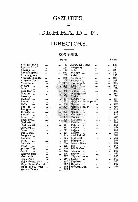
GAZETTEER OP
DEHRA DTTTT.
DIRECTORY.
CONTENTS.
A jab pur kalan
Page.
... 100 Jiwnngarb grant
Page.
... 228 Ajabpur khurd ... 199 doli grant ... ... 229 Amlawa ... ... 109 Kailo ... ... 220 Aunfleld grant IM 200 Kalauga ... .„ 230 Arcadia grant 200 Kalsi ... ... 230 Atbgaon Chandau ••• 201 Kalyanpur ... 233 Athgaon Uparli ... 201 Kanlegir ... ... 233 Attic Form ... 201 Kbutnugadh ... 234 Bnmtar ... 202 Koru ... 234 Bana ... 202 Kotbi (fl ... 235 Banadhar 203 Lakban ... 235 Bangaon ... • M 203 Lakbamandal ... 235 Basantpur 203 Lakbwar .. ... 237 Baundar ... • •a 204 I.andour ... ... ... 237 Bawur 201 or Lister grant ... 239 Bbalar 200 Maleta .. 210 Bharam ... • •a *♦ 20« Markham grant ... ... 240 Hhogpur ... 207 Missau ... ... 212 Birman ... 207 Mebna ... 242 Bioahal ,. 208 Mussooree .. ... 243 Kislar ... 208 Niiwada ... ... 257 Burasuwa... 209 Panjgaon ... .a. ... 257 Cbakrata . 209 Pbaniyar ... ... 258 Chakrata tabsil 211 l’bartur ... ... 258 CUhnltar ... ... ... 211 Kaipur ... 258 Debra ... ... 211 Rajpnr ... 259 Debra Taheil Mt 223 llaugau ... 261 Deoghar ... ««* 223 Kani Pokbri ... 261 Dbanau 224 Rikhikesh... ... 261 Disau ... 224 Saliaspur ... ... 263 Doiwala ... ■ at 225 SabasrudUftra ... 204 Dwar 225 Seli ... 264 Eastern Dnn 225 Seli Qotban ... 265 Garbi .. ... 220 Somalta ... ... ... 265 Hari pur Beat 22G Silgaon .. 265 Itairawala 227 Silgaon Bawar ... 265 Hope Town ... 227 Taplar ... ... 266 Hope Town, East ... ... 227 Tapoban ... ... 260 Hope Town, Centra: ... 227 Udpalta ... • a. ... 267 Hope Town, Weot 228 Western Dun ... ... 267 Jaunaar Bawar 228

DIRECTORY. [Ajabpur Kalan.
AJABPUR KALAN, Pargana Western Dun, Tahsil
Dehra. A largo village lying to the east of Dehra on the right bank
of the Rispana Rao, traversed by the Dehra-Hard war metalled
road and the Dehra-Mothronvvala unmetalled road. A portion of
the village lands lie across the Rispana Rao.
It is an ancient village held by the old proprietors, the Rawats.
By reason of its proximity to Dehra it is a favourite place of
residence. The irrigation has much fallen off, the village lying at
the tail of the overworked Rajpur canal. The village contains a
well constructed by Mr. Shore which dries up in the hot weather.
There is also a celebrated temple of Sitala Devi, which is much patronised by the sepoys of the Gurkha regiments stationed at
Dehra.
AJABPUR KHURD, Parganct Western Dun, Tahsil
Dehra. A good village south-east of Dehra, on the metalled road from
Dehra to Mothronwala, belonging to a large pattidar body of Rawats
who also own Ajabpur Kalan and Kedarpur. The population of the
two Ajabpur villages was, in 1901, 1,775. They share a primary
school. The villages are supposed to have been found by Ajbu Kuar, consort of the Rani Karnavati, regent of the Dun.
AMLAWA.
A river of Jaunsar-Bawar rising in khat Bamtar on the south¬
ern slopes of the Deoban mountain, to the north-west of Chakrata
It flows almost due south and joins the Jumna at Kalsi after a
course of 25 miles. Its basin is a triangular valley formed by two
lofty ranges, one running north-west from Bairat and the other
north-east from the Naga peaks, and both converging at Deoban.
Its chief tributary i3 the Badnargadh, rising at the western base
of Bairat. The Ohakrata military cart-road follows the right bank
of the Amiawa for a considerable distance,
200 Dehra Dun district.
ANNFIELD GRANT, Pargana Western Dun, Tahsil Dehra.
A large village with numerous hamlets situated on the left bank
of the Jumna, Its lands are traversed by the Saharanpur-
Timli-Chakrata .metalled road.
The estate was conveyed by grant to Major Rind, who in 1857
planted here a native Christian agricultural colony, affiliated to the
Church Missionary Society. At first the colony consisted of only
a few families, but the number of the colonists rose to 150 in 1859
and to 302 in 1874. The estate has been sold to the Raja of
Nahan. The cultivated area, which includes a tea garden, has
extended considerably of recent years. The estate includes a quan¬
tity of excellent loam irrigated from the Katapathar canal.
The Arazi Annfield Jungle grant was also given to Major
Rind on terms similar to those governing the Annfield grant with
the exception that the revenue was not progressive. Some years
before Major Rind’s death a tea company was formed, of which
Major Rind remained a member. This company took a lease of
the whole Annfield grant and also of the neighbouring villages,
Baitwala and Gangbhewa, but not of the Arazi Annfield Jungle
grant. Major Rind remained a manager of the company till his
death, when Mr. Watson succeeded him. In 1873 the heirs of
Major Rind sold the Arazi Annfield Jungle grant. Sir Herbert
Macpherson brought 395 acres, the Ambari Tea Company 327 acres
and the Annfield Tea Company 692 acres. Sir H. Macpherson
incorporated his portion with the Danda jungle fee-simple estate.
The Ambari Toa Company became a separate mahal. The Annfield
Tea Company eventually bought up the Annfield grant from Major
Rind’s heirs, and then in 1887 sold the Annfield grant, the villages of
Baitwala and Gangbhewa, and the portion of the Arazi Annfield Jun¬ gle grant previously purchased to the Raja of Nahan for Rs. 1,40,000.
The chief village is Chuharpur, where the Raja has recently
established a mart. It is much used by the people of the south¬
west of Jaunsar-Bawar. Here are situated the Church, the Church
Mission aided school and the village school. The population is 2,978.
ARCADIA GRANT, Pargann Western Dun, Tahsil Dehra,
A very fine fee-simple estate belonging to the Dehra Dun Tea
Company which has about 375 acres under tea. The grant
Attic Farm. 201
extends from the Tons bridge on the Dehra-Fatehpur metalled road
through some of the finest land in the Dohra plateau almost up to the
Delira-Asarori metalled road not far from Asarori. The feesimple
was purchased in 1862 under Lord Canning’s rules for Rs. 23,730.
ATHGAON CHANDAU, Pargana Jaunsar-Bawar, Tahsil
Chakrata.
A Ichat of Jaunsar, lying on tho left bank of the Tons which
forms it3 western boundary. On the south it adjoins Ichat Silgaon,
on tho north it is bounded by Ichat Maleta and on tho east by Ichat
Somalia. It is traversed by a path from Kalsi which passes through
or near the villages of Tepau, Delau and Arh, but is now aban¬
doned and consequently in bad repair, The Ichat pays a revenue of
Rs. 883, chiefly assessed upon its recorded 622 acres of permanent
cultivation. The cultivation is of a superior type, a considerable area
being under ginger and turmeric. A new famine road, the Panjiti-
Kuwanu road, passes through or near tho villages of Tepau, Chandau,
Khoi, Supan, Kesau and Timra villages, The chief villages are
Tepau and Chandau. The latter supports a vernacular school.
ATHGAON UPARLI, Pargana, Jaunsar-Bawar, Tahsil
Chakrata.
A Ichat of Jaunsar situated in the east centre of tho hill pargana.
It is separated from Bislar on the west by the Bijadgadh and
from Bangaon on the south by tho Khutnugadh, On the east
it is bounded by Ichat Baundar and tho reserved forest, which
also encircles its northern extremity. The three streams, the Bijad¬
gadh, tho Khutnugadh and the Sirigadh, which drain the Ichat
are fully utilized, and there is a fair quantity of good irrigated land.
Since the establishment of Chakrata the people can find an easy
market for the turmeric, ginger and walnuts which formerly used
to be carried down to Kalsi. Of the eight villages which the Ichat
orginally contained the more important are Siri and Pokhri. The
recorded permanent cultivation is 390 acres and the revenue
Rs. 362. The forest road from Chakrata to Nadh skirts the khat.
ATTIC FARM, Pargana Western Dun, Tahsil Deura.
Or Attica, a very large fee-simple grant of 2,370 acres lying
on either side of the Suarna river, consisting chiefly of waste
Dehra Dun diBtriet.
land and forest, and supporting a population of 64 only. This
grant used to belong to Messrs. Mackinnon, but was sold by
them recently to Chaudhari Dlgambar Singh, son of tho late
Chaudhri Shib Ram of Dunga,
BAMTAR, Pargana Jaunsar-Bawar, Tahsil Ohakrata.
A khat of Jaunsar lying to the west of, Ohakrata. The cart-
road runs through the centre of it. The khat is one of the largest
in the pargana. It has a permanent cultivated area of 1,040 acres
and it pays a revenue of Rs. 2,199. Grazing however is not plen¬
tiful and the flocks and herds of the khat are comparatively small.
This is due in the first place to the inclusion of a large quantity of
the khat waste land within the boundaries of tho Ohakrata canton¬
ment. The establishment of the cantonment has however been of
value to the people in another way: their turmeric, ginger and
potatoes are now easily exported by way of the military cart-road,
while much of this and other produce finds a ready market in
Ohakrata itself. The khat is watered by the upper course of the
Amlawa and has some good irrigated land. Its communications
aro good. In addition to the military cart-road, a good path
connects Astari in the centre of the khat with Ohakrata, At the
north extremity of the khat is a considerable block of reserved
forest surrounding tho temple of Chandeswar.
BAN A, Pargana Jaunsar-Bawar, Tahsil Ohakrata.
A khat of Jaunsar occupying the tract on the right bank of
the Amlawa river which separates it from khat Panjgaon on the
east. On the south it is bounded by khat Haripur, on the west by
the Jumna and khat Bisahal, and on the north by khat Silgaon.
The soil of the khat is poor and does notjgrow the more valuable
crops. Little of the land is irrigated, ’ The permanently culti¬
vated area amounts to 391 acres, and the revenue paid is Rs. 388.
The khat is advantageously situated near Kalsi and forest opera¬
tions in the cold weather offer employment to all who desire it.
The military cart-road skirts the eastern,border of the district, and
a good bridle path running north-west from Ealsi passes through
the villages of Dhaira and Nichiya terminqting' in Adeu. Other
villages worthy of note are Panjia and Jutiyaya.
Basantpur. 208
BANADHAR, Pargana Jaunsab-Bawae, Tahsil Chakeata.
Now a khat and formerly a Ichag (or minor sub-division) of
Bawar, Within the old khat boundaries is a considerable area of
reserved forest which divides it into two portions. The smaller, a
long narrow strip, lies along the left bank of the Dharagadh while
the larger is bounded on the north by that stream, which separates it
from khat Bawar; on the west the Tons river parts it from khat
Deogarh, and on the south the Binalgadh forms the boundary
between it and khat Bharam. The reserved forest however occupies
most of the riverain land and the villages lie high and enj oy but little
irrigation. The main line of communication in the khat is the
old Simla road which, leaving the Binalgadh, ascends the ridge
{dhar) on which Bana stands, and which gives its name to the
whole khat. Bhandrauli, Bana and Ohilar are the more notable
villages and they all lie near or on the road. The fields are liable
to a certain amount of injury from wild animals sheltered by the
forest, and owing to this and to the absenco of irrigation the culti¬
vation is not of a high order. The permanent area amounts to
214 acres and the revenue paid is Rs. 261.
BANGAON, Pargana Jaunsar-Bawar, Tahsil Chakeata.
A khat of Jaunsar bounded on the east by the Jumna, on the
south by khat Seli, on the west by the cantonment of Chakrata
and on the north by khat Taplar, from which it is separated by
the Khutnugadh, an important affluent of the Jumna, The khat
is entirely drained by the Ningalgadh and other smaller brooks
falling into the Khutnugadh. To the west it encloses tbo lands
of a small khat called Burasuwa, Its recorded permanent cultiva¬
tion amounted to 380 acres and its revenue was fixed at Rs. 780
The chief villages are Kaknoi and Ghanta. Potatoes are grown in
good quantities and exported through Chakrata.
BASANTPUR, Pargana Eastern Dun, Tahsil Dehra.
An ancient village lying at the foot of the outer Himalayan
range. It gave its name to a pargana now absorbed and was
in former days a town of some importance. Its wealth attracted
the adventurer, Husain Khan, who plundered it in 1575. It
was again pillaged by Khalil-ullah Khan in 1655. It is now a
204 Dehra Dun district.
mere hamlet of the big hill ilrtqa of Gadul, and the sole remaining
signs of its earlier prosperity are some mango groves near the
mean huts of which it consists.
BAUNDAR, Pargana Jaunsar-Bawar, Tahsil Chakrata.
A khat of Jaunsar bounded on tho cast by the Jumna,
on the south by khat Taplar, and on the north and west by the
reserved forest. The khat is moderately large with a recorded
permanent cultivation of 868 acres: the soil is generally good and
pasture is abundant. It is however somewhat remote from tho
markets and the rest of the district generally. The revenue
amounts to Rs. 1,002. The koltas and other low castes are some¬
what migratory by habit and in hard times a few occasionally
transfer their abode to the neighbouring state of Tehri-Garhwal.
Their fields are also exposed to the depredations of the wild animals
which find a shelter in the vast adjacent area of reserved forest.
Walnut trees are common and the people make a certain amount
of profit from the sale of' their produce: and another source of
income is labour in the reserved forests, which however is not very
popular. The khat is exceedingly mountainous. It is surrounded
on three sides by ranges which rise to over 8,000 feet on the northern
boundary, while a subordinate ridge with a peak 7,000 feet high
diverges from the main range traversing the khat from east to
west. It forms the watershed between the brooks Kungadh and
Mordgadh. On the latter stands tho village of Lakha-
mandal with its celebrated temple separately described elsewhere.
Other villages of some importance are Miundha, Kandoi, Kunna
and Lauri, whero there is a village school. On the 20th of
Sawan in each year all the sheep of the whole khat are collected
on a ridge called Mauthab above Bhabar village. The sheep
are shorn and a big fair is held.
BAWAR, Pargana Jaunsar-Bawar, Tahsil Chakrata.
Originally a pargana divided into five hhags, Bawar, Banadhar,
Phanyar, Silgaon and Deoghar. It occupied the northern third
of the hill appanage of tho Dun. Its five hhags have now become
khats, and one of them retains tho name formerly applied to the
whole pargana. Bawar is much intersected with reserved forests,
Fawar. 205
The largest block of the khat is a long narrow tract on the left
bank of the Tons river which forms its western and northern
boundary. To the south flows the Dharagadh, a considerable
affluent of the former river, separating Bawar from khat Banadhar.
On the east it is bounded by khat Phanyar and the reserved
forest. Two of the smaller detached blocks lie on the left bank of
the Tons north-east of the main portion, and four other smaller
blocks occupy the valley of the Kirungadh, a tributary of the Tons.
The khat though remote enjoys excellent communications. Colonel
Young’s original road, now a portion of the old Simla road, traverses
the centre of the main block and terminates at Bastil. Tho tracts
on the Kirungadh have ready access to the new Upper Simla road
which follows the course of the river as far as its junction with the
Tons. From this point a path runs up the Tons as far as
Hanoi, the chief village of the most eastern block of the khat,
famous for the temple of the god Mahaau. The main road con¬
tinues its course down the Tons round the northern extremity of
the main block of the khat, which it finally leaves by a bridge
crossing the Tons a few miles below its junction with the Pabar.
Other minor paths intersect the main block. The chief villages are
Bastil and Hanoi already mentioned, Maindrath, Chaunsal Kanda
and Koti. Maindrath possesses a temple and a. bridge across the
Tons. Koti possesses a vernacular school.
Bawar suffered in a peculiar degree from the depredations of
Mahasu. Mr. Cornwall the settlement officer wrote in 1873 : “ Most
of the villages of this khat are in a wretched state. Four of them
were until now given over to the temple at Hanoi and their quota
of the revenue paid by the whole of the Bawar khat, but now they
have been resumed and the khags having been settled separately
the quota payable by these villages will, if their proceeds bo
given, as hitherto, to the temple, as is very probable, fall upon this
khat only,” Mr. Cornwall’s predictions proved correct, and tho
distribution of the revenue of thj “ god’s villages ” was one of the
difficulties which Mr. Ross was called upon to face after Mr,
Cornwall’s departure. The Government ultimately declared the
four villages revenue-free. The cultivators are said to be apathetic
and backward, and thoir lands are exposed to the depredations
of wild animals from the neighbouring reseived forests,
200 Dehra Dun district
The permanent) cultivation amounts to 682 acres, but the lehat
enjoys a comparative abundance of forest and pasture. It pays
a revenue of Rs. 625. Opium is the chief money-producing
crop.
■ BHALAR, Pargana Jaunsar-Bawar, Tahsil Chakrata.
A khat of Jaunsar comprising the tract north of Nagthat
bungalow on the Mussooree-Chakrata road, bounded on the east
by the Jumna, on the south by khat Phartar and on the north
and west by khat Koru. It had at the last settlement a perma¬
nent cultivated area of 421 acres and it paid a revenue of Rs, 816.
The chief villages of the khat are Kuwasa, Lachha, Ludhera,
and Basoi. The khat enjoys unusually good communica¬
tions ; the Mussooree-Chakrata road, and the Nagthat-Kaknoi
and Nagthat-Murlan paths traverse it. It derives a certain
amount of profit from the sale of walnuts. Basoi supports a small
villago school.
BHARAM, Pargana Jaunsar-Bawar, Tahsil Chakrata.
A khat of Jaunsar bounded on the north by the Tons and
Banalgadh which separate it from Deoghar, on the west by the
Tons river, on the south by Dhanau and on the east by the re¬
served forest. The khat has a permanently cultivated area of 640
acres. There is a fair quantity of tableland on moist hills with
a good northern exposure. It is intersected by a number of
small streams, flowing into the Tons, which carry water to the
more favoured fields, and there is also an unusual amount of khil
or intermittent cultivation. The khat is somewhat remoto from
the markets, but the lower Chakrata-Simla road passes through its
centre, and has considerably reduced its isolation. The most valu¬
able crop produced is opium, which covers on an average about
35 acres. This finds a ready sale with itinerant merchants who
sell it in hill states. Some income is also derived from walnuts.
The eastern portion of the khat is occupied by the fine Mashak
forest consisting chiefly of deodars intermingled with cypress on the
higher ridges, and firs (chiefly spruce, mixed with some silver firs
and blue pine) lower down. The revenue paid is Rs. 1,223. The
chief villages are Kawakhera above the Sangotha bridge, where
Birman- 207
there is a District Board inspection bungalow, Bulari and Kandoi, where there is a village school.
BHOGPUR, Pargana Eastern Dun, Tahsil Dehra.
A village situated at the foot of the outer Himalayas
about 14 miles from Dehra with which it is connected by
an unmetalled road. Connected with the village, which is not in
itself large, are a number of small hamlets, and in the aggregate
the extent and population of these villages is not inconsiderable
for the Dun, The village lauds enjoy an excellent water supply
from the Jakhan canal. Bhogpur supports a large middle school
with an attendance of about 90 and a fairly flourishing girls’
school, and there is also a canal bungalow. The small bazar does
some business in the exchange of hills for plains produce, chiefly
with the Tehri-Garhwalis who bring down large flocks of sheep
and goats and usually halt at Bhogpur for a few days. The popu¬
lation was, in 1901, 364.
BIRMAU, Pargana Jaunsar-Bawar, Tahsil Chakrata.
A khat of Jaunsar lying between the Chakrata cantonment
and the Udpalta khat north and south, and bounded on the east
and west by khats Seli and Bamtar respectively. Birmau is
traversed by the Saiah-Chakrata bridle path which runs through
its centre, while the cart-road passes slightly inside its western
border. The khat has obviously benefited much by the establish¬
ment of the Chakrata cantonment which not only affords a market
for the surplus produce aud labour of the cultivators, but has also
given it the advantage of vastly improved communications with
the plains. At the same timo these advantages have not been
without their drawbacks; the khat was compelled to resign
nearly all its forest and pastures to the exigencies of the canton¬
ment. It has a permanent cultivated area of 405 acres and it
pays a revenue of Rs. 586. The chief villages are Birmau, Basoi
and Thana. A small block of reserved forest exists near the latter
villages. The villages of Thana and Tangra have hitherto been
permitted by an arrangement which dates from Mr, Ross’s settle¬
ment to graze their cattle on Chilmeri hill on payment of Rs. 70
to the Cantonment Committee. A somewhat similar arrangement
208 Dehra Dun district.
also appears to have been made by Mr. Cornwall when the grazing
lands of this khat were included in the cantonment area. The
question of the legality of this arrangement has been raised by the
cantonment authorities and has been referred to the Government
for decision. The people are taking to growing potatoes which are
exported through the mart at Chakrata to the plains. The Bisu
fair at Thana village attracts a good gathering, particularly as it is
held close to the cantonments.
BISAHAL, Pargana Jaunsar-Bawar, Tahsil Chakrata.
A khat of Jaunsar occupying the extreme south-west corner of
the pargana, and bounded on the west by the Tons, on the south
by the Jumna and on the east by the Jumna and khat Bana and
on the north by khat Silgaon. The khat is traversed by a bridle
path from Kalsi which enters it near Adeu, passes through or near
the villages of Danda, Rupan and Atlan and crosses the Tons,
into Sirmur territory by a rope bridge at Tunyaya. This path
follows a ridge running almost due cast and west and culminating
in a peak near Adeu with an altitude of close on 6,000 feet. The
ridge divides the khat into two portions, and through the northern
half flows the Dhawadgadh. There is a fair proportion of irrigated
land and some fine tablelands with good ginger and turmeric
cultivation. The khat pays a revenue of Es. 1,239, assessed princi¬
pally upon its 1,002 acres of permanent cultivation. The Bisu
fair on Chait 1st, aud Baisakh 1st and 2nd is fairly well attended.
BISLAR, Pargana Jaunsar-Bawar, Tahsil Chakrata.
A khat of Jaunsar with a cultivated area of only 267 acres. The
chief asset of the khat however is its large herds of cattle, sheep and
goats; it is in fact pastoral rather than agricultural. On these assets
the revenue of Rs. 446 is chiefly based. The Ichat is long and narrow
in shape stretching north aud south, and lying between Athgaon
Uparli on the cast aud Dwar on the west. Its northern extremity
is surrounded by the reserved forest, and on the south it is bounded
by khat Bangaon. Bislar is drained by the Bijadgadh. Its chief
villages are Jugau, Thanata, Kharsi and Khatuwa, all connected by
a good bridle path running up the centre of the khat. Potatoes and
walnuts are the chief commodities exported.
Chakrata. 209
BURASUWA, Purgana Jaunsar-Bawar, Taksil Chakrata.
A very small Ichat of Jaunsar with a permanent cultivated area
of only 105 acres. Its territory is divided into two separate blocks,
both lying to the east of the Chakrata cantonments and entirely
surrounded by khat Bangaon. The revenue is Rs. 83. The head¬
waters of the Khutnugadh form the northern boundary of
the khat. Many of the Bangaon cultivators occupy Buraauwa
lands.
CHAKRATA, Pargana Jaunsar-Bawar, Tahsil Chakrata.
A cantonment for British troops in khat Birmau is situated
in north latitude 30°32" and east longitude 77°54," at an
elevation of 6,885 feet abovo tho level of the sea, 25 miles from
Kalsi and 38 miles from Mussoorco by the hill road. The canton¬
ments which cover an area of nearly seven square miles lie on
two separate hills, Chakrata and Kailana, joined by a neck of
land known as Kailana neck. The population in 1901 was 1,250,
consisting almost entirely of British troops, servants and camp-
followers, with a small leavening of traders.
One British regiment is stationed at Chakrata and there are
barracks at Kailana to the cast of the cantonment occupied by de¬
tails from various units. In September 1900 the troops at Chak¬
rata with women and children numbered 1,060 and at Kailana
656. There is a good piped water supply from springs rising in
the Deoban hills which has recently been extended to the whole
of the cantonments. The Simla and Mussooree road passes
through the cantonment, where there is a good traveller’s bunga¬
low. Another staging bungalow exists at Lakhwar, 14 miles from
Mussooree; and a third at Chauranipani between Lakhwar and
Chakrata. Shorter stages are made possible for the less energetic
traveller by the presence of inspection bungalows at Sainji in Tohri
territory about seven miles from Mussooree and at Nagthat between
Lakhwar and Chauranipani.
Chakrata is managed by a committee with an annual income
of about Rs. 25,000 at its disposal. The chief sources of income are
a house-tax, a tax on trades and professions, octroi, and conservancy-
tax which produce respectively about Rs, 1,200, Rs. 10,000 and
Rs. 3,000, and the chief objects of expenditure are conservancy:which
14
210 Dehra Dun district.
absorbs over Rs. 5,000, medical Rs. 3,148 and public works about
Rs. 4,000. The secretary of the cantonment committee is the
cantonment magistrate, who also exercises the functions of an
assistant to the Superintendent of the Dun with regard to the
surrounding pargana of Jaunsar-Bawar : a medical offiier and a
chaplain also find employment at Chakrata, and here is situated
the tahsil building and the divisional forest offices, The forests
in the immediate vicinity of Ohakrata ware at its establishment
assigned for the use of the Cantonment. The scenery around Chak¬
rata is generally bleak and bare except towards Deobau. On the Simla
road some of the finest views in the hills are to be obtained ; but there
is no shooting near the station, and nothing to attract the sportsman.
Previous to 1866 the site of the present cantonments consisted
of a range of grass-clad hills with forests more or less dense run¬
ning up on all sides from the valleys below. The ground was
used solely for grazing purposes, and a few low sheds here and
there were the only signs of civilization. The road from Mussooree
to Simla passed over these hills, and the fair expanse of compara¬
tively smooth-topped hills early attracted the notice of military
men and became the subject of correspondence when the question
of hill sanitaria for British troops arose. The supposed unlimited
supply of good water at a high level on the Deoban range of hills
marked the place as in every way suitable for a military station.
Operations commenced in 1866, but no troops came until 1869,
when some Sappers were sent up. These were succeeded by H.
M.'s 55th Regiment under Colonel Hume, and it is to the interest
taken by him and his men in the station that its rapid strides
towards completion may he in a great measure attributed. For
the first year the troops, which warehoused in temporary huts, were
occupied in road-making, clearing sites and building. Substantial
barracks were built and a magnificent cart-road, seventy-seven miles
long, connect-s the station with Saharanpur by Timli and Kalsi.
Th ; original buildings and the road cost fifty-four lakhs of rupees,
and most people consider that less substantial buildings and a
less expensive roadway would equally have served the objects
contemplated. The water supply from the Deoban hill, though
not quite so unlimited as was at first supposed, is good and ample.
If more be wanted, springs furth er off can be tapped.
Deliira. 211
CHAKRATA Tahsil.
The Chakrata Tahsil comprises th 3 whole of the Jaunsar-Bawar
pargana (q.v.). The tahsildar’s head quarters are at Chakrata
but in the cold weather he moves down with his court, office and
treasury to Kalsi. The tahsildar’s staff consists of one registrar
kanungo, one assistant registrar kanungo, one wasil baqi navis
and one siaha navis and in the khals twelve patwaris. Jaunsar-
Bawar appears in the list of scheduled districts, and the peculiari¬
ties of its administration will be found described in Chapter IV.
CHHULTAR, Pargana Jaunsar-Bawar, Tahsil Chakrata.
A small Ichat of Jaunsar with a recorded cultivation of 131
acres, paying a revenue of Rs. 112. Tho villages of the Ichat
are not specially productive and there is no irrigated land. The
khat belongs to Rawats who are descended from a junior branch
of the Sirmur family. It is surrounded on all sides by khat
Baundar.
DEHRA, Pargana Western Dun, Tahsil Dehra.
A municipality, and the chief town and head quarters of the
Dohra Dun district, is situated in north latitude 30°iy' and east
longitude 78°5/ at an elevation of 2,300 feot above tho level of
the sea, slightly to the east of the watershed line between the
Ganges and the Jumna systems, occupying a plateau defined on
the east by tho Rispana Rao and on the west by the Bindal.
Between th?se rivers lie the city and civil station, and beyond the
Bindal are the cantonments. At the extreme south lies the
railway station, the Lakhibagh encamping-ground and the distil¬
lery. Next comes the Gurudwara or Sikh temple of Guru Ram
Rai, and beyond it no further places of interest except the Mission
school. The northern extremity of thcity is marked by the
Imperial Forest College and the forest park. A few detached
hamlets are to bi found on the west of the Rajpur road, and the
Dilaram bazar lies in the middle of the lin: of bungalows stretching
northward from the old parade ground. Dehra lies at the
terminus of the Dehra-Hardwar Railway, managed by the Oudh and
Rohilkhand Railway Company, and opened in 1900. The line
enters the Dun by a tunnel near Hardwar and runs almost
212 Dehra Dun dhirict.
parallel with the Siwaliks as far as Dehra. The intermediate
stations arc Rikhikesh road, Doiwala and Harrawala, It is also
connect'd with the plains by the Saharanpur road and the
Hardwar road, hut these communications, once the chief means of
access to the Dun, are now superseded by the railway though the
former road still carries a fairly large grain traffic. Dehra is also
connected with Raj pur and Mussooree, Ohakrata, the Eastern and
the Western Duns by roads already described in the second chapter.
It will be sufficient here to note that the Dehra-Rajpur road
passes through the centre of the city and civil station, and is
joined near the railway station by the Hardwar road, and also
by the Saharanpur road, of which it, properly speaking, forms
the northern section. The civil station extends along the
Raj pur road from the northern limit of the city nearly as far
as the Body-guard lines which are midway between Dehra and
Rajpur, The old cantonments and the region south-east towards
the raco-oourso have also been absorbed. The host houses are to
be found in the northern portion of the civil station. Some are
those of an earlier generation, largo and roomy, and evidently
designed in many cases by men who were intending to establish
permanent homos. They are surrounded by spacious compounds
often bordered by hedges of wild roses which are in full bloom in
April and May. Such houses are, however, in a rapidly decreasing
minority. The larger compounds are being partitioned into
nairow sites for small modern bungalows. An example in point
is the estate called Nashville. It consisted originally of a single
house with a compound of 85 bighas. Its history is interesting as
illustrating the rapid development of Dehra in recent years and
the consequent larg ■ increase in land values. It was sold in 1904
for Rs 20,000 and was divided into building plots. The purchasers
then disposed of the original building and the central portion of
the compound to Messrs. Pitch & Company. There are now, in
addition, seven other bungalows on the land. Two arc rented for
Rs. 80 each, and a third, built of the cheapest possible materials,
has been sold to the Raja of Mandwa together with a small plot of
land for Rs. 20,000, the price paid for the original estate. The
Rajpur road is here broad and well kept, and bordered by
fine clumps of bamboos and other umbrageous trees, and it is
Dehra. 213
intersected at right angles by branch roads leading to the east and
west. Immediately north of the town a few good European shops
abut on the west sido of the Raj pur road. Opposite them lies a
fine open space, onco the parade ground used by the troops at
Dehra before they were moved to the higher ground across the
Bindal river, but now the playground of the youth of Dehra. To
the south of the parade ground are tho Forest School, a handsome
modern building, and what was once the forest park. The latter
has now become tho compound of the official residence of the
Principal of the Forest College. On the opposite side of the parade
ground is th 3 new Dehra Club, and near it tho buildings of the
Great Trigonometrical Survey. A church dedicated to St. Thomas
stands on the Rajpur road and numerous bungalows fringe this road
on either side, their compounds in many cases over-stocked with
mango and other fruit trees and often carrying field crops as well.
Still further north are the new buildings of tho X-Ray Institute.
Two roads, the Eastern Canal road and Lytton road, branch
off from the Rajpur road at the Dilaram bazar near St. Thomas’s
Church and run south in a direction generally parallel to the
Rajpur road. In 11)03-04 capitalists turned their attention to
Dehra and in a few years erected a series of small cramped modern
houses on the land served by those two roads. The houses on the
sides of the Eastern Canal road have trebled in number in ten
years, The region to the east of that road extending as far as
Karanpur and Dalanwala on the banks of the Rispana, and
further south, tho region between it and tho Convent road as
far down as the race-course are now the most congested por¬
tions of the civil station and aro characterized by small
compounds, each containing a modem house. Tin only open
ground in tho vicinity is that occupied by the Trigonometrical
branch of the Survey of India, and, at the extreme south the race¬
course. Those houses were nearly all built for the accommodation
of pensioners and other European settlers who flocked to the
district after 1900, attracted by the reputed increased salubrity of
the station and its greater accessibility resulting from the opening
of the railway. So great was the first rush that, it is said, two or
three families commonly occupied one house until the local
builders could run up new houses for their accommodation, The
214' Dehra Dun district.
Sikh temple.
reaction has now appeared, more houses than necessary have been
built and a good number situated on the Eastern Canal and Lytton
roads are vacant, and there is a distinct slump in the building
trade. Speculators who put all their savings into house-property
are now anxious to sell, but purchasers arc apparently as rare as
tenants.
The better class of bungalows on or near tho Rajpur road are
chiefly occupied by the officers of various district establishments,
and of the scientific departments of the Government of India.
South-east again of the old parade ground lies the race-course
belonging to Municipality and once considered ono of the finest in
India.
The offices of the Superintendent of the Dun, the Small Causes
Judge, and the Superintendent of Police, the Sessions Court House,
the jail, tho dispensary and the leper asylum are grouped together
South of the Forest School. None are in any way remarkable.
The Viceroy’s stables with accommodation for somj fifty horses are
situated on the Hardwar road north of the race-course.
The temple or Gurudwara of the Udasis, the sect of religious
ascetics founded by Ram Rai, ihiir Guru, was built in 1699
A.D. and is the only object of historical interest. The
central block, in which the Guru’s bed is preserved, is a
handsome structure, designed in tho style of the Emperor
Jahangir’s tomb: at the corners, it has smaller monuments in
memory of the Guru’s four wives. The model adopted has
naturally given a Muhammadan appearance to the whole, very
curious in a place of worship built by Udasis, who suffered so much
at the hands of the Muhammadans: brick, plastered over and
pointed in imitation of mosaic, forms the material of the building.
Three reservoirs, the largest of them being 230 feet long by 184 feet
W'ide, are attached to the temple: two receiving supplies of water
from tho Rajpur canal and the third from rain-water only ; it is used
only for boiling pulses, for which purpose the canal water is too hard.
The mahant is elected from among the disciples (chelas).oi the last
deceased mahant. The election was formerly guided by the Sikh
chiefs of the Panjab. A nasarana of Rs. 500 used to be presented
to the British Government at the installation. The complimentary
gift in return was a pair of sha wls. The distinctive head-dress of the
Dehra. 215
sect worn by the high priest and his disciples is a cap of red cloth,
shaped like a sugar-loaf, worked over with coloured thread and
adorned with a black silk fringe round the rim. The acknowledge¬
ment of Guru Bam Kai's saintship is not coniincd to the Udasis, but
most Hindu sects furnish devotees, especially in the Dehra Dun,
where his influence was most felt. Perhaps, however, the most
enthusiastic of his worshippers will be found now, as heretofore,
among the cis-Sutlej Sikhs, Owing to the doubt cast upon his
legitimacy and the divergence of his peaceful doctrines from the stern
tenets of Sri Gum Gobind Singh, the Akhali Sikhs have uniformly
refused him recognition ; but, notwithstanding this, it is on
record that Banjit Singh, when apprehensive of impending death
in the spring of 1826, sent an offering of Rs. 500 to this temple.
The time fixed for the annual ceremonies of the saint is that
of the Hindu festival known as the Holi, usually falling in April.
A fair lasting ten days, and called Sangat, commences on the 1st
Chait, and on the 6th the ceremony of hoisting a new flag upon a
monster flagstaff standing between the temple and the large tank
takes place. Hundreds of pilgrims to each of whom a day’s food
is given by the mahant aid in this duty; but the total number
attending the fairs varies from 3,000 to 10,000, the larger figure
being reached only when the Hardwar fair, whither the pilgrims
flock immediately aftor, is very largely attended at the Kumbh
and Adh-Kumbh.
The temple is supported by the assignment of the revenue of a
number of villages in the Dun, one of which is Dehra itself. The
Mahant also holds jagirs in Tehri.
The climate of Dehra may be termed a moist and temperate Climate,
one. The average rainfall is 78 inches. The temperature in the shade
fluctuates from 37° in January to 98° in June and the daily
range is not great, if the unhealthy months of September and
October, are excepted. The valley, on the whole, is peculiarly free
from sudden .extremes of heat and cold, especially from the blasts
that scorch the country lying below its southern boundary, but owing
to the cutting, clearing, and cultivating operations which have within
the 25 years been carried on, in the western portion of the Dun, hot
winds now accompany the advent of the summer months. These
are not scorching in their effects; but are annually becoming more
216 Dehra Dun district.
Public health.
Wator.
marked and prolonged, and are doubtless due to the rapid clear¬
ances of tree jungle by the landowners. These warm breezes
were unknown in Dehra before 1873. From its close proximity
to the outer Himalayan range Dehra is also generally cool: the
cold weather commencing earlier and lasting longer than in the
plains.
In spite of its reputation the climate of Dehra in the hot weather
is probably not so bracing as that of other, good stations in the U nited
Provinces or the Panjab, though the temperature is on the whole
more endurable and the actual discomfort less. Most of the residents
who can afford it, Europeans as well as many Indians, resort to
Mussooree during the months of May, June, July, and part of
August. The atmosphere is often heavy and motionless causing
much depression of spirits among the inhabitants. Malarial-fever is
common, but is not so deadly as in the plains, In the great
outbreak of fever in the autumn of 1908 Dehra suffered far less
than the majority of towns in these provinces. Ono cause is the
excessive planting of trees in the numerous small allotments
into which large estates have been divided of late years conse¬
quent up >n the great influx of small householders both European
and Indian. Another cause is bho presence of large market
gardens and orchards, many of them within municipal limits.
Though nob popular with the native official in Government em¬
ploy, the reputation of Dehra as a summer resort is growing
amoug the Indian aristocracy and it is said that many ruling
princes now make periodical visits so as to avoid the torrid heat of
cheir own dominions. With an improved supply of uncontaminated
drinking water cholera epidemics are now rare. Such outbreaks
as occur are usually traceable to imported infection from the
Hardwar fair.
The ancient Raj pur canal, said to have been made by the Rani
Karnavati, was formerly the sole source of D jlira’s water supply.
It is open throughout its length and therefore liable to contamina¬
tion. Many years after the first piped supply was brought from the
Nalapani springs but apparently only for the Europeans of the civil
lines. In 1889 it was brought into the city. The supply proving
insufficient the Kolukhet stream immediately below Jharipani on
the bridle path to Mussooree was tapped in 1898 and water
Dehra. 217
brought into Dahra at a cost of Rs. 94,808. This had again to
be supptamented by an additional supply at a cost of Rs. 60,000.
The canal is now chiefly used for irrigation. Bifurcating near
the Dilaram bazar, it intersects the civil station and Dehra town
and i3 one of the characteristic features of the place. Nearly
every compound in the civil station has a fruit or vegetable garden
watered by the Raj pur canal. The produce of the gardens is
sold to Kunjras for the Mussooree market. Some of the larger
compounds bring in from Rs. 100 to Rs. 250 a year. Recent
settlers who have bought land and built houses are induced by the
hope of an immediate return in this way to plant every available
square yard in their compounds with fruit trees. Although the
canal may be charged with being the cause of malaria in some
cases, there is no doubt of its being the cause of the verdure
which makes Dehra at all times one of the prettiest stations in
India.
The town of Dehra was constituted as a municipality in 1867, and
at that time its boundaries enclosed an area of only some squaro
miles. The boundaries have been from time to time advanced agree¬
ably with the development of the town and civil station. Realign¬
ments took place in 1876, in 1878 and in 1891. The last altera¬
tion was made in 1909 with the object of including within muni¬
cipal limits the villages of Hathibarkala and Dalanwala, The
boundaries now standNorth—-a straight line from municipal
pillar on the west bank of the Rispana nadi running at right angles
to the canal to Body-guard pillar no. 10 on the canal, thence along
the southern boundary of the Body-guard, passing through Body¬
guard pillars 9, 8, 7, 6, up to Body-guard pillar 5, thence a straight
line to Body-guard pillar 4, and continued in the same direction to
municipal pillar on the east bank of the Bindal, West—From
municipal pillar on the east bank of the Bindal nadi above described
south-west along the east bank of the Bindal nadi, to municipal
pillar on the Kauuli road. South —from municipal pillar on the
Kaunli road in a straight line to municipal pillar at the south¬
eastern extremity of the race-course; thence in a straight line to
the point where the canal crosses the Hardwar road, thence north
along the canal to a point 660 feet south of the old saw mill on
the Hardwar road, thence to the east in a straight line to pillar
MufLioi. pality.
Dehra Bun district.
Inooma.
no. 5 on the southern boundary of the Dalanwala village, and
thence following the southern boundary of the Dalanwala village to
municipal pillar on the west bank ol the Rispana nadi. East—The
west bank of the Rispana nadi between the two aforesaid munici¬
pal pillars thereon.”
The composition of the municipal board has varied from time to
time as one municipal Act succeeded another. One of the most
interesting changes occurred in 1906 when the Government, recog¬
nizing the growth in importance and numbers of the Indian Chris¬
tians, decided to add to the board a member to represent the interests
of that community. The board as now constituted consists of four
appointed members—two Europeans, one Muhammadan and one
Hindu; and thirteen elected members—five Europeans, five Hindus,
two Muhammedans and one Indian Christian. There are sub-com¬
mittees for dealing with finance, octroi, public works, health, carriages
and vehicles, civil station buildings, city buildings and education.
The income for 1908-09 amounted to Rs. 82,528. The chief
sources of revenue are octroi (adopted in 1900) which brought in
Rs. 60,882, The expenditure was Rs. 90,548, out ofwhich^Es. 17,170
was spent on the improvement of the water supply, A few of the
most important improvements carried out or projected by the
municipality may be described. The indigenous trade methods
of the butchers were severely criticised. They used to expose their
meat for sale on ledges in front of their shops overhanging the
main sewage drain and lock it up at night in small ill-ventilated
rooms. During 1901 were built four lines of shops on open ground
adjoining the city but outside it; these were occupied in 1904 by the
butchers and the old insanitary boutiques were closed, The new
markets cost Rs. 9,867. In 1905 the drainage scheme of a portion
of the town which had been engaging the municipality’s attention
for years was brought to completion. A network of surface
drains costing Rs. 39,398 out of which Rs, 25,000 were borrowed
from the Government was laid down to carry off the sullage
of the town, replacing the filthy cesspools intermittently
cleansed by the mohalla sweepers. It is estimated that another
Rs. 30,000 will be required to complete the surface drainage of the
main portion of the to wn, and this takes no account of the Karanpur
and other bazar areas lying to the north and east of the maidan.
Dehra. 219
Moderate sums have been spent annually since 1903 on the
improvement of the municipal roads. The roads within the station
and city were, with the exception of provincial roads, all unmetalled,
the only attention they received being an insignificant top-dressing
with bajri. They arc all being gradually metalled, and some are
even watered. The conservancy of the city and station is a some¬
what difficult question. It has not been found possible to scavenge
all the compounds of the civil station, many of which are not kept
in a sanitary condition. Stable litter and hous; refuse; are used by
many residents as manure : some do nothing, allowing the rubbish
to accumulate, some would welcome the assistance of the munici¬
pality, but without the imposition of a substantial tax this could
hardly be done. The night soil is disposed of for a very small sum,
chiefly because the malis and other market gardeners haye pre¬
judices against its use : prejudices which an inexhaustible supply of
leaf mould and stable litter enables them to indulge. The munici-
jrality proposes to take up plots of land trenching them with
night soil and dry refuse and irrigating them with sullage water,
as an object lesson. It is also in contemplation to orect a
eombiued municipal office and public hall worthy of the city of
Dehra.
The 2nd Gurkha Rifles occupy now what have been hitherto
known as the new cantonments in contradistinction to the old can¬
tonments now absorbed into the Dehra Civil Station. This appella¬
tion becomes som what of a misnomer m view of the new canton¬
ments established between 1904-0(3 for the 9th Gurkhas and the
Mountain Batteries. The 2nd Gurkha rantonments acquired in
1872 are perhaps as beautiful as any in India. They are situated
on gentle-rising ground covering in all 5u0 acres to the west of the
Bindal river at a distance of about two rnilos Irom Dehra. The land
taken up has been thoughtfully laid out. The old trees have been
preserved and new ones planted, and the cantonments are now a
succession of broad spaces intersected by good roads, the whole
presenting rather the appearance of a well-wooded park than the
monotonous regularity usually associated with the word cantonment.
The 2nd Gurkhas and the station of Dehia arc coeval. The
nucleus of the regiment was the Nepalese troops, disbanded after
their final defeat in Sirmur, consisting of Gurkhas and Garhwali
Canton¬ ments.
Dehra Dun district.
The new canton- mentis.
m
levies chiefly. In 1818 the regiment known in its earlier days as
the Sirmur Battalion took part in the Mahratta campaign, but its
chief duties were comprised in the maintenance of law and order
within the district. A detachment was present at the capture of
Kunja, described in the historical chapter and, in memory of the
fact that their success was largely due to the employment of a rude
battering ram, the officers now wear a ram’s head on their cross belts.
In 1826 two companies were present at the capture of Bharatpur
and in 1846 the regiment saw service in the Sikh War and was
engaged at Aliwal. In 1857 it was the first in the field against
the mutineers and distinguished itself through all operations in
which it took part and especially at Badli-ki-serai and at Hindu
Rao’s house. In 1864 it served against the Mohmands, and in the
same year it was declared by the Government of India to bo
domiciled in Dehra, where the regiment now has its permanent
home. In 1868 it took part in the Hazara expedition, in 1871 in
the Lushai hills campaign. In 1875 the Princo of Wales (after¬
wards King Edward VII) was appointed Honorary Colonel and
the regiment was granted the title “ The Prince of Wales’ Own.”
In 1878 it proceeded to Malta and in the same year joined the
Khaibar Column in the Afghan War and was present at the battle
of Kandahar in September 1880. The second battalion was raised
and 1886 and housod in cantonments immediately north of those
occupied by the first battalion, occupying 892 acres, acquired in
1887. In 1889 a wing took part in the Lushai hills expedition, but
saw no fighting : aud in 1890-91 the battalion saw service in the
Chin-Lushai expedition. In 1891 the first battalion went to Mani¬
pur, In 1897 it took part in the Pan jab frontier campaign
in the Tirah campaign, in 1901-02 in the Waziri blockade. In
1906 the regiment was granted the title of “ King Edward’s
Own.”
The new cantonments of the two battalions of the 9th Gurkhas
occupy an area of 742 acres acquired in 1904-08, situated on the
Birpur plateau beyond the Tons river, and beyond these again are
the lines of two Mountain Batteries in a village called Ganghora, in
an area of 366 acres. The new cantonments of the 9th Gurkhas and
the Mountain Batteries are not yet completed though they have been
occupied for some years. They are pleasantly situated on a
Delira. 221
gently sloping plateau backed by the wooded slopes of the Angaila
hill.
The officers’ bungalows and mess-houses at Birpur command a
very fine view over the valley of the eastern Tons. Those of the
Mountain Batteries at Ganghora are erected on a high cliff above
the Nun, a river that takes its rise in the lower slopes of western
Mussooree, In time, when more trees have been planted, the
growth of turf has been encouraged and the somewhat obtrusive
air of newness has worn off the officers’ bungalows and the
sepoys’ lines, these cantonments will vie in beauty with the
older establishments on the other side of the Tons. Between
the two cantonments lies the large village of Garhi, astride the
Bijaput' canal. This is a favourite settlement for Gurkha
pensioners who are glad to give a large price for a cottage and a
few yards of land. Below Garhi and close to the western boundary
of the 2nd Gurkhas’ cantonments lie the Imperial Cadet Corps
lines. Nearly all the buildings were designed by Mr. Kansome,
recently architect to the Government of India. They are of a
somewhat unusual pattern, a blend apparently of the Indian bun¬
galow with tho half-timber al house of Warwickshire. The
buildings stand in well wooded grounds and present a pleasing
appearance, which will doubtless be greatly enhanced when they
are somewhat mellowed with age. The Cadet Corps, composed
of scions of noble Indian families, has been stationed at Dehra
since it was raised in 1902.
The Viceroy’s Body-guard has its summer head quarters at
Dehra, the lines being situated about half way between Dehra and
Raj pur. The Body-guard arrives at Dehra at the end of March
and leaves for Calcutta at the end of October.
The affairs of tho cantonments at Dehra are managed by a
committee which disburses some Rs. 18,000 a year. During 1908
the actual expenditure was Rs. 9,888 over sanitation and Rs. 3,093
over public works, besides minor sums over less important objects.
Tho chief sources of revenue were grants-in-aid amounting to
Rs. 12,120, Rs. 1,000 from octroi (a composition accepted from the
municipality on account of the share of octroi receipts due to the
cantonment), Rs, 1,260 from a conservancy-tax and Rs. 1,654 from
the sale of fruits. The income from all sources amounted to
222 Dehra Dun district.
History.
Rs. 6,566. Recently a single cantonment magistrate has been appointed with jurisdiction both in Dehra and Landour.
The authentic history of Dehra may be said to date from the
close of the seventeenth century (1756 S., 1699 A.D.), when Ram
Rai retired to the Dun, after his failure to obtain the recognitio n of
his claims to succeed his father as Guru, and founded a sect of
dissenters. He at first resided at Kandli on the western side of
the Tons river, but ultimately removed to Kharbara (now included in
the modem town of Dehra) and built tho temple named after him
at the neighbouring village of Dhammuwala, unless, as is sometimes
allegod, it was constructed by his widow, Panjab Kuar. His pre¬
sence soon attracted numerous devotees and a flourishing town, call¬
ed Gurudwara or Dehra, grew up around his dwelling. Coming
with letters of recommendation from Aurangzeb to Fateh Sah of
Garhwal the Guru was welcomed, and his temple endowed with the
three villages of Kharbara, Rajpur and Chamansari, to which four
others, Dhammuwala, Mihunwala, Panditwari and Dhartawala, were
added by his successor. Captain Raper visited Dehra, in 1808, and
found it an “ extensive village.” It had been a populous town a
few years before, its decadence resulting from the constant succes¬
sion of invasions by the Sikhs and Gujars. The rule of the Gur¬
khas, commencing in 1808, closed in 1814, and the formal annexa¬
tion of Dehra Dun to the district of Saharanpur in 1815 was followed
by the introduction of the usual revenue and police departments
but it was not till February 1823, that any real administra¬
tion commenced. The Hon’blo F. J. Shore then assumed charge
under the designation of Joint Magistrate, and during his residence
at Dehra (till 1828) the town along with the rest of the district
gain id greatly from his reforming hand Mr. Shore’s zal communi¬
cated itself to the people, whom he induced to repair the roads, and
he himself advanced the funds (which were hardly ever repaid)
required to build tho D hra jail, and to establish shops on the
road frequented by travellers to Mussooree and Landour, places
which were then beginning to be visited by Europeans from the
plains.
The town has gradually developed with the district, and has of
later years received an impetus from the increase of the garrison
and the location in the civil station of the head quarters of three
Deoghar. 22S
scientific departments of the Government of Iniia. It has from
very early days been a favourite place of retirement for government
officials, both Europeans and Indians, and especially since the
opening of the railway in 1900. In 1827 Dehra contained 518
houses and a population of 2,126 souls. In 1872 the population
had increased to 7,316, in 1831 it wa? 18,959, in 1891 25,684
and at the last census of 1901, 28,095, of whom 16,859 were males
and 11,236 females.
DEHRA, Tahsil.
The jurisdiction of the Tahsildar of Dehra extends over the
whole of the Dun. Tin boundaries, area and physical features
of this tract have been already described. The tahsil is divided
into two parganas known as the Eastern and the Western Dun,
roughly coinciding with the separate drainage basins of the Suswa
and the Asan. Formerly thjre were five parganas in the tahsil;
two in the Western Dun—Kalyanpur and Santaur—and three in
the Eastern Dun—Basantpur, Sori and Sahajpur. Mr. A. Ross
reduced the number of the parganas to two, the Eastern and
the Western Dun, divided by an imaginary line east of Mothron-
wala and Harrawala. The Eastern Dun was then extremely small,
containing only 35 villages. At Mr. Danioll’s settlement the
present boundaries were fixed, marked by the Rispana and Sukh
Raos, tributaries of the Suswa flowing from the Himalayas and the
Siwaliks respectively. Tho head quarters of the tahsil are at
Dahra. For its fiscal history, the progress of its population and
other cognate matters reference may b; made to the earlier
chapters of the Gazetteer.
DEOGHAR, Pargma Jaonsa.r-Ba.war, Tahsil Chakrata. A khat of Bawar lying entirely to the west of the Tons, which
forms with the Pabar its eastern boundary. On the west it is
bounded by the Jubal, Taroch and Raiengarh states. These states
and the reserved forest have split up the lchat into several detached
blocks of which the most considerable is the southernmost, Hamil¬
ton writes (Description of India, Volume II, page 631) : " The
section of this pargana situated to the west of the Tons was for¬
merly called Bttcan (sic.j but now Dewgur, from being the spot
224 Dehra Dun district.
where the sect and tenets of the Mahasu Deota religion originated,
since which period the division of Dewgur has been considered
holy land.” The middle portion of the khat is traversed by the
Simla road, which enters it by the Tiuni bridge and leaves it a
short distance beyond Phushara. Numerous small streams run
down into the Tons and are utilized to some extent for irrigation.
The cultivated area is 911 acres and the revenue paid is Rs. 755,
DHANAU, Pargana Jaunsar-Bawar, Tahsil Chakrata.
A khat of Jaunsar, bounded on the north by khat Bharam, on
the west by the Tons river, on the south by Disau from which it
is separated by the Amliargadh and on the east by the reserved
forest. The khat lost some of its better lands which were included
in the reserved forest many years ago, and is on this account some¬
what badly off for grazing land. It pays a revenue of Rs. 745,
chiefly assessed upon its 461 acres of permanent cultivation, The
lower Chakrata-Simla road passes through the north-eastern por¬
tion of the khat, and above it lies the peak of Lokhandi, 10,188
feet high, surrounded by the Bodhyar reserved forest. Villages
worthy of note are Jadi on the lower Chakrata-Simla road, where
there is a district board inspection bungalow, aDd Lohari. The khat
is divided by the reserved forest into two blocks : the larger is on the
Tons river and the smaller in the centre of the pargana, north of
Chakrata. The chief export is potatoes through Chakrata market.
DISAU, Pargana Jaunsar-Bawar, Tahsil Chakrata.
A khat of Jaunsar lying between Dhanau on the north from
which it is separated by the Amliargadh, and Maleta on the south.
The khat pays a revenue of Rs. 1,421. Its cultivation covers an
area of 949 acres, but at the time of the settlement the progress
of the khat was found to have been much retarded by the quarrels
of the component villages. The chief village is also called Disau.
The khat is traversed by a bridle path from Chakrata, now disused,
which enters it at Thunna Khera and leaves it near Kota on the Tons.
The Saiah Kawanu forest road skirts the western border and a
portion of the Panjiti-Darnalani road made in the 1908 famine
lies within the khat. The chief villages are Haja, Disau and
Majhgaon ; the latter supports a village school.
Eeastern Dun. 225
DOIWALA, Pargcma Eastern Dun, Tahsil Dehra.
A village adjoining the Markham grant, lying on tho Dehra-
Hardwar road. It has given its name to a station of the Dehra-
Hardwar railway, about 12 miles from the former place. The
history of the village is that of the Markham grant. To the
presence of the Doiwala railway station that grant owes much of
its prosperity. The exports are firewood and timber to the extent
of about 120,000 and 40,000 maunds a year, and about 55,000 maunds of stone and lime : nearly all of these commodities are the
produce of the Markham estate and the forests in its neighbourhood.
A small quantity of bansmati rice also finds an outlet by the
railway.
Doiwala contains a hospital, a school and a small bazar.
DWAR, Pargcma Jaunsar-Bawar, Tahatt Chakrata.
A khat of Jaurrnr bounded on the east by Bislar, on the south
by Bangaon and Burasuwa, on tho west by Mohna, from which t
is separated by the Dawangadh, and on the north by the reserved
forest. It is a very mountainous khat divided into two portions
by a block of reserved forest; and watered by the Nainedh and
Khanagadh which irrigate a few fields of tho more favoured
villages. It has a cultivated area of 391 acres and it pays a
revenue of Rs. 658. The chief village is Manjgaon. The khat
complains of a lack of forest and pasture, but is probably not worse
off than many others. The Jatra fair held in the khat attracts a
good gathering.
EASTERN DUN.
A pargana of the Dehra tahsil and a natural subdivision of
the Dun. It is bounded on the north-east by the outer scarp of
the Himalayas, and the Chandanawa Rao from Tehri-Garhwal, on
the south-east by the river Ganges, on the south-wesb by the
Siwalik hills and on the north-west by two affluents of the
Suswa, the Sukh Rao and the Rispana Rao, flowing respectively
from the Siwaliks and the Himalayas, The rivers of the tract are
the Ganges, and the Song-Suswa system and its tributaries already
described. The Eastern Dun is watered by the Jakhan and the
Kalanga canals. The chief villages are Bhogpur, Rikbikesh,
15
228 Dehra Dun district.
Ranipokhri and Doiwala, The railway traverses the pargana from
Hardwar to Dehra and has had a most important offcct in aiding
its development. Tho large Lister and Markham grants so long
unsuccessful arc now thriving colonies.
GARHI, Pargana Western Dun, Tahsil Chakrata.
A large village on the outskirts of Dehra consisting of thr. e
separate portions divided from one another by intervening villages.
One portion, that at tho top of the Dehra plateau, is well irrigated
and is inhabited mainly by Gurkha pensioners, who pay very
large rents for th i bara Land where they settle. The village is
conveniently situated between the two cantonments. The popula¬
tion was, in 1901, 1860. There is a fair village school and two
small girls’ schools.
HARIPUR BEAS, Pargana Jaunsar-Bawar. Tahsil Chakrata.
A small khat of Jannsar bounded on the oast by the
Amlawa, on the south by the Jamna, on the west by the Tons
and on the north by khat Bana, The khat is well irrigated.
The sayana of this khat was formerly the kanungo of tho Kalsi
tahsil, a descendant of Din Dayal Ram, the malzamin. Although
nominally undir the sam; system as that prevailing in the rest
of Jaunsar-Bawar, Haripur Be as is really in constitution similar
in most respects to a large village iu Dehra tahsil. The sayana
is’the landlord of the whole khat and the persons who cultivati
the land are his tenants, with the exception of a few
privileged tenure-holders. Rents are paid in kind generally
on the theka system, i.e. the tenant agrees to pay so many
seers per bigha at each harvest according to the class of land
he holds. The revenue is very light in proportion to the rental
received from the tenants. The only place of importance in
the khat is Kalsi its ilf (vide separate description). The famous
Asoka stone is situated in this khat on the right bank of the
Jumna. The khat is traversed by the fine military cart-road,
which crosses the Jumna by an iron suspension bridge just
below the dik bungalow at Tilwari, as tho settlement near
the camping-ground and bungalow is called.
The irrigated Icy tri land south of the suspension bridge
has been considerably eroded of late years. This is partly due
227 Central Hope Town-
to th? training works that were recently so successfully erected
by Mr. D ;nehy to protect the iron suspension bridge and throw
the Jumna into its old course under the middle of the bridge.
HARRAWALA, Parganit Eastern Dun, Tahail Dehra.
A small village twolvo miles south-east of Dehra lying in
latitude 30°15' north and longitude 78°81/ east. Its sole claim to
notice is the railway station to which it has given its name. Its
exports consist of large quantities of lime and timber, Harrawala
is also connected with Dehra by a metalled road.
HOPE TOWN.
This was the name of a large grant in the Western Dun,
comprising in all 18,813 acres. Hope Town was nominally assigned
in 1838 to Messrs. G. H. Smith, D. Maxwell and Major E. Gwatkin.
It was composed of three separate plantations, East, Central
and West, which have for very many years had no connection
with each other.
EAST HOPE TOWN, Pcirgann Western Dun, Tuhsil Deura.
East Hope Town is, next to Arcadia, the largest fee-simple
estate in the Western Dun. It covers 4,681 acres of which
2,451 are cultivated. The estate has passed through many
vicissitudes and now belongs partly to the East Hope TuWii
Tea Company, partly to Banias, partly to Muhammadan Baujams,
to whom portions were sold in order to clear off debts owed
by the company. It lies on both sides of the Asan river. The
cis-Asan portion contains a tea garden with about 600 acres
under tea. The Tea Company has carefully developed its estate,
which could be extended across the Asan. The tea garden
is one of the few in the Dun that yield a substantial profit.
CENTRAL HOPE TOWN, Pargana Western Dun,
Tahsil Dehra.
A large fee-simple grant of 2,105 acres lying mainly to the
north of the D ehra-Sahaspur road between Sahaspur and the Dholkot
forest originally granted to Mr. Yansittart under a a alias. Part
of it known as Selikua was purchased by Messrs, Mackinnon,
228 Dehra Dun district.
who sold it a year or two ago along with the Attic farm" to Chaudhri
Digambar Singh.
WEST HOPE TOWN, Pargana Western Dun, Tahsil Dehra.
A magnificent estate forming the western portion of the
old Hope Town estate. The revenue has not, as elsewhere,
been redeemed. The grant fell in in 1890. Practically the
whole of the estate has now passed from the original grantees,
the Vansittarts, to petty village zamindars. It comprises two
well defined portions, West Hope Town proper which lies in
the fertile triangle formed by the Sahaspur-AmbaTi, Sahaspur-
Fatehpur and Fatehpur-Ambari roads and is irrigated from
the Katapathar canal: and Charba, to the east and south of
the Sahaspur-Ambari road, of which the upper part is mostly
sal forest and the lower part below the Sahaspur road contains
some of the best land in the river tract with a khadar copiously
irrigated from the Asan river. A number of rather poor tea
gardens with about 875 acres under tea are situated on the
estate. Mr. H. Judd owns the Edenbagh portion of the grant
which is now dividod into nine mahals and pays a total revenue
of Rs. 33,100. There is a post-office at Hcrbertpur.
JAUNSAR-BAWAR.
The hill portion of the Dehra Dun district, now forming a
tahsil under the jurisdiction of a tahsildar stationed at Chakrata,
Jaunsar-Bawar originally consisted of two separate parganas
Jaunsar and Bawar. The former was divided into 30 Mats,
whilo the latter (q. v.) formed also one Jchat divided into five sub¬
divisions or Ichags, later elevated to the position of independent
Mate, The pargana now consists of thirty-nine khats each manag¬
ed by a sayana. Separate articles will be found dealing with
each khat, while the peculiarities of the pargana as a whole
have already been described in the first four chapters of the
Gazetteer,
JIWANGARH GRANT, Pargana Western Dun, Tahsil Dehra.
A large village originally given out under grant terms in
1845-46 to one Tulsi Brahman. Since then others, Muhammadans
Kailo. 229
and Brahmans, have purchased shares. The grant expired in
1895. Jiwangarh adjoins the Ambari Tea estate and is situated
partly in the rich triangle of upland lying between the Jumna on the
west and the Sahaspur-Ambari road on the east and partly in the
shelving land sloping down to the Jumna khadar. The proprietors
are now Hindus and Banjaras. A small tea garden of about 123
acres in mahal Bhure Banjara was started by Mr. Watson who
failed to make the venture a success, The garden with other cul¬
tivated land was bought by Bhure Khan for Es. 12,000. There is a
primary school in the village. The population is 815.
JOLI GRANT, Fargana Eastern Dun, Taheil Dehra,.
A large tract of country occupying almost all the land between
the Jakhan and Song on the east and west and the Thano
Government forest and the Lachhiwala-Bhogpur road on the
north and south. It was originally given to Major-General
Showers in 187G for an experimental cotton farm. Ultimately
it passed to the Muttra Seths and when their estate camo
under the Court of Wards, it was sold to Chaudhri Shib Ram and
others for Rs. 32,000. Chaudhri Shib Ram’s share has since been
sold and tho owners now are the mahant of Rikhikesh, some
zatnindara of Bidhauli in the Western Dun, and Pandit Fakir
Chand of Raipur. A small village school has been established on
the estate. The population was, in 1901, 472.
KAILO, Fargana Jaunsar-Bawar, Tahsil Chakrata.
A khat of Jaunaar in the north centre of the pargana lying
between Missau on tho west and Dwar on the east. The reserved
forest severs it into two portions, of which the larger occupies
the northern slopes of the Bajainara mountain and is intersected
by the streams which form the Binalgadh. The khat is much
circumscribed by the presence of tho reserved forests which
effectually prevent any extension of cultivation, besides sheltering
animals obnoxious to crops. The permanent cultivation is 297
acres and the revenue Rs. 344, The khat is skirted on its
western border by the old Simla road which drops steeply down
Dhuranidhar and then follows the Binalgadh. The new upper
Simla road passes through the reserved forest above Kailo and
230 JDehra Dun district.
to the west of it. The only villages worthy of note are Kharora
and Konain, where there is a forest bungalow. Potatoes and
walnuts are grown in fairly large quantities, and exported through
tho Chakrata mart.
KALANGA, Pargma Western Dun, Tabu 'd Dehra.
A hill about three miles north-cast of Dehra in north latitude
30°2i' and east longitude 78°8'. It was crowned by a fort
heroically defended by tho Gurkhas, but finally stormed and razed
by the British in 1815. Nothing but a few mounds now remain
to mark the site of the fort. The hill has an elevation of about
600 feet above the lowlands and on the summit is a plateau about
three-quarters of a mile long and very difficult of access by reason
of the steepness of the slope. About a mile below the fort lies
Nalapani, a station of the Great Trigonometrical Survey, with
a latitude of 3,286 feet. It derives its name from a spring of
excellent water carried by pipes to Dehra town. Nalapani village
has a small school.
KALSI, Pargana Jaunsar-Bawar, Tahsil Chakrata.
Once thj chief town of the pargana but now merely a decayed
village, lies in north latitude 30°32' and east longitude 77°53' at
an elevation of 1,8:;0 foot above sea level. The population in 1872
was 883, in 1881, 854; in 1831, 1,123, and by 1901 it had
deer used to 760. Th. town is situated on the left bank of the
Amlawa stream which falls into the Jumna about three miles
from the iron girder bridge over the Jumna on the Saharanpur-
Chakrata military road. It is approached from this road through
a fine grove of mango trees, and contains an old tahsili build*
ing, a post-office and a school.
The scenery around Kalsi is very picturesque. The whole dis¬
trict can show no more lovely view than the panorama opened up
on dropping from the Saharanpur road at Ambari into the declivi¬
ty by which the Jumna is reached. The new bridge over that
river, a little to the south of an old suspension bridge, the piers
of which alone remain, is a magnificent example of engineering
skill. From the Jumna up to Kalsi the land on the western bank
of the river is formed in two successive ledges or steps, each about
one hundred feet high. Near the foot of the upper ledge is the
celebrated Kalsi stone containing one of Asoka’s edicts. It is
reached by a path which goes off from the main road, nearly
opposite the turning to the Tilwari dak bungalow.
The Kalsi stone is a huge quartz boulder some ten feet high,
tan feet Jong and eight feet broad at the base, the breadth
diminishing towards the top. Tha south-eastern face has been
partly smoothed and bears the greater part of the inscription,
but a portion of the record has been inscribed on the left
hand side of the rock, the prepared surface having been evi¬
dently found insufficient for the whole. On the right-hand side
an elephant is traced in outline with the word gnjatame between
the legs. The natives call it chitra-sila, the inscribed or pictured
stone, not chatra-ailu or canopied stone. When first discovered
by Mr. Forrest, early in I860, the letters of the inscription
were hardly visible, the whole surface being incrusted with the
moss of ages, but on removing the black film the surface became
nearly as white as marble. On comparison with the other edicts
that at Kalsi was found to bo in a more porfeet state than any
other, aud more especially so in that part of the 13th edict
which contains the names of the five Greek kingsAutiochus
Ptolemy, Antigonus, Magas and Alexander, who from western,
records arc identified with Antioehus Theos of Syria, who
flourished B. C. 263-46: PtoLmy Philadelphus of Egypt, B. 0.
285-46 : Antigonus Gonnatus of Macedonia, B. C. 276-43 : Magas
of Gyrene, B. C. 258, and Alexander of Epirus, B. C. 272-54 ; so
that th! writing was inscribed in the third century before Christ, or,
say, 253 B. C. '1 he other similar Tock edicts are found at Shabaz-
garhi in the Yusufzai district, twenty-five miles north-west of Attok
on the Indus, at Qirnar in Gujrat, at Dhauli in Kattak and at
Jaugada in the Gacjam district. All these contain the whole four¬
teen edicts, but portions are found in caves and on pillars and rocks
elsewhere.* The Asoka stone has recently been declared a protect¬
ed monument.
The local legends connect Haripur with the Raja Rasalu of
the Panjab, and General Cunningham considers the fact of the
existence of the legend here as proving that the Indo-Scythic
* See General A. Cunningham in Arch. Rep. I. p. 2441 Corpus Insoriptiouum Indicarnmi pp. 12, 117 (Calcutta, 1877).
Asoka's stone.
Baja Kasai u.
232 DehralDun district.
Gtijara of the Jumna had emigrated from the Sind-Sagar Duab,
bringing with them the legends of their forefathers. The Bud -
dhist and Scythic connection with the tract of Jaunsar is further
borne out by the tradition ascribing to the Nagsidh hill the
scene of the penance of a Naga king. When Huen Tsiang,
the Chinese traveller, visited this part of India in 735-6 A. D.,
he does not mention any city nearer than Srughna, which lay
on the right bank of the Jumna below the Siwaliks. This is
merely negative evidence to show that no city of importance
existed there during the middle ages; but Haripur may have
formerly contained a large city, situated as it was at the con¬
fluence of two largo rivers and a border town of the Indo-Scythian
tribes inhabiting the hills.
Kalsi is in every respect a docaying town. It now lies in a
peaceful back-water, remote from the stream of commerce, between
Chakrata and the plains. Its administrative importance too has
disappeared. It used to be the head quarters of the dewan and
peshkar of tho pargana. Later it was the head quarters of a
tahsildar subsequently transferred to Chakrata. Formerly tho
presence of the malzamin, with his financial operations which in¬
volved every landholder in Jaunsar-Bawar, greatly contributed
to its prosperity. Now most of the well-to-do inhabitants have
migrated to Chuharpur in the Western Dun, a rising village and
mart planted by the Raja of Nahan in his recent purchase, tho
Annfield grant. The cantonment magistrate of Chakrata, who is
also assistant superintendent, usually moves to Kalsi for a month or
two during the cold weather, and with him the tahsil and trea¬
sury also migrates. In the cold weather Kalsi is less somnolent,
for the divisional forest officer of Jaunsar-Bawar makes it his head
quarters during the working season, when the town is thronged
with contractors and coolies who depend for their livelihood
on the timber trade. The traders of Kalsi still do a little trade
in the products of the hill pargana such as turmeric, ginger, wax,
honey, walnuts, soap-nuts, antimony, red-pepper, sheep, goats and
blankets. A military encampiug-ground of 150 acres in extent
has been taken up at Tilwari as a winter station for the Chakrata
troops if necessary, but it is now scarcely ever used except for a
night or so by troops on the march. Administratively Kalsi is a
Kaulagir. 8383
towa governed by the provisions of Act; XX of 1856. Its income
is about Rs. 40D a year, spent chiefly over sanitation and police.
Kalsi is supplied with drinking water by a small canal taken
off from the Amlawu, a few miles above tho town. The origin of
the canal is unknown but is said to date from before the British
conquest. The canal has of late suffered much damage from slips
of the hillside and from floods in the Ainlawa. In 1904 tho
Government allotted Rs. 1,000 for its repair, but tho work was
badly carried out and tho canal has again been blocked. The
district board has contributed a further grant of Rs. 1,000 during
the year 1909-10 and repairs are being carried out.
Tho camping-ground, dak bungalows and forest rest-house are
situated about 14 milos below the town of Kalsi, on a level stretch
of land known is Tilwari above the right bank of the Jumna. The
dak bungalow and the military works bungalow occupy sites
nearest to tho river, then comes the big caraping-ground, and beyond
it on tho east side of the military road at the foot of the rise
lies the forest bungalow.
KALYANPUR, Pargana Western Bun, Tahsil Dehra.
Once the head quarters of the old Kalyanpur pargana, now
abolished. It contains mounds said to bo ruins of old govern¬
ment buildings, tho remains of what is alleged to bo an old fort and a
well in a fairly good state of preservation. The village is tenanted
by Banjaras whoso chief income is derived from cattle-breeding,
the soil being stony and waterless. Good pasture is however
plentiful, and the zamiudars make a little rnonoy by leasing their
spare grazing-ground to the Lakhanwala people.
KAULAGIR, Pargana Eastern Dun, Tahsil Dehra.
A village and large tea estate near Dehra. It was the site of
the first experimental tea garden in the Dun, opened under the
auspices of the Government. Tho garden now covers an area of 400
acres and is in a most flourishing condition. When the govern¬
ment experiment was held to have proved the possibility of
successful tea cultivation in the Dun the estate was sold to General
Innes, The Rajah of Nahan purchased it from General Innes in
1868. The village contains a large primary school, and it is a
284 Dehra Dun district.
favourite residential suburb for clerks serving in the various Dehra
offices. Atiknson identifies Kaulagir with Kilaghar overrun by
Khalil-ullah Khan in 1654.
KHUTNUGADH, Pargana Jaunsar-Bawar, Taksil Chakrata.
A river rising on tho southern slopes of the Bajamara mountain :
hare it is called the Agargadh. A few miles further south it
becomes the Dawangadh. After passing Banuwa it turns sharply
to the east and receives the Khanagadh. Here it forms tho boundary
between Jchats Bangaon (with Burasuwa) and Dwar. A few miles
further on it is joined by tho Nainedhgadh and the Bijidgadh. The
latter is its most important feeder, rising in the reserved forests
clothing the great watershed ridge between the Tons and the
Jumna, and draining Jchats Bislar aud Athgaon Uparli. The
mainstream uow turns south-east and, after receiving on its right
bank the Kotgadh, discharges itself into the Jumna near Kankanoi
after a total course of about eighteen miles. It drains a well-
defined basin consisting of Jchats Mohna, Bangaon, Burasuwa,
Dwar, Athgaon Uparli, Taplar and Bislar.
KORU, Pargana Jaunsar-Bawar, Tah&il Chakrata.
A Jchat bounded on the east by the river Jumna, on the south
by Jchat Bhalar from which it is separated by the Dabredgadh, on
the west by Jchat Soligothan and on the north by Jchat Seli. The
Jchat is abundantly watered by the Dabredgadh and the Seligadh
and has some good irrigated land. The hills however are dry and
barren, with very little forest and not much pasture, aud though
very highly cultivated are not productive. Two small blocks of
reserved forest lie on the eastern slopes of the lofty range that
divides the Jchat from Soligothan. The range here culminates in a
peak 7,346 feet high, whence a lateral ridge runs east and forms
the water-parting between tho two streams already mentioned.
This ridge attains a height of 6,618 feet near Jaindau. The
Mussooree-Chakrata road skirts tho western boundary of the
Jchat and the Nagthat-Murlau road runs through its centre. The
Jchat has a small amount of trade with Chakrata. At the last set¬
tlement its permanent cultivated area amounted to 858 acres;
and it was assessed at Rs. 1,296, a small reduction on the expiring
Lakhamandal. 285
demand, The revenue has again been diminished to Rs. 1,192.
The chief village is Mundhan, where there is a school.
The aayana of Koru bears the title of Chauntra and receives
an allowance of Rs. 100 a year.
KOTH1, Pargana Jaunsar-Bawar, Tahnil CHAKRATA.
A small khat of Jaunsar consisting of a single village of the
same name, lying on the border of khats Maleta and Bamtar.
The cultivated area is only 44 acres and the revenue Rs. 42.
Mr. Cornwall, the settlement officer, wrote, in 1873: “ The people
are in a wretched state, having lately deserted their houses and
built new ones, being under the impression that the god had
cursed the old village site.” They have now however recovered
much of their former property.
LAKHAU, Pargana Jaunsar-Bawar, Tahsil CHAKRATA.
The most northerly khat of Jaunsar bounded on the south by
Missau and Kailo, on the west by Banadhar, a khag of Bawar, and
on the north and east by the reserved forest. At the last settle¬
ment (when the lcliat was found to be much crippled by unsuc¬
cessful litigation with khag Silgaon of Bawar) the permanent
cultivated area was recorded as 293 acres, and the revenue was
fixed at Rs. 253. Wild animals from the adjacent forests cause
some damage to the crops. There is a fair amount of irrigated
land and a little opium is grown, which ultimately finds its way
into the neighbouring hill states. The forests have separated
the khat into several portions. The boundaries of the largest
are described above: this portion is drained by the Binalgadh,
along whose right bank runs the old Simla road from Chakrata.
Other blocks of the khat'8 territory lie along the left bank of the
Dharagadh, several miles to the north. The noteworthy villages
are Dungari, Nimga and Kistul.
LAKHAMANDAL, Pargana Jaunsar-Bawar,
T ahull Chakrata.
A village iD khat Baundar of Jaunsar-Bawar standing at the
junction of the Mordgadh with the Jumna, at an elevation of 3,650
236 Dehra Dun district.
feet above the sea-level. It lies on the extreme edge of the district
and previous to the British occupation was claimed by the states
of Sirmur and Garhwal. Lalchamandal is a place of considerable
interest to the antiquarian. It contains temples to Siva, to the
hve Pandav brothers, to Bisram and to Parsu Ram, and a ruined
fane dedicated to Siva as Kedar. Ancient images cover the
ground, and in the month of Bhadon. the poople assemble annually
to worship at the shrines. Two figures in stone, Arjun and
Bhimsen are remarkably well executed; but their faces have been
mutilated, it is said by the Rohillas in an old incursion. There
is also a curious stone representing in relief a number of the Hindu
divinities—Ganesh, Durga, Bhawani, and others which are very
readily distinguishable. There is also at this place a narrow passage
leading underground through the rock to the river side, used, it
is said, by the peoplo of the country in time of danger, when
pressed by their enemies.
The inscription has been deciphered by Dr. G. Biihler. It is
a prasasti or eulogy and records the dedication of a temple of
Siva by a princess Isvara, who belonged to the royal race of
Singhapura, for the spiritual welfare of her deceased husband.
The latter, called Sri-Chandragupta, was the son of a king
of Jalandhara, apparently himself not a reigning king but
either a younger son, or possibly an elder son who died during his
father’s lifetime, Tho greater part of the inscription is taken
up by an account of the ancestors of the dedicatrix, and furnishos
a pedigree of the kings of Singhapura, who belonged to the line
of Yadu. The fact that Isvara was married to a scion of the royal
family of Jalandhara, the modern Jullundur in the Panjab, makes
it very probable that the district over which her ancestors ruled lay
in the same province. The kingdom of Singhapura may therefore
safely be identified with Saug-ho-pu-lo, i.e. Sinhapura, described
by Huen Tsiang. Dr. Biihler assigns a date between 600 and 800
A. D. to the inscription, basing his conclusion partly on a con*
sideration of the character in which it is written, and partly on
facts concerning tho political state of Singhapura at the time of
the Chinese traveller’s visit.
The monuments ab Lakhamandal have been recently declared
protected monuments.
Landour. 237
LAKHWAR, Pargana Jaunsar-Bawar, Tahsil Chakrata.
A khat, village and camping-ground on the Mussooree-Chak-
rata'road, fifteen miles from Mussoorcc and twenty-one from
Chakrata The village lies at the extreme south-east of the
pargana about 1J miles above the right bank of the Jumna
river, which is here crossed by a fine suspension bridge. The
village possesses a school, a traveller’s rest-house and an intermit¬
tent post-office, open between April and the end of October.
The khat is almost entirely composed of terraced laud, and
the hills are dry and unproductive with little or no forest and
a limited grazing area. A little turmeric is grown. It pays a
revenue of Ks. 668 and at the last settlement it3 permanent
cultivation amounted to 430 acres. The khat is bounded on the
east, south and west by the Jumna river, and on the north by
khat Phartar.
LANDOUR, Pargana EastebnDun, Tahdl Dehra.
Or more correctly Landhaur, a convalescent d6p£>t for British
troops adjoining Mussooree, is situated in north latitude 30'27‘
and east longitude 78°8/ partly in Dohra Dun and partly in Tehri,
with an area of about 1,000 acres. The population of Landour at
the summer census was 3,711, and on March 31st 1901, it was 1,720.
The station covers the crest and slopes of the eastern extension
of the Mussooree range. The highest point, a peak on the north¬
western boundary, is 7,534 feet above the level of the sea. To the
east on the road to Tehri are two peaks having an altitude of 7,699
and 8,569 feet respectively. The latter is known as Top-tiba,
In December 1827 the Pioneers, under Captain R, McMullen,
went up the hill to prepare quarters for the invalid establishment
who were settled by the beginn ing of April 1829. The formation
of the military station was due to a combination of military labour
and private enterprise, the latter being exercised under the control
and with the permission of the commanding officer. The station
comprised lands belonging both to zemindars who were British
subjects and to the Tehri Raja, the latter class being held as a
jagir by the mahant of Debra. The cantonment was demarcated in
1830 and it was decided,that the portion of the ground rented from
zamindars by military offices, which lying within the new
238 Dehra Dun district.
boundary had beeoma a part of the military station, should in
future be paid for by the Government, bungalows built thereon to
be subject to cantonment rules. The station now contains, in
addition to numerous bungalows, quarters for 26 married soldiers
and their families and for 244 single men, with male and female
hospitals, a library, a coffee-shop, a reading-room, an orderly-room,
a school, a guard-room and a theatre. There is a commandant and
station staff officer, with a medical officer and a chaplain.
The income of the cantonment is derived chiefly from a house-
tax (about Rs. 3,200), a tax on trades and professions (about
Rs. 1,100), octroi (Rs. 2,400), miscellaneous receipts from slaughter¬
houses, markets and the like (Rs. ‘2,5501 and averages in all about
Rs. 10,000 a year. The chief expenditure is incurred over sanita¬
tion, public works and repairs.
Landour is approached from Raj pur by the ordinary road to
Mussooreoas far as Barlowganj. II a'e the road divides, one branch
proceeding towards the west end of Mussooree, while the other
maintaining a generally north-eastern direction comes out near the
Club. Below the Club there is another bifurcation, one road going up
to the Club and the other reaching Landour after traversing a very
crowded portion of Mussooreo. For all ordinary purposes Mussooree
and Landour are one town, for the boundary line passes through
the most thickly populated part of the station. The greater part
of the Landour bazar is now an integral part of Mussooree, the
boundary line having boon pushed back to the ravine below
Ivanhoe on the south, so that a very small portion of the bazar now
remains within the cantonment limits. The nature of the tenures
of tho shopkeepers in the larger portiou now within the Mussooree
municipal limits, is a very difficult and thorny question, aud although
Mr E II. Ashworth in his report decided that the shopkeepers
were liable to pay ground rent to the municipality of Mussooree for
their sites, and the Government accepted his conclusions, the expense
of asserting its rights, and certain other considerations, have hitherto
deterred the Municipality from pressing its claims. The question has
several times been raised and dropped, with the not unnatural result
that the bazar occupants now disclaim all liability bo pay ground rent.
As Mr. Affiworth pointed out in his report, it is very desirable that
the claim the municipality makej to tli3 bazar land should either.
Mojri or Lister Grant- 239
be definitely asserted or finally abandoned. Neither of these
alternatives, however, has yet been chosen.
To the Church the approaches are very steep, one road lead¬
ing to the west in an almost direct ascent, passing the orderly-room
and convalescent barrack, and the other taking an easterly direc¬
tion just above the lower Tehri road zig-zags up the side of the
southern declivity and meets the first road at the Church, From
this point a road, almost level throughout, runs round the northern
peak, and a second road which similarly skirts the southern peak
of Lal-tiba is connected with it by a cross road near the d6p6t
guard-room. Beyond this second road is a third which skirts the
hill where the hospital is situated at the extreme east of the can¬
tonment. The length of the roads completing the circuit of the
three hills is 2 miles 6 furlongs 74 yards
The Landour hills are not only hotter wooded than the Mus-
sooree hills, but also afford finer views, and are by some regarded
as more healthy, because less crowded with houses. The climate is
excellent, except during the rains, and the sanitation is good, due
to the natural facilities for drainage and the absence of a clayey
soil, so that tho roads rapidly dry even after the heaviest rain,
With the exception of pulmonary and rheumatic cases and
advanced stages of organic disease, nearly all maladies appear to bo
ameliorated in this climate. The permanent residents appear to
enjoy as good health here as they would in England. Beyond
colds, disease is rarely contracted, and cholera is never endemic,
and is unknown except in the few cases where it has been imported
from the plains : but even then it does not become epidemic. The
public buildings includ St. Paul’s Church, the Roman Catholic
Chapel, tho Kellog Memorial Church, the post-office, the telegraph
office and the barracks,
MAJRI OR LISTER GRANT, Pargtna Eastern Dun, Tahsii
Dehra.
This grant is a wide stretch of land lying towards the
south of the tract of country contained between the Song
and the Jakhan. It is irrigated from a fine private canal
brought all cho way from tho Song above Songtiawala by the
original grantees. Ou tho failure of the silk experiment in 1902
240 Dehra Dun district.
the portion to which Lord Masham wag entitled with all buildings
including the silk factory was sold to the late Chaudhri Shib Ram
of Dunga for Rs. 10,000, The residue was resumed by the Govern¬
ment and sold to the same man for Rs. 25,100.
Some of the difficulties which beset Messrs. Lister and Com¬
pany’s silk venture have been already described. Another lay in
the unwillingness of tenants to settle on the estate. To obviate
this a system of progressive rents, similar to that which prevails on
the Markham grant, was devised, little or nothing being demanded
for the first year or two. Now that the railway has been opened
tenants aro more easily attracted. As a zamiudari the estate
promises well. The soil is rich, and water for irrigation cheap and
plentiful. The drawbacks are the bad climate and poor supply of
drinking water. The former will right itself in time as the forests
and swamps give place before extended cultivation, and the latter
will no doubt be surmounted also. The lato Chaudhri Shib Ram
was, at the time of his death, intending to sink wells or bring
piped water from Joli. He had already invested much capital over
the development of the estate : in particular over the repairs to the
canal and the neglected fence erected by Mr. Lepper against the
depredations of deer and pig. The great desideratum is however a
bridge over the Song at Doiwala. The population is 489. A
branch post-office exists at Majri.
MALETA, Pargana Jaunsar-Bawar, Taheil Dehra.
A hhat of Jaunsar lying to the west of Chakrata, on the left
bank of the Tons which forms its western boundary. On the south
lies hhat Athgaon-Chandau, and it is bounded on the east by Jchat
Bamtar and on the north by Ichat Disau, The hhat is very small,
having a permanently cultivated area of only 113 acres. It pays
a revenue of Rs. 85. The chief village is also called Maleta. The
hhat has no irrigated land.
MARKHAM GRANT, Pargana Eastern Dun, Tahsil Chakrata,
An enormous progressive revenue grant with a present area
of over 5,000 acres. It lies partly to the cast of the Negeidh
government forest, on the tongue of land between the Swwa
and the Song near Doiwala railway station and j aitly to the
Markham grant. 241
south of the Suswa along the base of the Siwaliks, The estate
was originally in 1838 granted to Captain Kirke and others
but was resumed in 1844. In 1858 Captain Thelwall applied
for the grant, with the exception of the settled villages, and
in 1860 2,678 acres of waste land and forest were assigned to him
on a clearing lease, Captain Thelwall determined to make experi¬
ments in rhea, and he reserved 200 acres for its cultivation and
spent about Rs. 20,000 over machinery and other expenses. The
experiment was not a success, and in 1875 the Delhi and London
Bank got possession on a decree for debts amounting to nearly
Rs. 2,00,000. The Bank tried tea, with the poorest results. In
1882 it was discovered that the land had not been oleared to the
extent prescribed under the terms of the deed of grant, and resump¬
tion was contemplated. The Bank however obtained an extension
of 10 years. In 1892 the matter seems to have been overlooked I
but in 1900 the grantees were again called upon to resign the
estate. The representations of Colonel Harrison, R.E., the then
manager, supported by Mr. Lyle, the Superintendent of the Dun,
were however successful, and tho period allowed for carrying out
the terms of the grant was extended to 1912.
Tho whole Markham estate, consisting of the Thelwall grant
and the khalsa villages of Lachhiwala, Doiwala, Hansuwala and
Ghisarpari, was sold recently to Babu Jyotish S war up, a leading
Dehra pleader, for Rs. 75,000. The development of the estate
since tho last settlement has been extraordinary. This result is due
chiefly to tho energy and liberality of Colonel Harrison who spent
nearly a lakh of rupees over wire fencing, roads, canals, a dispen¬
sary, wells and advances to tenants i and in addition to this intitial
expenditure the sum of nearly Rs. 2,000 is disbursed annually in
the maintenance of works of improvements. Tea has now been
discontinued. The estate is irrigated by private canals costing
Rs. 7,500 to construct. The climate is still far from healthy,
but as cultivation extends it will improve. In order to attract
tenants a system of progressive rents has been devised. Land is
given out to tenants rent-free for the first harvest. A small rent is
imposed for the second year and it rises by gradual increments until
the maximum is reached after seven years. A difference is
however made between the rates paid for new land broken up by
16
242 Dehra Dun district.
entirely new tenants and that broken up by old tenants. The former
get the more favourable terms, but the same maximum is reached
and in the same period. The greatest difficulty the landholder has
to contend with is a class of vagabond tenants known humorously
as muafi-eaters who go the rounds of all tho big estates, cultivate for
a year or so, and leave as soon as rent has to bo paid.
The prosperity of the grant is now assured. Thanks to the
work of Colonel Harrison and tho opening of the railway, with a
station within the estate, the present proprietor has now under culti¬
vation 3,461 acres of land or 1,250 acres more than the minimum
required by the terms of tho deed. The grant is provided with a
not very popular village school, a dispensary and a post-office, the
last situated at Lachhiwala, where there is also a bungalow of the
forest department. The population is now 1,257.
MISSAU, Pargana Jaunsar-Bawar, Tahsil Chakrata.
A khat of Jaunsar divided into four blocks by the intervening
reserved forest. The largest portion is the most westerly, and it
occupies the tract between the Chakrata-Simla road and the
Binalgadh which separates it from Bawar. The most important
villages are Mashak and Rajana. Tho khat has a cultivated
area of 549 acres and it pays an annual revenue of Rs. 871.
The growth and export of potatoes is now an important business.
The Dewali festival is celebrated with much ceremony in Mashak
village. Communications are good. The lower Simla road enters
the khat near Lokhandi and the south-eastern tract is traversed
by the forest roads from Deoban and Koti Kanasar. There are two
forest rest houses in the khat at Bodhyar and Koti Kanasar.
MOHNA, Pargana Jaunsar-Bawar, Tahsil Chakrata,
A khat of Jaunsar adjoining Dwar on the cast and lying im¬
mediately to the north of Chakrata. On the west it is bounded
by the great ridge which forms the water-parting between the
Tons and the Jumna: here a magnificent mountain mass culminat¬
ing in the peaks of Deoban (9,331 feet) and Bajamara,(9,536 feet).
The range is clothed with ban, moru and near the sum¬
mit kharshu, interspersed with the remains of a deodar forest from
which the hill Deoban derives its name, The forest is all included
Mnasooree. 243
in the departmental reserves, and the people complain that they are
rather pressed for want of fuel and pasture. The hhat covers
the tract watered by the upper course of the Davvangadh, an
affluent of the Khutnugadh, and it contains some excellent
irrigated land. The total area of permanent cultivation is 126
acres and the revenue was assessed by Mr, Ross at Rs. 341.
The khat lies very high, few portions of it having an altitude of loss
than 6,000 feet. The Simla road runs along the ridge which forms
its western boundary. Potatoes are grown to some ontont, and
sold at Chakrata,
MUSSOOREE, Pargana Western Dun, Tahsil Dehra.
A hill sanitarium and municipality situated in north latitude
30°27/ and east longitude 7B°61/, seven miles from Rajpur at
the foot of the hills and fourteen miles from Dehra. Mussooree
lies on the first range of hills lying east and west parallel to the
Siwaliks, and on lateral spurs thrown out to the north and south.
It has an elevation varying from 6,000 to 7,000 feet above the level
of the sea, and covers an area of 22 square miles. The population
varies with the season and in the cold weather it is almost deserted.
It contains in all 4,278 inhabited houses of all descriptions, and
the population at the September census of 1900 was 14,689.
Of this number 3,418 were Europeans. In March 1901 the popu¬
lation was 4,471. The origin of the name Mussooree is disputed.
Iu the vernacular the name is written Mansuri, as if of Muham¬
madan origin. There is however no trace of any eponymous hero
chieftain of the name of Mansur and the current spelling of the word
would therefore seem to be due to false derivation. The other
derivation is from the masur plant (ooriana Nepaleneis) which
grows abundantly throughout the station. This theory is strength¬
ened by the fact that the road, officially known as Convent lane, is
called by the hillmen masuri khala. The only objection to this
derivation is the fact that by natives the name of the place is
invariably pronounced Mansuri, and if we accept the derivation
from the masur plant, it is difficult to account for the presence of the
letter n in the first syllable of the name. Mussooree is connected
with Rajpur by a bridle road and a cart road. The bridle road forms
ths northernmost section of the Ghaziabad-Meerut-Rurki-Landour
244 Debra Dun district.
Provincial road. The cart road was constructed in 1843 by a Joint
Stock Company with a capital of Rs. 60,000. The road, generally
known as Mackinnon’s road, is well laid as far as Bhatta village and
the Crown Brewery. Beyond that the gradient becomes more severe,
as owing to difficulties connected with land acquisition at the time
of its construction Mr. Mackiunon was unable to carry out
his lino to the west and therefore had to bring the road rather
sharply up to the Library. A branch goes eastward from Kincraig
towards Tara Hall and comes out on the Masonic road east
of Kenilworth Lodge. The new cart road from Bhatta to the
old brewery was made by Messrs. P. and N. Mackinnion Brothers at
their own expense and is entirely private. The road, which is
fourteen miles long, has been much improved of recent years,
but it is liable to interruptions by landslips during the rains.
This is used largely by the breweries and shopkeepers for the convey¬
ance of heavy goods and is maintained partly by a grant from the
municipality and partly by subscriptions from the various brew¬
eries and forwarding agoncies that use it. A small length of the
lower section of the road near the toll-bar at Rajpur belongs to
Messrs. Mackinnon, who rebuilt the road at this point after
a heavy slip. Foot-travellers, coolies, riders and pack animals
use the bridle path which has recently been re-aligned and presents
no steep ascents. A good saddle-pony should perform the journey
in an hour and a half. The appearance of the station from
the approach above Jharipani is that of a series of undulating
hills extending from Bhadraj on the left bank of the Jumna to
the west to the heights on which the cantonment of Landour is
situated on the east. The middle space between Vincent’s
Hill and Landour contains the greater number of the houses of
Mussooree itself. In the western part of the station, and in the
municipal portion of Landour the houses are still situated at fair
distances from each other. But in the central portion of the
station, and especially in the neighbourhood of the Club and of
the Kulri bazar they are too crowded for proper sanitation,
The congestion is probably worst at and around the property
known as Garden Reach. Short of the complete demolition of
various properties in this neighbourhood ib is, however, difficult
to suggest any remedy likely to prove lastingly effective. It is
Mugaooree. 245
probable that most of the central region would hare become equally
congested but for the introduction of the two-acre rule is 1894-95,
There is no natural level area of any exeunt along the portion
faeing the Duu, aul the sites of the houses have in all cases
been made by excavation, or filling up on the ridges and
slopes. The architecture of Mussooree, whether of private
or public buildings, is at a very low level. The outsides
of the houses are lime plastered and whitewashed ; the roofs
are generally of corrugated galvanized iron. Very few per¬
sons paint their roofs red, so that the majority of houses present
the appearance of white and grey blotches on an otherwise pretty
landscape. The interiors are not much more attractive. Most
houses are planned on the type of the plains bungalow which is
for the hills a most unsuitable typo. As additional accommoda¬
tion is required the verandahs are glazed in and subdivided into
rooms; not infrequently a second or even third verandah is added,
so that in course of time the central rooms become dark, unhealthy
and ill-ventilated. It may be remarked that the Municipal Hall
and the ltink are singularly ugly edilices, even for a station where
so little attention is given to the aesthetic side in building, Tho
only building with any pretension to architectural beauty is the
Chateau Kapurthala, which was erected some years ago by the
Raja of that state, This is solidly built in the French style and
presents a great and pleasing contrast to the adjacent houses,
Mussooree possesses several fine broad roads. One leading from
the entrance of the Landour bazar to the library is known as
the Mall. At the library this road bifurcates, One branch known
as the Maddock road runs up to the Mussooree bazar on Vincent’s
Hill. The other runs practically level the whole way to the Charle*
ville Hotel gates where it again divides, one branch, Hick road,
circling round on the left to the Municipal gardens, the other
dropping down to the Happy Valley and ending at Kildare. From
this branch, again, an off-shoot runs down to tho new polo ground
and race-course, and thence descends the khad in the direc¬
tion of the J umna, Immediately to the east of tho library is the
hill called the Camel’s Back. This is encircled by a good road
leaving the Mall near the Library and rejoining it behind the Rink,
The main and subordinate ridges are intersected by excellent)
246 Dehra Dun district.
Public institu¬ tions.
paths too numerous for detailed description. The new Circular
road should, however, be mentioned. This road springs off just
above the Municipal gardens at one end, and skirting the south
side of Vincent’s Hill, emerges some few hundred yards above the
Library. From it some very tine views of the Dun can be obtained
on any clear day.
Ever since the opening of the railway Mussooree has been
growing in reputation as a health resort. It now attracts a large
number of visitors from the plains, for whoso wants there are
several hotels, banks and schools. The chief hotels are the Charle-
ville above the Happy Valley, the Savoy above the Library, the
Hotel Cecil, the Alexandra and the Grand Central, a new hotel
opened in May 1909. The boarding houses have increased in num¬
ber and in popularity of late years. They offer cheaper accommo¬
dation than Lho more expensive hotels, and the high rates
demanded by house owners have driven many who would otherwise
have set up a private menage to take rooms in a boarding house.
Boarding houses are now subject to tho Lodging House Act: they
are all licensed by tho municipal board and regularly inspected by
its special health officer. The hanks are the Delhi and London, the
Alliance Bank of Simla, and the Bank of Upper India, while Messrs,
Bhagwan Das of Delhi have a branch in the Larulour bazar. Mus¬
sooree supports two local newspapers, the Mussooree Times and
the Echo; both are distributed gratuitously and are mainly adver¬
tisement sheets enlivened by a brief record of local news and politics.
There are altogether nine boys’ and five girls’ schools in Mussooree,
most of which have been noticed elsewhere. The Summer Home
for soldiers’ children is also located in Mussooree. There are three
separate orphanages, St. Fidelis, Wynberg and the Church of
England orphanage. The first named is under Roman Catholic
management but children of other denominations are also taken.
The management of Wynberg is Protestant and Non-Conformist.
The Church of England institution is much the smallest of the
three, but is being enlarged. It is now located on the Dunbarnie
estate and shelter's about 150 orphans. The churches are Christ’s
Church, commenced in lb’36 and finished 15 or 20 years later, near
the Library and All Saints’ Church on the Castle Hill estate. A
large Roman Catholic Church, St, Emilian’s, has been recently
Mussooree. 247
built near the Club. The Club kuown a3 the Himalaya Club com¬
prises a library and hall, dining, billiard and writing rooms, besides
a double-storied range of buildings with accommodation for twenty-
five resident members. The recent marked development of the
west end of Mussooree has acted unfavourably upon the Himalaya
Club, and it was feared during the season of 1909 that lack of sup¬
port would involve its being closed. It has been decided, however,
to throw open the residential quarters to married members, and in
this way there is good prospect of tho continued existence of the Club.
The Municipal Hall, reconstructed in 1880, gives a fine large
room for balls, theatricals and other entertainments, with supper and
dressing rooms adjoining. The Library, started in 1843 and regis¬
tered under Act XXI of I860, is managed by a committee of sub¬
scribers, and is a favourite and well supported institution. The Rink
provides for the pastime of roller-skating and is also used as a concert
hall and theatre. Tho most recent institution of all is the Happy
Valley Club, started a few years ago by Mr. Vincent Mackinnon.
This club, occupying the flat land at the foot of the Charleville Hill,
possesses fourteen bajri tennis-courts, while there are also covered
courts for Canadian tennis, and sticks. In addition there is a
billiard room and bar, a bridge room, with a small stage at one end
much used during the season for concerts and variety entertain¬
ments, and a reading room and library. The Happy Valley Club
has been a great success from its inception, and during the season
its accommodation is all too small. It is difficult now-a-days to
i maginc how Mussooree in the old days contrived to exist without
it. Now that this area has been taken over for tennis it is no
longer available as a race-course, and a new race-course and polo
ground has been carved out of the hillside about half a mile below
Herne Dali. Mussooree contains many excellent English shops and
the bazars are unusually enterprising, and contain many artificers
of undoubted skill. Tho manufacture of beer for the use of the
troops is the only industry in Mussooree. Mackinnon’s or the Old
Brewery lies to the west of the station beyond the Library, and the
Crown Brewery is situate on the road to Rajpur above the village
of Bhatta. The latter has recently gone into liquidation. There
is a considerable import of necessaries for the use of visitors and a
small export trade to the Tehri villages. The Dun gives Mussooree

24& DehraWun district.
Medioat
a very small part of its supplies, Auimals for slaughter and
poultry are brought from the Saharaupur and other districts beyond
the Siwaliks, sheep from Tehri, and poultry from the Panjab.
Mussooree is the summer head quarters where the surveying
parties of the Trigonometrical branch of the Survey of India
come for recess. Hitherto these parties have been lodged in hired
premises, but in 1908 the Government purchased the Castle Hill
estate near the Landour bazar for three lakhs of rupees and it is now
the intention that all parties recessing at Mussooree in the summer
should be housed on this estate, while some sections of the office will
remain up in Mussooree for the whole year, Mussooree is well in
advance of Naini Tal in the matter of telephones. Not only has
it an exchange system of its own with some fifty subscribers, but
it is also connected by a trunk line with Dehra, where there is also
an exchange with a fair number of connections. The transaction
of business between Dohra and Mussooree has been much facili¬
tated by this means. The General Post Office was in 1909 trans¬
ferred from its old position at the entrance to the Landour bazar to
Rorloston House bought for the purpose from Messrs, Fitch &
Co. The new building, with less than an acre of land attached,
cost Rs. 60,000, The post office is now situated between Messrs.
Fitch & Co.’s shop and the General Telegraph Office,
There arc several medical practitioners besides the Civil Sur¬
geon and a number of nursing homes, where patients are received
on payment of fees. The Civil dispensary is situated in a rather
decrepit b.uilding below the Landour bazar. The sito has been
condemned and another and far more sanitary site selected else¬
where. There is no large public hospital for Europeans as at
Naini Tal and Simla. The more well-to-do patients are treated
in the nursing homes mentioned above. A cottage hospital for the
treatment of poor Europeans was started by Major Alpin in 1902,
It i3 supported mainly by subscriptions though small fees are
charged from those who can afford it. A small but quite up-to-
date operating theatre has recently been added and this little
hospital in it3 equipments can now vie with many on a much more
ambitious scale. The municipal board have recently erected an
isolation ward for the treatment of the infectious cases where the
patients cannot be properly looked after in their own homes,
Mussooree. 249
The views are very beautiful, comprising on the north the Scenery.
Himalayas clad in perennial snow ; on the south the rich and varied
expanse of the Dun bounded by the Siwaliks ; beyond which tho
prospect extends over the plains without any other limit than that
of the power of vision, or that caused by the imperfect transparency
of the atmosphere. The snowy range is seldom visible during the
rainy season, when tho view on all sides is usually obscured to
within a few hundred yards by the vast clouds of mist that creep
up from the valleys. When however these clear, as they do
occasionally, tho views equal if they do not exceed in grandeur
those obtained at any other season of the year, To the west, the
park belonging to the Messrs. Mackinnon is distant about four
miles from the Library by Everest’s road. It is more than a
mile long and a third of a mile wide, with fine woodland scenery,
and is a favourite resort for picnics. Tho top of the Camel’s
Back is reached by a foot-path from the northern side of the hill,
and affords splendid views of the snowy range and of the plains
on favourable occasions. The Kimpti Falls, five miles down
on the Simla road, are reached either by a path from tho Happy
Valley along the ridge or by the road, and are worth seeing
during or imm jdiateiy after the rains. There are small cascades
near the Bhatta and Kyarkuli villages, and one known as tho
Mossy Falls near Barlowgauj. The Murray Falls are above
Sahasradhara (q. v.) on the stream which has its rise below the
Landour Hill.
A few years after the British occupation in 1814 the advantages History,
of Mussooree as a sanitarium wore recognized both by the Gov¬
ernment and by private persons, Mussooree proper may be
said to have first come into existence in the year 1823, when the
first house, a small hut on the Camel’s Back was built as a shooting
box by Mr, Shore and Captain Young. Mullingar, built by Captain
Young, Commandant of Landour, as his residence, and White Park
Forest now known as Anneficld on the spur below it, arc probably
the first houses built which are recognizable at the present day.
The first general goods business was started in Mussooree
in the year 1820, by a Mr. Lawrence. In 1828 the influx of
settlers was so great that Mr. Shore, the Assistant, felt himself
compelled to interfere on behalf of the villagers of Kyarkuli whose
250 Dehra Dun district.
rights he conceived to be disregarded. The Kyarkuli people
had as is the common hill custom erected goths or cow-sheds on
flat pieces of land, as summer grazing stations for their cattle.
Prospectors had apparently visited the ridge at a season of the year
when the cattle stations were unoccupied and had naturally selected the flat pieces of land as building sites. Mr. Shore
declared that the land belonged to the villagers and interdicted
its usurpation, and expressed the opinion that though the
whole hill belonged to the villagers still they were anxious to retain
only the undisturbed possession of the level spots. Settlers were,
he said, at liberty to build elsewhere on the ridge if they so desired,
but it was fair that they should go to the expense of levelling their
sites : and he refused to recognize any transfers of land between
builders and the villagers unless they were declared before him.
Building however proceeded, and in less than two years’ time
Colonel Young wrote that the ridge to the west of Landour was so
covered with bungalows that the extension of the Landour d<sp6t
in that direction was not possible.
In 1832 the Old Brewery was started and in 1834 Mr. Mackinnon
came up and opened the first of the Mussooree schools. In 1886
Christ Church was erected by Captain Rennie Tailyour of the
Bengal Engineers, and in 1841 the Himalaya Club was formed,
By this time doubts began to arise as to the correctness of
Mr. Shore’s views of the villagers’ rights. As early as 1830, at
any rate, Major Young had been able to establish the principle
that the ownership of all land vested in the Sovereign, and though
this view was subsequently abandoned Mr. Shore was far in advance
of his time in recognizing the villagers’ proprietary right over
uncultivated land. Doubts were freely expressed as to the title
acquired by the settlers, and in 1842 Mr. F, O, Wells was ordered
to prepare a list of holdings, confirm those registered by
Mr. Shore’s orders in the Superintendent’s office, demarcate suitable
sites and include thorn within the boundary of the settlement
and induce the Raja of Tehri to come to terms as to the portion
of his territory included within the limits of the Mussooree settle¬
ment. And the fundamental principles upon which he was to
base his proceedings were (a) that villagers in British revenue-
paying villages never possessed any title capable of transfer in
Mussooree- 251
unoccupied lands ; (6) as leases have been already given by them
they should be confirmed: but the rent for the future is to be
paid to the Government; (c) in tho case of sites already leased
the villagers may be paid by the Government two-thirds of the
rental as compensation for their loss of grazing rights; (d) all
unoccupied sites to be sold by auction subject to a ground rent:
the price and the ground rent to be assigned to the local coramit-
tho. Mr. Wells earned out his instructions. Tho Raja of Tehri
appears to have ceded his territorial and zamindari rights over
the portion of the settlement in his dominions, stipulating that he
should be paid two-thirds of all the receipts derived from his lands.
The rents reserved from bungalow sites were made over by the
Government to the municipality. Further details as to the tenures
in Mussooree may be gathered from Mr. Ashworth’s interesting
report on the subject.
The subsequent history of Mussooree is merely a record of
slowly developed prosperity. The last point of interest is the
opening of the Hardwar-Dehra railway in 1900, which has done so
much to enhance the popularity of the staliou.
Mussooree was one of the first hill stations to enjoy the benefits Monici-
of local self-government. Immediately after Mr. Wells’s settle- Pay¬
ment of 1842 a local committee was consituted under Act X of
1842 and bye-laws were drawn up for the regulation of the station.
The committee’s main source of income appears to have been the
Government share of the ground rent imposed upon bungalow
sites. The constitution of tho committee was varied from time
to time as one Municipal Act superseded another, and for many years
the chairman was always a non-official. Since the seventies of
last century, however, the municipal board has invariably elected
the Superintendent of the Dun to its chair. The official or
appointed members are three in number: the senior Assistant
Superintendent of the Dun, the Officer Commanding at Landour
and the Civil Surgeon. The elected members number eleven,
nine of whom are Europeans and two Indians. Six of the eleven
are elected by the house-proprietors, three by the residents, and
one each by the potty-holders of Landour and Mussooree respectively.
Rules have been framed defining the qualifications of electors and
regulating the retirement in rotation of the elected members,
252 Dehra Dun district.
Finance. In 1882-33 tho total revenue of the Board from all sources
was Rs. 31,003. It has more than quadrupled in tho last quarter
of a century. In 1907-03 the board enjoyed an increase of
Rs. 1,59,900; derived from taxes on houses Rs. 36,605, from taxes on
professions Rs. 2,476, from taxes on vehicles and animals
Rs. 1,224, from tolls Rs. 79,141, from conservancy Rs. 16,211, from
the horse tax Rs. 716, from the dog tax Rs. 996, from the
slaughter tax Rs. 7,679, from licences Rs. 360, from rents Rs. 3,734
and from other minor sources Rs. 6,388 : together with an extra¬
ordinary receipt of Rs. 4,083. The chief charges were Rs, 15,615
for collections : Rs. 6,938 for the municipal office : Rs. 55,694 for
public works : Rs. 48,784 for conservancy. The finances of the
municipality havo not for the last few years been in a very satisfac¬
tory condition, Since 1905 it has been engaged on a costly scheme
for providing the station with light and water by electric power.
A detailed account will be found below.
In 1907-08 solvency was only secured by paying interest
charges out of capiLal. Early in 1908-09 a special sub-committee
was appointed to investigate the board’s expenditure in all
branches, suggest economies and recommend additional sources of
income. This sub-committee’s recommendations were accepted
in the main by the Government but owing to the delay that
intervened before the sanction of the local and tho supreme
Governments reached tho Board it was not possible to impose the
taxes in time to derive from them the whole additional income,
and it was therefore found necessary to postpone a portion of
the interest charges until the following year.
The budget estimate for 1909-10 shows an income of
Rs. 2,44,372 and an expenditure of Rs. 2,23,728. This income
includes a special subvention of Rs. 25,000, granted by the Gov¬
ernment for the next six years. On the expenditure side an item
of Rs. 80,000 is absorbed for the payment of the sinking fund and
interest charges on the Hydro-Electric Scheme and earlier loans.
It is rather early yet to say how far the new taxation introduced
in 1908-09 will prove adequate. The season of 1909 was abnormal
and the tolls have produced much less than was anticipated,
With more normal weather, the influx of visitors and the revenue
consequent thereon should increase, If this takes place and the
Mnssooree. 253
income from the Hydro-Electric Scheme is developed, there seems
every reason to anticipate that the hoard’s finances •will recover
their old stability.
The Civil Surgeon is ex officio health officer of the station,
but as he is much preoccupied by his medical duties it has been
found necessary to appoint a special health officer to act as the
Civil Surgeon’s assistant directly responsible for the public health.
The station is divided into two sanitary circles with a European
inspector over each. In the outlying parts of the station sweep¬
ings are burnt and night soil is trenched on the spot. In the centre
of the station the sweepings and a small portion of the night soil
is burnt in an incinerator and it is proposed to establish another
at tho west end of the station, in view of the rapid development
that has taken place there of late years, The bulk of the night
soil is collected at a d6p6t below the Savoy hill and shot down a
short distance to the trenching ground. Twenty-five per cent, of
the total expenditure is incurred over conservancy, but even so
the sanitation of Mussooree is not all that might be desired.
When funds admit a connected system of drainage for the Landour
and Kulhri bazars and the congested European quarter in the
vicinity of the latter will have to be initiated.
Up to 1909 the water supply of Mussooree was provided partly
by gravitation from the Chalmer Khad and Khattapani springs
and partly by steam pumping from the Mackinnon spring below
the Library. Of late years however it had been recognized that
the supply was quite inadequate to the demand, and in 1900
the question of the provision of a further supply was seriously
taken up. In October 1902 the Sanitary Engineer, Mr. Aikman,
presented a preliminary report and estimate for improving
the Mussooree and Landour water supply, coupled with a
scheme for lighting both places by electricity. The general
plan of the scheme was that power should be derived from the
Kimpti falls and utilized firstly to drive electric pumps, which
would pump up water from the Murray springs for the supply of
Mussooree, with subsidiary pumps for Landour, and secondly to
light the streets, public institutions, hotels and private houses in
Mussooree. The cost was tentatively estimated at Ks. 6,50,000, and
a detailed scheme was actually worked out .and ajjroved ; tut
Sanita¬ tion,
Hydro- Eleotrie Scheme,
m Dehra Dun district,
unfortunately the regotiations with tho Tehri Raja for the use of the
Kiinpti falls fell though, and the board chose as a substitute the
Bhatta falls on th; south face of the Mussooree ridge, which had
the advantage of being situated both in British territory and
also nearer the rail head at Dehra. Some further modifications
were introduced into the scheme, on the recommendation of Major
DeLotbiniere, who was called in to advise in September 1904.
The final estimates as sanctioned by the Government in March
1905 come to Rs. 7,29,560 for Mussooree and Landour, The
Landour portion of tho scheme as however subsequently dropped
as the cantonment authorities withdrew from participation in tho
scheme shortly after the final estimates had been passed. The
general plan of tho scheme is as follows :—
About two miles below the Mall and to the south of Mussooree,
near Bhatta village, two mountain streams join forces. Just
below this junction are constructed the necessary headworks,
which control the flow of water from these streams into
the steel pipes through which the water will flow to the
generating station. The latter is situated at Galogi, approxi¬
mately one mile below tho headworks. Tho generating station com¬
prises three generating sets of 150 kilowatts each, the generators
being alternating 3 phase, 50 cycle, 6,600 volt machines direct
coupled to Felton wheels, each set being controlled by a Lombard
governor. These machines are connected to tho necessary switching
apparatus fixed on tho switchboard, whence two sets of high tension
lines issue forth on bhoir way to the pumping station, tho one
running over Vincent’s Hill, feeding two sub-stations, while the
other wanders right through Mussooree from Barlowganj at tho
one end to Herne Hill at tho other, and feeds ten sub-stations.
Several springs situated in the Murray estate have been im¬
pounded for the supply of water which is led through pipes to a
reservoir hard by the pumping station. The latter is situated
about It miles below the Old Brewery aud contains two three-
throw pumps rope-driven by two motors of 150 horse power each.
The water is lifted, at the rate of 180 gallons a minute, some
1,700 feet, to she topmost point of Mussooree, Vincent’s Hill,
where are situated two reservoirs of 50,000 gallons capacity each.
Thence tho water flows by gravitation to all part3 of the station.
Mussooree. 255
The secondary portion of the scheme provides for the lighting
of all roads in the station. The Mall is to be lighted by means of
2,000 candle power are lam pi and other roads by means of 32
candle power incandescent lamps. The station has been divided into
twelve approximately equal areas. At the centre of each area is
fixed a transformer station, or sub-station. In each of these
suitable apparatus transform the high tension pressure of genera¬
tion to low tension pressure of 220 volts, suitable for a supply
to the public, and from each sub-station issues a net work of
wires, some of which convey the current to the public lamps
while others will convey it to private houses. Electric energy is sold
at the rate of four anuas per B.T. Q. (Board of Trade Unit), while
the water is obtainable through a meter at the rate of Rs. 2 per
1,000 gallons if supplied through house connections : at the public
standposts the supply is free.
The schsmo is iu many ways unique. The lift of 1,700
feet is certainly the highest lift in Asia and one of the highest
in the world. The laying of the power pipe line is an
exceptionally fine bit of work. The lino, instead of running
straight as most largo power pipe lines do in Europe, has to
follow the contour of the hills. The survey of this line and the
calculations involved so as to make sure of getting the right
angles iu the bends wore of a most difficult nature. Great credit
is due to Mr. Pitkeathly, the contractors’ chief engineer, who
almost sacrificed his life iu his endeavours to complete this
pipe line in time for tho scheme to be opened iu 1909. The
actual cost of tho scheme has far exceeded the final estimate of
1905. In 1908 the revised estimate for the completion of the
scheme had risen to Rs. 9,72,000 for Mussooree alone—an increase
of some 40 per cent, on the original estimate. In the end the
Government granted a subvention of Rs. 25,000 for six years to the
municipal finances, in order to assist the board in defraying the
charges due for interest and sinking fund on the loans incurred,
until the scheme commenced to pay its way.
Commenced in January 190(5, the scheme was practically ready
for workiug by May 1909, The new hydrants were opened for
public use on the 15th of that month. On the 24th—Empire Day—•
the electric light was switched on with some eclat for the first time.
Municipal area.
2150 Dehra Dim district.
Since then the lighting and water services have been conducted
with but few hitches. Experience has, however, shown that are
lamps are ill-suited to road lighting in a hill station, and they are
being replaced by incandescent lamps on the Waverly road between
the Library and Charleville Hotel. The only serious interruption
which occurred was that caused by the heavy floods of thi 11th
August 1909. These breached the paved pipe line in two places and
damaged the terre plein on which the power house is situated. Tem¬
porary repairs were effected within a fortnignt, but the permanent
repairs are still under construction and are estimated at Rs. 75,000.
By the time therefore that the scheme is finally completed the total
cost will probably have amounted to not less than 11 lakhs and
may possibly come to more. Even to repay the interest and
sinking fund charges on this sum at six per cent., an income of
Rs. 66,000 per annum would be required—which is scarcely within
the bounds of proxinate probability. The anticipations of speedy
profit which were entertained at the time of the launching of the
scheme are therefore never likely to be realized. At the same time
the board is taking active steps to promote light and water connec¬
tions, and expects to have a hundred houses at least on its mains
when the 1910 season opens. The income from these connections
will be considerable. While therefore it is improbable that the
scheme will, at any rate for many years to come, be a commercial
success, it is quite possible that in the near future, the net cost
of the scheme to the rates, will, after deducting the income derived
from house connections not exceed the amount paid by the board
for the vastly inferior lighting and water supply which prevailed
prior to 1909.
The present municipal boundary was entirely revised in the
year 1903 and the total area within the revised limits is about
12,280 acres or 19 square miles. The Landour bazar which was
handed over to the municipality by the cantonment authorities in
the year 1897 is included in this area. It is to be noted that
Bhadraj although municipal property, by virtue of the transfer
by the Raja of Tehri in 1894 of his interests in the “ Tehri unoc¬
cupied lands,” has been outside the municipal boundary since
1873. In Major Brown’s time (1842) Mussooree’s area was 17,473
acres or 27J square miles. The difference is due to the exclusion of
Panjgaon. 257
Raj pur and the land south of the toll gate and of Cha-
mansari,
The existing methods of transit have already been described.
Two schemes for the improvement of communications are now of quick
occupying the attention of the inhabitants. 1}These are the Dehra- trsn8it>
Mussooree Electric Tramway scheme promoted by the ‘ Indian and
Colonial Developennt Co,, and the Rajpur-Landour Rope Tram¬
way service promoted by Mr. Fitch and Mr. Shann. The former
hold the field provisionally. A preliminary project has been
drawn up by the Company and submitted to the Government.
The tramway would start from the Dehra railway station and run
along the Raj pur road as far as Raj pur: thence, avoiding the steep
hill just above the hotels, it would wind its way up to the toll-bar
and then proceed along the cart-road into Mussorree.\The pro¬
posed terminus would be just below the Library. Failing the
tramway the aerial rope scheme would be considered. As far as
the transport of baggage is concerned it would no doubt be cheap
and profitable but passengers would probably be chary of risking
their lives in cars swung over precipicos. Its main'^drawback is
that it does not abolish the double change between Dehra and
Mussooree.
N AW AD A, Fargana Eastern Dun, Tahsil Dehra.
An ancient village, once tho capital of the Dun, lying on the
northern slopo of the Nagsiddh hill. It contains a rest-house for
fakirs and a temple to Mahadeo at whieE the people of Dehra and
the neighbouring villages assemble annually on every Monday in
the month of Sawan. Nagsiddh itself 13 a well wooded hill about
five miles south-east of Dehra, with the Suswa river flowing along
the southern base. Is is a detached off-shoot of the Siwaliks.
Here according to the legend the snake Bamun or Bamni did
penance and thereby became the lord of the Dun. The population
of the village is now 148.
PANJGAON, Pargana Jaunsar-Bawab, Taheil
Chakrata,
A khat of Jaunsar bounded on the south by the Jumna, on the
west by the Amlawa river which parts it .from khate Haripnr and
17
258 Dehra Dun district.
Bana, on the east by khat Phartar and on the north by khat
Seligothan. The country is on the whole poor with bare hills
and little forest or grazing. The cultivation amounted at the
last settlement to 725 acres, and the revenue was assessed at
Rs. 1,104. The chief village of the khat is Thaina. Com¬
munications are good. The Chakrata cart road follows the
Amlawa river, though on the bank remote from the khat, and
numerous bridle paths connect the southern villages with each other.
PHANIYAR, Pargana Jaunsar-Bawar, Tahsil Chakrata.
Now a khat and formerly a khag of Bawar. It is situated in
the north contrc of the Jaunsar-Bawar pargana, being bounded
on the west by khat Bawar, on the north by the reserved forest,
on the east by khat Silgaon, and on the south by portions of the
Banadhar and Lakhau khats from which it is separated by the
Binalgadh, This stream and its tributaries drain the entire khat.
The khat has on the whole a south aspect sloping down from a
lofty range to tho north attaining a of height of nearly 8,000 feet
to the Binalghdh. Villages worthy of noto are Phaniyar and
Baghur. The established cultivation amounts to 214 acres and
the revenue paid is Rs. 261.
PHARTAR, Pargana Jaunsar-Bawar., Tahsil Chakrata.
A khat of Jaunsar with a permanent cultivated area of 619
acres. Mr. Cornwall fired the revenue at Rs. 1,224 including the
myanas fees, and Mr. Ross reduced it to Rs. 1,114 : it now stands
at Rs. 1,035. The khat is traversed by the Mussooreo-Chakrata
road and its chief villages are Laksyari, Luharna and Khadi. Tho
hills are precipitous, dry and barren: there is littlo forest and
pasture is scarce. Tho cultivation is largely on a southern aspect
aud theroforo not particularly productive, while the soil is poor
and stony.. The Ichat is bounded on the east by the Jumna, on the
south by Ichat Lakhwar, on the north by khats Bhalar, Koru and
Seligothan, and on tho west by khat Panjgaon.
RAIPUR, Pargana Eastern Dun, Tahsil Dehra.
One of the largest villages in the Eastern Dun. It is irrigated
from tbs Kalanga a&nak Tho main hamlet situated on thd
Rajpur. 850
right bank of the Song river is a favourite residence of minor
district officials. Pensioned Gurkhas also much affect the village.
A number wore planted here immediately after Mr. Daniell’s
settlement on very low terms. Present settlers however have
been compelled to pay more dearly for the privilege. A portion
of the village is lot by the Gaur Brahman proprietors to the
Raipur Toa Company, which has 180 acres under tea. The
population in 1901 was 1,961. Raipur possesses a well-attended
village school, a post-office and a small canal bungalow.
RAJPUR, Pargana Western Dun, Tahsil Dehra.
A small town situated on the low slopes of the Mussooree hills
at an elevation of about 3,000 feet above the see. It markB the
terminus of the cart road from Dehra, and is seven miles distant
from both Dehra on the south and Mussoorde on the north.
It consists for the greater part of a double row of houses stand¬
ing on either side of tho road to Mussooree, which is here very steep.
The hillside opens out somewhat at its upper and lower extremi¬
ties, thus affording sites for a number of dwelling-houses and huts.
Expansion to the cast and west is prevented by the presence of
deep ravines. Rajpur has grown out of three small villages, Raj-
pur, Birgirwali and Dhakpatti, whose names aro now borne by the muhallas into which the town is divided.
In the early days of the British occupation Rajpur was used as
a sanitarium for invalid soldiers, hut with the rise of Mussooree
its reputation vanished, and its importance lay in the fact that
it marked the beginning of the final stage to the hill
sanitaria. Two hotels were built and a club also came into exis¬
tence. Both theso hotels were subsequently destroyed by firo and
new hotels were built in Dhakpatti. As soop as the metalled road
from Saharanpur was completed more hotels were opened, and with
a yearly increasing number of travellers halting in tho town, it
began to flourish. Tho present Prince of W ales’ Hotel was estab¬
lished under another namo in 1835 and Mr. Chapman’s about
1860. In 1867, such was the developemenb of Rajpur, it
was declared a town under the provisions of Act XX of 1856 and
retained this status till 1907, Tho income was fairly large i the
chaukidari tax yielded Rs, 1,200 and the tarai Re, 800 a year, Of
260 Dehra Dun district.
late years Raj pur has declined in prosperity ; travellers do not now
make a stay of any length, since tho communications have
become so much easier with the opening of the railway. In 1907 it
became a notified area. Tho committeo now consists of three
members, the Assistant Superintendent of the Dun being president.
It has introduced many reforms in the way of sanitation, lighting,
road-watering and the removal of dangerous thatched houses from
the main street. The annual income amounts to about Rs. 3,000,
chiefly derived from a tax on property and circumstances.
Rajpur owes its very existence to its position at the terminus of
the Dehra cart road, It is the summer head quarters of a
largo floating population of coolies, and it is for the convenience
of travellers compelled to break their journey here that the hotels
now three in number, are maintained. Tho Star Company and
Lawson’s Agency are new concerns which are also used as hotels.
All act as forwarding agents for baggage or other goods. Messrs.
Smith, Rodwell & Co. have an important business here. They
own many of the tongas that ply between Dehra and Rajpur and
are also agents for the railway.
The population in 1901 was 2,900. In addition there is the
coolie population, sojurners chiefly from Tehri and British Qarhwal
and Doti in Nepal. They transport dandies, baggage or heavy
goods according to their physique and nationality. The Dotialis
usually undertake the heaviest loads, Tho remainder of the
population consists of Bauias who are shopkeepers and middlemen
in the supply of food-grain to Mussooree, Lodhs who are muleteers,
and Chamars who are grass-cutters. There are in addition always a
few European residents in Rajpur, those who find Mussooree too
expensive in the summer, and in the wintor a few of the permanent
residents of Mussooree resort to Rajpur to avoid the rigours of the
Mussooree climate. Rajpur is in telophonio communication with
both Dehra and Mussooree though there are at present but few sub-
scribers in the town.
The climate is equable being, warmer than that of Dehra in the
winter and cooler in the summer, and it is said to have a beneficial
effect on phthisical patients. Rajpur contain a dispensary, a pound,
a combined telegraph and post-office, two commissariat godowns,
tvro Brewery godowns, a district board school, an anglo-vernacular
Bikhikesh. 261
mission school with a branch for girls, a police station, and a horse
farm. The Glass Works Company and the Sansadhara Water
Company mentioned elsewhere have their factories here. The
American Episcopal Mission also has a branch in Rajpur; the most
interesting feature of their establishment is the industrial school
for Christian blind. The pupils, some 40 in number, are taught
reading and writing, and the art of weaving chairs, stools, tables
and other articles.from bamboos. The girls weave and spin and
and mako lace neckties, socks and the like. The revenue village
of Rajpur belongs in fee-simple to tho temple of Guru Ram Rai
in Dehra. Tho cultivation amounts to only 73 acres.
RANGAU, Pargana Jaunsak-Bawar, lahahil Chakbata.
A small khat of Jaunsar with a recorded cultivated area of 70
acros paying a revenue of Rs. 101. It was originally a service
grant assigned by the Raja of Sirmur, and belongs to Rawats who are
probably the descendants of a younger branch of the Raja’s
family. It is bounded on the north and cast by khat Baundar
and on the south and west by khat Athgaon Uparli.
RANI POKHRI Pargana Eastern Dun, Taheil Dehra.
A village of moderate size, situated in the Eastern Dun on the
Dehra-Rikhikesh road, a few miles south of Bhogpur. Tho village
belongs to Rajputs, Banias and Fakirs, the chief of whom is tho
Mahant Sheopuri. A police station is situated here; and there is
also a small school, and a post office. The village is traversed by
the main Jakhan canal and produces excellent wheat.
RIKE3KESH, Pargana Eastern Dun, Tahail Dehra.
A village or town beautifully situated on the right bank of the
Ganges, on a high cliff overlooking the river. The place is
developing very rapidly, especially since the construction of the now
bridge over the Song river, and the realignment of the pilgrim
road from Raiwala to Rikhikesh.
Pilgrims, no longer deterred by the difficulties of the journey,
now visit tho place in great numbers, especially after the fairs at
Hardwar. Some use it merely as a resting place before continuing
their pilgrimage to Badrinatb : others, and these form the greater
m t>ehra l)un district.
number, make Rikhikesh their final goal, and return homewards
after having visited tho various shrines that dot the road from
Rikhikesh to Lachhmanjhula. Tho most famous temple is that
of Bharat, the brother of Lachhman who did penance hero for the
killing of Ravan, It has been partly rebuilt, but even now it is
not a particularly imposing edifice. There arc numerous minor
temples and shrines. Tho building of temples and dharamsalas
proceeds apace, Tho largest of the now buildings is the Panjab
Kshetra. This fine edifice, which has been erected by subscriptions
from the Panjabi Sikhs, is the home of a very well managed insti¬
tution, It contains on the premises a spacious temple with ja full
complement of priests, readers and singers for the performance of
the Sikh religious services: a well-equipped dispensary with a
trained hospital assistant for the treatment of pilgrims; numerous
sets of apartments in which the pilgrims reside, and lastly a big
general kitchen where cooked food is distributed not only to the
pilgrims but to any of the hordes of fakirs, who frequent Rikhikesh.
Pilgrims, who prefer it, can obtain the usual rations from tho store¬
room and cook their food themselves with fuel provided by the in¬
stitution. A careful account of the stock and daily expenditure is
maintained and a thorough supervision is exercised by the manager,
an English-speaking Panjabi, Pandit Bhagwan Das, The whole con¬
duct of the institution reflects the greatest credit on the committee
of management and on Rai Bahadur Buta Singh of Rawal Pindi,
who is said to have been a leading spirit in starting it, and who
munificently maintains the dispensary at his entire expense.
Like most places of pilgrimage Rikhikesh swarms with sadhue.
These live for the most part in little conical-shapcd grass huts on
the sandy shore of the river. Their material wants are amply sup¬
plied by free kitchens maintained at the Panjab Kshetra, and | the
Dharmsala of Ram Nath Kali Kamliwala, popularly known as
the Nathji. To the exertions of this remarkable man are due the
construction of the bridge over the Song at a cost of nearly a lakh
of rupees, the improvement and realignment of the pilgrim road
between Hardwar and Rikhikesh, and the construction of nu¬
merous dharamsalas and wells en route. He was until lately busily
collecting money for a bridge over the Suswa, the only link missing
for through traffic at all seasons of the year between these
Sahaspur. m
two famous places of pilgrimage. With the. development of
Rikhikesh, the question of its proper sanitation has necessarily
pushed itself to the fore. A satisfactory solution of the j roblom
is not easy with the local means availably Till a year or two
ago the place was a mere collectio 1 of a few houses and temples
and one small line of shops dotted about on the bank of the
Ganges amid heavy undergrowth. The village was notoriously
unhealthy in the rains and for this reason the police used to
he moved every year at that season to Bhogpur. As a preliminary
step to better things, the village has been raised to the status
of a town under the Bengal Chaukidari Act (XX of 1856;, and
the jungle ancl undergrowth within th: town area have been
cleared. Money is, however, urgently required for the drainage
of the place and the paving of' the Janes and roads.
Rikhikesh is approached by two roads; the Hardwar-Rikhikesh
road on the south, and a new road from Delira via Lachhiwala and
Barkot on the west. The former is a section of the main pilgrim
route from Hardwar to Badrinath. This road is classed as provin¬
cial and is in charge of the public works department, who have
a small inspection bungalow to the south of the village site.
The pilgrim road ceases to be practicable for carts beyond the
Chandanawa Rao, and the journey is continued on horseback
or in dandy to Lachhmanjhula. A new police outpost is
being constructed and a post-office, remains open except in the
rains. The village was assigned by tho predecessors of the
British Government for the support of the temple of Bharat.
SAHASPUR, Targana Western Dun, Tahsil Dbhra.
One of the oldest village, in the Dun with a population of
1,098 at the census of 1901. It is connected with Dehra, 20 miles
away, by a first class metalled road. The village possesses a public
works department inspection bungalow, a police-station, a post-
office and a somewhat sparsely attended primary school. The
famous old Sahaspur swamp was drained by the zamindars many
years ago. The bench of honorary magistrates for the Sahaspur
police circle was constituted iu 1904. Originally they used to sit
alternately at Ambariaud Sahaspur. Now the sessions are usually
held at Aunfield.
264 Dehra Dun district.
SAHASR.4.DHARA, Pargana Eastern Dun, Tahsil Dehra.
The “ tkou9and-fold spring ” b a stalactitic cave about half way
up the somewhat precipitous right bank of the Baldi river iu a village
called Bagda Dhoran, east of Raj pur, The hillside is composed of
tufaceousli mestone oozing with water, Iu the cave itself water drips
from the roof in a perpetual shower which has the power of petrifying
everything coming into contact with it. From above hang stalactites
and stalagmites cover the ground below. One such pillar in a
smaller cave resembles the emblem of Siva and is tended by Brah¬
mans from Nagal. On the opposite side of the river is a small
sulphur spring. The spring has been recently purchased by
Mr. Lawson, who under the style of “ The Sansahara Water Com¬
pany " is endeavouring to create a trade in the bottled water of the
spring, which possesses undoubted medicinal properties.
SELI, Pargana Jaunsar-Bawar, Tahsil Chakrata.
A khat of Jaunsar, bounded on the east by the Jumna, on the
south by khat Koru, from which it is parted by the Seligadh, on
the west by khats Udpalta and Birmau; on the north a lateral
ridge diverting from the main Lakhwar-Chakrata range with peaks
rising to 7,239 and 6,788 feet separates it from the Bangaon and
Burasuwa khats. The khat is one of the largest in the pargana.
It had at the last settlement a permanent cultivation amounting
to 1,092 acres, 248 acres of intermittent cultivation and a very
large number of cattle. On these assets Mr. Ross fixed a revenue
of Rs. 2,182. At its north-west extremity the khat adjoins tho
Chakrata rifle range, and it has undoubtedly benefited largely
by the establishment of that cantonment. The land is excellent
and much of it is irrigated from the Seligadh. The chief villages
are Nagau, Makhata, Matyawa and Maralhan, and the communi¬
cations are good, the Mussooree-Chakrata road running along tho.
west of the khat. Thore is a village school at Nagau. The
sayana of Seli holds the title of Ghauntra and receives an
allowance of Rs. 100 a year. The d&k bungalow of Chauranipani
on the Mussooree-Chakrata road is situated in this khat. The
Bisu fair at Chauranipani attracts a good gathering. Potatoes are
grown in fairly large quantities and sold at Chakrata, whence
they are exported to the plains.
Silgaon Bawar 265
SELI GOTH 4 N, Pargma, Jaunsar-Bawar, Tahsil Dehra.
A khat of Jaunmr, bounded on the south by Panjgaon, on the
north by Udpalta, on the east by the main ridge which forms the
water-parting between the Jumna and Tons drainage system, and
on the west by the Amlawa river. The soil is fairly productive but
the cultivators are prejudiced by the absence of forest, and the conse¬
quent difficulties over pasture and fuel. The Ichat has a perma¬
nently cultivated area of 562 acres, and it pays a revenue of Its. 863.
The chief villages are Go than, from which the khat derives its
name, and Panuwa. The Bairat-Saiah road passes through the
centre of the khat*
SEMALTA, Pargana Jaunsar-Bawar, Tahsil Dehra.
A small khat or Jaunsar, lying between Udpalta on the north
and Seligothan on the south. It is bounded on the east by the
Chakrata-Mussooroe road and on the west by the Amlawa river,
which is followed by the Chakrata cart road, A good bridle path
passes through the centre of the khat from south to north; so that
it is especially favoured in the matter of communications. It pays
a revenue of Rs. 684, and its permanent cultivation amounted at
the settlement to 436 acres.
The people are taking to potato growing, and export their
produce to the plains by way of Saiah.
SILGAON, Pargana Jaunsar-Bawar, Tahsil Dehra.
A khat of Jaunsar, bounded on the west by the Tons, on the
south by khat Bisahal, on the north by khat Athgaon-Chandau
and on the east by the Amlawa river. The khat is traversed by a
path from Kalsi, and drained by the Dhawadgadh which forms
the southern border of the khat. The chief villages are Bhainjra,
Ubhrau, Mandau and Bhamari, The khat has a recorded per¬
manently cultivated area of 282 acres, and on this and its other
assets it pays a revenue of Rs. 1,195. Potatoes are the chief com*
modify exported through the Kalsi bazaar,
SILGAON BAWAR, Pargana Jaunsar-Bawar, Tahsil
Chakrata.
Now a khat and formerly a khag of Bawar. On the north*
east and south it is enclosed by the reserved forest. On the west
m Dehra Dun district.
it adjoins /chat Phaniyar. A few detached villages such as Pateura
and Lokar are situated in the middle of the forest. The /chat is
crossed by the Upper Simla road. The largest village is Chhajar.
The /chat has 282 aoros permanently cultivated and it pays a
revenue of Rs, 17 8.
TAPLAR, Pargana Jaunsar-Bawar, Tahsil Dehra.
A khat of Jaunsar, bounded on the east by the Jumna, on the
south by the Khutnugadh which separates it from Bangaon, on
the north by Baundar and on the west by Athgaon Uparli. The
chief villages are Dabala, Khabau and Kota. The khat is drained
by the Khutnugadh, the Sirigadh and the Jumna. It appears
to be thriving. Its cultivation was found to have doubled between
the years 1863 and 1873; and the population also increased
greatly. At' present the permanent cultivation is recorded as 533
acres and the revenue paid is Rs. 802. The people keep large
herds of goats. The /chat is traversed by two paths made in the
famine of 1908.
TAPOBAN, Pargana Eastern Dun, Tahsil Dehra.
Tapoban, the “ grove of penance ” is a sm ill village on the
right bank of the Gauges. It is, like its neighbour Rikhikosh, a
celebrated tirtha or place of pilgrimage. When the brothers
Rama and Lachhman had slain ltavau they performed powerful
austerities to remove their sin, the form ;r at Rikhikjsh and the
latter at Tapoban.
The chief places of worship in the village are the Lachhman
tomple and the group of small shrines noard the bridge head,
A striking feature of the village is the Lachhmanjhula sus-
pension bridge. The present suspension bridge was erected
at the cost of a muniheenb B argali millionaire. A short way
above the suspension bridge there is a big rock in the middle of
the river with various markings on it, which is held to be sacred
by Hindus. The village possesses an ancient temple of Vishnu
governed by a mahant of the Ramanauji Biiragi order. The
village is held revenue-free by the mahant: it is almost entirely
irrigated and is locally famous for tho production of a.fiue rice
'known as bansniati. The population was in 1901 only 162.
Wester a Ban. 267
UDPAETA, P.irgvm. Jaunsar-Bawar, Tahsil Chakrata,
A khat of Jaunsar, bounded on the north by Birmau and on
the south by Seligothan. It comprises the tract at the head of
the Amlawa river and its component streams, lying between the
Mussooree-Chakrata bridle path on the east and the Chakrata cart
road on the west. The chief village i3 Udpalta in the centre of
the Ichat. Saiah on the cart road is also worthy of notice, From
this point the bridle path for Chakrata, nine miles away, leaves
the cart road; while to the east runs the road to Bairat. A post-
office and a village school have been established ac this village and
the military works department have a rest-house here. The khat
has a permanent cultivated area of 498 acres and it pays a
revenue of Rs. 800. The people expend much labour over
keeping their carefully terraced fields in repairs, but they are
rather handicapped by the absence of forest and pasture, and their
advantageous position on the cart road has its drawbacks; their
crops suffer much from the depredations of the pack animals
travelling between Chakrata and the plains. Potatoes are grown
to a small extent and brought to Saiah whence they arc exported
to the plains.
WESTERN DUN, Pargana Jaunsar-Bawar, Tahsil Chakrata.
A pargana of the Dehra tahsil and a natural subdivision
of the Dun. It is bounded on the north by the pani dhal
or water-parting of the lowest Himalayan range, on the east
by the Rispana and Sukh Rao3 flowing from the Himalayas and
the Siwalik hills and meeting in the Suswa river, on the south-west
by the Siwalik hills and on the north-west by the river Jumna.
The entire tract is drained by the Asan river and its variou ’
affluents, which have boon fully described in the first chapter
The surface of the Western Dun is tolerably level with a gentle
slope to the north-west down to the Jumna river. To the north¬
west corner lies tho Ambari hill, a forest clad outlier of the
Himalayan system. Below this hill and to tho west of it lie the
plantations of the Ambari Tea Company and to the south the large
Annfield estate now in the possession of tho Raja of Nahan. Other
important villages and estates are Sahaspur, Fabehpur, Rampur
and the Jiwangarh grant. The north-west triangle of the pargana
168 Dehra Dun district.
is watered by the Katapathar Canal, and the eastern portion, by the
Bijaipur and Rajpur Canals. The soil is on the whole not so rich
as that of the Eastern Du,n. but the climate is much superior, and
the communications infinitely better. The Western Dun has
reached a high state of development and a large number of sue*
cossful grants are included within its area. The physiography of
the pargana has already been described in the first chapter.
GAZETTEER OF
DBHEA JDTnST.
APPENDIX.
GAZETTEER OF
IDE3IEEELA. DTTTT.
APPENDIX.
CONTENTS.
TabLB I.—Population by tahsils, 1901 Table II.— Population by thanas, 1901 ... Table III.—Vital statistics ... ... ... ...
Tablh IV.—Deaths according to cause ...
Table V.—Statistics of cultivation and irrigation, 1315 Fasli Table VI.—Area in acres under the principal Crops by Tahsils Table VII.—Criminal Justice ... Table VIII.—Cognizable Crirno ... ... ...
Table IX.—Revenue demand at successive settlements Table X.—Present demand for Revonue and Cesses, for the year
1316 Pasli
Table XI.—Excise • M ... Table XII.—Stamps ... Table XIII.—Income-tax Table XIV.—Income-tax by tahsils ... Table XV,—District Board ... TABLE XVI.—Municipalities Table XVII.—Distribution of Police, 1907 Table XVIII.—Education ...
Schools, 1908 ... (<t
Roads, 1908 ... POBt.offlces, 1903
Fairs ... ...
Page. i
K iii
if v
vi—vii Viil
X
X
xi xii
xiii xiv
xv—xvi xvii
xviii—xix XX
xxi xxii xxv
xxviii xxix
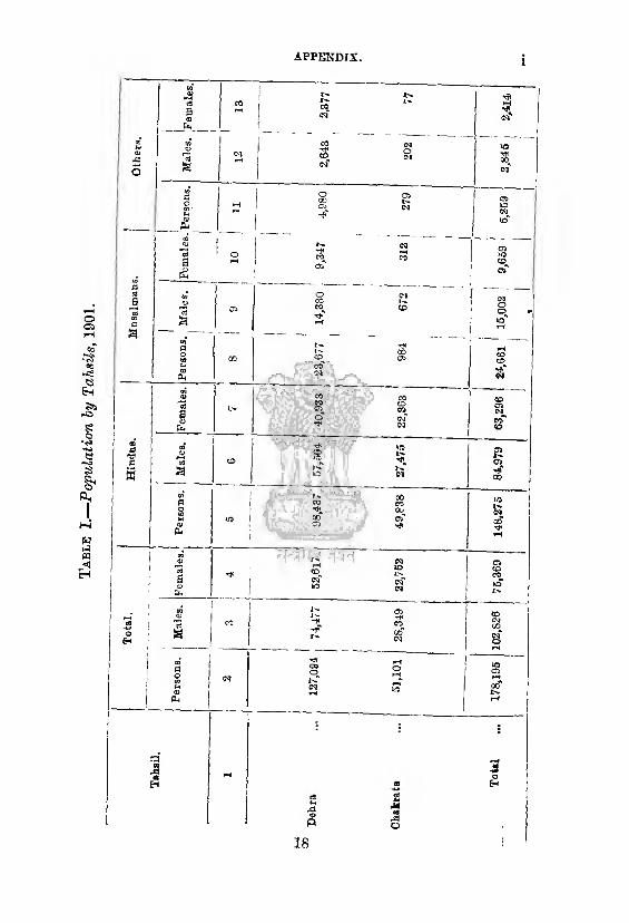
Tab
le I.
—P
op
ula
tio
n b
y T
ak
sils
, 1
90
1.
APPENDIX, I
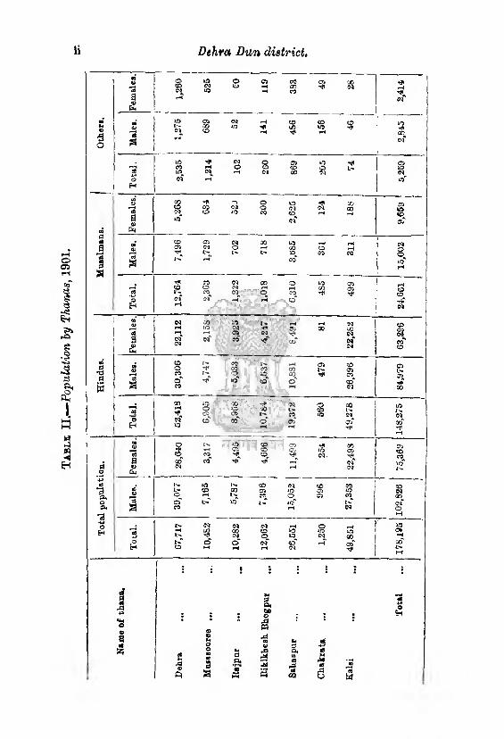
Tab
le I
I.—
Popula
tion b
y T
hanas,
1901.
ii Dehra Dun district.
To
tal
...
178,1
95
102,8
26
| 7
5,3
69
148,2
75
, 8
4,9
79
63,2
96
24,6
61
15
,00
2
9,6
59
! 5,2
59
2,8
45
2,4
14
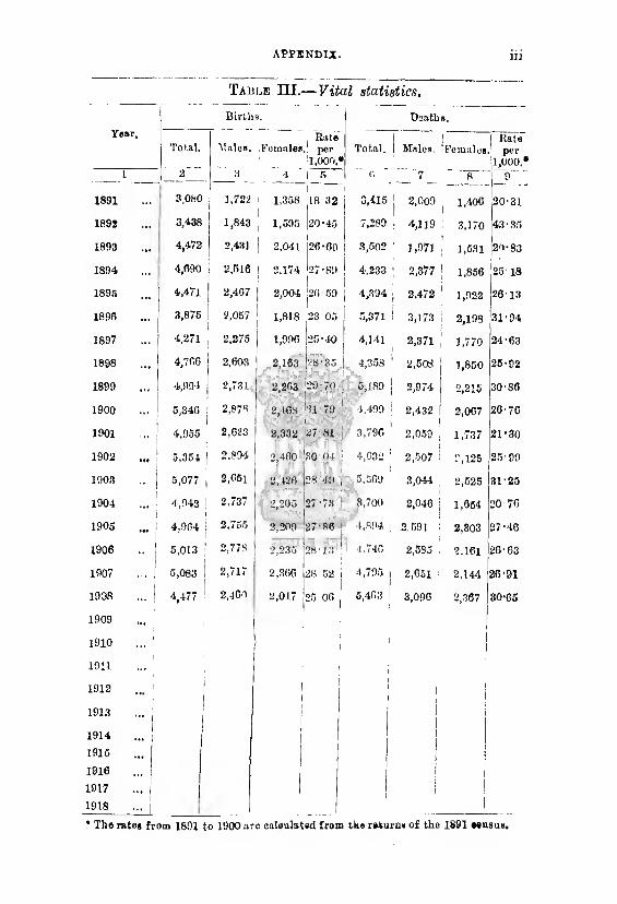
APPENDIX.
Table III.— Vital statistics.
Death 8.
Year, Total. Males. Females
Rate per
1,000,* Total. Males.
I ’Females
Rate per
1,000. l 2~ ~ a 4 1 5 i;
. 7 8 9
1891 3,080 1,722 1,358 j
1 18-32 3,415 2,009 1,400 20-31
1892 3,438 1,843 1,595 20 * 45 7,289 4,119 3,170 43 ■ 35
1893 ... 4,472 2,431 | 2,041 i 26-00 3,502 1,971 1,531 29-83
1894 4,690 2,516 i 2.174 27-89 4,233 2,377 ! 1,856 25-18
1895 ... 4,47l 2,467 2,004 '20-59 4,394 2,472 1,922 26 13
1896 ■ «. 3,876 2,057 1,818 i23'05 5,371 3,173 2,198 31-94
1897 4,271 2,275 1,996 25-40 4,141 2,371 1,770 24-63
1898 4,760 2,603 2,163 28-35 4,358 : 2,508 1,850 25-92
1899 4,994 2,731 2,203 20-70 5,189 | 2,974 2,215 30-86
1900 5,346 2,87« 2,408 ■1.1-79 4,499 2,432 2,007 26-70
1901 4,955 2,023 2,332 27-81 3,790 ' 2,059 1,737 21-30
1902 ... 5,354 2,894 2,460 30 04 4,032 : 2,507 2,125 25-09
1903 5,077 | 2,05l 2,126 28-49 , 5,509 3,044 2,525 31-25
1904 ... 4,943 ! 2,737 2,205 27-73 : 3,700 2,046 1,654 20-70
1905 ... 4,904 | 2,755 2,200 27-86 ' 4,894 2.591 2,803 27-46
1906 5,013 ! 2,778 2,235 28-13 1 4,740 2.585 2.161 26-63
1907 5,083 2,717 2,366 28 52, i 4,795 i 2,051 2,144 26-91
1908
1909
1910 1
4,477 ^
|
2,400 2,017 25 OG 6,463 i
i
3,090 2,367
i i
30-65
* The rates from 1891 to 1900 arc caleulated from the returns of the 1891 .ensue.
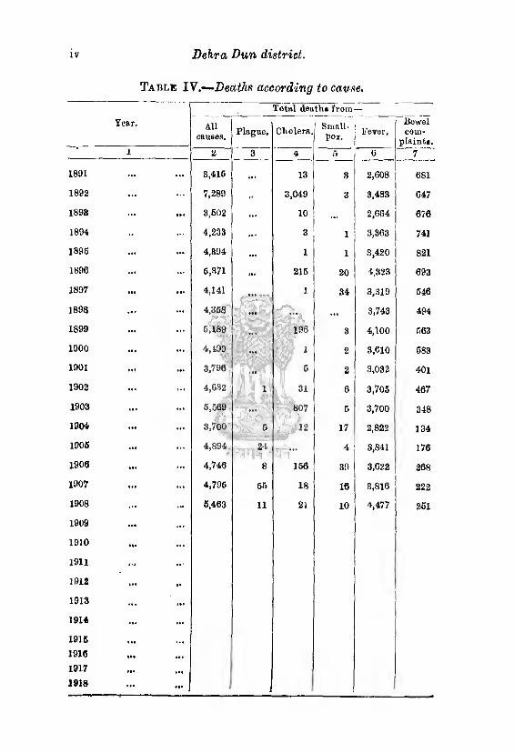
IV Dehra Dun district.
Table IV.—Deaths according to cause.
Tear.
Total death, from —
All causes.
Plague. Cholera, 1 Small, pox.
Fever. Bowel com¬
plaint..
1 a 3 4 5 0 7
1891 ... ... 8,415 ... 13 3 2,608 681
1893 7,289 3,049 3 3,483 647
1898 ... ... 3,502 ... 10 ... 2,064 676
1894 4,233 ... 3 1 3,363 741
1895 4,894 ... 1 1 3,420 821
1896 ... 6,371 ... 215 20 4,323 693
1897 ... 4,141 1 34 3,319 546
1898 4,368 ... ... 3,743 494
1899 ... ... 6,189 ¥%vSD5
196 3 4,100 563
1900 ... 4,199 ... | 1 2 3,610 583
1901 • *« .a. 3,798 ... 5 2 3,032 401
1902 ... 4,632 i 31 6 3,705 467
1903 ... ... 5,589 ... 807 6 3,700 348
1904 *«« ... 3,700 c 12 17 2,822 134
1905 4,894 24 4 3,841 l7fi
1906 4,746 8 166 39 3,622 268
1907 ... 4,795 55 18 16 3,816 222
1908 6,463 11 21 10 4,477 251
1909 ... ... 1910 Hi
1911
1912 ... *•
1913
1914 ... 1915 • t.
1916 •••
1917 »•«
1918 ...
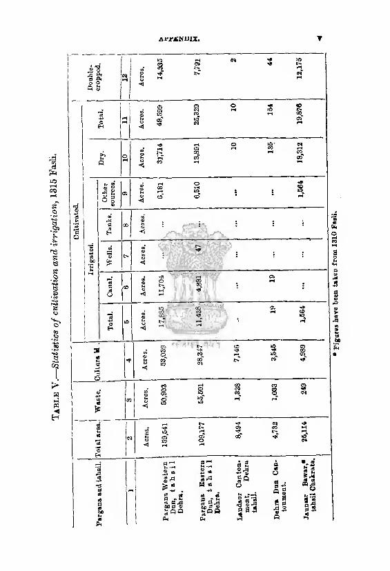
Table
Y.—
Sta
tist
ics
of
cult
ivati
on
and i
rrig
ati
on
, 13
15 F
asli
.
Al-BANDIX, T
Fig
ure
s h
ave
bee
n t
aken f
rom
13
10 F
asl
i.

Table V
I.—
Are
a i
n a
cres
under
the
pri
ncip
al
cro
ps, t
ah
sil
Deh
ra.
Dehra Dun district,
‘O O O t- CO 50 H-a h 01 CO ©.©» CO Tjt Tp to UiT to to" to to tcT to
05 ifl N Ci © o© ojw iq ic tjT
~f* co -n a & CO t-t CO -+* . rt " 00 o CD O
rrto S g‘i •£» D. 1>
03 Oi l> rS 05 GO Ol t-> >-< r-H *T 03 O GO H Js
^ « CO (M t> 05 OO
o oj k oo” iC*>T iC oT
1
1
W CO o 05 CD CO VO f< O WftN
W r-4 **4 W WWW
£§88 N Hn
£ P ?' <M N H N
! i i ‘
i
18
,46
0
_Ji
i
O CO 00 'f -»* oo ©
OJ* <53* ID* <20 >0 40 *D ^5
< lO 00 CO *H <-» CO oq co i—^ ©
r^-" t-T co" to to to lO
to
: : U 1
r
00 W <75 N ijl M R HHr^ 3
n m" c i ^
<D Cr
CO CD 00 O COONS
<N <N ci CO
*0 rH
: : ^ • : co"
«H-f o IO (M N l>^evs
W ^ -
' ^ J * g- ^*2 o - OWCOO
2 qc 03 rH ID ^ t_ q V ^ CO V
c; (-*h Ch o
■ n ft •i ^ _ OONO© >q 5 qt-cc > CfiT A. cC CD 03 ocT I W 3 M N NN
CO CD GO
8S38
5? S? 5 5
1C CD t-v cc o o o o K rt c. W
CTj o H M O HH-< CO « *)K
Ui cc h. c0 J?j O a w h h iw m n n rc m m » n eo eo
•No r
etu
rn* p
repare
d o
n a
cco
un
t of
cen
eu
* o
pera
tion*,
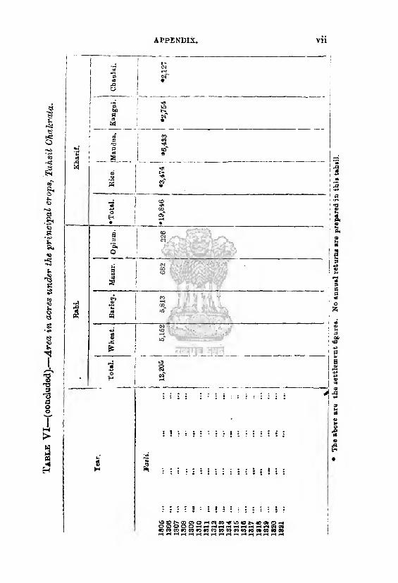
Table V
I—(o
oac
luded
).—
Are
a in
acre
s under
the
pri
ncip
al
cropsi
, T
ahsi
l O
kak
rata
. APPENDIX, Vll
The a
bove are
the s
ett
lem
en
t fi
gure
s.
No a
nn
ual
retu
rns a
re p
rep
are
d i
n t
his
tah
sil
.
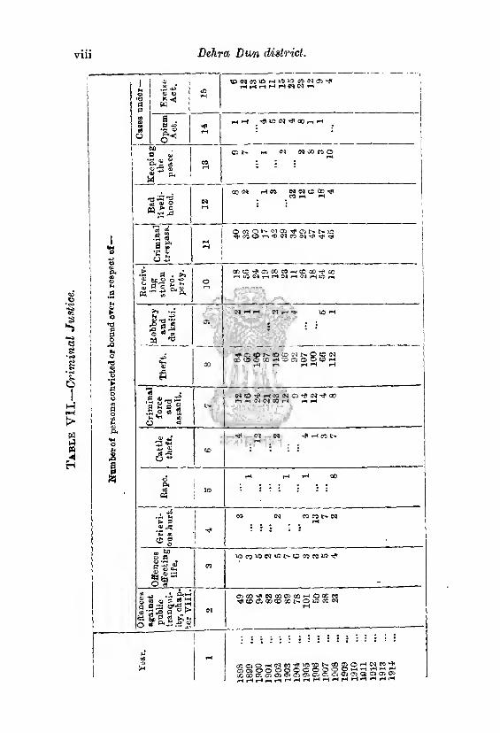
Ifu
mb
oro
f pers
ocsconri
cte
dor
bo
un
d e
ver
in r
eB
pect o
f
1913
1
91
4
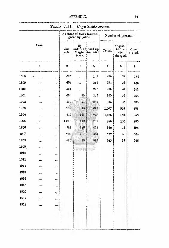
APPENDIX, IX
Table VIII.'—Cognizable crime.
Year.
Number of eases investi¬ gated by police. Number of persons—
Suo motv.
orders of Magis¬ trate.
Sent up for trial. Tried.
Acquit¬ ted or
diB-
chargod.
Con¬ victed.
I 2 3 4 6 6 7
1898 • a. 896 181 234 60 184
1899 459 214 291 75 216
1900 621 227 306 63 242
1901 466 39 202 300 46 264
1902 690 21 254 364 60 304
1903 ... 999 40 676 1,067 914 163
190* •*» 842 141 747 1,106 166 950
1905 ... 1,012 .
140 1! I i
799 985 180 805
1906 ••• 783 116 453 640 44 496
1907 ... 732 107 441 572 68 504
1908 ... 780 98 615 633 87 546
1909 _-
1910 ... "IH1
1911 ...
1912 , 1913
1914 ...
1916
1916
1917 ...
1918
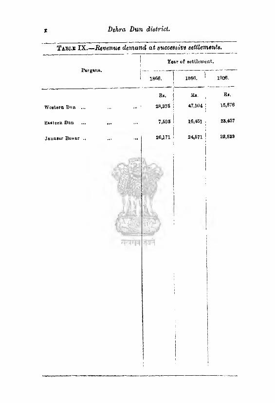
t Dehra Dun district,
Tabli IX.—Revenue demand at successive settlements.
PargMia.
Year of settlement, i
1 1868. 1886. ^ 1906.
Ra. R». Ra.
Weatern Dim ... 28,376 47,604 | 15,870
Kaateru Duu 7,695
, 16,461 23,427
Jautuar Buwar .. ... I 26,171 24,671 1 23,623
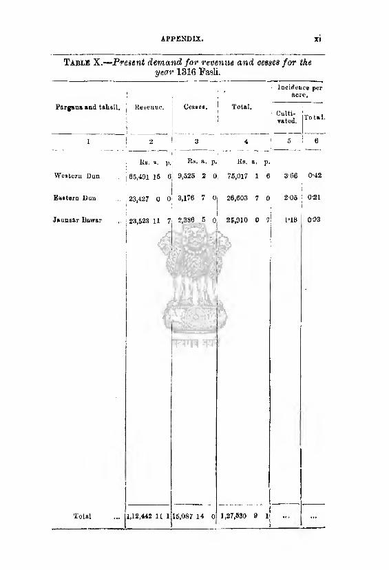
APPENDIX,
Table X.—Present demand for revenue and cesses for the year 1316 Fasli.
Pargana and talml. Revenue. Cesses. j
i
Total,
Incidence per acre.
Culti- , , rated. ToUl-
1 2 1 3 4 5 6
Kb. a.
1 p. Rs. “■ P- Ks. a. ]>■
Western Dun 05,491 IS oj 9,525 2 0. 75,017 i 6 3‘66 0-42
Kaateru Dun ... [ 23,427 0 o' 3,176 7 0, |
26,603 7 0 206 ,
0-21
Jaunsar Bawar 1 23,523 11 7 2,386 5 o' 25,910 0 7 1*18 I 093
,442 II 1 15,087 14 0 1,27,830 9 1 Total
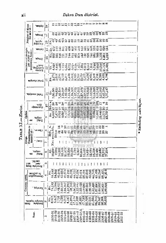
xn Dehra Dun district.
P. ,
H
*am)do
'a2aid
( — CM ph pi h C) »*h FH’-Il'-L'-I>l>l>t^00a0
OO-^IM'N WMh-i’h O 31 d 01 Oi (J> M W oioi-0’^Tft*f(rPTfH-^jt'^^cocg.'OCOWWW
■2 u
fel
PH
w J M H H
” a oS
a *-< 53 4> r3 1 3*!!
‘JJIlda £r)uuO£)
-raoido
eStuci
*’W anjpnpui
1 JconbKl
, O M in II Jj H Cl n M M H h IM C D O 55 ^ «'**'i,C0’'*c0-*C0C0:0co:0:0C0C0C0co<M0'i
..jj iO —i •—i ">1 CD 05 CM CO C5 -hi I-- »D <?5 CO 05 O *0 10 « K ’I1 -• /J C5 O W OSHCCOOfl-jHlSH n I ^ ^ LCHfl -* »!< ^^;^rt*‘D,OCDiOCD(X)CD'—>
"• w n D rH O ^ -ft W X (N oiO’OOiOCHM "-NO-t - --- ---- CO 09 *1"M O 4 HCDN'=JtON’#COrflCOHH 33 CO »0 00 l.-» l- fc» CD <* lO -.O i- 00 !-«■ Oi 05 p-^04 (M
05 iO lO SC Cl Jj !>*• >1 fl Cl O 33 CO O O pH •M CO CO i—i iQ ■?! HCOl-W .'; X G C© 2i Z& tr~ 03 _ ifi ■■') ■+ CO i*~ D. «D •t CD M i—i n I'- O M r-^ yfi pjT -D OOQ «0* CD*1-* l^CO’ 0*1-^’ jd*cTcT*^ pH
itj-joj,
’B^djOOOI
co-*:oco:':cio-Hv:-f,;T..i—*.Q — Ophcoco© l» :0 75 CO T -- -H o »D 1 - C5 CD jO X CD CO X
c/J ri W - J, - v, h --C 75 I - nJ. CO^ iO pH C^, ^ L-^ ^ pH Cl r? <N tT pH pH p-T of <N 0-f CO pH CO* CO* wTtJ* -»*
p^OCC. OOcT.ONHhWMDWIN^I' o w c Ol- r- c; n OU5 W ^ QOi T* a-' O CD VO © CD l(5 Cv CO H J; {£)_ a « H o ^ H
^ 6 W pH W ’f ^ t-*' CD of oj >o" Ol I o' O t-» L-*» I — © a- CO CO CO CO OQ CO 1 - «D rt< CD CO O p*< 04 ■»*_«2_ rH4 HH H H pH CM N(M« W
§
•UOJl o -dmasnoo •
•Bjdjao -8i i«;ox
X CD >0 cp CO CD iO CD ^ 75 <M CO 05 CO
■©^CGKJ-r p| <N CQ CO X Oi
I- t- D C I> CD W Id Ld rf N O O rH 05 O O pH pH *H pH pH pH pH pH pi i —I i—i H pH pH_H pH ■—I
O O- CO CC I-' -f -O O ITS CO J O ij. n cv i.pp --* un co CO 7i X CO O —• <M ■ ?D i - CO O —( 04 I - 7. *0 ri )Q CCi X QJ O ^ I-D
1*0-* C'j CD *- J_ CD _ 0_ *0^ -; ■* w 0* ^ 'O CO l>_
5 x‘*-"x"x- x L-''o cd cd'i- ji'd o» o oj rn
o'
1 gI Q O H fu°0
rJIOOnHOKH^ liljrH O (M CD <N H PH H W n C4 UN -N COpH5M<MCNJ
O h Tf Cl £ -T* Tj< CO CO CO <>t oj 04
H'MHriiCgiflfflltJlOCDOl.'. -^3*.-- rH £N <M c<|
•BjdlOO
"91 i'c^ox
, D o co cd >o o ■** o o t- r o“< ft O o n ?4 l - OCO CD o O o M Oj M L w , , ij © o„ n - * « « is io oq o q co co <n
O 05 (N pH Csf o tH 05 Q CO oi CO CD* oT oT l-p pH rIHrtHH r_lr-,r-|_*r-j1-Hl-|0|C<l
putt * MB/ *0
raojj Bjdioaau |
'saoiittS ui uo^dmnsaoQ
,awoo^HCOH^H^cDcfi«o©r'‘0 r/! S ^ 03 c' ‘1:0 05 ^ ^ ^ ^
a?. ,-i h; P cd 04 l-p F-H pH PH CP X t- ■’*1- ^r* co
5! 3 S ^5 0 ” ^ ir? V co" »> co 10* 10 o' o' t-T COCO,**Tii'TT}icO-tlD*OCOCO'*Tt4t340lO^
‘ »d{3D0y
IG'Jl !-■ Of) In C] lO Ci O O Ol »o" O', CD O N J. H • S p 9 ^ CJ CDOCOW005COCO -/; O 5D C? -?*, i> C5 X O O CD i> *«* CN 05 XX
DC5 ^! N lO C CO CO C>1 IO" oT CD CD* Ol lC 05* U3 05 l> t*- -.r O O H r. o 01 01 O CD IM I® 10 co JO (C
pH PH PH PH H Pi H H H -i"h H n H Pi
‘biouTjti a3j340j raojj P^d{99oy
L-h 1> 10 10 to !>. C> ^ O Cl 01 CD PH i® T? [> 0 D ^iD^.’^^r^^X-lOlOcOWlNCOlO D-tfCDOl ^ eic^r-t I^PH co O^L-^CC w Ifl N CC coco
«D N 10 30* Tf cT Ih* I-h’ Co t-C IO CO co CD p-iHp3?IHCOC®(HN*'JNN
!Tl^CO^|£?CDi''XCrj-^TH OlCO-rf<lOCOlH.(Xl(^b^H_iHiHH ® OJ. 9 905 050, 0. 2000600 OOo3322
9)IIH/?'1S?iI?*l^CC,r'-X H. OfHOIM-rttlOCDiH.XCTirHpH'VI ss3JSsasli®s°S®s^®®ss3Sg
Exclu
din
g m
alt
liq
uor.
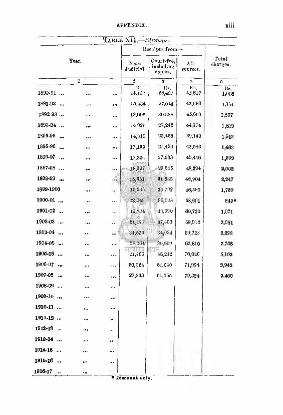
APPENDIX. xiii
Ta BLN XII. —iStamp*.
Receipts from —
Year. Noti- J udicial.
Court*-fee, including
copies.
All sources.
Total charges.
1 2 3 4 5
1890- 91 ... ... Ha.
14,131 Its,
28,437 Rs.
42,617 Ks.
1,098
1891-92 ... 15,434 27,044 43.C60 1,161
1892-93 ... ... ... 13,606 30.888 45,663 1,857
1893-94 ... ... 14,926 27,242 44,374 1,819
1894-95 ... 14,319 23,456 39,143 1,513
1896-96 ... ... 17,135 25,460 43,686 1,463
1896-97 ... ... 17,324 27,533 45,446 1,339
1897-98 ... ... ... 18,397 29,545 48,294 2,002
1898-99 ... ... »•« 15,331 31,645 48,904 2,247
1899-1900 ... 15,235 30,792 46,565 1,780
1900.01 ... ... 22,249 36,098 58,691 849*
1901-02 ... 19,834 40,590 60,730 1,971
1902-03 ... «« 21,177 37,460 58,912 2,081
1903-04 ... ... 24,533 34,934 50,728 2,298
1904-05 ... 28,654 36,859 65,810 2,766
1906-06 ... 21,465 48,242 70,026 5,163
1906-07 ... 20,024 51,640 71,994 2,943
1907-08 .„ ... 27,333 51,655 79,324 3,400
1908-09 ... ...
1909-10 ...
1910-H ...
1911-12 ... ...
1912-18 ... ... ...
1918-14 ... ...
1914-16 ... ...
1916-16 ... in* ...
1916-17 ... ... .. 1 • Dieoount only.
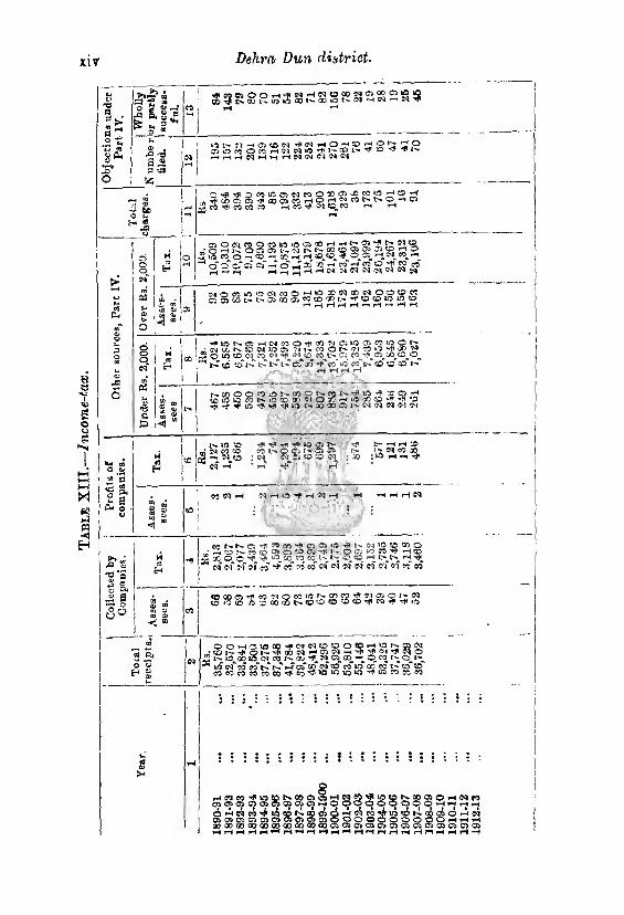
Tab
le X
III.
—In
com
e-ta
x,
xir Dehra Dun district.
T3 a n fc
g £ g-3
X!
o
*o 'TO
a « 3 <XJ
55
1(5 N -H OS <c N ■* IM —t O rj p g £ t; C? p OS in « O « H W N « -t I'* ■£ l> ’j' ^
O *•? r? OMiAOSNiOOBCl^W^r'^'^ i'*Pxo;3s^aocsco«HC>»-*c£cor'»t>0-»os
ll^TOTfieOCOW rH CO C1! <D « r-1 *H
<8 cu
£
o
NOrtusotfiraO’-'WcoNcONOtocprt a}0300L^t.''0}Q005CO?OS#X:'*''*,«Oce>10iO«0
^r-(rlHiH"iH*-*HH
''tvot^os^ovcoo^cn^osiogscovoo*'; « CC N CO (M lO os !■- « O !■> (71 >0 CD M
w loo Sfltf O VC <©. *i;-b " H I N © to i>
^ oq lO os ^ h- « 6 !■> (?l lO ^ CD M M 07 <M <M CD CO L-_ OS CO^^as^c/^cO^O^
i> lC l- i> as* jj -rf" co" vo co t>T co to to r-T
isCOOOtOiONCOONrtNilrt^X^H *X) lO lO CO N m cc cn 71 o X lO « ?D 'f ^ •£)
lO ^ rf! Tjl IQ C' 30 OO Os ^ CM (M N <M M
»w m O a>
“ ’3
«g, o rr ^ 3 G* o
o
t* tn pO <u
*o *S as £ o
Jd S
H d H
1^. so :o ^ ov co co
c£ cq -I
:*l I
IO 03 N 1-^ os as
•4* r>
CD CD (M ; co
t- H H » l' <M CO 00 ; vO 1—1
& «> s ^ <1
c*5 <M 1 N H 1/5 ’f H ^ ’ rH >H 1—i r—) Cl
C0l^.h-.0iTp?0c0^flC7i<?V‘»'^^lM,®^cCO ■ M O J> M (D Ch os 'O OS w o A >0 « ^ H to
j5 x 0^0 ■'f tP *C x_ CO CO l> vC^CO «H !>_*> *H
N ?l" ?r CO W W CO" N ?i N N M 0} 01 CO CO
co as
■< “
> as os -f « MOMW,s*®c?Tf,MaO<'|N |ioo5-;®00^CDCCDt5cCfKi^rH!0
OQt-ioiflM’fMN^^oCHiaNgsN ;«Oi-^Ql'>.^Q0NHOS|?:lH^ 2 ^ o
' -2 ifl> 00 «5 oi_ CO !-*• GO N OJfc OO O w t11; 0^1^ 35 vo c<T co co" t> t>T *-T of otT of co co" vo co co i> co" ccT
1 C0C0C0c0C0C0'^C0'^lO*Ovc5u^r^ir:)COCfic/3
r^nw'f 03 CS0)
d) -H C^J CO OS OS OS OS 00 co x QO
8 vo«ct^aoe>cs*-r$3 OSOsOSftOSHOCp
■^v^eot-iaoosdiw DOSDOsOSOSOO Q0»®ab®®osO3
ss CO CO o o as os
VD tO Is* £0 0900 5H0 «0 ti 0000 DOJOsffl HHH H
os o O *H ^2 os os Hr)
O i-t i—) rS OS OS 1
912-1
3
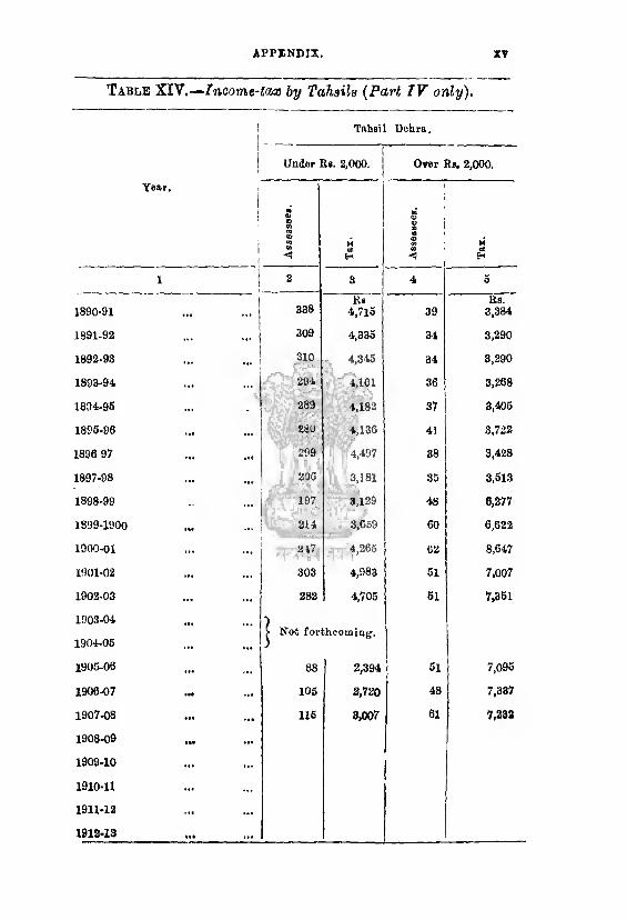
APPENDIX. XV
Table XIV.— Income-tax by Tahsils (Part IV only).
1 Tahsil Debra.
Under Rs. 2,000. Over Rb, 2,000.
Year,
! I l
i 1
m 0J ® CO 03 03 m w ■<
M trf e*
03 a>
s ® CD W <(
M erf H
i | 2 3 4 6
1890-91 338 lie
4,7l6 39 Us.
3,384
1891-92 309 4,336 34 3,290
1892-93 310 4,346 34 3,290
1893-94 294 4,161 36 3,268
1804-96 289 4,182 37 3,406
1896-96 280 4,136 41 3,722
1896 97 299 4,497 38 3,428
1897-98 206 3,181 35 3,613
1898-99 197 3,129 48 6,277
1899-1900 214 3,669 60 6,622
1900-01 247 4,265 62 8,647
19OX-02 303 4,983 51 7,007
1902-03 282 4,705 61 7,361
1903- 04
1904- 06
1905- 06
| Not for
88
ihcomiag.
2,394 61 7,096
1906-07 105 2,720 48 7,337
1907-08 116 3,007 61 7,232
1908- 09
1909- 10
1910- 11
1911- 12
1912- 13
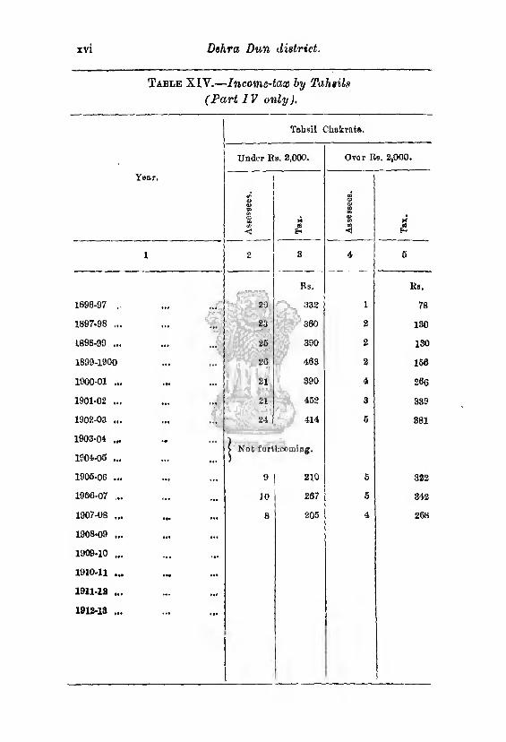
XVI Dehra Dun district.
Table XIV.—Income-tax by Tahtils
(Part 1V only ).
Tahsil Ckakrata.
Under Eb. 2,000. Over Rb. 2,000.
Year.
<D 03 50
0? to 09
< M flB H
IB 01 01 CD to 03 CD w
oJ
1 2 8 4 5
1890-97 20
Rs.
332 1
Rs,
78
1897.98 ... 23 360 2 180
1898-99 ... 25 390 2 130
1899-1900 26 1! .1 iT : .
463 2 156
1900-01 ... ... 21 890 4 266
1901-02 ... 21 452 3 389
1902-03 ... 24 414 5 881
19030-1 ...
1901-05 ...
1905-06 ...
j Not forthcoming-.
9 | 210 6 322
1906-07 ... 10 267 6 842
1907-08 ... 8 205 4 268
1908- 09 ...
1909- 10 ...
1910- 11 ...
1911.12 ...
1912-18 ...
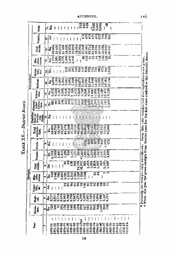
19

1 able
XV
I.—
Munic
ipali
ty o
f D
ehr
XY1U Dehra Dun District.
I,W“)'rfOli?0cnQMNQONH»0Offi^ as X£> O* » p-i -^00 ^JCD© €0 U5 ^
w ^ m t>T co* i>* *? as its <m" ia to cm* fsToo wT acT vo* co*i>~ • ^ IH -< IM iH CO C0W<Nc0’'fYf*©*OiON0i
r-i
. COCOCOXX-fCOCOCOOS^lQr^OSTflcO— go *r CO GO CO '*5* ^01>NCOCCONNCD
jS O^fH CM 00 o <0
CO CO W ctf CO 00 00 l> I> t-flN CO Ol ft i-T IQ* <0* ___ rH pH riHHrH
O^QC-O O^CiOi-rf <0_ o CD CO H CO CO CO jJONWNcOM^WHlOMioSl'.NlOWO ® 5i CMcO^Pt^OsOrftHpcOYji
ih w <-. ©T e«T co" co co
£> -* *-c *l : iO CO 05 ©
3 £j P cb'^ToT,co*“ 5 2 ^ ^ 50 so IQ CO M rH rH ^ » • in ra ra u (.n r1* m ® «i ® J3 U) m m h H
& *C lO C5 SO X X l^l> lO YfitN iM H» fs o O OO rj» £ g co oq fh ci r-T cm cmm* »h >T cm co'cm* -T i> i>Tqo**o*
. « . ” " j! O D O O -t* nTT^i'T>. >1 in " p,-„gf A ~ 'O 'O w W Tjt |V, o O W M 0 4 to X- Oi V*-5fi.® ’* 4 »D CD X C5 Jj X H X) O'. M <0 tC O O CM l> 00 CO
M W d .S (C '—t rH -A HhNNNOHhCI *H W . . m .o"i-TT-* VhTC»h®’co oo ■#»’ccHhT^h us o~co~~ 3 hH »Q^«OOlNOWONH®NWHP5HOO “ q *£ OS rH l^»> CD X^ 3^ CO, ce l-^GO C^ © »H CM -tf |>
l P ”* ao V to co of © <o*co <© i-<T i>T X os C> © cm ©* cm •j fH H HH H H
S-S -• "S -d *5 £ 9 '£*
J_p_
X^i,©'H;D>COl>Q0 CO 00 CM Om ao -c*
«-TlQ »“* r-T H N N H CO* t-T
wy V"*iWBT« <£ w tv CO t> X CO CO its „ N5d>COrpC3NNlO CO tf5 X © -« rfl •«*
--h“ ;h «3CiOi HNco HW ;or)03WfrJOCDN
^ ^ 'r-T nV o' CO p-T ■ CM* nf" N «> <N CO O aO
1 i (M '3D 53 co r-4 CO rH O’CO »0 CO UO CTi O'
OO^iOO^OS^O CO iMoaicoTfcoivcsjio co
* CO* *4 CsT W CsT CM* ?0* CO* 't CO* co” ».o" CD* CD* <M* (M* CO*
~IVY^ CO O O iq’co Oi CO 1> W 00 NON Cplo'CM-" 5* N CO W O flO Oi N -J'^W'Xl'MaOHN^NCO jhc'io co cd o a? jjs a> co ao ooo <*o H pH r4 CM* rn'^r --T i—T r-T CM X* O* Q3 GO* 05* O* O* »-•
r-H H H H
Tf(HOXilH(NjJlNiJJ^35©CON®OjH -HlftCHinOOi -UJHOJiaOcOONN^ «OD<SKOaJ^-?CJlO 1 ^C5 05 CD_CO 05 (NP HN
m its co d> lO o' -* CO* I»" l^r> CO rfTco 00 N N H CD HrHNH«(N'NM!M(N«5tO'}u(5l>.(OOCO
OCCUDWXN^HONHCOairst'Oj .XiOQDH^WH'OinoOCCCOQOl'-C
03 H CM 05 O Q5 GO iO rj< CC *> CO O CO C
M © tC »o“ M* co* i>-* x* x* x" co Tf< Tp nfT c^* i> ci
S .5 ....... o o 8 o • § :0-S-«f-r ’ hJ j CO _HH CQ
' ’ ’ O O t" 'P rft iO f'- O O U3 1> iO N CO W H ® ■0505rHiOCOCOCDrHCDCOCOCDcoCOCOn'0505 ^ ifl v UJ O W CO ^ 05 CO^JO 05 N rf ^®5
ID ,Jh rH* CsT CM* Of CO* W « C^" rH Cq* CO i-C N *H N w _
^ CO COHOCOO^^f'75^ S?w fe» • H^NTjlODOQDOJrsOCOjSS^
w tji -2 : : : * eo rn qo 05 ooi> n rjj^oa Q 3 W ■ ‘ * * fH n" Ofl* 5sT M* N 5f co ,4 <N eqT ^ <yf
' _ ^Ortoxbuo <D~CD COLO CO o o® tt xiOO^lONCCOCOOCnCON^ Mao'! co m on *>d woi co^o o,w : ; : : 3o«9 ’ asOiOx’cooro.'Tcoco^irco'r-r “ ' " H *3 rt HHHHrlHH
h N : ; ■• =
QtO^fMlOWCOO I^WOOWOCM^CO
•CMiOlOCDCDrP*^'^4 ■ co* co cc p* co* as" as* co* C0^C0^-?-F«\D
rH Cl CO VO CO r* X Os 05 rH CO "*9 VO CD K. fD /-*-\ _i Ai M -*•>
orooocsa^ooScpooooooooSSHSSH oricgo:^iStt)isanaOr4MMHiiAfAK.fTiJL
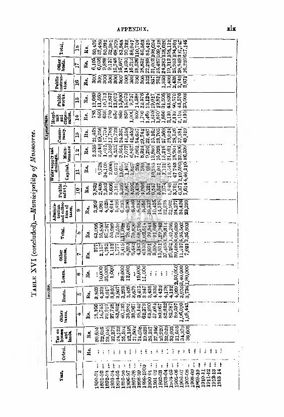
Tab
le X
VI
(conclu
ded).
—M
unic
ipali
ty o
f M
uss
oo
ree
APPENDIX
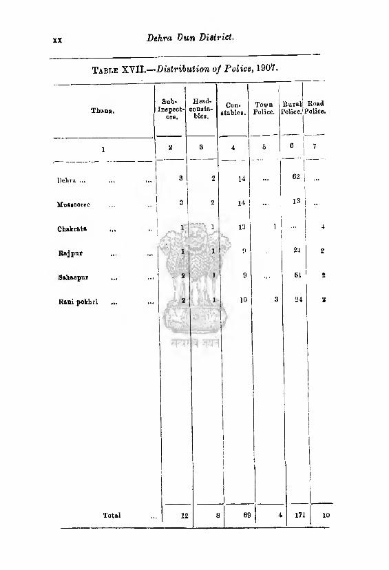
XX Dehra Dun District.
Table XVII.—'Distribution of Police, 1907.
Sub- Head-
1
Town Rural Road Thaua. [nspect-
orB. consta¬
bles. stables. Police. 1 Police, f ’dice.
1 2 3 4 6 6 7
Debra ... ... ... 3 2 14 ... G2|
Mufliooree 3
j
2 14 1 ... |
I 13!
i
Cbakrata ... ... , \i| 13 ,1
1 ■ 4
Bajpur
1
‘ ij 1 1
pgggra
0 21 2
Sabaspur . 2 j ! 9 61 2
Rani pokhii ... 2 j 1
)
10 1
r
i j i
3 24 2
Total 12 8 69 4 171 10
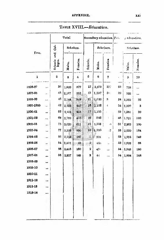
APPENDIX XXI
Table XVIII.-—Education.
tear.
Total Secondary education. Pi i. / education.
Sch
oo
ls
and
Col
¬
leg
es.
Scholnrs.
! S
cho
ols
,
Scholars. Scholars.
*3 a F
emal
es.
CO <39
a
m
8 V
m £ *93
3 £
X 2 3 4 S 6 7 9 10
1896-97 30 1,809 377 12 1,070 377 23 728
1897-98 ... 43 2,167 382 12 1,227 3v 29 932 ...
1898-99 46 2,144 389 11 1,033 3 34 1,103 32
1899-1900 ... 62 2,333 435 16 1,102 •l • 34 1,199 3
1900-01 ... 62 2,421 415 17 1,133 32 1,281 20
1901-02 68 2,789 455 16 846 • 48 1,921 180
1902-03 ... 73 3,623 691 18 1,263 51 2,363 100
1903-04 77 3,309 800 18 1,280 :7 55 2,020 164
1904-06 56 2,218 149 1 298 • 56 1,915 149
1906-06 64 2,801 68 2 46b 62 1,833 08
1906-07 ... 56 2,418 160 2 47' 54 1,948 160
1907-08 66 2,827 143 2 4-1 54 1,884 143
1908-09
1909-10 »•*
1910-11
1911-12
1912-13
1913-14 ;
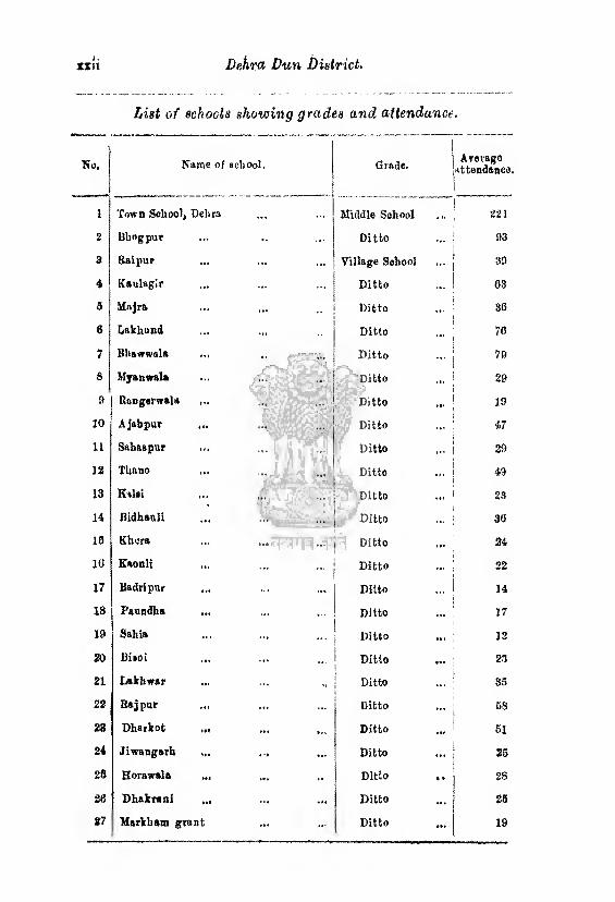
xxii Dekra Dun District,
List of schocls showing grades and attendance •
No. Name of school. Grade. Average
attendance.
1 Town School, Delira Middle School 221
2 Bhogpur Ditto 93
3 Raipur ... Village School ... 39
4 Kaulagir Ditto 63
5 Majra ... ... Ditto 36
6 Lakhond Ditto 70
7 Bhawwals ... ,, Ditto 79
8 Myanwala Ditto 29
A Rangerwala ... Ditto 19
10 Ajabpur ... Ditto 47
11 SahaBpur Ditto 29
18 TUano ... Ditto 49
13 Kalsi Ditto ... 23
14 Bidhauli Ditto 30
13 Khcra pf Ditto 24
10 Kaonli Ditto 22
17 Badri pur Ditto 14
18 Paundha Ditto 17
19 Sahia Ditto 12
20 Biioi Ditto 23
21 Lakbwar Ditto 35
22 Rajpur Ditto 68
23 Dharkot .„ ... Ditto 61
24 Jiwangarh Ditto 26
23 Borawala Ditto .. 28
38 Dbakrani ... Ditto 25
27 Markham grant Ditto 19
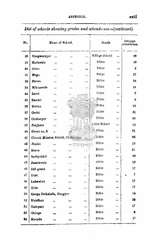
APPENDIX, XXI!
List of schools showing grades and attendance—(continued).
No. Name of School. \
Grade.
1
28 Bhagwantpur ... Village School
29 Hariawals ... Ditto
SO Dirau ... Ditto
31 Nagu Ditto
82 Barwa ... Ditto
33 Mlliunwala Ditto
84 Laori ... ■■ ... Ditto
35 Kandoi Ditto
30 Koanu ... ... Ditto
87 Garhi Ditto
88 Chuharpur Ditto
39 Jhajhora Aided School
40 Grant no. 8 .. ■tw jjfv/-
Ditto
41 Church Mission School, Chuhurpar ... Ditto
42 Jhalki ... ... Ditto
43 Duara ... ... • . Ditto
44 Rattipokhri Ditto
46 Jassonwala ... . , Ditto
46 Joli grant Ditto
47 Tuni Ditto
46 Ladwakot Ditto
49 Kota Ditto
GO Kenya Pathshala, Bhogpur Ditto
61 Mundhan .. ... Ditto
52 Nalapani Ditto
53 Ghinga ... .» Ditto
54 **» tt« **■ Ditto
Average attendance.
26
10
8
27
34
14
6
8
12
31
26
13
«I
66
18
21
20
10
17
7
17
17
14
28
17
8
17
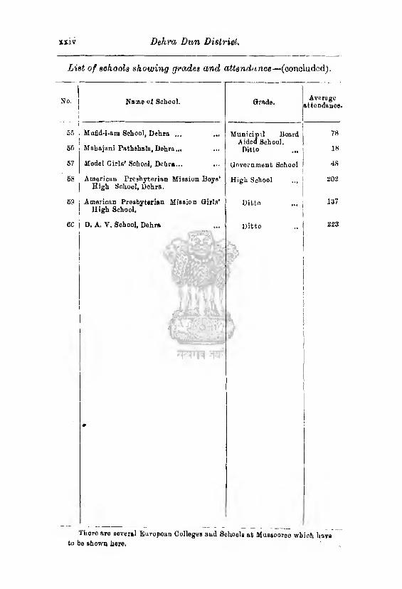
XXIV Dehra Dun District.
List of schools showing grades and attendance—(concluded).
No. Name of School. Grade. Avorage
attendance
55 Mufid-i-am School, Dehra ... Municipil Board A ided School.
78
56 Mabajani Pathshala, Dehra... Ditto 18
67 Model Girls’ School, Dehra... Government School 48
68 Amorican Presbyterian Mission Boys’ High School, Dehra.
High School 202
69 American Presbyterian Mission Girls' High School.
Ditto ... 137
60 D. A. V. School, Dehra Ditto 223
There are several European Colleges and Schools at Mussooreo which have to be shown here.
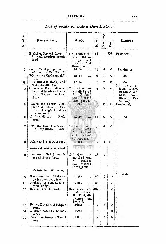
APPENDIX. xxv
List of roads in Dehra Dun District,
Name of mad. Grade.
| M
iles.
G aziabad- Meerut-Koor- 1st class met¬ 14 keeand Landanr trunk alled road A. road. Bridgod and
Dohra-Fatehpur portion
drain a d
throughout. Ditto 21
of Bampur-Mandi roul Sajiaraupur-Chakrata Hill Ditto (i
road
Dilavambazur-Hath, and Ditto 1 Cantonment road.
Ghuziabad-Meorut-Roor- 2nd class uu- 8 kco and Landaur trunk metalled road road Rajpur to Lnn- A. Bridged daur. and drained
Gliaiiabad-Moerutltoor- throughout.
Ditto 1 1 kee and Landanr trunk- road through Landaur Cantonment.
Kjr
Hard war-Badri Natli Ditto 17 road.
1
Doiwala and Harrawala i 1st class me¬ 1
Railway Station mads. talled road i i
Dehra and Hurdwar road
A Bridged and drained throughout.
Ditto
1 i 1
1
12 |
Landanr-Knmaun road. 1 f \ "1 Ifj 1
Landanr to Tehn bound¬ j 2nd class un- 11 ary at Baranakand. 1 metalled road
Mmtooree-Simla road,
A. Bridged ! and drained
throughout.
Mussoorcc via Chakr.ita 1
Ditto 86 to Jaunsar boundary.
Chakrata to Tona at San- Ditto 24 gota bridge.
Dehra-Hardwar road 2nd class un- 184
Dehra, Kaonli and Sahpur
metalled road B. Partially
bridged and drained.
Ditto 3 road.
Dilaram bazar to oknton- Ditto 1 ment.
Fatehpur-Bampur Mandi Ditto 4
Provincial,
Provincial.
do. (Prov i d c i a 1
from Dehra to Dhaki and Local from Dhaki to Fa* tehpur.)
Provincial.
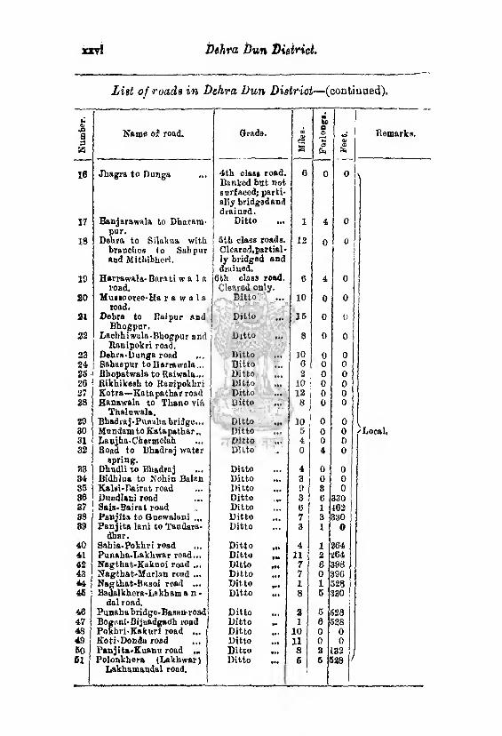
Dehra Dun District. jotrl
List of roads in Dehra Dun Distriot—(continued). N
um
ber
.
Name of road. Grade. CO 0>
3
00 fee a o >-< a
■*» <V
*
Remarks.
16 Jhagra to Dunga 4th clast road. Banked but not surfaced; parti¬ ally bridgedand drained.
0 0 0
17 Banjarawala to Dharam- pur.
Ditto ... 1 4 0
18 Dehra to Silakua with branches to Sahpur and Mitbibhori.
' 5th class roads, i Clearod.partial- j ly bridged and 1 drained.
12 0 0
19 Harrawala- Barati w a 1 a load.
j6th class road. Cleared only.
6 4 0
20 Muesooree-Ha r a w a 1 a road.
Ditto *•? 10 0 0
21 Dehra to Raipur and Bhogpnr.
Ditto »•« 15 0 0
23 Lftchbi wala-Bbogpur and Kauipokri road.
Ditto IW 8 0 0
23 Dehra-Donga road Ditto JO 0 0 24 Sahaspur toBarrowala... Ditto O 0 0 25 Bhopatwala to Raiwala... Ditto ... 2 0 0 26 Kikhikesh to Ranipokhrj Ditto 10 0 0 27 Kotra—Kata pathar road Ditto ... 12 0 0 28 Banawala to Th&no vi&
Thaluwala. Ditto • at 8 0 0
29 Bhadraj-Ponaha bridge... Ditto •SI 10 0 0 30 Mundamto Kata pathar.. Ditto m 5 0 0 f Local, 31 Lanjha.Chetmclah Ditto »•» 4 0 0 | 32 Road to Bhadraj water
spring. Dhndli to Bhadraj
Ditto 0 4 0
33 Ditto 4 0 0 34 Bidhlua to Nohin Balan Ditto •«. 3 0 0 35 Kalsi-Rairat road Ditto f »» 9 8 0 36 Dundlani road Ditto 3 6 330 37 Saia-Bajrat road Ditto 6 1 402 38 Panjita to Quewalani Ditto #»• 7 3 330 39 Panjita lani to Tandara-
dhar. Ditto 3 1 a
40 Sahia-Pokhri road Ditto 4 1 264 41 Pnnaha-Lakhwar road,., Ditto 11 2 264 42 Nagthat-Kaknoi road ... Ditto 7 8 398 43 Nagtkat-Mnrlan road ... Ditto Ill 7 0 396 44 Nagthat-Bftsoi road ... Ditto 1 1 523 4S Badalkhera-Lskham a n -
dal road. Ditto Ml 8 5 330
46 Punahabridgo-Basanroad Ditto • •• 2 5 528 47 Bognni-Bijnadgadh road Ditto **> 1 6 528 48 Pokhri-Kakurl road ... Ditto 10 0 0 49 Koti-Docda road Ditto • *« 11 0 Ell 60 Panjita-Kuanu road ... Ditto **► 8 2 132 61 Polonkhera (Lakhwar)
Lakhamandal road. Ditto ••4 6 6 528 '
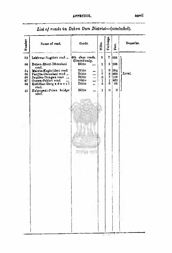
Nu
mb
er
APPKNDlX, ixrii
List of roads in Dehra Dun District— (concluded).
63
6a
61 66 63 67 63
53
Name of road.
Lakhwar-Nogthat road ...
Dnian.Qhati Dheralani road.
Maleta-Kophrithat road Panjita-Dartialani road ... Jamdan-Dungan road ... Guewa.Pokliri road ... Kadidkar-Darg a d n o t i
road. Kalgupani-Polao bridge
road.
Grade. ®
S
6th class roads. 6 I Cleared only.
Ditto ... 1
Ditto ... 1 Ditto ... 7 Ditto ... o Ditto ... l Ditto ,. 6
Ditto ... | 1
Remarks.
Local.
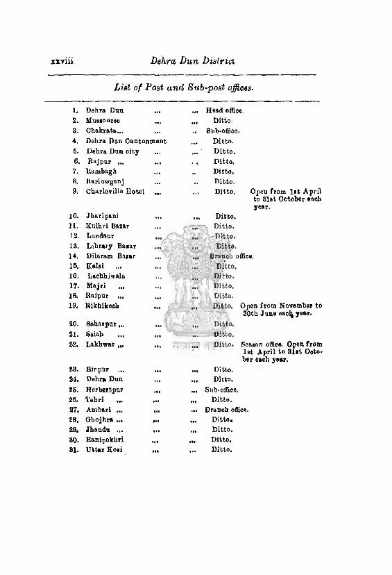
xxviii Dehra Dun Dislrici
List of Post and Sub-post offices.
l. Dehra Dan ... Heed office.
2. Mas io oree aaa Ditto.
3. Chakrata... ... .. Sub-office.
4. Dehra Dan Cantonment ... Ditto.
6. Dehra Dun city ,*■ ... Ditto.
6. Raj pur ... ... . a Ditto.
7. Itambagh ... .a Ditto.
8. Barlowganj ... Ditto.
9. Charlcville Hotel a*» Ditto. Opeu from l»t April to 3let October ouch year-
10. Jhnripani .a. • a. Ditto.
11. Kulhri Bazar ... ... Ditto.
12. Landaur tat .»# Ditto.
13. Library Bazar ... ... Ditto.
14. Dilaram Bazar ... ... Branoh office.
16. Kalsi ... ... Ditto,
10. Lachhiwala ... V*1 ... Ditto.
17. Majti ... M. Ditto.
18. Baipur ... • a* ... Ditto.
19. ltikhikesh ••• aaa Ditto. Open from November to 80th J une eacl^ year.
ao. Sahaapur aaa at. Ditto.
21. Saiah til ... Ditto,
22. Lakhwar ••a •aa Ditto. Season office. Open from 1st April to Slit Octo¬ ber oach year.
28. Birpur ... aaa a.t Ditto.
24, Dehra Dun ... aaa Ditto.
25. Herbertpur .•a ••a Sub-office.
2fi. Tehri ... aaa aaa Ditto.
27. Ambari ... «aa .a* Drench office.
28. Ghojhra ... **a aaa Ditto.
29. Jhaudu ... tta »aa Ditto,
30. Ranipokhri ..a ■fa Ditto.
81. Uttar Koii •«« ... Ditto.
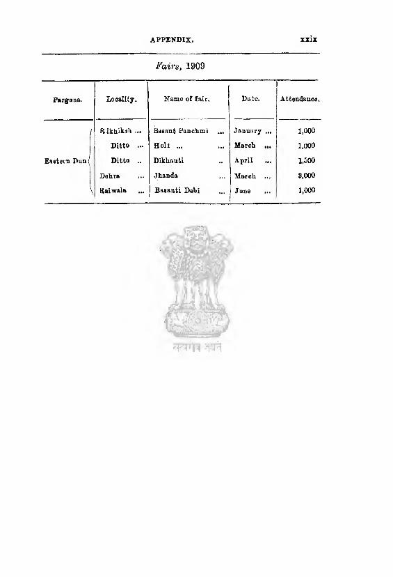
appendix, XXIX
Fairs, 1909
Pargana. Locality. Name of fair.
j
Date. Attendance.
Rikhiksli ... Basant Panchmi ... January .„ 1,000
Ditto .** Holi ... ... j March ... 1,000
Eastern Pun| Ditto .. Dikhauti April 1,500
Dehra Jhanda March ... 3,000
Raiwala Basanti Debi June ... 1,000

GAZETTEER OF DEHRA DUN
INDEX.
A.
Act XX of 1856. pp. 154,156,233,250, 263. Administration of district, pp 123, 191
—198. Agave, p. 60. Agriculture, pp. 41 —66. Agricultural company, p. 151.
A jab pur kalan, p. 199. Ajabpur khurd, p, 199, Aibu Kuar, pp. 47, 171, 199. Aman Singh Thapa, pp. 178,182,183,181. Amlaiva river, p, 199.
Aunfiold grant, pp. 120, 200. Area of the district, p. 1.
Arhar.tp. 42. Arya Samaj, p. 101.
Asan river, pp. 4, 8. Ashworth, Mr. E. H., pp. 238, 251. Asoba’s stone, pp. 168, 231,
Athgaon Chandan, p. 201,
Athgaon Uparll, p. 201. Atkinson, Mr. 15. f., pp. I, 93, 146, Attio Farm or Attica, pp. 118, 160, 161,
162, 201, Auckland, Lord, p. 161. Aurangzeb, p, 172.
B. Bairat, p. 6, Bajamari, p. 6.
Baigis, p. 98. Balbhaddra Singh Thapa, pp, 180—182.
Bamboos, p. 19. Bamta<*. p. 202.
Bana, p. 202. Banadhar, p. 203, Bangaon, p. 203. Banjaras, pp. 99, 119, 167.
Banks, p. 246. Barley, p. 43. Basantpur, p. 203, Baundar, p. 204.
Bawar, p. 204. Boars, p. 31, Beor, pp, 106. 155, Bhalar, p, 206, Bhangis, p. 99. Bharam, p. 206. Bhimghora, p, 167, Bhogpur, p. 207.
Bhuro dicoit, pp. 186—189. Bijuipur Canal, p. 46. Bindal river, p. 9. Birch, Captain, pp. 138, 184 Birds, p. 82. Birth rate, p.88. Bisahal, p. 208. Bislits, p. 96. Bislar, p. 208. Bodhyar,p. 21. Body guard linos, p. 221. Boundaries of the district, p. 2. Brahmans, p.967 Bricks, p. 13. Building materials, p, 13, Bnrnsuwa, p. 209.
0. Cadot corps, p. 221.
Caincvillo school, p. 157. Calvert, Mr., pp. 125, 154,184. CaualB, pp. 44—50, 53. Cantonments, pp. 209, 219. Carpenter, Colonel, pp. 181, 182. Castes, p 95. Cattle, p. 35, Cautley, Sir P„ pp. 46, 46. Census, pp. 85, 86. Chakrata, pp. 123, 209, Cliakrata tahsil, p. 211.
Chamars, p. 95. Chauntras, pp 124,138. 140,141,149. Chauntru, pp. 139—14], 142. Chhultar, p 211. Chillies, p. 66. Chital, p. 31. Cholera, p. 160.
Christianity, p, 99. Civil Courts, pp. 124, 125. Climate, p, 37. Colonisation, pp, 102,103,150—157,193. Communications, pp. 77—84, Condition of the people, pp. 102—105. Convent schools, p. 159. Cornwall, Mr., pp. 144—187.
Cotton, p. 69. Crime, p, 154. Criminal Courts, pp, 124.125,
Crops, pp. 42, 66. Cultivation, pp, 41, 50, 61.
ii INDEX
D,
Dacoits, pp, 184—189. Dam pier, Mr. G, K-, pp. 18,49,50, 81,
135 P37
Damn'll, Mr. C. A., pp. 46, 134,130. Darzis, p. 97. l>attur-vl-amal, pp, 72, 115, 116, 143, Death rate, p, 88. Deer, p. 31. Dehra, p. 211. Delira tahail, p, 223. Dehra Duu district, pp. 1, 122. Deneby, Mr P., pp 49, 60, 227. Deoban, pp. 21, 210. Deodar, pp, 21, 26. Deoghar, p. 223. Dhannu, p. 224, Digambar Singh, Chaudhri, pp. 118,202. Diaau, p, 224- Diseases, p. 169. Dispensaries, p. 169. District Board, p. 166. Doiwala, p 225. Doms, p. 97. Duns, p. 1, Dwar, p. 225,
E.
Eastern Dun, pp. 3, 4, 226. Education, pp. 166—159. Elephants, p. 31. Emigration, p. 87, Excise, p. 154,
F.
Fairs, p. 77. Famines, p. 68. Fateh Sab, Baja, p. 171. Fauna, p. 30. Ferries, p. 84. Fever, p. 169. Fiscal History, pp. 126 —160. Fish, p. 34 Fruit trees, p. 30. Forost school and college, p. 162. Forests, pp. 14—26. Forests, village, pp. 24, 14G. Forests, rights in, pp. 10, 26. Forests, settlements, pp. 18, 836 — 138.
G.
Ganges river, p. 8. Garhi, p. 226. Garhvval, pp. 125, 169, 171, 173,174, 176,
177 Garhwal, Tehri, pp.l, 260, 261, 264, 266. Geology, p. 11. Ghulam Kadir, pp. 126, 175.
Giilospio, Majcr-Gon., p. 180. Ginger, p. 56. Goats,, pp, 32, 36. Goitvo p. 161. Gold, p. 12.
I Grain rents, p. 114. Gram, p. 43.
I Great Trigonometrical Survey, p, 104. | iuiars, pp. 174, 176, 184 — 190.
Gulab Singh, p. 175, Gural, p. 32. GurkhaB, pp. 126,177. Gurkha oppression, p. 178. Gurkha war,pp.'178,179. Guru Ram Rai, temple of.'pp 172. 214.
H.
Har Kishcn or Har Sewalc, makant, pp. 47, 178.
Har Sewak ». Har Kishcn, Uardwar, pp. 77, 88. tlari Singh, p, 177. Harawala, p. 22G. Haripnr Beas, p. 226. Harvests, p. 42. Hast! Dal, pp. 126, 129, 178, 179. Health, 169. Hemp drugs, p. 155. Hill forests, pp. 21—27, HillTaluqas, p, 109 Himalayas, pp. 1, 2, 3, 7. Hindus, pp. 90, 95- History, p. 107. Hope Town, pp. 120, 160, 164, 227, 228. Horses, p. 36. Houses, p. 106- Hutton, Captain, pp. 61, G2. Hyaenas, p. 31.
I.
Immigration, p 86. Industries, p, 101. Infanticide, p. 187. Inoculation, p. 160 In teres t, p. 72. jron, pp, 12, 18. Irrigation, pp, 43—50, 63.
J. Jail, p. 214. Jains, p. 90. Jakhan canal, p. 48, Jakhan Kao, p. 4. Jaunsar, pp. 6, 228. Jauusar Bawar, pp. 6,13, 21, 60, 60, 86,
90, 104,115. 123, 138, JS3, 228. Jharipani, p. 244. Jiwangarh grant, p. 228. Joli grant, pp. 118, 120, 153, 229. Jumna river, p. 8.
INDEX. ill
K.
Kailan&, p. 209. Kailo, p, 229. Kakar, p. 82. Kalale, p, 119. Kalanga, p. 3,4, 47, 180—182, 230. Kailua, Gujar, pp.184—187. Kalsi, pp. 168, 230, Kalyanpur, p, 233. Kurm Prakash, Baja, p, 183. Karnavati, Bani, pp. 47, 171. Katapathar canal, p. 45. Kaulagir, p. 67, 233. Kbalil-ullah, p. 171. Khats, p, 115, 124, 228, Kbit, pp. 61, 52 Kbutnugadb, p. 234, Kinob Singh, Baja, p. 183 Koris, p. 97. Koru, p. 234. Kothi, 236. Kuar, dacoit, pp. 188 -189. Kuls, p. 63. Kunja fort, pp. 186-187. Kyar Kuli, p. 249.
L.
Lachhman, pp. 90,167. Laohbmanjliula, p. 262. Lakhamandal, pp. 183, 235. Lakhan, p. 237. Lakhwar, p. 237. Land holders, pp. 118—121. Landour, pp. 190, 237. Language, p. 108, Leopards, p. 31. Lepers, p. 161, Leper asylum, p. 161. Lepper, Mr., pp. 63-66. Lime, p. 73. Lime stone quarries, p. 12. Lister grant o. Majri grant. Lister, Mr., p. 66. Lokhandi, p. 6. Lovett, Major-General Beresford, p. 13, Ludlow, Major, pp. 181,182,
M.
Mackinnon, Mosers,, pp. 30,118,202,244. Macklnnon, Mr,V., p, 247. MaoPhoraon, Lady, p. 121. MacPherson, Sir A,, p. 200. Mabaso, pp. 90—96,140, 142. Majri grant or Lister grant, pp, 64,118,
120, 163, 289. Maleta, p. 240. Maliamin, the, pp, 139, 141,142, 144, Mandua, pp, 41, 48.
Manihars, p. 76. Markets, p. 77. Markham grant, pp. 69,118, 160,151,
163, 241. Martindell, Major-Gen., p. 182. Masham, Lord, p. 66. Mata Punjab, Kuar, p. J73. Maurusi qadims, p. 110. Mawby, Colonel, p. 180, Maxwell, Macgregor & Co., p. 161. Medini Sab, Kaja, p. 171. Motals, pp. 12, 13. Migration, p. 87, Minerals, p. 11, Missau, p. 242. Missions, p, 99. Modern school, p. 168. Mohna, p. 242. Morrow's neck, p. 82, Motichor, p. 7. Mountains, p 7. Muhammadans, pp, 90, 98. Muhammadan Historians, pp. 169, 183, Muir, Sir W., pp. 24, 134. Municipalities, pp. 166, 217, 251. Murray, Captain, p. 62. Muaalmana, pp. 90, 98. MuBk Deer, p. 32 Mussooree, pp. 190,143 Mutiny, p, 194.
N.
Nagsiddb, pp. 8,4. Nagthat, p. 82. Naban, Baja of, pp, 68, 77,119. Najib-ud-daula, pp. 126, 173, 17*. Nawad.i, p. 267. Nogis, p. 96. Newspapers, p. 77.
o. Oak grove school, p. 167. Oaks, p, 26, Oats, p, 43. Ocbterlony, Major-Genl,, pp. 180,18 Occupations, p. 101. Opium, p. 60. Ousely, Colonel, p. 120. Ousely, Mrs,, p. 120. Ousely, Mr. J. G., p. 120,
P.
JPabar river, p. 10. Panjgaon, p. 267. Parganas, p. 123, Patbans, p. 98. Patwaris, pp. 128, 130, 133, 146. Peaks, pp, 6, 7, 8.
ir INDEX,
Phanyar, p. 268. Phartar, p. 258. Pines, p. 26. Pirthi Sah, Raja, p. 171. Plague, p, 160. Police, p. 154. Polyandry, p. 89. Ponies, p. 36. Population, p. 85. Poppy, p. 60. Potatoes, p. 66, Pradliuman Sail, Raja, p. 176. Prailipt Sail, Baja, pp. 173, 174. Prices, p. 69. Proprietors o. land holders,
Q.
Quarries, p. 12.
B. Railway, p. 77. Rainfall, p. 39. Raipur, p. 258. Kaiwala, p. 81.' Rajputs, p. 95. Raj pur, p. 269. Raj pur canal, p. 47. Rama, pp. 90, 167. Bam Dyal Singh, pp. 175, 177. 178, Ram Rai, Guru, p.172, Rampur Mandi, pp. 80,84. Rangau, p._261. Rani pokhri, pp, 81, 261. Raos, p. 2. Rawats, pp. 96, 119. Raynor, Captain, p. 153. Raynorpur, pp. 120, 153, Religion, pp. 90.- 101. Rents, pp. 114, 118. Reptiles, p. 33, Revenue, pp. 125—150. Revenue free grants Rhea. p. 59. Rhododendron, pp. 26, 29, Rice, p, 42. Rikhikesh, pp. 77, 81 261, Riknorgadh, pp, 5, 9. Rind, Major, p. 200. Riepana, p. 5, Rivers, p, 8. Roads, pp. 78 84. Rocks, pp. 11, 12. Rohillas, pp. 98, 173. Ross, Mr. A, pp. 60,84,108,110,111,
115, 182,141-143. Ross, Mr. H. G., pp. 16, 49, 51, 60, 62,
79, 133, 147-150. Rotation of crops, pp, 43,55. Rupia of river, p. 10.
S. Sahaspur, p. 263. Sakasradliara, pp. 78, 264. Sambhar, p. 31. Saiah, pp. 81,83. Sainji, pp. 81, 83, 84. Sarao. p. 32. Sayan a s, pp. 115,116, 120,124,138,149. Scarcity, p. 68. Scenery, pp. 3, 249. Schools, pp. 156—159. Soli, p. 264. Seli gotkan, p. 265. Somalia, p. 265. Seri culture, pp. 61—67. Settlements, pp. 126—160. Sox, p. 87. Shabjahan, p. 171. Saikhs, p. 98. Sheep,"p, 36. 8hib Ram, pp. 66,118. Shore, Hon, F .1., pp.43,78, 79, 85, 127,
128, 129, 184—190, 249, 250. Sikhs, pp.77, 90, 101,17), 174,176, 178,
202, 214. Silgaon, p. 265. Silk, p. 61—67. Silver fir, p. 29. Sirmur, pp. 176, 183. Sirraur Hattalion, p. 186, 219. Siwaliks, p. 1, 2, 3,7. Small pox, p. 160. SnakeB, p. 83. Soils, p. 41. Song rivor, p. 4. Spruce, p. 29. St. Goorge’s collego, p. 158. St. Josoph’s convent school, p. 159, Subhak Prakash, Raja, pp. 171. 183, Sugarcane, pp. 42,57. Sulaiman Sbikob, p. 171. Superintendent of the Dun, p. 124. Supin river, p, 10. Surveys, pp. 131/143,145. Suswa, river, pp. 4, 5, 8, 163. Swam ps, p. 4,
T.
Tahsils, p. 123, 124. Taplar, p. 266. Tapoban, p. 366. Tea, pp. 67—59. Tebri Garhwal, pp, 1, 250, 251, 264, 256. Telephone, p. 248. Temperature, pp.37, 39. Tenants, pp. 108—118. Tenures, pp. 108—115. Tbeksdars, pp, 129—133. Tiger, p. 31, Timber, pp. 28, 29. Timur, p. 170.
INDEX. ?
Tong, Eastern, river, p. 8. Tons, Western, river, p, 10. Top Tiba, p. 8 Topography of the district, p, 1. Tosvns, p. 87. Trade, p. 73. Trees, p. 28. Tufaceoos lime stono, p. 12. Turpontine, pp. 27, 28, 29.
u. TJdasis, p. 214. Udpatta, p. 267. Umod Singh, pp. 170, 177.
V.
Vaccination, p, 100. Vansittart, Mr, pp. 121, 132, 227. Vansittarts, the, pp. 120, 228. Villages, p. 87. Village forest, pp 24, 140. Vital statistics, p. 88.
w. Wages, pp. 70—72. Walnuts, p. 81. Wasteland grants, p, 160. Weights, measures, p, 78. Wells, p. 43. Western Dun, pp. 3, 4, 267. Wheat, pp. 42, 43. Wild animals, pp. 80—83. Williams, Mr. F, pp. 16, 23,24,131. Wiliams, Mr. G. B. C., 11,16,38, 96,128.
129, 178, 178. Woodlands high Bchool, p. 160, Woodstock high school, p. 169,
X.
X-Bay Institute, p. 16S,
Y.
Young, Captain (afterwards Major Colonel), pp. 1,4, 110, 129, 130,131, 139,140, 141, 249, 250.