December 18, 1989 Project No. 8119 Mr. Art Wilde
276
BROMWELL & CARRIER, INC. Engineers, Designers & Scientists Offlcas Laksland Plant Clt" Tallahassee Tampa December 18, 1989 Project No. 8119 Mr. Art Wilde, ~xecutive Director Florida Inland Navigation District 1314 Marcinski Road Jupiter, Florida 33477 RE: Final Report - Phase One Long-Range Dredged Material Management Plan Atlantic Intracoastal Waterway Palm Beach County, Florida Dear Art: , t Submitted herein are five copies of our final report for the \ , ; I Phase One study for the Long-Range Dredged Material Management Plan for the ICW in Palm Beach County. The report contains the results of our review of the historical dredging records, an inventory of all existing FIND disposal areas, a site bank for future dredged material disposal recommendations for Phase I1 studies and responses to comments concerning the draft report. Please feel free to call at any time for clarification. Respectfully, ~a~neq.~:;~ri.cson, P. E . Vice President WAE : cdm cc: Shalloway, Foy, Rayman & Newell, Inc. P.O. Box 5467 (33807) 202 Lake Miriam Drive Lakeland, Florida 33813 81 3-646-8591 FAX 81 3-644-5920
-
Upload
khangminh22 -
Category
Documents
-
view
4 -
download
0
Transcript of December 18, 1989 Project No. 8119 Mr. Art Wilde

BROMWELL & CARRIER, INC. Engineers, Designers & Scientists
Offlcas Laksland Plant Clt" Tallahassee Tampa
December 18, 1989 Project No. 8119
Mr. Art Wilde, ~xecutive Director Florida Inland Navigation District 1314 Marcinski Road Jupiter, Florida 33477
RE: Final Report - Phase One Long-Range Dredged Material Management Plan Atlantic Intracoastal Waterway Palm Beach County, Florida
Dear Art:
, t Submitted herein are five copies of our final report for the
\ , ; I Phase One study for the Long-Range Dredged Material Management Plan for the ICW in Palm Beach County.
The report contains the results of our review of the historical dredging records, an inventory of all existing FIND disposal areas, a site bank for future dredged material disposal recommendations for Phase I1 studies and responses to comments concerning the draft report.
Please feel free to call at any time for clarification.
Respectfully,
~a~neq.~:;~ri.cson, P. E . Vice President
WAE : cdm
cc: Shalloway, Foy, Rayman & Newell, Inc.
P.O. Box 5467 (33807) 202 Lake Miriam Drive Lakeland, Florida 33813 81 3-646-8591 FAX 81 3-644-5920
FINAL REPORT
FIND - PALM BEACH COUNTY PHASE I STUDY
TABLE OF CONTENTS
Section Paqe
EXECUTIVE SUMWiRY AND CONCLUSIONS SUMMARY 1
1.0 INTRODUCTION
1.1 General Background
1.2 Project Overview
2.0 50 YEAR MAINTENANCE DREDGING 14
2.1 Dredged Material Quantities and Shoaling Locations 14
2.1.1 Reach I 16
2.1.2 Reach I1 17
2.1.3 Reach I11 2 1
2.1.4 Reach IV 27
3.0 DISPOSAL CONCEPTS, NEEDS AND AVAILABILITY
3.1 General
3.2 Reach I
3.3 Reach I1
3.4 Reach I11
3.4.1 Secondary Alternate Sites
3.5 Reach IV
4.0 SITE BANK ANALYSIS
4.1 General
4.2 Reach I
4.3 Reach I1
TABLE OF CONTENTS
(Continued)
4.4 Reach I11
4.4.1 Reach I11 a.
4.4.2 Reach I11 b.
4.4.3 Reach I11 c.
4.5 Reach IV
5.0 PHASE I1 S m D Y
5.1 General
5.2 Engineering
5.2.1 Dredged Material Characterization
5.2.2 Disposal Site Characterization
5.2.3 Preliminary Design and Analysis
5.3 Environmental
5.3.1 Site Characterization
5.3.2 Environmental Permitting
5.4 Socioeconomic
5.4.1 Site Characterization
5.4.2 Analysis, Reporting and Support
5.5 List of Anticipated Deliverables
REFERENCES
APPENDICES A - G
FIND - Palm Beach County BCI File 8119
EXECUTIVE S-Y
Realizing that the Palm Beach County area has become and
will continue to be densely populated with particular pressure
on waterfront property, the Corps of Engineers (COE) and the
Florida Inland Navigation District (FIND) initiated a Phase 1
study to evaluate the management of dredged spoil materials as
well as management of existing and proposed upland and below
water disposal easements and ownerships. This Phase 1 study was
completed using existing dredging information and historical data
provided primarily by the Corps of Engineers along with input
from various state and local agencies familiar with the dredging
history of the ICW in Palm Beach County.
The purpose of the study was to develop a strategy for long
ii range management of dredged materials for the Intracoastal
Waterway (ICW) in Palm Beach County, along with a plan for
continued ownership or easement maintenance of existing FIND
disposal areas along the ICW.
Following the initiation of the study, dredging records for
the Palm Beach County ICW were reviewed in the Jacksonville
offices of the U.S. Army Corps of Engineers. In addition, local
agencies and representatives such as the Jupiter Inlet, Boynton
Inlet and Port of Palm Beach engineers were contacted for
information regarding dredging history on the ICW. Using
information provided by all of the agencies and contacts,
estimates were made for the 50 year forecast for dredging of the
ICW in Palm Beach County.
The data obtained to date indicates that most of the
dredging has occurred at the Jupiter Inlet area where the dredged
.'>
FIND - Palm Beach County BCI File 8119
materials consist primarily of sands that are deposited on the
beaches north and south of the inlet. Other areas of recorded
significant dredging have been at the Port of Palm Beach and the
Boynton Inlet area (south Lake Worth), where beach disposal is
also predominant.
The existing or potential shoal areas within the ICW in Palm
Beach County, outside of the inlet areas, appear to be
discontinuous throughout the length of the ICW with localized
shoaling occurring in the northern reaches of the ICW, as well as
isolated locations within Lake Worth. Because most of the
information available concerning potential or existing shoal
areas consists of centerline surveys from the Corps of Engineers,
actual quantities of material to be dredged were difficult to
estimate. Review of aerial photos from FIND and the Corps of
Engineers indicates that some edge of channel shoaling is
occurring. Thus, quantities calculated for this report are only
approximate due to the lack of bathymetric information.
In preparing a dredged material management plan for the Palm
Beach ICW disposal, concepts were developed for the dredged
materials. The details of these concepts, other than upland
disposal, are limited in their scope in that sediment quality
information was generally poorly documented and obtained outside
the ICW right-of-way, particularly for areas outside the inlets.
Materials in the Lake Worth area may, in fact, be fine grained
and contain moderate to high percentages of organic materials
originating from old sewer disposal outlets and stormwater
discharge from intensively cultivated agricultural areas west of
the ICW.
FIND - Palm Beach County BCI File 8119
; The principal disposal concept, as'dictated by the scope of services, focused on the use of upland disposal areas, away from
existing wetlands. This concept included using upland sites
that could provide centralized disposal to reduce the number of
sites for future use and maintenance. These disposal sites would
be maintained as permanent facilities. Also, they should have
adequate capacity for long-term dredged material disposal as well
as being accessible for maintenance and operation by FIND or
other personnel from the state or federal agencies.
Due to very limited available upland land areas,
particularly in the Lake Worth area, alternate disposal concepts
were reviewed and are discussed in this report. The one disposal
alternative currently used at the inlets includes the use of
beach renourishment. This method of disposal for beach quality
L sand will likely continue indefinitely and upland disposal areas will not be required in the areas that are reachable for beach
disposal.
Recognizing that FIND maintains several below water
easements in the Lake Worth area, below water and nearshore
disposal have been evaluated, with input from regulatory
agencies. Due to the deficiency of detailed data concerning the
sediment quality, existing aquatic environments, and water
depths, these are discussed in a conceptual manner.
As an alternative to most of the existing FIND easements
along the ICW, Spoil Island addition and deep water disposal at
selected locations within the Lake Worth area has been
considered. Through conversations with local agencies and
consultants, we have identified areas along the ICW that were
probably excavated to depths in excess of 20 feet MSL. With
FIND - Palm Beach County BCI File 8119
further study, these deep isolated areas within the Lake Worth
area could possibly be used for disposal in association with
aquatic mitigation plans to promote or reestablish aquatic
habitats.
We have reviewed data concerning the existing FIND disposal
areas (MSA's) and cataloged them with regards to size, vegetative
cover, location, suitability for dredge material disposal, and
possible trade or easement release by FIND. In addition to the
engineering and environmental aspects of characterizing these
disposal areas, we have also obtained information regarding
zoning and land use impacts as well as the approximate cost or
land values of these subject areas.
It should be recognized that the majority of disposal
acreage held by FIND in the Palm Beach County area consists of
below water and spoil island easements within Lake Worth.
Because these areas have subsequently become vegetated with
seagrass beds and other desirable aquatic vegetation, their use
as disposal sites appears very limited.
This report contains recommendations as to the use of
existing as well as acquiring new disposal areas. In addition, it reviews the disposition of the numerous disposal areas or MSAs
that appear to be of no long range benefit or use to FIND or the
COE .
FIND - Palm Beach County BCI File 8119
CONCLUSIONS SUMMARY
A review of the dredging history and centerline survey data
has revealed that the likely dredging areas will be concentrated
near the inlet channels at Jupiter, Port of Palm Beach and south
Lake Worth Inlet. Other shoal areas were identified at isolated
locations in the channelized and lake portions of the Palm Beach
ICW. The ICW was divided into four reaches along its length to
separate areas of similar dredged material and likely disposal
options.
The following summarizes our findings concerning the
anticipated dredged material quantities, material types and
disposal methods.
REACH I: North ICW, COE cuts P-1 through P-13, ICW
mile 262.8 - 267.1
In this reach the dredging is completed on a regular basis
to maintain the design depth in the Jupiter Inlet area. Dredging
contracts are often completed every one to two years in the area.
Because the dredged materials are sandy in nature and the areas
are close to the ocean, beach disposal, both north and south of
the inlet has been the preferred method of disposal. It is
expected that beach disposal will continue for future dredging
contracts. Approximately 150,000 cubic yards of material are
dredged in Reach I every dredging cycle; its estimated that about
5 million cubic yards of sand materials will have be dredged in
this reach over the next 50 years.

FIND - Palm Beach County BCI File 8119
REAW 11: North ICW, COE cuts P-15 through P-31, ICW
mile 267.1 to 274.6
Reach I1 is generally a river channel setting located
between upland areas on both sides of the ICW right-of-way.
Dredging in this reach has been limited to one recorded
maintenance dredging event in 1972 at cut P-31 and one advanced
maintenance dredging contract,to a depth of -16 MLW at cut P-25
around 1974. FIND maintains several disposal areas in this reach
however only MSA 609/609A, MSA FO 610/611A and MSA FO 620B were
determined to be suitable as probable upland disposal areas for
the next 50 years. Based on the limited historical and shoaling
data, we have estimated that approximately 26000 cubic yards of
materials would be dredged in Reach I1 per dredging cycle and
about 130,000 cubic yards would have to be dredged in a 50 year
period.
REACH 111: Central ICW, COE cuts P-32 through
P-50, ICW mile 274.6 to 294.7
REACH I11 a. COE cuts P-32 - P-37, ICW mile 274.6 to 282.0 Reach I11 a. is located in the northern portion of Lake
Worth. The ICW in this area is characterized by the open
water/estuaries environment of the lake. Dredging in the area
is done at the Port of Palm Beach turning basin and entrance
channel. Dredged materials from this area are deposited on and
near the beach, south of the inlet, immediately east of the
port. Shoaling in the areas away from the port were identified in
the cuts north of Peanut Island (P-33A - P-35) and south of the turning basin (P-36/37). Peanut Island , in conjunction with

FIND - Palm Beach County BCI File 8119
disposal plans by the port, and the beach area south of the inlet
channel were identified as the most likely disposal sites in this
part of Reach 111. We have estimated the volume of material to
be dredged in this subreach will be on the order of 32000 cubic
yards per dredging cycle and the 50 year projection for dredging
is about 163,000 cubic yards.
REACH I11 b. COE cuts P-38 - P-45. ICW mile 282.0 to 291.5
No records of maintenance dredging in this portion of Lake
Worth were found during this study. Evidence of shoaling was
noted at cuts P-41 and P-44/45. The disposal areas maintained by
FIND in this reach are open water easements along both edges of
the ICW. Some of these easements are contiguous to or contain
existing spoil islands. The easements with spoil islands along
with some excavated deep holes on the west side of the lake and
one upland area near the Lake Worth Golf Course are the probable
disposal areas for Reach I11 b. Due to concerns about the
possible high organic content of the sediments in this area the
below water disposal options will have be studied further. The
volume of material to be dredged per dredging cycle is estimated
to be approximately 8000 cubic yards and about 40,000 cubic
yards for a 50 year period.
REACH I11 c. COE cuts P-46 - P-50, ICW mile 291.5 to 294.7
The area of recorded shoaling in Reach I11 c. is located at
cut P-50, near the South Lake Worth (Boynton) Inlet. Sand
materials are accreting in the ICW at this location in an area
immediately west of the sand trap on the south side of the
entrance channel. Though FIND has below water disposal areas in
the vicinity of cut P-50, the preferred disposal option appears

FIND - Palm Beach County BCI File 8119
to; be the beach and near-shore area south of the inlet channel.
This area has been recently used for dredged material disposal by
the South Lake Worth Inlet District. We have estimated the
quantity of material to be removed from the ICW at cut P-50 will
be about 26,000 cubic yards for each dredging event and that
approximately 130,000 cubic yards will have to dredged in a 50
year time frame.
REACH IV: South ICW, COE cuts P-51 through P-91, ICW
mile 294.7 to 310.2
Reach IV of the Palm Beach ICW is generally a channelized
area bounded on both sides by upland areas that have been
heavily developed for residential and commercial uses. Centerline
survey data for this reach indicate very limited shoaling with
$L , minor amounts appearing in cuts P-87/88. More substantive
shoaling is believed to be occurring at the edged of the ICW at
these same cuts. Based on these assumptions, the volume of
material to be dredged in Reach IV has been estimated to 14,000
cubic yards per dredging cycle and 28,000 cubic yards for 50
years. The preferred disposal method for this area will be upland
disposal. Existing FIND disposal areas MSA FO 641A and MSA 684A
have been identified as primary disposal areas and MSA FO
640/640A with some expansion as a secondary site.
FIND - Palm Beach County BCI File 8119
1.0 INTRODUCTION
This report presents the results of a Phase 1 study for the
Palm Beach County Intracoastal Waterway (ICW) with regard to
developing a 50-year plan for management of dredged material.
The study concentrated on the review of existing data regarding
history and forecasting in the ICW for maintenance dredging. It
also reviewed existing data, maps, and aerial photography to
inventory FIND-owned or controlled disposal areas within the
ICW. This Phase 1 study not only focused on the engineering and
environmental aspects of the disposal areas, it included a
preliminary review of the socioeconomic aspects of managing and
operating upland disposal sites in the ICW area. It also reviews
the potential for acquiring additional disposal areas,
particularly in the highly populous areas of central and southern
Palm Beach County.
1.1 General Backsround
The ICW in Palm Beach County stretches for about 47 miles
from Martin County to Broward County. The northern and southern
portions of the Palm Beach ICW are characterized by channelized
sections. Within the central 21 miles, the ICW channel limits
are located within Lake Worth. A map of the study area is shown
in Figure No. 1.
The present design channel width and depth are 125 feet and
-10 feet MLW, respectively. Around 1961, the ICW channel was
deepened and widened to these design limits.
The channelized portions of the ICW, except for the inlet
areas, are characterized by isolated and minimal amounts of

FIND - Palm Beach County BCI File 8119
maintenance dredging since 1961. This situation has resulted in
localized shoaling at several locations in the channelized
section north of Lake Worth. South of Lake Worth, the historical
records reveal little or no shoaling or maintenance dredging
requirements.
At the four inlets, dredging has been completed on an
irregular to frequent basis. Dredging at the Jupiter Inlet, Port
of Palm Beach, and Boca Inlet has been done several times since
1961. The Boynton Inlet (south Lake Worth) area has been dredged
as recently as early 1989 but much less frequently than the other
inlets. Beach disposal is the general method for dredged
material handling. There has been some ocean disposal of
materials from the Port of Palm Beach entrance channel and
turning basin areas.
The Lake Worth portions of the ICW are characterized by
shoaling at several localized areas. However, this shoaling to
date has not been deemed severe enough to warrant dredging.
The physical properties of the sediment materials of the
channelized sections of the Palm Beach ICW are generally
characterized as being fine to medium grained sands, often
sufficiently coarse grained to be acceptable for beach
renourishment projects or beach disposal. However, the sediment
characteristics of the materials in the Lake Worth portions of
the ICW appear to be finer grained with the likelihood of high
organic or other man-made pollutants.
The nature of Lake Worth water quality and sediment
characteristics has changed dramatically over the last 100 years.
Prior to 1860, it was a fresh water lake. In the 1860's the
FIND - Palm Beach County BCI File 8119
first inlet was dug and portions of the lake became salty. In
1877, a more stable inlet was established and in 1920, the
principal inlet at the Port of Palm Beach was opened. Prior to
1845, only two islands existed in the lake, Big Munyon and
Hypoluxo Islands (Bach, 1984).
Subsequent private, commercial, and agricultural development
of the areas around Lake Worth have contributed significantly to
its changes and several years of water quality degradation.
Beside the significant freshwater discharges from the numerous
canals, the water and sediment quality have been impacted by
several decades of disposal of raw and partially treated sewer
effluent. It was not until 1979, that all major municipal sewer
plant discharges were diverted from Lake Worth. Recent reports
regarding the status of the Lake Worth water and sediment quality
indicate that the major source of pollution is the West Palm
Beach Canal (C-51). This canal is responsible for large volumes
of freshwater, urban runoff, detritus, and other organic
materials which have caused a build-up of organic materials in
the central portions of the lake (Bach, 1984).
1.2 Proiect Overview
The Phase 1 study for the dredged material management plan
for the Palm Beach ICW included the following: a review of
historical dredging and shoaling data and a review and cataloging
of all existing disposal easements and ownerships. This
information was used to develop disposal and material handling
concepts for the long-range (50 year) management of dredged
materials and designated disposal areas.
FIND - Palm Beach County BCI File 8119
' The review of historical data was accomplished by visits to
the office of the COE in Jacksonville, correspondence with the
COE, and meetings with local and state agency officials.
Dredging contracts, ICW reconnaissance surveys, and environmental
permits and reports were obtained, to help quantify the areas
where historical dredging and shoaling has taken place.
An inventory of the existing disposal sites (MSA1s) was
completed by reviewing historical aerial photography, boundary
survey information, soil survey publications, and site
reconnaissance walk-overs. The sites were cataloged for
engineering, environmental, and socioeconomic parameters and
then ranked for suitability for dredged material disposal and/or
possible trade or release consideration by FIND. A bank of
candidate disposal sites was then developed for further
L< evaluation and consideration by the FIND and the COE.
As per the scope of services for this study, upland disposal
was emphasized throughout the Phase I study because of the
presumed reduced environmental permitting requirements and
constraints. Conceptual disposal planning did include other
options, particularly in areas where existing or potential
available upland sites are of limited availability.
The historical dredging and shoaling information and
disposal predictions for the next 50 years are presented in
detail in Section 2 of this report along with tables and figures
that highlight the available data.
The disposal concepts are presented in Section 3. Included
are discussions of each concept, focusing on upland disposal.
Other disposal options, with local and state environmental agency
FIND - Palm Beach County BCI File 8119
input are also presented in Section 3.
Subsequent sections and appendices of the report present the
candidate disposal site criteria, general disposal area plans
recommendations for further engineering, environmental and
socioeconomic studies, candidate site descriptions, vegetative
cover and soil survey maps agency contacts and pertinent sediment
data.
Aerial photography base maps, at a nominal scale of 1 inch =
400 feet, showing all existing MSA disposal areas, the ICW
centerline with cut numbers and mileage, and historical dredging
and shoaling data have been submitted under separate cover.

FIND - Palm Beach County BCI File 8119
2.0 50 YEAR M?dNTENANCE DREDGING
2.1 Dredsed Material Quantities and Shoalins Locations
Using data from the Jacksonville office of the U.S. Army
Corps of Engineers (COE) , baseline information regarding the
dredging and shoaling history was developed. These records were
determined to be the best available data for determining dredging
and shoaling rates. The data files reviewed at the Corps of
Engineers included previous dredging contracts, reconnaissance
surveys and other information provided by the Corps personnel.
Correspondence and communication with local and state officials
in the Palm Beach County area revealed additional information
regarding localized shoaling or dredging activities.
No single source of information or location was available
for compiling this dredging information. Much of it was deduced
from actual dredging contracts as well as reconnaissance
(centerline) surveys. However, because the centerline surveys do
not provide information for the full channel width, quantifying
the amount of shoaling was estimated, based on review of aerial
photography and assumed shoaling geometries within the ICW right-
of -way.
To attempt to quantify the dredging activities, as well as
potential shoaling and future dredging requirements, a
spreadsheet analysis was completed to compare the amount of
dredging or shoaling with time, as well as with distance along
the ICW corridor. The principal system used for dredging
contracts include the AIWW (Atlantic Intracoastal Waterway)
mileage as well as cut numbers designated P-1 through P-89 in
Palm Beach County. In addition, cut station and ICW mileage have

FIND - Palm Beach County BCI File 8119
been used to designate locations along the ICW right-of-way.
Table 1 presents these systems and the correlation between the
system.
We have broken out the ICW into four reaches, as depicted in
Figure 2. These reaches were determined by dredging frequency,
disposal methods, available disposal areas, and anticipated
sediment material characteristics. . It is recognized that the
reaches may be longer than typical maximum pumping distances ( 5 5
miles). Individual shoal or dredging locations (cut locations)
have been identified within each Reach.
The amount of material to be dredged at each location was
estimated using a rectangular surface area with a width of 125
feet (the ICW channel bottom width), the length along the ICW
centerline and an average of the bathymetry readings in the area
of shoaling from the various reconnaissance surveys. Bathmetric
readings were generally recorded between 200 and 250 feet apart,
therefore the length of the shoaled area was estimated to the
nearest similar spacing. This method of determining the shoaling
amounts is considered to be only an estimate.
The dredged volumes estimates shown in the following
sections are based on excavated volumes. A bulking factor of 2
should be applied to these volumes for disposal storage volume
determination as per COE procedures. However the actual bulking
factor is probably less than 2 considering the predominantly
sandy nature of the dredged materials. For this study the 50
year disposal volumes quantities include a bulking factor of 2.
Review of the data from the COE reveals unusually high
shoaling estimates for 1984. This anomaly appears to continue
FIND - Palm Beach County BCI File 8119
throughout the ICW in Palm Beach County. Therefore, we did not
include this data from the 1984 survey with regards to
calculating dredging or shoaling quantities in this study.
2.1.1 Reach I
Reach I consists of COE cuts P-1 (partially in Martin
County) through P-13 (ICW mile 262.84 to 267.09). This area has
seen considerable dredging activity over the past 28 years, as it
is located in the vicinity of the Jupiter Inlet. This area has
and continues to experience significant accretion of sand
materials both in the inlet and in the ICW right-of-way. COE
dredging contracts have been issued and completed on a regular
basis (one every 1-2 years) particularly in cuts P-3 through P-6.
Cut P-1, north of the inlet and ICW intersection, contains
shoaled materials that are accreting from Jupiter Inlet, however
dredging frequency appears to be less than the 1 to 2 year cycle
for the inlet area.
In addition to the COE dredging in the ICW, the inlet area
to the east, is dredged every 1 to 2 years by the Jupiter Inlet
district.
According to the dredging records, dredged material
quantities for cuts P-1 through P-4 of the Jupiter Inlet area are
typically in the range of 150,000 cubic yards. The quantities of
materials excavated from the area maintained by the Inlet
District are understood to be in the 60,000 to 70,000 cy range.
All materials from this area are pumped eastward to the beach.
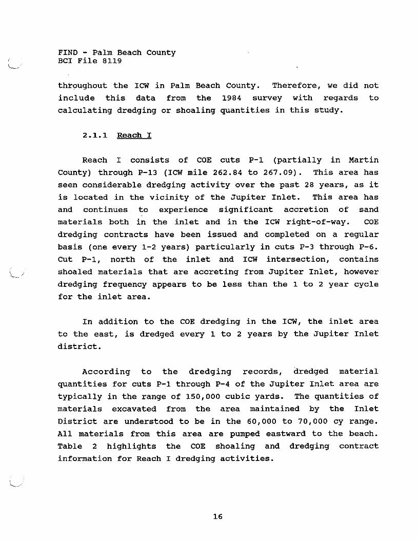
Table 2 highlights the COE shoaling and dredging contract
information for Reach I dredging activities.
FIND - Palm Beach County BCI File 8119
Dredging Volume Summary - Reach I
Approximate Dredge and Overdredge Cut No. ICW Mile Quantity Per Event
Estimated Total for Reach I per Dredging Cycle
Estimated Dredged Total for Reach I for 50 Year Projection 5,000,000 cy
Estimated 50 Year Total for Disposal
In the vicinity of cuts P-11 through P-13 (ICW mileage
266.06 to 267.09) an advanced maintenance dredging project was t , completed about one year ago north of Indiantown Road. This
advanced maintenance dredging to a depth of -16 feet MLW resulted
in the removal of approximately 104,000 cy of material. This
material was deposited onto a portion of MSA 605, which was
requestly released by FIND.
The island portion of disposal of MSA 605N and MSA 605 were
also released by FIND.
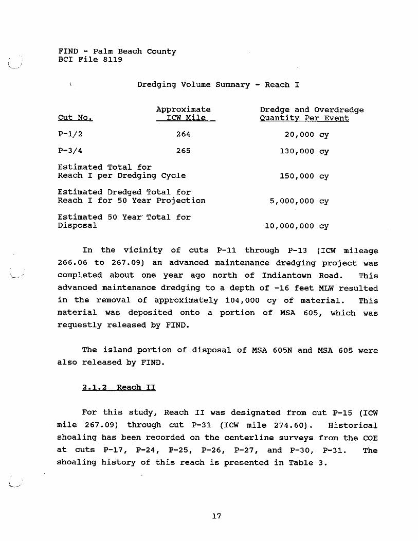
2.1.2 Reach I1
For this study, Reach I1 was designated from cut P-15 (ICW
mile 267.09) through cut P-31 (ICW mile 274.60) . Historical
shoaling has been recorded on the centerline surveys from the COE
at cuts P-17, P-24, P-25, P-26, P-27, and P-30, P-31. The
shoaling history of this reach is presented in Table 3.
FIND - Palm Beach County BCI File 8119
, The only reported dredging activity occurred at cuts P-25
and P-31. Cut P-25 was overdredged, in about 1974, to a nominal
depth of -16 MLW and the material deposited on MSA 617D. This
MSA site was subsequent released by FIND. The material quantity
dredged at P-31 was reported to be 4400 cubic yards and the
material was pumped to the upland disposal areas at MSA 624 and
FO 624E (DA-T-111/112), approximately 2 miles north of cut P-31.
Reach I1 covers a distance of about 7.5 miles along the ICW.
Because there has been no maintenance dredging, except at cut P-
31, the frequency of dredging cycles for this reach is difficult
to quantify. Minor shoaling at cut P-31 has been reported since
1980, with apparent increased amounts of shoaled materials
through 1987.
\ > >.-~.
Even though the current (1984 and 1987) level of shoaling in
Reach I1 is not significantly impacting the use of the ICW,
shoaling will continue to be present until the maintenance
dredging is done. Based on the historical data for cut P-31 the
shoals in Reach I1 will accrete to elevations, above design grade
(-10 feet MLW) within about 10 years after being dredged. Thus,
maintenance dredging in this reach would probably be required
five times in a 50 year period.
FIND - Palm Beach County BCI File 8119
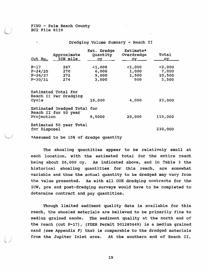
Dredging Volume Summary - Reach I1 Est. Dredge Estimate*
Approximate Quantity Overdredge Total Cut No. ICW mile cv cv c y
Estimated Total for Reach I1 Per Dredging Cycle 19,000
Estimated Dredged Total for Reach I1 for 50 year Projection 9,5000 20,000 115,000
Estimated 50 year Total for Disposal
L ,' *Assumed to be 15% of dredge quantity
The shoaling quantities appear to be relatively small at
each location, with the estimated total for the entire reach
being about 26,000 cy. As indicated above, and in Table 3 the
historical shoaling quantities for this reach, are somewhat
variable and thus the actual quantity to be dredged may vary from
the value presented. As with all COE dredging contracts for the
ICW, pre and post-dredging surveys would have to be completed to
determine contract and pay quantities.
Though limited sediment quality data is available for this
reach, the shoaled materials are believed to be primarily fine to
medium grained sands. The sediment quality at the north end of
the reach (cut P-17), (FDER Permit 501285649) is a medium grained
sand (see Appendix F) that is comparable to the dredged materials
from the Jupiter Inlet area. At the southern end of Reach 11,
FIND - Palm Beach County BCI File 8119
cut,P-31, we suspect that the sediments are finer grained and may
contain some fines (silt sized particles) and organic debris from
Lake Worth (Bach, 1984).
The area of the ICW between cuts P-15 to P-18 (ICW mile
267.1 to 268.5) has been permitted (FDER Permit No. 5012 85649)
for advanced maintenance dredging to -16 feet MLW. The dredging
would have removed about 100,000 cy of material (71,400
cy/mile). The materials were to be deposited in a series of
constructed upland disposal areas, on the west side of the ICW at
about ICW mile 267. The material to be dredged is characterized
by a fined to medium grained sand with generally less than 1
percent fines (-200 mesh sieve). This dredging project has not
been completed, however, the permits are in effect until
September 1992.
i.' Though the disposal concepts for Reach I1 are discussed in
more detail in a subsequent section and Appendix B of this
report, the preferred disposal option for maintenance dredging
in Reach I1 will be upland disposal. Existing easements and
ownership of MSAs in Reach I1 should provide adequate upland
disposal for the anticipated maintenance dredging in this area.
Except for the disposal area, MSA 6055, which is located near cut
P-17, the remaining dredging for channel maintenance would be
within 3 miles or less of the available storage areas. Because
dredging of the channel areas may occur on a noncontinuous basis
or all the shoaling areas may not be dredged simultaneously, it
appears desirable to maintain most of the upland disposal sites
in Reach 11. Even though a centralized disposal area such as at
MSA 610/611A appears to be adequate for the projected dredged
material disposal in Reach 11, pumping costs may outweigh this
choice, and closer, smaller disposal areas may be more desirable
'd

FIND - Palm Beach County I BCI File 8119 i-
for, individual dredging contracts.
2.1.3 Reach I11
Reach I11 includes COE cuts P-32 through P-50 or
approximately the area from north end of Lake Worth to Boynton
Inlet (ICW mile 274.6 to 294.7). This area of the ICW contains
approximately 20 miles of channel within the open water body of
Lake Worth.
This portion of the ICW is generally characterized by open
lake areas on each side of the channel right-of-way. These open
lake areas on each side of the channel often contain spoil
islands or submerged spoil areas that were deposited during the
original dredging of the ICW. Water depths of Lake Worth, I L4,
outside the channel right-of-way are often 5 feet or less. The
lake edges are characterized by numerous lateral access channels
leading to residential developments and shoreline stabilization
structures such as bulk heads and sea walls.
One prominent exception to this setting is the Port of Palm
Beach facility and the entrance channel (Lake Worth Inlet) at
about ICW mile 279 (north end of cut P-36). The port's turning
basin intersects with the ICW at this location. Peanut Island (a
spoil island) is located northeast of this intersection. The US
Coast Guard maintains a station on the south shoreline of Peanut
Island.
Due to the length of Reach 111, we have subdivided this
reach into three subreaches. The following summarizes the
location of these subreaches in Reach 111.

FIND - Palm Beach County BCI File 8119
Cuts Within Subreach ICW Milease Limits
Reach I11 a. P-32 - P-37 274.6 to 282.0
Reach I11 b. P-38 - P-45 282.0 to 291.5
Reach I11 c. P-46 - P-50 291.5 to 294.7
The results of the dredging and shoaling history for Reach
I11 are presented in Table 4.
2.1.3.1 Reach I11 a.
The historical dredging activity for maintenance of the ICW
in this reach is very limited. The principal activity for
dredging has been in the vicinity of Port of Palm Beach (cut P-
36). This area is dredged by the COE for maintenance of a deep
water port. In addition the entrance channel and turning basin
areas are also maintained in a deep water condition.
L., Shoaling has been indicated on the centerline surveys as
well as on the aerial photos for the cuts north of the Port of
Palm Beach, particularly cuts P-33A through P-35. The shoal area
occurring in the vicinity of cut P-33A is immediately north of
Peanut Island and this shoal is locally referred to as Little
Peanut Island. Review of information and aerial photography
indicates that the principal shoaling that is occurring, is at
edge of the ICW channel, in fact, may be aggravated by propeller
wash of spoiled materials on and north of Peanut Island.
We expect that maintenance dredging of the ICW in the
vicinity of P-33A through P-35 could result in sandy (possibly
beach quality) materials of quantities in excess of 20,000 cubic
yards.
FIND - Palm Beach County BCI File 8119
C/'
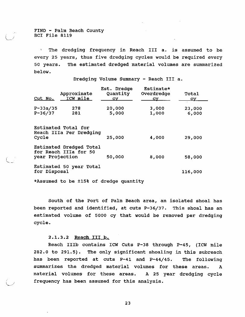
The dredging frequency in Reach I11 a. is assumed to be
every 25 years, thus five dredging cycles would be required every
50 years. The estimated dredged material volumes are summarized
below.
Dredging Volume Summary - Reach I11 a. Est. Dredge Estimate*
Approximate Quantity Overdredge Total Cut No. ICW mile cv cv cv
Estimated Total for Reach IIIa Per Dredging Cycle 25,000 4,000 29,000
Estimated Dredged Total for Reach IIIa for 50 year Projection 50,000 8,000 58,000
! \-
Estimated 50 year Total for Disposal 116,000
*Assumed to be +15% of dredge quantity
South of the Port of Palm Beach area, an isolated shoal has
been reported and identified, at cuts P-36/37. This shoal has an
estimated volume of 5000 cy that would be removed per dredging
cycle.
2.1.3.2 Reach I11 b.
Reach IIIb contains ICW Cuts P-38 through P-45, (ICW mile
282.0 to 291.5). The only significant shoaling in this subreach
has been reported at cuts P-41 and P-44/45. The following
summarizes the dredged material volumes for these areas. A
material volumes for these areas. A 25 year dredging cycle
frequency has been assumed for this analysis. i/

FIND - Palm Beach County BCI File 8119
Dredging Volume Summary - Reach I11 b. Est. Dredge Estimate*
Approximate Quantity Overdredge Total Cut No. ICW mile cv cv cv
Estimated Total for Reach IIIb Per Dredging Cycle 6000 1000 7000
Estimated Dredged Total for Reach IIIb for 50 year Projection 12000 2000 14000
Estimated 50 year i Total for Disposal ii
*Assumed to be +15% of dredge quantity
2.1.3.3 Reach I11 c.
The remaining area of significant shoaling in Reach I11 is
in the vicinity of cut P-50 (ICW mile 294) nea,r the Boynton
Inlet. Shoaling at this location within the ICW appears to be
the result of overflow of the sand trap for the Boynton Inlet
area, located east of the ICW right-of-way. This sand trap area
was recently (Spring 1989) dredged of about 39,000 cy of
materials, which were pumped to the beach. However, the
dredging contract did not extend into the ICW area. This sand
trap, was previously dredged in 1972. Approximately 32,000 cy of
material were removed at that time.
Based upon our review of the available data and aerial
photographs, we expect that the shoal in the ICW, at cut P-50
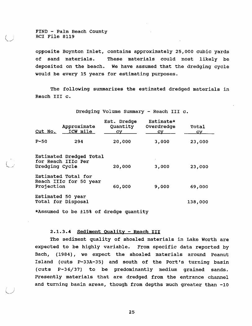
FIND - Palm Beach County BCI File 8119
opposite Boynton Inlet, contains approximately 25,000 cubic yards
of sand materials. These materials could most likely be
deposited on the beach. We have assumed that the dredging cycle
would be every 15 years for estimating purposes.
The following summarizes the estimated dredged materials in
Reach I11 c.
Dredging Volume Summary - Reach I11 c. Est. Dredge Estimate*
Approximate Quantity Overdredge Total Cut No. ICW mile cv cv cv
Estimated Dredged Total - i for Reach IIIc Per ". _ Dredging Cycle 20,000 3,000 23,000
Estimated Total for Reach IIIc for 50 year Projection 60,000 9,000
Estimated 50 year Total for Disposal
*Assumed to be +15% of dredge quantity
2.1.3.4 Sediment Oualitv - Reach I11 The sediment quality of shoaled materials in Lake Worth are
expected to be highly variable. From specific data reported by
Bach, (1984), we expect the shoaled materials around Peanut
Island (cuts P-33A-35) and south of the Port's turning basin
(cuts P-3 6/37) to be predominantly medium grained sands.
Presently materials that are dredged from the entrance channel
and turning basin areas, though from depths much greater than -10 / ii
FIND - Palm Beach County BCI File 8119
feet, are generally deposited on the beach south of the entrance
channel or in near-shore ocean disposal areas.
Sediment quality of other shoaled areas of Reach I11 are
presumed to be much finer grained than the materials near Lake
Worth Inlet. Studies done since the late 1960's (Bach 1984) have
shown that Lake Worth sediments are typically characterized by
fine grained sands that contain measurable amounts of fines
(silts and clays) with varying percentages of organic debris.
Though most of the sediment sampling in the lake appears to have
been done between the ICW right-of-way and the shoreline, the
types of materials reported are probably typical of the shoal
areas away from the inlet location.
Because Lake Worth has only two inlets, the water exchange -
C. (flow) in the interior portions of lake is minimal and thus the
removal of finer grained sediments does not take place as in the
channelized areas of the Palm Beach ICW. The principal
contributors to the sediment and nutrient load of Lake Worth,
outside the inlet areas at cuts P-36 and P-50, are the fresh
water canals that flow from the agricultural lands to the west.
The canals that are used to control the agricultural and more
recent urban development runoff on the west side of Lake Worth
are the Earman River (C-17) at ICW mile 277, the West Palm Beach
Canal (C-51) at ICW mile 287.5, and the Boynton Canal (C-16) at
ICW mile 295. In addition to the storm water runoff produced by
these canals, these discharge points were also used for sewer
effluent disposal as late as 1979. "Today the West Palm Beach
Canal, (C-51), remains the major source of pollution effecting
Lake Worth. It contributes large quantities of freshwater,
agricultural and urban runoff and heavy loads of detritus and
other organic materials which have caused the build up of organic , L
FIND - Palm Beach County BCI File 8119
deposits in the central portions of the lake1@ (TEI, 1983 as
reported in Bach 1984).
The report by Bach (1984) also contained data regarding
water and sediment chemistry. The Palm Beach County Department
of Environmental Resources plans to update the water quality and
sediment chemistry data for Lake Worth with their pending study,
that is scheduled to begin by October 1989. Because the water
quality and sediment chemistry data in the Bach (1984) report is
dated, we have not included it herein. This database can be
updated with the results of the pending County study and site
specific sampling and testing during the Phase I1 study of this
project . 2.1.4 Reach IV
Reach IV consists of the area of the Palm Beach ICW between
cuts P-51 and P-91 (ICW mile 295 to 310) in the southernmost
portions of the Palm Beach County. Historical data indicates
that little or no maintenance dredging has been done in this area
nor does the shoaling information indicate that significant
maintenance dredging will be required in this area. Review of
aerial photographs indicates that some shoaling is probably
occurring in the vicinities of cuts P-87 and P-88 near the
eastern side of Lake Boca and near the outlet of the Hillsboro
Canal at cut P-90. A minor shoal of about 500 to 1,000 cy was
recorded at cut P-87 in 1987. The results of the historical
shoaling data for Reach IV are presented in Table 5. A dredging
cycle of 25 years has been assumed for Reach IV for this study.
FIND - Palm Beach County BCI File 8119
Dredging Volume Summary - Reach IV Est. Dredge Estimate*
Approximate Quantity Overdredge Total Cut No. ICW mile cv cv cv
P-87 308 P-87/88 309 Channel Edge
Estimated Total for Reach IV Per Dredging Cycle 11,000 1,700 12,700
Estimated Dredged Total for Reach IV for 50 year Projection 22,000 3,400 25,400
Estimated 50 year Total for Disposal
*Assumed to be 115% of dredge quantity I i-'
Known dredging activities in this reach include the
continuous maintenance dredging at the Boca Inlet. This dredging
is done by the City of Boca Raton in an area primarily east of
Highway AlA.
In the vicinity of cuts P-74 through P-76 (ICW mile 304.0 to
304.9) the ICW was overdredged, in 1971, to a depth of about -20
feet MLW. As of the 1987 centerline survey, water depths in this
area were still being recorded in the 15 to 20 foot depth range.
The specific sediment characteristics of the shoaled or
suspected future shoal areas of Reach IV was not determined
through available data sources. As discussed in Reach 111, the
Boynton Canal (C-16) has discharged freshwater runoff and sewer
effluent into the ICW for about 40 years at about ICW mile 295
(cut P-51). Even though the sewer effluent was discontinued / L l after 1979 (Bach 1984), this canal is still a source of
FIND - Palm Beach County BCI File 8119
considerable stormwater runoff and detritus.
The sediment quality in the Lake Boca and Boca Inlet areas
is assumed to be similar to the beach quality sands that are
being dredged on a regular basis.
FIND - Palm Beach County BCI File 8119
3 .0 DISWSAL CONCEPTS, NEEDS, AND AVAILABILITY
3.1 General
The practice and philosophy of dredged material disposal has
changed over the past several years. As demonstrated by the
numerous spoil islands and open water spoil easements maintained
by FIND, the practice of dredged material deposition near its
source was common in the 1960's. This method helped to maximize
operational efficiency and short term costs, but did not consider
the long range maintenance or environmental impacts.
Increased environmental awareness, improved technical
understanding of handling dredged materials, competing land uses,
declining aquatic habitat quality and concerns about water
quality have forced the need for long range planning for dredged
material disposal. A key factor in this long range planning is
the identification and investigation of disposal concepts and
options.
The disposal emphasis, as outlined in the scope of services
for this study, was to focus on upland disposal sites that were
centrally located within a pumpable distance (I. 5 miles maximum)
and could be operated and maintained as permanent facilities by
FIND, even though the dredging frequency may be several years
between events.
Historical precedent, with regard to dredged material
handling in the Palm Beach ICW, was taken into account as part of
developing disposal concepts. In areas such as at Jupiter Inlet,
Boynton Inlet, and Boca Inlet it is assumed that beach disposal
will continue to be the disposal method because the sediments

FIND - Palm Beach County BCI File 8119
quality data indicates beach quality materials will be excavated
in these areas. At Lake Worth Inlet, even though the Port's
dredged materials are often sent to the beach, the lack of
sediment quality data for the cuts north of Peanut Island (P-33A-
35) required that we look at other disposal options in this area.
In Reach I the current and likely future disposal of dredged
materials will be on the beach areas north and south of Jupiter
Inlet. Beach disposal areas, used by the COE and the Inlet
District, have been identified for possible use.
In the northern part of Reach 11, upland disposal appears
to be the most likely option. FIND maintains several existing,
undeveloped or partially upland sites that appear to meet the
disposal needs for this area. i L,
Reach 111, characterized by the open waters of Lake Worth,
offered few potentially available upland sites due primarily to
competing land uses by urban development. Other disposal options
review during this study included open water disposal in deep
excavated holes, spoil island (upland portion) disposal, near
shore and shallow water spoil island disposal, upland disposal on
small to medium sized developed public sites and beach disposal
at a location between the inlets, via an existing FIND pipeline
easement.
Dredging in Reach IV is expected to be minor, based on the
limited historical data. Adequate upland disposal is available
at existing FIND sites within about 2.5 miles of the area where
dredging will probably take place in the next 50 years.
FIND - Palm Beach County BCI File 8119
The disposal concepts, particularly those for Reach 111,
have been discussed with local and state environmental agency
personnel. Their comments have been incorporated into this
report where applicable.
The following sections discuss in some detail the disposal
concepts, projected disposal needs, disposal options and
availability and agency input for each reach. As part of the
disposal need and availability we reviewed the inventory of
existing FIND MSA sites as well as identified primary and
secondary alternative disposal sites. A list of all the existing
MSA sites is presented in Table 6 with a supporting map, Figure
3, showing their general locations along the ICW.
Each existing MSA site and primary alternate site was
inventoried and cataloged for pertinent engineering,
environmental and socioeconomic factors. These data sheets are
presented in Appendix A of this report.
Also shown in Table 6, is the results of our qualitative
matrix analysis for candidate site selection and site bank
determination. Because many of the engineering, environmental
and socioeconomic factors could not be easily quantified, with
respect to a numerical ranking process, the site selection
(culling) was done on a more subjective basis. This process is
discussed further in Section 3.6 of this report. Each candidate
disposal site existing and proposed are described in detail in
Appendixes B and C along with disposal volume computations and
vegetative (FLUCCS) community diagrams and maps.
A map showing the general locations of the candidate
(primary) disposal sites is presented in Figure 4.
FIND - Palm Beach County BCI File 8119
3.2 Reach I
The historical precedent for dredged material handling in
Reach I (cuts P-1 through P-6) has been for beach disposal to
north and south of the Jupiter Inlet entrance channel. It is
expected that this method of disposal will prevail for future
dredging contracts in this area. Though this method of disposal
places the dredged materials in and area susceptible to wave and
current erosion, the beach is renourished and maintained because
of this disposal. Thus upland or other disposal options do not
appear likely or viable in this part of Reach I. Beach disposal
north of the Inlet is contingent on the COE being able to secure
access easements across the existing property and roadways
between Cut P-1 and the beach.
In the lower portions of Reach I, an advanced maintenance
dredging project to elevation -16 feet, was recently completed in
the vicinity of cuts P-11 through P-13. We understand that the
existing disposal sites, MSA 605 and the island portion of 605N,
were released by FIND after this advanced maintenance dredging
project. Because this area has been dredged to -16 feet, these
does not appear to be a need for dredged material disposal in the
next 50 years at this location. If dredging is required, it is
likely that the materials will be medium grained sands, that
could be pumped to the beach which is about 2 miles, via the ICW,
from cut P-13.
3.3 Reach I1
To our knowledge, maintenance dredging, in Reach 11, has not
occur, except at cut P-31 since the channel was dredged to design
FIND - Palm Beach County BCI File 8119
depth in 1961. The materials dredged at cut P-31 in 1972, were
pumped northward, about 1 mile to an upland disposal site (MSA
624/624E). At cut P-25, the ICW was overdredged for a distance
of 4800 feet, to about -16 feet MLW around 1974. The dredged
materials were deposited on an upland area to the east (old MSA
617D). The disposal area was released by FIND and subsequently
developed into a park.
Our review of data for this study has revealed localized
shoaling in four general areas of Reach I1 as discussed in
Section 2. Though the shoaling records produced somewhat
variable quantities for the different years the centerline
surveys were completed, we estimate that approximately 26,000 cy
of materials would be dredged in this reach per dredging cycle.
FIND maintains fifteen land easements and ownerships,
(MSAts) that date from 1927, along both sides of the ICW in
Reach 11. Because of the narrow nature of the ICW in this reach
and distances to the beach via the ICW are greater than three
miles from the identified shoaling areas, and the apparent
availability of upland disposal sites, our analysis for disposal
of dredged materials focused on the existing MSAts that contained
predominantly upland acreages.
Using the predominant upland disposal criteria as a starting
point, ten MSA areas (seven disposal sites) in this reach were
identified for further analysis for disposal capacity and site
characteristics. These candidate sites are highlighted in Table
6 and also in Appendix B of this report. As shown in Table 2 of
Appendix B the estimated maximum capacity of all the candidate
disposal sites in Reach I1 is about 500,000 cubic yards, and thus
far exceeds the estimated material/water volume that would occur
FIND - Palm Beach County BCI File 8119
even if dredging was required every 10 years. However these
sites are scattered at several locations along the ICW and some
have limited overland access, have been leased and developed for
public recreation facilities and/or are relatively small and may
require rehandling and removal of the dredged materials.
The two largest disposal areas, MSA 609/609A (combined) and
MSA FO 610/FO 611A (combined) are located in the northern portion
of Reach 11. These two areas are estimated to have a maximum
disposal volume capacity for dredged materials and water of
165,000 and 109,000 cy, respectively. These areas are within 3
miles of the minor shoaled areas of cuts P-24 and P-27.
The remaining candidate disposal areas, in this reach all
have estimated maximum capacities of 90,000 cy or less with two
i of them, MSA FO 614B and FO 617C having less than 25,000 cy of
available storage.
It is recognized that centralized disposal is one of the
criteria to be considered in this study. Except for dredging at
cut P-31, in the south end of Reach 11, this directive could be
accomplished by using one of the larger disposal sites at MSA
609/609A or MSA FO 610/611A.
As these larger potential disposal areas are more than 3
miles via the ICW from cut P-31 for pipeline access, disposal
sites in the southern portion of Reach I1 should be considered.
Historical records indicate that MSA 624/F0 6243 were used in
1972 for material dredged from cut P-31. Candidate site MSA FO
620B is located within about 2 miles of cut P-31 and has greater
maximum storage capacity than MSA 624/FO 6243. However, MSA FO
620B is currently used as a park and a large portion (about 6
i /
FIND - Palm Beach County BCI File 8119
acres) of the park area (about 14 acres) has been improved for
use as baseball fields.
Factors besides volume capacity, such as access,
environmental impacts, land value, zoning and surrounding land
uses are presented in Appendices A and B for all the candidate
sites. These need to be considered in addition to the location
and volume capacity before final decisions are made to use one
centralized area or decentralized disposal methods and areas.
3.4 Reach I11
The anticipated volume of materials to be dredged in Reach
I11 are shown in Section 2 of this report. We presume the lake
sediments may contain measurable percentages of fines (silts and
C clay sized particles) organic debris (from sewer disposal and
detritus accumulation) and possible man-made pollutants from
urban stormwater runoff.
The existing MSA disposal areas in Reach I11 are open water
spoil island or near shore areas. Due to environmental
constraints, all but three of the open water or spoil island
sites were eliminated from the site bank for disposal of dredged
materials. MSA LW 9A and LW 9C, are considered to be secondary
sites. These two sites were included as secondary sites because
of their contiguous position to upland areas and existing spoil
islands.
The candidate sites for dredged material disposal in Reach
I11 along with preliminary engineering design and environmental
and socioeconomic considerations is presented in the Appendices
of this report.
I ,,
FIND - Palm Beach County BCI File 8119
For the northern portion of Reach 111, (cuts P-33 and P-37)
upland disposal was initially considered possible on Munyon
Island and/or Peanut Island. These sites appear to offer volume
capacities in excess of the anticipated dredging material volumes
for this part of Reach 111. These proposed sites do not have
overland access and therefore use, maintenance and management of
these sites would have to be done by barged equipment.
Subsequent review by FIND, COE and FDER eliminated the Munyon
Island site.
Conversations with the Port of Palm Beach engineers,
indicate that the Port is considering developing an upland type
disposal area on the north end of Peanut Island. It is
understood this site would handle 8000 to 10000 cubic yards of
dredged materials from the turning basin and slip areas of the
Port. Based on these conversations another upland site, for ICW
dredged materials, could probably be built in conjunction with
the Port's plans.
It is our understanding that competing land use plans for
Peanut Island by local government agencies may make this site
unavailable.
Phase I1 studies may reveal that the shoaled materials,
particularly at cuts P-35 and P-36 adjacent to the Port's
entrance channel may be sufficiently coarse grained to be
suitable for beach disposal south of the Lake Worth Inlet.
The alternate site at Lake Park Park in the northern portion
of Reach I11 offers very limited disposal capacity. Dredged
materials would likely have to be removed after each dredging
FIND - Palm Beach County BCI File 8119
cycle due to the limited storage capacity. As an alternative,
below grade disposal was considered at this site. This would
probably be a one time use scenario requiring post-deposition
grading and revegetation.
In the southern portions of Reach 111, (cuts P-41/42 and P-
44) the availability of upland disposal sites is very limited.
Two possible sites, located along canal C-51 about 1.5 miles west
of the lake were identified. These are designated as the Canal
C-51 landfill and the West Palm Beach Golf Course sites. The
Lake Worth Golf Course, located west of cut P-44, was considered
to be a viable secondary disposal site upon review of the
preliminary results of this study.
Descriptions of the engineering, environmental and I
i/ socioeconomic factors about these sites and their potential use
are presented in Appendix C.
The upland sites at the landfill and the West Palm Beach
golf course appear to offer storage capacities of less than
20,000 cy each. Though the estimated dredged material volumes
for this part of Reach I11 appear to relatively small,
(approximately 40000 cy for 50 years), these sites would probably
have to be maintained and material removed after each dredging
cycle.
The sediment materials at these locations may contain silts,
clay, and organic debris. The settling and consolidation
characteristics of the dredged materials may require larger
storage volumes than for sandy materials. These characteristics
will have to be determined during Phase 11.
FIND - Palm Beach County BCI File 8119
: 3.4.1 Alternate DiS~oSal
The process of identifying possible dredged material
disposal sites in Reach I11 revealed some options other than
upland disposal on vacant land or in controlled shallow water
areas.
For the open water sites, such as MSA LW 9A and LW 9C and
the deep holes along the ICW, considerable environmental, water
quality dredged material data will need to be gathered to further
evaluate the use of these sites.
Environmental officials at Palm Beach DERM had suggested
that one-time disposal in the deep holes in Lake Worth may be
possible, if the County agrees to its use.
The use of pipeline easement PL 643 would be predicated on
the suitability of the dredged materials from cuts P-41/42 and P-
44 for beach disposal. This data will have to be determined as
part of a Phase I1 task.
FIND - Palm Beach County BCI File 8119
3.5 Reach IV
The need for dredging in Reach IV in the next 50 years is
expected to be minor, based on the current available data. More
complete bathymetric survey of the suspected shoal areas at cuts
P-87, P-88 and P-90 may reveal volumes greater than estimated in
this Phase I report.
The current inventory of FIND disposal sites in this reach
includes 27 easements and ownership locations. The list of these
sites is present in Table 6. The majority of these sites
consist of wetland or jurisdictional areas that would not be
suitable for upland disposal. Some of the upland sites are
small, less than 5 acres in size and have been set aside as
preservation areas.
C: Three candidate disposal sites were identified from this
inventory of 27 sites. The three sites are characterized by
primarily upland land areas. The three candidate sites in this
reach are MSA FO 641A at ICW mile 299, MSA 684A at ICW mile 306,
and MSA FO 690 at ICW mile 307. These are described in detail in
Appendix B.
Of these sites, MSA 684A appears to offer the most viable
opportunities for upland disposal as it relates to the
anticipated dredging in the reach. This site is about 2.5 miles
north of cuts P-87 and P-88. This site is characterized by
exotic vegetative cover and good upland access. It is currently
used as a park (Spanish Park). Preliminary engineering design of
this site indicates it has a maximum volume capacity on the order
115,000 cy, or nearly 3 times the volume capacity of MSA FO 641A
and 10 times that of MSA FO 690.
FIND - Palm Beach County BCI File 8119
The anticipated dredged material volumes for this reach are
currently estimated to be less than 15,000 cy per dredging cycle
and less than 30,000 cy for a 50 year projection, there is excess
storage capacity in the candidate disposal sites. Due to the
uncertainties of side channel shoaling, particularly in the Lake
Boca area, the actual volumes of materials to be dredged may be
measurably higher than the amount shown above. It is however,
assumed that the identified candidate sites (particularly MSA
684A) would provide adequate disposal capacity.

FIND - Palm Beach County BCI File 8119
4.0 SITE BANK ANALYSIS
4.1 General
The matrix analysis for disposal site bank selection was
based primarily on the general criteria of 1) preferred upland
disposal, 2) centralized location and 3) accessible and
manageable sites. Other criteria or data that were used in our
analysis included, parcel size, current land use, environmental
habitat and compatibility with adjacent land uses.
Taking into account the first major criteria of preferred
upland disposal, all be two of the 21 open water, near shore or
spoil island existing MSA disposal areas (all in Reach 111) were
eliminated from the disposal site bank. Strong concerns, were
expressed by the environmental agencies about established sea
grass beds and aquatic habitat areas in and around these open
water sites. These environmental concerns were considered to be
"fatal flawsm in the matrix process and the sites were eliminated
from the list of available sites.
The open water "deep holestf located along the west side of
Lake Worth in Reach I11 b. are considered to be primary disposal
areas in this reach. Very limited data concerning their size,
depth, sediment vegetative and aquatic habitat is available.
This will have to be determined during the Phase I1 portion of
the study.
Another major criteria that was evaluated as part of this
analysis was the available upland land area that could be used
for dike construction and dredged material disposal. Preliminary
design calculations were completed for several disposal sites

FIND - Palm Beach County BCI File 8119
considering the available upland land area, room for a buffer
zone, typically 100 foot, and the estimated ground surface
elevations. It was determined that upland sites with less than
about 6.5 acres of land were not viable for dike construction and
material handling. Thus upland sites with less than 6.5 acres of
available land were eliminated from the disposal bank. Sites
with about 8 acres of available upland land area offer only about
24,000 cy of volume capacity. These were kept in the initial
site bank because of the noncontiguous shoals and the relatively
small dredged material volume estimates for many of the areas in
the Palm Beach ICW.
A deficit of fill material for dike construction was not
considered a "fatal flawa1 at this time because material could be
borrowed from I1too small" upland sites for use at the candidate
disposal sites.
Available upland access and centralized location were also
factors that were considered in developing the site bank. Some
of these candidate sites have unimproved overland access through
or across adjacent properties. While others are located adjacent
to or are connected by easement to existing roadways. At this
time, candidate sites were not eliminated due to questionable
overland access. Because there is a scarcity of open tracts of
land in Palm Beach County, particularly Reaches I11 and IV, it
was assumed that overland access, where required, could be
obtained by easement or purchase.
The following sections summarizes the evaluation and
selection process for primary and secondary disposal sites for
the four reaches of the Palm Beach ICW.
FIND - Palm Beach County BCI File 8119
4.2 Reach I
The historical preference for dredged material disposal in
Reach I has been to use the beach and near-shore areas east of
cuts P-1 through P-4, both north and south of the Jupiter Inlet
channel. Beach easements, obtained by the COE, for previous
maintenance dredging in this are located in this area of the
inlet.
According to available dredging contract records, the three
areas are located north of the inlet are designated MDA - 2 and DAJ - 2 and 3. These easements are generally located from the
MLW waterward and are estimated to about 11 to 15 acres in size
and probably capable of handling 100,000 cubic yards or more of
material. Disposal at MDA - 2 may be done in conjunction with a beach nourishment and dune building project planned by Coral Cove
Park, located east of the south end of cut P-1.
Access to the north beach disposal areas is reported to be
via a pipeline crossing at station 70+28 of cut P-1 and easements
at station 74+20 of cut P-1 and along the MLW line parallel to
the beach
Another beach disposal area, used for COE contracts, is
located about 800 feet south of the Jupiter Inlet channel. The
area between the inlet and this disposal area, D M - 1 is used for beach disposal of dredged material from the inlet channel,
east of the ICW, by the Jupiter Inlet District. Access to DM-1
is via a MLW pipeline easement along the beach.

FIND - Palm Beach County BCI File 8119
4.3 Reach I1
At the time of this study, FIND maintains or owns fifteen
upland and shoreline disposal sites in Reach 11. These sites
were evaluated for vegetative cover, wetland areas, proximity to
shoal areas, availability of embankment fill materials and
available storage volume. Our initial review and analysis of
these sites revealed that 10 MSA areas ( seven disposal sites
total) appeared suitable for use as primary or secondary upland
disposal of dredged materials in Reach 11. These sites were
discussed in detail in the draft report for this study.
Following the review of these sites by FIND, COE, FDER and
FDNR the list of primary and secondary sites was reduced to three
areas (five MSAs) . The primary areas are MSA FO 610/611A
1 1 located at about ICW mile 269 and MSA FO 620B at Mile 272.5. The
secondary site in this reach is MSA 609/609A.
Based on our preliminary analysis of these particular sites,
the following volume capacity estimates were made.
MSA FO 610/611A
MSA FO 620B
MSA 609/609A
Our analysis also showed a material deficiency for
embankment construction of about 40,000 c. y. at MSA FO 610/611A
and 13,000 c.y. at MSA 609/609A.
Data sheets for these sites are included in the en end ices of this report.

FIND - Palm Beach County BCI File 8119
4.4 Reach I11
Reach 111, which runs from cut P-32 to P-50, is located in
the open water areas of Lake Worth. FIND maintains 23 open
water/estuary easements in this reach. Considering the emphasis
to consider upland disposal as the preferred method to handle
dredged material and concerns by State and County environmental
officials, only two of the open water disposal areas, LW 9A and
LW 9C, were considered for possible future use as secondary
disposal areas. These areas are located near or contain existing
spoil islands that could be enlarged by the placement of dredged
materials. ~ased on the restricted number of existing FIND
sites, other areas were evaluated.
This reach was subdivided to refine the analysis for dredged i L~,; material quantities and the disposal options for each subreach.
4.3.1 Reach I11 a.
Reach I11 a. extends from cut P-32, at the north end of Lake
Worth, to cut P-37 just south of the Port of Palm Beach. In this
area, the shoaling appears to be concentrated in the south end of
the subreach near Peanut Island and south of the port's turning
basin. Even though the material properties are not known at this
time, it is assumed that the dredged material, particularly that
north of Peanut Island, is sandy in nature and as such could be
deposited on or near the beach south of the entrance channel.
This area is used by the COE for maintenance dredging for the
port's entrance channel and turning basin.
The other primary disposal area in this subreach is the
upland portions of Peanut Island, probably in the north central
part of the island. The Port of Palm Beach is also considering
i/
FIND - Palm Beach County BcI File 8119
using Peanut Island for dredged material disposal. Assuming a
nominal 10 acre disposal area on this island, a storage volume of
about 105,000 c.y. has been estimated. There is no overland
access to Peanut Island, therefore all disposal and site
management activities would have to be accomplished using barged
equipment.
Other possible disposal areas in Reach I11 a., such as
Munyon Island, deep holes east of cuts P-33A and 34, Lake Park
Park, Currie Park and Little Munyon Island were considered during
the preliminary phases of this study,but were subsequently
eliminated as possible primary and secondary disposal sites upon
further review.
4.3.2 Reach I11 b.
C The south central part of Lake Worth contains Reach I11 b.,
which extends from cut P-38 to P-50. Isolated shoals have been
located in the vicinity of cuts P-41/42 and P-44/45. It is
suspected that the materials in these shoals is fine grained and
may contain organic debris from previous sewer disposal in Lake
Worth.
All of the existing FIND easements in this area are below
water sites with some spoil islands located in or at the edges of
the easements. The upland areas adjacent to the ICW in this
subreach are extensively developed with residential, commercial
and public recreational properties. A search for upland disposal
sites revealed a general lack of available vacant land areas.
Thus the initial site bank included existing golf courses for the
cities of West Palm Beach and Lake Worth, an old land fill along
Canal C-51, Bryant Park, previously excavated deep holes on the
west side of the ICW near cut P-42, and existing FIND water

FIND - Palm Beach County BCI File 8119
easements that were adjacent to the shoreline for access and/or
contained spoil islands already.
After further review and discussion of these sites, the
sites selected for further consideration and probable use are the
deep holes on the west side of the lake (primary), spoil island
improvements in existing easements (secondary), and upland and/or
shoreline disposal at the Lake Worth Golf Course (secondary).
Open water easements LW 9A and 9C were chosen for further
consideration because they contain spoil islands that could be
enlarged and used to help control deposition of the dredged
materials and water quality during disposal. LW 9A also is
contiguous to the eastern shoreline of Lake Worth, which would
provide upland access.
L, The deep holes and the shoreline of the Lake Worth Golf
Course, located on the west side of the lake, appear to offer a
viable option to upland disposal. These areas and the sediment
quality would have to be studied further to confirm their use and
the likelihood of being permitted by the state and local
agencies.
4.3.3 Reach I11 c.
Reach I11 c. is situated in the southern end of Lake Worth,
between cuts P-46 and P-50. Shoaling in this subreach is
concentrated at cut P-50, opposite the South Lake Worth (Boynton)
Inlet channel. The shoal in this area is believed to consist of
sand materials that are similiar in nature to the material in the
sand trap along the south edge of the channel.
Material from the sand trap was recently dredged by the

FIND - Palm Beach County BCI File 8119
Inlet District and deposited on the beach south of the inlet. It
is assumed that the estimated 25,000 c.y. of dredged material in
cut P-50 shoal could also be deposited on the beach, in the same
general area as used by the Inlet District.
4.4 Reach IV
The channelized portion of the Palm Beach ICW extending from
cut P-51 to P-91, has been designated as Reach IV. No
maintenance dredging in the ICW was reported by the COE in this
reach. Evidence of shoaling was noted in the vicinity of cuts
P-87/88, though the quantity of shoaled materials could not be
well defined. We have estimated that an inplace quantity of
about 30,000 c.y.would likely have to be dredged in a 50 year
time frame.
i; FIND maintains several upland disposal sites in this reach.
After a review and analysis of these sites three areas ( four
MSAs) were selected for probable use for dredged material
disposal. The primary sites chosen were MSA FO 641A and MSA 684A.
A secondary site, MSA FO 640/640A with some expansion in an
easterly direction, was also chosen.
Site MSA 684 is located about 2.5 miles from the shoal areas
in this reach. It is currently used as an undeveloped park
(Spanish Park) and is vegetated with exotic plants and trees. It
has good upland access and its estimated capacity for disposal of
dredged materials and water is 115,000 c.y. This capacity should
be adequate for a 50 year disposal of materials from cuts P-
87/88. The other sites chosen in this reach are smaller and
further away from the shoal areas, however both are owned by FIND
rather than an easement like MSA 684A. ( 1 \- 1
FIND - Palm Beach County BCI File 8119
5 .0 PHASE I1 STUDY
5.1 General
Further engineering, environmental and socioeconomic data
gathering will be required to formulate specific design and
permitting criteria for the long-range disposal and handling of
dredged materials from the ICW. This work effort would be
completed in a Phase I1 study. This study will concentrate on
the areas of the ICW identified in the Phase I study that will
require future dredging and be the candidate disposal sites for
handling the dredged materials.
As the Phase I study was principally a @*paperw study of the
entire Palm Beach ICW, the Phase I1 portion of the long range
plan for dredged materials, will focus more on site specific data
gathering to develop plans and reports for the acquisition,
design, environmental permitting, zoning, development and
management of the selected disposal sites.
Based on the results of the Phase I study, the following
outlines the technical areas and major data gathering and
analysis tasks that will be explored in the Phase I1 study.
5.2 Enaineerinq
5.2.1 Dredaed Material Characterization
o Review any updated surveys provided by COE in areas of
possible dredging.
o Sediment sampling of shoal areas in Reach I11 b. area (due
to concerns about organics) for mechanical and chemical
FIND - Palm Beach County BCI File 8119
laboratory testing to establish settling and water quality
data (by consultant).
5 .2 .2 D ~ S D O S ~ ~ Site Characterization
o Updated aerial photography (by COE/FIND)
o Soil surveys with test borings and laboratory testing of
upland sites to characterize site soils for disposal and
dike construction (by consultant).
o Reconnaissance of beach disposal areas and access to
disposal areas.
o Obtain groundwater elevation data from local agencies,
record data and prepare water table elevation maps.
o Sediment sampling of below water disposal areas for
mechanical, and water quality testing (by consultant).
o Topographic surveys of candidate upland disposal sites to
determine actual site grades and boundary limits with
respect to adjacent features (by COE).
o ~ngineering surveys of site access corridors and easements
by site reconnaissance, test borings and surveys (by
consultant and COE).
5.2.3 Preliminarv Desiqn and Analvsis Ibv Consultant1
o Prepare engineering report field and laboratory testing
findings including the dredged material disposal site
characteristics.
FIND - Palm Beach County BCI File 8119
o Prepare preliminary drawings and plans for design of
disposal site for inclusion with environmental permit
applications. To include such items as location maps, site
plans, pipeline access, water control structures, turbidity
control measures, typical dike geometry, storm water
management systems, equipment access, and revegetation
plans.
o Prepare preliminary cost estimate for site construction.
o Prepare preliminary site management plan for pre- and post-
dredged material disposal periods.
5.3 Environmental Ibv Consultant1
5.3.1 Site Characterization
o Detailed site reconnaissance and mapping of vegetative and
animal communities including species, types and distribution
and identification of rare and endangered animals or plants.
Delineation of jurisdictional wetlands.
o Area reconnaissance of road and pipeline access corridors
for vegetative and animal community identification and
mapping.
o Water quality sampling for chemical and turbidity properties
in Lake Worth area.
o Benthic water and sediment sampling in areas where below
water or near-shore disposal is the preferred disposal

FIND - Palm Beach County BCI File 8119
option.
o In depth review of archaeological records and possible site
reconnaissance.
5.3.2 Environmental Permittins (bv Consultant)
o Prepare detailed maps of vegetative communities and
jurisdictional areas at candidate disposal site.
o Prepare written report for each site describing vegetative
cover, animal habitat, jurisdictional areas and
archaeological findings.
o Prepare mitigation plans for disposal area continuation.
o Prepare report with findings and recommendations concerning
ground water impacts.
o Prepare drawings and text for environmental permits
concerning vegetation and animal habitats, jurisdictional
areas and impacts, and surface and ground water impacts.
5.4 Socioeconomic (by Consultant)
5.4.1 Site Characterization
o Complete updated data gathering of property appraisal,
adjacent land uses, site access current zoning and pending
zoning changes.
o Identify site utilization restriction with respect to

FIND - Palm Beach County BCI File 8119
' Comprehensive Plan for the County and local governing
bodies.
5.4.2 Analvsis. ReDortinCI and S u ~ ~ o r t
o Prepare written report with updated information about site.
o Assist FIND with zoning matters as they relate to local and
County Comprehensive Plans.
o Assist FIND with maintaining current property appraisals and
changing land use information.
o Assist FIND with public hearings and meetings as necessary
for zoning conflicts, acquisition or land use changes.
5.5 List of AnticiDated Deliverables
o Report on sediment sampling from Reach I11 b. area.
o Soil survey report with test boring logs for upland sites.
o Spreadsheet data base and maps with ground water levels.
o Topographic maps of disposal areas.
o Engineering reports of access and easements for road and
pipelines.
o Report detailing disposal site characterization and
development.

FIND - Palm Beach County BCI File 8119
o . Maps and plan sheets for inclusion with environmental
permits.
o Cost estimates for construction and management of disposal
areas.
o Site Management and maintenance reports for each disposal
site.
o Report of vegetative communities of disposal areas.
o Maps showing jurisdictional areas for inclusion with
permits.
o Report of updated zoning and appraisals
o Mitigation plans for disturbed wetland or upland sensitive
areas.

FIND - Palm Beach County BCI File 8119
REFERENCES
Reports
Steven D. Bach, Ph.D., Summarv of Water Ouality, Sediment
and Bioloaical Studies for Lake Worth. Florida. Submitted to the
Area Planning Board of Palm Beach County, West Palm Beach, FL.:
Wapora Inc., (1984) . R. Bruce Taylor, P.E., Ph.D. and Wm. F. McFetridge, Lonq-
Ranae Dredsed Material Manasement Plan For the Intracoastal
Waterway in Northeast Florida. Submitted to the Florida Inland
Navigation District, Jupiter, FL: Taylor & Divoky, Inc., (1986).
Joseph D. Ryan, Fred D. Calder, Louis C. Burney, Deewwater
Ports Maintenance Dredains and Diswosal Manual: A Guide to
Plannina and Estuarine Chemical Data Collection, Analysis, and
Interwretation. Florida Department of Environmental Regulation,
Office of Coastal Management, Tallahassee, FL: 1984.
Herbert L. Windom, Guide To the Interwretation of Reported
Metal Concentrations in Estuarine Sediments. Edited by the
Florida Department of Environmental Regulation, Office of Coastal
Management, Tallahassee, FL: 1988.
The Florida Land Use Cover Classification System: A
Technical Re~ort. Florida Department of Administration, Division
of State Planning, Bureau of Comprehensive Planning, Tallahassee,
FL: 1976.
FIND - Palm Beach County BCI File 8119
Harvey Rudolph, A Benthic Invertebrate Survev of Lake Worth,
Florida in Februarv and Auqust, 1985 - A Bioloqical Basin
Assessment Survev. Florida Department of Environmental
Regulation, Port St. Lucie, FL: 1989.
Soil Survev of Palm Beach Countv Area, FL. U. S. Soil
Conservation Service: 1978.
U. S. Army Corps of Engineers, Jacksonville District.
Reconnaissance Survey of the Intracoastal Waterway, Jacksonville
to Miami. Jacksonville, FL. 1968, 1974, 1977, 1980, 1981, 1982,
1984, 1987.

FIND - Palm Beach County BCI File 8119
Miscellaneous Resource Information
Florida Department of Environmental Regulation. (Permits)
File Number Awwlicant
501556439 R. Fisher, Rybovich Boat Works, Inc.
501424939 South Lake Worth Inlet District
501285649 G.M. Ward, Jonathan's Landing
50253391 Michael Egan, Ocean Harbor Club
Palm Beach County Florida, Department of Environmental
Resource Management.
File Number Avwlicant
DF-001-88 Business MenlsAssurance Co.,
D.B.A. Oak Harbor Marina
DF-10-88 ~enholtz-~hodes Assoc. , Fishekinan's Wharf
01-31-89 Hidden Harbor Mitigation Plan
Palm Beach County Department of Environmental Resources
Management. Proposal for the "Lake Worth Restoration and
Enhancement Project1'. September 30, 1989 - September 29, 1990.
Jonathan's Landing - Elutriate Study, water and sediment samples. February 19, 1987. Paul R. Mcginnes & Associates,
Consulting Laboratory, Inc., West Palm Beach, FL.

FIND - Palm Beach County BcI File 8119
Florida Department of Environmental Regulation. Lake Worth
Basin. Comprehensive Basin Assessment Monitoring FY 89-90.
Florida Department of Environmental Regulation, Office of
Coastal Management. Sediment chemistry from the Port of Palm
Beach Study. Stations PPB 1 - PPB 6. 1983.
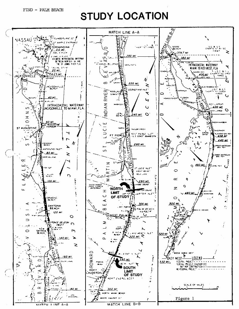
FIND - P r n BEACH
STUDY LOCATION

HISTORICAL IDENTIFIED SHOALING AREAS MAJOR OCCURANCE LOCATION MAP
C M D M U L O D I c*... (8." !
I 4 " ' " ' * r j , rc*tt I r o m 5 ~~~ . *."I,<., ",I,,
". -
FIGURE 2 BCI NO. 8119
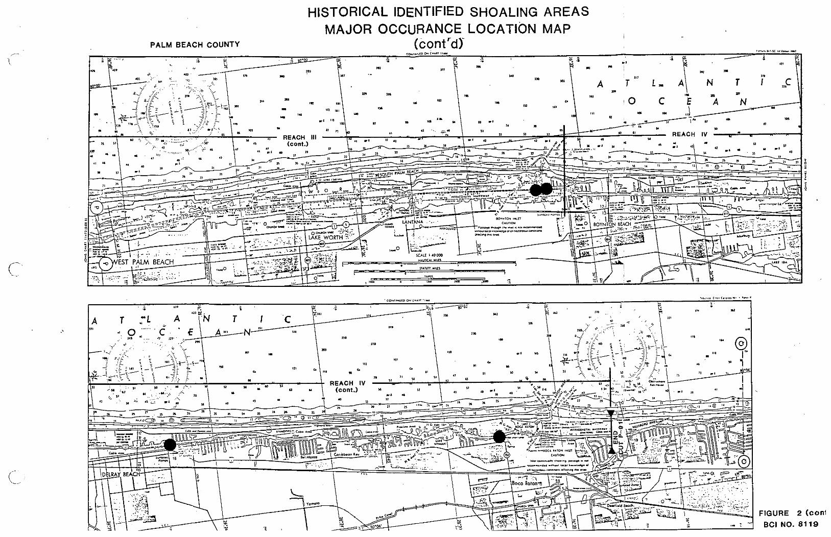
HISTORICAL IDENTIFIED SHOALING AREAS MAJOR OCCURANCE LOCATION MAP -
PALM BEACH COUNTY (contrd)'-
* : 0
- - - z - - i
a
FIGURE 2 (con1 BCI NO. 81 19

COE & F.I.N.D. EXISTING DISPOSAL AREAS LOCATION MAP
- EXISTING DISPOSAL AREA LOCATION
A- COE BEACH DISPOSAL EASEMENT
FIGURE 3 BCI NO. 81 19
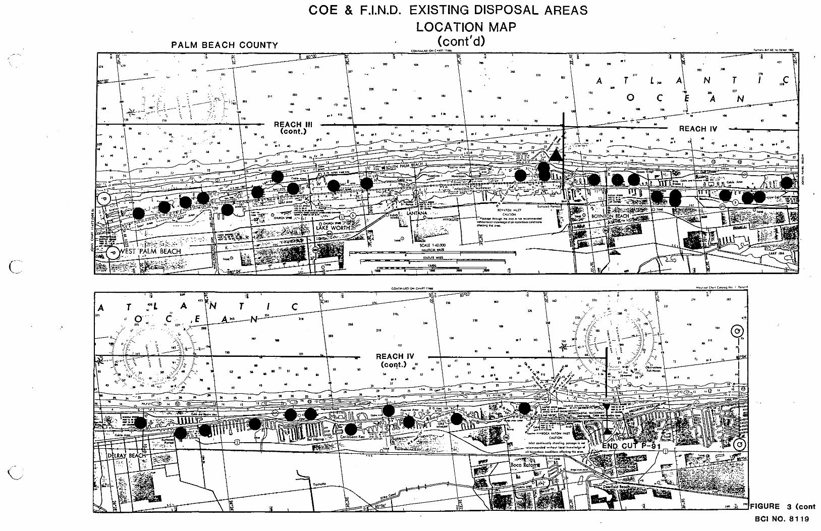
COE & F.I.N.D. EXISTING DISPOSAL AREAS LOCATION MAP
(cont'd) PALM BEACH COUNTY
I "I
2 g e a
BCI NO. 8119
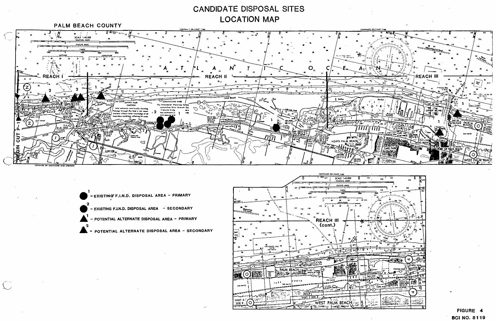
CANDIDATE DISPOSAL SITES LOCATION MAP
e2 - EXISTING F.LN.0. DISPOSAL AREA - SECONDARY
A - POTENTIAL ALTERNATE DISPOSAL AREA - PRIMARY
& - POTENTIAL ALTERNATE DISPOSAL AREA - SECONDARY
FIGURE 4
BCI NO. 8119
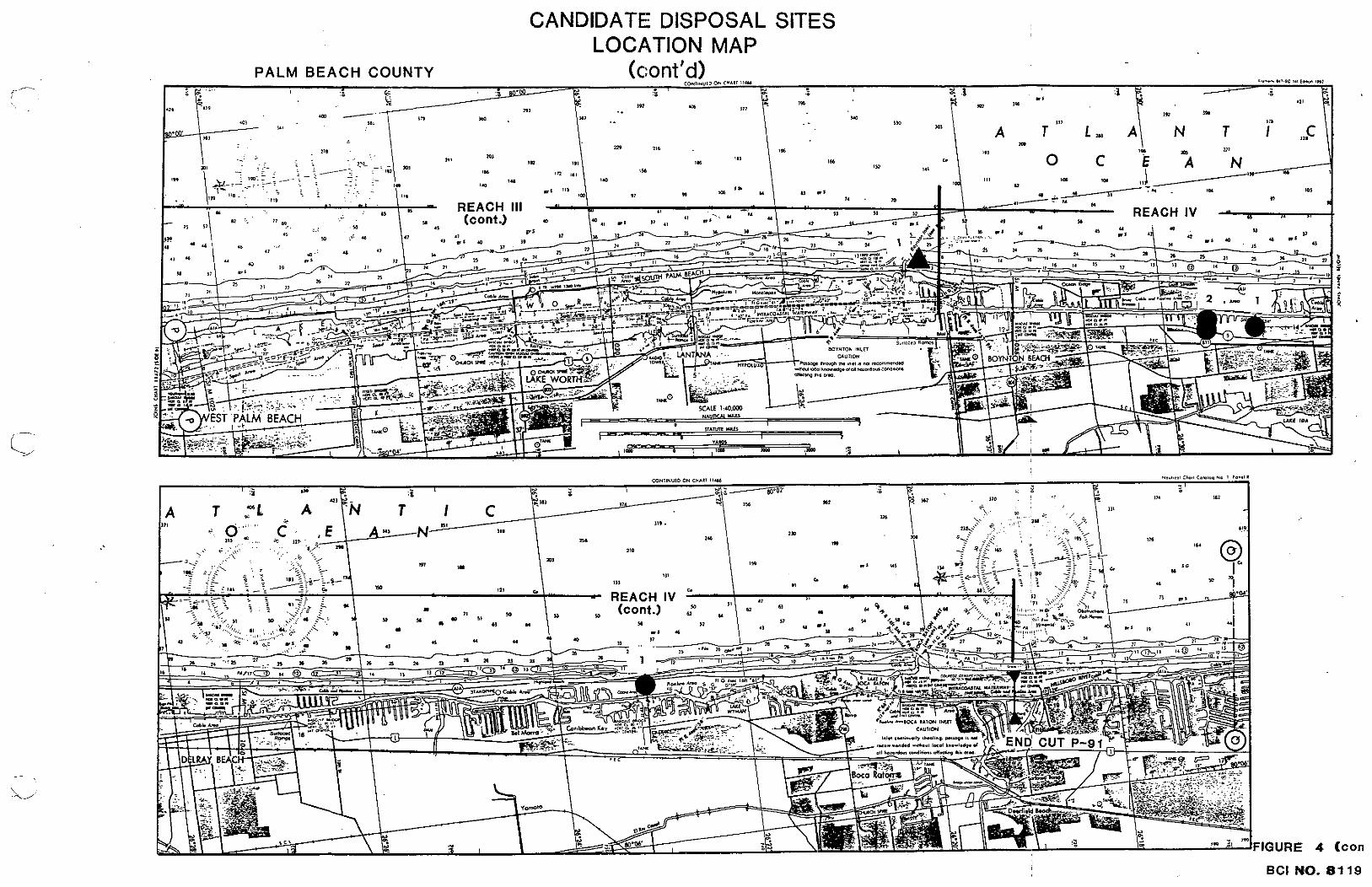
4 (con
BCI NO. 8 1 19

INTRACOASTAL WATERWAY MILEAGE CONVERSION PALM REACH COUNTY
CUT NO. CUT END STATION
AIXW ICWW MILEAGE MILEAGE
BEG IN END BEG IN END
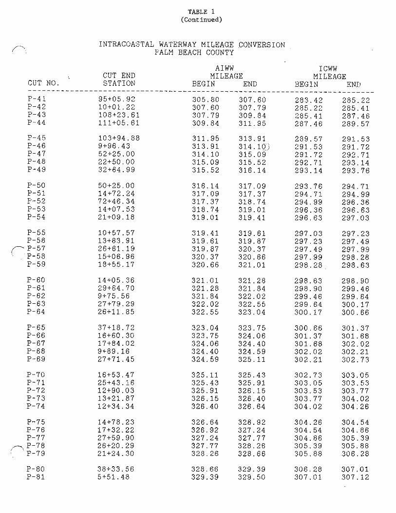
TABLE 1 (Continued)
1NTRACOA:STAL WATERWAY MILEAGE .CONVERSION PALM BEACH COUNTY
CUT END S T A T I O N
A 1 WW ICWW MILEAGE MILEAGE
BEGIN END BEG 1 N END CUT NO.
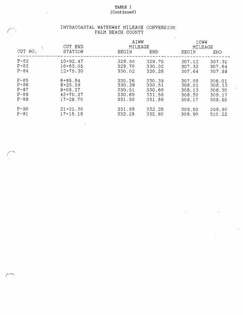
TABLE 1 (Continued)
I NTIiACOASTAL WATERWAY MILEAGE !:ONVERSION PALM EEACH COUNTY
CUT END CUT N O . STATION
AIWW ICWW MILEAGE MILEAGE
BEG I N END E,EG I ?I END

C
W
_1
E "7
OC
m
. w
m
C N
- aw
n
=-I-
-,- I
LL
= a
O
DC
t3
t
L,
+N
-
-0
r "7 c
m
U
N-
-
8 a W
a
;I, -- =
=
- = U
=
I -
U
a
W
PC
I-
,
I
,.
I
, u
,
I--
I
I rv
3- 2
t
I D
:
1>
1
1-
1
o 0
I
>I
I
E L
S
< h
I--
, m
0 ... I",
. I
,at-
, 8
- 0
8 ,
a1
m
I
L,
m
,
m,
m
-
8 a
t,
I
>;
0
0 o
+
0 4
4.
8
,0
07
0
o
- ,C
.
r .
IC
I
e
1 =
1
1-
8
a
0 0
I m
o
8 a
,
+
Is
m
I
PI .
to
.
3 0
L.w
I
P,
IY
il
I
a
IU
I
"7
I
.I
,
... 8
,=
a
h
m
10
I
CS
I
N
IZ
I
1-
1
c4
I
.I
I
." ,
1x
1
h
m
! E
,
ox
I
N
11
3
1 tY
... 0
,a
n
, -- -- ,_
_ _.
__ _- __ __
8-
8
8-
0
I-
U
I
8-
-
r
19
. I
am
.... I 0
00
0 I 0
tm
?-
I
"7
I IF
I4
8
.-
-
8 4
,a
m 0
Is,? 0
I
IW =
I
,L
O,
, m
. I
m
, L
,m
I
-0
4
,m
a
4-
0
8 0
10
I
-I
+
I
-8
-
I*
th
,
07
1.
0
0.
, -
0-
4-
t
I ,
,a
n
u;
8
-1
0
I
to
I
CC
I
+
IO
LO
I 0
IL
.
t r-.
IY
C
I .
I s: -7
I a
8 -
8
,.
..
IC
o
r*
.
10
1 -
t
I
m
,_
IN
0
.4
,
1-
3
I
.I
,
..
.I
n,
,
,=
, -
I e
I Q
1
03
1
m
IL
3 I
N
ILL
- I
1-
1
Ch
hP
-h
m
mm
mm
Z
ZZ
ZO
-
hh
hh
O
ui
GG
r;
&
mm
mm
m
NN
NN
N
~,
""
7*
1m
.
GS
Sh
h
mm
mm
m
CV
NN
NN
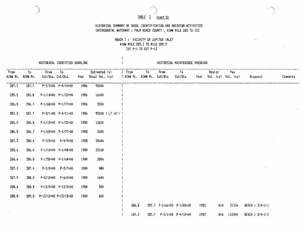
- - ..
, - - - -
, -
8-
I...
Y
,- - I_
.
,w
-
I.-
0
< m
>
16
8." - ,.-
* ,rn
0
IW
C
I
m
m
I
5:
L
_I
,
m
as
w
0,
-
I
I "
7,
. -- - - - -
0 0
0
n
0 -
e
N
NN
m
*
m
m
m.
a
..
0
0
0 0
+
+
a a
. *
*
.
, -
a
I b
0 0
0
0
+
+
LO
0
..
C)
.
8 .
a
I a

, -
I ,.
,C
"
3 m
-
, .A
I,"
- ,a-
,a 0
I
>
Y
i
Z,
-
, L
E:
:
"z
,>
0
I
w,
U
0
Z
I
w,
2
1 IT1
W
I a.
+
00
-
Z
I+.
-8
-
an s
EO
U
_I
I
G
8
UI
rn
O
,E
rn
+.
to
.
LO
8
b.W
-
ILL
3
II
U
, .
: T
1
0
I+
. I
D =
2 - , a
!
ii
ii
ii
ii
ii
ii
g
gg
gg
gg
gg
gg
g
Nc
"N
NN
NN
--
--
00
0
mm
mm
mm
mm
mm
mm
mm
0
.-
-0
-
,-
--
LZ
SL
LL
LE
LE
F-
r. m
ao
~m
m"
,a
mm
o
d<
$d
<d
dd
"i
<h
4d
d
mm
mm
mm
mm
mm
mm
mm
N
NN
NN
NN
NN
NN
NN
N
",
mN
N"
,D
mN
Nm
",
NN
D
d<
"i
di
i&
Gb
iK
<h
ii
,i
<
mm
mm
mm
m
mm
mm
N
NN
NN
NN
%%
%N
NN
N.
HlSTORICRL SUUMRRY OF SHOAL IDENTIFICATlON AND DREDGINI ACTIVITIES INTERCOASTAL WATERWAY : PBLN BEACH COUNTY , AlWW MILE 285 TO 333
REACH I : VICINITY OF JUPITER INLET AIWW HILE 285.2 TO MILE 289.5
CUT P-1 TO CUT P-13
HISTORICAL IDENTIFIED SHORLING HISTORICAL NAINTENENCE DREDGING
From To From To Estimated (I) : Fro@ To From To Design Pay RIWW M i , b1NW Mi, CutlSta, CutlSta, Year Shoal Vol, I c y l I AIWW tfi. RIWV Ui. CutISta CutlSta Year Vol. I c y ) Vo1. I c y ) Disposal Comments
1 287.3 287.7 P-313t50 P-4110t00 1979 NIR 118800 BERCH : Nlb 16' DESIGN DEPTH
207.2 287.7 P-2125t50 P-4111t00 1975 NIA 154000 BEACH : HDA-3 14' DESIGN DEPTH
SHOAL ABOVE 12'
28b.4 28h.7 P-llb4t00 P-1177tO0 1972 40500 BEACH : OIR-J-1
287.2 287.3 P-2123t00 P-312t00 1972 3300 BEACH : OIA-3-1 /-
287.4 287.7 P-3lBt50 P-4111t00 1972 i 33000 BERCH : 010-J-2 !
287.9 288 P-4121t20 P-bl2tSO 1972 1 12000 BEACH : OIA-J-2
287.3 287.7 P-31350 P-4111t00 1969 Nlb 50500 BEACH : MDA-3 12' DESIGH DEPTH
HISTORICAL IDENTIFIED SHOALING
HISTORICAL SUHNARY OF SHOAL IDENTIFICATION AND DREDGING ACTIVITIES INTERCORSTRL WATERWRY : PALM HERCH COUNTY , AIWW KILE 285 TO 333
REACH I : VICINITY OF JUPITER INLET AIWW MILE 285.2 TO HlLE 289.5
CUT P-1 TO CUT P-13
HISTORICAL HAINTENENCE DAEDGING .................................................................................................................................................................................... From To From To Estimated 11) I From To Fron To Design Pay
RIWW Mi. RIWW Ni, CutlSta, CutISta, Vear Shoal Vol. Icy1 I RIWW Hi. RIWW Hi. CutlSta CutlSta Year Vol. Icy) Vol. I cy ) Dispnsal Comments
1 287.3 287.6 P-314tOO P-415tOO 1968 28000 BEACH : DIA-J-2
1 287.4 287.5 P-3110t00 P-413tOO 1967 31500 UPLND : NSA 602
I 287.3 287.8 P-312t00 P-4/16+20 1965 24000 UPLN0:HSA 602&602A
1 287.3 287.6 P-313t00 P-417t00 1964 21800 BEACH : MSR 626-1
1 287.4 287.5 P-3lht00 P-414t00 1963 46000
1 287.1 288.4 P-2/lbt90 P-1110t00 l9bl 134000 ORIG. 10' OREDG
m.
I
IY
-.
,0
O*
**
OO
OO
OO
O*
~
aP
10
00
00
0O
O0
00
00
00
~
>,
-O
Y,
N_
;~
;~
-~
MM
n
z I
aN
m-
-D
0
*
.* - ,
N
,., -
um
I
YIP
I
wc
, '
-1

l
Yl
l
,a
1
l
rl
4
Dl
!
t S
t
8 E
l
10
1
,U
,
f I
8-
3
0 m
,
1 "
a1
0
03
0
-3
0
"7
,
IS
;
9-
,
I
,.I
J U
I
I_
--
I
I m
ta
h
10
3
1-
1
,-
,
I2
1
,= Y
I
/mu I
8 .A
,Y
l .
, I
*^
,
10
0
I
,a
,
0 L
O
, -
8
l
Dl
,
,>
,
I 1
-1
8
-1
,
Dm
, 8
-1
,
,a
,
3 =
,
,U
S
I
mt
,
a,
IE
LD
I
ID
.
3 ,L.+.
1 ,L
L =
,
8 c.,
, ,
.,
I
iz
I
ED
8
I
11
1
,a
0
I
.I
,
.A
8
,=
I
1 %z
0
I
IL
X
I
,L
L-
0 q
a,
(._
..
,
9-
,
I-
>
I
'4
2
, , - ,-
. ,
,a-
, 1
- a
I
,m
>
I
4 = 8
."
I
IC
m
I
I#
"
0
I
IW
C
I l
co
l
0 L
C
, m
,
l P
ll
v
>r
-0
00
m
mm
m
aa
aa
-
-*
-

I
WI
.
YO
m
-
1-
-
10
7
P
80
.
Y
or
."
a0
= -
8-
2,
.
rn
"
,=+
-
,nV)
CT
,L.
0
,Y
- -
2 3
22
;-
I
.I
!
HISTORICAL SUMMARY OF SHOAL IDENTlFICATlON AND DREDGING ACTIVITIES INTERCOASTAL WATERWAY : PALM BEACH COUNTY , AIWW MILE 285 TO 333
REACH I11 : LAKE WORTH REGION A I W W HILE 297.0 TO NILE 317.1
CUT P-32 TO CUT P-50
HISTORICAL IDENTIFIED SHOALING HISTORICAL MAINTENENCE DREDGING ..................................................................................................................................................................................... From To From To Estimated 111 I From To From To Design Pay
bIWW Hi. AlHW Ui, CutISta, Cutlsta, Year Shoal Vol. Icy1 I AlWW Hi. AIWW Mi. CutlSta CutlSta Year Vol. Icy1 Vol. Icy1 Disposal Comments .....................................................................................................................................................................................
305.8 307.8 P-41 P-42 1984 5500 lC.L.1 :
307.8 309.8 P-43 P-43 1984 800 1C.L.I I
299.7 299.9 P-34 P-34 1982 1900 IC.L.1 I
299.7 299.9 P-34 P-34 1982 2011 1C.L.) I
300.4 301.0 P-35 P-35 1982 900 1C.L.I
301.0 303.0 P-36 P-36 1982 2700 IC.L,1 I
303.0 304.4 P-37 P-37 1982 200 (C.L.) I
303.0 304.4 P-37 P-37 1982 3100 lC.L,l I
307.8 309.8 P-43 P-43 1982 300 (C.L.1 I !
307.8 309.8 P-43 P-43 1982 b0O (C.L.) I
307.8 309.8 P-43 P-43 1982 1900 lC.L.l :


HISTORICAL IDENTIFIED SHOhLING
, TABLE 4 l c o n t ' d ) - -
HISTORICAL SUMMARY OF SHOAL IDENTIFICATION AND DREDGING ACTIVITIES INTERCOASTAL U ~ T E R N A Y : PALn REACH COUNTY , AIWW UILE 285 TO 333
REACH 111 : LAKE WORTH REGION A I W W MILE 297.0 TO UILE 317.1
CUT P-32 TO CUT P-50
HISTORICAL MPINTENENCE DREDGING
-------------------------------------------------------------------------------------------------------------------------------------------------------------------------------------. From To From To Es t imated 11) I From To From To Design Pay
RIWH Ui, AlNN Ui . Cu t lS ta , Cu t lS ta . Year Shoal Vol. I c y ) I AIUW Ui. AIWW Ui. C u t I S t a C u t l S t a Year Vol. ( c y l Vol . I c y ) D isposa l Comments
1 301.5 303.7 P-36127t80 P-37/37+50 1962 MIA
1 303.9 305.1 P-37147t00 P-39/6+50 1962 NIA
\ 30b.3 311.4 P-41/29*00 P-44183t00 1962 NIA
1 311.6 315.3 P-44193t00 P-48113t25 1962 NIA
1 315.7 316.6 P-49111t50 P-50124t00 1962 NIA
I 316.3 322.5 P-52110t00 P-63126t62 1962 NIR
1 296.b 301.3 P-31/16t20 P-36115t50 1961 105000
ORIG. 10 ' DREDGII
ORIG. 10 ' DREDGII
ORIG. 10 ' DREDGII
ORIG. 10' DREDGll
ORIG. 10 ' DREDGII
ORIG. 10 ' DREDGII
ORIG. 10' DREDGII
r.
-,
.*
--
m
mm
mm
P
'z
zz
a

d
8
=I
+
,-,--'n
'n
'n."'n
-
'n
a'n
a'n
,---a
O
DD
--
D
D0
O0
"
.D
."
W0
0
m-
0-
"
'"
"Y
W
WW
W,
W
IY
ZY
-=
==
I Z
IZ
ZZ
Z
ZZ
LL
d
Id
-8
Z
ZZ
=Z
L
-0
>
-
0 >
>
>>
>
>
>
*
- *-
- 8
t tt
- 0
2
-8
2
I%
/,,,,,
'n'n
'n,'"
'n
'n
'n
'n
'n
"
.-a
00
O
DD
--
-
OD
D-
-
00
-0
0
-0
-0
C
2I
YY
YY
W
WY
YY
Y
YY
YY
W
YL
TL
Z I==,=
I====
TZ
ZW
X
IT
ZZ
Z
=-
a>
>>
>>
>
>>
>>
>
>>
**
>
-
5
-

TABLE. 6 (Continued)
EXISTIHS SPOIL AREA INVENTORY
PALM BEACH COUNTY, FLORIOR UPDATE NO. 5 F.O. = OWNEO BY F.I.N.O.
ALL OTHERS ARE EASEIIENTS ---_____.__. ................................................................................................................................................................................................... : -...---.----.--.----.- -- - - -- -- -- -. -- - - - -. - -- - -- - -- - - -. - - -. - - - - -- - - - - - - -- -- -- -- ---- - - ------ - *. -. . - -. - -- - -- - - -- - -- - - - -. -- -. -. -. -- -. - - -. - - - - - - - - - - - - -- -- - - - - - - -- - - - - - - - -- - -- - - - - - - - - - - -- -- -- - - - - -- - - -- - - -. . . . -. - ---- - - - - -- - - -. . - -. . -. . - - -- --. - -. -- -- -. -. . . -. . - STUOY ST. N.UH AREA TRADE RERCH bSb NO. n i l € NO, NLE NO. IRC.I CO~XEKTS OYNERSHlP ERSEMEHT VRLUE POTENTlRL ----------- ---------*------ -------- -------- ------ ---------.------.--------------------------------------------- --------- -------- ------- --------------------------------------------.--------..------------------.--------
FO 627-0 1034.1 317.78 7.0 APPROVED FOR DONATION TO P.B. CNTY, YILOERNESS ISLANOS PROGRAM X NO NO ~ANGROVESIUETLANOS 630 1035.2 318.28 2.3 I NO NO RANGROVESIWETLRNOS; OPEN YATER 633 1035.7 318.78 0.8 REPUESTEO FOR RELEASE BY OWHER X YES NO AOJACENT LAND USE IMPACTS FO-634 1035.5 318.58 2.3 PROPOSED FOR TRADE TO MR. FENDER FOR OTHER SPOIL AREA X YES NO ~ANGROVESIYETLANOSIAPUAT1C 635 1036.1 319.13 3.1 X NO NO MANGROVESIYETLRNOS
FO ASS-P 1036.1 319.18 3.3 I YES NO HhNfiRnUFc - UFW FnEF . . . . . . . . . . . . . . . . . . . . . "
636 1036.1 319.18 2.7 I NO NO MANGROVESIYETLRNOS FO 63s-8 1036.6 319.68 5.6 LEASED TO CITY OF SOYNTON BEACH FOR REC'L OR MUNICIPAL PURPOSES X YES NO SMALL S ITE i PROXIMITY TO RESIDENTIAL AREA FO 640 1037.1 320.40 3.0 LEASED TO TOWN OF GULFSTREAM FOR PRESERVATION X YES NO PRESERVATION AREA FO 640-A 1037.4 320.48 4.1 LEASED TO TDYN OF SULFSTREAII FOR PRESERVATION I YES NO PRESERVATION AREA
I FO 6 4 1 4 1038.0 321.08 11.5 PROPOSE0 TRADE TO SEACREST COMERC'L PROP. FOR OTHER SPOIL S ITE X YES YES GOOD SITE - MRNSROVE ON EAST SIDE; 7 5 1 USEABLE 642-A 1030.2 321.28 7.2 I YES NO PUSS. LAN0 TO SOUTH - IIAHGROVE EAST 112 j DUESTIONABLE ACCESS FO 645-C 1038.8 321.88 2.4 I YES N O POOR SITE; CONCURRENT WITH 645-0, EAST 112 MANGROVE, TIDAL INFLLENCE FO 645-D 1038.8 321.88 5.0 X YES NO POOR SITE; CONCURRENT WITH b 4 5 - ~ , EAST 112 FRNGROVE, TIDRL INFLUENCE
I V 648-A 1040.0 323.08 1.4 NO.770 ON SHEET 7 5 L Pa-35 I NO NO ROJACENT LAND USE IIIPACTS; OPE3 k1TER
648-0 1040.0 323.08 6.b HO 793 k 793E-2 0 1 SHEET 7 5 FO 650 1040.8 323.88 4.1 b51 1041.2 324.28 4.0 653-CI !042.3 325.70 8.3 FO 655-R 1043.4 326.48 4.5 N0.1370OE
FO 656 1043.0 326.08 2.8 NO. l 3606E SHEET 77; NOT ON FINO NAP; LEASED TO TOUN OF HIGHLAND BEACH FOR RECREATION AN0 CONSERVATION. PROPOSED FOR O€QlCATlOH TO PALM iERCH COUNTY WILOEkNESS ISLANO PROGRAII.
600 1044.2 327.28 7.0 I bB4-A 1045.0 328.08 20.0 PART OF SPANISH RI!!R PRRK
686, 1045.4 328.48 1.0 687 1045.4 328.48 4.0
t FO 690 1046.5 329.58 8.2 IPB-74) LEASED TO EDCA RATOH FOR RECREATIOY AND CONSERVATION 694 1047.9 330.98 5.7 OPEN WATER
X NO NO X YES NO
I YES NO
X NO NO X YES YES I NO NO X NO NO
I YES YES X NO NO
AOJACENT LAN0 USE IMPACTS; OPE3 WPTER 1 0 0 SMALL A SITE ; 112 YETLANDS WITH MPHGROVE OPEN UATER; POSS. MANGROVES; SMALL SIZE; RDJACENI LAN0 USE IMPACTS, DPEN WATER; A0JACEI;T LAND USE IM'RCTS I IANGROVESlUETLANOSlAOUATIC
HANGROVESIUETLRIIOSlAPUATIC GO00 SITE: EIOTIC VESETATICN
POOR UPLAND ACCESS ; 4 0 1 MRNSROVE OPEN UATER; PUSS. GRASS SEOSIIIRHRTEES
FOOTNOTE: MSA NO.'S OESIGNATEO UITH ' + ' ARE SUITABLE FOR DISPOSAL OF OREOSEO MATER!ALS.
EXISTING SPOIL RRER INVEWTDRY
-1 UPDATE NO. b
TABLB 6 F.0. = OYNEO BY F.I.N.D. RLL OTHERS ARE EASEHENIS PRLH BERCH COUNTY, FLORIOR
. -. . . - .-. - ---. - - --. . . -. -. . -. . - - - -- - - -- - - - - - --- ---- - - - - - - . . . . . . . . . . . . . . . . . . .. -. . -. . . -. . . . . . . . . . . -. . . . . - --. - - - -- - - STUDY ST. RIMY RRER RERCH HER NO. H E N O H E N O 1RC.I
TRRDE COMENTS OYUERSHIP ERSEIKYT VALUE POTEYTIRL
.- -- -- -- - . w
YES h9 no
YES
ENCROACHLlEYTS SOHE YETLRYOS YIMISP. DITCHES YETLRNOS, HRWGROVE k HRNATEE POTENTIRL TO0 SHRLL; NO RCEESS; BIRD HRBIIRT I N CONJUKI IO I I YI69PR, POSS. 1 PETRL PRY PRY
X YES X YES X YES
~ r n a r n i n rnuN nr ,llrlirn r n n n r r R r n r l n n I l h b k l l ' l l l I l lYH Ill J l b l l t M H IM HL I : I I t I I I I IN
PORTION USED FOR PRRK BY PRLH BEACH COUNIY
X YES I YFO I I k L i I Y f 9 X YES
YES W R v t u Y i J
WO
1 PETRL PRY PAY. POSS. HITIGATION ROOD I)CCFBR, I IP~~ND UIIIIO LI:I:U~, t l r l ONU ERST I 1 3 UPLLNO, 213 YITLRWD) L I I I I I t U RCCtLiB YETLLNOI L I I I ITED S l l E IPOSB. ERSEHENT FOR AOJACElll UPLAND1
YES W
YES w
L IH ITEO S l l E ; RESTRICTED N I S BY RESIOENTIRL RRiR; 6000 RRER TO ERST VERY L I H I I E O S I I E VOLUHE HRY BE L IMITED BY PARK OEVELOPHEWI TOO m u R SITE; POM RCCESS IN RESIOENTIRL ARER
I YES YES NO PUBLIC RCCESS: POSS. TRROE YIHcRRIHUR PROPERTIES
FO 624-E 1013.3 29b.38 2.3 . . . . . . . . 625-6 I b2b-8 RLT 1013.5 296.50 20.b
L Y - I 1014.4 297.18 57.5 LN-1 1015.1 298.18 37.9 LY-3 1016.0 299.08 15.9
O!EN YATER OPEN YRTER OPEN YRIER OPEN YATER
X YES X NO X NO X , no X NO
YES YO NO NO no
SHRLL SITE; POSS. SO00 S ITE Y Ib24 OPEN YRTER; RDJACENT TO EXISTING HARINRS; OFFSITE IHPRCTS; YATER PUOL OPEN YATER; WATER PURLITY; P M S . ORASS BEDS I N SOUTH ROJACENT LAND IIIPRCTS: OPEN YATER: ROJRCEWT CRNALS ROJRCENT LAND IMPACTS; LhREE OPEHYRTER SITE
L Y - I LY-5 LY-b LY-bR
. LY-be
OPEN YRTER OPEN YkTER OPEN YRTER OPEN YATER OPEN YRTER
EXISTING GRASS BEDS OPEN WATER; DEEP YRTER; NO SRRSS BE05 APPRRElil OPEN YRTER; DEEP YATER; NO GRASS BE05 RPPRRENT OPEN YATER; DEEP YATER; NU SRRSS BEOS RPPRRENT OPEN YRTER
L Y - 1 LY-8 LY-9
Ill LY-96 north . LY-PC
OPEN YRTER OPEN YATER OPEN YRTER OPEN YRTER; 110.638 OPEN YRTER
OPEN YATER BETYEEN ICY RND SPOIL ISLRND OPEN WATER WJRCENT TO SPOIL ISLPYO SPOIL ISLRNDS Y l I H l W A M ; Pf f iS. GIRD HRBITRT
OPEN YRTER OPEN YRTER: NO. I - 9 1 I E OPEN YRTER P IPELINE ERSEHENT I 0 BEACH OPEN WATER
X NO X NO x no X YES X YO
L I T T L E NO
L ITTLE L ITTLE
OPEN YRTER WITH RCCESS FROH UPLAYO OPEN YRTER; SHRLL S I I E POSS. ROJACENT LRNO IHPACIS; RESTRICTEO RCCESS FROn UPLRND KEEP PIPELINE ERSEIKNI OPEN YRTER
OPEN YRTER OPEN YRTER OPEN HATER OPEN YRTER OPEN YRTER
OPEN YRTER OPEN YRTER POSS. GRRSS BEDS OUE TO SHULOY YRTER DEPTH AOJACERT LRYD USE IHPRCTS; S I I E ; POSS. GRRSS BEDS ROJRCENT L M D USE IHPACTE

. ", ,, -
8,
. = ,#
g 2 * u
, .# .=
; I
- ", 3 e
- w
. ", 8,
2
L L
::
- ,,
'" = =
-
> - :I
", - - -
5
- - 38
=
0, - =
8,
z s s
%
u
8, =
==
=
z "
08 =
,,
I "I+
-
2
- - - ,, r a,
I s
u- w-
:: S# ' 8,
2
,'- . - :I
sg
g
'
i - 2
3, ---
=
. 2
51 &
=
u ", =
=
2 u
, =
c
Y
/j m
= =
=
- =
c
- ." m-
s z
I: ", .-. -
= =
=
-- m
II
DI -
= .-
*.-
-
= u
2
.,-m
",=
-
==
=
5
- ==w
w=
",'
- - - ,- I
E
.- ur =
%=a::
w
-c - -=
0
= =
8
=
- =
",-.- 0
u
kz >--o.
~B
"Y
I
e =
-----
-=.-
", =
=
I
=m
U
=..=I .-
.-2zs-
e
U,,," mu>,-
u
UE
UU
1
55
5
="Z;t
530I- '
'e-'
>
=-
=-
m
e=
- t
- 1 -
+_
=
E:C'Z
B g
gs
g
I " ._
-\ "
7 <
g
g
:=
.>
-. ____
8 ---a-
"7
m",
lBB91P EB4E8
ZP
ZS
S 4ESEf B
*-
==
--a2 2
=-
==
122-'2
Y2=-"' EDBH.3 -",LC'
- 8
--=,"-
w .-=
=
,---=
=
L.8 u
2=*2
,=
==
==
8
= c- .-.-=
=
wu-",
*
8, , ..2..
ZU%D
' a .-.-2 2
==
. .
I"
'"
"",
m",-..- -=
-", --"A",
"
5 ..z:
,UU'W",
u",-=
.x
.-='+
.. '>..'W
", ",-c"",
II ,>>*>5 >5",>> -2--*
==
==
>
>
w ..
"I -
u
,a 8 ---0-
=-
>>
a
,a ", 0 0
,, :
%-
%-
%
g&
gg
2-2"
gz"=
g
f "--- =
=
=
a ,, ,,
s=
=-
==
===-"A 0",-0- ---"I=
=
1 <
=-=
=
= - =
=
a=
==
==
5
5X
h%
g
Ez
z?
2
ZF
%$
S
S
= 0 =
<
= ", =
=
I: I
TABLE OF CONTENTS
APPENDICES
Disposal Site Evaluation Data Sheets
for Primary and Secondary FIND Sites
Disposal Site Evaluation Sheets
for Primary and Secondary Non FIND Sites
Disposal Site valuation Sheets
for Remaining FIND Sites
Candidate Disposal Sites Bank Summary
Information for Existing FIND MSA1s
Candidate Disposal Site Bank Summary
Information for Non FIND Sites
Survey Data Collection System Summary
USDA Soil Survey Sheets
Typical Sediment and Water Quality
Data by Reach
l- Agency Contacts
,
Appendix A-1
Appendix A-2
Appendix A-3
Appendix B
Appendix C
Appendix D
Appendix E
Appendix F
Appendix G

; LaR i?A INLAWO N R V I S A i i O N A i D I S T R I C T - F I N D DISPOSAL S i i E i i S T i N G - F I N D S i i E B C I FROJECT M. 3119 ,
EST. EST. GROSS VOLilf lE E X I S T I N G DEPTH VOL. OF DISPOSAL T O i A L DISPOSAL 3 U F i E R AVRIL . OF SURFRCE OF CONPACTED D E F I C I E N T VOLUHE
DISPOSAL A i i i i i RREA AREA AREA G1i;i i i E V . EXC. E I C . S O I L F I i i CAPACITY AREA (acres1 (acres! [acres! (ac res ) ! cv l I f t - H S L ) Iftl L i v l I c ' i i l c ~ l
----------- ------- ------- ------- ------- ------- --------- ------- ---------- --------- -------
RSR FO 010 ano 6 . 1 24.5 11.5 13 58.330 4 2 17950 60380 108510 RSA FO b l l R i o r i n a r r :
14 #Sh i s 620E 14 6 . 6 7.9 31.990 11.5 6.5 31536 - 38405 (p r imary !
REACH 111 b --------------
C L i - 9 ~ i 3 . 8 12 - 12 N I R 0 NIA N I A NIA 203061 Iseconoarv!
LW-'?A 32.6 23 . 23 N I A 0 N I A N i b # / A 20000+ Lsecon6arv1
REACH I'i
RSA iO546Ib40k 15 15 8 i 42,800 5 3 8800 33000 47660 i;econdarvl.
PW, - lbx%@ thbzrkl lSmqa~& Plan - m . - - ( - m ' Y
Preliminary DispasdL Site EvdLuaticn
Si te ~esign&ion: FDJDSiteNo. 609 , [XI Easement, [ 1 Ownership
Laxtion: NE Quarter'of NE w d r a n t , S e d i o n x , R a n g e x E, Tawn. 41 S
Description: 200 x 1300' strip adiacent to ICW & MSA No. 609A
Total =ge: 6.5, Funping D i s t a n c e ( f t ) Min. 450, Max. - Pipeline (ICW) Access: D i r e c t - no obstructions
Uplard A c c e s s : Good - road on N. end that is 1/2 mi f m US 1.
Surficial Soils: 80% ScB (St. Iucie Sand)
M i s c . : Combined area w/ 609A is 26.53 Ac. - Good site
E h ' *: Wetlands: Gxbm in N. half, f r i m e of mawroves i n extreme southern
Wildlife Habitat: &; saub-Fla. Mouse; ?bmmve-Wadim Bi rd s ; Gxbm-Masmtee
Surface W a t e r :
Ground Water: L/
Archaeological/Kistorical Sites:
Regulatory Authority/permit R q r h m m t s : Scrub-PDerm; Mammves and Gxbm FDEFLCOE,
Mix. : LNR, U.S. Coast Guard
Jupiter
S o c i o - ~ c / P 1 a n n , i n g : Cur ren t Land U s e (FLUCCS) : 622 1Kancmvel:413 (Sand Pine Scrub1
P l m Land use: Adjacent land Use(s): V a c a n t W A 609A to the east) ICW to W e s t
Cmership: J. Co?3~1llv, J. F o m , P. Gzace Zoning: R2
Assessed Value (tax records) : $96,376 Apart of 23.58 A c Parcel
M i s c . :
W/609A Oxbm
Preliminary S i t e Ummcterizaticm: X Potential Disp3sdL S i t e of 6.5 Acres
[ ] L i t t l e Potential D i s p o s a l S i t e Due to
[ ] N o Potential D i s p o s a l S i t e Due to [XI Potential Trade Value, Acres a t Estimated $ /acre
Map/Aerial Photcgraph: [ ] Attached [XI Available, Scale 1" = 2400 it.
C N/A - Not Applicable N/C - Not Campleted

F'IND - M a t e r h l %Sanxpa Plan -Fstezway,---mw
Preliminary JXqaal Si te Evaluatim
Site ~esigrdtion: FINTI Site No. 609A , [XI Easement, [ 1 Ownership Location: NW Qarkr of Quadrant, Section 17, Range 43 E, Twn. 4 1 S
Description: Mlard -1 adiacent to 609
~~: Total Acreage: 20.03, Armping Distance(ft) Min. -CS&,, Nax. - Pipeline (ICW) Access: Good - provided MSA 609 is kept
Upland Access: Good - existh dirt road on N. edcre is 1/2 m i f m US 1
Surficial Soils: 90% ScB (St. Lucie Sand) ; 10% Tidal Swam, Bassher fine sand.
Misc. : QAB cruartz ip saments (sand)
Ehv-: Wetlands: m y be nm-unmes in extreme south borderh ICW
Wildlife Habitat: .?-Petal Paw-Paw (erdamered plant) Iawwn; R&E scrub sc€cies mss. Surface Water:
Gmund Water:
ii ixchaeolqicdL/KistoricdL sites:
Rqulatoq Authority/permit Requirements: Scrub - P-Derm; 1~amrove-5 - F'DER. alE. DNR
Misc.: Four - cetaled Paw Paw knm on site; IMY be transolanted?
(Jupiter) S c c i o - ~ c / P l a r m i n g : Current Land Use (F'LUCCS) : 413 (Sand Pine) ; 622 fManqrove1
Planned Iand Use:
Adjacent Iand Use (s) : Residental to South. vacant to E, W. N
cNmxship: John C o ~ l v , J. Furran, P. Grace Zoning: R2
Assessea Value (tax mrds) : $1,187,200 A Dart of a 22.4 Ac Parcel
Misc. :
Prelimirnry Site ~ ~ t i c m : X Patential Disposal Site of 20 Acres
[ ] Little Potential Disposdl Site tue to
[ ] No Potential D i m Site lxle to [XI Potential Trade Value, Acres at Estimated $ /acre
Map/Aerial Pfiotcqraph: [ ] Attached [XI Available, Scale 1" = +400 ft.
i/' N/A - Not Applicable N/C - Not Capleted
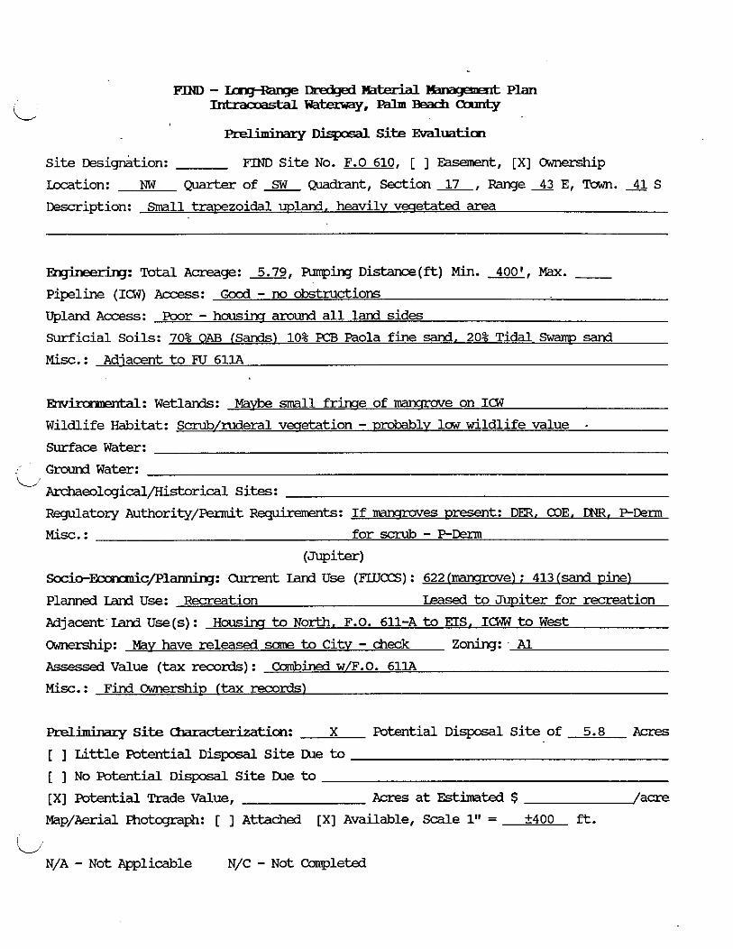
- rmdqd lBnagemart Plan Inhraooastalm-.---
m i m i n a r y Dispcsal Site M u a t i o n
Site ~esig&tion: FIND Site No. F.0 610, [ ] Easement, [XI Ownership
Location: NW Q u a r t e r o f a Q m d r a n t , S e d i o n L , R a n g e 4 3 E , T o w n . 4 1 S
Description: Srnall tracezoidal upland, heavily vecretated area
E@merbg: Total Acreage: 5.79, Armping D i s t a n c e ( f t ) Min. m, Max. - Pipeline (ICW) Access: G c d - no obstructions
Upland A c c e s s : Poor - hausins aruund al l land sides
Surficial Soils: 70% OAB (Sands) 10% PCB Paola fine sand. 20% Tidal Swam sand
Misc. : Adjacent to Fa 611A
-: Wetlands: MaW small f r h e of rcansrove on ICW
Wildlife Habitat: Scrub/ruderal vecretation - urobablv law wildlife value . Surface Water:
: Ground Water: C
Anhaeollogical/Historical Sites:
Regulatory Authority/~ennit -ts: I f mlmr~~es ~ m t : DER, COE, DNR. P D m
Mix. : for scrub - P-Derm
(Jupiter)
Socio-F 'c/Plan&g: Current Land U s e (FLUCCS) : 622 hawrwe) : 413 (sand pine)
Planned Land Use: Recreation Leased to Jupiter for re re i t ion
Adjacent'Lani U s e ( s ) : H o u s h to North, F.O. 611-A to EIS. ICW t o W e s t
Cwmxhip: May have released some to CitV - check Zoning: - Al
Assessed Value (tax mrds) : Cambin& w/F.O. 611A
Misc. : Find Ownership (tax records)
aeliminary Si te Chracterization: X Potential D i s p o s a l Si te of 5.8 Acres
[ ] Lit t le Potential D i q x s a l S i te Due to
[ ] No Potential D i s p o s a l Si te Due t o
[XI Potential Trade Value, Acres a t Estimated $ /acre
Map/Aerial Photcqraph: [ ] Attached [XI Available, Scale 1" = +400 ft.
- N/A - Not Aplicable N/C - Not Campleted
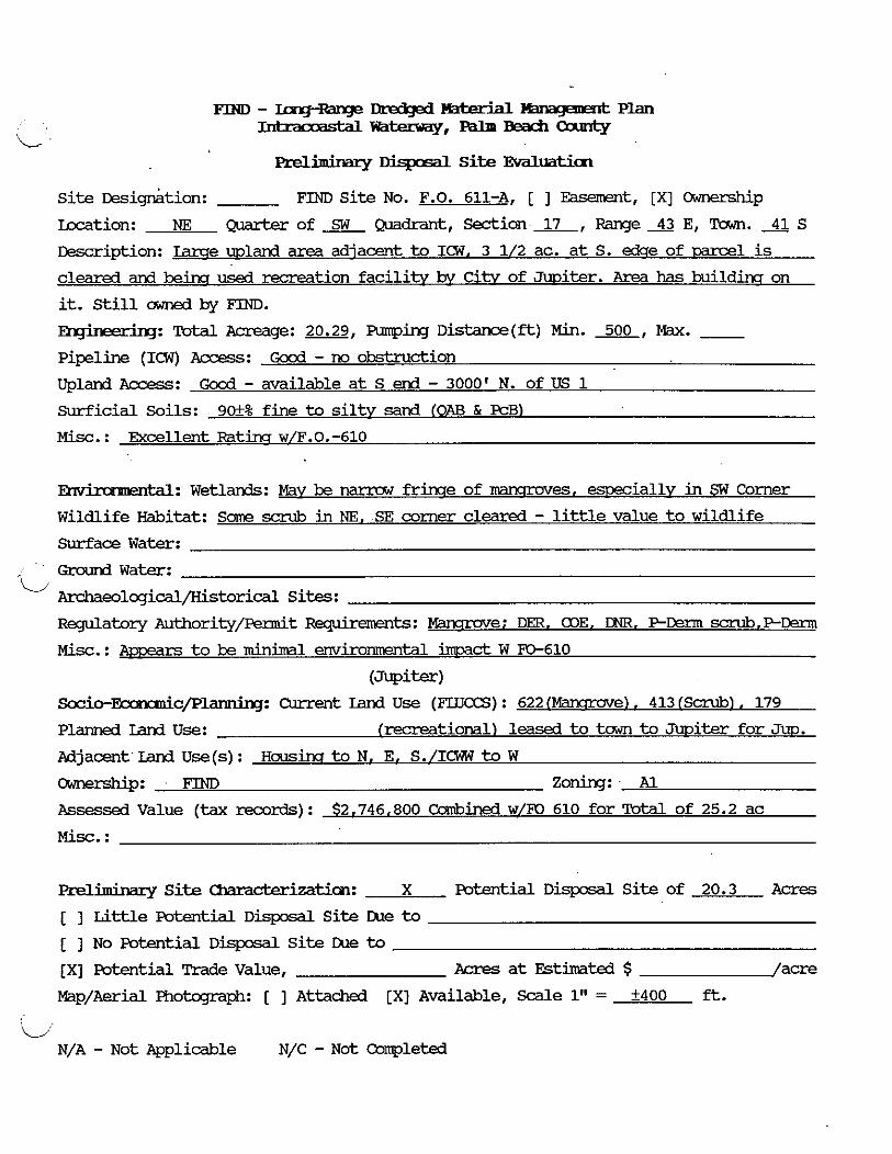
. . PrellrmMzy Disposdl Site Evaluaticn
Site ~esig&tion: FIND Site No. F.O. 611-A, [ ] Easement, [XI CXmemhip
kcation: NE ~ o f ~ ~ d r a n t , S e d i o n x , RangeXE, Tawn. 4 1 s
Description: m e mland area adjacent to ICW, 3 1/2 ac. at S. W e of m l is
cleared and b e h used recreation facili* bv Citv of Jwiter. Area has buildins on
it. Still cwne.3 by FIND.
A lg: Total Acreage: 20.29, Furping Distance(&) Min. 500, Max. - Pipeline (ICW) Access: Good - no obstruction Upland Access: Good - available at S end - 3000' N. of US 1 Surficial Soils: 9M% fine to siltv sand (OAB h FCB)
Misc.: Excellent R a t k w/F.O.-610
EnvirowPntdl: Wetlands: Mav be narrow f r h e of ~rawmves, esoeciallv in SW Corner
Wildlife Habitat: Same scrub in NE. SE comer cleared - little value to wildlife Surface Water:
Ground Water: i/
Archaeologicdl/Historical Sites:
Regulatory Authority/lk?dt Requirements: Fanamve: DER. COE, DNR, PDerm scrub. F D e r m
Mix. : Awsars to be minim1 environmental immd W FO-610
(Jupiter) S o c i o - ~ c / I ? ~ : Current land Use (FLUCCS) : 622 (Fanamve) . 413 (Scrub) , 179 P l m Land Use: (recreational) leased to tawn to Jwiter for Jw.
Mjacent Land. Use(s) : Housh to N, E, S./ICW to W
-P: FIND Zoning: Al Assessed Value (tax records) : $2,746,800 Combined w/FO 610 for Totdl of 25.2 ac
Preliminary Site clma&erization: X Potential Disposdl Site of 20.3 Acres
[ ] Little potential Disposdl Site Cue to
[ ] No Potential Disposdl Site LUe to
[XI Potential Trade Value, Acres at Estimated $ /acre
Map/Aerial Photcgraph: [ ] Attached [XI Available, Scale 1" = +400 ft.
C N/A - Not Applicable N/C - Not completed

Prelimkxy Dispcsal Site E v d l u a t h
S i t e ~esi&tion: FTND S i t e No. F.O. 620B, [ ] Easement, [XI Ownership
Laxtion: SE @ . a r t e r o f ~ Q ~ d r a n t , Section&, R a n q e s E , Town.41S
Description: Rect-ar -1 on e. s h o ~ ICW, with m k f ac i l i t i e s (Juno Park)
~ ~ i n g : Total Acreage: 13.97, Funping Distance(&) Min. 650, Max. - Pipeline (ICW) Access: GcxA - No obstructions
Upland A c c e s s : Excellent - Ellison-Wilsa Road adiacent east
Surf ic ia l Soils: Excellent - 60% Al l : Arents [SP) 40% PCB Paola fine sand (SP)
Misc.: About 7.7 acres undwel& - No adjacent lands available fo r exwnsion
Env ' ' al: Wetlands: None amxicent
Wildlife Habitat: about 40% cleared - m k faci l i t ies . remainder awse i s t o be
Surface Water: disturb& mlands
Ground Water: ' L A
Ar&aeolcgicdl/Historical Sites:
Regulatory Authority/Permit -ts: None
Mix. : Good site fmm enviromtal staxboint
Socio-F 'c/Planninq: Ouwlt Land U s e ( F L U E ) : Juna Fark bu i l t w/& FTND Auth.
Planned Land Use: Park?
Adjacent Land U s e ( s ) : Housim t o N, S, E / I W to w e s t
Ownership: FIND Zoning: RM IPdLm Bch. ( 3 . 1
Assessea Value (tax records) : $2,539,879
M i x . :
Preliminary Site Umacterizatiion: X Potential D i s p o s a l S i t e of 14 Acres
[ ] Li t t l e Potential D i s p o s a l S i t e Cue to
[ ] No Potential D i s p o s a l S i t e IXle to [XI Potential Trade Value, hi& Acres a t Estimated $ /acre
Map/Aerial Photcgraph: [ ] Attached [XI Available, S d e 1" = +400 ft.
(G'
N/A - N o t Applicable N/C - Not Ccanpleted
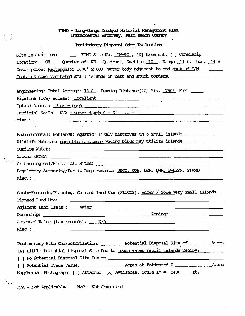
m - x a q + a g e ~ - P ~ T l t P l a n
L - m . - - - m t Y
Disposal S i t e Evaluation
Si te ~ i q r i a t i o n : FIND Site No. W-9C , [XI y t , [ 1 Ownership
m t i o n : SE Qmker of & Qmdrant, Section AL, Range 43 E, Town. 44 S
~escr ipt ion: Rectanclular 1000' x 600' water ix i i~ adjacent to and east of IW.
contains same veqe&ted small islands on w e s t and south borders.
Total Acreage: 13.8, Funping D i s t a n c e ( f t ) Min. 7501, Max. - Pipeline (ICW) Access: Excellent
Upland Access: poor - none Surficial Soils: N/A - water d e ~ t h 0 - 6' d-
Misc. :
W: Wetlands: Aquatic; likelv nmmmves on 5 d l islands
Wildlife Habitat: possible mnatees; wa diner birds mv u t i l i ze islands
Surface Water:
Ground Water: , u Ar&aeolcgical/Historical Sites:
Regulatory Authority/permit R q u k e m s t S : USG, a3E. D , CNR, P - D m . SlWlD
M i s c . :
~ocio-&c/plarming: Current land U s e (FUTCCS) : Water / Some very small Island.
Planned Land Use:
Adjacent Land Use(s) : Water
-P: Zoning:
Assessed Value (tax ream%) : N/A
Misc. :
Preliminary S i t e -ticm: Potential D i s p o s a l S i t e of A m
[x] Little Potential D i s p o s d l S i te lXle to a ~ e n w a t e r (spoil islands nearbv)
[ ] No Potential D i s p o s a l S i t e IXle to
[ ] Potential Trade Value, Acres a t Estimated $ /a-
Map/Aerial Photcgmph: [ ] Attached [XI Available, Scale 1" = +400 ft.
C N/A - Not Applicable N/C - Not Completed
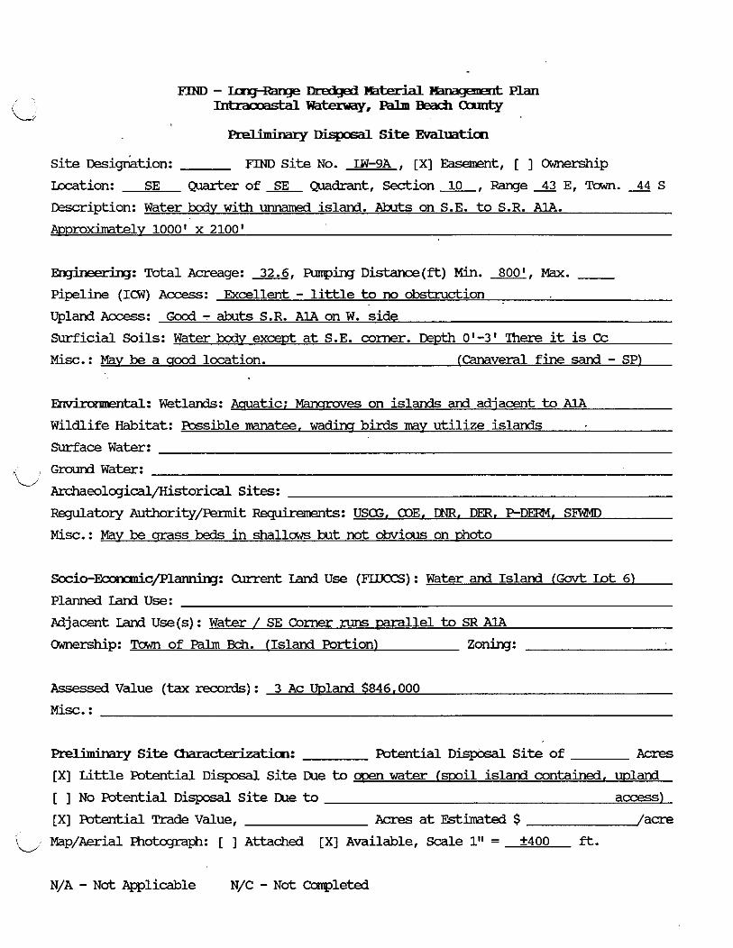
FIND - Imq+hqe Dr&# mterbl Plan -wa-,-BBacfiaannty
... . f Dispasal Site Evaluatian
Si te &sigr$tion: FIND S i t e No. LW-9A , [XI Easement, [ ] Cwmxship
Lazition: SE -of SE wdrant, Sec t i on&,Range43E ,Town .>S
Description: Water bodv w i t h unnamed island. Abuts on S.E. to S.R. AlA.
AKl~)roximatelv 1000' x 2100'
R-q-: Total Acreage: 32.6, Rmping Distance(ft) Min. m, Max. - Pipeline (ICW) Access : Excellent - l i t t le to no obstruction
Upland Access: Gocd - abuts S.R. AlA on W. s ide
surficial Soils: Water body exceut a t S.E. corner. W ~ t h 0'-3' There it is Cc
Misc.: Mav be a q o d location. (Canaveml fine sand - SP)
-: W e t l a n d s : Aquatic; Mammves on islands and adjacent to AlA
Wildlife Habitat: Possible -tee, mains birds mv ut i l i ze islands
Surface Water:
Ground W a t e r : i/
Archeolcgicdl/Kistorical Sites:
Regulatory Authority/Ennit -ts: USCG. a3E. DNR. Dm. P D m . S W
Misc.: May be crass beds i n shallaws but not drnrious on 13hoto
S o c i o - ~ c / F ' l a n n i n g : Current Land U s e (F'LLJCCS): Water and Island (Govt Lot 6)
Plarvled Land use: Fdjacent Land U s e ( s ) : Water / SE Corner runs m l l e l to SR A1A
Ckrmership: !Cmm of Palm Bch. (Island Portion1 Zoning:
Assessea Value (tax records) : 3 A c mland $846,000
Misc. :
Preliminary S i t e Chars ' ticm: Potential D i s p o s a l S i t e of Acres
[XI Li t t l e Potential D i s p o s d l S i t e lXle t o men water (mil island contained, wland
[ ] No Potential D i s p o s d l S i t e lXle to access)
[XI Futential Trade Value, Acres a t Estimated $ /acre
'- Map/Aerial Fi-~otqtaph: [ 1 Attached [XI Available, Scale 1" = +400 ft.
N/A - N o t Applicable N/C - N o t Completed

. . prellrmMlv Disposal Si t e Evaluaticn
Si te Dsiq-riation: F'IND Si te No. F.0 640, [ ] Easement, [XI Ownerskip
Location: NE Quarter of SE Quadrant, Section 4, Range 41 E, Town. 46 S
Description: Small mland -1 adiacent to and W e s t of ICW. leased to town of
Gulfstream for ~resezvation. Borders 640-A
A wring: Totdl Acreage: 3.0, Pumping D i s t a n c e @ = ) Min. -, Max. - Pipeline (ICW) Acces s : Excellent
Upland Access: Good - borders mad to S., accessible t o US 1
Surficial Soils: AX-100% - f ine sand w/ same surficial o d c s .
Misc.: Too mall. even w i t h 640-A. Ma* combine w i t h land t o west?
w e 1: Wetlands: None
Wildlife Habitat: Half cleared; half Casuarina Forest - law value
Surface Water:
i/ G r o u n d W a t e r :
Archaeolcqical/Historical Sites:
Regulatory Authority/Permit -ts: N/A
Misc. : Excellent site environmentallv
-ty Socio-~c/Plannbq: Current Land Use (FLLTCCS) : Vacant
Planned Iand Use: -tion - leased to tawn of Gulfstream
Adjacent Iand U s e ( s ) : Residential to S./Vacant to W. & N. (FO 640AI ICWW to E.
Ownerskip: FIND zoning: RM PallUBch. Col
Assessea Value (tax records) : $1,020,960 (comb. w/FO 640AI
M i s c . :
Preliminary S i t e Unracterizatim: Potential D i s p o s a l S i t e of Acres
[ ] Li t t le Potential Disposal Si te Due to [XI No mtential D i s p o s a l S i te Due to [XI Potential Trade Value, 3.0 Acres a t Estimated $ /acre
Map/Aerial Fhotapaph: [ ] Attached [XI Available, Scale 1" = 1L.400 f t .
N/A - N o t -1icable N/C - N o t Completed

m-- Lmzd@ Material & m q a w x & Plan --,---
-. . Disposal Site Evdluatim
Site oe~iktion: F'IND Site No. F.O. 640A, [ ] Easement, [XI OiJnership
Location: NE Quarter of SE ~uadrant, Section 4, Range 43 E, Tawn. 46 S Description: Small wland mrel with pi-line access to ICW. adiacent to #640
-: Tutal Acreage: 4.1, wing Distance(ft) Min. m, Max. - Pipeline (ICW) Access: Good - Parcel ~rovides direct access to ICW on N. end Upland Access: Good - Road on S. Border with access to US 1 Surficial Soils: AX - Surficial sands with orsanics M i s c . : See rtote on 640
kal: Wetlands: None
Wildlife Habitat: Half cleared, half forested minlv by Casuarina - law value Surface Water:
Ground Water: '-d
Archaeological/Kistorical Sites:
RBgulatory Authori+q/Fennit -ts: N/A
Mix. : Excellent site
-tY Socio-~c/P1larPling: Cwxmt Iand Use ( F U T a S ) : Vacant
Planned Land Use: Preservation - leased to town of Gulfstream Adjacent Land Use(s): Residential to N. & S./Vacant to W./IGW to W.
-P: FIM) Zoning: RM (Falm Bch. Co.) Assessea Value (tax mrds) : cambined with FO 640
Mix. :
F'reliminary Site ~ ~ t i m : Potential Disposal Site of Acres
[ ] Little Potential Disposal Site IUe to [XI No Potential Disposal Site IUe to
[XI Poterrtial Trade Value, hi& Acres at Estimated $ /acre
Map/Aerial Fhokqaph: [ ] ~ttached [XI Available, Scale 1" = A400 ft.
i/
N/A - Not Applicable N/C - Not Completed
m m - mq+qe Ibreclgad %Werial W a . n t Plan -='==Y,---
~ , ~ ~ . h & m r q r Disposal Si te Evaluaticn
Site ~esignition: FIND Si te No. F.O. 641A, [ ] Easement, [XI Ownership
Location: SW Qmrter of SE Quadrant, Section 4, Range 43 E, Town. 3 S
Description: UDland carel adiacent t o ( w e s t of) IW. Framxd trade t o Seacrest
Cammercial Fmrerties for other mil site.
hgineering: Total Acreage: 11.48, Funping Distance(&) Min. -EBL, Max. - Pipeline (ICW) Access: Excellent - adiacent to ICW
Upland Access : q d - unable t o confirm frmn aerial map/road map
Surficial Soils: AX - surficial fine sand w i t h u n d e r l y h orcranics
Misc. :
Envhmncmkd: W e t l a n d s : Narrow frinqe of mwroves alow ICW
Wildlife Habitat: I m value for disturbed uplands; mansrove f r h e m y be utilized bv
Surface Water: w a d h buds
Ground Water:
'i; Archaeolqical/Kistorical sites: m a t o r y Authority/Permit F&quirements: COE, DNR, DER, PDerm
Misc. : Excellent site
Gulf stream
Socio-Ecnrmic/planning: Current Land Use (FLUCCS) : Vacant
Planned Land Use: m. trade to Seacrest Commercial Prmerties for other mil site
Adjacent Land Use(s): Resid. to N./Marim planned t o S./Delrav S w a ~ ~ h o p t o W..ICWW E.
ckmmship: FIND (m vacant) Zoning: E ( s h l e family)
Assessea Value (tax records) : $975.800
Prel,bhaq S i t e Umazk%atian: X Potential D i s p o s a l S i te of 11.5 Acres
[ ] Li t t le Potential D i s p o s a l S i te me to
[ ] No Potential Disposdl Si te JXe to
[XI Potential Trade Value, hi* Acres at Estimated $ /acre
Map/Aerial Photcqraph: [ ] Attached [XI Available, Scale 1" = +400 ft.
'4 N/A - Not Applicable N/C - Not Coqleted
FIND - Inq-Rarge PIX&# Hater ia l Plan -~t-=Y,--Oaarty
Preliminary Disposdl Site EvaluatiCn
Site tksigGtion: FRiD Site No. 684A , [XI Easement, [ ] Owne?zhip
l[ocation: NW Q u a r t e r o f ~ Q u a d r a n t , S e d i o n ~ , R a n g e 4 3 E , T o w n . ~ S
Description: Lame wland -1 adiacent to (East of) ICW. Part of Swinish River
Park. Some bathroam facilities on-site.
-: Total Acreage: 20.0, Armping Distance(&) Min. 650, Max. - Pipeline (ICW) Access: Excellent to c r d Upland Access: Good - near MA. Easement or landmner rermission m i r e d
Surficial Soils: 50% AU - sand, fine sand; 50% OAB sand (SP.SP/SM)
Misc. :
' al: Wetlands: None Obvious
Wildlife Habitat: minimal
Surface Water:
, Groundwater: ' w
Archaeolcgical/Historical Sites:
RBgulatory ~uthority/Permit -tS: N/A
Misc.: Excellent site
Boca Raton
Socio-~c/Planning: Current land Use (FUJCCS) : Smnish River Park w/Parkiw lot
Planned land Use: Park (same)
Adjacent Iand Use(s): Park to S. & E./.Swnish River Blvd. to N./ICW to W.
Ownership: Citv of Boca Raton Zoning: PL imlic Lands)
Assessed Value (tax records) : $18,095,357 include Mildina
Misc. :
Preliminary Site -tion: X Potential Disposal Site of 20 Acres
[ ] Little Potential Disposal Site IXle to
[ ] No Potential Disposal Site IXle to
[XI Potential Trade Value, Acres at Estimated $ /acre
Map/Aerial Photcgraph: [ ] Attached [XI Available, S d e 1" = +400 ft.
L/ N/A - Not Applicable N/C - ~ o t Ccnpleted

, ;LORID8 iNLANU NAV!64TIDNAL DiSTRICT - FiHO E'ISPOSAL SITE i iST1NG - NONFIND SITEE YCi PROJECT NO. 8119 '
ESi . EST. GROSS VO'LUNE EXISTIN6 DEPTH VOL. OF DiSPOSRL TOTAL DiSPOSdL BUFFER AVAIL. OF SURFACE OF COHPbCiED DEFICIENT VOLLitlE
DiSPOSRL RRER ARER AREA aREA DIKE ELEV. EXO. EXC. S G i i F i i i CkPACiTY AREA !acres1 (acres1 { a c r e s ) (acres1 ic, i i ( I t - n S L I !it) i c v i ( c v ) i c v i
----------- ------- ------- ------- ------- ------- --------- ------- ---------- --------- ------- 4EACH i
BEACH SOUTH of 11 !I - !I - 2 t o -2 NIR HIA - !O!J,000 JUPITER INLET i p r i a a r v l
HERCH NORTH OF 15 15 - 15 - 2 T O -2 $!A H/R - 100,000
JUPITER INLET i s e c o n d a r v i
REACH 111 a
PEANUT 77 10 - 10 J6590 5 l 5 i kHD l p r l n a r v l
i/ BEACH SOUTH of 10 10 - 10 NIA ? t o -a PORT iHLE? ! o r l n a r v i
XERCH ii! b
DEEP HOLES i n 5 t o 20 5 t o 20 - 5 t o ?(I N!A 0 t o -20 - L a a WORTH ( o r i a a r v )
LAKE WORTI~ 97 a 4 4 10,000 5 60LF COURSE NORTX END i s e c o n d a r v i
LAKE WORTH 80 4 - 4 NIA 9 io -3 60LF COURSE SHORELINE i secondary )
REACH 111 r
- NiCl 20,000t
2 N l d N i a 20.000
L BOYNTOk INLE i b ti - 6 N l f i *2 t o -2 MIA NIA NIR 30,0001 BEaCH
S e c ~ x b q 7 Site
. . DisposdL Site Evaluaticm COE
Site Designation: MQ-2 FIND Site No. N/A , [XI Easement, [ ] Ownership
Location: Quarter of - Quadrant, Section 30, Range 43 E, Wwn. 40 S &scription: COE Each disDosal BasanerR north of Jmiter M e t entrane
Rqkerkq: TotalAcreage: 11+, AmpirgDkkmce(ft) Min. 5ooo', M&. 7ooo' Pipeline (ICW) Access: Pireline crossim at Sta . 7W28 Alt P.1 to Beach
Upland Aa!e.ss: Across undevelwed land to west or up beach f m Sauth
Surficial Soils: Beach (BN)
Misc. :
-: Wetlands: men nw3ne waters Wildlife Habitat: Beach and Near410r-e
Surface Water: Ocean; TIDAL
Graund Water: N/A
Archaeolcgical/Historical Sites: N/C
Ftagulatory Authoritypsmit Rsquirements: 03E. DER, W. FTX33-f. USCG
Misc. :
Socio-~c/p1annbq: Current Sand Use (FLLKXS) : Beaches (710) . Cmen Marine Waters
Planned Land Use: Beach Access, Recreation (5511
Adjacent Land Use(s): Residential and Park Areas
Ownership: TIIF Zoning: Uoland
Assessed Value (tax records) : Bath sides of SR 707 400 ft. wide -1 S. of Bawlim
Misc. : TIIF Deed #23851 Rock Condo $2,951,040
Preliminary Site Chmcbxht ion: X Potential D i s p o s a l Site of 1l3 Acres
[ ] W e Potential D i s p o s d l Site Due to [ ] No Potential D i s p o s a l Site Due to
[ ] Potential Trade Value, Acres at Estimated $ /acre
i/ Map/Aerial Photcgraph: [XI Attached [ ] Available, Scale 1" = 40m ft.
N/A - Not Ppplicable N/C - Not Cmpleted

- S F z r y Site
. . Pmhumry m i s s Site IWaIllaticn D/A-J-2 COE
S i te Designation: D/A+3 FIND Si te No. N/A , [XI Easanent, [ ] Ownership
Lacation: SE c8-l=t= of - Quadrant, s e A i o n 3 2 , R a n g e A E , Tawn. 40 S
&scription: COE Beach D k t x s l Easanent North of Jtwiter Inlet erkrame
hginaering: Tatal Acreage: x, Amp,i.ng D i s t a n c e ( & ) Min. m, Max. 10000'
Pipeline (ICW) Access: See MIIA-2 a t Sta. 7W28 C u t P1 then d m beach
Upland Access: See MIIA-2
surficial Soils: Beach (BNI
M i s c . : Used by COE for ~rev ious dredcriru contracts
-. M: Wetlands: cwn marine waters
Wildlife Habitat: Beach and near shore
C Surface Water: Ocean, lTW&
Ground Water: N/A
Archaeologicalpistorical Sites: N/C
watery Authority/Fermit Bykemnk: COE, DER. CNR. H)m. USCG
Misc. :
Socio-EcnxdcfP- Cmnnt Land U s e (FUJCCS) : Beaches (710). CXen Mark Waters
Planned Land Use: E?e~ch Access. Recreation (5511
Adjacent Land U s e (s) : Residential
Ownership: N o t Identified on Tax Rolls Zoning: N/A
Assessed Value (tax records) : N/A
Misc. :
Preliminary Site chmckrh- X Potential D i s p o s a l S i t e of 15? Acres
[ ] Little Fwtential D i s p o s a l S i t e LUe to
[ ] No Potential D i s p o s d l S i te IXle t o
[ ] Potential Trade Value, Acres a t Estirnatd $ /acre
i Map/Aerial R m t q m @ ~ : [XI Attached [ ] Available, S a l e 1" = 40W ft.
N/A - N o t Ppplicable N/C - N o t Canpletd

Site
. . mXbmmry Site Evaluat.im COE
Si te Designation: D/A-J-1 FIM) Site No. N/A , [XI Easanerrt, [ ] Ownerskip
Lacation: SW quarter of - -, Section 32, Range 43 E, Em. 40 S
kxription: COE Beach dismsd area W of Met D i s t r i c t dismsd area, South of
Jmiter Met en-
- a: Totdl Acreage: 2, Funping Distance(*) Min. 3500', Max. 5ooo' Pipeline (ICW) Access: V i a In le t channel and MLW eaSemerrt on beach
Uplard Access: V i a MUi ~asement to N o r t h
Surficial Soils: Beach (EN)
Misc. :
1: Wetlands: O r e n M a r i n e w a t e r s
Wildlife Habitat: Beach and Near-shore
Surface Water: Ocean and TIDAL
GmUna W a t e r : N/A
Archaeolcgicdl/Kistorical Sites: N/C
Rqdatory Authority/F?=nuit -ts: COE, DER, ENR. PDEIF?. U S
Misc. :
Socio-P 'c/phmhg: Current Land U s e (FLUCCS): Beaches 1710) . Cwa M a r i n e W a t e r s
Planned Land Use: Beach a-, Recreation (551)
A d j a c e n t I d U s e (s) : Residential
amership: PalmBeach Countv zaning: ILS IMland) PBC
Assessea V a l u e (tax mrds) : $2.298.000 wland 11.44 Ac
Misc. :
Preliminary Site X Fwtential Disposal Site of 11+ AQ-es
[ ] Little Potential D i s p o s a l Si te IXre to
[ ] No Paterrtial D i s p o s a l Si te Cue to
[ ] Potential Trade Value, Acres a t Estimated $ / a m
'- Fap/Aerial Rrotograph: [XI A t t a c h e d [ ] A v a i l a b l e , Scale 1" = 400f ft.
N/A - N o t Applicable N/C - N o t Cmpleted

- A l k m a t e S i tes
-. . rriqx~AZ Site Evaluatim
Si t e Desigmtion: Prim. FIND S i te No. Pea Id., [ ] Easewlt, [ 1 -P Location: cN-=t= of - Qmdrant, Section 34, Range 43 E, Town. 42 S
Description: Peanut Island
-: Total Acreage: 121.14, Pcrmping Distance(*) Min. 1.500, Max. 13.500
Pipeline (ICW) Access: D i r e c t from ICW
Upland Access:
Surficial Soils: OAB - icements, sham
Misc. :
Ehv ' 1: Wetlanls: 5% or less nwmmves on W. side. 5% beach or inte i t idal zone
Wildlife Habitat: Mamroves anl beach o r in ter t idal zone valuable, rest is d a i m t e d
(-, Surface Water: bv Australian ~ i n e
G r a m 3 Water:
?+rchaeological/Historical Sites:
m a t o r y Authority/-t -ts: DER. DJR. COE, PDERM, SFVBlO
Misc.: Other than small area (<lo%) wetlands tweS, habitat value is minimal
S o c i o - ~ c / P l ~ : Current Iand U s e (FUUCCS) :
Planned Land use: Adjacent IandUse(s): W a t e r
O;Jnership: Port of Palm Beach D i s t r i c t Zoning: PC - planned cam.
Assessed Value (tax records) : $12.774.330
M i s c . :
ael iminary S i t e chm&xkatim: Potential D i s p o s d l S i t e of A c r e s
[ ] Li t t l e Potentidl D i s p o s d l S i t e LUe to [ ] No Potential D i s p o s d l S i t e LUe to
[ ] Poterrtial Trade Value, Acres at Estimated $ /acre
'- Map/Aerial Fhotcgaph: [ ] Attached [ ] Available, Scale 1" = ft.
N/A - N o t mlicable N/C - N o t -1eted
Primary Site - Fb=a& III a.
FIHD - m q + q e L?redgd w&eria mxwmmt Plan -=t-w,--a=m
. . Prellrmnary L 9 9 s Site Evdluaticn
Port of Palm COE Site Designation: Beach FIND Site No. N/A , [XI Easement, [ ] Omczship
Location: SE Quarter of - QUadrant, Sedion 34, Range 43 E, Tbm. 42 S
&scription: COE Beach d i m area scuth of Palm Beach (N. Iake Worth) Inlet, used
bv COE for Port of Palm Beach ~roiects
-: Tatal kreige: -5, Armping D i s t a n c e ( f t ) Min. 5ooo', W. 8ooo' Pipeline (ICW) Access: Via entrance channel
Upland Access: Via street alonq keach edse
Surficial Soils: Beach (PPII
Misc. :
L M: Wetlands: men marine waters
Wildlife Habitat: Beach and N e a r shore
(-, Surface Water: Ocean and TIDAL
Ground Water: N/A
Archaeolqical/Hkbrical Sites: N/C
Fqulatory Authority/Pennit -: COE. DER. LNR. FDm. USCG
Misc. :
Sccio--hmbq: Current Land U s e (FLUCCS) : Beaches 1710). Qxn Mark Waters
Planned land Use: Beach Access, Recreation (551)
Adjacent hrd U s e ( s ) : Residential
amerdrip: N o t Identified on Tax Rolls Zoning: N/A
Assessea Value (tax remrds) : N/A
. . Site Characterizaticn: X Potential D i s p o s d l Site of 10-15 Acres
[ ] Little Fwtmtial Disposal Site IXle to
[ ] No Potential D i q c s a l Site LXle to
[ ] Potential Trade Value, Acres a t Estimated $ /acre
W Map/Aerial Fhotqm@: [XI Attached [ ] Available, S d e 1" = 40W ft.
N/A - ~ o t Ppplicable N/C - ~ o t Completed

SEE^ Site - M III b.
-. . r I)isposal Si te Evaluatim L.W. Go%
Site &=signation: Ccurse FIND Site No. r [ 1 -t, [ 1 -P -tion: w of - Qa*, Section 15/32, Range 43 E, Town. 44 s &scription: Golf ccxuse area on west side of ICW
Sing: Total m g e : 97, Funping Distance(ft) Min. 5ooo', Max. 10000' Pipeline (ICW) Access: Via ICW
Upland Access: Via Golf Course ~nxerfx
Surficial Soils: AU - Arents -Urban
Misc.: Possible shoreline &d or wland disccxal a t north end of Golf Course
B e -M: Wetlands: None
Wildlife Habitat:
(, Surface Water: N/C
Grclund Water: N/C
Amhaeolqical/Historical Sites: N/C
Faylatory Authority/Pennit -ts: DNR. COE. USCG, DER. PDERM
Sccio-Ec!annic/Pl~: (luwlt land U s e (FLUCCS) : 11721
Planned Land Use: Recreation
Aajacent Lana U s e ( s ) : Residential
Ownerskip: C i t v of Lake Worth Zoning: Public & Cxen Space
Assessed Value (tax records) : $446,920
M i s c . :
.. . y Si te -ticm: Secomlary Potential Disposal Site of 97 Acres
[ ] Lit t le Rkential D i s p o s a l Site IMe to [ ] No Potential Disposal Si te IXle t o
[ ] Potential Trade Value, Acres at Estimated $ /acre
L' MapIAerial Fhotqraph: [XI Attached [ ] Available, Scale 1" = 4012 ft.
N/A - Nut Applicable N/C - Nut Ccmpleted
Primary Site - Fed& III b.
Dispasal Si te EvdLuati.cn Deep
Site Designation: Holes FIND Site No. I [I-, [I-P
Location: NE/sE Quarter of - Quadrant, Section 3, Range 43 E, Tawn. 45 S
&scription: Fxcavated holes in Lake Worth. West of ICW
ring: Tota l Acreage: 6-20, Funping D i s t a n c e ( - ) Min. 3ooo', .Max. 12ooo' Pipeline (ICW) Access: Via ICW and Iake Worth
Upland Access: N/A
surficial Soils: N/A
~isc.: Da3D holes excamti for wland f i l l bv others
Enu' ntdl: Wetlands: N/A
Wildlife Habitat: Estuarv&ine Surface Water: Iake Worth
G m w d Water: N/A
Archaeolcgical/Historical Sites: N/C
Regulatory Authority/Bnnit R q u h m m k : CNR. DER. 03E. HIERM. USE
Sccio-F 'C/P~RUI~XJ: Land U s e (FLUCCS) : 545 CKE!~I ~ a t e r
Planned Lard Use: Recreation
Mjacent Lard Use@) : Residential
Ownership: CNR Zoning:
Assessed Value (tax records) :
Preliminary Si te -tiax Potential Disposal Site of 6-20
[ ] Lit t le Potential Disposal Si te rue to
[ ] No Fotential D m Site IXle to [ ] Potential Trade Value , Acres a t Estimated $ /acre
i/ Map/Aerial Photcgraph: [XI Attached [ ] Available, Scale 1" = 400f ft.
N/A - N o t m l i c a b l e N/C - N o t Caplet53
Primary S i t e - III c.
. . y Dispasal Site E v a l m t i a ~ SouthIakeWorth
site Designation: Inlet FINLI S i t e No. [ I Easement, [ 1 -P Location: SE Quarter of - mt, -ion 15, Range 43 El Tawn. 43 S
Desniption: Beach d i d in area smth of Met
-: !rotid Aczxage: 18f, Armphq D i s t a n c e ( - ) Min. w, M . 5000' Pipeline (ICW) Access: V i a Sauth Lake Worth Inlet
UplarKl Access:
Surficial Soils: Beach IBN)
-: Wetlamis: Ccm Marine Waters
Wildlife Habitat: Marine anl N e a r shore
ji Surface Water: Ocean
Gram3 Water: N/A
Ar&aeological/Historical Sites: N/C
m a t o r y Authority/permit -ts: COE, DER, CNR, K%ZZM. U S G
S o c i o - & c / P ~ aurent Land U s e (FLUCCS) : Beaches 17101 . Ccm Marine Waters
Planned I d Use: Beach D i d . Recreation (551)
Adjacent Land Use(s) : Residential
cmmxhip: South Iake Worth Inlet D i s t r i c t (18 Ac) Zoning:
Assessea Value (tax records) : $1,647,172
hreliminary S i t e -tion: Fwtential D i s p o s d l S i t e of Acres
[ ] Little mtial D k p c s a l S i te LUe to [ ] No M t i a l D k p c s a l S i te Lhe to [ ] Futential Trade Value, Acres a t Estimated $ /acre
i/ MaplAerial Photqxa@: [XI Attached [ ] Available, Scale 1" = 400f ft.
N/A - N o t m l i c a b l e N/C - N o t Ccmpleted

FTNo - uTg+aqe m3XQF.d - --g==t plan
u --,--- prelimirnry D i e ~ S i t e JWalmti.cn
S i te ~esign&ion: FIND S i t e No. F.0 605N, [ ] Easement, [XI OGJnership
kcation: sw -of & Quadrant, S e c t i o n A , R a n g e s E, Tawn. 4 0 s
Description: upland (60%+) and r iver w a t e r bodv (40%). Uplands are mostlv alreaaV
devel-. ~ l e r & n Island f8.5+ acreS) recentlv released
-rirq: Total Acreage: 29.2, FUping Distance(ft) Min. x, Max. - Pipeline (ICW) Access: Gccd - no obstructions
Upland Access: Poor - unlikelv t o f i l l areas accessible t o roads
Surficial Soils: on N l e r t o n Island: 80% AU - Arents (fine sand). 20% ?M Tiddl Marsh
Misc. : Note: A r e a planimetered, not from real estate l~rs peaty sands
tal: Wetlands: mnamve and aauatic (50%)
Wildlife Witat: Possible Mamtees; Marurove m i z e d as gccd wildlife habitat
Surface W a t e r :
Ground W a t e r :
'--/ Archaeo1qical/Kistorical sites: Regulatory Authority/Fermit -ts: U S , COE, DER, CNR. P D E R M
Misc.: Fi l l ins of Kmqmve and aauatic habitats alwavs a &ttb problem
S o c i c - ~ c / p l ~ : current Land U s e (FLUCCS) : Residential and Vacant Island
Planned Land Use: Residential
Adjacent Land Use(s) : Residential
Ownership: 33 Lots - a l l private m p Zoning-: - R3 & FU/Island = R1
Assessed Value (tax records): Approx. 33 residential lots amrox. $lOO,OOW each
Misc. : Island 111.9 ac) = $142.800
Preliminary S i t e -tion: mtent ia l D i s p o s d l S i t e of
[ ] Little Potential Di- S i t e IXle to [XI No Potential D i s p o s d l S i t e IXle to N l v emmached. subnmued
[ ] Potential Trade Value, Acres a t Esthted $ /a-
Map/Aerial Photcqmph: [ ] Attached [XI Available, Scale 1" = f400 ft.
i/ N/A - Not Applicable N/C - Not Completed

rn--~lrecfpdn' ' ZY-Itplan IntraooastalrJa~.--Olnrty
. ! ! preliminuy Disposal Site Evdlmtim
Si te resi&tion: FIM)WA No. 6059, [XI Easement, [ ] Ownership
Laxtion: SE c&artm of MJ Quadrant, Section 6, Range 43 E, Tbwn. 41 S
~escr ipt ion: Trawzoidal -1 awroximatel~ 700' x 430' mland, heavily veqetated
mimeritq: Total Acreage: du, Armping D i s t a n c e ( - ) M i n . 400, Max. - Pipeline (ICW) Access: Adiacent to ICW, w e s t side
Upland Access: Good - adiacent t o south of S.R. 706
Surficial Soils: AU - Arents - Urbanland Camlex Sandv f i l l
Misc. :
- ~td: W e t l a n d s : Mawroves and aquatic (20%)
Wildlife Habitat: minimal
Surface Water:
I Grourd Water:
Archaeolqicdl/Historical Sites:
Fqulatory Authority/Pennit -ts: COE. DNR. DER. F-DERM
Misc. : IXle to disturbed nature of mmmves [ditched) and man-made aauatic environment
permitting is possible. -'T private buffer, retention pond
S o c i o - ~ c / P l a r m i n g : Current Land U s e (FLUCCS) : for waterway c0untV m k
Planned Land Use: C i v i c ctr on 3.8 ac. oarcel m k , see a r r e n t L.V.
Adjacent Land U s e ( s ) : SR 706 to N. : Jonathan Landircl to W&S: I W to East
OiJnership: Palm Bch. m./Jonathan Land. Prm. Ilssoc.* Zoning: RUSE
Assessea Value (tax records) : TcM = $1.724.805
Misc.: park = $1,560,000, private buffer & retention & entrance = $375. Civic center
Parcel = $164,430
Preliminary Site UmxAerhtim: X Potential D i s p o s d l S i t e of 27.5 Acres
[ ] Little Potential Disposal Si t e me to
[ ] No Potential Disposal Si te IXle to
[XI Potential Trade Value, Acn=s a t Estimated $ /acre
Map/Aerial Phokgra&h: [ ] Attached [XI Available, Scdle 1" = f400 ft.
'2 N/A - ~ o t Applicable N/C - N u t ~mpleted *See pla t s
- BWmial Mmgmmt Plan I n t r a o o a s t d l ~ ~ , - - O a n r t y
prelhbary Disposdl Site Evaluat%n
S i t e ~ e s i g k t i o n : F'IND S i t e No. 607 , [XI Easement, [ ] Cwnemhip
kcation: NE 1/2 Qmrter of NE Quadrant, Section 7, Range 43 E, Tawn. 41 S
Description: Also, to the south, NE 1/4 of SE 1/4 S. 7 lEast side of ICWl and NW 1/4
of SW 1/4 5.8, 2 paxels, nearly adjacent - mrth area is triansular, S. area is
polygon, includes wetlands
lW$ma%g: Total Acreage: 47.6, Pumping Distame(ft) Min. 650, W. - Pipeline (ICW) Access: Pdiacent to ICW - amid use msuuito trenches
Upland Access: 900' W. of US 1
Surficial Soils: Au. ScB, W, 'IM 80-90% Tidal swam^
Misc. :
J3. n m : Wetlands: Manamves ditched for mosauito control: includes o m of crk
Wildlife Habitat: waterfawl, wa dina birds - wtential fo r manatees in oxbd
Surface Water:
Ground W a t e r :
Archaalcgical/Historical Sites:
RBgulatory ~uthority/Fennit RBquirements: FDER, SFWMD, COE. DNR, USCG, DER. P-DERM
Misc. : Mammme forests hiqhly prntecbfi
S o c i o - ~ c / P l ~ : Current G3-d U s e (FLUCCS) : 622 fMammvel. 544 (Estuary)
Planned Iand Use:
Adjacent Iand Use(s): MacArthur Fndn. Ccmazial along N. half vacant S. half/ICW
Ownership: J.Co&allv. J.Fuman,P.Grace,J~~iter,PBC Zoning: -U (N l/2) R2 fS 1/2)
Assessea Value (tax records) : mmx. = $1,208,645/132.1 Ac wlandl
Misc. :
Preliminary Site -tian: Potential Disposal S i t e of Acres
[ ] Little Pcrtential D i s p o s a l S i t e IXk? t o
[XI No Poterrtidl D i s p o s a l S i t e IXze to Fz~in~nmenta l Irramrwes. wetlands)
[ ] Potential Trade Value, Acres a t Estimated $ /acre
Map/Aerial Photqraph: [ ] Attached [XI Available, Scale 1" = f400 ft.
C N/A - ~ o t Applicable N/C - ~ o t Canpleted

FJm - Ing-Wnge Ihredged lhtxkl Plan - m . - - a a r n t y
. . PrellrmMTy Disposal Site Evdluatim
Si t e ~esign&ion: FIM) Si te No. 608 , [XI Easement, [ ] Ownership
Location: NW Quarter of Quadrant, Sedion 8, Range 43 E, Tawn. 4 1 S
Description: Several d l uplands islands adiacent to ICW and on interior of WA607.
Consists of the hiaher-elevation a r e a s w i t h i n the 607/608 area.
q: Total Acreage: 6.2, Fmqing D i s t a n c e ( f t ) Min. 510, Max. - - Pipeline (ICW) Access: D i r e c t - no obstrudions
Upland Access: Poor - must wss thru area 607, then 1000' from US 1
SUrficial Soils: AU - Sandy soils/urban land awlts
Misc. :
EnvirornnerM: Wetlands: Island areas manqlrcxe, E. 1/3 rtlanqlrove; W 2/3 w1.m Wildlife Habitat: Fzmxovesurater birds -roostins&: uplands ~ m b a b l v limited value
Surface W a t e r :
Ground Water: L, Archaeolqical/Historical Sites:
Fqulatory Authority/Fermit Rquhemnts: FDER. S W . 03E. PDEIIM. DNR
Misc. :
S o c i o - ~ c / p l ~ : auwlt Land U s e (FLUCCS) : 622 IMansrove) ; 191 l u n d e v e l ~ )
Planned land Use:
Aajacent Lana Use(s) : ~ ~ A ? = ~ ~ u I T Foundation - 622 ac Vacant
Ownership: J. C o ~ l ~ , J. Furman. P. Grace Zoning: - R2
Assessed Value (tax records) : $65.700
Misc. :
Prel?hhaq Site Cha tim: Potential D i s p o s d l S i t e of Acres
[ ] Little Potential D i s p o s d l S i t e IXE t o [XI No Potential D i s p o s d l S i t e Ihe to Size. access. bird habitat adjacent to rrammves
[ ] Potential Trade V a l u e , A c r e s a t E s t i m a t d $ . /acre
Map/Aerial Photapiph: [ ] Attached [XI Available, Scale 1" = +400 ft.
Ll N/A - N o t Applicable N/C - N u t Caplet&
Site EValuatj.cn
site ~ e s i q ~ h t i o n : FIND S i te NO. F.O. 614B, [ 1 Easement, [XI Ownerskip SE Quadrant, Sections, Range43 E, Tbm. 41 S Location: NW Quarter of -
Cescription: Lame Trapezoidal mrcel adjacent to ICW
Bqk&.q: Total Acreage: 30.15, Fuq?ing Dis tance(*) M.in. -, mix. - Pipeline (ICW) Access:
Upland Access: Poor - needs easement 700' N. [to residential areal o r 1600' S. to Don.
Surficial Soils: 80% QAB and PhB Pcanello fine to s i l t y sand, 20% Sanibel w/surf. muck
Misc.: Similar land t o S. and N. (see wland access) Good to excellent site-needs acc.
Etlv-: Wetlands: m r o x . 1/3 ( W e s t and Central) wetlands on san- muck,ditch
Wildlife Habitat: S m scrub on east mrtion: wetlands
Surface W a t e r :
I Gnxlnd Water:
'--' ~eolcgical/Kistorical Sites:
w a t o z y Authority/Permit Rqirmmts: Wetlands - Dm, COE, DNR, S m , PDerm
M i s c . : Upland - PCerm
S0cio-r 'c/Plarming: Current Land U s e (FLU-) : V a c a n t
Planned Land Use:
Adjacent Land U s e ( s ) : Vacant / I C W to West
-P: FIND Zoning: - FS Pdlm Et3-1. Co.
Assessed Value (tax records) : $3,286,350
M i s c . :
Preliminary Si te Cbmcbxizatiian: Patential Disposdl Si t e of Acres
[ ] Little Potential Di- S i te Due to Upland access and 2/3 wetlands
[ ] No Potential D i s p o s a l S i t e Due to [XI Potential Trade Value, Acres at Estimated $ /acre
Map/Aerial Fhokq-aph: [ ] Attached [XI Available, Scale 1" = +400 ft.
( ; -' N/A - ~ o t Fgplicable N/C - ~ o t conpleted

. . mdmmary 'D iqazd site Evalmtkn
S i t e &sibtion: FDJD Si te No. F.0 615D, [ ] Easement, [XI Ownerskip
Location: NE QmrterofJ&adrant , Sed ion&,Range43E, T a w n . 4 l S
Description: SlPall law-lvins area awmx. 500' E. of ICW shore. with pimline access
-ing: Tota l Acreage: 6.35, Armping D i s t a n c e ( & ) Min. 1100, Max. - Pipelhe (ICW) Access: Y e s - alom ditched easement ammx. 35' wide x 500' l o w
Upland Access: Excellent - adjacent to road on E. and just S. of Dondld Ross Road
Surficial Soils: 85% Sa - mckv sands, 15% PhB Pornello f ine sand.
M i s c . : Too m11 - i f combined w i t h 30 acre prwerty adjacent to N. wauld be excellent
Em-: Wetlands: Abaut 4/5 of site armears to be wetlands ditched f o r mosauito
Wildlife Habitat: Wetlands and smdll area of scrub habitat in N. mr t ion - Surface Water:
Ground Water:
li &chaeo1cgicdl/Kistorical sites: m a t o r y Authority/Permit Re@mments: Wetlands - 03E. FDER, DNR, SFWMD, PDERM
M i s c . : Scrub ( i f present) : PDERM
S o c i o - ~ c / P ~ : Current Land U s e (FLUCCS) : Vacant
Planned Iand Use:
Aajacent Land Use@) : Vacant
-P: rn zoning: RS palm Bch. Co.)
Assessed V a l u e (tax records) : $359,268
M i s c . :
Preliminary Si te -tian: Potential D i m S i t e of Acres
[ ] Little Potential Disposal Si t e IXle to [XI No Potential D i s p o s d l S i te IXre to Size. wetlands Possible easement for pi*&*
[ ] Potential Trade Value, Acres a t Esthted $ /acre
IGip/Aerial Photograph: [ ] Attached [XI Available, Scale 1" = +400 ft.
i N/A - N o t Applicable N/C - Not Chpleted *access to adj. sites
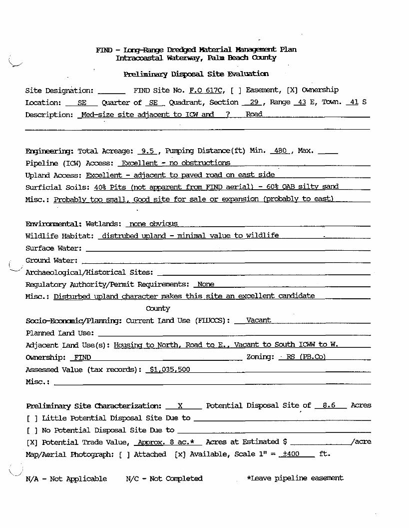
... . y r I 3 . S i t e J?.valwii%n
Si te ~esig&tion: FIND Si te No. F.0 617C, [ ] Easement, [XI Ownership
kcation: SE Q u a r t e r o f L Q u a d r a n t , Sections, R a n g e X E , Tawn .41S
Description: Med-size site adjacent t o ICW and ? Road
m q b e r h ~ : Tota l Acreage: 9.5, Funping Distan=e(ft) Min. A E L , Max. - Pipeline (ICW) Access: Excellent - no obstrw=tions
Upland Access: Excellent - adjacent to raved road on east side
Surficial Soils: 40% Pi t s (not a m t fnan FIND aerial) - 60% OAB s i l t v sand
Misc.: Probablvtoo a l l , Good site fo r sale o r exrxnsion lprobablv to east)
mv' ' dl: Wetlands: none obvious
Wildlife Witat: distrubed wland -minimal value to w i l d l i f e
Surface Water:
Ground Water: C. Archaeolcgical/Historical Sites:
RBgulatory ?uthority/Femit -ts: None
M i s c . : D i s t u r b 4 upland character makes this site an excellent candidate
-ty
S o c i o - S c p l a n n i n q : Current Land U s e (FLUCCS) : Vacant
Planned Land Use:
Adjacent Land Use(s): Housinci t o North. Road to E., Vacant to South IGW to W.
Ownership: FIND zoning: RS (PB.Co)
Assessed Value (tax records) : $1,035.500
M i s c . :
miminary S i t e Uwackdat ion: X Potential D i s p o s a l S i t e of 8.6 Acres
[ ] Eittle Potential Disposal Si te IXle to [ ] No Potential D i s p o s a l S i t e IXle to [XI Potential Trade Value, m x . 8 ac.* Acres at Estimated $ /acre
Map/Aerial Photqraph: [ ] Attached [x] Available, Scdle 1" = +400 f t .
\ , N/A - N o t Applicable N/C - Not Ccanpleted *Leave pipeline easement

F T N D - I m J - R a n g e m - Y - t P L a n
LC/ Intraomstal-,---
.. . r~ S i t e Evaluaticn
site ~esigMtion: m Si te NO. F.O. 619, [ 1 ~asement, [XI cwnership
Lacation: NE & NW Quarter of SE Wdrant , Section 32, Range 43 E, Tmn. 4 1 S
&?scription: Small redamdar parcel on W. bank of ICW
-: Total Acreage: 5.10, Armping D i s t a n c e ( f t ) Min. 380, Max. - pipeline (ICW) Access: Gocd - no obstrUcti0n~
Uplard Access: Adeauate althouqh caved road all aramfl, residential area
Surficial Soils: 70% '1M Mucky sand 30% R7B Fcinello fine sand
Misc. : too small
En ' r M: Wetlands: None obvious . . Wildlife Habitat: disturb& mland with Casuarina - muYmal habitat
Surface Water:
I G d Water:
'-/ ~eolqical/Historical Sites:
Fkqlatory Authority/Permit -ts: None
Misc. : Doesng t amear t o be anv restrict ive, environmental a%€ds
-ty Sccio-l!knnuicplarning: Current Land Use (FLU-) : Vacant
Planned land Use:
Pdjacent. Land Use(s) : Residential to N, W. S/ ICW to E
Ownership: FIND Zoning:- RS /Palm Bch. Co.1
Assessed Value (tax records) : $479,400
Misc. :
Preliminary Site -tion: Potential Disposal Si t e of Acres
[ ] Little Potential D i s p o s a l S i te IXle to
[XI NO Potential D i s p o s d l S i t e IXle to to0 mall
[XI Potential Trade Value, JKiqhl 5.1 Acres at Estimated $ /acre
I%p/Aerial Photqm@: [ ] Attached [XI Available, S d e 1" = +400 ft.
N/A - Not Applicable N/C - N o t Campleted
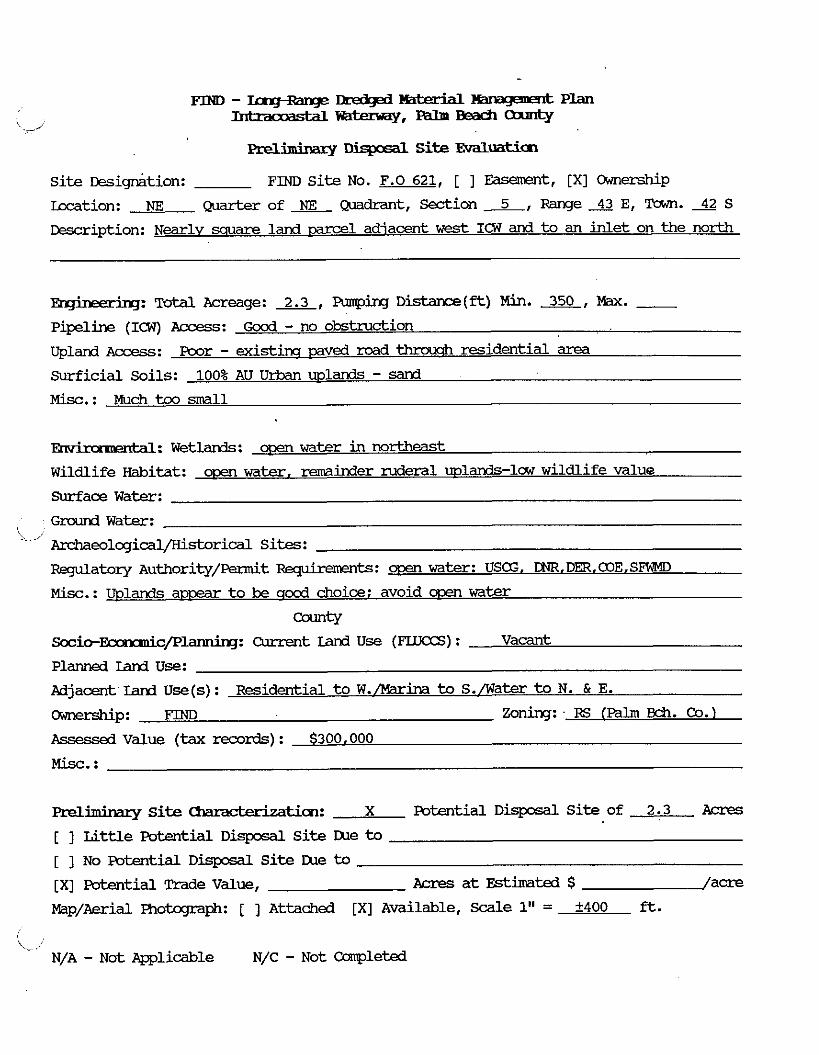
... . ry Dispcsal Site Evaluatim
site Designkion: FIND S i t e NO. F.O 621, [ 1 Easement, [XI C)wnership
Location: NE ~aar-br of Qmkant, m i o n 5, Range 43 E, Town. 42 S
Description: Nearly sauare land -1 adjacent w e s t ICW and to an inlet on the north
Pipeline (ICW) Access: Good - no obstruction
upland Access: Poor - existim mved road thraiqh residential area
Surficial Soils: 100% AU U r b a n uplands - sand M i s c . : Much too small
1: Wetl-: m water in mrtheast
Wildlife Witat: o m w a t e r , reaiinder ruderal uplands-law w i l d l i f e value
Surface Water:
Ground Water: L-
Archaeological/Historicdl Sites:
Regulatory ~uthority/Permit -ts: m water: USG. CNR.DER,COE.SFWMD
Misc.: Wlands a m t o be qca3 choice: avoid rn water
-tY Socio-Ecamnk/planniq: Current Land U s e (FLUCCS) : Vacant
Planned Iand Use:
Adjacent Lanl Use(s): Residential t o W./Marina to S./Water t o N. & E.
-P: m zoning: FG (Palm m. Co.) Assessed Value (tax records) : $300.000
Misc. :
m-elhhaxy S i t e Chmcb%at i cm: X Potential D i s p o s a l S i t e of 2.3 Acres
[ ] L i t t l e Poterrtial Disposdl S i t e Lhe to
[ 1 No Potential D i s p o s a l S i t e Lhe to
[XI Potential Trade Value, Acres a t Estimated $ /acre
Map/Aerial Fhotcgraph: [ ] Attached [XI Available, Scale 1" = +400 ft.
\-,' N/A - Not e l i c a b l e N/C - Not Ccnnpleted
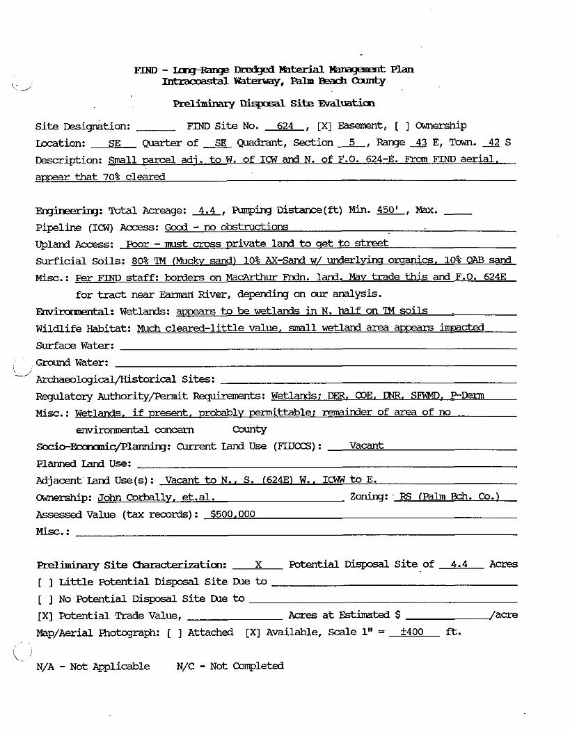
. . Djspsal S i t e EvaluatiCn
S i t e ~ e s i g n k i o n : FIM)SiteNo. 624 , [XI Easement, [ ] w p
kcation: SE Quarter of SE Qxidrant, Section 5, Range 43 E, Tawn. 42 S
Desrription: Small parcel adi. t o W. of ICW and N. of F.O. 624-E. Fram FIM) aerial.
amear that 70% cleared
Erg' ' KJ: Total Acreage: 4.4, Fmphq Distance(ft) Min. W , Max. - pipeline (Im) Access: Good - no obstructions
Upland Access: Rmr - must cross ~rivate lard to get t o street
Surficial Soils: 80% 'IM (Muckv sand) 10% AX-- w/ underlyinq omanics, 10% OAB sand
Misc. : Per FIND s taff : borders on MacArthur Fndn. land. May trade t h i s and F.O. 6243
for tract near Emmri River, depending on our analysis.
Envk 'dl: W e t l a r d s : a- t o be wetlands in N. half on TM soils
Wildlife Habitat: Much cleared-little value, d l wetland area amears inmact€d
Surface W a t e r :
Grounrl W a t e r : \-,
Archaeolcgical/Historical Sites:
Regulatory ~ u t h o r i t y / P e r m i t ~ t s : Wetlands; DER. a3E. OMi, SFWD, P D m
Misc.: Wetlands, i f present, probably wdttable: remainder of area of no
environmental concern -tY Socio-&c/Pl-: Cur ren t Iiind U s e (FUTCCS) : Vacant
Planned Land Use:
Adjacent I d Use(s): Vacant t o N.. S. (6243) W., I W to E.
-p: John Cor?xilly. et.al. Zoning: FS (Palm Ekh. Co.)
Rssessea Value (tax records) : $500.000
Misc. :
Preliminary S i t e ~ c t e r i z a t i c m : X Poterrtidl D i s p o s d l S i t e of 4.4 Acres
[ ] Li t t l e Pcrtential D i s p o s d l S i t e LUe to
[ ] No Potential D i s p o s d l S i t e lxle to [XI Fotential Trade Value, Acres at Estimated $ /acre
MapIAerial Photqraph: [ ] Attached [XI Available, S d e 1" = f400 ft.
i k-1 N/A - Not Applicable N/C - Not Corrpleted
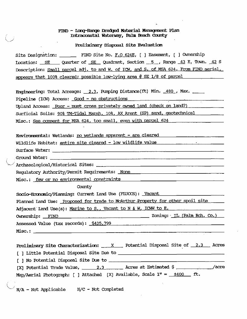
rn - Dr&k@ Ma- Hamga~& Plan -~t=q.---
Erelimirrary S i t e EvdLuatim
Si t e mi&t ion : rn Si t e NO. F.O 6243, [ ] Easement, [ ] cxlmership
kcation: SE quarter of a Quadrant, m i o n 5, Range 43 E, Tawn. 42 S
w i p t i o n : Small parcel adj. to and W. of ICW, and S. of KSA 624. Fmn aerial.
a m that 100% cleared; mssible l & - l v h area @ SE 1/8 of
-: Total Acreage: 2.3, Funping Distance(ft) Min. 480, M. - Pipeline (ICW) Access: Good - no obstructions
Upland Access: Poor - must cross privately owned land (check on land?)
Surficial Soils: 90% ?Mqidal Marsh, 10%. AX Arent ISP) sand. q e o W i c a 1
M i s c . : See camment for E A 624, too small, even w i t h -1 624
En ' r W : Wetlands: no wetlands a p m t - are cleared
Wildlife Habitat: entire site cleared - law wildlife value
Surface Water:
Ground Water:
j - 1 ~eolqical/Historical Sites:
RBgulatory Authority/Permit BfpirementS: None
M i s c . : few or no envimmtal constraints
-tY ~ o c i o - ~ c / P l a n n i n g : Current rand Use (FLUCCS) : Vacant
Planned land Use: proDosed for trade to WArkhur ProDertv fo r other mil site
Adjacent Land U s e ( s ) : Marine to S., Vacant to N & W, ICW t o E.
ihxzship: FIM) Zoning: IL lpalm Bch. Co.)
Assessed Value (tax records) : $425.799
aeliminary S i t e -tion: X Potential D i s p o s a l S i t e of 2.3 Acres
[ 1 Little Potential D i s p o s a l S i t e m e to
[ 1 No Patential D i s p o s d l S i t e IXe to [XI Potential Trade value, 2.3 Acres a t Estimated $ f acre
Map/Aerial Photcgraph: [ ] Attached [XI Available, S d e 1" = +400 ft.
i/ N/A - N& Applicable N/C - Not Completed

PIND - IngRange Manape& Plan -=-,--Canrty
. . Prellrmnary Dispasal Site EVdLuati.cn
Site ~esig&xtion: FIND Site No. 625B & 626B-AL3, [XI Easement, [ ] Ownership
m t i o n : Quarter of Quadrant, Section -, me43 E, Tawn. 42 S
~escription: Waterbodv in Lake Worth. In front of lame hotel near intmxeztion of
ICW (north ditch) and Lake Worth
Emgi,nerirlg: Total Acreage: 20.6 Funping D i s t a n c e @ ) Min. 2300, Max. - Pipeline (ICW) Access: Poor from N. Ino vim easement) qccd from S. (across water)
Upland ACXES: Pcor - no direct wland access to mrcd. althm US 1 is <l0OO3 awav
surficial Soils: None
M i s c . : ?he hotel would sue the D i s t r i c t i f thev art mil material here!
Em' ital: Wetlands: A l l rn water
Wildlife Habitat: Rssible Flanatee habitat
surface Water:
Ground Water:
L i ~ e o l c g i c a l / K i s t o r i c a l Sites:
F&qulatory Authority/-t Rqhmnents: @3E, FDER, DNR, SFWND. PDEIIM. USG
Misc.: oyster or q z s s beds? in anv event. oermitth mv be formidable
S c c i o - ~ c / P l ~ : Current Land U s e (FLLTCCS) : 544 - Estu2W
Planned Land Use:
Adjacent Land U s e ( s ) : Condos
-P: ZOrihq: -
Msesd Value (tax mrds) : N/A
Preliminary Si te Cbm-tian: Potential D i s p o s a l Si te of Acres
[ ] W e Potential D i s p o s a l Si te me to [XI No Potential Disposdl site LUe to Adiacent to existim marinas, emir. concerns [ ] Potential Trade Value, Acres a t Fstinnted $ / a m
Map/Aerial Photcgmph: [ ] Attached [XI Available, Scdle 1" = +400 ft.
L,' N/A - Not Ppplicable N/C - Not Capleted

. . aellmurazy L l k p x d Site EvdLuatim
Si te ~esigriation: FIND Si te No. W-1 , [XI Easement, [ ] Ownership
Location: E 1/2 of SE QiLadrant, S e d i o n A , Range* E, Tawn. S
&scription: 2866' X 1000' adjacent east of ICW. W a t e r bodv.
Tatal Acreage: 57.5, Armping D i & a x e ( f t ) Min. 700, Max. - .-
Pipelire (ICW) Access : Excellent - no obstructions
Upland Access : Poor - parcel is on Iake Worth, water on a l l sides
Surficial Soils: N/A [None - water depth 1-4'1
Misc. :
W: Wetlands: AL1 wen water, amears to be mass beds on shodls in S. half
Wildlife Habitat: Manatees msible
Surface Water:
Ground W a t e r :
Archaeological/Kistorical Sites:
R q u l a t o r y Authority/Femit Requiremmts: USCG. alE. Dm, DMI. F - D M . SFWMD
M i s c . : Environm~tallv sensitive
S o c i o - ~ c / F ' ~ : Current Land Use (FLUCCS) : W a t e r
Planned Land Use:
Adjacent land U s e (s) : W a t e r
-P: zoning:
Assessed Value (tax records) : N/A
M i s c . :
Preliminary S i t e Characteriztim: Patential D i s p o s a l S i t e of Acres
[XI L i t t l e Potential D i s p o s d l S i t e Due to 57.5 AC - own water: shodlira
[ ] No Potential D i s p o s d l S i t e the to [ ] Potential Trade Value, IIcres a t Estimated $ /acre
Map/Aerial Photcgraph: [ ] Attached [XI Available, Scale 1" = +400 ft.
i N/A - N o t Applicable N/C - Not CQnpleted
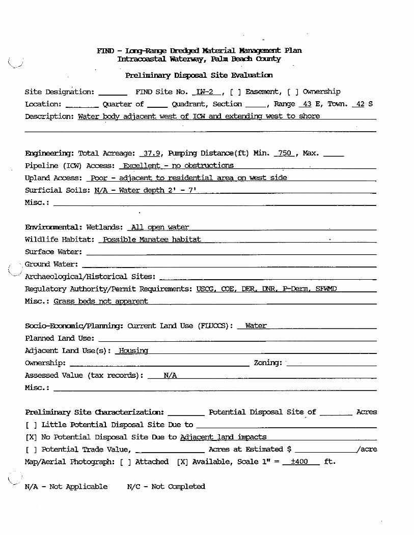
Preliminary D . w S i te Evdluaticn
S i t e ~esi&tion: FIND S i t e No. LW-2 , [ ] Easamnt, [ ] amership
m t i o n : Quarter of - Quadrant, m i o n -, Range 43 E, Tam. 42 S
Cescription: Water kc& adjacent w e s t of ICW and extendincr w e s t t o shore
-: Total Acreage: 37.9, Punping D i s t a n c e ( - ) Min. 750, Max. - pipeline (IW) Access: Excellent - no obstructions
Upland Access: Poor - adjacent to residential area on West side
Surficial Soils: N/A - Water depth 2' - 7 '
Misc. :
JZm' ' 1: Wetlands: A l l orem water
Wildlife Habitat: Possible Manatee habitat
Surface Water:
Ground Water:
' Archaeolcgical/Historical Sites:
RBgulatory Authority/Permit Fquhmrmts : U S E , COE, Dm. DNR. P-Germ. SFlUD
Mi%. : Grass beds not amarent
Sccio-&c/Planning: Olrrent Land Use (FLUCCS) : Water
Planned Iand Use:
Pdjacent Iand Use (s) : H o u s h
-P: zoning: Assessed Value (tax mrds) : N/A
Preliminary Site -tion: Potential D i s p o s d l S i t e of Acres
[ ] Little Eutential D i s p o s a l S i t e Lbe to [XI No Potential D i s p o s d l S i te h e to Pdiacent land immcts
[ ] Potential Trade Value, Acres a t Estimated $ /acre
Map/Aerial motcgraph: [ ] Attached [XI Available, Scale 1" = +400 ft.
I
\-' N/A - Not Applicable N/C - Not Capleted
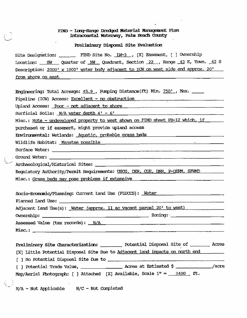
Preliminary I : ) Site Evaluatim
Si te resigriation: FIND Si te No. LW-3 , [XI Easement, [ I Ownership
Icmtion: sw ~ o f ~ ~ d r a n t , S e d i o n 2 2 , R a n g e 4 3 E r Tmn. 4 2 s rescription: 2000' x 1000' water body adjacent to ICW on w e s t side and amrox. 20'
f m shore on east
B n g h 3 = r h g : Total Acreage: 45.9, Funping DistanCe(ft) Min. m, Max. - Pipeline (ICW) Access: Excellent - no obstruction
Upland Access: Poor - nat adiacent to shore
surf ic ia l Soils: N/A water d m 4 ' - 6'
Misc.: Note - undevelorxd D- to w e s t shown on FIND sheet PB-12 which, i f
pumhsed or i f e x m m t , might provide upland access
enbl: Wetlands: Aauatic, ~ r ~ b a b l e crrass beds Wildlife Habitat: Manatee cossible
Surface Water:
G r a n d Water:
' ?u-&aeolcgical/Kistorical Sites:
Regulatory Authority/&t -ts: U S . DEFt. COE. DR. PDERM. SFWD
Misc. : ~ r a s s beds m y rxse uroblems i f extensive
S o c i o - ~ c / P l ~ : current Lard U s e (FLUCCS) : Water
Planned Land Use:
Adjacent Iand U s e ( s ) : Water (amrox. 11 ac vacant mrcel 20' t o West)
-P: zoning: Assessed V a l u e (tax records) : N/A
M i s c . :
m-eliminary Site Charact;eizaticn: Fotential D i s p o s a l S i te of A c r e s
[XI Li t t le Potential D i s p o s d l S i te Due to Adjacent land immds on north end
[ ] No Potential D i s p o s a l S i t e Due to [ ] Fwtential Trade Value, ~ c r e s a t E s t h t d $ /acre
Map/Aerial Photcqaph: [ ] Attachad [XI Available, Scdle 1" = 2400 ft.
\ - N/A - Not mlicable N/C - Not Ccanple td

Disposal Site Evdluation
Site ~ e s i e t i o n : FIM) Site No. LW-4 , [XI Easement, [ ] -p
Lccation: NW of NW Q~dran t , Section 27, Range 43 E, Town. 42 S
~escription: 2000' X 10001 wate r bodv adjacent to ICW on W. side, amrox. 450' from
w e s t shoreline
Eqineering: Total Acreage: 45.9, Fumping Distance(ft) Min. 750, Elax.
Pipeline (ICW) Access: Excellent
Upland A c c e s s : Poor - no mlands adiacent
Surficial Soils: N/A w a t e r derth 2-8'; mall E-W canal dredged for boats amrox. 400'
Misc. : from N. end
E I * errtdl: Wetlands: Aauatic: crrass beds ~robablv scattered th rowout
Wildlife Habitat: -tee wssible
Surface Water:
Ground Water: \- 1
Archaeolcgical/Kistorical Sites:
Regulatory Authority/permit R q d r a m t s : USG. COE, D , DMI, PDERM, SFWMD
Misc.: Extensive crrass beds a d ml i ca t e permittins
Socio-~c /p lan&g: Curmt Lard U s e (FLUCCS) : Water
Planre3 Lard use: Adjacent Lana U s e (s) : W a t e r
cmaship: Zoning:
Assessed Value (tax records) : N/A
Misc. :
Preliminary Site Cbmchdmtim: Potential Disposal Site of Acres
[ ] Lit t le Fot&tial Disposdl Site IXle to
[XI No Poterrtial Disposal Site the to grass beds, &tth difficulties
[ ] Potential Trade Value, Acres a t Estimated $ /acre
Map/Aerial Photcqra@: [ ] Attached [XI Available, Scale 1" = +400 ft.
\ ' 4
N/A - Not Applicable N/C - Not Ccmpleted
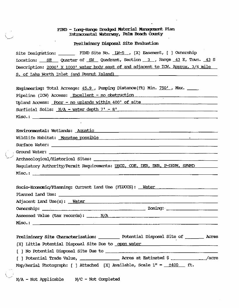
m.imiMzy Site Evaluaticn
S i te ~esig-riation: FIND Site No. LW-5 , [XI Easement, [ 1 Ownerskip
Location: SE c&arter of Quadrant, Section 3, Range 43 E, Town. 43 S
Description: 2~100' X 1000~ water bodv east of and adiacent t o ICW. A D P ~ X . 3/4 mile
S. of Iake Worth Inlet [and Peanut Island)
-: Total Acreage: 45.9, FUnping D i s t a n c e ( - ) Mh. w, W. - pipeline (ICW) Access: Excellent - no okstruction
Upland A c c e s s : Poor - no mlands w i t h i n 400' of site
Surficial Soils: N/A - water d e m 7 ' - 8'
rrtdl: Wetlands: Aauatic
Wildlife Habitat: Manatee m s i b l e
Surface Water:
Ground W a t e r : i-1 Archaeologicdl/Historical Sites:
Regulatory Authority/Piermit -ts: U S , COE, DER, INR. P D m . SZWD
Misc. :
Socio-Fccmanic / I? l~ : current Land U s e (FLUCCS) : Water
P l d Land use: Adjacent Iand U s e (s) : Water
-P: Zoning: -
Assessed Value (tax rewrds) : N/A
Prelhimry Site -tion: Fatent id Disposdl Site of Acres
[XI Little Pcrtential D i s p o s d l S i te Lbe to men water
[ ] No Potential D i s p o s a l S i te Due to [ ] Potential Trade Value, Acres a t Btimted $ /acre
Map/Aerial Phokqaph: [ ] A t t a c h e d [XI Available, Scale 1" = +400 ft.
i_, N/A - Not Pgplicable N/C - Not Completed

Preliminary Disposal Site EvalUatim
Si t e ~esi&tion: FIND Si t e No. IN-6 , [XI Easement, [ ] CWEPShip
Location: NE Qmrter of NW Quadrant, Section 10, Range 43 E, Tawn. 43 S
&scription: 2000' X 1000' water body adiacent to (east of) ICW
Total Acreage: 45.9, Funping D i s t a n c e ( & ) Min. -.EL, Max. - pipeline (ICW) Access: Excellent - no obstruction
upland ~ccess: Poor - no wl& w i t h i n 300-400'
surficial Soils: N/A - water depth 3-7'
Misc. :
.ntd: Wetlands: Aquatic
wildlife mitat: Manatee Possible
Surface Water:
Ground W a t e r : i
Archaeological/KistoricdL Sites:
Regulatow Authority/Permit -ts: USG. COE. DER. DNR. P D m . SFhMD
Misc. :
socio-Fmmmicplanniq: Current land U s e (FILJCCS) : W a t e r
Planned I d Use:
Adjacent Lars3 U s e ( s ) : Water
-P: Zoning:
Assessed Value (tax mrds) :
Misc. :
aeliminary S i t e Wderizati~~: Potential D i s p o s a l S i t e of A c r e s
[ ] L i t t l e Potential D i s p o s a l S i t e Due to
[XI No Potential D i s p o s a l site Due to CXxm water
[ ] Potential Trade Value, Acres a t Estimated $ /acre
Map/Aerial Fhotcgraph: [ 1 Attached [XI Available, Scale 1'' = +400 ft.
\ '-,
N/A - Not Applicable N/C - N o t Ccsnpleted
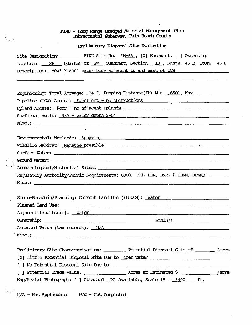
... . Disposal Si te Evaluaticn
Si te ~esig&tion: FIND Si te No. LW-6A , [XI Easement, [ ] Ownership
kcation: SE Quarterof SW Quadrant ,Sect ion-J&,Range43E,Town.43S
Description: 800' X 800' water kc& adiacent to and east of ICW
Engheerin~: Total Acreage: 14.7, Pumphg Dis tance(*) Min. m, W. - pipeline (ICW) Access: Droellent - no obstructions
Upland A c c e s s : Poor - no adiacent wlands
Surficial Soils: N/A - water depth 3-5'
Misc. :
-: Wetlands: Aquatic
Wildlife Habitat: Manatee m i b l e
Surface Water:
Grcund W a t e x : k -1 Archaeolcgicdl/Historical Sites:
Fegulatory Authority/permit -ts: USCG, 03E. DER. DNR. P-DERM, SFWD
Misc. :
Sccio-~c/Plarninq: Current Land Use (mLTCCS) : Water
Planned Land Use:
Adjacent Land U s e ( s ) : Water
-P: Zoning:
Assessed Value (tax -rds) : N/A
Misc. :
Preliminary Si t e Chamcterizaticn: Potential D i s p o s a l S i t e of Acres
[XI Li t t le Potential D i s p s a l S i te m e to a~en water
[ ] No Potential D i s p s a l S i te me to [ 1 Potential Trade Value, Aaes at Estimated $ /acre
Map/Aerial Photqmph: [ ] Attached [XI Available, Sale 1" = 5400 ft.
L. N/A - Not Applicable N/C - N o t Ccmpleted
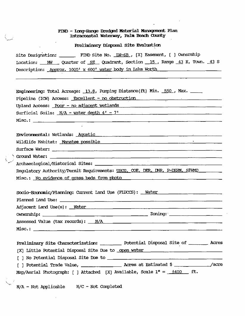
m - ~ n g ~ n g e Ihedged thtm-id wawz=nt Plan -W~,-BBacf i -= 'w
aeliminaxy r . ) . Site EvdLuaticn
site ~esigMtion: FIND site NO. L W - 6 ~ , [XI Easement, [ I ownership
Location: NW Q u a r t e r o f A Q u a d r a n t , S e c t i o n A , R a n g e S E , Tam. 4 3 s Description: A~prox. 1000' x 600' water bcdv in Lake Worth
Engineeriq: Total Acreage: 13.8, Fumping D i s t a n c e ( f t ) Min. 550, Max. - Pipeline (ICW) Access:
Upland Access: Poor - no adjacent w e t l a n d s
Surficial Soils: N/A - water depth 4 ' - 7'
ntal: Wetlands: Aauatic
Wildlife Habitat: Manatee wssible
Surface Water:
' Ground Water:
"' z c c h a e o l o g i c d l ~ r i c a l Sites:
Regulatory Authority/Fennit -ts: USCG, COE, DER. UNR, P - D M . SFkWD
Misc. : No evidence of qrass beds from 13hatO
~ o c i o - ~ c / P l ~ : auwlt Iand U s e (FLUCCS) : Water
PlanEd Iand use: Adjacent IanaUse(s): Water
-P: zoning: Assessed Value (tax records) : N/A
Misc. :
meliminazy Si te -tiion: Patential D i s p c 6 a l Site of Acres
[XI Lit t le Potential Disposal Site me to ooen water [ ] No Potential Disposal Site me to [ ] Potential Trade Va lue , Acres a t Estimated $ /acre
Map/Aerial Photograph: [ ] Attached [XI Available, Scale 1" = +400 ft.
i .: N/A - Not Applicable N/C - Not Ccwpleted

. . p r e b m m q '-. S i t e Evaluation
Si t e ~es ig~ia t ion : FIND S i te No. LW-7 , [XI Easanent, [ ] w p
Location: W Q.mrter of Quadrant, -ion 27, Range 43 E, Town. 43 S
Description: 4000' X 450' water body, e l e l , adiacent to and east of the ICW. also
parallel to and 100' w e s t of Ev-ladeS Island
Frqhering: Total Acreage: 41.3, wing Distance(*) M i n . 500, - Pipeline (ICW) Access: Excellent
Uplanl Access: Poor
Surficial Soils: N/A - water d e m 4 ' - 6'
M i s c . :
Etnr ' ' 1: Wetlands: Aquatic
Wildlife Habitat: mssible mtees
Surface W a t e r :
Ground Water: ' -' ~ e o l q i c d l / H i s t o r i c d l sites: Regulatory Authority/Permit -ts: USCG, WE, DER, DNR. P - D M , SFWMD
Misc.: No evidence of mass beds
S o c i o - M c / P W : Current Iand U s e (FIUCCS) : Water
Planned Land use: Pdjacent Land U s e (s) : Water
-P: zonirq: Assessed V a l u e (tax mrds) : N/A
hrelimina~~ S i t e -tion: Potential D i s p o s a l S i t e of ikxes
[ ] L i t t l e Potential D i s p o s a l S i t e IXle to
[XI No Potential D i s p o s a l S i t e IXle to cce.n land fmte adiacent lanl use)
[ 1 Potential !made Value, Acres a t Er;timated $ /acre
MapiAerial Fhotcgraph: [ 1 Attached [XI Available, Scale 1'' = +400 ft.
L ' N/A - Not Applicable N/C - N o t Ccanpleted
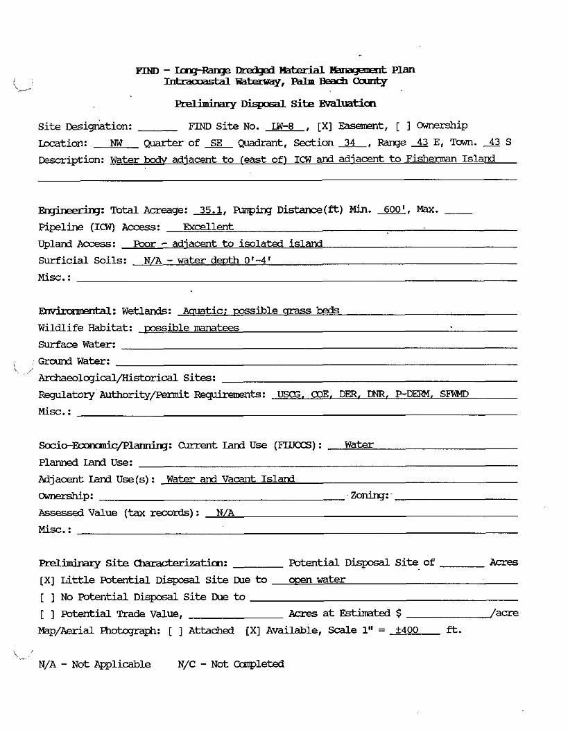
- DisposdL Site Evaluaticn Si te ~ e s i g k i o n : FIM) site NO. LW-8 , [XI ~asement, [ I m e r s h i p
m t i o n : NW Quarter of w d r a n t , Sedion 34, Range 43 E, Tam. 43 S
&scription: Water bodv adjacent to (east of) ICW and adiacent t o Fisherman Island
nqkering: Total Acreage: 35.1, Funping Distance(ft) Min. m, FBx. - Pipeline (ICW) Access: Excellent
Upland Access: Poor - adiacent to isolated island
Surficial Soils: N/A - water d e m 0'-4'
Misc. :
-: Wetlands: Aauatic; m i b l e srass beds Wildlife Habitat: possible -tees
Surface Water:
Ground Water: ' /
Ar&aeological/Historical Sites:
RBgulatozy Authority/&t Fqubxmnts: USCG, COE, DER. DNR. P - D m . SBWMD
Misc. :
Socio-Eumauic/EJlannirq: C u r r e n t Lard U s e (FLUCCS) : Water
Planned land Use :
Adjacent land U s e ( s ) : Water and Vacant Island
-P: Zoning: -
Assessed V a l u e (tax records) : N/A
Misc. :
Preliminazy Site -tian: Potential D i s p o s a l S i t e of Acres
[XI Li t t l e Potential D i s p o s a l S i t e me to own w a t e r
[ ] No Potential D i s p o s a l S i te IXe to
[ ] Potential Trade Value, Acres a t Estin!ated $ /acre
Map/Aerial Fhotajraph: [ ] Attached [XI Available, Scale 1" = f400 ft.
t- N/A - Not Aplicable N/C - N o t Ccwpleted
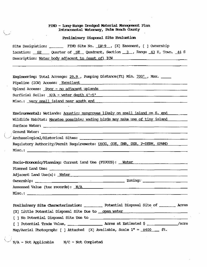
m--KWWPDredged ' 1 Emqtmmt Plan , ,
\<,/ --t==Y,---
. . preslrmMzy Site Evaluaticn
S i te ~esig&tion: FIND Si te No. LW-9 , [XI Easement, [ ] Ownerskip
-tion: SE Quarterof SE Quadrant, S e c t i o n L , R a n g e s E, Tuwn. 44 S
~escr ipt ion: W a t e r bodv adjacent t o (east of) ICW
R~~neering: Total Acreage: 29.9, Funping D i s t a n c e ( ft) Min. 700' M . - Pipeline (ICW) Access: Excellent
Upland Access : Poor - no adiacent wlands
Surficial Soils: N/A - water d e ~ t h 4'-5'
Misc . : very small island near south end
Ehv ' M: Wetlands: Aauatic: nrmqmves likely on small island on S. end
Wildlife Habitat: Ma~tee possible; wadinq birds m y make use of t iny island
Surface Water:
Grcund Water: ' / Archaeolqical/Kistorical Sites:
Regulatory Authority/Fennit -ts: USG. COE. DR. DER. P - D m . SFWMD
M i s c . :
S o c i o - I k m x m i c / P ~ : Current Land Use (FLLKXS) : Water
Planned I d Use:
Aajacent Land U s e (s) : Water
-P: zoning: -
Assessed Value (tax records) : N/A
Prelimirnry Site -ticm: mtid D i s p o s a l S i t e of Acres
[XI Li t t le Potential Disposdl Si t e IXle t o ooen water
[ 1 No Patentid Disposal S i te I lks t o
[ ] Fotentid Trade Value, Acres a t Estimated $ /acre
Map/Aerial Photqraph: [ ] Attached [XI Available, Scdle 1" = k400 ft.
'-" N/A - ~ o t mlic~le N/C - ~ o t ccmpleted
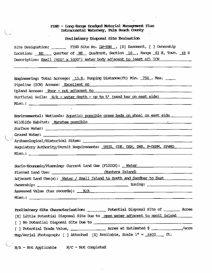
FJ3m-TrrgI tuge-Y' ' l % m a q l m t P L a n
(, - ~ ~ , - B e a c f i - = ' Q
. . pndmmaq Disposal Site Evalmtim
site ~esigrktion: FIND Si te No. LW-9BN , [XI Easement, [ ] ownership
Location: NE Quarterof NE ~uadrant, S e c t i o n x , R a n g e s E, m. 44 s 13escription: Small (600' x 1000') water body adjacent to l e a s t of) ICW
wineem: Total Acreage: 13.8, Farping Distance(ft) M h . 750, Max. - Pipeline (107) Access: Excellent 60
Upland Access: Poor - not adiacent t o
surf ic ia l Soils: N/A - water dewth - UP to 5' (sand bar on east side)
Misc. :
Em' 1 : Wetlands: -tic: m s i b l e srass beds on shoal on east side
Wildlife Habitat: Manatee msible
surface Water:
Ground Water: ' -,' Archaeolqid/Kistorical Sites:
watery Authority/-t Rqukmsnts: USG, COE. DER. m. PDERM. SFWMD
Misc. :
s o c i c - & c / P ~ : Current Land U s e (FlLTCCS) : Water
Planned Land Use: Eunters Island)
Adjacent Land U s e ( s ) : Water / Small Island to South and sandbar t o East
-P: zoning:
Assessed Value (tax records) : N/A
Misc. :
preliminary Site -tian: mtential DisposdL Si te of A c r e s
[XI Li t t le Potential D i q x s a l S i t e me to wen water adjacent to spoil island
[ ] No Potential D i s p o s a l S i te !2e to
[ ] Potential Trade Value, ?cres at Estimated $ /acre
Map/Aerial Photcgraph: [ ] Attached [XI Available, Scale 1" = k400 ft.
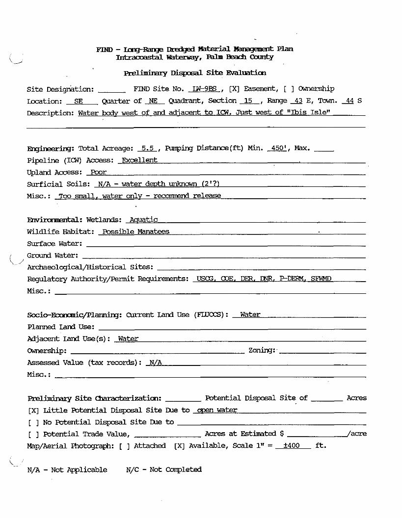
=-- Haterial Y- Plan --,---
. . p d h m m x y --1 S i t e Evaluaticm
S i te Desig-ktion: FIM) Si t e No. IW-9BS , [XI Faawnt, [ ] Ownership
Location: SE -of ME Quadrant, S e c t i o n L , R a n g e s E, Twn. 44 S
Description: Water kc& w e s t of and adiacent t o I(1W. Just w e s t of "Ibis Isle"
-ing: Total Acreage: 5.5, Armping ~istance(ft) Min. *, Max. - Pipeline (ICW) Access: Excellent
upland~ccess : poor
Surficial Soils: N/A - water d e m unla7awn [2'?)
Misc. : Tco small, water onlv - recommend release
Ehv' ' 1 : Wetlands: Aquatic
Wildlife Habitat: Possible Manatees
Surface Water:
G r o u n d Water: 1,
Archaeolcgicdl/Historical Sites:
Regulatory Authority/Fwmit Requiremmts: USCG, alE, Dm, DNR. PDEIF?, SZW4D
S o c i o - ~ c / P l a n n i n g : Current land U s e (FLUCCS) : Water
Planned land Use:
Adjacent Land U s e ( s ) : Water
WP: Zoning:
Assessed Value (tax records) : N/A
Misc. :
Prelhcbry S i t e & a n & c k a t i c m : Potential DisposaL Si t e of Acres
[XI Little Potential Disposal S i te W to ooen water
[ ] No Poterrtidl DisposdL S i t e IUe to
[ ] Potential Trade Value, AQ-es a t Estimated $ /acre
Nap/Aerial Photograph: [ ] Attached [XI Available, Scale 1" = +400 ft.
L . N/A - N o t Applicable N/C - Not CoPnpleted
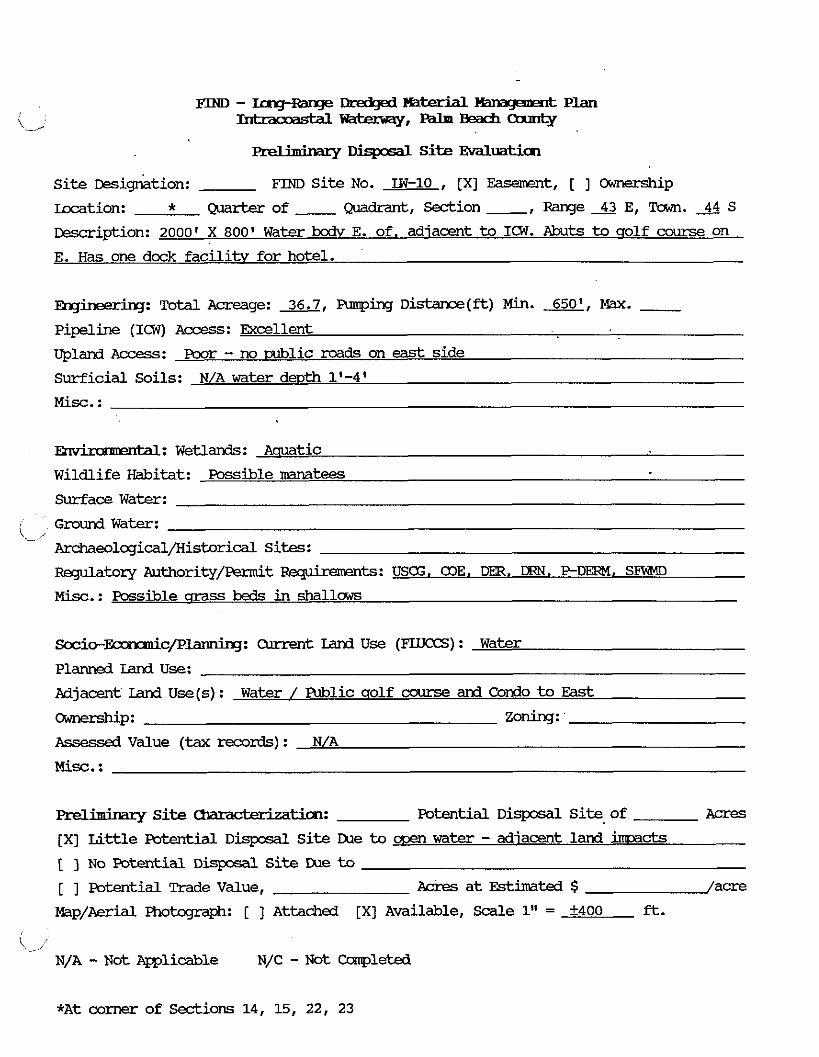
FIND - IogRanse F B mkrial Mmwarmt Plan -rYaterway,---m'T
.,. . D i s p o s a l S i te Evaluation
Si te &sib t ion : FIND Si te No. TW-10 , [XI Easement, [ ] Ownership
Location: * Quarterof ~ d r a n t , S e c t i o n , R a n g e > E , ~ . > S
rescription: 2000' X 800' Water bodv E. of. adiacent to ICW. Abuts to qolf awrje on
E. H a s one dock fac i l i tv for hotel.
l3qheeri.m~: Total Acreage: 36.7, Funping Distance(ft) Min. m, m. - Pipeline (ICW) Access: Excellent
Upland Access: poor - no mlic roads on east side
Surficial Soils: N/A water depth 1'-4'
Misc. :
w: Wetlands: A a u a t i c
Wildlife Habitat: Possible n?anateeS
Surface Water:
/ Ground W a t e r :
- Archaeological/Kistorical Sites:
Regulatory Authority/Permit Rqdremmts: USCG, a lE , Dm. DIW. PDERM, S B
Misc.: Possible qrass beds in s h a l l u s
S o c i o - ~ c p l ~ : Carrent Land Use (F'LUCCS) : Water
Planned Land Use:
Adjacent Land U s e ( s ) : Water / Public qolf ccxlrse and Condo t o East
-P: zoning:
Rssessed Value (tax records) : N/A
Misc. :
Preliminary Site Umxu' tia~: Potential D i s p a l S i t e of Acres
[XI Li t t le Potential Disposal Si te LUe t o water - adiacent land immds
[ ] No Potential D i q c s a l S i te LXle to [ ] Potential Trade Value, Acres a t Estimated $ /acre
Map/Aerial Photograph: [ ] Attached [XI Available, Scale 1" = ?400 ft.
k-. /' N/A - N o t mlicable N/C - N o t Completed
*At corner of Sedions 14, 15, 22, 23
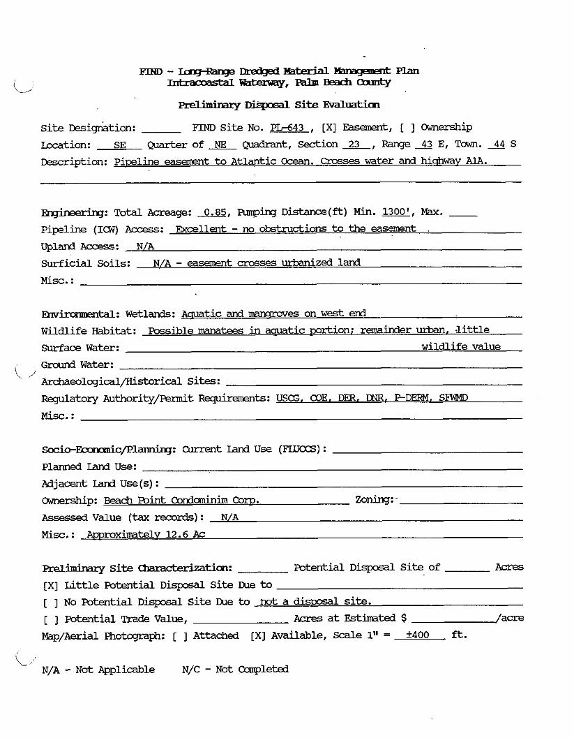
p ~ w - m&pi ~ ~ x x W Plan
(., Intraooastdl-,-Beacfi-
Prelimirrary Disposal Site EvdLuaticm
Si te ~esicgktion: FIND Site No. -643 , [XI Easement, [ ] Cmnership
b a t i o n : SE Q u a r t e r o f x Q u a d r a n t , S e c t i o n 2 3 , R a n g e 4 3 E , T o w n . 4 4 S
Description: Pireline easement to Atlantic Ocean. Crosses w a t e r and hicrhwav A1A.
-: Total Acreage: 0.85, Armping D i s t a r c e ( f t ) Min. m, Max. - Pipeline (ICW) Access: Excellent - no obstructions to the easement .
Upland Access: N/A
surf ic ia l Soils: N/A - easement crosses m i z e d land
M i s c . :
Envhmrmtal: Wetlands: Aauatic and mmroves on w e s t end
Wildlife Habitat: Possible mtees in aquatic ~ r t i o n ; minder urban. Jittle
Surface W a t e r : wildlife value
Ground Water: i/
Ar&aeological/Historical Sites:
Regulatory Authority/permit Fwpkmnts: USCG, COE, D , DNR. PDERM, SFWID
~ i o - ~ c / P l ~ : Current Land U s e (FWCCS) :
Planned Land Use:
Adjacent Land U s e ( s ) :
amership: Beach Point Condominim Corn. Zoning: -
Assessed Value (tax records) : N/A
Misc. : A m m b t e l v 12.6Ac
m i m i n a r y S i t e -tion: Potential D i s p o s a l S i te of Acres
[XI Li t t le Potential Disposal Si te IXle t o
[ ] No Potential D i s p o s a l S i t e IXle to not a d i m 1 site.
[ ] Potential Trade Value, Acres a t Fstima'ced $ / a m
Map/Aerial Photogmph: [ ] Attached [XI Available, Scale 1" = +400 ft.
k-, N/A - Not Applicable N/C - Not Cconpleted

FmD - Dmf3gd ?Qterbl lhnqm=k Plan
k - 1 -=t-=Y,-Beacfia='-T
... . - Disposal Site Evaluation
Si te Des ig~ t ion : FIND S i t e No. LW-11 , [XI Easement, [ ] Ownership
Lacation: SE ~ o f ~ Q u a d r a n t , S e c t i o n ~ , ~ e ~ E , T a w n . ~ S
~escr ipt ion: Amrox. 750' x 1100' water bodY, adiacent t o and east of ICW
mgiwmhg: Total Acreage: 18.6, Funping D i s t a n c e ( - ) Min. 625, m. - Pipeline (ICW) Access: Excellent
Upland Access: poor - no contisucus uplands
Surficial Soils: N/A water depth &mrox. 3 ' Mix. :
Wrimmwtdl: Wetlands: Aauatic
Wildlife Habitat: Possible Kmatees
Surface Water:
Ground Water:
i' Archaeolqical/Kistorical Sites:
Regulatory Authority/permit Rquiremerrts: U S . a l E . Dm, DMI. P - D m . SFWT?D
Misc. :
S o c i c - ~ c / P l ~ : Current Land U s e (FIlJCCS) : Water
Planned Land Use:
Adjacent Land U s e ( s ) : W a t e r
-P: Zoning:
Assessed Value (tax records) : N/A
Prel~minary Site Chars ' tim: Potential D i s p o s d l S i t e of Acres
[XI L i t t l e Potential D i s p o s d l S i t e IXle to wen water
[ ] NO Potential D i s p o s a l S i te lXle to
[ 1 Potential Trade Value, Acres a t Estimated $ /acre
Map/Aerial Fhotqraph: [ ] Attache. [XI Available, Scale 1" = +400 f t .
\-, N/A - N o t Applicable N/C - Not Campleted

Preliminary r&qcsal Site Evdluatim
Si te wignktion: FIND Si te No. LW-12 , [XI Easement, [ 1 Ownership
Location: SW (yJarter of @mdrant, Section 26, Range 43 E, Town. 2% S
Description: Water bodv east of and adjacent to ICW (2000' x 1000')
Fsrgineering: Total Acreage: 45.9, Funping D i s t a n c e ( f t ) Min. 750', Max. - Pipeline (IW) Access : Excellent
Upland A c c e s s : Poor
Surficial Soils: N/A water dewth 4'-5'
Mix. :
Fnv ' itdl: Wetlands: -tic
Wildlife Habitat: Possible NmateeS
Surface Water:
Ground Water: i/ Archaeolqical/Historical Sites:
Regulatory Authority/permit Reqkemnts: USG. COE. DER, DNR, P D m , SFWMD
Socic--c/Ple: Current land Use (FLLTCCS) : Water
Planned Land Use:
Adjacent Land U s e (s ) : W a t e r
-P: Zoning: -
Assessed Value (tax records) : N/A
Mix. :
Pre lhhry Site c k a m ~ t i o n : Potential Disposdl Si t e of A c r e s
[XI Li t t le Potential D i s p o s d l S i te IXle to wen water
[ 1 N o Potential D i s p o s a l S i te IXle to [ ] Potential Trade Value, ~ c r e s a t Estimated $ /acre
Map/Aerial FRobzp-aph: [ 1 Attached [XI Available, Scdle 1" = +400 ft.
'L,
N/A - N o t Applicable N/C - N o t Ccanpleted

FQuJ - IngRange ~lredged mterkd lfanageaent Plan Intracoastdl ~f=may, - - -
\_I
M i m i n a r y Site Evaluati.cn
Si te ~esigr&tion: FIND S i t e No. LW-13 , [XI Easement, [ ] Ownership
kcation: NW of Qadrant, -ion 35, Range 43 E, Tawn. 44 S
&scription: W a t e r ?xciy, 2000' x 1000'. adjacent to and east of I C W
2
' ,: Tcrtal &zt-cage: 45.9, Fmpirc~ D i s t a n c e ( & ) Min. 750, Max. - Pipeline (ICW) Aaxss: Exal len t
U p l a Access: Poor - None
Surficial Soils: N/A - water d e ~ t h 4'-5'
Misc. :
: Wetlands: Aquatic
Wildlife Habitat: Possible Manatees
Surface W a t e r :
Ground W a t e r : '- / Archaeological/Historical Sites:
Rqulatory Authority/Permit Rqwhments: USCG, CDE, DER, DNR, P - D M . SFWMD
Misc. :
S o c i o - ~ c / J ? l ~ : Current Land U s e (FLUCCS) : Water
Planned Land Use:
Adjacent Land U s e (s) : Water
-P: Zoning:
Assessed Value (tax re%rds) : N/A
Misc. :
Preliminary Site -tim: Potential D i s p o s a l S i t e of A c r e s
[XI Li t t l e Potential D i s p o s a l S i te IXle to ooen water
[ ] No Potential D i s p o s a l S i te Due to [ ] Fotential Trade Value, Acres at Estimated $ /acre
Map/Aerial Photqraph: [ ] A t t a c h e d [XI Available, Scale 1" = +400 ft.
N/A - ~ o t mlicable N/C - Not Campleted
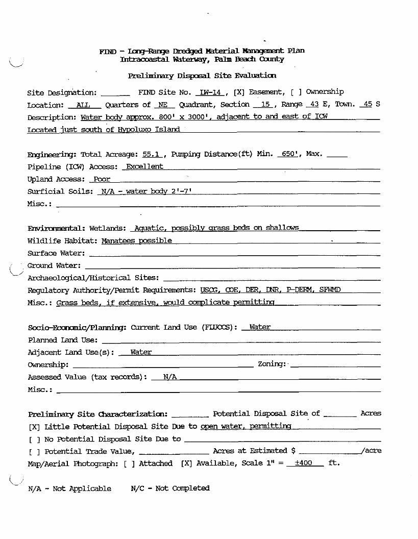
Preliminary Disposal Site EvdLuaticn
site wig rk t ion : m site NO. IW-14 , [XI ~asement, [ ] Odnerzhip
Lccation: AIL Quarters of Quadrant, Sedion 2, Range 43 E, Tawn. 45 S ~escr ipt ion: Water txdv amrox. 800' x 30001, adjacent t o and eas t of ICW
mted just south of ~ l u x o Island
-: m - g e : 55.1, A r m p i n g D i d a m % ( f t ) Min. 650', Max. - pipeline (ICW) Access: Excellent
Upland A c c e s s : Poor
Surficial Soils: N/A - w a t e r bodv 2'-7'
M i s c . :
Env ' -a rtdl: W e t l a n d s : Aauatic, ~xss ib ly crrass beds on shall-
Wildlife Habitat: Manatees wssible
Surface Water:
I Groundwater:
'j ~ e o ~ q i c a l / H i s t o r i c a l Sites:
Ftsqulatory Authority/Fe?mit FBgimmnts: USCG, COE. DER, DNR, P D m , SlTMl
Misc.: Grass beds, if extensive, would mlicate d t t h
Socic-&c/P-: Current Land U s e (FLUCCS) : Water
Planned Iand Use:
Adjacent Land U s e ( s ) : Water
-P: zoning: Assessed Value (tax records) : N/A
M i s c . :
Preliminary Site -tian: mtial Disposal S i t e of Acres
[XI L i t t l e Potential ~isposal S i t e me to men water. oermittins
[ ] No Potential D i s p o s d l S i t e IXle to [ ] Potential Trade Value, Acres a t Estimated $ /acre
Map/Aerial Photcgraph: [ ] Attached [XI Available, Scale 1" = 2400 fl.
I ,,- ,' N/A - ~ o t Fpplicable N/C - N o t Ccwpleted

-
F I N D - L c n g R a n g e ~ - I r ~ P L a n
C - ~ t = - y . - - ~ ... . - Dispcsal Si te Evaluatim
Site migr$tion: FIM) Site No. IN-14A , [XI Easement, [ ] mnwxzhip
kcation: SW W o f L Q u a d r a n t , Section-.-$LL, R a n g e S E , T a w n . s S
Description: Small water bodv adiacent t o and east of ICW and hnediatelv south of
the Bovnton Met.
Eqheerhq: Total Acreage: 4.8, Armping Distance(&) Min. m, Max. - Pipeline (1'3) Access: Exellent - no obstmctions
Upland Access: Poor - not adiacent to land
Surficial Soils: N/A - water depth awrox. 2'-5'
M i s c . : Too Small
Ehvimmambl: Wetlands: Aauatic; ccssibly, m s s beds in w e s t end
Wildlife Habitat: Manatees wssible
Surface W a t e r :
Ground Water:
/ Archaeological/Kistorical Sites:
Regulatory Authority/Fermit F&qhaents: U S . DER. COE . DNR. P - D m . SBWD
M i s c . :
S o c i o - ~ c / p l ~ : Current I d U s e (FLUCCS) : Water
Planne3 Iand use: Adjacent land U s e (s) : Water [adiacent to IN-15)
-P: zoning:
Assessed Value (tax records) : N/A
Misc. :
lYel1hhar-y Si te cbamcterizatim: Potential D i s p o s a l S i te of Acres
[ ] Little Potential D i s p o s a l Si te IXle to
[XI No Pcrtential D i s p o s a l S i te me to open water. too small, srassbeds [ ] Potential Rade Value , Acres a t E s t k t e d $ /acre
Kap/Aerial Photograph: [ ] Attached [XI Available, Scale 1" = f400 &.
- N/A - Not m l i c a b l e N/C - N o t Campleted

FIND - ung+age rIk-ed@ ?mimidl Kmapmt Plan
L/ -wam,--Canrty
preliminary r L z 1 S i t e Evdlmticn
Si te Eesig-riation: FIND S i t e No. IN-15 , [XI Easement, [ ] Ownership
Location: sw ( .?larterof&?~~drant , S e d i o n x , R a n g e - @ E , T o w n . x S
Description: Small water bodv adiacent to and east of ICW. Borders IN-14A on the
mrth and residential area on the south.
-: Total Acreage: 2.7, Furping Distance(ft) Min. m, Nax. - Pipeline (ICW) Access: Excellent
Upland Access : Good - caved road adiacent to south
Surficial Soils: N/A - water depth awmx. 2 ' ?
Misc. : Tko small
Emr-: Wetlands: -tic; m y be qrass beds in western mrtion of site
Wildlife Habitat: &wake wssible
Surface Water:
C Ground W a t e r :
Archaeological/Historical Sites:
Rqulatmy Authority/Permit w t s : USCG. alE. DER. DNR. PDE!EH. SFWMD
Misc. :
~ i c - ~ c / P l a r m i r g : Current Land U s e (FLIJCCS) : Water
Planned Land Use:
Adjacent Land U s e ( s ) : Residential
0;Jnersh.i~: Zoning:
Assessed Value (tax records) : N/A
Preliminary S i t e Ummck&mtim: Potential D i sposdL S i te of Acres
[ ] Li t t l e Potential DisposdL S i t e IXle to
[XI No potentidl Disposal Si t e me to ~ d i . lard use. size, srass beds. dismal t o beh
[ ] Potential Trade Value, Acres a t Estimated $ /acre
Map/Aerial Fhokqaph: [ ] Attached [XI Available, Scale 1" = +400 ft.
L, N/A - Not Applicable N/C - N o t Ccsrpleted
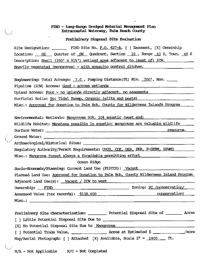
F I N D - - ~ Y ' ' l Y l 4 P l a n
C I n h r a o o a s t d L ~ ~ , - - -
Preliminazy Disposal Site Evdluatim
Site ~esi+tion: FIND Site No. F.O. 627-A, [ ] Easement, [XI Ownership
Iccation: SE Quarterofz@i~drant, Section&, RangeAE, Town.45S
Desrription: Small (350' x 915') wetland area adjacent to feast of) ICW. Heavily vwetated lnkmx-ovesl - with mosauito control ditches.
mginering: mtal Acreage: 7.0, Funping Distance(ft) Min. m, m. - Pipeline (ICW) Access: G o d - across wetlands upland A-: poor - no mlands directlv adjacent. no easerents
Surficial Soils: To: Tidal Swamp. Orsanic (silts and teats)
Misc.: Moroved for donation to Palm Bch. Countv for Wilderness Islands Prcsram
EIN-: Wetlands: Mawroves 90%. 10% aquatic fwest d l
Wildlife Habitat: Manatees mssible in aquatic: nkmx-oves are valuable wildlife
Surface Water: resource.
Ground Water: (s/
Arhaeological/Historical Sites:
m a t o r y Authority/permit -ts: USE. alE. DER, DNR. PDERM, SFWMD
Misc.: Manqrove forest always a formidable Dermittins effort
ocean w e
S o c i o - ~ c / p l ~ : Omrent: Iand Use (mLTCCS) : Vacant
Planned Ian3 Use: Amroved for DoMtion to Palm Bch. Countv W i l d e m Island Pmrram
Adjacent Ian3 Use(s) : Vacant / ICW to west
-P: FIND Zoning: - PC fvresenmtion/ Assessad Value (tax records) : $138.600 conservation)
Misc. :
Preliminary Site Chars ' tim: Potential Diqxsd Site of Acres
[ ] Little Potential Disposal Site Lhe to
[XI No Patential Dispcsal Site IXle to ?Qn?mves
[ ] Potential Trade Value, Acres at Estimated $ /acre
Map/Aerial Photcgraph: [ ] Attached [XI Available, S d e 1" = f400 ft.
i/ N/A - Not Ppplicable N/C - Not Completed
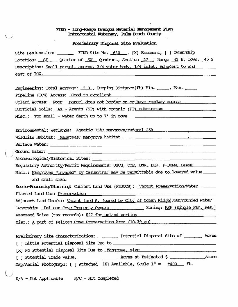
Prelkimqf DisposdL Si te Evaluatim
Site miqr$tion: FINTI Site No. 630 , [XI Easement, [ I O;Jnerskip
hxation: SE Q a r b r o f SW -&ant, S e c t i o n x , R a n g e s E, Tawn. 45 S
~ m i p t i o n : -1, amrox. 3/4 water m, 1/4 islet. Miacent to and
east of ICW.
mi~~~irq: Total Acreage: 2.3, pumping Distance(ft) Min. -, w e - Pipeline (ICW) Access: Gocd t o excellent
Upland Access: Poor - -1 does not border on or have mdwav access
Surficial Soils: AX - Arents (SP) w i t h orsanic (PT) substratum
M i x . : Too small -waterdepthm t o 7' in m e
Ehvh ' 1: W e t l m : Aauatic 75%; marrsrwe/ruderal 25%
Wildlife Habitat: Hmatees; mammve habitat
Surface Water:
Ground Water: t. 1:
Amhaeolcgical/Historical Sites:
Regulatory Authority/Fennit Requirements: USG, 03E. LNR. DER, P D m . SFViMD
M i x . : mnqmves atinvadedtt & casuarina; may be h t t a b l e due t o lowered value
and sFdll size. S o c i o - ~ c / P l a n n i q : Current Iand U s e (FLUCCS) : Vacant ~reservation/Water
Planned Land Use: -tion
Mjacent Land U s e ( s ) : Vacant land S. (awned & C i t v of Ocean Ridce) /-ed Water
dynership: Pelican Care Pnxerhr Owners Zoning: ~ RSF (sirale Fam. Res . . l
Assessed Value (tax records): $27 for mland mrt ion
Misc. : A cart of Pelican Care ~resenmtion Area (10.39 ac)
Preljminary Si te C h a r a ~ t i c m : Fotential D i s p o s d l Si te of Acres
[ ] Lit t le Potential D i s p o s a l site m e to [XI No Potential D i m Si te IXle to bbnmove, s i z e
[ ] Potential Trade Value, Acres at Estimated $ /acre
Map/Aerial Fhotqmph: [ ] Attached [XI Available, Scdle 1" = +400 ft.
(...A; N/A - ~ o t Applicable N/C - N o t Completed

. . PrellrmMlry Disposdl Site ESfaluatim
Si t e wignkt ion: FIM) Si t e No. 633 , [XI m t , [ 1 OiYnership
Lacation: SW Qlarb?xof&&adrant, S e c t i o n L , R a n g e X E , Tawn. 4 5 s ~escrription: Small area adiacent to (east of) ICW. Borders F.O. 634 t o the south.
Some standincl water. R e ~ u e s t . 6 3 for release kw awner.
~~: Total Acreage: 0.8, EUnping Distance(ft) Min. a, Max. - Pipeline (ICW) Access: Good - across veqetation
Upland Access: Poor - borders undwelmed land to the E. Presentlv no easment to A1A
Surficial Soils: AX - sand with o d c substrata
Misc. : Too small, even w i t h -1 F.O. 634. H c w m a . lx~rchase of this u m and
land t o E. (all the way to AlA) , might be an m i o n i f dredging is required nearby.
Envh I ' 1 : W e t l a n d s : -tic habitat on extreme west ~ r t i 0 n
Wildlife Habitat: IJuland area d&ted kw Casuarina - law wildlife value . Surface Water:
Ground Water:
(/ ArchaeolcgicdL/Kistorical Sites:
m a t o r y Authority/Permit -ts: Aquatic: USE, COE, DER. LNR. P D M . S W
Misc.: other than small aauatic habitat, the site is of law ecolosical value
~ o c i o - ~ c / p l ~ : Current Land U s e (FLUCCS) : Water / Vacant Lard
Planned Land Use:
Adjacent Land U s e ( s ) : Fender -1 to E./Hcusinq t o N./ICW to W./Vac. t o S. and E.
OiYnership: Ocean Ridqe E s t a t e s Zoning: - RSF fsinclle Fam. Res. 1 Assessea Value (tax records) : $44.000
M i s c . :
a e l i m i n a ~ ~ S i t e -tian: Potential D i s p o s a l S i t e of A c r e s
[ 1 Li t t l e Pcrtential D i s p o s a l S i t e me to
[XI No Potential D i s p o s a l S i t e IXle to Mia& lard use, s ize
[XI Potential Trade Value, hi* Acres a t Estimated $ /acre
Map/Aerial Fhotqraph: [ ] Attached [XI Available, Scdle 1" = +400 ft.
'-l' N/A - Not Appli-le N/C - Not Cmpleted
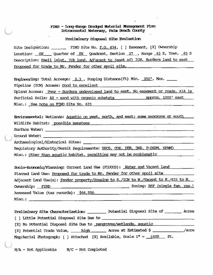
-. . y D k p i a l site Evdluatim
site ~ e s i q i t i o n : FIND Si te NO. F.O. 634, [ 1 Easement, /XI CXmership
Location: SW ~mrter of Quadrant, Section 27, Range 43 E, Town. 45 S
tkscription: .%all i s l e t , 70% land, Adjacent to feast of) ICw. Borders land to east
fo r trade to Mr. Fender for other mil site.
F ,' ing: Totdl Acreage: 2.3, Funping Distance(ft) Min. X, Max. - Pipeline (ICW) Access: Good t o excellent
Upland A c c e s s : poor - Borders u n d e v e l m land to east. No e a a w n t o r rwds. A1A is
Surficial Soils: AX - sand w i t h omanic sukstata approx. 1000' east
Misc.: See note on FIND Si t e No. 633
kid: W e t l a n d s : Aauatic on west, north, and east: some mansrove at south
Wildlife Habitat: m s i b l e mumtees Surface Water:
Ground Water: i,/
Archaeolcgical/Historical Sites:
R q u l a t x x y Authority/&t Re@remmts: USG, COE. Dm, DNR, P - D M , SFWMD
Misc. : Other than aauatic habitat, cermittina may not be ~ d l a t i ~
S o c i o - ~ c / p 1 ~ : Current Land U s e (FIIJaS) : Water and Vacant Land
Planned Land Use: f o r trade to Mr. Fender fo r other smil site
Adjacent Ianl Use(s): Fender ~ ~ r t v f i c ~ l s ~ to S./ICW to W./vacant t o E./633 t o N.
odtwship: FIND Zoning: - RSF lsinqle fam. res. 1 Assessea Value (tax records) : $66,550
M i s c . :
Preliminary S i t e mcterizaticm: Potential DisposdL S i t e of A c r e s
[ ] Li t t l e Potential D i s p o s a l S i t e IUe to
[XI No Potential D i s p o s a l S i t e IXle to ~ e s / w e t l a n d s . aauatic
[XI Potential Trade Value, h i m ~c res a t Estimated $ /acre
mp/Aerial Fhotcgraph: [ ] Attached [XI Available, S d e 1" = +400 f t .
i -i N/A - Not m l i c a b l e N/C - Not Cmpleted

~IND - 1ag~anp2 m u ltanageawt Plan I n t r a c o a s t a l m , - - m
a e l i m i m r y D i s p g a l Site Evaluaticn
S i te ~esig&tion: FTND Si t e No. 635 , [XI Easement, [ 1 Ownership
i za t ion : NW ~ m r t e r of NW Quadrant, Section 34, Range 43 E, Town. 45 S
Description: Smdll sand -1 adiacent to (west of) ICW. Eas t of F.O. 635A and north
of 636 ( a l l 3 mrcels contiquous).
-: Total Acreage: 3.05, Funping D i s t a n c e ( f t ) Min. 350, Kax. - Pipeline (107) Access: Excellent
Upland Access : Poor - no roads adiacent. Need easement east of F.O. 635A
Surficial Soils: !Dl - Tidal Marsh - mckv, loarmir sand /SP/SM)
Misc.: Miqht be suitable w i t h F.O. 635A and 636, but still needs road access
Ertvicmtntal: Wetlands: Manqrwes (95%) w i t h channel cont%xth ICW (5%)
Wildlife Habitat: Possible Kxmtees. nmmuves considered valuable
Surface Water:
C Ground Water:
?rchaeolcgical/Kistorical Sites:
F'zqulatory Authority/Fennit -ts: COE, DER, DNR. P - D M . SFWID
M i x . : mks like qc=xl quality manglrae habitat
S o c i o - ~ c / P l a m i r q : Qlrrent Land U s e (F'LUaS) : Vacant
Planned Land Use: Hi& densitv residential (B.B.L.U. Plan) ICNW to E.
Adjacent land U s e ( s ) : Carmnercial TJ~-CXE&V t o N./Vacant Land to W. & S. (636 and 635A)
Cmezddp: Wm. Kcch et. 61. Zoning: R3
Assessed Value (tax records): $21,291 (no Ac. qiven in tax records)
M i x . :
Preliminary Site -tion: Potential D i s p o s a l S i te of Acres
[ ] Li t t le mtential Disposal Si te Cue to [XI NO potential D i q c s a l site lXle t o ~ e s / w e t l a n d s
[ ] Potential Trade Value, Acres at Estimated $ /acre
Map/Aerial Fhotqraph: [ ] Attached [XI Available, S d e 1" = f400 fl.
c -, N/A - Not Applicable N/C - N o t Campleted
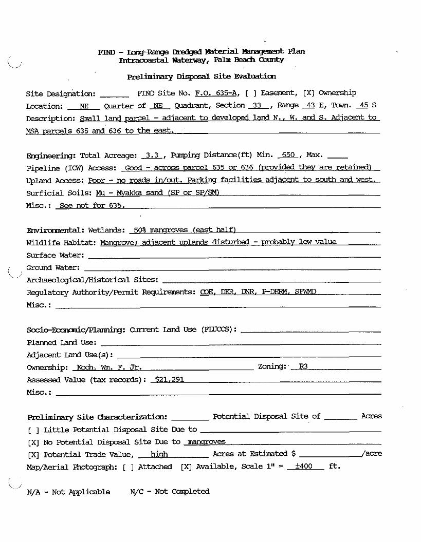
. . prdmmaq D i s p ~ i 1 Si te Evdluatim
Si te ~es ignk ion : FIND S i te No. F.O. 635-A, [ ] Easement, [XI OrYnership
m t i o n : NE -of NE ~ & a n t , S e d i o n ~ , R a n g e ~ ~ , ~ a w n . ~ S
Description: Srrall land -1 - adiacent to dwelow3 land N.. W. and S. Adiacent t o
EA parcels 635 and 636 to the east.
Total Acreage: 3.3, Fanping D i s t a n c e ( f t ) Min. 650, Max. - pipeline (ICW) Access: Good - across parcel 635 or 636 (pmided theV are retained)
upland ~ccess: Poor - no roads in/out. Parkira f ac i l i t i e s adiacent to south and wes t .
Surficial Soils: Mu - Mvakka sand (SP or SP/SM)
Misc.: See not for 635.
?&vkmmatal: Wetlands: 50% mwmves (east half l
Wildlife Habitat: mnqruve: adjacent uplands di&u&d - prdBb1~ law value
Surface Water:
Ground W a t e r : ' Archaeo~cgical/Kistoricdl sites: Regulatory Authority/Fennit -ts: COE. DER. P-DE3-l. SFWD
Misc. :
S o c i o - ~ c / P l a n n h q : Current Land U s e (FUCCS) :
Planned Land Use:
Mjacent Ian3 U s e ( s ) :
Cwmxship: K d i Wm. F. Jr. Zoning: - R3
Assessea Value (tax records) : $21,291
Prdiminapy Si te cbm&e&atim: mtial D m S i t e of Acres
[ 1 Little Potential D i s p o s d l S i t e Cue to [XI No Potential D i s p o s d l S i t e Cue to IEIWIUV~S
[XI Potential Trade Value, h i m Acres a t Estimated $ /acre
Map/Aerial Photograph: [ ] Attached [XI Available, ScdLe 1" = A400 ft.
\ / N/A - Not Applicable N/C - Not Campleted

FTND - m q - m q e Dmd@ ?mterM mwmmt Plan -m-,---
. . Di-1 S i t e Evaluath~
F'IND S i t e No. 636 , [XI Easement, [ ] Ownershi Si te ~esignktion: P
Location: NW Quarterof NW Quadrant, Section%, R a n g e A E , Town.A5S
Description: Small land parcel adjacent to ( w e s t of) ICW. Bordered to N. bv KSA-635
and t o east bv F.o.-635A. parkins f ac i l i t i e s to south.
R~~in?ering: Total Acreage: 2.7, Funping D i s t a n c e ( f t ) Min. 350, Max. - Pipeline (ICW) Access: Excellent
upland ACES: poor
Surficial Soils: 60% 'IM - mckv sandv loam, 40% AX sand with muck substrata
Misc. : See note for 635
~nv-: W e t l a r d s : 100% IImrmuve
W i l d l i f e Habitat: valuable manarove forest
Surface W a t e r :
Ground Water: '/ Archaeolcgical/Historical Sites:
R q u l a t o q Authority/-t Rqubxmmts: COE. DER, PDERM. S W
Misc.: Mancpme forest aprexs l i t t le disturbd - cermittins m y be di f f icu l t
~ o c i o - E c a n n i c / P l ~ : Current Land U s e (F'IlJCCS) : Vacant land
Planned Iand Use : Hi& densitv residential (B.B. L.U. ~ l a n )
Adjacent Land U s e ( s ) : Condols t o S./Vac. to N. & W.(635 & 635A)/ICW t o E.
cXJnership: Wm Kcch zoning:- Fs
Assessed Value (tax records) : $18,753 in0 Ac. siven in tax records)
Prelhbary S i t e -tian: Potential D i s p o s a l S i te of A c r e s
[ ] L i t t l e potesltial D i s p o s a l S i te Due t o
[XI No Potential D i s p o s d l S i t e Ike to MarumveS
[ ] Potential Trade Value, Acres a t Estimated $ /acre
Map/Aerial Photcqaph: [ ] Attached [XI Availible, Scdle 1" = 2400 ft.
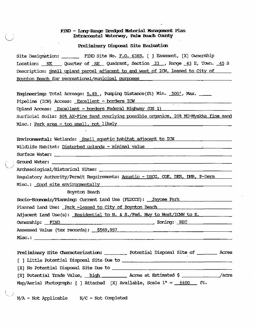
FIND - Iaq+amp H a k r X W m % y m k Plan -='==%-,---
-. . Disposal Site Evdluaticn
site ~esignkion: FTND Site NO. F.O. 638B, [ ] Easement, [XI Ownership
Location: NE Quarter of SE @adrant, Sedion 33, Range 43 E, Tawn. 4 5 S
Description: Small wland mrcel adjacent to and w e s t of ICW, leased t o C i t v of
BoVnton Beach for recreat ioml/miciEd Txmxses
mineering: Total Acreage: 5.49, PLnopbq Distance(ft) Min. 500', W. - Pipelhe (ICW) Access: Excellent - borders ICW
upland ~ccess: Excellent - borders Federal Hicbmv (US 1)
Surficial Soils: 80% AX-Fine Sand w e r l v h wssible omanics. 20% MU-Mwk3a fine sand
Misc. : Park area - too m l l , not likelv
Fnv ' 'A: Wetlards: Small aquatic habitat adiacent t o ICW
Wildlife Habitat: Disturb3 wlands - min imal value
Surf ace Water:
Ground Water: i \./' Archaeologicdl/Kistorical S i t s :
Reglatory ~uthority/Femit qirements: Acruatic - USG. 03E. DER. LNR, PCerm
Misc.: Good site envimnmentallv
Boynton Beach
S c c i o - F c m m n i c / P l ~ : Current Land U s e (FLUCCS) : J a v e Park Planned Land Use: Park -leased t o C i t v of Bwnton Beach
Mjacent Land Use(s): Residential t o N. & S./Fed. Hwv t o W@&/ICW t o E.
Ownership: FIM) Zoning:- REC
Assessed Value (tax records) : $569,957
M i s c . :
Preliminary Si te Characterization: Potential Dispod Si te of Acres
[ ] Lit t le mtential D i s p o s d l Si te IXle to [XI No Potential D i s p o s d L Si te IXle to [XI Potential Trade Value, hi* Acres a t Estimated $ /acre
Map/Aerial Photcxgraph: [ ] Attached [XI Available, Scale 1" = +400 ft.
N/A - Not Applicable N/C - Not Completed
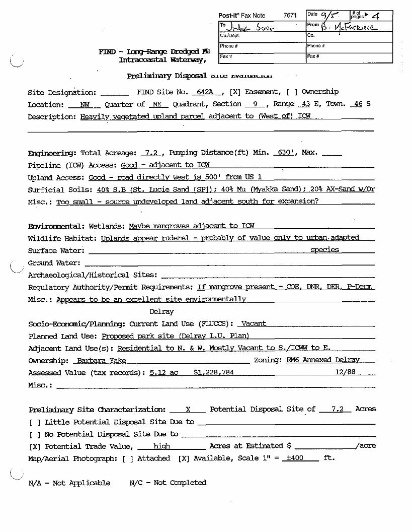
. . Fmammry Disposal al.u GVQL-U",
Post-itB Fax Note 7671
T"J,-~d- S,,,J~. CO IDept
Phone #
Fax #
Si t e ~es ignk ion : FIND Si te No. 642A , [XI Fasanmt, [ ] Ownership
kcation: NW Quarter of Quadrant, Section 9, Range 43 E, Town. 46 S
Cescription: Heavily vwetated uwland -1 adjacent to ( W e s t of1 ICW
Date q/f I #Of b 4 pages
pi . ~ & z ~ , o G - Ca I
Phone #
Fax #
Ek~~ineeriq: 'Ibtal Acreage: 7.2, ~ r m p i n g ~istance(ft) Min. m, W. - pipeline (ICW) Access: G c d - adiacent to ICW
Upland Access: G c d - road directlv w e s t is 500' fmm US 1
Surficial Soils: 40% S.B (St. Lucie Sand TSP11: 40% Mu (Mvakka Sand): 20% AX-Sand w/Or
Misc.: TOO ma11 - source undeveloced land adiacent south fo r ex?2amion?
-: Wetlands: Maybe mammves adjacent t o ICW
Wildlife Habitat: Uplands a m ruderel - w ~ l v of value onlv to urban.adawted
Surface W a t e r : species
C Grcund W a t e r :
Archaeolqical/Historical Sites:
Regulatory Authority/Permit Requiremnts: I f mansrae present - 03E. DNR. DER, PEnn
Misc.: &ipzars t o be an excellent site enviromnentallv
Delray
S c c i c - ~ c / P l a n n i n g : Curxent Land U s e (FLUCCS) : V a c a n t
Planned Land Use: Proms& 13ark site (Delrav L.U. Plan)
Adjacent Iand U s e ( s ) : Residential t o N. & W. Mostlv V a c a n t to S./ICWW to E.
Cxa-~&Gp: Eiarbma Yake Zoning: RM6 Annexed Delrav
Assessed Value (tax records) : 5.12 ac $1,228,784 12/88
Miminary Site Chmderization: X Potential D i s p o s a l S i t e of 7.2 A c r e s
[ ] Li t t l e Potential D i s p o s d l S i te IXle to
[ ] No Potential D i s p o s a l S i t e IXle to [XI Potential Trade Value, hi& Acres a t Estimated $ /acre
Map/Aerial Photograph: [ ] Attached [XI ~va i l ab l e , Scale 1'' = +400 ft.
L, N/A - Not Applicable N/C - N o t Completed

preliminary Disposal Site. Evaluaticn
Site ~esign&tion: FIND Site NO. F.O 645C, [ 1 ~asement, [XI Ownership bcation: SW Quarter of mdrant, Sedion 9, Range 43 E, Tawn. 46 S Description: mall land mrcel adjacent to [Fast of) ICW. Abuts F.O. 645D to east
heavilv vwetated
~~~: Total Acreage: 2.4, FUnping Distance(*) Min. LEE, Max. - Pipeline (ICW) Access: Excellent - borders the ICW Upland Access: Fxcellent - provided F.O. 645D is also retained. To Andrew 8th St. Surficial Soils: AX - Sard with underlvim orsanics
Misc.: Even with F.O. 645D. mrcel is small
Ehvimmentd: Wetlands: Possible imncrove f r k e adjacent to ICW
Wildlife Habitat: Distwkd wlands - low value Surface Water:
Ground Water:
j- Archaeolcgical/Historical Sites: Regulatov Authority/Permit Fqinments: If mawrove - 01E. DER. DNR, PDerm
Misc. : Good site environmentallv
Delray
Socio-Fconmuicp~: Current Land Use (FLUES) : Vacant
Planned Land Use: m-oarjed Park site IDelrav L.U. Plan)
Mjacent Land Use(s): Residential to N. & S./Vacant IEU 645D) to E./ICWW to W.
Ownership: FIND Zoning: -RIAA (simle families1
Assessed Value (tax mrds) : $505.050
Misc. :
w/645D
aeliminary Site Ommcterization: X Potential Disposal Site of 2.4 Acres
[ 1 Little Potential Disposdl Site rXle to [ ] No Potential Disposal Site m e to
[XI Potential Trade Value, hi* Acres at Estimated $ /acre
Map/Aerial Photcqaph: [ ] Attached [XI Available, Scdle 1" = +400 ft.
\ N/A - Not Applicable N/C - Not Ccrmpleted

. . preZlmurary Dispasal Site Evdluatim
site ~ e s i g k i o n : FIM) S i t e NO. F.O. 645D, [ 1 E a s e m e n t , [XI CXmerShip
Location: S E Q u a r t e r o f L Q m d r a n t , -ion&, R a n g e S E , T a w n . 4 6 S
DesQ-iption: S r n a l l land -1 a~~,roximatelv 350' from ICW east shore. adiacent t o
F.O. 645C and Andrews A v e n u e
mgineering: Total Acreage: 5.0, Armping D i s t a n c e ( - ) Min. 800', Max. - Pipeline (KW) A=: Good - D r u V i d e d F.O. 645C is retained
Upland A c c e s s : Excellent - Andrews A v e n u e to 8th Street to US 1 or A1A
Surficial Soils: AX - sand w i t h omanic substata
Misc.: S m a l l , even w i t h F.O. 6 4 5 C
ental: W e t l a n d s : N o n e
W i l d l i f e Habitat: D i s t u r b e d ~xhnds - hi& cover: Value to urban 57ECie.S . Surface W a t e r :
C/ water: Archaeolcgical/Kistorical Sites:
Regulatory A u t h o r i t y / p e r m i t Requkm3ts: N/A
Misc.: E x c e l l e n t site
D e l r a y
Socio-&c/Planninq: Current Land U s e (FLU-) : V a c a n t
Planned I d Use: Frqxsed Park S i t e ( D e l r a v L.U. P l a n )
Adjacent land U s e ( s ) : Residential t o N.,S., & E . / V a c a n t Iand (FO 645C) to W.
-P: F'IND Z o n i n g : RlAA ( s i m r l e £am. resl Assessed V a l u e (tax mrds ) : $503,000
M i s c . :
w/645C
Miminazy Site -tim: X Potential D i s p o s a l S i t e of 5.0 Acres
[ ] W e Potential D i s p o s a l S i t e IXle to [ ] N o EMential D i s p o s d L S i t e IXle to
[XI Potential Trade V a l u e , hi& Acres a t Estimated $ /acre
M a p / A e r i a l Photcqraph: [ ] A t t a c h e d [XI A v a i l a b l e , Scale 1" = A400 ft.
\J N/A - N o t Applicable N/C - N o t Completed
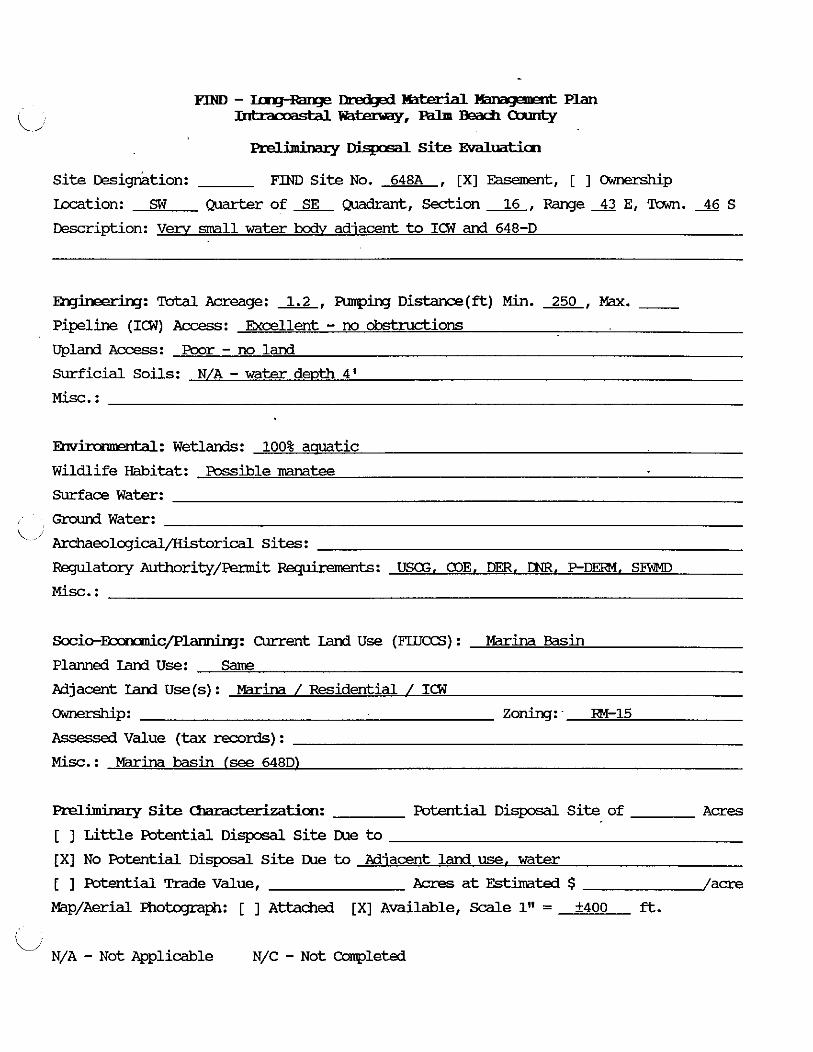
FIND - IngRanp nabrial KanqasnR Plan --,--Oanrty
... . y Dispcsal S i t e Eval*
Si te r~?sig&tion: FIND Si te No. 648A , [XI Easement, [ ] Ownership
Location: SW quarter of m d r a n t , Section 16, R?nge 43 E, Town. 46 S
Description: Verv small water bodv adjacent t o ICW and 648-D
~~~ineerirlg: -Acreage: 1.2, q i n g D i s t a n C e ( f t ) Min. 250, Max. - Pipeline (ICW) Access: Excellent - no c k t m d i o n s
Upland Access: poor - no land
Surficial Soils: N/A - w a t e r d e ~ t h 4'
Misc. :
Em' 'XI: Wetlands: 100% aauatic
Wildlife Habitat: Fossible namtee
Surface Water:
G n x l n d Water: < 1 Archeolcgical/Historical Sites:
Faylatory Authority/Permit Requiremmts: USE, 03E. DER, DNR, PDEFN. SFWMD
Socio-F 'c/Plarmiq: Current Land U s e (FLIJCCS) : Marina Basin
Planned Land Use: Same
Adjacent Land U s e ( s ) : Marina / Residential / ICW
-P: Zoning:- FX-15
Assessed Value (tax records) :
Misc. : Marina basin (see 648D)
Preliminary S i t e -tiion: Potential D i s p o s d l S i te of A c r e s
[ ] Little Potential D i s p o s a l S i t e tue to
[XI No Potential D i s p o s a l S i te tue to Adjacent land use. w a t e r
[ ] Potential Trade Value , Acres at Estimated $ /acre
P?ap/Aerial Photcqraph: [ ] Attached [XI Available, Scale 1" = k400 ft.
ii N/A - Not Applicable N/C - Not Completed
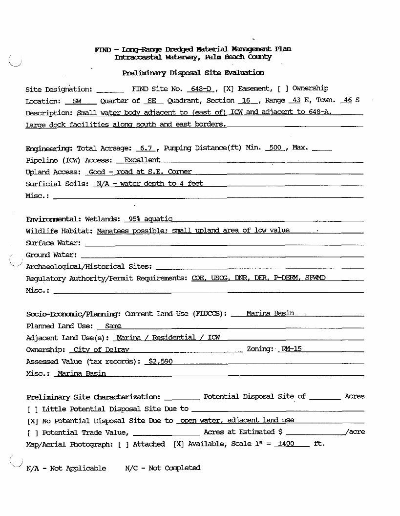
Prelimimq Dispcsdl Site Evaluation
Site %i&tion: FIND S i te No. 648-D , [XI Easement, [ 1 WP Location: SW of SE Quadtant, section 16, Range 43 E, l"u.m. 46 S
~escription: Small water bodv adiacent t o (east of) ICW and adjacent t o 648-A.
m e dock fac i l i t ies &OW sa~th and &st borders.
rng-: Tutal Acreage: 6.7, Rmping D i s t a n c e ( f t ) Min. 500, Max. - Pipeline (ICW) Access: Excellent
Upland Access: Good - road a t S.E. Corner
Surficial Soils: N/A -water deuth t o 4 feet
M i s c . :
Ehvhxmmtal: Wetlands: 95% a m t i c
Wildlife Habitat: Manatees w i b l e : small wland area of law value
Surface Water:
Ground W a t e r :
Archaeological/Kistorical Sites:
Regulatory Authority/permit -ts: COE, USa3. DNR. Dm, P - D m . SFiJMD
Socic-~c/plannirq: Current Land U s e (FLUCCS) : Marina Basin
Planned Iand Use: Same
Adjacent Land U s e ( s ) : Marina / Fesidential / I C W
cXJnership: C i t v of DelraY Zoning: RM-15
Assessea Value (tax reoords) : $2,590
Misc. : Marina Basin
Preliminary Site tion on: mtential D i s p o s a l S i te of Acres
[ ] Lit t le Foterrtial D i s p 3 s d l S i te me to [XI No Potential D i s p o s a l Si te me to water, adiacent land use
[ ] Fotential Trade Value, Acres a t Estimated $ /acre
Map/Aerial Fhotcqraph: [ ] Attached [XI Available, Scdle 1" = f400 ft .
"' N/A - Not Applicable N/C - N o t Ccanpleted
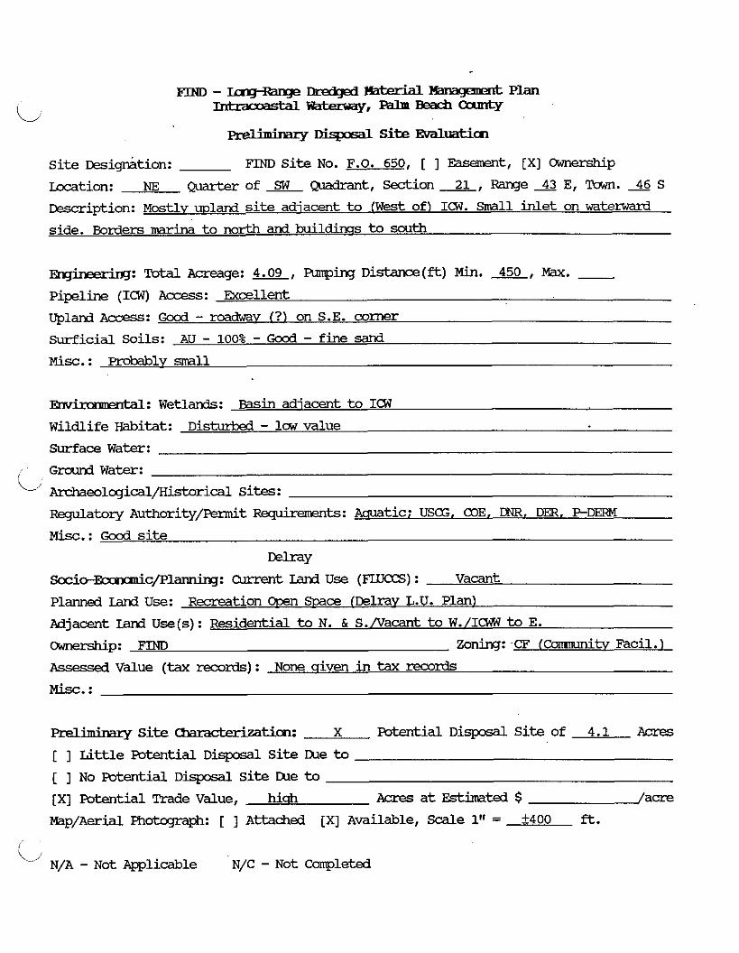
m - ~cng~ange mdgd mterial B x q e m d Plan IntraooastdlWa-,---
. . r i m 1 Site Evdluaticn
S i t e ~ e s i ~ r h t i o n : FIND S i t e No. F.O. 650, [ ] -t, [XI Ownerskip
Location: NE Quarter of Quadrant, -ion 2, Range 43 E, Town. 46 S
w i p t i o n : ~ t l y upland site adjacent t o ( W e s t of) 1 Small inlet on at el Ward
side. Borders marina t o mrth and buildinss to south
-hg: Total Acreage: 4.09, Funping D i s t a n c e ( f t ) Min. 450, Max. - Pipeline (ICW) Access: Excellent
upland ACCIXS: Good - mdwav I ? ) on S.E. corner
surficial Soils: AU - 100% - Good - fine sand
Misc. : Probably smll
-: Wetlands: Basin adjacent to ICW
Wildlife Habitat: D i s M - l c w value
Surface Water:
Ground W a t e r :
Archaeolcgical/Kistorical sites: Regulatory Authority/Fennit -ts: Aauatic: USG, alE. DNR, DER. PDERM
Misc.: Good site
W ~ Y S o c i o - ~ c / F ' l ~ : W e n t Land U s e (FLUOCS) : Vacant
Planned Land Use: Recreation Ooen SWce {Delra~ L.U. Plan)
Adjacent Ian3 Use(s) : Residential to N. & S./Vacant t o W./ICWW to E.
cmne~hip: FIND Zoning: CF (camunity Facil.
Assessed Value (tax rex~rds) : None qiven in tax records
Preliminary S i t e Umacbdmtion: X Potential DisposdL S i t e of 4.1 Acres
[ ] Li t t l e Potential DisposdL S i t e Due t o [ ] No Potential Disposdl S i te IXle to
[XI Potential Trade Value, hi& Acres a t Estimated $ /acre
Map/Aerial Photqraph: [ ] Attached [XI Available, Scale 1" = +400 ft.
i/ N/A - Not Applicable N/C - Not Campleted

FIW - Iuq-mqe mdp3 - lBnagement plan
L Tntracoastdlw-,---
m ~ y DispcsdL Si te Evalua th
S i t e t!esig-ktion: FIND Si te No. 651 , [XI Easement, [ ] Ownerskip
kcation: NE Quarter of NW Quadrant, Section 28, Range 43 E, Tawn. 46 S
w i p t i o n : small -1 awrox. 1/2 land and 1/2 water, adiacent to I(W. Includes
land eastkamd lanes of C.R. 782 bridqe (extends north to the section boundary).
- ' lg: Total Acreage: 4.0, PLrmping Distance(&) Min. a, Max. - Pipeline (ICW) A c c e s s : Excellent
Upland A c c e s s : Excellent - road a t south boundarv
Surficial Soils: On - surficial 13eat /omics underlain bv sand fSP/SM)
Misc . : Too d l
'dl: Wetlands: 1/2 aquatic; 1/2 wetland. m s i b l v mannwe Wildlife Habitat: Possible -tees; if inamroves i resent hioh wildlife value
Surface Water:
G r o u n d Water:
kdme01ogical/Historical Sites:
Regulatory Authority/Femit -ts: USCG. COE, DER, DNR, PDERM, SFWMD
Misc. : m r site environmentallv
S o c i o - ~ c / P l a x m i r q : Current Land U s e (FIUCCS) : Vacant
Planned Land Use: Recreation Cusm .%ace (Deli-a~ L.U. Plan)
Adjacent Land Use(s): Bridcre to N./Resident. & -ial t o W./ICW to E.
Ownership: Mike Blank Zoning:- RlAA annexed in El.
ASSEE& Value (tax records) : $82,795.00
M i s c . :
Prelimim.ry S i t e Chmcterizaticm: Potential D i s p o s a l S i t e of Acres
[ ] L i t t l e Potential Disposdl Si t e IXle to [XI No Pa ten t id D i s p o s d l S i t e me to cxxn water, envirom, size. adi. land use south
[ ] Potential Trade Value, Acres a t Estimated $ /acre
Map/Aerial Fhotcgraph: [ ] Attached [XI ~va i l ab l e , Scale 1" = +400 ft.
N/A - Not lyplisable N/C - Not -1eted
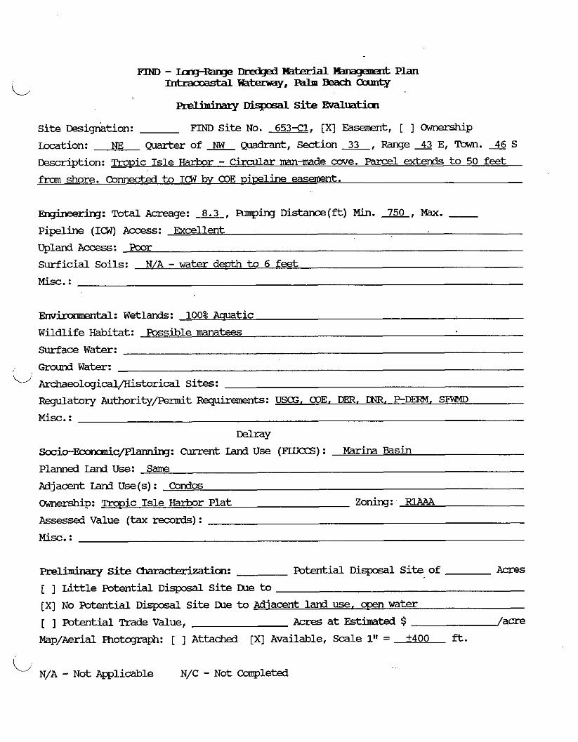
m - mq-mqe mtexhl Hmqmmt Plan -mt=-Y.--Oanrty
. . PrellrmMlry Disposal Si te Evaluatia~
Si te Desigthtion: FIND Si te No. 653x1, [XI Easement, [ ] cXYnership
hxation: NE Q ~ a r b x o f ~ Q u a d r a n t , Section&, R a n g e S E , Tawn.*S
Descrription: Tropic Isle H a r k o r - C i r c u l a r --made cove. Parcel extends t o 50 feet
from shore. Connected t o IcW bv COE viceline easement.
-: Total Acreage: 8.3, wing D i s t a n c e ( * ) Min. 750, Max. - Pipeline (ICW) Access: & e l l e n t
Upland Access : Poor
Surficial Soils: N/A - water depth t o 6 feet
Misc. :
Envimmnxkd: Wetlands: 100% Aauatic
Wildlife Habitat: Possible n?anatees
Surface Water:
L; Grourd Water:
k-dmeolqicdl/Historical Sites:
R q u l a t o r y Authority/Permit -ts: USCG, COE. DER. DNR. P - D m . SFFWD
Misc. :
MraY socio-=c/Planning: Current Land U s e ( F U T a S ) : Wins asi in
Planned Land Use: Same
Adjacent Land U s e (s) : Condffi
Cmership: m i c Isle H-r Plat Zoning: RlAAA
Assessed Value (tax records) :
Misc. :
Preliminary Site -tim: potential D i s p s a l S i t e of Acres
[ ] Little potential D i s p s a l S i te Lhe to
[XI No Potential Disposal Si te Lhe to Adiacent land use, men water
[ ] Potential m d e Value, Acres at Estimated $ / a m
Map/Aerial Photqnph: [ ] Attached [XI Available, Scale 1" = +400 ft.
L, N/A - ~ o t Applicable N/C - N o t Campleted
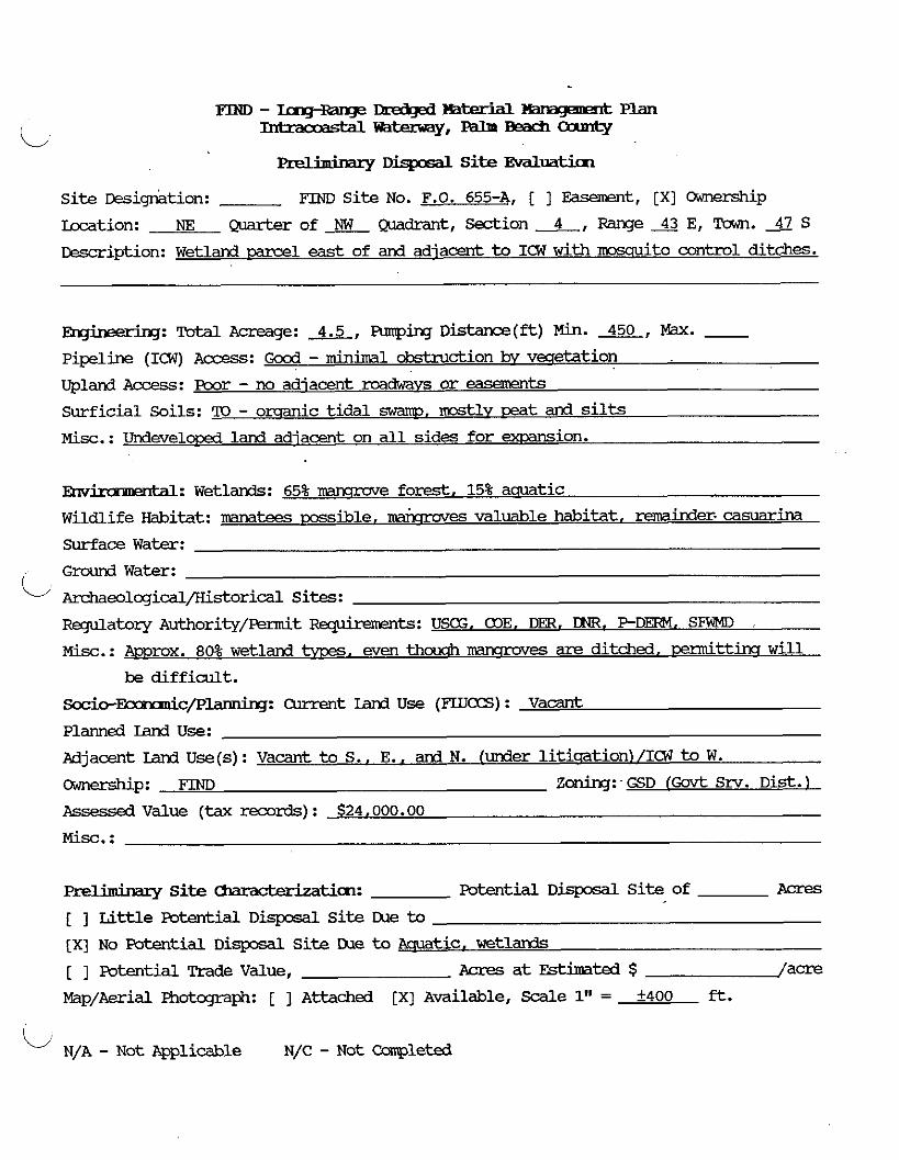
... . Site Evdluatj.cn
S i t e ~esign&tion: FIND S i te No. F.O. 655-A, [ ] Easement, [XI Ownership
-tion: NE Qmrter of a Quadrant, Section 4, Range 43 E, Town. S
W i p t i o n : Wetland parcel east of and adjacent to ICW w i t h mo~lui to control ditches.
E&ree&g: Total Acreage: 4.5, Armping Dis t ance (* ) Min. 450, W. - Pipeline (ICW) Access : Good -minimal obstruction bv vecletation
Upland Access: poor - no adjacent roadways o r easerents
Surficial Soils: ?O - orqanic t ida l swam^, mostlv teat and silts
Misc.: Undevelowd land adjacent on a l l sides for exmnsion.
~hvkammta l : wetlands: 65% mrmove forest. 15% aquatic
Wildlife Habitat: mtees msible, mixroves valuable habitat. reminder. casuarina
Surface Water:
Grcund W a t e r :
Archaeolcgical/Historical Sites:
FkqulatoLy Authority/penait F ~ p k m n t s : USG, alE, Dm, DNR. P-DERM. S W
Misc.: Amrox. 80% wetland m, even thcwh mrmoves are ditched, enn nit tins w i l l
be diff icult .
Socio-r 'c/Plannbg: Olrrent Land U s e (Was) : Vacant
Planned Land Use:
Adjacent Land U s e ( s ) : Vacant to S.. E., and N. (under litisation)/ICW t o W.
Ownership: FIND Zolling: GSD (Govt Srv. D i s t . )
Assessed Value (tax records) : $24,000.00
Misc. :
Preliminary Site UmxhrLmtiion: Potestial D i s p o s d l S i t e of Acres
[ ] Li t t l e Potential D i s p o s a l S i t e me t o
[XI No Potential D i s p o s d l S i t e Dae t o Aquatic. wetlands
[ ] Potential Trade Value, Aaes a t Estimated $ /acre
Map/Aerial Fhotqtaph: [ ] Attached [XI Available, Scdle 1" = f400 ft.
, - Not Applicable N/C - N o t Ccmp1et-d
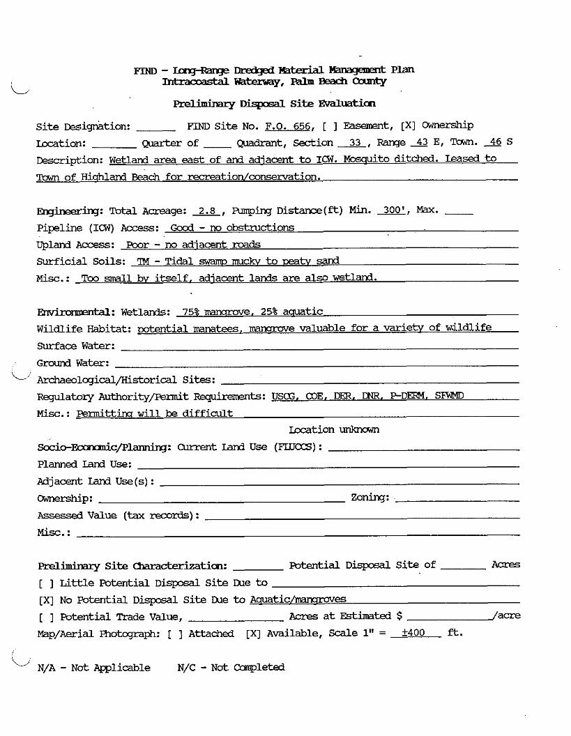
. . PrellrmMlly -1 S i t e Evdluation
Si te w i g k i o n : FIM) Si t e No. F.O. 656, [ ] Easement, [XI Ownership
Location: -of - Qmdrant, S e c t i o n x , Rmqe* E, Town. 46 S
Desrription: Wetland area east of and adjacent to ICW. Mossuito ditched. Leased t o
Town of Hiqhland Beach for rerreation/consemation.
Engine&iq: Total A m g e : 2.8, Plrmping D i s t a n c e ( * ) Min. 300', Max. - Pipeline (ICW) Access: Gocd - no obstructions
Upland Access : Poor - no adjacent mds
Surficial Soils: ?M - Tidal swam muckv to mtv sand
M i s c . : Too d l bv i t s e l f . adjacent lands are also wetland.
Envimmmbl: Wetlands: 75% mansrove. 25% aauatic
Wildlife Habitat: potential manatees, mmmve valuable for a varietv of wildlife
Surface Water:
Ground Water:
Archaeolcgical/Kistorical Sites:
RBgulatoq Authority/&t Rqhmnents: USCG, COE. DER. PDEFM. SFWMl
Misc.: P e r m i t t h w i l l be di f f icu l t
Location un)awwn
Socio-Emnanic/Planning: Current Land U s e (FLUCCS) :
Planned Land use: Adjacent Iand U s e (s) :
-P: Zoning:
Assessed V a l u e (tax records) :
Misc. :
Preliminary S i t e &aracterizaticm: Potential D i s p o s d l S i t e of Acres
[ ] Li t t l e Potential D i s p o s a l S i te me to
[XI No Potential D i s p o s a l S i t e IXle to A a u a t i c / m e s
[ ] Potential Trade Value, Acres a t Estimated $ /acre
Map/Aerial Photcgraph: [ ] Attached [XI Available, Scale 1" = +400 ft.
L N/A - Not -1iale N/C - N o t cmpleted
m - ~ D r d l @ - ~ p ~
L --,--- preliminary nispxd S i t e Evaluaticn
Si te wig&tion: FIND S i t e No. 680 , [XI Easement, [ 1 m p
Location: SW CT.larterof SW wdrant, S e c t i o n L , m e X E , 'Tam. 4 7 s ksmipt ion: Wetland area adjacent to (west of) ICW. Moscruito control ditched.
~ng-: TOM Acreage: 7.0, Rnqing D i s t a n c e ( & ) Min. 350, W. - Pipeline (ICW) Access : mcellent - no obstructions
Upland Access : Poor - no roads
Surficial Soils: TO - Tidal s m r a ~ - mts and silts
Misc. : Part of area v w i d e s access to new dock fac i l i tv t o west.
lentdL: wetlands: 80% mansrove. 20% aauatic
Wildlife Habitat: mtees, Valuable Inawmve forest
Surface Water:
Ground Water:
~ e o l q i c a l / K i s t o r i c a l Sites:
Regulatory Authority/Permit W t s : USCG, COE, Dm, DNR, PDEFW. SFWMD
Misc.: Difficult d t t h
~ i o - ~ c / P l ~ : Current Land Use (F'IJJCCS) : Vacant Ivreservation)
Planned Land Use: Same
Pdjacent Land U s e ( s ) : Vacant to N. & W . / H c u s h t o S./ICW to E.
m p : Boca Marina Homeowners Assoc. Zoning: - BE-R1B
Assessed V a l u e (tax records) : $62.00
Misc. :
Prelhbary S i t e clmmcbrizaticn: Potential D i s p o s d l S i t e of Acres
[ ] L i t t l e Potential D i s p o s d l S i t e IXle to [XI No Potential D i s p o s d l S i t e IXle to Ac[uatic/wetland
[ ] Potential Trade Value, Acres a t Estimated $ /acre
Map/Aerial Fhobgaph: [ ] A t t a c h e d [XI Available, Scale 1" = +400 ft.
C N/A - Not el icable N/C - Not Ccarpsleted
FIND - D l 3 - mwF=t Plan
ii --,--- preliminazy ~ L E . S i t e Evaluation
Si te L!esig&tion: FIM) site No. 686 , [XI Easement, [ ] Ownership
Location: NW Q u a r t e r o f E Q u a d r a n t , S e c t i o n x , R a n g e X E , T o w n . X S
&scription: Venr mall trianqular-shad m1 w e s t of and a d i a m t to ICW, and
adiacent t o %A 687
-: Tatal Acreage: 1.0, Pumping Distance(&) Min. 300, Max. - Pipeline ( 1 0 7 ) Access: Gocd
Upland Access: Good - road adjacent t o north - thru residential
Surficial Soils: Pea* sands - about 1/2 of the area is water
M i s c . : Too small
,rtdL: Wetlands: 95% roamrrae or CO?~ water
Wildlife Habitat: Good wildlife habitat
Surface Water:
Ground Water:
Archaedogid/Historical Sites:
Regulatory Authority/Piermit Requirements: USE, a l E , DER. DNR. P - D M , SFWD
M i s c . : Difficult mttira
S c c i o - ~ c / P l a x m i q : Current Land U s e (FLUES) :
Planned Land Use:
A d j a e n t Iand U s e (s) :
Ownerskip: Frank Sawver Zoning:
Assessea Value (tax mrds) : $48.000
M i s c . : 1 acre
Prelimimq S i t e characterization: Mtial D i s p o s d l S i t e of Acres
[ ] L i t t l e m t i a l D i s p o s a l S i t e IXle to [XI No potential D i s p o s d l S i t e LUe to Aauatic/-es wetlands
[ ] Futential Trade Value, Acres at Est imated $ /acre
Map/Aerial Photqmph: [ ] Attached [XI Available, Scale 1" = +400 ft.
i/ N/A - Not Applicable N/C - Not Ccanpleted

FIND - IrngRange J k d g d - Plan -warn,---
Dispasal Site Evdlmticn
S i t e ~esig&tion: FIM) S i te No. 687 , [XI Easement, [ I Ownership
-tion: NE Q ~ a r k ~ of NE mdrant, Section 2, Range 43 E, m. 47 s m i p t i o n : upland and wa te r (50-50+1 ml adiacent t o (west of) ICW. Borders
residential t o north and west.
-: Total Acreage: 4.0, Funping Dis t ance ( - ) Min. 300, Max. - Pipeline (ICW) Access: Excellent
upland ~ccess: Excellent - mads adiacent north and west
Surficial Soils: AU - f ine sand (SP, SP/SM)
Misc.: TOO small - no roam for exuansion on w e s t side ICW nearbv.
-: Wetlands: 90% mamrrove o r cix3 water
Wildlife Habitat: Gccd wildlife habitat
Surface Water:
Gmund Water:
Archaeolqical/Kistorical Sites:
Regula tory Authority/-t -ts: USE. CDE. Dm. DNR. PDERM. SlW4D
M i s c . : Difficult d t t i n a
Boca Raton
Socio-F 'c/Plamiq: Current Land U s e (FLUCCS) : Vacant
Planned Land Use:
Adjacent Land U s e ( s ) : Residential to N., S.. and W./ICW to E.
CkJnership: Frank Sawyer Zoning: RIB (residential)
Ilssessea Value (tax records) : $145,985.00
M i s c . :
Preliminary Si te Cbm&zkatim: Futential D i s p o s a l S i te of Acres
[ ] Li t t le Potential D i s p o s a l S i te IXle to
[XI No Fotential D i s p o s a l S i te IXle to aauatic. mamrroves [ ] Potential Tradevalue, Acres a t Estimated $ /acre
Map/Aerial Fhotcqraph: [ ] Attached [XI A v a i l a b l e , Scale 1" = +400 ft.
L N/A - ~ o t mlicable N/C - Not Cconpleted
--- DIE&@ % f a M W-4 Plan -*tJ==v,---
Prelhimry Disposal Site Evaluaticn
Site ~esig~tion: FnoD Site No. F.O. 690, [ ] Easement, [XI Oi.mership
kcation: NE Quarter of wdrant, Section 20, Range 43 E, Tawn. JJ S
Description: Upland m l adjacent to ICW on West side. At south end of Lake WvIMn.
msed to FZXX Raton for recreation and conservation. rLake Wvman Park1
Ehginee-rirq: Total Acreage: 8.2, Funping Distance(ft) Min. 600, Max. - Pipeline (ICW) Access: Excellent
upland Access: poor - no roads, law land to M a t e west
Surficial Soils: 90% AU - fine sand, 10% Tidal marsh (alons S. edqe)
Enviramnerrtdl: Wetlands: 10% lMncrrove or ocen water
Wildlife Habitat: Maxmme and amtic valuable: 90% of site is Casuarh . Surface Water: dcmhated and of law value
Ground Water:
ji Archaeological/Historical Sites: Regulatory Authority/piermit -ts: Wetlands - COE, DER, DMI, P-Derm
Misc. : Majorikq of site is disturb&; sm311 areas of wetland habitat should be
permittable Boca Raton
Socio-~c/Plarm.irg: Current Land Use ( F L U B ) : Lake Wvman Park-Conservation Area
Planned Land Use: Recreation/Conservation f-1 Adjacent Land Use(s): Water to N. & E./Vacant land to W. & S.
mnenhip: FIND Zoning: PL [Public Iandsl
Assessea Value (tax records): 8.21 ac = $533,650: SM Parcel to E. = $80.906 [not
Mist. : shown as s e m t e m l on aerials1
(poor upland a-1 Preliminary Site C h a r a ~ t i c m : X Potential Disposal Site of 8.2 Acres
[ ] Little Potential Disposal Site m e to
[ ] No Potential Disposdl Site lXle to
[XI Potential Trade Value, Acres at Fstimated $ /acre
mp/Aerial Fhotcgraph: [ ] Attached [XI Available, Scale 1" = k400 ft.
L N/A - Not Mlicable N/C - Not Completed

rn - T- md# m W Hmaqmmt Plan
i/ Intracoastdlm-,---
preliminary DispcsdL Site EvalUaticn
S i t e ~esign&ion: F'IND S i te No. 694 , [XI Easement, [ ] C=memhip
Location: SE Q u a r t e r o f x Q u a d r a n t , S e c t i o n x , R a n g e X E , T o w n . x S
Description: Water ?xdy approx. 500' x 500'. In Iake Boca Raton.
-: Total Acreage: 5.7, Punping Dis tance(*) Min. 500, Max. - Pipelhe (ICW) Access: Bcel lent
upland Access: Poor - none available
Surficial Soils: N/A - water d e ~ t h amrox. 4 fee t
Misc.: ADKI~OX. 3000 feet f m Boca Raton Inlet.
W: Wetlands: 100% aauatic; oossiblv crass beds in eastern half,
Wildlife Habitat: Possible mtees
Surface Water:
Ground Water:
L' Archaeolcgical/Historical Sites:
Regulatory Authority/Fennit -ts: USCG, COE, DER. DNR, PDERM, SFWMD
Misc.: If qrass beds or oyster beds are resent, permittins w i l l be more difficult .
~ o c i o - ~ c / P l a n n h g : current Land U s e (FLUCCS) : Water (center of Lake Bxa Raton)
P l m Land use: Pajacent Ixd U s e (s) : Water
-P: zoning:
llssessed Value (tax records) :
Preliminary S i t e Characterizticm: Potential D i s p o s a l S i t e of A c r e s
[XI Li t t l e Potential D i s p o s a l S i t e me t o oren water izloss. srass beds. Inmatee)
[ ] No Potential D i s p o s a l S i t e IXle to [ ] Potential Trade Value, Acres a t Estimated $ /acre
Map/Aerial Photqraph: [ ] Attached [XI Available, Scale 1" = +400 ft.
ii N/A - ~ o t Aqplicable N/C - Not Cmpleted

FIND - Palm Beach County BCI File 8119
TABLE 1
Plant species Commonly Encountered on FIND Sites
~cientif ic -Name Common Name
Abrus precatorius Asimina tetramera Avicennia germinans Blechnum serrulatum ~aesalpinia bonduc Casuarina equisetifolia Ceratiola ericoides Chiococca alba Coccoloba uvifera Conocarpus erecta. Cuscuta sp Cynanchum anqustifolium Ficus aurea Laguncularia racemosa Lyonia ferruginea Myrica cerifera ~ephrolepis cordifolia Ochrosia elliptica Panicum maximum Papaya carica Parthenocissus quinquefolius Paspalum vaginatum Persea borbonia Phoenix reclinata Pinus clausa Pospalum rotatum Psychotria nervosa, P. sulzneri Quercus chapmanii Quercus geminata Quercus laurifolia Quercus myrtifolia Quercus virginiana Rhizophora mangle Rhoeo discolor Rhynchelytrum repens Rivina humilis Sabal palmetto Schefflera actinophylla Schinus terebinthefolius serenoa repens Smilax auriculata
Rosary pea Four-petal pawpaw
Black mangrove
. , Swamp fern Gray nicker
Australian pine Rosemary Snowberry Sea grape Buttonwood
Dodder .: Cynanchum
Strangler fig White mangrove Rusty lyonia Wax myrtle Boston fern
Ochrosia Guineagrass
Papaya Virginia creeper, Seaside paspalum
Red bay Phoenix palm
Sand pine Bahia gras Wild coffee
Chapman ' s oa'k Sand live oak
Laurel oak Myrtle oak Live oak .
Red mangrove , Oyster plant
Natal grass Rouge plant Cabbage palm Schefflera
Brazilian pepper Saw palmetto Greenbrier
FIND - Palm Beach County BCI File 8119
TABLE 1 (Continued)
Plant Species Commonly Encountered on FIND Sites
Scientific .~ame Common Name
Smilax bona-nox Sporobolus virginicus Stenotaphrum secundum Terminalia catappa Thevetia peruviana Toxicodendron radicans Vitis munsoniana Wedelia trilobata Zanthoxylum fagara
Catbrier Dropseed
St. Augustine grass . . Tropical almond
Lucky nuts Poison ivy
Muscadine grape Wedelia
Wild lime
FIND - Palm Beach County BCI File 8119
MSA 609/609A (Combinedl
MSA 609 and 609A are located approximately at ICW mile 268
within the northern portion of Reach I1 of the Palm Beach County
ICW. The total land area of these two combined disposal areas is
approximately 28 acres. These two sites are located on the
eastern side of the ICW with the western property boundary being
formed by the shoreline of the ICW channel. The ,combined areas
are primarily upland land areas with some jurisdictional or
transitional acreage immediately adjacent to the ICW right-of-
way. The eastern boundary of MSA 609A is located approximately
2500 feet west of US Highway 1. Current access to the property
is via an unimproved roadway that is located along the northern
boundary of the section line for Section 17. No known public
easement or right of way is available for access from US 1 to the
boundary of MSA's 609 and 609A.
According to the USDA Soil Conservation Report for Palm
Beach County, the near surface soils of 609 and 609A consist
primarily of SCB (St. Lucie sand) with minor amounts of QAB
(quartzipsamments) and TM (tidal swamp - mineral).
The ground surface elevations for these two contiguous sites
is approximately 5 feet MSL as estimated from the USGS
quadrangle map for this area. The ground water table is
estimated to be a elevation 2 feet MSL.
The predominant plant community on both sites is Coastal
Scrub as shown in Figure B-12. Site 609 contains fringes of
Mangrove and Estuary. Characteristic plants of the coastal scrub
include sand pine, sand live oak, myrtle oak, chapman's oak, and
rosemary. Four-petal paw paw is also reported for this area.
FIND - Palm Beach County BCI File 8119
This is considered an endangered plant by the Florida Committee
on Rare and Endangered Plants and Animals (FCREPA) and threatened
on the U.S. Fish and Wildlife list as reported in the Federal
Register (.9/86). The mangrove fringes likely contain red, black,
and white mangroves. The estuarine area appears unvegetated
based upon examination of aerial photos.
Deleting the probable jurisdictional or. near shoreline
areas, primarily in MSA 609, the available gross land area for
upland disposal in these two areas is estimated to be 25 acres.
Reducing the available storage to allow for a minimum 100 foot
buffer around the disposal area, the available area for dike
construction and dredge materials is reduced to approximately 15
acres.
A sketch of the available area and assumed dike geometry is
shown in Figure B-2. The depth of excavation for construction
of the dike is estimated to be 3 feet (approximately +2 feet
MSL). Constructing the.dike to the maximum area available and to
the excavated depths of approximately 3 feet below existing
grade, there is a deficit of fill materials of about 12,500 cubic
yards for dike construction. The resulting maximum volume for
dredge material handling in these combined areas is estimated to
be 165,000 cubic yards.
Disposal areas MSA 609 and 609A are located in a portion of
the Reach I1 that appears to have no immediate dredging history.
As discussed in MSA 605S, minor dredging efforts may be required
at cut P17 with quantities estimated to be less than 1,000 yards.
Shoaling in the vicinity of cut P25 (1.7 miles to the south) and
cut P27 (3.2 miles to the south) would generate quantities of
about 40,000 cubic yards including a bulking factor of 2 and
FIND - Palm Beach County BCI File 8119
overdredging for each dredging event.
Portions of MSA 609 and 609A have been included in a recent
study identifying desirable scrub habitat in the Palm Beach
County area. Thus, utilization of these sites for upland
disposal may, in fact, require significant mitigation for upland
scrub habitat for the endangered four-petal pawpaw (Asimina
tetramera). In addition, due to the lack of .public easement to
the property, additional land easements would have to be
acquired to obtain access for this site.
The upland nature of these sites and large size provide
more than sufficient disposal capacity . for the .'estimated
quantities for dredged materials from central portidn of the
Reach 11. It is our estimate that if all of Reach I1 was
dredged simultaneously, the required disposal volume for this
material would be on'the order of 40,000 cubic yards per event.
Due to the lack -of dredging history for Reach 11, the
frequency of future dredging is difficult to predict. However,
realizing that this area was dredged to design grade
approximately 28 years ago and shoaling has been observed in
these areas up through 1987, it can be assumed that dredging of
cuts P25, and P27 in Reach I1 would likely be required twice
within the next 50 years. Once the spoiled dredged materials are
fully drained, the resulting volume will be similar to the
inplace dredged volume, which is estimated to be about 20,000
cubic yards for these cuts. Thus, the available storage MSA
609/609A appears to be adequate for at two or more dredging
events without material rehandling.

FIND - Palm Beach County BCI File 8119
MSA FO 610/FO 611A (Combinedl
MSA FO 610 and 611A are located approximately at ICW mile
269 within the northern portion of Reach I1 of the Palm Beach
County ICW. The total land area of these two combined disposal
areas is approximately 26 acres. These two sites are located on
the eastern side of the ICW with the western property boundary
being formed by the shoreline of the ICW right-of-way. The
combined areas are primarily upland land areas with some
jurisdictional or transitional acreage immediately adjacent to
the ICW right-of-way. The southern boundary of MSA FO 611A is
located approximately 1000 feet north of the FIND offices on
Marcinski Road. Current access to the property is via an
improved roadway that is located near the southeast corner of MSA
FO 611A.
According to the USDA Soil Conservation Report for Palm
Beach County, the near-surface soils of 609 and 609A consist
primarily of PCB (Paola sand) and QAB (Quartzipsamments) and
minor amounts of TM (Tidal swamp-mineral). The groundwater table
is estimated to be at 2 feet MSL.
The ground surface elevation for these two contiguous sites
is estimated to be approximately 4 feet MSL as estimated from
the USGS quadrangle map for this area.
The conspicuous plant community types of both sites are
Other Hardwoods (Australian pine)/Xeric Oak and, a fringe of
Mangrove forest adjacent to the Intracoastal Waterway. As
depicted in Figure B-13, the characteristic species of the first
type are Australian pine, sand live oak, myrtle oak, chapman's
oak and rosemary. Common components of the mangrove fringe are

FIND - Palm Beach County BCI File 8119
red mangrove, black mangrove, white mangrove, buttonwood, and
seaside paspalum in open areas.
Deleting the possible jurisdictional or near shoreline areas
along the western edge of MSA FO 610/611A the available gross
area for upland disposal in these two areas is estimated to be 25
acres. Reducing the available storage to allow for a minimum 100
foot buffer around the disposal area, the available'area for dike
construction and dredge materials is reduced to approximately 13
acres.
A sketch of 'the available area and assumed dike geometry is
shown in Figure B-3. The depth of excavation for construction
of the dike is estimated to be 2 feet or to approximate'ly 2 feet
MSL. Constructing the dike to the maximum area available and to
the excavated depths of approximately 2 feet below existing
grade, there is a deficit of fill materials for dike
construction. The resulting volume for dredge material handling
in these combined areas-is estimated to be 109,000 cubic yards.
The disposal areas at FO 610 and 611A are located in a
portion of the Reach I1 that appears to have no immediate
dredging history. As discussed in MSA 605S, minor dredging
efforts may be re+ired at cut P17 with quantities estimated to
be less than 1,000 yards. Shoaling in the vicinity of cut P25
(one mile to the south) and cut P27 (2.5 miles to the south)
could generate quantities of about 40,000 cubic yards including a
bulking factor of 2 and overdredging per dredging event.
The upland nature of these sites and large size provide
more than sufficient disposal capacity for the estimated
quantities for dredge materials in the Reach I1 area. Due to the

FIND - Palm Beach County BCI File 8119
lack of dredging history for Reach 11, the frequency of future
dredging is difficult to predict. However, realizing that this
area was dredged to design grade approximately 28 years ago and
shoaling has been observed in these areas up through 1987, it can
be assumed that dredging of Reach I1 would most likely be
required at least two times within the next 50 years thus
resulting in a maximum. disposal volume need of approximately
80,000 cubic yards. Considering that the .deposited sandy
materials will drain to a volume similar to the dredged quantity
between dredging events, MSA FO 610 and 611A appear to be of
adequate size to handle the anticipated volume for dredged
material for at 'least two dredging cycles of cut P25 and P-27
without material rehandling.
FIND - Palm Beach County BCI File 8119
MSA FO 620B
MSA FO 620B is located approximately at ICW mile 272.5
within the. southern portion of Reach I1 of the Palm Beach County
ICW. The total land area of this disposal area is approximately
14 acres. This site is located on the eastern side of the ICW
with the western property boundary being formed by the ICW right-
of-way. The eastern boundary of MSA FO 620B is fornied by Ellison
Wilson Road. The area is currently leased to Palm Beach County
for use as a Park (Juno Park), with approximately 6 acres of the
park having been improved as baseball fields.
According to the USDA Soil Conservation Report .'for Palm
Beach County, the near surface soils of MSA FO 6 2 0 ~ consist
primarily of AU (Arents-Urban land complex) and PCB (Paola
Sand).
The ground surface elevation for this site is estimated to
be approximately 10 to- 12 feet MSL as estimated from the USGS
quadrangle map for this area.
The following FLUCCS categories were observed: Other
Hardwood (Live oak hammock), Xeric Oak, Scraped Areas, and Parks.
The live oak hammock (Other Hardwoods) is characterized by live
oak, cabbage palm, and strangler fig in the canopy. Typical
understory taxa are saw palmetto, Boston fern, swamp fern,
dodder, muscadine grape, guinea grass, and rosary pea. The
Xeric Oak community is dominated by sand live oak, myrtle oak,
chapman's oak, rusty lyonia, and rosemary. Associated with this
community type is a small population of four-petal pawpaw (at
least 3 individuals). Scraped areas are either barren or
sparsely vegetated by a variety of weeds, especially natal grass. i- .-A

FIND - Palm Beach County BCI File 8119
The, Parks "community" is a developed area with recreational
facilities and hammock remnants and lawn areas planted with bahia
grass. A vegetative cover map is shown in Figure B-16.
Even though this area is currently used as a park, the
entire acreage of the site was considered available for a buffer
zone and disposal area construction. Reducing the available
storage to allow for a minimum 100 foot buffer around the
disposal area, the available area for dike construction and
dredge materials is approximately 7.5 acres.
A sketch of the available area and assumed dike geometry is
shown in Figure B-6. The depth of excavation for construction
of the dike is estimated to be 6.5 feet or to approximately 4
feet MSL. Constructing the dike to the maximum area available
and to the excavated depths of approximately 6.5 feet below
existing grade, adequate fill materials are available for dike
construction. The resulting available volume for dredge material
handling in this area is estimated to be 88,500 cubic yards.
The disposal area at MSA FO 620B is located in a portion of
the Reach I1 were shoaling has been reported both to the north at
cut P25 and P27 and to the south at cut P-31. Shoaling in the
vicinity of cuts P25 (2 miles to the north), P27 (0.5 mile to
the north), and P31 (2 miles to the south) could generate a
quantity of about 50,000 cubic yards including a bulking factor
of 2 and overdredging, per dredging event.
The primarily upland nature of this site and its moderate
size provide sufficient disposal capacity for the estimated
quantities for dredge materials in the southern portions of Reach
11. It is estimated that if the cuts of the southern portions of
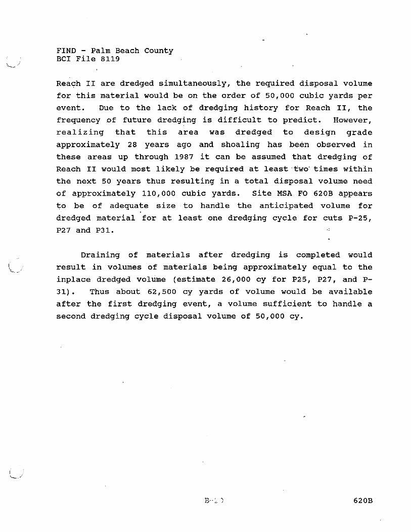
FIND - Palm Beach County BCI File 8119
Reach I1 are dredged simultaneously, the required disposal volume
for this material would be on the order of 50,000 cubic yards per
event. Due to the lack of dredging history for Reach 11, the
frequency of future dredging is difficult to predict. However,
realizing that this area was dredged to design grade
approximately 28 years ago and shoaling has been observed in
these areas up through 1987 it can be assumed that dredging of
Reach I1 would most likely be required at least.%wo'times within
the next 50 years thus resulting in a total disposal volume need
of approximately 110,000 cubic yards. Site MSA FO 620B appears
to be of adequate size to handle the anticipated volume for
dredged material for at least one dredging cycle for cuts P-25,
P27 and P31.
Draining of materials after dredging is completed would
result in volumes of materials being approximately equal to the
inplace dredged volume (estimate 26,000 cy for P25, P27, and P-
31). Thus about 62,500 cy yards of volume would be available
after the first dredging event, a volume sufficient to handle a
second dredging cycle disposal volume of 50,000 cy.

FIND - Palm Beach County BCI File 8119
MSA FO 640/640A WITH EXPANSION
MSA PO 640/640A is located approximately at ICW mile 298.1
within the central portion of Reach IV of the Palm Beach County
ICW. The total land area of the two MSA1s and expanded disposal
area is approximately 15 acres. This site is located on the
western side of the ICWwith the eastern property boundary being
formed by the shoreline of the ICW channel; ' 'The area is
primarily upland with some jurisdictional or transitional acreage
immediately adjacent to the ICW right-of-way. The western
boundary of this area is located at US Highway 1 (Federal
Highway). The property is bounded by residential property to the
north. The expanded area for this site is a vacant 8' acre lot
west of FO 640A.
According to the USDA Soil Conservation Report for Palm
Beach County, the near surface soils of 640/640A consist
primarily of AX (Arents-Urban land complex).
The ground surface elevations for this site is estimated to
be approximately 5 feet MSL as estimated from the USGS quadrangle
map for this area.
Based on aerial photos, three communities occur, Navigable
waterway, Other Hardwoods (Australian pine), and Scraped Areas
exist at MSA 641A. The small portion of Navigable Waterway on
this site appears to support no vascular plants. Other Hardwoods
is predominately vegetated with Australian pine.and Brazilian
pepper with some live and laurel oaks. Scraped areas are barren
or vegetated by a variety of used forbs. The vegetative cover
map for this area is shown in the appendix section.
The available gross area for upland disposal in this area
is estimated to be 15 acres. Reducing the available storage to
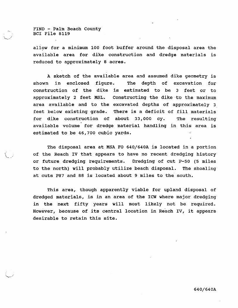
FIND - Palm Beach County BCI File 8119
allow for a minimum 100 foot buffer around the disposal area the
available area for dike construction and dredge materials is
reduced to approximately 8 acres.
A sketch of the available area and assumed dike geometry is
shown in enclosed figure. The depth of excavation for
construction of the dike is estimated to be 3 feet or to
approximately 2 feet MSL. Constructing the dike tb the maximum
area available and to the excavated depths of approximately 3
feet below existing grade. There is a deficit of fill materials
for dike construction of about 33,000 cy. The resulting
available volume for dredge material handling in this area is
estimated to be 46,700 cubic yards.
The disposal area at MSA FO 640/640A is located in a portion
'L, of the Reach IV that appears to have no recent dredging history
or future dredging requirements. Dredging of cut P-50 (5 miles
to the north) will probably utilize beach disposal. The shoaling
at cuts P87 and 88 is located about 9 miles to the south.
This area, though apparently viable for upland disposal of
dredged materials, is in an area of the ICW where major dredging
in the next fifty years will most likely not be required.
ow ever, because of its central location in each IV, it appears desirable to retain this site.

FIND - Palm Beach County BCI File 8119
MSA 641A
MSA 641A is located approximately at ICW mile 298.7 within
the central portion of Reach IV of the Palm Beach County ICW.
The total land area of this disposal area is approximately 12
acres. This site is located on the western side of the ICW with
the eastern property boundary being formed by the shoreline of
the ICW channel. The area is primarily upland with some
jurisdictional or transitional acreage immediately adjacent to
the ICW right-of-way. The western boundary of MSA FO 614A is
located approximately 700 feet east of US Highway 1 (Federal
Highway). The property is bounded by private property to the
west, however, there is an access easement to this site from
us 1.
According to the USDA Soil Conservation Report for Palm
Beach County, the near surface soils of 641A consist primarily of
AX (Arents-Urban land complex) and SUB (Saint Lucie Urban land
complex) .
The ground surface elevations for this site is estimated to
be approximately 5 feet MSL as estimated from the USGS quadrangle
map for this area.
Based on aerial photos, four communities occur, Navigable
waterway, Mangroves, Other Hardwoods (Australian pine), and
Scraped Areas exist at MSA 641A. The small portion of Navigable
Waterway on this site appears to support no vascular plants.
Mangrove areas are dominated by red, black and/or white
mangroves. Other Hardwoods is predominately vegetated with
Australian pine and Brazilian pepper with some live and laurel
oaks. Scraped areas are barren or vegetated by a va~iety of used
I/
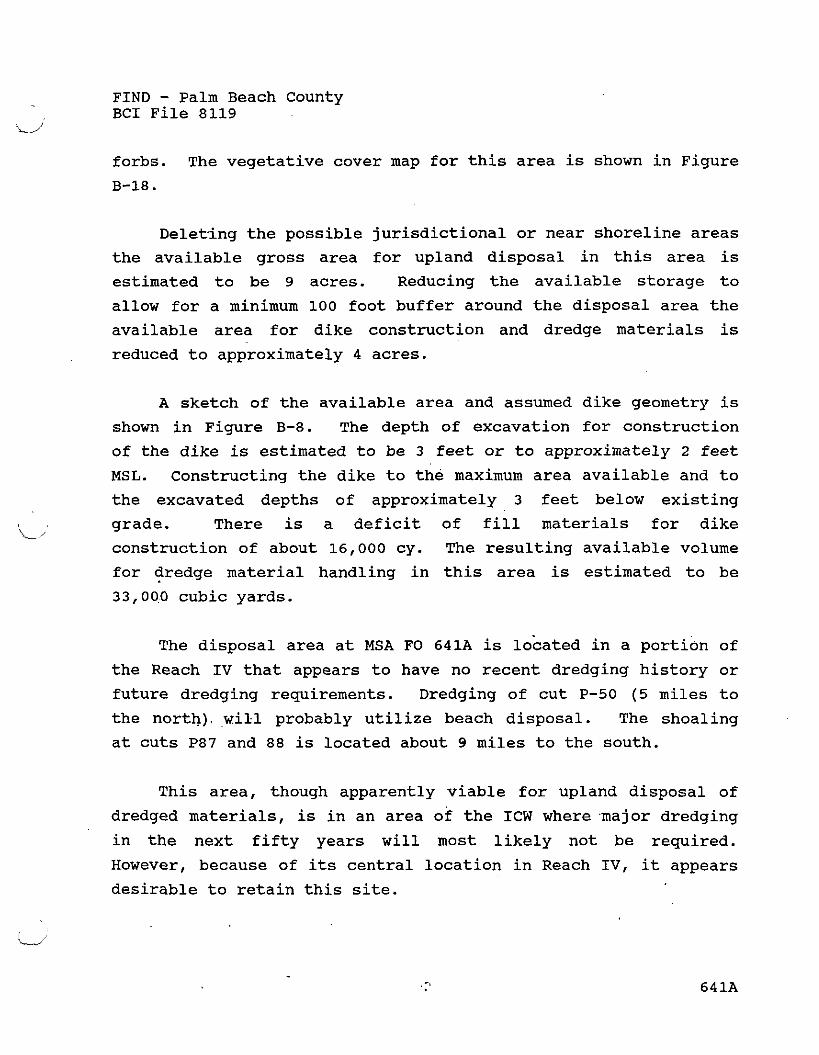
FIND - Palm Beach County BCI File 8119
forbs. The vegetative cover map for this area is shown in Figure
B-18.
Deleting the possible jurisdictional or near shoreline areas
the available gross area for upland disposal in this area is
estimated to be 9 acres. Reducing the available storage to
allow for a minimum 100 foot buffer around the disposal area the
available area for dike construction and dredge materials is
reduced to approximately 4 acres.
A sketch of the available area and assumed dike geometry is
shown in Figure B-8. The depth of excavation for construction
of the dike is estimated to be 3 feet or to approximately 2 feet
MSL. Constructing the dike to the maximum area available and to
the excavated depths of approximately 3 feet below existing
grade. There is a deficit of fill materials for dike i/
construction of about 16,000 cy. The resulting available volume
for dredge material handling in this area is estimated to be
33,000 cubic yards.
The disposal area at MSA FO 641A is located in a portion of
the Reach IV that appears to have no recent dredging history or
future dredging requirements. Dredging of cut P-50 (5 miles to
the north). will probably utilize beach disposal. The shoaling
at cuts P87 and 88 is located about 9 miles to the south.
This area, though apparently viable for upland disposal of
dredged materials, is in an area of the ICW where .major dredging
in the next fifty years will most likely not be required.
However, because of its central location in Reach IV, it appears
desirable to retain this site.

FIND - Palm Beach County BCI File 8119
MSA 684A
MSA 684A is located approximately at ICW mile 305.7 within
the southern portion of Reach IV of the Palm Beach County ICW.
The total land area of this MSA is approximately 20 acres. This
site is located on the eastern side of the ICW with the western
property boundary being formed by the right-of-way for the ICW
channel. The area is primarily upland with possibly a narrow
band of jurisdictional wetlands immediately adjacent to the
waterway. The northern and eastern boundaries of MSA 684A are
formed by Ocean Boulevard and SR 800, respectively. The site is
currently leased to the County and known as Spanish Park.
According to the USDA Soil Conservation Report for Palm
Beach County, the near-surface soils of MSA 684A consist
primarily of AU (Arents Urban complex) and QAB
(Quartzipsamments).
The ground surface elevations for the site are estimated to
be approximately 7 to 8 feet MSL as estimated from the USGS
quadrangle map for this area.
Two communities exist at 684A; other Hardwood (Australian
pine) and Park; Exotics predominate in the Other Hardwoods area.
Common species include Australian pine in the canopy and papaya,
oyster plant, rouge plant, wild coffees, Ochrosia, lucky nuts,
and schleffera in the understory. The Parks area is primarily
lawn and picnic facilities. A vegetative cover map is shown in
Figure B-19.
Reducing the available storage to allow for a minimum 100
foot buffer around the disposal area, the area available for dike
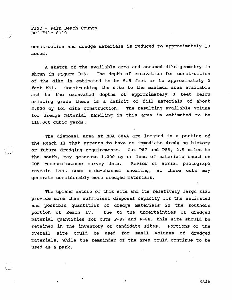
FIND - Palm Beach County BCI File 8119
construction and dredge materials is reduced to approximately 10
acres.
A sketch of the available area and assumed dike geometry is
shown in Figure B-9. The depth of excavation for construction
of the dike is estimated to be 5.5 feet or to approximately 2
feet MSL. Constructing the dike to the maximum area available
and to the excavated depths of approximately 3 feet below
existing grade there is a deficit of fill materials of about
5,000 cy for dike construction. The resulting available volume
for dredge material handling in this area is estimated to be
115,000 cubic yards.
The disposal area at MSA 684A are located in a portion of
the Reach I1 that appears to have no immediate dredging history
or future dredging requirements. Cut P87 and P88, 2.5 miles to
the south, may generate 1,000 cy or less of materials based on
COE reconnaissance survey data. Review of aerial photograph
reveals that some side-channel shoaling, at these cuts may
generate considerably more dredged materials.
The upland nature of this site and its relatively large size
provide more than sufficient disposal capacity for the estimated
and possible quantities of dredge materials in the southern
portion of Reach IV. Due to the uncertainties of dredged
material quantities for cuts P-87 and P-88, this site should be
retained in the inventory of candidate sites. Portions of the
overall site could be used for small volumes of dredged
materials, while the remainder of the area could continue to be
used as a park.

4 ~ $ 4 FO 6 / 0 2 M S A F 0 6 / / A - -- TOP of S€DI~?P,JT 10'
7- I
\ -, .7-.
I 1
/ I
I
-- P / G O . ma- ------. . , = 3) 6 7 0 r,,
Ex. VOLUME H~~ER/AC FOR D / E C D N J ~
yc = A, * h = (so, 3 t ; ' - Z L L 7 / 1 L 3 4 L e / 4 = 3 f4,
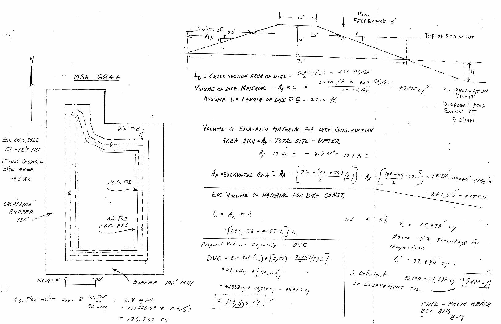
MSA 6 8 4 4
Excc. VOLUME OF H~~EZIAL FOR bIXE L0fl5T ' F 0 , g 6 - / / ~ r d
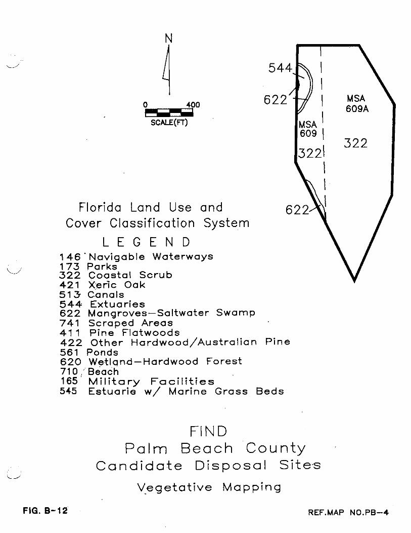
Florida Land Use and Cover Classif ication System
L E G E N D 1 4 6 ' Navigable Waterways
V 1 7 3 Parks 322 Coastal Scrub 4 2 1 Xeric Oak 513 Canals 544 Extuaries 622 Mangroves-Saltwater Swamp 741 Scraped Areas 41 1 Pine Flatwoods 422 Other Hardwood/AustraIian Pine 561 Ponds 620 Wetland-Hardwood Forest 71 0 ,' Beach 165 Military Facilit ies 545 Estuarie w/ Marine Grass Beds
ii
FIG. 8-12
FI N D Pa lm Beach ' C o u n t y
Candidate D isposa l Sites
Vegetat ive Mapping

i 0 200 III"
SCALE(FT)
---
Florida Land Use
and Cover
ass i f i ca t i on Sysyem
L E G E N D 1 4 6 Navigable Waterways 173 Parks 3 2 2 Coastal Scrub 421 Xeric Oak 513 Canals 544 Extuar ies 622 Mangroves-Saltwater Swamp 741 Scraped Areas 41 1 Pine Flatwoods 422 Other ~a rdwood /Aus t ra I i an Pine 561 ponds 620 Wetland-Hardwood Forest 710 Beach 165 M i l i t a r y F a c i l i t i e s 545 Estuar ie w/ Marine Grass Beds
P a l m Beach County \A Candidate Disposal Si tes
vegetat ive Mapping FIG. 8-13 REF.MAP NO.PB-5

Flor
Classi
146
FIG. B-16.
-ida Land Use
and Cover
f i ca t ion S y s y e m
L E G E N D Navigable Waterways Parks Coastal Scrub Xeric Oak Canals Extuar ies Mangroves-Saltwater Swamp Scraped Areas Pine Flatwoods Other Hardwood/AustraI ian Pine
Ponds Wetland-Hardwood Forest Beach tylil?tary Facil i t ies Estuar ie w / Marine Grass Beds
P a l m Beach County C-andidate D isposa l Sites
Vegetative Mapping
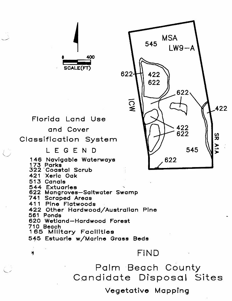
Florida Land Use
and Cover
assi f icat ion System
L E G E N D 146 Navigable Waterways 173 Parks 3 2 2 'coastal Scrub 421 Xeric Oak 513 Canals 544 Extuaries , 622 Mangroves-Saltwater Swamp 741 Scraped Areas 41 1 Pine Flatwoods -
422 Other Hardwood/AustraIian Pine 561 Ponds 620 wetland-~ardwood Forest 710 Beach 1 65 Mil i tary Faci l i t ies 545 Estuarle w/Marine Grass Beds
FIND
P a l m B e a c h County Candidate Disposal Sites
Vegetative Mapprng
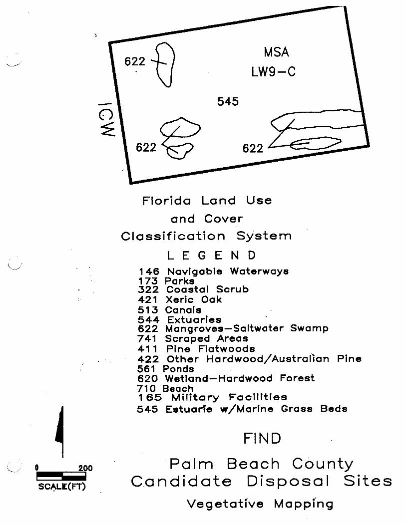
Florida Land Use
and Cover Classif icat ion System
L E G E N D 146 Navigable Waterways 173 Parks 322 Coastal Scrub 421 Xeric Oak 51 3 Canals 544 Extuaries 622 Mangroves-Saltwater Swamp 741 Scraped Areas 41 1 Pine Flatwoods 422 Other Hardwood/Australian Pine
I 561 Ponds 620 Wetland-Hardwood Forest 710 Beach 1 6 5 M i l i t a ry Fac i l i t i es 5 4 5 Estuarfe w/Marine Grass Beds
FIND I
<, o 200 Palm Beach County m SCALE(FT) Candidate Disposal Sites
Vegetati've Mappi'ng

Florida Land Use
and Cover Classif ication System
L E G E N D 146 Navigable Waterways 173 Parks 322 coastal Scrub 421 Xeric Oak 513 Canals 5 4 4 Extuaries 622 Mangroves-Saltwater Swamp 741 Scraped Areas 41 1 Pine Flatwoods 422 Other Hardwood/AustraIian Pine 561 Ponds 620 Wetland-Hardwood Forest 710 Beach 1 65 Mi l i ta ry Faci l i t ies 545 Estuarie w/Marine Grass Beds
FIND
Pa lm Beach county C a n d i d a t e D i s p o s a l S i t e s
Vegetative Mapping
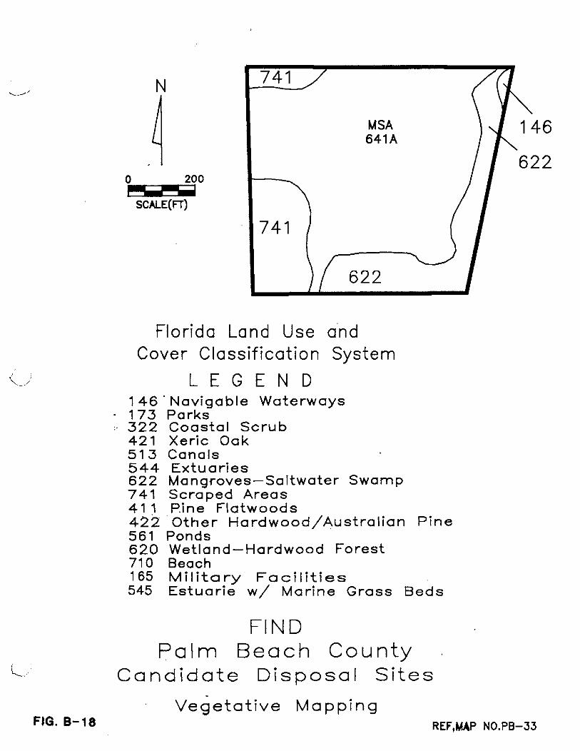
Florida Land Use and Cover Classif icat ion System
L E G E N D 146 ' Naviaable Waterways
- 173 parks :. 322 Coastal Scrub
421 Xeric Oak 573 Canals 544 Extuaries 622 Mangroves-Saltwater Swamp 741 S c r a ~ e d Areas 41 ~ . i n e ' Flatwoods 422 ' Other Hardwood/AustraIian Pine 561 Ponds 620 Wetland-Hardwood Forest 710 Beach 165 Military Facilities 545 Estuarie w/ Marine Grass ~ e d s
FIND P a l m Beach County
i C a n d i d a t e D i s p o s a l S i t e s
Vege ta t i ve Mapping FIG. 8-18 REF,MAP NO.PB-33
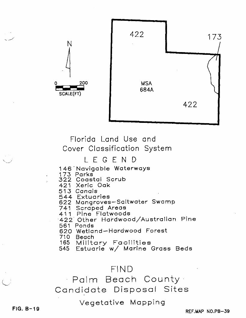
I MSA 684A
Florida Land Use and Cover Classif ication System
L E G E N D 146 ' Navigable Waterways 173 parks 322 Coastal Scrub 421 Xeric Oak 513 Canals 544 Extuaries 622 Manqroves-Saltwater Swamp 741 scraped Areas 41 1 Pine Flatwoods ,422' Other Hardwood/AustraIian Pine 561 Ponds 620 Wetland-Hardwood Forest 710 Beach 165 Mil i tary Facilities 545 Estuarie w / Marine Grass Beds
FI N D
L, P a l m Beach County Cand ida te Disposal S i tes
FIG. B-19 V e g e t a t i v e M a p p i n g
REF.MAP NO.PB-39

FIND - Palm Beach County BCI File 8119
BEACH DISPOSAL SOUTH OF JUPITER INLET
Beach disposal would be feasible south of Jupiter Inlet.
This easement on the beach has been included in previous COE
dredging contracts for cuts P-1 thru P-4. Pipeline access to
this easement would be via a MLW easement along the beach,
adjacent to the beach disposal area used by the Inlet District. I
The disposal areas south of the inlet is designated D/A-J-1.
The near surface soils of these beach areas classified as
beach materials (BN), according to the SCS soil survey.
This disposal easement has a surface areas of 'about 11
acres, which could likely handle in excess of 100,000 cy yards of
beach quality dredged materials.

FIND - Palm Beach County BCI File 8119
BEACH DISPOSAL SOUTH OF JUPITER INLET
Beach disposal would be feasible south of Jupiter Inlet.
This easement on the beach has been included in previous COE
dredging contracts for cuts P-1 thru P-4. Pipeline access to
this easement would be via a MLW easement along the beach,
adjacent to the beach disposal area used by the Inlet District. ,
The disposal areas south of the inlet is designated D/A-J-1.
The near surface soils of these beach areas classified as
beach materials (BN), according to the SCS soil survey.
This disposal easement has a surface areas of 'about 11
acres, which could likely handle in excess of 100,000 cy yards of
beach quality dredged materials.

FIND - Palm Beach County BCI File 8119
PEANUT ISLAND
The Peanut Island site is located approximately at ICW mile
278 within the northern portion of Reach I11 of the Palm Beach
County ICW. The total land area of this disposal area is about
77 acres. This site is located east of the ICW channel and
north of the Port of Palm Beach entrance channel. Current access
to the island is via water crossings. The proposed' location for
a 10-acre site would probably be in the northern half of the
island in conjunction with a similar sized disposal area proposed
by the Port of Palm Beach.
According to the USDA Soil Conservation Report 'for Palm
Beach County, the near-surface soils of Peanut 1sland consist
primarily of QAB (quartzipsamments). These soils are the result
of previous upland disposal of dredged materials to form the
island. The upland ground surface elevations range from about 5
to 20 feet MSL as estimated from the USGS quadrangle map for this
area.
Four vegetation types are discernible from aerial photos.
These are Other Hardwoods (Australian Pine), Mangrove, Beaches,
and Military Installation (Coast Guard Station). The Other
Hardwoods community is dominated by Australian Pine. The
Mangrove Swamp is likely to contain red, white, and black
mangroves as well as buttonwood. Areas designated as beach
include both intertidal areas as well as permanently exposed
sand. Though largely unvegetated, several herbaceous species
such as seaside paspalum likely occur. The Coast Guard station
is planted in lawn with no significant components of native
vegetation. A vegetative cover map is shown in Figure C-10.

FIND - Palm Beach County BCI File 8119
PEANUT ISLAND
The Peanut Island site is located approximately at ICW mile
278 within the northern portion of Reach I11 of the Palm Beach
County ICW. The total land area of this disposal area is about
77 acres. This site is located east of the ICW channel and
north of the Port of Palm Beach entrance channel. Current access
to the island is via water crossings. - The proposed. ldcation for
a 10-acre site would probably be in the northern half of the
island in conjunction with a similar sized disposal area proposed
by the Port of Palm Beach.
According to the USDA Soil Conservation Report "for Palm
Beach County, the near-surface soils of Peanut 1sland consist
primarily of QAB (quartzipsamments). These soils are the result
of previous upland disposal of dredged materials to form the
island. The upland ground surface elevations range from about 5
to 20 feet MSL as estimated from the USGS quadrangle map for this
area.
Four vegetation types are discernible from aerial photos.
These are Other Hardwoods (Australian Pine), Mangrove, Beaches,
and Military Installation (Coast Guard Station). The Other
Hardwoods community is dominated by Australian Pine. The
Mangrove Swamp is likely to contain red, white, and black
mangroves as well as buttonwood. Areas designated as beach
include both intertidal areas as well as permanently exposed
sand. Though largely unvegetated, several herbaceous species
such as seaside paspalum likely occur. The Coast Guard station
is planted in lawn with no significant components of native
vegetation. A vegetative cover map is shown in Figure C-10.

FIND - Palm Beach County BCI File 8119
LAKE WORTH GOLF COURSE
The Lake Worth (LW) Golf Course site is located west of ICW
mile 288 to 289 within Reach I11 b. of the Palm Beach County ICW.
The total land area of this site is approximately 97 acres. This
site is located on the west side of the ICW with the western
property boundary being.defined by a residential area.. Current
access to the property is via the golf. course ' property.
Ownership by the City of Lake Worth includes submerged lands that
extend about 500 feet east of the lake shoreline.
A review of the USDA soil survey indicates the near-surface
soils are Arents-Urban land complex (AU). The ground surface
elevation for this site is estimated to be approximately 5 feet
MSL.
The entire upland area is designated as golf course. The
near shore areas are marine/estuary.
The proposed disposal area at the L.W. Golf Course is
located in a portion of the Reach I11 that appears to have minor
future dredging requirements. Shoaling at cuts P-41 and 42 and
cut 44 could generate quantities of about 20,000 cubic yards
including a bulking factor of 2.
Due to the lack of dredging history for Reach 111, the
frequency of future dredging is difficult to predict. However,
realizing that this area was dredged to design grade
approximately 28 years ago and shoaling has been observed in
these areas up through 1987, it can be assumed that dredging of
Reach I11 would most likely be required at least two times within
the next 50 years. Due to the recreational use of this site,
dredged materials would most likely have to be handled and
removed after the sediment has drained.
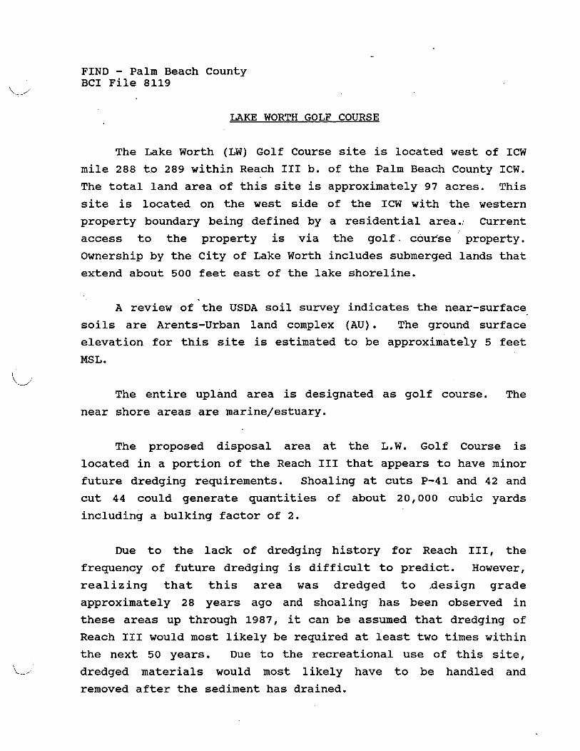
FIND - Palm Beach County BCI File 8119
LAKE WORTH GOLF COURSE
The Lake Worth (LW) Golf Course site is located west of ICW
mile 288 to 289 within Reach I11 b. of the Palm Beach County ICW.
The total land area of this site is approximately 97 acres. This
site is located on the west side of the ICW with the western
property boundary being .defined by a residential area., Current
access to the property is via the golf. course property.
Ownership by the City of Lake Worth includes submerged lands that
extend about 500 feet east of the lake shoreline.
A review of the USDA soil survey indicates the near-surface
soils are Arents-Urban land complex (AU). The ground surface
elevation for this site is estimated to be approximately 5 feet
MSL.
The entire upland area is designated as golf course. The
near shore areas are marine/estuary.
The proposed disposal area at the L.W. Golf Course is
located in a portion of the Reach I11 that appears to have minor
future dredging requirements. Shoaling at cuts P-41 and 42 and
cut 44 could generate quantities of about 20,000 cubic yards
including a bulking factor of 2.
Due to the lack of dredging history for Reach 111, the
frequency of future dredging is difficult to predict. However,
realizing that this area was dredged to design grade
approximately 28 years ago and shoaling has been observed in
these areas up through 1987, it can be assumed that dredging of
Reach I11 would most likely be required at least two times within
the next 50 years. Due to the recreational use of this site,
'L 1 dredged materials would most likely have to be handled and
removed after the sediment has drained.
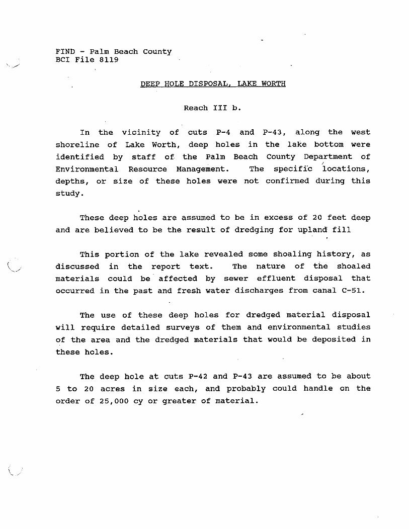
FIND - Palm Beach County BCI File 8119
DEEP HOLE DISPOSAL, LAKE WORTH
Reach I11 b.
In the vicinity of cuts P-4 and P-43, along the west
shoreline of Lake Worth, deep holes in the lake bottom were
identified by staff of. the Palm Beach County Department of I
Environmental Resource Management. The specifzc locations,
depths, or size of these holes were not confirmed during this
study.
These deep holes are assumed to be in excess of 20 feet deep
and are believed to be the result of dredging for upland fill
This portion of the lake revealed some shoaling history, as
discussed in the report text. The nature of the shoaled
materials could be affected by sewer effluent disposal that
occurred in the past and fresh water discharges from canal C-51.
The use of these deep holes for dredged material disposal
will require detailed surveys of them and environmental studies
of the area and the dredged materials that would be deposited in
these holes.
The deep hole at cuts P-42 and P-43 are assumed to be about
5 to 20 acres in size each, and probably could handle on the
order of 25,000 cy or greater of material.
FIND - Palm Beach County BCI File 8119
DEEP HOLE DISPOSAL, LAKE WORTH
Reach I11 b.
In the vicinity of cuts P-4 and P-43, along the west
shoreline of Lake Worth, deep holes in the lake bottom were
identified by staff of the Palm Beach County Department of /
Environmental Resource ~anagement . The specifi'c locations,
depths, or size of these holes were not confirmed during this
study.
These deep holes are assumed to be in excess of 20 feet deep
and are believed to be the result of dredging for upland fill
This portion of the lake revealed some shoaling history, as
discussed in the report text. The nature of the shoaled
materials could be affected by sewer effluent disposal that
occurred in the past and fresh water discharges from canal C-51.
The use of these deep holes for dredged material disposal
will require detailed surveys of them and environmental studies
of the area and the dredged materials that would be deposited in
these holes.
The deep hole at cuts P-42 and P-43 are assumed to be about
5 to 20 acres in size each, and probably could handle on the
order of 25,000 cy or greater of material.

i-
l< ,L 4 = 3 l/, = LBf 0.23 .SC~LC' 0 ZOO' V L - = , ~ ~ ~4 : r 2 6 6 7 5 6 - 3528hJh I C . .
'Y

Florida Land Use Cover Classi f icat ion
L E G E N D
71 0
622
71 0 165 and System
i/ 1.46. Navigable Waterways 173 Parks 322 Coastal Scrub 421 Xeric Oak 5'13 Canals 544 Extuaries 622- Mangroves-Saltwater Swamp 741 Scraped Areas 41 1 Pine Flatwoods '422 Other ~a rdwood /Aus t ra I i an Pine 561 P0nd.s 620 Wetland-Hardwood Forest 710 Beach 165 Military Facilities 545 Estuarie w/ Marine Grass Beds
L
FIG. C-10
FIND P a l m Beach County
Cand ida te Disposal S i tes
Vegeta t i ve .;Mapping . . '
REFSMW '~0.~6-14

FIND
-
56 1 t? 172
LAKE
Pa lm Beach county Candidate D i s p o s a l Si tes
545
Vegetative Mapping SKT. 1 OF 2
Florida Land Use
and Cover Classification System
WORTH GOLF
COURSE
C L E G E N D 146 Navigable Waterways 173 .Parks 322 Coastal Scrub 421 Xeric Oak 513 Canals 544 Extuaries 622 Mangroves-Saltwater Swamp 741 Scraped Areas 41 1 Pine Flatwoods
172
MATCH
LINE 'A' 422 Other Hardwood/Australian Pine 561 ponds 620 Wetland-Hardwood Forest 710 Beach 165 Mi l i ta ry Faci l i t ies 545 Estuarie w/Marine Grass Beds

MATCH LINE 'B'
LAKE WORTH
7 C::EE
I
MATCH LINE 'B'
LINE 'A'
172
LAKE WORTH GOLF
COURSE
172
561
. DATA COLLECTION SYSTEM FOR SUPERIMPOSING INTRACOASTAL &RIGHT OF WAY INFORMATION AND
FLORIDA INTRACOASTAL NAVIGATIONAL DISTRICT
The mapping process required that information be
acquired from three primary sources. These sources were:
1. The Intracoastal Waterway Plats as found in Palm Beach County Records Plat Book #17.
2. U.S.. Army Corps of Engineers 10-Foot Project Control Data, U.S.A.C.O.E. File #8B-24,258. Intracoastal Waterway Jacksonville to Miami (shows cut line and X, Y, coordinates of each cut)
3. Maintenance Spoil Area Maps showing bearing and Distance ties to section corners. These section corners have State Plan Coordinate values.
Using traditional coordinate geometry (COGO), all Right
of Way maps were coordinated on the state plane coordinate
system. Next the Cut Line was coordinated using COGO. The
bearing base was different for both groups of information.
Because the Right of Way maps bearings base was more closely
related to the State Plane Coordinate system the coordinates
of the Cut Lines were rotated and transposed into the Right
of Way coordinate system.
All coordinate values were 'then dumped into Autocad
using the D.C.A. enhancement program. Actual line work was
then established between Right of Way points.
With this completed, the digitizing began. This was
necessary to correlate the theoretical Right of Way and cut e
lines with the existing topographic features. The
digitizing of bridges and abrupt coastline changes were most
important in obtaining a good match. Other features such as
lighthouses, buoys and channel markers were inserted using
their coordinate values. These provided a check where
coastline areas might have been undistinquishable.
The Right of Way lines, and Cut lines were then plotted
to the scale of the aerial photos. By using the digitized
coastline and the location of lighthouse and markers the
aerial photos were overlaid and aligned on the plotted maps.
Finally the Right of Way lines, cut lines and check marks
were hand drafted onto the aerials maps.
C
SOCIO/ECONOMIC PLANNING INFORMATION
Each FIND parcel, easement and selected alternative
disposal site was investigated for its potential economic
and sociological impacts. The economic data collected was
the current ownership, the assessed value of the property
and the total acreage being taxed. The sociological data
collected was the current zoning, adjacent land uses and
planned land uses. Other criteria investigated was the
accessibility of upland equipment and affects to adjacent
properties should a site be used for dredge spoil.
The economic data was obtained by first locating each
site on Palm Beach County Appraisers Maps. The individual
Property Control numbers were then used to obtain the tax
records.. The tax records contained the information
regarding ownership, easements, assessed values and the
acreage. The tax assessors appraised value is the value
shown, however, in those instances were an easement occupied
only a portion of the property the assessed value was based
upon its aerial percentage.

L-
The current zoning was obtained from the individual
municipalities or the Palm Beach County Planning Department.
Future land use was obtained by comparing the current land
use with the individual municipalities1 proposed
Comprehensive Land Use Plans. In most instances no change
to the Comprehensive Land Use Plan had been prepared,
therefore the future land use remained the same. Also, in
the case of vacant properties proposed as alternative sites
the local municipality was asked if any plans had been
submitted for a proposed development.'
The remaining information was gathered by viewing
recent aerial photos and site visits. This provided the
infokmation regarding the accessibility and adjacent land
uses. Also, local knowledge of political views and
practices was used to determine its overall sociological
impact, i. e., it is highly unlikely the Town of Palm Beach
will allow us .to truck spoil material through their city.
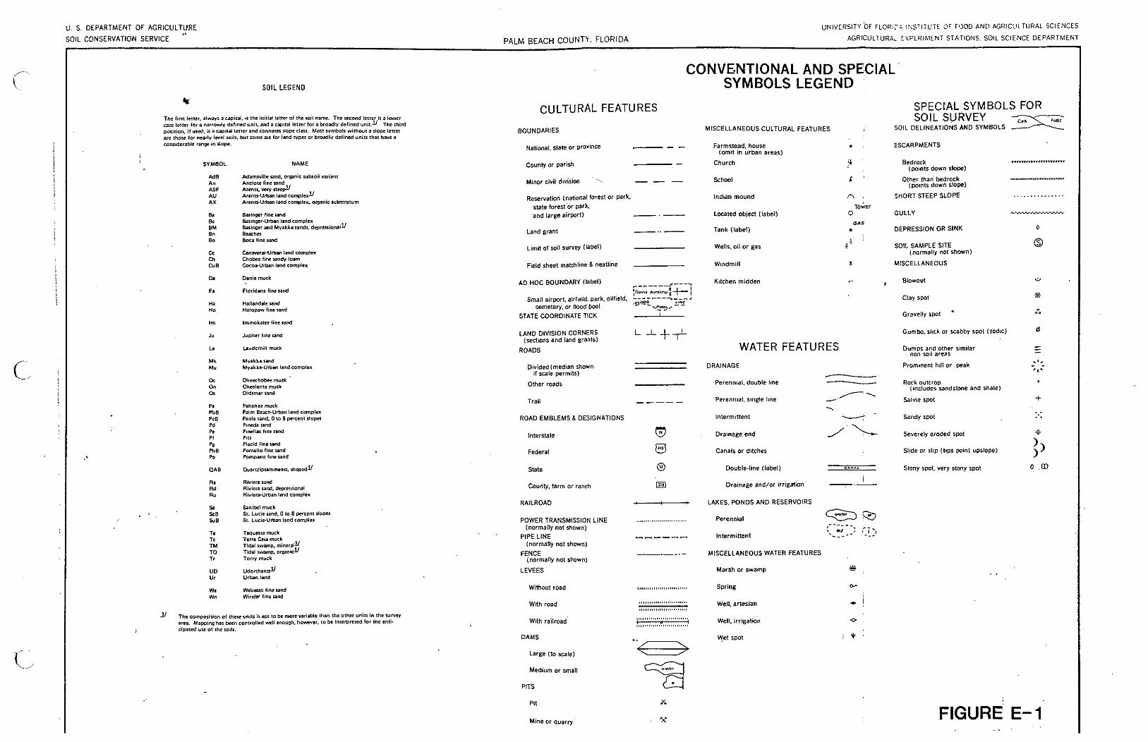
U. S. DEPARTMENT OF AGRICULTURE VNIVERSITY OF FLOR;; l i<STITUTE CIF F,>OD AN[) AGHlCLlLTllRAL SCIENCES
SOIL CONSERVATION SERVICE PALM BEACH COUNTY. FLORIDA AGRICULTVRA, iXPERIMENT STATIONS. SOIL SCIENCE DEPARTMENT
I 1 CONVENTIONAL AND SPECIAL
SYMBOLS LEGEND SOlL LEGEND
C CULTURAL FEATURES SPECIAL SYMBOLS FOR
SOlL SURVEY BOUNDARIES MISCELLANEOUS CULTURAL FEATURES SOlL DELINEATIONS AND SYMBOLS
The firs, ,rncr. alw4.1ca.icol. i l l h l initial lsrrel Of the Wil nsm. The %con< ,.,,or is . , w e . sole lelter for anarrorly defined unit.and scaosll letter tor a broadly defined ~ n i f . U The Third paition. imu~d. ir acaoctd !ezxerandc~nn~tn dowclau Monrymbolr without a s ~ m e kncr are ihose torneadv lwrl W1Is. k t somean lor land Wper or brodlydelinedunilr that hare8
National, state or province - - - Farmstead, house (omlt i n urban arear)
Church
Schml
Indoan mound
L m t e d object (label)
Tank (label)
Wells. oil or gar
Wtndmill
ESCARPMENTS
...................... Bedrock (polntr down s l ow)
SYMBOL NAME County or parish - M B Mamnille rand. orpanic rubsoil rarianr An Anrlom line rand ASF ~ r c n o , n 4 AU Armo-Urban l a d comp ls r~ AX Armts-Urban land complex. oqanis lubnrzlum
Other than bedrock (potntr down slope1
Minor civil division - - - SHORT STEEP SLOPE .......... tion on (national forest or park.
rtate forest 'or park a n d large airporl) -.- GULLY - 81 Basing. fine und
Bc ParingcrUrbm )and complex EM Baslwe? and MyakXa sands. deprerlionalu 8n Beach- no B a a line rand
DEPRESSION OR SINK 0 Land grant - .. - SOIL SAMPLE SITE
(normally not shown) 0
MISCELLANEOUS
Limit of soil survey (label)
~ i e l d sheet matchl8ne 8 neatllne
D. oaois muck
F. Floridan# tine u%d
b b Hallandd. und Ho Halapaw line rand
Im Immokalee tine und
JU J U ~ i l t r lane and
b Laudemill muck
AD HOC BOUNDARY (label) ------_,-__7 Kttchen midden ;.."I. A,",".:+-
small airport, airheid. park. oilfield. %-~c----.;,;?. cemetery. or l l w d bwl \==>, - -
STATE COORDINATE TICK I
LAND DIVISION CORNERS Gumbo. rltch or scabby spot (sods) er (rect~ons and land grant51
WATER FEATURES Dumps and other rlmllar - ROADS - non ~ l l l arear -
M* Mu
Oc on h
P I ma PCB W Pe PI b PhB PO
OAB
A. Rd RU
SI .%B SUB
T. TC TM TO TI
UD ur
Divided (median shown if scale permltr)
Other roads
DRAINAGE
Perennlal, double llne
Perennlal, rlngle llne
lnterm~ttent
Dramage end
Canals or dltcher
Double-Imne (label)
Dramage and/or lrrlgallon
LAKES. PONDS A N 0 RESERVOIRS
Perenntal
Intermbnent
- Rock (nnrludes outcrop sandstone and shale1 - .T' Saline r w t + 0ldSm.r rand
P.h~*rr ","EL Palm Blach.Urban land comolrr P.01. und. 0 to 8 prrmt %lop.% Plnrda rand P,"til.I ll"l..nd Plf, P l x i d linec.nd PomeIIo fin. wnd Pompano Ions rand
Ouartz;p.mmn.. .hapdU
Rl r i ln sand ~i r is ra rand. dqmsional RiriereUrban !and comolei
Sa"ib1 m u d Sr. Lu<ieund. 0 80 8oerrent r l v p l St. ~uriru*ab.n land romDlex
Tcque%Y muck Tern ceia murk Ti*( swamp, mineratu r aa i rramp. o w n i c u TO.." murk
udonhvnou U*en band
Trail ----- . . . - Sandy spot . . ROAD EMBLEMS 8 DESIGNATIONS
Interstate b Federal
@
state 0
Severely eroded spot -
shde or sllp l t l p r polnt upslopel
caw.L Stony spot, very stony spot 0 (D
Counly, farm or ranch
RAILROAD c3__
POWER TRANSMISSION LINE .......................... lnormally not rhown)
PIPE LINE ------ (normally not shown)
FENCE - . - . -. - inormally not shown)
LEVEES
MISCELLANEOUS WATER FEATURES
Marsh or swamp Y*
Without road
With road
With railroad.
DAMS
Large ( to scale)
Medium or m a l l
PITS
Pit
Mine or quarry
......................... Spring
........................ Well, artesian ........................ .......................... :..l....;n.:.........111: Well, irrigation
Thecomporition of tbnc~n i ts isapt 1obmorevarlable than the olherunils in ihr ruNsl arer ~ a p o i n s har ken c o n t r o ~ ~ d rill enough. honwm. 10 b inxrmrerod for the anti. CiP.td "Y 0, XhC,.,,'.
Wet rpot
-.-
FIGURE E-1

PALM BEACH COUNTY, FLORIDA - SHEET NUMBER 8

PALM BEACH COUNTY, FLORIDA - SHEET NUMBER 17 -

PALM BEACH COUNTY. FLORIDA - SHEET NUMBER 26
FIGURE


- PALM BEACH COUNTY. FLORIDA - SHEET NUMBER 82
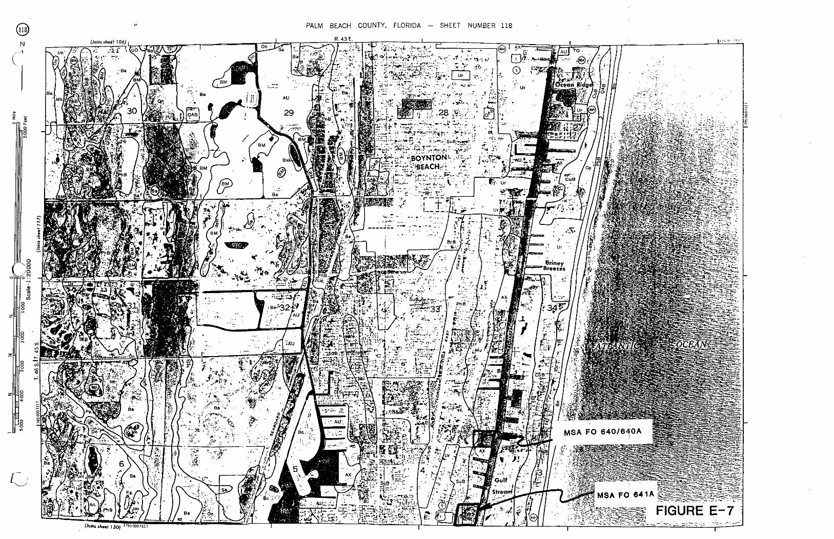
0 PALM BEACH COUNTY, FLORIDA - SHEET NUMBER 118

PALM BEACH COUNTY. FLORIDA - SHEET NUMBER 154
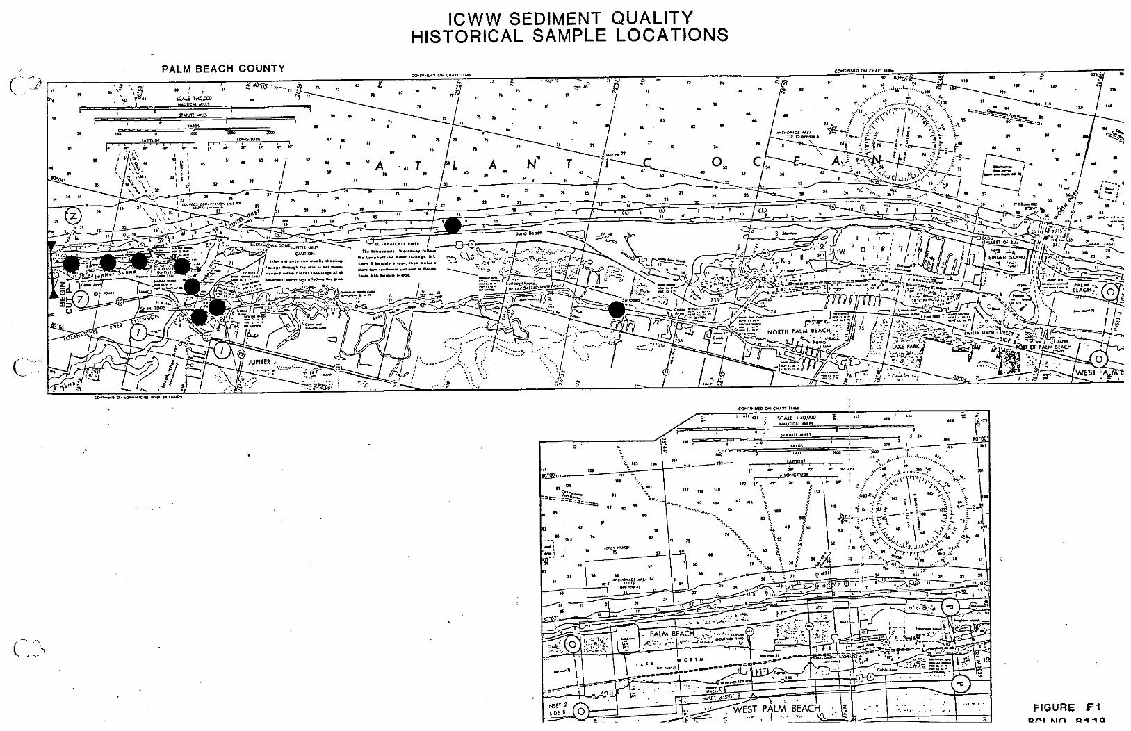
ICWW SEDIMENT QUALITY HISTORICAL SAMPLE LOCATIONS
FIGURE F1 PI &In ~ 1 i a

U. S. DEPARTMENT OF AGRICULTURE VNIVERSITY OF FLOR;; l i<STITUTE CIF F,>OD AN[) AGHlCLlLTllRAL SCIENCES
SOIL CONSERVATION SERVICE PALM BEACH COUNTY. FLORIDA AGRICULTVRA, iXPERIMENT STATIONS. SOIL SCIENCE DEPARTMENT
I 1 CONVENTIONAL AND SPECIAL
SYMBOLS LEGEND SOlL LEGEND
C CULTURAL FEATURES SPECIAL SYMBOLS FOR
SOlL SURVEY BOUNDARIES MISCELLANEOUS CULTURAL FEATURES SOlL DELINEATIONS AND SYMBOLS
The firs, ,rncr. alw4.1ca.icol. i l l h l initial lsrrel Of the Wil nsm. The %con< ,.,,or is . , w e . sole lelter for anarrorly defined unit.and scaosll letter tor a broadly defined ~ n i f . U The Third paition. imu~d. ir acaoctd !ezxerandc~nn~tn dowclau Monrymbolr without a s ~ m e kncr are ihose torneadv lwrl W1Is. k t somean lor land Wper or brodlydelinedunilr that hare8
National, state or province - - - Farmstead, house (omlt i n urban arear)
Church
Schml
Indoan mound
L m t e d object (label)
Tank (label)
Wells. oil or gar
Wtndmill
ESCARPMENTS
...................... Bedrock (polntr down s l ow)
SYMBOL NAME County or parish - M B Mamnille rand. orpanic rubsoil rarianr An Anrlom line rand ASF ~ r c n o , n 4 AU Armo-Urban l a d comp ls r~ AX Armts-Urban land complex. oqanis lubnrzlum
Other than bedrock (potntr down slope1
Minor civil division - - - SHORT STEEP SLOPE .......... tion on (national forest or park.
rtate forest 'or park a n d large airporl) -.- GULLY - 81 Basing. fine und
Bc ParingcrUrbm )and complex EM Baslwe? and MyakXa sands. deprerlionalu 8n Beach- no B a a line rand
DEPRESSION OR SINK 0 Land grant - .. - SOIL SAMPLE SITE
(normally not shown) 0
MISCELLANEOUS
Limit of soil survey (label)
~ i e l d sheet matchl8ne 8 neatllne
D. oaois muck
F. Floridan# tine u%d
b b Hallandd. und Ho Halapaw line rand
Im Immokalee tine und
JU J U ~ i l t r lane and
b Laudemill muck
AD HOC BOUNDARY (label) ------_,-__7 Kttchen midden ;.."I. A,",".:+-
small airport, airheid. park. oilfield. %-~c----.;,;?. cemetery. or l l w d bwl \==>, - -
STATE COORDINATE TICK I
LAND DIVISION CORNERS Gumbo. rltch or scabby spot (sods) er (rect~ons and land grant51
WATER FEATURES Dumps and other rlmllar - ROADS - non ~ l l l arear -
M* Mu
Oc on h
P I ma PCB W Pe PI b PhB PO
OAB
A. Rd RU
SI .%B SUB
T. TC TM TO TI
UD ur
Divided (median shown if scale permltr)
Other roads
DRAINAGE
Perennlal, double llne
Perennlal, rlngle llne
lnterm~ttent
Dramage end
Canals or dltcher
Double-Imne (label)
Dramage and/or lrrlgallon
LAKES. PONDS A N 0 RESERVOIRS
Perenntal
Intermbnent
- Rock (nnrludes outcrop sandstone and shale1 - .T' Saline r w t + 0ldSm.r rand
P.h~*rr ","EL Palm Blach.Urban land comolrr P.01. und. 0 to 8 prrmt %lop.% Plnrda rand P,"til.I ll"l..nd Plf, P l x i d linec.nd PomeIIo fin. wnd Pompano Ions rand
Ouartz;p.mmn.. .hapdU
Rl r i ln sand ~i r is ra rand. dqmsional RiriereUrban !and comolei
Sa"ib1 m u d Sr. Lu<ieund. 0 80 8oerrent r l v p l St. ~uriru*ab.n land romDlex
Tcque%Y muck Tern ceia murk Ti*( swamp, mineratu r aa i rramp. o w n i c u TO.." murk
udonhvnou U*en band
Trail ----- . . . - Sandy spot . . ROAD EMBLEMS 8 DESIGNATIONS
Interstate b Federal
@
state 0
Severely eroded spot -
shde or sllp l t l p r polnt upslopel
caw.L Stony spot, very stony spot 0 (D
Counly, farm or ranch
RAILROAD c3__
POWER TRANSMISSION LINE .......................... lnormally not rhown)
PIPE LINE ------ (normally not shown)
FENCE - . - . -. - inormally not shown)
LEVEES
MISCELLANEOUS WATER FEATURES
Marsh or swamp Y*
Without road
With road
With railroad.
DAMS
Large ( to scale)
Medium or m a l l
PITS
Pit
Mine or quarry
......................... Spring
........................ Well, artesian ........................ .......................... :..l....;n.:.........111: Well, irrigation
Thecomporition of tbnc~n i ts isapt 1obmorevarlable than the olherunils in ihr ruNsl arer ~ a p o i n s har ken c o n t r o ~ ~ d rill enough. honwm. 10 b inxrmrerod for the anti. CiP.td "Y 0, XhC,.,,'.
Wet rpot
-.-
FIGURE E-1

FIGURE F 1 (cont.)
BCI N O R 1 1 Q
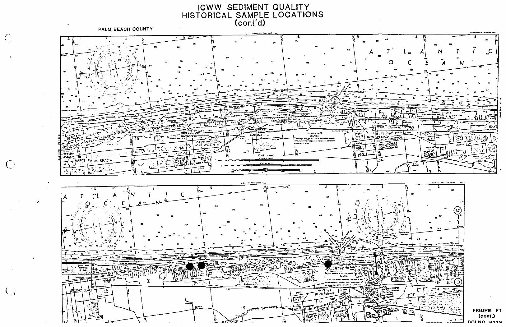
FIGURE F 1 (cont.)
BCI N O R 1 1 Q

TYPICAL SEDIMENT AND WATER QUALITY DATA
REACH I : VICINITY OF JUPITER INLET ICWW CUTS P-1 THROUGH P-13
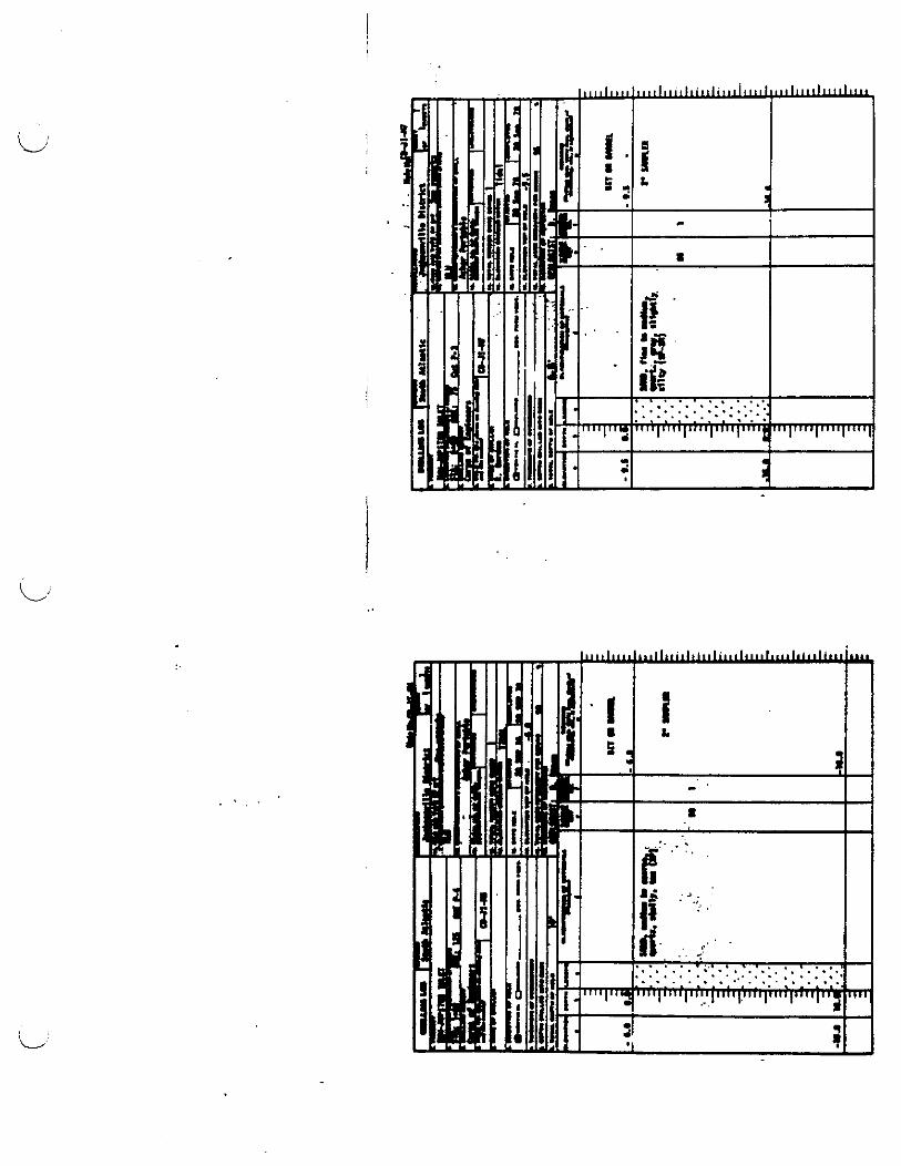
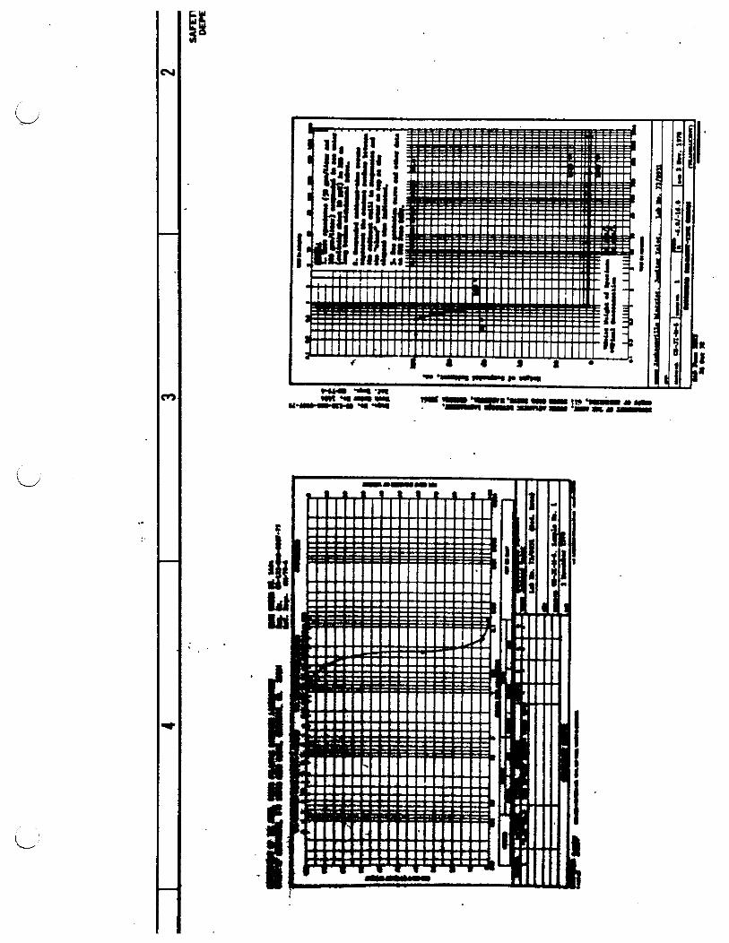
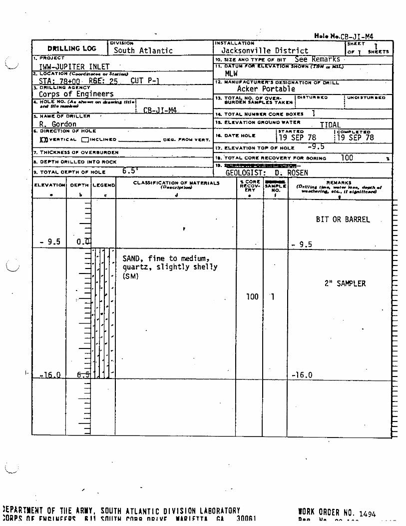
) E P ~ R T Y E W T OF T l l E ARMY, SOUTH A T L A N T I C D I V I S I O N L A B O R A T O R Y n F FUCIUCCPT R 1 1 PflllTU P f l O O nulYC MlPlFTTl E l 300fil
l O R K ORDER NO. 1494 0." U. ..A - - - ~. - -
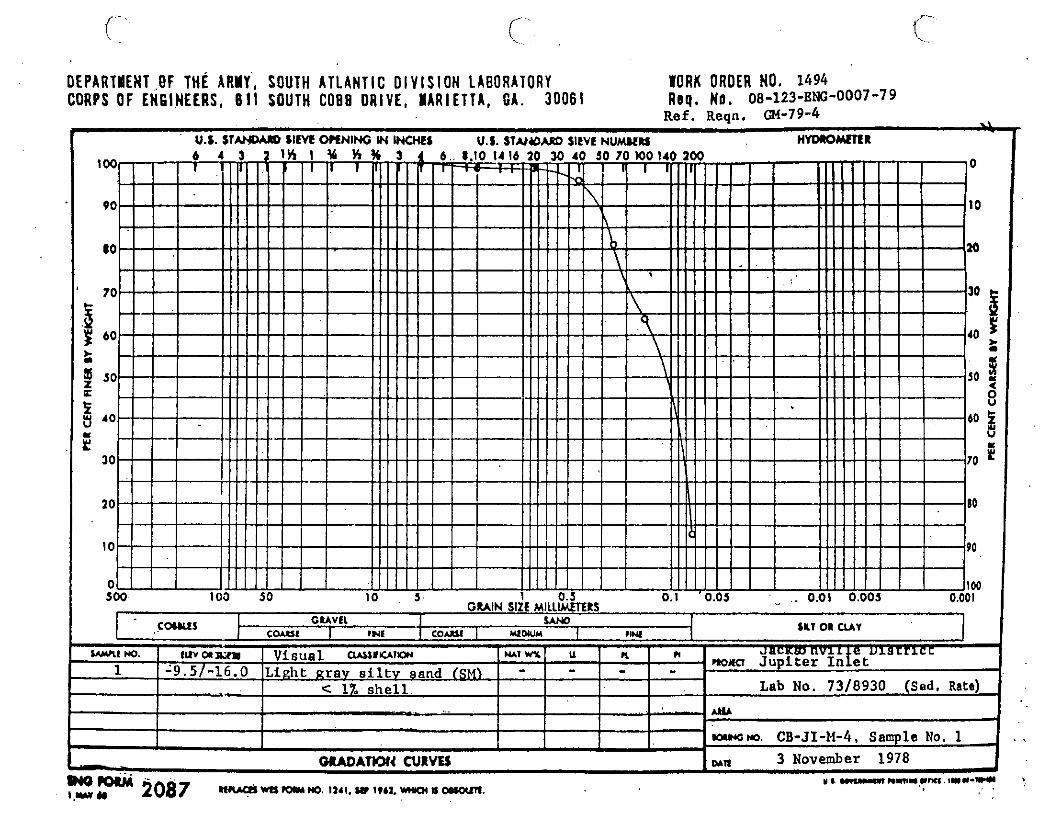
DEPARTMENT OF THE ARUY, SOUTH A T L A N T I C O l V l S l O N LABORATORY WORK ORDER NO. 1494 CORPS OF E N G I N E E R S . 611 SOUTH COB0 D R I V E , N A R I E T T A , G A . 3 0 0 6 1 R e q . N o . 08-123-~N-o007-79
Ref. Reqn. (;M-79-4 .i
fi . U.S. ST- S I M WNING IN WOIEI U.S. S T U Y ) M @ SltVL N U W D H Y D I O r n R
C W S I G U V t l I S A M C M C I I N S 1 COULl I r*LDWM 1 IlNL 4 SKI on CLAY 1
WLC m l u r m ~ Visual a*llrr*rw MI WL u PL n 1 - - - - -9 .5 / -16 .0 Linht gray s i l t y sand (SM)
C 1Z s h e l l Lab No. 73/8930 (Sed. Rats) -.' W -
-m CB-JI-M-4, Sample No. 1
- WADATION CURVES wn 3 November 1978 I 8 UY..P~ m m - w m i r w - u m W-2087 I.U * ~ ) o m u m m . ~ s r ~ . s w i c t r . n r o c s o r r a n .
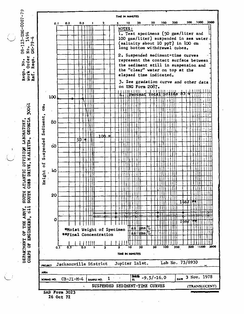
- + ; Q".
<Cn-
k! 3 H w z arc 0 0
a rn 2 2 W O n 0 ,, Jacksonville D i s t r i c t , Jupiter In l e t , Lab No. 7318930 , . - 1
L U A
-NO. CB-JI-M-4 I u u w . I IF -9.51-16.0 I,, 3 N w . 1978
. SUSPENDED SEDMZNT-TIME CURVES (TRANSLUCENT)
SAD Porn 3023 26 Oct 72

U. 3. ARMY E l f i l l E E R D l Y l S l O l L A B O R A T O R Y , S O U T H A T L A M T I C C O R P S O F E M Q I N E E R S M A R I E T T A , Q E O R Q I A
D 1 : i T H I C T
Jacksonville P H u I i CT
1I.N J to M - CONTRACT NO.
GENERAL T E S T REPORT
( SEDIMENT 1 DESCRI F T l O N . Sediment Samples SOURCE
PER CENT BY W E I G ~ (DRY BASIS)
Lab. No. w-281 3~-282 y-283 3 -284 Field Sample No. M 5-1 M 5-2 P 1-1 P 14
Volatile Solids ax 6.0) 2.14 2.74 2.12 2.18 . T. V. S., Formula EC 1.63 1-56 1.58 1.53 '"3tal Organic Carbon 0.60 0.46 0.27 0.49
I !)A 1L HI PORTED
10 llarch 1972
7383 WORK 0unt .u NO.
HLON. NO. ED 72-126 08-123 Enn 109-79
UASE U N I T COST
FOR U S t AS:
TESTED FOR: Chemical Anslysis (see below)
I . 0. D . ax 5.0) 0.32 0.24 0.27 0.21 Nitrogen, Kjeldahl ax 0.10) 0.017 0.008 0.014 0.009
DATE SAUPLE RECEI VLD
24 February 1972 LAB NO.
See below
O i l and Grease (Max 0.15) 0.04 0.04 0.07 0.04 Lead (Max 0.005) 0.0006 0.0011 0.0030 4,0005 Zinc (Xax 0.005) 0.0011 0.0010 < 0.0001 0.0007 Mercury (Max 0.0001) 0.00005 o.@Xd+ 0.00003 O.ooOo5 Total Phosphorous ar PO4 0.08 0.21 0.16 0.14 Iron 0.224 0.118 0.110 . 0.104 Cadmium 0.0001 O.OOO3 0.0001 0.0003
Chromium 0.0030 0.0019 0.0015 0.0021 Nickel 0.0054 0.0044 < 0.0005 0.0016 Copper 0.0327 0.0015 0.0012 0.0016
. R E M A R K S : A l l results are below the maximum limits (sbown i n parenthesis) establisheq by Appendix A to EC 11654-97, 12 May 1971 for the determination of the acceptability of dredged rpo i l disposal to the Nations waters.
Trace metals and nitrogen analyses were performed by @w and Company.'
TESTED BY W E C K E D BY '.OUTED W I PHWE WIRE ~ J C , DV DW
I SAMPLED BY - DATE I - I SAD FORM IM . tw OCT 60 . ' - Prrvlous rdltlonr of thlr f o n (I( a))#lrtr.. ' .. . . , . . , . . . ,. .., . . . .

- U. s. ARMY E N ~ I I I E E R D I V I S I O M L A B O R A T O I Y , souTn A T L A N T I C
CORPS OF EWQllEERS P R O l t C T
MARIETTA, QEORQIA CONTRACT NO.
I > A r L RIPIJRTED
QEWERAL TEST REPORT 10 March 1972
( 1 W R K 0RnF.H NO.
SEDIMENT
SOURCE I
PER CENT BY WEIGHT (DRY BASIS) Lab. No. 3~ -285 3~-2% 9-287 3D -288 Field Sample No. P 1-3 P 2-1 P 2-2 P 3-1 Volatile Solids ax 6.0) 2.13 l.54 0.89 1-50 T. V. S., Formula EC 1.49 1.46 1.46 1.p
I J
I Total Organic Carbon 0.46 0.25 0.27 0.24
0. D., ax 5.0) 0.17 0.14 0.14 0.20 1
FOR USt *St
TESTED FOR: Chcmical Analysis (see below)
I Nitrogen, Kjeldahl ax 0.10) 0.008 0 . w 0 . w 0.- I
DATE SAUPLE RECEI VLO
24 February 1972 LAB NO.
See below
O i l and Grease ax 0.15) 0.04 0.02 0.06 0.05 Lead (Max 0.005) < 0.0005 . c 0.0005 0.0012 < 0.0005 Zinc (Max 0.005) 0.CKXx 0.0012 0 . a 1 0.0012 Mercury (Kax 0.0001) O.oooO3 0.00005. 0.00005 0.00005
4
Total Phorphorour ar PO4 0.W 0.09 0.07 0.14 Iron
I 0.064 0.076 0.069 0.116
Cadmilrm .. 0.0001 <o.ooOl < 0.0001 < 0.0001 Arsenic , .
, . . . < 0.0001 0.0001 < 0.0001 < 0.0001 Chromium 0.&12 0.0023 0.0020 0.0011 Nickel < 0.0005 < 0.0005 0.0017 < 0.0005 Copper 0.0008 0 . W 0.0021 0.0006
I J
REMARKS: A l l results are below the maximum l i m i t s (sham in parentheses) established by Appendix A to EC 1165-2-97, 12 May 1971 for the determination of the acceptability of dredged rpoil disposal to the Nations waters.
I Trace metalr and nitrogen analyses were performed by Law and Company. . I
SAD FORM 1M . . . . , . . . . 21) OCT 80 ' Pravloua odl t lona o f t h l a , f o n &re obro lbt&. . '. ' . ..
.- '... !\ t .
. L: . , , . : . . 2 . , . , . . . . .
'*OUTED 8Y1 ruwr 0 WIRE
OATEI
TESTED BY W E C K E D BY
CJC, DW DW S W P L E D BY
A
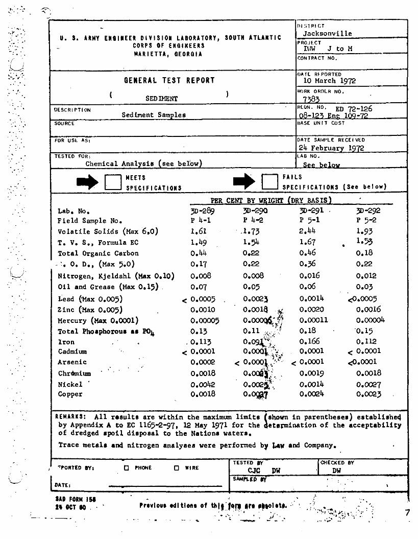
U. S. ARMY E l O l N E E R D I V I S I O N L A B O R A T O R Y , S O U T H A T L A N T I C C O R P S O F E N e l N E E R S M A R I E T T A , B E O R B I A
Jocksonville PRO.JCCT
IIlW J to M - CONTRACT NO.
OENERAL TEST REPORT
( SEDIMENT 1
DESCRl F T l O N -
Sediment Samples SOU RC t
PER CENT BY WXIGHT (DRY BASIS) Lab. No. 9-2$ 9-29'3 9-291 . 3)-292 Field Sample No. P 4-1 P 4-2 P 5-1 p 5-2 Volati le Solids ax 6.0) 1.61 -1.73 2.44 1.93 T. V. S., Formula EC 1.49 1.9 1.67 . l.2 Total Organic Carbon 0.44 0.22 0.46 0.18
r)A r L ~k PORTED 10 March 1972
WORK OHDLR NO.
7 383 ItLoN. NO. ED 72-126 08-1?3 Enc 109-72
IJASE U N I T COST
FOR U S t A S :
TESTED FOR:
Nitrogen, Kjeldahl (Max 0.10) O i l and Grease a ax 0.15) ~ e a d (%ax 0.005) Zinc (Max 0.005) Mercury (Max 0.0001) Total Korphomur a r PO4 Iron Cadmium Arsenic
> . . .' Chrhium . .
Nickel ' Copper
DATE SAI4PLE RECEIVED
24 February 1972 LAB NO.
R E M A R K S : A l l r esu l t s are within the maximum l i m i t s shovn i n parenthesea) e s t a b l i s h 4 by Appendix A to EC 1165-2-97, 12 May 1971 for the e t a a i m t i o n of the acceptabi l i ty of dredged spoi l dispoaal to the Nationr waters. I I Trace metals and nitrogen analyser were performed by b w and Company. + I
I Chemical Analysis (see belbw)
SAD FORM IM , . - . . t r m v l o u r dl t l o n m o f t h ( g ' f q w i)rr p)(olrt). '. '. . : :! . .:,,, *..- . . - . . . . .,
1 2 t OCT ( 0 . . '
' . ' I : . , , ...;; 8, . ." '
. .. .:... . . .,i'.. .,. ;\':.;. :. ; . . ~ . - . . , . . . . - . - - - - . .- "' 7
See belov
, "PORTED 6 1 1 0 P H W E O WIRE
1 DATE8 -
TESTED W W E W E D 0 1
CJC OW , DW SNPLEP W . .
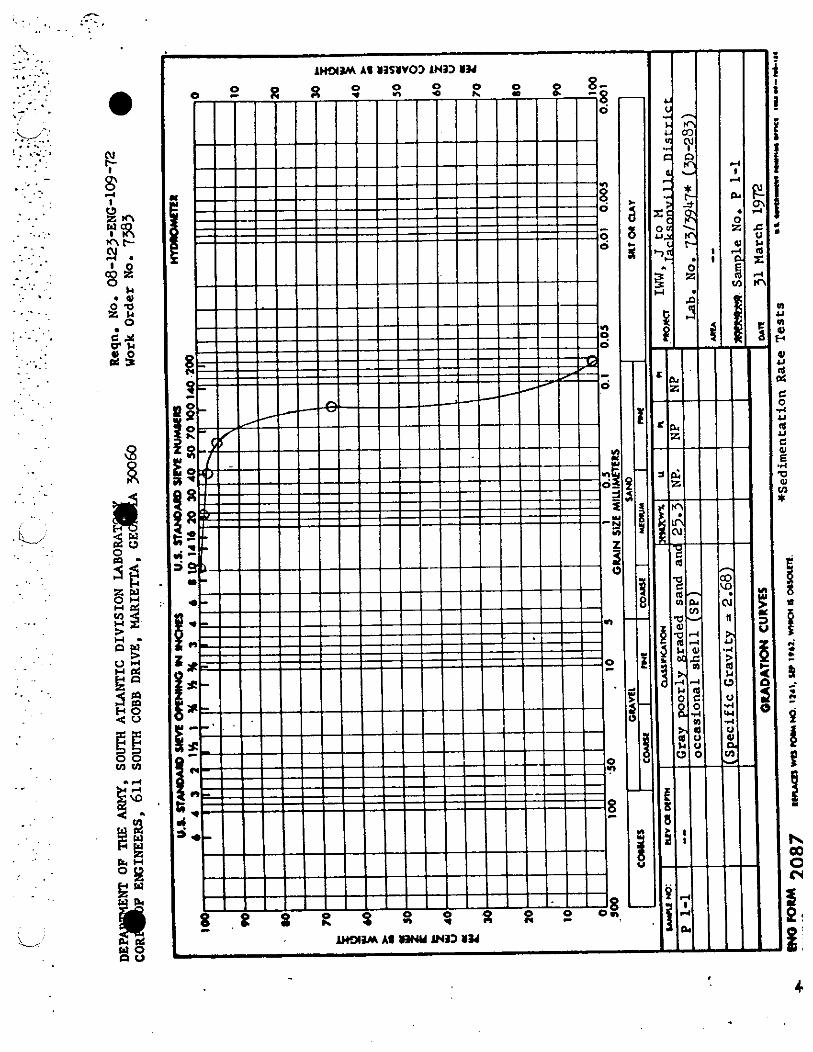
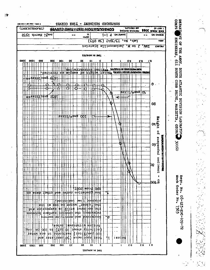
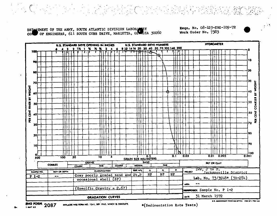
t . ? Keqn. No. 08-123-Erg-109-72
. ' Work Order No. 7383
I bRb -- I Sample No. P 1-2
wn 31 March 1972 .L .IIIII11...""...-. ,ur-,,a. z,? 2087 -rn-w. I W I , Y . ' I * ~ ~ . - ~ - . *(Sedimentation Rate ~ e a t s )

. .I . . -. -. . .- . , I T I M M MINLWES I
Z - nYt H M N ~ S
s l 8
Em L/ 2 YOPOUll -p VRANSLUCENT) SUSPENDED SEDMENT - T I M CURW *-I IU I-~~CIS
n 0
morn IUW, J to M, Jacksonville D i s tr i c t
mu Lab. No. 73/3948 ( 3 ~ 284) YIM m. -- -* P 1-2
DWm ct -- - # w e ~ = ~ I mv u mttL+,, o*n 31 March 1972


. .
3 % .. P l .re . . . , . . . . .. " ? . ' , : . . - 0 3 3 I . . I D . . . .
* 0 . . . Z CLI . . 0 1
. . . .
' IG . . - . . . . 2: . ..
. . VI :' . .
c i . :.. -- . . -. . .. .. . . .. r 0 . . . . . \D . . . I 4 .' , r >.;- )
TU :'><, .. ,
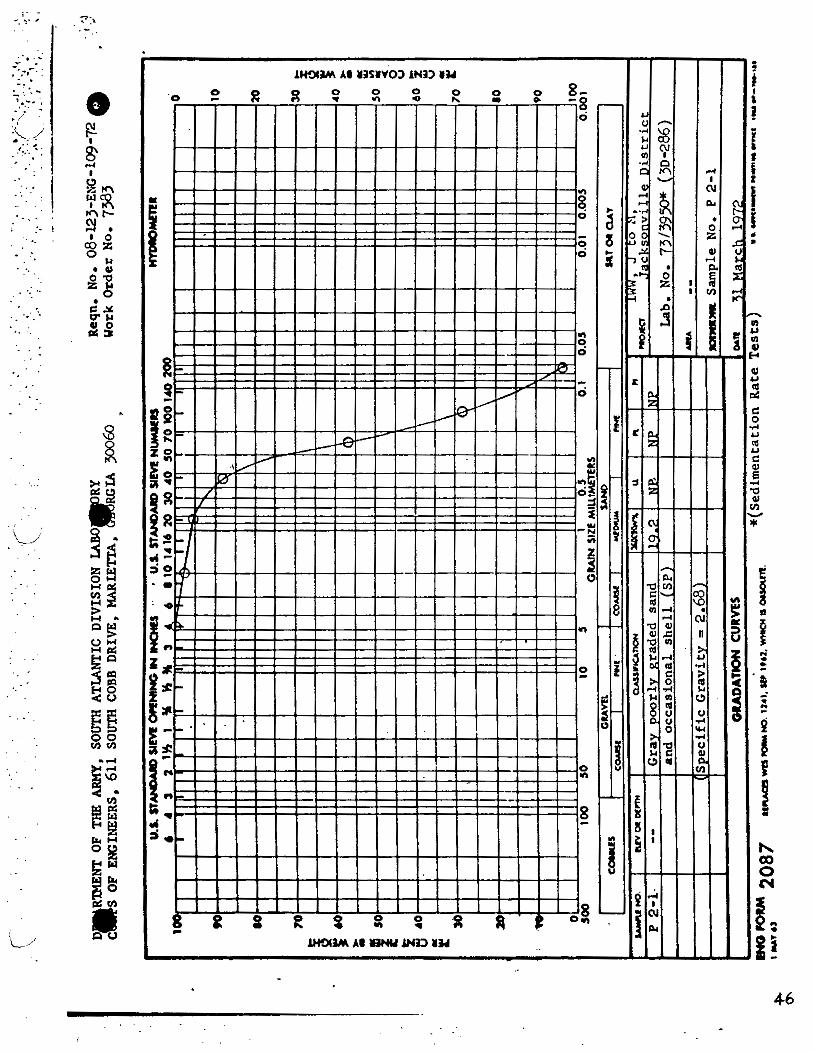
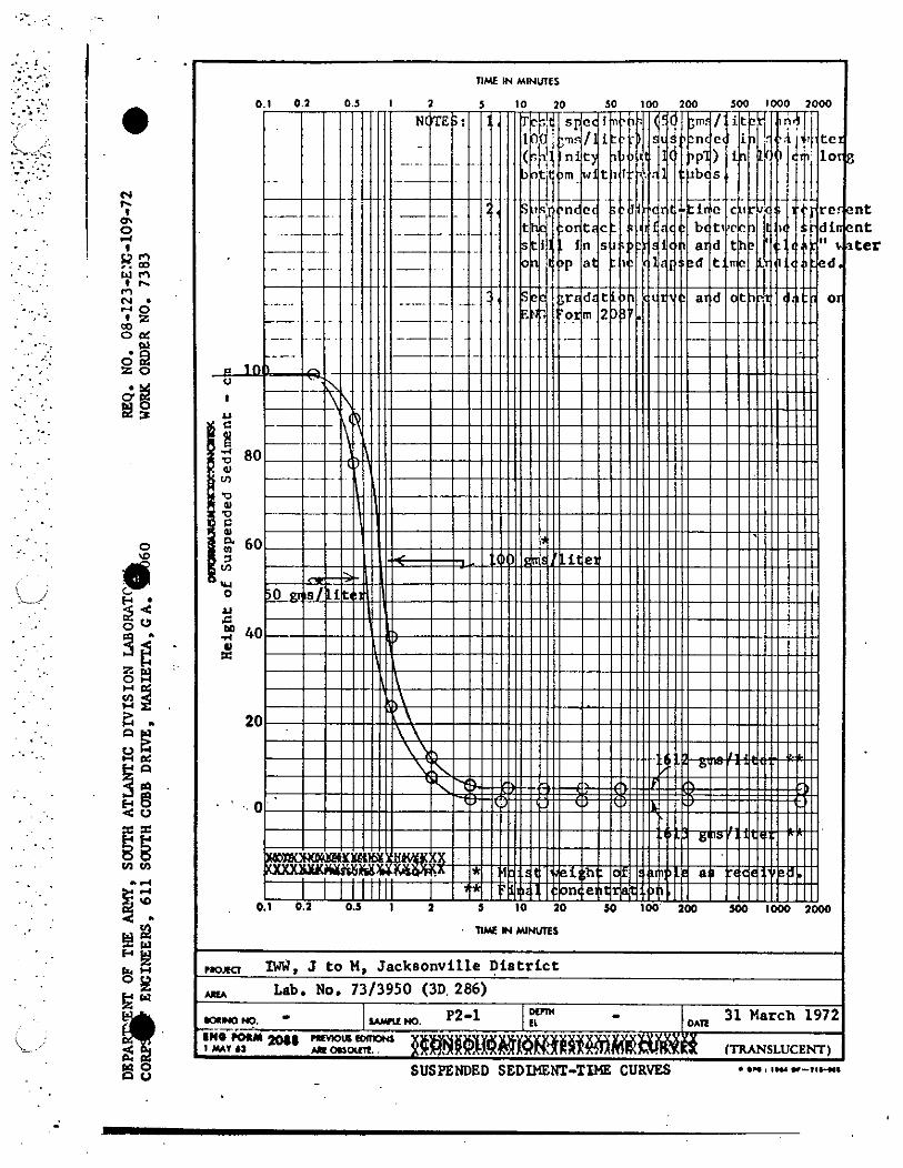
2 Y w w $ 2 8 g,
!i i El 8 SUSPENDED SEDIMENT-TDIE CURVES
....I ,..a"-,,-.
-
nuz H WMES
plom IW, J t o M, Jacksonville Di s tr i c t
uu Lab. No. 7313950 (3D 286)
,, P2-1 LOIM, - XiiiORM ,, mK!-
I Y*l6t bROnomt $ $ ~ # @ X X # ~ X ~ ~ ~ ! 1 ! ~ ~ ~ ~ (TRANSLUCENT)
Dtnn - I1 BAR
31 Match 1972


I -- TIME W MINUTES
m o m IW'. J t o H - Jacksonville D i s tr i c t mu lab No. 73/3951 (3D 287)
DTml DIHO m. - u u m . P2-2 EL - . o ~ n 3 April 1972
'~iiie-rour 100 mVKXD EDmW I Y * T U LIoaCm.. CTRANSLUCENT)
SUSPERDED S E D m - T W CURVES. - - ..".I." "-,I-
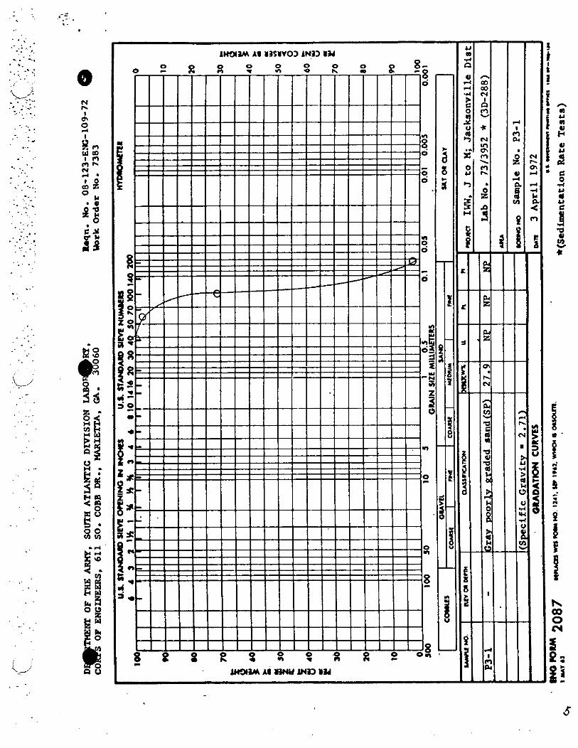

,tom IWW, J to K - Jacksonville Dirtrict *ru U b No. 7313952 (3D 288) - m DIM m. WNO. P3-1 EL - om 3 April 1972 IN0 row 1018 'UYKnaamM 1 MAV 63 4 R OIYxm. (TRANSLUCENT)
SUSPENDED S E D m . - ' TIME CURVES .MI I." "-7,-


N h
I OI
0, I
i? r, w m I rl rl lr N d . 1 0
m Z
M . U 0 u Z I. 0
c Y w u 2 8 loo-
m
9i a
ei ?i Y
a m a Ig .. 0 s -
gi z 2 z 3i s? 518 $2 M i
h b No. 7
mw m. I#'"' II . OAR 3 April 1972
bR-. caw- f lnANSLUCBM)
SUSPENDED S E D I W W . .' 1S)IB CURVES 'U."W u-"L"'
, . . .
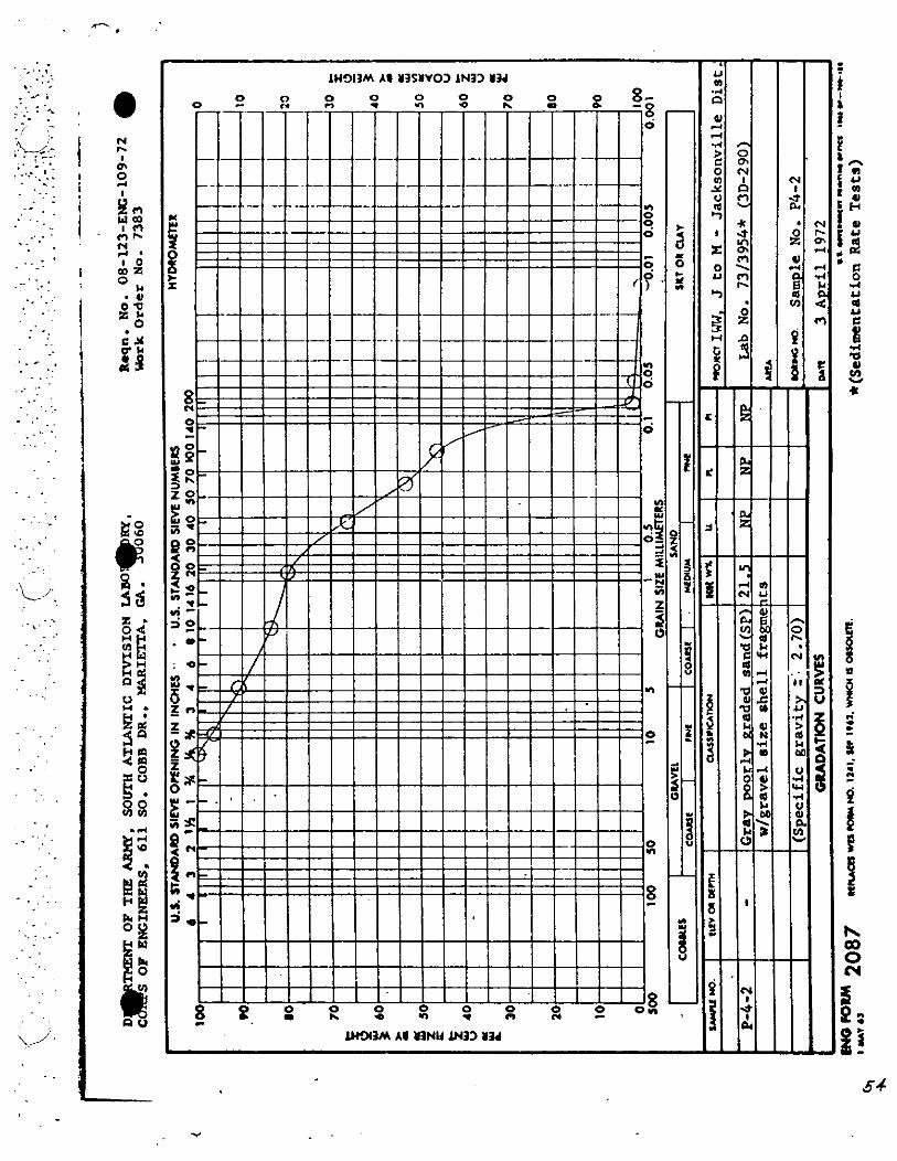
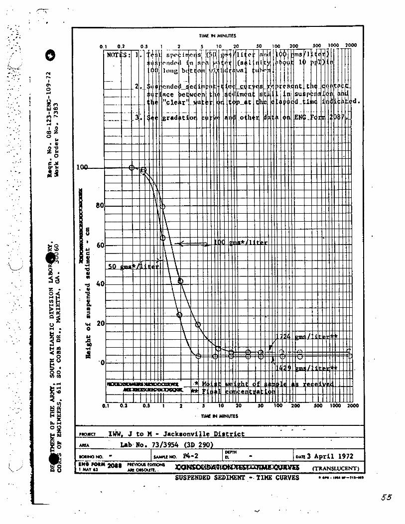
NIL IN MJNUTEI
- - - .. . ~lorn IWW. J t o n - J ~ C L S O ~ V ~ I I ~ Distr ict .
Lab No. 73/3954 (3D 290) Mrm
lOlHOM. - I MNO. P4-2 E l - - -- D A ~ 3 April 1972 IN0 roll4 20(( Pnmcus mllO
*I)-. zamwlMu- ITMN,E,, SUSPENDED SEDlMEm - TIME CURVES . em 3 IU i-IIHI
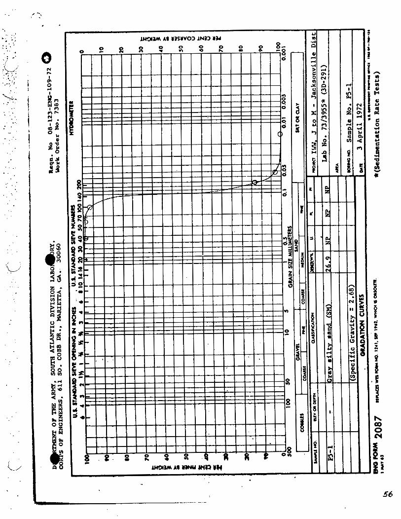

. rwHYmml
pmm IWW. J t o W - Jackaonv- um b b a /- - .m 2911 Y*HOYO. - WNO. P5-1 1" I) - DAn 4 April 1972
-irro'iou mi n m ~ . ~naw, I YLTU ~ o l o ~ n . - v m c m s ~ v c e m )
SUSPEKDED SEPmq, - CURVES ma'mu-~lc"l-


TYPICAL SEDIMENT AND WATER QUALITY DATA
REACH I1 : JUPITER INLET TO LAKE WORTH ICWW CUTS P-15 THROUGH P-31

n
- - . . . - - - :;. 6 ', -, $5, -, , : , -J ; : 6)?> - !- < 1
t L i r - , ' ~ ~ . J
- 4
---- - kl?JJ 2lGi'i-D: - ~ ! c - .
M C W d BJTTDH D i C H 4 X N L
- 15. 25: 5 2 : SCALE in rcc
DATE !~?/D~RPP$,I-,,~J


. . ... .
T E S T HOLE 1 . DEPTH : pYMB04 CLASSIfl CATION I MIRE0 CLAS:
Samp1e':fl . 1 . , ! SP 1
-- &d.mmn lAs.oclal.s
~o'#athans Land ing (Ward, P . E : )
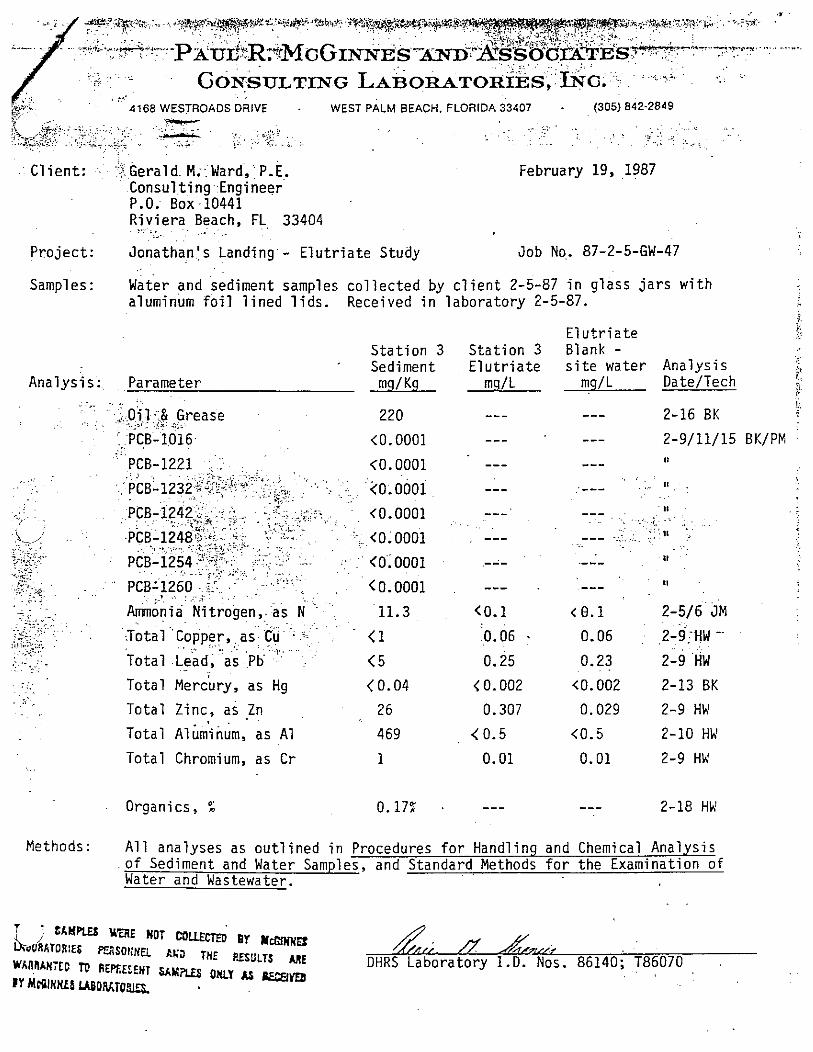
,. ,* .*::.iP+Y3,7., 1 . . , !.. ,.., ..: *x:*$.%k,?,t@*,es:q+&; . ,.!?' ., ,.. ,? . . ,t%b.,,+: :*y;$'*$$p#,$;*~y:*~~*@,*3; . . , . . . . --.... *: ..,.,.,. ., A & . , < 8 ;*?: y&*:,!>;3>y:& ,.. , . , . .,,.3*:..
, . . : . . - ..:; .. . . . . : . : . : . ;.. , , . . . .. ,... . .. * .?;?If*<, <& ...,, ..., "., ,.: ,< . . -I!:-. - p x u ~ ~ ~ r M G ~ I N h + ~ S I A m ; ~ ~ O S S aG~aTE~s~-+-r..llp',.p'. - ... .. . :.. ...' . . , .. .. .
. ~
. . ., . ..; ::. : ,, '.. : : . . . : a;, c :, .. . . . Goh'snLTING LABORATO*&S, INC, ":.: ,
":>'. ' , . . . . 1.
... . . ,~ 4168 WESTROADS DRIVE . WEST PALM BEACH. FLORIDA 33407 - (305) 842-2849
. ~ . . .. C l i e n t : . :$.Gerald. M.:Ward,': P.E. February 19, ,1987
Consu l t i ngEng inee r P.O. Box -10441 R i v i e r a Beach, FL 33404
>.. <. ., . . . :.. .
P r o j e c t : ~ o n a t h a n j s L a n d i n g - E l u t r i a t e Study Job No.. 87-2-5-GW-47
Samples: water and sediment samples c o l l e c t e d by c l i e n t 2-5-87 i n g lass j a r s w i t h aluminum f o i l 1 ined 1 i ds . Received i n l a b o r a t o r y 2-5-87.
i.
E l u t r i a t e 5
S t a t i o n 3 S t a t i o n 3 Blank - . . Sediment E l u t r i a t e s i t e water Ana lys is
I $(
~ n a l y s i s: Parameter mg/Kg mg/L mg/L Date/Tech 1.
i;. . ~ ,. .. .. . . . .
220 --- --- 2-16 BK .$i!;r& Grease . . .-. . . : ,.:. , ~<=: : :.: ... .-
': , PCB- . 1016. . . <0.0001 --- --- 2-9/11/15 BK/PM : I, --- ---
., . . . . . 11, . --- .--- . ~
--- . -
, . --- --- .---
I, --- --- <0.1 (0 .1 2 -5 /6 JM . . . .
0.06 . 0.06 : ,Z-~;HW --
0.25 0.23 . . . 2-9 'HW < 0.002 <0.002 2-13 BK
. . To ta l Zinc, as Zn 26 0.307 0.029 2-9 Hh'
. . To ta l ~ l k i h m , as A1 469 <0.5 <0.5 2-10 Hh'
. . To ta l Chromium, as C r 1 0.01 0.01 2-9 Hh'
Organics, % 0.17: --- --- 2-18 HW
Methods: A l l analyses as o u t l i n e d i n Procedures f o r Handl ing and Chemical Ana lys is o f Sediment and Water Samples, and Standard Methods f o r t h e Examination o f Water and Wastewater.
7 ' ~ ~ W I J 3 YEUi HOT gy ~dyn~n 1
~ Y R A D R ~ E S S O rrr 7.l pasrrr Wfif lhhHXO TC REPEECENT S L Y m
1~ m m FY MrPInM& U B o ~ k r 0 ~

pSj;?:E?T. ~ ~ ~ p & ~ i r ; . . . P r . % ~ ~ ~ ~ - , .:* . .... 4: .e .... -,<? .... *::. 9 ++:,:.*: :%?,;;:? .. ..:*$?;3J@+@gfg%)<;;::?i. ... *:::.,. 2~::..z, .:>! . . ! . . . . . . . ...... 3:' -,.. : . . . . ,,_... ,. .: ,+ ~.'::i ,.<;~..~ ..:. ; ::,.:..<+.., ;;;4$ *! ':,~:~<<;,;.:'~:,~+..~..;.>;.; -?.< .; , . ' . . ' ..+? , . .. " ~ w ' : 5 . ' . . . . ...... ..+.-. p x ~ ~ R ~ ~ ; ' @ ~ ~ g S ~ r ~ ~ x ~ ~ S ~ S ~ O O G ~ T * T E s- .-,.. . .
+ > ~ . !? ..;y34 > .+.>.% b+<fi..: ,.,-., %:..:.-. .-.*.. ,,>. $.;; . . . . . . . . . . . . . . ..... ..=:<r . ,. ..-:t.. ,>'?..l:- -.. . . ::.; ............ ..: ;. < . ' :.. . G o ~ s o ~ r m ~ ; LABoRBTORIES,. ,ING. . . . . . > . .
. J.. . . ::;.. .\., ! ' <..;;:';;<.: > : ' a. :.c:+:.;wt .,. , , ..>.<, *,,+< ,::. . 4168 WESTROADSDRIVE ; 'WEST PALM BEACH. FLORIDA 33407-' . (305) 842-2849 . . . . .
Gerald M. : ~a id , :P . .~ . Client: February 19; 1987 Cons3J t i ng's~ngineer P.O. Box 10441 Riviera Beach, . . . . FL 33404 . . . . . .
Project: Jonathan's Landing - Elutr ia te Study Job No. 87-2-5-GW-47
Samples: Water-and -sediment samples collected by c l i e n t 2-5-87 in glass j a r s w i t h aluminum foil l ined l ids . Received i n laboratory 2-5-87.
E lu t r ia te Station 2 Station 2 Blank - Sediment - Elut r ia te s i t e water Analysis
Analysis: Parameter mq/Kg ms/L mg/L DateITech
Oil & Grease < 100
PCB-1016 <0.0001
PCB-1221 <0.0001
PCBT1232 . . (0.0001 . . . . ~~Br.l2$2., ... .. . , . . ........ ~ :-(0. 0001
. . . . . . P C B - I Z ~ ~ ~ . ~ . : , . . <o.o001
~. I I
PCB-1254 .'- 8. . - : <0..0001
PCB-1260 ........... a * . < 0.0001
~mnonia Nitrogen, as N (0.1
Total: Copper, ..as <Cu '. .
1
Total Lead,. a s P b < 5
Total Mercury, a s Hg (0.04
Total Zinc, a s ,Zn . . ( . . 77
Total Aluminum, as A1 633
Total Chromium, as Cr 1
2-516 JM
2-9: HW
2-9 HW
2-13 BK
2-9 Hk'
2-10 HW
2-9 Hk'
Organics, % 1.52% --- --- 2-18 Hk'
Methods: All analyses as outlined in Procedures for Handling and Chemical Analysis of Sediment and Water Samples, and Standard Methods f o r the Examination of Water a n d Wastewater.
i/ SAMPLES WERE N3T MUECTm BY YcGIKNES UBGRirTOiilE: RRSONEEL AOD THE RESULTS ME
b' ;c/ wr\nW.m~ m APRECEKT SAWS ONLY AS PE@VEO n / r
BY Yc6lNKES M G K T C R I E 5 . OHRS Laboratory 1.D. Nos. 86140; T86070

TYPICAL SEDIMENT AND WATER QUALITY DATA
REACH I11 : LAKE WORTH REGION ICWW CUTS P-32 THROUGH P-50

Y
w .u '0 w 3 A e c 3 m * e
o m m m 3 e e a
rl 3 m m u m u Y,
Y d Y V)
m m tn w a m me. ;; s. . . .g o u o o c m e. - a P - N U PI OI h - 3 0 P- P- 3 P a 0 . P - h w r - U P - 0 r - X r. U
u 3 e Y .rl Y m w m k u 0 ' 1 bt u Y e :
bt g . . . -g .rl 2 C 3 m 9 el a 1 0 el. U
i a 0 m n P,
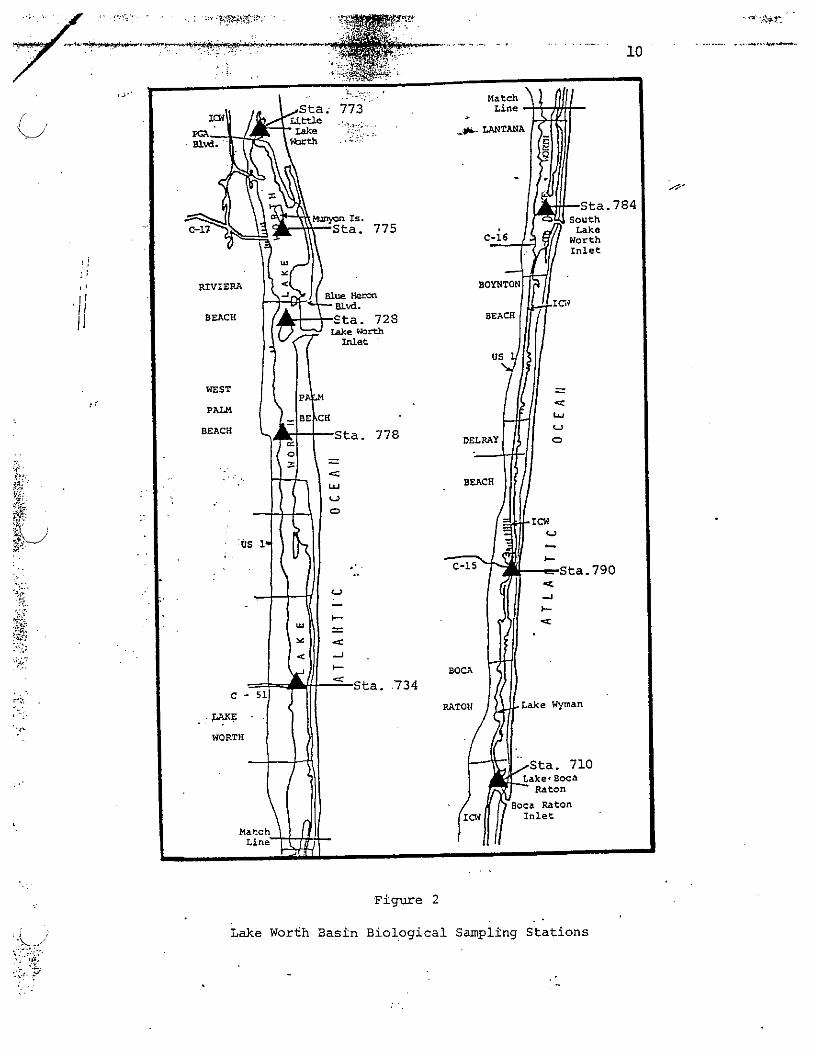
F i g u r e 2
Lake Worth Bas in B i o l o g i c a l Sampling S t a t i o n s

(- ;I . . .:.
Department of Envir.o~im'ental , . . . Regulation .., . .
... .~, . .. ,
Monitoring Proposal, S~ Fla . District . .\ Basin: Lake W O ~ Cbmprehensive Basin ., .. Asessment Monitoring . . FY.89-90 r:,'5 .* - . ,, .. 7 ... ..! r . .: .~ .... . . .. ,. .. . . . ,. . . . . s :
Brief descriplion of Basin, ils major bodies of waler, and polenlial or a!ual prob!ems: Lake Worth is a t i d a l lagoon extending frbm nor th t o south . from west;Palm Beach to. Boca Raton. There a==,
. t h r e e . ( 3 ) i n l e t s , f o u r (4 ) freshwater discharge sources. Problems' include p o l l u t i o n from dredging,'.storm- water runof f , n u t r i e n t enrichment from a g i i c u l t u r i l r a n d urban runoff. . T h e West Palm Beach Canal ~ e m i i n s .the major source of p o l l u t i o n e f f e c t i n g Lake Worth.
1 , . . . ,
mouth of West Palm Beach Canal i
, , . . , . I
. .
+ . ', . I!
3 .,I : ' " :; . .>$ .s . .. . ' d . -2
: r : ';r '; :;,!
. > . .. *. 3 '
Sampling Frequency
J
2 / v e a r i n Feb. and J u l .
* 1990 4
28010728 Peanut Is land - nor th end
W/g - physica l parameters near Currie Park 28010778 -
Pararnelers
Bioloqica l Ouan t i t a t ive n a t u r a l su?x&,~at=s~
Sediment g r a i n s i z e and o rgan ic t
Slalion Localions
L i t t l e Lake Worth
Munyon I s l and - south end
STORET No.*
28010773
28010775
\
Department of Regulation Monitoring ~ r o ~ o s a l , 5 u ~ 2 ~ ~ i s t r i c t
I . Basin:&/&% -28.1 F L.
Station Locations

. Table m a BASIN FIATER
... . . .STATION
1 - QUALITY LIST
Intracoastal khterway (ICN) @ FGA Blvd. Little Lake Worth - center arm River (C-17).@ U.S. 1 bridge m y o n Island Transect - 50 yds off west shore Mun-yon Island Transect - ktween islands Munyon Island Transect - 200 yis off east shore Lake Fbrth @ Blue Heron Blvd. bridge Lake Worth 100 qds E of ICW Savigation Marker $3 Carrie Park Tfansect - 150' off west shore Carrie Park hansect - middle ~ie'park Transect - 150' off east'shore Lake Wrth @ Royal Palin bridge West Palm Eeach Canal (C-51) @ S. Olive (U.S. 1) Lake Worth east of Navigation Marker a28 Lake hbrth @ SR 812 bridge - Lantana Lake Wrth east of Navigation Wker M4 Lake Wrth east of Navigation Wker g48 Boynton Canal '(c-16) - east of structure ICW @' SR 804 (ocean venue) bridge - -ton ICi @ SR 806A bridge (NE 8th Street) ICW @ Linton Blvd.- bridge Delray C d (c-15) - muth by bridge ICW @ SR 800 bridge (Spanish R. Blvd.) ICi @ SR 798 bridge (Palmetto Park Road) ICW @ Camino Real bridge

. ~ '.' ; .. . &. . . .. .. . - .. : , . . . ,
Figure ' 2 . . ~ ~ ~ B A S I N ~ Q ~ L ~ I Y A S S ~ S M E N T .. . ,
SAMPLING -0NS & DEp?EIs . ..1.:;. ; . - . . . .; , .; j . . . . . r :.
..-*. .. .;. . . ;. -. - .. ... . I .' ' '

Sediment Results f o r Stat ion &PB+ re@-&
Rep1 i c a t e
I I I I11 Mean a
e p m (dry b a s i s )
A1 uminum
Cadmium
Chromi urn
Copper
Iron . Lead
'I -L, Manganese
Nickel
s i l v e r
Zinc
Mercury
Total Sol ids ( X ) L 76 75 76 1.0
Total Organic Carbon 5000 6100
. Oil h Grease '200 " 190 - Su l fa t e
Total Kjeldahl Nitrogen 180 150 i /
Total Phosphorus 420 470
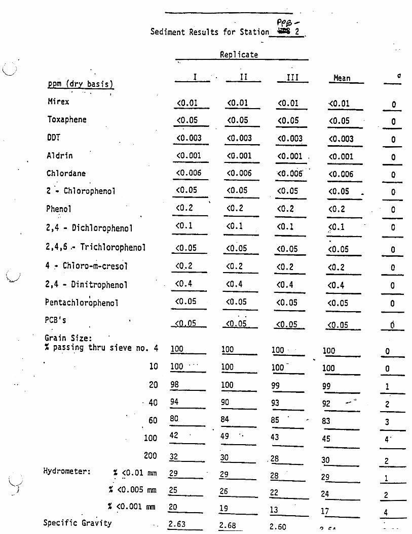
PPB - Sediment ~esults for Station 2 + -
. . Rep1 icate
I . I I I11 - Mean o ppm (dry basis) - - ~ ..
Mi rex
Toxaphene
DOT
Aldrin
Chlordane
2 - Chlorophenol Phenol
2,4 - Dichlorophenol 2,4,6 .- Trichlorophenol 4 - ~hloro-m-cresol 2,4 - Dinitrophenol ~entachlorb~henol
PCB's
Grain Size: X passing thru sieve no. 4 . .
10
20
40
60
100
200
Hydrometer: % <0.01 mm . ..
X <0.005 mm
X <0.001 mn
Specific ~ r a v i t ~
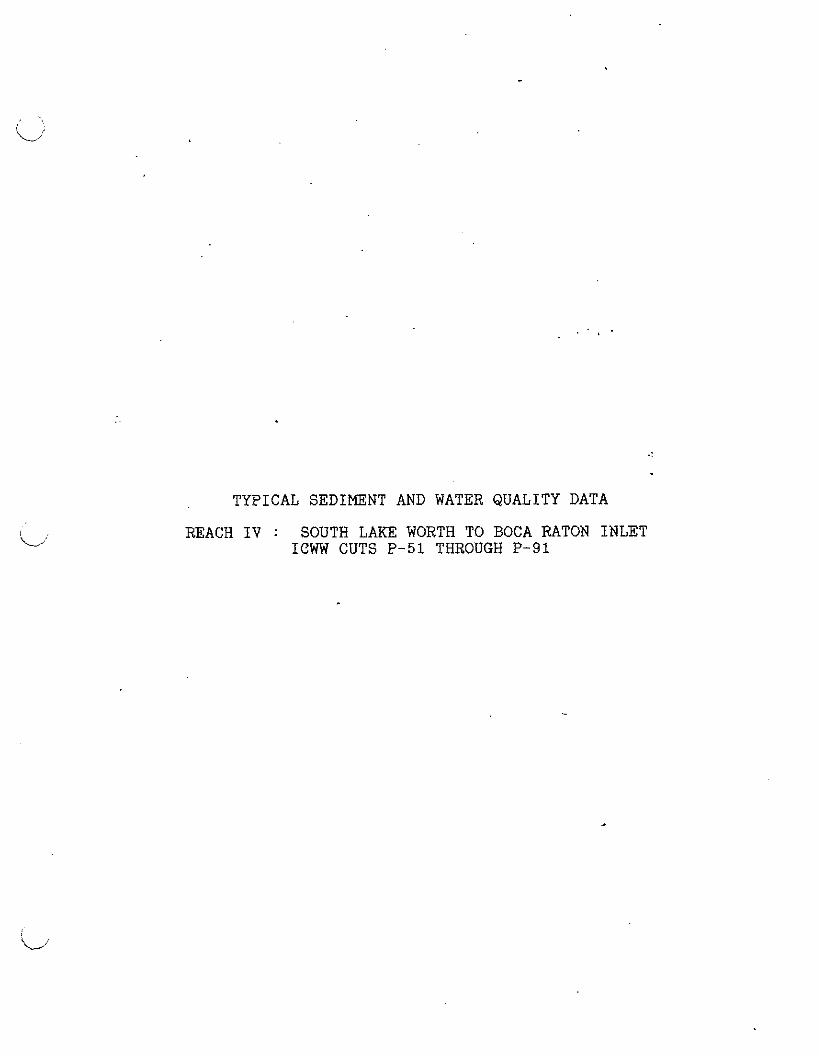
TYPICAL SEDIMENT AND WATER QUALITY DATA
REACH IV : SOUTH LAKE WORTH TO BOCA RATON INLET ICWW CUTS P-51 THROUGH P-91
NO CHEMICAL ANALYSIS OR MECHANICAL SEDIMENT TESTING RESULTS AVAILABLE FOR REACH IV
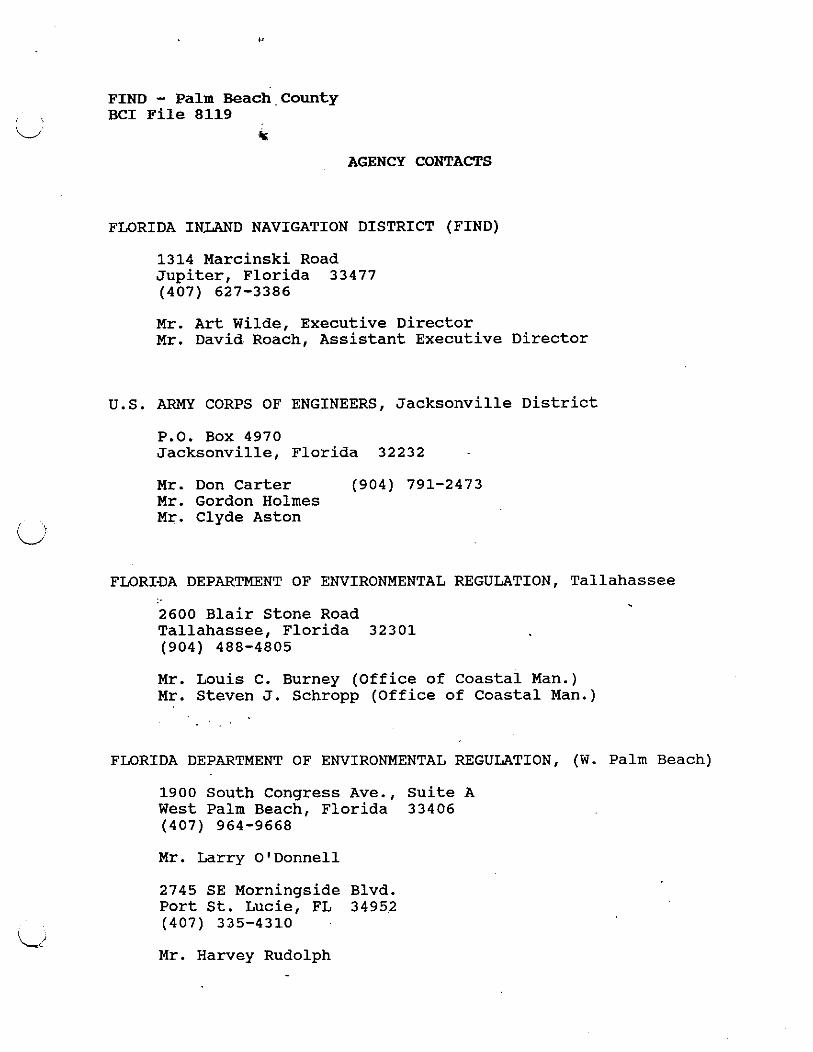
FIND - Palm each County BCI File 8119
t:
AGENCY CONTACTS
FLORIDA INLAND NAVIGATION DISTRICT (FIND)
1314 Marcinski Road Jupiter, Florida 33477 (407) 627-3386
Mr. Art Wilde, Executive Director Mr. David. Roach, Assistant Executive Director
U.S. ARMY CORPS OF ENGINEERS, Jacksonville District
P.O. Box 4970 Jacksonville, Florida 32232
Mr. Don Carter (904) 791-2473 Mr. Gordon Holmes Mr. Clyde Aston
FLORIDA DEPARTMENT OF ENVIRONMENTAL REGULATION, Tallahassee
2600 Blair Stone Road Tallahassee, Florida 32301 (904) 488-4805
Mr. Louis C. Burney (Office of Coastal Man.) Mr. Steven J. Schropp (Office of Coastal Man.)
FLORIDA DEPARTMENT OF ENVIRONMENTAL REGULATION, (W. Palm Beach)
1900 South Congress Ave., Suite A West Palm Beach, Florida 33406 (407) 964-9668
Mr. Larry O'Donnell
2745 SE Morningside Blvd. Port St. Lucie, FL 3495.2 (407) 335-4310
Mr. Harvey Rudolph
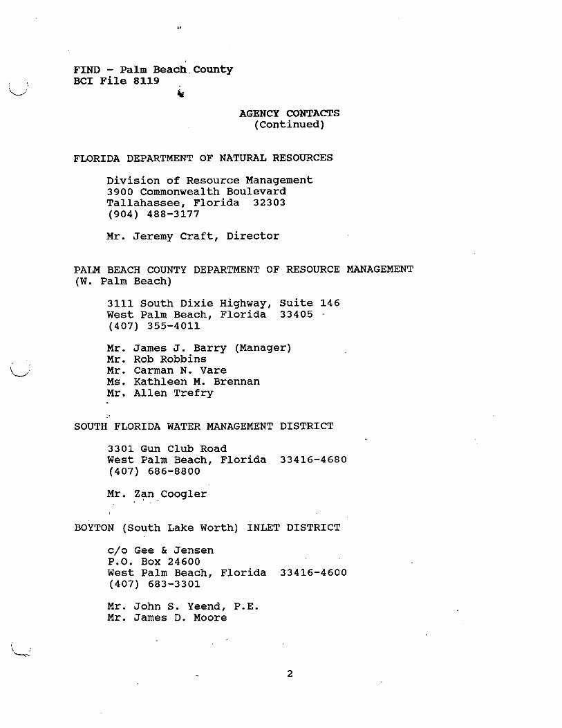
FIND - Palm Beach.County BCI File 8119
k
AGENCY CONTACTS (Continued)
FLORIDA DEPARTMENT OF NATURAL RESOURCES
Division of Resource Management 3900 Commonwealth Boulevard Tallahassee, Florida 32303 (904) 488-3177
Mr. Jeremy Craft, Director
PALM BEACH COUNTY DEPARTMENT OF RESOURCE MANAGEMENT (W. Palm Beach)
3111 South Dixie Highway, Suite 146 West Palm Beach, Florida 33405 - (407) 355-4011
Mr. James J. Barry (Manager) Mr. Rob Robbins Mr. Carman N. Vare Ms. Kathleen M. Brennan Mr. Allen Trefry
SOUTH FLORIDA WATER MANAGEMENT DISTRICT
3301 Gun Club Road West Palm Beach, Florida 33416-4680 (407) 686-8800
Mr. Zan . Coogler . .
BOYTON (South Lake Worth) INLET DISTRICT
c/o Gee & Jensen P.O. Box 24600 West Palm Beach, Florida 33416-4600 (407) 683-3301
Mr. John S. Yeend, P.E. Mr. James D. Moore
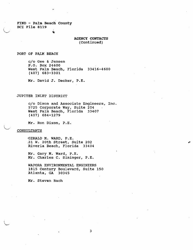
FIND - P a l m Beach C o u n t y B C I F i l e 8119
i/ k
AGENCY CONTACTS ( C o n t i n u e d )
PORT OF PALM BEACH
c/o G e e & Jensen P.O. B o x 2 4 6 0 0 West Palm B e a c h , Florida 3 3 4 1 6 - 4 6 0 0 ( 4 0 7 ) 6 8 3 - 3 3 0 1
M r . D a v i d J. D e c k e r , P.E.
J U P I T E R INLET DISTRICT
c/o D i x o n and A s s o c i a t e E n g i n e e r s , I nc . 5 7 2 5 C o r p o r a t e Way, S u i t e 2 0 4 . West Palm B e a c h , Florida 3 3 4 0 7 ( 4 0 7 ) 6 8 4 - 1 2 7 9
M r . R o n D i x o n , P .E. , L
CONSULTANTS
GERALD M. WARD, P.E. :31 W. 2 0 t h Street, S u i t e 2 0 2 R i v e r i a B e a c h , F lor ida 3 3 4 0 4
M r . G a r y M. Ward, P . E . M r . C h a r l e s C. Siminger, P.E.
WAPORA ENVIRONMENTAL ENGINEERS 1815 C e n t u r y B o u l e v a r d , S u i t e 1 5 0 A t l a n t a , GA 3 0 3 4 5
M r . Steven B a c h
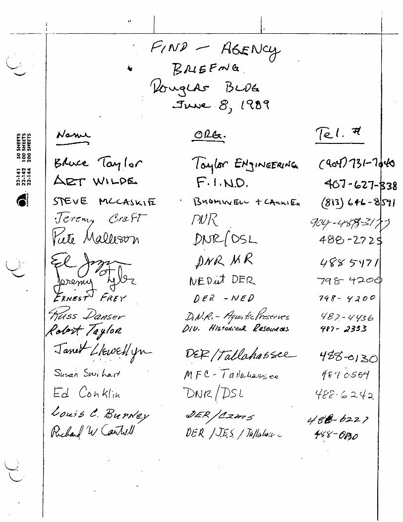
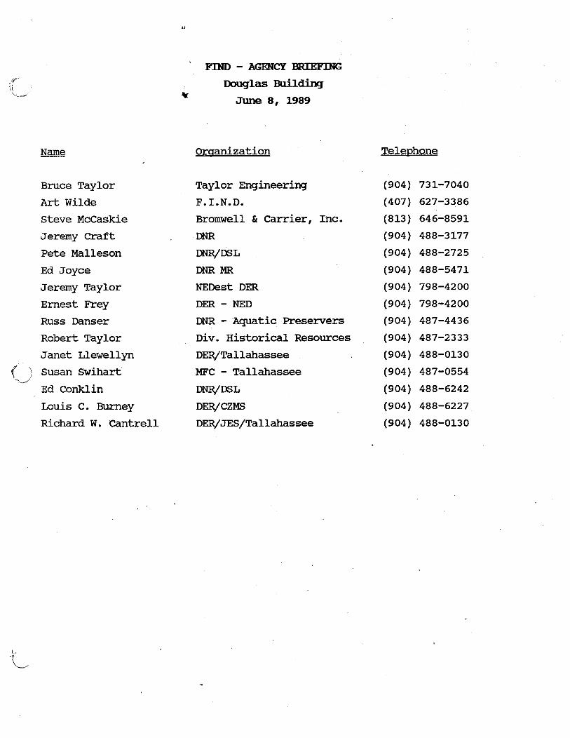
Bruce Taylor
Art Wilde
Steve McCaskie
Jeremy Craft
Pete Malleson
Ed Joyce
Jeremy Taylor
Ernest Frey
Russ Danser
Robert Taylor
Janet Llewellyn
Susan Swihart
Ed Conklin
Louis C. Burney
Richard W. Cantrell
FIND - AWCY BRTEFING Douglas Wlilding
.cr June 8 , 1989
Orqanization
Taylor Engineering
F.I.N.D.
Bromwell & Carrier, Inc.
DNR
W E L
DNRMR
NEDest DER
DER - NED DNR - Aquatic Preservers Div. Historical Resources
DER/Tallahassee
MFC - Tallahassee W W L
DER/CZMS
DER/JES/Tallahassee