Dead Sea Levels During the Bronze and Iron Ages. Kagan Langgut et al. 2015. RADIOCARBON
16
DEAD SEA LEVELS DURING THE BRONZE AND IRON AGES Elisa Joy Kagan 1 • Dafna Langgut 2 • Elisabetta Boaretto 3 • Frank Harald Neumann 4 • Mordechai Stein 5 ABSTRACT. The history of lake-level changes at the Dead Sea during the Holocene was determined mainly by radiocarbon dating of terrestrial organic debris. This article reviews the various studies that have been devoted over the past 2 decades to defining the Dead Sea levels during the Bronze and Iron Ages (~5.5 to 2.5 ka cal BP) and adds new data and interpretation. In particular, we focus on research efforts devoted to refining the chronology of the sedimentary sequence in the Ze’elim Gully, a key site of paleoclimate investigation in the European Research Council project titled Reconstructing Ancient Israel. The Bronze and Iron Ages are characterized by significant changes in human culture, reflected in archaeological records in which sharp settlement oscillations over relatively short periods of time are evident. During the Early Bronze, Intermediate Bronze, Middle Bronze, and Late Bronze Ages, the Dead Sea saw significant level fluctuations, reaching in the Middle Bronze an elevation of ~370 m below mean sea level (bmsl), and declining in the Late Bronze to below 414 m bmsl. At the end of the Late Bronze Age and upon the transition to the Iron Age, the lake recovered slightly and rose to ~408 m bmsl. This recovery reflected the resumption of freshwater activity in the Judean Hills, which was likely accompanied by more favorable hydro- logical-environmental conditions that seem to have facilitated the wave of Iron Age settlement in the region. INTRODUCTION The Dead Sea, a hypersaline (currently 340 g TDS/L) terminal lake located at the lowest elevation on Earth [water level at 427 m below mean sea level (bmsl) in 2014], is the modern remnant of a series of lakes that filled the tectonic depressions situated along the Dead Sea transform during the late Quaternary (Neev and Emery 1995; Stein 2001, 2014a,b). The watershed of the lakes that filled the Dead Sea Basin (Figure 1) is located between the desert belt and the Mediterranean climate zone and receives water and sediments from both regions. Thus, the Dead Sea, which is considered a “terminal trap” of these waters and sediment fluxes, is regarded as a regional gauge that records in its sedimentary archives the late Quaternary climate-hydrological history of these regions [e.g. Stein 2001, 2014a,b; Bookman (Ken-Tor) et al. 2004; Migowski et al. 2006; Kushnir and Stein 2010; Haliva-Cohen et al. 2012; Langgut et al. 2014; Neugebauer et al. 2014]. In this review, we focus on the lake-level history of the Dead Sea during the Bronze and Iron Ages (~5.5 to 2.5 ka cal BP). This period saw dramatic changes in the regional climate and in the devel- opment of human cultures. During the Early Bronze Age, cities such as Jericho, Bab edh-Dhra’, and Arad prospered and olive horticulture spread in the Samaria and Judean highlands (Neev and Emery 1995; Rosen 2007). Numerous settlements flourished in the Judean Hills and in the north- ern Negev Desert as well as in the entire circum-Mediterranean (Finkelstein and Gophna 1993; Finkelstein 1995; Offer and Goossens 2004; Issar and Zohar 2007). In general, the climate was significantly more humid than in modern times (Litt et al. 2012). The Intermediate Bronze Age is described as a nonurban interlude, with low settlement activity, between the urban civilizations of the Early Bronze and the Middle Bronze Ages (Dever 1980). At that time, moderate climate con- ditions prevailed (Langgut et al. 2015). This low settlement scenario continued into the beginning of the Middle Bronze Age I. Settlement activity increased in the Middle Bronze Age II–III, with re-expansion to more southern areas (Gophna and Portugali 1988; Finkelstein and Langgut 2014). 1. Geological Survey of Israel, 30 Malkhe Israel St., Jerusalem 95501, Israel. Corresponding author. Email: [email protected]. 2. Sonia and Marco Nadler Institute of Archaeology, Tel Aviv University, P.O. Box 39040, Tel Aviv 69978, Israel. 3. Weizmann Institute-Max Planck Center for Integrative Archaeology, D-REAMS Radiocarbon Dating Laboratory, The Weizmann Institute of Science, Rehovot 76100, Israel. 4. Forschungsstelle für Paläobotanik, Heisenbergstrasse 2, 48149 Münster, Germany. 5. Institute of Earth Sciences, The Hebrew University, Givat Ram 91904, Jerusalem, Israel; Geological Survey of Israel, 30 Malkhe Israel St., Jerusalem 95501, Israel. Radiocarbon, Vol 57, Nr 2, 2015, p 237–252 DOI: 10.2458/azu_rc.57.18560 © 2015 by the Arizona Board of Regents on behalf of the University of Arizona The Iron Age in Israel: The Exact and Life Sciences Perspective Edited by Israel Finkelstein, Steve Weiner, and Elisabetta Boaretto
Transcript of Dead Sea Levels During the Bronze and Iron Ages. Kagan Langgut et al. 2015. RADIOCARBON
DEAD SEA LEVELS DURING THE BRONZE AND IRON AGESElisa Joy Kagan1 • Dafna Langgut2 • Elisabetta Boaretto3 • Frank Harald Neumann4 • Mordechai Stein5
ABSTRACT. The history of lake-level changes at the Dead Sea during the Holocene was determined mainly by radiocarbon dating of terrestrial organic debris. This article reviews the various studies that have been devoted over the past 2 decades to defining the Dead Sea levels during the Bronze and Iron Ages (~5.5 to 2.5 ka cal BP) and adds new data and interpretation. In particular, we focus on research efforts devoted to refining the chronology of the sedimentary sequence in the Ze’elim Gully, a key site of paleoclimate investigation in the European Research Council project titled Reconstructing Ancient Israel. The Bronze and Iron Ages are characterized by significant changes in human culture, reflected in archaeological records in which sharp settlement oscillations over relatively short periods of time are evident. During the Early Bronze, Intermediate Bronze, Middle Bronze, and Late Bronze Ages, the Dead Sea saw significant level fluctuations, reaching in the Middle Bronze an elevation of ~370 m below mean sea level (bmsl), and declining in the Late Bronze to below 414 m bmsl. At the end of the Late Bronze Age and upon the transition to the Iron Age, the lake recovered slightly and rose to ~408 m bmsl. This recovery reflected the resumption of freshwater activity in the Judean Hills, which was likely accompanied by more favorable hydro-logical-environmental conditions that seem to have facilitated the wave of Iron Age settlement in the region.
INTRODUCTION
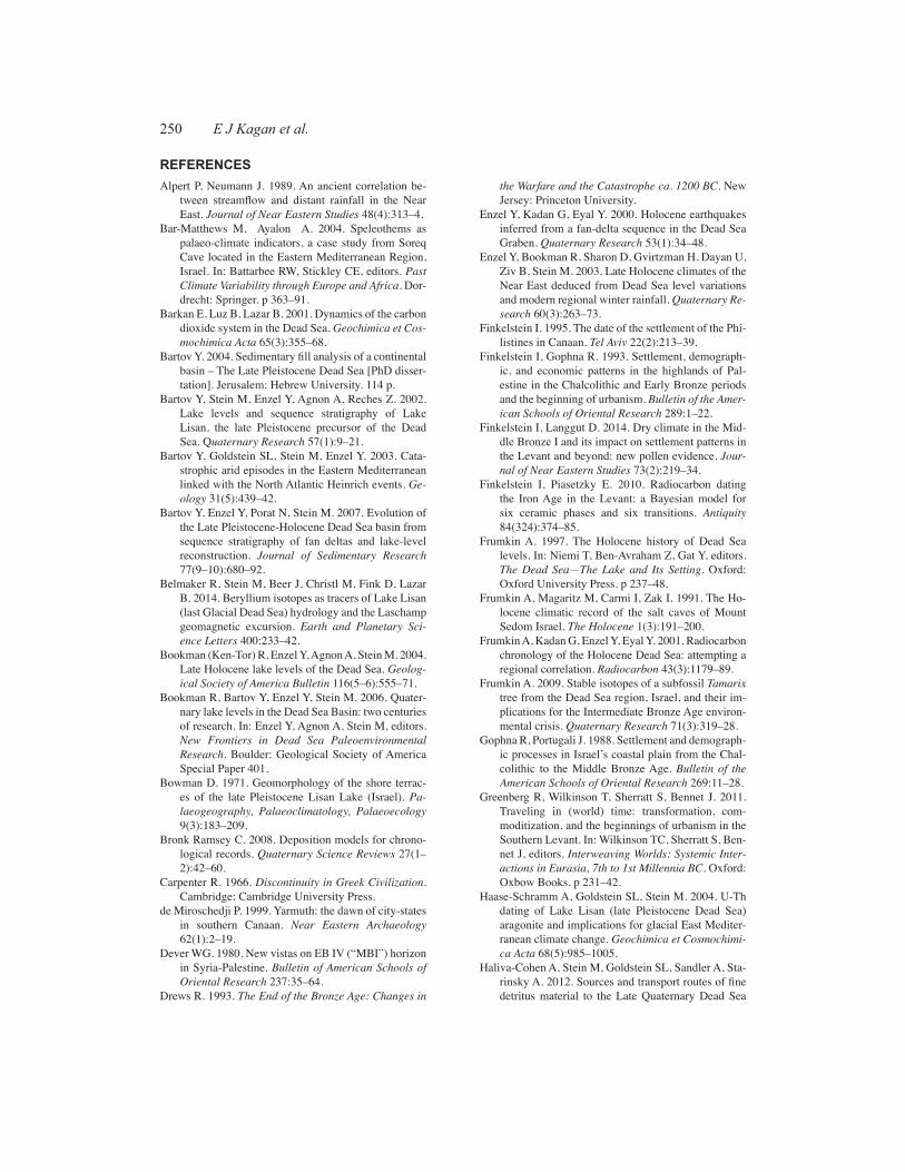
The Dead Sea, a hypersaline (currently 340 g TDS/L) terminal lake located at the lowest elevation on Earth [water level at 427 m below mean sea level (bmsl) in 2014], is the modern remnant of a series of lakes that filled the tectonic depressions situated along the Dead Sea transform during the late Quaternary (Neev and Emery 1995; Stein 2001, 2014a,b). The watershed of the lakes that filled the Dead Sea Basin (Figure 1) is located between the desert belt and the Mediterranean climate zone and receives water and sediments from both regions. Thus, the Dead Sea, which is considered a “terminal trap” of these waters and sediment fluxes, is regarded as a regional gauge that records in its sedimentary archives the late Quaternary climate-hydrological history of these regions [e.g. Stein 2001, 2014a,b; Bookman (Ken-Tor) et al. 2004; Migowski et al. 2006; Kushnir and Stein 2010; Haliva-Cohen et al. 2012; Langgut et al. 2014; Neugebauer et al. 2014].
In this review, we focus on the lake-level history of the Dead Sea during the Bronze and Iron Ages (~5.5 to 2.5 ka cal BP). This period saw dramatic changes in the regional climate and in the devel-opment of human cultures. During the Early Bronze Age, cities such as Jericho, Bab edh-Dhra’, and Arad prospered and olive horticulture spread in the Samaria and Judean highlands (Neev and Emery 1995; Rosen 2007). Numerous settlements flourished in the Judean Hills and in the north-ern Negev Desert as well as in the entire circum-Mediterranean (Finkelstein and Gophna 1993; Finkelstein 1995; Offer and Goossens 2004; Issar and Zohar 2007). In general, the climate was significantly more humid than in modern times (Litt et al. 2012). The Intermediate Bronze Age is described as a nonurban interlude, with low settlement activity, between the urban civilizations of the Early Bronze and the Middle Bronze Ages (Dever 1980). At that time, moderate climate con-ditions prevailed (Langgut et al. 2015). This low settlement scenario continued into the beginning of the Middle Bronze Age I. Settlement activity increased in the Middle Bronze Age II–III, with re-expansion to more southern areas (Gophna and Portugali 1988; Finkelstein and Langgut 2014).
1. Geological Survey of Israel, 30 Malkhe Israel St., Jerusalem 95501, Israel. Corresponding author. Email: [email protected]. Sonia and Marco Nadler Institute of Archaeology, Tel Aviv University, P.O. Box 39040, Tel Aviv 69978, Israel.3. Weizmann Institute-Max Planck Center for Integrative Archaeology, D-REAMS Radiocarbon Dating Laboratory, The Weizmann Institute of Science, Rehovot 76100, Israel.4. Forschungsstelle für Paläobotanik, Heisenbergstrasse 2, 48149 Münster, Germany.5. Institute of Earth Sciences, The Hebrew University, Givat Ram 91904, Jerusalem, Israel; Geological Survey of Israel, 30 Malkhe Israel St., Jerusalem 95501, Israel.
Radiocarbon, Vol 57, Nr 2, 2015, p 237–252 DOI: 10.2458/azu_rc.57.18560 © 2015 by the Arizona Board of Regents on behalf of the University of Arizona
The Iron Age in Israel: The Exact and Life Sciences Perspective Edited by Israel Finkelstein, Steve Weiner, and Elisabetta Boaretto
238 E J Kagan et al.
The Late Bronze Age is characterized by low settlement activity with a collapse of the entire set-tlement system towards the end of the period, when many sites were abandoned altogether. This collapse is largely contemporaneous with a drop in Dead Sea level and increasing aridity (Litt et al. 2012; Langgut et al. 2014). This period features a decrease in olive cultivation in the Samaria and Judean highlands (Litt et al. 2012). Aridity also affected the northern regions of the Dead Sea watershed (Schwab et al. 2004; Langgut et al. 2013, 2014, 2015), as well as other large regions all over the eastern Mediterranean, where prominent civilizations had previously thrived, e.g. the Hittite Empire in Anatolia, Cyprus, the Syrian coast, and Egypt (Ward and Joukowsky 1992; Drews 1993; Kaniewski et al. 2010, 2013). Immigrants from the Aegean Basin—the Sea Peoples—settled along the coastal regions of the Levant at the time of transition to the Iron Age (Stager 1995). A contemporary wave of settlement, representing the (proto)-Israelites, characterizes the Samaria and Judean Hills (Finkelstein 1995). This time period saw an increase in humidity in the Dead Sea area (Neumann et al. 2007; Litt et al. 2012; Langgut et al. 2014) as well as in northern Israel (Schwab et al. 2004; Langgut et al. 2013).
The focus of this review is the reconstruction of the Dead Sea level during the Middle Bronze to Iron Ages. In particular, we focus on research efforts devoted to refining the chronology of the sedimen-tary sequence in the Ze’elim Gully, a key site of paleoclimate investigation in the ERC Reconstruct-ing Ancient Israel project. We compile the chronological data, mainly radiocarbon ages along with
7 1
2
4
6 3
a
Ein Feshkha
FIGURE 1 – KAGAN
Ein Gedi Ze’elim Gully
Mt. Sedom
Sea of Galilee
Dead Sea
Ein Qedem
Figure 1 The catchment area of the Dead Sea (~40,000 km2) (brown line), the maximum extent of the Pleistocene paleo- Dead Sea (blue shading), and main sites on the western shores of the Dead Sea mentioned in the paper. Note that the Sea of Galilee is also referred to as Lake Kinneret. The Hula Lake is depicted as it was before its desiccation in the 1950s (due to human interference).
239Dead Sea Levels during the Bronze and Iron Ages
the information on shoreline elevations, and link it with the cultural history in the southern Levant. The sedimentological and chronological data were derived from wadi (ephemeral stream) exposures and boreholes at several sites along the retreating western shores of the modern Dead Sea: mainly at the Ze’elim, Ein Gedi, and Ein Feshkha shores (Figure 1).
LIMNOLOGICAL SETTING OF THE HOLOCENE DEAD SEA
The Holocene Dead Sea evolved from Lake Lisan, its Pleistocene precursor, which filled the tecton-ic depressions along the central Dead Sea transform during the last glacial period ~70–14 ka cal BP (Haase-Schramm et al. 2004; Torfstein et al. 2013a,b). At its maximum elevation of ~160 m bmsl, Lake Lisan extended over the entire Dead Sea–Jordan–Kinnarot Basins from Hazeva in the south to the Bethsaida (Beteicha) Valley in the north, converging with the Sea of Galilee (Lake Kinner-et; freshwater) (Bartov et al. 2003; Hazan et al. 2005; Stein 2014b). At ~14–13 ka cal BP, Lake Lisan declined from its high stand to below 450 m bmsl, rose back during the Younger Dryas, then declined again at ~11–10 ka cal BP (depositing a thick sequence of salts), and recovered in the Neolithic period (Stein et al. 2010). During the Holocene, the lake evolved through a complex limnological history with surface levels fluctuating between ~430 and 370 m bmsl [Bookman (Ken-Tor) et al. 2004; Migowski et al. 2006; Kushnir and Stein 2010]. The surface levels reflect the net freshwater influx (precipitation minus evaporation) into the lake that in turn mainly reflects the precipitation over the larger watershed regions. At the beginning of the 20th century, the lake stood at ~390 m bmsl and covered the southern shallow basin of the Dead Sea. Yet, during significant parts of the Holocene the southern Dead Sea was dry or precipitated salts (Neev and Emery 1995). A topographic sill at ~402–403 m bmsl separates the relatively deep northern basin and the shallow southern basin of the Dead Sea. When the lake level is high enough for the water to cross the sill, additional water is subjected to evaporation (similar to the current situation at the evaporation ponds of the Dead Sea Works potash plant). Thus, a significant increase in the water supply to the lake is required for the lake to rise above the sill and additional evaporation at the southern basin buffers lake-level rise (Bookman [Ken-Tor] et al. 2004).
It is noteworthy that during the past few hundred years the Dead Sea was characterized by salinity- driven stratification and only in 1977 did the lake overturn and attain its current configuration. The layered configuration reflects enhanced freshwater input to the lake. This is accompanied by supply of bicarbonate and sulfate ions that result in the precipitation of primary carbonate and gypsum in the lake (Stein et al. 1997; Barkan et al. 2001). When the supply of freshwater loaded with carbonate is limited, almost no aragonite precipitates into the lake (e.g. Waldmann et al. 2007; Stein 2014a).
RECONSTRUCTION OF DEAD SEA WATER LEVELS – BACKGROUND General
The reconstruction of water-level curves of the ancient lakes that occupied the Dead Sea Basin in the past hundreds of thousands of years has been a major objective of Dead Sea researchers over the past decades, reflecting the potential of this curve to serve as a regional hydrological gauge [e.g. Bowman 1971; Neev and Emery 1995; Machlus et al. 2000; Frumkin et al. 2001; Bartov et al. 2002; Bookman (Ken-Tor) et al. 2004; Torfstein et al. 2009, 2013a; Waldmann et al. 2009]. The changes in the supply of water and sediments to the lake reflect the hydroclimate history of the watershed during Quaternary times and in turn are reflected in the lakes’ limnology (composition and water levels) and sedimentology (sedimentary facies, Figures 2a,b) (Stein et al. 2001; Stein 2014a,b and references therein). A positive correlation exists between precipitation from 1870 until 1964—just before human intervention in the flow of the Jordan River—and recorded Dead Sea levels (Klein and Flohn 1987; Enzel et al. 2003). This is so despite all potential complexities that are involved in
240 E J Kagan et al.
the “transfer” of the hydroclimate configuration of the watershed into the lakes’ limnological and sedimentological properties. The lake rose when annual precipitation in Jerusalem exceeded ~650 ± 100 mm and receded when the annual precipitation dropped to ~450 ± 100 mm (Enzel et al. 2003). The most significant lake rise of the past decades (since the beginning of human intervention in the regional water balance) occurred in the winter of 1991/2, when anomalous amounts of rain fell in the watershed (e.g. ~1500 mm in Jerusalem compared to the annual mean of 550 mm). That winter the Degania Dam, which prevents the flow of the Jordan River out of the Sea of Galilee, was opened and the Dead Sea level rose by more than 1.5 m.
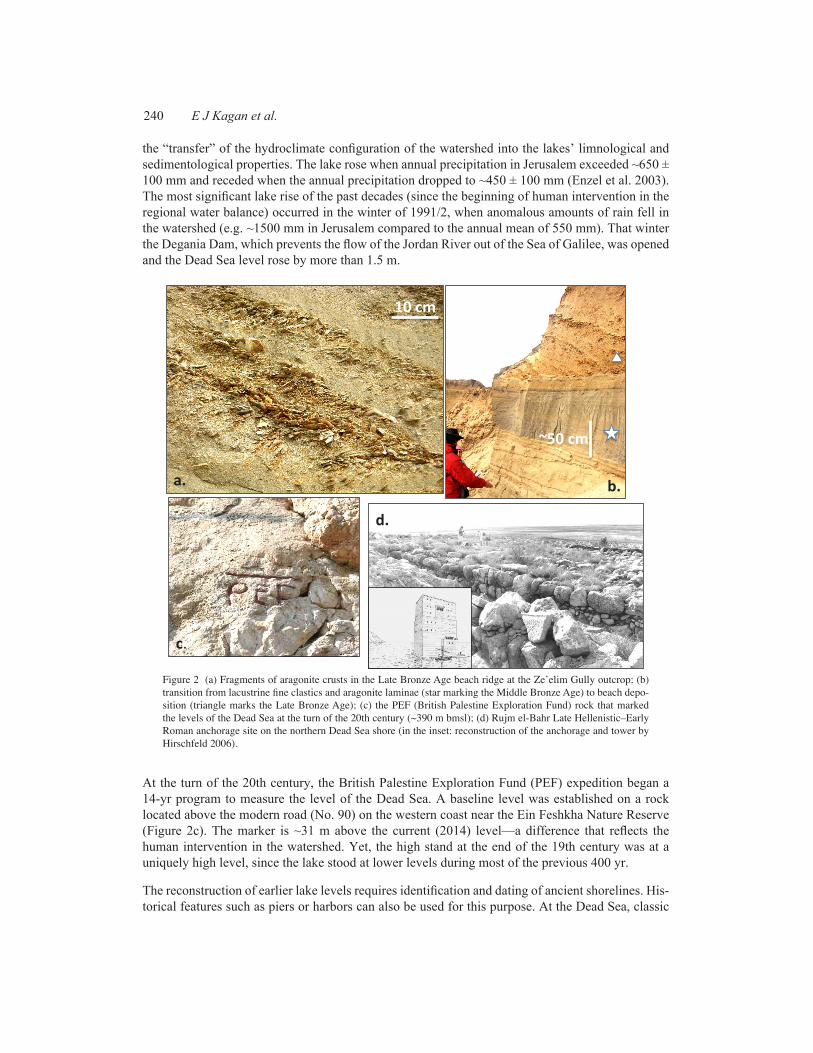
At the turn of the 20th century, the British Palestine Exploration Fund (PEF) expedition began a 14-yr program to measure the level of the Dead Sea. A baseline level was established on a rock located above the modern road (No. 90) on the western coast near the Ein Feshkha Nature Reserve (Figure 2c). The marker is ~31 m above the current (2014) level—a difference that reflects the human intervention in the watershed. Yet, the high stand at the end of the 19th century was at a uniquely high level, since the lake stood at lower levels during most of the previous 400 yr.
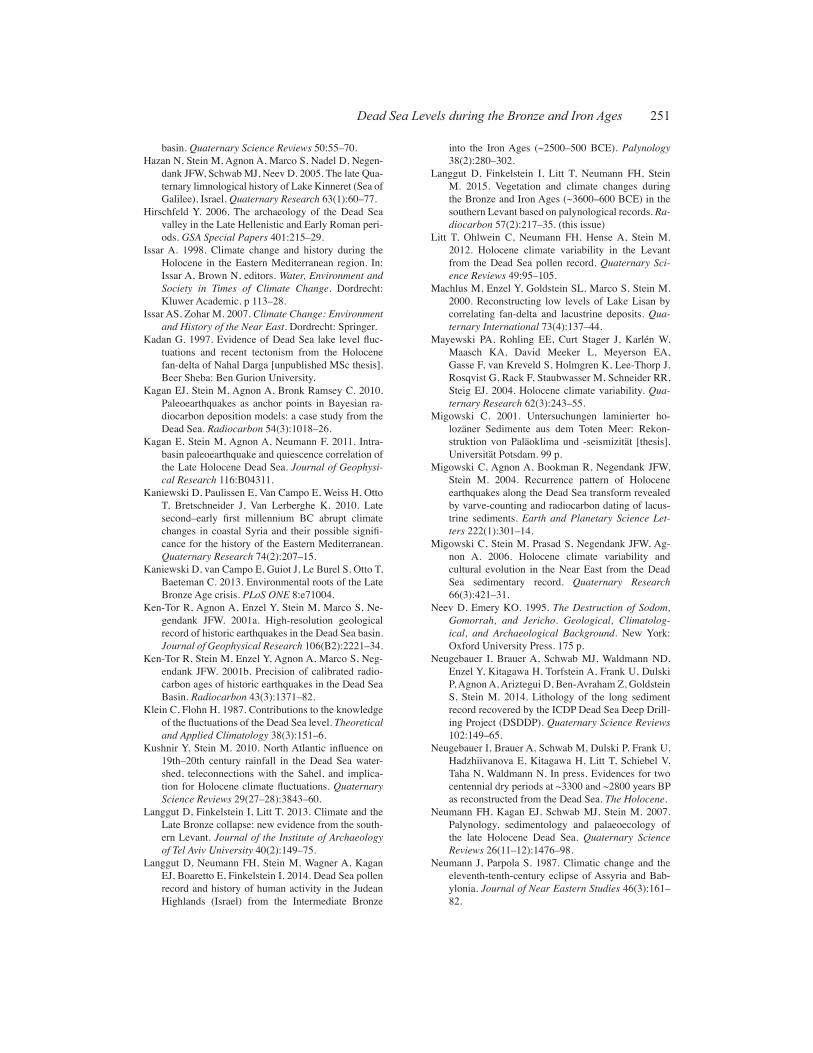
The reconstruction of earlier lake levels requires identification and dating of ancient shorelines. His-torical features such as piers or harbors can also be used for this purpose. At the Dead Sea, classic
FIGURE 2 - KAGAN
a.
c.
b.
d.
10 cm
~50 cm
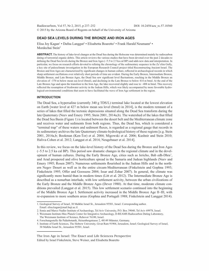
Figure 2 (a) Fragments of aragonite crusts in the Late Bronze Age beach ridge at the Ze’elim Gully outcrop; (b) transition from lacustrine fine clastics and aragonite laminae (star marking the Middle Bronze Age) to beach depo-sition (triangle marks the Late Bronze Age); (c) the PEF (British Palestine Exploration Fund) rock that marked the levels of the Dead Sea at the turn of the 20th century (~390 m bmsl); (d) Rujm el-Bahr Late Hellenistic–Early Roman anchorage site on the northern Dead Sea shore (in the inset: reconstruction of the anchorage and tower by Hirschfeld 2006).
241Dead Sea Levels during the Bronze and Iron Ages
examples are the Late Hellenistic–Early Roman anchorage piers at Rujm el-Bahr (Figure 2d) (at 393.1 m bmsl, placing the lake level of that time at ~394 m bm) and at Khirbet Mazin (390–394 m bmsl) (Hirschfeld 2006). A pioneering investigation into Dead Sea levels was attempted by mea-suring and dating wide versus narrow cave passages in the Mt. Sedom salt diapir (Frumkin et al. 1991, 2001; Frumkin 1997). Precise lake-level elevation reconstruction using salt cave data was hampered by uncertain rates of diapir rise (Frumkin et al. 2001). Beyond the historical data and cave evidence, the lake-level reconstruction is based on sedimentological features such as shore-line markers or near-shore sediments (Figures 2a,b). Comprehensive descriptions and reviews of methods of identification of the shoreline deposits characteristic of the Dead Sea Basin are given by Machlus et al. (2000), Bookman (Ken-Tor) et al. (2004), and Bookman et al. (2006). For the purpose of this review, we use the following criteria: (1) laminated detritus, laminated primary aragonite and detritus, indicating a few meters or more water depth; (2) silty-sandy detritus, indicating very shallow near-shore depths; and (3) sand, small pebbles, aragonite crusts, and wave-related structures (e.g. beach ridges, ripple marks), indicating former shorelines. Note that primary aragonite laminae precipitation, whether as lacustrine aragonite laminae or encrusted aragonite at the shore, require continuous supply of freshwater loaded with bicarbonate to the lake (Stein et al. 1997; Barkan et al. 2001; Torfstein et al. 2013a).
The dating of the shoreline markers is accomplished by several methods such as 14C (discussed in the following sections) or the U-Th dating method, which is applicable for the primary aragonites deposited from the lake waters or encrusting pebbles and organic debris (Figure 2a). Based on these principles, level curves were reconstructed for the lakes that occupied the Dead Sea and Kinnarot basins during the past ~140 ka. These reconstructions included works by Neev and Emery (1995), Machlus et al. (2000), Frumkin et al. (1991, 2001), Bartov et al. (2002, 2003), Bookman (Ken-Tor) et al. (2004), Hazan et al. (2005), Waldmann et al. (2007, 2009), Stern (2010), and Torfstein et al. (2013a). Over this time interval, which encompasses the last interglacial period (Lake Amora– Samra), the last glacial (Lake Lisan), the post-glacial, and the Holocene (the Dead Sea), lake level fluctuated between 160 m bmsl and lower than 450 m bmsl. Recent studies of a core drilled in the deep basin of the Dead Sea suggest a possible extreme low stand of the last interglacial Lake Samra (the ICDP drilling project, Stein et al. 2011; Torfstein et al. 2015). Here, we focus on the chronology of the mid- to late-Holocene Dead Sea levels, when the Bronze and Iron Age cultures, which feature processes of settlement expansion and collapse, developed in the region.
RADIOCARBON DATING OF THE HOLOCENE DEAD SEA
The sediments comprising the Holocene sections deposited from the Dead Sea are termed the Ze’elim Formation [Yechieli et al. 1993; Bookman (Ken-Tor) et al. 2004]. The formation comprises sequenc-es of laminated detritus (transported to the lake by seasonal floods) and primary aragonite, gypsum, and salt (details in Migowski et al. 2004, 2006; Haliva-Cohen et al. 2012; Neugebauer et al. 2014).
The chronology of the Ze’elim Formation is essential for the reconstruction of the Dead Sea level curve. Paleoclimate, paleoseismology, and palynology studies have been carried out using these in-dispensable outcrops (e.g. Enzel et al. 2000; Ken-Tor et al. 2001a,b; Neumann et al. 2007; Kagan et al. 2011; Langgut et al. 2014). The sediment exposures are rich in organic debris of seeds and wood that were transported from the surrounding mountains or the close marginal terraces by runoff and winter floods [Ken-Tor et al. 2001a,b; Bookman (Ken-Tor) et al. 2004; Migowski et al. 2006]. Ear-ly 14C dating of Holocene sediments from cores drilled at the southern (shallow) basin of the Dead Sea was undertaken by D Neev and W C Broecker (published in Neev and Emery 1995). Yechieli et al. (1993) dated organic debris from a core (DSIF) drilled at the western side of the Ze’elim Plain (Figure 1), and reported several 14C ages of post-glacial to early Holocene times. These researchers

242 E J Kagan et al.
also dated driftwood from the Ze’elim Gully floor near the Dead Sea shores in order to examine the residence time of wood at the shore environment and to estimate any delay between time of organ-ic matter demise and incorporation into the sediment. All five driftwood samples yielded percent modern carbon (pMC) between 102 and 155, signifying that modern shore driftwood is post-bomb (younger than 40 yr old at time of sampling) and that transport time is insignificant for dating of geological and paleolimnological events (Yechieli et al. 1993). Ken-Tor et al. (2001b) also demon-strated a short lag period between the beginning of 14C decay and the deposition of the organic debris (usually less than a few decades, and no more than 2 centuries). In most of the chronological studies, researchers aimed to date “short-lived” organic debris (seeds, twigs) where equilibrium with the atmosphere and short transport time to the shoreline sediments can be assumed. We suggest that lacustrine sediments incorporate organic fragments recently washed off-shore, while near-shore lithologies, such as beach ridges, tend to also accumulate recycled organic remains.
The Ze’elim Gully has been a major site of study of the limnological and sedimentological history of the mid- to late-Holocene Dead Sea. This stems from its location at the Ze’elim Plain on the fringe of the fan delta of Nahal Ze’elim, a major wadi (ephemeral stream) that drains the southwest regions of the Dead Sea watershed, and from its rapid incision into the Ze’elim Plain (the previ-ously submerged part of the fan delta), which comprises lacustrine and fluvial sedimentary facies. In the 1990s, the exposed gully walls were only 4 m deep beneath the plain surface. Ken-Tor et al. (2001a,b) and Bookman (Ken-Tor) et al. (2004) provided a detailed chronology of the sedimentary sections in two of the southern gullies that dissect the Ze’elim Plain. In their reconstruction of the paleoseismic history from these sections, through identifying and 14C dating of the seismites, Ken-Tor et al. (2001a) produced an age-depth model based on 24 14C ages of short-lived plant remains. Remarkable correlation of all historically documented earthquakes to either sediment deformations or to depositional hiatuses supports Ken-Tor et al.’s (2001b) argument for a short (<50 yr) interval between plant death and burial in the sediment. Bookman (Ken-Tor) et al. (2004) used the chrono-logical information from the Ze’elim Gully and from Nahal David outcrop (near Kibbutz Ein Gedi) (Figure 1), as well as identification and measuring of elevation of shoreline indicators, to produce a lake-level curve for the late Holocene (past 3000 yr) Dead Sea.
In December 1997, a joint team from the GFZ-Institute in Potsdam, Germany, and the Hebrew Uni-versity, Israel, carried out a drilling campaign along the Dead Sea shores, with the aim of recovering the entire Holocene sedimentary record. Migowski (2001) and Migowski et al. (2004) present-ed a detailed sedimentary description and 14C chronology of the 20-m-long core recovered at the Ein Gedi spa shore, covering the past 10,000 yr. Migowski et al. (2006) combined the lithological and 14C-chronological information from three cores—Ein Gedi (DSEn), Ein Feshkha (DSF), and Ze’elim (DSZ)—to produce a lake-level curve for the entire Holocene Dead Sea. The DSEn core was dated by 20 14C ages and by laminae counting of ~1500 yr, from 200 to 1300 CE. Migowski et al. (2004) reported the appearance of various types of seismites along this core and a laminae- counted floating chronology of the seismites was matched with the historic earthquake catalog. The best-fit gave model ages younger than their calibrated 14C ages, and thus in the time interval of ~3.0 to 0.2 ka BP the authors shifted the age-depth curve by 50–200 yr. At the interval discussed herein, there is only a small 50-yr shift. Other studies found no significant reworking time of the organic debris in the Ze’elim Formation (Ken-Tor et al. 2001a,b; Kagan et al. 2011; Langgut et al. 2014; Neugebauer et al., in press).
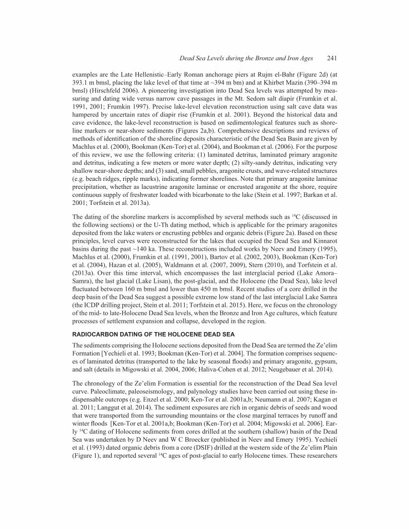
Ongoing gully incision at Ze’elim and Ein Feshkha alluvial fan plains, responding to the continuous anthropogenic drop of the Dead Sea, exposed new outcrops (Figure 3) previously only observed in cores. Neumann et al. (2007) and Kagan et al. (2011) took advantage of these new outcrops and
243Dead Sea Levels during the Bronze and Iron Ages
provided additional insight into the chronology, palynology, paleoclimate, and paleoseismology of the Late Holocene.
14C dating of the more lake-ward Ze’elim Gully outcrop (ZA2) was established down to 10.5 m below the plain surface (12 ages) in the palynological study of Neumann et al. (2007) and the paleo- seismic study of Kagan et al. (2011). The ZA2 section is a few hundred meters east of the Ze’elim A section (ZA1) [Bookman (Ken-Tor) et al. 2004], making it more lacustrine, but interfingering with shore facies. The section showed mostly continuous deposition, with perhaps minor hiatuses not identified by dating and one long hiatus (~7–4 ka BP). This hiatus is, at least in part, only local since at the nearby ZA3 section part of this time interval is represented. At the Ein Feshkha Gully, Neumann et al. (2007) and Kagan et al. (2011) dated nine horizons along an almost 6-m section (from about 3300 to 550 yr cal BP), showing essentially continuous lacustrine deposition. In an effort to improve the chronology of the Ze’elim and Ein Feshkha sections, Kagan et al. (2010, 2011) produced Bayesian age-depth deposition models using the OxCal P_sequence model (see Bronk Ramsey 2008). In this manner, the Bayesian package provides a model age for every depth in the section, such as the earthquake marker depths, with a narrow uncertainty envelope. The application of this model allowed correlation of seismites to tens of historic earthquakes and an intrabasin cor-relation and comparison of seismite occurrence and characteristics at three sites. In a palynological- sedimentological study carried out as part of the Reconstructing Ancient Israel project, more than 10 ages were reported covering the Bronze and Iron Ages time interval in the Ze’elim Gully (ZA3 section) (Langgut et al. 2014).
LAKE LEVELS DURING THE BRONZE AND IRON AGE INTERVAL General
This section summarizes the chronological and shoreline information established for the Bronze to Iron Age time interval in the Ze’elim Gully. The sedimentary sections were also studied for palyno-logical investigation as reported by Langgut et al. (2014), and reviewed in this issue by Langgut et
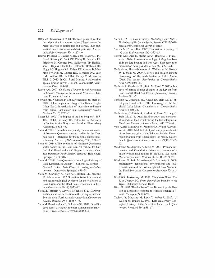
FIGURE 3 - KAGAN
Late Bronze Beach Ridge
Middle Bronze
Iron Age
Babylonian to Middle Ages
Ze’elim Plain 401.5
411.0
409.5
408.0
Elevation (m bmsl)
Dead Sea
Figure 3 ZA3 outcrop section, with main archaeological periods and elevations
244 E J Kagan et al.
al. (2015). A stratigraphic, mineralogical, and isotopic study of this interval is given by Kagan and colleagues in a forthcoming publication.
For the purpose of establishing a lake-level curve, the shoreline elevations and their ages obtained from the Ze’elim gullies were integrated with 14C ages from other lacustrine and off-shore exposures from various sites: the Ein Gedi core (Migowski et al. 2006), the Ein Qedem outcrop (Stern 2010), the Ein Feshkha core (Migowski et al. 2006), the Ein Feshkha outcrop (Neumann et al. 2007; Kagan et al. 2011), the Arugot outcrop (Bartov et al. 2007), and the Darga outcrop (Kadan 1997; Enzel et al. 2000; Bartov et al. 2007). 14C ages relevant to this discussion are listed in Table 1.
Late Chalcolithic Period and Early Bronze Age (~6000–2500 BCE; ~8 to 4.45 ka cal BP)
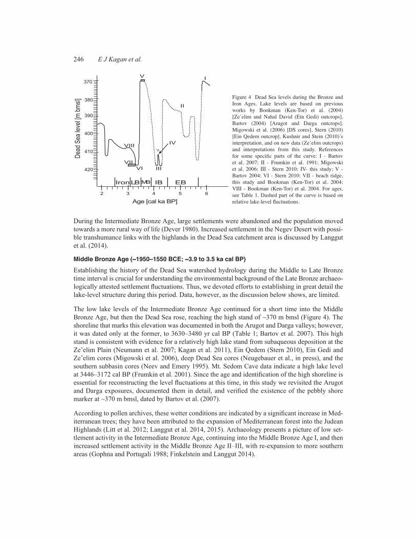
The time interval of the Chalcolithic period through the Early Bronze Age (Table 2) is not exposed in the Ze’elim Gully, where deposition was discontinuous at that time. Lake level was therefore esti-mated from drilled cores in the Ze’elim Plain, Ein Gedi spa shore, and Ein Feshkha (Migowski et al. 2004, 2006; Litt et al. 2012). Migowski et al. (2006) reconstructed an “approximate” level curve for the time intervals that lack direct shoreline evidence (Figure 4). Integrated with the evidence from the Nahal Darga exposure (Bartov et al. 2007) it appears that the Dead Sea rose from its early Holo-cene low stand (~8–6.5 ka cal BP) to its mid-Holocene high stand at ~6.3 ka cal BP. The low-stand period is characterized by gypsum and sand layers in the cores and supported by evidence from a salt tongue revealed in a core from the southern Dead Sea Basin (Neev and Emery 1995). At ~6.3 ka cal BP, laminated lake sediments exposed at the Darga and Arugot terraces mark a significant lake transgression to ~370 m bmsl (Bartov et al. 2007). Neev and Emery (1995) report on a lacustrine transgression at ~6.3 to 6.0 ka BP that interrupted the salty south basin of the Dead Sea. The transi-tion to the Early Bronze Age is marked in the Ein Gedi core by deposition of laminated aragonite, indicating the onset of a significant lake rise at ~5.2 ka cal BP (Migowski et al. 2006). This rise was sufficient to cause the lake to cross the sill at ~4.9 ka cal BP (Neev and Emery 1995). This rise is corroborated by data of wide and high cave passages at Mt. Sedom, dated by wood fragments em-bedded in flood deposits from the caves (Frumkin et al. 1991; Frumkin 1997) and by pollen archives indicating especially high arboreal pollen percentages (Litt et al. 2012; Langgut et al. 2014). The humid period was characterized by the rise of large urban centers in the southern Levant (de Miro-schedji 1999; Greenberg et al. 2011).
Intermediate Bronze Age (~2500–1950 BCE; ~4.45 to 3.9 ka cal BP)
At ~4.4 ka cal BP, the lake dropped sharply based on gypsum deposition in the Ein Gedi core (Migowski et al. 2006) and microconglomerate, pebbles, and abundant gypsum precipitation at ~415–416 m bmsl at the Ein Qedem spring system outcrop (Stern 2010). This low stand is also indicated by narrower cave passage morphology at Mt. Sedom (Frumkin et al. 1991).
At the Ze’elim Gully (ZA3 section), in the middle of this time period, there is a 40-cm sequence of lacustrine detrital sediment representing a short lake rise. This event is also reflected in the Ein Gedi core lithology (at 5.8 m depth; Migowski et al. 2006), but was not noted in previous lake-level curves. A significant increase in olive pollen in the Ein Gedi core (Litt et al. 2012) and the Ze’elim Gully (Langgut et al. 2014) corroborates this event. Then, at ~4.1 ka cal BP, the lake level dropped, depositing gypsum and pebbles at the Ein Qedem site (415.5 m bmsl; Stern 2010) and shore sed-iments at the Ze’elim Gully section. A drought of more than 100 yr at the end of the Intermediate Bronze Age is also recorded in the isotopic composition of tamarisk wood from the Mt. Sedom Cave (southern Dead Sea) (Frumkin 2009). Carbon isotopes measured in speleothems from the Soreq Cave (Judean Hills) indicate a sharp rise in desert vegetation at this time (Bar-Matthews and Ayalon 2004).
245Dead Sea Levels during the Bronze and Iron Ages
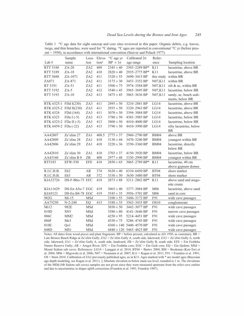
Table 1 14C age data for eight outcrop and core sites reviewed in this paper. Organic debris, e.g. leaves, twigs, and thin branches, were used for 14C dating. 14C ages are reported in conventional 14C yr (before pres-ent = 1950), in accordance with international convention (Stuiver and Polach 1977).
Lab #Sample name
Loca-tion
Eleva-tion‡
14C age yr BP ± 1σ
Calibrated 2σ age range
Refer-ence Sampling location
RTT 5188 ZA-20 ZA2 409 2345 ± 40 2503–2289 BP* K11 lacustrine, above BRRTT 5189 ZA-18 ZA2 410 2820 ± 40 2935–2775 BP* K11 lacustrine, above BRRTT 5688 ZA-1071 ZA2 411 3320 ± 55 3690–3415 BP this study within BRZA871 ZA-871 ZA2 411 3175 ± 30 3453–3352 BP N07,K11 within BRRT 5191 ZA-51 ZA2 411 3500 ± 75 3974–3584 BP N07,K11 silt & ac, within BRRTT 5192 ZA-5 ZA2 412 3540 ± 45 3965–3695 BP N07,K11 lacustrine, below BRRTT 5193 ZA-10 ZA2 413 3475 ± 45 3863–3636 BP N07,K11 sandy, ac, beach sedi-
ments, below BRRTK 6325-1 FDd I(230) ZA3 411 2895 ± 50 3210–2881 BP LG14 lacustrine, above BRRTK 6325-2 FDd II(230) ZA3 411 2935 ± 50 3320–2963 BP LG14 lacustrine, above BRRTK 6324 FDd (164) ZA3 411 3070 ± 50 3394–3084 BP LG14 lacustrine, above BRRTK 6323 FDa I (-5) ZA3 413 3780 ± 50 4383–3985 BP LG14 lacustrine, below BRRTK 6323-2 FDa II (-5) ZA3 413 3800 ± 50 4410–4000 BP LG14 lacustrine, below BRRTK 6459-2 FDa (-22) ZA3 413 3790 ± 50 4410–3990 BP LG14 silty lacustrine, below
BRAA42807 Ze’elim 27 ZA1 408.5 2775 ± 37 2960–2790 BP BM04 above BRAA42809 Ze’elim 28 ZA1 410 3130 ± 44 3470–3240 BP BM04 youngest within BRAA42806 Ze’elim 29 ZA1 410 3220 ± 36 3550–3360 BP BM04 lacustrine, directly
below BRAA42810 Ze’elim 30 ZA1 410 3703 ± 37 4150–3920 BP BM04 lacustrine, below BRAA43160 Ze’elim B 8 ZB 408 2977 ± 48 3330–2990 BP BM04 youngest within BRRT5183 EFW-530 EFE 418 2850 ± 65 3065–2789 BP* K11 lacustrine, 40 cm
above gypsum domesR.I.C.H.B. Eh2 AR 374 5630 ± 40 6310–6450 BP BT04 shore markerR.I.C.H.B. Eh3 AR 372 3330 ± 50 3630–3480 BP BT04 shore markerKIA32726 DS-F-B6o-73 EFC 418 2873 ± 88 3211–2862 BP* K11 above sand and arago-
nite crustsKIA11629 DS-En A5o-7 EGC 419 3065 ± 40 3377–3084 BP M06 lacustrine, above sandKIA9123 DS-En B4-78 EGC 419 3545 ± 35 3956–3701 BP M06 sand in core982G Mi-15 MSd 3100 ± 55 3446–3172 BP F91 wide cave passagesAA75250 N-2-240 EQ 415 3188 ± 35 3562–3435 BP OS10 conglomerateMi12 982E MSd 3030 ± 50 3442–3077 BP F91 wide cave passages810D SN5 MSd 3580 ± 80 4141–3646 BP F91 narrow cave passages886C MM2 MSd 4250 ± 95 5214–4451 BP F91 wide cave passages886F Me3 MSd 4350 ± 75 5286–4745 BP F91 wide cave passages810E Qo1 MSd 4360 ± 140 5440–4570 BP F91 wide cave passages848D MS1 MSd 4440 ± 120 5465–4823 BP F91 wide cave passagesNotes: All dates from wood pieces and plant fragments. BP = before present, calculated as AD 1950, as customary. BR = Late Bronze Beach Ridge at Ze’elim Gully. ZA2 = Ze’elim Gully A, south side, lakeward; ZA3 = Ze’elim Gully A, north side, lakeward; ZA1 = Ze’elim Gully A, south side, landward; ZB = Ze’elim Gully B, south side; EFE = Ein Feshkha Nature Reserve Gully; AR = Arugot River; EFC = Ein Feshkha core; EGC = Ein Gedi core; EQ = Ein Qedem; MSd = Mount Sedom salt caves. References: LG14 = Langgut et al. 2014; BT04 = Bartov 2004; BM = Bookman (Ken-Tor) et al. 2004; M06 = Migowski et al. 2006; N07 = Neumann et al. 2007; K11 = Kagan et al. 2011; F91 = Frumkin et al. 1991; OS = Stern 2010. Calibration of ZA2 previously published ages, as in K11. Ages marked with * are model ages (Bayesian age-depth modeling, see Kagan et al. 2011). ‡ Absolute elevation m below main sea level, rounded to 1 m. The elevations of the MDd (Mt Sedom salt caves) samples are not given since they were measured upstream from the relict cave outlets and due to uncertainties in diaper uplift corrections (Frumkin et al. 1991; Frumkin 1997).
246 E J Kagan et al.
During the Intermediate Bronze Age, large settlements were abandoned and the population moved towards a more rural way of life (Dever 1980). Increased settlement in the Negev Desert with possi-ble transhumance links with the highlands in the Dead Sea catchment area is discussed by Langgut et al. (2014).
Middle Bronze Age (~1950–1550 BCE; ~3.9 to 3.5 ka cal BP)
Establishing the history of the Dead Sea watershed hydrology during the Middle to Late Bronze time interval is crucial for understanding the environmental background of the Late Bronze archaeo-logically attested settlement fluctuations. Thus, we devoted efforts to establishing in great detail the lake-level structure during this period. Data, however, as the discussion below shows, are limited.
The low lake levels of the Intermediate Bronze Age continued for a short time into the Middle Bronze Age, but then the Dead Sea rose, reaching the high stand of ~370 m bmsl (Figure 4). The shoreline that marks this elevation was documented in both the Arugot and Darga valleys; however, it was dated only at the former, to 3630–3480 yr cal BP (Table 1; Bartov et al. 2007). This high stand is consistent with evidence for a relatively high lake stand from subaqueous deposition at the Ze’elim Plain (Neumann et al. 2007; Kagan et al. 2011), Ein Qedem (Stern 2010), Ein Gedi and Ze’elim cores (Migowski et al. 2006), deep Dead Sea cores (Neugebauer et al., in press), and the southern subbasin cores (Neev and Emery 1995). Mt. Sedom Cave data indicate a high lake level at 3446–3172 cal BP (Frumkin et al. 2001). Since the age and identification of the high shoreline is essential for reconstructing the level fluctuations at this time, in this study we revisited the Arugot and Darga exposures, documented them in detail, and verified the existence of the pebbly shore marker at ~370 m bmsl, dated by Bartov et al. (2007).
According to pollen archives, these wetter conditions are indicated by a significant increase in Med-iterranean trees; they have been attributed to the expansion of Mediterranean forest into the Judean Highlands (Litt et al. 2012; Langgut et al. 2014, 2015). Archaeology presents a picture of low set-tlement activity in the Intermediate Bronze Age, continuing into the Middle Bronze Age I, and then increased settlement activity in the Middle Bronze Age II–III, with re-expansion to more southern areas (Gophna and Portugali 1988; Finkelstein and Langgut 2014).
?
IV
II
I
III
V
VIIVI
EBIBMBLBIron
VIII
Dead
Sea
leve
l [m bm
sl]370
380
420
410
400
390
2 4 5 6
Age [cal ka BP]
Figure 4.
3
Figure 4 Dead Sea levels during the Bronze and Iron Ages. Lake levels are based on previous works by Bookman (Ken-Tor) et al. (2004) [Ze’elim and Nahal David (Ein Gedi) outcrops], Bartov (2004) [Arugot and Darga outcrops], Migowski et al. (2006) [DS cores], Stern (2010) [Ein Qedem outcrop], Kushnir and Stein (2010)’s interpretation, and on new data (Ze’elim outcrops) and interpretations from this study. References for some specific parts of the curve: I - Bartov et al. 2007; II - Frumkin et al. 1991; Migowski et al. 2006; III - Stern 2010; IV- this study; V - Bartov 2004; VI - Stern 2010; VII - beach ridge, this study and Bookman (Ken-Tor) et al. 2004; VIII - Bookman (Ken-Tor) et al. 2004. For ages, see Table 1. Dashed part of the curve is based on relative lake-level fluctuations.

247Dead Sea Levels during the Bronze and Iron Ages
Table 2 Summary of archaeological periods, Ze’elim Gully sedimentary environment, and lake-level conditions.
Period DateEnvironment at Ze’elim Gully site Comments regarding lake level
Iron Age 1150–586 BC (~3100–2536 BP)
lacustrine Rise in LL to moderate/low level
Late Bronze Age
1550–1150 BC (~3500–3100 BP)
lacustrine Slight LL recoveryshore (beach ridge)probably short hiatus Drastic drop in lake level
Middle Bronze Age
MB II–III, 1750–1550 BC (~3700–3500 BP)
lacustrine Very high lake level
MB I, 1950–1750 BC (~3900–3700 BP)
shore Low lake level
Intermediate Bronze Age
2500–1950 BC (~4450–3900 BP)
shore, lacustrine, shore Low lake level, with short lake rise in the middle of the period
Early Bronze Age
3500–2500 BC (~5450–4450 BP)
hiatus/truncated High lake level
Notes: Lake-level interpretation from this study and from Frumkin et al. (1991), Bartov (2004), Bookman (Ken-Tor) et al. (2004), and Migowski et al. (2006). The dating of the archaeological periods follows, as far as possible, 14C results of Levantine archaeological sites from the last decade [Regev et al. (2012) for Early Bronze and Intermediate Bronze Ages; Bietak (2002) for beginning of Middle Bronze Age; the transition from the Middle to the Late Bronze Age, now broadly fixed in the mid-16th century BCE, is yet to be verified; Finkelstein and Piasetzky (2010) and Toffolo et al. (2014) for the Iron Age].
Late Bronze Age (~1550–1150 BCE; ~3.5 to 3.1 ka cal BP)
The Late Bronze Age begins with a severe lake drop, well documented in many geological ar-chives: the Ze’elim Plain, Ein Qedem, Ein Feshka Gully, and Ein Gedi cores. The lowest stand was identified at the Ein Qedem shore (415 m bmsl) and was 14C dated to 3562–3435 yr cal BP by Stern (2010). The uncharacteristic lithology of this period in the Ein Gedi core (Migowski et al. 2006; Neugebauer et al., in press), displaying sand and gypsum, also indicates a very low stand (at ~3.5–3.3 ka cal BP). Within the uncertainties in the 14C calibration (Reimer et al. 2009), the ages of the Nahal Arugot high stand (3630–3480 yr cal BP) and the Ein Qedem low stand (3562–3435 yr cal BP) seem very close. We suggest that the high stand occurred towards the beginning of that range (late Middle Bronze Age) and the low stand towards the end of it (Late Bronze Age). The Ze’elim Gully displays a thick (>1 m) beach ridge during the Late Bronze Age. The lower constraint for this low stand is given by an age of 3550–3360 cal BP (Bookman [Ken-Tor] et al. 2004) taken from lacustrine sediment directly below the beach ridge. Organic matter from lacustrine sediment ~80 cm below the beach ridge in the ZA-2 section yields an age of 3965–3695 cal BP, which, based on approximate sedimentation rate, would give an age of ~3.7–3.4 ka cal BP directly below the beach ridge (Kagan et al. 2011). There is possibly a short sedimentary hiatus between this lacustrine sediment and the beach ridge.
The pollen data from the Late Bronze Age interval recovered from the Sea of Galilee and Ein Fesh-kha sedimentary sections is characterized by extremely low arboreal vegetation percentages (Langgut et al. 2014, 2015), in agreement with the arid conditions inferred from the Ze’elim Gully sediments.
The recovery of the Dead Sea began towards the end of the Late Bronze Age, with evidence seen
248 E J Kagan et al.
in the existence of aragonite crusts in the beach ridge. The beach ridge is a prominent sedimen-tary feature of a sequence of recycled aragonite crusts comprising a foresets-backsets structure (Figures 2a,b). The aragonite crusts, at various stratigraphic levels in the Ze’elim Formation, were formed along the shoreline marking enhanced supply of freshwater rich with bicarbonate (e.g. Bookman [Ken- Tor] et al. 2004); on the shoreline they were subjected to wave action, which constructed the foresets and backsets. Thus, the beach ridge structure marks the time of resumption of freshwater activity in the Judean Hills (after the extreme dry event of the Late Bronze Age) and the elevation of the shoreline where the structure was formed. Along with the aragonite crusts, the waves collected and amalgamated wood fragments that were incorporated within the aragonite crust layers of the beach ridge. 14C dating of the youngest group of wood remains in the beach ridge yielded ages that lie in the interval of ~3.4 to 3.2 ka cal BP (Table 1). The youngest of these dates (3470–3240 cal BP; Bookman [Ken-Tor] et al. 2004) marks the approximate time of formation of the beach ridge structure, slightly preceding the end of the Late Bronze Age. Lacustrine subaqueous sediments indicating further lake rise were deposited above the beach ridge. They include organic matter dated to 3394–3084 yr cal (Table 1; chronology from Langgut et al. 2014). The younger part of this calibration range is at the transition to the Iron Age.
At the Ein Feshkha site, the Ze’elim beach ridge structure is correlated with a layer containing gypsum domes that were probably deposited in shallow waters (Neumann et al. 2007). 14C ages of organic debris recovered from a laminated section ~40 cm above the gypsum dome horizon yielded an age of 3258–2788 BP (Neumann et al. 2007; Kagan et al. 2011), indicating lake-level recovery earlier than that. The Ein Feshkha sediments support the scenario described above, with the lowest stand being represented by the gypsum domes and resumption of lacustrine deposition above that, but still within the Late Bronze Age.
Continuous speleothem growth at the Soreq Cave in the Judean Hills throughout the Holocene (Bar-Matthews and Ayalon 2004) indicates that rainfall there was always >300–350 mm/yr (Vaks et al. 2010); nonetheless, slower speleothem growth during the Late Bronze Age (Bar-Matthews and Ayalon 2004; Vaks et al. 2010) may signify drier conditions. Sampling resolution is uncharacteris-tically low in this interval of the Soreq Cave stable isotope record, where each data point represents ~102 yr, meaning that rapid events may not be apparent (Bar-Matthews and Ayalon 2004).
Severe, long-term droughts may be the main reason for the sociopolitical collapse in the eastern Mediterranean area during the “Crisis Years” (Carpenter 1966; Weiss 1982; Neumann and Parpola 1987; Alpert and Neumann 1989; Ward and Joukowsky 1992; Issar 1998). In the Levant, the Crisis Years are represented by destruction of urban centers, decline of village life, and changes in settle-ment patterns. Textual evidence from several places in the Ancient Near East attest to drought and famine starting in the mid-13th century BCE and continuing until the second half of the 12th century BCE (see in this issue, Langgut et al. 2015 and references therein).
Our reconstruction of the Dead Sea levels indicate that the recovery of the hydrological system oc-curred at ~3.2 ka cal BP, slightly before the time indicated by the palynological, archaeological, and historical findings. Possibly the conditions leading to the recovery of the hydrological system of the Dead Sea watershed heralded the recovery of the regional settlement system.
The global climatic reasons for this catastrophic drop of the Late Bronze Dead Sea and its recovery during the end of the Late Bronze Age and Early Iron Age are complex and beyond the scope of this paper. Other similar abrupt lake drops occurred throughout the Holocene and were correlated by Kushnir and Stein (2010) with times of global abrupt climate events referred to as the Holocene
249Dead Sea Levels during the Bronze and Iron Ages
Rapid Climate Change (RCC, Mayewski et al. 2004). Kushnir and Stein (2010) argued that these abrupt events were the result of extreme cold temperatures in the North Atlantic and extreme cold air outbreaks over the Mediterranean that caused cooling of the deep seawater layers, resulting in cold summer sea temperatures and weakening of the winter Mediterranean cyclones.
Iron Age (1150–586 BCE; ~3.1–2.5 ka cal BP)
By ~3.1 ka cal BP, the Dead Sea had somewhat recovered, rising from its low stand of below 414 to ~408 m bmsl. Although the lake recovered from its extreme minima, low lake-level deposition con-tinued at the Ze’elim site, with silty detritus and some aragonite laminae. The Ein Gedi core shows enhanced primary aragonite precipitation, indicating more stable lake conditions (Migowski et al. 2004; Waldmann et al. 2007). Deeper lacustrine conditions returned to the Ze’elim site only about a millennium later, at the end of the Hellenistic period to beginning of the Roman period, when lake levels rose significantly [Bookman (Ken-Tor) et al. 2004; Migowski et al. 2006].
The resumption of hydrological activity in the Dead Sea watershed that led to the recovery of lake level is expressed in the development of Iron Age settlements in the Judean Hills. This required not only freshwater supply but also soil development, which was perhaps made possible by the transport of desert dust from the Sahara Desert and leaching of the carbonates to the Dead Sea when more precipitation and vegetation were available (Haliva-Cohen et al. 2012; Belmaker et al. 2014; Stein 2014a). While the movement of the Sea Peoples over the Mediterranean possibly reflects environmental stress such as severe droughts in their source regions during the Late Bronze circum- Mediterranean crisis, the Iron Age settlement recovery was most likely supported by the resumption of freshwater activity, recovery of the vegetation, and formation of mountain soils.
SUMMARY
The terminal and hypersaline Dead Sea stores in its sedimentary archives the climate-hydrological history of its large watershed. The reconstruction of level curves for the lakes that occupied the Dead Sea Basin during the late Quaternary requires information on the shoreline elevations and their ages. This information is obtained by sedimentological and geological means and by radiomet-ric dating methods. Here, we reviewed the studies that established the lake-level curve of the late Holocene Dead Sea, including new data. In particular, we focused on the time interval of the Early Bronze to the beginning of the Iron Age that is characterized by dramatic changes in the regional climate and human culture history. In the mid-Holocene, the lake rose several times to its highest Holocene stand of ~370 m bmsl, but also displayed abrupt declines. The most dramatic decline occurred in the Late Bronze Age when the lake level dropped by more ~50 m to below 414 m bmsl. This was shortly followed by a rapid but limited rise to ~408 m bmsl, close to the transition to the Iron Age. The resumption of freshwater activity was likely accompanied by vegetation recovery and soil production in the Judean Hills terrain. These hydrological-environmental developments made the Iron Age settlement and demographic growth in the region possible.
ACKNOWLEDGMENTS
The research leading to these results received funding from the European Research Council under the European Community’s Seventh Framework Programme (FP7/2007–2013)/ERC grant agree-ment n°229418. S Ben-Dor Evian is thanked for her technical help regarding this program. The authors are grateful to two anonymous reviewers and to the volume editors for helpful comments that led to the improvement of the manuscript.
250 E J Kagan et al.
Alpert P, Neumann J. 1989. An ancient correlation be-tween streamflow and distant rainfall in the Near East. Journal of Near Eastern Studies 48(4):313–4.
Bar-Matthews M, Ayalon A. 2004. Speleothems as palaeo-climate indicators, a case study from Soreq Cave located in the Eastern Mediterranean Region, Israel. In: Battarbee RW, Stickley CE, editors. Past Climate Variability through Europe and Africa. Dor-drecht: Springer. p 363–91.
Barkan E, Luz B, Lazar B. 2001. Dynamics of the carbon dioxide system in the Dead Sea. Geochimica et Cos-mochimica Acta 65(3):355–68.
Bartov Y. 2004. Sedimentary fill analysis of a continental basin – The Late Pleistocene Dead Sea [PhD disser-tation]. Jerusalem: Hebrew University. 114 p.
Bartov Y, Stein M, Enzel Y, Agnon A, Reches Z. 2002. Lake levels and sequence stratigraphy of Lake Lisan, the late Pleistocene precursor of the Dead Sea. Quaternary Research 57(1):9–21.
Bartov Y, Goldstein SL, Stein M, Enzel Y. 2003. Cata-strophic arid episodes in the Eastern Mediterranean linked with the North Atlantic Heinrich events. Ge-ology 31(5):439–42.
Bartov Y, Enzel Y, Porat N, Stein M. 2007. Evolution of the Late Pleistocene-Holocene Dead Sea basin from sequence stratigraphy of fan deltas and lake-level reconstruction. Journal of Sedimentary Research 77(9–10):680–92.
Belmaker R, Stein M, Beer J, Christl M, Fink D, Lazar B. 2014. Beryllium isotopes as tracers of Lake Lisan (last Glacial Dead Sea) hydrology and the Laschamp geomagnetic excursion. Earth and Planetary Sci-ence Letters 400:233–42.
Bookman (Ken-Tor) R, Enzel Y, Agnon A, Stein M. 2004. Late Holocene lake levels of the Dead Sea. Geolog-ical Society of America Bulletin 116(5–6):555–71.
Bookman R, Bartov Y, Enzel Y, Stein M. 2006. Quater-nary lake levels in the Dead Sea Basin: two centuries of research. In: Enzel Y, Agnon A, Stein M, editors. New Frontiers in Dead Sea Paleoenvironmental Research. Boulder: Geological Society of America Special Paper 401.
Bowman D. 1971. Geomorphology of the shore terrac-es of the late Pleistocene Lisan Lake (Israel). Pa-laeogeography, Palaeoclimatology, Palaeoecology 9(3):183–209.
Bronk Ramsey C. 2008. Deposition models for chrono-logical records. Quaternary Science Reviews 27(1–2):42–60.
Carpenter R. 1966. Discontinuity in Greek Civilization. Cambridge: Cambridge University Press.
de Miroschedji P. 1999. Yarmuth: the dawn of city-states in southern Canaan. Near Eastern Archaeology 62(1):2–19.
Dever WG. 1980. New vistas on EB IV (“MBI”) horizon in Syria-Palestine. Bulletin of American Schools of Oriental Research 237:35–64.
Drews R. 1993. The End of the Bronze Age: Changes in
the Warfare and the Catastrophe ca. 1200 BC. New Jersey: Princeton University.
Enzel Y, Kadan G, Eyal Y. 2000. Holocene earthquakes inferred from a fan-delta sequence in the Dead Sea Graben. Quaternary Research 53(1):34–48.
Enzel Y, Bookman R, Sharon D, Gvirtzman H, Dayan U, Ziv B, Stein M. 2003. Late Holocene climates of the Near East deduced from Dead Sea level variations and modern regional winter rainfall. Quaternary Re-search 60(3):263–73.
Finkelstein I. 1995. The date of the settlement of the Phi-listines in Canaan. Tel Aviv 22(2):213–39.
Finkelstein I, Gophna R. 1993. Settlement, demograph-ic, and economic patterns in the highlands of Pal-estine in the Chalcolithic and Early Bronze periods and the beginning of urbanism. Bulletin of the Amer-ican Schools of Oriental Research 289:1–22.
Finkelstein I, Langgut D. 2014. Dry climate in the Mid-dle Bronze I and its impact on settlement patterns in the Levant and beyond: new pollen evidence. Jour-nal of Near Eastern Studies 73(2):219–34.
Finkelstein I, Piasetzky E. 2010. Radiocarbon dating the Iron Age in the Levant: a Bayesian model for six ceramic phases and six transitions. Antiquity 84(324):374–85.
Frumkin A. 1997. The Holocene history of Dead Sea levels. In: Niemi T, Ben-Avraham Z, Gat Y, editors. The Dead Sea—The Lake and Its Setting. Oxford: Oxford University Press. p 237–48.
Frumkin A, Magaritz M, Carmi I, Zak I. 1991. The Ho-locene climatic record of the salt caves of Mount Sedom Israel. The Holocene 1(3):191–200.
Frumkin A, Kadan G, Enzel Y, Eyal Y. 2001. Radiocarbon chronology of the Holocene Dead Sea: attempting a regional correlation. Radiocarbon 43(3):1179–89.
Frumkin A. 2009. Stable isotopes of a subfossil Tamarix tree from the Dead Sea region, Israel, and their im-plications for the Intermediate Bronze Age environ-mental crisis. Quaternary Research 71(3):319–28.
Gophna R, Portugali J. 1988. Settlement and demograph-ic processes in Israel’s coastal plain from the Chal-colithic to the Middle Bronze Age. Bulletin of the American Schools of Oriental Research 269:11–28.
Greenberg R, Wilkinson T, Sherratt S, Bennet J. 2011. Traveling in (world) time: transformation, com-moditization, and the beginnings of urbanism in the Southern Levant. In: Wilkinson TC, Sherratt S, Ben-net J, editors. Interweaving Worlds: Systemic Inter-actions in Eurasia, 7th to 1st Millennia BC. Oxford: Oxbow Books. p 231–42.
Haase-Schramm A, Goldstein SL, Stein M. 2004. U-Th dating of Lake Lisan (late Pleistocene Dead Sea) aragonite and implications for glacial East Mediter-ranean climate change. Geochimica et Cosmochimi-ca Acta 68(5):985–1005.
Haliva-Cohen A, Stein M, Goldstein SL, Sandler A, Sta-rinsky A. 2012. Sources and transport routes of fine detritus material to the Late Quaternary Dead Sea
REFERENCES
251Dead Sea Levels during the Bronze and Iron Ages
basin. Quaternary Science Reviews 50:55–70.Hazan N, Stein M, Agnon A, Marco S, Nadel D, Negen-
dank JFW, Schwab MJ, Neev D. 2005. The late Qua-ternary limnological history of Lake Kinneret (Sea of Galilee), Israel. Quaternary Research 63(1):60–77.
Hirschfeld Y. 2006. The archaeology of the Dead Sea valley in the Late Hellenistic and Early Roman peri-ods. GSA Special Papers 401:215–29.
Issar A. 1998. Climate change and history during the Holocene in the Eastern Mediterranean region. In: Issar A, Brown N, editors. Water, Environment and Society in Times of Climate Change. Dordrecht: Kluwer Academic. p 113–28.
Issar AS, Zohar M. 2007. Climate Change: Environment and History of the Near East. Dordrecht: Springer.
Kadan G. 1997. Evidence of Dead Sea lake level fluc-tuations and recent tectonism from the Holocene fan-delta of Nahal Darga [unpublished MSc thesis]. Beer Sheba: Ben Gurion University.
Kagan EJ, Stein M, Agnon A, Bronk Ramsey C. 2010. Paleoearthquakes as anchor points in Bayesian ra-diocarbon deposition models: a case study from the Dead Sea. Radiocarbon 54(3):1018–26.
Kagan E, Stein M, Agnon A, Neumann F. 2011. Intra-basin paleoearthquake and quiescence correlation of the Late Holocene Dead Sea. Journal of Geophysi-cal Research 116:B04311.
Kaniewski D, Paulissen E, Van Campo E, Weiss H, Otto T, Bretschneider J, Van Lerberghe K. 2010. Late second–early first millennium BC abrupt climate changes in coastal Syria and their possible signifi-cance for the history of the Eastern Mediterranean. Quaternary Research 74(2):207–15.
Kaniewski D, van Campo E, Guiot J, Le Burel S, Otto T, Baeteman C. 2013. Environmental roots of the Late Bronze Age crisis. PLoS ONE 8:e71004.
Ken-Tor R, Agnon A, Enzel Y, Stein M, Marco S, Ne-gendank JFW. 2001a. High-resolution geological record of historic earthquakes in the Dead Sea basin. Journal of Geophysical Research 106(B2):2221–34.
Ken-Tor R, Stein M, Enzel Y, Agnon A, Marco S, Neg-endank JFW. 2001b. Precision of calibrated radio-carbon ages of historic earthquakes in the Dead Sea Basin. Radiocarbon 43(3):1371–82.
Klein C, Flohn H. 1987. Contributions to the knowledge of the fluctuations of the Dead Sea level. Theoretical and Applied Climatology 38(3):151–6.
Kushnir Y, Stein M. 2010. North Atlantic influence on 19th–20th century rainfall in the Dead Sea water-shed, teleconnections with the Sahel, and implica-tion for Holocene climate fluctuations. Quaternary Science Reviews 29(27–28):3843–60.
Langgut D, Finkelstein I, Litt T. 2013. Climate and the Late Bronze collapse: new evidence from the south-ern Levant. Journal of the Institute of Archaeology of Tel Aviv University 40(2):149–75.
Langgut D, Neumann FH, Stein M, Wagner A, Kagan EJ, Boaretto E, Finkelstein I. 2014. Dead Sea pollen record and history of human activity in the Judean Highlands (Israel) from the Intermediate Bronze
into the Iron Ages (~2500–500 BCE). Palynology 38(2):280–302.
Langgut D, Finkelstein I, Litt T, Neumann FH, Stein M. 2015. Vegetation and climate changes during the Bronze and Iron Ages (~3600–600 BCE) in the southern Levant based on palynological records. Ra-diocarbon 57(2):217–35 . (this issue)
Litt T, Ohlwein C, Neumann FH, Hense A, Stein M. 2012. Holocene climate variability in the Levant from the Dead Sea pollen record. Quaternary Sci-ence Reviews 49:95–105.
Machlus M, Enzel Y, Goldstein SL, Marco S, Stein M. 2000. Reconstructing low levels of Lake Lisan by correlating fan-delta and lacustrine deposits. Qua-ternary International 73(4):137–44.
Mayewski PA, Rohling EE, Curt Stager J, Karlén W, Maasch KA, David Meeker L, Meyerson EA, Gasse F, van Kreveld S, Holmgren K, Lee-Thorp J, Rosqvist G, Rack F, Staubwasser M, Schneider RR, Steig EJ. 2004. Holocene climate variability. Qua-ternary Research 62(3):243–55.
Migowski C. 2001. Untersuchungen laminierter ho-lozäner Sedimente aus dem Toten Meer: Rekon-struktion von Paläoklima und -seismizität [thesis]. Universität Potsdam. 99 p.
Migowski C, Agnon A, Bookman R, Negendank JFW, Stein M. 2004. Recurrence pattern of Holocene earthquakes along the Dead Sea transform revealed by varve-counting and radiocarbon dating of lacus-trine sediments. Earth and Planetary Science Let-ters 222(1):301–14.
Migowski C, Stein M, Prasad S, Negendank JFW, Ag-non A. 2006. Holocene climate variability and cultural evolution in the Near East from the Dead Sea sedimentary record. Quaternary Research 66(3):421–31.
Neev D, Emery KO. 1995. The Destruction of Sodom, Gomorrah, and Jericho. Geological, Climatolog-ical, and Archaeological Background. New York: Oxford University Press. 175 p.
Neugebauer I, Brauer A, Schwab MJ, Waldmann ND, Enzel Y, Kitagawa H, Torfstein A, Frank U, Dulski P, Agnon A, Ariztegui D, Ben-Avraham Z, Goldstein S, Stein M. 2014. Lithology of the long sediment record recovered by the ICDP Dead Sea Deep Drill-ing Project (DSDDP). Quaternary Science Reviews 102:149–65.
Neugebauer I, Brauer A, Schwab M, Dulski P, Frank U, Hadzhiivanova E, Kitagawa H, Litt T, Schiebel V, Taha N, Waldmann N. In press. Evidences for two centennial dry periods at ~3300 and ~2800 years BP as reconstructed from the Dead Sea. The Holocene.
Neumann FH, Kagan EJ, Schwab MJ, Stein M. 2007. Palynology, sedimentology and palaeoecology of the late Holocene Dead Sea. Quaternary Science Reviews 26(11–12):1476–98.
Neumann J, Parpola S. 1987. Climatic change and the eleventh-tenth-century eclipse of Assyria and Bab-ylonia. Journal of Near Eastern Studies 46(3):161–82.
252 E J Kagan et al.
Offer ZY, Goossens D. 2004. Thirteen years of aeolian dust dynamics in a desert region (Negev desert, Is-rael): analysis of horizontal and vertical dust flux, vertical dust distribution and dust grain size. Journal of Arid Environments 57(1):117–40.
Reimer PJ, Bard E, Bayliss A, Beck JW, Blackwell PG, Bronk Ramsey C, Buck CE, Cheng H, Edwards RL, Friedrich M, Grootes PM, Guilderson TP, Haflida-son H, Hajdas I, Hatté C, Heaton TJ, Hoffman DL, Hogg AG, Hughen KA, Kaiser KF, Kromer B, Man-ning SW, Niu M, Reimer RW, Richards DA, Scott EM, Southon JR, Staff RA, Turney CSM, van der Plicht J. 2013. IntCal13 and Marine13 radiocarbon age calibration curves 0–50,000 years cal BP. Radio-carbon 55(4):1869–87.
Rosen AM. 2007. Civilizing Climate: Social Responses to Climate Change in the Ancient Near East. Lan-ham: Rowman Altamira.
Schwab MJ, Neumann F, Litt T, Negendank JF, Stein M. 2004. Holocene palaeoecology of the Golan Heights (Near East): investigation of lacustrine sediments from Birkat Ram crater lake. Quaternary Science Reviews 23(16):1723–31.
Stager LE. 1995. The impact of the Sea Peoples (1185–1050 BCE). In: Levy TE, editor. The Archaeology of Society in the Holy Land. London: Bloomsbury Academic. p 332–48.
Stein M. 2001. The sedimentary and geochemical record of Neogene-Quaternary water bodies in the Dead Sea Basin – inferences for the regional paleoclimat-ic history. Journal of Paleolimnology 26(3):271–82.
Stein M. 2014a. The evolution of Neogene-Quaternary water-bodies in the Dead Sea rift valley. In: Gar-funkel Z, Ben-Avraham Z, Kagan E, editors. Dead Sea Transform Fault System: Reviews. Heidelberg: Springer. p 279–316.
Stein M. 2014b. Late Quaternary limnological history of Lake Kinneret. In: Zohary T, Sukenik A, Berman T, Nishri A, editors. Lake Kinneret: Ecology and Man-agement. Dordrecht: Springer. p 39–58.
Stein M, Starinsky A, Katz A, Goldstein SL, Machlus M, Schramm A. 1997. Strontium isotopic, chemical, and sedimentological evidence for the evolution of Lake Lisan and the Dead Sea. Geochimica et Cos-mochimica Acta 61(18):3975–92.
Stein M, Torfstein A, Gavrieli I, Yechieli Y. 2010. Abrupt aridities and salt deposition in the post-glacial Dead Sea and their North Atlantic connection. Quaternary Science Reviews 29(3–4):567–75.
Stein M, Ben-Avraham Z, Goldstein SL. 2011. Dead Sea deep cores: a window into past climate and seismici-ty. Eos, Transactions AGU 92(49):453–4.
Stern O. 2010. Geochemistry, Hydrology and Paleo- Hydrology of Ein Qedem Spring System. GSI/17/2010. Jerusalem: Geological Survey of Israel.
Stuiver M, Polach HA. 1977. Discussion: reporting of 14C data. Radiocarbon 19(3):355–63.
Toffolo MB, Arie E, Martin MAS, Boaretto E, Finkel-stein I. 2014. Absolute chronology of Megiddo, Isra-el, in the late Bronze and Iron Ages: high-resolution radiocarbon dating. Radiocarbon 56(1):221–44.
Torfstein A, Haase-Schramm A, Waldmann N, Kolod-ny Y, Stein M. 2009. U-series and oxygen isotope chronology of the mid-Pleistocene Lake Amora (Dead Sea basin). Geochimica et Cosmochimica Acta 73(9):2603–30.
Torfstein A, Goldstein SL, Stein M, Enzel Y. 2013a. Im-pacts of abrupt climate changes in the Levant from Last Glacial Dead Sea levels. Quaternary Science Reviews 69:1–7.
Torfstein A, Goldstein SL, Kagan EJ, Stein M. 2013b. Integrated multi-site U-Th chronology of the last glacial Lake Lisan. Geochimica et Cosmochimica Acta 104:210–31.
Torfstein A, Goldstein S, Kushnir Y, Enzel Y, Haug G, Stein M. 2015. Dead Sea drawdown and monsoon-al impacts in the Levant during the last interglacial. Earth and Planetary Science Letters 412:235–44.
Vaks A, Bar-Matthews M, Matthews A, Ayalon A, Frum-kin A. 2010. Middle-Late Quaternary paleoclimate of northern margins of the Saharan-Arabian Desert: reconstruction from speleothems of Negev Desert, Israel. Quaternary Science Reviews 29(19):2647–62.
Waldmann N, Starinsky A, Stein M. 2007. Primary car-bonates and Ca-chloride brines as monitors of a paleo-hydrological regime in the Dead Sea basin. Quaternary Science Reviews 26(17–18):2219–28.
Waldmann N, Stein M, Ariztegui D, Starinsky A. 2009. Stratigraphy, depositional environments and level reconstruction of the last interglacial Lake Samra in the Dead Sea basin. Quaternary Research 72(1):1–15.
Ward WA, Joukowsky M. 1992. The Crisis Years: The 12th Century BC: From Beyond the Danube to the Tigris. Dubuque: Kendall Hunt.
Weiss B. 1982. The decline of Late Bronze Age civiliza-tion as a possible response to climatic change. Cli-matic Change 4(2):173–98.
Yechieli Y, Magaritz M, Levy Y, Weber U, Kafri U, Woelfli W, Bonani G. 1993. Late Quaternary Geo-logical History of the Dead Sea Area, Israel. Qua-ternary Research 39(1):59–67.