Conservation and multiple purpose dam management: challenges and opportunities. A Case study of...
17
Conservation and multiple purpose dam management: challenges and opportunities. A Case study of Okpara dam in north Benin. by Check Abdel Kader, Baba. Institute of International Forestry and Forest Products. Faculty of Environmental Mangement/Technische Universität Dresden. E-mail: [email protected] Abstract: Integrated water management remains a constant issue in developing countries and the availability of clean and fresh water is an increasing challenge. In Benin like in other countries, pilot projects aiming to integrate ecosystem services into development priorities are being implemented as a good alternative to reach development objectives without jeopardizing ecosystems, the basis of continuous provision of environmental services upon which rural populations strongly depend for their livelihood. The Initiative Okpara which engaged the Okpara dam stakeholders from all levels in a common effort to restore ecosystem functions for the safety of the dam itself and the related ecosystem services it provides, represents an interesting case to investigate and accompany. This paper aims to review the stakeholders’ interests and the main ecosystem services they depend upon, to identify the issues and challenges of the Okpara dam and finally to discuss the opportunities to integrate ecosystem services into development perspectives in the context of north Benin. Keywords: Okpara Initiative, Ecosystem services, Stakeholders and development perspectives Introduction In spite of its importance for life, drinking water remains a luxury product and water, whatever its nature, a rare commodity in most areas of the world (Geny et al, 1992). In sub- Saharan countries, more than three hundred million people have no access to clean water and fifty percent (50%) of this population suffer from diseases associated with poor water quality (Mérino, 2008). To tackle water scarcity problems, governments and their partners have opted for the construction of dams since the 70s. Against this background, about 250 dams (mostly for hydro pastoral purpose) have been constructed between 1970 and 1990 at a cost estimated at more than ten billion in local currencies (15 384 615 €). The current problem is that half of these dams dried up by the end of the dry season (Ibouraima, 2005), corresponding to the period of high water demand in all sub-Saharan countries characterized by a unimodal rainfall regime with one rainy season and one dry season. Heavy sedimentation resulting from soil erosion in the watershed and induced by different land uses systems and local farming practices (farming, grazing, timber harvesting, charcoal production, etc.) is pointed out as the main cause of this rapid drying up of reservoirs. Ecosystems weakening through multiple and
-
Upload
independent -
Category
Documents
-
view
8 -
download
0
Transcript of Conservation and multiple purpose dam management: challenges and opportunities. A Case study of...
Conservation and multiple purpose dam management: challenges and opportunities. A Case study of Okpara
dam in north Benin.
by Check Abdel Kader, Baba.
Institute of International Forestry and Forest Products. Faculty of Environmental
Mangement/Technische Universität Dresden.
E-mail: [email protected]
Abstract:
Integrated water management remains a constant issue in developing countries and the
availability of clean and fresh water is an increasing challenge. In Benin like in other
countries, pilot projects aiming to integrate ecosystem services into development priorities are
being implemented as a good alternative to reach development objectives without
jeopardizing ecosystems, the basis of continuous provision of environmental services upon
which rural populations strongly depend for their livelihood. The Initiative Okpara which
engaged the Okpara dam stakeholders from all levels in a common effort to restore ecosystem
functions for the safety of the dam itself and the related ecosystem services it provides,
represents an interesting case to investigate and accompany. This paper aims to review the
stakeholders’ interests and the main ecosystem services they depend upon, to identify the
issues and challenges of the Okpara dam and finally to discuss the opportunities to integrate
ecosystem services into development perspectives in the context of north Benin.
Keywords: Okpara Initiative, Ecosystem services, Stakeholders and development perspectives
Introduction
In spite of its importance for life, drinking water remains a luxury product and water,
whatever its nature, a rare commodity in most areas of the world (Geny et al, 1992). In sub-
Saharan countries, more than three hundred million people have no access to clean water and
fifty percent (50%) of this population suffer from diseases associated with poor water quality
(Mérino, 2008). To tackle water scarcity problems, governments and their partners have opted
for the construction of dams since the 70s. Against this background, about 250 dams (mostly
for hydro pastoral purpose) have been constructed between 1970 and 1990 at a cost estimated
at more than ten billion in local currencies (15 384 615 €). The current problem is that half of
these dams dried up by the end of the dry season (Ibouraima, 2005), corresponding to the
period of high water demand in all sub-Saharan countries characterized by a unimodal rainfall
regime with one rainy season and one dry season. Heavy sedimentation resulting from soil
erosion in the watershed and induced by different land uses systems and local farming
practices (farming, grazing, timber harvesting, charcoal production, etc.) is pointed out as the
main cause of this rapid drying up of reservoirs. Ecosystems weakening through multiple and
conflicting land uses and practices have already been identified by several scholars as factors
limiting ecosystem goods and services (drinking water, soil protection, flood regulation, cults
and culture, etc.) provision. In this vein, Mérino (2008) mentioned that the weakening of
ecosystems resulting from intense deforestation, intensification of farming activities, etc. is
one aggravating factor of water scarcity in Sub- Saharan Africa, and Uhlmann (1979), Amani
& Nguetora (2000) and Freeman et al. (2008) showed that decreased forest or soil cover
(whether forests, thickets, savannas, grasslands or a thin mulch) was significantly correlated
to decreased water quantity and quality due to the modification of surface runoff and transport
of sediments and chemicals. Finally, Tomer and Schilling (2009) highlighted the relationship
between a terrain’s physical characteristics, human activities and hydrology by stressing that
physical parameters such as vegetation types, soil properties, geology, topography and
humans actions such as land use practices and the interactions among them affect catchment
hydrology. This clearly recalls that development cannot be separated from ecosystems (World
Resources Institute, 2008) and water provision. Forest resources and local livelihood
conditions are closely interlinked.
The aim of this research is to contribute to this debate by taking a case study of a
multiple purpose dam (Okpara dam). This choice is justified by four main reasons: (1) Okpara
dam which represents the only source of fresh water for more than 266 000 people and
contributes to the riparian population’s livelihood is currently threatened by both human
activities and climate change and the situation is expected to worsen by 2025 (Bossa, 2012).
(2) The dependency of this region on surface waters is likely to increase as Barthel et al.
(2008) show by stressing the "particularly unfavorable conditions for groundwater use" in the
northern part of Benin because "groundwater recharge during the wet season does not lead to
the formation of persistent groundwater storage in its shallow, unconfined aquifers." (3) The
department of Borgou (surrounding communes of Okpara dam) is characterized by a Human
Poverty Index varying from 51,1 to 65,5% and more than 50 percent of its population live
under the tolerable threshold of poverty (INSAE, 2008). The high cost of groundwater
pumping technology combined with the continual deterioration of surface water quality and
the expected reduction of rainfall are likely to increase the level of poverty and the pressure
on natural ecosystems. (4) There is a recent local and regional initiative called "Initiative
Okpara" focused on the restoration of the ecosystem’s vitality and dynamics, and the building
of an effective institutional framework which will define and implement the payment of
ecosystem services (fresh water). Although the mechanisms and the involvement of the
Okpara dam stakeholders are not yet clear, this initiative opens perspectives for research on
the one hand and the integration of ecosystems in development priorities on the other hand.
To efficiently implement the Okpara initiative, it thus appears urgent to analyze the
opportunities and challenges of such an initiative.
Objectives
The main objective of this paper is therefore to investigate the opportunities and challenges of
integrating ecosystem services into development perspectives in the case study of the Okpara
dam. Thus the following specific objectives are formulated:
1. Who are the stakeholders of Okpara dam and what are their current interests with
regard to the ecosystem goods and services (fresh water, NTFP, soil protection, flood
protection, etc.) ?
2. What are the current issues and challenges of the Okpara dam that potentially
jeopardize the delivery of the above ecosystem goods and services?
3. What opportunities could effectively help the implementation of the Okpara Initiative
and successfully contribute to the integration of ecosystem services into development
priorities?
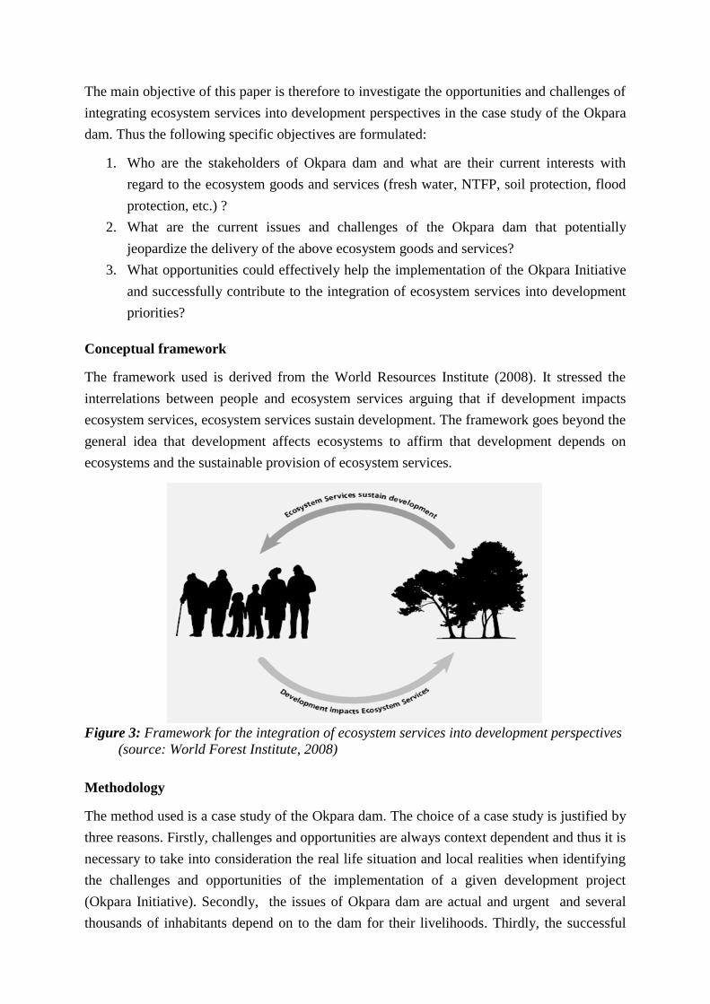
Conceptual framework
The framework used is derived from the World Resources Institute (2008). It stressed the
interrelations between people and ecosystem services arguing that if development impacts
ecosystem services, ecosystem services sustain development. The framework goes beyond the
general idea that development affects ecosystems to affirm that development depends on
ecosystems and the sustainable provision of ecosystem services.
Figure 3: Framework for the integration of ecosystem services into development perspectives
(source: World Forest Institute, 2008)
Methodology
The method used is a case study of the Okpara dam. The choice of a case study is justified by
three reasons. Firstly, challenges and opportunities are always context dependent and thus it is
necessary to take into consideration the real life situation and local realities when identifying
the challenges and opportunities of the implementation of a given development project
(Okpara Initiative). Secondly, the issues of Okpara dam are actual and urgent and several
thousands of inhabitants depend on to the dam for their livelihoods. Thirdly, the successful
implementation of Okpara Initiative though is uncertain as no one can predict the behavior of
stakeholders during the implementation of the Initiative. All these factors justify fully the
choice of a case study (refer Yin, 1994). Scientific reviews of different sources have been
used as main investigation option and three telephonic interviews with key informants have
been conducted (focal point of the Okpara Initiative in APIC NGO, one farmers' leader and
one herders leader from Kika village). Similar experiences throughout the world have been
revised in order to better assess the challenges and opportunities of the implementation of
Okpara Initiative.
Overview of the study area: The Okpara dam and its sub watershed
Constructed in 1969 by the "Société Dahoméenne du Kénafe" or SODAK (Dahomey was the
former name of today's Benin before 1972), the Okpara dam had primarily been constructed
for the production of kenaf (Hibiscus cannabinus). By 1975, it had been inherited by the
Benin National Society of Water (SONEB) and is being used since as drinking water
reservoir. Located in the district of Kika, commune of Tchaourou, the reservoir is an earthfill
dam characterized by a dyke length of 480 m and height of 10 m. This water holding structure
had an initial storage volume of 5 750 000 m³ but today this volume has decreased to
approximately 2 000 000 m³ due to sedimentation as corollary of erosion in its watershed
induced mainly by human activities (PNE-Benin, 2008).
The catchment area of the Okpara dam is known as the Nanon sub watershed. It includes five
communes: Nikki, Pèrèrè, N'Dali, Tchaourou and Parakou and a population estimated to be
466 192 inhabitants in 67 776 households (INSAE, RGPH3). Various socio-linguistic groups
with different cultural backgrounds (Baatombu, Gando, Fulani, Yoruba, etc.), often practicing
conflicting professions such as farming, pastoralism, agro pastoralism and trading are found
in this region. Farmed food crops include sorghum, maize, millet, rice, yam, etc., while
industrial crops are dominated by groundnut and cotton, the latter using a high rate of inputs
(seeds, fertilizers, insecticides and herbicides). Extensive breeding (cattle, ovine, caprine,
porcine and poultry) is one particular feature of the region. Other economic activities include
fishery, timber logging, etc.
In the form of a funnel, the Nanon sub catchment has an area estimated to be 2070 km² and is
characterized by a generally low topographic relief, a slightly undulating land surface and is
mostly dominated by a granitic – gneissic plateau (Menz, 2010). The region belongs to the
Guinean Soudanian climatic zone (dry tropical type) characterized by an annual mean
temperature of 26 to 30°C and annual mean rainfall of 1280 mm (from 1950 to 1969) and
1150 mm (from 1970 to 2004) at the climatic station of Parakou (Fink et al., 2010a). While
the movements of the Inter Tropical Convergence Zone (ITCZ) could explain the climate
variability in the region (Cochémé and Franquin, 1967), other local factors such as the
topography, the atmospheric disturbances and the surface cover mainly affected by land use
and land use changes (deforestation, fragmentation, farming, etc.) also play an important role.
Ferruginous tropical soils with concretions supporting woodland and savannah as natural
vegetation are predominant in the region. Tree species such as Daniellia oliveri, Isoberlinia
doka, Parkia biglobosa, Pteleopsis laxiflous, Pterocarpus erinacens, Vitellaria paradoxa,
Bridelia ferruginen, Chlorophora excelsa, Detarium microcarpus, among others, and
herbaceous such as Imperata cylindrica, Schizachirum pulchellum, Eragrostis namaguensis,
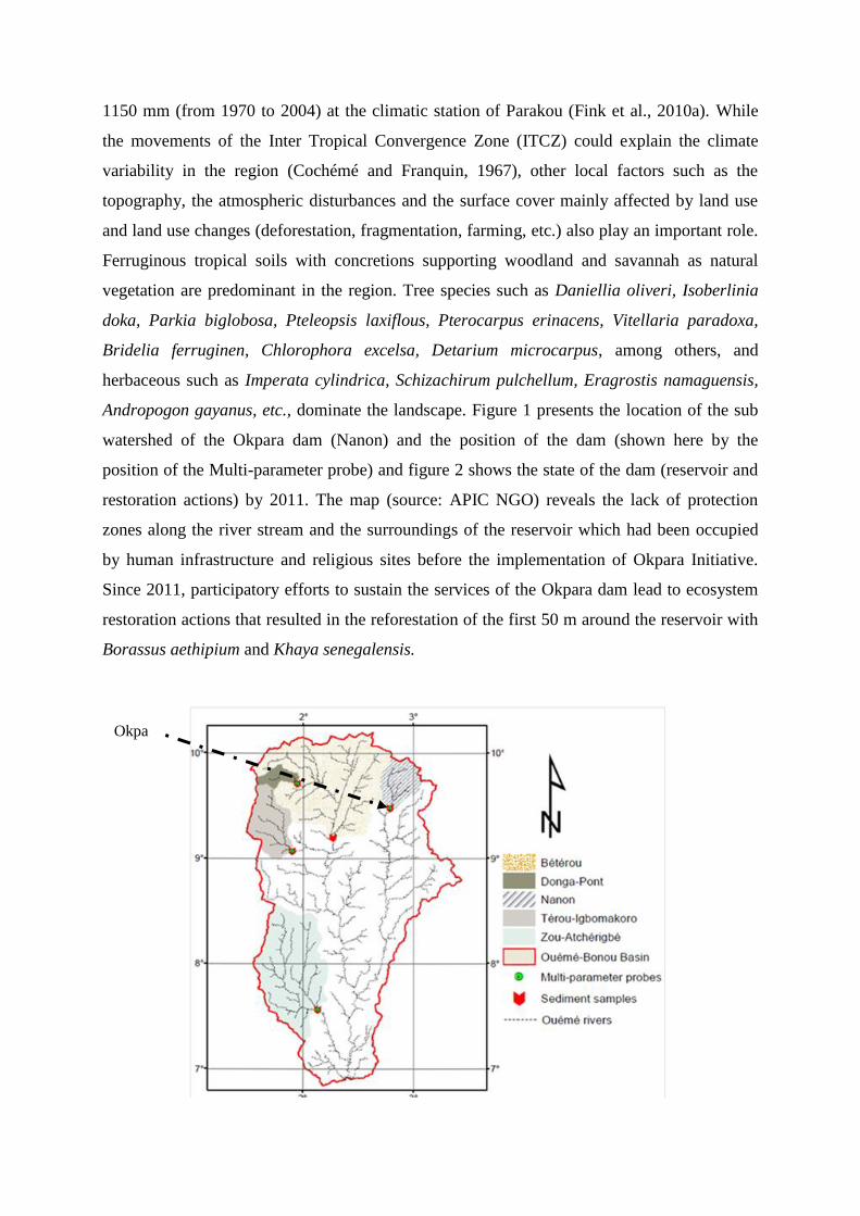
Andropogon gayanus, etc., dominate the landscape. Figure 1 presents the location of the sub
watershed of the Okpara dam (Nanon) and the position of the dam (shown here by the
position of the Multi-parameter probe) and figure 2 shows the state of the dam (reservoir and
restoration actions) by 2011. The map (source: APIC NGO) reveals the lack of protection
zones along the river stream and the surroundings of the reservoir which had been occupied
by human infrastructure and religious sites before the implementation of Okpara Initiative.
Since 2011, participatory efforts to sustain the services of the Okpara dam lead to ecosystem
restoration actions that resulted in the reforestation of the first 50 m around the reservoir with
Borassus aethipium and Khaya senegalensis.
Okpa
ra
dam
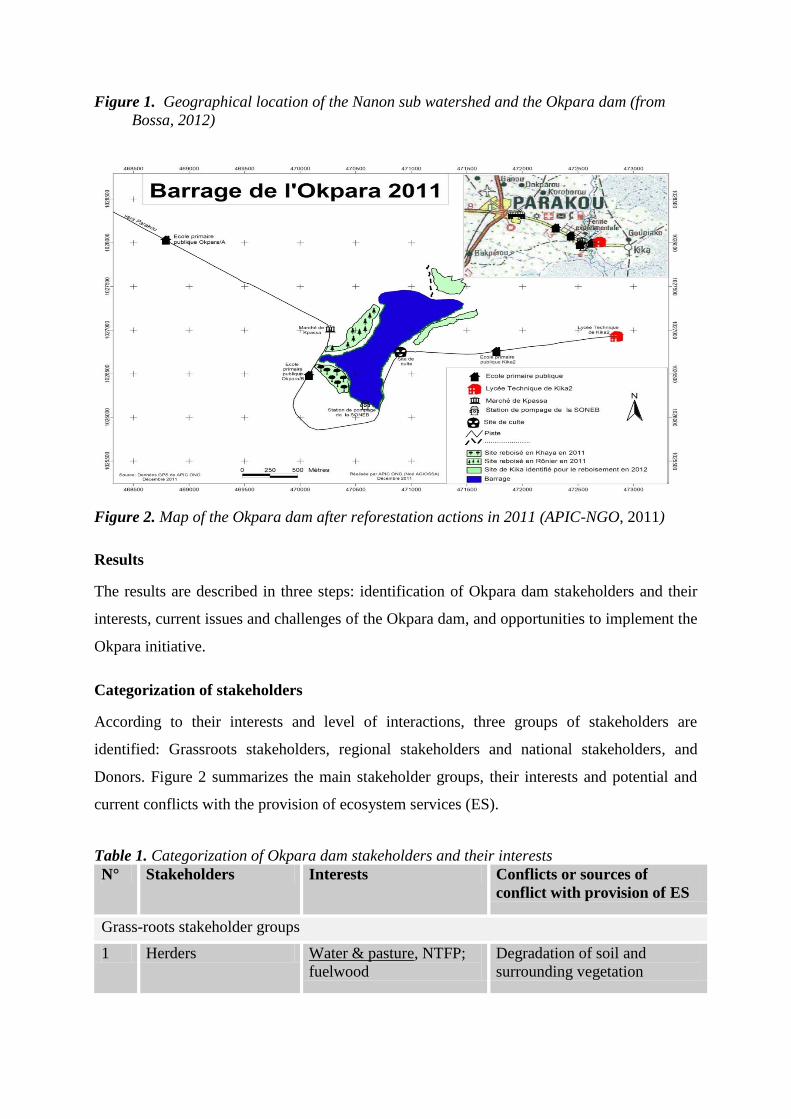
Figure 1. Geographical location of the Nanon sub watershed and the Okpara dam (from
Bossa, 2012)
Figure 2. Map of the Okpara dam after reforestation actions in 2011 (APIC-NGO, 2011)
Results
The results are described in three steps: identification of Okpara dam stakeholders and their
interests, current issues and challenges of the Okpara dam, and opportunities to implement the
Okpara initiative.
Categorization of stakeholders
According to their interests and level of interactions, three groups of stakeholders are
identified: Grassroots stakeholders, regional stakeholders and national stakeholders, and
Donors. Figure 2 summarizes the main stakeholder groups, their interests and potential and
current conflicts with the provision of ecosystem services (ES).
Table 1. Categorization of Okpara dam stakeholders and their interests
N° Stakeholders Interests Conflicts or sources of
conflict with provision of ES
Grass-roots stakeholder groups
1 Herders Water & pasture, NTFP;
fuelwood
Degradation of soil and
surrounding vegetation
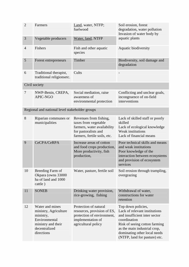
2 Farmers Land, water, NTFP;
fuelwood
Soil erosion, forest
degradation, water pollution
Invasion of water body by
aquatic plants 3 Vegetable producers Water, land, NTFP
4 Fishers Fish and other aquatic
species
Aquatic biodiversity
5 Forest entrepreneurs Timber Biodiversity, soil damage and
degradation
6 Traditional therapist,
traditional religionsetc.
Cults -
Civil society
7 NWP-Benin, CREPA,
APIC-NGO
Social mediation, raise
awareness of
environmental protection
Conflicting and unclear goals,
incongruence of on-field
interventions
Regional and national level stakeholder groups
8 Riparian communes or
municipalities
Revenues from fishing,
taxes from vegetable
farmers, water availability
for pastoralists and
farmers, fertile soils, etc.
Lack of skilled staff or poorly
skilled
Lack of ecological knowledge
Weak institutions
Lack of financial means
9 CeCPA/CeRPA Increase areas of cotton
and food crops production,
More productivity, fish
production,
Poor technical skills and means
and weak institutions
Poor knowledge of the
interaction between ecosystems
and provision of ecosystem
services
10 Breeding Farm of
Okpara (owns 33000
ha of land and 1000
cattle )
Water, pasture, fertile soil Soil erosion through trampling,
overgrazing
11 SONEB Drinking water provision,
rice-growing, fishing
Withdrawal of water,
constructions for water
retention
12 Water and mines
ministry, Agriculture
ministry,
Environmental
ministry and their
decentralized
directions
Protection of natural
resources, provision of ES,
protection of environment,
implementation of
agricultural policy
Top down policies,
Lack of relevant institutions
and insufficient inter sector
coordination
Risk of seeing cotton farming
as the main industrial crop,
dominating other local needs
(NTFP, land for pasture) etc.

Table 1 describes twelve major stakeholders of Okpara dam with various interests in
term of ecosystem goods or commodities (water, pasture, NTFP, timber, fertile soil, etc.).
Conflicting interests such as farming versus pasture, vegetable farming versus entrance points
of cattle in the water body, fodder trees versus timber, etc., are common and lead each group
of stakeholders to egoistic profit maximization regardless of the impacts on ecosystems. The
dam and the surrounding ecosystems undergo the so called "tragedy of the commons" as
involved stakeholders are not aware of the limits of the ecosystems (concept of Maximum
Sustainable Yield) or they just prefer to maximize the present use as no legal institution takes
care of the use of common pool resources in public lands.
From the perspective of future corrective actions aiming to restore ecosystem functions
and accordingly the delivery of ecosystem goods and services, we have segregated the above
stakeholders into three main categories according to the type of interactions they have with
the surrounding ecosystems: strong interdependence, fair interdependence and low
interdependence. Stakeholders with a strong interdependency with ecosystem services affect
ecosystems by their daily activities (farming, cattle breeding, timber logging, etc.) and are
most likely to be affected by the lost of ecosystem services. Actions of stakeholders with a
low interdependency do not affect ecosystems directly and a hypothetical loss of ecosystem
services will not affect them directly either. In between are stakeholders with fair
interdependency. Table 2 presents this categorization.
Table 2. Ecosystem services-stakeholders’ level of interdependency N° Ecosystem
Services (ES)
affected
Activities
threatening
ES provision
Involved stakeholders
Strong
interdependence
Fair
interdependence
Low
interdependence
1 Sustainable
provision of
fresh and clean
water
Farming,
cattle
breeding,
vegetable
farming, use
of water,
fishing
Farmers, herders,
Breeding Farm of
Okpara, vegetable
farmers, SONEB
Riparian
municipalities,
CeCPA/CeRPA
Civil Society,
sectoral ministries
and their
decentralized
bodies
2 Flood
protection
Farming,
cattle
breeding,
vegetable
farming
Farmers, herders,
vegetable farmers,
forest
entrepreneurs,
SONEB
CeCPA/CeRPA,
communities
downstream the
dam (Oueme
river valley),
Civil Society,
sectoral ministries
and their
decentralized
bodies
3 Soil protection
and nutrient
cycle
Farming,
cattle
breeding,
unsustainable
timber
logging
Forest
entrepreneurs,
farmers, herders,
Breeding Farm of
Okpara
CeCPA/CeRPA,
Municipalities,
Civil Society
Sectoral ministries
and their
decentralized
bodies
4 Climate
stabilization
Farming,
cattle
breeding,
unsustainable
timber
Farmers, herders,
forest
entrepreneurs,
Breeding Farm of
Okpara
Municipalities,
Civil Society
Sectoral ministries
and their
decentralized
bodies, global
community
logging
5 Biodiversity
and landscape
beauty
Farming,
cattle
breeding,
over-fishing,
Tradi therapist,
traditional
religions, herders,
fishers
Municipalities,
Civil Society
Sectoral ministries
and their
decentralized
bodies, global
community
It appears that stakeholders with strong interdependency are mostly local stakeholders
(farmers, herders, SONEB, Breeding Farm of Okpara, vegetable farmers, fishers, traditional
therapists and somehow forest entrepreneurs) because this category of stakeholders depend
entirely on ecosystem services for their daily life and a loss of these services will dramatically
affect their livelihoods. Stakeholders with fair interdependency are regional agencies or
decentralized bodies in charge of implementing national development policies by supporting
local stakeholders such as CeCPA/CeRPA, civil society including local NGOs and the
municipalities. Their policies, implementation approaches and actions affect ecosystems and
the delivery of ecosystem services indirectly, and inversely they are affected by the loss of
ecosystem services because they live in the region. Stakeholders with low interdependency
are in general policy makers, national agencies and the international community who impact
the delivery of ecosystem services mostly through a poor design of environmental laws, poor
policies, and inversely only their professional career or position could be affected in case of
policy failure.
It appears also that the effects of ES loss go beyond the sub- watershed and the riparian
communities of the dam. Indeed, the table reveals a new group of stakeholders with strong
dependency on a specific service of ecosystems such as flood protection, biodiversity,
landscapes’ beauty and climate protection. Understanding these interlinks and how each
factor affects another is therefore a key challenge in integrating ecosystem services into
development perspectives.
Current issues and challenges
Dramatic changes in LULUC, the sub-watershed of Nanon, have resulted in severe impacts on
the hydrology of the Okpara river, the provision of fresh and clean water and the stability of
the dam itself (GWP, 2008; APIC-ONG, 2012). Table 3 resumes the current issues of the
Okpara dam and their direct causes and figure 2 shows the actual situation of the lateral
spillway of the dam.
Table 3. Issues on Okpara dam and their causes
N° Problems Primary causes Secondary causes
1 Filling up of the reservoir
-> Water quantity
Sedimentation, watershed
erosion
Conversion of forests and
wooded lands into crop
lands,
Soil degradation through
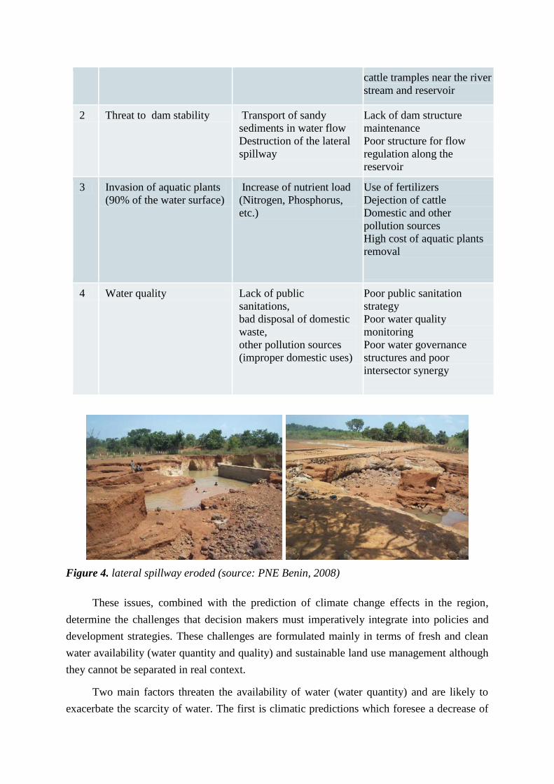
cattle tramples near the river
stream and reservoir
2 Threat to dam stability Transport of sandy
sediments in water flow
Destruction of the lateral
spillway
Lack of dam structure
maintenance
Poor structure for flow
regulation along the
reservoir
3 Invasion of aquatic plants
(90% of the water surface)
Increase of nutrient load
(Nitrogen, Phosphorus,
etc.)
Use of fertilizers
Dejection of cattle
Domestic and other
pollution sources
High cost of aquatic plants
removal
4 Water quality Lack of public
sanitations,
bad disposal of domestic
waste,
other pollution sources
(improper domestic uses)
Poor public sanitation
strategy
Poor water quality
monitoring
Poor water governance
structures and poor
intersector synergy
Figure 4. lateral spillway eroded (source: PNE Benin, 2008)
These issues, combined with the prediction of climate change effects in the region,
determine the challenges that decision makers must imperatively integrate into policies and
development strategies. These challenges are formulated mainly in terms of fresh and clean
water availability (water quantity and quality) and sustainable land use management although
they cannot be separated in real context.
Two main factors threaten the availability of water (water quantity) and are likely to
exacerbate the scarcity of water. The first is climatic predictions which foresee a decrease of
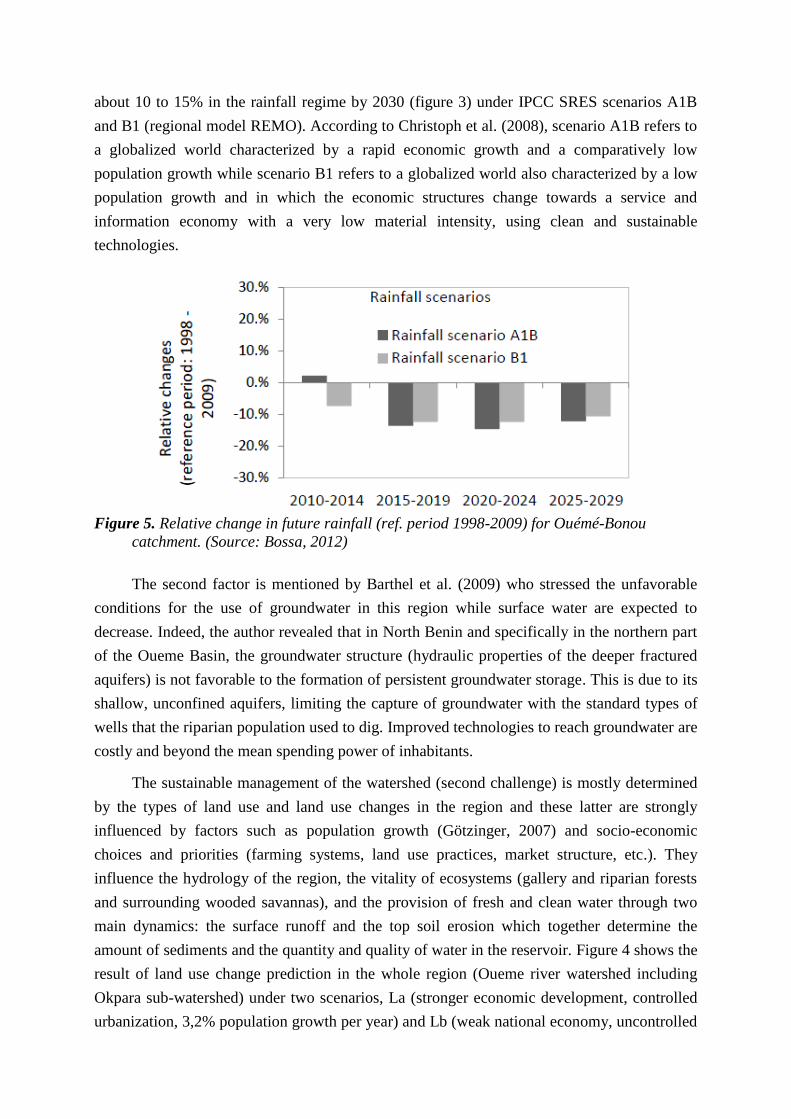
about 10 to 15% in the rainfall regime by 2030 (figure 3) under IPCC SRES scenarios A1B
and B1 (regional model REMO). According to Christoph et al. (2008), scenario A1B refers to
a globalized world characterized by a rapid economic growth and a comparatively low
population growth while scenario B1 refers to a globalized world also characterized by a low
population growth and in which the economic structures change towards a service and
information economy with a very low material intensity, using clean and sustainable
technologies.
Figure 5. Relative change in future rainfall (ref. period 1998-2009) for Ouémé-Bonou
catchment. (Source: Bossa, 2012)
The second factor is mentioned by Barthel et al. (2009) who stressed the unfavorable
conditions for the use of groundwater in this region while surface water are expected to
decrease. Indeed, the author revealed that in North Benin and specifically in the northern part
of the Oueme Basin, the groundwater structure (hydraulic properties of the deeper fractured
aquifers) is not favorable to the formation of persistent groundwater storage. This is due to its
shallow, unconfined aquifers, limiting the capture of groundwater with the standard types of
wells that the riparian population used to dig. Improved technologies to reach groundwater are
costly and beyond the mean spending power of inhabitants.
The sustainable management of the watershed (second challenge) is mostly determined
by the types of land use and land use changes in the region and these latter are strongly
influenced by factors such as population growth (Götzinger, 2007) and socio-economic
choices and priorities (farming systems, land use practices, market structure, etc.). They
influence the hydrology of the region, the vitality of ecosystems (gallery and riparian forests
and surrounding wooded savannas), and the provision of fresh and clean water through two
main dynamics: the surface runoff and the top soil erosion which together determine the
amount of sediments and the quantity and quality of water in the reservoir. Figure 4 shows the
result of land use change prediction in the whole region (Oueme river watershed including
Okpara sub-watershed) under two scenarios, La (stronger economic development, controlled
urbanization, 3,2% population growth per year) and Lb (weak national economy, uncontrolled
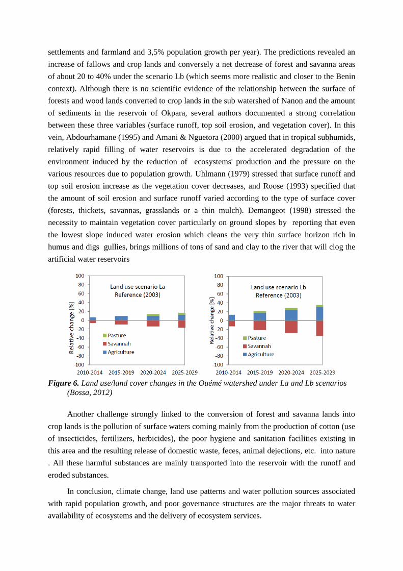
settlements and farmland and 3,5% population growth per year). The predictions revealed an
increase of fallows and crop lands and conversely a net decrease of forest and savanna areas
of about 20 to 40% under the scenario Lb (which seems more realistic and closer to the Benin
context). Although there is no scientific evidence of the relationship between the surface of
forests and wood lands converted to crop lands in the sub watershed of Nanon and the amount
of sediments in the reservoir of Okpara, several authors documented a strong correlation
between these three variables (surface runoff, top soil erosion, and vegetation cover). In this
vein, Abdourhamane (1995) and Amani & Nguetora (2000) argued that in tropical subhumids,
relatively rapid filling of water reservoirs is due to the accelerated degradation of the
environment induced by the reduction of ecosystems' production and the pressure on the
various resources due to population growth. Uhlmann (1979) stressed that surface runoff and
top soil erosion increase as the vegetation cover decreases, and Roose (1993) specified that
the amount of soil erosion and surface runoff varied according to the type of surface cover
(forests, thickets, savannas, grasslands or a thin mulch). Demangeot (1998) stressed the
necessity to maintain vegetation cover particularly on ground slopes by reporting that even
the lowest slope induced water erosion which cleans the very thin surface horizon rich in
humus and digs gullies, brings millions of tons of sand and clay to the river that will clog the
artificial water reservoirs
Figure 6. Land use/land cover changes in the Ouémé watershed under La and Lb scenarios
(Bossa, 2012)
Another challenge strongly linked to the conversion of forest and savanna lands into
crop lands is the pollution of surface waters coming mainly from the production of cotton (use
of insecticides, fertilizers, herbicides), the poor hygiene and sanitation facilities existing in
this area and the resulting release of domestic waste, feces, animal dejections, etc. into nature
. All these harmful substances are mainly transported into the reservoir with the runoff and
eroded substances.
In conclusion, climate change, land use patterns and water pollution sources associated
with rapid population growth, and poor governance structures are the major threats to water
availability of ecosystems and the delivery of ecosystem services.
Implementation of Okpara Initiative and ecosystem services: Opportunities
The Okpara Initiative has been developed from the necessity to implement urgent actions to
save Okpara dam and the riparian populations from water scarcity. Supported by the Global
Water Partnership though its national body called PNE-Benin, the initiative also benefits from
other national and international agencies (Ministry of Cooperation of the Netherlands,
Ministry of Water and Mines, municipalities, etc.). Its aim is the participatory and sustainable
management of Okpara dam by restoring its surrounding ecosystems. Specifically, six outputs
are pursued but they can be segregated into two main axis: the development of an effective
institutional framework and the restoration of ecosystem dynamics.
Opportunities to implement such an initiative exist at both national and international
levels. At the national level, four categories of opportunities have been identified:
• Political will: This is shown by taking water issues into account as a prerequisite for
sustainable development and its integration into the fourth component of the Multiannual
Program of Water and Sanitation sector. Supported by the Ministry of Cooperation of the
Netherlands, the program is implementing the Integrated Water Resources Management
(IWRM) since 2007 in three pilot sites in Benin including the Okpara dam and its sub
watershed. Although certain development policies aiming to increase the production of
cotton may contradict efforts to preserve the ecosystems, there is a strong will at the
regional level to implement the Okpara Initiative as the loss of Okpara dam would result
in immeasurable damages.
• Institutional framework: With the support and lobby of international agencies such as the
Global Water Partnership, an institutional framework including both national, regional
and local institutions is under development around the Okpara dam. So far, a riparian
communes association called "Territoire de Développement Oueme Superieur” or TDOS
and including the three closest communes to Okpara dam (Parakou, Tchaourou and N'dali)
has been created and officially recognized by a prefectural decision (Ordinance
2011/042/PDBA/SG/SAG/DASCCS of May 20th, 2011). The Initiative Management Unit
and the Orientation and Monitoring Committee known as "Comité d'Orientation et de
Suivi or COS" have been established by a prefectural decision (Ordinance
N°5/198/PDBA-SG-SPAT of November 22nd, 2011) and, at local level, a stakeholder
council for the participatory management of Okpara dam resources known as the "Conseil
des Acteurs pour la Gestion Concertée des ressources du barrage de l'Okpara or CACG"
has been established and formalized by statutes and internal regulations approved on
December 10th, 2011.
This institutional framework is also supported by bilateral conventions and partnerships
such as the "Convention National Water Partnership - TDOS" or the Partnership "TDOS -
National Society of Benin Waters (SONEB)". Technical support is provided by a local
NGO called APIC NGO which has been designated by consensus as the Client's
Representative.
• Willingness to pay drinking water services: The support of the Okpara Initiative by the
TDOS communes (Parakou, Tchaourou and N'dali) has been demonstrated by the
payment of a contribution fund according to their respective revenues, amounting to 18
000 000 FCFA (about 27 700 €). It is expected that other stakeholders such as the national
society of Benin waters (SONEB) and local users will contributed financially or with
other means to the Okpara Initiative.
• Possibility of compensation payment and pricing of water use: During the implementation
of the Okpara Initiative, several families have been displaced from the banks of the river
stream or the reservoir in order to establish protection zones (restoration of ecosystems).
These families are supposed to be compensated. Other activities such as fishing, watering
of cattle, etc., had in the past been successfully priced and it is expected that the local
stakeholder council in charge of the participatory management of the Okpara dam with the
technical support of NGOs and regional partners will find suitable and fair options to
introduce the pricing of water uses.
At the international scale, opportunities are summarized as follow:
1. Networks for learning processes and sharing of experiences: Numerous experiences
aiming to integrate ecosystem services to development issues have been documented
and lessons learnt. Among them are successful experiences such as the Quito Water
Fund in Ecuador consisting in the creation of a water fund; the sloping land
conversion program known as the "Grain to Green Program" in China consisting
mainly in compensation payment by the State budget; the investment in restoring the
natural purification services in the Catskills-Delaware watershed in New York City;
the revolutionary approach of Napa in California to mitigate floods; and lessons learnt
from experiences that failed to integrate ecosystem services into development mostly
because of a poor understanding of species ecology or ecosystem dynamics and poor
implementation approaches such as the Shrimp Aquaculture in Former Mangrove
Forests in coastal regions of Asia, and the West African Wildlife Project (confer
Tallis et al., 2008; Turner and Daily, 2008, Daily and Matson, 2008).
2. Existence of a technical and financial platform to implement an ecosystem based
project: This are several organizations such as the Millennium Ecosystem Assessment,
the World Forestry Institute, The CIFOR, etc., working to promote and support
initiatives aiming to integrate ecosystem preservation and development priorities.
These agencies are supported in their actions by a multitude of financial institutions
such as the United Nations agencies (GEF, UNEP, PNUE, PNUD, etc.) and locally by
bilateral cooperation agencies (GIZ, SNV, etc.).
3. Good scientific knowledge of ecological processes: Numerous publications related to
the understanding of the ecological processes, the integration of local knowledge into
species preservation and water protection, approaches to transfer scientific knowledge
to the local level efficiently and suitably are on-going and at the national level, local
NGOs are supported in both capacity building and implementation of their work plans.
In conclusion, the implementation of the Okpara Initiative appears to be a unique
opportunity to study the behavior of stakeholders, their willingness to protect ecosystems and
the functionality of a regional institutional framework. How successful the Initiative will be
and how it could contribute to change the land use patterns in the sub watershed and preserve
ecosystem dynamics is an interesting case to be investigate by researchers.
Conclusion
Riparian communes of the Okpara dam will experience water scarcity by 2025 (PNE Bénin,
2008). Indeed, it is expected that by 2025 the water needs of Parakou and the surrounding
communes will be around 7 233 003 m³ while the reservoir storage volume will be less than 2
650 000 m³/year. This situation demands urgent measures to reduces soil erosion and to
increase the storage volume of the reservoir. Among factors that lead to such a situation are
the ecosystems’ degradation and weak institutions around the dam. The Okpara Initiative
which is build around the sustainable provision of drinking water, seen as an umbrella ES, is
an opportunity to protect and promote forest ecosystems as well as the climate at a local and
regional scale. Successful experiences exist and a panoply of lessons learnt are available to
support the project technically. Besides, an effective institutional framework including
stakeholders from local to national level and supporting international agencies and civil
society is under development to accompany and sustain the efforts of the Initiative.
References
Abdourhamane D., 1995. Contribution à l’étude hydrologique du bassin versant du Goroubi à
Diongoré, Mémoire de fin d’études, Agrymet, Niamey, Niger, p. 109
Amani A. Nguetora M., 2000. Evidence d’une modification hydrologique du fleuve Niger à
Niamey, In FRIEND 2002 Regional Hydrology : Bridging the gap between research and
practice (H. Van Lanner and S. Demuth Sc.), Proc. Friend Conf., Cape Town, South Africa,
IAHS Pub. N° 274, pp. 449-456
APIC-ONG, 2011. Rapport technique annuel d’activités 2011. Initiative pilote GIRE autour du
barrage de l’Okpara. Parakou, p. 76
Barthel R., Sonneveld B.G.J.S., Götzinger J., Keyzer M.A., Pande S., Printz A., Gaiser T., 2008.
Integrated assessment of groundwater resources in the Ouémé basin, Benin, West Africa.
Physics and Chemistry of the Earth 34(2009): 236–250
Bossa A. Y., 2012. Multi-scale modeling of sediment and nutrient flow dynamics in the Ouémé
catchment (Benin)– towards an assessment of global change effects on soil degradation and
water quality. Doktorgrades (Dr. rer. nat.) der Mathematisch-Naturwissenschaftlichen Fakultät
der Rheinischen Friedrich-Wilhelms-Universität. Bonn, p. 130
Christoph, M., Fink, A. Diekkrüger, B. Giertz, S. Reichert, B., Speth, P., 2008. IMPETUS:
Implementing HELP in the Upper Ouémé Basin. Water SA (online). 34( 4), Special HELP
edition:481-490
Cochemé, J., and P. Franquin, 1967. An agroclimatology survey of a semi-arid area in Africa south of
the Sahara. WMO Tech. Note, 86. Geneva, Switzerland, p. 136
Daily C.G., and P. Matson, 2008. Ecosystem services: From theory to implementation. PNAS,
105(28) : 9455-9456
Demangeot J. (1998): Les milieux naturels tropicaux. Paris, Arnaud Colin, 337 p.
Fink, A. H., Paeth, H., Ermert, V., Pohle, S., Diederich, M., 2010b. Meteorological processes
influencing the weather and climate of Benin. In: Speth, P., Christoph, M., Diekkrüger, B., (Eds)
Impacts of Global Change on the Hydrological Cycle in West and Northwest Africa. Springer,
Heidelberg, Germany
Gény P., Waechter P. Yatchinovosky, 1992. Environnement et développement rural. Guide de la
gestion des ressources naturelles. Frisson-Roche, Saint-Etienne, p. 418
Götzinger, J., 2007. Distributed Conceptual Hydrological Modeling-Simulation of Climate, Land Use
Change Impact and Uncertainty Analysis. Doctoral thesis, University of Stuttgart, Germany.
http://elib.uni-stuttgart.de/opus/volltexte/2007/3349/pdf/Diss_Goetzinger_ub.pdf (accessed on
23.12.2012)
Ibouraima, S., 2005. Comblement des retenues d’eau d’abreuvement en zone agropastorale soudano-
sahélienne : Dynamique, bilan et impact de la sédimentation intra-cuvette. Cas du Département
de l’Alibori (Nord-Est du Bénin - Afrique de l’Ouest). Thèse de Doctorat (unique) en Gestion de
l’Environnement. Laboratoire de sédimentologie, Département des Sciences de la Terre,
FAST/UAC. Ecole Doctorale Pluridisciplinaire ‘’Espace, Cultures et Développement’’, Chaire
UNESCO de Sciences, Technologie et Environnement. Cotonou, p. 221
INSAE, 2009. Tableau de Bord Social (TBS) 2008. Profils socio-économiques et indicateurs de
développement. Institut National de la Statistique et de l'Analyse Economique. Cotonou, p. 196
Menz, G., 2010. Topography and natural regions. In: Speth, P., Christoph, M., Diekkrüger, B., (Eds.)
Impacts of Global Change on the Hydrological Cycle in West and Northwest Africa. Springer,
Heidelberg, Germany. pp 40-44
Merino, M., 2008. L’eau : quels enjeux pour l’Afrique subsaharienne ? Université de Pau et des Pays
de l’Adour. Note de la FRS, n°20/2008. Fondation pour la Recherche Stratégique. Université de
Pau et des Pays de l’Adour, p. 13
PNE‐Bénin, 2008. Note de plaidoyer pour la réhabilitation et la mise en place d’une gestion concertée
du barrage de l’Okpara, unique source d’AEP de la ville de Parakou. Global Water Partnertship.
Parakou, p. 6
Ranganathan J., Raudsepp-Hearne C., Lucas N., Irwin F., Zurek M., Bennett K., Ash N. and West P.,
2008. Ecosystem services. A Guide for Decision Makers. Plus The Decision: A fictional story
about a community facing ecosystem change. World Resources Institute,Library of Congress
Control Number: 2007941147
Roose E. J., 1994. Introduction à la gestion conservatoire de l’eau, de la biomasse ET de la fertilité des
sols (G.C.E.S). Bulletin pédologique de la FAO, n° 70, 420 p
Tallis, H., Kareiva, P., Marvier, M. and A. Chang, 2008. An ecosystem services framework to support
both pratical conservation and economic development. PNAS, USA, 105( 28): 9457-9464
Turner, R.K. and G.C.Daily, 2007. The Ecosystem Services Framework and Natural Capital
Conservation. Springer. Environ Resource Conservation 2008(39): 25-39
Uhlmann, D., 1979. Hydrobiology. John Wiley, New York, NY
Yin K.R., 1994. Case Study Research. Design and Methods. Second Edition. Applied Social Research
Methods Series, Volume 5. Sage publications, p. 171