comprehensive plan 16-cpa-04 staff report - Spokane County
80
COMPREHENSIVE PLAN 16-CPA-04 STAFF REPORT 1 PROPOSAL INFORMATION Agent J.R. Bonnett Engineering Owner Harley C. Douglass Inc. Request Map Text UGA Change Other From Low Density Residential To Medium Density Residential Location/Site Size North of Five Mile Road and adjacent to and west of Waikiki Road 22.3 acres Parcel Number(s) 26131.9063, 36182.9116 & 36182.9114 Site Description Current Use Vacant land with high voltage electrical and gas transmission lines Topography Sloped and rolling Other features Multiple utility easements GOVERNMENTAL AGENCY COORDINATION The application was circulated for initial review on August 2, 2016 and circulated again on August 26, 2016. Review comments were collected and incorporated into a Mitigated Determination of Nonsignificance (MDNS). The MDNS was executed on June 14, 2017 between the site property owner and the Spokane County Department of Building and Planning. The MDNS was circulated along with the amendment request on June 14, 2017 along with a notice of public hearing to be held on June 29, 2017. STATE ENVIRONMENTAL POLICY ACT (SEPA) The environmental checklist and application information was circulated to the agencies of jurisdiction for initial review and comment in August 1, 2016 with a comment deadline of September 21, 2016. After receiving comments from the Spokane County Department of Building and Planning, Spokane County Public Works, Spokane Transit Authority, Mead School District and the Washington State Department of Transportation, a MDNS was issued by the Spokane County Building and Planning Department on June 14, 2017. The mitigation measures were circulated to interested parties and agencies of jurisdiction on June 14, 2017 and the appeal period for the MDNS ended on June 28, 2017. The MDNS was circulated to 28 interested parties and agencies of jurisdiction and published in the Spokesman Review on June 14, 2017. Summary of Mitigating Measures: Site development shall anticipate a future fixed-route bus stop on Waikiki Road. Accessible pedestrian connections (sidewalks and pathways) for the most direct route possible between the residential units and Waikiki Road bus stop shall be required. Development of the site shall include an east-west public road, connecting Waikiki Road with the west property line of parcel 36182.9116, for the purpose of serving as part of a future east-west arterial road, per the County’s Arterial Road Plan, as illustrated in the conceptual site plan dated 5-24-17. Site
-
Upload
khangminh22 -
Category
Documents
-
view
0 -
download
0
Transcript of comprehensive plan 16-cpa-04 staff report - Spokane County

COMPREHENSIVE PLAN 16-CPA-04 STAFF REPORT
1
PROPOSAL INFORMATION
Agent J.R. Bonnett Engineering
Owner Harley C. Douglass Inc.
Request
Map Text UGA Change Other
From Low Density Residential
To Medium Density Residential
Location/Site Size North of Five Mile Road and adjacent to and west of Waikiki Road
22.3 acres
Parcel Number(s) 26131.9063, 36182.9116 & 36182.9114
Site Description Current Use Vacant land with high voltage electrical and gas transmission lines
Topography Sloped and rolling
Other features Multiple utility easements
GOVERNMENTAL AGENCY COORDINATION The application was circulated for initial review on August 2, 2016 and circulated again on August 26, 2016. Review comments were collected and incorporated into a Mitigated Determination of Nonsignificance (MDNS). The MDNS was executed on June 14, 2017 between the site property owner and the Spokane County Department of Building and Planning. The MDNS was circulated along with the amendment request on June 14, 2017 along with a notice of public hearing to be held on June 29, 2017.
STATE ENVIRONMENTAL POLICY ACT (SEPA) The environmental checklist and application information was circulated to the agencies of jurisdiction for initial review and comment in August 1, 2016 with a comment deadline of September 21, 2016. After receiving comments from the Spokane County Department of Building and Planning, Spokane County Public Works, Spokane Transit Authority, Mead School District and the Washington State Department of Transportation, a MDNS was issued by the Spokane County Building and Planning Department on June 14, 2017. The mitigation measures were circulated to interested parties and agencies of jurisdiction on June 14, 2017 and the appeal period for the MDNS ended on June 28, 2017. The MDNS was circulated to 28 interested parties and agencies of jurisdiction and published in the Spokesman Review on June 14, 2017.
Summary of Mitigating Measures: Site development shall anticipate a future fixed-route bus stop on Waikiki Road. Accessible pedestrian connections (sidewalks and pathways) for the most direct route possible between the residential units and Waikiki Road bus stop shall be required. Development of the site shall include an east-west public road, connecting Waikiki Road with the west property line of parcel 36182.9116, for the purpose of serving as part of a future east-west arterial road, per the County’s Arterial Road Plan, as illustrated in the conceptual site plan dated 5-24-17. Site

COMPREHENSIVE PLAN 16-CPA-04 STAFF REPORT
2
development shall be limited to 300 multi-family units and an approved second vehicular access is required prior to the development of the 100th dwelling unit. The full MDNS is attached to this report.
PUBLIC NOTICE REQUIREMENTS
Notice of the public hearing on the proposal was published in the Legal Notice section of the Spokesman Review on June 14, 2017. In addition, notice of the hearing was mailed to property owners within 400 feet of the proposal and a sign was posted on the subject property at least 15 days prior to the public hearing.
PUBLIC PARTICIPATION The applicant and Spokane County Department of Building and Planning have met the following Public Participation Program guidelines for public notice and public hearing(s):
A copy of the proposed amendment was circulated to the State Department of Commerce on August 22, 2016
Circulation of application and SEPA checklist to affected Spokane County agencies and jurisdictions
US mail notice to neighboring property owners and tax payers
US mail notice to affected neighborhood and/or sub-area group(s) within 400 feet.
County-wide general circulation of legal advertisement placed in the Spokesman Review newspaper on June 14, 2017
Circulation of amendment to state agencies for review as required by RCW 36.70A
Publication of amendment and map on Spokane County internet site
Planning Commission briefings were held on September 15, 2016 and February 16, 2017
AGENCY/SERVICE PROVIDER COMMENTS The most recent comment letters received from agencies and service purveyors are attached.
PUBLIC COMMENTS The Department of Building and Planning received numerous comment letters on this proposal. Most were concerned about access and transportation impacts and school capacity issues. Many others voiced concerns over disruptions to wildlife and the health of future residents living next to power lines. All public comments received are attached to this report.
PROPOSAL The application is a request to change the Comprehensive Plan Map designation from Low Density Residential to Medium Density Residential on approximately 22.3 acres with a concurrent zoning map reclassification from Low Density Residential (LDR) to Medium Density Residential (MDR).
The applicant states, in their application, that economic conditions have changed and that the property is no longer suitable for Low Density Residential (LDR) uses. The site was previously approved for 50 residential units (see expired Redstone plat PN-1974-06). The conceptual site

COMPREHENSIVE PLAN 16-CPA-04 STAFF REPORT
3
plan for this amendment shows 300 multi-family units with access to Waikiki Road. An MDNS limits site development to 99 residential units until a second access is provided.
Background: A preliminary plat submitted by the sponsor for a subdivision called Redstone (PN-1974-06) was approved for the site in 2007. The preliminary plat illustrated 38 lots, 26 for single family dwellings and 12 for duplexes for a total of 50 dwelling units. The preliminary plat expired on March 30, 2017. In 2011, under application 11-CPA-05, the sponsor requested a similar Comprehensive Plan amendment, requesting to change the site from Low Density Residential to Medium Density Residential with primary access to Five Mile Road. The Planning Commission voted 4-2 to deny, but the Board of County Commissioners approve the amendment in Resolution 11-1191. The Board of County Commissioner’s decision was appealed by Five Mile Prairie Neighborhood Association and Futurewise and in its August 23, 2012, final decision and order the Eastern Washington Growth Management Hearing Board (EWGMHB) found and concluded that: 1) Comprehensive Plan amendment 11-CPA-05 is not consistent with and does not implement Comprehensive Plan Policies UL.2.16, UL.2.20, and CF.3.1 and 2) 11-CPA-05 is contrary to RCW 36.70A.070, RCW 36.70A.130(1)(d), and Spokane County Zoning Code 14.402.040. The decision by the EWGMHB was appealed and the Court of Appeals held that 11-CPA-05 is inconsistent with Comprehensive Plan Policy UL.2.16, Spokane County Zoning Code 14.402.040, but consistent with comprehensive plan policies UL.2.20 and CF.3.1. The Court of Appeals remanded the case to the EWGMHB to reweigh compliance with the above-cited comprehensive plan policy and Section 14.402.040 of the Spokane County Zoning Code. Upon remand, the EWGMHB re-affirmed its previous ruling and determination of invalidity for Comprehensive Plan Amendment 11-CPA-05 and remanded the amendment to Spokane County to come into compliance with the Growth Management Act (GMA). In its July 11, 2016 decision, the EWGMHB found that Comprehensive Plan amendment 11-CPA-05 lacked good access to major arterials inconsistent with Policy UL.2.16 that states “Encourage the location of medium and high density residential categories near commercial areas and public open spaces, and on sites with good access to major arterials” as the record showed that Five Mile Road and Waikiki Road are not major arterials, the site is not near commercial areas and public open spaces – the site is .9 miles from the nearest commercial area, and that adequate transportation facilities do not exist on Five Mile Road to serve the site. Although this proposal is similar to the 2011 Comprehensive Plan amendment 11-CPA-05, it differs in several important ways. This proposal is tied to a MDNS which limits the site’s development to 300 multi-family units, as well as other development conditions. The MDNS includes a conceptual site plan which describes the proposed development of the property. The access points are different in this proposal with the primary access point on Waikiki Road instead of on Five Mile Road, as was proposed in 11-CPA-05.
Site Information: The subject property consists of three parcels (26131.9063, 36182.9116 & 36182.9114) totaling approximately 22.3 acres and is located on the north side of Five Mile Prairie, north of Five Mile Road and west of Waikiki Road in the NE ¼ of Section 13, Township 26, Range 42 and

COMPREHENSIVE PLAN 16-CPA-04 STAFF REPORT
4
the NW ¼ of Section 18, Township 26, Range 43 EWM. The site has frontage on Five Mile Road, an Urban Collector Arterial and Waikiki Road, an Urban Principal Arterial. Surrounding land uses consist of the following: To the north: Avista’s Waikiki Substation is surrounded by the site. Beyond that, is vacant land with high voltage power lines which run east to west and a residential subdivision. To the west: Vacant land with high voltage power lines and large lot residential uses To the south: Five Mile Road and residential subdivisions To the east: Large lot residential properties, several parcels with duplexes, large, vacant parcels with high voltage power lines and Whitworth University. The Comprehensive Plan and zoning designations in this area are as follows: To the north is Low Density Residential To the south is Low Density Residential To the east is Low Density Residential To the west is Low Density Residential
CRITICAL AREAS REVIEW
Critical Aquifer Recharge Area High Susceptibility
Fish & Wildlife Habitat & Species
Conservation Areas
Urban Natural Open Space
Floodplain N/A
Geologically Hazardous Areas Erodible soils and steep slopes
Wetlands None noted on site
GUIDING DOCUMENTS The Comprehensive Plan, Zoning Code and other applicable regulations provide the framework for consideration of Comprehensive Plan amendments. The following are relevant goals and policies for the consideration of the proposed amendment.
COMPREHENSIVE PLAN GOALS AND POLICIES
Chapter 2 Urban land Use: The Urban Land Use Chapter provides policy guidance for the development of Spokane County’s unincorporated urban areas. The policies in this chapter strive to improve quality of life, provide opportunities for innovative approaches to land use and protect our community character...

COMPREHENSIVE PLAN 16-CPA-04 STAFF REPORT
5
Planning Principles The following planning principles, developed through citizen participation efforts, form the basis for development of the Urban Land Use Chapter. • Compact urban forms should be encouraged that create a greater sense of “community,”
with pedestrian/bicycle-friendly settlement patterns. • Neighborhood character should be preserved and protected. • Jobs, housing, services and other activities should be within easy walking distance and
shorter commute times of each other. • Communities should have a center focus that combines commercial, civic, cultural and
recreational uses. • Streets, pedestrian paths and bike paths should contribute to a system of fully connected
routes. • Communities should have a diversity of housing and job types that enable residents from a
wide range of economic levels and age groups to work and reside within their boundaries.
Multifamily Residential UL.2.16 Encourage the location of medium and high density residential categories near
commercial areas and public open spaces and on sites with good access to major arterials.
UL.2.17 Site multifamily homes throughout the Urban Growth Area as follows:
a) Integrated into or next to neighborhood, community or urban activity centers.
b) Integrated into small, scattered parcels throughout existing residential areas. New multi-family homes should be built to the scale and design of the community or neighborhood, while contributing to an area-wide density that supports transit and allows for a range of housing choices.
Staff Comment: Medium Density Residential zoning allows for compact, urban style development and a variety of housing types, including multi-family. There are a number of duplexes near this site, but no multi-family uses. The inclusion of multifamily would integrate housing variety into the area. This proposal appears to meet Policy UL. 2.17. The conceptual site plan shows direct access to Waikiki Road which is designated as an Urban Principal Arterial by Spokane County’s Arterial Road Plan. It has one lane in each direction and a center turn lane. It has sidewalks on both sides and is used as a bus route by Spokane Transit Authority. The MDNS contains a condition requiring the developer to construct a pedestrian pathway to a future bus stop on Waikiki Road. Five Mile Road is noted as an Urban Collector Arterial on the Arterial Road Plan, is steep and windy and does not have sidewalks. The MDNS for this proposal limits development to 300 units on the site and states that only 99 dwelling units can be built before a second vehicular access point is required. This site has frontage on, and access to an Urban Principal Arterial. The site is also located in proximity to the open spaces of Whitworth University’s campus and is consistent with part of Policy UL 2.16. This site is not located near a commercial area and is inconsistent with part of Policy UL 2.16.

COMPREHENSIVE PLAN 16-CPA-04 STAFF REPORT
6
Residential Land Use Residential land use ranges from low-density, single-family neighborhoods to group homes and high-density multifamily apartments. The challenge to the community is to provide for this range of uses and affordable housing consistent with goals for protection of neighborhood character. Community involvement in design and a greater level of planning detail within the Comprehensive Plan are methods to achieve these objectives. Additionally, subarea and neighborhood planning can offer further opportunities for achieving residential goals. Goal UL.7 Guide efficient development patterns by locating residential development in areas
where facilities and services can be provided in a cost-effective and timely fashion.
Policies UL.7.1 Identify and designate land areas for residential use, including categories for
low-, medium- and high-density areas. UL.7.2 Coordinate housing and economic development strategies to ensure that
sufficient land is provided for affordable housing in locations readily accessible to employment centers.
UL.7.3 New urban development must be located within the Urban Growth Area (UGA)
boundary. UL.7.12 New development within the UGA shall be connected to public sewer, consistent
with requirements for concurrency. Developer-financed extensions of public sewer may be allowed within any area of the UGA provided capacity and infrastructure needs are adequately addressed.
Housing Variety Goal UL.8 Create urban areas with a variety of housing types and prices, including manufactured
home parks, multifamily development, townhouses and single-family development. Policies
UL.8.1 Provide for mixed-income development in residential areas and encourage opportunities for co-housing and shared community resources, where appropriate.
Residential Density Goal UL.9a Create a variety of residential densities within the Urban Growth Area with an
emphasis on compact mixed-use development in designated centers and corridors. UL.9b Create efficient use of land and resources by reducing the conversion of land to
sprawling, low density development.

COMPREHENSIVE PLAN 16-CPA-04 STAFF REPORT
7
UL.9.2 Spokane County shall seek to achieve an average residential density in new development of at least 4 dwelling units per net acre in the Urban Growth Area through a mix of densities and housing types.
Staff Comment: Public sewer service is available to the this site. The Medium Density Residential designation allows multi-family residential development, among other uses. There are no multi-family developments adjacent to this site. Their inclusion could add variety density and affordability to the area’s housing mix. Medium density uses could be viewed as reducing sprawl. This proposal appears to meet Policies UL.7.12, UL.8, UL.8.1, UL.9a & UL.9b.
Chapter 6 – Housing
Goal
H.3a Develop a variety of housing options for all economic groups.
H.3b Ensure that all present and future residents of Spokane County have the
opportunity to obtain adequate housing.
Policies H.3.1 Encourage creative housing design and appropriate open spaces in areas of
high-density housing.
H.3.2 Ensure that the design of infill development preserves the character of the neighborhood.
H.3.3 Encourage creative design practices that allow for residential uses in business
zones. Staff Comment: The site is within the Urban Growth Area and could be considered infill development. Medium Density Residential allows a variety of housing types many of which fall into the affordable housing category. This proposal is supported by Housing Goal H.3a.
Low-income Housing
Goal
H.4 Provide the opportunity for extremely low- through moderate-income
households (as defined by HUD) to obtain affordable housing.
Policies H.4.1 Promote an increased supply of lower-cost housing types such as apartments,
small-lot cottages, manufactured housing and townhouses.
H.4.2 Encourage a broad range of ownership and rental housing opportunities for extremely low through moderate-income households.

COMPREHENSIVE PLAN 16-CPA-04 STAFF REPORT
8
Staff Comment: The Medium Density Residential zone allows for a variety of housing types, including apartments which are generally considered affordable. This proposal is supported by Policies H.4.1 and H.4.2.
Chapter 7 – Capital Facilities and Utilities
Goal CF.3 Ensure that public facilities and services support proposed development at
established
Levels of Service.
Policies CF.3.1 Development shall be approved only after it is determined that public facilities and services will have the capacity to serve the development without decreasing levels of service below adopted standards. Staff Comment: This proposal lies within the Urban Growth Area and urban level services are available to serve this site. Spokane County Utilities provides sewer service and Whitworth Water District provides water service to this site. The proposal is consistent with Goal CF.3 and Policy CF.3.1.
Schools
Goal CF.9 Coordinate with individual school districts to ensure that school sites and facilities
meet the educational needs of Spokane County residents.
Policies CF.9.7 Consider the adequacy of school facilities when reviewing new residential development. Staff Comment: The subject property is in the Mead School District and they have provided the following comment: “At this point in time, the Mead School District (MSD) requests that Spokane County postpone any decision to continue to add multifamily projects until such a time that MSD can adequately respond to the already aggressive growth in the North Spokane corridor. The continued multi-family projects are a tremendous strain on our already overcrowded schools and associated resources. Mead School Dist. Is in the early stages of planning a 2018 bond measure to address this growth. When and If we are able to pass a bond measure it will take approximately 60 months to occupy a new building.” The Department of Building and Planning has engaged in coordinated review of the proposal with the Mead School District and their comments are included in this report for consideration. Note; Schools are not identified as a direct concurrency service in the Spokane County Code and there is no adopted Level of Service for schools in the Spokane County Comprehensive Plan or Capital Facilities Plan.

COMPREHENSIVE PLAN 16-CPA-04 STAFF REPORT
9
Fire Protection
Goal CF.12 Provide fire and emergency medical services efficiently and cost effectively to
residents of Spokane County.
Policies CF.12.1 Limit growth to areas served by a fire protection district or within the corporate limits of a city providing its own fire department. Staff Comment: Fire District 9 serves the site and has indicated they can provide service.
Chapter 8, Economic Development
Infill and Redevelopment Infill and redevelopment programs provide an economic development tool to revitalize under utilized areas. Infill development is the process of developing or redeveloping vacant or under used parcels of land within existing urban areas that are already provided with services. Infill development policies help utilize existing utilities and services before considering costly service extensions. Staff Comment: This site is located within the UGA and it’s development would be considered infill.
Countywide Planning Policies The following adopted policies are relevant to the consideration of this request.
Transportation Policy # 5
Local jurisdictions shall develop and adopt land use plans that have been coordinated through the Spokane Regional Transportation Council (SRTC) to ensure that they preserve and enhance the regional transportation system… Staff Comment: This proposed amendment has been shared with the Spokane Regional Transportation Council for review and coordination purposes.
Zoning Code:
14.402.040 Criteria for Amendment
The County may amend the Zoning Code when one of the following is found to apply. 1. The amendment is consistent with or implements the Comprehensive Plan and is not
detrimental to the public welfare.

COMPREHENSIVE PLAN 16-CPA-04 STAFF REPORT
10
2. A change in economic, technological, or land use conditions has occurred to warrant modification of the Zoning Code.
3. An amendment is necessary to correct an error in the Zoning Code. 4. An amendment is necessary to clarify the meaning or intent of the Zoning Code. 5. An amendment is necessary to provide for a use(s) that was not previously addressed by
the Zoning Code. 6. An amendment is deemed necessary by the Commission and/or Board as being in the
public interest. Staff Comment: In regards to Zoning Code criterial # 1, this report has previously identified that the proposal is supported by many Comprehensive Plan Goals and Policies, specifically: Policy UL.2.17, portions of UL.2.16, UL.7.12, Goal UL.8, Policy UL.8.1, UL.9a, UL.9b, Goal H.3a, Policies H.4.1, H.4.2, Goal CF.3 and Policy CF.3.1. However, the proposal is not entirely supported by Comprehensive Plan Policy UL.2.16. In regards to Zoning Code criteria 2, the applicant has stated that economic conditions have changed recently and development allowed under the Medium Density Residential standards are now more appropriate for this site.
Consistency and Concurrency The Growth Management Act requires capital facilities to be concurrent with development. This means that capital facilities must be in place prior to development, or within a specific time period. Staff Comment: This parcel is located within the Urban Growth Area and urban level services are available to serve this site. The Department of Building and Planning analyzed this site as part of a Cumulative Impacts Analysis and concluded that this proposal would produce the following impacts on services over and above typical development of the site under its current zoning designation1:
Adds an additional demand for 0.5 law enforcement officers
Adds an additional demand for 202 square feet of library space
Adds an additional demand for 0.69 acres of park land
Adds an additional demand for 96.5 students
Adds an additional demand for 1,820 vehicle trips per day
Adds an additional demand for 20,592 gallons of wastewater per day
Adds an additional demand for 26,297 gallons of water per day
Cumulative Impact Evaluation Please see the supplemental Cumulative Impact analysis prepared by the Building and Planning Department which addresses the collective impacts of the 2016 annual amendments.
1 Spokane County 2016 Comprehensive Plan Amendments; Cumulative Impacts Analysis

COMPREHENSIVE PLAN 16-CPA-04 STAFF REPORT
11
Attachments:
A) Vicinity Map B) Aerial Map C) Public Notice D) Compressive Plan Map E) Zoning Map F) Site photos G) Site Plan H) Agency Comments I) Public Comments J) Mitigated Determination of Nonsignificance K) Cumulative Impacts Report (Separate Document)

ATTACHMENT
A

Proposed Comprehensive Plan Map Amendment and
Zoning Map Change: 16-CPA-04
Agent: J.R. Bonnett Engineering
Owner: Harley Douglass
Proposed Comprehensive Plan Change:
Low Density Residential to Medium Density Residential
Proposed Zoning Change:
Low Density Residential to Medium Density Residential
Site Size: Approximately 22.3 Acres

ATTACHMENT
B

Air Photo 16-CPA-04
June 23, 20170 0.2 0.40.1 mi
0 0.3 0.60.15 km
1:9,028
This map is a composite of "best available data layers. This map is for reference only. No warranties are expressed or implied.Building and Planning
rwbrock
Polygon

ATTACHMENT
C

TO: All interested persons and owners/taxpayers within four hundred (400) feet of the periphery of the proposal if
located inside the Urban Growth Boundary (UGA) or one thousand (1000) feet if located outside the UGA.
YOU ARE HEREBY NOTIFIED THAT A PUBLIC HEARING WILL BE HELD ON THE
COMPREHENSIVE PLAN/ZONING MAP CHANGE LISTED BELOW, AS FOLLOWS:
A public hearing will be held in the Commissioners Assembly Room, Lower Level, Spokane County Public Works Building, 1026 West Broadway, Spokane, Washington on Thursday June 29, 2017 beginning at 9:00 a.m. and concluding with the last speaker, or at 4:00 p.m., whichever comes first. If necessary, the hearing may be continued.
Environmental Determination: A Mitigated Determination of Nonsignificance (MDNS) was issued under the State
Environmental Policy Act (SEPA) by the lead agency, Spokane County Department of Building and Planning, on or before June 14, 2017. The comment and appeal period will end on June 28, 2017.
Agency Review: Additional review may be necessary For the application to be processed.
Planning Staff: Robert Brock, AICP, Planner
PLANNING COMMISSION PROCEDURES
Hearing Process and Recommendation: All interested persons may testify at the public hearing(s), and may submit written comments and documents before or at the Hearing(s). Written comments will be accepted until 4:00 p.m. on June 28, 2017. The Planning Commission reserves the right to extend the written comment period. Send written comments to the Spokane County Long Range Planning Division, 1026 W. Broadway, Spokane, WA 99260-0220.
Following the hearing(s), the Planning Commission will make a recommendation to the Board of County Commissioners (Board). The Board may adopt the Planning Commission’s recommendation or hold their own hearing(s) before making a final decision on Comprehensive Plan Amendments. All hearings will be conducted in facilities that are accessible to persons with physical disabilities. Information regarding the accessibility of the Public Works Building, Commissioners Assembly Room, or notification of an ADA accommodation should be made to Maria Maynard, Clerk of the Planning Commission at (509) 477-7104.
Inspection of File, Copies of Documents: A Staff Report will generally be available for inspection before the hearing. The
Staff Report and application file may be inspected at the Spokane County Department of Building and Planning, 1st Floor Permit Center, Public Works Building, 1026 W. Broadway, Spokane, WA 99260-0220, between 7:30 a.m. and 4:00 p.m. Monday through Thursday, except holidays and 7:30 through 1:00 PM and Fridays. Copies of documents will be available to the public
for the cost of reproduction.
If you have any questions, please call the Dept. of Building and Planning at (509) 477-3675.
Owner(s): Harley Douglass
5520 N. Florida Street.
Spokane, WA 99217 Amendment Location: Generally located on the north
slope of Five Mile Prairie, adjacent to both North Five Mile Road and Waikiki Road, in the NE1/4 of Section 13
Township 26 N Range 42 EWM and the NW ¼ of Section 18, Township 26N, Range 43 EWM.
Proposed Comprehensive Plan Designation: Medium Density Residential
Proposed Zoning: Medium Density Residential (MDR)
Agent: J.R. Bonnett Engineering
803 E. 3rd Avenue Spokane, WA 99202
Application File No: 16-CPA-04
Parcel Number(s): 26131.9063, 36182.9116
36182.9114
Size: Total site area approximately 22.3 acres
Existing Comprehensive Plan Designation: Low Density Residential
Existing Zone: Low Density Residential (LDR)
COMPREHENSIVE PLAN/ZONING MAP CHANGE NOTICE OF PUBLIC HEARING BEFORE THE SPOKANE
COUNTY PLANNING COMMISSION

ATTACHMENT
D

MAVIS
Sources: Esri, HERE, DeLorme, USGS, Intermap, INCREMENT P,NRCan, Esri Japan, METI, Esri China (Hong Kong), Esri Korea, Esri(Thailand), MapmyIndia, NGCC, © OpenStreetMap contributors,and the GIS User Community
June 23, 20170 0.2 0.40.1 mi
0 0.3 0.60.15 km
1:9,028
This map is a composite of "best available data layers. This map is for reference only. No warranties are expressed or implied.Building and Planning
rwbrock
Polygon
rwbrock
Text Box
Comprehensive Plan Map

ATTACHMENT
E

16-CPA-04 Zoning
Sources: Esri, HERE, DeLorme, USGS, Intermap, INCREMENT P,NRCan, Esri Japan, METI, Esri China (Hong Kong), Esri Korea, Esri(Thailand), MapmyIndia, NGCC, © OpenStreetMap contributors,and the GIS User Community
June 23, 20170 0.2 0.40.1 mi
0 0.3 0.60.15 km
1:9,028
This map is a composite of "best available data layers. This map is for reference only. No warranties are expressed or implied.Building and Planning
rwbrock
Polygon

ATTACHMENT
F

16-CPA-04 Site photos
Looking west up Five Mile Rd. The site is to the right.Looking NW at the site from File Mile Rd.
Looking north at the site from Five Mile Rd. at the
access road for Avista’s Waikiki substation. Looking NE at the site from Five Mile Rd.

16-CPA-04 Site photos
Looking SE from the middle of site. Looking west from the site
Looking east from the middle of the siteLooking west at the site from Waikiki Rd..

ATTACHMENT
G


ATTACHMENT
H


CC: Applicant Steve Soltys
Engineer/Surveyor J.R. Bonnett Engineering
Planner Paul Jensen
OFFICE OF THE SPOKANE COUNTY ENGINEER
1026 W Broadway Ave Spokane, WA 99260-0170
(509) 477-3600 Fax (509) 477-7655
“ENGINEER’S CONDITIONS OF APPROVAL” CPA
TO: Spokane County Department of Building and Planning FROM: Division of Engineering & Roads DATE: June 9, 2017
PROJECT: Douglass – Waikiki Rd. & North Five Mile Rd. CPA
FILE #: CPA-0004-2016 (LDR proposed change to MDR) Planner: ROBERT BROCK, PLANNER Hearing Date: @ Sponsor/Applicant: STEVE SOLTYS, P.E. – J.R. BONNETT ENGINEERING Section Township Range: 09-26-43 The Spokane County Division of Engineering and Roads has reviewed the above referenced application. The following "Conditions of Approval" are submitted to the Spokane County Department of Building and Planning for inclusion in the "Findings of Fact, Conclusions and Order/Decision" should the request be approved.
Prior to release of a building permit or use of property as proposed: 1. Approach Permits are required for any access to the Spokane County road system. 2. A Professional Engineer (P.E.), licensed in the State of Washington, shall submit road and
storm drainage construction plans and a drainage report that conform to the versions of the 2010 Spokane County Road Standards, the 2008 Spokane Regional Stormwater Manual, and all applicable federal, state, and local regulations and laws that are in effect at the time of the plan submittal or at the time of the development permit application(s). The final road and storm drainage plans and drainage report shall receive the County Engineer's acceptance prior to release of any associated Grading, Building, or Right-of-Way Permit.
3. The proposed Comprehensive Plan Amendment is not being requested for a specific
development proposal, only a conceptual site plan dated 5/24/17 has been submitted for review. At such time a detailed site plan is submitted for Building Permit review, then the applicant will need to compare the accepted trip letter, dated 12/27/16 from Morrison Maierle, to the building permit development proposal, for review by the County Engineer. Additional off-site mitigation may be required for development over 99 multi-family dwelling units.
4. The applicant has proposed a comprehensive plan amendment for a medium density residential
zone (MDR). This MDR change from LDR (Low Density Residential) could allow up to a 300-unit apartment complex which was analyzed in the 12/27/16 traffic letter. This 300-unit apartment complex would require the applicant to construct a second access road in accordance with Section 1.03(8) of the Spokane County Road Standards, prior to release of the building permit for the 100th apartment unit or at the request of Spokane County Fire District 9.

Page 2 Engineers
CPA – 04 - 2016
5. A parking plan and traffic circulation plan shall be submitted and approved by the Spokane County Engineer. The design, location and arrangement of parking stalls shall be in accordance with standard engineering practices.
6. The construction of the roadway improvements stated herein shall be accomplished as
approved by the Spokane County Engineer. 7. All required improvements shall conform to the current State of Washington Standard
Specifications for Road and Bridge construction and other applicable county standards and/or adopted resolutions pertaining to Road Standards and Stormwater Management in effect at the date of construction, unless otherwise approved by the County Engineer.
8. Roadway standards, typical roadway sections and drainage plan requirements are found in
Spokane Board of County Commissioners resolution 10-0262 as amended and are applicable to this proposal.
9. No construction work is to be performed within the existing or proposed right of way until a
permit has been issued by the County Engineer. All work within the public road right of way is subject to inspection and approval by the County Engineer.
10. All required construction within the existing or proposed public right of way is to be completed
prior to the release of a building permit or a bond in an amount estimated by the County Engineer to cover the cost of construction or improvements shall be filed with the County Engineer.
11. Applicant shall dedicate right-of-way as specified in the Spokane County Standards for the
internal public road.
12. The applicant shall grant applicable border easements adjacent to Spokane County Right-of- Way per Spokane County Standards.
13. The County Engineer has designated a Special Roadway Section for the improvement of Five
Mile Road which is adjacent to the proposed development. This will require the installation of guardrail along the frontage of the development while maintaining the existing roadway and shoulder width. The applicant shall also provide an intersection transition plan which maintains sight distance at the proposed road intersection with North Five Mile Road. The applicant has prepared a sight distance analysis for the intersection with North Five Mile Road. Prior to Building Permit approval which proposes access to North Five Mile Road, the applicant shall implement the recommendations of the accepted Sight Distance Analysis dated July 17, 2006.
14. The County Engineer will determine if any road improvements are required for Waikiki Road at
the time of road and drainage plan submittal for a building permit. The existing improvements on Waikiki Road were constructed by County Road Project #113 and CRP #2662A. The current roadway configuration and surface improvements may adequately serve the proposed development without additional construction requirements for Waikiki Road, except the required intersection improvements for the proposed east-west public road near the north boundary of the proposed development.

Page 3 Engineers
CPA – 04 - 2016
15. The County Engineer has designated a Commercial Local Access Roadway Section for the improvement of the proposed east-west public road which is to be constructed within the proposed site. This will require the installation of 40 feet of asphalt. The construction of curbing and sidewalk is also required.
16. The applicant may be required to sign a Spokane County Notice to Public Number 4, which
allows a privately maintained road to be constructed within the public right-of-way dedicated within this development. The road may be privately maintained until extended to properties outside this property as a public road.
17. Appropriate provision shall be made for one (1) foot strips at the ends or edges of all streets that
terminate or border the developments boundary be held in trust until the continuation of the streets is dedicated or deeded. Note: Temporary cul-de-sacs are required when streets terminate at the development boundaries.
18. The applicant is advised that there may exist utilities either underground or overhead affecting
the applicant’s property, including property to be dedicated or set aside future acquisition. Spokane County will assume no financial obligation for adjustments or relocation regarding these utilities. The applicant should contact the applicable utilities regarding responsibility for adjustment or relocation costs and to make arrangement for any necessary work.
19. The proposal is located within a Critical Aquifer Recharge Areas (CARA) of High susceptibility to groundwater contamination under the Spokane County Critical Areas Ordinance (as amended by BOCC Resolution No. 8-0609). The Critical Areas Ordinance protects aquifers used for potable water and requires compliance with the Spokane Regional Stormwater Manual (SRSM).
20. The applicant is being given notice by Spokane County that site disturbances of greater than 1-
acre with a discharge to “waters of the state” regulated by the National Pollutant Discharge Elimination System (NPDES) under WAC 171-220 must apply with the Washington State Department of Ecology.
21. The applicant shall acknowledge receipt of notice from Spokane County that prior to use, all
drywells and other infiltration devices regulated under WAC 173-218-070 serving the proposed project shall be registered with the Washington State Department of Ecology.
END
1
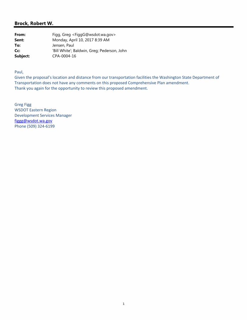
Brock, Robert W.
From: Figg, Greg <[email protected]>Sent: Monday, April 10, 2017 8:39 AMTo: Jensen, PaulCc: 'Bill White'; Baldwin, Greg; Pederson, JohnSubject: CPA-0004-16
Paul, Given the proposal’s location and distance from our transportation facilities the Washington State Department of Transportation does not have any comments on this proposed Comprehensive Plan amendment. Thank you again for the opportunity to review this proposed amendment. Greg Figg WSDOT Eastern Region Development Services Manager [email protected] Phone (509) 324‐6199


1
Brock, Robert W.
From: Ned Wendle <[email protected]>Sent: Wednesday, August 31, 2016 4:37 PMTo: Jensen, PaulSubject: #16-CPA-04
Mr. Jensen,
At this point in time, the Mead School District (MSD) requests that Spokane County postpone any decision to continue to add multifamily projects until such a time that MSD can adequately respond to the already aggressive growth in the North Spokane corridor. The continued multi-family projects are a tremendous strain on our already overcrowded schools and associated resources. Mead School Dist. Is in the early stages of planning a 2018 bond measure to address this growth. When and If we are able to pass a bond measure it will take approximately 60 months to occupy a new building.
-- Ned P. Wendle Mead School District Director of Facilities and Planning [email protected] (509) 465-7657

1
Brock, Robert W.
From: JOHNSON, JEFFREY R GS-13 USAF AMC 92 MSG/CD <[email protected]>Sent: Monday, September 19, 2016 12:13 PMTo: Jensen, PaulCc: YOUNG, ALEC CIV 92 CES; DANIELS, RONALD R GS-13 USAF AMC 92 CES/CDSubject: Spokane County Amendments 16-CPA-02, 16-CPA-04, and 16-CPA-05
Mr. Paul Jensen, We've reviewed Spokane County Amendments 16‐CPA‐02, 16‐CPA‐04, and 16 ‐CPA‐05. We do not have any comments for the Comprehensive Plan and Zoning Map Amendments of 16‐CPA‐02 and 16‐CPA‐04 because they occur outside of our airspace and Military Influence Areas. Concerning 16‐CPA‐05, we do not have any issues with the requested comprehensive plan text amendment change to policy UL.2.16. Please continue to coordinate with us on these proposals; we appreciate your continued support of our mission. Sorry this is late...I was out of town. Our folks had it prepared but I missed this one. Warmest Regards, Jeff //SIGNED// Jeffrey R. Johnson, GS‐13, DAFC 92 Mission Support Group, Deputy // Director, Fairchild AFB Encroachment Management Team Fairchild AFB, WA 99208 DSN 657‐1477 509‐247‐1477

September 20, 2016
Mr. Paul Jensen
Principal Planner
Spokane County Building & Planning
1026 W. Broadway Avenue
Spokane, WA 99260
Re: Waikiki Comprehensive Plan Amendment, File # 16-CPA-04
Dear Mr. Jensen:
Thank you for the opportunity to comment on the proposal to reclassify approximately 22.3 acres
from the Low Density Residential (LDR) zone to the Medium Density Residential (MDR) zone
for the future plan of constructing several multi-family, residential dwellings consisting of
roughly 134-to-334 units on approximately14 buildable acres (Proponent: J.R. Bonnett
Engineering, PLLC). The Department of Ecology (Ecology) has reviewed the documents and
submits the following comments:
Water Quality Program-Shannon Petrisor (509) 329-3610
Proper erosion and sediment control practices must be used on the construction site and
adjacent areas to prevent upland sediments from entering surface water. Local
stormwater ordinances will provide specific requirements. Also refer to the Stormwater
Management Manual for Eastern Washington
(http://www.ecy.wa.gov/programs/wq/stormwater/eastern_manual/manual.html). All
ground disturbed by construction activities must be stabilized. When appropriate, use
native vegetation typical of the site.
All new dry wells and other injection wells must be registered with the Underground
Injection Control program (UIC) at Department of Ecology prior to use and the discharge
from the well(s) must comply with the ground water quality requirement (non-
endangerment standard) at the top of the ground water table. Contact the UIC staff at
UIC Program, Department of Ecology, P.O. Box 47600, Olympia, WA 98504-7600,
(360) 407-6143 or go to
http://www.ecy.wa.gov/programs/wq/grndwtr/uic/registration/reg_info.html for
registration forms and further information.
Mr. Paul Jensen
September 20, 2016
Page 2
State Environmental Policy Act (SEPA)-Terri Costello (509) 329-3550
Ecology’s comments are based upon information submitted for review. As such, they do
not constitute an exhaustive list of the various authorizations that must be obtained or
legal requirements that must be fulfilled in order to carry out the proposed action.
If you have any questions or would like to respond to these comments, please contact the
appropriate staff listed above.
Department of Ecology
Eastern Regional Office
(Ecology File #: 201604699)
cc: Jay Bonnett, J. R. Bonnett Engineering, PLLC

ATTACHMENT I

1
Maynard, Maria
From: Robert Fordan <[email protected]>Sent: Saturday, June 24, 2017 9:42 AMTo: Maynard, Maria; Brock, Robert W.; Pederson, JohnSubject: Fwd: Rezone application 16-CPA-04
Follow Up Flag: Follow upFlag Status: Flagged
DEAR PLANNING DEPARTMENT STAFF: I originally was going to email a letter to you AND to County Commissioner Kerns. However, I had trouble with my computer in doing so. I was able to send my letter to Commissioner Kerns individually. Now, I’m sending this same letter to you, so you have a copy. —RF
Begin forwarded message: From: Robert Fordan <[email protected]> Subject: Rezone application 16-CPA-04 Date: June 24, 2017 at 9:34:23 AM PDT To: [email protected] June 24, 2017 Dear Commissioner Kerns, I write this letter in response to the proposed change in the Spokane County Comprehensive Plan from Low Density Residential to Medium Density Residential, requested by Harley C Douglass/JR Bonnett Engineering. According to documents I have seen, it is for a site located in the North Metro Urban Growth Area on the north slope of Five Mile Prairie, adjacent to both North Five Mile Road and Waikiki Road. Located in the NE1/4 of Section 13, Township 26 North, Range 42 EWM and the NW1/4 of Section 18, Township 26 North, Range 43 EWM. Parcel numbers 36182.91 14' 36182.9116, and 26131.9063 I have a number of concerns and questions that were raised by my reading of a document, “Mitigated Determination of Nonsignificance" (MDNS) related to this project. Firstly, if the comprehensive plan calls for low density housing in the area, and the developer now requests a rezone to medium density — what is reason for this request? How was the comprehensive plan flawed, when up until now, it was relied upon by the county, land, and homeowners, for future development? It appears to me that a rezone from low to medium density would permit “leap frog” development,” as there are no other projects with higher density in the immediate North Five Mile Road area. Apartments exist much farther to the southeast, near Whitworth University. To permit this change is to introduce for the first time, shall we say, “too much city in the county.” As you well know, county government is not structured or equipped to provide the same scale of amenities that people

2
demand in urban cities. It seems to me this proposal would blur the appearance of that distinction. Denser development should be undertaken in the area closer to the university. The MDNS document states one mitigating measure would be the creation of an east-west public road, connecting Waikiki Road with the west property line of parcel 36182.9116. I presume this road is proposed because the only existing road, North Five Mile Road, is simply not enough alone to handle the increase in traffic that will end up on Waikiki Road. So, I must ask, would this road be necessary if the developers simply adhered to the comprehensive plan and developed their parcel as those who created and adopted the Comprehensive Plan intended? The document stated that as a result of the project proposal, an additional bus route on Waikiki Road will be required, to mitigate the project’s impact. Did the EIS study predict how much mitigation of the problem there will be by adding a bus route? I did not see anything on that in the EIS report statement that addressed this question. Will the route include a stop or stops within the proposed development, or will the members of the 300 family units being proposed need to walk from the proposed development down to Waikiki Road to catch the bus? If there are no plans for a pick up/drop off within the development, are families expected to walk down the road to Waikiki to catch the bus? Or are there plans for the creation of a parking lot near the Waikiki bus stop for the family cars to be parked while the buses are used? I find it hard to believe that adding a pick up and drop off route alone on Waikiki Road would resolve the traffic problem created by an additional 300 multi-family units in the nearby area. If I read the EIS document correctly, item #14 states the county engineer will determine if any road improvements are required for Waikiki Road, and that the current roadway configuration “may adequately serve the proposed development…” Thus there are currently no plans for a widening of the Waikiki Road from its current two lanes (one lane each direction) to four lanes (two lanes either direction) to accommodate the increase in traffic. One question: what information does the county engineer have that leads him to conclude the current Waikiki Road can handle the increased traffic from the 300 family units being proposed? Second question: If the county engineer were to conduct a further review, and realized the road must be widened from two to four lanes, would the developers pay for it, or are the expectations that this cost would be the burden of the taxpayers of Spokane County? The document also stated, “Plan for safe and convenient pedestrian crossing of Waikiki Road.” With the speed limit currently 35 mph, and of course, some cars moving 10 to 15 miles faster than the posted limit, I presume the plan will include more than just a painted crosswalk. I see no mention of the words “traffic light.” If there is one, to ensure safety, are the developers paying for this light, or are county taxpayers? As you can tell from the above questions and concerns I am very apprehensive about this proposed comprehensive plan change and rezone. I do have to tell you that part of that apprehension comes from an observation of poor zone planning by the county in the past that, as a result, must remain unresolved. For a year now, ever since my wife and I moved to our home (we moved to Spokane in June, 2016), I have seen somewhat deep standing water on the roadway near the intersections of West Forest Hill Drive, North Forest Hill Drive and West Spring Lane. I was told by a neighbor that building of homes never should have been permitted there, because a pond existed on and near the road, and this issue was never properly addressed prior to the granting of applications to build homes there (I have seen a crew, presumably from the county, bringing in rocks and dirt to help “dry” up the area — but this is no permanent solution. The water returned a few weeks later. So, unfortunately, whether rightly or wrongly, that issue must color my judgment. I cannot help but be weary of Spokane County government’s ability to address this important issue, by truly investigating whether 300 family units can, or should, be added to the nearby area, when projects of such greater density are better suited to other areas — It seems to me that if the developers are permitted just build residential homes, with adequate amount of space around each, on the development site, they will realize the creation and completion of a
3
project that everyone else knew was what expectations were when the county’s comprehensive plan was adopted and later relied upon by others for purposes of development or home owning. Thus, if further studies of the environment, traffic, and safety are not conducted, or if there is no adequate addressing of the other concerns I have raised in this letter by your planning department staff, I would urge you to vote to deny the comprehensive plan amendment and rezone. Please share my letter with your fellow commissioners, French and O’Quinn, and other planning department employees involved in this project that I have failed to include in this e-mail. Sincerely, Robert Fordan 1520 W Forest Hill Dr Spokane, WA 99218 (509) 960-7009 [email protected]

1
Maynard, Maria
From: [email protected]: Sunday, June 25, 2017 8:49 PMTo: French, Al; Kerns, Josh; Maynard, Maria; Brock, Robert W.; O'Quinn, ShellySubject: Proposed Zoning Change - Application File No. 16-CPA-04
Follow Up Flag: Follow upFlag Status: Flagged
Dear Mr. French, Mr. Kerns, Ms. Quinn, Mr. Maynard, and Mr. Brock, We are writing to express our concerns over the proposed re-zoning of parcels numbers 26131.9063, 36182.9116, and 36182.9114, as described in application file number 16-CPA-04. This proposal would re-zone this 22.3 acre area from low density residential (ldr) to medium density residential (mdr) for the purpose of building an apartment complex with up to 334 units. We are asking that the decision to re-zone be delayed until there has been appropriate impact studies conducted regarding the impact of a 334 unit housing complex on traffic (along Waikiki/Mill Road as well as through the Whitworth Campus), safety, schools, health, and the environment. We have listed a few high level concerns regarding the rezoning.
Over crowding in the Mead School District - There are currently wait list for children to attend many of the schools within the Mead School District. What, if any, are the plans to address student placement within the district and/or reasonable transportation to schools outside the district.
With an estimated 850 to 2200 trips to and from the proposed housing complex, what impact will that have on the Whitworth campus, North Wall, Waikiki/Mill Road corridor, and the Five Mile Road. Mr. Bonnet states the current plan for traffic revision on Waikiki as it is the "main" entrance. He has failed to mention any plans for traffic impact on the additional entrance on Five Mile Road.
Mr. Bonnett states that they will encourage ride share and use of public transportation as means to combat the impact the 850-2200 trips will have but later states that no additional recourses will be needed from public utilities such as STA. Currently there are zero bus stops near the proposed site - the existing bus stops are located to the north at Hawthorne and Waikiki and to the south on Hastings within the Fairwood shopping center. He also failed to consider the additional transportation needed for students going to school outside of the district.
Mr. Bonnet States that due to existing utilities crossing the property only approximately 14 acres will be developed. Why is the rezoning request for more than 22 acres. How close are they planning on constructing homes to the existing high voltage power lines. What if any steps will be taken to ensure the safety of that community from the low lines that exist today?
How close are the proposed units to the existing high voltage power lines and what studies have been concluded on the safety of living below those power lines?
The surrounding community has many legitimate concerns and we ask that the County Commissioners not proceed with this rezoning until a thorough study has been performed and reviewed by the public.

2
Thank you in advance for taking the time to hear our concerns, Lin and Terri Wicks 1714 W. Forest Hills Dr. Spokne Wa 99218

1
Maynard, Maria
From: Dyer Davis <[email protected]>Sent: Sunday, June 25, 2017 7:34 PMTo: French, Al; Kerns, Josh; Maynard, Maria; Brock, Robert W.Subject: Proposed zoning change -- Application file no. 16-CPA-04
Follow Up Flag: Follow upFlag Status: Flagged
Dear Sirs, We write to express our concern over the proposed re‐zoning of parcel numbers 26131.9063, 36182.9116 and 36182.9114, as described in application file no. 16‐CPA‐04. This proposal would re‐zone this area from low‐density residential to medium‐density residential housing for the purpose of building approximately 335 apartment units. We urge you to delay a decision on this rezoning until a comprehensive evaluation of the impact of this rezoning on traffic, safety, schools, health and the environment is conducted and reviewed by the public. Among the specific concerns we have about this proposed rezoning and development are as follows: 1) Overcrowding in the Mead schools. Have discussions occurred with the district to prepare for increased student population? 2) Increased traffic on the north Waikiki/Mill Rd corridor, as well as north Five Mile Rd. We understand the estimated increase in traffic is 850‐2200 vehicle trips per day. 3) Possible impact on the Little Spokane River and Five Mile watershed, including wildlife in the area. 4) Exposure of the population in the development to possible adverse health effects of living in such close proximity to high voltage power lines. 5) Will the developer be required to add walking paths and bike lanes to protect the population in and around the development? 6) Is additional street lighting planned to protect public safety? 7) What kind of landscaping will be required in and around the storm run‐off area in order to protect the environment? To us, it seems presumptuous and possibly dangerous for the county to proceed with granting this re‐zoning without taking the time to perform studies related to traffic, safety, schools, health, and environmental impacts of this proposed development. We respectfully request that any decision on this re‐zoning by delayed until such studies are completed and reviewed. Sincerely, Dyer and Beth Davis

2
11411 N Pinecrest Drive Spokane, WA 99218
Dyer Davis/Broker Real Experience. Real Results. Real Estate. Windermere North 509-389-5488 cell 509-321-9114 direct 509-321-9214 fax www.dyerdavis.com

1
Maynard, Maria
From: Charles Moore <[email protected]>Sent: Monday, June 26, 2017 9:01 AMTo: [email protected]; Kerns, Josh; Maynard, Maria; [email protected]: Proposed Zoning Change - Application File No. 16-CPA-04
Follow Up Flag: Follow upFlag Status: Flagged
Dear Commissioners, We are writing to express our concerns over the proposed re-zoning of parcel numbers 216131.9063, 36182.9116, and 36182.9114,as described in application file no. 16-CPA-04. This proposal would re-zone this area from low-density residential to medium density residential housing for the purposes of building approximately 335 apartment units. We urge you to delay a decision on this re-zoning until a comprehensive evaluation of the impact on this re-zoning on traffic, safety, schools, and the environment can be conducted and reviewed by the public. We have the following specific concerns about the proposed re-zoning: 1. Overcrowding in the Mead Schools. The student population at Mead High Schools already exceeds the number the school was designed to handle. 2. Increased traffic on the north Waikiki/ Mill Road corridor, as well as north Five Mile road. We have lived on Marc Drive since 1998 and have witnessed a substantial increase in area traffic since that time. During the morning and evening rush hours traffic is often backed up on the Waikiki/Mill Road corridor from Hastings to Hawthorn. The current roads were not designed to handle the current traffic load much less the increase that would be evidenced by the proposed re-zoning. A thorough evaluation of the current road conditions needs to be completed before any re-zoning is considered. 3. Possible impact to the Little Spokane River and the Five Mile watershed, including wildlife in the area. 4. Exposure of the population in the development to possible adverse heath effects of living in such close proximity to high voltage power lines. We believe the current residents of the area deserve answers to our concerns before any decisions on re-zoning are granted. Sincerely, Charles and Sherry Moore 1604 W. Marc Drive Spokane, WA 99218

1
Maynard, Maria
From: [email protected]: Saturday, June 24, 2017 11:33 PMTo: Maynard, MariaSubject: Rezone app.16-CPA-04
Follow Up Flag: Follow upFlag Status: Flagged
I am totally against the rezone change application file number 16-CPA-04 on Parcels numbers 26131.9063, and 361182.9116, and 36182.9114 from low density residential to medium density residential, for the purpose of building 335 apartment units.
My biggest concern is the amount of traffic it will produce on the Waikiki/Mill road corridor. I have live here at my current address for over 21 years and the amount of traffic has increase over the years to this point:
At the round about on Waikiki between 7:30 am and 8:10 am and 2:25 pm to 3:00 pm, traffic is backed up northbound from the round about to the five mile road traffic light also from the west is backed up on Waikiki 30 automobiles. Also, backed up nouthbound from the round about to the light at 5 mile road.
During the other times of the day the traffic gets heavy and light depending on the day of the week. Rezoning to allow 335 apartment units to an already congested traffic corridor is just a wrong decision.
Charles and Darla Thiel
1616 W Marc DR
Spokane WA 99218
509-994-5283

1
Brock, Robert W.
From: Kathy Miotke <[email protected]>Sent: Tuesday, July 19, 2016 12:02 PMTo: Pederson, JohnCc: Jensen, Paul; Davenport, SteveSubject: 16-CPA04 and 05. Harley Douglas
John, Paul and Steve, The Growth Management Hearings Board has affirmed their order of invalidity on the previous comp plan amendment for Harley Douglas (Five Mile Rd). With the new amendment along with the text amendment, I would like to know when the public comment period starts and when it is being heard by the Plan Commission as well as the BOCC. Is the text amendment shown as CPA05, the final language that you will be presenting to the Plan Commission and the Board? If you could answer my question and also keep me in the loop on these I would appreciate it. Thanks You. Kathy Miotke

1
Brock, Robert W.
From: Breton Van Sloten <[email protected]>Sent: Friday, June 23, 2017 7:14 AMTo: Kerns, Josh; Brock, Robert W.; Maynard, MariaSubject: Rezoning in the 5 mile corridor
Hello, My name is Breton Van Sloten and I a homeowner in the Fairwoods development and I would like to voice my disapproval of changes to the zoning proposals in the 5 mile area. Since owning my home I have already seen a significant increase in traffic and any new zoning changes to medium density for new apartment complexes will only increase the situation ten fold. Many of the homeowners in my development purchased their homes for the specific reason of having that semi-country feeling if you go and change things, where going to feel like were back living in town with a huge influx of traffic. The traffic will be horrendous, I have been in the real estate business for over 30 years and I can tell you first hand if you make these zoning changes you are going to see a large exodus of homeowners fleeing the area. Additionally I also know the area where your plans are forecasted is a wildlife path for many popular animals in the area, I am sure if a environmental impact study was completed by dept. of wildlife they would conclude this is a bad idea for the natural wildlife that uses this area. Please reconsider you plans, there is so much available land in so many other more accommodating locations which should be examined before and decisions are made. I am just one of a whole community that disagrees with this proposal. Thank you for your time. Concerned homeowner Breton Van Sloten

1
Maynard, Maria
From: Brent Osborn <[email protected]>Sent: Tuesday, June 20, 2017 12:03 PMTo: Maynard, Maria; Brock, Robert W.; Kerns, JoshSubject: proposed apartments in mead area
Hello Awesome county leaders, I hope you are having a blessed morning. Unlike many of my fellow neighbors in the 5 mile area I am not opposed to growth and apartments. However, to say that this will not have a major impact on traffic is simply covering one eyes to reality. Try getting off 5 mile hill in the morning or getting up that road in the afternoon. The area is surrounded by three schools (Mead, Whitworth, and St. Georges) and many businesses and elementary schools. This proposal CANNOT go forward without a major restructuring of traffic from Hastings to Holmberg park and up and down 5 mile road. This will require road widening and likely property purchasing. I am fine with growth but not without proper planning for traffic considerations that provide safe transport for our kids through that area. Thank You for your time Brent Osborn 5 Mile resident 509-342-0569
1
Maynard, Maria
From: Eric Smith <[email protected]>Sent: Tuesday, June 20, 2017 9:15 AMTo: Maynard, MariaSubject: Douglas Proposed North Spokane/Waikiki Development
As someone who resides in this area, I am concerned about many things associated with this development: overcrowding in Mead Schools, traffic impact (Douglas only solution as stated in reports, encourage ride sharing); possible impacts to the Little Spokane Watershed, area wildlife and flora; increased demand on emergency services; exposure and it’s affects to the population in this development to high voltage lines, especially young children; additional public transportation needs; etc. The SEPA report submitted by the Douglas hired engineer is certainly biased and non-specific. There was no mention of the effects of putting a “minor arterial” from Waikiki up the very steep hill under the power lines. The transmission lines were not mentioned or pictured on the map. There has been no information of the environmental effects and the mention of an arterial under the power lines brings up an issue from 2006 when the area had to fight against a county proposal to put a “limited access” highway under the power lines that would hook up to hwy2 and I-90 taking truck traffic away from the freeway. We are adamantly opposed to this development and plan to appear at the June 29th hearing, we hope to have your support in this opposition. Eric and Susan Smith 1707 W. Forest Hills Drive Spokane, WA 99218

1
Maynard, Maria
From: Eric Smith <[email protected]>Sent: Wednesday, June 21, 2017 5:50 PMTo: Maynard, MariaSubject: Appeal of ref file 16-CPA-04
Follow Up Flag: Follow upFlag Status: Flagged
Please consider this email as a formal request to appeal the MDNS decision that a formal environmental impact statement is not needed on the proposed H. Douglas development of up to 300 housing units for North Spokane/Waikiki. Eric and Susan Smith 1707 W Forest Hills Drive Spokane, WA. 99218 Sent from my iPad

1
Maynard, Maria
From: Pederson, JohnSent: Thursday, June 22, 2017 8:08 AMTo: Maynard, MariaSubject: FW: ReZoning North Five Mile Road to Waikiki/Mill Road - Case 16-CPA-04
Maria, Please add this comment to the project file and electronic record. Thanks, JP
From: KYE [mailto:[email protected]] Sent: Wednesday, June 21, 2017 4:10 PM To: Pederson, John <[email protected]> Subject: ReZoning North Five Mile Road to Waikiki/Mill Road ‐ Case 16‐CPA‐04
I am writing to request our Spokane County planning commission reconsider the mitigated determination for this case due to multiple reasons and requests: A geotechnical evaluation on the site has not been performed for over 10 years. I am requesting a new geotechnical evaluation be performed before any decision moves forward on this request.. I would like to request a survey be done to ensure the stream running across Waikiki Road confirming it is beyond 200 fee from this property, does not run over or underneath the property, and that there be no impacts to area water, rather above ground or under ground. Will a waste-water discharge permit be granted by the WA State Department of Ecology given the close proximity to the Little Spokane Watershed/environment? I am requesting an environmental study regarding impacts to wildlife and flora. Eagles and Osprey have been known to nest along the Little Spokane Watershed. The study should ensure that there is no disruption to their habitat or nesting grounds, as well as other wildlife and flora native in this area. I am requesting an environmental study be done to determine the impact to the Little Spokane Watershed. That the proposed swales property protect the area given it's close proximity to the Little Spokane Watershed, above and underground streams. In addition, the possibility of erosion, both during and after construction, should be studied; as well as the possibility of contamination by chemicals used such as de-icers, household solutions, fertilizers, etc. to this delicate environment. I am requesting an EMF evaluation of the transmission lines across this property as it's likely families would reside in and under large power lines. I am very concerned about the negative impact to the population (specifically children) due to the strong electromagnetic field. I am requesting a long term traffic study, including a study during the school year, of the traffic load and impact to the Mill Road/Waikiki corridor and plans to handle the expected 2,200+ additional vehicle trips per day. This corridor has become almost impassable during high volume hours of the

2
day due to the reduction of lanes and the addition of a roundabout a few years ago without adding another 2,200+ trips per day to the road. Mill Road/Waikiki cannot handle this additional volume of traffic, neither road is built to handle the heavy traffic flow we are already experiencing. This traffic study needs to occur when the Mead SD and Whitworth University are in session. To perform a study any other time would provide invalid data and an incomplete picture of the traffic patterns. I would like a study done by the county outlining the plans for increased public services (due to increased population) which includes emergency services (fire, sheriff, police, ambulance), public sidewalks, bike paths and crosswalks, schools (in the already overcrowded Mead district) and increased public safety and transportation needs. I am requesting a public hearing for this zoning case to be held in the evening at the local library, or public meeting space, so those whom work may attend a meeting focused directly on this issue. Thank you, in advance, for your kind consideration. Kye Pederson 1903 W Johannsen Rd Spokane WA 99208

1
Brock, Robert W.
From: [email protected]: Wednesday, June 21, 2017 11:14 AMTo: French, Al; Kerns, Josh; Maynard, Maria; Brock, Robert W.Subject: Proposed zoning change -- Application file no. 16-CPA-04
Dear Mr. French, Mr. Kerns, Mr. Maynard, and Mr. Brock -- We write to express our concern over the proposed re-zoning of parcels numbers 26131.9063, 36182.9116, and 36182.9114, as described in application file no. 16-CPA-04. This proposal would re-zone this area from low-density residential to medium-density residential housing for the purpose of building approximately 335 apartment units. We urge you to delay a decision on this rezoning until a comprehensive evaluation of the impact of this rezoning on traffic, safety, schools, health, and the environment is conducted and reviewed by the public. Among the specific concerns we have about this proposed rezoning and development are the following: 1) Overcrowding in the Mead schools. Have discussions occurred with the Mead School District to prepare for increased student population? 2) Increased traffic on the north Waikiki/Mill Road corridor, as well as north Five Mile Road. We understand the estimated increase in traffic is 850-2200 vehicle trips per day. 3) Possible impact on the Little Spokane River and Five Mile watershed, including wildlife in the area. 4) Exposure of the population in the development to possible adverse health effects of living in such close proximity to high voltage power lines. 5) Will the developer be required to add walking paths and bike lanes to protect the population in and around the development? 6) Is additional street lighting planned to protect public safety? 7) What kind of landscaping will be required in and around the storm run-off area in order to protect the environment? To us, it seems presumptuous and possible dangerous for the county to proceed with granting this re-zoning without taking the time to perform studies related to the traffic, safety, school, health, and environmental impact of this proposed development. We respectfully request that any decision on this re-zoning be delayed until such studies are completed and reviewed. Sincerely, Dick and Susan Boysen 1441 W. Marc Drive Spokane, WA 99218

1
Maynard, Maria
From: Linda Wilson <[email protected]>Sent: Wednesday, June 21, 2017 4:33 PMTo: Maynard, Maria; Kerns, JoshSubject: Comments on re-zoning request N. Five Mile Road
Follow Up Flag: Follow upFlag Status: Flagged
My name is Linda Wilson, I have lived on Five Mile Prairie and put 6 children through Mead School district schools K‐12. I am writing to request our Spokane County planning commission reconsider the mitigated determination for this case due to multiple reasons and requests: A geotechnical evaluation on the site has not been performed for over 10 years; I am requesting a new geotechnical evaluation be performed before any decision moves forward on this request and the results be made public. I would like to request a survey be done to ensure the stream running across Waikiki Road confirming it is beyond 200 feet from this property, does not run over or underneath the property and that there be no impacts to area water - rather above ground or under ground. Will a wastewater discharge permit be granted by the WA State Department of Ecology given the close proximity to the Little Spokane Watershed/environment? I am requesting an environmental study regarding impacts to wildlife and flora. Eagles and Osprey have been known to nest along the Little Spokane Watershed, the study should to ensure there is no disruption to their habitat or nesting grounds as well as other wildlife and flora native to this area. I would like the results of this study be made public. I am requesting an environmental study be done to determine the impact to the Little Spokane Watershed; that the proposed swales properly protect the area given it's close proximity to the Little Spokane Watershed, above and underground streams. In addition the possibility of erosion both during and after construction should be studied; as well as the possibility of contamination by chemicals used such as de-icers, household solutions, fertilizers, etc. to this delicate environment. I would like the results of this study be made public also. I am requesting an EMF evaluation of the transmission lines across this property as it's likely families would reside in and under large power lines; I am very concerned about the negative impact to the population (especially children who will reside here) due to the strong electromagnetic field. I would like the results of this study be made public. I am requesting a long term traffic study, including a study during the school year, of the traffic load and impact to the Mill Road / Waikiki corridor and plans to handle the expected 2,200+ additional vehicle trips per day. This corridor has become almost impassable during high volume hours of the day due to the reduction of lanes and the addition of a roundabout a few years ago without adding another 2,200+ trips per day to the road. Mill Road/Waikiki cannot handle this additional traffic, neither road is built to handle the heavy traffic flow we are already experiencing. As noted, this traffic study, needs to occur when the Mead School District and Whitworth University are in session. To perform a study during the summer would provide invalid data, an incomplete picture of the traffic patterns. Please make the results of this study public also. Most important of all….I would like a study done by the county outlining the plans for increased public services (due to increased population) including emergency services (fire, sheriff, police, ambulance); public sidewalks, bike paths and crosswalks; schools (in the already overcrowded Mead district);, and increased public safety and transportation needs. I request these results be made public as well.
Thank you,

2
Linda Wilson Sent from Mail for Windows 10

1
Maynard, Maria
From: Robby Grether <[email protected]>Sent: Tuesday, June 20, 2017 9:31 PMTo: Maynard, Maria; Brock, Robert W.; Kerns, JoshSubject: Proposed zoning change on North Waikiki Rd
Dear Sir or Madam, As a ten‐year resident of Fairwood Park II, I am writing to express my great concern regarding the proposal of the building of hundreds of apartments along the stretch of road between North Five Mile Road and Mill Road. As you are aware, this road was recently changed from four lanes to two, with a middle turning lane. The roundabout at Mill/Waikiki has helped to keep traffic running fairly smoothly. To add the several hundred cars from apartment residents would put an unbearable strain on Waikiki Road and unreasonably delay traffic. I can't even imagine the congestion that would occur as traffic built up at the roundabout and then again at the lights at North Five Mile Road/Waikiki and Hawthorne/Waikiki. Please, please do not succumb to the temptation to approve the change of zoning that would allow these apartments to be built in this area. Sincerely yours, Robby Grether 12314 North Fairwood Drive Spokane WA 99218 (509)468‐4855

1
Maynard, Maria
From: Sandy Sweeney <[email protected]>Sent: Monday, June 19, 2017 10:00 AMTo: Maynard, MariaCc: Kerns, Josh; Sandy SweeneySubject: Fw: Zoning Change Comments Concerning the Mill Road / Waikiki Area
Hello Maria; Please see the below with my questions/concerns regarding rezoning in my area. I would like this passed on to the planning commission and any other decision makers prior to the June 29th planning commission meeting. Thank you, Sandy Sweeney
From: Sandy Sweeney <[email protected]> Sent: Saturday, June 17, 2017 7:37:55 PM To: [email protected] Subject: Zoning Change Comments Concerning the Mill Road / Waikiki Area
Hello Josh;
As my elected county commissioner I am writing to you regarding the following.
I live in northwest Spokane, in Woodway Park, very near where a zoning request has been received to change the zoning from the current Low Density Residential status to Medium Density Residential for multiple parcels owned by Harley Douglas as noted here:
“The subject property consists of three parcels, 26131.9063, 36182.9116, and 36182.9114 that are located adjacent to Waikiki Road and North Five Mile Road in North Spokane County within the NW quarter of Section 13, and NE Quarter of Section 18, T25N, R43E W.M. The completed proiect will gain primary access from Waikiki Road.
The project scope includes the placement of multiple multi‐family dwellings on approximately 22.3 acres of land. The intent is to construct wood‐framed buildings within the buildable areas of the property. The

2
requested land use designation would provide for a housing density of 6‐ 15 units per acre, yielding 134‐334 units. Due to existing utilities crossing the property, the developable area of land will approximate 14 acres.”
I am writing to you to ask that you oppose this requested zoning change for multiple reasons/concerns as noted within this letter as our elected representative.
Has an environmental study taken place to determine the effect on the Little Spokane Watershed due to the significant population increase if this zoning change is allowed? There will be additional stresses on the environment because of this added population: waste, vehicle emissions, sewage, etc if the planned additional 334 units are added in this area. If a study has occurred where can I access the results?
What about the abundant wildlife in this area? This area is home to many deer, hawk, songbirds and moose just to name a few. Not too far up Waikiki are nesting areas for Eagle and Osprey among other protected/delicate species. What will happen to this wildlife? Has consideration been given to the impact to the fish hatchery on the Little Spokane River in this area?
A few years ago Mill road was reduced from a bidirectional four lane arterial down to a two lane arterial and a roundabout was installed at the intersection of Waikiki and Mill Road. After this change, the Mill Road / Waikiki corridor is clogged with traffic many hours of the day. In fact, I can no longer easily turn across traffic to access my neighborhood during the morning or evening school/work commute hours; I have stopped using this arterial in 98% of my travels. What kinds of traffic studies have occurred with the expected addition of 885 to 2205 vehicular trips per day? Many of the residents in this area already struggle with traffic delays; it seems far-fetched of anyone who believes this zoning change will not further negatively affect our quality of tax-supported roadways in this area.
As well, I have significant concerns for the safety of residents both in and around this planned development as it appears only one entry is planned for entry and exit from this very large, multi unit dwelling development and it appears this entry/exit point will be just south of the roundabout mentioned above. It is hard to believe traffic will be anything but at a standstill if this is allowed.
Has a traffic study occurred regarding the easy ingress and egress into this development by police, sheriff, fire and public safety officials? Addition of significant population strains public services; how many additional sheriff, fire, first responders and patrols will be added to this area if a zoning change occurs?
What kind of additional public transportation routes will be added to service the increased population in this area if this zoning change occurs? Will sidewalks and bike paths be added to the development as well as the surrounding areas in order to provide alternate ways for the populace to move about the area? Will additional street lights be added to this area and the surrounding areas due to the increased population and to support the safety of the

3
citizens? Additional traffic will decay our roadways sooner, what are the plans for additional, ongoing road maintenance in the area if this zoning change occurs?
Today, the Mead School District is suffering from significant overcrowding (in its elementary schools especially). Many young students currently must be bused to schools outside of their neighborhood; this impact is already difficult for the thousands of families in the area. Has Spokane County worked in partnership with the Mead School District for long term planning of this additional, significant population? Schools need to be built already, why would we add a large multi family zoning to a school district area that is struggling to serve it’s current population?
The area under consideration is a beautiful, northwest environment full of ponderosa pine, ancient basalt rock outcroppings and rolling hills. The quality of life for the citizens in this area, the wildlife, the environment will become greatly diminished if this zoning change is allowed.
Please support keeping this area as it should be, a great place to raise families in a Low Density Residential area rather than a chaotic, traffic-laden, high population area which would further stress an already struggling infrastructure. This requested zoning change makes no sense and will negatively affect this area in perpetuity if allowed.
As our county commissioner have you been out among us in this area to discuss, consider and address our concerns? One public meeting, with very short notice does not allow you enough time to represent the wishes of District 1. A successful public official represents their constituents.
I am very interested to hear back from you in the next few days regarding this issue. I would also like to read any studies completed by the county – traffic; public services; environmental (including wildlife); etc. and would appreciate you forwarding those as well.
Thank you,
Sandy Sweeney
821 West Rolland
509-599-6788

1
Maynard, Maria
From: Sandy Sweeney <[email protected]>Sent: Monday, June 19, 2017 10:04 PMTo: Maynard, Maria; Kerns, JoshSubject: Fw: Zoning Change Comments Concerning the Mill Road / Waikiki Area 16-CPA-04
In addition to my original concerns below, sent to Josh Kerns, I am writing to request our Spokane County planning commission reconsider the mitigated determination for this case due to multiple reasons and requests: A geotechnical evaluation on the site has not been performed for over 10 years; I am requesting a new geotechnical evaluation be performed before any decision moves forward on this request.
I would like to request a survey be done to ensure the stream running across Waikiki Road confirming it is beyond 200 feet from this property, does not run over or underneath the property and that there be no impacts to area water ‐ rather above ground or under ground. Will a wastewater discharge permit be granted by the WA State Department of Ecology given the close proximity to the Little Spokane Watershed/environment? I am requesting an environmental study regarding impacts to wildlife and flora. Eagles and Osprey have been known to nest along the Little Spokane Watershed, the study should to ensure there is no disruption to their habitat or nesting grounds as well as other wildlife and flora native to this area. I am requesting an environmental study be done to determine the impact to the Little Spokane Watershed; that the proposed swales properly protect the area given it's close proximity to the Little Spokane Watershed, above and underground streams. In addition the possibility of erosion both during and after construction should be studied; as well as the possibility of contamination by chemicals used such as de‐icers, household solutions, fertilizers, etc. to this delicate environment. I am requesting an EMF evaluation of the transmission lines across this property as it's likely families would reside in and under large power lines; I am very concerned about the negative impact to the population (especially children who will reside here) due to the strong electromagnetic field. I am requesting a long term traffic study, including a study during the school year, of the traffic load and impact to the Mill Road / Waikiki corridor and plans to handle the expected 2,200+ additional vehicle trips per day. This corridor has become almost impassable during high volume hours of the day due to the reduction of lanes and the addition of a roundabout a few years ago without adding another 2,200+ trips per day to the road. Mill Road/Waikiki cannot handle this additional traffic, neither road is built to handle the heavy traffic flow we are already experiencing. As noted, this traffic study, needs to occur when the Mead School District and Whitworth University are in session. To perform a study during the summer would provide invalid data, an incomplete picture of the patterns. I would like a study done by the county outlining the plans for increased public services (due to increased population) including emergency services (fire, sheriff, police, ambulance); public sidewalks, bike paths and

2
crosswalks; schools (in the already overcrowded Mead district);, and increased public safety and transportation needs. Please respond confirming this request and email will be presented to the planning commission prior to any final decisions; I would like my voice to be heard. Thank you, Sandy Sweeney
From: Sandy Sweeney <[email protected]> Sent: Monday, June 19, 2017 10:00 AM To: [email protected] Cc: [email protected]; Sandy Sweeney Subject: Fw: Zoning Change Comments Concerning the Mill Road / Waikiki Area Hello Maria; Please see the below with my questions/concerns regarding rezoning in my area. I would like this passed on to the planning commission and any other decision makers prior to the June 29th planning commission meeting. Thank you, Sandy Sweeney
From: Sandy Sweeney <[email protected]> Sent: Saturday, June 17, 2017 7:37:55 PM To: [email protected] Subject: Zoning Change Comments Concerning the Mill Road / Waikiki Area
Hello Josh;
As my elected county commissioner I am writing to you regarding the following.
I live in northwest Spokane, in Woodway Park, very near where a zoning request has been received to change the zoning from the current Low Density Residential status to Medium Density Residential for multiple parcels owned by Harley Douglas as noted here:
“The subject property consists of three parcels, 26131.9063, 36182.9116, and 36182.9114 that are located adjacent to Waikiki Road and North Five Mile Road in North Spokane County within the NW quarter of Section

3
13, and NE Quarter of Section 18, T25N, R43E W.M. The completed proiect will gain primary access from Waikiki Road.
The project scope includes the placement of multiple multi‐family dwellings on approximately 22.3 acres of land. The intent is to construct wood‐framed buildings within the buildable areas of the property. The requested land use designation would provide for a housing density of 6‐ 15 units per acre, yielding 134‐334 units. Due to existing utilities crossing the property, the developable area of land will approximate 14 acres.”
I am writing to you to ask that you oppose this requested zoning change for multiple reasons/concerns as noted within this letter as our elected representative.
Has an environmental study taken place to determine the effect on the Little Spokane Watershed due to the significant population increase if this zoning change is allowed? There will be additional stresses on the environment because of this added population: waste, vehicle emissions, sewage, etc if the planned additional 334 units are added in this area. If a study has occurred where can I access the results?
What about the abundant wildlife in this area? This area is home to many deer, hawk, songbirds and moose just to name a few. Not too far up Waikiki are nesting areas for Eagle and Osprey among other protected/delicate species. What will happen to this wildlife? Has consideration been given to the impact to the fish hatchery on the Little Spokane River in this area?
A few years ago Mill road was reduced from a bidirectional four lane arterial down to a two lane arterial and a roundabout was installed at the intersection of Waikiki and Mill Road. After this change, the Mill Road / Waikiki corridor is clogged with traffic many hours of the day. In fact, I can no longer easily turn across traffic to access my neighborhood during the morning or evening school/work commute hours; I have stopped using this arterial in 98% of my travels. What kinds of traffic studies have occurred with the expected addition of 885 to 2205 vehicular trips per day? Many of the residents in this area already struggle with traffic delays; it seems far-fetched of anyone who believes this zoning change will not further negatively affect our quality of tax-supported roadways in this area.
As well, I have significant concerns for the safety of residents both in and around this planned development as it appears only one entry is planned for entry and exit from this very large, multi unit dwelling development and it appears this entry/exit point will be just south of the roundabout mentioned above. It is hard to believe traffic will be anything but at a standstill if this is allowed.
Has a traffic study occurred regarding the easy ingress and egress into this development by police, sheriff, fire and public safety officials? Addition of significant population strains public services; how many additional sheriff, fire, first responders and patrols will be added to this area if a zoning change occurs?

4
What kind of additional public transportation routes will be added to service the increased population in this area if this zoning change occurs? Will sidewalks and bike paths be added to the development as well as the surrounding areas in order to provide alternate ways for the populace to move about the area? Will additional street lights be added to this area and the surrounding areas due to the increased population and to support the safety of the citizens? Additional traffic will decay our roadways sooner, what are the plans for additional, ongoing road maintenance in the area if this zoning change occurs?
Today, the Mead School District is suffering from significant overcrowding (in its elementary schools especially). Many young students currently must be bused to schools outside of their neighborhood; this impact is already difficult for the thousands of families in the area. Has Spokane County worked in partnership with the Mead School District for long term planning of this additional, significant population? Schools need to be built already, why would we add a large multi family zoning to a school district area that is struggling to serve it’s current population?
The area under consideration is a beautiful, northwest environment full of ponderosa pine, ancient basalt rock outcroppings and rolling hills. The quality of life for the citizens in this area, the wildlife, the environment will become greatly diminished if this zoning change is allowed.
Please support keeping this area as it should be, a great place to raise families in a Low Density Residential area rather than a chaotic, traffic-laden, high population area which would further stress an already struggling infrastructure. This requested zoning change makes no sense and will negatively affect this area in perpetuity if allowed.
As our county commissioner have you been out among us in this area to discuss, consider and address our concerns? One public meeting, with very short notice does not allow you enough time to represent the wishes of District 1. A successful public official represents their constituents.
I am very interested to hear back from you in the next few days regarding this issue. I would also like to read any studies completed by the county – traffic; public services; environmental (including wildlife); etc. and would appreciate you forwarding those as well.
Thank you,
Sandy Sweeney
821 West Rolland
509-599-6788

1
Maynard, Maria
From: Sandy Sweeney <[email protected]>Sent: Tuesday, June 20, 2017 6:03 PMTo: Pederson, John; Kerns, Josh; Maynard, MariaSubject: Re: Zoning Change Comments Concerning the Mill Road / Waikiki Area 16-CPA-04
Thank you. I would also like to request a public hearing be set up on a Saturday or weekday evening at the local library, school, etc to allow the residents in this area time to comment and have their voice heard. Please let me know when the weekend/evening meeting will be held and where. Thank you, Sandy Sweeney
From: Pederson, John <[email protected]> Sent: Tuesday, June 20, 2017 3:08 PM To: Kerns, Josh Cc: [email protected] Subject: RE: Zoning Change Comments Concerning the Mill Road / Waikiki Area 16‐CPA‐04 Commissioner, Ms. Sweeney’s comments will be added to the project file and will be part of the record considered by the Planning Commission at their public hearing on June 29th. John Pederson
From: Kerns, Josh Sent: Monday, June 19, 2017 10:19 PM To: Pederson, John <[email protected]> Subject: Fwd: Zoning Change Comments Concerning the Mill Road / Waikiki Area 16‐CPA‐04 FYI. Sent from my iPhone Begin forwarded message:
From: Sandy Sweeney <[email protected]> Date: June 19, 2017 at 10:03:36 PM PDT To: "[email protected]" <[email protected]>, "[email protected]" <[email protected]>
2
Subject: Fw: Zoning Change Comments Concerning the Mill Road / Waikiki Area 16-CPA-04
In addition to my original concerns below, sent to Josh Kerns, I am writing to request our Spokane County planning commission reconsider the mitigated determination for this case due to multiple reasons and requests: A geotechnical evaluation on the site has not been performed for over 10 years; I am requesting a new geotechnical evaluation be performed before any decision moves forward on this request. I would like to request a survey be done to ensure the stream running across Waikiki Road confirming it is beyond 200 feet from this property, does not run over or underneath the property and that there be no impacts to area water ‐ rather above ground or under ground. Will a wastewater discharge permit be granted by the WA State Department of Ecology given the close proximity to the Little Spokane Watershed/environment? I am requesting an environmental study regarding impacts to wildlife and flora. Eagles and Osprey have been known to nest along the Little Spokane Watershed, the study should to ensure there is no disruption to their habitat or nesting grounds as well as other wildlife and flora native to this area. I am requesting an environmental study be done to determine the impact to the Little Spokane Watershed; that the proposed swales properly protect the area given it's close proximity to the Little Spokane Watershed, above and underground streams. In addition the possibility of erosion both during and after construction should be studied; as well as the possibility of contamination by chemicals used such as de‐icers, household solutions, fertilizers, etc. to this delicate environment. I am requesting an EMF evaluation of the transmission lines across this property as it's likely families would reside in and under large power lines; I am very concerned about the negative impact to the population (especially children who will reside here) due to the strong electromagnetic field. I am requesting a long term traffic study, including a study during the school year, of the traffic load and impact to the Mill Road / Waikiki corridor and plans to handle the expected 2,200+ additional vehicle trips per day. This corridor has become almost impassable during high volume hours of the day due to the reduction of lanes and the addition of a roundabout a few years ago without adding another 2,200+ trips per day to the road. Mill Road/Waikiki cannot handle this additional traffic, neither road is built to handle the heavy traffic flow we are already experiencing. As noted, this traffic study, needs to occur when the Mead School District and Whitworth University are in session. To perform a study during the summer would provide invalid data, an incomplete picture of the patterns. I would like a study done by the county outlining the plans for increased public services (due to increased population) including emergency services (fire, sheriff, police, ambulance); public sidewalks, bike paths and crosswalks; schools (in the already overcrowded Mead district);, and increased public safety and transportation needs.

3
Please respond confirming this request and email will be presented to the planning commission prior to any final decisions; I would like my voice to be heard. Thank you, Sandy Sweeney
From: Sandy Sweeney <[email protected]> Sent: Monday, June 19, 2017 10:00 AM To: [email protected] Cc: [email protected]; Sandy Sweeney Subject: Fw: Zoning Change Comments Concerning the Mill Road / Waikiki Area Hello Maria; Please see the below with my questions/concerns regarding rezoning in my area. I would like this passed on to the planning commission and any other decision makers prior to the June 29th planning commission meeting. Thank you, Sandy Sweeney
From: Sandy Sweeney <[email protected]> Sent: Saturday, June 17, 2017 7:37:55 PM To: [email protected] Subject: Zoning Change Comments Concerning the Mill Road / Waikiki Area Hello Josh; As my elected county commissioner I am writing to you regarding the following. I live in northwest Spokane, in Woodway Park, very near where a zoning request has been received to change the zoning from the current Low Density Residential status to Medium Density Residential for multiple parcels owned by Harley Douglas as noted here: “The subject property consists of three parcels, 26131.9063, 36182.9116, and 36182.9114 that are located adjacent to Waikiki Road and North Five Mile Road in North Spokane County within the NW quarter of Section 13, and NE Quarter of Section 18, T25N, R43E W.M. The completed proiect will gain primary access from Waikiki Road. The project scope includes the placement of multiple multi‐family dwellings on approximately 22.3 acres of land. The intent is to construct wood‐framed buildings within the buildable areas of the property. The requested land use designation would provide for a housing density of 6‐ 15 units per acre, yielding 134‐334 units. Due to existing utilities crossing the property, the developable area of land will approximate 14 acres.” I am writing to you to ask that you oppose this requested zoning change for multiple reasons/concerns as noted within this letter as our elected representative.

4
Has an environmental study taken place to determine the effect on the Little Spokane Watershed due to the significant population increase if this zoning change is allowed? There will be additional stresses on the environment because of this added population: waste, vehicle emissions, sewage, etc if the planned additional 334 units are added in this area. If a study has occurred where can I access the results? What about the abundant wildlife in this area? This area is home to many deer, hawk, songbirds and moose just to name a few. Not too far up Waikiki are nesting areas for Eagle and Osprey among other protected/delicate species. What will happen to this wildlife? Has consideration been given to the impact to the fish hatchery on the Little Spokane River in this area? A few years ago Mill road was reduced from a bidirectional four lane arterial down to a two lane arterial and a roundabout was installed at the intersection of Waikiki and Mill Road. After this change, the Mill Road / Waikiki corridor is clogged with traffic many hours of the day. In fact, I can no longer easily turn across traffic to access my neighborhood during the morning or evening school/work commute hours; I have stopped using this arterial in 98% of my travels. What kinds of traffic studies have occurred with the expected addition of 885 to 2205 vehicular trips per day? Many of the residents in this area already struggle with traffic delays; it seems far-fetched of anyone who believes this zoning change will not further negatively affect our quality of tax-supported roadways in this area. As well, I have significant concerns for the safety of residents both in and around this planned development as it appears only one entry is planned for entry and exit from this very large, multi unit dwelling development and it appears this entry/exit point will be just south of the roundabout mentioned above. It is hard to believe traffic will be anything but at a standstill if this is allowed. Has a traffic study occurred regarding the easy ingress and egress into this development by police, sheriff, fire and public safety officials? Addition of significant population strains public services; how many additional sheriff, fire, first responders and patrols will be added to this area if a zoning change occurs? What kind of additional public transportation routes will be added to service the increased population in this area if this zoning change occurs? Will sidewalks and bike paths be added to the development as well as the surrounding areas in order to provide alternate ways for the populace to move about the area? Will additional street lights be added to this area and the surrounding areas due to the increased population and to support the safety of the citizens? Additional traffic will decay our roadways sooner, what are the plans for additional, ongoing road maintenance in the area if this zoning change occurs? Today, the Mead School District is suffering from significant overcrowding (in its elementary schools especially). Many young students currently must be bused to schools outside of their neighborhood; this impact is already difficult for the thousands of families in the area. Has Spokane County worked in partnership with the Mead School District for long term planning of this additional, significant population? Schools need to be built already, why would we add a large multi family zoning to a school district area that is struggling to serve it’s current population? The area under consideration is a beautiful, northwest environment full of ponderosa pine, ancient basalt rock outcroppings and rolling hills. The quality of life for the citizens in this area, the wildlife, the environment will become greatly diminished if this zoning change is allowed. Please support keeping this area as it should be, a great place to raise families in a Low Density Residential area rather than a chaotic, traffic-laden, high population area which would further stress an already struggling infrastructure. This requested zoning change makes no sense and will negatively affect this area in perpetuity if allowed. As our county commissioner have you been out among us in this area to discuss, consider and address our concerns? One public meeting, with very short notice does not allow you enough time to represent the wishes of District 1. A successful public official represents their constituents.

5
I am very interested to hear back from you in the next few days regarding this issue. I would also like to read any studies completed by the county – traffic; public services; environmental (including wildlife); etc. and would appreciate you forwarding those as well. Thank you, Sandy Sweeney [email protected] 821 West Rolland 509-599-6788

1
Maynard, Maria
From: Pete Thompson <[email protected]>Sent: Wednesday, June 14, 2017 12:10 PMTo: Maynard, MariaSubject: Letter for Planning Commission MembersAttachments: Letter to Planning Commission 6-14-17.pdf; Bus into Pedestrian Pathway, 6-5-17.jpg; Red SUV in
Pathway, all day 6-2-17.jpg; Aerial Photo 6-2-17.jpg
Follow Up Flag: Follow upFlag Status: Flagged
Dear Ms. Maynard: Please distribute this letter and photos among the members of the planning commission for the upcoming hearing on June 29. Sincerely, Pete Thompson 509-995-2919 Cell

ATTACHMENT
J

SPOKANE ENVIRONMENTAL ORDINANCE
(WAC 197-1 1-970) Section 1 1.10.230(3) File No. 16-CPA'{'4
Mitigated Determination of Nonsigniticance
MITIGATED DETERMINATION OF NONSIGNIFICANCE (MDNS}
Description of proposal: 2016 Annual Comprehensive Plan amendment and concunent rezoning of aPproximately 22.3
acres of Low Density Residential (LDR) designated and zoned property into approximately 22.3 acres of Medium Density
Residential in (MDR) designated and zoned property.
Proponent: Harley C. Douglass/JR Bonnett Engineering
Location of proposal: The site is located in the North Metro Urban GroMh Area on the north slope of Five Mile Prairie,
adiacent to both North Five Mile Road and Waikiki Road. Located in the NE1/4 of Section 13, Township 26 North, Range
42 EWM and the NW1/4 of Section 18, Township 26 North, Range 43 EWM. Parcel numbers 36182.91 14' 36182.9116,
and 26131.9063
Lead Agency: Spokane County Department of Building and Planning
The lead agency for this proposal has determined that it does not have a probable significant adverse impact on the
environment. An Environmental lmpact Statements (ElS) is not required under RCW 43.21C.030(2Xc). This decision was
made after review of a completed environmental checklist and other information on file with the lead agency. This
information is available to the public upon request.
lxl This MDNS is issued under 197-11-340(2): the lead agency wilt not act on this proposal for 14 days from the date
below. Comments and appeals must be submitted by June 28' 2017.
Mitigating Measu;ea:
Site development shall anticipate a future fixed-route bus stop on Waikiki Road. Accessible pedestrian connections
(sidewalks and pathways) for the most direct route possible between the residential units and Waikiki Road bus stop shall
be required. Any development of the site shall include an east-west public road, connecting Waikiki Road with the west
property line of parcel 36182.9116, for the purpose of serving as part of a future east-west arterial road, per lhe County's
Arterial Road Plan, as illustrated in the conceptual site plan dated 5-24-17. This site shall be limited to 300 multi-family
units. Applicant to construct an approved second vehicular access prior to the develoPment of the 100r dwelling unit and
the following mitigating measures in Attachment "A' and Concepiual site plan dated 5-24-17.
I acknowledge the above mitigating measures to be modilications and adjustments to the above described proposal and
warrant that I will not oppose, object to or contest these measures in the future.
oa., 6"'/ ? - / '7
prinuryped ttame: 0gl Sfro-Tfa"'tSignature of Property Owner/Legal Representative:
Responsible official: John Pederson, Planning of Building and Planning
Signature of Responsible Official:
Contact Robert Brock, AICP,
Phone: (509) 477-7223
Address: 1026 W. Broadway Ave. Spokane, WA. 99260

.pnatur",
You Jfay appeal this determination to the County Hearing Examiner at the Department of Building and99260, no later than 4:00 pm on June 28s, 20.17, by completing and
signing the appeal form and remitting the appropriate appeal fee.
You should be prepared to make speclfic factual objections.
Contact Robert Brock to read or ask about the procedures for SEPA appeals.
This MDNS was mailed lo:1. WA State Depa(ment of Ecology, SEPA Registry2. WA State Department of Transportation, Greg Figg3. WA State Department of Ecology, Eastern Washington Otfice, Terri Coste o4. WA State Department of Commerce, Eastern Washington Office, Dave Andersen5. Spokane County Division of Public Works, Greg Batdwin6. Spokane County Division of Public Works, Matt Zarecor7. Spokane County Division of Environmental Services, Kevin CookeL Spokane Regional Health District, Eric Meyer9. Mead School District No. 354, Ned Wendle10. Spokane County Fire Protection District #9, Doug Bleeker1'1. Spokane County Building & Planning, Randy Vissia12. Spokane County Parks & Recreation, Doug Chase13. Spokane County Sheriff, Ozzie Knezovich14. Spokane County Division of Environmental Services, Gene Repp15. Whitworth Water District #2, Susan Mcceorge16. Spokane County Environmental Service, Water Quality program, Rob Lindsay17. Spokane Transit Authority, Karl Otterstrom18. Spokane Regional Transportation Council, Ryan Stewart19. Spokane County Library District, Rick Knon20. Waikiki-Rutter Pkwy Neighborhood Association, Jeffrey Rahn21. Five Mile Prairie Neighborhood Association, Kathy Miotke22. Forest Hills Homeowners Association. Alexa Wilson23. Forest Hills 4th Addition Neighborhood Association, Debbi Miltigan24. Homeolvners Association Services, Inc.25. Spokane Clean Air Agency, April Westby26. J.R. Bonnett Engineering27. Hatley C. Douglass, Property Owner28. William John Crittenden, 12345 Lake City Way NE, Suite 306, Seatfle, WA 98125-S4Ol
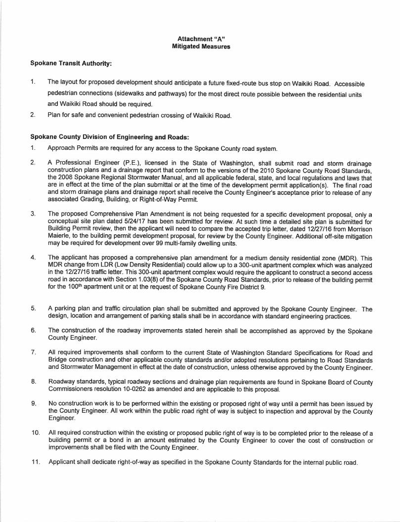
Attachment "A"Mitigated Measures
Spokane Tlansit Authority:
1. The layout for proposed development should anticipate a future tixed-route bus stop on Waikiki Road. Accessiblepedestrian connections (sidewalks and pathways) for the most direct route possible between the residential unitsand Waikiki Road should be reouired.
Plan for safe and convenient pedestrian crossing of Waikiki Road.
Spokane County Division of Engineering and Roads:
1. Approach Permits are required for any access to the Spokane County road system.
2. A Professional Engineer (P.E.), licensed in the State of Washington, shall submit road and storm drainageconstruction plans and a drainage report that conform to the versions ofthe 2010 Spokane County Road Standards,the 2008 Spokane Regional Stormwater Manual, and all applicable federal, state, and local regulations and laws thatare in effect at the time of the plan submittal or at the time of the development permit application(s). The final roadand storm drainage plans and drainage report shall receive the County Engineels acceptance prior to release of anyassociated Grading, Building, or Right-of-Way Permit.
3. The proposed Comprehensive Plan Amendment is not being requested for a specilic development proposal, only aconceptual site plan dated 5n4117 has been submitted for review. At such time a detailed site plan is submitted forBuilding Permit review, then the applicant will need to compare the accepted trip letter, dated 1z27116 from MonisonMaierle, to the building permit development proposal, for review by the County Engineer. Additional off-site mitigationmay be required for development over gg multi-family dwelling units.
4. The applicant has proposed a comprehensive plan amendment for a medium density residential zone (MDR). ThisMDR change from LDR (Low Density Residential) could allow up to a 300-unit apartment complex which was analyzedin tne 12127116iaffic letter. This 300-unit apartment complex would require the applicant to construct a second accessroad in accordance with Section 1.03(8) of the Spokane County Road Standards, prior to release of the building permitfor the 100h apartnent unit or at lhe request of Spokane County Fire District 9.
7.
A parking plan and traffic circulation plan shall be submitted and approved by the Spokane County Engineer. Thedesign, location and anangement of parking stalls shall be in accordance with standard engineering practices.
The construction of the roadway improvements stated herein shall be accomplished as approved by the SpokaneCounty Engineer.
All required improvements shall conform to the current State of Washington Standard Specifications for Road andBridge construction and other applicable county standards and/or adopted resolutions pertaining to Road Standardsand Stormwater Management in effect at the date of construction, unless otherwise approved by the County Engineer.
Roadway standards, typical roadway sections and drainage plan requirements are found in Spokane Board of CountyCommissioners resolution 10-0262 as amended and are applicable to this proposal.
No construction work is to be performed within the existing or proposed right ofway until a permit has been issued bythe County Engineer. All work within the public road right of way is subject to inspection and approval by the CountyEngineer.
All required construction within the existing or proposed public right of way is lo be completed prior to the release of abuilding permit or a bond in an amount estimated by the County Engineer to cover the cost of construction orimprovements shall be filed with the County Engineer.
Applicant shall dedicate righfof-way as specified in the Spokane County Standards for the internal public road.
o.
9.
10.
I t_

't2.
13.
Mitigated Measures continued,
The applicant shall grant applicable border easemenb adjacent to Spokane County RighGoFWay per Spokane CountyStandards.
The County Engineer has designated a Special Roadway Section for the improvement of Five Mile Road which isadiacent to the proposed development. This will require the installation of guardrail along the Aontage of thedevelopment while maintaining the existing roadway and shoulder width. The applicant shall also provide anintersection transition plan which maintains sight distiance at the proposed road intersection with North Five Mile Road.The applicant has prepared a sight distiance analysis for the intersection with North Five Mile Road. Prior to BuildingPermit approvalwhich proposes access to North Five Mile Road, the applicant shall implement the recommendationsof the accepted Sight Oistance Analysis dated July 17, 2006.
The County Engineer will determine if any road improvements are required for Waikiki Road at the time of road anddrainage plan submittalfrora building permit. The existing improvements on Waikiki Road were constructed by CountyRoad Project #1 13 and CRP #26624. The current roadway configuration and suface improvements may adequatelyserve the proposed development without additional construction requirements for Waikiki Road, except the requiredintersection improvements for the proposed east-west public road near the north boundary of the proposeddevelooment.
The County Engineer has designated a Commercial Local Access Roadway Section for the improvement of theproposed east-west public road which is to be constructed within the proposed site. This will require lhe installation of40 feet of asphalt. The mnstruction of curbing and sidewalk is also required.
The applicant may be required to sign a Spokane County Notice to Public Number 4, which allows a privatelymaintained road to be constructed within the public right-of-way dedicated within this development. The road may beprivately maintained until extended to properties outside this property as a public road.
Appropriate provision shall be made for one (1) foot strips at the ends or edges of all streets that terminate or borderthe developrnents boundary be held in trust until the continuation of the streets is dedicated or deeded. NqF:Temporary cuFde-sacs are required when streets terminate at the development boundaries.
The applicant is advised that there may exist utilities either underground or overhead affecting the applicants property,including property to be dedicated or set aside future acquisition. Spokane County will assume no financial obligationfor adiustments or relocation regarding these utilities. The applicant should contact the applicable utilities regardingresponsibility for adjustment or relocation costs and to make anangement for any necessary work.
The proposal is located within a Critical Aquifer Recharge Areas (CARA) of High susceptibility to groundwatercontamination under the Spokane County Critical Areas Ordinance (as amended by BOCC Resolution No. 8-0609)-The Critical Areas Ordinance protects aquifers used for potable water and requires compliance with the SpokaneRegional Stormwater Manual (SRSM).
The applicant is being given notice by Spokane County that site disturbances of greater lhan 1 -acre with a dischargeto'waters of the stiate' regulated by the National Pollutant Discharge Elimination System (NPDES) under WAC 171-220 must apply with the Washington State Oepartment of Ecology.
The applicant shall acknowledge receipt of notice from Spokane County that prior to use, all drywells and otherinfiltration devices regulated under WAC 173-218-070 serving the proposed prolect shall be registered with theWashington Stiate Department of Ecology,
14.
15.
'16.
,t7
'| 8.
19.
)'1

g
>z
INTERNAL CIRCULATIONDRIVE LOCATIONS TO BEDETERMINED AT TIME OFDEVELOPMENT.
FUTUREEMERCENCYACCESS
APPROXIMATE LOCATION OFFUTURE PUBLIC INTERSECTION
*APPROXIMATE LOCATION
PROPOSED PUBLTC(SHOWN HATCHED)
- SITE AREA - 22,92 ACRES- PROPOSED ZONE . MDR- PROPOSED NUMBER OF MULTI.
. FAMILY LIVINC IJNITS . 3OO UNITS
lcoNslsrrtr wtrH THE TRAFFIc rzuPGENERATION AND DISTRIBUTIONANALYSIS).
I ACCESS LOCATIONS INDICATED ON THISCONCEPTUAL SITE PLAN ARE APPROXIMATE.DEVELOPMENT OF THE SITE WILL BE LIMITEDTO LESS THAN IOO MULTI.FAMILY IJNITS I.'NTILA SECOND ACCESS IS PROVIDED.
J.R. B omNrrr ENGTNEERTNcqUL XID SIR',CTUML COIgT.TIT{G
^llD DESGII
l6cPA-04CONCEPflJAL SITE PLAN
PARCETS # 36tt2.91t6, J6t&2.9t46, & 168t.9053
JRBE JOB #r I6-027.10DATE:05n4/17
{
Y
INTS
tllllllllltllllliltlll)iItlr\\
\'
II
II
\l