clayton county, georgia
279
CLAYTON COUNTY, GEORGIA COMPREHENSIVE PLAN 2005 - 2025 Prepared for: The Clayton County Board of Commissioners By: Robert and Company and GRICE and Associates September 2004
-
Upload
khangminh22 -
Category
Documents
-
view
0 -
download
0
Transcript of clayton county, georgia

CLAYTON COUNTY, GEORGIA
COMPREHENSIVE PLAN 2005 - 2025
Prepared for:
The Clayton County Board of Commissioners
By: Robert and Company
and GRICE and Associates
September 2004

Clayton County Comprehensive Plan 2005 – 2025
i
CHAPTER 1 INTRODUCTION, CITIZEN PARTICIPATION & COMMUNITY
VISION .............................................................................................................................. 1
1.1 PURPOSES AND USES OF THE PLAN ............................................................................ 1
1.2 AMENDMENT AND UPDATE OF THE PLAN .................................................................. 2
1.3 REGIONAL LOCATION ................................................................................................ 2
1.4 PLANNING PROCESS AND PUBLIC PARTICIPATION ..................................................... 4
1.4.1 Comprehensive Plan Update Schedule ............................................................. 4
1.4.2 Public Participation Program and Actions ...................................................... 4
1.5 CLAYTON COUNTY VISION FOR THE FUTURE ............................................................ 6
1.5.1 Vision for the Future of Clayton County............................................................ 6
1.6 COMMITMENT TO QUALITY COMMUNITY OBJECTIVES .............................................. 8
1.6.1 Economic Development ..................................................................................... 8
1.6.2 Natural and Cultural Resources ........................................................................ 9
1.6.3 Community Facilities ......................................................................................... 9
1.6.4 Housing .............................................................................................................. 9
1.6.5 Land Use ............................................................................................................ 9
CHAPTER 2 POPULATION ....................................................................................... 11
INTRODUCTION .............................................................................................................. 11
2.1 COUNTY POPULATION GROWTH .............................................................................. 11
2.2 HOUSEHOLDS .......................................................................................................... 14
2.3 AGE DISTRIBUTION ................................................................................................. 15
2.4 RACIAL COMPOSITION ............................................................................................. 17
2.5 EDUCATIONAL ATTAINMENT ................................................................................... 20
2.6 INCOME .................................................................................................................... 21
2.7 ASSESSMENT OF CURRENT AND FUTURE CONDITIONS ............................................ 23
CHAPTER 3 HOUSING ............................................................................................... 25
3.1 TYPES OF HOUSING UNITS ....................................................................................... 25
3.2 AGE AND CONDITION OF HOUSING .......................................................................... 25
3.3 OWNER AND RENTER UNITS .................................................................................... 27
3.4 COST OF HOUSING ................................................................................................... 28
3.4.1 Cost Burdened Households .............................................................................. 29
3.5 HOUSING AND COMMUNITY CHARACTERISTICS ...................................................... 30
3.5.1 Characteristics of Population Affecting Housing ............................................ 30
3.5.2 Special Needs Housing .................................................................................... 31
3.6 ASSESSMENT OF CURRENT AND FUTURE HOUSING NEEDS ...................................... 32
3.7 HOUSING GOALS AND POLICIES .............................................................................. 35
CHAPTER 4 ECONOMIC DEVELOPMENT ........................................................... 39
INTRODUCTION .............................................................................................................. 39
4.1 EMPLOYMENT BY SECTOR ........................................................................................ 39
4.2 EARNING BY SECTOR ............................................................................................... 41
4.3 WEEKLY WAGES ..................................................................................................... 43
4.4 INCOME BY TYPE ..................................................................................................... 45
4.5 COMMUTE PATTERNS .............................................................................................. 45

Clayton County Comprehensive Plan 2005 – 2025
ii
4.6 COMMUNITY LEVEL ECONOMIC ACTIVITIES ........................................................... 48
Major Clayton County Employers ............................................................................ 48
Unique Economic Activities ...................................................................................... 48
Tradeport ............................................................................................................... 48
Hartsfield-Jackson Atlanta International Airport.................................................. 49
Atlanta State Farmer's Market .............................................................................. 49
Gateway Village Project ....................................................................................... 49
Mountain View Redevelopment ........................................................................... 49
Southside Hartsfield Redevelopment and Stabilization Plan ................................ 50
RiverWalk ............................................................................................................. 50
Commuter Rail ...................................................................................................... 50
4.7 EMPLOYMENT BY OCCUPATION .............................................................................. 50
4.8 EMPLOYMENT STATUS ............................................................................................ 52
4.9 UNEMPLOYMENT RATES ......................................................................................... 54
4.10 LOCAL ECONOMIC DEVELOPMENT RESOURCES .................................................... 55
4.10.1 Economic Development Agencies .................................................................. 55
Clayton County Chamber of Commerce ............................................................... 55
Development and Redevelopment Authority of Clayton County ......................... 55
The Small Business Development Center (SBDC) .............................................. 55
Joint Development Authority of Metro Atlanta .................................................... 56
MetroSouth ........................................................................................................... 56
4.10.2 Economic Development Programs ................................................................ 56
4.10.3 Education and Training Opportunities .......................................................... 56
4.11 ASSESSMENT OF ECONOMIC DEVELOPMENT NEEDS .............................................. 57
4.11.1 Summary ........................................................................................................ 58
4.12 ECONOMIC DEVELOPMENT VISION STATEMENT.................................................... 59
4.13 ECONOMIC DEVELOPMENT GOALS AND POLICIES ................................................. 60
CHAPTER 5 COMMUNITY FACILITIES .............................................................. 64
INTRODUCTION .............................................................................................................. 64
5.1 WATER SUPPLY AND TREATMENT ........................................................................... 64
5.1.1. Storm water Management ............................................................................... 65
5.2 SEWAGE SYSTEM AND WASTEWATER TREATMENT ................................................. 65
5.3 SOLID WASTE MANAGEMENT ................................................................................. 67
5.3 SOLID WASTE MANAGEMENT ................................................................................. 68
5.4 GENERAL GOVERNMENT BUILDINGS ....................................................................... 68
5.5 PUBLIC SAFETY ....................................................................................................... 75
5.5.1 Correctional Institution ................................................................................... 75
5.5.2 Police Department ........................................................................................... 75
5.5.3 Sheriff’s Department ........................................................................................ 79
5.5.4 Fire Department............................................................................................... 79
5.6 RECREATION FACILITIES ......................................................................................... 81
5.6 RECREATION FACILITIES ......................................................................................... 82
5.7 HOSPITALS .............................................................................................................. 85
5.8 EDUCATIONAL FACILITIES ....................................................................................... 85
5.8.1 Public Schools .................................................................................................. 85
5.8.2 Private Schools ................................................................................................ 87

Clayton County Comprehensive Plan 2005 – 2025
iii
5.8.3 Clayton College and State University .............................................................. 88
5.9 LIBRARIES AND OTHER CULTURAL FACILITIES ........................................................ 90
5.9.1 Clayton County Library System ....................................................................... 90
5.9.2 Spivey Hall ....................................................................................................... 92
5.9.2 Spivey Hall ....................................................................................................... 93
5.9.3 Other Community Facilities and Services ....................................................... 93
5.10 COMMUNITY FACILITIES GOALS AND POLICIES ..................................................... 94
5.10.1 Community Facilities Vision .......................................................................... 94
5.10.2 Water .............................................................................................................. 94
5.10.3 Sanitary Sewer ............................................................................................... 95
5.10.4 Solid Waste Management ............................................................................... 95
5.10.5 General Government Facilities...................................................................... 96
5.10.6 Fire Protection/Emergency Medical Services ............................................... 96
5.10.7 Police and Sheriff Departments ..................................................................... 97
5.10.8 Parks and Recreation ..................................................................................... 97
5.10.9 Hospitals and Health Care ............................................................................ 98
5.10.10 Education ..................................................................................................... 98
5.10.11 Libraries and Cultural Facilities ................................................................. 99
CHAPTER 6 NATURAL AND CULTURAL RESOURCES .................................. 101
6.1 PUBLIC WATER SUPPLY SOURCES AND WATER SUPPLY WATERSHEDS ................ 101
6.2 WATER SUPPLY WATERSHEDS .............................................................................. 101
6.3 GROUNDWATER RECHARGE AREAS ...................................................................... 101
6.4 WETLANDS ............................................................................................................ 102
6.5 PROTECTED MOUNTAINS ....................................................................................... 104
6.6 PROTECTED RIVERS ............................................................................................... 104
6.7 COASTAL RESOURCES ........................................................................................... 104
6.8 FLOOD PLAINS ....................................................................................................... 104
6.9 SOIL TYPES ........................................................................................................... 106
6.10 STEEP SLOPES ..................................................................................................... 107
6.11 PRIME AGRICULTURAL AND FOREST LAND ......................................................... 109
6.12 PLANT AND ANIMAL HABITATS .......................................................................... 111
6.13 MAJOR PARK, RECREATION, AND CONSERVATION AREAS .................................. 114
6.14 SCENIC VIEWS AND SITES ................................................................................... 116
6.15 CULTURAL AND HISTORIC RESOURCES ............................................................... 116
6.15.1 Jonesboro Historic District.......................................................................... 116
6.15.2 Stately Oaks Plantation................................................................................ 117
6.15.3 Rex Mill ........................................................................................................ 117
6.15.4 Crawford - Dorsey House and Cemetery..................................................... 117
6.16 NATURAL AND CULTURAL RESOURCES VISION ................................................... 119
6.17 GOALS AND POLICIES .......................................................................................... 119
CHAPTER 7 LAND USE ............................................................................................ 122
INTRODUCTION ............................................................................................................ 122
7.1 PRIOR LAND USE PLANNING IN CLAYTON COUNTY .............................................. 122
7.1.1 Summary of Land Use Map Changes Since 1992 ......................................... 122
Rex and Ellenwood Area of Northeast Clayton County ..................................... 122

Clayton County Comprehensive Plan 2005 – 2025
iv
Highway 138 Corridor ........................................................................................ 123
Panhandle Area ................................................................................................... 123
7.1.2 Land Use Classification Name Changes....................................................... 123
7.1.3 Residential Density Changes ........................................................................ 124
7.1.4 Other Changes .............................................................................................. 124
7.2 LAND USE CLASSIFICATIONS ................................................................................ 125
7.3 EXISTING LAND USE ............................................................................................. 126
7.3.1 Description of Existing Land Use in Clayton County ................................... 127
7.3.1 Description of Existing Land Use in Clayton County ................................... 128
Agriculture .......................................................................................................... 128
Residential........................................................................................................... 128
Public-Institutional .............................................................................................. 128
Office/Professional ............................................................................................. 128
Commercial ......................................................................................................... 129
Industrial ............................................................................................................. 129
Transportation/Communications/Utilities........................................................... 129
Parks/Recreation/Conservation Uses .................................................................. 129
Vacant/Undeveloped Land.................................................................................. 129
7.4 SUMMARY OF LAND USE CHANGE 1992 - 2004..................................................... 130
7.5 IDENTIFIED LAND USE ISSUES / PROBLEMS ........................................................... 131
7.5.1 Historical Factors Leading to Development Patterns .................................. 131
7.5.2 Land Use Patterns and Densities in Relation to Infrastructure ................... 131
7.5.3 Blighted or Transitional Areas ...................................................................... 132
7.5.4 Incompatible Land Uses and Abrupt Zoning Changes .................................. 133
7.5.5 Lack of Open Space ....................................................................................... 133
7.6 OPPORTUNITIES FOR INFILL DEVELOPMENT .......................................................... 133
7.7 REDEVELOPMENT PLANS ....................................................................................... 134
7.7.1 Southside Hartsfield Redevelopment and Stabilization Plan ........................ 134
7.7.2 RiverWalk ....................................................................................................... 134
7.7.3 Mountain View ............................................................................................... 135
7.7.4 Gateway Village ............................................................................................. 135
7.8 CONSIDERATION OF TRADITIONAL NEIGHBORHOOD DEVELOPMENT .................... 135
7.9 PROTECTION OF ENVIRONMENTALLY SENSITIVE AREAS ....................................... 136
7.10 FUTURE LAND USE PLANNING CONSIDERATIONS ............................................... 136
7.11 FUTURE LAND USE NARRATIVE .......................................................................... 137
7.12 SUMMARY OF FUTURE LAND USE CLASSIFICATIONS .......................................... 142
7.12.1 Land Use Classification Changes ............................................................... 148
7.13 INFRASTRUCTURE IMPROVEMENTS SUPPORTING FUTURE LAND USE .................. 148
7.14 LAND USE REGULATIONS CHANGES NEEDED ..................................................... 149
7.14.1 Revised Conservation Subdivision Ordinance ............................................. 149
7.14.2 Mixed-Use Zoning ........................................................................................ 150
7.14.3 Revised Planned Unit Development (PUD) Ordinance ............................... 151
7.15 LAND USE VISION ............................................................................................... 152
7.16 LAND USE GOALS AND POLICIES......................................................................... 152
CHAPTER 8 TRANSPORTATION .......................................................................... 162
INTRODUCTION ............................................................................................................ 162

Clayton County Comprehensive Plan 2005 – 2025
v
8.1 EXISTING CONDITIONS .......................................................................................... 162
8.1.1 Transportation Network ................................................................................. 163
Roads and Highways........................................................................................... 163
Bridge Inventory ................................................................................................. 168
Bike and Pedestrian Trails Inventory .................................................................. 169
Bike and Pedestrian Trails Inventory .................................................................. 170
Sidewalks Inventory............................................................................................ 170
Public Transportation Inventory ......................................................................... 171
The Macon-Atlanta Commuter Rail Service .................................................. 173
Southern Crescent and Mountain View .......................................................... 174
Southern Crescent and Mountain View .......................................................... 175
Airports Inventory ............................................................................................... 175
Hartsfield-Jackson International Airport ........................................................ 175
Tara Field ........................................................................................................ 177
Railroads Inventory ............................................................................................. 177
8.1.2 Accident Frequency ....................................................................................... 178
8.1.3 Road Lanes, Volumes, and Capacities ........................................................... 178
8.1.3 Road Lanes, Volumes, and Capacities ........................................................... 179
8.2 ASSESSMENT OF CURRENT AND FUTURE NEEDS .................................................... 180
8.2.1 Growth Trends and Travel Patterns .............................................................. 180
Vehicles per Household ...................................................................................... 180
Vehicle Miles Traveled ....................................................................................... 181
Work Travel Destinations ................................................................................... 182
Means of Transportation to Work ....................................................................... 183
Travel Time to Work .......................................................................................... 184
Types of Housing and Types of Jobs .................................................................. 185
8.2.2 Existing Levels of Service and Land Use ....................................................... 186
8.2.3 Future Levels of Service and Land Use ......................................................... 189
Traffic Performance Measures ............................................................................ 190
Land Use and Transportation Interaction ........................................................... 192
Livable Centers Initiatives .................................................................................. 192
HOV Lanes ......................................................................................................... 193
Ride-Share Programs .......................................................................................... 193
Commuter Rail .................................................................................................... 193
Proposed Land Use Actions ................................................................................ 193
8.3 PROPOSED TRANSPORTATION ALTERNATIVES AND IMPROVEMENTS ..................... 195
8.3.1 Livable Centers Initiatives ............................................................................. 195
8.3.2 Transportation Improvement Plan (TIP) and Regional Transportation Plan
(RTP) Projects ........................................................................................................ 197
Roadway Capacity and Intersection Upgrade Projects ....................................... 197
Roadway Operation Projects ............................................................................... 197
Pedestrian Facility Expansion and Improvements .............................................. 198
Bridge Capacity Expansion and Upgrades ......................................................... 198
8.3.3 SPLOST Projects ........................................................................................... 198
Road Construction Projects................................................................................. 198
Road Widening and Improvement Projects ........................................................ 199

Clayton County Comprehensive Plan 2005 – 2025
vi
Intersection Improvements.................................................................................. 199
Upgrade Dirt Roads ............................................................................................ 200
8.3.4 Newly recommended road improvement projects .......................................... 200
8.3.5 Bike and Pedestrian Considerations .............................................................. 202
8.3.6 Proposed alternative modes of travel ............................................................ 202
8.3.7 Emergency Preparedness............................................................................... 202
8.3.8 Transportation Operations in Underserved Areas ........................................ 202
8.4 TRANSPORTATION REQUIREMENTS FOR NON-ATTAINMENT AREAS ...................... 203
8.5 ARTICULATION OF COMMUNITY VISION AND GOALS AND IMPLEMENTATION
PROGRAM .................................................................................................................... 205
8.5.1 Transportation Vision .................................................................................... 205
8.5.2 Goals and Policies ......................................................................................... 205
CHAPTER 9 INTERGOVERNMENTAL COORDINATION ............................... 214
9.1 ADJACENT LOCAL GOVERNMENTS ........................................................................ 214
9.2 SCHOOL BOARD .................................................................................................... 214
9.3 OTHER LOCAL GOVERNMENTAL ENTITIES ............................................................ 215
9.3.1 Clayton County Water Authority ................................................................... 215
9.3.2 Hartsfield Jackson International Airport....................................................... 215
9.3.3 Development Authority of Clayton County .................................................... 215
9.3.4 Joint Development Authority of Metro Atlanta .............................................. 215
9.3.5 MetroSouth ..................................................................................................... 216
9.4 REGIONAL AND STATE ENTITIES ........................................................................... 216
9.4.1 Atlanta Regional Commission........................................................................ 216
9.4.2 Metropolitan North Georgia Water Planning District .................................. 216
9.4.3 Georgia Department of Transportation ......................................................... 217
9.4.4 Georgia Department of Natural Resources ................................................... 217
9.4.5 Georgia Department of Community Affairs ................................................... 217
9.4.6 Georgia Greenspace Program ....................................................................... 217
9.5 PRIVATE ENTITIES ................................................................................................. 218
9.5.1 Clayton County Chamber of Commerce ........................................................ 218
9.5.2 Georgia Power Company .............................................................................. 218
9.6 SERVICE DELIVERY STRATEGY ............................................................................. 219
9.6.1 Police Services ............................................................................................... 219
9.6.2 Jails ................................................................................................................ 219
9.6.3 Fire Protection ............................................................................................... 219
9.6.4 EMS & 911 ..................................................................................................... 220
9.6.5 Landfill ........................................................................................................... 220
9.6.6 Roadway Construction and Maintenance ...................................................... 220
9.6.7 Animal Control............................................................................................... 220
9.6.8 Parks and Recreation ..................................................................................... 220
9.6.9 Building Services ........................................................................................... 220
9.6.10 Economic Development ............................................................................... 220
9.7 SUMMARY OF DISPUTE RESOLUTION PROCESS ...................................................... 221
9.8 SERVICE PROVISION CONFLICTS OR OVERLAPS ..................................................... 222
9.9 LAND USE ............................................................................................................. 222
9.9.1 Compatibility of Land Use Plans ................................................................... 222

Clayton County Comprehensive Plan 2005 – 2025
vii
9.9.2 Land Use and Siting Facilities of Countywide Significance .......................... 223
9.9.3 Developments of Regional Impact ................................................................. 223
9.9.4 Annexation ..................................................................................................... 223
9.10 INTERGOVERNMENTAL COORDINATION GOALS AND POLICIES ............................ 225
CHAPTER 10 IMPLEMENTATION ........................................................................ 226
10.1 1999 – 2004 SHORT TERM WORK PROGRAM STATUS REPORT ............................ 227
10.2 SHORT TERM WORK PROGRAM 2005 TO 2009 .................................................... 251
Figures
Figure 4.1 Commute Flows for Clayton County Residents......................................... 47
Figure 4.2 County of Work Place for Clayton County Residents .............................. 47
Figure 4.3 County of Residence for Clayton County Workers ................................... 48
Maps
Map 1.1 Clayton County Location .................................................................................. 3
Map 2.1 Population Change by Census Tract 1990 - 2000 ......................................... 12
Map 2.2 2000 Black Population ................................................................................. 18
Map 2.3 2000 Hispanic Population ................................................................................ 19
Map 2.4 2000 Asian Population .................................................................................... 19
Map 5.1 Clayton County Water and Wastewater Systems ......................................... 67
Map 5.2 Clayton County Police Precincts .................................................................... 77
Map 5.3 Clayton County Fire Stations ......................................................................... 81
Map 5.4 Clayton County Parks and Recreation Facilities .......................................... 84
Map 5.5 Clayton County Public Schools ...................................................................... 89
Map 5.6 Library Locations in Clayton County ............................................................ 92
Map 6.1 Clayton County Hydrology ........................................................................... 103
Map 6.2 Clayton County Floodplains and Water Features ...................................... 105
Map 6.3 Clayton County Soils ..................................................................................... 107
Map 6.4 Clayton County Slope .................................................................................... 108
Map 6.5 Clayton County Prime Agricultural Soils.................................................... 110
Map 6.6 Clayton County Parks and Recreation Facilities ........................................ 115
Map 6.7 Historic and Cultural Resources .................................................................. 118
Map 7.1 Clayton County Existing Land Use .............................................................. 127
Map 7.2 Future Land Use Map ................................................................................... 147
Table 7.6 Summary of Land Use Classification Changes ......................................... 148
Map 8.1 Roadway Classifications in Clayton County ............................................... 167
Map 8.2 Clayton County Bridge Inventory ................................................................ 169
Map 8.3 Sidewalk Inventory ........................................................................................ 170
Map 8.4 Public Transportation in Clayton County ................................................... 172
Map 8.5 Proposed Commuter Rail Station Locations ............................................... 174
Map 8.6 Clayton County Airports ............................................................................... 175

Clayton County Comprehensive Plan 2005 – 2025
viii
Map 8.7 Clayton County Signalized Intersection Accidents ..................................... 178
Map 8.8 Clayton County Existing Traffic Volumes .................................................. 179
Map 8.9 Existing Roadway Level of Service .............................................................. 188
Map 8.10 Future Level of Service ................................................................................ 191
Map 8.11 Future Level of Service Considering Proposed Land Use Actions.......... 194
Map 8.12 Non-attainment Area ................................................................................... 204
List of Tables
Table 1.1 Planning Schedule ............................................................................................ 4
Table 2.1 Population Change Comparisons ................................................................. 13
Table 2.2 2003 Population Estimates ............................................................................ 13
Table 2.3 Clayton County Projected Poulation ............................................................ 13
Table 2.4 Clayton County Households .......................................................................... 14
Table 2.5 Projected Households..................................................................................... 14
Table 2.6 Age Distribution ......................................................................................... 15
Table 2.7 Age Distribution 1980 – 2000 ..................................................................... 16
Table 2.8 Projected Age Distribution ........................................................................ 17
Table 2.9 Racial Composition of Clayton County........................................................ 18
Table 2.10 Educational Attainment............................................................................... 20
Table 2.11 Education Statistics ...................................................................................... 20
Table 2.12 2000 Educational Attainment Comparison ............................................... 21
Table 2.13 Median Household Income Comparison .................................................... 22
Table 2.14 Per Capita Income Comparison ................................................................. 22
Table 2.15 Household Income Distribution .................................................................. 23
Table 2.16 Surrounding Counties’ Income Distribution ............................................. 23
Table 3.1 Types of Housing in Clayton County ........................................................... 25
Table 3.2 Age of Housing in Clayton County .............................................................. 26
Table 3.3 Age of Housing in Georgia ............................................................................ 26
Table 3.4 Age of Housing in the ARC Region ............................................................. 26
Table 3.5 Comparison of Housing Conditions ............................................................ 27
Table 3.6 Clayton County Occupancy Characteristics ............................................... 27
Table 3.7 ARC Region Occupancy Characteristics .................................................... 28
Table 3.8 Georgia Occupancy Characteristics ............................................................ 28
Table 3.9 Clayton County Housing Costs .................................................................... 29
Table 3.10 ARC Region Housing Costs ....................................................................... 29
Table 3.11 Georgia Housing Costs ............................................................................... 29
Table 3.12 Monthly Owner Costs .................................................................................. 29
Table 3.13 Clayton County Monthly Renter Costs ...................................................... 30
Table 3.14 Clayton County Over Crowded Housing Units ......................................... 30
Table 3.15 Clayton County Housing Unit Projections ................................................ 33
Table 4.1 Employment by Sector ................................................................................... 40
Table 4.2 Employment by Sector Comparison ............................................................ 41

Clayton County Comprehensive Plan 2005 – 2025
ix
Table 4.3 Earnings by Sector ......................................................................................... 42
Table 4.4 Earnings by Sector Comparison ................................................................... 43
Table 4.5 Average Weekly Wages ................................................................................. 44
Table 4.6 Georgia Average Weekly Wages................................................................... 44
Table 4.7 Personal Income by Type .............................................................................. 46
Table 4.8 Labor Force by Place of Work ...................................................................... 46
Table 4.9 County Employment by Occupation ............................................................ 51
Table 4.10 US and Georgia Employment by Occupation ........................................... 52
Table 4.11 County Labor Force Participation ............................................................. 53
Table 4.12 US and Georgia Labor Force Participation............................................... 54
Table 4.13 Comparison of Unemployment Rates......................................................... 55
Table 5.1 Reduction in Demand through Conservation Measures ............................ 65
Table 5.2 Clayton County Water Reclamation Facilities ............................................ 66
Table 5.3 Clayton County Government Buildings ....................................................... 69
Table 5.4 Estimated Police Office Needs 2005 - 2025 .................................................. 78
Table 5.5 Clayton County Park Acreage Assessment.................................................. 83
Table 5.6 CCPS 2004 Capacity ...................................................................................... 86
Table 5.7 CCPS Anticipated 2008 Capacity ................................................................. 86
Table 5.8 Future Needs for Clayton County Public Libraries.................................... 91
Table 6.1 Soil Suitability............................................................................................... 106
Table 6.2 Clayton County Prime Farmland ............................................................... 109
Table 6.3 Threatened and Endangered Plants and Animals in Clayton County .... 111
Table 6.4 Threatened and Endangered Plants and Animals in Surrounding Counties
................................................................................................................................. 112
Table 7.1 Land Use Classification Name Changes ..................................................... 124
Table 7.2 Existing Land Use Distribution .................................................................. 126
Table 7.3 Land Use Distribution Change 1992 – 2003 .............................................. 130
Table 7.4 Residential Zoning Density Maximums in Clayton County ..................... 132
Table 7.5 Summary of Existing and Future Land Use Change ................................ 146
Table 7.6 Summary of Land Use Classification Changes ......................................... 148
Table 8.1 Clayton County Road Types ....................................................................... 163
Table 8.2 Roadway Function Classifications .............................................................. 165
Table 8.3 Number of Vehicles per Household in Clayton County (1990) ................ 180
Table 8.4 Number of Vehicles per Household in Clayton County (2000) ................ 181
Table 8.5 Vehicle Miles Traveled in Clayton County ................................................ 182
Table 8.6 Means of Transportation to Work in Clayton County, 2000 ................... 184
Table 8.7 Travel Time to Work in Clayton County, 2000 ......................................... 185
Table 8.8 Time Leaving Home to go to Work in Clayton County, 2000 .................. 185
Table 8.9 Percent Difference Targets for Daily Traffic Volumes by Facility Type 186
Table 10.1 Short Term Work Program ...................................................................... 252

Clayton County Comprehensive Plan 2005 – 2025
1
CHAPTER 1 INTRODUCTION, CITIZEN PARTICIPATION & COMMUNITY
VISION
This document is the comprehensive plan for Clayton County. This plan was prepared to
meet the Georgia Departments of Community Affairs Minimum Standards and
Procedures for Local Comprehensive Planning.
1.1 Purposes and Uses of the Plan
The Comprehensive Plan for Clayton County is a cornerstone for almost every type of
decision that must be made in local government. As the name “comprehensive” suggests,
its range is broad and inclusive, and also long-term.
The Comprehensive Plan covers the entirety of unincorporated Clayton County for the
time period of 2005 - 2025. Each of the county’s cities is responsible for completing its
own plan and a concerted effort has been made to coordinate the plans of the county and
cities. The document addresses and coordinates, at a high level, nearly all the essential
functions of the county. These functions are classified under the eight key elements or
chapters of the plan; population, housing, economic development, community facilities
and services, natural and cultural resources, transportation, land use and
intergovernmental coordination.
The Future Land Use Map included in the Comprehensive Plan is a physical plan with
the purpose of guiding the development and redevelopment of the county by describing
what should be built where over the next two decades. The purpose of the Future Land
Use Map is to serve as the basis of evaluation for all future rezoning, subdivision, and
other development and redevelopment applications or proposals.
The Comprehensive Plan provides a framework of goals and policies based on the
county’s current, projected and desired conditions. This framework is meant to serve as a
guide to elected officials, county departments and related authorities and organizations
who are tasked with implementing the plan.
Lastly, the Short Term Work Program included in the plan provides a list of work items
the county will complete to implement the plan and bring forth the vision for the county’s
future. The Short Term Work Program will be used to guide the development of the
county’s capital improvement program and the individual budgets of various county
departments and service providers. The Short Term Work Program is also used to help
the county secure state and Federal funds for programs and improvements.
By adopting the Clayton County Comprehensive Plan 2005 – 2025 the County
Commission publicly express their consent and support of the Plan’s vision, goals and
policies and their dedication to promoting the implementation measures included in the
plan.
Clayton County Comprehensive Plan 2005 – 2025
2
1.2 Amendment and Update of the Plan
The current Clayton County Comprehensive Plan was completed in 1992 with an outlook
to 2012. This plan has been partially updated and amended as recently as 1996. The
state legislation that governs local planning, established in 1989, set a benchmark that
plans should be fully updated every ten years. This update of the Clayton County
Comprehensive Plan serves the planning period of 2005 – 2025.
Many county departments, agencies, business people and the development community
rely on the comprehensive plan to be an expression of the county’s current policy. To
remain effective the plan must continue to accurately reflect the desires of the county as
expressed through its elected County Commission. Due to this it may be necessary to
amend the plan from time to time when a particular goal or policy on which the plan is
based has significantly changed so at to materially detract from the usefulness of the plan
to serves a guide for local decisions making. Under the State of Georgia’s current
planning guidelines there are provisions for both major and minor plan amendments.
Major plan amendments are those that alter the basic tenets of the overall plan or a
significant portion of the plan an/or potentially affect another local government.
Examples of changes that typically qualify as major amendments include, change of
population greater or equal to 10% and changes to the Future Land Use Map, which show
a higher intensity of land use in an area adjacent to another local government’s
jurisdiction. Minor plan amendments are those that are purely local in nature. The
process for making plan amendments follows a process similar to that of the plan update
including public participation and regional and state review.
The Short Term Work Program included in the Comprehensive Plan may be updated on
an annual or five-year basis at the county’s discretion. A minimum of one public hearing
must be held by the county to inform the public of its intent to update the program and to
receive suggestions and comments on the proposed update.
1.3 Regional Location
Clayton County is located in the southern portion of the Atlanta Regional Commission’s
10 county district. Clayton County is directly adjacent the City of Atlanta on the north
and bordered by Fulton and DeKalb counties to the north, Fayette to the west, Spalding to
the south, and Henry to the east (Map 1.1). Its land size of 145 square miles makes it one
of the smallest counties in the State of Georgia. Yet with more than 253,000 residents, it
is one of the most densely populated and urbanized counties in the state. Clayton County
was formed in 1858 from parts of Fayette and Henry Counties , which where created by
the Indian Springs Treaty of 1821. The 125th county created in Georgia, Clayton County
was named in honor of Augustine Smith Clayton (1783-1839), a judge and member of
the U.S. House of Representatives.

Clayton County Comprehensive Plan 2005 – 2025
3
Map 1.1 Clayton County Location
Fulton
Cobb
Henry
Gwinnett
Cherokee
DeKalb
Fayette
Douglas
Clayton
Rockdale
Clayton County, GeorgiaRegional Location
0 6 12 18 243Miles
µLegend
Clayton County
ARC Counties
Interstate Highways
Clayton County Comprehensive Plan 2005 - 2025
Robert and Company
Engineers, Architects, and Planners96 Poplar Street N.W.
Atlanta, GA 30303RAC 02076

Clayton County Comprehensive Plan 2005 – 2025
4
1.4 Planning Process and Public Participation
1.4.1 Comprehensive Plan Update Schedule
The Clayton County Comprehensive Plan Update was completed according to a schedule
put forth by the county in order to meet the October 31 2004 deadline of the Georgia
Department of Community Affairs. Table 1.1 shows the time frame and activities
undertaken during the planning process.
Table 1.1 Planning Schedule
Activity Time Frame
Project Started May 2003
Intergovernmental Coordination Meeting July 2003
Inventory and Assessment of County September – December 2003
Steering Committee Meetings January – June 2004 (monthly)
Interdepartmental Coordination Meetings September 2003 – April 2004
Public Visioning Sessions February – March 2004
Distribution of Draft Plan April – June 2004
Work Session with County Commissioners May 2004
Public Town Hall Meetings June 2004
Regional and State Review July – September 2004
Adoption October 2004
1.4.2 Public Participation Program and Actions
The public participation process for the Clayton County Comprehensive Plan 2005 –
2025 was based on the requirements of the Georgia Department of Community Affairs
(DCA), guidance from the Atlanta Regional Commission (ARC) and input from county
leaders and staff. Drawing from these sources the following goals were established for
the public participation program of the Comprehensive Plan Update.
Goal 1: Raise the level of awareness and understanding of planning in Clayton County.
Goal 2: Provide the citizens of Clayton County with meaningful opportunities for
involvement in the planning process.
Goal 3: Involve and maintain close contact with identified key stakeholders throughout
the planning process.
Goals 4: Identify and involve traditionally underserved communities (minority, low-
income, elderly, etc.) in the planning process.

Clayton County Comprehensive Plan 2005 – 2025
5
To achieve these goals the planning team undertook a number of activities. One of the
first was the identification of key stakeholders and the formation of a Steering Committee
which in conjunction with the County Commission oversaw and directed the planning
process.
The Steering Committee included representatives from Chamber of Commerce, Clayton
County Public Schools, Clayton College and State University, Clayton County
Convention and Visitors Bureau, Jonesboro Housing Authority, Southern Regional
Medical Center, Clayton County NAACP, the residential development community,
Clayton County Greenspace Board, Spivey Hall, various homeowner’s associations,
Clayton County Water Authority, Clayton County Code Enforcement Board, Clayton
County Development Authority, and Clayton County Habitat for Humanity. The
committee also included citizens appointed by the County Commissioners. This group
met on a monthly basis during the planning process and was instrumental in the
formation of goals and polices included in the Comprehensive Plan.
Five public “visioning” meetings were held, one in each county commission district plus
one central “at-large” meeting. At these meetings participants were asked to provide
input on what future development patterns should be, where housing should be developed
and at what density level, what areas of the county should be conserved –as park land, as
rural, or “no-development” areas such as flood plains, steep slopes, etc , and where
additional industry, office, and commercial should be developed. Additionally, a
community preference survey was administered to meeting attendees to help discern what
type of development patterns and levels of intensity are preferred by the public, i.e.
development nodes or corridors, mixed-use vs. single use, density of units per acre, etc.
More than one hundred people attended a the visioning meetings and eighty-two
responded to the community preference survey. The input received from the public and
the results of the preference survey were used to develop the county’s “Vision for the
Future.”
Throughout the development of the Comprehensive Plan Update information about the
planning process and the draft elements of the plan were made available to the public
“on-line” via a link from the county’s homepage. The web page posting also encouraged
the public to submit their comments to the county and consultant planners involved in the
process. In addition to on-line posting of draft documents, paper copies of the draft plan
elements were available to the public in the county’s planning office and the headquarters
public library in Jonesboro.
When the draft plan update was completed a second series of five public meetings was
conducted. A meeting was held in each county commission district and a fifth “at large”
meeting was held in Jonesboro. These “town hall” meetings took place in early June and
gave the public the opportunity to review the draft plan and discuss it with the county and
consultant planners. The meetings included a formal presentation of the draft plan by the
consultant planners along with a presentation of the results from the Community
Preference Survey conducted during the earlier visioning meetings. Over two hundred
county residents attended the “town hall” meetings.

Clayton County Comprehensive Plan 2005 – 2025
6
1.5 Clayton County Vision for the Future
The DCA Minimum Standards and Procedures for Local Comprehensive Planning
include a requirement for a “Community Vision” to be developed as part of the plan
update. This vision is based on public input and an assessment of the current and future
needs of the county as identified in the other elements of the plan. The vision also
coordinates the future of Clayton County with regional and state planning goals as
expressed through the Quality Community Objectives put forth by DCA.
1.5.1 Vision for the Future of Clayton County
Clayton County will continue to grow and become a thriving center for business and
living on Atlanta’s south side.
The county’s blighted commercial
corridors and residential developments
will be redeveloped, some into mixed-
use nodes providing citizens with well
designed, pedestrian friendly
environments including a diverse mix of
high quality residential development
where they can live, work, and recreate.
Older single-family residential
neighborhoods will be stabilized and the
development of new, high quality and
“executive” style single-family housing
is actively encouraged.
The county will maintain the rural nature
of the Panhandle through the use of a
conservation subdivision ordinances that
conserve open space and natural features
and adhere to national and regional best
practices.
New office and industrial parks will be
developed in appropriate places
increasing the county’s tax base and
providing local employment
opportunities.
Office Development
Office Development
Maintenance of Rural Environment in
Panhandle
Mixed-Use Activity Centers
Mixed-Use Activity Centers
Clayton County Comprehensive Plan 2005 – 2025
7
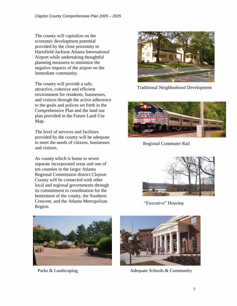
The county will capitalize on the
economic development potential
provided by the close proximity to
Hartsfield-Jackson Atlanta International
Airport while undertaking thoughtful
planning measures to minimize the
negative impacts of the airport on the
immediate community.
The county will provide a safe,
attractive, cohesive and efficient
environment for residents, businesses,
and visitors through the active adherence
to the goals and polices set forth in the
Comprehensive Plan and the land use
plan provided in the Future Land Use
Map.
The level of services and facilities
provided by the county will be adequate
to meet the needs of citizens, businesses
and visitors.
As county which is home to seven
separate incorporated areas and one of
ten counties in the larger Atlanta
Regional Commission district Clayton
County will be connected with other
local and regional governments through
its commitment to coordination for the
betterment of the county, the Southern
Crescent, and the Atlanta Metropolitan
Region.
Traditional Neighborhood Development
Traditional Neighborhood Development
Regional Commuter Rail
Regional Commuter Rail
“Executive” Housing
“Executive” Housing
Parks & Landscaping
Parks & Landscaping
Adequate Schools & Community
Facilities
Adequate Schools & Community
Facilities

Clayton County Comprehensive Plan 2005 – 2025
8
1.6 Commitment to Quality Community Objectives
1.6.1 Economic Development
Regional Identity Objective: Clayton County identifies itself with the Southern Crescent of
counties on the south side of Atlanta. Beyond the Southside, Clayton County is an active part of
the larger Atlanta Regional Commission.
Growth Preparedness Objective: Clayton County has a long history of providing the prerequisites
to development such as its world-class water and sewer systems and its county transportation
systems. The county’s commitment to quality infrastructure will continue and shall be expanded
to include a stronger focus on ensuring that infrastructure preparedness for growth includes
facilities and services such as schools, parks, and public safety.
Appropriate Business Objective: Due to proximity the economy of Clayton County is heavily
linked to Hartsfield-Jackson Atlanta International Airport. The airport has had and is expected to
continue to have a significant positive impact on the county’s business climate and the county
will continue to work with and encourage airport related development. However, the county’s
economy cannot become dependent upon the airport, therefore the additional office/professional
businesses will be sought after to located in the county in order to provide positions fulfilling to
an employment sector need identified during the planning process.
Education Opportunities Objective: The number and variety of education opportunities in
Clayton County will continue to expand. The county and the public school system are
committed to coordinating to ensure that the facilities and educational capacity of the school
system is not overtaxed and each Clayton County child receives the best education possible.
Clayton College and State University provides a number of excellent higher and continuing
educational and workforce training opportunities which respond to the needs of Clayton County
employers and the workforce needs of the greater Atlanta metro and the state.
Employment Options Objective: The County’s Future Land Use map provides for the expansion
of all employment sectors. Additionally the county will provide greater opportunities for
workers to live in close proximity to a variety of job types by encouraging the development of
mixed-use nodes and adoption zoning ordinances to support the development of mixed-use
projects.
Clayton County Comprehensive Plan 2005 – 2025
9
1.6.2 Natural and Cultural Resources
Heritage Preservation Objective: The County has a number of significant historic resources that
should be protected. The county is committed to developing a historic preservation plan, which
provides for the preservation of these resources to and other resources identified through the
planning process. Additionally, through the implementation of conservation subdivision zoning
consistent with the Future Land Use Map the county will protect and preserve the rural character
of the Panhandle are of the county while managing inevitable growth.
Open Space Preservation Objective: By adopting conservation residential zoning and revising its
conservation subdivision ordinance the county will strengthen its support for preserving open
space from development for use as passive recreation space, greenbelts, and wildlife corridors.
Environmental Protection Objective: The County is committed to protecting air quality and
environmentally sensitive areas. Whenever feasible the county shall require the preservation of
natural terrain, drainage and vegetation of an area.
Regional Cooperation Objective: Clayton County is and will continue to be active member of
many adjacent and regional governmental bodies. Coordination is especially in areas related to
the natural environment such as water and air quality and the development trails and greenways.
1.6.3 Community Facilities
Transportation Alternatives Objective: The County is committed to providing pedestrian
facilities and transit services as an alternative to autos where feasible and when demand is
present. The county Future Land Use Plan has also been formulated to provide opportunities for
pedestrian and transit oriented development especially in areas near existing activity nodes such
as the Southern Regional Medical Center, Clayton College and State University, and Hartsfield-
Jackson Atlanta International Airport.
Regional Solutions Objective: The County will seek out, carefully consider and when
appropriate support regional solutions to the needs shared by its residents and those of the seven
incorporated cities in Clayton County and other local governments in the region. These solutions
will certainly be supported in cases when they will directly benefit the citizens of Clayton
County through cost savings and increased efficiency compared to those incurred by the county
acting alone.
1.6.4 Housing
Housing Opportunities Objective: The County is dedicated to providing a diverse range of high
quality housing types in the county as to allow a significant number of people who work in the
county to live in the county.
1.6.5 Land Use
Traditional Neighborhood Objective: Through its redevelopment efforts and the vision set forth
in the Future Land Use Map the county supports the mixing of land uses and the development of

Clayton County Comprehensive Plan 2005 – 2025
10
activity centers designed on a human scale. The county strongly encourages the development of
safe and attractive pedestrian connections between commercial, office, institutional and
residential areas.
Infill Development Objective: The majority of Clayton County is developed and the county is
focused on opportunities for the redevelopment of older, blighted areas and compatible infill
development near existing activity nodes. The mixed-use areas identified in the plan are areas
identified for redevelopment.
Sense of Place Objective: Clayton County has a number diverse regions each and encourages
the preservation, protection and/or development of unique senses of place for each. Sense of
place is achievable through consistent and complimentary development styles and distinctive
roadway, pedestrian, and landscaping. In identified redevelopment areas the county encourages
the development of design and development standards that will help produce attractive,
distinctive environments for residents, businesses, and visitors.

Clayton County Comprehensive Plan 2005 – 2025
11
CHAPTER 2 POPULATION
Introduction
This chapter provides an inventory and assessment of the growth trends and demographic
characteristics of the population of Clayton County. A thorough understanding of the county’s
general population characteristics is a vital first step in completing the comprehensive plan. This
information is key to determining the future needs of the community with regards to
infrastructure, provision of county services, jobs and economic development, housing, and
ultimately the patterns of future land development and redevelopment for the duration of the
2005 – 2025 planning period.
2.1 County Population Growth
Clayton County’s population has been growing rapidly over the past twenty years. Between
1980 and 2000 the county has added a total of 86,155 new residents, an increase of 57.30 %
(Table 2.1). The areas of the county with the most significant gains in population are the
southern end (panhandle area) and the northeastern edge (Rex/Ellenwood area). The northwest
area of the county lost population due in part to neighborhood buyouts related to the noise
impacts of Hartsfield-Jackson International Airport (See Map 2.1 for population change by
Census Tract). In August 2003 the Atlanta Regional Commission released the most recent
estimate of the county’s population; this estimate of 253,500 represents an increase of 7.18%
since the 2000 Census (Table 2.2).
Despite its significant growth, Clayton County increased in population at a slower pace than the
metropolitan Atlanta region during 1980’s and 1990’s. However, estimates show that Clayton
County has been matching or even slightly exceeding the Atlanta Metropolitan Area’s growth
since 2000. Comparing the 1980 – 1990 and 1990 – 2000 growth rates, Clayton County is
growing at almost double the rate of the country and a slightly higher rate than the state (Table
2.1).

Clayton County Comprehensive Plan 2005 – 2025
12
Map 2.1 Population Change by Census Tract 1990 - 2000
Clayton County Comprehensive
Plan 2003Robert and Company
Architects, Engineers, and Planners
96 Poplar St. N.W.Atlanta, GA 30303
RAC 0207610
FOREST PARK
MORROWRIVERDALE
LOVEJOY
JONESBORO
LAKE CITY
COLLEGE PARK
I-75
W F
ayette
vill
e R
d
Fayette
ville R
d
I-285
Rive
rdale
Rd
Georgia Highway 138T
ara
Blv
d
Sta
te R
oute
85
McDonough Rd
I-675
I-675
I-75
I-285
I-75
µ0 1 2 3 40.5
Miles
Legend
Percentage Change
-99.5% to -10.1%
-10.1% to 9.4%
9.4% to 12.8%
12.8% to 15.3%
15.3% to 18.4%
18.4% to 20.4%
20.4% to 23.9%
23.9% to 25.5%
25.5% to 26.6%
26.6% to 30.2%
30.2% to 39.8%
39.4% to 55.1%
55.1% to 74.5%
74.5% to 136.7%
136.7% to 293.6%
City Limits
County Boundary
Highways
Population Change by Census Tract 1990 - 2000

Clayton County Comprehensive Plan 2005 – 2025
13
Population projections provided by Woods and Pool Economics Inc. indicate that Clayton
County will continue to grow through the end of the planning period in 2025, although at a
slower rate that that which was experienced in the past two decades. Between 2005 and 2015 the
county is projected to grow 13.45% and between 2015 and 2025 the county is anticipated to
grow an additional 12.83% (Table 2.3). These percentages represent over a 50% reduction in the
growth rates observed between 1990 and 2000. (Table 2.1).
Table 2.1 Population Change Comparisons
Population Change Comparison
1980
Population
1990
Population
1980 – 1990 %
Population
Change
2000
Population
1990 – 2000 %
Population
Change
United States 224,810,192 248,032,624 10.33% 281,421,920 13.46%
Georgia 5,457,566 6,478,216 18.70% 8,186,453 26.37%
Atlanta Region 1,896,182 2,557,800 34.86% 3,429,379 34.08%
Clayton County 150,362 182,055 21.08% 236,517 29.92%
Source: Census
Table 2.2 2003 Population Estimates
2003 Population Estimates
Census ARC
Estimate
Total
Change
% Total
Change
Average Annual
Change 2000-2003
2000 2003 2000 - 2003 2000 - 2003 Persons Percent
Atlanta Region 3,429,379 3,669,300 239,921 7.00% 79,974 2.3%
Clayton County 236,517 253,500 16,983 7.18% 5,661 2.3%
Source: Atlanta Regional Commission Released Aug 2003
Table 2.3 Clayton County Projected Population
Clayton County Projected Population
Year 2005 2010 2015 2020 2025
Total 254,503 271,229 288,804 306,956 325,851
Source: Woods & Pool Economics, Inc.
The fast population growth rate and increasing population density of Clayton County present a
number of challenges. The costs of providing infrastructure and services such as roads, water
and sewer service and schools are growing while available land is disappearing. The county
must achieve a balance between residential and commercial and industrial land uses in order to
maintain a tax base that can support the required facilities and services.

Clayton County Comprehensive Plan 2005 – 2025
14
2.2 Households
The 2000 Census reported 82,243 households in Clayton County. This represents a 25%
increase in households in the county between 1990 and 2000 and a 61.74% increase since 1980
(Table 2.4). The average household size in the county decreased during the past 20 years from
2.96 in 1980 to 2.84 in 2000. However, households in the county increased in size during the
1990s, growing from an average of 2.74 to 2.84 persons. This average household size is larger
than the average for the state or the nation, 2.65 and 2.59 respectively in 2000. The increase in
average household size in Clayton County is also contrary to the national and state trends of
decreasing household sizes exhibited during the 1990 to 2000 period.
Table 2.4 Clayton County Households
Clayton County Households
1980 1990 2000 % Change % Change
90 - 00
Net Change
Households 50,850 65,523 82,243 61.74% 25.52% 16,720
Average
Household Size
2.96 2.74 2.84 -4.05% 3.65% N/A
Sources: Woods and Poole Economics, Inc. and Census
Projections for household growth in the county show a gain of 13,551 additional households by
2010 and a total of 113,303 households in 2025 (Table 2.5).
Table 2.5 Projected Households
Projected Number of Households for Clayton County
Year 2000 2005 2010 2015 2020 2025
Total 82,662* 89,527 96,213 102,591 108,271 113,303
Source: Woods & Pool Economics, Inc. * Note, 2000 total households is an estimate and does
not match the actual 2000 Census count.
The increase in households projected for Clayton County will result in a need for new residential
development. Due to the county’s dense population many areas have already reached or are
nearing build out. The additional housing development required to accommodate household
projections will result in increased development pressure on the county’s few remaining rural
areas such as the southern “panhandle.” Future housing needs may also result in a need to
increase allowable densities in the county’s more urbanized areas and encourage infill housing in
order to limit the costs of extending infrastructure to new greenfield developments. However, all
residential growth will result in the need additional schools and services such as police and fire
protection.

Clayton County Comprehensive Plan 2005 – 2025
15
2.3 Age Distribution
2000 Census figures show that Clayton County has a young population. The majority of the
population can be found in one of two age groups, children under 15 and adults between 25 and
34 (Table 2.6/Chart2.1). The portion of the county’s population over 85 years of age is less than
1%, representing the smallest percentage share of total population of any of the age cohorts. The
percentage of population over 65 is also fairly small, accounting for only 5.88% of the total
population.
Table 2.6 Age Distribution Chart 2.1 Age Distribution
Age Distribution of Clayton County
Population
2000 % of Population
Total 236,51
7
Under 5 years 19,726 8.34%
5 to 9 years 20,798 8.79%
10 to 14 years 19,598 8.29%
15 to 17 years 10,799 4.57%
18 and 19 years 6,647 2.81%
20 years 3,541 1.50%
21 years 3,434 1.45%
22 to 24 years 10,859 4.59%
25 to 29 years 21,864 9.24%
30 to 34 years 21,747 9.19%
35 to 39 years 21,497 9.09%
40 to 44 years 18,513 7.83%
45 to 49 years 15,450 6.53%
50 to 54 years 12,905 5.46%
55 to 59 years 8,948 3.78%
60 and 61 years 2,752 1.16%
62 to 64 years 3,516 1.49%
65 and 69 years 4,930 2.08%
70 to 74 years 3,628 1.53%
75 to 79 years 2,704 1.14%
80 to 84 years 1,556 0.66%
85 years and
over
1,105 0.47%
Source: 2000 Census
Age Distributuion of Clayton County Population in
2000
0.00%
2.00%
4.00%6.00%
8.00%
10.00%
Un
de
r 5
yea
rs
10
to 1
4 y
ea
rs
18
and
19
21
ye
ars
25
to 2
9 y
ea
rs
35
to 3
9 y
ea
rs
45
to 4
9 y
ea
rs
55
to 5
9 y
ea
rs
62
to 6
4 y
ea
rs
70
to 7
4 y
ea
rs
80
to 8
4 y
ea
rs
% of Total Population

Clayton County Comprehensive Plan 2005 – 2025
16
Despite the relative youth of Clayton County’s present population, the county has exhibited an
aging trend over the past two decades. Between 1980 and 2000 most of the younger age cohorts
lost shares of population while the county’s over 35 population grew (Table 2.7/Chart 2.2). This
aging trend is consistent with national trends during the same time period.
Table 2.7 Age Distribution 1980 - 2000 Chart 2.2 Age Distribution 1980 - 20000
Clayton County Age Distribution 1980 - 2000
Category 1980 1990 2000
Age 0 to 4 8.26% 8.47% 8.34%
Age 5 to 9 9.09% 7.76% 8.80%
Age 10 to 14 9.22% 7.30% 8.29%
Age 15 to 19 9.61% 7.64% 7.38%
Age 20 to 24 9.75% 8.65% 7.54%
Age 25 to 29 10.13% 10.56% 9.25%
Age 30 to 34 9.96% 9.98% 9.20%
Age 35 to 39 7.76% 8.63% 9.09%
Age 40 to 44 6.12% 7.97% 7.83%
Age 45 to 49 5.21% 6.05% 6.53%
Age 50 to 54 4.34% 4.52% 5.45%
Age 55 to 59 3.63% 3.72% 3.78%
Age 60 to 64 2.54% 2.88% 2.65%
Age 65 to 69 1.79% 2.29% 2.08%
Age 70 to 74 1.17% 1.52% 1.53%
Age 75 to 79 0.72% 1.02% 1.14%
Age 80 to 84 0.40% 0.60% 0.66%
Age 85 & Over 0.29% 0.43% 0.47%
Source: Woods and Poole Economics Inc.
Over the next two decades Clayton County’s aging trend is projected to continue. Projections
presented in Table 2.8 and Chart 2.3 show that the county will lose shares of population in all the
age brackets under 50 and gain in all of the over 50 brackets.
Shift in Age Distribution of Clayton County Population
1980 - 2000
-2.50%
-2.00%
-1.50%
-1.00%
-0.50%
0.00%
0.50%
1.00%
1.50%
2.00%
Age 0 to 4 Age 5 to 9 Age 10 to 14 Age 15 to 19
Age 20 to 24 Age 25 to 29 Age 30 to 34 Age 35 to 39
Age 40 to 44 Age 45 to 49 Age 50 to 54 Age 55 to 59
Age 60 to 64 Age 65 to 69 Age 70 to 74 Age 75 to 79
Age 80 to 84 Age 85 & Over
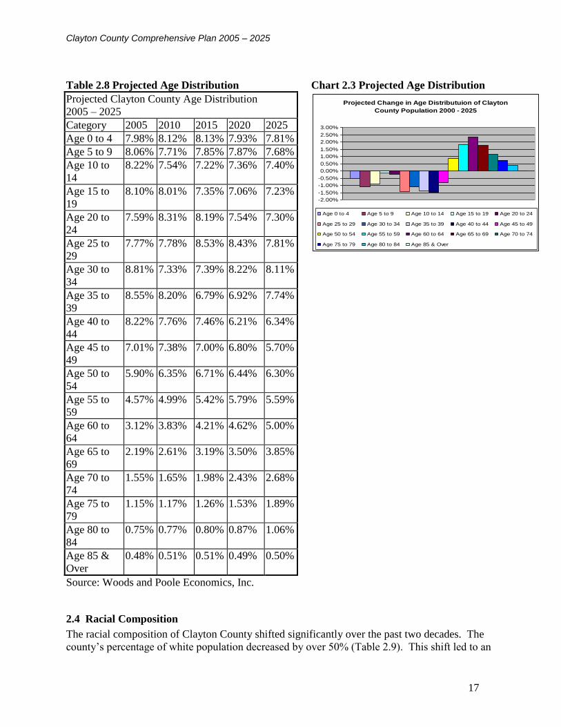
Clayton County Comprehensive Plan 2005 – 2025
17
Table 2.8 Projected Age Distribution Chart 2.3 Projected Age Distribution
Projected Clayton County Age Distribution
2005 – 2025
Category 2005 2010 2015 2020 2025
Age 0 to 4 7.98% 8.12% 8.13% 7.93% 7.81%
Age 5 to 9 8.06% 7.71% 7.85% 7.87% 7.68%
Age 10 to
14
8.22% 7.54% 7.22% 7.36% 7.40%
Age 15 to
19
8.10% 8.01% 7.35% 7.06% 7.23%
Age 20 to
24
7.59% 8.31% 8.19% 7.54% 7.30%
Age 25 to
29
7.77% 7.78% 8.53% 8.43% 7.81%
Age 30 to
34
8.81% 7.33% 7.39% 8.22% 8.11%
Age 35 to
39
8.55% 8.20% 6.79% 6.92% 7.74%
Age 40 to
44
8.22% 7.76% 7.46% 6.21% 6.34%
Age 45 to
49
7.01% 7.38% 7.00% 6.80% 5.70%
Age 50 to
54
5.90% 6.35% 6.71% 6.44% 6.30%
Age 55 to
59
4.57% 4.99% 5.42% 5.79% 5.59%
Age 60 to
64
3.12% 3.83% 4.21% 4.62% 5.00%
Age 65 to
69
2.19% 2.61% 3.19% 3.50% 3.85%
Age 70 to
74
1.55% 1.65% 1.98% 2.43% 2.68%
Age 75 to
79
1.15% 1.17% 1.26% 1.53% 1.89%
Age 80 to
84
0.75% 0.77% 0.80% 0.87% 1.06%
Age 85 &
Over
0.48% 0.51% 0.51% 0.49% 0.50%
Source: Woods and Poole Economics, Inc.
2.4 Racial Composition
The racial composition of Clayton County shifted significantly over the past two decades. The
county’s percentage of white population decreased by over 50% (Table 2.9). This shift led to an
Projected Change in Age Distributuion of Clayton
County Population 2000 - 2025
-2.00%
-1.50%
-1.00%
-0.50%
0.00%
0.50%
1.00%
1.50%
2.00%
2.50%
3.00%
Age 0 to 4 Age 5 to 9 Age 10 to 14 Age 15 to 19 Age 20 to 24
Age 25 to 29 Age 30 to 34 Age 35 to 39 Age 40 to 44 Age 45 to 49
Age 50 to 54 Age 55 to 59 Age 60 to 64 Age 65 to 69 Age 70 to 74
Age 75 to 79 Age 80 to 84 Age 85 & Over

Clayton County Comprehensive Plan 2005 – 2025
18
increase in the county’s percentage of black population, which rose by over 35%. The county
also had gains in its percentages of Asian and Hispanic population. The 2000 Census shows the
county’s population is predominately black (51.55%) or white (38%) with other racial groups
accounting for a little over 8% (Table 2.9). Maps 2.2, 2.3, and 2.4, depict the concentrations of
the county’s black, Asian and Hispanic populations in 2000.
Table 2.9 Racial Composition of Clayton County
Racial Composition of Clayton County
Category 1980 1990 2000 Change
1980 -
2000
TOTAL Population 150,362 182,055 236,517
White 137,949 91.74% 131,726 72.36% 89,741 37.94% -53.80%
Black 10,495 6.98% 43,403 23.84% 121,927 51.55% 44.57%
American Indian Eskimo or
Aleut
334 0.22% 456 0.25% 751 0.32% 0.10%
Asian or Pacific Islander 915 0.61% 5,046 2.77% 10,784 4.56% 3.95%
Other 635 0.42% 1,418 0.78% 8,392 3.55% 3.13%
Persons of Hispanic Origin 1,619 1.08% 3,747 2.06% 17,728 7.50% 6.42%
Source: Census

Clayton County Comprehensive Plan 2005 – 2025
19
Map 2.2 2000 Black Population Map 2.3 2000 Hispanic Population
Map 2.4 2000 Asian
Population
Clayton CountyComprehensive
Plan 2003Robert and Company
Architects, Engineers,
and Planners
96 Poplar St. N.W.
Atlanta, GA 30303
RAC 0207610
FORESTPARK
MORROWRIVERDALE
LOVEJOY
JONESBORO
LAKECITY
COLLEGEPARK
I-75WFayettevilleRd
JonesboroRd
Fayetteville Rd
I-285
RiverdaleRd I-675
GeorgiaHighway 42
Georgia Highway 138
TaraBlvd
I-85
StateRoute85
McDonough Rd
Highway 42
OldDixieHwy
I-285
I-285
I-285
I-675
TaraBlvd
I-75
I-75
I-75
I-75
I-675
StateRoute85
I-675
I-75
µ0 1 2 3 40.5
Miles
Legend
Percentage Asian Population
0 - 5 %
5 - 10 %
10 - 15 %
15 - 20 %
Municipal Boundaries
County Boundary
Highways
Streets
Railroad
Lakes
Rivers
Percentage Asian Population2000
Clayton County Comprehensive
Plan 2003Robert and Company
Architects, Engineers, and Planners
96 Poplar St. N.W.Atlanta, GA 30303
RAC 0207610
FOREST PARK
MORROWRIVERDALE
LOVEJOY
JONESBORO
LAKE CITY
COLLEGE PARK
I-75
W F
ayette
vill
e R
d
Jo
ne
sb
oro
Rd
Fayettevil
le Rd
I-285
Rive
rdale
Rd
I-675
Georg
ia H
ighw
ay 4
2
Georgia Highway 138
Ta
ra B
lvd
I-85
Sta
te R
oute
85
McDonough Rd
Highway 42
Old
Dixie
Hw
y
I-75
I-675
I-285
I-285
I-75
I-675
Sta
te R
ou
te 8
5
I-67
5
Tara
Blv
d
I-75
I-285
I-6
75
I-75
I-75
µ0 1 2 3 40.5
Miles
Legend
Percentage Black Population
10 - 20 %
20 - 30 %
30 - 40 %
40 - 50 %
50 - 60 %
60 - 70 %
70 - 80 %
80 - 90 %
Municipal Boundaries
County Boundary
Highways
Streets
Railroad
Lakes
Rivers
Percentage Black Population 2000
Clayton County Comprehensive
Plan 2003Robert and Company
Architects, Engineers, and Planners
96 Poplar St. N.W.Atlanta, GA 30303
RAC 0207610
FOREST PARK
MORROWRIVERDALE
LOVEJOY
JONESBORO
LAKE CITY
COLLEGE PARK
I-75
W F
ayette
vill
e R
d
Jo
ne
sb
oro
Rd
Fayettevil
le Rd
I-285
Rive
rdale
Rd
I-675
Georg
ia H
ighw
ay 4
2
Georgia Highway 138
Ta
ra B
lvd
I-85
Sta
te R
oute
85
McDonough Rd
Highway 42O
ld D
ixie H
wy
I-675
I-75
I-285
I-75
I-285
I-67
5
I-75
I-285
I-675
I-75
Sta
te R
ou
te 8
5
I-6
75
I-75
Tara
Blv
d
µ0 1 2 3 40.5
Miles
Legend
Percentage Hispanic Population
0 - 5 %
5 - 10 %
10 - 15 %
15 - 20 %
20 - 25 %
25 - 30 %
Municipal Boundaries
County Boundary
Highways
Streets
Railroad
Lakes
Rivers
Percentage Hispanic Population 2000

Clayton County Comprehensive Plan 2005 – 2025
20
2.5 Educational Attainment
2000 Census figures show that the majority of Clayton County residents possess a high school
diploma and many have college degrees or have attended some college (Table 2.10). The
educational levels of the county’s population have remained relatively steady over the past two
decades. Comparisons of 1990 and 2000 Census figures show that there has been a slight
increase in the percent of the population holding bachelor’s degrees (2%) and small decreases in
high school graduates (4%) and those leaving school earlier (3%) (Table 2.10).
Table 2.10 Educational Attainment
Educational Attainment of Clayton County Population
Category 1980 1990 % of
Population
2000 % of
Population
Change
1990 - 2000
TOTAL Adult Population 25 &
Over
81,055 109,898 141,554
Less than 9th Grade 10,899 7,231 6.58% 9,122 6.44% -0.14%
9th to 12th Grade (No Diploma) 16,253 17,758 16.16% 19,099 13.49% -2.67%
High School Graduate
(Includes Equivalency) 32,632 39,435 35.88% 45,143 31.89% -3.99%
Some College (No Degree) NA 22,630 20.59% 36,151 25.54% 4.95%
Associate Degree NA 6,686 6.08% 8,495 6.00% -0.08%
Bachelor's Degree NA 11,261 10.25% 17,280 12.21% 1.96%
Graduate or Professional Degree NA 4,900 4.46% 6,264 4.43% -0.03%
Source: Census
Department of Education figures show that the percentage of students dropping out of high
school dropped significantly between 1995 and 2001 (Table 2.11), and that greater numbers of
students completing high school are going on state colleges and technical schools. Despite these
educational gains, however, graduation test scores have dropped.
Table 2.11 Education Statistics
Clayton County: Education Statistics
Category 1995 1996 1997 1998 1999 2000 2001
H.S. Graduation Test Scores
(All Components)
85% 80% 71% 70% 67% 67% 59%
H.S. Dropout Rate 13.80% 11.30% 10.60% 9.40% 9.10% 8.70% 8.10%
Grads Attending Georgia Public
Colleges
31.50% 42.50% 40.70% 41.20% 40.00% NA NA
Grads Attending Georgia
Public Technical Schools
2.50% 3.50% 1.20% 2.50% 3.10% 4.10% NA
Source: Department of Education
Fewer Clayton County residents hold college or advanced degrees when compared with residents
of surrounding counties or the state as a whole. Clayton County also has a higher percentage of

Clayton County Comprehensive Plan 2005 – 2025
21
residents with less than a 9th
grade education than its surrounding counties. With the exception of
Henry County, Clayton County has a higher percentage of the population that has achieved high
school graduation or equivalency than neighboring counties or the state.
The recent and projected population growth presents a number of challenges for the county’s
public school system. A number of county schools are over crowded and the School Board has
reported that new schools usually require modular classrooms soon after, if not before, opening
their doors. Overcrowded classrooms and growing student teach ratios may be part of the reason
for the declining test scores the county has experienced in the recent decade. Test scores are also
partially a result of recent demographic shifts. Many of the county’s new residents are
immigrants who have not yet mastered English and/or transient families whose children often
have numerous gaps in their education due to frequently relocations. Addressing the issues
related to these populations place further requirements and educational needs on the public
school system.
Table 2.12 2000 Educational Attainment Comparison
Comparison of 2000 Population Educational Attainment for Clayton County
with Surrounding Counties and State
Georgia DeKalb Fayette Fulton Henry Clayton
Less than 9th Grade 7.58% 5.65% 2.22% 5.14% 4.06% 6.44%
9th to 12th Grade
(No Diploma) 13.85% 9.30% 5.40% 10.85% 11.71% 13.49%
High School Graduate
(Includes Equivalency) 28.65% 20.32% 24.02% 19.37% 34.31% 31.89%
Some College
(No Degree) 20.41% 22.39% 24.95% 18.55% 23.72% 25.54%
Associate Degree 5.20% 6.05% 7.23% 4.70% 6.66% 6.00%
Bachelor's Degree 16.00% 22.74% 23.91% 26.65% 13.53% 12.21%
Graduate or Professional Degree 8.30% 13.56% 12.26% 14.73% 6.02% 4.43%
Source: Census
2.6 Income
The 2000 Census shows a median household income of $42,697 and an average per capita
income of $18,079 for Clayton County (Tables 2.13 and 2.14). Per capita and household
incomes rose in Clayton County between the 1990 and 2000 Censuses, however they rose at
significantly lower rates when compared to the state or nation. Although the median household
income in Clayton County is higher than the state or national level, per capita incomes in the
county are lower in comparison.

Clayton County Comprehensive Plan 2005 – 2025
22
Table 2.13 Median Household Income Comparison
Median Household Income Comparison
Category United States Georgia Clayton County
Median household income in 1989 $30,056 $29,021 $33,472
Median household income in 1999 $41,994 $42,433 $42,697
% Change 89 – 99 39.72% 46.21% 27.56%
Source: Census
Table 2.14 Per Capita Income Comparison
Per Capita Income Comparison
Category United States Georgia Clayton County
Per capita income in 1989 $14,420 $13,631 $13,577
Per capita income in 1999 $21,587 $21,154 $18,079
% Change 89 - 99 49.70% 55.19% 33.16%
Source: Census
The distribution of household incomes in Clayton County for the 2000 Census year shows that
the largest percentage of Clayton County households earn between $60,000 and $74,999 per year
(Table 2.15). However, almost a quarter (23.24%) of county households earn under $25,000 per
year. Comparatively, only 7.26% of earn over $100,000 per year.
When the distribution of household incomes in Clayton County is compared to its surrounding
counties it becomes Clayton County more closely resembles the distribution of incomes in its
more urban neighbors, Fulton and DeKalb Counties, than suburban Fayette and Henry Counties
(Table 2.16). Overall, Clayton has significantly fewer households earning in the higher income
brackets than any of its surrounding counties. In 2000 only 7.25% of the county’s households
earned over $100,000 per year, compared to low 14% (Henry County) and a high of 29%
(Fayette County) of the households in surrounding counties. These discrepancies may indicate
that Clayton County is an attractive location for lower income households. If lower income
families continue to migrate to Clayton County there will be an increased demand for health and
human services provided by the county government during the next two decades.

Clayton County Comprehensive Plan 2005 – 2025
23
Table 2.15 Household Income Distribution
Clayton County Household Income Distribution
2000 % of Population
Total: 82,272
Less than $10,000 5,031 6.12%
$10,000 to $14,999 3,286 3.99%
$15,000 to $19,999 4,934 6.00%
$20,000 to $24,999 5,867 7.13%
$25,000 to $29,999 6,280 7.63%
$30,000 to $34,999 6,335 7.70%
$35,000 to $39,999 5,781 7.03%
$40,000 to $44,999 5,963 7.25%
$45,000 to $49,999 4,880 5.93%
$50,000 to $59,999 9,444 11.48%
$60,000 to $74,999 9,934 12.07%
$75,000 to $99,999 8,566 10.41%
$100,000 to $124,999 3,143 3.82%
$125,000 to $149,999 1,196 1.45%
$150,000 or more 1,632 1.98%
Source: Census
Table 2.16 Surrounding Counties’ Income Distribution
2000 Income Distribution in Surrounding Counties
Total DeKalb Co. Fayette Co. Fulton Co. Henry Co. Clayton Co.
$5000 - $9999 6.47% 2.85% 11.24% 3.97% 6.12%
$10000 - $14999 3.94% 1.94% 5.27% 2.17% 3.99%
$15000 - $19999 4.74% 2.70% 5.38% 2.97% 6.00%
$20000 - $29999 11.67% 6.59% 11.05% 9.07% 14.76%
$30000 - $34999 6.29% 3.93% 5.47% 5.31% 7.70%
$35000 - $39999 6.28% 3.95% 4.98% 5.74% 7.03%
$40000 - $49999 11.45% 9.30% 8.62% 11.78% 13.18%
$50000 - $59999 9.93% 8.27% 7.58% 11.70% 11.48%
$60000 - $74999 11.83% 13.62% 8.91% 15.93% 12.07%
$75000 - $99999 11.90% 18.02% 9.97% 16.96% 10.41%
$100000 or more 15.50% 28.82% 21.54% 14.40% 7.25%
Source: Census
2.7 Assessment of Current and Future Conditions
Clayton County’s population has grown rapidly during the past decades and is expected to
continue growing, albeit at a somewhat slower rate, during the 2005 to 2025 planning period.
The county’s increasing density is transforming it from a suburban enclave to an increasingly
urbanized community that is faced with a number of challenges more often associated with
cities. These challenges include, declining test scores and household incomes and an increasing

Clayton County Comprehensive Plan 2005 – 2025
24
demands for public transportation additional public safety needs. The growing population
numbers and increasing density also necessitate additional infrastructure such as roads, water and
sewer service and schools. Providing this infrastructure becomes harder as more and more land
is developed to provide housing for new households. In the coming decades the county must
strive to establish a proportional mixture of residential and commercial and industrial land uses
in order to maintain a tax base that can support the growing public facility and service needs.
The amount that per capita incomes in Clayton County are lagging behind the state and national
figures in 2000 is cause for concern. Additionally, although the County’s median household
income is higher than the state or national median, it did not rise at a comparable rate during the
past decade. These discrepancies in household incomes may indicate one or a combination of
two situations; the county’s population may be unable to acquire higher-paying employment
opportunities and is in need of job training programs to better prepare them for the workforce
and/or there may be factors in the county, such as low cost housing, that make it an attractive
home for lower income households in Metropolitan Atlanta.
As detailed in an earlier section of this chapter, projections show that the population of Clayton
County is aging and that there will be a significantly greater portion of the county over 65 in
2025. This has a potential to impact the county in a number of ways; median income growth will
continue to stagnate as many retirees are living on fixed incomes, there will be an increased
demand for assisted living and other housing options geared towards seniors and public funds
may be shifted away from education and other county services and into programs focused on
elderly. However, the county’s current proportion of younger population will continue to require
additional growth in the school system and other youth services such as organized recreation
programs in the near-term future.
The factor of declining test scores and some of the lowest educational attainment levels in the
region is another challenge facing Clayton County. A well-educated population is a key
component in recruiting new business and industries to the county and retaining those already in
place. It is imperative that Clayton County’s educational environment be enhanced in order to
attract additional employers to the county and to assist in population retention. As test scores
have declined many middle income families have chosen to relocate to other metro area counties
with better performing schools. This trend is another factor impacting the growth of household
incomes in the County.

Clayton County Comprehensive Plan 2005 – 2025
25
CHAPTER 3 HOUSING
3.1 Types of Housing Units
Between 1990 and 2000 the number of housing units in Clayton County grew by over 20%.
Despite the fact that Clayton County has been a developed suburban county for several decades,
housing growth continues to be primarily a singular type of housing; detached single family
homes. The number of units of single family housing units rose by 25% between 1990 and 2000
(Table 3.1). Almost two-thirds of the county’s housing units are single family detached homes.
Comparatively, multi-family housing is declining in share of housing in the county, especially in
regards to structures with between 3 and 49 units, which accounted for 31.15% of housing in
1990 and only 25.77% in 2000. However, the county did experience slight increases in the
number of units in structures with 50 or more units and manufactured homes.
Table 3.1 Types of Housing in Clayton County
Types of Housing in Clayton County
Category 1990 2000 % Change in Units
1990 to 2000
TOTAL Housing Units
71,931
% of Total
Units 86,461
% of Total
Units
20.20%
Single Units (detached) 42,656 59.30% 53,335 61.69% 25.04%
Single Units (attached) 1,862 2.59% 2,670 3.09% 43.39%
Double Units 1,156 1.61% 1,260 1.46% 9.00%
3 to 9 Units 13,867 19.28% 15,439 17.86% 11.34%
10 to 19 Units 6,504 9.04% 5,322 6.16% -18.17%
20 to 49 Units 2,035 2.83% 1,520 1.76% -25.31%
50 or more Units 596 0.83% 3,046 3.52% 411.07%
Mobile Home or Trailer 2,756 3.83% 3,802 4.40% 37.95%
All Other 499 0.69% 67 0.08% -86.57%
Source: Census
3.2 Age and Condition of Housing
Most of Clayton County’s housing was built between 1970 and 1979 (26.79%), however a large
percentage (23.90%) has also been built since 1990. The statistics in Table 3.2 show that the
County has experienced some loss of older housing, especially that built between 1950 and 1959.
The apparent increase in housing built before 1939 is assumed to be due to greater accuracy in
dating and counting older structures in the 2000 Census.

Clayton County Comprehensive Plan 2005 – 2025
26
Table 3.2 Age of Housing in Clayton County
Year Housing Structures Built in Clayton County
1990 2000 Change in # of Units
1999 to March 2000 3,273 3.79%
1995 – 1998 8,428 9.75%
1990 – 1994 8,961 10.36%
1980 – 1989 23,668 32.91% 20,825 24.09% -12.01%
1970 – 1979 23,589 32.80% 23,160 26.79% -1.82%
1060 – 1969 16,896 23.49% 15,180 17.56% -10.16%
1950 – 1959 5,636 7.84% 4,438 5.13% -21.26%
1940 – 1949 1,442 2.00% 1,360 1.57% -5.69%
1939 or earlier 695 0.97% 836 0.97% 20.29%
Source: Census
Compared to housing statistics for the State of Georgia, less housing was built in Clayton County
between 1990 and 2000 (27.89% vs. 23.90%). However, the state as a whole has experienced a
greater loss of housing built between 1960 and 1980 (52.04%) than Clayton County (50.93%)
(Tables 3.2 and 3.3). A full comparison between the age of housing in Clayton County and in
the ARC RDC region is not possible due to reporting errors in the counts of 1939 or earlier
housing in Clayton County. However, it appears that there is proportionally less housing of that
age in Clayton County (.97%) than at either the regional (3.98%) or state levels (5.88%) (Tables
3.3 and 3.4).
Table 3.3 Age of Housing in Georgia
Year Housing Structures Built in Georgia
1990 2000 Change in # of Units
1999 to March 2000 130,695 3.98%
1995 – 1998 413,557 12.60%
1990 – 1994 370,878 11.30%
1980 – 1989 847,309 32.11% 721,174 21.98% -14.89%
1970 – 1979 646,094 24.49% 608,926 18.55% -5.75%
1060 – 1969 453,853 17.20% 416,047 12.68% -8.33%
1950 – 1959 309,335 11.72% 283,424 8.64% -8.38%
1940 – 1949 168,889 6.40% 144,064 4.39% -14.70%
1939 or earlier 212,938 8.07% 192,972 5.88% -9.38%
Source: Census
Table 3.4 Age of Housing in the ARC Region
Housing Built Before 1939 in the ARC RDC Region
1990 2000 Change in # of Units
TOTAL Housing Units 1052430 1331264
1939 or Earlier 56329 52960 -5.98%
% of Housing Built 1939 or Earlier 5.35% 3.98%
Source: Census

Clayton County Comprehensive Plan 2005 – 2025
27
The condition of housing, based upon the presence of plumbing facilities, is better in Clayton
County than in the ARC Region or state as a whole. As shown in Table 3.5, only 0.35% of
housing lacked plumbing in Clayton County in 2000 compared to 0.49% in the ARC Region and
0.90% statewide.
Table 3.5 Comparison of Housing Conditions
Comparison of Condition of Housing
Category 1990 2000
Clayton County Housing Lacking Plumbing Facilities 229 0.32% 306 0.35%
Housing in ARC Region Lacking Plumbing Facilities 4,367 0.41% 6,465 0.49%
Georgia Housing Lacking Plumbing Facilities 28,462 1.08% 29,540 0.90%
Source: Census
3.3 Owner and Renter Units
The majority of occupied housing in Clayton County is and has been owner occupied, however
the percentage of owner occupied housing has dropped from a high in 1980 of 64.35% of
households to 60.59% of households in 2000 (Table 3.6). Vacancy rates in the county are
relatively low, and the vacancy rate among renters has dropped significantly from 14.53 to 6.46
between 1990 and 2000 possibly indicating a tightening of the rental market in the County.
As of 2000 Clayton County had a lower percentage of owner occupied housing than the
statewide percentage or that percentage for the ARC region. These percentages are 60.59%,
64.24% and 67.47% respectively. However, the vacancy rates among owners (1.78) and renters
(6.46) are lower in Clayton County than the rates for the ARC Region (1.96 and 7.14) (Table
3.7) and the state (2.24 and 8.46) (Table 3.8).
Table 3.6 Clayton County Occupancy Characteristics
Clayton County Occupancy Characteristics
Category 1980 1990 2000
TOTAL Households 50,448 65,522 82,272
Housing Units Vacant NA 6,403 4,218
Housing Units Owner Occupied 32,461 64.35% 38,500 58.76% 49,845 60.59%
Housing Units Renter Occupied 17,989 35.66% 27,023 41.24% 32,398 39.38%
Owner to Renter Ratio of Vacancy NA 0.26 0.4
Owner Vacancy Rate NA 3.01 1.78
Renter Vacancy Rate NA 14.53 6.46
Source: Census

Clayton County Comprehensive Plan 2005 – 2025
28
Table 3.7 ARC Region Occupancy Characteristics
ARC RDC Region Occupancy Characteristics
Category 1980 1990 2000
TOTAL Households 676,693 944,594 126,2401
Housing Units Vacant NA 107,826 69,370
Housing Units Owner Occupied 408,918 60.43% 577,178 61.10% 810,955 64.24%
Housing Units Renter Occupied 267,763 39.57% 367,426 38.90% 450,939 35.72%
Owner to Renter Ratio of Vacancy NA 0.728 0.775
Owner Vacancy Rate NA 3.017 1.956
Renter Vacancy Rate NA 13.979 7.139
Source: Census
Table 3.8 Georgia Occupancy Characteristics
Georgia Occupancy Characteristics
Category 1980 1990 2000
TOTAL Households 186,9754 236,6615 300,7678
Housing Units Vacant NA 271,803 275,368
Housing Units Owner Occupied 121,5206 64.99% 153,6759 64.93% 202,9293 67.47%
Housing Units Renter Occupied 654,548 35.01% 829,856 35.07% 977,076 32.49%
Owner to Renter Ratio of Vacancy NA 0.32 0.51
Owner Vacancy Rate NA 2.36 2.24
Renter Vacancy Rate NA 12.36 8.46
Source: Census
Unlike counties in other parts of Georgia, housing units used for seasonal, recreational, or
occasional use do not account for a large part of the housing market in Clayton County. This is
evidenced by 1990 and 2000 Census statistics which show a 55% increase in the vacancy rate of
these types of properties with the number of vacant units rising from 95 in 1990 and 211 in 2000.
3.4 Cost of Housing
The cost of housing is rising in Clayton County. Census data shows that between 1990 and 2000
the median property value in the county rose by 30.60% and median rent rose by 12.59% (Table
3.9). Looking at the longer time period of 1980 to 2000 property values increased by 127.25%
and median rent by 173.52% (Table 3.9). Although these percentages seem high they are lower
than the increases experienced statewide during the same two decades. Statewide median
property values rose by 335.5% and median rent by 230.07% (Table 3.11). This indicates that
housing has remained comparatively inexpensive in Clayton County. Further evidence of the
low cost of housing in Clayton County are comparisons with housing costs in the ARC region
where median property values grew by over 55% and median rents by over 56% between 1990
and 2000 (Table 3.10).

Clayton County Comprehensive Plan 2005 – 2025
29
Table 3.9 Clayton County Housing Costs
Clayton County Housing Costs
Category 1980 1990 2000
Median Property Value $ 40,000 $ 69,600 $ 90,900
Median Rent $ 219 $ 532 $ 599
Source: Census
Table 3.10 ARC Region Housing Costs
ARC RDC Region Housing Costs
Category 1980 1990 2000
Median Property Value N/A $ 93,128 $ 144,504
Median Rent N/A $ 422 $ 661
Source: Census
Table 3.11 Georgia Housing Costs
Georgia Housing Costs
Category 1980 1990 2000
Median Property Value $ 23,100 $ 71,278 $ 100,600
Median Rent $ 153 $ 365 $ 505
Source: Census
3.4.1 Cost Burdened Households
Using the 2000 Census data for income distribution in Clayton County found in (Table 2.15 in
Chapter 2) of this document and median housing costs from Table 3.9 above, it appears that at
least 10% of the county’s households are cost burdened. This means that housing costs are
greater than 30% of annual household income. Furthermore, no less than 6% of Clayton
County's households are severely cost burdened, meaning that housing costs are more than 50%
of their total income. When the total household pool is divided into renters and owners, these
numbers shift significantly showing that renters are much more likely to be cost burdened than
owners in Clayton County. By comparing statistics shown in Tables 3.12 and 3.13 it can be seen
that 15% of owners are cost burdened compared to 22% of renters. Additionally while only 6%
of owners are severely cost burdened over double that many (14%) renters fall into this category.
Table 3.12 Monthly Owner Costs
Clayton County Monthly Owner Costs as a Percentage of Household in 1999
Less than 30% of Income 62.50% Not Cost Burdened
30% - 49% of Income 14.94% Cost Burdened
50% of More of Income 6.31% Severely Cost Burdened
Total Housing Units 45,161
Median Monthly Owner Costs as % of 1999
Household Income
19.5
Source: Census

Clayton County Comprehensive Plan 2005 – 2025
30
Table 3.13 Clayton County Monthly Renter Costs
Monthly Renter Costs as a Percentage of Household in 1999
Less than 30% of Income 60.09% Not Cost Burdened
30% - 49% of Income 22.38% Cost Burdened
50% of More of Income 14.11% Severely Cost Burdened
Total Specified Renter Occupied Units 32,306
Median Monthly Renter Costs as % of 1999
Household Income
24.9
Source: Census
Antidotal evidence collected during the planning process suggests that many of the newly
developed extended stay hotels which have developed along the Tara Boulevard corridor are
serving as semi-permanent residences for lower income, cost burdened and severely cost
burdened households in Clayton County. This is reportedly placing additional stress on the
county’s school system to provide adequate classroom capacity for a growing number of
transient students. Additionally there are reports that these establishments place additional
demands on the county’s public safety services. Revisions to the county’s zoning ordinances
affecting extended-stay hotels, evaluation of the county’s hotel/motel tax structure and
augmentation of housing services provided to lower income families could assist in mitigating
these circumstances.
Overcrowding of housing units is a symptom of cost burdened households. Table 3.14 supports
the data previously presented showing that rental households are much more likely than owner
households to be living in overcrowded or severely overcrowded circumstances.
Table 3.14 Clayton County Over Crowded Housing Units
Over Crowded Housing Units by Tenure
Occupants per Room Rental Owned
Units % Units %
Overcrowded: 1.01 to 1.50 occupants per room 2,483 7.66% 1314 2.64%
Severely Overcrowded: 1.51 or more occupants per
room
1,810 5.59% 831 1.67%
Source: Census
3.5 Housing and Community Characteristics
3.5.1 Characteristics of Population Affecting Housing
There are many characteristics of the population of Clayton County that affect the types of
housing needed to meet the needs of county residents. The county’s population can be described
as a growing, family oriented, moderate income population that will be aging over the next two
decades. Households in Clayton County are larger than average for the state as are the wages
paid to workers residing in the county. However, it should be noted that there is evidence that
household incomes in the county are stagnating and that their growth may be curtailed in the

Clayton County Comprehensive Plan 2005 – 2025
31
future. This summary suggests that the county will need a greater diversity of housing in the
future. It is anticipated that detached single family homes will continue to be the housing of
choice in the county, however, the projected aging of the population indicates there will be a
need for smaller low maintenance residences such as condominiums, retirement communities
and assisted living facilities to fulfill the housing needs of a growing number of “empty-nesters.”
Additionally, as today’s young families grow in size and income, larger and higher priced homes
will be needed to serve their needs as they look to move out of “starter” homes. There is a need
for higher priced housing to aid in the county’s efforts to retain professional “working families.”
Detailed information regarding the population characteristics that affect housing are contained in
many other elements of this document. For information about population growth and age
distribution please see Chapter 2, Sections 2.1. and 2.3. For income related data, reference
Chapter 2, Section 2.5 and for household sizes Section 2.2. For information regarding
employment and wages please see Chapter 4 Section 4.3.
3.5.2 Special Needs Housing
The Jonesboro Housing Authority administers low-rent public housing units and the Section 8
Housing Voucher program in Clayton County. The Authority currently has 35 low-rent housing
units and 1,538 Section 8 vouchers. Of the total Section 8 Vouchers available, 50 are
specifically designated for the elderly and disabled, however this does not exclude the elderly
and disabled from using additional vouchers. These limited resources are not sufficient for
meeting the needs of the poor, elderly, and disabled seeking assistance from the Authority. The
Authority reports that the number of requests for housing assistance have risen steadily during
the past decade and as the population of the county continues to increase the Authority
anticipates requests for assistance to continue to increase as well. To meet these increasing
needs the Authority is continually recruiting additional landlords into their Section 8 Housing
Voucher program. At this time the Authority does not have any plans to expand its stock of low-
rent public housing units.
There are a number of other population groups in addition to those served by the Housing
Authority discussed above that have may have a need for special housing. These groups include
those living with AIDS, victims of family violence, those with substance abuse problems, and
the disabled. Estimates provided by the University of Georgia show that Clayton County had
419 AIDS cases reported between 1981 and 2000. This number is significantly more than either
Fayette or Henry counties, with 35 and 70 cases respectively, but much less than either DeKalb
or Fulton, which had over 3,000 and 10,000 cases reported. Statistics provided by the University
of Georgia also show that one fifth of Clayton County’s population over 16 year of age is
disabled. Percentage wise this is more than Fayette County, which has 18% but equal, or less
than the other surrounding counties.
In 2001 an estimated 5.27% of Clayton County’s population (13,000 people) needed substance
abuse treatment. This estimate is slightly lower than those for adjacent counties, which ranged
for 5.59% in DeKalb County and 6.20% in Henry County. The group with the potential for the
highest need for special housing in Clayton County is victims of family violence. According to

Clayton County Comprehensive Plan 2005 – 2025
32
Georgia Bureau of Investigation statistics for the number of police actions taken in relation to
family violence in 2000 there was more than 1 action per every 80 county residents. This is
much higher than statistics for surrounding counties, which show approximate actions to
population ratios of 1/140 for DeKalb, 1/225 for Fayette, 1/100 for Fulton and 1/190 for Henry.
3.6 Assessment of Current and Future Housing Needs
Wages paid to those working in the county are relatively high when compared to those in
surrounding counties. The average weekly wage was $663 in 1999, equating to a yearly income
of approximately $34,000 per year. Despite high wages, the cost of housing in Clayton County
is low, as exhibited by a median housing value of $90,900 in 2000 which can be compared to
median values of $170,000 in Fayette County, $120,000 in Henry County, $176,000 in Fulton
County and $134,000 in DeKalb.
A yearly income of $34,000 provides purchasing power for housing valued at $100,0001.
However, the majority of housing in Clayton County (60%) is valued lower. Furthermore, only
3% or 2,974 housing units are valued over $200,000. This is an affordable price point for
households earning $60,000 or more, which includes approximately 30% or 24,500 of the
households in Clayton County as of 2000. In the next two decades annual household incomes
are projected to increase in Clayton County from $45,024 in 2000 to $83,575 by 2025. To match
the housing needs of the future, Clayton County must add a significant number of higher value
housing units to its housing stock.
There is also a need for additional housing at the opposite end of the income spectrum. In 2000
approximately 16% or 13,251 of Clayton County households earned under $20,000 per year. At
this income households can afford a monthly housing cost of approximately $292, which
provides the purchasing power for a home valued at approximately $50,000. While housing
costs are lower in Clayton County, there is still very little housing valued at this level. In 2000
only 2.43% or 1,099 housing units were valued at $50,000 or less. However, there is a large
stock of older homes and apartments available for rent in the County which provide lower cost
housing options.
One reason for the high concentration of lower income households in Clayton County (16%
earning under $20,000 per year, compared to 7.49% of households in Fayette County and 9.11%
in Henry County), could be the lower wages paid in these adjoining counties. In 2000 the
average weekly wages for Henry and Fayette Counties were $526 and $510, 21% and 23% lower
respectively than the average wage in Clayton County. It can be concluded that while many
higher paid Clayton workers are choosing to reside outside of the county due to the higher
quality of housing and higher school test scores in neighboring counties, many lower paid
workers of those counties likely reside in Clayton due to the relatively low cost of housing.
As shown in Section 4.5 of the Economic Development Element many residents of the counties
surrounding Clayton (Fulton, DeKalb, Fayette, and Henry) commute into the county for work. It
is most likely the case that many workers holding high wage jobs in Clayton County are
1 Based on a 30-year mortgage at an interest rate of 7% with 20% down payment.

Clayton County Comprehensive Plan 2005 – 2025
33
choosing to reside in the surrounding counties. While this is in part due to a lack of housing
priced appropriately for these households, there are additional factors. One large factor in the
determination of where a household with children will reside is the perceived quality of schools
in a locality. Recently, Clayton has fallen behind its neighboring counties in this area as
exhibited by high school graduation test scores and high school drop out rates. In 2000 Clayton
County had a graduation test passing rate of 59% and a drop out rate of 8.1% (see Chapter 2,
Section 1.5, Table 2.11) compared to scores and rates of 84% and 2% for Fayette County and
71% and 4.2% in Henry County. The comparatively low scores of the Clayton County schools is
a reason why more affluent families may be choosing to locate in neighboring counties rather
than in Clayton.
In 2000 the county was experiencing lower vacancy rates than either the ARC region or the state.
This is evidence of the market for lower priced homes and renter opportunities that are prevalent
in Clayton County compared with most metropolitan Atlanta counties (especially neighboring
Fayette and Henry). Clayton County disproportionately provides the low-to-moderate income
housing stock for the metro Atlanta region. Reasons for this phenomenon may be the availability
of water and sewer service throughout most of the County, higher percentages of apartments and
multi-family housing than surrounding counties, and a greater number of smaller, older homes
that tend to be renter occupied. The County’s current zoning regulations have hastened the
development of low cost housing in the county through a lack of design and landscaping
standards and by encouraging moderate to high density single-family development with 1 acre or
smaller lot requirements throughout the entire county.
Based on household projections included in Chapter 2 Table 1.5, Clayton County will need to
add approximately 32,507 housing units between 2000 and 2025 (Table 3.15). Many of these
new housing units will need to be smaller, low maintenance units to meet the needs of aging
residents, or higher priced homes with amenities to fulfill the wants of working families looking
for a step up from starter homes. Additionally the county should work with the Clayton County
Public School Board to ensure that new housing developments do not heighten school over
crowding, a factor that may contribute to low test scores in the County’s schools.
Table 3.15 Clayton County Housing Unit Projections
Clayton County Housing Unit Projections
2005 2010 2015 2020 2025
Projected Households 89,527 96,213 102,591 108,271 113,303
Housing Units 94,003 101,024 107,721 113,685 118,968
Single Family Units 61,102 65,665 70,018 73,895 77,329
Multi Family Units 31,961 34,348 36,625 38,653 40,449
Manufactured Housing 3,760 4,041 4,309 4,547 4,759
As exhibited by the housing data provided in this chapter, Clayton County provides a large
amount of affordable housing and most people employed in Clayton County could find
affordable homes in the County. However, Clayton County is not fully meeting the state’s
quality communities housing objective to make it possible for all who work in the county to live
in the community. Although there is a sizable percentage of workers employed in Clayton

Clayton County Comprehensive Plan 2005 – 2025
34
County making higher incomes, there is a significant lack of higher quality housing priced
appropriately for this income group.

Clayton County Comprehensive Plan 2005 – 2025
35
3.7 Housing Goals and Policies
Goal 1.0 Provide a wide variety of quality housing options to meet the current and projected
needs of all Clayton County residents regardless of age, income, or disabilities.
Policy 1.1 Require new housing development meet higher standards of site planning and
residential design through the establishment and enforcement of appropriate subdivision
regulations and building codes.
Policy 1.1.1 Develop and/or improve design guidelines for new residential developments to
ensure that new housing is of very high quality, is aesthetically compatible with existing
development and adds to rather than detracts from the overall visual quality of Clayton County.
Policy 1.2 Revise current zoning and housing codes to ensure that they are coordinated in
promoting quality standards in an effective manner.
Policy 1.2.1 Review current residential building codes and revise as necessary to ensure that
new housing meets a minimum level of quality throughout all areas of the county.
Policy 1.2.2 Review current county zoning ordinances to determine if residential square footage
requirements are effective for providing the level of housing quality desired by Clayton County.
Policy 1.2.2.1 Explore options for reducing residential square footage requirements while
increasing the quality standards of new development by including increased landscaping and
architectural requirements for new residential developments.
Policy 1.3 Encourage the development and redevelopment of neighborhoods that provide higher
quality and higher value housing for professionals within the county.
Policy 1.3.1 Consider institution of an expedited review process for developments that provide
housing well above the minimum standard required by the zoning for the parcel in terms of lot
size, square footage, open space set asides, and community amenities.
Policy 1.4 Encourage the development of housing to meet the specific need of disabled and
elderly county residents including single story residences, managed condominium
communities, communities designed for multi-generational living and assisted living
facilities.

Clayton County Comprehensive Plan 2005 – 2025
36
Goal 2.0 Maximize public safety, health and convenience in all residential areas, regardless of
value or location.
Policy 2.1 Encourage the maintenance and/or improvement of the individual character and
identity of established neighborhoods and communities.
Policy 2.1.1 Vigorously enforce housing codes to ensure an appropriate level of
safety and sanitary conditions in all neighborhoods.
Policy 2.1.1 1 Provide sufficient support to the County Code Enforcement Department.
Policy 2.1.1.1 Retain a staff of enforcement officers that is sufficient to meet the code
enforcement needs of the County and responds to citizens in a timely manner.
Policy 2.1.1.1.1 Implement an on-line code violation
reporting system so county residents can report and receive
information about code violations in their neighborhood
electronically.
Policy 2.2 Direct new residential development near Hartsfield-Jackson International Airport into
areas specifically designated for residential development in the Southside Hartsfield
Redevelopment Plan to reduce the negative impacts airport generated noise and air pollution on
residents.
Policy 2.3 Require developers of all new housing developments to establish Homeowner’s
Associations to ensure the continued maintenance and upkeep of the development after
completion by the developer.
Goal 3.0 Stabilize and enhance the county's existing housing stock by promoting conservation
practices, supporting revitalization plans and encouraging the replacement of dilapidated
structures.
Policy 3.1 Support revitalization of existing, deteriorating neighborhoods to encourage stability
in the resident population.
Policy 3.1.1 Explore was to engage the non-profit agency, Clayton County Housing Corp., to
accomplish pockets of revitalization.
Policy 3.1.2 Explore opportunities for public-private partnerships that can be formed to aid in
the revitalization of blighted neighborhoods
Policy 3.1.3 Provide support to existing Home Owners Associations (HOAs) and encourage
establishing or reactivating HOAs in older neighborhoods where they have never existed or have
lapsed.

Clayton County Comprehensive Plan 2005 – 2025
37
Policy 3.1.3.1 Designate a county employee to coordinate with HOAs, code enforcement, and
planning and zoning to spearhead the stabilization and enhancement of the county’s existing
residential communities.
Policy 3.1.4 Conduct a neighborhood study to identify a priority list of neighborhoods in need of
revitalization and recommend specific revitalization strategies.
Policy 3.1.5 Coordinate neighborhood revitalization efforts with the redevelopment plans
of the Clayton County Economic Development Authority.
Goal 4.0 Prevent the encroachment of incompatible land uses into established residential land
use areas.
Policy 4.1 Consider all existing adjacent land uses and projected land uses for an area as
indicated by the Future Land Use Map when making decisions concerning residential rezoning
requests.
Goal 5.0 Prevent the occurrence of discrimination in housing based on race,
color, religion, sex or national origin.
Goal 6.0 Have new residential development, particularly higher-density residential
development, to occur in areas where adequate transportation facilities and
commercial and public services exist or are planned. These land uses should be
located in close proximity to centers of employment and higher education.
Policy 6.1 Encourage the development of compatible residential infill and open space. In
Established residential areas, careful consideration should be given to determining the
appropriate types of redevelopment and infill land uses to occur.
Policy 6.1.1 Ensure that new development is compatible with surroundings and to allow
developers greater creativity and flexibility that what may be available through the underlying
zoning ordinance.
Goal 7.0 Implement new and innovative approaches to residential development that will expand
housing opportunities and/or minimize public costs.
Policy 7.1 Revise county zoning ordinances to allow for mixed-use developments that
combine residential and commercial uses.
Policy 7.2 Study the establishment of impact fees for new residential development to
ensure that current residents are not burdened with the cost of new infrastructure required
to service new residential developments
Policy 7.2.1 Consider requiring developers of residential subdivision of a certain
size to set aside a minimum amount of land for new schools or other appropriate
public services.

Clayton County Comprehensive Plan 2005 – 2025
38
Policy 7.3 Mitigate the impacts of extended stay hotels on the county’s public services.
Policy 7.3.1 Revise the zoning to limit the development of extended stay hotels to
areas where they can directly serve business travelers and corporate users, such as
the airport redevelopment area and office nodes as they develop in the future.
Policy 7.3.2 Consider modifying the county's hotel/motel tax structure to help
offset the high cost of public safety and school use that the county is reportedly
incurring from extended-stay motels.

Clayton County Comprehensive Plan 2005 – 2025
39
CHAPTER 4 ECONOMIC DEVELOPMENT
Introduction
This chapter includes information regarding Clayton County’s economic base, labor force,
special economic development programs and plans and general economic trends. Throughout
the chapter, information on the economic conditions at the state, regional, and national level is
also given in order to provide points of comparison to the conditions in Clayton County. The
purpose of inventory and assessment of the current economic conditions in the county is to
identify economic development needs and integrate them into the overall comprehensive
planning process. After determining the county’s needs, the land uses necessary to support
economic development can be determined, and the infrastructure and programmatic and policy
support needed to fulfill the economic development goals can be provided.
4.1 Employment by Sector
In 2000 the sectors accounting for the greatest proportions of employment in Clayton County
were transportation, communications and utilities (TCU) (28.14%), services (21.72%) and retail
trade (18.74%) (Table 4.1). Over the next twenty years the county's TCU sector is projected to
continue growing, and may account for up to a third of all employment by 2025 (Table 4.2).
Employment in the retail trade sector is projected to steadily decline, dropping from 18.74% of
total employment in 2000 to 16.39% in 2025. Employment in the services sector is expected to
remain steady at around 21% (Table 4.2). Overall, no significant shifts in the employment shares
of each sector are projected for the county.
Clayton County has a significantly higher concentration of jobs in the TCU sector in comparison
to the distribution of employment across the major sectors at the state level. The location of
Hartsfield-Jackson International Airport is the primary reason for this concentration of
employment. Another notable difference between the state and Clayton County’s employment
distributions is the difference in manufacturing employment. The state is much more reliant on
this sector for jobs (12.63%) than Clayton County (5.53%). Despite these differences, Clayton
County and the state share comparable concentrations of employment in the retail trade sector
and both are expected to see job growth in their services sectors over the next twenty years
(Table 4.2).

Clayton County Comprehensive Plan 2005 – 2025
40
Table 4.1 Employment by Sector
Clayton County Employment by Sector
Category 1990 1995 2000 2005 2010 2015 2020 2025
Total 103,558 122,374 141,987 157,175 172,092 186,053 198,429 208,839
Farm 83 66 60 59 58 56 55 54
Agricultural
Services, Other 398 585 544 588 639 690 737 779
Mining 42 71 66 68 70 72 74 76
Construction 5,462 6,705 6,610 6,728 6,872 7,038 7,238 7,481
Manufacturing 5,868 6,416 7,854 8,115 8,375 8,619 8,843 9,046
Trans, Comm,
& Public
Utilities 24,173 29,562 39,957 48,239 56,126 63,036 68,353 71,629
Wholesale
Trade 6,117 7,571 8,866 9,748 10,459 11,095 11,713 12,347
Retail Trade 25,396 25,224 26,604 28,682 30,591 32,198 33,418 34,223
Finance,
Insurance, &
Real Estate 4,015 4,818 5,538 5,795 6,057 6,324 6,601 6,892
Services 17,825 27,930 30,834 33,396 36,356 39,674 43,380 47,536
Federal Civilian
Government 2,713 2,065 2,101 2,086 2,043 1,977 1,888 1,779
Federal Military
Government 819 829 849 862 873 880 884 886
State & Local
Government 10,647 10,532 12,104 12,809 13,573 14,394 15,245 16,111
Source: Woods and Pool Economics, Inc.

Clayton County Comprehensive Plan 2005 – 2025
41
Table 4.2 Employment by Sector Comparison
Employment by Sector for Georgia and Clayton County
Sector 1990 1995 2000 2005 2010 2015 2020 2025
Georgia Farm 2.01% 1.63% 1.39% 1.24% 1.11% 1.00% 0.90% 0.82%
Clayton Co. Farm 0.08% 0.05% 0.04% 0.04% 0.03% 0.03% 0.03% 0.03%
Georgia
Agricultural Services,
Other 0.85% 1.06% 1.13% 1.15% 1.16% 1.17% 1.17% 1.16%
Clayton Co.
Agricultural Services,
Other 0.38% 0.48% 0.38% 0.37% 0.37% 0.37% 0.37% 0.37%
Georgia Mining 0.29% 0.22% 0.20% 0.18% 0.17% 0.17% 0.16% 0.15%
Clayton Co. Mining 0.04% 0.06% 0.05% 0.04% 0.04% 0.04% 0.04% 0.04%
Georgia Construction 5.75% 5.58% 6.10% 6.05% 5.94% 5.80% 5.66% 5.52%
Clayton Co. Construction 5.27% 5.48% 4.66% 4.28% 3.99% 3.78% 3.65% 3.58%
Georgia Manufacturing 15.51% 14.27% 12.63% 12.07% 11.56% 11.03% 10.50% 9.97%
Clayton Co. Manufacturing 5.67% 5.24% 5.53% 5.16% 4.87% 4.63% 4.46% 4.33%
Georgia
Trans, Comm, &
Public Utilities 5.86% 5.72% 6.10% 6.17% 6.19% 6.16% 6.09% 5.97%
Clayton Co.
Trans, Comm, &
Public Utilities 23.34% 24.16% 28.14% 30.69% 32.61% 33.88% 34.45% 34.30%
Georgia Wholesale Trade 6.18% 5.73% 5.69% 5.74% 5.73% 5.71% 5.69% 5.66%
Clayton Co. Wholesale Trade 5.91% 6.19% 6.24% 6.20% 6.08% 5.96% 5.90% 5.91%
Georgia Retail Trade 16.44% 17.14% 16.80% 17.08% 17.32% 17.51% 17.65% 17.76%
Clayton Co. Retail Trade 24.52% 20.61% 18.74% 18.25% 17.78% 17.31% 16.84% 16.39%
Georgia
Finance, Insurance, &
Real Estate 6.64% 6.36% 7.12% 7.05% 6.98% 6.91% 6.83% 6.76%
Clayton Co.
Finance, Insurance, &
Real Estate 3.88% 3.94% 3.90% 3.69% 3.52% 3.40% 3.33% 3.30%
Georgia Services 23.75% 26.61% 28.63% 29.27% 30.10% 31.07% 32.16% 33.35%
Clayton Co. Services 17.21% 22.82% 21.72% 21.25% 21.13% 21.32% 21.86% 22.76%
Georgia
Federal Civilian
Government 2.79% 2.33% 1.90% 1.76% 1.63% 1.53% 1.43% 1.35%
Clayton Co.
Federal Civilian
Government 2.62% 1.69% 1.48% 1.33% 1.19% 1.06% 0.95% 0.85%
Georgia
Federal Military
Government 2.46% 2.24% 1.93% 1.82% 1.71% 1.61% 1.51% 1.42%
Clayton Co.
Federal Military
Government 0.79% 0.68% 0.60% 0.55% 0.51% 0.47% 0.45% 0.42%
Georgia
State & Local
Government 11.46% 11.11% 10.39% 10.44% 10.40% 10.33% 10.22% 10.10%
Clayton Co.
State & Local
Government 10.28% 8.61% 8.52% 8.15% 7.89% 7.74% 7.68% 7.71%
Source: Woods and Pool Economics, Inc.
4.2 Earning by Sector
In Clayton County the transportation communications and utilities (TCU) sector accounts for the
highest percentage of the county’s earning (42.5% in 2000) (Table 4.3). The second and third
highest earning sectors are services (17.29%) and retail trade (18.74%). This dispersion matches
the distribution of employment by sector for the county. There are no major shifts in earning by

Clayton County Comprehensive Plan 2005 – 2025
42
sector expected over the next two decades for Clayton County. The TCU sector’s dominance is
projected to increase and may account for half of all earnings by 2025 (Table 4.4).
The services sector is the highest earning sector at the state level (Table 4.4) followed by
manufacturing and state and local government. However, the proportions of manufacturing
earnings are expected to decline at the state level and in Clayton County over the next two
decades (Table 4.4). Additionally, the economy at both levels is expected to experience slight
declines in retail trade earnings and growth in their services sectors earnings during the 2005 –
2025 time period (Table 4.4).
Table 4.3 Earnings by Sector
Clayton County Earnings by Sector
Category 1990 2000
Total $ 3,210,470,000 $4,921,800,000
Farm $ 216,000 0.01% $287,000 0.01%
Agricultural Services, Other $ 6,171,000 0.19% $9,950,000 0.20%
Mining $ 1,536,000 0.05% $2,568,000 0.05%
Construction $ 152,471,000 4.75% $219,436,000 4.46%
Manufacturing $ 198,107,000 6.17% $297,570,000 6.05%
Trans, Comm, & Public Utilities $ 1,336,460,000 41.63% $2,091,680,000 42.50%
Wholesale Trade $ 204,306,000 6.36% $357,081,000 7.26%
Retail Trade $ 427,274,000 13.31% $480,596,000 9.76%
Finance, Insurance, & Real Estate $ 78,017,000 2.43% $118,053,000 2.40%
Services $ 388,045,000 12.09% $850,752,000 17.29%
Federal Civilian Government $ 96,952,000 3.02% $88,100,000 1.79%
Federal Military Government $ 9,514,000 0.30% $10,849,000 0.22%
State & Local Government $ 311,403,000 9.70% $394,868,000 8.02%
Source: Woods and Pool Economics, Inc.
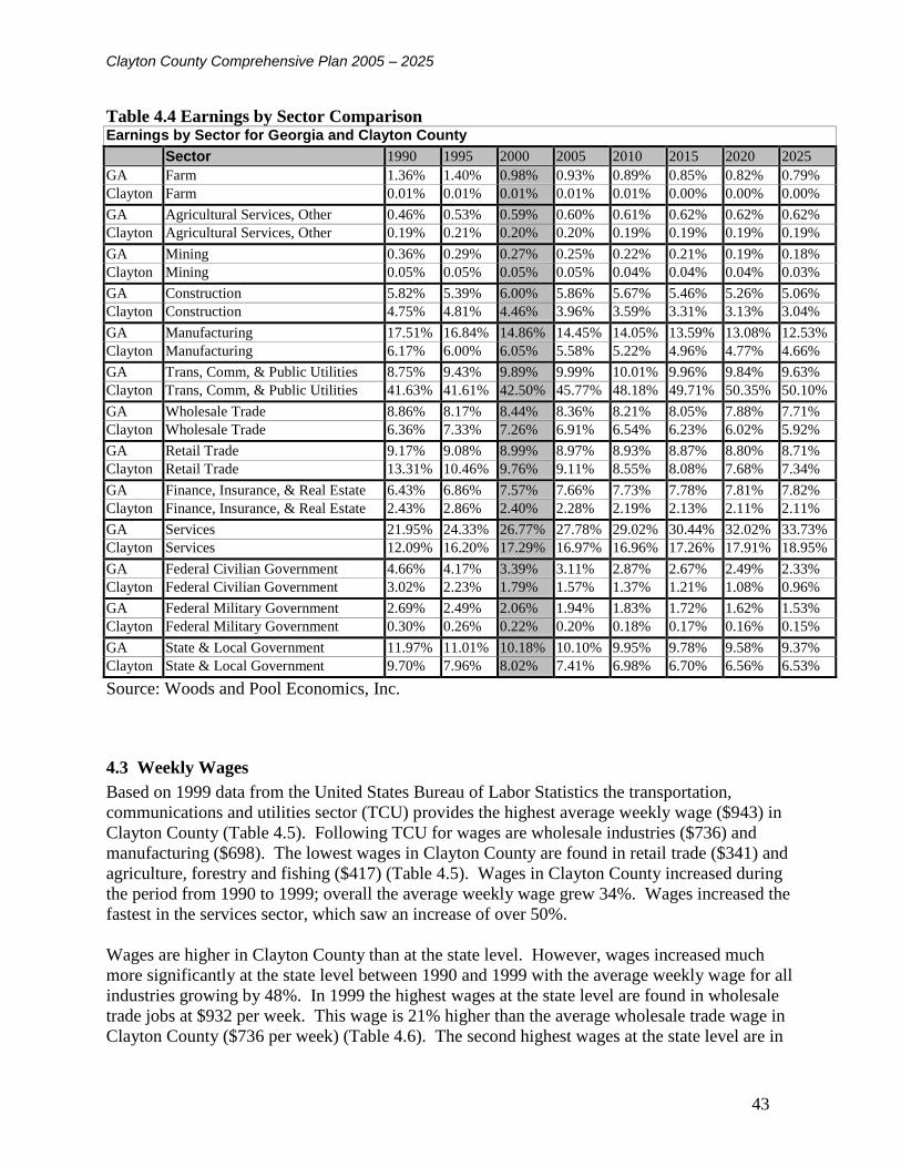
Clayton County Comprehensive Plan 2005 – 2025
43
Table 4.4 Earnings by Sector Comparison Earnings by Sector for Georgia and Clayton County
Sector 1990 1995 2000 2005 2010 2015 2020 2025
GA Farm 1.36% 1.40% 0.98% 0.93% 0.89% 0.85% 0.82% 0.79%
Clayton Farm 0.01% 0.01% 0.01% 0.01% 0.01% 0.00% 0.00% 0.00%
GA Agricultural Services, Other 0.46% 0.53% 0.59% 0.60% 0.61% 0.62% 0.62% 0.62%
Clayton Agricultural Services, Other 0.19% 0.21% 0.20% 0.20% 0.19% 0.19% 0.19% 0.19%
GA Mining 0.36% 0.29% 0.27% 0.25% 0.22% 0.21% 0.19% 0.18%
Clayton Mining 0.05% 0.05% 0.05% 0.05% 0.04% 0.04% 0.04% 0.03%
GA Construction 5.82% 5.39% 6.00% 5.86% 5.67% 5.46% 5.26% 5.06%
Clayton Construction 4.75% 4.81% 4.46% 3.96% 3.59% 3.31% 3.13% 3.04%
GA Manufacturing 17.51% 16.84% 14.86% 14.45% 14.05% 13.59% 13.08% 12.53%
Clayton Manufacturing 6.17% 6.00% 6.05% 5.58% 5.22% 4.96% 4.77% 4.66%
GA Trans, Comm, & Public Utilities 8.75% 9.43% 9.89% 9.99% 10.01% 9.96% 9.84% 9.63%
Clayton Trans, Comm, & Public Utilities 41.63% 41.61% 42.50% 45.77% 48.18% 49.71% 50.35% 50.10%
GA Wholesale Trade 8.86% 8.17% 8.44% 8.36% 8.21% 8.05% 7.88% 7.71%
Clayton Wholesale Trade 6.36% 7.33% 7.26% 6.91% 6.54% 6.23% 6.02% 5.92%
GA Retail Trade 9.17% 9.08% 8.99% 8.97% 8.93% 8.87% 8.80% 8.71%
Clayton Retail Trade 13.31% 10.46% 9.76% 9.11% 8.55% 8.08% 7.68% 7.34%
GA Finance, Insurance, & Real Estate 6.43% 6.86% 7.57% 7.66% 7.73% 7.78% 7.81% 7.82%
Clayton Finance, Insurance, & Real Estate 2.43% 2.86% 2.40% 2.28% 2.19% 2.13% 2.11% 2.11%
GA Services 21.95% 24.33% 26.77% 27.78% 29.02% 30.44% 32.02% 33.73%
Clayton Services 12.09% 16.20% 17.29% 16.97% 16.96% 17.26% 17.91% 18.95%
GA Federal Civilian Government 4.66% 4.17% 3.39% 3.11% 2.87% 2.67% 2.49% 2.33%
Clayton Federal Civilian Government 3.02% 2.23% 1.79% 1.57% 1.37% 1.21% 1.08% 0.96%
GA Federal Military Government 2.69% 2.49% 2.06% 1.94% 1.83% 1.72% 1.62% 1.53%
Clayton Federal Military Government 0.30% 0.26% 0.22% 0.20% 0.18% 0.17% 0.16% 0.15%
GA State & Local Government 11.97% 11.01% 10.18% 10.10% 9.95% 9.78% 9.58% 9.37%
Clayton State & Local Government 9.70% 7.96% 8.02% 7.41% 6.98% 6.70% 6.56% 6.53%
Source: Woods and Pool Economics, Inc.
4.3 Weekly Wages
Based on 1999 data from the United States Bureau of Labor Statistics the transportation,
communications and utilities sector (TCU) provides the highest average weekly wage ($943) in
Clayton County (Table 4.5). Following TCU for wages are wholesale industries ($736) and
manufacturing ($698). The lowest wages in Clayton County are found in retail trade ($341) and
agriculture, forestry and fishing ($417) (Table 4.5). Wages in Clayton County increased during
the period from 1990 to 1999; overall the average weekly wage grew 34%. Wages increased the
fastest in the services sector, which saw an increase of over 50%.
Wages are higher in Clayton County than at the state level. However, wages increased much
more significantly at the state level between 1990 and 1999 with the average weekly wage for all
industries growing by 48%. In 1999 the highest wages at the state level are found in wholesale
trade jobs at $932 per week. This wage is 21% higher than the average wholesale trade wage in
Clayton County ($736 per week) (Table 4.6). The second highest wages at the state level are in

Clayton County Comprehensive Plan 2005 – 2025
44
finance, insurance and real estate (FIRE), $900 per week; this is 30% more than the average
Clayton County weekly wage for the sector ($623). TCU is the third ranking sector for wages in
the state, paying an average of $895 per week; this is $48 or 5% less than the 1999 average
weekly wage for the sector in Clayton County.
Table 4.5 Average Weekly Wages
Clayton County: Average Weekly Wages
Category 1989 1990 1991 1992 1993 1994 1995 1996 1997 1998 1999
All Industries $468 $494 $522 $546 $546 $549 $555 $586 $611 $635 $663
Agriculture, Forestry,
Fishing
NA 324 348 309 294 298 308 NA NA 382 417
Mining NA NA NA NA 635 NA NA NA NA NA NA
Construction NA 456 471 484 487 509 522 565 597 629 658
Manufacturing NA 499 519 548 560 588 616 659 649 676 698
Transportation, Comm, Util NA 841 844 835 860 872 883 908 910 916 943
Wholesale NA 505 548 589 615 619 631 661 696 743 736
Retail NA 255 264 276 265 272 283 295 305 329 341
Financial, Insurance, Real
Estate
NA 425 459 482 482 491 507 505 546 554 623
Services NA 375 390 424 406 403 434 484 527 539 577
Federal Government NA NA NA NA NA NA NA NA NA NA NA
State Government NA NA NA NA NA NA NA 554 577 596 623
Local Government NA NA NA NA NA NA 442 473 507 502 555
Source: US Bureau of Labor Statistics
Table 4.6 Georgia Average Weekly Wages
Georgia: Average Weekly Wages
Category 1989 1990 1991 1992 1993 1994 1995 1996 1997 1998 1999
All Industries $404 $424 $444 $471 $480 $488 $509 $531 $562 $598 $629
Agriculture, Forestry,
Fishing
267 276 285 297 304 312 322 336 347 373 390
Mining 561 589 605 NA NA 698 734 741 781 832 866
Construction NA 434 439 451 461 479 508 534 556 590 623
Manufacturing NA 450 473 503 511 531 555 588 620 656 684
Transportation, Comm, Util NA 603 635 689 709 720 737 769 805 842 895
Wholesale NA 603 632 669 695 711 729 762 809 873 932
Retail NA 236 244 255 260 267 275 286 299 318 335
Financial, Insurance, Real
Estate
NA 544 569 627 648 648 693 741 799 872 900
Services NA 414 439 464 471 475 501 519 551 580 611
Federal Government NA 543 584 612 651 667 666 701 774 791 808
State Government NA 451 462 460 471 NA 493 517 533 561 579
Local Government NA 387 401 401 410 420 440 461 480 506 523
Source: US Bureau of Labor Statistics

Clayton County Comprehensive Plan 2005 – 2025
45
4.4 Income by Type
In 2000 wages and salaries accounted for approximately 90% of personal income for Clayton
County residents. In comparison wages and salaries accounted for only 61% of personal income
at the state level (Table 4.7). Clayton County and the state are comparable in most income
categories with the exception of dividends, interest and rent, which accounts for 16.8% of
personal income at the state level compared to only 12.02% of personal income in Clayton
County.
4.5 Commute Patterns
Resident adjustment figures show that Clayton County is increasingly becoming a bedroom
community. This means that residents may work in one county but live, pay taxes and spend
most of their income in their resident county. The degree to which a county serves as a bedroom
community can be measured by a “resident adjustment” to the county personal income. A
positive figure, such as Clayton County’s 20.51% in 2000 (Table 4.7), implies that a significant
portion of the county’s residents commute outside of the county for work.
The place of work statistics presented in Table 4.8 support this assertion. These statistics show
where county residents worked in 1990 and 2000. County residents commuting elsewhere for
work grew by over 7% between 1990 and 2000. The 2000 Census figures showed that 62% of
Clayton County’s residents commuted outside the county for work (Figure 4.1).

Clayton County Comprehensive Plan 2005 – 2025
46
Table 4.7 Personal Income by Type
Personal Income by Type (%) for Georgia and Clayton County
Category 1990 1995 2000 2005 2010 2015 2020 2025
Clayton Wages & Salaries 76.57% 80.98% 89.86% 91.31% 92.43% 93.17% 93.49% 93.35%
GA Wages & Salaries 60.36% 59.07% 61.18% 61.09% 61.00% 60.94% 60.92% 60.92%
Clayton Other Labor Income 10.53% 12.05% 10.23% 10.25% 10.24% 10.19% 10.08% 9.93%
GA Other Labor Income 8.68% 8.63% 6.84% 6.71% 6.60% 6.48% 6.38% 6.28%
Clayton Proprietors Income 3.91% 3.44% 3.95% 3.96% 3.97% 3.96% 3.93% 3.88%
GA Proprietors Income 7.11% 7.96% 8.65% 8.52% 8.43% 8.34% 8.26% 8.19%
Clayton Dividends, Interest, &
Rent
12.31% 11.36% 12.02% 11.74% 11.56% 11.47% 11.49% 11.61%
GA Dividends, Interest, &
Rent
17.34% 16.31% 16.80% 16.76% 16.70% 16.61% 16.49% 16.34%
Clayton Transfer Payments to
Persons
8.25% 11.54% 10.86% 10.82% 10.91% 11.16% 11.57% 12.16%
GA Transfer Payments to
Persons
10.94% 12.62% 11.13% 11.25% 11.43% 11.66% 11.93% 12.25%
Clayton Less: Social Ins.
Contributions
5.45% 5.97% 6.41% 6.78% 7.15% 7.47% 7.72% 7.92%
GA Less: Social Ins.
Contributions
4.33% 4.45% 4.49% 4.67% 4.86% 5.04% 5.19% 5.33%
Clayton Residence Adjustment -6.12% 13.40% 20.51% 21.30% 21.96% 22.48% 22.84% 23.03%
GA Residence Adjustment -0.10% -0.15% -0.11% 0.33% 0.70% 1.00% 1.21% 1.35%
Source: Woods and Pool Economics, Inc.
Table 4.8 Labor Force by Place of Work
Clayton County Labor Force by Place of Work
1990 2000
Worked in County of Residence 43,879 46.02% 42,924 38.44%
Worked outside county of Residence 51,467 53.98% 68,727 61.56%
Source: Census

Clayton County Comprehensive Plan 2005 – 2025
47
Figure 4.1 Commute Flows for Clayton County Residents
Of the 62% of residents commuting outside of the county for work most are commuting to
neighboring counties, such as Henry, Fulton, Fayette, and Dekalb (Figure 4.2). Over half of the
out-commuters are commuting into Fulton County.
Figure 4.2 County of Work Place for Clayton County Residents
There are also a high number of workers who commute into Clayton County from surrounding
counties. The 2000 Census figures show that workers residing outside the County hold
approximately 56% of the 141,987 jobs in Clayton County. The place of residence distribution
for workers commuting into Clayton County is shown in Figure 4.3.
Place of Work for Clayton County Residents
Commuting Outside County
4%5%
6%
6%
13%
58%
8%
Gwinnett Co. GA
Fayette Co. GA
Cobb Co. GA
Henry Co. GA
DeKalb Co. GA
Fulton Co. GA
Other
Commute Flows for Clayton County Residents
62%
38% Work Outside of Clayton County
Work in Clayton County

Clayton County Comprehensive Plan 2005 – 2025
48
Figure 4.3 County of Residence for Clayton County Workers
4.6 Community Level Economic Activities
Major Clayton County Employers
Delta Air Lines
Clayton County School System
U.S. Army at Fort Gillem
State Farmers Market
Southern Regional Medical Center
Clayton County Government
J.C. Penney Co. (retail store, distribution center, and catalog center)
Northwest Airlines
Clayton College & State University
Georgia Department of Revenue
The JWI Group (includes Atlanta Felt, Atlanta Wireworks, and Drytex)
Unique Economic Activities
Tradeport
To the east of Hartsfield-Jackson International Airport Clayton County has supported the
development of the Atlanta Tradeport, home of the Atlanta Foreign Trade Zone. Foreign trade
zones provide significant tax advantages to companies importing foreign goods, especially if
Place of Residence for Workers Commuting Into
Clayton County1%2% 4%
4%
6%
6%
10%
11%
18%
25%
10%
3%
Rockdale Co. GA
Douglas Co. GA
Gwinnett Co. GA
Spalding Co. GA
Coweta Co. GA
Cobb Co. GA
DeKalb Co. GA
Fayette Co. GA
Fulton Co. GA
Henry Co. GA
Other GA County
Outside of GA

Clayton County Comprehensive Plan 2005 – 2025
49
used in the manufacturing process. Goods may be brought into the zones without formal custom
entries, payment of duties, or excise taxes. Duties are paid only if items are shipped into the
United States. Items held in the zones are also exempt from property taxation. Goods may be
stored, displayed, manipulated, and assembled while in the Foreign Trade Zone. A significant
portion of the land in the Atlanta Tradeport has been developed over the past decade, however
expansion opportunities exist within the designated area and to the east in the Mountain View
Redevelopment Area.
Hartsfield-Jackson Atlanta International Airport
The impact of Hartsfield-Jackson Atlanta International Airport on Clayton County is
immeasurable. The largest portion of the nation’s busiest airport in passenger traffic lies mostly
within Clayton County’s borders, along with the midfield terminal and the international
concourse. The airport's largest carrier, Delta Air lines, also has offices and operations located
within Clayton County. Cargo companies in close proximity to the airport put every major U.S.
city within direct reach of the Clayton County industrial community and the international routes
bring the entire world close to Clayton’s borders.
Atlanta State Farmer's Market
At 146 acres, the Atlanta State Farmer's Market is the largest wholesale distribution hub for the
Southeast and contributes over $1 billion directly to the local economy. It features a garden
center, wholesale and retail activities, and is a major marketing hub and distribution point for
fresh produce in the Southeast and throughout the country. The Atlanta Market also has a
restaurant, welcome center and USDA Federal-State office. A new Market Hall is planned for
development in next few years. This hall will provide approximately 50,000 square feet that will
house 50 merchants and 250 employees, and is anticipated to generate $42 million in sales
annually.
Gateway Village Project
Gateway Village is a master-planned 165-acre mixed-use development adjacent to the Clayton
College and State University Campus in Morrow. Planned adjacent to a future commuter rail
station are office, housing, retail and hotel/conference developments as well as the new location
for the Southeastern Regional headquarters for the National Archives and Records
Administration. Within minutes of Hartsfield-Jackson Atlanta International Airport, and thus
two hours from 80% of the U.S. population, Gateway Village is also located at the epicenter of
Georgia's land transportation system with access to three major interstate highways: I-85, I-75, I-
285. Gateway Village will include one of the first of Georgia's new passenger rail stations that
will connect Metro Atlanta with the entire state.
Mountain View Redevelopment
The Redevelopment Authority of Clayton County prepared a redevelopment plan for the
Mountain View area in 1989 and updated it in 2000. This portion of unincorporated Clayton
County is located directly east of the airport along the Aviation Boulevard axis. The plan

Clayton County Comprehensive Plan 2005 – 2025
50
includes the partially developed Atlanta Tradeport area as well as East Mountain View, much of
which is under the ownership of the City of Atlanta following airport noise-related acquisition.
Redevelopment plans for Mountain View call for a "community of commerce" including retail
commercial, office and light industrial developments surrounding the planned multi-modal
Southern Crescent Transportation Service Center. It is also likely that the Mountain View area
will meet some of the projected need for airport related parking following construction of the
East International Terminal.
Southside Hartsfield Redevelopment and Stabilization Plan
Initiated as a joint effort of the Development Authorities of Clayton and Fulton Counties, the
preparation of a redevelopment plan for a 3,400-acre area south of Hartsfield Airport is an
important step towards shaping the future of metro Atlanta's Southside. The plan for this area
encourages redevelopment activities to occur in the northern portion of the area and encourages
neighborhood stabilization efforts in the southern portion. A higher intensity of land use is
recommended near I-285 with a mixture of commercial, office, business and distribution
development. Land use intensity decreases as a transition is made from commercial to higher
density residential (multi-family, mixed-use) to lower density residential (single-family)
neighborhoods.
RiverWalk
Clayton County, the Development Authority of Clayton County, and the Southern
Regional Medical Center (SRMC) prepared a redevelopment plan for the Upper
Riverdale Road corridor. SRMC is located along Upper Riverdale Road in
unincorporated Clayton County adjacent to the City of Riverdale. The plan includes a
SRMC Campus Village and a gateway at each end of the study area. This area has been
labeled River Walk due to its proximity to the Flint River.
Commuter Rail
The proposed commuter rail line from Atlanta to Macon includes five transit stations in Clayton
County. These proposed stations include Southern Crescent Transportation Services Center,
Forest Park, Morrow, Jonesboro, and Lovejoy. The cities of Forest Park, Morrow and Jonesboro
have each developed plans for redevelopment around the proposed stations. An environmental
impact study was completed from Atlanta to Macon and funding was released for rail
improvements and purchase of land for the station areas. The section from Atlanta to Lovejoy
will be the first leg for commuter rail service in Georgia and is anticipated to be operational by
2006.
4.7 Employment by Occupation
The most common occupations among Clayton County residents are professional and technical
jobs. These occupations represented the jobs of 13.4% of Clayton residents in 2000, an increase
of almost 5% since 1990 (Table 4.9). The county also gained residents employed in service
occupations and as machine operators, assemblers and inspectors during the 1990s. Precision

Clayton County Comprehensive Plan 2005 – 2025
51
production, craft and repair professions had the most significant loss of residents during this time
period, the category decreased by almost 7%.
Compared to the distribution of persons by occupation at the state and national levels, Clayton
County has higher concentrations of residents employed in occupations such as machine
operators, transportation and material moving and clerical services (Table 4.10). The state and
the nation show higher percentages of persons employed in executive, professional, and sales
positions compared to Clayton County in 2000. The county, state, and nation had comparable
percentages of their populations employed in service occupations in 2000 (Table 4.10).
Table 4.9 County Employment by Occupation
Clayton County Employment by Occupation
Category 1990 2000
TOTAL All Occupations 96,775 100.00% 114,468 100.00%
Executive, Administrative and Managerial (not Farm) 10,665 11.02% 12,206 10.66%
Professional and Technical Specialty 8,482 8.76% 15,340 13.40%
Technicians & Related Support 3,381 3.49% NA NA
Sales 10,471 10.82% 10,362 9.05%
Clerical and Administrative Support 22,614 23.37% 24,706 21.58%
Private Household Services 138 0.14% NA NA
Protective Services 2,232 2.31% NA NA
Service Occupations (not Protective & Household) 9,347 9.66% 13,389 11.70%
Farming, Fishing and Forestry 702 0.73% 135 0.12%
Precision Production, Craft, and Repair 13,319 13.76% 8,196 7.16%
Machine Operators, Assemblers & Inspectors 4,947 5.11% 13,444 11.74%
Transportation & Material Moving 5,892 6.09% 12,444 10.87%
Handlers, Equipment Cleaners, Helpers & Laborers 4,585 4.74% NA NA
Source: Census

Clayton County Comprehensive Plan 2005 – 2025
52
Table 4.10 US and Georgia Employment by Occupation
United States and Georgia Employment by Occupation
GA USA GA USA
Category 1990 2000
TOTAL All Occupations 100.00% 100.00% 100.00% 100.00%
Executive, Administrative and Managerial (not Farm) 12.26% 12.32% 14.03% 13.45%
Professional and Technical Specialty 12.39% 14.11% 18.68% 20.20%
Technicians & Related Support 3.58% 3.68% NA NA
Sales 12.28% 11.79% 11.64% 11.25%
Clerical and Administrative Support 16.00% 16.26% 15.14% 15.44%
Private Household Services 0.51% 0.45% NA NA
Protective Services 1.70% 1.72% NA NA
Service Occupations (not Protective & Household) 9.77% 11.04% 11.57% 12.01%
Farming, Fishing and Forestry 2.20% 2.46% 0.64% 0.73%
Precision Production, Craft, and Repair 11.86% 11.33% 9.02% 8.49%
Machine Operators, Assemblers & Inspectors 8.50% 6.83% 10.83% 9.45%
Transportation & Material Moving 4.60% 4.08% 6.63% 6.14%
Handlers, Equipment Cleaners, helpers & Laborers 4.34% 3.94% NA NA
Source: Census
4.8 Employment Status
During the 1990s the labor force participation rate of Clayton County residents declined
approximately 5%. The majority, 4.6%, of this decline was in the civilian labor force as less
than 1% of the total labor force is employed by the armed forces. Statistics show reductions in
labor force participation of both sexes, however they are more significant for men (8.68%) than
women (1.4%) (Table 4.11). The county’s reduction in labor force participation has been more
pronounced than declines at the state (-1.8%) and national (-1.36%) levels (Table 4.12). The
decline of men in the labor force experienced in Clayton County between 1990 and 2000 is
consistent with national and state-wide trends, however the decline in Clayton County (9%) was
much higher than the state or national rates which were between 3.5% and 4.0%.

Clayton County Comprehensive Plan 2005 – 2025
53
Table 4.11 County Labor Force Participation Clayton County Labor Force Participation
Category 1990 2000
TOTAL Males and Females 136,834 100.00% 172,507 100.00%
In Labor Force 103,823 75.88% 122,396 70.95%
Civilian Labor Force 102,474 74.89% 121,146 70.23%
Civilian Employed 96,778 70.73% 114,468 66.36%
Civilian Unemployed 5,696 4.16% 6,678 3.87%
In Armed Forces 1,349 0.99% 1,250 0.72%
Not in Labor Force 33,011 24.12% 50,111 29.05%
TOTAL Males 65,645 100.00% 82,107 100.00%
Male In Labor Force 55,363 84.34% 62,122 75.66%
Male Civilian Labor Force 54,197 82.56% 61,183 74.52%
Male Civilian Employed 51,494 78.44% 57,897 70.51%
Male Civilian Unemployed 2,703 4.12% 3,286 4.00%
Male In Armed Forces 1,166 1.78% 939 1.14%
Male Not in Labor Force 10,282 15.66% 19,985 24.34%
TOTAL Females 71,189 100.00% 90,400 100.00%
Female In Labor Force 48,460 68.07% 60,274 66.67%
Female Civilian Labor Force 48,277 67.82% 59,963 66.33%
Female Civilian Employed 45,284 63.61% 56,571 62.58%
Female Civilian Unemployed 2,993 4.20% 3,392 3.75%
Female In Armed Forces 183 0.26% 311 0.34%
Female Not in Labor Force 22,729 31.93% 30,126 33.33%
Source: Census

Clayton County Comprehensive Plan 2005 – 2025
54
Table 4.12 US and Georgia Labor Force Participation
Labor Force Participation Rates for Georgia and United States
Georgia USA
Category 1990 2000 1990 2000
TOTAL Males and Females 100.00% 100.00% 100.00% 100.00%
In Labor Force 67.89% 66.07% 65.28% 63.92%
Civilian Labor Force 66.41% 65.00% 64.39% 63.39%
Civilian Employed 62.60% 61.43% 60.34% 59.73%
Civilian Unemployed 3.80% 3.57% 4.05% 3.66%
In Armed Forces 1.48% 1.07% 0.89% 0.53%
Not in Labor Force 32.11% 33.93% 34.72% 36.08%
TOTAL Males 100.00% 100.00% 100.00% 100.00%
Male In Labor Force 76.65% 73.11% 74.48% 70.75%
Male Civilian Labor Force 73.87% 71.20% 72.82% 69.81%
Male Civilian Employed 70.07% 67.65% 68.18% 65.81%
Male Civilian Unemployed 3.80% 3.55% 4.63% 3.99%
Male In Armed Forces 2.78% 1.91% 1.66% 0.94%
Male Not in Labor Force 23.35% 26.89% 25.52% 29.25%
TOTAL Females 100.00% 100.00% 100.00% 100.00%
Female In Labor Force 59.88% 59.43% 56.79% 57.54%
Female Civilian Labor Force 59.59% 59.15% 56.60% 57.39%
Female Civilian Employed 55.78% 55.57% 53.10% 54.04%
Female Civilian Unemployed 3.81% 3.59% 3.51% 3.35%
Female In Armed Forces 0.29% 0.28% 0.19% 0.15%
Female Not in Labor Force 40.12% 40.57% 43.21% 42.46%
Source: Census
4.9 Unemployment Rates
After rising in the early 1990s, the unemployment rate in Clayton County consistently dropped
until it rose slightly (.1%) in 2000. However, the 2000 rate of 3.6% is still well below the 1990
rate of 5.4% (Table 4.13). Compared to surrounding counties, Clayton County's unemployment
rate is consistent or lower than rates for DeKalb and Fulton Counties, but higher than rates in
either Fayette or Henry County. Since 1996 Clayton County has experienced unemployment
rates lower than the state or nation.

Clayton County Comprehensive Plan 2005 – 2025
55
Table 4.13 Comparison of Unemployment Rates
Unemployment Rates for Clayton County, Surrounding Counties, Georgia and United States
1990 1991 1992 1993 1994 1995 1996 1997 1998 1999 2000
Clayton
County
5.40% 5.70% 7.30% 6.20% 5.60% 5.10% 4.50% 4.10% 3.80% 3.50% 3.60%
DeKalb
County
5.00% 4.60% 6.60% 5.70% 5.40% 4.90% 4.40% 4.50% 4.10% 3.90% 3.60%
Fulton County 5.70% 5.30% 7.40% 6.40% 5.80% 5.40% 5.00% 4.60% 4.10% 3.90% 3.70%
Fayette County 3.30% 3.70% 4.20% 3.30% 2.90% 2.60% 2.30% 2.30% 2.30% 1.80% 1.90%
Henry County 4.60% 4.60% 5.40% 4.10% 3.70% 3.40% 2.80% 2.60% 2.30% 2.00% 2.10%
Georgia 5.50% 5.00% 7.00% 5.80% 5.20% 4.90% 4.60% 4.50% 4.20% 4.00% 3.70%
United States 5.60% 6.80% 7.50% 6.90% 6.10% 5.60% 5.40% 4.90% 4.50% 4.20% 4.00%
Source: U.S. Bureau of Labor Statistics
4.10 Local Economic Development Resources
4.10.1 Economic Development Agencies
Economic development agencies are established to promote economic development and growth
in a jurisdiction or region. The agencies create marketing techniques and provide coordination
and incentives for new businesses wishing to locate their establishments or subsidiaries in
Clayton County. Economic development agencies also assist existing businesses in a jurisdiction
with expansion and relocation techniques. Agencies involved in economic development in
Clayton County include:
Clayton County Chamber of Commerce
A non-profit membership organization, the Clayton County Chamber of Commerce provides
assistance to new businesses wishing to locate their establishments in the county. The agency's
activities are focused in the areas of business recruitment and retention.
Development and Redevelopment Authority of Clayton County
The Development and Redevelopment Authority of Clayton County has the jurisdiction to issue
tax exempt or taxable bonds to businesses wishing to locate in Clayton County. In accordance
with the Georgia Redevelopment Powers Act, of 1985, the Authority can also create special
district taxes on approved urban redevelopment issues. The authority also has jurisdiction to
provide incentives such as tax breaks, venture capital programs, tax abatements and enterprise
zones to new businesses locating in Clayton County as well as existing businesses. Additionally,
the Authority has the power to buy and sell property and construct buildings.
The Small Business Development Center (SBDC)
This center, located at Clayton College and State University, is a partnership between the U.S.
Small Business Administration and colleges and universities from around the state. The SBDC
office at CCSU serves new and existing businesses in Clayton, Fayette, Henry and Spalding
Clayton County Comprehensive Plan 2005 – 2025
56
Counties. The center provides one-on-one counseling on a wide range of issues including:
developing and updating business plans, identifying sources of capital, financial records analysis,
specialized research geared to the specific needs of the business owner, accounting, marketing
strategies, and governmental regulation compliance. The center also provides confidential
services to companies seeking operational and strategic planning advice.
Joint Development Authority of Metro Atlanta
Through participation in the Joint Development Authority of Metropolitan Atlanta, Clayton,
DeKalb, Douglas and Fulton Counties work together to address economic development as a
region. The combined population of counties participating in the Joint Authority represents
approximately 25% of the population of Georgia. By participating in the alliance, the member
counties enable each company located within its jurisdiction to take advantage of a $1,000-per-
job state tax credit.
MetroSouth
Founded in 1993, Metro South was among the nation's first regional economic development
marketing initiatives. The organization initially incorporated only four of its current members:
Clayton, Fayette, Henry and South Fulton counties. Within two years, both Coweta and Spalding
were added.
4.10.2 Economic Development Programs
Clayton County has a large number of programs and tools that are currently being utilized to
foster local economic development. These programs and tools include industrial recruitment
opportunities, business incubators, special tax districts, and industrial parks; as well as other
similar activities.
4.10.3 Education and Training Opportunities
Clayton College & State University is an accredited, moderately selective four-year state
university in the University System of Georgia. Located on 163 beautifully wooded acres with
five lakes, Clayton State serves the population of metropolitan Atlanta, focusing on south metro
Atlanta. The school’s enrollment exceeds 5,700. Clayton State students live throughout Atlanta
and represent every region of the United States and some 25 foreign countries. While one-third
of the students are under 22, the median age is 28. The 2003 US News & World Report ranking
of colleges identified Clayton State as having the most diverse student body population among
comprehensive baccalaureate-level colleges and universities in the Southeastern United States.
Clayton State has 158 full-time faculty. Two-thirds of the faculty teaching in programs leading to
the bachelor’s degree hold the highest degrees in their field. Through ITP Choice, the second
phase of the Information Technology Project (ITP), all faculty and students are required to have
access to a notebook computer. Now one of only 36 "Notebook Universities" nationwide,
Clayton State was the third public university in the nation to require notebook computers when
ITP started in January 1998.

Clayton County Comprehensive Plan 2005 – 2025
57
4.11 Assessment of Economic Development Needs
Clayton County’s economy continued to grow in the past decade. Between 1990 and 2000
employment in the county grew by 37% and earnings by 35%. (Table 4.1 and 4.3). Projections
show that the County’s job market is expected to grow by 47% between 2000 and 2025 (Table
4.3). However, the majority of this growth is concentrated in the Transportation,
Communications, and Utilities sector, which is projected to gain approximately 32,000 or 53% of
the anticipated 67,000 jobs the county is projected to add by 2025. It is recognized that the TCU
sector will always be the strongest sector of the Clayton County economy due to the location of
Hartsfield-Jackson International Airport. However, over-dependence on a singular industry
increases the county’s vulnerability to economic downturns or industry specific events, such as
the impacts of September 11th
on the aviation industry. To limit the effects of such
circumstances on the local economy, Clayton County needs to make a concerted effort to
diversify the local economy by expanding and developing it’s other economic sectors.
Other than the services sector, which is projected to gain an additional 1% of the County’s
employment and earning by 2025, all other sectors are projected to decline. Despite the decline
in most of the County’s employment sectors, job growth projections are strong. In 2000 there
were 0.60 jobs per county resident. To sustain this level, 195,511 jobs will be needed in 2025,
however 208,839 or 0.64 jobs per resident are projected (Table 4.1).
In spite of the availability of jobs in Clayton County, over two thirds (62%) of the working
residents commute outside the county for work, with the majority of these workers (58%)
commuting to jobs in Fulton County. This out-commuting is not due to a lack of jobs in Clayton
County as statistics show that of the 141,987 jobs in the county in 2000, only 42,924 or 30%
were filled by Clayton County residents. This discrepancy indicates that there may be a
mismatch between the skills of the resident Clayton County labor force and the needs of
employers located in the County.
Indicators of the mismatch between the occupations held by Clayton County residents and the
jobs available in the county can be seen in the statistics for jobs in the county and occupations
held by county residents. In 2000 28.14% of jobs in the county were in the Transportation,
Communication, Public Utilities sector and many of these jobs require technically skilled
workers. Conversely, 21.58% of county residents reported working in the clerical and
administrative support occupations. This indicates a need to expand opportunities for education
in professional technical specialties in order to fill local technical jobs with Clayton residents as
well as a need to expand the office professional sectors in the County to provide more clerical
and administrative job opportunities for residents.
The outflow of workers also has a negative affect on the Clayton County economy because
workers spend a relatively large sum of money for goods and services such as food, fuel, and
retail items near their place of employment. With such a large percentage of residents employed
outside the county, a large amount of retail revenue is likely being spent outside Clayton County.
Providing more opportunities for employment of county residents in Clayton County will also
bolster the county’s retail and service sectors by capturing the dollars they are spending
elsewhere on services and retail items.

Clayton County Comprehensive Plan 2005 – 2025
58
A bright point in the county’s economic development outlook is the redevelopment projects
underway in the county. The Southside Hartsfield project with its focus on the development of
additional office and retail/commercial space in the north-western area of the county will provide
an opportunity for the development of additional office based professional jobs which may
afford local employment to many county residents. New business nodes such as Gateway
Village, Mountain View and Southside Hartsfield should also be used to help attract new
businesses to the county and create a greater diversity among the economic sectors of the county.
4.11.1 Summary
The following Economic Development needs in Clayton County have been determined based on
the preceding assessment and input from community stakeholders gathered through Community
Visioning Meetings and the Steering Committee process. The Economic Development Vision
Statement, Goals and Policies are designed to be responsive to identified needs and to provide
guidance for future economic development activities and investments.
The local economy needs to become more diversified among all economic sectors in order to
shield the economy from negative effects of declines in a single sector such as transportation,
communications, and utilities.
Specific strategies are needed to encourage quality commercial development and mixed-use
development in appropriate areas of the County as delineated by the Future Land Use Map and
coordinated redevelopment plans.
There is a need to redevelop empty or failing strip centers and to revitalize declining corridors in
the County such as the Tara Boulevard/19/41 corridor. Corridor specific merchants or business
associations are needed.
Areas of blight need to be reclaimed and empty buildings revitalized through public-private
partnerships to attract businesses.
A wider variety of restaurants is needed in the vicinity of Spivey Hall to capture additional
entertainment revenue from concert attendees.
The County should continue to support existing industrial employers and make efforts to recruit
higher paying industries in order to secure good jobs with living wages for county residents
without a college degrees.
Clayton County needs to encourage the creation of additional office professional employment
opportunities to balance the local economy and reduce the trend of residents commuting outside
of the County for work.
The workforce training opportunities at Clayton College and State University should be
continued and expanded and additional ways to partner County businesses and industries with

Clayton County Comprehensive Plan 2005 – 2025
59
educational programs to prepare County residents to enter the local workforce should be
encouraged.
The Small Business Development Center at Clayton College and State University should be
supported and encouraged to expand services to aid entrepreneurship in Clayton County.
Clayton County needs to maintain or improve the quality of life citizens of the County currently
enjoy. Quality of life factors include development of clean industry, an educated workforce,
appropriate infrastructure, protection of the environment well-paying jobs, proper regulation and
development (zoning) and good cooperation between governments.
Stakeholders (to include investors, bankers, the Clayton County Development and
Redevelopment Authority, the Chamber of Commerce, entrepreneurs, and potential businesses)
need to be actively involved in community decisions.
Infrastructure (roads, water/sewer service, telecommunications, etc.) needs to be adequate to
support business growth.
4.12 Economic Development Vision Statement
To serve the purposes of local Economic Development, Clayton County will establish a business
climate that:
Attracts industries and businesses that provide a diversity of jobs that are appropriate for
the wide variety of skills and educational levels held by residents of the County;
Ensures that residents have access to educational opportunities that prepare them
adequately for jobs available in the County; and
Improves the quality of life for all Clayton County residents.
Clayton County Comprehensive Plan 2005 – 2025
60
4.13 Economic Development Goals and Policies
Goal 1.0 Attract a greater diversity of jobs to Clayton County to create more options for Clayton
County residents desiring to work in the county.
Policy 1.1 Coordinate with economic development agencies to develop programs
attracting office-professional businesses to Clayton County.
Policy 1.1.1 Develop and maintain an up-to-date inventory of available existing
office space within the County and market it to prospective businesses.
Policy 1.2 Develop a program of industrial recruitment aimed at attracting jobs that pay
living wages for individuals without college degrees.
Policy 1.2.1 Work with industrial businesses relocating to Clayton County to
develop job training programs that will prepare Clayton residents for employment
by the company.
Policy 1.3 Support and promote the services provided by the Small Business
Development Center at Clayton College and State University.
Goal 2.0 Support redevelopment of specific areas of the County such as identified on the
Future Land Use Map and in coordinated redevelopment plans.
Policy 2.1 Develop, or as necessary update existing long-range plans for redevelopment
areas which coordinate and address the needs of all involved jurisdictions.
Policy 2.2 Assist the State Farmers Market in updating its market potential.
Policy 2.3 Continue to support and strengthen the Clayton County Development
and Redevelopment Authority and the economic development efforts of the
Clayton Chamber of Commerce.
Policy 2.4 Develop forums and programs that promote cooperation among all local
governments and between governments and the private sector.
Policy 2.5 Ensure that Clayton County and its cities work in cooperation, not
competition, to attract new businesses and industries.
Policy 2.5.1 Develop work groups and forums to discuss economic development
in Clayton County and jobs recruitment and retention. Ensure that all
stakeholders, including investors, bankers, economic development professionals,
and employers, are represented in these groups.
Clayton County Comprehensive Plan 2005 – 2025
61
Policy 2.6 Identify and develop plans for the revitalization of declining or vacant strip
shopping centers and “big-box” commercial structures throughout the County.
Policy 2.6.1 Study the feasibility of developing local ordinances that require
owners to tear down strip centers or “big-boxes” that remain vacant for a
specified period of time.
Policy 2.6.2 Establish incentives for developers that purchase and redevelop
blighted shopping centers in Clayton County.
Policy 2.7 Develop revitalization plans for the declining commercial corridors in Clayton
County, i.e. Tara Boulevard/19/41 corridor.
Policy 2.7.1 Encourage the formation of business associations in these corridors
to help develop and fund needed revitalization plans.
Goal 3.0 Coordinate planning for land use and transportation in order to provide
economic development opportunities.
Policy 3.1 Cooperate in development of the new International Terminal
at Hartsfield Jackson International Airport and encourage the City of
Atlanta and the Georgia Department of Transportation to develop a multi
modal station in Clayton County that will serve international passengers.
Policy 3.2 Pursue funding assistance for the continuation of efforts to
improve the Tara Boulevard entrance to Clayton County.
Policy 3.3 Encourage the conversion of Aviation Boulevard into a four lane road
with an interchange at I-285; also Hwy. 138 to I-75 and I-85.
Policy 3.4 Address needed changes to the interchange at Southlake Mall to provide
better access to the mall and Southlake Festival.
Policy 3.5 Encourage the widening of Church Street in Riverdale and
the continued widening of Hwy. 54 through Clayton County.
Policy 3.6 Study redesign of intersection of Georgia 85, Forest Parkway,
Sullivan Road and I-75 for improved efficiency and safety.
Goal 4.0 Increase tourism awareness inside and outside of Clayton County.
Policy 4.1 Support efforts of the Clayton County Convention and Visitors'
Bureau.
Policy 4.2 Develop a current marketing plan for the county and explore the most
Effective media for promoting opportunities in Clayton County; i.e. magazines, Web

Clayton County Comprehensive Plan 2005 – 2025
62
sites, advertising, etc.
Policy 4.3 Support Metro South (Clayton, Fayette, Henry and South Fulton
counties) in their efforts to market the area for new and expanding
businesses.
Policy 4.4 Develop a recruitment strategy to attract up-scale dining establishment to
the area around Spivey Hall in order to provide appropriate dining opportunities to
patrons of the nationally recognized concert facility.
Goal 5.0 Locate and regulate new businesses and industries so as to improve the quality of life
in Clayton County.
Policy 5.1 Prohibit spot zoning for commerce and industry.
Policy 5.2 Insure the visual cohesiveness of businesses and other adjacent and nearby
land uses through appropriate screening, buffers, landscaping, and other measures.
Policy 5.3 Require all businesses and industries to meet appropriate standards with
respect to air quality, noise, signage, and lighting.
Policy 5.3.1 Strengthen the County’s ordinances regulating business signage
along commercial corridors to improve the visual quality of the County’s retails
nodes and corridors.
Policy 5.4 Encourage mixed use developments that include office, retail and residential
land uses in order to provide workers the opportunity to live, work, and shop within a
single area and reduce the need for long commutes to work and/or numerous trips to
disparate locations for shopping and services.
Policy 5.4.1 Revise zoning codes to require the inclusion of open space and/or
recreational amenities in mixed use developments and larger employment centers
and residential subdivisions.
Goal 6.0 Support, publicize, and as appropriate develop new educational and training
opportunities for county residents that are beneficial both to local and prospective
employers and employees.
Policy 6.1 Support vocational/technical education programs at Clayton College and State
University that train workers for the County’s health care and aviation industries.
Policy 6.2 Develop and enhance existing educational programs that provide training and
skills for office/professional and technical jobs.
Policy 6.3 Support the degree programs of Clayton College and Sate University

Clayton County Comprehensive Plan 2005 – 2025
63
Policy 6.4 Use economic incentives to encourage businesses to assist in training local
residents for employment.
Policy 6.5 Concentrate industrial/office park and commercial land uses in areas as
defined by the future land use plan and map.

Clayton County Comprehensive Plan 2005 – 2025
64
CHAPTER 5 COMMUNITY FACILITIES
Introduction
The purpose of this chapter is to provide an inventory of a wide range of community facilities
and services and assess their adequacy for serving the present and future population and
economic needs of Clayton County. The information contained in this chapter will assist
Clayton County in coordinating the planning of public facilities and services with new
development and redevelopment projects in order to make the most efficient use of existing
infrastructure as well as future investments and expenditures for capital improvements and long
term operation and maintenance costs. The county’s goal is to provide the best possible public
facilities and the highest level services in a cost-effective manner to all citizens and businesses.
This chapter includes a series of policies and implementation recommendations intended to aid
the county in meeting this goal.
5.1 Water Supply and Treatment
The Clayton County Water Authority (CCWA) was created by an act of the Georgia Legislature
in 1955 to have supervision and control over the water and sewer systems of Clayton County.
The Authority is governed by a seven member board appointed by the Clayton County Board of
Commissioners. A general manager, responsible for the daily operation of the Water Authority,
is employed by and reports to the Water Authority Board.
The Clayton County Water Authority operates three water treatment plants; the William J.
Hooper Plant located in Henry County, the J.W. Smith Plant located in the panhandle area, and
the Freeman Road Plant, a new facility that opened in October 1999. Water is treated and
pumped to the system from the William J. Hooper Plant located in Henry County and the J.W.
Smith Plant located in the panhandle area (See Map 5.1). The County’s Water Service Area
covers nearly the entire county minus a small portion of the northwest corner of the county
which includes part of the City of College Park.
The 2000 CCWA Master Plan is based on historical data through 1998, that shows increased
water capacity needs from a 2000 demand of 38mgd (million gallons per day) to between 48.6
and 51mgd by 2020. Based on population projections included in Chapter 2, demand is
anticipated to reach 55.5mgd by 2025. The current combined capacity of the water treatment
plants is 42mgd. The result of projected growth will be an additional demand of 13.5mgd by
2025, with current capacity being reached before 2010.
The anticipated water demand is based on historical data and the implementation of passive
water conservation measures. Passive conservation, which occurs through increases in
efficiency resulting from changes in plumbing codes, routine replacement of water fixtures and
increases in residential water rates, is anticipated to decrease water demand by 4%. Under
aggressive conservation measures, CCWA could achieve a 9% (0.39% per year) reduction in per
capita demand (Table 5.1). Aggressive conservation is undertaken through increases in
efficiency as described above and other active measures such as summer surcharges for
residential customers and a rebate program on low-flow toilets.

Clayton County Comprehensive Plan 2005 – 2025
65
Table 5.1 Reduction in Demand through Conservation Measures
Passive Conservation Aggressive Conservation
1998 2000 2010 2020 2000 2010 2020
Total Population 208,999 215,950 256,160 291,933 215,950 256,160 219,933
Per Capita Water
Demand gpd
135 134 132 130 134 128 123
Annual Avg Water
Demand, mgd
28.17 29.00 33.78 37.81 28.88 32.89 35.98
Max Day Water
Demand, mgd
38.03 39.15 45.61 51.04 38.99 44.4 48.58
Source: CCWA Master Plan, Jan. 2000.
As stated above, projected year 2025 demand is approximately 55mgd and will require upgrades
and or expansion of the County’s existing water treatment plants by 2010 to meet the additional
demand.
The 2000 CCWA Master Plan states that both the William J. Hooper and Smith water treatment
plants (WTP) are aging and in need of upgrades to extend their life and increase efficiency. The
2000 CCWA Master Plan proposes that the additional treatment capacity can be obtained by
increasing the hydraulic capacity of each of the three WTP by 10 to 20 percent, which would
negate the need to construct new capacity. It was also identified that rehabilitation of filters may
also be necessary to provide for higher rate settling systems, which would also provide additional
capacity. All of these measures have been identified as possibly more economical than building
new water treatment capacity in the county. Additionally, the 2000 CCWA Master Plan
identifies that distribution system and storage tank improvements are critical to the successful
operation of the water system and should be a high priority
5.1.1. Storm Water Management
Clayton County is in the early stages of evaluating alternative methods of funding storm water
management programs. CCWA is in the process of completing a study on this topic; staff has
recommended a utility approach. It is anticipated that county officials will reach a decision on
this matter in late 2004 or early 2005.
5.2 Sewage System and Wastewater Treatment
The county’s sewer service area cover most areas of the county with the exception of the
southern most end of the panhandle and areas east of Jonesboro surrounding Lake Spivey and
south to Lovejoy, the extents of the sewer service area are depicted on Map5.1. The Clayton
County Water Authority (CCWA) has four water reclamation facilities (WRF) and two land
application sites (LAS). The LAS receive secondary treated effluent that is land applied in a
slow-rate irrigation system.. The locations of these facilities are noted on Map 5.1. The current
capacity and future demands on the facilities as stated in the 2000 CCWA Master Plan are show
in Table 5.2.

Clayton County Comprehensive Plan 2005 – 2025
66
Table 5.2 Clayton County Water Reclamation Facilities
Water Reclamation Facility Capacity Demand
Current 2000 2010 2020
W.B. Casey 15 15.03 18.43 21.7
R.L Jackson 4.5 4.56 5.74 6.76
Shoal Creek 2.2 1.89 2.43 2.92
Northeast 6.0 5.84 7.91 9.65
Total Clayton Co. Capacity/ Demand 27.7 27.3 34.5 41.0
Outside Clayton Co.* 2.45 3.19 3.8
Projected WRF Demand 29.78 37.7 44.83
*Includes flows from City of Atlanta and DeKalb County based on per capita flows for the four
WRF’s
Source: CCWA Master Plan, Jan. 2000.
The demand projections outlined in the 2000 CCWA Master Plan show that the county will need
an additional 17.13mgd of treatment capacity by 2020. Based on population projections
included in the Population Element - Chapter 2, the county will need 50.17mgd of treatment
capacity by 2025 (for a total of 18.47mgd over the current capacity). The CCWA Master Plan
includes plans for 27mgd expansions by 2020. These expansions of capacity will take place as
follows:
The W.B. Case WRF will be retrofitted and re-rated to 12mgd capacity. Expansion
ultimately to 22mgd capacity is anticipated in the Master Plan, the first phase of which
will bring the facility to 18mgd.
The R.L. Jackson facility will be expanded to a capacity of 7mgd
The Northeast facility will be expanded to 10mgd.
The plan does not include any planned expansions of the Shoal Creek WRF. These planned
expansions will provide 51.2mgd capacity by 2020, this capacity is sufficient to meet the
51.2mgd projected for 2025.
The CCWA Shoal Creek Land Application Site is a 325-acre facility with a holding pond and
pump station. The E.L. Huie LAS is located upstream from the CCWA’s William J. Hooper
Raw Water Reservoir, north of Lovejoy. This facility is a 3,700-acre site. The 2000 CCWA
Master Plan recommends that the maximum sustainable amount of water that can be applied at
these sites is 1.25 inches per week. This is equivalent to a total average disposal capacity of
10mgd at the E.L. Huie LAS and 0.6mgd at the Shoal Creek LAS. To accommodate flows in
excess of this capacity the CCWA will modify the sites to operate at the maximum sustainable
rate and implement wetland-treatment systems for alternate and wet-weather surface discharge.
By making these improvements CCWA will be able to maintain its tradition of natural treatment
systems.
The CCWA’s 2000 Master Plan does not include plans for the expansion of the current sewer
service area. Due to this, new residential construction in those areas of Clayton County without

Clayton County Comprehensive Plan 2005 – 2025
67
sewer service must be limited to large lot development that can support septic systems while
meeting minimum drainfield sizes required by the County Health Department.
Map 5.1 Clayton County Water and Wastewater Systems
&
&
3Q
3Q&
&3Q
&
Northeast WRF
W.J. Hooper WPP
Freeman Road WPP
RL Jackson WRF
W.B. Casey WRF
Shoal Creek WRF and LAS
J.W. Smith WPP
E.L. Huie LAS
FOREST PARK
MORROWRIVERDALE
LOVEJOY
JONESBORO
LAKE CITY
COLLEGE PARK
¯
Water and Wastewater Systems
0 1 2 3 40.5Miles
Clayton County Comprehensive Plan 2005 - 2025Robert and Company
Engineers, Architectsand Planners
96 Poplar St. N.W.Atlanta, GA 30303
RAC 0207610
Legend
& Land Application Site
& Water Reclamation Facility
3Q Water Treatment Plant
Sewer Service Area
Municipal Boundaries
County Boundary
Water Serivce Area
Lakes
Rivers
Clayton County Comprehensive Plan 2005 – 2025
68
5.3 Solid Waste Management
The Clayton County Transportation and Development Department is responsible for the
operation and maintenance of a landfill at 11678 Hastings Bridge Road in Lovejoy. This landfill
accepts waste from Clayton County and the surrounding area according to E.P.D. standards and
is funded entirely through fees collected for waste disposal. The Clayton County Landfill does
not receive tax money. In conjunction with the landfill the County also funds and operates a
recycling center located at 1430 Highway 138 in Jonesboro and a processing center at 11650
SLR Blvd. in Lovejoy. The County does not provide waste collection services, waste pick up is
provided by private haulers. The Clayton County landfill currently accepts 230 tons of
residential and commercial waste per day and is operating at an adequate level of service. It is
estimated that at least 50% of the waste generated in Clayton County is transported outside the
County for disposal. The County’s landfill has a total capacity of 4,423,363 cubic yards of
waste. At the present rate of collection, the landfill is projected to have capacity through 2020.
After reaching capacity it is anticipated that the facility would be converted to a transfer station
and waste hauled out of the county for disposal due to rising land costs in the area. Clayton
County’s Transportation and Development department is currently updating the County’s 1993
Comprehensive Solid Waste Management Plan, additional information regarding level of service
and demand projections for the county maintained landfill will be included in this document.
In addition to the county managed landfill a private construction and demolition landfill is
scheduled to open in the early spring of 2005. This facility will be located at the intersection of
Flat Shoals Road and GA Hwy 85 in the industrial section of the northwest portion of the county.
The facility has been designed with a capacity of 12,000,000 cubic yards and is anticipated to
have a 20 to 25 year lifespan.
The Clayton County Recycling Drop Off Center is located at 1430 State Route 138, in
Jonesboro, GA (behind the CCPS bus maintenance building). The Center accepts the following
items: magazines, newspapers, cardboard, glass containers (clear, brown, & green), plastic
containers (HDPE Nos. 1 & 2), Aluminum Cans, Office Paper, and Telephone Books. The
Center cannot accept egg cartons, mirrors, light bulbs, window glass, drinking glass, ceramics,
heat resistant ovenware, crystal, plastic bags, or paper bags. In addition to the Drop Off Center
there are a number of newspaper recycling drop off locations in the county including the Board
of Education on Maddox Road, CWMI on Cook Road off Forest Parkway, Home Depot,
Morrow City Hall, Sam's Club Parking lot, the Clayton County Fire Station on Walt Stevens
Road and the SaveRite on Hwy 42, in Rex (near 675).
5.4 General Government Buildings
The Clayton County Building and Maintenance department is responsible for the maintenance of
all county owned and operated buildings, renovation of existing county owned and operated
buildings, and the construction of new county owned and operated buildings. Employees in this
department respond to approximately 1000 calls per month. Work performed includes:
plumbing, electrical, cabinetry, locksmith, roofing, flooring, concrete, and heating and air
conditioning. Recent county renovation projects include: 112 Smith Street Building, County
Administration Buildings at 120 and 121 Smith Street, the Central Services Department ,
International Park VIP Complex, Extension Service, Tag Office, Tax Assessors Office, and

Clayton County Comprehensive Plan 2005 – 2025
69
Transportation and Department’s Transportation Control Center. Recent building projects
include The International Park Tennis Complex, concession stands at Flat Shoals and Forest
Parks, the Lovejoy Recreation Complex, a concession stand at the Panhandle Park Office, the
Refuse Control building, the Recycling Center, and an addition at the Reynolds Nature Preserve.
Table 5.3 includes a listing of all of the buildings owned or leased by the county, the department
or service occupying them and/or their function, the year built, (if available), and the total square
footage.
Table 5.3 Clayton County Government Buildings
Clayton County Government Buildings
Facility Location Year built or
acquired by
Clayton Co.
Square
Footage
C.C. COURTHOUSE w/Annex 2 121 MCDONOUGH ST 1898 11,416
JUVENILE COURT SERVICES 259 ARROWHEAD BLVD,
C-2
- 2,898
C.C. COURTHOUSE ANNEX 3 121 MCDONOUGH ST 1978 51,340
JONESBORO HEALTH CENTER 134 NW SPRING ST 1957 5,203
JONESBORO LIBRARY 124 SMITH ST 1966 6,689
PANHANDLE COMMUNITY CENTER 12818 PANHANDLE RD 1989 1,020
C.C. FIRE STATION 06 10580 PANHANDLE RD 1971 4,546
H.R. BANKE JUSTICE COMPLEX 9151 TARA BLVD 2000 726,855
SOUTHERN CRESCENT HABITAT
HUMANITY
170 SE FLINT RIVER RD 1974 3,304
COMMUNITY SUPPORT CENTER 217 STOCKBRIDGE RD 1980 14,600
JONESBORO RECREATION CENTER 101 LAKE JODECO RD 1955 4,730
C.C. ADMINISTRATION OFFICE - Annex
I
112 SMITH ST 1972 29,808
CONCESSION STAND W/ CANOPY 10930 PANHANDLE RD 2001 3,441
PRESSBOX / CONCESSION 10930 PANHANDLE RD 1980 512
PRESSBOX / CONCESSION 10930 PANHANDLE RD 1980 288
RESTROOM BUILDING 10930 PANHANDLE RD 1980 300
RESTROOM BUILDING 10930 PANHANDLE RD 1980 300
PAVILION 10930 PANHANDLE RD 1980 720
RESTROOM / STORAGE BUILDING 8970 THOMAS RD 1981 484
PAVILION 8970 THOMAS RD 1981 720
PERSONNEL/AUDITOR 120 SMITH ST 1962 8,364
BONANZA MINIPARK POOL
RESTROOMS
FLICKER RD 1983 192
CONCESSION STAND 140 SMITH ST 1980 260
PRESSBOX / STORAGE 140 SMITH ST 1980 256
PRESSBOX / RESTROOMS 140 SMITH ST 1980 400
RESTROOM BUILDING 140 IRVIN ST 2000 300
PAVILION 140 IRVIN ST 2000 300
JESTER'S CREEK PARK PAVILION 844 JESTER LAKE DR 1999 309

Clayton County Comprehensive Plan 2005 – 2025
70
Clayton County Government Buildings
Facility Location Year built or
acquired by
Clayton Co.
Square
Footage
REFUSE CONTROL 7984 N MCDONOUGH ST 2000 3,700
ROAD TO TARA MUSEUM 104 N MAIN ST 1867 4,150
CLAYTON MENTAL HEALTH 123 NORTH MAIN ST 1930 2,310
CLAYTON MENTAL HEALTH 114 BROAD ST 1972 6,080
T&D CONSTRUCTION BUILDING 7960-D N MCDONOUGH
ST
1955 16,892
PARKS & RECREATION
MAINTENANCE SHOP
1391 GOVERNMENT CIR 1985 4,800
MATERIAL STORAGE SHED 1391 GOVERNMENT CIR 1985 3,000
T&D HOG HOUSE 7960-F N MCDONOUGH
ST
1950 648
FLEET MAINTENANCE SERVICE
STATION
1347 GOVERNMENT CIR 1981 2,664
CANOPY 1347 GOVERNMENT CIR 1981 800
ICE HOUSE 1347 GOVERNMENT CIR 1981 80
TRANSPORTATION / DEVELOPMENT 7960-A N. MCDONOUGH
ST
1950 8,713
T&D TRAFFIC / BUILDING
MAINTENANCE
7960-B N. MCDONOUGH
ST
1975 6,426
T&D ANNEX - ADMINISTRATION /
RECORDS
7960-C N. MCDONOUGH
ST
1975 7,600
C.C. POLICE HEADQUARTERS 7930 N MCDONOUGH ST 1970 10,253
CIVIL DEFENSE / COMMUNICATIONS 7946 N MCDONOUGH ST 1972 17,312
C.C. HUMANE SOCIETY 7810 N MCDONOUGH ST 1962 2,588
BUILDING MAINTENANCE
EQUIPMENT BLDG I
7960-B MCDONOUGH ST 1986 940
BUILDING MAINTENANCE
EQUIPMENT BLDG II
7960-B MCDONOUGH ST 1986 1,400
C.C. FIRE STATION 03 1077 BATTLECREEK RD 1991 5,562
C.C. FIRE STATION 05 2135 WALT STEPHENS RD 1970 4,408
CENTRAL SERVICES WAREHOUSE /
PRINT SHOP
1330 GOVERNMENT CIR 1974 7,554
MATERIAL STORAGE SHED 1330 GOVERNMENT CIR 1994 3,200
DOCK SHELTER 1330 GOVERNMENT CIR 1994 800
COMPUTER CENTER 1285 GOVERNMENT CIR 1974 10,200
POLICE WAREHOUSE 7930 N MCDONOUGH ST 1974 1,000
VOTER REGISTRATION 148 COURTHOUSE ST - 3,080
EVIDENCE BUILDING 7930 N MCDONOUGH ST 1980 4,710
SOUTH CLAYTON POLICE PRECINCT 1669 FLICKER RD 1964 4,620
C.C. FIRE STATION 07 8796 ROBERTS RD 2000 6,417
CONCESSION STAND W/ RR & OFFC 1303 GOVERNMENT CIR 1965 2,122

Clayton County Comprehensive Plan 2005 – 2025
71
Clayton County Government Buildings
Facility Location Year built or
acquired by
Clayton Co.
Square
Footage
STORAGE BUILDING 1303 GOVERNMENT CIR 1965 585
PAVILION 1303 GOVERNMENT CIR 1980 720
OFFICE / CONCESSION W/ CANOPY 1303 GOVERNMENT CIR 1984 2,511
STORAGE BUILDING 1303 GOVERNMENT CIR 1984 900
C.C. SENIOR CITIZENS CENTER 849 BATTLECREEK RD 1958 10,947
ELECTRONIC TECHNICAL SUPPORT 1383 GOVERNMENT CIR 1991 6,772
CentralSvcs Bldg. (formerly
Comm.Develop)
7994 N MCDONOUGH ST 1986 21,020
LIBRARY HEADQUARTERS 865 BATTLECREEK RD 1988 32,938
C.C. HEALTH CENTER 853 BATTLECREEK RD 1988 14,770
DEPT FAM CHILD SERV / RAINBOW
HOUSE INC
877 BATTLECREEK RD 1988 30,458
DEPT FAM CHILD SERV ANNEX 877 BATTLECREEK RD 1993 30,501
RAINBOW CONNECTION 879 BATTLECREEK RD 2000 5,202
T&D STORAGE SHED 7960-F N MCDONOUGH
ST
2001 5,100
POLICE STORAGE BUILDING 7930 N MCDONOUGH ST 1970 1,000
POLICE DEPARTMENT ANNEX - RYDC 7908 N MCDONOUGH ST 1965 8,567
RADIO SHOP STORAGE BUILDING 1381 GOVERNMENT CIR 1988 320
TARA HEALTH CENTER 6439 TARA BLVD, 17 - 8,625
FLEET MAINTENANCE BUILDING 1348 GOVERNMENT CIR 1992 23,864
VIP COMPLEX W/ METAL BLEACHERS,
RR, CONC
2300 HIGHWAY 138 S.E. 1996 29,343
METAL BLEACHERS VOLLEYBALL
COURT
2300 HIGHWAY 138 S.E. 1996 -
ADMINISTRATIVE OFFICES - P&R
DEPT
2300 HIGHWAY 138 S.E. 1995 3,800
BEACH KITCHEN 2300 HIGHWAY 138 S.E. 1995 1,320
BEACH MAINTENANCE 2300 HIGHWAY 138 S.E. 1995 4,640
NASSAU BUILDING 2300 HIGHWAY 138 S.E. 1995 16,200
BEACH OFFICE 2300 HIGHWAY 138 S.E. 1996 600
STORAGE BUILDING 2300 HIGHWAY 138 S.E. 1995 720
BEACH MAIN GATE 2300 HIGHWAY 138 S.E. 1996 1,400
ST. THOMAS PAVILION W/
CONCESSION
2300 HIGHWAY 138 S.E. 1995 9,100
ST. THOMAS PAVILION RESTROOM
BLDG
2300 HIGHWAY 138 S.E. 1995 460
ST. MARTIN PAVILION W/ CONC & RR 2300 HIGHWAY 138 S.E. 1993 6,800
ST. JOHN PAVILION W/ CONC & RR 2300 HIGHWAY 138 S.E. 1993 6,800
RESTROOM BUILDING 2300 HIGHWAY 138 S.E. 1993 2,040

Clayton County Comprehensive Plan 2005 – 2025
72
Clayton County Government Buildings
Facility Location Year built or
acquired by
Clayton Co.
Square
Footage
GRAND CAYMAN PAVILION 2300 HIGHWAY 138 S.E. 1993 1,350
ST. BARTS PAVILION 2300 HIGHWAY 138 S.E. 1993 2,520
ST. KITTS PAVILION 2300 HIGHWAY 138 S.E. 1993 6,000
SALES OFFICE 2300 HIGHWAY 138 S.E. 1996 2,520
STORAGE BUILDING 2300 HIGHWAY 138 S.E. 1993 640
SAN JUAN PAVILION 2300 HIGHWAY 138 S.E. 1993 2,400
ST. VINCENT PAVILION 2300 HIGHWAY 138 S.E. 1993 3,200
CENTRAL SERVICES STORAGE
BUILDING
1330-A GOVERNMENT
CIR
1996 3,200
HELICOPTER HANGAR (NEW) 7930 N MCDONOUGH ST 1998 8,000
POLICE ACADEMY/NARCOTICS 1560 COMERCIAL CT 1991 20,180
CLAYTON COLLABORATIVE
AUTHORITY
696 MOUNT ZION RD, 8A - 1,200
ANIMAL CONTROL CENTER 1396 GOVERNMENT CIR 1996 7,008
T&D EQUIPMENT / CONSTRUCTION
MAINTENANCE
7960-E N MCDONOUGH
ST
1998 6,000
RECYCLING CENTER 1430 HIGHWAY 138 1998 408
SPORTS PAVILION 2300 HIGHWAY 138 S.E. 1999 1,500
KENDRICK PERSONAL CARE HOME 8132-A KENDRICK RD 1955 1,924
KENDRICK PERSONAL CARE HOME 8132-B-C KENDRICK RD 1955 1,848
HOUSING & COMMUNITY
DEVELOPMENT
136 S MAIN ST - 1,500
SECURUS HOUSE 942 Battle Creek Road 1984
Health Dept./Archive & Record Retention 1117 Battle Creek Road 1983 222,605
1117 Battle Creek Road 2,400
1117 Battle Creek Road 154,250
1117 Battle Creek Road 460
1117 Battle Creek Road 600
C.C. FIRE STATION 12 280 Mundy's Mill Road 2003 920,110
Pintail Personal Care Home 1585 Pintail Road 1,372
C.C. FIRE SUPPLY 1125 E. FAYETTEVILLE
RD
1967 3,710
C.C. FIRE STATION 01 6375 GARDEN WALK RD 1986 8,591
RIVERDALE LIBRARY (OLD) 6701 HIGHWAY 85 1968 6,254
C.C. FIRE STATION 11 & F.D. HQ 7810 HIGHWAY 85 1990 17,610
C.C. FLINT RIVER CENTER 6315 GARDEN WALK RD 1976 15,287
PRESSBOX / CONCESSION W/ CANOPY 1915 FLAT SHOALS RD 1978 2,848
N CLAYTON ATHLETIC ASSC BLD 1915 FLAT SHOALS RD 2000 1,364
CONCESSION STAND 1915 FLAT SHOALS RD 2000 207
PAVILION 1915 FLAT SHOALS RD 1980 720

Clayton County Comprehensive Plan 2005 – 2025
73
Clayton County Government Buildings
Facility Location Year built or
acquired by
Clayton Co.
Square
Footage
RIVERDALE RECREATION CENTER 7208 CHURCH ST - 4,320
FD BURN BUILDING 7810 HIGHWAY 85 1991 2,756
FD TRAINING TOWER 7810 HIGHWAY 85 1991 2,420
CONFINED SPACE SIMULATOR 7810 HIGHWAY 85 1997 400
FD TRAINING CLASSROOM 7810 HIGHWAY 85 2002 1,440
RIVERDALE LIBRARY 420 VALLEY HILL RD 1997 12,463
NORTH CLAYTON POLICE PRECINCT 6335 CHURCH ST 1969 9,277
C.C. SENIOR CITIZENS CENTER (NEW) 6213 RIVERDALE RD 2002 25,726
Youth Center - Riverdale 6179 Riverdale Rd. 1998 7,485
REYNOLDS NATURE PRESERVE 5665 REYNOLDS RD 1980 2,880
RESTROOM BUILDING 5665 REYNOLDS RD 1990 384
OUTDOOR CLASSROOM 5665 REYNOLDS RD 1990 400
FOREST PARK HEALTH CENTER 685 FOREST PKWY 1985 7,168
JUDGE REYNOLDS HOME 5605 REYNOLDS RD 1867 2,180
BARN 5605 REYNOLDS RD 1867 1,344
FOREST PARK LIBRARY 696 MAIN ST 1967 8,625
TEEN CLINIC & YOUTH
DEVELOPMENT CTR
675 FOREST PKWY 1963 2,828
MARCUS LAYSON ATHLETIC
BUILDING
667 SOUTH AVE 1992 1,760
CONCESSION STAND W/ CANOPY 667 SOUTH AVE 2000 1,800
TOOL STORAGE / OFFICE 5605 REYNOLDS RD 1992 1,920
COMMUNITY SERVICE AUTHORITY
INC.
667 SOUTH AVE 1992 19,518
STORAGE/ CLASSROOM BUILDING 667 SOUTH AVE 1992 1,440
OLD OAK COURTHOUSE 1200 TERRELL MILL RD 1955 600
ROBERT A. DEYTON DETENTION
FACILITY
11866 HASTINGS BRIDGE
RD
1986 160,331
FEE COLLECTION & SCALE HOUSE 11678 HASTINGS BRIDGE
RD
1992 1,826
C.C. CORRECTIONAL INSTITUTE 11420 S.L.R. BLVD 1992 33,478
MAINTENANCE SHOP 11420 S.L.R. BLVD 1992 980
LARRY YOUNG PISTOL RANGE 11590 S.L.R. BLVD 1994 1,811
GUARD TOWER - DETENTION
FACILITY
11866 HASTINGS BRIDGE
RD
1997 64
GUARD TOWER - DETENTION
FACILITY
11866 HASTINGS BRIDGE
RD
1997 64
LANDFILL EQUIPMENT BARN 11678-B HASTINGS
BRIDGE RD
1997 3,200
STORAGE BUILDING 11678-A HASTINGS 1993 904

Clayton County Comprehensive Plan 2005 – 2025
74
Clayton County Government Buildings
Facility Location Year built or
acquired by
Clayton Co.
Square
Footage
BRIDGE RD
LANDFILL MAINTENANCE SHELTER 11678-C HASTINGS
BRIDGE RD
1994 2,800
RECYCLING PROCESSING CENTER 11650 S.L.R. BLVD 1998 8,000
POLICE TOWER - DRIVING COURSE 11590 S.L.R. BLVD 1999 164
PD PAVILION - DRIVING COURSE 11590 S.L.R. BLVD 1999 1,200
C.C. FIRE STATION 09 4320 OLD DIXIE ROAD 1979 3,826
HOPE SHELTER 4231 OLD DIXIE
HIGHWAY
1950 3,353
MORROW LIBRARY 6225 MADDOX RD 1991 10,080
C.C. FIRE STATION 08 6700 MADDOX RD 1978 7,015
PARADISE PARK RESTROOMS 5455 ATTUCK BLVD 1992 400
STATE ADULT PROBATION 1331 CITIZENS PKWY - 9,568
C.C. HEALTH DEPARTMENT 1380 SOUTHLAKE PLAZA
DR
- 7,818
C.C.Health Dept. (Admin. Offices) 1384 Southlake Plaza Dr. - -
CONCESSION STAND W/ RR & OFFC 5555 NORTHLAKE DR 1998 900
PAVILION 5555 NORTHLAKE DR 1998 1,200
PRESSBOX W/ RR & CONC 5555 NORTHLAKE DR 1980 840
STORAGE BUILDING 5555 NORTHLAKE DR 1980 800
MOTOR VEHICULE TAG OFFICE 1388 SOUTHLAKE PLAZA
DR
- 2,500
PRESSBOX W/ RR, CONC, & OFFC 3499 REX RD 1981 1,276
PAVILION 3499 REX RD 1981 1,200
PRESSBOX W/ STORAGE 3499 REX RD 1981 1,536
CONCESSION STAND W/ RR & STOR 3499 REX RD 1996 900
CONCESSION STAND W/ CANOPY WILKERSON RD 1987 1,200
ELLENWOOD J.P. COURTHOUSE 5245 BOULDERCREST RD 1956 1,000
C.C. FIRE STATION 02 5329 HIGHWAY 42 1989 5,618
UTILITY BUILDING TARA FLD 474 MT PLEASANT RD 1985 120
HANGAR A W/ MAIN OFFICE TARA
FLD
474 MT PLEASANT RD 1985 11,520
HANGAR B W/ T-HANGARS TARA FLD 474 MT PLEASANT RD 1985 17,790
HANGAR C W/ T-HANGARS TARA FLD 474 MT PLEASANT RD 1985 17,478
CONTROL TOWER 474 MT PLEASANT RD 1995 -
HANGAR G HALE AIRCRAFT TARA
FLD
474 MT PLEASANT RD 1999 13,134
AIRCRAFT FUEL TANKS TARA FLD 474 MT PLEASANT RD 1999 -
C.C. FIRE STATION 10 12554 PANHANDLE RD 1988 4,476
MCDONOUGH PARK CONCESSION 1935 MCDONOUGH RD 1996 2,394

Clayton County Comprehensive Plan 2005 – 2025
75
Clayton County Government Buildings
Facility Location Year built or
acquired by
Clayton Co.
Square
Footage
STAND
MCDONOUGH PARK PRESSBOX /
CONCESSION
1935 MCDONOUGH RD 2001 2,317
MCDONOUGH PARK PRESSBOX /
CONCESSION
1935 MCDONOUGH RD 2001 2,312
MCDONOUGH PARK TENNIS BLDG 1935 MCDONOUGH RD 2001 633
MCDONOUGH PARK MAINTENANCE
BLDG
1935 MCDONOUGH RD 2001 2,400
NARCOTICS - ATLANTA AIRPORT 4960 RIVERDALE RD, W-
100
- 1,550
5.5 Public Safety
5.5.1 Correctional Institution
The Clayton County Correctional Institution is located at 11420 S.L.R. Boulevard in Lovejoy. In
2003 the Institution had 50 employees, 1 less than the total number of staff authorized. There are
plans to fill the open position as soon as possible. The Correctional Institution’s operating
capacity is 226 medium custody and below inmates. In 2003 an average of 220 inmates per
month were housed in the Institution’s four dormitories. The Institution operated with a net
monetary benefit of $1,464,483 in 2003, this benefit is due in part to the value of inmate labor
provided to various Clayton County government departments and agencies. The Correctional
Institution reported the annual value of inmate labor at $2,674,270. The Institution’s annual
report states that it is exceeding all State standards and that all facilities and equipment are in
good working order. The Institution does not report any significant plans for additions to staff,
facilities, or equipment in the upcoming years.
5.5.2 Police Department
The Clayton County Police Department is a full service law enforcement agency responsible for
handling all calls for emergency service in the unincorporated areas of Clayton County. Officers
of the Police Department report to the Chief of Police, who is appointed by the County
Commission. It is the responsibility of the Clayton County Police Department's Uniform Patrol
Division to handle all calls for service within the unincorporated areas of Clayton County.
The County is divided into two Patrol Districts with two zones in each district (See Map 5.2).
District One consists of Zones 2 and 3 while District Two consists of Zones 4 and 5. The
District One Precinct, or North Clayton Precinct is located at 6335 Church Street, Riverdale.
The District Two Precinct, or South Clayton Precinct is located at 1669 Flicker Road, Jonesboro.
The police department also maintains a mini-precinct at Southern Regional Medical Center to
handle walk-in victims at the hospital. During special events or serious incidents the Clayton
County Police Department's state-of-the-art Mobile Precinct and Command Center may be
utilized.

Clayton County Comprehensive Plan 2005 – 2025
76
Officers of the Department’s Uniform Division work in one of four zones within Clayton
County. When not responding to calls for service, officers of the Uniform Patrol Division
aggressively enforce the traffic laws of the State of Georgia and patrol their assigned areas to
ensure the safety of the citizens in the County. Assignments within the Uniform Division
include, but are not limited to: Patrol, D.U.I. Task Force, H.E.A.T. (Highway Enforcement of
Aggressive Traffic), Accident Investigations and Traffic/Commercial Safety Unit.

Clayton County Comprehensive Plan 2005 – 2025
77
Map 5.2 Clayton County Police Precincts
Clayton County Comprehensive
Plan 2003Robert and Company
Architects, Engineers, and Planners
96 Poplar St. N.W.Atlanta, GA 30303
RAC 0207610
ca
ca
ca
cb
FOREST PARK
MORROWRIVERDALE
LOVEJOY
JONESBORO
LAKE CITY
COLLEGE PARK
W F
ayett
evill
e R
d
Jonesboro
Rd
Fayette
ville R
d
Rive
rdale
Rd
I-675
Georg
ia H
ighw
ay 4
2
Georgia Highway 138T
ara
Blv
d
Sta
te R
oute
85
McDonough Rd
Highway 42
Old
Dixie
Hw
y
I-675
I-75
I-75
I-285
I-285
µ0 1 2 3 40.5
Miles
Legend
Police Precincts
Zone 2
Zone 3
Zone 4
Zone 5
Hartsfield Jackson Airport
CITY POLICE
FORT GILLEM
ca Police Precinct
ca Police HQ
cb Sheriff
Highways
Streets
Railroad
County Boundary
Police Precincts

Clayton County Comprehensive Plan 2005 – 2025
78
The Clayton County Police Department currently employs 262 officers and 34 support
personnel. The department staffs three shifts per day, morning and day watch are staffed with 49
officers each and evening watch is staffed with 60. Equipment used by the department include,
Ford Crown Victoria Police Interceptors, Chevrolet Impalas, 2 helicopters,
5 motorcycles, a Mobile Precinct/Command Center and an Armored Personnel Carrier.
In 2003 officers responded to approximately 113,230 calls or 0.4466 calls per person based on
the 2003 ARC population estimate of 253,500. Calls for service are broken down by shift as
follows:
Day Shift 36,031
Evening Shift 50,789
Morning Shift 26,410
The method used to determine whether Clayton County has adequate police protection is the
International Association of Chiefs of Police modified workload analysis. This analysis assumes
an average of 30 minutes for call completion.
Total calls for service per year X no. of minutes for call completion = No of hours
60 minutes per hour
113,230 calls X 30 minutes = 56615 hours
60 minutes
2) No. hours = Number of officers needed to answer calls
1800 hrs. per officer per year
= 56,615/1800 = 31.45 officers needed for calls
The office currently staffs each shift with between 49 and 60 officers so this analysis shows that
the department is currently adequately staffed during each shift. To determine the adequacy of
the police force in the future the same calculations were conducted using population projection
figures as a basis for projecting the number of calls anticipated per year in the future (See Table
5.4).
Table 5.4 Estimated Police Office Needs 2005 - 2025
Estimated Officer Needs 2005 - 2025
Year Population Projected Calls Number of Officers Needed
2005 254,503 113,678 31.57
2010 271,229 121,131 33.64
2015 288,804 128,979 35.82
2020 306,956 137,087 38.07
2025 325,851 145,525 40.42

Clayton County Comprehensive Plan 2005 – 2025
79
These projections show that the department should be adequately staffed to meet the police
protection needs of the County for some time into the future assuming that current staffing levels
are maintained.
5.5.3 Sheriff’s Department
Clayton County is also served by the Clayton County Sheriff's Office. The Sheriff's
responsibilities include the operation of the county jail, courthouse security, civil process, crime
scene investigations and fugitive apprehension. The department moved into new facilities n
August 2003. Department staff report that these facilities are adequate for meeting their needs
however they do not have the staff to operate the facility at its capacity; portions of the facility
are yet to be occupied due to short staffing. In FY2000 the department made a personnel request
to the County for an additional 169 staff positions. In the following four years 47 of these
requests have been filled, 122 remain open. Of the 122 unfilled positions, 96 are for additional
corrections officers to man the County Jail. Currently a number of deputy sheriffs are serving
duty in the jail to ensure the proper level of surveillance for inmates. As additional correction
officer positions are authorized and filled these deputy sheriffs will be released into the field to
fulfill law enforcement duties.
5.5.4 Fire Department
The Clayton County Fire Department is a community-based organization focused on excellence
in customer service. The department’s primary responsibilities are to respond to medical
emergencies, vehicle crashes, natural gas leaks, building fires, vehicle fires, woods/grass fires,
and natural disasters, and to protect the citizens of Clayton County. Non-emergency services
provided to the citizens include fire code inspections, building plan review, pre-fire planning for
large businesses, assessing water supply for fire fighting, injury prevention programs, equipment
demonstrations, fire cause determination, arson investigation and many other customer services.
With almost 300 members, the Clayton County Fire Department staffs three shifts at a total of 12
stations covering the 142 square mile area of unincorporated Clayton County (See Map 5.3).
The Clayton County Fire Department opened three new fire stations in September 2002. Two of
the stations, Four and Nine, were built to replace existing stations, which were built in 1967 and
1957 respectively. The old stations were antiquated and ill equipped to meet the requirements of
a modern day fire department. Station Twelve, built on Mundy’s Mill Road is a new addition to
the County’s compliment of stations. The site for Station Twelve was specifically chosen so the
department could more quickly respond to the ever-increasing number of calls in the Jonesboro
area. All three stations, built identically, are state-of-the-art facilities boasting environmental
safety features and technically advanced amenities.
According the Fire Department’s 2001 Annual Report, the department responded to 21,855
emergencies requiring 33,104 calls. This represents almost a 10% increase in emergencies since
1999, when there were 19,929 reports of emergencies filed by the department. As a result of the
department’s 2001 calls it treated 16,025 patients and transported 9,309 people. Of the calls to
which the department responded, 73% were medical emergencies and only 6% fires. 421 of the
fires the department responded to were structural fires and the department had an average save of
the structures rate equal to 78% of the building value. The average response time for structure
fires was 6 minutes and 11 seconds.

Clayton County Comprehensive Plan 2005 – 2025
80
The Clayton County Fire Department is proud of the County’s ISO Class Three rating and is
committed to preserving this rating by providing citizens with the best, most advanced
department. The County’s ISO rating reduces the cost of fire insurance for homeowners and
businesses in Clayton County. Additionally, The Clayton County Fire Department is one of two
fire departments in the metro Atlanta area equipped with a certified arson investigation team.
This team has been certified by the Maine Criminal Justice Academy through a program
underwritten by State Farm Insurance Companies. The CCFD goes beyond the everyday fire
fighting skills by training personnel in specialties like confined space rescue, trench rescue, and
rope rescue.
The Clayton County Fire Department’s Emergency Medial Services contingent has expanded
during the past decade. In the past two years the department has added eight (8) advanced life
support (ALS) engines. These engines allow fire trucks to respond to medical calls first and
provide initial care freeing up the departments advanced life support transports (ambulances) for
more serious call that require transportation of injured to medical facilities immediately. In the
past five years the departments has purchased and put into use two additional ambulances.
Personnel has also been increased with three additional positions in the Emergency Medical
Services (EMS) training division and a medical director position for EMS. The EMS medical
director oversees department protocol, provides on going education for the departments staff and
participates in the departments CQI (continued quality improvement) committee.
To meet the needs of new development and the county’s growing population, and maintain the
county’s ISO rating of 3, the Fire Department has identified the need for additional stations in
the following areas during the next five years. A station in the Ellenwood area is expected to
open in 2004 followed by stations in the Panhandles, the Stockbridge area, W. Fayetteville Road
and the Hall Road area. These stations should be located in the Ellenwood, Panhandle, and W.
Fayetteville Road areas of the County. The fire department’s EMS section plans acquire three
additional ALS transports and upgrade the departments remaining five fire engines to ALS
engines during the next fire years. Additionally the department will add a quick response vehicle
that will be dispatched to assess medical needs during emergency situations, the department
plans to add a supervisor position to oversee the unit assigned to this vehicle.

Clayton County Comprehensive Plan 2005 – 2025
81
Map 5.3 Clayton County Fire Stations
²µ²µ
²µ
²µ
²µ
²µ
²µ
²µ
²µ
²µ
²µ
²µ
FOREST PARK
MORROWRIVERDALE
LOVEJOY
JONESBORO
LAKE CITY
COLLEGE PARK
I-75
W F
aye
ttevill
e R
d
Jo
ne
sb
oro
Rd
Fayettevil
le Rd
Rive
rdale
Rd
Georg
ia H
ighw
ay 4
2
Georgia Highway 138
Tara
Blv
d
Sta
te R
oute
85
McDonough Rd
I-67
5
Sta
te R
ou
te 8
5
I-75
I-285
I-75
I-675
I-675
I-285
I-75
¯
Fire Stations
0 1 2 3 40.5Miles
Legend
²µ Fire Stations
Highways
Streets
Lakes
Rivers
Municipal Boundaries
County Boundary
Clayton County Comprehensive Plan 2005 - 2025Robert and Company
Engineers, Architectsand Planners
96 Poplar St. N.W.Atlanta, GA 30303
RAC 0207610

Clayton County Comprehensive Plan 2005 – 2025
82
5.6 Recreation Facilities
The Clayton County Parks and Recreation Department maintains 670 acres of park land which
includes a variety of recreational facilities and programs geared to meet the leisure needs of the
county’s citizens. The location of County recreation facilities are shown on Map 5.4. The
Department has 35 park locations, 70 athletic fields, 29 tennis courts, three community centers,
13 playgrounds, 17 picnic areas (10 picnic pavilions), one nature preserve, two senior adult
centers, one swimming pool and two fishing ponds. The Department provides youth and adult
athletic programs, recreation center programs for physical fitness and senior adult activities.
Two of the Recreation Department’s most notable recreation facilities are the Clayton County
International Park and the William H. Reynolds Nature Preserve.
The Clayton County International Park was home of the 1996 Olympic Beach Volleyball
competition. The park has a picnic area, indoor arcade, game room, concessions, scenic walking
and fitness trails, fishing, volleyball, and bike trails. The park contains 13 regulation beach
volleyball courts for open play, leagues and weekend tournaments. The VIP Complex can
accommodate wedding receptions, corporate meetings and parties. In addition to a water park
and concert facility which is open during the summer season, the park provides acres of fishing
lakes, picnic areas and bike trails for year-round family recreation.
The William H. Reynolds Nature Preserve is dedicated to promoting public awareness and
appreciation of our natural environment. The preserve encompasses 146 acres of undisturbed
woodlands, ponds, and streams. Four miles of hiking trails provide an opportunity to commune
with nature while enjoying recreational pursuits. A wheelchair accessible native plants trail is
located just outside the Preserve Interpretive Center native woodland, where aquatic and granite
outcrop plants are represented. The Interpretive Center offers exhibits on native species and is
open Monday through Friday, the Preserve is open to the public daily.
The National Recreation and Parks Association (NRPA) has published nationally recognized
guidelines for evaluating the public's need for recreational facilities. However, the provision of
parks and associated recreation facilities in an interactive relationship of many factors and the
NRPA guidelines should serve as a basic level of evaluation and are not appropriate for detailed
recreation planning actions in all jurisdictions. The factors that should be considered in
determining the need for park land include; additional recreation facilities available to residents
of the County such as parks/recreation facilities in adjacent jurisdictions, use of school facilities,
private recreation centers such as YMCAs, pools, playgrounds and tennis courts in residential
subdivisions and proximity to State, National, and other public parks and lakes. Additionally,
the usage level of the existing facilities in the County should be considered.
For the purpose of comprehensive planning, a ratio of ten acres of park land per 1,000 residents
of Clayton County has been established. Table 5.6 provides an analysis of recreational needs for
Clayton County based on existing population counts and future population projections.

Clayton County Comprehensive Plan 2005 – 2025
83
Table 5.5 Clayton County Park Acreage Assessment
2003 Population 253,500 2025 Population 325,851
Acres of Parkland 670 670
NRPA Standard
10 acres per 1,000 persons
2,355 acres 3,259 acres
Excess or Deficit -1,685 acres -2,589 acres
In comparing the acreage listed above and the standards provided in Table 5.6, it is clear that the
County has a substantial deficit in total park acreage, and if not appropriately addressed by 2025
this deficit will be severe. It should be noted that this analysis does not include recreation space
at public schools, within subdivisions or provided by private entities which may significantly
offset the deficit shown above. Additionally, it should be remembered that when using
standards, it is not anticipated that a community can always attain these "desired" facility or
acreage standards. However, standards do help a community to "benchmark" how it is doing in
light of these standards. In addition, if the facilities are not geographically dispersed to provide
access to the County’s population centers or are not adequately maintained, meeting the
"numbers" in standards will not adequately meet the needs of county residents.
The County’s current Parks and Recreation 10 Year Master Plan outlines a number of
improvements recommended for Clayton County in the near future. Planned improvements
include six recreation centers containing a total of approximately 30,000 square feet, two
gymnasiums, a dance room, aerobics room, art room, game room, registration arena, three
meeting/program rooms, two outdoor pools, and outdoor basketball areas. The Master Plan also
calls for a new county gymnasium, four outdoor tracks of 10 acres each, the completion of the
Lovejoy Regional Outdoor Pool located at Lovejoy Regional Park, the upgrading of lighting on
ball fields, building new restrooms concession buildings, the addition of new playground
equipment and building walking/jogging tracks and picnic pavilions at the following parks: Flat
Shoals Park, Rex Park, Riverdale Park, Morrow-Lake City Park, South Clayton, Jonesboro
Recreation Center.
The citizens of Clayton County recently passed a Special Purpose Local Option Sales Tax
(SPLOST) the revenues of which will be used in part to fund a new Senior Center at the Beach, a
new recreation center in North Clayton, and the expansion of the County's aquatic center. While
these facilities will greatly expand the recreation options of Clayton County residents, the
County will need to make an assessment of it’s park land needs and establish appropriate local
standards and a program of land acquisition to ensure it meets the needs of its projected future
population.

Clayton County Comprehensive Plan 2005 – 2025
84
Map 5.4 Clayton County Parks and Recreation Facilities
_̂ _̂_̂_̂
_̂_̂ _̂
_̂ _̂_̂
_̂
_̂
_̂
_̂
_̂
_̂
_̂
_̂_̂
_̂
_̂
_̂
_̂
_̂
_̂
kj
kj
FOREST PARK
MORROWRIVERDALE
LOVEJOY
JONESBORO
LAKE CITY
COLLEGE PARK
W F
ayette
vill
e R
d
Jo
ne
sb
oro
Rd
Fayettevil
le Rd
I-285
Rive
rdale
Rd
Georg
ia H
ighw
ay 4
2
Sta
te R
oute
85
McDonough Rd
I-75
Tara
Blv
d
I-675
I-285
I-75
I-675
I-75
Rex Park
Conley Park
Lovejoy Park
Tenneco Park
Rum Creek Park
Riverdale Park
Panhandle Park
Grant Road Park
Maddox Road Park
Flat Shoals Park
Pine Circle Park
Conley Road Park
Independence Park
Jesters Creek Park
Clayton International Park
Lee Park
Paradise Park
Southside Park
Key Street Park
J.W. Arnold Park
Sigma Chi Memorial
Tar Creek Mini-Park
Morrow/Lake City Park
Forest Park City Park
Reynolds Nature Preserve
¯0 1 2 3 40.5
Miles
Parks and Recreational Facilities
Clayton County Comprehensive Plan 2005 - 2025Robert and Company
Engineers, Architects,and Planners
96 Poplar St. N.W.Atlanta, GA 30303
RAC 0207610
Legend
kj Senior Rec Centers
_̂ Parks
_̂ Clayton International Park
_̂ Reynolds Nature Preserve
Golf Courses
Trails and Greenways
Existing
Planned
Lakes
Rivers
Municipal Boundaries
County Boundary

Clayton County Comprehensive Plan 2005 – 2025
85
5.7 Hospitals
The primary source of medial care in Clayton County is Southern Regional Medical Center, a
406-bed, medical / surgical, facility located in Riverdale, Georgia. This center provides a wide
range of state-of-the-art services including: anesthesiology, cardiology, a community care center,
diagnostic imaging, emergency medicine, gastroenterology, general medicine, general surgery,
gynecology, neurology, obstetrics, oncology, orthopedics, pain management, pathology,
pediatrics, psychiatric, and wound, ostomy, and continence care. The center’s emergency
department is one of Georgia's busiest serving more than 70,000 patients annually. Southern
Regional Health Systems has recently completed upgrades to the Fast Track area of the
Emergency Department to maximize patient care and efficiency while improving patient flow.
The goal of Fast Track is to have non-urgent patients treated and released within sixty minutes of
their arrival.
Other recent improvements to the health care facility include the opening of the Women's Life
Center in May 2001. This center, which provides comprehensive women's healthcare in one
convenient location has quickly become the premiere facility for women's health care in the
Atlanta area. The hospital has also added an additional Magnetic Resonance Imaging (MRI) unit
to accommodate increasing volume in this service area. The new piece of equipment is a special
open MRI unit which is more comfortable for patients who feel claustrophobic in traditional
"closed" MRI’s. In October of 1999, Southern Regional Medical Center became the first facility
in the state of Georgia to use the new Endoscopic Vessel Harvesting system in treating
peripheral vascular disease (PVD) a condition restricts blood flow in the legs. Additionally, a
new Campus Support Building has been constructed in order to free up more space in the
medical center for patient care areas. The 42,000 square foot, three-story, building houses
storage for medical records, film and equipment, print and carpentry shops, home health,
information systems, Southern Crescent Health Network, accounting, patient accounts, public
relations and marketing, planning and development, and physician services.
Southern Regional Medical Center is designed to meet not only Clayton County's needs, but also
the needs of the southern crescent of the Atlanta metropolitan area. Therefore, healthcare
services provided by Southern Regional are more than adequate to meet the needs of the
county’s current and future population.
5.8 Educational Facilities
5.8.1 Public Schools
Although Clayton County is the third smallest county in geographic size in Georgia, the county’s
public school system is the 6th
largest. The school system reported a total enrollment of 50,367
students for the 2003-2004 academic year; 49 % of these students are in elementary school, with
25% and 26% in middle and high school respectively.
In 1994, the school system projected a 2003 enrollment of 48,000 students, due to the county’s
growth this enrollment level was reached by 2001. Since 1994 the school systems’ total
enrollment has increased by almost 40%. The recent population growth in the county has

Clayton County Comprehensive Plan 2005 – 2025
86
brought an average of 1,200 new students, nearly enough to fill a standard high school, to the
county each year. Current projections provided by Clayton County Public Schools show total
enrollment reaching 56,000 during the 2007-2008 school year. The Clayton County Public
School’s available and projected facilities and capacity are shown in the Tables 5.7 and 5.8.
Table 5.6 CCPS 2004 Capacity
Type Average
Student
Capacity per
School
Current Capacity Enrollment Difference
Elementary Schools 618 31 Schools – 19,174 24,567 +28%
Middle Schools 792 12 Schools – 9,506 12,465 +31%
High Schools 1490 8 Schools – 11,925 13,335 +12%
Table 5.7 CCPS Anticipated 2008 Capacity
Type Under Construction (2003-2004) To be Built Total Capacity 2008
Elementary
Schools
2
ES #9 – 5885 Maddox Rd, Marrow
ES #10 – 10990 McDonaugh Rd Hampton
Capacity: 1540
9
Capacity: 6315
27,029
Middle
Schools
1
MS #5 – 95 Valley Hill Rd, SW, Riverdale
Capacity: 850
3
Capacity: 3677
14,033
High
Schools
None –
Mundy’s Mill High School opened in 2003
2
Capacity: 2912
14,836
The County also operates an alternative school, an evening high school for adults, and a special
education center for students with special needs. Map 5.5 shows the locations of the county’s
public schools.
Clayton County Public Schools is one of Clayton County’s larger employers with 7,838
employees, and increase of almost 63% since 1994. Approximately 45% or 3,532 of the
system’s employees are teachers, this equates to a student/teacher ratio of 14 to 1. In comparison
the average student to teacher ratio for Georgia Schools was 16 to 1 in 2001 as reported by the
National Center for Education Statistics.
The Transportation Department of the Clayton County School System operates a fleet of 181
regular busses and 87 special education busses to transport all eligible children in the school
system (i.e. those outside 1.5 miles of the school). The Department is also responsible for
transporting additional children in hazardous situations. Over 34,000 students (including 1,265
special education students) are transported by the department. This number represents 85% of
the school system's total enrollment.

Clayton County Comprehensive Plan 2005 – 2025
87
According to data provided in Table 5.6 Clayton County’s public schools are currently over
crowded. Additionally, the county’s public schools have larger average enrollments than the
averages for the state as reported by the National Center for Education Statistics. In 2001 the
average enrollments for elementary, middle, and high schools in Georgia were as follows, 607,
834, and 1,177. To remedy the current state of overcrowding, CCPS has an ambitious plan for
constructing new schools. As shown in table 5.7 the school system needs to construct 14 new
schools in the next four years in order to provide adequate facilities to meet the needs of the
projected 2008 enrollment.
CCPS has secured land for a handful of these future schools, as indicated in Table 5.8. In order
to ensure that adequate land is available for the additional schools included in CCPS current
building plan there is a need for coordination between CCPS and the county’s planning and
zoning department. A process must be developed for the provision of school capacity concurrent
with the development of new housing developments that are anticipated to generate additional
public school students. Additionally, CCPS and county officials should work together to identify
and secure locations for future schools as early as possible.
In addition to facility needs, demographic information related to the education of the County’s
population contained in the Population Element, (Chapter 2, Section 2.5) show that there are
needs for improving test scores and reducing drop out rates.
5.8.2 Private Schools
In addition to the public school system, there are a number of private schools located in Clayton
County. A list of private schools and their enrolments is provided.
Bible Baptist Christian
Enrollment: 250
Grades: K4–12th
Community Christian Academy
Enrollment: 320
Grades: PreK–8th
Forest Park Christian School
Enrollment: 130
Grades: K-12
Mount Zion Christian Academy
Enrollment: 612
Grades: K3–12th
Woodward Academy, Busey Campus
Enrollment: 240
Grades: PreK–6th

Clayton County Comprehensive Plan 2005 – 2025
88
5.8.3 Clayton College and State University
Clayton College and State University is a four-year state university in the University System of
Georgia with an enrollment exceeding 5,700. The university campus is located just east of the
City of Morrow on 163 wooded acres with five lakes. Clayton State serves the population of
metropolitan Atlanta, focusing on south metro Atlanta. Clayton State has 158 full-time faculty.
Two-thirds of the faculty teaching in programs leading to bachelor’s degrees hold the highest
degrees in their field.
As Georgia’s only university that also houses a regional technical institute, Clayton State is a
unique institution. This status enables the university to serve as a practical bridge between
Georgia’s two systems of post-secondary education the liberal arts and specialized
career/vocational tracks. Clayton College and State University’s core mission is to provide
superior career-oriented studies that will prepare students to succeed in the world of work in the
21st Century and to provide services and continuing education that will assist the Southern
Crescent and the State in improving the quality of life for residents.

Clayton County Comprehensive Plan 2005 – 2025
89
Map 5.5 Clayton County Public Schools
!!
!!
!
!!! !! !! !!
!! !!!
!! !
! !
! !
!
!
!
!! !!!
!
!
!
!
!
!
!
!
!
!
!!
!
!
!
!
!
!
!
FOREST PARK
MORROWRIVERDALE
LOVEJOY
JONESBORO
LAKE CITY
COLLEGE PARK
I-75
W F
aye
ttevill
e R
d
Jone
sboro
Rd
Fayettevil
le Rd
I-285
Riverd
ale Rd
I-675
Georg
ia H
ighw
ay 4
2
Ta
ra B
lvd
I-85
Sta
te R
oute
85
McDonough Rd
I-675
Sta
te R
ou
te 8
5
I-675
I-285
I-75
I-75
I-285
Tara
Blv
d
I-67
5
Tara
Blv
d
I-285
I-75
I-75
I-75
I-75
¯
0 1 2 3 40.5Miles
Clayton County Public Schools
Legend
Schools
! Elementary Schools
! Middle Schools
! High Schools
Highways
Municipal Boundaries
County Boundary
Clayton County Comprehensive Plan 2005 - 2025Robert and Company
Engineers, Architectsand Planners
96 Poplar St. N.W.Atlanta, GA 30303
RAC 0207610

Clayton County Comprehensive Plan 2005 – 2025
90
5.9 Libraries and other Cultural Facilities
5.9.1 Clayton County Library System
The Clayton County Library system operates 5 libraries, two in Jonesboro, and one each in
Forest Park, Morrow, and Riverdale (See Map 5.6). Services provided by the Clayton County
Library System include books, audio tapes, video tapes and framed art prints to check out,
weekly story time at the Headquarters Library for preschool children, BabyTalk! for children
ages 0 - 24 months and parents/care givers at the Headquarters Library, a Vacation Reading
Program for young readers during the summer, scheduled programs for school age children,
voter registration forms, income tax forms, free Internet access, a local history and genealogy
room, and typewriters for public use.
The library system is currently constructing the Lovejoy Branch Library on McDonough Road.
This 12,000 square foot branch library will have shelf space for 60,000 items and includes a
public meeting room with seating for forty. The budget for the project is $2,176,400, which
includes design, construction, furniture and equipment. It is anticipated to open in November
2004. With this newest branch, geographic coverage of the county will be complete. However,
the library system will still be well below the American Library Association’s minimum space
standard for public libraries. Due to Clayton’s growing population, the Headquarters Library
needs a 10,000 square foot addition and to be retrofitted for technology. In addition to these
improvements the Forest Park Branch needs to be renovated, retrofitted for technology and made
wheelchair accessible and the Jonesboro Branch needs some renovation, the addition of a
meeting room and to be retrofitted for wheelchair accessibility and technology.
To assess the level of service provided by the Clayton County Library system the collections,
staffing, and hours of operation of all the libraries in the system were compared to the Georgia
Public Library Standards. These standards have a tri-level system for rating libraries ranging
from a low of Essential to a high of Comprehensive. The Clayton County Library System
provides 1.72 volumes per capita, this does not meet the Essential level of service which is
defined as 2 volumes per capita. The libraries provide 2.39 subscriptions per 1000 population
which slightly exceeds the Essential level standard of 2 per 1,000. Totaling and averaging the
hours and days per week all the libraries in the Clayton County system are open to the public
resulted in total of 6.2 days per week and 61 hours. This falls between the ratings for systems
with a population between 200,000 and 499,999 which are as follows Comprehensive 7 days/52
hours, Full 7 days/46 hours and Essential 6 days/40 hours. Table 5.9 shows the county’s library
needs in the future based upon population projections provided in the Population Element -
Chapter 2. This analysis shows that the county will need an additional 327,341 volumes and
90,929 sq. feet of library space to meet the minimum level of service for the projected 2025
population of 325,851.
In addition to collections needs the has been an identified need for greater computing capacity at
the county’s public libraries. Many Clayton County residents do not have access to computers at
home or at work. Due to this, one of the major roles the county’s library system has taken on
during the past five years is providing (free) public use computers with Internet and word
processing at all it libraries. The county’s headquarters library has twenty-five public access

Clayton County Comprehensive Plan 2005 – 2025
91
computers, which are used by 300 citizens on a typical day. Citizens use the library computers
for email, job searches, resume writing, and personal and educational research. At the Forest
Park branch library there are four computers, which also provide interactive GED study software
(bought with a federal grant). Despite the overwhelming demand for technology services the
library system is using aged, obsolete computers. While progress has been made in the recent
past by upgrading the library system’s network, replacing a small percentage of its computers
and installing software to schedule user sessions, there are still many computers that require
constant attention and perform at a low level. Funding to support a systematic plan to replace
computers every three years is needed to alleviate the current state of low performance. Skilled
technical support for the library’s networks and for troubleshooting problems with PCs and
printers is also needed.
Lastly, the need for increased collaboration between the county’s public schools and local
libraries for after school and other enrichment programs for school age youth was identified
during the planning process. The Clayton County Public Library System is specifically
interested in working with area schools and other agencies to provide tutor.com access.
Table 5.8 Future Needs for Clayton County Public Libraries
2003 Population 253,500 2025 Population 325,851
Existing Volumes 324,361 324,361
Min Volumes 2 per capita = 507,000 2 per capita = 651,702
Excess or Deficit - 182,639 - 327,341
Existing Sq. footage 71,997 (includes Lovejoy) 71,997
Minimum Square Footage .5 sq. ft / person = 126,750 sq. ft. .5 sq. ft / person = 162,926 sq. ft.
Excess or Deficit - 54,753 sq. feet - 90,929 sq. feet

Clayton County Comprehensive Plan 2005 – 2025
92
Map 5.6 Library Locations in Clayton County
Æc
Æc
Æc
Æc
Æc
FOREST PARK
MORROWRIVERDALE
LOVEJOY
JONESBORO
LAKE CITY
COLLEGE PARK
I-75
W F
aye
ttevill
e R
d
Jone
sboro
Rd
Fayettevil
le Rd
Riverd
ale Rd
Georg
ia H
ighw
ay 4
2
Georgia Highway 138T
ara
Blv
d
Sta
te R
oute
85
McDonough Rd
I-67
5
Sta
te R
ou
te 8
5
I-75
I-285
I-75
I-6
75
I-675
I-285
I-75
Clayton County Libraries
0 1 2 3 40.5Miles
Clayton County Comprehensive Plan 2005 - 2025Robert and Company
Engineers, Architectsand Planners
96 Poplar St. N.W.Atlanta, GA 30303
RAC 0207610
County Boundary
¯Legend
Municipal Boundaries
Æc Library
Highways

Clayton County Comprehensive Plan 2005 – 2025
93
5.9.2 Spivey Hall
Since opening its doors in 1991, Spivey Hall, located on the campus of Clayton College and
State University in Morrow, GA, has earned renown as one of the premiere recital halls in the
United States, boasting the finest acoustics and a perennial top-notch concert season. Spivey
Hall offers a wide-ranging season that features the finest in piano, vocal, chamber, jazz, world,
choral, organ, string and early music. Artists, patrons and journalists have all sung the hall’s
praises.
5.9.3 Other Community Facilities and Services
Clayton County provides a number of services for senior citizens. These services include two
senior centers and a volunteer program for retired and senior persons. (See Map 5.2 for location
of Senior Centers)
The Wilma W. Shelnutt Senior Adult Center located at 849 Battle Creek Road in Jonesboro is a
senior adult recreation center. The Senior Adult Center offers retired leisure services that
include local and worldwide travel, to places such as Rome, Venice, London, Alaska, Nov Scotia
and Maine. Patrons of the center stay fit with aerobics, line and ballroom dancing. The center
also offers classes in computer technology, writing and various artistic disciplines as well as
bridge and billiards competitions.
The Clayton Senior Center is a 25,600 sq. ft. center located at 6213 Riverdale Road. This center
opened on April 25, 2002 giving senior adults a place for learning, exercising and interacting in
the Riverdale area. U. S. Housing and Urban Development’s Community Development Block
Grant funds paid for the center. The center includes a main lobby with a covered drop-off,
classrooms, an arts and crafts area, a library, a computer lab, an exercise room, a complete
training kitchen, an indoor therapy pool, a full-service locker room and a multipurpose room
with a stage that will seat approximately 150.
The citizens of Clayton County recently passed a SPLOST the revenues of which will be used in
part to fund a new Senior Center at the Beach, the amenities of this center are proposed to be
comparable to those at the Clayton Senior Center on Riverdale Road.
The Retired and Senior Volunteer Program (RSVP Program) which is active in Clayton County
is one of the largest volunteer efforts in the nation. This program has been matching has
matched local problems with older Americans who are willing to help since 1971. RSVP
projects link the skills of the volunteers with identified community needs. The volunteers
determine how many hours a week they can serve. RSVP volunteers do not receive any stipend,
but the RSVP project may reimburse them for certain out-of-pocket costs associated with their
service activities.

Clayton County Comprehensive Plan 2005 – 2025
94
5.10 Community Facilities Goals and Policies
5.10.1 Community Facilities Vision
Clayton County will maintain planned and orderly growth consistent with the county's ability to
extend or provide the necessary supporting public services and facilities and assure that public
funds appropriated to provide needed public services and facilities are utilized in a manner the
provides the highest level of service in a cost-effective manner that does not overly burden current
taxpayers for new facilities or expanded services required by new development.
Policy 1.0 Provide ample, high quality public services and facilities to serve county
residents and establish criteria to ensure that privately supplied community facilities are
adequately designed, constructed and maintained.
Policy 2.0 Achieve the orderly growth and improvement of public service facilities
according to need, population density, land use continuity, natural resource suitability,
user safety and community objectives.
Policy 3.0 Extend and improve public services and facilities on a priority basis into areas
with an existing need or into areas where the timing for new development is appropriate.
Policy 4.0 Ensure that public facilities comply with all local, state, and Federal
environmental regulations and other standards.
Policy 5.0 Require the identification and consideration of the potential impacts on all
county services when reviewing requests for rezoning or approval of new developments.
5.10.2 Water
Goal 1.0 Continue to deliver safe, potable water of an approved quality at a reasonable cost to
the residents of Clayton County.
Policy 1.1 Pursue a program of passive conservation to aid in limiting water demand and
conserving capacity at the CCWA’s Water Treatment Plants.
Policy 1.2 Implement appropriate aggressive conservation measures to aid efforts to
decrease water demand and conserve treatment capacity.
Policy 1.3 Increase hydraulic capacity of CCWA’s existing Water Treatment Plants to
extend their life and increase efficiency and capacity in order to meet projected 2025
capacity demands.
Policy 1.4 Investigate the opportunity to rehabilitate filters at the existing Water
Treatment Plants to provide a higher rate of settling and additional capacity.

Clayton County Comprehensive Plan 2005 – 2025
95
Policy 1.5 Promote the extension of distribution systems and expansion of water service
areas in coordination with areas identified for growth on the Future Land Use Map.
Policy 1.6 Explore opportunities to pay for new infrastructure and increased capacity
costs resulting from providing service to new development through impact fees versus
increasing costs to existing water customers.
5.10.3 Sanitary Sewer
Goal 1.0 Maintain a cost effective sewer service delivery that protects the health and welfare of
the county’s households, businesses, and institutions.
Policy 1.1 Pursue a program of expanding water reclamation capacity to meet projected
2025 demand in accordance with the 2000 CCWA Master Plan.
Policy 1.2 Target sanitary sewer expansion to areas designated for development on the
Future Land Use Map.
Goal 2.0 Maintain the Clayton County’s tradition of natural treatment systems.
Policy 2.1 Modify the county’s existing land application sites to operate at the maximum
sustainable rate.
Policy 2.2 Implement wetland treatment systems for alternate wet weather surface
discharge.
5.10.4 Solid Waste Management
Goal 1.0 Maintain solid waste treatment and disposal facilities that meet all regulatory
requirements, have the ability to meet capacity requirements during the ten-year planning
horizon and have limited impacts on surrounding communities.
Policy 1.1 Pursue a policy that limits the siting of new landfills within Clayton County.
Policy 1.2 Maintain and implement a Solid Waste Management Plan that is updated as
required by Georgia Department of Community Affairs every ten years.
Goal 2.0 Reduce the amount of solid waste received at the county’s landfill by promoting source
reduction policies such as reuse and recycling.
Policy 2.1 Continue to expand the county’s network of recycling drop off facilities to
make recycling as convenient as possible for residents.
Policy 2.2 Encourage private haulers to provide recycling pickup for residential and
commercial customers.

Clayton County Comprehensive Plan 2005 – 2025
96
5.10.5 General Government Facilities
Goal 1.0 Expand and develop new public buildings and other facilities in a manner that
enhances the quality of the surrounding community, conserves natural resources, and produces
the maximum benefit for the investment of public funds.
Policy 1.1 When feasible and appropriate use multi-story construction for all new public
buildings.
5.10.6 Fire Protection/Emergency Medical Services
Goal 1.0 Maintain a countywide fire protection ISO rating of 3.
Policy 1.1 Develop new fire stations in areas of identified need, specifically in the
Ellenwood Panhandle, West Fayetteville Road, Stockbridge, and Hall Road areas of the
County.
Policy 1.2 Explore the implementation impact fees for residential subdivision and
commercial/industrial development in order to maintain the Fire Department’s response
time targets and provide the facilities and equipment needed to maintain ISO rating.
Goal 2.0 Improve coordination of fire and ambulance services and reduce response times.
Policy 2.1 Acquire a state-of-the-art transmission and receiver radio system for the
enhanced 911 system that can be tied to a countywide Geographic Information System.
Goal 3.0 Continue to improve fire and emergency medical services (EMS).
Policy 3.1 Plan for future service needs based on population projections, and consider
encouraging the development of privately operated ambulance services to supplement
county service.
Policy 3.2 Maintain EMS equipment and staff at a level consistent with call volumes.
Policy 3.2.1 Acquire three more advanced live support transport vehicles
(ambulances).
Policy 3.2.2 Upgrade the department’s remaining fire engines to advanced life
support engines.
Policy 3.2.3 Acquire a quick response vehicle for the assessment of medical
needs in emergency situations.
Policy 3.2.3.1 Secure an supervisor position to oversee the unit assigned
to the quick response vehicle.

Clayton County Comprehensive Plan 2005 – 2025
97
Policy 3.3 Develop a countywide master street address guide and eliminate duplicate
street names to improve EMS/911 response times.
Policy 3.4 Institute workplace language instruction programs to improve communication
between EMS and firefighters and the county’s growing ethnic communities.
5.10.7 Police and Sheriff Departments
Goal 1.0 Maintain a public safety force that meets or exceeds the service need of the county’s
population
Policy 1.1 Require all public safety agencies to develop or update an existing baseline
report of level of service provided to Clayton County citizens, this report should be based
on state or national standards for level of service.
Policy 1.2 Support initiatives that will supply funding to adequately staff all public
safety agencies to meet or exceed industry standards of ratio of staff per population.
Policy 1.2.1 Provide the Sheriff’s Department with the staff necessary to fully
staff the Clayton County Corrections Institution and provide enough officers to
fulfill the department’s other law enforcement duties.
Policy 1.3 Institute a workplace language instruction programs to improve
communication between officers and the county’s growing ethnic communities.
Goal 2.0 Reduce instances of crime and drug use in Clayton County.
Policy 2.1 Undertake a comprehensive effort to address crime prevention and drug
problems.
Policy 2.2 Increase support of law enforcement efforts, bolster treatment programs
offered in the county, improve crime awareness and drug education programs and support
state and federal governments in their efforts to create stiffer penalties and develop
innovative techniques in the fight against drugs.
5.10.8 Parks and Recreation
Goal 1.0 Expand the County’s parks and recreation offerings to meet the needs of all residents
and to increase citizen’s accessibility to parks and other recreation facilities.
Policy 1.1 Conduct a full needs assessment to determine the appropriate ratio of park
land and facilities per population in Clayton County.
Policy 1.2 Update the County’s Recreation Master Plan to include a schedule for
acquiring land and developing additional parks and facilities to achieve the recommended
ratio of population to parks and facilities by 2025.

Clayton County Comprehensive Plan 2005 – 2025
98
Policy 1.3 Develop new parks and facilities to ensure that all residents are no more than
a 10 minute drive from a recreation facility by 2025.
Policy 1.4 Develop incentive programs or requirements for developers to provide green
space and age appropriate recreation outlets with all new housing developments.
Policy 1.5 Coordinate with the Clayton County Water Authority to create a recreation
corridor along restored sections of East Jester’s Creek, and restored stream corridors in
the Rex area.
Policy 1.6 Expand coordination and joint use of facilities with Clayton County Public
Schools.
Policy 1.7 Consider permanently protecting the Headwaters of the Flint River and
developing the area for passive recreation.
Policy 1.8 Coordinate with the CCWA to develop the CCWA property in the southern
area of the county for parks and recreation or open space.
5.10.9 Hospitals and Health Care
Goal 1.0 Assist Southern Regional Medical Center in maintaining its reputation as the premiere
health care facility in the Southern Crescent Region.
Policy 1.1. Coordinate land use planning and development in the area surrounding
Southern Regional Medical Center with the hospital’s long range facility planning efforts.
Policy 1.2 Support residential development that provides “executive housing” to help
Southern Regional Medical Center attract and retain world class medical personnel.
5.10.10 Education
Goal 1.0 Coordinate the county’s development and future growth with the Clayton County
School
Board’s plans for provision of public schools to ensure that demand for school facilities does not
outpace capacity.
Policy 1.1 Expand school facilities to match population growth and encourage use of
school facilities for a variety of purposes that enhance the quality of life of the
surrounding
community.
Policy 1.2 Explore the implementation of a program of impact fees for new
development to pay for required school improvements and/or require all new
Clayton County Comprehensive Plan 2005 – 2025
99
residential developments (except Senior Housing Communities) over 300 units to
include land set-asides for new schools.
Goal 2.0 Provide a quality educational environment for all Clayton County public school
students.
Policy 2.1 Maintain an adequate school facilities throughout the county so that
enrollment at any school does not exceed its capacity by more than 10% for more than 5
years.
Policy 2.2 Support initiatives that will provide Clayton County schools with the funds
required to meet facility construction and maintenance needs.
Policy 2.3 Consider the impact of zoning changes on local schools and require sufficient
school capacity for rezoning or new residential development approval.
Goal 3.0 Maintain and expand upon the county’s reputation as a center for excellence in higher
education.
Policy 3.1 Support and aid in an appropriate manner Clayton College and State
University’s expansion of vocational and technical programs that will attract students,
businesses and commercial and industrial prospects to Clayton County.
Policy 3.2 Assist Clayton College and State University’s expansion efforts by aiding in
identifying possible locations for satellite learning centers in Clayton County.
5.10.11 Libraries and Cultural Facilities
Goal 1.0 Improve and expand the Clayton County Library System to meet needs of current and
future population.
Policy 1.1 Support the Library’s expansion plans and when appropriate help identify
possible locations for new facilities near existing or projected population centers.
Policy 1.2 Pursue funding mechanisms that will provide the Library with the resources to
increase its level of service to meet or exceed all of the State’s standards for an essential
level of service by 2015.
Policy 1.3 Continue to provide free computing capabilities and internet access to citizens
of Clayton County.
Policy 1.3.1 Pursue funding to support a systematic plan to replace computers at
the county’s public libraries every three years.

Clayton County Comprehensive Plan 2005 – 2025
100
Policy 1.3.2 Provide adequate technical support to maintain the library’s network
and troubleshoot problems with computers and printers so that a high level of
computing capability is maintained.
Goal 2.0 Continue to provide first class outlets for performing arts in Clayton County that attract
patrons from the region and beyond.
Policy 2.1 Encourage the development of upscale dining establishments near Spivey Hall
to aid the concert facility’s regional draw and expand the commercial economy of
Clayton County.
Policy 2.2 Coordinate with the Clayton County Convention and Visitor’s Bureau
to better advertise facilities such as Spivey Hall and the Beach for entertainment
and tourism purposes.
Clayton County Comprehensive Plan 2005 – 2025
101
CHAPTER 6 NATURAL AND CULTURAL RESOURCES
This chapter provides information related to the natural, cultural, and historic resources located
in Clayton County. The chapter addresses the county’s hydrology, topography, soil types, prime
agricultural and forest lands, plant and animal habitats, recreation areas, historic properties and
cultural amenities. The identification and inventory of these resources is necessary to develop a
sound land use plan for the future that protects the county’s sensitive environments and steers
development to the most suitable areas.
6.1 Public Water Supply Sources and Water Supply Watersheds
Public water supply sources are very limited in Clayton County. A major factor contributing to
the county's lack of water sources is the subcontinental divide bisecting Clayton County north to
south. Due to this major ridge and the county's relatively small land area, most streams have
their headwaters in the county and have insufficient flows for drinking water sources. Clayton
County's primary raw water source is located 7.5 miles into Henry County on Little Cotton
Indian Creek just before its confluence with Big Cotton Indian Creek. The Flint River is also a
water source for the county with the J.W. Smith Water Treatment Plant located on Shoal Creek
in the panhandle of Clayton County. Other water sources include a secondary water intake on
Cotton Indian Creek, also in Henry County, and purchase of treated water from the city of
Atlanta.
6.2 Water Supply Watersheds
A water supply watershed is an area where rainfall runoff drains into a river, stream, or reservoir
used as a source of public drinking water supply. Clayton County has three small drinking water
supply watersheds and two large drinking water supply watersheds. The county identifies the
Shoal Creek Watershed (J.W. Smith Reservoir and Shoal Creek Reservoir), Pates Creek
Watershed (Shamrock Reservoir and Edgar Blalock, Jr. Reservoir), and Little Cotton Indian
Creek Watershed (William J. Hooper Reservoir) as small drinking water supply watersheds. The
large drinking water supply watersheds are the Flint River Watershed and Big Cotton Indian
Creek Watershed. All drinking water reservoirs in both small and large drinking water supply
watersheds are protected by a reservoir management plan and a Watershed Protection District
ordinance (See Map 6.1 for watershed locations).
6.3 Groundwater Recharge Areas
Groundwater recharge areas, as defined by state law, are any portion of the earth’s surface where
water infiltrates into the ground to replenish an aquifer. Probable “significant recharge areas”
have been mapped by the Georgia Department of Natural Resources. Mapping of recharge areas
is based on outcrop area, lithology, soils type and thickness, slope, density of lithologic contacts,
geologic structure, the presence of karst, and potentiometric surfaces. Standards have been
promulgated for their protection, based on their level of pollution susceptibility. Significant
recharge areas are generally those with thick soils and slopes of less than 8%. The areas have
not been mapped at a scale that corresponds to county maps and are therefore difficult to locate
with precision.

Clayton County Comprehensive Plan 2005 – 2025
102
A review of significant groundwater recharge areas as mapped by the Department of Natural
Resources in Hydrologic Atlas 18 indicates that there are three recharge areas within Clayton
County (See Map 6.1). The largest area can be found in the extreme northwestern corner of the
county. This recharge area is within the College Park city limits and adjacent to the western
edge of the Atlanta Hartsfield Airport. Heavy development has already occurred within this
recharge area and groundwater pollution is inevitable. Development is also occurring in the
northwestern portion of this recharge area, which is located in Fulton County.
The other two recharge areas are located in the extreme southeastern corner of the county. The
larger of the two recharge areas extends into the City of Lovejoy and continues east into Henry
County. Since this recharge area is partially within the city limits and outlying areas of Lovejoy,
development has occurred in some portions. Below this recharge area, a smaller recharge area is
located along the eastern and southern borders of the county. This recharge area is small in
comparison with the other two recharge areas but it is within an area that is not developed.
Further development in either of these recharge areas should be prohibited so that the areas are
not polluted.
6.4 Wetlands
There are a few acres of wetlands in Clayton County. The majority of these areas are located in
the southwestern portions of the County along the boarder with Fayette County (See Map 6.2).
The majority of the wetlands are associated with the system of rivers and creeks throughout the
county but there are also many small, natural and man-made, ponds within the county. The
predominant wetland type along the river and creek system in Clayton County tends to be a
forested area with broad-leaved deciduous terrain, which is temporarily flooded during the year.
Secondary characteristics of the wetlands include scrub land and land which is semi-permanently
flooded or constantly emerged. Because of the extensive flood plain, the wetlands located along
the system of rivers and creeks are less likely to be endangered by development except, where
they are bisected by roadways. Further development within the wetland areas should be
prevented.

Clayton County Comprehensive Plan 2005 – 2025
103
Map 6.1 Clayton County Hydrology
FOREST PARK
MORROWRIVERDALE
LOVEJOY
JONESBORO
LAKE CITY
COLLEGE PARK
µ0 1 2 3 40.5
Miles
Hydrology
Lakes and Ponds
Wetlands
Municipal Boundaries
Reservoirs
Rivers
Legend
County Boundary
Groundwater Recharge Areas
Large Water Supply Watershed
Small Water Supply Watershed
Clayton County Comprehensive Plan 2005 - 2025Robert and Company
Architects, Engineers, and Planners
96 Poplar St. N.W.Atlanta, GA 30303
RAC 0207610
Clayton County Comprehensive Plan 2005 – 2025
104
6.5 Protected Mountains
Protected mountain are land areas 2,200 feet or more above mean sea level, that have a slope of
25% or greater for at least 500 feet horizontally, this also includes any crests, summits, and ridge
tops which lie at elevations higher than any such area. There are no protected mountains in
Clayton County.
6.6 Protected Rivers
Protected rivers are perennial rivers and watercourse with average annual flows of at least 400
cubic feet per second as determined by appropriate U.S. Geological Survey documents.
However, segments of river covered by the Metropolitan River Protection Act or the Coastal
Marshlands Protection Act are specifically excluded from the definition of a protected river.
There are no protected rivers in Clayton County.
6.7 Coastal Resources
NOT APPLICABLE
6.8 Flood Plains
Clayton County has one major flood plain area associated with the Flint River and several other
smaller flood plain areas throughout the county (See Map 6.2). The most extensive flood plain is
located along the Flint River which flows north to south throughout the middle of the county and
then curves toward the west, continuing a southerly flow. In several areas, the flood plain
reaches one thousand feet in width and overlaps into developed areas of the city. This flood
plain is crossed by several major roadways including Highway 85, Highway 54, Upper Riverdale
Road and Flint River Road.
Another significant flood plain is associated with Camp Creek, which runs along the western
border of the county. Camp Creek and its associated flood plain merge with the Flint River and
its associated flood plain, which then continues southward. Five smaller flood plains can be
found on the eastern side of the county, all associated with a creek or a lake. All of the following
have flood plains which follow them eastward, out of the county: Cotton Indian Creek, Panther
Creek, Reeves Creek, Spivey Lake and Pates Creek.
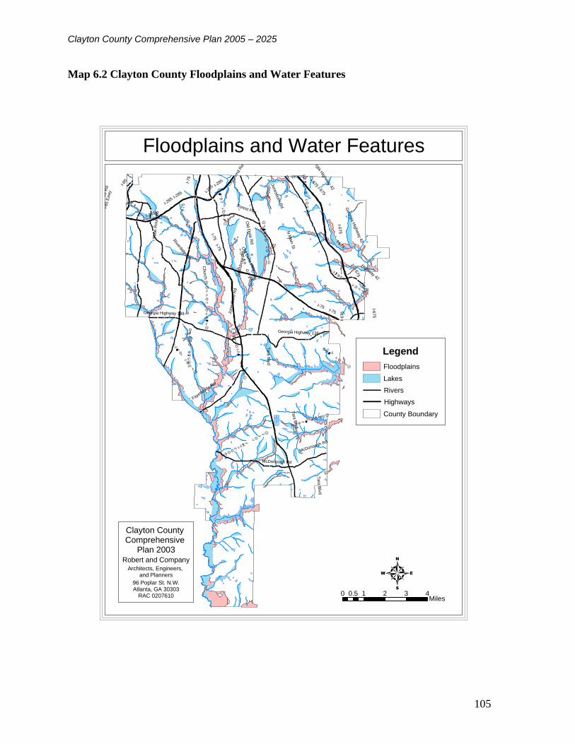
Clayton County Comprehensive Plan 2005 – 2025
105
Map 6.2 Clayton County Floodplains and Water Features
CAMP CREEK
RUM CREEK
PANTHER CREEK
JESTER CREEK
BEAVERDAM CREEK
FLINT RIVER
MUD CREEK
CONLEY CREEK
HURRICANE CREEK
PATES CREEK
JESTER CREEK
FLINT RIVER
I-75
W F
aye
tte
vill
e R
d
Old
Dix
ie R
d
Forest Pky
Jonesboro
Rd
Fayette
ville R
d
I-285
Riverdale R
d
I-675
Georg
ia H
ighw
ay 4
2
N M
ain
St
Georgia Highway 138
Ta
ra B
lvd
I-85
Sta
te R
ou
te 8
5
McDonough Rd
Thu
rmon
d R
d
Churc
h S
t
I-85 E
xw
y
Highway 42
Old
Dixie
Hw
y
W F
ayettevill
e R
d
I-75 I-675
I-75
I-75
I-7
5
Jonesboro
Rd
I-67
5
Tara
Blv
d
I-675
Ta
ra B
lvd
Georgia H
ighway 42
I-285
I-285
Jonesb
oro
Rd
I-6
75Georgia Highway 138
I-675
I-285
I-675
I-75
I-285
McDonough Rd
I-675
0 1 2 3 40.5Miles
4
Legend
Floodplains
Lakes
Rivers
Highways
County Boundary
Floodplains and Water Features
Clayton County Comprehensive
Plan 2003Robert and Company
Architects, Engineers, and Planners
96 Poplar St. N.W.Atlanta, GA 30303
RAC 0207610

Clayton County Comprehensive Plan 2005 – 2025
106
6.9 Soil Types
Clayton County soils are classified by the U.S. Soil Conservation Service according to six major
soil associations (Cartecay-Wehadkee, Cecil-Appling-Pacolet, Cecil-Pacolet-Madison, Gwinntt-
Cecil, Pacolet-Ashlar Gwinnett, Urban Land) and generally consist of sandy loam surface soils
and red clay subsoils. Each association exhibits a distinct pattern of soils, drainage and
landscape; however, the soils comprising one association can occur in other associations in
different patterns. The distribution of soil types in Clayton County is illustrated on Map 6.3.
The Cartecay-Wehadkee soils, which comprise approximately twelve percent of the soils in
Clayton County, are highly flood prone and therefore unsuitable for urban development. These
soils are generally located along major and minor streams and should be reserved for woodlands
and pasture activities. Other major constraints to development include erosion and high
shrink/swell ratios. Erosion usually occurs on steep slopes (25% or more ) and areas under
construction. The Pacolet-Ashlar-Gwinnett Association, which covers fourteen percent of the
county, includes areas of steeps slopes unsuitable for certain types of development, small
commercial buildings, septic tanks and dwellings with basements. Although the Urban Land
Association is highly favorable for development, erosion in areas under construction is a severe
hazard where soils have been modified by cutting, filling, shaping and smoothing. These
shrink/swell ratios also severely restrict development activity. This ratio is measured by the
percentages a soil will shrink when dry and swell when wet, with a ten percent shrinkage index
and a six percent swelling index considered a high ratio. The Gwinnett-Cecil Association, which
covers fifteen percent of the county, contains areas with high shrink/swell ratios and should be
avoided for certain types of development such as roads, bridges and multi-story buildings.
Table 6.1 indicates each soil association's general development potential as determined by the
United States Department of Agriculture's Soil Conservation Service. Three associations in
Clayton County received "High" ratings for urban land use, one association rated "Medium" and
two associations rated "Low" in potential for urban use. Deliberate decisions to avoid
development within these two associations should be made, particularly in the flood plain soils
of the Cartecay-Wehadkee Association.
Table 6.1 Soil Suitability
URBAN FARMING PASTURE WOODLANDS
Cartecay-Wehadkee Low Low Medium High
Cecil-Appling-Pacolet High High High Medium
Cecil-Pacolet-Madison High Medium High Medium
Gwinntt-Cecil Medium High High Medium
Pacolet-Ashlar Gwinnett Low Low Medium Medium
Urban Land High Low Medium Medium

Clayton County Comprehensive Plan 2005 – 2025
107
Map 6.3 Clayton County Soils
Clayton County Comprehensive
Plan 2003Robert and Company
Architects, Engineers, and Planners
96 Poplar St. N.W.Atlanta, GA 30303
RAC 0207610
FOREST PARK
MORROW
RIVERDALE
LOVEJOY
JONESBORO
COLLEGE PARK
LAKE CITYI-75
W F
ayett
evill
e R
d
Old
Dix
ie R
d
Jo
ne
sb
oro
Rd
Fayetteville
Rd
I-285
Rive
rdale
Rd
I-675
Georg
ia H
ighw
ay 4
2
Georgia Highway 138
Tara
Blv
d
I-85
Sta
te R
oute
85
McDonough Rd
Thu
rmon
d R
d
Georg
ia H
ighw
ay 4
2
Tara
Blv
d
I-675
McDonough Rd
I-285
I-285
I-675I-75
I-75
I-67
5I-285
I-75
I-75
I-75
Tara
Blv
d
I-675
I-75
µ0 1 2 3 40.5
Miles
Legend
Soil Type
AkA
AmB
AmC
AnC2
AsC
AtE
CA
CeB
CeC
CfC2
CuC
DgB
DgC
GeB
GwC2
GwC3
GwE2
MdB
MdC
MfC2
MfE2
MoC
PaC
PaE
PgC2
PuE
QU
TS
To
UD
W
WH
Municipal Boundaries
County Boundary
Highways
Clayton County Soils

Clayton County Comprehensive Plan 2005 – 2025
108
6.10 Steep Slopes
Non-rocky terrain with a slope of more than 25% is considered to have a high risk for severe
soils erosion. Clayton County is in the middle of the Piedmont Province in the gently rolling
landscape of the Central Georgia region. The northwestern part of the county is higher in
elevation and has steeper slopes than the southwestern and eastern parts. The highest elevation
in the county is 1049 feet and the lowest point 749 feet. There are few areas of steep slopes
within the County; those that due occur are primarily located in the northwest and northeast areas
of the county (See Map 6.4).
Map 6.4 Clayton County Slope
TA
RA
BLV
D
GE
OR
GIA
HIG
HW
AY
42
PA
NH
AN
DLE
RD
OLD
DIX
IE R
D
RIV
ER
DA
LE
RD
LAKE JODECO RD
MT
ZIO
N B
LV
DCONLEY RD
GE
OR
GIA
HIG
HW
AY
54
JON
ES
BO
RO
RD
FAYETTEVILLE
RD
FOREST PKWYM
AIN
ST
SULLIVAN RD
GE
OR
GIA
HIG
HW
AY
85
W F
AY
ET
TE
VIL
LE
RD
GEORGIA HIGHWAY 138
WOOLSEY
R
D
BO
ULD
ER
CR
ES
T R
D
MCDONOUGH R
D
N M
AIN
S
T
UPPER RIVERDALE RD
GE
OR
GIA
HIG
HW
AY
85
W F
AY
ET
TE
VIL
LE
R
D
PA
NH
AN
DLE
R
D
Slope by Percent
Clayton County Comprehensive
Plan 2003Rogert and Company
Architects, Engineers, Planners96 Poplar Street
Atlanta, GA 30316
µ
Legend
Slope by Percent
0 - 2.5 %
2.5 - 5 %
5 - 7.5 %
7.5 - 10 %
10 - 12.5 %
12.5 - 25 %
25 % and Over
Rivers
Lakes
Major Roads
County Boundary
2 0 21 Miles

Clayton County Comprehensive Plan 2005 – 2025
109
A significant geological feature in Clayton County is Soapstone Ridge. It covers a total of 25
square miles in DeKalb, Fulton and Clayton counties, the majority of which is located in DeKalb
County. However, approximately six square miles of the Ridge extends into north central and
northeastern Clayton County. The highest elevation of the Ridge in Clayton County is about 950
feet. The term "soapstone" is synonymous with steatite and refers to all talcose massive rocks.
The rock materials on the Ridge contain some of the materials, which comprise soapstone but are
not true soapstones. The Ridge was probably named for its soapstone-like characteristics. When
wet, the soapstone-like rock common to the Ridge area assumes a sudsy, soapy appearance
which was easily carved into bowls and other small tools as early as the Archaic Period (3000
B.C. - 1500 B.C.). In Clayton County, the predominant rock type in the Ridge is granite gneiss,
a medium grain light gray rock that contains feldspar, quartz and biotite. This rock is generally
considered developable except where sizable surface outcrops require blasting and therefore
limit the feasibility of economical foundation construction. In addition, high shrink/swell ratios
and steep slopes contribute to developmental constraints in many areas of the Ridge.
From a land use standpoint, the topography of Clayton County will not have a major
impact on future development. However, the following should be considered in the location of
land uses, intensive uses (commercial and industrial) should be encouraged to develop primarily
in areas of reasonably level land with slopes that do not exceed 5% in slope and residential
developments proposed to be developed on lands in excess of 12% slope should be carefully
planned to prevent the development of streets with excessive grades, unmanageable building lots
and excessive drainage problems.
6.11 Prime Agricultural and Forest Land
The U .S. Department of Agriculture reports that there are six types of prime farmland soils
present in Clayton County (See Table 6.2). These soils are considered prime unless they are
urban or built up. Areas of prime agricultural soils in Clayton County are illustrated on Map 6.5.
Table 6.2 Clayton County Prime Farmland
Map Symbol Soil Name Slopes
AkA Altavista sandy loam 0 to 3 percent slopes
AmB Appling sandy loam 2 to 6 percent slopes
CeB Cecil sandy loam 2 to 6 percent slopes
DgB Davidson loam 2 to 6 percent slopes
GeB Gwinnett sandy loam 2 to 6 percent slopes
MdB Madison sandy loam 2 to 6 percent slopes
Forest cover occurring naturally in Clayton County consists primarily of southern pines and in
particular Loblolly pine. Shortleaf pine grows with the Loblolly pine in greater or lesser
quantities depending on the fertility and slope of the topography. Mixed hardwoods such as
various Oaks, Hickories, American Winged Elms and Dogwoods can be found under pine
canopies. Bottomland hardwoods such as Yellow Poplar, Tupelo Gum, Sweetgum, Sycamore,
Red Maple and Ash occupy the more fertile sites along creeks and swamps. There is no prime
forestry land in Clayton County. According to statistics from the Georgia Forestry Commission
approximately 28,000 acres of 30% of the county is forested.

Clayton County Comprehensive Plan 2005 – 2025
110
Due to low instances of farming activity in the county and the growing urbanization of the
county agricultural activities are not anticipated to continue on Clayton County. For this reason
no specific measure to protect prime agricultural soils are included in the plan.
Map 6.5 Clayton County Prime Agricultural Soils
TA
RA
BLV
D
GE
OR
GIA
HIG
HW
AY
42
PA
NH
AN
DLE
RD
OLD
DIX
IE R
D
RIV
ER
DA
LE
RD
LAKE JODECO RD
MT
ZIO
N
B
LV
D
CONLEY RD
GE
OR
GIA
HIG
HW
AY
54
JON
ES
BO
RO
RD
FAYETTEVILLE
R
D
FOREST PKWY
MA
IN S
T
SULLIVAN RD
GE
OR
GIA
HIG
HW
AY
85
W F
AY
ET
TE
VIL
LE
RD
GEORGIA HIGHWAY 138
WO
OLSEY
R
D
BO
ULD
ER
CR
ES
T R
D
MCDONOUGH
RD
N M
AIN
S
T
UPPER RIVERDALE RD
PA
NH
AN
DLE
R
D
GE
OR
GIA
HIG
HW
AY
85
Prime Agricultural Soils
Clayton County Comprehensive
Plan 2003Rogert and Company
Architects, Engineers, Planners96 Poplar Street
Atlanta, GA 30316
µ
Legend
Prime Farmland
County Boundary
Major Roads
2 0 21 Miles

Clayton County Comprehensive Plan 2005 – 2025
111
6.12 Plant and Animal Habitats
The U.S. Fish and Wildlife Service of the Department of the Interior lists only two types of birds
and one invertebrate as threatened or endangered in Clayton County (Table 6.3). The names of
these animals, their status, habitat and threats are listed in the table below. In addition to the
plants and animals listed there are a number of others threatened or endangered in surrounding
counties (Table 6.4). Due to their location in surrounding counties it is possible that they may
also be present but undetected in Clayton County.
Table 6.3 Threatened and Endangered Plants and Animals in Clayton County
Clayton County Threatened and Endangered Plants and Animals
Species Common
Name
Scientific
Name
Federal
Status
State
Status
Habitat Threats
Bird Bald
eagle
Haliaeetus
leucocephal
us
T E Inland waterways and
estuarine areas in
Georgia.
Major factor in initial
decline was lowered
reproductive success
following use of
DDT. Current threats
include habitat
destruction,
disturbance at the
nest, illegal shooting,
electrocution, impact
injuries, and lead
poisoning.
Bird Wood
stork
Mycteria
americana
E E Primarily feed in
fresh and brackish
wetlands and nest in
cypress or other
wooded swamps.
Active rookeries were
located in Camden
County 1991-2001.
Decline due primarily
to loss of suitable
feeding habitat,
particularly in south
Florida. Other factors
include loss of
nesting habitat,
prolonged
drought/flooding,
raccoon predation on
nests, and human
disturbance of
rookeries.
Invertebrat
e
Oval
pigtoe
mussel
Pleurobema
pyriforme
E E River tributaries and
main channels in slow
to moderate currents
over silty sand,
muddy sand, sand,
and gravel substrates
Habitat modification,
sedimentation, and
water quality
degradation

Clayton County Comprehensive Plan 2005 – 2025
112
Table 6.4 Threatened and Endangered Plants and Animals in Surrounding Counties Threatened and Endangered Plants and Animals in Surrounding Counties
Counties Species Common
Name
Name Federal
Status
State
Status
Habitat Threats
Clayton,
DeKalb,
Fayette,
Fulton,
Henry
Bird Bald eagle Haliaeetus
leucocephalus
T E Inland waterways and
estuarine areas in
Georgia.
Major factor in initial
decline was lowered
reproductive success
following use of DDT.
Current threats include
habitat destruction,
disturbance at the nest,
illegal shooting,
electrocution, impact
injuries, and lead
poisoning.
DeKalb,
Fulton
Plant Bay star-
vine
Schisandra
glabra
No
Federal
Status
T Twining on subcanopy
and understory
trees/shrubs in rich
alluvial woods
DeKalb Plant Black-
spored
quillwort
Isoetes
melanospora
E E Shallow pools on
granite outcrops, where
water collects after a
rain. Pools are less than
1 foot deep and rock
rimmed.
DeKalb,
Fulton
Fish Bluestripe
shiner
Cyprinella
callitaenia
No
Federal
Status
T Brownwater streams
Fulton Fish Cherokee
darter
Etheostoma
scotti
T T Shallow water (0.1-0.5
m) in small to medium
warm water creeks (1-
15 m wide) with
predominantly rocky
bottoms. Usually found
in sections with reduced
current, typically runs
above and below riffles
and at ecotones of
riffles and backwaters.
Habitat loss due to dam
and reservoir
construction, habitat
degradation, and poor
water quality
DeKalb Plant Flatrock
onion
Allium
speculae
No
Federal
Status
T Seepy edges of
vegetation mats on
outcrops of granitic
rock
DeKalb,
Henry
Plant Granite rock
stonecrop
Sedum
pusillum
No
Federal
Status
T Granite outcrops among
mosses in partial shade
under red cedar trees
DeKalb,
Fulton
Plant Piedmont
barren
strawberry
Waldsteinia
lobata
No
Federal
Status
T Rocky acedic woods
along streams with
mountain laurel; rarely
in drier upland oak-
hickory-pine woods

Clayton County Comprehensive Plan 2005 – 2025
113
Threatened and Endangered Plants and Animals in Surrounding Counties
Counties Species Common
Name
Name Federal
Status
State
Status
Habitat Threats
Fayette,
Fulton
Invertebra
te
Gulf
moccasinsh
ell mussel
Medionidus
pencillatus
E E Medium streams to
large rivers with slight
to moderate current
over sand and gravel
substrates; may be
associated with muddy
sand substrates around
tree roots
Habitat modification,
sedimentation, and
water quality
degradation
Fayette,
Fulton
Fish Highscale
shiner
Notropis
hypsilepis
No
Federal
Status
T Blackwater and
brownwater streams
DeKalb Plant Indian olive Nestronia
umbellula
No
Federal
Status
T Dry open upland forests
of mixed hardwood and
pine
Clayton,
Fayette
Invertebra
te
Oval pigtoe
mussel
Pleurobema
pyriforme
E E River tributaries and
main channels in slow
to moderate currents
over silty sand, muddy
sand, sand, and gravel
substrates
Habitat modification,
sedimentation, and
water quality
degradation
DeKalb,
Henry
Plant Pool Sprite,
Snorkelwort
Amphianthus
pusillus
T T Shallow pools on
granite outcrops, where
water collects after a
rain. Pools are less than
1 foot deep and rock
rimmed
Fayette,
Fulton
Invertebra
te
Shiny-rayed
pocketbook
mussel
Lampsilis
subangulata
E E Medium creeks to the
mainstems of rivers
with slow to moderate
currents over sandy
substrates and
associated with rock or
clay
Habitat modification,
sedimentation, and
water quality
degradation
In addition to these listings by the Fish and Wildlife Service, the Georgia Department of Natural
Resources (GA DNR) lists additional plant and animal species as protected, unusual, or of
special concern. The Georgia Department of Natural Resources (GA DNR) lists the Pink
Ladyslipper as a “Protected” species with a status of “unusal” as present in Clayton County.
While, GA DNR does not list any threatened or endangered animals in the county the agency
does list two species of special concern, the Gulf Darter and Florida Floater. The Gulf Darter is
listed with a status of S3, meaning it is rare or uncommon and the Florida Floater has a status of
S2 denoting it is imperiled due to rarity.
Private developers and public officials involved with development review should utilize the
programs and resources made available by the Georgia Department of Natural Resources in
order to ensure the highest degree of protection of the county’s natural habitats from the
negative impacts of development. Additionally, the county’s development regulations and
development review process should strive for the highest possible protection and conservation of
habitats of threatened and endangered plant and animal species in Clayton County.

Clayton County Comprehensive Plan 2005 – 2025
114
6.13 Major Park, Recreation, and Conservation Areas
There are not state or national parks, sites, forests, or management areas located in Clayton
County. However, Clayton County Parks and Recreation Department maintains 670 acres of
park land including a number of recreational facilities for the leisure and enjoyment of its
citizens. In total there are 35 county park locations including 70 athletic fields, 29 tennis courts,
three community centers, 13 playgrounds, 17 picnic areas (10 picnic pavilions), two senior adult
centers, one swimming pool, two fishing ponds and one nature preserve (many of these areas are
noted on Map 6.6). The William H. Reynolds Nature Preserve, located in Morrow, encompasses
146 acres of undisturbed woodlands, ponds, and streams. The preserve also provides four miles
of hiking trails for recreational pursuits. Additionally, opportunities for watersports can be found
throughout the county at Lake Spivey, Lake Jodeco, Lake Shamrock and Drake's Landing.
Clayton County has a low proportion of open and green space to population. However, the
county’s numerous floodplains provide an opportunity for the conservation of open space and
protection of the water supply and the development of additional areas for passive recreation.
The Clayton County Water Authority (CCWA) has recently planned and undertaken a number of
steam restoration projects. These restored stream corridors provide an opportunity for the county
to coordinate with CCWA to develop a system of greenways and trails for recreation along these
and other stream corridors in Clayton County.

Clayton County Comprehensive Plan 2005 – 2025
115
Map 6.6 Clayton County Parks and Recreation Facilities
Clayton County Comprehensive
Plan 2003Robert and Company
Architects, Engineers, and Planners
96 Poplar St. N.W.Atlanta, GA 30303
RAC 0207610
_̂ _̂_̂_̂
_̂_̂ _̂
_̂ _̂_̂
_̂
_̂
_̂
_̂
_̂
_̂
_̂
_̂_̂
_̂
_̂
_̂
_̂
_̂
_̂
kj
kj
FOREST PARK
MORROWRIVERDALE
LOVEJOY
JONESBORO
LAKE CITY
COLLEGE PARK
W F
ayette
vill
e R
d
Jo
ne
sb
oro
Rd
Fayettevil
le Rd
I-285
Rive
rdale
Rd
Georg
ia H
ighw
ay 4
2
Sta
te R
oute
85
McDonough Rd
I-75
Tara
Blv
d
I-675
I-285
I-75
I-675
I-75
Rex Park
Conley Park
Lovejoy Park
Tenneco Park
Rum Creek Park
Riverdale Park
Panhandle Park
Grant Road Park
Maddox Road Park
Flat Shoals Park
Pine Circle Park
Conley Road Park
Independence Park
Jesters Creek Park
Clayton International Park
Lee Park
Paradise Park
Southside Park
Key Street Park
J.W. Arnold Park
Sigma Chi Memorial
Tar Creek Mini-Park
Morrow/Lake City Park
Forest Park City Park
Reynolds Nature Preserve
µ0 1 2 3 40.5
Miles
Legend
_̂ Parks
_̂ Clayton International Park
_̂ Reynolds Nature Preserve
kj Senior Rec Centers
Trails and Greenways
Existing
Planned
Golf Courses
Rivers
Lakes
Municipal Boundaries
County Boundary
Parks and Recreational Facilities

Clayton County Comprehensive Plan 2005 – 2025
116
6.14 Scenic Views and Sites
Clayton County serves as the gateway Georgia's Peach Blossom Trail. The trail follows U.S. 41
and U.S. 341 to Houston County covering almost 100 miles of Georgia's most beautiful yet
hidden sites down to Perry in Houston County. The trail promotes areas of the Georgia
countryside whose scenic beauty is enhanced each year by the delicate pink and white blossoms
of the peach tree. The trail also follows the path of the Flint River, which has been called the
most scenically beautiful, diverse and recreation-friendly river in Georgia.
6.15 Cultural and Historic Resources
Clayton County has a number of cultural, historical, and archaeological resources that enrich the
quality of life for the county’s citizens. Cultural facilities include Spivey Hall located on the
campus of Clayton State College, just off of I-75. Spivey Hall was built for the purpose of
supporting and endowing performances by artists and for enhancing the further development of
the outstanding music program at Clayton State College. The Clayton County Performing Arts
Center was built for the Clayton County School Board to offer a location for schools throughout
the county to present various productions put on by the students. It is also used for hosting
musical and theatrical productions by professional artists throughout the country. The Clayton
County Performing Arts Center includes three theaters that hold 1,211, 250 and 339 visitors,
which can be combined to seat a total of 1,800 visitors. Additionally, Arts Clayton, Inc. is an
organization which is able to foster and encourage the performing and visual arts within the
community, as well as make numerous presentations for the enjoyment of all ages.
There are five sites in Clayton County listed on the on the National Register of Historic Places
(two of which are associated with the City of Jonesboro). These sites are shown on Map 6.8
6.15.1 Jonesboro Historic District
Originally settled as Leaksville in 1823, Jonesboro's business district became a National
Register site in 1972. The District encompasses eighteen historical sites including the 1869
and 1898 Courthouse, the County Jail, the Confederate Cemetery and ten private residences.
The total acreage of the district is 300 acres and the building styles were primarily Greek
Revival and Gothic. The 1869 Courthouse, located at the corner of North McDonough
Street and King Street, was built to replace the original county offices which were destroyed
in Kilpatrick's Raid on August 20, 1864. It served as the government center until 1898
when that use terminated and it became the Jonesboro Masonic Hall. The 1898 Courthouse,
located two blocks south of the original structure on McDonough Street, still accommodates
county offices. The first Clayton County Jail was erected in 1869 near the original
courthouse and a second floor was added in 1880. From 1898 to 1971, the building was
used as a private residence and now serves as the archives buildings for historical Jonesboro,
Inc. During the Battle of Jonesboro of August 31 and September 1, 1864, the
Confederate Cemetery became the burial site for over 600 Confederate soldiers in
what is now a part of the City of Jonesboro. Individual markers were erected in 1964 and
the site was officially designated as the "Pat Cleburne Memorial Cemetery" for a
Confederate general who fought in the battle.

Clayton County Comprehensive Plan 2005 – 2025
117
6.15.2 Stately Oaks Plantation
Located in the Jonesboro Historic District, this home became a National Register site in
The 151-year old, ten room house was constructed by Whitemall P. Allen in the late
1830's, four miles north of Jonesboro on Tara Boulevard. Through the efforts of
Clayton County, the City of Jonesboro and Historical Jonesboro, Inc., the house was
moved to a 42-acre site on Lake Jodeco Road in 1973. Dedicated as the Margaret
Mitchell Memorial Center, complete restoration work began in 1979.
6.15.3 Rex Mill
Listed on the National Historic Register in 1979, this grist mill is believed to have been
constructed sometime between 1820 and 1860. This 1.5-acre site is located north of Rex
Road on Cotton Indian Creek in unincorporated Rex. The Mill is historically significant in
that it reflects a characteristic architectural style and the industrial history of the county.
6.15.4 Crawford - Dorsey House and Cemetery
Designated in July 1984, this site is the most recent addition to Clayton County's list of
National Register sites. Built in 1835 with additions made in 1858, it is located north of
Lovejoy at the intersection of McDonough and Freeman Roads. It was the scene of heavy
fighting during the Battle of Lovejoy in the Civil War. However, in December 1984 it was
destroyed by fire which left only three chimneys standing.
In addition to the historic sites related to the Civil War Era, Clayton County possesses a
155-acre archaeological site was listed on the National Register in 1974. The Orkin Early
Quartz Site-is located in the southwest corner of the panhandle near the Fayette County line.
Artifacts such as quartzite tools and chips believed to be dated as early as 3000 B.C. have been
discovered on this site. Little or nothing has been published about this phase of the Archaic
period in Georgia and the Orkin Early site may provide information regarding settlement and
social patterns of this period.
There are no records of a comprehensive survey of the county’s historic resources. Historic
resource surveys provide information on buildings, structures, objects, and sites, which are 50
years old or older and possess historical, architectural, or cultural significance. While these
surveys do not provide a complete documentation of each resource they are an invaluable tool
for recording the county’s history, increasing awareness of a community’s history and historic
buildings, and planning for their protection and preservation. Additionally, historic resources
can serve as a catalyst for economic development when they are preserved and interpreted for
cultural tourism. It is recommended that Clayton County undertake a comprehensive inventory
of its historic resources and develop a plan for their promotion and preservation.

Clayton County Comprehensive Plan 2005 – 2025
118
Map 6.7 Historic and Cultural Resources
Clayton County Comprehensive
Plan 2003Robert and Company
Architects, Engineers, and Planners
96 Poplar St. N.W.Atlanta, GA 30303
RAC 0207610
FOREST PARK
MORROWRIVERDALE
LOVEJOY
JONESBORO
LAKE CITY
COLLEGE PARK
I-75
W F
aye
ttevill
e R
d
Jo
ne
sb
oro
Rd
Fayettevil
le Rd
I-285
Rive
rdale
Rd
I-675
Georg
ia H
ighw
ay 4
2
Georgia Highway 138
Ta
ra B
lvd
I-85
Sta
te R
oute
85
McDonough Rd
I-67
5
I-675
I-75
I-285
Tara
Blvd
I-67
5
I-75
I-75
I-285
I-75
Tara
Blv
d
I-285
I-675
I-75
I-675
µ0 1 2 3 40.5
Miles
Legend
Crawford - Dorsey House and Cemetery
Rex Mill
Stately Oaks Plantation
Peach Blossom Scenic Hwy
Municipal Boundaries
Highways
Railroad
County Boundary
Historic and Cultural Resources

Clayton County Comprehensive Plan 2005 – 2025
119
6.16 Natural and Cultural Resources Vision
Clayton County will conserve and protect the positive overall qualities of the natural
environment which give the county its character, and preserve those areas which have important
recreational, scenic, historic, archaeological, educational and aesthetic values which should be
shared, enjoyed, protected and passed on to future generations.
6.17 Goals and Policies
Goal 1.0 Ensure the availability and accessibility of a variety of recreational opportunities for all
persons.
Policy 1.1 Conduct a parks and recreation needs assessment to determine the appropriate level
of public recreation facility and parks provision for Clayton County.
Policy 1.2 Work with the Clayton County Water Authority and other interested local
organizations to develop a pedestrian and bike trail system encompassing the wetland and
floodplain areas of Clayton County.
Policy 1.3 Pursue the joint use of school board recreational properties for county-wide
recreational programs when these properties are not in use by the school system.
Policy 1.4 Conduct a study to determine the feasibility of creating a county-wide
authority to oversee all aspects of recreational, environmental and historical
resource management and development.
Policy 1.5 Develop mechanisms to consistently provide funds for parks and recreation
services.
Policy 1.5.1 Explore the feasibility of implementing fees for the usage of
facilities, especially for out of county individuals.
Goal 2.0 Secure adequate future sites for recreation activities by identifying land and
water areas having the best combinations of natural features, size and location suited for
the type of experience to be provided.
Policy 2.1 Develop a long term land acquisition strategy to meet the parks
acreage needs of the county’s projected 2025 population.
Goal 3.0 Preserve and protect Clayton County’s historic resources for the education and
enjoyment of current and future county residents and visitors.
Policy 3.1 Conduct a comprehensive survey of Clayton County to assess the
presence of previously undocumented historic sites.

Clayton County Comprehensive Plan 2005 – 2025
120
Policy 3.1.1 Add to the county's historical sites priority list the Flint River,
Jester's Creek, Huie Cemetery, Elam Road Baptist Church, the Dorsey
property, Lovejoy area sites.
Policy 3.2 Develop a long range plan for the preservation and promotion of the
county’s historic sties which coordinates educational, recreational, and tourism
opportunities.
Goal 4.0 Meet or exceed the 20% benchmark for open space preservation set by the
Governor’s greenspace program.
Policy 4.1 Encourage land development practices that reserve open space within
or close to developed sites.
Policy 4.1.1 Revise the county’s current conservation subdivision ordinance to
ensure that land, which would have been otherwise developed, is preserved as
open space in conservation subdivisions.
Policy 4.1.2 Consider developing and adopting incentives to persuade
developers of any new residential subdivision to provide open space as part of
the development.
Policy 4.1.3 Review the county’s current retail and office zoning
ordinances and revise as necessary to require openspace and greenspace set
asides for larger developments.
Goal 5.0 Achieve efficient use of multi-purpose greenspaces which help to define
development concentrations, serve as buffers between dissimilar development and/or
protect sensitive natural areas.
Policy 5.1 Review and revise as necessary all of the county’s development regulations to
include adequate and appropriate buffering requirements for all zoning classifications.
Goal 6.0 Protect natural resources from development which would create significant negative
environmental or economic impacts. Floodplains, steep slopes, rock outcroppings and soils with
high shrink/swell ratios are natural features that, when developed, could create significant
negative impacts on the surrounding environs.
Policy 6.1 Use land for the purpose for which it is best suited based on its resource
capabilities and land use suitability.
Policy 6.2 Support land use patterns which are more energy efficient by encouraging the
development traditional neighborhood developments and mixed-use nodes while discouraging
the spread of random, low density sprawl.
Goal 7.0 Conserve and protect Clayton County’s tree cover.

Clayton County Comprehensive Plan 2005 – 2025
121
Policy 7.1 Review the county’s current tree ordinance and revise as necessary to ensure that
developers are not clear cutting land or leaving only a perimeter of trees when clearing land for
development.
Goal 8.0 Protect Clayton County’s rivers, streams, watersheds, wetlands and other water
resources in order to insure adequate water supply and water quality.
Policy 8.1 Restrict land disturbing activities adjacent to rivers and streams in order to
limit erosion and the potential for increased flow velocities and flood heights.
Policy 8.2 Preserve wetlands and floodplains as permanent open space whenever
feasible.
Policy 8.2.1 Develop incentives for developers and landowners willing to donate
wetland and floodplain areas to the county or another appropriate entity for
permanent preservation and/or development for public recreational purposes.
Policy 8.2.2 Develop and enact ordinances that allow for zero wetlands loss to development and
in the case of unavoidable destruction promote replacement versus mitigation.
Goal 9.0 Protect and improve air quality in Clayton County.
Policy 9.1 Promote compact land development that allows for walking and other non-
motorized transportation.

Clayton County Comprehensive Plan 2005 – 2025
122
CHAPTER 7 LAND USE
Introduction
The land use element begins with a survey and analysis of the county’s existing land use pattern.
This background data is combined with information contained in the plan’s other elements
regarding the wants and needs of the county’s current and future citizens in order to set the
course for future development. This course of action is expressed graphically in the Future Land
Use Map and textually in a series of goals and policies that will to provide the county’s elected
officials with a guide for making sound land use decisions during the 2005 – 2025 planning
period.
7.1 Prior Land Use Planning in Clayton County
As a metro-Atlanta county that was early to develop in a suburban and urban pattern, Clayton
County has prepared land use plans for several decades. These past planning efforts have
addressed land use and development, transportation infrastructure, water and sewer
infrastructure, and many related issues. Past planning efforts have helped to coordinate public
services, infrastructure development and policy for the betterment of the community.
The current Clayton County Comprehensive Plan was completed in 1992 with assistance from
Robert and Company. The 1992 plan was prepared in accordance with the State of Georgia
Department of Community Affairs Minimum Standards for Comprehensive Planning,
established in 1989. In 1999 the county updated the Future Land Use Map to reflect changes in
the existing land use pattern and newly adopted land use amendments. In 2003 the County
Commission voted to regularly update the Future Land Use Map in conjunction with land use
amendment decisions, which are made concurrent with rezonings.. The county also consolidated
certain land use classifications depicted on the map in order to reduce the frequency of zoning
changes, which would require a revision to the Land Use Map.
7.1.1 Summary of Land Use Map Changes Since 1992
A number of land use amendments were passed in Clayton County between 1996 and 1997.
These changes are summarized below. The county’s 1999 update of the Future Land Use Map
reflected these changes.
Rex and Ellenwood Area of Northeast Clayton County
The triangular shaped area roughly bounded by I-675 on the west, the county line to the north,
Bouldercrest Road on the east and a point between Ellenwood and Double Bridges Road to the
south was reclassified to light industrial from a mixture of low density residential in the northern
portion of the area and light industrial in the southern portion.
The area from Grant Road and property facing Boldercrest Road eastward to the county line,
bounded on the north by the county line and on the south by a line approximately halfway
between Rex and Ellenwood, was reclassified from a combination of undeveloped and low

Clayton County Comprehensive Plan 2005 – 2025
123
density residential to suburban residential (a density of two units per acre) with
office/institutional land uses also allowable.
The area surrounding the town of Rex, bounded by I-675 on the west and the county line on the
east, was reclassified from low density residential to medium density residential as defined by
the county’s current RS-180 and RS-110 zoning classifications.
Highway 138 Corridor
The Highway 138 corridor, from its intersection with Walt Stephens Road to Interstate 75, was
reclassified from low density residential to a number of land uses including nodes of industrial,
office, commercial, residential, and park/openspace. This reclassification was based on the
identification of Highway 138 as a major east-west corridor through the county and the
anticipation of pressure for major land use change resulting from a proposed widening of the
road from two to four lanes (the roadway remains a two lane road as of April 2004). To protect
against strip style commercial development, the county sought to limit commercial development
to major intersections. When the Land Use Map was updated in 1999 the corridor was
designated as Highway 138 Commercial, however no distinction was made regarding the
specifically acceptable land uses on the county’s official Land Use Map.
Panhandle Area
In the southern portion of the county, referred to as the Panhandle, land was reclassified from
undeveloped and low density residential to a mixture of one-acre and one half-acre building lot
low density residential land use. Generally, the area south of McDouough Road was designated
for one-acre lots as was the area east of Tara Boulevard and south of Freeman Road. The area to
the north of these areas and south of Highway 54 was designated for half-acre residential lot
development.
7.1.2 Land Use Classification Name Changes
During this update of the Future Land Use Map a number of land use classification names were
changed. These changes and their equation to the 1992 Future Land Use map are show in Table
7.1

Clayton County Comprehensive Plan 2005 – 2025
124
Table 7.1 Land Use Classification Name Changes
1992 Land Use Classification 2003 Land Use
Classification
Currently
Allowable Density
Related Zoning
Single Family (Residential)
Class I
Low Density Residential 1.0 unit/acre A and ER
Single Family (Residential)
Class II
Suburban Residential 2.0 units/acre RS –300
Single Family (Residential)
Classes III, IV, V, and VI
Medium Density
Residential
4.0 units/acre RS 180A, RS-
180, and RS-110
Single Family (Residential)
Class VII
Urban Residential 7.5 units/acre RG-75
MF (Residential) Class I, II
and MH
High Density Residential 8 units/acre RM, RMTH, and
MHP
Neighborhood Business Neighborhood Commercial N/A NB
Office Park Office Institutional N/A OI
General Business General Commercial N/A GB and CB
7.1.3 Residential Density Changes
The maximum density associated with the residential multi-family (RM) and residential multi-
family townhouse (RMTH) zoning classifications have been lowered twice in the past decade.
The maximum density currently allowable under these classifications is 8 units per acre.
7.1.4 Other Changes
In 2001 the county established the Limited Commercial (LC) zoning district classification. The
purpose of the LC district is to allow low-intensity commercial uses as a transition from existing
residential districts and more intense uses. This zoning classification has been implemented on a
limited basis and is used most commonly for rezoning of residential properties converting into
small offices for doctors and real estate agents along roadways that have been widened.
The RS-65 (cluster-style single family residence district) zoning classification that allowed for
residential densities of up to five (5) units per acre was abolished in January 2004.
In January 2004 the county adopted the single family conservation residential district (CR)
classification. The purpose of CR district is to accommodate single-family residences in
subdivisions designed to concentrate lots, houses, streets, utilities, and related development
activities on the more suitable areas of a parcel and conserve the environmentally sensitive areas
as green/open space.

Clayton County Comprehensive Plan 2005 – 2025
125
7.2 Land Use Classifications
The Department of Community Affairs (DCA) recommends that land use classification in local
plans to be consistent with the standard system established by for the State of Georgia. Local
governments are free to develop additional, more detailed categories, however they must be
grouped under one of these nine standard categories. These categories are as follows.
Agriculture: This category is for land dedicated to farming (fields, lots, pastures, farmsteads,
specialty farms, livestock production, etc.) or other similar rural uses such as pasture, land is not
used for commercial purposes.
Forestry: This category includes land dedicated to commercial timber or pulpwood harvesting
and woodlands not in commercial use.
Commercial: This category is for land dedicated to non-industrial business uses, including retail
sales, office, service and entertainment facilities. Commercial uses may be located as a single
use in one building or grouped together in a shopping center or office building.
Industrial: This category is for land dedicated to manufacturing facilities, processing plants,
factories, warehousing and wholesale trade facilities, mining or mineral extraction facilities or
other similar uses.
Park/Recreation/Conservation: This category is for land dedicated to active or passive
recreational uses. These areas may be either publicly or privately owned and may include
playgrounds, public parks, nature preserves, wildlife management areas, national forests, golf
courses, recreation centers, and similar uses.
Public/Institutional: This category includes certain state, federal, or local government uses and
institutional land uses. Examples of institutional land uses include colleges, churches,
cemeteries, and hospitals. Government uses in this category include city halls or government
building complexes, police and fire stations, libraries, prisons, post offices, schools and military
installations.
Residential: The predominant use of land within the residential category is for single family and
multi-family dwellings. In describing existing land use in Clayton County the existing
residential land use category has been subcategorized according to the following density
classifications.
Low Density Single-Family Residential 2.00 - 5.00 acres per dwelling unit
Medium Density Single-Family Residential 0.25 - 2.00 acres per dwelling unit
Multi-family Residential - including apartments, condominiums, and town houses with a typical
density of 8 units per acre or greater.
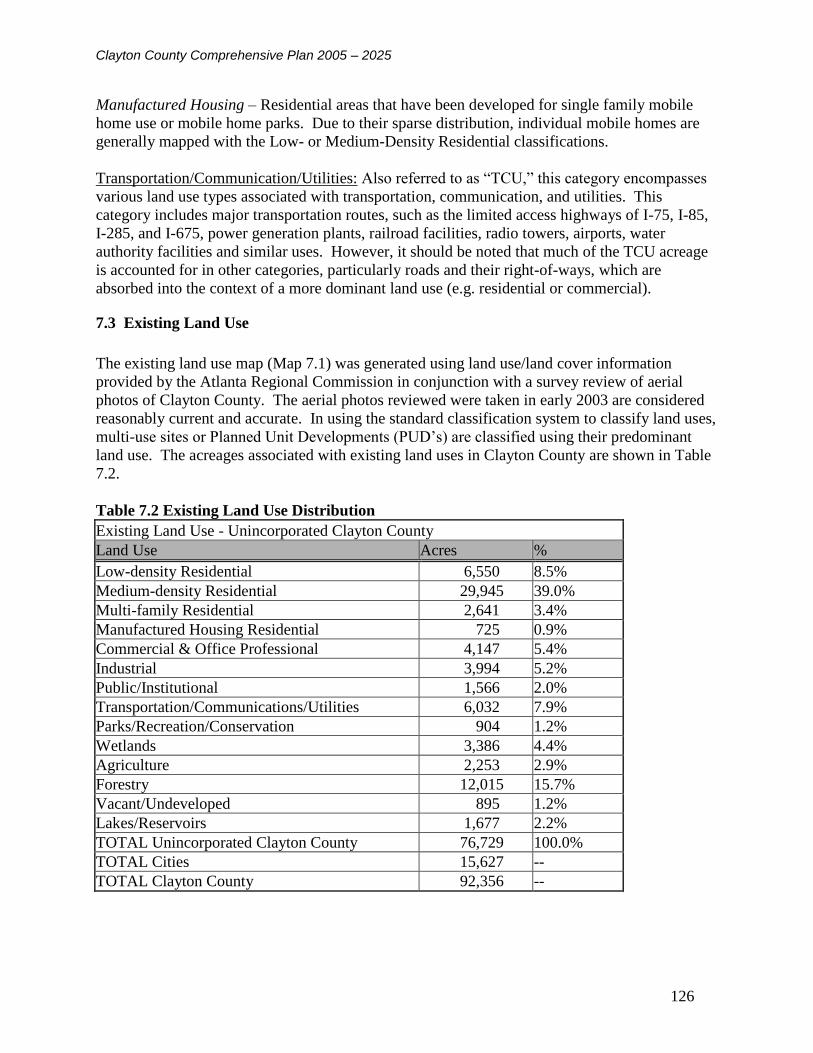
Clayton County Comprehensive Plan 2005 – 2025
126
Manufactured Housing – Residential areas that have been developed for single family mobile
home use or mobile home parks. Due to their sparse distribution, individual mobile homes are
generally mapped with the Low- or Medium-Density Residential classifications.
Transportation/Communication/Utilities: Also referred to as “TCU,” this category encompasses
various land use types associated with transportation, communication, and utilities. This
category includes major transportation routes, such as the limited access highways of I-75, I-85,
I-285, and I-675, power generation plants, railroad facilities, radio towers, airports, water
authority facilities and similar uses. However, it should be noted that much of the TCU acreage
is accounted for in other categories, particularly roads and their right-of-ways, which are
absorbed into the context of a more dominant land use (e.g. residential or commercial).
7.3 Existing Land Use
The existing land use map (Map 7.1) was generated using land use/land cover information
provided by the Atlanta Regional Commission in conjunction with a survey review of aerial
photos of Clayton County. The aerial photos reviewed were taken in early 2003 are considered
reasonably current and accurate. In using the standard classification system to classify land uses,
multi-use sites or Planned Unit Developments (PUD’s) are classified using their predominant
land use. The acreages associated with existing land uses in Clayton County are shown in Table
7.2.
Table 7.2 Existing Land Use Distribution
Existing Land Use - Unincorporated Clayton County
Land Use Acres %
Low-density Residential 6,550 8.5%
Medium-density Residential 29,945 39.0%
Multi-family Residential 2,641 3.4%
Manufactured Housing Residential 725 0.9%
Commercial & Office Professional 4,147 5.4%
Industrial 3,994 5.2%
Public/Institutional 1,566 2.0%
Transportation/Communications/Utilities 6,032 7.9%
Parks/Recreation/Conservation 904 1.2%
Wetlands 3,386 4.4%
Agriculture 2,253 2.9%
Forestry 12,015 15.7%
Vacant/Undeveloped 895 1.2%
Lakes/Reservoirs 1,677 2.2%
TOTAL Unincorporated Clayton County 76,729 100.0%
TOTAL Cities 15,627 --
TOTAL Clayton County 92,356 --

Clayton County Comprehensive Plan 2005 – 2025
127
Map 7.1 Clayton County Existing Land Use
FORT GILLEM FOREST PARK
RIVERDALEMORROW
LOVEJOY
JONESBORO
COLLEGE PARK
LAKE CITY
µ
Legend
Existing Land Use
Low Density Residential
Medium Density Residential
Mobile Home Residential
Multi-Family Residential
Commercial
Industrial
Public/Institutional
Transport/Utilities
Parks/Recreation/Conservation
Agriculture
Forestry
Wetlands
Lakes and Reservoirs
Vacant/Undeveloped
City Limits
Streets
Highways
Rivers
Clayton County Comprehensive
Plan 2025Robert and Company
Engineers, Architects,and Planners
96 Poplar St. N.W.Atlanta, GA 30303
RAC 0207610 0 2 41 Miles
Existing Land Use - Clayton County

Clayton County Comprehensive Plan 2005 – 2025
128
7.3.1 Description of Existing Land Use in Clayton County
Between 1992 and 2003 Clayton County experienced a large amount of development. The
effects of this development on the county’s land use pattern are discussed below. References to
the 1992 Land Use Inventory and conditions at that time are included when appropriate.
Agriculture
There is currently very little land used for agriculture in Clayton County, and the bulk of this
land is located in the Panhandle area. The area between Hwy 54 and Flint River Road, which
constituted a large area of agricultural land on the 1992 Existing Land Use Map, is now used for
medium density residential housing.
Residential
Low-density residential (single-family detached houses on two to five acre lots) land use in
Clayton County is scarce. The largest areas of this type of residential development are located in
the Panhandle area of the southern end of the county and a few pockets in the northeastern area
of the county between I-675 and the county line.
Medium density residential land use (single-family detached houses on quarter acre to two acre
lots) accounts for most of the land in Clayton County. Many areas of the county that were
undeveloped in 1992 are now dedicated to this use such as the land between I-75 and Lake
Spivey east of the City of Jonesboro and the area between Mundy’s Mill and Lovejoy Roads.
In 1992 the multi-family residential land uses in Clayton County were mainly apartment
complexes located along Upper Riverdale Road between the cities of College Park and
Riverdale. Multi-family land use has expanded greatly in Clayton County since that time and
now includes town home communities in addition to apartment complexes. Areas of multi-
family housing have developed between South Lake Mall and the Highway 138 Spur, near the
intersection of Highway 138 and I-675, and along GA 85 south of Highway 138.
There are a few nodes of manufactured housing in Clayton County. These include areas on
Warren Road west of GA 85 and between I-675 and Panther Creek. Additionally, the area of
manufactured housing at Tara Boulevard and Fitzgerald Roads has been expanded since 1992.
Public-Institutional
Clayton College and State University, to the east of Morrow, has grown due to the expansion of
the university and the relocation of state and national archival facilities to land adjacent to the
university. Additionally, due to population increases, a number of new public school campuses
have been developed throughout the county.
Office/Professional
Office and other professional land uses are located in various areas around the county. There are
larger nodes of office/professional land use developing along the Mt. Zion Road corridor
between Mt. Zion Boulevard and Highway 138 and adjacent to Southern Regional Hospital to
the east of the City of Riverdale.

Clayton County Comprehensive Plan 2005 – 2025
129
Commercial
Commercial land uses are primarily found in linear developments along the county’s major
transportation routes. The Tara Boulevard corridor contains a number of older strip malls that
are now in need of redevelopment, as does Riverdale Road. New, “big box” style commercial
developments have located near the county’s interstate exits such as the Mount Zion Road exit
on I-75 and the intersection of I-675 and Hwy 138. The Highway 138 corridor has developed
since 1992 with a number of smaller commercial developments, best described as “neighborhood
commercial.”
Industrial
Hartsfield Jackson International Airport is located in the northwest corner of Clayton County.
The continued expansion of the airport and the impacts of aircraft related noise have lead to the
expansion of industrial uses in the area south of I-285 between the airport and the cities of
Riverdale and Forest Park and Georgia Highway 85. There has also been continued expansion of
industrial land uses along I–675 near Fort Gillem.
Transportation/Communications/Utilities
As mentioned above, Hartsfield Jackson International Airport is located in the northwest area of
the county. The airport is presently expanding with the construction of a fifth runway and a new
international terminal. Other major TCU land uses in Clayton County include large tracts of land
owned by the Clayton County Water Authority (CCWA). CCWA owns most of the land south
of Noah’s Ark Road and east of Highway 19/41, and operates a land application site at Shoal
Creek in the Panhandle.
Parks/Recreation/Conservation Uses
Areas included in this category include county parks, such as The Atlanta Beach, and private
recreation facilities like the Lake Spivey Golf Club.
Vacant/Undeveloped Land
In 1992 the county had a large amount of undeveloped land. During the past decade, increasing
development pressure and population growth in the metropolitan Atlanta region combined with
“pro-growth” policies to realize substantial development throughout most of the county. At this
time, the largest concentrations of undeveloped land are located in the southern Panhandle and
the northeast corner of the county near the Rex and Ellenwood communities. It is anticipated
that both areas will continue to experience pressure for residential development. However, these
pressures are anticipated to be stronger in the northern area of the county due to the proximity to
the City of Atlanta and major regional transportation routes.

Clayton County Comprehensive Plan 2005 – 2025
130
7.4 Summary of Land Use Change 1992 - 2004
The change in the land use mix of Clayton County between 1992 and 2004 is shown in Table
7.3. The “other” category listed on the table includes floodplains and wetlands not dedicated for
conservation, and lakes and reservoirs. The 1992 and 2003 land use inventories employed a
greater variety of land use categories, however for the sake of comparison a number of these
more specific categories such as “low density residential” or “manufacturing/distribution” were
aggregated into larger classifications like “residential” or “industrial”.
As discussed in the previous section, Clayton County has become more urban in the past decade.
This is exhibited in the increases in residential, commercial and office/professional land and the
decreases in agricultural land. The significant decrease in vacant/undeveloped land can also be
attributed in part to increasing development. Other factors contributing to the decrease are
increased mapping capabilities and a conscious effort during the 2003 inventory process to
provide a specific use for land areas whenever reasonably possible. The changes in the
agriculture/forestry and TCU categories are attributed to inconsistencies in classifications of land
use between 1992 and 2003.
Table 7.3 Land Use Distribution Change 1992 – 2003
Land Use Category
1992 Existing
Land Use
2003 Existing
Land Use
Change
1992 - 2003
Residential 37.02% 54.35% 17.33%
Commercial & Office/Professional 1.91% 5.65% 3.75%
Industrial 3.88% 5.45% 1.56%
Public/Institutional 1.29% 2.13% 0.84%
Transportation/Communications/Utilities 9.93% 8.22% -1.71%
Parks/Recreation/Conservation 1.07% 1.23% 0.16%
Agriculture/Forest 1.77% 19.45% 17.68%
Other 11.47% 2.29% -9.18%
Vacant/Undeveloped 31.66% 1.22% -30.44%
Total Unincorporated Clayton County 100.00% 100.00%

Clayton County Comprehensive Plan 2005 – 2025
131
7.5 Identified Land Use Issues / Problems
This section of the land use element describes particular issues and problems that have been
experienced already, or that are likely to be experienced during the 20-year planning horizon.
7.5.1 Historical Factors Leading to Development Patterns
Clayton County’s development pattern has been influenced by a number of factors. The
continued expansion of Hartsfield Jackson International Airport has led to conversion of
residential property to commercial, office and industrial uses in areas adjacent to the airport due
to the effects of airport noise. The presence of seven municipalities within the county’s small
land area has led to the concentration of public/institutional and commercial land uses in these
population centers. The proximity of the county to a number of regional transportation routes
has played a role in the concentrations of distribution centers and other light industrial land uses
along I-75 and I-675 corridor in the eastern portion of the county. Additionally this accessibility
to regional transportation routes has made the county, especially the northern areas, attractive for
residential development. The county’s world class water authority and the availability of water
and sewer service throughout most of the county, combined with land use policies and
development regulations that are amongst the least restrictive in the Atlanta Metropolitan Area,
have been largely responsible for the proliferation of suburban style residential development
throughout the county in the past decade.
Clayton County’s most recent zoning ordinance was adopted in 1987, however numerous
amendments have been made since that time. Generally, the zoning ordinance has promoted the
separation of land uses throughout the county and amendments have led to decreases in
allowable densities and larger minimum square footage requirements for new residences.
7.5.2 Land Use Patterns and Densities in Relation to Infrastructure
With the exception of some northeastern areas and sections of the Panhandle almost the entire
county is served by public water and sewer. This high level of infrastructure has allowed a
density of housing development that will eclipse the current capacity of the water and sewer
system if it continues at the projected pace over the next two decades (see Chapter 5 -
Community Facilities).
The county’s road network has been kept in good repair and, despite a few areas of bottlenecking
during peak hours, it functions well. One issue facing the functionality of the county’s road
network is the connectivity of large developments to the existing road network; the limited
number of access points provided to many large housing subdivisions has resulted in roadway
congestion during morning and evening peak hours.
County schools have become more crowded in the past decade. There are several reasons for
this, including the fact that housing growth has occurred respect for impacts on county schools.
The increasing urbanization of the county and rising land costs have resulted in a lack of
available land parcels large enough in size for new schools, which are affordable and located in
reasonable proximity to growing housing areas.

Clayton County Comprehensive Plan 2005 – 2025
132
The county’s high concentration of lower cost residential development is becoming an increasing
burden on community facilities and services. Many of the county’s facilities are at or near
capacity, and improvements and expansions needed to maintain the current level of service as the
population continues to grow will be costly. The county is losing long time residents and more
affluent residents to neighboring counties that offer higher quality housing and community
amenities. The county currently needs to adopt and implements strategies to ensure the efficient
use of and avoid overtaxing existing infrastructure.
The county has reduced allowable residential densities in the past decade. Specifically, multi-
family residential density has been lowered from fifteen (15) to eight (8) units per acre in an
effort to combat the strain on some county services, such as schools, and to help promote higher
end single family residential development to increase the county’s tax base. However, due to the
county’s proximity to Atlanta and regional transportation hubs, increased density may be
appropriate in certain areas when combined with redevelopment efforts in the future. Density
does not preclude high quality development, and it is recommended that the county review and
examine ways to strengthen its multi-family development regulations to ensure the quality of
new higher density development. The county’s current zoning density maximums are presented
in Table 7.4.
Table 7.4 Residential Zoning Density Maximums in Clayton County
Residential Zoning Density Maximums in Clayton County
Zoning District Minimum Lot Size Maximum Number
Dwelling Units per Acre
A 43,560 sq. ft. 1.0
ER 43,560 sq. ft. 1.0
RS-180A 18,000 sq. ft. 2.42
RS-180 18,000 sq. ft. 2.42
RS-110 11,250 sq. ft. 3.87
RS-300 300,00 sq. ft. 1.45
RG-75 7,500 sq. ft. 5.81
RM 4,365 sq. ft. 8.0
RMTH 2,300 sq. ft. 8.0
RMH 6,000 sq. ft. 5.0
7.5.3 Blighted or Transitional Areas
Clayton County has a number of potentially blighted residential neighborhoods. These
neighborhoods include areas off of Thomas Road along Country Club Drive and Sleepy Hollow,
Phillips Drive and Reynolds Road, some subdivisions off of Georgia Highway 85, and housing
on Conley Road and Tara Boulevard built in the late 1980’s and 90’s. The condition of these
neighborhoods is due in part to the low development standards and a lack of diligent reporting of
code enforcement violations on the part of area residents. The county’s development standards
should be reviewed and strengthened in the near future due to the proliferation of new
subdivisions where quality has been sacrificed to meet minimum square footage requirements
and reduce costs. If not addressed, these neighborhoods have the potential to become blighted in
the next decade as lower income residents may not have the means to make costly repairs to

Clayton County Comprehensive Plan 2005 – 2025
133
correct problems resulting from lower quality construction. A number of the county’s older
commercial corridors (Tara Boulevard and Upper Riverdale Road) have suffered from
concentrations of retail vacancy and the induction of more marginal commercial uses such as
discount and pawn shops, adult oriented businesses, and lower-end hotels and motels. There is a
high level of interest in redeveloping these areas and efforts should be made to promote
revitalization studies for these areas.
The northeastern corner of the county, referred to as the Ellenwood/Rex area, and the southern
Panhandle are areas in transition. In northeast Clayton, industrial and low-density residential
land areas are experiencing pressure to develop into higher density residential. In the Panhandle
area, previously undeveloped or agricultural land is rapidly converting to suburban density
residential subdivisions.
7.5.4 Incompatible Land Uses and Abrupt Zoning Changes
The county’s rapid development and changes in the county’s land use amendment and zoning
processes have led to abrupt zoning changes and areas of incompatible land uses in many parts of
the county. Further study is needed to adequately assess this issue. To accomplish this the
county intends to initiate a complete review and revision of its zoning ordinance and
development regulations to promote consistency with this comprehensive plan and the land use
plan contained here in after the plan is adopted in late 2004.
7.5.5 Lack of Open Space
An area of concern in Clayton County’s development pattern is the low percentage of land
reserved for conservation and open space in the County (5% of the total land is parks, recreation,
and conservation, including wetlands) The Governor’s Greenspace Program has set a standard
land set-aside of 20% for Georgia’s counties. Clayton County created a Greenspace Plan under
this program and established the Greenspace Trust Board on the 18th of September 2001. Since
that time the county has received grants from the state, which have enabled it to purchase 275 +/-
acres to date, an additional 52 acres has also been donated to the county for greenspace. The
nationally accepted level of service standard for parks and recreation provided in the Community
Facilities Element – Chapter 5 is 10 acres per 1,000 residents. Meeting these standards would
require the county to set aside 214 acres of land per year through the end of the planning period
to meet the needs of 2025 population projections. The best opportunities to set aside permanent
open space are in floodplain and wetland areas as these areas are unsuitable for development. A
number of easement and land donation programs between the county or authority and land
developers could be pursued to assist the county in preserving these areas.
7.6 Opportunities for Infill Development
Due to the history of development in Clayton County most of the land use issues in the county
are associated with redevelopment of blighted or transitional areas rather than large scale green-
field development. This section discusses the county’s current redevelopment plans in detail.
The few remaining undeveloped or vacant areas in the county are generally larger tracts in the
southern Panhandle and northeastern Rex/Ellenwood areas. Due to the county’s expressed need

Clayton County Comprehensive Plan 2005 – 2025
134
for large lot “executive” style housing and a wish to preserve a greater amount of open space, the
appropriate development of these areas should be given serious consideration. The use of
conservation subdivision development principles is strongly suggested as a means to promote
open space conservation in the Panhandle area. Due to the proximity of Rex/Ellenwood to
Atlanta and regional transportation routes, this area is an appropriate location for the
development of executive housing and therefore a lower density of development (2 units/acre) is
generally recommended for the area. However, this area may also accommodate mixed use
development nodes incorporating a variety of residential housing types including town homes,
small lot (.25 acre) and large lot (5 acre) single family homes with commercial and institutional
land uses. The county must establish a mixed use zoning district and development regulations in
order to support this type of development.
7.7 Redevelopment Plans
As discussed in the Economic Development Element (Chapter 4), the county has identified a
number of areas for redevelopment. These areas include Mountain View (located east of
Hartsfield Jackson International Airport), Gateway Village (directly to the west of Clayton
College and State University), Southside Hartsfield (south of Hartsfield Jackson International
Airport), and Riverwalk and the Upper Riverdale Road corridor (adjacent to the Southern
Regional Medical Center). The redevelopment plans for these areas have been reviewed and
incorporated into the county’s future land use map.
7.7.1 Southside Hartsfield Redevelopment and Stabilization Plan
The area this plan addresses is in Clayton and Fulton Counties between I-285 and Flat Shoals
Road and is bounded by I-85 and the Old National Highway corridor to the west, and to the east
a line running north from the intersection of Flat Shoals and Riverdale Road to I-285. The plan
for this area encourages redevelopment activities to occur in the northern portion of the area and
neighborhood stabilization efforts in the southern portion. A higher intensity of land use is
recommended near I-285 with a mixture of commercial, office, business and distribution
development. Land use recommendations include progressively decreasing levels of intensity
with a transition from commercial directly south of the airport to higher density residential
(multi-family) to lower density residential (single-family) neighborhoods.
7.7.2 RiverWalk
Clayton County, the Development Authority of Clayton County, and the Southern Regional
Medical Center (SRMC) prepared a redevelopment plan for the Upper Riverdale Road corridor.
SRMC is located along Upper Riverdale Road in unincorporated Clayton County adjacent to the
City of Riverdale. The plan includes a SRMC Campus Village with neighboring parcels
redeveloped to create a mix of office/professional and residential development. The plan also
calls for significant improvements the Upper Riverdale Road and the redevelopment of that
roadway into a parkway. This area has been labeled “River Walk” due to its proximity to the
Flint River. The RiverWalk plans consider the Flint River and its floodplains and wetlands as a
regional asset and propose the development of a boardwalk skirting its edges and penetrating the
floodplain at various locations including a series of open spaces and educational exhibits focused
on wetlands ecology and preservation.

Clayton County Comprehensive Plan 2005 – 2025
135
7.7.3 Mountain View
The Clayton County Development Authority prepared a redevelopment plan for the Mountain
View area in 1989 and updated it in 2000. This portion of unincorporated Clayton County is
located directly east of the airport along the Aviation Boulevard axis. The plan includes the
partially developed Atlanta Tradeport area as well as East Mountain View, much of which is
under the ownership of the City of Atlanta following noise-related acquisition. Redevelopment
plans for Mountain View call for a "community of commerce" including retail commercial,
office and light industrial developments surrounding the multi-modal Southern Crescent
Transportation Service Center. It is also intended that the Mountain View area will meet some
of the projected need for airport related parking following construction of the East International
Terminal.
7.7.4 Gateway Village
Gateway Village is a mixed-use development planned for the area just west of the campus of
Clayton College & State University, between the campus and Reynolds Nature Preserve in
Morrow and Lake City. Gateway Village is a joint venture among Clayton State, the
Development Authority of Clayton County, the cities of Morrow and Lake City, and The
University Financing Foundation, a nonprofit foundation established to finance real estate
ventures for the benefit of colleges and universities. The redevelopment plan promotes a vision
of a "community-university planning district." The development would stretch beyond student
housing to create a community and regional development initiative to change the area into one
tied directly to the needs of an economy driven by information technology and continuous,
lifelong learning. At build out, Gateway Village is planned to encompass 165 acres of property
enclosing the Clayton State campus with 500,000 square feet of Class "A" office space, a new
Morrow post office, a 200-room high-tech executive conference center/Hilton hotel, student
housing and a multi-modal/passenger rail station.
Gateway Village already has its first two tenants, the National Archive’s southeast regional
headquarters and the Georgia State Archives. The two archival facilities, on the east side of
Jonesboro Road, represent the first such model in the nation to combine both state and federal
facilities, providing "one-stop shopping" for archive researchers. The joint facility is a high tech,
state-of-the-art facility providing on-line access to records.
7.8 Consideration of Traditional Neighborhood Development
The county’s current zoning ordinance and development regulations are not very supportive of
traditional neighborhood development. The county’s current Planned Unit Development (PUD)
ordinance allows for a mix of land uses within a single master planned development, however
density limitations and size requirements may attribute for the lack of mixed use PUDs
developed in the county to date.
Due to the large land area of Clayton County and the desire for some areas of the county to
remain less densely developed, such as the Panhandle and areas surrounding Lake Spivey,
traditional neighborhood development (TND) may not be appropriate countywide but is
recommended in limited areas of the county. These areas are categorized as mixed-use on the
Future Land Use Map and are generally located in designated redevelopment areas or locations

Clayton County Comprehensive Plan 2005 – 2025
136
adjacent to incorporated cities where higher density and a more urban style of development is
appropriate. Traditional neighborhood development principals are appropriate in these areas.
7.9 Protection of Environmentally Sensitive Areas
The Natural Resources Element – Chapter 6 of this comprehensive plan provides an inventory
and assessment of the environmentally sensitive areas of the county. These areas include
significant floodplains, wetlands, watersheds, and limited groundwater recharge areas and slopes
greater than 20%.
The Clayton County Water Authority has played an important role in the protection of the
county’s wetlands, water supply watersheds, and floodplains and the county has adopted
adequate watershed management ordinances.
Consideration and attention were given to the preservation and conservation of the county’s
sensitive environments in the preparation of the future land use plan. Perhaps the largest issue
facing the county is the lack of open space. To combat this the adoption of appropriate and
progressive conservation subdivision design standards is strongly recommended. Additionally,
to protect the county’s water supply and promote greenspace conservation it is recommended
that development be strictly limited within the county’s floodplains. In many areas there are
opportunities for the county to coordinate with the Clayton County Water Authority and private
land owners to preserve and restore streams and develop a system of greenways for recreation
along stream corridors.
7.10 Future Land Use Planning Considerations
Planning for future land use in Clayton County is based on a number of assumptions. These
include:
The Land Use Plan should support mixed-use, pedestrian and transit-oriented development in the
areas surrounding the county’s major employment, institutional, and higher density residential
centers.
The Land Use Plan should promote a managed approach to new growth and redevelopment in
order to maintain and enhance the quality of life enjoyed by the county’s population and the
vitality of the local economy. Because there are few undeveloped sites in the county, the Land
Use Plan should encourage redevelopment and mixed-use, higher-density development in
appropriate areas.
The land use plan must identify areas of the county targeted for redevelopment and encourage
the establishment of design standards unique to each community. Ongoing efforts should be
made to enforce codes, insure that public safety is promoted and educate new and existing
residents about civic opportunities and responsibilities.
Redevelopment should be encouraged in several areas of the County, these include:

Clayton County Comprehensive Plan 2005 – 2025
137
- Upper Riverdale Road, Highway 138 and Tara Boulevard Corridors
- Areas surrounding Clayton College and State University
- Mountain View Redevelopment area
- Southside Hartsfield Redevelopment area
- Older commercial and higher density housing nodes along Point South Parkway and Flint River
Road
Due to the demand for housing in Clayton County an emphasis should be placed on preserving
and improving the existing neighborhoods in the county as well as the development of a greater
diversity of housing types. The needs for development of executive housing and the
conservation of open space within residential subdivisions must be addressed.
In addition to continued improvements to existing parks and recreation facilities, new active and
passive facilities should be developed so that all county residents are in close proximity to
recreation opportunities. Undeveloped floodplain areas in Clayton County should be maintained
as permanent open space through the coordinated efforts of the County, Clayton County Water
Authority, and other public and private organizations. Additionally, mechanisms should be
developed to provide for greater coordination between those organizations, departments, and
authorities involved in the protection of open space and sensitive environments and the
development of recreational amenities in the county.
Development patterns in Clayton County should be changed to better support pedestrians,
cyclists and public transportation. Multi-modal transportation systems such as C-TRAN should
be linked to provide choices to residents traveling within the county and the region.
The county should look to take advantage of the opportunities afforded by its proximity to
Hartsfield Jackson International Airport while continuing to insure that airport operations and
flight patterns are sensitive to Clayton County businesses and residents. The county should
coordinate land use planning for the immediate airport area with the airport’s long range plans.
There rural character and greenspaces of Clayton County’s southern Panhandle are a unique
asset for the county that should be protected and preserved. To accomplish this, new
developments in this area should conform to regionally accepted conservation subdivision design
standards. The county’s current conservation subdivision regulations should be revised to adhere
to national and regional best practices.
Existing areas of industrial land use should be protected from residential encroachment in order
to reduce land use conflicts and protect the vitality of that sector of the county’s economy.
7.11 Future Land Use Narrative
The Future Land Use Plan for Clayton County, shown in Map 7.2, has been developed with a
planning horizon of 2025. The plan represents a change in direction from the 1999 Future Land
Use Plan in that it is focused more on redevelopment than development. This shift in focus is

Clayton County Comprehensive Plan 2005 – 2025
138
primarily due to the decline of a number of the county’s older commercial and housing areas and
the lack of vacant land that remains for new development in the county. The anticipated changes
in the county’s land use mix are quantified in Table 7.5.
To help achieve the county’s redevelopment goals a new land use classification, Mixed - Use,
has been incorporated in the future land use map. This land use has been concentrated in areas
that are the focus of current redevelopment planning efforts or have been identified for future
redevelopment by the citizens of Clayton County during the comprehensive planning process.
The Mixed-Use land classification supports the traditional town planning philosophy of new
communities, which include residential, commercial, office/professional and public/institutional
land uses, resulting in live/work/play environments. This land use pattern is appropriate for
many of the county’s identified redevelopment areas, including the areas surrounding Clayton
College and State University, and the Upper Riverdale Road corridor/Southern Regional
Hospital campus, and should also be encouraged in certain areas adjacent to the cities of College
Park, Forest Park, Jonesboro, Lake City, Morrow and Riverdale.
It is anticipated that mixed use development will take two forms in Clayton County; mixed-use
nodes in large areas such as the area directly to the west of Jonesboro, and mixed-use corridor
such as the Highway 138 corridor to the east of Jonesboro to the county line. Nodal mixed use
development will incorporate a town center plan with office/commercial cores surrounded by
residential areas of varied densities. Greenspaces and public facilities would be integrated
throughout these nodes. Corridor mixed-use development should incorporate vertical integration
of land uses. This might include retail or office ground floor uses with housing located above.
As most areas classified as mixed-use are also areas of the county which currently have or have
been identified for redevelopment plans, moderate to high residential densities (4 to 15
units/acre) are recommended in order to attract and encourage the redevelopment of blighted or
deteriorating commercial and residential areas. However, multifamily apartments should be
limited to a small percentage of the housing so that these areas do not compete with areas of the
county specifically designated as high density residential where multi-family housing is currently
concentrated.
As with other metropolitan area counties, the amount of land used for agriculture and the
remaining parcels of undeveloped forest are shrinking considerably as areas are converted to
residential uses to provide housing. Due to Clayton County’s location, economy and established
pattern of higher density development, it is not appropriate to classify large areas of land for
agriculture or forestry, due to this there are no areas classified as Agriculture/Forest on the
Future Land Use Map.
The set aside of additional lands for Parks/Recreation/Conservation is needed in Clayton
County in order to meet the needs of current and future populations. It is anticipated that
additional open space will be permanently preserved as new subdivisions are developed in the
conservation residential district in the southern portion of the county. Additionally, flood plains
throughout the county have been designated as Parks/Recreation/Conservation on the Future
Land Use Map. The restriction of development in these areas will help maintain water quality,

Clayton County Comprehensive Plan 2005 – 2025
139
provide contiguous habitats for plants and wildlife and to encourage use for passive recreation.
While an increase in the amount of Parks/Recreation/Conservation land is projected for Clayton
County, the total increase is not directly reflected on the Future Land Use Map due to the
difficulty of predicting exactly where future public parks will be developed. For lands acquired
for parks and recreation facilities in the future, it is recommended that the county choose land
that is appropriately located with respect to population centers and consistent with adopted
greenspace preservation policies. Land for parks be purchased well in advance of the anticipated
time of development to minimize costs.
During the past decade the county has continued to urbanize, becoming arguably the most
densely developed county in the State of Georgia. It is likely that development pressures on the
county will remain steady during the 2005 –2025 planning period. During the comprehensive
planning process it was recognized that future residential development in Clayton County should
include greater diversity of housing forms in order to provide significant choices for the county’s
current and future residents. To achieve this, the future land use map employs a number of
residential land use classifications.
The northern and western areas of the unincorporated county are developed with predominately
suburban density single family homes and limited pockets of multi-family and manufactured
housing. The vision for these areas includes the stabilization of older residential areas and the
redevelopment of deteriorated residential areas and those residential areas impacted by
Hartsfield-Jackson International Airport. Redevelopment will be achieved through plans for
mixed-use developments, the residential components of which area discussed in the Mixed-Use
land classification description.
The northeastern area of the county, including the Ellenwood and Rex areas, is less densely
developed than the northwest, however development pressures are growing. This area of the
county contains a number of significant environmental and historical resources such as
floodplains/wetlands and the historic Rex Mill. Public comments during the planning process
suggested a desire to reserve this area of the county for Low Density Residential development
with a maximum density of two (2) single family detached units per acre. Low Density
Residential land use is also recommended for the residential areas surrounding Lake Spivey.
This recommendation projects a continuation of the area’s current development pattern.
Additionally the Lake Spivey community is one of the few concentrations of “executive” style
housing in Clayton County and it should be preserved as such to aid the county’s ability to
provide housing for the executives, professionals and other higher wage earners associated with
local businesses.
In the southern portion of the county, the area commonly referred to as the “Panhandle,” the
existing land use pattern is more rural with low and very low density residential development.
However, pressures for new developments in this pastoral setting are increasing. To help
achieve the county’s vision of preserving greenspace and the rural quality of this area, it has been
classified as Conservation Residential. Residential densities in areas classified as Conservation
Residential should be the lowest in Clayton County with a maximum of one (1) unit per acre. To
help preserve open space and protect those areas that are not appropriate for development of any

Clayton County Comprehensive Plan 2005 – 2025
140
kind, such as wetlands and floodplains, new housing developments in these areas should be
required to employ appropriate conservation subdivision design principles.
The Medium Density Residential classification indicates areas where a more suburban density of
single family detached homes is appropriate. Density in these areas should range between one
(1) and four (4) units per acre. The areas are meant to serve as a transition between areas of less
intensity such as low density and conservation residential and higher intensity uses such as
mixed use or office/professional development. New housing developments in these areas are
encouraged to include “neo-traditional” design elements such as sidewalks and interconnected or
“grid pattern” street networks. The incorporation of parks, schools, and other public facilities
within residential developments is strongly recommended to provide a high level of service to
residents in an efficient manner.
Areas designated for High-Density Residential development in unincorporated Clayton County
are limited on the future land use map. Recommended housing types for these areas include
attached and detached single-family homes, condominiums, and apartments with a density of 8
units per acre. Most areas designated for this use are currently developed for large-scale
apartment home communities. It is also recommended that some new higher density residential
development be directed into those areas designated for Mixed-Use, where higher density will
help promote pedestrian activity and the “traditional neighborhood” feel of an environment
where residences are located above or near retail and office uses.
In recent decades, commercial land use in Clayton County has tended to follow “strip”
development patterns, consistent with suburban sprawl. To avoid strip commercial conditions,
commercial land uses should be organized into nodes wherever possible. To aid in this, the
designation of new commercial land has been limited in Clayton County and it is anticipated that
most commercial land development will happen as part of mixed-use developments or
redevelopments. Commercial land use is vitally important to the success of traditional
neighborhood or mixed-use developments. Often, such developments are planned and initiated
but result only in the completion of the residential component of the community. For master
planned, mixed-use development in Clayton County, the inclusion of appropriate amounts of
commercial land use should be required.
There are numerous areas of the county, especially along major corridors such as Tara Boulevard
that have been specifically identified during the planning process as in need of redevelopment.
Commercial redevelopment must be regulated in an appropriate manner and it is imperative for
the county to develop appropriate and detailed design regulations for each of the designated
redevelopment areas. Good design can help to preserve the visual quality of the roadway and
landscape of commercial land use along major corridors. Limiting curb cuts along major
corridors can improve the visual quality and also maintain good traffic flow. Standards for
consistent landscaping and building materials also support visual quality. Building setbacks
should be appropriately proportional to the scale of the roadway, with greater setbacks required
from larger arterial roadways. Additionally, new commercial developments and large-scale
redevelopment projects must include pedestrian elements such as sidewalks, crosswalks, and
landscaped buffers between walkway and automobile travel lanes.
Clayton County Comprehensive Plan 2005 – 2025
141
Two classifications of commercial land use are included on the future land use map. General
Commercial is designated in areas that are appropriate for non-industrialized business uses, such
as retail and entertainment facilities. Larger chain "big box" style retail stores and movie
theaters should be limited to these areas. Due to the higher level of automobile traffic associated
with these uses, General Commercial areas have been limited to nodes along major
transportation routes.
The other commercial classification shown the future land use map is Neighborhood
Commercial. This classification designates areas appropriate for neighborhood serving
businesses such as banks, dry cleaners, grocery stores, and small restaurants. Neighborhood
Commercial areas are specifically not recommended for large-scale retail stores or “power
center” style developments. These areas are located in proximity to residential nodes and
therefore should have linkages to promote pedestrian and bicycle access.
Industrial land use in Clayton County has generally been located in the northern area of the
county adjacent to major interstates (I-75, I-675, and I-285), the Hartsfield Jackson International
Airport area, and areas adjacent to Fort Gillem. It is important for industrial land use in Clayton
County to be conveniently located to major arterial and Interstate transportation routes. The
potential for economic development that is created by Clayton County’s level of access to
Hartsfield Jackson International Airport and the region’s major highways and interstates makes it
advisable to provide adequate amounts of land for industrial expansion in strategic locations.
Specifically, industrial land use is recommended in certain areas south and east of the airport
where the noise effects of air traffic restrict the appropriateness of many other types of land use.
Industrial use is also appropriate for the areas located along the railroad lines near the
transportation routes of I-75 and I-675 in the northeastern portion of the county.
Two different classifications of industrial land use are indicated on the future land use map. The
Light Industrial classification is intended to accommodate industrial uses such as warehousing,
distribution and assembly in an industrial park setting. The Heavy Industrial classification is
appropriate for large scale manufacturing and similar uses. For the area classified as Heavy
Industrial, it is important to restrict future industrial development to only that which is consistent
with the industrial designation. Piecemeal development of these areas with residential
communities or small commercial entities will detract from their economic potential and will
result in undesirable and incompatible land use patterns. Additionally, zoning requirements for
heavy industrial development should include large setbacks or buffer areas from surrounding
streets and/or properties, and access to development should be designed to minimize conflicts
with local traffic.
Distinct from the commercial land use classification, Office/Professional recommends lighter
intensity business uses that are not retail-oriented. Appropriate developments within
Office/Professional include low to mid-rise office buildings, office parks, office/distribution
facilities, research and development facilities and similar. Uses such as colleges/universities and
large churches are appropriate in the Office/Professional classification. Areas classified for this
Office/Professional include the majority of the I-75 corridor and the Highway 42 corridor.

Clayton County Comprehensive Plan 2005 – 2025
142
Public/Institutional land uses include public buildings, schools, libraries, churches and similar
uses. Most Public/Institutional uses in unincorporated Clayton County are schools and churches.
While an increase in the needed amount of Public/Institutional land is projected for Clayton
County, this increase is not directly reflected on the Future Land Use Map due to the difficulty of
predicting exactly where future public schools, county service buildings or churches may need to
be developed. For public buildings and properties needed in the future, it is recommended that
the county choose land that is appropriately located with respect to projected new population
nodes. Land should also be identified and purchased well in advance of the anticipated time of
development of public facilities to minimize costs.
Transportation/Communication/Utilities (TCU) land use in Clayton County consists of
properties associated with the Clayton County Water Authority and Hartsfield Jackson
International Airport. Future TCU land use needs are not specifically located on the future land
use map as they will be determined by future transportation improvements and infrastructure
development.
7.12 Summary of Future Land Use Classifications
The following section provides a summary of the land use classifications discussed in the land
use narrative and provides some additional recommendations for appropriate developments
within each classification.
Light Green - Conservation Residential:
Single-family, detached-unit residential development at a maximum of one (1) unit per
acre.
Open space preservation within residential developments is required through the
implementation of conservation subdivision principals.
These areas are also appropriate for development of limited amounts of “estate” housing
on five to ten acre lots.
Light Yellow - Low Density Residential:
Single-family, detached-unit residential development at a maximum intensity of two (2)
dwelling units per acre.
Appropriate for executive style housing.
Yellow - Medium Density Residential:
Single family, detached residences at a maximum density of four (4) dwelling units per
acre.
Existing surrounding/adjacent density and infrastructure availability should influence
appropriate density for new developments.

Clayton County Comprehensive Plan 2005 – 2025
143
Traditional neighborhood design (TND) elements should be incorporated into new
developments.
Orange - High Density Residential:
Single family detached, single family attached, duplex, triplex, townhouse,
condominiums and multi-family apartments at a density of eight (8) dwelling units per
acre.
Purple - Mixed Use:
Allows for a mixture of retail, residential, and office uses in a “traditional neighborhood”
or “main street” fashion.
Uses include neighborhood-friendly retail commercial uses such as drugstores, grocery
stores, banks etc. that may front on commercial streets with a mixture of residential units
including condominiums, apartments, town homes, and smaller single-family detached
residential units and/or offices located above or behind.
Density of 4 to 15 units per acre is appropriate with final density determined by the mix
of uses provided in the development. Higher densities may be allowable I if they are
supported by an adopted redevelopment plan.
Open space preservation (e.g. neighborhood parks) is required in these areas through
traditional neighborhood design and conservation subdivision design principles.
Mixed-use development must be designed to promote walking and where available transit
use as opposed to traditional auto-oriented development.
Red - General Commercial:
Non-industrial business uses, including retail sales, office, service, and entertainment
facilities.
Appropriate for uses such as larger chain retail establishments, shopping malls, and
movie theaters.
Commercial uses may be located as a single use in one building or grouped together in a
large shopping center or complex
Developments must be designed so that they are appropriately screened from adjacent
residential communities and do not negatively impact the county’s roadways.
Commercial development and large scale redevelopment should be designed to
accommodate pedestrian and vehicular transportation with building setbacks
appropriately proportional to the scale of the roadway and with greater setbacks required
from larger arterial roadways.
Pink - Neighborhood Commercial:

Clayton County Comprehensive Plan 2005 – 2025
144
Appropriate uses for these areas include neighborhood service businesses such as gases
stations, grocers, dry cleaners, drug stores, and smaller restaurants.
Specifically not recommended for large-scale retail such as national chain stores or
“power center” style developments.
Commercial uses may be located as a single use in one building or grouped together in
small complexes.
These areas are located in proximity to residential nodes and therefore should have
linkages to promote pedestrian and/or bicycle access and use.
Light Grey - Light Industrial:
Appropriate uses include storage and warehousing facilities, technology related
manufacturing with offices, auto repair, structures which combine office and
warehouse/distribution functions and similar structures and other businesses that are
manufacturers but do not necessarily conflict with commercial uses.
Industrial development should include setback or buffer areas from surrounding streets
and/or properties.
Access to industrial development should be designed so as to minimize conflicts with
local traffic.
Dark Grey - Heavy Industrial:
Higher intensity industrial uses such as large scale manufacturing facilities.
Heavy industrial development should include large setbacks and buffer areas between the
development and surrounding streets and other land uses.
Access to heavy industrial development sites should be designed so as to minimize
conflicts with intra-county traffic.
Light Blue - Office/Professional:
Light intensity business uses that are not retail-oriented, including low to mid-rise
professional office buildings, office parks, office/distribution facilities, research and
development facilities and similar.
Also appropriate are public/institutional uses such as colleges/universities and large
churches.
Dark Blue - Public/ Institutional:
Uses include public schools, county administrative and service buildings, fire stations,
and police and sheriff stations.
Churches, lodges, hospitals, and cemeteries are also appropriate uses in these areas.

Clayton County Comprehensive Plan 2005 – 2025
145
All potential locations for future Public/Institutional uses are not shown on the future
land use map due to the difficulty of predicting exactly where future public buildings or
churches may be developed.
Tan - Transportation/Communication/Utilities (TCU):
Primarily Clayton County Water Authority properties and Hartsfield Jackson
International Airport.
All future needs are not specifically located on the future land use map as they will be
determined by future transportation improvements and development of public
infrastructure.
Bright Green - Parks/Recreation/Conservation (PRC):
Includes land dedicated to active or passive recreational uses such as playgrounds, public
parks, nature preserves, golf courses, recreation centers, and similar uses.
Sensitive natural resource areas such as wetlands and floodplains are also included in this
category.
Land is this category may be either publicly or privately owned.
White – Municipalities:
Incorporated areas within Clayton County that include the cities of College Park, Forest Park,
Jonesboro, Lake City, Lovejoy, Morrow, and Riverdale.

Clayton County Comprehensive Plan 2005 – 2025
146
Table 7.5 Summary of Existing and Future Land Use Change
Year Existing (2003) Future (2025) 2003 - 2025
Land Use Category Acres
% of
Total Acres
% of
Total
Acreage
Change % Change
Residential
39,861 51.95%
44,029 57.39% 4,168 10.46%
Commercial & Office/Professional 4,147 5.41% 4,847 6.32% 700 16.88%
Industrial 3,994 5.20% 5,813 7.58% 1,820 45.57%
Public/Institutional 1,566 2.04% 1,841 2.40% 275 17.55%
Transportation/Communications/Uti
lities 6,032 7.86% 6,048 7.88% 16 0.27%
Parks/Recreation/Conservation 904 1.18% 8,347 10.88% 7,443 823.82%
Agriculture & Forest
14,268 18.59% 0.00% -14,268 -100.00%
Other 895 1.17% 1,677 2.19% 782 87.39%
Vacant/Undeveloped 5,063 6.60% - 0.00% -5,063 -100.00%
Mixed Use - 0.00% 4,119 5.37% 4,119
Total Unincorporated Clayton
County
76,729 100.00%
76,721 100.00%

Clayton County Comprehensive Plan 2005 – 2025
147
Map 7.2 Future Land Use Map
FOREST PARK
RIVERDALE
MORROW
LOVEJOY
JONESBORO
COLLEGE PARK
LAKE CITY
Rex
Forest
I-75
Ta
ra
Ge
org
ia_
85
McDonough
Ta
ylo
r
Woo
lsey
Ash
Hall
Georg
ia_42
Ma
dd
ox
Valley HillP
riva
te
Main
Jone
sboro
I-285
Bridge
Flint River
Gra
nt
Fro
nta
ge
Lake Jodeco
Turn
er
Wa
lke
r
Bethsaida
Sullivan
I-675
Lees Mill
Ch
urch
Lake
King
Faye
ttevi
lle
Hampton
Noahs Ark
Lovejoy
Slate
Riv
erd
ale
Carnes
Roc
k C
ut
Fre
em
an
We
bb
Bro
wn
South
lake
Da
le
Mt. Zion
Conkle
Fitzg
erald
Lee
Rountree
Mt
Zio
n
Cra
ne
Mundys Mill
Wild
wood
Panha
ndle
Bo
uld
erc
rest
SL
R
Walt Stephens
Lake Harbin
Hill
Anvil Block
Po
sto
n
Reynolds
Front
Old Rex Morrow
Flo
yd
Ph
illips
Jodeco
Em
era
ld
CCWA Access
Old
41
Battle Creek
Thur
man
Lyle
Oak
85
Pixley
Conley
Wri
gh
t
Scott
He
nd
rix
Fla
t Shoa
ls
Fo
lso
m
Upper Riverdale
Mo
nic
a
Iron G
ate
Hu
ie
Ka
tie
Ne
w H
op
e
Roxbury
Ry
an
Roy Huie
Mural
No
rth
Ald
er
Penney
Old
Dix
ie
Loop
Bu
rks
Brya
nt
I-85
En
glis
h
Airport
Loop
Players
Po
we
rs
OHara
Ann
Fo
rtso
n
Kenyon
Carla
Garden Walk
Brian
Cone
Ellenwood
Oxford
Park
Ovis
Lu
Da
n
Bry
ce
Bal
lard
Blalock
1st
Smith
Key
Helmer
Pu
cke
tt
Inman
Ma
rk
Morrow
Logan
Perimete
r
Ellis
on
Warren
Aviation
Ca
stle
ga
te
We
st
Wilso
n
Berry
Sta
gecoa
ch
Flint
Southern
Cre
ek
Hillto
p
Cynthia
Old
Mo
rrow
Linda
Thrailkill
Field
er
Ivy
Rand
De
nso
n
Ke
nd
rick
Fe
ag
an
Jett
Citizens
Cla
rk How
ell
Toney
Double
Bridg
e
Poi
nt
Twilight
Ba
rtle
tt
Co
llier
Tra
mm
el
Morrow Industrial
Godby
Bay View
Norman
Cooper
Bis
cayn
e
Dix
on
In
du
str
ial
Willia
mso
n
Charle
s
Bethaven
Opal
Llo
yd
Riv
er
Ga
no
Liberty
Vic
tory
Sam
s
Sim
pson
Mize
Plantation
Botany
Ho
lida
y
Pinto
Abbey
3rd
Rock Hill
Maple
Th
orn
ton
Ph
oe
nix
Danie
l
Rock C
reek
Da
vid
Tyler
Hunt
Gle
nw
oo
ds
Westley
De
lta
Georgia_138
Ke
lly
Attu
cks
Do
rse
y
Royal
Win
sto
n
South
Park
Willow
Sim
mo
ns
Hughes
Thomas
Sylvia
Fieldgreen
Laurel
Mead
Commerce
Cam
p
Central
South
Sawmill
Point South
Sn
ipe
Barnett
College
Tsali
Sh
ore
Charlotte
Fort Gillem
Du
nn
Eva
ns
Rid
ge
Bim
ini
Da
wn
Tu
pe
lo
Tal
madg
e
Arrowhead
Tiffa
ny
Luke
Medina
Gra
yso
n
Kir
k
Elon
Ric
ha
rd
Summit
Joy Lake
Lucan
Steele
Sta
rlin
g
Irw
in
Tin
a
De
nn
y
Bon
ita
Martin
Ba
rton
Bam
by
Panola
Springdale
Ric
ketts
Ne
ll
Clo
ud
Orc
hard
Edgew
ate
r
Gla
de
Adrian
Jo
ne
s
Ca
rlto
n
Hillside
Geneva
Catherine
Yale
Air
po
rt
Lilac
Ca
rib
ou
Fred
Campbell
Kidd
Norden
Drexel
Ha
stin
gs B
ridg
e
Lake Park
Patton
Pin
tail
Easy
Sca
rle
tt
Raven
Beave
r
Judy
Mitchell
Ea
st
Wrig
hts
Wilk
ers
on
Bretton
Ad
el
Co
llins
Hu
nte
r R
idg
e
Coatsworth
Metcalf
Martha
Georgia_3
Windsor
Oakdale
Farn
Me
ad
ow
Ocee
Denham
Va
lde
z
Heathrow
Longleaf
Gilg
al
Ru
skin
Morris
Castile
Fairda
le
Noahs
Astor
Co
urt
ne
y
Alb
righ
t
Old Poston
Chelsea
Robin
Pa
lad
in
Deerfield
Argonne
Kennedy
Uta
h
Southfield
LaBelle
Atla
nta
South
Coffer
4th
Du
ne
lle
n
Mc
Elr
oy
Wo
od
s
Ha
nd
ley
Ap
ach
e
5th
Ern
est
Peaco
ck
Hillview
Tabor
Tanne
rs Chu
rch
Clara
Ro
se
mo
nt
Old
Jo
nesb
oro
Rock Springs
Lake Mirror
Windgate
Bethune
Jonathan
Pin
eri
dg
e
Finley
Genny
Oldenburg
Tamarack
Cry
sta
l
Camelot
Crystal Lake
Lamar Hutcheson
Hill
pin
e
Bis
ho
p
Ellio
t
Rabun
Pine Needle
Holly Hill
Heath
er
Leicster
Old C
onley
Creekwood
Retre
at
Sh
an
gri
la
Dixie
Sto
ckbr
idge
Kn
ott
y P
ine
Bear Creek
Ch
an
tilly
Alle
n
Sp
ive
y
Railroad
Pin
e
Poplar Springs
Fallview
Wh
itfie
ld
Sherwood
Faith
Attleboro
Bent C
reek
Bra
nch
Stancil
Re
ve
na
Shann
on
Sh
aro
n
Eunic
e
Patricia
Mill
Salisbury
Ka
rla
Mo
ran
t
Robert
s
Northridge
Wre
ns
Slaton
Banks
Holborn
Wh
ite
Riv
er G
len
Irongate
Burnside
Carriage
Plaza
Alm
os
a
Tara Beach
Hager
He
rita
ge
Wendy Jean
Avery
Au
bre
y
Foxfie
ld
Vic
tori
a
Pine Glen
So
uth
rid
ge
Adams
Cyp
ress
Medical
Willa
rds
Curtis
Jo
hn
so
n
Ea
gle
Clayton
Vo
yle
s
Skyla
ne
Se
ve
n O
ak
s
Sherman
Cib
on
ey
Cameron
Interlaken
Waln
ut C
reek
Do
ve
r
Ho
me
wo
od
Fie
ldw
ay
Windemere
Ahyoka
Elle
ry
2n
d Old
Gra
nt
Riv
iera
Pin
e G
rove
Ard
mo
or
Lauranceae
Burbank
Lullwater
Bo
ca
Gra
nd
e
Fairview
Sie
rra
Autu
mn F
ore
st
Shoreham
Fair Oaks
Cla
ssic
Carlisle
Falcon
Pin
ed
ale
Lassiter
Ash
ton
Winslow
Elizabeth
Brook
Ch
ilton
Flicker
Bell
Wa
ldro
p
De
xte
r
Stormy
Yo
rkto
wn
e
Va
nity
Jo
y's
Wells
Lisbon
Dixon
Nina
Shelley
Wexwood
Chippewa
Heron
Lu
ns
ford
Cheryl Leigh
Ed
en
Red Ivy
Fox R
un
Big
elo
w
Wes
tfiel
d
Ta
ra G
lyn
n
Ca
rolin
a
Wavelyn
Em
bry
Cheyenne
Diplomat
Hale
y
Inverness
Ple
asa
nt
Va
lle
y
Cre
eksid
e
Coventry
Valley Woods
Watts
Pownal
Hu
ron
Ca
na
l
Towngate
Elsmere
Ela
m C
hurc
h
Grace
Aq
uila
Ca
rve
r
Shellnut
Orr
Pheasant
Old
So
uth
Lerose
Southpoint
Bayridge
Me
rlin
Brittan
Post
City
Vie
w
Aza
lea
Ca
rdif
Waterford
Th
orn
he
dg
e
Nassa
u
Willo
ws
Pharr
Needle
Ridgeview
Chalk
Am
herstJe
ns
on
Woodlake
Benton
Ma
tth
ew
s
Staten
Gre
en
willo
w
Sa
ga
na
w
Kon Tiki
Me
ad
ow
vie
w
Sunnyhill
Ha
rpe
r
Ha
ye
s
Kes
wic
k
No
ga
les
Ro
se
co
mm
on
s
Ow
en
Preston
Ashw
ood
Fe
rnw
oo
d
Haver
Bobolink
Hyde
Kevin
Iris
Alo
ha
Cris
tie
Carmel
Lakeview
Peggy Sue
Ro
nn
ie
Riverhill
Babblin
g B
rook
Brookfield
Ca
rl P
ark
er
Hu
nte
rs
Essex
Ind
ian
hill
Jenni
Bay
Boca Raton
Hawthorne
Sta
nto
n
Lost
Brenston
Spring
La
nie
rWoodland
Timberland
Sh
ore
line
Kennesaw
Ga
tew
oo
d
Surrey
Port A
Prin
ce
Jew
ell
Bla
ckfoot
Terance
Hickory
Lucas
Pier I
Fre
est
one
Carg
ile
Su
nse
t
Alb
an
ia
Marion
Birdie
Fie
ldcre
st
Dennis
Win
din
g W
ay
Cre
stv
iew
Menlopark
Jo
an
Of
Arc
Whaleys Lake
Skylark
Twain
Kn
igh
ts
Sh
eri
da
n
Beach
Kimsey
Flint Ridge
Sanders
Pin
e G
ate
Lexin
gto
n
Village
Service
Olive
Country Lake
Dease
Hartford
Da
lma
tia
Denise
Cash Memorial
Pinecrest
Melrose
Randy
Edinboro
Ste
rlin
g R
idg
e
Duffey
Penla
nd
Le
lan
d
De
an
s
Arnold
Bria
rbay
Vinton Woods
Kn
ollw
oo
d
Wiste
ria
Lamont
Cle
arw
ate
r
Meadowlark
Se
qu
oia
Fle
mm
ing
Cre
eksto
ne
Hyannis
Cascade
Pruett
Flamingo
Ingleside
Seneca
Lago
Teal
Mis
tyv
iew
Edwards
De
an
Huntington
John Robert
Inte
rna
tio
na
l
Red B
riar
Autu
mn
Leeward
Yorkshire
Blu
esto
ne
Birch
Holly
Cedar
Olm
ste
ad
Stillw
ate
r
Kenning
ton
Waterview
Va
nch
at
Trahlyta
Oa
kvie
w
La
ke
Vie
w
Valley Dale
Helen
Creel
Brave
Wesley Park
Caribbean
Cedar Creek Ridge
Elgin
Cardinal
Austin
Wa
rne
r
Mo
ckin
gb
ird
Tim
be
r Lake
Mosswood
Do
n H
astin
gs
Britta
ny
York
Willia
mso
n M
ill
Corinth
Dunm
oor
Greenview
Param
ore
Engle
wood
Raven's
Kay
Jim
my L
ee
Pineglen
Hebron
Georgia
Foxvale
Airport South
De
vo
nsh
ire
Am
ba
ss
ad
or
Boston
Ste
ph
en
s
Pam
Verde
Quentin
Northw
est
Bra
ss R
ing
Levgard
Tubeway
Windcrest
Eto
n
Holston
Su
ga
rla
nd
Old Well
Lyn
da
le
Rangeley
Kinglet
Olym
pic
Wall
Wa
ikik
i
Wa
llis
Fairfield
Paddington
Agnew
Cra
ig
Alb
ert
Pin
e C
ree
k
Gale
Wato
nga
Alp
ine
Adamson
Pawnee
Sherry
Ori
ole
We
stb
ury
Lo
ttie
Mine
Fielding
Bre
ntw
oo
d
Kin
g W
illia
m
Auburn Ridge
Og
ala
Ga
rde
ne
r
Jeb Stuart
Re
db
ud
La
ke
sid
e
Be
ton
y W
oo
d
Forest Knoll
Vio
let
Maple Grove
La
ke
Fo
res
t
Sunday
Clemons
Ho
we
ll
Sa
rge
nt
Hearthstone
Jeffrey
Cre
str
idg
e
Am
berly
Lyn
n
Somerton
Villager
Ro
ckla
ne
Kensington
Old Roundtree
Broadhurst
Sin
cla
ir
Hill
cre
st
Gove
rnm
ent
Plum
tree
Post Oak
Bu
sse
ll
Cornell
Ha
be
rsh
am
Rhode
Day Lily
Co
tta
ge
Hiddenlake
Ray
Sutton
Ma
libu
Evelyn
Co
rbin
Raintree
Sta
rr
Butler
Ab
ing
ton
Wood K
noll
Bald Eagle
Alston
Fayet
te
Montego
Sheba
Ne
w D
ale
Anderson
No
rth
win
d
Majesty
Pe
ca
n G
rove
Moore
Kin
g G
eorg
e
Sparta
Mill Lake
Ka
the
rin
e V
illa
ge
Me
landre
Scarsdale
Ka
the
rin
e
Silv
er
Ma
ple
Raymond
Caliente
Marceau
Lom
bard
y
Winchester
Macon
Neal
Weems
Bagpipe
Wo
od
Gre
en
Brady
Laure
n
Sonja
Betty Jean
Brookdale
Alv
an
Fa
irla
ne
Emily
Gleneagles
Riv
er
Ru
n
Blue Heron
Ch
iso
lm
Hig
h P
oin
t
Shieldcrest
Wa
ve
rly
Se
da
lia
National Colony
Win
vie
w
Ba
rbe
rry
Barnesdale
Center
Fos
ter
Tw
in O
ak
s
Creston
Bra
ve
s
Lisa
Qu
ee
ns
Poplar
Roos
evelt
Brookwood
Greenhill
Ethan
Forest Glen
Ca
rne
s C
ros
sin
g
Oa
kri
dg
e
We
sts
ide
Ester
Campfire
Prestige
Ow
en
's
De
rby
Has
tings
Old
Maco
n
Bogota
Tilson
Northview
Talbot R
idge
Cu
lve
r
Su
nn
yd
ale
Wellesley
Gin
ge
r
Stoneham
Shore
vie
w
Coronet
Rob
Roy
Ma
ssa
ch
us
ett
s
Yancey
Queen Aliese
Huntingdon
Riv
er P
ark
Ansley
Ber
mud
aK
ite
Wilmont
Wood Duck
Fair Haven
Ewing
Crystal River
Ch
urch
ill
Popla
r Rid
ge
Bo
urn
e
Se
min
ole
Brenda
Cherokee
Granada
Circl
e
Asco
t
Cro
ss R
oa
d
Ru
by
Glen Moor
Minnow Lake
Ch
ad
's
Cyprus
Virginia
Skyla
nd
Ch
ristia
n
Co
ok
Do
dso
n
Bright
Wood Hollow
Co
rpo
rate
Isleworth
Lake Regency
Tw
elv
e O
aks
Wayne
Do
rch
este
r
Carter
Connell
Willow Bend
Ca
nd
lelig
ht
Holly Berry
Higgins
Hid
de
n H
ollo
w
Wynfield
Ash
mo
re
Susse
x
Hudson
Excalibur
Me
nlo
Be
rna
rdo
Je
rri
Pine Mountain
Alice
Ela
ine
Hanes
Stanford
Lake Chase
De
rric
k J
on
es
Channing
Rid
ge
mo
or
Echota
Enoch
Greenfield
Cameo
Ka
ren
Indian Hill
Country Club
Ma
dis
on
Cu
rrie
s
King Arthur
Sedgefield
Ham
ilton
Sheld
on
Mt
Ca
rme
l
Rhonda
Ma
rab
ou
Me
rce
r
Wyn
n
Ivy
Ga
te
Wren
Spoonbill
Va
lley
Bro
ok
Ba
rrw
yn
Orme
River Valley
Sum
mer
Cry
sta
l Sp
ring
s
Hig
hla
nd
Whi
twor
th
Fairwood
Co
nnie
Walden
Sir G
ala
ha
d
Boling
Da
rrell
Mistral
Woo
dhill
Double
ga
te
Wile
y
Fontaine
Oa
k H
ill
Fa
lco
n C
rest
Park
Rid
ge
Cedar Hill
Andover
Renard
Ca
rolin
as
Cu
mb
erl
an
d
Fieldstone
Tri
nity
Pa
rk
Wib
elton
Washington
Fisher
Ashley
Pri
scilla
He
rnd
on
Wesle
y
Gra
cela
nd
Alley
Bro
ad
lea
f
Hamlin
Lance
Glenn
Hackney
Oak Leaf
River Oak
Rex M
ill
Rector
Lo
is
Tra
cy
Russell
Kathie
Rogers
Dem
ere
Sedgwick
Me
rida
n
Win
dw
oo
d
Sunnybrook
Na
va
ho
Dela
mere
Duncan
Trailwood
Ione
Liv
ing
sto
n
Courtney'
s
De
wa
yn
e
Gra
yst
one
California
Ke
nt
Pine Valley
Shady
Sa
yb
roo
k
Terrell Mill
Cherwell
Red Oak
Daisy
Fay
Paul
Liv
e O
ak
Pleasent Hill
Otis C
am
p
Pin
etr
ee
Old
Ro
ck C
ut
Gilb
ert
Salina
Bri
dg
ew
ate
r
Silverstone
Am
esb
ury
Gle
n Hav
en
Atta
ch
e
Bonanza Church
Ch
esw
ick
Durham
Hig
hvie
w
Holden
Magn
olia
Kunuga
Pin
ela
nd
Marie
Ve
sta
Bro
ok
Championship
Eu
ba
nks
Haddon
Darlington
Sco
ttis
h
Sh
ep
pa
rd
Alden
Springfield
Ava
lon
Old
Fie
ld
Lake Cove
Chase
Valentine
Tudor
Sultan
Bridle
wood
Birch Walk
Almach
Gre
en
mar
Co
llin
gw
oo
d
Bartow
River Mist
Swamp Creek
Ste
wa
rt
Fairw
ay O
verlook
Nottingham
Dearing
Chelsey
Stonybrook
Glo
ria
Rhett B
utler
Sa
nd
Rosedale
Woodfield
Re
eve
s
Hammond
Ca
stle
wo
od
Heatherwood
Woodcrest
Elli
ott
Shelburn
Edie's
River Bend
Mallard
Kearn
y
Woodbridge
Middlebrooks
Ba
yw
oo
d
Lace
y
Ke
nw
oo
d
Radford
Bellwood
Gro
ve
Pine Ridge
Elmore
Old
Ivy
Cordell
Re
d F
ox
Emmett
Ha
rvard
Ste
epl
e C
has
e
Rowden
Ma
nse
Pond Ridge
Stacy
Brookvale
Rid
ge
wo
od
J.G
. G
lov
er
Grindenwald
Le
dg
ew
oo
d
Lila
Joyce
Kate
Cecelia
Kin
gsw
oo
d
Ech
o
Loriann
Utoy
Clearview
Fox F
ire
La
dy
He
idi
Imp
ala
Silent
6th
Str
att
on
Ventura
Glendevon
Lynwood
Rivercrest
Willoby
School
Kim
be
rly
Southampton
Redland
McFerrin
Peachtre
e Farm
s
Surf
Pin
e V
iew
Granade
Mila
n
Unnamed Street 329
Haida
Ru
gb
y
Winter
Spring Lake
Tara Bend
Garrison
Cobbro
ok
Club House
Cro
wd
er
Bu
rto
n
Lolli
La
ke
Rid
ge
Wood Valley
Royce
Lookout
Glenshire
Crabtree
Danver
Hom
estead
Hid
de
n B
ran
ch
Paula
Po
int
Vie
w
Daf
fodi
l
Mountain P
ass
Museum
Old
ha
m
Fri
ar
Kendal
Short
leaf
Willo
wb
roo
k
Ravenel
Marlborough
Parkwood
Donca
ste
r
Mo
ss
Sunrise
Millwood
Watterson
Sietser
Southlake Plaza
Ric
hard
son
Exc
hang
e
Sta
neb
rook
Gro
ve
no
r
Fo
rest
Ha
ve
n
Darw
in
Su
nn
y
Lindsey
Mimosa
Ch
ese
pe
ak
e
Irm
a L
ee
Ha
rris
on
Thra
sher
Trafalgar
Cre
ekri
dg
e
Silver Queen
De
ll
Camp Hill
Spring Valley
Gre
tna
Ma
rga
ret
Fa
irha
ve
n
Old Rose
Dra
kes
Harb
in W
ood
Nordic
Valley Lake
Te
ton
Tra
de
po
rt
Mu
rray L
ake
Pebble Beach
Saxo
n
Stayman
Re
ub
en
Briar Ridge
Nicole
Sandpiper
No
rth
cre
st
GA Highway 138 Spur
Clayton State
Lo
rra
ine
Valleyview
Chestnut
Envoy
Neuch
ate
l
Ponte Vedra
Hynds Springs
Lees
Ro
se
wo
od
Ju
lie
Bedford
Birch Chase
Da
nb
ury
Gre
en
Me
ad
ow
Ga
rde
n S
prin
gs
Lamar
Todiway
Attic
a
Kipling
Ho
wa
rd
Win
ward
Mo
lly S
ue
Harbour Lake
Olivet
Deck
Pre
stw
ick
To
wn
se
nd
Tra
il
Augustus
Chath
am
Ch
err
y
Shoal
Pem
bro
ke
Mustang
Sierra Heights
De
cke
r
Tyra
Rockport
Me
rch
an
t
Sawgrass
The In
let
Lo
dg
ep
ole
Bristol
Wa
hse
ga
Brandon Hill
King Saul
Bri
arw
oo
d
Stra
tford
Arm
s
Bonne
ll
Mandy
San J
ose
Eliz
ab
eth
Pa
rk
Thornwood
Plo
ver
Shamro
ck
Eva
Ch
ickasaw
Robert E Lee
Fairway
Seaport
Pem
bro
ok
Fox Chase
We
stm
inste
r
Pe
rso
na
l
Commons
Sa
nd
hu
rst
Bo
we
n
OverlandGovernors
Au
bu
rn
Shade
Da
vid
so
n
Westwood
Randall M
ark
Oa
kh
urs
t
Clay
Coldst
ream
Prin
ce
ton
Sol
Blue Ridge
Veterans
Glynn
Prince George
Ya
rmo
uth
Bro
ok H
ollo
w
Flagstaff
Pueblo
Palm
etto
Stark
Southern Golf
Hedgerow
Portwest
Lori
Dogwood
Old Jones
Stillw
oo
d
Mo
nte
rey
Fre
ed
om
Burnham
Ch
ase
Wo
od
s
Claxton
Thames
Tipton
He
nd
ers
on
Sw
ee
tbri
ar
Endic
ott
Wa
rd
Meadows
Eagle's Nest
Crow
n
Oakleigh
Kin
gs
Su
nsto
ne
Independence
Nort
hfie
ld
Pim
a
Vera
cru
se
Su
sa
n
Su
nse
t H
ills
Hazelwood
Stim
so
n
Ye
llow
oo
d
Oa
k P
ark
Overmyer
Te
rri
My
stic
Cypress Estates
Ca
stle
Buckingham
Bria
rbay L
oo
p
Commercial
Ann Marie
Riv
erg
len
Jeffery
Foster Lake
Dundy
Pinewalk
Southside Commercial
Clarendon
Lin
ksid
e
Pineview
Ch
ad
wic
k
Ra
leig
h
Pattie
Vesta
Walker Creek
Wellin
gto
n
Rock Shoals
Roca
Kenne
th
Elm
Pratt
Elb
erta
Ch
an
ce
y
Elm Forest
Ca
roly
n
Springside
Oa
kw
oo
d
Larrack
Basswood
Wa
lnu
t
Gre
enda
le
Crimson Ridge
Morn
ing D
ove
Bell H
aven
Cle
arb
rook
Mandarin
Fair R
idge
Villa
King James
Lasso
Valiant
Clubhouse
Po
nd
Thomas Downs
Alla
too
na
Kyle
Augusta
Ellington
Ho
llow
bro
ok
Wo
od
law
n
Ed
en
ton
Ha
ve
nri
dg
e
Avo
n
Gatwick
Burkshire
Bo
b J
ac
kso
n
Tobano
Park Villa
Do
roth
y
Fallwater
Marsh Glen
Gle
nle
igh
Hav
ana
Travellers
Co
lem
an
Gre
en
Va
lley
Slash Pine
Wildrose
Ca
mbrid
ge
Cariolet
Arc
her
Fairfie
ld A
ppro
ach
Ch
ase
lan
d
Elle
n
Oa
k M
ill
Sycamore
Huntw
ood
Be
arp
aw
Pa
rk P
lac
e S
ou
th
Country Lane
Inn
es
Sirocco
No
rthcu
t
Heather Ridge
Brookside
Cle
mm
on
s
Bob White
Wicker
Whitley
Ha
rtfort
Olde Town
Skylin
e
Pro
fes
sio
na
l
Wesso
n
Leslie
Wynn Brook
Peppertree
Dow
ns
Bu
rch
Mead
ow G
len
Castleton
Whitney
Canyon F
orge
Benne
tt
Co
nra
d
Wild T
urk
ey
Ashbill
Ca
sey P
lant
Bre
cke
nri
dg
e R
un
Ivy Trace
Ruby W
alk
Holly Run
Indio
Willia
msb
urg
Tanglewood
Beech
wood
Eagle's Feather
Gideon
Southwoods
Mead
owbro
ok
Peach
tree
Qu
ee
n E
ste
r
Saddle Ridge
De
bb
ie S
ue
Laboon
Green Springs
Eagle's Flight
Cza
r
Norw
alk
Gly
nn
Rid
ge
Au
tum
n W
oo
ds
Holly Dell
White Oak
Tufts
Cheryl
Me
ad
ow
Ga
te
Family
An
teb
ellu
m
Exe
ter
Lakeland
Shawnee
Ca
sp
er
Sloan
High
Car
illon
Weth
ers
field
Su
mm
erg
len
n
Regency
Ha
milto
n G
len
Cattail
Hu
mm
ing
bird
Ru
nle
t
Woodsboro
Canterbury
Barksdale
Cla
te
Tara Point
Fa
iro
aks
Ha
ze
l
Continental
Am
an
da
Alexander
Qu
ail
Misty Ridge
Moor
Wo
od
lea
f
Bells Landing
An
ne
tte
Henry
Jasm
ine
Old Anvilb
lock
Pe
artre
e
Jan
Ald
en W
ood
s
River Chase
Ca
me
llia
Lenox
Togwatee
Sio
ux
Lakemont
Lakeridge
Golden Meadow
Club V
alley
Pebble Ridge
Su
ga
rcre
ek
Pre
stig
e V
alle
y
Vicksburg
Fairfax
Dra
wb
rid
ge
Ne
wto
n
Silverwood
Po
rt R
oya
l
Unnamed Street 2526
Briar Crest
Ho
ne
ysu
ck
le
Arden
Re
dskin
Vis
ta
Rolling H
ills
Charlene
Justin
Aqula
Fore
st P
oin
te
Southpark
Black Hawk
Keystone
Wallis C
reek
Tour
Greystone
Kiowa
Ho
llyw
oo
d
Tan B
ark
Dauphine
Manor
Ma
nsu
re
Aspen
Ashworth
Carmen
Holm
Briar Hill
Pershing
Morton
Lundy
Suzan
ne
Briar Gate
Le
vo
n
Mo
ultrie
Cherry Tree
Stallion
Brookview
Terry Cullen
Ba
rrin
gto
n
Wo
rth
ing
ton
Cor
al
Ma
rke
t
Cro
oke
d C
ree
k
Lib
by
Weybridge
New Haven
We
lto
n
Trace
Woodhaven
Su
mm
er
Cre
ek
Dove
Red Maple
Iow
a
Fle
mis
h
Betty Talmadge
Sa
nd
erl
ing
Cre
eklin
e
Bentwood
Lancelo
t
De
erw
oo
d
Shann
on O
aks
Whe
atfie
ld
An
telo
pe
Ba
r H
arb
or
Batiste
Page
Pine Bark
Delores
Quail Hunt
Fireside
Lu
ce
rne
An
gie
Brannock
Woodbine
Evergreen
Sto
ne
rid
ge
Hickory Hollow
Pa
me
la
Briarberry
Snake
Wolf River
Win
ew
ood
Bria
r Fo
rest
Sp
ring
vie
w
Watson Ferry
Cre
stw
oo
d
Bra
nt
Teal Landing
Hig
hla
nd
Pa
rk
Win
de
rmere
Ma
rina
Ba
yAmerson
Ridgel
and
South
Main
Parkridge
Brett
Prospect
Cre
ekfo
rd
Fairgreen
Amish
Bugle
Aaron
Lo
ch
Fo
res
t
Win
dy
John
Arn
old
Unnamed Street 2534
Brig
hto
n
Panther
Cottonwood
Briar C
reek
Nic
hols
on
Re
dw
oo
d
Christopher
Shirburn
Palo
min
o
Foxwood
Kingsdown
Pointe Knoll
Misty M
eadows
Sun V
alle
y
Hurs
t
Harv
est
Glen Hollow
Me
dic
al C
ente
r
Pine ShoalsB
ranch
view
Shilo
h
Sleepy Hollow
Creekmoor
Dura
n
Co
lon
ial
Harbour Town
Saratoga
Ca
rne
s A
llen
Rolling M
eadows
Pier II
Hig
hto
we
r
Kingston
Collinswood
Peach
Hem
lock
Lowell
Zeiler
Olde Oaks
Mo
na
rch
Ne
boP
elican
Swan
Big
Ced
ar
Ne
w T
rad
e C
en
ter
Andrea
Wendell
Summerchase
Saddle Creek
Autu
mn W
est
Southlake Cove
Cedar Knoll
Ash
ley O
aks
Willow Springs
North lake
Bald
win
Te
ren
ce
George Washington
Kyle Springs
Oak Trace
Horseshoe Bend
Sto
ne
Vincent
Ha
mb
rick
Maple Leaf Ridge
Southshore
Holland
Spruce
Maple Valley
Rein
osa
Ge
ntr
y
Selden
Winmar
Ro
ckin
gw
oo
d
Black
jack
Bla
ck T
wig
Wh
ite
Ce
da
r
Em
pe
ror
Thorn Ridge
Sea Marsh
Shado
wm
oore
Paradise
Marissa Cove
Ta
ylo
r D
ow
ns
Co
dd
ing
ton
Windy Hill
Maste
rs
Hig
hrid
ge
Arlington
Springwoods
Woo
dloo
p
Ashbury
Be
rksh
ire
Four Winds
Montgomery
Am
ity
Wee
pin
g W
illow
Christy
Hatch C
over
Overlook
Cedar
Tre
e
Basse
tt
Valenti
Silv
er
Aspe
n
Gu
m
Big Ben
Pin
e M
ea
dow
s
Eve
n V
iew
Enchanted Forest
Did
we
ll
Brook Valley
Lake
shore
Bo
nn
ie G
len
Su
nse
t V
alle
y
Dorita
Clarence Hollis
Palm
er
Hardwood
Gre
en
wood
Kri
ste
n
Batiste Park
White
Pin
e
Je
bs
Terry
Lake
Moor
St J
am
es
Providence
Fleetwood
Comanche
He
ritage R
un
Bayberry
Balsam
Lost
Val
ley
Em
era
ld G
len
Jo
de
co
Esta
tes
Celina
Valley Stream
Mo
rro
w C
ove
Daley
White Fox
Cedar C
reek
Willena
Cre
ek V
iew
Worth
Gre
en
In
du
str
ial
Ap
artm
en
t
Sp
rin
g C
ree
k
Gre
en
s
Harkness
Wa
rwic
k
Ca
rde
r
Fra
nklin
Hollow
Oak
La
rk
Ju
nip
er
Silverth
orn
Aspen
wood
Unnam
ed S
treet 2
527
Cre
st K
noll
Be
ech
er
Gro
om
s
Downing
Ma
ngo
Ne
wb
erry
Sha
sta
Erw
in
Fairgate
Unnamed Street 2549
Ca
rlse
n
Parkland
Duckhead
Gre
en
Me
ad
ow
s
Crestmont
Webster
Zurich
Dunaire
Robin Hood
Blue Cedar
Drury
Tw
in C
ree
ks
Sprin
ghave
n
Darby
Red C
edar
Sir W
illia
m
Gillis
Un
na
me
d S
tre
et
25
39
Downey
Garden
Crow
Eus
ton
Tre
e T
op
Cla
yto
n C
rossi
ng
Jolly Green
Thom
pson
Ca
rnes E
sta
tes
Black Bend
Hoss
Jo
an
ne
Woo
dcock
Reserv
e
Cre
ekvie
w
Ma
yfair
Clu
b
Ge
org
ia_54
Co
untry
Valley Green
Kendrick Estates
Woodrid
ge
Eagle's Crossing
La
ke
En
d
Farm
Elle
nw
oo
d T
rad
e
Stonew
all Jackson
The B
y W
ay
Robertson
Darien
Scoby
Little Joe
Ohara
Sir Richard
Jo
rda
n M
ill
Bentwater
La
uru
s
Fleming
Woodvi
ew
Shady L
ane
Chalet
Tara
Oak
Lo
we
rwo
od
Ace
Brookstone
Queen Helen
Americ
an Legio
n
Zebulon
Hartly
Willow
Run
Ashland
Hidden Brook
Waterpoint
Stre
am
Fern
Andean
Mo
nte
cla
ir
Kin
g C
art
er
Millig
an
Rockford
Da
vid
so
n S
Southaven
Tid
e
Renee
Lake
Vis
ta
Glenfare
Kerrie's
Myrt
le L
ee
Crest Creek
Camden Forrest
Blanch
Pleasant Hill
Key West
Pine Knoll
Old
Orc
hard
Towhee
Duch
ess
Lady Agatha
Hunt
oon
MichelleAnson
Herscu
Sa
nta
Ma
ria
Se
aso
ns
Pri
va
te
Walt Stephens
4th
Azalea
Woods
Private
Pa
rk
Ro
be
rts
Priv
ate
Sta
rr
Priv
ate
Martha
Davidson
Bre
nsto
n
Sullivan
Johnson
Clayton
Ava
lon
Private
Flat Shoals
Pinecrest
No
rma
n
Adamson
Priva
te
Jo
de
co
Patricia
Co
mm
erc
ial
Private
Ke
vin
Lake
Fo
rest
Evans
Teal
Ch
ery
l
Ba
rtle
tt
Adamson
Co
ve
ntry
Priva
te
Sullivan
Villager
Carter
Olde Town
St
Ja
me
s
Ca
mp
Private
Mead
owla
rk
Cam
ellia
Ma
in
Private
Private
Pe
lica
n
Lake M
irror
Ho
ne
ysu
ck
le
Hebron
Thornwood
River Bend
Glenn
Roberts
I-75
Pri
va
te
Mimosa
Co
ok
Co
nle
y
Private
Cedar
Lake
Forest
Do
ve
r
Priv
ate
Jonesboro
No
ttin
gh
am
Private
Peach
tree
Ge
org
ia_85
Private
Co
lleg
e
Private
Cambridge
Forest
Private
Lake Mirror
Private
Dixon Indust
rial
Caribou
Private
Allen
Private
Pri
va
te
Pri
va
te
Washington
Airport Loop
Private
Oak
Holly
Le
es
Mill
Jone
sboro
Private
Private
Briar Ridge
Flint River
Valley Hill
Dean
Conkle
Hill
Shore
Ivy
Ca
mp
Shore
Village
Georgia_138
I-75
Ma
gn
olia
Broo
kside
Fort Gillem
Pin
etre
e
King
Pin
e
Jode
co
Marie
Oa
kwood
Private
Priva
te
Pin
e
Fort G
illem
Thames
Pri
va
te
Priva
te
Old
Dix
ie
Ridge
Priv
ate
Walt Stephens
Phoenix
Villa
ge
Private
Grant
Private
Deerwood
Private
Priv
ate
Birch W
alk
Do
roth
y
Pow
ers
2nd
Private
Burk
shire
Private
Mead
owbro
ok
Elm
Faye
ttevi
lle
Mt Zion
Pin
e
Pla
yers
Lake
Central
Oa
k
Private
For
t G
illem
Private
Pri
va
te
Ke
ysto
ne
Main
Le
e
Cree
kstone
Lin
da
Panhandle
Bre
nsto
n
He
rndon
Private
Oak
Old
So
uth
Pri
va
te
Pa
nh
an
dle
Mc
Do
no
ug
h
Warren
Cardinal
Rid
ge
wo
od
Private
I-75
I-285
Private
Mit
ch
ell
Lee
Cu
mb
erl
an
d
Eagle
Lake
Private
Priva
te
Ma
ple
Priva
te
Au
stin
Ca
rria
ge
Ta
ra
Bridge
Priv
ate
I-75
Iris
Kennedy
Spring
Johnson
Priv
ate
Ho
lly
Private
Battle Creek
Fa
irfield
Bridge
Scott
Private
Skylark
Tyle
r
Phill
ips
Molly
Sue
Fayetteville
Cyp
ress
Lee
Pine View
Cecelia
Players
Camp
Sherwood
Cottage
Private
ElaineI-75
Peachtree
Lake
Priv
ate
5th
Evergreen
Private
Ivy
Ga
te
Hendrix
Crestwood
Priv
ate
Private
Lee
Alpine
Mo
ssw
oo
d
Heather
3rd
Pa
nh
an
dle
Jo
ne
s
Private
Howard
Roberts
Private
Private
Priv
ate
Priv
ate
Ste
ele
Fa
lco
n
Priv
ate
Jo
ne
s
Mit
ch
ell
Priv
ate
Private
We
st
Par
k
Patton
Pa
rk
Lee
King
Grant
Tara
Priv
ate
Pri
va
te
Phoenix
Th
orn
ton
Private
Lakesi
de
Moore
Woodland
Summit
Ve
sta
Bro
ok
Rid
ge
Gilbert
Oa
k
Dale
Heritage
Private
King
Iron Gate
Katherine
Orchard
Ash
Priva
te
Cynthia
Win
dsor
Tiff
any
Ward
Sandpiper
Private
Pine
Oa
k
Co
mm
erc
e
North
Private
Clayton State
Pri
va
te
Fa
ye
tte
ville
Harper
Ho
me
wo
od
Henry
Ya
rmo
uth
Corinth
Aviation
5th
Private
Julie
Mt Zion
Ha
mp
ton
Old
Mor
row
Kin
g
Alexander
Bridge
Sherwood
Washington
Private
Private
Canterbury
Pri
va
te
Joy
Lake
Pri
va
te
Mill
Independence
Kath
erine
Private
Conkle
Priv
ate
Pri
va
te
Hunt
Private
Pri
va
te
Priv
ate
Priv
ate
1st
Sw
eetb
riar
Church
Pinecrest
I-285
Dixon
Pri
va
te
Priv
ate
Private
Gilb
ert
Priv
ate
We
st
I-75
Ta
ra
Private
Laure
l
Oa
k
Fla
min
go
North
Ch
ero
ke
e
Lees Mill
Ba
y
Churc
h
Private
Centra
l
Bell
Priv
ate
Cro
wn
Fay
ette
ville
Stag
ecoach
Webb
Da
wn
1st
Bedfo
rd
Private
Scott
Sco
tt
Ch
ery
l
Ma
in
Rive
rdale
Robin
Private
Private
Bu
rnh
am
Pri
va
te
Carriage
Priv
ate
Priv
ate
Private
Roberts
I-285
Georgia_42
Parkwood
Thra
ilkill
Stockbridge
Spivey
Parkwood
Pri
va
te
Fielder
Enoch
Hollyw
ood
Georgia_138
Battle CreekPriv
ate
Avia
tio
n
School
Priv
ate
Pin
e
Garden Walk
CCWA Access
Pine
Allen
Hale
y
Co
rinth
Beach
Lakeshore
Lees Mill
Sco
tt
Iron G
ate
Lee
Lib
erty
Ashley
Pin
tail
Waverly
Geor
gia
_138
He
mlo
ck
Lakeview
Southla
ke
Moore
Abbey
Cherokee
3rd
Cardinal
Pri
va
te
Radford
Eunice
Bu
rks
Priva
te
Private
Private
1st
Priva
te
I-285
Sherwood
Ash
Fie
lder
Co
urt
ne
y
I-285
Julie
Chase Woods
Private
Pri
va
te
Fayetteville
Pri
va
te
Georgia_138
Val
ley
Hill
Maple
Berry
Helen
Ge
org
ia_85
Ad
am
so
n
Churc
h
I-675
Plantation
Private
Pri
va
te
Pri
va
te
Pri
va
te
Tea
l
Ash
La
ke
Vie
w
Sh
erw
oo
d
Wils
on
Bo
go
ta
Private
Am
he
rst
Edgewater
Private
Ta
ra
Conl
ey
Lake
Hilltop
Railroad
Pri
va
te
Lake Jodeco
Sta
gecoa
ch
Pin
e G
rove
Wild
wood
Oak
Wo
od
lan
d
Private
Private
Owen
Riv
erd
ale
Arn
old
Clearw
ater
Mallard
Private
Hillc
rest
Mimosa
Huie
Medina
Wood Knoll
Private
Priv
ate
Private
Hearthstone
Ea
st
I-285
Priva
te
Aviation
Gano
Conley
Cypress
Sh
erm
an
Fairlane
Lake
Airport
Loop
Private
Pineglen
Private
Barton
McD
onou
gh
Ernest
Willia
msb
urg
Roberts
Courtne
y
Harper
Bridge
Old Dixie
Priv
ate
Priv
ate
Priva
te Private
Royce
Flicker
Cedar
Spring
Ju
stin
Priva
te
Webb
Ash
ton
Panhandle
Spring
Tin
a
Ne
w D
ale
Co
tta
ge
Lee
Sco
tt
Pri
va
te
Wilson
Private
West
Warren
Church
Elizabeth
Private
Pri
va
te
Private
Pa
rk
Private
Private
Oa
k
Private
Ta
ra
Private
Tara
Kin
g
Eva
ns
Homestead
Old
Dixie
I-85
Ha
milt
on
Private
Rex
Village
Private
Park
Priva
te
Priv
ate
Co
nle
y
Private
Priv
ate
Hickory
Fro
nta
ge
Inman
Private
Cypress
Creekside
Ca
rlto
n
Priva
te
Private
I-75
Orr
Fie
ldsto
ne
Bould
erc
rest
Ash
Oa
k
Alle
n
Woodland
Eva
ns
Pineridge
CC
WA
Acc
ess
Mimosa
Private
Cook
Eva
ns
Brookwood
Private
Wh
ale
ys L
ak
e
Private
Lake
Priv
ate
Scott
South
Private
Pa
nh
an
dle
Crestridge
2nd
Do
gw
oo
d
Ke
nd
rick
Fayette
ville
Fie
lde
r
Ma
in
Mt Zion
Private
Rock Shoals
Private
Private
Cry
sta
l
Ma
gn
olia
Wre
n
2nd
Jo
ne
s
Lake
Rid
ge
Conley
Se
ve
n O
ak
s
Thomas
Private
Private
Private
Elizabeth
Tudor
Johnson
Tiffany
Johnson
North
West
I-675
Le
es
Mill
Lovejoy
Lee
Jone
sboro
Hill
Anvil B
lock
Bonita
Bethsaida
Mundys Mill
Ch
estn
ut
I-75
Yale
Cambridge
Jone
sboro
Ash
mo
re
Martin
Fie
ldsto
ne
Terrell Mill
Wah
sega
Overlook
Huie
Geneva
Private
Ca
mp
Sp
rin
gd
ale
Private
Priva
te
Riv
er
Cheryl
Th
om
as
Wellington
Fie
ldgre
en
Adam
s
Sherwood
Georgia_138
Lake Ridge
Private
Bu
rks
Old
Dix
ie
Sinclair
Co
untr
y
I-285
Dixie
Turn
er
Lake
Sw
ee
tbri
ar
Co
lleg
e
Ta
ra
Privat
e
Tanne
rs Chu
rch
Pri
va
te
Mo
rris
Be
rry
Rex
Charles
Redw
ood
Tara
Norman
Private
Th
orn
ton
Mt. Zion
Hampton
Ovi
s
Fayetteville
Alley
Private
Forest
Lynw
ood
Private
Grant
Lake
I-675
Vic
tory
Red Oak
Rain
tree
Ro
ckin
gw
oo
d
Sp
ruce
1st
I-285
Beechwood
Be
ave
r
Lisa
Priv
ate
Private
Panola
Noahs Ark
Priv
ate
Hanes
Ma
rga
ret
Ma
ple
Private
Bourne
Ash
Watts
Lee
I-675
Fielder
Priv
ate
Meadow
I-285
Oriole
Morrow
Private
Robin
Brown
OH
ara
Future Land Use
Legend
Future Land Use
Conservation Residential
Low Density Residential
Medium Density Residential
High Density Residential
General Commercial
Neighborhood Commercial
Office/Business
Mixed Use
Light Industrial
Heavy Industrial
Public/Institutional
Transportation/Utilities
Parks/Recreation/Conservation
Lakes and Ponds
City Limits
Streets
Highways
Railroads
Rivers
Clayton County Comprehensive
Plan 2025
Robert and CompanyEngineers, Architects
and Planners96 Poplar St. N.W.Atlanta, GA 30303
RAC 0207610
µ2 0 21 Miles

Clayton County Comprehensive Plan 2005 – 2025
148
7.12.1 Land Use Classification Changes
The Clayton County Future Land Use Map includes a few land use classifications that are not
present on the county’s previous Future Land Use Map. New land use classifications and their
previous names are summarized in the Table 7.6
Table 7.6 Summary of Land Use Classification Changes
1999 Land Use Plan 2004 Future Land Use Plan Areas Affected
Low Density Residential Conservation Residential Panhandle/South
Suburban Residential Low Density Residential Northeast Corner –
Rex/Ellenwood Area
Urban Residential Deleted, land designated as
Urban Residential was
reclassified as either High
Density or Medium Density
Residential based on its
existing land use.
Located around incorporated
municipalities.
N/A Mixed-Use, new classification Located adjacent to
incorporated municipalities,
areas designated in adopted
redevelopment plans, or
corridors targeted for
redevelopment during the
planning process.
7.13 Infrastructure Improvements Supporting Future Land Use
The Transportation Element includes information related to transportation system improvements
that will support the future land use plan. Developers will construct most new roads needed to
support residential and commercial development while the county will be responsible for
continued maintenance and improvements to arterial routes. Many of the county’s arterial
roadways are in need of landscaping improvements that will increase the aesthetic quality of the
corridors and help attract commercial redevelopment to declining commercial strip centers.
Additionally, the Transportation Element provides information regarding additions to the
county’s facilities for pedestrians and cyclists that are needed to promote increased access to
commercial, residential, institutional and professional nodes.
As mentioned previously, the county will need to expand water service and capacity to
accommodate projected growth. As the county’s population continues to increase, additional
capacity will also be required for a number of county services, such as schools, fire, police and
EMS. It is strongly recommended that the county consider following the lead of other metro-
Atlanta counties such as Henry and Cherokee and adopt a system of development impact fees to
offset capital improvements expenditures that would otherwise be paid from general funds and
place an increased property tax burden on Clayton County’s existing residents.

Clayton County Comprehensive Plan 2005 – 2025
149
7.14 Land Use Regulations Changes Needed
There are a number of Clayton County Zoning Ordinance and Subdivision Regulation measures
in need of adjustment in order to establish consistency with the Land Use Plan. It is strongly
recommended that the county’s current Zoning Ordinance and Development Regulations be
reviewed and revised immediately following adoption of the Comprehensive Plan Update. To
provide continuity to this process the steering committee for the ordinance and regulation update
should include the member of the Comprehensive Plan steering committee. Additionally, the
ordinance and regulation update committee should include members appointed by each county
commissioner and the members of the county’s Zoning Advisory Group.
The regulatory revisions most needed to implement the vision depicted on the Future Land Use
Map are detailed in this section.
7.14.1 Revised Conservation Subdivision Ordinance
Clayton County’s current conservation residential (CR) zoning designation is inadequate to
achieve the level of open space preservation and low-density, rural environment of residential
land use that is intended by the Conservation Residential classification employed in the Future
Land Use Map for the Panhandle area of the county. To achieve the desired effects, the current
ordinance needs a number of revisions summarized here.
The county’s current conservation residential ordinance defines the purpose of the district as
being to provide lots for single-family residences. This should be amended to place primary
emphasis on the preservation of open space. It is suggested that the ordinance include definitions
of “primary” and “secondary” conservation areas in order to provide developers with direction as
to what types of environments Clayton County strives to protect. Additionally, the ordinances’
current wording of “may include” should be revised to read “shall include” with regards to the
preservation of these areas.
In order to make conservation subdivisions fiscally beneficial for developers, some level of
flexibility in design standards should be provided. It is common and desirable for conservation
subdivision ordinances to emphasize that subdivision designers should limit the size and width of
lots to avoid the look of conventional subdivisions.
In addition to a conceptual/sketch plan, the developer should be required to submit a site analysis
map with the initial subdivision design to ensure that the important site features have been
adequately surveyed and identified and that this information has been thoughtfully incorporated
into the site design. This requirement will allow the officials and staff to make intelligent
recommendation for changes, especially those that result in a greater level of conservation or
protection of sensitive environmental areas, before the developer invests in final site design.
The current Clayton County ordinance requires a set aside of 25% of the parcel for open space.
This is a very low minimum requirement and is more consistent with TND (Traditional
Neighborhood Design) principles, where the goal is a more urban type of development that
mixes residential and commercial land uses rather than a conservation subdivision. In areas of
the county that are more urban in nature, TND developments are appropriate and recommended.

Clayton County Comprehensive Plan 2005 – 2025
150
However, during the public meetings held for the Comprehensive Plan update many Clayton
County residents expressed concern over the low open space requirement of the current
conservation residential ordinance and how it has affected the remaining rural areas of the county
such the Panhandle. Citizens have expressed an overwhelming desire to conserve the semi-rural
character of these areas of the county. Additionally, it has also been established that the county
does not meet national standards for the amount of parkland per citizen; conservation
subdivisions should be considered a tool for providing passive recreation space at little or no cost
to the county. In order to achieve the intended purpose of conservation subdivisions, a minimum
open space set aside of 40% is recommended.
A revised conservation subdivision ordinance should specifically prohibit golf courses as a use
for open space within the subdivision. Although golf courses provide large open green areas,
they are managed for only one type of activity and typically convert previously natural areas into
intensively managed lawns that are inhospitable for most forms of wildlife. Furthermore, golf
course construction is suspected as playing a role in the degradation of waterways and the
courses rely heavily on the use of chemical fertilizers and pesticides that have the potential to
pollute surface and groundwater.
Due to the considerable savings developers realize through the reduced costs of infrastructure in
conservation subdivisions, providing additional density incentives is unnecessary and, in the case
of the Clayton County, undesirable. Clayton County citizens have expressed frustration with the
effects that increased allowable densities in conservation subdivisions have on older, less dense,
subdivisions nearby. Specific issues cited by residents include increased traffic, overcrowded
schools and reduced property values. In the current ordinance, the bonus provided for sidewalks
on both sides of streets should be removed as it is counter to the goal of conservation
subdivisions to increase greenspace and reduce impervious pavement. To promote quality
development, sense of community, and passive recreation, pedestrian trails or paths should be
required. A modest density bonus of 1% - 2% could be provided for this provision, particularly
if the trails provide linkages with adjacent properties and/or developments. Similarly, the
bonuses provided for increased dwelling space should also be removed from the ordinance as
increased floor area has the effect of reducing the greenspace in the subdivision. Finally, the 6%
bonus for providing full front-side brick, stone, or stucco façade on all homes in the subdivision
must be removed as it provides a bonus for a quality of construction that is already required in
the ordinance. There are a few instances where providing a density bonus might be desirable.
These instances are limited to those where the developer conserves a significant additional
percentage (minimum 5%) of open space or provides for large contiguous open spaces (such as
10 acres).
7.14.2 Mixed-Use Zoning
The current Clayton County zoning ordinance does not include a designation that allows for
mixed-use development. The county needs to develop a new zoning district for this purpose. It is
strongly recommended that Traditional Neighborhood Development (TND) concepts and
standards be considered for incorporation into these new regulations. TND, as detailed in the
Atlanta Regional Commission’s Toolkit for Smart Growth, can be implemented at the scale of an
individual subdivision or at a larger community-wide scale. Five organizing principles for TND
are as follows:

Clayton County Comprehensive Plan 2005 – 2025
151
Compact, defined urban neighborhoods, comprising a compatible mix of uses and housing types.
A network of connected streets with sidewalks and street trees to facilitate convenient and safe
movement throughout neighborhoods for all modes of transportation. Focus on the pedestrian
over the automobile (while retaining automotive convenience). Integration of parks and public
spaces into each neighborhood. Placement of important civic buildings on key sites to create
landmarks and a strong sense of place.
Parking standards in the commercial districts of Clayton County’s zoning ordinance currently
require considerably more parking than is actually needed for the associated developments. In
the past, it was assumed that requirement of extra parking spaces would solve potential
congestion problems at peak use times. Today, however, it is recognized that many of the
undesirable factors of urban and strip development are due to excessive requirements for
parking, which result in large, often empty surface parking lots. Instead of requiring minimum
amounts of parking (the development industry insures that adequate parking is included with any
development in order to better market a property), it would be preferable for the County Zoning
Ordinance to apply maximum allowances for parking spaces as well as standards for location of
parking behind or to the side of buildings rather than in front.
7.14.3 Revised Planned Unit Development (PUD) Ordinance
The provisions for Planned Unit Development (PUD) in the Clayton Zoning Ordinance need to
be addressed in the near term due to insufficient standards to promote quality development. Due
to the relative shortage of large development sites remaining in Clayton County, the standards
for PUD should be improved immediately in order to insure that development of these sites is of
high quality. The county’s current PUD ordinance allows for the development of PUDs without
consideration of the surrounding land uses and the incompatibilities that may arise from the PUD
development. Additionally, it is recommended that certain “conservation subdivision” principles
be added to the current residential PUD requirements in order to achieve better quality
developments and preservation of environmental and greenspace resources. The Metropolitan
North Georgia Water Planning District has adopted a Model Stormwater Management
Ordinance, which includes Conservation Subdivision and Open Space Development standards.
These standards should be considered for addition to the existing PUD standards. Further, the
requirements for specific site planning in association with approval of a PUD rezoning should be
increased and developers should be required to build strictly in accordance with an approved
development plan.

Clayton County Comprehensive Plan 2005 – 2025
152
7.15 Land Use Vision
Clayton County will achieve a spatial distribution of land uses, which assures compatibility
between various use areas, is highly functional in a county-wide and regional context, and
is energy efficient. The county will provide a sustainable healthful, productive, culturally
satisfying
and aesthetically pleasing environment to live, work, and recreate.
7.16 Land Use Goals and Policies
Goal 1.0 Improve land use regulation and planning processes and mechanisms to protect and
enhance the quality of life in Clayton County.
Policy 1.1 Review existing zoning ordinances and development regulations to assess the
suitability of allowable uses, adequacy of development specifications, consistency, and
enforceability of standards. Revise and develop new ordinances and regulations as necessary to
produce desired development patterns and ensure clarity, consistency, and enforceability.
Policy 1.1.1 Develop a steering committee for the ordinance and regulation
update so there is continuity between this process and the comprehensive plan
update process. The committee should include the member of the Comprehensive
Plan steering committee, members appointed by each county commissioner and
the members of the county’s Zoning Advisory Group.
Policy 1.2 Review and revise the land use plan amendment policy and process to provide
adequate time for a professional and comprehensive assessment of amendment requests.
Policy 1.2.1 Consider land use plan/map amendments on a yearly basis in
coordination with the Atlanta Regional Commission’s suggested amendment
schedule.
Policy 1.3 Expand the Zoning Advisory Group to include to two (2) “at large”
posts to be filled with individuals holding professional training and/or experience
in fields applicable to planning.
Policy 1.4 Implement a process of for reviewing applications for subdivisions,
rezonings, and zoning variances that is comprehensive in nature and considers at a
minimum coordination with all applicable county and municipal plans, reasonable
projections of population and traffic generated by the proposed development,
impacts on all applicable county services and Clayton County Public Schools.
Policy 1.4.1 Implement a process through which the county’s professional
planning staff reviews and issues a staff report and recommendations to

Clayton County Comprehensive Plan 2005 – 2025
153
the Zoning Advisory Group for all rezoning, variance, and subdivision
applications.
Policy 1.5 Update the county’s land use plan every five years consistent with the update
of the Short Term Work Program.
Policy 1.5.1 Establish a standing committee of department representatives and
community stakeholders for the purpose of conducting the Land Use Plan and
Short Term Work Program updates.
Policy 1.5.1.1 Work with affected departments and organizations to
include committee participation in the job description and duties of all
participants.
Policy 1.6 Continue to develop the capacity to accomplish a greater proportion of current
and long range planning and GIS mapping within the county’s Community Development
Department.
Policy 1.6.1 Establish a staff expansion and retention plan for the county’s
planning staff that is based on a reasonable staff/population ratio comparable to
other counties in the ARC region.
Goal 2.0 Improve public education and awareness of planning and zoning mechanisms.
Policy 2.1 Expand the presence of planning and zoning issues on the homepage of the
Clayton County website.
Policy 2.2 Revise the Planning and Zoning Department's web site to include a wider
variety of information.
Policy 2.2.1 Develop an interactive zoning map to be posted on the Community
Development homepage where the public can ascertain the zoning of any property in the
County and be provided information regarding the development requirements applicable
to property.
Policy 2.3 Develop programs for using additional media such as local public television
and radio stations to promote planning and zoning education in Clayton County.
Goal 3.0 Ensure that the individuals responsible for planning and zoning decisions are provided
with adequate training to make the best decisions possible for Clayton County.
Policy 3.1 Establish planning education standards for all Zoning Advisory Group (ZAG)
members and County Commissioners to ensure that group members and commissioners
have the ability to make the best decisions possible in terms of land use and zoning.
Policy 3.1.1 Require all Commissioners and Zoning Advisory Group members to

Clayton County Comprehensive Plan 2005 – 2025
154
attend the Atlanta Regional Commission’s Training for Planning Officials course
or a similar educational seminar within their first year in office or as a member of
the ZAG.
Policy 3.2 Develop a Planning Handbook to be used as an educational tool and
quick reference by the Zoning Advisory Group and County Commissioners.
Goal 4.0 Increase publicity for land use and zoning meetings and create additional opportunities
for the public to comment on requests for development approval and/or zoning changes.
Policy 4.1 Establish a formal association or committee of Home Owners Associations
(HOA), with representation from every HOA in the county, which can be used as a
mechanism for informing the public and encouraging their involvement in land use and
development issues.
Policy 4.1.1 Require developers of all new subdivisions with over 10 units to
establish an HOA.
Policy 4.1.2 Establish processes by which older neighborhoods can re-establish
HOA’s.
Policy 4.1.3 Designate a staff position in planning and zoning responsible for
providing information to and coordinating with the association of HOAs.
Goal 5.0 Protect the County’s zoning decisions from legal challenges.
Policy 5.1 Maintain consistent application of the Comprehensive Plan goals and policies
when considering requests for rezoning.
Goal 6.0 Meet or exceed the state of Georgia goal to set aside 20% of land as permanently
undeveloped greenspace.
Policy 6.1 Maintain a greenspace preservation plan that meets or exceeds the 20%
countywide set aside goal established by the Governor’s Greenspace Program.
Policy 6.2 Review and revise the county’s zoning ordinances and subdivision regulations
to increase emphasis on preserving open spaces and greenbelts.
Policy 6.2.1 Revise the county’s conservation subdivision ordinance to:
1) Disallow greater density that what is allowable by right in the underlying
zoning district unless the developer sets aside 10 acres or more of open
space that is adjacent to or connects with floodplains, watersheds, wetlands,
river corridors, greenways, or another protected open space.
2) Require an open space set aside of 40% of the gross tract area with at least
75% being in one contiguous tract to be consistent with regional standards.
3) Explicitly prohibit clear cutting land for development.

Clayton County Comprehensive Plan 2005 – 2025
155
Policy 6.2.2 Require that all residential, commercial, or office developments
over 100 acres to include a dedicated, usable open space set aside.
Policy 6.3 Develop and adopt minimum standards for landscaping in all zoning
districts.
Policy 6.4 Preserve and expand tree cover in Clayton County.
Policy 6.4.1 Revise the county tree ordinance to establish a minimum tree density
factor to be retained when a parcel is developed, establish diameter standards for
hardwood, softwood, understory specimen trees to be retained, set minimum
diameter standards for replacement trees planted when specimen trees are
removed, require the preservation of trees beyond the perimeter of a parcel when
it is developed, and initiate a tree banking process for the county.
Goal 7.0 Increase the proximity and accessibility of parks and recreation facilities to the
citizens of Clayton County.
Policy 7.1 Establish a standing committee managed by the planning department to
coordinate the current greenspace preservation, stream restoration and watershed
management, bike trail, and parks and recreation planning efforts of different county
departments and authorities to maximize the accessibility of parks and greenspace to the
county's residents.
Policy 7.2 Pursue opportunities to coordinate greenspace and park facilities with
significant environmental and cultural resources in the county.
Policy 7.2.1 Develop a recreation/open space plan for the Flit River Corridor
that incorporates opportunities for educating the public on the history of Clayton
County.
Policy 7.2.2 Develop a recreation/open space plan for the historic Rex
community that incorporates public education and trails and/or other passive
recreation amenities.
Goal 8.0 Develop and redevelop the County’s commercial corridors (Tara Blvd./19/41, Ga. Hwy
85/Riverdale Rd, Upper Riverdale Road, Rt. 138, and Mt. Zion Road) and other older
commercial nodes or strip malls in an orderly manner that enhances the quality of life and retail
options of Clayton County residents.
Policy 8.1 Review and revise county zoning ordinances to:
Discourage the spread of strip type commercial development;
Encourage a balanced distribution of regional, community, and neighborhood
shopping centers;

Clayton County Comprehensive Plan 2005 – 2025
156
Coordinate the zoning of land for commercial usage with residential and business growth
patterns and trends;
Encourage the clustering of neighborhood and community shopping facilities in nodes
which are convenient to population concentrations; and
Encourage the adaptive reuse of existing structures, when appropriately located, for
commercial use.
Policy 8.2 Establish design guidelines for development in general commercial and
neighborhood commercial areas.
Policy 8.3 Establish unique design guidelines for redevelopment areas in conjunction
with the development of area specific redevelopment plans or immediately after the
completion of an area redevelopment plan.
Policy 8.4 Identify and develop plans for the revitalization of declining or vacant strip
shopping centers and “big-box” commercial structures throughout the County.
Policy 8.4.1 Study the feasibility of developing local ordinances that require
owners to redevelop or tear down strip centers or “big-boxes” that remain vacant
for a specified period of time.
Policy 8.4.2 Establish incentives for developers that purchase and redevelop
blighted shopping centers and vacant “big boxes” in Clayton County.
Goal 9.0 Limit to the extent possible the encroachment of incompatible development into
well established residential and industrial areas.
Policy 9.1 Encourage new developments to locate on parcels which are properly zoned
and/or designated for the desired type of development on the Future Land Use Map
and strongly discourage rezonings that will lead to incompatible adjacent land uses.
Policy 9.2 Develop site design standards in regard to off-street parking and loading,
signs, building locations and landscaping to ensure minimal interference to traffic
movements, preservation of aesthetic values and impact on adjacent land uses.
Policy 9.3 Develop and adopt appropriate landscaping and buffering requirements for all
land uses in Clayton County.
Goal 10 Ensure that current county taxpayers are not required to bear the costs of providing the
infrastructure and public services necessary to support new development.

Clayton County Comprehensive Plan 2005 – 2025
157
Policy 10.1 Coordinate land use plans and capital improvement plans within the county
to assure that they are mutually supportive and comply with overall growth and
development
concepts.
Policy 10.2 Promote residential, commercial and industrial development in those
undeveloped areas designated for such uses which are presently served by water, sewer
and other necessary services.
Policy 10.2.1 Discourage large-scale developments in the outlying portions of the
county where sewer and other services are currently unavailable.
Policy 10.3 Require developers to bear the cost and responsibility for the infrastructure
and public services necessary to support new development.
Policy 10.3.1 If determined appropriate, require impact fees to mitigate
development costs paid by the county.
Policy 10.4 Require all new residential developments (except senior housing communities) of
more than five (5) units to coordinate with the Clayton County School Board to ensure that
availability of adequate capacity in county schools.
Policy 10.4.1 Require all new residential developments (except senior housing
communities) of three hundred (300) units or more to set aside land or provide
funds for land acquisition for new schools in the general area of the development.
Goal 11.0 Adopt mixed use development as a preferred development pattern for new
development and redevelopment in Clayton County in accordance with the Future Land Use
Map.
Policy 11.1 Develop and adopt mixed use zoning ordinances and design guidelines.
Policy 11.1.1 Consider overlay zoning for mixed-use development applicable to
any of the county’s current zoning districts.
Goal 12 Maintain a healthy living environment and high quality of life in all neighborhoods
regardless of the income level or age of neighborhood.
Policy 12.1 Establish clear channels for communicating code enforcement issues to the
county agency or officials with the ability to address the problems.
Policy 12.1.1 Develop a code enforcement web-site which citizens can access to
obtain information regarding what is and is not a code violation.
Policy 12.1.2 Create an on-line form that citizens can use to submit code
enforcement requests to the County code enforcement officers via the internet and

Clayton County Comprehensive Plan 2005 – 2025
158
establish a system through which officers send out updates on the steps being
taken to rectify the compliant electronically.
Goal 13.0 Encourage redevelopment of appropriate areas as designated by adopted
redevelopment plans.
Policy 13.1 Establish incentives for redevelopment projects that make the projects
fiscally attractive for private developers to undertake.
Policy 13.1.1 Reserve the use of Tax Allocation Districts (a.k.a. Tax Increment
Financing) for redevelopment areas only.
Goal 14.0 Coordinate planning for land use and transportation in order to provide economic
development opportunities.
Policy 14.1 Cooperate in development plans for the new International Terminal at
Hartsfield Jackson International Airport and encourage the City of Atlanta and the
Georgia Department of Transportation to develop a multi modal station in Clayton
County that will serve international passengers.
Policy 14.2.1 Coordinate with planners at Hartsfield Jackson International
Airport to ensure the compatibility of land use and development in Clayton
County and the Airport’s long range expansion and development plans.
Policy 14.2 Pursue funding assistance for the continuation of efforts to improve the Tara
Boulevard entrance to Clayton County.
Policy 14.3 Encourage the conversion of Aviation Boulevard into a four lane road with
an interchange at I-285; also Hwy. 138 to I-75 and I-85.
Policy 14.4 Address needed changes to the interchange at Southlake Mall to provide
better access to the mall and Southlake Festival.
Policy 14.5 Encourage the widening of Church Street in Riverdale and the continued
widening of Hwy. 54 through Clayton County.
Policy 14.6 Study redesign of intersection of Georgia 85, Forest Parkway, Sullivan Road
and I-75 for improved efficiency and safety.
Policy 14.7 Pursue funding for streetscape improvements to enhance the visual quality of
Clayton County’s major roadways.
Goal 15.0 Encourage all new developments to be designed at a human scale including
residential, retail and/or professional uses within an easy walk of one another.

Clayton County Comprehensive Plan 2005 – 2025
159
Policy 15.1 Require new developments to include pedestrian facilities such as sidewalks
and crosswalks connecting uses within the development and connecting the development
to adjacent land uses.
Goal 16.0 Encourage industrial growth that provides quality employment opportunities, makes
effective use of the county's resources, and does not negatively impact the quality of life in
Clayton County.
Policy 16.1 Encourage the development of industrial uses in areas which will maximize
the potential for safe, efficient and harmonious operations while minimizing excessive
infrastructure improvements and services costs to both industries and government.
Policy 16.2 Encourage the development of planned industrial districts and discourage the
unnecessary proliferation of industrial uses along the county’s highways.
Policy 16.3 Allow only new industrial development that does not produce excessive
noise, smoke, dust or other particulate matter, vibration, toxic or noxious waste materials,
odors, fire and explosive hazards or other detrimental impacts.
Goal 17.0 Establish and maintain a balanced relationship between industrial, commercial and
residential growth to ensure a stable and healthy tax base in Clayton County.
Policy 17.1 Limit new multi-family residential development only to those areas planned
for such development as indicated on the Future Land Use Map.
Policy 17.2 Establish criteria for areas currently zoned multi-family that encourages
reversion to lower intensity zoning if the tract is not developed within twenty-four (24)
months of the rezoning.
Policy 17.3 Create incentives to encourage the development of “executive housing” in
Clayton County.
Policy 17.3.1 Consider reducing or waiving impact fees (if adopted in the future)
for new residential developments with an average unit price over $250,000.
Goal 18.0 Ensure that new residential development provides neighborhoods and communities
that are safe, efficient (in terms of land consumption and traffic flow) and attractive to all
residents.
Policy 18.1. Encourage the location of residential development within master planned
subdivisions that include a variety of residential types and amenities, mixed use
developments, or as in-fill in pre-existing residential nodes.
Policy 18.2 Promote the development of residential areas in a manner that is efficient
and includes environmentally sound design elements and land use patterns such as an

Clayton County Comprehensive Plan 2005 – 2025
160
interconnected street network, a mixture of land uses (residential, service commercial,
office, recreation), and designated common greenspaces.
Policy 18.3 Provide for the development of a variety of residential dwelling types
so as to provide a variety of housing options in the County
Policy 18.3.1 Promote the mixing of housing types in residential
development areas to promote multi-generational and mixed income
communities.
Policy 18.3.2 Revise minimum square footage requirements to allow for
reductions in square footage if developers include higher levels of
architectural detailing, landscaping, and additional subdivision amenities.
Policy 18.3.3 Revise development requirements to allow for high quality
housing at a wide range of sizes and cost levels.
Policy 18.4 Ensure that manufactured housing in Clayton County is consistent
and compatible with surrounding land uses and building design.
Goal 19.0 Minimize the adverse effects of traffic and parking associated with new development
on the quality of life, environment, economy and visual attractiveness of Clayton County.
Policy 19.1 Where appropriate, promote a distributed network (grid pattern) rather than a
heriarchial pattern of road development to increase roadway efficiency and reduce traffic
congestion.
Policy 19.2 Create development guidelines that establish size thresholds for requiring
new developments of any type to provide access and egress points on multiple roadways.
Policy 19.3 Require all new residential, industrial, commercial, office/professional, and
institutional land developments to tie into existing adjacent public roadways and to
provide access points to any planned public roads.
Policy 19.4 Require commercial and institutional development adjacent to
residential areas to provide convenient pedestrian and vehicular access in order to
help reduce traffic impacts on collector and arterial roadways.
Policy 19.5 Allow for reduced street widths and right of way requirements if streets
within residential, commercial, office/professional, institutional and industrial
developments are designed as a distributed network (grid system).
Goal 20.0 Manage future land use and development activity to minimize negative impacts on the
natural environment and conserves open space.
Policy 20.1 Limit the use of septic tanks and settling ponds for all but very low density

Clayton County Comprehensive Plan 2005 – 2025
161
(2 acre minimum) residential development.
Policy 20.2 Allow only new development that does not produce excessive noise, smoke,
dust or other particulate matter, vibration, toxic or noxious waste materials, odors,
fire and explosive hazards or other detrimental impacts.
Policy 20.3 When feasible use multi-story construction for all public buildings.
Goal 21.0 Ensure that the remaining large development sites in Clayton County are developed in
a manner that increases the quality of the surrounding communities and the county as a whole.
Policy 21.1 Review the county’s Planned Unit Development (PUD) ordinance and revise
as necessary to ensure quality development.
Policy 21.1.1 Enhance the requirements for specific site planning in association
with approval of a PUD rezoning; developers should be required to build strictly
in accordance with an approved development plan.
Policy 21.1.2 Revise the PUD ordinance requirements to better coordinate the
PUD approval process with the Atlanta Regional Commission’s (ARC)
Development of Regional Impact (DRI) review process when a PUD falls under
the DRI classification.
Policy 21.1.3 Ensure that the revised PUD ordinance is compatible with the any
Mixed-Use zoning adopted by the county.

Clayton County Comprehensive Plan 2005 – 2025
162
CHAPTER 8 TRANSPORTATION
Introduction
Effective January 1, 2004, Chapter 110-12-1 of the Rules of the Georgia Department of
Community Affairs provides the Minimum Standards and Procedures for Local Comprehensive
Planning. The Rules requires a three step planning process that includes: (1) an inventory of
existing conditions; (2) an assessment of current and future needs; and (3) the articulation of the
community’s vision, goals, and an associated implementation program. This transportation
element must provide an inventory of the local transportation network; an assessment of the
adequacy for serving current and future population and economic needs; and the articulation of
community goals and an associated implementation program that provides the desired level of
transportation facilities and services throughout the planning period. Clayton County must meet
additional requirements for its Advanced Planning Level.
8.1 Existing Conditions
The first step in the local comprehensive transportation planning process is a detailed inventory
of existing conditions. The inventory is summarized as follows:
Table 8.1. Clayton County Road Types
Table 8.2 Functional Classification of streets, roads, and highways
Table 8.3 Number of Vehicles per Household in Clayton County (199))
Table 8.4 Number of Vehicles per Household in Clayton County (2000)
Table 8.5 Number of Vehicles per Household in Forest Park (1990)
Table 8.6 Number of Vehicles per Household in Forest Park (2000)
Table 8.7 Number of Vehicles per Household in Jonesboro (1990)
Table 8.8 Number of Vehicles per Household in Jonesboro (2000)
Table 8.9 Vehicle Miles Traveled in Clayton County
Table 8.10 Means of Transportation to Work in Clayton County
Table 8.11 Means of Transportation to Work in Forest Park
Table 8.12 Means of Transportation to Work in Jonesboro
Table 8.13 Travel Time to Work in Clayton County
Table 8.14 Time Leaving Home to go to Work in Clayton County
Table 8.15 Travel Time to Work in Forest Park
Table 8.16 Time Leaving Home to go to Work in Forest Park
Table 8.17 Travel Time to Work in Jonesboro
Table 8.18 Time Leaving Home to go to Work in Jonesboro
Table 8.19 Percent Difference Targets for Daily Traffic Volumes by Facility Type
Table 8.20 Programmed transportation improvements
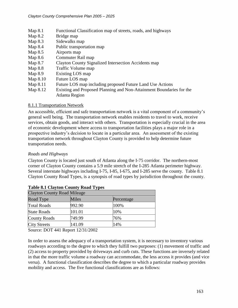
Clayton County Comprehensive Plan 2005 – 2025
163
Map 8.1 Functional Classification map of streets, roads, and highways
Map 8.2 Bridge map
Map 8.3 Sidewalks map
Map 8.4 Public transportation map
Map 8.5 Airports map
Map 8.6 Commuter Rail map
Map 8.7 Clayton County Signalized Intersection Accidents map
Map 8.8 Traffic Volume map
Map 8.9 Existing LOS map
Map 8.10 Future LOS map
Map 8.11 Future LOS map including proposed Future Land Use Actions
Map 8.12 Existing and Proposed Planning and Non-Attainment Boundaries for the
Atlanta Region
8.1.1 Transportation Network
An accessible, efficient and safe transportation network is a vital component of a community’s
general well being. The transportation network enables residents to travel to work, receive
services, obtain goods, and interact with others. Transportation is especially crucial in the area
of economic development where access to transportation facilities plays a major role in a
prospective industry’s decision to locate in a particular area. An assessment of the existing
transportation network throughout Clayton County is provided to help determine future
transportation needs.
Roads and Highways
Clayton County is located just south of Atlanta along the I-75 corridor. The northern-most
corner of Clayton County contains a 5.9 mile stretch of the I-285 Atlanta perimeter highway.
Several interstate highways including I-75, I-85, I-675, and I-285 serve the county. Table 8.1
Clayton County Road Types, is a synopsis of road types by jurisdiction throughout the county.
Table 8.1 Clayton County Road Types
Clayton County Road Mileage
Road Type Miles Percentage
Total Roads 992.90 100%
State Roads 101.01 10%
County Roads 749.99 76%
City Streets 141.09 14%
Source: DOT 441 Report 12/31/2002
In order to assess the adequacy of a transportation system, it is necessary to inventory various
roadways according to the degree to which they fulfill two purposes: (1) movement of traffic and
(2) access to property provided by driveways and curb cuts. These functions are inversely related
in that the more traffic volume a roadway can accommodate, the less access it provides (and vice
versa). A functional classification describes the degree to which a particular roadway provides
mobility and access. The five functional classifications are as follows:

Clayton County Comprehensive Plan 2005 – 2025
164
1. Interstate Principal Arterial: An interstate principal arterial is a multi-lane controlled access
road which only allows access at designated interchanges. The purpose of the interstate is to
transport people and goods over long distances at high speeds with a minimum amount of
friction from entering and exiting traffic. Freeways typically have average daily traffic volumes
of over 100,000 vehicles per day.
2. Principal Arterial: A principal arterial is used to transport large volumes of traffic at
moderate speeds and are typically multi-lane. A principal arterial is usually a median divided
highway with some controlled access. These roads provide immediate access to adjacent land
uses through driveways and two-way turn lanes in the center of the multi-lane arterial. A
principal arterial is designed for typical capacity of 45,000 to 75,000 vehicles per day.
3. Minor Arterial: A minor arterial is designed to provide cross-town and cross-county street
access. These roadways are usually multi-lane, although in some less developed areas they may
be two lane roads. With access to development, there are often driveways that run directly into
thoroughfares and, occasionally, on-street parking. Typical right-of-ways are between 70 and 90
feet, with traffic volumes between 20,000 and 50,000 vehicles per day.
4. Major Collectors: A major collector is designed to move traffic from large residential areas
and other local traffic generators such as schools, parks, office, and retail areas to principal and
minor arterials. Generally these are two to four lane roads with frequent intersections. Traffic
volumes are between 15,000 and 30,000 vehicles per day.
5. Minor Collectors: Minor collectors are roads designated to collect traffic from local networks
of city streets and county roads and transport this traffic to the arterial system. Collectors are
typically two to four lane facilities with an average daily traffic between 7,500 and 15,000
vehicles.
6. Local Roads and Streets: These roads exist primarily to provide access to adjacent land; and
serve low-mileage trips compared to collectors or other higher systems. Use of these roads and
streets for through traffic is usually discouraged. Local roads and streets constitute the mileage
not classified as part of the principal arterial, minor arterial, or collector system.
The roadway system in Clayton County is well developed. The network is comprised of
Interstate highway access, state routes, county roads and city streets. Table 8.7 Vehicle Miles
Traveled in Clayton County includes a breakdown of Mileage and Vehicle Miles Traveled
grouped by jurisdiction for each functional classification. The inventory of transportation
networks in Clayton County according to their functional classification is illustrated in Map 8.1.
All roads not listed are considered local roads.

Clayton County Comprehensive Plan 2005 – 2025
165
Table 8.2 Roadway Function Classifications
Roadway Classifications in Clayton County
Classification Roadways
Interstate Principal Arterials
Interstate 285
Interstate 85
Interstate 75
Interstate 675
Principal Arterials
Fayetteville Rd
State Route 85 south of Forest Pkwy
SR 138
Tara Blvd
Minor Arterials
Old Dixie Hwy (US 19, US 41, SR 3)
SR 42 (US 23)
Anvil Block Rd
Bethsaida Rd
Bouldercrest Rd
Church St (From Riverdale Rd to Main St. in Riverdale)
Ellenwood Rd
Fayetteville Rd (Jonesboro)
Fielder Rd
Flat Shoals Rd (West of Fayetteville Rd)
Forest Pkwy (SR 33)
Jodeco Rd
Jonesboro Rd (N. Main St. in Lake City and Morrow)
Lake Harbin Rd (Morrow Rd in Morrow)
McDonough Rd
McDonough St
Morrow Industrial Blvd
Mt. Zion Rd
N Bridge Rd (West of Hampton Rd)
North Ave (From SR 138 to N. McDonough St)
Panola Rd
Pointe South Pkwy
Rex Rd (East of SR 42)
Riverdale Rd (SR 135)
S Main St (Jonesboro)
Stockbridge Rd (From McDonough St to SR 138)
Sullivan Rd
Valley Hill Rd (Main Street in Riverdale)
Walt Stephens Rd
West Fayetteville Rd (SR 314)
Major Collectors
Hampton Rd (East of Panhandle Rd)
N Bridge Rd (East of Hampton Rd)
Panhandle Rd (From N Bridge Rd to Hampton Rd)
Wildwood Rd (From Woolsey Rd to Fortson Rd)

Clayton County Comprehensive Plan 2005 – 2025
166
Roadway Classifications in Clayton County
Classification Roadways
Woolsey Rd
Minor Collectors
Airport Loop Rd
Mount Zion Boulevard
Battle Creek Rd
Clark Howell Hwy
Conley Rd
Fayetteville St
Flat Shoals Rd
Flint River Rd
Harper Dr
Huie Rd
I-75 access ramp
Main St (Forest Park)
Mt Zion Blvd (North of Battle Creek Rd)
Mundy's Mill Rd
Noah's Ark Rd
Old Conley Rd
Panhandle Rd (From Tara Rd to N Bridge Rd)
Pine Ridge Dr
Poplar Springs Rd
Rex Rd (West of SR 42)
Reynolds Rd
Rock Hill Dr
Tara Rd
Taylor Rd (Roberts Dr in Riverdale)
Thomas Rd
Wildwood Rd (South of Fortson Rd)

Clayton County Comprehensive Plan 2005 – 2025
167
Map 8.1 Roadway Classifications in Clayton County
Clayton County Comprehensive
Plan 2003Robert and Company
Architects, Engineers, and Planners
96 Poplar St. N.W.Atlanta, GA 30303
RAC 0207610
FOREST PARK
MORROW
RIVERDALE
LOVEJOY
JONESBORO
LAKE CITY
COLLEGE PARK
I-75
W F
ayett
evill
e R
d
Jone
sboro
Rd
Fayettevil
le Rd
I-285
Riverd
ale Rd
I-675
Georg
ia H
ighw
ay 4
2
Georgia Highway 138
Tara
Blv
d
I-85
Sta
te R
oute
85
McDonough Rd
I-75
I-75
I-675
I-285
I-75
I-67
5
Tara
Blv
d
I-675
I-75
I-67
5
I-75
I-285 I-285
I-75
I-67
5
Tara
Blv
d
Sta
te R
ou
te 8
5
µ
Road Classifications
0 2 4 6 81Miles
Legend
Road Classification
Interstate
Principal Arterial
Minor Arterial
Major Collector
Minor Collector
Local Road
Railroads
County Boundary
Lakes
Rivers
City Limits

Clayton County Comprehensive Plan 2005 – 2025
168
The Clayton County Department of Transportation has had some disagreements with the Georgia
Department of Transportation in the past about the proper functional classification of roads. It is
recommended that Clayton County plan, develop and implement a detailed Comprehensive
Transportation Plan that includes a detailed analysis of any proposed changes to the federal
functional classification system.
Bridge Inventory
The Clayton County road network contains a total of 211 bridges. The vast majority of these
bridges are in sound structural condition. However, as indicated in Map 8.2, there are four
bridges in poor condition that will require corrective action or replacement. Those bridges
include the following:
Conkle Road at Reeves Creek – 2.5 miles northeast of Jonesboro
Valley Hill Road at Flint River – 2 miles southeast of Riverdale
Rex Road at Little Cotton Indian Creek – 1.6 miles east of SR 42
Maddox Road at Panther Creek – 1 mile east of Morrow
Currently, there are three (3) bridge rehabilitation projects programmed in the Atlanta Region FY
2003-2005 (TIP) for Rex Road at Big Cotton Indian Creek.

Clayton County Comprehensive Plan 2005 – 2025
169
Map 8.2 Clayton County Bridge Inventory
Clayton County Comprehensive
Plan 2003Robert and Company
Architects, Engineers, and Planners
96 Poplar St. N.W.Atlanta, GA 30303
RAC 0207610
kj
kj
kj
FOREST PARK
MORROWRIVERDALE
LOVEJOY
JONESBORO
LAKE CITY
COLLEGE PARK
RUM CREEK
CAMP CREEK
PANTHE
R CREE
K
JESTE
R CRE
EK
UPTON CREEK
FLINT RIV
ER
REEVES CREEK
BEAVERDAM CREEK
SWAM
P CRE
EK
SHOAL CREEK
MUD CREEK
CONLEY CREEK
PATES CREEK
HURRICANE CREEK
VAUG
HN BR
ANCH
LINE CREEK
BIG COTTO
N INDIAN CREEK
CATER CREEK
FLIN
T RIV
ER
FLINT RIVER
CONLEY CREEK
FLINT RIVER
FLIN
T RIV
ER
JESTER CREEK
MUD CREEK
JEST
ER C
REEK
Rex
Forest
I-75
Ta
ra
Georg
ia_85
Woolse
y
Ash
Hall
Phill
ips
Priv
ate
Main
Valley Hill
Jonesboro
I-285
Bridge
Flint River
Gra
nt
Fro
nta
ge
Lake Jodeco
Turn
er
Walk
er
Emerald
Sullivan
Riv
erd
ale
I-675
Churc
h
Taylor
Lake
Lovejoy
King
Hampton
Noahs Ark
McDonough
Mt. Zion
Fa
ye
tteville
Madd
ox
Slate
South
lake
Carnes
Fre
em
an
Web
b
Bro
wn
Dale
Conkle
Fitz
gera
ld
Lee
Rountre
e
Mt Z
ion
Cra
ne
Mundys Mill
Bethsaida
Wild
wood
Panhandle
Bould
erc
rest
SLR
Walt Stephens
Lake Harbin
Posto
n
Reynold
s
Front
Old R
ex M
orro
w
Flo
yd
Jodeco
Georg
ia_42
CCWA Access
Battle Creek
Stock
brid
ge
Lyle
Old
41
Oak
85
1st
Pixley
Dors
ey
Carlto
n
Wrig
ht
Scott
Hendrix
Flat Shoals
Fo
lsom
New
Ho
pe
Iron G
ate
Lees Mill
Huie
Katie
Morrow
Roxbury
Pow
ers
Rya
n
Ellenwood
Mural
North
Ald
er
Penney
Old
Dix
ie
Loop
Brya
nt
I-85
Eng
lish
Airport Loop
Players
OHara
Ann
Fo
rtso
n
Garden Walk
Brian
Cone
Oxford
Park
Lu
Dan
Bry
ce
Balla
rd
Blalock
Key
Inman
Mark
Logan
Perimete
r
Ellis
on
Warren
Aviation
Castle
gate
West
Wils
on
Anvil Block
Berry
Sta
gecoach
Flint
Southern
Hillto
p
Cre
ek
Cynthia
Linda
Thrailkill
Fiel
der
Cla
rk How
ell
Rand
Denson
Ken
drick
Fe
aga
n
Monic
a
Jett
Citizens
Toney
Dou
ble
Brid
ge
Point
Tw
iligh
t
Bart
lett
Tra
mm
el
Morrow Industrial
Bay View
Norman
Cooper
Bis
cayne
Fay
Dix
on I
ndu
str
ial
Will
iam
son
Charle
s
Bethaven
Opal
Llo
yd
Riv
er
Ga
no
Liberty
Sam
s
Sim
pson
Mize
Pla
nta
tion
Botany
Holid
ay
Pinto
Abbey
3rd
Rock Hill
Maple
Commerce
Th
orn
ton
Pho
enix
Danie
l
Rock C
reek
David
Tyler
Hun
t
Westley
Delta
Georgia_138
Kelly
Attu
cks
Royal
Win
sto
n
Willo
w
Sim
mo
ns
South
Park
Hughes
Thomas
Sylvia
Mead
Cam
p
Centra
l
South
Sawmill
Point South
Snip
e
Tudor
Barnett
Colle
ge
Sho
re
Charlotte
Dunn
Evans
Daw
n
Tu
pelo
Arrowhead
Tiffa
ny
Luke
Medina
Gra
yson
Kirk
Elon
Summit
Joy Lake
Rid
ge
Ovis
Steele
Coatsworth
Irw
in
Tin
a
Denn
y
Bonita
Martin
Sta
rling
Panola
Springdale
Ric
ketts
Nell
Clo
ud
Orchard
Edgew
ate
r
Gla
de
Adrian
Jones
Hillside
Geneva
Airp
ort
Lila
c
Caribou
Fred
Campbell
Kidd
Nor
den
Drexel
Lake Park
Patton
Helmer
Pin
tail
Easy
Raven
Beaver
Judy
Mitc
hell
East
Wrig
hts
Wilk
ers
on
Ade
l
Collin
s
Hunte
r R
idge
Metcalf
Martha
Georgia_3
Windsor
Oakdale
Farn
Mead
ow
Ocee
Vald
ez
Gilg
al
Ruskin
Morris
Castile
Fairdale
Noahs
Sha
ngri
la
Courtn
ey
Alb
right
Yale
Old Poston
Chelsea
Fieldgreen
Robin
Pala
din
Deerfield
Kennedy
Uta
h
Southfield
LaBelle
Atlanta S
outh
Elli
ot
Coffer
4th
Dunelle
n
Woo
ds
Hand
ley
Apa
ch
e
Doncaste
r
Peacock
Tanners C
hurch
Arg
on
ne
Lago
Clara
Lake Mirror
Windgate
Beth
une
Oldenburg
Tamarack
Cry
sta
l
Camelot
Crystal Lake
Roc
k Cut
Northridge
Lam
ar
Hutc
heson
Bis
hop
Rabun
Holly Hill
Heath
er
Leicster
Old C
onley
Retreat
Dixie
Kno
tty P
ine
Bear Creek
Chan
tilly
Alle
n
Spiv
ey
Railroad
Pine
Poplar Springs
Fallview
Whitfield
She
rwood
Faith
Pineridge
Attle
boro
Bent C
reek B
ranch
Stancil
Revena
Sha
ron
Mill
Salisbury
Conley
Mora
nt
Longleaf
Roberts
River Glen
Irongate Carriage
Tara Beach
Hager
Herita
ge
Wendy Jean
Avery
Dixon
Aub
rey
Foxfield
Vic
toria
Southridge
Mosswood
Cyp
ress
Will
ard
s
Joh
nson
Eag
le
Clayton
Skyla
ne
Cib
oney
Cameron
Cedar
Interlaken
Dover
Hom
ew
ood
Fie
ldw
ay
Windemere
Elle
ry
2nd
Riv
iera
Ard
moor
Lauranceae
Fairview
Sie
rra
Shoreham
Lucan
Falcon
Ashto
n
Winslow
Elizabeth
Bro
ok
Chilton
Flicker
Bell
Dexte
r
Stormy
Van
ity J
oy's
She
lley
Wexwood
Chippewa
Lunsfo
rd
Red Ivy
Big
elo
w
Cheyenne
Hale
y
Inverness
Cre
eksid
e
Coventry
Fa
lcon
Cre
st
Pownal
Cana
l
Towngate
Pine Needle
Aqu
ila
Shellnut
Orr
Pheasant
Lerose
Bayridge
Merlin
Brittan
Lullwater
Post
Azale
a
Waterford
Nassau
Pharr
Ridgeview
Am
herst
Woodlake
Benton
Matth
ew
s
Gre
enw
illow
SaganawH
ayes
Kesw
ick
Noga
les
PrestonB
obolin
k
Ow
en
Iris
Carmel
Ronn
ieRiverhill
Brookfield
Carl P
ark
er
Hunte
rs
Jenni
Bay
Haw
thorn
e
Lost
Brenston
Spring
Woo
dla
nd
Shore
line
Surrey
Jew
ell
Shannon
Bla
ckfo
ot
Terance
Hic
ko
ry
Pier I
Sun
se
t
Alb
ania
Marion
Birdie
Win
ding
Way
Joa
n O
f A
rc
Skylark
Twai
n
Knig
hts
Beach
Flint Ridge
Pin
e G
ate
Lexi
ngto
n
Village
Service
Olive
Country Lake
Dease
Cash Memorial
Randy
Edinboro
Duffey
Lela
nd
Bria
rbay
Kno
llwood
Cle
arw
ate
r
Seq
uoia
Hyannis
Cascade
Pruett
Seneca
Teal
Edwards
Leeward
Runn
ym
ede
Willo
ws
Holly
Wellesley
Olm
ste
ad
Van
ch
at
Lake V
iew
Wha
leys L
ake
Helen
Wesley Park
Cardinal
Austin
Don H
astin
gs
Corin
th
Dunm
oor
Gre
envie
w
Paramore
Raven's
Hebron
Foxvale
Airport South
Am
bassa
dor
Julie
Levgard
Win
dcre
st
Old Well
Lyn
dale
Wall
Waik
iki
Walli
s
Fairfield
Agnew
Gale
Sherry
Oriole
Lottie
Min
e
Fielding
Auburn RidgeO
gala
Redb
ud
Lakesid
e
Forest Knoll
Lake F
ore
st
Clemons
How
ell
Hearthstone
Jeffrey
Am
berly
Somerton
Rockla
ne
Old Roundtree
Broadhurst
Hillc
rest
Habers
ham
Hid
denla
ke
Malib
u
Evelyn
Sta
rr
Abin
gto
n
Kevin
Bald Eagle
Port A
Prin
ce
Anderson
Sparta
Rosem
ont
Kath
erin
e
Lombardy
Winchester
Imperial
Fa
irla
ne
Em
ily
Chis
olm
Sed
alia
Center
Fost
er
Ethan
Forest Glen
Carn
es C
rossin
g
Oa
kri
dge
Hastin
gs
Tilson
Win
dw
ood
Sun
nydale
Sho
revie
w
Autu
mn
Hid
den H
ollo
w
Bourne
Cherokee
Cro
ss R
oad
Glen Moor
Virginia
Chris
tian
Wood Hollow
Lake Regency
Misty M
eadows
Tw
elv
e O
aks
Carter
Willow Bend
Ashm
ore
Bern
ard
o
Elaine
Hanes
Lake ChaseC
han
nin
g
Indian Hill
Country Club
Ham
ilton
Rhonda
Merc
er
Ivy G
ate
Orme
Sum
mer
Whitw
orth
Cedar Hill
Renard
Tri
nity P
ark
Washington
Ashley
Bro
ad
leaf
Hamlin
Lance
Glenn
Rector
Lois
Sedgwick
Duncan
Liv
ingsto
n
Saw
gra
ss
Saybro
ok
Terrell Mill
David
son
Cherwell
Otis C
am
p
Gilb
ert
Am
esb
ury
Arctic
Chesw
ick
Magn
olia
Kunuga
Pin
ela
nd
Vesta
Bro
ok
Rex M
ill
Scottis
h
Alden Avalo
n
Old
Fie
ld
Sir G
ala
had
Lake Cove
Swamp Creek
Nottin
gh
am
Chelsey
Reeves
Hammond
Heath
erw
oo
d
Elli
ott
River Bend
Mallard
Woodbridge
Radfo
rd
Elmore
Old
Ivy
Cordell
Harv
ard
Rowden
Cecelia
Cle
arv
iew
Fox F
ire
6th
Str
att
on
Lyn
woo
d
Rivercrest
School
Kim
be
rly
Peachtree Farms
Mila
n
Winter
Tara Bend
Lolli
Lake Ridge
Win
dcha
se
Royce
Dan
ver
Sterling Ridge
Daffodil
Mus
eum
Kendal
Moss
Ric
hard
son
Exc
hange
Stane
broo
k
Mimosa
Gre
tna
Dra
kes
Nordic
Te
ton
Tra
depo
rt
Reuben
Chestn
ut
Danb
ury
Howard
Harbour Lake
Tra
il
Chath
am
Pem
bro
ke
Tyra
Bria
rwood
Eliz
abe
th P
ark
Pennel
Sham
rock
Westminster
Commons
Overland
ShadeWestwood
Cold
stre
am
Red
Map
le
Pueblo
Stark
Dogwood
Hom
estead
Claxton
Sw
eetb
riar
Independence
Oa
k P
ark
Castle
Foster Lake
Pinewalk
Southside Commercial
Lin
kside
Caro
lyn
Clubhouse
Pond
Marsh Glen
Gle
nle
igh
North
cut
Woo
dcliff
Olde Town
Wesson
Dow
ns
Bennett
Holly Run
Will
iam
sburg
Stim
son
Gideon
Laboon
Casper
Moor
Ashley Chase
Vicksburg
New
ton
Sta
nle
y
Aqula
Tour
Greystone
Aspen
Holm
Bria
r Hill
Briar Gate
Levon
Cor
al
Canary
Weybridge
Silv
ers
tone
Lear
Wheatfie
ld
Old Anvilblock
Pam
ela
Spruce
Cam
p
Private
Priv
ate
Interlaken
Courtney
Cedar
Private
Priv
ate
Ta
ra
Grant
Mt. Zion
3rd
Main
Priv
ate
Lake
Private
Cedar
Deerfield
Private
Bridge
Priv
ate
Lee
Park
South
Private
Lees M
ill
I-75
Lees M
ill
CC
WA
Access
Scott
Private
3rdT
ara
Private
Private
Private
Private
Mt Zion
Mt Zion
Private
North
I-75
AviationHampton
I-75
PrivateSky
lark
Private
Tin
a
Panhan
dle
Airport Loop
Private
Private
Priv
ate
Chestn
ut
Lee
s MillPrivate
I-285
Priv
ate
MainOld
Dix
ie
Gilb
ert
I-285
Private
Park
Private
Churc
h
Teal
I-675
Jonesboro
Woodland
Shore
Private
Fayetteville
I-85
Th
orn
ton
Aspen
Airp
ort
Mallard
Inman
Panola
Fayettevill
e
Huie
Thom
as
Kin
g
I-285
West
Panhandle
PrivateP
rivate
Cam
p
Herita
ge
Evans
Faye
ttevi
lle
Priv
ate
Martin
Private
Lake Jodeco
Pan
han
dle
Oak
Tara
Private
Maple
Lake
side
Georgia_138
Garden Walk
Mimosa
Tara
Riverdale
Scott
I-675
Ta
ra
Private
Fie
lder
Conley
Turn
er
Sullivan
Private
I-75
Grant
I-75
Old
Dix
ie
Riv
er
Private
Orr
Priv
ate
Lake
Eagle
Private
Private
Lake
Priv
ate
2nd
Beave
r
Private
Homestead
Airport
Loop
Georgia_138
Priva
te
Mundys Mill
I-7
5
Sha
ngri
la
Sta
rr
Mt Zion
Forest
Conkle
Rex
Private
Robin
Corinth
Private
Berr
y
Tara
Kin
g
Mila
n
Lee
Aviation
Priv
ate
Priv
ate
Webb
Priva
te
Fo
rest
Pine
Fielder
Sta
geco
ach
Tara
Stagecoach
Ta
ra
Priv
ate
Elaine
Conle
y
Private
Scott
I-285
Frontage
Lee
Private
Bart
lett
Sherwood Oak
µ
Bridges
0 1 2 3 40.5Miles
Legend
Bridge
Bridge - Poor Condition
kj TIP Bridge Projects
County Boundary
Highways
Streets
Municipal Boundaries
Lakes
Rivers

Clayton County Comprehensive Plan 2005 – 2025
170
Bike and Pedestrian Trails Inventory
Please see Chapter 4 - Natural and Cultural Resources section 4.13 and Map 4.5 and/or
Chapter 5 - Community Facilities section 5.6 and Map 5.2.
Sidewalks Inventory
An inventory of sidewalks was conducted for the six major functional classes of roadways within
Clayton County. A field survey was conducted throughout Clayton County to determine if
sidewalks were present on one side, both sides, or neither side. The results of this survey are
presented in Map 8.3 below.
Map 8.3 Sidewalk Inventory

Clayton County Comprehensive Plan 2005 – 2025
171
The sidewalk inventory map illustrates that sidewalks are generally not present on the major
functional classes of roadways throughout Clayton County, including the Cities of Jonesboro and
Forest Park. It should be noted that the areas illustrating worn paths should be targeted for
sidewalk installation as there is evidence of pedestrian activity at these locations.
Public Transportation Inventory
Public Transportation in Clayton County is operated by the C-TRAN bus system. C-TRAN was
first approved by Clayton County voters in 2000. Upon approval from the Clayton County
Board of Commissioners, the county entered into a contract with the Georgia Regional
Transportation Authority (GRTA) to manage local bus service in Clayton. In April 2001, GRTA
approved the purchase of 12 buses powered by clean-burning compressed natural gas for use in
the C-TRAN system. At full service, C-TRAN will operate five local routes connecting with the
Metro Atlanta Rail Transportation Authority (MARTA) rail system: Two routes will connect
with MARTA at Hartsfield-Jackson Atlanta International Airport, two routes will connect to the
Lakewood MARTA station, and one route will connect with the College Park MARTA station.
GRTA reported that C-TRAN ridership exceeds expectations.
C-TRAN service will be instituted in phases with 35 clean fuel buses operating at full
implementation. Currently, C-TRAN operates three routes serving major destinations such as
Hartsfield-Jackson Atlanta International Airport and Southlake Mall (see Map 8.4). The first
phase of implementation became operational in October 2001 and included routes 501 and 503.
Route 504 was implemented in February 2003. There are 200 bus stops along these three (3) bus
routes. In 2003, C-TRAN installed 15 of the planned 150 bus shelters. One of the 2004 Unified
Planning Work Program for the Atlanta Region goals is to continue the installation of bus
shelters, benches, and trash receptacles at every bus stop location.
Additionally, there is a MARTA bus route # 77 which runs from the East Point rail station to
Forest Park and Fort Gillem via Jonesboro Road and Forest Parkway.
C-TRAN buses operate Monday through Friday from 5am to 12 am, Saturday from 6am to 12
am, and Sunday from 7am to 10pm. The general C-TRAN fare is $1.50 and there is half fare for
senior citizens and disabled riders. Therefore, there is a commitment to make C-TRAn more
affordable to the transit dependent.
Approximately 54,000 people live within a quarter mile of the C-TRAN routes, and the total
Clayton County population is 253,500. C-TRAN has the capability of serving twenty-one
percent (21%) of the Clayton County population. Transit dependent populations traditionally
include teens, low-income, disabled and senior populations. From the 2000 census data, the
teens, lower income, disabled and senior citizen populations of Clayton County represent fifty-
one percent (51%) of the total Clayton County population. Thus, with current service capacity at
21%, there is clearly a need for more public transportation options in Clayton County.

Clayton County Comprehensive Plan 2005 – 2025
172
Map 8.4 Public Transportation in Clayton County
A field survey was conducted to determine if the existing bus routes had transit amenities such as
sidewalks around stops, bus turn-out bays, and bus shelters. Sidewalks and bus shelters were
observed at some of the transit stops in Clayton County, though there were a number of transit
stops without sidewalks and/or bus shelters. C-Tran transit stops were clearly defined at
throughout the study area.

Clayton County Comprehensive Plan 2005 – 2025
173
Based on a review of the Existing Land Use Map and C-Tran ridership information, it can be
concluded that the major transit generators and attractors in Clayton County are currently
Hartsfield Jackson International Airport and the Southlake Mall area. The airport is a major
employment center in the Atlanta area and there is also an existing MARTA rail line at that
airport that provides access to a number of additional major employment centers such as
downtown and midtown Atlanta, the Buckhead area, the Medical Center area north of Buckhead,
and the Perimeter Center area. There is currently a C-Tran terminal area at the airport where
patrons can transfer between Routes 501 and 503 to the MARTA rail line. Additionally, C-Tran
riders can currently transfer between Routes 501 and 503 at Kelly Avenue at Mount Zion Road
and Mount Zion Road at Southlake Parkway near Southlake Mall. Transfers are available
between Routes 501 and 504 at the Clayton County Justice Center and at the intersection of Flint
River Road and Tara Boulevard. Routes 503 and 504 intersect at Lamar Hutcheson Parkway at
Valley Hill Road and Lamar Hutcheson Parkway and State Route (SR) 85. Additionally, C-Tran
patrons can transfer between Route 501 and MARTA Route 77 at the intersection of Forest
Parkway and West Street.
Route 501 currently operates at thirty (30) minute headways during the Peak and Midday hours
north of Southlake Mall and sixty (60) minute headways during the Peak and Midday hours
south of Southlake Mall. Buses run at sixty (60) minute headways for the entire route in the
evening weekday hours and on weekends.
Route 503 currently operates at thirty (30) minute headways during the Peak and Midday hours
with alternating service on Gardenwalk Boulevard and Riverdale Road and sixty (60) minute
headways during the evening weekday hours and weekends with service on Gardenwalk
Boulevard only.
Route 504 currently operates at thirty (30) minute headways during the Peak and Midday hours
with alternating service on Taylor Road and SR 85 and sixty (60) minute headways during the
evening weekday hours and weekends with service on SR 85 only.
THE MACON-ATLANTA COMMUTER RAIL SERVICE
The Macon-Atlanta commuter rail service with three stops in Clayton County was selected by
the State of Georgia in June 2001. The Federal Transit Administration (FTA) issued a Finding
of No Significant Impact (FONSI) clearing the way for partial funding in the 2003-2005 Atlanta
Regional Commission (ARC) `Transportation Improvement Plan. See Map 8.5

Clayton County Comprehensive Plan 2005 – 2025
174
Map 8.5 Proposed Commuter Rail Station Locations

Clayton County Comprehensive Plan 2005 – 2025
175
SOUTHERN CRESCENT AND MOUNTAIN VIEW
The proposed Southern Crescent Transportation Service Center (SCTSC) is a multi-modal
transit-oriented district (TOD) that is apart of the Mountain View Redevelopment. The TOD
will include office, retail, hotel, industrial and green space land uses. The SCTSC is proposed to
meet regional transportation needs through the integration of commuter rail, MARTA,
community buses, shuttles and taxis, with a direct connect to the new East International Terminal
at Hartsfield.
Airports Inventory
HARTSFIELD-JACKSON INTERNATIONAL AIRPORT
Clayton County is located adjacent to Atlanta’s Hartsfield-Jackson International Airport, the
largest air carrier facility in the southeast. See Map 8.6 Hartsfield-Jackson International Airport
is growing. In 2000, the Airport began a ten-year, $5.4 billion capital improvement project.
Map 8.6 Clayton County Airports

Clayton County Comprehensive Plan 2005 – 2025
176
There are four key elements to this project including: (1) construction of a consolidated rental
agency complex for rental cars; (2) enhancements to the airports central terminal; (3)
construction of a fifth runway; and (4) building a new terminal.
Due to the increasing demands upon the existing on-airport car rental facilities, the need for a
consolidated rental car structure has become necessary. Traffic flow around the airport and air
quality will benefit from the consolidation of these facilities. The new Consolidated Rental
Agency Complex (CONRAC) will be located south of Camp Creek Parkway and west of
Interstate 85. The facility will accommodate the ten existing rental car companies operating at
Hartsfield-Jackson (with room for expansion in the future) and will provide for approximately
8,700 ready and return spaces. Additionally, this project will include accommodations for
customer service centers, storage and minor maintenance areas, wash lane facilities and vehicle
fueling positions to support the quick turn around operation used by the rental car agencies. The
CONRAC project also includes an Automated People Mover (APM) System to ferry passengers
to and from the Central Passenger Terminal Complex (CPTC) and the CONRAC. There will be
three proposed transport stops for the passengers, along with an elevated rail line over I-85.
A new four-lane airport access road will connect from the airport roadway system to the
CONRAC providing vehicular access both coming and going to the facility. The roadway
includes bridges to cross Interstate 85, CSX Railroad and MARTA tracks.
The Central Passenger Terminal Complex will be enhanced to accommodate the rising number
of travelers passing through Hartsfield-Jackson. To enhance passenger service, improvements
will include upgrades to curbside services, security checkpoints, ticket counters, interior finishes,
concessions, baggage, baggage claim areas, vertical transportation, moving sidewalks and
expansion of existing concourses. Further modification plans include taxiway enhancements as
well as the expansion of Air Cargo and Aircraft Maintenance facilities.
The new Jackson International Terminal (JIT) will be "Atlanta’s global gateway to the world."
Hartsfield-Jackson Atlanta International Airport officials are constantly reviewing and
implementing enhanced features to accommodate passengers and employees as securely as
possible. The completion of the innovative East International Terminal project is a part of
realizing that goal. In 2006, Atlanta will proudly unveil its new, state-of-the-art, “front door”
through which the world comes to Atlanta.
In order to meet the increased demand for air travel and reduce current delays, the airport began
construction on a new $1.2 Billion, 9,000 foot Fifth Runway (Runway 10/28) in 2000. The
runway is schedule to be commissioned in May 2006. It will be a full-length parallel taxiway
with dual north/south taxiways having two bridges capable of sustaining one mullion pound
aircraft. The two bridges will overpass the 18-lane I-285 highway.

Clayton County Comprehensive Plan 2005 – 2025
177
TARA FIELD
The local airport for Clayton County is Tara Field, located at 474 Mt. Pleasant Road about three
(3) miles west of the City of Hampton, just west of the Atlanta Motor Speedway. Although the
airport is physically located in Henry County, Clayton County acquired the airport in 1992.
The operation of Clayton County Airport-Tara Field over the past three (3) years has provided by
the county with about $20,000 in profits. The money comes from aircraft gas sales and storage
and parking fees; property taxes go to Henry County. The airport maintains a runway that is
4503 feet long by 75 feet wide. There are 143 aircraft based at the field, 126 single engine
planes, 10 multi-engine planes, and seven (7) jets. The airport averages 82 aircraft operations
per day, 57% of which are transient general aviation, 37% local general aviation and 6% air taxi
services. Most of the air traffic at Tara involves propeller aircraft and helicopters with jets using
the facility mainly on the two big race weekends at the speedway.
Due to increased security concerns following the September 11th
terrorist attacks there are many
security measures that have been implemented at Tara Field and more are planned for the near
future. Recently a fence was erected to enclose about 70% of the airport’s property off of US
19/41 near the Atlanta Motor Speedway. Other changes include new runway landing lights and
taxiway lights. Additional lighting also will be installed in the lots where planes are parked, and
all vehicle entrances to the 200-acre airport soon will be gated.
The Federal Aviation Administration (FAA) FY 2002 Airport Improvement Program (AIP)
Grants gave priority to the acquisition of 63 acres of land for development and 0.9 acre for
approaches and runway rehabilitation at Tara Field. Approximately $1.4 Million in federal funds
was appropriated for this effort.
Railroads Inventory
Two railroad corridors service Clayton County providing industrial railway service north to the
major rail hub of Atlanta and south to Macon. The Norfolk Southern Railway line extends
approximately 6.5 miles across the northeast corner of the county. The Norfolk Southern
Railway enters Clayton County in the north near Georgia Highway 42 and exits the county in the
southeast near Big Cotton Indian Creek. The Norfolk Southern Railway line maintains the
highest level of freight traffic in the county with 23 trains per day. The Central of Georgia
Railroad, a subsidiary of Norfolk Southern Railway, enters Clayton County at the northern
boundary near Interstate 75 and bisects the county for nearly 20 miles until it enters Henry
County. The Central of Georgia line maintains only slight freight traffic with one train per day.
There is also a rail network inside Fort Gillem. However, it is underutilized and not maintained.
According to the Georgia Department of Transportation, there are fifty-six (56) at grade rail/road
crossings in Clayton County. Under federal law, each state is required to maintain a survey of all
highways to identify railroad crossings that may require grade separation, relocation, or
protection devices. At grade rail crossings are significant features of the Clayton County
transportation network because they may need to be eliminated to improve safety.

Clayton County Comprehensive Plan 2005 – 2025
178
8.1.2 Accident Frequency
Data on automobile accident frequency at signalized intersections was collected for Clayton
County for the period of July 2002 through June 2003. Twenty-one road intersections were
identified as having accident totals at or above 50 for the period of study. Ten of these high
accident intersections occur along SR 3 (Tara Blvd/Old Dixie Rd). This is consistent with the
high level of congestion and the significant amount of access to businesses along SR 3. See Map
8.7
Map 8.7 Clayton County Signalized Intersection Accidents
Clayton County Comprehensive
Plan 2003Robert and Company
Architects, Engineers, and Planners
96 Poplar St. N.W.Atlanta, GA 30303
RAC 0207610
FOREST PARK
MORROWRIVERDALE
LOVEJOY
JONESBORO
LAKE CITY
COLLEGE PARK
I-75
W F
aye
tte
vill
e R
d
I-285
I-675
I-85
McDonough Rd
Highway 42
I-285
I-75
I-675
I-675
I-75
I-75
I-75
I-759
8
8
46344
3
4
0
9
1
248
53
3
0
2
1
7
8
4
7
6
6
9
7
2
3
4
1
6
7
9
3
1
5
9
8
5
1
0
9
8
5
9
8
4
3
25
10
14
33
32 19
24
60
4013
2713
1213 17
20
41
32
25
41
97
18
11
55
19
14
18
21
53
15
16 11
4312
10
32
13
1416
88
32
20
10
12
38
34
12
34
38
22
16
31
13
28
41
49
28
39
50
10
27
24
12
15
97
39
25
11
37
25
26
23
16
98
65
18
28
59
10
126
µ0 1 2 3 40.5
Miles
Legend
ACCIDENTS
0 - 4
5 - 11
12 - 20
21 - 35
36 - 132
County Boundary
Streets
City Boundaries
Lakes
Rivers
Signalized Intersection Accident Totals
College Park

Clayton County Comprehensive Plan 2005 – 2025
179
8.1.3 Road Lanes, Volumes, and Capacities
Prior to conducting a Level of Service (LOS) Analysis on the roadway network, an inventory of
roadway link geometry, including functional class, number of lanes, capacity, and volumes was
conducted. The Atlanta Regional Commission (ARC) travel demand model was used for this
purpose. Additionally, Clayton County currently maintains an extensive traffic volume data
collection database, which is graphically represented in Map 8.8.
Map 8.8 Clayton County Existing Traffic Volumes
Clayton County Comprehensive
Plan 2003Robert and Company
Architects, Engineers, and Planners
96 Poplar St. N.W.Atlanta, GA 30303
RAC 0207610
FOREST PARK
MORROWRIVERDALE
LOVEJOY
JONESBORO
LAKE CITY
COLLEGE PARK
Tara
Rex
Forest
I-75
Ge
org
ia_
85F
aye
tte
vill
e
Woo
lsey
Hall
Ash
Phillips
Ma
dd
ox
Valley Hill
Morrow
Priv
ate
Ma
in
I-285
Bridge
Flint River
Gra
nt
Fro
nta
ge
Lake Jodeco
Turn
er
Walk
er
Emerald
Bethsaida
Sullivan
Jo
ne
sb
oro
Fie
lder
I-675
Chu
rch
Taylor
Lake
Lovejoy
King
Hampton
Noahs Ark
McDonough
Mt. Zion
Slate
South
lake
Riv
erd
ale
Carnes
Fre
em
an
Web
b
Bro
wn
Dale
Con
kle
Le
e
Rountree
Mt
Zio
n
Cra
ne
Mundys Mill
Wild
wood
Panhandle
Bou
lderc
rest
SLR
Walt Stephens
Lake Harbin
Posto
n
Reyno
lds
Front
Old Rex Morrow
Flo
yd
Georgia
_42
CCWA Access
Battle Creek
Sto
ckbr
idge
Thu
rman
Lyle
Old
41
Oak
85
Dors
ey
Carl
ton
Wrig
ht
Scott
Fols
om
New
Ho
pe
Iron Gate
Lees Mill
Huie
Katie
Roxbury
Rya
n
Ellenwood
Roy H
uie
North
Ald
er
Penney
Old
Dix
ieLoop
Jodeco
Brya
nt
I-85
Eng
lish
Airport L
oop
Players
OHara
Fort
so
n
Fort
Gill
em
Garden Walk
Bria
n
Cone
Oxford
Park
Dan
Bry
ce
Blalock
1st
Inman
Ma
rk
Logan
Perimeter
Elli
son
Warren
Aviation
Castle
ga
te
West
Anvil Block
Berry
Sta
geco
ach
Flint
Southern
Hillto
p
Cre
ek
Linda
Rand
Den
so
n
Ken
dri
ck
Fea
ga
n
Jett
Citizens
Toney
Dou
ble
Brid
ge
Tra
mm
el
Morrow Industrial
Bay View
Norman
Cooper
Fay
Dix
on
In
du
str
ial
Will
iam
son
Cha
rles
Bethaven
Opal
Llo
yd
Riv
er
Liberty
Sams
Mize
Plantation
Botany
Pinto
Abbey
3rd
Rock Hill
Commerce
Tho
rnto
n
Dan
iel
Rock C
reek
David
Tyler
HuntD
elta
Georgia_138
Win
sto
n
Willo
w
Sim
mon
s
Sou
th P
ark
Hughes
Thomas
Sylvia
MeadC
am
p
Cen
tral
South
Sawmill
Point South
Snip
e
Tudor
Sho
re
Charlotte
Dun
n
Eva
ns
Daw
n
Tup
elo
Luke
Medina
Kirk
Elo
n
Summit
Ovis
Ste
ele
Irwin
Den
ny
Martin
Sta
rlin
g
Panola
Orchard
Gla
de
Jo
ne
s
Yale
Airp
ort
Campbell
Kidd
Norden
DrexelPatton
Helmer
Pin
tail
Easy
Raven
Judy
East
Wrig
hts
Wilk
ers
on
Ade
l
Hun
ter
Rid
ge
MetcalfMartha
Windsor
Farn
Ocee
Vald
ez
Gilg
al
Morris
Castile
Noahs
Old Poston
Chelsea
Fieldgreen
Robin
Deerfield
Arg
onn
e
Uta
h
LaBelle
Atlanta S
outh
Coffer
4th
Woo
ds
5th
Lake Mirror
Camelot
Roc
k Cut
Northridge
Bis
ho
p
Ellio
t
Holly Hill
Cre
ekw
ood
Retreat
Dixie
Kno
tty P
ine
Bear Creek
Alle
n
Spiv
ey
Fitzg
era
ld
Pine
Poplar Springs
Whitfield Sherwood
Pineridge
Attleboro
Stancil
Reven
a
Mill
Con
ley
Mo
ran
t
Robert
s
River Glen
Carriage
Herita
ge
Southridge
Cyp
ress
Willa
rds
Eag
le
Clayton
Skyla
ne
Cib
on
ey
Interlaken
Dover
Fie
ldw
ay
Ard
moor
Sie
rra
Shoreham
Falcon
Ash
ton
Winslow
Flicker
Stormy
Van
ity J
oy's
ChippewaLu
nsfo
rd
Red Ivy
Hale
y
Cre
ekside
Towngate
Pine Needle
Elsmere
Pheasant
Lero
se
Me
rlin
Aza
lea
Benton
Ma
tth
ew
s
Sag
an
aw
Kon Tiki
Alm
osa
Hayes
Preston
Ow
en
Hyde
Iris
Cristie
Ronnie
Carl
Pa
rke
r
Hunte
rs
Je
nn
i
Bay
Hawthorne
Spring
La
nie
r
Sho
relin
e
Shannon
Terance
Pier I
Sun
se
t
Knig
hts
Beach
Kimsey
Flint Ridge
Pin
e G
ate
Lexing
ton
Service
Olive
Cre
eks
tone
Cash Memorial
Cle
arw
ate
r
Hyannis
Teal
Mis
tyvie
w
Edwards
Dea
n
Holly
Olmstead
Vanch
at
Wha
leys L
ake
Vesta
Bro
ok
Elgin
Austin
Brittany
Corinth
Foxvale
Am
ba
ssad
or
Old Well
Waik
iki
Gale
Min
e
Auburn Ridge
Og
ala
Ga
rden
er
Redbud
La
ke
sid
e
Bet
ony
Woo
d
Forest Knoll
Jeffrey
Am
be
rly
Rockla
ne
Bald Eagle
Alston
New
Da
le
Anderson
Kath
erin
e
Poin
t Vie
w
Chis
olm
Tw
in O
aks
Eth
an
Culv
er
Kite
Bourne
Cro
ss R
oa
d
Carter
Bern
ard
o
Elain
e
Hanes
Stanford
Montego
Rhonda
Walden
Cedar Hill
Renard
Washington
Bro
adle
af
Glenn
Sedgwick
Ione
Cou
rtne
y's
Terrell Mill
David
so
n
Pleasent Hill
Gilb
ert
Eub
an
ks
Rex M
ill
Sir
Gala
had
San
d
Ree
ve
s
Ellio
tt
Mallard
Kea
rny
Elmore
Cle
arv
iew
Silent
Mila
n
Spring Lake
Win
dch
ase
Mus
eum
Fria
r
Kendal
Ric
ha
rdson
Stanebr
ook
Gre
tna
Teto
n
Tra
deport
Four Winds
Briar Ridge
Wes
tmin
ster
Cha
se
Wo
ods
Cheryl
Lees Mill
Turn
er
Stag
eco
ach
1st
Priv
ate
Tara
Tara
Sta
geco
ach
Old
Dix
ie
Le
e
I-285
Le
e
I-285
Lake Jodeco
Sullivan
Morro
w
Private
Pine
Priv
ate
Panhandle
Private
Private
Sco
tt
I-285
Mt
Zio
n
Tara
Park
Priv
ate
Priv
ate
Forest
Tara
Scott
Aviation
Tara
Camp
Anvil Block
Private
Cam
p
I-675
Private
Mt Zion
Flint River
Grant
CC
WA
Acce
ss
Private
I-75
Private
Priv
ate
ScottI-2
85
Lake
South
Priv
ate
Ash
Priva
te
Elaine
Private
Private
Private
Tara
Webb
I-75
Clearw
ater
Airp
ort
Private
Private
Main
Private
Priv
ate
I-75
I-75
Teal
µ
Traffic Volume
0 1 2 3 40.5Miles
Legend
Traffic Volume
0 - 5,000
5,000 - 10000
10,000 - 15,000
15,000 - 20,000
20,000 - 25,000
> 25,000
Municipal Boundaries
County Boundary
Highways
Streets
Railroad
Lakes
Rivers

Clayton County Comprehensive Plan 2005 – 2025
180
8.2 Assessment of Current and Future Needs
An assessment to determine whether existing facilities and current levels of service are adequate
to meet the needs of the communities within Clayton County was conducted.
8.2.1 Growth Trends and Travel Patterns
Growth trends and travel patterns and interactions between land use and transportation, and the
compatibility between the land use and transportation elements were examined. As the
population, housing, and economic development elements of this comprehensive plan illustrate,
Clayton County has experienced rapid growth over the last 20 years. While the county has
recently started the bus transit system C-TRAN, travel by private automobile remains the
primary mode of transportation in the county.
The Clayton County population grew between the 1990 and 2000 censuses. The population is
projected to continue to grow to the year 2025 (see Section 2.1 Population). Although people
move to the metro Atlanta region seeking jobs, the number of jobs in the Atlanta region has
declined due to a decline in the national economy. Nevertheless, the increased population
presents a challenge for the County to provide adequate transportation infrastructure to
accommodate the increasing commutes.
Vehicles per Household
Data in Tables 3-8 illustrates the growth in Clayton County.
Table 8.3 Number of Vehicles per Household in Clayton County (1990)
Owner-occupied housing units
No vehicle available 721
1 vehicle available 7912
2 vehicles available 18015
3 vehicles available 8204
4 vehicles available 2550
5 or more vehicles available 1099
Vehicles per household
2283
Renter-occupied housing units 12774
No vehicle available 9772
1 vehicle available 1804
2 vehicles available 297
3 vehicles available 92
Source: U.S. Census Bureau, 1990 Census of Population and Housing

Clayton County Comprehensive Plan 2005 – 2025
181
Table 8.4 Number of Vehicles per Household in Clayton County (2000)
Owner-occupied housing units 49,845 100.0
No vehicle available 1,458 2.9
1 vehicle available 13,740 27.6
2 vehicles available 22,117 44.4
3 vehicles available 9,135 18.3
4 vehicles available 2,468 5.0
5 or more vehicles available 927 1.9
Vehicles per household 2.0 (X)
Renter-occupied housing units 32,398 100.0
No vehicle available 3,097 9.6
1 vehicle available 17,328 53.5
2 vehicles available 9,733 30.0
3 vehicles available 1,744 5.4
4 vehicles available 303 0.9
5 or more vehicles available 193 0.6
Vehicles per household 1.4 (X
Source: U.S. Census Bureau, 2000 Summary File 3, Matrices H7, H44, H46, HCT11, and
HCT12.
Tables 8.3 and 8.4 illustrate that both the number of housing units and associated vehicles have
grown significantly between the years 1990 and 2000. The number of vehicles overall in
Clayton County has grown by over twenty-five percent (25%) during this time frame.
The 1990 census data shows that most owner-occupied housing units had two (2) vehicles, while
most renter-occupied housing units had no vehicles. In very general terms, home owners are
traditionally considered to have a higher socioeconomic status than renters. Thus, in Clayton
County, the higher the socioeconomic status, the more vehicles per household and the more
likely the household will contribute to vehicular travel in the County. However, the 2000 census
data shows that while most owner-occupied housing units still have two (2) vehicles, the renter-
occupied housing units now have one (1) vehicle. This is evidence of that the socioeconomic
status of renters has improved and that renters are now contributing more to vehicular travel in
Clayton County. Further, as population grew between 1990 and 2000 (see Table 2.1), so has the
number of vehicles owned per household.
Vehicle Miles Traveled
The dependence on the private automobile combined with the growth in both households and
passenger vehicles in Clayton County, has led to a steady increase in Vehicle Miles Traveled
(VMT). Table 8.5 shows the daily vehicle miles traveled in Clayton County.
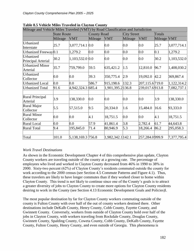
Clayton County Comprehensive Plan 2005 – 2025
182
Table 8.5 Vehicle Miles Traveled in Clayton County
Mileage and Vehicle Miles Traveled (VMT) by Road Classification and Jurisdiction
State Route County Road City Street Totals
Mileage VMT Mileage VMT Mileage VMT Mileage VMT
Urbanized
Interstate 25.7 3,077,714.1 0.0 0.0 0.0 0.0 25.7 3,077,714.1
Urbanized Freeway 0.1 1,279.2 0.0 0.0 0.0 0.0 0.1 1,279.2
Urbanized
Principal Arterial 30.2 1,103,532.0 0.0 0.0 0.0 0.0 30.2 1,103,532.0
Urbanized Minor
Arterial 35.7 759,799.0 59.5 635,421.2 1.5 12,810.0 96.7 1,408,030.2
Urbanized
Collector 0.0 0.0 39.3 350,775.4 2.9 19,092.0 42.2 369,867.4
Urbanized Local 0.0 0.0 586.7 915,198.6 132.3 207,115.6 719.0 1,122,314.2
Urbanized Total 91.6 4,942,324.3 685.4 1,901,395.2 136.8 239,017.6 913.8 7,082,737.1
Rural Principal
Arterial 3.9 138,330.0 0.0 0.0 0.0 0.0 3.9 138,330.0
Rural Major
Collector 5.5 57,515.0 9.5 20,334.0 1.6 15,484.0 16.6 93,333.0
Rural Minor
Collector 0.0 0.0 4.1 18,751.5 0.0 0.0 4.1 18,751.5
Rural Local 0.0 0.0 57.9 41,861.4 3.8 2,782.4 61.7 44,643.8
Rural Total 9.4 195,845.0 71.4 80,946.9 5.3 18,266.4 86.2 295,058.3
Total 101.0 5,138,169.3 756.8 1,982,342.1 142.1 257,284.0 999.9 7,377,795.4
Work Travel Destinations
As shown in the Economic Development Chapter 4 of this comprehensive plan update, Clayton
County workers are traveling outside of the county at a growing rate. The percentage of
employees who lived and worked in Clayton County decreased from 46% in 1990 to 38% in
2000. Sixty-two percent (62%) of Clayton County’s residents commuted outside the county for
work according to the 2000 census (see Section 4.5 Commute Patterns and Figure 4.1). Thus,
these travelers are likely to have longer commutes than if they worked closer to home within
Clayton County. This trend is not likely to continue since one of the County’s goals is to attract
a greater diversity of jobs to Clayton County to create more options for Clayton County residents
desiring to work in the County (see Section 4.13 Economic Development Goals and Policies)l.
The most popular destination by far for Clayton County workers commuting outside of the
county is Fulton County with over half of the out of county workers destined there. Other
destinations include DeKalb County, Henry County, Cobb County, Fayette County, and
Gwinnett County. Conversely, workers from outside of Clayton County hold over half of the
jobs in Clayton County, with workers traveling from Rockdale County, Douglas County,
Gwinnett County, Spalding County, Coweta County, Cobb County, DeKalb County, Fayette
County, Fulton County, Henry County, and even outside of Georgia. This phenomena is

Clayton County Comprehensive Plan 2005 – 2025
183
consistent with Clayton County being a part of a major metropolitan area with major
employment centers such as Delta Airlines being located in the county, and conversely, major
employment centers such as downtown and midtown Atlanta, Buckhead, and the Perimeter
Center area being located outside of Clayton County. The inter-county commuting patterns help
fuel the increased VMT mentioned previously as workers travel ever-increasing distances to
access employment. The increased VMT leads to congestion along freeways such as I-75 and
major arterials such as Tara Boulevard (US 41/19) and SR 85 in Clayton County.
Means of Transportation to Work
Table8.6 shows work commute travel modes in 2000. When compared to the surrounding
counties in the Atlanta metropolitan area, Clayton County is at the median for workers traveling
alone by autos, trucks and vans. Approximately three out of four (3/4) workers age 16 and over
drive to work alone compared to over eighty percent (80%) in Fayette and Henry Counties and
just over seventy percent (70%) in Fulton and DeKalb Counties. This reflects the more suburban
nature of Fayette and Henry Counties and the more urban nature of DeKalb and Fulton Counties
when compared to Clayton County.
Almost ninety-five percent (95%) of workers age 16 and over in Clayton County traveled by car,
truck, or van. Only three percent (3%) of Clayton County workers used public transportation,
including MARTA and CTRAN to travel to work, whereas one and a half percent (1 ½%)
walked to work, and one and a half percent (1 ½%) worked from home. While these percentages
illustrate the dependence on private automobile for home-based work trips, the percentages also
illustrate the potential opportunities to reduce travel demand through mixed-use developments
where employees can walk to work and recreation and through telecommuting where employees
could work from home in Clayton County.
There is an opportunity for greater transit use. In fact, the Macon-Atlanta commuter rail service
with three stops in Clayton County was selected by the State of Georgia in June 2001. The
Federal Transit Administration (FTA) issued a Finding of No Significant Impact (FONSI)
clearing the way for partial funding in the 2003-2005 Atlanta Regional Commission (ARC)
Transportation Improvement Plan.

Clayton County Comprehensive Plan 2005 – 2025
184
Table 8.6 Means of Transportation to Work in Clayton County, 2000
MEANS OF TRANSPORTATION AND CARPOOLING
Workers 16 and over 112,580 100.0
Car, truck, or van 106,472 94.6
Drove alone 85,944 76.3
Carpooled 20,528 18.2
In 2-person carpool 14,421 12.8
In 3-person carpool 3,265 2.9
In 4-person carpool 1,460 1.3
In 5- or 6-person carpool 1,103 1.0
In 7-or-more-person carpool 279 0.2
Workers per car, truck, or van 1.12 (X)
Public transportation 1,683 1.5
Bus or trolley bus 799 0.7
Streetcar or trolley car (público in Puerto Rico) 0 0.0
Subway or elevated 587 0.5
Railroad 77 0.1
Ferryboat 19 0.0
Taxicab 201 0.2
Motorcycle 148 0.1
Bicycle 118 0.1
Walked 1,586 1.4
Other means 858 0.8
Worked at home 1,715 1.5
Source: U.S. Census Bureau, Census 2000 Summary File 3, Matrices P30, P31, P33, P34, and
P35
Travel Time to Work
Travel time to work is a function of distance traveled and levels of congestion. A worker may
have to travel only a short distance, but if in congested conditions, travel time can still be higher
than average. The average commute time was generally about thirty (30) minutes in the year
2000 in metropolitan Atlanta. Table 8.7 illustrates three distinct groups in travel time to work
within Clayton County. The first group, between fifteen (15) and twenty four (24) minutes
constitute close to thirty percent (30%) of total trips. The second group falls between thirty (30)
and thirty four (34) minutes, which constitutes over seventeen percent (17%) of total trips, and
the third group, workers traveling between forty-five (45) and fifty nine (59) minutes constitute
almost twelve percent (12%) of total trips. Clayton County’s close proximity to downtown and
midtown Atlanta is consistent with the significant percentage of moderate travel times between
fifteen (15) and thirty-four (34) minutes. The higher travel times are most likely associated with
workers accessing more remote employment centers such as the Perimeter area and Buckhead,
where most routes, such as I-285 are heavily congested during large portions of the day.

Clayton County Comprehensive Plan 2005 – 2025
185
Table 8.7 Travel Time to Work in Clayton County, 2000
TRAVEL TIME TO WORK
Workers who did not work at home 110,865 100.0
Less than 10 minutes 7,452 6.7
10 to 14 minutes 11,680 10.5
15 to 19 minutes 17,325 15.6
20 to 24 minutes 15,851 14.3
25 to 29 minutes 6,918 6.2
30 to 34 minutes 19,241 17.4
35 to 44 minutes 9,044 8.2
45 to 59 minutes 12,864 11.6
60 to 89 minutes 7,533 6.8
90 or more minutes 2,957 2.7
Mean travel time to work (minutes) 29.8 (X)
Source: U.S. Census Bureau, Census 2000 Summary File 3, Matrices P30, P31, P33, P34, and
P35
Table 8.8 Time Leaving Home to go to Work in Clayton County, 2000
TIME LEAVING HOME TO GO TO WORK
Workers who did not work at home 110,865 100.0
5:00 to 5:59 a.m. 8,561 7.7
6:00 to 6:29 a.m. 12,417 11.2
6:30 to 6:59 a.m. 13,558 12.2
7:00 to 7:29 a.m. 17,451 15.7
7:30 to 7:59 a.m. 13,854 12.5
8:00 to 8:29 a.m. 9,234 8.3
8:30 to 8:59 a.m. 3,880 3.5
9:00 to 11:59 a.m. 8,911 8.0
12:00 to 3:59 p.m. 9,114 8.2
All other times 13,885 12.5
Source: U.S. Census Bureau, Census 2000 Summary File 3, Matrices P30, P31, P33, P34, and
P35
Table 8.8 illustrates that Clayton County workers are leaving home between 6:00 AM and 8:00
AM to travel to work. The relatively even percentages throughout the morning are consistent
with the phenomena of “peak spreading”, where the traditional peak hour has extended to
multiple hours due to traffic congestion, and the associated travel demand reduction strategies,
such as flexible work shifts, which allow workers to miss the heaviest congestion during the peak
period.
Types of Housing and Types of Jobs
Nearly two-thirds (2/3) of Clayton County’s housing units are single family detached homes.
There are increasing numbers of multi-family housing with 50 or more units. Mixed use
developments are encouraged since they are considered the most efficient use of land because

Clayton County Comprehensive Plan 2005 – 2025
186
people can work, live and play in a more clustered environment which shortens their trips. Thus,
mixed use residential and commercial developments that are transit, pedestrian, and bicycle
friendly are encouraged.
Clayton County has a significant concentration of employment in the transportation,
communications and utilities sectors (see Section 4.1 Employment by Sector). The location of
Hartsfield-Jackson International Airport is the primary reason for this concentration of
employment. As other sectors are developed in Clayton County, work trips will likely be shorter
which may improve traffic safety and Levels of Service.
8.2.2 Existing Levels of Service and Land Use
The existing transportation system Levels of Service (LOS) and system needs based upon
existing design and operating capacities is illustrated in Map 8.9.
The ARC travel demand model was utilized in the highway systems analysis for existing and
future year conditions. Prior to the analysis, the Average Daily Traffic (ADT) in the travel
demand model was compared to the ADT at Georgia Department of Transportation (GDOT)
count stations and the Clayton County traffic volume map for validation purposes.
Volumes were compared on the five major functional classes summarized previously in the
Transportation Inventory: Interstate Principal Arterial, Principal Arterial, Minor Arterial, Major
Collector, and Minor Collector. Where ARC volumes were significantly lower than the
collected volumes, the highest volume between the Clayton County map and the GDOT count
station was used in the analysis. In cases where there was only one GDOT count station or
Clayton County volume available within a series of roadway links in the travel demand model,
the adjacent links represented in the ARC model were adjusted upward accordingly until a point
was reached along the roadway corridor where the ARC forecast volume was within the
acceptable range of the GDOT and/or Clayton County count. In areas where there were no
existing count data available, the ARC volume was used.
While absolute criteria for assessing the validity of all model systems cannot be precisely
defined, a number of target values have been developed. These commonly-used values provide
excellent guidance for evaluating the relative performance of a particular travel demand model
when compared to actual traffic count data. Observed versus estimated volumes should be
checked by facility type and geographic area. As per the US Department of Transportation
Model Validation and Reasonableness Checking Manual, the Federal Highway Administration
(FHWA) and Michigan Department of Transportation define targets for daily volumes by facility
type as shown in Table 8.9 below.
Table 8.9 Percent Difference Targets for Daily Traffic Volumes by Facility Type
Facility Type FHWA Targets MDOT Targets
Freeway +/- 7% +/- 6%
Major Arterial 10% 7%
Minor Arterial 15% 10%
Collector 25% 20%
Sources: FHWA Calibration and Adjustment of System Planning Models, 1990;

Clayton County Comprehensive Plan 2005 – 2025
187
Michigan Department of Transportation (MDOT), Urban Model Calibration Targets, June 10,
1993
The FHWA guidelines were used for this study as this is the federally adopted standard for travel
demand model validation.

Clayton County Comprehensive Plan 2005 – 2025
188
Map 8.9 Existing Roadway Level of Service

Clayton County Comprehensive Plan 2005 – 2025
189
As expected, major arterials, such as Tara Boulevard (US 19/41), SR 138, SR 85, SR 54 have
locations where the LOS is below the desired LOS D. This can be attributed to heavy traffic
volumes and the large number of driveways and curb cuts with and without traffic signals that
interrupt traffic flow on these major arterials. Interstate 75 near I-285 also experiences failing
Level of Service, which can be attributed to heavy travel demand and the interchange with I-285
currently operating over capacity, which leads to acute congestion during the AM and PM peak
hours at this location. Additionally there are short segments of West Fayetteville Road just south
of Flat Shoals Road and just north of I-285, I-285 just west of I-75, Riverdale Road near I-285, I-
85 just north of I-285, and Valley Hill Road west of Tara Boulevard that also experience an LOS
below the accepted standard of D.
Although the Metropolitan Atlanta area is currently in non-attainment status for air quality, the
federal government may fund roadway expansion projects to address traffic congestion on
freeways and major arterials. However, as mentioned in the Level of Service Standards section
of the report, a comprehensive access management plan can improve roadway capacity by as
much as forty percent (40%) according to the 1985 Highway Capacity Manual, by the Florida
Department of Transportation. Applying access management strategies to major arterials such as
Tara Boulevard and SR 85 can be a lower cost alternative that could garner federal funding
support versus the addition of lanes. Intersection improvements currently being funded by the
SPLOST along major arterials such as SR 54 will improve capacity and provide congestion relief
along such corridors.
Local road network improvements currently funded by the SPLOST will also provide some
traffic relief in Clayton County, in particular in residential areas, where a number of roadway and
intersection improvements are being improved with SPLOST funds. See Section 8.3.4 for a list
of recommended road capacity improvement projects to improve LOS.
8.2.3 Future Levels of Service and Land Use
Several steps were undertaken to validate the volumes and geometries in the future year ARC
travel demand model. The link geometry was reviewed to ensure that all TIP projects had been
incorporated into the future year model. Additionally, the future year model was reviewed to
verify if widening projects listed in the Clayton County SPLOST program had been incorporated
into the roadway geometries in the model. In situations where roadway improvements were not
coded into the model and these improvements were deemed significant in terms of traffic
diversion, a screen-lining methodology based on the National Cooperative Highway Research
Program (NCHRP) 255 Report entitled Highway Traffic Data for Urbanized Area Project
Planning and Design was implemented to redistribute the volumes to new and/or improved
roadway segments prior to analysis.
A similar review of the ARC travel demand model was conducted on the land use elements to
verify that the proposed Land Use plan, including major employment centers and updated land
uses proposed in the Land Use and Economic Development sections of this comprehensive plan
update were reflected in the travel demand model. Where discrepancies were discovered, a
manual adjustment to forecast volumes was conducted in those areas to more accurately reflect
the projected volumes based on the land use in the area.

Clayton County Comprehensive Plan 2005 – 2025
190
Additionally, GDOT historical trends were evaluated on major principal arterials, such as Tara
Boulevard and I-75 to compare to the model forecast results. In situations where the historical
trends were much greater than the model forecasts (without exceeding the capacity of the future
roadway segments), the historical forecast volume was used instead of the travel demand model
forecast volume.
At locations where the volumes in the existing condition travel demand model had been replaced
by existing counts, the future year ARC model was used to calculate the appropriate growth
factor to apply to the existing counts in lieu of using the forecast volume in the ARC model.
Traffic Performance Measures
A key element of the roadway design process is the provision of acceptable traffic operations and
sufficient capacity for flexible operations. The key performance measures to assess design
options consist of traffic LOS, intersection delay, and the intersection volume to capacity ratio.
Delay is expressed in seconds per vehicle and provides a measure of driver frustration that could
lead to unsafe gap acceptance behaviors, and traffic violations such as red light running. The
LOS is a qualitative rating of intersection performance that is related to the average total delay
per vehicle.
Unsignalized intersection LOS becomes unacceptable (LOS E) at an average delay of 35 seconds
per vehicle, and failure (LOS F) occurs at a delay of 50 seconds per vehicle. Signalized
intersection level of service becomes unacceptable (LOS E) at an average delay of 55 seconds
per vehicle, and failure (LOS F) occurs at 80 seconds per vehicle. While the previously
mentioned thresholds specifically apply to intersection LOS, the same concepts can be applied to
highway systems analysis to conduct an area wide, planning level assessment of a highway
system.
The highway system LOS analysis was conducted using the methodology developed by the
Florida Department of Transportation and accepted by the Georgia Regional Transportation
Authority (GRTA). The Florida DOT methodology factors in the intersection performance
measures mentioned above to determine link volume thresholds that correspond with a particular
LOS. The volume thresholds are segregated by functional class, area type, and number of lanes
for a particular facility. The Florida DOT methodology and LOS analysis sheets are presented in
Appendix A.
Based on the ARC future travel demand model, the future LOS is provided in Map 8.10.

Clayton County Comprehensive Plan 2005 – 2025
191
Map 8.10 Future Level of Service

Clayton County Comprehensive Plan 2005 – 2025
192
See Section 8.3.4 for a list of recommended road capacity improvement projects to improve
LOS.
Land Use and Transportation Interaction
Single-family subdivisions are located throughout Clayton County in areas distant from
employment centers, leading to a reliance on vehicles and increases in vehicle miles traveled, as
previously noted. Similarly, housing is not often located within or in convenient walking
distance to employment centers, thus requiring vehicle use when public transit is not available.
As previously noted, working from home and providing opportunities for citizens to walk to
destinations via mixed use developments also reduces vehicle use and the associated VMT.
However, any increase in vehicular traffic due to large mixed use developments be offset by
private/public infrastructure improvements such as public transportation investments and
investments in other alternative modes of transportation.
It is recommended that Clayton County review its zoning policies and processes to ensure that
developers explain how new developments will be accessible to public transit, bike paths, and
sidewalks. In particular, public transportation connectivity must become a significant factor in
the zoning process.
Livable Centers Initiatives
Recognizing the relationship between land use patterns/densities and travel behavior in Clayton
County, cities such as Jonesboro have developed plans that support mixed uses in the downtown
central business district, which allows employees and residents to walk to amenities such as
restaurants and shopping during the day. Three Livable Centers Initiative (LCI) plans and
studies have been developed in Clayton County. See Table 20 for recommended transportation
improvements.
The Jonesboro LCI is designed to capitalize on the potential commuter rail service between
Lovejoy and Atlanta, which further assists with the reduction of VMT, while providing
commuters a viable transportation option to travel beyond Clayton County.
The Forest Park Transit Village Transit Oriented Development (TOD) at Main and Phillips is a
37-acre area encompassing its downtown as the heart of its activity center. The city intends to
utilize the redevelopment of this area to form a more dynamic town center, featuring a
transportation plaza that will capitalize on the proposed commuter rail route, with appropriate
shops and services and high density in-fill housing. In addition, mixed income housing and a
system of parks and recreational amenities will all connected by sidewalks, bike and jogging
trails and public transportation.
The City of Morrow Clayton State University LCI Gateway Village was conducted in the year
2000 and involves a redevelopment area on SR 54. A new LCI study will be undertaken this
year in northwest Clayton County near Hartsfield-Jackson Airport. The study supports the
creation of C-TRAN to be managed by MARTA was listed in the implementation plan. The
study also recommends the creation of a major roundabout Boulevard at the intersection of
Highway 54 with the main entrance road into Clayton State University and College (Clayton
State Boulevard), which connects with a new conference center and hotel at the edge of a natural

Clayton County Comprehensive Plan 2005 – 2025
193
park. The Boulevard is to become the primary pedestrian circulation path between the
University and related businesses. The Boulevard is to provide an at-grade rail crossing; focal
point for development, an alternative to a bridge over the highway because a walker only has to
cross one-way traffic, which is slowed. The roundabout is reported to cut accidents in half and to
decrease wait time compared to traffic lights. The roundabout has an external ring of double
parallel parking in front of the future development as well.
There are several existing and ongoing studies in Clayton County, including the Ellenwood
Township Development of Regional Impact (DRI) for a major mixed-use development in
northeast Clayton County.
HOV Lanes
Additionally, a High Occupancy Vehicle (HOV) System Implementation Plan recommends
HOV lanes on the I-75 corridor in Clayton County. The Georgia Fast Forward bond program
includes HOV lanes on I-75 from SR 54 through to SR 155 in Henry County with preliminary
engineering is to begin in 2005 and construction in 2009.
By 2006, GDOT plans additional miles of HOV lanes outside I-285 on I-75 and I-675 south of
the Atlanta city limits. HOV lanes were first introduced in December 1994 along an 18-mile
section of I-20 east of I-75/85. In 1996, 60 additional miles were opened on I-75/85 inside I-285.
HOV lanes are designed to help reduce air pollution, improve traffic congestion and ensure
substantial time-savings for commuters that rideshare with two or more occupants per vehicle.
HOV lanes are best suited for interstates congested by a large number of commuters traveling
from their homes to densely developed activity centers and return trips. They are most effective
as part of a transportation system that includes transit, park-and-ride lots and ride-share
opportunities.
Ride-Share Programs
With respect to ride-share opportunities, the Hartfield Area Transportation Management
Association (HATMA) performs transportation workshops to provide employees with commute
options such as forming carpools and vanpools. HATMA conducts worksite transportation
surveys to help employers with providing commuter choices and parking management decisions.
HATMA advises employers on transportation-related tax deductions and other tax benefits that
can improve a company’s bottom line. HATMA is one of eight (8) transportation management
associations (TMAs) in the metro-Atlanta region formed where air quality does not meet federal
clean air standards.
Commuter Rail
Commuter rail service between Macon and downtown Atlanta is partially programmed for
federal funding.
Proposed Land Use Actions
Based on the proposed increases in mixed-use development in the Land Use Chapter of this
comprehensive plan update, projections for transportation uses and LOS are illustrated in Map
8.11.

Clayton County Comprehensive Plan 2005 – 2025
194
Map 8.11 Future Level of Service Considering Proposed Land Use Actions
Clayton County Comprehensive Plan 2005 – 2025
195
This comprehensive plan update includes proposed land use actions to increase mixed use
developments. Developments that combine a mix of land uses promote the wider objectives of
reducing the need to travel and reliance on the car. Closely integrated or closely linked
residential uses with other uses such as a mix of housing, employment and community activities
in order to encourage travel by walking and cycling between them.
All developments must be fully accessible to public transport, cyclists, pedestrians and the car.
On larger mixed-use developments, non-residential uses could generate significant numbers of
vehicular traffic. Thus, high concentrations of vehicular traffic need to be located within clearly
identified areas such as areas adequately served by transportation infrastructure. Any increase in
vehicular traffic due to large mixed use developments be offset by private/public infrastructure
improvements such as public transportation investments and investments in other alternative
modes of transportation.
It is necessary to consider the individual roads and transport requirements for each use. Here, the
individual road links with LOS of E and F include:
Noahs Ark Rd from Jonesboro Rd to Ashley Oaks Dr
South Main Street from Jodeco Rd to Noahs Ark Dr
Forest Parkway from SR 42 to I-675
Lake Drive south of Rex Rd
Upper Riverdale Road west of Tara Blvd
SR 138 west of Tara Blvd
To improve service along these routes, the long-term promotion of public transit and bike/ped
facilities is required. See Section 8.3.4 for a list of recommended road capacity improvement
projects to improve LOS.
8.3 Proposed Transportation Alternatives and Improvements
8.3.1 Livable Centers Initiatives
In FY 2003, the Jonesboro Town Center LCI Study began and a number of transportation
improvements were recommended to accommodate the revitalization of downtown Jonesboro
and the adjacent areas. The transportation improvements recommended in the Livable Centers
Initiative Study are presented below:
Streetscape-Main Street from North to South Streets (This will include the replacing of
the angled parking on Main Street with Parallel parking) and McDonough Street from
Johnson Street to Turner Road
West Mill Street Parking Deck (Estimated 500 spaces)
The addition of mast arm signals to the following intersections along Main Street:
College Street, Mill Street, Spring Street, and North Avenue to include pedestrian signals
and marked crosswalks
Commuter Rail Station-600 foot platform in the vicinity of West Mill Street and Smith
Street

Clayton County Comprehensive Plan 2005 – 2025
196
Streetscape-Smith Street from Tara Boulevard to Main Street
Sidewalks-Fayetteville Road from West Mill Street to Tara Boulevard
Sidewalks-Fayetteville Road from North Avenue to Williamson Mill Road
Close West Mill Street Rail Crossing to vehicles, but maintain as pedestrian crossing
location for future commuter rail station
Sidewalks-Old Stockbridge Road from White Line Street to Old Courthouse
Streetscape-Lee Street from West Mill to Spring Street
Sidewalks-King Street to Wilburn Street
Construct gateways
New Connector Parkway from South McDonough Street to Old Courthouse (including
sidewalks)
Sidewalks-Main Street from West Mimosa Drive to North Avenue and Johnson Street
from Wallis Street to White Line Street
Streetscape-King Street from Wilburn Street to McDonough Street
Sidewalks-Wilburn Street from King Street to Public Housing
Multi-Purpose Paths-new Middle School to Stately Oaks
Installation of a wayfinding system to help guide visitors to various attractions
Sidewalks-Plant Street from West Mill Street to Church Street; Sims Street from West
Mill Street to Church Street; Memorial Avenue from West Mill Street to Church Street;
Cloud Street from Church Street to College Street; and Spring Street from Lee Street to
Dean Street
Streetscape-North Main Street from Main Street to City Limit
Sidewalks-Main Street from Batiste Park Road to south City limits
Multi-Purpose Paths-Old Courthouse to African American Museum on Smith Street
Sidewalks-North Avenue from 118 North Avenue to BB&T
Sidewalks-Highway 54 from Highway 138 to Raymond Street
Sidewalks-Raymond Street to Old Morrow Road
Courthouse Drive Parking Deck-Estimate 700 Spaces
Sidewalks-Williamson Mill Road from North Avenue to Hanes Street
Sidewalks-Williamson Mill Road from Hanes Street to Fayetteville Road
Sidewalks-Crowder Street (all)
Sidewalks-Whiteline Street (all)
Proposed Downtown Trolley (2 buses)
In FY 2000, the City of Morrow LCI Study began and recommends the creation of C-TRAN to
be managed by MARTA was listed in the implementation plan. The study also recommends the
creation of a major roundabout Boulevard at the intersection of Highway 54 with the main
entrance road into Clayton State University and College (Clayton State Boulevard), which
connects with a new conference center and hotel at the edge of a natural park.
In FY 2001, the Forest Park LCI Study began and the following transportation projects were
recommended:
Construct 3-mile multi-use, bike/ped trail
Acquire site and construct a rail station
Construct a people mover train to Hartsfield-Jackson airport
Clayton County Comprehensive Plan 2005 – 2025
197
Construct a pedestrian bridge connecting Main Street and City Hall
Forest Parkway Street Scape/ Pedestrian
8.3.2 Transportation Improvement Plan (TIP) and Regional Transportation Plan (RTP) Projects
Clayton County utilizes a variety of funding sources in building and maintaining their
transportation network. Transportation projects in the ARC 2003-2005 Transportation
Improvement Plan (TIP) and Regional Transportation Plan (RTP) includes a mix of financial
support from Federal transportation programs, Georgia Department of Transportation funds,
reinvestment revenue bonds, and local general revenue. Additional projects are funded through
SPLOST programs.
The following projects are listed under the Atlanta Regional Commission Transportation
Improvement Plan (TIP). The TIP projects are scheduled for the 2003 – 2005 planning period.
The RTP projects are long-range out to 2025.
Roadway Capacity and Intersection Upgrade Projects
Widening SR 42 from Lake Harbin Rd north to Anvil Block Rd
Widening SR 85 including interchange at Forest Parkway from Adams Drive to I-75
ramp.
Widening SR 85 from SR 279 to Roberts Rd
Widening Battlecreek Rd from Southlake Pkwy. to Valley Hill Rd
Widening Battlecreek Rd-Mt. Zion Blvd from Southlake Pkwy to Lake Harbin Rd.
Widening SR 138 from Walt Stephens Rd to I-75 South in Henry County.
Widening SR 54 from McDonough Rd in Fayette County to SR 3/US 41/Tara Blvd.
Widening SR 314-Fayetteville Rd from Norman Dr/CR 255 to SR 139/Riverdale Rd.
Widening SR 42 from SR 138 in Henry County to I-675 northbound.
Widening Conley Rd (Aviation Blvd Extension) from SR 54 to SR 3-Old Dixie
Hwy.(NOTE: ARC recommended that this project be moved to the long range per
amendments to the FY 2003-2005 TIP and 2025 RTP listing bond funded projects)
Widening SR 920-Jonesboro Rd from SR 54 to US 19/41 and SR 3.
Widening Anvil Block Rd from the end of current 5-lane section to Bouldercrest Rd
Widening I-75 South add two lanes southbound only from I-285 south to US 19/41-SR 3-
Old Dixie Hwy.
Interchange capacity expansion at I-75 south new interchanges and 4-lane
collector/distributor system.
Widening US 41/SR 3-Cobb Parkway from Windy Hill Rd to Terrell Mill Rd.
I-75 South interchange upgrade.
I-285 eastbound to I-75 southbound interchange upgrade.
Roadway Operation Projects
I-285 and Conley Rd.
Flint River Rd from Glenwood Dr to Kendrick Rd.
Tara Rd from McDonough Rd to Tara Blvd.

Clayton County Comprehensive Plan 2005 – 2025
198
ATMS Enhancement, Phase 2.
Anvil Block Rd from Bouldercrest Rd to Allen Rd.
Conley Rd from SR 54 to Cherokee Trail.
SR 85 and SR 138 from SR 331 and SR 85 to Pointe South Pkwy and North Ave.
Jonesboro Rd-SR 54 signal upgrades at 16 locations from Rex Rd to East Dixie Dr
ATMS/ITS enhancements implementation
Pedestrian Facility Expansion and Improvements
Putnam Ford Rd from Bascomb Carmel Rd to Eagle Dr
Woodstock Rd sidewalks from SR 92 to Oak Grove Elementary School.
Jonesboro downtown pedestrian streetscape from North Ave to South Ave.
Riverdale sidewalks around school facilities.
Lake Harbin Road sidewalks from Maddox Rd to SR 42.
Transit-oriented pedestrian improvements from I-75 south to US 19/41-SR 3.
Forest Park sidewalks around school facilities (3-phase project).
Bridge Capacity Expansion and Upgrades
Bridge capacity expansion I-75 south at Lee Street Bridge.
Bridge upgrade SR 42 at Upton Creek.
Bridge upgrade US 19/41-SR 3-Old Dixie Hwy at Central of Georgia Railroad.
Rex Rd at Big Cotton Indian Creek.
8.3.3 SPLOST Projects
In addition to the TIP projects in Clayton County, a number of road improvements are scheduled
to be funded through the county SPLOST. SPLOST funds have been earmarked for a variety of
transportation improvement projects including new road construction, road widening or
improvement, intersection improvements, upgrading dirt roads, upgrading bridges and box
culverts, improving railroad crossings, installing sidewalks, and reducing congestion around
schools.
Road Construction Projects
Aviation Blvd Extension – From Intersection of Aviation at Old Dixie Road to Conley
Road near Ellery Drive.
Gardenwalk Boulevard – Phase 1 – From Gardenwalk Boulevard at SR 85 to upper
Riverdale Rd.
Jonesboro Transportation Improvements – General road improvements inside the City of
Jonesboro.
Noah’s Ark Road – From the intersection of Tara Boulevard at Betty Talmadge Avenue
to the intersection of Thornton Road at Noah’s Ark Road.
Pleasant Hill Road to E. Pleasant Hill Road – From East Pleasant Hill Road to Pleasant
Hill Road.
Richardson Parkway – From Mt. Zion Boulevard to Mt. Zion Road.

Clayton County Comprehensive Plan 2005 – 2025
199
Road Widening and Improvement Projects
Anvilblock Road – From the existing 5 lane section to the Henry County line.
Battlecreek Road – From Valley Hill Road to Southlake Parkway.
Bethsaida Road – From the Fulton County line to Carder Court.
Conley Road – From SR 54 to the DeKalb County line.
Conley Road/Aviation Boulevard Extension – From Aviation Blvd to SR 54.
Davidson Parkway – Davidson Parkway South realignment and widening to 3 lanes.
East Lovejoy Road – From La Costa to Hastings Bridge Road.
Flint River Road – Expand to three lanes from Glenwood Drive to Kendrick Road;
Expand to four lanes with median from Kendrick Road to Tara Boulevard; From Pointe
South Parkway to Thomas Road.
Godby Road – From Highway 314 to South Hampton Road.
Lee Street – From Southlake Parkway to Twilight Trail.
Mt. Zion Boulevard – Four lanes with median from Southlake Parkway to Lake Harbin
Road; Three lanes from Lake Harbin road to Rex Road. Three to Four lanes from
Richardson parkway to SR 138.
Mundy’s Mill Road – From SR 54 to East of Fitzgerald Road.
Norman Drive – From SR 314 to SR 139.
North Bridge – 1,000 feet on either side of Flint River Bridge.
Old Rex-Morrow Road – 500 feet on either side of Hartford Drive. Improve intersections
around Maddox Road to accommodate planned schools.
Panola Road – From Bouldercrest Road to the Henry County Line.
Pine Drive – From Crestridge Drive to SR 139.
Pointe South Parkway – From Flint River Road to SR 85.
Rex Road Bridge – 1,000 feet on either side of Big Cotton Indian Creek.
Rountree Road – Between Old Rountree Road and SR 138.
Southlake Parkway – From Noland Court northward to railroad spur track.
SR 139 at SR 85 – Construct an eastbound right turn lane from SR 139 onto SR 85
southbound.
Tara Road – From McDonough Road to US 19/41 Tara Boulevard.
Tara Road – From Panhandle Road to US 19/41.
Valley Hill Road – From Battlecreek Road to Upper Riverdale Road.
West Lee’s Mill Road – From Gardenwalk Boulevard to Rock Hill Drive.
Warren Drive – From Warren Drive dead end to SR 85.
Intersection Improvements
BattleCreek Road at Southlake Parkway – Construct east and westbound left turn lanes.
Cash Memorial Boulevard at Old Dixie Road – Add a westbound turn lane from Cash
Memorial Boulevard.
Clark Howell at SR 85 – Realign southern end of Clark Howell.
College Street at Main Street (Forest Park) – Realign College Street with Ash Street.

Clayton County Comprehensive Plan 2005 – 2025
200
Elliot Road at Fielder Road – Add a right turn lane from Elliot Rd. to Fielder Rd.
Evans Drive at Rex Road – Add a new northbound right turn lane.
Flat Shoals Road at SR 314 – Realign Flat Shoals Rd. away from SR 314.
Forest Parkway at North Parkway – Add an eastbound right and westbound left turn lane.
Lovejoy Road at Tara Boulevard – Realign sharp curves on Lovejoy Rd near Tara Blvd.
McDonough Rd at Hastings Bridge Road –
Mt. Zion Blvd at Mt. Zion Circle – Add a northbound turn lane on Mt. Zion Blvd.
North McDonough St. at SR 138 – Add northbound lane and restripe for southbound
exclusive right turn lane.
SR 138 at SR 138 Spur – Enlarge the radius of traffic traveling westbound.
SR 54 at Commerce Road – Add a southbound right turn lane.
SR 54 at Southern Road – Add a southbound right turn lane.
SR 54 at Thomas Road – Add a northbound left turn lane.
SR 54 at US 19/41 – Add a northbound right turn lane.
Tara Boulevard at SR 138 Spur – Construct a bridge over SR 138 with ramp turn lanes.
Upper Riverdale Road at Arrowhead Boulevard – Add an eastbound right turn lane.
Valley Hill Road at Camp Street – Add a westbound right turn lane.
Webb Road at SR 85 – Construct a westbound right turn lane.
Upgrade Dirt Roads
1st Avenue
East Clayton Road
Ellison Road
Front Street
Lee Street
Lunsford Drive
Mill Street
Otis Camp Road
The Inlet
8.3.4 Newly recommended road improvement projects
Besides the extensive list of programmed improvement projects in the SPLOST program and
ARC TIP/RTP, the existing and future LOS analyses reveal failed links along:
Tara Boulevard (US 19/41)
SR 138
SR 85
SR 54
Interstate 75 near I-285
I-285
Short segments of SR 314 West Fayetteville Road just south of Flat Shoals Road and just
north of I-285
Riverdale Road near I-285
I-85 just north of I-285

Clayton County Comprehensive Plan 2005 – 2025
201
Valley Hill Road west of Tara Boulevard
Noah’s Ark Road from Jonesboro Road to Ashley Oaks Drive
South Main Street from Jodeco Road to Noah’s Ark Drive
Forest Parkway from SR 42 to I-675
Upper Riverdale Road from Tara Blvd to 0.2 miles west of Tara Blvd
Lake Drive from Rex Road to Twilight Trail (1 mile south of Rex Road)
Among these links, the following are not currently identified in the SPLOST, TIP or RTP
listings. They continue to show failed LOS in 2025 and should be added to the Clayton County
Comprehensive Plan Update. Thus, the following are recommended widening projects:
o Tara Boulevard (US 19/41) from Mt Zion Road to Sherwood Drive from Battle
Creek Road to Walt Stephens Road, from Fayetteville Road to McDonough Road,
and from I-75 to Lovejoy Road;
o Riverdale Road near I-285 from I-285 to Flat Shoals Road, from I-85 to Sullivan
Road, and from Sullivan Road to I-285;
o Noah’s Ark Road from Jonesboro Road to Ashley Oaks Drive;
o South Main Street from Jodeco Road to Ashley Oaks Drive;
o Forest Parkway from SR 42 to I-675;
o Upper Riverdale Road from Tara Boulevard to Hayes Drive; and
o Lake Drive from Rex Road to Twilight Trail (1 mile south of Rex Road).
In addition, the following list of road segments have been identified by the Clayton County
Department of Transportation as requiring detailed engineering studies and operational
improvement within the next few years:
o Forest Parkway from SR 54 to SR 42 (existing 4 lane roadway needs a center turn
lane or installation of a 20 foot raised median to control left turn movement);
o Panhandle Road from Woolsey Road to Tara Road ( widen from 2 lanes to 4 lanes
with a 20 foot raised median);
o Mundy’s Mill Road from SR 54 to US 19/41 (widen from 2 lanes to 4 lanes with
a 20 foot raised median);
o Bouldercrest Road from Panola Road to DeKalb County line (widen from 2 lanes
to 4 lanes with a 20 foot raised median);
o Noah’s Ark Road from Henry County to S. Main Street (widen from 2 lanes to 4
lanes with a 20 foot raised median);
o Jodeco Road from Henry County to S. McDonough Street (widen from 2 lanes to
4 lanes with a 20 foot raised median);
o Walt Stephens Road from SR 138 to Henry County line (widen from 2 lanes to 3
lanes with decel lanes at key locations).
o Conley Road Realignment at Cherokee Trail (intersect SR 42 at E. Conley Road
and then follow Grant Road; widen from 2 lanes to 3 lanes with decel lanes at key
locations);
o Stagecoach Road from Anvilblock Road to Henry County line (add a center turn
lane and other turn lanes at key intersections).

Clayton County Comprehensive Plan 2005 – 2025
202
o Improve a series of roads that make an east-west corridor (begin at Godby Road at
the Fulton County line and proceed eastward to Phoenix Boulevard, then continue
east on the newly constructed Sullivan Road, then to Forest Parkway to
Ellenwood Road to Panola Road to Henry County.
It is recommended that Clayton County plan, develop, and implement a county-wide long-range,
comprehensive transportation plan. The proposed long-range, comprehensive transportation plan
should take into consideration: (1) routes identified herein with LOS of E or F; (2) bridges with
poor condition ratings; (3) and the recommended improvements identified in LCI studies.
This plan should include access management planning that addesses the large number of
driveways/curb cuts with and without traffic signals that interrupt traffic flow on the major
arterials that currently have a LOS below D.
8.3.5 Bike and Pedestrian Considerations
It is recommended that Clayton County plan, develop, and implement a county-wide
bike/ped/trails plan
8.3.6 Proposed alternative modes of travel
HOV Lanes
Hartsfield-Jackson International Airport Transportation Management Association
Sidewalk improvements
C-TRAN
Macon-Atlanta Commuter Rail
Southern Crescent multi-modal transportation service center
8.3.7 Emergency Preparedness
Adequacy of the existing and projected transportation system to evacuate populations prior to an
impending natural disaster. Since Clayton County is not a coastal region, there are few concerns
about flooding or hurricane evacuation. Nevertheless, Clayton County is well served by
interstates I-75, I-675 and I-285 which can be used in the event of a natural disaster. With
respect to national security, Fort Gillem is served by I-675 at Moreland Avenue (SR 42) from the
East and Jonesboro Road from the west.
8.3.8 Transportation Operations in Underserved Areas
The primary need for expanded public transportation can be met with service provided by C-
TRAN and MARTA. Mixed-use, Transit-oriented developments are encouraged. Map 8.4
entitled Public Transportation in Clayton County was compared to the Future Land Use Plan.
The existing C-TRAN routes were compared to the proposed residential, commercial, and mixed
use land areas. There are a number of underserved residential and commercial areas west of C-
TRAN route 503; residential areas east of the Southlake Parkawy section of C-TRAN route 501
to the eastern county line; and residential areas northeast of C-TRAN route 501 east of Morrow
to I-675 and beyond. Therefore, it is recommended that Clayton County plan, develop and
implement a county-wide transit expansion feasibility study.
Clayton County Comprehensive Plan 2005 – 2025
203
8.4 Transportation Requirements for Non-Attainment Areas
This section provides a discussion of the severity of any violations contributed by transportation
related sources that are contributing to air quality non-attainment; and identification of measures,
activities, programs, and regulations that the City of Atlanta will implement consistent with the
Statewide Implementation Program (SIP) for air quality through the Atlanta comprehensive plan
implementation program, as per the Intergovernmental Coordination Element of the DCA Rules.
See Map 8.12.
For air-quality modeling purposes, three (3) additional counties are included in ARC’s planning
efforts, Coweta, Paulding, and Forsyth Counties. All of Clayton County is within the nationally
designated ambient air quality standards non-attainment area of metropolitan Atlanta.
Therefore, compliance of Clayton County’s transportation element with the Federal Clean Air
Act is required. Severity of violations are discussed and addressed on a regional basis in the
state implementation plan for air quality attainment. The 13 counties previously classified as a
serious non-attainment area have been downgraded to severe non-attainment status as of January
2004. Measures that the county and cities will implement to comply with the state
implementation plan include encouraging transportation demand management, provision of an
extensive sidewalk system, and certain efforts to promote public transit. Clayton County has
recently undertaken significant steps in transportation demand management by implementing a
regional bus transit system with the assistance of GRTA, and by passing a Special Purpose Local
Option Sales Tax (SPLOST); the proceeds of which will help fund the installation of ninety-six
(96) miles of sidewalks on forty-seven (47) miles of roads in Clayton County.
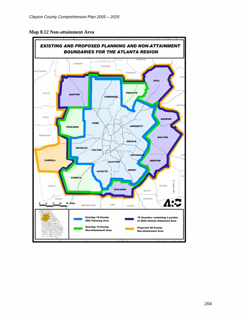
Clayton County Comprehensive Plan 2005 – 2025
204
Map 8.12 Non-attainment Area
HALL
FULTON
COBB
CARROLL
BARTOW
COWETA
HENRY
GWINNETT
CHEROKEE
WALTON
DEKALB
NEWTON
PAULDING
FORSYTH
FAYETTE
DOUGLAS
SPALDING
BARROW
CLAYTON
ROCKDALE
FLOYD
CHATTOOGA
GORDON
PICKENS
DAWSON
LUMPKIN
WHITE HABERSHAM
BANKS
JACKSON
MORGAN
JASPER
PUTNAM
BUTTS
MONROE
LAMARPIKEMERIWETHER
TROUP
HEARD
UPSON
HARALSON
POLK
WALKER
MURRAY
GILMER
FANNIN
UNION
N
5 0 5 10 15 Miles
EXISTING AND PROPOSED PLANNING AND NON-ATTAINMENT
BOUNDARIES FOR THE ATLANTA REGION
Existing 10-County
ARC Planning Area
Existing 13-County
Non-Attainment Area
19 Counties containing a portion
of 2000 Atlanta Urbanized Area
Proposed 20-County
Non-Attainment Area

Clayton County Comprehensive Plan 2005 – 2025
205
8.5 Articulation of Community Vision and Goals and Implementation Program
A community visioning workshop was required to determine long range needs and ambitions.
The Community adopted LOS standards for transportation facilities and services to be achieved
and/or maintained during the first ten-year planning period through capital improvements,
service expansions or other strategies was to be determined. An associated implementation
program in the form of a Capital Improvement Program is provided in Table 21. At a minimum,
as per the minimum and additional requirements for local governments in the Advanced
Planning Level, the following information was identified:
8.5.1 Transportation Vision
Clayton County will have a multi-modal and environmentally sensitive transportation system
that maintains tolerable operating travel speeds, and provides routes that are well connected to
the greater metro-Atlanta region to promote economic development.
8.5.2 Goals and Policies
Goal 1.0. Achieve and maintain safe operating speeds, comfort and convenience in Clayton
County.
A workshop was conducted with Clayton County officials and transportation professionals to
develop Level of Service Standards for Clayton County. Synchro/Simtraffic simulation models
were utilized during this workshop to graphically illustrate the differences between intersection
Levels of Service ranging from A to F. Illustrations of the various Levels of Service are
presented as follows:

Clayton County Comprehensive Plan 2005 – 2025
206
Level of Service A
Level of Service A conditions are characterized by free flowing conditions with maximum
mobility to switch lanes and very little delay (less than 10 seconds for signalized intersections)

Clayton County Comprehensive Plan 2005 – 2025
207
Level of Service B
Level of Service B conditions are characterized by free flowing conditions, though with minor
limitations to freedom to switch lanes. Intersection delays range from ten (10) to twenty (20)
seconds at Level of Service B.

Clayton County Comprehensive Plan 2005 – 2025
208
Level of Service C
At Level of Service C, some queuing is observed at intersections, though all queues are typically
dispersed during the green cycle. Freedom to change lanes continues to diminish, though there is
still some flexibility to do so. Intersection delays range from twenty (20) to thirty-five (35)
seconds in Level of Service C conditions.

Clayton County Comprehensive Plan 2005 – 2025
209
Level of Service D
At Level of Service D, queuing at intersections becomes more pronounced, and when signals are
not optimally timed, all queued vehicles may not make it through the intersection. Flexibility to
change lanes is minimal, and intersection delays range from thirty-five (35) to fifty-five (55)
seconds.

Clayton County Comprehensive Plan 2005 – 2025
210
Level of Service E
Level of Service E represents capacity conditions, where intersection queuing becomes acute and
traffic flow is near breakdown, making lane switching difficult. Intersection cycle failures begin
to occur at capacity conditions where the entire queue of traffic does not make it through the
intersection during the green cycle. Delays at Level of Service E range from fifty-five (55) to
eighty (80) seconds.

Clayton County Comprehensive Plan 2005 – 2025
211
Level of Service F
At Level of Service F, forced flow traffic conditions exist and intersection cycle failures are
common. Queues in excess of a half a mile or greater can build at intersection approaches at
Level of Service F conditions. Delays of eighty (80) seconds or greater exist at Level of Service
F.
Policy 1.1 Clayton County has adopted Level of Service D as their minimum required Level of
Service. This Level of Service Standard would apply to all existing and future intersections
within Clayton County and is consistent with the community’s visions and goals of balancing
growth, congestion, and green space throughout Clayton County.
Clayton County Comprehensive Plan 2005 – 2025
212
Goal 2.0 Propose land development regulations and incentives to mitigate congestion and to
achieve the LOS D standard.
Policy 2.0 Implement additional mitigation measures to mitigate poor projected LOS. The
additional measures could include:
Employer sponsored flex-time schedules
Employer sponsored telecommuting programs
Transit Subsidies with tax incentives for employers and employees
Modifications to land use, for example, mixed use developments
Local Shuttle Services
Policy 2.1 Take actions to bring into compliance any public transit facilities or services that are
below the adopted LOS D.
Actions to bring into compliance any public transit facilities or services that are below an
established LOS and/or other transportation performance measures include:
Newly proposed land development regulations and incentives to ensure that new development
does not cause the community’s adopted LOS for an individual transportation facility to decline
below the established transportation performance measures; to insure that transportation capital
improvements or other strategies needed to accommodate the impacts of development are made
concurrent with the development; and to protect or enhance transportation facilities, corridors,
and sites to ensure that they can fulfill their identified functions include:
All future development proposals are recommended to conduct comprehensive traffic studies to
determine if the proposed development would cause any adjacent intersections to fall below the
newly adopted Level of Service thresholds.
Where proposed developments would cause any adjacent intersections to operate
at LOS E or F, it is recommended that the County ensures that the developer take
all necessary steps, including but not limited to paying for necessary roadway
improvements, prior to approving the development plan.
Policy 2.2 Promulgate standards, programs and actions that promote the creation of a multi-
modal transportation network which includes bicycle and pedestrian facilities.
Access control guidelines are recommended to be developed for each functional class of
roadway in Clayton County to ensure that each roadway within the county fulfills its functional
use in the future.
Principal arterials are recommended to have access control guidelines that would consolidate
access into multiple businesses as well as the consolidation of pedestrian crossings and the
associated transit stops to maintain the principal arterial’s function of providing mobility
throughout Clayton County.

Clayton County Comprehensive Plan 2005 – 2025
213
Local collectors could have more liberal access and multiple pedestrian crossings including
raised pedestrian crossings to calm traffic in residential areas of the county and the Cities of
Jonesboro and Forest Park.
Bicycle lanes could also be implemented in conjunction with new construction of these types of
roadway classes to provide for safer, multi-modal corridors where practical throughout the
county.
Policy 2.3. Align existing plans and performance measures with any future plans to achieve more
detailed transportation goal and policy development.
Additional detailed sub-plans, such as corridor plans, gateway plans, and other
measures, such as traffic-calming measures, street alignments, intermodal
connections, pedestrian or sidewalk plans, and bikeway plans, needed to achieve
more specific transportation goals and/or policies include:
There are several existing and ongoing studies in Clayton County, including:
The Ellenwood Township Development of Regional Impact (DRI) for a major mixed-use
development in northeast Clayton County.
The Atlanta Regional Commission has sponsored Livable Centers Initiatives (LCI) Studies in
downtown Jonesboro and Forest Park and in the City of Morrow adjacent to Clayton State
College, and a new LCI study will be undertaken this year in northwest Clayton County near
Hartsfield-Jackson Airport. Based on the goals of the Livable Centers Initiative, recommended
transportation improvements have to achieve transportation demand reduction, internal mobility,
continuity of local streets, transit circulation, and external connectivity.
An HOV system Implementation Plan previously conducted recommends HOV lanes on the I-75
corridor in Clayton County. Finally, an Environmental Impact Assessment has recently been
completed by Georgia Rail Consultants to provide commuter rail service between Macon and
downtown Atlanta.
Policy 2.4 Ensure that transportation planning includes measures to manage or control land uses
and natural resources. Measures to manage or control land uses and natural resources include:
This comprehensive development plan update includes proposed land use actions to increase
mixed use developments. Developments that combine a mix of land uses promotes the wider
objectives of reducing the need to travel and reliance on the car. Closely integrated or closely
linked residential uses with other uses such as a mix of housing, employment and community
activities in order to encourage travel by walking and cycling between them.
Georgia’s Peach Blossom Trail follows US 41 in Jonesboro from Clayton County to Houston
County along the Flint River, providing a great alternative to I-75 along the back roads of
Georgia.
Clayton County Comprehensive Plan 2005 – 2025
214
CHAPTER 9 INTERGOVERNMENTAL COORDINATION
The boundaries for use of community facilities and transportation corridors as well as the effects
of land use often go beyond the legal boundaries of a county or municipal government. The
purpose of this element is to inventory the existing intergovernmental coordination mechanisms
and processes between Clayton County and the cities of College Park, Forest Park, Jonesboro,
Lake City, Lovejoy, Morrow and Riverdale and between the county and other governmental
entities and programs that have the potential of impacting the successful implementation of the
Comprehensive Plan. This element will address the adequacy and suitability of existing
coordination mechanisms to serve the current and future needs of the county as well as and
articulate goals and formulate strategies for the effective implementation of policies and
objectives that involve more than one governmental entity.
9.1 Adjacent Local Governments
There are seven municipalities within Clayton County. Due to this many aspects of coordination
are required, especially with regard to the delivery of services. Clayton County provides many
services to the residents of the cities of College Park, Forest Park, Jonesboro, Lake City,
Lovejoy, Morrow, and Riverdale, as they are also residents of the County. In addition to this
element of the Comprehensive Plan, the county’s Service Delivery Strategy (SDS) is designed to
serve as the primary coordination mechanism between theses city governments and the county.
The majority of the county’s departments and entities involved in the delivery of services are
unaware of the SDS and coordination between the county and cities is minimal. There are few
instances of information sharing or documented mechanisms for intergovernmental discussions.
The SDS is a large document and cumbersome for everyday use. To encourage greater
coordination, less formal and more accessible means are needed. A committee of representatives
from the county and each city government is needed to address interjurisdictional issues in a
comprehensive manner.
Four other metropolitan Atlanta counties, Fulton, DeKalb, Fayette, and Henry surround Clayton
County. There are no formal coordination outlets between the Clayton County government and
these county governments. However a number of informal coordination mechanisms have been
formed when necessary to address issues of multi-jurisdictional nature such as the recent
Southside Hartsfield Redevelopment and Stabilization Plan. Additionally, the counties’
representation in the Atlanta Regional Commission provides the opportunity for the high level
coordination of planning efforts.
9.2 School Board
The Clayton County Board of Education oversees Clayton County Public Schools, which serve
the entire county and the municipalities. The school board through school system staff
representation was involved in this comprehensive planning process and provided information
regarding school capacity and facility conditions and anticipated needs (see Chapter 5
Community Facilities). During the comprehensive planning process it became evident that an
increased level of coordination between the Board of Education and the County is needed

Clayton County Comprehensive Plan 2005 – 2025
215
specifically in the areas of new school locations, development of educational programs to
respond to workforce needs, and joint use of facilities.
9.3 Other Local Governmental Entities
9.3.1 Clayton County Water Authority
The Clayton County Water Authority’s service district covers the entirety of Clayton County
with the exception of some areas of the extreme northwest, which are under the jurisdiction of
the City of College Park and Hartsfield-Jackson International Airport.
9.3.2 Hartsfield Jackson International Airport
Hartsfield-Jackson International Airport is located in the Northwest corner of Clayton County.
The presence of one of the nation’s busiest airports continues to significant impact on the
development and redevelopment potential of the county. The airport and county have and are
presently coordinating on issues related to the airport’s expansion and long range plans, and the
future land use plan is coordinated with the airports long range plan. Additionally, the county,
airport and adjacent governments of College Park and Fulton County recently joined together in
a redevelopment planning process for the area directly below the airport’s fifth runway. The
coordination of the airport and county’s planning efforts is accomplished through staff level
interaction between the airport’s Community and Land Use Planning department and the
county’s Development Authority and Community Development department.
9.3.3 Development Authority of Clayton County
The Development Authority of Clayton County has the jurisdiction to issue tax exempt or
taxable bonds to businesses wishing to locate in Clayton County. In accordance with the
Georgia Redevelopment Powers Act, of 1985, the Authority can also create special district taxes
on approved urban redevelopment issues. The authority also has jurisdiction to provide
incentives such as tax breaks, venture capital programs, tax abatements and enterprise zones to
new businesses locating in Clayton County as well as existing businesses. Additionally, the
Authority has the power to buy and sell property and construct buildings.
During the comprehensive planning process the representatives from the county’s Community
Development Department and the Development Authority worked together to identify areas of
the county in need of redevelopment. This level of coordination should be continued and
specific redevelopment plans established for these areas of the county and any additional areas of
the county that are identified as in need of redevelopment in the future.
The staff of the county’s development authority serves as the county’s representative to two
regional development authorities:
9.3.4 Joint Development Authority of Metro Atlanta
Through participation in the Joint Development Authority of Metropolitan Atlanta, Clayton,
DeKalb, Douglas and Fulton Counties work together to address economic development as a
region. The combined population of counties participating in the Joint Authority represents
approximately 25% of the population of Georgia. By participating in the alliance, the member
Clayton County Comprehensive Plan 2005 – 2025
216
counties enable each company located within its jurisdiction to take advantage of a $1,000-per-
job state tax credit.
9.3.5 MetroSouth
Founded in 1993, Metro South was among the nation's first regional economic development
marketing initiatives. The organization provide economic develop assistance to the member
counties of Clayton, Fayette, Henry Fulton Coweta and Spalding.
There area a number of other units of local government in Clayton County that provide services
to the county and its citizens that do not have authority related to the use of land. These entities
are mainly comprised of constitutional officers such as the Tax Assessor, County Courts and
Clerk of Court, Sheriff, Police Department, Board of Elections and Registration. In the case of
public safety officials (i.e. sheriff and police department) and the county’s Emergency
Management and Communications Department land use planning decisions which have potential
effects on issues of their concern are coordinated through a number of mechanisms such as
interdepartmental committees and stakeholder meetings related to specific planning studies.
These methods of coordination are adequate and appropriate at this time and should continue
through the planning period. In particular coordination with the county’s law enforcement
agencies is an essential part of revitalization planning for declining or blighted commercial areas
where crime is a real or perceived problem.
9.4 Regional and State Entities
9.4.1 Atlanta Regional Commission
The Atlanta Regional Commission (ARC) serves as the regional development center for
metropolitan Atlanta area including Clayton County. The ARC provides a variety of services to
Clayton County, such as land use and transportation planning coordination, services for the
elderly and workforce development. The ARC is responsible for serving the public interest of
the state by promoting and implementing the comprehensive planning process among its ten
county region and with involvement in local and regional planning related to land use,
transportation, recreation, historic preservation, natural resources, and solid waste. The county is
represented on the ARC’s Board of Directors. The existing mechanisms of coordination between
Clayton County and the Atlanta Regional Commission are considered adequate and expected to
remain constant through the planning period.
9.4.2 Metropolitan North Georgia Water Planning District
With a finite water resource and a population of nearly 4 million and growing, the need to
carefully and cooperatively manage and protect Metropolitan Atlanta's rivers and streams has
become a priority. The Metropolitan North Georgia Water Planning District was signed into law
on April 5, 2001 (2001 S.B. 130) and is developing regional and watershed specific plans for
stormwater management, wastewater management, and water supply and conservation in a 16
county area which encompasses Clayton County and Bartow, Cherokee, Cobb, Coweta, DeKalb,
Douglas, Fayette, Fulton, Forsyth, Gwinnett, Hall, Henry, Paulding, Rockdale and Walton

Clayton County Comprehensive Plan 2005 – 2025
217
Counties. Local governments within the District that do not substantially adopt the model
ordinances will be ineligible for state grants or loans for stormwater related projects. This
decision may be appealed to the District Board with a majority vote required to overturn. Those
governments that do not implement plans that apply to them would have their current permits for
water withdrawal, wastewater capacity or NPDES stormwater permits frozen.
In September 2003, the Metropolitan North Georgia Water Planning District Board adopted three
comprehensive plans to ensure adequate supplies of drinking water, protect water quality and
minimize the impacts of development on the District’s watersheds and downstream water
quality.
Clayton County coordinates with the Clayton County Water Authority on the District Plans for
water supply and wastewater treatment. Clayton County is represented on the district’s
governing board by the county commission chairperson. The county has developed and adopted
watershed and stream buffer protection ordinances complying with the directive of the
MNGWPD and will adopt and implement the District Model for Stormwater Management
Ordinances or other comparable ordinances.
9.4.3 Georgia Department of Transportation
The Georgia Department of Transportation (GDOT) maintains and improves state and Federal
highways in Clayton County and provides financial assistance for local road improvements.
Clayton County coordinates closely with GDOT through the county’s Transportation and
Development Department. This coordination is expected to continue throughout the planning
period.
9.4.4 Georgia Department of Natural Resources
The Georgia Department of Natural Resources (DNR) provides assistance and guidance to the
County in a number important areas including; water conservation, environmental protection,
wildlife preservation, and historic preservation. There is staff level interaction between the
County, DNR’s divisions on a regular basis and this interaction will continue during the planning
period.
9.4.5 Georgia Department of Community Affairs
The Georgia Department of Community Affairs (DCA) has overall management responsibilities
for the State’s coordinated planning program and reviews plans for compliance with minimum
planning standards. DCA provides a variety of technical assistance and grant funding
opportunities to the county.
9.4.6 Georgia Greenspace Program
The Georgia General Assembly created the Georgia Greenspace Program during the 2000
legislative session by enacting Senate Bill 339. The Department of Natural Resources
administers the program, which is overseen by a five-member Georgia Greenspace Commission
that reviews and approves community greenspace programs submitted by eligible counties.
Greenspace is defined as permanently protected land and water, including agricultural and
forestry land, that is in its undeveloped, natural state or that has been developed only to the
extent consistent with, or is restored to be consistent with, one or more listed goals for natural

Clayton County Comprehensive Plan 2005 – 2025
218
resource protection or informal recreation. The permanent protection of such lands enhances a
community's quality of life and its economic competitiveness and, therefore; should be
considered as part of the necessary infrastructure for a community's development, as are roads,
water supply, and sewage. As such, the Georgia Greenspace Program provides a mechanism for
local governments to incorporate greenspace into their long-term planning for development. The
Program promotes counties to voluntarily adopt policies and rules, which enables them to
preserve at least 20 percent of the county's land area as connected and open greenspace. These
lands can be used for informal recreation and natural resource protection.
To assist counties in carrying out their strategies for acquiring and permanently protecting land
the bill that created the Georgia Greenspace Program also created the Georgia Greenspace Trust
Fund the provides funds from the General Assembly as grants to participating local governments
with an approved community greenspace program and an established a Community Greenspace
Trust Fund.
Clayton County established a greenspace program in accordance with the Georgia Greenspace
Program in 2001. As part of this program the county established a Greenspace Trust Board to
oversee the purchase of land for permanent greenspace within the county. By the spring of 2004
the county purchased a total of 275 acres and had 52 acres of land donated for greenspace. IN
total the Clayton County Greenspace Program has received total of 1,242,226 from the state for
the purchase of property for greenspace preservation.
Through May 2004 the county’s acquisitions were focused on floodplain property along the Flint
River from Upper Riverdale Road south to the Spalding County Line. At this time the Clayton
County Green Space Trust Board has exhausted all possible property acquisitions in this area and
has shifted its focus to the acquisition of properties along Jesters Creek with an emphasis on
promoting connectivity with the Jesters Creek Greenway area. It is recommended that the
Greenspace Board coordinate its acquisition efforts with the county’s Parks and Recreation
Department, the Clayton County Water Authority’s stream restoration and watershed
management efforts, and Clayton County Public Schools to provide the greatest possible impact
for future greenspace acquisitions.
9.5 Private Entities
9.5.1 Clayton County Chamber of Commerce
A non-profit membership organization, the Clayton County Chamber of Commerce provides
assistance to new businesses wishing to locate their establishments in the county. The agency's
activities are focused in the areas of business recruitment and retention.
9.5.2 Georgia Power Company
Georgia Power is a utility company servicing customers throughout the State of Georgia. There
is little coordination required between the county and Georgia Power except for issues related to
electric utility hookups.

Clayton County Comprehensive Plan 2005 – 2025
219
9.6 Service Delivery Strategy
In 1997 the State passed the Service Delivery Strategy Act (HB489). This law mandates the
cooperation of local governments with regard to service delivery issues. Each county was
required to initiate development of a Service Delivery Strategy (SDS) between July 1, 1997 and
January 1, 1998. Service Delivery Strategies must include an identification of services provided
by various entities, assignment of responsibility for provision of services and the location of
service areas, a description of funding sources, and an identification of contracts, ordinances, and
other measures necessary to implement the SDS.
The Service Delivery Strategy for Clayton County was adopted and submitted for compliance
review in October 1999 and extension agreements were signed in April 2000 and April 2004.
The county is in the process of evaluating the need to make changes to the existing strategy and
if required will prepare an official update and submittal of appropriate forms to the Georgia
Department of Community Affairs. The provision of services in the county is discussed in detail
in the Chapter 5 - Community Facilities element of the Comprehensive Plan. The major
agreements included in the Clayton County Service Delivery Strategy are summarized here,
except where it is noted the existing agreements between the county and cities are considered
adequate. However, as the local governments meet to review and update the current Clayton
County Service Delivery Strategy is it recommended that each of the existing agreements be
examined and evaluated.
9.6.1 Police Services
Clayton County has an agreement to provide services for the city of Lovejoy, but the current
service delivery strategy does not identify any areas of potential overlap or duplication of
services between the county and the municipal police department. During the comprehensive
planning process it was identified that there may be some discrepancy concerning which
jurisdiction provides police protection to a number of unincorporated and incorporated islands
which exist throughout the county. This issue should be explored during the county’s SDS
update.
9.6.2 Jails
Clayton County has agreements to provide jail services to the cities of Jonesboro, Lake City,
Forest Park, Lovejoy, Morrow, and Riverdale. These agreements are considered adequate at this
time.
9.6.3 Fire Protection
Clayton County has an agreement to provide fire services to the City of Lovejoy. Additionally
there is a mutual aid agreement for response between the county and the City of Jonesboro.
Through this agreement the county and city provide secondary services to locations in the other
jurisdiction and provide fist response to various districts within boundary limits agreed upon by
both fire chiefs.

Clayton County Comprehensive Plan 2005 – 2025
220
9.6.4 EMS & 911
Clayton County provides emergency medical services to all unincorporated areas of the county
as well as the cities of Jonesboro, Lovejoy and Riverdale. These services are provided through
"EMS Zones" authorized by the State Department of Human Resources. Supplemental
emergency medical services are also provided to the cities of Forest Park and Morrow in
accordance with mutual aid agreements. Clayton County provides Emergency 911 services to all
unincorporated areas of the county as well as the cities of Jonesboro and Lovejoy. The County
also provides back-up Emergency 911 services when necessary to the cities of Forest Park,
Morrow, Lake City, and Riverdale and the College Park portion of the city lying within Clayton
County.
9.6.5 Landfill
A single private service provider provides services countywide.
9.6.6 Roadway Construction and Maintenance
Clayton County provides roadway construction and maintenance assistance to the City of
Jonesboro through a contract established in February, 1977.
9.6.7 Animal Control
Clayton County provides animal control services to the cities of Jonesboro, Lake City, Lovejoy,
Morrow, and Riverdale.
9.6.8 Parks and Recreation
There is a February, 1986 agreement between Clayton County and the City of Riverdale by
which Riverdale leases Bethsaida Park to the County for $1.00 a year and the county provides
the maintenance and repair for the grounds and facilities and supervisory personnel for
scheduling and controlling all aspects of the park. This agreement renews automatically each
year.
9.6.9 Building Services
The county has a contract to provide building inspection services to the City of Jonesboro
whereby Jonesboro remits 50% of the building permit fees collected to the county.
9.6.10 Economic Development
The county’s current Service Delivery Strategy does not include an agreement between the
county and the Development Authority of Clayton County for the provision of economic
development and redevelopment coordination services. In recent years the Development
Authority has made great strides to develop and implement redevelopment plans for a number of
areas of the county, and the continuance of this work is necessary to achieve the vision for the
county’s future articulated in the Future Land Use Map included in Chapter 7 – Land Use. Due
to this, it is strongly recommended that a formal agreement for the provision of economic
development services between the county and the Clayton County Development Authority be
included in an update of the county’s SDS.

Clayton County Comprehensive Plan 2005 – 2025
221
9.7 Summary of Dispute Resolution Process
The county and the municipalities adopted an agreement on July 1, 1998 titled
“Intergovernmental Agreement for Alternative Dispute Resolution on Annexation” This
agreement pertains to lands that border the jurisdiction of the county and its seven municipalities.
This agreement states when a municipality initiates an annexation, it must notify the county and
any other affected city of the proposed annexation and provide information including notice of
any proposed rezoning of the property to be annexed so that the county and/or city can make an
informed analysis concerning potential objections to the annexation.
Within twenty-one days of notification, the affected local governments must respond to the
annexing city that it has no objection to the proposed land use and zoning classification for the
property to be annexed or that it objects. If the affected local government objects it must
include a list of curative conditions/stipulations that will allow them to respond with no objection
to the proposed land use and zoning classifications.
If there is an objection the annexing city will respond to the affected local government in
fourteen days either agreeing to implement the affected government’s stipulation, agreeing to
cease action on the proposed annexation, initiating a fourteen day mediation process to discuss
compromises or disagreeing that the objections of the affected government are bona fide within
the meaning of O.C.G.A § 36-36-11(b) and that it will avail itself of any available legal
remedies.
If the annexing city moves forward with the annexation agreeing to the stipulations of the
affected government, the city agrees that irrespective of future changes in land use or zoning, the
site-specific mitigation/enhancement measures or site-design stipulations included in the
agreement are binding on all parties for a three year period following execution of the annexation
agreement.
The agreement between Clayton County and its cities recognized the fact that there are very few,
if any, zoning changes that would not result in changes that would qualify as bona fide
objections pursuant to of O.C.G.A § 36-36-11(b). Due to this, the agreement states that only the
following conditions constitute bona fide objections with regard to annexations;
change in residential classification that increases density by more than 50%, change from a
residential classification allowing single family homes to one that allows for structures other than
single family homes, change from a low intensity commercial classification to a high intensity
classification, change from office/institutional to a general business classification, change from a
commercial to industrial classification, or change from a light industrial to a heavy industrial
classification.
It is suggested that changes be made to this agreement to minimize land use conflicts in the case
of annexation. Remedies might include stipulations that the property annexed must be classified
under the municipality’s zoning ordinance for the classification that is most similar to the zoning
classification placed on the property by Clayton County. When a rezoning application is filed

Clayton County Comprehensive Plan 2005 – 2025
222
for property that has been annexed within a specified amount of time (18 months) of the effective
date of the annexation the municipality must notify the county and provide the county with 30
days to object to the proposed rezoning and enter into negotiations and, if necessary, a mediation
process to resolve the issues.
Additionally, a new agreement could incorporate the designation of “zones of influence” for each
of the governing bodies in the county. These zones could extend for a specified number of feet
(2,000 to 5,000) from city boundaries outward into Clayton County and inward. When a petition
for rezoning or variance is received by a government for land that lies in another’s zone of
influence, the other jurisdiction must be notified. In addition to notification the affected
jurisdiction must be allowed to submit comments on the petition that the government acting on
the petition must take into consideration in making its final decision.
9.8 Service Provision Conflicts or Overlaps
The Service Delivery Strategy includes a thorough assessment of service responsibilities
outlining those areas where joint or coordinated services are provided and stating reasons in
cases where the county and municipalities provide separate services. During the process of
preparing this Comprehensive Plan update it has been identified that the county needs to
undertake an update of its Service Delivery Strategy. This update process should concentrate on
identifying areas where there are service provision conflicts and overlaps. Once these instances
are identified, the local governments are encouraged to undertake negotiations to relieve these
conflicts and, where undesirable eliminate existing service overlaps.
9.9 Land Use
9.9.1 Compatibility of Land Use Plans
Through the land use planning process Clayton County has coordinated its future land use
planning with the present, and when available future, plans for each of the seven incorporated
cities. The county has also taken steps to coordinate land use plans for the areas in proximity to
Hartsfield-Jackson International Airport with the airport’s long range plans. The land use plans
for the adjacent counties were also taken under consideration when developing the county’s
Future Land Use Plan. Overall the county’s plan is compatible with those of the incorporated
cities, Hartsfield-Jackson International Airport, and the surrounding counties.
There are a few areas along the county’s eastern border with Henry County that have some
potential for conflict in the future. The areas of concern include the area surrounding Rex Road
at the border between Clayton and Henry counties. In Clayton County this area is currently
developed in very low density residential nodes and this pattern of development has been
identified as desirable by the area’s residents. The area is projected to develop at a density of up
to two units per acre through 2025. In contrast Henry County’s initial future land use concepts
for 2025 designate the Rex Road area for a residential density of up to four units per acre. This
increased density may generate traffic, which could congest Clayton County roadways with
Henry County commuters traveling through the area to reach the I-675 transportation corridor.

Clayton County Comprehensive Plan 2005 – 2025
223
The other area of concern is the extreme southeastern corner of the county. This area of Clayton
County is sparsely developed with large lot residences. The residents of the southern area of the
county have indicated that they want to preserve the rural character of the area during public
input workshops. This area has been designated for conservation residential development with a
density of up to one unit per are, allowing for the clustering of homes in conservation
subdivisions. Across the border in Henry County, the are currently some nodes of higher density
residential development and the entire area is indicated for medium density residential
development of up to eight units per acre in the future. The additional density on the Henry
County side of this border may cause increased traffic congestion on Old Highway 3 and US 41.
It is suggested that the counties coordinate concerning future development of additional higher
density housing in this area to ensure there is adequate roadway capacity.
9.9.2 Land Use and Siting Facilities of Countywide Significance
The land use planning effort undertaken to develop this comprehensive plan has addressed the
concerns held by the county regarding the siting of public and private facilities. Additionally,
please see Chapter 5 – Community Services and Facilities for a discussion of the issues
surrounding school siting in Clayton County and the need for greater coordination between the
county and the Clayton County Board of Education.
9.9.3 Developments of Regional Impact
Developments of Regional Impact (DRI's) are large-scale developments likely to have effects
outside of the local government jurisdiction in which they are located. The Georgia Planning Act
of 1989 authorizes the Department of Community Affairs (DCA) to establish procedures for
intergovernmental review of these large-scale projects. These procedures are designed to
improve communication between affected governments and to provide a means of revealing and
assessing potential impacts of large-scale developments before conflicts relating to them arise.
At the same time, local government autonomy is preserved because the host government
maintains the authority to make the final decision on whether a proposed development will or
will not go forward. State law and DCA rules require a regional review prior to a city or county
taking any action (such as a rezoning, building permit, water/sewer hookup, etc.) that will further
or advance a project that meets or exceeds established size thresholds. For Clayton County and
its municipalities the Atlanta Regional Commission (ARC) and the Georgia Regional
Transportation Authority (GRTA) administer this process when an application meeting the state
set threshold criteria is received from a developer. Due to the transportation opportunities
available in Clayton County and its proximity to the City of Atlanta Clayton County has begun to
encounter applications for Development of Regional Impact.
9.9.4 Annexation
The Service Delivery Strategy Act requires local governments to establish a process to resolve
land use classification disputes that arise when the County objects to a municipal annexation
within its jurisdiction. The county’s efforts to coordinate with the cities during the
comprehensive planning process generally identified areas surrounding some of the cities which
may be incorporated into the cities of Morrow and Jonesboro during the planning period. It is
also recommended that the county and cities work together to facilitate the annexation of the

Clayton County Comprehensive Plan 2005 – 2025
224
“islands” of unincorporated land that exist. The need to annex unincorporated islands potentially
concerns the cities of College Park, Forest Park, Lake City, Morrow and Riverdale

Clayton County Comprehensive Plan 2005 – 2025
225
9.10 Intergovernmental Coordination Goals and Policies
Goal 1.0 Resolve land use conflicts with other local governments through the established
dispute resolution process included in the Clayton County Service Delivery Strategy.
Policy 1.1 Assess and amend the current dispute resolution process as needed to ensure its
effectiveness.
Goal 2.0 Maintain coordination between the vision, goals, and policies set fourth in the
Comprehensive Plan and the land use planning and facility siting actions of all local
governments in Clayton County and the Clayton County Board of Education.
Policy 2.1 Develop agreements as needed to ensure the sharing of resources and information by
all government entities in Clayton County.
Policy 2.2 Develop a formal forum for coordination between the Clayton County Board of
Education and Clayton County with regard to new schools and residential developments deemed
to have a significant impact on school capacity.
Goal 3.0 Maintain coordination between the vision, goals, and policies of the Comprehensive
Plan and the programs and requirements of all applicable regional and state programs.
Policy 3.1 Continually seek methods of enhancing the current service delivery strategy to make
the best use of local government resources and provide the highest level of services to all
resident of Clayton County.

Clayton County Comprehensive Plan 2005 – 2025
226
CHAPTER 10 IMPLEMENTATION
The success of the comprehensive plan depends upon how effectively it is implemented. Four
basic implementation tools are described below:
1. Provision of public facilities, especially through capital improvements programming and
through the preservation of or the advance acquisition of future public lands and rights-of-way.
The county's capital improvements program will play a significant role in implementing the land
use recommendations in Chapter 7 of this document.
2. Development regulations, such as subdivision controls, the zoning ordinance, and other
regulatory codes, which insure that private development complies with development and other
building standards and is located in areas that conform to the comprehensive plan.
3. Persuasion, leadership and coordination, which are somewhat more informal implementation
tools than capital improvement programming or development regulations, but which can be very
effective in making sure that ideas, data, maps, information and research pertaining to growth
and development are not only put forth, but also find their way into the decision making of
private developers as well as various public agencies and departments. The land use
recommendations in Chapter 7 of this document will not be realized without the continuing
political, economic and financial support of the county's decision makers.
4. The comprehensive plan itself can become a tool in carrying out its own policies and
recommendations, if the plan is kept visible and up-to-date as a continuous guide for public and
private decision making. The County Commission should, therefore, periodically review the
plan and if necessary, make appropriate revisions to the plan to keep it viable as a current
document. In addition, it should be stressed that a zoning ordinance is not a land use plan and
should not be considered an adequate substitute for one.
The future land use plan should not be considered a static document. Development patterns
perceived when it was prepared may change and various resources (human, natural and financial)
may become available or decline.
If the goals and policies contained in this plan truly reflect community opinion, they will provide
a solid basis for evaluating changes and updates to this document. If they are not sufficiently
detailed to serve this function, future amendments to this document should begin with the goals
and policies. A plan that is firmly grounded on usable goals remains current and instills residents
with confidence that the future development of their community is logical, predictable and
understandable. This attitude is critically important. This document should also be allowed to
evolve by adding detail. At a minimum, detailed functional plans for transportation, parks and
open space, community facilities,' housing and economic development should be prepared as an
amplification of this plan and should be regularly updated.

Clayton County Comprehensive Plan 2005 – 2025
227
10.1 1999 – 2004 Short Term Work Program Status Report
Pursuant to the Minimum Planning Standards this chapter includes a Status Report for the
county’s previous Short Term Work Program (1999 – 2004) The status reports detail the status
items included in the government’s last work program.
LAND USE ELEMENT
Project Number: LU1 Goals/Policies Reference Number(s): 1.1.1.2, 3.4
Revise and replace the existing zoning map with a digital, computer-generated map that may be
reprinted.
Estimated Cost: N/A Source: N/A
Year(s) of Implementation: 2000
Responsibility: Department of Community Development
Status: Not Completed, Postponed to 2005/06
Project Number: LU2 Goals/Policies Reference Number(s): 1.1, 1.2, 3.4
Revise and amend the existing zoning ordinance
Estimated Cost: N/A Source: N/A
Year(s) of Implementation: 1999, 2000
Responsibility: Department of Community Development
Status: Not Completed, Postponed to 2005/06
Project Number: LU3 Goals/Policies Reference Number(s): 1.1, 1.2, 3.4
Revise and amend the existing subdivision regulations.
Estimated Cost: N/A Source: N/A
Year(s) of Implementation: 2000, 2003
Responsibility: Department of Community Development
Status: Not Completed, Postponed to 2005/06

Clayton County Comprehensive Plan 2005 – 2025
228
Project Number: LU4 Goals/Policies Reference Number(s): 1.1, 1.2, 3.4
The comprehensive plan ten year update should be completed.
Estimated Cost: $50,000 Source: General Fund
Year(s) of Implementation: 2002, 2003
Responsibility: Department of Community Development
Status: Completed 2004
Project Number: LU5 Goals/Policies Reference Number(s): 1.18, 1.20
Utilizing a consultant, complete a corridor study of the I-675 area.
Estimated Cost: $15,000 Source: N/A
Year(s) of Implementation: 2000, 2001
Responsibility: Department of Community Development
Status: Not Completed, Postponed to 2006/07, Submit for LCI2 Funding
Project Number: LU6 Goals/Policies Reference Number(s): 1.7, 1.9
Complete a study of the Mt. Zion Road and Battlecreek Road areas to develop a pedestrian
walkway plan.
Estimated Cost: $15,000 Source: General Fund
Year(s) of Implementation: 2001, 2002
Responsibility: Department of Transportation and Development Department of Community
Development
Status: Unknown
Project Number: LU7 Goals/Policies Reference Number(s): 1.20, 1.32
Through a consultant, evaluate the impact of high density development and develop new criteria
for the evaluation of new residential construction.
Estimated Cost: $15,000 Source: General Fund
Year(s) of Implementation: 2000, 2001
Responsibility: Department of Community Development
Status: Not Completed, Postponed to 2005

Clayton County Comprehensive Plan 2005 – 2025
229
Project Number: LU8 Goals/Policies Reference Number(s): 1.7, 1.9
Implement the 138 Commercial Corridor standards of review for proposed commercial
rezonings.
Estimated Cost: N/A Source: N/A
Year(s) of Implementation: 1999, 2000, 2001, 2002, 2003
Responsibility: Department of Community Development
Status: Not Completed, No longer applicable, will be replaced with Mixed-Use, and part of
zoning ordinance update in 2005
COMMUNITY FACILITIES ELEMENT
Project Number: CF1 Goals/Policies Reference Number(s): 2.8
Complete the evaluation of potential governmental and departmental consolidation of services.
Estimated Cost: $15,000 Source: General Fund
Years(s) of Implementation: 1999, 2000
Responsibility: County Administration
Status: Not completed, No longer applicable, department structure is set
Project Number: CF2 Goals/Policies Reference Number(s): 2.36
Forest Park Middle School Expansion
Estimated Cost: $4,257,000 Source: C.O. FY99-2000 Local 1 cent sales tax
Year(s) of Implementation: 2000
Responsibility: Board of Education’
Status: Completed
Project Number: CF3 Goals/Policies Reference Number(s): 2.36
Jonesboro High School Modifications
Estimated Cost: $5,781,000 Source: Reg. C.O. FY99-2000 Local 1 cent sales tax
Year(s) of Implementation: 1999, 2000
Responsibility: Board of Education
Status: Completed
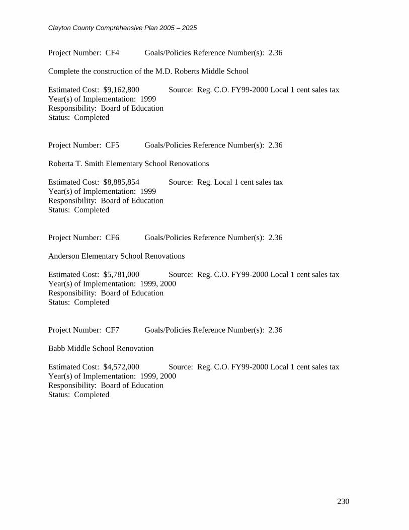
Clayton County Comprehensive Plan 2005 – 2025
230
Project Number: CF4 Goals/Policies Reference Number(s): 2.36
Complete the construction of the M.D. Roberts Middle School
Estimated Cost: $9,162,800 Source: Reg. C.O. FY99-2000 Local 1 cent sales tax
Year(s) of Implementation: 1999
Responsibility: Board of Education
Status: Completed
Project Number: CF5 Goals/Policies Reference Number(s): 2.36
Roberta T. Smith Elementary School Renovations
Estimated Cost: $8,885,854 Source: Reg. Local 1 cent sales tax
Year(s) of Implementation: 1999
Responsibility: Board of Education
Status: Completed
Project Number: CF6 Goals/Policies Reference Number(s): 2.36
Anderson Elementary School Renovations
Estimated Cost: $5,781,000 Source: Reg. C.O. FY99-2000 Local 1 cent sales tax
Year(s) of Implementation: 1999, 2000
Responsibility: Board of Education
Status: Completed
Project Number: CF7 Goals/Policies Reference Number(s): 2.36
Babb Middle School Renovation
Estimated Cost: $4,572,000 Source: Reg. C.O. FY99-2000 Local 1 cent sales tax
Year(s) of Implementation: 1999, 2000
Responsibility: Board of Education
Status: Completed

Clayton County Comprehensive Plan 2005 – 2025
231
Project Number: CF8 Goals/Policies Reference Number(s): 2.36
East Clayton Elementary School Renovations
Estimated Cost: $2,317,000 Source: Reg. Local 1 cent sales tax
Year(s) of Implementation: 1999
Responsibility: Board of Education
Status: Completed
Project Number: CF9 Goals/Policies Reference Number(s): 2.36
Forest Park High School Renovations
Estimated Cost: $8,404,000 Source: Local 1 cent sales tax
Year(s) of Implementation: 1999,2000
Responsibility: Board of Education
Status: Completed
Project Number: CF10 Goals/Policies Reference Number(s): 2.36
Haynie Elementary School Renovation
Estimated Cost: $2,207,000 Source: Growth C.O. FY99, Reg. C.O. FY99-2000, Local
1 cent sales tax
Year(s) of Implementation:
Responsibility:
Status: Completed
Project Number: CF11 Goals/Policies Reference Number(s): 2.36
Lovejoy Middle School Renovation
Estimated Cost: $1,779,000 Source: Reg. Local 1 cent sales tax
Year(s) of Implementation:
Responsibility:
Status: Completed

Clayton County Comprehensive Plan 2005 – 2025
232
Project Number: CF12 Goals/Policies Reference Number(s): 2.36
Pointe South Elementary School Renovation
Estimated Cost: $1,845,000 Source: Local 1 cent sales tax
Year(s) of Implementation: 1999, 2000
Responsibility: Board of Education
Status: Completed
Project Number: CF13 Goals/Policies Reference Number(s): 2.36
Riverdale Middle School Renovation
Estimated Cost: $4,782,000 Source: Local 1 cent sales tax
Year(s) of Implementation: 1999, 2000
Responsibility: Board of Education
Status: Completed
Project Number: CF14 Goals/Policies Reference Number(s): 2.36
Tara Elementary School Renovation
Estimated Cost: $3,595,000 Source: Reg. Local 1 cent sales tax
Year(s) of Implementation: 1999, 2000
Responsibility: Board of Education
Status: Completed
Project Number: CF15 Goals/Policies Reference Number(s): 2.36
Church Street Elementary School Renovation
Estimated Cost: $3,047,000 Source: Reg. Local 1 cent sales tax
Year(s) of Implementation: 1999, 2000, 2001
Responsibility: Board of Education
Status: Completed

Clayton County Comprehensive Plan 2005 – 2025
233
Project Number: CF16 Goals/Policies Reference Number(s): 2.36
Lake City Elementary School Renovation
Estimated Cost: $2,725,000 Source: Local 1 cent sales tax
Year(s) of Implementation: 1999, 2000
Responsibility: Board of Education
Status: Completed
Project Number: CF17 Goals/Policies Reference Number(s): 2.36
Mundy’s Mill Middle School Renovation
Estimated Cost: $3,594,000 Source: Reg. Local 1 cent sales tax
Year(s) of Implementation: 1999, 2000, 2001
Responsibility: Board of Education
Status: Completed, Opened 2003
Project Number: CF 18 Goals/Policies Reference Number(s): 2.36
Complete the Justice Complex Center
Estimated Cost: $120,000,000 Source: Special Option Sales Tax
Year(s) of Implementation: 1999, 2000
Responsibility: County Administration
Status: Completed 2000
Project Number: CF 19 Goals/Policies Reference Number(s): 2.36
Northcutt Elementary School Renovation
Estimated Cost: $2,397,000 Source: Local 1 cent sales tax FY 2000 / Reg. C.O. FY
2000
Year(s) of Implementation: 1999, 2000, 2001
Responsibility: Board of Education
Status: Completed

Clayton County Comprehensive Plan 2005 – 2025
234
Project Number: CF20 Goals/Policies Reference Number(s): 2.36
North Clayton Middle School Renovation
Estimated Cost: $3,138,000 Source: Reg. Local 1 cent sales tax FY 2000
Year(s) of Implementation: 1999, 2000, 2001
Responsibility: Board of Education
Status: Completed
Project Number: CF21 Goals/Policies Reference Number(s): 2.36
Pointe South Middle School Renovation
Estimated Cost: $4,825,000 Source: Local 1 cent sales tax FY 2000
Year(s) of Implementation: 1999, 2000, 2001
Responsibility: Board of Education
Status: Completed
Project Number: CF22 Goals/Policies Reference Number(s): 2.36
Riverdale Elementary School Renovation
Estimated Cost: $2,680,000 Source: Local 1 cent sales tax FY 2000
Year(s) of Implementation: 1999, 2000, 2001
Responsibility: Board of Education
Status: Completed
Project Number: CF23 Goals/Policies Reference Number(s): 2.36
Riverdale High School Renovation
Estimated Cost: $5,910,000 Source: Reg. Local 1 cent sales tax FY 2000
Year(s) of Implementation: 1999, 2000, 2001
Responsibility: Board of Education
Status: Completed

Clayton County Comprehensive Plan 2005 – 2025
235
Project Number: CF24 Goals/Policies Reference Number(s): 2.36
Swint Elementary School Renovation
Estimated Cost: $2,253,000 Source: Local 1 cent sales tax FY 2000
Year(s) of Implementation: 1999, 2000, 2001
Responsibility: Board of Education
Status: Completed
Project Number: CF25 Goals/Policies Reference Number(s): 2.36
Elementary School #1 New Construction
Estimated Cost: $10,000,000 Source: Future Local 1 cent sales tax
Year(s) of Implementation: 1999, 2000, 2001
Responsibility: Board of Education
Status: Completed – Callaway Elementary School
Project Number: CF26 Goals/Policies Reference Number(s): 2.36
Elementary School #2 New Construction
Estimated Cost: $10,000,000 Source: Reg. Future Local 1 cent sales tax
Year(s) of Implementation: 1999, 2000, 2001
Responsibility: Board of Education
Status: Completed – Harper Elementary School
Project Number: CF27 Goals/Policies Reference Number(s): 2.36
Elementary School #3 New Construction
Estimated Cost: $10,000,000 Source: Future Local 1 cent sales tax
Year(s) of Implementation: 1999, 2000,2001
Responsibility: Board of Education
Status: Completed – Jackson Elementary School

Clayton County Comprehensive Plan 2005 – 2025
236
Project Number: CF28 Goals/Policies Reference Number(s): 2.5, 2.30
Replace 100” Tower Ladder Truck
Estimated Cost: $700,000 Source: County Fire Fund
Year(s) of Implementation: 2000
Responsibility: Fire Department
Status: Completed 2000
Project Number: CF29 Goals/Policies Reference Number(s): 2.5, 2.30
Replace 3 Pumpers
Estimated Cost: $600,000 Source: County Fire Fund
Year(s) of Implementation: 1999, 2000, 2001
Responsibility: Fire Department
Status:Completed 2001
Project Number: CF30 Goals/Policies Reference Number(s): 2.5, 2.30
Replace Heavy Rescue Vehicle
Estimated Cost: $250,000 Source: County Fire Fund
Year(s) of Implementation: 200
Responsibility: Fire Department
Status: Completed 2000
Project Number: CF31 Goals/Policies Reference Number(s): 2.5, 2.30
Replace Pumper with Combo Pumper/Ladder
Estimated Cost: $435,000 Source: County Fire Fund
Year(s) of Implementation: 2000
Responsibility: Fire Department
Status: Not Completed, Postponed to 2005

Clayton County Comprehensive Plan 2005 – 2025
237
Project Number: CF32 Goals/Policies Reference Number(s): 2.5. 2.30
Rebuild/Relocate Station #7
Estimated Cost: $650,000 Source: County Fire Fund
Year(s) of Implementation: 2000
Responsibility: Fire Department
Status: Completed 2000
Project Number: CF33 Goals/Policies Reference Number(s): 2.5, 2.30
Rebuild/Relocation Station #9
Estimated Cost: $750,000 Source: County Fire Fund
Year(s) of Implementation: 2000
Responsibility: Fire Department
Status: Completed 2003
Project Number: CF34 Goals/Policies Reference Number(s): 2.5, 2.30
Rebuild/Relocate Station #4
Estimated Cost: $750,000 Source: County Fire Fund
Year(s) of Implementation: 2000
Responsibility: Fire Department
Status: Completed 2003
Project Number: CF35 Goals/Policies Reference Number(s): 2.5, 2.30
Remodel Fire Department Headquarters
Estimated Cost: $725,000 Source: Reg. County Fire Fund
Year(s) of Implementation:
Responsibility: Fire Department
Status: Completed 2004

Clayton County Comprehensive Plan 2005 – 2025
238
Project Number: CF36 Goals/Policies Reference Number(s): 2.5, 2.30
Build Concrete Burn Building
Estimated Cost: $550,000 Source: County Fire Fund
Year(s) of Implementation: 2005
Responsibility: Fire Department
Status: Moved forward to 2005 - 06
Project Number: CF37 Goals/Policies Reference Number(s): 2.5, 2.30
Add Flashover Simulator
Estimated Cost: $335,000 Source: County Fire Fund
Year(s) of Implementation: 2004
Responsibility: Fire Department
Status: In Planning Stage – Anticipated 2005-06
Project Number: CF38 Goals/Policies Reference Number(s): 2.5, 2.30
Build New Fire Station (12), West Clayton
Estimated Cost: $750,000 Source: County Fire Fund
Year(s) of Implementation: 2003, 2004
Responsibility: Fire Department
Status: Completed 2004
Project Number: CF39 Goals/Policies Reference Number(s): 2.5, 2.30
Build New Fire Station (13), East Clayton
Estimated Cost: $750,000 Source: County Fire fund
Year(s) of Implementation: 2005, 2006
Responsibility: Fire Department
Status: Moved forward to 2004-05

Clayton County Comprehensive Plan 2005 – 2025
239
Project Number: CF40 Goals/Policies Reference Number(s): 2.2
New Construction – Communications/Police Headquarters Building
Estimated Cost: $15,000,000 Source: General Fund
Year(s) of Implementation: 2000
Responsibility: Emergency Management
Status: Completed 2004
Project Number: CF41 Goals/Policies Reference Number(s): 2.2
Mobile Data Computers
Estimated Cost: $1,000,000 Source: Reg. General Fund
Year(s) of Implementation: 2000, 2001, 2002
Responsibility: Emergency Management
Status: Partially Completed/Ongoing
Project Number: CF42 Goals/Policies Reference Number(s): 2.2
Digital 911 Mapping System
Estimated Cost: $100,000 Source: 911 Fund
Year(s) of Implementation: 1999
Responsibility: Emergency Management
Status: Underway/Ongoing
Project Number: CF43 Goals/Policies Reference Number(s): 2.2
Computer Aided Dispatch Redundancy
Estimated Cost: $75,000 Source: 911 Fund
Year(s) of Implementation: 2000
Responsibility: Emergency Management
Status: Unknown

Clayton County Comprehensive Plan 2005 – 2025
240
Project Number: CF44 Goals/Policies Reference Number(s): 2.2
County-Wide Radio System
Estimated Cost: $15,000,000 Source: Reg. General Fund
Year(s) of Implementation: 1999-2007
Responsibility: Emergency Management
Status: Completed 1999
Project Number: CF45 Goals/Policies Reference Number(s): 2.2
Telecommunications/Communications Systems – Judicial Complex
Estimated Cost: $1,000,000 Source: General Fund
Year(s) of Implementation: 1998, 1999, 2000
Responsibility: Emergency Management
Status: Completed 2000
Project Number: CF46 Goals/Policies Reference Number(s): 2.2
Radio Site – Conley Rd.
Estimated Cost: $55,000 Source: General Fund
Year(s) of Implementation: 1999
Responsibility: Emergency Management
Status: Completed, Date Unknown
Project Number: CF47 Goals/Policies Reference Number(s): 2.2
Radio System Upgrade – Water Authority
Estimated Cost: $25,000 Source: Water Authority
Year(s) of Implementation: 1999
Responsibility: Emergency Management
Status: Unknown

Clayton County Comprehensive Plan 2005 – 2025
241
Project Number: CF48 Goals/Policies Reference Number(s): 2.2
Fire Ground Radio System – Jonesboro Fire Dept.
Estimated Cost: $75,000 Source: Fire Fund
Year(s) of Implementation: 1999
Responsibility: Emergency Management
Status: Unknown
Project Number: CF49 Goals/Policies Reference Number(s): 2.2
Radio Maintenance – Water Authority
Estimated Cost: $ Source: Water Authority
Year(s) of Implementation: On-Going
Responsibility: Emergency Management
Status: Ongoing
Project Number: CF50 Goals/Policies Reference Number(s): 2.27, 2.28, 2.29
New Construction – Lovejoy/Panhandle Branch Library
Estimated Cost: $2,010,000 Source: State of Georgia, General Fund
Year(s) of Implementation: 2001, 2002
Responsibility: Library System
Status: Completed 2004
Project Number: CF51 Goals/Policies Reference Number(s): 2.27, 2.28, 2.29
Renovate Forest Park Branch Library
Estimated Cost: $400,000 Source: State of Georgia, General Fund
Year(s) of Implementation: 2000
Responsibility: Library System
Status: Moved to 2005/06

Clayton County Comprehensive Plan 2005 – 2025
242
Project Number: CF52 Goals/Policies Reference Number(s): 2.27, 2.28, 2.29
Renovate Jonesboro Branch Library
Estimated Cost: $350,000 Source: State of Georgia, General Fund
Year(s) of Implementation: 2000
Responsibility: Library System
Status: Moved to 2005/06
Project Number: CF53 Goals/Policies Reference Number(s): 1.7, 1.9
Implement a Countywide standard platform GIS information system
Estimated Cost: $1,000,000 Source: General Fund
Year(s) of Implementation: 2000, 2001, 2002, 2003
Responsibility: Dept. of Community Development, Dept. of Transportation & Development,
Clayton County Water Authority, Emergency Management
Status: Moved to 2005/06
Project Number: CF54 Goals/Policies Reference Number(s): 2.16, 2.18, 2.2, 2.23
(TIP) Tara Blvd. Median Cuts
Estimated Cost: $192,000 Source: County Road Improvements Fund, State
Year(s) of Implementation: 1999
Responsibility: Transportation and Development Department
Status: In Progress/Ongoing
Project Number: CF55 Goals/Policies Reference Number(s): 2.06, 2.18, 2.20, 2.23
(TIP) Panhandle Rd. Curve Alignment
Estimated Cost: $445,040 Source: County Road Improvements Fund, State
Year(s) of Implementation: 1999
Responsibility: Transportation and Development Department
Status: Completed 2002

Clayton County Comprehensive Plan 2005 – 2025
243
Project Number: CF56 Goals/Policies Reference Number(s): 2.16, 2.18, 2.20,
2.23
Lamar Hutchison Pkwy. Improvements (Valley Hill Rd. to Parkwood Way)
Estimated Cost: $1,070,795 Source: County Road Improvements Fund, State
Year(s) of Implementation: 2001
Responsibility: Transportation and Development Department
Status: Completed 2001
Project Number: CF57 Goals/Policies Reference Number(s): 2.16, 2.18, 2.20, 2.23
Alexander Dr. Construction (Arrowhead to Parkwood Way
Estimated Cost: $111,999 Source: County Road Improvements Fund, State
Year(s) of Implementation: 2000
Responsibility: Transportation and Development Department
Status: Unknown
Project Number: CF58 Goals/Policies Reference Number(s): 2.16, 2.18, 2.20, 2.23
(TIP) Shirley Dr. Construction
Estimated Cost: $234,370 Source: County Road Improvements Fund, State, City
Year(s) of Implementation: 2001, 2002
Responsibility: Transportation and Development
Status: Unknown
Project Number: CF59 Goals/Policies Reference Number(s): 2.16, 2.18, 2.20, 2.23
(TIP) Intersection Improvement at Walt Stephens Rd. and Camp Rd.
Estimated Cost: $29,210 Source: County Road Improvements Fund, State
Year(s) of Implementation: 2000
Responsibility: Transportation and Development Department
Status: Unknown

Clayton County Comprehensive Plan 2005 – 2025
244
Project Number: CF60 Goals/Policies Reference Number(s): 2.16, 2.18, 2.20, 2.23
(TIP) Flint River Rd. Widening Project (Glenwood to Thomas)
Estimated Cost: $879,941 Source: County Road Improvements Fund, State
Year(s) of Implementation: 2000, 2001
Responsibility: Transportation and Development Department
Status: Under construction/Anticipated 2005
Project Number: CF61 Goals/Policies Reference Number(s): 2.16, 2.18, 2.20, 2.23
(TIP) Richardson Parkway Construction
Estimated Cost: $581,000 Source: County Road Improvements Fund, State
Year(s) of Implementation: 2001, 2002
Responsibility: Transportation and Development Department
Status: Unknown
Project Number: CF62 Goals/Policies Reference Number(s): 2.16, 2.18, 2.20, 2.23
(TIP) Forest Parkway at J.G. Glover Industrial Ct. Intersection Improvement
Estimated Cost: $370,138 Source: County Road Improvements Fund, State
Year(s) of Implementation: 2000
Responsibility: Transportation and Development Department
Status: Unknown
Project Number: CF63 Goals/Policies Reference Number(s): 2.16, 2.18, 2.20, 2.23
(TIP) McDonough Rd. Widening (Tara Blvd. To Panhandle Rd.)
Estimated Cost: $301,842 Source: County Road Improvements Fund, State
Year(s) of Implementation: 2000, 2001
Responsibility: Transportation and Development Department
Status: Completed 2001

Clayton County Comprehensive Plan 2005 – 2025
245
Project Number: CF64 Goals/Policies Reference Number(s): 2.16, 2.18, 2.20, 2.23
(TIP) Hastings Bridge Rd. Widening
Estimated Cost: $126,387 Source: County Road Improvements Fund, State
Year(s) of Implementation: 1999
Responsibility: Transportation and Development Department
Status: Not Completed
Project Number: CF65 Goals/Policies Reference Number(s): 2.16, 2.18, 2.20, 2.23
(TIP) Flint River Road Widening (Kendrick to Tara Rd.)
Estimated Cost: $1,814,464 Source: County Road Improvements Fund, State
Year(s) of Implementation: 2001, 2002
Responsibility: Transportation and Development Department
Status: Under Construction/Anticipate 2005
Project Number: CF66 Goals/Policies Reference Number(s): 2.16, 2.18, 2.20, 2.23
(TIP) Booker T. Dr. Realignment
Estimated Cost: $19,385 Source: County Road Improvements Fund, State
Year(s) of Implementation: 2000
Responsibility: Transportation and Development Department
Status: Unknown
Project Number: CF67 Goals/Policies Reference Number(s): 2.16, 2.18, 2.20, 2.23
(TIP) East Lovejoy Rd. Alignment
Estimated Cost: $107,000 Source: County Road Improvements Fund, State
Year(s) of Implementation:1999
Responsibility: Transportation and Development Department
Status: Not Completed due to New Wal-Mart location

Clayton County Comprehensive Plan 2005 – 2025
246
Project Number: CF68 Goals/Policies Reference Number(s): 2.16, 2.18, 2.20, 2.23
(TIP) Intersection Improvement at Camp Rd. and Jodeco Rd.
Estimated Cost: $8,960 Source: County Road Improvements Fund, State
Year(s) of Implementation: 2000
Responsibility: Transportation and Development Department
Status: Unknown
Project Number: CF69 Goals/Policies Reference Number(s): 2.16, 2.18, 2.20, 2.23
(TIP) Intersection Improvements at Rex Rd. and Evans Rd.
Estimated Cost: $13,848 Source: County Road Improvements Fund, State
Year(s) of Implementation: 2000
Responsibility: Transportation and Development Department
Status: Unknown
Project Number: CF70 Goals/Policies Reference Number(s): 2.12
Develop a Full Service Bus System
Estimated Cost: $1,000,000py Source: State and Federal Funds, General Fund
Year(s) of Implementation: 2000, 2001, 2002, 2003
Responsibility: County Administration
Status: C-TRAN established 2001, Ongoing
NATURAL AND HISTORIC RESOURCES ELEMENT
Project Number: NH1 Goals/Policies Reference Number(s): 3.15
Complete the Construction of the Recycling Drop-Off and a Processing Center
Estimated Cost: $4000,000 Source: General Fund
Year(s) of Implementation: 1999
Responsibility: Transportation and Development Department
Status: Completed 2000

Clayton County Comprehensive Plan 2005 – 2025
247
Project Number: NH2 Goals/Policies Reference Number(s): 3.15
Clayton County will contract with private companies to provide grinding operations for yard
waste.
Mulch is given to public or used on county projects.
Estimated Cost: $65,000 Source: General Fund
Year(s) of Implementation: 1999, 2000, 2001, 2002, 2003
Responsibility: Transportation and Development Department
Status: Unknown
Project Number: NH3 Goals/Policies Reference Number(s): 3.15
Clayton County will continue to accept tires at the landfill/recycling area and have them disposed
of by Georgia Tire Disposal
Estimated Cost: $6,000 per year Source: General Fund
Year(s) of Implementation: 1999, 2000, 2001, 2002, 2003
Responsibility: Transportation and Development Department
Status: Unknown
Project Number: NH4 Goals/Policies Reference Number(s): 3.15
Continue to support the Clayton County Beautiful Program
Estimated Cost: $67,383 per year Source: General Fund
Year(s) of Implementation: 1999, 2000, 2001, 2002, 2003
Responsibility: Transportation and Development Department
Status: Ongoing
Project Number: NH5 Goals/Policies Reference Number(s): 3.1
Revise the Recreation Master Plan
Estimated Cost: $10,000 Source: General Fund
Year(s) of Implementation: 2001
Responsibility: Parks and Recreation Department
Status: Completed 2001

Clayton County Comprehensive Plan 2005 – 2025
248
Project Number: NH6 Goals/Policies Reference Number(s): 3.1
Complete the Bicycle and Walking Trail Along Jester’s Creek
Estimated Cost: $500,000 approx. Source: General Fund, State and Federal Grants
Year(s) of Implementation: 1999, 2000
Responsibility: Parks and Recreation Department
Status: Under Construction / Anticipated 2005
Project Number: NH7 Goals/Policies Reference Number(s): 3.1
Develop a Centrally Located Community Center with Tennis Facilities, Swimming Pool, and
Multi-Purpose Fields
Estimated Cost: $3,600,000 Source: General Fund
Year(s) of Implementation: 1999, 2000, 2001, 2002
Responsibility: Parks and Recreation Department, Board of Education
Status: Under Construction
Project Number: NH8 Goals/Policies Reference Number(s): 3.15
Continue the Operation of the Drop-Off Site and Processing Center
Estimated Cost: $46,421 Source: General Fund
Year(s) of Implementation: 1999, 2000, 2001, 2002, 2003
Responsibility: Transportation and Development Department
Status: Unknown
Project Number: NH9 Goals/Policies Reference Number(s): 3.8, 3.9
Implement special land development guidelines to protect watershed, wetland, and aquifer areas
in the county
Estimated Cost: $3000,000 Source: General Fund
Year(s) of Implementation: 1999, 2000
Responsibility: Transportation and Development Department, Clayton County Water Authority
Status: Completed 2000

Clayton County Comprehensive Plan 2005 – 2025
249
Project Number: NH10 Goals/Policies Reference Number(s): 3.3
Prepare an inventory and assessment of historic buildings and sites
Estimated Cost: $ Source: General Fund, Grants
Year(s) of Implementation: 2000, 2001
Responsibility: County Administration
Status: Unknown
Project Number: NH11 Goals/Policies Reference Number(s): 3.8, 3.9
Complete the Soccer/Baseball Complex at McDonough Road
Estimated Cost: $1,000,000 Source: General Fund
Year(s) of Implementation: 1999, 2000
Responsibility: Parks and Recreation Department
Status: Completed 2000
Project Number: NH12 Goals/Policies Reference Number(s): 3.1
Build Two Senior Citizen Recreation Facilities
Estimated Cost: $2,000,000 Source: General Fund, Community Development Block
Grants
Year(s) of Implementation: 2000, 2001, 2002
Responsibility: Parks and Recreation Department
Status: Completed 2003
ECONOMIC DEVELOPMENT ELEMENT
Project Number: ED1 Goals/Policies Reference Number(s): 4.2
Revise and continue the redevelopment of the Mountain View Area
Estimated Cost: $100,000,000 Source: City of Atlanta, County, Private Investment
Year(s) of Implementation: 1999, 2000, 2001, 2002, 2003
Responsibility: County Administration, Chamber of Commerce
Status: Ongoing

Clayton County Comprehensive Plan 2005 – 2025
250
Project Number: ED2 Goals/Policies Reference Number(s): 4.4
Continue to support the Clayton County Collaborative project.
Estimated Cost: $N/A Source: N/A
Year(s) of Implementation: 1999, 2000, 2001, 2002, 2003
Responsibility: County Administration
Status: Unknown
Project Number: ED3 Goals/Policies Reference Number(s): 4
Work to attract high-tech industry to the county
Estimated Cost: $10,000 Source: General Fund
Year(s) of Implementation: 1999, 2000, 2001, 2002, 2003
Responsibility: Economic Development Department, Chamber of Commerce
Status: Ongoing
HOUSING ELEMENT
Project Number: HE1 Goals/Policies Reference Number(s): 5.10
Analyze the existing housing mixture to determine how the County compares to the metro area
by cost and total units available.
Estimated Cost: $10,000 Source: General Fund
Year(s) of Implementation: 2000
Responsibility: Community Development Department
Status: Completed in Comprehensive Plan / Ongoing
Project Number: HE2 Goals/Policies Reference Number(s): 5.3
Analyze the possibility of developing goals for housing mixtures to insure an equitable range of
all housing types and utilize this in evaluating new proposals for development in the County.
Estimated Cost: $10,000 Source: General Fund
Year(s) of Implementation: 2001
Responsibility: Community Development Department
Status: Completed in Comprehensive Plan / Ongoing

Clayton County Comprehensive Plan 2005 – 2025
251
Project Number: HE3 Goals/Policies Reference Number(s): 5.6
Work to improve and revitalize existing residences in the County.
Estimated Cost: $750,000 per year Source: Community Development Block Grants
Year(s) of Implementation: 1999, 2000, 2001, 2002, 2003
Responsibility: Housing Authority
Status: Ongoing
Project Number: HE4 Goals/Policies Reference Number(s): 1.24
Review the possibility of implementing residential construction standards
Estimated Cost: $N/A Source: N/A
Year(s) of Implementation: 1999, 2000
Responsibility: Community Development Department
Status: Completed, 1999
10.2 Short Term Work Program 2005 to 2009
The 2005 – 2009 Short Term Work Program presents a list of programs to be initiated and
regulations to be adopted in order to implement the goals and policies put forth by the preceding
chapters of the comprehensive plan. Each work items is accompanied by a cost estimate and
potential funding source where applicable. The “General Fund” source of funding is understood
to mean the government’s annual operating budget. Additionally, when feasible, work items
have a time frame for completion. All work items have a designated department or organization
responsible for the status of the work item.
The Short Term Work may be updated on an annual or five-year basis at the county’s discretion.
A minimum of one public hearing must be held by the county to inform the public of its intent to
update the program and to receive suggestions and comments on the proposed update.

Clayton County Comprehensive Plan 2005 – 2025
252
CLAYTON COUNTY, GEORGIA
SHORT TERM WORK PROGRAM for 2005 TO 2009
Table 10.1 Short Term Work Program
Project Chapter / Policy Description YEAR Total ($)
Possible
Funding
Source(s)
Responsible
Department 05 06 07 08 09
1
Housing /
Policy 1.1.1
Develop design
guidelines for new
residential developments
X
$50,000 General
Fund /
Grants
Planning /
Zoning
2
Housing/
Policy 1.2 / Land Use
Policies 1.1, 6.2, Goal
8, Policy 9.2, 10.4,
11.1, 15.1, 16.3, 17.2,
18.3.2, 18.3.3, 18,4,
19.1 – 19.5, 20.1, 21.1
and 2.12
Review/Revise/Rewrite
County Zoning
Ordinances to support the
goals and policies
included in the
Comprehensive Plan.
X
$100,000 General
Fund /
Grants
Planning /
Zoning
3 Housing/
Policy 1.2.1
Revise residential
building codes to
increase minimum
quality level acceptable
x
$50,000 General
Fund
Planning /
Zoning
4 Housing/
Policy 1.3.1
Conduct a feasibility
study and if appropriate
implement an expedited
approval and permitting
process for new
residential developments
that exceed the county’s
minimum residential
standards.
x
$15,000 Include in
Staff Time
Planning /
Zoning
5 Housing/
Policy 2.1.1.1.1/
Land Use 12.1.1,
12.1.2
Develop a website and
online code violation
reporting capability for
the County’s Code
Enforcement office
X
$15,000 General
Fund
Code
Enforcement
6 Housing/
Policy 3.1.3
Land Use/
Policy 4.1
Foster the development
of a county-wide
association of
Homeowner’s
Associations to function
as a citizen advisory
group for planning
related matters
x x x x
$25,000 to
$35,000
year
Create or
redirect a
staff
position to
oversee and
provide
administrati
ve support
to this group
Planning and
Zoning
7 Housing/
Policy 3.1.4
Conduct a neighborhood
study to identify a
priority list of
neighborhoods in need of
revitalization and
recommend specific
revitalization strategies.
x
Included in
staff time
Planning and
Zoning
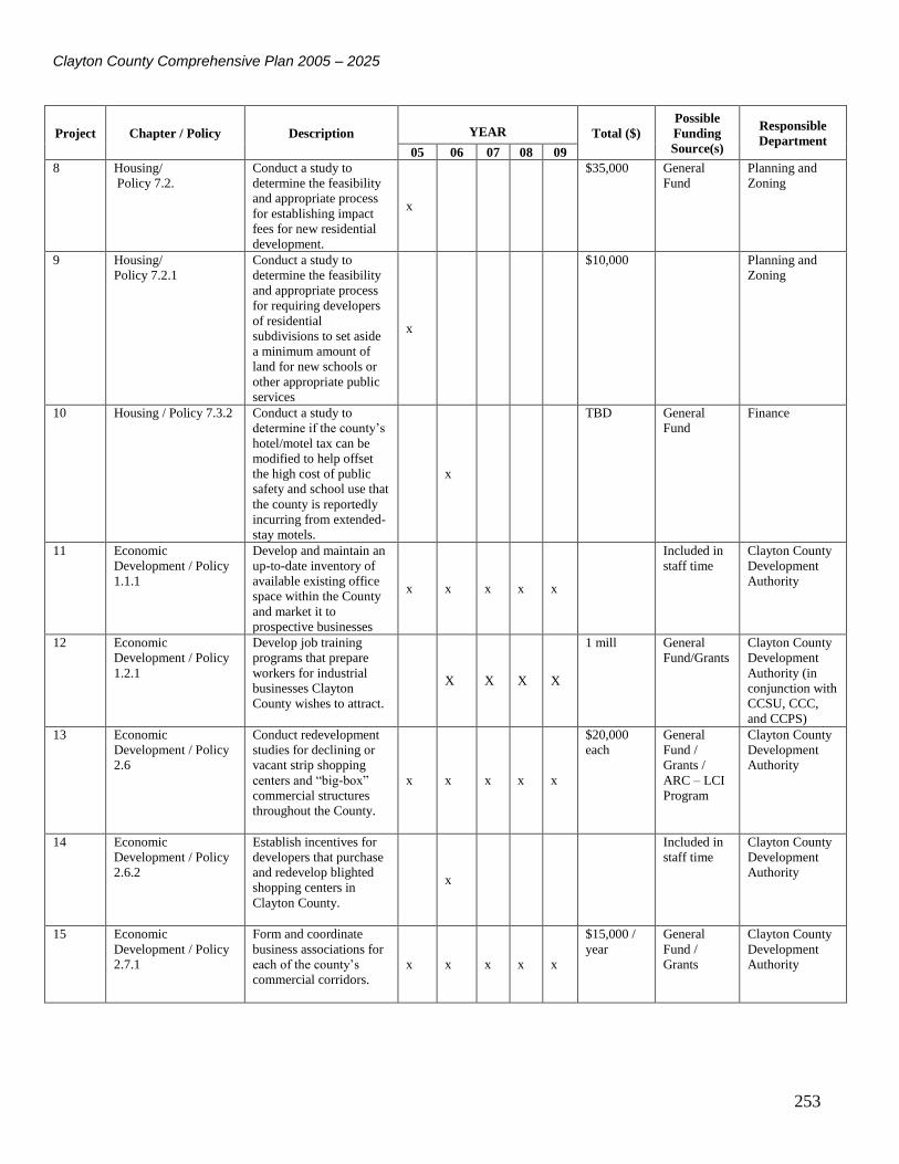
Clayton County Comprehensive Plan 2005 – 2025
253
Project Chapter / Policy Description YEAR Total ($)
Possible
Funding
Source(s)
Responsible
Department 05 06 07 08 09
8 Housing/
Policy 7.2.
Conduct a study to
determine the feasibility
and appropriate process
for establishing impact
fees for new residential
development.
x
$35,000 General
Fund
Planning and
Zoning
9 Housing/
Policy 7.2.1
Conduct a study to
determine the feasibility
and appropriate process
for requiring developers
of residential
subdivisions to set aside
a minimum amount of
land for new schools or
other appropriate public
services
x
$10,000 Planning and
Zoning
10 Housing / Policy 7.3.2 Conduct a study to
determine if the county’s
hotel/motel tax can be
modified to help offset
the high cost of public
safety and school use that
the county is reportedly
incurring from extended-
stay motels.
x
TBD General
Fund
Finance
11 Economic
Development / Policy
1.1.1
Develop and maintain an
up-to-date inventory of
available existing office
space within the County
and market it to
prospective businesses
x x x x x
Included in
staff time
Clayton County
Development
Authority
12 Economic
Development / Policy
1.2.1
Develop job training
programs that prepare
workers for industrial
businesses Clayton
County wishes to attract.
X X X X
1 mill General
Fund/Grants
Clayton County
Development
Authority (in
conjunction with
CCSU, CCC,
and CCPS)
13 Economic
Development / Policy
2.6
Conduct redevelopment
studies for declining or
vacant strip shopping
centers and “big-box”
commercial structures
throughout the County.
x x x x x
$20,000
each
General
Fund /
Grants /
ARC – LCI
Program
Clayton County
Development
Authority
14 Economic
Development / Policy
2.6.2
Establish incentives for
developers that purchase
and redevelop blighted
shopping centers in
Clayton County.
x
Included in
staff time
Clayton County
Development
Authority
15 Economic
Development / Policy
2.7.1
Form and coordinate
business associations for
each of the county’s
commercial corridors.
x x x x x
$15,000 /
year
General
Fund /
Grants
Clayton County
Development
Authority

Clayton County Comprehensive Plan 2005 – 2025
254
Project Chapter / Policy Description YEAR Total ($)
Possible
Funding
Source(s)
Responsible
Department 05 06 07 08 09
16 Economic
Development / Policy
4.2
Develop a current
marketing plan for the
county which determines
the most effective media
for promoting
opportunities in Clayton
County; i.e. magazines,
Web sites, advertising,
etc.
x
$100,000 General
Funds
Clayton County
Chamber of
Commerce
17 Economic
Development / Policy
4.4
Develop a recruitment
strategy to attract up-
scale dining
establishment to the area
around Spivey Hall.
X
Include in
Staff Time
Clayton County
Chamber of
Commerce
18 Economic
Development / Policy
5.3.1
Revise/Rewrite the
county’s signage
ordinance to eliminate
visual clutter along the
county’s roadways
X
$10,000 General
Fund
Planning /
Zoning
19 Community Facilities /
Water/ Goal 1.0
Additional Raw Water
Capacity Study X
$100,000 User Fees Clayton County
Water Authority
(CCWA)
20 Community Facilities /
Water/ Goal 1.0
Replace raw water intake
pumps @ William J.
Hooper WTP
X X X X X
$500,000 User Fees CCWA
21 Community Facilities /
Water/ Goal 1.0
Replace high service
pumps @ William J.
Hooper WTP
X X X X X
$710,000 User Fees CCWA
22 Community Facilities /
Water/ Goal 1.0
Replace transfer pumps
@ William J. Hooper
WTP
X X X X X
$685,000 User Fees CCWA
23 Community Facilities /
Water/ Goal 1.0
Make intake
improvements @
William J. Hooper WTP
X X X X X
$600,000 User Fees CCWA
24 Community Facilities /
Water/ Goal 1.0
Incorporate
improvements into
SCADA @ William J.
Hooper WTP
X X X X X
$350,000 User Fees CCWA
25 Community Facilities /
Water/ Goal 1.0
Filter valving
improvements @ J.W.
Smith WTP
X X X X
$705,000
User Fees CCWA
26 Community Facilities /
Water / Goal 1.0
Filter gallery
dehumidification @ J.W.
Smith WTP
X X X X
$440,000 User Fees CCWA
27 Community Facilities /
Water/ Goal 1.0
Filter media/underdrain
improvements @ J.W.
Smith WTP
X X X X
$500,000 User Fees CCWA
28 Community Facilities /
Water/ Goal 1.0
Replace chemical feed
equipment @ J.W. Smith
WTP
X X X X X
$900,000 User Fees CCWA
29 Community Facilities /
Water/ Goal 1.0
Incorporate
improvements into
SCADA
X
$360,000 User Fees CCWA
30 Community Facilities /
Water/ Goal 1.0
Replace high service
pumps at Morrow ground
storage tank
x
$160,000 User Fees CCWA

Clayton County Comprehensive Plan 2005 – 2025
255
Project Chapter / Policy Description YEAR Total ($)
Possible
Funding
Source(s)
Responsible
Department 05 06 07 08 09
31 Community Facilities /
Water / Policy 1.5
Distribution system line
improvements and
extensions
x x x x X
$15,000,00
0
User Fees CCWA
32 Community Facilities /
Water / Policy 1.6
Conduct a study to
determine the feasibility
and a process for
implementing impact
fees to fund for water
distribution system
improvements required to
serve new development.
X
$50,000 User Fees CCWA &
Planning &
Zoning
33 Community Facilities /
Wastewater / Goal 1.0
Effluent storage
improvements @ Casey
WRF
X
$4,500,000 User Fees CCWA
34 Community Facilities /
Wastewater / Goal 1.0
Equipment replacement
@ R.L. Jackson WRF X
$600,000 User Fees CCWA
35 Community Facilities /
Wastewater / Goal 1.0
A&E services @ R.L.
Jackson WRF X
$80,000 User Fees CCWA
36 Community Facilities /
Wastewater / Goal 1.0
Effluent screening for
TPS @ R.L. Jackson
WRF
X
$1,300,000 User Fees CCWA
37 Community Facilities /
Wastewater / Goal 1.0
Design – TPS
upgrade/expansion @
R.L. Jackson WRF
X
$700,000 User Fees CCWA
38 Community Facilities /
Wastewater / Goal 1.0
TPS upgrade/expansion
@ R.L. Jackson WRF X X X X
$3,000,000 User Fees CCWA
39 Community Facilities /
Wastewater / Goal 2.0
Future Wetlands @ Huie
LAS Facility X X X X
$12,000,00
0
User Fees CCWA
40 Community Facilities /
Wastewater / Goal 1. 0
Distribution loop
modifications/additions
@ Huie LAS Facility
x x x X
$3,000,000 User Fees CCWA
41 Community Facilities /
Wastewater / Goal 1.0
Rehabilitation of water
conveyance system X x x x X
$5,000,000 User Fees CCWA
42 Community Facilities /
Wastewater / Goal 1.0
Interception/collector
extensions for water
conveyance system
x x x X
$10,000,00
0
User Fees CCWA
43 Community Facilities /
Water / Goal 1.0
Regulatory support and
nonpoint source pollution
projects
X
$150,000 User Fees CCWA
44 Community Facilities /
Water / Goal 1.0
CCWA Administrative
facilities expansion X
$500,000 User Fees CCWA
45 Community Facilities /
Fire
Protection/EMS/Policy
1.1
Develop 3 new fire
stations (Panhandle, West
Fayetteville Road,
Stockbridge, and Hall
Road )
x x x
$750,000
each
General
Fund
Clayton County
Fire Department
& EMS
46 Community
Facilities/Fire
Protection and EMS/
Policy 3.2.1
Acquire 3 additional ALS
vehicles (ambulances) x x x x
X
$250,000
each
General
Fund
Clayton County
Fire Department
& EMS
47 Community
Facilities/Fire
Protection and EMS/
Policy 3.2.2
Acquire a quick response
vehicle x
$100,000 General
Fund
Clayton County
Fire Department
& EMS

Clayton County Comprehensive Plan 2005 – 2025
256
Project Chapter / Policy Description YEAR Total ($)
Possible
Funding
Source(s)
Responsible
Department 05 06 07 08 09
48 Community
Facilities/Fire
Protection and EMS/
Policy 3.3.3
Upgrade all the
department’s engines to
ALS engines x x x x
X
$200,000
each
General
Fund
Clayton County
Fire Department
& EMS
49 Community
Facilities/Fire
Protection and
EMS/Policy 3.2.3.1
Secure an supervisor
position to oversee the
unit assigned to the quick
response vehicle.
X
$40,000/
year
General
Fund
Clayton County
Fire Department
and EMS
50 Community
Facilities/Fire
Protection and
EMS/Policy 3.3 .
Develop a countywide
master street address
guide and eliminate
duplicate street names to
improve EMS/911
response times
X
$25,000 General
Fund
Clayton County
Fire Department
and EMS
51 Community
Facilities/Fire
Protection and
EMS/Policy 3.4
Institute workplace
language instruction
programs to improve
communication between
EMS and firefighters and
the county’s growing
ethnic communities.
X X X X X
$10,000/
year for
instruction
General
Fund
Clayton County
Fire Department
and EMS
52 Community
Facilities/Fire
Protection and EMS
Policy 2.1
Acquire a state-of-the-art
transmission and receiver
radio system for the
enhanced 911 system that
can be tied to a
countywide Geographic
Information System.
x
$250,000 General
Fund
Clayton County
Fire
Department/EM
S
53 Community Facilities
Water / Policy 1.6
Fire Policy 1.2
Education 1.2/ Land
Use Policy 10.3,
10.3.1
Conduct a study to
determine the feasibility
and a process for
implementing a
comprehensive system of
development impact fees
for Clayton County.
X
$100,000 General
Fund
CCWA/ Fire and
EMS / Planning
& Zoning
54 Community
Facilities/Police and
Sheriff Departments /
Policy 1.1
Develop or update an
existing baseline report
of level of service
provided to Clayton
County citizens, this
report should be based on
state or national
standards for level of
service.
X X X X X
Included in
staff time
Clayton County
Sheriff and
Police
Department
55 Community
Facilities/Police and
Sheriff Departments /
Policy 1.3
Institute a workplace
language instruction
programs to improve
communication
between officers and the county’s growing ethnic communities.
X X X X X
$10,000/
year for
instruction
General
Fund
Clayton County
Sheriff and
Police
Department

Clayton County Comprehensive Plan 2005 – 2025
257
Project Chapter / Policy Description YEAR Total ($)
Possible
Funding
Source(s)
Responsible
Department 05 06 07 08 09
56 Community
Facilities/Police and
Sheriff Departments /
Policy 1.2.1
Provide the Sheriff’s
Department with the staff
necessary to fully staff
the Clayton County
Corrections Institution
and provide enough
officers to fulfill the
department’s other law
enforcement duties.
x x x x X
TBD General
Fund
Clayton County
Sheriff’s
Department
57 Community
Facilities/Police and
Sheriff Departments /
Goal 1.0
Fund the 26 positions
open in the Sheriff’s
Department. x x x x
X
TBD General
Fund
Clayton County
Sheriff’s
Department
58 Community Facilities
/Parks and Recreation
/ Policies 1.1/1.2
Natural/Cultural
Resources / Policy 1.1
Recreation Needs
Assessment study and
update of County’s
Recreation Master Plan. x
$30,000 General
Fund
Parks and
Recreation
59 Community Facilities
/Parks and Recreation
Policy 1.5
Coordinate with the
Clayton County Water
Authority to create a
recreation corridor along
restored sections of East
Jester’s Creek, and
restored stream corridors
in the Rex area.
x x
TBD General
Fund
Parks and
Recreation and
CCWA
60 Community Facilities
/Parks and Recreation
Policy 1.4
Develop incentive
programs or requirements
for developers to provide
green space and age
appropriate recreation
outlets with all new
housing developments.
X
Included in
Staff Time
Planning and
Zoning, Clayton
County
Greenspace
Board, and Parks
and Recreation
61
Community Facilities
/Education/
Policy 3.2
Assist Clayton College
and State University’s in
identifying possible
locations for satellite
learning centers in
Clayton County.
x x x x X
Included in
Staff Time
Planning and
Zoning / CCSU
62 Community Facilities
/Education/ Policy 2.1
Adamson Middle School
renovation x
$3,042,361 Not
Identified
CCPS
63 Community Facilities
/Education/ Policy 2.1
Kemp Elementary School
renovation x
$2,361,971 Not
Identified
CCPS
64 Community Facilities
/Education/ Policy 2.1
Kilpatrick Elementary
School renovation and
addition
x
$3,713,000 Not
Identified
CCPS
65 Community Facilities
/Education/ Policy 2.1
Morrow Middle School
renovation x
$1,500,000 Not
Identified
CCPS
66 Community Facilities
/Education/ Policy 2.1
New Middle School 6
(Rex Area)
68 classrooms in state of
the art facility designed
to house 1100 students
x
$18,976,16
0
TBD CCPS

Clayton County Comprehensive Plan 2005 – 2025
258
Project Chapter / Policy Description YEAR Total ($)
Possible
Funding
Source(s)
Responsible
Department 05 06 07 08 09
67 Community Facilities
/Education/ Policy 2.1
New Elementary School
#11
50 classrooms in stat of
the art facility designed
to house 725 students K-
2 Design co-located with
Mt. Zion Elementary
School
x
$12,101,60
0
TBD CCPS
68 Community Facilities
/Education/ Policy 2.1
New Middle School # 7
Undetermined location
68 classrooms, designed
to house 1100 students.
TBD
$18,976,16
0
TBD CCPS
69 Community Facilities
/Education/ Policy 2.1
Mt. Zion High School
12 classroom addition TBD
$5,248,846 TBD CCPS
70 Community Facilities
/Education/ Policy 2.1
Smith Elementary School
12 classroom addition TBD
$2,345,645 TBD CCPS
71 Community Facilities
/Education/ Policy 2.1
Hawthorne Elementary
School
11 classroom addition TBD
$2,035,357 TBD CCPS
72 Community Facilities
/Education/ Policy 2.1
Lake Ridge Elementary
School
8 classroom addition TBD
$2,039,192 TBD CCPS
73 Community Facilities
/Education/ Policy 2.1
Jonesboro High School
11 classroom addition TBD
$3,349,606 TBD CCPS
74 Community Facilities
/Education/ Policy 2.1
Rivers Edge Elementary
School
14 classroom addition
x
$1,926,710 TBD CCPS
75 Community Facilities
/Education/ Policy 2.1
Kendrick Middle School
14 classroom addition TBD
$3,145,849 TBD CCPS
76 Community Facilities
/Education/ Policy 2.1
North Clayton Middle
School
15 classroom addition TBD
$4,999,165 TBD CCPS
77 Community Facilities
/Education/ Policy 2.1
Harper Elementary
School
12 classroom addition TBD
$2,102,605 TBD CCPS
78 Community Facilities
/Education/ Policy 2.1
Roberts Middle School
15 classroom addition TBD
$3,386,792 TBD CCPS
79 Community Facilities
/Education/ Policy 2.1
Mundys Mill High
School
24 classroom addition TBD
$4,467,865 TBD CCPS
80 Community Facilities
/Education/ Policy 2.1
Jackson Elementary
School
12 classroom addition TBD
$2,144,405 TBD CCPS
81 Community Facilities
/Education/ Policy 2.1
New High School #2
location to be determined
96 classroom state of the
art facility designed to
house 1900 students
X
$36,540,00
0
TBD CCPS
82 Community Facilities
/Education/ Policy 2.1
Riverdale Middle School
9 classroom addition TBD
$3,829,427 TBD CCPS
83 Community Facilities
/Education/ Policy 2.1
Pointe South Middle
School
12 classroom addition TBD
$3,153,444 TBD CCPS
84 Community Facilities
/Education/ Policy 2.1
Lovejoy High School
11 classroom addition TBD
$4,878,462 TBD CCPS

Clayton County Comprehensive Plan 2005 – 2025
259
Project Chapter / Policy Description YEAR Total ($)
Possible
Funding
Source(s)
Responsible
Department 05 06 07 08 09
85 Community Facilities
/Education/ Policy 2.1
Forest Park High School
15 classroom addition TBD
$3,425,438 TBD CCPS
86 Community Facilities
/Education/ Policy 2.1
Jonesboro Middle School
13 classroom addition TBD
$2,555,218 TBD CCPS
87 Community Facilities
/Education/ Policy 2.1
New Elementary School
#13
location to be determined TBD
$13,361,66
0
TBD CCPS
88 Community Facilities
/Education/ Policy 2.1
Elementary School 9
(Thurgood Marshall
Elementary)
12 classroom addition
TBD
$1,978,645 TBD CCPS
89 Community Facilities
/Education/ Policy 2.1
Middle School 5
(Sequoyah Middle
School)
X $10,989,00
0
tbd CCPS
90 Community Facilities
/Education/ Policy 2.1
Middle School 5
(Sequoyah Middle
School)
13 classroom addition
TBD
$2,623,538 TBD CCPS
91 Community Facilities
/Libraries/ Goal 1.0
Build 10,000 sq. foot
addition to Headquarters
Library and retrofit for
technology.
x
Clayton County
Library System
92 Community Facilities
/Libraries/ Goal 1.0
Renovate Forest Park
Branch, retrofit for
technology, and make
wheelchair accessible.
x
$300,000 General
Fund
Clayton County
Library System
93 Community Facilities
/Libraries/ Goal 1.0
Build meeting room
addition at Jonesboro
Branch, retrofit for
technology, and make
wheelchair accessible
x
$450,000 General
Fund
Clayton County
Library System
94 Community Facilities
/Libraries/ Policy 1.2
Purchase additional
volumes for each branch
to meet the State’s
minimum level of service
standard.
X x x x X
$638,000
per year
($382,644
budgeted)
General
Fund
Clayton County
Library System
95 Community Facilities
/Libraries/ Policy 1.3.2
Contract for skilled
technical support
adequate to maintain the
library’s network and
troubleshoot problems
with computers and
printers.
x x x x X
TBD General
Fund
Clayton County
Library System
96 Community Facilities
/Libraries/ Policy 1.3.1
Develop and implement a
plan to replace public and
staff computers at the
county’s public libraries
every three years.
x x x x X
TBD General
Fund
Clayton County
Library System

Clayton County Comprehensive Plan 2005 – 2025
260
Project Chapter / Policy Description YEAR Total ($)
Possible
Funding
Source(s)
Responsible
Department 05 06 07 08 09
97 Community
Facilities/Cultural
Facilities/Policy 2.2
Coordinate with the
Clayton County
Convention and Visitor’s
Bureau to
better advertise facilities
such as Spivey Hall and
the Beach for
entertainment and
tourism purposes.
x x x x X
Included in
Staff Time.
CCCVB, Spivey
Hall, Parks and
Recreation
98 Community Facilities /
General Government
Facilities / Goal 1.0
Renovate 1117
Battlecreek Road for the
Clayton County Health
Department
x x
$1,500,000 General
Funds
Buildings and
Maintenance
99 Community Facilities /
General Government
Facilities / Goal 1.0
New building for
Building and
Maintenance Department
x
$300,000 General
Funds
Buildings and
Maintenance
100 Community Facilities /
General Government
Facilities / Goal 1.0
Renovate Old 911
Building x x
$130,000 -
$150,000
General
Funds
Buildings and
Maintenance
101 Community Facilities /
General Government
Facilities / Goal 1.0
Renovate Alzheimer
Building x x
$1,000,000 General
Funds
Buildings and
Maintenance
102 Community Facilities /
General Government
Facilities / Goal 1.0
Renovate old Traffic
Engineering building x x
$50,000 General
Funds
Buildings and
Maintenance
103 Community Facilities /
General Government
Facilities / Goal 1.0
Renovate Transportation
and Development brick
building
x
$40,000 General
Funds
Buildings and
Maintenance
104 Natural and Cultural
Resources/
Policy 1.2
Work with the Clayton
County Water Authority
and other interested local
organizations to develop
a pedestrian and bike trail
system encompassing the
wetland and floodplain
areas of Clayton County.
x x x x X
TBD General
Fund
Parks and
Recreation /
CCWA
105 Natural and Cultural
Resources/
Policy 1.3
Develop a program for
the joint use of school
board recreational
properties for county-
wide recreational
programs when these
properties are not in use
by the school system.
x
Included in
Staff Time.
Parks and
Recreation /
CCPS
106 Natural and Cultural
Resources/
Policy 1.4
Conduct a study to
determine the feasibility
of creating a county-wide
authority to oversee all
aspects of recreational,
environmental and
historical resource
management and
development.
x
TBD General
Fund
County
Commission
107 Natural and Cultural
Resources/
Policy 1.5.1
User fee feasibility study.
x
TBD General
Fund
Parks and
Recreation

Clayton County Comprehensive Plan 2005 – 2025
261
Project Chapter / Policy Description YEAR Total ($)
Possible
Funding
Source(s)
Responsible
Department 05 06 07 08 09
108 Natural and Cultural
Resources/
Policy 2.1
Parks and Recreation
long term land
acquisition plan. x
TBD General
Fund
Parks and
Recreation /
Greenspace
Board
109 Natural and Cultural
Resources/
Policy 3.1
Comprehensive county-
wide historic resources
survey and assessment.
x
$150,000 General
Fund/Grants
Planning and
Zoning
110 Natural and Cultural
Resources/
Policy 3.2
Cultural resources
management plan for the
County.
x
$100,000 General
Fund /
Grants
Planning and
Zoning.
111 Natural and Cultural
Resources/
Policy 4.1.1/
Land Use Policies 6.2,
6.2.1, 6.2.2
Revise the county’s
current conservation
subdivision ordinance x
Included in
project 2.
General
Fund
Planning and
Zoning
112 Natural and Cultural
Resources/ Policy
4.1.2
Develop a program of
incentives to persuade
developers to provide
open space as part of new
residential developments.
X
TBD General
Fund / State
and Federal
Assistance
Planning and
Zoning
113 Natural and Cultural
Resources/
Policy 4.1.3
Review the county’s
current retail and office
zoning ordinances and
revise as necessary to
require openspace and
greenspace set asides for
larger developments
x
Included in
project 2.
General
Fund
Planning and
Zoning
114 Natural and Cultural
Resources/
Policy 5.1
Review and revise as
necessary all of the
county’s development
regulations to include
adequate and appropriate
buffering requirements
for all zoning
classifications
x
Included in
project 2.
General
Fund
Planning and
Zoning
115 Natural and Cultural
Resources/
Policy 7.1/
Land Use Policies 6.4
and 6.4.1
Review the county’s
current tree
ordinance and revise as
necessary to ensure that
developers are not clear
cutting land or leaving
only a
perimeter of trees when
clearing land
for development
x
$10,000 General
Fund
Planning and
Zoning
116 Natural and Cultural
Resources/
Policy 8.1
Revise county ordinances
to restrict
land disturbing activities
adjacent to
rivers and streams in
order to limit
erosion and the potential
for increased flow
velocities and flood
heights.
x
$7,500 General
Fund
Planning and
Zoning

Clayton County Comprehensive Plan 2005 – 2025
262
Project Chapter / Policy Description YEAR Total ($)
Possible
Funding
Source(s)
Responsible
Department 05 06 07 08 09
117 Natural and Cultural
Resources/
Policy 8.2.2
Revise the county’s
ordinances to allow for
zero wetlands loss to
development and in the
case of unavoidable
destruction promote
replacement versus
mitigation.
x
$7,500 General
Fund
Planning and
Zoning
118 Land Use / Policy 1.2 Review and revise the
land use plan amendment
policy
and process to provide
adequate
time for a professional
and
comprehensive
assessment of
amendment requests
x
Included in
Staff Time
Planning and
Zoning
119 Land Use / Policy 1.3 Expand the Zoning
Advisory Group to
include to two (2) “at
large” posts to be filled
with individuals holding
professional training
and/or experience in
fields applicable to
planning
x
Included in
Staff Time
Planning and
Zoning
120 Land Use / Policy 1.5 Update the Land Use
Plan and Short Term
Work Program.
X
$150,000 General
Fund
Planning and
Zoning
121 Land Use / Policy
1.5.1
Establish a standing
committee of department
representatives and
community stakeholders
for the purpose of
conducting the Land Use
Plan and Short Term
Work Program updates.
X
Included in
Staff Time
Planning and
Zoning
122 Land Use / Policy 1.6 Develop, Implement, and
Train staff to conduct all
of the county’s current
and long range planning
using GIS.
x x x
TBD General
Fund
Planning and
Zoning
123 Land Use / Policy
1.6.1
Establish a staff
expansion and retention
plan for the county’s
planning staff that is
based on a reasonable
staff/population ratio
comparable to other
counties in the ARC
region.
x
Included in
Staff Time
Planning and
Zoning
124 Land Use / Policy 2.1 Expand the presence of
planning and zoning
issues on the homepage
of the Clayton County
website.
x x x x X
Included in
Staff Time
Planning and
Zoning

Clayton County Comprehensive Plan 2005 – 2025
263
Project Chapter / Policy Description YEAR Total ($)
Possible
Funding
Source(s)
Responsible
Department 05 06 07 08 09
125 Land Use / Policy 2.2 Revise the Planning and
Zoning Department's web
site to include a wider
variety of information
x x x x X
Included in
Staff Time
Planning and
Zoning
126 Land Use / Policy
2.2.1
Develop an interactive
zoning map to be posted
on the Community
Development homepage
where the public can
ascertain the zoning of
any property in the
County and be provided
information regarding the
development
requirements applicable
to property.
x
TBD General
Fund
Planning and
Zoning
127 Land Use / Policy 2.3 Develop programs for
using additional media
such as local public
television and radio
stations to promote
planning and zoning
education in Clayton
County.
x
Included in
Staff Time
Planning and
Zoning
128 Land Use / Policy 3.1 Establish planning
education standards for
all Zoning Advisory
Group (ZAG) members
and County
Commissioners to ensure
that group members and
commissioners have the
ability to make the best
decisions possible in
terms of land use and
zoning
x
Included in
Staff Time
Planning and
Zoning
129 Land Use / Policy 3.2 Develop a Planning
Handbook to be used as
an educational tool and
quick reference by the
Zoning Advisory Group
and County
Commissioners
x
$5,000 General
Fund
Planning and
Zoning
130 Land Use / Policy
4.1.1
Amend county
ordinances to require
developers of all new
subdivisions with over 10
units to establish an HOA
x
Included in
project 2
General
Fund
Planning and
Zoning
131 Land Use / Policy
4.1.2
Establish and publicize a
processes by which older
neighborhoods can re-
establish HOA’s.
x
Included in
Staff Time
Planning and
Zoning
132 Land Use / Develop and adopt
minimum standards for
landscaping in all zoning
districts
x
Included in
project 2
General
Fund
Planning and
Zoning

Clayton County Comprehensive Plan 2005 – 2025
264
Project Chapter / Policy Description YEAR Total ($)
Possible
Funding
Source(s)
Responsible
Department 05 06 07 08 09
133 Land Use / Policy 7.1 Establish a standing
committee managed by
the planning department
to coordinate the current
greenspace preservation,
stream restoration and
watershed
management, bike trail,
and parks and recreation
planning efforts of
different county
departments and
authorities to maximize
the accessibility of parks
and greenspace to the
county's residents.
x
Included in
Staff Time
Planning and
Zoning/CCWA/
Parks and
Recreation /
Greenspace
Board
134 Land Use / Policy
7.2.1
Develop a
recreation/open space
plan for the Flit River
Corridor that
incorporates
opportunities for
educating the public on
the history of Clayton
County.
x
$50,000 General
Fund
Greenspace
Board / Parks
and Recreation /
CCWA
135 Land Use / Policy
7.2.2
Develop a
recreation/open space
plan for the historic Rex
community that
incorporates public
education and trails
and/or other passive
recreation amenities.
x
$50,000 General
Fund
Greenspace
Board / Parks
and Recreation /
CCWA
136 Land Use / Policy
8.4.2
Establish incentives for
developers that purchase
and redevelop blighted
shopping centers and
vacant “big boxes” in
Clayton County.
X
Included in
Staff Time
Planning and
Zoning
137 Land Use / Policy 8.4 Identify and develop
plans for the
revitalization of declining
or vacant strip shopping
centers and “big-box”
commercial structures
throughout the County.
X X X X X
TBD General
Fund
Planning and
Zoning/ Clayton
County
Development
Authority
(CCDA)
138 Land Use / Policy 8.2 Establish design
guidelines for
development in general
commercial and
neighborhood
commercial areas.
x
TBD General
Fund
Planning and
Zoning

Clayton County Comprehensive Plan 2005 – 2025
265
Project Chapter / Policy Description YEAR Total ($)
Possible
Funding
Source(s)
Responsible
Department 05 06 07 08 09
139 Land Use / Policy 8.3 Establish unique design
guidelines for
redevelopment areas in
conjunction with the
development of area
specific redevelopment
plans or immediately
after the completion of an
area redevelopment plan.
x x x x X
TBD General
Fund
Planning and
Zoning / CCDA
140 Land Use / Policy 9.3 Develop and adopt
appropriate landscaping
and buffering
requirements for all land
uses in Clayton County.
x
Included in
Project 2
General
Fund
Planning and
Zoning
141 Land Use / Policy 13.1 Establish incentives for
redevelopment projects
that make the projects
fiscally attractive for
private developers to
undertake.
x x
Included in
Staff Time
CCDA
142 Land Use / Policy 14.2 Pursue funding assistance
for the continuation of
efforts to improve the
Tara Boulevard entrance
to Clayton County.
x x x x X
Included in
Staff Time
Planning and
Zoning / CCDA
143 Land Use / Policy 14.7 Pursue funding for
streetscape improvements
to enhance the visual
quality of Clayton
County’s major
roadways.
x x x x X
Included in
Staff Time
Planning and
Zoning /
Transportation
144 Land Use/ Policies
17.3, 17.3.1
Create incentives to
encourage the
development of
“executive housing” in
Clayton County.
x
TBD General
Fund
Planning and
Zoning
145 Land Use/ Policy 20.3 Adopt a county-wide
policy of using multi-
story construction for all
public buildings when
feasible.
x
Included in
Staff Time
Buildings and
Maintenance /
CCPS
146 Intergovernmental
Coordination / Policy
1.1
Assess and amend the
county’s current dispute
resolution process as
needed to ensure its
effectiveness.
x
TBD General
Fund
County
Commission
147 Intergovernmental
Coordination / Policy
2.1
Update the county’s
Service Delivery
Strategy.
x
TBD General
Fund
County
Commission
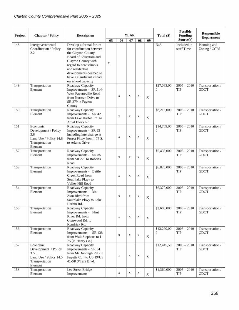
Clayton County Comprehensive Plan 2005 – 2025
266
Project Chapter / Policy Description YEAR Total ($)
Possible
Funding
Source(s)
Responsible
Department 05 06 07 08 09
148 Intergovernmental
Coordination / Policy
2.2
Develop a formal forum
for coordination between
the Clayton County
Board of Education and
Clayton County with
regard to new schools
and residential
developments deemed to
have a significant impact
on school capacity
x
N/A Included in
staff Time
Planning and
Zoning / CCPS
149 Transportation
Element
Roadway Capacity
Improvements - SR 314-
West Fayetteville Road
from Norman Drive to
SR 279 in Fayette
County
x x x X
$27,083,00
0
2005 – 2010
TIP
Transportation /
GDOT
150 Transportation
Element
Roadway Capacity
Improvements - SR 42
from Lake Harbin Rd. to
Anvil Block Rd.
x x x X
$8,213,000 2005 – 2010
TIP
Transportation /
GDOT
151 Economic
Development / Policy
3.6
Land Use / Policy 14.6
Transportation
Element
Roadway Capacity
Improvements - SR 85
including interchange at
Forest Pkwy from I-75 S.
to Adams Drive
x x x X
$14,709,00
0
2005 – 2010
TIP
Transportation /
GDOT
152 Transportation
Element
Roadway Capacity
Improvements - SR 85
from SR 279 to Roberts
Road
x x x X
$5,438,000 2005 – 2010
TIP
Transportation /
GDOT
153 Transportation
Element
Roadway Capacity
Improvements - Battle
Creek Road from
Southlake Pkwy to
Valley Hill Road
x x x X
$6,826,000 2005 – 2010
TIP
Transportation /
GDOT
154 Transportation
Element
Roadway Capacity
Improvements - Mt.
Zion Blvd from
Southlake Pkwy to Lake
Harbin Rd.
x x x X
$6,370,000 2005 – 2010
TIP
Transportation /
GDOT
155 Transportation
Element
Roadway Capacity
Improvements - Flint
River Rd. from
Glenwood Rd. to
Kendrick Rd.
x x x X
$2,600,000 2005 – 2010
TIP
Transportation /
GDOT
156 Transportation
Element
Roadway Capacity
Improvements - SR 138
from Walt Stephens to I-
75 (in Henry Co.)
x x x X
$13,290,00
0
2005 – 2010
TIP
Transportation /
GDOT
157 Economic
Development / Policy
3.5
Land Use / Policy 14.5
Transportation
Element
Roadway Capacity
Improvements - SR 54
from McDonough Rd. (in
Fayette Co.) to US 19/US
41-SR 3/Tara Blvd.
x x x X
$12,445,50
0
2005 – 2010
TIP
Transportation /
GDOT
158 Transportation
Element
Lee Street Bridge
Improvements x x x X
$1,360,000 2005 – 2010
TIP
Transportation /
GDOT

Clayton County Comprehensive Plan 2005 – 2025
267
Project Chapter / Policy Description YEAR Total ($)
Possible
Funding
Source(s)
Responsible
Department 05 06 07 08 09
159 Economic
Development / Policy
3.5
Land Use / Policy 14.5
Transportation
Element
Widen SR 54 from SR
138 Spur to Oxford Drive
x x x X
$9,914,000 2005 – 2010
TIP
Transportation /
GDOT
160 Transportation
Element
Roadway Capacity
Improvements - Mt.
Zion Road from
Richardson Pkwy to SR
138
x x x X
$9,786,700 2005 – 2010
TIP
Transportation /
GDOT
161 Transportation
Element
Roadway Capacity
Improvements - SR 42 /
SR 138 / N. Henry Blvd.
from I-675 in Clayton to
SR 138 in Henry
x x x X
$6,862,000 2005 – 2010
TIP
Transportation /
GDOT
162 Transportation
Element
Conley Road/Aviation
Blvd Extension from SR
54 / Jonesboro Rd. to US
19/41 – SR 3/ Old Dixie
Hwy
x x x X
$11,150,00
0
2005 – 2010
TIP
Transportation /
GDOT
163 Transportation
Element
Bridge Upgrade – SR 42
@ Upton Creek x x x X
$213,000 2005 – 2010
TIP
Transportation /
GDOT
164 Transportation
Element
Bridge Upgrade – Central
of GA RR @ US 19/41 –
SR 3 Old Dixie Hwy
x x x X
$9,326,000 2005 – 2010
TIP
Transportation /
GDOT
165 Transportation
Element
Tara Road turn lanes and
improvements from
McDonough Rd. to Tara
Blvd.
x x x X
$2,850,000 2005 – 2010
TIP
Transportation /
GDOT
166 Transportation
Element
Roadway Capacity
Improvements - SR 920
from Jonesboro Road
from SR 54 to US 19/41
– SR 3
x x x X
$12,274,00
0
2005 – 2010
TIP
Transportation /
GDOT
167 Transportation
Element
Streetscaping North
Avenue and South
Avenue
x x X
x
$1,302,000 2005 – 2010
TIP
Transportation /
GDOT
168 Transportation
Element
Roadway Capacity
Improvements – Anvil
Block Road from end of
current 5 lane section to
Bouldercrest Road
x x X
x
$1,785,000 2005 – 2010
TIP
Transportation /
GDOT
169 Transportation
Element
Roadway Capacity
Improvements – Anvil
Block Road from
Bouldercrest Road to
Allen Road
x x X
x
$1,785,000 2005 – 2010
TIP
Transportation /
GDOT
170 Transportation
Element
Roadway Operations
Improvements – Conley
Road from SR 54 to
Cherokee Trail
x x X
x
$2,450,000 2005 – 2010
TIP
Transportation /
GDOT
171 Transportation
Element
Bridge Upgrade – Rex
Road at Big Cotton
Indian Creek
x x X
x
$3,600,000 2005 – 2010
TIP
Transportation /
GDOT

Clayton County Comprehensive Plan 2005 – 2025
268
Project Chapter / Policy Description YEAR Total ($)
Possible
Funding
Source(s)
Responsible
Department 05 06 07 08 09
172 Transportation
Element
Traffic Signals on SR 85
and 138 from SR 331 /
SR 85 to Pointe South
Pkwy and North Ave.
x x X
x
$1,374,000 2005 – 2010
TIP
Transportation /
GDOT
173 Transportation
Element
Clayton ATMS/ITS
enhancements and
implementation
x x X
x
$6,350,000 2005 – 2010
TIP
Transportation /
GDOT
174 Transportation
Element
Roadway Capacity
Improvements – Godby
Road from Southampton
Rd. to SR 314
x x X
x
$3,085,000 2005 – 2010
TIP
Transportation /
GDOT
175 Transportation
Element
Roadway Capacity
Improvements – Panola
Road from Bouldercrest
Road to Bailey Drive
x x x X
x
$3,737,000 2005 – 2010
TIP
Transportation /
GDOT
176 Transportation
Element
Roadway Operations
Improvements – Medians
for SR 54/ Jonesboro
Road
x x x X
x
$588,000 2005 – 2010
TIP
Transportation /
GDOT
177 Transportation
Element
Interchange Upgrades I-
75 from Mt. Zion Blvd.
to Old Dixie and SR 54
Interchange including the
RR bridge
x x x X
x
$16720000 2005 – 2010
TIP
Transportation /
GDOT
178 Transportation
Element
C-Trans Operational
Planning x x x X
x $100,000 2005 – 2010
TIP
C-Trans
179 Transportation
Element
C-Trans preventative
maintenance x x x X
x $500,000 2005 – 2010
TIP
C-Trans
180 Transportation
Element
C-Trans Operations x x x
X x
$100,000 2005 – 2010
TIP
C-Trans
181 Transportation
Element
Pedestrian Facilities –
Lake Harbin Rd. from
Maddox Rd. to SR 42
x x x X
x
$300,000 2005 – 2010
TIP
Transportation /
GDOT
182 Transportation
Element
Transit oriented
pedestrian improvements
I-75 south to US 19/41 –
SR 3
x x x X
x
$860,000 2005 – 2010
TIP
Transportation /
GDOT
183 Transportation
Element
Bike/Ped underpass and
crosswalks Pedestrian
Facility – SR 54
/Jonesboro Rd south of
Clayton St. Blvd.
x x x X
x
$2,950,000 2005 – 2010
TIP
Transportation /
GDOT
184 Transportation
Element
Forest Park Sidewalks to
Schools Phase I x x x X
x $2,063,000 2005 – 2010
TIP
Transportation /
GDOT
185 Transportation
Element
Traffic Control Center
Upgrades X X X
$2700000 SPLOST Transportation
186 Transportation
Element
County-wide traffic
signal improvements X X X
$5125000 SPLOST Transportation
187 Transportation
Element
County-wide roadway
signage upgrades X X X
$3,000,000 SPLOST Transportation
188 Transportation
Element
Miscellaneous county-
wide traffic safety
projects
X X X
$2,525,000 SPLOST Transportation

Clayton County Comprehensive Plan 2005 – 2025
269
Project Chapter / Policy Description YEAR Total ($)
Possible
Funding
Source(s)
Responsible
Department 05 06 07 08 09
189 Transportation
Element
Road widening – various
locations in county, see
SPLOST report for
specifics
X X X
$42,100,00
0
SPLOST Transportation
190 Transportation
Element
County-wide Dirt road
review and paving, see
SPLOST report for
specific locations
X X X
$420,000 SPLOST Transportation
191 Transportation
Element
County-wide bridge and
culvert upgrades – see
SPLOST for details
X X X
$1,800,000 SPLOST Transportation
192 Transportation
Element
County wide intersection
improvements - see
SPLOST report for
specific locations
X X X
$13,500,00
0
SPLOST Transportation
193 Transportation
Element
County-wide rail road
crossing improvements –
see SPLOST report for
specific locations
X X X
$740,000 SPLOST Transportation
194 Transportation
Element
Sidewalks – see SPLOST
report for specific
locations
X X X
$6,963,440 SPLOST Transportation
195 Transportation
Element
New road construction –
see SPLOST report for
specific locations
X X X
$4,000,000 SPLOST Transportation
196 Economic
Development / Policy
3.3
Land Use/ Policy 14.3
Convert Aviation
Boulevard into a four
lane road with an
interchange at I-285; also
Hwy. 138 to I-75 and I-
85.
TBD State and
Federal
Funds /
SPLOST
Transportation
197 Economic
Development / Policy
3.4
Land Use / Policy 14.4
Improve the interchange
at Southlake Mall to
provide better access to
the mall and Southlake
Festival.
TBD State and
Federal
Funds
Transportation