Chronology of Pleistocene sedimentary cycles in the Carmel Coastal Plain of Israel
12
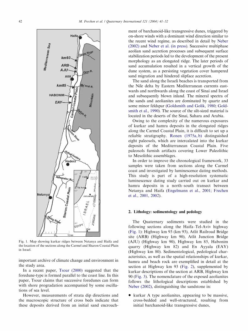
Quaternary International 121 (2004) 41–52 Chronology of Pleistocene sedimentary cycles in the Carmel Coastal Plain of Israel Manfred Frechen a, *, Alexander Neber b , Alexander Tsatskin c , Wolfgang Boenigk c , Avraham Ronen c a Leibniz Institute for Applied Geosciences (GGA), Geochronology and Isotope Hydrology, Stilleweg 2, Hannover D-30655, Germany b Geologisches Institut, Universit . at zu K . oln, Z . ulpicher Str. 49a, K . oln D-50674, Germany c The Zinman Institute of Archaeology, The University of Haifa, Haifa 31905, Israel Abstract The Eastern Mediterranean Coastal Plain of Israel is composed mainly of loam and sand and gravel of Pleistocene to Holocene age, supplemented by an Upper Pleistocene beach rock horizon, indicating an alternation of marine, coastal and continental environments. Owing to the complexity of the numerous exposures of aeolianites (‘‘kurkar’’) and soils (‘‘hamra’’) in the elongated ridges along the coastal plain, it is difficult to set up a reliable stratigraphy. A systematic luminescence dating study was carried out on loose sand, kurkar and hamra deposits in the coastal plain between Netanya and Haifa. In this study, 33 samples were investigated from key sections along the Carmel coast. The chronological results are in excellent agreement with the geological estimates. Five periods of sand accumulation and kurkar formation can be distinguished at about 140, 130, 90 and around 60 ka and between 60 and 50 ka. Hamra formation took place between 140 and 130 ka, around 80, 65 and 60 ka and between 20 and 12 ka. The beach rock is correlated with the sea level maximum during OIS 5e. The luminescence dating results indicate that neither kurkar nor hamra formation correlates with glacial and interglacial periods of the Northern Hemisphere. However, the chronological succession of these climate-related cycles is in good agreement with marine and terrestrial archives in the Eastern Mediterranean. r 2004 Elsevier Ltd and INQUA. All rights reserved. 1. Introduction The coastal plain of Israel is characterized by development of sand dune fields and aeolianite ridges locally termed ‘‘kurkar’’ running parallel to the coast line (Issar, 1968)(Fig. 1). Kurkar ridges are built of several sedimentary cycles (Ronen, 1975a, b; Gvirtzman et al., 1984; Neber, 2002), which are intercalated by red sandy loam soils locally termed ‘‘hamra’’ (Arabic word for ‘‘red’’) (Yaalon and Dan, 1967). These kurkar ridges are designated to represent typical longitudinal sand dunes formed synchronously parallel to the coastline by dominant wind direction perpendicular to the coast, as described by Gvirtzman et al. (1998). Archaeological and geological studies of sections along the Haifa–Tel- Aviv highway (Farrand and Ronen, 1974; Ronen, 1977) indicate that the upper part of exposed Quaternary sediments in the Carmel Coastal Plain contain two major kurkar units separated by a red paleosol (‘‘hamra’’, Arabic word for ‘‘red’’) including Mousterian artifacts. In addition, Boenigk et al. (1985) described the presence of a beach rock at the section at Highway km 95. At the same elevation, a kurkar is exposed but there is no physical contact between these two units. This kurkar is covered by a re-deposited Mousterian hamra soil including artifacts. Ronen et al. (1999) and Tsatskin and Ronen (1999) documented a Mousterian pedocom- plex at the section at Habonim, which includes several pedogenic episodes apparently separated by both phases of sedimentation and erosion. Neber (2002) and Neber et al. (in press) distinguished several major sand transgression events, which led to the development of the highway ridge in the Carmel Coastal Plain. The sedimentology and petrography of the exposed aeolia- nites revealed distinct facies characteristics for each kurkar unit. The different facies are related to changes in the environmental setting, including changes in the vegetation cover and distance from the sediment source, the Mediterranean beaches. Current studies attempt to detail the stratigraphic relations among kurkar, hamra and beach rock, as this coastal sediment sequence is an ARTICLE IN PRESS *Corresponding author. E-mail address: [email protected] (M. Frechen). 1040-6182/$ - see front matter r 2004 Elsevier Ltd and INQUA. All rights reserved. doi:10.1016/j.quaint.2004.01.022
Transcript of Chronology of Pleistocene sedimentary cycles in the Carmel Coastal Plain of Israel
ARTICLE IN PRESS
Quaternary International 121 (2004) 41–52
*Correspondin
E-mail addres
1040-6182/$ - see
doi:10.1016/j.qua
Chronology of Pleistocene sedimentary cycles in the Carmel CoastalPlain of Israel
Manfred Frechena,*, Alexander Neberb, Alexander Tsatskinc, Wolfgang Boenigkc,Avraham Ronenc
a Leibniz Institute for Applied Geosciences (GGA), Geochronology and Isotope Hydrology, Stilleweg 2, Hannover D-30655, Germanyb Geologisches Institut, Universit .at zu K .oln, Z .ulpicher Str. 49a, K .oln D-50674, Germany
c The Zinman Institute of Archaeology, The University of Haifa, Haifa 31905, Israel
Abstract
The Eastern Mediterranean Coastal Plain of Israel is composed mainly of loam and sand and gravel of Pleistocene to Holocene
age, supplemented by an Upper Pleistocene beach rock horizon, indicating an alternation of marine, coastal and continental
environments. Owing to the complexity of the numerous exposures of aeolianites (‘‘kurkar’’) and soils (‘‘hamra’’) in the elongated
ridges along the coastal plain, it is difficult to set up a reliable stratigraphy. A systematic luminescence dating study was carried out
on loose sand, kurkar and hamra deposits in the coastal plain between Netanya and Haifa. In this study, 33 samples were
investigated from key sections along the Carmel coast. The chronological results are in excellent agreement with the geological
estimates. Five periods of sand accumulation and kurkar formation can be distinguished at about 140, 130, 90 and around 60 ka and
between 60 and 50 ka. Hamra formation took place between 140 and 130 ka, around 80, 65 and 60 ka and between 20 and 12 ka. The
beach rock is correlated with the sea level maximum during OIS 5e. The luminescence dating results indicate that neither kurkar nor
hamra formation correlates with glacial and interglacial periods of the Northern Hemisphere. However, the chronological
succession of these climate-related cycles is in good agreement with marine and terrestrial archives in the Eastern Mediterranean.
r 2004 Elsevier Ltd and INQUA. All rights reserved.
1. Introduction
The coastal plain of Israel is characterized bydevelopment of sand dune fields and aeolianite ridgeslocally termed ‘‘kurkar’’ running parallel to the coastline (Issar, 1968) (Fig. 1). Kurkar ridges are built ofseveral sedimentary cycles (Ronen, 1975a, b; Gvirtzmanet al., 1984; Neber, 2002), which are intercalated by redsandy loam soils locally termed ‘‘hamra’’ (Arabic wordfor ‘‘red’’) (Yaalon and Dan, 1967). These kurkar ridgesare designated to represent typical longitudinal sanddunes formed synchronously parallel to the coastline bydominant wind direction perpendicular to the coast, asdescribed by Gvirtzman et al. (1998). Archaeologicaland geological studies of sections along the Haifa–Tel-Aviv highway (Farrand and Ronen, 1974; Ronen, 1977)indicate that the upper part of exposed Quaternarysediments in the Carmel Coastal Plain contain twomajor kurkar units separated by a red paleosol
g author.
s: [email protected] (M. Frechen).
front matter r 2004 Elsevier Ltd and INQUA. All rights
int.2004.01.022
(‘‘hamra’’, Arabic word for ‘‘red’’) including Mousterianartifacts. In addition, Boenigk et al. (1985) described thepresence of a beach rock at the section at Highway km95. At the same elevation, a kurkar is exposed but thereis no physical contact between these two units. Thiskurkar is covered by a re-deposited Mousterian hamrasoil including artifacts. Ronen et al. (1999) and Tsatskinand Ronen (1999) documented a Mousterian pedocom-plex at the section at Habonim, which includes severalpedogenic episodes apparently separated by both phasesof sedimentation and erosion. Neber (2002) and Neberet al. (in press) distinguished several major sandtransgression events, which led to the development ofthe highway ridge in the Carmel Coastal Plain. Thesedimentology and petrography of the exposed aeolia-nites revealed distinct facies characteristics for eachkurkar unit. The different facies are related to changesin the environmental setting, including changes in thevegetation cover and distance from the sediment source,the Mediterranean beaches. Current studies attempt todetail the stratigraphic relations among kurkar, hamraand beach rock, as this coastal sediment sequence is an
reserved.
ARTICLE IN PRESS
Fig. 1. Map showing kurkar ridges between Netanya and Haifa and
the location of the sections along the Carmel and Sharon Coastal Plain
in Israel.
M. Frechen et al. / Quaternary International 121 (2004) 41–5242
important archive of climate change and environment inthe study area.
In a recent paper, Tsoar (2000) suggested that theforedune-type is formed parallel to the coast line. In thispaper, Tsoar claims that successive foredunes can formwith shore progradation accompanied by some oscilla-tions of sea level.
However, measurements of strata dip directions andthe macroscopic structure of cross beds indicate thatthese deposits derived from an initial sand encroach-
ment of barchanoid-like transgressive dunes, triggered byon-shore winds with a dominant wind direction similar tothe recent wind regime, as described in detail by Neber(2002) and Neber et al. (in press). Successive multiphaseaeolian sand accretion processes and subsequent surfacestabilization periods led to the development of the presentmorphology as an elongated ridge. The later periods ofsand accumulation resulted in a vertical growth of thedune system, as a persisting vegetation cover hamperedsand migration and hindered slipface accretion.
The sand along the Israeli beaches is transported fromthe Nile delta by Eastern Mediterranean currents east-wards and northwards along the coast of Sinai and Israeland subsequently blown inland. The mineral spectra ofthe sands and aeolianites are dominated by quartz andsome minor feldspar (Goldsmith and Golik, 1980; Gold-smith et al., 1990). The source of the silt-sized material islocated in the deserts of the Sinai, Sahara and Arabia.
Owing to the complexity of the numerous exposuresof kurkar and hamra deposits in the elongated ridgesalong the Carmel Coastal Plain, it is difficult to set up areliable stratigraphy. Ronen (1975a, b) distinguishedeight paleosols, which are intercalated into the kurkardeposits of the Mediterranean Coastal Plain. Fivepaleosols furnish artifacts covering Lower Paleolithicto Mesolithic assemblages.
In order to improve the chronological framework, 33samples were taken from sections along the Carmelcoast and investigated by luminescence dating methods.This study is part of a high-resolution systematicluminescence dating study carried out on kurkar andhamra deposits in a north–south transect betweenNetanya and Haifa (Engelmann et al., 2001; Frechenet al., 2001, 2002).
2. Lithology: sedimentology and pedology
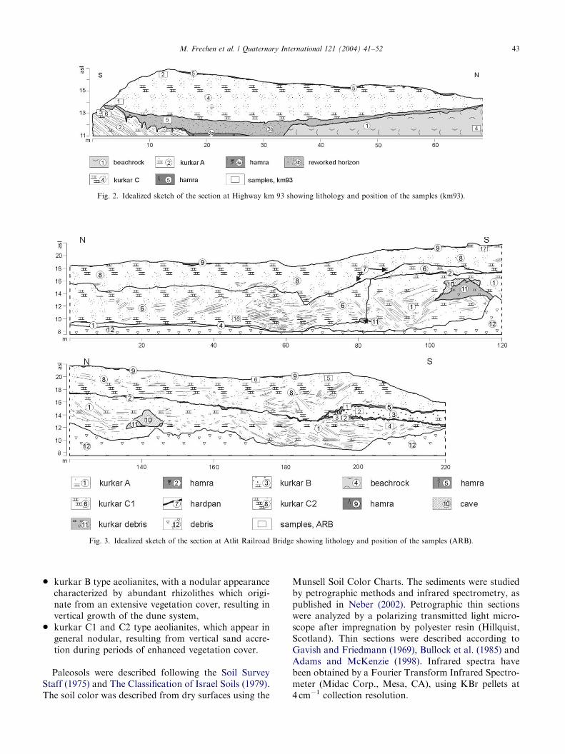
The Quaternary sediments were studied in thefollowing sections along the Haifa–Tel-Aviv highway(Fig. 1): Highway km 93 (km 93), Atlit Railroad Bridgesite (ARB) (Highway km 90), Atlit Junction Bridge(AJU) (Highway km 90), Highway km 85, Habonimquarry (Highway km 82) and En Ayyala (EAY)(Highway km 80). Sedimentological, pedological char-acteristics, as well as the spatial relationships of kurkar,hamra and beach rock are exemplified in detail at thesection at Highway km 93 (Fig. 2), supplemented bykurkar descriptions of the section at ARB, Highway km90 (Fig. 3). The nomenclature of the exposed aeolianitesfollows the lithological descriptions established byNeber (2002), distinguishing the sandstone in:
* kurkar A type aeolianites, appearing to be massive,cross-bedded and well-structured, resulting frominitial barchanoid-like transgressive dunes,
ARTICLE IN PRESS
Fig. 2. Idealized sketch of the section at Highway km 93 showing lithology and position of the samples (km93).
Fig. 3. Idealized sketch of the section at Atlit Railroad Bridge showing lithology and position of the samples (ARB).
M. Frechen et al. / Quaternary International 121 (2004) 41–52 43
* kurkar B type aeolianites, with a nodular appearancecharacterized by abundant rhizolithes which origi-nate from an extensive vegetation cover, resulting invertical growth of the dune system,
* kurkar C1 and C2 type aeolianites, which appear ingeneral nodular, resulting from vertical sand accre-tion during periods of enhanced vegetation cover.
Paleosols were described following the Soil SurveyStaff (1975) and The Classification of Israel Soils (1979).The soil color was described from dry surfaces using the
Munsell Soil Color Charts. The sediments were studiedby petrographic methods and infrared spectrometry, aspublished in Neber (2002). Petrographic thin sectionswere analyzed by a polarizing transmitted light micro-scope after impregnation by polyester resin (Hillquist,Scotland). Thin sections were described according toGavish and Friedmann (1969), Bullock et al. (1985) andAdams and McKenzie (1998). Infrared spectra havebeen obtained by a Fourier Transform Infrared Spectro-meter (Midac Corp., Mesa, CA), using KBr pellets at4 cm�1 collection resolution.
ARTICLE IN PRESSM. Frechen et al. / Quaternary International 121 (2004) 41–5244
3. Section at Highway km 93
The spatial relationships between kurkar, hamra andbeach rock are exemplified in the section at Highway km93 (Fig. 2). The base of the visible Quaternary sequenceis represented by beach rock (Unit 1) and a cross-beddedaeolianite with kurkar A type characteristics (Unit 2).The beach rock is exposed in the section at the sameelevation like the lower kurkar but no physical contactof the two units is visible. Both sediments are covered byhamra (Unit 3). The uppermost sediment layer consistsof a calcareous sandstone with kurkar C type attributes(Unit 4) indicating a period of renewed sand migration.
Solution cavities in the beach rock (Unit 1) indicate arelatively high permeability. The main rock formingcomponents (60–90%) are shells and skeletal fragmentsof foraminifera (particularly Miliolidea), corals, coral-line algae, red algae, echinoidea and mollusks (mainlyGlycymeris and Oysters). Most skeletal fragments showsigns of aragonite dissolution. Intraclasts of reworkedkurkar can be recognized. Microsparitic cement isdeveloped at grain-to-grain boundaries as meniscuscement, maintaining porosity. In rare cases, spariticcement is growing into open pore space. Calcite wasidentified as the major mineral in the infrared spectra.
The lower kurkar, an A type aeolianite (Unit 2), is anindurated calcareous sandstone about 2 m thick showingcross-bedding with an unimodal range of north-north-east dipping directions. Petrographic studies show well-sorted subangular to subrounded quartz with corrosionembayments, carbonate fragments, minor amounts offeldspar and accessory heavy minerals. All grains arerimmed by brownish micritic envelopes, sometimesformed of needle-like calcite, most likely precipitatedin an at least temporarily water saturated environment(Neber, 2002; Neber et al., in press). The quartz partlyshows corrosion embayments owing to peripheralreplacement of quartz by calcite according to Gavishand Friedman (1969). Former interparticle pore spacehas been mostly occluded by microsparitic to spariticcement, either developed as roughly isopachous rimcements or meniscus cements at grain-to-grain bound-aries. Both cement types precipitated in a vadoseenvironment (Neber, 2002). Skeletal fragments, andclasts include mollusk shells, coralline algae, red algae,echinoidea and benthic foraminifera. Shell fragmentsare in general filled by a drusy calcite mosaic. Accordingto infrared spectrometry, aragonite and low Mg-calciteare the major carbonate minerals.
The hamra (Unit 3) is composed of two subunits: anupper, strongly cemented part (Subunit 3b) and a lowerweakly cemented part (Subunit 3a). The sediment ofSubunit 3a shows in thin sections a closely packed sandymatrix (80% of subrounded and subangular sand of0.10–0.15 mm in size including quartz, feldspars and fewheavy minerals; feldspar grains are strongly weathered).
The matrix is basically decalcified. Sand grains arebound with reddish argillic plasma forming anisotropiccoatings up to 20 mm thick. These coatings are foundoften in embayments on sand grains and recognized asclay illuviation features. Clay argillans are sporadicallyembedded within the matrix resulting from weathering.Carbonate and amorphous pedofeatures are abundant,sometimes found in a juxtaposed occurrence. Carbonatenodules exhibit features of recurrent dissolution andprecipitation, with dense micrite at the rim and micro-sparite, occasionally brown-stained, in the core areaaround a void. Micromorphological features allow torelate this paleosol to quartzic red-brown sandy soil,termed hamra or Rhodoxeralf (Dan and Yaalon, 1971;Wieder and Yaalon, 1982). This paleosol was obviouslyformed in situ.
Subunit 3b has a different microfabric structure. Thematrix is strongly heterogeneous owing to juxtapositionof shells and products of their eventual dissolution withbrown clayey material. Quartz sand constitutes onlyabout 15–20% of the slide. Sparitic cement has grown tooccupy almost all porosity. Within the sparitic matrix,brown clayey pellets or spongy aggregates with weakmicritic cementation are embedded. The upper part ofthe hamra reflects strong diagenetic reworking, appar-ently by erosion of calcareous littoral sediments fromthe adjacent areas.
The uppermost, indurated sandstone in the sectionunder study is of kurkar C1 type characteristics (Unit 4).Most parts of this layer are without preserved beddingstructures showing nodular carbonate and rhizolithes aswell as patches of weakly cemented quartz sand. In thinsections, the consolidated parts of Unit 4 show well-sorted, subangular to subrounded quartz, carbonatefragments and minor amounts of feldspar and heavyminerals. In slides, the kurkar C1 type aeolianite ischaracterized by abundant superficial ooids of up tothree concentric rims around the nucleus. Thesecarbonate cements most likely originate from a periodof marine reworking of older aeolianites, prior torenewed aeolian sedimentation (Neber, 2002; Neberet al., in press). In rare cases, quartz grains show roughlyisopachous rim cements. In parts, microsparitic tosparitic cement of a drusy mosaic completely fills formerpore space, whereas meniscus cement formed in areaswhere interparticle porosity is preserved. Micriticenvelopes around grains are less expressed and corro-sion embayments on quartz are less common thanin the kurkar A type aeolinaite of Unit 2. In parts,microsparitic to sparitic cement completely fills formerpore space. The fossil species are similar to those of Unit1 but less abundant. In the Infrared spectra, Mg-calciteand aragonite could be distinguished.
The data described above supplements that given byBoenigk et al. (1985), who described a reworked hamraoverlying a beach rock at Highway km 95. Additionally,
ARTICLE IN PRESSM. Frechen et al. / Quaternary International 121 (2004) 41–52 45
an underlying, in situ developed hamra (Subunit 3a) isexposed at the section at Highway km 93, currentlyunder investigation. The complexity of eventsafter hamra formation and before a renewed sandmigration is displayed by the strongly reworked upperpart of the hamra (Unit 3b) including kurkar and beachrock material. The reworking might be caused bycolluviation.
4. Atlit railraod bridge section, Highway km 90
The section at ARB, Highway km 90 (Fig. 3), iscomposed of nine lithological units, which display acomplex geological history, described in detail by Neber(2002) and Neber et al. (in press). The base of theexposed site displays a massive kurkar A type aeolianite(Unit 1) with preserved cross-bedding structures andforesets dipping in westerly directions. This kurkar iscovered by a carbonated reddish, sandy hamra (Unit 2).This soil formed in situ and in the southern part of thesection is covered by a massive grayish, nodular kurkarB type aeolianite (Unit 3). The basal aeolianite (Unit 1)is truncated by a vertical transition resembling a ‘‘paleo-cliff’’. Beach rock (Unit 4) has been deposited along thesuggested abrasion platform at an elevation of approxi-mately 9 m above the present sea level. The kurkar Btype aeolianite (Unit 3) in the southern fringe of the siteis covered by a sandy and weakly cemented reddishhamra (Unit 5). The morphological negative form of the‘‘paleo-cliff’’ in the northern part of the section is filledwith a calcareous sandstone of kurkar C1 typecharacteristics (Unit 6). This grayish, partly nodularkurkar shows weakly preserved tabular planar bedsdipping to the northwest. Reduced sand accumulationafter the deposition of Unit 6 is documented by acarbonaceous, caliche-like hardpan (Unit 7), which iscovered by a massive grayish, nodular kurkar C2 typeaeolianite (Unit 8), characterized by abundant rhizo-lithes and weakly preserved bedding structures. Cavitieson top of the Unit 8 kurkar are filled by brownish sandyloam (Unit 9). Two caves (Unit 10) developed within theaeolian sandstone of Unit 1.
Petrographic studies of the exposed aeolianitesshowed similar characteristics for the beach rock, the
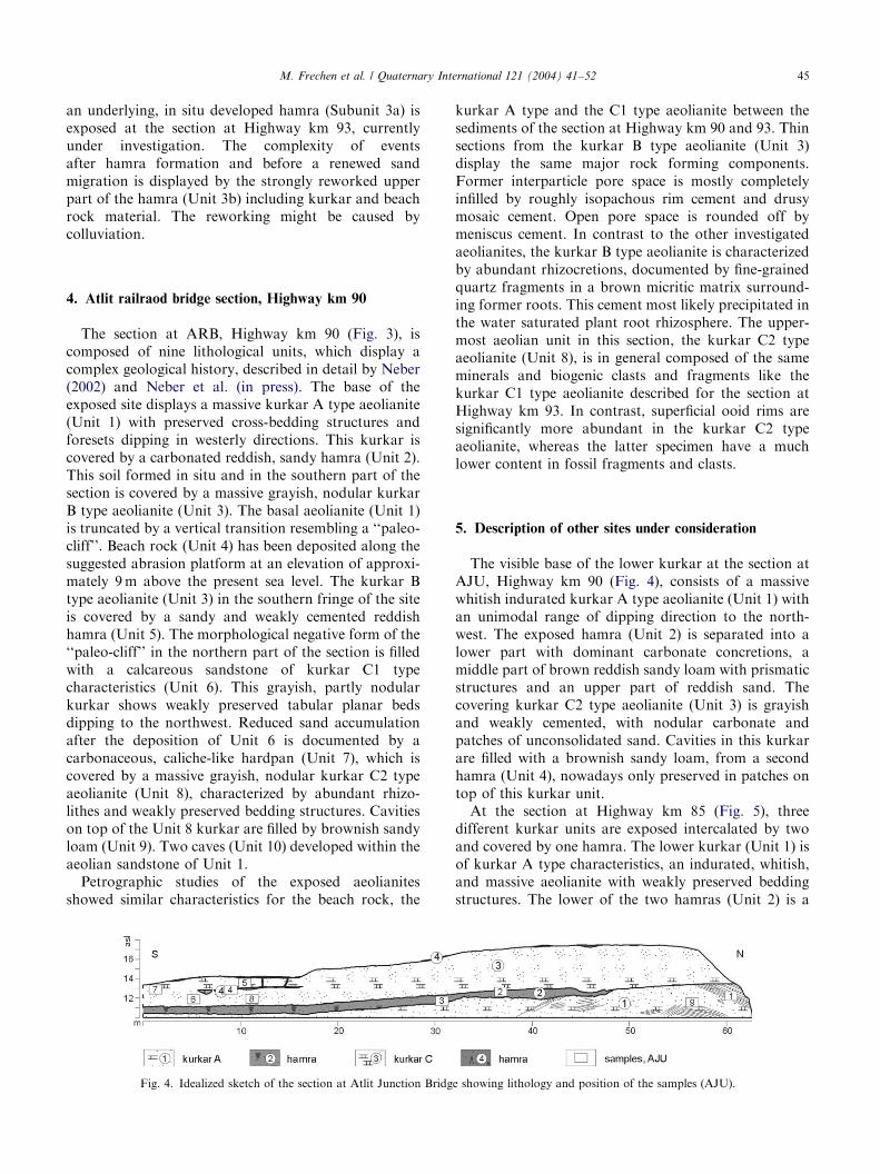
Fig. 4. Idealized sketch of the section at Atlit Junction Bridg
kurkar A type and the C1 type aeolianite between thesediments of the section at Highway km 90 and 93. Thinsections from the kurkar B type aeolianite (Unit 3)display the same major rock forming components.Former interparticle pore space is mostly completelyinfilled by roughly isopachous rim cement and drusymosaic cement. Open pore space is rounded off bymeniscus cement. In contrast to the other investigatedaeolianites, the kurkar B type aeolianite is characterizedby abundant rhizocretions, documented by fine-grainedquartz fragments in a brown micritic matrix surround-ing former roots. This cement most likely precipitated inthe water saturated plant root rhizosphere. The upper-most aeolian unit in this section, the kurkar C2 typeaeolianite (Unit 8), is in general composed of the sameminerals and biogenic clasts and fragments like thekurkar C1 type aeolianite described for the section atHighway km 93. In contrast, superficial ooid rims aresignificantly more abundant in the kurkar C2 typeaeolianite, whereas the latter specimen have a muchlower content in fossil fragments and clasts.
5. Description of other sites under consideration
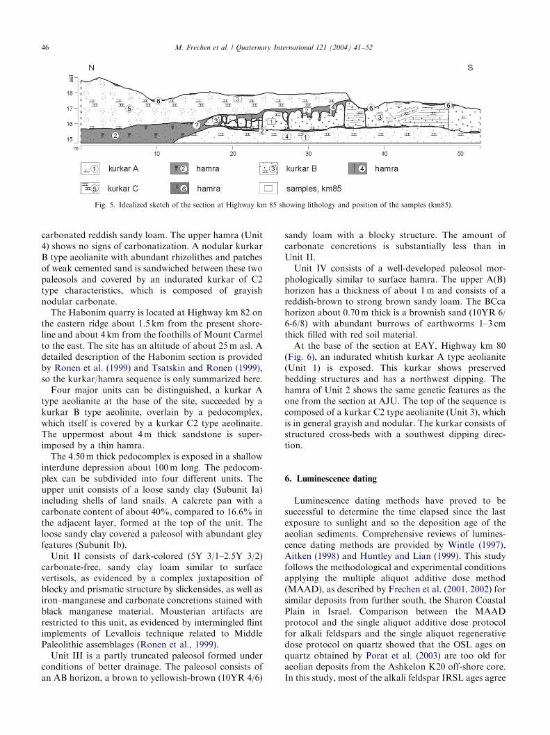
The visible base of the lower kurkar at the section atAJU, Highway km 90 (Fig. 4), consists of a massivewhitish indurated kurkar A type aeolianite (Unit 1) withan unimodal range of dipping direction to the north-west. The exposed hamra (Unit 2) is separated into alower part with dominant carbonate concretions, amiddle part of brown reddish sandy loam with prismaticstructures and an upper part of reddish sand. Thecovering kurkar C2 type aeolianite (Unit 3) is grayishand weakly cemented, with nodular carbonate andpatches of unconsolidated sand. Cavities in this kurkarare filled with a brownish sandy loam, from a secondhamra (Unit 4), nowadays only preserved in patches ontop of this kurkar unit.
At the section at Highway km 85 (Fig. 5), threedifferent kurkar units are exposed intercalated by twoand covered by one hamra. The lower kurkar (Unit 1) isof kurkar A type characteristics, an indurated, whitish,and massive aeolianite with weakly preserved beddingstructures. The lower of the two hamras (Unit 2) is a
e showing lithology and position of the samples (AJU).
ARTICLE IN PRESS
Fig. 5. Idealized sketch of the section at Highway km 85 showing lithology and position of the samples (km85).
M. Frechen et al. / Quaternary International 121 (2004) 41–5246
carbonated reddish sandy loam. The upper hamra (Unit4) shows no signs of carbonatization. A nodular kurkarB type aeolianite with abundant rhizolithes and patchesof weak cemented sand is sandwiched between these twopaleosols and covered by an indurated kurkar of C2type characteristics, which is composed of grayishnodular carbonate.
The Habonim quarry is located at Highway km 82 onthe eastern ridge about 1.5 km from the present shore-line and about 4 km from the foothills of Mount Carmelto the east. The site has an altitude of about 25 m asl. Adetailed description of the Habonim section is providedby Ronen et al. (1999) and Tsatskin and Ronen (1999),so the kurkar/hamra sequence is only summarized here.
Four major units can be distinguished, a kurkar Atype aeolianite at the base of the site, succeeded by akurkar B type aeolinite, overlain by a pedocomplex,which itself is covered by a kurkar C2 type aeolinaite.The uppermost about 4 m thick sandstone is super-imposed by a thin hamra.
The 4.50 m thick pedocomplex is exposed in a shallowinterdune depression about 100 m long. The pedocom-plex can be subdivided into four different units. Theupper unit consists of a loose sandy clay (Subunit Ia)including shells of land snails. A calcrete pan with acarbonate content of about 40%, compared to 16.6% inthe adjacent layer, formed at the top of the unit. Theloose sandy clay covered a paleosol with abundant gleyfeatures (Subunit Ib).
Unit II consists of dark-colored (5Y 3/1–2.5Y 3/2)carbonate-free, sandy clay loam similar to surfacevertisols, as evidenced by a complex juxtaposition ofblocky and prismatic structure by slickensides, as well asiron–manganese and carbonate concretions stained withblack manganese material. Mousterian artifacts arerestricted to this unit, as evidenced by intermingled flintimplements of Levallois technique related to MiddlePaleolithic assemblages (Ronen et al., 1999).
Unit III is a partly truncated paleosol formed underconditions of better drainage. The paleosol consists ofan AB horizon, a brown to yellowish-brown (10YR 4/6)
sandy loam with a blocky structure. The amount ofcarbonate concretions is substantially less than inUnit II.
Unit IV consists of a well-developed paleosol mor-phologically similar to surface hamra. The upper A(B)horizon has a thickness of about 1 m and consists of areddish-brown to strong brown sandy loam. The BCcahorizon about 0.70 m thick is a brownish sand (10YR 6/6-6/8) with abundant burrows of earthworms 1–3 cmthick filled with red soil material.
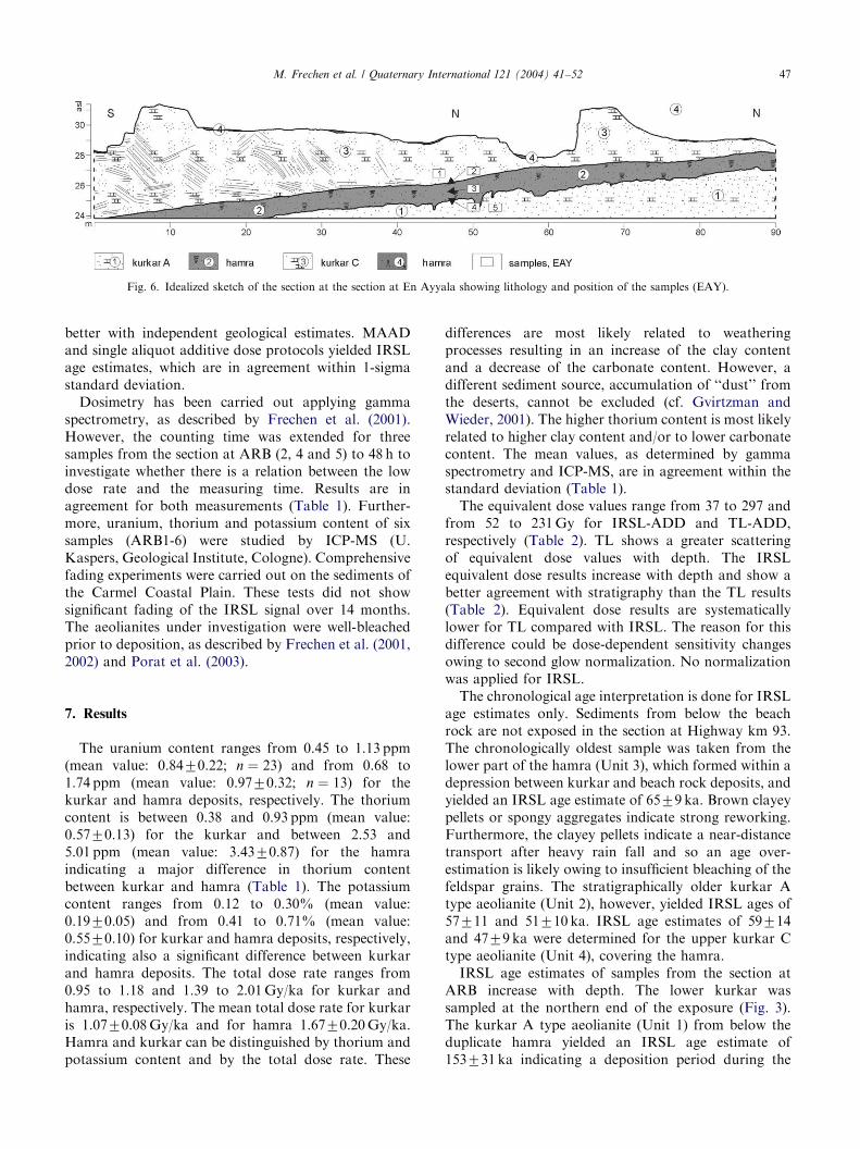
At the base of the section at EAY, Highway km 80(Fig. 6), an indurated whitish kurkar A type aeolianite(Unit 1) is exposed. This kurkar shows preservedbedding structures and has a northwest dipping. Thehamra of Unit 2 shows the same genetic features as theone from the section at AJU. The top of the sequence iscomposed of a kurkar C2 type aeolianite (Unit 3), whichis in general grayish and nodular. The kurkar consists ofstructured cross-beds with a southwest dipping direc-tion.
6. Luminescence dating
Luminescence dating methods have proved to besuccessful to determine the time elapsed since the lastexposure to sunlight and so the deposition age of theaeolian sediments. Comprehensive reviews of lumines-cence dating methods are provided by Wintle (1997),Aitken (1998) and Huntley and Lian (1999). This studyfollows the methodological and experimental conditionsapplying the multiple aliquot additive dose method(MAAD), as described by Frechen et al. (2001, 2002) forsimilar deposits from further south, the Sharon CoastalPlain in Israel. Comparison between the MAADprotocol and the single aliquot additive dose protocolfor alkali feldspars and the single aliquot regenerativedose protocol on quartz showed that the OSL ages onquartz obtained by Porat et al. (2003) are too old foraeolian deposits from the Ashkelon K20 off-shore core.In this study, most of the alkali feldspar IRSL ages agree
ARTICLE IN PRESS
Fig. 6. Idealized sketch of the section at the section at En Ayyala showing lithology and position of the samples (EAY).
M. Frechen et al. / Quaternary International 121 (2004) 41–52 47
better with independent geological estimates. MAADand single aliquot additive dose protocols yielded IRSLage estimates, which are in agreement within 1-sigmastandard deviation.
Dosimetry has been carried out applying gammaspectrometry, as described by Frechen et al. (2001).However, the counting time was extended for threesamples from the section at ARB (2, 4 and 5) to 48 h toinvestigate whether there is a relation between the lowdose rate and the measuring time. Results are inagreement for both measurements (Table 1). Further-more, uranium, thorium and potassium content of sixsamples (ARB1-6) were studied by ICP-MS (U.Kaspers, Geological Institute, Cologne). Comprehensivefading experiments were carried out on the sediments ofthe Carmel Coastal Plain. These tests did not showsignificant fading of the IRSL signal over 14 months.The aeolianites under investigation were well-bleachedprior to deposition, as described by Frechen et al. (2001,2002) and Porat et al. (2003).
7. Results
The uranium content ranges from 0.45 to 1.13 ppm(mean value: 0.8470.22; n ¼ 23) and from 0.68 to1.74 ppm (mean value: 0.9770.32; n ¼ 13) for thekurkar and hamra deposits, respectively. The thoriumcontent is between 0.38 and 0.93 ppm (mean value:0.5770.13) for the kurkar and between 2.53 and5.01 ppm (mean value: 3.4370.87) for the hamraindicating a major difference in thorium contentbetween kurkar and hamra (Table 1). The potassiumcontent ranges from 0.12 to 0.30% (mean value:0.1970.05) and from 0.41 to 0.71% (mean value:0.5570.10) for kurkar and hamra deposits, respectively,indicating also a significant difference between kurkarand hamra deposits. The total dose rate ranges from0.95 to 1.18 and 1.39 to 2.01 Gy/ka for kurkar andhamra, respectively. The mean total dose rate for kurkaris 1.0770.08 Gy/ka and for hamra 1.6770.20 Gy/ka.Hamra and kurkar can be distinguished by thorium andpotassium content and by the total dose rate. These
differences are most likely related to weatheringprocesses resulting in an increase of the clay contentand a decrease of the carbonate content. However, adifferent sediment source, accumulation of ‘‘dust’’ fromthe deserts, cannot be excluded (cf. Gvirtzman andWieder, 2001). The higher thorium content is most likelyrelated to higher clay content and/or to lower carbonatecontent. The mean values, as determined by gammaspectrometry and ICP-MS, are in agreement within thestandard deviation (Table 1).
The equivalent dose values range from 37 to 297 andfrom 52 to 231 Gy for IRSL-ADD and TL-ADD,respectively (Table 2). TL shows a greater scatteringof equivalent dose values with depth. The IRSLequivalent dose results increase with depth and show abetter agreement with stratigraphy than the TL results(Table 2). Equivalent dose results are systematicallylower for TL compared with IRSL. The reason for thisdifference could be dose-dependent sensitivity changesowing to second glow normalization. No normalizationwas applied for IRSL.
The chronological age interpretation is done for IRSLage estimates only. Sediments from below the beachrock are not exposed in the section at Highway km 93.The chronologically oldest sample was taken from thelower part of the hamra (Unit 3), which formed within adepression between kurkar and beach rock deposits, andyielded an IRSL age estimate of 6579 ka. Brown clayeypellets or spongy aggregates indicate strong reworking.Furthermore, the clayey pellets indicate a near-distancetransport after heavy rain fall and so an age over-estimation is likely owing to insufficient bleaching of thefeldspar grains. The stratigraphically older kurkar Atype aeolianite (Unit 2), however, yielded IRSL ages of57711 and 51710 ka. IRSL age estimates of 59714and 4779 ka were determined for the upper kurkar Ctype aeolianite (Unit 4), covering the hamra.
IRSL age estimates of samples from the section atARB increase with depth. The lower kurkar wassampled at the northern end of the exposure (Fig. 3).The kurkar A type aeolianite (Unit 1) from below theduplicate hamra yielded an IRSL age estimate of153731 ka indicating a deposition period during the
ARTICLE IN PRESS
Table 1
Dosimetric and chronological results for section under investigation
Sample Uranium Thorium Potassium Cosmic dose Total dose
(ppm) (ppm) (%) (NGy/a) (Gy/ka)
Highway km 93
Km93-1 1.1070.10 0.7070.10 0.1870.01 150715 1.1770.17
Km93-2 0.7070.10 0.4270.03 0.1670.01 150715 1.0470.17
Km93-3 0.6370.04 0.5470.04 0.3070.01 120712 1.1470.17
Km93-4 Beach rock — — — —
Km93-5 0.7970.06 2.9670.21 0.6770.03 8078 1.7670.17
Km93-6 0.6370.04 0.4670.03 0.2370.01 8078 1.0370.17
Atlit Junction Bridge (Highway km 90)
AJU1 0.6770.05 0.6570.05 0.2770.01 7077 1.0570.17
AJU2 0.8170.06 3.5670.25 0.5270.03 115712 1.5970.17
AJU3 0.9370.06 4.6470.33 0.6070.03 110711 1.8170.17
AJU4 1.7470.12 5.0170.35 0.5770.03 135713.5 2.0170.17
AJU5 0.8670.06 0.3870.03 0.1470.01 150715 1.0670.17
AJU6 0.8370.06 2.5770.18 0.4470.02 135713.5 1.3970.17
AJU7 0.9570.07 0.6170.04 0.1570.01 150715 1.0670.17
AJU8 1.1370.08 0.6870.05 0.1670.01 135713.5 1.1670.17
AJU9 0.5970.04 0.6570.05 0.2770.01 7077 1.0670.17
Atlit Railroad Bridge (Highway km 90)
ARB1 1.5270.11 3.1870.22 0.6370.03 120712 1.8470.17
ARB2 0.6770.05 0.7270.05 0.1270.01 7577.5 0.9570.17
ARB2a 0.7070.05 0.6670.05 0.1370.01
ARB3 1.1470.08 3.4370.24 0.5470.03 120712 —
ARB4 1.0770.07 0.4270.03 0.2570.01 7577.5 1.1570.17
ARB4a 1.0470.07 0.4470.03 0.2670.01
ARB5 1.1070.08 0.5070.04 0.1470.01 150715 1.1470.17
ARB5a 1.0970.08 0.4670.03 0.1470.01
ARB6 0.8670.06 2.5370.18 0.4570.02 150715 1.5370.17
ARB6a 0.7870.05 2.6370.18 0.4570.02
ARB16 1.1370.08 0.4870.03 0.1770.01 3075 1.0570.18
ARB17 0.7370.05 0.4670.03 0.1370.01 150715 1.0370.18
Highway km 85
KM85-1 0.5870.04 0.5270.04 0.1470.01 110711 0.9670.17
KM85-2 0.9170.06 2.6070.18 0.4170.02 135713.5 1.4670.17
KM85-3 1.0870.08 0.5170.04 0.1770.01 150715 1.1670.17
KM85-4 0.8270.06 0.9370.07 0.2070.01 8578.5 1.0970.17
En Ayyala (Highway 80)
EAY1 0.9770.07 0.7170.05 0.2170.01 135713.5 1.1870.17
EAY2 0.6870.05 2.8270.20 0.5270.03 120712 1.4770.17
EAY3 0.8070.06 4.5270.32 0.7170.04 115711.5 1.8370.17
EAY4 0.7970.06 4.1270.29 0.6670.03 110711 1.7270.17
EAY5 0.4570.03 0.7170.05 0.2070.01 9079 0.9670.17
EAY6 0.6570.05 0.5970.04 0.1670.01 4075 0.9770.17
ICP-MS results
Sample U (ppm) Th (ppm) K (%) Rb (ppm)
ARB1 1.12 3.51 0.67 25
ARB2 0.54 0.75 0.10 4.9
ARB3 1.04 4.16 0.70 31
ARB4 0.67 0.43 0.27 6.5
ARB5 1.18 0.54 0.14 5
ARB6 0.92 3.16 0.54 21
Moisture: Kurkar (K): 973%
Hamra (H): 571.5%
Internal potassium content: 12.571.5%
Alpha efficiency: 0.0870.008
a Gamma spectrometry for 48 h.
M. Frechen et al. / Quaternary International 121 (2004) 41–5248
ARTICLE IN PRESS
Table 2
Equivalent dose and luminescence age results
Sample Equivalent dose in Gray Age in 1000 years
TL-ADD IRSL-ADD TL-ADD IRSL-ADD
Highway km 93
km93-1 75.2712.2 69.4712.0 64.0714.2 59.3713.7
km93-2 66.174.0 49.473.0 63.3711.6 47.478.8
km93-3 87.7710.0 58.276.7 76.7715.0 51.0710.0
km93-4 Beach rock — —
km93-5 75.970.6 113.5710.9 43.074.2 64.578.9
km93-6 — 58.374.9 — 56.7710.7
(km93-6=km93-3)
Atlit Junction Bridge (Highway km 90)
AJU1 79.2719.3 48.871.0 75.4722.5 46.678.1
AJU2 81.572.2 72.8710.9 51.475.6 45.978.4
AJU3 75.470.5 95.577.9 41.674.0 52.976.7
AJU4 17.870.6 40.075.8 )8.870.8* 19.973.4
AJU5 57.576.4 37.272.4 54.3711.0 35.376.5
AJU6 69.9711.5 41.675.0 50.2710.4 30.075.3
AJU7 78.4712.0 78.472.4 73.9716.8 74.2712.8
AJU8 61.1713.4 56.770.7 52.5713.8 48.777.1
AJU9 88.474.6 97.871.1 83.3714.2 92.5715.0
(AJU9=1; AJU8=6)
Atlit Railroad Bridge (Highway km 90)
ARB1 113.378.5 140.375.1 61.777.2 76.477.4
ARB 2 96.379.6 135.977.2 101721 143727
ARB 3 — — — —
ARB 4 132.578.2 176.2724.3 115718 153731
ARB 5 61.478.4 67.7711.4 53.8711.2 59.5713.7
ARB 6 8.970.5 18.372.8 5.870.7 11.972.3
ARB16 46.477.1 48.670.7 44.1710.1 46.277.8
ARB17 115.8710.7 76.4711.0 112.6722.5 74.3716.9
Highway km 85
KM85-1 87.473.8 115.377.2 90.7716.8 120723
KM85-2 74.570.3 97.2710.1 51.175.9 66.7710.3
KM85-3 57.577.0 75.079.1 49.579.4 64.6712.3
KM85-4 117.1714.4 137.6722.9 107721 126729
En Ayyala (Highway km 80)
EAY1 47.172.6 75.475.1 39.976.4 64.1710.7
EAY2 85.077.0 124.879.4 57.578.4 84.8717.1
EAY3 101.6711.4 145.3718.0 55.578.1 79.4712.2
EAY4 164.1739.5 163.3725.0 94.9724.8 94.8717.5
EAY5 109.6711.5 128.5716.0 114725 134730
EAY6 104.2713.0 102.4715.5 107724 106726
M. Frechen et al. / Quaternary International 121 (2004) 41–52 49
penultimate glaciation. An age of 143727 ka wasdetermined for the kurkar B type aeolianite (Unit 3)intercalated between the two hamras. Samples AJU 1and 7 (Tables 1 and 2) were excluded from the ageinterpretation owing to problems during an earlier fieldsession, which could not be excluded. The kurkar C2type aeolianite (Unit 8) yielded IRSL age estimates of60714 and 74717 ka. A sample from the uppermostpart of the sequence, where hamra is exposed inweathering pockets (Unit 9), gave an IRSL age estimateof 1272 ka.
The kurkar A type aeolianite (Unit 1) from the sectionat the AJU (Fig. 4) yielded a deposition age of93715 ka. The intercalated hamra (Unit 2) gave IRSLage estimates ranging from 5777 to 4678 ka. The C2type aeolianite is intercalated by a lens, most likelysolution pockets filled by reworked hamra material(Unit 4). Stratigraphically the pedosediment belongs toa younger soil formation, as evidenced by an IRSL ageestimate of about 2073 ka.
The section at Highway km 85 is stratigraphically anequivalent of the section at ARB. The lowermostexposed kurkar is an A type aeolianite (Unit 1) andgave an IRSL age estimate of 126720 ka. The kurkar Btype sandstone of Unit 3, exposed between two hamras,yielded a deposition age of 120723 ka. An IRSL ageestimate of 67710 ka was determined for the uppermostpart of the hamra (Unit 4), which is in agreement withan age of 65712 ka determined for the kurkar C2 typeaeolianite (Unit 5) covering this hamra.
The section at Habonim includes one of the mostdetailed pedocomplexes intercalated in kurkar depositsexposed along the Carmel Coastal Plain. So far, onlyradio-thermoluminescence ages, as reported by Ronenet al. (1999) and Tsatskin and Ronen (1999), areavailable for this key section. Unfortunately, the RTLages were published as preliminary RTL dates and finalage estimates have not been published since then. As nomethodological background information is availableabout dosimetry, equivalent dose values and ageestimates, the RTL dates have to be regarded with careand should not be included into the final chronologicalinterpretation. However, a correlation is possible bymeans of lithology.
At the section at EAY, Highway km 80, two kurkarunits are exposed and intercalated by a hamra. Theluminescence age estimates increase with depth. Thelower kurkar A type, aeolianite (Unit 1) yielded anIRSL age of 134730 ka. The hamra (Unit 2) yieldeddeposition ages ranging from 95718 to 80712 ka. Theupper kurkar C2 type aeolianite (Unit 3) gave adeposition age of 64711 ka (Fig. 7).
8. Discussion
In the Carmel Coastal Plain, at least five majorperiods of increased sand accumulation and kurkarformation can be distinguished, separated by hamraformation or beach rock deposition. The stratigraphi-cally oldest exposed kurkar, an A type aeolianite, wasaccumulated during the penultimate glaciation (OIS 6).This kurkar gave deposition ages between 153 and126 ka and is exposed at the sections at ARB, Highwaykm 85, Habonim and EAY (Fig. 1). These sections areall exposed along the easternmost ridge, the so-calledhighway ridge along the Carmel Coastal Plain.
ARTICLE IN PRESS
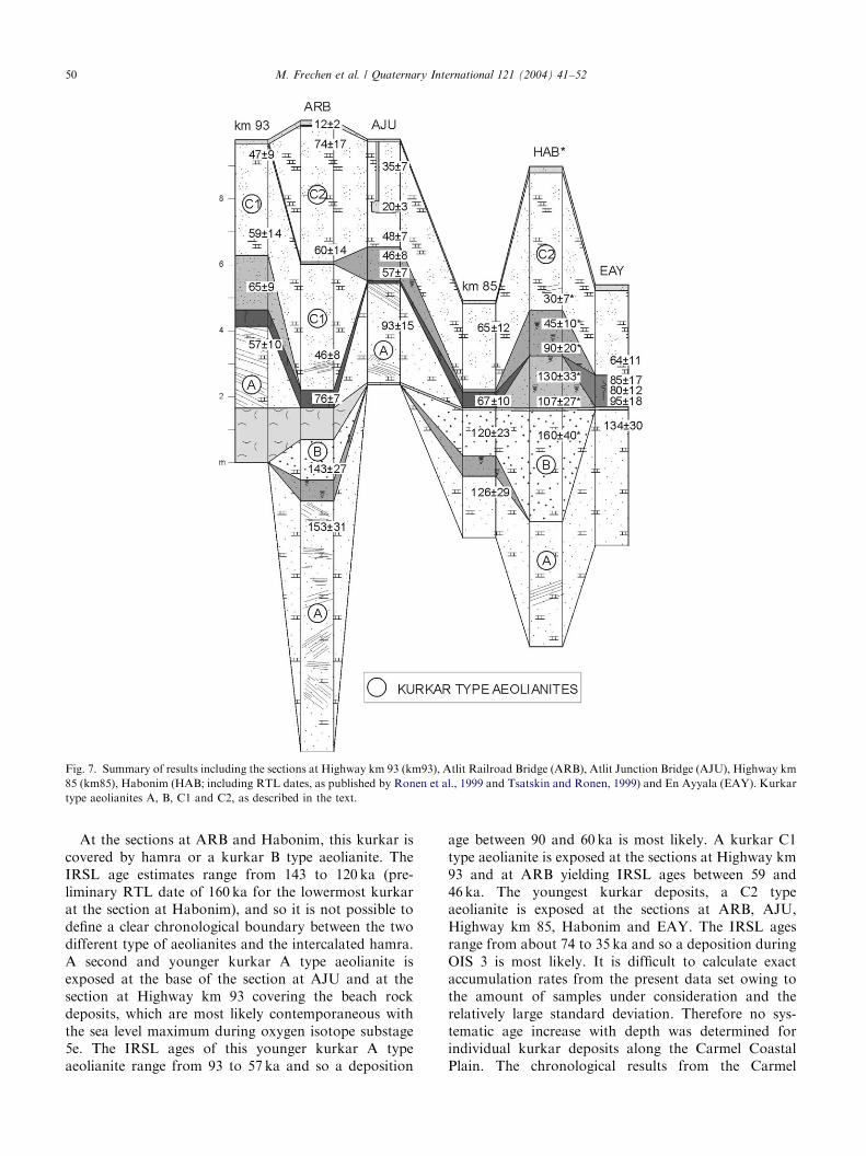
Fig. 7. Summary of results including the sections at Highway km 93 (km93), Atlit Railroad Bridge (ARB), Atlit Junction Bridge (AJU), Highway km
85 (km85), Habonim (HAB; including RTL dates, as published by Ronen et al., 1999 and Tsatskin and Ronen, 1999) and En Ayyala (EAY). Kurkar
type aeolianites A, B, C1 and C2, as described in the text.
M. Frechen et al. / Quaternary International 121 (2004) 41–5250
At the sections at ARB and Habonim, this kurkar iscovered by hamra or a kurkar B type aeolianite. TheIRSL age estimates range from 143 to 120 ka (pre-liminary RTL date of 160 ka for the lowermost kurkarat the section at Habonim), and so it is not possible todefine a clear chronological boundary between the twodifferent type of aeolianites and the intercalated hamra.A second and younger kurkar A type aeolianite isexposed at the base of the section at AJU and at thesection at Highway km 93 covering the beach rockdeposits, which are most likely contemporaneous withthe sea level maximum during oxygen isotope substage5e. The IRSL ages of this younger kurkar A typeaeolianite range from 93 to 57 ka and so a deposition
age between 90 and 60 ka is most likely. A kurkar C1type aeolianite is exposed at the sections at Highway km93 and at ARB yielding IRSL ages between 59 and46 ka. The youngest kurkar deposits, a C2 typeaeolianite is exposed at the sections at ARB, AJU,Highway km 85, Habonim and EAY. The IRSL agesrange from about 74 to 35 ka and so a deposition duringOIS 3 is most likely. It is difficult to calculate exactaccumulation rates from the present data set owing tothe amount of samples under consideration and therelatively large standard deviation. Therefore no sys-tematic age increase with depth was determined forindividual kurkar deposits along the Carmel CoastalPlain. The chronological results from the Carmel
ARTICLE IN PRESSM. Frechen et al. / Quaternary International 121 (2004) 41–52 51
Coastal Plain indicate that sand migration and accretionoccurred within short periods of time with highaccumulation rates. This result is in agreement withthose from the Sharon Coastal Plain (Frechen et al.,2002). At the section at Netanya South, the lowermostkurkar with a thickness of more than 25 m wasdeposited rapidly, most likely in less than 5 ka. A similarrapid accumulation rate is expected for aeolianites fromthe Carmel Coastal Plain.
The stratigraphically oldest hamra is exposed at thesection at ARB and Highway km 85. This hamra formedin situ and separates the kurkar A and B type aeolianites,which were most likely deposited during OIS 6. Thehamra horizon at the Atlit Railroad Railroad Bridgeformed in situ during part of OIS 6, as the subsequentlydeposited beach rock is designated to be an equivalent ofOIS 5e. The most complete hamra sequence is exposed atthe section at Habonim. Although the reliability of thepreliminary RTL dates is still under discussion, it is likelythat the lowermost part of the pedocomplex formedbetween 130 and 100 ka before present. The sections atEAY, Highway km 85, ARB and AJU represent severalhamra formation periods between about 95 and 67 ka. Ayounger in situ hamra is exposed at the section at AJU.The IRSL ages range from 57 to 46 ka. This hamra ismost likely exposed at the section at Habonim, too. Thehamra is also exposed at the section at Givat Olga in theSharon Coastal plain, characterized there by a brownishpaleosol horizon, which is the lowermost of twosuccessive soil horizons in the sequence (Frechen et al.,2001, 2002). IRSL ages indicate deposition ages between56 and 33 ka.
At the section at ARB remnants of reworked hamramaterial yielded an IRSL age estimate of about 12 ka,which is in agreement with an age of about 20 kadetermined for reworked hamra within a lens interclatedin kurkar deposits at the section at AJU. The reworkedhamra material is most likely an equivalent of the UpperRed Paleosol exposed at the section at Givat Olga in theSharon Coastal Plain, which gave luminescence agesranging from 19 to 12 ka. The age range is in agreementwith results from the section at Netanya South(Engelmann et al., 2001; Frechen et al., 2002) andGa’ash (Porat and Wintle, 1994; Ritte et al., 1997) and isdefined by Gvirtzman et al. (1998) as Netanya Hamra.
Further chronological and stratigraphical correlationsbetween the Carmel and the Sharon Coastal Plainemerge, as the uppermost kurkar along the CarmelCoastal Plain is chronologically most likely an equiva-lent of the oldest kurkar exposed along the SharonCoastal Plain, as investigated by Porat and Wintle(1994), Ritte et al. (1997) and Frechen et al. (2002). Theoldest kurkar exposed on-shore along the SharonCoastal Plain gave a mean IRSL age of 53.979.1 kaindicating a deposition age between 60 and 50 ka beforepresent. Interglacial deposits were described from the
section at Highway km 93, where beach rock is exposeddesignated to represent OIS 5e indicating sea leveltransgression over the shelf.
The presented chronological results suggest that moreclimate variations are indicated in the terrestrial recordof the Carmel Coastal Plain and so, the terrestrialsequences would be expected to record local andregional climate variations versus homogenized climatesignals in deep marine cores of the Eastern Mediterra-nean. Sand encroachment, subsequent accumulationand early diagenetic lithification of the kurkar typeaeolianites along the coast occurred in an at least semi-arid environment (Neber, 2002; Neber et al., in press),whereas soil formation periods are generally attributedto more humid episodes (e.g. Yaalon and Dan, 1967).Summarizing the Late Pleistocene to early Holocenesequences in the Carmel and Sharon Coastal Plain, thesediments show five major periods of sand migrationwhich lead to the formation of the elongated kurkarridges. These semi-arid phases are interspersed andsucceeded by six soil formation episodes under morehumid conditions. The chronological succession of theseclimate-related cycles is in good agreement with marineand terrestrial archives in the Eastern Mediterranean,discussed in detail in Neber (2002) and a forthcomingpaper by Neber et al. (in preparation).
9. Conclusion
Five periods of sand accumulation and six of soilformation and one beach rock can be distinguished inthe sections under investigation along the CarmelCoastal Plain. The two oldest kurkar deposits wereformed at about 140 ka and at about 130 ka and so mostlikely within OIS 6. These two kurkars are intercalatedby hamra indicating soil formation during that period.The beach rock most likely formed during the sea levelmaximum at OIS 5e. Furthermore, it is likely that thebeach rock is an equivalent of the lowermost paleosol atthe section at Habonim yielding preliminary RTL datesof about 130 and 107 ka. The third kurkar formationtook place around 90 ka successively followed by hamraformation around 80 and 65 ka. In the north of theCarmel Coastal Plain, kurkar formed around 60 kasuperimposed by hamra formation immediately after-wards. The latter two units cannot be distinguished bychronological means owing to the relatively highstandard deviation and too few dating results. A veryprominent kurkar deposited between 60 and 50 ka, themean age is 58714 ka (n ¼ 6). This kurkar can becorrelated with the oldest exposed kurkar along theSharon Coastal Plain (Porat and Wintle, 1994; Ritteet al., 1997; Frechen et al., 2001, 2002). The uppermosthamra deposits gave IRSL ages between 20 and 12 kaand so represent the youngest deposits.
ARTICLE IN PRESSM. Frechen et al. / Quaternary International 121 (2004) 41–5252
Kurkar sediments accumulated rapidly in a fewhundred to a few thousand years. However, in orderto calculate the chronological boundaries of the sandaccumulation periods more reliable, more precise ageestimates are required.
Acknowledgements
We thank the German–Israeli Foundation for fund-ing (Project-No. I132-301.02/95).
References
Adams, A.E., McKenzie, A., 1998. A Colour Atlas of Carbonate
Sediments and Rocks under the Microscope. Manson Publishing
Ltd., London.
Aitken, M.J., 1998. Introduction to Optical Dating. Academic Press,
Oxford.
Boenigk, W., Brunnacker, K., Tillmanns, W., Ronen, A., 1985. Die.Aolianite in der n .ordlichen K .ustenebene von Israel—Genese,
Stratigraphie und Klimageschichte. Quart.ar 35/36, 113–140.
Bullock, P., Fedoroff, N., Jongerius, A., Stoops, G., Tursina, T., 1985.
Handbook for Soil Thin Section Description. Waine Research,
Wolverhampton.
Dan, J., Yaalon, D.H., 1971. On the origin and nature of
paleopedological formations in the coastal desert fringe areas of
Israel. In: Yaalon, D.H. (Ed.), Paleopedology—Origine, Nature
and Dating of Paleosols. Israel University Press, Jerusalem,
pp. 245–260.
Engelmann, A., Neber, A., Frechen, M., Boenigk, W., Ronen, A.,
2001. Luminescence chronology of Upper Pleistocene and Holo-
cene Aeolianites from Netanya South—Sharon Coastal Plain,
Israel. Quaternary Science Reviews 20, 799–804.
Farrand, W.R., Ronen, A., 1974. Observations on the kurkar–hamra
succession on the Carmel Coastal Plain. Tel-Aviv 1, 45–55.
Frechen, M., Dermann, B., Boenigk, W., Ronen, A., 2001. Lumines-
cence chronology of aeolianites from the section at Givat Olga—
Coastal Plain of Israel. Quaternary Science Reviews 20, 805–809.
Frechen, M., Neber, A., Dermann, B., Tsatskin, S., Boenigk, W.,
Ronen, A., 2002. Chronostratigraphy of aeolianites from the
Sharon Coastal Plain of Israel. Quaternary International 89, 31–44.
Gavish, E., Friedman, G.M., 1969. Progressive diagenesis in Qua-
ternary to late tertiary sediments: sequence and time scale. Journal
of Sedimentary Petrology 39, 980–1006.
Goldsmith, V., Golik, A., 1980. Sediment transport model of the
southeastern Mediterranean coast. Marine Geology 37, 147–175.
Goldsmith, V., Rosen, P., Gertner, Y., 1990. Eolian transport
measurements, winds, and comparison with theoretical transport
in Israeli coastal dunes. In: Nordstrom, K., Psuty, N., Carter, B.
(Eds.), Coastal Dunes—Form and Processes. Wiley, Chichester,
pp. 79–101.
Gvirtzman, G., Wieder, M., 2001. Climate of the last 53,000 years in
the eastern Mediterranean, based on soil-sequence stratigraphy in
the coastal plain of Israel. Quaternary Science Reviews 20,
1827–1849.
Gvirtzman, G., Shachnai, E., Bakler, N., Ilani, S., 1984. Stratigraphy
of the kurkar group (Quaternary) of the coastal plain of Israel.
Geological Survey Israel, Current Research 1983–84, 70–82.
Gvirtzman, G., Netser, M., Katsav, E., 1998. Last-Glacial to Holocene
kurkar ridges, hamra soils and dune fields in the coastal belt of
Israel. Israeli Journal of Earth Science 47, 29–46.
Huntley, D.J., Lian, O.B., 1999. Using optical dating to determine
when a sediment was last exposed to sunlight. GSC Bulletin 534,
211–222.
Issar, A., 1968. Geology of the central coastal plain of Israel. Israel
Journal of Earth Sciences 17, 16–29.
Neber, A., 2002. Sedimentological properties of Quaternary deposits
on the central coastal plain. Unpublished Ph.D. Dissertation,
Department of Archaeology, University of Haifa, Israel.
Neber, A., Boenigk, W., Ronen, A., 2003. Facies characteristics of
aeolianites near Atlit—Carmel coastal plain, Israel. Mitt. Ges.
Geol. Bergbaustud. .Osterr 46, 67–75.
Neber, A., Frechen, M., Tsatskin, A., Boenigk, W., Ronen, A., in
preparation. Aeolianites, paleosols and beachrock—climate ar-
chives in the Carmel Coastal Plain, Israel.
Porat, N., Wintle, A.G., 1994. IRSL dating of kurkar and hamra from
the Givat Olga Member in the Sharon Coastal Cliff, Israel. Israel
Geological Society, Proceedings of the Annual Meeting, Vol. 85.
Porat, N., Avital, A., Frechen, M., Almogi-Labin, A., 2003.
Chronology of upper quaternary offshore successions from the
southeastern mediterranean sea, israel. Quaternary Geochronology
22, 1191–1199.
Ritte, M., Porat, N., Gvirtzman, G., 1997. Stratigraphy of the coastal
cliff of the Sharon environments of deposition and luminescence
dating. Israel Geological Society, Proceedings of the Annual
Meeting, pp. 92–93.
Ronen, A., 1975a. The Palaeolithic archaeology and chronology of
Israel. In: Wendorf, F., Marks, A.E. (Eds.), Problems in
Prehistory: North Africa and the Levant, Southern Methodist
University, Dallas, pp. 229–248.
Ronen, A., 1975b. R!eflexions sur l’origine, la gen"ese et la chronologie
des gr"es dunaires calcifi!es dits premi"ere et deuxi"eme cha#ınes c #oti"eres
sur le littoral isra!elien. Bulletin de la soci!et!e Pr!ehistorique
Fran@aise, Paris 72, 72–77.
Ronen, A., 1977. Mousterian Sites in the red loam of Mount Carmel.
Eretz-Israel 13, 183–1190.
Ronen, A., Tsatskin, A., Laukhin, S.A., 1999. The genesis and age of
Mousterian paleosols in the Carmel Coastal plain, Israel. In:
Davies, W., Charles, R. (Eds.), Studies in Honour of D.A.E.
Garrod. Oxbow Books, Oxford, pp. 135–151.
Soil Survey Staff, 1975. Soil Taxonomy. A Basic System of Soil
Classification for Making and Interpreting Soil Surveys. USDA
Agriculture Handbook 436, US Government Printing Office,
Washington, DC.
The Classification of Israel Soils, 1979. Special Publication, 137.
Division of Scientific Publications, The Volcani Center, Bet Dagan.
Tsatskin, A., Ronen, A., 1999. Micromorphology of a Mousterian
paleosol in aeolianites at the site Habonim, Israel. Catena 34,
365–384.
Tsoar, H., 2000. Geomorphology and paleogeography of sand dunes
that have formed the kurkar ridges in the coastal plain of Israel.
Israel Journal of Earth Sciences 49, 189–196.
Wieder, M., Yaalon, D.H., 1982. Micromorphological fabrics and
development stages of carbonate nodular forms related to soil
characteristics. Geoderma 28, 203–220.
Wintle, A.G., 1997. Luminescence dating: laboratory procedures and
protocols. Radiation Measurements 27, 769–817.
Yaalon, D.H., Dan, J., 1967. Factors controlling soil formation and
distribution in the Mediterranean coastal plain of Israel during the
Quaternary. Quaternary Soils, Seventh INQUA Congress, 1965,
pp. 321–338.