Characterization of porosity and permeability for CO2 sequestration models in the Mississippian...
18
Rocky Mountain Geology, v. 45, no. 2, p. 133–150, 11 figs., 1 table, October 2010 133 Characterization of porosity and permeability for CO 2 sequestration models in the Mississippian Madison Group, Moxa Arch–LaBarge Platform, southwestern Wyoming Geoffrey D. Thyne 1* , Mark Tomasso 1 , Sharon V. Bywater-Reyes 1 , David A. Budd 2 , and Brian M. Reyes 1 1 Enhanced Oil Recovery Institute, University of Wyoming, 1000 E. University Ave., Laramie, Wyoming 82071, U.S.A. 2 Department of Geological Sciences, University of Colorado, Boulder, 1505 University Ave., Boulder, Colorado 80309, U.S.A. *Correspondence should be addressed to: [email protected] ABSTRACT Porosity and permeability data for the Mississippian Madison Group in southwestern Wyoming were compiled and evaluated to relate these properties to stratigraphic facies in the Madison Group. The study was performed to provide baseline data for a geologic model required to sequester carbon in the study area. Public domain geological and petrophysical data provided the basis for the evaluation. Using the available database of wire-line logs and core from wells that penetrate the Madison Group, we place the wells within the regional structural and sequence-stratigraphic framework and detail porosity-permeability relationships. The high- est porosity and permeability in the study area is present in the lower portion of the formation in dolomitic packstone-to grainstone-dominated facies near the top of the transgressive systems tract. Wire-line logs were used to calculate porosity values that correlate well with the more limited core-based data. The porosity in the Madison Group has a tri-modal distribution with porosity related to depositional facies. The first group is characterized by low porosity (<4 percent) with highly variable permeability for low porosity units. The second has intermediate porosity (4–12 percent) with variable porosity-to-log permeability; the last is high porosity (>12 percent) with a strong log permeability to porosity covariance. While lateral variations in poros- ity related to depositional facies can be traced over tens of kilometers, natural fractures appear to be a signifi- cant control on permeability in the lower porosity portions of the Madison. KEYWORDS: Madison Group, permeability, porosity, stratigraphy. INTRODUCTION Carbon sequestration offers a potential solution to reduce atmospheric carbon emissions from the majority of U.S. electrical generation. One concept involves the capture and injection of carbon dioxide in the form of supercritical gas into saline aquifers for long-term geologic storage (10,000 years). However, any future carbon repository will have to comply with significant regulatory requirements. The regula- tory framework is still being formulated, but all pro- posed permitting requirements for sequestration sites include detailed static and dynamic geologic models of potential repositories. In Wyoming, saline aquifers are estimated to have a potential CO 2 storage capacity of between 218 and 784 billion metric tons (Gt), sufficient to store 4600 years of current power-sector carbon emissions in the state, assuming CO 2 production of 53.7 mil- lion metric tons (Mt) per year (DOE, 2007). One of those storage targets is the Mississippian Madison Group on the Rock Springs Uplift in southern Wyoming (Surdam and Zunsheng, 2007). On the Moxa Arch, which is proximal to the Rock Springs Uplift, there is a naturally occurring CO 2 reservoir in the Madison Group, which supports the idea that the Madison Group can provide safe, long-term CO 2 storage where the formation is water-saturated (Surdam and Zunsheng, 2007). To develop the geological background necessary to estimate storage and eventually permit sequestra- tion sites, knowledge of subsurface conditions such
-
Upload
ibjoergensen -
Category
Documents
-
view
0 -
download
0
Transcript of Characterization of porosity and permeability for CO2 sequestration models in the Mississippian...

Rocky Mountain Geology, v. 45, no. 2, p. 133–150, 11 figs., 1 table, October 2010 133
Characterization of porosity and permeability for CO2 sequestration models in the Mississippian Madison Group, Moxa Arch–LaBarge Platform, southwestern Wyoming
Geoffrey D. Thyne1*, Mark Tomasso1, Sharon V. Bywater-Reyes1, David A. Budd2, and Brian M. Reyes1
1Enhanced Oil Recovery Institute, University of Wyoming, 1000 E. University Ave., Laramie, Wyoming 82071, U.S.A.2Department of Geological Sciences, University of Colorado, Boulder, 1505 University Ave., Boulder, Colorado 80309, U.S.A.
*Correspondence should be addressed to: [email protected]
ABSTRACTPorosity and permeability data for the Mississippian Madison Group in southwestern Wyoming were
compiled and evaluated to relate these properties to stratigraphic facies in the Madison Group. The study was performed to provide baseline data for a geologic model required to sequester carbon in the study area. Public domain geological and petrophysical data provided the basis for the evaluation. Using the available database of wire-line logs and core from wells that penetrate the Madison Group, we place the wells within the regional structural and sequence-stratigraphic framework and detail porosity-permeability relationships. The high-est porosity and permeability in the study area is present in the lower portion of the formation in dolomitic packstone-to grainstone-dominated facies near the top of the transgressive systems tract. Wire-line logs were used to calculate porosity values that correlate well with the more limited core-based data. The porosity in the Madison Group has a tri-modal distribution with porosity related to depositional facies. The first group is characterized by low porosity (<4 percent) with highly variable permeability for low porosity units. The second has intermediate porosity (4–12 percent) with variable porosity-to-log permeability; the last is high porosity (>12 percent) with a strong log permeability to porosity covariance. While lateral variations in poros-ity related to depositional facies can be traced over tens of kilometers, natural fractures appear to be a signifi-cant control on permeability in the lower porosity portions of the Madison.
KEYWORDS: Madison Group, permeability, porosity, stratigraphy.
INTRODUCTION
Carbon sequestration offers a potential solution to reduce atmospheric carbon emissions from the majority of U.S. electrical generation. One concept involves the capture and injection of carbon dioxide in the form of supercritical gas into saline aquifers for long-term geologic storage (10,000 years). However, any future carbon repository will have to comply with significant regulatory requirements. The regula-tory framework is still being formulated, but all pro-posed permitting requirements for sequestration sites include detailed static and dynamic geologic models of potential repositories.
In Wyoming, saline aquifers are estimated to have a potential CO2 storage capacity of between 218
and 784 billion metric tons (Gt), sufficient to store 4600 years of current power-sector carbon emissions in the state, assuming CO2 production of 53.7 mil-lion metric tons (Mt) per year (DOE, 2007). One of those storage targets is the Mississippian Madison Group on the Rock Springs Uplift in southern Wyoming (Surdam and Zunsheng, 2007). On the Moxa Arch, which is proximal to the Rock Springs Uplift, there is a naturally occurring CO2 reservoir in the Madison Group, which supports the idea that the Madison Group can provide safe, long-term CO2 storage where the formation is water-saturated (Surdam and Zunsheng, 2007).
To develop the geological background necessary to estimate storage and eventually permit sequestra-tion sites, knowledge of subsurface conditions such

134 Rocky Mountain Geology, v. 45, no. 2, p. 133–150, 11 figs., 1 table, October 2010
as thickness, geometry, and petrophysical properties (porosity and permeability) of the target aquifer and all overlying strata must be established. The primary sources for this information are petroleum explora-tion and production wells. The data can be direct (core samples) or indirect (wire-line logs), but in either case provide information about the rock only within a few feet surrounding the borehole. Even highly developed petroleum fields have a very low density of information. Regardless, permit applications will require static and dynamic models to calculate stor-age potential and model injection with petrophysical properties for each model grid block over the entire target area (tens of square kilometers). The data gath-ered by petroleum development represent the largest source of subsurface knowledge about the Madison Group on the Moxa Arch. Much of this information is in the public domain through the Wyoming Oil and Gas Conservation Commission (WOGCC). In this study, information from the WOGCC was sup-plemented by other published academic and govern-ment research in the study area. The primary goal of this paper is to formulate a basic geological and petrophysical framework to sup-port future detailed work for the characterization and permitting of potential Madison sequestration sites. First, we use the available public domain data to char-acterize the sequence-stratigraphic framework in the study area. The petrophysical (porosity and permea-bility) data were evaluated to determine the potential relationship to facies in the Madison Group. Finally, we evaluate the petrophysical data to help define the relationship between sedimentary facies and reservoir properties in the Madison Group.
GEOLOGY
Structural and stratigraphic architecture of the Madison Group, Moxa Arch
The Moxa Arch is a ~140 mile (~225 km) long, north–south-trending anticline within the western portion of the Greater Green River Basin, located in Uinta, lincoln, and Sublette Counties, Wyoming (Fig. 1; kraig et al., 1987; Powers, 1995). The arch constitutes an extensive structural trap for hydrocar-bons, primarily He and CO2 (Allis et al., 2001). CO2 separated from natural gas at ExxonMobil’s laBarge facility supplies most of the CO2 for regional CO2 –Enhanced Oil Recovery (EOR) operations.
The configuration of outcrops and subsurface strata of the Madison Group in Wyoming is a direct result of laramide orogenesis in the late Cretaceous to Eocene (keefer, 1965a, 1965b; Thomaidis, 1973; Wach, 1977; kraig et al., 1987; Dickinson et al., 1988). Figure 2 shows the overall structural framework across the Moxa Arch. The main phase of deformation that formed the arch occurred during the middle late Cretaceous (Thomaidis, 1973; Wach, 1977; Blackstone, 1979). The arch was likely emplaced along the east-directed, low-angle Moxa thrust (kraig et al., 1987), with sub-sequent younger laramide deformation (Tertiary) of the Uinta Uplift to the south and Darby and Prospect thrusts to the west accentuating and closing the struc-ture (Thomaidis, 1973; Blackstone, 1979). At laBarge and southwest of Big Piney, the Moxa Arch is approxi-mately 40 mi (65 km) long and 18 mile (29 km) wide, along a northwesterly trend (Powers, 1995). This area, known as the laBarge Platform or the laBarge Anticline, comprises the northwestern crest of the arch (kreuger, 1960) and is offset by the east- to northeast-directed leading edges of the Hogsback thrust and the reverse faults of the western overthrust belt (Royse et al., 1975; Dixon, 1982; Powers, 1995). The generalized Paleozoic, Mesozoic, and Tertiary stratigraphy for the Greater Green River Basin study area is shown in Figure 3. The Mississippian Madison limestone is referred to as either the Madison Group or the Madison Formation, depending on the nomen-clature of the specific locality (e.g., Sando, 1972, 1976, 1982; Ballard et al., 1983; Sando and Bamber, 1985); in this paper we refer to it as the “Madison Group.” It was deposited in the foreland basin of the early Mississippian Antler orogeny. The orogeny, character-ized by minimal volcanism and metamorphism, was likely caused by accretion of terranes onto the western margin of North America (Prothero and Dott, 2004). A resultant foreland basin is inferred to have formed in response to flexural loading in the hinterland of the orogen (Speed and Sleep, 1982; Giles and Dickinson, 1995; Giles, 1996). The existence of the Antler fore-land basin, combined with a paleogeographic position close to the paleoequator (Maughan, 1983; Mckerrow and Scotese, 1990) resulted in a ~250 mile (~400 km) wide marine ramp that extended ~1000 miles (~1600 km) from New Mexico to western Canada in the early Mississippian (Sando, 1976; Gutschick and Sandberg, 1983; Maughan, 1983; Mckerrow and Scotese, 1990; kraus et al., 2004).
G. D. THyNE, M. TOMASSO, S. V. ByWATER-REyES, D. A. BUDD, AND B. M. REyES

Rocky Mountain Geology, v. 45, no. 2, p. 133–150, 11 figs., 1 table, October 2010 135
In Wyoming, the early Mississippian ramp was located within ~5° N of the paleoequator (Maughan, 1983) and was bounded to the north by the Williston Basin, to the west by the Antler highlands, and to the east by the Transcontinental Arch (Sando, 1976; Gutschick and Sandberg, 1983; Maughan, 1983; Mckerrow and Scotese, 1990). Due to the con-figuration of this asymmetric foreland basin, water depths deepened to the west toward the Antler fore-deep and shallowed to the east toward the back-bulge (Elrick, 1990; Reid and Dorebek, 1993; Giles, 1996; Buoniconti, 2008).
The sequence stratigraphy of the Madison Group in Wyoming and southern Montana, as defined by Sonnenfeld (1996a and 1996b), Smith et al. (2004), and Buoniconti (2008) reflects the temporal evolu-tion of the early Mississippian depositional profile. In southwestern Wyoming, the Madison Group
is bounded at its base by an angular unconformity and at the top by a regional karsted disconformity forming an unconformity-bounded transgressive-regressive second-order sequence, which is divided into two composite sequences (sensu Vail et al., 1977; Mitchum and Van Wagoner, 1991; Sonnenfeld, 1996a, 1996b; katz et al., 2007; katz, 2008). In this hierarchical framework, the lower portion consists of the lodgepole limestone and the upper portion the Mission Canyon limestone (Sonnenfeld, 1996a, 1996b). Regionally, the change from lower to upper composite sequence represents a significant change in the depositional geometry from a homoclinal ramp to flat-topped shelf (Buoniconti, 2008). Elrick and Read (1991) attributed this change to a shift from low-amplitude, low-frequency sea level changes in the early Mississippian greenhouse (Veevers and Powell, 1987; Frakes et al., 1992) to higher-ampli-
Figure 1. Regional map of Greater Green River Basin in western Wyoming that shows the structural framework and wells avail-able to the study overlain on a shaded digital elevation model. The cored wells discussed in the text and shown in Figures 9 and 11 are indicated by green and blue dots. The main study area for this paper is the Moxa Arch, which occupies the central inset and is shown in detail in Figure 4. lines of section for Figures 2 and 5 are also shown. Abbreviations are as follows (modified after Dixon, 1982): MA, Moxa Arch; lBP, laBarge Platform; WOB, Western Overthrust Belt; Pr, Prospect Thrust; D, Darby Thrust; H, Hogsback Thrust; A, Absaroka Thrust; Cr, Crawford Thrust; Sv, Star Valley Fault.
PETROPHySICAl CHARACTERIZATION OF MADISON GROUP, MOxA ARCH

136 Rocky Mountain Geology, v. 45, no. 2, p. 133–150, 11 figs., 1 table, October 2010
tude, higher-frequency sea level fluctuations as global climate transitioned to ice-house conditions. Within the Madison, six third-order (sensu Goldhammer et al., 1991) unconformity-bounded depositional sequences are recognized, with the two lowermost depositional sequences making up the lowermost composite sequence. The unconformities atop the six depositional sequences represent either exposure or a change from decreasing to increasing accommoda-tion space (Smith et al., 2004). These six third-order sequences can be recognized on the outcrops (e.g., Sonnenfeld et al., 1996a, 1996b; Smith et al., 2004; Westphal et al., 2004; katz et al., 2007; katz, 2008), and in the subsurface using wire-line logs (e.g., Huang et al., 2007).
Diagenesis of the Madison Group
Westphal et al. (2004) studied the gas reser-voirs of the Madison Group in eastern Wyoming and found that the dolomitized portions were highly permeable units defined by sequence-stratigraphic boundaries. They found the upper portions of the reservoir that retained original limestone composi-tion had poorer petrophysical properties; thus the most important diagenetic processes in regard to pet-rophysical properties is dolomitization, preservation of original limestone, and creation of limestone by
dedolomization. The importance of dolomitization was probably not in creating porosity. Instead, poros-ity was preserved by dolomitization, whereas porosity was destroyed by pressure-solution in the limestones that were not dolomitized. This type of lithology-dependent porosity preservation in carbonates creates compartmentalization in reservoirs, thus enhanc-ing the potential for vertical and lateral petrophysi-cal variability (Ehrenberg et al., 2006). In the Moxa Arch area, and the subsurface of Wyoming in general (Sonnenfeld, 1996b), anhydrite cements are perva-sive throughout the Madison Group and contribute to permeability variation. lastly, the Madison Group was subjected to multiple episodes of fracturing and brecciation and multiple episodes of compressive stress that would have facilitated stylolitization (or release of forces against stylolites). Both outcrop and core studies note fractures on the microscopic and visible scale (Budai et al., 1987; Sonnenfeld 1996b; Westphal et al., 2004; katz, 2008).
Two examples highlight the complexity of dia-genesis within the Madison Group. Bedded gypsum (altered to anhydrite during burial) that formed in evaporatic environments within sequences III, IV, and V (Sonnenfeld, 1996b) may be dissolved during pre-Pennsylvanian karsting, partially stylolitized with subsequent burial, or preserved. later anhydrites also filled veins and pores created by hydrothermal
Figure 2. Structural cross-sections through the Western Overthrust Belt (WOB). A, W-E section through the WOB and laBarge Platform, centered on Tip Top Field. B, WNW–ESE section through the WOB, centered on Whitney Canyon–Carter field complex. location of the sections is shown on Figure 1. Depths measured from sea level; sections have no scale exaggeration. From Dixon (1982; reprinted by permission of the AAPG).
G. D. THyNE, M. TOMASSO, S. V. ByWATER-REyES, D. A. BUDD, AND B. M. REyES
Rocky Mountain Geology, v. 45, no. 2, p. 133–150, 11 figs., 1 table, October 2010 137
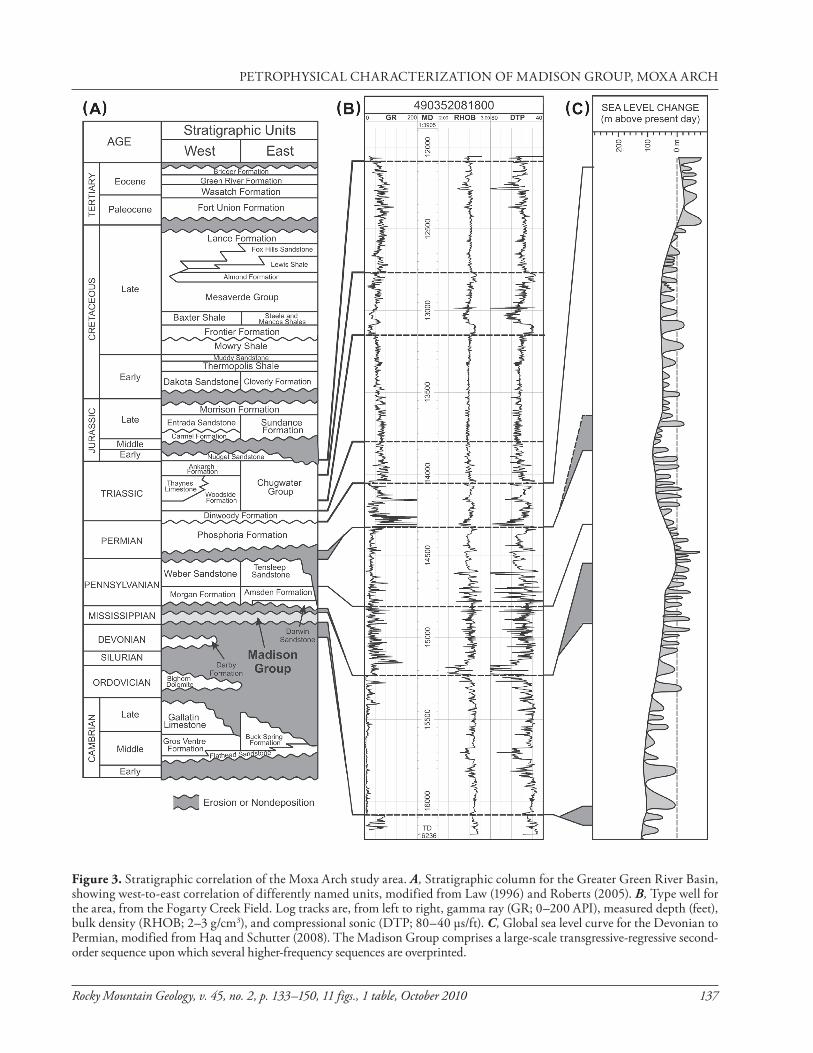
Figure 3. Stratigraphic correlation of the Moxa Arch study area. A, Stratigraphic column for the Greater Green River Basin, showing west-to-east correlation of differently named units, modified from law (1996) and Roberts (2005). B, Type well for the area, from the Fogarty Creek Field. log tracks are, from left to right, gamma ray (GR; 0–200 API), measured depth (feet), bulk density (RHOB; 2–3 g/cm3), and compressional sonic (DTP; 80–40 µs/ft). C, Global sea level curve for the Devonian to Permian, modified from Haq and Schutter (2008). The Madison Group comprises a large-scale transgressive-regressive second-order sequence upon which several higher-frequency sequences are overprinted.
PETROPHySICAl CHARACTERIZATION OF MADISON GROUP, MOxA ARCH

138 Rocky Mountain Geology, v. 45, no. 2, p. 133–150, 11 figs., 1 table, October 2010
brecciation (katz et al., 2006). Dolomite provides a second example. katz (2008) has shown that three varieties of dolomite exist in the Madison. First, there is early formed, fine-crystalline dolomite that replaced precursor mudstones and wackestone during Mississippian times. Second is a slightly coarser crys-talline dolomite that replaces packstones and grain-stones, which also probably formed early but was subsequently recrystallized (and geochemically reset) during shallow burial. The third major diagenetic event is late (probably related to the laramide orog-eny), very coarsely crystalline, and fracture/breccia-related zoned dolomite characterized by elevated fluid-inclusion temperatures and enriched 87Sr/86Sr values. All three exist in the Church Buttes 31 core (katz, 2008), with the third example occurring in the most porous interval of the entire core (sequence IV, 5615 to 5617 m; 18,422 to 18,427 ft).
Diagenesis associated with laramide processes are also known to have affected carbonate reser-voirs within the laramide province of Wyoming. Specifically, tectonic brecciation and fracturing is widespread, with subsequent cementation by hydro-thermal processes during faulting events (Sibson, 1990; katz et al., 2006). katz et al. (2006) showed how these hydrothermal events introduce heteroge-neities that compartmentalize reservoir-quality car-bonate. However, these heterogeneities, including the associated coarsely crystalline dolomites, are pre-dicted to be more significant at uplifted basin mar-
gins and along known laramide structures and neg-ligible near less-deformed basin centers (katz et al., 2006). The importance of these laramide-derived diagenetic heterogeneities at prospective CO2 seques-tration sites is thus uncertain.
METHODS
In all, 95 wells penetrate the Madison Group in the study area; core is available from four of those wells (Fig. 1). The WOGCC database for these wells comprises geophysical (wire-line) logs and core anal-yses from 12 wells that include porosity, permeabil-ity, fluid content, grain density, residual fluid satu-ration, and lithologic descriptions (including iden-tification of mineralogy). Some permeability values were reported as <0.01 mD, that is, below measure-ment sensitivity. These samples were assigned values of 0.001 mD for purposes of statistical analysis. A detailed stratigraphic log was generated for each well with core.
In addition, geophysical well logs, specifically the gamma ray, bulk density, and sonic wire-line logs, are available for the most of the wells. These data were digitized from raster images at a 0.5 ft (0.15 m) resolu-tion. Where density logs were not available but sonic logs were, the bulk density logs were reconstructed using equation 7 of Gardner et al. (1974) and cali-brated to match the local stratigraphy where test wells had both sonic and density logs. Then, log-based
Table 1. Wells and cored footage examined in the study.
USGS # Well API Examined footage 3rd-order Madison sequences cored
D037 490370565500 7,484-7,860 ft I, II, III, lower IV
D504 490372226800 18,295-18,796 ft top II, III, IV, V, lower VI
D959 490232028300 14,760-14,815 and probably upper III 15,526-15,575 ft probably I
490352067300 15,526-15,547 and IV 15,923-15,979 ft III
Note: Measured depths are in core depth and have not been corrected to log depth.
Table 1. Wells and cored footage examined in the study.
G. D. THyNE, M. TOMASSO, S. V. ByWATER-REyES, D. A. BUDD, AND B. M. REyES

Rocky Mountain Geology, v. 45, no. 2, p. 133–150, 11 figs., 1 table, October 2010 139
porosity was reconstructed from the bulk density logs by using the density porosity formula (Schlumberger, 1972), combining limestone and dolostone constants with a bulk density cut-off. The log-based porosity is plotted on the far right side of the wire-line log cor-relations.
Cores of the Madison Group from four wells (Fig. 1; Table 1) were examined. Cores were described for lithology, sedimentary structures, and depo-sitional fabrics on a foot-by-foot basis. Two of the wells, Chevron 1-29 (490232028300) and UPRR#4 (490370565500), lie to the west and east of the Moxa Arch, respectively, and do not now contain CO2-rich gas reservoirs. The Church Buttes 31 (490372226800) is south of the gas cap, and the Riley Ridge 33-24 (490352067300) is within the structures that now contain CO2-rich gas reservoirs (Fig. 1). Comparing porosity data measured from the cores to density-derived porosity allowed a core-to-log shift to be determined for each well. In the fol-lowing sections, we provide core depth, followed by log depth in brackets.
Graphical core logs of lithology and original depositional fabric (grainstone-packstone-wacke-stone-mudstone; Dunham, 1962) for two of the four cored wells (UPRR#4 (490370565500) and Church Buttes 31 (490372226800)) were previously pub-lished by Smith et al. (2004) and katz et al. (2007). Digital copies of the descriptions published by katz et al. (2007) were obtained and used as a starting point. Only minor adjustments to depositional fabric and lithologies were made to the Church Buttes 31 core description, and those were based on the thin section examinations. lithologies and depositional fabric adjustments were made in the lowermost 125 ft (38 m) of the previously published UPRR#4 core description, as more grain-supported fabrics were rec-ognized herein relative to the observations of katz et al. (2007).
RESULTS
Core-based sequence boundaries
Third-order stratigraphic sequences and their component transgressive and highstand systems tracts were identif ied in the Church Buttes 31 (490372226800) and UPRR#4 (490370565500) cores by katz et al. (2007). Based on the core obser-vations made herein, katz et al.’s (2007) sequence
boundaries in the Church Buttes 31 core were accepted and were used for detailed stratigraphic correlation of the wire-line log database. However, in the UPRR#4 core, we place the upper boundary of sequence I at 7809 ft (2380.8 m); 7820 ft/2384.1 m log depth and the maximum f looding surface between transgressive and highstand systems tract in the overlying sequence II is placed at 7782 ft (2372.6 m); 7793 ft/2375.9 m log depth. katz et al. (2007) placed these boundaries at 7826 ft (2386.0 m) and ~7780 ft (~2372.0 m), respectively (7837 ft/2389.3 m and 7791 ft/2375.3 m log depth, respectively). In the case of the maximum flooding surface in sequence II, the difference between our boundary and that of katz et al. (2007) is merely a placement at the base of a two-foot grain-rich facies encased in mud-rich lithologies, versus atop that grain-rich bed. In the case of the sequence I boundary, katz et al.’s (2007) and katz’s (2008) placement at 7826 ft (2362 m) is in an interval with no core recovery and makes all of sequence I just ~12 ft (~3.7 m) thick. Our place-ment of the boundary 17 ft (5.2 m) higher sets it at the point where the upward increase in δ13C values changed from about +0.06‰ per foot to +0.33‰ per foot. This criteria is compatible with katz et al.’s (2007) placement of the sequence I boundary in numerous other locations in the Big Horn Basin of Wyoming (e.g., Benbow Mine, Tensleep and Wind River Canyons, and Sheep Mountain).
The minimal amount of core from the Riley Ridge 33-24 (490352067300) well is insuff i-cient for the precise placement of Madison third-order sequence boundaries based on facies pat-terns. However, based on the facies observed in the core and by analogy with sequence thicknesses in the Church Buttes 31 well (which was at the same approximate position on the Mississippian Madison shelf as Riley Ridge 33-24), the two cored intervals in the Riley Ridge well are interpreted most likely to be from the transgressive systems tract of sequence III (high-energy grainstones of the regional detached mid ramp shoal complex) and the transgressive to highstand systems tract of sequence VI (low energy, restricted lagoonal mudstones of the inner shelf).
The two cored intervals in the Chevron 1-29 (490232028300) well are interpreted as the high-stand stage of sequence I to the lower highstand stage of sequence II (wackestones grading upwards into high-energy packstones and grainstones of the
PETROPHySICAl CHARACTERIZATION OF MADISON GROUP, MOxA ARCH

140 Rocky Mountain Geology, v. 45, no. 2, p. 133–150, 11 figs., 1 table, October 2010
regional detached mid ramp shoal complex) and the amalgamated coarsening-upward wackestone to grainstone shoals of the uppermost highstand stage of sequence V to the lowermost highstand stage of sequence VI. These interpretations take into account the 710 ft (216 m) of Madison rocks between the two cores. However, the alternative interpretation is possible given that this core is from a position on the Madison paleoshelf that is farther to the west than all the prior regional work of Sonnenfeld (1996a, 1996b), Smith et al. (2004), katz et al. (2007), and Buoniconti (2008). This well also has some compli-cation in that the Madison Group is significantly over-thickened compared to the regional thickening trend. There is evidence both from regional struc-tural sections and the wire-line logs that the lower-most thrust of the Western overthrust belt repeats at least the upper part of the Madison several times in this well. This thrust probably soles on to evaporites and shales in the uppermost parts of the Madison Group.
Wire-line log correlations
Wire-line log correlations were constructed for the four cored wells (Fig. 1) and a north–south tran-sect along the Moxa Arch (Fig. 4). The initial third-order sequence picks were taken from the core analy-ses discussed above, correlated among the cored wells, and then correlated out to wells without core based on geophysical log signatures. All six sequences can be correlated across the region (Figs. 5 and 6). To the south and east, the highstand of sequence V and all of sequence IV are eroded by the top Madison uncon-formity. With the exception of sequence V and the eroded sequence IV, there are definable thickening and thinning trends. Sequence I overall thins north to south by 37 percent, ~150 ft (~46 m) to ~95 ft (~29 m), with the transgressive systems tract thinning by 32 percent from 55 to 30 ft (17 to 9 m) and the high-stand systems tract thinning by 75 percent from 57 to 14 ft (17 to 4 m). Sequence II remains essentially a constant thickness (104 versus 102 ft; 32 versus 31 m). However, the transgressive systems tract thickens
Figure 4. Map of the study area focused on in this paper, located in Figure 1. The line of section and wells used in Figure 6 are shown. All the wells except State 74-31888 1 (490372106500) and Bruff Unit 1(490232004500) fully pen-etrate the Madison Group. legend as in Figure 1.
G. D. THyNE, M. TOMASSO, S. V. ByWATER-REyES, D. A. BUDD, AND B. M. REyES

Rocky Mountain Geology, v. 45, no. 2, p. 133–150, 11 figs., 1 table, October 2010 141
from north to south by 166 percent (15–40 ft; 4.5–12 m), while the highstand thins by 30 percent (89–62 ft; 27–19 m). Sequence III thickens from north to south by 45 percent, from 266–387 ft (81–118 m). In this sequence, the transgressive systems tract thins by 17 percent (188–156 ft; 57–48 m) and the high-stand thickens markedly by 196 percent, 78–231 ft (24–70 m). Sequence IV thins from north to south by 19 percent, from 180–146 ft (55–45 m). As with sequence III, the transgressive systems tract thins, in this case by 48 percent, to 120–62 ft (37–19 m), with the highstand thickening by 40 percent, 60–84 ft (18–26 m). Sequence V stays at constant thick-ness for the entire sequence (~76 ft; ~23 m) and the transgressive (62 ft; 19 m) and highstand (14 ft; 4 m) systems tracts. Dividing these relationships into the two separate second-order sequences, in the lower lodgepole limestone the highstand system tract for sequences I and II reduces in thickness from north to south, while in the overlying Mission Canyon limestone, the transgressive systems tracts thin and the highstands thicken from north to south.
Overall, there is good agreement between the core-based and log-based porosities. There is a good correlation for the dolostones (R2 = 0.746), but the correlation is weaker for the limestones where most samples have porosity less than 5 percent. Figure 7 shows both the correlations between core-based and calculated porosity, and the geophysical logs from well 490352081800 with the gray bars indicating the intervals with core-based porosity, represented on the far right log as the colored interval. A 1.5 ft moving average of the core-based porosity was used in order to approximate the resolution of the density logging tool. The heavy black line is the calculated porosity.
The regional north–south section along the Moxa Arch (Fig. 6) shows that the best porosity is present in a high porosity zone near the top of the transgressive systems tract in sequence III. Core from this zone is present in three of the studied wells: Riley Ridge 33-24 (490352067300), Church Buttes 31 (490372226800), and UPRR#4 (490370565500). All of these wells are dolostones in this zone. The lower porosities in this zone are present in micritic to wackestone facies, and also thinly bedded packstones and grainstones (Church Buttes 31 and UPRR#4 wells). The higher porosities are present in packstone- to grainstone-dominated facies (Riley Ridge 33-24 and UPRR#4 wells). This agrees with the overall trend reported by
Westphal et al. (2004) and supports a link between petrophysics and depositional facies.
The porosity in the transgressive systems tract of sequence III decreases in both east-to-west and north-to-south directions, implying a NNW–SSE-striking porosity trend on a regional scale, which may be linked to lateral (E–W) variability in facies belts. There is also a high-porosity zone that can be divided into two shoaling-upwards sections straddling the top of sequence III. In this case, there is a decrease in porosity in this zone to the north and to the south; as in the underlying high porosity zone, this might be interpreted as due to facies changes along a NNW–SSE-striking, ENE–WSW-variable facies belt.
Core petrophysical data
The public-domain petrophysical data from the Madison consist of reports of standard core analy-sis voluntarily submitted from petroleum compa-nies, mostly on whole core. For Madison rocks in the Moxa Arch area, the total database had 2680 samples that include 2060 samples with the primary lithology identified as dolostone, 610 samples with the primary lithology identified as limestone, and the remaining 10 samples identified as either chert or anhydrite. The core data are from gas fields on the northern end of the Moxa Arch (Riley Ridge, Tip Top, and Fogarty Creek), or from wells in petroleum fields west of the Moxa Arch in the thrust belt (Carter Creek, Session Mountain, and Whitney Canyon).
The distribution of porosity values is shown in Figure 8. The porosity ranges from essentially zero to as high as 31 percent; however, very few samples had values greater than 24 percent. The majority of the core samples have values less than 8 percent, with only 20 percent of the samples having porosity greater than 15 percent. Permeability is roughly log-normally distributed with a bias toward low values. Some of the low bias is due to values that were reported as <0.01 mD. Another source is the difficulty of measurement for values between 0.01 and 0.1 mD using the stan-dard technique employed. There are also a few very high values (>1000 mD) that are due to highly con-ductive fractures observed in the core.
Figure 9 shows the relationship between perme-ability and porosity for limestone and dolostone sam-ples. The limestone samples have a range of porosity values from 0 to 25 percent with an average value of 3 percent and the majority of the samples having values
PETROPHySICAl CHARACTERIZATION OF MADISON GROUP, MOxA ARCH

142 Rocky Mountain Geology, v. 45, no. 2, p. 133–150, 11 figs., 1 table, October 2010
G. D. THyNE, M. TOMASSO, S. V. ByWATER-REyES, D. A. BUDD, AND B. M. REyES

Rocky Mountain Geology, v. 45, no. 2, p. 133–150, 11 figs., 1 table, October 2010 143
less than 3 percent. The dolostone samples have an average porosity of 8.5 percent. Both rock types dis-play similar porosity-permeability relationships. The relationship appears to be either highly variable per-meability/lower porosity (with permeability varia-tions over several orders of magnitude), or a log per-meability/porosity relationship in the higher poros-ity samples. The broad range of permeability values, especially at porosities less than 3 percent in lime-stone and less than 8 percent in dolostone, is tenta-tively attributed to fractures, which were observed in cores on the visible and microscope scale.
Wire-line log porosities
Calculated log-based porosity values at intervals of 0.5 ft (0.15 m) in a series of nine wells that run north to south along the axis of the Moxa Arch (Fig. 4) are shown in Figure 10. Porosity calculated from logs can have negative values, which have no physi-cal significance, thus values less than zero were not included in the histogram. The data show a tri-modal distribution, with porosity values centered at approxi-mately 2 percent, 7.5 percent, and 14 percent, respec-tively. Forty-five percent of the porosity values are less than 4 percent, 16.5 percent are between 4 percent and 12 percent and 37.7 percent are greater than 12 percent. Comparing this expanded log-based dataset to the core porosity dataset, it is apparent that the log-based porosity shows more high-porosity rock.
DISCUSSION
Based on the log and core porosity histograms, we suggest that the log-based porosity is a better rep-resentation for the Madison Group. Core is gener-ally taken only from expected reservoir intervals due to expense and is not necessarily representative of a
thick body of rock over a large area. Most of the more porous zones were also not cored in the wells used for the log-based porosity analysis. Since the log-based porosity incorporates samples from the entire forma-tion in most of the wells in our study, this method minimizes any inherent sampling bias associated with a relatively small core data base.
In our study area, the Madison is a tri-porosity system with natural fractures providing permeable migration pathways between and through intervals of matrix permeability. This produces three dis-tinct petrophysical facies that can be related to dep-ositional facies and lithology. The first has samples with low porosity (<4 percent) and highly variable permeability. The second has intermediate porosity (4–12 percent) with less variable-to-log permeabil-ity. The third distinct group of samples have high porosity (>12 percent) with a strong log permeabil-ity relationship. lateral variations in porosity appear to be controlled by depositional facies with our data showing high porosity zones extending over tens of kilometers (Fig. 6). Thick intervals of low porosity rock can occur, ranging up to 50 ft (15.2 m) thick within the Madison and up to 125 ft (38.1 m) thick at the top and bottom of the Madison. Natural frac-tures, including open, partially mineralized, and completely mineralized, were noted in all cores but appear to have the most significant effect in the inter-mediate and low porosity facies in both limestones and dolostones.
Westphal et al. (2004) and Ehrenberg et al. (2006) showed data from the Madison Group in Wyoming with a well-defined log permeability-porosity relationship. Both authors and katz et al. (2006) demonstrated a strong link between pet-rophysical properties and depositional facies. The data from our study area show the same basic pat-tern, but have a much broader distribution of per-meability in the lower porosity samples. Given the larger dataset in our study, we may be better able to define the range of permeability heterogeneity of the lower porosity units. Alternatively, the larger range in permeability, assumed to be due to fractures, may reflect the proximity to the thrust belt. Westphal et al. (2004) concluded that the distribution of petro-physical properties within Madison reservoirs are controlled mainly by the third-order sequences that form flow units. They propose the good quality dolo-mitized lower sequences are compartmentalized by
Figure 5, facing page. West-to-east wire-line log and core cor-relations of the four cored wells in the overall study area. Datum is the maximum flooding surface between the transgressive and highstand systems tracts for Madison sequence III (Seq III MFS). The sequence correlations are expanded upon interpreta-tion of the core in the Church Buttes 31 (490372226800) well by katz et al. (2007) and this study. Each well track shows, from left to right, gamma ray (GR; 0–100 API), measured depth (feet), core locations (black bars), core-interpreted facies (1, rock type; 2, grain size), bulk density (RHOB; 2–3 g/cm3), compressional sonic (DT; 80–40 µs/ft), and core-calibrated density-derived porosity (DPHI; 30 to -10 percent).
PETROPHySICAl CHARACTERIZATION OF MADISON GROUP, MOxA ARCH

144 Rocky Mountain Geology, v. 45, no. 2, p. 133–150, 11 figs., 1 table, October 2010
G. D. THyNE, M. TOMASSO, S. V. ByWATER-REyES, D. A. BUDD, AND B. M. REyES

Rocky Mountain Geology, v. 45, no. 2, p. 133–150, 11 figs., 1 table, October 2010 145
interbedded limestone. Ehrenberg et al. (2006) docu-mented the compartmentalization in limestone reser-voir worldwide as the product of the burial diagenesis and the loss of limestone porosity compared to dolos-tone porosity during burial. Both studies support the concept of facies-constrained petrophysical property distribution in static geologic models. However, the large permeability range observed in lower porosity Madison samples suggest that the degree of Madison compartmentalization on the Moxa Arch may be much less than that seen in prior studies that used samples from predominantly eastern portions of Wyoming.
To assess the potential degree of vertical compart-mentalization due to the changes in facies and the accompanying porosity, the ratio of horizontal core permeability (kh) to vertical core permeability (kv) was calculated for the three classes of porosity. A total
Figure 6, facing page. North to south cross section, corre-lating nine wells along the spine of the Moxa Arch–laBarge Platform. The figure illustrates the six third-order transgressive (red)-regressive (blue) sequences within the Madison Group that can be correlated through the region. Datum is the maxi-mum flooding surface between the transgressive and high-stand systems tracts for Madison sequence III (Seq III MFS). The sequence correlations are expanded from interpretation of the core in the Church Buttes 31 (490372226800) well by katz et al. (2007) and this study. Each well track shows, from left to right, gamma ray (GR; 0–100 API), measured depth (feet), and core-calibrated density-derived porosity (DPHI; 30 to -10 per-cent). The location of physical core is shown as black rectangles and core-based petrophysical analyses as gray rectangles.
Figure 7. Wire-line logs for well 490352081800, showing the excellent correlation between density-derived porosity and core-measured porosity when using a combination limestone-dolostone density porosity formula (after Schlumberger, 1972). A, The columns represent, from left to right, gamma ray (GR; 0–100 API), measured depth (feet), core measurements (gray bars), bulk density (RHOB; 2–3 g/cm3), compressional sonic (DT; 80–40 µs/ft), and core-measured porosity (colored zones) compared to density-derived porosity (heavy black line; 30 to -10 percent). B, Graph showing the correlation of the core-mea-sured porosity and density-derived porosity. The core-porosity data presented here are for a 1.5 ft (0.5 m) moving average of the raw data to approximate the resolution of the density tool. The individual groupings result from the use of separate lime-stone (blue, lower group) and dolostone (purple, upper group) constants in the porosity formula (see text for more details). There is a good correlation between core-based and density-derived porosity for the dolomites (R2 > 0.7). The poor correla-tion for the limestones is probably the result of a large bias to porosities less than five percent.
PETROPHySICAl CHARACTERIZATION OF MADISON GROUP, MOxA ARCH

146 Rocky Mountain Geology, v. 45, no. 2, p. 133–150, 11 figs., 1 table, October 2010
of 985 samples reported both values for the high, intermediate, and low porosity classes (15, 33, and 52 percent, respectively). Figure 11 shows the distri-bution of kh/kv by porosity classes. All three poros-ity classes have distributions skewed toward lower permeability, with lower porosity samples show-ing somewhat more permeability anisotropy than higher porosity samples. Ninety-five percent of the higher porosity samples (n = 153) are dolostone with a mean log kh/kv of 0.52, or a factor of 3.3 times. The intermediate porosity samples (n = 362) are also mostly dolostone (94 percent) and have slightly more anisotropy (mean log kh/kv = 0.77). The low porosity samples, equally split between dolostone and limestone, have a mean log kh/kv of 0.88, meaning about a 7.5-fold permeability contrast.
It appears permeability anisotrophy (kh/kv) is only weakly correlated with porosity. Interpretation of core data for kh/kv is difficult since the more sig-nificant vertical permeability changes may not be cap-tured in the core samples and the fracture permeability may overwhelm the smaller-scale facies or cycle-based permeability variations. However, within the limita-tions mentioned, the data suggest that whereas poros-ity can be facies controlled and modeled as such, both horizontal and vertical permeability are strongly linked to fracturing. Permeability is only weakly related to porosity, especially in the lower porosity portions most likely to compartmentalize the reservoir.
CONCLUSIONS
In our study area we were able to identify and correlate third-order sequences in the Madison Group. These sequences extend laterally over kilo-meters defining the stratigraphic framework, but dis-play slightly different architecture than correspond-ing sequences previously described to the south and east in Wyoming. For purposes of assigning porosity to geological models based on depositional facies dis-tribution, we examined core that had accompanying petrophysical data. We found that the lower porosi-
Figure 8. Histogram of the distribution of core-based porosity values for all samples from the Madison Group wells. The data are from cores located in either gas fields on the northern end of the Moxa Arch (Riley Ridge, Tip Top, and Fogarty Creek) or petroleum fields in the thrust belt west of the Moxa Arch (Carter Creek, Session Mountain, and Whitney Canyon). The thick black line represents the normal distribution of the data.
Figure 9. Core permeability versus core porosity for Madison Formation limestone (N = 610) and dolomite (N = 2060) sam-ples. Samples with reported values for permeability <0.01 mD (limit of measurement) are not shown.
G. D. THyNE, M. TOMASSO, S. V. ByWATER-REyES, D. A. BUDD, AND B. M. REyES

Rocky Mountain Geology, v. 45, no. 2, p. 133–150, 11 figs., 1 table, October 2010 147
ties are mostly present in micritic to wackestone facies and also thinly bedded packstones and grainstones. The higher porosities are present in packstone- to grainstone-dominated facies.
We were able to extend the core-based poros-ity data by using density and sonic logs to calculate log-based porosity, which offers a more comprehen-sive description of the variation in Madison porosity values. lateral variations in porosity correlate with depositional facies and extend laterally over tens of kilometers. At the regional scale, there is a north-south trend along the Moxa Arch with the best porosity near the top of the transgressive systems tract in sequence III.
The log-based data also show three distinct poros-ity classes whereas core-based data defined only two porosity classes. Both limestone and dolostone with higher porosity generally have a log permeability/poros-ity relationship, and expectations that facies were a first-order control on porosity and permeability appear war-ranted. The distribution of low porosity limestone and dolostone zones are also related to depositional facies, but unlike higher porosity rocks, have horizontal and vertical permeability ranging over several orders of magnitude. We observed natural fractures that appear
Figure 10. Histogram of 11,959 log-based porosity measure-ments (calculated every 0.5 ft/0.15 m) for the 11 wells used in the north-south cross section along the Moxa Arch (Fig. 6). The location of the wells used is shown in Figure 4.
Figure 11. Distribution of ratio of vertical permeability to horizontal permeability for core samples from Madison Group wells, Moxa Arch, Wyoming. Units on the x-axis are log of kh/kv. The thick black lines represent normal distributions for the data.
PETROPHySICAl CHARACTERIZATION OF MADISON GROUP, MOxA ARCH

148 Rocky Mountain Geology, v. 45, no. 2, p. 133–150, 11 figs., 1 table, October 2010
to provide permeable migration pathways between and through intervals of matrix permeability. The proxim-ity of our study area to the thrust belt may explain the stronger fracture control on permeability in the lower porosity rocks. Whereas assigning permeability values based on porosity appears justified in the higher poros-ity zones, the lower porosity zones which, are the key elements in developing reservoir compartmentaliza-tion, may have fractured-enhanced or -dominated per-meability. The presence of low porosity zones without accompanying low permeability may lower the degree of reservoir compartmentalization. To apply these data to geologic models properly, additional petrophysical facies that incorporate the impact of fracturing on per-meability will be required.
ACKNOWLEDGMENTS
Funding for this study came f rom U.S. Department of Energy’s National Energy Technology laboratory Award #DE-FC26-05NT42587 (Big Sky Carbon Sequestration Partnership) and the State of Wyoming through the Enhanced Oil Recovery Institute. Staff members at the USGS core repository in lakewood, Colorado, are thanked for their time. Schlumberger and Blueback Reservoir are thanked for providing academic licensing for Petrel and the Blueback Toolbox, respectively. ESRI are thanked for academic licensing of ARC GIS, and WyGISC (Wyoming Geographic Information Science Center) are especially thanked for providing support for the ESRI software. Reviewers G. P. Eberli, D. A. katz, W. R. Wright, and M. D. Sonnenfeld, Rocky Mountain Geology managing editor B. Orr, and special volume editors C. D. Frost and A. Jakle are thanked for helping improve this paper.
REFERENCES CITED
Allis, R., Chidsey, T., Gwynn, W., Morgan, C., White, S. D., Adams, M., and Moore, J., 2001, Natural CO2 reservoirs on the Colorado Plateau and southern Rocky Mountains; candidates for CO2 sequestration, in Proceedings, First National Conference of Carbon Dioxide Sequestration, Washington D.C., March 3–6, 2001: National Energy Technology laboratory, http://www.netl.doe.gov/publi-cations/proceedings/01/carbon_seq/carbon_seq01.html.
Ballard, W. W., Bluemle, J. P., and Gerhard, l. C., 1983, Correlation of stratigraphic units of North America (COSUNA) project: Northern Rockies/Williston basin
region: American Association of Petroleum Geologists Correlation Chart Series (COSUNA), 1 sheet.
Blackstone, D. l., Jr., 1979, Geometry of the Prospect-Darby and laBarge faults at their junction with the laBarge Platform, lincoln and Sublette Counties, Wyoming: Wyoming State Geological Survey Reports of Investigation RI-18, 34p.
Budai, J. M., lohmann, k. C., and Wilson, J. l., 1987, Dolomitization of the Madison Group, Wyoming, and Utah Overthrust Belt: American Association of Petroleum Geologists Bulletin, v. 71, p. 909–924.
Buoniconti, M. R., 2008, The evolution of the carbonate shelf margins and fill of the Antler Foreland Basin by pro-grading Mississippian carbonates, northern U.S. Rockies [Ph.D. thesis]: Coral Gables, Florida, University of Miami, 436 p.
Dickinson, W. R., klute, M. A., Hayes, M. J., Janecke, S. U., lundin, E. R., Mckittrick, M. A., and Olivares, M. D., 1988, Paleogeographic and paleotectonic setting of laramide sedimentary basins in the central Rocky Mountain region: Geological Society of America Bulletin, v. 100, p. 1023–1039.
Dixon, J. S., 1982, Regional structural synthesis, Wyoming Salient of Western Overthrust Belt: American Association of Petroleum Geologists Bulletin, v. 66, p. 1560–1580.
DOE (U.S. Department of Energy) Nationa l Energy Technology laboratory, 2007, Carbon sequestra-tion atlas of the United States and Canada: Pittsburgh, Pennsylvania, NETl.
Dunham, R. J., 1962, Classif ication of carbonate rocks according to depositional texture, in Ham, W. E., ed., Classification of carbonate rocks: American Association of Petroleum Geologists Memoir #1, p. 108–121.
Ehrenberg, S. N., Eberli, G. P., keramati, M., and Moallemi, S. A., 2006, Porosity-permeability relationships in interlay-ered limestone-dolostone reservoirs: American Association of Petroleum Geologists Bulletin, v. 90, p. 91–114.
Elrick, M., 1990, Development of cyclic ramp-to-basin car-bonate deposits, lower Mississippian, Wyoming and Montana [Ph.D. thesis]: Blacksburg, Virginia, Virginia Polytechnic Institute and State University, 197 p.
Elrick, M., and Read, J. F., 1991, Cyclic ramp-to-basin carbon-ate deposits, lower Mississippian, Wyoming and Montana: a combined field and computer modeling study: Journal of Sedimentary Petrology, v. 61, p. 1194–1224.
Frakes, l. A., Francis, J. E., and Syktus, J. I., 1992, Climate modes of the Phanerozoic; the history of the Earth’s cli-mate over the past 600 million years: Cambridge, United kingdom, Cambridge University Press, 274 p.
Gardner, G. H. F., Gardner, l. W., and Gregory, A. R., 1974, Formation velocity and density: the diagnostic basics for stratigraphic traps: Geophysics, v. 9, p. 770–780.
G. D. THyNE, M. TOMASSO, S. V. ByWATER-REyES, D. A. BUDD, AND B. M. REyES

Rocky Mountain Geology, v. 45, no. 2, p. 133–150, 11 figs., 1 table, October 2010 149
Giles, k. A., 1996, Tectonically forced retrogradation of the lower Mississippian Joana limestone, Nevada and Utah, in longman, M. W., and Sonnenfeld, M. D., eds., Paleozoic systems of the Rocky Mountain Region: Denver, Colorado, Rocky Mountain Section, Society for Sedimentary Geology (RMS-SEPM), p. 145–164.
Giles, k. A., and Dickinson, W. R., 1995, The interplay of eustatsy and lithospheric flexure in forming stratigraphic sequences in foreland settings: an example from the Antler foreland, Nevada and Utah, in Dorobek, S. l., and Ross, G. M., eds., Stratigraphic evolution of foreland basins: Denver, Colorado, Society for Sedimentary Geology (SEPM) Special Publications 52, p. 187–211.
Goldhammer, R. k., Oswald, E. J., and Dunn, P. A., 1991, Hierarchy of stratigraphic forcing: example from Middle Pennsylvanian shelf carbonates of the Paradox Basin, in Franseen, E. k., Watney, W. l., kendall, C. G., and Ross, E., eds., Sedimentary modeling: computer simulations and methods for improved parameter definition: kansas Geological Survey Bulletin 233, p. 361–413.
Gutschick, R. C., and Sandberg, C. A., 1983, Mississippian continental margins of the coterminous United States, in Stanley, D. J., and Moore, G. T., eds., The shelf-break: critical interface on continental margins: Denver, Colorado, Society for Sedimentary Geology (SEPM) Special Publications 33, p. 79–96.
Haq, B. U., and Schutter, S. R., 2008, A chronology of Paleozoic sea-level changes: Science, v. 322, p. 64–68.
Huang, N. S., Baker, B. H., Matthews, T. R., and Pottorf, R. J., 2007, Integrated reservoir modeling to maximize the value of a large sour-gas field with high concentra-tions of inerts, in Proceedings, International Petroleum Technology Conference: Dubai, U.A.E.
katz, D. A., 2008, Early and late diagenetic processes of Mississippian carbonates, Northern U.S. Rockies [Ph.D. thesis]: Miami, Florida, University of Miami, 445 p..
katz, D. A., Buoniconti, M. R., Montanez, I. P., Swart, P. k., Eberli, G. P., and Smith, l. B., 2007, Timing and local perturbations to the carbon pool in the lower Mississippian Madison limestone, Montana and Wyoming: Palaeogeography Palaeoclimatology Palaeoecology, v. 256, p. 231–253.
katz, D. A., Eberli, G. P., Swart, P. k., and Smith, l. B., Jr., 2006, Tectonic-hydrothermal brecciation associ-ated with calcite precipitation and permeability destruc-tion in Mississippian carbonate reservoirs, Montana and Wyoming: Special Issue: Hydrothermally Altered Carbonate Reservoirs, American Association of Petroleum Geologists Bulletin, v. 90, p. 1803–1841.
keefer, W. R., 1965a, Geologic history of Wind River Basin, central Wyoming: American Association of Petroleum Geologists Bulletin, v. 49, p. 1878–1892.
____1965b, Stratigraphy and geologic history of the upper-most Cretaceous, Paleocene, and lower Eocene rocks in the Wind River Basin, Wyoming: U.S. Geological Survey Professional Paper, P 0495-A, p. A1–A77.
kraig, D. H., Wiltschko, D. V., and Spang, J. H., 1987, Interaction of basement uplift and thin-skinned thrusting, Moxa Arch and the Western Overthrust Belt, Wyoming: a hypothesis: Geological Society of America Bulletin, v. 99, p. 654–662.
kraus, F. F., Scotese, C. R., Nieto, C., Sayegh, S. G., Hopkins, J. C., and Meyer, R. O., 2004, Paleozoic stromatactis and zebra carbonate mud-mounds: Global abundance and paleogeographic distriubtion: Geology, v. 32, p. 181–184.
kreuger, M. l., 1960, Occurrence of natural gas in the west-ern part of the Green River Basin, in McGookey, D. P., and Miller, D. N., Jr., eds., Overthrust belt of south-western Wyoming and adjacent areas: Casper, Wyoming Geological Association, 15th Annual Field Conference, Guidebook, p. 194–209.
law, B. E., 1996, Southwestern Wyoming province (037), in Gautier, D. l., Dolton, G. l., Takahashi, k. I., and Varnes, k. l., eds., National assessment of United States oil and gas resources—Results, methodology, and sup-porting data: U.S. Geological Survey Digital Data Series DDS–30, release 2, CD–ROM publication.
Maughan, E. k., 1983, Tectonic setting of the Rocky Mountain Region during the late Paleozoic and the Early Mesozoic, in Proceedings, Symposium on the genesis of Rocky Mountain ore deposits: changes with time and tec-tonics, Denver Regional Exploration Geologists Society, p. 39–50.
Mckerrow, W. S., and Scotese, C. R., 1990, Revised world maps and introduction, in Mckerrow, W. S., and Scotese, C. R., eds., Paleozoic paleogeography and biogeography: Memoirs of the Geological Society of london,r, v. 12, p. 1–24.
Mitchum, R. M., Jr., and Van Wagoner, J. C., 1991, High fre-quency sequences and their stacking patterns: sequence stratigraphic evidence of high-frequency sequence strati-graphic cycles: Sedimentary Geology, v. 70, p. 131–160.
Powers, R. B., 1995, Wyoming thrust belt province (036), in Gautier, D. l., Dolton, G. l., Takahashi, k. I., and Varnes, k. l., eds., National assessment of United States oil and gas resources—Results, methodology, and sup-porting data: U.S. Geological Survey Digital Data Series DDS-30, release 2, CD-ROM publication.
Prothero, D. R., and Dott, R. H., 2004, Evolution of Earth, 7th Edition: New york, New york, McGraw-Hill, 576 p.
Reid, S. k., and Dorobek, S. l., 1993, Sequence stratigraphy and evolution of a progradational, foreland carbonate ramp, lower Mississippian Mission Canyon Formation and stratigraphic equivalents, Montana and Idaho, in loucks, R. G., and Sarg, J. F., eds., Recent developments
PETROPHySICAl CHARACTERIZATION OF MADISON GROUP, MOxA ARCH

150 Rocky Mountain Geology, v. 45, no. 2, p. 133–150, 11 figs., 1 table, October 2010
and applications: American Association of Petrolium Geologists Memoir, v. 57, p. 327–352.
Roberts, S. B., 2005, Geologic assessment of undiscovered petroleum resources in the Wasatch–Green River com-posite total petroleum system, southwestern Wyoming province, Wyoming, Colorado, and Utah, in Petroleum systems and geologic assessment of oil and gas in the southwestern Wyoming province, Wyoming, Colorado, and Utah: U.S. Geological Survey Digital Data Series DDS–69–D, 26 p.
Royse, F., Jr., Warner, M. A., and Reese, D. l., 1975, Thrust belt structural geometry and related stratigraphic prob-lems, Wyoming-Idaho-northern Utah, in Bolyard, D.W., ed., Deep drilling frontiers of the central Rocky Mountains: Denver, Colorado, Rocky Mountain Association of Geologists Symposium, p. 41–54.
Sando, W. J., 1972, Madison Group (Mississippian) and Amsden Formation (Mississippian and Pennsylvanian) in the Beartooth Mountains, northern Wyoming and southern Montana, in lynn, J., Balster, C., and Warne, J., eds., Montana Geological Society 21st Annual Field Conference Guidebook, p. 57–63.
____1976, Madison limestone (Devonian and Mississippian), east flank of Bighorn Mountains, Wyoming in, laudon, R. B., Curry, W. H., III, and Runge, J. S., eds., Geology and Energy Resources of the Powder River: Casper, Wyoming Geological Association, 28th Annual Field Conference, Guidebook, p. 45–52.
____1982, New members of the Madison limestone (Devonian and Mississippian), north-central Wyoming and southern Montana: U.S. Geological Survey Bulletin 1529-H, p. H125–H130.
Sando, W. J., and Bamber, E. W., 1985, Coral zonation of the Mississippian System in the Western Interior Province of North America: U.S. Geological Survey Professional Paper 1334, 61 p.
Schlumberger, 1972, log interpretation manual/principles, Vol. I: Houston, Texas, Schlumberger Well Services Inc., Houston, 198 p.
Sibson, R. H., 1990, Chapter 4: Faulting and f luid f low, in Nesbitt, B. E., ed., Mineralogical Association of Canada short course on crustal fluids, handbook, v. 18, p. 93–131.
Smith, l. B., Jr., Eberli, G. P., and Sonnenfeld, M. D., 2004, Sequence-stratigraphic and paleogeographic distribu-tion of reservoir-quality dolomite, Madison Formation, Wyoming and Montana, in Grammer, G. M., Eberli, G. P., and Harris, P. M., eds., Integration of outcrop and modern analogues in reservoir modeling, American Association of Petroleum Geologists Memoir, v. 88, p. 94–118.
Sonnenfeld, M. D., 1996a, An integrated sequence strati-graphic approach to reservoir characterization of the lower Mississippian Madison limestone, emphasizing
Elk Basin field, Bighorn Basin, Wyoming [Ph.D. thesis]: Golden, Colorado, Colorado School of Mines, 438 p.
____1996b, Sequence evolution and hierarchy within the lower Mississippian Madison limestone of Wyoming, in longman, M. W., and Sonnenfeld, M. D., eds., Paleozoic systems of the Rocky Mountain Region: Denver, Colorado, Society for Sedimentary Geology, Rocky Mountain Section (RMS-SEPM), p. 165–192.
Speed, R. C., and Sleep, N. H., 1982, Antler orogeny and Foreland Basin: a model: Geological Society of America Bulletin, v. 93, p. 815–828.
Surdam, R. C., and Zunsheng, J., 2007, The Rock Springs Uplift: an outstanding geological CO2 sequestration site in southwest Wyoming, in Challenges in Geologic Resource Development No. 2: laramie, Wyoming, Wyoming State Geological Survey.
Thomaidis, N. D., 1973, Church Buttes arch, Wyoming and Utah, in Scheel, E. M., ed., The geology and min-eral resources of the Greater Green River Basin: Casper, Wyoming, Wyoming Geological Association, 25th Field Conference, Guidebook, p. 35–39.
Vail, P. R., Mitchum, R. M., and Thompson, S., III, 1977, Seismic stratigraphy and global changes of sea level, Part 4: Global cycles of relative changes in sea level, in Payton, C. E., ed., Carbonate sequence stratigraphy-applications to hydrocarbon exploration: American Association of Petroleum Geologists Memoir, v. 26, p. 83–97.
Veevers, J. J., and Powell, C. M., 1987, late Paleozoic gla-cial episodes in Gondwanaland ref lected in trangres-sive-regressive depositional sequences in Euramerica: Geological Society of America Bulletin, v. 98, p. 179–196.
Wach, P. H., 1977, The Moxa Arch, an overthrust model?, in Heisey, E. l., Norwood, E. R., Wach, P. H., and Hale, l. A., eds., Rocky Mountain thrust belt geology and resources: Casper, Wyoming, Wyoming Geological Association, 29th Annual Field Conference, Guidebook, p. 651–664.
Westphal, H., Eberli, G. P., Smith, l. B., Grammer, G. M., and kislak, J., 2004, Reservoir characterization of the Mississippian Madison Formation, Wind River Basin, Wyoming: American Association of Petroleum Geologists Bulletin, v. 88, p. 405–432.
Manuscript Submitted May 11, 2010
Revised Manuscript Submitted September 9, 2010
Manuscript Accepted September 21, 2010
G. D. THyNE, M. TOMASSO, S. V. ByWATER-REyES, D. A. BUDD, AND B. M. REyES