Changing City Changing Space - OAPEN Library
232
-
Upload
khangminh22 -
Category
Documents
-
view
0 -
download
0
Transcript of Changing City Changing Space - OAPEN Library

P h i l i P h a r r i s o n • G r a e m e G ot z
a l i s o n to d e s • C h r i s W r ay
edited by
Changing spaCe,Changing CityJ O H A N N E S B U R G A F T E R A P A R T H E I D - O P E N A C C E S S S E L E C T I O N
CSCC.indb 1 2014/10/07 5:14 PM
Published in South Africa byWits University Press1 Jan Smuts AvenueJohannesburg, 2001www.witspress.co.za
Open Access selected edition © Wits University Press 2018Original published edition © Wits University Press 2014Published edition © Wits University Press 2014 Compilation © Edition editors 2014Chapters © Individual contributors 2014Images and maps © Individual copyright holders 2014
Editors: Philip Harrison, Graeme Gotz, Alison Todes, Chris Wray
First published 2014DOI: http://dx.doi.org.10.18772/22014107656
ISBN: 978 1 77614 239 2 (Open Access PDF)ISBN: 978 1 86814 765 6 (Hardback)ISBN: 978 1 86814 766 3 (Web PDF)ISBN: 978 1 86814 813 4 (EPUB)ISBN: 978 1 77614 137 1 (Mobi)
All rights reserved. No part of this publication may be reproduced, stored in a retrieval system, or transmitted in any form or by any means, electronic, mechanical, photocopying, recording or otherwise, without the written permission of the publisher except in accordance with the Copyright Act, Act 98 of 1978. This book is freely available through the OAPEN library (www.oapen.org) under a CC-BY-NC-ND 4.0 Creative Commons Licence (https://creativecommons.org/licenses/by-nc-nd/4.0/).
All images remain the property of the copyright holders. The pu lishers gratefully acknowledge the publishers, institutions and individuals referenced in captions and in the list of photographic credits for the use of images. Every effort has been made to locate the original copyright holders of the images reproduced. Please contact Wits University Press at the address above in the case of any omissions or errors.
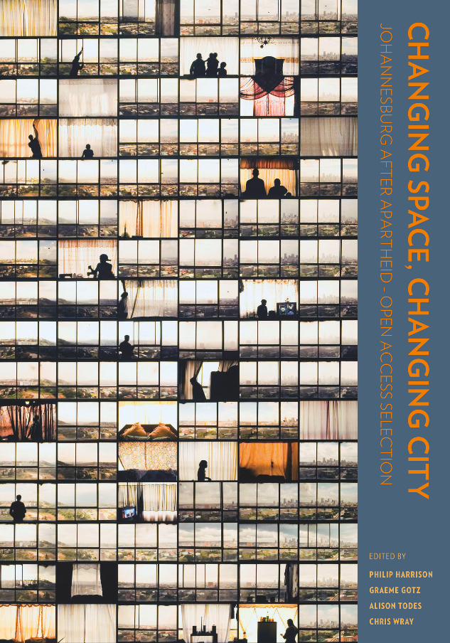
Cover artwork: Windows, Ponte City, 2008–2010 by Mikhael Subotzky and Patrick Waterhouse, courtesy Goodman Gallery
Design and layout by Peter Bosman Indexed by Clifford PerussetCopyedited by Lee Smith
CSCC.indb 2 2014/10/07 5:14 PM
The original publication (ISBN: 978 1 86814 7656) was the winner of The Humanities and Social Sciences: Book, Creative and Digital Awards (2017) awarded by the National Institute of Humanities and Social Sciences (www.nihss.ac.za). This Open Access publication was made possible with their support.

Supported by
CSCC.indb 3 2014/10/07 5:14 PM
Open Access publication made possible by
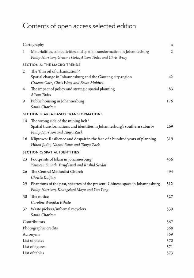
Contents of open access selected edition
CSCC.indb 4 2014/10/07 5:14 PM
seCtion B: area-Based transformations
seCtion C: spatial identities
Graeme Gotz, Chris Wray and Brian Mubiwa4 The impact of policy and strategic spatial planning 83
Alison Todes9 Public housing in Johannesburg 176
Sarah Charlton
14 The wrong side of the mining belt? 269Spatial transformations and identities in Johannesburg’s southern suburbs
Philip Harrison and Tanya Zack16 Kliptown: Resilience and despair in the face of a hundred years of planning 319
Hilton Judin, Naomi Roux and Tanya Zack
23 Footprints of Islam in Johannesburg 456Yasmeen Dinath, Yusuf Patel and Rashid Seedat
26 The Central Methodist Church 494Christa Kuljian
29 Phantoms of the past, spectres of the present: Chinese space in Johannesburg 512Philip Harrison, Khangelani Moyo and Yan Yang
30 The notice 527Caroline Wanjiku Kihato
32 Waste pickers/informal recyclers 539Sarah Charlton
Cartography x
1 Materialities, subjectivities and spatial transformation in Johannesburg 2Philip Harrison, Graeme Gotz, Alison Todes and Chris Wray
seCtion a: the maCro trends
2 The ‘thin oil of urbanisation’? 42Spatial change in Johannesburg and the Gauteng city-region
567568569570
571573
Contributors Photographic credits AcronymsList of plates List of figures List of tables
Contents from original edition (2014)
Preface viiCartography x
1 Materialities, subjectivities and spatial transformation in Johannesburg 2Philip Harrison, Graeme Gotz, Alison Todes and Chris Wray
seCtion a: the maCro trends
2 The ‘thin oil of urbanisation’? Spatial change in Johannesburg and the Gauteng city-region 42Graeme Gotz, Chris Wray and Brian Mubiwa
3 Poverty and inequality in the Gauteng city-region 63David Everatt
4 The impact of policy and strategic spatial planning 83Alison Todes
5 Tracking changes in the urban built environment: An emerging perspective from the City of Johannesburg 101Peter Ahmad and Herman Pienaar
6 Johannesburg’s urban space economy 117Graeme Gotz and Alison Todes
7 Changes in the natural landscape 137Maryna Storie
8 Informal settlements 154Marie Huchzermeyer, Aly Karam and Miriam Maina
9 Public housing in Johannesburg 176Sarah Charlton
10 Transport in the shaping of space 194Mathetha Mokonyama and Brian Mubiwa
11 Gated communities and spatial transformation in Greater Johannesburg 215Karina Landman and Willem Badenhorst
CSCC.indb 4 2014/10/07 5:14 PM
seCtion B: area-Based transformations
12 Between fixity and flux: Grappling with transience and permanence in the inner city 232Yasmeen Dinath
13 Are Johannesburg’s peri-central neighbourhoods irremediably ‘fluid’? Local leadership and community building in Yeoville and Bertrams 252Claire Bénit-Gbaffou
14 The wrong side of the mining belt? Spatial transformations and identities in Johannesburg’s southern suburbs 269Philip Harrison and Tanya Zack
15 Soweto: A study in socio-spatial differentiation 293Philip Harrison and Kirsten Harrison
16 Kliptown: Resilience and despair in the face of a hundred years of planning 319Hilton Judin, Naomi Roux and Tanya Zack
17 Alexandra 342Philip Harrison, Adrian Masson and Luke Sinwell
18 Sandton Central, 1969–2013: From open veld to new CBD? 370Keith Beavon and Pauline Larsen
19 In the forest of transformation: Johannesburg’s northern suburbs 395Alan Mabin
20 The north-western edge 418Neil Klug, Margot Rubin and Alison Todes
21 The 2010 World Cup and its legacy in the Ellis Park Precinct: Perceptions of local residents 437Aly Karam and Margot Rubin
22 Transformation through transportation: Some early impacts of Bus Rapid Transit in Orlando, Soweto 443Christo Venter and Eunice Vaz
CSCC.indb 5 2014/10/07 5:14 PM
seCtion C: spatial identities
23 Footprints of Islam in Johannesburg 456Yasmeen Dinath, Yusuf Patel and Rashid Seedat
24 Being an immigrant and facing uncertainty in Johannesburg: The case of Somalis 481Samadia Sadouni
25 On ‘spaces of hope’: Exploring Hillbrow’s discursive credoscapes 487Tanja Winkler
26 The Central Methodist Church 494Christa Kuljian
27 The Ethiopian Quarter 498Hannah le Roux
28 Urban collage: Yeoville 506Naomi Roux
29 Phantoms of the past, spectres of the present: Chinese space in Johannesburg 512Philip Harrison, Khangelani Moyo and Yan Yang
30 The notice 527Caroline Wanjiku Kihato
31 Inner-city street traders: Legality and spatial practice 532Puleng Makhetha and Margot Rubin
32 Waste pickers/informal recyclers 539Sarah Charlton
33 The fear of others: Responses to crime and urban transformation in Johannesburg 546Teresa Dirsuweit
34 Black urban, black research: Why understanding space and identity in South Africa still matters 553Nqobile Malaza
Contributors 567Photographic credits 568Acronyms 569List of plates 570List of figures 571List of tables 573Index 574
CSCC.indb 6 2014/10/07 5:14 PM
CSCC.indb 8 2014/10/07 5:14 PM
Carto
graph
y
CSCC.indb 9 2014/10/07 5:14 PM
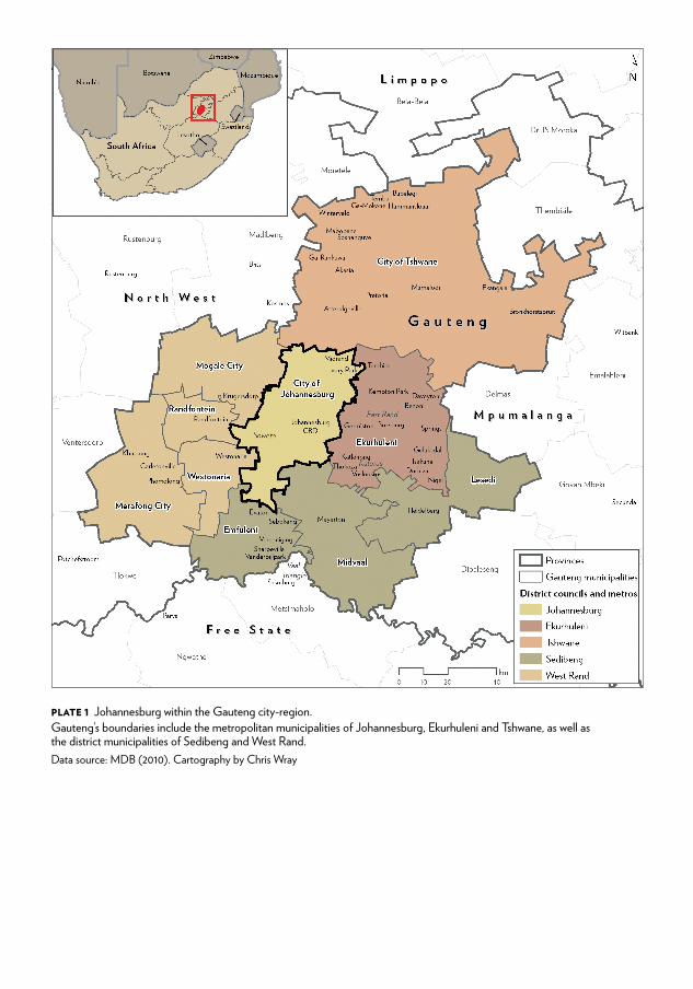
Plate 1 Johannesburg within the gauteng city-region.gauteng’s boundaries include the metropolitan municipalities of Johannesburg, ekurhuleni and tshwane, as well as the district municipalities of sedibeng and West rand.data source: Mdb (2010). Cartography by Chris Wray
CSCC.indb 10 2014/10/07 5:14 PM
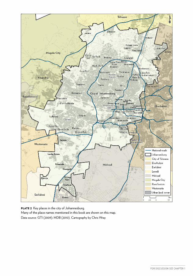
Plate 2 Key places in the city of Johannesburg. Many of the place names mentioned in this book are shown on this map.data source: gti (2009); Mdb (2010). Cartography by Chris Wray
F o r d i s c u s s i o n s e e c h a p t e r 1
CSCC.indb 11 2014/10/07 5:14 PM
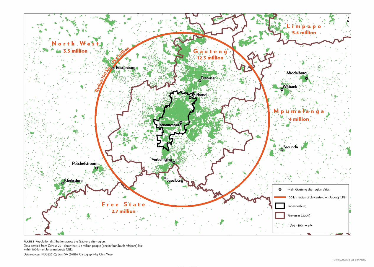
Plate 3 population distribution across the gauteng city-region.data derived from Census 2011 show that 13.4 million people (one in four south africans) live within 100 km of Johannesburg’s Cbd.data sources: Mdb (2010); stats sa (2011b). Cartography by Chris Wray
CSCC.indb 12 2014/10/07 5:14 PM
F o r d i s c u s s i o n s e e c h a p t e r 2
CSCC.indb 13 2014/10/07 5:14 PM
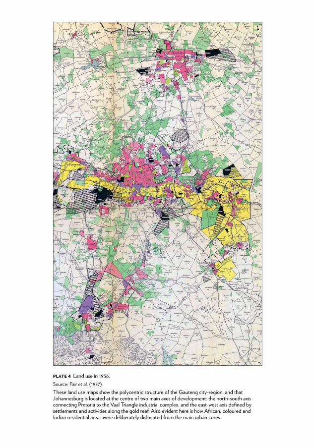
Plate 4 Land use in 1956.source: fair et al. (1957) these land use maps show the polycentric structure of the gauteng city-region, and that Johannesburg is located at the centre of two main axes of development: the north-south axis connecting pretoria to the Vaal triangle industrial complex, and the east-west axis defined by settlements and activities along the gold reef. also evident here is how african, coloured and indian residential areas were deliberately dislocated from the main urban cores.
CSCC.indb 14 2014/10/07 5:14 PM
F o r d i s c u s s i o n s e e c h a p t e r 2
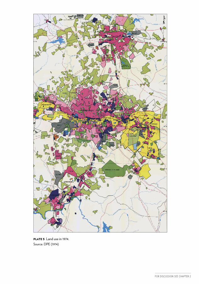
Plate 5 Land use in 1974.source: dpe (1974)
CSCC.indb 15 2014/10/07 5:14 PM
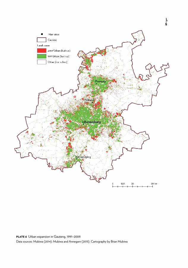
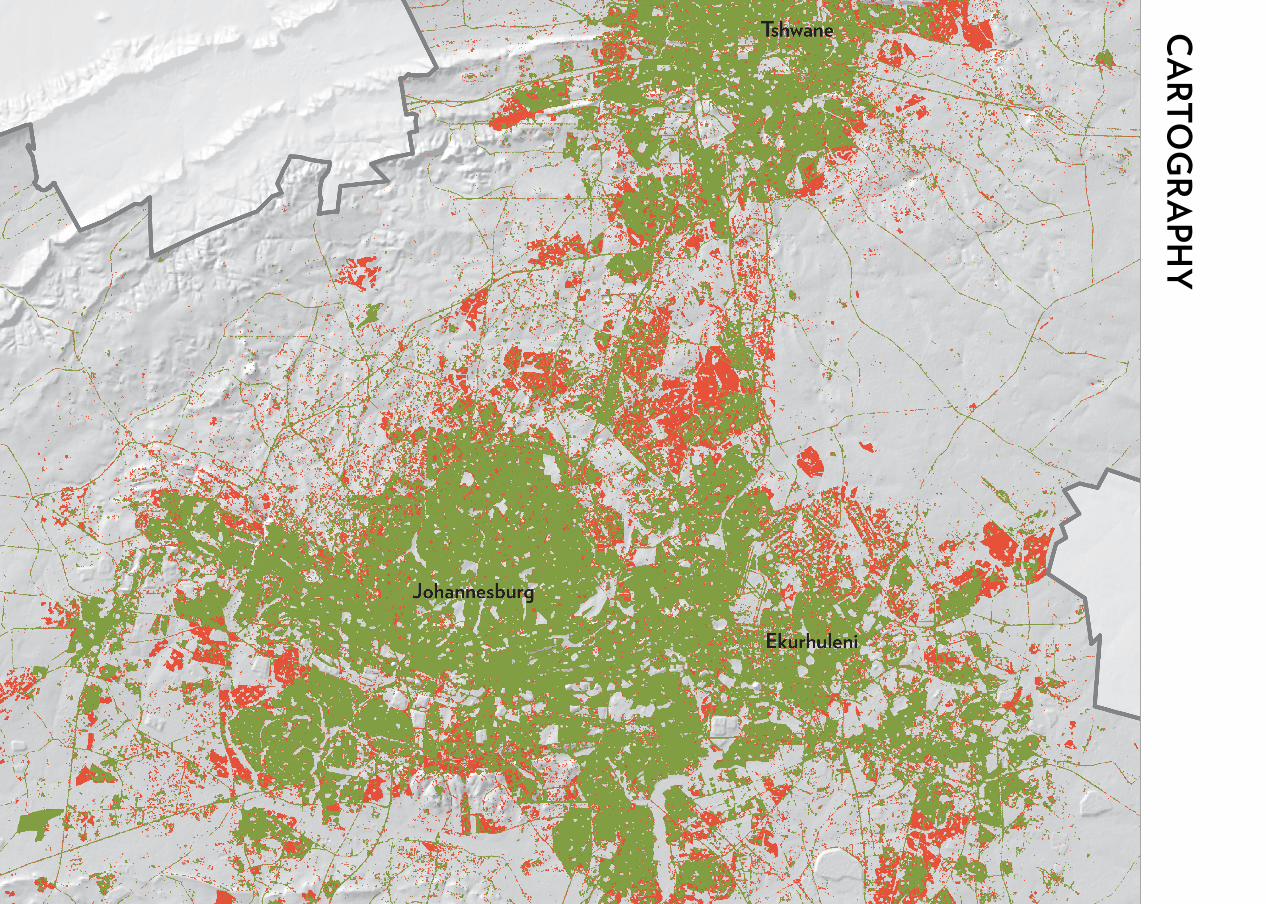
Plate 6 urban expansion in gauteng, 1991–2009.data sources: Mubiwa (2014); Mubiwa and annegarn (2013). Cartography by brian Mubiwa
CSCC.indb 16 2014/10/07 5:14 PM
F o r d i s c u s s i o n s e e c h a p t e r 2
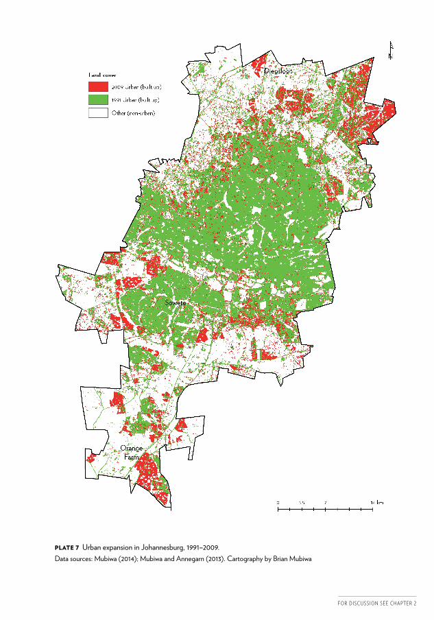
Plate 7 urban expansion in Johannesburg, 1991–2009.data sources: Mubiwa (2014); Mubiwa and annegarn (2013). Cartography by brian Mubiwa
CSCC.indb 17 2014/10/07 5:14 PM
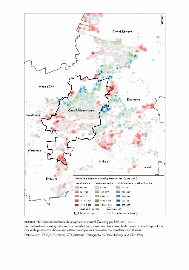
Plate 8 new formal residential development in central gauteng per km2, 2001–2010.formal freehold housing units, mostly provided by government, have been built mainly on the fringes of the city while private townhouse and estate developments dominate the wealthier central areas.data sources: Csir/arC (2000); gti (2013a,b). Cartography by daniel Kibirige and Chris Wray
CSCC.indb 18 2014/10/07 5:14 PM
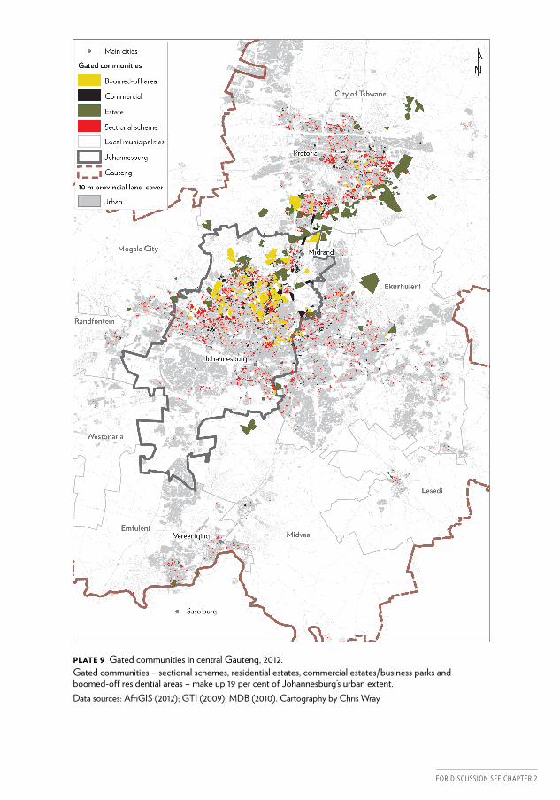
Plate 9 gated communities in central gauteng, 2012.gated communities – sectional schemes, residential estates, commercial estates/business parks and boomed-off residential areas – make up 19 per cent of Johannesburg’s urban extent.data sources: afrigis (2012); gti (2009); Mdb (2010). Cartography by Chris Wray
F o r d i s c u s s i o n s e e c h a p t e r 2
CSCC.indb 19 2014/10/07 5:14 PM
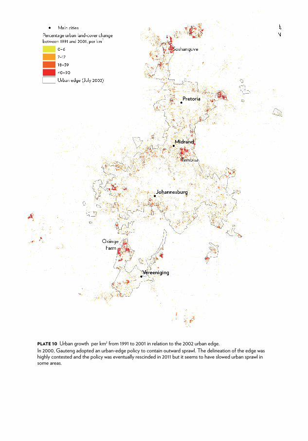
Plate 10 urban growth per km2 from 1991 to 2001 in relation to the 2002 urban edge.in 2000, gauteng adopted an urban-edge policy to contain outward sprawl. the delineation of the edge was highly contested and the policy was eventually rescinded in 2011 but it seems to have slowed urban sprawl in some areas.
CSCC.indb 20 2014/10/07 5:14 PM
F o r d i s c u s s i o n s e e c h a p t e r 2
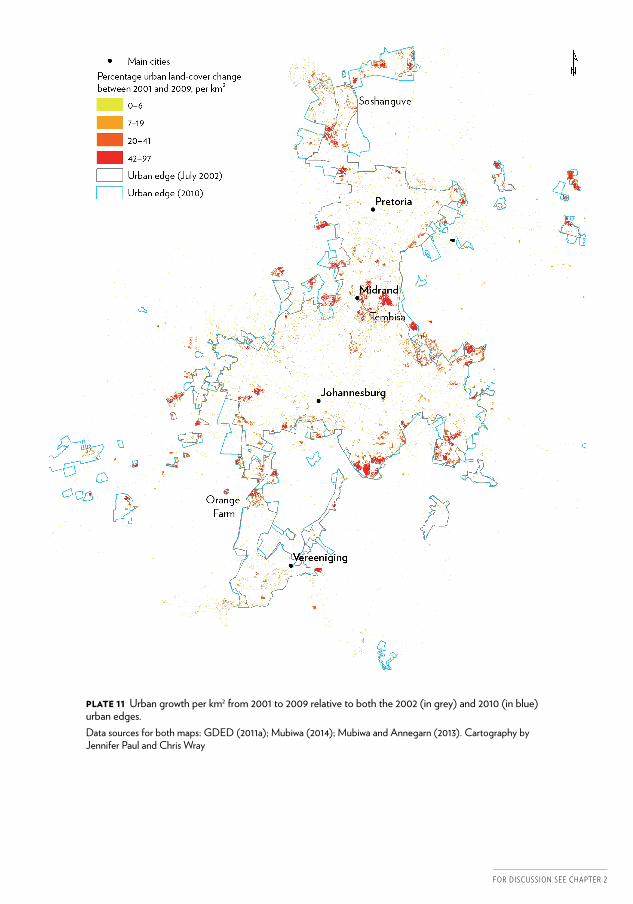
Plate 11 urban growth per km2 from 2001 to 2009 relative to both the 2002 (in grey) and 2010 (in blue) urban edges.data sources for both maps: gded (2011a); Mubiwa (2014); Mubiwa and annegarn (2013). Cartography by Jennifer paul and Chris Wray
CSCC.indb 21 2014/10/07 5:14 PM
2
1 Materialities, subjectivities and spatial transformation in Johannesburg
Johannesburg and the city-regionTh is volume is an exploration of the extraordinary spatial changes in the city of Johannesburg in the period aft er the ending of apartheid. It builds upon an already fl ourishing literature on Johannesburg, off ering as its principal contribution a balanced perspective that connects systematic, empirically grounded analyses of material trends with readings of the city’s ‘subjectivities’ – the character of its fast-mutating neighbourhoods and the identities being forged in its diversity of places.
Th e volume focuses primarily on the area governed by the City of Johannesburg Metropolitan Municipality, and uses data that are largely delineated by the municipal boundary. Th e analysis is, however, not rigidly restricted to the arbitrary edge of the city’s administrative boundaries. Where appropriate, it extends to near-Johannesburg areas along what has historically been known as the Witwatersrand, the stretch of urban sett lements along the old gold-mining belt. More importantly, the volume explicitly situates the development of Johannesburg within the changes under way across the broader metropolitan region of which it is a part, now commonly known as the Gauteng city-region.
Th e wider city-region also includes the Metropolitan Municipality of Tshwane, anchored on Pretoria, which has historically been the centre of government in South Africa, and a string of smaller cities and towns around Johannesburg which form an arc of mining and industrial activity. While this volume directs its major focus to Johannesburg, it does also emphasise the relationship of this city to these other areas, and the writing of the volume is being supplemented by work under way on the other components of the city-region.
P H I L I P H A R R I SO N , G R A E M E G OT Z , A L I SO N TO D E S A N D C H R I S W R AY
CSCC.indb 2 2014/10/07 5:17 PM
3
Plates 1 and 2 provide a spatial context for many of the places and cities mentioned in this volume.
Why Johannesburg?A focus on Johannesburg is arguably important for at least two reasons. First, Johannesburg is the dynamo within the national economy and has a commanding position in the national social imagination for this reason. Scholarly attention to this city will, hopefully, inform policy development that is responsive to this reality.
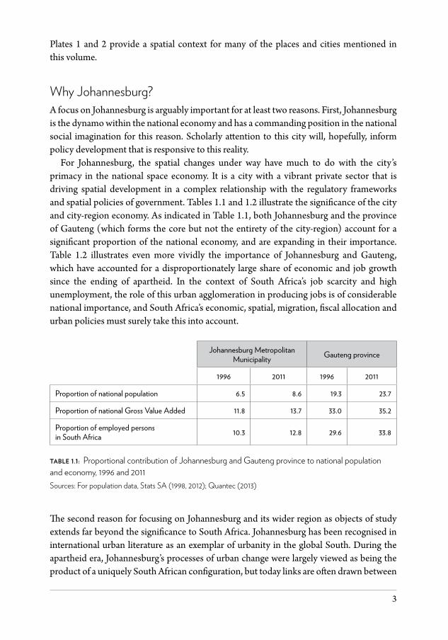
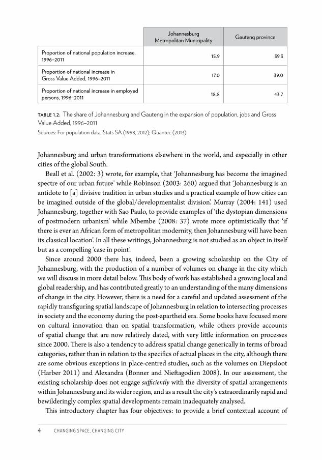
For Johannesburg, the spatial changes under way have much to do with the city’s primacy in the national space economy. It is a city with a vibrant private sector that is driving spatial development in a complex relationship with the regulatory frameworks and spatial policies of government. Tables 1.1 and 1.2 illustrate the significance of the city and city-region economy. As indicated in Table 1.1, both Johannesburg and the province of Gauteng (which forms the core but not the entirety of the city-region) account for a significant proportion of the national economy, and are expanding in their importance. Table 1.2 illustrates even more vividly the importance of Johannesburg and Gauteng, which have accounted for a disproportionately large share of economic and job growth since the ending of apartheid. In the context of South Africa’s job scarcity and high unemployment, the role of this urban agglomeration in producing jobs is of considerable national importance, and South Africa’s economic, spatial, migration, fiscal allocation and urban policies must surely take this into account.
Johannesburg Metropolitan Municipality Gauteng province
1996 2011 1996 2011
Proportion of national population 6.5 8.6 19.3 23.7
Proportion of national Gross Value Added 11.8 13.7 33.0 35.2
Proportion of employed persons in South Africa 10.3 12.8 29.6 33.8
table 1.1: Proportional contribution of Johannesburg and Gauteng province to national population and economy, 1996 and 2011Sources: For population data, Stats SA (1998, 2012); Quantec (2013)
The second reason for focusing on Johannesburg and its wider region as objects of study extends far beyond the significance to South Africa. Johannesburg has been recognised in international urban literature as an exemplar of urbanity in the global South. During the apartheid era, Johannesburg’s processes of urban change were largely viewed as being the product of a uniquely South African configuration, but today links are often drawn between
CSCC.indb 3 2014/10/07 5:17 PM
Changing SpaCe, Changing City4
Johannesburg and urban transformations elsewhere in the world, and especially in other cities of the global South.
Beall et al. (2002: 3) wrote, for example, that ‘Johannesburg has become the imagined spectre of our urban future’ while Robinson (2003: 260) argued that ‘Johannesburg is an antidote to [a] divisive tradition in urban studies and a practical example of how cities can be imagined outside of the global/developmentalist division’. Murray (2004: 141) used Johannesburg, together with Sao Paulo, to provide examples of ‘the dystopian dimensions of postmodern urbanism’ while Mbembe (2008: 37) wrote more optimistically that ‘if there is ever an African form of metropolitan modernity, then Johannesburg will have been its classical location’. In all these writings, Johannesburg is not studied as an object in itself but as a compelling ‘case in point’.
Since around 2000 there has, indeed, been a growing scholarship on the City of Johannesburg, with the production of a number of volumes on change in the city which we will discuss in more detail below. This body of work has established a growing local and global readership, and has contributed greatly to an understanding of the many dimensions of change in the city. However, there is a need for a careful and updated assessment of the rapidly transfiguring spatial landscape of Johannesburg in relation to intersecting processes in society and the economy during the post-apartheid era. Some books have focused more on cultural innovation than on spatial transformation, while others provide accounts of spatial change that are now relatively dated, with very little information on processes since 2000. There is also a tendency to address spatial change generically in terms of broad categories, rather than in relation to the specifics of actual places in the city, although there are some obvious exceptions in place-centred studies, such as the volumes on Diepsloot (Harber 2011) and Alexandra (Bonner and Nieftagodien 2008). In our assessment, the existing scholarship does not engage sufficiently with the diversity of spatial arrangements within Johannesburg and its wider region, and as a result the city’s extraordinarily rapid and bewilderingly complex spatial developments remain inadequately analysed.
This introductory chapter has four objectives: to provide a brief contextual account of
Johannesburg Metropolitan Municipality Gauteng province
Proportion of national population increase, 1996–2011 15.9 39.3
Proportion of national increase in Gross Value Added, 1996–2011 17.0 39.0
Proportion of national increase in employed persons, 1996–2011 18.8 43.7
table 1.2: The share of Johannesburg and Gauteng in the expansion of population, jobs and Gross Value Added, 1996–2011Sources: For population data, Stats SA (1998, 2012); Quantec (2013)
CSCC.indb 4 2014/10/07 5:17 PM
haRRiSOn, gOtZ, tODeS anD WRay • intRODUCtiOn 5
economic, demographic, physical and administrative transformations in Johannesburg through the post-apartheid era; to contextualise the book within evolving discursive representations of Johannesburg; to explain the intended contributions and orientations of the book in relation to the existing literature; and to outline the structure and content of the volume.
Context: Johannesburg in transformationThe construction and transformation of Johannesburg, from the discovery of gold in 1886 until the ending of apartheid in 1994, is described in some detail by Keith Beavon in Johannesburg: The Making and Shaping of the City (2004), with a popular account also in Brodie’s The Jo’burg Book (2009). These books and others – including Beall et al.’s Uniting a Divided City (2002), Murray’s Taming the Disorderly City (2008) and City of Extremes (2011), and Chipkin’s Johannesburg: Architecture in Transition (2008) – do extend analysis of change in Johannesburg into the post-apartheid era but were produced before data from Census 2011 – and in some instances, even from Census 2001 – were available and so must be complemented by more recent analysis.
The results of the 2011 national population Census and of various other datasets produced by Statistics South Africa and by private agencies suggest that Johannesburg has experienced profound economic and socio-spatial transformations since the ending of apartheid, and compel us to investigate processes in detail across scales. In this introduction, we contextualise the detailed work in the volume in terms of four major dimensions of material change: the expanding, tertiarising economy; the growing, changing population; the increasingly complex, densifying spatial form; and the restructured, gradually stabilising governance arrangements for this expanding city.
An expanding, tertiarising economyThe size of Johannesburg’s economy grew relatively fast in the period 1996–2011, at least in comparison to the national economy. Between 1996 and 2011, the Gross Value Added (GVA) of Johannesburg’s economy expanded by 87.7 per cent compared to a national increase of 61.8 per cent. The differential between growth in Johannesburg and nationally was greater in relation to employment, with Johannesburg’s economy proving to be relatively labour absorptive. In South Africa, the number of individuals with jobs increased by 43 per cent compared with 79 per cent for Johannesburg. The unemployment rate for Johannesburg dropped modestly from 29.4 per cent to 25 per cent, indicating that jobs were being produced at a rate faster than the increase of the working-age population, although insufficiently fast to significantly reduce unemployment.
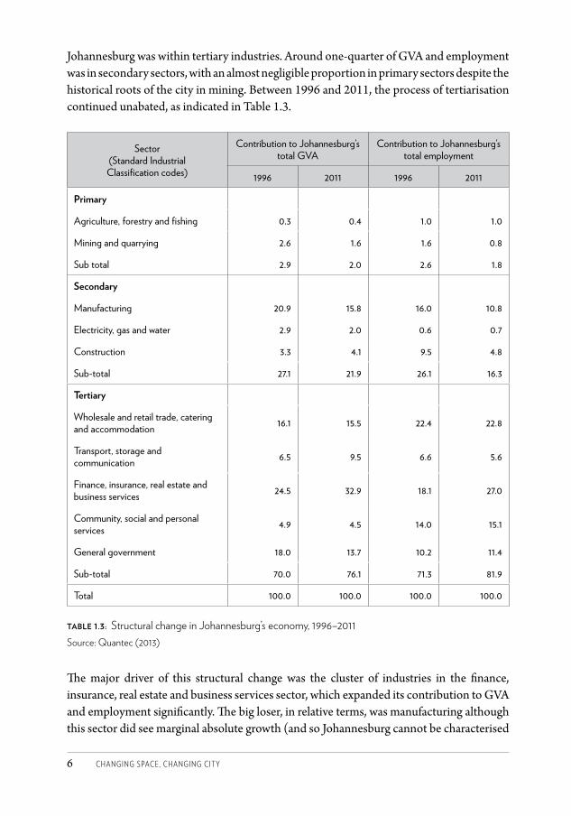
As the economy expanded, so its structure continued to change. The transition from a mining to a manufacturing economy, and then to a service economy, was well over by the mid 1990s when South Africa entered the age of democracy (see Beall et al. 2002; Harrison and Zack 2012). In 1996, 70 per cent of GVA and 71 per cent of employment in
CSCC.indb 5 2014/10/07 5:17 PM
Changing SpaCe, Changing City6
Johannesburg was within tertiary industries. Around one-quarter of GVA and employment was in secondary sectors, with an almost negligible proportion in primary sectors despite the historical roots of the city in mining. Between 1996 and 2011, the process of tertiarisation continued unabated, as indicated in Table 1.3.
Sector (Standard Industrial Classification codes)
Contribution to Johannesburg’s total GVA
Contribution to Johannesburg’s total employment
1996 2011 1996 2011
Primary
Agriculture, forestry and fishing 0.3 0.4 1.0 1.0
Mining and quarrying 2.6 1.6 1.6 0.8
Sub total 2.9 2.0 2.6 1.8
Secondary
Manufacturing 20.9 15.8 16.0 10.8
Electricity, gas and water 2.9 2.0 0.6 0.7
Construction 3.3 4.1 9.5 4.8
Sub-total 27.1 21.9 26.1 16.3
tertiary
Wholesale and retail trade, catering and accommodation 16.1 15.5 22.4 22.8
Transport, storage and communication 6.5 9.5 6.6 5.6
Finance, insurance, real estate and business services 24.5 32.9 18.1 27.0
Community, social and personal services 4.9 4.5 14.0 15.1
General government 18.0 13.7 10.2 11.4
Sub-total 70.0 76.1 71.3 81.9
Total 100.0 100.0 100.0 100.0
table 1.3: Structural change in Johannesburg’s economy, 1996–2011 Source: Quantec (2013)
The major driver of this structural change was the cluster of industries in the finance, insurance, real estate and business services sector, which expanded its contribution to GVA and employment significantly. The big loser, in relative terms, was manufacturing although this sector did see marginal absolute growth (and so Johannesburg cannot be characterised
CSCC.indb 6 2014/10/07 5:17 PM
haRRiSOn, gOtZ, tODeS anD WRay • intRODUCtiOn 7
as deindustrialising). Mining was a tiny sector in 1996, and continued to decline in both relative and absolute terms.
A growing, changing populationThe growth in the economy, and especially in employment, has attracted large numbers of work seekers to Johannesburg. In 1996, shortly after the ending of apartheid, the enumerated population of Johannesburg was well over 2.5 million (2 634 126). In the 15 years until 2011 it increased by 68.4 per cent to almost 4.5 million (4 434 828).1 During the same period, the national population grew by only 28 per cent.
Importantly, the number of households in Johannesburg increased by 96 per cent, significantly faster than the population increase. This reflects the decline in average household size from 3.5 to 2.9 over the 15-year period, and has had major implications for the demand for accommodation and household services.
Johannesburg’s reputation as a ‘city of migrants’ was reinforced over this time period, with in-migration accounting for nearly 60 per cent of the population growth. Migrants came mainly from elsewhere in South Africa, but there was also a considerable influx from international destinations, especially from sub-Saharan Africa. In 1996, the enumerated population of Johannesburg was overwhelmingly South African, with only 2.8 per cent of the population having non-South African citizenship. By 2011, 12.7 per cent of the enumerated population had a foreign citizenship.
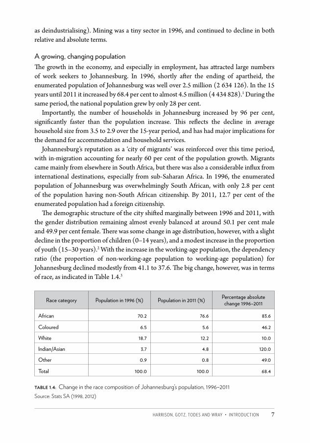
The demographic structure of the city shifted marginally between 1996 and 2011, with the gender distribution remaining almost evenly balanced at around 50.1 per cent male and 49.9 per cent female. There was some change in age distribution, however, with a slight decline in the proportion of children (0–14 years), and a modest increase in the proportion of youth (15–30 years).2 With the increase in the working-age population, the dependency ratio (the proportion of non-working-age population to working-age population) for Johannesburg declined modestly from 41.1 to 37.6. The big change, however, was in terms of race, as indicated in Table 1.4.3
Race category Population in 1996 (%) Population in 2011 (%) Percentage absolute change 1996–2011
African 70.2 76.6 83.6
Coloured 6.5 5.6 46.2
White 18.7 12.2 10.0
Indian/Asian 3.7 4.8 120.0
Other 0.9 0.8 49.0
Total 100.0 100.0 68.4
table 1.4: Change in the race composition of Johannesburg’s population, 1996–2011Source: Stats SA (1998, 2012)
CSCC.indb 7 2014/10/07 5:17 PM
Changing SpaCe, Changing City8
The African population is increasingly dominant, accounting for more than three-quarters of the total population by 2011. By contrast, there was a significant relative decline in the size of the white population, and only a marginal absolute increase. Among the smaller groupings, there was a significant proportional increase in the size of the population of Indian/Asian descent, driven mainly by a wave of in-migration from Asia, and a slight proportional decline in the size of the coloured population, which is not benefiting from in-migration.
Comparing changes in terms of class is more complex given definitional issues, and also the lack of comparability between the 1996 and 2011 censuses in terms of enumerated income categories. It is clear, however, that there were two key processes affecting distribution of population by class: first, the expansion of the black middle class, but second, as a counter-trend, the influx of work seekers who are part of the broad category of urban poor.
An increasingly complex, densifying spatial formThe economic changes have increased the complexity of the spatial form, leading to the growth of an intricate network of decentralised economic nodes. The major growth in GVA and employment has happened in the spatially flexible tertiary sector, and especially in business services; this has propelled the development of dispersed office nodes, following patterns of commercial decentralisation which were well established before 1994. The growing complexity of urban form has reinforced the importance of the transport sector, the expansion of which is revealed spatially in the expanding infrastructure supporting the private automobile, but also in the continually developing minibus taxi industry (a form of ‘privatised’ public transport) and investments in public transport, including the Bus Rapid Transport (BRT) system and the rapid rail system (known as the Gautrain).
While the manufacturing sector has grown little overall, there has been a patchwork of spatial change relating to this sector, with the stagnation or decline of some nodes and the development of a small number of new nodes. Traces of mining still exist but this is a sector of mainly historic importance in terms of physical production, although Johannesburg remains a key node globally within a corporate network of mining-related firms. The old mining tracts remain a belt of partial dereliction, although there is a gradual infill of industrial, recreational and residential activities as land is rehabilitated.
The bulk of new development is in the residential sector. In the 15 years between 1996 and 2011, the city had to accommodate over 68 per cent more people. The key question is whether this happened through the expansion of the urban footprint or through the densification of the existing urban fabric. To measure this we need to compare population increase with the increase in the extent of the built-up area of the city.
The difficulty in analysing the degree of densification is matching the data on population and on city expansion. In a major international study, Professor Shlomo Angel of New York University identified Johannesburg as one of the few cities in the
CSCC.indb 8 2014/10/07 5:17 PM
haRRiSOn, gOtZ, tODeS anD WRay • intRODUCtiOn 9
world experiencing real densification. Using satellite imagery and population data, Angel explored density trends in 120 cities worldwide and concluded that in all regions of the world urban densities are decreasing, and that this is happening at an average rate of 1.7 per cent per annum.4 In contrast to cities internationally, the urban densities of Johannesburg were increasing at around 1.7 per cent per annum (Angel et al. 2012).
Angel’s data were, however, for the period 1990 to 2000, and so a question is whether these trends have persisted since then. Analysis based on two different methods suggests that they have. One method employs GeoTerraImage (GTI) Growth Indicator Data for 2001 and 2009 to estimate growth in the built-up area, and compares this with population figures from the 2001 and 2011 population Censuses.5 For the period 2001–2009 there was a 28.9 per cent increase in population but only a 10.8 per cent increase in the built-up area of Johannesburg. The result was a 16.4 per cent increase in the population density within the built-up area (5 575 p/km2– 6 479 p/km2), equating to a 1.8 per cent density increase per annum. Another method uses a projection of the urban/built-up area of Johannesburg in 2000 from the National Land Cover 2000 (NLC2000) dataset, and determines the population growth inside and outside this built-up area between 2001 and 2011 from Census data. This method shows that Johannesburg’s population grew 73.3 per cent outside the 2000 urban extent, and only 26.7 per cent inside it. However, in absolute numbers the growth inside the built-up area was larger – 661 470 versus 547 460 – and so densities here increased 26.7 per cent from 4 534 p/km2 to 5 744 p/km2 between 2001 and 2011 (see Chapter 2).
We may conclude that Johannesburg is a densifying city, contrary to international trends. Although Johannesburg remains relatively low density in international terms,6 it is not factually correct to represent the city as a sprawling metropolis in which the patterns of the past are simply being perpetuated. This densification is happening as the pent-up demand to move closer to jobs and services has been released with the ending of apartheid. It is a positive process that requires adequate management.
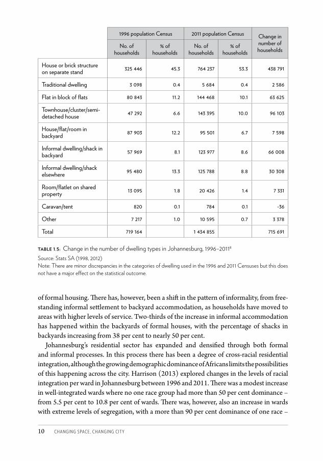
The remaining question is the form that residential growth and densification is taking in Johannesburg (see Table 1.5). A comparison of the 1996 and 2011 Censuses reveals the increasing dominance of detached dwellings on separate stands, which has been reinforced by subsidised housing programmes introduced by the government after 1994 (the so-called RDP housing).7 Another area of growth has been townhouse or cluster development, mainly on the edge of the city, but contributing to overall densification through the medium-density nature of this development. New developments have generally not included blocks of flats, reflected in the slight decline in the proportion of households in this form of dwelling. However, there has been densification through increased occupancy of flats, especially in inner-city precincts, and so absolute numbers of households in flats have increased.
In 1996, 21.4 per cent of households in Johannesburg lived in shacks in informal settlements or in backyard accommodation. This proportion declined to 17.4 per cent in 2011, arguably as a result of the state’s housing subsidy programme and the rapid expansion
CSCC.indb 9 2014/10/07 5:17 PM
Changing SpaCe, Changing City10
of formal housing. There has, however, been a shift in the pattern of informality, from free-standing informal settlement to backyard accommodation, as households have moved to areas with higher levels of service. Two-thirds of the increase in informal accommodation has happened within the backyards of formal houses, with the percentage of shacks in backyards increasing from 38 per cent to nearly 50 per cent.
Johannesburg’s residential sector has expanded and densified through both formal and informal processes. In this process there has been a degree of cross-racial residential integration, although the growing demographic dominance of Africans limits the possibilities of this happening across the city. Harrison (2013) explored changes in the levels of racial integration per ward in Johannesburg between 1996 and 2011. There was a modest increase in well-integrated wards where no one race group had more than 50 per cent dominance – from 5.5 per cent to 10.8 per cent of wards. There was, however, also an increase in wards with extreme levels of segregation, with a more than 90 per cent dominance of one race –
1996 population Census 2011 population Census Change in number of householdsNo. of
households% of
householdsNo. of
households% of
households
House or brick structure on separate stand 325 446 45.3 764 237 53.3 438 791
Traditional dwelling 3 098 0.4 5 684 0.4 2 586
Flat in block of flats 80 843 11.2 144 468 10.1 63 625
Townhouse/cluster/semi-detached house 47 292 6.6 143 395 10.0 96 103
House/flat/room in backyard 87 903 12.2 95 501 6.7 7 598
Informal dwelling/shack in backyard 57 969 8.1 123 977 8.6 66 008
Informal dwelling/shack elsewhere 95 480 13.3 125 788 8.8 30 308
Room/flatlet on shared property 13 095 1.8 20 426 1.4 7 331
Caravan/tent 820 0.1 784 0.1 -36
Other 7 217 1.0 10 595 0.7 3 378
Total 719 164 1 434 855 715 691
table 1.5: Change in the number of dwelling types in Johannesburg, 1996–20118
Source: Stats SA (1998, 2012)Note: There are minor discrepancies in the categories of dwelling used in the 1996 and 2011 Censuses but this does not have a major effect on the statistical outcome.
CSCC.indb 10 2014/10/07 5:17 PM
haRRiSOn, gOtZ, tODeS anD WRay • intRODUCtiOn 11
from 48.7 per cent to 54.6 per cent of wards. While previously white middle-class suburbs are gradually desegregating with the movement of the black middle class into these areas, historically black townships remain almost exclusively black, while new black enclaves have emerged in the inner city and in previously white working-class suburbs around the inner city. We therefore must conclude ambivalently on the question of whether Johannesburg is becoming a more residentially integrated city.
Restructured, gradually stabilising governance arrangementsThe task of governing Johannesburg has become more complex and demanding as the population and the economy have expanded. When the first democratic election was held in 1994 for the national and provincial legislatures, local administration in Johannesburg was still racially divided and highly fragmented.
Between 1996 and 2001 there was a transitional period as the previously racially delineated local authorities were amalgamated into new democratic municipal structures. A two-tier metropolitan structure was set up with a Transitional Metropolitan Council sharing power with local councils. This relatively complex arrangement contributed to a financial crisis in 1997 which threatened to derail progress towards transformed metropolitan government. The crisis prompted action from national and provincial governments, and measures were taken to curtail expenditure and to restructure the city administration.
Far-reaching institutional transformations at the end of 2000 included the establishment of a single-tier, consolidated metropolitan authority, and the corporatisation of service delivery with the creation of city-owned companies to provide water and sanitation, electricity, waste management and other functions. While the single-tier authority was widely accepted as a means to realise the ideals of integrated planning and resource redistribution, corporatisation was stridently opposed by labour unions and a coalition of civic associations that came together in the Anti-Privatisation Forum.
Within the frame of these new metropolitan government and corporatised service-delivery structures, city finances were stabilised and long-term development strategies put in place. After around 2005 there was relative stability as the city sought to manage competing imperatives such as apartheid redress, delivery to a mainly low-income political constituency, and fiscal sustainability. On the foundation provided by this stability, major new initiatives were mounted, including the introduction of BRT as a new form of public transport (in addition to the rapid rail system introduced by the provincial government); preparations for the hosting of the 2010 FIFA World Cup; the development of the historically African townships of Soweto and Alexandra; inner-city regeneration; and the local implementation of national government’s subsidised housing programme.
The global financial crisis from 2008 affected Johannesburg and this, together with the costs of the World Cup and severe difficulties in managing the billing system, led to cutbacks in major city programmes. There was also political tension in the ruling party locally linked to national divides within the party. The complex system of intergovernmental relations in South Africa also complicated development with provincial and municipal governments
CSCC.indb 11 2014/10/07 5:17 PM
Changing SpaCe, Changing City12
struggling to co-ordinate effectively in areas including spatial planning, housing delivery, health and transport. The idea of city-region governance was introduced but progress in realising this concept has proven slow with differing visions of the form such governance ought to take.
By 2013 city finances had again stabilised and an ambitious programme of new capital development was launched which included the development of ‘Corridors of Freedom’ linking further investment in public transport to residential densification, mixed-use developments and service delivery. A new long-range development strategy, Joburg GDS 2040, also committed the city administration to an ambitious programme aimed at resilience and environmental sustainability.
In terms of governance arrangements and approaches, the City of Johannesburg is significant internationally as an example of single-tier metropolitan governance (although the complex relationship between city and provincial governance does complicate the matter). In South Africa, Johannesburg is the only major city municipality that has corporatised its service delivery, with mixed outcomes in terms of performance.
In this volume we avoid categorical labelling of post-apartheid governance and spatial processes, including the popular and overused term ‘neo-liberal’. What is required is not trite stereotyping but rather a careful analysis of the complex and multiple imperatives and motivations that shape the decisions and actions of different players, and of the varying spatial consequences (as argued, for example, in Beall et al. 2002; Lipietz 2008; Parnell and Robinson 2006; Robinson 2008).
Towards the detailJohannesburg is a transforming city. It is growing in economy and population, and at the same time changing in terms of economic structure, demographic composition and spatial form. With this fluidity, we will inevitably only understand change in a very partial sense, and many dimensions of change will remain elusive. However, it is possible to draw on the available data to map some of the contours of change. The broad outline provided above is only the beginning. We need to understand in far greater detail, using quantitative data and qualitative techniques, the highly differentiated economic, social and spatial landscape within and across Johannesburg, and we need to develop this understanding at multiple scales.
Discursive representationThere is a rich and multifarious tradition of writing on the City of Johannesburg with a complex interweaving of theoretical and conceptual threads.
Until around 1970 much of this writing was targeted at a popular audience and took the form of celebratory accounts of the ‘romantic’ story of gold mining on the Witwatersrand and the transition from a mining camp to a large modern city, but there were a few counter-narratives that explored the city in analytical detail. These included, for example, the detailed investigation into the conditions of the Afrikaner working class by the Carnegie Corporation (1932), the expansive investigation into the nature of city government by
CSCC.indb 12 2014/10/07 5:17 PM
haRRiSOn, gOtZ, tODeS anD WRay • intRODUCtiOn 13
an Oxford academic (Maud 1938), and the work of a pioneering urban anthropologist on the material conditions and processes of cultural formation in an African slum yard in Doornfontein (Hellmann 1948).
From the 1970s there was a great increase in writing on Johannesburg, which was partly to do with the emergence of urban studies as a field of critical enquiry internationally, but mainly to do with the enormous provocation of the Soweto uprising of June 1976. This event ruptured forever the vision of an orderly, modern, segregated Johannesburg and provoked new waves of writing on the city. The first was a liberal-oriented critique of the irrationalities of the state’s race-based urban policies that was targeted at pressuring the government into urban reform. The liberal writers were sponsored in part by the Urban Foundation, an urban think tank established in the wake of the 1976 uprising by business leaders in South Africa, and in part by the South African Institute of Race Relations. There were books on Soweto (Kane-Berman 1978; Morris 1980) and also an influential volume on Johannesburg, A City Divided, which was authored by a leading executive of the Anglo American Corporation. It concluded that ‘the most pressing need is to eliminate the irrational partitions which divide the city of Johannesburg against itself ’ (Mandy 1984: 407).
The second was a radical interdisciplinary research programme, called the Wits History Workshop (WHW), which was broadly situated within a paradigm of humanist Marxism, and which drew attention to the everyday lives of African working people. The WHW drew from the context of struggle in South Africa but was also directly inspired by the History Workshop Movement founded at Ruskin College, Oxford, by Raphael Samuel, which sought to subvert conventional historiographies by providing a ‘history from below’ (Bonner 2010: 17). The WHW was prolific and accumulated a significant corpus of work on the (mainly) African working-class history of Johannesburg (see compilations edited by Bozzoli in 1979, 1983 and 1987). The best illustration of this work was Charles van Onselen’s extensive Studies in the Social and Economic History of the Witwatersrand 1886–1914 (1982a, b), which recorded the histories of the most socially ostracised and economically marginalised groups in early Johannesburg – sex workers, Yiddish cab drivers, domestic workers, Zulu washermen and Afrikaner brick makers, among others.
Geographers joined the historians in their engagement with the politics of spatial transformation. They turned away from the depoliticised spatial science of the later 1960s and early 1970s – which had at least contributed an understanding of spatial trends in the city (e.g. Fair 1977; Hart 1976) – to a critical commentary on the spatial effects of colonial and apartheid rule. Much of the literature on Johannesburg from the 1970s to the end of the 1980s was concerned with uncovering the origins and patterns of segregation in the city landscape (Fick et al. 1988; Mather 1987; Parnell 1988), but geographers also turned their attention in the 1980s to the everyday struggles of the urban poor for material livelihood through numerous studies of informal-sector activity in the city (see, for example, Rogerson 1986, 1988; Rogerson and Beavon 1980).
Situated apart from these dominant strands of writing was the work of Afrikaans-speaking academics at the newly established Rand Afrikaans University. They explored the
CSCC.indb 13 2014/10/07 5:17 PM
Changing SpaCe, Changing City14
ways in which a minority Afrikaner community in Johannesburg dealt with its vulnerable status in a primarily English-speaking world by affirming a separate identity and creating a network of mutual aid organisations (Stals 1978, 1986). Also outside the ‘mainstream’ was the angry, post-1976 outpouring by black poets and novelists who were adherents of a black consciousness ideology (Chapman 2007).
In retrospect, also, there were the germs of contemporary postcolonialist writing on Johannesburg. There were a handful of writers from the 1970s – including within the WHW – who explored cultural meaning in the slum yards, mining compounds and townships of Johannesburg (e.g. Coplan 1985; Couzens 1983; Hart 1986; Hofmeyr 1979; Koch 1983; Moodie 1983; Pirie 1984).
The most potent influence in the emergent postcolonial sensibility was, however, the memory of Sophiatown, a racially mixed urban slum in Johannesburg that was destroyed by the apartheid government between the mid 1950s and the early 1960s. In the 1950s, Drum magazine famously recruited a crew of black journalists who were able to tap into the animated and creolised African working-class cultures of Johannesburg, which were epitomised at the time by life in Sophiatown. The Drum writers had no aspirations to produce highbrow journalism and revelled in stories of crime and gangsterism and popular music and sport and sex. This writing was a crude realism but it asserted an urban culture that was dislocated from any tribal structure, and an urban identity that had no suggestion of rural nostalgia (Gready 1990).
By the early 1960s Sophiatown had been destroyed by the apartheid state and many of the Drum journalists had died prematurely – from suicides, alcoholism and fatal stabbings – but the memory of Sophiatown was a potent force. From the 1960s the surviving journalists, in more sober mode, reflected on the heady years of Sophiatown (e.g. Modisane 1986; Nkosi 1983) and identified in their earlier writing the cultural syncretism that was to be so important to the postcolonialists of later years.
The ending of the political struggle, which had long infused academic writing in Johannesburg with a higher purpose, had a double-edged effect on writing about Johannesburg from the early 1990s. On the one hand there was ‘a hiatus, a loss of direction, a loss of purpose, even of confidence’ (Bonner 2010: 21). It was an epistemological confusion heightened by the global collapse of intellectual metanarrative, including Marxist theory. On the other hand, however, the ending of apartheid released a new creativity in Johannesburg writing – researchers were ‘no longer constrained by the moral imperative to direct their creative energies toward exposing the evils of white minority rule’ (Murray 2010: 153). Despite the epistemological anxiety, the 1990s was a rare period in which theory and practice seemed to come together, and in which academic work directly informed policy development, including through an engagement in the early 1990s with the Central Witwatersrand Metropolitan Chamber, which forged a wide-ranging consensus on the shape of post-apartheid local government in the region (Turok 1993).
An uncertain process of intellectual experimentation began in the 1990s that led eventually to the remarkable outpouring of Johannesburg writing in the 2000s. There were
CSCC.indb 14 2014/10/07 5:17 PM
haRRiSOn, gOtZ, tODeS anD WRay • intRODUCtiOn 15
two academic events in Johannesburg that reflected both the angst and the opportunity of the new era. The first was an architectural exhibition – Blank: Architecture, Apartheid and After (1997–1999) – that was hosted in Rotterdam by the Netherlands Architecture Institute before coming to South Africa, put together by a young architect, Hilton Judin, and a novelist, Ivan Vladislavić, and compiled into a book of the same name ( Judin and Vladislavić 1998). The exhibition was a direct critique of the dominant orderings of space, including modernist architecture and apartheid planning, but it also provided the platform for an intellectual crossover that stimulated new intellectual directions in the writing on Johannesburg. This included contributions from a new generation of writers who were familiar with post-structuralist and postcolonialist philosophy (especially Jennifer Robinson, AbdouMaliq Simone and Lindsay Bremner).
The second event was the Urban Futures Conference held in Johannesburg in July 2000 (see Mabin 2001). Key papers from the conference were published in Emerging Johannesburg: Perspectives on the Postapartheid City (Tomlinson et al. 2003: xiii), a book that began with the recognition that ‘the old Johannesburg exists in nostalgia; the new Johannesburg exists in absentia’. The conference brought to the fore questions of identity and belonging in a city where old hierarchies had disintegrated and where new, largely transient migrant populations were settling en masse. The conference struggled to make sense of the unpredictability and heterogeneity of Johannesburg and revealed the uncertain and troubled intellectual environment of a city that seemed to be on the verge of unravelling (Lipietz 2004). But, with hindsight, the conference also hinted at new forms of urban coherence and identified the beginnings of ‘creative new intersections of forces, peoples, and economies’ (Gotz and Simone 2003: 126).
In the 1990s, there were continued attempts to make sense of the political and material forces reshaping the city. The WHW continued its work with a strong focus on the history of townships (e.g. Bonner and Segal 1998; Parnell 1991), but the WHW was no longer the dominating intellectual movement. Writing on urban segregation continued into the 1990s but with a new twist: a focus on processes of desegregation (Crankshaw and White 1995; Hart 1989).
The most evident material transformation in Johannesburg in the 1990s was in the inner city, where physical decay was linked to the flight of big business and the arrival of slumlords who gave accommodation to a new wave of African migrants. One of the major studies of the period was Alan Morris’s Bleakness and Light (1999) which analysed the dramatic transformations of Hillbrow, a high-rise residential precinct in inner-city Johannesburg, but there were other important contributions. There were writers who reflected the popular perceptions of crime and physical decay (e.g. Crankshaw and White 1995) or who saw opportunities for new economies and relationships within the perceived decline (Tomlinson 1999). Other changes in the city attracted attention, including changes in architectural form (Chipkin 1993), the extraordinary rise of the black-owned minibus taxi industry (Khosa 1992) and the re-emergence of informal settlement in Johannesburg from the 1970s (Crankshaw 1993).
CSCC.indb 15 2014/10/07 5:17 PM
Changing SpaCe, Changing City16
However, the key shift in the 1990s was arguably the hesitant emergence of a postcolonialist scholarship, which brought new directions in philosophy internationally into an engagement with the context of Johannesburg. This writing was, however, not pre-eminently about Johannesburg but rather about the ways in which the local experience is suggestive of new constructions of African identity – of new forms of association, cultural syncrecity, alternative modernities, and networks and circulations that connect Africa to elsewhere.
Gready (1990) and Hannerz (1994) used the worldliness and syncrecity of Sophiatown to show how local cultures fuse with international influences in cultural forms including fashion, urban dialects, popular jazz and gangsterism. The attention of promising young scholars such as Jennifer Robinson, Achille Mbembe and AbdouMaliq Simone was also, gradually, being drawn to Johannesburg. In 1998, Robinson, for example, challenged the conventional conception of South African cities as segregated and divided, asking whether the spaces of apartheid were really ‘so fixed, so divisive, so certain in their form’ (1998: 163). In 1995, Cameroon-born Mbembe co-authored the influential article ‘Figures of the Subject in a Time of Crisis’ (Mbembe and Roitman 1995), which spoke of the dissonance between the grand modern project envisaged by African elites and the facticity of African cities in decay. Simone’s 1998 article ‘Urban Social Fields in Africa’ set the tone for his prolific later work. It explained how ‘Africans reinvent the terms through which they understand and act on their everyday lives’ (1998: 72) in the absence of functioning, formal systems of governance.
The Johannesburg connection was made explicit from around the time of the Urban Futures Conference in 2000. Robinson (2003: 277) stated that Johannesburg allows us to move conceptually ‘from a divided approach to cities, where some are interpreted as structurally irrelevant and others as globally powerful, to one where all (ordinary) cities are understood as complex, diverse and contested environments for living’. Simone used Johannesburg to describe the ways in which urban Africans confront the precarious realities of their lives by weaving together new forms of cohesion involving social networks and relationships (e.g. Gotz and Simone 2003; Simone 2001, 2004, 2006).
The burgeoning field of migration studies, promoted vigorously by the African Centre for Migration and Society at Wits University in Johannesburg, drew deeply on the notions of associational life embedded in Simone’s work although the prospect of an emerging ‘Afromodernity’ was dimmed by a growing sense of the fragility and ephemerality of these associations (see, for example, Kihato 2007; Kruger 2009; Landau and Freemantle 2010; Pineteh 2010; Sadouni 2009; Vidal 2010; Winkler 2006).
Although Mbembe established his reputation internationally with his On the Postcolony (2001), which revealed the grotesque formations of a postcolonial state, he saw in Johannesburg glimpses of an Afromodernity that went beyond this gloom. Through an engagement with Johannesburg, Mbembe began to ‘seriously think about what the “African modern” or African forms of worldliness could actually look like’ (Oboe 2011).
In 2004, Mbembe collaborated with the literary theorist Sarah Nuttall in editing a special
CSCC.indb 16 2014/10/07 5:17 PM
haRRiSOn, gOtZ, tODeS anD WRay • intRODUCtiOn 17
edition of the journal Public Culture, which they titled Johannesburg: The Elusive Metropolis. The special edition was later reworked and published as a book with the same title and was the high point of postcolonialist writing on Johannesburg (Nuttall and Mbembe 2008). This was followed in 2009 by Nuttall’s Entanglement, which depicted the city in terms of a postcolonialist representation of ‘discontinuities, reversals, inertias and swings that overlay one another, interpenetrate one another …’ (2009: 4).
Mbembe and Nuttall’s work focused largely on cultural innovations and drew didactically on avant-garde continental theory, for example Walter Benjamin’s Passagen-Werk, or Arcades Project; Lefebvre on the production of space; Deleuze on the lines of flight and leakages of the city; De Certeau on movement through the city; and Guattari on amnesia, nostalgia and psychic repression. There was also a strong crossover with literature and other imaginative forms of representation, including film and fiction (Goodman 2009; Kruger 2006).
The work focused on the elusiveness and unknowability of the city, and quickly inspired a new generation of writing on Johannesburg, including Bremner’s Writing the City into Being: Essays on Johannesburg 1998–2008 (2010), Kruger’s Imagining the Edgy City: Writing , Performance and Building Johannesburg (2013), and Kreutzfeldt and Malcomess’ Not no Place: Johannesburg. Spaces and Fragments of Time (2013).
Mbembe and Nuttall’s representation of Johannesburg exerted a strong pull on the thinking of a new generation of scholars, and drew urban studies from the traditionally spatial disciplines (geography, planning and architecture) into the realm of social and literary theory. It did not, however, achieve a hegemonic status within local scholarship as many writers continued within traditions that directed attention to the economic and spatial materialities of the city. Full length books include Beall et al.’s Uniting a Divided City (2002), Tomlinson et al.’s Emerging Johannesburg: Perspectives on the Postapartheid City (2003), Beavon’s Johannesburg: The Making and Shaping of the City (2004), Murray’s Taming the Disorderly City (2008) and City of Extremes (2011), Chipkin’s Johannesburg: Architecture in Transition (2008), Bonner and Nieftagodien’s Alexandra (2008) and Harber’s Diepsloot (2011), as well as books not exclusively about Johannesburg but strongly inspired by an experience of Johannesburg, such as Huchzermeyer’s Unlawful Occupation: Informal Settlements and Urban Policy in South Africa and Brazil (2004).
Numerous other contributions have drawn attention to one or other aspect of material change in the city, including the impacts of crime on city form (De Bruyn 2002; Dirsuweit 2002; Landman and Schönteich 2002; Murray 2013), informal settlements and backyard shacks (Huchzermeyer and Karam 2006; Shapurjee and Charlton 2013), new forms of township development (Haferburg 2013), desegregation (Selzer and Heller 2010), new forms of public transportation (Venter 2013) and inner-city regeneration (Winkler 2013).
There is a growing focus also on the complex intersections and multiple agendas underlying urban politics or spatial governance (e.g. Bénit-Gbaffou 2008, 2012; Dirsuweit and Wafer 2006; Fourchard et al. 2012; Heller 2003; Hornberger 2004; Lipietz 2008; Mabin 2007; Matlala and Bénit-Gbaffou 2012; Parnell and Robinson 2006; Winkler 2011),
CSCC.indb 17 2014/10/07 5:17 PM
Changing SpaCe, Changing City18
as well as on policies to manage or shape spatial change (Didier et al. 2012; Peyroux 2012; Todes 2012).
Initially, work on the natural environment and the ecological sustainability of development was sparse but this is now a growing field of focus (e.g. Carruthers 2008; GCRO 2013; Schaffler and Swilling 2013). Work on the economy of the city was also under-represented with the important exception of Rogerson’s writing on small-business clusters and spaces of tourism and commerce (e.g. Rogerson 2004, 2011), but contributions have since been made on the economic legacy of mining (Harrison and Zack 2012), illicit economies (Krige 2011) and corporate geographies (Parnreiter et al. 2013).
The focus on spatial transformation was underpinned by a strong normative drive to achieve a more equitable and sustainable city, revealed for example in the Deutsche Bank-sponsored Urban Age Project, which organised a major conference in Johannesburg in 2006 highlighting the inefficiencies and inequalities in Johannesburg’s urban structure (Urban Age 2010), and also in the extensive work of the Gauteng City-Region Observatory, which was established in 2008 as a partnership between the provincial government and two universities with a ‘vision for South Africa’s economic heartland as a region that is competitive, spatially integrated, environmentally sustainable and socially inclusive’.9
Much of this work draws implicitly on traditions of critical thinking, but generally lacks the overtly theoretical focus of writers in the cultural studies tradition. An exception is Burawoy and Van Holdt’s Conversations with Bourdieu: The Johannesburg Moment (2011), which uses the context of Johannesburg to inform a debate between Marxism and the ideas of the French philosopher Pierre Bourdieu.
Some work connects across the materiality/subjectivity divide, with at least three books placing the subjectivities of human life within the specificities of place in Johannesburg: At Home with Apartheid: The Hidden Landscape of Domestic Service in Johannesburg (Ginsberg 2011), Sanctuary: How an Inner City Church Spilled onto a Sidewalk (Kuljian 2013) and Migrant Women of Johannesburg: Everyday Life in an In-between City (Kihato 2013). The persisting focus on international migrants within Johannesburg in other writing has also helped to bridge the divide (e.g. Harrison et al. 2012; Ostanel 2012; Vearey 2013).
PositioningFrom this overview it is clear that Johannesburg has benefited from a rich history of writing on its social and spatial realities. The many diverse strands of analysis provide a tapestry of perspectives that help us understand the multiple dimensions of this complex city. However, since around 2000, the literature on Johannesburg has progressed within two largely separate, and sometimes antagonistic, discursive communities. As indicated above, there is the literature exemplified by the work of Mbembe and Nuttall which has been heavily influenced by the cultural and linguistic turns of late twentieth-century philosophy, and the literature which directs attention to the materialities of the city, focusing mainly, but not only, on the inequalities or injustices of the city.
CSCC.indb 18 2014/10/07 5:17 PM
haRRiSOn, gOtZ, tODeS anD WRay • intRODUCtiOn 19
Our view is that both strands of writing have contributed immensely to a multilayered understanding of Johannesburg, but both position themselves by pointing to the limitations in the other, and in doing so have hardened perspectives into an unhelpful division. Mbembe and Nuttall wrote in partial critique of the ‘materialist’ tradition, providing a compelling argument for a complex and fluid representation of the city that moves beyond the conventional characterisation of Johannesburg only as ‘the spatial embodiment of unequal economic relations and coercive and segregationist policies’ (Mbembe and Nuttall 2004: 349). We are sympathetic to Mbembe and Nuttall’s agenda in this regard, although we think that they have moved the pendulum too far in the other direction.
Mbembe and Nuttall, in turn, have been criticised for downplaying the physicality or materiality of the city, and ignoring the extent to which the city consists of elements which are finite and at least partially fixed, or have a structural form in an economic or social sense. Chipkin, for example, notes in this scholarship a danger of ‘deliberately failing to consider … social and economic structures’ (2005: 107). Graham admonishes Nuttall for ‘dehistoricized or dematerialized readings’ (2008: 114). Watts (2005) observes that the work provided a brilliant rendering of the city but that the materiality of the city was conspicuous in its absence.
We agree that any proper understanding of Johannesburg must engage with the ‘materialities’ of the city. In this we follow Lefebvre who, in The Production of Space (1991), insisted that there are determinate structures in the making of space, and that these must be explored with analytical rigour, and that we should avoid presenting space as being radically indeterminate. However, it would be fatuous to ignore the immense contributions made by writers who have explored the subjective life of the city. Many dimensions of the city are, indeed, ‘turbulent, unstable and unpredictable’ (Mbembe and Nuttall 2004: 349), and the limits of knowability are always pressing. The challenge, we think, is to find a way to underpin theoretically rich and philosophically informed representations of the city with an empirically informed understanding of what may be happening in the city, and in this way bridge an unnecessary divide in the readings of Johannesburg.
Internationally, there is an emergent scholarly literature that deals with the intersection of urban materialities and urban subjectivities. This is apparent, for example, in recent writing on ‘urban assemblages’ (McFarlane 2011), ‘vibrant matter’ (e.g. Bennett 2010), ‘actor network theory’ (e.g. Latour 2005), ‘material feminisms’ (e.g. Alaimo and Hekman 2008) and ‘new materialisms’ (e.g. Coole and Frost 2010). With respect to Johannesburg there are, at least, the seeds of a productive dialogue across the two representational traditions. Chipkin (2005), for example, reminds us that the city is a space of material inequality and of cultural expression. Graham found a bridging position in the work of Ivan Vladislavić, Johannesburg’s leading postcolonial novelist:
Vladislavić does indeed suggest in The Exploded View that concerns with material spaces and social inequalities are insufficient in themselves for understanding the invisible infrastructures that make the contemporary South African metropolis function. Yet the novel also implies that we entirely ignore these concerns at our peril. (2008: 129)
CSCC.indb 19 2014/10/07 5:17 PM
Changing SpaCe, Changing City20
Our intention in this volume is not necessarily to engage theoretically or conceptually with this literature but to bring concerns with the materialities of the city together with an appreciation of urban subjectivities and, more explicitly, to build a deeper understanding of the interplays between materiality and subjectivities through situated narrative. We start from the premise that human subjectivities are situated within a material context and that materialities and subjectivities of the city are mutually constituted. This is vividly represented in Johannesburg where, for example, extreme inequalities in the material context, evident in many forms of spatial disparities, have contributed to hugely variant political, social and personal subjectivities. At the same time, urban subjectivities reflect back on the physical landscape in innumerable ways. In Johannesburg this is apparent, for example, in the ways in which youth, gender, racial identities and immigrant cultures are visibly represented in physical space.
While the book primarily offers empirical analyses of changes in physical space – with some consideration also of the economic, social and political processes that shape this space – there are chapters which explicitly bridge the conceptual divide by showing how physical space intersects with the changing identities of people who inhabit the space. Some chapters speak to the changing form as well as the changing character of suburbs and neighbourhoods with unique histories, features and qualities. There are also a number of pieces which deal directly with the ‘subjectivities’ of the city – the perceptions, identities, aspirations, expectations, imaginations, memories and cultural expressions of the people who inhabit it.
Contributions and orientations of the bookThe first contribution of this book, as noted above, is its composite focus on both the ‘physicality’ or ‘materiality’ of the city and the ‘subjective’ forms of the city – the social identities being shaped in dynamic interaction with the material changes under way.
In relation to the concern with materiality, we are informed by a desire to better understand the city in which we live and work, and to make some sense of the dramatic transformations that have shaped this city since the dawn of democracy in South Africa. Our key question here is, ‘What are the changes to the physical form of the city and what processes underlie these?’ We acknowledge the work of authors such as Beall et al. (2002), Tomlinson et al. (2003) and Beavon (2004), which provides an empirically grounded assessment of changes in Johannesburg. We note, however, that this work draws mainly on data and information from the 1990s, and requires urgent update. We also attempt to expand the spatial compass of the existing corpus, by including aspects of urban development and parts of the city that have not been included before.
However, in our view an exclusive focus on empirical analysis of material trends would be inappropriate. The physical city has no meaning without the lives, activities and identities of its residents. Space cannot be treated ‘in-itself ’, as politics, economy, society, culture and subjectivity continually engage materiality in the production of the city. Most
CSCC.indb 20 2014/10/07 5:17 PM
haRRiSOn, gOtZ, tODeS anD WRay • intRODUCtiOn 21
chapters in the book frame material change in terms of these intersections and Section C of the book specifically foregrounds the relationship between space and identity. We argue for a representation of spatial change which understands that the city consists of intangible elements such as political power, social relations and cultural formation, but also accepts the hard elements such as houses and infrastructure and modes of transport (as well as the material flows that happen in abstracted space, such as the connections between firms through shareholding arrangements and financial flows in cyberspace).
The second contribution of the book is the new and robust empirical evidence it seeks to provide in exploring urban change. In our method, we lean more towards inductive rather than deductive approaches – in general, we don’t start from theory but rather from empirical data, observations and experiences of the city. We try to avoid generalities as we direct attention to the complexities of change across different parts of the city. There are normative intentions in our work, as the editors and the authors are united in their commitment to building a more just and inclusive city, but we have not underscored the normative element as we seek to extend and deepen an analysis of urban change as unencumbered as possible by prior commitments. Our hope is that the findings presented in the book will be compelling on the basis of the evidence that supports them, and that the book will be used by those who are working towards better futures for the residents of the city.
The empirical base of the book is supported by new datasets that have become available. Data remain a continual challenge for researchers in Johannesburg. During the course of writing, however, the results of Census 2011 became available, and this is an extraordinarily valuable resource. There are other useful new sources of data that have also been brought to bear in the writing. The City of Johannesburg’s Development Planning and Urban Management Department, for example, recognising the need to better understand the dynamic growth and development across the city, has since 2007 built and maintained an information system that captures new townships, building plans and rezonings. These data have formed the basis of the city’s Growth Management Strategy and have been utilised in a number of this book’s chapters.
Since it was established in 2008, the Gauteng City-Region Observatory has also succeeded in putting together a substantial archive of digital data on Johannesburg and its wider city-region, from sources including government and private companies.
As illustration, a longer-term view of change within the built environment was constructed through the use of the Growth Indicator data acquired from GTI. The GTI land-use per building datasets contain a point per building (with its associated land use), digitised from aerial photography dated 2001/2002 and 2009/2010. Various residential building land-use subclasses within the GTI data, such as formal, informal, clusters and complexes, and smallholdings, were analysed and mapped to indicate residential settlement patterns and changing land use over a ten-year period. A similar analysis has been possible using the commercial and industrial subclasses to indicate changing patterns in the space economy.
Finally, two important datasets were sourced from AfriGIS. The first is a geocoded database of mostly formal businesses that can be used to map the urban space economy. The
CSCC.indb 21 2014/10/07 5:17 PM
Changing SpaCe, Changing City22
data provide detail on each firm’s industry focus, using the Standard Industrial Classification codes, as well as its turnover and number of employees, permitting rich spatial analyses of employment concentrations and the distribution of businesses by type and size. The second is a database of all ‘gated communities’ across Gauteng, broken down by categories such as boomed-off residential areas, commercial office parks and estates. It provides a remarkable view of how much space in the city and the wider region is segmented into walled enclosures of one sort or another. All of these datasets have afforded new, innovative analysis and visualisation of spatial change within Johannesburg.
A third contribution of the book is that it is designed to cross geographic scales and look at aspects and parts of the city that have not been analysed before. There are studies that provide a macro view of change in the city-region (for example OECD 2011) and also studies that provide the fine grain of micro analysis (such as the work on street traders and waste recyclers). We try to connect these scales and also introduce an intermediary or mesoscale, especially in Section B of the book.
The book attempts to provide a wide-ranging perspective of change across the city. Much of the literature on Johannesburg in recent times has been overdetermined by the experience of what is happening in the inner city. This is an important part of the city – and we do have a contributing chapter on the inner city – but there are dangers in generalising from the inner city to the city as a whole. Suburbia, for example, has been neglected in urban studies and we devote a number of chapters to it in the book. Writing on Johannesburg has tended to emphasise extremities and sensation. Johannesburg is either presented as one of the most socially and spatially divided cities in the world or as one of the more incomprehensible of cities. Writing tends to focus on spaces of crisis or of spectacle but rarely on the ordinary spaces of the city that have their own identities but may attract little fuss. We try to address this imbalance in the book.
We have not succeeded in providing a comprehensive coverage of the city. There are parts of the city that remain under-researched, and we were unable to find authors willing and able to write on them. An example is the greater Orange Farm area in the south of Johannesburg, which is a complex area of formal and informal developments, and a concentration of deep poverty. We would welcome new research on this neglected part of the city. We also do not have chapters on areas of marginality in the north of the city, including Diepsloot and Ivory Park, but we can point to Anton Harber’s compelling book, Diepsloot (2011). We address the development of Sandton as a major node of private investment, but we don’t have a similar chapter on Midrand, an area that also requires renewed investigation in the light of changing patterns of international investment in South Africa. We investigate patterns of development in the north-west of Johannesburg but not to the same extent in the north-east, where there are very different circumstances in terms of land ownership (large tracts of land owned by single companies rather than the pattern of smallholdings in the north-west). We look forward to the publication of more of Ivor Chipkin’s important work on research into townhouse complexes, luxury estates and informal settlements on the western edge of Johannesburg (see Chipkin
CSCC.indb 22 2014/10/07 5:17 PM
haRRiSOn, gOtZ, tODeS anD WRay • intRODUCtiOn 23
2013). He delves into the socio-political dynamics of new spatial formations in a way that we have not done in this book. Readers may identify other gaps but we hope that the publication of this book will stimulate extended and deepened analysis of change across Johannesburg, and further contributions by many other authors.
A fourth contribution of several chapters of the book is to highlight the role of spatial planning in reshaping space at various scales. While this was not an explicit focus of the book initially, many authors are planning practitioners or planning academics and used the opportunity to reflect on the impact of spatial planning since the ending of apartheid. Further, planning ambitions to restructure the city and to address complex development challenges at a local scale have meant that it might be seen as an important player in shaping spatial change. Some chapters here add to evaluations of the performance of post-apartheid spatial planning (such as Harrison et al. 2008; Robinson et al. 2004; Watson 2002) by providing accounts of the effects of both strategic spatial planning at a city scale, and of area-based regeneration initiatives in former townships and the inner city. These studies show that strategic spatial planning has become much more sophisticated in its approaches and methodologies than in the past and is moving towards greater effectiveness, but its ability to meet its objectives is still partial and uneven, particularly as key spatial inequalities remain difficult to address.
While planning has hoped to deal with ‘wicked problems’ through grounded, integrated, area-based initiatives sensitive to local contexts, several chapters in the book raise questions about its ability to do so. Chapters which include a consideration of the role of planning in area-based transformations (such as Dinath on the inner city, Chapter 12; Harrison et al. on Alexandra, Chapter 17; Judin et al. on Kliptown, Chapter 16; Klug et al. on the north-west, Chapter 20) point to the complexity of these processes, and how conflicting place imaginaries and visions – among and within diverse groupings of officials, politicians and planners – as well as varying interests within local communities, influence local development trajectories and the prospects for planning. Several chapters point to the need to understand and embrace livelihoods, informalities and ways of living, to move away from forms of planning based on ordering and control. Yet there are tensions in policy and practice, and old styles of intervention coexist with – and sometimes contradict – newer modes. Even newer approaches may appear wanting. These studies provide a valuable reflection on the prospects for transformative local planning, particularly in the context of ‘deep divides’ (Watson 2006).
Finally, this book is oriented towards understanding contemporary processes of change (post-1994) but it is rooted in an understanding of historical process, of how the past continues to shape the future, of how the past both lingers and is erased. We respond, in part, to work which represents contemporary Johannesburg as either a comprehensive departure from the apartheid past, or as a simple prolongation of the past. Johannesburg surely bears the imprint of the colonial and apartheid eras, and of the accumulation strategies of private business which benefited from previous governance regimes, but it is also a dynamic, rapidly changing city, and there have been far-reaching transformations
CSCC.indb 23 2014/10/07 5:17 PM
Changing SpaCe, Changing City24
since the end of apartheid rule – including spatial densification and a degree of racial integration – which must be both acknowledged and properly analysed.
In outlining the contributions we accept that not all the contributing authors agree with all the views or leanings of the editors. In producing this book, we have taken seriously Lefebvre’s challenge to ‘multiply the readings of the city’ (1991: 159). In this spirit, we have retained the diversity of perspectives in individual chapters, while nevertheless orienting the book as a whole towards the contributions discussed above. In the final event, given the enormous complexity of Johannesburg, we need a layering of representations that allows us to hold in tension, and bring into dialogue, very different conceptions of the city. As new theoretical intersections are formed into the future, we can expect new intellectual surprises as we continue to engage with both the material and the conceptual spaces of the city.
Outline of the bookThe book seeks to address spatial trends at a number of levels and from different perspectives, and so is organised into three sections.
Section A provides an overview of macro spatial trends and a commentary on spatial policies which have attempted to shape them and their impact. The first two chapters locate Johannesburg within a city-region frame, and outline key spatial dynamics with respect to both the Gauteng city-region and Johannesburg itself. In Chapter 2, Graeme Gotz, Chris Wray and Brian Mubiwa provide a city-region-wide overview of patterns of spatial change, analysing historical and more recent trends that have stretched and fragmented the urban form, as well as those, contrary to the dynamic of sprawl, resulting in greater consolidation and densification.
In Chapter 3 David Everatt considers Johannesburg within its city-region context in relation to concerns with poverty, inequality and exclusion. Poverty in Johannesburg is less extreme than elsewhere, as the ‘poorest of the poor’ are generally not found in the city, but relative deprivation continues to fuel social tensions, including xenophobia, and inequality is the primary challenge facing Johannesburg and the broader city-region. At one level, the spatiality of inequality can be described by metaphors such as ‘a ring of fire’, with the wealthy located close to a well-developed spine running down the Gauteng city-region, from Tshwane to Johannesburg to Ekurhuleni, while levels of poverty grow in concentric circles at increasing distance from this core. However, the patterns are more complex, with informal settlements emerging adjacent to better-off and better-located formal settlements in former African townships.
Graeme Gotz and Alison Todes provide an overview of Johannesburg’s changing space economy in Chapter 6, considering spatial patterns and shifts in tertiary and manufacturing sectors. They provide evidence of the continuing dispersal of office and commercial activities and the growth of new centralities in the north, but also point to the continuing importance of the CBD. While some commercial growth is occurring in the south and in former townships, it is dwarfed by the scale of growth elsewhere.
CSCC.indb 24 2014/10/07 5:17 PM
haRRiSOn, gOtZ, tODeS anD WRay • intRODUCtiOn 25
A number of chapters explore the spatial impact of policies in the post-apartheid era. In Chapter 4, Alison Todes outlines the evolution of spatial policy in post-apartheid Johannesburg. She argues that early post-apartheid spatial policy in Johannesburg in effect allowed for the continuation of previous property development trends, but more systematic policy is being put in place, including innovative linking of infrastructure investment with the spatial framework. The impact of spatial policy is explored more fully by Peter Ahmad and Herman Pienaar in Chapter 5. They show that while the north-south divide remains entrenched in terms of formal investment in residential, office and commercial development, there is also an increasing focus in investment on mixed-use nodes and routes emphasised for public transport within the north. Sarah Charlton (Chapter 9) explains why the predominant pattern of investment in public housing for the urban poor has continued to occur on the periphery. Some new innovative housing developments do, however, break this pattern, as does some privately provided informal housing. While there is a long-standing critique of predominant patterns, Charlton argues that household responses to this housing context are not self-evident and require exploration.
Informal settlements form an important part of the low-cost housing landscape, with many on the periphery, but some are also challenging traditional spatial divides in terms of location. In Chapter 8, Marie Huchzermeyer, Aly Karam and Miriam Maina argue that this category has not been sufficiently disaggregated, and that there are several other forms of inadequate housing whose needs in many cases remain to be appropriately conceptualised and addressed by policy. Backyard shacks have become an increasingly important element of informal housing, accommodating much larger numbers of households than informal settlements, a point also made by Ahmad and Pienaar.
Johannesburg has developed in a polycentric form, and is increasingly reliant on car- and taxi-based road transport. Mathetha Mokonyama and Brian Mubiwa (Chapter 10) show that rail and bus usage has declined, but levels of congestion are rising. The predominant pattern of densification on the periphery since 1990 has in part underscored increasing dependence on these transport modes. While there are plans to improve public transport, and the first stages of BRT systems have been put in place, poor co-ordination between spheres of government responsible for transport is impeding a more systematic and concerted approach to this issue.
In theory, the natural environment should be an important influence on how cities develop spatially and should be a key informant in how they are planned and developed. While it has of course shaped the spatial development of Johannesburg, Maryna Storie argues in Chapter 7 that there has been insufficient sensitivity in policy, both historically and in the contemporary era, to environmental processes within the city; and to varying physical conditions and constraints that pertain in different areas. Hence urban development has often occurred in ways that have reduced its sustainability and increased risk, particularly affecting the urban poor. Even well-intentioned contemporary policies which attempt to equalise greening across the city fail to recognise the diversity of the natural environment.
CSCC.indb 25 2014/10/07 5:17 PM
Changing SpaCe, Changing City26
Lastly, Karina Landman and Willem Badenhorst (Chapter 11) explore the phenomenon of ‘gated communities’ where space is literally closed off through physical boundaries. They show that there are diverse forms of enclosure, and that Johannesburg is an evolving environment where the nature of gated communities is continually changing. They argue that enclosures work against policy intentions to promote greater integration and accessibility across the city.
Hence, at the level of macro trends, a picture emerges of a city that is out of sync with its natural environment and riven with inequality that is expressed spatially in patterns of inclusion and exclusion, in residential, transport and economic development. Policy and planning, while having some impacts, are also attempting to move against strong trends in different directions. While this captures some of the reality, it is also more complex, as the chapters examining area-based transformations in the next section demonstrate.
Section B explores the shaping of Johannesburg at a mesoscale. It deals with change in specific quadrants of the city, such as the inner city, the northern suburbs and the townships of Soweto, but also addresses specific categories of area, such as the 2010 FIFA World Cup precincts. These chapters reveal that, although it is important to have the synoptic view of processes shaping the city, as provided in Section A, the complexity and diversity of the city requires us to shift scales and study the peculiarity of processes within different areas. Importantly, Section B does not only elucidate trends with greater spatial detail, but also identifies trends that were not detected in macro-level analysis.
The section begins with the historical heart of Johannesburg: the inner city and the ‘peri-central neighbourhoods’ immediately surrounding it. The chapters by Yasmeen Dinath (Chapter 12) and Claire Bénit-Gbaffou (Chapter 13) provide a fresh perspective on change in the inner city, challenging the common representation of this area only in terms of transience or inexhaustible fluidity. Dinath’s contribution directs attention to both transience and permanence, providing a critique of both the city government’s attempt to discipline space and create fixity, and academic representations that only represent the ephemeral and deny the possibilities for state- and community-driven intervention. Bénit-Gbaffou argues that these representations ignore the well-entrenched structures of power that provide continuity within this context of incessant change. She points to the repressive nature of power arrangements but offers a hopeful note, arguing that the combination of continuity and fluidity allows the possibility, at least, of building community and sustained leadership.
The next set of chapters address changes in the historically black townships of the city, and specifically in Soweto (including Kliptown) and Alexandra. These contributions caution against a generalised view of what is happening in the townships, pointing to growing differentiation. They also explore the consequence of state intervention, and provide some insight into why the government of post-apartheid South Africa, which has focused so much of its energy and resources on township development, is now confronted with endemic service-delivery protests and deep scepticism about its capacity to deliver. In Chapter 15, Philip Harrison and Kirsten Harrison argue that the so-called ‘renaissance of Soweto’ is more partial and more ambiguous than suggested. While parts of Soweto
CSCC.indb 26 2014/10/07 5:17 PM
haRRiSOn, gOtZ, tODeS anD WRay • intRODUCtiOn 27
have transformed in positive ways, development is fractious, partial and conflict-ridden in others.
Hilton Judin, Naomi Roux and Tanya Zack (Chapter 16) explore this in relation to Kliptown, a place of great political and historical importance, but also an area of deeply contested development processes. They tell an intricate tale of ‘resilience and despair’ as a series of state interventions have followed on one from another. They avoid the temptation of presenting this history simply in terms of state failure and community contestation, arguing that this is ‘not a story of heroes and villains’ but ‘rather a complicated and contradictory tale of fragmentation, contestation, decades of disappointment, and a still fierce unsatiated spirit of independence and cautious hope’.
Philip Harrison, Adrian Masson and Luke Sinwell (Chapter 17) look at the development history of Alexandra. They explore the many twists and turns in a succession of apartheid and post-apartheid plans, focusing primarily on the Alexandra Renewal Programme. They show that, in many respects, the Programme represents a positive departure from the past but that there are also strong elements of historical continuity. The deep tensions which have bedevilled the history of the township remain largely unresolved, and the spatial objectives set for Alexandra may not be appropriate for a post-apartheid city.
The next four chapters deal with the historically white suburbs and business areas in the city. They address the common tendency to represent the legacies of the apartheid city only in terms of historically black townships, and reveal the tensions and webs of competing interests that surround the development of these areas.
In Chapter 18, Keith Beavon and Pauline Larsen provocatively argue that the Sandton business node has moved beyond the status of an ‘edge city’ and should be recognised as the new CBD of an expanded Johannesburg. They show the various phases through which Sandton developed, challenging the common perception of Sandton’s development as a relentless upward trajectory.
Alan Mabin (Chapter 19) confronts a number of conventional wisdoms in historical accounts of the northern suburbs of Johannesburg. He rejects the simple dichotomy of townships and suburbs, arguing that we need a far more complex and spatially situated under-standing of what is happening across the city. He points to the tensions that are emerging as the roles of suburbs within the metropolitan and international economies transform.
Philip Harrison and Tanya Zack (Chapter 14) write of spatial transformations in the generally less glitzy southern suburbs. They show how this relatively neglected part of the city offers a wealth of insight into processes of socio-spatial development in the city and provide an intriguing window into the lives and identities of a diversity of social groups. Their work reveals how complex and differentiated the post-apartheid city is.
In Chapter 20, Neil Klug, Margot Rubin and Alison Todes explore development processes along the north-western frontier of the city. This is an area where tensions around development processes are acute as there are highly variant and widely contested visions for the future. The chapter reveals how the different interests intersect, and how they are negotiated in development processes.
CSCC.indb 27 2014/10/07 5:17 PM

Changing SpaCe, Changing City28
The final two chapters in Section B address special categories of space. Aly Karam and Margot Rubin (Chapter 21) consider the effects of the massive investments in infrastructure and public space that were associated with the 2010 FIFA World Cup. They show that a majority of individuals living within the Ellis Park Precinct believe that their lives have improved because of the World Cup, but that the improvements are mainly incidental and have not come from the major investments.
Christo Venter and Eunice Vaz (Chapter 22) also reveal the complex links between state investment and real impacts on the lives of residents. They show that the Rea Vaya (BRT) system is benefiting many residents but that the distribution of these benefits is highly unequal, with Rea Vaya being used disproportionately by middle-income commuters, and the benefit of living around stations accruing mainly to property owners in the form of property-value increments rather than to renters.
Overall, the chapters in Section B reveal a highly differentiated and complex city. Collectively, they work to contest glib attempts to generalise processes, and assert the need for more detailed area-based investigations to understand the mesh of influences and contingencies that are shaping different parts of the city, sometimes in contradictory ways.
While Section A of this book examines the macro trends shaping space across the city and Section B considers the mesoscale, with chapters on the more nuanced processes of change in certain areas, Section C assembles a set of pieces on the micro-scale interweaving of place and identity in Johannesburg. Some of these pieces are full length chapters exploring particular identities in detail. Others are shorter vignettes offering tantalising glimpses into life on the streets or behind the high walls of this complex city.
These pieces wind together around the issue of ‘spatial identity’. The places that people inhabit are never neutral, inert, merely physical configurations. Spaces are always also social constructions. The way spaces are built reflects the ideological and political imaginaries, the real or irrational fears, the economic aspirations, and the cultural conceits of individuals, communities and nations. More interestingly, the reverse is also true: space has a material reality that marks the social. Places and spaces, in where they are and how they are built, can forge shared memories and histories, inspire hope and common endeavour, and lay down limits and boundaries to alternative, better ways of being. The pieces in this section explore this dynamic interaction between space and identity in both directions. Some look at how inhabitants of the city, acting either as groups or individuals, configure the spaces around them through the processes of expressing or forming identities, thereby in turn enabling them to find a ‘home’ in the city, navigate – or even just survive – the vicissitudes of urban life, and mount projects of social or economic self-realisation. Others contemplate the character of particular Johannesburg places, and ask not only how they manifest the place-making effects of past social, cultural, religious and economic practices, but also how they recursively shape the identities that continue to be produced or reproduced within them.
This section starts with a number of pieces on religious identities and spaces. In Chapter 23, Yasmeen Dinath, Yusuf Patel and Rashid Seedat track the origins and evolution of Muslim communities in different parts of the city, and the spatial imprints this has left.
CSCC.indb 28 2014/10/07 5:17 PM
haRRiSOn, gOtZ, tODeS anD WRay • intRODUCtiOn 29
They consider three themes: first, irrespective of the commonality implied by the idea of ummah or the global congregation of Muslims, how has a rather heterogeneous Muslim community emerged in Johannesburg, with multiple layerings of Islamic traditions from different parts of the world, and locally specific adaptations and innovations? Second, how has Islam impacted the spatial fabric of the city through complex patterns of community dispersal and concentration, and the unique urban forms and features this has produced? And third, how have distinctive Muslim spaces – for prayer, welfare, education, even entertainment – worked to reproduce Islamic social relations in the city?
Samadia Sadouni focuses in on one of these Muslim spaces in Chapter 24. She looks at how Somali migrants into Johannesburg have deployed Islam as their main ‘mode of identification’, and how that identification has been spatially targeted towards the suburb of Mayfair, west of Johannesburg’s inner city. Facing extreme vulnerability, often as illegal immigrants, Somalis have an incentive to appeal to a pan-Somali and pan-Islamic identity that enables them to claim support from others of the same nationality and faith. This urban strategy has found a spatial focus on Mayfair’s 8th Street, where a Somali market, mosque and many small shops have clustered. The site has become a staging ground for Somali trading networks across the city and into the countryside, and for fascinating new forms of spatially organised class identity.
Echoing Sadouni’s analysis, Tanya Winkler (Chapter 25) draws our attention to what she intriguingly calls the ‘credoscapes’ of Hillbrow, a growing mix of faith communities, some small and ephemeral, others large and loud, with their colourful garb making a public display of presence on the streets, or with ‘highly charged’ and ‘ecstatic styles of worship’. All in some way offer what Winkler calls ‘spaces of hope’ for their followers. They afford a sense of belonging and community, which helps members to negotiate the city’s uncertainties, as well as ways for groups and individuals to ‘position themselves’, by offering material assistance such as skills training, job placement support, legal advice, hospice facilities and even housing.
One such ‘space of hope’ in inner-city Johannesburg is the Central Methodist Church. The Church today provides aid to thousands of migrants, most from Zimbabwe, much to the chagrin of government and business in the area who do not welcome the fact that it has been turned into a shelter for so many desperate people. In a small but evocative journalistic piece (Chapter 26), which in its final sentences offers a very pointed sting in the tail, Christa Kuljian captures the scene outside the Church and with it a typical migrant woman’s day-to-day struggle to survive on Johannesburg’s streets.
Not far from the Central Methodist Church in central Johannesburg is another but very different migrant space. In Chapter 27, Hannah le Roux provides a piece rich in allusion and symbolism that captures the essences of a vibrant quadrant of Ethiopian trade, known locally as Jeppe, after the main street that runs through it. In the traditional Ethiopian coffee ceremony – Bunna bet – and in the red, yellow and green colours of the Ethiopian flag so often emblazoned on its coffee cups, Le Roux sees metaphors for a space continuously being produced by the ‘gestures and negotiations that revolve around the materiality of the buildings and the packs of (traded) goods’.
CSCC.indb 29 2014/10/07 5:17 PM
Changing SpaCe, Changing City30
Naomi Roux presents us with an urban collage of Yeoville, a suburb in which she spent her childhood but in which she now keeps being asked where she comes from (Chapter 28). This fast-changing neighbourhood has become a hub of African migrants. The multiplicity of identities from across the continent today manifests in Yeoville’s varied culinary spaces. From the Cameroonian restaurant offering the best poisson braise in the city, through to the surreal scene of students caught up in a police raid on an Ivorian community centre where they were busy with a cassava cooking lesson, Roux offers us a selection of scenes of life in this many layered space, whose complexity, despite all the challenges this produces, is at the heart of Johannesburg’s vitality.
Philip Harrison, Khangelani Moyo and Yan Yang have authored a chapter on ghosts or, more exactly, the spectral presences of another immigrant community, the Chinese (Chapter 29). They point out the diminishing pile of stones that marks the anonymous graves of thousands of indentured Chinese labourers who were brought to Johannesburg in the early 1900s, and who died under terrible conditions in mines and mine compounds. Over a century later, this very site has become the epicentre of one of the largest Chinese presences in Johannesburg, a cluster of giant China malls and mixed-use business nodes in and around Crown Mines. Ghosts also mingle with the living in a number of the other rapidly changing Chinese spaces explored by the authors: in the fading and now tiny assortment of restaurants and shops in downtown Johannesburg’s Commissioner Street; in the ‘ethnoburbs’ of Kensington, Bedfordview and Edenvale, in which a Chinese population is growing but is almost imperceptible; and in Johannesburg’s premier Chinatown of Cyrildene, as well as the new Sandton towers that headquarter some of China’s largest global multinationals, where the Chinese presence is becoming more and more visible.
Caroline Kihato offers a fascinating insight into the intersection between the city’s formal rule making and informal street trading in a piece that reveals its unique authorial position bit by tantalising bit (Chapter 30). Through the window of a bureaucratic charade – the filling in and handing over of a Notice to Appear in Court to an immigrant street vendor caught in a metro police raid – Kihato first reflects on the impossibility of governance where urban populations cannot be seen and known, and then contemplates the strange ambiguity of how officialdom tolerates illegal trading precisely because the periodic enforcement of the regulations against it provides opportunities to exact bribes and siphon off confiscated goods. The rules therefore construct an illicit sub-economy, where the boundaries between legal and illegal, formal and informal blur. In this invisible system, legal instruments come to symbolise the complex nature of urban spatial relationships in cities like Johannesburg.
Puleng Makhetha and Margot Rubin also consider the relationship between street vendors and urban space, contrasting legal vendors operating from municipality provided stalls, and those trading illegally from improvised spaces where wares can be placed in the way of pedestrians on prized thoroughfares and intersections (Chapter 31). The former have the security of knowing they will not be harassed or their goods confiscated, but their sanctioned spaces command licence fees, restrict how much can be displayed, and are often
CSCC.indb 30 2014/10/07 5:17 PM
haRRiSOn, gOtZ, tODeS anD WRay • intRODUCtiOn 31
positioned back from the street and out of the way of passing foot-traffic. Illegal traders are more flexible and pay no licences, thereby offering cheaper goods and making more profit. But they suffer the constant risk of raids and solicited bribes. To compensate, they have developed strong social networks and a system of street signals to warn one another of the proximity of the police. In both cases, but in different ways, space and economic identities shape one another in a dynamic interaction.
The theme of space usage and economic identities is picked up by Sarah Charlton in Chapter 32. She details the circumstances of two informal waste reclaimers who spend their weeks pulling huge trolleys of recyclable rubbish from suburban bins to inner-city buy-back depots, and sleeping under a bridge. Weekends they spend back home with families in the RDP houses they own in Evaton West, far south of Johannesburg. In this ambiguous world of in-between physical and economic spaces, their strenuous and environmentally useful daytime activity is undervalued, unprotected and overlooked in state policies and programmes. But at least it is tolerated. However, points at which recyclers sort and store their collections, as well as their night-time sleeping arrangements, are ruthlessly controlled by law-enforcers who burn their stock and tell them to go home, even when there is no work there or any possibility of going home on a nightly basis.
In Chapter 33, Theresa Dirsuweit interrogates the spatial identities associated with residents trying to barricade themselves against the fear of crime. ‘Target hardening’ has seen road closures to restrict access to previously open suburbs, purportedly on a temporary basis; the dramatic growth in shopping malls; and, most perniciously, the development of large security villages. In turn, this new morphology shapes urban identities. Millions of urban inhabitants feel the intense frustration of being forced daily to navigate the unmapped terrain of boomed neighbourhoods. And residents of fortress spaces withdraw from the social life of the broader city, with the concomitant erosion of an ‘ethic of care’ which would otherwise connect different urban communities.
Lastly, Nqobile Malaza asks in Chapter 34 what it means to be ‘black urban’ in cities such as Johannesburg. Reminding us that taken-for-granted social distinctions are not natural or given, but the result of ‘difference-producing historical processes’, she points out that terms such as ‘township’ or ‘suburb’ frequently carry mental associations that reproduce the separated city in the collective mind, and in turn in practice. She counters this by offering new insights into the property-investment choices and cultural practices of young African professionals, which help to unravel some of the myths and ready-to-hand caricatures about the relationship between race and space in the post-apartheid city. In the process of exploring ‘what we live and where we live it’, her contribution provides, in her own words, a ‘deeper understanding of how identity is translated, negotiated and reflected in the urban morphology’. The phrase aptly characterises the collection of pieces in this section of the book.
Hence, the book brings together broad understandings of macro spatial trends and the policies that shape them, together with more nuanced views provided by area-based studies and chapters exploring the relationships between place and identity. It is hoped that the
CSCC.indb 31 2014/10/07 5:17 PM
Changing SpaCe, Changing City32
diverse analytical perspectives enable us to deepen our appreciation of the complexity of spatial change in Johannesburg.
Notes1 Johannesburg’s annual population growth was 4.0 per cent in the period 1996 to 2001,
dropping to 3.2 per cent from 2001 to 2011.2 The proportion of children (0–14 years old) declined from 24.3 per cent to 23.2 per cent of
the total, with the proportion of youth (15–30 years old) rising from 32.8 per cent to 33.7 per cent.
3 The use of racial categories in this book reflects a pervasive reality in South Africa, and is not meant to condone them. For analysis of racial change in the book we have had to use the race categories as provided by Statistics South Africa. We acknowledge, however, the problems with these categories including, for example: the use of African to denote ‘black African’; ‘coloured’ to refer to a wide spectrum of race identities, and Indian/Asian to refer to diverse groups that originated from Asia.
4 Urban expansion is driven largely by cheaper transport technology but is also associated with lifestyle preferences and the lack of effective metropolitan governance.
5 The estimated extent of the built-up area was calculated by creating a buffer of 50 metres around each formal and informal building indicated on the GTI Growth Indicator Database. The 2001 population figures were used, and the 2009 population figures were estimated on the basis of the 2011 Census.
6 Johannesburg’s density of around 6 000 p/km2 is significantly higher than densities of most North American cities, and significantly lower than most Asian cities, but with the increase is approaching the densities of some European and Latin American cities.
7 The 1996 and 2011 population Censuses do not use identical categories for dwelling type, and so some adjustments have been necessary to align the data. For both Census years, categories of ‘unspecified’ and ‘not applicable (collective living quarters and other institutions)’ have been excluded. In 1996, ‘Unit in a retirement village’ was specified as a separate category, whereas it was not in 2011, and so ‘Unit in a retirement village’ has been added to ‘Other’ in 1996. For 2011, the three separate categories ‘Cluster house in complex’, ‘Townhouse (semi-detached house in a complex)’ and ‘Semi-detached house’ have been added together to match the 1996 category ‘Townhouse/cluster/semi-detached house’. All other categories are identical.
8 While the housing programme may have led to increased densities as formal low-income housing is at a higher density than the average existing suburban density, the focus on detached housing means that further densification opportunities have been lost.
9 GCRO website: http://www.gcro.ac.za/.
ReferencesAlaimo, S and Hekman, S (eds) (2008) Material Feminisms. Bloomington: Indiana University
Press.
CSCC.indb 32 2014/10/07 5:17 PM
haRRiSOn, gOtZ, tODeS anD WRay • intRODUCtiOn 33
Angel, S, Parent, J, Civco, DL and Blei AM (2012) Atlas of Urban Expansion. Massachusetts: Lincoln Institute of Land Policy.
Beall, J, Crankshaw, O and Parnell, S (2002) Uniting a Divided City: Governance and Social Exclusion in Johannesburg. London and Sterling: Earthscan.
Beavon, K (2004) Johannesburg: The Making and Shaping of the City. Pretoria: UNISA Press.Bénit-Gbaffou, C (2008) ‘Are practices of local participation sidelining the institutional
participatory channels: Reflections from Johannesburg.’ Transformation: Critical Perspectives on Southern Africa 66(67): 1–33.
Bénit-Gbaffou, C (2012) ‘Party politics, civil society and local democracy – reflections from Johannesburg.’ Geoforum 43(2): 178–189.
Bennett, J (2010) Vibrant Matter: A Political Ecology of Things. Durham, NC: Duke University Press.
Bonner, P (2010) ‘Keynote address to the “Life after Thirty” Colloquium.’ African Studies 69(1): 13–27.
Bonner, P and Nieftagodien, N (2008) Alexandra: A History. Johannesburg: Wits University Press.
Bonner, P and Segal, L (1998) Soweto: A History. Cape Town: Maskew Miller Longman.Bozzoli, B (ed.) (1979) Labour, Townships and Protest: Studies in the Social History of the
Witwatersrand. Johannesburg: Ravan Press.Bozzoli, B (ed.) (1983) Town and Countryside in the Transvaal. Johannesburg: Ravan Press.Bozzoli, B (1987) Class, Community and Conflict: South African Perspectives. Johannesburg:
Ravan Press. Bremner, L (2010) Writing the City into Being: Essays on Johannesburg , 1998–2008.
Johannesburg: Fourthwall Books.Brodie, N (ed.) (2009) The Jo’burg Book. Johannesburg: Pan Macmillan South Africa. Burawoy, M and van Holdt, K (2011) Conversations with Bourdieu: The Johannesburg Moment.
Johannesburg: Wits University Press.Carnegie Corporation (1932) The Poor White Problem in South Africa. Stellenbosch: Pro
Ecclesia.Carruthers, J (2008) ‘Dainfern and Diepsloot: Environmental history and environmental
justice in Johannesburg, South Africa.’ Environmental Justice 1(3): 121–126.Chapman, M (ed.) (2007) Soweto Poetry: Literary Perspectives. Durban: University of
KwaZulu-Natal Press.Chipkin, C (1993) Johannesburg Style: Architecture and Society 1880s–1960s. Cape Town:
David Philip.Chipkin, C (2008) Johannesburg: Architecture in Transition. Johannesburg: STE Publishers.Chipkin, I (2005) ‘The political stakes of academic research: Perspectives on Johannesburg.’
African Studies Review 48(2): 87–109.Chipkin, I (2013) ‘Looking west.’ Social Dynamics 39(2): 248–257.Coole, D and Frost, S (2010) New Materialisms: Ontology, Agency, Politics. Durham, NC: Duke
University Press.Coplan, D (1985) In Township Tonight! South Africa’s Black City Music and Theatre.
Johannesburg: Ravan Press.
CSCC.indb 33 2014/10/07 5:17 PM
Changing SpaCe, Changing City34
Couzens, T (1983) ‘An introduction to the history of football in South Africa.’ In B Bozzoli (ed.) Town and Countryside in the Transvaal. Johannesburg: Ravan Press.
Crankshaw, O (1993) ‘Squatting, apartheid and urbanisation on the southern Witwatersrand.’ African Affairs 92(366): 31–52.
Crankshaw, O and White, C (1995) ‘Racial desegregation and inner-city decay in Johannesburg.’ International Journal of Urban and Regional Research 19(4): 622–638.
De Bruyn, T (2002) ‘Policy, fear and systemic violence.’ Urban Forum 13(3): 80–98. Didier, S, Peyroux, E and Morange, M (2012) ‘The spreading of the city improvement district
model in Johannesburg and Cape Town: Urban regeneration and the neoliberal agenda in South Africa.’ International Journal of Urban and Regional Research 36(5): 915–935.
Dirsuweit, T (2002) ‘Johannesburg: Fearful city?’ Urban Forum 13(3): 3–19.Dirsuweit, T and Wafer, A (2006) ‘Scale, governance and the maintenance of privileged
control: The case of road closures in Johannesburg’s northern suburbs.’ Urban Forum 17(4): 327–352.
Fair, TDJ (1977) ‘The Witwatersrand: Structure, shape and strategy.’ South African Geographer 5: 380–389.
Fick, J, De Coning, C and Olivier, N (1988) ‘Ethnicity and residential patterning in a divided society: A case study of Mayfair.’ South Africa International 19(1): 1–27.
Fourchard, L, Bénit-Gbaffou, C and Wafer, A (2012) ‘Local politics and the circulation of community security initiatives in Johannesburg.’ International Journal of Urban and Regional Research 35(5): 936–957.
GCRO (Gauteng City-Region Observatory) (2013) State of Green Infrastructure in the Gauteng City-Region. Johannesburg: GCRO.
Ginsberg, R (2011) At Home with Apartheid: The Hidden Landscape of Domestic Service in Johannesburg. Charlottesville and London: University of Virginia Press.
Goodman, R (2009) ‘Ivan Vladislavić’s Portrait with Keys: A bricoleur’s guide to Johannesburg.’ Safundi 10(2): 223–230.
Gotz, G and Simone, A (2003) ‘On belonging and becoming in African cities.’ In R Tomlinson, RA Beauregard, L Bremner and X Mangcu (eds) Emerging Johannesburg: Perspectives on the Postapartheid City. New York: Routledge.
Graham, S (2008) ‘Layers of permanence: A spatial-materialist reading of Ivan Vladislavić’s “The Exploded View”.’ ‘Mediations, 24(1), p.113–134.’
Gready, P (1990) ‘The Sophiatown writers of the fifties: The unreal reality of their world.’ Journal of Southern African Studies 16(1): 139–164.
Haferburg, C (2013) ‘Townships of To-Morrow? Cosmo City and inclusive visions for post-apartheid urban futures.’ Habitat International 39(1): 261–268.
Hannerz, U (1994) ‘Sophiatown: The view from afar.’ Journal of Southern African Studies 20(2): 181–193.
Harber, A (2011) Diepsloot. Johannesburg and Cape Town: Jonathan Ball.Harrison, P (2013) ‘South Africa’s spatial development: The journey from 1994.’ Report
prepared for the Office of the President of South Africa as an input into its 20-Year Review process.
Harrison, P and Zack, T (2012) ‘The power of mining: The fall of gold and the rise of Johannesburg.’ Journal of Contemporary African Studies 30(4): 551–570.
CSCC.indb 34 2014/10/07 5:17 PM
haRRiSOn, gOtZ, tODeS anD WRay • intRODUCtiOn 35
Harrison, P, Moyo, K and Yang, Y (2012) ‘Strategy and tactics: Chinese immigrants and diasporic spaces in Johannesburg, South Africa.’ Journal of Southern African Studies 38(4): 899–925.
Harrison, P, Todes, A and Watson, V (2008) Planning and Transformation: Lessons from the Postapartheid experience. London: Routledge.
Hart, DM (1986) ‘A literary geography of Soweto.’ GeoJournal 12(2): 191–195. Hart, G (1989) ‘On grey areas.’ South African Geographical Journal 71(2): 81–88.Hart, T (1976) ‘The evolving pattern of elite white residential areas in Johannesburg.’ South
African Geographical Journal 58(1): 68–75.Heller, P (2003) ‘Reclaiming democratic spaces: Civics and politics in post-transition
Johannesburg.’ In R Tomlinson, RA Beauregard, L Bremner and X Mangcu (eds) Emerging Johannesburg: Perspectives on the Postapartheid City. New York: Routledge.
Hellman, E (1948) Rooiyard: A Sociological Survey of an Urban Native Slumyard. Cape Town: Oxford University Press.
Hofmeyr, I (1979) ‘The mad poets: An analysis of an early sub-tradition of Johannesburg literature and its subsequent developments.’ In B Bozzoli (ed.) Labour, Townships and Protest: Studies in the Social History of the Witwatersrand. Johannesburg: Ravan Press.
Hornberger, J (2004) ‘“My police, your police”: The informal privatisation of the police in the inner city of Johannesburg.’ African Studies 63(2): 213–230.
Huchzermeyer, M (2004) Unlawful Occupation: Informal Settlements and Urban Policy in South Africa and Brazil. Trenton: Africa World Press.
Huchzermeyer, M and Karam, A (eds) (2006) Informal Settlements: A Perpetual Challenge? Cape Town: UCT Press.
Judin, H and Vladislavić, I (eds) (1998) Blank: Architecture, Apartheid and After. Rotterdam: NAi.
Kane-Berman, J (1978) Soweto: Black Revolt, White Reaction. Johannesburg: Ravan Press.Khosa, M (1992) ‘Changing state policy and the black taxi industry in Soweto.’ In DM Smith
(ed.) The Apartheid City and Beyond: Urbanization and Social Change in South Africa. London: Routledge.
Kihato, CW (2007) ‘Invisible lives, inaudible voices? The social conditions of migrant women in Johannesburg.’ African Identities 5(1): 89–110.
Kihato, CW (2013) Migrant Women of Johannesburg: Everyday Life in an In-between City. New York: Palgrave Macmillan.
Koch, E (1983) ‘Without visible means of subsistence: Slumyard culture in Johannesburg 1918–1940.’ In B Bozzoli (ed.) Town and Countryside in the Transvaal. Johannesburg: Ravan Press.
Kreutzfeldt, D and Malcomess, B (2013) Not no Place: Johannesburg – Spaces and Fragments of Time. Johannesburg: Jacana Media.
Krige, D (2011) ‘We are running for a living: Work, leisure and speculative accumulation in an underground numbers lottery in Johannesburg.’ African Studies 70(1): 3–24.
Kruger, L (2006) ‘Filming the edgy city: Cinematic narratives and urban form in postapartheid South Africa.’ Research in African Literatures 37(2): 141–163.
Kruger, L (2009) ‘Africa thina? Xenophobic and cosmopolitan agency in Johannesburg’s film and television drama.’ Journal of Southern African Studies 35(1): 237–252.
CSCC.indb 35 2014/10/07 5:17 PM
Changing SpaCe, Changing City36
Kruger, L (2013) Imagining the Edgy City: Writing , Performance and Building Johannesburg. Oxford: Oxford University Press.
Kuljian, C (2013) Sanctuary: How an Inner City Church Spilled onto a Sidewalk. Johannesburg: Jacana Media.
Landau, L and Freemantle, I (2010) ‘Tactical cosmopolitanism and idioms of belonging: Insertion and self-exclusion in Johannesburg.’ Journal of Ethnic and Migration Studies 36(3): 375–390.
Landman, K and Schönteich, M (2002) ‘Urban fortresses.’ Urban Security Review 11(4): 71–85.
Latour, B (2005) Reassembling the Social: An Introduction to Actor-Network Theory. Oxford: Oxford University Press.
Lefebvre, H (1991) The Production of Space. Oxford: Blackwell.Lipietz, B (2004) ‘Muddling through: Urban regeneration in Johannesburg’s inner city.’ Paper
presented at the N-AERUS Annual Conference, 15–16 September, Barcelona.Lipietz, B (2008) ‘Building a vision for the post-apartheid city: What role for participation
in Johannesburg’s city development strategy?’ International Journal of Urban and Regional Research 32(1): 135–163.
Mabin, A (2001) ‘Contested urban futures: Report on a global gathering in Johannesburg.’ International Journal of Urban and Regional Research 25(1): 180–184.
Mabin, A (2007) ‘Johannesburg (South) Africa’s aspirant global city.’ In K Segbers (ed.) The Making of Global City Regions: Johannesburg , Mumbai (Bombayu), Sao Paulo, Shanghai. Baltimore: Johns Hopkins University Press.
Mandy, N (1984) A City Divided: Johannesburg and Soweto. Johannesburg: Macmillan.Mather, C (1987) ‘Residential segregation and Johannesburg’s “locations in the sky”.’ South
African Geographical Journal 69(2): 119–125.Matlala, B and Bénit-Gbaffou, C (2012) ‘Against ourselves: Local activists and the
management of contradicting political loyalties – the case of Phiri, Johannesburg.’ Geoforum 43(2): 207–218.
Maud, JPR (1938) City Government: The Johannesburg Experiment. Oxford: Clarendon Press.Mbembe, A (2001) On the Postcolony. Berkeley: University of California Press.Mbembe, A (2008) ‘Aesthetics of superfluity.’ In S Nuttall and A Mbembe (eds) Johannesburg:
The Elusive Metropolis. Johannesburg: Wits University Press. Mbembe, A and Nuttall, S (eds) (2004) ‘Writing the world from an African metropolis.’ Public
Culture (special edition) 16(3): 347–372.Mbembe, A and Roitman, J (1995) ‘Figures of the subject in times of crisis.’ Public Culture
7(1): 323–352.McFarlane, C (2011) ‘Assemblage and critical urbanism.’ City: Analysis of Urban Trends,
Culture, Theory, Policy, Action 15(2): 204–224.Modisane, B (1986) Blame Me on History. Rotterdam: AD Donker.Moodie, D (1983) ‘Mine culture and miners: Identity on the South African gold mines.’ In
B Bozzoli (ed.) Town and Countryside in the Transvaal. Johannesburg: Ravan Press.Morris, A (1999) Bleakness and Light: Inner-city Transition in Hillbrow. Johannesburg: Wits
University Press. Morris, P (1980) Soweto. Johannesburg: Urban Foundation.
CSCC.indb 36 2014/10/07 5:17 PM
haRRiSOn, gOtZ, tODeS anD WRay • intRODUCtiOn 37
Murray, M (2004) ‘The spatial dynamics of South African urbanism: Social polarisation and fragmentation in Sao Paulo and Johannesburg.’ Journal of Contemporary African Studies 22(2): 139–164.
Murray, M (2008) Taming the Disorderly City: The Spatial Landscape of Johannesburg after Apartheid. Cape Town: UCT Press.
Murray, M (2010) ‘Book review of Johannesburg: The Elusive Metropolis.’ African Studies Review 53(1): 153–156.
Murray, M (2011) City of Extremes: The Spatial Politics of Johannesburg. Durham and London: Duke University Press.
Murray, M (2013) ‘The quandary of post-public space: New urbanism, Melrose Arch and the rebuilding of Johannesburg after apartheid.’ Journal of Urban Design 18(1): 119–144.
Nkosi, L (1983 [1965]) Home and Exile, and Other Selections. London: Longman.Nuttall, S (2009) Entanglement: Literary and Cultural Reflections on Post-apartheid.
Johannesburg: Wits University Press.Nuttall, S and Mbembe, A (eds) (2008) Johannesburg: The Elusive Metropolis. Johannesburg:
Wits University Press.Oboe, A (2011) ‘Africa and the Night of Language: An Interview with Achille Mbembe by
Annalisa Oboe.’ The Salon 2. Johannesburg Workshop in Theory and Criticism (online document).
OECD (Organisation for Economic Co-operation and Development) (2011) OECD Territorial Reviews: The Gauteng City-Region, South Africa. Paris: OECD.
Ostanel, E (2012) ‘Practice of citizenship: Mozambican immigration within the city of Johannesburg.’ Journal of Intercultural Studies 33(1): 23–38.
Parnell, S (1988) ‘Racial segregation in Johannesburg: The Slums Act, 1934–1939.’ South African Geographical Journal 70(2): 112–126.
Parnell, S (1991) ‘Sanitation, segregation and the Natives (Urban Areas) Act: African exclusion from Johannesburg’s Malay location, 1897–1925.’ Journal of Historical Geography 17(3): 271–288.
Parnell, S and Robinson, J (2006) ‘Development and urban politics: Johannesburg’s City Development Strategy.’ Urban Studies 43(2): 337–355.
Parnreiter, C, Oßenbrügge, J and Haferburg, C (2013) ‘Shifting corporate geographies in global cities of the South: Mexico City and Johannesburg as case studies.’ Journal of the Geographical Society of Berlin 144(1): 41–62.
Peyroux, E (2012) ‘Legitimating business improvement districts in Johannesburg: A discursive perspective on urban regeneration and policy transfer.’ European Urban and Regional Studies 19(2): 181–194.
Pineteh, E (2010) ‘Haven or hell? Discordant representations of Johannesburg in testimonies of Cameroonian forced migrants.’ African Identities 8(1): 69–80.
Pirie, GH (1984) ‘Letters, words, worlds: The naming of Soweto.’ African Studies 43(1): 43–51.
Quantec (2013) 'Quantec Easy Data'. Subscription-based website available at www.quantec.co.za
Robinson, J (1998) ‘(Im)mobilizing space: Dreaming of change.’ In H Judin and I Vladislavić (eds) Blank: Architecture, Apartheid and After. Rotterdam: NAi.
CSCC.indb 37 2014/10/07 5:17 PM
Changing SpaCe, Changing City38
Robinson, J (2003) ‘Johannesburg’s futures: Beyond developmentalism and global success.’ In R Tomlinson, R Beauregard, L Bremner and X Mangcu (eds) Emerging Johannesburg: Perspectives on the Postapartheid City. London: Routledge.
Robinson, J (2008) ‘Developing ordinary cities: City visioning processes in Durban and Johannesburg.’ Environment and Planning 40(1): 74–87.
Robinson, P, McCarthy, J and Forster, C (2004) Urban Reconstruction in the Developing World: Learning through an International Best Practice. Johannesburg: Heinemann.
Rogerson, C (1986) ‘Johannesburg’s informal sector: Historical continuity and change.’ African Urban Quarterly 1(2): 139–151.
Rogerson, C (1988) ‘The underdevelopment of the informal sector: Street hawking in Johannesburg, South Africa.’ Urban Geography 9(6): 549–567.
Rogerson, C (2004) ‘Urban tourism and small tourism enterprise development in Johannesburg: The case of township tourism.’ GeoJournal 60(3): 249–257.
Rogerson, C (2011) ‘Urban tourism and regional tourists: Shopping in Johannesburg, South Africa.’ Tijdschrift Voor Economische en Sociale Geografie 102(3): 316–330.
Rogerson, C and Beavon, K (1980) ‘The awakening of informal sector studies in southern Africa.’ South African Geographical Journal 62(2): 175–190.
Sadouni, S (2009) ‘“God is not unemployed”: Journeys of Somali refugees in Johannesburg.’ African Studies 68(2): 235–249.
Schaffler, A and Swilling, M (2013) ‘Valuing green infrastructure in an urban environment under pressure: The Johannesburg case.’ Ecological Economics 86(1): 246–257.
Selzer, A and Heller, P (2010) ‘The spatial dynamics of middle-class formation in post-apartheid South Africa: Enclavization and fragmentation in Johannesburg.’ Political Power and Social Theory 21(1): 171–208.
Shapurjee, J and Charlton, S (2013) ‘Transforming South Africa’s low-income housing projects through backyard dwellings: Intersections with households and the state in Alexandra, Johannesburg.’ Journal of Housing and the Built Environment (online document).
Simone, A (1998) ‘Urban social fields in Africa.’ Social Text 56(1): 71–89.Simone, A (2001) ‘The worlding of African cities.’ African Studies Review 44(2): 15–41.Simone, A (2004) ‘People as infrastructure: Intersecting fragments in Johannesburg.’ Public
Culture 16(3): 407–429.Simone, A (2006) ‘Pirate towns: Reworking social and symbolic infrastructures in
Johannesburg and Douala.’ Urban Studies 43(2): 357–379. Stals, ELP (1978) Afrikaners in die Goudstad: Deel 1. Pretoria: HAUM.Stals, ELP (1986) Afrikaners in die Goudstad: Deel 2. Pretoria: HAUM.Stats SA (Statistics South Africa) (1998) National Population Census 1996 (online document).Stats SA (2012) Census 2011 Statistical Release – P0301.4 (online document).Todes, A (2012) ‘Urban growth and strategic spatial planning in Johannesburg, South Africa.’
Cities 29(3): 158–165.Tomlinson, R (1999) ‘From exclusion to inclusion: Rethinking Johannesburg’s central city.’
Environment and Planning 31(9): 1655–1678.Tomlinson, R, Beauregard, RA, Bremner, L and Mangcu, X (eds) (2003) Emerging
Johannesburg: Perspectives on the Postapartheid City. London: Routledge.
CSCC.indb 38 2014/10/07 5:17 PM
haRRiSOn, gOtZ, tODeS anD WRay • intRODUCtiOn 39
Turok, I (1993) ‘The metropolitan chamber: A view from the sideline.’ Urban Forum 4(2): 69–81.
Urban Age (2010) The Endless City. London: Phaidon.Van Onselen, C (1982a) Studies in the Social and Economic History of the Witwatersrand
1886–1914: Vol. 1, New Babylon. Johannesburg: Ravan Press. Van Onselen, C (1982b) Studies in the Social and Economic History of the Witwatersrand
1886–1914: Vol. 2, New Nineveh. Johannesburg: Ravan Press.Vearey, J (2013) ‘Migration, urban health and inequality in Johannesburg.’ In T Bastia (ed.)
Migration and Inequality. London: Routledge.Venter, C (2013) ‘The lurch towards formalisation: Lessons from the implementation of BRT
in Johannesburg, South Africa.’ Research in Transportation Economics 39(1): 114–120.Vidal, D (2010) ‘Living in, out of, and between two cities: Migrants from Maputo in
Johannesburg.’ Urban Forum 21(1): 55–68. Watson, V (2002) Change and Continuity in Spatial Planning: Metropolitan Planning in Cape
Town under Political Transition. London: Routledge.Watson, V (2006) ‘Deep difference: Division, planning and ethics.’ Planning Theory 5(10):
31–50.Watts, M (2005) ‘Baudelaire over Berea, Simmel over Sandton?’ Public Culture 17(1):
181–192.Winkler, T (2006) Kwere Kwere Journeys into Strangeness: Reimagining Inner-city
Regeneration in Hillbrow, Johannesburg. PhD dissertation, University of British Columbia.Winkler, T (2011) ‘Retracking Johannesburg: Spaces for participation and policy making.’
Journal of Planning Education and Research 31(3): 258–271.Winkler, T (2013) ‘Why won’t downtown Johannesburg “regenerate”? Reassessing Hillbrow
as a case example.’ Urban Forum 24(4): 309–324.
CSCC.indb 39 2014/10/07 5:17 PM
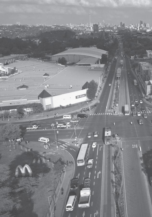
CSCC.indb 40 2014/10/07 5:17 PM
SECT
ION
A
tHe M
aCRO tReN
DS
CSCC.indb 41 2014/10/07 5:17 PM
42
2 The ‘thin oil of urbanisation’? Spatial change in Johannesburg and the Gauteng city-region
Johannesburg in its regional context‘Delink from Johannesburg’: a regional view of spatial developments
EMM [Ekurhuleni Metropolitan Municipality] and its MSDF [Metropolitan Spatial Development Framework] acknowledge that it is part of the Gauteng city region. All the spatial and integral frameworks from the inception of the metro in 2000 have taken their cue from the Gauteng spatial planning framework and all the studies associated with it. Initially the core economic development triangle was developed directly from the GSDF [Gauteng Spatial Development Framework] of 2003, which identifi ed Tshwane, Johannesburg and Kempton Park (including Germiston and Boksburg) as the development triangle of the province. Th e current MSDF evolved from the GSDF of 2010 which identifi es Kempton Park as a development area emerging from the region developing around Johannesburg CBD as its core. However, since EMM is a metro in its own right, the concentric zone model adopted for Gauteng with EMM being part of CoJ [City of Johannesburg], it had been necessary to consciously delink EMM from CoJ and retain the core economic development triangle as part of the developmental agenda for EMM …
It so happens that the airport is less than 10km from the metros boundary CoJ and hence the city is skewed towards Johannesburg. Most of the development activities in the city are based towards the west which is close to CoJ. Having noticed the skewed nature of developments in the city close to CoJ, the city adopted the core economic development triangle that would push the metro towards the east. Th e closeness of
G R A E M E G OT Z , C H R I S W R AY A N D B R I A N M U B I WA
CSCC.indb 42 2014/10/07 5:17 PM
43
the city to CoJ cannot be ignored but it should not be to the detriment of the desired development of the eastern areas of the city of Ekurhuleni. (EMM 2012: 16–17)
This extract, from the EMM’s MSDF, is a remarkably frank statement of an underlying set of assumptions and attitudes about future urban development in the municipality. Decoded and pared to its essence, the passage signals a refusal to accept a new regional planning framework that sees Ekurhuleni in the orbit of Johannesburg. In turn, it states an intention to steer development away from the boundary shared by the two municipalities and therefore away from the current urban centre of gravity and towards the spatial periphery. The approach is justified with reference to the municipality being part of a larger urban formation – the Gauteng city-region – which older planning frameworks such as the GSDF of 2003 had envisaged evolving around a core development triangle to the north-east of Johannesburg.
There is much to contemplate in this extract, but in general terms it alerts us to the fact that in any sustained examination of spatial change in Johannesburg it would be an error to abstract the city from its regional context. The changes under way in the city need to be understood within a wider view of spatial developments – planned and unplanned – in a region of towns and cities of which Johannesburg is simply a part.
In this chapter we consider changes in the macro spatial structure of Johannesburg within the frame of the Gauteng city-region. We first provide a schematic overview of the city-region and Johannesburg’s place in it, and then give a brief historical account of key spatial trends that have shaped both Johannesburg and the region over the last century. In the latter part of the chapter we use a depiction of urban expansion over the period 1991–2009, based on satellite imagery, to anchor an analysis of more recent aspects of the evolution in spatial forms. In this enquiry, our focus falls principally on whether there has been a continuation of past patterns of urban growth in and around Johannesburg, in particular what two scholars in the 1950s (Fair and Mallows 1959) termed the ‘thin oil of urbanisation’ – extensive sprawl with highly fragmented and discontinuous urban structures. We look specifically at the balance between changes on the edge of the built-up area, in effect extending the urban form, and those within it, leading to densification.
The Gauteng city-region: places and populationsGauteng, the provincial area within which Johannesburg falls, is located in the central north-east of South Africa. It stretches some 200 km north to south and some 190 km east to west, giving it an area of 18 179 km2. Johannesburg, South Africa’s primary economic centre and the provincial capital, lies at the centre of the province. To its north is Pretoria, the national administrative capital, in the municipal area of Tshwane. A number of smaller urban centres – including Germiston, Alberton, Boksburg, Benoni, Springs, Nigel, Heidelberg, Vereeniging, Vanderbijlpark, Krugersdorp, Randfontein and Westonaria – spread out across the province (see Plate 1 in the colour section of this book). Each of these centres has its own history and character, but together they work as a functionally connected, almost continuous urban agglomeration (South African Cities Network 2004).
CSCC.indb 43 2014/10/07 5:17 PM
Changing SpaCe, Changing City44
In 1996 Gauteng had a population of 7.8 million people. By 2001 this had increased to just under 9.4 million. Census 2011, released in October 2012 (Stats SA 2012), estimated the province to have almost 12.3 million people. Statistics South Africa’s mid-year population estimates for 2013 put the Gauteng population at just over 12.7 million, representing 24 per cent of the national total on about 1.4 per cent of its land area.
Within Gauteng, Johannesburg is the largest municipality by population size. In 1996 it had an estimated 2.6 million people. In 2001 this had grown to 3.2 million and Census 2011 estimated the city’s population at 4.4 million. Statistics South Africa’s mid-year population estimates for 2013 put the city at over 4.6 million, 36.5 per cent of the provincial total and almost 9 per cent of the national total. The next largest city in Gauteng is Ekurhuleni at just over 3.2 million, followed by Tshwane at almost 3.1 million on 2013 estimates.
A wider urban footprint of other towns and population concentrations extends beyond the borders of Gauteng. To the north-west is the town of Rustenburg, and the Rustenburg, Madibeng and Moretele local municipalities, all in the North West province. Rustenburg is a global centre of platinum mining. As the demand for platinum has increased over recent decades, mining activities have expanded and the area’s growth has accelerated. According to the 2011 Census, Rustenburg has a population of 549 575. It grew 42 per cent between 2001 and 2011, compared to Johannesburg’s growth of 37 per cent.
To the south-west of Gauteng, also in the North West province, is a patchwork of towns historically anchored on gold mining. Among them is Potchefstroom in the local municipality of Tlokwe and, to a greater extent, Klerksdorp in the City of Matlosana local municipality. Some of these centres have seen limited population growth over the last decades as their gold-mining economies have stagnated. Matlosana, for example, grew just 11 per cent over the period 2001–2011. Also to the south, just across the Gauteng border in the Free State province, is Sasolburg, a town centred on the production of oil from coal, situated within the local municipality of Metsimaholo.
To the east are a number of small to medium-sized towns, notably Witbank, Middelburg and Secunda, anchored respectively on coal mining, iron and steel production and energy generation. Some of these local municipalities are growing incredibly fast. For example Steve Tshwete, centred on Middleburg, grew 61 per cent between 2001 and 2011 to now stand at some 230 000 residents. Another area closely linked to Gauteng, situated to the north-east in the Mpumalanga municipalities of Thembisile and Dr JS Moroka, is a swathe of semi-urban settlements – a zone of displaced urbanisation – housing people once barred by apartheid from setting up home in South Africa’s whites-only urban centre. This area of some 560 000 people, on 2011 estimates, has little economy of its own. It is functionally connected to the Gauteng economy by subsidised bus transport routes which have historically ferried thousands of workers into central Pretoria on a long-distance daily commute.
All of these centres are socially and economically linked with the cities and towns in Gauteng. Together they constitute an extended city-region. Since the region has no determinate boundary, it is difficult to estimate the total population of this wider formation.
CSCC.indb 44 2014/10/07 5:17 PM
GOTZ, WRAY AND MUBIWA • THE ‘THIN OIL OF URBANISATION’ 45
However, if concentric circles are drawn around the inner city of Johannesburg – the putative ‘centre’ of the broader region – it can be estimated to have had 13.4 million people within a 100 km radius (Plate 3), and 16.8 million within 175 km, in 2011.
The ‘thin oil of urbanisation’: regional spatial development in historical perspectiveWhile the dramatic expansion of urban forms and activities in what is today recognisable as the Gauteng city-region is singularly attributable to the discovery of gold in Johannesburg in 1886, this city was not the first urban formation in the area. As Mabin (2009: 5) notes, ‘the oldest surviving focus of urbanism in the region is Pretoria, founded as capital of a then-separate settler state in 1855.’1 It took over from Potchefstroom in the far south-west corner of the city region.2 Pretoria grew quickly in the years after it was established, and under ordinary circumstances urban expansion over the last century would probably have occurred in a monocentric form around this city. The discovery of gold some 50 km south of this emerging centre set up a bipolar arrangement of two linked but separate cities in close proximity, one with capital city functions, the other anchored on production, trade and finance.
The discovery of gold marked a dramatic adjustment in the fortunes of South Africa as a whole, and in turn a tectonic shift in the distribution of economic activity and population across the country. The gold rush led to massive international investment. The resulting accumulation of wealth attracted opportunity seekers from within South Africa and across the world. In turn this growth resulted in, and was enabled by, huge infrastructure and institutional developments,3 which set the basis for both the region’s emerging spatial structure and its articulation to the national space.
Writing in 1959, Fair and Mallows neatly describe this evolution:
In order to serve ‘the Reef ’, as the gold mining zone of the Witwatersrand came to be called, and in particular to supply it with coal from these collieries, a railway was completed between Springs and Krugersdorp in 1891. Meanwhile, railways from the coastal ports of Cape Town, Lourenco Marques and Durban reached the Witwatersrand and Pretoria in 1892, 1894 and 1895 respectively. The junction of these routes on the Witwatersrand took place at the easiest crossing of the watershed at Germiston and so gave a permanent nodal significance to this centre. The railway crossing at, and its position on, the Vaal River, a future main source of water for the region, established Vereeniging also, then a small coal mining village, as a potentially important industrial nucleus in the pattern that was later to emerge … Thus, as early as 1896 the broad framework of the present settlement pattern was clearly established. The polynuclear structure, the east-west mining axis and the north-south communications axis had emerged. The sum of these factors had produced the now clearly defined cruciform nature of the structure built around these two dominant axes. (Fair and Mallows 1959: 130)
CSCC.indb 45 2014/10/07 5:17 PM
Changing SpaCe, Changing City46
There are three important points here. First, the bipolar presence of Pretoria and Johannesburg has dominated the structure of the Gauteng city-region. But further discoveries of gold all along the east-west reef, the growth of coal mining in the east, and the emergence of smaller industrial centres, such as Vereeniging-Vanderbijlpark and Nigel, all of which in one way or another connect into mining supply chains, have led to a metropolitan region with a polycentric spatial structure.
Second, over the last century the expansion of Johannesburg and its surrounding region has seen the reorientation of South Africa’s space-economy so that the area now stands at the centre of a web of nationwide infrastructure networks. Today, national roads, passenger and freight rail, road freight routes, gas and oil pipelines, electricity transmission lines, water transfer schemes, national and international air corridors and so on all converge on, or radiate out from, the towns and cities that make up this region. Some of these networks not only connect the region to places elsewhere; they traverse the space and provide very significant internal structuring elements.
Third, the polycentric form of the region was itself structured in a cruciform pattern, with a predominant east-west arm known as the Witwatersrand, and a north-south axis with Pretoria at its head and the Vaal Triangle industrial complex (Vereeniging, Vanderbijlpark and Sasolburg) in the south. Initially referred to in the planning literature as the Southern Transvaal, the region eventually came to be known in everyday reference as the PWV (Pretoria-Witwatersrand-Vereeniging) (Beavon 1997). This form is clearly visible in Plate 4, a 1956 land-use map from the report A Planning Survey of the Southern Transvaal (Fair et al. 1957).4 The same shape can be seen, here more consolidated, in the 1974 map (Plate 5), which is drawn in virtually identical colours.5
Within this overall polycentric structure, loosely organised along and around two major axes crossing in Johannesburg, the region’s spatial development has produced a number of distinctive characteristics over time. While the historical literature points to considerable variety in spatial structures, some characteristics were common across the region. Four are highlighted briefly here.
Fractured forms In the 1973 study ‘The Witwatersrand – Regional Setting: Southern Transvaal’ (often colloquially referred to as the Metrocom Report),6 the Urban and Regional Research Unit at the University of the Witwatersrand highlighted that component parts of the region had evolved quite varied macro structures.7 However, it refers repeatedly to the fact that a common feature across large parts of the region was the highly fractured nature of urban development. In relation to the Vaal Triangle it speaks of ‘sparse and scattered pockets of white and non-white residential development’. On the near East Rand it sees a ‘confused nucleus of mining, industrial and white residential development’, and on the far East Rand a ‘widely scattered pattern of land uses’ (Urban and Regional Research Unit 1973: 13).
This fractured development pattern is visible in Plates 4 and 5. Both show white residential areas in dark pink and proposed white residential areas in light pink. The light
CSCC.indb 46 2014/10/07 5:17 PM
GOTZ, WRAY AND MUBIWA • THE ‘THIN OIL OF URBANISATION’ 47
pink areas in the 1956 map have become dark by 1974, indicating significant consolidation in the northern Johannesburg part of the Witwatersrand, as also noted by the Urban and Regional Research Unit (1973). However, the eastern stretches of the Reef are very evidently made up of a series of residential fragments strewn across proclaimed mining land, shown in yellow on both maps. This pattern seems even more fragmentary by the early 1970s. A similar conclusion can be drawn for southern Pretoria, albeit to a lesser extent, and the Vaal Triangle, although here the light pink suggests a plan to cohere the area between the huge Iscor industrial works – in purple on both maps – and the Vaal River.
There were several reasons for this fracturing of urban development in the history of the Gauteng city-region. A very important factor on the central east-west axis was the nature of mining land itself. Undermining of southerly sloping gold reefs, together with extensive areas of mine tailings sterilised by the industrial chemicals used to extract gold from ore-bearing rock, meant that residential areas, even while they were essential in the vicinity of mine works to ensure a proximate labour supply, simply could not grow in more natural and efficient ways.
Of course, township planning under apartheid significantly exacerbated the fracturing of urban forms in the region. As Plates 4 and 5 show for the critical 20-year period over which apartheid was most vigorously implemented, African, coloured and Indian/Asian areas were demarcated to be deliberately dislocated from the main urban cores. African areas are shown in dark grey on the 1974 map, coloured areas in dark blue and Indian/Asian areas in orange. To illustrate, consider the placement of Tembisa, shown as planned in 1956 and partly built in 1974, in what was then still open space between Pretoria and the Witwatersrand.
The mining belt of the Witwatersrand was also used deliberately in places as an apartheid ‘buffer zone’ separating racially defined settlements. Over time it became a physical marker of the spatial and wealth divides wrought by apartheid, and still today poses limitations on post-apartheid spatial reintegration. In Johannesburg in particular it continues to segment the city into a wealthier and greener north, and a much poorer and dustier south where townships such as Soweto and more informal settlements such as Orange Farm are located.
Another key reason for fragmentation has been that the region is encircled by an east-west-running collar of dolomitic land that renders development in some areas difficult or even impossible because of the danger of sinkholes (Urban and Regional Research Unit 1973). In one view, this ‘constraint’ on urban growth is also an asset. It ensures that a proportion of Gauteng’s land surface, in particular sections containing valuable agricultural land and unique unspoilt Bankenveld grassland, will be preserved from future development. But this land has prevented urban consolidation in certain areas, notably south of Soweto and south of Pretoria.
Sprawl and inverted densities In their 1959 article, Fair and Mallows also identify the fragmented nature of urban space as a key characteristic, and tie this together with the issue of sprawl:
One interesting aspect of the historic development of the Reef and one affording a very sharp contrast to much of the older industrial growth, particularly in Europe, is
CSCC.indb 47 2014/10/07 5:17 PM
Changing SpaCe, Changing City48
the relative lack of any restriction on horizontal expansion as far as the availability of land is concerned. The ‘wide open spaces’ of the Highveld are literally true; they have little agricultural value in the immediate neighbourhood of the Reef, as has already been pointed out, and the only limitations on urban sprawl are the internal technical limitations, mainly transport, water and power, of the urbanization itself. … This thin ‘oil’ of urbanization has been spread out over the surface of the land … This factor, added to the naturally haphazard surface patterns that any mining operation creates, has given an exceptionally loose and open texture to the urban areas. All trends indicate that urban dispersion is continuing at an un-checked rate, whether planned or un-planned; and it seems that planning will have to be done against the background of such a texture. (Fair and Mallows 1959: 137–138)
The fact that almost all of the growth in Gauteng occurred during the age of the automobile meant that very little white residential development occurred in and around dense, walkable city centres on the model of European cities. The rapid spreading of these areas is clearly shown in Plates 4 and 5. The light pink areas in the 1956 map have all been built by 1974, and more has been developed besides, as evidenced in particular in northern Johannesburg and eastern Pretoria. And the 1974 map then shows the further planned extension of these areas. Most noticeable here is the proposed stretching of the residential edge in the south of Johannesburg – what would become the suburbs of Glenvista, Mulbarton, Bassonia, Meyersdal, Brackenhurst and Brackendowns – as well as along a corridor north of Roodepoort and Krugersdorp, and north and south of Pretoria.
In addition, apartheid policies of locating Africans in decentralised dormitory ‘townships’ did two things. First, on an overall level, it spread Gauteng’s urban form more thinly than would have been the case if the cities’ property markets had functioned normally, and people had been permitted to cluster naturally nearer to nodes of work opportunity. Fair and Mallows (1959: 137) compellingly, and not disapprovingly,8 describe the outcome of the 1953 Witwatersrand and Vereeniging Native Areas Zoning Committee’s region-wide planning of African townships as follows:
The rate of this (African housing) development is such that the Director of Housing for Johannesburg was able to state that the ground was being consumed for African housing at the rate of two square miles per annum in the chief area of development south-west of Johannesburg.
This expansion is clear in the 1956 and 1974 maps. In 1956 a relatively small part of Soweto, just south of the mining belt, is shown as built (black on the map). The planned section is marked with a diagonal line pattern. By 1974 much of this had been built, as had Sebokeng north of Vereeniging, and Katlehong and Vosloosrus south of Alberton. Meanwhile, Sophiatown in central Johannesburg had been removed. Intriguingly, the two maps suggest that there was relatively slower development of African residential areas on the far East Rand, with Daveyton in particular showing no growth between 1956 and 1974.
Second, because apartheid policies forced large racially defined populations into ghettos
CSCC.indb 48 2014/10/07 5:17 PM
gOtZ, WRay anD MUBiWa • the ‘thin OiL OF URBaniSatiOn’ 49
and prohibited free movement, this resulted in an aberration in the overall pattern of fast-spreading urban forms. Ordinarily the density curves of a city are highest at its centre, and drop off towards the periphery. In the Gauteng city-region the historical displacement of African, coloured and Indian/Asian populations was another dimension of sprawl, but it led to the unique signature of concentrations of high density on the edge of the city (Mabin 2009). Alain Bertaud shows that by 1990 Johannesburg had a density of some 40 persons per hectare (p/h) in its city centre, compared to about 300 in Paris and 100 in New York. Its densities then increased to between 140 and 150 persons p/h at a distance of around 25–30 km from the CBD along the central Witwatersrand zone, compared to less than 50 in Paris and around 25 in New York (Bertaud 2004).
Deconcentration and displaced urbanisationThere is a recurring anxiety in the historical writings on the region over whether the urban fragments that had sprung up on the periphery would be viable in the long run. Fair and Mallows traced the shifting centres of gravity of gold mining and associated production. They highlighted the swing in economic weight from the West to the East Rand – in part due to the fact that the latter had a convergence of regional and national railways, proximity to the coalfields in what is now Mpumalanga, and flatter land for large industrial works – but also how gold production volumes in the Southern Transvaal were declining, while those in the new Free State goldfields were increasing. In their view, Johannesburg had already long since passed the point where it was ‘primarily dependent on mining’, and had consolidated a truly diverse metropolitan economy. But the ‘arms of the east-west axis’ were facing an ‘acute’ problem. They were showing a ‘growing degree of commuting’ to the ‘Johannesburg metropolitan core’ and had a ‘growing dormitory character in relation to Johannesburg’. To offset this decline, Fair and Mallows argue, outlying urban centres along the Reef were ‘encouraging the growth of industry’ to promote a more ‘balanced economy’ (Fair and Mallows 1959: 136).
Though in favour of this strategy in the late 1950s, Fair and his team at the Urban and Regional Research Unit seem more ambivalent about the likely success of industrial decentralisation in the 1973 Metrocom Report. Here they emphasise the special planning problems associated with urban areas on or near mining landscapes, which ‘may be shallowly undermined or replete with mine dumps, slime dams and derelict plant’, and which may also be affected by the ‘structural weaknesses’ of dolomitic land, and conclude pessimistically:
There is no geological reason for each of the formerly independent mining towns to become a manufacturing or service node within the modern metropolitan region that is so rapidly replacing the old mining complex, and there may be no particular economic or social reason either. (Urban and Regional Research Unit 1973: 9)
The challenge of how to ensure the sustainability and growth of peripheral areas, and ambivalence over the prospects for success of decentralisation measures, have been echoed at the larger regional scale through much of the last half-century. Geyer (1990) traces how
CSCC.indb 49 2014/10/07 5:17 PM
Changing SpaCe, Changing City50
the 1956 Guide Plan for the PWV envisaged industrial development only in the region’s core, while the 1974 Guide Plan had shifted policy to emphasise industrial development in the far eastern, far western and southern sections of the PWV. As early as the 1960s, but very explicitly by the early 1980s, decentralisation of industrial development was being tied to the patterns of urbanisation in bantustan areas in the far north-west and north-east of the city-region. Here, as mentioned earlier, swathes of semi-urban, semi-rural settlement make up a vast zone of displaced urbanisation. Late apartheid planning identified six industrial deconcentration points in this zone, to promote ‘the development in these outer peripheral Bantustan areas and in the diversion of black urbanization away from the PWV’ (Geyer 1990: 389).
Geyer is scathing in his critique of the deconcentration points selected, indicating that contrary to claims that they are geographically well located and economically supported by ‘spontaneous natural growth tendencies’, they would not work without costly and inefficient industrial subsidies. He also references academic arguments that the PWV was then still a small metropolitan region by world standards, and that diverting growth away from its core would hamper consolidation. But ironically, he concludes his article with his own vision for deconcentration, intriguingly in support of the ideals of a wider city-region:
If intermediate centres such as Potchefstroom-Klerksdorp-Witbank-Middleburg and Rustenburg are regarded as decentralization points in a system of cities with the PWV, a geographically more balanced distribution of deconcentration points … some within the intermediate/outer core zone and some within the core fringe zone need to be designated to reinforce the system of cities. Centres such as Midrand and Meyerton within the intermediate/outer core zone, and Brits, Bronkhorstspruit, Secunda and Carletonville within the core fringe zone, all of which are centres with considerable growth potential, and all of which are located on primary communication axes inside the PWV and between the PWV and the intermediate cities should be considered. (Geyer 1990: 393)
Ribbon development The historical scholarship is also ambivalent on a gradual process of infill development between the three poles of the city-region – Pretoria, the Witwatersrand and the Vaal Triangle – along key corridors. As noted, the region was connected to other key centres across South Africa by a national network of railway lines and later highways, but this infrastructure also traverses the space internally, providing a lattice along which growth can occur. While Geyer, in the extract above, sees the need to locate deconcentration points with explicit reference to these ‘primary communication axes’, others have worried about how the core urban areas seem to be sprawling outwards along these links. The 1973 Metrocom Report expresses great anxiety about this phenomenon, in fascinating terms contrasting it with a future spatial strategy that privileges development of peripheral areas:
Other probable sources of inter-metropolitan planning problems are … in connection with ribbon-like industrial and residential thrusts taking place along the main highways
CSCC.indb 50 2014/10/07 5:17 PM
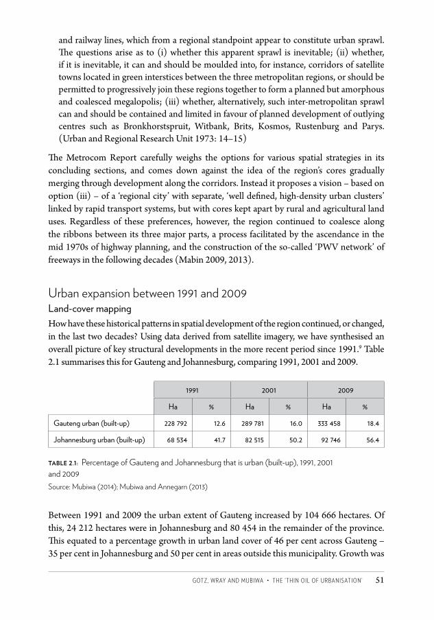
gOtZ, WRay anD MUBiWa • the ‘thin OiL OF URBaniSatiOn’ 51
and railway lines, which from a regional standpoint appear to constitute urban sprawl. The questions arise as to (i) whether this apparent sprawl is inevitable; (ii) whether, if it is inevitable, it can and should be moulded into, for instance, corridors of satellite towns located in green interstices between the three metropolitan regions, or should be permitted to progressively join these regions together to form a planned but amorphous and coalesced megalopolis; (iii) whether, alternatively, such inter-metropolitan sprawl can and should be contained and limited in favour of planned development of outlying centres such as Bronkhorstspruit, Witbank, Brits, Kosmos, Rustenburg and Parys. (Urban and Regional Research Unit 1973: 14–15)
The Metrocom Report carefully weighs the options for various spatial strategies in its concluding sections, and comes down against the idea of the region’s cores gradually merging through development along the corridors. Instead it proposes a vision – based on option (iii) – of a ‘regional city’ with separate, ‘well defined, high-density urban clusters’ linked by rapid transport systems, but with cores kept apart by rural and agricultural land uses. Regardless of these preferences, however, the region continued to coalesce along the ribbons between its three major parts, a process facilitated by the ascendance in the mid 1970s of highway planning, and the construction of the so-called ‘PWV network’ of freeways in the following decades (Mabin 2009, 2013).
Urban expansion between 1991 and 2009Land-cover mappingHow have these historical patterns in spatial development of the region continued, or changed, in the last two decades? Using data derived from satellite imagery, we have synthesised an overall picture of key structural developments in the more recent period since 1991.9 Table 2.1 summarises this for Gauteng and Johannesburg, comparing 1991, 2001 and 2009.
1991 2001 2009
Ha % Ha % Ha %
Gauteng urban (built-up) 228 792 12.6 289 781 16.0 333 458 18.4
Johannesburg urban (built-up) 68 534 41.7 82 515 50.2 92 746 56.4
table 2.1: Percentage of Gauteng and Johannesburg that is urban (built-up), 1991, 2001 and 2009 Source: Mubiwa (2014); Mubiwa and Annegarn (2013)
Between 1991 and 2009 the urban extent of Gauteng increased by 104 666 hectares. Of this, 24 212 hectares were in Johannesburg and 80 454 in the remainder of the province. This equated to a percentage growth in urban land cover of 46 per cent across Gauteng – 35 per cent in Johannesburg and 50 per cent in areas outside this municipality. Growth was
CSCC.indb 51 2014/10/07 5:17 PM
Changing SpaCe, Changing City52
faster between 1991 and 2001 (26.7 per cent for Gauteng) than between 2001 and 2009 (15.1 per cent), though this partly reflects the shorter second period. When viewed as a proportion of its own total area, urban land-cover growth was the fastest in Johannesburg between 1991 and 2009, rising nearly 15 per cent from 42 per cent to 56 per cent urban.10 By way of comparison, Ekurhuleni rose 12 per cent to end at 44 per cent urban in 2009. However, almost all municipal areas had faster percentage growth than Johannesburg over the two decades. Illustratively, the urban extent of Emfuleni (Vereeniging) grew 46 per cent, Mogale City (Krugersdorp) 56 per cent and Midvaal (Meyerton) 73 per cent.
Urban growth between 1991 and 2009 is mapped in Plate 6 at the Gauteng-wide scale, and Plate 7 for Johannesburg. The plates show the 1991 urban extent in green and the 2009 extent in red.
A close examination of the maps between 1991 and 2009 suggests that the regional structure of large urban blocks roughly arrayed in a cruciform pattern, with smaller but distinct urban centres around them, has remained intact, and that there has been considerable continuity in the historical growth patterns.
First, fractured forms of development continue, and in parts the process of fragmentation seems to have been exacerbated. In Johannesburg, consider Diepsloot and Cosmo City on the city’s northern edge, a range of urban fragments in the south – with Poortjie in the far south-west corner being a particularly noteworthy example – and Vlakfontein north-west of Soweto in the old mining belt. (Plates 1 and 2 provide a visual reference for many of the cities and suburbs mentioned in this chapter.) Vlakfontein and nearby Bram Fischerville notwithstanding, there has also been little development that has overcome the historical barrier of the east-west mining belt, and the separation it symbolises between the north and south of the city. The holes it leaves in the overall spatial pattern also remain. The same is clearly true for the East Rand segments of the Witwatersrand, in what is now Ekurhuleni – they show only slightly less fragmentation than in the 1956 and 1974 maps discussed earlier (Plates 4 and 5).
Second, and as suggested in the percentage calculations above, the maps indicate that sprawl has continued on the edges of both township areas and previously whites-only suburbs. Following Fair and Mallows’ quoting of the then Johannesburg Director of Housing, ‘African housing’ still ‘consumes ground’ at a considerable rate on the edge of Soweto, and also every other large township laid out under apartheid. For example, Soweto has been extended dramatically south-west, west and north-east with new areas such as Protea South, Protea Glen, the beginnings of Lufhereng, and Braamfischerville. Urban growth was also significant in the Orange Farm, Lawley Estate, Ennerdale and Grasmere areas. However, by far the strongest growth seems to have been north-west of Tembisa, east of Halfway House, in Ivory and Ebony Park and related extensions.
In the north of Johannesburg, suburban sprawl characterised growth around the urban edge of the north-western suburbs, notably in Fourways, Sunninghill, Diepsloot and west of Midrand in new suburbs like Kyalami Estates and Vorna Valley. The extension of previously white residential areas is also pronounced in the south of Johannesburg.
CSCC.indb 52 2014/10/07 5:17 PM
GOTZ, WRAY AND MUBIWA • THE ‘THIN OIL OF URBANISATION’ 53
While Johannesburg has seen much outward growth in certain areas, the province-wide map (Plate 6) makes it clear that other parts of the region have experienced even more significant expansion. Remarkable growth has occurred in the areas north-west of Pretoria around such settlements as Kekana, Babelegi, Hammanskraal, Temba and Ga-Mokone, together with north-east expansion of Mabopane and the south-west expansion of Soshanguve. Also in the Tshwane area, urban growth was seen on the edge of Atteridgeville, Mamelodi and Akasia. Bronkhorstspruit/Ekangala to the far north-east, and mining-related settlements such as Krugersdorp, Westonaria, Carletonville, Khutsong and Phomolong in the far west, also saw some growth.
The pace of expansion seemed slower on the East Rand than elsewhere between the late 1950s and early 1970s, but Ekurhuleni appears to have seen some of the most dramatic growth of townships in the 1991–2009 period. Areas such as Duduza and Geluksdale expanded southwards while Tsakane grew westwards. There has been a huge southward spread of the Katorus (Katlehong, Thokoza and Vosloosrus) complex of townships, as well as outward development on the north-eastern edge of Daveyton.
Not all areas have seen outward expansion. For example, the cores of Vereeniging and Vanderbijlpark, which certainly showed some expansion in the 1970–1990 period, have barely grown over the last two decades, except for the scattering of low-density development along the Vaal River to the west.11 Further, notwithstanding evidence of spread, there has also been infill development in some places. Small portions of mining-to-urban conversion were experienced close to the Johannesburg CBD. This could be attributed to the reclamation of mine tailing facilities for wholesale and industrial development (see Chapter 29).
Third, the extraordinary development of the band of settlements in the north-western corner of the province speaks volumes to the residual effects of displaced urbanisation, and policies of diverting urbanisation through industrial deconcentration. While the monocentric character of the central part of Pretoria remains, the remarkable growth around Mabopane, Soshanguve and the Winterveld has bifurcated the space. Unfortunately our change-detection maps cover only Gauteng and so it is impossible to see whether there has been a similar trend in the areas previously covered by KwaNdebele, with the exception of that small portion – Ekangala – that was incorporated into Gauteng. This does seem to have shown similar growth over the period.
Fourth, all the evidence points towards the steady erosion of the Metrocom Report’s vision of a ‘regional city’, built on the model of dense urban clusters kept separate by protected rural and agricultural green belts. Its fear that an amorphous region will coalesce from sprawl along ribbons between the three major cores is exactly what has come to pass, most notably with the developments along two corridors between Pretoria and Johannesburg/Ekurhuleni.
Key developments stretching the urban formOur calculations and mapping of urban growth between 1991 and 2009 show the extent to which the urban form of Johannesburg and the wider city-region has stretched over the
CSCC.indb 53 2014/10/07 5:17 PM
Changing SpaCe, Changing City54
last two decades, and some of the main patterns. There have been three key driving forces behind this expansion: the provision of public housing, the dramatic growth of various sorts of gated communities and, to a lesser extent, the establishment of informal settlements. All three are discussed in detail in other chapters in this volume (Chapters 8, 9 and 11) but a broad overview is warranted here.
An indication of the extent and spatial location of new public housing developments and the expansion of gated communities can be drawn from GeoTerraImage’s (GTI) building-based, land-use dataset. This captures a point per structure with associated attributes for various residential categories and thus can give a sense of residential growth patterns in Gauteng between 2001 and 2010.12
Plate 8 depicts the growth of formal freehold housing units – the deeper the shade of red the larger the number of new housing units per square kilometre between 2001 and 2010. It is clear that new housing has concentrated on the fringes of the cities, with the largest growth in Johannesburg occurring in Cosmo City in the north, around Soweto in the west and Orange Farm in the south. Much of this would have been government-provided housing.
On GTI’s count there were 1 191 932 self-standing houses in Gauteng in 2001 (395 782 in Johannesburg) and by 2010 there were 1 550 905 (501 472 in Johannesburg). This was an increase of 30 per cent across Gauteng, and 27 per cent in Johannesburg.
Plate 8 also maps the growth of estates and security villages – the deeper the blue the greater the number of units per square kilometre between 2001 and 2010. GTI estimates that there was a 202 per cent increase in housing units – from 26 573 to 80 342 – in estates and security villages across the province. Johannesburg saw an increase of 114 per cent, from 13 757 to 29 410.
The location of townhouse clusters and estates, development of which is driven by the private sector, differs wildly from the sites of new housing, most of it in the form of publicly driven delivery. As shown in Plate 8, the latter are all in the poorer areas of the city-region, usually on the edges of municipalities and with a preponderance in southern and western Johannesburg, on an axis running between Johannesburg and Vereeniging (the Orange Farm, Evaton, Sharpeville complex of informal settlements and townships), as well as in the far northern parts of Tshwane. By contrast, the growth of estates is almost exclusively located in the wealthy core of the province, most on the edge of the existing built-up area, on a sweeping diagonal from the north-west of Johannesburg to the south-east of Tshwane.
Plate 9 confirms this picture, using a different dataset (AfriGIS) as at 2012. This captures gated communities in Gauteng, disaggregating between sectional schemes, residential estates, commercial estates/business parks and boomed-off residential areas. The background data show that in Johannesburg these various kinds of gated communities made up a total of 141.4 km2 in 2012. This represents 8.6 per cent of the total land area of the city (1 644 km2) and a significant 19.0 per cent of its urban area (743 km2). In Gauteng as a whole, gated communities comprised 324.4 km2, 1.9 per cent of Gauteng’s total area and 11.7 per cent of its urban area. The extraordinary swathe of these gated communities across a wide sweep of
CSCC.indb 54 2014/10/07 5:17 PM
GOTZ, WRAY AND MUBIWA • THE ‘THIN OIL OF URBANISATION’ 55
the central province, as mapped in Plate 9, more viscerally captures the reality of how these forms of settlement have stretched the urban form than do the statistics.
The urban extent of the region has also been extended by informal settlements, but to a lesser degree. GTI informal housing data contain a point per informal housing structure, as well as another category, transitional, for informal dwellings in areas – such as those being formalised in situ with roads and stand layouts – where it is difficult to distinguish between temporary, informal housing and more permanent housing. On GTI’s count, the number of informal settlement units across Gauteng increased from 395 449 in 2001 to 424 215 in 2010 (7.3 per cent growth) and the number of transitional units from 161 963 to 165 015, a mere 1.9 per cent increase. In Johannesburg, units in informal settlements declined from 105 868 to 99 166, while transitional structures rose by 50 per cent from 41 738 to 62 719.
There is consonance between these data and the results of the 2011 Census, if informal and transitional dwellings are counted together. According to the Census, there were 512 774 Gauteng households in informal and traditional dwellings in 2001. This declined by –12.7 per cent to 447 800 in 2011.13 One possible explanation for the miniscule growth (or decline in the case of the Census) in informal settlements may be the roll-out of government housing schemes across the province. The movement of informal settlement residents to backyard dwellings within formal stands may be another key factor. Regardless of the reason, it is clear that while informal settlements have certainly been part of the ‘thin oil of urbanisation’, spreading the region’s urban form, their impact is declining relative to other settlement types.
Consolidation and densification within the urban extentThe section above traced key settlement developments extending the urban form of both Johannesburg and the wider region. However, this visible outward expansion is certainly not the only change under way. There are also trends that are having the opposite effect of driving up population densities.
As noted in the introduction to this volume, Angel et al. (2012) alert us to the fact that, contrary to almost all other major cities in the world, densities in Johannesburg increased between 1990 and 2000. There are various ways to test whether this trend continued.14
Using the concentric ring depiction of the Gauteng city-region discussed earlier, it is possible to show that the population beyond a 100 km radius of the centre of Johannesburg, but within 175 km, increased by 595 845 people (21.2 per cent) between 2001 and 2011. The population within 100 km increased by 3 143 625 (30.8 per cent), and the population within Johannesburg’s boundaries grew by 1 211 136 (37.6 per cent) over the period. In overall terms, this is therefore a city-region that is growing fastest at its core, in effect consolidating.
On the basis of our land-cover change mapping we can also determine that the urban extent of Gauteng grew 15.1 per cent between 2001 and 2009, and that for Johannesburg it was 12.4 per cent. The population growth over the roughly corresponding period of 2001
CSCC.indb 55 2014/10/07 5:17 PM
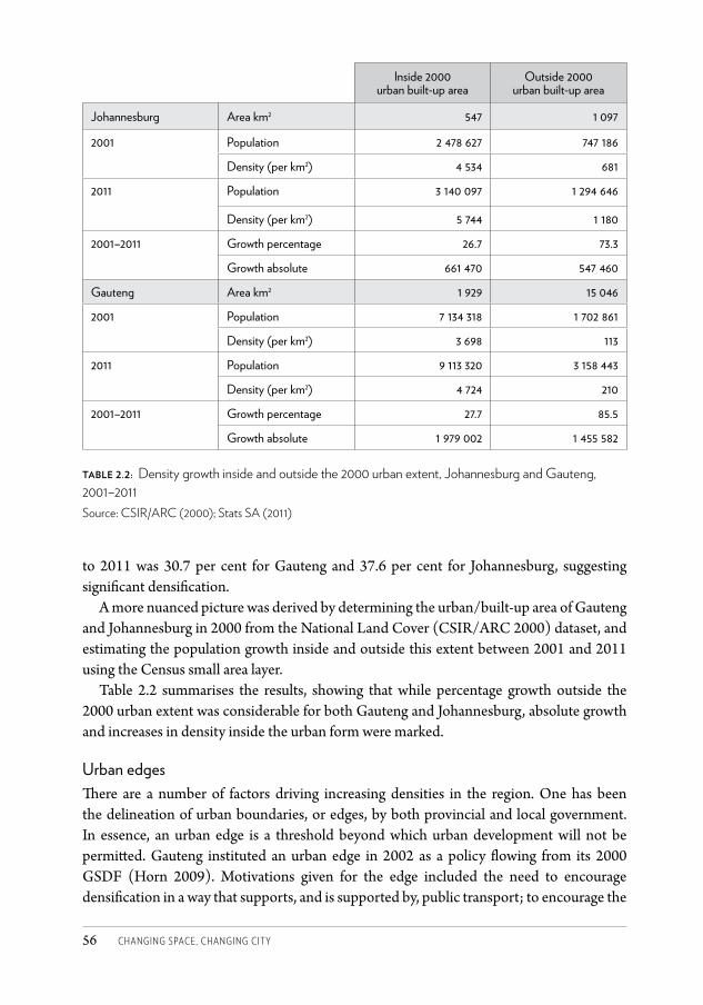
Changing SpaCe, Changing City56
to 2011 was 30.7 per cent for Gauteng and 37.6 per cent for Johannesburg, suggesting significant densification.
A more nuanced picture was derived by determining the urban/built-up area of Gauteng and Johannesburg in 2000 from the National Land Cover (CSIR/ARC 2000) dataset, and estimating the population growth inside and outside this extent between 2001 and 2011 using the Census small area layer.
Table 2.2 summarises the results, showing that while percentage growth outside the 2000 urban extent was considerable for both Gauteng and Johannesburg, absolute growth and increases in density inside the urban form were marked.
Urban edgesThere are a number of factors driving increasing densities in the region. One has been the delineation of urban boundaries, or edges, by both provincial and local government. In essence, an urban edge is a threshold beyond which urban development will not be permitted. Gauteng instituted an urban edge in 2002 as a policy flowing from its 2000 GSDF (Horn 2009). Motivations given for the edge included the need to encourage densification in a way that supports, and is supported by, public transport; to encourage the
Inside 2000 urban built-up area
Outside 2000 urban built-up area
Johannesburg Area km2 547 1 097
2001 Population 2 478 627 747 186
Density (per km2) 4 534 681
2011 Population 3 140 097 1 294 646
Density (per km2) 5 744 1 180
2001–2011 Growth percentage 26.7 73.3
Growth absolute 661 470 547 460
Gauteng Area km2 1 929 15 046
2001 Population 7 134 318 1 702 861
Density (per km2) 3 698 113
2011 Population 9 113 320 3 158 443
Density (per km2) 4 724 210
2001–2011 Growth percentage 27.7 85.5
Growth absolute 1 979 002 1 455 582
table 2.2: Density growth inside and outside the 2000 urban extent, Johannesburg and Gauteng, 2001–2011 Source: CSIR/ARC (2000); Stats SA (2011)
CSCC.indb 56 2014/10/07 5:17 PM
GOTZ, WRAY AND MUBIWA • THE ‘THIN OIL OF URBANISATION’ 57
acquisition of well-located land for housing which would consequently not be on the edge of the city; to promote a compact and sustainable city; and to direct development towards sites in the core where bulk infrastructure already exists, relieving pressure for the extension of stretched infrastructure networks (Horn 2009).
By all accounts, the delineation of the edge started well with the establishment of an urban edge task team, consisting of key provincial government departments and all affected municipalities, and the definition of a logically ordered process to define and approve the boundary. However, intergovernmental challenges arose when municipalities contended that they had not been consulted enough in the initial design work on the urban edge, and proposed a different set of boundaries through their own integrated development planning processes.15 This led to a conundrum: on the one hand the provincial government’s version of the edge had no legal standing because it needed to be authorised in terms of legislation that was only concluded later in 2003, with key regulations still to be drafted thereafter; on the other, a different set of boundaries was formally adopted as part of spatial development frameworks in municipal integrated development plans, and began to govern local planning decisions immediately (Horn 2009). While efforts to resolve the matter over the years met with some success in some places, differences of opinion and divergences in application of urban edges continued through much of the 2000s (see Chapter 20), until in February 2011 the Gauteng edge was rescinded with the approval of a new GSDF.
These difficulties aside, urban boundaries did have some impact in limiting expansion. Plates 10 and 11 show the changing Gauteng urban edge, overlaid with a new view of our change-detection mapping between 1991 and 2009. In these maps the extent of change to urban land cover in each square kilometre block across the province is shown through a colour ramp, with 100 per cent being complete change in the block, as marked in red on the maps. This version of the change mapping illuminates that urban expansion in the 1991–2001 period seemed to be over a much wider area in virtually all parts of the province than over the 2001–2009 period. In the latter period, growth was also considerable, but much more concentrated in specific locations. Plate 10 shows the first provincial urban edge drawn in 2002. Municipal urban edges would have roughly followed this line, though there were certainly divergences. Plate 11 shows both the 2002 edge in grey, and how this line shifted over the decade with the 2010 adjustment in blue.
Four things stand out. First, it is notable that the urban edge was drawn to start with in a way that permits the ongoing ‘ribbon development’ connecting Pretoria and the Witwatersrand, a choice that recognises the inevitability of the trend the 1973 Metrocom Report feared. Second, it seems clear that the 2002 line was drawn to contain areas of extensive sprawl such as the fast-expanding north-western belt and growing southern suburbs in Johannesburg. The 2001–2009 map (Plate 11) suggests that, by and large, the edge succeeded in accomplishing exactly this. The pattern of growth has altered significantly in the second map, and sprawl has not continued across the 2002 line except in a few places. Third, it is clear that some areas of concentrated expansion were in fact already anticipated and allowed for in the 2002 edge. Consider, for example, how the southerly
CSCC.indb 57 2014/10/07 5:17 PM
Changing SpaCe, Changing City58
expansion of the Katorus townships in Ekurhuleni, while dramatic, occurs within the 2002 line. Fourth, these positive conclusions notwithstanding, there has been development over the boundary between 2001 and 2009 and an accompanying trend of moving the edge to accommodate this. For example, the edge has been moved to allow for new large-scale housing developments such as Lufhereng west of Soweto, and for more lifestyle estates, especially where this brings greater property rates revenue to smaller municipalities such as the previous Kungwini. However, as the second map (Plate 11) shows, the shift is not always outwards, allowing free reign to sprawl; in some instances the edge has actually been tightened over time.
While there is considerable nuance in the story, and while we cannot be conclusive, it is likely that the urban edge approach contributed to the slowing of urban expansion in the 2001–2009 period over that seen in the previous decade. Further, the slower pace of outward growth in some areas may be attributable to the more rigorous application of urban boundaries there than elsewhere. For example, Johannesburg’s urban growth of 12 per cent between 2001 and 2009 compares to 16 per cent in Tshwane, a municipality that did not adopt an urban edge.
Inner-city developments and backyard dwellingsA number of other trends are driving densification. We noted earlier that Alain Bertaud (2004), while highlighting the generally low densities in the region, had identified the odd phenomenon of inverted densities, with a very low population concentration at Johannesburg’s core increasing dramatically some 25–30 km from the centre. However, Bertaud reproduced his analysis later in the decade, using 2001 instead of 1991 Census data, and looking at Gauteng as a whole. Here he found that densities in the inner city of Johannesburg had increased to over 140 p/h. Along the density curve they also slope downwards in line with international norms to about 25 p/h within 30 km of the city centre. He specifies here that his 1991 analysis was along the Witwatersrand only (Bertaud 2008).
For much of its early years, Johannesburg’s inner city was a dense mixture of both formal and informal dwellings crowded together around the original mine works to the south. From these early beginnings residential development spread outwards, first to the east and south, and then over the Braamfontein ridge to the north. It did so in part because city planning regulations restricted the height of buildings in the central city area. These height restrictions were removed in the 1950s, leading to a building boom of high-rise residential apartments in Hillbrow and Berea. Since then densities have increased in waves, although the 1980s saw a dip in the overall trend, with white residents beginning to abandon the area in favour of the suburbs. More recently, densities have climbed as underutilised office blocks have been converted to residential quarters, both legally and illegally. Flats, houses in the near-inner-city suburbs and industrial spaces have also been subdivided to accommodate multiple families. Within the urban development zone boundary conventionally used to define the Johannesburg inner city,16 the population increased 35 per cent from 158 142 in 1996 to 213 650 in 2001. It increased a further 21 per cent to 259 268 between 2001 and
CSCC.indb 58 2014/10/07 5:17 PM
GOTZ, WRAY AND MUBIWA • THE ‘THIN OIL OF URBANISATION’ 59
2011. Similar marked growth has been seen in other central city areas across the region, such as the Pretoria CBD.
Another instance of multiple families occupying a property is the phenomenon of backyard dwellings. This occurs when the yards of formal self-standing houses are made available for the construction of secondary structures, formal or informal. GTI data indicate that while there was limited growth of structures in informal settlements between 2001 and 2010, the number of backyard structures across Gauteng increased by 178 per cent from 266 929 to 743 052. In Johannesburg, the increase was a massive 213 per cent from 86 422 to 270 285, a significant impetus behind densification.
ConclusionThis chapter started from the premise that spatial change in Johannesburg can only be fully understood if one contextualises it within the trends and dynamics shaping space in the wider urban form of which this city is a part. At no point in the history of modern settlement in the area did the boundaries of the current City of Johannesburg contain the full extent of urban development. Johannesburg has always been one part of a wider region of towns and cities and spatial change in the city, whether planned or unplanned, has always occurred in dynamic interaction with changes in the surrounding parts of the city-region, and vice versa. With reference to spatial features and processes that are explored in more detail in other chapters of this volume, we have tried to give both a historical perspective and a more contemporary view. We show that while some dimensions of region-wide change continue to stretch the urban form, the ongoing ‘thin oil’ of sprawl and fragmentation is also strongly counterbalanced by structural changes leading to densification and consolidation within the urban fabric.
AcknowledgementsThe authors wish to acknowledge the work of Jennifer Paul and Daniel Kibirige on some of the maps.
Notes1 This section of the chapter is informed by Alan Mabin’s considerable work tracing the
history of the region, notably: Mabin (2008, 2009 and 2013) as well as his contribution to the case study commissioned by the GCRO in 2009 on The Gauteng City Region for Metropolis’s Commission 2 on Urban Growth Management, see http://www.gcro.ac.za/project/metropolis.
2 Potchefstroom was founded in 1838 and became the capital of the Zuid Afrikaanse Republiek in 1841. See http://www.potchefstroom.info/history/town-timeline. The oldest European-settled town in the broader region is Klerksdorp, founded in 1837.
3 An example was Rand Water, established in 1903, which today still supplies much of the extended region with bulk water (Rand Water 2004).
CSCC.indb 59 2014/10/07 5:17 PM
Changing SpaCe, Changing City60
4 Note that the map is recorded in the report as dated 1956, while the report was published in 1957.
5 We cropped the map to a size equivalent to the 1956 map to enable comparison.6 The report’s preface explains that Metrocom was a grouping of city councils whose members
were Johannesburg and Germiston, Alberton, Edenvale, Kempton Park, Krugersdorp, Randburg, Roodepoort, Sandton, as well as the Village Council of Bedfordview and the Modderfontein Health Committee (Urban and Regional Research Unit 1973). It is worth noting that TJD Fair was also involved in the development of this report, as the director of the Urban and Regional Research Unit, and as one of the authors.
7 The report indicates that metropolitan Pretoria had developed an ‘essentially mononuclear character’ compared to the ‘dualistic character’ of the Vaal Triangle, with Sasolburg located across the Vaal River from the extensive industrial and residential areas around Vereeniging-Vanderbijlpark. By contrast, the Witwatersrand had its own ‘multi-centred character’. Within this variegation the Metrocom Report disaggregates further to different parts of the Witwatersrand. Its central sections around Johannesburg – despite the east-west mining and industrial belt – had consolidated and were in a process of becoming denser and more connected. The eastern parts, by contrast, had a more fragmented structure across a ‘vast expanse of mining land’ (Urban and Regional Research Unit 1973: 13).
8 In this 1959 article their primary reference point seems to be that the post-Second World War industrial development of the region has led to a rapid increase in the flow of African workers to the region. Existing African township areas could not accommodate this increase, leading in turn to ‘undesirable shanty towns (arising) in an unplanned fashion around all the main urban areas’ (Fair and Mallows 1959: 137).
9 A method that combines land-cover mapping using Landsat5 Thematic Mapper (TM) and Landsat7 Enhanced Thematic Mapper Plus (ETM+) data, together with classification and post-classification analysis, was employed to detect and analyse urban growth in Gauteng over the time spans 1991 to 2001 and 2001 to 2009. The classification procedure generally performed well in extracting land-use/cover information. Some spectrally separable classes were easily identified and classified. However, spectral-signature-based classification did not amply discriminate between some spectrally similar classes (e.g. grasslands and vegetated mine tailing storage facilities; barren, bare-cultivated lands; unvegetated mine tailing storage facilities and some partially built-up areas), resulting in classification confusions. Apparent errors were detected by comparing classification results/maps with true and false colour composites of the source images and resolved by way of on-screen editing (a process known as heads-up digitising). Further checking against other high-resolution imagery, Google Earth images and other mapping was also done. Using the confusion matrix tool in ENVI™, the overall accuracy of the land-use/cover change detection was calculated to be 90 per cent and the Kappa Index was 0.89, both very satisfactory results.
10 On this analysis urban growth across the region was mostly at the expense of woodlands. In 1991 woodlands made up 9.6 per cent of Gauteng and 6.9 per cent of Johannesburg; by 2009 this land-cover class had declined to 3.4 per cent of Gauteng and 0.8 per cent of Johannesburg. Counter-intuitively, grasslands increased slightly and agricultural land remained static over the period.
11 This is while urban land cover in Emfuleni as a whole grew 46 per cent between 1991 and 2009.
CSCC.indb 60 2014/10/07 5:17 PM
GOTZ, WRAY AND MUBIWA • THE ‘THIN OIL OF URBANISATION’ 61
12 Satellite imagery for some parts of the province was for 2002 and 2009, but for ease of reference the base dates of 2001 and 2010 are used in the text.
13 Differences in the numbers are attributable to the fact that the Census counts households, not structures, and previous studies have found a high incidence of ‘locked structures’ – dwellings which no household seems to use on a regular basis – in informal settlements.
14 The method discussed in the introduction is not repeated here.15 Not all Gauteng municipalities incorporated the idea of the urban edge into their own
spatial development frameworks. Tshwane in particular regarded it as a blunt instrument, and preferred instead to emphasise other growth management tools (Horn 2009).
16 This analysis is based on the 27 Census sub-places that overlay the urban development zone boundary.
ReferencesAfriGIS (2012) Gated communities data, February 2012 release. Dataset obtained from
AfriGIS, http://www.afrigis.co.zaAngel, S, Parent, J, Civco, D and Blei, AM (2012) Atlas of Urban Expansion. Massachusetts:
Lincoln Institute of Land Policy.Beavon, KS (1997) ‘Johannesburg: A city and metropolitan area in transformation.’ In C
Rakodi (ed.) The Urban Challenge in Africa: Growth and Management of Its Large Cities. Tokyo: United Nations University Press (available online).
Bertaud, A (2004) The Spatial Organization of Cities: Deliberate Outcome or Unforeseen Consequence? World Development Report Background Paper, World Bank (available online).
Bertaud, A (2008) ‘Gauteng Urban Spatial Structure: Evolution of Population Densities Since 1990 – Could a New Transport Network Accelerate the Evolution of Gauteng Spatial Structure toward ‘Normalcy’? Presentation to World Bank International Urban Development Workshop, 12–13 November, Pretoria, South Africa (available online).
CSIR/ARC (Council for Scientific and Industrial Research/Agricultural Research Council) (2000) National Land Cover Database. Dataset obtained from the CSIR, http://www.csir.co.za
DPE (Department of Planning and the Environment) (1974) Proposals for a Guide Plan for the Pretoria/Witwatersrand/Vereeniging (PWV) Complex. Pretoria.
EMM (Ekurhuleni Metropolitan Municipality) (2012) Metropolitan Spatial Development Framework.
Fair, TJD and Mallows, EWN (1959) ‘The `southern Transvaal: An emerging metropolitan complex in Africa.’ The Town Planning Review 30(2), July: 125–138.
Fair, TJD, Moolman, JH, Quass, FW, Winkle, FF, Gie, GW, Sevenster, FH and Willers, JB (1957) A Planning Survey of the Southern Transvaal: The Pretoria-Witwatersrand-Vereeniging Area. Pretoria: South Africa Natural Resources Development Council.
Gauteng Department of Economic Development (2011) Various urban edge datasets for Gauteng. Dataset obtained from GDED, http://www.ecodev.gpg.gov.za
GTI (GeoTerraImage) (2009) Gauteng provincial 10 metre land cover data. Dataset obtained from GTI, http://www.geoterraimage.com
CSCC.indb 61 2014/10/07 5:17 PM
Changing SpaCe, Changing City62
GTI (2013a) Building based land use dataset, 2010. Dataset obtained from GTI, http://www.geoterraimage.com
GTI (2013b) Building based land use dataset, 2001. Dataset obtained from GTI, http://www.geoterraimage.com
Geyer, H (1990) ‘Implications of differential urbanization on deconcentration in the Pretoria/ Witwatersrand/Vaal Triangle metropolitan area, South Africa.’ Geoforum 21(4): 385–396.
Horn, A (2009) The Life and Death of Growth Management in the Gauteng Province. Master of Town and Regional Planning research report, University of Pretoria.
MDB (Municipal Demarcation Board) (2010) Administrative boundaries and transport data. Dataset obtained from the MDB, http://www.demarcation.org.za.
Mabin, A (2008) ‘The Gauteng urban region.’ In The State of African Cities 2008: A Framework for Addressing Urban Challenges in Africa. Nairobi: United Nations Human Settlements Programme.
Mabin, A (2009) Theme Trend Paper: City/Spatial Structure, Gauteng 2055. Unpublished.Mabin, A (2013) The Map of Gauteng: Evolution of a City-region in Concept and Plan. Gauteng
City-Region Observatory Occasional Paper 5, August. Johannesburg: GCRO.Mubiwa, B (2014) Influences of Transport Infrastructure on Urban Development and
Mobility in the Gauteng city-region, PhD thesis, University of Johannesburg.Mubiwa, B and Annegarn, H (2013) Historical Spatial Change in the Gauteng City-region.
GCRO Occasional Paper 6 (online document).Rand Water (2004) ‘Background.’ In 100 Years of Excellence: 1903–2003, A Rand Water
Publication (available online). South African Cities Network (2004) State of the Cities Report: 2004. South African Cities
Network (available online).Stats SA (Statistics South Africa) (2011) Census 2011 Community profiles in SuperCross
data (DVD).Stats SA (2012) Census 2011 Statistical Release – P0301.4 (online document).Urban and Regional Research Unit (1973) ‘The Witwatersrand – regional setting: Southern
Transvaal.’ A study in metropolitan research and analysis undertaken to assist the Central Guide Plan Committees for the East and West Rand 1972–73, First report. Johannesburg: University of the Witwatersrand, Urban and Regional Research Unit.
CSCC.indb 62 2014/10/07 5:17 PM
83
4 The impact of policy and strategic spatial planningA L I SO N TO D E S
In 2013, the new mayor of the City of Johannesburg, Parks Tau, announced the city’s commitment to ‘Corridors of Freedom’ in his State of the City Address. Th ese Corridors, centred on Bus Rapid Transit (BRT) routes across the city, would connect strategic urban nodes and att ract high-density mixed-use development, shift ing the city away from the sprawling urban form inherited from apartheid. Th e ‘Corridors of Freedom’, he argued, were central to the realisation of the ‘right to a spatially integrated and united city’ (CoJ 2013: 5), one of the fi ve rights promised in his speech.
Th ose familiar with South African spatial planning will recognise that these ideas are not new. Indeed, the notion of restructuring South African cities through dense mixed-use public-transport-oriented routes goes back to the 1970s and 1980s, and has been taken up in many national and local spatial policies since the 1990s (Todes 2006). What seems to be new, however, is the political commitment given to these ideas. Studies have argued that planning ideas to compact and integrate cities have had litt le real impact on spatial patt erns (Harrison et al. 2008; Todes 2000, 2006; Turok 2001; Watson 2002), and that spatial policies have been marginalised within municipal decision-making structures (Todes 2002; Watson 2003). Is this a new era for strategic spatial planning, where these ideas have a real chance of realisation?
Most studies of the impact of strategic spatial planning refl ect the period prior to the establishment of consolidated metropolitan governments in 2000,1 when there was considerable fl ux and many councillors and offi cials were new and inexperienced. Th e
CSCC.indb 83 2014/10/07 5:17 PM
Changing SpaCe, Changing City84
post-2000 period in Johannesburg is interesting as several of these conditions have seemingly changed, and spatial planning is in a much stronger position than before. In this chapter I trace and explain the evolution of strategic spatial planning in Johannesburg, from initiatives in the early 1990s to the current spatial framework and its 2008 Growth Management Strategy (GMS) with related policies which attempt to link strategic spatial planning more directly to implementation. Much of the chapter focuses on the period since 2000, after the formation of a single metropolitan municipality, which enabled the gradual development of a far more coherent set of policies and much stronger political support for their implementation. I then reflect briefly on the impact of these and related policies over time, and consider their potential to influence spatial change over the longer term. Attention is given to the political and institutional conditions that have shaped policy and implementation, and to the way market dynamics, contestation and conflict over some policies are affecting spatial change. A more detailed discussion of the impact of spatial policies on development trends is provided by Ahmad and Pienaar in Chapter 5 of this volume.
I draw on an analysis of documents and existing literature, and also on some 22 interviews conducted from 2009 to 2011 with councillors, officials (in Johannesburg’s planning, housing and water departments), developers, private-sector planners and academics. I also make reference to a further set of interviews conducted in 2004 for other purposes. Some interviews are not cited directly, in part to preserve confidentiality.
The transitional periodUnder apartheid, what is now the City of Johannesburg was run by several administrations which were divided on racial grounds: the old ‘core’ city of Johannesburg including most areas reserved for white, coloured and Indian people; a few largely white municipalities in the north and west; an ‘Indian’ local authority; and several ‘black local authorities’ running ‘townships’ reserved for African people (Beall et al. 2002).2 These divisions resulted in significant differentiation in planning systems and standards, as well as in severe inequalities in access to finance and resources and thus services across the city. Not surprisingly, calls for ‘one city’ became central to anti-apartheid struggles in the 1980s.
By 1990 these struggles had culminated in a Soweto Accord between civic organisations, local and provincial governments, which agreed, inter alia, to the establishment of the Central Witwatersrand Metropolitan Chamber (CWMC) as a forum to negotiate ‘the future of the central Witwatersrand’ (Mabin 1995: 81). The first of a national wave of negotiating forums including municipal and provincial governments, civic organisations, political parties, unions, business and other stakeholders, it developed a core set of ideas on urban restructuring which were to become influential in both the development of Johannesburg and in national planning policies – most importantly, the 1995 Development Facilitation Act (DFA).3
The CWMC’s Physical Development Working Group developed an Interim Strategic Framework as a form of metropolitan spatial planning for the city, drawing on the ideas
CSCC.indb 84 2014/10/07 5:17 PM
TODES • THE IMPACT OF POLICY AND STRATEGIC SPATIAL PLANNING 85
of compaction and integration and the use of activity spines, corridors and nodes to restructure the city away from trends towards a divided, sprawling city (Turok 1994). These approaches reflected the influence of the work of academics Dewar and Uytenbogaardt (1991) and their critique of the impact of modernist planning principles in the South African context, which had by then become a predominant discourse in ‘alternative’ planning circles (Harrison et al. 2008; Todes 2006; Watson 2002). The emphasis given to notions of compaction and integration was reinforced by a 1991 World Bank Urban Mission to South Africa, which pointed to Johannesburg’s low average densities compared to those of other cities internationally, and to its peculiar density gradient, with densities peaking at 22 to 45 km from the city centre, compared to an average of 5 km internationally. It was argued that these patterns contributed to poor access to employment by the urban poor and to high transport costs, and justified attempts to densify around the centre.4
While the Interim Strategic Framework remained a very broad document which, as Turok (1994: 364) argued, ‘could be used by public and private developers to justify investments almost anywhere in and around the conurbation, except in the remote fringes’, its immediate purpose was to defeat plans by provincial authorities for the development of a large new area of low-cost housing for half-a-million Africans in Rietfontein, some 35 km south of the city (Mabin 1995; Turok 1994). Considerable attention was paid in the CWMC’s Physical Development Working Group to identifying well-located land for low-cost housing. A Rapid Land Development Programme under the Greater Johannesburg Transitional Metropolitan Council was initiated in 1994 to provide sites for some 20 000 informally housed households in former ‘white’ areas, challenging the apartheid spatial order. However, apart from a single project of some 770 sites near Alexandra, this Programme was never implemented. It faced considerable opposition from established white residents, with around 23 000 objections received, but the political will to override these concerns was lacking (Bremner 2000). Bremner argues that the Programme was caught within fierce contestation over local government in Johannesburg and the powers and functions of different spheres. The Programme was a metropolitan project, but the weak metropolitan government which was established in 1995 did not have the funds for the project, and local councils resisted acceding funds to it. Instead, local councillors supported housing development in and around the former township areas, seemingly reinforcing apartheid spatial patterns (Bremner 2000). Similar processes occurred in other cities (e.g. see Todes 2000 on Durban). However, even if accepted, the Programme might not have been a desirable solution: not all residents could be accommodated, and it was resisted by many who were to be included as it would have disrupted their networks and livelihood strategies (Winkler 2011). Thus the complexities and difficulties associated with compact city planning emerged early on.
Ironically, in the early post-apartheid years to 2000, the ‘new’ planning ideas – of densification, infill, activity spines and corridors, and a more flexible approach, which were contained in the Interim Strategic Framework – seem to have contributed to rampant growth of commercial and office developments along arterials and adjacent to freeways in
CSCC.indb 85 2014/10/07 5:17 PM
Changing SpaCe, Changing City86
the north, and to the growth of higher-density residential ‘townhouse’ complexes in these areas. Beavon (2006: 242) comments that
it became very easy for businesses to opt out of the CBD and take up positions along virtually any major arterial road in any residential suburb, even on land not zoned for business, simply by citing ‘densification’, or claiming that employment opportunities would be offered along a ‘transportation corridor’. Rezoning of property rights from residential to business, if applied for at all, became easier to achieve. Applications for sub-division of residential properties, supposedly only to promote higher densities, were increasingly granted unopposed by local authorities, in contrast to their stance in the years before.
These developments, however, also need to be seen in the context of property market trends and changing institutional conditions. Decentralisation of retail businesses and offices and the growth of higher-density gated residential complexes are longer-term trends which began in earlier periods, although they accelerated and in some cases took on new dimensions in the 1990s (Beavon 2006; Goga 2003). It might be argued that the growth of the north was inevitable given the strength of the link to Pretoria and the way roads and highways were structured.5 However, in the apartheid era, competition between local authorities and attempts by municipalities in the north and west to establish an economic base also contributed to growth there. The case of Sandton, which actively recruited firms and developers and offered far lower rates than Johannesburg, is the most obvious and well-documented example (Beall et al. 2002; Robinson 2008).
In the early post-apartheid period, the amalgamation of municipalities into four metropolitan substructures with a weak metropolitan government in 1995 (Tomlinson 1999) meant that forms of competition between local authorities continued. The system of representation in this interim phase privileged (mostly white) ratepayers, and council executive committees included members of the opposition party, weakening the influence of dominant political parties. At this stage, planning committees were run by councillors, but most were new and inexperienced.6 Interpersonal dynamics and political perceptions played roles in decisions made. Objections by neighbours could be written off as whites protecting their narrow interests, and old town planning schemes were cast as part of the old regime and thus of little value. Large developers brought in lawyers to push through applications, and the new language of growth, job creation and densification was used by developers to motivate for offices, shopping centres and townhouse complexes.7 Further, the period was one of considerable instability as municipalities were reorganised and officials moved between positions.
From 1997, a tribunal established in terms of the DFA became an alternative (and usually quicker) route for planning approvals. Tribunal judgments were based on DFA principles, which were expected to be read in terms of municipal ‘land development objectives’. In the absence of such plans – or of plans which were formally registered or recognised as such (as was the case in Johannesburg) – judgments were made purely on the basis of
CSCC.indb 86 2014/10/07 5:17 PM
TODES • THE IMPACT OF POLICY AND STRATEGIC SPATIAL PLANNING 87
DFA principles, with the caveat that developments should not be turned down unless they conflicted with these principles.8 This continued into the post-2000 period, particularly as staff shortages in the early 2000s and the high volume of planning applications lengthened the time to process them, encouraging applicants to use the DFA route (Sim et al. 2004).
Thus considerable incremental development occurred in the late 1990s and in subsequent years as developers built on earlier planning permissions. The ease with which planning permissions were given in this period also reflected the lack of more detailed policies and guidelines and the breadth of the metropolitan spatial framework developed in this period (Beall et al. 2002). This began to change in the post-2000 period, as policies were slowly developed which gave stronger parameters for land-use decisions,9 and as these decisions shifted out of the political arena.
Unitary metropolitan government and strategic spatial planningIn Johannesburg, the configuration of local government in the post-apartheid period was hotly debated (Tomlinson 1999), not least because it was difficult to balance income sources and expenditure requirements in any sort of divided local government. A fiscal crisis of local government in 199710 led to the establishment of a single local authority for the Johannesburg area from 2000,11 and the introduction of municipal owned enterprises (MOEs) for a range of services. The consolidation of local government, which was now based on a one-person, one-vote and executive mayor system, resulted in a much greater centralisation of power in the hands of the ruling African National Congress. The particular grouping that came to power introduced a system in which politicians were responsible for policy but played no part in individual site-level planning decisions, other than those which were contentious or went against policy,12 strengthening the position of planners and planning policy within the council.13 This approach was – and is – unusual in South Africa, and reflected both a reaction to the fiscal crisis14 as well as the ‘old school’ approach of the mayor of the time, seeing councillors as public representatives and distancing them from the allocation of funds and resources.15 Further, for much of the period since 2000, planning as a function has received strong political support, enabling it to develop a suite of consistent policies and to move towards playing a central co-ordinating role in development within the municipality. This contrasts, for example, with Watson’s (2003) analysis of Cape Town, where spatial planning was marginalised in the context of integrated development planning and budgeting processes.
A Spatial Development Framework (SDF) approved at the end of 2001 provided the first set of spatial policies for the city. The objectives were to create a sustainable urban environment, ensure efficiency, and enable access to opportunities and the city experience. These were to be realised through a set of ‘strategic elements’:
• An urban development boundary (UDB), intended to contain urban sprawl andencourage densification, infill and redevelopment, as well as the efficient use of infrastructure;
CSCC.indb 87 2014/10/07 5:17 PM
Changing SpaCe, Changing City88
• Aneffectivemovementsystembasedonimprovedpublictransporttoenableaccessibility,and linked to nodes and activity routes around which residential densification would occur. Uncontrolled land-use change to economic functions along ‘mobility routes’, however, was to be contained, as this had impaired the mobility function of major arterials and led to the diffusion of economic activity;
• Strong nodes with diverse uses. Strategies would attempt to consolidate importantnodes, including the inner city, and to avoid patterns of decline coupled with new growth elsewhere;
• Environmental management, protection of environmentally sensitive areas, and thecreation of a network of open spaces;
• Sustainable neighbourhoods and settlements, with a range of amenities and housingtypes, and densification in appropriate locations;
• Corridordevelopment, focusedonamajoreast-westandnorth-southroute,bringingtogether a variety of land uses and transport modes.
Over time, more detailed policies and guidelines were developed for each of these elements. The SDF was cascaded into Regional Spatial Development Frameworks which provided more detailed guidance for the 11 and later 8 planning regions, and which would act as ‘land development objectives’ in terms of the DFA (CoJ 2003). More localised urban development frameworks were developed to guide land-use decisions and infrastructure investment in areas requiring attention, and residents’ associations could generate neighbourhood plans under their own resources, although this has generally only occurred in upper/middle-class areas. Such plans provided a way of managing growth and change beyond the inherited town planning schemes which remained. In addition, multi-sectoral area-based projects, such as those in Alexandra and the inner city (see Chapters 1 and 12), provided a broader-based approach to enabling urban change. All these forms of planning include levels of participation, but this tends to take the form of consultation rather than deep or empowering participation.16 Indeed, the limits of participation in Johannesburg – beyond purely spatial planning – have been criticised by a number of authors (e.g. Winkler 2011). Yet Lipietz (2008) argues that more formal politics has nevertheless delivered a strongly redistributive agenda.
Spatial plans were of course located within broader statutory Integrated Development Plans for the city, which were developed on a five-year basis and reviewed annually, as well as city development strategies focused on the long-term development of the city. In the wake of the 1997 fiscal crisis, plans were developed which have been widely interpreted as putting in place ‘neo-liberal’ policies. These were iGoli 2010 and Johannesburg 2030, which focused on developing Johannesburg as a ‘world-class city’ and shifting attention towards economic development. Yet as Lipietz (2008), Robinson (2008) and Parnell and Robinson (2006) argue, a redistributive agenda focused on pro-poor policies and service delivery remained important. The 2006 Growth and Development Strategy (GDS), a long-term strategic plan for the city, shifted the agenda more formally to ‘a world-class city for all’, with a much stronger focus on equity with its emphasis on ‘proactive absorption
CSCC.indb 88 2014/10/07 5:17 PM
TODES • THE IMPACT OF POLICY AND STRATEGIC SPATIAL PLANNING 89
of the poor’, ‘balanced and shared growth’ and ‘settlement restructuring’ (CoJ 2006). Considerable resources have gone into improving infrastructure and services in former township areas, particularly Soweto, with significant impact on access to services and infrastructural conditions in these areas (see Chapters 3 and 15).
While Johannesburg 2030 talked to the importance of using infrastructural investment to support economic growth, council policies did not privilege growth in the north as a new space of economic development, deserving of infrastructural investment (Robinson 2008). Considerable incremental development occurred in these areas after 2003 as the property industry boomed, resulting in a crisis of infrastructure and services there. While developers paid contributions for infrastructure, these went into a common fund and were not ring-fenced to provide services there. Rather, the focus was on historically marginalised areas. In some places, such as Sandton, growth outstripped infrastructure and services that were available, since the area had not been planned to accommodate the intensity of development that eventually resulted. In new areas of growth, the broad framework planning which had been undertaken did not provide a basis for reserving land, for funding or for ensuring the co-ordination necessary to enable the provision of parks, schools and other amenities. Johannesburg’s system of MOEs also made it difficult to enable co-ordination around infrastructure, and mechanisms to enable integrated planning with provincial departments (such as education) were lacking. Major infrastructural bottlenecks occurred, such as congestion in Fourways, a lack of sewer capacity in Bryanston, underprovision of schools, and electricity blackouts due to lack of network capacity. These problems were highlighted in a fractious meeting between Johannesburg’s Development Planning and Urban Management department, residents and developers in 2006,17 which pointed to the inadequacies of existing forms of planning in directing growth.
The need for a stronger linkage between spatial planning and infrastructure development also came to the fore during Eskom’s rolling electricity blackouts across the country from 2007. While this was the consequence of Eskom’s poor planning in earlier years, it became evident that a much more judicious approach to new development would be required. Initially, a moratorium on new development was considered but a meeting with President Mbeki in 2007, which highlighted the city’s importance to national economic growth, led to other approaches. Mbeki argued that economic growth was not sufficiently on Johannesburg’s agenda and that its growth rates were too low. If the country was to grow at 6 per cent per annum, then Johannesburg’s economic growth rates should be much faster. This was interpreted in the municipality as a need to grow at 9 per cent per annum. All departments were required to indicate how they would achieve this growth. Infrastructure was clearly a constraint – even current rates of economic growth could not be sustained.18 Although infrastructural planning under apartheid had tended to build in additional capacity, this had largely been taken up19 as the focus shifted to rolling out new development, with too little attention to renewal and maintenance of existing infrastructure – a common problem in growing South African cities (SACN 2006).
CSCC.indb 89 2014/10/07 5:17 PM
Changing SpaCe, Changing City90
The 2008 GMS which emerged was about achieving growth, but doing so in ways that were consistent with the intentions of the SDF and the GDS, and that could be supported in terms of infrastructural development. All departments were required to map their networks and capacity,20 and a strategy was developed which mapped areas prioritised for infrastructural investment where growth would be accepted, those where development would be allowed if infrastructure was available or would be paid for by developers, and those where no development would be allowed. Infrastructural investment was prioritised in ‘marginalised’ areas, reflecting former townships and informal areas, and ‘public transport management areas’ – areas of 1 km around major public transport routes, and linked to the corridors. ‘Consolidation’ areas – largely the former white areas in the north – were a medium-term priority for investment, where development would be contingent on the availability of infrastructure or the ability of developers to cover costs fully, while ‘expansion’ areas were new areas where development permission would depend on developers’ willingness to pay the cost. No development would be allowed beyond the UDB (Figure 4.1).
The GMS was a significant advance on previous planning, although it was not without limitations. Eskom – important in parts of the city – failed to come in, and the strategy focused only on hard infrastructure, neglecting social infrastructure such as schools.21 Further, existing capacity in high-priority areas was not necessarily available to support further development (Silverman and Zack 2010), and there were concerns that it would be difficult to insist that developments in expansion areas would have to fund their own infrastructure.
Importantly, however, the GMS provided a much stronger basis for integrating development within the municipality. In the early 2000s, a Capital Investment Framework was put in place, which required all capital investments to be assessed in terms of municipal priorities (CoJ 2003). A GIS-based Capital Investment Management System allowed for assessment against the SDF. The Management System was held within the planning department, and put planning in a strong position in relation to budgeting.22 However, the GMS allowed a much clearer link between spatial intentions and budgets, and it was supplemented by ongoing negotiations and engagement between planning and other departments to gain agreement on capital expenditure.23
A system of monitoring was put in place (see Chapter 5) to allow assessment of impacts and trends. There have been high levels of compliance between expenditure on capital projects and the GMS, with some 60 to 70 per cent focusing on public transport management areas and marginalised areas (CoJ 2009, 2010, 2011). However, it needs to be recognised that the focus on marginalised areas is in effect one long-standing priority in the municipality, while investment in inner-city redevelopment – an important part of ‘public transport management areas’ – is another (see Chapter 12).24
The GMS drew from the GDS and made much stronger arguments on the need for urban restructuring to address spatial inequalities than had been present in previous SDFs. Incentives to encourage the development of inclusive housing – affordable housing for the
CSCC.indb 90 2014/10/07 5:17 PM
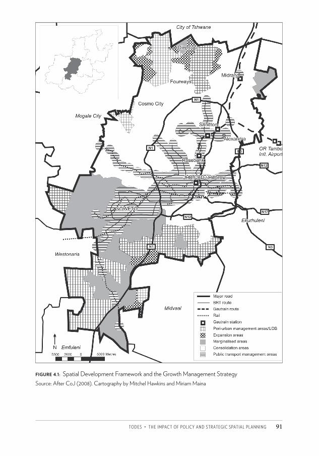
tODeS • the iMpaCt OF pOLiCy anD StRategiC SpatiaL pLanning 91
FIGURE 4.1: Spatial Development Framework and the Growth Management StrategySource: After CoJ (2008). Cartography by Mitchel Hawkins and Miriam Maina
CSCC.indb 91 2014/10/07 5:17 PM
Changing SpaCe, Changing City92
working poor – in public transport management areas were proposed (including density bonuses and fast-tracking of applications) (CoJ 2008) and, in later years, processes to enable the identification of well-located land for low-cost and inclusive housing were put in place (CoJ 2011). A broader set of incentives were also to be investigated to encourage development consistent with the plan, such as tax rebates, special rating districts and forms of planning gain (CoJ 2008).
The GMS works with new forms of public transport which have been introduced in the city: the Gautrain and the BRT system, which, together with existing rail systems, are the routes around which public transport management areas are defined (see Figure 4.1). The Gautrain is a limited light rail system which was initiated by the provincial government from 2002, and opened in 2010. Widely criticised for its focus on middle-class commuters and its cost, Gautrain stations have nevertheless been key in Johannesburg’s initiatives towards ‘transit-oriented development’ – mixed-use and higher-density residential development around stations, as important parts of nodes. The property industry has been responsive to these developments, but mainly in the existing upmarket nodes of Rosebank and Sandton stations. However, new office blocks here are being built with high levels of parking, suggesting that the use of the Gautrain may go along with continued reliance on cars, rather than displacing them entirely.
The BRT is a system of high-capacity buses moving along dedicated bus lanes. It was intended to provide improved access to public transport within 500 m for 85 per cent of the population over the long term, with links to rail and the Gautrain (COJ n.d.). The BRT was initiated by the municipality in 2006, displacing earlier planning for a more widespread system of dedicated lanes for buses and taxis – the Strategic Public Transport Network – although the most recent SDF sees a transport network as extending the system of public transport in areas that the BRT does not reach. Politicians were impressed by the way similar systems in Bogota had managed to incorporate a mafia-like taxi industry to produce a more effective public transport system there. The BRT importantly also provided a way to respond to demands by Soweto commuters for improved public transport other than taxis, which could not be done through the bus system due to existing contractual agreements with bus providers in the area.25 The process of putting in place the BRT has been a highly contested one. Considerable effort has gone into negotiations with the taxi industry. While some associations came in, others were resistant, arguing that it would undermine their livelihoods (Sibiya 2009). The BRT was seen as an important form of transport for the 2010 FIFA World Cup, and so despite difficulties it moved ahead. A first leg was established in 2009 for the Confederations Cup, but in later months buses were attacked and it took intervention by President Zuma to enable negotiations to move forward. An agreement was finally reached on the first phase at the end of 2010, bringing in taxi associations as shareholders. By now, routes to Soweto and around the central city have been established. A planned route to link to Rosebank and Sandton was replaced by an alternative route through Louis Botha Avenue to Alexandra and Sandton, following resistance by residents’ associations in an environmental impact assessment process.
CSCC.indb 92 2014/10/07 5:17 PM
tODeS • the iMpaCt OF pOLiCy anD StRategiC SpatiaL pLanning 93
The elaboration of spatial policies since 2000 has enabled a closer link between strategic spatial planning and land-use decision-making, and the GMS has been particularly important in this regard.26 Nevertheless, there are still difficulties in promoting the types of environment considered desirable. Following the GMS, a set of Sustainable Human Settlement indicators was developed to guide responses to planning applications affecting larger-scale developments or sites.27 These indicators represent an attempt to reshape urban environments according to urbanist principles. They respond to the limits of spatially fragmented, inward-looking, mono-functional and car-oriented environments that have been widely criticised.28 Early reaction to the use of this system29 by developers, however, was negative,30 and it remains to be seen whether it will be possible to reshape dominant patterns of development, which are highly entrenched. It does not seem that it will be used to prevent the development of gated residential complexes, although it would prevent the creation of completely enclosed suburbs with significant non-residential development.31 Currently, a few very large-scale developments (over 1 000 residential units) are at various stages of approval (see Chapter 2), although the recession has slowed their establishment. At present, Johannesburg’s planning department does not have the capacity to proactively negotiate the way developments occur with developers (Silverman and Zack 2010),32 except in relation to special precincts, nor to ensure that its design guidelines are carried through at a detailed level (Silverman and Zack 2010), limiting the extent to which planning is able to shape the way development occurs on the ground.
An important and long-standing part of Johannesburg’s planning has been the establishment of a UDB, beyond which development would be restricted. As Horn (2009) and Klug et al. (see Chapter 20) show, this has been a source of considerable contestation. Johannesburg’s UDB was first established in the early 2000s, but it was much narrower than that of the provincial government, and was not taken seriously by most provincial departments other than the Gauteng Department of Environment (Horn 2009). The DFA tribunal saw it as no more than a guideline. Housing authorities and developers exploited these differences, resulting in some development contrary to Johannesburg’s UDB. Klug et al. explore the way these tensions played out in the case of the Ruimsig area in the north-west of Johannesburg, resulting finally in a series of court cases from 2005 which challenged the constitutionality of the DFA tribunal, and its ability to make decisions counter to those of local municipalities. A Constitutional Court decision in 2010 eventually ruled that ‘urban and regional planning’ was a local function, negating provincial decision-making on land-use applications, and thus the ability of the DFA tribunal to rule on these matters,33 although existing judgments remained. The provincial UDB also became of little effect after that. The power of Johannesburg’s decision-making has thus been strengthened through this process.
However, Johannesburg is located in a broader city-region in which there are sometimes countervailing agendas from neighbouring municipalities. As Klug et al. (see Chapter 20) show, Mogale City in the north-west in particular has wanted to encourage growth in places where Johannesburg has attempted to control it. Over the last few years, however,
CSCC.indb 93 2014/10/07 5:17 PM
Changing SpaCe, Changing City94
Johannesburg has begun a process of engaging with neighbouring municipalities on a more systematic basis, and a provincial SDF has been prepared which will require buy-in from municipalities. Recent Johannesburg SDFs reflect this engagement with and recognition of the broader regional context, including proposing a new development corridor along the N14, taking into account expected growth around Lanseria Airport, and broader growth dynamics (CoJ 2011).
Towards the end of 2011, a new 2040 GDS was formulated, using a far more extensive participatory process than before. With a vision of a ‘sustainable, liveable and resilient city’, it reinforced many of the existing spatial planning ideas, but the translation of the policy into a new SDF is still to be completed. Nevertheless, the importance given to spatial restructuring seems to have increased with the installation of a new mayor in 2011, and his advocacy of the ‘Corridors of Freedom’. There is also growing pressure by politicians on staff to address socio-spatial divisions and the limited extent of economic development in former townships. While the ideas currently in use are not new, there appears to be far greater political support for them than in the past.
Impacts and prospectsThe period since 2000 reflects the establishment of a more consistent set of policies, and the elaboration of broad frameworks into more detailed policies and guidelines. There is also growing co-ordination around the SDF and related policies, and stronger links between planning, infrastructure and budgets which enable planning to influence development over the longer term. In addition, the municipality is gaining greater control over decision-making in its area. All of these factors should enable planning to influence where and how development occurs within the municipality to a greater extent than before.
Moving towards greater co-ordination and consistency around development is, however, challenging. The system of MOEs has made it more difficult to gain the co-operation of these departments, and their agendas do not necessarily accord with those of planning. For instance, the Johannesburg Property Company sees itself as focused on using public land to generate revenues for the municipality, in contrast to ideas around developing well-located land of this sort for inclusive housing (Klug 2011). Further, while there is broad consistency with the GMS in infrastructural expenditure, infrastructural investments do not necessarily accord with the priorities identified in detailed local plans, and funds are lacking to ensure planned development even in priority areas (Silverman and Zack 2010). There are also differences in interest between planning and some of the other departments within the municipality, and in some cases with provincial departments and agencies, as discussion in the previous section showed. Charlton (see Chapter 9) shows how public housing investments have in several cases exacerbated sprawl, in contrast to spatial policies towards compaction. Processes to put in place new systems of transport have been conflictual, as the previous section showed, and the shift towards public transport has probably been undermined by significant investments in highway improvement by
CSCC.indb 94 2014/10/07 5:17 PM
tODeS • the iMpaCt OF pOLiCy anD StRategiC SpatiaL pLanning 95
provincial government. It remains to be seen how far current proposals for devolution of housing and transport functions to accredited municipalities such as Johannesburg (SACN 2011) will help to improve co-ordination.
Shaping spatial change is a long-term process, and it is obviously early days in terms of the policy frameworks that have been developed. Further, slow economic growth since 2008 has also limited new development. In Chapter 5, Ahmad and Pienaar use the planning and building application system to assess the extent to which property development is occurring in the directions sought by the SDF, but some comments can be made on dynamics here.
There has been some progress in achieving more compact development (see Chapter 5), although not necessarily in the forms desired by spatial policies. Johannesburg is one of the few cities in the world where densities have been rising (Angel et al. 2011). Densities have increased since the mid 1980s, and comparison of 1996 and 2011 Statistics South Africa Census data at a sub-place level shows that this trend has continued (Harrison and Todes 2013) – the consequence of rising occupational density in the inner city, and of increasing built density in new developments compared to those in the past. Both the ‘hassle factor’ associated with environmental impact assessments on the periphery34 and efforts to maintain the UDB in a context where there is still considerable available land within it have constrained development beyond the edge, although it has been contested and growth is shifting, to an extent, into surrounding municipalities (see Chapter 5). Over the longer term, it seems inevitable that considerable growth will occur in places now considered to be peripheral: the GMS’s own assessment of land availability shows that the bulk of land available for residential development is in marginalised and expansion areas in the south (CoJ 2008). It seems unlikely that it will be possible to increase densities three- or fourfold by 2050 as suggested in a draft provincial spatial framework (GDED 2010).
Ideas of corridors and nodes are to some extent taking off (see Chapter 5), but unevenly. Rosebank and particularly Sandton have been stimulated by the Gautrain (see Chapter 18), but market response to the BRT has been more limited. The east-west corridor has hardly emerged, but considerable development is occurring along the north-south corridor, and in parts of public transport management areas (mainly in the north) (see Chapter 5). However, there is a strong network of major routes besides these defined corridors which are likely to continue to attract development in some places, contrary to plans. This is a key underlying pull in the north-west (see Chapter 20). While a major innovation of Johannesburg’s planning is the link to infrastructure, ironically, the old network of roads produced from the 1940s to the 1970s (Mabin 2012) continues to shape and attract development.
Moving towards greater spatial equity remains challenging. Although there has been significant public investment in infrastructure in former townships (see Chapter 3), the creation of more integrated environments remains difficult to achieve.35 New private-sector, non-residential, formal development has largely been concentrated in the north,
CSCC.indb 95 2014/10/07 5:17 PM
Changing SpaCe, Changing City96
as Ahmad and Pienaar (Chapter 5) show. The GMS suggests that incentives should be explored to promote economic development in marginalised areas, but the approach suggested is still facilitative. Some townships have been the focus of a range of interventions, with mixed outcomes (see Chapter 15). New kinds of economic activity, however, seem to be emerging in some of these areas, but patterns are uneven and over time differentiation among these ‘marginalised areas’ is likely to grow.
Some mixed-income housing projects are emerging, including in the north. Both social housing companies and some private-sector companies are focusing on lower middle-income rental housing in the inner city (see Chapter 9),36 while some developers are orienting to a slightly wealthier market in well-located areas in the north.37 The idea of promoting inclusive housing, however, has remained elusive (see Chapter 5). Lack of national policies, resistance by developers, lack of interest in the incentives on offer, and the difficulties of accessing land have been among the constraints experienced (Klug et al. 2013).
ConclusionIn the period since 2000, the City of Johannesburg has developed a more consistent set of policies to enable it to manage growth and development. Policies have evolved to embrace emerging concerns – the infrastructural crisis and the reality of its location within a city-region, among others. There have been important innovations such as the links to infrastructure, budgets and implementation. This contrasts with the previous period, and with contemporary dynamics in many municipalities in South Africa (SACN 2011). There are of course limits to what has been achieved: Silverman and Zack (2010) argue that planning policy has not been systematically reconsidered through a pro-poor lens, and has had a wavering approach to informality. Nor have questions of gender inequalities been considered. In addition, the focus on policy development and the need to constantly revise documents to ensure consistency have drawn limited capacity away from implementation (Silverman and Zack 2010).
Policies are starting to shape development, most importantly through the impact on capital expenditure, investments in infrastructure – including new transport systems – and through the regulatory system. Levels of co-ordination are improving compared to those in the past, but differences in interest and agenda between departments within and outside of the municipality remain. The response of the property development industry is perhaps predictable – constraining development on the edge has been easier than promoting spatial equity, but even there, planning is beginning to come to terms with the reality of its position within a broader city-region, and over the longer term, spatial policy may need to be reconsidered more fully to address this. There remain real difficulties for planning in mounting approaches to development which move against markets and their underlying social logics. Climate change, rising oil prices and other energy shortages may shift some of these dynamics, opening up space for somewhat more compact, public transport
CSCC.indb 96 2014/10/07 5:17 PM
tODeS • the iMpaCt OF pOLiCy anD StRategiC SpatiaL pLanning 97
focused development over the longer term, but other social divisions are likely to remain. Nevertheless, the greater political support given to the idea of spatial restructuring and the evocative concept of ‘Corridors of Freedom’ may well enable greater commitment to move towards desired spatial change than has hitherto been the case. The challenges of doing so, however, remain significant.
AcknowledgementsThe valuable inputs and insights of people interviewed for this project are gratefully acknowledged. Thanks to Margot Rubin and Mitchel Hawkins for research assistance. This material is based upon work supported by the National Research Foundation, South Africa. Any opinions, findings and conclusions or recommendations expressed in this material are those of the author and therefore the National Research Foundation does not accept any liability in regard thereto.
Notes1 But see Breetzke (2008) on eThekwini, which shows some similar dynamics.2 The use of racial categories in this text reflects a pervasive reality in South Africa and is not
intended to condone these divisions. 3 Interview with A Mabin, Professor, Graduate School of Public and Development
Management, University of the Witwatersrand, 13 July 2004.4 World Bank (1991) ‘South Africa: Urban sector reconnaissance.’ World Bank Mission, 6
December. Aide Memoire. Unpublished paper. Washington.5 Interview with L Druce, South African Association for Consulting Professional Planners,
Johannesburg, 10 November 2010.6 Interview with R Mathang, Member of the Mayoral Committee for Housing, City of
Johannesburg, 9 November 2010.7 Interview with L Poulsen, Architect, Former Adjunct Professor of Architecture, University
of the Witwatersrand, Johannesburg, 15 August 2011. 8 Interview with G Abrahams, Urban Planning Consultant, and R Tomlinson, Visiting
Professor, University of the Witwatersrand, 13 July 2004. 9 Interview with G Zanti, Director, Land Use Management, Development Planning and
Urban Management, City of Johannesburg, 27 October 2010.10 The result of a complex set of factors including, inter alia, a rates boycott in Sandton as rates
rose to levels equivalent to the rest of the city; income imbalances across local municipalities; poor revenue collection in township areas; huge expenditure on improving basic services in townships and unsustainable levels of borrowing to do this; poor financial management; low levels of support from central government (see Beall et al. 2002).
11 This approach came to be seen as the generic solution for all metropolitan areas in the country (Tomlinson 1999).
12 Interview with P Tau, MMC for Finance, City of Johannesburg, 15 November 2010.13 Nevertheless, forms of political influence do occur, as Klug et al. (see Chapter 20) show in
the case of Lanseria.
CSCC.indb 97 2014/10/07 5:17 PM
Changing SpaCe, Changing City98
14 It pre-empted and in some respects carried forward the intentions of the 2003 Municipal Finance Management Act into the realm of planning.
15 Interview with P Harrison, SA Research Chair of Development Planning and Modelling, University of the Witwatersrand, and former Executive Director, Development Planning and Urban Management, City of Johannesburg, 15 September 2010.
16 Interview with R Mathang, City of Johannesburg, 9 November 2010.17 Interview with P Harrison, City of Johannesburg, 15 September 2010.18 Interview with P Harrison, City of Johannesburg, 15 September 2010; interview with
G Gotz, Research Director, Global City Region Observatory, and former official on the Strategic Planning Unit, City of Johannesburg, 18 October 2010.
19 Interview with D Hulley, Joburg Water, City of Johannesburg, 15 November 2010.20 Interview with P Harrison, City of Johannesburg, 15 September 2010.21 Interview with P Harrison, City of Johannesburg, 15 September 2010; interview with G
Zanti, City of Johannesburg, 27 October 2010.22 Interview with P Tau, City of Johannesburg, 15 November 2010; interview with P Harrison,
City of Johannesburg, 15 September 2010.23 Interview with H Pienaar, Director, Strategic Planning, Development Planning and Urban
Management, City of Johannesburg, 9 December 2009.24 While much investment might have gone into the right areas, considerable investment
went into infrastructural investment associated with the 2010 World Cup, detracting from expenditure on basic infrastructure and services (Silverman and Zack 2010).
25 Interview with R Moosajee, MMC for Transport, City of Johannesburg, 1 November 2010.26 Interview with G Zanti, City of Johannesburg, 27 October 2010.27 Over 20 dwelling units, sites larger than 2 000 m2, and in any precinct plan or development
framework.28 Principles promoted include: spatial integration, compaction and access to economic
opportunities; access to public transport and walkable environments; protection of environmentally sensitive areas; energy efficiency; provision of open space; support of the informal economy at appropriate locations; employment promotion; promotion of safety and security through design; adequate infrastructure, services and amenities; and a diversity of housing types to enable access to housing for a range of users, with a particular emphasis on affordable housing (CoJ 2010/11).
29 Introduced in late 2010.30 Interview with G Zanti, City of Johannesburg, 27 October 2010.31 Interview with G Zanti, City of Johannesburg, 27 October 2010.32 Interview with G Gotz, City of Johannesburg, 18 October 2010.33 Constitutional Court of South Africa (2010) Case CCT89/09 [2010] ZACC 11.34 Interview with F Viruly, former Head of Property Studies, University of the Witwatersrand,
and property market consultant, 3 August 2009.35 Interview with P Ahmad, Development Planning and Urban Management Department,
City of Johannesburg, 27 July 2009.36 Interview with L Bethlehem, Standard Bank Property, and former head of Johannesburg
Development Agency, 28 October 2010.37 Interview with P Blanckenburg, Executive, Summercon, Johannesburg, 28 October 2010.
CSCC.indb 98 2014/10/07 5:17 PM
tODeS • the iMpaCt OF pOLiCy anD StRategiC SpatiaL pLanning 99
ReferencesAngel, S, with Parent, J, Civco, D and Blei, A (2011) Making Room for a Planet of Cities. Lincoln
Institute of Land Policy Focus Report (online document). Beall, J, Crankshaw, O and Parnell, S (2002) Uniting a Divided City: Governance and Social
Exclusion in Johannesburg. London: Earthscan. Beavon, K (2006) Johannesburg: The Making and Shaping of the City. Pretoria: UNISA Press. Breetzke, K (2008) ‘From conceptual frameworks to quantitative models: Spatial planning
in the Durban metropolitan area, South Africa – the link to housing and infrastructure planning.’ Case study prepared for the Global Report on Human Settlements 2009.
Bremner, L (2000) ‘Post-apartheid urban geography: A case of Greater Johannesburg’s Rapid Land Development Programme.’ Development Southern Africa 17(1): 87–104.
CoJ (City of Johannesburg) (2003) Spatial Development Framework (online document). CoJ (2006) Growth and Development Strategy. Johannesburg. CoJ (2008) Growth Management Strategy (online document). CoJ (2009) Growth Management Strategy. Growth Trends and Development Indicators (online
document). CoJ (2010) Growth Management Strategy. Growth Trends and Development Indicators (online
document). CoJ (2011) Growth Management Strategy. Growth Trends and Development Indicators (online
document). CoJ (2010/11) Spatial Development Framework (online document). CoJ (2013) State of the City Address (online document). CoJ (n.d.) Rea Vaya Joburg (online document). Dewar, D and Uytenbogaardt, R (1991) South African Cities: A Manifesto for Change. Urban
Problems Research Unit: University of Cape Town. GDED (Gauteng Department of Economic Development) (2010) Gauteng Spatial
Development Framework (online document). Goga, S (2003) ‘Property investors and decentralization: A case of false competition?’ In
R Tomlinson, R Beauregard, L Bremner and X Mangcu (eds) Emerging Johannesburg: Perspectives on a Postapartheid City. London: Routledge.
Harrison, P and Todes, A (2013) ‘Spatial considerations in the development of urban policy in South Africa.’ Paper prepared as input into the Integrated Urban Development Framework.
Harrison, P, Todes, A and Watson, V (2008) Planning and Transformation: Lessons from the Postapartheid Experience. London: Routledge.
Horn, A (2009) The Life and Death of Urban Growth Management in the Province of Gauteng. Masters dissertation, University of Pretoria.
Klug, N (2011) ‘An examination of “exactions” or “planning gain” in a developing country context: Using Johannesburg as a case study.’ Paper presented to the World Planning Schools Congress, Planning’s Future – Futures Planning: Planning in an Era of Global (un)Certainty and Transformation, 4–8 July, Perth.
Klug, N, Rubin, M and Todes, A (2013) ‘Inclusionary housing: A tool for reshaping South Africa’s spatial legacy?’ Journal of Housing and the Built Environment 28(4): 667–678.
CSCC.indb 99 2014/10/07 5:17 PM
Changing SpaCe, Changing City100
Lipietz, B (2008) ‘Building a vision for the post-apartheid city: What role for participation in Johannesburg’s City Development Strategy?’ International Journal of Urban and Regional Research 32(1): 135–163.
Mabin, A (1995) ‘Urban crisis, growth management and the history of metropolitan planning in South Africa.’ Urban Forum 6(1): 66–94.
Mabin, A (2012) ‘Think métropole: Memory, citizenship and futures in São Paolo, Paris and Johannesburg.’ Paper presented to the Wits Institute for Social and Economic Research Seminar, University of the Witwatersrand, 12 May.
Parnell, S and Robinson, J (2006) ‘Development and urban policy: Johannesburg’s City Development Strategy.’ Urban Studies 43(2): 337–355.
Robinson, J (2008) ‘Developing ordinary cities: City visioning processes in Durban and Johannesburg.’ Environment and Planning A 40(1): 74–87.
SACN (South African Cities Network) (2006) State of Cities Report. Johannesburg: SACN.SACN (2011) State of Cities Report. Johannesburg: SACN. Sibiya, Z (2009) An Exploration into the Conflicting Interests and Rationalities on the Rea
Vaya BRT. BSc Honours Research Report, University of the Witwatersrand, Johannesburg.Silverman, M and Zack, T (2010) ‘Position paper on the state and medium future of planning
in Johannesburg.’ Report to the Department of Development Planning and Urban Management, Johannesburg.
Sim, V, Oelofse, C and Todes, A (2004) ‘eThekwini Municipality: Assessment of the municipality’s environmental and planning processes.’ Report to the eThekwini Municipality, Durban.
Todes, A (2000) ‘Reintegrating the apartheid city? Urban policy and urban restructuring in Durban.’ In S Watson and G Bridges (eds) A Companion to the City. London: Blackwell.
Todes, A (2002) ‘Spatial change and Durban’s spatial framework.’ In A Bouillon, B Freund, D Hindson and B Lootvoet (eds) Governance, Urban Dynamics and Economic Development: A Comparative Analysis of the Metropolitan Areas of Durban, Abidjan and Marseilles. Durban: Plumbline Publishing.
Todes, A (2006) ‘Urban spatial policy.’ In U Pillay, R Tomlinson and J du Toit (eds) Democracy and Delivery: Urban Policy in South Africa. Cape Town: HSRC Press.
Tomlinson, R (1999) ‘Ten years in the making: A history of the evolution of metropolitan government in Johannesburg.’ Urban Forum 10(1): 1–39.
Turok, I (1994) ‘Urban planning in the transition from apartheid. Part 2: Towards reconstruction.’ Town Planning Review 65(34): 355–374.
Turok, I (2001) Persistent Polarisation Post-apartheid? Progress Towards Urban Integration in Cape Town. Urban Change and Policy Research Group Discussion Paper 1. Glasgow: University of Glasgow.
Watson, V (2002) Change and Continuity in Spatial Planning: Metropolitan Planning in Cape Town under Political Transition. London: Routledge.
Watson, V (2003) ‘Planning for integration: The case of metropolitan Cape Town.’ In P Harrison, M Huchzermeyer and M Mayekiso (eds) Confronting Fragmentation: Housing and Urban Development in a Democratising Society. Cape Town: UCT Press.
Winkler, T (2011) ‘Retracking Johannesburg: Spaces for participation and policy making.’ Journal of Planning Education and Research 31(3): 258–271.
CSCC.indb 100 2014/10/07 5:17 PM
176
9 Public housing in JohannesburgS A R A H C H A R LTO N
At fi rst glance the spatial patt ern of post-1994 publicly funded low-income housing in Johannesburg appears to reinforce the historical spatial patt ern in which poorer people are peripheralised to the edge of the city. Alarmingly, and contrary to policy intentions, in some cases housing developed aft er 1994 appears to extend apartheid geography, locating housing benefi ciaries on the outer edges of apartheid townships.
But a closer look shows signifi cant examples where state-funded low-income housing breaks from this patt ern. A ‘public housing’1 view of Johannesburg therefore shows both continuities and ruptures with the past. Th e situation is not simply one of earlier projects falling short of objectives and more recent developments aligning bett er with post-apartheid visions. So what explains this diverse patt ern, and why do some developments accord directly with the post-apartheid city’s spatial objectives and others continue to appear not to?
In this chapter I discuss the reasons behind this patt ern of development, citing explanations off ered by provincial and city offi cials, as well as explanations presented in other analyses. However, a further factor is key to understanding the spatial dimensions of public housing, namely the living conditions of many poorer people. Private, oft en unauthorised, living circumstances are not only relevant to an overall description of how and where poorer people live in Johannesburg, but also help to explain patt erns in publicly funded housing. However, before I develop these arguments, it is necessary to describe the dominant patt ern of low-income housing development, and the nature of this type of housing.
CSCC.indb 176 2014/10/07 5:18 PM
177
Spatial description and the nature of low-income housingThe capital letter ‘G ’, written with a tail, offers a graphic sense of the dominant spatial pattern of low-income housing projects in the city. If the Johannesburg metropolitan area is roughly oval in shape, with its long axis running north-east to south-west and tapering to a tail in the south-west, state-funded low-income housing projects delivered since 1994 can mainly be found tracing the outline of a sloping G: from the north-east perimeter of the city, arcing up to the north and sloping down to the north-west along the metropolitan boundary, then down to a cluster in the west of the city, and still further down along the south-west tail (Figure 9.1).
These low-income housing projects usually consist of neighbourhoods of newly built houses and basic services, or at times upgrading interventions in existing informal settlements. Projects are predominantly funded by the state in the form of a capital grant from national government with infrastructure subsidised to a degree by local government. Houses for individual ownership dominate but a small amount of rental housing – known as ‘social’ or ‘institutional’ housing – has also been delivered. This has largely failed to accommodate very low-income beneficiaries, as will be discussed below. Housing-for-ownership assistance is aimed at the poorest of the poor (defined in income terms), those with inadequate shelter who have never owned property before. In some newer ‘mixed-income’ projects, bonded houses for sale to less poor buyers have been developed in close proximity to the state-subsidised housing.
Nationally, a significant number of houses2 have been delivered in a fairly short period of time, in response to a great shortage of decent, affordable accommodation. In 2009 the director-general in the Department of Housing (now Human Settlements) noted that:
We’ve been able to build homes for more than 13m people so far. The number of people who have benefited is equivalent to the populations of Botswana, Lesotho, Namibia and Swaziland combined. (Mzolo 2009: 8)
But beyond the objective of building numbers of houses, other aims for the housing programme grew over the years, including the contribution new neighbourhoods could make to restructuring and integrating the city, both geographically and socially. Further, the housing programme aims not only to provide shelter to households and to meet basic infrastructure needs, but also to contribute to poverty alleviation and to facilitate access to economic opportunities, facilities and amenities.3 A third expectation for the housing programme is that with access to formal jobs and a decent house in a safe, secure and nurturing neighbourhood, beneficiaries will gradually be absorbed into the cohort of ‘urban citizens’.4
At a local level the City of Johannesburg strongly advocates the home-ownership paradigm and the notion of the property ladder as a key dimension of its strategy of proactively absorbing the poor (CoJ 2006, 2011). The idea of the property ladder is that different sizes, qualities and values of housing exist and that ‘households will move progressively up the “rungs of the ladder” as lifestyle and financial circumstances
CSCC.indb 177 2014/10/07 5:18 PM
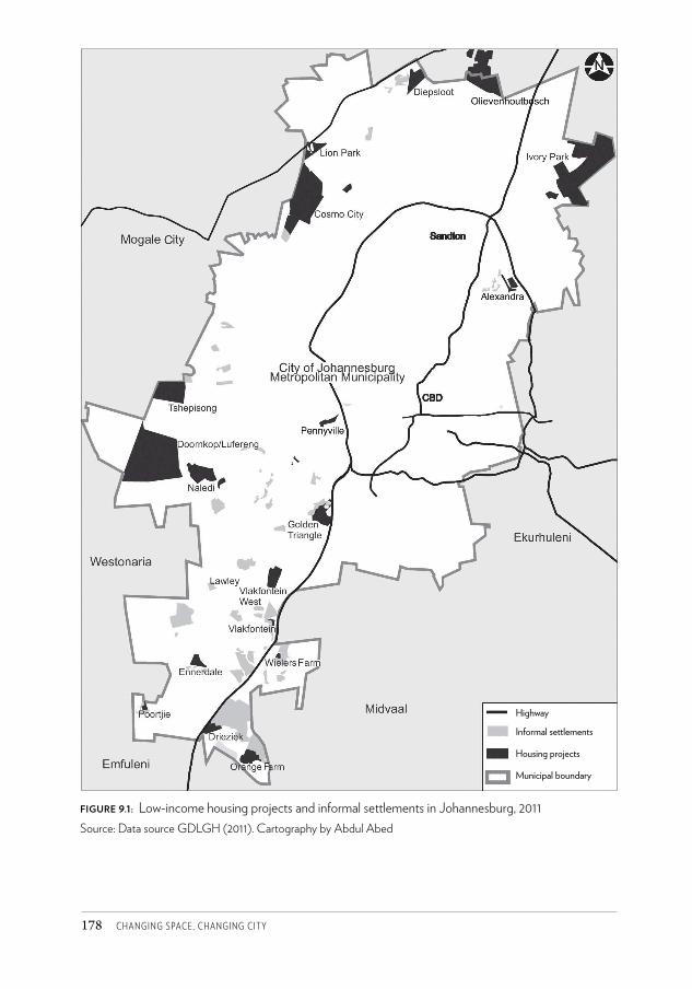
Changing SpaCe, Changing City178
figure 9.1: Low-income housing projects and informal settlements in Johannesburg, 2011Source: Data source GDLGH (2011). Cartography by Abdul Abed
Highway
Informal settlements
Housing projects
Municipal boundary
CSCC.indb 178 2014/10/07 5:18 PM
ChaRLtOn • pUBLiC hOUSing in jOhanneSBURg 179
shift’ (Charlton 2010: 6). The city argues that housing is essential to assist with social advancement: ‘houses are not just places to stay. The potential asset of saleable homes in good neighbourhoods is a crucial ingredient in promoting conditions for social mobility’ (CoJ 2006: 64). While the city also supports rental housing, the housing-for-ownership model dominates and has had a considerably more significant spatial impact.
The private sector has been developing new housing for ‘the market’ (middle- to upper-income residents) in a variety of locations, predominantly in the north of the city where economic growth seems most vibrant. By contrast, a review by the Organisation for Economic Cooperation and Development notes a prevalence of low-income housing projects in the southern and western regions of the city where a mix of new low-cost housing developments and informal settlements can be found (OECD 2011).5 The review notes that, in Gauteng as a whole, public housing has mainly been built in poorer parts of the province where economic activity is limited (OECD 2011).
There are, however, significant exceptions to this pattern. New housing developments around Alexandra, the Pennyville project between Soweto and central Johannesburg, and inner-city social housing, for example, offer good locations in the city. These places accord most directly with the post-1994 objectives in housing policy of infill development and restructuring the apartheid city,6 and also with the city’s aims of providing ‘well located, good quality, adequately serviced, safe and affordable accommodation opportunities’ (CoJ 2006: 6).
In a further break from apartheid form, some areas that are indeed geographically on the edge of the metro – such as Ivory Park – are no longer marginal in terms of regional opportunities. Places in the north-east and north-west of the city are close to the limits of Johannesburg’s metropolitan area but can connect relatively easily with places of economic activity on and beyond the city boundaries in neighbouring municipalities, as the map of the greater Gauteng urban area demonstrates (Figure 9.2).
From a location perspective, public housing in the city spans a range of locations, from those that can be described as poorly placed relative to the opportunities of the city to those that can be described as very well positioned. Problems with the location of housing projects in Johannesburg and their contribution to spatial exclusion have been noted in the past (see for example Tomlinson et al. 2003). Explanations for poorly located projects span a variety of issues including pressures for rapid mass housing delivery, constraints in national housing policy, institutional priorities and relationships, and the interests of private property owners in resisting or luring low-income housing development. On the other hand, the existence of some of the better-located projects can be explained by special interventions operating outside of the norm, by creativity and perseverance, or by fortuitous alignment with wider spatial trends.
Below I discuss these issues and the contribution they make to the spatial pattern of publicly funded housing in Johannesburg. But I also discuss ways in which other cheap accommodation in the city contributes to understanding the spatial dimensions of public housing. A significant population in the income range targeted by public housing lives in
CSCC.indb 179 2014/10/07 5:18 PM
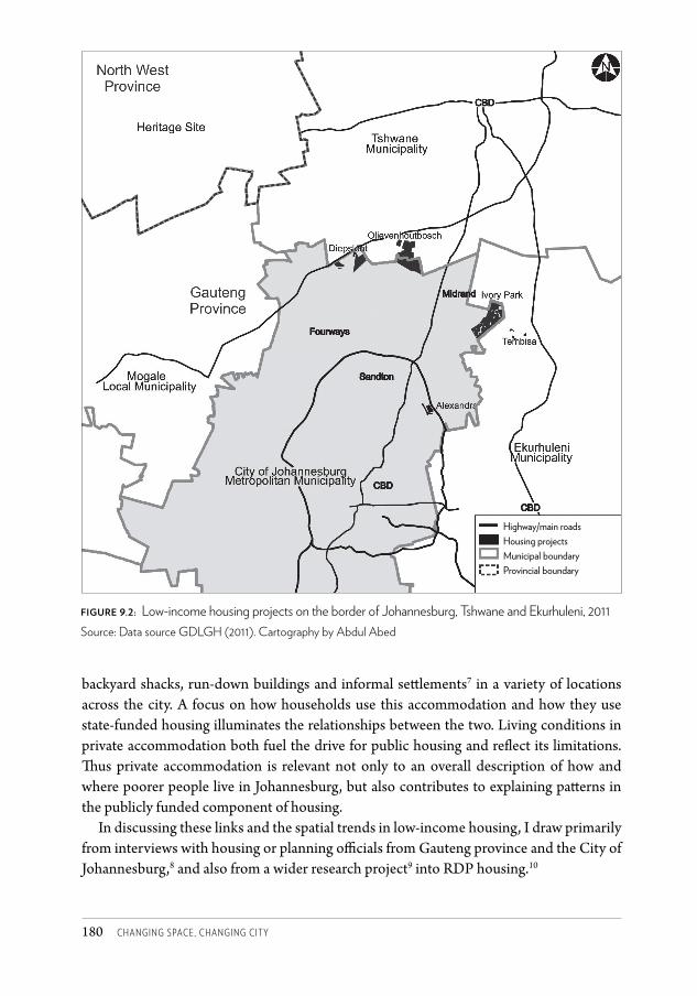
Changing SpaCe, Changing City180
backyard shacks, run-down buildings and informal sett lements7 in a variety of locations across the city. A focus on how households use this accommodation and how they use state-funded housing illuminates the relationships between the two. Living conditions in private accommodation both fuel the drive for public housing and refl ect its limitations. Th us private accommodation is relevant not only to an overall description of how and where poorer people live in Johannesburg, but also contributes to explaining patt erns in the publicly funded component of housing.
In discussing these links and the spatial trends in low-income housing, I draw primarily from interviews with housing or planning offi cials from Gauteng province and the City of Johannesburg,8 and also from a wider research project9 into RDP housing.10
figure 9.2: Low-income housing projects on the border of Johannesburg, Tshwane and Ekurhuleni, 2011Source: Data source GDLGH (2011). Cartography by Abdul Abed
Highway/main roadsHousing projectsMunicipal boundaryProvincial boundary
CSCC.indb 180 2014/10/07 5:18 PM
ChaRLtOn • pUBLiC hOUSing in jOhanneSBURg 181
Accounting for the location of publicly funded projectsNational policy on low-income housing strives for housing ‘in areas allowing convenient access to economic opportunities, and to health, educational and social amenities’ (NDoH 2000: 4). In the context of the weak public transport system which does not offer safe, cheap or convenient commuting from outlying areas, this objective suggests the need to position housing for the poor in strategic parts of the city. The City of Johannesburg’s vision suggests a similar overall aim in striving for
a spatial form that embraces the principles of integration, efficiency and sustainability, and realizes tangible increases in accessibility, amenity, opportunities and quality of life for all communities and citizens. (CoJ 2006: 13)
Despite these national and local objectives, a number of housing developments constructed since 1994 in Johannesburg appear to offer little access or opportunity to the poor. As one official put it,
in terms of spatial location, I think any map that you look at will show you everything [to do with low-income housing] on the periphery of the city … [on] the margins of the existing urban areas.11
Many people’s impression of Johannesburg’s housing pattern is of the predominantly peripheral development that has been heavily critiqued in commentary on South African housing (see for example Sihlongonyane and Karam 2004). Commenting that ‘public housing in Johannesburg is depressing from a spatial point of view’, a city official explained that
for every better effort, like at Pennyville and at Cosmo, there are many [peripheral] Lufherengs, Driesig Extensions, Lehae and so on.12
What accounts for areas continuing to be developed without aligning to locational and spatial objectives? Key to understanding this is the relationship between the City of Johannesburg and the Gauteng provincial government. Rather than reflecting common purpose, attempts at alignment and co-ordination between the province and the city on the housing issue have been uneven, faltering and at times fraught with tension.13 For historical and institutional reasons the province has been the dominant partner; in the 1990s planning and housing capacity in the city was weak relative to national and provincial government, where the housing function is located constitutionally. For a number of years Gauteng’s provincial government took the lead in implementing housing projects within Johannesburg’s municipal area. While the city has since grown in capacity and has had a dedicated housing department for some years, the province’s grip on the purse strings of housing subsidy money – the key funding mechanism – has tended to shape developments.
they who own the money … can … sway development in line with their priorities.14
Subsidy funding has not always been approved for city housing priorities, or has been channelled into projects that the city supported only reluctantly or under pressure.
CSCC.indb 181 2014/10/07 5:18 PM
Changing SpaCe, Changing City182
Provincial-wide priorities for housing may not be the same as the priorities of a city within that region.15 The province is an independent sphere of government, with a premier who does not report to the city’s mayor:
They’ve got their own rules, they’re governed by the Constitution, so they don’t have to ask permission from us as long as they’re not doing something that is not lawful.16
While spatial plans – such as city and provincial Integrated Development Plans – should be able to guide housing development within a geographic area, weaknesses in the plans have become apparent: layers of spatial and housing planning can be confusing, processes at provincial and municipal levels (such as township establishment procedures) are often misaligned, and the status of provincial spatial plans is unclear.17
The city’s attempts to gain more autonomy in the housing sphere through accreditation18 stalled for a number of years in the face of apparent reluctance from provincial government. The level one accreditation finally awarded in April 2011 remains limited in power but is an important step for the city:
The reason why we went and asked and pushed for accreditation was solely so that you can have one responsible and accountable sphere of government for a particular service in one jurisdiction.19
Within this institutional morass it is difficult to identify which of the more peripheral housing projects was initiated by the province and which by the city. Planners associated with the province claim the City of Johannesburg supported the development of these areas.20 Others suggest the city was overridden, coerced or politically ordered by the province to support certain projects, even if they did not accord with city plans.21 Officials in the city see politicians as having particular whims for certain projects – for example Lufhereng, a very large project of 24 000 sites currently under way west of Soweto.
Lufhereng was something that came out of the [provincial] MEC [for Housing] you know, and then you as a city must make that work.22
The Bram Fischerville project, undertaken by the provincial housing department, illustrates the lack of a common vision between city and province. While not locationally peripheral in metropolitan terms, the project is fraught with conflict over the level and quality of the infrastructure that has been developed, and which the city is reluctant to accept maintenance responsibility for. While province tends to ‘go by the book’ of what housing policy requires as a minimum level of roads, sanitation and so on, city officials argue this is not a very mature approach:
Province will tell you it’s [developed to that level] because housing subsidy only goes so far, and if the cities want to have metropolitan-quality infrastructure, like roads with tarred surfaces, they must fund that [themselves]. And I’m saying, is that really a mature approach to the question of urbanisation? Are we saying that gravel roads are perfectly acceptable in a higher-density urban setting? I don’t believe it is. Why is it even a debate?23
CSCC.indb 182 2014/10/07 5:18 PM

ChaRLtOn • pUBLiC hOUSing in jOhanneSBURg 183
But even given this complex institutional environment, why do peripheral projects receive support from any sphere of government? One key explanation is the ‘pressure for delivery’, which resulted in the province favouring large-scale projects.24 The province promoted ‘the big numbers’ of houses that require large, uncontested tracts of developable land.
I would go as far as to say, I think at a particular time with the [Gauteng] provincial housing department, anything of less than 3 000 or 4 000 households that was a greenfields project was probably put on the back burner …25
In the drive to deliver at scale, the smaller, typically more socially and politically complex projects on infill26 land or more central pockets received little attention (apart from social housing, discussed below) from either the province or the city.27 The impact of delivery pressure in working against urban integration in the 1990s and early 2000s in many places in South Africa is well established (see Todes 2006 for an overview). The City of Johannesburg arguably failed to establish a track record of examples of good housing developments which aligned with its own spatial objectives, beyond one or two key projects,28 and failed to grapple with controversial or hard decisions associated with such development.29 Even now, though, work is under way in this regard.
Not enough effort is going into project preparation in infill areas, in the smaller, more difficult project areas and pieces of land … [it’s beyond me] why we’re not sitting with an inventory of projects you can pull off the shelf on infill land along what we say are strategic areas, whether it’s your nodes, whether it’s your transportation corridors …30
A further explanation for the contrary location of some housing projects is the interests of private property owners in luring development onto land holdings that they wished to dispose of on the edge of the city.
You see the problem was initially with the private sector driving the projects. They use their land and … the money was allocated without thinking about the long-term consequences.31
Alternatively, private property owners have also influenced the spatial pattern of low-income housing by resisting housing developments near their land, through NIMBY32 concerns. This kind of conflict considerably delayed (though ultimately did not derail) the Cosmo City project, for instance.
Provincial officials argue that good land for low-income housing development is not available: ‘how do you accommodate people [centrally] if there is no land?’33 Others disagree, arguing that accessing the better land is merely slower and more difficult due to pressures working against using this land for low-income housing purposes. But these sorts of difficulties in a context of massive pressure for delivery result in housing projects being initiated wherever it is possible ‘just to get going’, usually on uncontested, seemingly uncontroversial land. Further, these projects tend to be characterised by low-density/detached houses in order to get at least some housing yield as quickly as possible.34
CSCC.indb 183 2014/10/07 5:18 PM

Changing SpaCe, Changing City184
I think we’re defaulting [to this] now, whether it’s us as city or in collaboration with province, saying ‘just get anything out of it’. It’s like wringing a dry cloth and hoping you’re going to get a couple of drops of moisture.35
Another explanatory factor flags the problem created by exceptionalising the housing function, and separating this from more general planning and implementation of projects at municipal level. This creates opportunities for housing developments to proceed without being embedded in spatial planning visions. A senior planner in the city questioned the need for provincial involvement or even a specific housing department at local level:
There actually shouldn’t be, in my mind, a housing department. Identify a site, do your own feasibilities, get it structured and implement, then manage it as you would any project, whether it’s the Gautrain, whether it’s the upgrading of OR Tambo or the development of Bram Fischerville Extension 13. But we seem to be stuck in this [mode]; housing must plough their own field in terms of where the projects are, and to hell with it if it doesn’t fit with the spatial plan of the city. We’ve had more fights internally [within the City of Johannesburg] than we have with province around locations.36
Over and above issues specific to the Johannesburg and Gauteng contexts, the housing policy and funding framework is fundamental to understanding spatial patterns in housing implementation. The capital subsidy funding model for low-income housing, linked with an emphasis on land and housing ownership, leads most commonly to a suburban neighbourhood model of detached houses on individual subdivisions. In Johannesburg, housing ownership has been embraced through the city’s emphasis on the ‘property ladder’ as a tool in support of inclusion, as noted earlier. Ownership of a house is seen as an important step on the road to poverty alleviation and, ultimately, modest prosperity. This vision most easily – though not inevitably – translates into a ground-related, low-density built form, least suited in planning terms to the intensive usage invited by high-value, strategic, well-located land. There are important exceptions to this norm, however, discussed later.
Higher-density, multi-storey rental accommodation is also part of the low-income housing programme in Johannesburg and there are a number of examples of this ‘social housing’ in the CBD, Alexandra and in housing projects such as Pennyville and Cosmo City – though numerically much smaller than the houses-for-ownership programme. However, much of this well-located rental accommodation is unaffordable to very poor people due in large part to the absence of a rental subsidy, and the need to cover running costs from the rentals charged on the units.
Nevertheless, despite these pressures which tend to result in more peripheral projects, and the trend that strategically located housing is often unaffordable to the very poor, Johannesburg does have key examples of well-located, low-income housing. Some of these neighbourhoods showcase higher-density built forms and other innovations in addition to locational advantage. How did these developments come about, given the factors cited above in explanation of the counter-trend?
CSCC.indb 184 2014/10/07 5:18 PM
ChaRLtOn • pUBLiC hOUSing in jOhanneSBURg 185
Centrally located housing projects linked to the Alexandra Renewal Project can be explained by the township of Alexandra’s rich political history and key strategic location, which has strengthened as the city has shifted northwards. The area’s significance coupled with its persistently poor living conditions made it a site for focused political attention, resulting in a special institutional development vehicle and dedicated funding allocation since 2001. These factors, including some flexibility with respect to use of funds, have allowed for experimentation. Among the spectrum of project interventions have been a number of innovative housing projects,37 although the overall Alexandra initiative is also criticised for relocating vulnerable people to distant locations in its early years, and for the congested living conditions that remain in the old township.
Cosmo City in the north-west of the city is lauded as an example of mixed-income development, one of the pioneers of the combination in one development (though in separate areas) of bonded and state-funded housing. Its innovations include a strong involvement from private-sector developers and banks and the argument that its edge location is nevertheless desirable for its links to existing and forthcoming developments nearby. Its success is partly attributed to good project-level co-operation between the city and the province, its favourable timing in relation to market conditions for bonded housing, and the tenacity of officials in persevering with the development proposals in the face of opposition from land owners in the area. From an ‘inclusion’ perspective it has been criticised, however, for the form of its ‘mixed’ development: areas of more expensive housing with islands of low-cost housing nearby, rather than a more interwoven arrangement between the two.
Pennyville demonstrates a mix of typologies and tenure on buffer-strip land between the northern edge of Soweto and former coloured, Indian and white areas of Johannesburg. It has good access to a commuter train station and is located on a Bus Rapid Transit system route. Developed largely by the city, its success is ascribed to dedicated and focused attention to getting ‘key fundamentals’ right, such as good location (in this case through an innovative land swap with a private developer), as well as cross-subsidisation through market-driven rental development on a portion of the site.
[Pennyville] took a lot of time to plan but that is a model of how we would want to do our settlements. Not only build houses but create all other things. But that costs money, that takes time.38
Although social housing is generally criticised for largely missing the largest and poorest target group of state-funded housing, as noted above, there are some buildings where rental opportunities for poorer people have been secured.39 These have been undertaken by the city-supported social housing company Joshco and by the Johannesburg Housing Company, at times with support from the faith-based organisation Madulammoho. Low-rent accommodation has generally been difficult to achieve, as available funding models don’t easily support multi-storey low-budget rental without rent subsidisation.
These diverse examples of low-income housing that is supportive of spatial and other developmental objectives arise from various conditions. Some emerge from the focused
CSCC.indb 185 2014/10/07 5:18 PM
Changing SpaCe, Changing City186
attention, prioritisation and flexibility that ‘special’ initiatives allow – bending rules, pushing policy limits and bridging institutional divides and silos, for example. Others are the result of innovation and some experimentation between the private and public sectors, or finding ways to streamline costs and cross-subsidise investment across the income levels of the target group.
Justifying more distant developmentsWhile these examples of well-located projects receive critical acclaim, at the same time justifications – not just explanations – are put forward for the spatially distant projects. Some of these areas are described as ‘natural extensions of townships’.40 From this perspective new developments on the outer edge of existing settled areas are necessary, acceptable and inevitable. Lufhereng/Doornkop is thus seen by a provincial planner as a natural extension of the western part of Soweto – and in any event, he explained, ‘fifteen minutes and you’re in Maponya Mall’.41 But while on the one hand it is argued that it is ‘natural’ to extend existing development beyond the outer edge of townships, on the other hand the same planner laments unsustainable city growth and the lack of public transport: ‘Buses don’t even reach some of these areas.’42 Indeed, as a city official pointed out, the weak transportation system is a fundamental contextual weakness: ‘If we created easy access in terms of rail and improved public transport I don’t think we would even notice that people are living in the periphery.’43
A second justification for recently initiated large peripheral projects places high faith in the character of these areas as ‘Breaking New Ground’-style projects, a reference to the national Department of Human Settlements’ 2004 housing policy adjustment which attempted to address, inter alia, criticisms that post-1994 housing developments were mono-functional, dormitory-type ‘seas of poverty’. Breaking New Ground projects in Johannesburg are conceptualised as mixed income (with both state-funded and bonded housing), mixed use and mixed tenure. The mixed-use approach promotes planned economic activities within and around the settlement, and aims to counter the criticism that these peripheral areas are generally far from economic activity. In the case of Lufhereng in the far west of Johannesburg, planned economic projects include agriculture and associated industries. But in the current context of massive unemployment, will these approaches of ‘taking economic activity to the settlement’ be able to counter structural economic constraints or systemic problems such as lack of skills, education, good health and work experience?
A third justification for proceeding with seemingly peripheral development is that ‘poor locations today can become good locations tomorrow’,44 as the notion of peripheral is not a static state. As has been demonstrated by favourable trends in some areas on the northern perimeter of the city, the functionality and desirability of an area shifts over time as cities grow and change shape. Therefore, a planner involved in the project asks, ‘Who knows what might happen to somewhere like Lufhereng?’45
CSCC.indb 186 2014/10/07 5:18 PM
ChaRLtOn • pUBLiC hOUSing in jOhanneSBURg 187
Focusing on householdsMoving from explaining the locations of low-income housing developments to the impacts of this settlement pattern, does it matter that housing developments continue in areas which are not clearly in alignment with city spatial planning objectives? Peripheral projects are likely to cost the city more than closer-in ones, in aspects such as the extension of bulk infrastructure to these areas, the maintenance of new infrastructure on the outer reaches of the city, and the risk that these areas may never, or only very slowly, attract private-sector investment and develop a rates base and a robust economic life. Related to this, these areas may not offer a supportive platform for their residents to consolidate their lives and start building wealth. It is to this dimension of the problem and its link to privately provided shelter that I now turn.
Little work appears to have been done nationally or in Johannesburg on the experience for the household of having received a government-sponsored house.46,47 Some South African research on the location of residential areas has highlighted that what are considered peripheral locations by planners may offer unexpected advantages to residents (see for example Schoonraad in Todes 2006), flagging that the matter of location is more complex than a bird’s-eye judgement might assume. What is clear, however, is that, first, current practices around state-funded housing by residents show a number of unforeseen consequences, and second, that considerable numbers of people in the income band targeted by public housing policy house themselves in other ways, outside of publicly funded housing. Both of these issues have considerable implications for the city and can enhance understanding of the consequences of housing location.
First, indications are that some people are not occupying their allocated state-funded house as expected. Some48 have sold or rented out their house,49 and while this reflects the desirability of the state-funded housing (in that others have bought or leased the houses), of relevance to this discussion is where the original beneficiary has moved to. There is little evidence of people ‘trading up’ – accessing bigger, better located or pricier formal accommodation on disposing of their state-funded house (Lemanski 2010). Rather, some people appear to revert to informal or unsanctioned living conditions post the housing benefit. For example, surveys from informal settlements in Johannesburg show that some shack residents have already received a publicly funded house.50 City officials concur:
The challenge … is if you give somebody who earns R0 a month a house, they will stay in that house for two or three months and when they are hungry they will sell the house and they will go back to the informal settlement …51
This suggests that there is not necessarily a simple or direct relationship between the delivery of formal state-funded housing units and a reduction in the number of people in poor living conditions in the city. One more government-funded house delivered does not necessarily mean one less shack in the city.
In addition to this apparent sequential trajectory from decent housing back to poor living conditions for some people, there is also evidence of multiple concurrent forms
CSCC.indb 187 2014/10/07 5:18 PM
Changing SpaCe, Changing City188
of accommodation. In some cases the forms of shelter which are claimed simultaneously include a formal state-funded house in Gauteng plus a room,52 shack, rented floor space or even open-air pavement or public space in another part of the urban area.53 This situation arises primarily because of the cost of daily transport from the state-funded house to places of income generation or schooling. These multi-nodal households (Shisaka 2004) are located across space and forms of accommodation because of the difficulties households face to consolidate financially while rooted only in the state-funded benefit.
Multi-nodal households may not only have more than one form of accommodation simultaneously (Greenberg 2004 in Murray 2008), but may also be ‘spatially stretched’ households (Spiegel et al. 1996) in which family members are spread across different sites in the city. Children might be separated from parents, for example. In other words, not only is more than one physical structure used by one family but in some cases shelters in different places are used on the same night by different family members. Research in Gauteng shows how some families in these situations gather at the state-funded house at week or month ends, for example.54 While findings cited here are confined to small numbers of respondents, examples of these practices exist across both better located55 and more peripheral projects56 in Gauteng. In addition, the forms of shelter span municipal boundaries, which are not necessarily significant in the daily life of residents. For example, a respondent with a low-cost house in Houtkop in Emfuleni Municipality to the south of Johannesburg sleeps on a nightly basis at his pavement trading stall in central Johannesburg, while his children reside with their grandmother in Soweto. The house in Houtkop is visited ‘when there is money’, less frequently than once a month.
For some households at least, the geography of life with a state-funded house might therefore be more complex than expected. Further, poor living conditions in the city – such as backyard rooms or even rough sleeping, which are part of ‘the problem’ the state wishes to address through its housing programme – might in part be nurtured by the very solution the state puts forward for this issue, due mainly to locational and transport difficulties with the state-funded housing solution. Also, these practices deplete or ‘thin’ the resident population in the housing settlements at times of the week or month when some or all members of a household camp elsewhere for a time. This potential impact on the vibrancy, population density, safety and economy of the housing settlement deserves further investigation.
In the meantime, not only is energy being put into developing formal, decent accommodation to offer those in inadequate shelter, but poor living conditions are themselves the focus of attention. Informal settlements have become a key focus area of the state, and where possible in situ upgrading is now promoted. In Johannesburg, informal settlements often coincide with ‘areas of deprivation’ which have been mapped in the city, suggesting to the city that development and delivery must go to those areas.57 However, in some cases the settlement itself appears to have a weak economic basis,58 and investing and consolidating in the current pattern of informal settlements might entrench poor location, reinforcing rather than transforming a geography that roughly conforms with poverty in the
CSCC.indb 188 2014/10/07 5:18 PM
ChaRLtOn • pUBLiC hOUSing in jOhanneSBURg 189
south of Johannesburg and prosperity interspersed with pockets of poverty in the north.59 At the very least, it urges careful attention to the current and future economic aspects of a particular settlement and its envisaged role in the city. In addition, some people in these settlements appear to be transient workers maximising the cheap living that can come with an informal settlement, or people with a home they invest in elsewhere,60 either within or outside of the Gauteng urban area.
In the ‘vertical informal settlements’ – formal buildings in developed parts of Johannesburg occupied in unplanned ways – the matter of poor people’s accommodation is a fraught and contentious issue. Thousands live here in run-down conditions the city views as unacceptable. Evictions from these buildings have been condemned for the displacement of very poor people out of inadequate accommodation into no accommodation, for rendering people shelterless. Litigation by socio-economic rights organisations in support of displaced residents and against the city has been aimed at ‘getting the city to take responsibility for people’.61 In the absence of a city strategy or policy to respond to this particular issue, court judgments have forced the city to provide alternative well-located rental accommodation (rather than a house in a distant new settlement), the implementation of which has been mired in problems. Relationships between city officials and public-interest law organisations have become very antagonistic, and considerable frustration has resulted. The impression from litigants is that the city ‘does not take engagement and resolution of these issues seriously’.62 A counter-perspective identifies a key stumbling block as the lack of a financial model at national or local level – such as a rent subsidy – to make high-density inner-city accommodation affordable to occupants and acceptable to city regulations. This problem may have played into the interests of other key decision-makers, who are unconvinced that strategic parts of the city, such as the CBD, are places for very poor residents, and insist that Breaking New Ground housing offers the solution.
ConclusionThis discussion of informal settlements and inner-city buildings focused on visible and high-profile manifestations of poor living conditions – spaces occupied by people without adequate housing, and who would broadly form a key part of ‘the backlog’ the state’s housing programme aims to address. Concerns around these conditions and the prominence accorded to them in recent years fuel the drive for rapid housing delivery of the kind easiest to make happen. This stokes ‘the numbers game’ that has been criticised in the past for mass production of houses for ownership on uncontested or cheaper land on the edge of the city. Better-designed developments on well-located land are generally slower and more complex to achieve, and don’t emerge quickly enough to meet real and perceived pressures.
Spatially peripheral housing developments have therefore persisted post-apartheid, resulting from the need to build rapidly to fulfil housing delivery promises, to improve shelter and services circumstances, or to respond to existing deprivation. Proposed
CSCC.indb 189 2014/10/07 5:18 PM
Changing SpaCe, Changing City190
economic interventions in and around these areas may be necessary to help overcome locational isolation. However, they are unlikely to be sufficient to overcome systemic problems in our society and economy that entrench poverty in the user group of publicly funded housing.
In the meantime, research indicates that low-income housing in diverse localities across the city can have positive aspects to it from the user’s perspective. While many locations, coupled with a pricey transport system, are often not able to service user commuting or income-earning needs as expected, and may necessitate parallel living arrangements, some of these houses fulfil other roles or household needs.63 But the implications of this limited or partial function on the ability of housing to contribute to poverty alleviation as hoped for by the state are much more uncertain. Particular attention needs to be paid to the strategies people need to invoke to make use of their housing and the impact this has on people’s lives and on the functioning of the city.
Notes1 The term ‘public housing’ is used here to refer to state-funded low-income housing, and
does not specify state-run rental accommodation, as the term might suggest in other contexts.
2 In some parts of the country the house was initially not much more than a room as much of the subsidy funding was spent on engineering requirements or on more technically expensive land or where local authorities imposed stricter, more costly development conditions.
3 Republic of South Africa, Housing Act (No. 107 of 1997).4 Charlton, forthcoming, PhD research.5 Many of the informal settlements in Johannesburg are in the north-west of the city or to the
south of the CBD (OECD 2011). 6 The housing programme is viewed as intervening in the apartheid spatial legacy, to help
create spatially and socially integrated settlements with a focus on overcoming segregation, fragmentation and inequality in the city (NDoH 2000, in Charlton 2010). See Todes (2006) for an overview of the ‘restructuring, compaction and integration’ ideas that were prevalent in the 1990s, as well as the decline in prominence of these ideas.
7 Approximately 23 per cent of Johannesburg’s residents live in informal settlements, excluding backyard shacks.
8 Grateful thanks to the officials for their candour and insights. 9 Generously funded by the National Research Foundation, the University of Sheffield and
the University of the Witwatersrand.10 RDP housing is the nickname for the houses for ownership developed by the state for its
poorest residents – the largest component of its housing programme. The term comes from its association with the Reconstruction and Development Programme of the democratic government in the 1990s.
11 QB interview, City of Johannesburg official, 1 March 2011.
CSCC 9.indd 190 2014/10/08 2:07 PM
ChaRLtOn • pUBLiC hOUSing in jOhanneSBURg 191
12 QB interview, 1 March 2011.13 Although reasonably impressive in terms of numbers of houses delivered – about 70 000
between 2006 and 2011 (Smit and Royston 2010).14 XN interview, City of Johannesburg official, 11 March 2011. 15 XN interview, 11 March 2011.16 XN interview, 11 March 2011.17 QB interview, 1 March 2011.18 Accreditation of a local authority to take on housing functions is provided for in national
housing policy. 19 XN interview, 11 March 2011.20 KM interview, private sector practitioner, 25 March 2011.21 TO interview, former City of Johannesburg official, 16 March 2011.22 TO interview, 16 March 2011.23 QB interview, 1 March 2011.24 QB interview, 1 March 2011.25 QB interview, 1 March 2011.26 Land which if developed would fill the gaps between land uses or racially distinct areas
separated by buffer strips or other devices under apartheid.27 QB interview, 1 March 2011.28 Such as Cosmo City which, while technically close to the edge of the metro area, is seen as a
location offering access to opportunities in places such as Kaya Sands and the Lanseria area.29 QB interview, 1 March 2011.30 QB interview, 1 March 2011.31 XP interview, private sector practitioner, 4 March 2011.32 Not In My Back Yard33 BX interview, Gauteng Provincial Government official, 5 April 2011.34 QB interview, 1 March 2011.35 QB interview, 1 March 2011.36 QB interview, 1 March 2011.37 Such as the K206 project combining ownership and private rental, and the ‘520 rooms’
cheap rental scheme.38 XN interview, 11 March 2011.39 Such as in the BG Alexander and Rondebosch buildings in the CBD, and buildings in
Pennyville.40 BX interview, 5 April 2011.41 BX interview, 5 April 2011. Maponya Mall is a shopping mall developed in Soweto
post-2000.42 BX interview, 5 April 2011.43 XN interview, 11 March 2011.44 BX interview, 5 April 2011.45 KM interview, 25 March 2011.46 For some, the post-occupancy experience seems irrelevant. When asked, a senior planner in
Gauteng province was able to make no clear connection between insights into beneficiary lives and how this affects planning/approaches to housing (BX interview).
CSCC 9.indd 191 2014/10/08 2:07 PM
Changing SpaCe, Changing City192
47 In the studies done to date by the City of Johannesburg on areas of deprivation (using five indicators of deprivation), it is not clear what formal low-income housing areas reflect on this matter (KL interview city of Johannesburg official, 3 June 2011).
48 Figures on the numbers of people in RDP settlements who are not original beneficiaries are hard to come by and opaque, but range from between 10 and 20 per cent to as much as 50 per cent, depending on particular studies and sources of information.
49 This is prohibited in terms of low-income housing policy for a stipulated period, usually defined as eight years after the initial beneficiary takes ownership.
50 KM interview, 25 March 2011.51 XN interview, 11 March 2011.52 Such as domestic worker accommodation linked to a job.53 Charlton, forthcoming.54 Charlton, forthcoming.55 Such as Devland Ext. 26 and Vosloorus.56 Such as Orange Farm, Evaton West and Hammanskraal.57 KL interview, 3 June 2011.58 MT interview, Gauteng Provincial Government official, 15 June 2011.59 Tomlinson et al. noted that ‘most new informal settlements and low income housing
projects are located south of the inner city and almost all new jobs are being located along the M1 between the Johannesburg and Tshwane central business districts’ (2003: 14).
60 OM interview, Gauteng Provincial Government official, 28 February 2011.61 LU interview, NGO practitioner, 16 May 2011.62 LU interview, 16 May 2011.63 Charlton, forthcoming.
ReferencesCharlton, S (2009) ‘Housing for the nation, the city and the household: Competing
rationalities as a constraint to reform?’ Development Southern Africa 26(2): 301–315.Charlton, S (2010) ‘Inclusion through housing: Limitations and alternatives in Johannesburg.’
Urban Forum 21: 1–19.CoJ (City of Johannesburg) (2006) Growth and Development Strategy (online document).CoJ (2011) Joburg 2040: Growth and Development Strategy (online document). GDLDH (Gauteng Department of Local Government and Housing)(2011) Low-income
housing projects and informal settlements. Data obtained from GDLGH, http://www.dgldh.gpg.gov.za
Lemanski, C (2010) ‘Moving up the ladder or stuck on the bottom rung? Homeownership as a solution to poverty in urban South Africa.’ International Journal of Urban and Regional Research 35(1): 57–77.
Murray, M (2008) Taming the Disorderly City: The Spatial Landscape of Johannesburg after Apartheid. Cape Town: UCT Press.
Mzolo, S (2009) ‘More than shelter.’ Financial Mail Corporate Report, 27 March.NDoH (National Department of Housing) (2000) National Housing Code. Pretoria:
Department of Housing.
CSCC.indb 192 2014/10/07 5:18 PM
ChaRLtOn • pUBLiC hOUSing in jOhanneSBURg 193
OECD (Organisation for Economic Cooperation and Development) (2011) ‘A growing but polarized region.’ In OECD Territorial Reviews: The Gauteng City-Region, South Africa 2011. Paris: OECD.
Shisaka (2004) Workings of Township Residential Property Markets. Final Report: Findings, Conclusions and Implications (online document).
Sihlongonyane, M and Karam, A (2004) ‘The impact of the national housing capital subsidy scheme on the apartheid city: The case of Johannesburg.’ In Proceedings of the National Planning History Conference, Bloemfontein, South Africa.
Smit, D and Royston, L (2010) Review of the long-term strategic perspective of the Johannesburg Growth and Development Strategy. Housing sector position paper. Unpublished report produced for the City of Johannesburg.
Spiegel, A, Watson, V and Wilkinson, P (1996) ‘Domestic diversity and fluidity among some African households in Greater Cape Town.’ Social Dynamics 22(1): 7–30.
Todes, A (2006) ‘Urban spatial policy.’ In U Pillay, R Tomlinson and J du Toit (eds) Democracy and Delivery: Urban Policy in South Africa. Cape Town: HSRC Press.
Tomlinson, R, Beauregard, R, Bremner, L, and Mangcu, X (2003) ‘The postapartheid struggle for an integrated Johannesburg.’ In R Tomlinson, R Beauregard, L Bremner and X Mangcu (eds) Emerging Johannesburg: Perpectives on the Postapartheid City. New York: Routledge.
CSCC.indb 193 2014/10/07 5:18 PM
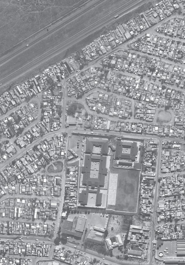
CSCC.indb 230 2014/10/07 5:19 PM
SECT
ION
B
AREA-BASED TRAN
SFORM
ATION
S
CSCC.indb 231 2014/10/07 5:19 PM
269
14 The wrong side of the mining belt? Spatial transformations and identities in Johannesburg’s southern suburbs
P H I L I P H A R R I SO N A N D TA N YA Z AC K
Absences and insightsTh e southern suburbs are the terra incognita of urban scholarship in Johannesburg. Hart (1968) dealt expressly with this part of Johannesburg and a few other contributions have provided insights into specifi c aspects of the history and development of the southern suburbs (e.g. Mooney 1998; Parnell 1988). Th e seemingly mundane spaces of the historically white working-class south have remained largely outside the purview of the academic elite in Johannesburg, who have directed their att ention to either the spaces of the black working class or to the glitzy spaces of the north.
Th e south is the in-between space, seemingly neither poor enough nor rich enough to warrant serious att ention. However, the southern suburbs off er urban researchers a wealth of insight into processes of socio-spatial development in the city. Th ey provide an intriguing window into the social lives and identities of a diversity of groups, but also into the social and cultural construction of space. Th e shaping of space in the south cannot be separated from the emergence and consolidation of a white working class in the early decades of Johannesburg’s mining and industrial history; the state response to an infl ux of largely destitute rural Afrikaners; the arrival of southern European immigrants in signifi cant numbers from the 1940s; the rapid expansion of the white middle class in the 1950s and 1960s; the rapid expansion of a black middle class from the 1990s; and the arrival of large numbers of African migrants, including those from Mozambique, Zimbabwe, the Congo, Nigeria and Somalia.
Th e southern suburbs elucidate many other spatial processes shaping Johannesburg with a clarity missing elsewhere in the city. Here the spatial fragmentation of the city is
CSCC.indb 269 2014/10/07 5:19 PM
Changing SpaCe, Changing City270
barely concealed. The area as a whole retains a level of separateness that has outlasted the south’s distinctive role as a space of the white working class. The suburbs are a motley, poorly connected collection of neighbourhoods, developed separately at different times, with little apparent thought for internal integration or citywide connections. A book celebrating the Turf Club racecourse offers a commentary on its location in the lacklustre southern suburbs:
It is not the most beautiful situation; one might even suppose it to have been chosen by mistake. Close by, on the north and west, sit mine dumps … to the south and east lie squat, working class suburbs, their density broken here and there by public transport depots, low-rise commercial and industrial buildings and other uglinesses. (Collings 1987: 10)
There are few other spaces in the city where the legacy of mining is so clearly present in the urban landscape. The mining belt creates a physical and perceptual barrier between the southern suburbs and the central-north of the city, and its undermined status for many years froze this belt against development. However, as the old mining land is progressively redeveloped, so the built environment surrounding and intruding into the southern suburbs evolves. This sets the area apart as one of the few places in the city where industrial and residential landscapes are deeply entangled. The development trajectory of the southern suburbs also reflects the spatial effects of state investment in transportation infrastructure. The arrival of freeways in the 1970s and 1980s had a dramatic expansionary impact, opening up a large swathe of land to suburban development. In this chapter we elaborate on these insights with a narrative that broadly follows a chronological ordering. Before doing this, however, we provide a brief scan of the southern suburbs.
A scan of the southern suburbsThe southern suburbs stretch in an irregular belt between Soweto in the west and Alberton (in the Ekurhuleni Metropolitan Municipality) in the east (Figure 14.1). Historically, it was bordered by mining land in the north and the Klipriviersberg in the south but the southern suburbs have now extended into the mining belt, and over and beyond the Klipriviersberg. There is also a sharp differentiation within the area, with common reference to the ‘old South’ – an area of historically white, compact, working-class suburbs and some associated industrial development – and the ‘new South’, an area of middle- and upper-middle-class suburban development that emerged from the late 1960s.
Almost every journey to and from the southern suburbs traverses the scarred landscapes associated with mining land, while some of the suburbs are literally wrapped around old mines: West Turffontein, for example, completely surrounds a slime dam while Ormonde is one of the suburbs developed on the old Crown Mines site. Most of the mines closed in the 1970s and gradually (and fitfully) the derelict mining land has been rehabilitated. Today slime dams and mine dumps, and land sterilised by undermining, still interrupt
CSCC.indb 270 2014/10/07 5:19 PM
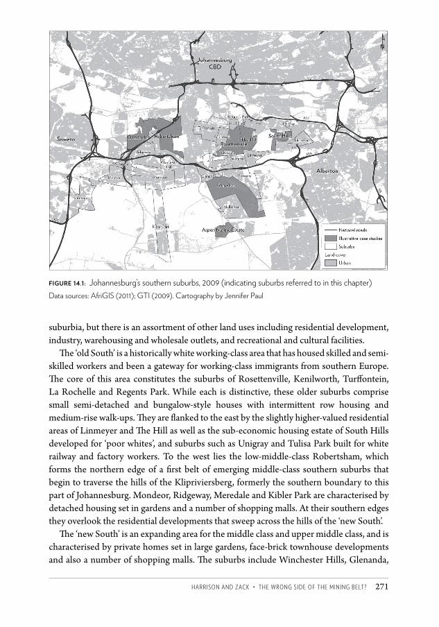
haRRiSOn anD ZaCK • the WROng SiDe OF the Mining BeLt ? 271
suburbia, but there is an assortment of other land uses including residential development, industry, warehousing and wholesale outlets, and recreational and cultural facilities.
The ‘old South’ is a historically white working-class area that has housed skilled and semi-skilled workers and been a gateway for working-class immigrants from southern Europe. The core of this area constitutes the suburbs of Rosettenville, Kenilworth, Turffontein, La Rochelle and Regents Park. While each is distinctive, these older suburbs comprise small semi-detached and bungalow-style houses with intermittent row housing and medium-rise walk-ups. They are flanked to the east by the slightly higher-valued residential areas of Linmeyer and The Hill as well as the sub-economic housing estate of South Hills developed for ‘poor whites’, and suburbs such as Unigray and Tulisa Park built for white railway and factory workers. To the west lies the low-middle-class Robertsham, which forms the northern edge of a first belt of emerging middle-class southern suburbs that begin to traverse the hills of the Klipriviersberg, formerly the southern boundary to this part of Johannesburg. Mondeor, Ridgeway, Meredale and Kibler Park are characterised by detached housing set in gardens and a number of shopping malls. At their southern edges they overlook the residential developments that sweep across the hills of the ‘new South’.
The ‘new South’ is an expanding area for the middle class and upper middle class, and is characterised by private homes set in large gardens, face-brick townhouse developments and also a number of shopping malls. The suburbs include Winchester Hills, Glenanda,
figure 14.1: Johannesburg’s southern suburbs, 2009 (indicating suburbs referred to in this chapter) Data sources: AfriGIS (2011); GTI (2009). Cartography by Jennifer Paul
CSCC.indb 271 2014/10/07 5:19 PM
Changing SpaCe, Changing City272
Glenvista, Mulbarton and Bassonia. These suburbs were built against the Klipriviersberg range, and are among the most attractive residential neighbourhoods of Johannesburg. They have, since the 1990s, been supplemented with the affluent gated communities of Aspen Hills and Aspen Lakes – security villages of often ostentatious homes surrounded by swathes of open land, all monitored by guards and cameras. Although a 20-year splurge of residential development occurred from the late 1960s, the south still lags behind the north in terms of the scale of development.
Identity-in-place: the makings of a white working class, 1886 to 1945Working-class ‘respectability’The development of the southern suburbs was closely tied to the formation and evolution of Johannesburg’s white working class. The southern suburbs offered a less desirable location than the northern parts of Johannesburg as they had a harsh micro climate with south-facing slopes and winds blowing the dust from the mine dumps into residential areas. Developers quickly marked out the area for the working class by subdividing the land into relatively small stands – generally around 500 m² compared with a norm of between 1 000 m² and 4 000 m² in the northern suburbs (Hart 1968). The area was initially designated for skilled artisans (electricians, plumbers, builders, carpenters, boilermakers and so forth) who serviced the mines and other emerging industries of Johannesburg. It was an area of ‘working-class respectability’, reflected in the sturdy workers’ cottages laid out in strict gridiron pattern.
A key physical and institutional presence in the south was the Turffontein Racecourse. This introduced a strong gambling culture into the south which has persisted to this day, but it also brought Johannesburg’s elite – on occasion, at least – into the working-class suburbs. The Johannesburg Turf Club initiated much of the residential development in the ‘old South’, including the suburb of Turffontein as it developed or sold off portions of its land holdings (Collings 1987).
In the early years there was a rush of township establishment in a broad crescent to the south of the mining belt.1 After about 1910, however, development tailed off as opportunities for residential development expanded in the north of the city. From 1910 to 1940 relatively few new residential areas were laid out and these catered for a slightly higher-income group.2
By 1931 only about 14.9 per cent of Johannesburg’s white population lived in the south, a figure that increased only gradually to around 16 per cent in the 1960s (Hart 1968).
The tramline between the Johannesburg CBD and the southern suburbs sustained suburban expansion as it provided the critical link across the mining belt in an era when private car ownership was still relatively low in working-class suburbs. The electric tram was introduced to the south in 1906 and gradually extended until the early 1930s (Spit 1976).
The southern suburbs were not the only spaces of the white working class in Johannesburg, but they did exhibit peculiar characteristics linked to their ethnic mix. The
CSCC.indb 272 2014/10/07 5:19 PM
haRRiSOn anD ZaCK • the WROng SiDe OF the Mining BeLt ? 273
white working class at the time was segmented between an Afrikaner grouping that had arrived from rural areas of South Africa and included a significant proportion of ‘poor whites’; Yiddish-speaking Jews from the western parts of the Russian Empire who came to the goldfields with few resources but with the advantage of a long intellectual and educational tradition; and a relatively skilled English-speaking grouping from the mining regions of the United Kingdom, including Cornwall, Wales and north England.
Afrikaners settled mainly in the west of Johannesburg and Jewish immigrants in a band extending north-east from Doornfontein and Hillbrow. English speakers settled in centrally located suburbs along the Witwatersrand Ridge, including Brixton, Jeppe and Malvern. The southern suburbs were more ethnically and linguistically mixed although they were initially English-dominated. In the 1930s, small groups of Jewish families were clustered around the Rosettenville-La Rochelle and Ophirton synagogues (Rubin 2005).3 The Afrikaner presence in the southern suburbs was also relatively small to begin with but it was to expand significantly: in 1938, 20.4 per cent of the municipal voters in the southern suburbs were Afrikaans speaking but this increased to 44.2 per cent by 1961 (Stals 1986).
English-speaking immigrants brought a tradition of trade unionism that meshed with a history of Afrikaner struggle. In 1922 – when white workers marched under the banner ‘Workers of the World, Fight and Unite for a White South Africa’ – English and Afrikaner workers drilled together on the streets of Turffontein, La Rochelle, Regents Park and Booysens, and organised attacks on police stations and neighbouring mines (Krikler 2005). In 1924, the (mainly English-speaking) Labour Party, which was strong in the southern suburbs, collaborated with the (mainly Afrikaans-speaking) National Party to form the Pact Government, which introduced measures to protect white labour. The possibility existed of a broad front of white labour that would have been well represented in the ethnically diverse south. However, from the 1930s, instead of a continued process of white working-class formation, there was the ‘growth of a distinct Afrikaner working class consciousness and a sense of cultural distance from English-speaking workers’ (Visser 2005: 141).
‘Poor whites’In the 1930s the number of Afrikaners on the Witwatersrand expanded rapidly as drought and other dire circumstances in rural areas forced thousands of Afrikaners to move to the cities in what historians have referred to as ‘the last Great Trek’ (Van Jaarsveld 1982). The newly arrived Afrikaners mobilised along ethnic lines and established their own churches, trade unions and social and cultural organisations. Many of these Afrikaners were destitute and fell within a category known as ‘poor whites’. Economically, poor whites were protected by the policies of job reservation introduced by the Pact Government but they competed with Africans for accommodation in inner-city slums and often resided in racially mixed precincts. Parnell (1988) argues that it was this racial mixing that most offended the municipal authority and which prompted it to intervene in the ‘poor-white problem’. Thus, during the 1930s the Johannesburg City Council tried to separate racial groups into
CSCC.indb 273 2014/10/07 5:19 PM
Changing SpaCe, Changing City274
different housing estates – moving Africans to Orlando, coloureds to Coronationville, and whites to sub-economic housing estates in areas such as Bertrams and Jan Hofmeyr near the inner city. In this way, what may have formed the seeds of an integrated society were forcibly splintered by the state.
In the 1930s, planning commenced for around 2 000 sub-economic houses for whites, to be built on open land east of the southern suburbs. The proposed development provoked strong opposition from the established working class in the area but the municipality persevered and eventually around 530 houses were built (Parnell 1988). The housing estate was laid out using Garden City principles ‘in a half-baked way’ (Parnell 1993: 83) and when it was proclaimed in 1942 the estate was patronisingly called ‘Welfare Park’. In the 1960s the name of the estate was changed to South Hills, but the stigma remained. A Wikipedia entry, for example, reports that the colloquial name for South Hills is ‘Storks’, referring to the number of unplanned pregnancies in the suburb.4
In South Hills, as in the sub-economic suburbs near the inner city, whites became tenants of a state that was alarmed at the social pathologies of poor-white communities: ‘In these new suburbs, poor whites were offered a “proper environment” where they were taught how to be hard-working and respectable good whites’ (Teppo 2004: 221). From 1948, there was further development of mainly Afrikaner working-class housing towards the east of the southern suburbs, linked mainly to post-war industrial development.
Post-war developments, 1945 to 1970The post-war era was accompanied by sustained economic growth, which raised many working-class whites into the middle classes, and also by an influx of European immigrants, including from southern Europe. These processes were to significantly influence the spatial form and social composition of the southern suburbs.
The ‘American Dream’Mondeor and Robertsham, both proclaimed in 1948, were the largest of the middle- and new lower-middle-class suburbs built to meet the housing demand of servicemen returning from the war, and in the 1940s and 1950s, middle-class expansion was modest. By the 1960s, however, a sustained period of rapid economic growth in South Africa eventually translated into a middle-class lifestyle among white South Africans that was comparable to that of post-war USA. This was reflected in the mini housing boom in Mondeor, described vividly by an interviewee who grew up in the suburb:
This late, miniature version of the ‘American Dream’ was expressed in a lifestyle where just about every family had two cars, wives worked in offices in downtown Johannesburg and could be seen waiting for the morning bus in their stiletto heels, tight skirts and beehive hairstyles. Swimming pools were constructed on many of these newer properties, and Penguin Pools, who seemed to have the monopoly on pool construction, were a byword amongst house-proud suburbanites.5
CSCC.indb 274 2014/10/07 5:19 PM
haRRiSOn anD ZaCK • the WROng SiDe OF the Mining BeLt ? 275
Immigrant gatewayFrom the mid 1940s the southern suburbs emerged as a gateway for immigrant communities arriving from southern Europe (and neighbouring Mediterranean states). Smuts’s immigration programme of 1946 was an attempt to fill the skills gap in the post-war era. It brought Greek, Lebanese, Italian, Portuguese, Irish, Polish and other immigrants to the working-class suburbs of Johannesburg.
The initial immigration scheme was short-lived, as Smuts was defeated in 1948 by Afrikaner nationalists who discouraged the immigration of dark-skinned, mainly Catholic southern Europeans, preferring Germans and Dutch. In the 1960s, however, when rapid economic growth led to a growing skills deficit, the National Party government relaxed its immigration policies, allowing for a further (and expanded) influx of immigrants from southern Europe (Glaser 2010; Peberdy 2009). Browett and Hart (1977) identify the southern suburbs as a major point of concentration for these immigrants, with Portuguese migrants clustering in La Rochelle, Regents Park, Rosettenville, Kenilworth and Turffontein.
Glaser (2010) explains that the earliest wave of Portuguese arrivals came from the impoverished island of Madeira. This group had been trickling into South Africa from the end of the nineteenth century, and continued to do so until the 1970s. They found a home in unfashionable suburbs where houses were cheap and often shared by an extended family. The second wave involved Portuguese from the mainland who generally had higher levels of education and skill but who also found an entry into Johannesburg in the southern (and eastern) suburbs. The second wave reached its peak in 1966 when over 8 700 immigrants were recorded as arriving from mainland Portugal. The Portuguese occupied an ambivalent position within white South Africa. As Glaser put it, ‘they were white, yes, but on the margins: exotic, darker-skinned, Catholic, poorer than most whites, less educated, keeping to themselves, unpredictable in their loyalties’ (2010: 77).
Greek and Lebanese communities also occupied an ambivalent position in South Africa’s white society, which was predominantly Protestant and of northern European origin.6 Some of the communities made special efforts to prove their identification with their host society. One interviewee noted that in their efforts to integrate into South Africa as enfranchised whites, Lebanese immigrants abandoned their language and did not speak it to their children.7
Youth cultureThe identity of the ‘old South’ was shaped in the context of its diversity of white working-class communities. The youth culture of the south was especially important in shaping this identity.
The Ducktail gangs of working-class neighbourhoods in Johannesburg in the 1950s shared many of the characteristics of an international youth culture at the time (akin, for example, to the Teddy Boys in the United Kingdom). They were ‘rebellious, hedonistic, apolitical and displayed little respect for the law, education or work’ (Mooney 1998: 753).
CSCC.indb 275 2014/10/07 5:19 PM
Changing SpaCe, Changing City276
Ducktails were a partial consequence of the post-war immigration programme. As Mooney explained, ‘this influx and the social dislocation and insecurity that families experienced in moving to a new country, led to the youths forming themselves into ethnically based groups in search of security, familiarity and a sense of belonging’(2006: 182). The gangs were highly territorial and often ethnically exclusive, with Lebanese and Greek gangs gaining special notoriety. In the southern suburbs there were the Rosettenville Gang and the notoriously violent South Hills Gang, which would clash frequently with gangs from the eastern suburbs. Local gangs claimed territory over certain hotels.8
However, despite these divisions, Ducktail culture was hybridised and ‘Ducktail argot was an interesting synthesis of English, Afrikaans and “South African English”, loosely based on old Cockney rhyming slang (“Rub & Tub”) combined with the incorporation of a few Americanisms from the film industry’ (Mooney 2006: 120). The blending of the linguistic traits of different groups into a local patois was especially pronounced in the southern suburbs, where it was famously captured in 1961 by Jeremy Taylor’s hit single ‘Ag Pleez Daddy’ (also known as ‘The Ballad of the Southern Suburbs’).
A southern identityThe core of the ‘old South’ remained resolutely working class. While around 2 per cent of Johannesburg’s white population earned more than R10 000 per annum in 1970, the proportional figure for the suburbs of Rosettenville, La Rochelle, Kenilworth, Regents Park and South Hills was less than 0.1 per cent.9
Despite the continued working-class identity, there was a switch in political allegiance. From its earliest days the ‘old South’ had been doggedly supportive of the Labour Party, but in the 1950s the mood shifted. This was evidenced when the Labour Party MP for Rosettenville, Alex Hepple, offended his constituency with his radical politics and was rejected in 1958 in favour of a United Party MP. From then on, there was no obvious political home for the waning white working class.
Our interviewees revealed considerable nostalgia for the 1960s as the heyday of white working-class culture. In that decade, before the arrival of television and the economic and political uncertainties of the 1970s, social life happened in the high streets, hotels, cinemas and sports clubs of the old suburbs. Our respondents reminisced about dancing and partying in the Portuguese Hall, the Italian Club and in local hotels; carousing at the drive-in cinemas; drinking in the Lebanese-run backyard shebeens; sharing late-night milkshakes and toasted sandwiches in the roadhouses (that remained open after hotels had closed their doors at midnight); and socialising at the public swimming pools. Sport was an important element of the local culture with boxing, soccer, rugby, tennis, horse racing and pigeon racing featuring prominently in stories we were told of the 1960s. The south was also remembered as a tough place with gang violence and ethnic rivalries.10
The southern suburbs identity that had coalesced by the 1960s was a deliberate counterpoint to perceived behaviours and identities in the north. Residents of the south saw the north as pretentious and effete in contrast to the gritty honesty and practicality
CSCC.indb 276 2014/10/07 5:19 PM
haRRiSOn anD ZaCK • the WROng SiDe OF the Mining BeLt ? 277
of the south. This identity has persisted in the ‘old South’ although it has been diluted by recent immigration. In a 2004 study on white identity in Johannesburg, it was said of the proletarian south that ‘there was no norm of an intellectual culture here. There were elements of a hearty and mean local chauvinism’ (Stewart 2004: 134–135).
Spatial transformationsDevelopment through the 1950s and early 1960s was incremantal. However, from the late 1960s powerful processes were to fundamentally transform the face of the south. In the post-war era, private car ownership expanded dramatically, including within working-class suburbs. The electric tramway’s key link to the south was closed in 1957, with all tramway operations terminated by 1961 (Spit 1976). The tramways were followed by electric trolley and then diesel buses, but public transportation was in sharp decline. By the 1960s white South Africa was a car-oriented society with levels of car ownership exceeded only in North America, and investment in public transportation was almost entirely abandoned.
The period of sustained economic growth through the 1950s and 1960s largely benefited the politically powerful white population. It lifted a large proportion of the white working class into the middle class and created a pent-up demand for middle-class suburban expansion. This coincided with the freeway developments around Johannesburg and also with the release of land by mining companies for residential development.
There were other changes. In 1961 Southdale, adjoining Robertsham, was established as Johannesburg’s first out-of-town shopping centre. It was a modest development but it heralded the beginning of a major shift in retail typology across the city. Furthermore, there was also a significant improvement in the number and quality of services in the southern suburbs, with the white working class proving highly successful in making demands on the state. There were, for example, new recreational facilities, the opening of the South Rand Hospital, and the development of a number of new (mainly Afrikaans-language) schools.
While the southern suburbs were the spaces of the white working class (with some middle-class incursions in the post-war era), there was, importantly, also an island of the African elite. St Peters Secondary School, both a school and a seminary, was opened in 1907 in Rosettenville for African males (the same year that St Agnes School, where ‘native girls could be trained as useful servants’, was opened in Rosettenville [ Joubert 1998: 11]).11
The ‘new South’: suburban expansion in the orbital motorway, the 1970s and 1980sThe next great rush of suburban growth was associated with the planning and construction of Johannesburg’s ‘orbital motorway’, which dramatically changed the relative advantage of locations in the south for new development. The construction of Johannesburg’s ring road began in the late 1960s and proceeded in phases until the N12, or southern bypass, was
CSCC.indb 277 2014/10/07 5:19 PM
Changing SpaCe, Changing City278
finally completed in 1986. It was the anticipation of the N12 that led to the emergence of the so-called ‘new South’.
There were 25 township establishments in the 1970s. These were middle-class suburbs that profoundly changed the class composition of the south. By the end of the 1980s, it was no longer possible to characterise (white) Johannesburg in terms of the wealthy north and working-class south, as the south had expansive middle-class areas (the ‘new South’) as well as the traditional working-class suburbs (the ‘old South’). The expansion was facilitated by the Johannesburg City Council, which was incrementally and deliberately expanding its boundaries to incorporate peri-urban areas.
The new suburbs had individual properties around four times larger than in the ‘old South’. With little regard for environmental considerations, developers built over the hills of the Klipriviersberg, taking advantage of the spectacular views offered along the ecologically sensitive ridges.
During the 1970s, suburban development in the south actually outpaced that of the north of Johannesburg (Beavon 2004). This growth, however, slowed markedly from the mid 1980s, coincident with the stagnation of the South African economy and infrastructural constraints on expansion to the south. Such constraints included a lack of sewer outfall capacity and stronger environmental controls, such as the proclamation of the 680-hectare Klipriviersberg Nature Reserve in 1984.
Strategies of the mining companiesAlongside the development of freeways, the strategic decision of mining companies to release land for property development was a significant force in the expansion of the south. In the early 1960s, eight large gold mines operated in the Central Rand Goldfield immediately adjoining the southern suburbs, but all had closed by the late 1970s owing to the growing cost and difficulty of deep-level mining (Viljoen 2009).
Much of the mining land was dangerously undermined and environmentally damaged but significant tracts of land held development opportunity. The biggest land owner by far was Rand Mines Limited with a huge tract of land across the mining belt, comprising at least 13 per cent of the land area of Johannesburg Municipality at the time (Prinsloo 1993).
In 1968, Rand Mines Property (RMP) was established and listed on the Johannesburg Stock Exchange. An architectural and planning office was set up at RMP under the directorship of well-known architect Ivor Prinsloo, and a Master Plan for the area was produced by a consortium led by Roelof Uytenbogaardt from the University of Cape Town. The plan proposed restructuring development by grouping land uses, organising east-west movement, and reclaiming derelict land for residential, industrial, business and recreation purposes in a systematic way (RMP 1969, 1971). Many of the proposals were advanced for their time, including the idea of an express bus route that prefigured the present-day Bus Rapid Transit system.
The choice portion of RMP land was the old Crown Mines site. Multiple proposals for its use were outlined, with Ormonde New Town development as a central feature
CSCC.indb 278 2014/10/07 5:19 PM
haRRiSOn anD ZaCK • the WROng SiDe OF the Mining BeLt ? 279
(Prinsloo 1993). The planning for Ormonde was cutting edge, grounded in ideals of urban ecology and drawing on an avant-garde modernism.12 The plan was, however, devised within the context of the Group Areas Act, and Ormonde was intended for around 40 000 middle- to upper-middle-income whites, separated from Soweto by a buffer of industry and warehousing (RMP 1969, 1971).13
Ormonde was proclaimed in 1973 but it never attracted the white middle class as expected. The development was interrupted by the 1976 Soweto uprising which created growing anxiety around white residential settlement near black townships.14 But Ormonde expanded incrementally over time and more rapidly when apartheid barriers began to break down and, in a departure from the original vision, lower-middle-class residential demand was catered for.
Beyond Ormonde, the staccato development of the mining belt continued with RMP (later known as iProp) developing 1 065 hectares of land between 1968 and 1980 for uses including a fresh produce market, a flower market, the Gold Reef City casino, industrial townships and office developments. Among the largest developments were the government-sponsored Nasrec Expo Centre (1984) and Nasrec Soccer Stadium (1989) on the Crown Mines site on land purchased from the mining company. In 2010, the refurbished stadium was a centrepiece in the FIFA Soccer World Cup.
A Portuguese influxThe spatial development of the ‘old South’ during the 1970s and 1980s was gradual, but it was socially significant. There was a shift in character as the Portuguese community became increasingly dominant in some areas, especially around Rosettenville, Regents Park and La Rochelle.
In the mid 1970s the Portuguese administrations in Angola and Mozambique collapsed, and large numbers of colonial Portuguese fled to South Africa where many found a home in the southern suburbs of Johannesburg. Eventually as many as 400 000 Portuguese were living in South Africa with perhaps as many as 70 000 in the southern suburbs. The Portuguese-medium newspaper O Século de Joanesburgo, with its offices in Ormonde, claimed a circulation of 40 000 and a readership of over 200 000 (Glaser 2010).
Glaser reveals that these newcomers established their own Mozambican and Angolan associations when they arrived in South Africa, but that they were drawn into the established Portuguese communities by the ties of language and church. Portuguese cultural life in the southern suburbs proliferated.15
The (colonial) Portuguese influx reinforced the conservative, family-oriented traditions of the ‘old South’. With many of the Portuguese being tradesmen, the increasingly shabby suburbs in the south were given a makeover, and Portuguese cultural markers like blue porcelain tiles, grapevines and religious statues became local features. Rosettenville and La Rochelle became known for their Portuguese eateries. The Portuguese-style Nando’s fast-food restaurant, established in Rosettenville in 1987, expanded into a global chain and is now represented in 34 countries.
CSCC.indb 279 2014/10/07 5:19 PM
Changing SpaCe, Changing City280
Democracy and space in the southern suburbs, the 1990s onwardsDifferentiated changeThere have been far-reaching socio-spatial transformations in the southern suburbs associated with the arrival and consolidation of democracy in South Africa, and that are indicated in the figures provided by Census 2011.16 An initial overview of the data revealed a high degree of differentiation within the southern suburbs and even within the broad categories ‘old South’ and ‘new South’. Post-apartheid spatial transformations have been far from uniform.
The data suggest that the southern suburbs may now, broadly speaking, be divided into at least seven demographic zones, each with distinctive characteristics but with the inevitable blurring of boundaries between (see Figure 14.1):
1. The historic core of the ‘old South’ (Rosettenville, Turffontein, Kenilworth, Regents Park and La Rochelle);
2. The sector of the ‘old South’ historically characterised by public housing for ‘poor whites’ (e.g. South Hills, Unigray, Tulisa Park);
3. Suburbs in the ‘old South’ which were historically of higher income than the core (e.g. The Hill, Townsview, Oakdene);
4. Suburbs to the east of the ‘old South’ which were historically developed for the emergent white middle class during and immediately after World War Two (e.g. Robertsham, Mondeor, Ridgeway, Alan Manor, Southdale);
5. A zone of interface with Soweto, with a mix of older developments associated with the old and new South, and new post-1994 expansion (e.g. Ormonde, Meredale, Southgate, Naturena, Kibler Park);
6. The suburbs of the ‘new South’ developed from the 1970s for the white middle class (e.g. Winchester Hills, Glenanda, Glenvista, Mulbarton and Bassonia);
7. Expansion to the ‘new South’ through the development of gated nature estates (e.g. Aspen Hills).
Within these zones there is a differential mix of demographic processes, including the in-migration of low-income Africans, both South African and foreign nationals; the in-migration of an emergent and established black middle class; the in-migration of middle-class Indians of South African origin, with a trickle also of new migrants from Asia; white flight from suburbs undergoing rapid demographic transition; and white movement into new enclaves. The southern suburbs have become a cauldron of the changing post-apartheid space and society.
It is impossible to adequately represent the extent and complexity of this transformation, but we illustrate below what has been happening through a brief account of a ‘representative’ suburb within each zone. Tables 14.1 and 14.2 provide a comparative view of the suburbs, and a more detailed demographic analysis is referred to in the discussions of the suburbs that follow.
CSCC.indb 280 2014/10/07 5:19 PM
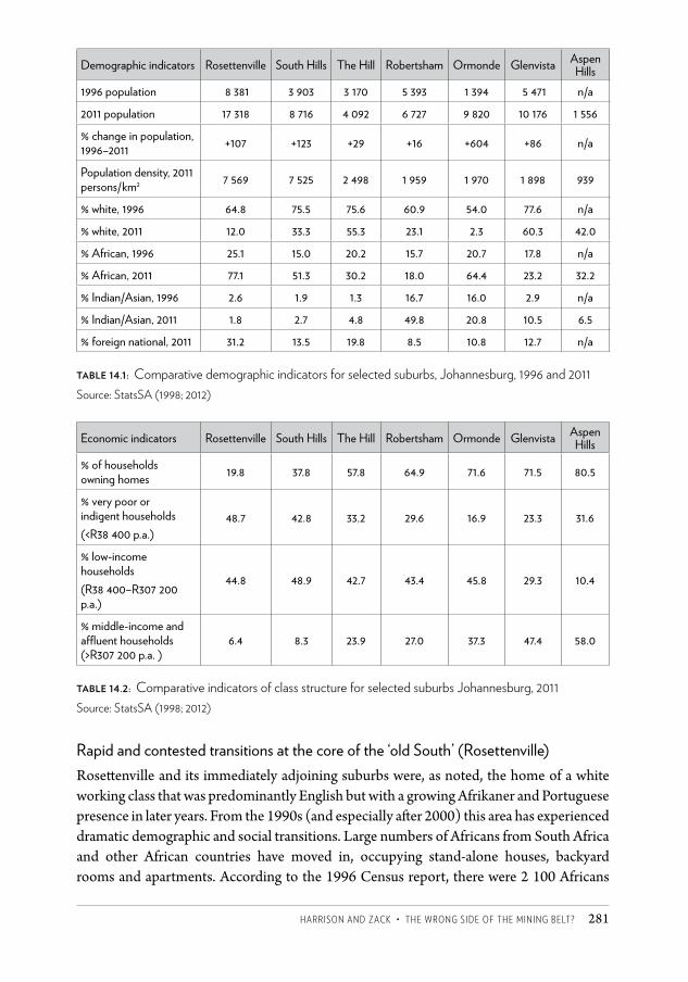
haRRiSOn anD ZaCK • the WROng SiDe OF the Mining BeLt ? 281
Demographic indicators Rosettenville South Hills The Hill Robertsham Ormonde Glenvista Aspen Hills
1996 population 8 381 3 903 3 170 5 393 1 394 5 471 n/a
2011 population 17 318 8 716 4 092 6 727 9 820 10 176 1 556
% change in population, 1996–2011 +107 +123 +29 +16 +604 +86 n/a
Population density, 2011 persons/km2 7 569 7 525 2 498 1 959 1 970 1 898 939
% white, 1996 64.8 75.5 75.6 60.9 54.0 77.6 n/a
% white, 2011 12.0 33.3 55.3 23.1 2.3 60.3 42.0
% African, 1996 25.1 15.0 20.2 15.7 20.7 17.8 n/a
% African, 2011 77.1 51.3 30.2 18.0 64.4 23.2 32.2
% Indian/Asian, 1996 2.6 1.9 1.3 16.7 16.0 2.9 n/a
% Indian/Asian, 2011 1.8 2.7 4.8 49.8 20.8 10.5 6.5
% foreign national, 2011 31.2 13.5 19.8 8.5 10.8 12.7 n/a
table 14.1: Comparative demographic indicators for selected suburbs, Johannesburg, 1996 and 2011Source: StatsSA (1998; 2012)
Economic indicators Rosettenville South Hills The Hill Robertsham Ormonde Glenvista Aspen Hills
% of households owning homes 19.8 37.8 57.8 64.9 71.6 71.5 80.5
% very poor or indigent households(<R38 400 p.a.)
48.7 42.8 33.2 29.6 16.9 23.3 31.6
% low-income households(R38 400–R307 200 p.a.)
44.8 48.9 42.7 43.4 45.8 29.3 10.4
% middle-income and affluent households (>R307 200 p.a. )
6.4 8.3 23.9 27.0 37.3 47.4 58.0
table 14.2: Comparative indicators of class structure for selected suburbs Johannesburg, 2011Source: StatsSA (1998; 2012)
Rapid and contested transitions at the core of the ‘old South’ (Rosettenville)Rosettenville and its immediately adjoining suburbs were, as noted, the home of a white working class that was predominantly English but with a growing Afrikaner and Portuguese presence in later years. From the 1990s (and especially after 2000) this area has experienced dramatic demographic and social transitions. Large numbers of Africans from South Africa and other African countries have moved in, occupying stand-alone houses, backyard rooms and apartments. According to the 1996 Census report, there were 2 100 Africans
CSCC.indb 281 2014/10/07 5:19 PM
Changing SpaCe, Changing City282
in Rosettenville, representing 25 per cent of the suburb’s population. By 2011, there were 13 449 Africans, or 78 per cent of the population.
As Africans moved in, the white population left, with the white proportion of the total declining sharply from 65 per cent to 12 per cent, and numbers dropping from 5 437 to 2 079 over the same period of time. Racial change was linked to a shift from owner-occupied dominance to a predominantly rental market. By 2011, fewer than 20 per cent of the population owned their homes.
The increase in foreign nationals resident in the area has also been dramatic. The 2011 Census reveals that 31 per cent (or 50 per cent of Africans) were born outside South Africa. The actual figures may, however, be considerably higher as many transnational migrants live ‘under the radar’ and don’t announce their presence to Census officials. Census figures by country of origin per suburb are not available, but the figures do indicate that the foreign migrants come predominantly from the SADC17 countries, although there is a significant minority from the ‘rest of Africa’.
Indications are that Rosettenville and surrounds have a particularly strong Mozambican presence. La Rochelle, a previously white Portuguese enclave, remains one of Johannesburg’s few suburbs where a language classified as ‘other’ dominated. Here, Portuguese-speaking African Mozambicans have moved in, often renting from white Portuguese home owners.18 A ward councillor in the area told us that ‘the Mozambicans are in La Rochelle, the Congolese in Roseacre, the Nigerians in Rosettenville, South African blacks in Turffontein and the Zimbabweans all over’.19 This may oversimplify a more variegated pattern, but it does suggest a degree of local ethnic clustering. A 2006 survey by the Forced Migration Programme at the University of the Witwatersrand confirmed the clustering of Mozambicans in the ‘old South’, not only in La Rochelle but across an area known generally to immigrants as ‘Rosettenville’, but which includes suburbs such as Turffontein and Kenilworth (Landau 2010).20
The ethnic patterning emerging in the area is also happening at a micro scale. Ostanel (2011) wrote of how Mozambican migrants occupy ethnically defined spaces such as eating houses, bars and internet cafes. One of our interviewees reinforced this observation of ethnic clustering and solidarity, telling us that:
Here we live in a segregated way; we live in groups. When you go to a certain club or a certain restaurant, you will find only Angolans and Mozambicans. In another club you will find Nigerians. In yet another club, 90 per cent of those who go there are Ghanaian. We all have our own particular spots and we know our spot. Everyone knows where to go and where not to go.21
A respondent from Cote d’Ivoire says, ‘We go to church together, we cut our hair together, we go shopping. We eat in African restaurants; we meet in internet cafes.’22 The proliferation of hair salons relates to the social function of this activity: the salons cater mainly to customers who have their hair attended to at least twice a week. Here immigrants share news from ‘home’ and from the local neighbourhood, and discuss tactics necessary to
CSCC.indb 282 2014/10/07 5:19 PM
haRRiSOn anD ZaCK • the WROng SiDe OF the Mining BeLt ? 283
survive in a sometimes hostile environment. Internet cafes perform a similar function: they allow for transnational financial transfers and are places to job hunt and to find out about accommodation possibilities.
But respondents also indicated that ethnic clustering is a safety strategy. For instance, ‘Immigrants prefer to frequent bars rather than shebeens, because it is threatening to drink in South African-dominated shebeens, less threatening to drink in more public places.’23
Two narratives of contemporary processes of change compete in this part of the ‘old South’. The first is of physical decay and rising crime, and the second is of increasing social vibrancy and diversity. Local ward councillors and some long-standing residents point to the migrant influx as a tipping point, and express despair at properties being taken over by criminal syndicates, the emergence of prostitution and drug dealing, and a surge in illegal land uses. One white interviewee bemoaned the invasion of foreigners and the overcrowding, saying that ‘the old South is now the new Hillbrow’.24 A local estate agent advised us that the influx of migrants into the ‘old South’ has been especially dramatic since 2005.25 A degree of physical deterioration has clearly occurred in the ‘old South’ since the early 2000s, as the newcomers are a largely transient, tenant grouping compared with the stable owner-occupier communities of the past. Landlords frequently take advantage of migrants, crowding them into dwellings, extracting unreasonably high rents and failing to maintain properties (Landau 2009).
The competing narrative of a new social (and even economic) vibrancy has to do with new forms of entrepreneurialism and new activities evident in the ‘old South’. A businessman who manages retail space pointed to the high levels of entrepreneurialism among new African migrants, arguing that there is still a thriving market for retail in the ‘old South’ – ‘it’s just that there are different customers now’.26 He explained that the demand is now for smaller and shared shop spaces. The new vibrancy is also indicated in the proliferation of informal economic activities such as shebeens, internet cafes, spaza shops, eating houses and hairdressing salons. Our survey of visible informal activity in the core of the ‘old South’ is mapped in Figure 14.2.
The proliferation of churches is a particular feature of the immigrant presence with Landau referring to religion as one of the key strategies ‘for negotiating inclusion and belonging while transcending ethnic, national and transnational paradigms’ (2009: 197).27 Many of the new churches have their origins in Nigeria and the Democratic Republic of the Congo (DRC), and are linked to evangelical and Pentecostal movements across Africa, but Brazil’s Universal Church of the Kingdom of God also has a strong presence, offering daily Portuguese-language services for Mozambican and Angolan immigrants.
The role of Rosettenville and adjoining suburbs as an immigrant gateway is similar to that of inner-city Johannesburg, and in some respects this area is a southerly extension of the inner city, leapfrogging the mining belt. However, population pressures and densities are still many times lower than that of the inner city, and also less than in suburbs such as Yeoville, which began the demographic transition about a decade earlier than Rosettenville. Immigrants we interviewed indicated that they are attracted to the ‘old South’ because it is safer and quieter than inner-city localities.28
CSCC.indb 283 2014/10/07 5:19 PM
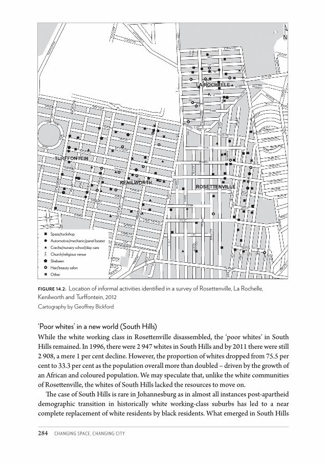
Changing SpaCe, Changing City284
‘Poor whites’ in a new world (South Hills)While the white working class in Rosett enville disassembled, the ‘poor whites’ in South Hills remained. In 1996, there were 2 947 whites in South Hills and by 2011 there were still 2 908, a mere 1 per cent decline. However, the proportion of whites dropped from 75.5 per cent to 33.3 per cent as the population overall more than doubled – driven by the growth of an African and coloured population. We may speculate that, unlike the white communities of Rosett enville, the whites of South Hills lacked the resources to move on.
Th e case of South Hills is rare in Johannesburg as in almost all instances post-apartheid demographic transition in historically white working-class suburbs has led to a near complete replacement of white residents by black residents. What emerged in South Hills
figure 14.2: Location of informal activities identifi ed in a survey of Rosettenville, La Rochelle, Kenilworth and Turff ontein, 2012Cartography by Geoff rey Bickford
Spaza/tuckshopAutomotive/mechanic/panel beaterCreche/nursery school/day careChurch/religious venueShebeenHair/beauty salonOther
CSCC.indb 284 2014/10/07 5:19 PM
HARRISON AND ZACK • THE WRONG SIDE OF THE MINING BELT ? 285
is an unusually integrated suburb with 51.3 per cent Africans, 33.3 per cent whites, 12.2 per cent coloureds and a smattering of other groups.
The class and income profiles of Rosettenville and South Hills are now very similar – both are areas with a mix of indigent and low-income households, with virtually no middle-class residence. There are, however, some differences: in South Hills, Afrikaans remains the dominant language spoken by the white and coloured communities; home ownership is more prevalent, reflecting government efforts to transfer rental stock to ownership; and there are fewer foreign nationals.
Ironically, it is in South Hills, which has long been associated with right-wing politics in the marginalised white community, that there are at least glimpses of an emergent society of racial crossover. The integration process has been fractious and complex but persistent, as explained by Vandeyar and Jansen (2008) in their story of how the previously all-white Afrikaans-language Hoërskool JG Strijdom in South Hills underwent a transition to social and demographic diversity, even changing its name to Diversity High School in 2005.
Relative stability along the ridge (The Hill)While Rosettenville and some neighbouring suburbs may be attracting attention in the media for crime, grime and decay, there are suburbs in the ‘old South’ where change is slow. These are suburbs which are working class but which have, historically, had a slightly more elevated income profile than places like Rosettenville or Turffontein. They are a little further away from the grit of the mining belt and are strung out along the ridge with expansive views to the south and northwards to the city skyline.
In The Hill, for example, whites remain in a majority, despite an increase in the African and coloured populations. Overall population increase and densification has been slow – less than 30 per cent over 15 years – and the majority of households are still home owners. Councillors and property agents report stable property markets.29
Muslim space in the west (Robertsham)A mainly Muslim Indian population has concentrated in Robertsham and Ridgeway where there are now six mosques, and, to some extent, also in Mondeor and other neighbouring suburbs. This area now forms part of a broad arc of Indian residence in the city, from Lenasia in the south-west of Johannesburg to Fordsburg and Mayfair on the western side of the inner city. Already in 1996, 16.7 per cent of Robertsham’s population was Indian, indicating processes similar to those in Mayfair where Indians gradually infiltrated despite the Group Areas Act, often using whites as nominees. In 2011, 50 per cent of Robertsham’s population was classified as Indian/Asian, representing an absolute increase from 902 to 3 353 Indians. At the same time, the proportion of whites declined from 61 per cent to 23 per cent with an absolute decline from 3 277 to 1 551. There was only a small increase in the African population.
While the demographics of Robertsham have shifted, the suburb has retained its lower middle-class/stable working-class profile. The expansion of the Indian population has
CSCC.indb 285 2014/10/07 5:19 PM
Changing SpaCe, Changing City286
stimulated the property market, with the participants of a focus group we held with former residents of the ‘old South’ crediting Indian households for a wave of gentrification in and around Robertsham, as homes have been extended and upgraded.
The tendency of the (mainly Muslim) Indian population to concentrate their residences in specific areas is linked to the importance of being near religious facilities (the process of expanding Muslim space in Johannesburg is explained in Chapter 23). And while Indian residential space has extended into the western parts of the ‘old South’, this community has retained strong links with the historically Indian township of Lenasia, with many children from households in the southern suburbs still attending schools in Lenasia.30
The African middle class and the interface with Soweto (Ormonde)The expansion of the African middle class has been one of the key drivers of spatial change in post-apartheid Johannesburg (Crankshaw 2008). The emergent and established African middle class has moved into previously white suburbs, although some segments of the middle class have remained in historically African townships, and especially in Soweto.31 In making locational choices, the African middle class is responding to the opportunity to move into high-amenity residential suburbs previously reserved for whites, but also to the desire to remain physically connected to social networks and cultural experiences in the townships. The southern suburbs closest to Soweto provide the opportunity to do both.
The interface zone in the southern suburbs is separated from Soweto by the mining belt and freeways but is growing towards Soweto through infill and new expansion. In 1996, Ormonde, for example, was a small, failed, residential suburb with a population of 1 394. It was already reasonably mixed racially but had a white majority. Between 1996 and 2011 Ormonde’s population expanded by over 600 per cent to 9 820, with all the new growth from African, Indian and coloured households. The white proportion dropped from 55 per cent to a negligible 2 per cent, with Africans increasing from 21 per cent to 64 per cent, and Indians from 16 per cent to 21 per cent. The new residential developments were private, and catered to the emergent black middle class. In 2011, 72 per cent of Ormonde’s households owned their own house.
Population increase has been equally significant in the other suburbs along the interface, although there are some differences between the suburbs. Meredale, for example, is attracting higher numbers of coloured households because of its relative proximity to the coloured township of Eldorado Park. And not all the spillover from Soweto is middle class. An extension to Naturena has a distinctly working-class Soweto character, with an energetic street life and informal activities including spaza shops, street traders and doctors’ consulting rooms on residential properties.
The interface may either be regarded as part of a gradual extension of Soweto into the southern suburbs or as a new socio-spatial formation which has hybridised Soweto with the southern suburbs. This spatial configuration has begun to erode the deeply entrenched perceptual divide between Soweto and the southern suburbs. An illustration of this redefinition of spatial identity can be found in the Southern Johannesburg Business and
CSCC.indb 286 2014/10/07 5:19 PM
HARRISON AND ZACK • THE WRONG SIDE OF THE MINING BELT ? 287
Tourism Association’s concept of a Business, Tourism and Recreation Loop linking the southern suburbs and Soweto.
Politically, this area of interface is the only part of the southern suburbs which is not a stronghold of the opposition Democratic Alliance, a party mainly supported by white, coloured and Indian voters. The African National Congress controls the two wards in the southern suburbs closest to Soweto.
White dominance in the ‘new South’ (Glenvista)The ‘new South’ remains majority white. Not only has the white population retained its dominance but it has grown in absolute terms. In the case of Glenvista, the number of whites increased from 4 246 in 1996 to 6 137 in 2011.
There is a link between the ‘old South’ (of white working-class days) and the ‘new South’, as many of the families who made good in the ‘old South’ moved into the ‘new South’, taking with them ethnically oriented associations and establishments. Examples include the well-known Calisto’s Portuguese Restaurant which was relocated from Turffontein to Gillview, and also the Lebanese Maronite Church which established in the suburb of Liefde-en-Vrede in 2001, recongregating the Lebanese community which had dispersed across the city.32 The suburbs in the ‘new South’ still have the highest proportion of Europe-born residents in any part of Johannesburg, although migrants from Europe are overall now a tiny proportion of total transnational immigrants.
Although the ‘new South’ may be forging a social character that is at least partly different from other middle-class areas in Johannesburg, it is also mimicking the north in its patterns of development. For example, the retail offerings and spatial forms of the shopping malls are very similar to those in the north, as are the gated qualities and aesthetic sensibilities of the new generation of residential estates with their fake Tuscan and Bali-style architecture.
A retreat into eco-estates (Aspen Hills Nature Estate)Some of the newest expansion in the ‘new South’ – within Johannesburg and immediately across the border in Ekurhuleni and Midvaal – has taken the form of ‘eco-estates’ with mansion-style living in estates with quiet roads and footpaths, nature reserves hosting antelope and other wild animals, and no private boundary walls. The Aspen Hills Nature Estate, 8 km from the Johannesburg CBD in the ‘new South’, is marketed as country-style living:
Imagine awakening every morning to the sweet sound of birdsong, breathing in the fresh country air and being enveloped with a sense of peace and security that nothing can spoil … Be part of the select few who escape the imprisoned lifestyle of suburban living.33
Extreme measures are taken to secure the safety of residents in this estate, including more than a hundred cameras that provide thermal imaging and follow visitors to their destinations within the estate.34 A prominent resident of the southern suburbs, owner of the Calisto’s restaurant, has moved to an eco-estate where, he says, his children can roam the streets freely as he did in the ‘old South’ of his youth.35 This notion of the ‘old South’ as a safe place was echoed by an
CSCC.indb 287 2014/10/07 5:19 PM
Changing SpaCe, Changing City288
estate agent who noted that the form created by semi-detached housing, compact properties and small apartments was a precursor to the perceived safety created by ‘cluster living’.36
As may be expected, the Aspen Hills Nature Estate has the highest proportion of middle-class residents and home owners of all selected suburbs. However, there is not an absolute majority of white residents and there is also a large proportion of ‘indigent or very poor’ households. The reason for this is that the affluent residents of Aspen Hills are served by a significant number of African domestic and other workers.
Business nodesThe ‘new South’ mimics the northern suburbs in terms of its polycentric pattern of decentralised commercial development. There is a network of neighbourhood shopping nodes in the south, but also two mega regional shopping malls that rival centres in the north in terms of size. The first is the Southgate Shopping Mall, established in 1990 between Mondeor and Soweto at a major freeway junction, with 69 750 m² of commercial space.37 Initially, Southgate was intended to serve a mainly white middle-class market that had expanded in the region since the 1960s but it soon reoriented towards the spending power of the rising black middle class, and became a key retail node for residents in Soweto. The next major development was The Glen, launched in 1998 in Oakdene near the Camaro Junction on the N12. Its main market is the middle- and upper-middle-class suburbs of the ‘new South’.
Despite these nodes and a number of linear strips of business activity, the southern suburbs still barely feature in terms of formal business development citywide. In the period 2006–2010 there were only 196 rezonings in the southern suburbs, which was around 4 per cent of the total for Johannesburg as a whole, and not one of the 21 office nodes in Johannesburg analysed annually by the South African Property Owners Association is in the southern suburbs.38 There is, however, a significant emergent business node in Ormonde which includes a business park with the headquarters of De Beers Corporation, a large casino and the Apartheid Museum.
ConclusionIn this chapter we sought to remedy the ‘forgottenness’ of the south but also to use the southern suburbs to illustrate the ongoing evolution of space in Johannesburg, connected as it is with social and political transformations. An important work on Johannesburg, titled City of Extremes (Murray 2011), invokes an image of Johannesburg as a continuation and even an exaggeration of apartheid divisions. It is a popular academic argument about the city. Our assessment of the south suggests that the realities within the city’s neighbourhoods are more complex. There is a substantial class divide in the south (between the ‘old South’ and the ‘new South’), but within each of these new categories there is complexity and blurring. Suburbs are racially and ethnically diverse; identities are being revised and new forms of mixing are occurring in spaces such as churches, where cultural and ethnic divisions are overridden by social and religious cohesion.
CSCC.indb 288 2014/10/07 5:19 PM
HARRISON AND ZACK • THE WRONG SIDE OF THE MINING BELT ? 289
In the intricate mix of spatial stability and spatial turbulence in the southern suburbs, the outlines of new urban futures are present in their utopian and dystopian forms. The ‘old South’ may be pointing us towards a future of decay and new forms of socio-spatial segregation or to a new ‘Afropolitanism’ in which diversity and new entrepreneurial and social energies restore urbanity to the city. The ‘new South’ may be pointing to the retreat of the middle class into fortress-like enclaves, on individual properties and in collective estates, or to new forms of interracial solidarity in response to common ‘middle-class concerns’.
The old identities of the southern suburbs, established during a period of predominantly white working-class residence, have been significantly eroded, although they linger in some circles. While older residents may still have a fierce loyalty to the ‘old South’, the new arrivals have transnational identities and live transiently between places. There may, however, be the beginnings of a revised identity for the south which has to do with social diversity. Significantly, despite the large immigrant presence, the ‘old South’ did not experience xenophobic attacks during the violence of May 2008, with a local ward councillor suggesting that this is because there is more experience of living with diversity in the ‘old South’ than elsewhere.39
This Afropolitanism is, however, fractious at best, given the high levels of social segregation between communities that live in close proximity, and the ethnic and racial prejudice which prevails. Our task is to ‘envisage alternative futures whose very propagation might help them to be realised’ (Giddens 1990: 154).
AcknowledgementsThis chapter has been written with the research assistance of a number of people. Melinda Silverman contributed desktop research, interview material and valuable insights. Ori Ben Zeev and Isabella Kentridge undertook archival research, with Isabella also conducting several of the interviews. Geoffrey Bickford assisted with mapping while Peter Ahmad of the City of Johannesburg provided valuable data. John Harrison, a previous resident of the southern suburbs, assisted with editing and provided insight into the history of the area.40 This work is based upon research supported by the South African Research Chairs Initiative of the Department of Science and Technology and the National Research Foundation.
Notes1 Including Ophirton (1886), Booysens (1887), Rosettenville (1889), Turffontein (1889),
La Rochelle (1895), Regents Park (1904) and Kenilworth (1907).2 The Hill (1919), Townsview (1922) and Haddon (1927).3 Only two of Johannesburg’s 40 synagogues were in the southern suburbs.4 See http://en.wikipedia.org/wiki/South_Hills,_Gauteng.5 Email from Richard Holden, 8 December 2010.6 Initially, the Lebanese were regarded as non-white (Asiatic) but an Appeal Court ruling in
1913 reversed this classification.7 Interview with Father Maurice, Our Lady of Lebanon Maronite Church, Mulbarton,
interviewed by Isabella Kentridge, 14 February 2011.
CSCC.indb 289 2014/10/07 5:19 PM
Changing SpaCe, Changing City290
8 Former Residents Focus Group (a group of eight former residents of the ‘old South’ who recall the 1960s and 1970s), interviewed by Tanya Zack and Isabella Kentridge, March 2011, Johannesburg.
9 Population Census Reports for Johannesburg, 1970, 1996, 2001, 2011.10 Former Residents Focus Group, interviewed March 2011, Johannesburg.11 The school closed in 1956 owing to pressure from the apartheid state and reopened as the
whites-only St Martin’s Boys’ School.12 The planner for Ormonde was Roelof Uytenbogaardt who had studied under the University
of Pennsylvania’s Louis Kahn.13 Interview with Roger Boden, a planner who worked for Rand Mine Properties, interviewed
by Geoffrey Bickford, 15 August 2011, Johannesburg.14 The modest development at the time was, however, notable for including the earliest
example of cluster housing in Johannesburg.15 Portuguese sports clubs proliferated, with roller hockey being especially popular; particular
bars, restaurants and events halls also attracted a largely Portuguese crowd, while the annual Lusito Festival in the southern suburbs grew into a significant event on the Johannesburg calendar. The children of Portuguese immigrants attended Portuguese classes in the afternoons at Rosettenville Central Primary School. (Interview with Isabel Dos Santos, resident of La Rochelle, interviewed by Isabella Kentridge and Tanya Zack, 15 February 2011, Johannesburg).
16 In our analysis we supplemented these data with quantitative information provided through an assessment of township establishment, rezoning, and building-plan applications, as well as qualitative information provided by ward councillors, local estate agents, local residents and the local media.
17 Southern African Development Community.18 A detailed study of La Rochelle, showing the relationship between Mozambicans and white
Portuguese, is being conducted by Khangelani Moyo, who is working as a researcher with one of the authors of this chapter, and will be published shortly. A focus group we conducted also confirmed this relationship, with one respondent explaining that Portuguese-speaking Africans are attracted to the area because they can access work without having to speak English, as required elsewhere in the city (Anonymous 1, Migrants Focus Group 2: six migrants from Mozambique and Angola, interviewed by Tanya Zack, April 2011, Johannesburg).
19 Interview with Councillor Turk, Johannesburg, interviewed by Philip Harrison, Melinda Silverman and Tanya Zack, November 2010.
20 The survey involved a sample of 847 respondents across seven neighbourhoods in central Johannesburg. Of the 202 Mozambicans in the sample, 53.5 per cent lived in ‘Rosettenville’.
21 Anonymous 2, participant in Migrants Focus Group 1: four migrants from Cote d’Ivoire and DRC, interviewed by Melinda Silverman and Tanya Zack, April 2011, Johannesburg.
22 Anonymous 3, participant in Migrants Focus Group 2, April 2011, Johannesburg.23 Anonymous 3, April 2011.24 Interview with Jorge Calisto, long-standing resident and restaurateur in the South,
interviewed by Isabella Kentridge and Tanya Zack, 21 February 2011, Johannesburg. 25 Interview with Louis Birkenstock, estate agent, Johannesburg, interviewed by Isabella
Kentridge and Tanya Zack, 2 March 2011.26 Interview with Jorge Calisto, 21 February 2011.27 This was confirmed by religious leaders we interviewed who explained the role of their
CSCC.indb 290 2014/10/07 5:19 PM
HARRISON AND ZACK • THE WRONG SIDE OF THE MINING BELT ? 291
churches in providing newly arrived migrants with assistance in finding accommodation and jobs, and in providing feeding schemes and support to single parents (interviews with pastors of Evergreen Chapel and the Universal Church of the Kingdom of God, February 2011).
28 Migrants Focus Group 1, April 2011, Johannesburg.29 Interview with Deseree Hauser, Lencar Properties, interviewed by Isabella Kentridge, 21
February 2011, Johannesburg; interview with Louis Birkenstock, 2 March 2011; interview with Councillor Turk, interviewed by Philip Harrison, Melinda Silverman and Tanya Zack, November 2010, Johannesburg.
30 Interview with Deseree Hauser, 21 February 2011, Johannesburg.31 The Unilever Institute of Strategic Marketing reports that the proportion of black middle-
class families living in the suburbs increased from 23 per cent in 1993 to 47 per cent in 2007.32 Interview with Father Maurice, 14 February 2011, Mulbarton.33 See http://www.aspennature.co.za/.34 Interview with anonymous estate agent, Aspen Hills, interviewed by Philip Harrison and
Tanya Zack, May 2011, Johannesburg.35 Interview with Jorge Calisto, 21 February 2011, Johannesburg.36 Interview with Deseree Hauser, 21 February 2011, Johannesburg.37 These figures compare with Cresta Shopping Centre in the northern suburbs at 94 000 m²
and Maponya Mall in Soweto at 58 500 m².38 The most significant node for office development in the south is Theta, adjacent to
Ormonde, which has De Beers Corporation as its blue chip tenant.39 Interview with Councillor Dennis Jane, interviewed by Isabella Kentridge and Tanya Zack,
15 February 2011, Johannesburg.40 Interview with John Harrison, former resident of Rosettenville, interviewed by Philip
Harrison, February 2012, Johannesburg.
ReferencesAfriGIS (2011) Suburbs data, May release. Dataset obtained from AfriGIS, http://www.
afrigis.co.za/ Beavon, K (2004) Johannesburg: The Making and Shaping of the City. Pretoria: UNISA Press. Browett, JG and Hart, T (1977) ‘The distribution of white minority groups in Johannesburg.’
South African Geographer 5(5): 404–421.Collings, J (1987) Gold under Their Hooves: A History of the Johannesburg Turf Club
1887–1987. Johannesburg: Chris van Rensburg Publications. Crankshaw, O (2008) ‘Race, space and the post-Fordist spatial order of Johannesburg.’ Urban
Studies 45(8): 1692–1711.Giddens, A (1990) The Consequences of Modernity. Cambridge: Polity Press.Glaser, C (2010) ‘Portuguese immigrant history in twentieth century South Africa: A
preliminary overview.’ African Historical Review 42(2): 61–83.GTI (GeoTerraImage) (2009) Urban 2.5-metre land-cover data. Dataset obtained from GTI,
http:// www.geoterraimage.com Hart, G (1968) ‘An introduction to the anatomy of Johannesburg’s southern suburbs.’ South
African Geographical Journal 50: 65–72.Joubert, L (1998) The Story of St Martin’s School: A School with a Difference. Johannesburg: St
Martin’s School.
CSCC.indb 291 2014/10/07 5:19 PM
Changing SpaCe, Changing City292
Krikler, J (2005) The Rand Revolt: The 1922 Insurrection and Racial Killing in South Africa. Johannesburg and Cape Town: Jonathan Ball Publishers.
Landau, L (2009) ‘Living within and beyond Johannesburg: Exclusion, religion and emerging forms of being.’ African Studies 68(2): 197–214.
Landau, L (2010) ‘Passage, Profit, Protection and the Challenge of Participation: Building and Belonging in African Cities.’ Working Paper No. 2010/49, World Institute for Development Economics Research, United Nations University.
Mooney, K (1998) ‘“Ducktails, flick-knives and pugnacity”: Subcultural and hegemonic masculinities in South Africa, 1948–1960.’ Journal of Southern African Studies 24(4): 753–774.
Mooney, K (2006) ‘Die Eendstert Euwel’ and Societal Responses to White Youth Subcultural Identities on the Witwatersrand, 1930–1964. PhD thesis, Faculty of Humanities, University of the Witwatersrand, Johannesburg.
Murray, M (2011) City of Extremes: The Spatial Politics of Johannesburg. Johannesburg: Wits University Press.
Ostanel, E (2011) ‘Citizenship in the making: Mozambicans in Johannesburg.’ Paper delivered at the International RC21 Conference, 7–9 July, Amsterdam.
Parnell, S (1988) ‘Public housing as a device for white residential segregation in Johannesburg, 1934–1953.’ Urban Geography 9: 584–602.
Parnell, S (1993) Johannesburg’s Slums and Racial Segregation in South Africa, 1910–1937. PhD thesis, University of the Witwatersrand, Johannesburg.
Peberdy, S (2009) Selecting Immigrants: National Identity and South Africa’s Immigration Policies, 1910–2008. Johannesburg: Wits University Press.
Prinsloo, I (1993) ‘Sixties revisited.’ Architecture SA July/August: 31–42.RMP (Rand Mines Property) (1969) Major Report CMP. April. Cape Town: Urban Design
Consultants.RMP (1971) ‘CMP landscape planning and design.’ Consulting report for RMP. Rubin, M (2005) The Jewish Community of Johannesburg, 1886–1939: Landscapes of
Reality and Imagination. Masters thesis, University of Pretoria.Spit, T (1976) Johannesburg Tramways. London: Light Transport League.Stals, ELP (1986) Afrikaners in die Goudstad, Deel 2 1924–1961. Pretoria: HAUM. Stats SA (Statistics South Africa)(1998) Census 1996 (online document).Stats SA(2012) Census 2011. Stewart, P (2004) Segregation and Singularity: Politics and its Contexts amongst White, Middle
Class English Speakers in Late Apartheid Johannesburg. Pretoria: UNISA Press. Teppo, A (2004) The Making of a Good White: The Historical Ethnography of the Rehabilitation
of Poor Whites in a Suburb of Cape Town. Helsinki: Helsinki University Press. Van Jaarsveld, F (1982) Die Afrikaner se Groot Trek na die Stede. Johannesburg: Perskor.Vandeyar, S and Jansen, J (2008) Diversity High: Class, Color, Culture and Character in a South
African High School. Maryland: University Press of America. Viljoen, M (2009) ‘The life, death and revival of the Central Rand Goldfield.’ Paper presented
at the Southern African Institute of Mining and Metallurgy World Gold Conference, 26–30 October, Johannesburg.
Visser, Wessel (2005) ‘Urbanisation and Afrikaner class formation.’ In S Salm and T Falola (eds) African Urban Spaces in Historical Perspective, 131–163. New York: University of Rochester Press.
CSCC.indb 292 2014/10/07 5:19 PM
319
16 Kliptown: Resilience and despair in the face of a hundred years of planning
H I LTO N J U D I N , N AO M I RO U X A N D TA N YA Z AC K
Kliptown, located 25 km south-west of the Johannesburg city centre and today part of the township of Soweto, is best known in South African history as the site where the Freedom Charter was signed at the 1955 Congress of the People. Th e Freedom Charter became a seminal document of the liberation movement, outlining in ten clauses a vision for a future socialist democracy. When the apartheid regime collapsed in the 1990s, it seemed obvious that the site where this event had taken place should be offi cially commemorated along with many other sites, stories and public memories connected to the anti-apartheid struggle. But Kliptown is also a unique sett lement with a multilayered spatial, political and social history. Th e act of commemoration and its accompanying development agenda is one of several imprints of a planning framework on Kliptown. Each planning intervention has been stymied by the disjuncture between the interventions of the state and the perceptions and needs of the local community. In this chapter we look at some of those complexities, tracing a century of state spatial interventions in Kliptown. We draw on archival research into the history and development of Kliptown, in-depth interviews conducted for research into the area’s history and local responses to planning eff orts and developments, as well as details and reviews of these urban planning frameworks. We have been involved independently of each other in Kliptown as researchers, academics and architects.
‘Back ends of nothing’In every respect, Kliptown is a place of defi ance shrouded in territorial mystery. According to one estimate, up to 45 000 people live in the area.1 Yet, at an offi cial level, Kliptown
CSCC 16.indd 319 2014/10/08 2:11 PM
Changing SpaCe, Changing City320
has only recently begun to exist. For a long time Kliptown was not mapped on municipal cadastral records but was demarcated as pieces of the Klipspruit and Klipriviersoog farms, tucked away at the south-eastern edge of Soweto. This rural label disguised the urban reality of shacks interspersed with brick houses in a ramshackle sprawl of settlements with unique identities and histories, captured in their evocative names: Vaalkamers, Geelkamers, Paddavlei, Tamatievlei. The informal settlements run into the surrounding formal townships of Pimville to the north; Dlamini, Chiawelo and Moroka to the west; and Eldorado Park to the east. There, Kliptown found a footing in ‘the leftover, back ends of nothing’, as described by one town planner.2 It became known as a ‘backyard’ town (Abrahams 2002), comprising the residual parts of other areas, fragmented by a river and a railway line.
Kliptown is best known as the space where the 1955 Congress of the People and the signing of the Freedom Charter took place. Today, the events of 1955 are commemorated by a large memorial and heritage precinct, known as the Walter Sisulu Square of Dedication (WSSD), which was built over the site known colloquially as Freedom Square. For residents, the plan to commemorate the Freedom Charter also offered the promise of delivery of previously withheld services. Here at last was a plan with a budget and with a team to implement it, and it was bound to be different from previous efforts which had caused residents’ resentment:
Our town has been over-planned but almost nothing concrete has come to light … It is disheartening to see what the housing conditions are in a town which hosted the nation when the Freedom Charter was adopted and signed. The same Freedom Charter that contains a clause that reads: ‘There shall be houses, security and comfort!’3
This was not the first time the communities of Kliptown had seen a bevy of planners in their area. There had been multiple plans, and yet basic living conditions remained the same: life in shacks without proper access to running water or toilets, let alone electricity, decent roads or play spaces. Kliptonians had been involved in plans and projects run by the state, by academic institutions and by NGOs. Each brought the hope of a better life. As a community member complained: ‘Kliptown is used as a pawn, like honey, people come and feed and then go.’4 Throughout this long history Kliptown has maintained a powerful sense of identity and local history; one way to read Kliptown’s story is as a narrative about resilience and resistance, as much as about despair, in the face of over a century of planning.
The making of KliptownIn the racial tapestry of apartheid planning, Kliptown defied racial patterning. Located in a buffer between Eldorado Park (for coloured people) and the African townships that comprised Soweto, it is the oldest urban settlement in Johannesburg that accommodated various race groups. Kliptown has existed since the turn of the twentieth century when this site, located two miles beyond the furthest boundaries of the city and alongside the outfall sewer, was chosen as the place to dump the unwanted and marginal folk of the booming
CSCC 16.indd 320 2014/10/08 2:11 PM
JUDin, ROUX anD ZaCK • KliptOwn 321
mining town that, for all its cosmopolitan nature, was intended as a place for whites. In the 1890s, Africans came to the growing ‘City of Gold’ both as mine workers and
as labourers, working as domestic workers, ‘houseboys’, shop workers, brick makers, and so on. (Bonner and Segal 1998). Many found a place to live in one of the three locations established by the Kruger government for Africans, Indians and Muslims. After the South African War, many poor white Afrikaners moved into Johannesburg from their ruined farmlands. Impoverished Africans also fled the poverty and shortages of rural areas and came to the town. Many of these new immigrants to Johannesburg moved into the city’s slum yards. Conditions in these yards were appalling: people lived in overcrowded rooms in portioned-off sheds, outbuildings and warehouses, with little water or sanitation. The slum yards were condemned by the city council as breeding grounds for disease and also as areas of interracial mixing (Bonner and Segal 1998).
An outbreak of bubonic plague in the ‘Coolie Location’ in 1905 provided a convenient excuse for the government to remove the 600 Indian and 1 358 African residents from the city-centre location and to burn it to the ground. The municipality established a new African location in Klipspruit, 13 km from the centre of Johannesburg, to house displaced Africans (Bonner and Segal 1998).
In what would prove to be a significant twist of fate, Klipriviersoog Estate was established prior to the Natives’ Land Act (1913), which prohibited Africans from buying land in townships, other than from Africans, without special permission. So until 1913, Africans were free to buy land in the Kliptown area (and in the townships of Alexandra and Sophiatown). Kliptown therefore became a reception area for all races.
Washing yards were set up by Kliptown residents, some of whom had performed these tasks in the areas from which they were relocated. Reverend Phudule, who ran the Baptist Church in Kliptown, remembered his experience:
My mother was a washerwoman … I was about 16 or so, I used to help her. I would wake up in the morning, go and get the washing from Johannesburg … The train at Kliptown station was two shillings for a return ticket, Pimville was six pence. The reason was that the Johannesburg municipality subsidised fare for the township people – Kliptown was outside of Johannesburg, so we had to pay two shillings.5
Today the blending of shacks and houses in Kliptown confounds the binaries of formal and informal settlement. Formal houses, free-standing shacks, backyard shacks and an unusual category entitled ‘semi-formal settlements’ were identified by planners attempting to pin down the many housing forms in this area (Seneque/Maughan-Brown SWK 1996). The Kliptown settlements spread along the Klipspruit river bed in precarious conditions within the floodline (Seneque/Maughan-Brown SWK 1996). Over 4 000 people lived in the flood plain in the late 1990s (Bremner 2000), and indeed many of those people still inhabit the river bank. Every year heavy summer rains leave residents displaced, as homes are flooded or entirely obliterated by the rising river – only to be quickly rebuilt.
For the 1936 Census it was defined as the ‘Rural Township of Kliptown’, housing almost
CSCC 16.indd 321 2014/10/08 2:11 PM
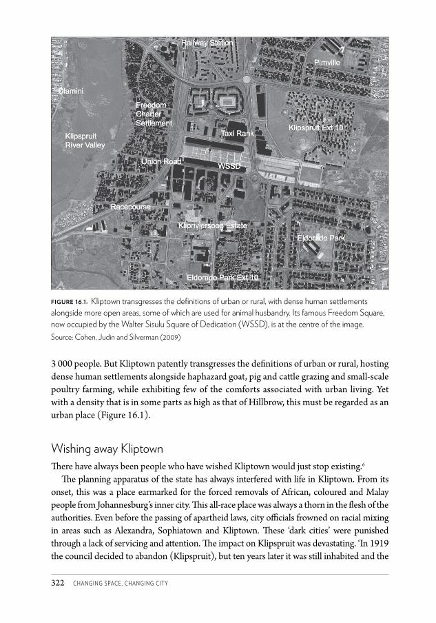
Changing SpaCe, Changing City322
3 000 people. But Kliptown patently transgresses the defi nitions of urban or rural, hosting dense human sett lements alongside haphazard goat, pig and catt le grazing and small-scale poultry farming, while exhibiting few of the comforts associated with urban living. Yet with a density that is in some parts as high as that of Hillbrow, this must be regarded as an urban place (Figure 16.1).
Wishing away KliptownTh ere have always been people who have wished Kliptown would just stop existing.6
Th e planning apparatus of the state has always interfered with life in Kliptown. From its onset, this was a place earmarked for the forced removals of African, coloured and Malay people from Johannesburg’s inner city. Th is all-race place was always a thorn in the fl esh of the authorities. Even before the passing of apartheid laws, city offi cials frowned on racial mixing in areas such as Alexandra, Sophiatown and Kliptown. Th ese ‘dark cities’ were punished through a lack of servicing and att ention. Th e impact on Klipspruit was devastating. ‘In 1919 the council decided to abandon (Klipspruit), but ten years later it was still inhabited and the
Figure 16.1: Kliptown transgresses the defi nitions of urban or rural, with dense human settlements alongside more open areas, some of which are used for animal husbandry. Its famous Freedom Square, now occupied by the Walter Sisulu Square of Dedication (WSSD), is at the centre of the image.Source: Cohen, Judin and Silverman (2009)
CSCC 16.indd 322 2014/10/08 2:11 PM
JUDIN, ROUX AND ZACK • KlIptOwN 323
infant mortality rate was reputed to be 958 per 1000’ (Maud 1938: 135). As early as 1923, when sanitary conditions in the area were already appalling, the Transvaal province denied the residents of Klipspruit and Nancefield a health committee to oversee the health conditions of the area. No health committee, and no local authority, meant no services.
For over ten years these debates went to and fro. In 1928 the first suggestion of expropriation of the Native interests in the township was made and it was decided that no action should be taken around a health committee for the area. This sort of sidestepping of the basic service needs of Kliptonians would continue as plans for racial segregation took priority. The very lack of services became a motivation for expropriation of land owned by Africans. In the 1930s the city council continuously opposed calls for the Kliptown area to be incorporated into Johannesburg.
The birth of apartheid and resistanceWhile being included in Johannesburg might have brought the hope of services and management in the area, this was not welcomed by African and coloured residents. There was good reason to be suspicious of the outcome of such a move. Residents argued that they could not meet the demands of the rates and taxes that would be required, that they could not abide by the city’s building regulations, and that they feared they would eventually be compelled to give up their properties. They knew also that pass laws would then apply, forcing Africans to carry night passes in urban areas.
Post-war Kliptown was continuing to grow. Trading in Kliptown was vibrant and community facilities thrived. As one resident said, ‘We saw Kliptown as a town, maybe because of its name. There was a blacksmith, a chemist, churches, schools, a police station, etc. We felt quite autonomous although we didn’t have a council to go to.’7 After the onset of formal apartheid, the multilayered settlement was left out of any infrastructural programmes of the authorities and was bypassed in terms of schooling and social facilities.
Thus, there are two sides to the story of Kliptown’s historical neglect: on the one hand, its official marginalisation left the area without basic services or infrastructure; on the other, it meant that people could, to some extent, slip under the radar of the apartheid state – so, for example, mixed-race couples would often settle in Kliptown as one of the few spaces in the city where they could live in relative peace.
‘Everybody used to come and live in Kliptown’A key element of local memory that emerges across interviews and oral histories is that of Kliptown as a mixed space, an area characterised by a fluctuating population drawn from elsewhere. ‘Everybody used to come and live in Kliptown. Apartheid was not strictly enforced,’ recalls Lettie Zacarias.8 Gene Duiker, CEO of the Kliptown Our Town Trust and lifelong resident of Kliptown, relates the mixed-race community directly to a unique spirit of resistance and community that existed in the area:
CSCC 16.indd 323 2014/10/08 2:11 PM
Changing SpaCe, Changing City324
We had Poles, we had Jews, we had Scottish people, we had English people, we had Shangaans, we had Malawians, people from Mozambique, from the north … Somalis, they were here since I opened my eyes … And somehow the government couldn’t actually break the spirit that existed in this place.9
Kliptown has always been a place which people came to from elsewhere: as Lindsay Bremner describes it, Kliptown is characterised by ‘superimposed spatial stories about political affiliations, kinship networks, places of origin, and landscape features. Kliptown is … folded into and through the myriad of geographies its residents occupy and the stories they tell’ (Bremner 2008: 338). These ‘myriad geographies’ posed a challenge to the apartheid state and its insistence on strict categorisation of people’s origins; and so, as a place where people could evade some of these imposed boundaries, Kliptown was one of the few spaces where the apartheid ideology of segregation could to some extent be subverted.
However, not all local narratives about the cosmopolitan nature of Kliptown have a positive slant. Martin Chetty recalls that:
A lot of people came into Kliptown [in the 1950s and 1960s]. It became heavily populated with a lot of people from all areas. A lot of them came with their own ideas which had an effect on the normal people who longed to live in peace and quiet … I think that’s when a lot of morals were lost.10
Chetty’s words are a reminder that one cannot exclude from Kliptown’s past the tensions and ruptures which may have existed. Today these tensions tend to be expressed in a discourse of mistrust towards ‘outsiders’ or ‘newcomers’ to Kliptown. At the same time, however, there is a prevalent discourse of community,11 or of Kliptown as a ‘family’ bonded by the past:
If they think they can move all of us to well-developed areas I think I can move. To move alone, I don’t think will work. To move alone will be selfish because I grew up with them, we suffered together you see.12
The year 1948 brought the pain of apartheid racial segregation to Kliptown. Families were split and neighbours divided in the efforts to survive in a colour-coded world. Reverend Phudule recalls:
Some coloured people, you could not distinguish – some were classified as black people. A Malay woman’s boy passed for white, there was one coach for whites and then ten for blacks. In town, he wouldn’t talk to you, once he crossed the tracks in the townships, he would. The black, coloured, white thing was tough if you couldn’t handle it … The German farmer owned the whole of Dlamini-Jeriken – he moved out when the Immorality Act was passed – the whites moved out on their own. People joked about it, but it hurt them.13
David Blom remembers that racism infiltrated everything: ‘Even old Kliptown had lots of racism between light- and dark-skinned coloureds. Soccer teams were chosen on skin and not skill.’14
CSCC 16.indd 324 2014/10/08 2:11 PM
JUDIN, ROUX AND ZACK • KlIptOwN 325
Amid the hardship of apartheid, it was not accidental that the Congress of the People was held in Kliptown. Besides its location outside the city borders, which made it possible to arrange a large event where thousands of delegates from all over the country and from a wide range of resistance organisations could gather, Kliptown has a long history of resistance to apartheid in ways both large and small (Khumalo 2003). Gene Duiker recalls some of the informal networks of resistance that were commonly used in Kliptown under apartheid:
And then, the resistance that you saw in those years: you know, resilience, inasmuch as Kliptown’s always been tenacious and kind of fighting back. I’ll give you an example: we were aware of the Group Areas Act and things like that. But we had many black people living in Kliptown [which had been declared a coloured area], right? … So we devised here in Kliptown a method where when the cops used to come at night … we would teach [people who couldn’t speak Afrikaans] these few words: when they knock on your door, don’t say Ubani lokhu? … rather say, Wie’s daar?, and then they’d assume it’s coloured people occupying that residence … and you know it worked, it was effective. People would hide their neighbours. We had a system, where people would inform others … As fast as a fire can spread, word would spread and people would be in wardrobes and under beds …15
Duiker’s narrative suggests a history of Kliptown which includes some less public forms of resistance, a description very different to the sense of spectacle and drama often invoked in descriptions of the 1955 Congress. There are several sites in Kliptown which residents identify as remembered sites of resistance: houses where activists hid from the police (including Eva Mokoka’s clinic), homes of politically active individuals such as Stanley Lollan and Charlotte Maxeke, and churches and social spaces that doubled as meeting places and places of safety. Today, however, there are few ways to encounter this history other than through the memories of residents.
‘Haikuna lo hamba’16
Kliptown was at various stages managed by the Peri-Urban Board, then the Group Areas Board, and then the (ironically named) Community Development Board. These authorities were remembered, not for services they rendered to the area, but for periodic slum clearance and shack removal exercises through the 1960s and 1970s.17 When it did come, expropriation was painful:
They started moving us to Eldorado Park in the 60s. Little by little. It wasn’t a big mass like Sophiatown. They started moving but there was a date on which it was finally expropriated because we were amongst the last to leave and (we were) paid peanuts – for our massive house and big stand. Our neighbour was put into one of those flats there and because she was not used to living in a flat with lots of children, she committed suicide.18
CSCC 16.indd 325 2014/10/08 2:11 PM

Changing SpaCe, Changing City326
Many who were moved out of Kliptown still speak of it as a familial home, with connections between people remaining in place despite time and distance: ‘We were a family. Whenever we meet at funerals we know that we are old Kliptonians.’19
With the constant threat of removal hanging over them, residents were not secure enough to upgrade their dwellings or improve the area. This threat did not abate, even in the late apartheid years: ‘About Kliptown, there was always this thing of “they’re gonna break Kliptown down.” So nobody wanted to do anything but the years are going and up to now they haven’t broken anything down.’20
Kliptown was not even nominally administrated as one place. Under apartheid the area fell within the boundaries of both the Soweto City Council and the Johannesburg City Council. As recently as the mid 1990s, when local government boundaries were redrawn, Kliptown remained institutionally fragmented, as the area fell within two different local structures of the City of Johannesburg.
Protest in an era of developmentIn these planning and demarcation exercises, the community had not been passive. They had organised themselves to protest against being included in the city when it was clear that inclusion would cost them their land rights. Over many years the community withstood wholesale removals. Later, during the transition to democracy, Kliptown representatives demanded rights for shack dwellers and called for attention to the oldest informal settlement in the metropole.
The face of Kliptown changed in the late 1980s and 1990s as it became one of many urban reception areas for burgeoning informal settlements. Some viewed the shack dwellers as unwelcome squatters, and not as part of the Kliptown community:
People think that if they can’t make it elsewhere, they can come and dump themselves in Kliptown.21
During the mid 1990s, residents’ anger over the lack of services in Kliptown boiled over. Protests were staged and residents went to the city offices to demand services. One resident remembers how difficult it was to even get the shared chemical toilets that now serve the area: ‘The toilets! We had to fight for them. I remember we even hired some taxis through our pockets to take us to Johannesburg TMC [Transitional Metropolitan Council] with buckets full of shit to show them that we were tired of the bucket system … Then we got these toilets …’22
Residents of the Dlamini settlement within the greater Kliptown area protested when, after eight years of being located on an ash tip as an apparent emergency and temporary measure, they had precious few services – around 90 shared toilets and water points service over 4 000 residents – and no prospect of being granted a permanent place to stay. At the peak of community frustration, on 27 March 1995, the Dlamini Residents Association staged a sit-in at the Greater Johannesburg Transitional Metropolitan Council
CSCC 16.indd 326 2014/10/08 2:11 PM
JUDIN, ROUX AND ZACK • KlIptOwN 327
offices demanding immediate attention to their housing needs. This action led to the city council appointing consultants to prepare a comprehensive plan for the whole area.
A stakeholders’ frameworkThe 1996 Greater Kliptown Development Framework was developed with community consultation. A Greater Kliptown Development Forum ‘consisting of all stakeholders in the study area affected’ was established (Southern Metropolitan Local Council 1997). Meetings were held with taxi associations, property owners and informal traders in the area. Feedback from workshops was given to the community on a regular basis through the Forum. At the end of that process, a ten-year upgrading framework plan was drawn up. This development would focus on connecting Kliptown with the surrounding communities, promoting economic opportunities and, most significantly, on de-densifying and upgrading existing informal settlements.
The Development Framework made proposals for boosting Freedom Square as a tourism site, with a museum, public spaces, a park, and a mix of shops and informal trading. The Square would include medium-density residential flats, and community facilities such as a library and a welfare office.
For the informal settlements, it was proposed that settlements in unsafe areas should be relocated to suitable land. A number of settlements would be upgraded. On vacant land a mix of higher- and medium-density housing would be developed. However, the report submitted to the Johannesburg City Council included two warnings. Firstly, the hazardous conditions under which people lived in the flood plain of the Klip River would be worsened by an increase in the number of shacks in the area, and upgrading was urgent (Southern Metropolitan Local Council 1997). Secondly, expectations had been raised, and this plan now needed to be implemented through local detailed plans and action.
This 1996 plan seemed to have covered all the bases for a large-scale upgrading for Kliptown. So why was it not implemented? The plan was handed over to the housing department and the planning department, neither of which had experience of urban renewal at this scale, and neither was geared up for the implementation of area-wide development projects. While the housing department put the housing projects onto its priority lists and would allocate funding to these, no championing of the Kliptown plan happened in city departments. Delays were also caused on work throughout the city due to institutional restructuring within Johannesburg in the mid 1990s, as officials were caught up in the restructuring of their job descriptions and changes in their physical space and responsibilities.23 Moreover, no funding was dedicated to implementing the projects whose urgency had been so well articulated.
‘Since au funi, ngi zoyi thatha mina’24
Residents were compelled to prepare their own plan. With the assistance of several
CSCC 16.indd 327 2014/10/08 2:11 PM
Changing SpaCe, Changing City328
organisations, including the French development organisation CRIAA, the Kliptown Our Town Trust was established in 2000. The Trust undertook research and developed ideas and projects for building on the heritage of Kliptown. Fearful that when housing projects did come to Kliptown they would simply destroy the rich fabric and history of the place, the Trust went about documenting oral histories of Kliptown. They also developed conceptual ideas for the upgrading of the area in a way that was organic and that respected the heritage of Kliptown.
The Trust established a photographic exhibition that captured the political and social landscape of Kliptown. It was temporarily housed at the Kliptown education and training centre, an old building previously used as a municipality store. This exhibition was the inspiration for one of the first projects implemented by the newly formed Johannesburg Development Agency ( JDA) for Kliptown – the Kliptown Visitors Centre. The oral histories collected by the Trust included tales of despair at the fact that Kliptown had not been upgraded:25
I have not noticed major changes or improvements in Kliptown. It is still the Kliptown that I knew. There are no libraries. The only cinema that we had is gone. People have to travel to go and play soccer. As far as better housing, water-borne sewerage, water and other services are concerned, it is shocking! Why have they left Kliptown out?
The advantage is that half of the population of Soweto finds Kliptown to be one of the cheapest areas to do shopping … It’s also the reason why people flock to Kliptown. The disadvantage is that it is a pity that nobody has ever thought that the upgrading of Kliptown could be one of a greater benefit to all population groups.
Kliptown is like a mother town. If they could give us at least real toilets and electricity, we would be happy. But now since all these years, we must still live like our forefathers and mothers …
The making of memoryIn January 2002, a press report entitled ‘A makeover for historic Kliptown’ celebrated the announcement of massive investment intended for ‘the renovation of Kliptown’.26 A new energy for investment in Kliptown would bring together the resources of a provincial agency, Blue IQ, and a local government agency, the JDA. The then Gauteng Premier, Mbhazima Shilowa, envisaged the creation of a monument on Freedom Square to commemorate the Freedom Charter, and to be dedicated to one of the icons of the struggle for freedom in South Africa, Walter Sisulu. The monument was to be completed in time for the 50th anniversary of the adoption of the Freedom Charter – 26 June 2005.
The idea for a project centred on a monument was in large measure swept along by the pro-growth focus of the city and provincial government, a focus on Johannesburg as a ‘world-class African city’, and the positive re-imagining of the city that had its roots in a late 1990s provincial trade and industry strategy. Concerned with high levels of unemployment,
CSCC 16.indd 328 2014/10/08 2:11 PM
JUDIN, ROUX AND ZACK • KlIptOwN 329
that strategy pushed for a shift towards sophisticated, high level, value-added production, a focus on knowledge-based, smart activities, and on a service economy focused on business and tourism (Rogerson 2005). Blue IQ was established specifically to implement projects that were in line with this vision, and in the spirit of boosting economic opportunity through tourism, Blue IQ took on the development of Kliptown as a ‘significant tourist destination and heritage site’ (Blue IQ 2002).
The implementing agent within the city would be the JDA, established in 2001 with a vision ‘to drive developments that will contribute to achieving Johannesburg’s potential as the African world class city: a city of prosperity, excellent quality of life and a wealth of cultural and economic opportunities’.27 But Graeme Reid, CEO of the JDA at the time, was not satisfied to see a monument erected in Kliptown without attention being paid to the wider needs of the area. Heritage architect Herbert Prins recalled, ‘Graeme understood that this could not just be a heritage project. He saw the opportunity to now create the integrated development project that would be required to improve Kliptown.’28
Serving two masters: growth and developmentSouth African urban renewal projects in the early 2000s focused on marginalised areas where neglect had led to massive disinvestment and decline, high levels of poverty and crime. Kliptown was identified for intervention for these reasons and also for its importance to the city as a place of commemoration and potentially a place of investment.
It should also be noted that development plans for Kliptown fell within a larger project of developing Soweto as an urban centre in its own right: Soweto as a whole has undergone large and noticeable changes since 2000, having been prioritised for development by Mayor Amos Masondo, both via the allocation of public funds – as in the case of Kliptown – and in attempts to encourage private investment. Kliptown was one of the ‘nodes’ that was meant to drive the future transformation of Soweto, and expectations were high for the promised far-reaching effects of the JDA project.29
The tension of the Greater Kliptown Development Project (GKDP) would be captured in a tension between the local and the global, between growth and development. Should the basis of the project be the creation of a monument, or should it be the upliftment of the area and the resolving of bad conditions that rendered the area economically and socially dysfunctional? The pro-poor and pro-growth agendas of South Africa’s development were struggling to find the right fit of institutions and tools. Academics had criticised the pro-growth boosterish language of plans, arguing that South African local governments were not in a position to deliver to the developmental needs of the poor (Parnell 2004).
On its own, the idea of creating a monument to the Freedom Charter on the site where that manifesto was adopted would have been an enormous undertaking. Aside from the monument, the area urgently needed attention at every level of basic service provision, welfare assistance, job creation, physical upgrading, environmental improvement and housing delivery. There had been comprehensive studies of the area, so the challenges and
CSCC 16.indd 329 2014/10/08 2:11 PM
Changing SpaCe, Changing City330
the terrain were well known. The various planning processes of the previous decade had seen the involvement of local leaders, so there was some local capacity to absorb a development project. Kliptown was ripe and ready to receive large-scale planning and investment.
Conventional practice in the field of urban regeneration is based on the assumption that if the city invests in physical infrastructure, a robust market would read and respond to the signs of future regeneration benefits. This would expand economic opportunities and gradually improve property values, allowing the city to ultimately offset the cost of its investment through increased property taxes and associated economic growth. Many of the large-scale projects of the JDA operated on this basis. But this was not ultimately the case in Kliptown: the existing local market was fragile, in some disrepair and increasingly challenged by mall and strip retail developments across Soweto.
The business plan for the project nevertheless suggested that the vision was to deal with multiple agendas simultaneously, encapsulated in the plan’s vision statement:
The sustainable and integrated development of greater Kliptown and Walter Sisulu Square of Dedication as a prosperous, desirable, well-managed residential and commercial area and a major national and international heritage site.30
However, in practice, the commemorative agenda stumped the development agenda and projects geared at economic and social upliftment fell far short of the goals set up for them.
Kliptown marketThe planning team of the GKDP hoped to effect changes and make improvements in almost every aspect of life in a very complex social environment. Optimism at this time was pronounced: ‘This will lead to a prosperous, desirable, well-managed residential and economic area and a major national and international heritage site.’31 The risks to success were noted, but in reality they paled behind the enormous enthusiasm attached to bringing housing, jobs and facilities to the area.
Extensive investigations into the land-use conditions had shown multiple owners, a muddle of different types of land-tenure rights which had been conferred by the complex legal systems of apartheid, a mix of old townships, farm portions, industrial lands, partially proclaimed townships and, of course, a flood plain. No development could proceed until all the legal knots of these areas were resolved.
Meanwhile, studies of the economic context of the project revealed the declining job opportunities and the very low and erratic incomes of inhabitants in the area (Seneque/Maughan-Brown SWK 1996). Sowetans were increasingly spending their money in the Johannesburg CBD, in the suburbs and in the growing number of malls in Soweto itself. Kliptown was still at that time the strongest retail centre in Soweto, but was in danger of dropping on the commercial list (Figure 16.2). For Kliptonians, however, this trading space remained the space where most residents bought their food, building supplies and clothing.
CSCC 16.indd 330 2014/10/08 2:11 PM
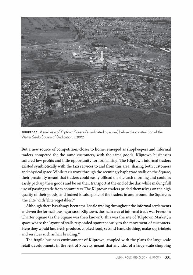
JUDin, ROUX anD ZaCK • KliptOwn 331
But a new source of competition, closer to home, emerged as shopkeepers and informal traders competed for the same customers, with the same goods. Kliptown businesses suff ered low profi ts and litt le opportunity for formalising. Th e Kliptown informal traders existed symbiotically with the taxi services to and from this area, sharing both customers and physical space. While taxis wove through the seemingly haphazard stalls on the Square, their proximity meant that traders could easily offl oad on site each morning and could as easily pack up their goods and be on their transport at the end of the day, while making full use of passing trade from commuters. Th e Kliptown traders prided themselves on the high quality of their goods, and indeed locals spoke of the traders in and around the Square as ‘the elite’ with ‘elite vegetables’.32
Although there has always been small-scale trading throughout the informal sett lements and even the formal housing areas of Kliptown, the main area of informal trade was Freedom Charter Square (as the Square was then known). Th is was the site of ‘Kliptown Market’, a space where the layout of stalls responded spontaneously to the movement of customers. Here they would fi nd fresh produce, cooked food, second-hand clothing, make-up, trinkets and services such as hair braiding.33
Th e fragile business environment of Kliptown, coupled with the plans for large-scale retail developments in the rest of Soweto, meant that any idea of a large-scale shopping
Figure 16.2: Aerial view of Kliptown Square (as indicated by arrow) before the construction of the Walter Sisulu Square of Dedication, c.2002
CSCC 16.indd 331 2014/10/08 2:11 PM
Changing SpaCe, Changing City332
centre in Kliptown would be ill considered. The planning framework developed in the late 1990s had helped to put paid to the shopping centre idea in favour of a more appropriate commemorative space.
Service deliveryA study of the social needs of Kliptown ( JDA 2004b) highlighted a desperate situation. Over 70 per cent of the community was unemployed – the knock-on effect of a 25 per cent school dropout rate and poor education levels. Women faced high risks of violence. They also had little access to childcare and suffered high risks of teenage pregnancy, poverty and disempowerment in private and public life. Alcohol and substance abuse were rife, particularly among men. Young people felt insecure in their family lives, unprotected against violence and abuse and at high risk of HIV/AIDS infection and of alcohol and drug abuse.
These social needs were taken into account when plans were developed for the Kliptown area in terms of a dedicated social strategy. In addition, the intention was for projects to benefit local people by developing skills, either through involvement as community representatives, by directly receiving training and skills, or by working on the project as contractors, labourers or service providers.
It was critically important to city officials not to unduly raise expectations that could not be met. As an earlier council report had stated of Kliptown:
Although its residents have lived and worked in relative harmony, any intervention is likely to be explosive unless done with utmost delicacy, empathy and with the support of the various Kliptown communities … Tension could arise if expectations are not coupled with a clear understanding of the phased approach and evidence of resource allocation on an equitable basis. (Greater Johannesburg Transitional Metropolitan Council 1997)
Since the first days of Kliptown, the problem of inadequate services had plagued the area. No services were even remotely adequate: water, electricity, stormwater drainage, sanitation, management, access roads and refuse removal were all extremely poor. Any improvement would require a ten-year investment programme in infrastructure, including a massive investment in getting bulk services to the area.
In terms of the natural environment, the Klip River that bisects Kliptown was polluted. Oral histories attested to the long history of the river and its banks as a recreational space. Now it was polluted with industrial waste and sewage. The critical filtering function of this regional wetland was under threat.
And Kliptown was poorly connected to the rest of Soweto and Johannesburg. Any development project that planned to change this would need to redevelop Kliptown Station by linking rail, bus and taxi traffic, and then linking those routes with public spaces and open-space routes through the area to smooth traffic flow for vehicles and pedestrians.
When the GKDP came to life, several housing projects were already planned for the area. It was estimated that 6 907 houses and shacks required upgrading or replacement. In
CSCC 16.indd 332 2014/10/08 2:11 PM
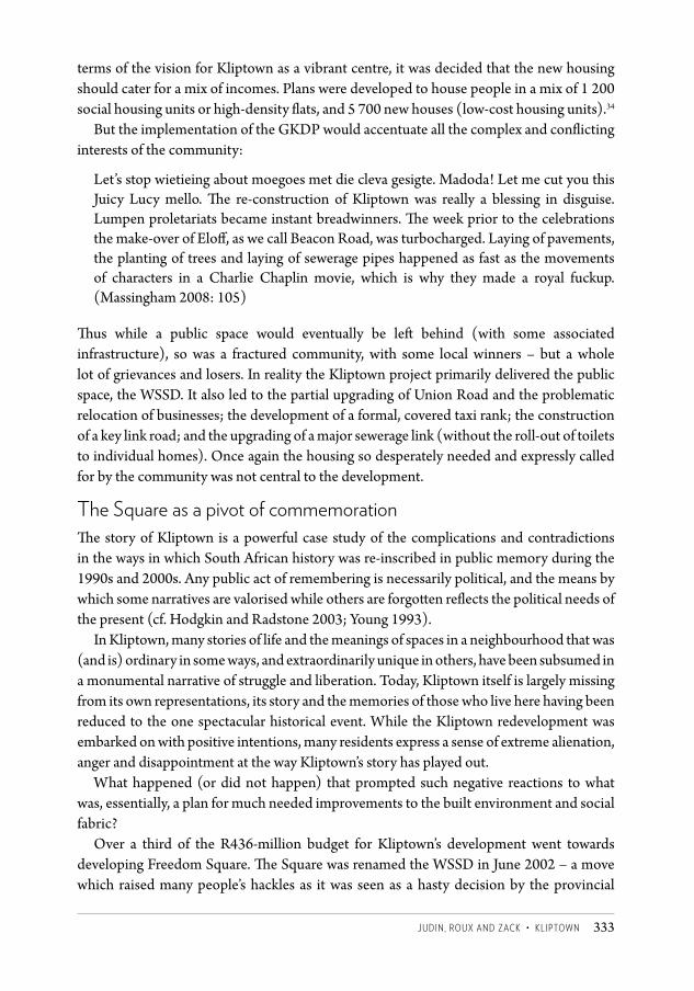
JUDin, ROUX anD ZaCK • KliptOwn 333
terms of the vision for Kliptown as a vibrant centre, it was decided that the new housing should cater for a mix of incomes. Plans were developed to house people in a mix of 1 200 social housing units or high-density flats, and 5 700 new houses (low-cost housing units).34
But the implementation of the GKDP would accentuate all the complex and conflicting interests of the community:
Let’s stop wietieing about moegoes met die cleva gesigte. Madoda! Let me cut you this Juicy Lucy mello. The re-construction of Kliptown was really a blessing in disguise. Lumpen proletariats became instant breadwinners. The week prior to the celebrations the make-over of Eloff, as we call Beacon Road, was turbocharged. Laying of pavements, the planting of trees and laying of sewerage pipes happened as fast as the movements of characters in a Charlie Chaplin movie, which is why they made a royal fuckup. (Massingham 2008: 105)
Thus while a public space would eventually be left behind (with some associated infrastructure), so was a fractured community, with some local winners – but a whole lot of grievances and losers. In reality the Kliptown project primarily delivered the public space, the WSSD. It also led to the partial upgrading of Union Road and the problematic relocation of businesses; the development of a formal, covered taxi rank; the construction of a key link road; and the upgrading of a major sewerage link (without the roll-out of toilets to individual homes). Once again the housing so desperately needed and expressly called for by the community was not central to the development.
The Square as a pivot of commemorationThe story of Kliptown is a powerful case study of the complications and contradictions in the ways in which South African history was re-inscribed in public memory during the 1990s and 2000s. Any public act of remembering is necessarily political, and the means by which some narratives are valorised while others are forgotten reflects the political needs of the present (cf. Hodgkin and Radstone 2003; Young 1993).
In Kliptown, many stories of life and the meanings of spaces in a neighbourhood that was (and is) ordinary in some ways, and extraordinarily unique in others, have been subsumed in a monumental narrative of struggle and liberation. Today, Kliptown itself is largely missing from its own representations, its story and the memories of those who live here having been reduced to the one spectacular historical event. While the Kliptown redevelopment was embarked on with positive intentions, many residents express a sense of extreme alienation, anger and disappointment at the way Kliptown’s story has played out.
What happened (or did not happen) that prompted such negative reactions to what was, essentially, a plan for much needed improvements to the built environment and social fabric?
Over a third of the R436-million budget for Kliptown’s development went towards developing Freedom Square. The Square was renamed the WSSD in June 2002 – a move which raised many people’s hackles as it was seen as a hasty decision by the provincial
CSCC 16.indd 333 2014/10/08 2:11 PM
Changing SpaCe, Changing City334
government, made without consultation or regard for the site’s local history (Bremner 2008; Kuljian 2009; Peters 2002).
Building in the WSSD began in 2003. Architect firm StudioMAS’s winning design (the JDA had run a design competition for the Square) included a paved square surrounded by colonnades, with office, retail and banking space around the edges, as well as a community hall and museum. Roughly in the centre of the WSSD is a memorial to the Freedom Charter, housed in a brick conical tower, where the words of the Charter are carved on a concrete wheel surrounding a commemorative flame. The informal traders who did business in the Square were moved to a designated market space within one of the new buildings fronting Union Road, and most of the historic warehouses adjoining the WSSD were torn down, left as ruins or dismantled to be rebuilt elsewhere.
At the time, another commemoration of Kliptown’s history existed in a community hall in Beacon Street, a short walk away from the new site. The Kliptown Our Town Trust photographic exhibition reflected the fact that Kliptown was historically a space with a powerful sense of independence and community, unique in its multiracial and multicultural character, replete with its own narratives and myths. According to Gene Duiker, it was promised that the exhibition would find a permanent home in the WSSD, but this did not come to fruition. In April 2007, the exhibition and community centre were vandalised, and today all that is left is a collection of photographs in Gene Duiker’s desk drawer and a few other objects that he was able to salvage.35
Instead, the WSSD was conceived of as a public space with a civic function (as a gathering space, an event space and a recreational space) and a memorial function, expressed in the museum, monument and the motif of the crosses symbolising the vote. However, interviews and observation suggest that the WSSD has not been successful in either of these roles except at the national and historical level for occasional grand events.
The WSSD, under its old name of Freedom Square, is marked with a dual history as a civic space: a space of resistance and a space of participation. The 1955 Congress was remarkable as a subversive anti-apartheid gathering, attended by delegates from a range of political movements and racial backgrounds. The police broke up the meeting on its second day, taking the names of delegates and later charging 156 people associated with the Congress in the Treason Trial (cf. Bernstein 1999; Suttner and Cronin 1985). But besides its role as the setting for this dramatic event, Freedom Square was also a well-utilised public space: a soccer field, an informal market and a gathering space on weekends. The revamped WSSD was, in part, intended to support its function as a public space but, as interviews suggest, this has not been particularly successful.
At the time of the Congress, many activists were under banning orders and had to watch proceedings from a hiding place in the coal yard of Jada’s hardware shop, as recounted by Bernstein (1999), Mandela (1994), Suttner and Cronin (1985) and many other eyewitnesses. Given this historical context, then, it was considered important that the redesign of Freedom Square be based on principles such as ‘equality’, ‘accessibility’ and ‘legibility’. However, many residents express feelings that ‘the Square was built by them for
CSCC 16.indd 334 2014/10/08 2:11 PM
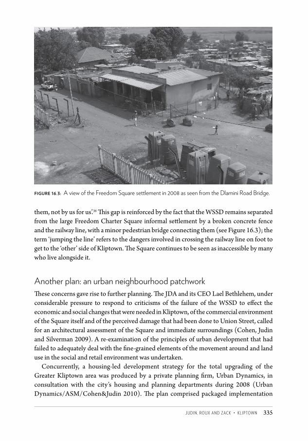
JUDin, ROUX anD ZaCK • KliptOwn 335
them, not by us for us’.36 This gap is reinforced by the fact that the WSSD remains separated from the large Freedom Charter Square informal settlement by a broken concrete fence and the railway line, with a minor pedestrian bridge connecting them (see Figure 16.3); the term ‘jumping the line’ refers to the dangers involved in crossing the railway line on foot to get to the ‘other’ side of Kliptown. The Square continues to be seen as inaccessible by many who live alongside it.
Another plan: an urban neighbourhood patchworkThese concerns gave rise to further planning. The JDA and its CEO Lael Bethlehem, under considerable pressure to respond to criticisms of the failure of the WSSD to effect the economic and social changes that were needed in Kliptown, of the commercial environment of the Square itself and of the perceived damage that had been done to Union Street, called for an architectural assessment of the Square and immediate surroundings (Cohen, Judin and Silverman 2009). A re-examination of the principles of urban development that had failed to adequately deal with the fine-grained elements of the movement around and land use in the social and retail environment was undertaken.
Concurrently, a housing-led development strategy for the total upgrading of the Greater Kliptown area was produced by a private planning firm, Urban Dynamics, in consultation with the city’s housing and planning departments during 2008 (Urban Dynamics/ASM/Cohen&Judin 2010). The plan comprised packaged implementation
Figure 16.3: A view of the Freedom Square settlement in 2008 as seen from the Dlamini Road Bridge.
CSCC 16.indd 335 2014/10/08 2:11 PM
Changing SpaCe, Changing City336
plans that could be taken forward by developers on individual land parcels or precincts. Each package would include master and individual precinct plans, housing typologies, an overall business plan and a project programme – all tools necessary to fast-track housing delivery across Kliptown.
The new plan envisaged an urban environment that would be supportive of residents, but also of traders and consumers. It revived the idea that a housing settlement needed to be seated within an evolving urban infrastructure, including improved pedestrian routes and other public spaces.
The aim of the framework was to increase housing stock through optimising available plots and suitable heritage housing, expanding the range of low-rise housing options, while offering mixed-use opportunities and keeping costs low through the use of state subsidies. Densification was intended to help alleviate the housing shortage while increasing footfall for local retail and anchoring the underused civic space in the WSSD. Economic opportunities were to be provided in the immediate vicinity. The revised framework argued that housing delivery would be the lead development intervention, would address the long-standing backlog and would enable viable and sustainable economic activity.
Extremely high levels of unemployment meant that the most likely housing interventions would be wholly state subsidised. In the present subsidy regime, such housing encompasses giveaway houses in various low-rise configurations such as row houses, courtyard-type houses and maisonettes, informal settlement upgrades, and social housing co-operatives offering formal rental tenure in apartment blocks. Design ideas emphasised the income-producing capacity of the houses by facilitating household rental and uses such as shops, offices and light industrial workshops.
Pedestrian routes and common local civic squares and public facilities were to be used as means of integrating spaces and usages, providing easier access to underutilised nearby schools and informal retail networks. An active pedestrian route was proposed to connect transport facilities, commercial areas and civic spaces, while a new and upgraded set of bridges was proposed to stitch together the living areas still sharply divided by the railway line.
Housing unitsThe design proposals incorporated elements from local informal settlements, from the use of recycled roof attachments and wall fragments, to social communal spaces organised around rental yards and shared outdoor urban rooms. An expanded retail and civic node was proposed around the WSSD and historical retail fabric. Here, mixed-use buildings would include rental housing. Greatest densities would be concentrated around the WSSD, and would gradually decrease block by block to lower densities and heights away from the centre. The main housing forms proposed were single residential housing in semi, row and walk-up type developments to accommodate everyone then living in informal settlements in Kliptown.
CSCC 16.indd 336 2014/10/08 2:11 PM
JUDin, ROUX anD ZaCK • KliptOwn 337
Kliptown was back on a planning agenda and hopes were revived for the housing need to be addressed. The lead urban design consultants elicited multiple possible housing solutions to develop innovative housing typologies for Kliptown, within the state subsidy environment and with due consideration for incremental implementation and growth of individual units. Six architectural practices37 working in housing typology work groups developed a variety of types and delivery processes in response to specific precincts.
The urban costs of extreme low densities and wasted spaces posed a key challenge. This built form had to be recalibrated to offer the infrastructural savings that could then be applied to the housing subsidies. There was also a clear need for significant residential densification to accommodate all the informal settlement residents and optimise transport infrastructure. The strategic placement of the initial unit close to the street boundary allowed for some important urban developments to follow: the promotion of an interesting and sharply defined streetscape, the availability of deeper back areas for expansion, and a clearer spatial relationship between evolving units. In addition, these basic housing units were adaptable and would thus offer a variety of living arrangements to residents with limited resources. The backyard add-ons would also indirectly assist in accommodating many other residents who were currently renting in the area but did not qualify for the state subsidy.
These plans and ideas offer fresh approaches but again delivery may be a pipe dream. Key, but minimal, elements of the urban upgrade around the WSSD were implemented adjacent to the WSSD by the JDA in 2012. These included upgrades of the bridge, Union Road and a pedestrian path connecting the railway line to the Square. The progress of the larger neighbourhood plan – that which affects the living environments of thousands of Kliptonian households – is limited to the submission of township layouts and provision of some bulk infrastructure. The delivery of shelter through the roll-out of any of the proposed housing blocks is not imminent. Indeed, it is likely that this is another plan that will be reviewed before it reaches any hope of implementation. That is because it is likely to be influenced by changes in national housing policy and the state’s growing emphasis on informal settlement upgrades.
Meanwhile, despair at living conditions persists. As Freedom Square was being prepared to host President Zuma’s delivery of a keynote address at Human Rights day celebrations in 2012, a Kliptown resident remarked:
So much was clearly stated in the Freedom Charter, and it is heartbreaking that we’re here today wondering why it is that we’re not seeing the vision of the (manifesto) happening here in Kliptown. I was born here 75 years ago, and have seen this place deteriorate into a slum, hopes revived and then vanishing again … For decades I have shared a tap and gone from bucket toilets to a smelly portable plastic toilet, lived without electricity and slept under a leaking roof. Zuma should come to Kliptown and see for himself the pigsty we live in.38
CSCC 16.indd 337 2014/10/08 2:11 PM
Changing SpaCe, Changing City338
Conclusion: between nostalgia and developmentOver the years each new plan for Kliptown added more detail than the last; they range from plans that have tackled basic needs, to plans for wholesale relocation, from plans for commemoration to more recent plans for a variety of shelter options. The official language used about Kliptown has historically been one that framed Kliptown as not much more than a site of lack; a dangerously chaotic, unruly place in urgent need of cleaning and regulation. Since 1994, official discourse about Kliptown has tended to fall within the paradigm of development; the common thread is a view of Kliptown as a problem in need of fixing. In this context, residents’ narratives and memories of the ‘homely’ Kliptown of the past continue to suggest a powerful alternative way of speaking about place that undermines this official narrative, and returns a sense of agency and possibility to residents.
Many complaints about the deterioration of Kliptown are related to the physical space, the houses and streets and living conditions; but the significance of this material deterioration is often vested in its effects on the intangible aspects of Kliptown’s heritage and character. Bob Nameng says,
It’s changing, it’s changing. You can see now, if you look around at the conditions, we are so congested now … And you know, we’re missing quite a lot. Kliptown used to be quite a cultural community. There was a lot of exchange happening, understanding, harmony and togetherness … So for me, I still long for that because that’s not there today. We don’t trust and support one another any more. There are these boundaries that we’ve built.39
In many cases, Kliptown residents express warm and positive associations with Kliptown’s past and its intangible legacies, and in the same discussion a sense of loss or mourning for something once present in the community but no longer apparent. Narratives of nostalgia are not simple and are often contradictory, producing a kind of anti-nostalgia which, while longing for the traditions and perceived sense of community of the past, also looks adamantly to the future for much needed change in terms of material conditions.
In Dolores Hayden’s 1995 study of urban counter-memory in Los Angeles, she argues that ‘urban landscapes are storehouses for these social memories … Decades of “urban renewal” and “redevelopment” of a savage kind have taught many communities that when the urban landscape is battered, important collective memories are obliterated’ (1995: 9). Arguably, Kliptown’s collective or neighbourhood memories are in danger of being erased by developments that were intended to celebrate and provoke memory; Kliptown’s landscape has not been publicly recognised as the kind of ‘storehouse of memory’ or marker of identity described by Hayden, and certainly not by officials currently at work in the area. Consequently, many interviewees in Kliptown continue to speak of a sense of being forgotten or ignored by the state, and see the WSSD as a marker of this forgetting or ignorance.
It is understood, however, that the question of memory – whose memory, and at what level of collectivity? – is a highly complex and contested one. It is not possible, or useful, to attempt to publicly commemorate every personal memory of thousands of individuals living in Kliptown. In some senses it perhaps does not even make sense to talk about a
CSCC 16.indd 338 2014/10/08 2:11 PM
JUDin, ROUX anD ZaCK • KliptOwn 339
‘neighbourhood identity’ or ‘local memory’ in a space where these identities and allegiances are constantly under construction and remain fragmented.
The contestation around memory reinforces in many ways the competing interests that continuously challenge communities such as Kliptown’s attempts to engage with government. For urban planner Claire Bénit-Gbaffou (2008: 21), the resulting loss is clear:
When ways of engaging with urban issues are multiplied in a context of competing legitimacies which do not confront one another on a common platform that could help find compromise, the result is the depoliticisation of urban governance through engagement with mere technical bodies or agencies.
What is less clear is how more managed or organised collective contestation could channel and perhaps prevent these deep-seated frustrations of intentions and support from going awry. In one sense, it is clear that any large-scale intervention in Kliptown would be controversial and divisive, regardless of how it was carried out or by whom. Contestation over the ownership of resources, space and memory is not limited to tension between ‘state’ and ‘residents’ but is much less clear-cut than this; apparent, for example, in the vandalisation of the Kliptown Our Town Trust exhibition and the destruction of museum plaques around Kliptown. Although the implementation of the Kliptown redevelopment came from a sincere need to acknowledge the area’s history and significance while improving living conditions, many residents feel that, in the absence of actual housing and local urban facilities, it has had the opposite or little effect at all. Most refer to the redevelopment as having been imposed ‘from above’. Despite the heroic claims made on Freedom Square’s place in history, this is not a story of heroes and villains. It is rather a complicated and contradictory tale of fragmentation, contestation, decades of disappointment, and a still fierce unsatiated spirit of independence and cautious hope.
Notes1 Johannesburg Development Agency website, available at http://www.jda.org.za/gallery/
projects/kliptown.2 Interview with Gemey Abrahams, senior planner for Greater Kliptown Development
Framework Plan, telephonic discussion with Tanya Zack, 5 July 2007.3 Kliptown Our Town Trust, Kliptown oral history project, unpublished transcripts, 2000.4 Interview with Dendrick ‘Pops’ Mahlamvu, Kliptown, interviewed by Tanya Zack, June
2007.5 Interview with Reverend Phudule, Kliptown, interviewed by Tanya Zack, June 2007.6 Interview with Gene Duiker, CEO of Kliptown Our Town Trust, interviewed by Naomi
Roux, Kliptown, September 2008.7 Kliptown Our Town Trust, unpublished transcripts, 2000.8 Kliptown Our Town Trust, unpublished transcripts, 2000.9 Interview with Gene Duiker, Kliptown, September 2008.10 Interview with Martin Chetty, Kliptown Our Town Trust oral history project, 2000.
CSCC 16.indd 339 2014/10/08 2:11 PM
Changing SpaCe, Changing City340
11 The use of the word ‘community’ in discussions such as this one is convenient shorthand, but also disguises any number of ruptures.
12 Interview with Eva Mofokeng, Kliptown Our Town Trust oral history project, 2000.13 Interview with Reverend Phudule, Kliptown, June 2007.14 Interview with David Blom, Kliptown, interviewed by Tanya Zack, July 2007.15 Interview with Gene Duiker, Kliptown, September 2008.16 ‘We are not going anywhere’, from Massingham (2008).17 Kliptown Our Town Trust, unpublished transcripts, 2000.18 Kliptown Our Town Trust, unpublished transcripts, 2000.19 Kliptown Our Town Trust, unpublished transcripts, 2000.20 Kliptown Our Town Trust, unpublished transcripts, 2000.21 Kliptown Our Town Trust, unpublished transcripts, 2000.22 Kliptown Our Town Trust, unpublished transcripts, 2000.23 Interview with Lindsay Bremner, Johannesburg, interviewed by Tanya Zack, August 2007.24 ‘Since you don’t want to give it, I will take it myself ’, from Massingham (2008).25 Kliptown Our Town Trust, unpublished transcripts, 2000.26 See http://www.joburg.org.za/index.php?option=com_content&task=view&id=283&Ite
mid=9.27 See http://upetd.up.ac.za/thesis/available/etd-11272003-130901/unrestricted/01chapter1.pdf.28 Interview with Herbert Prins, Johannesburg, interviewed by Tanya Zack, May 2007.29 For more detail on transformation in Soweto, see Chapter 15.30 Blue IQ and JDA, Greater Kliptown Development Project, 2001.31 JDA and Gauteng provincial government, undated pamphlet, ‘The Freedom Charter 50th
Anniversary Celebrations’.32 Interview with Koekie Jeremiah, Kliptown, interviewed by Tanya Zack, 2007.33 As described by students from the Department of Architecture, University of the
Witwatersrand, engaged on a student research project, 1998.34 Blue IQ and JDA, Greater Kliptown Development Project, 2001.35 Interview with Gene Duiker, Kliptown, September 2008.36 Interview with Gene Duiker, Kliptown, September 2008.37 Anca Salavitch Architects, Fiona Garson Architects, Savage and Dodd Architects, Blacklines
on White Paper, Mphethi Morojele Architects, and Mashabane Rose Architects.38 Daisy Motaung, quoted in The Star, 20 March 2012.39 Interview with Bob Nameng, Kliptown, interviewed by Naomi Roux, October 2008.
ReferencesAbrahams, G (2002) ‘Kliptown development framework and business plan review.’ Report
prepared for the Johannesburg Development Agency.Bénit-Gbaffou, C (2008) ‘Are practices of local participation sidelining the institutional
participatory channels? Reflections from Johannesburg.’ Transformation: Critical Perspectives on Southern Africa 66/67: 1–33.
Bernstein, R (1999) Memory Against Forgetting: Memoirs from a Life in South African Politics 1938–1964. Johannesburg: Viking.
Blue IQ (2002) Blue IQ: The Plan for a Smart Province – Gauteng (online document).Bonner, P and Segal, L (1998) Soweto: A History. Cape Town: Maskew Miller Longman.
CSCC 16.indd 340 2014/10/08 2:11 PM
JUDin, ROUX anD ZaCK • KliptOwn 341
Bremner, LJ (2000) ‘Post-apartheid urban geography: A case of Greater Johannesburg’s RLDP.’ Development Southern Africa 17(1): 87–104.
Bremner, L (2008) ‘Reframing township space: The Kliptown project.’ In A Mbembe and S Nuttall (eds) Johannesburg: The Elusive Metropolis. Durham and London: Duke University Press.
Cohen, N, Judin, H and Silverman, M (2009) Kliptown: Envisioning the Neighbourhood. Johannesburg Development Agency.
Greater Johannesburg Transitional Metropolitan Council (1997) ‘Report on Greater Kliptown development framework.’ Report to the Planning, Urbanisation and Environmental Management Committee.
Hayden, D (1995) The Power of Place: Public Landscapes as Urban History. Cambridge MA: MIT Press.
Hodgkin, K and Radstone, S (2003) Contested Pasts: The Politics of Memory. London and New York: Routledge.
JDA ( Johannesburg Development Agency) (2004a) Kliptown Development Business Plan. Johannesburg: JDA.
JDA (2004b) Kliptown Social Development Strategy. Johannesburg: JDA.Khumalo, V (2003) ‘Greater Kliptown: Heritage and cultural survey.’ Unpublished
report prepared for South African Heritage Resources Agency and the Johannesburg Development Agency.
Kuljian, C (2009) ‘The Congress of the People and the Walter Sisulu Square of Dedication: From public deliberation to bureaucratic imposition in Kliptown.’ Social Dynamics: A Journal of African Studies 35(2): 450–464.
Mandela, N (1994) Long Walk to Freedom. London: Abacus.Massingham, P (2008) Kliptown Stories. South Africa: Chameleon.Maud, JPR (1938) City Government: The Johannesburg Experiment. London: Oxford
University Press.Parnell, S (2004) ‘Building developmental local government to fight poverty: Institutional
change in the city of Johannesburg.’ International Development Planning Review 26: 377–399.
Peters, W (2002) ‘Locating and Missing Sisulu: The Paradoxes of the Kliptown Open Air Museum’ (online document).
Rogerson, CM (2005) ‘Johannesburg pro-poor growth through support of the SMME economy.’ Case Study prepared for the World Bank-Netherlands Partnership Program, Evaluating and Disseminating Experiences in Local Economic Development.
Seneque/Maughan-Brown SWK (1996) Greater Kliptown Development Framework Plan: Perspective Phase. Prepared for Greater Johannesburg Metropolitan Transitional Council.
Southern Metropolitan Local Council (1997) Report on Greater Kliptown Development Framework, Johannesburg.
Suttner, R and Cronin, J (1985) 30 Years of the Freedom Charter. Johannesburg: Ravan Press.Urban Dynamics/ASM/Cohen&Judin (2010) Kliptown Urban Design Framework and
Housing Typologies Development Guidelines, Johannesburg.Young, J (1993) The Texture of Memory: Holocaust Memorials and Meaning. New Haven: Yale
University Press.
CSCC 16.indd 341 2014/10/08 2:11 PM
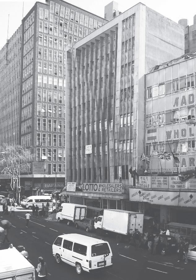
CSCC.indb 454 2014/10/07 5:20 PM
SECT
ION
C
SPATiAL iDeN
TiTieS
CSCC.indb 455 2014/10/07 5:20 PM
456
23 Footprints of Islam in Johannesburg
Religious identities are profoundly infl uencing place-making and socio-spatial organisation of twenty-fi rst-century cities around the world and they are in turn being hybridised by their contact with the urban environments in which they locate. Islam in particular has become the focus of much global geopolitical debate and research in the post-9/11 world. Its spatial footprint across the continents has become a visible public part of major cities and towns. Islam in Western Europe and North America has over the past two decades come to occupy an increasingly public presence in the city. Muslim communities, long hidden from view by virtue of their small numbers, are emerging more visibly in the spatial fabric of these cities.
While there seems to be a signifi cant body of academic literature discussing place-making and built environments in cities of the Muslim world, there are fewer texts that explore the urban environment dynamics of the Muslim diaspora. To date, there has been a dearth of academic work published on Islam’s spatial footprint in South African cities, including Johannesburg. Tayob (1995) discusses the development of Islam in South Africa and shows how its resurgence plays out in diff erent parts of the country. His treatment of the spatial dynamics is only tangential to his overall argument. In a diff erent vein, Jeppie (2001) is mainly concerned with the Cape Muslim identity, with a mono-focus on the Western Cape. Paulsen’s (2003) principal area of enquiry is on the syncretic beliefs and practices of Malays1 in Gauteng. While it has a strong spatial emphasis, it examines only Muslims who live in coloured group areas such as Westbury, Bosmont, Eldorado Park and Ennerdale. Sadouni (2012) examines the presence of the Somali community in Mayfair, Johannesburg. Although her work (see Chapter 24) has a strong socio-spatial emphasis,
YA S M E E N D I N AT H , Y U S U F PAT E L A N D R A S H I D S E E DAT
CSCC.indb 456 2014/10/07 5:20 PM
457
it focuses on a new and still small component of the wider Muslim community in the city. In a similar vein, Fakude (2002) traces the development of Islam in the townships, focusing briefly on Soweto. He is concerned with developing a socio-political critique of relations between Muslims in the townships and the ‘established’ Muslim communities – mainly those of Indian or Malay origin. It is clear that the subject is under-researched and this contribution to the literature of urban spatial planning aims to at least add one fresh perspective and stimulate additional scholarship.
In this chapter we aim to unveil the spatial footprint of Islam in Johannesburg, tracing how it originated and how it has evolved and transformed. In discussing how the spaces of Islam are produced and imprinted onto the spatial landscape, we reveal how Islam in Johannesburg has in turn been shaped and influenced by the social, economic and spatial politics of the city. Our research has drawn on a review of academic literature on Islam and the development of Islam in South Africa. This has been supplemented by the three authors’ collective experiential knowledge of Muslim communities in Johannesburg, as well as their training and experience as spatial planners in the city.
We explore three overarching and interconnected themes so as to illuminate the socio-spatial presence of Muslims in Johannesburg. The first theme is the emergence of a heterogeneous Muslim community in Johannesburg and its impact on space in the city. There is no doubt that Muslims across the world are bound by a common faith and share the fundamental tenets and day-to-day practices of their religion – expressed in the notion of the ummah, or the global congregation of Muslims. However, Muslim identity across the world is differentiated across national, linguistic, racial and ethnic lines. Similarly, the Muslim community of Johannesburg is differentiated along these and other lines. These heterogeneous and multiple identities are expressed in the spaces of Islam in the city.
The second theme focuses on the impact of Islam and the Muslim community on the spatial fabric of Johannesburg. From the time of their arrival in the city, and in spite of their relatively small numbers, Muslims have enjoyed a significant presence due to their prominence in resistance politics, professions such as law and medicine, commercial activity and their distinctive dress and places of worship. They have been able to assert a publicness of Islam and have sustained spatial growth and prominence of Islamic spaces across Johannesburg over a century and a quarter.
The third theme concerns the reproduction of Islamic social relations in the city, which has ensured, and will ensure, the continued existence of a distinctive community. This includes spaces for culture, entertainment and prayer as well as educational and welfare institutions. We conclude with a view on the future of the Muslim community in Johannesburg.
Emergence of a heterogeneous Muslim community in JohannesburgThe variety of Islamic schools of jurisprudence and outlook, embedded as they are in the historical development of Islam, race and ethnicity – given Islam’s particular development in South Africa – and the impact of social class relations, have led to a heterogeneous
CSCC.indb 457 2014/10/07 5:20 PM
Changing SpaCe, Changing City458
community of Muslims in Johannesburg. Consequently, Islamic outlook and practice differ significantly between different social groups and this has differential impacts on the use of space in the city. Gender politics, briefly explored here, add a further dynamic to the heterogeneity in the Muslim community of Johannesburg. This heterogeneity is obviously not unique to Johannesburg. It is rooted in the global history of Islam and the way Muslims from different parts of the world with their various backgrounds came to locate in the city. A brief look at this history provides a vital context to understanding the socio-spatial make-up of Islam in Johannesburg.
Islam, established in the seventh century, has spread globally both as a religion and as a civilisation, taking root and enmeshing itself often seamlessly in different cultures and societies. Today Islam is regarded as one of the fastest-growing religions with over one billion Muslims worldwide (Al-Sheha, 2011). This is expected to grow to 2.2 billion by 2030, making Muslims more than 25 per cent of the world’s population (Grim and Karim 2011).
The guiding values and laws of Islam are codified in the Holy Quran, supplemented by the lifestyle and practices of the Prophet Muhammad (PBUH),2 known as the sunnah. The five pillars of Islam constitute the basic framework for Muslims (Al-Sheha 2011). The first pillar is the testimony of faith (shahaadath), whereby Muslims declare that there is none worthy of worship but Allah (God) and Muhammad is his messenger. The second pillar is salaah (prayer). Zakaah, or obligatory charity, is the third pillar. The fourth is fasting in the month of Ramadaan. The fifth pillar is the hajj (pilgrimage) to Mecca.
While the five pillars of Islam are a strong and common uniting framework for Muslims, the political history of Islam after the death of Prophet Muhammad has resulted in a variety of alternative practices and interpretations. The Prophet did not ordain anyone to lead after him but encouraged shura (consultation) in deciding on matters of leadership. The first four caliphs chosen to lead were Abubakr, Omar, Uthman and Ali.3 Those who regarded Ali (the Prophet’s cousin and son-in-law) to be the immediate successor of the Prophet because he came from within the household of the Prophet later became known as Shia Muslims. Sunni Muslims, on the other hand, accept Abubakr as the first caliph on the understanding that, although Ali was highly regarded by the Prophet for his leadership qualities, he was very young (Armstrong 2000). Shia Muslims also believe (although to differing extents among different Shia groups) in several ordained imams emanating from the lineage of Ali, including The Twelfth Imam (The Hidden Imam) who will return to guide Muslims. The Sunni-Shia divide is one of the main schisms in Islamic identity.
Over time, madhhabs or ‘schools of thought’ emerged from the work of Muslim scholars and jurists. The main madhhabs within the Sunni stream are Hanafi, Shafi’i, Maliki and Hanbali. The main madhhab in the Shia stream is the Jafari school, derived from the work of Imam Jafar-as-Saddiq (Armstrong 2000). More esoteric forms of Islam also took root to counter the jurisprudential approach. Sufis, for instance, developed a concern with the inner self, aiming to reach higher levels of spirituality and a state of being that enables divine revelation.4 The period 1500–1700 represents Imperial Islam, when absolute monarchies
CSCC.indb 458 2014/10/07 5:20 PM
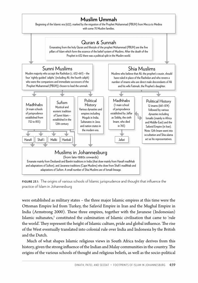
Dinath, pateL anD SeeDat • FOOtpRintS OF iSLaM in JOhanneSBURg 459
were established as military states – the three major Islamic empires at this time were the Ott oman Empire led from Turkey, the Safavid Empire in Iran and the Mughal Empire in India (Armstrong 2000). Th ese three empires, together with the Javanese (Indonesian) Islamic sultanates,5 constituted the culmination of Islamic civilisation that came to ‘rule the world’. Th ey represent the height of Islamic culture, pride and global infl uence. Th e rise of the West eventually translated into colonial rule over India and Indonesia by the British and the Dutch.
Much of what shapes Islamic religious views in South Africa today derives from this history, given the strong infl uence of the Indian and Malay communities in the country. Th e origins of the various schools of thought and religious beliefs, as well as the socio-political
Muslim ummahBeginning of the Islamic era (622), marked by the migration of the Prophet Muhammad (PBUH) from Mecca to Medina
with some 70 Muslim families.
Quran & SunnahEmanating from the holy Quran and lifestyle of the prophet Muhammad (PBUH) are the fi ve pillars of Islam which form the essence of the belief system of Muslims. After the death of the
Prophet in 632 there was a political split in the Muslim world.
Sunni MuslimsMuslim majority who accept the Rashidun (c. 632–661) – the four ‘rightly guided ‘caliphs’ (including Ali, the fourth caliph) who were the companions and immediate successors of the Prophet Muhammad (PBUH)) chosen to lead the ummah.
Madhhabs(4 main schools of jurisprudence established from
732 to 855)
Hanafi Shafi ’i Maliki Hanbali Jafari
Sufi smMystical and
esoteric tradition of Sunni Islam –
established in the 12th century
Political History
Various dynasties and empires including Moguls in India,
Sultanates in Java; and nation states in
the modern era.
Muslims in Johannesburg (from late-1880s onwards)
Emanate mainly from Deobandi and Barelvi traditions in India (that draw mainly from Hanafi madhhab and adaptations of Sufi sm), and Javanese traditions (Cape Muslims) who draw from Shafi ’i madhhab and
adaptations of Sufi sm. A small number of Shia Muslims are of Ismaili lineage.
Political History12 imams (661–874) followed by various dynasties including
Ismailis (mainly in Africa and Middle-East) and the Safavid Empire (in Iran).
Note: 12th Imam went into occultation and Shia ulama act as his representatives.
Madhhabs(1 main school
of jurisprudence established by Ja� ar as-Siddiq, the sixth
Imam, who died in 765)
Shia MuslimsMuslims who believe that Ali, the prophet’s cousin, should
have ruled in place of the Rashidun and who revere a number of imams who are direct male descendants of Ali
and his wife Fatimah, the Prophet’s daughter.
Figure 23.1: The origins of various schools of Islamic jurisprudence and thought that infl uence the practice of Islam in Johannesburg
CSCC.indb 459 2014/10/07 5:20 PM
Changing SpaCe, Changing City460
histories that influence the practice of Islam in Johannesburg today, are summed up in Figure 23.1.
Islamic schools of thought in JohannesburgMost of the Muslims in the Western Cape are descended from Malaysian, Javanese and Bengalese slaves who were brought to the Cape Colony from the Indonesian/Malaysian archipelago and the Indian coastal regions by the Dutch in the mid seventeenth century. A small number were political exiles, and some of these were learned Imams who made a major impact on the spread of Islam in the Cape in the early years of colonisation (Tayob 1995).6
Malay Muslims, the majority of whom are Sunni and followers of the Shafi’i madhhab, draw from a mystical tradition that was influenced by Sufism and pre-Islamic Javan traditions, as well as from the strong sense of justice that led Javan Muslims to fight colonialism. Muslims of Indian origin in South Africa are also Sunni, but mainly follow the Hanafi madhhab. They are further characterised into two prominent movements, namely Deobandi and Barelvi, which to differing extents draw on forms of Sufism that evolved in India, which has its own rich spiritual traditions rooted in Buddhism and Hinduism. The Deobandis in South Africa tend to be mainly from Gujarati-speaking communities and the Barelvi from Urdu-speaking communities. Thus the Malays, the Deobandis and the Barelvi represent in a simple way the ethnic differences and diversity among South African Muslims (Dockrat 2005).
The Deobandi movement began in the 1860s in a darul-uloom (Islamic seminary) north of Delhi, and came to represent an inward approach focusing on reconnecting with the roots of Islam and practising their religion in a ‘pure’ form – close to the way it was done in early times. In a similar vein, the Barelvis reconnect with earlier Islamic times but revere pirs (spiritual guides) and observe certain celebrations, ceremonies and festivities.7
The Tablighi Jamaat then emerged, with the Deobandi school as its frame of reference. The Tablighi Jamaat is well established in South Africa, and serves as an instrument for the propagation of Islam (da wah), with a specific methodology including door-to-door visits inviting people to ‘pure Islam’.
Another important response to colonial rule and growing westernisation in India came from the Jamaat-e-Islami led by Abul A la Maududi, who took a more outward approach premised on striving for justice and regaining political power by establishing an Islamic state (Zainuddin 2000). Muslim organisations in South Africa such as the Muslim Youth Movement, the Call of Islam and Qibla arguably drew largely, although not solely, from the Maududi tradition. These organisations played an active role in the anti-apartheid struggle and served as a critical and alternative voice keeping the Muslim community focused on the plight of the oppressed and the fight for justice in South Africa. The Call of Islam and Qibla actively aligned themselves, especially in the 1980s and 1990s, with mainstream liberation organisations such as the African National Congress and the Pan Africanist Congress. With a strong presence in Cape Town, they drew on the rich tradition of struggle of the early
CSCC.indb 460 2014/10/07 5:20 PM
Dinath, pateL anD SeeDat • FOOtpRintS OF iSLaM in JOhanneSBURg 461
Muslims who fought colonial rule from the time they were brought there as slaves and prisoners in the eighteenth century.
In contemporary Johannesburg the dominant religious outlook is Deobandi. Most of the mosques and madrassas8 in the city are run by the Jamiatul-Ulama, which is the leading theological body for Muslims in the city. It bases its teachings and practice on the Deobandi movement. Even the religious outlook of the Malay community in Johannesburg is being influenced by this perspective (Paulsen 2003). Although Islam is growing rapidly among the African community, with a growth of over 50 per cent between 1991 and 2001 ( Jeppie and Vahed 2005), it is still relatively small and diverse with varying relations to the Indian Muslim community (Fakude 2002).
Race, class and genderApart from the separate madhhabs of Muslims from Indian or Malay descent, race was another key marker of difference. While the Malays in the Cape have retained their faith for over 200 years, they also shared many physical, cultural and linguistic characteristics with the nascent coloured population, who were mostly Christian. Cape Muslim identity thus became closely tied to the emergent coloured identity. Adhikari (1993) argues that by the mid nineteenth century the Cape Colony’s black population had several social identities, such as Malays, Hottentots, Griquas and others. These groups grew and developed together, developing an additional shared identity through their common socio-economic status. This was fuelled by increasing social interaction after their emancipation from slavery.
Although they were not a homogeneous group, Muslims of Indian descent spoke Indian languages, dressed in distinctive Indian Muslim dress and maintained close links with their native country.9 In the early years, due to their tenuous status, they considered themselves citizens of India who sought to improve their livelihoods in South Africa. It was only in 1961 that the authorities finally agreed to grant Indians South African citizenship. In contrast, the citizenship of Cape Muslims was unambiguous. ‘Difference was expressed through a language of ethnicity; the Malay Muslim was different to the Indian or Asiatic Muslim. Threats of “Asiatic repatriation” and other hardships placed on them by the government made “Malay” a preferable term of identification’ ( Jeppie 2001: 84).
There were also occupational differences between the Indian and Cape Muslims who moved up to Johannesburg. The latter tended to work as unskilled labourers or artisans – a tradition they brought with them from the Western Cape. Many Indian Muslims started off as traders (door-to-door hawkers) or worked as assistants in Indian-owned businesses, later graduating to owning their own small shops. While the really successful vehparis (business people) became wholesalers, the vast majority of enterprises remained survivalist. In later years, this translated into discernible class differences between the communities. This class cleavage deepened between Indian and Malay Muslims over the course of the twentieth century, and had a profound impact on the ability of the respective communities to establish and maintain an Islamic infrastructure in the city.
CSCC.indb 461 2014/10/07 5:20 PM
Changing SpaCe, Changing City462
While the majority of Muslims in Johannesburg identify themselves as Indian or Malay, there have always been a minority of African Muslims who originally hailed from Mozambique and Malawi. In many cases, they lived, worked and worshipped alongside their co-religionists. The muezzins (those appointed to make the call to prayer and often to take care of the mosques) in most of Johannesburg were, and remain, African Muslims. In line with the belief that all Muslims are equal except for their righteous character, the dominant Indian and Malay Muslims had no problems with African Muslims performing the esteemed role of call to prayer or praying with them. African Muslims, however, still faced social discrimination, which followed broader patterns of relations between different race groups in the South African context. In time, sizeable Muslim communities emerged within African townships such as Soweto.
Gender is a key marker of heterogeneity in Islam in Johannesburg. In the early days of Muslim settlement in Johannesburg, most women assumed the less publicly visible and more traditional roles of childminding, cooking and housekeeping. With the influence of modernity and secular resistance to apartheid, a small number of Muslim women activists rose to prominence during the 1940s and 1950s.10
During the early 1970s, housewives in the newly created group area of Lenasia gathered in homes within walking distance of each other to hold religious talks and learning sessions where the Quran and other instructive texts were read and discussed. These were informally known as tabligh groups.11 They served an important social purpose as they provided a religiously sanctioned form of interaction with strangers in these new neighbourhoods. These groups also furthered the teachings of the Deobandi outlook of Islam. It was from this pool of women that faith-based organisations began to recruit women into madrassas and administrative support positions. This initiative, pioneered by the Central Islamic Trust, created an important source of paid work for many Muslim women who would otherwise have battled to find employment due to the social and political barriers imposed on them. Women’s tabligh gatherings in residential areas are still active. Zahraa McDonald (2005), in her research on the Tablighi Jamaat, found that these gatherings by women still occur in Lenasia, Brixton, Crosby and Mondeor.
Another significant aspect of Muslim women’s participation in the public life of Johannesburg is the great debate that has grown around the matter of whether or not it is advisable to have women attending mosques and public places of worship and to perform the five daily prayers as an integral part of the congregation. This has been a point of vehement contestation among followers of the different Islamic traditions in Johannesburg.
The historic dominance of the Deobandi tradition across the former Transvaal has meant that the majority of the city’s mosques are not open to female worshippers. Mosques in the city that do allow women to pray in them or that allow women to lead the congregation take on an anomalously large regional catchment area, particularly for the extended prayers that occur at Jummah on a Friday, during the holy month of Ramadaan and on Islamic religious holidays.
Muslim women in Johannesburg have played a key role in Islamic social welfare and
CSCC.indb 462 2014/10/07 5:20 PM
Dinath, pateL anD SeeDat • FOOtpRintS OF iSLaM in JOhanneSBURg 463
non-profit community organisations since the 1970s. Thus many women who were prevented from participating in full-time employment by socio-cultural and political barriers found ways to contribute to community organisations instead.
The impact of Islam on the spatial fabric of the cityInitially, sections of the Muslim community were housed together in enclaves close to the city centre, due to official segregationist policies. By the middle of the twentieth century, Muslims had been pushed out into new, racially defined settlements on the periphery of the city as a result of the strict implementation of the policy of apartheid. In the 1980s, apartheid settlement patterns began to erode in Johannesburg as black people – many Muslims among them – began moving into white suburbs. This started a process of ‘greying’ the city that has continued unabated ever since. The advent of democracy in 1994 created the basis for further movement by both existing Muslim communities and new Muslim migrants into clusters of suburbs where they had not previously ventured. The spatial presence of Muslims in Johannesburg can thus be characterised as a process of centralisation in segregated areas close to the urban core, followed by decentralisation into racially exclusive settlements on the periphery and ultimately dispersal across the city in the post-apartheid period (see Figures 23.2 to 23.5). In the next section of the chapter, we trace the different phases of this process in a little more detail.
Settling in the TransvaalIslam was present in Johannesburg prior to the Union of South Africa in 1910. Indian Muslims started arriving in the Transvaal Republic from Natal in 1881 in search of economic opportunity (Pahad 1972). They were followed by significant numbers of ‘passenger Indians’ (who had paid their own passage to South Africa and were not tied to an indenture), mainly from Gujarat. Malays who moved to the Transvaal came from Kimberley, Cape Town and Port Elizabeth. Those who came from Port Elizabeth had gone there from Cape Town as army recruits into the Malay Corps, although some absconded. They later made their way into the interior, while others migrated to Johannesburg directly from Cape Town (Ebrahim 2009).
In the space of a dozen years, the discovery of gold on the Witwatersrand in 1886 transformed a landscape occupied by a few boer farmhouses and African homesteads into southern Africa’s largest and wealthiest city. The Gold Rush lured people from all parts of the world, including India and Malaysia. Muslims arrived in Johannesburg in the late 1880s, and by 1896 they numbered several thousand according to a census carried out within a distance of three miles from the Market Square. The census found that there were 50 907 whites, 42 533 Africans, 3 831 Malays and coloureds, and 4 807 Indians and Chinese (Randall and Desai 1967: 1). Although the number of Muslims is not precise, their numbers would have been sizeable among both the ‘Malay and coloured’ and ‘Indian and Chinese’ categories.
CSCC.indb 463 2014/10/07 5:20 PM
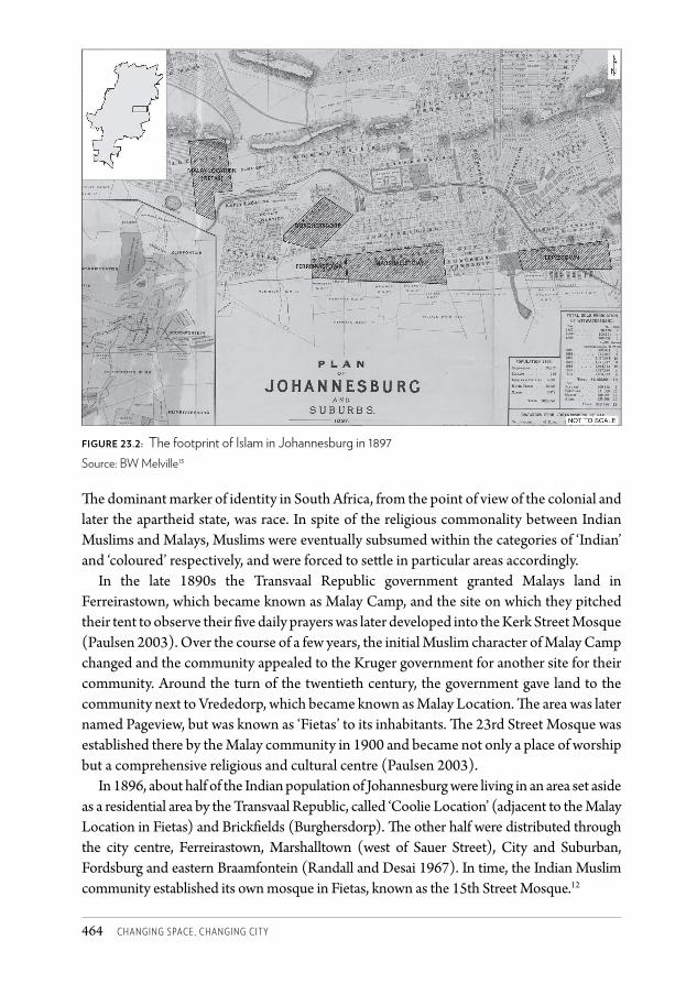
Changing SpaCe, Changing City464
The dominant marker of identity in South Africa, from the point of view of the colonial and later the apartheid state, was race. In spite of the religious commonality between Indian Muslims and Malays, Muslims were eventually subsumed within the categories of ‘Indian’ and ‘coloured’ respectively, and were forced to settle in particular areas accordingly.
In the late 1890s the Transvaal Republic government granted Malays land in Ferreirastown, which became known as Malay Camp, and the site on which they pitched their tent to observe their five daily prayers was later developed into the Kerk Street Mosque (Paulsen 2003). Over the course of a few years, the initial Muslim character of Malay Camp changed and the community appealed to the Kruger government for another site for their community. Around the turn of the twentieth century, the government gave land to the community next to Vrededorp, which became known as Malay Location. The area was later named Pageview, but was known as ‘Fietas’ to its inhabitants. The 23rd Street Mosque was established there by the Malay community in 1900 and became not only a place of worship but a comprehensive religious and cultural centre (Paulsen 2003).
In 1896, about half of the Indian population of Johannesburg were living in an area set aside as a residential area by the Transvaal Republic, called ‘Coolie Location’ (adjacent to the Malay Location in Fietas) and Brickfields (Burghersdorp). The other half were distributed through the city centre, Ferreirastown, Marshalltown (west of Sauer Street), City and Suburban, Fordsburg and eastern Braamfontein (Randall and Desai 1967). In time, the Indian Muslim community established its own mosque in Fietas, known as the 15th Street Mosque.12
Figure 23.2: The footprint of Islam in Johannesburg in 1897Source: BW Melville13
CSCC.indb 464 2014/10/07 5:20 PM
Dinath, pateL anD SeeDat • FOOtpRintS OF iSLaM in JOhanneSBURg 465
One of the earliest significant sites of Islam in Johannesburg is Mia’s Farm. Situated on the farm Waterval at Halfway House, it was once in the northern rural hinterland of the city and was the seat of the Waterval Islamic Institute, a nationally and internationally recognised Islamic education institute established in 1940 by the well-resourced and devout Indian Muslim Mia family. This institute provided free Islamic education and attracted scholars from around the world. Today Mia’s Farm is at the heart of one of Johannesburg’s significant high-value property growth nodes, the R40 billion Waterfall City development. As owner of the land, the Waterval Islamic Institute, which continues to provide Islamic education and social services to a national and global audience, has secured a 22 per cent shareholding in the development company and will receive considerable monthly revenue with which to continue its activities (Fife 2008a,b).
Withstanding discriminatory legislationFor much of the twentieth century, successive governments sought to impose discriminatory legislation on Indians and coloureds, which had a direct impact on Johannesburg’s Muslim communities. This included restrictions on trade, residence and occupation as well as the denial of basic democratic rights that persisted in different forms until the demise of apartheid in 1994. As the state attempted to impose one form of discrimination or another, it was often met with fierce resistance, sometimes forcing the state to retreat. This included resistance campaigns pioneered by MK Gandhi at the turn of the century and by Dr Yusuf Dadoo, a prominent political figure in the Muslim community of Johannesburg and leader of the Transvaal Indian Congress in the 1940s.
In 1948, the National Party came to power on the platform of apartheid and within a short space of time introduced a raft of oppressive legislation against black people. The Group Areas Act of 1950 proved to be one of the most important pillars of ‘grand apartheid’ and had a devastating impact on trade and residence, for the Muslim community in particular. In the mid 1950s, Pageview was declared a white group area and new coloured group areas such as Albertville were created in the western part of the city. African people who lived in the Western Native Township, which adjoined Newclare and Sophiatown, were forcibly removed to Meadowlands and Diepkloof between 1956 and 1960. This area was initially used as an emergency camp for coloured people displaced by the Group Areas Act, but it was later extended, declared a coloured group area and renamed Westbury. Bosmont was added in 1962 to this cluster of coloured townships on the western edge of Johannesburg. Riverlea, located about 10 km south-west of the city centre and south of Main Reef Road, was proclaimed a group area in 1960 (Paulsen 2003) (see Figure 23.3).
These settlements were relatively well located, but had little room for expansion. As a result, the apartheid government decided to establish Eldorado Park, some 30 km south-west of central Johannesburg, as a new coloured group area in the late 1960s. Some years later, Ennerdale was established as a coloured group area even further from the major centres of employment. These two townships have since become the largest coloured settlements in Gauteng province. Malays – as a minority within the coloured ‘population
CSCC.indb 465 2014/10/07 5:20 PM
Changing SpaCe, Changing City466
group’ – began setting up Islamic institutions such as mosques, madrassas and burial societies in every locality to which they were moved (Paulsen 2003). The buildings were generally modest due to the lack of financial resources in the Malay community.
The pattern of settlement for Indians was somewhat different. Lenasia – with the suffix ‘Asia’ in its name, leaving no doubt about the ethnicity of its intended inhabitants – was created in the mid 1950s as the only group area for Indians in the City of Johannesburg. Indians were forcibly moved from all corners of the white city, and by the late 1970s the struggle against removal from Fietas, the largest remaining settlement, was by and large defeated. A handful of Indians remained in Jeppestown, Ferreirastown, Burghersdorp, Fordsburg and Fietas, while the vast majority found themselves in Lenasia (Figure 23.3). The Indian community comprises Muslims, Hindus (three linguistic groups) and Christians and each of these religious groups has made their mark on the spatial footprint of Lenasia. But Muslims are the most numerous and well resourced, which meant that their impact on space in Lenasia has been especially profound.
The most obvious symbols of Islam are its mosques, which dominate the landscape of the township. Lenasia has more than 30 mosques, essentially one in each neighbourhood. In keeping with the heterogeneity of Islam, some mosques, such as the Saaberie Chishty Mosque in Lenasia Extension 6, embrace a strongly Barelvi outlook, while others practise within the dominant Deobandi tradition.
Over time, Muslim organisations in Lenasia built their own madrassas and darul-ulooms, set up a variety of charities to cater for Muslims and non-Muslims alike, developed small businesses such as halaal eateries and butcheries to cater for Muslim dietary requirements, and established businesses that sold clothing for Muslims.
It was only in the 1970s that the government agreed to establish Marlboro Gardens as a group area for people who lived and traded in Alexandra Township (Figure 23.3). At the time, this was not considered part of Johannesburg since it fell under the Sandton municipality.
Dispersal from the mid 1980sAs apartheid began to crumble during the mid to late 1980s and the city began to grey, Muslims began to seek places of residence outside the group areas they had been confined to under apartheid. Since this was not yet legal, many Muslims arranged white nominees or ‘fronts’ in order to acquire business or residential property closer to or in the central areas of the city. It was in the former white working-class neighbourhoods closest to the city centre, such as Mayfair, Bertrams and Bezuidenhout Valley, where this first began to occur (Figure 23.4). Many of the white property owners in these areas were reaching retirement or were reticent about the changes taking place in the city and were therefore willing to sell and leave the area.
These areas not only offered affordable property for sale but also better access to places of trade and employment for Muslim communities who had been commuting from far-flung group areas for several decades. Once a few pioneering moves by Muslim families were made into these areas, others (often extended family and friends of those who had
CSCC.indb 466 2014/10/07 5:20 PM
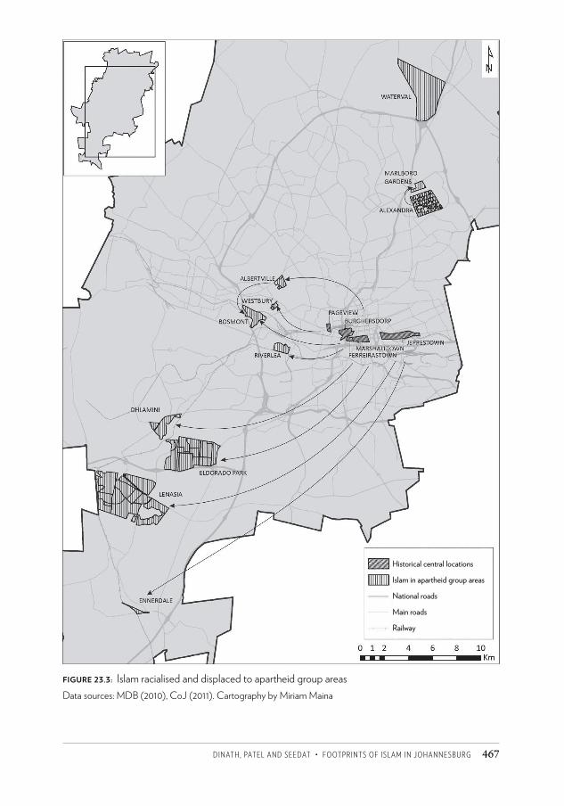
Dinath, pateL anD SeeDat • FOOtpRintS OF iSLaM in JOhanneSBURg 467
Figure 23.3: Islam racialised and displaced to apartheid group areasData sources: MDB (2010), CoJ (2011). Cartography by Miriam Maina
Historical central locations
Islam in apartheid group areas
National roads
Main roads
Railway
CSCC.indb 467 2014/10/07 5:20 PM
Changing SpaCe, Changing City468
first moved) took comfort in knowing that such moves could be made and felt more at ease about their fears of being found out, or of being alienated or isolated in the new surroundings. The result was a gradual normalising and then popularising of moves out of group areas and into the former white suburbs of Johannesburg.
In many cases the push factor was the lack of land for expansion in places like Lenasia due to natural population growth and migration from Natal. The alternative was to find homes further away from the city centre in places such as Lenasia South and Zakariyya Park (Figure 23.4). Many who decided to stay in group areas cited fear of the unknown, fear of loss of social support systems and neighbourly relations, fear of being anonymous, and the fear of not having access to Islamic social infrastructure as reasons for not wanting to make the leap.
Once a critical mass began to reside within the new areas, moves were quickly afoot to create local prayer facilities known as musullahs14 in houses that were donated to the congregation by a benevolent donor or purchased using funds raised by the local organising committee. These would later grow into fully fledged mosques with governing committees and community-sourced funding for maintenance and operations. As an increasing number of families from former group areas relocated to the greying suburbs of Johannesburg, the footprint of Islam grew. Mosques – along with burial preparation facilities and madrassas – were set up in the western suburbs of Mayfair, Homestead Park, Mayfair West and later Crosby (Figure 23.4).
As mosques sprang up in these new territories and more homes were purchased, improvements were made to the old working-class housing stock that characterised the Mayfair area. Extended families moved into these properties and renovated them extensively in order to cater for their large families, their domestic workers (in outbuildings) and their motor vehicles. Not only did the facades of these houses change the streetscape dramatically, but the coverage of the small stands increased substantially, often up to boundary lines. The increasing density and intensity of the use of space meant that the physical fabric of Mayfair and its residential areas changed. So too did its aesthetic. A flashy pastiche of architectural styles was introduced with these home renovations by the upper-middle-class families moving into them and the in-vogue architectural features and cladding of the day were often replicated by many homes on one street or within a street block.
More local mosques and musullahs meant that for each of the five daily prayers men would take to the streets to walk to their local mosque. The streets became a meeting place for local Muslim men and women to get to know their new Muslim neighbours and community.
In the mid 1990s the influx of Muslim families into Mayfair extended its tentacles into Homestead Park, Mayfair West and Crosby. This brought similar physical and spatial changes to these areas as described for Mayfair. With these changes the local high streets (in the case of Mayfair, Church Street and Central Avenue) began to diversify their offerings. As the market responded to new demand created by a resident Muslim population, halaal
CSCC.indb 468 2014/10/07 5:20 PM
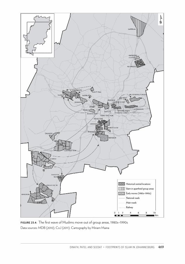
Dinath, pateL anD SeeDat • FOOtpRintS OF iSLaM in JOhanneSBURg 469
Figure 23.4: The first wave of Muslims move out of group areas, 1980s–1990sData sources: MDB (2010), CoJ (2011). Cartography by Miriam Maina
Historical central locations
Islam in apartheid group areas
Early moves (1980s–1990s)
National roads
Main roads
Railway
CSCC.indb 469 2014/10/07 5:20 PM
Changing SpaCe, Changing City470
eateries and Muslim-owned halaal butcheries, Muslim medical practitioners and other Muslim enterprises began to have a presence on main shopping streets in these areas. In the east of the city a similar trend was emerging. Areas such as Bezuidenhout Valley and Bertrams saw an influx of Muslim families and the establishment of musullahs and mosques, albeit in smaller numbers and less spatial concentration than in Mayfair. In the southern suburbs of the city many Muslims families moved into Ormonde, Evans Park, Mondeor, Robertsham and Ridgeway, bringing mosques and madrassas, but their spatial impact has been more diffuse than in Mayfair. Further to the west of the city, some Muslims (mainly from Malay communities) began moving into the formerly white suburbs of Florida and Maraisburg. These areas are depicted in Figure 23.4.
As South Africa entered the democratic era in the early 1990s, the freedom to acquire property outside of the group areas and without the need for nominees or fronts led to Muslim households venturing still further away from the group areas. In what seemed to be a second wave of migration, some who had lived in Mayfair since the 1980s began to sell up and move to areas further north and to the north-west in suburbs such as Houghton, Killarney, Emmarentia, Greenside, Northcliff and Auckland Park (Figure 23.5). Many of those who moved were young families who were looking to access better schooling in the northern suburbs. Another push factor for families making a second move out of Mayfair was a deteriorating public environment that had resulted from a combination of factors, including increased pressure on public infrastructure due to increased densities, and poor maintenance and urban management.
The new freedom to locate anywhere in the city meant that those who initially were wary of moving out of group areas in the 1980s began to consider suburbs much further away once Muslim communities were set up there.15 As this dispersal took place, and the journey of Islam through the city unfolded, social changes started to appear in the congregations of many of the new suburban mosques. The colours of Islam in Johannesburg were changing.
Muslim migrants: social diversification of the ummahIn the apartheid era, the Muslim community in Johannesburg basically comprised Malays and Indian Muslims, with growing pockets of African Muslims in black townships. The apartheid regime’s restrictive immigration laws and antagonistic international relations meant that very few Muslim migrants entered the country, let alone Johannesburg. The result was the creation of spatially confined and socially insular pockets of Muslim communities and spaces in the city. The advent of democracy normalised international relations and ‘opened’ the borders, leading to an influx of Muslim migrants from Asia, the Middle East and Africa – including India, Pakistan, Bangladesh, Turkey, Egypt, Jordan, Nigeria and Somalia. Their presence in the city has led to a diversification from the established authority of the Deobandi religious outlook and the long-held perception that Muslims were Indian or Malay.
There are some Muslim migrant groupings who, despite being present in significant numbers, have chosen to locate themselves within or near to the established South
CSCC.indb 470 2014/10/07 5:20 PM
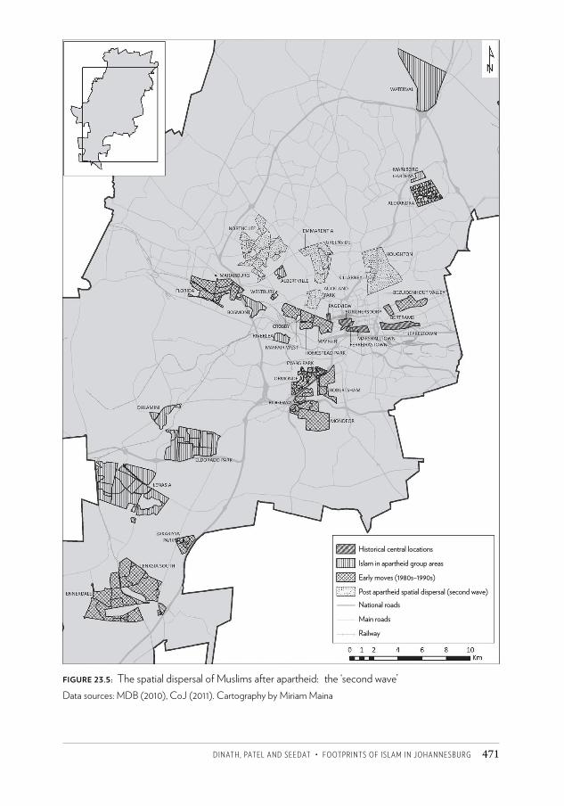
Dinath, pateL anD SeeDat • FOOtpRintS OF iSLaM in JOhanneSBURg 471
Figure 23.5: The spatial dispersal of Muslims after apartheid: the ‘second wave’Data sources: MDB (2010), CoJ (2011). Cartography by Miriam Maina
Historical central locations
Islam in apartheid group areas
Early moves (1980s–1990s)
Post apartheid spatial dispersal (second wave)National roads
Main roads
Railway
CSCC.indb 471 2014/10/07 5:20 PM
Changing SpaCe, Changing City472
African Muslim communities. This has brought interesting diversity to former ethnically homogeneous group areas. Muslim migrants from Pakistan, India and Bangladesh have, despite immigration laws, been steadily making their way to Johannesburg since the late 1980s. Once South Africa entered democracy and its borders became more porous, many more of these Indo-Pak Muslim migrants were recruited by established Indian Muslim communities to provide relatively cheap labour in their retail and wholesale businesses. Still more came independently to Johannesburg in search of a better life and economic prospects. Many of them entered the established Indian group areas either due to relational family networks (seeking support from family members who may have migrated to Johannesburg a few years earlier) or to the perception that it would be in these areas where the demand for their services would be greatest (for example, Indian Gujarati barbers and tailors).
While many of these migrants find themselves at the bottom of the economic and social pecking order in areas that are dominated by established Muslim communities (Lenasia, Marlboro, Mayfair), they have been fully integrated into the practice of religious ritual in these parts. Their presence in mosques and at other Muslim community gatherings gives an interesting diversity to a previously Indian- or Malay-dominated congregation. In some parts of Johannesburg such as Lenasia, where migrants have chosen to locate in close proximity to established Muslim communities, their presence has served to subordinate or suppress the racial label attached to being Muslim; rather, being a Muslim has become the superordinate identity ascription of the local community.
Another example is the position of the Somali community that has occupied parts of Mayfair. Their presence in that locality, as opposed to in another inner-city neighbourhood, was mainly due to the presence of mosques, madrassas and halaal establishments ( Jinnah 2010). However, with time they have sourced their own funds to create mosques and associated religious infrastructure of their own, thus concretising the link between their religious identity and their national or ethnic identities. While these types of grouping would rarely overtly exclude Muslims of other ethnicities or nationalities from participating in prayers or other Islamic activities in their facilities, language would automatically deter others from attending.
Then there are other Muslim migrant groupings that have chosen to locate independently of the established South African Muslim communities – either because their location is more suited to their means of earning a living or because they consciously choose to be separate from the established Muslim communities. The Turkish Muslim community in Johannesburg is one example of how migrant Muslim communities are having an impact on both the spatial dispersal of Islam through the city and on the social and ethnic diversification of the Muslim congregation across Johannesburg. The local Turkish community has not thus far geographically attached itself to the established Muslim communities of the city, but interacts with local Muslim aid organisations as and when this would help access indigent local communities and extend the reach of their local charity work.16
CSCC.indb 472 2014/10/07 5:20 PM
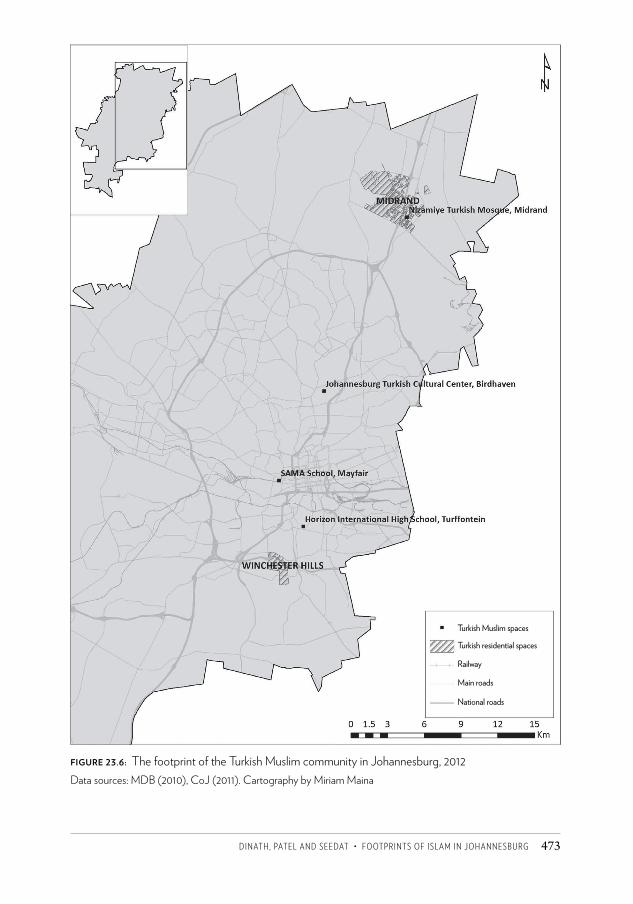
Dinath, pateL anD SeeDat • FOOtpRintS OF iSLaM in JOhanneSBURg 473
Figure 23.6: The footprint of the Turkish Muslim community in Johannesburg, 2012Data sources: MDB (2010), CoJ (2011). Cartography by Miriam Maina
Turkish Muslim spaces
Turkish residential spaces
Railway
Main roads
National roads
CSCC.indb 473 2014/10/07 5:20 PM
Changing SpaCe, Changing City474
Turks in Johannesburg recently made a very public statement of their presence and contribution to the city in the form of the majestic Nizamiye Mosque and Islamic Centre located in Midrand. The mosque is said to be the largest in the southern hemisphere and has become a significant tourist attraction in Johannesburg. It is likely to shift the epicentre of the Turkish community in Johannesburg northwards away from Turffontein, Winchester Hills and Mayfair (SAMA School) to Midrand.17 Figure 23.6 depicts the current Turkish Islamic spatial footprint in Johannesburg.
Reproduction of Islamic social relationsIn this section we explore those institutions and practices that reproduce Islamic social relations in the city, with particular emphasis on their spatial impact. The most obvious and significant of these is the mosque and its associated (madrassa and tabligh) activities, which create a powerful centripetal force for Muslims wishing to find a place in the community. There has always been a strong sense of wanting to be close to a mosque in the location and lifestyle choices of Muslim communities in Johannesburg.
While relocation threatens to disrupt familiar home-based support systems cultivated between neighbours and friends in an area, the presence of a mosque in the area to which one is being relocated symbolises hope of access into another support system. While years of political oppression may have initially been the reason for the strong emphasis on place-based support systems and collaboration in Muslim communities of Johannesburg, the strong bonds being forged today in areas that are newly occupied by Muslim families and businesses seem to be rooted more in religious principles than the need to survive oppression. Support systems in local Muslim communities in Johannesburg are often formed and strengthened through the interactions members have with the activities of the mosque.
The original role of the mosque in the Prophet’s time was to fulfil the total development needs of the community and was not limited to a building for ritualistic worship (Rasdi 1998). In many cases the mosque is a space that facilitates interaction between different subgroups (defined by ethnicity, nationality or age) and promotes the expression of a superordinate collective identity. This less obvious role of the mosque in various parts of the city has become especially significant due to the increasing diversity of the Muslim community.
While Muslims who use it may see themselves as part of a global common Muslim ummah, there is also an underlying (sometimes overt) tension between the followers of the various schools of thought on how Islam should be practised. This is divisive and acts as a sub-label that Muslims ascribe to themselves to express their allegiance to a particular interpretation/way of practising Islam. For this reason, some mosques in Johannesburg have been labelled as ‘belonging’ to a certain type or group of believers. The result is that the mosque may be shunned by members in its immediate vicinity who choose to attend a mosque in an adjacent neighbourhood instead. Simultaneously, the mosque develops a much wider catchment area to include Muslims from far-flung areas of the city who are willing to travel a much greater distance in order to find better
CSCC.indb 474 2014/10/07 5:20 PM
Dinath, pateL anD SeeDat • FOOtpRintS OF iSLaM in JOhanneSBURg 475
resonance with their belief in the particular school of thought or interpretation of Islam represented in that masjid.
Tayob (1999) notes that mosques in South Africa are established and constructed by followers or factions of divergent Islamic schools of thought. The spatial network of mosques situated across the City of Johannesburg is not a homogeneous one but a hybrid one. The mosque as a spatial site of worship in the city takes multiple layered identities. It is often ascribed an ethnic identity based on the dominance of a particular ethnic group in its congregation or even based on the largest financial contribution made for its establishment. It is usually ascribed a religious sub-identity based on the particular Islamic school of thought it espouses and follows in its sermons and method of prayer, and of course its global identity as belonging to the global religion of Islam.
Where there is a significantly large resident Muslim population in the city, in areas such as Lenasia, Marlboro and the Fordsburg-Mayfair-Crosby residential areas, there is a much more complex and fine-grained separation of mosques according to madhhabs. The result is that while there may be more established large mosques that represent the dominant school of thought, there are many smaller masjids and musullahs in close proximity to each other, each having a small congregation for the five daily prayers and each ascribing a slightly different identity to itself on the basis of following different schools of thought and perhaps even different ethnicities. Examples include the Somali Mosque, the Shafi’i mosques and the Sultan Bahu Mosque.
Mosques in the city are spatial anchors for new and established Muslim communities. What is also significant to the footprint of Islam in Johannesburg is that due to the centrality of the practice of the five daily prayers as a compulsory pillar of Islam, ‘proximity to a mosque’ becomes one of the key criteria for decision-making on residential and commercial property investment choices. Especially in residential areas, mosques in Johannesburg cast what Francois Viruly18 refers to as a ‘value-shadow’ – where properties in closest proximity to a mosque peak in value due to an increase in demand driven by the desire among Muslim believers to be living in close proximity to a mosque and all its activities.
Curiously, what has been experienced when mosques have been established in formerly white areas of Johannesburg is that the existing non-Muslim residents have sold their properties. This has enabled new Muslim entrants into these areas to purchase a number of properties in very close proximity to the mosque. Also, as in the case of the Robertsham Mosque adjacent to the M1 south, it has allowed the mosque committee and its funders to appropriate stands adjacent to the mosque to provide much needed off-street parking or to expand its activities. The result is a spatial clustering of mosque-related activities and of properties owned by Muslims.
Despite the public presence and political acknowledgement of Islam in Johannesburg, the development of mosques in Johannesburg’s former white suburbs and office nodes has not gone uncontested. Often residents’ associations and individual residents of suburbs in which a new mosque is planned have submitted objections based on the impact the mosque will have on parking and traffic in the area.
CSCC.indb 475 2014/10/07 5:20 PM
Changing SpaCe, Changing City476
By far the most contentious element of a new mosque is the volume and frequency of the public address system that delivers the muezzin’s call to prayer (adhaan) to the neighbourhood five times a day. Most objections raise noise and intrusiveness of this action as their primary objection to a mosque development in the suburbs. In Greenside in the early 2000s, the Mosque of Mercy allayed residents’ fears about noise by making transmitters available to every Muslim household in the area so that the call to prayer could be beamed silently into people’s private homes (Davie 2006). Still, most proposed new mosque developments in the suburbs have seen the local town planning authorities bombarded with objections from local non-Muslim residents.
Mosques in Johannesburg vary in size and status too. The larger mosques that have active and well-resourced governing committees are often favoured for the auspicious Jummah (Friday) prayer. Smaller, less well-resourced neighbourhood and workplace mosques are frequented for all other daily prayers, based on proximity (often walking distance).
Most mosque complexes in Johannesburg have become hubs for associated religious infrastructure. Madrassas are one of the first accompanying establishments to join a mosque in an area. Historically, in areas such as Fietas, madrassas were run in teachers’ homes. As the numbers of students increased just prior to relocation into group areas, faith-based organisations such as the Central Islamic Trust approached the government for permission to rent school premises to conduct classes in the afternoons. This was continued in the group areas until some madrassas received enough donor funding and revenue from fees to be able to construct their own premises. Most madrassas were then built adjacent to mosques.
The lack of early childhood development facilities in group areas was a long-lamented problem. The state’s failure to provide facilities of this type created a gap that both the market and the range of Islamic faith-based organisations began to fill. Mosque complexes such as Nur-ul-Islam Mosque in Lenasia and the LMA Centre in Duck Avenue in Lenasia added a nursery school to their premises to cater for Muslim toddlers. This pattern of developing supporting religious infrastructure to accompany the development of a mosque has been repeated in areas such as Greenside and Northcliff. Both these suburbs now have a mosque, a madrassa and Islamic nursery schools.
Unlike in parts of the Middle East, leisure activities seldom form part of Johannesburg’s mosque complexes. Leisure activities in Johannesburg are often, but not always, linked to the availability of halaal food and eateries.19 Muslims in Johannesburg tend to develop cognitive maps of various points in the city that offer halaal food and this influences the ways in which they use the city when shopping, eating out or spending their leisure time.
Muslims in Johannesburg: looking to the futureAbout 1 300 years after its beginnings, Islam took root in Johannesburg and has grown as an important part of the make-up and identity of the city, mainly due to the fervour of the local Muslim community who have remained fairly steadfast in maintaining and promoting
CSCC.indb 476 2014/10/07 5:20 PM
Dinath, pateL anD SeeDat • FOOtpRintS OF iSLaM in JOhanneSBURg 477
the faith. In South Africa, unlike in many other parts of the world, the freedom to publicly practise Islam and live as a Muslim is a right that is protected by the constitution of the country. Mosques, headscarves and mass prayer gatherings, outlawed in some countries and on the receiving end of much political resistance in others, are a normalised and (mostly) accepted part of South African public life and have been for a number of years. Muslims in Johannesburg are integrated fairly seamlessly into broader society and have benefited from the constitutional dispensation in South Africa which is in part a product of their own contribution to the anti-apartheid struggle.
Going forward, there is likely to be an increasing dynamism between the way Muslims with their diverse religious and socio-political outlooks continue to shape spaces in Johannesburg, and in the ways that the city’s development policies, informed by the South African constitutional state, will continue to engage with all communities, including Muslims.
Although the location of Muslim communities, with their associated social infrastructure, is likely to be concentrated in certain parts of the city, it is also probable that further dispersion will occur across Greater Johannesburg as movement patterns are influenced by economic and transportation imperatives. Generational perspectives will also shape these patterns. Younger people and families tend to be more mobile while older folk seem to prefer to remain in established settings. Thus new Islamic institutions and footprints are likely to be established and championed by younger people as they disperse across the city. Spatial, locational and movement patterns will no doubt impact on and represent the extent to which Muslims deal with their identity in Johannesburg. The heterogeneity of the community and growing identity assertion should see tendencies of assimilation and insularity sit side by side. Both assimilation and insularity will take on different expressions according to the various and changing outlooks of Muslims.
Islam is practised with much diversity and varying levels of conviction on the part of individual Muslims. Identity is also asserted with great diversity, from an emphasis on physical and traditional attributes in a religious codified sense to more assimilated understandings with an emphasis on the universal values of Islam. While not widespread, ideological contestation within the Muslim community centres around the interpretation of the religious text and global Islamic experience, but also around the role Muslims should play in society.
The demographics of Johannesburg, like those in the rest of the country, are changing rapidly. While the Indian and Cape Muslim groups remain dominant the number of indigenous African Muslims is rising. In addition, the in-migration of Muslims from all over the world into Johannesburg means that the spectrum of global influence is wider and richer. This is adding to the colour and depth of Islamic life in the city, and giving rise to interesting dynamics between the more established Muslim communities in Johannesburg and newer migrant Muslim communities.
No doubt, the identity and practice of Islam in Johannesburg, together with their socio-spatial dimensions, will be increasingly enmeshed in the collective experiences, cultures
CSCC.indb 477 2014/10/07 5:20 PM
Changing SpaCe, Changing City478
and traditions of the established Muslim community, the strongly rising indigenous African Muslim community and the myriad new migrant Muslim communities. All of this makes the footprint of Islam in Johannesburg both colourful and interesting, and one that will continue to enrich the city as it grapples with ways of managing its own urbanisation, diversity and growth.
AcknowledgementFigure 23.1 was compiled by Yusuf Patel.
Notes1 There has been some debate in the literature about the appropriate designation for
‘Coloured Muslims’ in South Africa and the preferred term appears to be ‘Cape Muslims’ (Ebrahim 2009; Jeppie 2001; Tayob 1995). Since the focus of this chapter is on Muslims in Johannesburg, we felt that the term Cape Muslims might lead to some confusion and therefore decided to use the term ‘Malay’.
2 PBUH – Peace be upon Him. It is encouraged in the Quran that salutations be recited after the name of the Prophet is invoked.
3 The caliphs were not prophets and had to rely on the teachings of the Prophet and on their own insight (Armstrong 2000).
4 The most well-known Sufi intellectual, Abu Hamid Al-Ghazali (1058–1111), believed that only ritual and prayer could bring human beings closer to God. In the thirteenth century another famous Sufi, Jalal al-Din Rumi, promoted divesting oneself of egotism and selfishness as the path to God (Armstrong 2000).
5 Java is one of Indonesia’s largest islands, and contains the majority of the country’s population. Much of Indonesia’s history unfolded on this island, including the colonial occupation by the Dutch East Indies. ‘By the end of the 16th century, Islam, through conversion firstly amongst the island’s elite, had surpassed Hinduism and Buddhism as the dominant religion in Java. During this era, the Islamic kingdoms of Demak, Cirebon, and Banten were ascendant. The Mataram Sultanate became the dominant power of central and eastern Java at the end of the 16th century. The principalities of Surabaya and Cirebon were eventually subjugated such that only Mataram and Banten were left to face the Dutch in the 17th century’ (http://en.wikipedia.org/wiki/Java).
6 Tayob (1995: 54) succinctly describes the development of Islam in the Cape until the end of the nineteenth century: ‘Until 1804, the resources of mystical Islam provided spiritual support under conditions of slavery. With the advent of religious freedom, at the end of the eighteenth century, Muslims came out into the open. Mosques and schools made public Islamic jurisprudence and theology. Rites and rituals, in addition to mosque-related and jurisprudential disputes, formed the key aspects of the Muslim community in the nineteenth century.’
7 These include festivities held at graves of popular saints, the celebration of the Prophet’s birthday and a belief in the omnipresence of the Prophet, as well as ceremonies which include devotional music (qawali) as a form of divine remembrance and purification of the soul.
CSCC.indb 478 2014/10/07 5:20 PM
Dinath, pateL anD SeeDat • FOOtpRintS OF iSLaM in JOhanneSBURg 479
8 A madrassa is where local Muslim children of school-going age who attend secular schools during the morning receive religious instruction for two hours each weekday afternoon.
9 The religious profile of the Indian community in South Africa in 1960 was Hindu (68.6 per cent), Muslim (20.7 per cent), Christian (7.5 per cent) and other (3.2 per cent); and in 1980 there were 468 300 Hindus and 90 984 Muslims in Natal and 33 404 Hindus and 66 808 Muslims in the Transvaal. It is worth noting that Hindus made up just 2.1 per cent and Muslims 1.2 per cent of the South African population as a whole (Pillay et al. 1989: 145–153).
10 Dr Zainab Asvat, Amina Pahad, Cissy Gool, Rahima Moosa and Amina Cachalia, to name just a few examples.
11 These are now more commonly referred to as taleem groups.12 Although the mosques on 15th and 23rd streets were within short walking distance of each
other, religious and racial divisions prevented unity between the communities.13 This image is available online at WIReDSpace (Wits Institutional Repository on DSpace).14 Musullah is the Arabic term for a ‘Muslim place of prayer that, unlike a mosque (masjid), is
not consecrated because it is temporary or rented’; the Urdu term for such places is jamaat khanas.
15 Unlike many other groups affected by apartheid separation, many Indian Muslims were able to afford housing in the city’s wealthy northern suburbs. These included entire extended families or working professionals who wanted to live closer to places of work and enjoy the leisure opportunities available in the suburbs
16 Personal communication with A Inal, Director, Turquoise Harmony Institute, Birdhaven, Johannesburg, 30 January 2012.
17 Personal communication with A Inal, Director, Turquoise Harmony Institute, Birdhaven, Johannesburg, 30 January 2012.
18 Personal communication with F Viruly, Property Market Consultant and Professor of Property Studies (then based in) the School of Construction Economics and Management, University of the Witwatersrand, 18 April 2009.
19 In South Africa and in Johannesburg in particular, most Muslim communities, no matter how liberal or conservative, consider the consumption of haram meat or products that are derived from haram meat (such as bovine gelatine) as a boundary that they will not cross.
ReferencesAdhikari, M (1993) Let us Live for our Children: The Teachers’ League of South Africa, 1913-
1943. Cape Town: Buchu Books and UCT Press.Al-Sheha, AR (2011) ‘The Key to Understanding Islam’ (online document). Armstrong, K (2000) Islam: A Short History. Hachette, UK: Weidenfeld & Nicolson.CoJ (City of Johannesburg) (2011) Corporate GIS Townships database. Dataset obtained
from the Corporate Geo-Informatics Department, http://eservices.joburg.org.za/joburg/eservices
Davie, L (2006) Mosque of Mercy in Emmarentia. Accessed on 1 April 2012 at http://www.joburgnews.co.za/2006/feb/feb1_mosque.stm.
Dockrat, MAE (2005) The Tasawwuf of Ethnicity: Barelwi and Deobandi Manifestations in South African Sufism (online document).
CSCC.indb 479 2014/10/07 5:20 PM
Changing SpaCe, Changing City480
Ebrahim, MH (2009) The Cape Hajj Tradition: Past & Present. Cape Town: MH Ebrahim & International Peace University South Africa.
Fakude, E (2002) ‘Muslims in the townships of South Africa.’ The Annual Review of Islam in South Africa 5: 47–49.
Fife, I (2008a) ‘Dare to share.’ Financial Mail, 5 September.Fife, I (2008b) ‘Funds for schools and mosques.’ Financial Mail.Grim, BJ and Karim, MS (2011) The Future of the Global Muslim Population: Projections for
2010–2030. Washington DC: Pew Research Center.Jeppie, S (2001) ‘Reclassifications: Coloured, Malay, Muslim.’ In Z Erasmus (ed.) Coloured by
History, Shaped by Place: New Perspectives on Coloured Identities in Cape Town. Cape Town and Maroelana: Kwela Books and South African History Online.
Jeppie, S and Vahed, G (2005) ‘Multiple communities: Muslims in post apartheid South Africa.’ In J Daniel, R Southall and J Latchman (eds) State of the Nation: South Africa 2004–2005. Cape Town: HSRC Press.
Jinnah, Z (2010) ‘Making home in a hostile land: Understanding Somali identity, integration, livelihood and risks in Johannesburg.’ Journal of Sociology and Anthropology 1(1): 91–99.
McDonald, Z (2005) Place, Meaning and Shared Experience: The Construction of the Tabligh Jamaa Identity in Johannesburg. Mini MA dissertation, Rand Afrikaans University, Johannesburg.
MDB (Municipal Demarcation Board) (2010) Administrative boundaries and transport data. Dataset obtained from the Municipal Demarcation Board, http://www.demarcation.org.za
Pahad, E (1972) The Development of Indian Political Movements in South Africa, 1924–1946. PhD thesis, University of Sussex.
Paulsen, MA (2003) The Malay Community of Gauteng: Syncretism, Beliefs, Customs and Development. MA dissertation, Rand Afrikaans University, Johannesburg.
Pillay, GJ, Naidoo, T and Dangor, S (1989) ‘Religious profile.’ In AJ Arkin, KP Magyar and GJ Pillay (eds) The Indian South Africans. Pinetown: Owen Burgess.
Randall, P and Desai, Y (1967) From ‘Coolie Location’ to Group Area: A Brief Account of Johannesburg’s Indian Community. Johannesburg: South African Institute of Race Relations.
Rasdi, MTHM (1998) The Mosque as a Community Development Centre: Programme and Architectural Guidelines for Contemporary Muslim Societies. Malaysia: Penerbit UTM Press.
Sadouni, S (2012) Somalis in Johannesburg: Muslim Transformation of the City (online document).
Tayob, A (1995) Islamic Resurgence in South Africa: The Muslim Youth Movement. Cape Town: UCT Press.
Tayob, A (1999) Islam in South Africa: Mosques, Imams, and Sermons. Gainesville: University Press of Florida.
Zainuddin, S (2000) ‘Economic internationalization and Islamic resurgence in India.’ Paper presented at the APSA conference in Japan and published in The International Scope Review 2(4), Winter.
CSCC.indb 480 2014/10/07 5:20 PM
494
26 The Central Methodist Church
In 2008, unemployment in Zimbabwe rose over 90 per cent and the country was hit with rampant infl ation, food insecurity, political violence, a cholera epidemic and near collapse of the education and health systems.1 Th e crisis hit its peak aft er failed elections in that same year. Th ese conditions forced nearly a quarter of Zimbabwe’s total population into a diaspora, much of which travelled to South Africa. People crossed the border as a matt er of survival, many heading to Johannesburg in search of work. As a result, growing numbers sought refuge at the Central Methodist Church in downtown Johannesburg, which had opened its doors to the homeless and destitute. Th e number of residents at the church got close to 3 000 in 2009, with another thousand or so people sleeping outside on the pavement. Th is created a crisis in the neighbourhood as the Central Methodist Church is next to the High Court, several legal buildings and a busy pedestrian mall. Th e City of Johannesburg hoped to fi nd other accommodation for the migrants but this was never implemented. In this cameo I describe the space around Central Methodist, as it is commonly known, and the High Court on Pritchard Street in 2010/2011. Th e numbers of people in the area have since subsided, but the underlying issues have yet to be resolved.
Carl von Brandis stands three metres high with his right arm in the air, overlooking the corner of Pritchard and Von Brandis streets in downtown Johannesburg (Figure 26.1). Von Brandis was Johannesburg’s fi rst mining commissioner; he then became a magistrate and was the city’s most senior government offi cial from 1886 to 1900. Standing on the western side of the High Court building, he’s seen a lot over recent years: Jacob Zuma’s supporters dancing during the Zuma rape trial in 2006; the press hounding businessman Glen Agliott i in 2009 and former Police Commissioner Jackie Selebi in 2010; and crowds gathering to
C H R I S TA K U L J I A N
CSCC.indb 494 2014/10/07 5:20 PM
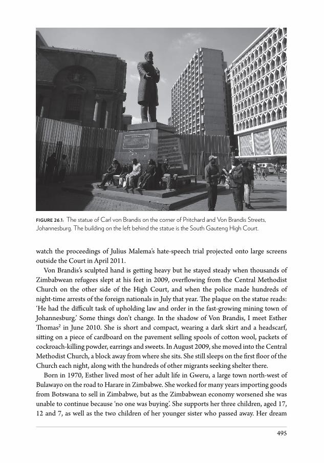
495
watch the proceedings of Julius Malema’s hate-speech trial projected onto large screens outside the Court in April 2011.
Von Brandis’s sculpted hand is getting heavy but he stayed steady when thousands of Zimbabwean refugees slept at his feet in 2009, overflowing from the Central Methodist Church on the other side of the High Court, and when the police made hundreds of night-time arrests of the foreign nationals in July that year. The plaque on the statue reads: ‘He had the difficult task of upholding law and order in the fast-growing mining town of Johannesburg.’ Some things don’t change. In the shadow of Von Brandis, I meet Esther Thomas2 in June 2010. She is short and compact, wearing a dark skirt and a headscarf, sitting on a piece of cardboard on the pavement selling spools of cotton wool, packets of cockroach-killing powder, earrings and sweets. In August 2009, she moved into the Central Methodist Church, a block away from where she sits. She still sleeps on the first floor of the Church each night, along with the hundreds of other migrants seeking shelter there.
Born in 1970, Esther lived most of her adult life in Gweru, a large town north-west of Bulawayo on the road to Harare in Zimbabwe. She worked for many years importing goods from Botswana to sell in Zimbabwe, but as the Zimbabwean economy worsened she was unable to continue because ‘no one was buying’. She supports her three children, aged 17, 12 and 7, as well as the two children of her younger sister who passed away. Her dream
figure 26.1: The statue of Carl von Brandis on the corner of Pritchard and Von Brandis Streets, Johannesburg. The building on the left behind the statue is the South Gauteng High Court.
CSCC.indb 495 2014/10/07 5:20 PM
Changing SpaCe, Changing City496
was to build a house but ‘now there’s no dream’, she says. Things were so bad in Zimbabwe she was forced to travel to South Africa to look for some way to bring in an income. ‘You need foreign currency to buy anything in Zimbabwe. How do they expect us to get foreign currency? You have to leave. Now I buy clothes at the Salvation Army and send them home,’ she says. ‘What are your plans for the next few months?’ I ask. ‘You can only have plans if you have money,’ she says. ‘I have no money so I have no plans.’
‘When the police need money, they come to us,’ says Esther. There are also private security guards who patrol the area. Top Ten Bravo is the name written on the back of the t-shirts of one such security company. ‘These guys, they bribe us. They want to get paid.’ Esther sits across from a man who has a pile of remotes for sale, set out on a blanket. Further down on the same side of the street, there’s another man selling CDs. Two men who look like bodybuilders walk by, wearing Top Ten t-shirts. We watch them stand in front of the CDs for five to ten minutes, pushing for R15. ‘If they don’t get the money, they take your stock,’ she says. ‘You see that woman with the green jersey, green pants and the green high-top boots? She is the notorious one. She is the supervisor. She teaches the others to bribe.’
Sometimes if the harassment gets too much on Von Brandis Street, Esther moves to a spot on Pritchard Street across from the High Court in front of Innes Chambers, which was abandoned in the late 1990s when many advocates left for new premises in Sandton. On the ground floor is a sign saying ‘Kidz World’; the shop is gone; the front gate is down; but the sign remains. One day in March 2011, Esther and I sit there together on a piece of cardboard. From this vantage point, we have a clear view of the Court. Clients park on the street to meet their lawyers on the front steps. Members of the Johannesburg Metropolitan Police Department stand in orange and tan clusters. Attorneys walk by, dressed in black, pulling small wheeled suitcases filled with legal papers. Journalists wait outside the Court’s front gate to catch a quote or a photograph as attorneys or their clients come out of the building.
Esther tells me that she tried to see the bishop (Paul Verryn at the Central Methodist Church) on Saturday, Sunday, Monday and Tuesday. She wanted to speak to him about her documents. Finally, on Wednesday, she reached the front of the queue and spoke to him. He suggests that she goes to Lawyers for Human Rights to review her asylum papers. They reassure her that all is in order but say she’ll have to renew on time because in August 2011 the special dispensation for Zimbabweans will end and the police will begin deportations again.
Before I can ask about her renewal, a man in black pants and a black shirt, holding a clipboard, walks towards us. ‘You cannot sell here. You must move.’ There is no one around us. We are bothering no one. ‘Why?’ I ask. ‘Because shopkeepers pay a lot of money to maintain this place,’ he says. ‘You must go and sell on the corner of Kerk and Harrison.’ ‘Kerk and Harrison? But that’s …’ Not waiting to hear my question and with great speed, as if she’s had plenty of practice, Esther gathers her wares into a bag, pulls up her cardboard and starts to cross the street. She heads back to her spot on Von Brandis.
The Central Johannesburg Partnership oversees city improvement districts (CIDs). A CID is a collaboration of property owners that pool their funds to improve security and keep
CSCC.indb 496 2014/10/07 5:20 PM
kulJiAN • the CeNtRAl MethODiSt ChuRCh 497
an area clean, bolstering the role played by the local municipality. CIDs exist throughout the city, and there is one that covers the south side of Pritchard Street where Esther and I were sitting. It does not, however, cover anything on the north side of Pritchard Street – the High Court, the section of Von Brandis Street next to the Court, the Central Methodist Church, or the Smal Street Mall, one of the busiest walkways in the city, running between the Court and the Church.
The Johannesburg Development Agency worked to upgrade this public space in 2007. With help from the private sector, the city spent R15 million to revamp the area around the Church and the High Court. The idea was to develop an attractive ‘legal precinct’. The Agency installed unique paving, benches and street lights along Prichard and Von Brandis streets, and a new modern red clock at the corner of Pritchard and Smal. They even polished Carl von Brandis.
Many of the businesses in the area are unhappy that the Central Methodist Church opened its doors to the homeless and has provided accommodation for large numbers of foreign nationals arriving in Johannesburg, especially from Zimbabwe. Bishop Paul Verryn tells the weekly refugee meeting at the Church, ‘This place is meant to be a stepping stone. Don’t waste your life sitting on a court bench in the sun. You must be working or trying to educate yourself.’
Under the red clock, women sell vetkoek from large plastic tubs. Attorneys and journalists don’t often buy, but the passing foot traffic from the Smal Street Mall does. Sometimes Esther buys a late lunch from the vendors here before she leaves her selling for the day. ‘I don’t know why they say there are no problems in Zim. There’s no food. I couldn’t go back to where I stay,’ Esther says. ‘We don’t know when God is going to release Zimbabwe.’
The entrance to the High Court is often shown on the evening news. But you need a wide-angle lens to see everything that makes the rest of the street unique. With a broad view, you can see the Johannesburg Metropolitan Police Department and Top Ten security. You can see Esther and others selling on the street. And you can see Carl von Brandis. By the way, he was a migrant too; from Germany. Some things don’t change.
Notes1 A version of this cameo appears in Kuljian (2013).2 Not her real name. She said, ‘You can write about me, but only if you change my name. If
someone in Zim reads about me, I’ll be in soup.’
ReferenceKuljian, C (2013) Sanctuary: How an Inner-city Church Spilled onto a Sidewalk. Johannesburg:
Jacana Media.
CSCC.indb 497 2014/10/07 5:20 PM
512
29 Phantoms of the past, spectres of the present: Chinese space in Johannesburg
Respect ghosts and gods but keep them at a distance.– Th e Analects of Confucius, 6.20
Phantoms lie about the past whilst spectres gesture towards a still unformulated future. – Colin Davis, 2005
Spectrality does not involve the conviction that ghosts exist or that the past (and maybe even the future they off er to prophesy) is still very much alive and at work, within the living present: all it says, if it can be thought to speak, is that the living present is scarcely as self-suffi cient as it claims to be; that we would do well not to count on its density and solidity, which might under exceptional circumstances betray us.
– Frederic Jameson, 1999
Phantom spacesIn the seventh lunar month of the Chinese calendar the gates of hell are opened and ghosts are released to roam the world. Th ose who died a wrongful death – Diào Sǐ Guǐ – or those who passed away far from home – Gū Hún Yě Guǐ – are oft en restless and vengeful, seeking recompense. It is a dangerous month to be out and about in Johannesburg for nearly 3 200 Chinese mine workers died on the Witwatersrand in the short period between 1904 and 1910. Faced with primitive conditions in the mines and prison-like conditions in the compounds in which they were housed, the lives of mine workers
P H I L I P H A R R I SO N , K H A N G E L A N I M OYO A N D YA N YA N G
CSCC.indb 512 2014/10/07 5:21 PM
513
were ended by ‘execution, disease, opium overdoses, accidents, homicide and suicide’ (MacLellan 2008: 78). The dying suffered the terrible loneliness of being 7 000 miles away from home.1
Around 63 000 Chinese were brought from the northern provinces of Henan and Shandong after the South African War to work on the gold mines as indentured labour. It was a move that restored production to the mines that had been closed during the war but provoked near hysteria among Johannesburg’s white citizens and helped bring down Lord Arthur Balfour’s government in the United Kingdom. By 1910 all the surviving Chinese workers had been repatriated except for the handful that had absconded and avoided capture (Kynoch 2005).
Over time, this episode of Johannesburg’s history faded into distant memory. It was repressed deep in the collective psyche. In 1981, the newsletter of the Johannesburg Historical Foundation noted that there was still a diminishing pile of stones among the bluegums where the Fordsburgspruit enters Crown Mine properties, although the ceramic pagodas that are traditionally left on the graves had all been stolen.2 Not far away, along Main Reef Road, the ruins of one of the largest Chinese compounds could still be seen. Today, there is almost nothing to mark the presence of the Chinese mine workers save for some old postcards exhibited in 2011 in the University of the Witwatersrand library, some artefacts in private collections, and the human skeletons that are unearthed on occasion during construction works along the old mining belt.
Another group of Chinese lived in early Johannesburg and their ghosts also walk the city, although sometimes mingling with the living. The most poignant reminder of this small group may be ‘a beautiful monument in the Chinese section of the cemetery in Braamfontein erected in memory of a young man who died of frustrated love’.3
During the second half of the nineteenth century, Guangdong, a province of south China, was ravaged by disasters – famine, drought, rebellion and war. Peasant and artisan families emigrated en masse to North and South America, Australia and New Zealand. From the 1870s a small number found their way to South Africa. Hakka families settled mainly in the coastal cities of the Cape Colony while Cantonese immigrants found their way to the Witwatersrand after the discovery of gold in 1886. There they worked mainly as petty entrepreneurs, opening small shops and laundries. They kept a low profile, worked hard and courted social respectability. Their numbers were small. By 1904, when immigration controls prevented more Chinese from arriving, there were only around 3 000 nationally, of whom 900 lived in Johannesburg. Today, the descendants of this group – known as SABCs (South African born Chinese) – number little more than 8 000 across the country.
There are phantom spaces across the city where immigrants from south China found temporary homes. As shopkeepers, the Chinese needed to be close to their markets of low-income earning Africans and coloureds and, to a slightly lesser extent, less affluent whites. The Chinese therefore lived and traded across the poorer parts of the city, including in Alexandra, Kliptown, Doornfontein, Prospect, Denver, Sophiatown and Western Native
CSCC.indb 513 2014/10/07 5:21 PM
Changing SpaCe, Changing City514
Township (now Newclare) (see Figure 29.1). Their biggest presence was in Sophiatown and the adjoining Western Native Township, where, by 1950, there were around 1 000 Chinese out of a total population of 60 000. A Chinese-owned shop traded on almost every street corner, and the Chinese presence is noted in recollections of that time. Gwen Ansell wrote in her book on township jazz and popular music:
Lenny Lee was one of the great jazz trumpeters in Sophiatown – he was Chinese, very strongly Chinese, but he had broken away from the Buddhist Chinese cultural hold, so he mixed freely with young players like Hugh Masekela. There was another Chinese family – Ah Lun – who had all black women – his children today are still walking around, and his young brother Giap; they had two beautiful sisters and oh! they were just crazy Chinese women; but they didn’t live a Chinese life – they lived with black people; they intermingled with the so-called coloureds and Indians in Sophiatown. Then there was the Yung family; also Chinese – one of the handsomest families – they wore the best American clothes, they spoke tsotsitaal; they mixed with the people. (Ansell 2005: 67)
Dugmore Boetie remembers the Chinese numbers game, Fafi, being played in Sophiatown while Dorothy Masuku recalls discovering North American jazz in a small Chinese shop next to her boarding school. This all came to an end in the late 1950s when the apartheid state destroyed Sophiatown and built the suburb of Triomf on its ruins. Jack Shear writes of the ‘ideological haunting’ of Triomf as ‘Sophiatown’s buried past rises to the surface’ (2006: 71).
The Chinese who were dislocated by the removals dispersed into the few remaining mixed-race areas in Johannesburg. Around 800 Chinese found a temporary home among the Indians and Malays of Fietas (later renamed Pageview). In the 1970s, the apartheid bulldozers arrived in Fietas too, leaving another phantom space. At this time the government made a final attempt to cluster the Chinese in their own group area. A small cultural hub, known to the Chinese as Malaikem, had developed along Commissioner Street in Ferreirasdorp during the 1890s. Social clubs, a Chinese language school and the offices of a Cantonese-language newspaper operated here. However, Chinese patterns of work and residence remained strongly dispersed in Johannesburg and Malaikem had only a few shops and a population that never exceeded 200. In the 1950s, the idea of a Chinese area was first mooted, and the Chinese Association of South Africa told Prime Minister DF Malan that the small community of Chinese shopkeepers would not survive if they were forced into a ghetto where they could only sell to each other (Liss 2011).
In the 1970s, when the government again proposed an ‘informal’ Chinese group area in Ferreirasdorp, the Chinese Association told the government that it ‘would not tolerate any exclusive grouping, whether this be voluntary or enforced’ (Liss 2011: 423). At the time, the increasingly isolated South African government was looking towards the East – to Japan and Taiwan – for trading ties and political support, so it quietly dropped the idea of a Chinese group area, leaving a small chink in the apartheid edifice. Chinese were now
CSCC.indb 514 2014/10/07 5:21 PM
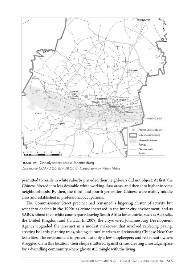
haRRiSOn, MOyO anD yang • ChineSe SpaCe in JOhanneSBURg 515
permitted to reside in white suburbs provided their neighbours did not object. At first, the Chinese filtered into less desirable white working-class areas, and then into higher-income neighbourhoods. By then, the third- and fourth-generation Chinese were mainly middle class and established in professional occupations.
The Commissioner Street precinct had remained a lingering cluster of activity but went into decline in the 1990s as crime increased in the inner-city environment, and as SABCs joined their white counterparts leaving South Africa for countries such as Australia, the United Kingdom and Canada. In 2009, the city-owned Johannesburg Development Agency upgraded the precinct in a modest makeover that involved replacing paving, erecting bollards, planting trees, placing cultural markers and reinstating Chinese New Year festivities. The environment improved but only a few shopkeepers and restaurant owners struggled on in this location, their shops shuttered against crime, creating a nostalgic space for a dwindling community where ghosts still mingle with the living.
Figure 29.1: Ghostly spaces across JohannesburgData source: GDARD (2011); MDB (2010). Cartography by Miriam Maina
Mining belt
Former Chinese spaces
City of Johannesburg
Mine residue areasRailway national roadsRoads
CSCC.indb 515 2014/10/07 5:21 PM
Changing SpaCe, Changing City516
Spectral geographiesColin Davis drew on Derrida’s representation of a spectre as ‘a deconstructive figure hovering between life and death, presence and absence, and making established certainties vacillate’ (2005: 376).4 While ghosts come from the past, spectres haunt us with ‘not yet formulated possibilities of the future’ (2005: 379). Maddern (2008) brings ‘haunting’ into a discussion on transnational migration. She calls migration a ‘phantasmagorical phenomenon … its essence, meaning and significance often difficult to adequately grasp’. She writes:
Migration continues to be a ghostly phenomenon, something threatening and uncanny, on the outer edge of what is sayable. It remains something to be quantified, measured, tamed and understood – the ‘other’, the shadow, the outer force, that threatens to disrupt the centre. (2008: 375)
The idea of the haunted or uncanny also speaks to the experience of migrants themselves. Madden refers to migration as ‘the condition of being in place and out of place simultaneously, or of feeling at home while simultaneously experiencing a sense of strangeness or foreignness’ (2008: 365). This is not very different from Caroline Kihato’s account of migrants in inner-city Johannesburg: ‘The interstitiality of immigrant life implies that they live suspended in society. On the one hand, they are present but not rooted in the host society; on the other, they are absent from their homes yet feel rooted to them’ (2009: 218).
Coming closer to home, Darryl Accone (2006) referred to the Chinese in South Africa as ‘ghost people’, although he did not elaborate on the metaphor. The contemporary Chinese presence in Johannesburg is phantasmagorical in the sense that Chinese migrants are suspended between places but also in the sense that the outcomes of the Chinese presence in Johannesburg are far from certain. While the original Chinese migrants – and the SABCs – were forced to make a leap of identity when ties between South Africa and mainland China were severed in 1949, more recent Chinese migrants hold a complex and ambivalent position across national boundaries. Is their presence transient? Will they acculturate and find roots in Johannesburg and in South Africa, gradually shifting from the fluidity of a transnational identity to the sense the SABCs have of being of Chinese origin in South Africa?
In the 1980s, after nearly a century of prohibited migration, a new wave of Chinese immigrants arrived in South Africa. Responding to the Taiwanese government’s initiative to move low-productivity industries offshore and to South Africa’s efforts to attract industry into the homelands, the Taiwanese came to South Africa as ‘settler-industrialists’. By the early 1990s there were around 30 000 Taiwanese in South Africa, but with the end of apartheid the industrial incentive scheme was dismantled, and South Africa shifted its political allegiance from Taiwan to the People’s Republic of China. The numbers of Taiwanese in South Africa have since dropped to around 6 000.
In the early 1990s a trickle of Chinese arrived in Johannesburg, departing from Hong Kong where they had faced the spectre of a handover to Chinese (Communist Party) rule in 1997. This group had the advantages of being proficient in English and having roots in a vibrant entrepreneurial environment, and generally flourished in Johannesburg.
CSCC.indb 516 2014/10/07 5:21 PM
haRRiSOn, MOyO anD yang • ChineSe SpaCe in JOhanneSBURg 517
The first of the new immigrants from the People’s Republic of China were initially from Shanghai and came to Johannesburg via Lesotho in the early 1990s. They had worked in Chinese-owned factories in that country until 1991 when anti-Chinese violence flared there and they crossed the border into South Africa as refugees, eventually finding their way to Johannesburg. There they lived together in a cluster of apartment blocks in Hillbrow and made a living in the inner city as street hawkers selling cheap consumer goods. With low business overheads and low residential costs, they did well, and many opened small shops in the inner city. Their success was reported in the media in China and this attracted many others, including a well-educated entrepreneurial class who came from cities on China’s east coast. It was this latter group that set up the large wholesale and retail malls that became a feature of China’s investment in Johannesburg in the 2000s.
In 1998, the 15th Communist Party Congress took the strategic decision to ‘grasp the large, release the small’ (Wang 2002: 206). This opened the spaces for hundreds of thousands of small, privately owned Chinese enterprises to move to new locations across the world, but it also refocused Chinese state-owned enterprises on strategic locations across the world, including in Africa, which became an important focus of China’s investment and foreign policy after 2000.
From around 2000 Johannesburg attracted large numbers of migrants from the rural areas of two or three districts of Fujian, an economically stressed province in south China which had a long tradition of emigration and extreme levels of competition for resources and jobs. The migrants came from poor families with few links into transnational business networks and they opened small shops or stalls, often in rural areas and small towns but also in Cyrildene and the China malls of Johannesburg. Many arrived illegally as part of ‘the clandestine diaspora’ (Ma 2002: 23), choosing South Africa because it was a relatively cheap destination and because controls on immigration to destinations such as Europe, North America and Australia had been tightened (Chen 2011). Today, the majority of the roughly 300 000 Chinese in South Africa are Fujianese and their large number has significantly changed the character of the Chinese immigrant society (Chen 2011).5 Most of our informants from established Chinese immigrant communities in South Africa referred negatively to these new arrivals. However, a Chinese doctoral student, Fenglan Chen – herself from Fujian province – has provided an empathetic account of the travails of the Fujianese in South Africa: ‘They struggle to make money, necessary to repay the loans they took out to immigrate; they struggle to communicate in the local languages; and they struggle with the loneliness of life in remote places’ (Chen 2011: 10).
A new trend is the arrival of high-level Chinese professionals in the wake of large-scale investment in Johannesburg by China’s state-owned enterprises. The catalyst was China’s entry into South Africa’s financial sector through a mega deal in 2007 in which the Industrial and Commercial Bank of China purchased a 20 per cent equity stake in the Johannesburg-based Standard Bank of South Africa.6 Since then, almost all China’s leading financial institutions have established offices in Johannesburg together with major Chinese construction and mining companies.
CSCC.indb 517 2014/10/07 5:21 PM
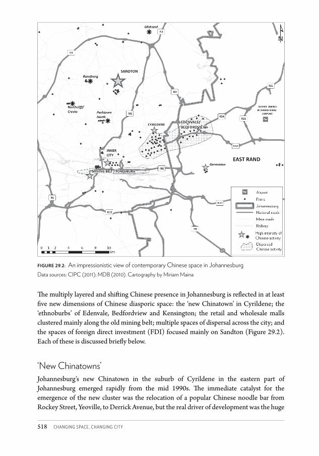
Changing SpaCe, Changing City518
The multiply layered and shifting Chinese presence in Johannesburg is reflected in at least five new dimensions of Chinese diasporic space: the ‘new Chinatown’ in Cyrildene; the ‘ethnoburbs’ of Edenvale, Bedfordview and Kensington; the retail and wholesale malls clustered mainly along the old mining belt; multiple spaces of dispersal across the city; and the spaces of foreign direct investment (FDI) focused mainly on Sandton (Figure 29.2). Each of these is discussed briefly below.
‘New Chinatowns’Johannesburg’s new Chinatown in the suburb of Cyrildene in the eastern part of Johannesburg emerged rapidly from the mid 1990s. The immediate catalyst for the emergence of the new cluster was the relocation of a popular Chinese noodle bar from Rockey Street, Yeoville, to Derrick Avenue, but the real driver of development was the huge
Figure 29.2: An impressionistic view of contemporary Chinese space in Johannesburg Data sources: CIPC (2011); MDB (2010). Cartography by Miriam Maina
CSCC.indb 518 2014/10/07 5:21 PM
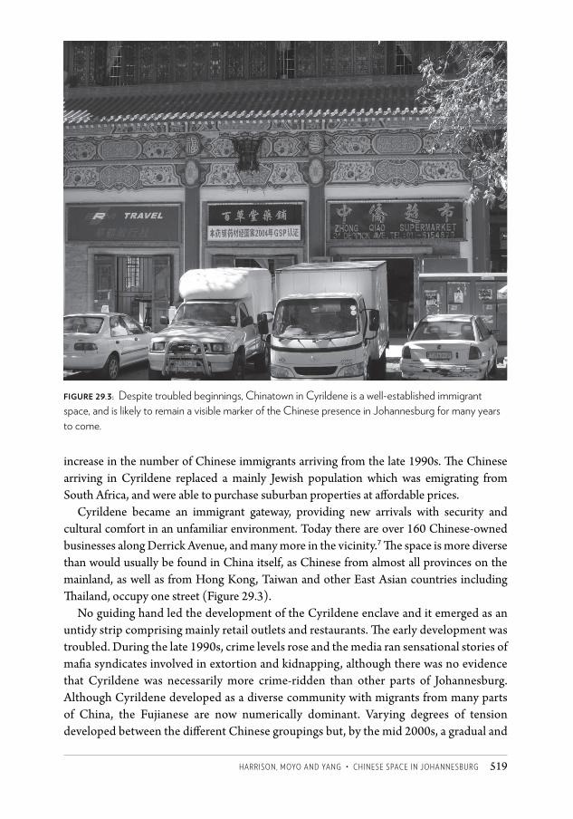
HARRISON, MOYO AND YANG • CHINESE SPACE IN JOHANNESBURG 519
increase in the number of Chinese immigrants arriving from the late 1990s. The Chinese arriving in Cyrildene replaced a mainly Jewish population which was emigrating from South Africa, and were able to purchase suburban properties at affordable prices.
Cyrildene became an immigrant gateway, providing new arrivals with security and cultural comfort in an unfamiliar environment. Today there are over 160 Chinese-owned businesses along Derrick Avenue, and many more in the vicinity.7 The space is more diverse than would usually be found in China itself, as Chinese from almost all provinces on the mainland, as well as from Hong Kong, Taiwan and other East Asian countries including Thailand, occupy one street (Figure 29.3).
No guiding hand led the development of the Cyrildene enclave and it emerged as an untidy strip comprising mainly retail outlets and restaurants. The early development was troubled. During the late 1990s, crime levels rose and the media ran sensational stories of mafia syndicates involved in extortion and kidnapping, although there was no evidence that Cyrildene was necessarily more crime-ridden than other parts of Johannesburg. Although Cyrildene developed as a diverse community with migrants from many parts of China, the Fujianese are now numerically dominant. Varying degrees of tension developed between the different Chinese groupings but, by the mid 2000s, a gradual and
figure 29.3: Despite troubled beginnings, Chinatown in Cyrildene is a well-established immigrant space, and is likely to remain a visible marker of the Chinese presence in Johannesburg for many years to come.
CSCC 29.indd 519 2014/10/08 12:13 PM
Changing SpaCe, Changing City520
partial process of regularisation and community formation was under way. In 2003, a local business association was established to deal with safety and security concerns and this was formalised in 2005 as the Cyrildene Chinatown Community Association. The Association focused mainly on security issues, but since 2005 some individuals within the local leadership have promoted a new vision for the area represented. This vision includes, for example, the annual Chinese New Year festivities, the traditional arch opened by President Zuma demarcating Derrick Avenue as a Chinatown, and efforts to set up a city improvement district to improve the management of the area.
Some non-Chinese residents in the area have resisted the Chinese presence. Numerous objections were lodged against rezoning applications for Chinese businesses and the Derrick Street arch (which took no less than six years to receive approval). However channels of communication between Chinese and non-Chinese residents have improved since 2010. Today, the Cyrildene Chinatown is a well-established immigrant space. It continues to grow and is likely to remain a visible marker of the Chinese presence in Johannesburg for years to come. Of course, though, the future will always remain uncertain and depends to some extent on the success of the local leadership in forging a sense of community, or at least in containing conflict.
the ‘ethnoburb’While Cyrildene is overwhelmingly and visibly Chinese, other parts of Johannesburg also house large numbers of Chinese although their presence is only subtly represented in the cityscape. In 1998, Wei Li (1998) coined the term ‘ethnoburb’ to refer to new forms of Chinese clustering in the San Gabriel Valley suburbs of southern California which deviated from the stereotypical Chinatown. In Li’s ethnoburbs, cultural markers were largely absent although the Chinese were a large (although not necessarily majority) presence. Residents of these ethnoburbs possessed higher-than-average incomes, higher occupational status and better education than those in the traditional Chinatowns who were predominantly small traders.
The suburbs of Edenvale, Bedfordview and Kensington, extending across the Johannesburg-Ekurhuleni boundary, may represent the first case of a Chinese ethnoburb in South Africa (see Figure 29.2). The cluster is not featured in academic writing but is referred to by local Chinese as Dong Qu (meaning ‘the east’), with the local Chinese media estimating that there are around 60 000 Chinese living in this part of the city, although this was not verified by Census 2011 (Stats SA 2012). This cluster is confirmed by our mapping, which revealed that 20 per cent of firms in Johannesburg and the East Rand with the words ‘China’ or ‘Chinese’ in their officially registered names are located in these three adjacent suburbs. This Chinese presence tends to be hidden, reflecting a general anxiety around crime, but also the intra-Chinese tensions in Johannesburg. Unlike in Cyrildene, the firms are not the ‘traditional Chinese busineses’ such as retail stores, restaurants and wellness centres, but operate in sectors such as travel, media and investment, which have links to transnational business flows. The close proximity of this area to OR Tambo International Airport is significant.
CSCC.indb 520 2014/10/07 5:21 PM
haRRiSOn, MOyO anD yang • ChineSe SpaCe in JOhanneSBURg 521
China mallsExtraordinary changes are taking place along the old mining belt of Johannesburg as Chinese investment in wholesale and retail trade transforms derelict land. The story of this development began in 1995 when Chinese entrepreneurs in the inner city closed shop almost overnight following serious incidents of crime and moved to Ellis Park, setting themselves up adjacent to the sports stadium, where a Chinese businessman had refurbished an old Spar supermarket, turning it into a small shopping mall. A year later the owner of the mall hiked rentals and more than a hundred aggrieved Chinese tenants all left. Collectively they purchased a warehouse in Crown City, a newly established industrial township on mining land. The mall is known in Chinese as Baijia (‘one hundred families’) and in English as China Mart.
Crown City proved to be an auspicious location. It is near a major interchange on the M2 motorway, land was relatively cheap, and it is situated between concentrations of low-income consumers in Soweto and the inner city. In 2000 Dragon City was opened in the nearby (mainly) Indian area of Fordsburg. In 2006 a Chinese businessman purchased the fire-damaged buildings of a large Makro store a little further along Main Reef Road, and established the highly successful China Mall (see Figure 29.4). There was a further surge of mall construction in 2010 and 2011, supported by a strong South African currency which allowed Chinese goods to be imported at very low cost. The Afrifocus development in Crown City is the most impressive, comprising an extensive mixed-use development incorporating warehousing, retailing, residential and recreational facilities. With its significant residential component, it may provide a nucleus for Johannesburg’s ‘third Chinatown’.
In mid 2011, we identified no fewer than 18 Chinese malls in Johannesburg, accommodating around 4 000 Chinese businesses. Half of these were in and around the Crown City/Fordsburg complex with the other half in an extended band along Main Reef Road, with a cluster at Bruma in Cyrildene, and individual malls in Ormonde and Newclare.
The mall owners come mainly from a handful of cities along China’s east coast and are linked into transnational circuits of business that are largely defined by city of origin. They often also have strong links with top African National Congress politicians although the tenants in the malls are mainly Fujianese and many of them operate at a level that is barely more than survivalist.
The ‘China brand’ is a successful business strategy as it is associated with cheap consumer goods, with the ‘Chineseness’ of businesses openly advertised. It has been a successful strategy and initial investment has produced strong agglomeration and multiplier effects. However, the growing number of Chinese entrepreneurs, all competing on the basis of low prices, has increased competitive pressures, while the volatility of South Africa’s currency is a risk for a business model that depends on the ability to import produce from China at low cost.
Local competition has prompted mall owners and tenants to establish malls and independent shops outside of Johannesburg. Large new China malls have been established in Cape Town, Pretoria, Durban and Mussina (to tap cross-border trade) as have Chinese
CSCC.indb 521 2014/10/07 5:21 PM
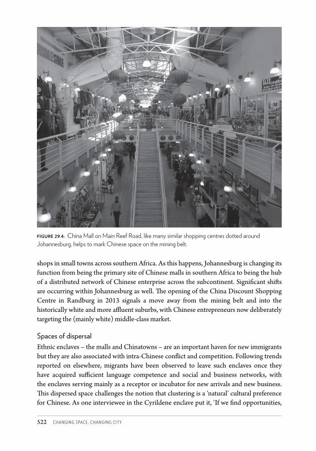
Changing SpaCe, Changing City522
shops in small towns across southern Africa. As this happens, Johannesburg is changing its function from being the primary site of Chinese malls in southern Africa to being the hub of a distributed network of Chinese enterprise across the subcontinent. Significant shifts are occurring within Johannesburg as well. The opening of the China Discount Shopping Centre in Randburg in 2013 signals a move away from the mining belt and into the historically white and more affluent suburbs, with Chinese entrepreneurs now deliberately targeting the (mainly white) middle-class market.
Spaces of dispersalEthnic enclaves – the malls and Chinatowns – are an important haven for new immigrants but they are also associated with intra-Chinese conflict and competition. Following trends reported on elsewhere, migrants have been observed to leave such enclaves once they have acquired sufficient language competence and social and business networks, with the enclaves serving mainly as a receptor or incubator for new arrivals and new business. This dispersed space challenges the notion that clustering is a ‘natural’ cultural preference for Chinese. As one interviewee in the Cyrildene enclave put it, ‘If we find opportunities,
Figure 29.4: China Mall on Main Reef Road, like many similar shopping centres dotted around Johannesburg, helps to mark Chinese space on the mining belt.
CSCC.indb 522 2014/10/07 5:21 PM
haRRiSOn, MOyO anD yang • ChineSe SpaCe in JOhanneSBURg 523
we will move.’8 It is impossible to generalize about this, however; some well-established Chinese immigrants choose to remain in Cyrildene because new immigrants provide an important market for their businesses.
Of the 172 firms in Johannesburg on the Companies and Intellectual Property Commission database that have the words ‘China’ or ‘Chinese’ in their names, 79 (46 per cent) are located outside the ethnic clusters. Chinese supermarkets, restaurants and wellness centres – as well as Chinese firms in ‘non-traditional’ sectors – operate across the city but especially in the affluent northern suburbs. For example, we counted 50 Chinese restaurants outside the ethnic enclaves in 28 suburbs. Immigrants who arrived before 2000 – mainly from Taiwan, Hong Kong and the large east coast cities such as Shanghai – are disproportionately represented in these dispersed spaces (see Harrison et al. 2012).
Foreign direct investmentFrom 2007, China’s FDI in South Africa shifted spatially from rural areas in provinces such as KwaZulu-Natal to Johannesburg, and especially to the financial and business centre of Sandton. This investment is represented in the physical landscape. The 17-storey Sinosteel Plaza along Rivonia Road, which houses the South African offices of one of China’s largest ferrous and mineral companies, is a prominent part of Sandton’s new skyline. Immediately adjacent is the South African headquarters of the China Construction Bank. The China Railroad Group, Asia’s biggest construction company, entered South Africa in 2010 when it commenced talks with Standard Bank and the South African government on the construction of a US$30 billion rapid-rail link between Durban and Johannesburg. It also formed a consortium with a company to develop Sandton Skye, three luxury residential and business tower blocks.
Not all Chinese investment is as visible; many Chinese firms operate more discreetly within Sandton and in other nodes in the city, and a substantial but discreet Chinese business community lives in and around Sandton. Chinese presence is now also strongly represented in industrial areas with, for example, Huawei Technologies in Woodmead, HiSense in Midrand and First Automotive Works in Isando on the East Rand.
In November 2013, the deal struck between AECI and the Chinese company Shanghai Zendai Properties created a media sensation.9 Shanghai Zendai agreed to purchase a 1 600 hectare portion of land on AECI’s Modderfontein properties in the east of Johannesburg for R1 billion, with the intention of investing nearly R80 billion over a ten-year period in a massive upmarket mixed-use development between Sandton and OR Tambo International Airport. One media report referred to this as ‘the New York of Africa’10 and another as ‘Baby Beijing’.11 This investment, if successful, will mark the beginning of a new phase of Chinese FDI in Johannesburg and South Africa, with a direct focus on property development on a very large scale.
CSCC.indb 523 2014/10/07 5:21 PM
Changing SpaCe, Changing City524
ConclusionThe ghosts of the past remind us that we should never count on the density or solidity of the present ( Jameson 1999). Throughout Johannesburg’s history, Chinese space has been fluid, changing in response to state interventions and to the shifting social and economic profiles of Chinese communities in the city. In some places, all that is left are phantom spaces. Yet, in the relatively short period since the early 1990s, the Chinese footprint in Johannesburg has also expanded dramatically, and is now a substantial feature of the city landscape. Despite this, the Chinese presence remains ephemeral and continues to evolve in surprising ways. It is difficult to envisage what forms Chinese space might take in, say, ten years’ time. For example, Johannesburg’s ‘third Chinatown’ may be emerging in Crown Mines as accommodation is provided in mixed-use business sites. This is land where a hundred years ago Chinese mine workers were confined to compounds and where many were buried in anonymous graves; the ghosts may mingle with the living once again. Meanwhile Chinese entrepreneurial presence is moving with new confidence into the higher-income suburbs, targeting a new market, but how permanent will the new Chinese presence be in Johannesburg? Chen’s survey of migrants conducted in 2010 suggests that the large majority of migrants aspire to return to China, and will do so once they have earned sufficient money. Some of our informants insist, however, that despite these aspirations, most migrants will eventually settle in South Africa. The surprise of massive Chinese investment in the property sector, which could significantly reshape parts of Johannesburg, also points to this fluidity.
In the words of Colin Davis (2005: 377), ‘spectres gesture towards a still unformulated future’.
Acknowledgements This work is based on research supported by the South African Research Chairs Initiative of the Department of Science and Technology and the National Research Foundation. We are grateful to Miriam Maina for her assistance with the illustrations.
Notes1 This section draws on writing on Chinese history including Yap and Man (1996), Accone
(2004), Kynoch (2005), Park (2008), Harris (2009) and Liss (2011). 2 Then and Now, newsletter of the Johannesburg Historical Foundation, September 1981, No.
22, p.3.3 Then and Now, July 1982, No. 23, p.7.4 The references we draw on for this section include Pickles and Woods (1989), Accone
(2007), Park and Chen (2009), Huynh et al. (2010) and Dittgen (2011). We have undertaken our own investigation into Chinese space in Johannesburg which draws on a number of formal and informal interviews. A comprehensive account of the study is provided in Harrison et al. (2012).
CSCC.indb 524 2014/10/07 5:21 PM
haRRiSOn, MOyO anD yang • ChineSe SpaCe in JOhanneSBURg 525
5 The Fujianese Association of South Africa claims a membership of 70 000, with the total number of Fujianese in South Africa in a range between 180 000 and 240 000.
6 Standard Bank was of strategic importance to the People’s Republic of China as it had a footprint in 18 African countries and had identified billions of dollars in potential infrastructural investments in Africa.
7 The figure of 160 was provided by the deputy chairman of the Cyrildene Chinatown Community Association.
8 Interview conducted for Harrison et al. (2012).9 See Enca 6 November 2013; Business Report 6 November 2013; Business Day 8 November
2013; Mail & Guardian 8 November 2013.10 Business Report 6 November 2013.11 Biznews.Com 5 November 2013.
ReferencesAccone, D (2004) All Under Heaven: The Story of a Chinese Family in South Africa. Cape Town:
David Philip.Accone, D (2006) ‘“Ghost people”: Localising the Chinese self in an African context.’ Asian
Studies Review 30(3): 257–272.Accone, D (2007) ‘Chinese communities in South Africa.’ The China Monitor 21: 6–9.Ansell, G (2005) Soweto Blues: Jazz, Popular Music and Politics in South Africa. New York:
Continuum International Publishing Group.Chen, F (2011) ‘Chinatown in Johannesburg: A social survey.’ The China Monitor 61, April:
8–12.CIPC (Companies and Intellectual Property Commission) (2010) CIPC database, http://
www.cipc.co.zaDavis, C (2005) ‘Hauntology, spectres and phantoms.’ French Studies 59(3): 373–379.Dittgen, R (2011) ‘From China to Johannesburg’ (online document).GDARD (Gauteng Department of Agriculture and Rural Development) (2011) GIS
database. Dataset obtained from GDARD, http://www.gdard.gpg.gov.za Harris, KL (2009) ‘“Confusion, heaven and honour”: Being Chinese in South Africa.’ African
Historical Review 41(2): 116–128.Harrison, P, Moyo, K and Yang Y (2012) ‘Strategic and tactics: Chinese immigrants and
diasporic spaces in Johannesburg, South Africa.’ Journal of Southern African Studies 38(4): 899–926.
Huynh, TT, Park, YJ and Chen AY (2010) ‘Faces of China: New Chinese migrants in South Africa, 1980s to present.’ African and Asian Studies 9(3): 286–306.
Jameson, F (1999) ‘Marx’s purloined letter.’ In M Sprinkler (ed.) Ghostly Demarcations: A Symposium on Jacques Derrida’s ‘Spectres de Marx’. London and New York: Verso.
Kihato, C (2009) Migration, Gender and Urbanisation in Johannesburg. PhD thesis, University of South Africa, Pretoria.
Kynoch, G (2005) ‘“Your petitioners are in mortal terror”: The violent world of Chinese mineworkers in South Africa, 1904–1910.’ Journal of Southern African Studies 31(3): 531–546.
CSCC.indb 525 2014/10/07 5:21 PM
Changing SpaCe, Changing City526
Li, W (1998) ‘Anatomy of a new ethnic settlement: The Chinese ethnoburb in Los Angeles.’ Urban Studies 35(3): 479–501.
Liss, DL (2011) Black, White, and the Limbo in Between: The Precarious Position of the South African Chinese Under Apartheid, 1948–1994. Honours thesis, Harvard University.
Ma, LJC (2002) Space, Place and Transnationalism in the Chinese Diaspora. Centre for China Urban and Regional Studies, Hong Kong Baptist University, Hong Kong.
MacLellan, G (2008) Dragons on the Rand: A Documentary about Indentured Workers on the Witwatersrand Mines. Mini MA thesis, University of the Witwatersrand, Johannesburg.
Maddern, F (2008) ‘Spectres of migration and the ghosts of Ellis Island.’ Cultural Geographies 15(3): 359–381.
MDB (Municipal Demarcation Board) (2010) Administrative boundaries and transport data. Dataset obtained from MDB, http://www.demarcation.org.za
Park, YJ (2008) Matter of Honour: Being Chinese in South Africa. Johannesburg: Jacana Media.Park, YJ and Chen AY (2009) ‘Recent Chinese migrants in small towns of post-apartheid
South Africa.’ Revue Européenne des Migrations Internationales 25(1): 25.Pickles, J and Woods J (1989) ‘Taiwanese investment in South Africa.’ African Affairs 88:
507–528.Shear, J (2006) ‘Haunted house, haunted nation: Triomf and the South African postcolonial
gothic.’ Journal of Literary Studies 22(1-2): 70–95.Stats SA (2012) Census 2011 Statistical Release – P0301.4 (online document).Wang, MY (2002) ‘The motivations behind China’s government-initiated industrial
investments overseas.’ Pacific Affairs 75(2): 187–206.Yap, M and Man DL (1996) Colour, Confusion and Concessions: The History of the Chinese in
South Africa. Hong Kong: Hong Kong University Press.
CSCC.indb 526 2014/10/07 5:21 PM
527
30 The notice
‘Your name?’ ‘Hannah’‘How do you spell it?’‘H-a-n-n-a-h’H|A|N|N|A|H, the policeman wrote painstakingly. ‘Your ID number?’ ‘I don’t have a South African ID … but my passport number is A470 …’‘When were you born?’ interrupted the offi cer, glaring at Hannah.‘I was born on twenty three March, nineteen eighty six.’|1|9|8|6|0|9|2|3| | | | | | Th ere were blank spaces left in the form, but this would have
to do, the policeman thought to himself. His boss would have to understand – few migrant women had local identity documents. In any case, we all knew that they provided false information to hide their identities.
‘Nationality?’ he asked brusquely. M|A|LA|W|IAN he wrote, squeezing the extra lett ers together. Th e form only provides
six spaces for this entry. [5 spaces given above]‘Address?’ ‘Flat 103, Fatis Mansion, Jeppe; corner Harrison Street, Johannesburg.’ F|L|A|T| |1|0|3| |F|A|T|I|S| |M|A|N|S| | … continued offi cer Molokomme. His left
hand moved slowly, making jerky movements with the strokes of his pen. Each lett er was carefully writt en in the spaces and no matt er what he felt, whether he believed in what he
C A RO L I N E WA N J I K U K I H ATO
CSCC.indb 527 2014/10/07 5:21 PM
Changing SpaCe, Changing City528
was writing or not, I could see he did take some pride in his written work. Knowing this was going to take a while, I resigned myself to watching the goings-on on Klein Street, right there where we stood, on the pedestrian path between Plein and De Villiers. I cast my eye at the scene in front of me and understood immediately why the superintendent and I were there – why we had to be there.
It was a late summer morning on the last day of March 2008. Although we were still 15 minutes away from midday, when the heat of the sun was inescapable, I was hot from the scorching sun on the police car’s dashboard. The area is close to the Noord Street taxi rank, one of the busiest transport nodes in the city. It was easy to understand why the traders set up their illicit trade here – the number of people passing through daily guaranteed them a ready market. Moreover, business at the end of the month is always good. As hoards of commuters with their monthly earnings in their pockets go home, they may buy a few extra tomatoes, the pair of sunglasses they have been eyeing all month, or some imitation jewellery for a loved one. ‘Month-end’, pronounced ‘maanzy-end’, is a good time for traders and their customers alike.
Our arrival had disrupted the rhythms of street banter, negotiations and trade, causing the illegal traders to take what goods they could and run. It looked like a tornado had come through this part of Johannesburg’s CBD, leaving destruction in its wake. On the pavements were abandoned cardboard boxes. Alongside them were bright orange crates – one filled with maize was lying on its side, and a few of the green cobs spilled over into the street. Strewn across the pavement were newspapers, plastic bags, sweets, oranges, beads, cigarettes and cooked mielie pap, which the wind and people’s feet were helping distribute across other parts of the city. Even though it was the last day of the month, the street was eerily quiet. On this day, Superintendent Molokomme was issuing notices to appear in court, while other colleagues confiscated the goods of those traders who had not been quick enough to make a getaway. I could hear a woman crying foul, wailing that the police have mercy on her; she was pregnant and needed the money to buy food for her children. The pregnant woman whose name I did not know, Hannah who was talking to Molokomme, and a few others were the unlucky ones – caught before they could escape ‘the metro’. That is what the traders call the Johannesburg Metropolitan Police Department – ‘the metro’.
The written ‘Notice to Appear in Court’ (issued in terms of section 56 of the Criminal Procedure Act, No. 51 of 1977) is one of the legislative mechanisms that allows the city to regulate what can or cannot be done in a given space in the municipal area. The Act from whence this section is derived provides guidelines to those who work in the policing, justice and correctional services on the variety of procedures available to them in criminal proceedings. Section 56 presents an officer of the law with the option to hand an accused a written notice to appear in a magistrate’s court. The words, written in black and white in this auspicious legal document, say that the notice should:
a. Specify the name, the residential address and the occupation or status of the accused;b. Call upon the accused to appear at a place and on a date and at a time specified in the
written notice to answer a charge of having committed the offence in question;
CSCC.indb 528 2014/10/07 5:21 PM
KIHATO • THE NOTICE 529
c. Contain an endorsement in terms of section 57 that the accused may admit his guilt in respect of the offence in question and that he may pay a stipulated fine in respect thereof without appearing in court; and
d. Contain a certificate under the hand of the peace officer that he has handed the original of such written notice to the accused and that he has explained to the accused the import thereof.
I turned my attention back to Hannah and the officer. As I continued to listen in on the conversation, I began to have doubts about the bureaucratic ritual taking place in front of me. Now, I am no expert on the city’s geography, but I was beginning to wonder whether F|L|A|T| |1|0|3| |F|A|T|I|S| |M|A|N|S|I|O|N| really did exist and whether Hannah in fact lived there. I noticed that ‘Hannah’ did not give us a surname and had an incomplete identity number. The notice provides 13 spaces for the identity number – officer Molokomme only inserted eight digits. This made little sense to me. South African identity documents typically have 13 digits. The first six digits are the individual’s birthday – comprising the last two digits of the year of birth, month and day, written in that order. |1|9|8|6|0|9|2|3| | | | | | was not only incorrect, but also incomplete. As I pondered these issues, I wondered whether officer Molokomme shared my concerns, and if he did, why he continued this charade of filling the notice with phoney information. Surely this was ineffective in bringing to book those who participated in illegal trade in the city? We may have fulfilled section 56 b, c and d of the Criminal Procedure Act, but what good was that if critical information – the name and residential address – of the offender was missing? I wished I could point out these concerns to the officer, but I was powerless, a mere pawn, in this habitual practice.
My concerns were not new, and are shared by city planners and service providers alike. Urban development is predicated upon knowledge of urban populations. Without an understanding of who lives in the city and where they live, it is near impossible to direct urban development and plan for the city’s future. Which areas in the city are growing? Are people young or aging? Are communities stable or transient? All these questions have a bearing on the kinds of urban services needed by urban dwellers, and the nature of public investment required in the city. While a good deal of planning is about supplying urban services, another aspect is ensuring that the city government regulates what happens in streets, parks, commercial and residential areas. The raid on illegal trade on Klein and Plein streets was an attempt by the city to enforce municipal by-laws. Illegal street trading presents urban governments with numerous problems. Trading on sidewalks interrupts the through-flow of pedestrian traffic, creating overcrowded streets which can potentially harbour criminals. Shop owners and potential investors shy away from areas that are unregulated as this not only affects their business, but also signals that the city government is unable to control the spaces in its jurisdiction. Businesses want predictability and the assurance that the government can protect their interests. Public health is another concern. Unplanned markets have no ablutions or cleaning areas, presenting a potential health hazard not only for the traders but also their customers.
CSCC.indb 529 2014/10/07 5:21 PM
Changing SpaCe, Changing City530
Although the enforcement of rules is an important part of urban life, it depends on the ability of the state to ‘see’ its populations. Local authorities need to know who lives in their jurisdictions, and where to find them. At an administrative level, population registers allow governments to plan for services such as health, education, electricity, water and sanitation. It also makes taxation and finding criminals or law-breakers possible. Having a visible population in the city is therefore a critical aspect to good governance. Hannah’s illegibility, the lack of state capacity to track her down, makes good governance – tax collection, effective regulation and urban investment – difficult if not impossible to achieve. Officer Molokomme had clearly not ‘captured’ Hannah’s details in a manner that would allow the city’s bureaucracy to follow up the charge, which he was now writing up.
The officer continued to write that Hannah had the option to pay a fine of R500, or appear in Courtroom 35 at the Johannesburg magistrate’s court on 8 May 2008.
When he was finished, the officer handed me over to Hannah, and I wondered where I would end up. Perhaps in a bin in a backstreet alley? Maybe she would crumple me up and throw me on the pavement where, no doubt, I would find others like me who shared the similar fate of being ignored. I doubted that Hannah would pay the fine of R500, or bring me to court to challenge the police officer. I may not have been utilised in the manner expected, but I am surprised that I continue to endure in a context where few seem to take me seriously. The performance that I had just witnessed between Superintendent Molokomme and Hannah was not an isolated event, but an interaction that occurs often in the city. She mindlessly shoved me into her purse as she watched policemen load her goods into the back of the police van. Making a quick calculation of her day’s losses, she looked around for her friends and approached them two blocks away where they were putting what they had managed to save in the ubiquitous plastic ‘Ghana must go’ bags.
‘Eish, today they caught me … I couldn’t run fast enough.’ ‘Ag, shame! How much is your ticket for?’‘About five hundred rands … my stuff is not even up to five hundred. That fine is just too
much!’‘Just leave your stuff with them and start again my sister.’‘Eish, now where shall I get money for new stock to sell tomorrow?’ It came as no surprise to me that Hannah did not intend to go to court or pay the fine. She
even planned to be back at her trading spot on the corner of Plein and Klein streets the next day. In fact, few traders pay the fine. Fewer still try to retrieve their confiscated goods from police warehouses. The traders are aware that the police officers do not always declare all the goods they confiscate. Either they sell what they can or take what they want for themselves. Police ‘siphoning’, as it is sometimes known, is seen as part of a street tax that traders must pay to trade. You see, there is an informal system of exchange at work. The police tolerate some level of illegal street trading because it gives them an added source of income, through bribes and the theft of confiscated goods. Informal traders are aware that they are breaking the law by trading illegally and therefore see the exchange as part of a business expense. It is true that they complain about the unfairness of police harassment and the amounts they
CSCC.indb 530 2014/10/07 5:21 PM
KIHATO • THE NOTICE 531
have to pay. But they recognise that the police, who possess the authority to execute official regulations, also have the power to turn a blind eye to their illicit trade.
I reflected on what I had become in this fragile system of exchange, where formal rules met informal ones. Without the backing of the state’s laws and regulations, I was powerless to enforce urban order. But because of it, I facilitated an illicit sub-economy that allowed illegal traders in the city. It is precisely because I occupy a position of power in state officialdom that I am a powerful actor in the informal economy. As James Scott points out, part of the power of the official over the subaltern ‘is the strategic use of “the rules”’ (2005: 399). I represent the threat of the enforcement of the law, yet at the same time I am complicit in its undoing. In this zone, the boundaries between legal and illegal are blurred and it is possible to see the extent to which extra-legal practices run through the institutions of the state (Das and Poole 2004).
Legal instruments like me symbolise the complex nature of urban relationships in cities like Johannesburg. Indeed, if we look carefully we can no longer speak of a city in which the formal sector is separate from the informal sector. Similarly, the boundaries that separate official regulation and enforcement from unofficial and extra-legal practices collapse when we scrutinise the relationships between the state and urban actors. As I reflected on my role in configuring urban spaces, I realised that I participate in the production of a hybrid spatial logic created not just by the formalism of state rules and regulations, but by the intersection of these rules with alternative logics of non-state actors. Traders and officers alike may not pay much attention to the contents of The Notice, but I nevertheless remain a powerful symbolic figure in shaping the nature of urban spaces.
ReferencesDas, V and Poole, D (2004) ‘State and its margins: Comparative ethnographies.’ In V Das
and D Poole (eds) Anthropology in the Margins of the State. School of American Research advanced seminar series. Santa Fe, NM: School of American Research Press.
Scott, JC (2005) ‘Afterword to “Moral economies, state spaces, and categorical violence”.’ American Anthropologist 107(3): 395–402.
CSCC.indb 531 2014/10/07 5:21 PM
539
32 Waste pickers/informal recyclers
On any weekday in any street in Johannesburg one might encounter a lean, bowed person straining to pull a vast load up a hill, round a bend or across a busy traffi c intersection, cramping to the side of the road out of the way of impatient cars and trucks, or pausing to lean on the trolley handles to catch a breath. Bulky brown hessian bags squatt ing on fl at platform trolleys are stuff ed with cardboard or paper, metal or plastic, making their trundling way by human muscle power alone to a recycling depot where their contents can be exchanged for cash.
Daily the waste discarded by businesses and residents of Johannesburg is actively salvaged in the transition between private property and public landfi ll. In the dark early hours of the morning, empty trolleys and defl ated bags rumble briskly from central areas to the suburbs, scheduled for the city’s refuse removal service that day. Th e journey out can be many kilometres and several hours of walking. Reclaimers must arrive at bursting wheelie bins before the Pikitup trucks do, before the formal recycling companies collect their hauls, before pedestrian competitors arrive with ratt ling trolleys hungry for loading. Bins and bags are systematically trawled for particular goods: white A4 paper perhaps, PET plastics or scrap metal. When hessian bags are full enough to make the long journey back worthwhile – today, or perhaps only tomorrow, aft er another suburb is scoured – the back-breaking journey to the depot begins.
Both physically and institutionally, recyclers operate in in-between places and spaces: recycling businesses use their hauls – indeed depend on them for source material – but the recyclers are self-employed, without wages, job protection, insurances or medical aid.
S A R A H C H A R LTO N
CSCC.indb 539 2014/10/07 5:21 PM

Changing SpaCe, Changing City540
Their strenuous manual labour, eye for the cash value in rubbish, diversion of volumes of material from landfills, and low carbon footprints are not lauded and applauded. City residents and businesses generating waste are mostly ambivalent – occasionally recognising and facilitating the reclaiming process on their doorstep, sometimes complaining and chasing away ‘dirty vagrants’, but mostly ignoring their fellow residents and road users. City authorities, too, mostly overlook recyclers while they do their work – indeed, appear blind to their existence and their labour. A different response, however, is provoked at the gathering points for sorting and storing accumulated materials, and by the recyclers’ nightly sleeping arrangements. These attract censure and harsh rebuke from law enforcement officers.
This then is the ambiguous world of the informal recycler or reclaimer in Johannesburg. Interviewed in Newtown in 2010, Sizwe and Danny’s stories reflect this complexity.1 Sizwe entered recycling work based on the experience of his close friend Danny, a recycler for more than ten years. Sizwe was struggling to make ends meet from his job as a once-a-week gardener in Vereeniging, earning R200 a month, and from hawking of loose cigarettes in his own neighbourhood of Evaton West.
Figure 32.1: Ignored while they work, recyclers earn harsh censure from law enforcement officials when they try to create gathering points for sorting and storing accumulated materials or find places to sleep.
CSCC.indb 540 2014/10/07 5:21 PM

ChaRLtOn • WaSte piCKeRS/inFORMaL ReCyCLeRS 541
The spatial range of their recycling work is wide. Sizwe and Danny trawl Rosebank on Mondays, Westcliff on Wednesdays, Northcliff and Cresta on Thursdays, and Booysens to the south of the CBD on Fridays. They also salvage from businesses in central Johannesburg in the late afternoons, and they sell their stock to a depot in Newtown.
In addition to these working ranges, they divide their living time between Newtown and Evaton West, some 40 km to the south-west of central Johannesburg, in the neighbouring municipality of Emfuleni. Living conditions in the two places contrast sharply: both men are property owners in Evaton West, owning small, formal, government-sponsored low-cost houses acquired between 1995 and 1997. The houses are permanently occupied by spouses and children, and Sizwe and Danny join their families for the weekend on Friday nights and Saturday afternoons respectively.
During the week, however, they sleep rough, on leftover public space under a freeway bridge in central Johannesburg. This is their response on being asked about sleeping arrangements during their working week:
Sizwe: Oh well, no it’s a difficult question. There’s just … we just sleep.
Danny: What we do, then we get some cardbox, ne? Then maybe … big cardbox, then we make it … something like a wall, yeah, just to … you know, just to keep the wind … and then, you’ll make a bed, and then you put your blanket.
Sizwe: Before you write, before you write [what he said], you are going to fight with me – he has got that box, he is alone, mine I don’t have a box and I will sleep over on top of the trolley. So he’s one that has got that box … He found it on Friday last week, so he say … yeah, we are just sleeping right there, on top of our trolleys, yeah.
Danny: Open sort of … like this.
By contrast, their homes in Evaton West, although cramped and of poor physical quality they say, have electricity and flush toilets. They represent, too, a form of security and stability:
what is good for me is that I have my own place … And I own at least the soil …
But what Evaton West doesn’t offer them is a way of earning an adequate income. Sizwe and Danny speak of extensive poverty and unemployment in the area: ‘People are not working’. In the central areas of Johannesburg they can provide for their families through harvesting the waste of a much more affluent society. But why does this involve sleeping most days of the week in Johannesburg, and why in such rough living conditions?
A key factor for staying in Johannesburg on week nights is the cost of transport between Johannesburg and Evaton West – at R32 for the return journey, a daily commute would be a considerable expense relative to earnings. Recyclers also start their outbound journeys to the suburbs very early in the mornings. But there are other reasons for needing to remain in the city and close to their goods during the week. Recycling work involves both gathering and later sorting the load prior to having it weighed at the depot. Recyclers need space to
CSCC.indb 541 2014/10/07 5:21 PM
Changing SpaCe, Changing City542
separate and sort bulky items – which depend on volume to attract value – and they need time to do this. They also need a place to stockpile items until they have amassed enough of a particular material to make the exchange at the depot worthwhile. Then there is the trolley and hessian bag to store. Danny explains that when he goes home over weekends, he tries to find a way to secure the trolley that he leaves behind:
Like last week, I used to ask somebody, I say ‘you must look my trolley’ they say ‘give me R5’, I give them. When I come Monday, I’ve got no trolley any more. I have to go anywhere until I get the lucky, get another trolley.
While recyclers are on the move much of the time, therefore, essential to their business is space for sorting and a secure spot for stockpiling and storage. Add to this the long working hours, the early morning start times and the transport costs, and the week night stay-over in Johannesburg makes sense. So too does sleeping with your trolley and your goods, even if this is on a bleak patch of ground under a freeway flyover, close to the buy-back depot.
One such piece of land is marked by the huge concrete pillars of the motorway overhead, and is rough and unlandscaped. It brings to mind words such as ‘wasteland’ and ‘leftover ground’, appearing desolate and uninviting. But the recyclers’ use of it is not uncontested. Sizwe and Danny explain that the Johannesburg Metropolitan Police Department ( JMPD) officers frequently raid the area and burn their belongings – their reclaimed stock ready to be sold, and their personal possessions. They burn
the whole … whatever, whatever, even our belongs, our belongs, because we just put our belongs there. Like now, there is a bag of mine where there is my clothes, everything, ID and everything, they just burned everything.
If you don’t have anywhere to leave your bedding where it will be safe from these raids, you must take it with you, even if it interferes with the collecting process:
you see, so when you sleep there, you must sleep there, then early in the morning [go] and take everything out. So you can imagine if you got some blankets and everything in your trolley and going to collect some other stuffs again, together with [all your possessions] …
Sizwe says the recyclers are not treated well by the police:
So they don’t … regard us as human beings … When they see us, they just think maybe you are just the hobos, somebody just kicked out and (unclear).
Typically, the recyclers are dispersed with pepper spray before their goods are burned or confiscated. Danny reflects on the impossibility of saving and of bettering their circumstances under these conditions. His strategy for budgeting and accumulating savings rather than spending his earnings every day was to amass a quantity of material before cashing it in, but this plan literally went up in smoke:
CSCC.indb 542 2014/10/07 5:21 PM
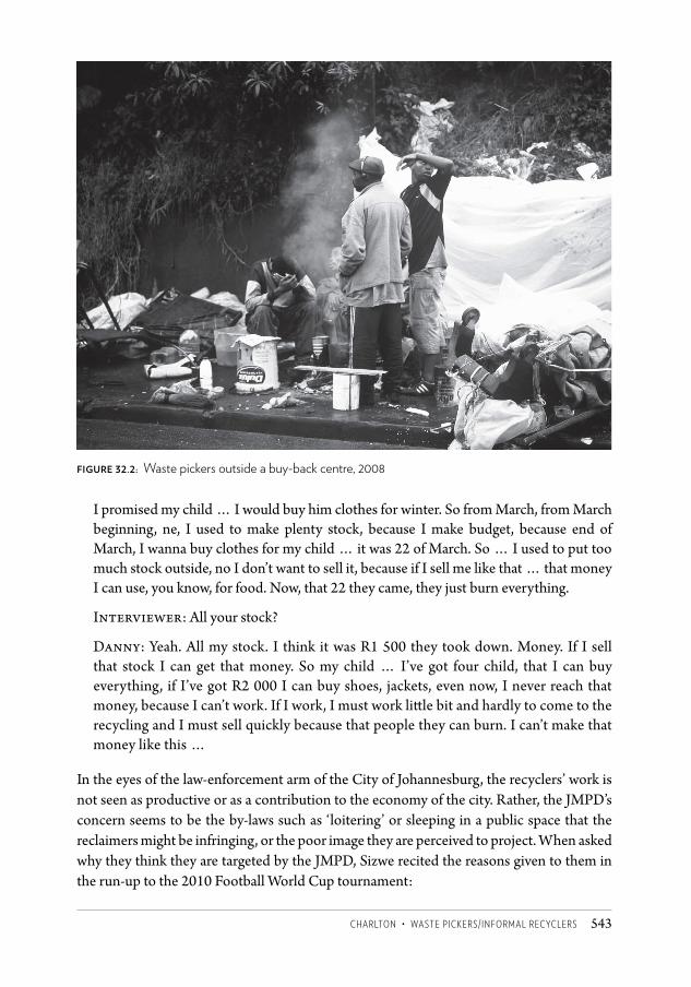
CHARLTON • WASTE PICKERS/INFORMAL RECYCLERS 543
I promised my child … I would buy him clothes for winter. So from March, from March beginning, ne, I used to make plenty stock, because I make budget, because end of March, I wanna buy clothes for my child … it was 22 of March. So … I used to put too much stock outside, no I don’t want to sell it, because if I sell me like that … that money I can use, you know, for food. Now, that 22 they came, they just burn everything.
Interviewer: All your stock?
Danny: Yeah. All my stock. I think it was R1 500 they took down. Money. If I sell that stock I can get that money. So my child … I’ve got four child, that I can buy everything, if I’ve got R2 000 I can buy shoes, jackets, even now, I never reach that money, because I can’t work. If I work, I must work little bit and hardly to come to the recycling and I must sell quickly because that people they can burn. I can’t make that money like this …
In the eyes of the law-enforcement arm of the City of Johannesburg, the recyclers’ work is not seen as productive or as a contribution to the economy of the city. Rather, the JMPD’s concern seems to be the by-laws such as ‘loitering’ or sleeping in a public space that the reclaimers might be infringing, or the poor image they are perceived to project. When asked why they think they are targeted by the JMPD, Sizwe recited the reasons given to them in the run-up to the 2010 Football World Cup tournament:
Figure 32.2: Waste pickers outside a buy-back centre, 2008
CSCC.indb 543 2014/10/07 5:21 PM
Changing SpaCe, Changing City544
We are making a mess (unclear), we are not needed here because 2010 is coming … tourists they are coming here they are going to see us suffering, so [the Metro Police] don’t want us to be seen [by] those people, that we are suffering. So they have to chase us away.
The JMPD tells them to go back ‘home’ and stay there, Sizwe says. This attitude appears to cast recyclers as synonymous with down-and-outs, vagrants and
scavengers which the city needs to rid itself of. But while they do sleep rough or informally on a regular basis, recyclers are engaged in regular, productive work involving long, strenuous working hours. This resonates with Tipple and Speak’s observation that large numbers of people who sleep on pavements, under bridges or in their pushcarts in developing countries are not ‘vagrants’ but are ‘working and productive members of society’ (Tipple and Speak 2009: 140). By contrast, visible homelessness is frequently assumed in society to be a function of personal characteristics and failings, captured in terms such as ‘villain’, ‘beggar’, ‘immoral’, ‘transient’, ‘loner’, ‘helpless’, ‘non-citizen’ (Speak and Tipple 2006).
The recyclers’ activities of scavenging through bins, their sometimes rough appearance, their makeshift trolleys and the lack of interaction typical between them and home owners, contribute perhaps to their being dismissed by some as ‘unproductive vagabonds’. Not only are they largely unsupported in their efforts – they are actively overlooked as the city leapfrogs over them in introducing recycling initiatives. The city’s separation-at-source pilot scheme, which gets households to separate waste items into different bags, partners with private truck-based companies for the collection of this waste. Sizwe comments that recyclers have been doing the hard labour of this work for years, picking through the unsorted mess of bins, but now count for ‘nothing’ in the new scheme:
We started this long time ago, [but] because we don’t have somebody to help us, then the people with their power and their money, they just come and overcome us and tell … and we are nothing, the very same people who started the job.
Informal recyclers in Johannesburg are by and large invisible to the state in their daily work of salvaging and transporting waste – omitted from the city’s ‘non-motorised transport’ policy of 2009/ 2010, for example, although hundreds of trolleys are pulled precariously through city streets every day. But in their sorting, stockpiling and sleeping arrangements, they run foul of those tasked with enforcing regulations for an ordered, regulated city – they become visible through activities in contravention or that are mismatched with the space they are practised on.
The activity in itself is not necessarily illegal or even unwanted; indeed, in a context of dramatically high unemployment, self-employment is one of the few possibilities encouraged in the abstract by the state. Self-employment that also fulfils environmental agendas should be a win-win for the individual, the buy-back companies and local government. But with the strange combination of unsupported invisibility during the day and vulnerability to sanction at night, efforts at economic growth and self-development
CSCC.indb 544 2014/10/07 5:21 PM
CHARLTON • WASTE PICKERS/INFORMAL RECYCLERS 545
falter. A spatial focus on the activity chain can help illuminate these facets of city life as well as the intersections and clashes informal recyclers have with fellow citizens, city management and the wider state.
Note1 Interview with Sizwe and Danny, informal recyclers, Newtown, 22 April 2010.
ReferencesSpeak, S and Tipple, G (2006) ‘Perceptions, persecution and pity: The limitations of
interventions for homelessness in developing countries.’ International Journal of Urban and Regional Research 30(1): 172–188.
Tipple, G and Speak, S (2009) The Hidden Millions: Homelessness in Developing Countries. London: Routledge.
CSCC.indb 545 2014/10/07 5:21 PM
contributors 567
Contributors
Peter Ahmad is the senior manager for metropolitan planning in the City of Cape Town, South Africa.
Willem Badenhorst is a spatial analyst in private practice in Pretoria .
Keith Beavon is professor emeritus of the University of the Witwatersrand in Johannesburg and of the University of Pretoria, South Africa.
Claire Bénit-Gbaffou is an associate professor at the University of the Witwatersrand’s School of Architecture and Planning in Johannesburg.
Sarah Charlton is a senior lecturer in the School of Architecture and Planning at the University of the Witwatersrand in Johannesburg and director of its Centre for Urbanism and Built Environment Studies.
Yasmeen Dinath is a researcher in the School of Architecture and Planning at the University of the Witwatersrand in Johannesburg.
Teresa Dirsuweit is an associate professor in the Department of Geography at the University of the Witwatersrand in Johannesburg.
David Everatt is the executive director of the Gauteng City-Region Observatory in Johannesburg.
Graeme Gotz is the director of research at the Gauteng City-Region Observatory in Johannesburg.
Kirsten Harrison is an independent consultant based in Johannesburg with over 15 years of experience in urban development, planning and strategy, particularly in the public sector.
Philip Harrison is the South African Research Chair in Development Planning and Modelling at the University of the Witwatersrand in Johannesburg and a member of the National Planning Commission and other advisory structures to government.
Marie Huchzermeyer is a professor in the School of Architecture and Planning at the University of the Witwatersrand in Johannesburg.
Hilton Judin is an adjunct professor at the School of Architecture and Urban Planning at the University of the Witwatersrand in Johannesburg.
Aly Karam is an associate professor in the School of Architecture and Planning as well as assistant dean for graduate affairs in the
Faculty of Engineering and Built Environment at the University of the Witwatersrand in Johannesburg.
Caroline Wanjiku Kihato is a visiting researcher in the School of Architecture and Planning at the University of the Witwatersrand in Johannesburg.
Neil Klug is a senior lecturer in the School of Architecture and Urban Planning at the University of the Witwatersrand in Johannesburg.
Christa Kuljian is a writing fellow at the Wits Institute for Social and Economic Research (WISER), University of the Witwatersrand.
Karina Landman is a senior lecturer at the University of Pretoria in South Africa.
Pauline Larsen is the senior economic development manager at the Downtown Yonge Business Improvement Area in Toronto, Canada.
Hannah le Roux is a senior lecturer at the University of the Witwatersrand in Johannesburg.
Alan Mabin is professor at the Centre for Advancement of Scholarship, University of Pretoria, South Africa.
Miriam Maina is a PhD candidate at the University of the Witwatersrand in Johannesburg.
Puleng Makhetha works in the aviation industry in Johannesburg, where her focus is to help ensure that the capacity of airports, both airside and landside, meets users’ needs.
Nqobile Malaza is a lecturer and researcher at the University of the Witwatersrand in Johannesburg.
Adrian Masson is a planning consultant in Johannesburg.
Mathetha Mokonyama is a professional engineer and a specialist researcher in transport systems and operations at the Council for Scientific and Industrial Research in Pretoria, South Africa.
Khangelani Moyo is a researcher in the School of Architecture and Planning at the University of the Witwatersrand in Johannesburg and a GCSRI-Carnegie PhD fellow.
Brian Mubiwa is a project manager at SAFIRI (Pty) Ltd and a PhD candidate in the Department of Geography, Environmental
CSCC.indb 567 2014/10/07 5:21 PM

Changing SpaCe, Changing City568
Management and Energy Studies, at the University of Johannesburg.
Yusuf Patel is a director in the developments division of Basil Read (Pty) Ltd in Johannesburg, and President of the South African Planning Institute.
Herman Pienaar is director of the City Transformation Directorate in the City of Johannesburg’s Department of Development Planning.
Naomi Roux is completing her PhD on heritage, memory and urban transformation in the Eastern Cape at the Department of Art History, Birkbeck College, London, UK.
Margot Rubin is a researcher in the School of Architecture and Planning and in the Department of Political Studies at the University of the Witwatersrand in Johannesburg.
Samadia Sadouni is an associate professor of political science at Sciences Po Lyon in France.
Rashid Seedat is the head of the Gauteng Planning Commission.
Luke Sinwell is a senior researcher at the
University of Johannesburg.Maryna Storie is a GIS executive at AECOM
(Pty) Ltd and a PhD candidate at the University of the Witwatersrand in Johannesburg.
Alison Todes is a professor of urban and regional planning in the School of Architecture and Planning at University of the Witwatersrand in Johannesburg.
Eunice Vaz is a town and regional planner with Aurecon (Pty) Ltd in Maputo, Mozambique.
Christo Venter is an associate professor in the Department of Civil Engineering at the University of Pretoria in South Africa.
Tanja Winkler is an associate professor at the University of Cape Town, South Africa.
Chris Wray is a senior systems analyst and manager at the Gauteng City-Region Observatory in Johannesburg.
Yan Yang is a consultant for the South African Cities Network.
Tanya Zack is a town-planning consultant based in Johannesburg and a visiting senior lecturer in the School of Architecture and Planning, University of the Witwatersrand.
Section divider A Courtesy Gauteng City-Region Observatory
Section divider B Courtesy City of JohannesburgSection divider C By Nerali PatelFigures 5.1–5.3 Courtesy City of JohannesburgFigures 8.4–8.6 Courtesy City of JohannesburgFigure 8.10 Courtesy City Johannesburg,
2009; roads layer from Gauteng provincial government, 2010
Figures 11.3 and 11.5 By Trisha van RhynFigure 11.4 By Philippe SchockaertFigures 13.1 and 13.3 By Claire Bénit-GbaffouFigures 13.2 and 13.4 Courtesy Yeoville Studio Figure 16.2 Courtesy Urban Dynamics Gauteng
Inc. Figure 16.3 By Hilton JudinFigure 18.9 Courtesy National Geo-spatial
Information, Department of Rural Development and Land Reform, South Africa
Figure 21.1 Courtesy National Geo-spatial Information, Department of Rural Development and Land Reform, South Africa
Figure 22.1 Background image © 2011, Google, top layer AfriGIS. Used with permission.
Figure 22.6 Courtesy Charles Block, City of Johannesburg
Figure 24.1 By Samadia SadouniFigure 26.1 By Christa KuljianFigure 27.1 By Hannah le Roux, 2012Figure 27.2 By Nerali PatelFigures 28.1–28.4 By Naomi RouxFigures 29.3 and 29.4 By Philip HarrisonFigure 31.1 and 32.2 By Puleng MakhethaFigures 32.1 and 32.2 By Graeme GotzFigure 34.1 By Mbali Mdledle (I Spy); Christian
Scriba (The Voids); Mikey Rosato (Phumeza), © Gauteng City-Region Observatory, 2013. Used with permission.
Photographic credits
CSCC 35.indd 568 2014/10/08 2:19 PM
acronyms 569
AcronymsACTSTOP Action Committee to Stop Evictions AIC African independent church ALPOA Alexandra Land and Property Owners
Association AMD acid mine drainage ANC African National CongressARP Alexandra Renewal Project BNG Breaking New Ground strategyBRT Bus Rapid Transit CBD central business districtCID city improvement districtCoJ City of Johannesburg CPTED crime prevention through
environmental design CSIR Council for Scientific and Industrial
Research CWMC Central Witwatersrand Metropolitan
Chamber DFA Development Facilitation Act DRC Democratic Republic of the Congo EMM Ekurhuleni Metropolitan Municipality FDI foreign direct investment FIRE finance, insurance, real estate and business
services sectors GCRO Gauteng City-Region ObservatoryGDS Growth and Development StrategyGIS geographic information systemsGKDP Greater Kliptown Development Project GMS Growth Management Strategy GSDF Gauteng Spatial Development FrameworkGTI GeoTerraImage GVA Gross Value Added HSRC Human Sciences Research CouncilIC independent churchIDP Integrated Development PlanITP Integrated Transport PlanJDA Johannesburg Development Agency
JMPD Johannesburg Metropolitan Police Department
JRA Johannesburg Roads AgencyKNR Klipriviersberg Nature Reserve KNRA Klipriviersberg Nature Reserve
AssociationLAC Local Area CommitteeLIS Land Information System MOEs municipal-owned enterprises MRA mine-residue areaMSDF Metropolitan Spatial Development
FrameworkMTC Metropolitan Trading Company NDPG Neighbourhood Development
Partnership Grant NUSP National Upgrading Support Programmep/h per hectare PRC People’s Republic of China PTMA Public Transport Management AreaPWV Pretoria-Witwatersrand-VereenigingRDP Reconstruction and Development
Programme RMP Rand Mines Property RSDF Regional Spatial Development
FrameworkSABCs South African born ChineseSANCO South African National Civics
Organisation SAPOA South African Property Owners
Association SDF Spatial Development FrameworkSPTN Strategic Public Transport NetworkUDB urban development boundary UISP Upgrading of Informal Settlements
ProgrammeWHW Wits History Workshop WSSD Walter Sisulu Square of Dedication
CSCC.indb 569 2014/10/07 5:21 PM
changing space, changing city570
Plate 1 Johannesburg within the Gauteng city-region
Plate 2 Key places in the city of JohannesburgPlate 3 Population distribution across the
Gauteng city-regionPlate 4 Land use in 1956Plate 5 Land use in 1974Plate 6 Urban expansion in Gauteng, 1991–2009Plate 7 Urban expansion in Johannesburg,
1991–2009Plate 8 New formal residential development in
central Gauteng per km2, 2001–2010Plate 9 Gated communities in central Gauteng,
2012Plate 10 Urban growth per km2 from 1991 to
2001 in relation to the 2002 urban edgePlate 11 Urban growth per km2 from 2001 to
2009 relative to both the 2002 (in grey) and 2010 (in blue) urban edges
Plate 12 A 2007 deprivation-index map of Johannesburg overlaid with GCRO 2011 survey data
Plate 13 A 2007 deprivation-index map of Soweto overlaid with GCRO 2011 survey data
Plate 14 Unemployment by ward, Gauteng, 2001Plate 15 Estimated uptake of social grants per
ward across Gauteng, 2010Plate 16 Incremental densification through
subdivisions, Johannesburg 2007–2011Plate 17 Densification through residential
rezoning, Johannesburg 2007–2011Plate 18 Applications for higher-density
residential buildings, Johannesburg 2007–2011Plate 19 New township development
applications, Johannesburg 2007–2011. Plate 20 Commercial and business rezoning
applications, Johannesburg 2007–2011Plate 21 Office vacancy rates, Johannesburg 2011Plate 22 Industrial building applications,
Johannesburg 2007–2011Plate 23 Property price-band shifts for 2000,
2006 and 2011Plate 24 Current and historic/previous informal
settlements, Johannesburg 2012Plate 25 Concentration of informal backyard and
transitional housing units, Johannesburg 2010Plate 26 The distribution of businesses across
Gauteng (shaded grey) and in Johannesburg (shaded black), 2010
Plate 27 Number of businesses per km2, Johannesburg, 2010
Plate 28 Number of employees per km2, Johannesburg, 2010
Plate 29 Manufacturing firms in Johannesburg, 2010Plate 30 Finance, insurance and real-estate sector
firms in Johannesburg, 2010.Plate 31 Wholesale and retail trade, catering and
accommodation firms in Johannesburg, 2010Plate 32 Construction firms in Johannesburg,
2010Plate 33 Industrial buildings by type,
Johannesburg 2010Plate 34 Commercial buildings by type,
Johannesburg 2010Plate 35 New industrial buildings, Johannesburg
2001–2010Plate 36 Disappearance of industrial buildings,
Johannesburg 2001–2010Plate 37 New commercial buildings,
Johannesburg 2001–2010Plate 38 Disappearance of commercial buildings,
Johannesburg 2001–2010Plate 39 Trips taken by residents of the Orange
Farm/Stretford area to work or to look for jobsPlate 40 Determinants of form: the physical
environment and presence of gold reefsPlate 41 Johannesburg’s ecological assets,
including grassland, trees, wetlands and flood plains
Plate 42 Settlements at risk of subsidence, Johannesburg, 2011
Plate 43 The spread of gated communities in Johannesburg, 2012
Plate 44 Different types of gated communities in relation to the Gauteng Spatial Development Framework
Plate 45 Gated communities in relation to the public transport network and its influence areas
Plate 46 Gated communities in northern Johanensburg in relation to mobility-spine influence areas
Plate 47 Johannesburg’s inner cityPlate 48 The changing urban edge in north-
western Johannesburg, 2002–2010Plate 49 Spatial trends in north-western
Johannesburg, 2000–2009Plate 50 Hillbrow’s known faith-based
organisations, 2006Plate 51 Jeppe’s flow, vertical circulation and
porosity coded in the colours of the bunna bet Plate 52 Racial distribution in Gauteng, 2001
and 2011
Plates
CSCC.indb 570 2014/10/07 5:21 PM
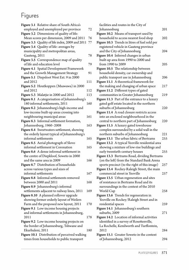
plates/figures 571
FiguresFigure 3.1 Relative share of South Africa’s
employed and unemployed per province 72Figure 3.2 Dimensions of quality of life:
Mean scores per dimension, 2009 and 2011 76Figure 3.3 Quality of life index, 2009 and 2011 77Figure 3.4 Quality of life: averages by
municipality and metropolitan areas, Gauteng, 2011 78
Figure 3.5 Correspondence map of quality of life and education level 79
Figure 4.1 Spatial Development Framework and the Growth Management Strategy 91
Figure 5.1 Diepsloot West Ext. 9 in 2000 and 2012 111
Figure 5.2 Houtkoppen (Msawawa) in 2000 and 2012 112
Figure 5.3 Malatjie in 2000 and 2012 113Figure 8.1 A categorisation of Johannesburg’s
180 informal settlements, 2011 160Figure 8.2 Johannesburg’s high-income and
low-income built-up areas crossing into neighbouring municipal areas 161
Figure 8.3 Informal settlement formation, Johannesburg, 1960–2008 163
Figure 8.4 Sweetwaters settlement, showing the orderly layout typical of Johannesburg’s informal settlements 165
Figure 8.5 Aerial photograph of Slovo informal settlement in Coronation 165
Figure 8.6 A dense informal settlement in the centre of Diepkloof, Soweto in 2000 and the same area in 2009 166
Figure 8.7 Distribution of households across various types and sizes of informal settlements 167
Figure 8.8 Informal settlements removed between 2000 and 2011 168
Figure 8.9 Johannesburg’s informal settlements adjacent to railway lines, 2011 169
Figure 8.10 A planned rollover upgrade showing former orderly layout of Weilers Farm and the proposed new layout, 2011 170
Figure 9.1 Low-income housing projects and informal settlements in Johannesburg, 2011 178
Figure 9.2 Low-income housing projects on the border of Johannesburg, Tshwane and Ekurhuleni, 2011 180
Figure 10.1 Distribution of perceived walking times from households to public transport
facilities and routes in the City of Johannesburg 201
Figure 10.2 Means of transport used by household to access nearest food shop 202
Figure 10.3 Trends in litres of fuel sold per registered vehicle in Gauteng province and the City of Johannesburg 204
Figure 10.4 Inferred changes in urban built-up area from 1990 to 2000 and from 1990 to 2009 205
Figure 10.5 The relationship between household density, car ownership and public transport use in Johannesburg 206
Figure 11.1 A theoretical framework for the making and changing of urban space 217
Figure 11.2 Different types of gated communities in Greater Johannesburg 219
Figure 11.3 Part of the entrance to a luxury gated golf estate located in the northern suburbs of Johannesburg 220
Figure 11.4 A road closure restricts access into an enclosed neighbourhood in the central to northern part of Johannesburg 220
Figure 11.5 A luxury gated townhouse complex surrounded by a solid wall in the northern suburbs of Johannesburg 221
Figure 13.1 The urban fabric of Bertrams 255Figure 13.2 A typical Yeoville residential area
showing a mixture of low-rise buildings and early twentieth-century houses 255
Figure 13.3 Bertrams Road, dividing Bertrams (on the left) from the Standard Bank Arena sports precinct (to the right of this image) 257
Figure 13.4 Rockey-Raleigh Street, the main commercial street in Yeoville 257
Figure 13.5 Urban regeneration and sites of resistance in Bertrams Road and its surroundings in the context of the 2010 World Cup 258
Figure 13.6 Trends for regeneration in Yeoville on Rockey/Raleigh Street and in residential spaces 259
Figure 14.1 Johannesburg’s southern suburbs, 2009 271
Figure 14.2 Location of informal activities identified in a survey of Rosettenville, La Rochelle, Kenilworth and Turffontein, 2012 284
Figure 15.1 Greater Soweto in the context of Johannesburg, 2012 294
CSCC.indb 571 2014/10/07 5:21 PM
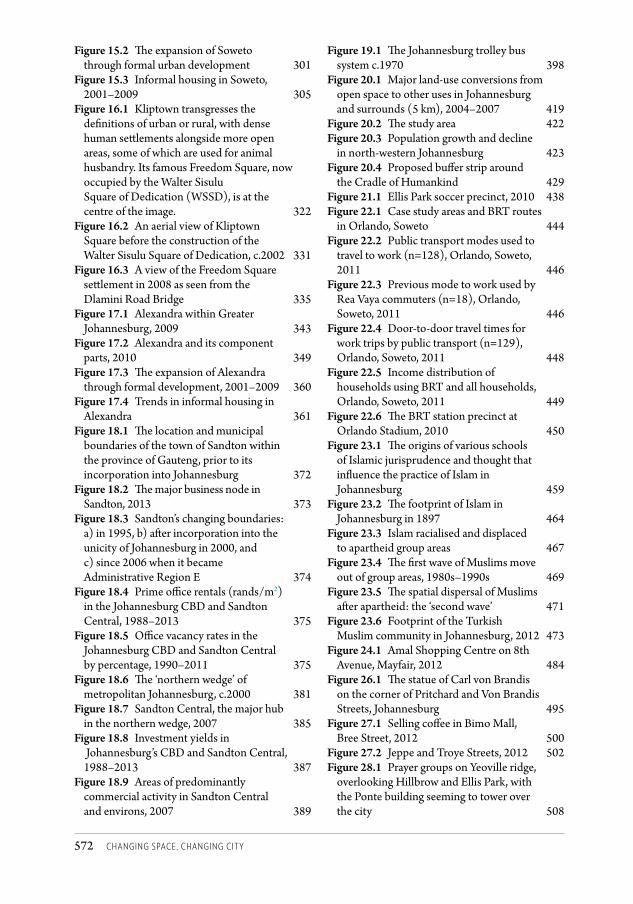
changing space, changing city572
Figure 15.2 The expansion of Soweto through formal urban development 301
Figure 15.3 Informal housing in Soweto, 2001–2009 305
Figure 16.1 Kliptown transgresses the definitions of urban or rural, with dense human settlements alongside more open areas, some of which are used for animal husbandry. Its famous Freedom Square, now occupied by the Walter Sisulu Square of Dedication (WSSD), is at the centre of the image. 322
Figure 16.2 An aerial view of Kliptown Square before the construction of the Walter Sisulu Square of Dedication, c.2002 331
Figure 16.3 A view of the Freedom Square settlement in 2008 as seen from the Dlamini Road Bridge 335
Figure 17.1 Alexandra within Greater Johannesburg, 2009 343
Figure 17.2 Alexandra and its component parts, 2010 349
Figure 17.3 The expansion of Alexandra through formal development, 2001–2009 360
Figure 17.4 Trends in informal housing in Alexandra 361
Figure 18.1 The location and municipal boundaries of the town of Sandton within the province of Gauteng, prior to its incorporation into Johannesburg 372
Figure 18.2 The major business node in Sandton, 2013 373
Figure 18.3 Sandton’s changing boundaries: a) in 1995, b) after incorporation into the unicity of Johannesburg in 2000, and c) since 2006 when it became Administrative Region E 374
Figure 18.4 Prime office rentals (rands/m2) in the Johannesburg CBD and Sandton Central, 1988–2013 375
Figure 18.5 Office vacancy rates in the Johannesburg CBD and Sandton Central by percentage, 1990–2011 375
Figure 18.6 The ‘northern wedge’ of metropolitan Johannesburg, c.2000 381
Figure 18.7 Sandton Central, the major hub in the northern wedge, 2007 385
Figure 18.8 Investment yields in Johannesburg’s CBD and Sandton Central, 1988–2013 387
Figure 18.9 Areas of predominantly commercial activity in Sandton Central and environs, 2007 389
Figure 19.1 The Johannesburg trolley bus system c.1970 398
Figure 20.1 Major land-use conversions from open space to other uses in Johannesburg and surrounds (5 km), 2004–2007 419
Figure 20.2 The study area 422Figure 20.3 Population growth and decline
in north-western Johannesburg 423Figure 20.4 Proposed buffer strip around
the Cradle of Humankind 429Figure 21.1 Ellis Park soccer precinct, 2010 438Figure 22.1 Case study areas and BRT routes
in Orlando, Soweto 444Figure 22.2 Public transport modes used to
travel to work (n=128), Orlando, Soweto, 2011 446
Figure 22.3 Previous mode to work used by Rea Vaya commuters (n=18), Orlando, Soweto, 2011 446
Figure 22.4 Door-to-door travel times for work trips by public transport (n=129), Orlando, Soweto, 2011 448
Figure 22.5 Income distribution of households using BRT and all households, Orlando, Soweto, 2011 449
Figure 22.6 The BRT station precinct at Orlando Stadium, 2010 450
Figure 23.1 The origins of various schools of Islamic jurisprudence and thought that influence the practice of Islam in Johannesburg 459
Figure 23.2 The footprint of Islam in Johannesburg in 1897 464
Figure 23.3 Islam racialised and displaced to apartheid group areas 467
Figure 23.4 The first wave of Muslims move out of group areas, 1980s–1990s 469
Figure 23.5 The spatial dispersal of Muslims after apartheid: the ‘second wave’ 471
Figure 23.6 Footprint of the Turkish Muslim community in Johannesburg, 2012 473
Figure 24.1 Amal Shopping Centre on 8th Avenue, Mayfair, 2012 484
Figure 26.1 The statue of Carl von Brandis on the corner of Pritchard and Von Brandis Streets, Johannesburg 495
Figure 27.1 Selling coffee in Bimo Mall, Bree Street, 2012 500
Figure 27.2 Jeppe and Troye Streets, 2012 502Figure 28.1 Prayer groups on Yeoville ridge,
overlooking Hillbrow and Ellis Park, with the Ponte building seeming to tower over the city 508
CSCC.indb 572 2014/10/07 5:21 PM
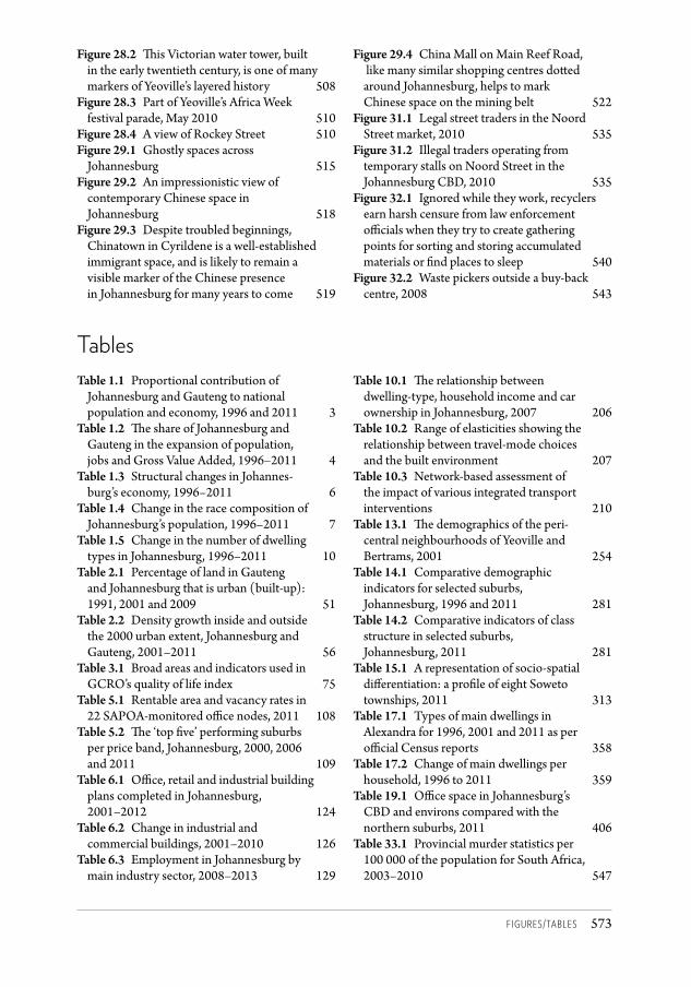
figures/tables 573
Figure 28.2 This Victorian water tower, built in the early twentieth century, is one of many markers of Yeoville’s layered history 508
Figure 28.3 Part of Yeoville’s Africa Week festival parade, May 2010 510
Figure 28.4 A view of Rockey Street 510Figure 29.1 Ghostly spaces across
Johannesburg 515Figure 29.2 An impressionistic view of
contemporary Chinese space in Johannesburg 518
Figure 29.3 Despite troubled beginnings, Chinatown in Cyrildene is a well-established immigrant space, and is likely to remain a visible marker of the Chinese presence in Johannesburg for many years to come 519
Figure 29.4 China Mall on Main Reef Road, like many similar shopping centres dotted around Johannesburg, helps to mark Chinese space on the mining belt 522
Figure 31.1 Legal street traders in the Noord Street market, 2010 535
Figure 31.2 Illegal traders operating from temporary stalls on Noord Street in the Johannesburg CBD, 2010 535
Figure 32.1 Ignored while they work, recyclers earn harsh censure from law enforcement officials when they try to create gathering points for sorting and storing accumulated materials or find places to sleep 540
Figure 32.2 Waste pickers outside a buy-back centre, 2008 543
TablesTable 1.1 Proportional contribution of
Johannesburg and Gauteng to national population and economy, 1996 and 2011 3
Table 1.2 The share of Johannesburg and Gauteng in the expansion of population, jobs and Gross Value Added, 1996–2011 4
Table 1.3 Structural changes in Johannes- burg’s economy, 1996–2011 6
Table 1.4 Change in the race composition of Johannesburg’s population, 1996–2011 7
Table 1.5 Change in the number of dwelling types in Johannesburg, 1996–2011 10
Table 2.1 Percentage of land in Gauteng and Johannesburg that is urban (built-up): 1991, 2001 and 2009 51
Table 2.2 Density growth inside and outside the 2000 urban extent, Johannesburg and Gauteng, 2001–2011 56
Table 3.1 Broad areas and indicators used in GCRO’s quality of life index 75
Table 5.1 Rentable area and vacancy rates in 22 SAPOA-monitored office nodes, 2011 108
Table 5.2 The ‘top five’ performing suburbs per price band, Johannesburg, 2000, 2006 and 2011 109
Table 6.1 Office, retail and industrial building plans completed in Johannesburg, 2001–2012 124
Table 6.2 Change in industrial and commercial buildings, 2001–2010 126
Table 6.3 Employment in Johannesburg by main industry sector, 2008–2013 129
Table 10.1 The relationship between dwelling-type, household income and car ownership in Johannesburg, 2007 206
Table 10.2 Range of elasticities showing the relationship between travel-mode choices and the built environment 207
Table 10.3 Network-based assessment of the impact of various integrated transport interventions 210
Table 13.1 The demographics of the peri- central neighbourhoods of Yeoville and Bertrams, 2001 254
Table 14.1 Comparative demographic indicators for selected suburbs, Johannesburg, 1996 and 2011 281
Table 14.2 Comparative indicators of class structure in selected suburbs, Johannesburg, 2011 281
Table 15.1 A representation of socio-spatial differentiation: a profile of eight Soweto townships, 2011 313
Table 17.1 Types of main dwellings in Alexandra for 1996, 2001 and 2011 as per official Census reports 358
Table 17.2 Change of main dwellings per household, 1996 to 2011 359
Table 19.1 Office space in Johannesburg’s CBD and environs compared with the northern suburbs, 2011 406
Table 33.1 Provincial murder statistics per 100 000 of the population for South Africa, 2003–2010 547
CSCC.indb 573 2014/10/07 5:21 PM