Called in Decision: Land at Silverthorne Lane ... - GOV.UK
311
Department for Levelling Up, Housing & Communities Mike Hale, Decision Officer Planning Casework Unit 3rd Floor Fry Building 2 Marsham Street London SW1P 4DF Tel: 0303 444 5374 Email: [email protected] Craig O’Brien Savills Embassy House Queens Avenue Bristol BS8 1SB Our ref: APP/Z0116/V/20/3264641 and 3264642 Your ref: 19/03867/P and 19/03868/LA 13 April 2022 Dear Sir TOWN AND COUNTRY PLANNING ACT 1990 – SECTION 77 APPLICATION MADE BY FEEDER ESTATES LLP LAND AT SILVERTHORNE LANE, SILVERTHORNE LANE, BRISTOL, BS2 0QD APPLICATION REF: 19/03867/P AND 19/03838/LA This decision was made by the Minister of State for Housing, Stuart Andrew MP, on behalf of the Secretary of State 1. I am directed by the Secretary of State to say that consideration has been given to the report of Zoё H R Hill BA(Hons) DipBldgCons(RICS) MRTPI IHBC, who held a public local inquiry which opened 11 May 2021 into your client’s application for: • planning permission for: the phased development of site wide remediation including demolition, outline planning permission with all matters reserved aside from access for up to 23,543m² GIA of floorspace to include offices (B1a), research and development (B1b), non-residential institution (D1) and up to 350m² GIA of floorspace for cafe (A3) (PLOT 1), erection of buildings (full details) to provide up to 367 dwelling houses (C3), offices (B1a), restaurants and cafés (A3) (PLOTS 2 & 3), redevelopment of ‘The Erecting Sheds’ (full details) to provide offices (B1a) (PLOT 4), erection of buildings and redevelopment of ‘The Boiler Shop’ (full details) to provide a 1,600 pupil secondary school (D1) (PLOT 5), erection of buildings (full details) to provide up to 841 student units (Sui generis) (PLOT 6), associated works and infrastructure, in accordance with application Ref. 19/03867/P, dated 7 August 2019 and; • listed building consent for: Plot 1 - Removal of the Shed 4 western gable wall; Plot 2 - Removal of Shed 4 (excluding wall to canal); Plot 2 -Insertion of opening into the boundary wall and lowering/removal of material; Plot 3 - Removal of Shed 3; Plot 3 -Removal of Sheds 2a-c; Plot 4 - Insertion of pedestrian access opening into the northern boundary wall of Shed 1 b; Plot 4 - Alterations to the south wall of Shed 1b/north wall of Shed 2b; Plot 4 - Restoration/rebuild of Shed 1a; Plot 5 - Reduction in height of the walls attached to the North Gateway; Plot 5 - Removal of western Hammer Forge wall; reduction in height of northern Hammer Forge Wall; demolition and rebuild of eastern Hammer Forge wall; Plot 5 - Works to the
-
Upload
khangminh22 -
Category
Documents
-
view
1 -
download
0
Transcript of Called in Decision: Land at Silverthorne Lane ... - GOV.UK

Department for Levelling Up, Housing & Communities Mike Hale, Decision Officer Planning Casework Unit 3rd Floor Fry Building 2 Marsham Street London SW1P 4DF
Tel: 0303 444 5374 Email: [email protected]
Craig O’Brien Savills Embassy House Queens Avenue Bristol BS8 1SB
Our ref: APP/Z0116/V/20/3264641 and 3264642 Your ref: 19/03867/P and 19/03868/LA
13 April 2022
Dear Sir TOWN AND COUNTRY PLANNING ACT 1990 – SECTION 77 APPLICATION MADE BY FEEDER ESTATES LLP LAND AT SILVERTHORNE LANE, SILVERTHORNE LANE, BRISTOL, BS2 0QD APPLICATION REF: 19/03867/P AND 19/03838/LA This decision was made by the Minister of State for Housing, Stuart Andrew MP, on behalf of the Secretary of State
1. I am directed by the Secretary of State to say that consideration has been given to the report of Zoё H R Hill BA(Hons) DipBldgCons(RICS) MRTPI IHBC, who held a public local inquiry which opened 11 May 2021 into your client’s application for:
• planning permission for: the phased development of site wide remediation including demolition, outline planning permission with all matters reserved aside from access for up to 23,543m² GIA of floorspace to include offices (B1a), research and development (B1b), non-residential institution (D1) and up to 350m² GIA of floorspace for cafe (A3) (PLOT 1), erection of buildings (full details) to provide up to 367 dwelling houses (C3), offices (B1a), restaurants and cafés (A3) (PLOTS 2 & 3), redevelopment of ‘The Erecting Sheds’ (full details) to provide offices (B1a) (PLOT 4), erection of buildings and redevelopment of ‘The Boiler Shop’ (full details) to provide a 1,600 pupil secondary school (D1) (PLOT 5), erection of buildings (full details) to provide up to 841 student units (Sui generis) (PLOT 6), associated works and infrastructure, in accordance with application Ref. 19/03867/P, dated 7 August 2019 and;
• listed building consent for: Plot 1 - Removal of the Shed 4 western gable wall; Plot 2 - Removal of Shed 4 (excluding wall to canal); Plot 2 -Insertion of opening into the boundary wall and lowering/removal of material; Plot 3 - Removal of Shed 3; Plot 3 -Removal of Sheds 2a-c; Plot 4 - Insertion of pedestrian access opening into the northern boundary wall of Shed 1 b; Plot 4 - Alterations to the south wall of Shed 1b/north wall of Shed 2b; Plot 4 - Restoration/rebuild of Shed 1a; Plot 5 - Reduction in height of the walls attached to the North Gateway; Plot 5 - Removal of western Hammer Forge wall; reduction in height of northern Hammer Forge Wall; demolition and rebuild of eastern Hammer Forge wall; Plot 5 - Works to the

2
Boiler Shop. Including new openings in the western gable end; replacement of asbestos cement roof; removal of post-war cladding and glazing between piers; internal works including new floor level; Plots 2-5 - Potential stabilisation engineering works to the early 19th century Feeder Canal rubblestone wall, in accordance with application Ref. 19/03868/LA, dated 7 August 2019
2. On 7 December 2020, the Secretary of State directed, in pursuance of Section 77 of the Town and Country Planning Act 1990, that your client’s application be referred to him instead of being dealt with by the local planning authority.
Inspector’s recommendation and summary of the decision
3. The Inspector recommended that the applications be allowed.
4. For the reasons given below, the Secretary of State agrees with the Inspector’s conclusions, except where stated, and agrees with her recommendation. He has decided to grant planning permission and listed building consent. A copy of the Inspector’s report (IR) is enclosed. All references to paragraph numbers, unless otherwise stated, are to that report.
Procedural matters
5. The Inspector identifies a number of procedural matters at IR1-8. During the application process a number of amendments were made to the proposals as detailed at IR3 and minor changes put forward once the scheme had been called in and during inquiry (IR4) with the full revised Description of Development at IR816. The Secretary of State agrees there would be no prejudice arising from them being considered as part of the scheme at this stage (IR3-4). Since the close of the Inquiry, the Framework was updated on 20 July 2021 (IR7); and the Environment Agency (EA) Guidance on Climate Change Allowances changed (Nov 2021) (IR8). However, the Secretary of State notes that some of these matters at IR1-8 were before the inquiry and considers that those arising since do not raise any matters that would require him to refer back to the parties for further representations prior to reaching his decision on these applications. He is therefore satisfied that no interests have thereby been prejudiced.
Matters arising since the close of the inquiry
6. On 24 March 2022, the Secretary of State wrote to the main parties to afford them an opportunity to comment on a recent appeal decision relating to 10 and 12-16 Feeder Road and 6-8 Albert Road, St Philip’s Bristol, dated 9 March 2022 (Appeal Reference: APP/Z0116/W/21/3279920) and the proposed Deed of Easement on behalf of the occupiers of the residential development on Plots 2 and 3 in favour of Motion Night Club (or any other night club or music venue operating from 74-78 Avon Street) as detailed at IR667-669. A list of representations received in response to this letter is at Annex A. These representations were circulated to the main parties on 7 April 2022.
7. The applicant and Local Planning Authority both consider that the above appeal decision is material to the Secretary of State’s consideration and supports their respective cases on the key flooding issues. In contrast, in its response the EA do not consider that support may be drawn in favour of the proposal on those issues and emphasise the differing circumstances and development proposed in doing so.
8. The applicant confirmed that a Deed of Easement has not been produced at the present time as the proposed conditions require the submission and approval of further noise

3
surveys which would need to be reflected in the subsequent Deed of Easement. The applicant considers that it is necessary to deal with the matter by way of a condition and agrees the proposed revised pre-commencement condition. The Local Planning Authority would have no objection to either condition relating to the Deed of Easement.
9. These documents and the resulting representations have all been taken into account by the Secretary of State in reaching this decision.
10. The Secretary of State also received a number of representations on the applications following the close of the inquiry. The Secretary of State is satisfied that the issues raised do not affect his decision, and no other new issues were raised in this correspondence to warrant further investigation or necessitate additional referrals back to parties. A separate list of representations which have been received since the inquiry is also at Annex A. Copies of these letters may be obtained on request to the email address at the foot of the first page of this letter.
Policy and statutory considerations
11. In reaching his decision, the Secretary of State has had regard to section 38(6) of the Planning and Compulsory Purchase Act 2004 which requires that proposals be determined in accordance with the development plan unless material considerations indicate otherwise.
12. In this case the development plan consists of Bristol Core Strategy (2011), Site Allocations and Development Management Plan (2014) and Bristol Central Area Plan (March 2015). The Secretary of State considers that relevant development plan policies include those set out at IR23-32.
13. Other material considerations which the Secretary of State has taken into account include the National Planning Policy Framework (‘the Framework’) and associated planning guidance (‘the Guidance’), as well as the Bristol Avon Flood Strategy (BAFS): Strategic Outline Case Technical Document; Environment Agency Guidance: Flood Risk Assessment: Climate Change Allowances; the Adept and Environment Agency – Flood risk emergency plans for new development and the Bristol City Council Adopted Silverthorne Lane Conservation Area Character Appraisal (2021).
14. In accordance with section 66(1) of the Planning (Listed Buildings and Conservation Areas) Act 1990 (the LBCA Act), the Secretary of State has paid special regard to the desirability of preserving those listed buildings potentially affected by the proposals, or their settings or any features of special architectural or historic interest which they may possess.
15. In accordance with section 72(1) of the Planning (Listed Buildings and Conservation Areas) Act 1990 (the LBCA Act), the Secretary of State has paid special attention to the desirability of preserving or enhancing the character or appearance of conservation areas.
Emerging plan
16. The emerging plan comprises the emerging Bristol Local Plan Review Draft Policies and Development Allocations Document (LPR) and the emerging West of England Combined

4
Authority Spatial Development Strategy (SDS). Consultation on ‘Issues and Options’ for the LPR is anticipated by Summer 2022.
17. Paragraph 48 of the Framework states that decision makers may give weight to relevant policies in emerging plans according to: (1) the stage of preparation of the emerging plan; (2) the extent to which there are unresolved objections to relevant policies in the emerging plan; and (3) the degree of consistency of relevant policies to the policies in the Framework. The Secretary of State considers that the emerging policies of most relevance to this case include the draft LPR Policy DS2 (Bristol Temple Quarter), however given the early stage of preparation of both documents he considers that the emerging plan carries very little weight.
Main issues
18. The Secretary of State agrees that the main considerations are those set out by the Inspector at IR682.
Flooding
19. For the reasons given at IR683, the Secretary of State agrees that the Sequential Test does not need to be addressed. For the reasons given at IR684-688, the Secretary of State agrees that whilst it is a positive objective, reduction in flood risk overall is not a realistic objective for this site having in mind its constraints; he further agrees that the main crux of the matter is whether the development will be safe for its lifetime taking account of the vulnerability of its users (IR686).
Design Life, Design Flood Level (DFL), and Freeboard
20. The Secretary of State agrees with the Inspector’s approach to these matters as set out at IR691-692, 693-700 and 701-702 respectively.
Modelled Impacts
21. The Secretary of State notes the Inspector’s analysis on modelled impacts at IR703-704 and is mindful that the scenarios are considered on the basis that there is no additional flood protection in place from the BAFS – thus it is essentially whether the development in isolation would be safe.
22. The Secretary of State agrees that as Plot 1 is in outline only it will require an FRA (Flood Risk Assessment) at reserved matters stage and notes that the DAS (Design and Access Statement) is clear that there would be access to the high level walkway and the podium level is proposed to be set at 10.8m AOD or higher, and this will be secured by condition. For the reasons given at IR705, the Secretary of State agrees that there is no reason that the exception test would not be met for this plot.
23. The Secretary of State notes that for Plots 2 and 3, as detailed at IR706-708, all dwellings are designed to be above the flood level in the modelled extreme event and although there would be areas of water inundation, these would be the lower ground levels car park, office uses, and the stairs/lifts to the residential lobby which are on the podium. For the reasons given at IR706-708, the Secretary of State agrees that the lower lift/stairs area, if flooded, would not conflict with the ability for the actual residential areas to remain safe as a refuge area or provide access to the high level walkway and therefore on balance this would be acceptable in flood risk safety terms. The Secretary of State

5
further agrees that as a result of the proposed design the exception test would be passed for these plots (IR708).
24. The Secretary of State notes the proposed lower level car parking on Plot 1 and 2 would be below the DFL and that this would be protected by flood barriers in the event of a flood. For reasons given at IR709, he agrees with the Inspector that in this case, the practicalities are such that the ‘less vulnerable’ attributed to integral car parking in Annex 3 to the Framework could apply readily as it would to free standing car parking.
25. For the reasons given at IR710-713, the Secretary of State therefore agrees with the Inspector that the approach taken to the listed building on Plot 4 reflects its end users who would be less vulnerable and that they would not be required on site during a flood event (IR713). He further agrees with the Inspector that the exception test would be met and that the fact that this is a listed building with statutory protection and one which has an extant use further supports this element of the scheme (IR713).
26. For the reasons given at IR714-718, the Secretary of State agrees with the Inspector that the new school development could be made safe through the implementation of a robust flood response plan (IR717) and that the exception test would be met for the new school building (IR718). The Secretary of State notes that the sports hall would be developed through conversion of a Grade II listed building which limits the uses it is suited to and works it can sustain without harming its heritage value (IR716). The Secretary of State agrees that whilst the evacuation process takes a pragmatic and reasoned approach, it is difficult to conclude that the exception test, as written, would be met in full because of the issues around the absence of safe dry access in DFL for the sports hall (IR718). He further agrees that, in practical terms, and noting the tidally influenced nature of the flooding which would be likely to be predictable and of short duration, the safety concerns would be very limited, restricted to the heritage building alone and to an unlikely possibility of failed evacuation and that even in such circumstances the proposed internal mezzanine would provide a safe place of refuge (IR718).
27. The Secretary of State notes that the MUGAs (Multi-Use Games Areas) would, in events approaching the DFL, be covered to a significant depth with potentially fast-moving water and anyone exposed to these areas would be at significant risk (IR718). However, like the Inspector he considers this acceptable given also that the lower level of the MUGAs was necessary and a response to consultation with the EA regarding flood storage and that Flood Risk or Emergency Plans could provide for a controlled approach to prevent access to these areas in the run up to any event (both also IR718).
28. For the reasons given at IR719, the Secretary of State agrees with the Inspector that the exception test would be passed for Plot 6.
Access/Egress and the High Level Walkway
29. The Secretary of State notes that a key flood design feature is the proposed high level walkway (IR720) which would be set at a minimum of 10.35m AOD for its whole length which would be above the Higher Central (HC) DFL of 10.17m AOD (IR721). For the reasons given at IR720-725, and not withstanding that the EA says pedestrian routes should not be subject to any combination of depth and velocity that would result in a flood hazard rating of 0.75 (danger for some) or greater, the Secretary of State notes that in the event the DFL was exceeded there would only be a modest depth of water to walk through and the velocity of this water would be low (IR722). He therefore agrees with the Inspector that on balance and considering the likelihood, and length of such an

6
occurrence and the likelihood of the walkway needing to be used, along with the additional measures proposed to prevent debris, that overall it can be regarded as an acceptably safe walkway (IR725).
Voids
30. The Secretary of State notes that voids are proposed under the school on Plot 5 (IR729) and that the EA maintained fundamental concerns with the proposed use of voids for flood storage (IR728 and IR551). For the reasons given at IR726-729, the Secretary of State agrees with the Inspector that the use of the voids can be managed and maintained and controlled by condition and that it is not justified to resist the development on the basis that it would materially increase flood risk elsewhere.
Flood Prediction and Warning
31. For the reasons given at IR730, the Secretary of State agrees that for residential uses the design addresses flood risk, and better prediction and warning would assist for the managed uses, that is the school and employment uses (IR730).
Evacuation or Closure
32. For the reasons given at IR731-734, the Secretary of State agrees that it is a result of the need for regeneration and incorporation of the heritage structures, that robust procedures to allow for evacuations or closure of the offices and school, based on flood warnings, would also be required for extreme scenarios (IR733). He further agrees with the Inspector that whilst a precautionary approach should be taken and evacuation/closure procedures should be produced and be kept up-to-date, the scheme is not justified on the basis of those procedures as a matter of course, rather they are an additional mechanism to support safety associated with retention of key heritage assets (IR734).
Access for the Emergency Services
33. The Secretary of State notes for the reasons given at IR735-738, that access for emergency services to the site would be via the Silverthorne Lane tunnel (IR736) and that a floodgate is proposed as part of the scheme at the east end of Silverthorne Lane (IR737). He agrees with the Inspector that even in a Upper End (UE) event the emergency services (ambulances and fire appliances) can get to the boundary of the site with the exception of Plot 4 (IR738), and further notes that a parking point is provided for such vehicles above UE plus freeboard (10.96 AOD) and all residential buildings could be reached.
Residual Risks
34. For the reasons given at IR739-740, the Secretary of State agrees with the Inspector and taking the DFL based on HC and with sensitivity testing at UE, considers that the scheme can be made as safe as practicable (IR739). He also agrees that the risks above that DFL for those using the high level walkway and other access/egress routes are minimal, and has taken into account that there would also be risks in a flood event from standing water on site, such as the MUGAs (IR739). The Secretary of State agrees that the risk of it not being possible to evacuate the buildings in a design flood would be highly unlikely because it would represent an extreme event with no or very limited warning, and further agrees that, even in such circumstances, safe refuge would be provided within every internal space, and, being predominantly tidal, the nature of flooding is predicted to be a relatively short duration event (IR739). The Secretary of State further agrees that the

7
likelihood of such an extreme event, with no flood warning coinciding with peak flooding during the school day, where school staff, despite being aware of advancing flood risk, kept children in the hall, is highly unlikely and, in any event, there would be a place of refuge (IR740). Overall, the Secretary of State agrees that the residual risk is a level of risk which can be accepted for events above DFL (IR740).
Bristol Avon Flood Strategy (BAFS)
35. For the reasons given at IR741-744, the Secretary of State agrees that there is no doubt that the BAFS will be key to protecting Bristol from Flood risk events in the future (IR741), but that the lack of progress with the BAFS does not of itself justify resisting this proposed development (IR744).
Conclusions on Flood Risk
36. For the reasons given at IR745-750, the Secretary of State agrees that the planned approaches to development on Plots 1-4 and 6 are fully in accord (IR745) with the Framework requirement that the development is safe for its lifetime taking account of the vulnerability of its users, without increasing flood risk elsewhere (Paragraph 164 of the Framework). He further agrees that in terms of Plot 5, the extent of risk, or element that would not be ‘safe’ for the lifetime of the development, could be managed rendering the extent of that risk to be negligible (IR746).
37. The Secretary of State notes that Development Plan Policy BCS16 does not consider evacuation, an active form of management, to be a factor in achieving acceptable flood design (IR748). However and, in agreement with the Inspector, the Secretary of State does not concur with the EA that that the failure to strictly adhere to this part of the Framework or the failure to strictly adhere to the prescriptive wording within Policy BSC16 is necessarily determinative (IR749). Based on the wider sustainability benefits set out at paragraphs 62 to 64 below, the Secretary of State considers Part (a) of the Exception Test is satisfied. The Secretary of State considers that for all aspects of the development except for the sports hall, part (b) of the Exception Test is passed. While he does not consider that the sports hall strictly adheres to the Framework or Local Plan flood policy, for the reasons given in paragraphs 26, 34 and 36 above, he does not consider that this should be determinative in this case.
Heritage
38. As set out at IR751-753, the Secretary of State notes that since the Council’s committee meeting at which this proposal was considered, the Silverthorne Lane Conservation Area has been designated such that this also forms a matter for consideration (IR752). He further notes the summary of significance provided by the Victorian Society as set out at IR753.
The Listed Buildings on the Site and the effect on their Settings
39. The Secretary of State agrees with the Inspector’s analysis on the impact of the proposal on the Boiler Shop including The Hammer Forge Walls at IR755-757, and for the reasons given there agrees with the Inspector at IR756 that the retention of the Boiler Shop is a heritage benefit of the scheme which attracts significant positive weight in the heritage balance. He further agrees with the Inspector at IR757, that the Hammer Forge would be further diminished as a consequence of the proposals, which would result in a reduction in the historic interest and significance as a result of this part of the works. He agrees that

8
this is a modest negative factor within the scheme but that such harm is below that level where it might be considered to reach or broach the line between less than substantial and substantial harm in terms of the Framework (IR757).
40. For the reasons given at IR758-759, the Secretary of State agrees that, with respect to the Eastern Gateway and the remnant internal wall, even though the rebuild would utilise existing material and provide a clearer view of the Boiler Shed façade, historic fabric would be removed and realignment made (IR758) which should be accounted as a harm, though modest. He further agrees with the Inspector with respect to the remnant of a boundary wall within the site associated with the alignment of the Boiler Shop/Shed 1b curtilage at IR759 that the reduction in the height of this wall would have a negligible impact.
41. For the reasons given at IR760, the Secretary of State notes that the proposed development would see Shed 1a, which has been severely damaged, retained and converted into offices and agrees that this is a clear and significant heritage benefit of the proposed scheme.
42. For the reasons given at IR761-762, the Secretary of State agrees that the works to the SW Gateway and attached wall would constitute modest harm and count against the proposal.
43. The Secretary of State notes that the scheme includes a skeletal form of Sheds 2a-c but for the reasons given at IR763, agrees that modest heritage harm would arise from their loss. For the reasons given at IR764, he further agrees that the removal of the corrugated building to the north of Shed 2b would be of negligible harm.
44. The Secretary of State agrees with the Inspector’s analysis with respect to Shed 3 at IR765 and for the reasons given there agrees that, whilst HE (Heritage England) raised no objection, its demolition would nevertheless cause heritage harm albeit that the key features of the Feeder Canal wall would be retained. He agrees that modest harm would arise from the demolition (IR765).
45. For the reasons given at IR766-767, the Secretary of State agrees with the Inspector that some modest harm would come from the loss of Shed 4 (IR766).
46. The Secretary of State agrees with the Inspector’s analysis with respect to the Northern Gateway and Attached Walls incorporating Shed 1b at IR768-772 and for the reasons given there agrees that the reconstruction of Shed 1b, retaining the historic fabric, is a positive aspect of the scheme.
47. For the reasons given at IR773-774, the Secretary of State agrees that the Feeder Canal Walls are a significant feature of the heritage of the site dating from its earliest phases (IR773) and the scheme would enable public access along this route, improving the opportunity to observe and appreciate this part of the heritage asset. He agrees that this is a positive aspect of the proposed development which forms part of the heritage balance.
48. For the reasons given at IR775, the Secretary of State agrees with the Inspector that the removal of the 1950s building to east of Shed 3 would have a limited impact on the historic interest of this site and so at most is a very modest degree of harm to weigh in the heritage balance.
Non-designated Heritage Assets on Site

9
49. The Secretary of State notes the Inspector’s analysis of the non-designated Heritage Assets on site at IR776. He also agrees for the reasons given there that the former Purifier House is of low heritage value and like the Inspector does not attach significant weight to its removal as part of the scheme. He further agrees that the stretch of the Acraman’s Works rubblestone canal side walls are of historic interest in terms of the early development of the site and as they would be retained, and improved access would be provided he also agrees that some benefit would arise to this non-designated asset as part of the proposals (IR776). The Secretary of State further agrees that the effect on non-designated heritage assets can be judged as neutral in the heritage balance (IR776).
The effect on the Setting of Listed Buildings outwith the Site
50. The Secretary of State has considered the Inspector’s analysis of the effect on St Vincent’s Works offices (Grade II*) at IR777-779 and for the reasons given there agrees that whilst the offices would not be altered there would be change to the setting of this listed building, particularly in terms of changes to the grain of development in the wider complex, and the massing and height of the proposed development (IR779). He agrees with the Inspector that this would constitute modest harm that needs to be weighed in the heritage balance.
51. For the reasons given at IR780, the Secretary of State agrees with the Inspector that there would be some effect upon parts of the wall attached to the SW Gateway (Grade II) and the small gatehouse building by virtue of lowering of the boundary wall of which this wall forms part. He further agrees that the loss of this historic fabric would lead to some heritage harm, in terms of loss of historic fabric and change to the imposing sense of enclosure created by the walls, which would amount to modest harm to be weighed in the heritage balance (IR780).
52. For the reasons given at IR781, the Secretary of State agrees there would be modest harm to the warehouse of the former Marble Mosaic Company (Grade II) through proximity to the proposed development within its setting, however design work has led to creation of public space to allow for an improved relationship with the associated listed building and as such negligible harm would arise (IR781).
53. For the reasons given at IR782, the Secretary of State agrees that the proposed development would not adversely affect the setting of the walls surrounding the Jews’ Burial Ground (Grade II). For the reasons given at IR783, the Secretary of State agrees that no material harm would arise to the significance of the perimeter wall of the Gasworks site on Silverthorne Lane and Gas Lane (Grade II).
54. The Secretary of State notes the Inspector’s analysis of the effect on the Temple Meads Station (Grade I) at IR784 and for the reasons given there agrees that the key approach to Temple Meads would not be altered but the wider setting for those viewing from trains in the area of the site would change. He further agrees that there would be moderate harm to the setting of Temple Meads Station, albeit not to the main façade, but that in terms of the Framework this would still amount to less than substantial harm (IR784).
The Silverthorne Lane Conservation Area
55. The Secretary of State notes the Inspector’s analysis at IR785-791 on the recently designated Silverthorne Lane Conservation Area and for the reasons given there agrees that the regeneration proposed, combined with the active restoration of some of the listed buildings, would rejuvenate the site and breathe active life back into it and that the

10
retention of key buildings which would be likely to be lost without active use would also be a benefit of the proposals (IR788). Nevertheless, he agrees that the proposed scheme would undoubtedly alter the character and appearance of the site and that it would so substantially be dominated by new and radically different buildings, particularly in terms of massing, height and use that it could not be said to preserve the Conservation Area, the character and appearance of which would significantly change (IR789). Overall, the Secretary of State agrees with the Inspector that the proposed development would fail to preserve the character and appearance of the Silverthorne Lane Conservation Area, contrary to the expectations of the Act. He further agrees that the magnitude of harm to the Conservation Area can be rightly characterised as more than moderate but less than substantial harm in the context of the Framework (IR791).
Heritage Benefits and Harms Summary
56. For the reasons given at IR792-795, the Secretary of State agrees with the Inspector that the heritage benefits would include: the refurbishment and bringing into viable use of the boiler shop; the rebuilding and bringing into viable use of the listed erecting sheds (Shed 1a and 1b) and positive relationship to the Northern Gateway and Attached Walls; the retention and consolidation of the Feeder Canal Walls (IR792). He further agrees that these are significant as long-term benefits would accrue from active viable use and that there would be better public accessibility to the heritage assets (IR792).
57. The Secretary of State agrees with the Inspector that the harmful aspects of the scheme in terms of heritage assets are, as set out at IR793, the modest harm to the remaining Hammer Forge Walls; the modest loss of fabric and historic positioning/realignment of the Eastern Gateway; the modest harm by virtue of changes to the walls associated with the South-West Gateway; works to remove/alter Sheds 2a-c, Shed 3, Shed 4 which would cause modest harm; very limited harm by virtue of removal of the 1950s shed; harmful effects on the setting of the St Vincent’s Works Offices; moderate harm to the setting of Temple Meads Station by virtue of the change to the approach by rail (not main Station approach); and, the failure to preserve or enhance the character or appearance of the Silverthorne Lane Conservation Area which amounts to a more than moderate but less than substantial level of harm (IR793).
58. The Secretary of State agrees with the Inspector, for the reasons given at IR794, that the setting of the retained and restored listed buildings site would be adversely affected by the bulk, massing and the height of the tallest buildings on the site and agrees this would fail to meet the expectations of the Act that their settings be preserved, a matter of considerable importance and weight. The Secretary of State further agrees with the Inspector at IR795 that while there would be significant improvements for some of the listed buildings and the relationship of buildings within the site there would be partial demolitions and loss of historic fabric, and it is necessary to look at the whole package of works which include major works of restoration. Like the Inspector he is satisfied that there is no intentional neglect. He further agrees with the Inspector in attaching significant weight to the benefits advanced by the restoration works, particularly given that the proposed development results in creating viable uses for the listed buildings which are to be retained.
Heritage Balance – The Framework
59. For the reasons given at IR796, the Secretary of State agrees with the Inspector that aggregating and balancing the heritage harms and benefits in this case, there is overall harm, albeit moderately against the scheme rather than significantly so (IR796). The
11
Secretary of State further agrees that this harm does not amount to substantial harm, rather it would be less than substantial harm. The Secretary of States agrees it is therefore necessary to weigh the overall heritage harm against the public benefits arising from the proposal (paragraph 61-64 below), in line with paragraph 202 of the Framework. The Secretary of State’s conclusion on this is set out in paragraph 61 below.
Heritage Conclusions – Development Plan Policy
60. For the reasons given at IR797-798 and IR811, the Secretary of State agrees with the Inspector that the key Development Plan Policies here are BCS22 and DM31 (IR797) and agrees that the proposed development does not accord with the development plan policy in terms of heritage assets (IR811). The Secretary of State further agrees with the Inspector and is not satisfied that either policy complies with the purposes of the Framework insofar as they do not seek a balance to be struck between heritage harms and public benefits (IR798 and IR811).
Policy
Benefits of the Scheme
61. The Secretary of State notes the Inspector’s analysis of the benefits of the proposed development at IR802-805 and agrees that negligible weight is to be afforded to a number of benefits detailed at IR803.
62. The Secretary of State agrees with the Inspector that moderate weight is afforded to the following benefits listed at IR804: sustainable energy benefits including connection to and delivery of the District Heat Network as well as on site energy generation through PVs; facilitating public access to a new area of public realm in a location that was previously inaccessible, affording inclusive access to the waterside, incorporating a new public square and canal side walkway, also creating access for the EA on plot 6; introduction of significant landscape planting, resulting in biodiversity and public realm betterment; improvement to the environment of Silverthorne Lane, through new activity, movement and people living in the area including improved security; provision of highly sustainable development that will achieve BREEAM ‘Excellent’ and ‘Very Good’ ratings; a new community hub, connecting the academy to the employment, commercial and residential opportunities – accessible to the new and existing community; and 23,550 sqm of employment, research and learning space for the University of Bristol to compliment the adjacent campus.
63. The Secretary of State agrees with the Inspector that significant weight is afforded to the following benefits listed at IR805: the delivery of 371 homes, including 73 affordable homes; the provision of 693 purpose-built student flats to support the new Bristol University Campus; development of previously developed land in an area of decline; provision of a new eight form entry (plus sixth form) secondary school to accommodate 1,600 school places in a part of the city which is subject to a critical shortage of places; the remediation of a contaminated site; and helping to remove barriers to education and jobs in a Ward subject to evidenced deprivation.
64. The Secretary of State notes that the Inspector considers at IR805 that the likely financial and employment benefits arising as a result of the proposed development cannot be guaranteed and so limits the weight to be accorded here but that it would be a significant benefit. The Secretary of State affords the financial and employment benefits significant weight.

12
The Development Plan
65. For the reasons given at IR806-812, the Secretary of State agrees that the proposed development is in accord with BCAP35, which allocates this site for development (IR806), as well as associated Policy BCS2. He further agrees that as this is an allocated site the principle of development here is accepted and thus there is accord with the relevant element of Policy BCS16 (IR809). The Secretary of State further agrees that, with respect to the element of Policy BCS16 that sets out what will be expected in areas of flood risk, that there would be accord for Plots 1-4 and 6, but that there is a lack of strict adherence in respect of Plot 5 (IR810). In agreement with the Inspector, the Secretary of State does not consider lack of accord for this element should be so constraining as to resist the development as a whole (IR810). He further agrees that there is a tension between policies because the building on Plot 5 which causes concern is a heritage asset (listed building) which other policies of the plan seek to encourage the retention and re-use of in precisely the type of way proposed (IR810).
66. For the reasons given at IR811, the Secretary of State agrees that the proposed development does not accord with development plan policy in terms of heritage assets but that those policies do not provide for a balance of heritage harms with public benefits as required by the Framework.
67. For the reasons given at IR812, the Secretary of State agrees that the development plan pulls in different directions and in many respects the scheme would accord with it. The Secretary of State’s conclusions on accordance with the development plan are set out at paragraph 71 below.
Planning conditions
68. The Secretary of State has given consideration to the Inspector’s analysis at IR661-673, the recommended conditions set out at the end of the IR and the reasons for them, and to national policy in paragraph 56 of the Framework and the relevant Guidance. Unless otherwise specified he is satisfied that the conditions recommended by the Inspector comply with the policy test set out at paragraph 56 of the Framework and that the conditions set out at Annex B and Annex C should form part of his decision.
69. The Secretary of State is mindful of the potential for conflict between the proposed homes and operation of the nearby Motion nightclub. Therefore and in response to representations received from the applicant and Local Planning Authority (detailed at paragraphs 6 and 8 above), he considers that due to the requirement for updated noise surveys (through conditions 13 and 14 at Annex B) to inform the Deed of Easement it is not possible to complete and assess the Deed before the grant of planning permission, as proposed by the Inspector at IR668. He considers that it is necessary and appropriate to address this matter by way of a condition. Parties have agreed a pre-commencement condition, as set out at condition 56 of Annex B. The Secretary of State considers that this condition complies with the policy test set out at paragraph 56 of the Framework.
Planning obligations
70. Having had regard to the Inspector’s analysis at IR674-681, the planning obligation dated 7 June 2021, paragraph 57 of the Framework, the Guidance and the Community Infrastructure Levy Regulations 2010, as amended, the Secretary of State agrees with the Inspector’s conclusion for the reasons given in IR681 and considers that the

13
obligation complies with Regulation 122 of the CIL Regulations and the tests at paragraph 57 of the Framework.
Planning balance and overall conclusion
71. For the reasons given above, the Secretary of State considers that the application is in conflict with development plan policy in terms of heritage assets and is not in strict accordance in relation to BCS16 with regards to flood risk, and is not in accordance with the development plan overall. He has gone on to consider whether there are material considerations which indicate that the proposal should be determined other than in accordance with the development plan.
72. As the Housing Delivery Test for Bristol City Council is below 75%, paragraph 11(d) of the Framework indicates that planning permission should be granted unless: (i) the application of policies in the Framework that protect areas or assets of particular importance provides a clear reason for refusing the development proposed; or (ii) any adverse impacts of doing so significantly and demonstrably outweigh the benefits, when assessed against policies in the Framework taken as a whole.
73. Weighing in favour is the delivery of homes and affordable units; student flats; development of previously developed land in an area of decline; provision of a secondary school; remediated site; removing barriers to education and jobs; and financial and employment benefits. Each is afforded significant weight. There is also the delivery of sustainable energy benefits; public realm; biodiversity and public realm betterment; improvement to the local environment; ‘Excellent’ and ‘Very Good’ BREEAM standards; a new community hub; and employment, research and learning space. Each is afforded moderate weight.
74. The Secretary of State has concluded that while all other aspects of the proposal satisfy parts (a) and (b) of the Exception Test as set out at paragraph 164 of the Framework, the sports hall is not in strict accordance with part (b) of the Exception Test; however, in the overall circumstances of this case, he does not consider this lack of strict accordance is determinative. There would be overall less than substantial heritage harm, which is afforded great weight.
75. Overall the Secretary of State agrees with the Inspector at IR814 that the public benefits of the scheme are collectively sufficient to outbalance the identified ‘less than substantial’ harm to the significance of the heritage assets. He considers that the balancing exercise under paragraph 202 of the Framework is therefore favourable to the proposal.
76. In the light of his conclusions on flooding and heritage, the Secretary of State considers that there are no protective policies which provide a clear reason for refusing the development proposed. He further considers that the adverse impacts of granting permission would not significantly and demonstrably outweigh the benefits. The presumption in favour of sustainable development therefore applies.
77. Overall the Secretary of State considers that the material considerations in this case indicate a decision which is not in line with the development plan – i.e. a grant of permission.
78. The Secretary of State therefore concludes that planning permission and listed building consent should be granted.
Formal decision

14
79. Accordingly, for the reasons given above, the Secretary of State agrees with the Inspector’s recommendation. He hereby grants planning permission and listed building consent subject to the conditions set out in Annex B and Annex C of this decision letter for:
• The phased development of the following: site wide remediation, including demolition; (Plot 1) outline planning permission with all matters reserved aside from access for up to 23,543m2 Gross Internal Area (GIA) of floor space to include offices (E), research and development (E), non-residential institution (D1) and up to 350m2 GIA floor space for cafe (E); (Plots 2 and 3) erection of buildings (full details) to provide 371 dwelling houses (C3), offices (E), restaurants and cafes (E); (Plot 4), redevelopment of 'Erecting Sheds 1A and 1B' (full details) to provide offices (E); (Plot 5) erection of buildings and redevelopment of 'The Boiler Shop' (full details) to provide a 1,600 pupil secondary school (F.1); (Plot 6) erection of buildings (full details) to provide 693 student bed spaces (Sui generis); infrastructure, including a new canal side walkway and associated works at land and buildings on the south side of Silverthorne Lane, in accordance with application Ref. 19/03867/P, dated 7 August 2019, as amended as set out in paragraph 5 of this decision letter, and;
• listed building consent for: Plot 1 - Removal of the Shed 4 western gable wall; Plot 2 - Removal of Shed 4 (excluding wall to canal); Plot 2 -Insertion of opening into the boundary wall and lowering/removal of material; Plot 3 - Removal of Shed 3; Plot 3 -Removal of Sheds 2a-c; Plot 4 - Insertion of pedestrian access opening into the northern boundary wall of Shed 1 b; Plot 4 - Alterations to the south wall of Shed 1b/north wall of Shed 2b; Plot 4 - Restoration/rebuild of Shed 1a; Plot 5 - Reduction in height of the walls attached to the North Gateway; Plot 5 - Removal of western Hammer Forge wall; reduction in height of northern Hammer Forge Wall; demolition and rebuild of eastern Hammer Forge wall; Plot 5 - Works to the Boiler Shop. Including new openings in the western gable end; replacement of asbestos cement roof; removal of post-war cladding and glazing between piers; internal works including new floor level; Plots 2-5 - Potential stabilisation engineering works to the early 19th century Feeder Canal rubblestone wall, in accordance with application Ref. 19/03868/LA, dated 7 August 2019
80. This letter does not convey any approval or consent which may be required under any enactment, bye-law, order or regulation other than section 57 of the Town and Country Planning Act 1990.
Right to challenge the decision
81. A separate note is attached setting out the circumstances in which the validity of the Secretary of State’s decision may be challenged. This must be done by making an application to the High Court within 6 weeks from the day after the date of this letter for leave to bring a statutory review under section 288 of the Town and Country Planning Act 1990.
82. An applicant for any consent, agreement or approval required by a condition of this permission for agreement of reserved matters has a statutory right of appeal to the Secretary of State if consent, agreement or approval is refused or granted conditionally or if the Local Planning Authority fail to give notice of their decision within the prescribed period.

15
83. A copy of this letter has been sent to Bristol City Council and the Environment Agency and Summix FRB Development Ltd as Rule 6 parties, and notification has been sent to others who asked to be informed of the decision.
Yours faithfully
M A Hale Mike Hale Decision officer This decision was made by the Minister of State for Housing, Stuart Andrew MP, on behalf of the Secretary of State, and signed on his behalf

16
Annex A Schedule of representations
SCHEDULE OF REPRESENTATIONS
General representations
Party Date
George Perfect 29 October 2021
Barra Mac Ruairí 10 December 2021
The Baroness Barran MBE 28 January 2022
John Murphy 2 February 2022
Thangam Debbonaire MP 2 February 2022
Kerry McCarthy MP 4 February 2022
Tom Vaughan-Jones 15 February 2022
Tom Vaughan-Jones 17 March 2022
Representations received in response to the Secretary of State’s letter of 24 March 2022
Party Date
Craig O’Brien (on behalf of the applicant) 6 April 2022
Lewis Cook (on behalf of Bristol City Council) 7 April 2022
Mark Willitts (on behalf of the Environment Agency) 7 April 2022

17
Annex B List of Conditions for Planning Application
1. Full Planning Permission The fully detailed development hereby permitted on Plots 2, 3, 4, 5 and 6 (as shown on drawing no. 120 Rev N) and which also includes site wide remediation and associated demolition, shall begin before the expiration of three years from the date of this permission. 2. Reserved Matters Approval of the details of the appearance, landscape, layout and scale (herein after called the ‘reserved matters’) on Plot 1 (as shown on drawing no. 120 Rev N) shall be obtained from the Local Planning Authority in writing before any development is commenced on Plot 1 (excluding development associated with Phase 0). 3. Outline Permission Application for approval of the reserved matters in relation to buildings on Plot 1 (as shown on drawing no. 120 Rev N), shall be made to the Local Planning Authority before the expiration of 3 years from the date of this permission. The development hereby permitted on Plot 1 shall begin no later than the expiration of 2 years from the date of approval of the last of the reserved matters to be approved. Pre commencement conditions 4. Reserved Matters Submission The reserved matters submission for Plot 1 shall be accompanied by the following supporting documents:
a) Updated sustainability and energy strategy;
b) A design statement demonstrating how the scheme’s design has been informed by site constraints, with a particular emphasis on heritage assets in the immediate vicinity of Plot 1;
c) Details of car and cycle parking;
d) Details of servicing;
e) Update to the flood risk assessment, and flood compensation modelling to take account of detailed design;
f) A movement strategy, to include details of the canal side walkway and pedestrian access to it from the rest of the site, Silverthorne Lane and Avon Street;
g) Update to the noise assessment, to include a scheme of mitigation and ventilation for the building.
The reserved matters will not be approved until an updated flood risk assessment for Plot 1 has been submitted to and agreed in writing by the Local Planning Authority. The updated flood risk assessment must be based on the updated design, together with all other design changes made to the scheme, so as to provide a comprehensive assessment in a single document.

18
5. Highway Works Prior to the commencement of the relevant phase of development (as shown on drawing no: 3884-135_A_Proposed Phasing Plan – Phases 1 to 5 – Construction) a general arrangement plan including the following works to the highway (where relevant to that phase) shall be submitted to, and approved in writing by the Local Planning Authority:
a) Silverthorne Lane (East) works (prior to development of Phase 1);
b) Silverthorne Lane (West) works (prior to development of Phase 2);
c) Gas Lane/ Kingsland Rd/ Silverthorne Lane junction works (prior to development of Phase 1);
d) New site accesses (to serve the relevant phase);
e) Structures (including the detailed design of the proposed flood gate) (prior to development of phase 1 (in all cases excluding phase 0 works)).
The works shall then be completed and approved in writing by the Local Planning Authority, in accordance with a timetable that has first been agreed in writing by the Local Planning Authority. 6. Construction Management Plan No development shall take place on each phase of development (including Phase 0) until a Construction Management Plan for that phase of development has been submitted to and approved in writing by the Local Planning Authority. The approved plan shall be adhered to throughout the construction period of the associated phase of development. The plan shall provide for:
a) Parking of vehicles of site operatives and visitors;
b) Routes for construction traffic;
c) Hours of operation;
d) Method of prevention of mud being carried onto the highway;
e) Pedestrian and cyclist protection;
f) Proposed temporary traffic restrictions;
g) Arrangements for turning vehicles;
h) Safe access being maintained to existing development/earlier phases of development;
i) Retention of public rights of way across the site (or temporary measures relating to the public right of way);
j) The use of plant and machinery;
k) Wheel washing and vehicle wash-down and disposal of resultant dirty water;
l) Oils/chemicals and materials;
m) The use and routing of heavy plant and vehicles;

19
n) The location and form of work and storage areas and compounds;
o) The control and removal of spoil and wastes.
7. Highway to be Adopted No development on Plot 6 (excluding Phase 0) shall take place until plans to a scale of 1:200 showing the following information relating to the turning head has been submitted to and approved in writing by the Local Planning Authority:
a) Long sections;
b) General arrangements;
c) Drainage.
These works shall then be completed to the satisfaction of the Local Planning Authority and be approved in writing. 8. Site Investigation and Remediation Strategy A remediation strategy associated with Plots 1 to 5 and a remediation strategy associated with Plot 6 shall be submitted to and approved in writing by the Local Planning Authority prior to the commencement of phase 2 remedial works as described in Table 5 of the Silverthorne Lane, Bristol, Plots 1 – 6 Remediation Strategy & Implementation Plan (September 2019). The remediation strategies can be submitted and approved by the Local Planning Authority independently of each other, although each strategy shall identify the risks associated with contamination of the site and will include the following elements:
a) A preliminary risk assessment which has identified:
• all previous uses;
• potential contaminants associated with those uses;
• a conceptual model of the site indicating sources, pathways and receptors;
• potentially unacceptable risks arising from contamination at the site.
b) A site investigation scheme, based on (a above) to provide information for a detailed assessment of the risk to all receptors that may be affected, including those off-site;
c) The results of the site investigation and the detailed risk assessment referred to in (b above) and, based on these, an options appraisal and remediation strategy giving full details of the remediation measures required and how they are to be undertaken;
d) A verification plan providing details of the data that will be collected in order to demonstrate that the works set out in the remediation strategy in (c above) are complete and identifying any requirements for longer-term monitoring of pollutant linkages, maintenance and arrangements for contingency action.
Any changes to these components require the written consent of the Local Planning Authority. The scheme shall be implemented as approved.

20
9. Implementation of Approved Remediation Scheme Prior to each phase of development being brought into use, a verification report(s) for that phase demonstrating the completion of works set out in the approved remediation strategy for that phase and the effectiveness of the remediation shall be submitted to, and approved in writing, by the Local Planning Authority. The report(s) shall include results of sampling and monitoring carried out in accordance with the approved verification plan to demonstrate that the remediation criteria for that phase have been met. 10. Foundation Works Risk Assessment Prior to the commencement of each phase of development (excluding development associated with Phase 0), a 'Foundation Works Risk Assessment' must be submitted to and approved in writing by the Local Planning Authority. Works shall then be undertaken as agreed. The Risk Assessment shall demonstrate there are no unacceptable risks to ground or controlled waters. The assessment shall summarise detail of:
a) The process of the assessment, including the pollution scenarios that may occur using these techniques;
b) The potential mitigation measures that may be appropriate;
c) Proposals for any monitoring;
d) Particular issues and uncertainties associated with the methods chosen.
11. Further Details Before relevant element started For each phase of development hereby approved (excluding development associated with Phase 0), detailed drawings at a relevant scale of the following shall be submitted to and be approved in writing by the Local Planning Authority before the relevant part of work associated with that phase is begun. The detail thereby approved shall be carried out in accordance with that approval;
a) Typical window openings (including door openings to balconies), including cills, reveal, heads, frame and timber panelling;
b) Typical balconies - including Juliette balconies (including structure, flooring, balustrade, handrails and soffit);
c) Typical level 0 and 1 openings, including columns, fascias, glazing, metal cladding, plinth, and car park entrances;
d) Main pedestrian entrances, including details of steps, handrails, soffits, shopfronts and any security measures;
e) Roof level open space, to include details of balustrades and handrails;
f) All material junctions on elevations;
g) Roof level details, including eaves, parapets and rainwater goods and details regarding living roofs;
h) Entrance to car park, specifically any access gate or barrier and other security measure required;
i) Photovoltaic panels;
j) Any gates, bollards or boundary treatments;

21
k) Details of defensible space to the front of residential units, including railings, walls and columns;
l) Lighting fixtures and furniture;
m) Tree surrounds;
n) Litter bins;
o) Seating;
p) Planters;
q) Cycle stands and shelters;
r) New wall structures.
12. Sample Panels Before Specified Elements Started Prior to the commencement of the relevant parts of the work of each phase of development (excluding development associated with Phase 0) sample panels of the brickwork, cladding, stonework, roofing materials, glazing systems, including spandrel panels and window frames relevant to that phase, and paving materials relevant to that phase, demonstrating the colour, texture, face bond, pointing jointing and edge details of the buildings and hard landscape elements hereby approved shall be erected on site and approved in writing by the Local Planning Authority before the relevant parts of the work associated with that phase are commenced. The approved panel(s) shall remain on site and be removed on occupation of the building in accordance with a timescale to be agreed in writing with the Local Planning Authority once the panel(s) have been agreed. The development shall be completed in accordance with the approved details before the building is occupied. 13. Noise Survey Prior to the commencement of residential development at Plots 2 and 3, an updated noise assessment shall be submitted to, and approved in writing by the Local Planning Authority. The noise assessment shall include the best available current survey information on environmental noise levels affecting the development and shall consider music venue licences that relate to 74-78 Avon Street. The assessment shall include recommendations to ensure that environmental noise that affects Plots 2 and 3 will be controlled to the internal noise limits set out in Bristol City Council Policy DM35. With reference to ANC/IOA guidance “Acoustics, Ventilation and Overheating”, January 2020 (AVO Guide), clarification shall be provided in the noise assessment on the duration and level of any exceedances of the DM35 internal noise limits (exceedance events) such as the need to control overheating via openable windows during extreme summer temperatures or licensed irregular outdoor events occurring at local entertainment venues unless otherwise agreed in writing. 14. Noise Mitigation – Plots 2 and 3 Prior to the occupation of residential development at Plots 2 and 3 full details of the noise mitigation measures, recommended in the noise assessment required by Condition 13, shall be submitted and approved in writing by the Local Planning Authority. Should a material change to the noise environment occur prior to the submission of mitigation, the applicant / developer shall submit an updated noise assessment (following the same requirements as condition 13), to justify any reduction in the mitigation measures proposed. Thereafter the noise mitigation measures shall be completed in accordance with the approved details prior to the occupation of the development at Plots 2 and 3.

22
15. Sustainable Drainage Each phase of the development hereby approved (excluding development associated with phase 0) shall not commence until a detailed design, management and maintenance plan of surface water drainage, including the infiltration of surface water to the ground (if any), for the relevant phase of development produced in accordance with the approved Drainage Strategy (Flood and Drainage Strategy Statement P03 (3 April 2020) has been submitted to and approved in writing by the Local Planning Authority. The drainage system shall be implemented in accordance with the approved design prior to the use of any building associated with that phase commencing, and maintained thereafter for the lifetime of the development. 16. Public Art Prior to the commencement of development (excluding development associated with Phase 0) a Public Art Plan for Project 1 (as identified in the Outline Sitewide Public Art Plan (March 2020) produced by Gingko), shall be submitted to and approved in writing by the Local Planning Authority. Prior to the commencement of each phase of development (excluding development associated with Phase 0), a Public Art Plan for the public art project(s) associated with that phase (as identified in the Outline Sitewide Public Art Strategy (March 2020) produced by Gingko) shall be submitted to, and approved in writing by, the Local Planning Authority. The Public Art Plan(s) shall accord with the recommendations of the Outline Sitewide Public Art Strategy (March 2020) produced by Gingko, and shall also contain a timetable for delivery, including how it relates to the phasing of the development, and details of future maintenance responsibilities and requirements. All public art works shall be completed in accordance with the agreed scheme and thereafter retained as part of the development. 17. Demolition of Walls Notwithstanding the approved plans, prior to the implementation of development on Plots 2, 3, 4 and 5, full details of the proposed demolition of the Silverthorne Lane boundary walls associated with that Plot (with the exception of the Hammer Forge walls, which are dealt with separately under conditions 20 and 21), to include where appropriate a strategy for salvaging materials from the walls, shall be submitted to, and approved in writing by, the Local Planning Authority. The works shall be carried out in accordance with the approved details prior to the occupation of the phase to which the works relate, or in accordance with a schedule approved in writing by the Local Planning Authority. 18. Sheds 2A and 2B No development associated with Phase 0 shall be carried out until a strategy for the retention on site of the roof trusses and associated columns within Sheds 2a and 2b, and any other fabric identified as being of value within the Silverthorne Lane Assessment of Heritage Effects Report (January 2020) produced by Cotswold Archaeology, for retention on-site for potential re-use, has been submitted and approved in writing by the Local Planning Authority. The development shall be carried out in accordance with the approved strategy. 19. Canal-side Walkway Prior to the commencement of development on Phases 1 and 2 (excluding development associated with Phase 0) full details of the proposed riverside walkway relating to that phase

23
of development, to include details of the canal-side wall bracing structure on Plots 2 and 3, and impact loading from debris during design flood conditions on Plot 5, with the addition of details of how continuity between the phases will be maintained, shall be submitted to and approved in writing by the Local Planning Authority. The submission shall include details of levels showing the walkway being no lower than 10.35m AOD (as set out in the Flood Risk Assessment V5). The development shall then be carried out in accordance with the approved details and be available for use in accordance with a schedule approved in writing by the Local Planning Authority. The submission shall include details of how the walkway on Plot 5 can be moved or removed to allow access to the canal-side. The submission shall include details of how the walkway adjacent to plots 5 and 6 minimises debris entering the walkway such that there would not be a debris factor applicable to safe access. 20. Hammer Forge Close Working Notwithstanding the information shown in the approved plans, prior to the implementation of development on Plot 5 (including any demolition and remediation associated with Phase 0), a methodology for the demolition and working in close proximity to the retained elements of the Hammer Forge, shall be submitted to and approved in writing by the Local Planning Authority. Any work to or in the proximity of the Hammer Forge shall only be carried out in accordance with the approved methodology. 21. Hammer Forge - Retention Notwithstanding the information shown in the approved plans, prior to the commencement of development associated with Plot 5 a methodology for retaining and restoring the eastern wall of the Hammer Forge, where possible, shall be submitted to and approved in writing by the Local Planning Authority before any part of the Hammer Forge is demolished. Any works to the Hammer Forge shall only take place in accordance with the approved methodology. 22. Structure Notwithstanding the approved plans, prior to the implementation of development on Plot 4 (excluding development associated with Phase 0) full details of the proposed replacement roof structure as shown indicatively on drawing no P109-P08 shall be submitted to and approved in writing by the Local Planning Authority. The structure shall be provided in accordance with the approved details prior to the occupation of Plot 4, or in accordance with a timetable approved in writing by the Local Planning Authority. 23. To Ensure Implementation of a Programme of Archaeological Works Prior to commencement of Phase 2 remedial works as described in Table 5 of the Silverthorne Lane, Bristol, Plots 1 – 6 Remediation Strategy & Implementation Plan (September 2019), in relation to below ground archaeology, the applicant/developer will secure the implementation of a programme of archaeological work for each Plot, in accordance with a Written Scheme of Investigation which has been submitted by the applicant / developer and approved in writing by the Local Planning Authority.

24
The scheme of investigation shall include an assessment of significance and research questions and:
a) The programme and methodology of site investigation and recording;
b) The programme for post investigation assessment;
c) Provision to be made for analysis of the site investigation and recording;
d) Provision to be made for publication and dissemination of the analysis and records of the site investigation;
e) Provision to be made for archive deposition of the analysis and records of the site investigation;
f) Nomination of a competent person or persons/organisation to undertake the works set out within the Written Scheme of Investigation.
24. To Secure the Recording of the Fabric of Buildings of Historic or Architectural Importance Prior to the implementation of Phase 0, the applicant/developer will undertake the recording of all structures on the application site that are designated or non-designated heritage assets, namely those structures of sufficient heritage significance to comprise ‘heritage assets’ as set out in the approved Silverthorne Lane Assessment of Heritage Effects Report (January 2020) produced by Cotswold Archaeology which are likely to be disturbed or concealed in the course of redevelopment or refurbishment. The recording must be carried out by an archaeologist or archaeological organisation approved by the Local Planning Authority and submitted to the Historic Environment Record (HER), the archive should then be submitted to Bristol City Museum and a hard copy to Bristol Record Office. 25. Arboricultural Method Statement Prior to the implementation of any development on Plot 6 an Arboricultural Method Statement for any works to or around trees shall be submitted and approved in writing by the Local Planning Authority. The method statement shall include measures for protecting retained tree during construction of Plot 6. No work of any kind shall take place on Plot 6 until the protective fence(s) specified in the approved method statement have been erected around the retained trees. The Local Planning Authority shall be given not less than two weeks prior written notice by the developer of the commencement of works on the site in order that the Local Planning Authority may verify in writing that the approved tree protection measures are in place when the work commences. The approved fence(s) shall be in place before any equipment, machinery or materials are brought on to the site for the purposes of the development and shall be maintained until all equipment, machinery and surplus materials have been removed from the site. Within the fenced area(s) there shall be no scaffolding, no stockpiling of any materials or soil, no machinery or other equipment parked or operated, no traffic over the root system, no changes to the soil level, no excavation of trenches, no site huts, no fires lit, no dumping of toxic chemicals and no retained trees shall be used for winching purposes. If any retained tree is removed, uprooted or destroyed or dies, another tree shall be planted at the same place and that tree shall be of such size and species, and shall be planted at such time, as may be specified in writing by the Local Planning Authority.

25
26. Flood Emergency Plan No development shall be carried out on any phase until the applicant / developer has submitted to and had approved in writing by the Local Planning Authority a Flood Warning and Emergency Plan (FEP) for that phase. This plan shall include the following information, and shall be refreshed in periods of no greater than 3 years for the lifetime of the development. During demolition/construction process
a) Command and control (decision making process and communications to ensure activation of FEP);
b) Training and exercising of personnel on site (Health & Safety records of to whom and when);
c) Flood warning procedures (in terms of receipt and transmission of information and to whom);
d) Site evacuation procedures and routes; and,
e) Provision for identified safe refuges (including who goes there and resources to sustain them).
During occupation of development
a) Details of management of the site, to include responsibilities for managing and maintaining flood infrastructure in perpetuity, including voids under the buildings, and how site occupants would remain safe during flood events;
b) Occupant awareness of the likely frequency and duration of flood events;
c) Safe access to and from the development;
d) Details of site emergency procedures and triggers and routes for relevant parts of the site, including operation and evacuation of on-site car parks;
e) Subscription details to Environment Agency flood warning system, 'Flood Warning Direct’.
f) Provision of safe refuges (including who goes there and resources to sustain them).
27. Flood Gates The development hereby approved (with the exception of Phase 0) shall not commence until the details of the proposed flood gates to be located near to Plot 6 / Silverthorne Lane have been submitted to and approved in writing by the Local Planning Authority. The approved flood gates shall be installed prior to the occupation of the development or in accordance with a timetable to be agreed with the Local Planning Authority. The details will include:
a) Designs of the proposed flood gates sufficient to demonstrate how it will facilitate the
safe access route to the site, including reference to relevant design standards;
b) Confirmation of ownership, construction, maintenance and operation responsibility of
the flood gates;

26
c) Confirmation of maintenance and operation requirements and procedures of the
gates, making reference to the Flood Warning and Emergency Plan;
d) Confirmation, supported by designs, of the necessary highway works required to
facilitate emergency vehicular access from Queen Ann Road to the end of
Silverthorne Lane, including confirmation of the statutory mechanism required to
deliver such works.
28. Local Employment Opportunities No phase of development shall take place (excluding works associated with Phase 0) until the developer/occupier submits a strategy that aims to maximise the opportunities for local residents to access employment offered by that phase of the development, and the strategy is approved in writing by the Local Planning Authority. The approved strategy shall be implemented in accordance with an agreed timetable. 29. Wind Analysis No development shall take place on Plot 6 (excluding works associated with Phase 0) until a revised wind analysis report, taking into account the changes to the proposed design, is submitted to and approved in writing by the Local Planning Authority. The report shall include recommendations for the mitigation of the impact of wind on the residential and pedestrian environment. Prior to the occupation of the development details of the mitigation (if required) shall be submitted to and approved in writing by the Local Planning Authority. The mitigation shall then be implemented in accordance with the approved details prior to the occupation of the development. Pre-occupation conditions 30. Land affected by contamination - Reporting of Unexpected Contamination In the event that contamination is found at any time when carrying out the approved development of any phase that was not previously identified it must be reported in writing immediately to the Local Planning Authority. An investigation and risk assessment must be undertaken in accordance with the requirements of condition 8 and where remediation is necessary a remediation scheme must be prepared in accordance with the requirements of condition 8, which is to be submitted to and be approved in writing by the Local Planning Authority. Following completion of measures identified in the approved remediation scheme a verification report must be prepared, which is subject to the approval in writing of the Local Planning Authority in accordance with condition 9. 31. Noise from Plant and Equipment Prior to the occupation of each phase incorporating commercial development (Use classes A1, A2, A3, B1(a), D1 or D2, or any other use class replacing those uses) an assessment to show that the rating level of any plant and equipment associated with that phase, will be at least 5 dB below the background level within any existing residential property or any residential property constructed as part of this development shall be submitted to and approved in writing by the Local Planning Authority.

27
The assessment must be carried out by a suitably qualified acoustic consultant/engineer and be in accordance with BS4142: 2014 Methods for rating and assessing industrial and commercial sound. 32. Implementation/Installation of Extract/Ventilation System No part of a building hereby permitted shall be occupied for purposes with an A3 use class (or any use class replacing this use) until details of equipment for the extraction and dispersal of cooking smells/fumes has been submitted to, and approved in writing by, the Local Planning Authority. The details shall include method of construction, odour control measures, noise levels, its appearance and finish. The approved scheme shall be installed before the occupation of the unit and thereafter shall be permanently retained for the lifetime of the use for which it is required. 33. Odour Management Plan No part of a building hereby permitted shall be occupied for purposes with an A3 use class (or any use class replacing this use) until an Odour Management Plan for that building has been submitted and approved in writing by the Local Planning Authority. The plan shall set out odour monitoring, extraction system cleaning and maintenance, filter replacement policies and mitigation measures to be taken should an odour nuisance be established. The development shall thereafter be operated in accordance with the approved plan, unless otherwise approved in writing by the Local Planning Authority. 34. Sound Insulation No building on Plots 1, 4 and 6 shall be occupied until there has been submitted to and approved in writing by the Local Planning Authority a detailed scheme of noise insulation measures, to include details of ventilation, for that building for the relevant uses. The scheme of noise insulation measures shall take into account the provisions of BS 8233: 2014 "Guidance on sound insulation and noise reduction for buildings” (or as may be updated) to ensure that the building is suitably insulated against transport noise in the area and noise from Motion Night Club. The approved details associated with that Plot shall be implemented in full prior to the commencement of the use permitted on that Plot and be permanently maintained thereafter. 35. External Lighting No phase of the development (excluding Phase 0) or use herby permitted shall be occupied or use commenced until a report detailing the lighting scheme and predicted light levels at neighbouring residential properties and the canal for the relevant phase has been submitted to and been approved in writing by the Local Planning Authority. Artificial lighting to the development must conform to requirements to meet the Obtrusive Light Limitations for Exterior Lighting Installations for Environmental Zone - E2 contained within Table 1 of the Institute of Light Engineers Guidance Notes for the Reduction of Obtrusive Lighting, GN01, dated 2005.

28
36. Implementation/Installation of Refuse Storage and Recycling Facilities – Shown on approved plans No building or use hereby permitted associated with each phase of development shall be occupied or use commenced until the refuse store and area/facilities allocated for storing of recyclable materials serving that phase of development, as shown on the approved plans have been completed in accordance with the approved plans. 37. Completion of Vehicular Access – Shown on approved plans No building or use hereby permitted associated with each phase of development shall be occupied or use commenced until the means of vehicular access serving that phase of development has been constructed and completed in accordance with the approved plans and the said means of vehicular access shall thereafter be retained for access purposes only for the lifetime of the development. Any access point opening onto the adopted highway shall include suitable drainage provision within the curtilage of the site, to prevent the discharge of any surface water onto the adopted highway. 38. Completion of Pedestrians/Cyclists Access – Shown on approved plans No building or use hereby permitted associated with each phase of development shall be occupied or the use commenced until the means of access for pedestrians and/or cyclists serving that phase have been constructed in accordance with the approved plans and shall thereafter be retained for access purposes only. 39. Completion and Maintenance of Car/Vehicle Parking – Shown on approved plans No building or use hereby permitted associated with each phase of development shall be occupied or use commenced until the car/vehicle parking area (and turning space) shown on the approved plans serving that phase of development has been completed and thereafter the area shall be kept free of obstruction and available for the parking of vehicles associated with the development. 40. Completion and Maintenance of Cycle Provision – Shown on approved plans No building or use hereby permitted associated with each phase of development shall be occupied or the use commenced until the cycle parking provision shown on the approved plans serving that phase of development has been completed, and shall thereafter, be kept free of obstruction and available for the parking of cycles only. 41. Management and Maintenance of Private Streets No building or use hereby permitted associated with each phase of development shall be occupied or use commenced until details of arrangements for the future management and maintenance of proposed carriageways, footways, footpaths and landscaped areas not put forward for adoption within that phase of development have been submitted to and approved in writing by the Local Planning Authority. Following occupation of the first dwelling on the site, the streets shall be maintained in accordance with the approved management and maintenance details. 42. Permissive Routes
29
No building or use hereby permitted on each phase of development shall be occupied or use commenced until details of how the permissive route within that phase will be kept open, free from any obstruction, in a safe condition for use by members of the public for 364 days of the year and clearly marked to indicate that there is no indication to dedicate as part of the adopted highway, have been submitted to and approved in writing by the Local Planning Authority. The development shall thereafter be managed in accordance with the approved details. 43. Car Club No building or use hereby permitted on either Plot 2 or 3 shall be occupied or use commenced until details of a car club scheme, in accordance with a contract to be entered into by the developer and an approved car club provider, has been submitted to and approved in writing by the Local Planning Authority. The car club scheme shall comprise (where applicable):
a) The allocation of car club parking space(s);
b) The provision of vehicle(s);
c) Provision of car club membership for all eligible residents of the development for a
minimum of three years;
d) Promotion of the scheme;
e) The phasing at which the scheme will be introduced.
44. Electric Vehicle Charging Points No building or use hereby permitted associated with each phase of development shall be occupied or the use commenced until details of the total number of car parking spaces serving that phase of development, the number/type/location/means of operation and a programme for the installation and maintenance of electric vehicle charging points and points of passive provision for the integration of future charging points have been submitted to and approved in writing by the Local Planning Authority. The electric vehicle charging points as approved shall be installed prior to occupation of that phase and retained in that form thereafter for the lifetime of the development. 45. Bat and Bird Boxes No building or use hereby permitted associated with each phase of development shall be occupied until details of bat roosting and bird nesting opportunities for the relevant phase have been submitted to and approved in writing by the Local Planning Authority. The bat and bird boxes shall be provided in accordance with the approved details prior to the occupation of the relevant phase of development. 46. To ensure completion of a programme of archaeological works No building within the relevant phase shall be occupied until the site investigation and post investigation assessment for that phase has been completed in accordance with the programme set out in the Written Scheme of Investigation approved under condition 25 and

30
the provision made for analysis, publication and dissemination of results and archive deposition has been secured. 47. New Works to Match – Listed Building All new external and internal works and finishes, and any works of making good, which relate to the retained buildings and structures on the site shall match the existing original fabric in respect of using materials of a matching form, composition and consistency, detailed execution and finished appearance, except where indicated otherwise on the drawings hereby approved. 48. Submission and Approval of Landscaping Scheme No building or use hereby permitted associated with each phase of development shall be occupied or the use commenced until there has been submitted to and approved in writing by the Local Planning Authority a scheme of hard and soft landscaping for that phase of development, which shall include indications of all existing trees and hedgerows on the land, and details of any to be retained, together with measures for their protection, in the course of development. The detailed landscaping scheme for each phase shall be in accordance with drawing nos. 301 Rev. B and 302 Rev. B. The approved scheme for each phase shall be implemented so that planting is carried out no later than the first planting season following the occupation of the building(s) or the completion of the development whichever is the sooner. All planted materials shall be maintained on each phase for five years and any trees or plants removed, dying, being damaged or becoming diseased within that period shall be replaced in the next planting season with others of similar size and species to those originally required to be planted unless the Local Planning Authority gives written consent to any variation. 49. Energy and Sustainability Each phase of the development hereby approved shall incorporate the energy efficiency measures, renewable energy, sustainable design principles and climate change adaptation measures into the design and construction of that phase in full accordance with the following prior to occupation or use of that phase commencing:
a) Plots 2 to 4: Energy and Sustainability Statement (ref. SIL-HYD-XX-ZZ-RP-ME-0001),
submitted by Hydrock (9th March 2020);
b) Plot 5: Sustainability Statement Inclusive of Energy Strategy, submitted by Arups (20th
June 2019);
c) Plot 6: Energy Strategy submitted by Applied Energy (August 2019).
A total reduction in carbon dioxide emissions beyond Part L 2013 Building Regulations in line with the energy hierarchy shall be achieved, and a reduction in carbon dioxide emissions below residual emissions through renewable technologies shall be achieved in accordance with the relevant statement or strategy.

31
50. BREEAM Prior to occupation of each phase of development (excluding Phase 0), the full BREEAM Post Construction Report (prepared by the registered BREEAM assessor) together with confirmation that this has been submitted to the Building Research Establishment (BRE) (or other approved registration body), including dates/receipt confirmation email from the BRE, for that phase of development shall be submitted to the Local Planning Authority and approved in writing. Within six months of first occupation the final post construction BREEAM certificate(s) indicating that a BREEAM rating of the following has been achieved shall be submitted to the Local Planning Authority and approved in writing;
a) Plots 1-4: Excellent;
b) Plot 5: Very Good;
c) Plot 6: Excellent.
51. Flood Risk Assessment The development shall be carried out in accordance with the following Flood Risk Assessments, including minimum floor levels and the provision of flood resilient and resistant construction:
a) Flood Risk Assessment V5 (13 April 2021), as produced by Clive Onions;
b) Flood and Drainage Strategy Statement P03 (3 April 2020) (Plot 5 only), as produced
by Arup.
52. Flood Resilience measures No phase of development approved by this planning permission shall commence until such time as a scheme detailing flood resilience and resistance measures (including maintenance) for the relevant phase has been submitted to, and approved in writing by, the local planning authority. The approved details shall be fully implemented prior to occupation of the relevant phase and shall be retained and maintained in effective working order thereafter in accordance with the approved details, throughout the lifetime of the development. 53. Student Management Plan Prior to occupation of the student development hereby permitted on Plot 6, a Student Accommodation Management Plan shall be submitted to and approved in writing by the Local Planning Authority. This Management Plan should include, unless otherwise agreed in writing by the Local Planning Authority, the following:
a) Drop off/pick up management arrangements, providing details on the operation of student tenancy collection at the beginning and end of terms;

32
b) The day to day management of students and out of hours strategy (including conduct, security arrangements and systems, emergency/complaint protocols);
c) Overall maintenance and management of the site (Plot 6).
d) Details of how students will be informed about the agreed Flood Warning and Evacuation Plan (FEP), in order to raise awareness of the flood risk and evacuation plan.
The Management Plan shall be implemented prior to the first occupation of the student accommodation and maintained as such for the lifetime of the development unless otherwise approved in writing by the Local Planning Authority. 54. Community Use Agreement No building or use herby permitted on Plot 5 shall be occupied or the use commenced until there has been submitted to and approved in writing by the Local Planning Authority a scheme of community use. The scheme shall apply to the sports pitches and school sport facilities and shall include details of pricing policy, hours of use, access by non-educational establishment users/non-members, management responsibilities, a mechanism for review and a programme for implementation. The approved scheme shall be implemented in accordance with the approved timetable and shall be complied with for the lifetime of the development, unless otherwise agreed in writing with the Local Planning Authority. 55. Safeguarding Shed 1A Prior to first residential occupation of Plots 2 and 3 a timetable for Shed 1A to be roofed, glazed, and made watertight, and the external walls repaired and made structurally sound, shall be submitted and approved in writing by the Local Planning Authority. The development shall be carried out in accordance with the approved timetable. 56. Deed of Easement Prior to the commencement of residential development at Plots 2 and 3, the developer of Plots 2 and 3 shall enter into a deed of easement on behalf of the occupiers of the residential development in favour of Motion Night Club (or any other night club or music venue operating from 74-78 Avon Street). The deed of easement shall grant Motion Night Club (or other operator) the right to produce noise up to levels identified in the noise assessment (pursuant to conditions 13 or 14), including noise levels during exceedance events (informed by its operating license). Post Occupation Management 57. Hours Open to Customers Monday - Sunday No customers shall remain on the premises of any unit used for purposes with use class A3 (or any use class superseding this) outside the hours of 08:00 to 23:00 Monday to Saturday, and on Sundays 08:00 to 22:00. 58. Use of Refuse and Recycling facilities Activities relating to the collection of refuse and recyclables for any commercial units (use class A1, A2, A3, B1(a), D1 or D2 or any use class superseding these class) and the tipping

33
of empty bottles into external receptacles shall only take place between 08.00 and 20.00 Monday to Saturday and not at all on Sundays or Bank Holidays. 59. Travel Plan Statement The Travel Plan Statement hereby approved shall be implemented in accordance with the measures set out therein. Within three months of occupation of each phase of the development, evidence of the implementation of the measures set out in Travel Plan Statement (which shall operate from the first day of occupation) shall be prepared for the relevant phase, submitted to and agreed in writing with the Local Planning Authority unless alternative timescales are agreed in writing. 60. Limitation of Uses - retail uses No single unit on the ground floor used for the purposes of A1 (retail) shall exceed 200 square metres. 61. Plot 1 – Height Parameters The final height of Plot 1 shall not exceed 44.35m AOD to parapet level and 52.9m AOD maximum, to include any plant or flues required. Additional Conditions 62. Flood barrier Prior to commencement of development on plot 2 (excluding any works associated with Phase 0) details of a flood barrier on the entrance to the lower ground floor car park shall be submitted to, and approved in writing by, the local planning authority. The development of plot 2 shall be constructed in accordance with the approved details, and the flood protection measures shall be in operation prior to the occupation of the relevant part of the development, and thereafter maintained. 63. Emergency exits for mezzanine floorspace on Plots 2 and 3 Prior to the occupation of Plots 2 and 3, details of emergency exits, from the mezzanine floorspace within Plots 2 and 3 onto podium level, shall be submitted to and approved in writing by the Local Planning Authority. The exits shall be installed and shall be available for use before the occupation of Plots 2 and 3 and thereafter shall be permanently retained. 64. Use of Voids on Plots 5 and 6 The voids provided on Plots 5 and 6 shall not be used for any other purpose except for flood storage. The voids shall be kept clear and maintained in perpetuity for flood storage in accordance with the measures secured under Condition 28. List of Approved Plans and Drawings 65. List of Approved Plans and Drawings

34
The development shall conform in all aspects with the plans and details shown in the application as listed below, unless variations are agreed by the Local Planning Authority in order to discharge other conditions attached to this decision: Site Wide
• Drg. No. 3884-100 (Rev A) Site wide site location plan
• Drg. No. 3884-101 (Rev A) Site wide existing topographic survey/site plan
• Drg. No. 3884-105 (Rev A) Site wide constraints plan
• Drg. No. 3884-120 (rev. N) Sitewide masterplan and feeder canal elevation proposals
• Drg. No. 3884-130 (Rev A) Sitewide - proposed phasing plan - phase 0 - remediation
and demolition
• Drg. No. 3884-135 (Rev A) Sitewide - proposed phasing plan - phase 1 to 5 -
construction
• Drg. No, 3884-140 (Rev G) Sitewide demolition proposals
• Drg. No. 3884-150 (Rev C) Sitewide vehicle access and servicing proposals
• Drg. No. NPA-11042-302 (Rev B) Sitewide Landscape Strategy Diagram
Plot 1
• Drg. No. (00)_P001 P02 Existing site plan
• Drg. No. (00)_P002 P01 Existing section A-A
• Drg. No. (00)_P003 P01 Existing section B-B
• Drg. No. (00)_P005 P03 Maximum footprint: Upper ground floor and above
• Drg. No. (00)_P006 P02 Proposed uses: Ground floor
• Drg. No. (00)_P007 P02 Proposed uses: Upper floor
• Drg. No. (00)_P008 P03 Proposed Maximum building heights
Plot 2 – 4:
• Drg. No. EX_(00)_P001 P02 Existing - Site plan
• Drg. No. EX_(00)_P102 P01 Existing - Erecting Sheds Ground Floor
• Drg. No. EX_(00)_P201 P01 Existing - Canal elevation
• Drg. No. EX_(00)_P202 P01 Existing - Unwrapped Silverthorne Lane Elevation
• Drg. No. EX_(00)_P203 P01 Existing - North Elevation Sheds 4, 1a,2a,2c
• Drg. No. ES_00_P210 P01 Existing - Erecting Sheds Elevations 3 &15
• Drg. No. ES_00_P211 P01 Existing - Erecting Sheds Elevations 20 – 23
• Drg. No. ES_00_P212 P01 Existing - Erecting Sheds Elevations 24, 25 & 29
• Drg. No. EX_(00)_P301 P01 Existing - Longitudinal Section 01
• Drg. No. EX_(00)_P302 P01 Existing - Cross Section 01
• Drg. No. EX_(00)_P303 P01 Existing - Cross Section 02
• Drg. No. EX_(12)_P101 P05 Demolition - Site plan
• Drg. No. EX_(12)_P201 P01 Demolition - Canal Elevation
• Drg. No. EX_(12)_P202 P04 Demolition - Unwrapped Silverthorne Lane Elevation
• Drg. No. EX_(12)_P203 P01 Demolition - North Elevation Sheds 4, 1a,2a,2c
• Drg. No. EX_(12)_P210 P02 Demolition - Erecting Sheds Elevations 3 &15
• Drg. No. EX_(12)_P211 P03 Demolition - Erecting Sheds Elevations 20 – 23
• Drg. No. EX_(12)_P212 P03 Demolition - Erecting Sheds Elevations 24, 25 & 29

35
• Drg. No. NB_(00)_P001 P04 Proposed - Site plan
• Drg. No. NB_(00)_P108 P06 Proposed - Car Park Level
• Drg. No. NB_(00)_P109 P08 Proposed - Ground Floor
• Drg. No. NB_(00)_P110 P07 Proposed - Upper Ground Floor
• Drg. No. NB_(00)_P111 P06 Proposed - Level 01
• Drg. No. NB_(00)_P112 P06 Proposed - Level 02-06
• Drg. No. NB_(00)_P117 P06 Proposed - Level 07-08
• Drg. No. NB_(00)_P119 P06 Proposed - Level 09
• Drg. No. NB_(00)_P120 P06 Proposed - Roof Plan
• Drg. No. ES_(00)_P110 P05 Proposed - Erecting Sheds Ground Floor
• Drg. No. ES_(00)_P111 P05 Proposed - Erecting Sheds L01
• Drg. No. ES_(00)_P112 P05 Proposed - Erecting Sheds L02
• Drg. No. ES_(00)_P113 P04 Proposed - Roof Plan
• Drg. No. ES_(00)_P114 P01 Proposed - Mezzanine Level
• Drg. No. NB_(00)_P201 P06 Proposed - Canal Elevation
• Drg. No. NB_(00)_P202 P04 Proposed - Building 02 Elevation 01
• Drg. No. NB_(00)_P203 P04 Proposed - Building 04 Elevation
• Drg. No. NB_(00)_P204 P07 Proposed - North Elevation
• Drg. No. NB_(00)_P205 P04 Proposed - Building 02 Elevation 02
• Drg. No. NB_(00)_P206 P04 Proposed - Building 03 Elevation
• Drg. No. NB_(00)_P207 P02 Proposed - Building 05 Elevation 01
• Drg. No. NB_(00)_P208 P02 Proposed - Building 05 Elevation 02
• Drg. No. NB_(00)_P209 P02 Proposed - Building 01 Elevation 01
• Drg. No. NB_(00)_P210 P02 Proposed - Building 01 Elevation 02
• Drg. No. NB_(00)_P211 P02 Proposed - Building 03 Elevation 02
• Drg. No. NB_(00)_P212 P02 Proposed - Building 04 Elevation 02
• Drg. No. ES_(00)_P301 P03 Proposed - Erecting Shed Cross Section 1
• Drg. No. ES_(00)_P302 P04 Proposed - Erecting Shed Cross Section 2
• Drg. No. NB_(00)_P301 P06 Proposed - Longitudinal Section 01
• Drg. No. NB_(00)_P302 P04 Proposed - Cross Section 01
• Drg. No. NB_(00)_P303 P04 Proposed - Cross Section 02
• Drg. No. ES_(00)_P201 P03 Proposed - Erecting Shed Elevation 1
• Drg. No. ES_(00)_P202 P03 Proposed - Erecting Shed Elevation 2
• Drg. No. ES_(00)_P203 P03 Proposed - Erecting Shed Elevation 3
• Drg. No. ES_(00)_P204 P03 Proposed - Erecting Shed Elevation 4
• Drg. No. ES_(00)_P205 P03 Proposed - Erecting Shed Elevation 5
• Drg. No. ES_(00)_P206 P04 Proposed - Erecting Shed Elevation 6
• Drg. No. NB_(20)_P401 Proposed - Building 4 Canal Elevation Bay Study
• Drg. No. NB_(20)_P402 Proposed - Building 4 Flank Elevation Bay Study
• Drg. No. ES_(20)_P201 P03 Proposed - Erecting Shed Bay Study 01
• Drg. No. ES_(20)_P202 P03 Proposed - Erecting Shed Bay Study 02
• Drg. No. ES_(20)_P203 P02 Proposed - Erecting Shed Bay Study 03
• Swept Path Analysis Refuse Vehicle HYD-00-ZZ-SK-C-7700 P03
• Swept Path Analysis Pantechnicon HYD-00-ZZ-SC-7701 P04
• Visibility Splay HYD-00-ZZ-SK-C-7702 P01
• Swept Path Analysis 2.5m Panel Van HYD-00-ZZ-SK-C-7703 P02
• Swept Path Analysis Refuse Vehicle and Car HYD-00-ZZ-SK-C-7704 P01

36
Plot 5: • Drg. No. FS0780-STL-XX-XX-DR-A-0100 PL02 Site Location Plan
• Drg. No. FS0780-STL-ZZ-00-DR-A-0102 PL04 Overall - Proposed Ground Floor
Plan
• Drg. No. FS0780-STL-ZZ-01-DR-A-0112 PL02 Overall - Proposed First Floor Plan
• Drg. No. FS0780-STL-ZZ-02-DR-A-0122 PL02 Overall - Proposed Upper Floor
Plans
• Drg. No. FS0780-STL-ZZ-RF-DR-A-0132 PL04 Overall - Proposed Roof Plan
• Drg. No. FS0780-STL-B1-00-DR-A-0141 PL01 Boiler Shop - Existing Ground Plan
• Drg. No. FS0780-STL-B1-00-DR-A-0142 PL01 Boiler Shop - Works to Ground Plan
• Drg. No. FS0780-STL-B1-01-DR-A-0143 PL01 Boiler Shop - Works to First Floor
• Drg. No. FS0780-STL-B1-02-DR-A-0144 PL01 Boiler Shop -Works to Second Floor
• Drg. No. FS0780-STL-B1-RF-DR-A-0145 PL01 Boiler Shop - Existing Roof Plan
• Drg. No. FS0780-STL-B1-RF-DR-A-0146 PL04 Boiler Shop - Works to Proposed
Roof Plan
• Drg. No. FS0780-STL-XX-XX-DR-A-0151 PL01 Hammer Forge - Existing Ground
Plan & Conditions
• Drg. No. FS0780-STL-XX-RF-DR-A-0152 PL01 Hammer Forge- Existing Roof Plan
• Drg. No. FS0780-STL-ZZ-XX-DR-A-0201 PL02 Overall - Existing Street Elevations
• Drg. No. FS0780-STL-ZZ-XX-DR-A-0202 PL05 Overall - Proposed Street
Elevations
• Drg. No. FS0780-STL-A1-XX-DR-A-0212 PL05 Teaching Block - Proposed
Elevations
• Drg. No. FS0780-STL-A1-XX-DR-A-0213 PL01 Teaching Block - Feeder Canal
Detail Elevations
• Drg. No. FS0780-STL-A1-XX-DR-A-0214 PL01 Teaching Block - Silverthorne Lane
Detail Elevations
• Drg. No. FS0780-STL-B1-XX-DR-A-0221 PL01 Boiler Shop - Existing Elevations
• Drg. No. FS0780-STL-B1-XX-DR-A-0222 PL01 Boiler Shop - Demolition
Conservation Elevations
• Drg. No. FS0780-STL-B1-XX-DR-A-0223 PL01 Boiler Shop - Internal Demolition
Conservation Elevations
• Drg. No. FS0780-STL-B1-XX-DR-A-0224 PL01 Boiler Shop - Proposed Elevations
• Drg. No. FS0780-STL-XX-XX-DR-A-0231 PL01 Hammer Forge - Demolition
Conservation Elevations
• Drg. No. FS0780-STL-XX-XX-DR-A-0232 PL01 Hammer Forge - Proposed
Elevations
• Drg. No. FS0780-STL-XX-XX-DR-A-0241 PL03 Boundary Walls - Demolition
Conservation Elevations
• Drg. No. FS0780-STL-XX-XX-DR-A-0242 PL03 Boundary Walls - Proposed
Elevations
• Drg. No. FS0780-STL-A1-XX-DR-A-0301 PL02 Teaching Block - Proposed Sections
• Drg. No. FS0780-STL-B1-XX-DR-A-0311 PL01 Boiler Shop - Existing Demolition
Conservation Sections
• Drg. No. FS0780-STL-B1-XX-DR-A-0312 PL01 Boiler Shop - Proposed Sections

37
• Drg. No. FS0780-STL-B1-XX-DR-A-0421 PL01 Boiler shop External wall details
• Drg. No. FS0780-STL-B1-XX-DR-A-0422 PL01 Boiler shop External wall details
upper floors
• Drg. No. FS0780-STL-B1-XX-DR-A-0423 PL01 Boiler shop external gable end
walls Upper floors
• Drg. No. FS0780-STL-XX-XX-DR-L-09001 PL09 Landscape Masterplan
• Drg. No. FS0780-STL-XX-XX-DR-L-09020 PL09 Main School Entrance
• Drg. No. FS0780-STL-XX-XX-DR-L-09025 PL09 Formal and Informal External
Space
• Drg. No. FS0780-STL-XX-XX-DR-L-09030 PL09 Boiler House and MUGA Sports
Provision
• Drg. No. FS0780-STL-XX-XX-DR-L-09140 PL09 Planting Plan
• Drg. No. FS0780-STL-XX-XX-DR-L-09180 PL09 Boundary Treatment Plan
• Drg. No. FS0780-STL-XX-XX-DR-L-09185 PL09 Retaining Walls Plan
• Drg. No. FS0780-STL-XX-XX-DR-L-09301 PL09 Landscape Sections_Sheet 1
• Drg. No. FS0780-STL-XX-XX-DR-L-09302 PL10 Landscape Sections_Sheet 2
• Drg. No. FS0780-STL-XX-XX-DR-L-09303 PL09 Landscape Sections_Sheet 3
• Drg. No. FS0780-STL-XX-XX-DR-L-09405 PL05 Boundary Treatment Details
• Drg. No. FS0780-STL-XX-XX-DR-L-09415 PL05 Cycle Shelter Details
• Drg. No. FS0780-STL-XX-XX-DR-L-09420 PL05 Tree Pit Details
• Drg. No. FS0780-STL-XX-XX-DR-L-09425 PL01 Timber Planter
• Drg. No. FS0780-STL-XX-XX-DR-L-09501 PL01 Hard Landscape Details
• Combined External Services Plan OATQ-ARUP-XX-00-DR-N-1001 P01
• Plot 5 – Remedial Timber Canal Wall S-01 P04
• Combined External Services Plan ARUP-SK-MEP-002
• Plant Strategy Main Building Ground Floor OATQ-ARUP-A1-00-DR-N-9301 P01
Plot 6: • Drg. No. 4181-0101 Rev. C Site Plan - Existing
• Drg. No. 4181-0102 Rev. P Site Plan – Proposed
• Drg. No, 4181-0200 Rev. L Plan - Level 00
• Drg. No. 4181-0201 Rev. L Plan - Level 01
• Drg. No. 4181-0202 Rev. K Plan - Level 02
• Drg. No. 4181-0203 Rev. K Plan - Level 03
• Drg. No. 4181-0204 Rev. K Plan - Level 04
• Drg. No. 4181-0205 Rev. K Plan - Level 05
• Drg. No. 4181-0206 Rev K Plan - Level 06
• Drg. No. 4181-0207 Rev. L Plan - Level 07
• Drg. No. 4181-0208 Rev. J Plan - Level 08
• Drg. No. 4181-0209 Rev. J Plan - Level 09
• Drg. No. 4181-0210 Rev. K Plan - Level 10
• Drg. No, 4181-0211 Rev. J Plan - Level 11
• Drg. No. 4181-0212 Rev. K Plan - Level 12
• Drg. No. 4181-0213 Rev. J Plan - Level 13
• Drg. No, 4181-0214 Rev. J Plan - Level 14
• Drg. No. 4181-0215 Rev. J Plan - Level 15
• Drg. No, 4181-0216 Rev. K Plan - Level 16

38
• Drg. No. 4181-0217 Rev. G Plan – Roof
• Drg. No. 4181-0300 Rev. F Building A Elevations (Sheet 1 of 2)
• Drg. No. 4181-0301 Rev. F Building A Elevations (Sheet 2 of 2)
• Drg. No. 4181-0303 Rev. H Building B Elevations
• Drg. No. 4181-0700 Rev. H Area Schedule
• Drg. No. NPA-11068-301 (P07) Landscape General Arrangement
• Drg. No. NPA-11068-501 (P01) Plant Schedule
• South Elevation Changes Summary 4181-0323 A
• West Elevation Changes Summary 4181-0324 A
• Block B Detail Elevations 0311
• Block B Detail Elevations 0312
Highways works: • Drg. No. PHL-101 Rev. F Proposed Off-Site Highway Layout, Silverthorne Lane
(East)
• Drg. No. PHL-102 Rev. D Proposed Highway Layout, Silverthorne Lane (West)
The following matters all relate to guidance ‘Advice’ sought by the Local Planning Authority. They have no legal status and are matters for information only to assist in the submission or details and similar matters. 1. Outline planning permissions You are advised that for Plot 1 only this is an outline planning permission only and that the approval of the reserved matters relating to appearance, landscape, layout and scale are required to be submitted. You are reminded that for major development proposals you are required to demonstrate the processes you have carried out in terms of pre application community involvement and submit a Community Involvement Statement (CIS) (to be submitted as a separate titled document) as part of a planning application submission. This should also be carried out on proposals that are of significance locally, regardless of their scale. A CIS should demonstrate that the views of the local community have been sought and taken into account in the formulation of your reserved matters proposals. Be advised that there is emphasis on the early involvement of the community at the “ideas” stage of the plan or the development preparation process i.e. before proposals are fixed and whilst significant options are still open. The Bristol Neighbourhood Planning Network (BNPN) can help identify the appropriate community group(s) to involve and offer further advice on the overall process. They can be contacted at [email protected]. 2. Construction Site Noise Due to the proximity of existing noise sensitive development and the potential for disturbance arising from contractors' operations, the developers' attention is drawn to Section 60 and 61 of the Control of Pollution Act 1974, to BS 5528: Parts 1 and 2: 2009 Noise and Vibration Control on Construction and Open Sites code of practice for basic information and procedures for noise and vibration control" and the code of practice adopted by Bristol City Council with regard to "Construction Noise Control". Information in this respect can be

39
obtained from Pollution Control, City Hall, Bristol City Council, PO Box 3176, Bristol BS3 9FS. I007 Sound insulation/acoustic reports The recommended design criteria for dwellings are as follows: Daytime (07.00 - 23.00) 35 dB LAeq 16 hours in all rooms & 50 dB in outdoor living areas. Nightime (23.00 - 07.00) 30 dB LAeq 8 hours & LAmax less than 45 dB in bedrooms. Where residential properties are likely to be affected by amplified music from neighbouring pubs or clubs, the recommended design criteria is as follows: Noise Rating Curve NR20 at all times in any habitable rooms 3. Noise – plant & equipment Anti vibration mounts should be used to isolate plant from fixed structures and a flexible connector used to connect the flue to the fan if there is a potential to transmit vibration to any noise sensitive property. Any systems will also need regular maintenance so as to reduce mechanical noise. 4. Details of Extraction/Ventilation System It is recommended that any flues for the dispersal of cooking smells shall either: (a) Terminate at least 1 metre above the ridge height of any building in the vicinity, with no obstruction of upward movement of air or: (b) Have a method of odour control such as activated carbon filters, electrostatic precipitation or inline oxidation. Guidance on the above can be gained at ‘Guidance on the Control of Odour & Noise from Commercial Kitchen Exhaust System’ available from www.defra.gov.uk by searching for Product Code PB10527. 5. Odour Management Plan Guidance on the above can be gained at ‘Guidance on the Control of Odour & Noise from Commercial Kitchen Exhaust System’ Published electronically by Department for Environment, Food and Rural Affairs. Product Code PB10527. http://www.defra.gov.uk/environment/noise/research/kitchenexhaust/pdf/kitchenreport.pdf And 'Odour Guidance for Local Authorities 'Published electronically by Department for Environment, Food and Rural Affairs. http://www.defra.gov.uk/environment/quality/local/nuisance/odour/documents/local-auth-guidance.pdf 6. Nesting Birds Anyone who takes, damages or destroys the nest of any wild bird whilst that nest is in use or being built is guilty of an offence under the Wildlife and Countryside Act 1981 and prior to commencing work you should ensure that no nesting birds will be affected.

40
7. Bats and bat roosts Anyone who kills, injures or disturbs bats, obstructs access to bat roosts or damages or disturbs bat roosts, even when unoccupied by bats, is guilty of an offence under the Wildlife and Countryside Act 1981, the Countryside and Rights of Way Act 2000 and the Conservation (Natural Habitats, &c.) Regulations. Prior to commencing work you should ensure that no bats or bat roosts would be affected. If it is suspected that a bat or bat roost is likely to be affected by the proposed works, you should consult Natural England (0845 6003078). 8. Alterations to vehicular access The development hereby approved includes the carrying out of alterations to vehicular access(s). You are advised that before undertaking work on the adopted highway you will require a Section 184 Licence from the Highway Authority which is available at www.bristol.gov.uk/highwaylicences The works shall be to the specification and constructed to the satisfaction of the Highways Authority. You will be required to pay fees to cover the Councils costs in undertaking the approval and inspection of the works. 9. Works on the Public Highway The development hereby approved includes the carrying out of work on the adopted highway. You are advised that before undertaking work on the adopted highway you must enter into a highway agreement under Section 278 of the Highways Act 1980 with the Council, which would specify the works and the terms and conditions under which they are to be carried out. Contact the Highway Authority’s Transport Development Management Team at [email protected] allowing sufficient time for the preparation and signing of the Agreement. You will be required to pay fees to cover the Councils costs in undertaking the following actions:
I. Drafting the Agreement
II. A Monitoring Fee equivalent to 15% of the planning application fee
III. Approving the highway details
IV. Inspecting the highway works
NB: Planning permission is not permission to work in the highway. A Highway Agreement under Section 278 of the Highways Act 1980 must be completed, the bond secured and the Highway Authority’s technical approval and inspection fees paid before any drawings will be considered and approved 10. Traffic Regulation Order (TRO) You are advised that a Traffic Regulation Order (TRO) is required. You must submit a plan to a scale of 1:1000 of an indicative scheme for a TRO, along with timescales for commencement and completion of the development. Please be aware that the statutory TRO

41
process is not straightforward; involving the public advertisement of the proposal(s) and the resolution of any objections. You should expect a minimum of six months to elapse between the Highway Authority’s TRO Team confirming that it has all the information necessary to enable it to proceed and the TRO being advertised. You will not be permitted to implement the TRO measures until the TRO has been sealed, and we cannot always guarantee the outcome of the process. We cannot begin the TRO process until the appropriate fee has been received. To arrange for a TRO to be processed contact the Highway Authority’s Transport Development Management Team at [email protected] N.B. The cost of implementing any lining, signing or resurfacing required by the TRO is separate to the TRO fees, which solely cover the administration required to prepare, consult, amend and seal the TRO. 11. Highway to be Adopted The development hereby approved includes the construction of new highway. To be considered for adoption and ongoing maintenance at the public expense it must be constructed to the Highway Authority’s Engineering Standard Details and terms for the phasing of the development. You are advised that you must enter into a highway agreement under Section 38 of the Highways Act 1980. The development will be bound by Sections 219 to 225 (the Advance Payments Code) of the Highways Act 1980. Contact the Highway Authority’s Transport Development Management Team at [email protected] You will be required to pay fees to cover the Councils cost's in undertaking the following actions: I. Drafting the Agreement II. Set up costs III. Approving the highway details IV. Inspecting the highway works To discuss the requirement for sewers contact the Highway Authority’s Flood Risk Management Team at [email protected] You should enter into discussions with statutory undertakers as soon as possible to co-ordinate the laying of services under any new highways to be adopted by the Highway Authority. N.B. The Highway Authority’s technical approval inspection fees must be paid before any drawings will be considered and approved. Once technical approval has been granted a Highway Agreement under Section 38 of the Highways Act 1980 must be completed and the bond secured 12. Public Right of Way The property boundary of the development hereby approved abuts a Public Right of Way PROW (No. BCC/407 )You are advised that before undertaking any work you must contact the Highway Authority’s Public Rights Of Way Team at [email protected] Public Right Of Way (PROW) (No. BCC/407):

42
• Should remain open, unobstructed and safe for public use at all times, unless
otherwise agreed in writing;
• No materials are to be stored or spilled on the surface of the PROW;
• There must be no encroachment onto the width of the PROW;
• No vehicles are to use the PROW without lawful authority of the landowner(s), unless
a private right of way is shown on property deeds. It is the applicant’s responsibility to
ensure that the appropriate private right exists or has been acquired from the
landowner.
• Any scaffolding and/or skips placed over or adjacent to the PROW must not obstruct
public access or inconvenience the public in their use of the way and must be properly
licensed. Licences are available at www.bristol.gov.uk/highwaylicences
• Any interference of the PROW either whilst demolition/construction is in progress or
on completion, may well constitute a criminal offence.
If construction works are likely to temporarily affect the right of way, a Temporary Traffic Regulation Order (TTRO) may be required to close or divert the PROW for the duration of the works on the grounds of safety of the public. To discuss and/or apply for a TTRO contact the Highway Authority’s Network Management Team at [email protected] N.B. Any damage caused to the surface of the PROW during development works must be made good to the satisfaction of the Local Highway Authority. 13. Flood Risk Activity Permit You are advised that there is a need for a Flood Risk Activity Permit issued by the Environment Agency for works within 16 metres of the Feeder Canal, a designated Main River. https://www.gov.uk/guidance/flood-risk-activities-environmental-permits 14. Community Infrastructure Levy The Community Infrastructure Levy (CIL) liability for this development (or relevant phase) will be calculated when the approval of reserved matters application relating to this outline permission is submitted. The calculation will be based on the CIL rates in place at the time. The CIL liability for each approval of reserved matters will become payable in accordance with the Council's CIL Instalments Policy, upon commencement of the relevant approval. 15. Impact on the highway network during construction The development hereby approved and any associated highway works required, is likely to impact on the operation of the highway network during its construction (and any demolition required). You are advised to contact the Highway Authorities Network Management Team at [email protected] before undertaking any work, to discuss any temporary traffic management measures required, such as footway, Public Right of Way, carriageway closures or temporary parking restrictions a minimum of eight weeks prior to any activity on site to enable Temporary Traffic Regulation Orders to be prepared and a programme of Temporary Traffic Management measures to be agreed.

43
16. Restriction of parking permits – existing controlled parking zone/residents parking scheme Note that in deciding to grant permission, the Committee/Planning Service Director also decided to recommend to the Council's Executive in its capacity as Traffic Authority in the administration of the existing Controlled Parking Zone of which the development forms part, that the development should be treated as car free / low-car and the occupiers ineligible for resident parking permits. 17. Restriction of parking permits – future controlled parking zone/residents parking scheme You are advised that the Local Planning Authority has recommended to the Highways Authority that on the creation of any Controlled Parking Zone/Residents Parking Scheme area which includes the development, that the development shall be treated as car free / low-car and the occupiers are ineligible for resident parking permits as well as visitors parking permits if in a Residents Parking Scheme. 18. External cladding Please note that this planning application has been assessed against current planning legislation only. The applicant (or any subsequent owner or developer) is therefore reminded that the onus of responsibility to ensure the proposed cladding installation meets current fire safety regulations lies fully with them and that they are legally obliged to apply for the relevant Building Regulations. 19. Highway Condition Survey The development hereby approved includes the carrying out of a Highway Condition Survey. To agree the extent of the area to be surveyed contact the Highway Authority’s Transport Development Management Team at [email protected] 20. Structure Adjacent To/Within 6m of the Highway The development hereby approved includes the construction of structures adjacent to or within six metres of the adopted highway. You are advised that before undertaking any work on the adopted highway you must prepare and submit an AiP Structural Report. You will be required to pay technical approval fees (as determined by the proposed category of structure to be assessed) before the report will be considered and approved. Contact the Highway Authority’s Bridges and Highway Structures Team at [email protected] 21. Planning permission is not permission to work in the highway. A Highway Agreement under Section 278 of the Highways Act 1980 must be completed, the bond secured and the City Council's technical approval and inspection fees paid before any drawings are considered and approved and formal technical approval is necessary prior to any works being permitted.

44
Annex C List of Conditions for Listed Building Consent
Application Ref. 19/03868/LA 1. Listed Building Consent The works hereby permitted shall begin before the expiration of three years from the date of this permission. 2. Detailed drawings (Listed Building) For Phase 1, 2 and 4 (as shown on drawing no. 120 Rev N) detailed drawings at a relevant scale of the following shall be submitted to and be approved in writing by the Local Planning Authority before the relevant part of work associated with the relevant phase on the relevant listed building is begun. The detail thereby approved shall be carried out in accordance with that approval:
a) 1:10 internal and external elevation drawings of the retained Listed structures
to Plot 2, 3, 4 and Plot 5 including all boundary walls, and the retained wall to the
Feeder Canal showing the existing condition of the fabric and indicating the proposed
extent and method of repair, remediation and other intervention required.
b) 1:5 section details and 1:10 elevation details of all new internal and external
doors within the Listed buildings on Plot 4 and Plot 5 and showing all proposed
materials, profiles, and the fabric connections with the existing fabric at head, reveals
and thresholds.
c) 1:5 section details 1:10 elevation details of all proposed windows, glazed doors
and screens, roof lights, dormers or other proposed glazing in Listed buildings on Plot
4 and 5 and the retained Listed fabric of the wall along the Feeder Canal and showing
all proposed materials, profiles, glazing, glazing bars, and showing the fabric
connections with the existing fabric at head, reveals, and cill.
d) Section details to an appropriate scale showing all proposed structural
interventions within the Listed buildings on Plot 4 and Plot 5 and with the retained
façade wall along the Feeder Canal and including all new roof trusses, foundation
design, new floor structure, columns and piers, retaining structure for freestanding
facades on Plot 4 and the Feeder Canal wall, and the retention of the Hammer Forge
walls on Plot 5.
e) Elevation and section details to an appropriate scale showing the proposed
intervention and treatment of the historic dock opening on Plot 5 and showing all
proposed materials, steps, hard landscaping and interpretation.
f) 1:5 section details and 1:10 plan and elevation details of the proposed
openings in the existing boundary walls to Silverthorne Lane to Plots 2 and 3, and Plot
5 and showing proposed realignment, materials piers, copings, and the protection of
the existing arched entrance to Plot 5.
g) 1:5 section details and 1:10 elevation details of all proposed architectural
steelwork on Plots 1, 2, 3, 4, and 5, and including gates, railings, fences, balconies,

45
fall arrest, balustrades, and reinstated Shed 2A & 2B trusses, and new landscaping
frame structures attached to the Listed buildings internally and externally.
h) Plan, section and elevation details to an appropriate scale showing all
proposed street lights and other external illumination and floodlighting within the
setting of the Listed buildings on Plot 2, 3, 4, and 5 and showing all luminaire designs,
materials, fixings to buildings, and servicing.
i) 1:5 section details and 1:10 elevation details of the proposed new dormer
structures on the roof of the Listed building on Plot 4 and showing all proposed
materials, profiles, eaves, and fabric connections with the existing building.
j) 1:5 section details and 1:10 elevation details of the proposed new end facades
to the Listed building on Plot 4, and the west end of the Listed building on Plot 5, and
the southern infill elevations between piers to Plots 4 and Plot 5, and showing all
prosed materials, cladding profiles, gable or eaves, coping, and fabric connections
with the existing building.
k) Section and elevation details to an appropriate scale showing all proposed
hard landscaping, steps, ramps, planters, retaining walls, dwarf walls, parking bays,
tactile paving to Plot 1, 2, 3, 4, and 5.
l) Elevations and sections to an appropriate scale showing all proposed rainwater
goods, to Listed buildings on Plot 4 and 5 and the retained façade along the Feeder
Canal.
m) 1:5 section details and 1:10 elevation details of all proposed new openings in
Listed building fabric on Phase 1 and 4, Plot 4 and 5 and the retained façade along
the Feeder Canal to form vents, ducts, flues, or other services.
n) 1:5 details to an appropriate scale showing the proposed roofs to the Listed
buildings on Plots 4 and 5 and showing proposed materials, junctions at ridge, eaves,
parapet and verge ends and fabric connections with the existing built fabric.
o) 1:5 section details and 1:10 elevation details of all proposed new openings
within retained historic fabric and showing all proposed structural interventions, facing
materials, soffits, reveals, and cills.
p) 1:5 section details of all proposed treatment of internal masonry faces of the
Listed buildings on Plots 4 and 5 and showing all proposed methods of ensuring
moisture can be released from the wall fabric and allowed to dry naturally without
damage to the masonry, pointing and structural integrity of the Listed buildings.
q) Section details to an appropriate scale showing all proposed servicing of the
Listed building in Plot 5 and showing all prosed ventilation, ductwork, flues, heating
panels, lighting, and other elements fixed to or supported from the walls or roof
trusses of the Listed building.
r) Elevation and section details to an appropriate scale showing the proposed
“intervention” to the existing clock face on the west façade of the Listed building,
shown on drawing no. 00_P205/P03, and detailing the retention of all the historic dial
and milk glass and all proposed new materials and details.

46
3. Sample Panels Before Specified Elements Started Prior to the commencement of the relevant parts of the work to any listed building on each phase of development (excluding development associated with Phase 0) sample panels of the brickwork, cladding, stonework, roofing materials, glazing systems, including spandrel panels and window frames, and mortar relevant to that phase, and paving materials relevant to that phase, demonstrating the colour, texture, face bond, pointing, jointing and edge details of the buildings and hard landscape elements hereby approved shall be erected on site and approved in writing by the Local Planning Authority before the relevant parts of the work associated with that phase are commenced. The approved panel(s) shall remain on site and be removed on occupation of the building in accordance with a timescale to be agreed in writing with the Local Planning Authority once the panel(s) have been agreed. The development shall be completed in accordance with the approved details before the building is occupied. 4. Materials – Listed Buildings Prior to commencement of the relevant element of each of Phase 1, 2 and 4 the following sample panels shall be erected on the relevant phase of no less than 1.5m by 1.5m in size, made available to the Local Planning Authority and approved in writing.
a) Cleaning, repointing with suitable mortars, and repair of retained external
wall fabric of Listed buildings on Plot 4 and Plot 5, boundary walls, and the
retained wall along the Feeder Canal.
b) New external wall fabric for new facades on Plot 4 and showing all key fabric
connections between materials.
c) New external wall fabric for new facades on Plot 5 and showing all key fabric
connections between materials.
d) Section of rubble stone walling proposed for new and rebuilt boundary walls to
Silverthorne Lane and within Plots 2 and 3.
Sample panels shall be retained on site for the duration of the works to act as a reference. Development shall be completed to the agreed materials, workmanship, and detailing of the approved sample panels. 5. Demolition of Walls Notwithstanding the approved plans, prior to the implementation of development on Plots 2, 3, 4 and 5, full details of the proposed demolition of the Silverthorne Lane boundary walls associated with that Plot (with the exception of the Hammer Forge walls, which are dealt with separately under conditions 8 and 9), to include where appropriate a strategy for salvaging materials from the walls, shall be submitted to, and approved in writing by, the Local Planning Authority. This shall accord with the Revised Demolition Plan Revision G. The works shall be carried out in accordance with the approved details prior to the occupation of the phase to which the works relate, or in accordance with a schedule approved in writing by the Local Planning Authority.

47
6. Sheds 2A and 2B No development associated with Phase 0 shall be carried out until a strategy for the retention on site of the roof trusses and associated columns within Sheds 2A and 2B, and any other fabric identified as being of value within the Silverthorne Lane Assessment of Heritage Effects Report (January 2020) produced by Cotswold Archaeology, for retention on-site for potential re-use, has been submitted and approved in writing by the Local Planning Authority. The development shall be carried out in accordance with the approved strategy. 7. Canal-side Walkway Prior to the commencement of development on Phases 1 and 2 (excluding development associated with Phase 0) full details of the proposed riverside walkway relating to that phase of development, to include details of the canal-side wall bracing structure, with the addition of details of how continuity between the phases will be maintained, shall be submitted to and approved in writing by the Local Planning Authority. The development shall then be carried out in accordance with the approved details and shall be available for use in accordance with a schedule approved in writing by the Local Planning Authority. The submission shall include details of how the walkway can be moved or removed to allow access to the canal-side, unless otherwise agreed in writing by the Local Planning Authority. 8. Hammer Forge Close Working Notwithstanding the information shown in the approved plans, prior to the implementation of development on Plot 5 (including any demolition and remediation associated with that phase), a methodology for the demolition and working in close proximity to the retained elements of the Hammer Forge, shall be submitted to and approved in writing by the Local Planning Authority. Any work to or in the proximity of the Hammer Forge shall only be carried out in accordance with the approved methodology. 9. Hammer Forge - Retention Notwithstanding the information shown in the approved plans, prior to the commencement of development associated with Plot 5 a methodology for retaining and restoring the eastern wall of the Hammer Forge, where possible, shall be submitted to and approved in writing by the Local Planning Authority before any part of the Hammer Forge is demolished. Any works to the Hammer Forge shall only take place in accordance with the approved methodology. 10. Structure Notwithstanding the approved plans, prior to the implementation of development on Plot 4 (excluding development associated with Phase 0) full details of the proposed structure as shown indicatively on drawing ref: P109-P08 shall be submitted to and approved in writing by the Local Planning Authority. The structure shall be provided in accordance with the approved details prior to the occupation of Plot 4, or in accordance with a timetable approved in writing by the Local Planning Authority.

48
11. To Secure the Recording of the Fabric of Buildings of Historic or Architectural Importance Prior to the implementation of Phase 0, the applicant/developer shall undertake the recording of all structures on the application site that are designated or non-designated heritage assets, namely those structures of sufficient heritage significance to comprise ‘heritage assets’ as set out in the approved Silverthorne Lane Assessment of Heritage Effects Report (January 2020) produced by Cotswold Archaeology which are likely to be disturbed or concealed in the course of redevelopment or refurbishment. The recording must be carried out by an archaeologist or archaeological organisation approved by the Local Planning Authority and submitted to the Historic Environment Record (HER), the archive should then be submitted to Bristol City Museum and a hard copy to Bristol Record Office. 13. Demolition Method Statement Prior to commencement of each of Phase 0, Phase 1, Phase 2 and Phase 4 a method statement for the demolition and opening-up works to Listed buildings (including by curtilage relationship) on the relevant phase and detailing all proposed methods of demolition ensuring the protection of the structures proposed for retention, installation of temporary and permanent structural interventions, the removal of fabric using appropriate hand tools, and the making good of new openings for the relevant phase shall be submitted to the Local Planning Authority and approved in writing. The development shall be completed in accordance with the approved method statement. 14. Retained Brickwork and Stonework Method Statement Prior to commencement of each of Phase 1, Phase 2 and Phase 4, a method statement for the repair and cleaning of retained brick and stonework and detailing the proposed system of cleaning, tools, liquid, steam, chemicals, abrasives, pressure, use of appropriately trained personnel, and the making good and repair of all mortar, pointing, and failed stonework for the relevant phase shall be submitted to the Local Planning Authority and approved in writing. The development shall be completed in accordance with the approved method statement. Pre-occupation condition(s) 15. To ensure completion of a programme of archaeological works No building within the relevant phase shall be occupied until the site investigation and post investigation assessment for that phase has been completed in accordance with the programme set out in the Written Scheme of Investigation approved under condition 11 and the provision made for analysis, publication and dissemination of results and archive deposition has been secured. 16. New Works to Match – Listed Building All new external and internal works and finishes, and any works of making good, which relate to the retained buildings and structures on the site shall match the existing original fabric in respect of using materials of a matching form, composition and consistency, detailed execution and finished appearance, except where indicated otherwise on the drawings hereby approved.

49
List of Approved Plans and Drawings For Information Only Site Wide
• Drg. No. 3884-100 (Rev A) Site wide site location plan
• Drg. No. 3884-101 (Rev A) Site wide existing topographic survey/site plan
• Drg. No. 3884-105 (Rev A) Site wide constraints plan
• Drg. No. 3884-120 (rev. N) Sitewide masterplan and feeder canal elevation proposals
• Drg. No. 3884-130 (Rev A) Sitewide - proposed phasing plan - phase 0 - remediation
and demolition
• Drg. No. 3884-135 (Rev A) Sitewide - proposed phasing plan - phase 1 to 5 -
construction
• Drg. No, 3884-140 (Rev G) Sitewide demolition proposals
• Drg. No. 3884-150 (Rev C) Sitewide vehicle access and servicing proposals
• Drg. No. NPA-11042-302 (Rev B) Sitewide Landscape Strategy Diagram
Plot 1
• Drg. No. (00)_P001 P02 Existing site plan
• Drg. No. (00)_P002 P01 Existing section A-A
• Drg. No. (00)_P003 P01 Existing section B-B
• Drg. No. (00)_P005 P03 Maximum footprint: Upper ground floor and above
• Drg. No. (00)_P006 P02 Proposed uses: Ground floor
• Drg. No. (00)_P007 P02 Proposed uses: Upper floor
• Drg. No. (00)_P008 P03 Proposed Maximum building heights
• Drg. No. (00)_P010 P03 Indicative Proposed Section B-B
• Drg. No. (00)_P011 P02 Proposed Service Yard Tracking
Plot 2 – 4:
• Drg. No. EX_(00)_P001 P02 Existing - Site plan
• Drg. No. EX_(00)_P102 P01 Existing - Erecting Sheds Ground Floor
• Drg. No. EX_(00)_P201 P01 Existing - Canal elevation
• Drg. No. EX_(00)_P202 P01 Existing - Unwrapped Silverthorne Lane Elevation

50
• Drg. No. EX_(00)_P203 P01 Existing - North Elevation Sheds 4, 1a,2a,2c
• Drg. No. ES_00_P210 P01 Existing - Erecting Sheds Elevations 3 &15
• Drg. No. ES_00_P211 P01 Existing - Erecting Sheds Elevations 20 – 23
• Drg. No. ES_00_P212 P01 Existing - Erecting Sheds Elevations 24, 25 & 29
• Drg. No. EX_(00)_P301 P01 Existing - Longitudinal Section 01
• Drg. No. EX_(00)_P302 P01 Existing - Cross Section 01
• Drg. No. EX_(00)_P303 P01 Existing - Cross Section 02
• Drg. No. EX_(12)_P101 P05 Demolition - Site plan
• Drg. No. EX_(12)_P201 P01 Demolition - Canal Elevation
• Drg. No. EX_(12)_P202 P04 Demolition - Unwrapped Silverthorne Lane Elevation
• Drg. No. EX_(12)_P203 P01 Demolition - North Elevation Sheds 4, 1a,2a,2c
• Drg. No. EX_(12)_P210 P02 Demolition - Erecting Sheds Elevations 3 &15
• Drg. No. EX_(12)_P211 P03 Demolition - Erecting Sheds Elevations 20 – 23
• Drg. No. EX_(12)_P212 P03 Demolition - Erecting Sheds Elevations 24, 25 & 29
• Drg. No. NB_(00)_P001 P04 Proposed - Site plan
• Drg. No. NB_(00)_P108 P06 Proposed - Car Park Level
• Drg. No. NB_(00)_P109 P08 Proposed - Ground Floor
• Drg. No. NB_(00)_P110 P07 Proposed - Upper Ground Floor
• Drg. No. NB_(00)_P111 P06 Proposed - Level 01
• Drg. No. NB_(00)_P112 P06 Proposed - Level 02-06
• Drg. No. NB_(00)_P117 P06 Proposed - Level 07-08
• Drg. No. NB_(00)_P119 P06 Proposed - Level 09
• Drg. No. NB_(00)_P120 P06 Proposed - Roof Plan
• Drg. No. ES_(00)_P110 P05 Proposed - Erecting Sheds Ground Floor
• Drg. No. ES_(00)_P111 P05 Proposed - Erecting Sheds L01
• Drg. No. ES_(00)_P112 P05 Proposed - Erecting Sheds L02
• Drg. No. ES_(00)_P113 P04 Proposed - Roof Plan

51
• Drg. No. ES_(00)_P114 P01 Proposed - Mezzanine Level
• Drg. No. NB_(00)_P201 P06 Proposed - Canal Elevation
• Drg. No. NB_(00)_P202 P04 Proposed - Building 02 Elevation 01
• Drg. No. NB_(00)_P203 P04 Proposed - Building 04 Elevation
• Drg. No. NB_(00)_P204 P07 Proposed - North Elevation
• Drg. No. NB_(00)_P205 P04 Proposed - Building 02 Elevation 02
• Drg. No. NB_(00)_P206 P04 Proposed - Building 03 Elevation
• Drg. No. NB_(00)_P207 P02 Proposed - Building 05 Elevation 01
• Drg. No. NB_(00)_P208 P02 Proposed - Building 05 Elevation 02
• Drg. No. NB_(00)_P209 P02 Proposed - Building 01 Elevation 01
• Drg. No. NB_(00)_P210 P02 Proposed - Building 01 Elevation 02
• Drg. No. NB_(00)_P211 P02 Proposed - Building 03 Elevation 02
• Drg. No. NB_(00)_P212 P02 Proposed - Building 04 Elevation 02
• Drg. No. ES_(00)_P301 P03 Proposed - Erecting Shed Cross Section 1
• Drg. No. ES_(00)_P302 P04 Proposed - Erecting Shed Cross Section 2
• Drg. No. NB_(00)_P301 P06 Proposed - Longitudinal Section 01
• Drg. No. NB_(00)_P302 P04 Proposed - Cross Section 01
• Drg. No. NB_(00)_P303 P04 Proposed - Cross Section 02
• Drg. No. ES_(00)_P201 P03 Proposed - Erecting Shed Elevation 1
• Drg. No. ES_(00)_P202 P03 Proposed - Erecting Shed Elevation 2
• Drg. No. ES_(00)_P203 P03 Proposed - Erecting Shed Elevation 3
• Drg. No. ES_(00)_P204 P03 Proposed - Erecting Shed Elevation 4
• Drg. No. ES_(00)_P205 P03 Proposed - Erecting Shed Elevation 5
• Drg. No. ES_(00)_P206 P04 Proposed - Erecting Shed Elevation 6
• Drg. No. NB_(20)_P401 Proposed - Building 4 Canal Elevation Bay Study
• Drg. No. NB_(20)_P402 Proposed - Building 4 Flank Elevation Bay Study
• Drg. No. ES_(20)_P201 P03 Proposed - Erecting Shed Bay Study 01

52
• Drg. No. ES_(20)_P202 P03 Proposed - Erecting Shed Bay Study 02
• Drg. No. ES_(20)_P203 P02 Proposed - Erecting Shed Bay Study 03
• Swept Path Analysis Refuse Vehicle HYD-00-ZZ-SK-C-7700 P03
• Swept Path Analysis Pantechnicon HYD-00-ZZ-SC-7701 P04
• Visibility Splay HYD-00-ZZ-SK-C-7702 P01
• Swept Path Analysis 2.5m Panel Van HYD-00-ZZ-SK-C-7703 P02
• Swept Path Analysis Refuse Vehicle and Car HYD-00-ZZ-SK-C-7704 P01
Plot 5:
• Drg. No. FS0780-STL-XX-XX-DR-A-0100 PL02 Site Location Plan
• Drg. No. FS0780-STL-ZZ-00-DR-A-0102 PL04 Overall - Proposed Ground Floor Plan
• Drg. No. FS0780-STL-ZZ-01-DR-A-0112 PL02 Overall - Proposed First Floor Plan
• Drg. No. FS0780-STL-ZZ-02-DR-A-0122 PL02 Overall - Proposed Upper Floor Plans
• Drg. No. FS0780-STL-ZZ-RF-DR-A-0132 PL04 Overall - Proposed Roof Plan
• Drg. No. FS0780-STL-B1-00-DR-A-0141 PL01 Boiler Shop - Existing Ground Plan
• Drg. No. FS0780-STL-B1-00-DR-A-0142 PL01 Boiler Shop - Works to Ground Plan
• Drg. No. FS0780-STL-B1-01-DR-A-0143 PL01 Boiler Shop - Works to First Floor
• Drg. No. FS0780-STL-B1-02-DR-A-0144 PL01 Boiler Shop -Works to Second Floor
• Drg. No. FS0780-STL-B1-RF-DR-A-0145 PL01 Boiler Shop - Existing Roof Plan
• Drg. No. FS0780-STL-B1-RF-DR-A-0146 PL04 Boiler Shop - Works to Proposed Roof
Plan
• Drg. No. FS0780-STL-XX-XX-DR-A-0151 PL01 Hammer Forge - Existing Ground
Plan & Conditions
• Drg. No. FS0780-STL-XX-RF-DR-A-0152 PL01 Hammer Forge- Existing Roof Plan
• Drg. No. FS0780-STL-ZZ-XX-DR-A-0201 PL02 Overall - Existing Street Elevations
• Drg. No. FS0780-STL-ZZ-XX-DR-A-0202 PL05 Overall - Proposed Street Elevations
• Drg. No. FS0780-STL-A1-XX-DR-A-0212 PL05 Teaching Block - Proposed Elevations

53
• Drg. No. FS0780-STL-A1-XX-DR-A-0213 PL01 Teaching Block - Feeder Canal Detail
Elevations
• Drg. No. FS0780-STL-A1-XX-DR-A-0214 PL01 Teaching Block - Silverthorne Lane
Detail Elevations
• Drg. No. FS0780-STL-B1-XX-DR-A-0221 PL01 Boiler Shop - Existing Elevations
• Drg. No. FS0780-STL-B1-XX-DR-A-0222 PL01 Boiler Shop - Demolition Conservation
Elevations
• Drg. No. FS0780-STL-B1-XX-DR-A-0223 PL01 Boiler Shop - Internal Demolition
Conservation Elevations
• Drg. No. FS0780-STL-B1-XX-DR-A-0224 PL01 Boiler Shop - Proposed Elevations
• Drg. No. FS0780-STL-XX-XX-DR-A-0231 PL01 Hammer Forge - Demolition
Conservation Elevations
• Drg. No. FS0780-STL-XX-XX-DR-A-0232 PL01 Hammer Forge - Proposed Elevations
• Drg. No. FS0780-STL-XX-XX-DR-A-0241 PL03 Boundary Walls - Demolition
Conservation Elevations
• Drg. No. FS0780-STL-XX-XX-DR-A-0242 PL03 Boundary Walls - Proposed
Elevations
• Drg. No. FS0780-STL-A1-XX-DR-A-0301 PL02 Teaching Block - Proposed Sections
• Drg. No. FS0780-STL-B1-XX-DR-A-0311 PL01 Boiler Shop - Existing Demolition
Conservation Sections
• Drg. No. FS0780-STL-B1-XX-DR-A-0312 PL01 Boiler Shop - Proposed Sections
• Drg. No. FS0780-STL-B1-XX-DR-A-0421 PL01 Boiler shop External wall details
• Drg. No. FS0780-STL-B1-XX-DR-A-0422 PL01 Boiler shop External wall details upper
floors
• Drg. No. FS0780-STL-B1-XX-DR-A-0423 PL01 Boiler shop external gable end walls
Upper floors
• Drg. No. FS0780-STL-XX-XX-DR-L-09001 PL09 Landscape Masterplan
• Drg. No. FS0780-STL-XX-XX-DR-L-09020 PL09 Main School Entrance
• Drg. No. FS0780-STL-XX-XX-DR-L-09025 PL09 Formal and Informal External Space
• Drg. No. FS0780-STL-XX-XX-DR-L-09030 PL09 Boiler House and MUGA Sports
Provision
• Drg. No. FS0780-STL-XX-XX-DR-L-09140 PL09 Planting Plan

54
• Drg. No. FS0780-STL-XX-XX-DR-L-09180 PL09 Boundary Treatment Plan
• Drg. No. FS0780-STL-XX-XX-DR-L-09185 PL09 Retaining Walls Plan
• Drg. No. FS0780-STL-XX-XX-DR-L-09301 PL09 Landscape Sections_Sheet 1
• Drg. No. FS0780-STL-XX-XX-DR-L-09302 PL10 Landscape Sections_Sheet 2
• Drg. No. FS0780-STL-XX-XX-DR-L-09303 PL09 Landscape Sections_Sheet 3
• Drg. No. FS0780-STL-XX-XX-DR-L-09405 PL05 Boundary Treatment Details
• Drg. No. FS0780-STL-XX-XX-DR-L-09415 PL05 Cycle Shelter Details
• Drg. No. FS0780-STL-XX-XX-DR-L-09420 PL05 Tree Pit Details
• Drg. No. FS0780-STL-XX-XX-DR-L-09425 PL01 Timber Planter
• Drg. No. FS0780-STL-XX-XX-DR-L-09501 PL01 Hard Landscape Details
• Combined External Services Plan OATQ-ARUP-XX-00-DR-N-1001 P01
• Plot 5 – Remedial Timber Canal Wall S-01 P04
• Combined External Services Plan ARUP-SK-MEP-002
• Plant Strategy Main Building Ground Floor OATQ-ARUP-A1-00-DR-N-9301 P01
Plot 6:
• Drg. No. 4181-0101 Rev. C Site Plan - Existing
• Drg. No. 4181-0102 Rev. P Site Plan – Proposed
• Drg. No, 4181-0200 Rev. L Plan - Level 00
• Drg. No. 4181-0201 Rev. L Plan - Level 01
• Drg. No. 4181-0202 Rev. K Plan - Level 02
• Drg. No. 4181-0203 Rev. K Plan - Level 03
• Drg. No. 4181-0204 Rev. K Plan - Level 04
• Drg. No. 4181-0205 Rev. K Plan - Level 05
• Drg. No. 4181-0206 Rev K Plan - Level 06
• Drg. No. 4181-0207 Rev. L Plan - Level 07
• Drg. No. 4181-0208 Rev. J Plan - Level 08
• Drg. No. 4181-0209 Rev. J Plan - Level 09

55
• Drg. No. 4181-0210 Rev. K Plan - Level 10
• Drg. No, 4181-0211 Rev. J Plan - Level 11
• Drg. No. 4181-0212 Rev. K Plan - Level 12
• Drg. No. 4181-0213 Rev. J Plan - Level 13
• Drg. No, 4181-0214 Rev. J Plan - Level 14
• Drg. No. 4181-0215 Rev. J Plan - Level 15
• Drg. No, 4181-0216 Rev. K Plan - Level 16
• Drg. No. 4181-0217 Rev. G Plan – Roof
• Drg. No. 4181-0300 Rev. F Building A Elevations (Sheet 1 of 2)
• Drg. No. 4181-0301 Rev. F Building A Elevations (Sheet 2 of 2)
• Drg. No. 4181-0303 Rev. H Building B Elevations
• Drg. No. 4181-0700 Rev. H Area Schedule
• Drg. No. NPA-11068-301 (P07) Landscape General Arrangement
• Drg. No. NPA-11068-501 (P01) Plant Schedule
• South Elevation Changes Summary 4181-0323 A
• West Elevation Changes Summary 4181-0324 A
• Block B Detail Elevations 0311
• Block B Detail Elevations 0312
Highways works:
• Drg. No. PHL-101 Rev. F Proposed Off-Site Highway Layout, Silverthorne Lane
(East)
• Drg. No. PHL-102 Rev. D Proposed Highway Layout, Silverthorne Lane (West)

Inquiry Opened on 11 May 2021 with sitting on 11-14 May, 18-21 May and 27-28 May and 28 June 2021 Land at Silverthorne Lane, Silverthorne Lane, Bristol BS2 0QD
File Refs: APP/Z0116/V/20/3264641 and 3264642
https://www.gov.uk/planning-inspectorate
Report to the Secretary of State by Zoё H R Hill BA(Hons) DipBldgCons(RICS) MRTPI IHBC
an Inspector appointed by the Secretary of State
Date 31 January 2022
SECTION 77 OF THE TOWN AND COUNTRY PLANNING ACT 1990
FEEDER ESTATES LLP

File Refs: APP/Z0116/V/20/3264641 and 3264642
https://www.gov.uk/planning-inspectorate Page 1
CONTENTS
Procedural Matters 5 The Site and Surroundings 6
The Proposals 7
Planning Policy
- National Policy 8 - Development Plan Policies 9
Planning History 13
Agreed Matters 13 - Flooding 13 - Heritage 16
- Hazardous Substance Consent 17
The Case for the Applicant 18 The Case for the Council (LPA) 86
The Case for the Summix FRB Developments Ltd 103
The Case for the Environment Agency 112
Interested Parties appearing at the Inquiry 133
Written Representations 140 Conditions 150
Planning Obligations 151
Inspector’s Conclusions 154
- Flooding 154
- Heritage 166 - Policy 176
- Planning Balance (including Heritage Balance) 180 - Other Matters 181
Recommendation 181
Appearances 182
Documents 184
Schedules of Conditions (A and B) and Advice Notes 204

File Refs: APP/Z0116/V/20/3264641 and 3264642
https://www.gov.uk/planning-inspectorate Page 2
ABBREVIATIONS USED IN THIS REPORT
ADEPT guidance
Adept and Environment Agency – Flood risk emergency plans for new development
AEP Annual Exceedance Probability
AOD Above Ordnance Datum
BCS Bristol Core Strategy
BCAP Bristol Central Area Action Plan
BAFS Bristol Avon Flood Strategy: Strategic Outline Case
Technical Document
CCA Climate Change Allowance
CCA Guidance Environment Agency Guidance: Flood Risk Assessments: Climate Change Allowances
Council (the) Bristol City Council
CPU Civil Protection Unit
DFL Design Flood Level
dpa Dwellings per annum
EA Environment Agency
EA Act 2010 Equalities Act 2010
EP Emergency Plan
FRA Flood Risk Assessment
Framework
(the)
National Planning Policy Framework
GIA Gross Internal Area
HC Higher Central
HDT Housing Delivery Test
LHN Local Housing Need
LLFA Lead Local Flood Authority
LPA Local Planning Authority – in this case Bristol City
Council
LV Less Vulnerable
MUGA Multi Use Games Areas
MV More Vulnerable
PoE Proof of Evidence
PPG Planning Practice Guidance
SoS Secretary of State
UE Upper End
5YHLS Five Year Housing Land Supply
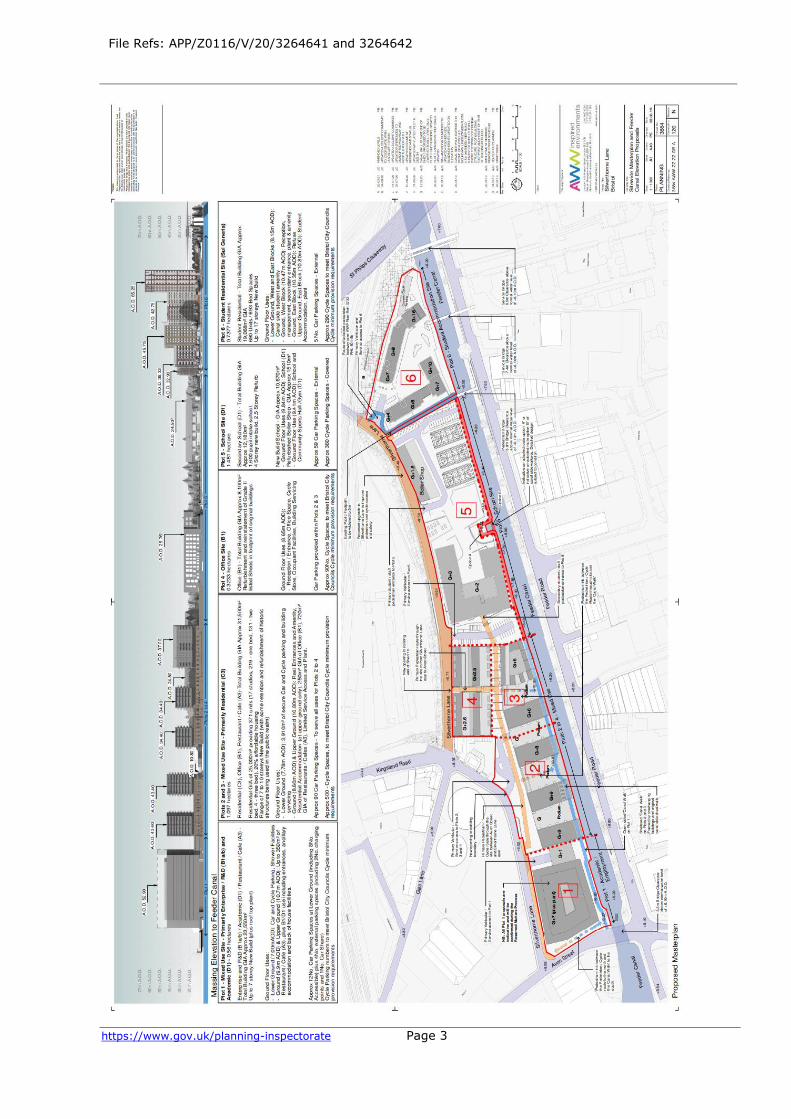
File Refs: APP/Z0116/V/20/3264641 and 3264642
https://www.gov.uk/planning-inspectorate Page 3

File Refs: APP/Z0116/V/20/3264641 and 3264642
https://www.gov.uk/planning-inspectorate Page 4
File Refs: APP/Z0116/V/20/3264641 and 3264642 Land at Silverthorne Lane, Silverthorne Lane, Bristol BS2 0QD
• The applications were called in for decision by the Secretary of State (SoS) by a direction,
made under section 77 of the Town and Country Planning Act 1990, on 7 December 2020.
• The applications are made by Feeder Estates LLP.
• The Planning Application Ref: 19.03867.P is dated 7 August 2019.
• The development proposed is described as: The phased development of site wide
remediation including demolition, outline planning permission with all matters reserved
aside from access for up to 23,543m² GIA of floorspace to include offices (B1a), research
and development (B1b), non-residential institution (D1) and up to 350m² GIA of
floorspace for cafe (A3) (PLOT 1), erection of buildings (full details) to provide up to 367
dwelling houses (C3), offices (B1a), restaurants and cafés (A3) (PLOTS 2 & 3),
redevelopment of ‘The Erecting Sheds’ (full details) to provide offices (B1a) (PLOT 4),
erection of buildings and redevelopment of ‘The Boiler Shop’ (full details) to provide a
1,600 pupil secondary school (D1) (PLOT 5), erection of buildings (full details) to provide
up to 841 student units (Sui generis) (PLOT 6), associated works and infrastructure.
• The Listed Building Consent Application Ref: 19.03838.LA is dated 7 August 2019.
• The proposed works are described as: Plot 1 - Removal of the Shed 4 western gable wall;
Plot 2 - Removal of Shed 4 (excluding wall to canal); Plot 2 -Insertion of opening into the
boundary wall and lowering/removal of material; Plot 3 - Removal of Shed 3; Plot 3 -
Removal of Sheds 2a-c; Plot 4 - Insertion of pedestrian access opening into the northern
boundary wall of Shed 1 b; Plot 4 - Alterations to the south wall of Shed 1b/north wall of
Shed 2b; Plot 4 - Restoration/rebuild of Shed 1a; Plot 5 - Reduction in height of the walls
attached to the North Gateway; Plot 5 - Removal of western Hammer Forge wall;
reduction in height of northern Hammer Forge Wall; demolition and rebuild of eastern
Hammer Forge wall; Plot 5 - Works to the Boiler Shop. Including new openings in the
western gable end; replacement of asbestos cement roof; removal of post-war cladding
and glazing between piers; internal works including new floor level; Plots 2-5 - Potential
stabilisation engineering works to the early 19th century Feeder Canal rubblestone wall.
• The reason given for making the direction was that it accords with the SoS’s policy on the
type of development which should be called in.
• The following were the matters on which the SoS particularly wished to be informed for
the purpose of his consideration of the application:
a) The extent to which the proposed development is consistent with government policies
for meeting the challenge of climate change, flooding and coastal change in National
Planning Policy Framework (the Framework) (Chapter 14).
b) The extent to which the proposed development is consistent with the development
plan for the area; and
c) Any other matters the Inspector considers relevant.
Summary of Recommendation:
I recommend that the applications be allowed on the basis of the revised plans
and revised description, and planning permission and listed building be granted subject to conditions set out in Schedules A and B, satisfaction with the Deed of Easement position, and the s.106 Agreement.

File Refs: APP/Z0116/V/20/3264641 and 3264642
https://www.gov.uk/planning-inspectorate Page 5
Procedural Matters
1. In respect of other matters which the ‘Inspector considers relevant’, given the statutory duties in respect of listed buildings, as the Inspector I sought additional
clarification on heritage matters which formed part of a topic specific Heritage Statement of Common Ground (HSoCG).1
2. In response to the pandemic the Inquiry was held in a digital format with face-to-
face meeting limited to a socially distanced site visit. A Pre-Inquiry Meeting took place on 16 March 2021 with a subsequent note being provided. The Inquiry sat
on 11-14 May, 18-21 May and 27-28 May and 28 June 2021. I undertook an accompanied site visit on 29 June 2020. In addition, I viewed the site from public land and from the train on the rail line which goes from Bristol Temple Meads
towards Bristol Parkway.
3. During the application process a number of amendments were made to the
proposals. These were identified in the report to the Planning Committee and I am satisfied that no prejudice would arise from consideration of those amendments as part of this Report and recommendation. The most substantial of
those changes, as set out in the Planning Committee report are:
(a) The extension of the riverside walkway along the whole frontage from plots 1
to 5. In addition, further clarity has been provided as to the design and appearance of the walkway – this includes indicative plans which show how the walkway could be raised above the design flood level to allow for safe access in
the event of a flood.
(b) The reinstatement of shed 1B to its original footprint (plot 4). The original
proposals included open car parking to the eastern end of shed 1B.
(c) The reinstatement of the skeletal form of shed 2 (between plot 4 and the affordable housing block on plot 3), and additional clarity provided regarding the
public realm in this area.
(d) Alterations to the boundary wall along the northern edge of plots 2 to 4, to
retain more of the historic fabric.
(e) Change to the residential blocks to ensure that all of the proposed flats meet national space standards, and alterations to the external appearance to better
break up the visual appearance of the blocks.
(f) Alterations to the design of block 6, including the reduction in scale of some of
the elements and the provision of additional public realm along the west of the site. This has resulted in a reduction in the number of units from 764 to 693
study bedrooms.
(g) The reduction in levels of the external spaces within plot 5, in order to provide additional flood water storage.
4. In addition, minor changes were put forward once the scheme had been called in and during the Inquiry, including modest internal changes to facilitate
1 CD 8.4a

File Refs: APP/Z0116/V/20/3264641 and 3264642
https://www.gov.uk/planning-inspectorate Page 6
access/egress within the building on plots 2/3 and in terms of flood gates. These matters are so limited in nature that consideration of them (as matters which
would be picked up by conditions) again mean that there would be no prejudice arising from them being considered as part of the scheme at this stage.
5. Subsequent to the application being called-in the site has been designated as being within a new Conservation Area, the Silverthorne Lane Conservation Area. This new designation formed part of the matters discussed at the Inquiry in
respect of heritage assets and so all interested parties have had opportunity to put their points in respect of that designation2.
6. The application was screened by the Planning Inspectorate on 19 May 2021. The screening concluded that the proposal did not require an Environmental Impact Assessment. The Applicant was notified accordingly.
7. The Framework was updated on 20 July 2021. The main parties were given opportunity to comment upon the changes to that document insofar as they
related to the main matters in the application. The comments arising are covered in this report and for ease of reference, the paragraph numbers have been updated so that they relate to the Framework in its July 2021 format.
8. In addition, the Environment Agency (EA) Guidance on Climate Change Allowances has also been changed since the Inquiry closed on 20 and 27 July and
6 October 2021. The main parties have been given opportunity to comment and their comments have been incorporated into are covered within the body of the report.
The Site and Surroundings
9. As set out in the Statement of Common Ground3(SoCG), the site is approximately
4.2 hectares in size, and is located to the east of Temple Meads Station, in the city of Bristol. The site lies between the Feeder Canal to the south, Avon Street to the west and the railway line to the east. The northern boundary of the site is
formed by Silverthorne Lane. The site has been in industrial use since the early 19th century and is currently used for a mixture of industrial and storage uses.
2 The matter of re-advertisement following the Conservation Area designation was discussed.
Legal advice submitted by the Applicant is as follows: (1) S.73 of the Planning (Listed
Buildings & Conservation Areas) Act 1990 states as follows: “(1) The Secretary of State may
prescribe requirements as to publicity for applications for planning permission in cases where
the local planning authority think that the development of land would affect the character or
appearance of a conservation area.” (2) The relevant regulations are the Planning (Listed
Buildings and Conservation Areas) Regulations 1990 (“the Regulations”). (3) The Regulations
used to require advertisement pursuant to regs. 3 and 5 where an application was made for
conservation area consent. But the Regulations were amended by the Enterprise and
Regulatory Reform Act 2013 (Abolition of Conservation Area Consent) (Consequential and
Saving Provisions) (England) Order 2013 so that there is now only a requirement under the
Regulations for advertisement under reg. 5 in respect of listed building consent. This
amendment coincided with the removal of the need for conservation area consent by the
Enterprise and Regulatory Reform Act 2013. (4) IN any event, even under the Regulations as
they were, the obligation in reg. 5(1) was to advertise (only) when an application was made.
And at the time the application was made here, there was no conservation area and,
accordingly, there was no requirement to advertise. 3 CD8.4

File Refs: APP/Z0116/V/20/3264641 and 3264642
https://www.gov.uk/planning-inspectorate Page 7
The site contains a number of heritage assets, including listed buildings, curtilage listed buildings / walls and other non-designated heritage assets (more detail is
provided in the ‘Agreed Matters’ section of this report). The wider area is industrial and commercial in character, including storage uses and vehicle repair
and sales uses.
The Proposals
10. The description of development for the planning application is as follows:
“The phased development of the following: site wide remediation, including demolition; (Plot 1) outline planning permission with all matters reserved aside
from access for up to 23,543m2 Gross Internal Area (GIA) of floor space to include offices (B1a), research and development (B1b), non-residential institution (D1) and up to 350m2 GIA floor space for cafe (A3); (Plots 2 and 3) erection of
buildings (full details) to provide 371 dwelling houses (C3), offices (B1a), restaurants and cafes (A3); (Plot 4), redevelopment of 'Erecting Sheds 1A and
1B' (full details) to provide offices (B1a); (Plot 5) erection of buildings and redevelopment of 'The Boiler Shop' (full details) to provide a 1,600 pupil secondary school (D1); (Plot 6) erection of buildings (full details) to provide 693
student bed spaces (Sui generis); infrastructure, including a new canal side walkway and associated works at land and buildings on the south side of
Silverthorne Lane (application nos: 19/03867/P & 19/03868/LA).”
11. The Site Masterplan is set out above, after the glossary of terms, for ease of reading this Report.
12. As set out in the description above, the permission for plot 1, at the junction of Avon Street with Silverthorne Lane, is in outline only and I have therefore dealt
with the submitted plans for this part of the development as being illustrative. The floor space and uses are as set out in the description above. The Design and Access Statement/masterplan set out the building parameters and the overall
height (as a levels height) which is shown as containing ground and lower ground floors, plus 6 further floors (8 stories) and rooftop plant. Parking and cycle
parking facilities plus pedestrian access including to the Walkway along the bank of the Avon are also shown.
13. Plots 2 and 3 create, in essence, 4 blocks set perpendicular to the canal of between 7 and 10 stories. Lower ground floor parking, with commercial uses at ground floor and residential above. It would lead to the demolition of most of the
curtilage listed buildings situated on these plots but with retention of the canal-side wall. The revised plans provide for 371 flats (17 studio flats, 219 one-bed
flats) 131 two-bed flats and 4 three bed flats). These include 298 units for private rent and 73 affordable units. The ground floor office space would amount to some 979 m2 and the café/restaurant some 856m2. A public realm area would
be included, reflecting the former warehouse structure. The waterside walkway would provide for pedestrian movement.
14. Plot 4 in essence redevelops and reconstructs the Erecting Sheds, Grade II listed buildings, and includes a new building extending up from existing walls. The two buildings would be separated by a pedestrian route but with ground and first
floor linking structures. This development would be used to create offices.
File Refs: APP/Z0116/V/20/3264641 and 3264642
https://www.gov.uk/planning-inspectorate Page 8
15. Plot 5 is for the development of a new secondary school. It would be for year 8 teaching through to and including sixth form. A new building would house the
teaching block, with performance and catering facilities. It also provides for the refurbishment of the Grade II listed Boiler Shop to create a sports block.
Elements of the former Hammer Forge, which forms part of the boundary wall, would be retained with other historic structures, including the canal wall, which would be rebuilt. There would be provision for car parking, a coach turning area,
and cycle parking (360 spaces) on site. In addition, there would be 3 Multi Use Games Areas (MUGAs) and the canal walkway route.
16. Plot 6 would include two buildings, one reaching 17 stories at the maximum, the other 11 stories, which would be used to create student accommodation for 693 study bedrooms and associated facilities. The two-block design caters for the
position of a high voltage electricity line which divides the site. There would be 4 car parking spaces and 290 cycle spaces. A canal-side amenity area would also
be created.
17. Since the date of the application, the Use Classes Order has been amended, coming into force in September 2020. Some the Use Classes set out in the
application description have been altered. As the proposal was submitted to the Council prior to 1 September 2020 it falls to be considered as submitted.
18. The application for listed building consent sought the following proposed works: Plot 1 - Removal of the Shed 4 western gable wall; Plot 2 - Removal of Shed 4 (excluding wall to canal); Plot 2 -Insertion of opening into the boundary wall and
lowering/removal of material; Plot 3 - Removal of Shed 3; Plot 3 -Removal of Sheds 2a-c; Plot 4 - Insertion of pedestrian access opening into the northern
boundary wall of Shed 1 b; Plot 4 - Alterations to the south wall of Shed 1b/north wall of Shed 2b; Plot 4 - Restoration/rebuild of Shed 1a; Plot 5 - Reduction in height of the walls attached to the North Gateway; Plot 5 - Removal of western
Hammer Forge wall; reduction in height of northern Hammer Forge Wall; demolition and rebuild of eastern Hammer Forge Wall; Plot 5 - Works to the
Boiler Shop, including new openings in the western gable end, replacement of asbestos cement roof, removal of post-war cladding and glazing between piers,
internal works including new floor level, Plots 2-5 - Potential stabilisation engineering works to the early 19th century Feeder Canal rubblestone wall.
19. During the application process modest amendments have been made to this (as
noted above). The amended details have formed part of the application documentation and therefore no prejudice arises from consideration of those
changes. Details of the matters for consideration are set out in the conditions.
Planning Policy
National Policy
20. The key areas of the Framework for this application relate to chapters 2, 5, 12, 14 and 16. Chapter 14 ‘Meeting the challenge of climate change, flooding and
coastal change’ is of particular importance given this is the area about which disagreement exists for the main parties.
Development Plan Policies

File Refs: APP/Z0116/V/20/3264641 and 3264642
https://www.gov.uk/planning-inspectorate Page 9
21. For the purposes of Section 38(6) of the Town and Country Planning Act 1990, the development plan for the area comprises:
• The Bristol Core Strategy (June 2011);
• The Site Allocations and Development Management Plan (July 2014); and
• The Bristol Central Area Plan (March 2015).
22. Work is currently being undertaken to review the Local Plan. A draft Local Plan was prepared, and was subject to consultation through 2019. However, progress with this revision of the Local Plan was halted following the withdrawal of the
West of England Joint Spatial Plan in April 2020. The Council is therefore seeking to revise this draft to take account of the emergence of the West of England
Combined Authority Spatial Development Strategy, as well as seeking to update the evidence base to support the emerging plan. Whilst this plan is at an early
stage of preparation, given that it has been subject to consultation, it is agreed that the emerging plan is material to the determination of the application. In particular, the site falls within the area covered by draft Policy DS2 (Bristol
Temple Quarter) which supports the redevelopment of the Silverthorne Lane area for the creation of a “mixed used area incorporating workspace; homes; student
accommodation; leisure including evening economy uses; and education facilities”.
Core Strategy Policies
23. The most relevant strategic policies in this application relate to the uses proposed namely:
24. Policy BCS5 of the Core Strategy, which relates to housing aims to deliver a minimum of 26,400 dwellings within Bristol’s administrative area, although it envisages 30,600 in total to be delivered up until 2031 (1,320 dwellings per
annum (dpa)). The policy provides a distribution framework for these houses, with 7,400 being provided within the city centre area, which includes the
application site. The housing requirement set by this policy was informed by the strategic housing market assessment and associated economic forecasts dating from 2010.
25. However, as the Council and Applicant agree, a matter with which there is no dissent, the housing requirement for Bristol is currently derived using the
standard method for establishing local housing need (LHN). The standard method was revised in December 2020. Bristol is subject to a ‘cities and urban centres uplift’ of 35%. The housing requirement (utilising the 2014 based household
projections with the 2019 affordability ratio) for the City is 3,196 dpa (utilising a 2020 base date). For reference, the LHN without the uplift, equates to 2,368
dpa. A six-month transitional period applies before the uplifted LHN figure is used for the purposes of 5 year housing land supply (5YHLS), and as such, until the 16 June 2021, the City’s 5YHLS, position is based upon the City’s 5YHLS the
previous LHN of 2,368dpa. The 2020 Housing Delivery Test (HDT) published on 19 January 2021, confirms the City achieved 72%. The presumption is therefore
engaged as per footnote 7, paragraph 11 of the Framework, and the appropriate buffer for the purposes of 5YHLS is 20% (paragraph 73 of the Framework).

File Refs: APP/Z0116/V/20/3264641 and 3264642
https://www.gov.uk/planning-inspectorate Page 10
26. The increased housing requirement has a notable impact upon the Council’s ability to maintain a supply of specific deliverable sites to provide a minimum of
five years’ worth of housing. The parties agree that this demonstrates the significant pressure that currently exists in Bristol to boost housing delivery at
appropriate densities.
27. Policy BCS8 which relates to Employment Land requires the delivery of 236,000 sqm of net additional office floor space, with 150,000 sqm to be provided in the
City centre, in which the application site is located. This policy itself has been informed by evidence prepared by the Council in its Employment Land Study
Final Report 2009. This report is, in turn, informed by economic forecasts undertaken by Cambridge Econometrics which were associated with the production of the South West Regional Spatial Strategy, with these forecasts
dating back to circa 2006 as a part of the local plan review. More up-to-date evidence is available in the West of England Economic Development Needs
Assessment (2016). This presents a range of growth scenarios that indicate an employment land (‘B’ use classes) need of between 324,000m² and 534,000m² for Bristol. Whilst this evidence underpins an emerging development plan, I
concur with the Council and Applicant that it demonstrates a significant level of economic demand beyond that envisaged by Policy BCS8 of the Core Strategy.
28. Policy BCS16 deals with Flood Risk and Water Management. The full text is as follows:
Development in Bristol will follow a sequential approach to flood risk
management, giving priority to the development of sites with the lowest risk of flooding. The development of sites with a sequentially greater risk of flooding will
be considered where essential for regeneration or where necessary to meet the development requirements of the city.
Development in areas at risk of flooding will be expected to:
* be resilient to flooding through design and layout, and/or incorporate sensitively designed mitigation measures, which may take the form of on-site
flood defence works * and/or a contribution towards or a commitment to undertake such off-site
measures as may be necessary,
in order to ensure that the development remains safe from flooding over its lifetime.
All development will also be expected to incorporate water management measures to reduce surface water run-off and ensure that it does not increase
flood risks elsewhere. This should include the use of sustainable drainage systems (SUDS).
29. In addition, the following policies are also relevant:
• BCS2 (Bristol City Centre)
• BCS5 (Housing Provision)

File Refs: APP/Z0116/V/20/3264641 and 3264642
https://www.gov.uk/planning-inspectorate Page 11
• BCS8 (Delivering a Thriving Economy)
• BCS9 (Green Infrastructure)
• BCS10 (Transport and Access Improvements)
• BCS11 (Infrastructure and Developer Contributions)
• BCS12 (Community Facilities)
• BCS13 (Climate Change)
• BCS14 (Sustainable Energy)
• BCS15 (Sustainable Design and Construction)
• BCS17 (Affordable Housing Provision)
• BCS18 (Housing Type)
• BCS20 (Effectiveness and Efficient Use of Land)
• BCS21 (Quality Urban Design)
• BCS22 (Conservation and Historic Environment)
Site Allocations and Development Management Plan
30. A number of policies from this document are relevant as listed below:
• DM4 (The Health Impacts of Development)
• DM15 (Green Infrastructure Provision)
• DM19 (Development and Nature Conservation)
• DM23 (Transport Development Management)
• DM26 (Local Character and Distinctiveness)
• DM27 (Layout and Form)
• DM28 (Public Realm)
• DM29 (Design of New Buildings)
• DM32 (Recycling and Refuse Provision in New Development)
• DM31 (Heritage Assets)
• DM33 (Pollution Control, Air Quality and Water Quality)
• DM34 (Contaminated Land)
• DM35 (Noise Mitigation)
Bristol Central Area Plan (BCAP)
31. Policy BCAP35 is a key policy in this application. Given its relevance the full text is set out as follows:

File Refs: APP/Z0116/V/20/3264641 and 3264642
https://www.gov.uk/planning-inspectorate Page 12
Sites within Bristol Temple Quarter (Policies Map site KS01) will be developed for a wide range of uses as part of the growth and regeneration of the area as an
employment-led, mixed-use quarter of the city centre, an exemplar for new initiatives and a hub for all creative minded businesses. The layout, form and mix
of uses should contribute to delivering this vision for Bristol Temple Quarter and, in doing so, have regard to the Spatial Framework for Bristol Temple Quarter. Development will include:
• A major indoor arena and complementary leisure uses;
• At least 100,000m² of net additional high quality office and flexible
workspace;
• Up to 2,200 new homes including live/work space;
• Hotel and conference facilities;
• Complementary retail and leisure uses, particularly within and adjacent to
Bristol Temple Meads station;
• New walking and cycle routes to connect the developments to the rest of the
city centre and surrounding neighbourhoods; and,
• Green infrastructure and public realm enhancements including a continuous
and accessible Quayside Walkway (Policy BCAP32) and the improvement of open
space to serve the new developments.
Bristol Temple Meads Station will be enhanced as a major transport interchange. The development of sites adjoining the station to the north will be expected to
accommodate this interchange function. Development of sites within Bristol Temple Quarter that are at risk of flooding now, or with climate change, should
be supported by a flood risk sequential test undertaken within the policy area, taking account of all reasonably available sites in the area. The development of sites that are at risk of flooding, or are larger than one hectare in size, should be
supported by a Flood Risk Assessment.
32. In addition, the Policies listed below are also relevant:
• BCAP1 (Mixed-use Development in Bristol City Centre)
• BCAP3 (Family Sized Homes)
• BCAP4 (Specialist Student Housing in Bristol City Centre)
• BCAP11 (University and Hospital Developments)
• BCAP15 (Small-scale retail developments and other related uses in Bristol City
Centre)
• BCAP20 (Sustainable Design Standards)
• BCAP21 (Connection to Heat Networks)
• BCAP22 (Habitat Preservation, Enhancements and creation on Waterways)
• BCAP29 (Car and Cycle Parking)

File Refs: APP/Z0116/V/20/3264641 and 3264642
https://www.gov.uk/planning-inspectorate Page 13
• BCAP32 (Quayside Walkways)
Planning History
33. Whilst this is a site which has been developed over many years, it is agreed between the Council and Applicant that the following summarise the relevant
planning permissions. No party suggested any additional relevant cases.
(a) Planning permission ref: 17/06459/P - land at Cattle Market Road. In June 2019 outline planning permission was granted (all matters reserved aside from
access) for the University of Bristol’s Temple Quarter Enterprise Campus. The proposal consists of up to 82,395 sqm of floor space to provide retail,
commercial, leisure and education uses and up to 1,500 student beds.
(b) Planning permission ref: 15/06070/P - Temple Island. The Council previously refused permission for the development of a 12,000-capacity indoor arena and
associated infrastructure and a mixed-use proposal including 19,000 sqm of floor space to provide uses comprising offices, retail, leisure, residential, hotel and
student accommodation. However, the Council resolved on 4 September 2018 to pursue an alternative mixed-use scheme for the site (not including an arena). The application was granted planning permission on 11 April 2016 following a
resolution to grant at a planning committee on 6 April 2016. It should be noted that this planning permission expired on 11 April 2021.
Agreed Matters
General Matters Agreed between the Council and the Applicant
34. The following matters are agreed between the Applicant and the Council (flood
risk and heritage are the subject of specific SoCG):
(a) The site is in a sustainable location allocated for development.
(b) The tilted balance in para 11(d) of the Framework is engaged, such that permission should be granted unless the policies in the Framework provide a clear reason for refusal, or the adverse impacts of doing so would significantly
and demonstrably outweigh the benefits.
(c) The proposals would not result in any substantial harm to any designated or
other heritage assets either on-site or off-site and would have substantial heritage gains.
(d) The design and density of the proposals meet the design objectives set out in the relevant adopted policies.
(e) There are very substantial economic, social, and environmental public
benefits to the scheme.
(f) Noise, contamination risk and traffic management can all be dealt with by
planning conditions or planning obligations.

File Refs: APP/Z0116/V/20/3264641 and 3264642
https://www.gov.uk/planning-inspectorate Page 14
Flood Risk Matters Agreed between the Council, Applicant and EA
35. A Statement of Common Ground on Flooding (FSoCG) has been signed by the
Council, Applicant and EA4. Amongst the matters of agreement the following are most pertinent:
(a) The site is currently mapped on the Flood Map for Planning maintained by the EA as being part in flood zone 1 (low risk of flooding), part in flood zone 2 (medium risk of flooding) and part in flood zone 3 (high risk of flooding).
(b) The latest Bristol City Council flood modelling indicates that the site is entirely in flood zone 3a (high risk). This is referred to in the recently published level 1
Strategic Flood Risk Assessment and the Flood Map for Planning will be updated once the EA has received this modelling.
(c) It is agreed that climate change effects are likely to have a significant impact
upon sea levels as well as peak flows in rivers.
(d) It is agreed that the July 2020 government guidance on climate change is the
relevant and most up to date published climate change guidance for planning purposes5.
(e) It is agreed that the peak river flow climate change predictions applicable to
the Severn river catchment in the periods to 2039, 2069 and 2115 are as follows:
Peak river flow allowances by river basin district (based on a 1961 to1990
baseline) Source: Gov.UK
River basin district
Allowance category
Total potential change anticipated for
the ‘2020s’ (2015 to
2039)
Total potential change anticipated for
the ‘2050s’ (2040 to
2069)
Total potential change anticipated for
the ‘2080s’ (2070 to
2115)
Severn H++ 25% 45% 90%
Upper End 25% 40% 70%
Higher
Central
15% 25% 35%
Central 10% 20% 25%
(f) It is agreed that the draft Bristol Avon Flood Strategy (BAFS), published for
consultation by Bristol City Council in October 2020, is an emerging relevant strategy.
4 CD8.5a 5 Inspector’s note: later updates to this guidance have been made and parties have been
consulted on their implications. The latest guidance was dated 6 October 2021

File Refs: APP/Z0116/V/20/3264641 and 3264642
https://www.gov.uk/planning-inspectorate Page 15
(g) It is agreed that the site is at risk of flooding from tidal and/or fluvial flood events.
(h) It is agreed that the scheme provides that Plots 1, 2 and 3 include a raised podium (upper level) at 10.8m above ordnance datum (AOD) and ancillary uses
such as parking set at levels at a minimum of 7.0m AOD.
(i) It is agreed that the design floor levels proposed in the application are as follows:
Design floor levels used in the Applications
Plot 1 – Podium (upper level) 10.8m AOD
Plot 1 – Car Parking 7.0m AOD
Road level approx 8.9m AOD
Plot 2 – Podium (upper level) 10.8m AOD
Plot 2 – Car Parking 7.6m AOD
Plot 2 – Road Level at entrance to car
park (varies)
8.6m AOD
Plot 4 – Existing retained historic
building
8.65m AOD
Plot 5 – External circulation areas,
External carparks, MUGA and play areas
8.2m AOD to 9.84m AOD
Plot 5 – retained historic building 9.4m AOD
Plot 5 – new building 9.84m AOD
Plot 6 – lower level 8.15m AOD
Plot 6 – West block 10.47m AOD
Plot 6 – East block 10.35 to 10.8m AOD
Plot 6 – external ground levels 8.0m AOD to 10.8m AOD
(j) It is agreed that in some locations in the UK, where appropriate, car parks can be situated below raised buildings.
(k) It is agreed that the proposed car parking for Plots 1, 2 and 3 is at a lower level (7.0 – 7.6m AOD) than the proposed design flood level.
(l) It is agreed that the application for Plot 1 is in outline only, and the final design levels will be determined at reserved matters stage within the parameters prescribed at outline stage.
(m) It is agreed that the design lifetime of the school (Plot 5) proposed by the Department for Education is 60 years.

File Refs: APP/Z0116/V/20/3264641 and 3264642
https://www.gov.uk/planning-inspectorate Page 16
(n) The Bristol City Council Strategic Flood Risk Assessment (SFRA) Model referred to as Model-19 has been accepted by the EA for use in the SFRA and
provides baseline data for the proposed BAFS. However, this model uses out of date climate change allowances and the SFRA states that the developer needs to
include the updated climate change allowances.
(o) It is further agreed that Edenvale Young have carried out further SFRA modelling on behalf of Bristol City Council and have proposed revised flood levels
from Model 20.
(p) It is agreed that JBA Group independently reviewed the Silverthorne Lane
FRA Model 20 on behalf of Bristol City Council and issued a Technical Review Certificate dated 11 June 2020.
(q) It is also agreed that the modelled flood levels in Model 20 have been used by
the Applicant to inform finished floor levels and other mitigation measures for this site.
(r) It is also agreed that the Applicant provided the EA with an updated pre and post development model based on Model 20 (received 23 March 2021). This is currently being reviewed.
(s) It was agreed at the Inquiry that paragraph 159 of the Framework provides that inappropriate development in areas of flood risk should be avoided, but
where development is necessary in such areas, the development should be made safe for its lifetime without increasing flood risk elsewhere. The EA, the Applicant and the Council are all in agreement that the development proposed in these
applications cannot be situated elsewhere - therefore the sequential test is passed.
Heritage Matters
36. Turning to heritage matters, the Applicant and the Council agree the following matters many of which are in the HSoCG:
(a) Both parties are in agreement that the heritage assessment work undertaken to inform the design and to accompany the applications, with regard to heritage
assets (both designated and non-designated), was appropriate, proportionate and followed industry guidance and good practice.
(b) The site comprises a highly complex arrangement of standing structures representing nearly 200 years of industrial activity. All of these buildings have undergone some degree of change during their use. Many of these structures
possess heritage significance worthy of their status as listed buildings. As a collection, the site forms part of a wider industrial landscape worthy of its
recently designated status as a conservation area. Insofar as it is material to the planning decisions, both parties are in agreement regarding the buildings and structures that possess heritage significance.
(c) Furthermore, both parties are in agreement that several structures within the site possess very limited or no heritage significance. In some cases, these
buildings and structures are fixed to, or lie within the land associated with a listed building. As such, there is agreement between both parties that there are instances of structures and buildings that are listed buildings but which do not

File Refs: APP/Z0116/V/20/3264641 and 3264642
https://www.gov.uk/planning-inspectorate Page 17
possess special architectural or historic interest (essentially these being curtilage structures).
(d) On the specific matter of the Conservation Area, both parties are in agreement that this recent designation does not necessitate a review of the
matters presented within the application documents or the position expressed by the Council. Both parties agree that the designation of the area as a Conservation Area is recognition of the long-understood importance of the place; its
designation is not a reflection of a recent realisation of greater importance.
(e) There is agreement between both parties that the development would result
in the loss of historic built fabric that would result in harm to designated heritage assets.
(f) Furthermore, there is agreement between both parties that the loss of several
late 19th and early 20th century buildings would change the character of the site as a whole and this would result in harm.
(g) There is agreement between both parties that the development would deliver considerable benefits to the designated heritage assets within the site. These heritage benefits comprise the renovation and reuse of the most important
buildings within the site, safeguarding them for the future. The development would also allow for improved access and enhanced views of many buildings,
better revealing their significance.
(h) There is agreement between both parties that the development would result in instances of harm to heritage assets and also instances of heritage benefits. It
is the Applicant’s position that the heritage benefits of the development outweigh the instances of harm. In contrast, the Council takes the view that the less than
substantial harm needs to be weighed against the substantial heritage gains.
(i) Both parties acknowledge that some heritage stakeholders identify concerns within the development. It is the position of both parties that these outstanding
concerns relate to the same instances of harm identified in the Applicant’s and Council’s own assessments. Both parties believe any differences lie in the weight
given to the identified harm. For example, the Council for British Archaeology identify the loss of buildings as substantial harm, and the Victorian Society
describe an almost total loss of significance. Both parties disagree with these particular statements.
Hazardous Substance Consent
37. There is a gas holder site immediately to the north of the application site. Given the proximity, high density residential development of the type proposed would
normally be resisted by the Health and Safety Executive. However, the Council as LPA confirmed that this consent has been revoked6.
6 CD 11.1

File Refs: APP/Z0116/V/20/3264641 and 3264642
https://www.gov.uk/planning-inspectorate Page 18
The Case for the Applicant– Feeder Estates LLP
Applicant Introduction
38. The Applicant seeks to focus on what this proposal is about, the proposed redevelopment of a previously developed site to include 371 new dwellings,
including 73 affordable homes, new office space, an academic/research and development space for Bristol University, 693 student flats, a new canal-side walkway, and a 1,600 pupil state-funded secondary school in an area with an
acute need for additional school places. It is supported by the Council, its Development Control Committee having resolved unanimously to follow the
advice of its officers and to grant planning permission on 5 August 2020.7 The proposals are also supported by many local people and groups, as well as Summix FRB Developments Ltd, the developer of a neighbouring site and a Rule
6 Party at this Inquiry. Out of the many oral representations made over the course of the Inquiry, only the EA and its two witnesses spoke against the
proposals. This was therefore a highly unusual public Inquiry where almost every party who made representations, including the Council, was in agreement that planning permission should be granted.
39. The agreed matters are extensive. Given this level of agreement between the Applicant and the Council, the only area of dispute in this Inquiry concerns the
flood risk matters raised in the EA’s objections to the proposals. On flooding, the Council and the Applicant are agreed that the scheme passes not just the sequential test but also the exception test.
40. The Applicant considers it is also important to note at the outset that over the course of the Inquiry, significant parts of the EA’s case on flood risk have fallen
away, as follows:
(a) The EA argued up until the Inquiry that the design life for Plots 4 and 5 should be 100 years rather than 60 years. The EA described this as part of its
primary case. However, it is now accepted that on that key issue, in respect of both Plots 4 and 5, the EA defers to the Council which has agreed that the design
life of those plots is 60 years. If this was the EA’s true position all along, which earlier correspondence with the Applicant certainly seems to suggest,8 then the
EA has wasted time by making this a key point of contention in its written evidence to the Inquiry.
(b) The EA said in its opening speech that there is some uncertainty as to how
the basement areas have been represented in the modelling, and that on that basis it argued that it has not been shown that the scheme would not increase
flood risk elsewhere. This criticism is less strident than the position the EA put forward to the SoS in August 2020 (its letter requesting call-in said ‘We assert that the proposed development would have a major impact on flood risk in Bristol
and beyond’ 9). However, the submission on third-party impacts put forward by
7 CD 4.3 8 Consultation response from 27 April 2020 at CD 6.55: “We first requested during pre-
application discussions, that this point be confirmed by the local planning authority (LPA) in
writing. This point has recently been resolved and confirmed by the LPA as being 60 years.” 9 CD 8.1: note also that the EA said “we consider that no sound attempt has been made in the
flood risk assessment to assess or quantify the extent to which flood risk will be increased as a

File Refs: APP/Z0116/V/20/3264641 and 3264642
https://www.gov.uk/planning-inspectorate Page 19
the EA was not robust when presented at the Inquiry. The Applicant’s detailed modelling presentation,10 based entirely on the written evidence submitted to the
Inquiry, showed conclusively that there would be no off-site detriment caused by the scheme. The EA did not even seek to cross examine about off-site detriment.
This key part of the EA’s case has been abandoned, despite it being a major part of the request for call-in.11
(c) Linked to this, the EA’s case objecting to the use of voids as mitigation has
also largely, if not entirely, fallen away for the same reasons. It was only faintly pursued at this Inquiry.
(d) Several other points were conceded by the EA’s planning witness namely:- written evidence on the scheme’s overall compliance with the development plan was given without any consideration to the proposals compliance with any of the
many non-flooding policies relevant to the scheme; in respect of the three policies that had been considered, the proposals, in fact, complied with one of
those policies, Policy BCAP5, and at least partly complied with the others; a view was given in written evidence on the overall planning balance, without carrying out any kind of balancing exercise at all. All the benefits had been ignored and
the view was taken that any flood risk outweighed the benefits – whatever they might be. But it was accepted in cross examination that flooding is not a trump
card in the planning balance; it was said that to assess the planning policies or planning benefits of a scheme was outside the planning witness’s area of expertise.
41. Following the above, the EA’s case against the scheme focuses on the correct climate change allowance (agreed to be a matter of judgment), flood depths on
site, and the acceptability of the proposed mitigations in respect of any residual flood risk. Overall, however, the key question for the Inspector and the SoS is whether the proposals are safe. The Applicant has shown that a combination of
detailed modelling, careful design and robust flood mitigation strategies, informed by two leading civil engineers in the field of flood risk, have ensured
that the proposals would be safe for their lifetime and resilient to the effects of climate change. This view is agreed by the Council and in particular its
experienced Flood Risk and Data Manager. In those circumstances, and in light of the planning benefits of the scheme, planning permission should, the Applicant says, be granted without delay.
42. On the issue of delay, it should be noted that the need for the proposed new school is acute. Each academic year that comes around without the school being
delivered sees children miss out on the chance of attending the new school and instead having to be fitted into big year groups, often with temporary classrooms
result of the proposed development”; and “The resolution by the Council to grant planning
permission for the proposed development is in clear conflict with the above referenced national
planning policies that are designed to ensure not only the safety of the development, but also
the safety of existing up and downstream communities. We believe that these communities
may face an unacceptable increased flood risk if this development is permitted to go ahead”;
and “The consequences of that impact are far wider than the impact and advantages in the
immediate area of the proposed development.” 10 INQ 23 11 CD 8.1

File Refs: APP/Z0116/V/20/3264641 and 3264642
https://www.gov.uk/planning-inspectorate Page 20
being put in place, in other schools, sometimes far away from where they live. This has an impact on all of the children in these schools. Any delay in decision-
making that further cuts across the cycle of academic years adversely affects yet more children.
Applicant - Flood Risk
43. The dispute at this Inquiry between the EA on one side and the Applicant, the Council and Summix on the other, is focussed solely on whether the second limb
of the exception test contained in paragraph 164 of the Framework is complied with in relation to the scheme. In considering compliance with the second limb of
the exception test there are two sub-requirements, namely whether: the scheme would, taking into account all the proposed mitigations, be safe for its users during its lifetime, taking account of the vulnerability of its users; and that the
scheme would not increase flood risk elsewhere. This is focussed not on users of the scheme but on any third party impacts of the development in terms of
flooding outside the site. At the opening of the Inquiry, the EA was still pursuing a case that both sub-requirements were failed, but it has at the Inquiry, to all intents and purposes, abandoned its case on sub-requirement (ii), and is now
essentially focussed on (i). In its very last consultation response on the application (dated 29 July 2020), the EA set out its five remaining key concerns
with the scheme. But the reality is different as, by the end of the Inquiry, only one of those five key concerns is being meaningfully pursued by the EA. This is that the area is at high risk and would be subject to considerable, hazardous
flood depths over the lifetime of the development, when taking into account the predicted impacts of climate change.
44. Thus, the remaining key concern of the EA with this scheme is in relation to the depths of water that would be present on the site in a future flood event. It should be recorded that the EA’s flood risk witness said that there was only one
solution to this concern from the EA’s perspective, and that was the adoption of the BAFS. This means, contrary to what has been stated in the EA’s planning
evidence, that the EA’s position is that this scheme (on what is an allocated site), and other similar schemes in the Temple Quarter Enterprise Zone (the Temple
Quarter), should not proceed absent the BAFS being adopted. The planning blight that this approach would cause is a matter to be considered later.
45. In relation to the first sub-issue under the second limb of the exception test, this
requires consideration of whether the development would be safe. The protection of life is, of course, always paramount. But it is important in this regard to
understand that assessing risk in this context requires both the prediction of flood levels and frequencies far into the future (in this case to 2080 and 2120), and a judgment to be made on the degree to which any residual risks from
flooding can be managed. Whether a development is safe requires careful consideration of the full package of mitigations proposed. The assessment self-
evidently involves professional judgment. It is also clear that to be safe, it is not necessary to eliminate all flood risk.
46. The EA witness sought to maintain that technical issues in relation to flooding in
this case were not matters of professional judgment on which two experts could disagree without either view being unreasonable, but rather were black or white
issues allowing only one right answer. It was contended that the PPG dictated the answers to these questions but accepted later that this was not so. Guidance

File Refs: APP/Z0116/V/20/3264641 and 3264642
https://www.gov.uk/planning-inspectorate Page 21
could never dictate the answers. The fact is that the PPG does not cover a number of the issues, for example which climate change allowance to apply
where, as there is, for more vulnerable (MV) development, a range to be considered. What seems clear is that the EA’s flood risk witness came into this
Inquiry believing, incorrectly, that the climate change allowance to be used was prescribed but it is now accepted this is not so. There was also a perception that the EA view must be right in this Inquiry because it is that of the regulator.
However, it is the Applicant’s view that it was conceded that all of the flooding issues involve professional judgement.
47. The Applicant points out that it is important at the outset to understand the parameters of the flood risk issues, these are, it contends:
(a) There is agreement that the design flood is a 1 in 200 year tidal event,
combined with a 1 in 2 year fluvial event; and it is thus also agreed by all the parties that the focus is on tidal not fluvial flooding. Accordingly, we are
concerned with an event that has a 0.5% chance of happening in any given year.
(b) The concern is not with the consequences of such an event were it to happen today, but rather with the consequences of such an event were it to happen far in
the future – towards the end of the 60 year design life (of Plots 4 and 5) and the 100 year design life (of Plots 1 – 3 and 6) as a result of the effect of climate
change and the sea level rises that are predicted (today 9m AOD rising to 10.66 by 2120 at Avonmouth).
(c) Were a 1 in 200 year tidal event combined with a 1 in 2 year fluvial event to
happen not in 2080 or even 2120 but instead now, the impact of such an event on the site would be virtually non-existent. The Applicant’s position is that flood
levels on site from such an event today would be 7.92m AOD, which is below the level of the site.
(d) The increased frequency of 1 in 200 year events in the future put forward by
the EA witness include that by 2125, a 1 in 200 year tidal flood event could be an almost annual occurrence. But it was accepted that was referring to flooding
levels that would be caused by a 1 in 200 year tidal event now and such a level of flooding, even if happening on an annual basis, would have essentially no
impact upon the on the site. Such events are predicted to be much more common in the future, but as they would, the Applicant says, have no impact on the site this hardly matters. The 1 in 200 year tidal event that this case focusses
on in terms of future flood levels and taking account of climate change allowances would have a 1 in 200 year chance (0.5% chance) of occurring in
2120 – it would not be an annual event.
(e) The Applicant’s witness explained that the hydraulic modelling indicated that the high level walkway would be flood free for a 1 in 200 year tide/surge
dominated event in combination with a 1 in 2 year fluvial flow for the Higher Central (HC) climate change scenario in 2120 and it was only in the last 10 years
of the development's lifetime, 2110 to 2120, that the high level walkway would be inundated in a 1 in 200 year tide/surge dominated event in combination with a 1 in 2 year fluvial flow for the Upper End (UE) climate change scenario. There is
a 0.5% chance of that happening in any given year of this 10 year period, so a 99.5% chance in each year that it would not happen. The Applicant’s witness

File Refs: APP/Z0116/V/20/3264641 and 3264642
https://www.gov.uk/planning-inspectorate Page 22
calculated the chance of there being such an event in that critical 10 year period as being in the order of 5%.
Applicant’s Views on Policy and Guidance Context for the Flooding Issues
The Framework
48. In terms of the Framework it is agreed that the sequential test is passed. Paragraph 164 of the Framework sets out the exception test12. To pass the exception test it should be demonstrated that:
the development would provide wider sustainability benefits to the community that outweigh the flood risk; and the development will be safe for its lifetime
taking account of the vulnerability of its users, without increasing flood risk elsewhere, and, where possible, will reduce flood risk overall
49. There is, the Applicant says, no dispute between the parties that the first limb of
the exception test is passed - the starting point here is that the sustainability benefits to the community of the scheme outweigh the flood risk on this site.
50. Paragraph 167 of the Framework13 provides more detail regarding the application of the sequential and exception tests. It states that:
When determining any planning applications, local planning authorities should
ensure that flood risk is not increased elsewhere. Where appropriate, applications should be supported by a site-specific flood-risk assessment. Development should
only be allowed in areas at risk of flooding where, in the light of this assessment (and the sequential and exception tests, as applicable) it can be demonstrated that:
(a) within the site, the most vulnerable development is located in areas of lowest flood risk, unless there are overriding reasons to prefer a different location,
(b) the development is appropriately flood resistant and resilient such that, in the event of a flood, it could be quickly brought back into use without significant refurbishment,
(c) it incorporates sustainable drainage systems, unless there is clear evidence that this would be inappropriate,
(d) any residual risk can be safely managed; and,
(e) safe access and escape routes are included where appropriate, as part of an
agreed emergency plan.
51. This provision of the Framework is of particular importance in this case. It clearly recognises that it may not always be appropriate to require safe access and
escape routes in all circumstances, at all times. The appropriateness of safe access and escape routes is necessarily a matter of professional judgment.
52. Overall, the Framework provides limited guidance on how flood risk should be managed or what the standard of safety should be. It sets out a very broad
12 This has been amended to reflect the July update but does not alter the case advanced 13 This has been amended to reflect the July update but does not alter the case advanced

File Refs: APP/Z0116/V/20/3264641 and 3264642
https://www.gov.uk/planning-inspectorate Page 23
requirement that the development should be safe for its lifetime and leaves the detail of how this is to be achieved, and what the required standards are, to
developers and local planning authorities. It also focuses on the need to manage residual risks and contains no requirement to eliminate all risk.
Development Plan Policies
53. The Applicant considers that three policies are relevant to the flooding issues. Policy BCS16 of the adopted Core Strategy provides for a sequential test to be
applied to flood risk and imposes a requirement that development in flood risk areas is resilient to flooding and incorporates sensitively designed mitigation
measures. Policy BCAP35 of the Bristol Central Area Plan, which allocates this site for development, similarly provides for a sequential test to be applied within the Temple Quarter allocation. Policy BCAP5 of the BCAP also requires that the
development of sites within, inter alia, the Bristol Temple Quarter that are at risk of flooding should be supported by a flood risk sequential test and that those
larger than one hectare in size should be supported by a FRA.
54. The EA’s position that this scheme does not comply with the development plan is based solely on the EA’s technical flood case. It follows that if the EA’s technical
flood case is not made out, the proposals must be held to fully comply with development plan policies, including those on flooding. The EA does not contend
that the requirements of these policies are more onerous than, or different from, what is set out in national policy and guidance.
55. Moreover, insofar as these local policies impose a sequential test, the site is
allocated for development as part of Policy BCAP35 of the BCAP, and that allocation in itself has been sequentially tested. The Framework states, at
paragraph 166, that proposals on sites allocated for development need not apply the sequential test again. Nonetheless, a sequential test was undertaken and submitted by the Applicant, which demonstrates that taking into account the
Temple Quarter BCAP35 allocation and the Council’s Flood Risk Sequential Test Practice Note14, the area of search for the sequential test is the Bristol Temple
Quarter and that there are no other available sites of this scale in the area that are reasonably available. It would not, therefore, be possible to locate this
development on a site at lower risk.
56. None of the local policies refer to the BAFS or suggest that planning permission should only be granted with some form of strategic defence in place.
Relevant Guidance
57. Whilst the guidance which follows is relevant it needs to be clear none of it has
the same status as policy. In R (Solo Retail) v Torridge15 Lieven J said at paragraph 33: “In my view the NPPG16 has to be treated with considerable caution when the Court is asked to find that there has been a misinterpretation of
planning policy set out therein, under para 18 of Tesco v Dundee. As is well known the NPPG is not consulted upon, unlike the NPPF and development plan
14 CD 9.5 15 R (Solo Retail) v Torridge15 [2019] EWHC 489 (Admin) (NPPF ‘the Framework’ NPPG ‘the
Guidance’) 16 PPG but text is as quoted

File Refs: APP/Z0116/V/20/3264641 and 3264642
https://www.gov.uk/planning-inspectorate Page 24
policies. It is subject to no external scrutiny, again unlike the NPPF, let alone a development plan. It can, and sometimes does, change without any forewarning.
The NPPG is not drafted for or by lawyers, and there is no public system for checking for inconsistencies or tensions between paragraphs. It is intended, as its
name suggests, to be guidance not policy and it must therefore be considered by the Courts in that light.” Lieven J also noted at [34] that the part of the NPPG being considered in that case “cannot and should not be interpreted and applied
in an overly legalistic way as if it was setting out mandatory requirements.”
58. On this point see also Richborough Estates v SSHCLG [2018] EWHC 33 (Admin)
where Dove J at paras 42 and 43 noted that the NPPG “exist[s] within the context of the Framework” and that the content of the NPPG is “not rules or laws, and there may be circumstances which require their application to be adapted or
afforded less weight.”
59. The EA’s approach at this Inquiry has been contrary to the above. It has at all
stages sought to treat the PPG, and other guidance as laying down immutable rules which must always be complied with in all regards and planning permission refused if this is not the case. In cross examination for the EA, it was put that if
the SoS concluded that the PPG could be departed from that would set a precedent. This, in the Applicant’s view, was rightly rejected.
60. The EA suggested that in order to comply with the Framework’s requirements regarding the exception test, the sections of the PPG that relate to that test must also be complied with in full. The Applicant says that they have been. But even if
they were not, the EA’s argument (that a failure to comply with guidance in the PPG means a failure to comply with the Framework) is directly contrary to the
above case law. To treat the PPG as if it were the Framework would clearly go against Lieven J’s judgment in Solo Retail: that the PPG “is intended, as its name suggests, to be guidance not policy” and that the PPG “cannot and should not be
interpreted and applied in an overly legalistic way as if it was setting out mandatory requirements.” The PPG, as Dove J said in Richborough, should not be
treated as rules or laws. It has been a distinct feature of the EA’s case at this Inquiry to treat the PPG as such. If the EA’s approach to the PPG was adopted in
this case, the important distinction between policy and guidance would be significantly undermined. Contrary to the case law cited above, the PPG would be elevated to the same status as the Framework which has the benefit of
consultation.
61. The limits of all the guidance in this area, so far as this case is concerned are
palpable. The key issue at this Inquiry is the safety of the scheme for its users, and that is ultimately, and indeed quintessentially, a matter of professional judgment. It is a judgment that is inevitably both scheme and site specific and,
moreover, it requires a holistic view to be taken of all the proposed mitigations which accompany any scheme. Given all this, the role of any national guidance in
answering such questions is always going to be limited. As noted in the previous section, the Framework requires that, in terms of flood risk, a development be safe for its lifetime taking account of the vulnerability of its users and, as noted
above, states that “safe access and escape routes are included where appropriate …”. The guidance must be read in light of this important qualification. Thus, for
example, the proposal here is to close the offices on Plot 4 and the school on Plot 5 in response to a flood warning, and in advance of the flood. In those

File Refs: APP/Z0116/V/20/3264641 and 3264642
https://www.gov.uk/planning-inspectorate Page 25
circumstances, potential safe access and escape routes during the peak of the design flood for these plots are, as the Applicant’s witness explained, somewhat
hypothetical.
62. In a number of places in its evidence, the EA have sought to read into the
guidance more than it actually contains. The EA’s case in opening and in cross examination of the Applicant’s witnesses has been that the PPG contemplates that evacuation would be the appropriate response to an extreme flood event,
but not the response to a design flood event. This has provided a platform for a contention by the EA that the proposals to close the school and offices prior to a
design flood (rather than an extreme flood) would be a breach of the PPG. But this is clearly wrong. Just because guidance explicitly refers to evacuation in the context of an extreme event does not mean that it is in some way a breach of the
PPG to close buildings in the design flood on a precautionary basis – as indeed is proposed here. Moreover, it is only guidance anyway and can be departed from if
that is justified.
63. As already noted, the EA sought to contend that the PPG here dictated the use of UE Climate Change Allowance (CCA). But it was soon accepted under challenge
that this was not in fact so. The PPG sets out a range to be considered for MV development – it does not in any way dictate which CCA should be applied to the
Design Flood Level (DFL). This is thus another example of the EA reading material into the PPG that is not in fact there.
64. Further it was sought to contend that because for Less Vulnerable (LV)
development, HC (the highest end of the range indicated in the PPG for such development) is advised for access, escape routes and places of refuge for MV
development, the implication must be that UE should be used as it was at the highest end of the range set out for MV development. This is not what the PPG actually said, and there was no logic to justify such an extension of the guidance.
The Applicant’s witness explained that, whether safe access or escape was from LV or MV development, it would involve the same cross section of the general
public. Extending the guidance to suggest that there would be a more onerous requirement for people leaving MV development would not be logical. Whether
the development is LV or MV in terms of access and escape, what matters is people, and obviously, people occupy buildings with both MV and LV uses.
65. Turning to what the PPG says in terms of safety, as with the Framework, because
there is no dispute that the proposals pass the sequential test and the first limb of the exception test, the Applicant focuses on the sections of the PPG concerned
with the second limb of the exception test.
The PPG
66. Regarding flood risk generally, the PPG on Flood Risk and Coastal Change notes
that:
(a) Wider safety issues need to be considered as part of the plan preparation. If
infrastructure fails, then people may not be able to stay in their homes. Flood warnings and evacuation issues therefore need to be considered in design and

File Refs: APP/Z0116/V/20/3264641 and 3264642
https://www.gov.uk/planning-inspectorate Page 26
layout of planned developments.17 This illustrates the obvious point that regardless of whether a design flood or more extreme flood is envisaged, it is
entirely proper to consider evacuation from sites at risk of flooding. Indeed, it would be grossly irresponsible not to consider evacuation in non-extreme flood
events. The Guidance is also endorsing consideration of flood warnings as part of mitigation of flood risk.
(b) The broad approach of assessing, avoiding, managing and mitigating flood
risk should be followed.18 What is notable here is that this part of the Guidance endorses a broad approach which includes managing and mitigating flood risk.
Clearly, this recognises that different circumstances require different approaches.
(c) As mentioned above, the PPG states that a site-specific flood risk assessment “should demonstrate to the decision-maker how flood risk will be managed now
and over the development’s lifetime, taking climate change into account, and with regard to the vulnerability of its users”.19 It should be emphasised that the
focus here is clearly on managing risk rather than eliminating all residual risk.
67. As for the exception test specifically, the PPG on Flood Risk and Coastal Change notes the following:
(a) The PPG poses the question “What must developers do to demonstrate that development will be safe?”20 The guidance it gives is that the developer must
provide evidence to show that the proposed development would be safe and that any residual risk can be overcome to the satisfaction of the LPA, taking into account EA advice. It also gives guidance on what a FRA needs to cover, namely:
access and egress, the management and reduction (but not elimination) of flood risk wherever possible (and so explicitly acknowledging it may not always be
possible), as well as flood warning and evacuation procedures.
(b) The PPG on Flood Risk then poses the question “How can you ensure safe access and egress to and from the development?” The guidance is that where
access and egress is important to the overall safety of the development, this should be discussed with the local planning authority and EA at the earliest stage.
This recognises that sometimes access and egress may not be important to the overall safety of a development depending on the context, as both Applicant and
Council flooding witnesses noted. An example of where safe access would not be required would be where part of a development was intended to be closed prior to any flood, relying on flood warnings.
(c) The PPG then says that access considerations should include the voluntary and free movement of people during a design flood. It is important to note here
that access considerations are framed by the Guidance as just that: considerations rather than mandatory requirements. This follows from the fact that questions of safety, particularly when considering flood risk in up to 100
years’ time, necessarily involve the exercise of professional judgment. The Guidance also says that wherever possible, safe access routes should be provided
17 Para 025 (CD 5.5) 18 Para 029 (CD 5.5) 19 Para 030 (CD 5.5) 20 Para 038 (CD 5.5)

File Refs: APP/Z0116/V/20/3264641 and 3264642
https://www.gov.uk/planning-inspectorate Page 27
that are located above DFLs and so it is recognised that it may not always be possible for safe access routes to be provided above DFLs. The reasons for this
not being possible may be as a result of other constraints, for example heritage.
(d) Residual risks are defined in paragraph 41 of the PPG on Flood Risk as “those
remaining after applying the sequential approach to the location of development and taking mitigating actions.” The three examples given are the failure of flood management infrastructure, the failure of a reservoir, and a severe flood event
“that exceeds a flood management design standard.” Importantly, however, these three examples given in the Guidance are not a closed list. There is no
reason why residual risks cannot also include any remaining risks that cannot be designed out of a development, for example due to heritage constraints. Paragraph 40 of the PPG asks “What is needed to ensure safe evacuation and
flood response procedures are in place?”. It advises that in relation to any residual risks, it should be demonstrated to the LPA that the development will be
safe and that “appropriate evacuation and flood response procedures are in place to manage the residual risk associated with an extreme flood event”.
(e) PPG Paragraph 54 also provides additional flexibility, noting that “When
considering safety, local circumstances need to be taken into account.” This acknowledges that the overall question of safety is a holistic one based on
individual circumstances. Moreover, one example of a relevant local circumstance given by the PPG is “the characteristics of a possible flood event”, which would include the fact that tidal flooding is far more predictable and slower in onset
than, for example, fluvial flash flooding.
(f) PPG Paragraph 57 deals with considerations relevant for flood warning and
evacuation plans. It requires consideration of “the type of flood risk present, and the extent to which advance warning can be given in a flood event” as well as the adequacy of evacuation routes and places to evacuate to. It states that there
should be “sufficiently detailed and up to date evacuation plans … in place for the locality …”.
68. The CCA Guidance (linked from the PPG)21 is concerned with the correct CCA rather than safety, and so is dealt with in detail below under the subheading
‘Design Flood Level.’ The Applicant now notes that the 27 July 2021 update has revised the CCA Guidance and now it is less onerous by prescribing the use of the Central allowance for MV and LV uses22. Whilst this relates to peak river flow
allowances, and the key issue here is tidal flooding, the river flow reduction is such that less onerous requirements now exist. The Applicant also notes for
completeness that 27 July 2021 did not alter sea level allowances and the H++ scenario remains as before, but should be treated as a sensitivity test as the Applicant did throughout the Inquiry.
(a) Moreover, the CCA Guidance does not at any point dictate that the use of HC climate change scenarios for MV development is in some way unsafe or
inappropriate, on the contrary, HC was explicitly identified in the Guidance as part of the range of scenarios that should be considered in respect of such development and its requirements have been lowered.
21 CD 5.6 22 INQ 37

File Refs: APP/Z0116/V/20/3264641 and 3264642
https://www.gov.uk/planning-inspectorate Page 28
(b) The CCA Guidance has a section entitled “How to use a range of allowances to assess flood risk”. It sets out a number of factors “to help you decide which
allowances to use to address flood risk for a development or development plan allocation”.23 This acknowledges that professional judgment is required to set a
DFL where a range of allowances must be assessed that is for MV developments.
69. The relevant PPG is guidance and recognises explicitly that what it says on, for example, safe access and egress, does not always have to be complied with.
Thus, it says in terms that it is only “wherever possible” that safe accesses are provided above the DFL. It recognises explicitly that sometimes this may not be
possible. The PPG is intended to be flexible and invites developers and LPAs to apply their own judgment to specific scenarios, rather than mechanically applying each individual word and sentence of the PPG.
The ADEPT Guidance
70. There is also the ADEPT/EA guidance (ADEPT guidance) to consider.24 This is not
part of the PPG, and so in the hierarchy of guidance it sits below it. It provides a guide on emergency plans.
71. The ADEPT guidance is a joint document produced by the Association of Directors
of Environment, Economy, Planning and Transport (ADEPT) and the EA, dated September 2019. It states that it is intended to “inform decisions about whether
development proposed in areas of flood risk will be safe” and can form the basis of assessing proposals “where such local guidance is absent.”25 The following parts of the ADEPT guidance are relevant:
(a) The ADEPT guidance explicitly acknowledges that local authorities (and not the EA) “must decide whether development proposed in areas of flood risk is
acceptable”; and that while the EA “can advise on key flood risks”, it is “not able to comment on the overall adequacy of an EP (emergency plan)].”
(b) While the ADEPT guidance does state that an EP will need to demonstrate
that “safe access and escape routes are included” and “voluntary and free movement of people will be available during a design flood, taking climate
change into account,” it does not at any point say that an evacuation plan in respect of a design flood in some circumstances cannot be an acceptable
alternative. It also specifically refers to the requirement that “any residual risks remaining after other location and design measures have been incorporated, can be safely managed.”
(c) The ADEPT guidance notes that “the EA and others will want to see that every feasible option for avoiding, controlling, mitigating and managing all sources of
flood risk has been taken, before considering access and escape measures in an
23 Those factors are “likely depth, extent, speed of onset, velocity and duration of flooding for
each allowance of climate change over time”; “vulnerability of the proposed development types
or land use allocations to flooding”; “‘built in’ measures used to address flood risk, for example,
raised floor levels”; and “capacity or space in the development to include measures to manage
flood risk in the future, using an adaptive approach” 24 CD 9.34 25 CD 9.34

File Refs: APP/Z0116/V/20/3264641 and 3264642
https://www.gov.uk/planning-inspectorate Page 29
EP”, suggesting where there are no feasible options for managing flood risk, evacuation is acceptable.
(d) The ADEPT guidance is clear that it may not be possible to comply with every aspect of it. It states that access routes should (rather than must) allow
occupants to safely access and exit the development in design flood conditions for all types of flooding; it states that vehicular access for the emergency services will “normally” be required; It states that “wherever possible, access
routes should be located above design flood levels”, and that “where routes can’t be designed to be dry and access is required through limited flood depths,
signage should be provided”.
72. Overall, like the Framework and PPG, the ADEPT guidance is intended to be flexible and not overly prescriptive in how LPAs approach issues of flood risk in
their own specific local circumstances.
FD2320/TR2 - Flood Risk Assessment Guidance for New Development
73. Whilst the EA relies on this document or its assertion that the on-site flood depths in a design flood event at the end of the development’s life would not be safe, it is important to clarify that this document is also only guidance. The
Executive Summary on page iv describes it as a “framework” designed to “assist practitioners in undertaking appropriate assessments of flood risk for new
development.” It contains a set of “support guidance” and “decision guidance.” The Executive Summary notes that “a lot of the guidance produced by this project should only be considered as interim” and “the project outputs should
only be considered as R&D recommendations”. Moreover, para 1.1 of FD2320/TR2 notes that this project does not define where development should or
should not take place, as flood risk is only one of the issues that have to be taken into account in planning policies and decisions and this is the responsibility of planning authorities. However, this project provides guidance to assist planning
authorities and the EA in deciding what might be considered appropriate or inappropriate development from the perspective of flood risk and also provide
guidance regarding the management of that risk.
Flood Modelling
74. The Applicant’s position is that the SoS may place full reliance on the modelling work undertaken by the Applicant26. This is because the modeller is recognised as one of the UK’s most experienced engineers in the field of hydraulic modelling.
Their special area of expertise is the application of the industry standard hydraulic modelling program for 1D-2D analysis called (FMP-TUFLOW) and works
in the business that is responsible for the custodianship of the Council’s hydraulic model in which he is a partner. The modelling undertaken has been extensive: 51 model runs, with over 765 hours of computer time.
75. The EA has not sought to question the validity of the hydraulic modelling, or to suggest that it is not fit for purpose. Indeed, the EA has itself relied on the
outputs of this modelling. The dispute between the Applicant and the EA is only about the interpretation of the outputs and results: not the modelling itself. The
26 Appendix A to PoE of Mr Young

File Refs: APP/Z0116/V/20/3264641 and 3264642
https://www.gov.uk/planning-inspectorate Page 30
EA’s witness confirmed (i) that the model had been formally reviewed by the EA27, and (ii) that the Inspector and the SoS can rely on the modelling for the
purposes of making a decision in this case.
76. The EA had two minor criticisms of the modelling completeness. Considering each
in turn: Criticism one - the lower ground floor areas in Plots 2 and 3 are not accurately represented. However, the EA witness accepted that the representation of the under-croft car parking within the model has no impact on
maximum water levels or flow routes around the development and that there are no uncertainties associated with the representation of the car parking, its impact
on flood storage compensation, finished floor levels, high level-walkway levels or third-party impacts. Criticism two - the most recent (very minor) design changes made in March 2021 in respect of Plot 6 are not reflected in the modelling, but
the EA could not explain the issue about where this would arise or the outcomes and the Applicant’s witness explained that, over the flood area being modelled,
there would be no material impact.
77. There are three other points on modelling that the Applicant wants to identify. First, while not of direct relevance to the issues as they now stand, in the letter
the EA wrote to the SoS requesting call in, it was alleged that prior to the determination of the application by the Council, the Applicant had, contrary to EA
advice, failed to provide modelling representing the post-development scenario
28, an allegation repeated in the EA flood witness’s PoE29. This was not so, as was accepted, as such modelling had, in fact, been provided to the EA30. But in any
event, there is no dispute, nor could there be, that detailed post-development scenario modelling has been provided in a fully updated form and that this can be
relied on. Second, it was suggested that one of the Applicant’s rebuttals31 exhibited confusion because all of the proposed mitigations associated with this scheme were fully represented in the modelling and thus did not need be
considered beyond the modelling outputs. However, the EA flood witness accepted that this was not so, and it was confirmed that a number of the
proposed mitigations are external to the model. Thirdly, it was suggested by the EA witness that the modelling was indicative. This is not so. It is modelling by an
expert hydraulic modeller.
27 Mr Taylor relied on his drawing 11 to show flood levels at the school in 2080. This drawing
is based on the 2019 model not the 2020 model and is a pre-development drawing. He
sought to defend his use of this drawing by suggesting that the Applicant’s modelling failed to
assess this scenario post-development in 2080. But this is incorrect. See in Mr Young’s
Appendix A: (i) Flood Hazard
BRISFRA_DEF_2080_0200_T0200_F0002cc70_EVY_v10_B_ZUK2.png; (ii) Flood depth
BRISFRA_DEF_2080_0200_T0200_F0002cc70_EVY_v10_B_D.png and (iii) Flood Level
BRISFRA_DEF_2080_0200_T0200_F0002cc70_EVY_v10_B_H.png. The most relevant one is
(ii), given that Mr Taylor was referring to his Drawing 11. This modelling was provided to the
EA pre-Proofs on 23 March 2021 28 CD 8.1 29 Para 4.12 30 PoE Mr Young paras 1.58, 1.60, 1.62, 1.65 and 1.67. 31 At para 8.1.3 “… the depths therefore ignore all the mitigation measures I have introduced
to make the development safe”

File Refs: APP/Z0116/V/20/3264641 and 3264642
https://www.gov.uk/planning-inspectorate Page 31
Safety of Users: The First Sub-Requirement Under the Second Limb of the Exception Test
Design Flood Level (DFL)
78. This is a key area of dispute between the main parties and involves consideration
of sub-issues.
Design Life of the Scheme
79. In its opening the EA made clear that it was part of its primary case that the design life for the whole scheme should be 100 years, and that Plots 4 and 5 should not be assessed on the basis of a 60 year design life32 despite that being
their accepted design life. This was argued on the basis of the interconnectedness of the scheme. But was then accepted that a 60 year design life could be applied to Plots 4 and 5.
80. It seems this concession was made partly on the basis that the EA’s clearly stated position in its consultation responses33 was that it would accept a 60 year
life for parts of the development if the LPA accepted this: the Council has agreed this. There is now no dispute that an assessment of the site must be on the basis of Plots 4 and 5 having a 60 year life (so to 2080), with the other plots having a
100 year life (to 2120).
Flood Risk Vulnerability
81. The next matter to be considered is the flood risk vulnerability of the scheme. The EA flood witness accepted that Plot 4 should be considered to be LV. All the other plots have uses that require them to be considered as MV, albeit that
looking at the component parts, there are parts of the proposed development on these plots that are LV34.
DFL - Definition
82. It is necessary to consider for a moment the definition of the DFL. The Guidance states that “[t]he design flood level is a flood event of a given annual flood
probability, which is generally taken as: … tidal flooding with a 0.5% annual probability (1 in 200 chance each year), against which the suitability of a
proposed development is assessed and mitigation measures, if any, are designed”35. The DFL is thus something against which a proposed development is
assessed, and mitigation measures are designed. Mitigation, of course, can take many forms, and it is not confined to setting finished floor levels above the DFL36. The Guidance on DFL is that37 the DFL should be presented in metres above
Ordnance Datum (i.e., the height above average sea level) and (that where
32 INQ9 paras 12 and 13 33 CD 6.27, CD 6.33 34 CD 5.5, p. 34 in the notes to Table 3 35 CD 5.5 para 55 36 CD 5.5 para 60 37 CD 5.5 pp. 36/44, section 5 d. and e.

File Refs: APP/Z0116/V/20/3264641 and 3264642
https://www.gov.uk/planning-inspectorate Page 32
properties are expected to flood internally in the DFL, to set out at what depth38. The DFL is thus a question of professional judgment for the designer of a
development in each case.
83. However, there is agreement between all the main parties on the fact that the
DFL should be based on a tidally dominated 1 in 200 year event combined with a 1 in 2 year fluvial event and that the Guidance requires that a single DFL ultimately be chosen, so that while various CCAs may need to be considered and
assessed in a FRA, the scheme designer must ultimately pick a DFL39 against which a proposed development is assessed and mitigation measures are
designed.
Climate Change Allowances (CCA)
84. It is common ground that the DFL needs to include a CCA appropriate to the
lifetime(s) of the development40. The Applicant and Council agree the DFL as being 10.17m AOD for Plots 1 – 3 and 6 based on a HC CCA and 9.54m AOD for
Plots 4 and 541. There is thus a consensus among three of the four flooding witnesses called to give evidence at this Inquiry that the DFL should be based on a HC CCA. The EA at this Inquiry has argued instead for a DFL of 10.67m AOD
(or rather 10.97m AOD if freeboard is added) for Plots 1 – 3 and 6 based on an UE CCA, and 9.99m (or 10.29m AOD with freeboard) for Plots 4 and 542.
85. In terms of the disagreement, plots 1 – 3 and 5 – 6 are categorised as MV uses in the Guidance (this being defined as including residential development and educational institutions43). Plot 4, it is agreed, is LV. The MV classification of
vulnerability sits in the middle of the hierarchy set out in the PPG (iii of five points).
86. In relation to MV development, the PPG advises44 that the HC and UE allowances should both be used to assess a range of allowances, and to understand a range of impacts. So, there is no dispute that both these allowances need to be
considered/assessed in a FRA. But in terms of setting the DFL, a judgment needs to be made on which allowance to apply, as there is only a single DFL45 and the
DFL will be different depending on whether one applies HC or UE. The setting of the DFL involves a judgment, which needs to be made by the author of the FRA.
No more specific advice is given in the PPG as to which CCA should be applied in setting the DFL.
38 The national Guidance thus recognises that it may be acceptable for buildings to be flooded
at the DFL 39 Where, as here, the site is made up of plots with different design lives, the DFL – while based
on the same climate change scenario – will produce different figures for the different years: so
here for 2080 and 2120 40 Definition of “design flood level” in the glossary to Mr Onions’ PoE, Mr Taylor’s PoE at para
3.4 41 NB different design lives 42 INQ5 43 CD 5.5 pp. 32 – 33, Table 2 and see CD 5.6 p. 6 44 CD 5.6, p. 6 and p. 8 45 The DFL value is different for Plots 4 and 5 from the other plots because of the different
lifespan

File Refs: APP/Z0116/V/20/3264641 and 3264642
https://www.gov.uk/planning-inspectorate Page 33
87. It is, the Applicant says, important to note then that there is an obvious difference between considering a range of CCA in a FRA and making a judgment
as to which to apply in determining the DFL. This is illustrated by the EA’s case on the H++ CCA. The EA argues that H++ should be considered and treated as a
sensitivity test46 but it is not contended by the EA, at least ostensibly, that the H++ CCA should actually be used to set the DFL.
88. The EA’s case at this Inquiry has been the contention that the UE CCA must not
just be considered but must be applied to the DFL47. Despite this, prior to call-in this was not, in fact, the EA’s position. Instead, the EA merely suggested that the
UE CCA (and the HC allowance48) should be considered and discussed, in the FRA. For example, the EA consultation response of 26 June 202049: “both the higher central and upper end must be considered. Only the higher central runs
are discussed in the technical memorandum …”; The EA consultation response of 29 July 2020 (CD 6.80) “Additional climate change runs have been undertaken by
the applicant in line with our latest climate change guidance, December 2019, for the two sea level rise scenarios; Higher Central and Upper End. The access/egress walkway proposed is set at only 10.17m AOD; the Higher Central
allowance in 2120 as calculated for the site but with no freeboard. The Upper End allowance the Applicant calculated to be 10.67m AOD and including freeboard
this would put the levels at 10.57m AOD and 10.97m AOD respectively. The Applicant must clarify why freeboard and the Upper End sea-level rise allowance have not been discussed or considered for this access route or in relation to
mitigation measures for the site? This discussion/narrative must be included within the FRA.”50
89. There is no dispute that the FRA v 5 considers and discusses not just the HC CCA but also UE and H++. These allowances are considered but are not used to design the floor levels: instead, they have influenced the package of further
mitigations proposed for safety.
90. It is necessary to consider for a moment H++. H++ is based on what the PPG
says are “extreme climate change scenarios”51. As already noted, the EA do not contend that this should be used to set the DFL. Instead, they say that it should
be considered as a sensitivity test, and, of course, the Applicant has done so in the FRA. In his PoE the EA’s flood witness made clear that focussing on H++ “would not provide a balanced view of the flood risk”. He also acknowledged that
it is impossible to say how likely the H++ scenario is. No doubt these matters explain why the EA is not arguing for the DFL to be set by reference to the H++
scenario. But in this case, the DFL that the EA is contending for, based on UE plus freeboard is 10.96m AOD, is at the same level as H++. Thus, in reality, the EA is arguing for the DFL for this development to be at the H++ climate change
scenario: despite it being recognised that this would not provide a balanced view of flood risk, and despite the fact that even in respect of Nationally Significant
46 Mr Taylor PoE 5.16 47 See the EA’s Statement of Case, CD 8.8 at para 8.35 and Mr Taylor’s PoE paras 7.4 and 7.9. 48 The HC allowance was first raised by the EA in their June 2020 consultation response (see
CD 6.72). In terms of the chronology here see Mr Young’s Rebuttal at paras 1.34 – 1.36. 49 CD 6.72 50 CD 6.80 (also note typo corrected for ease) 51 CD 5.6, p 2

File Refs: APP/Z0116/V/20/3264641 and 3264642
https://www.gov.uk/planning-inspectorate Page 34
Infrastructure Projects (NSIPs), new settlements or significant urban extensions the PPG only requires that H++ be looked at as a sensitivity test, and not to set
the DFL.
91. The EA say that the DFL should be based on UE plus freeboard, so in effect H++,
because this is a “very high risk development”52. In response to that there is nothing in the PPG that mandates that UE or H++ must be applied to set the DFL for MV development. There is nothing in the PPG which provides that the UE and
H++ scenarios are to be applied to what the EA’s witness labels “high risk development”, nor is this a concept referred to or defined in the Guidance. The
only developments where H++ must be considered is in respect of NSIPs, significant urban extensions and new settlements – and even here only as a sensitivity test. The EA witness sought to contend that the scheme was
analogous to a significant urban extension, but this is an incorrect contention, and was not a point put to the Applicant’s witnesses. Outside of NSIPs, significant
urban extensions and new settlements, the PPG is not prescriptive at all as to when H++ must be considered.
92. Moreover, the PPG sets the climate change scenario to be used for essential
infrastructure as UE, but for MV developments it provides a range, HC/UE, and a judgment is required as to what is the appropriate climate change scenario to use
in setting the DFL. If the test of whether UE or H++ should be applied is whether the development is very high risk consideration must be given to not just the DFL and the proposed floor levels but to all the proposed mitigations. The guidance
on sea levels – in terms of HC and UE – has been in place since December 2019, with guidance on the application of H++ introduced in July 2020. Despite that,
and despite the Inquiry having the benefit of many other decisions (on appeal and by LPAs) being before it, it was accepted that the EA witness could point to no other scheme where the EA had insisted on UE being applied to set the DFLs
on the basis that MV development was to be regarded as very high risk53.
93. The case advanced in favour of UE plus freeboard (effectively H++) by the EA is
three-fold54 but none of these points bear any scrutiny. The argument is put that the scheme is for MV development (save in respect of Plot 4): the PPG is clear
that for MV development there is a range to consider. So the fact the development is MV cannot determine whether, for the purposes of the DFL, the HC or UE CCA should be applied. There is a range, and a judgment to be made. If
the guidance had wanted UE to always be applied to MV uses, it could have said so, as it did for essential infrastructure. Moreover, if UE were to always be
applied to the DFL for MV uses, the reference to HC being considered for MV development would be otiose. The Applicant’s evidence55 is that MV sits in the middle of the range of vulnerabilities, and HC is therefore appropriate to apply,
and indeed is precautionary. The Applicant considers that relying on the likelihood of hazardous flood depths to justify UE being applied to set the DFL is
not the right approach because CCA are a key input into any prediction of what
52 See Mr Taylor’s PoE at para 5.14 53 It is correct that in respect of the Soapworks development the FRA voluntarily adopted UE in
setting the DFL, but this may well have been done because it was possible to do so easily there
in technical terms 54 See Mr Taylor’s PoE at para 5.15 55 INQ3

File Refs: APP/Z0116/V/20/3264641 and 3264642
https://www.gov.uk/planning-inspectorate Page 35
flood depth levels will be in the future. So, justifying the application of UE to set the DFL based on the flood depth levels that will result cannot be logical.
94. Public safety is always an imperative. It cannot be used to justify applying UE to set the DFL, as again this would render the use of HC, which the PPG specifically
includes in the range to be considered, otiose. It was suggested for the EA that a precautionary approach must be taken to selecting the climate change scenario and that this meant selecting UE. But there are several issues with this: the PPG
does not in fact say anything of the sort; if this was the approach then despite the PPG advising that there is a range – HC to UE – the highest end of the range
must always be used in order to be precautionary and the effect of this is to render the HC scenario as otiose; the use of HC is itself precautionary; and there are other ways in which the proposals have adopted a precautionary approach.
The case advanced by the EA for applying UE to set the DFL is thus, the Applicant’s say, a weak one.
95. It is then necessary to turn to the Applicant’s case as to why HC has been used to set the DFL. There are a number of points to be made on this. First, the consensus view among these three highly experienced experts was that the HC
scenario was to be used to set the DFL, with the UE and H++ scenarios providing a sensitivity test.
96. Second, the Applicant’s witnesses agree that the majority of FRAs are undertaken on the assumption that the HC climate change scenario is an appropriate design water level with checks made for the UE to ensure building resilience. Neither EA
witness could point to any other scheme where UE had been insisted on by the EA to set the DFL. A number of regional offices of the EA recommend using a HC
allowance for new residential development. The EA practice is thus inconsistent in this regard.
97. In the University of Worcester development56 the EA had advised as recently as
15 January 2021 that HC should be used for the DFL. But the vulnerability of this proposed development was the same as is the majority of the scheme namely MV
and while that site benefited from nearby flood defences, these were ineffective in the relevant 1 in 100 year event.
98. The EA in its consultation role in respect of the BAFS have advised that the HC allowance should be used for new residential developments57. The EA does not dispute that this was the advice given58, nor that while it was advice given in the
context of fluvial flows it applies equally to tidal59. The EA has sought to distinguish itself away from this clear advice at this Inquiry.
99. Having accepted that it was the EA’s advice that the BAFS was to use the HC allowance, they then sought to suggest that it was advice for a city-wide strategy, not an individual development site. But this makes no sense. The site is
after all within the city and would benefit from the very defences proposed by the
56 See Mr Young’s Rebuttal at paras 1.19 – 1.21 and his Appendix B 57 See Mr Onions’ PoE paras 12.6.3 – 12.6.5, and see the Bristol Avon Flood Strategy Strategic
Outline Case Technical Document (October 2020) at CD 9.42 at p 12 and the Overview of Flood
Modelling document which is App. I at p. 14 (September 2020) 58 See Mr Taylor’s PoE at para 16.4 59 See also the email exchanges in Appendix A to Mr Goodey’s Rebuttal

File Refs: APP/Z0116/V/20/3264641 and 3264642
https://www.gov.uk/planning-inspectorate Page 36
BAFS, and which the EA has advised should be based on HC CCA. Moreover, the Guidance makes clear that the advice it provides on CCA applies equally to FRAs
and strategic FRAs.
100. The other main contention made is that this advice was given prior to the July
2020 revision of the PPG, and thus is out-of-date and/or will need to be revisited. But the climate change guidance on sea level changes and the use of HC and UE was changed not in July 2020 but in December 2019. The documents recording
the EA’s advice, in fact, post-date July 2020 anyway (being published in September/October 2020). The EA has on multiple occasions since indicated that
it endorses both the BAFS and the modelling, which is all based on HC CCA. It has at no point suggested on any of these occasions that the modelling is out-of-date and needs to be revisited. The EA has had since December 2019 to revisit
its advice, based on the changed guidance, and it has not done so. For all these reasons, the appropriate CCA to apply in setting the DFL is HC.
Freeboard
101. The concept of freeboard is not mentioned or defined, in either the Framework or the PPG. The definition of freeboard is the difference between a flood defence
level or a finished floor level and the DFL. Freeboard is not something that is in some way added to the predicted water levels – it is not a water level at all. The
EA’s evidence at times seemed to lose sight of this. It is thus not something to be incorporated into the modelling. Rather, it is something to be considered by the scheme designer in the FRA to help determine, in the light of the modelled water
levels, what the finished floor levels should be.
102. Freeboard is something that requires consideration in the context of the DFL.
Here, if the UE CCA is to be used as a sensitivity test but not applied to set the DFL (as is the position of the Applicant and the Council) then freeboard is not relevant to any flood levels derived from the UE scenario. Freeboard is only
relevant in considering finished floor levels against the DFL. The EA witness suggested that the Applicant erred in not applying freeboard to UE flood levels as
considered in the FRA saying that this was not in conformity with the PPG and he said “there is nothing to suggest that it is inappropriate or unnecessary to add
freeboard to an upper end climate change allowance”. But it was accepted that the PPG is entirely silent on freeboard and so does not offer any view either way as to where freeboard should be applied; and that freeboard should be applied to
the DFL, and in the FRA, the DFL is based on HC not UE, with the latter being merely a sensitivity test. This just takes us back to the issue of what is the
proper DFL to be applied.
103. It is the Applicant’s view that the main purpose of applying freeboard, here agreed to be 300mm, to the DFL is to account for uncertainty in the modelling. It
should be noted that the Applicant’s modelling witness gave unchallenged evidence that his model was accurate to +/- 150mm. This is less than the
300mm freeboard that the EA recommends be applied, and which it is accepted by the Applicant should be applied to the DFL. Moreover, the Applicant’s witness is clear that freeboard should not be applied to access/egress.
Flood Depths

File Refs: APP/Z0116/V/20/3264641 and 3264642
https://www.gov.uk/planning-inspectorate Page 37
104. The EA’s position60 is that, even if the Applicant’s case is upheld on DFL and the other issues set out above, then in the design flood event the site would
experience flood depths presenting a danger to the general public, and parts of the site would present danger for even the emergency services. For the EA it was
also said that even if forecasting in the future was 100% accurate, the EA would remain concerned by the flood depths on the site in future years.
105. A large part of the EA’s evidence is that in the design flood there would be
deep water present on lower lying parts of the site in 2120 that is in the car parks and amenity areas in Plots 2-3 and 6. The EA’s case also focussed on the
fact that there would also be deep water on parts of the site in the design flood in 2080 in and around Plots 4 and 5. It is not disputed that in the design flood in 2080 and 2120, parts of the site would be affected by deep water. The EA sought
to suggest that in the lowest amenity areas flood depths could be 2.92m, not 2.42m. But in practical terms in considering safety there is no difference between
these flood levels. A person cannot stand up in a flood depth of 2.42m of water let alone 2.92m.
106. But this is an allocated site, the allocation of which the EA chose not to object
to. The EA’s case at this Inquiry, if accepted, would blight this site and, indeed, much of the Temple Quarter. When asked what the solution was, the EA
witnesses came back to adoption of the BAFS. So, it is essentially the position of the EA, despite its denials, that development in the Temple Quarter should be refused planning permission unless and until the BAFS is adopted. It is clear that
the blight this would cause would be very significant.
107. It was accepted for the EA that further land raising was not possible on the site
and for the first time in oral evidence for the EA it was suggested that the possibility of private defences or tanking be considered but the Applicant’s witnesses made it clear that these were not options that could be achieved
without third party impacts and so would fail the exception test.
108. In the end it was accepted that given the concerns of the EA were focussed on
the depth of water on site in the design flood, that effectively the BAFS was the only way in which development in accordance with the allocation could come
forward on the site, and that it was “the only solution on the table” in terms of development coming forward.
109. The EA’s position is thus a stark one. It invites the SoS to endorse the causing
of significant planning blight to central Bristol. Its key concern is depth of flooding in the design event and its view is that it is only the BAFS – which has
not yet been adopted – that can deal with this issue.
110. The EA’s position is also inconsistent. Thus, for example, it withdrew its objections to the former Avon Fire & Rescue Headquarters despite the FRA61 for
that site noting that without the BAFS “projected tidal levels would result in significant flooding throughout much of the centre of Bristol” and that in the local
vicinity on that site “this would result in flood depths on Temple Street of circa … 1.9m in the 2119 scenario”. The concern with flood depths also ignores the
60 INQ9 para 14 61 CD 9.34a, p. 13 bottom of the page

File Refs: APP/Z0116/V/20/3264641 and 3264642
https://www.gov.uk/planning-inspectorate Page 38
package of mitigations that will ensure safety, that is the buildings would provide safe refuge. The Applicant recognises that in the design flood there would be
parts of the site affected by deep water. But it has developed a detailed and comprehensive set of mitigations, fully accepted by the Council, to deal with this.
Development Proposals – Mitigation and Safety
111. The main mitigation measures proposed are as follows:
(a) the finished floor levels for any MV uses in Plots 1, 2, 3, 5 and 6 are above
the DFL with an appropriate freeboard allowance, and with only LV uses in any lower areas within these buildings and which are also vulnerable to flooding. So,
the lowest residential use across the site is set at 10.8m AOD. That 10.8m AOD is above not just the DFL but also the sensitivity test based on UE.
This approach of setting living accommodation and other more vulnerable uses in
a building above the DFL has been adopted on many regeneration sites in Bristol.
(b) On Plot 4, because of its listed status, setting finished floor levels above the
DFL is not possible and this is why Plot 4 is, following EA advice, to accommodate what is agreed to be a LV use.
(c)The introduction of a high-level walkway to allow step-free dry (at HC the
elevated walkway is dry with a freeboard of 0.18m and the ADEPT guidance seeks a safe access, but not necessarily a dry one) access and egress from Plots
1, 2 and 3 and also Plot 5, albeit that Plot 5 – the school – will in fact be closed before the DFL.
(d) The introduction of a floodgate to allow access for ambulances and first
responders (fire appliances) to Plot 6, and from there via the high-level walkway to other plots in the DFL in 2120.
(e) All buildings on the site would have upper floors for safe refuge in more extreme events than the DFL.
(f) Within buildings with lower (LV) areas that may flood in the DFL there are
internal access/stairs from these lower levels to upper levels (so people don’t have to go outside to go upstairs).
(g) High ground around buildings has been provided where possible. Around Plots 1–3, this is provided by the podium, and there are also raised areas around Plot
6 This is to facilitate free and voluntary access around all buildings (save Plot 4) in the design flood.
(h) Barriers 600mm high have been placed on the school doorways to reduce risk
of flood water entering in events beyond the DFL with 300mm freeboard (called ‘resistance’). These barriers extend protection for the school above the H++
level62. There are also barriers proposed for Plot 4, and now for the car park under Plots 2 and 3.
62 See Mr Onions’ examination in chief and his explanation of INQ2

File Refs: APP/Z0116/V/20/3264641 and 3264642
https://www.gov.uk/planning-inspectorate Page 39
(i) Flood resilient construction has been utilised throughout the site – this means that the damage to lower (non-vulnerable) areas which are flooded is lessened
and they can be brought back into use soon after flooding.63
(j) Flood Response Plans would be used, controlled by condition and required to
be updated every 3 years, and tailored to the requirements of each plot to ensure the protection of people, to minimise any impact on the emergency services and to protect property.
The Respective Roles of the EA and the Council on the Safety Issues
112. The position is that it is the Council and their Civil Protection Unit (“CPU”) that
has the responsibility for safe access and egress including evacuation64. Thus:
(a) The EA does not normally make comment on the safety of access, or object on that basis.
(b) The EA does not normally comment on, or approve, the adequacy of flood emergency response procedures accompanying development proposals, as they
do not carry out these roles during a flood.
(c) The EA’s position is that LPAs should consult with its emergency planners and with the emergency services to determine if the proposals are safe for the
purposes of the PPG.
(d) “The EA are not able to comment on the overall adequacy of an [Emergency
Plan] EP. Forming this overall view relies on the input of other key parties such as emergency planning teams who play a more central role on access, escape and evacuation during flooding”65.
(e) Local authorities, by contrast, “are category 1 responders under the Civil Contingencies Act. Their emergency planning teams work closely with the
emergency services and partner organisations to help prepare plans and respond to emergencies” and “the Planning Practice Guidance is clear that they should be consulted by the LPA and can advise on proposals that have emergency planning
implications for flood risk”66.
113. On matters of safe access and egress including for the emergency services,
evacuation, and the content of Emergency Plans, the lead role lies with local authorities (here, the Council), and not the EA. On these matters, whatever the
position is more generally, great weight cannot attach to the EA’s views as these are matters the principal responsibility for which lies with the Council, not the EA.
114. Although the EA suggested the SoS now has responsibility and while, the SoS
is the planning decision-maker, the views of the Council/CPU on safe access and egress, including evacuation, remain of great importance because they, not the
EA or the SoS, have the lead role on actually responding to flooding
63 This would be guaranteed by draft conditions 53 and 61 (CD 10.2 and 10.3). Draft condition
61 has been added to ensure an additional flood barrier for the lower ground floor car park on
Plot 2. 64 See Mr Onions’ Rebuttal at para 10.1.8 65 CD 9.34, p 3 66CD 9.34

File Refs: APP/Z0116/V/20/3264641 and 3264642
https://www.gov.uk/planning-inspectorate Page 40
contingencies. So, the position of the Council/CPU is an important consideration here, and something that carries more weight than the views of the EA.
The Position of the Council/Civil Protection Unit
115. The Applicant considers it necessary to note that the Council and CPU consider
that the development proposals provide an acceptable flood evacuation plan in the event of flooding for the lifetime of the entire development, as given in evidence to the Inquiry. The EA accepted that the Council was entirely satisfied
that the developer has provided evidence to show that the proposed development would be safe and that any residual flood risk can be overcome to the satisfaction
of the local planning authority. Indeed, the Council made it clear that it had made a full assessment and concluded that the Guidance had been satisfied in respect of: acceptance that the emergency services could access the site in the design
flood; the proposed condition in relation to the Silverthorne Lane floodgate; taking the view that the walkway provided safe and indeed dry access in the
design flood, and even considering UE flood levels in 2120 could be used with water levels being a low hazard; being confident that at the detailed design stage, the walkway could be designed to achieve a reduced debris factor (if a
debris factor of 0 does not already apply to the walkway); the site being safely evacuated in an extreme flood with consideration that evacuation would not, in
fact, be needed but that if it were, it could be achieved and that there were adequate evacuation routes and places of safety; and is content with the Applicant’s reliance on flood warning as part of the package of mitigations
proposed.
The High-Level Walkway
116. A 2m wide step free high-level walkway is proposed to facilitate safe access and egress from Plots 1, 2, 3 and 5 to the Silverthorne Lane tunnel in the design flood. The high-level walkway would run along the frontage of the Feeder Canal
and connect the Plot 1, 2 and 3 podiums with the school on Plot 5 before reaching Plot 6. The high-level walkway would be designed with parapets to
guide pedestrians. It would also allow access onto the site by the emergency services.
117. The Applicant draws attention to the following points:
(a) By condition, the walkway will be along its full route at least 10.35m AOD.
(b) The DFL, based on HC, is 10.17m AOD, this means that in the design flood
the walkway is dry and, indeed, has 0.18m of freeboard (that is to say a level of freeboard in excess of the modelling uncertainty here).
(c) The EA has argued for a freeboard of 300 mm to be applied to the walkway, but the Applicant’s witness’s evidence was clear, namely that in all his considerable years of experience he had never before come across a request for
freeboard on an access/egress route and, there is no policy or even guidance, indicating that freeboard be added to such a route. If freeboard is added to the
DFL, the amount of water on the walkway would be 0.12m, and that depth of water with the low velocity would be a very low hazard and safe for all (regardless of whether the debris factor is 1 or 0). Moreover, the evidence is
clear that the walkway would only be wet at the peak of the UE (not the DFL) and

File Refs: APP/Z0116/V/20/3264641 and 3264642
https://www.gov.uk/planning-inspectorate Page 41
for no more than 1.5 hours67, and moreover this is only likely to occur in the last 10 years of the 100 year design life for Plots 1 – 3 and 6. The evidence of the
Applicant’s and Council’s water witnesses is that the walkway could, at the detailed design stage, be designed in such a way as to ensure no debris on it,
and a draft condition is proposed to deal with this specifically. This could be achieved by the proposed handrails or, in addition, even perhaps porous grills like kickboards. This would allow even deeper water on the walkway to be
regarded as safe. Further, the ADEPT guidance does not require dry access but safe access.
118. Testing the position not against the DFL based on HC, but instead on a sensitivity basis against UE flood levels in 2120, the flood level would be 10.67m AOD68 and thus there would be 0.32m of water on the walkway. Given the low
velocities and the lack of debris, this would - for 1.5 hours only at the peak of the flood in the last 10 years of the 100 year life of the development - be a danger
for some (children, elderly and the infirm) if a debris factor of 1 was given, but useable by others including the emergency services even at the peak of such a flood. However, a debris factor of zero could properly be given in the UE
scenario. This was based on the design of the walkway (which it is proposed would be secured by condition) and the unlikelihood of debris entering the
walkway in an UE event. If the debris factor is taken as zero, the flood hazard on the walkway would be classified as Low in the 1 in 200 UE Climate change scenario in 2120. The elevated walkway would allow for movement off-site prior
to the peak of the UE flood and in response to warning – were this necessary.
119. It must be recalled as well that the design life of the school is 60 years (so to
2080), and, in 2080, the UE flood level is 9.99m AOD. Even adding freeboard of 300mm, this means that the walkway would provide dry access for the school if it were needed (see below as to why it would not), even at the peak of the flood
(9.99m AOD) and indeed would do so applying UE plus freeboard (10.29m AOD).
120. The elevated walkway is thus an important feature in terms of the overall
safety of the site.
121. It is important to note also that the walkway being 2m wide and step free
means that in the DFL it would be fully useable by disabled persons. The smaller floodgate proposed at the eastern end of the site would not prevent access as it is small and would be ramped.
The Upper and Lower Floodgates and Access for the Emergency Services
122. The EA has throughout this Inquiry sought to pursue a number of points in
relation to access by the emergency services. It is though, of course, accepted that these matters are primarily for the Council/CPU and the emergency services and not for the EA.
123. In a flood event, access for the emergency services would be via the Silverthorne Lane tunnel. To ensure access in a flood higher than 9.7m AOD, the
development incorporates a floodgate, accepted by the Council, at the east end
67 CD 9.34 68 Freeboard is not added here, as freeboard is something added to the DFL, and UE is being
used as a sensitivity test not to define the DFL.

File Refs: APP/Z0116/V/20/3264641 and 3264642
https://www.gov.uk/planning-inspectorate Page 42
of Silverthorne Lane. There does not seem to be any dispute that the site has safe access for the emergency services, including ambulances, during a HC event
in 2120, with a parking space at 10.8m AOD (so above the predicted UE flood level in 2120). Paramedics would then have step free access from the ambulance
to the elevated walkway, and therefore to all Plots in the HC event (except Plot 4). In this scenario, the upper/second floodgate would not be shut as it would not need to be. In a UE event, emergency services, in particular ambulances and fire
appliances, can get to the boundary of the site with safe access for those services into the whole of the development (bar Plot 4). The parking point for an
ambulance is above UE plus freeboard, and a vehicle could be located on site prior to the peak of the flood, a solution that has been accepted for the nearby University of Bristol site. The Applicant’s witness was clear that even in an UE
event with freeboard (10.96m AOD), emergency services would be able to reach all residential buildings, in accordance with the guidance in FD2320.
124. In its PoEs, the EA focussed on ambulance access, but in its rebuttals it was accepted that ambulances could access the site in the design flood, and so the focus then turned to fire engines. In relation to this, it is unlikely they would need
to access the site in a flood event, but it has been shown that they could. It should be noted that the Fire Service was consulted on the planning application
and responded seeking a contribution for additional fire hydrants. No objection or other issue was raised. Evidence on behalf of the Council/CPU confirmed that there would be access for the emergency services in the design flood and made
the point that the site is designed in such a way that it is likely to be far less of a burden on the emergency services in a flood event than much of the rest of
central Bristol. There is no obstruction to emergency service access as a result of the second smaller floodgate. Complaints made by the EA as to the floodgate being outside the redline boundary are without merit. There is a condition dealing
with these works (draft condition 5) and they would be subject to a s.278 agreement. The floodgate would be maintained by the Council, and there is no
reason to think it would not act properly in this regard.
The Flood Response Plans
125. In relation to Flood Response Plans, the key points are that these are secured by condition and required for each plot. They would need to be approved by the Council and are to be reviewed every 3 years. The objectives of the Flood
Response Plans are to ensure that a precautionary approach is applied to the management of risks during flooding which includes closure of buildings and safe
evacuation of people before the onset of flooding from areas where the flood hazard is unacceptable; people living, working, and visiting the development are informed of the risks and take the appropriate action before, during and after
flooding and there is no additional burden on the emergency services during and following a flood event.
126. As is explored below, for Plots 4 and 5, the Plans would look to close the offices and school prior to the flood event taking place. For the residential accommodation on Plots 2, 3 and 6, this is all above the DFL with freeboard. So,
the proposal would be to evacuate non-essential staff and visitors before the onset of flooding but to allow residents to remain in the buildings. The high level
walkway would allow evacuation, if needed, but it is not likely to be. It was accepted for the EA in cross examination that the proposed Flood Response Plans

File Refs: APP/Z0116/V/20/3264641 and 3264642
https://www.gov.uk/planning-inspectorate Page 43
met the requirements for such as set out in the PPG in terms of the detail required.
Flood Warning
127. The Applicant submits that the following are the key points on flood warning.
The Council already has in place a Flood Plan and Evacuation Plan for the City. This is led by the emergency services and the CPU and uses a “warning and informing” approach. Based on evidence from two tidal flood events (2020 and
2014), it is likely that some warning of a potential severe flood would be provided days in advance of a design or extreme event. In both March 2020 and January
2014 (peak tides of 8.7m AOD and 8.8m AOD respectively), forecasts were provided at least three days before the events. Given the above were relatively minor events (in the region of 1 in 10 annual chance), it is highly probable that
given the likely severe weather conditions that would result in a design or extreme flood, more warning would be available for these events.
128. Flood procedures sought here are comparatively few compared to the required measures for the onset of flooding in Bristol, such that there would be adequate mitigation of flood risk to people reducing the burden on emergency services.
Moreover, for the design flood to occur there would need to be a combination of a mean high spring tide and a surge. The tides are entirely predictable. While
surges are less predictable, in order to give rise to an event of the scale of the design flood there would be a very large depression in the Atlantic and, thus, the Applicant’s witness was confident that this would allow the design flood to be
forecast. There can be no question that the trend is for increasingly accurate forecasting, but even so, the Council’s response conservatively assumes that
systems will not have improved from the present in 100 years’ time. There is no requirement for forecasting to be 100% accurate. What is clear is that a major flooding event would be known about in advance. That is true now and likely to
be even clearer in 100 years.
Evacuation in an Extreme Event
129. The Council/CPU have accepted that the FRA identifies a number of potential escape routes from the site that could be used in advance of an extreme event
with very short distances (approximately 300-400m) to travel to be out of the flood extent. The plot-specific Flood Response Plans would confirm specific details as to how evacuation messages will be received and implemented. It is likely that
such evacuation would be planned and occur well in advance of the onset of the flood event. On-site security could ensure the evacuation was successful and help
people to evacuate if needed, thus reducing the burden on the emergency services. There is sufficient provision of Places of Safety (evacuee assembly points, rest centres or reception centres), all of which are allied to evacuation.
The school and offices would already be closed and so would not need to be evacuated. The EA have sought to conjure up the somewhat emotive image of
thousands of people, including school children and university students, trying to evacuate the site at the height of a flood: but this has no basis in reality. It ignores the package of mitigation measures in place. Evacuation may well not be
required at all, given the availability of upper floors as safe refuges throughout the development for the short peak of a tidal event, even at UE flood levels. Two
of the flood risk witnesses agreed that the site would be one of the safest places in the City Centre to be; and moreover would be likely to be far less needy in

File Refs: APP/Z0116/V/20/3264641 and 3264642
https://www.gov.uk/planning-inspectorate Page 44
terms of the emergency services than other parts of the City Centre. What is proposed is thus fully compliant with the requirements of para 57 of the PPG. It
was accepted by the EA that evacuation would be easier when under single management. The offices and the school could direct closure. Moreover, the
student accommodation would be under single management. Similarly, Plot 1 would be under University control.
What Safety Means in the Context of the Exception Test
130. The overriding requirement of the second limb of the exception test is that the development will be safe. There are a number of points to make on this. There is
no definition in the Framework of what safety means in this context. What is safe involves judgment based on all the proposed mitigations.
131. What is safe is not binary. This is illustrated by the appeal decision for Gosport
APP/J1725/V/9/211347969. The Inspector there, with whom the SoS agreed, discussed the matter in terms of risk. Whatever the proposed mitigations in
respect of flooding, there will be residual risk. Not all risk can be eliminated. The Inspector and the SoS were prepared to accept some residual risk where “it would be limited to the point where it would not be disproportionate to that
involved in everyday life”70. In that case, a package of measures was proposed to minimise and mitigate risk. In that case, safe access and egress was not possible
during an inundation event, an event which it was predicted could occur relatively regularly in that case71. It was accepted there that evacuation might not be possible because it depended on free will but that there were safe refuges. The
risk was held acceptable, and in that case was outweighed by the heritage benefits.
132. The EA’s case at this Inquiry has been that if there is any risk in flooding terms, any risk at all, that means that the development is unsafe, and so fails the exception test, and so should be refused permission. This is, the Applicant
contends, an extreme and untenable view.
133. Obviously, if the scheme were manifestly unsafe, it should quite properly be
refused. But the nature of any flood risk in this case does not come anywhere near this threshold. Thus, when challenged on what the position was if the
scheme were found to be “manifestly unsafe”, the Applicant’s witness explained that the risks had been assessed and that they were “very minimal”, and so whatever the finding on safety, the nature of any residual risk in this particular
case meant that permission should be granted in any event. There is however no basis for suggesting the scheme is, or could be said to be, manifestly unsafe.
134. It is the Applicant’s view that the EA’s case is contrived, because only if there was a 1 in 200 year tidal event (an extreme event), and it was an UE event (and so based an extreme climate change scenario), and despite, the scale of the
69 Fort Gilkicker, Fort Road, Gosport See para 177 70 The Applicant wishes to note that whilst it was suggested that this view of risk arose late in
the Inquiry it is based on what was said in APP/J1725/V/9/2113479 in Mr O’Brien’s PoE; and
(ii) it became important at the Inquiry because of the extreme view on risk taken by the EA’s
witnesses 71 IR 176

File Refs: APP/Z0116/V/20/3264641 and 3264642
https://www.gov.uk/planning-inspectorate Page 45
event, there had been no flood warnings and so the school (Plot 5) remained open, and the peak of the flooding event was to occur during the school day, and
there were school children in the school hall, and when the flood waters started to rise and ingress into the hall, they did not exit the building, but instead their
teacher made them remain there doing sports, then the children would become trapped and be in danger. Thus, if all of those things occurred (and in the real world, they would not), then there was in any event a safe refuge upstairs in the
sports hall for the very short duration of the peak of the flood event. The Applicant says that scenario the EA has painted is therefore not only entirely
artificial: it is wrong in any event, because the children would still be safe.
Applicant’s Assessment of Safety – Plot by Plot
135. The Applicant’s analysis below looks at the safety of each plot based on the
DFL, but also considering UE as a sensitivity test.
Plot 1
136. In relation to Plot 1, while the University of Bristol require only a 60 year design life, it has been assessed on the precautionary basis of a 100 year design life. It is anticipated that Plot 1 would have an ‘academic’ floor for the University
which, along with any other vulnerable uses, would be at 10.8m AOD or higher, formed as a podium with external circulation. This would provide 0.63m
freeboard in the DFL in 2120, and 0.13m freeboard even when assessed against the UE flood level as a sensitivity. The application for this Plot is in outline only, but it is set out in more detail by the Applicant for the purposes of explaining the
issues in the FRA. Further approval is, of course, required by way of submission of reserved matters. There will need to be a Plot-specific FRA at reserved matters
stage to confirm that the detailed design passes the exception test. All construction below the 2120 UE flood level of 10.67m AOD would be formed using flood resilient techniques. Plot 1 has access to the elevated walkway. Plot 1
will benefit from a Flood Response Plan.
Plots 2 and 3
137. Plots 2 and 3 can be considered together. These plots are residential and assessed on the basis of a 100 year design life. The upper ground floors with all
active uses are all at podium level and so in the design flood, based on HC climate change, have freeboard of 0.63m. Using the UE climate change scenario as a sensitivity test, these floors still have 0.13m freeboard. The residential uses
are largely at first floor level, with some at podium that is upper ground floor level at the lowest. There would thus be no need for evacuation of Plots 2 and 3,
and as Applicant and Council witnesses explained, these plots would be among the safest places to be in central Bristol even in an extreme flood event. The only parts of the building that would be inundated with water would be the lower
ground floor car park, the ground floor areas proposed for office use with mezzanine, the stairs/lifts to the residential lobby on the podium72.
72 The area circled by the EA in the plans in INQ5. These were referred to in some of the
evidence as lobbies but they are the proposed office areas and would be closed prior to a flood
under the Flood Response Plan in the same way as would be Plot 4.

File Refs: APP/Z0116/V/20/3264641 and 3264642
https://www.gov.uk/planning-inspectorate Page 46
138. While the car park and stairs/lifts, but not the offices, are associated with the residential uses above, they are themselves self-evidently less vulnerable uses.
The Applicant contends that these parts of the scheme can be considered in their component parts, something allowed for expressly by the PPG73, and something
which has been accepted by the EA on other sites74. These should thus be treated as less vulnerable uses. There is no dispute, of course, that the office uses are less vulnerable.
139. In terms of the car parks the Flood Response Plan for Plots 2 and 3 would ensure signage is erected and the entrance to the car park is closed with a
barrier, the aim being that vehicles are removed from the car park by their owners if it is safe to do so. The Applicant has put forward a condition for a flood barrier to be erected to the car park. This is common in central Bristol and would
reduce the incidences of flooding of the car park as well as providing a barrier to prevent people moving cars, if this is not done in time. In terms of the offices,
these would, under the Flood Responses Plan, be closed prior to a flood. In addition, an emergency exit from the mezzanine offices to the podium level is now proposed to be secured by condition.
140. The residential lobbies are on the podium level but with stairs/lift from the ground floor level. Were these affected by flooding, the lifts would only go down
to podium level and there is alternative access/egress to the buildings from the podium level and the elevated walkway. In addition, flood barriers are also proposed to reduce flooding in these areas by protecting the lift and stair
entrances at ground level. In addition, all plant for the lifts will be on higher floors and all construction of the lobby/office areas will be flood resistant, so that
lifts can function during a flood.
141. Moreover, all construction below 10.67m AOD – the UE derived flood level – would be formed using flood resilient techniques.
Plot 4
142. The EA’s case at the Inquiry perhaps surprisingly focussed on Plot 4. There are
a number of key points.
143. The sheds on Plot 4 are Grade II listed. The proposals to restore and bring
these buildings back into use and hence secure their future is supported and welcomed by the Council, Historic England and even the Victorian Society. Because these buildings are listed, any ground raising would be significantly
harmful. The result is that the ground levels around the buildings cannot be raised and are at about 8.65m AOD. It is important to note, that the flooding
issues on Plot 4 would be identical for any application for its re-use, even if not as part of this scheme.
144. The original proposal was to have residential development on this plot, but the
EA in its pre-application response directed the Applicant to prioritise less vulnerable uses on this plot. It is accepted now by the EA that this plot should be
73 See CD 5.5 para 67, “unless the development is considered in its component parts” 74 Mr Onions’ PoE sets out the Avon Fire & Rescue Headquarters and the Soapworks site, where
varied uses within the same building (albeit linked) were assessed on the basis of differing
levels of vulnerability.

File Refs: APP/Z0116/V/20/3264641 and 3264642
https://www.gov.uk/planning-inspectorate Page 47
regarded as less vulnerable and that it has a design life of 60 years. It is relevant in this regard that the proposals for Plot 4 do not increase its vulnerability, and it
also has an extant lawful use for commercial purposes.
145. The floor levels for the ground floor will be at 8.65 AOD. It is accepted that in
the design flood (based on HC) there would be flooding of the ground floor in 2080 to 0.89m and, in the sensitivity test based on UE, 1.34m. But there are a number of mitigations proposed to mitigate this risk. The use of the whole
building is less vulnerable, this being based on EA advice. This means that the building would only be occupied during office hours with no overnight stays. A
Flood Response Plan would be agreed whereby the offices are closed prior to the onset of flooding. Being an office use, employees can be directed to go home or not come in to work. There are not the issues there might be in “evacuating”
people’s homes.
146. Furthermore, the proposed offices are located about 10m from the podium
associated with Plots 1 – 3. This provides nearby access to higher ground. Prior to the onset of any flood or in the early stages of flooding those in the building can thus leave either via Silverthorne Lane directly or alternatively by accessing
the podium and then the elevated walkway. The suggestion made of employees ignoring all flood warnings, and directions to leave and carrying on working away
on their emails, while water enters the building, is just not realistic. In any event, in an emergency, the building has higher floors that provide safe refuge. Plot 4 would remain accessible to the emergency services, as they could safely wade
through the water. Reception areas and service space would be maximised on the ground floor and offices minimised to reduce the risk to property. All
construction will be flood resilient to 10.14m AOD which is 200mm above the UE predicted flood level in 2080. Indeed, the EA in its consultation response only requested flood resilience to 9.25m AOD. There would be 600mm flood barriers,
which is the highest recommended, to reduce property damage. Thus, the Applicant and Council witnesses agree that the exception test is met for Plot 4.
147. The position is that the EA’s flood risk concerns on Plot 4 conflict with the heritage benefits. The EA’s position would leave Plot 4 and the listed buildings
unused at least until the BAFS is adopted.
148. The EA’s argument is that the PPG requires free and voluntary movement in the DFL and this is failed in relation to Plot 4. But this is guidance only, not a
rigid requirement. The exception test turns on an overall judgment as to safety. Moreover, the PPG itself (para 39) refers to access and egress being necessary
where it is important to the overall safety of the development. For Plot 4, given that it would be closed prior to a flood, access and egress in the design flood is not important. Moreover, the PPG recognises that safe access routes need not
always be provided, but only where possible. It is not possible here given the heritage constraints, nor is it needed due to the other mitigations proposed to
ensure safety.
Plot 5
149. Plot 5 being a school is a more vulnerable use but it is now agreed it should be
tested on the basis of a 60 year life.

File Refs: APP/Z0116/V/20/3264641 and 3264642
https://www.gov.uk/planning-inspectorate Page 48
150. The school consists of the Grade II listed sports hall, the new buildings, and the outdoor areas including car parking and Multi Use Games Areas (MUGAs).
151. The new building has a ground floor level of 9.84m AOD. That gives it a 300mm freeboard above the DFL (based on HC). On the UE sensitivity test the
new building would experience 0.15m of floodwater. The sports hall is at 9.40m AOD, and so would flood to 0.14m in 2080 based in the DFL (HC). However, the proposal is for the school to close in advance of a flood event and 600mm flood
barriers would provide protection to the building above H++ levels75. Moreover, the Applicant considers that the building would be in flood resilient construction
up to 10.67m AOD.
152. While there would be areas of deep water around the school, this is, in part, as a result of the lowering of the MUGAs, which was done on the EA’s
recommendation. In any event, in the design flood, the school would be closed. Institutional uses such as a school can easily be closed in response to a flood
warning. It would be like a school closing on a snow day. Moreover, the areas around the buildings are at 9.35m AOD and the flood hazard on the designated access/escape route via Silverthorne Lane would be low. The high level walkway
is also accessible from the school, and in 2080 would be above the level of the design flood.
153. Even were the school, for some reason, not closed, then from the new building there is safe and dry access and egress via the walkway in 2080, both in HC and UE events. In relation to the sports hall, the levels of water around this in the
design flood would allow children to safely walk from the new school building and use the walkway or walk along Silverthorne Lane east and into the tunnel. In this
scenario, the floodgate would not be shut. But even if it were, the children could simply walk into Plot 6 and down the path – all step free and above the DFL once they get through the small amount of shallow water that there would be around
the Sports Hall. The Applicant’s witness indicated that the elevated walkway could take 160 people a minute and, on that basis, if needed, the entire school
(1,600 students) could be evacuated via the walkway in only a quarter of an hour.
Plot 6
154. In relation to Plot 6, this is student accommodation and is assessed as more vulnerable and on the basis of a 100 year design life. The bedrooms in both
blocks would all be 10.8m AOD or above, and in Block B that means there are no bedrooms at ground level. This ensures that bedrooms are above the DFL, and
the UE sensitivity. The parts of Block B that would flood are lower sensitivity uses for amenity, but even these are at 10.47m AOD. There are low lying amenity areas and amenity buildings that would flood but these are LV, and (where
external), they are water compatible uses. The PPG defines water compatible uses not just as amenity open space but also essential facilities for such. The
main blocks, insofar as they house amenity uses at lower levels have internal stairs to higher areas. These amenity areas are additional to living rooms, kitchens etc. which are provided on the higher levels, free of flooding. The higher
floors housing the residential uses would be flood-free and have all necessary
75 INQ3

File Refs: APP/Z0116/V/20/3264641 and 3264642
https://www.gov.uk/planning-inspectorate Page 49
facilities, including for amenity, even without these additional lower areas. It would not be like the flooding of a traditional house. The buildings would be flood
resilient construction to 10.67m AOD.
Applicant’s Overall Conclusions on Safety
155. The conclusion on safety is simple. The SoS can be satisfied that the proposed development would be safe. That is not just a view supported by the Applicant’s expert flood advisers, but it is also the view of the Council/CPU who have a lead
role in relation to safety in terms of flooding.
Third Party Impact: The Second Sub-requirement of the Second Limb of the
Exception Test
Demonstrating No Impact
156. Flood storage compensation is a method of ensuring that works within the
floodplain, such as the construction of a development or an embankment do not result in a loss in the overall capacity of a floodplain to store water during a flood
event which may result in the displacement of water and increased risk to third parties elsewhere. In order to mitigate the impact of introducing a structure into the floodplain, it is usual to provide ‘volume for volume’ or ‘level for level’ flood
storage compensation.
157. The EA in its letter sent to the SoS76 argued that the scheme in flooding terms
risked “[s]ignificant effects beyond their immediate locality” and that “[t]he resolution by the Council to grant planning permission for the proposed development is in clear conflict with the above referenced national planning
policies that are designed to ensure not only the safety of the development, but also the safety of existing up and downstream communities. We believe that
these communities may face an unacceptable increased flood risk if this development is permitted to go ahead.”
158. That allegation was wholly unfounded and should never have been made.
159. The EA has made no attempt to justify what had been said. By the opening of this Inquiry, the EA’s position was summarised as being that it was accepted that
the modelling provided by the Applicant showed that the scheme would result in only negligible off-site detriment, but that there was some uncertainty as to how
the lower ground floor areas, which they referred to as basement areas, have been represented and there were fundamental concerns with the proposed use of voids for flood storage.
160. The modelling undertaken proves conclusively that the allegation made in the call-in request was unfounded, and that given the size of the Silverthorne Lane
site compared to the magnitude of the surrounding floodplain, any suggestion of significant third party impacts upstream and downstream was obviously completely wrong. In other words, one hardly needed detailed hydraulic
modelling to establish this.
76 CD 8.1

File Refs: APP/Z0116/V/20/3264641 and 3264642
https://www.gov.uk/planning-inspectorate Page 50
161. The flood compensation/third party issue could have been disposed of prior to the call-in, had the EA replied to the Applicant’s email of 18 March 2020: but it
never did77.
162. Two issues were said to remain outstanding when the EA opened its case.
First, there was never any basis for a suggestion that the treatment of the lower ground floor areas could affect the modelling analysis in relation to third party impacts. The second is the use of voids.
The Use of Voids
163. The EA’s principal concern is that the proposed voids (under Plots 5 and 6)
might not be maintained in perpetuity and hence that they would become blocked and fail to function as a void. However, the modelling showed that if this were to happen, it would, the Applicant states, have precisely zero impact on
flood levels. This is unchallenged by the EA.
164. In any event, there is to be a condition to ensure that the voids are maintained
in perpetuity. Ultimately, on the nearby Soapworks development, the EA accepted obligations to maintain what are far more complex voids there. It is difficult to see why such a condition could not be acceptable here. Any concern
about voids being repurposed can be controlled by condition. The Applicant has proposed such a condition.
165. Furthermore, the EA has no in principle objection to the use of voids. There is no published policy or guidance that in any way deprecates the use of voids. Voids have been proposed on the site from the outset of this scheme, yet in its
two responses at the pre-application stage and its first two consultation responses on the application the EA did not object to the use of voids, only doing
so in its April 2020 response. The EA objection has always been focussed on the difficulties of maintaining voids in perpetuity through the planning process. The size of the proposed void under Plot 5 has been reduced as a result of the
lowering of the MUGAs at the suggestion of the EA. The EA’s internal guidance78 recognises that the use of voids may be appropriate;79 and that this is especially
so where a site is wholly in Flood Zone 3a and a more conventional compensation scheme is limited by land ownership. It is accepted that both of these factors
applied here. Voids have been accepted by the EA on a very large number of other schemes.
166. The EA’s objection to the use of either a condition (as proposed here) or a
s.106 to deal with maintenance is that these are capable of variation and are not enforceable by third parties such as the EA. But these matters are within the
control of the Council, and it is to be assumed that the Council will act competently absent evidence to the contrary, and the EA has not advanced any such evidence. Moreover, binding undertakings regarding the maintenance of
voids were accepted by the EA for the nearby Soapworks80 site. No evidence was offered by the EA to suggest that the Council would not enforce a condition or a
77 CD 6.42, CD 6.51a 78 INQ3 79 INQ2 page 10 80 Mr O’Brien’s PoE Appendix COB13

File Refs: APP/Z0116/V/20/3264641 and 3264642
https://www.gov.uk/planning-inspectorate Page 51
planning obligation if it were to raise concern. In terms of employee safety this is a matter not for the EA but for Health & Safety Executive; and there is no
evidence at all that they would be unsafe. Therefore, the Applicant says there is no basis for refusal of this scheme based on its use of voids.
Applicant’s Opinion on the Weight to be Given to the Views of the EA
167. In the EA’s Statement of Case81 it argued that “as the government’s principal expert adviser on flooding issues, it is submitted that decision-makers should
give the EA’s advice on flood risk “great” or “considerable” weight in the planning balance” and that “a decision to depart from the EA’s advice as a statutory
consultee on flooding issues requires “cogent and compelling reasons” (Shadwell Estates Ltd v. Breckland District Council [2013] EWHC 12 (Admin) at paragraph 72).”
168. What is said in Shadwell concerned Natural England, not the EA. The Court said: “a decision-maker should give the views of statutory consultees, in this
context the “appropriate nature conservation bodies”, “great” or “considerable” weight. A departure from those views requires “cogent and compelling reasons”: see R (Hart DC) v Secretary of State for Communities and Local Government
[2008] EWHC 1204 (Admin) at [49] per Sullivan J, and R (Akester) v Department for the Environment, Food and Rural Affairs [2010] EWHC 232 (Admin) at [112]
per Owen J. See also R (Jones) v Mansfield DC [2003] EWCA Civ. 1408 per Dyson LJ at [54].”
169. The other case relevant in this regard and oft-cited is R. (Prideaux) v
Buckinghamshire CC [2013] Env. L.R. 32. In that case Lindblom J. (as he then was) said: “116. As the committee was well aware, by the time FCC's proposals
came before it for a decision, the effects of the development on ecological interests, including European Protected Species, had been discussed over a long period, both with the County Council's officers and with Natural England. It is
clear that the committee gave considerable weight to the conclusions reached by Natural England. This is hardly surprising. It is exactly what one would expect.
Natural England is the “appropriate nature conservation body” under the regulations. Its views on issues relating to nature conservation deserve great
weight. An authority may sensibly rely on those views. It is not bound to agree with them, but it would need cogent reasons for departing from them (see, for example, the judgment of Sullivan J., as he then was, in R. (Hart District Council)
v Secretary of State for Communities and Local Government [2008] EWHC 1204 (Admin) (2008) 2 P. & C.R. 16 , at paragraph 49), and the judgment of Owen J.
in R. (Akester) v Department for the Environment, Food and Rural Affairs [2010] Env. L.R. 33 , at paragraph 112).”
170. All of these cited cases that articulate the principle (so that is to say Shadwell,
Hart, Akester, Jones and Prideaux, hereafter “the Hart/Shadwell principle”) are examples of great or considerable weight being given to the views of Natural
England or, as it was previously, English Nature. And all of these cases also involved challenges by way of judicial review to decisions by local planning authorities to grant permission, and not s.288 challenges to decisions made on
81 CD 8.8 paras 4.12 and 4.13.

File Refs: APP/Z0116/V/20/3264641 and 3264642
https://www.gov.uk/planning-inspectorate Page 52
appeals under s. 78 of the Town and Country Planning Act 1990 (“TCPA 1990”) or other decisions following an Inquiry (e.g. a call-in under s.77 of the TCPA 1990).
171. Following these cases on the position relating to Natural England, there are High Court cases applying these principles to other statutory advisers e.g. the
local highway authority in Visao v SSHCLG [2019] EWHC 276; Sport England in R. (East Meon Forge and Cricket Ground Protection Association) v East Hampshire DC [2014] EWHC 3543 (Admin) at paras 108 – 109 and Historic
England in R (Hayes) v York City Council [2017] P.T.S.R 1587 and Steer v SSCLG [2017] EWHC 1456 (Admin)82. In these cases, East Meon and Hayes involved
grants of planning permission by local planning authorities that were under legal challenge, and Visao and Steer concerned challenges under s. 288 to Inspectors’ decisions on planning appeals.
172. In the more recent decision in R (Hawkhurst) v Tunbridge Wells [2020] EWHC 3019 Admin it was held by James Strachan QC (sitting as a Deputy Judge of the
High Court):
(At 122) “In the case of impacts on the highway network, the local highway authority is a consultee. But it is also particularly well placed to assist a local
planning authority in making the sort of judgment required under paragraph 109 of the NPPF. As Mr Mills correctly points out, the judgment still remains that of
the local planning authority, rather than the local highway authority as a consultee. A local planning authority can ultimately disagree with a consultee (subject to the normal principles of administrative law to which I have already
referred). It may then have to defend that disagreement at appeal. But equally, it is entitled to agree with a consultee of this kind. It is axiomatic the weight it
chooses to attach to such views is a matter for its own judgment.
(At 123) Ms Thomas and Mr Cannock rely on cases which address the potential requirement of a local planning authority to attach considerable, or great, weight
to the views of Natural England, when it acts as the “appropriate nature conservation body” statutory consultee in respect of certain ecological matters:
see Prideaux v Buckinghamshire County Council [2013] EWHC 1054 (Admin) at 116; R. (Akester) v Department for the Environment, Food and Rural Affairs
[2010] Env. L.R. 33, at 112, R (Morge) v Hampshire County Council [2011] UKSC 2 at 45.
(At 124) I do not consider it necessary for me to decide how far that principle can
be extended beyond that particular situation so as to require considerable weight to be attached to the views of a local highway authority in relation to highway
impacts. It is sufficient in the context of this challenge to apply conventional principles, namely that the Defendant is entitled (if not obliged) to take into account the views of KCC on such impacts as material to its decision, but
thereafter it is a matter for the Defendant’s judgment as to what weight it applies to those views as material considerations.”
82 Note that the decision in the Steer case was reversed in the Court of Appeal ([2018] EWCA
Civ 1697), albeit not on any point related to the Shadwell/Hart principle

File Refs: APP/Z0116/V/20/3264641 and 3264642
https://www.gov.uk/planning-inspectorate Page 53
173. It is accepted that there seems no reason that the Shadwell/Hart principle would not also apply to the EA as a statutory consultee on flooding issues,
subject though to the points set out below.
174. As noted above, the main cases setting out the Shadwell/Hart principle (see
above) concern judicial review challenges to decisions by local planning authorities to grant permission, and not to appeals under s.78 of the TCPA 1990 or other decisions following an Inquiry (e.g. a call-in under s.77 of the TCPA
1990). In terms of other cases, the following are relevant:
(a) The Shadwell/Hart principle was applied in the context of a Development
Consent Order (“DCO”) examination: see R. (Mynnyd y Gwynt Ltd) v Secretary of State for Business Energy and Industrial Strategy [2018] P.T.S.R. 1274 at para 8(8). This concerned written objections by NRW to a scheme and which were
outstanding at the end of the process and which, in a critical regard, the applicant failed through its experts to respond to.
(b) The Shadwell/Hart principle was applied to the views of a highway authority in a planning appeal in Visao, see paras 65 – 68. This was a written representations case not one determined by an Inquiry with expert witnesses
being called.
(c) In Steer, the Shadwell/Hart principle was applied to the views of Historic
England in the context of a planning appeal that was determined following an Inquiry. In that case Historic England had raised written objections but did not appear at the Inquiry or call any witnesses.
(d) In Gallagher Properties Limited v SSCLG [2016] EWHC 674 (Admin), there was a s.288 challenge to an Inspector’s decision following an Inquiry. The
Inspector relied on the views of a local councillor on wildlife impacts. This approach was challenged under s.288 on the basis of the Shadwell/Hart principle. The Judge (Collins J) rejected this argument:
(At 41.) “Ground 3 relates to concerns which were raised by a local councillor, Mr Harwood, who gave evidence about the risk of an adverse impact on the River
Len and its wildlife, and on the local wildlife reserve managed by the Kent Wildlife Trust. There were no material objections raised by the Wildlife Trust or by the
Environment Agency83, and indeed in the environmental statement it was clearly stated that the view taken was that there was no risk of any adverse effect. Mr Harwood was a local wildlife enthusiast who said that in his experience, in
particular his having dealt with the silting of the river resulting from the construction of the M20, it was in his view inevitable that some adverse effect
would be likely to result.
(At 42.) He had, it was submitted, no expertise, and the Inspector therefore acted irrationally in accepting his evidence against that of the experts, including
in particular what was set out in the environment statement and bearing in mind the lack of any objection by, perhaps in particular, the Kent Wildlife Trust, who
could be expected to have real concerns were there any chance of any adverse effect, it is said, and a judgment of Beatson J is relied on for this proposition in
83 This is an error the Judge meant to refer to Natural England.

File Refs: APP/Z0116/V/20/3264641 and 3264642
https://www.gov.uk/planning-inspectorate Page 54
Shadwell Estates v Breckland District Council [2013] EWHC 12 (Admin), that there was a need for cogent and compelling reasons to depart from the views of
a statutory consultee.
(At 43.) That depended of course upon the facts of that particular case, and it
certainly is not the case that the evidence given by an expert can only be properly contradicted by evidence given by an expert. Mr Harwood stated that he had considerable experience in dealing with the River Len and the wildlife around
it, and that despite indications that there would not be any damage from the M20, there was. It seems to me that the Inspector was, in the circumstances,
having regard to the evidence given by Mr Harwood, entitled to give it some weight, as I say, bearing in mind his experience and his local knowledge of the relevant conditions. It is quite unnecessary that there be an expert.”
175. In paragraph 81 in this connection was as follows:
(At 81) “there is concern that the substantial remodelling of the land form would
have an impact on the Kent Wildlife Trust's local wildlife reserve and the River Len through the deposit of silt. This has apparently already proved to be a problem following the construction of the M20 and the CTRL, although the ES
found that there would be a negligible impact.
(At 82) Natural England has not objected on these grounds, but I have noted the
arguments of the CPR witness [that is Mr Harwood] on this topic, who is a well informed and enthusiastic supporter of local wildlife conservation products. He made the point that he is likely to have more direct and detailed experience of
the specific effects of similar construction sites on the River Len and the wildlife in its environs than may be available to other less local consultees. I consider
that his evidence raised valid concerns, particularly given the proximity of the proposed development platforms to the river and the consequent changes in land levels that would result from their construction.”
(At 45) I do not regard that as being in any way irrational, because that is the test that is applicable in deciding whether the Inspector was entitled to have
regard, as she did, and give some weight to, the evidence before her of Mr Harwood. Accordingly, ground 3 is not made out.”
176. The issue that arises is about the application of the Shadwell/Hart principle where there is to be a full Inquiry with witnesses called and evidence tested. So here, the EA has objected on flooding grounds. The EA has appeared at the
Inquiry and called two witnesses to seek to justify this objection. The EA’s position is not accepted by either the Applicant or the Council who have called
between them three expert witnesses on flooding issues. All of these witnesses have given oral evidence to the Inquiry, and this has been tested by cross examination. None of the above cases, it seems to us, deal with that situation.
177. There seem to be two possibilities in this context. First, that the Shadwell/Hart principle cannot apply at all. Instead, the evidence to be given to support the
EA’s view as put forward by its two witnesses should attract such weight as it deserves depending on how the witness performs in oral evidence as against how other witnesses on these matters perform (the Applicant’s flooding witnesses and
the Council’s flooding witness). So, on this analysis, the EA’s evidence cannot start with some added weight in this scenario. It is evidence that is only as good

File Refs: APP/Z0116/V/20/3264641 and 3264642
https://www.gov.uk/planning-inspectorate Page 55
as the witnesses who appear to defend it at the Inquiry. The evidence given on behalf of the EA carries only such weight as the Inspector considers in her
judgment that it should having heard all the oral evidence on flooding. That judgment on which expert evidence to prefer where there is a contested technical
issue cannot properly or sensibly be influenced by attaching more weight to start with to the witnesses appearing for one party over another.
178. Second, the alternative approach is to accept that the EA’s view as statutory
consultee carries great weight to start with but to recognise that an Inspector is perfectly well entitled to reject the view of such a consultee where there is
evidence to the contrary. The Gallagher case can be seen, perhaps, as supporting that view. There, the written views of statutory consultees were overridden by the Inspector relying on evidence provided by a local objector. This shows that
the bar for “compelling” or “cogent” reasons for departing is really not that high. The position must be a fortiori where there is expert evidence that contradicts
the views of the statutory consultee. So, where a statutory consultee objects in writing but does not appear at the Inquiry and the appellant or applicant calls expert evidence to expressly contradict the views of the statutory consultee, that
evidence would very readily provide a basis for departing from the views of the statutory consultee. Where instead, the statutory consultee appears at the
Inquiry and calls a witness, and so does the applicant/appellant, the Inspector must, in the ordinary way, weigh up all that evidence and reach a view on it. If the Inspector concludes that the expert evidence of the appellant/applicant is to
be preferred, then that clearly provides a ready basis for departing from the views of the statutory consultee. In those circumstances, saying the view of the
statutory consultee carries “great weight” to start with and that cogent and compelling reasons are needed to depart from that view adds little. If there is expert evidence to contradict those views, and that evidence is preferred, then
the views of the statutory consultee may be readily overridden.
179. All of this is supported by the general principle that where a Court is faced with
competing expert evidence, it must properly weigh that evidence and give sufficient reasons for why the evidence of one expert is preferred over that of
another: see the notes in the White Book at 35.0.3 and the reference to Flannery v Halifax Estate Agencies [2000] 1 WLR 377.84 It is submitted that the expert evidence of one party could not be preferred over another merely because, for
example, one of the witnesses was called by a statutory consultee and the other was not.
180. There are other practical issues with the EA’s contention. The Council in its role as Lead Local Flood Authority (LLFA) is also a statutory consultee on planning applications, and it supports the application. If the EAs view must be given “great
weight” because it is a statutory consultee, so too must the competing views of the LLFA. The EA’s witness’s view changed so it is unclear which carries great
weight and moreover, the EA witnesses did not always agree so there is no clarity about which should takes great weight.
181. There are various appeal decisions that apply the Shadwell/Hart principle
following an Inquiry, but in many of these, the situation is a written response
84 Appended to Mr O’Brien’s PoE

File Refs: APP/Z0116/V/20/3264641 and 3264642
https://www.gov.uk/planning-inspectorate Page 56
from the statutory consultee – often a non-objection – on which one or other party (appellant or local planning authority) was seeking to rely, and with no
contradictory expert evidence having been called, rather than a case where there is competing expert evidence including from the statutory consultee.
182. The (limited) relevance of the Shadwell/Hart principle where there is competing expert evidence is supported by a recent call-in decision by the Secretary of State in respect of land at Citroen Site, Capital Interchange Way,
Brentford, TW8 0EX (APP/G6100/V19/3226914). In that case, Historic England opposed the scheme at Inquiry and called a witness. In its submissions (see the
Inspector’s Report at para 9.185), it referred to its role as the Government’s principal advisor on the historic environment, and submitted that “[a]s a statutory consultee and with its specialist role its views should be given
considerable weight and only departed from for good reason”. The Inspector and Secretary of State, in rejecting Historic England’s view and granting planning
permission, did not appear to accord any added weight to the views of Historic England and its witness, just because it was Historic England. Rather the evidence on those issues was assessed on its merits.
183. Moreover, there are examples86 of the EA’s flooding objections being overruled by Inspectors and the SoS on appeal and where, in doing so, there is nothing to
suggest that the Inspectors applying Shadwell/Hart principle began by giving the EA’s objection any added weight. On this, the position is clear in both of the decisions cited, the EA strongly objected on flooding safety grounds (including
safe access and egress) and these objections were ultimately overridden by the SoS.
The Bristol and Avon Flood Strategy (BAFS)
The EA’s Position on the Relationship Between the Scheme and the BAFS
184. A substantial part of the EA’s written and oral evidence concerns the effect of
the scheme on the BAFS. This is very strange, given that the EA accepts that “little or no weight can be afforded to the Strategy in decisions on planning
applications.”87 The Applicant places no reliance on the BAFS, and considers that the only relevance of the BAFS to the scheme is the fact that the modelling work
undertaken and the advice given on this by the EA endorses the use of the HC climate change allowance for new residential developments.88
185. It was accepted that the proposals would have no effect on the physical
infrastructure of the BAFS and that the only concern relates to financial matters, namely that granting planning permission would set a precedent for development
coming forward without making a contribution to the BAFS, and that without such contributions it would be threatened. The logic seemed to be that, accordingly, it should be held against the Applicant that it is not making any financial
contribution to the BAFS although, of course, it cannot.
85 Appended to Mr O’Brien’s PoE 86 Mr O’Brien’s PoE, section 8, and see especially Appendices COB8 and COB9 87 Mr Willitts’ PoE, para 6.9 88 CD 9.42, 2.1.3 (p 12)

File Refs: APP/Z0116/V/20/3264641 and 3264642
https://www.gov.uk/planning-inspectorate Page 57
186. If the EA is correct, the Applicant is in an impossible situation: it is agreed by all parties that it cannot contribute to the BAFS,89 and yet because it has not
contributed to the BAFS, the scheme should be seen as undermining it. The EA ultimately agreed that it should not be held against the Applicant that it cannot
contribute to the BAFS.
187. It should also be noted that the Council is not relying on development to wholly fund the BAFS in any event; funding will likely come from a range of
sources, including central Government. There is, in any event, a distinct possibility that, contrary to the EA’s case, the scheme would eventually assist the
BAFS if part of the substantial CIL receipts are, in fact, allocated to the BAFS by the Council.
Applicant’s Conclusion on the Relationship between the Scheme and the BAFS
188. Even if the BAFS’s funding shortfall were relevant to these applications (which it clearly is not, as it is agreed that the BAFS itself is not a material planning
consideration), the EA have produced no evidence whatsoever to back up its claim that allowing the scheme would undermine the BAFS. In summary, the effect of the scheme on the deliverability of the BAFS is pure conjecture and
should be given no weight whatsoever. In any event, it was agreed that if the development passed the exception test, the EA’s concerns regarding the BAFS
would not be a freestanding reason for refusal. This being the case, it was wrong for the EA to focus so heavily in its written and oral evidence on a marginal point which, by the EA’s own admission, has no bearing on the safety issue, and yet
cannot stand on its own two feet as a reason for refusal. A called-in planning Inquiry is not the appropriate forum for the EA to vent its frustrations (whether
justified or not) with the Council regarding the progress of the BAFS.
The EA’s General Approach to the BAFS
189. The EA’s approach to development in central Bristol is affecting many more
developments than this one. The EA said it was “extremely challenging… but not impossible” to develop sites in the Temple Quarter in 2014, but now it is “even
more difficult” due to better flood risk information. It was put that this view that development in the Temple Quarter was “even more difficult than extremely
challenging” was equivalent to it being well-nigh impossible. This was not accepted despite it being a perfectly fair characterisation of the position. Overall, it does seem to be that the EA’s approach in central Bristol is to object to major
developments on flood risk grounds in order to encourage the Council to adopt the BAFS. This approach clearly risks planning blight, contrary to local plan
policies.
The Likelihood that the BAFS Will Be In Place During the Lifetime of the Scheme
190. Although the Applicant places no reliance on the BAFS, it is inconceivable that
the BAFS (or something very similar) will not be in place during the lifetime of the scheme. It was accepted that if nothing is done in terms of advancing the
Strategy, there would be a “massive risk” to central Bristol. In blunt terms that
89 It is also the Applicant’s view that any proposed contribution would not currently pass the
test in reg. 122 of the Community Infrastructure Levy Regulations 2010 (“the CIL Regulations”)

File Refs: APP/Z0116/V/20/3264641 and 3264642
https://www.gov.uk/planning-inspectorate Page 58
without the BAFS, within the lifetime of the development the City’s existing flood defences would be effectively useless. Unchallenged evidence was given by the
Applicant’s Planning Witness that “if no action is taken on a flood strategy, a severe flood event from the River Avon in 2025 would result in the flooding of
1,328 homes and businesses. This figure increases to 4,459 existing properties in 2125 if no action is taken. It is therefore imperative that the Council allocate the required resources to protect existing homes and businesses from a flood event.
Given the exposure of existing homes and businesses to the predicted flood event, and the potential cost to both, it seems inconceivable that a flood
protection strategy would not be put in place over the next decade before the predicted flood event is likely to occur”.
191. This stark reality provides an important context to the consideration of flood
risk facing the scheme. But this scheme does “wash its own face” in the sense that it places no reliance on the BAFS it is hard to envisage a future for Bristol
where the BAFS is not in place, and which it is agreed the scheme would benefit from.
The Applicant’s view on the situation if the Exception Test is Not Passed
192. If, contrary to the above submissions, the exception test is not passed in this case, that does not automatically mean that the scheme should be refused. While
it is not the Applicant’s case that the scheme fails the exception test, it is important to consider circumstances where, despite the failure to pass the exception test or other aspects of national policy on flooding, planning permission
has nevertheless been granted.
193. In particular, in Appeal decision APP/J1725/V09/2113479,90 a called-in
decision, the SoS held that there was some conflict with national policy (then PPS25) on flooding. The Inspector found that there remained residual risk from flooding91, but that “for the reasons given in IR76-78, he further agrees with the
Inspector that the residual risk to future residents is capable of management… The Secretary of State considers that flooding is not on its own a decisive factor
in this case, and that it must be weighed in the planning balance against the benefits offered by the Scheme.”92
194. In that case, the site was to be eventually subject to an inundation frequency of 6 times every 5 years (IR 176)93. However, the Inspector noted the important difference (at IR 175) between a proposal that was “manifestly unsafe” and one
that involved only a potential risk far in the future. She said (at IR 175) “establishing the risk to residents from flooding includes both the prediction of
flood levels and frequencies far into the future (in this case 2115) and the degree to which any residual flood risk can be managed.” At IR 176, she preferred the
90 Appendix COB8 to Mr O’Brien’s PoE 91 In that case the exception test was not applicable (see IR 172) but what were in play were
policies that sought to ensure safety in flooding terms. 92 At paras 12-13 93 (i) the risk is largely confined to the end of the 100 year period in respect of Plots 1 – 3 and
6, with a 5% chance of it happening in the last 10 years; and (ii) in terms of the elevated
walkway, this would be dry in the design flood. So the inundation frequency is far more limited
than was the case in Appendix COB8

File Refs: APP/Z0116/V/20/3264641 and 3264642
https://www.gov.uk/planning-inspectorate Page 59
views of the Applicant to the EA on inundation frequency. And at IR 177, she held that the fact that “safe access and egress would not be possible during an
inundation event… would not in practice, if the measures were properly followed, necessarily increase the risks to residents.” She concluded at IR 182 that the
“significant and substantial” heritage benefits of the scheme outweighed the residual flood risk, which was capable of management.
195. Similarly, in Appeal decision APP/J4423/V/09/2104003,94 another called-in
decision, the SoS disagreed with the refusal recommendation of his Inspector, and granted planning permission notwithstanding a failure of the sequential test
and the exception test95. The SoS concluded at para 19 that although “the proposed development conflicts with [local plan flooding policy], and is additionally not in accordance with national policy on flooding,” nevertheless:
“having taken into account the regeneration benefits of the proposal, along with its sustainability and the contribution it would make to housing supply and
potentially to affordable housing supply, he considers that these benefits outweigh the conflict with the development plan and national flooding policy.”
196. What is notable in both of these cases is not only the striking similarities with
the present case (called-in applications, the EA opposing a scheme on flood grounds, the need to manage residual flood risks etc), but also the fact that in
these two examples, there were far fewer factors weighing against flood risk than here: and yet still flood risk was held to be outweighed in those cases. In the present case, as will be set out below, there are not only heritage gains,
regeneration benefits and a sizeable contribution to the Council’s housing land supply: there is also a new state secondary school in the most deprived area in
central Bristol, which should be given very great weight in the planning balance.
197. Thus, while it is by no means the Applicant’s case that the scheme fails the exception test, even if that were the case, the substantial benefits of the scheme
would still outweigh any failings in terms of compliance with national flood risk policy. As noted, safety is not binary, and in planning terms a small degree of
residual risk, and which would be managed, can be acceptable when weighed against other factors.
The EA’s Fear of “Setting a Precedent”
198. The EA’s Statement of Case96 raised the issue of the grant of permission for the scheme creating a “precedent”97 or ”an unhelpful model”98 in relation to
matters such as the alleged failure to comply with national policies on flooding, the acceptance of what it says are hazardous flood depths, an alleged improper
consideration of climate change effects, the use of voids and the non-contribution to the BAFS.
94 Appendix COB9 to Mr O’Brien’s PoE 95 While it is correct that the Inspector (see IR 108) said that because the sequential test was
failed in strict terms, the exception test did not fall for consideration, she went on to consider
the test at IR 108 – 115, and found that it was failed as the scheme was not safe. The Secretary
of State agreed with those findings in DL13, but still granted permission. 96 CD 8.8 para 11.1 97 CD 8.8 para 11.1. 98 Mr Willitts’ PoE at para 7.1

File Refs: APP/Z0116/V/20/3264641 and 3264642
https://www.gov.uk/planning-inspectorate Page 60
199. Case law has long established that a generalised fear of setting an unhelpful precedent, unsupported by any evidence, is not a material planning
consideration.
200. Moreover, the issue between the parties is essentially as to whether the
second part of the exception test is met, that is to say whether the development is safe taking into account the vulnerability of its users. Such an issue is fact specific and it is difficult to see how it gives rise to any precedent. Other schemes
would also have to comply with the test. Alternatively, if this scheme were allowed despite failing the exception test, that would be on the basis that any
residual flood risk (which is scheme and site specific) was outweighed by the benefits of this particular scheme. This again suggests that any fear of creating a precedent is unfounded.
Accord with the Development Plan for the Area
201. It is common ground between the Applicant and the Council that the proposals
are entirely consistent with the development plan. The only dispute between the EA and the Council and Applicant in terms of policy relates to the policies concerning flood risk. Three policies are relevant: Policy BCS16 of the adopted
Core Strategy,99 and Policies BCAP5100 and BCAP35101 of the Bristol Central Area Plan. It is submitted by the Applicant that all three of these policies have all been
complied with in full.
202. It was accepted for the EA that its assertion that these policies are not complied with is based solely on the EA’s technical flood case. It necessarily
follows that to the extent that the EA’s technical flood case is not made out, the proposals comply with these policies. Moreover, no reference to a flood strategy,
or requirement for strategy to be in place prior to development commencing, can be found in any of these three policies (or indeed any policy in the development plan).
Policy BCS16
203. Policy BCS16102 provides that “Development in Bristol will follow a sequential
approach to flood risk management, giving priority to the development of sites with the lowest risk of flooding” and that “The development of sites with a
sequentially greater risk of flooding will be considered where essential for regeneration or where necessary to meet the development”. The policy also requires that development in areas at risk of flooding will be expected to “be
resilient to flooding through design and layout”, and/or “incorporate sensitively
99 CD 1.12. Policy BCS16 provides for a sequential test to be applied to flood risk, and imposes
a requirement that development in flood risk areas is resilient to flooding and incorporates
sensitively designed mitigation measures. 100 CD 1.39a. Policy BCAP5 of the Bristol Central Area Plan requires that the development of
sites within Bristol Temple Quarter that are at risk of flooding should be supported by a flood
risk sequential test and that those larger than one hectare in size should be supported by a
Flood Risk Assessment. 101 CD 1.54. Policy BCAP35, which allocates this site for development, similarly provides for a
sequential test to be applied within the Temple Quarter allocation. 102 CD 1.12.

File Refs: APP/Z0116/V/20/3264641 and 3264642
https://www.gov.uk/planning-inspectorate Page 61
designed mitigation measures” in order to “ensure that the development remains safe from flooding over its lifetime.”
204. The EA’s assertions in relation to non-compliance with this policy therefore rest solely on their view that the second limb of the exception test has not been met
in this case. For the reasons given above, the exception test has been complied with, and therefore the proposals are in accordance with this policy. The Applicant has already shown that the proposals are resilient to flooding through
design, they do incorporate sensitively designed mitigation measures, and the development is safe from flooding over its lifetime.
205. If, contrary to this submission, the Inspector and/or the SoS finds that there is any breach of Policy BCS16 on flood risk grounds (i.e. that the EA’s case on the exception test is made out), for the Council it was stated that in those
circumstances one could reasonably reach the conclusion that, as a whole, the development complies with the development plan. The Applicant agrees. Safety
is not binary and in development plan terms, a small degree of residual flood risk contrary to a single policy may not be fatal to overall compliance with the development plan, especially where there are proposals to mitigate any such
residual risk.
Policy BCAP5
206. Regarding Policy BCAP5 it was conceded that the policy only requires a sequential test (which has been carried out in this case, and the EA does not contest has been passed in this case). This part of the EA’s case therefore falls
away: there is no longer any disagreement between the main parties that Policy BCAP5 is complied with.
207. Importantly, it was also conceded that the underlying aim of Policy BCAP5 was to prevent planning blight, and like Policy BCS16 it sought to encourage regeneration. Thus, the supporting text to Policy BCAP5 says103 “[t]here are a
number of areas in need of regeneration in the city centre that coincide with some of the areas identified as being at risk of flooding. Within these areas, a
more focused approach to flood risk will be required that allows some residential development to proceed, in order to avoid blight, while minimising the exposure
of its residents to flood risk to the greatest extent possible”. This is said to expressly apply to the Temple Quarter. The view expressed here recognises that not all flood risk can be removed, but it can be mitigated, and that development
in such locations is necessary to avoid blight. “Site allocations for new homes in these areas are included to ensure that regeneration is able to continue in areas
that might otherwise experience planning blight”104one of those allocations being the Temple Quarter.
208. Further it was also conceded that there is a risk that the EA’s approach to
developments across Bristol could lead to planning blight. In the Applicant’s submission, this is not a risk: it is a reality. The extensive research for Summix
has identified six major developments within the Temple Quarter that are subject to EA objections. These developments have the potential to significantly
103 CD 1.39a para 3.18 104 CD 1.39a para 3.19

File Refs: APP/Z0116/V/20/3264641 and 3264642
https://www.gov.uk/planning-inspectorate Page 62
regenerate the area, as well as providing a total of 1,361 potential new dwellings.105
209. It is obvious from seeing it that the application site is a blighted area. It will remain so if planning permission is not granted. The regeneration of a blighted
inner-city area is an important and freestanding benefit of the proposals.
Policy BCAP35
210. A similar analysis applies to Policy BCAP35.106 This is the policy that allocates
the site; it provides that Bristol Temple Quarter “will be developed for a wide range of uses as part of the growth and regeneration of the area as an
employment-led, mixed-use quarter of the city centre, an exemplar for new initiatives and a hub for all creative minded businesses.” There is no dispute that the scheme complies with this part of the policy. What is in dispute is that the
proposals comply with the flooding aspects of Policy BCAP35: that is the requirement that “Development of sites within Bristol Temple Quarter that are at
risk of flooding now or with climate change should be supported by a flood risk sequential test undertaken within the policy area, taking account of all reasonably available sites in the area. The development of sites that are at risk of
flooding or are larger than one hectare in size should be supported by a Flood Risk Assessment.”
211. It is hard to see how the proposals fall short of this part of the policy (even arguably). A sequential test has been carried out. The EA does not dispute that the proposals comply with the sequential test. Several iterations of an FRA have
been carried out. The EA’s conclusions on non-compliance seem to rest solely on the assertion that the FRA is not “appropriate” in “demonstrating the safety of
the development over its lifetime.”107 Contrary to this assertion, for the reasons given in the preceding section the Applicant has demonstrated throughout the course of the Inquiry why its approach to flood risk has been cautious, thorough
and proper.
212. Moreover, given that Policy BCAP35 is also only explicitly concerned with the
sequential test, the logic of the concession regarding Policy BCAP5 must also apply to Policy BCAP35. Again, there is no dispute that the scheme passes the
sequential test.
213. Finally, on Policy BCAP35, it should be noted that it was accepted that because the lack of a Strategy’s impact on deliverability was an issue of soundness, the
EA could have objected to this allocation at the local plan examination stage: but did not do so. The EA witness was not aware of what deliberations were had in
respect to a possible objection on soundness (despite purporting to give evidence on those deliberations in his Rebuttal108). Overall, it should therefore be considered too late for the EA to object to development in this area in principle in
the absence of the BAFS.
105 Mr Roe’s PoE, section 7 106 CD 1.54 107 Mr Willitts’ PoE, 5.10.1 108 At para 10.1

File Refs: APP/Z0116/V/20/3264641 and 3264642
https://www.gov.uk/planning-inspectorate Page 63
Flooding Policies being ‘Out of Date’
214. The EA has failed to deal with the fact that the flooding policies it relies on are
deemed to be out-of-date in any event, by virtue of the Council’s failure to demonstrate a 5-year housing land supply. In fact, their witness considered
Policies BCS16, BCAP5 and BCAP35, are up-to-date in his PoE. Yet as also stated in his Proof (and in his Rebuttal) that the EA agrees with the Applicant and the Council that para 11 d) of the Framework is engaged.109 The obvious effect of this
is that the “policies which are most important for determining the application” are deemed to be out-of-date. When the effect of para 11 d) of the Framework was
explained it was agreed that all three flooding policies relied on should be deemed to be out-of-date. This does not mean that these policies do not carry weight, but it is important to start in the correct place on the status of the
policies the EA relies on. Where, as here, there is a housing shortfall and policies which are out-of-date are being relied on to block housing, then they should
carry less weight.
Other Relevant Policies
Policies Relating to Sustainability
215. The scheme is in accordance with all of the Council’s policies relating to sustainability and would provide substantial sustainability benefits to the wider
area.
216. It is common ground between the Council and the Applicant that the proposals concern a brownfield site in a sustainable location that is allocated for
development.110 The EA does not take issue with this. The site is very close to a major train station, Bristol Temple Meads, and is located within the Temple
Quarter Enterprise Zone, which Policy BCAP35 of the Bristol Central Area Plan allocates as an employment-led mixed use regeneration area.111 Policy BCS20 of the Core Strategy provides that “New development will maximise opportunities to
re-use previously developed land” and that “Imaginative design solutions will be encouraged at all sites to ensure optimum efficiency in the use of land is
achieved.”112
217. Policy BCAP20 of the Central Area Plan provides that development in Bristol
City Centre will be expected to meet sustainable design standards. The scheme uses sustainable design principles and performs very well against national sustainability standards i.e. BREEAM (the Building Research Establishment
Environmental Assessment Method)113. As was summarised by the Committee report, “With regard to BCAP 20 all parts of the development, except Plot 5, are
targeting BREEAM ‘Excellent’ in accordance with the policy ...”114 Plot 5 achieved
109 Mr Willitts’ PoE, 8.1; see also Mr Willitts’ Rebuttal, para 9.2 110 CD 8.4 111 CD 1.54. 112 CD 1.15. 113 Mr Pullan’s Proof, 8.3. See also CD 2.1.33 (Site Wide BREEAM Statement); CD 2.3.75 (Plots
2-4 BREEAM Statement); CD 2.4.56 (Plot 5 BREEAM Statement); CD 2.5.43 (Plot 6 BREEAM
Statement). Plot 1 is an outline permission. 114 CD 4.1.

File Refs: APP/Z0116/V/20/3264641 and 3264642
https://www.gov.uk/planning-inspectorate Page 64
a “very good” in its BREEAM assessment and concluding that there was overall compliance with Policy BCAP20.
218. The scheme also performs very well against Policy BCAP21 of the Central Area Plan. Policy BCAP21 concerns sustainable heat networks. The Council are
currently developing a carbon neutral heating network in the effort to combat climate change. Policy BCAP21 provides that proposals will be expected to demonstrate that account has been taken of potential opportunities to source
heat from adjoining development or nearby heating networks and it is noted in the Council’s witness’s PoE “elements of the network have been provided to the
north and west of the site” and that “this site is important to expanding the network into this area… the agreement for the development to connect to the emerging network is considered to be a significant benefit in terms of meeting
the wider strategy.” Moreover, it was said that the Council regards the proposals as a “critical element” of the overall plan for the heat network, as a high
quantum of development is needed to make the network viable. Therefore, it was concluded that the scheme “goes further than compliance” with the policy, and provides “wider benefits than just this site” in terms of supporting the heat
network and helping to combat climate change.
219. The proposals would also achieve an overall 20% saving in CO2 emissions.
This is in compliance with Policies BCS 13-15 of the Core Strategy,115 which require a 20% saving in CO2 emission against national standards.
Housing Policies
220. As to the student accommodation elements of the scheme, the proposals are in accordance with draft Policy H7 of the emerging Local Plan116, which provides
for 2,300 student bed spaces at Bristol Temple Quarter; Policy DM2 of the Development Management Policies,117 which provides that “specialist student housing schemes will be acceptable within the city centre”; and Policy BCAP4 of
the Bristol Central Area Plan,118 which notes the in-principle acceptability of specialist student housing in Bristol City Centre.
221. Regarding residential accommodation, Policy BCS5 of the Core Strategy119 aims to deliver a minimum of 26,400 dwellings within Bristol’s administrative
area, which the scheme would contribute to.
Office Space Allocation Policy
222. Regarding office space, Policy BCS8 of the Core Strategy120 requires the
delivery of 236,000 sqm of net additional office floor space, with 150,000 sqm to be provided in the City Centre, in which the application site is located. Plot 4
provides 8114 sqm of office space: Plots 2 and 3 provide 979 sqm of office space.121
115 CD 1.9 – 1.11. 116 CD 1.57. 117 CD 1.19a. 118 CD 1.39. 119 CD 1.2. 120 CD 1.4. 121 CD 4.1, p 5.

File Refs: APP/Z0116/V/20/3264641 and 3264642
https://www.gov.uk/planning-inspectorate Page 65
Heritage Policy
223. Policy DM31 of the Local Plan provides that “Alterations, extensions or changes
of use to listed buildings, or development in their vicinity, will be expected to have no adverse impact on those elements which contribute to their special
architectural or historic interest, including their settings” and that “Development within or which would affect the setting of a conservation area will be expected to preserve or, where appropriate, enhance those elements which contribute to
their special character or appearance.”
224. For the reasons given in more detail below the scheme complies with Policy
DM31. In summary, this is because, on Mr Sutton’s analysis (in line with the Bramshill judgment122), there is no net harm to the heritage assets on site.
Other Policies
225. The Applicant’s evidence123 contains a detailed assessment of the compliance of the scheme with no less than 53 relevant policies in the Core Strategy, Site
Allocations and Development Management Plan and Central Area Plan. This analysis is not disputed by any party save that the EA contend that two (it was three) policies are breached (or to be more accurate, partially breached) in
relation to flood risk.
Emerging Policy
226. Finally, turning to emerging policy: draft Policy DS2 of the emerging Local Plan notes that “The emphasis for the Silverthorne Lane area will be on the creation of a mixed used area incorporating workspace; homes; student accommodation;
leisure including evening economy uses; and education facilities.”124 This is, in effect, a description of the application proposals, which incorporate all of the
desired elements set out in the draft policy.
Overall Compliance with the Development Plan
227. The Applicant therefore submits that the proposals overwhelmingly comply
with the adopted development plan, and the emerging development plan, for the area. Other than the development plan policies concerning flooding, there is no
dispute between the parties that the proposals otherwise comply with the development plan.
228. The EA accepted it had not, at any point, reached a view on overall compliance with the development plan, and that views on non-compliance were limited to the three flooding policies set out, one of which, Policy BCAP5, it was accepted that
the proposals do, in fact, comply with.
229. Therefore, despite questioning of the Council and the Applicant’s planning
witnesses on overall development plan compliance, it should be noted that no witness at this Inquiry has suggested that there is not overall development plan compliance. All of the planning witnesses whose evidence qualifies them to
express a view on this issue are in agreement.
122 Appendix A to Mr Sutton’s PoE 123 Mr O’Brien PoE Appendix COB2 124 CD 1.56

File Refs: APP/Z0116/V/20/3264641 and 3264642
https://www.gov.uk/planning-inspectorate Page 66
Compliance with the Development Plan if Exception Test is Not Passed.
230. Finally, although it is not the Applicant’s case that the exception test is not
passed in this case, the Applicant agrees with the Council that even in those circumstances, there can still be overall compliance with the development plan.
As the Council states, safety is not binary and one can reasonably reach the conclusion that even if there was a minor breach of Policy BCS16, for example, on flood risk grounds, overall the development complies with the development
plan due to the number of other policies it complies with. A similar conclusion on development plan compliance was reached in Appeal decision
APP/J1725/V/09/2113479,125 referred to above.
The Effect of the Proposed Development on Heritage Assets
231. Several Grade II listed buildings are situated within the application site,
including the Boiler Shop (Plot 5) and the Erecting Sheds (Plot 4), and two gateways and attached walling. These buildings belong to the earliest phases of
the Iron Works in the first half of the 19th century. The later turn-of-the-century Grade II* listed company offices are also just outside the site. Further buildings within the site are considered “curtilage listed”126. Clearly, heritage is an
important issue in this Inquiry that requires careful consideration.
232. The Applicant’s heritage witness has carried out a detailed and thorough
heritage assessment of the site and the surrounding area, going building-by-building through the local assets of significance in his Proof and the roundtable discussion.127 He has concluded that there is no net harm in the overall heritage
balance. Historic England has commented that “the significance of the site and its various heritage assets is well-documented in the accompanying heritage
statement”128, showing that it is satisfied with the Applicant’s assessment of the site’s heritage significance.
233. There is no formal objection from Historic England to the scheme, and
moreover Historic England supports a number of aspects of it.129
234. Both heritage experts at the Inquiry recognise the heritage benefits – The
Applicant’s witness says these alone outweigh the harms, the Council’s witness does not go quite that far, but both agree that there are substantial heritage
gains.130 While there are some minor differences of opinion held by the two heritage witnesses, it is agreed that there are no matters of materiality in dispute between the Applicant and the Council on the issue of heritage.131
235. Overall, both the Applicant and the Council agree that the development would result in the loss of some historic built fabric and would change the character of
125 Appendix COB8 to Mr O’Brien’s PoE 126 Mr Sutton’s PoE, para 7.2 127 See section 4 of Mr Sutton’s PoE and see also the 197 page “Assessment of Heritage Effects”
(revised January 2020) at CD 7.18 128 CD 7.19 129 CD 7.19 the Historic England letter of advice to the Council – 13 March 2020, and see further
below at 3.8 130 Heritage Statement of Common Ground, para 2.10 (CD 8.4a) 131 Heritage Statement of Common Ground, para 3.1 (CD 8.4a)

File Refs: APP/Z0116/V/20/3264641 and 3264642
https://www.gov.uk/planning-inspectorate Page 67
the site, which would result in harm.132 However, it is a matter of agreement between the Applicant, Historic England and the Council that there are no
instances of ‘substantial’ harm (if there is harm at all).133
The Planning (Listed Buildings and Conservation Areas) Act 1990
236. Section 66(1) of the Planning (Listed Buildings and Conservation Areas) Act 1990 provides that: In considering whether to grant planning permission … for development which affects a listed building or its setting, the local planning
authority or … the Secretary of State shall have special regard to the desirability of preserving the building or its setting or any features of special architectural or
historic interest which it possesses.
237. Section 72(1) of the Planning (Listed Buildings and Conservation Areas) Act 1990 provides that in the exercise, with respect to any buildings or other land in
a conservation area, of any of the provisions mentioned in subsection (2), special attention shall be paid to the desirability of preserving or enhancing the character
or appearance of that area.
The Framework Requirements for Heritage
(NB paragraph changes took place in July 2021 following this Inquiry and revised
paragraph numbers have been inserted)
238. Chapter 16 of the Framework is entitled “Conserving and enhancing the
historic environment.” The Applicant considers the most relevant provisions to be:
(a) Para 197 a) of the Framework notes that in determining applications, local
planning authorities should take account of the desirability of sustaining and enhancing the significance of heritage assets and putting them to viable uses
consistent with their conservation.134
(b) Paragraph 200 of the Framework states that any harm to, or loss of, the significance of a designated heritage asset (from its alteration or destruction, or
from development within its setting), should require clear and convincing justification.
(c) Para 202 of the Framework provides that: Where a development proposal will lead to less than substantial harm to the significance of a designated heritage
asset, this harm should be weighed against the public benefits of the proposal including, where appropriate, securing its optimum viable use.135 There is no dispute that the overall harm in this case is less than substantial, and that para
202 therefore applies to the scheme.
(d) Para 206 of the Framework provides that: Local planning authorities should
look for opportunities for new development within Conservation Areas and World Heritage Sites, and within the setting of heritage assets, to enhance or better reveal their significance. Proposals that preserve those elements of the setting
132 Heritage Statement of Common Ground, paras 2.6 and 2.7 (CD 8.4a) 133 Mr Sutton’s PoE, para 7.5 134 CD 5.1 135 CD 5.1
File Refs: APP/Z0116/V/20/3264641 and 3264642
https://www.gov.uk/planning-inspectorate Page 68
that make a positive contribution to the asset (or which better reveal its significance) should be treated favourably.136
The Applicant’s Heritage Philosophy for this Site
239. The applicant’s philosophy was one of retaining as much as possible of phases
1 and 2 of the site’s development, while paying homage to later stages of development in the design of new structures (for example, by the use of red brick frontages, which call back to the 20th century additions to the site that are
of lesser historic significance). Moreover, the overall historical significance of the site lies in a story of change. The new structures would contribute to that story.
They would also call back to, and draw reference from, its earlier chapters without seeking to mimic or ape what was there in the past.
The Effect of Demolition on Historic Significance
240. In terms of the proposed demolition, both heritage experts accepted at the Inquiry roundtable that there would be heritage harm, but both also noted the
new opportunities this would bring. Opportunities to better reveal some of this heritage given the public realm improvements around these buildings, noting that while a significant amount of fabric would be lost, overall, the much improved
access to the site would allow better appreciation and understanding of what remained. This is consistent with para 206 of the Framework.137
241. Many of the individual structures on the site are not easily intelligible even when viewed up close, particularly those set for demolition, which reflects the piecemeal fashion in which the site developed over time. Sheds 2a and 2c have
been heavily modified, with their roofs replaced in the early 20th century. The Council’s heritage witness agreed that even if these sheds were removed, the
significance of the site would still be legible.
Impact on Historic Setting
242. The Council’s witness said that there would be harm to the setting of the
overall site as a result of the proposals, but that it would be less than substantial. The Applicant’s witness noted that there had been considerable change to the
setting of the individual listed buildings within the site, and clarified that his overall assessment of less than substantial harm took into account the change to
setting. In terms of the setting of individual buildings it was noted by the Applicant’s witness that despite the loss of Sheds 2a, 2b, 2c etc the creation of the new public space along with the restoration of Shed 1a would have a net
positive on the setting and significance of this particular building.
Plot 4 and the EA’s Suggestion Regarding Ground Raising
243. It is notable given the EA’s opposition to the design and layout of Plot 4 that this is the part of the development which was not only positively supported by Historic England but also garnered the most support from the Victorian Society,
which noted: “We welcome the retention of the Grade II-listed Erecting Shed, and given the damage it has suffered previously, have no objections to the
136 CD 5.1 137 CD 5.1

File Refs: APP/Z0116/V/20/3264641 and 3264642
https://www.gov.uk/planning-inspectorate Page 69
proposed conversion of the building into offices. Furthermore, the proposed design of a new structure in the area once occupied by the Foundry Shed appears
to be largely acceptable, and we note that an attempt has been made to respond to both the building which was once there, and the surrounding site.”138
244. The EA’s view is that the finished floor levels are too low on Plot 4 and that despite the substantial heritage constraints, ground-raising should be considered. However, ground raising was unworkable for heritage reasons, a matter which
the EA did not produce evidence to rebut.
245. The Applicant’s heritage witness explained that an enormous amount of effort
had been put in to guarding heritage significance of this structure, and that a proposal that would raise the ground, inside or out, to the level required by the EA would clearly be detrimental to the physical fabric of the building, its
accessibility and readability.
246. Overall, the heritage constraints on this site clearly preclude more ground
raising than that already proposed. There is no doubt that if further ground raising were to be proposed, it would meet substantial objections from Historic England and other heritage stakeholders that would be very difficult to overcome.
There is always a balance to be drawn between competing interests, and it is of significance that in heritage terms, the proposals for Plot 4 have universal
support from stakeholders. Similar constraints apply to any suggestion of raising ground levels in or around the proposed school sports hall (Plot 5).
Historic England’s Views
247. Historic England commented on the proposals in a letter dated 13 March 2020.139 While it did not raise a formal objection, it noted some remaining
concerns regarding the extent of demolition, the layout of the buildings in Plot 6, and the design of the residential buildings in Plots 2-3. These concerns are addressed as follows. The Applicant has always accepted that there would be
some heritage harm as a result of the scheme, their heritage witness’s contention is that there would be an overall net heritage gain. Historic England has
concluded that its remaining concerns do not, in any instance, result in substantial harm to any designated heritage asset.
248. The design of the proposals has evolved considerably in discussion with Historic England and other heritage stakeholders. Discussions with Historic England in particular have been extensive, involving discussions both on site and
in meetings. As a result of these fruitful discussions, Historic England is “satisfied that the revised proposals address our concerns over the proposed scale of
demolition to the listed boundary walls which front Silverthorne Lane”, is “satisfied with the applicant’s reasoning that the retention of the western elevation of shed 4 is not desirable in urban design terms” and is also “satisfied
that the landscaping proposals will now better respond to the post-industrial character of the site”, recognises that “efforts have been made to preserve the
linearity of the site through retention of the canal-side walls, repurposing the structure of sheds 2a & 2b, and modest improvements to the design of the
138 Quoted in CD 4.1 (Council Officers’ report). 139 CD 7.19 (this relates to the quotes throughout this and the next para

File Refs: APP/Z0116/V/20/3264641 and 3264642
https://www.gov.uk/planning-inspectorate Page 70
buildings”, states that “we acknowledge the improvements that have been made to these proposals since the application was first submitted” and that any harm is
less than substantial.
249. Historic England also welcomes certain aspects of the proposals: it is for
example “happy to endorse” the proposed restoration of Shed 1a on Plot 4.
The Victorian Society’s Objection
250. The Victorian Society object to the scheme on heritage grounds. The Society
acknowledge in their letter that the history of the site involved “gradually introducing new structures piecemeal bringing the site closer to its current
appearance”, consistent with the Applicant’s view that the story of the site is one of change140. As noted above, the Society “welcome” the Applicant’s proposals for Plot 4, that is the retention of the Erecting Shed (Shed 1a) and the conversion of
the building into offices.
251. The Society provides a fairly mild objection to Plot 1, noting that “we do not
object to the development of this area of the site” but considers that the scale and bulk of the building is too great. The Applicant’s heritage witness has noted a small degree of harm to the nearby Mosaic Warehouse Grade II listed building,
which arises from the height of the building at Plot 1.141 But as “the emerging context contains a number of significantly larger building within closer proximity
to the Temple Meads context. In this regard, the proposed building at Plot 1 which is lower than many of the emerging buildings would not appear incongruous.” It should also be emphasised that Plot 1 is only an outline
permission, subject to development parameters including maximum height, and that Historic England have indicated they have no concerns about the proposed
height142.
252. The Society describes Plots 2 and 3 as “the most serious cause for concern”, due to the proposed demolition of Sheds 2-4. However, the Applicant contends
that these structures have limited historic value, and that those with the greater historical interest, Sheds 2a-2c, would have their structural ‘skeleton’ retained.143
By contrast, Sheds 3-4 have limited value: they are not part of the early phases of the works, and Shed 3 has been extensively altered and modified over the
years144.
253. Regarding Plot 5, again the objection is fairly mild. The Society notes “further refinement” is needed on design, but that it has “no objections to the interior
interventions.”
254. Regarding Plot 6, the Society has no objection to the proposed demolition, but
is “concerned by the scale of the proposed buildings” and that “the development takes design cues from development to the west of Bristol Temple Meads Station rather than from the industrial context to the east.” Given that this is an
allocated City Centre site, it is considered that, in all the circumstances, the scale
140 Quoted in CD 4.1 (Council Officers’ report). 141 Mr Sutton’s PoE, 5.12 142 CD 7.18, Appendix 3 143 Mr Sutton’s PoE, 5.13 144 Ibid
File Refs: APP/Z0116/V/20/3264641 and 3264642
https://www.gov.uk/planning-inspectorate Page 71
and massing is appropriate. As the Applicant explains “the regeneration of the wider area includes a number of tall buildings that are predominantly student
accommodation. The location of the tall buildings on the scheme is considered an appropriate response to this landmark location as described within the DAS (CD
2.1.11) and is consistent with the Bristol Temple Quarter Enterprise Zone Spatial Framework (October 2018) (CD 1.62)”.
255. Overall, when considering the detail of the Victorian Society’s objection, it is
clear that the Society is content with substantial elements of the proposals. Its remaining concerns are largely matters of detailed design, and have all been fully
addressed by the Applicant through the evidence.
Heritage Benefits
256. The scheme has a number of important heritage benefits. The most important
buildings on the site would be renovated and reused, safeguarding them for the future. Several of these buildings are currently in a poor condition. Providing a
new use to empty historic buildings such as the sheds in Plot 4 and the Boiler Shop on Plot 5 would, of itself, also help secure the buildings’ future. As noted at the roundtable, “when historic buildings have a use, they have a future.”
Moreover, providing new uses for historic buildings is consistent with the Framework. The development would open up the site and allow for improved
access and enhanced views of several important buildings, better revealing their significance.145 This is consistent with the Framework. The Council witness focused on the group value of the buildings on the site, which is reflective of the
multi-phase industrial heritage of the area. By opening up the site to the public, such that its key buildings can be experienced together (rather than in fleeting,
individual glimpses from outside the site), this important group value would also be strengthened by the scheme: this is again consistent with the Framework.
257. The strong heritage influence on the design, informed by extensive
consultation, would help sustain the special heritage values of the site long-term. The elevated canal-side walkway would open up an entirely new experience for
pedestrians, amplifying their historic appreciation of both the canal and the site alongside it.
The Heritage Balance
258. In terms of the heritage balance, The Applicant’s heritage witness’s view is that the heritage benefits alone outweigh the less than substantial heritage
harm.146 In his view the heritage significance of the site is more robust and can withstand more change. He described this in the roundtable session as a net
heritage win.
259. Applying the approach to heritage balance endorsed in the recent Court of Appeal judgment Bramshill v Secretary of State for Housing, Communities and
Local Government [2021] EWCA Civ 320,147 the Applicant’s heritage witness concluded that there was no heritage harm overall. Bramshill is an important
decision which shows that there are a number of potential approaches to
145 Heritage Statement of Common Ground, para 2.8 (CD 8.4a) 146 Mr Sutton’s PoE, para 7.6 147 Appendix 1 to Mr Sutton’s PoE

File Refs: APP/Z0116/V/20/3264641 and 3264642
https://www.gov.uk/planning-inspectorate Page 72
weighing the heritage balance, none of which is inherently incorrect.148 At [78] the Court noted: “Cases will vary. There might, for example, be benefits to the
heritage asset itself exceeding any adverse effects to it, so that there would be no “harm” of the kind envisaged in paragraph 196. There might be benefits to
other heritage assets that would not prevent "harm" being sustained by the heritage asset in question but are enough to outweigh that "harm" when the balance is struck. And there might be planning benefits of a quite different kind,
which have no implications for any heritage asset but are weighty enough to outbalance the harm to the heritage asset the decision-maker is dealing with.”
260. Thus, it is perfectly reasonable to conclude that there is no heritage harm overall. Indeed, as the Applicant’s heritage witness says, there are net heritage gains arising from the scheme on a pure heritage balance basis, before any other
benefits are even considered.
261. The Council’s heritage witness notes “the less than substantial harm” needing
to be weighed against the “substantial heritage gains”149. He gave an example in the roundtable of bringing the ruinous sheds back into use as “significant gain”. However, at the roundtable he also stated in his view there was an overall
heritage loss to the site (which, in his view, was outweighed by the other benefits of the proposals, once they are added to the balance).
262. Reflecting on the Council’s evidence, it is hard to see how, balancing less than substantial heritage harm against substantial heritage gains, one can reach a view of overall heritage loss. But in any event, when one considers all the
benefits of this scheme (not just the heritage ones), the Applicant and the Council are agreed that the public benefits outweigh the less than substantial
heritage harm, in line with the Framework.
263. Overall, on any analysis, it is clear that the Framework is satisfied by the scheme: the public benefits, including heritage gains, clearly outweigh the
heritage harms. The Applicant and the Council are entirely in agreement on this point.
The Conservation Area
264. It is agreed between the Applicant and the Council that the recent designation
of the area as a Conservation Area does not necessitate a review of the matters presented in the application documents on heritage. This is because the designation of the area as a Conservation Area is merely recognition of the long-
understood importance of the place.150 Moreover, there are no legal or procedural implications as a result of the designation151.
148 For example the Court noted at [71] “It is not stipulated, or implied, in section 66(1), or
suggested in the relevant case law, that a decision-maker must undertake a "net" or "internal"
balance of heritage-related benefits and harm as a self-contained exercise preceding a wider
assessment of the kind envisaged in paragraph 196 of the NPPF. Nor is there any justification
for reading such a requirement into NPPF policy.” 149 Heritage Statement of Common Ground, para 2.10 (CD 8.4a) 150 Heritage Statement of Common Ground, para 2.5 (CD 8.4a) 151 This issue was dealt with in an email sent by Leading Counsel

File Refs: APP/Z0116/V/20/3264641 and 3264642
https://www.gov.uk/planning-inspectorate Page 73
Other matters on which the Inspector wishes to be Informed
Site suitability in respect of Contamination
265. The agreed position between the Council, the Applicant and the EA is that contamination matters can be dealt with by planning condition. A Remediation
Strategy and Implementation Plan152 was submitted with the planning application to set out the risks posed by identified (and potentially additional) ground contamination, and to provide a framework for remediating and managing the
identified risks. This has been reviewed by both the Council’s Contaminated Land Officer and the EA. It is very much hoped that conditions will be fully agreed with
the Council and the EA setting out the required measures regarding contamination. The Council notes that in light of the proposed conditions, it is “satisfied that the contamination will be mitigated to a degree that it would be
suitable for the intended use and would not result in contamination of controlled waters.”
266. The hazardous substance consent relating to the disused gas holder site to the north of the site has now been revoked, removing the residual risk to the proposed new dwelling houses had that use resumed.
Noise
267. Through the consultation process, concerns were raised that introducing new
residential accommodation into the immediate area would impact on the viability of the nearby Motion nightclub, a popular venue and an important part of Bristol’s night-time economy. The Applicant subsequently entered into fruitful
discussions with Motion nightclub, following which draft conditions have been agreed to address this issue. The Applicant has also agreed in principle to a deed
of easement with Motion to prevent residents complaining about noise generated by the nightclub, to be guaranteed by condition. The Applicant has also agreed to explore the provision of soundproofing of Motion nightclub.
268. As a result of these negotiations, the Managing Director of Motion has confirmed that subject to the draft conditions, the nightclub now “fully support
the application” and that in their view “the sooner this application can be granted the better.” There are no other noise issues raised.
The Traffic Regulation Orders (TROs)
269. It has been agreed between the Applicant and the Council that TROs would need to be implemented in the area. The Section 106 Agreement153 allows for
this and the payment of the consequent costs. The Council has concluded in this regard that whilst there may be some impacts on local business, the site is
allocated for redevelopment and therefore such impacts cannot be entirely removed from the scheme. The Council’s highway officer has broken down the need for TROs in more detail154.
152 CD 2.1.56. See further Mr O’Brien’s PoE, paras 8.55-8.57 153 CD 10.1 154 INQ27

File Refs: APP/Z0116/V/20/3264641 and 3264642
https://www.gov.uk/planning-inspectorate Page 74
Housing Land Supply
270. As has already been noted, it is common ground between all parties, including
the EA, that the tilted balance in para 11(d) of the Framework is engaged, such that permission should be granted unless there is a “clear reason” for refusal in
the Framework, or any adverse impact would significantly and demonstrably outweigh the benefits.
271. For the Council it is estimated that there is housing land supply in Bristol for
around 3.5 to 4 years.155 In the Applicant’s view this was an optimistic assessment, as the Council’s housing supply assumptions include the assumption
that a significant proportion of all consented schemes (both major and minor applications) will be completed by 2025.156 The Applicant’s witness considers the housing land supply figure from 21 June 2021 to be at or below 2.59 years, in
part due to the Local Housing Need (LHN) transition period ending at that time.157 But “it is clear in any view that Bristol are not meeting their housing targets.” 158
272. However, the Council’s witness subsequently noted that he was now “fully in agreement” with the Applicant on housing land supply, and that his most recent calculations “puts us at the upper end” of the range estimated by the Applicant’s
witness, but firmly “within that range as expressed in Mr O’Brien’s Proof.” It is submitted that the significant housing supply shortfall in Bristol is a weighty
material consideration in favour of the application proposals.
Design
Design Context
273. The scheme lies in the heart of an exciting regeneration area. The Temple Quarter is the largest regeneration area in the country, covering 130 hectares of
brownfield land in the areas around Temple Meads Station and St Philip’s Marsh to the east. Local plan policies such as Policy BCAP35159 require a transformation of this redundant industrial land into a new mixed use urban quarter. Change is
desirable and it is expected.
274. The existing form of development in the surrounding area is urban and high
density. If one is walking towards the site from Temple Meads, the pattern of existing development provides a good indication of the potential for change.
Notwithstanding the newly designated Conservation Area, the quality of the site and adjacent areas are poor, characteristic of a former industrial area.
155 Mr Cook’s PoE, para 3.5. 156 Mr O’Brien’s PoE, para 8.65. 157 From 21 June 2021, the LHN transition period will end, and the LHN figure for the City will
include the cities and urban centres uplift as per the December 2020 revised PPG. See Mr
O’Brien’s Proof, para 8.66: “Using the same base as the Council’s housing supply figure (2020
base date with 2014-based household projections and 2019 affordability ratio), the LHN will
increase to 3,196 dwellings per annum [from 21 June 2021]. Utilising the Council’s supply
figures, the five year housing land supply would drop to between 2.59 and 2.96 years.” 158 Mr Cook’s Proof, para 3.5. 159 CD 1.54.

File Refs: APP/Z0116/V/20/3264641 and 3264642
https://www.gov.uk/planning-inspectorate Page 75
The Existing Site
275. The existing site is very enclosed. Walking along Silverthorne Lane one of the
few former entrances along the otherwise enclosed boundary is visible, affording a rare glimpse into the site. The former entrance gates are foreboding and
unwelcoming: the nature of the site’s former industrial activity was designed to keep visitors out and employees in. This also means that there are few existing views into the site, and consequently few opportunities to appreciate the heritage
assets located within it.
276. At present the site is very compartmentalised and enclosed. Even with the
benefit of an historical map and walking around within the site, it would be difficult to appreciate the historical context, which is largely illegible at present.
277. The poor condition of the Grade II listed Boiler Shop and the general low
quality of functional industrial structures and spaces is emphasised. There is also very little vegetation on the site other than self-seeded plants breaking through
the concrete. The space is not attractive.
The Design Ambition
278. Whilst the Applicant would not retain industrial uses as part of the mixed-use
development160, it is considered vitally important to retain, integrate and repurpose many of the existing historic structures in order to preserve and
enhance what is a key part of Bristol’s industrial history. The proposals also include exciting new structures on the site that draw inspiration from that industrial past and allow old and new to sit side by side. From a design
perspective the history of the site is helpful in creating a sense of place, which would distinguish the new community from others, while at the same time
continuing to the tell the story of the growth and change of the city.
279. The design challenge the Applicant set itself was to identify the best of the existing historic fabric and weave it into a new development of its own legacy,
rather than retaining everything within what easily could become a meaningless experience.
280. With that ambition firmly in mind, the scheme has been designed with input from over 36 stakeholders, including community groups, professionals and other
interest groups. There have been a number of iterations of the scheme in response to engagement by the wider design team and community stakeholders.
The Completed Design
281. From a masterplan perspective the scheme would create a new mixed-use community including academic, enterprise and research uses at Plot 1;
residential, commercial and employment uses at Plots 2 and 3; Commercial at Plot 4; a new academy at Plot 5 with some community and leisure use (the gym and MUGAs); student accommodation at Plot 6; and a new public realm across
the site including a new elevated canal-side walkway.
160 That said commercial uses – B class uses – are included with office space in Plot 4 and
elsewhere.

File Refs: APP/Z0116/V/20/3264641 and 3264642
https://www.gov.uk/planning-inspectorate Page 76
282. It is common ground between the Applicant and the Council that the design and density of the proposals meet the design objectives set out in the relevant
adopted policies.
283. There are significant public realm benefits in terms of the quality of the places
created and accessibility benefits to creating east-west blocks at Plots 2, 3 and 4, breaking up the existing coarse grain into a finer grain pattern that is familiar to Temple Quay. One is afforded more access through the site, and in so doing
more able to understand the site’s greater story and its connection to the Feeder Canal.
284. As to character and appearance, there are numerous examples of attractive design features that draw influence from the industrial legacy of the immediate area. The new buildings on Plots 2, 3 and 4 have a clearly expressed base in dark
grey brick and exposed steel beams that would sit behind the retained canal-side. The red brick of Shed 4 matches the proposed upper floors of these
buildings. There are also spandrel panels that echo the steel frames below.161 This architectural language is also picked up in the detailing of the school on Plot 5 and the student accommodation on Plot 6.
285. The layout provides a strong framework for the individual plots within a structure of legible streets and spaces that would afford access to this previously
closed off site. The layout is pedestrian and cycle friendly, connecting into the existing network and providing safe and attractive routes through the site and towards the city centre. There are multiple connections from the western end of
Silverthorne Lane that direct people to the academy, the Feeder Canal, the elevated canal-side walkway and the new apartments.
286. As to access, these links are shown by the access plan. The Masterplan layout affords a very permeable place for pedestrians and cyclists.162 There would also be improved access to Temple Meads Station through a new entrance/ticket
office facing east towards the new University campus, with a path to Cattle Market Road to serve the entire area. In addition to making the site itself more
accessible, this also provides important sustainability benefits more widely.
287. As to quantum of development and density, considering quantum and uses,
the proposals make efficient use of the site. The proposals adopt an approach to urban intensification which is consistent with its setting and sustainable location. The scheme is dense enough to build a sense of community supported by
attractive spaces to produce a liveable place, and appropriate to the Temple Quarter character.
288. As to the quality of the living accommodation, all of the proposed apartments would meet the national described space standard. All apartments would have access to private amenity space and/or the private communal podium gardens.
As noted in the Committee Report recommending approval, “it is considered that the proposal provides for relatively generous communal space.”163
161 Mr Pullan’s Presentation, p62-63 (INQ 15); see also Mr Pullan’s PoE, para 7.119. 162 CD 8.19. 163 CD 4.1

File Refs: APP/Z0116/V/20/3264641 and 3264642
https://www.gov.uk/planning-inspectorate Page 77
289. In terms of designing for flood risk there are a number of design elements that manage flood risk, including creating safe egress routes, raising finished floor
levels above predicted food levels, lowering the MUGAs to create water storage areas; and using upper storeys for habitable areas of housing, with ground and
lower ground level used for less vulnerable or non-habitable uses.
290. The provision of a continuous canal-side walkway along the north bank of the Feeder Canal was highlighted as a key requirement for the Silverthorne Lane
development and introduced in the February 2020 amendments. It is demountable to facilitate maintenance to the canal-side. This route would provide
an attractive alternative to walking along Feeder Road and Silverthorne Lane. It is at grade with the footbridge crossing and links to the walkway alongside the retained Shed 4 wall through Plots 2 and 3 and Plot 1 towards Avon Street.
Conclusion on Design
291. To conclude on design the proposals are a positive, contextual response to the
aspirations for the regeneration area and would result in a well-designed place. They reverse the decline in a derelict brownfield site, and in doing so enhance the existing heritage assets and create new opportunities for them to be appreciated.
The proposals achieve a successful balance with regard to maintaining the value of the heritage assets and creating a well-designed place. They restore and
repurpose derelict and redundant heritage assets and features to become integral parts of the new scheme, each asset being part of an attractive and accessible environment. The proposals create new green spaces in places where previously
there were none, which is of particular importance to well-being in a busy urban centre. In respect of sustainable design, as was stated in the Committee Report
resolving to grant permission the proposals have excellent sustainable design credentials. All of the proposed residential apartments meet the nationally described space standard. Overall, the scheme would deliver attractive buildings
and spaces within which to work, visit and reside.
Benefits
292. There are a number of important benefits to be considered164, many of which are fully agreed between the Applicant and the Council165. Thirty-two individual
benefits to the scheme have been identified. All of these must be weighed in the balance.
Secondary School Provision
Planning guidance on Secondary School Provision
293. The proposals include a 1,600 pupil state-funded secondary school. Paragraph 94 of the Framework notes that it is important that a sufficient choice of school places is available to meet the needs of existing and new communities and that local planning authorities should give great weight to the need to create, expand
or alter schools.166
164 For a full list see Mr O’Brien’s PoE, para 8.98. 165 Statement of Common Ground between the Applicant and Council (CD 8.4), Appendix 6. 166 CD 5.1

File Refs: APP/Z0116/V/20/3264641 and 3264642
https://www.gov.uk/planning-inspectorate Page 78
294. Moreover, the government’s Policy statement Planning for School Development (2011) states that:
(a) It is the government’s view that the creation and development of state-funded schools is strongly in the national interest and that planning decision-
makers can and should support that objective, in a manner consistent with their statutory obligations167.
(b) There should be a presumption in favour of the development of state-funded
schools168.
(c) The SoS will attach significant weight to the need to establish and develop
state-funded schools when determining applications and appeals that come before him for decision169.
(d) A refusal of any application for a state-funded school, or the imposition of
conditions, will have to be clearly justified by the local planning authority. Given the strong policy support for improving state education, the Secretary of State
will be minded to consider such a refusal or imposition of conditions to be unreasonable conduct, unless it is supported by clear and cogent evidence170.
295. This policy statement is still considered up-to-date. The default position in
planning policy terms is therefore that great weight should be given to new school proposals that increase choice and meet new and future needs. However,
it is submitted that even greater weight should be attached to this benefit in this particular case due to the acute demand for state-funded secondary school places in central Bristol, and the high levels of deprivation in the local area.
The Acute Demand for Secondary School Places in Bristol
296. Bristol is currently experiencing a severe shortfall in secondary school places
as the population increase previously affecting primary schools has now moved to secondary school level. Pupil projections indicate that there will be an even greater shortfall for September 2021 admission171. The Council note that if
permission is not granted there is limited scope to provide additional places elsewhere within the city to compensate for the shortfall in this area172. In terms
of choice in secondary education providers, the local area is currently served only by a single academy provider173.
297. Mr McEwan (a flooding expert by profession but speaking at the Inquiry in his capacity as co-founder of the BS5 local parents’ group) made important observations about the wider education context. He noted that there are simply
no secondary places available in the local area past 2023174. He also noted that those places that could be found via expanding existing schools would ultimately
167 CD 5.8 168 CD 5.8 169 CD 5.8 170 CD 5.8 171 CD 8.4 7.11 172 Mr Cook’s PoE, para 6.14. 173 Mrs Harris’ Statement (INQ 12) 174 INQ16

File Refs: APP/Z0116/V/20/3264641 and 3264642
https://www.gov.uk/planning-inspectorate Page 79
be at the expense of other children, as all of the local secondary schools are already expanded far beyond reasonable capacity, taking on far more pupils than
the buildings are designed for175.
298. As Ms Eynon (the education lead for the proposed education provider Oasis)
noted, this application decision is an opportunity to provide certainty to parents that the school they desperately want for their children will be delivered.176
The High Levels of Deprivation in the Immediate Area
299. The local area also suffers from high levels of poverty, with the reduced life chances for local children that poverty necessarily entails. Mr McEwan noted that
65 percent of children in the local area (Lawrence Hill ward) speak English as a second language, and between 30 and 39 percent of local under 16 year old’s are from low income families177. The Reverend Steve Chalke, the founder of the
chosen education provider Oasis, noted at the Inquiry that Lawrence Hill is the most deprived ward in Bristol, with a real lack of opportunity for social and
economic growth. Local resident and former teacher of 20 years Ms Harrison noted in her moving third party evidence that the neighbourhood suffers some of the highest levels of multiple deprivation in the country, and neighbourhood
children suffer from digital poverty, health inequality, air pollution, lack of access to green space and adequate housing, mental health issues and crime178. She
stated in moving terms what many local people feel, that the children of the local community desperately need and deserve is a new secondary school179. In Reverend Chalke’s words, the new Oasis Academy would be a catalyst for
change: a flagship community asset that will open the doors of opportunity to local children180.
300. There is also a very particular benefit to bringing a secondary school forward through a mixed-use development such as this one. The school would sit in close proximity to cutting-edge university research, high-flying graduate jobs and
innovative local start-ups. There is simply no better place to prepare generations of deprived young people for their future. The Temple Quarter could be a crucible
of inspiration for thousands of deprived local children, who would otherwise have few opportunities to see first-hand what they might become. Mr Murphy, CEO of
Oasis, stated that his team would make sure the new Oasis school had close links with Bristol University, rich opportunities for students, and meaningful career-based experiences181.
175 INQ 16: “the Cabot Learning Federation who run all the local schools, has been taking so
many additional children for so many years that they are now legally obliged to carry out a
public consultation on how they plan to manage an expansion project. Cabot Learning
Federation have said that their expansion plans will cater for the2021and 2022 year 7 intake,
but that they simply cannot provide additional school places beyond this.” 176 INQ11 177 INQ16 178 INQ12 179 During the original planning application, around 150 local people submitted supportive
statement; see Mr McEwan’s statement, INQ 16 180 INQ11 181 INQ11

File Refs: APP/Z0116/V/20/3264641 and 3264642
https://www.gov.uk/planning-inspectorate Page 80
The experience of DfE’s chosen Education Provider
301. It should also be noted that the education provider Oasis has a wealth of experience in raising children out of poverty through education. As Reverend Chalke noted in his evidence, Oasis runs 53 schools, serving some 31,000
children in marginalised communities around the country182. They have the knowledge and skills this area desperately needs.
The “Bigger Picture” in terms of Education Benefits
302. Finally, the overwhelming local support for a new secondary school provides an important ‘big picture’ context to the decision that must be made on these
applications. As Mr McEwan rightly noted to the Inquiry, perspective and rationality must be at the heart of that decision183. The small residual managed risk of future flooding which the EA puts forward must be weighed against the
indisputable and overwhelmingly negative impact on local children’s life chances if a new school is not built in this area as soon as possible. As Mr McEwan noted,
this impact is not a question of risk: it is a dead certainty. There are simply no other proposals that could deliver the same or equivalent educational provision to the local community at the present time.
The EA’s view on Education Benefits
303. The EA planning witness stated that he was not qualified to express a view on
the planning benefits of the scheme, as this was outside of his field of work in the planning profession despite his appearance at the Inquiry as the EA’s planning witness, and despite him having given his view on the overall planning balance.
However, it was explained that the EA does not contest there are wider benefits.
304. The EA sought to play down the need for the school by suggesting that there
was no evidence that an alternative site was unavailable. But a failure to provide a new school on the site will result in intense pressure on places meaning that a significant number of children will not get their first choice, children travelling
long distances and existing schools becoming seriously overcrowded. In addition, the school will provide for a much-needed widening of choice, and form an
essential bridge between the east Bristol communities and the new Enterprise Campus. Moreover, the Council has confirmed that Bristol is currently
experiencing a shortfall in secondary school places as population increases, which previously affected primary schools and has now moved to secondary school level. The issue is particularly acute in the East Central area where the Council
identified the need for additional places from September 2019. For September 2020, existing schools have reluctantly agreed to offer places well in excess of
their capacity and some pupils from the area have had to be offered places in the Hartcliffe and Withywood area in order that the Council can meet the statutory duty to offer all pupils a school place. Pupil projections indicate that there will be
an even greater shortfall for September 2021 admission, with projected demand exceeding the admission numbers for schools in the area by approximately 200
pupils. The provision of a secondary school in this location is desperately needed to provide both sufficient choice and to meet the needs of the local community as
182 INQ11 183 INQ16

File Refs: APP/Z0116/V/20/3264641 and 3264642
https://www.gov.uk/planning-inspectorate Page 81
well as to create a sustainable solution to the provision of school places for the community, particularly bearing in mind the Local Plan allocation for more homes
in Temple Quarter.
305. Moreover, it is not disputed by the EA that the sequential test is passed and
that there are no other available sites of this scale in the area that are reasonably available. The school takes up a very large part of the site (approx. 2/3). There is no alternative site in the Temple Quarter for the school. That
cannot be disputed.
306. It was also put that there was no evidence that an alternative site was not
available somewhere else in the City. But a site elsewhere in the City would not meet the need of the East Central area and of the Temple Quarter; and in any event, beyond satisfying the sequential test, which the Applicant has done, there
is no requirement in policy or law for the Applicant to demonstrate the absence of alternatives. If the EA wants to argue there is an alternative, it must produce
evidence of this. It has not done so.
Conclusion on Weight to be given to Educational Benefits
307. Overall, planning policy mandates that great weight should automatically be
given to new schools. But in this case, the Applicant has shown why in this specific case, even greater weight should be given to the provision of a new
school in this specific area. The Applicant therefore considers that the additional state school provision is a substantial benefit of the scheme that should be given very great weight in the planning balance.
Legal Duties relating to Educational Provision and Deprivation in the Planning Context
308. Before leaving the key benefit of the new school and turning to other benefits, it is important to add that the school proposal brings several important legal duties to the forefront of the decision which must be made.
The Public Sector Equality Duty
309. Firstly, there are important duties under the Equality Act 2010 (“EA 2010”)
which must be considered in this particular context. Race is a protected characteristic under the EA 2010, as is disability (which includes long-term
mental illness, over 1 year, under s.6 of the EA 2010).
310. The public sector equality duty in s.49 of the EA 2010 is of particular importance to this decision. It requires that in the exercise of public functions
(including the making of planning decisions), a decision-maker must have due regard to the need to:
(a) eliminate discrimination, harassment, and victimisation184;
(b) advance equality of opportunity between persons who share a relevant protected characteristic and persons who do not share it185;
184 Section 149(1)(a) 185 Section 149(1)(b)

File Refs: APP/Z0116/V/20/3264641 and 3264642
https://www.gov.uk/planning-inspectorate Page 82
(c) foster good relations between persons who share a relevant protected characteristic and persons who do not share it186.
311. Moreover, the EA 2010 is explicit that having due regard to the need to advance equality of opportunity includes, in particular, having due regard to the
need to remove or minimise disadvantages suffered by persons who share a relevant protected characteristic that are connected to that characteristic187 and encourage persons who share a relevant protected characteristic to participate in
public life or in any other activity in which participation by such persons is disproportionately low.188
312. In this case, due regard should be had to the obvious equality benefits of a new secondary school. As Mr McEwan noted, over 65 percent of local children speak English as a second language189. A new school would advance equality of
opportunity for those with the protected characteristic of Race and encourage their participation in public life through improved career prospects and life
chances. It would also advance equality of opportunity for those suffering with mental illness arising from deprivation. Finally, it would foster good relations by encouraging integration between different parts of the central Bristol community.
The Legal Duty to have in mind the Best Interests of Children as a Primary Consideration
313. The legal duty to have regard to the best interests of children are also crucial in this case. The need to have in mind the best interests of children as a primary consideration is a vital part of this duty, which is a point that was emphasised by
the Supreme Court in ZH (Tanzania) v SSHD [2011] UKSC 4, a case applied in later planning cases.
314. In Stevens v SSCLG) [2013] EWHC 792 (Admin), Hickinbottom J applied ZH (Tanzania) in a planning context. He set out at [69] a number of helpful guidelines relating to how the rights of children should be considered in the
planning process, which were later endorsed by the Court of Appeal in Collins v SSCLG [2013] EWCA Civ 1193. The following points are relevant to this
application:
(a) Article 3 of the UN Convention on the Rights of the Child requires a child's
best interests to be a primary consideration.
(b) This requires the decision-maker, first, to identify what the child's best interests are.
(c) In a planning context, a child’s rights are likely to be consistent with those of his parent or other carer who is involved in the planning decision-making process
and the decision-maker can assume that that carer will properly represent the child's best interests and can properly represent and evidence the potential adverse impact of any decision upon that child's best interests. In this particular
case, it is considered that local children’s interests are adequately put forward at
186 Section 149(1)(c) 187 Section 149(3)(a) 188 Section 149(3)(c) 189 INQ16

File Refs: APP/Z0116/V/20/3264641 and 3264642
https://www.gov.uk/planning-inspectorate Page 83
the Inquiry by the parent and community groups speaking on their behalf. But, of course, we did also hear a statement from a child read out whom this decision
would so closely effect. This was a heartfelt plea for the new school.
(d) Once identified although a primary consideration, the best interests of the
child are not determinative of the planning issue.
(e) However, no other consideration must be regarded as more important or given greater weight than the best interests of any child, merely by virtue of its
inherent nature apart from the context of the individual case.
(f) Further, the best interests of any child must be kept at the forefront of the
decision-maker's mind as he examines all material considerations and performs the exercise of planning judgment on the basis of them; and, when considering any decision he might make (and, of course, the eventual decision he does
make), he needs to assess whether the adverse impact of such a decision on the interests of a child is proportionate.
315. While Hickinbottom J limited his analysis in Stevens to cases where it was alleged that a planning decision would interfere with a child’s Article 8 rights (which is not alleged here), it was accepted on behalf of the Secretary of State in
the later Court of Appeal case, Collins, that in light of the reasoning in ZH in particular (at [21]), there is a broad consensus in support of the idea that in all
decisions concerning children, their best interests must be of primary importance, and that planning decisions by him ought to have regard to that principle190.
316. It is submitted by the Applicant in this case, it is plainly in the best interests of
local children to grant planning permission and allow the construction of a new state secondary school. While the legal principle to have regard to children’s best
interests does not dictate that the best interests of local children must be determinative of the planning issue, it does require that those best interests must be a primary consideration. In this case, the adverse impact on local children’s
best interests by not allowing the school to be built would be disproportionate to the nature and scale of the few remaining issues maintained by the EA.
Student Accommodation
317. The scheme would provide a significant amount of student accommodation in
an allocated area. The demand for student accommodation in this area is particularly high due to Bristol University’s developing new campus in Temple Quarter, which the Council have actively facilitated. To illustrate the effects of the
current demand for student accommodation, it was noted by the Summix witness that in the past, the shortage of student accommodation meant that a number of
University of Bristol students were forced to live outside Bristol in places such as Newport in Wales, and commute into Bristol to study. New student accommodation in this part of the City therefore provides a substantial benefit;
and also reduces pressure on other housing in the City from student need.
190 Para 8. That case was also concerned with Article 8 ECHR, but the Secretary of State’s
concession clearly covers a broader category of cases than those where an Article 8 breach is
alleged. Moreover, as was noted in Collins at [13] “Hickinbottom J's proposition (iii) is not, and
does not purport to be, a complete statement of what may be relevant to the evaluation of a
child's best interests in a particular case.”

File Refs: APP/Z0116/V/20/3264641 and 3264642
https://www.gov.uk/planning-inspectorate Page 84
318. Furthermore, the provision of specialist student accommodation also has the additional benefit of relieving pressure on the general housing stock, as well as
contributing to the Council’s 5YHLS. The EA had not given a considered view on such benefits.
Housing, including Affordable Housing
319. The City of Bristol is failing to meet its housing delivery targets. As is noted by the Council, “this issue has gained weight for Bristol, following the under
performance against the Housing Delivery Test 2020.” This scheme would offer a welcome boost to Bristol’s housing figures on a site allocated for housing. The
housing provided by this scheme, includes student accommodation which contributes to the Council’s 5YHLS. It would also provide 73 affordable homes and affordable housing should be afforded great weight in the planning balance.
The EA did not consider this benefit in its planning balance.
The reinstatement, and Bringing into Active Use, of Specific Heritage Assets
320. As has already been noted, the scheme would bring about net heritage gains, including bringing disused heritage assets back into use. This should be afforded great weight in the planning balance. The EA did not consider this benefit.
Significant Contributions to the Area through CIL and New Homes Bonus
321. CIL is estimated to be between £3.5m and £4.8m depending on factors such
as when the development commences, indexation, phasing and the credits available for demolition. This would provide a substantial benefit to Bristol. It could even be used to help fund the BAFS. The EA did not consider this benefit.
Improved Access to the Waterside
322. As part of the regeneration of the area, the proposed development would allow
the public greater access to the Feeder Canal. Part of the route is specifically identified in the Spatial Framework for the Temple Quarter, which the Council considers to be a significant benefit. The EA did not consider this benefit.
Other Benefits
323. There are a number of other benefits to the scheme. Many are explicitly
agreed with the Council in the Statement of Common Ground, including job creation (the scheme would create 4,355 jobs, comprising 3,136 jobs during the
construction phase and 1,219 jobs during the operational phase), the remediation of a contaminated site; and, fostering civic pride. The Applicant also wishes to emphasise the substantial sustainability benefits of the proposals,
including on-site energy generation, sustainable design standards, and connection to the district heat network.
324. The EA’s planning witness did not consider any of these other benefits, in the planning balance, as he accepted.
Conclusion on the Weight to be Given to Benefits
325. Thirty-two benefits have been listed by the Applicant’s planning witness. The Council’s planning witness agrees that even without a tilted balance the benefits
tip the balance in favour of the proposed development. This is further reinforced

File Refs: APP/Z0116/V/20/3264641 and 3264642
https://www.gov.uk/planning-inspectorate Page 85
by the Rule 6 party’s planning witness. These witnesses have considerable planning experience over very many years.
326. In contrast, the EA’s witness, who does not have full chartered status191offered a firm planning balance in his PoE but accepted in cross examination that he had
not done a weighting exercise in respect of any of the development benefits. In other words, his purported balancing exercise was completely one-sided. He had concluded that the balance weighed against granting permission, without any
consideration at all of what the benefits were and whether they might outweigh the disbenefits.
327. It is a fundamental requirement when giving independent planning evidence, to assist a decision-maker on the planning balance. Given the EA’s failure of approach, it is submitted that his evidence, and, in particular, the views on the
planning balance, should be given very limited weight, if any. The considered views of the Applicant and Council on the planning balance are clearly to be
preferred. The balance weighs heavily in favour of granting permission.
Applicant’s Conclusions and Planning Balance
328. The balance that para 11 d) of the Framework requires to be struck is that
permission be granted unless the policies in the Framework that protect areas or assets of particular importance provide a clear reason for refusing the
development, or any adverse impacts of doing so would significantly and demonstrably outweigh the benefits.
329. In this case, there is no clear reason to refuse the proposals. Contrary to the
case advanced by the EA, the scheme complies with the exception test in the Framework and with all other relevant flooding policies, national and local. This is
the view of the Applicant, but also of the Council and its CPU.
330. Applying the tilted balance then, the myriad of benefits that the scheme would bring decisively outweigh any disbenefits. But that is so even if the titled balance
does not apply.
331. It is contended, in the alternative, that even if the exception test were not
found to be fully complied with (which is not the Applicant’s case), the benefits still weigh in favour of granting permission, and the development is nonetheless
safe in flooding terms, with any residual risks properly and fully managed through a comprehensive package of mitigation measures.
332. Accordingly, for all these reasons these applications should be granted without
delay.
191 For the Royal Town Planning Institute

File Refs: APP/Z0116/V/20/3264641 and 3264642
https://www.gov.uk/planning-inspectorate Page 86
The Case for the Local Planning Authority – Bristol City Council
Introduction
333. The Council seeks to focus on the following: the extent to which the proposed development is consistent with government policies for meeting the challenge of
climate change, flooding, and coastal change in the National Planning Policy Framework (Chapter 14); the extent to which the proposed development is consistent with the development plan for the area; the effect of the proposed
development on heritage assets within and outwith the site having regard to statutory duties; and, the public benefits (including Education Provision) to be
weighed in the overall planning balance.
Climate Change and Flooding
334. The proposals comply with the policies in the Bristol Core Strategy (BCS) and
Bristol Central Area Action Plan (BCAP) which provide the sustainability standards.
335. Put shortly, Plots 1-5 would connect to the emerging carbon neutral heating network. This would enable the development to meet the hierarchy of Policy BCS14 and the requirements of Policy BCAP21. This expansion of the network
would make it easier for future developers in the Silverthorne Lane area to connect in the future. The proposal actually goes further than the compliance the
policy requires and is an enhancement to the overall network.
336. Plot 6 is constrained by the services and so would rely on an alternative sustainable heating method, which has been suggested to be air source heat
pumps, which would meet the requirements in local policy.
337. All of the development plots would target BREEAM excellent, with the
exception of Plot 5 which is targeting very good. This would comply with Policy BCAP 20. Plots 2-6 provide photovoltaic panels and there would be a saving of 20% CO2 emissions over and above the current building regulations requirement
and this would comply with Policies BCS13-15.
338. The development is in accordance with the Framework policies on climate
change. Developing this city centre regeneration site would help to reduce greenhouse gas emissions from its highly sustainable location in accordance with
the Framework. The design of the buildings to reduce CO2 emissions is also in keeping with this. By complying with the development plan policies on decentralised energy supply and in particular the connection to the carbon
neutral heat network for plots 1 to 5, the photovoltaic panels for plots 2-6 and other measures for Plot 1, to be provided by condition the development clearly
complies with Paragraph 157a of the Framework.
Compliance with Flooding Policies in the Framework
339. The site is all part of the allocated site for development of Policy BCAP35.
340. There is no dispute that the development was tested against the sequential test and passed. The EA do not, understandably, allege that there is any failure
to comply with the sequential test. The Council’s case that the sequential test is complied with is set out. There is no site sequentially preferable in the Policy BCAP35 area for this development, which is the area that is set out in policy as

File Refs: APP/Z0116/V/20/3264641 and 3264642
https://www.gov.uk/planning-inspectorate Page 87
being the relevant area. There was of course also a sequential test carried out as part of the allocation of the site in Policy BCAP35. This results in the conclusion
that there is nowhere better in flooding terms for this development in the relevant area.
341. The first part of the exception test is also complied with in this case. That is that the sustainability benefits to the community outweigh the flood risk. The EA do not of course cover the sustainability benefits and did not dispute this as they
confirmed in cross examination from the Applicant, and they did not challenge the Council’s witness’s conclusions.
342. The only significant area of dispute is whether the second part of the exception test is complied with for this development. This is whether the development is safe for its lifetime taking account of the vulnerability of its users without
increasing flood risk elsewhere.
Design Flood and Higher Central Climate Change Allowances
343. The PPG and CCA Guidance (CD 5.6) do not specify the climate change allowance to use for the design flood. CD 5.6 says the following in the peak river flow allowances paragraph - more vulnerable - use the higher central and upper
end allowances to assess a range of allowances. In the sea level allowance paragraphs, it says: For flood risk assessments and strategic flood risk
assessments, assess both the higher central and upper end allowances to understand the range of impact.
344. Compelling and consistent evidence was given that the HC allowance should be
taken for the design flood. In terms of the guidance, it was very reasonably set out that neither CD 5.5 or 5.6 specified which climate change allowance should
be used. This is clearly correct and was eventually accepted. If it was always appropriate to take a precautionary approach and use the higher of the two as the design flood as suggested in cross examination the guidance would not set
out the choice of the two because UE would always have to be taken.
345. Since the Inquiry revisions to the CCA Guidance confirm that the Central
allowance should be used for LV and MV development. Whilst there have been modest Climate Change uplifts to the management catchments in the Bristol and
North Somerset Streams catchment, given the reduction in requirement from HC (and the sensitivity UE level) to the use of the Central allowance those modest changes are catered for within use of HC.
346. Thus, the compelling reasons to use HC for the design flood are now more pertinent given the advice change to use Central. It is what the whole project
team concluded was the appropriate CCA to be taken in BAFS. This included the City Council, the EA and consultants Arup who were the lead engineering and modelling consultants. In addition, it was the correct climate change allowance to
use bearing in mind the nature of the flooding risk that is present in that it is relatively predictable and short lived.
347. The BAFS uses HC as the correct CCA to use for this area and nature of the flooding makes HC the correct level to use. It was explained why the EA, Arup and the City Council were correct to use HC for the CCA in the BAFS bearing in
mind the nature of the flooding. It is of course the same flood risk that the BAFS and this application are dealing with. The flooding here is predictable and

File Refs: APP/Z0116/V/20/3264641 and 3264642
https://www.gov.uk/planning-inspectorate Page 88
relatively short lived. Therefore, one does not need to take higher levels because it is not necessary to design out all risk because more human based solutions
such as warning and evacuation are more possible than in many cases of unpredictable flooding and flooding which is longer lasting. The nature of the
flooding in this area points to being able to use the HC CCA for the design flood because of the greater ability to use other types of mitigation as opposed to only design to create a safe situation. In taking HC as the design flood, the flood
witnesses for the Council and Applicant all agreed and they have great experience of numerous flood risk assessments. The Council are entitled to rely
on the evidence provided by such eminent flood risk experts with such a wealth of experience, as well as their own expertise.
EA’s case on CCA diametrically changed and was unsupported by any reasoning once
that was conceded
348. The EA’s case then was that the Inspector and Council should prefer their
evidence at this Inquiry. Unfortunately, their evidence at the Inquiry was entirely flawed. Despite the guidance not saying one way or the other about which CCA should be used as the design flood the evidence was initially that it was black and
white, and the guidance said that UE needed to be taken and there was no choice and no judgment. No other justification was provided for this choice apart from
this flawed belief that the guidance made it mandatory. In cross examination, it was conceded this was wrong and the CCA Guidance did not say that UE needed to be used and in fact it was a matter of judgment. No evidence was offered for
why it was judged that UE should be used.
349. Nevertheless, an attempt at argument was made in cross examination (which
is of course not evidence) that on the construction of the PPG that there was some inference that UE should be used because it takes a higher level for LV development therefore must do the same for MV. This was not in the evidence of
either of the EA witnesses, which if that were at all a good point it no doubt would have been. It was not accepted by any witness and is not correct. It would
lead again to only ever being able to take one level for access considerations. If that had been what the guidance was meaning it would have said so. It is better
to look at the nature of the flooding and the specific advice on the specific flood risk that the EA have given after careful consideration in the context of the BAFS.
350. The EA’s suggestion that one should not look to all the work in the BAFS where
they have endorsed and continue to endorse use of HC CCA is unjustified. The design flood should accordingly use the HC CCA.
351. It accords with the approach of the Avon Flood Strategy team, which includes the Council, the EA and Arup, who are doing the modelling. The BAFS has been through considerable work and endorsement at a high level from the EA and the
Council. The BAFS also has a strategic objective to ensure developments that would benefit from the resultant defences would meet Framework requirements.
It is appropriate, bearing in mind the predictability of the flood risk in the area and the short duration of flooding, to take HC because, for the design flood, other forms of mitigation apart from design can be used. The professional judgment of
the Council and Applicant’s witnesses is based on considerable experience and expertise and understanding of the particular flood risk in this area. The only
party that recommended a different CCA did so on the basis that they accepted it

File Refs: APP/Z0116/V/20/3264641 and 3264642
https://www.gov.uk/planning-inspectorate Page 89
was flawed that the CCA Guidance in CD 5.6 said was mandatory and allowed no judgment.
Access and Egress in Design Flood
352. The PPG provides advice about the access and egress from the development,
and it certainly seeks that access and egress are covered in the FRA, as set out at paragraph 38. Paragraph 39 sets out that where “access and egress is important to the overall safety” then this should be discussed. This clearly means
that there will be cases where access and egress are less important to the overall safety. When it sets out the guidance about access and egress during a design
flood it provides that “access considerations should include the voluntary and free movement of people...” This clearly shows that it is something that should be included but it of course does not follow that if, for sound reasons, it is not, that
would necessarily mean a development is unsafe. Similarly, in paragraph 54 when introducing the list, it says “specific local circumstances need to be taken
into account including..” which means that not everything that follows is mandatory guidance but rather matters that need to be considered. It would be wrong to read the PPG as providing mandatory policy tests which need to be met
for the exception test to be satisfied.
353. The policy test which deserves more weight is set out in the Framework. This
is more flexible and what needs to be demonstrated is that development should only be allowed in areas at risk of flooding where it can be demonstrated that safe access and escape routes are included where appropriate, as part of an
agreed emergency plan. Ultimately, it is the policy test in the exception test that is what needs to be applied, which is whether the development will be safe for its
lifetime taking account of the vulnerability of its users.
Safe Access and Egress in the Design Flood for all the Buildings that will be Open
354. Plots 1, 2, 3, 5 and 6 all have safe access and egress in the design flood as
explained. The raised walkway would provide dry access in the design flood. That is shown simply at tables 5 and 6 of the Council’s flooding PoE. The lowest level
of the raised walkway is 10.35m AOD. The design flood 1:200 tidal dominant flood level even in 2120 is 10.17m AOD and so the raised walkway would provide
dry access.
355. Freeboard should not be added to the levels for access. Even if 300mm of freeboard is added that would mean that in the design flood in 2120 there would
be a period of less than 30 mins when there would be 120mm of water at its peak on the raised walkway. This would be in the very low hazard rating, so it
would be safe for all even with a debris factor. Some 120mm of water would be well below a flood rating of 0.75 because the speed would be a maximum of 0.2m/s and, in fact, at the highest water levels it would be stationary because
that is when the tide turns.
356. It is important that the emergency services would have access to safely reach
the site during the design flood. The PPG says that vehicular access to allow the

File Refs: APP/Z0116/V/20/3264641 and 3264642
https://www.gov.uk/planning-inspectorate Page 90
emergency services to safely reach their development during design flood conditions will also normally be required192.
357. This is achieved for this development. For the design flood, the floodgate close to the Silverthorne Lane tunnel would be closed. With the design flood of 10.17m
AOD it is not necessary to close the lower gate and so emergency vehicles would be able to enter Plot 6193. Even if that was closed, the emergency services could reach the tunnel and park there. They would then have access to the site via the
raised walkway. This would be dry, or with freeboard, safe for all. The EA express concern about a vehicle ramp but this was for pedestrian use only.The PPG
normal requirement is thus easily satisfied.
358. Emergency vehicles could gain access to the site via the Silverthorne Tunnel. It was agreed by all that ambulances can enter. The dimensions of the tunnel in
INQ4 and the note of the vehicles used by Avon Fire and Rescue in INQ25, confirm that all of the appliances used in Bristol would in fact be able to get to
the site. The highest vehicle is 3.4m high which easily passes under the bridge. The normal requirement of allowing access for the emergency services is accordingly met for the DFL. Thus, for the DFL there is no question that the
raised walkway would provide safe access and egress even in the height of the 1 in 200 year event in 2120 for all of the plots that it serves. Of course, for the
school, this is over-robust because all agree that the school has a design life of 60 years. At the end of the 60 year period, the design flood is 9.54m AOD and so the walkway is clearly completely dry. This is the case even if it were correct to
add freeboard for access.
Safe Access and Egress if UE is used
359. The evidence for the Council was that UE should be used as it says to “to understand the range of impact194” and not as a DFL. It is a sensitivity test. When the UE figures are considered to see what the impact would be, they show
that the access and egress is perfectly possible and safe for all the plots that would be open and being used and that use the raised walkway. The levels for
the UE in 2120 are 10.67m AOD195. This means that for about 1 hour and 30 mins the walkway would have some water on it for this sensitivity test, CCA in
100 years time in the 1 in 200 tidal event. Even if a debris factor of 1 was used, that would only mean that for 30 mins there would be a danger for some. However, having considered the matter in more detail, there is the ability to
condition the raised walkway so that its detailed design would prevent debris coming on to it. If debris was avoided so that the debris factor was 0, the
walkway would be safe for all even in this sensitivity case. Also, when the water was at its highest, it would be stationary because that is when the tide turns.
360. Even in the UE, the emergency services would be able to safely reach the site.
Both ambulances and fire appliances would be able to go under the Silverthorne tunnel. The raised walkway with 320 mm of water at its peak would clearly be
safe for the emergency services. The emergency services can safely operate in
192 CD5.5 at para 39 page 17 193 CO presentation INQ 24 page 74 194 Page 8 of CD 5.6 195 Table 6 PG para 3.23

File Refs: APP/Z0116/V/20/3264641 and 3264642
https://www.gov.uk/planning-inspectorate Page 91
1m to 1.5m of water that has a velocity of 0.2m/s196 and so the raised walkway gives very safe access for them even if UE is used.
361. The evidence from the Council was that it is not correct to add freeboard to the sensitivity test. This is supported by the EA guidance (Accounting for Residual
Uncertainty), which says “the level is calculated by adding the residual uncertainty allowance to the design water level at the site”197. The EA had no evidence that freeboard should be added to access provisions and still less to the
sensitivity case. Therefore, when the UE sensitivity test is considered, it shows that there would be safe access even if that range of impact is considered at the
end of the design life of all the plots served by the raised walkway.
Conclusions on Safe Access and Egress
362. The conclusion is that all the plots which would be open in the design flood
event, would have voluntary and free movement of people during the design flood along the raised walkway. The access and egress for Plot 4 would be safe
because it would not be open in the design flood event it would have safe refuges upstairs and a short distance to go to the raised podium from outside it.
363. It must be remembered that, in this case, the design flood would not cause
the raised walkway to be wet even in the last 10 years of the 100 year period. Even this level, which does not make the walkway wet, is not very likely to occur.
For the last 10 years of the 100-year period there is a 95% chance that the design flood would not occur at all. Even if freeboard is added, the walkway would be safe for all. There would be vehicular access for the emergency services
and the ability to safely reach all parts of the development open in the design flood event. The desire to have voluntary and free movement of people in the
guidance, is clearly achieved for all plots that would be open in the design event. However, this policy guidance even if not fully achieved, should not lead to refusal of permission. The SoS in Gosport APP/J1725/V09/2113479198 permitted
a scheme for residential development which did not have safe access 6 times in each 5 year period but had a depth of 600mm of water199. The raised walkway in
this case is dry even in the design event. Even that event which is dry has a 95% chance of not occurring in the last 10 years, which is in stark contrast. Thus, the
access and egress arrangements are considerably better than that permitted scheme by the SoS.
Plot 4 Access and Egress
364. Plot 4 would be in a different position because it is a LV use being an office. Being LV means that it would not have to pass the exception test as set out in
Table 3 of the PPG200.
196 Fig 1 Mr Goodey above para 3.30 197 This Document, the EA guidance ‘Accounting for Residual Uncertainty’ is appended to Mr
Taylor’s PoE as Appendix 2.6. (For ref see Page 23 app 2.6 of Mr Taylor). 198 Mr O’Brien POE COB8 199 176 of COB 8 200 CD 5.6

File Refs: APP/Z0116/V/20/3264641 and 3264642
https://www.gov.uk/planning-inspectorate Page 92
365. It is in the PPG as an appropriate use in flood zone 3a. Further, it is a listed building which is desirable to re-use. Moreover, it would be closed well ahead of a
design flood event.
366. There is not free and voluntary access and egress for the whole of the design
flood event but there does not need to be because it would be closed in advance of the design flood. It was pointed out for the Council that, in light of experience in the last year, it is not a big problem to close the office in the relatively
infrequent flooding events that would require it, including the 1 in 200-year event toward the end of its life. The flood resilient measures and relatively short-lived
flood durations would mean that the office can quickly be reusable.
367. It was explained that with the safe refuges upstairs and the short distance to the raised podium it would not be at all unsafe for this office not to have access
and egress throughout the flood period. The forecasting is such that there has been 3 to 4 days’ notice of more minor flood events in 2014 and 2020 and so
that there would clearly be at least that for the design flood events which would be easily sufficient to close the office in advance. Thus, there is compliance with the policy test in the Framework in Paragraph 167 (e) and it does not cause there
to be any failure to comply with the exception test201. The PPG should not be interpreted as providing a binding policy test, which it does not. The PPG
provides, in paragraph 1, that the Framework sets out the tests. The exception test is written in the language it is and does not have mandatory requirements imported into it but is more concerned with ensuring the overall safety of the
development and its occupants.
368. It is simply not correct to view access and egress in the design flood as a
mandatory requirement in all cases such that, if it is not provided, permission must be refused. The test of safety and the exception test clearly allows judgment to be exercised. The SoS decision at Gosport APP/J1725/V09/2113479 202 is an example of a case where there was not free and voluntary access and egress in the design event as is set out in paragraph 177. The Inspector
concluded: “that safe access and egress will not be possible during an inundation event (132)203 would not in practice, if the measures were properly followed,
necessarily increase the risk to residents”.
369. The Inspector then said that there was a risk from people not following the measures which would not be disproportionate and recommended approval. The
SoS accepted that recommendation and granted permission concluding that flood risk was not on its own decisive. It is also worthy of note that, in that case, the
risk was higher because it was a residential use and so MV in contrast to the LV office use in the case of Plot 4.
370. It is absolutely clear that access and egress in the design year is not a
consideration that necessarily leads to refusal in the way that is suggested by the EA. In this case there is free and voluntary access and egress in the design flood
for all the plots except Plot 4, which would be safe because it would be closed in
201 In fact the exception test would not even apply strictly to plot 4 it being less vulnerable
development. 202 Mr O Brien appendix COB8 203 This references the design year so that is what is meant.

File Refs: APP/Z0116/V/20/3264641 and 3264642
https://www.gov.uk/planning-inspectorate Page 93
the design flood. Such an event would be able to be forecast and there is also safe refuge to upstairs floors even in the very unlikely event that someone
remained in the office when it should be closed.
Safe Evacuation
371. One of the factors here that can and must be taken into account in reaching a judgment that the site is safe and passes the exception test is that safe evacuation is practical and is provided for by condition.
372. The EA accept that they do not normally comment on flood evacuation procedures and flood emergency plans. In the University of Worcester case they
expressed the usual position in this way. “We do not normally comment on or approve the adequacy of flood emergency response and flood evacuation procedures accompanying development proposals as we do not carry out these
roles during a flood204”.
373. In cross examination, it was accepted that the evacuation plans are practical
and to allow for safe evacuation is reasonable and that is the responsibility of the Council and not the EA.
Type of Flood Risk and Advance Warning
374. Advance warning would be available for the design flood and more extreme event because there is detailed knowledge of the factors that make up such a
flood. To have such a flood there would have to be a high astronomical tide which is entirely predictable and a high surge factor which for these types of events would be necessary to have a very low depression, which would be forecast.
Thus, the nature of the flooding points to a high level of predictability for the DFL and more extreme floods. The experience in Bristol of the last 2 events which
were both lesser events than the DFL showed that at least 3 or 4 days’ notice was given of the flood event from the flood guidance statements.
375. For the 2014 event the flood guidance statement gave at least 3 days’ notice
of the relevant flood event. For example, the flood guidance statement was sent on 31 December 2013 at 11am and the flood events with the high spring tides
were on 3 and 4 January 2014. Similarly, for the 2020 event which was again well below the present day 1 in 200 year design event 6 to 7 days of notice was
given by the flood guidance statement. This arrived on 5 March 2020 and the high spring tides and so floods were on 11 and 12 March that is 6-7 days later. Thus, the nature of the flooding dependent especially for the highest flood on one
of the preconditions being the entirely predictable high astronomical tides make it able to be forecast with at least 3-4 days’ notice. This accords with recent
experience of lesser floods which are less predictable where at least 3-4 days’ notice has been given by the forecasts. Even on the basis of the current ability to forecast there would be at least 3 to 4 days’ notice of the design flood or an
extreme event. Forecasting is likely to improve but the proposed emergency plan has been assessed without accounting for such improvements. Based on the type
of flood risk present and the extent of advance warning that can be given of the flood event this points to the safe evacuation being entirely practical.
204 See page 3 of appendix B of Young rebuttal

File Refs: APP/Z0116/V/20/3264641 and 3264642
https://www.gov.uk/planning-inspectorate Page 94
The Number of People that would Require Evacuation
376. In the extreme event, taken as 10.97m AOD, even in 100 years’ time the
residential occupants on all the floors above the upper ground would clearly not need to evacuate for the relatively short flood period but could stay in their
homes or in their student accommodation. The upper ground floor accommodation would not be unsafe to stay in even in the extreme flood event. 170mm of water would be unlikely to come into the flats and even if it did, it
would not be unsafe. The residents of the upper ground floor would also have the choice of going to safe refuges higher up the buildings. The school would be
closed in advance and that has a life of 60 years so there would not be evacuation of that. Similarly, with the office on Plot 4, there would not need to be evacuation because that would be shut down in advance. The number put
forward of 1,400 people needing to be evacuated is a highly pessimistic figure that would in reality not come about.
Adequacy of Evacuation Routes and Places of Refuge
377. The evacuation routes show that there would be short routes along public highways to safe ground and which would be entirely practical to use205. There
are sufficient places of safety and this has not been challenged. The CPU keep this under review constantly and planned on the basis of updated information so
the Inspector and SoS can be confident that there will be sufficient provided for in the future.
Duration of Evacuation
378. The duration of evacuation would be relatively short because of the nature of flooding and very short by comparison with other civil emergencies, and this
again points to the practicality of safe evacuation.
Sufficiently Detailed and up to date Evacuation Plan
379. The evacuation plan would be up to date because the condition requires the
evacuation plan to be updated every 3 years.
Conclusion on Emergency and Evacuation Plan
380. A safe evacuation plan is entirely practical in this case as the expert on this said. The CPU have responsibilities for emergency planning and the CPU officer
has confirmed that they are content with the evacuation and emergency planning for the site.
Local Factors for Site Safety
381. These factors were reviewed by the Council’s witness, which helped to explain his judgment as to why the development complied with the second part of the
exception test. The frequency of flooding where the walkway could possibly have water on it would be extremely rare, as set out above and all of the factors about the characteristics of flooding locally, point to it being safe.
205 CD 6.35 page 19

File Refs: APP/Z0116/V/20/3264641 and 3264642
https://www.gov.uk/planning-inspectorate Page 95
Safety Before Extreme Flood Events
382. Within the buildings there is a great measure of safety. The residential units
are all designed to have the residential sleeping accommodation above the design event with freeboard. It is also above flood levels even if the UE CCA are
used. All of the residential units of sleeping accommodation would be safe even in the H++ extreme event. There would be the possibility in an extreme event of a maximum of 170mm of water, which is safe but clearly a nuisance. All plots
have safe refuges and the flooding is reasonably predictable, for the reasons above.
383. Around the buildings would also be safe. It is overwhelmingly likely that there would be at least 3 days warning of a design flood. Direct access to the raised walkway would be available from Plots 1, 2, 3 and 5. Safe refuges would also be
provided for each of the plots. There would be easy, short access to the raised podium from much of the site. Even if outside and a person had not heeded
warnings it would be easy to get to the safety of the podium.
384. The access and egress during the design flood has been carefully considered above and all plots apart from Plot 4, would have access and egress even at the
peak of the design flood via the raised walkway. There would be dry access along that in the design flood event for all those plots as set out above206. Plot 4 would
be closed ahead of the design flood and would be a LV office use. It would have a safe refuge upstairs if someone disobeyed the clear closure. If someone was outside building 4 there would be a short distance of about 10m to get to the
podium or a shorter distance to return to the office and seek safe refuge upstairs.
385. There would be ample and easy short evacuation routes to higher ground and
so, for the reasons above, evacuation before an extreme event would be entirely practical, which further points to the safety of the local circumstances here.
Structural Safety of Buildings and Impact on Essential Services
386. It is undisputed that the buildings would be built so that they were structurally safe and resilient to flooding. Set against the local circumstances and the
particular mitigation plans, which are suggested should be considered by the PPG at paragraph 54, the site can be seen to be safe.
Conclusions on the Exception Test
387. The overall judgment is made for the Council that the development passed the second part of the exception test, in paragraph 164(b) of the Framework. The
development would be safe for its lifetime taking account of the vulnerability of its users. The Council’s witness clearly has considerable experience, in particular
with emergency planning and flooding in Bristol. He is giving evidence on behalf of the CPU who have responsibilities for emergency planning for flooding. His evidence was robust and did not change in cross examination. It was confirmed
by the EA that all his evidence on the emergency plan and evacuation was reasonable.
206 Even if freeboard is added, which is not necessary for access, the access is safe for all for
the design flood event

File Refs: APP/Z0116/V/20/3264641 and 3264642
https://www.gov.uk/planning-inspectorate Page 96
388. The emergency plan, the evacuation plan, the safe refuges for each of the plots, all of the mitigation offered by each of the plots, the ability to condition the
development, the access and egress arrangements including the raised walkway as well as the proposed layout have been considered in coming to his view that
the development would be safe for its lifetime. The generalised assertions of the EA of risk to life from deep water where people would not go in the design flood, failed to deal properly with all the mitigation provided. The evidence of the
Council and Applicant’s flood witnesses all provide reasons and evidence as to why occupants would remain safe despite the level of water on some parts of the
plots in the design flood.
389. This is sufficient in itself to show that the second part of the exception test, contained at paragraph 164(b) of the Framework, is satisfied.
Development Plan
390. The evidence of the Council is that the development accords with the allocation
Policy BCAP35 which allocated the wider site for a wide range of uses as part of the growth and regeneration of the area as an employment led mixed use quarter of the city centre. The first part of the policy is critical and sets out that
the Bristol Temple Quarter is an area of growth and regeneration. Policy BCAP35 seeks to facilitate this growth and regeneration. The proposals accord with this
important part of the policy. So far as the mix of uses at the site the policy is permissive and not restrictive. The mix of uses complies with the policy and was unchallenged. It is clearly, on any view, of considerable importance that the site
is allocated for development and the development complies with this policy. The development clearly also accords with the requirement to have a Flood Risk
Assessment as elucidated in oral evidence. The view was that it was supported by an FRA which covered all the issues and upon which the LPA was entitled to rely.
391. The EA did not object to this policy in the BCAP. If they thought it was not sound because it was not deliverable, they could have objected to the policy207.
The adoption of the plan is a clear recognition it is a sound policy and capable of being delivered in flooding terms. The EA have not suggested any practical step
that the Applicant could take that has not been taken as part of this scheme to make it safer.
392. The student accommodation complies with Policy DM2 on student
accommodation, which is permissive in the City Centre.
393. The development is clearly of a high standard of design. It complies with the
policies in the development plan on design. In particular, it accords with Policy DM26 on Local Character and Distinctiveness, layout and form, in Policy DM27, the public realm, in Policy DM28, and the design of new buildings, in Policy
DM29. Similarly, it is a positive advantage of the proposal that it brings about active ground floor uses in a suitable location, contributing to the vitality and
character of the area in accordance with the aspirations of Policy BCAP31. This is a considerable enhancement from the existing position. The walkway along the
207 See paragraph 35 of the NPPF 2019 very similar provision in 2012 NPPF

File Refs: APP/Z0116/V/20/3264641 and 3264642
https://www.gov.uk/planning-inspectorate Page 97
Feeder fulfils the aspirations in Policy BCAP32 to deliver quayside walkways. This design compliance and the improvements were set out in the evidence.
394. The increased accessibility that the development would bring about through the site with the riverside walkway and vastly improved public realm is in
accordance with Policy BCS10208, and is a positive advantage of the proposal209. It is in keeping with the priority given to the pedestrian.
395. There is conflict with the heritage Policy DM31, but this should be given less
weight because it does not contain any balancing exercise within it and accordingly is not consistent with the Framework.
396. In terms of the flooding policies in the plan, there is compliance with Policy BCAP5210 which does not deal with the exception test. It deals with the sequential test, which it is agreed is complied with. In fact, the reasoned justification to the
policy importantly wants to allow residential development to proceed in areas of the city centre that are in need of regeneration. It specifically says that it wants
to avoid blight. It says: “within these areas a more focused approach to flood risk will be required that allows some residential development to proceed in order to avoid blight while minimising the exposure of its residents to risk to the greatest
extent possible.”211. Thus, within the areas of the city that are in need of regeneration, such as the application site, it is not the approach of the
development plan or government policy to prevent development or avoid any flood risk.
397. Policy BCS16212 would be complied with because the development is safe for
the lifetime of the development on the basis of the flooding evidence. Having considered all the relevant policies, the Council submits that the development
plan is complied with as a whole. Most significantly it complies with the regeneration aims of the policy that allocates this site, Policy BCAP35. It achieves the sustainability goals of policy. It improves accessibility. It meets the design
policies. It accords with the flooding policies of the plan and while it is considered flooding Policy BCS16 was complied with, even if there were a minor breach
because of the risk, the development plan as a whole would still be complied with because of the compliance with other policies. If the view was reached contrary
to the primary case about flood risk from the Council, it would still “not to be disproportionate to that involved in normal everyday life” so the balance would be in favour of the development.
Heritage Assets
398. In terms of Plot 1 the buildings have limited value and the proposal would not
result in any identifiable harm to heritage assets.
399. Plots 2-3 would retain the canal-side wall which gives the site significant character when viewed from the south. The curtilage listed industrial sheds would
be lost, which results in some loss of significance and harm. The boundary wall
208 CD 1.6 209 See LC 10.5 and examination in chief 210 CD 1.39a 211 3.18 BCAP 212 CD 1.12

File Refs: APP/Z0116/V/20/3264641 and 3264642
https://www.gov.uk/planning-inspectorate Page 98
loss has been kept to a minimum level while providing safe and convenient access. This loss and the proposal’s increased scale would cause some harm to
the setting of the listed buildings on the site. However, the proposal would increase access to areas where the listed buildings can be appreciated including
shed 1a, shed 1b and the Grade II* St Vincent’s works offices.
400. Plot 4 would ensure the rebuilding of the fire damaged Grade II part of the Erecting Shop and to ensure that it is used. The eastern block would be re-
roofed. It is proposed to be a five-bay building which would provide a visual indication of the full extent of the original building and so be an enhancement of
the historic setting.
401. Plot 5 would bring about the reuse and refurbishment of the Grade II Boiler Shop for the school sports hall, which would be a positive heritage gain. There
are concerns about loss of fabric of the Hammer Forge and a condition is proposed to secure proper investigation about retaining further elements of that
structure.
402. Plot 6 does not contain heritage assets of any note.
403. There would be less than substantial harm to the Silverthorne Lane
Conservation Area character and appearance. However, there would also be benefits of restoring the erecting shop buildings which offer a significant
enhancement to the character and appearance of the conservation area which would enhance the sense of industrial heritage that defines the special character of the conservation area.
404. There would be less than substantial harm to the setting of Lysaght’s Works Offices and a low degree of harm to the Marble Works Warehouse adjacent to
Plot 1. The Council’s evidence is that there is no harmful impact on views from Temple Meads Station.
405. The Council says there would, however, be heritage benefits that are public
benefits. The Grade II former Erecting Shed should be viewed as being at risk and its restoration and use count as an important public benefit. Similarly, the
refurbishment and bringing back into viable use of the Boiler Shop is an important heritage gain. The school use would be likely to be an assured longer-
term use. The heritage assets including the Lysaght’s Office would have better public accessibility and be better appreciated. When the public benefits are considered, the Framework paragraph 202 balance is complied with taking into
account the heritage benefits and the other public benefits.
The Public Benefits
406. There are important and significant public benefits that this development brings about including the following.
New School
407. The Framework is clear that it is important that a sufficient choice of school places is available to meet the needs of existing and new communities.
Authorities and decision makers on appeal should give great weight to the need to create, expand or alter schools including through decisions on applications.

File Refs: APP/Z0116/V/20/3264641 and 3264642
https://www.gov.uk/planning-inspectorate Page 99
408. In this case, there is an estimated shortfall of 170 spaces for year 7 places for September 2021 based on the annual school capacity survey forecast in the East
Central area of Bristol. This is forecast to increase to over 200 for September 2022, over 200 for 2023 and 2024 and then nearly 200 for the following 2 years.
Without the delivery of this school there is accordingly a significant shortfall of places.
409. The national policy support for increasing school places is extremely strong in
recognition that it can transform children’s lives, as set out in the extant ‘Policy Statement - Planning for schools’ development’213. That policy statement provides
as follows. “The government is firmly committed to ensuring there is sufficient provision to meet growing demand for state funded school places increasing choice and opportunity in state funded education and raising education
standards... By increasing both the number of school places in the choice of state funded schools we can raise educational standards and so transform children's
lives by helping them to reach their full potential. It is the government’s view the creation and development of state funded schools is strongly in the national interest and the planning decision makers can and should support that objective
in a manner consistent with their statutory obligations214.”
410. The evidence is that significant weight should be given to benefits of the
provision of the school in this development. This must be correct in light of the very strong policy support and the considerable need for places.
Housing and Affordable Housing
411. The provision of housing and affordable housing in the context of Bristol not having a 5 year supply and the government policy objective of significantly
boosting the supply of homes is quite clearly a benefit of significant weight.
412. When the new figures are applied from June 2021 for the uplift in the Local Housing Need, the Council are of the view that this would rise to an annual
requirement of 3,153. The supply figures would then be likely to be in the upper end of the range 2.59-2.96 years. It is not necessary to resolve the precise figure
because there is agreement on the lack of 5YHLS and the broad scale of the deficit. The provision of housing and affordable housing is a benefit attracting
significant weight.
Improvements to Accessibility and Waterside Walkway
413. The site vastly improves the accessibility and permeability of the site and
would deliver an attractive waterside walkway. This accords with section 8 and 9 of the Framework and Policies BCS10, BCAP32 and BCAP35. This is a significant
benefit.
Regeneration Benefits
414. The site clearly regenerates an important City Centre site which has been
allocated for regeneration in the BCAP35. This accords with the BCAP, the development plan, and government policy. Paragraph 120 of the Framework says
213 CD 5.8 214 CD 5.8

File Refs: APP/Z0116/V/20/3264641 and 3264642
https://www.gov.uk/planning-inspectorate Page 100
that planning decisions should (120 c) “give substantial weight to the value of using suitable brownfield land within settlements for homes and other identified
needs …”. On this basis the government apply substantial weight to these regeneration benefits.
Contribution and Compliance with Climate Change Policy
415. The facilitation of the extension of the district heating network for the area and the compliance with climate change policies as set out above is a considerable
benefit of the scheme.
Compliance with the Development Plan
416. Clearly compliance with the development plan is a powerful consideration in favour of granting planning permission in light of section 38(6) Planning and Compulsory Purchase Act 2004. The Framework, at paragraph 11, provides that
the presumption in favour of sustainable development for decision taking means approving development proposals that accord with an up-to-date development
plan without delay. The compliance with the development plan also needs to be taken into account in the overall balance and be given considerable weight in favour of the development.
Heritage
417. The evidence of the Council is that the Framework paragraph 202 balance is
passed because the public benefits including heritage benefits outweigh the less than substantial harm to the heritage asset.
The Council’s view on the EA’s Approach to the Balance
418. The EA’s conclusions on the overall balance were clearly fatally flawed. They did not deal with the very significant benefits that this scheme would bring, for
example, the policy support for the school and the need for school places. It was accepted in cross examination by the EA that “I have not looked at the positive side of the balance but only on the negative”215. In terms of the development
plan, the EA’s witness accepted that he had not assessed the plan as a whole.216 Accordingly, without assessing the benefits and without assessing the
development plan, read as a whole, it is not possible to conclude whether the development should be permitted and not possible to conduct the overall
balance.
419. The point that the EA were then driven to take was that any breach of the exception test or any risk to life would necessarily mean that permission should
be refused whatever the benefits were. However, it is not accepted that the exception test is only passed if all risk is eliminated however small. It is a
question of judgment whether a development passes the exception test and that will involve assessing the risk. A scheme can be safe despite there being a very small level of risk associated with it. The SoS approach in Gosport is an example
of a scheme being permitted despite there being some level of risk. The Inspector found that safe access and egress would not be possible during an
215 See cross examination by Applicant not repeated by Council 216 Cross examination of MW

File Refs: APP/Z0116/V/20/3264641 and 3264642
https://www.gov.uk/planning-inspectorate Page 101
inundation event, by which he meant the design flood217. He then found that: “the residual risk could not be entirely eliminated: but it would be limited to the
point here it would not be disproportionate to that involved in normal everyday life”218. Even with that risk, permission was granted and the SoS concluded that
flooding is “not on its own a decisive factor and that it must be weighed in the balance”219. Thus, flood risk is not a trump card which means that a development has to be refused.
420. The Council’s case is, of course, that the exception test and flooding policy is complied with. However, even if a conclusion was reached contrary to all the
evidence of compliance with those tests, a judgment can still be reached that the development should be approved. The SoS in APP/J4423/V/09/2104003220 accepted the conclusions of the Inspector that the Sequential Test was failed, the
first part of the Exception Test was breached and there was doubt as to whether the development was safe221. The SoS concluded that the development should be
allowed bearing in mind the regeneration benefits of the proposals and its sustainability and the contribution it would make to housing supply and potentially affordable housing. Thus, a failure to comply with the Exception Test
does not necessarily mean that permission should not be granted. The benefits of course need to be considered and weighed against the harm.
421. The EA seek to say that a departure from its views requires cogent and compelling reasons in reliance on Shadwell Estates v Breckland [2013] EWHC 12. All the authorities have been considered222 and it is concluded that either: (a) the
principle does not apply where there is an Inquiry with the EA and other parties calling expert witnesses; or (b), that if it does exist, it would be easily displaced
by expert evidence that was accepted in preference.
422. It is submitted that the first position is correct, and that the Inspector should assess all the expert evidence in the normal way and give weight to the evidence
as appropriate223. On this basis, on these critical issues, the Inspector is free to reject the evidence of the EA. However even if the second approach is taken
where there is preferable and more compelling evidence, as is the case here, the Inspector is able to rely on that and the views of the EA can be readily overridden
in this case.
423. In this case, the EA gave evidence at the beginning of the Inquiry that the design flood must use UE CCA and no judgment needed to be used because it
was in black and white in CD5.6. By the end of the cross examination, the witness said it was a question of judgment and that CD5.6 did not say which CCA
to use. Which of those views must great or considerable weight be given to? A departure from which of these must have cogent and compelling reasons? This points to the correct legal approach being to give the EA’s evidence the weight it
deserves after the Inspector has assessed the quality. If this is not followed, it
217 Paragraph 177 of COB 8 a paragraph endorsed by SoS 218 177 of COB8 219 See paragraph 13 of DL 220 Mr O’Brien appendices COB9 221 See paragraph 120. Accordingly, in that case safety had not been demonstrated. 222 Mr O’Brien POE appendix COB7 223 see paragraph 12 and 14 of COB7

File Refs: APP/Z0116/V/20/3264641 and 3264642
https://www.gov.uk/planning-inspectorate Page 102
should be overridden by the cogent and compelling evidence of the other witnesses. Their overall case on the Exception Test was clearly affected by their
choice of the design flood based on what they accepted to be a wrong reading of CD5.6.
424. The EA’s evidence on the overall balance when it has not considered most of the positive factors, again cannot be preferred to the other witnesses. It is best to give the EA’s partial evidence the weight it deserves depending on the
assessment of quality. If this approach is not taken, the EA’s evidence should be overridden for cogent and compelling reasons, namely the preferable evidence of
other witnesses.
425. The Council’s case, based on compelling evidence, is that the second part of the Exception Test is complied with in this case because the judgment should be
reached that the development is safe for its lifetime taking into account the vulnerability of its users.
Overall Conclusion on Balance
426. The evidence was that even if a flat balance is applied the benefits of the scheme are such that permission should be granted. If the tilted balance is
applied, it is more compelling. The tilted balance should be applied because the Council cannot show a 5YHLS and there is no clear reason for refusing the
development in light of the evidence that the exception test is passed, and the heritage balance is passed.
427. The Inspector and the SoS are asked to permit this scheme and follow the
resolution of the Council. The development would deliver considerable benefits. The benefit of providing a critically needed school, which great weight must be
given to and which government policy describes as being in the National interest. The benefit of delivering housing and affordable housing when government policy seeks a significant boost in the supply and when there is a considerable need in
Bristol, which does not have a 5YHLS. The benefit of the regeneration of an allocated site in the City Centre which government policy gives substantial weight
to. The benefit of compliance with national policy on heritage and climate change. The benefit of vast improvements to accessibility and the delivery of a long-held
policy aspiration for a waterside walkway. A scheme that fulfils the allocation policy and complies with the development plan as whole which the government policy is to approve without delay.

File Refs: APP/Z0116/V/20/3264641 and 3264642
https://www.gov.uk/planning-inspectorate Page 103
The Case for Summix FRB Developments Ltd (Rule 6(6)) supporting the scheme
428. Summix FRB Developments Ltd (Summix) have essentially limited themselves to the broad flooding related issues which have arisen in the context of the SoS’s
call-in of the Applications. They do not go into the technical details of the FRAs and extensive underlying hydraulic modelling that has been undertaken by the Applicant and are focussed on the following broader issues of principle: flooding
and climate change policies and guidance (Framework, PPG and Development Plan); the choice of CCA setting the design flood level; strategic flood defences;
flood Mitigation (off-site, the use of Emergency Plans and sub-structure voids); impact of the EA’s objections on development in Bristol.
Climate Change and Flooding Policy and Guidance
429. National policy on climate change and flooding is set out in section 14 of the Framework and advises in relation to planning and flood risk that, in areas of
greatest risk from flooding, a 2-stage test should be applied to proposed new development – a sequential test and an exception test.
430. The sequential test aims to steer new development to areas with the lowest
risk of flooding and is to be applied in areas known to be at risk now or in the future from any form of flooding224, which provides that development should not
be allocated or permitted if there are reasonably available sites appropriate for the proposed development in areas with a lower risk of flooding. If it is not possible for development to be located in zones with a lower risk of flooding, the
exception test may need to be applied depending on the potential vulnerability of the site and the development proposed.225
431. In this case, the site lies within an area at high risk of flooding and everyone agrees that both the sequential test and exception test should be applied. There is agreement by the EA that the sequential test in this case is passed. Not only is
the site allocated for development, in which case the Framework226 advises that applicants need not apply the sequential test again, but the Applicant has re-
tested whether it would be possible to locate the proposed development in an area with a lower risk of flooding and has concluded that it cannot. This is
accepted by the Council and agreed by the EA.227
432. The issue, therefore, is in relation to the Framework exception test which has two elements to it. Both elements need to be satisfied for development to meet
the exception test. However, there is only a dispute in this case in relation to the second part of the exception test which requires three things to be satisfied,
namely that the development will be safe for its lifetime, not increase flood risk elsewhere, and where possible, reduce flood risk overall. The issues in this case relate to the first two of these.
433. It is necessary to understand what safe means. The EA’s approach, as is evident from the way so many of its questions were put in cross examination,
224 Framework para. 162 225 Framework para. 163 226 Framework para. 166 227 For EA Mr Willits xx Day 3

File Refs: APP/Z0116/V/20/3264641 and 3264642
https://www.gov.uk/planning-inspectorate Page 104
and its choice of CCA, appears to be that a development is not safe unless the safety of all the occupiers of the proposed development in the event of a design
flood can be guaranteed. In other words, that all risk from flooding to residents, school children, workers and visitors is eliminated, by ensuring that no part of
the site would be exposed to flooding now and in a design flood event. The EA does not realistically look at the planning balance fully, rather it sees flood risk as so significant and hazardous that that outweighs any other considerations,
particularly when risks are to life.
434. It is Summix’s view that the EA’s counsel of perfection cannot be right. It is
not what the Framework requires and the issue for this Inquiry (and all other developments affected by flooding in Bristol and elsewhere in the country) is whether the mitigation measures, taken as a whole, as proposed by the Applicant
to address the flooding that is predicted to occur on the site in the design flood event, would reduce the risk to those occupiers and visitors to an acceptable
level. Moreover, the residual risk has then to be balanced against the benefits of the proposed development. This is made clear in the PPG228.
435. As regards the second matter and whether the proposed development would
increase flood risk elsewhere, the matter in issue is a narrow one, namely is the use of sub-structure voids to ensure that flood water is stored on site for the
duration of the flood event and not displaced elsewhere acceptable?
The Choice of Climate Change Allowance
436. The EA’s approach to safety, and in the view of Summix its misunderstanding
as to how a development can be made safe for its lifetime, is most acutely evident from the evidence as regards reliance on and understanding of the EA’s
Guidance on Flood Risk Assessments and Climate Change Allowances (CCA Guidance)229 and, in particular the choice of the CCA to be used in setting the DFL.
437. PPG, including the CCA Guidance, are of course not policy and are only guidance, a point that is clearly understood by the Applicant but less so by the
EA. Lieven J230 who said in relation to the PPG “In my view the NPPG has to be treated with considerable caution when the Court is asked to find that there has
been a misinterpretation of planning policy set out therein, under para 18 of Tesco v Dundee. As is well known the NPPG is not consulted upon, unlike the NPPF (Framework) and Development Plan policies. It is subject to no external
scrutiny, again unlike the Framework, let alone a development plan. It can, and sometimes does, change without any forewarning. The Guidance is not drafted
for or by lawyers, and there is no public system for checking for inconsistencies or tensions between paragraphs. It is intended, as its name suggests, to be guidance not policy and it must therefore be considered by the Courts in that
light”.
438. The CCA Guidance makes clear that it only provides guidance to local planning
authorities when preparing strategic flood risk assessments; and developers
228 CD 5.5 at paras. 38 – 40 and 53 – 57 and 59 229 CD 5.6 230 in Solo Retail Ltd v Torridge District Council [2019] EWHC 489 at [33]

File Refs: APP/Z0116/V/20/3264641 and 3264642
https://www.gov.uk/planning-inspectorate Page 105
when preparing site specific flood assessments. In relation to the use of CCA, the CCA Guidance identifies what the appropriate allowance is for different categories
of development (infrastructure, highly vulnerable, more vulnerable, less vulnerable and water compatible development) depending on the source of
flooding.
439. For fluvial flooding, it advises that for infrastructure and water compatible development the UE and Central allowances respectively should be used in
setting the DFL; but for highly vulnerable, more vulnerable and less vulnerable development it advises that a range should be considered.
440. For highly vulnerable and more vulnerable development, the parameters of the range are the HC and UE allowances; and for less vulnerable development they are the central and HC allowances. Where the source of flooding is sea level rise,
the CCA Guidance advises that the FRA should assess both the HC and UE allowances to understand the range of impacts but does not specify, as the EA
contends, the UE allowance must be used.
441. Where the CCA Guidance allows for a range in the CCA to be used for setting the DFL it provides no guidance to the flood risk assessor as to whether the
allowance used should be at the bottom of the range, at the top of the range or somewhere in between the top and the bottom. Instead, where a range is given,
the choice of allowance is clearly a matter of professional judgment to be determined on the facts and circumstances of each case taking account of the CCA Guidance.
442. This is so self-evident that it hardly needs saying, which makes it all the more surprising that the EA witness thought that the Guidance was black and white;
only allowed for one reasonable answer; and did not involve any professional judgment. This response was so obviously wrong that it must have been reflected on, resulting in the subsequent response that the CCA Guidance did not specify
what CCA in the specified range should be used in undertaking a FRA; and selecting an allowance within the range specified by the CCA Guidance when
undertaking a flood risk assessment was a matter of judgment. It was also accepted that the EAG did not include the H++ climate change allowance as part
of the range to be considered when assessing highly vulnerable or more vulnerable categories of development.
443. On this issue, it is submitted that the CCA Guidance does not mandate that the
UE CCA must be used, as the EA appears to suggest, and that professional judgment is required in undertaking an FRA to use an allowance appropriate to
the circumstances. This is what has been done for the Applicant in this case in using the HC CCA in the extensive FRA work undertaken for the Silverthorne Lane application.
444. Moreover, the use of an HC allowance is consistent with the FRA work undertaken by ARUP on behalf of the Council in relation to the BAFS.231
445. In relation to the BAFS, ARUP’s work was undertaken in conjunction with the EA and uses the HC allowance. The EA sought to undermine that work on the
231 CD 9.43, App. I, para. 4.3

File Refs: APP/Z0116/V/20/3264641 and 3264642
https://www.gov.uk/planning-inspectorate Page 106
basis that ARUP’s report had not taken account of the revisions to the CCA Guidance in July 2020 as they were issued shortly before ARUP’s report was
published on 29 September 2020. However, it was accepted that the CCA Guidance had been revised in December 2019 to include the sea level rise
allowances based on the 2018 UK climate change projections and that these revisions were not introduced as being new in July 2020.
446. Consequently, it was agreed that the EA had had almost 18 months to advise
the Council that the use of the HC allowance was not appropriate (if that was the case) and it was further agreed that there was no knowledge of the EA having
changed its advice to the Council. This is consistent with the fact that the relevant date for the change in the EA’s CCA relating to sea level rise was 17 December 2019 and that all modelling done for the BAFS had been done in
accordance with that guidance. The EA’s attempt to say that the BAFS had not taken account of the July 2020 revisions to the CCA Guidance were therefore a
complete red-herring.
447. As was made clear by the Council, the BAFS is to facilitate regeneration and development of the city centre and there is a direct correlation between using the
same design event for development sites and the BAFS. Thus, when asked what logic there would be in using a HC allowance for the BAFS which was intended to
facilitate development but then, at the insistence of the EA, using a UE allowance for individual applications, would, as the Council said, undermine that strategic objective of the strategy because there is no logic in using a different design
event when the BAFS has based its defences and its approach on HC and how that development meets the Framework requirements.
448. In respect of the principle of using HC for the BAFS the Council gave evidence that it had no intention to deviate from the use of HC, given the vast amount of analysis that has gone into the strategic outline case, including engineering,
economics, environmental analysis and so forth, and that it is highly unlikely that at this stage, only a few months after consultation, the strategy team would
significantly deviate from the principle of using HC to derive the design flood event.
449. This evidence further supports the use of a HC CCA. It reflects the Council’s view that the HC allowance was appropriate for the BAFS and for the Applicant’s FRA for two principal reasons. First, the dominant cause of flooding was tidal and,
therefore, relatively predictable (compared, for example, to flash flooding); and secondly, any flooding was likely to have a relatively slow onset and be short-
lived as a consequence of it being largely tidal.
450. In the circumstances, the weight of the evidence from 3 witnesses, with vast experience of undertaking FRAs and the nature of flooding in Bristol, points
overwhelmingly in favour of the HC allowance being used as the appropriate CCA for the purposes of assessing the flood risk to the Silverthorne Lane site and the
wider central Bristol area.
451. In Summix’s view, in contrast to the Applicant’s careful consideration, the EA’s position appears to be driven by the belief that its CCA Guidance is policy and not
guidance, a misunderstanding of that guidance, the adoption of an ultra-precautionary approach and an inconsistent approach to using a HC allowance for

File Refs: APP/Z0116/V/20/3264641 and 3264642
https://www.gov.uk/planning-inspectorate Page 107
the purposes of the BAFS but a UE allowance for the site specific FRA for the Silverthorne Lane site.
Summix’s View on Strategic Flood Defences
452. The EA’s objection to the Silverthorne Lane application, as it is for the Summix
application, includes the absence of strategic flood risk infrastructure for the area to reduce flood risk and mitigate detriment.232 However, it seems the EA’s position is less certain and inconsistent.
453. At first, it was accepted that Policies BCS16, BCAP5 and BCAP35 did not require a wider strategic flood defence strategy to be in place before planning
permission could be granted for the Silverthorne Lane site but then it was said that developing Silverthorne Lane (and other sites in Bristol affected by flooding) before the Council’s strategic flood strategy was in place would be extremely
challenging and that a strategic flood risk management solution was crucial to enable new development in this part of Bristol. Later it was confirmed that the
EA was not saying that the Applicant should, or even could, make a financial contribution to the strategic flood risk strategy for central Bristol. However, concern was expressed that other sites might come forward without making a
financial contribution to those strategic flood defences. Indeed, it was said that granting planning permission for Silverthorne Lane without a financial
contribution would undermine the strategic flood risk strategy if the same approach is replicated across the Temple Quarter. Those replies are clearly inconsistent and substantially undermine the EA’s case on this issue and its
approach to development at risk of flooding in Bristol more generally.
454. It is submitted that the correct position is that if the proposed development at
Silverthorne Lane, or for that matter any other proposed development in Bristol, can demonstrate that it would not have an adverse impact on flooding off-site, then it meets the second part of the exception test and it would be unreasonable
to prevent development coming forward before strategic flood defences are delivered. Indeed, were that to be the case, it is clear that the uncertainty as to
when strategic flood defences are likely to be delivered would prevent a swathe of desirable development from coming forward in central Bristol, examples of
which were provided.233
455. As to the delivery of those strategic flood defences, the Council has made significant progress in identifying what is needed by way of flood defences and
has approved the BAFS234 and the issue is one of funding. In this regard, it is evident that there is a funding gap of between £93m-£128m (depending on CIL)
which means that there is uncertainty as to whether the first phase of the BAFS will be delivered within the next 5 years. However, what is clear from evidence to the Inquiry is that there is a clear and present danger of flooding to Bristol city
centre which means that it is inevitable that strategic flood defences will come forward. It is submitted that the EA’s position (if it is the EA’s position) that
232 CD 6.80 233 Examples given by Mr Rowe in his PoE at paras. 7.8, 7.9 and Table 1 234 Strategic Outline Case for the Bristol Avon Flood Strategy – see the Decision Pathway
Report at App. MR5 to Mr Roe’s PoE

File Refs: APP/Z0116/V/20/3264641 and 3264642
https://www.gov.uk/planning-inspectorate Page 108
development of the Silverthorne Lane should not be permitted until strategic flood defences are in place is wholly untenable and should be rejected.
Summix’s View on Flood Mitigation
456. There are two issues here. The first is the use of sub-structure voids to
mitigate the off-site impacts of the development. The second relates to the use of Emergency Plans (EP) and goes to the question of whether the development would be safe for its lifetime.
457. As to the use of sub-structure voids, development on sites susceptible to flooding reduces that site’s flood storage capacity and this needs to be
compensated for to ensure that flooding is not increased off-site by water displaced from the development site. This can be achieved, for example, by lowering the surface level of open areas of land within the site (for example in
the present case by lowering the level of the MUGA). It can also be achieved by the use of sub-structure voids as the EA has previously accepted and of which
there are many examples in the evidence.235
458. Although, the EA’s position was that it did not generally accept the use of voids, it was accepted that the EA’s concern was not one of principle but that if
those voids are not properly inspected and maintained then there is a danger that they would not perform their intended function in the event of a flood.
459. This is evident from the many examples of where the EA has accepted the use of sub-structure voids and in particular the Soapworks application which is of direct relevance to the Silverthorne Lane application (and the Summix
Application) because the development comprises mixed use development including residential uses (private rented sector), the development is in Bristol
and is affected by the same flooding issues, and is very recent.
460. In the Soapworks case, the EA originally objected to the proposed development, including on the basis that flood compensation on site was to be
provided by sub-structure voids and this was generally resisted due to the difficulties in securing ongoing maintenance236. However, following the
submission of a Flood Management Plan as part of the Soapworks FRA, the EA withdrew its objection on 30 March 2021.237
461. It was accepted that this was because the EA was satisfied that inspection and maintenance of the culverts and voids could be ensured for the lifetime of the development by way of condition or s.106 agreement. Importantly, as with the
Soapworks development, the various buildings proposed as part of the Silverthorne Lane development would be under management and that
management can be secured by condition/s.106. Moreover, the system of culverts to channel the water to the voids and inspection points as part of the Soapworks development238 and which the EA was satisfied could be adequately
maintained for the lifetime of the development, is clearly a substantially more complicated flood compensation system than that proposed at Silverthorne Lane.
235 See evidence of Mr Roe and Mr O’Brien 236 INQ18 237 Mr Roe MR6.1 238 Mr Roe MR6.1- see the text on p.16 and Figs 4 & 5 on p. 17 in the Soapworks FRA

File Refs: APP/Z0116/V/20/3264641 and 3264642
https://www.gov.uk/planning-inspectorate Page 109
Consequently, there is no basis for the EA to continue to object to the use of sub-structure voids as part of the mitigation strategy at Silverthorne Lane. Indeed,
provided it is clear that any sub-structure voids can be maintained in a manner that allows them to perform their intended function, it is submitted that the EA
cannot reasonably object to their use in any proposed development.
462. It is submitted for Summix that the EA has not put forward any credible evidence why, in relation to the proposed development at Silverthorne Lane, the
sub-structure voids required to provide flood compensation to avoid any off-site impacts cannot be managed to ensure that they function as intended and its
objection on this ground should be rejected.
463. As regards the EP proposed for Silverthorne Lane in the event of a flood, the Soapworks FRA (accepted by the EA) is also relevant and stated “An Outline
Flood Emergency Plan … should be prepared for the respective uses within the proposed development and maintained as live documents, updated and
implemented by the users of the development. This shall be prepared in accordance with the ‘Flood Emergency Plan Guidance & Template’ produced by the Bristol City Council Civil Protection Unit”. The main risk to the site is tidal. A
feature of these types of flood is that they are predictable and can be forecast long in advance. In addition, periods of flooding are likely to be relatively short
duration. This allows temporary management to be put in place to provide additional protection where required and means site users having advance warning and can take appropriate measures depending on the degree of risk
predicted.
464. Each EP is clearly bespoke to the site and development in question and the
nature/extent of the flooding risk. Further, it is the function of the LPA to form an overall view of the adequacy of an EP and whilst the EA can advise on key flood risks it is not able to comment on the overall adequacy of an EP (see Roles and
Responsibilities on page 3 of the ADEPT/EA joint document Flood risk emergency plans for new development).239 The objections and concerns expressed by the EA
of the EP through the Inquiry are examples of the EA’s overreach.
465. In the present case, the Council has accepted that the measures proposed
through the EP are appropriate to mitigate the residual risk from flooding. The features of the EP were summarised as including a raised walkway at no lower than 10.35m rising to a podium level of 10.8m AOD, flood gates at the eastern
end of Silverthorne Lane, safe refuge within the upper levels of all plots and all buildings, and evacuation and shutdown procedures for all plots.
466. The EA was critical of the emergency procedures and the accuracy of flood forecasting and persisted with its position that the EP plan could not guarantee the safety of everyone on site in the event of a flood, and that forecasts could not
be 100% accurate, and that there was no guarantee that people would react rationally to floods. However, while the Council accepts that, the chances of that
happening are a lot lower or very low with the mitigation in place.
467. Moreover, some of the questions put to the witnesses by the EA on the basis that the outcome could not be guaranteed need to be put in the context of the
239 CD 9.34

File Refs: APP/Z0116/V/20/3264641 and 3264642
https://www.gov.uk/planning-inspectorate Page 110
answers given by the EA in relation to the EP. For example, in relation to a concern expressed that a problem with EPs is that people do not always do what
they are supposed to, Summix put the question that it could not be a rational basis to object to a development because some people might not comply with an
EP as that would be a problem for all developments with an EP. The response to that question was that it is not part of an objection and was to flag the witness’s wider concerns as a planner.
468. An important element as to the effectiveness of the EP, which the Council, and not the EA, has responsibility for is the nature of the flood events in Bristol and
the fact that they can be predicted sufficiently far in advance to allow, for example, roads, schools and workplaces to be closed so that workers and school children are not on site in the event of a flood and, therefore, do not require
evacuation. Indeed, the first strategy is to close the buildings in advance of flooding because the flooding can be predicted and evacuation would not,
therefore, be necessary.
469. In this regard, examples of floods that occurred on New Year’s Eve in 2013 and on 11 March 2000, where the flood events were predicted 4 and 6 days
respectively before the actual flood events occurred were given by the Council. Even in an extreme flood event witnesses for the Council and Applicant said that
the combination of a very high spring tide and a very deep Atlantic depression needed to generate a tidal surge of 1m for an extreme event to occur would be well forecasted.
Summix’s view of the Impact on Development in Bristol
470. The extent to which the EA’s position is preventing development from coming
forward in the immediate area to the Silverthorne Lane Site is apparent with six sites objected to by the EA240. Together, these would contribute 1,361 dwellings to the Council’s substantial shortfall in its 5YHLS position (currently between 3.5
– 4 years and from 21st June 2021 likely to reduce to between 2.59 – 2.96 years when the housing need increases from 2,368 to 3,196 dpa). One of those sites is
Summix’s Feeder Road Site, where the EA has objected because of the absence of strategic flood defences and the use of sub-structure voids and the Council has
refused planning permission, at least in part, because of the EA’s position.
471. This is of importance to the Council’s ability to meet its housing targets but also to the Universities which are expanding and creating a significant demand
for additional purpose-built student accommodation in Bristol. Moreover, with city centre developments prevented from coming forward there is increasing pressure
on the Council to meet its housing targets by granting planning permission on less sustainable sites (including greenfield sites).
Conclusion for Summix
472. It is submitted that the evidence very clearly supports the use by the Applicant of the HC CCA in setting the design flood level and assessing the flood risk. It
also very clearly demonstrates that the EA’s objections to the absence of strategic flood defences and/or the use of sub-structure voids are unfounded and
240 Mr Roe in section 7 of his PoE

File Refs: APP/Z0116/V/20/3264641 and 3264642
https://www.gov.uk/planning-inspectorate Page 111
should be rejected. There is no real risk that the mitigation measures proposed would not be effective to prevent development of the site from increasing the
flood risk elsewhere or that the development would not be safe for its lifetime. Consequently, the exception test is fully met and the EA’s objections are no
impediment to the grant of planning permission.

File Refs: APP/Z0116/V/20/3264641 and 3264642
https://www.gov.uk/planning-inspectorate Page 112
The Case for the Environment Agency Objecting to the Scheme
473. The EA’s case relates to the flood risks associated with the proposed
development. To make this assessment the EA sets out its position on various matters, namely; what ‘safe for its lifetime’ should mean in flood risk terms; the
design flood level; the acceptability of voids; accordance or otherwise with the development plan and the Framework; the relevance of the site’s allocation, precedent, the flood risk strategy and benefits of the scheme and the weight to
be given to its evidence on these matters.
Safe for its Lifetime
474. One of the requirements of the second part of the Exception Test (para. 164b of the Framework)241 is that the development will be safe for its lifetime taking account of the vulnerability of its users. That requirement should obviously be
interpreted in accordance with the guidance that is set out in the PPG242. Any other approach renders the relevant passages of the PPG entirely devoid of any
utility. The PPG “exist[s] within the context of” the Framework, as the High Court (Dove J) recognised in the Richborough Estates243 decision upon which the Applicant has indicated they rely. The very purpose of the relevant passages of
the Guidance is to provide guidance on the application of the second, safety part of the Exception Test.
475. At the outset of the PPG it is explained that it is the Government’s advice on how to take account of and address the risks associated with flooding and coastal change in the planning process. It goes on to set out the main steps to be
followed by LPAs to meet the strict tests that are set by the Framework to protect people and property from flooding and that those main steps are designed to
ensure inter alia that if a proposed development cannot be made safe, it should not be permitted.
476. A development that does not meet the requirements of the PPG as regards
safety from flooding is thus not safe for its lifetime for the purpose of the second part of the Exception Test. This was accepted by the Applicant’s witness. The PPG
requires the site-specific FRA to demonstrate that the site will be safe, and that people will not be exposed to hazardous flooding from any source. The developer
must provide evidence to show that the proposed development would be safe and that any residual flood risk can be overcome. Residual flood risk is a reference to a flood that is more extreme than the design flood.
477. The PPG also requires that there be safe access and egress from the development in the design flood event. Evacuation is only identified as the
appropriate response to a flood that is more extreme than the design flood.
478. The PPG at paragraph 39 states that access considerations should include the voluntary and free movement of people during a design flood, as well as the
potential for evacuation before a more extreme flood and that access routes should allow occupants to safely access and exit their dwellings in design flood
241 At the Inquiry this was para 160b – the numbering reflects changes to the Framework
which took place July 2021 242 CD 5.5 243 Richborough Estates Limited v SSHCLG [2018] EWHC 33 (Admin) at [42].

File Refs: APP/Z0116/V/20/3264641 and 3264642
https://www.gov.uk/planning-inspectorate Page 113
conditions. Safe access routes should be provided above design flood levels wherever possible; flooding of access routes is only acceptable where that is not
possible and, even then, only to limited depths. It is wrong to suggest that these requirements apply only where access/egress is important to the overall safety of
the development. As the Council’s witness accepted, the first sentence of paragraph 39 is simply making the point that where that is the position, access/egress should be discussed with the LPA and the EA at the earliest stage
because of the potential implications for the overall design of the development. In any event, the Applicant’s witnesses agreed that access/egress is important to
the overall safety of the development here.
479. At paragraph 40 the PPG refers to appropriate evacuation and flood response procedures being in place to manage the residual risk associated with an extreme
flood event. It was agreed that this paragraph is only contemplating evacuation in response to an extreme flood event and does not support evacuation as the
appropriate response to the design flood event. Guidance in paragraph 54 includes, amongst the specific local circumstances that need to be taken into account, the need for safety of people within a building if it floods. This includes
the ability of residents and users to safely access and exit a building during a design flood and to evacuate before an extreme flood.
480. The PPG requires users of the site, including those with less mobility, to be able to access and exit all buildings safely during the design flood event; and that evacuation is only identified as the appropriate response to an extreme flood (not
to the design flood). The PPG requires safe access/egress at all times during the design flood and that nothing within it suggests that it is acceptable to have even
a brief period where safe access/egress is unavailable.
481. Both the PPG and the guidance produced by ADEPT and the EA (Flood risk emergency plans for new development, September 2019; (the ADEPT
Guidance))244 require all parts of the Scheme to have safe access/egress during the design flood; and that nothing in either of those documents supports an
argument that it is acceptable for development to be unsafe provided that it is only unsafe for a short period of time.
482. The main parties agree that the design flood here is a 1 in 200 chance / 0.5% Annual Exceedance Probability (AEP) event, namely a 1 in 200 chance / 0.5% AEP tidal event combined with a 1 in 2 chance / 50% AEP fluvial event. It does
not matter that a 1 in 200 chance event has only a 0.5% probability of occurring in the relevant year that is 2120, save for plots 4 and 5 in respect of which the
relevant year is 2080. The PPG identifies that in order to ensure people’s safety, it is appropriate to require developers to demonstrate that safe access/egress is provided during an event of that probability.
483. The PPG also explains that vehicular access to allow the emergency services to safely reach the development during design flood conditions will also normally be
required.
484. The guidance produced by ADEPT similarly requires users of the site to be able to move around freely (and safely) during the design flood, with evacuation again
244 CD 9.34

File Refs: APP/Z0116/V/20/3264641 and 3264642
https://www.gov.uk/planning-inspectorate Page 114
identified as the appropriate response to a more extreme flood event, as was accepted. Thus, the ADEPT Guidance requires an emergency plan to demonstrate
(i) that safe access and escape routes are included; (ii) that voluntary and free movement of people will be available during a design flood and (iii) that there is
the potential for evacuation before a more extreme flood. Again, people are not to be exposed to hazardous flooding from any source, now or in the future.
485. The ADEPT Guidance goes on to consider what is safe access and escape,
emphasising that: access routes should allow occupants to safely access and exit the development in design flood conditions for all types of flooding; vehicular
access to allow the emergency services to safely reach the development during design flood conditions will also normally be required; access routes should be located above design flood levels wherever possible and only where routes
cannot be designed to be dry can access be provided through limited flood depths; and pedestrian routes should not be subject to any combination of depth
and velocity that would result in a flood hazard rating of 0.75 (danger for some) or greater, applying FD2320.245 The Applicant’s witness agreed, the EA says, that for safe access/egress, finished floor levels should be set at the design flood
level plus a freeboard allowance of 300mm.
Design Food Level
486. The Climate Change Allowance (CCA) Guidance246 requires a range of climate change allowances to be assessed, nevertheless in order to calculate the design flood level either the higher central (HC) or upper end (UE) allowances must be
preferred and applied. The Applicant and EA disagree on which should be applied. The EA considers that the UE allowances should be applied here, for the following
reasons.
487. Firstly, the EA note that the Scheme would result in 1,600 schoolchildren, hundreds of university students and hundreds of other residents including
families living and/or studying on the site. Irrespective of whether the HC or the UE CCAs are applied, in the design flood, parts of the site would be inundated to
depths that are dangerous. Against that context, it is plainly appropriate in this instance to choose between HC and UE (for the applicable CCAs) on a
precautionary basis. Two of the expert witnesses agreed and the third agreed it was wrong to have stated in his rebuttal247 that the users of the site are not a particularly vulnerable section of the community requiring additional
consideration in terms of flood risk.
488. All parties agreed that, if the choice between HC and UE should be made on a
precautionary basis, UE should be chosen. It should be noted that the Applicant’s witness in effect conceded that the UE allowances should be applied here, having accepted both (i) that in this instance the choice between HC and UE should be
made on a precautionary basis; and (ii) that making the choice on a precautionary basis, UE should be chosen.
245 FD2320 is Appendix 3 to Mr Taylor’s proof of evidence (Appendix EA 2.3) 246 CD 5.6 247 Mr Young at para. 1.112.

File Refs: APP/Z0116/V/20/3264641 and 3264642
https://www.gov.uk/planning-inspectorate Page 115
489. Secondly, as noted above, the CCA Guidance requires a range of CCAs to be assessed. The choice between HC and UE (for calculating the design flood level)
should take into account what that assessment shows, that is, regard should be had to the position under both HC and UE, before choosing between them. The
Applicant’s Flood Modelling witness also accepted that if the assessment shows significant hazards when the UE allowances are applied, that is justification for choosing UE allowances over HC allowances. The assessment here does indeed
show that there are significant hazards in the UE scenario. UE allowances should therefore be applied.
490. Thirdly, the majority of the Scheme is more vulnerable (MV) development.248 Whilst the CCA Guidance does not stipulate which CCAs should be used to calculate the design flood level for MV development, it stipulates that the HC
peak river flow allowance should be used as the basis for designing safe access/escape routes for less vulnerable (LV) development in flood zones 2 or
3a: For less vulnerable development, use the higher central allowance as the basis for designing safe access, escape routes and places of refuge. This would ensure the safety of people using the development.
491. That approach supports the application of UE allowances to MV development. Applying HC allowances to MV development fails to reflect the fact that the CCA
Guidance expressly distinguishes between MV and LV development. The identified range of peak river flow allowances for MV development is HC and UE; the identified range of peak river flow allowances for LV development is
correspondingly lower (being central and HC).
492. Furthermore, as noted above, the CCA Guidance explicitly states that the HC
peak river flow allowance, that is the allowance that is at the top of the identified range, which for LV development is central-HC, should be applied for LV development. Logically and consistently, the top of the identified range should
similarly be applied for MV development. For MV development, that is the UE allowance, the identified range for MV development being HC-UE.
493. It would make no sense to apply the top of the identified range HC for LV development but to apply the bottom of the identified range HC for MV
development, when users of MV development are by definition more vulnerable than users of LV development. Furthermore, on the specific facts of these applications, to apply HC, which is stipulated for LV development in the CCA
Guidance, would be to fail to acknowledge that the majority of the scheme is MV development.
494. Fourthly, looking at recent cases the FRA for the Soapworks (Former Gardiner Haskins Homecentre) development249 dated 25 February 2021, (produced by Arup) applies the UE allowances to arrive at the design flood level. The
Soapworks site is very near to the application site; neither the Applicant nor the Council has identified any justification for taking a different approach to CCAs
here than was taken in the Soapworks application.
248 All of the residential development (including the student accommodation) and the secondary
school falls within the definition of MV 249 Appendix 2 PoE Mr Onions

File Refs: APP/Z0116/V/20/3264641 and 3264642
https://www.gov.uk/planning-inspectorate Page 116
495. Fifthly, the fact that the UE design flood level (10.66m AOD) taken together with a 300mm freeboard allowance approximates to the design flood level if H++
(rather than UE) is applied (which is 10.97m AOD250) is a coincidence but in no way lessens the case for applying UE allowances. That is not least because the
approximation is only achieved if a 300mm freeboard allowance is applied to the UE allowances but not to the H++ allowances.251
496. In support of the application of the HC allowances, both the Applicant and the
Council rely on Appendix I to the Bristol Avon Flood Strategy: Strategic Outline Case Technical Document (BAFS) (i.e. Appendix I to CD9.42), which is itself
entitled Bristol FRM Strategy: Overview of flood modelling (Appendix I). It is dated 29 September 2020 and was produced by Arup. Reliance is placed on the following statement within Section 4.3 of Appendix I (internal page 14): ‘The
Environment Agency have advised that the higher central band for fluvial flows is used for new residential developments’.
497. However, the Framework climate change allowances that are being referred to are those set out in the February 2019 version of the CCA Guidance: see footnote 9 of Appendix I (internal page 14). That version of the CCA Guidance pre-dates
both the July 2020 amendments (the significance of which is disputed between the main parties) and the December 2019 amendments, which all the main
parties agree were significant; and Appendix I expressly recommends that the latest climate change guidance is used in any modelling required for future stages of work. The Applicant’s Flood Modelling witness agreed that the most up-
to-date guidance on CCAs should be applied as development of the Strategy252 progresses.
498. The EA witness253 is the only one of the witnesses who gave evidence to this Inquiry who is a member of the BAFS project team. His evidence, accepted by the Council’s Flooding witness was that the project team has accepted that there
will be a need to revisit the climate change scenarios that inform the BAFS. The factual position is simply that those scenarios have not yet been revisited so it is
not right to speculate on whether HC or UE allowances would be preferred.
499. Appendix I amounts to a statement that at some point prior to 29 September
2020, the EA generally advised that for fluvial flows the HC allowance was used for new residential development. That statement is presented in a document that: acknowledges neither the December 2019 nor the July 2020 updates to the
CCA Guidance; is supporting an initial stage in the development of the BAFS; and expressly acknowledges that the latest climate change guidance should be used
as the development of the BAFS progresses. Against that the EA has provided its up-to-date advice, having regard to the latest version of the CCA Guidance, in relation to this scheme.
250 Para. 5.18 of Mr Taylor’s PoE 251 For the avoidance of doubt, the EA does not suggest that H++ should be applied to calculate
the design flood level. The H++ results should be treated as a sensitivity test: para. 5.16 of Mr
Taylor’s PoE 252 The BAFS 253 Mr Willits

File Refs: APP/Z0116/V/20/3264641 and 3264642
https://www.gov.uk/planning-inspectorate Page 117
500. The distinction between the scheme and the BAFS is important. The strategic defences that are proposed to come forward under the Strategy will contribute to
protecting individual development sites. If those strategic defences are in due course constructed to a design flood level based on the HC allowances, that will
not preclude additional protection subsequently being brought forward within individual development sites, so that the design flood level for individual development schemes could be fixed on the basis of the UE allowances, if that
were considered appropriate. Conversely, the scheme is at application stage that is the point at which the applicable CCA has to be chosen and the design flood
level fixed (for the lifetime of the scheme) on the basis of that choice. The EA’s position should be preferred over what it is recorded (in Section 4.3 of Appendix I) as having previously advised in relation to the BAFS.
501. In support of the application of the HC allowances, reliance is placed on the EA’s consultation response to an application for planning permission for
development in Worcester254. It is acknowledged that guidance from the EA BAFS may vary due to specific site circumstances.255 The EA accepted the application of a minimum 35% CCA to the Worcester scheme on the basis of both its
vulnerability classification and its lifetime; and whilst the vulnerability classification was (like the majority of this scheme) MV, the lifetime of the
Worcester scheme was 60 years in contrast to this Scheme, which save for Plots 4 and 5 has a lifetime of 100 years. Furthermore, whilst the vulnerability classification of the Worcester scheme was MV, the scheme did not include any
residential development. Whilst both educational use and residential use are classified as MV, educational facilities can be closed whereas people cannot be
forced to evacuate their homes. The EA’s consultation response on the Worcester scheme expressly notes that ‘Whilst recognising that the proposed use is a more vulnerable one, we acknowledge that the risks during a flood event are not the
same as they would be if this were for a residential development’. The Worcester site also lies within 50m of flood defences that protect it to a 1 in 100 year
standard; and the design flood level for the Worcester scheme was the 1 in 100 year fluvial flood level. Here, the design flood is a 1 in 200 year chance event and
the site is undefended.
502. Given the numerous factual distinctions between the Worcester site and scheme and that of this Inquiry, the EA’s view on the appropriate CCA for this
scheme should be preferred over its view in relation to the Worcester scheme. It was accepted that the EA’s view in respect of this scheme attracted more
weight256.
EA view on the position if upper end climate change allowances are applied
503. The position for Plots 1, 2, 3 and 6 is shown in Mr Taylor’s drawings, nos. 25 to
28,257 the accuracy of which is not disputed by the Applicant. They show that in the UE post-development scenario, in the design flood in 2120, the hazard rating
254 Mr Young’s Rebuttal Appendix B 255 Para. 1.19 of Mr Young’s rebuttal 256 Mr Young referred in cross-examination to “standard” EA advice for the Severn area. No
such document is before the inquiry and for the avoidance of doubt, there is no “standard” EA
advice that addresses the application of CCAs in the Bristol area 257 Appendix 2 to his proof of evidence (Appendix EA2.2).

File Refs: APP/Z0116/V/20/3264641 and 3264642
https://www.gov.uk/planning-inspectorate Page 118
across much of the site would be danger for all, with most of the rest of the site being danger for most (drawing no. 28). Danger for all includes the emergency
services: see Table 13.1 on p. 118 of FD2320.258 Danger for most includes the entire general public.
504. The position for Plots 4 and 5 is that in the UE post-development scenario, in the design flood in 2080, the hazard rating for the majority of the site is significant/danger for most; with some areas of extreme hazard/danger for all,
particularly along the Feeder Canal. This is shown in the modelling results259.
How the scheme would respond to flood
Building Plots
505. Dealing first with Plots 1, 2, 3 and 6: as noted above, the Applicant’s Flood Modelling witness agreed that to achieve safe access/egress, finished floor levels
should be set at the design flood level plus a freeboard allowance of 300mm. The design flood level for 2120 applying the UE allowances is 10.65m AOD. Finished
floor levels for Plots 1, 2, 3 and 6 in the UE scenario should therefore be set at 10.95m AOD (10.65m AOD plus 300mm freeboard allowance). None of the finished floor levels within those plots are set at 10.95m AOD: even the Podium
level is set at only 10.8m AOD.
506. Even leaving aside freeboard allowance, in the UE scenario the design flood
level for 2120 is 10.65m AOD. Thus, in the 2120 UE design flood, all floor levels within Plots 1, 2, 3 and 6 would be wet to varying depths, save for the Podium level (which at 10.8m is the only level that is set above 10.65m AOD.
507. As to Plots 4 and 5, the UE design flood level in 2080 is c. 9.90m AOD.260 None of the finished floor levels within Plots 4 and 5 are set at 10.2m AOD which is the
2080 UE design flood level plus 300mm freeboard allowance. Indeed, none of the finished floor levels within those plots attain 9.90m AOD; they would all, therefore, be wet in the UE design flood in 2080.
508. It follows that none of the plots within the scheme achieves safe access/egress if UE allowances are applied. None of the finished floor levels are set at design
flood level plus 300mm freeboard allowance, which the Applicant’s Flood Modelling witness agreed is the level that is necessary to achieve safe
access/egress.
509. Turning to consider Plot 4 specifically, in the UE scenario flood depths within the plot would reach 1.25m – 1.3m in the UE design flood (2080).261 The
Applicant’s Flood Modelling witness’s evidence is that those depths present a hazard rating of significant / danger for most (i.e. to everyone other than the
emergency services).262 He also accepted that the Applicant’s proposed approach (of evacuating the plot before the onset of flooding) was contrary to the requirements of the PPG, which requires people to be able to access and exit
258 Appendix 3 to Mr Taylor’s proof of evidence (Appendix EA2.3). 259 BriSFRA20_Def_2080_0200_T0200_F0002cc70_EVY_v10-B_ZUK2_Max 260 See p. 49 of Mr Young’s PoE 261 Mr Young’s PoE Table 8 262 P. 57 of Mr Young’s PoE , Table 12.

File Refs: APP/Z0116/V/20/3264641 and 3264642
https://www.gov.uk/planning-inspectorate Page 119
safely during the design flood. It was accepted that if the UE allowances apply, Plot 4 is not safe and that if the UE allowances apply, Plot 4 fails the Exception
Test.
510. On the evidence of the Applicant’s own witness, therefore, if the UE allowances
apply, the Exception Test is failed. Plot 4 is not safe: paragraph 164b of the Framework– the scheme would not be safe for its lifetime. The Applicant’s Flood Risk witness accepted that Plot 4, like all the other plots, has to pass the
Exception Test; likewise the Council’s Flood witness accepted that the entirety of the Scheme needs to be safe for its lifetime. The Applicant’s Flood Risk witness
contended that the Applicant’s Flood Modelling witness had been wrong to accept that Plot 4 did not satisfy the Exception Test. The reason that he gave for that contention, was that the Applicant’s Flood Modelling witness was not familiar with
the Grade II listing. As was accepted, the Grade II listing is irrelevant in flood risk terms.
511. As regards Plot 5 in the UE scenario, any schoolchildren needing to exit the sports hall in the design flood would have to do so through depths that would be dangerous to them. This was accepted by the Applicant’s witness.
512. As to Plots 1, 2, 3 and 6, the Applicants’ Flood Modelling witness accepted that in the 2120 UE design flood, there would be flood depths of: 3.65m in the Plot 1
car park; around 3m in the car parks on Plots 2 and 3; 2m in the ground floor parts of Plots 2 and 3, which would function as lobby/mezzanine office space263; and 2.5m in the lower level student amenity space within the Plot 6 buildings264.
513. These depths represent danger for all, applying Table 13.1 of FD2320 (p. 118: a depth of 2m or above falls into the danger for all category, even where the
velocity of the flood is zero). The Applicant’s Flood Modelling witness accepted that these parts of the site would experience long duration flooding in the UE 2120 design flood: see his Table 15265.
514. The argument that these areas are for less vulnerable use266 is not compelling and anyway makes no difference to the fact that in the UE design flood in 2120,
these plots would present an extreme degree of flood hazard267. The Applicant’s Flood Modelling witness accepted in cross-examination that contrary to his proof
of evidence, all of the areas discussed above are associated with residential use. The internal student amenity areas within Plot 6 would be used by students for socialising; The Applicant’s Planning witness observed that the provision exceeds
policy requirements but that is nothing to the point. Like the other parts of the student accommodation, they have a design life of 100 years. The Applicant’s
Flood Risk witness stated that he had treated the student accommodation as commercial because it would not be the students’ primary residence, but he accepted in cross-examination that it would be for some, such as international
students. The Guidance expressly identifies student halls of residence as MV development, and such halls would include internal student amenity areas.
263 INQ5 264 INQ5 265 Page 68 of his PoE 266 Para. 1.180 of Mr Young’s PoE 267 That is danger for all: see Table 2 within CD 9.3

File Refs: APP/Z0116/V/20/3264641 and 3264642
https://www.gov.uk/planning-inspectorate Page 120
515. As to the lobby/mezzanine office space at ground floor level within Plots 2 and 3, the application plans show no available access/egress from that space in the
UE 2120 design flood. It was not until the third week of the Inquiry that the Council and the Applicant acknowledged that additional emergency exits would
be necessary to ensure that safe access and egress is provided in a flood event.
Walkway
516. Turning to the walkway, nowhere along its length has it been set at the
appropriate level to achieve safe access/egress in the UE scenario (that is DFL plus 300mm freeboard allowance: 10.96m AOD). At its highest it sits at 10.8m
AOD. Moreover, where it is proposed at 10.35m AOD, it would be submerged to a depth of 300mm in the UE 2120 design flood. That depth of flooding poses a danger for some, including children, the elderly and the infirm268, even when the
velocity of the flood is zero.
517. It is no answer to this point to argue that the design life of the school is 60
years. Applying Table 13.1 within FD2320, in the UE scenario the walkway would not be safe for the schoolchildren during the DFL.
518. At least some of the residents of Plots 2, 3 and 6 are likely to fall within the
danger for some category. FD2320 expressly advises269 that safe access and exit routes should be designed to achieve the very low hazard rating (represented by
the white boxes within Table 13.1) - and even then, a hazard does remain. The position is not altered if Table 4 - the extended version of Table 13.1270 is preferred: even at zero velocity, a flood depth of 300mm represents a hazard
rating of 1.15, which falls within the moderate/danger for some category and also exceeds the hazard rating of 0.75, contrary to the ADEPT Guidance.
519. FD2320 explains that a precautionary approach has been adopted in applying debris factors to then arrive at the classifications that are set out in Table 13.1. A precautionary approach is entirely appropriate given the very large number of
people who would be using the scheme and the fact that the majority of them (c. 3,000271) fall within the MV classification. The walkway is located above some of
the fastest flowing water on the site: see Mr Taylor’s drawing no. 027.272 The Applicant’s Flood Modelling witness’s evidence shows a hazard rating of extreme
(danger for all) in that location in the UE scenario, even in 2080.273 The suggestion that a debris factor of zero should instead be applied fails to reflect the precautionary approach that is appropriate here.
520. Whether or not the walkway would only be inundated for some 1.5 hours in the 2120 UE design flood, it is the sole (allegedly) safe means of access/egress
from the entire site in that event. In the event that everyone on site does have to evacuate via the walkway whilst it is inundated, hundreds if not thousands of
268 P. 118 of FD2320 269 FD2320 270 Page 5 of CD 9.3 271 1,600 schoolchildren; c. 1,400 residents (including residents of the student
accommodation). 272 Mr Taylor Appendix 2 / EA Appendix 2.2. 273 Within the modelling results: BriSFRA20_Def_2080_0200_T0200_F0002cc70_EVY_v10-
B_ZUK2_Max.

File Refs: APP/Z0116/V/20/3264641 and 3264642
https://www.gov.uk/planning-inspectorate Page 121
people would be negotiating 300mm of floodwater that they cannot see to the bottom of. If the flood levels exceed the UE 2120 design flood level of 10.65m
AOD, both floodgates would be overtopped and submerged and would present additional hazards to people who are attempting to leave the site safely.
521. The Council’s witness suggested that the number of residents on the site (c. 1,400 including the residents of the student accommodation) was quite a small number when compared to the evacuation required in the entire flood zone, but
he accepted in cross-examination that the point was irrelevant because the question is whether the design of the site enables the number of people who
might be on it to be evacuated safely off it. He also acknowledged that there was a distinct possibility that it might be necessary to evacuate all 1,400 residents.
522. In his evidence-in-chief the Applicant’s Flood Risk witness referred to a rate of
dispersal of 160 people per minute but did not elaborate beyond stating that he had consulted someone, the relevant British Standard and Network Rail. The
point was not properly evidenced and should be disregarded.
523. In the above context, it is not acceptable for the walkway to be inundated to dangerous depths for any period of time. The Applicant’s approach here is
obviously contrary to the requirements of the Guidance and of the ADEPT Guidance. Indeed, the walkway fails to accord with those requirements in that it
is supposed to be dry unless it cannot be designed to be dry. The Applicant has not even attempted to demonstrate that the walkway could not be designed to be dry in the UE 2120 design event.
524. The Applicant’s Flood Modelling witness was also wrong to state (in evidence-in-chief) that it must be emphasised that the high level walkway would not be
inundated until 2110. The Framework requires the scheme to be safe for its lifetime: that is, for the entirety of its lifetime, including the final decade.
525. As regards the Silverthorne Lane tunnel in the UE scenario, the floodgates that
are intended to protect it are proposed at 10.65m AOD. That level is the UE 2120 design flood level and does not include any freeboard allowance. If the flood
levels exceed that level the floodgates would both be overtopped and there would be no safe route off the site at all because there would be around 1.4m of water
in the tunnel.
526. Importantly, emergency vehicles cannot drive on to any of the plots in the 2120 UE design flood without negotiating the lower floodgate. The suggestion
that they might do so by way of a ramp (over the lower floodgate) was introduced for the first time by the Applicant’s witness in his evidence-in-chief.
When asked whether the emergency services had been consulted on the feasibility of their vehicles successfully negotiating a ramp his response was that the vehicles would not get on Plot 6.
527. The Council’s witness considered that it was clearly crucial that the lower floodgate would facilitate emergency access. There is no evidence before the
Inquiry from either the ambulance service or the fire service to confirm that they are content with the position being that they would not be able to get their vehicles on to the site if the lower floodgate is closed.
528. The Applicant’s witness suggested in re-examination that emergency vehicles could be brought on to the site in advance. But there is no evidence that either

File Refs: APP/Z0116/V/20/3264641 and 3264642
https://www.gov.uk/planning-inspectorate Page 122
the ambulance service or the fire service has been asked about that possibility; in particular, there has been no discussion with those services of whether that
approach would place an additional burden on their resources. If emergency vehicles were to attend the site after the lower floodgate had been closed, they
would be parked in the very same tunnel that would (in that situation) be the only safe exit from the site; and that it was possible that hundreds if not a four-figure number of people would be trying to evacuate down the tunnel. That
scenario is obviously unacceptable.
529. In summary: the Exception Test on the evidence of the Applicant’s own
witness is failed if the UE allowances are applied. In the UE scenario the scheme is, overall, manifestly unsafe.
The Position if the HC CCA is Applied
530. The position is no different if the HC allowances are applied (in preference to the UE allowances). On the evidence of the Applicant, the scheme would not be safe for its lifetime and the Exception Test is failed. The Applicant’s Flood
Modelling Witness’s evidence shows that in the HC post-development scenario, in the design flood in 2080 (the relevant year for Plots 4 and 5), there would be
significant depths across much of the site, a hazard rating of danger for most, that is the entire general public274. In the HC post-development scenario for the 2120 design flood (relevant for Plots 1, 2, 3 and 6), the Applicant’s Flood
Modelling Witness’s evidence275 shows that the majority of the site would experience significant depths (danger for most), with extreme depths over some
of the site (danger for all i.e. including the emergency services), including over the route that site users would have to take in order to access the Walkway from Plot 4.
531. Plot 4 would be flooded to a depth of at least 850mm in the 2080 design flood (not including any freeboard allowance)276. The finished floor levels for Plot 4 had
not been set at design flood level plus 300mm freeboard allowance (being the level that is necessary to achieve safe access/egress). It was also agreed that:
Plot 4 would present a hazard rating of at least danger for most in the design flood, even if the flood water were not moving at all; evacuation in advance of the design flood event would be required from Plot 4 even if the HC allowances
were applied and no allowance was made for freeboard; there would not be safe access/egress to Plot 4 in the design flood; the approach to Plot 4 was not
consistent with the Guidance even if the HC allowances (rather than the UE allowances) were applied; Plot 4 would not be safe for its lifetime; and Plot 4 failed the Exception Test.
532. It follows that even if the HC allowances are applied, it remains the case that on the evidence of the Applicant’s own witness, the Exception Test is failed. The
Scheme will not be safe for its lifetime.
274 Slide no. 60 within Mr Young’s evidence-in-chief presentation (INQ23) 275 INQ23 slide no. 75 276 Table 8, p. 49 of PoE

File Refs: APP/Z0116/V/20/3264641 and 3264642
https://www.gov.uk/planning-inspectorate Page 123
533. For the Applicant, whilst their Flood Risk witness stressed that there was only about 10m distance between Plot 4 and the steps to the podium level, in the HC
design flood, that distance would be under significant depth of flooding, presenting danger for most. Thus, even if the design flood levels for which the
Applicant argues are accepted (that is the HC allowances are applied), the only exit from Plot 4 that the Applicant contends is safe would in reality require site users to negotiate flood depths hazardous to the general public.
534. Turning to Plot 5, the Applicant relies on the objective of the flood response for Plot 4 and Plot 5 is to safely evacuate and close buildings of all staff and visitors
before the onset of flooding.277 This proposed response of evacuation in advance of the design flood is not supported by the PPG.
535. As to Plots 1, 2, 3 and 6, the Walkway has not been designed at the level that
is necessary to achieve safe access/egress, that is the design flood level plus 300mm freeboard allowance. For the 2120 design flood applying the HC
allowances, that level is 10.47m AOD.
536. Having regard to all of the above, the scheme is, overall, manifestly unsafe in the HC scenario (as in the UE scenario).
The EA response to the Applicant and Council’s case
537. It is no answer to argue that Plots 4 and 5 would be closed in advance and
that, if necessary, people who have not been evacuated can take refuge on the upper floors of the scheme. That approach to flood risk flies in the face of the clear guidance that is set out in the Guidance and the ADEPT Guidance.
538. It is common ground between all main parties that: floods do not always correspond exactly to forecasts; flood levels can be higher (and lower) than
forecasted (as the events of March 2020 demonstrate278); and that will remain the position irrespective of the degree to which super-computers improve. The surge component of the flooding here is not readily predictable and it is not
possible to predict the degree to which it will become more predictable in the future.
539. The Council’s position is that a forecast tide event would need to have an inaccuracy of over 700mm in order for the site to be unsuspectedly impacted by
a design or sensitivity test flood event and its witness is not aware of any precedent in Bristol for such an inaccuracy.279 There can of course be no guarantee that inaccuracy to that degree would not occur. It is equally impossible
to guarantee that there would always be sufficient time to evacuate the relevant users of the site in advance of the peak of the event.
540. As regards the 2013 New Year’s Eve event and the March 2020 event, to which the Council’s witness referred, those were smaller events (that is of less
277 INQ23, slide no. 6 278 See CD 9.47, the Council’s report on the March 2020 event, at 3.1 and 3.2. NB the March
2020 event was not a design flood event; Mr Goodey thought that the return period had been
estimated as 1 in 10 or 1 in 20. In other words, it was a much less extreme event than is the
design flood here (with a return period of 1 in 200) 279 PoE para. 3.20

File Refs: APP/Z0116/V/20/3264641 and 3264642
https://www.gov.uk/planning-inspectorate Page 124
extremity than the design flood) and as acknowledged, whilst one might expect to have more notice for the design flood (an extreme event), the scale of
response required to those events is likely to be more significant. The EA was heavily involved in the March 2020 event. It is responsible for issuing flood
alerts/warnings. Its experience of how previous flood events have panned out in Bristol, including the March 2020 event, has not reassured it that the flood risk in relation to the scheme is acceptable.
541. The Applicant’s Flood Modelling evidence 280 demonstrates how rapidly the position on the site could deteriorate: it shows an increase in water levels of
nearly 4m in the space of two hours.
542. If the site were to flood in a way that had not been accurately forecasted, that is sooner or more rapidly than anticipated or to higher levels and it became
necessary to evacuate the site quickly, it would potentially be necessary to evacuate thousands of people. There would be 1,600 schoolchildren on the site;
1,200 workers; and some 1,400 residents (taking the university students and the residents of Plots 2 and 3 together).
543. Moreover, even if a flood event were forecasted with complete accuracy and
warnings duly issued, flood water would still enter the site and present a very serious hazard to anyone remaining on-site. This would be the case whether they
are unaware of the factual situation, or unable or unwilling to evacuate. As the SoS has accepted in a previous appeal decision,281 not all people respond to flood warning system calls and it cannot be guaranteed that people would react
rationally in a flood situation; human behaviour could be unpredictable.
544. The position of the Applicant and the Council on the need to comply with the
PPG (and with the ADEPT Guidance) is unclear. For the Applicant, the Flood Modelling witness did not seek to divorce the PPG from the Exception Test, but their Flood Risk Witness contended that one should not be blinded by the
guidance. There was no suggestion that the PPG need not be complied with. The Council sought to argue both (i) that people should comply with the PPG and (ii)
that as it is guidance you can deviate from it.
545. The EA has not been blinded by the guidance here. As regards the decision of
Lieven J in Solo Retail Limited v Torridge District Council [2019] EWHC 489 (Admin), the learned Judge held (at [33]) that the PPG had to be treated with considerable caution “when the Court is asked to find that there has been a
misinterpretation of planning policy set out therein”. That is not the position here. Moreover, Solo Retail was concerned with the PPG on retail impact
assessment, not flood risk. In R (Kinsey) v LB Lewisham [2021] EWHC 1286 (Admin) Lang J held (at [89]) that: “…the PPG is only guidance, and not binding. However, where a planning officer decides to depart from national guidance, I
consider that he should give reasons for doing so, especially if he is departing from the approach taken by the Council’s conservation expert”. I do not consider
that this part of the PPG ought to be treated with ‘considerable caution’, as suggested by Lieven J in respect of a different part of the PPG in Solo Retail Limited v Torridge DC [2019] EWHC 489 (Admin)”.
280 Figure 31 of Mr Young’s PoE (p. 71) 281 Appendix 9 to Mr O’Brien’s PoE APP/J4423/A/09/2104003 at IR[114]-[115]

File Refs: APP/Z0116/V/20/3264641 and 3264642
https://www.gov.uk/planning-inspectorate Page 125
546. There is no good reason to depart from the PPG (or the ADEPT Guidance) here. In particular as this is a scheme that would accommodate some 3,000
more vulnerable users, including 1,600 school children, and the walkway is the only access on/off the site that the Applicant contends would be safe in a flood. It
is consequently extremely surprising that it has not been designed at the level that is necessary to achieve safe access/egress (in either the UE or the HC scenario). No attempt has been made to explain why that could not have been
done.
547. As to Plot 4: any suggestion that office floorspace does not require safe
access/egress to be provided is entirely unsustainable in the light of proposed Condition 62. This condition was proposed in the third week of the Inquiry, apparently in response to the EA’s observations in relation to its document INQ5.
That proposed planning condition is concerned with the B1 mezzanine floorspace within Plots 2 and 3 office floorspace. The sole reason that was in support of that
condition282 was that it was to ensure that safe access and egress be provided in a flood event. If, as the existence of the proposed planning condition acknowledges, the (mezzanine) office floorspace within Plots 2 and 3 requires
safe access/egress in a flood event, so too does the office floorspace within Plot 4.
548. The safety of the existing position on site in flood risk terms is completely irrelevant to the second part of the Exception Test (which is concerned with whether the proposed development would be safe for its lifetime); equally, the
question for the SoS is not whether the scheme would be safer in the event of flooding than other sites in Bristol (or indeed anywhere else).283 It was accepted
that the current vulnerability of the site was irrelevant to whether the scheme would be safe.
549. Turning to Plot 5, the finished floor level is the result of the decision to use the
existing building as a sports hall, in consequence of which the Sports England headroom requirements have to be achieved.284 The focus ought instead to have
been on the need to fix the finished floor level at the level that would be safe. The approach taken to the Avon Fire and Rescue site285 does not justify any
failure to satisfy the PPG here; and criticisms of the EA’s engagement during the application process were of no interest to the SoS because they had nothing to do with whether the scheme was safe in terms of flood risk.
550. The wider ramifications if the requirements of the PPG (and of the ADEPT Guidance) are departed from here, on the scant justification that has been
advanced by the Applicant and the Council, are obvious. The result would be to drive a coach and horses through the second part of the Exception Test.
The Acceptability of Voids
551. It is common ground between the main parties that the acceptability of proposed voids (for flood storage) has to be determined on the facts of the
282 E-mail dated 26 May 2021 283 PoE of Mr Onions at paragraph 12.2.10 284 PoE of Mr Onions at paragraph 5.1.3d 285 Mr Onions Section 11.3 of his proof of evidence, p.75

File Refs: APP/Z0116/V/20/3264641 and 3264642
https://www.gov.uk/planning-inspectorate Page 126
individual proposal. The EA remains of the view that the voids proposed here are unacceptable, for the reasons set out in its evidence. The EA’s primary concern
here is that it would be difficult to ensure a maintenance regime would be adhered to in perpetuity. Voids are proposed on Plot 5 under the main school
building. Grates/louvre doors would catch debris during a flood event thus reducing the ability of this space to store water in a flood event. It would also be impossible to clear debris in between tidal cycles during a flood event. Further,
large voids, as here, might be used for ad hoc storage reducing their functionality. There are additional concerns that conditions/s.106 agreements
could be removed. It follows that it has not been shown that the scheme would not increase flood risk elsewhere and the second part of the Exception Test is failed in this regard as well. This is, however, a distinct issue from the safety of
the scheme: even if the EA’s points in relation to off-site detriment are rejected, the scheme still fails the second part of the Exception Test because it would not
be safe for its lifetime.
EA view on accord with the Statutory Development Plan
552. The scheme conflicts with Policy BCS16 of the Core Strategy because it would
not remain safe from flooding over its lifetime. In this context safety is binary: either it has been established that the scheme would remain safe from flooding over its lifetime, or it has not. The SoS will have to reach one of those two
potential conclusions in order to determine whether the requirements of Policy BCS16 are met. Policy BCS16 cannot be complied with even if development is not
safe for its lifetime; nor would development that is slightly unsafe comply with the policy. Again: either a development is safe, or it is not. That is also true of the Exception Test in the second part of paragraph 164b of the Framework.
553. The scheme also conflicts with Policy BCAP35. The Council’s witness was correct to interpret Policy BCAP35 as requiring not only that an FRA be produced
but also that the FRA demonstrate safety for the lifetime of the development. When Policy BCAP35 is read in the light of the supporting text, the implied
requirement is obvious. The interpretation also accords with the Framework because it reflects the Exception Test and is correct as a matter of common sense. The primary purpose of undertaking FRAs is to ensure people’s safety
554. The failure to establish that the scheme would be safe in flood risk terms for its lifetime thus leaves the scheme in conflict with Policy BCAP35 in addition to
Policy BCS16 and the Framework.
555. It is the EA’s view that as a result of the conflict with Policy BCS16 and Policy BCAP35, the scheme fails to accord with the statutory development plan overall.
Compliance with the development plan is not a numbers game, that is, it does not follow from the fact that there is non-compliance with only two development
plan policies that overall there is compliance. Given the number and vulnerability of the users of the scheme, the importance of keeping people safe from flood risk and the extremely serious nature of the risk that the scheme would present to its
users, the appropriate conclusion here is that there is non-compliance with the development plan overall. It is accepted that conclusion is open to the SoS.
556. Finally, on the development plan, it remains open to the SoS to accord full weight to both Policy BCS16 and Policy BCAP35, notwithstanding that applying

File Refs: APP/Z0116/V/20/3264641 and 3264642
https://www.gov.uk/planning-inspectorate Page 127
paragraph 11d of the Framework both of those policies are out-of-date because of the housing delivery position286.
557. Full weight should be given to both policies. It was agreed that both policies were consistent with the Framework and that the degree of weight to be given to
a development plan policy did not depend on whether the proposed development accorded with the policy. It follows that the apparent suggestion from the Applicant that the weight to be given to Policies BCS16 and BCAP35 depends on
whether they are found to be blocking housing delivery cannot be correct.
EA view on accord with the Framework
558. As the Applicant’s flood modelling witness correctly acknowledged, the second part of the Exception Test is failed. The Scheme would not be safe for its lifetime taking account of the vulnerability of its users, such that the requirements of
paragraph 164(b) of the Framework are not met. Paragraph 165 of the Framework expressly stipulates that in those circumstances, planning permission
should be refused.
559. The scheme also fails to satisfy the requirements of paragraph 167(e) of the Framework, which provides that development should only be allowed in areas at
risk of flooding where, in the light of a site-specific FRA (and a sequential and exception test, as applicable) it can be demonstrated that:(e) safe access and
escape routes are included where appropriate, as part of an agreed emergency plan. For the reasons developed above, it is plainly appropriate to require safe access/egress to be provided from all plots in the design flood. The scheme’s
failure to secure that provision conflicts with Framework paragraph 167(e).
560. Thus, whilst policies which are most important for determining the application
are out-of-date, the application of Framework policies relating to areas at risk of flooding provides a clear reason for refusing the development proposed. The Framework is an important material consideration that weighs against granting
planning permission for the scheme.
EA other Material Considerations
561. The significance of the site’s allocation under Policy BCAP35 should not be over-stated. The Temple Quarter allocations were made in the knowledge that
both (i) Policy BCS16 of the Core Strategy and (ii) the Framework required it to be shown that proposed development would be safe for its lifetime in flood risk terms.
562. The EA did not object to the allocation of the Temple Quarter sites because its view was that it would be extremely challenging to develop those sites without
the BAFS in place – but not impossible287. That remains the EA’s view notwithstanding that since Policy BCAP35 was adopted in March 2015, better flood risk information has become available that shows that the area is at a
higher risk of flooding than the EA previously thought.
286 Hopkins Homes Ltd v SSCLG [2017] 1 WLR 1865 per Lord Carnwath JSC at [51] 287 Rebuttal of Mr Willitts, para. 10.1

File Refs: APP/Z0116/V/20/3264641 and 3264642
https://www.gov.uk/planning-inspectorate Page 128
563. Policy BCAP35 is not prescriptive about the quantum of development that should come forward on the site; nor does it detail the specific uses that should
be brought forward. In particular, it does not require a secondary school to be provided on the site.
564. There is no evidence before this Inquiry of the flood risk position in relation to the other sites within the Temple Quarter allocation; nor of the prospects of those other sites coming forward in accordance with (i) the statutory
development plan (including the Policy BCAP35 allocation) and (ii) Framework policies on flood risk.
565. What is clear is that granting planning permission for the scheme would present an unhelpful model for development proposals elsewhere in the Temple Quarter Enterprise Zone. Most obviously, doing so would endorse acceptance of
on-site flood depths that present danger to all (both the general public and the emergency services) and a risk to life; endorse a failure properly to apply the
most recent guidance on CCA, and there is plainly potential for a precedent effect in this regard; and, endorse a failure to comply with the provisions of the Framework and the PPG.
EA views on the BAFS
566. The EA accepts that there is not yet any mechanism in existence to enable the
scheme to make a financial contribution to the BAFS. The factual position nevertheless remains that granting planning permission for the scheme (and/or for other development proposals in the locality) prior to the point at which
financial contributions to the strategy can be made, would make it less likely that the requisite funding for the delivery of the strategy will ultimately be secured288.
The absence of strategic defences also means that the onus of demonstrating that the requirements of flood risk policy (both national and local) have been satisfied falls entirely upon the individual development scheme in question.
EA comments on the Benefits of the Scheme
567. Weight has not been ascribed to the benefits of the scheme. However, it is not
persuasive to suggest that the scheme would result in flood risk betterment when the scheme would introduce more than 4,000 regular users on to a site that is at
present largely vacant and, where no part of the site is currently MV development, but there would be about 3,000 MV users of the site under the scheme. The suggested creation of an elevated safe access in a design flood
event, which could also be utilised to unlock other surrounding development is incorrect, as the walkway would not provide safe access/egress in the design
flood and it might not unlock development potential. As to the secondary school, the EA acknowledges the pressing demand for a new secondary school to serve the local community. However, it is not suggested that there was no scope to
provide additional places on a city-wide basis; the Applicant had not shown, either on a city-wide basis or in relation to Temple Quarter, that there were no
alternative sites that could accommodate the school alone (as opposed to the entire scheme). It was not right to suggest that children would have nowhere to
288 Rebuttal of Mr Willitts, paragraph 3.2

File Refs: APP/Z0116/V/20/3264641 and 3264642
https://www.gov.uk/planning-inspectorate Page 129
go to school if the scheme did not come forward. There is a statutory duty upon the Council to offer all pupils a school place.
568. The EA accepts that, in theory, it is open to the SoS to grant planning permission for the scheme even if the conclusion reached is that the scheme
would not be safe for its lifetime in flood risk terms such that it conflicts with both local and national flood risk policy. However, that approach finds no support in the development plan as the flood risk policies do not contain any
internal balance to the effect that a failure to ensure safety in flood risk terms for the lifetime of the development should be balanced against the public benefits of
the development and might be outweighed. There is no support in the Framework either. Flood risk policy within the Framework contrasts with other policy matters, for example, the Framework on heritage assets, which expressly acknowledges
that even substantial harm to designated heritage assets can be outweighed by the public benefits of the development. On flood risk, the position under the
Framework is that the Exception Test is either passed or failed; and if it is failed, planning permission should be refused. There is no support for an approach whereby planning permission can/should be granted provided that the Exception
Test is only slightly failed. In this regard, it should be noted that the Applicant’s planning witness did not say the requirements of the Framework need not be
complied with.
569. There is scant support in previous appeal decisions of the SoS for such an approach. The Applicant has not identified any examples of the second part of
the Exception Test having actually been applied, having been failed and planning permission having nevertheless been granted by the SoS.
570. The nearest example is in the Gosport and Sheffield appeal decisions. Both appeal decisions are readily distinguishable from the facts of these applications, as a result of which neither provides the case with any real assistance.
571. With regard to Gosport289, the decision is over a decade old. The proposed development was of an entirely different scale to that proposed here, being an
application for planning permission for the conversion of Fort Gilkicker to 26 dwellings only. The Fort was a Scheduled Ancient Monument, a heritage asset of
national importance. No conflict with development plan policies on flooding was identified; there was compliance (overall) with the development plan; and the SoS agreed with the Inspector that neither the Sequential Test nor the Exception
Test were actually to be applied (see DL[11]-[12]). The identified flood risk (See IR[173]) was that the sole vehicular access road to the Fort would, at a point
after the year 2062 (which at the date of the decision was more than half a century into the future) flood – on the EA’s evidence, 6 times in each 5 year period. The Inspector relied on the fact that “[n]o evidence was put to the
Inquiry that further raising of the road would not be feasible as an additional defence measure at some time in the future, after 2062” (IR[178]). Here, the
Applicant’s case is that ground levels cannot be raised, at least as regards Plots 4 and 5. Moreover this Inquiry does not have the benefit of analysis that seeks to predict how many times the Walkway will be inundated during the lifetime of the
Scheme. Finally, the benefits of the proposal to the Fort, described as an
289 Mr O’Brien PoE Appendix COB8

File Refs: APP/Z0116/V/20/3264641 and 3264642
https://www.gov.uk/planning-inspectorate Page 130
“outstanding heritage asset” (IR[182]) were found to be “significant and substantial”. Conversely, the view of the Council’s heritage witness is that the
heritage benefits of the scheme are not even sufficient to outweigh the heritage harm that it would cause – never mind additionally outweighing, in the overall
planning balance, a failure to comply with the second part of the Exception Test.
572. Finally on Gosport, it is anticipated that the other main parties might argue (in reliance on IR[177]) that the residual flood risk from the scheme would (as in
Gosport) be limited to the point where it would not be disproportionate to that involved in normal everyday life. That argument is not accepted by the EA. It was
not put to the EA’s witnesses. Nor does the SoS have the benefit of the views of either of the Applicant’s flooding witnesses on the point.
573. As regards Sheffield290, this appeal decision is also over a decade old. In the
EA’s submission it is extremely telling that the Applicant has not been able to locate any more recent appeal decision that comes anywhere close to providing
an example of a failure to comply with the second part of the Exception Test having been outweighed by the public benefits of the proposal. The proposed development in Sheffield was again of a completely different scale to the scheme,
including only 24 residential units (DL[9]). The Inspector recommended refusal (DL[3]); the SoS disagreed on the question whether the conflict with local and
national flood policy was outweighed by the benefits of the proposal. The Sequential Test was failed at both the strategic and the site-specific level; the Exception Test did not apply (IR[108]). The Exception Test cannot be failed if it
does not apply; Sheffield is not, therefore, an example of public benefits outweighing a failure of the Exception Test. It should also be noted that the
Inspector (with whom the SoS on this point agreed) did not conclude that the proposal would not be safe for its lifetime; she merely identified some doubt on that point (IR[120]).
574. If the conclusion reached is that the scheme would not be safe for its lifetime in flood risk terms, such that it conflicts with both local and national flood risk
policy, the bar that must be passed if planning permission is to be granted is an extremely high one. It is not passed here. In particular, the depths of flooding
that would be experienced on the site over the lifetime of the Scheme constitute a risk to life. The Applicant has not succeeded in demonstrating that the scheme would ensure that that risk is avoided. The scheme presents a risk to life, it
should not be given planning permission.
575. Irrespective of whether the scheme would present a risk to life, it would be
manifestly unsafe in either the UE or the HC scenario; planning permission should not be granted in that context either. The EA are surprised that the other parties consider that planning permission should be granted even if the school would be
manifestly unsafe for the schoolchildren.
The Weight to be Afforded to the EA’s Evidence
576. EA’s evidence should be preferred to that of the other main parties and afforded great weight for the following reasons: The Applicant’s Flood Modelling witness agrees with the EA that the scheme would not be safe for its lifetime and
290 Mr O’Brien’s PoE Appendix COB9

File Refs: APP/Z0116/V/20/3264641 and 3264642
https://www.gov.uk/planning-inspectorate Page 131
that the second part of the Exception Test is failed. The Applicant’s Flood Risk witness in effect agrees with the EA that the UE CCAs should be applied, having
conceded that the choice between the UE and the HC allowances should be made on a precautionary basis and that the UE allowances are the precautionary
choice. Whilst comparisons abound in the evidence, the other main parties have not identified a single example of the EA’s view on whether the second part of the Exception Test is passed having been rejected by the SoS. The EA’s
approach to these applications accords with the PPG and with the ADEPT Guidance.
577. Furthermore, the EA together with the Met Office operate the flood forecasting and warning systems for Bristol; those two organisations have been entrusted with keeping people safe through the use of flood forecasting. It is accepted by
the Applicant’s witness that, in the light of those considerations, the EA’s views on the limitations of flood forecasting are entitled to great weight. The EA’s
witnesses have reviewed hundreds of FRAs and this Inquiry has heard from them on their extensive personal involvement with flood events in Bristol. The ADEPT Guidance does not say that the EA has no role to play in relation to Emergency
Plans. The EA is entitled to express its view on the second part of the Exception Test and that safe access/egress was one aspect of that. Further, the EA was
perfectly entitled to reach a different view to that of the Council’s CPU and that, whilst the EA was not in a position to provide information on, for example, the turning circle of an ambulance, it was qualified to express a view on matters such
as whether the depth of flooding over a walkway would be hazardous.
578. As to the Gosport appeal decision, there is no methodological dispute between
the EA and any of the other main parties. It is not the case that the EA is not negotiating with the Council and Applicant to resolve matters and just objecting in principle. Rather, the objections are based on details of the scheme. Nor does
the EA object because there would be no contribution to the BAFS, nor do the EA hold up other development for this reason.291
579. It is not the role of the LLFA to support the Applicant’s case: the LLFA is supposed to scrutinise flooding issues independently, in the public interest.
580. Numerous points indicate that the Applicant did not give sufficient thought to the flood risk presented by the scheme: modelling reflecting changes to the scheme was received by the EA as late as 23 March 2021; the effect of the lower
floodgate on the ability of emergency vehicles to access the site was apparently only appreciated for the first time during the Inquiry, hence the initial suggestion
of a ramp, followed by the suggestion that emergency vehicles might access the site in advance, neither of which have been discussed with the emergency services; and the need for an emergency exit from the mezzanine level in Plots 2
and 3 that was only acknowledged in the third week of the Inquiry.
581. The Applicant appears intent on securing planning permission at all costs: see
the highly unattractive argument that planning permission should still be granted even if the conclusion reached is that the school would be manifestly unsafe for the schoolchildren.
291 For example see schemes 2&3 in Mr O’Brien Appendix COB5

File Refs: APP/Z0116/V/20/3264641 and 3264642
https://www.gov.uk/planning-inspectorate Page 132
Conclusions for the EA
582. The scheme does not accord with the statutory development plan and material
considerations do not indicate that planning permission should nevertheless be granted. The scheme would be subject to serious flooding over its lifetime, to
depths that would constitute a risk to life. In addition to the statutory development plan, the scheme is contrary to the provisions of both the Framework and the Guidance; it is obvious that granting planning permission for
it would present an unhelpful model for development proposals elsewhere in the Temple Quarter Enterprise Zone, endorsing numerous approaches to (very
serious) flood risk that are clearly highly undesirable and plainly ought not to be endorsed.
583. The EA acknowledges the pressing demand for a new secondary school to
serve the local community and also recognises the other benefits that would result from the scheme. The imperative, though, is to ensure that the scheme
would be safe (as regards flood risk) for the schoolchildren, residents, workers and visitors who would occupy it.
584. The Applicant has itself now conceded292 that the scheme would not be safe for
its lifetime, irrespective of whether the UE or the HC allowances are applied. That concession was properly made given that it follows from an entirely
straightforward application of the Government’s own guidance on flood risk. Indeed, the scheme is manifestly unsafe. In that context, the public benefits of the scheme do not outweigh the very serious flood risk. It follows that planning
permission should be refused for the scheme and the SoS is respectfully requested to dismiss these applications.
292 Evidence of Mr Young

File Refs: APP/Z0116/V/20/3264641 and 3264642
https://www.gov.uk/planning-inspectorate Page 133
Interested Parties
Interested Parties Appearing at the Inquiry
585. Mr McEwen: In speaking, Mr McEwen declared that in his profession he works for the LLFA at Bath and North East Somerset Council. Thus, he acknowledges
professional relationships and that he has worked with some of the EA staff present at this Inquiry, Bristol City Council’s LLFA Team and has had professional dealings with Clive Onions the Applicants Flooding witness.
586. He appeared in a personal capacity, as a parent and member of the community and explained he had no intention of scrutinising any technical
aspects of flood risk associated with the site. He sought to highlight some community context to the application.
587. Mr McEwen lives in east Bristol, is a parent of primary school aged children and
cofounder of the BS5 Secondary Forum, which is a public forum set up to exchange information about secondary school provision in east Bristol. The forum
has a reach of around 1,500 parents in the local area. Amongst other things, its’ members have volunteered their own time to organise a number of public meetings that have bought together developers, decision makers, education
providers and local parents and children in order to try and accelerate the opening of a new secondary school in the area.
588. Mr McEwen’s comments focus almost entirely on Plot 5, which is the site of the secondary school. He understands the planning decision concerns the whole mixed-use development, but he considers that the school is just too important
for it not to be highlighted.
589. Mr McEwen submitted evidence concerning two aspects of the planning
application. The first is about community need and the second concerns the Framework and the exception test.
590. Community need: Back in 2013, local parents campaigned to get a new
primary school built in east Bristol in order to cater for a child population bulge working its way through nursery schools. With the support of the Council and
education providers, a new primary school was built in Redfield. Alongside this, Whitehall Primary and Hannah More School were able to increase capacity via
building projects with new buildings, more classrooms, and better outside space. All of these schools are rated as Good by Ofsted. These schools mean local children can attend (mostly by walking or cycling) a school with their friends from
the local neighbourhood. This means that each child will benefit from a terrific social and learning experience that will set them up for secondary education. The
primary schools provision in east Bristol is a great success story and everyone involved should be proud of what has been achieved.
591. At the same time, local secondary schools such as City Academy and Bristol
Brunel Academy have worked hard to make dramatic improvements to the learning opportunity that they provide and they too provide a ‘Good’ standard of
education.
592. During this period of progress, everybody involved in education in Bristol knew that more secondary school places would be needed for the children working
their way through primary school, which is why Oasis’ original Free Schools

File Refs: APP/Z0116/V/20/3264641 and 3264642
https://www.gov.uk/planning-inspectorate Page 134
application to the DfE in 2016 included such a strong emphasis on the urgent need for the hundreds of additional school places required. The application
included a timetable to see the school open by 2018 in order to meet the first wave of the population bulge. The application was rapidly approved and in
signing off the Oasis Temple Quarter Secondary School Free Schools bid in April 2017, the then Education Secretary Justine Greening said, we need schools that can bring out the best in every single child, no matter where they are growing
up, how much their parents earn, or however different their talents are - this is good, and that is why these new schools are so important, they give us the
school places we need for the future, and they also give parents more choices to find a great school place in their area that is right for their child.
593. Mr McEwen explained that the school could not be built in time to open in 2018
or 2019 or even 2020, and it will not be opening in 2021. To date, around 1,300 children, many of whom are from an area affected by deprivation, have already
missed out on the opportunity that this dynamic new school would have given them. The earliest date that the school could now open is 2023 - and that’s only if this planning application is approved. So, if this application does not gain
approval, there is currently no plan for secondary school places for hundreds of children in this area from 2023 onwards.
594. During the last few years, local secondary schools have been asked to take more and more pupils, year on year. Local secondary schools are regularly admitting more pupils than their ‘Published Admission Number’, this effectively
means they are taking in more children than the school is designed for. In fact, the Cabot Learning Federation, who run all the local schools, has been taking so
many additional children for so many years that they are now legally obliged to carry out a public consultation on how they plan to manage an expansion project. Cabot Learning Federation has said that their expansion plans will cater for the
2021 and 2022 year 7 intake, but that they simply cannot provide additional school places beyond this. So never mind the quality of education, never mind
the choice in education, there simply will not be education in Mr McEwen’s view.
595. The Exception Test: Paragraph 164 of the Framework states that ‘for the
exception test to be passed it should be demonstrated that: a) the development would provide wider social benefits to the community that outweigh the flood risk’.
596. Much of this Inquiry was spent scrutinising the level of flood risk associated with the site, and this is clearly very important. Mr McEwen suggested it will be
necessary to try to better understand, to the nearest millimetre the level of water on site for a range of flood events, that includes subjective climate change factors, and flood events that are based on some incredibly complicated hydraulic
models that will be laced with statistical uncertainty.
597. Mr McEwen sought to urge that as much time be spent thinking hard about the
wider social benefits and risks. He explained he did not know precisely what method or criteria would be looked at in order to calculate the ‘wider social benefit’, but the following issues should be considered.
598. Firstly, there is a fundamental local need for school places. There is an indisputable and urgent community need to deliver secondary school places in
this area. This is not just about numbers on a Council projection; school places

File Refs: APP/Z0116/V/20/3264641 and 3264642
https://www.gov.uk/planning-inspectorate Page 135
are a real local concern. During the original planning application, around 150 local people submitted supportive statements for the Silverthorne Lane
development citing their desire to see a secondary school opened so that their children would be able to attend a high quality, local school. This is something
the local community is demanding. From the 1,000’s of engagements the BS5 Secondary Forum has had, and the hundreds that have attended public meetings over the years, nobody living locally has ever raised concerns about flood risk.
This site has historically been active in the community through industry and there is plenty of housing located nearby; the canal has never been perceived as a risk.
Parents are satisfied with the flood mitigation measures in the design and the additional impact of the new BAFS.
599. Secondly, the pressure on existing schools puts every child’s education at risk.
It is known that more children are now going to existing secondary schools. This means more pressure on physical space, including classrooms, cafeterias,
gymnasiums, changing rooms, access to IT and music equipment, outside space, the school playground. More children puts more pressure on teachers and administrative staff. More children puts pressure on children themselves, creating
big, scary places for Year 7 pupils that are wildly different from their primary school experience.
600. Local secondary schools with a challenging intake have achieved great things over recent years to improve grades, boost attainment and help children reach their potential. The Cabot Learning Federation will do a good job in managing the
expansion of their schools, but these additional pressures risk putting all their achievements in jeopardy.
601. Mr McEwen sought to remind the Inquiry that it is not just the ‘extra’ children that will be affected if the Oasis school does not open, the knock-on effects will be felt in all local schools and will influence the learning experience/academic
outcomes of existing pupils, as well as new ones.
602. Thirdly, there are significant local demographics that must be considered when
calculating potential social benefits.
603. Mr McEwen suggested that it is useful to provide a few quick statistics to get a
sense of place for the location of this school: the ward of Lawrence Hill has a significantly higher proportion of children and young people compared to the rest of Bristol. Between 30 and 39% of under 16 year olds in Lawrence Hill are from
low income families, this is amongst the highest levels in Bristol. 65% of children in Lawrence Hill have English as an additional language. Lawrence Hill’s
Educational Attainment 8 score is the 6th worst in the city (out of 34 wards).
604. Lawrence Hill ward has the fourth highest crime rate in the city. 55% of people living in Lawrence Hill feel that anti-social behaviour is a problem, compared with
just 33% generally in Bristol. Lawrence Hill has by far the highest proportion of high-density overcrowded households in the city.
605. As Ms Harrison (see following representation) highlights, the school would be at the heart of a community that is already at a social disadvantage. Mr McEwen suggests that the stakes are so much higher for children that are disadvantaged.
According to the Social Mobility Commission, 2016, the link between social demography and educational destiny has not been broken. Between 2011 and

File Refs: APP/Z0116/V/20/3264641 and 3264642
https://www.gov.uk/planning-inspectorate Page 136
2016, 1.2 million 16-year-olds, disproportionately from low-income homes, have left school without five good GCSEs.
606. In 2019, the Educational Policy Institute showed that the gap in GCSE attainment between disadvantaged pupils and non-disadvantaged pupils has
stopped closing. By the time they leave secondary school, disadvantaged pupils are now over 18 months behind non-disadvantaged pupils. The Institute went as far as to say that there is a real risk that we could be at a turning point and that
we could soon enter a period where the attainment gap between disadvantaged and non-disadvantaged children starts to widen.
607. All of these statistics are from a time before Coronavirus and months of lost teaching, when Mr McEwen suggests it is known that the negative impacts have been felt more strongly amongst disadvantaged children.
608. He argued this is not about a squeeze on secondary school places in affluent parts of Bristol like Clifton or Redland. This is the East Central area of the city
with a unique social and cultural make-up. At the moment children in Lawrence Hill, Barton Hill, Redfield, St Philips, Whitehall, Easton and St George need help; they face enough challenges in their future and they do not need more setbacks.
609. In order to make a fair calculation when weighing up the relative value of flood risk and social benefit, evidence must be gathered from educational and social
mobility experts. Above all, perspective and rationality must be at the centre of this decision.
610. Mr McEwen urges that, when considering the exception test and when
weighing up the 1 in 200 chance in any year of a tidal surge, or a 1 in 100 chance in any year of a significant fluvial event please also consider the 100%
chance that in each and every year, this school would improve the life chances of every child that is given the opportunity to attend.
611. He argued that when you think about the quality of this school and its location
– next door to an inspiring new University of Bristol campus, and surrounded by creative, technology companies - then there’s a really good chance that some of
the diverse children that leave this school could become the flood risk engineers of the future or teachers or architects or town planners or planning inspectors.
612. Amy Harrison BSc PGCE QTS (local parent/resident, Co-Founder: BS5 Secondary Forum, Vice Chair: Eastside Community Trust, Director: Our Place (Bristol) C.I.C). Ms Harrison explained that she speaks as a mother, a local
resident, a trustee of a community charity and a former teacher and school governor. Above all, she says, she speaks on behalf of the thousands of children
in the Easton and Lawrence Hill community both now and in the future. They have no real voice or agency in this process and yet the outcome of this Inquiry will directly impact their life chances for the rest of their lives.
613. Ms Harrison’s concerns relate mostly to Plot 5 and the secondary school. She considers no decision-making can ever take place in a vacuum and the planning
system rightly gives weight to the public benefit of education provision, and so she would like to speak to the acute social context within which this decision-making process is taking place.

File Refs: APP/Z0116/V/20/3264641 and 3264642
https://www.gov.uk/planning-inspectorate Page 137
614. The neighbourhood in which this development is proposed is not one of middle class, white privilege. It experiences some of the highest levels of multiple
deprivation in the country. It is also one of the most ethnically diverse communities in the South West region. Growing up in this location is not always
an ‘easy ride’.
615. Ms Harrison acknowledges her own white and educational privilege. As someone who grew up in poverty, she was only able to achieve a university
education/professional career by accessing a state grammar school. That enabled her to develop the social capital necessary to navigate democratic systems such
as this Inquiry, and to have the confidence to speak to the Inquiry; this privilege isn’t shared by the majority in her community, and she feels that responsibility keenly. Every young person growing up in her community deserves the
opportunity to develop their own social capital and reach their full educational potential. This should not be a lottery or privilege determined by the postcode or
family circumstances into which they were born, equitable access to quality education should be a fundamental right for every young person. In the future she hopes that participants of a Public Inquiry such as this, would better
represent the socio-economic and ethnic diversity of the city; ultimately, that is dependent on quality secondary education provision for communities such as this
one.
616. Ms Harrison argued that social mobility is currently at an all-time low in this country. Covid has disrupted the education of all children this last year but has
disproportionately impacted those from disadvantaged communities such as this one. Many children in this neighbourhood already experience digital poverty,
health inequalities, toxic air pollution, lack of access to green space and adequate housing, mental health issues, risk of crime and racial inequality, put simply, she says, the odds are already stacked against them.
617. As a former teacher, with 20 years’ experience of working in disadvantaged communities across Bristol, she feels only too aware of the critical impact of
secondary education on the life chances of children in the city. The children of this community desperately need and deserve the delayed Oasis Temple Quarter
Secondary School (as part of the wider Silverthorne Lane development) to open in 2023. The increasing city population (a trend set to continue) means there is quite simply nowhere else for them to go to secondary school.
618. Existing local schools are being expanded far beyond reasonable capacity over the next 2 years, jeopardising recent improvements in educational outcomes in
East Bristol. Furthermore, the planning process supports the principle of choice within education provision, currently there is no choice at all within secondary education in East Bristol, it is run entirely by a single academy provider.
619. Social mobility is hindered by many things. The unique enterprise zone context of the Oasis Temple Quarter Secondary School would connect young people with
the dynamic new university campus and a wealth of innovative, creative enterprises located nearby. These partnerships, combined with the vision of Oasis Academies, would provide invaluable insight into the world of work and higher
education that many young people from the neighbourhood would not otherwise be able to access. Ms Harrison argued that if you know no-one who has been to
university and have no family connections to enable you to access quality work experience, your progression opportunities are yet further diminished. The

File Refs: APP/Z0116/V/20/3264641 and 3264642
https://www.gov.uk/planning-inspectorate Page 138
children and young people in this neighbourhood are full of potential and talent and this should not be compromised. In addition, the wider benefits of the
Silverthorne Lane scheme such as future jobs, affordable housing, quality public space and the regeneration of a derelict part of the neighbourhood, would also
bring improved quality of life benefits to many in the community.
620. Financial implications notwithstanding, for many this Inquiry is largely theoretical. But for Ms Harrison, her family and her community it is deeply
personal; it is her child and her peers whose futures are at stake and they are voiceless in this process, but their lives will be shaped as a consequence of the
decisions made. She explained that she simply cannot look her daughter and her friends in the eye without knowing she has done everything possible within her limited power as a citizen and a parent, to fight for their right to the education
provision they so deserve, in order to thrive and reach their full potential.
621. There are many factors that will influence the judgment in this Inquiry, but it
is her sincere hope that due consideration will be given to the future life chances of the children in one of the UK’s most disadvantaged communities when the decision is made. As an addition, she would also like to draw attention to the
transcript of filmed evidence submitted by a child from the local community (Miss Dixon). She represents the voices that are not able to be present at the Inquiry,
but whose future will be directly affected by what happens over the course of the Inquiry.
622. Miss Dixon (aged 9) (largely as read to the Inquiry): As children we feel like
we do not have a voice. Adults make decisions that affect us but do not ask us what we think or feel. Growing up in a neighbourhood like Lawrence Hill, is not
always easy. At the moment there is not anywhere for us to go to secondary school. We have already missed out of lots of learning this year because of Covid. Me and my friends have got hopes and dreams and want to grow up to make the
world a better place. We need a good education to do that. We learn a lot about children’s rights and equality at school. Just because we are growing up in a
poorer part of the city, it does not mean we should not get a good education. The children of Lawrence Hill really need and deserve the new Temple Quarter
secondary school to open in 2023. Going to school next door to a university and lots of businesses would give us good opportunities. They would also give jobs to local people who are struggling after Covid. The Inspector, and the grown-ups at
the Inquiry, please can you think about the futures of me and my friends when you make your decision. Thank You.
623. Reverend Steve Chalke, MBE, founder of Oasis read the following statement: Oasis exists to build strong and inclusive local communities. We are not satisfied with the status quo that keeps people trapped in poverty or at risk
of exclusion. As part of this we have developed 53 schools, serving some 31,000 children and young people in marginalised local communities around the country.
The way we see it, ‘if we can, we must’. In line with this, our vision for Oasis Academy Temple Quarter is that it will be a school for everyone. It will be a flagship community asset for the local people of Lawrence Hill who live in the
most deprived ward in Bristol.
624. The Lawrence Hill community has grappled for decades with inequality and a
lack of opportunity for social and economic growth – the regeneration of Silverthorne Lane would be a catalyst to change that; creating a new destination

File Refs: APP/Z0116/V/20/3264641 and 3264642
https://www.gov.uk/planning-inspectorate Page 139
in the city, attracting businesses and people. And, at the centre of all of this will be a thriving community school.
625. All of our eight existing Bristol Oasis academies are committed to the Bristol City One Plan and are actively working on meeting the UN Sustainability
Development Goals. More than that, each is part of a local Oasis Hub – supporting and serving the wider needs of our students, their families and the whole neighbourhood, by working to reduce inequality, promote good health and
well-being, ensure no one goes hungry, putting an end to poverty and creating sustainability. Oasis Academy Temple Quarter will open doors of opportunity that
were previously shut. It will help transform lives. That’s why Oasis is in full support of this scheme. The way we see it, ‘if we can, we must’.
626. We owe it to the young people of Lawrence Hill and beyond to give them a
school that is at the heart of the city’s regeneration project, a place where they belong, share in the city’s economic success and be part of an inclusive future.
Local young people will be the community and City leaders of tomorrow and our goal is to support them to achieve their aims and aspirations by building a school that they are proud to call theirs. The way we see it, ‘if we can, we must’.
627. John Murphy - CEO, Oasis Community Learning read the following Statement: Oasis Community Learning is extremely proud to be the education
provider for Oasis Academy Temple Quarter, and to respond to the urgent need for more school places in the Central East area of Bristol City. Across our family of Oasis Academies, we are dedicated to delivering exceptional education for all
our young people and we are passionate about the progress and success of every student. We bring this commitment to Oasis Academy Temple Quarter and its
future pupils. When our students leave our Bristol secondary academies, over 95% of them are in education, apprenticeships or training. Our aim is to make sure young people leave us with the knowledge, skills and character to flourish,
and go on to lead successful and fulfilling lives. The first Oasis Academy opened in Bristol in 2008. We now have a family of five primary and three secondary
academies serving areas of Bristol with high unemployment and less opportunity. Our staff understand and see first-hand the challenges faced by communities who
are excluded from the economic growth seen in other parts of the city. We know Bristol is a divided city. With Oasis Academy Temple Quarter, we have an opportunity to overcome obstacles that prevent young people from accessing and
benefiting from everything that this culturally diverse and economically growing city has to offer.
628. Oasis Academy Temple Quarter will be in the heart of the Temple Quarter Enterprise Zone (TQEZ), which is one of the UK’s largest city regeneration projects designed to create a sustainable and thriving new urban area in Bristol.
A large part of the TQEZ will include an innovation district centred around a University of Bristol Enterprise campus. We will make sure Oasis Academy
Temple Quarter has close links with the university and surrounding businesses to provide our students with a unique opportunity to engage with these organisations and have meaningful experiences that will help shape their
understanding of future career pathways and create a culture of aspiration throughout our academy. The location of Oasis Academy Temple Quarter on
Silverthorne Lane is fundamental to the vision we have for the academy. The mixed-use regeneration of Silverthorne Lane will help tackle economic exclusion

File Refs: APP/Z0116/V/20/3264641 and 3264642
https://www.gov.uk/planning-inspectorate Page 140
and improve community integration by creating a vibrant new place for people to go to school, work, live, and socialise. Oasis Academy Temple Quarter is an
integral part of the community’s journey towards economic prosperity; it will be a flagship community asset that will help break down social barriers and support
community development. If approval is granted for this scheme, you will be giving Bristol the opportunity to create an inspiring new neighbourhood full of aspiration, hope and inclusion for a community that so richly deserves it.
629. Alison Eynon – Education Lead, Oasis Academy Temple Quarter, addressed the Inquiry as follows: Oasis Academy Temple Quarter is a school that will bring
communities together, and help every young person and every family in its care, to thrive. Bristol is a wonderfully diverse city, but one of inequality. Our belief is that every child can excel; that a child’s destiny should not be determined by
demography, but by hard work and passion. At Oasis Academy Temple Quarter, every child – regardless of background or faith – will be nurtured in an
outstanding school; one that knows its students and families and supports them every step of the way. As a result of our thoughtful and rigorous academic curriculum, our enrichment entitlement, pastoral care and community projects,
our pupils will leave us with the competence, character and sense of community to live happy and fulfilling lives in an ever-changing world.
630. We have been planning and preparing for this school for five years, and in that time, we have put hundreds of hours into a thoughtful building design. One which breathes life into buildings of heritage and creates new and forward-thinking
facilities. One which reflects the ambition of our school and pupils, but which is careful to harmonise with its historic and industrial past. We have planned pupils’
journeys through our building and through their education in detail; designed how they might work and play and carved out spaces for community engagement which will mean Oasis Temple Quarter is not just a school, but a space that the
whole community can use and be proud about.
631. Along the way, we have built meaningful relationships with parent groups,
primary schools, the University, and business. Together, we have planned an education for our pupils that incorporates cultural and social experiences, work
related learning, and exciting sporting opportunities. Our pupils, parents and partners will connect in our café and exhibition spaces, in our beautiful sports facilities and on the canal. Our inspirational and bespoke site will provide an
outstanding 6th form which will address the urgent need for progression in the city, and which will support all pupils to be ambitious and hopeful about their
future. And in breaking down these barriers and opening doors for our pupils and community, our young people will be equipped to navigate life in the 21st century with confidence and optimism. We have an opportunity with this school
to show what can be done when city stakeholders work together; to showcase a paradigm shift in how we unite communities and help young people thrive. This is
an opportunity to provide certainty for our young people and their parents that their much-needed school will be delivered.
Written Representations
632. As part of the application process written representations were submitted by Thangam Debbonaire MP, The Victorian Society, Redfield Educated Together
Primary School (Fiona Lynch Chair of Governors and Miriam Fredrickson-Barnaby

File Refs: APP/Z0116/V/20/3264641 and 3264642
https://www.gov.uk/planning-inspectorate Page 141
Headteacher), 5BS Secondary School Forum, Stacy Yelland on behalf of the Eastside Community Trust and Amy Harrison.
Written Support for the Proposed Development
633. Thangam Debbonaire MP for Bristol West, expressed support for the
proposed development along with concern regarding the delay in progress.
634. Stacy Yelland on behalf of the Eastside Community Trust sets out that the Trust is a charity to support children in the local community. They have been
campaigning for new primary and secondary education facilities for children in Lawrence Hill and are concerned about an impending crisis in secondary
education in this locality. They explain that up to 60% of children in Lawrence Hill are living below the poverty line in some of the Local Super Output Areas in the top 1% Indices of Deprivation nationally. The Trust says to deny young people a
secondary education is unthinkable and compounds inequalities exacerbated by the recent lockdowns. The need is one which they explain dates from 2015. The
Trusts reiterates concerns raised by the BS5 Secondary Forum that:
In 2015 Bristol City Council predicted a shortfall of more than 200 secondary places in East Central Bristol every year from 2020 onwards, as a result of a
population bulge. This shortfall in places was considered so urgent that a new school (1,800 student capacity) was planned to open in 2018 on the
Silverthorne Lane site. A new school has yet to be built and the lack of school places has only become more acute. There is no credible plan B and local secondary schools are already exceeding capacity. A failure to build a new
secondary school on the Silverthorne Lane site will mean: • every year 240 children, many from the most deprived areas of Bristol,
missing out on the opportunity to experience a high-quality, innovative education with close links to the businesses and university campus located in the Temple Quarter
• intense pressure on secondary school places across East Bristol • existing local schools becoming seriously overcrowded
635. The Trust goes on to explain that currently Silverthorne Lane is home to derelict light industrial units and is a hotspot for fly tipping and antisocial
behaviour. The Trust feels that the remaining businesses could be supported but that the area overall is in need of change. It says the Silverthorne Lane development could bring benefits to the local community in terms of increased
employment, accessible public realm and the much-needed community asset of a new secondary school which would be hugely significant to our diverse, inner city
community, which experiences multiple deprivation.
636. Like BS5 Secondary, the Trust is satisfied with the flood risk mitigations currently in place for the development and believes the new Bristol Avon Flood
Strategy (Bristol City Council & Environment Agency) further mitigates any potential impacts of extreme/infrequent flood risk.
637. The re-development of the Silverthorne Lane site, with the new Temple Quarter Secondary School at its heart, would give the children of East Central Bristol an opportunity to access high quality education and to make positive
connections with Temple Quarter businesses and the new University of Bristol

File Refs: APP/Z0116/V/20/3264641 and 3264642
https://www.gov.uk/planning-inspectorate Page 142
campus. These connections will inevitably broaden their aspirations and opportunities, and positively impact their future life chances.
638. The Temple Quarter Secondary School, as a core part of the Silverthorne Lane development is desperately needed and long overdue. Without a voice of their
own in this planning process, we ask that this inquiry gives due consideration to the best interests (both socially and educationally) of East Bristol children when making its judgement.
639. Redfield Educated Together Primary School (Fiona Lynch Chair of Governors and Miriam Fredrickson-Barnaby Headteacher) explain that is a
currently a high level of concern and anxiety amongst local parents about the provision of secondary education for local children. The Temple Quarter Secondary School was due to open in 2018 to meet the increase in local school
places required – the same increase which saw the need for their primary school to be built 7 years ago. They explain that in 2021/2022 the existing, over-
stretched local secondary schools have been forced to take well over their capacity and they are concerned about the impact this may have on quality of learning and student wellbeing. There is predicted shortfall of over 200 places for
September 2023 onwards. Many of those young people are pupils at the primary school and they have serious concerns about where their current Year 4 children
(and below) will actually be able to attend secondary school, especially one that is local to them.
640. The school serves an inner-city neighbourhood which experiences multiple
deprivation, the same catchment of the proposed Temple Quarter Secondary School. They explain that they know only too well that good quality education is
essential for the children of their community to progress and reach their full potential. There are high levels of inequality across Bristol and many families from the community experience social and economic disadvantage. They,
understandably, state that children from their school and neighbouring primary schools need and deserve access to high quality secondary provision to ensure
they have the best start in life. Put simply, they need Oasis Temple Quarter Secondary to open in 2023. The Silverthorne Lane development, with the new
Temple Quarter Secondary School at the heart, would, they reiterate, give the children of Redfield, Easton, Lawrence Hill and Barton Hill an amazing opportunity to access high quality education in a new school that is local to them, in an area
that would connect them to the innovative businesses and university campus developments on neighbouring sites.
641. Moreover, they clarify that the connections with these enterprise and higher education organisations would inevitably provide opportunities to broaden the horizons and future aspirations of local children and young people. Access to
education at the proposed new school, within the Silverthorne Lane scheme is likely to positively affect the life chances of children within their community. They
request that the needs of children and families in this community are prioritised when making the decision.
642. The BS5 Secondary Forum is an independent parent-led community group
from East Central Bristol (on behalf of whom Amy Harrison spoke as above). BS5 Secondary Forum set out that it is primarily making this statement on behalf of
the many thousands of children living in East Central Bristol. The Forum consider that the decision made in respect of this proposed development will significantly

File Refs: APP/Z0116/V/20/3264641 and 3264642
https://www.gov.uk/planning-inspectorate Page 143
impact on the future life chances of children in this locality and yet they have no voice or agency in this process. They therefore feel compelled to make a
representation on their behalf. In reviewing this planning application, they urge the Inquiry to take into account the acute need of local children and the
impending educational crisis in secondary school places in East Bristol. The children of this neighbourhood experience some of the highest levels of deprivation and inequality in the region, and access to a high-quality secondary
education provision is essential for their future life chances. Their social and educational disadvantage has been significantly compounded by the current
Covid pandemic, with severe loss of educational and social opportunities over the last year.
643. In 2015 Bristol City Council predicted a shortfall of more than 200 secondary
places in East Central Bristol every year from 2020 onwards, as a result of a population bulge. This shortfall in places was considered so urgent that a new
school (1800 student capacity) was planned to open in 2018 on the Silverthorne Lane site. A new school has yet to be built and the lack of school places has only become more acute. There is no credible plan B and local secondary schools are
already exceeding capacity. A failure to build a new secondary school on the Silverthorne Lane site will mean: every year 240 children, many from the most
deprived areas of Bristol, missing out on the opportunity to experience a high-quality, innovative education with close links to the businesses and university campus located in the Temple Quarter; intense pressure on secondary school
places across East Bristol; existing local schools becoming seriously overcrowded, threatening the availability of high quality educational provision more widely, for
many thousands of children in East Bristol.
644. This, they say, is now even more challenging with COVID-19 social distancing. As a community-led group, BS5 Secondary Forum feel the benefits that the entire
Silverthorne Lane development would bring to the local community in terms of increased employment, accessible public realm and the much-needed community
asset of a new secondary school, are hugely significant to this diverse, inner-city community, which experiences multiple deprivation. The Forum is satisfied with
the flood risk mitigations currently in place for the development and believe the new Bristol Avon Flood Strategy (Bristol City Council & Environment Agency) further mitigates any potential impacts of extreme/infrequent flood risk. The re-
development of the Silverthorne Lane site, with the new Temple Quarter Secondary School at its heart, would give, in their view, the children of East
Central Bristol an opportunity to access high quality education and to make positive connections with Temple Quarter businesses and the new University of Bristol campus. These connections would, they say, inevitably broaden their
aspirations and opportunities, and positively impact their future life chances. The Temple Quarter Secondary School, a core part of the Silverthorne Lane
development is desperately needed and long overdue. Without a voice of their own in this planning process, they ask that due consideration is given to the best interests (both socially and educationally) of East Bristol children when
determining this application.
Written Objections to the Proposed Development
645. The Victorian Society objected to the proposed development making the following comments:

File Refs: APP/Z0116/V/20/3264641 and 3264642
https://www.gov.uk/planning-inspectorate Page 144
646. Significance of the site: The Silverthorne site is an intrinsic part of Bristol’s heritage. The Acraman’s Bristol Iron Works was established on the site in 1828
and continued operating here until 1842. After an interim period in which various other companies occupied the site, John Lysaght purchased four acres and
established his own ironworks. This utilised many buildings which had been built during Acraman’s time, whilst also gradually introducing new structures piecemeal, bringing the site closer to its current appearance. The primary
significance of the site is therefore the role it plays in Bristol’s industrial past, as well as the survival of a considerable number of buildings which represent the
development of the site and evolving industrial techniques from the end of the 1820s and over the next century. Without many of these buildings, the legibility of the site as an important industrial space which expanded at various rates
throughout this period would be lost.
647. Masterplanning: As an initial comment on the proposed development of the
whole site, the committee felt that more attention needed to be given to general masterplanning. Historically, a significant proportion of the current development area operated as one site under either Acraman’s or Lysaght’s Works. Whilst the
Society does not object to the principle of dividing the site into separate plots in order to develop it, a link between these plots needs to be maintained in order to
achieve the cohesiveness which allows the history of the area to remain legible. Several of the developments put forward on numerous plots fail to respond to the context of the surrounding area, the history of the site, or indeed each other.
They appear as separate sites altogether, unresponsive to what is being proposed on their neighbouring plots. The committee further suggested that a
reassessment of the proposed uses for the various plots would need to be undertaken, especially in light of the comments made below, in order to effectively utilise the opportunities which the existing buildings on the site
present and maintain the unity of the site.
648. Plot 1: An outline application for this plot proposes the demolition of all
structures and the construction of an 8-storey academic research building. Given that this is an outline application, specifics pertaining to the detailing of the
proposed building have not been presented, however the Society still has concerns about the proposed massing and height of the building. Plot 1 is at the western edge of the site, and is therefore the closest building to the Grade I-
listed Temple Meads Station. Although there are a number of higher buildings to the west of the tracks, the development on the eastern side remains relatively
low rise. The construction of a building of such a height and bulk risks dominating the area and so adversely affecting the setting of the Grade I-listed building. It would moreover appear incongruous within its surroundings, making no effort to
respond to the appearance of the traditionally low-rise industrial area. The Society does not object to the development of this area of the site, but would
suggest that a building of this scale and bulk is not appropriate on this particular part of the site and the proposed design needs to be rethought.
649. Plots 2 and 3: The planning application for this plot presented the committee
with the most serious cause for concern. Sheds 2a, b, c, 3 and 4 are crucial for fully understanding the previous function and significance of the site as a whole
as well as indicating the growth of the iron works under Lysaght from the mid19th century into the early 20th century. They are imposing buildings, occupying a significant portion of the site and are moreover inextricably linked

File Refs: APP/Z0116/V/20/3264641 and 3264642
https://www.gov.uk/planning-inspectorate Page 145
with other buildings on the site. The earlier Erecting and Foundry Shed were designed to be almost unusually detailed and grand, in order to appeal to
customers travelling on the newly constructed Great Western Railway to the North, whereas the later sheds are considerably more utilitarian in design. This
does not mean that the sheds are of less significance in the context of the site however, and their retention is central to understanding the development of the site over the years from the earlier sheds, designed to attract customers to a
newly established works, to the later sheds, designed to meet the demand which the now well-established site encouraged. Sheds 2, 3, and 4 moreover share an
important link with the Grade II*-listed St Vincent’s Works to the north. Both of these were built by Lysaght after he had taken over the works, and the juxtaposition between the highly decorated, castellated, office building and the
more functional sheds is not only interesting but also important for understanding the relationship between the public and private faces of the company.
Furthermore, their interiors retain original features which continue to demonstrate this former function and growth, and of particular interest are the various roof structures throughout which demonstrate developing construction
techniques. The demolition of these sheds would therefore not only result in the loss of buildings representing Bristol’s industrial growth, but it would also have a
detrimental effect on the significance of the site by removing the evidence of a key stage of its development.
650. The impact on the St Vincent’s Works office building would also be significant
as a key feature of its setting, a substantial proportion of the buildings it was built to manage, would be lost and the retention of just the wall to the Feeder
Canal would do nothing to mitigate this harm. Instead, the retention of solely this wall would cause further harm as it was traditionally an integrated part of the site, and the proposed treatment would use it instead as a free standing,
boundary wall, separate from the other buildings on the site. The proposed buildings which would replace these sheds furthermore fail to respond to the site
and would overshadow both the Grade II-listed Erecting Shed and the St Vincent’s Works. Their orientation, sitting perpendicular to the Feeder Canal,
furthermore shows a lack of regard for the canal to the south, an important element to the site, which allowed for the transportation of materials to and from the iron works site. If the demolition of sheds 2, 3 and 4 was granted consent,
the construction of these buildings would have a further detrimental effect on the site. The retention and conversion of sheds such as these is not a new concept
and would present an interesting combination of new and old architecture which would allow the buildings to continue to contribute to Bristol’s industrial heritage whilst also serving 21st century needs. Other successful examples of this kind of
development include Covent Garden Market, the Refurbished Old Spitalfields Market and the Transit sheds at the Kings Cross Goods Yards, as well as the IJ-
Hallen converted sheds in Amsterdam. All of these examples have taken these disused industrial buildings and turned them into thriving and fashionable hubs which continue to present the site’s history. Given the proximity of the
Silverthorne site both to the city centre and to Bristol Temple Meads, as well as the demographics of the city, the potential to retain and convert the building into
a similarly vibrant hub should be one which is really explored further so that the site’s heritage can be highlighted as it continues to function into the 21st century.

File Refs: APP/Z0116/V/20/3264641 and 3264642
https://www.gov.uk/planning-inspectorate Page 146
651. Plot 4: The Society welcomes the retention of the Grade II-listed Erecting Shed and, given the damage it has suffered previously, has no objections to the
proposed conversion of the building into offices. Furthermore, the proposed design of a new structure in the area once occupied by the Foundry Shed appears
to be largely acceptable, and it is noted that an attempt has been made to respond to both the building which was once there, and the surrounding site.
652. Plot 5: The design for the conversion of the Boiler Shed needs further
refinement. This is a Grade II-listed building, and whilst the Society has no objections to the interior interventions, it has some comments to make on the
proposed exterior. The current proposal seeks to replace the existing timber windows with double glazed aluminium PPC windows whilst the roof will be replaced with composite metal faced lightweight panels, however the committee
felt that these features should be treated more sympathetically, and alternative materials and finishes should be explored.
653. Plot 6: The Society has no objection to the proposed demolition of structures on Plot 6, however it is concerned by the scale of the proposed buildings in this, which, like plot 1, will appear incongruous in the context of the surrounding area.
The development here once again takes design cues from development to the west of Bristol Temple Meads Station rather than from the industrial context to
the east of the tracks. Paragraph 194 of the Framework states that “any harm to, or loss of, the significance of a designated heritage asset (from its alteration or destruction, or from development within its setting), should require clear and
convincing justification.” The significance of the site is the role it played in Bristol’s industrial past, as well as the survival of a considerable number of
buildings which represent the development of the site and industrial techniques from the 1820s and over the next century. The listed buildings and structures within the site, including the Erecting Shed, remaining walls and gateway to the
east of the Foundry Shed, the Boiler Shed, and the St Vincent’s Works offices outside the site, have their own architectural merits, but their historical
significance is inseparably linked with the site as a whole. The demolition of sheds 2, 3 and 4 would destroy a key element of the significance of the site and
therefore have a detrimental impact on the remaining designated heritage assets. The following unsympathetic development within their setting would further damage what significance remained by dividing the site and removing the
legibility of the individual plots as part of a wider area, and many of the proposed buildings fail to respond to the context of the site and the immediate area
surrounding it, instead looking to development to the west. The culmination of these factors would amount to the almost total loss of significance of the site, and yet clear and convincing justification for this level of harm has not been
provided.
654. Finally, the Bristol Local Plan – Site Allocations and Development Management
Policies notes that; Conserving heritage assets where a proposal would affect the significance of a heritage asset, including a locally listed heritage asset, or its wider historic setting, the applicant will be expected to: (i) Demonstrate that all
reasonable efforts have been made to sustain the existing use, find new uses, or mitigate the extent of the harm to the significance of the asset; and (ii)
Demonstrate that the works proposed are the minimum required to secure the long term use of the asset; and (iii) Demonstrate how those features of a heritage asset that contribute to its historical, archaeological, social, artistic or

File Refs: APP/Z0116/V/20/3264641 and 3264642
https://www.gov.uk/planning-inspectorate Page 147
architectural interest will be retained; and (iv) Demonstrate how the local character of the area will be respected. Again, the significance of the site and the
setting of the heritage assets within and around it will be adversely affected by the proposed development. It is the Society’s view, however that the stipulations
of the Local Plan have not been met either, and this harm cannot be accepted. We are not convinced that sufficient justification for not reusing the curtilage listed sheds has been given, and although the majority of listed buildings and
structures will be retained, their setting will be affected in such a way that their historical interest will be seriously harmed. Furthermore, as touched on above,
the Society feels that the local character is not being respected by the proposed development
Written Comments of General Nature
655. Luke Slater (unable to speak so sought the following comments were made): Please preserve all the trees on the north side of the Feeder canal, they are
important for maintaining a healthy environment and mental health. Please improve the cycle path on the Feeder road. Mr Slater explains he has nearly been knocked off his bike twice while using it. Motorists drive in the cycle lane
frequently. Please fix the footbridge, it's full of holes which are big enough for a bicycle wheel to fit in. Mr Slater also encourages spending a night at the Motion
nightclub so that a proper understanding of quite how loud it is can be made and he notes such a visit might be enjoyable.
Written Comments at the Application Stage
656. At the application stage 1,907 written consultation responses were received. Of those, 1,697 objected to the proposal on the basis that the proposal would
lead to the closure of the nearby Motion nightclub. Specifically, it is argued that the nightclub is a culturally important venue of at least national importance, and brings large numbers of visitors to the city, which has a positive impact on the
economy of the city. The decision maker should therefore apply ‘agent of change’ principles and require the developers to enter into a Deed of Easement to ensure
the long-term retention of the nightclub. In addition, a petition of over 12,000 signatures was established to the same ends. A Deed of Easement has now been
secured and so those objections have fallen away.
657. The remaining objections, including an additional 16 letters, raised the following concerns:
- Object to the development of offices and student accommodation, as it puts making money ahead of children's welfare
- No consideration has been given to existing business in the area. Specifically, the loss of on street parking will mean that existing business in the Silverthorne Lane arches will not be able to function
- Existing business in the area rely on this area for staff and visitor parking
- The businesses in the arches will need to relocate as a result of this
development, and should be aided in this by either the developer or the City Council

File Refs: APP/Z0116/V/20/3264641 and 3264642
https://www.gov.uk/planning-inspectorate Page 148
- Inadequate car parking is provided, which will result in residents parking on surrounding streets
- The proposal should provide a canal-side walkway all the way along the frontage of the site
- Silverthorne Lane is an important cycle/pedestrian link to the east of the city, and any development that impacts on this should be resisted
-The location of a school is incompatible with the industrial character of the area,
and will not create a safe environment for the pupils
-The proposal will diminish the industrial heritage of the area, leading to the loss
of buildings of heritage and aesthetic value
-The proposed architecture is generic and would not be characteristic of the context of the area
-The area is subject to considerable levels of contamination, and site construction may lead to the contamination impact on neighbouring properties
- The development will lead to considerable disruption which will be harmful to existing business in the area
- The site is subject to flooding, and is unsuitable for residential development
- It would be more sustainable to reuse existing buildings rather than demolishing and rebuilding, given the embedded carbon in the existing buildings
658. Some 166 representations were made specifically supporting the proposed new secondary school. A further 21 letters of support were also received. These broadly covered the following matters:
- The school is supported, but provision must be made for appropriate access, which should include improved lighting on cycle routes, travel plans, and play
space
- The proposal will provide additional housing, student accommodation and employment opportunities in the area
- The extension of the canal-side walkway is welcomed, although this should be continued across the student plot to join up with the River Avon Trail
- Support, but subject to matters which need resolving, for instance, retention of historic structures including the folly gates, and concerns about flood risk
659. Numerous other specific consultation responses were received from formal consultees. Those who were involved at the Inquiry stage or who sought to make requests are not set out here. Those key to this application include Historic
England who objected and sought further negotiations as did the Conservation Advisory Panel.

File Refs: APP/Z0116/V/20/3264641 and 3264642
https://www.gov.uk/planning-inspectorate Page 149
660. The consultation responses are summarised in the Council’s Committee Report (and addendum report) and so are not fully set out here.293
293 CD 4.1

File Refs: APP/Z0116/V/20/3264641 and 3264642
https://www.gov.uk/planning-inspectorate Page 150
Conditions
661. The conditions which were discussed at the Inquiry and deemed to meet the
tests of the Framework are set out in Schedule A for the Planning Permission, and Schedule B for the Listed Building Consent. Each condition has the
associated reason for that condition set out beneath it. Those conditions may have been altered in minor terms so that they comply with the tests and to reflect discussion at the Inquiry. The following conditions, which are addressed in
greater detail, are those over which there was no agreement or upon which further comment is needed.
662. Planning Conditions 4, 5, 7 and 27 - the condition should be discharged by the Local Planning Authority, it may consult with others in undertaking this function, but they do not need to be listed in the condition, this was discussed at the
Inquiry.
663. A number of the proposed planning conditions included the tailpiece ‘unless
otherwise agreed writing’. This has been removed to allow for precision and certainty unless the potential for variation is minor in nature.
664. Planning Conditions 31, 32, 33, 57, 58 and 60 retain the Use Class descriptors
used in the application given the date of application. However, it is possible to simplify condition 63 to omit the Use Classes, which has been done.
665. Condition 36 has been amended as it is necessary to require bin and recycling storage but it is not reasonable to be so prescriptive about what can be placed on the highway, and when, under the provision of planning conditions.
666. A condition had been proposed to assess roads in the vicinity in order to seek repair work as a consequence of damage to them arising from the development.
However, this is not a normal matter for planning conditions as it is something which would be better dealt with by other legislation. I therefore have removed this condition from the proposed schedule294.
667. Planning Condition 56 is included within the conditions schedule but on the basis that it is for information. This represents the condition put forward by the
main parties. It reads as follows: Plots 2 and 3 of the development hereby approved shall not be occupied until the developer of Plots 2 and 3 has entered
into a deed of easement on behalf of the occupiers of the residential development in favour of Motion Night Club (or any other night club or music venue operating from 74-78 Avon Street). The deed of easement shall grant Motion Night Club (or
other operator) the right to produce noise up to levels identified in the noise assessment (pursuant to conditions 13 or 14295), including noise levels during
exceedance events (informed by its operating license).
668. This condition has been amended slightly in case the SoS decides to impose it insofar as it is not appropriate to add ‘unless otherwise agreed writing’ given that
this goes to the heart of the matter in terms of the noise issue. The easement, which in my view ought to be completed and assessed before the grant of
294 This condition can be found at No. 8 of the proposed conditions draft supplied by the main
parties. 295 Note this reflects numbers in the schedule below

File Refs: APP/Z0116/V/20/3264641 and 3264642
https://www.gov.uk/planning-inspectorate Page 151
planning permission, and the noise conditions must ensure an acceptable noise environment for future occupiers without impinging on the operation of the
nearby business at 74-78 Avon Street (the Motion Nightclub). A condition in my view is not appropriate. Should the SoS agree they will need to be satisfied that
such a Deed of Easement is in place before granting planning permission and that it would adequately support ‘the agent of change’ principle. In the alternative the proposed condition is set out as noted above.
669. The reason for the proposed Deed of Easement condition is: In the interests of retaining existing cultural facilities in the vicinity of the site. (Policy Links –
Chapter 15 of the NPPF; BCS23 of the Bristol Local Plan, Core Strategy; and DM35 of the Bristol Local Plan, Site Allocation and Development Management Policies). The reason is a valid one, the issue is how to secure such protection
besides that sought through the acoustic management works set out in conditions 13 and 14 of the planning permission conditions schedule below.
670. In terms of the Listed Building Consent conditions, a number were suggested to duplicate those put forward for the Planning Permission. However, it is not necessary to duplicate those conditions unless they relate specifically to the listed
buildings. Therefore, a number of the suggested conditions have been omitted/altered.
671. One of the listed building conditions relates to securing the works to Shed 1A following new development. This is not a condition of Listed Building Consent rather a Planning Permission requirement to secure that listed building’s
protection. I have therefore moved the condition between the two schedules.
672. The Council also seeks numerous ‘advices’ are recorded. These clearly have no
function as conditions and are not more than supporting notes from the Council. There are attached below the conditions schedule for completeness. I have not assessed these matters given they do not have the status of conditions.
673. In respect of the Listed Building Consent a ‘plans’ condition was sought. There is no need for such a condition on a Listed Building Consent – it is not necessary
given any variation would need to be sought through a new application. However, for clarity regarding the approved plans I have appended the list as a matter of
information similar to the ‘advices’ referred to above.
S.106 Obligations
674. The s.106 Agreement is dated 7 June 2021.
675. It sets out the following financial contributions:
Phase 1 of the development:
Fire Hydrant Contribution - £4,500
Footbridge Contribution - £39,000
Highways Contribution (East) - £52,000
Highways Contribution (Gas Lane) - £13,000
Parking Measures Contribution - £15,600

File Refs: APP/Z0116/V/20/3264641 and 3264642
https://www.gov.uk/planning-inspectorate Page 152
Traffic Regulation Order Contribution - £6,149.52
Phase 2 of the development
Fire Hydrant Contribution - £1,500
Footbridge Contribution - £19,500
Highways Contribution (East) - £26,000
Highways Contribution (Gas Lane) - £6,500
Parking Measures Contribution - £7,800
Traffic Regulation Order Contribution - £3,074.76
Travel Plan Contribution - £5,165
676. The second part of the s.106 relates to affordable housing provision. This provides the Phase 2 of the development cannot commence until written approval
has been obtained for the provision and timetable for 56 social rented units and 17 shared ownership units (details for which are set out also), to include 2
wheelchair accessible units.
677. No more than 40% of the open market housing can be occupied until a long lease has been agreed for the affordable units or they have been transferred to a
registered provider. No more than 80% of the open market housing can be occupied until 100% of the affordable housing has been substantially completed.
Details are also established for the mix of social rent and shared ownership units in terms of minimum size and occupancy. A viability review mechanism is built into the agreement to assess whether the scheme can, through improved
financial viability, provide for a greater amount of social housing.
678. The next part of the s.106 relates to Phase 3 of the development and sets out
the following contributions:
Phase 3 of the development:
Fire Hydrant Contribution - £1,500
Footbridge Contribution - £31,500
Highways Contribution (East) - £42,000
Highways Contribution (Gas Lane) - £10,500
Parking Measures Contribution - £12,600
Traffic Regulation Order Contribution - £4,966.92
Travel Plan Contribution £5,165
File Refs: APP/Z0116/V/20/3264641 and 3264642
https://www.gov.uk/planning-inspectorate Page 153
Phase 4 of the development:
Footbridge Contribution - £13,500
Highways Contribution (East) - £18,000
Highways Contribution (Gas Lane) - £4,500
Parking Measures Contribution - £5,400
Traffic Regulation Order Contribution - £2,128.68
Travel Plan Contribution £5,165
Phase 5 of the development:
Fire Hydrant Contribution - £1,500
Footbridge Contribution - £46,500
Highways Contribution (East) - £62,000
Highways Contribution (Gas Lane) - £15,500
Parking Measures Contribution - £18,600
Traffic Regulation Order Contribution - £7,332.12
Travel Plan Contribution - £5,165
679. Schedule 6 relates to the Bristol District Heat Network (DHN). This sets out
when the details and specifications for the DHN will be submitted, critical dates for its implementation, what to do where delays arise (including an owners Alterative Heat System), not to allow occupation of Phase 1 until the DHN
connections have been made, and matters relating to its retention and maintenance.
680. Matters relating to indexation are set out in Schedule 7.
681. All of the above matters are clearly related to the development proposals and are acceptable. Further details are provided, including of the Transport
Regulations Orders that will be required, in the CIL Compliance Statement and accompanying documentation (INQ26, INQ27).

File Refs: APP/Z0116/V/20/3264641 and 3264642
https://www.gov.uk/planning-inspectorate Page 154
Inspector’s Conclusions
[References to earlier paragraphs are set out in square brackets.]
The Main Issues
682. The principle of this development, including its uses and design approach, is
not at issue between the main parties for reasons fully rehearsed in the Report to the Council’s Planning Committee and, in part, rehearsed by the Applicant in their case above. Further, these reflect the ‘agreed matters’ above and accord with
Policy BCAP35. In terms of the significant issues raised about the possible conflict between the proposed development and the Motion nightclub, the Applicant has
confirmed that it would pursue options to address the noise issues, establish appropriate levels of soundproofing to avoid conflict with proposed residential dwellings and agree to a Deed of Easement. This accords with the Framework296
and the ‘agent of change’ principles, much of which can be addressed through conditions. However, I am not satisfied that a Deed of Easement could be
required by condition (see the conditions section above) although if an easement were made it would be a material consideration that could be taken into account. On the basis that a Deed of Easement has been agreed in principle which has led
The Motion Nightclub to withdraw its objections I am satisfied that it could be resolved prior to the SoS issuing the decision and thus carry weight. On the
basis that the SoS is so satisfied, therefore, the main issues for the Inquiry and this Report are those raised by the SoS along with the need to address the statutory duties relating to heritage assets which has raised objections, and are
as follows:
(a) Whether or not the proposed development is acceptable in respect of flood
risk having regard to local and national planning policies and guidance;
(b) The effect of the proposed development on heritage assets and in particular the desirability of preserving (i) the listed buildings on the site and (ii) the setting
of those buildings and (iii) the setting other listed buildings upon which the proposed development would be likely have an effect and (iv) whether or not the
proposed development would preserve or enhance the character or appearance of the Silverthorne Lane Conservation Area; and,
(c) Whether the proposed development accords with the Development Plan; and,
(d) Having regard to the forgoing and all other material considerations, including public benefits of the proposed development, it is necessary to arrive at a
planning balance which will form the recommendation.
Flooding
Main Issue (a) Whether or not the proposed development is acceptable in respect of flood risk having regard to local and national planning policies and guidance.
Introduction [43-214, 333-396, 429-472]
683. The site is located within Flood Zone 3a. It is agreed by all parties that, in terms of the Framework, the Sequential Test does not need to be addressed
296 Paragraph 187

File Refs: APP/Z0116/V/20/3264641 and 3264642
https://www.gov.uk/planning-inspectorate Page 155
because this is an allocated site. Moreover, the Applicant has considered whether there are sequentially more preferable sites within the Temple Quarter for the
proposed development and, as agreed with the Council, found there were no others reasonably available at lower risk sites. It is possible that the school alone
might be sited elsewhere, as noted by the EA. However, given it is agreed that the Sequential Test is passed there is no need for further assessment.
684. Thus, focus is on the Exception Test set out at paragraph 164 of the
Framework. In terms of this test, setting aside the EAs continued objection to the scheme in terms of the flood risk they say would arise, there was nonetheless,
general agreement that there would be significant wider sustainability benefits that would arise. The focus of the Inquiry, in this respect, was therefore on the second limb.
685. Limb two of the Exception Test states:
To pass the exception test it should be demonstrated that:
b) the development will be safe for its lifetime taking account of the vulnerability of its users, without increasing flood risk elsewhere, and, where possible will reduce flood risk overall.
686. Whilst a positive objective, reduction in flood risk overall is not a realistic objective for this site having in mind its constraints. Therefore, the main crux of
the matter is whether the development will be safe for its lifetime taking account of the vulnerability of its users. The EA also express concern that it is not clear that the proposed development would not increase flood risk elsewhere; this is
linked to its concerns about the use of voids.
687. Additionally, paragraph 167 of the Framework seeks demonstration of further
matters for sites in areas of flood risk. The first three of these are not matters of dispute. Thus, consideration of whether ‘any residual risk can be safely managed’; and, ‘whether safe access and escape routes are included where
appropriate, as part of an agreed emergency plan’ need to be addressed here. The PPG provides more detail and focuses on what it considers to be key matters
for development. In this case, the key matters of debate are access and egress, operation and maintenance (including voids), design to manage and reduce risks,
resident awareness and flood warning and evacuation.
688. The starting point needs to be consideration of the DFL.
The Flood Modelling [74-77]
689. There is no dispute about the modelling as an exercise in itself, rather it is a matter of the key inputs and what they should be. The main parties all agree that
the DFL should be based on a tidally dominated 1 in 200 year event combined with a 1 in 2 year fluvial event.

File Refs: APP/Z0116/V/20/3264641 and 3264642
https://www.gov.uk/planning-inspectorate Page 156
690. The modelling is agreed and shows the following DFLs:
Figures are in m AOD
HC UE UE plus freeboard
2080 9.54 9.99 10.29
2120 10.17 10.67 10.97
Design Flood Level [78-100, 486-504]
Design Life
691. It has been accepted, based on the Department for Education requirements,
that the school (Plot 5) should have a design life of 60 years. Whilst the EA sought a longer life for the office use on Plot 4, the listed buildings have particular heritage status which alters how they should be viewed. Relocation,
alteration of levels and so forth now would amount to, at least, close to substantial loss and significantly devalue the heritage value now; policy and
guidance seek significant justification for this. Given that the anticipated significant flood risk will result from climate changes, and be most relevant in the
latter years of the design life of the project, there is inadequate justification for such drastic and harmful intervention at this time. That is not to say no regard should be paid to the safety of users within the repurposed historic buildings, but
it does alter how flood risk should be approached for this plot too, and the Council, in making that judgement for the proposed converted offices has applied
a 60 year life for this plot.
692. The EA now accepts the Council’s design life approach with Plots 1-3 and 6 having a lifetime of 100 years (to 2120) and Plots 4 and 5 being 60 years (to
2080). These lifespans should be applied for the purposes of modelling as, despite the interconnectivity of the plots at certain points, there is a divisibility of
plots and uses.
The DFL
693. The Guidance seeks that a single DFL, measured as metres above Ordnance
Datum (AOD) be chosen. The choice of DFL is a matter over which the parties disagree and thus, the area of dispute is about the modelling inputs in terms of
the CCA used.
694. In the UE scenario, Mr Taylor’s drawings, nos. 25 to 28,297 for Plots 1, 2, 3, and 6 show that with a UE DFL in 2120, the hazard rating across much of the site
would be danger for all (which includes emergency services), with most of the rest of the site being danger for most (including the public). Similarly, in 2080,
the hazard rating for the majority of the site is significant/danger for most; with some areas of extreme hazard/danger for all, particularly along the Feeder Canal. Although this is not disputed, the use of UE to model DFL is.
297 Appendix 2 to his proof of evidence (Appendix EA2.2).

File Refs: APP/Z0116/V/20/3264641 and 3264642
https://www.gov.uk/planning-inspectorate Page 157
695. In terms of flood risk vulnerability, the uses proposed, except for Plot 4 (LV), are all MV uses, albeit there are areas within the plots that are less vulnerable in
character. The overall vulnerability factor (MV) feeds into the flood modelling.
696. The CCA Guidance (which is directly linked to the PPG) is the most relevant
guidance here. Although it is not policy and does not have its status, it sets out the best, current expectations and data on the implications of climate change for development and flood risk. It sets out which CCA should apply depending on the
vulnerability classification. For fluvial flooding, infrastructure and water compatible development are both given a specific CCA. However, for highly
vulnerable and more vulnerable development, the parameters of the range are the HC and UE allowances; and for less vulnerable development they are the central and HC allowances. Whilst there is no fixed CCA, a DFL needs to be set
and can only be done so using one of those allowances. There is no definitive guidance or policy which sets out which should apply. Whilst it is self-evident that
UE will be more precautionary than HC it is still the case that a decision has to be taken on which allowance should be used.
697. The CCA Guidance gives an approach to how to consider a range of allowances
based on four considerations. These include: the nature of the flooding, depth, speed of onset, duration; vulnerability of the development types; built in
measures to address flood risk; and capacity to make future adaptation. It is, therefore, a matter of judgement, the CCA guidance now only indicating that for sea level allowances that the HC and UE should be used for FRAs. It should be
noted that following updates, for peak river flow allowances, the guidance now suggests that the central allowance should be used for all levels of vulnerability
except essential infrastructure, while the HC allowance should be used for safe access and escape route.
698. The EA seek use of UE to inform the DFL and it was suggested that the
development was analogous to an urban extension, because there could be up to 1,600 schoolchildren, hundreds of university students and hundreds of other
residents, including families, living and/or studying on the site. I do not concur with that view because this is an allocated development site within the city rather
than an extension to the city. Nor is this a Nationally Significant Infrastructure scheme; both such scheme types are considered in the CCA Guidance to require use of UE and H++ as a sensitivity test.
699. Moreover, the vulnerability classification is MV (not HV). As the range referred to in evidence, drawn from the earlier versions of the CCA Guidance, gives the
range HC-UE to both MV and HV there seems justification to use HC as the DFL in this case, where the development is MV or lower. Clearly the expert witness who undertook the modelling work for the Applicant decided on their professional
judgement that this was correct and there is nothing compelling before me to suggest that this was wrong. In such circumstances using HC as the DFL and
then using UE as a sensitivity test is important because it can assist in understanding how sensitive the development would be to changes in the climate for different future scenarios. Indeed, this is what the modeller has done. At this
stage it is worth noting that the CCA Guidance does not seek consideration of H++ CCA for MV (or even HV). Moreover, whether or not it changes in the
future, the BAFS has been designed based on HC so modellers for that city

File Refs: APP/Z0116/V/20/3264641 and 3264642
https://www.gov.uk/planning-inspectorate Page 158
scheme felt it was appropriate too, although I note the EA suggest that this would need to be revisited based on the December 2019 and July 2020 updates.
700. In considering this proposal, for the purposes of this Report the assessment made will be against HC as the DFL and UE will also be considered as a ‘what if’
scenario for sensitivity purposes. However, it is necessary to consider what else needs addressing when looking at the modelling, so I next turn to the matter of freeboard.
Freeboard [101]
701. Freeboard is not defined in the PPG. However, one of its purposes is to give a
margin above DFL to address uncertainties within any modelled output. In this case, it is agreed 300mm should be used as the freeboard allowance. This level of freeboard is cautious given that the unchallenged modelling uncertainty is +/-
150mm. Therefore, this adds a further margin to the modelled outcomes.
702. Adding the freeboard allowance results in effectively the same level as the
H++ level. This is a mathematical quirk, and is reliant on there being no freeboard allowance applied to the H++ level, rather than there being any link. In my view, UE is to be used as a sensitivity test and adding the freeboard
allowance to HC adds an allowance for uncertainty in the modelling. I do not attach weight to this commonality between UE and H++, rather I will consider
the implications identified from the sensitivity testing.
Modelled impacts [111]
703. Based on the modelling, there is no doubt, whether at UE or HC, flood risk in
terms of likely impacts as a consequence of climate change will be significant in 100 years’ time compared to now, with gradual change during the intervening
years. It is in this context, and set against the raft of policy and guidance (including for modelling), that safety needs considering. The priority has to be safety of life, both of the site users and of emergency workers potentially called
to the site. A lesser priority, yet important, is the need to protect property.
704. In looking at these scenarios, one must be mindful that they are considered on
the basis that there is no additional flood protection in place from the BAFS - thus it is essentially whether the development in isolation would be safe.
Plot 1 [136,505-515, 530-535]
705. Plot 1 is in outline only and so will require an FRA at reserved matters stage. Nonetheless, at this stage, the DAS is clear that there would be access to the
high level walkway. The podium level is proposed be set at 10.8m AOD or higher, and this could be secured by condition. This would achieve 0.63m above DFL at
HC in 2120 (this is well above HC with freeboard) and 0.13m above UE (thus 300mm freeboard would not be achieved is sensitivity scenario). There is no reason that the exception test would not be met for this plot.
Plots 2 and 3 [137, 505-515, 530-535]
706. Plots 2 and 3 are the residential blocks and so are MV uses. They are proposed
to be formed above a podium level of 10.8m AOD so would be above the modelled DFL using UE with a further freeboard of 0.13m as for the Plot 1 design. This level would be the lowest for residential accommodation, so all dwellings are

File Refs: APP/Z0116/V/20/3264641 and 3264642
https://www.gov.uk/planning-inspectorate Page 159
designed to be above the flood level in the modelled extreme event. Although there would be areas of water inundation, these would be the lower ground level
car park, office uses, and the stairs/lifts to the residential lobby which are on the podium.
707. While the offices themselves would be LV uses, the stairs/lift are a functional facility that is part of the residential use. In that context, they would not be safe. Whilst it is difficult to disassociate this from the residential use completely (unlike
the office use element), in practical terms the lower lift/stairs area, if flooded, would not conflict with the ability for the actual residential areas to remain safe
as a refuge area or provide access to the high level walkway. Thus, on balance I conclude this would be acceptable in flood risk safety terms.
708. Prior to any flood, owners of vehicles could potentially be able to move them
from the car park if safe to do so; a matter that can be addressed in any flood warning/flood response plans. As flood waters approach, the car parking would
be closed with a barrier. This is not an uncommon practice and is not a reason to resist the proposed development. As a result of the proposed design the exception test would be passed for these plots.
Lower Level Car Parking - Plots 1 and 2 [139]
709. The proposed lower level car parking on Plots 1 and 2 would be below the
DFL. This would be protected by flood barriers in the event of flood. Flood resilient construction would be used so that these lower areas can be brought rapidly back into use should flooding occur. Thus, whilst I appreciate the EA
consider integral car parking to be MV298 the practicalities are such that the LV now attributed to them in Annex 3 to the Framework299 could apply readily as it
would to free standing car parking.
Plot 4 [14-148, 507-515, 530-535, 547]
710. The listed building on this plot is proposed to be restored and reused for
offices. This is a LV use, without overnight residential accommodation. Moreover, it has a design life of 60 years to 2080. It has not been disputed that this
building has an extant lawful use for commercial purposes.
711. The ground floor would be at 8.65m AOD. There is no dispute that this means
in a HC DFL for 2080 there would be ground floor flooding of 0.89m, or 1.34m in the UE scenario. As a result, it could be deemed not safe. However, given this is an existing building, and a listed building at that, it is necessary to look further.
This is a LV use. It would have an evacuation plan and it would be evacuated in the event of forecast flood. Unlike residential properties, there are considerably
less challenges in implementing evacuation of office buildings, or ensuring that they are not accessed in the run up to a flood event. The building could be evacuated by a direct route to Silverthorne Lane or the podium level of Plots 1-3
some 10m distant. In the event of an employee staying within the building contrary to an instruction to evacuate they could retreat to the upper floor for
safety. Ultimately, safe access and exit should be available in the DFL, but with a
298 INQ40 299 Annex 3 to the Framework July 2021

File Refs: APP/Z0116/V/20/3264641 and 3264642
https://www.gov.uk/planning-inspectorate Page 160
robust Flood Warning and Evacuation Plan, or Flood Response Plan, the occurrence of workers being present on the site should be very limited. Such a
plan should set out clear protocols on how and when the office buildings should be closed and, in light of the evidence, I am confident that this can be secured by
condition.
712. Furthermore, there would be flood resilient construction and flood barriers to 600mm to protect property.
713. The exception test is clear that it requires that the development will be safe for its lifetime taking account of the vulnerability of its users. The approach taken to
this building reflects its end users who would be less vulnerable and that they would not be required to be on site during a flood event. As such, I am satisfied that the exception test would be met. The fact that this is a listed building with
statutory protection and one which has an extant use further support this element of the scheme.
Plot 5 [149-153, 507-515, 530-535, 549]
714. This is the school plot so a MV use but one which all parties agreed should be assessed against a 2080 date (60 year life span). It would have three distinct
areas. The main new school building, the sports hall developed from a Grade II listed building and the external areas including MUGAs.
715. The new building would have a floor level of 9.84 AOD giving 300mm freeboard above the HC DFL to 2080. In UE this would suggest flooding of some 150mm. There would be safe means of escape via the high level walkway, which
I address below, in the HC DFL and UE scenario. However, the intention would be to close the school in advance of the flood and use flood barriers of 600mm to
protect the buildings above UE or even H++levels modelled for 2080.
716. The sports hall would be developed through the conversion of a Grade II listed building. This limits the uses it is suited to and the works it can sustain without
harming its heritage value. The sports hall use would sit well with the retention of the building in spatial terms, Sport England seeks specific height standards too.
Consequently, with a fixed floor level of 9.40m AOD, it would flood in HC or UE modelled events in 2080. However, the intention is that the school would be
closed so there would be no school use. In the case of any possible community use the building would be closed and evacuated prior to any flood. Furthermore, flood barriers would be included within the design to protect the building to UE
levels for 2080.
717. Thus, the new school development could be made safe through the
implementation of a robust flood response plan. Whilst the sports hall would require evacuation, if the school was not previously closed or it were being used by a community group, it is clear that there are reasons for allowing this to
happen and it is not simply that the building is being constructed inappropriately in flood risk terms. The building is existing and is a designated heritage asset.
Once evacuated, the building, with its flood barriers, could be designed to be protected even in the circumstances of an event at the highest level of sensitivity testing.
718. Nonetheless, whilst the evacuation process takes a pragmatic and reasoned approach, it is difficult to conclude that the exception test, as written, would be

File Refs: APP/Z0116/V/20/3264641 and 3264642
https://www.gov.uk/planning-inspectorate Page 161
met in full because of the issues around the absence of safe dry access in DFL for the sports hall. However, in practical terms, and noting the tidally influenced
nature of the flooding which would be likely to be predictable and of short duration, the safety concerns would be very limited, restricted to the heritage
building alone and to an unlikely possibility of failed evacuation. Even in such circumstances the proposed internal mezzanine would provide a safe place of refuge. However, the exception test would be met for the new school building.
The MUGAs would, in events approaching the DFL, be covered to a significant depth with potentially fast-moving water and anyone exposed to these areas
would be at significant risk. However, the lower level of the MUGAs was a response to consultation with the EA regarding flood storage and Flood Risk or Emergency Plans could provide for a controlled approach to prevent access to
these areas in the run up to any event. If regeneration is going to take place on city centre sites like this, the reality is that an understanding of water based
danger will have to become part of public awareness as it is with proximity to any fast moving or deep water body.
Plot 6 [154, 512, 530-535]
719. As this plot would be for student accommodation, it is a MV use. It could also provide year-round, full time living accommodation for mature students,
international students and other students for which it becomes their main home. All bedrooms would be at a minimum floor level of 10.8m AOD and so above the DFL based on the HC model, with freeboard, and the upper sensitivity level based
on UE, but without freeboard. While parts of Block B would be at 10.47m AOD, these areas are proposed to be used for amenity. That amenity space would be
part of the MV use but it would be at a level based on HC plus 300mm freeboard, which I have concluded represents the appropriate approach in this case. Looking at the UE event as a sensitivity test, in such a scenario, this part of the building
may be affected by flooding. Consequently, it makes sense that the use here is for amenity space rather than bedrooms and so could have restricted access,
controlled under an Emergency Plan in times of flood. Provision for amenity facilities exists on higher floors too, so students would not be reliant on this
amenity space in times of flooding. The exception test would be passed for this plot.
Access/Egress and the High Level Walkway [116-121, 352-370, 516-529]
720. A key flood design feature is the proposed high level walkway, which would run alongside the Feeder Canal from Plot 1 to the Silverthorne Lane tunnel. This
would provide step free access linking Plots 1, 2 and 3 at ‘podium level’ with plots 5 and 6. It would be designed with parapets to guide people along its length. During the Inquiry, further suggestions were made to ensure this route would be
free of general detritus brought with water flow in the event of flood. This could be the subject of a condition.
721. This walkway would be set at a minimum of 10.35m AOD for its whole length. This is above the HC DFL of 10.17m AOD. Thus, the full 300mm freeboard would not be provided albeit this is sought by the EA. While I note the disagreement
between the EA and the other witnesses involved as to the applicability of freeboard to access or escape routes, it strikes me that the purpose of adding
freeboard is to allow for model uncertainties, unmodelled hydraulic effects or the influence of wind or waves, natural or otherwise. More advanced approaches to

File Refs: APP/Z0116/V/20/3264641 and 3264642
https://www.gov.uk/planning-inspectorate Page 162
dealing with residual uncertainties exist but, as set out in the evidence there does not appear to be clear guidance on whether freeboard should be applied to
access routes.
722. It might well be that adding freeboard is precautionary. However, this is the
proposal before me for consideration. In the event that the DFL was exceeded the EA’s preferred 300mm freeboard, this would result in some 120mm of water on the walkway. However, the model accuracy is accepted to be high, and the
walkway is away from other likely sources of disturbance (such as roads) which, in my view, all reduce justification for the additional precaution of adding
freeboard here. Moreover, the implication of this risk needs practical thought. This would only be a modest depth of water to walk through. The velocity of this water would be low, as the source of flooding here would be tidal and so only
achieving these depths around the period when the tide turns and when flow rates would be at their lowest.
723. As the EA says, pedestrian routes should not be subject to any combination of depth and velocity that would result in a flood hazard rating of 0.75 (danger for some) or greater, applying FD2320. The ADEPT guidance also clearly notes that
while dry access is preferable, routes through limited flood depths should be provided with signage. However, in designing out debris risk through use of grills,
and noting velocity and water depth, I am satisfied that the flow conditions that would potentially be present, even assuming the HC modelled event with freeboard, would be in line with this advice.
724. If the UE sensitivity event is considered, at 10.67m AOD, 320mm could be on the walkway although it would be predicted to last for no more than 1.5 hours.
Furthermore, any flooding would be linked to tide change periods and would only be likely to occur towards the latter part of the 100 year design life. I note that within the design life of the school, when schoolchildren could, in such an
extreme event be considered to use the route for evacuation, then the walkway would be above the sensitivity scenario of 2080 UE plus freeboard.
725. The ADEPT guidance seeks safe access but not dry access. I am satisfied that under the HC scenario, the walkway would provide dry access and, were
freeboard to be applied, to depths that would not represent unacceptable risk. Taking into account the sensitivity analysis, the judgement is whether the presence of water at a greater depth and potentially velocity would be safe. I am
mindful that the elderly, those with mobility issues and children might need to use the walkway. However, on balance and considering the likelihood, and
length, of such an occurrence and the likelihood of the walkway needing to be used, along with the additional measures proposed to prevent debris, it can be regarded as an acceptably safe walkway.
Voids [163-166, 459-462, 551]
726. As set out above, the EA also expresses concern that it is not clear that the
proposed development would not increase flood risk elsewhere; this is linked to its concerns about the use of voids.
727. In this respect, the EA’s witness accepts in their PoE that ‘the latest modelling
submitted by the Applicant demonstrates that there is a negligible detriment to surrounding property and infrastructure of less than 0.025m’.

File Refs: APP/Z0116/V/20/3264641 and 3264642
https://www.gov.uk/planning-inspectorate Page 163
728. However, the EA maintained fundamental concerns with the proposed use of voids for flood storage, explaining that this uncertainty cast doubt on the
floodplain compensation calculations proposed by the Applicant and a failure to satisfy the second limb of the Exception Test.
729. Turning to the use of voids, the concern set out by the EA relates to their maintenance, to prevent blocking by deliberate act or by silt and debris. In this scheme, voids are proposed under the school on Plot 5. The EA expresses
concern about the enforceability of a condition and the potential for conditions and s.106 agreements to be altered. However, the latter concern seems
somewhat irrational given release from such requirements would only be likely were they proved to be unnecessary. In terms of enforceability, it would depend upon the mechanism used and commitment to it. In a world of increased climate
uncertainty, rigorous attention to maintenance is increasingly likely and could be enforced. As the EA accepts, voids continue to be used and the recognition that
voids should only be used as a last resort implies that they are not ruled out. Indeed, as recently as March the EA withdrew its objections to the use of voids on the Soapworks site. In the proposed development, external space such as the
MUGAs would be used to accommodate some water on site, along with the use of the voids, which, in my view, can be managed and maintained and controlled by
condition. I therefore consider that is not justified to resist the development on the basis that it would materially increase flood risk elsewhere.
Flood Prediction and Warning [374-375, 465]
730. Although forecasting is likely to improve as technology advances, it is currently effective in many cases in predicting tidal flooding, as evidenced by the recent
tidal events which benefitted from several days’ notice. While I accept that surge events can be difficult to estimate, and the EA has a difficult job in balancing the number of times it issues warnings with the public’s response, there is no doubt
that forecasting will continue to develop and improve going forward. However, a warning of flooding will not prevent large areas of the proposal being inundated
by flood waters and human behaviour is less predictable. Nonetheless, whilst that might not change, for residential uses I am content that the design addresses
flood risk, and better prediction and warning would assist for the managed uses, that is the school and employment uses.
Evacuation or Closure [127-129,371-373, 376-379]
731. Whilst I note the EAs concerns that evacuation should not be considered as an acceptable design solution, I do not consider that its approach predicated in the
use of the UE scenarios gives a true measure on which to establish the DFL, despite its usefulness as a sensitivity test to ensure that procedures on the site ensure opportunities for safe responses even in such extreme conditions.
732. In this respect, I am mindful that the PPG requires that there be safe access and egress from the development in the design flood event. The residential Plots
2, 3 and 6 are all above DFL plus freeboard. Residents could remain on site with the high level walkway providing a route out if needed, albeit, if adding freeboard of 300mm above modelled HC levels, with some 120mm flooding (i.e. 300mm-
180mm), as set out above. It is noteworthy that the peak levels of a flood event are likely to be short lived given their tidal nature.

File Refs: APP/Z0116/V/20/3264641 and 3264642
https://www.gov.uk/planning-inspectorate Page 164
733. It is a result of the need for regeneration and incorporation of the heritage structures, that robust procedures to allow for evacuations or closure of the
offices and school, based on flood warnings, would also be required for extreme scenarios. Visitors and non-essential staff associated with the offices and school
could be evacuated prior to flooding and, in any event, in most cases could also access the high level walkway and, where not, would have places of safe refuge. Given the predictability of tidal flood events and the relatively short duration,
provided flood safe development is employed as proposed, closures should be short-lived. As suggested by the Applicant, such events would be similar to a
‘snow-day’ thus an inconvenience rather than a danger. Should, in an extreme event, evacuation be needed it would be anticipated that the school and offices would have been kept empty. Indeed, the most recent events were predicted
with three or so days’ notice, so demonstrating likely timeframes.
734. Thus, whilst a precautionary approach should be taken and evacuation/closure
procedures should be produced and be kept up-to-date, the scheme is not justified on the basis of those procedures as a matter of course, rather they are an additional mechanism to support safety associated with retention of key
heritage assets.
Access for the Emergency Services [112-126]
735. The practical matters in respect of the Emergency Services are matters for the Council and CPU. However, part of looking at the safety of the site from a planning perspective is that access is considered and, of course, emergency
services are part of that. Indeed, conditions are necessary in this respect.
736. For this site, access for the emergency services to the site would be via the
Silverthorne Lane tunnel. This is an historic, flat-arched tunnel which is currently pedestrian/cycle access only. Despite its limited height it was confirmed that the necessary vehicles could use this route.
737. To ensure the route would remain available in a flood of greater than 9.7m AOD a floodgate is proposed as part of the scheme at the east end of
Silverthorne Lane. Despite being off-site, this can be secured by planning condition of a Grampian form and would also be subject of a s.278 highways
agreement.
738. As a result of this arrangement, even in a UE event the emergency services (ambulances and fire appliances) can get to the boundary of the site with the
exception of Plot 4. A parking point is provided for such vehicles above UE plus freeboard (10.96 AOD) and all residential buildings could be reached.
Residual Risks
739. Risk is an inherent factor in life and cannot be eliminated, rather it needs to be managed to an acceptable level. Here, taking the DFL based on HC and with
sensitivity testing at UE, I consider that the scheme can be made as safe as practicable. The risks above that DFL for those using the high level walkway and
other access/egress routes as set out above are minimal. There would also be risks in a flood event from standing water on site, such as in the MUGAs, but people living close to a waterside location will be faced with the risk of proximity
to water on a daily basis. A further risk is what would happen should it not be possible to evacuate the buildings in the design flood. I have considered this, but

File Refs: APP/Z0116/V/20/3264641 and 3264642
https://www.gov.uk/planning-inspectorate Page 165
find such circumstances to be highly unlikely because it would represent an extreme event with no or very limited warning. Nonetheless, even in such
circumstances, safe refuge would be provided within every internal space, and, being predominantly tidal, the nature of flooding is predicted to be a relatively
short duration event.
740. Noting the greater unpredictability of children, and their requirement for care, there was focus on the school hall. However, the likelihood of such an extreme
event, with no flood warning coinciding with peak flooding during the school day, where school staff, despite being aware of advancing flood risk, kept children in
the hall, is, to my mind, highly unlikely and, in any event, there would be a place of refuge. Thus, whilst child welfare should be paramount, the risk suggested by the EA appears to be overly emphasised. The residual risk is therefore a level of
risk which can be accepted for events above DFL.
BAFS [184-191, 566]
741. There is no doubt that the BAFS, described by the EA as ‘a strategic and co-ordinated flood risk management solution (is) crucial to enable regeneration and development in this part of Bristol’300 will be key to protecting Bristol from flood
risk events in the future. However, it is clear that the developer cannot be required to contribute to a strategy which has not yet been adopted and for
which there is no mechanism for contributions to be sought, to be offered or taken, to be managed or put to use. Furthermore, there is no policy requirement that development can only take place once a strategic flood defence is in place.
Thus, it cannot be right that the status of the BAFS should prevent development. To do so would risk creating significant planning blight within the city of Bristol,
given the extent of the area identified as being at flood risk, while the BAFS is developed and put into effect. The harm of this could be particularly damaging at a time when, post pandemic, it is essential that economic growth is encouraged.
742. Moreover, without the benefit of the BAFS, this proposal has been designed based on flood risk modelling so that it properly responds to its local flood risk
and avoids putting other sites at risk.
743. It seems to me, as evidenced by the work on the BAFS, that a strategy will
come forward and indeed it needs to if Bristol is to be protected from flood risk, particularly that associated with tidal surges. That scheme or its subsequent iterations should assist in protecting this site, indeed, it would be wrong for the
BAFS to create risk elsewhere, as the tenet of the strategy is to protect development.
744. Whilst a model where development plays its part in supporting long term flood alleviation is a realistic and pragmatic approach, commuted sums cannot currently be sought to contribute to the BAFS. Whether or not the Council can
use receipts associated with this scheme to support the development of BAFS works, it is likely that funding will have to be sought by means other than
development such as central funding support. In any event, the lack of progress with the BAFS does not of itself justify resisting this proposed development.
300 PoE Mr Taylor for the EA

File Refs: APP/Z0116/V/20/3264641 and 3264642
https://www.gov.uk/planning-inspectorate Page 166
Conclusion on Flood Risk
745. The Framework requirement is clear in that it seeks that the development is
safe for its lifetime taking account of the vulnerability of its users, without increasing flood risk elsewhere. In that respect, I am satisfied that the planned
approaches to development on Plots 1-4 and 6 are fully in accord.
746. In terms of Plot 5, I am mindful that the PPG considers evacuation as a way to manage residual risk rather than the approach to managing the risk associated
with the DFL. In this respect, this concern is limited to the sports hall. That said, the extent of risk, or element that would not be ‘safe’ for the lifetime of the
development, could be managed rendering the extent of that risk to be negligible. Moreover, guidance is just that, it does not have policy status. Nonetheless, this matter brings into question compliance with the Framework
insofar as it sets out the tests for flooding.
747. Turning to the Development Plan policies, Policy BCS16301 is key. Amongst
other things, it requires that development in areas at risk of flooding will be expected to “be resilient to flooding through design and layout”, and/or “incorporate sensitively designed mitigation measures” in order to “ensure that
the development remains safe from flooding over its lifetime.”
748. Again, this does not consider evacuation, an active form of management, to be
a factor in achieving acceptable flood design.
749. However, I do not concur with the EA that the failure to strictly adhere to this part of the Framework or the failure to strictly adhere to the prescriptive wording
within Policy BSC16 is necessarily determinative.
750. The implications of this in terms of other local and national policies and other
material considerations is dealt with later in this Report. However, it is important to remember that in respect of the Local Plan, this is an allocated site for the uses that are being proposed and its suitability for those uses will have been
addressed during the preparation and Examination of the Plan, and have been found to be sound. Nonetheless, the conclusion on this first main issue cannot be
fully resolved at this point, that is whether or not the proposed development is acceptable in respect of flood risk having regard to local and national planning
policies and guidance, which I will deal with later in this Report.
Heritage [36, 231-264, 398-405, 645-654]
Main Issue (b): The effect of the proposed development on heritage assets and in
particular the desirability of preserving (i) the listed buildings on the site and (ii) the setting of those buildings and (iii) the setting of other listed buildings upon
which the proposed development would be likely to have an effect and (iv) whether or not the proposed development would preserve or enhance the character or appearance of the Silverthorne Lane Conservation Area.
301 CD 1.12
File Refs: APP/Z0116/V/20/3264641 and 3264642
https://www.gov.uk/planning-inspectorate Page 167
Introduction
751. The proposed development is accompanied by clear and detailed heritage
assessments. The detail below reflects the extensive written evidence in addition to that discussed at the Inquiry and is necessary to reach a judgement on the
heritage balance. Despite the main parties arriving at the same overall conclusion, there are interested parties who express concern in respect of heritage impacts and there is a difference of opinion between the Council and
Applicant’s heritage witnesses about where the heritage balances lie.
752. In addition, since the Council’s committee meeting at which this proposal was
considered, the Silverthorne Lane Conservation Area has been designated such that this also forms a matter for consideration.
753. The Victorian Society succinctly summarise the significance of the site as a
whole and this provides a useful context for considering the complex of buildings. Its summary of significance is as follows:
The Silverthorne site is an intrinsic part of Bristol’s heritage. The Acraman’s Bristol Iron Works was established on the site in 1828 and continued operating here until 1842. After an interim period in which various other companies
occupied the site, John Lysaght purchased four acres and established his own ironworks. This utilised many buildings which had been built during Acraman’s
time, whilst also gradually introducing new structures piecemeal, bringing the site closer to its current appearance. The primary significance of the site is therefore the role it plays in Bristol’s industrial past, as well as the survival of a
considerable number of buildings which represent the development of the site and evolving industrial techniques from the end of the 1820s and over the next
century.
The Listed Buildings on the Site and the effect on their Settings [242-264]
754. The key listed buildings on the site are: the listed boiler shop, on the eastern
part of the site, the remnants of the erecting shed which is located towards the centre of the site, and the south-west and northern gateways and parts of the
boundary wall serving the St Vincent's Works fronting the western part of Silverthorne Lane (the Grade II* company offices are located just outside the
application site, as are parts of the wall and small gatehouse building related to the SW Gateway). These buildings on the site are all listed at Grade II. In addition, there are other structures which are listed by being part of the curtilage
of those structures.
755. Boiler Shop including The Hammer Forge Walls. The Boiler Shop, dating from
the 1830s, is a large stone shed largely as originally built, rendered in a distinctive Neo-Romanesque style. This gives a clear character that defines this phase of development. As such, it is both of architectural and historic
significance, with an architectural concept reflecting this phase of development as physically impressive in scale and prestigious in its self-expression, albeit mainly
seen along the side road between the main route and Silverthorne Lane tunnel. In this view, the remnants of the c.1820 Hammer Forge walls are also seen, being part of the Acraman Iron Works. Only three sides remain of the Hammer
Forge. The remains of the former functional connection to the Boiler shop are seen in the blocked arches of the Boiler shop and the Hammer Forge walls. Whilst

File Refs: APP/Z0116/V/20/3264641 and 3264642
https://www.gov.uk/planning-inspectorate Page 168
the survival of the physical structure is limited, it retains historic interest in its fabric and in terms of its evidential interest of the development of the site.
756. The Boiler Shop would be retained, with a reasonable separation from other buildings. It would therefore still be legible as a building and the works of
restoration would be a positive benefit of the scheme. In particular, a good degree of space would be achieved by the positioning of the sports pitches. This aspect gets support from HE and I am in no doubt it is a heritage benefit of the
scheme which attracts significant positive weight in the heritage balance.
757. In contrast the Hammer Forge, already significantly reduced in fabric terms,
would be further diminished as a consequence of the proposals. The west wall would be removed and the north reduced in height. This would result in a loss of historic fabric. The east wall would be rebuilt with the existing stone and the
same alignment. Whilst the latter at least retains historic fabric on site, and the works are made necessary by the need for safe redevelopment to create the
school, it is the case that there would be a reduction in historic interest and significance as a result of this part of the works. This is a modest negative factor within the scheme which needs to be accounted for in the heritage balance. For
the avoidance of doubt in reaching conclusions in this section where there is identified harm, such harm is below that level where it might be considered to
reach or broach the line between less than substantial harm and substantial harm in terms of the Framework. At any point where the higher end of less than substantial harm might be reached, I shall make more explicit references to the
position in respect of the calibration of harm in terms of the Framework.
758. Eastern Gateway and the remnant internal wall. The gateway and walls at the
eastern end of the site form the boundary of the Iron Works site. As such, it is significant in defining this historic site. The scheme proposed would remove the re-entrant part of the curving wall of the gate pier. This is to provide for
improved pedestrian safety where the footpath is narrow. The rebuild would utilise existing material and provide a clearer view of the Boiler Shed façade.
Nonetheless, historic fabric would be removed, and realignment made. This should therefore be accounted as a harm, though modest, and thus counts
against the scheme in heritage balance terms.
759. The remnants of a boundary wall within the site from the earliest phase of development (c.1820), associated with the alignment of the Boiler Shop/Shed 1b
curtilage, helps identify stages of the works. The scheme would see a reduction in height of this wall. However, it would retain its use as a marker of a former
structure. Given the existing limited survival here, I agree with the Applicant the changes proposed would have a negligible impact and therefore are not of significance for the heritage, or indeed planning, balance.
760. Shed 1a – the western half of a pair of sheds the west gable wall remaining). Shed 1a is the western half of a pair of sheds located adjacent to the St Vincent
Work’s Offices. It was part of the Acraman’s Works pre-dating 1847 at which point it was described as an Erecting Shop. It is certainly of architectural merit, expressed emphatically in the Neo-Romanesque detailing of its elevations. It is
prominent in public views from the highway as was no doubt originally intended. The building has been severely damaged. The proposed development would see
it retained and converted into offices (Plot 4). This gains support from the

File Refs: APP/Z0116/V/20/3264641 and 3264642
https://www.gov.uk/planning-inspectorate Page 169
Victorian Society and HE and is a clear and significant heritage benefit of the proposed scheme.
761. SW Gateway and attached wall (also see small gatehouse below – outside of the site). The SW gateway remains intact. It is part of the Gothic Revival style
development from c.1904 and is of architectural interest. It is important in the context of this phase of the site’s development, emphasising that status of this phase of works. Whilst, as the Applicant notes, it is not particularly prominent,
this does not change its value to the complex as a whole, or its historic or architectural interest. The associated boundary walls are also significant in
creating an important sense of enclosure.
762. The application proposals retain the gateway, but the introduction of a new access route by creating a new opening in the wall would necessarily reduce
its primary status. In addition, parts of the boundary walls would be reduced in height. I appreciate that both the new opening and wall height reduction would
be at a distance from this historic gateway and that HE and the City Design Group were satisfied by the proposals as they now stand (following amendment) nonetheless the works to the wall would constitute modest harm and count
against the proposal when weighed in terms of the heritage balance.
763. Sheds 2a-c and corrugated building to the north of Shed 2b. These sheds were
erected to increase Lysaght’s St Vincent works providing more space for the corrugated iron and netting works. Shed 2a dates from the 1880s but has a lightweight steel roof of a later date. Shed 2b c.1874 has a timber roof with
queen post design, trusses are of cast iron with flat tie beams. The north side rests on a steel joist supported on the stone piers of Shed 1b. Shed 2c is
fragmentary, relying on 2a and b for support. These sheds show the developing nature of the site and the roof structure has some architectural significance. The Assessment of Heritage Significance rates these as being of moderate interest
with which I agree. The scheme now includes a skeletal form of these sheds. This would assist in understanding and legibility of the site. Nonetheless, modest
heritage harm would arise from their loss which again requires weighing in the heritage balance.
764. The corrugated shed on this plot has been dealt with as a listed building although it may well fall outside of that definition defined by the Act. Nevertheless, this building is of no particular architectural merit and limited
historic interest in terms of the specific industrial complex context of this site, it being a typical semi-circular structure of largely prefabricated form (Nissan hut
type). The removal of this building would be of negligible harm and has not raised any concerns from HE.
765. Shed 3 dates from the 1880s as an extension to the initial phase of
development and was used for industrial purposes. Much of the metal roof structure was replaced in the 1950’s. Indeed, relatively little of this shed
remains, with the key element being that of the feeder canal walls, part rubble stone wall and part later red brick. The southern wall is well observed from the opposite side of the canal. The semi-circular headed windows are of particular
note, as is the brick infill where there had been a covered inlet wharf. This building is of some architectural interest and has historic value as part of the
development of the site. However, it has been significantly altered and reworked to the extent that it has a much-reduced heritage value. Nonetheless, it forms

File Refs: APP/Z0116/V/20/3264641 and 3264642
https://www.gov.uk/planning-inspectorate Page 170
part of the development of the site and assists in telling its story as the Victorian Society notes. HE raised no objection to its demolition. However, its demolition
would nevertheless cause heritage harm, but the key features of the Feeder Canal wall would be retained. I consider that a good record has been made of the
building and the modest heritage harm would result from the demolition and, again, is a matter to be weighed in the heritage balance.
766. Shed 4 dates from the 1905-1912 phase of development. It is situated to the
South of the earlier sheds being an expansion of space for industrial processing, as a sheet metal works and machine shop by the 1960s. It has some
architectural interest in its use of rubble stone walling and historic interest in terms of evidence of internal features (sub-station and crane, as well as use of structural metal work). This building is of moderate heritage significance and so,
as with Shed 3, some modest harm would come from its loss that needs weighing in the heritage balance.
767. Whilst I agree with the Victorian Society that the evolution of the site seen through the extension of the shed arrangement is of historic interest, it is not an outstanding example of the completeness of such a site, nor one that clearly
illustrates its evolution. Moreover, the proposals for the wider site allow for access between the plots with the canal-side walkway and other internal routes.
Whilst access across the school site would not be encouraged, there would remain a good degree of visual permeability across the wider site area comparing favourably with the current situation.
768. Northern Gateway and Attached Walls incorporating Shed 1b. I agree that the Northern Gateway is likely to be part of the 1830s development rather than the
1880s as set out in the list description. It is significantly diminished from its original form. Constructed of rubble and ashlar much of the original form is missing with the central castellated arch lost to widening of the access, it seems
in the 1960s. It now consists of two pedestrian arches (one each side of the vehicular access) and the truncated wall.
769. The attached walls, which include the north wall of shed 1b, also likely to be 1830s, being part of a pair with shed 1a linked to the Acraman’s Works. Shed 1b
has been almost entirely demolished, with its remnants retained in the form of the boundary wall.
770. Thus, these two structures are already significantly compromised but are
nevertheless of architectural and historic interest. Their relationship to Silverthorne Lane as boundary structures also makes them visually prominent.
771. The application proposals see the reconstruction of Shed 1b, retaining the historic fabric. The new structure would be of modern form and materials so, while the massing would be reinstated, the new build would be clearly apparent.
772. HE supports the approach taken to this aspect of the proposals and I concur that it is appropriate and, as such, a positive aspect of the scheme. This weighs
positively in the heritage balance attracting moderate weight.
773. Feeder Canal Walls. The canal-side walls are a significant feature of the heritage of this site dating from its earliest phases. As the canal-side rubblestone
retaining walls, they form part of the intrinsic character of this industrial site. Above the stone are the redbrick canal-side walls of the sheds.

File Refs: APP/Z0116/V/20/3264641 and 3264642
https://www.gov.uk/planning-inspectorate Page 171
774. The retention of the rubblestone walling is important to the site, in historic and aesthetic terms. Viewed from the opposite side of the Feeder Canal they are a
locally distinctive feature too. The scheme would enable public access along this route, improving opportunity to observe and appreciate this part of the heritage
asset. This is a positive aspect of the proposed development which forms part of the heritage balance.
775. 1950s building to east of Shed 3. The Council and Applicant disagree about the
status of this building on the basis of the extent of attachment to the Grade II listed gateway on Silverthorne Lane. Whether or not the building is listed, it is a
1950s building forming part of the post-war development of the site and is not of particular architectural merit, rather it forms part of the ongoing evolution of the site. In this respect it is not directly linked to the key industrial phases of the
site. The proposal includes the removal of this building. Even if this building is treated as a listed building there would be little lost in terms of the key historic
and architectural features of the site. Other non-designated heritage assets on the site are of greater significance and I will turn to these next. However, at most removal of this shed would have a limited impact on the historic interest of this
site so at most is a very modest degree of harm to weigh in the heritage balance.
Non-designated Heritage Assets on Site
776. For completeness two non-designated assets have been identified. These are the remains of the former Purifier House and a stretch of the Acraman’s Works rubblestone canal side walls. These are not contained in any formal designation
or identified on a local list. The Purifier House, itself a replacement building of c.1880, has seen extensive change and loss therefore is of low heritage value
and I do not attach significant weight to its removal as part of the scheme. The rubblestone walls are likely to date from the earliest phase of development. They are of historic interest in terms of early development of the site. However, they
would be retained, and improved public access would be provided. As such, some benefit would arise to this non-designated asset as part of the proposals. Thus,
the effect on non-designated heritage assets can be judged as neutral in the heritage balance.
The effect on the Setting of Listed Buildings outwith the Site [240-242]
777. St Vincent’s Works offices (Grade II*) are striking as a piece of Victorian Gothic Revival architecture, indeed they are described in the list description as
‘an outstanding example of late C19 factory architecture’. Located at the junction of Kingsland Road and Gas Lane the offices were designed to be seen as a
testament to the prestigiousness of the business. Its significance stems from its architectural quality and its importance in terms of the historic and social development of factory sites and this area. The key historic associations are
those related to the associated works (particularly the Acraman’s Works and the 1840s St Vincent Works), which are clearly part of the setting of this building.
That setting extends to incorporate the surrounding industrial area and approach roads. Indeed, the building has a landmark quality despite its relatively modest size. Thus, the setting of the building contributes to its significance because of
the direct associative links, evidential value, and its ability to provide a context in which its status is evident.

File Refs: APP/Z0116/V/20/3264641 and 3264642
https://www.gov.uk/planning-inspectorate Page 172
778. The offices, situated outside of the site, would not be altered but there would be changes to their setting. Historically the offices would have been surrounded
at times by a much greater extent of development than currently exists. In terms of the road-side prominence of the buildings there would be limited change.
Positively, the works resulting in reuse of the other heritage assets on the site (see above) would enhance the setting of this building and enhance understanding of the historic site. However, removal of Sheds 2-4 would result in
loss of associative fabric which would have a detrimental effect in terms of the historic complex as a whole.
779. The layout of the proposed design seeks to reflect the layout of some of the historic buildings. In particular, the position of Sheds 2-4 creates the northern extent of Plots 2-3 and has assisted in informing access and layout. Buildings
have been given a reasonable degree of separation creating space for views and to reduce continuous massing behind the turrets of the office (LVIA viewpoint
2)302. As the Applicant notes, HE has not objected to the scheme in terms of impacts here. However, it is not disputed that there would be harm to the works complex and change to the setting of this listed building, particularly in terms of
changes to the grain of development in the wider complex, and the massing and height of the proposed development. This would constitute modest harm that
needs to be weighed in the heritage balance.
780. Parts of the wall attached to the SW Gateway (Grade II) and the small gatehouse building, a curtilage building, fall outside of the application site and so
no works are submitted for consideration here. However, there would be some effect upon these listed assets by virtue of lowering of the boundary wall of which
this wall forms part. In terms of the listed boundary walls, it has been noted above that HE no longer raises an objection. Nevertheless, the loss of this historic fabric would lead to some heritage harm, in terms of loss of historic fabric and
change to the imposing sense of enclosure created by the walls, which contributes to its aesthetic value as an imposing and splendid statement of its
success. This would again amount to modest harm to be weighed in the heritage balance.
781. Warehouse of the former Marble Mosaic Company (Grade II) currently forms part of a night-club on the opposite side of the road to the application site. It dates from 1863-74 and is a single storey (having been of two storeys) building
by a local architect, William Gingell, and is associated with the Gas works buildings having been a retort/coke house. There would be modest harm to this
building through proximity to the proposed development within its setting. However, design work has led to creation of public space, as sought by HE, to allow for an improved relationship with the associated listed buildings and as
such negligible harm would arise.
782. Walls Surrounding the Jews’ Burial Ground (Grade II) are in relatively close
proximity to the site. However, the separation due to other buildings is such that the proposed development would not adversely affect the setting of this Grade II listed building.
302 CD 2.1.44 Visually Verified Montages

File Refs: APP/Z0116/V/20/3264641 and 3264642
https://www.gov.uk/planning-inspectorate Page 173
783. The Perimeter wall of the Gasworks site on Silverthorne Land and Gas Lane (Grade II) will be unaltered by the proposals. In terms of its setting, its function
as a means of enclosure will not be altered either. Whilst other development within the setting would change the area, I am satisfied no material harm would
arise to the significance of this listed building.
784. Temple Meads Station (Grade I) dates from 1865-78 by Sir Matthew Digby Wyatt for the Great Western Railway (GWR) and the Midland Railway. The station
is of great heritage significance. The key views of the station are from its main approach to the west of the station. However, also important are the approach
routes by rail from the east, where the opposing train shed engineered by Sir Francis Fox and later C20 extensions by Percy Culverhouse can best be appreciated. There is no doubt that these would change as a result of the
proposed development. However, the key approach to Temple Meads would not be altered, as demonstrated by the LVIA montages (No 14303) albeit the wider
setting for those viewing from trains in the area of the site would change, much as the development of the Temple Quarter has already done. On balance, given the changes to this historic approach I do not agree with the main parties that
there would be negligible harm, rather it seems to me there would be much greater harm (in this case moderate harm) than this to the setting of Temple
Meads Station, albeit not to the main façade, but in terms of the Framework this would still amount to less than substantial harm, which needs to be weighed in the heritage balance.
The Silverthorne Lane Conservation Area [5, 264]
785. The Silverthorne Lane Conservation Area is a recent designation with an up-to-
date appraisal (2021). This provides a clear summary of the Conservation Areas as follows: ‘The predominant character of the Conservation Area is derived from the two main historic industrial land uses that dominated Silverthorne Lane in the
19th century. This has left a legacy of large 19th century and early 20th century industrial buildings. All the routes through the area are historic, dating back to
the origins of the industrial period. The 19th century pennant boundaries along these routes present a very distinctive character to Silverthorne Lane and Gas
Lane in particular. There are several landmarks within the area including the late nineteenth century St Vincent’s Works office building with flanking octagonal, crenelated turrets. Views to these turrets along Silverthorne Lane, Gas Lane,
Kingsland Road and from trains on the approach to Temple Meads are one of the defining elements of the area.’
786. The appraisal also identifies the Historic Interest as being: ‘A surviving landscape of former industrial buildings and associated structures that date back to the earliest industrial period.’ It then identifies the Architectural Interest as
being ‘Listed heritage assets that were originally designed to make a visual, aspirational statement particularly when these buildings are viewed from the
neighbouring railway.’
787. Whilst many of the heritage buildings within the Conservation Area would be enhanced in themselves by this scheme, others would be harmed and some
buildings of industrial character which prevails in this area would also be
303 CD 2.1.44 Visually Verified Montages

File Refs: APP/Z0116/V/20/3264641 and 3264642
https://www.gov.uk/planning-inspectorate Page 174
removed. I am mindful that the Silverthorne Lane Conservation Area includes many vacant and semi-derelict sites where decline of the buildings, lack of use
and regenerative growth is undermining what was once a thriving hub of industrial activity.
788. In many respects the regeneration proposed, combined with the active restoration of some of the listed buildings, would rejuvenate the site and breathe active life back into it. The retention of key buildings which would be likely to be
lost without active use would also be, in my view, a benefit of the proposals in character and appearance terms. The maintaining and enhancing of strong key
features such as the canal-side wall would also reinforce the waterside identity of this part of the Temple Quarter and the water-side walkway would open up access opportunities.
789. Nevertheless, the proposed scheme would undoubtedly alter the character and appearance of the site. It would in my view be so substantially dominated by new
and radically different buildings, particularly in terms of massing, height and use that it could not be said to preserve the Conservation Area, the character and appearance of which would significantly change.
790. The concerns raised by the Victorian Society and the Council for British Archaeology clearly reflect the very significant new development proposed which,
with its focus on large scale buildings of educational and residential function and design, would inevitably alter both the character and appearance of the Conservation Area.
791. As such, the proposed development would fail to preserve the character and appearance of the Silverthorne Lane Conservation Area, contrary to the
expectations of the Act. That said, taking into account the range of enhancements to principal listed buildings and associated beneficial works to open space and access, the magnitude of harm to the Conservation Area can be
rightly characterised as more than moderate but less than substantial harm in the context of the Framework.
Heritage Benefits and Harms Summary [292-327]
792. To summarise the above, the heritage benefits would include: the
refurbishment and bringing into viable use of the boiler shop; the rebuilding and bringing into viable use of the listed erecting sheds (Shed 1a and 1b) and positive relationship to the Northern Gateway and Attached Walls; the retention
and consolidation of the Feeder Canal Walls. These are significant as long-term benefits would accrue from active viable use. Furthermore, there would be
better public accessibility to the heritage assets, particularly Lysaght’s office and the canal-side, with views of this building being available from the public realm within the site. Subject to the agreement to a community use plan from the
school, it is likely that the public would have at least some access to the boiler shop.
793. The harmful aspects of the scheme in terms of heritage assets are: the modest harm to the remaining Hammer Forge Walls; the modest loss of fabric and historic positioning/realignment of the Eastern Gateway; the modest harm by
virtue of changes to the walls associated with the South-West Gateway; works to remove/alter Sheds 2a-c, Shed 3, Shed 4 which would cause modest harm; very

File Refs: APP/Z0116/V/20/3264641 and 3264642
https://www.gov.uk/planning-inspectorate Page 175
limited harm by virtue of removal of the 1950s shed; harmful effects on the setting of the St Vincent’s Works Offices; moderate harm to the setting of Temple
Meads Station by virtue of the change to the approach by rail (not main Station approach); and, the failure to preserve or enhance the character or appearance
of the Silverthorne Lane Conservation Area which I have identified as amounting to a more than moderate but less than substantial level of harm.
794. I also am mindful that the setting of the retained and restored listed buildings
site would be adversely affected by the bulk, massing and the height of the tallest buildings on the site. This is particularly the case given that the key listed
buildings would have, and to some extent remain, substantial structures which reflect their function and importance when constructed. Thus, and also noting the relationship of those buildings to the road, rail and water routes, the proposed
development would adversely affect the setting of those listed buildings. This would again fail to meet the expectations of the Act that their settings be
preserved, a further consideration the courts have determined a matter of considerable importance and weight.
795. Thus, whilst it is clear that there would be significant improvements for some
of the listed buildings and the relationship of buildings within the site there would be partial demolitions and loss of historic fabric. It is necessary to look at the
whole package of works which include major works of restoration. I am mindful that neglect of buildings is something which should be set aside. In that respect, the buildings are being protected from further deterioration, including following
fire damage, by being shored up and there is provision of on-site security. Thus, I am satisfied there is no intentional neglect. I therefore attach significant weight
to the benefits advanced by the restoration works, particularly given that the proposed development results in creating viable uses for the listed buildings which are to be retained.
Heritage Balance –The Framework
796. I have identified 9 modest or very modest harms. Whilst incremental or
modest harms can have a significant cumulative effect that can become extremely harmful and tip into substantial harm to an asset (tiggering a different
threshold for the purposes of the Framework), I do not find this to be the case here, in part because of the nature of the site which can absorb those harms without reaching such a tipping point. However, aggregating those harms with
the two identified as ‘moderate’ and ‘more than moderate but less than substantial’ harms, that to the setting of Temple Meads Station and to the
Conservation Area, and balancing them with the benefits to the listed buildings, essentially the benefits of restoring the Boiler shop (a significant benefit), and the works to sheds 1a and 1b (significant and moderate benefits respectively), as a
whole there is still, in my view, overall harm albeit moderately against the scheme rather than significantly so. In this respect I concur with the Council’s
heritage witness’s view and acknowledge the harm identified by the Victorian Society and the CBA. Having made that internal balance of the heritage benefits and harms, turning to the Framework, I consider that this harm does not amount
to substantial harm, rather it would be less than substantial. It is therefore necessary to weigh the heritage harm against the public benefits arising from the
proposal. In order to do this the wider planning benefits need setting out and so the final heritage balance will be made later in this Report.

File Refs: APP/Z0116/V/20/3264641 and 3264642
https://www.gov.uk/planning-inspectorate Page 176
Heritage Conclusions – Development Plan Policy
797. The Key Development Plan Policies here are BCS22 and DM31. Policy BCS22
requires that development proposals will safeguard or enhance heritage assets and the character and setting of areas of acknowledged importance, including
historic buildings both nationally and locally listed, and conservation areas. Policy DM31 explains that it seeks implementation of Policy BCS22. In greater detail it sets out the types of assets and notes how alterations, extensions or changes of
use to listed buildings, or development in their vicinity, will be expected to have no adverse impact on those elements which contribute to their special
architectural or historic interest, including their settings. Similarly, that development within Conservation Areas or their settings will be expected to preserve or, where appropriate, enhance those elements which contribute to
their special character or appearance. Moreover, Policy DM31 seeks that locally important heritage assets should be conserved having regard to their significance
and the degree of any harm or loss of significance. In terms of this Policy, it seeks to mitigate the harm to the asset, demonstrate that the works proposed are the minimum necessary to secure the long-term use of the asset,
demonstrate how the features that contribute to the asset will be retained and how local character will be respected. It also seeks recording for any asset where
works involve loss.
798. Thus, whilst Policy DM31 follows from Policy BCS22, it is much more pragmatic and open to change. In many respects I find that the Applicant has demonstrated
that sought by Policy DM31. However, I am not satisfied that the scheme is the minimum required to secure the assets and some heritage assets would be
harmed, including for instance the loss of the dominance of the works buildings through changes to setting. Thus, there is a tension between different aspects of the scheme in terms of the Policy such that I am not satisfied it is fully complied
with. Moreover, I am not satisfied that either policy complies with the purposes of the Framework insofar as they do not seek a balance to be struck between
heritage harms and public benefits. The lack of accord with the Framework in this regard is a material consideration I shall consider in the final planning balance.
Policy
Main Issue (c) Whether the proposed development accords with the Development Plan.
Introduction [20-32, 201-229, 339-340, 390-397, 552-560]
799. This matter is set out as specifically sought by the SoS. In terms of the
Framework the SoS will be familiar with the policies contained within so little time will be spent on them here (it being left to the planning balance), those key matters relating to heritage and flooding having been considered in the preceding
reasoning sections. However, it is important to note at the outset that it is agreed between the Applicant and Council that paragraph 11(d) is engaged, and the EA
does not seek to challenge that position. Of course, flood risk could still be a compelling reason to resist the development, as set out at paragraph 11 (d) (i). However, for the reasons set out above I do not find flood risk on this site, which
is allocated for development, so clear as to refuse the scheme on those grounds without considering other benefits. Thus, it is necessary to move to paragraph 11
(d) (ii) and so apply the tilted balance, that is to consider whether any adverse

File Refs: APP/Z0116/V/20/3264641 and 3264642
https://www.gov.uk/planning-inspectorate Page 177
impacts of granting planning permission (and listed building consent) would significantly and demonstrably outweigh the benefits, when assessed against the
policies of the Framework taken as a whole.
800. Section 38(6) of the Planning and Compulsory Purchase Act 2004 sets out
that:
If regard is to be had to the development plan for the purpose of any determination to be made under the planning Acts the determination must be
made in accordance with the plan unless material considerations indicate otherwise.
801. Therefore, in order to consider Development Plan policy compliance of the scheme it is necessary to be aware of the aspects of the scheme beyond those which have raised objection. Some of these are self-evident and others less so.
To avoid double counting or protracting matters within this Report the public benefits identified are set out here, including one which is not directly related to
a policy of the Development Plan but has a tangential relationship. These relevant matters should be factored into whether the proposed development is compliant with the Development Plan. The policies set out in brackets indicate
the relevant policies with which each of the cited benefits offers general accord. However, the matters relating to the main issues of flood risk and heritage have
been dealt with above and are the subject of more detailed assessment.
The Public Benefits of the Scheme [292-327, 406-415, 471, 567-575, 585-644]
802. The Applicant sets out forcibly the benefits of the scheme which, it is said, run
to 32 matters. However, I do not agree that all those benefits are worthy of material weight in the planning balance, and some are linked to each other so
that the weight is attached to a combination of factors, as set out below.
803. The following matters are ones which would be expected from development of the site, and/or to serve the development itself, and/or are a requirement of
policy. Thus, they do not significantly contribute to the wider area or should be taken as a given and so attract negligible weight although a number accord with
Development Plan requirements:
- Creating a high quality, attractive place to live, with quality public realm and
which will support civic pride (Policies BCS2, BCS21 and DM28)
- A financial contribution of £20,660 towards monitoring of a travel plan (Policies BCS11, BCS10 and DM23)
- Agreement to a deed of easement in favour of Motion nightclub safeguarding the club’s future (Policies BCS23, DM33 and DM35)
- £465,913 towards investment into new highway infrastructure including TROs, upgrading the highway infrastructure to the east of the site, upgrading the footbridge across the Feeder Canal, upgrading Gas Lane and the funding of
resident parking measures within the vicinity of the site (Policies BCS10, BSC11, DM23, BCAP35 and BCAP32)
- Contributions to the area through CIL and New Homes Bonus. CIL is estimated to be between £3.5m and £4.8m depending on when the development

File Refs: APP/Z0116/V/20/3264641 and 3264642
https://www.gov.uk/planning-inspectorate Page 178
commences, indexation, phasing and the credits available for demolition (Policy BCS11)
- A diverse range of employment and commercial opportunities within a place people will want to be (Policies BCS2, BCS20, BSC21, DM29, BCAP15 and
BCAP35)
804. The next group of matters are ones to which moderate weight can be attached because they contribute some wider benefit through development of the site,
again a number of these adhere to Development Plan policy requirements:
- Sustainability benefits including connection to and delivery of the District Heat
Network as well as on site energy generation through PVs (Policies BCAP2, BCS13 and BCS14)
- Facilitating public access to a new area of public realm in a location that was
previously inaccessible, affording inclusive access to the waterside, incorporating a new public square and canal side walkway, also creating access for the EA on
plot 6 (Policies BCS2, BCS21, DM28 and BCAP32)
- Introduction of significant landscape planting, including trees, resulting in biodiversity and public realm betterment (Policies BCS2, BCS9, BCS23, DM15,
DM19 and BCAP32)
- Improvement to the environment of Silverthorne Lane, through new activity,
movement and people living in the area including improved security (Policies BCS2, BCS20, DM26, DM27 and BCAP35)
- Provision of highly sustainable development that will achieve BREEAM
‘Excellent’ and ‘Very Good’ ratings (Policies BSC14, BCS15 and BCAP21)
- A new community hub, connecting the academy to the employment,
commercial and residential opportunities – accessible to the new and existing community (Policies BCS2, BSC8, BSC5, BSC12 and BCAP35)
- 23,550 sqm of employment, research and learning space for the University of
Bristol to compliment the adjacent campus (Policies BSC2, BSC8 and BCAP11)
805. The most important group are those key benefits which the proposed
development would contribute to the local area and find support within the Development Plan. These attract significant weight:
- The delivery of 371 homes, including 73 affordable homes. This is particularly significant given the 5YHLS position and, in itself, changes the weight in the planning balance in terms as expressed in the Framework (Policies BCS5, BCS2,
BCS17, BCS18, BCS20, BCAP3 and BCAP35)
- The provision of 693 purpose-built student flats adjacent to, and in order to
support, the new Bristol University Campus, the supply of which would assist recycling of existing housing stock (Policies BCS5, BCS18, BCAP4 and BCAP11)
- The delivery of sustainable development on land allocated for development in
the Council’s adopted Development Plan under Policy BCAP 35, noting this is previously developed land in an area of decline in which the mixed use coming
forward would create positive environmental and economic benefits. These

File Refs: APP/Z0116/V/20/3264641 and 3264642
https://www.gov.uk/planning-inspectorate Page 179
benefits are likely to act as a catalyst to further investment in this area which is an Enterprise Zone (Polices BCAP35, BCS5, BCS8, BCS20, BCS21 and BCAP1)
- Provision of a new eight form entry (plus sixth form) secondary school to accommodate 1,600 school places in a part of the city which is subject to a
critical shortage of places (Policy BCS12)
- The remediation of a contaminated site (Policies BSC20 and DM34)
- Helping to remove barriers to education and jobs in a Ward subject to
evidenced deprivation (Policy BCS2)
- The likely financial and employment benefits arising as a result of the proposed
development. The anticipated figures (creation of £375m of GVA in the first 10 years following implementation of the planning permission and creation of 4,355 jobs in addition to those existing, comprising 3,136 jobs during the construction
phase and 1,219 jobs for the operational phase) cannot be guaranteed so limits the weight to be accorded here, but nonetheless it would be a significant benefit
of the proposed development.
The Development Plan [21-32, 201-230, 390-397]
806. As agreed by the main parties the key policy which allocates this site for
development is Policy BCAP35, which is set out in full at paragraph 31 above. I am satisfied that the proposed development is in accord with this key policy, as
well as associated Policy BCS2 Bristol City Centre’s role including expansion into the St. Philips Area, emphasis on waterfront access and achieving community cohesion.
807. There are numerous other policies which are directly relevant to the proposal. Of those, many have not raised objection, or resulted in objections that have
been overcome, and therefore accord with them is apparent. Indeed, this can be seen in the preceding section where benefits can be seen in the light of relevant policies albeit in general terms.
808. This leaves two key policy areas. These relate to flooding and heritage matters.
809. In terms of flood matters the key development plan policy is Policy BCS16 set out under Flood Risk and Water Management. This policy explains Bristol will
follow a sequential approach to flood risk management giving priority to sites with the lowest risk of flooding. However, it goes on to explain that the development of sites with a sequentially greater risk of flooding will be
considered where essential for regeneration or where necessary to meet development requirements of the city. Of course, this is an allocated site so the
principle of development here is accepted and thus there is accord with this element of Policy BCS16.
810. The Policy goes on to set out what will be expected in areas of flood risk;
essentially, development in such areas will be expected to be resilient through design and layout, and/or, incorporate sensitively designed mitigation measures
in order that the development remains safe from flooding over its life-time. In the flooding section of this Report, I have set out why there would be accord for plots 1-4 and 6, and that there is a lack of strict adherence in respect of Plot 5.

File Refs: APP/Z0116/V/20/3264641 and 3264642
https://www.gov.uk/planning-inspectorate Page 180
The flood risk here relates to the sports hall. I do not consider lack of accord for this element should be so constraining as to resist the development as a whole.
Moreover, it is evident that there is a tension between policies here. This is because the building on Plot 5 which causes concern is a heritage asset (listed
building) which other policies of the plan seek to encourage the retention and re-use of in precisely the type of way proposed. I will turn to the heritage policies next before concluding on the matter of accord with development plan policy.
811. In terms of heritage matters as set out above (paragraph 798), I have concluded that the proposed development does not accord with development plan
policy in terms of heritage assets. However, as explained, those polices do not provide for a balance of heritage harms with public benefits as required by the Framework.
812. Moreover, the Development Plan pulls in different directions and in many respects the scheme would accord with it. Nonetheless, I do not find strict
adherence to the Development Plan. However, s.38 (6) of the Planning and Compulsory Purchase act 2004 Act makes it clear that this is a starting point, such that any determination must be in accordance with the Development Plan
unless material considerations indicate otherwise. In this case, there are material considerations of great weight. These can be articulated largely in
terms of the pragmatic balances sought by the Framework to which I now turn in looking at the planning and heritage balances.
Planning Balance (including Heritage Balance)
Main Issue (d) Having regard to the forgoing and all other material considerations, including public benefits of the proposed development, it is necessary to arrive at a
planning balance which will form the recommendation.
813. As set out at paragraph 34 there is an accepted position between the Council and Applicant, with which the EA does not disagree, that the tilted balance in
paragraph 11(d) of the Framework is engaged304, such that permission should be granted unless the policies in the Framework provide a clear reason for refusal,
or the adverse impacts of doing so would significantly and demonstrably outweigh the benefits.
814. In terms of heritage impacts, the internal balance of heritage harms and heritage benefits has been addressed above. On balance in the internal ‘heritage balance’ I have found the benefits of the scheme do not outweigh the heritage
harms. The heritage harms, whilst less than substantial harms in terms of the Framework, are a matter of considerable weight and importance. However, there
is a further balance to be made to weigh heritage harms against public benefits. I have no doubt that there are very significant public benefits in this case, particularly those associated with the provision of education facilities in an area
of educational need where there are significant levels of deprivation, and housing, including affordable housing. The cost of attaching an appropriate level
of serious weight to those public benefits is acceptance that there would be a failure to preserve the character and appearance of the recently designated Silverthorne Lane Conservation Area and some harm to the historic assets
304 This is unchanged by the Housing Delivery Test Results of 14 January 2022

File Refs: APP/Z0116/V/20/3264641 and 3264642
https://www.gov.uk/planning-inspectorate Page 181
including partial demolition of listed buildings, and harm to the setting of listed buildings. Despite this it seems to me that there is clear and convincing
justification for that harm to be accepted.
815. In terms of the Development Plan conflict in respect of flood policies, and
indeed the flood risks identified which are limited and manageable on the basis of the evidence before me, I do not find that the harm identified would outweigh the benefits proposed by this scheme. Furthermore, I am mindful of the equality
benefits of the proposed new school, in particular, and that local children’s interests would also be served by allowing the proposed development. Essentially
the adverse impacts of allowing the proposed development (and associated works) would not significantly and demonstrably outweigh the benefits which would accrue from it. This, therefore, provides a clear and compelling reason to
allow the proposed development (and works) contrary to strict adherence with the Development Plan.
Other Matters
816. Description of Development (note this is the amended description as referred to in the Procedural Matters section):
Planning Permission:
The phased development of the following: site wide remediation, including
demolition; (Plot 1) outline planning permission with all matters reserved aside from access for up to 23,543m2 Gross Internal Area (GIA) of floor space to include offices (E), research and development (E), non-residential institution (D1)
and up to 350m2 GIA floor space for cafe (E); (Plots 2 and 3) erection of buildings (full details) to provide 371 dwelling houses (C3), offices (E),
restaurants and cafes (E); (Plot 4), redevelopment of 'Erecting Sheds 1A and 1B' (full details) to provide offices (E); (Plot 5) erection of buildings and redevelopment of 'The Boiler Shop' (full details) to provide a 1,600 pupil
secondary school (F.1); (Plot 6) erection of buildings (full details) to provide 693 student bed spaces (Sui generis); infrastructure, including a new canal side
walkway and associated works at land and buildings on the south side of Silverthorne Lane (application nos: 19/03867/P & 19/03868/LA).
Recommendation
817. I recommend that the applications be allowed on the basis of the revised plans
and revised description, and that planning permission and listed building consent be granted subject to conditions set out in Schedules A and B, satisfaction with
the Deed of Easement position, and the s.106 Agreement.
ZHR Hill
Inspector

File Refs: APP/Z0116/V/20/3264641 and 3264642
https://www.gov.uk/planning-inspectorate Page 182
APPEARANCES
FOR THE LOCAL PLANNING AUTHORITY:
Richard Ground QC He called
Lewis Cook MA RTPI Planning Witness Patrick Goodey BSc(Hons) MSc
Flood Risk Witness
Peter Insole BA(Hons) Heritage Witness
FOR THE APPLICANT:
James Maurici QC Assisted by Alex Shattock
He called
Colin Michael Pullen BA Dip Urban Design
Design Witness
John Young BEng MSc CEng MICE MCIWEM
Hydaulic Modelling Witness
Clive Onions BSc CEng
FICE FCIwEM MIStructE MCIHT
Flood Risk Witness
Robert Sutton CIfA Heritage Witness Craig O Brien BA(Hons) BTP MRTPI
Planning Witness
Dan Yeates BSc(Hons) MA MRTPI
Conditions session only
Tom Vaughan-Jones MRICS
Conditions session only
FOR SUMMIX:
John Litton QC He called
Mr Matthew Roe BA(Hons) MTP MRTPI
ROK Planning Planning Witness
FOR THE ENVIRONMENT AGENCY:
Heather Sargent She called
Mark Willitts BA(Hons) MA
Planning Witness EA
Colin Taylor BSc(Hons) C.WEM CEnv M.CIWEM EngTech
Flood Risk Witness EA
INTERESTED PERSONS:
Mr McEwen

File Refs: APP/Z0116/V/20/3264641 and 3264642
https://www.gov.uk/planning-inspectorate Page 183
Amy Harrison BSc PGCE QTS Miss Dixon Statement read out on her behalf as she was a
school Reverend Steve Chalke, MBE
John Murphy Alison Eynon

File Refs: APP/Z0116/V/20/3264641 and 3264642
https://www.gov.uk/planning-inspectorate Page 184
INQUIRY DOCUMENTS INQ1 Errata Sheet Submitted by Applicant
INQ2 Summary of Levels for 2080 & 2120 INQ3 EA Internal Guidance - Flood Risk Management
INQ4 Technical Note - Fire Appliance Access INQ5 EA Response to Clive Onions Rebuttal INQ6 Opening Statement - James Maurici QC on behalf of Feeder
Estates LLP INQ7 Opening Statement - Richard Ground QC on behalf of Bristol
City Council INQ8 Opening Statement - John Litton QC on behalf of Summix INQ9 Opening Statement - Heather Sargent on behalf of the EA
INQ10 Extract of Building Regulations B5 Table 13.1 INQ11 Interested Party Statement - Oasis (3x statements)
INQ12 Interested Party Statement - Amy Harrison INQ13 Interested Party Statement - Luke Slater INQ14 Draft Conditions
INQ15 Presentation - Evidence in Chief - Colin Pullan INQ16 Interested Party Statement - Jim McEwen
INQ17 Interested Party Statement - Miss Dixon INQ18 EA Consultation Response to Soapworks 21 December 2020 INQ19 Interested Party Statement - Redfield Educate Together
Primary School 5 May 21 INQ20 Interested Party Statement - Eastside Community Trust
INQ21 Interested Party Statement - BS5 Secondary Forum INQ22 Errata Sheet Submitted by Colin Taylor (EA) INQ23 3 Presentation - Evidence in Chief - John Young
INQ24 Presentation - Evidence in Chief - Clive Onions INQ25 Avon Fire & Rescue Appliance Dimensions
INQ26 Silverthorne Lane S106 Summary - 12.5.2021 and CIL R122nCompliance Statement
INQ27 Email from Lewis Cook to Dan Yeates - Summary of TROs INQ28 Flood Map for Planning - Silverthorne Lane, Bristol -
19.05.2021
INQ29 Sitewide Demolition Proposals Plan - 3884 140 G INQ30 Officer Report for 20.01930.F (Police Dog & Horse Training
Centre) INQ31 Officer Report for 19.02664.F (Chanson Foods) INQ32 Applicant’s Additional Legal Authorities
INQ33 Closing Submissions – for the EA INQ34 Closing Submissions - for Summix
INQ35 Closing Submissions - for the Council INQ36 Closing Submissions – for the Applicant INQ37 Bundle of 4 Documents from Applicant following changes to
the Framework in July (Covering letter, Changes Schedule, Supporting Note Mr Onions and Mr Young, Supporting Note
Mr Pullan) INQ38 Response from the Council to amendments to the
Framework in July 2021
INQ39 Response from the EA to amendments to the Framework in July 2021

File Refs: APP/Z0116/V/20/3264641 and 3264642
https://www.gov.uk/planning-inspectorate Page 185
INQ40 Bundle of email responses (Applicant, Council and EA) to the 6 October changes to the ‘Guidance on Flood risk
assessments: climate change allowances’
PLANS - INCORPORATED IN CORE DOCUMENT LIST
CORE DOCUMENTS
1.0 Local Planning Policy and Guidance 1.1 Bristol Core Strategy – Policy and Supporting Text Extract -
BCS2 (Bristol City Centre) 1.2 Bristol Core Strategy – Policy and Supporting Text Extract -
BCS5 (Housing Provision)
1.3 Bristol Core Strategy – Policy and Supporting Text Extract - BCS7 (Centres and Retailing)
1.4 Bristol Core Strategy – Policy and Supporting Text Extract - BCS8 (Delivering a Thriving Economy)
1.5 Bristol Core Strategy – Policy and Supporting Text Extract -
BCS9 (Green Infrastructure) 1.6 Bristol Core Strategy – Policy and Supporting Text Extract -
BCS10 (Transport and Access Improvements) 1.7 Bristol Core Strategy – Policy and Supporting Text Extract -
BCS11 (Infrastructure and Developer Contributions)
1.8 Bristol Core Strategy – Policy and Supporting Text Extract - BCS12 (Community Facilities)
1.9 Bristol Core Strategy – Policy and Supporting Text Extract - BCS13 (Climate Change)
1.10 Bristol Core Strategy – Policy and Supporting Text Extract -
BCS14 (Sustainable Energy) 1.11 Bristol Core Strategy – Policy and Supporting Text Extract -
BCS15 (Sustainable Design and Construction) 1.12 Bristol Core Strategy – Policy and Supporting Text Extract -
BCS16 (Flood Risk and Water Management) 1.13 Bristol Core Strategy – Policy and Supporting Text Extract -
BCS17 (Affordable Housing Provision)
1.14 Bristol Core Strategy – Policy and Supporting Text Extract - BCS18 (Housing Type)
1.15 Bristol Core Strategy – Policy and Supporting Text Extract - BCS20 (Effectiveness and Efficient Use of Land)
1.16 Bristol Core Strategy – Policy and Supporting Text Extract -
BCS21 (Quality Urban Design) 1.17 Bristol Core Strategy – Policy and Supporting Text Extract -
BCS22 (Conservation and Historic Environment) 1.18 Bristol Core Strategy – Policy and Supporting Text Extract -
BCS23 (Pollution)
1.18a Bristol Core Strategy – Extract – Section 2 (Issues and Challenges)
1.19 Bristol Site Allocations and Development Management Policies – Policy and Supporting Text Extract - DM1 (Presumption in Favour of Sustainable Development)

File Refs: APP/Z0116/V/20/3264641 and 3264642
https://www.gov.uk/planning-inspectorate Page 186
1.19a Bristol Site Allocations and Development Management Policies – Policy and Supporting Text Extract - DM2 (Residential Sub-
divisions, Shared and Specialist Housing) 1.20 Bristol Site Allocations and Development Management Policies
– Policy and Supporting Text Extract - DM4 (Wheelchair Accessible Housing)
1.21 Bristol Site Allocations and Development Management Policies
– Policy and Supporting Text Extract - DM10 (Food and Drink Uses and the Evening Economy)
1.22 Bristol Site Allocations and Development Management Policies – Policy and Supporting Text Extract - DM14 (The Health Impacts of Development)
1.23 Bristol Site Allocations and Development Management Policies – Policy and Supporting Text Extract - DM15 (Green
Infrastructure Provision) 1.24 Bristol Site Allocations and Development Management Policies
– Policy and Supporting Text Extract - DM17 (Development
Involving Existing Green Infrastructure) 1.25 Bristol Site Allocations and Development Management Policies
– Policy and Supporting Text Extract - DM19 (Development and Nature Conservation)
1.26 Bristol Site Allocations and Development Management Policies
– Policy and Supporting Text Extract - DM22 (Development Adjacent to Waterways)
1.27 Bristol Site Allocations and Development Management Policies – Policy and Supporting Text Extract - DM23 (Transport Development Management)
1.28 Bristol Site Allocations and Development Management Policies – Policy and Supporting Text Extract - DM23 (Transport
Development Management) 1.29 Bristol Site Allocations and Development Management Policies
– Policy and Supporting Text Extract - DM27 (Layout and Form)
1.30 Bristol Site Allocations and Development Management Policies
– Policy and Supporting Text Extract - DM28 (Public Realm) 1.31 Bristol Site Allocations and Development Management Policies
– Policy and Supporting Text Extract - DM29 (Design of New Buildings)
1.32 Bristol Site Allocations and Development Management Policies
– Policy and Supporting Text Extract - DM32 (Recycling and Refuse Provision in New Development)
1.33 Bristol Site Allocations and Development Management Policies – Policy and Supporting Text Extract - DM31 (Heritage Assets)
1.34 Bristol Site Allocations and Development Management Policies
– Policy and Supporting Text Extract - DM33 (Pollution Control, Air Quality and Water Quality)
1.35 Bristol Site Allocations and Development Management Policies – Policy and Supporting Text Extract - DM34 (Contaminated Land)
1.36 Bristol Site Allocations and Development Management Policies – Policy and Supporting Text Extract - DM35 (Noise Mitigation)

File Refs: APP/Z0116/V/20/3264641 and 3264642
https://www.gov.uk/planning-inspectorate Page 187
1.37 Bristol Central Area Plan – Policy and Supporting Text Extract - BCAP1 (Mixed-use Development in Bristol City Centre)
1.38 Bristol Central Area Plan – Policy and Supporting Text Extract - BCAP3 (Family Sized Homes)
1.39 Bristol Central Area Plan – Policy and Supporting Text Extract - BCAP4 (Specialist Student Housing in Bristol City Centre)
1.39a Bristol Central Area Plan – Policy and Supporting Text Extract -
BCAP5 (Development and Flood Risk) 1.40 Bristol Central Area Plan – Policy and Supporting Text Extract -
BCAP6 (Delivery of Employment Space in Bristol City Centre) 1.40a Bristol Central Area Plan – Policy and Supporting Text Extract -
BCAP9 (Cultural and Tourist Facilities and Water-Based
Recreation) 1.41 Bristol Central Area Plan – Policy and Supporting Text Extract -
BCAP11 (University and Hospital Developments) 1.42 Bristol Central Area Plan – Policy and Supporting Text Extract -
BCAP13 (Strategy for Retail Development in Bristol City
Centre) 1.43 Bristol Central Area Plan – Policy and Supporting Text Extract -
BCAP15 (Small-scale Retail Developments and Other Related Uses in Bristol City Centre)
1.44 Bristol Central Area Plan – Policy and Supporting Text Extract -
BCAP20 (Sustainable Design Standards) 1.45 Bristol Central Area Plan – Policy and Supporting Text Extract -
BCAP21 (Connection to Heat Networks) 1.46 Bristol Central Area Plan – Policy and Supporting Text Extract -
BCAP22 (Habitat Preservation, Enhancements and Creation on
Waterways) 1.47 Bristol Central Area Plan – Policy and Supporting Text Extract -
BCAP25 (Green Infrastructure in City Centre Developments) 1.48 Not used
1.49 Bristol Central Area Plan – Policy and Supporting Text Extract - BCAP29 (Car and Cycle Parking)
1.50 Bristol Central Area Plan – Policy and Supporting Text Extract -
BCAP30 (Pedestrian Routes) 1.51 Bristol Central Area Plan – Policy and Supporting Text Extract -
BCAP31 (Active Ground Floor Uses and Active Frontages in Bristol City Centre)
1.52 Bristol Central Area Plan – Policy and Supporting Text Extract -
BCAP32 (Quayside Walkways) 1.53 Bristol Central Area Plan – Policy and Supporting Text Extract -
BCAP34 (Coordinating Major development in Bristol City Centre)
1.54 Bristol Central Area Plan – Policy and Supporting Text Extract -
BCAP35 (Bristol Temple Quarter) 1.55 Bristol Central Area Plan Policies Map
1.56 Bristol Local Plan Review: Draft Policies and Development Allocations Consultation Draft – Policy and Supporting Text Extract – DS2 (Bristol Temple Quarter)
1.57 Bristol Local Plan Review: Draft Policies and Development Allocations Consultation Draft – Policy and Supporting Text

File Refs: APP/Z0116/V/20/3264641 and 3264642
https://www.gov.uk/planning-inspectorate Page 188
Extract – H7 (Managing the Development of Purpose-Built Student Accommodation)
1.58 Bristol Local Plan Review: Policies and Site Allocations Proposed to be Retained
1.59 Urban Living Supplementary Planning Document 1.60 Affordable Housing Practice Note 1.61 Planning Obligations SPD
1.62 Temple Quarter Enterprise Zone Spatial Framework 1.63 Bristol Local Development Scheme for the Local Plan Review
1.64 Community Infrastructure Levy Charging Schedule 1.65 Employment Land Study Final Report 1.66 West of England Economic Development Needs Assessment
1.67 Minutes of the Bristol City Council Development Control A Committee held on 4 March 2020
1.68 Bristol City Council - Temple Quarter & St Philip’s Marsh: A Vision for the Future
1.69 Progressing Bristol’s Development
1.70 Bristol Housing Delivery Test Action Plan 1.71 Climate Change and Sustainability Practice Note
1.72 Bristol One City Climate Strategy 1.73 Government’s Housing Standards Review: Operation of Local
Plan Policies
1.74 Government’s Housing Standards Review: Operation of Local Plan Policies (Updated March 2021)
1.75 Bristol City Council Five Year Housing Land Supply 2017 - 2022 1.76 Bristol Residential Development Survey Report 2020 1.77 Bristol Avon Flood Strategy – Cabinet Decision Pathway Report
2.0 Planning Application - 19/03867/P (minus documents on
flooding and heritage) 2.1 Site Wide
2.1.1 Application Form 2.1.2 Covering Letter 2.1.3 Planning Application Technical Content
2.1.4 CIL Questions 2.1.5 CIL Form Section 7
2.1.6 Floorspace – CIL Plots 2 to 4 2.1.7 Site Location Plan 3884-100 A 2.1.8 Constraints Plan 3884-105 A
2.1.9 Topographic Survey 3884-101 A 2.1.10 Site Wide Masterplan 3884-120 M
2.1.11 Design and Access Statement 2.1.12 Design and Access Statement Addendum 2.1.13 Demolition Plan 3884-140 E
2.1.14 Utilities Statement 2.1.15 Access and Servicing Plan 3884-150 C
2.1.16 Sitewide Illustrative Massing Proposal 3884-160 D 2.1.17 Planning Statement 2.1.18 Economic Statement
2.1.19 Health Impact Assessment 2.1.20 Draft Heads of Terms for the Section 106 Agreement

File Refs: APP/Z0116/V/20/3264641 and 3264642
https://www.gov.uk/planning-inspectorate Page 189
2.1.21 Sitewide Flood Risk Sequential and Exception Tests Report 2.1.22 Transport Assessment and Framework Travel Plan
2.1.23 Proposed Highway Layout, Silverthorne Lane (West) 0733-PHL-102-D
2.1.24 Proposed Off-site Highway Layout, Silverthorne Lane (East) 0733-PHL-101-F
2.1.25 Highways Technical Note
2.1.26 Landscape and Visual Impact Assessment 2.1.27 Outline Drainage Strategy
2.1.28 Phase 0 - Remediation & Demolition 3884-130 A 2.1.29 Phases 1 to 5 – Construction 3884-135 A 2.1.30 Noise and Vibration Impact Assessment
2.1.31 Canal Walkway Concept 2.1.32 Outline Site Wide Public Art Strategy
2.1.33 BREEAM Statement 2.1.34 Site Wide Energy Statement 2.1.35 Sustainability Statement
2.1.36 Site Wide Lighting Impact Assessment 2.1.37 Site Wide Air Quality Assessment
2.1.38 Arboricultural Impact Assessment 2.1.39 Preliminary Arboricultural Method Statement 2.1.40 Site Wide Ecological Assessment
2.1.41 Site Wide Statement of Community Involvement 2.1.42 Site Wide Illustrative Masterplan 301 Rev B
2.1.43 Site Wide Landscape Strategy 302 Rev B 2.1.44 Visually Verified Montages 1 2.1.45 Visually Verified Montages 2
2.1.46 GI Phase 2 – Plot 5 2.1.47 GI Preliminary 313899 R01 (00)
2.1.48 GI Assessment 313899 R02 (00) 2.1.49 GI Phase 2 314208 R01
2.1.50 GI Remediation 170873-R01 (00) 2.1.51 GI Supplemental 314600 R01 (00) 2.1.52 GI Controlled Waters 314600 R02 (00)
2.1.53 District Heating Proposal 2.1.54 Draft Outline Construction Environmental Management Plan
2.1.55 Turning Head – Refuse Tracking – 0733-SK-601A 2.1.56 Outline Remediation Strategy & Implementation Plan 170873-
R01 (02)
2.1.57 Topographical Survey A486-10232-1A Rev C 2.1.58 Topographical Survey A486-10232-1B Rev E
2.1.59 Topographical Survey A486-10232-1C Rev C 2.1.60 Topographical Survey A486-10232-1D Rev C 2.1.61 Topographical Survey A486-10232-1E Rev C
2.1.62 Topographical Survey A486-10232-1F Rev C 2.1.63 Topographical Survey A486-10232-1G Rev D
2.2 Plot 1 2.2.1 Existing Site Plan (00)_P001 P02 2.2.2 Existing Section A-A (00)_P002 P01
2.2.3 Existing Section B-B (00)_P003 P01 2.2.4 Indicative Lower Ground Floor (00)_P004 P02

File Refs: APP/Z0116/V/20/3264641 and 3264642
https://www.gov.uk/planning-inspectorate Page 190
2.2.5 Maximum Footprint Upper Ground Floor & Above (00)_P005 P03
2.2.6 Proposed Uses Ground Floor Plan (00)_P006 P02 2.2.7 Proposed Uses Upper Floor Plan (00)_P007 P02
2.2.8 Proposed Building Heights (00)_P008 P03 2.2.9 Indicative Proposed Section A-A (00)_P009 P02 2.2.10 Indicative Proposed Section B-B (00)_P010 P03
2.2.11 Proposed Service Yard Tracking GF Plan (00)_P011 P02 2.2.12 Design and Access Statement Rev D
2.2.13 Daylight & Sunlight Assessment 2.2.14 District Heat Network Data Transfer Form (Draft) 2.3 Plots 2-4
2.3.1 Existing Site Plan EX_(00)_P001 P02 2.3.2 Existing Erecting Sheds Ground Floor EX_(00)_P102 P01
2.3.3 Existing Canal elevation EX_(00)_P201 P01 2.3.4 Existing Unwrapped Silverthorne Lane Elevation -
EX_(00)_P202 P01
2.3.5 Existing North Elevation Sheds 4, 1a, 2a, 2c - EX_(00)_P203 P01
2.3.6 Existing Erecting Sheds Elevations 3 &15 - ES_00_P210 P01 2.3.7 Existing Erecting Sheds Elevations 20 - 23 - ES_00_P211 P01 2.3.8 Existing Erecting Sheds Elevations 24, 25 & 29 - ES_00_P212
P01 2.3.9 Existing Longitudinal Section 01 - EX_(00)_P301 P01
2.3.10 Existing Cross Section 01 - EX_(00)_P302 P01 2.3.11 Existing Cross Section 02 - EX_(00)_P303 P01 2.3.13 Demolition Site Plan - EX_(12)_P101 P05
2.3.13 Demolition Canal Elevation - EX_(12)_P201 P01 2.3.14 Demolition Unwrapped Silverthorne Lane Elevation
EX_(12)_P202 P04 2.3.15 Demolition North Elevation Sheds 4, 1a, 2a, 2c - EX_(12)_P203
P01 2.3.16 Demolition Erecting Sheds Elevations 3 &15 - EX_(12)_P210
P02
2.3.17 Demolition Erecting Sheds Elevations 20 - 23 - EX_(12)_P211 P03
2.3.18 Demolition Erecting Sheds Elevations 24, 25 & 29 - EX_(12)_P212 P03
2.3.19 Proposed Site Plan - NB_(00)_P001 P04
2.3.20 Proposed Car Park Level - NB_(00)_P108 P06 2.3.21 Proposed Ground Floor - NB_(00)_P109 P08
2.3.22 Proposed Upper Ground Floor - NB_(00)_P110 P07 2.3.23 Proposed Level 01 - NB_(00)_P111 P06 2.3.24 Proposed Level 02-06 - NB_(00)_P112 P06
2.3.25 Proposed Level 07-08 - NB_(00)_P117 P06 2.3.26 Proposed Level 09 - NB_(00)_P119 P06
2.3.27 Proposed Roof Plan - NB_(00)_P120 P06 2.3.28 Proposed Erecting Sheds Ground Floor ES_(00)_P110 P05 2.3.29 Proposed Erecting Sheds L01 - ES_(00)_P111 P05
2.3.30 Proposed Erecting Sheds L02 - ES_(00)_P112 P05 2.3.31 Proposed Roof Plan - ES_(00)_P113 P04

File Refs: APP/Z0116/V/20/3264641 and 3264642
https://www.gov.uk/planning-inspectorate Page 191
2.3.32 Proposed Mezzanine Level ES_(00)_P114 P01 2.3.33 Proposed Canal Elevation - NB_(00)_P201 P06
2.3.34 Proposed Building 02 Elevation 01 - NB_(00)_P202 P04 2.3.35 Proposed Building 04 Elevation NB_(00)_P203 P04
2.3.36 Proposed North Elevation NB_(00)_P204 P07 2.3.37 Proposed Building 02 Elevation 02 NB_(00)_P205 P04 2.3.38 Proposed Building 03 Elevation NB_(00)_P206 P04
2.3.39 Proposed Building 05 Elevation 01 NB_(00)_P207 P02 2.3.40 Proposed Building 05 Elevation 02 NB_(00)_P208 P02
2.3.41 Proposed Building 01 Elevation 01 NB_(00)_P209 P02 2.3.42 Proposed Building 01 Elevation 02 NB_(00)_P210 P02 2.3.43 Proposed Building 03 Elevation 02 NB_(00)_P211 P02
2.3.44 Proposed Building 04 Elevation 02 NB_(00)_P212 P02 2.3.45 Proposed Erecting Shed Cross Section 1 - ES_(00)_P301 P03
2.3.46 Proposed Erecting Shed Cross Section 2 - ES_(00)_P302 P04 2.3.47 Proposed Long Section 01 - NB_(00)_P301 P06 2.3.48 Proposed Cross Section 01 - NB_(00)_P302 P04
2.3.49 Proposed Cross Section 02 NB_(00)_P303 P04 2.3.50 Proposed Erecting Shed Elevation 1 - ES_(00)_P201 P03
2.3.51 Proposed Erecting Shed Elevation 2 - ES_(00)_P202 P03 2.3.52 Proposed Erecting Shed Elevation 3 - ES_(00)_P203 P03 2.3.53 Proposed Erecting Shed Elevation 4 - ES_(00)_P204 P03
2.3.54 Proposed Erecting Shed Elevation 5 - ES_(00)_P205 P03 2.3.55 Proposed Erecting Shed Elevation 6 - ES_(00)_P206 P04
2.3.56 Proposed Erecting Shed Bay Study 01 - ES_(20)_P201 P03 2.3.57 Proposed Erecting Shed Bay Study 02 - ES_(20)_P202 P03 2.3.58 Proposed Erecting Shed Bay Study 03 - ES_(20)_P203 P02
2.3.59 Proposed Canal Elev Bay Study NB_(20)_P401 2.3.60 Proposed Flank Elev Bay Study NB_(20)_P402
2.3.61 Swept Path Analysis Refuse Vehicle HYD-00-ZZ-SK-C-7700 P03 2.3.62 Swept Path Analysis Pantechnicon HYD-00-ZZ-SC-7701 P04
2.3.63 Visibility Splay HYD-00-ZZ-SK-C-7702 P01 2.3.64 Swept Path Analysis 2.5m Panel Van HYD-00-ZZ-SK-C-7703
P02
2.3.65 Swept Path Analysis Refuse Vehicle and Car HYD-00-ZZ-SK-C-7704 P01
2.3.66 Design and Access Statement 2.3.67 Design and Access Statement Addendum 2.3.68 Existing Shed 4 Gable Wall Study
2.3.69 Structural Assessment of the Western Boundary Wall between Plots 1 & 2 P02
2.3.70 Landscape General Arrangement – Ground Level LTS_104(08)101 C
2.3.71 Masterplan_REVC_A1_300
2.3.72 Air Quality Assessment 2.3.73 Noise Planning Report
2.3.74 Energy and Sustainability Statement 2.3.75 BREEAM Statement 2.3.76 Utilities Statement
2.3.77 External Lighting Statement 2.3.78 Ventilation & Extraction Statement

File Refs: APP/Z0116/V/20/3264641 and 3264642
https://www.gov.uk/planning-inspectorate Page 192
2.3.79 Daylight & Sunlight Assessment 2.3.80 Wind & Microclimate Assessment
2.3.81 Travel Plan 2.3.82 Waste Management and Servicing Strategy
2.3.83 Home Quality Mark Pre-Assessment 2.3.84 Affordable Housing Statement 2.3.85 Area and Accommodation Update
2.3.86 District Heat Network Transfer Form 2.3.87 Foul & Surface Water Drainage Strategy
2.4 Plot 5 2.4.1 Location Plan FS0780-STL-XX-XX-DR-A-0100 PL02 2.4.2 Design and Access Statement
2.4.3 Design and Access Statement Addendum 2.4.4 Proposed Ground Floor Plan FS0780-STL-ZZ-00-DR-A-0102
PL04 2.4.5 Proposed First Floor Plan FS0780-STL-ZZ-01-DR-A-0112 PL02 2.4.6 Proposed Upper Floor Plans FS0780-STL-ZZ-02-DR-A-0122
PL02 2.4.7 Proposed Roof Plan FS0780-STL-ZZ-RF-DR-A-0132 PL04
2.4.8 Boiler Shop Existing Ground Plan FS0780-STL-B1-00-DR-A-0141 PL01
2.4.9 Boiler Shop Works to Ground Plan FS0780-STL-B1-00-DR-A-
0142 PL01 2.4.10 Boiler Shop Works to First Floor FS0780-STL-B1-01-DR-A-0143
PL01 2.4.11 Boiler Shop Works to Second Floor FS0780-STL-B1-02-DR-A-
0144 PL01
2.4.12 Boiler Shop Existing Roof Plan FS0780-STL-B1-RF-DR-A-0145 PL01
2.4.13 Boiler Shop Works to Proposed Roof Plan FS0780-STL-B1-RF-DR-A-0146 PL04
2.4.14 Hammer Forge Existing Ground Plan & Conditions FS0780-STL-XX-XX-DR-A-0151 PL01
2.4.15 Hammer Forge Existing Roof Plan FS0780-STL-XX-RF-DR-A-
0152 PL01 2.4.16 Existing Street Elevations FS0780-STL-ZZ-XX-DR-A-0201 PL02
2.4.17 Proposed Street Elevations FS0780-STL-ZZ-XX-DR-A-0202 PL05
2.4.18 Teaching Block Proposed Elevations FS0780-STL-A1-XX-DR-A-
0212 PL05 2.4.19 Teaching Block Feeder Canal Detail Elevations FS0780-STL-A1-
XX-DR-A-0213 PL01 2.4.20 Teaching Block Silverthorne Lane Detail Elevations FS0780-
STL-A1-XX-DR-A-0214 PL01
2.4.21 Boiler Shop Existing Elevations FS0780-STL-B1-XX-DR-A-0221 PL01
2.4.22 Boiler Shop Demolition Conservation Elevations FS0780-STL-B1-XX-DR-A-0222 PL01
2.4.23 Boiler Shop Internal Demolition Conservation Elevations
FS0780-STL-B1-XX-DR-A-0223 PL01

File Refs: APP/Z0116/V/20/3264641 and 3264642
https://www.gov.uk/planning-inspectorate Page 193
2.4.24 Boiler Shop Proposed Elevations FS0780-STL-B1-XX-DR-A-0224 PL01
2.4.25 Hammer Forge Demolition Conservation Elevations FS0780-STL-XX-XX-DR-A-0231 PL01
2.4.26 Hammer Forge Proposed Elevations FS0780-STL-XX-XX-DR-A-0232 PL01
2.4.27 Boundary Walls Demolition Conservation Elevations FS0780-
STL-XX-XX-DR-A-0241 PL03 2.4.28 Boundary Walls Proposed Elevations FS0780-STL-XX-XX-DR-A-
0242 PL03 2.4.29 Shed 1B Demolition Conservation Elevations FS0780-STL-XX-
XX-DR-A-0251 PL01
2.4.30 Shed 1B Proposed Elevations FS0780-STL-XX-XX-DR-A-0252 PL01
2.4.31 Teaching Block Proposed Sections FS0780-STL-A1-XX-DR-A-0301 PL02
2.4.32 Boiler Shop Existing Demolition Conservation Sections FS0780-
STL-B1-XX-DR-A-0311 PL01 2.4.33 Boiler Shop Proposed Sections FS0780-STL-B1-XX-DR-A-0312
PL01 2.4.34 Boiler Shop External Wall Details FS0780-STL-B1-XX-DR-A-
0421 PL01
2.4.35 Boiler Shop External Wall Details Upper Floors FS0780-STL-B1-XX-DR-A-0422 PL01
2.4.36 Boiler Shop External Gable End Walls Upper Floors FS0780-STL-B1-XX-DR-A-0423 PL01
2.4.37 Teaching Block Illustrative Exterior Views FS0780-STL-A1-XX-
DR-A-0601 PL03 2.4.38 Boiler Shop Illustrative Exterior Views FS0780-STL-B1-XX-DR-
A-0602 PL02 2.4.39 Landscape Masterplan FS0780-STL-XX-XX-DR-L-09001 PL09
2.4.40 Landscape Sections Sheet 1 FS0780-STL-XX-XX-DR-L-09301 PL09
2.4.41 Landscape Sections Sheet 2 FS0780-STL-XX-XX-DR-L-09302
PL10 2.4.42 Landscape Sections Sheet 3 FS0780-STL-XX-XX-DR-L-09303
PL09 2.4.43 Timber Planter FS0780-STL-XX-XX-DR-L-09425 PL01 2.4.44 Hard Landscape Details FS0780-STL-XX-XX-DR-L-09501 PL01
2.4.45 Tree Pit Details FS0780-STL-XX-XX-DR-L-09420 PL05 2.4.46 Cycle Shelter Details FS0780-STL-XX-XX-DR-L-09415 PL05
2.4.47 Street Furniture Details FS0780-STL-XX-XX-DR-L-09410 PL01 2.4.48 Boundary Treatment Details FS0780-STL-XX-XX-DR-L-09405
PL05
2.4.49 Main School Entrance Plan FS0780-STL-XX-XX-DR-L-09020 PL09
2.4.50 Formal & Informal External Space FS0780-STL-XX-XX-DR-L-09025 PL09
2.4.51 Boiler House & MUGA Sports Provision FS0780-STL-XX-XX-DR-
L-09030 PL09 2.4.52 Planting Plan FS0780-STL-XX-XX-DR-L-09140 PL09

File Refs: APP/Z0116/V/20/3264641 and 3264642
https://www.gov.uk/planning-inspectorate Page 194
2.4.53 Boundary Treatment Plan FS0780-STL-XX-XX-DR-L-XXXX-09180 PL09
2.4.54 Retaining Walls Plan FS0780-STL-XX-XX-DR-L-09185 PL09 2.4.55 Plot 5 – Remedial Timber Canal Wall S-01 P04
2.4.56 BREEAM Position Statement 2.4.57 Sustainability Statement Incorporating Energy Strategy 2.4.58 Combined External Services Plan OATQ-ARUP-XX-00-DR-N-
1001 P01 2.4.59 Flood and Drainage Strategy Statement P03
2.4.60 Travel Plan Rev B 2.4.61 Combined External Services Plan ARUP-SK-MEP-002 2.4.62 Plant Strategy Main Building Ground Floor OATQ-ARUP-A1-00-
DR-N-9301 P01 2.4.63 District Heat Network Transfer Form
2.4.64 Education Statement 2.4.65 School Secure Line Justification 2.4.66 Noise Assessment Compliance Statement
2.4.67 Underground Utility Survey 2.5 Plot 6
2.5.1 Design and Access Statement 2.5.2 Design and Access Statement Addendum 2.5.3 Site Plan – Existing 4181-0101 C
2.5.4 Site Plan – Proposed 4181-0102 M 2.5.5 Plan – Level 00 4181-0200 K
2.5.6 Plan – Level 01 4181-0201 L 2.5.7 Plan – Level 02 4181-0202 K 2.5.8 Plan – Level 03 4181-0203 K
2.5.9 Plan – Level 04 4181-0204 K 2.5.10 Plan – Level 05 4181-0205 K
2.5.11 Plan – Level 06 4181-0206 K 2.5.12 Plan – Level 07 4181-0207 L
2.5.13 Plan – Level 08 4181-0208 J 2.5.14 Plan – Level 09 4181-0209 J 2.5.15 Plan – Level 10 4181-0210 K
2.5.16 Plan – Level 11 4181-0211 J 2.5.17 Plan – Level 12 4181-0212 K
2.5.18 Plan – Level 13 4181-0213 J 2.5.19 Plan – Level 14 4181-0214 J 2.5.20 Plan – Level 15 4181-0215 J
2.5.21 Plan – Level 16 4181-0216 K 2.5.22 Plan – Roof 4181-0217 G
2.5.23 Wind Analysis CFD Modelling Report 2.5.24 Micro Climate Assessment Email 2.5.25 Air Quality Assessment
2.5.26 Building A Elevations (Sheet 1 of 2) 4181-0300 F 2.5.27 Building A Elevations (Sheet 2 of 2) 4181-0301 F
2.5.28 Building B Elevations 4181-0303 H 2.5.29 External Lighting Design Note 2.5.30 Area Schedule 4181-0700 H
2.5.31 Cycle Store Plans and Elevations 4181-0310 2.5.32 Landscape General Arrangement NPA-11068-301 P04

File Refs: APP/Z0116/V/20/3264641 and 3264642
https://www.gov.uk/planning-inspectorate Page 195
2.5.33 Plant Schedule NPA-11068-501 P01 2.5.34 Vehicle Tracking (1 of 2) 071445-CUR-00-XX-DR-C-95000 P03
2.5.35 Vehicle Tracking (2 of 2) 071445-CUR-00-XX-DR-C-95001 P03 2.5.36 Sustainable Drainage Strategy V01
2.5.37 Travel Plan 2.5.38 Noise Assessment Report 2.5.39 Utilities Assessment
2.5.40 District Heat Network Annex A 2.5.41 Ground Floor Proposed Layout SK00004
2.5.42 Ground Floor District Heating Layout SK0005 2.5.43 BREEAM Statement 2.5.44 Energy Strategy
2.5.45 Internal Daylight Report 2.5.46 Ventilation Report
2.5.47 Not used 2.5.48 Not used 2.5.49 South Elevation Changes Summary 4181-0323 A
2.5.50 West Elevation Changes Summary 4181-0324 A 2.5.51 Not used
2.5.52 Block B Detail Elevations 0311 2.5.53 Block B Detail Elevations 0312
3 Listed Building Consent Application - 19/03838/LA (excluding documents also submitted for 19/03867/P)
3.1 Site Wide 3.1.1 Application Form 3.1.2 Advice Note – Listed Building Consents (Schedule of Works)
3.2 Plot 5 3.2.1 Condition Survey and Structural Method Statement
3.2.2 Warehouse Buildings and Boundary Walls Investigation Report 3.2.3 Hammer Forge and Entrances to Silverthorne Lane Structural
Note 4 Case Officer Committee Report and Committee Minutes
4.1 Case Officer Report to Committee 4.2 Case Officer Report to Committee Amendment Sheet
4.3 Minutes of the Bristol City Council Development Control A Committee held on 5 August 2020
5.0 National Policy and Guidance 5.1 National Planning Policy Framework
5.2 National Design Guide 5.3 National Model Design Code Consultation Draft 5.4 National Model Design Code: Guidance Notes for Design Codes
5.5 National Planning Practice Guidance: Flood Risk and Coastal Change
5.6 Environment Agency Guidance: Flood Risk Assessments: Climate Change Allowances
5.7 National Planning Practice Guidance: Historic Environment
5.8 Policy Statement – Planning for Schools Development

File Refs: APP/Z0116/V/20/3264641 and 3264642
https://www.gov.uk/planning-inspectorate Page 196
5.9 National Planning Practice Guidance: Land Affected by Contamination
5.10 National Planning Practice Guidance: Housing Supply and Delivery
5.11 National Planning Practice Guidance: Climate Change 5.12 National Planning Practice Guidance: Design: Process and Tools 5.13 DEFRA and Environment Agency Guidance: Flood risk
assessments if you're applying for planning permission 5.14 National Planning Policy Framework Draft Text for Consultation
6 Flooding Documents (Planning Application and Listed Building
Consent Application) (in chronological order)
6.1 Preliminary Flood Risk Assessment in Support of Pre-Application V4
6.2 Email from Clive Onions of Clive Onions Limited to Sustainable Places at the Environment Agency– ‘Silverthorne Lane, Bristol - Pre-app consultation’
6.3 Completed Payment Details Proforma (attachment to Linda Jones email at 6.4)
6.4 Email from Linda Jones of Clive Onions Limited to Sustainable Places and Clive Onions – ‘Cost Recovered Advice: Feeder Canal & Silverthorne Lane : ENVPAC/1/WSX/00048’
6.5 Letter from the EA to Clive Onions responding to Preliminary Flood Risk Assessment V4
6.6 Email from Clive Onions to Sustainable Places – ‘FW: Cost Recovered Advice: Feeder Canal & Silverthorne Lane : ENVPAC/1/WSX/00048’
6.7 Email from Sustainable Places to Clive Onions – ‘RE: Cost Recovered Advice: Feeder Canal & Silverthorne Lane :
ENVPAC/1/WSX/00048 6.8 Preliminary Flood Risk Assessment in Support of Pre-
Application V5 6.9 Email from Clive Onions to Sustainable Places –
‘ENVPAC/1/WSX/00048 - Silverthorne Lane’
6.10 Email from Clive Onions to Sustainable Places – ‘FW: ENVPAC/1/WSX/00048 - Silverthorne Lane’
6.11 Email from Clive Onions to Sustainable Places – ‘RE: ENVPAC/1/WSX/00048 - Silverthorne Lane’
6.12 Email from Clive Onions to Mark Willitts of the EA and Jonathan
Millard of Arup – ‘RE: Silverthorne Lane School Site - meeting 21st May 10.30 Bristol’
6.13 Email from Clive Onions to Bristol Harbourmaster – ‘Feeder Canal - new discharge pipes’
6.14 Example Volume Table (attachment to Clive Onions email at
6.15) 6.15 Email from Clive Onions to Jonathan Millard, Duncan Overy of
Arup, Mike Griffin of Hydrock, Rob Frost of Buro Happold and Stephen Beggs of Curtins – ‘Silverthorne Lane - Flood Compensation and plans for FRA’
6.16 EA Offer of Planning Advice for Feeder Canal & Silverthorne Lane (attachment to Sustainable Places email at 6.19)

File Refs: APP/Z0116/V/20/3264641 and 3264642
https://www.gov.uk/planning-inspectorate Page 197
6.17 EA Payment Proforma Template (attachment to Sustainable Places email at 6.19)
6.18 EA Terms & Conditions April 2018 (attachment to Sustainable Places email at 6.19)
6.19 Email from Sustainable Places to Clive Onions - ‘Cost Recovered Advice: Feeder Canal & Silverthorne Lane Addendum 1 : ENVPAC/1/WSX/00048A’
6.20 Signed Payment Proforma Template (attachment to Clive Onions email at 6.21)
6.21 Email from Clive Onions to Sustainable Places – ‘FW: Cost Recovered Advice: Feeder Canal & Silverthorne Lane Addendum 1 : ENVPAC/1/WSX/00048A’
6.22 Feeder Canal Wall Survey (attachment to Clive Onions email at 6.24)
6.23 Oasis Academy & Silverthorne Lane Utility Survey (attachment to Clive Onions email at 6.24)
6.24 Email from Clive Onions to Sustainable Places – ‘Cost
Recovered Advice: Silverthorne Lane Addendum 1 : ENVPAC/1/WSX/00048A – Surveys’
6.25 Letter from the EA to Clive Onions responding to Preliminary Flood Risk Assessment V5 (attachment to Sustainable Places email at 6.26)
6.26 Email from Sustainable Places to Clive Onions – ‘Environment Agency Response to:’
6.27 Consultation Response from EA 6.28 Email from Wessex Enquiries of the EA to Sam Rice of Clive
Onions Limited – ‘71250-WX - Request for Product 4 -
Silverthorne Wharf, Silverthorne Lane, BS2 0QD’ (attachment to Clive Onions email at 6.30)
6.29 Flood Risk Assessment V3 (attachment to Clive Onions email at 6.30)
6.30 Email from Clive Onions to Patrick Goodey of Bristol City Council (BCC) and Flooding Data Requests of BCC – ‘FW: 19/03867/P Silverthorne Lane - Flood Levels’
6.31 Letter from Clive Onions to Lewis Cook of BCC responding to EA’s Letter dated 10 September 2019 (attachment to Clive
Onions email at 6.32) 6.32 Email from Clive Onions to Lewis Cook of BCC, Patrick Goodey
and Flooding Data Requests – ‘19/03867/P Silverthorne Lane;
Response to EA letter 10.09.19’ 6.33 Consultation Response from EA
6.34 Technical Memorandum (Hydraulic Modelling) Rev E 6.35 Flood Risk Assessment V4 6.36 Email from Clive Onions to Sustainable Places –
‘WX/2019/133288 - Silverthorne Lane, FRA V4 and Tech Memo’
6.37 Technical Memorandum (Response to JBA review) Rev A 6.38 Consultation Response from EA 6.39 Clive Onions’ Annotations on the EA letter of 13 March 2020
(attachment to Clive Onions email at 6.40)

File Refs: APP/Z0116/V/20/3264641 and 3264642
https://www.gov.uk/planning-inspectorate Page 198
6.40 Email from Clive Onions to Lewis Cook, Patrick Goodey, Flooding Data Requests – ‘RE: 19/03867/P Silverthorne Lane;
Response to EA letter 10.09.19’ 6.41 Email from Clive Onions to Lewis Cook, Patrick Goodey – ‘RE:
19/03867/P Silverthorne Lane; Response to EA letter 10.09.19 - safe access’
6.42 Email from Clive Onions to Mark Willitts, Sustainable Places
and Lewis Cook – ‘19/03867/P Silverthorne Lane; EA letter 13th March 2020 - flood compensation’
6.43 Email from Clive Onions to Mark Willitts and Sustainable Places – ‘FW: 19/03867/P Silverthorne Lane; EA letter 13th March 2020 - flood compensation’
6.44 Email from Sustainable Places to Clive Onions – ‘RE: 19/03867/P Silverthorne Lane; EA letter 13th March 2020 -
flood compensation [Filed 26 Feb 2021 15:35]’ 6.45 Email from Clive Onions to Mark Willitts and Sustainable Places
– ‘RE: 19/03867/P Silverthorne Lane; EA letter 13th March
2020 - flood compensation’ 6.46 Email from Clive Onions to Patrick Goodey – ‘Silverthorne Lane’
6.47 Flood Compensation Layout STL-HYD-00-ZZ-DR-C-7411 P03 (attachment to Clive Onions email at 6.48)
6.48 Email from Clive Onions to Mark Willitts, Sustainable Places
and Lewis Cook – ‘RE: 19/03867/P Silverthorne Lane; EA letter 13th March 2020 - flood compensation EMAIL 1’
6.49 Plot 6 Existing Flood Compensation Plan 071445-CUR-00-XX-DR-C-91500-P02 (attachment to Clive Onions email at 6.51)
6.50 Plot 6 Proposed Flood Compensation Plan 071445-CUR-00-XX-
DR-C-91550-P03 (attachment to Clive Onions email at 6.51) 6.51 Email from Clive Onions to Mark Willitts, Sustainable Places
and Lewis Cook – ‘RE: 19/03867/P Silverthorne Lane; EA letter 13th March 2020 - flood compensation EMAIL 2’
6.51a Email from Sustainable Places to Clive Onions and Lewis Cook – ‘RE: 19/03867/P Silverthorne Lane; EA letter 13th March 2020 - flood compensation EMAIL 1’
6.52 Flood Compensation Layout STL-HYD-00-ZZ-DR-C-7411 P04 (attachment to Clive Onions email at 6.53)
6.53 Email from Clive Onions to Mark Willitts, Sustainable Places and Lewis Cook – ‘RE: 19/03867/P Silverthorne Lane; EA letter 13th March 2020 - REVISED flood compensation drg., Plots 2,3
&4.’ 6.54 Email from Clive Onions to Patrick Goodey, Lewis Cook –
‘19/02664/F Silverthorne Lane - Flood Risk Assessment’ 6.55 Consultation Response from EA 6.56 Email from Lewis Cook to Matthew Halstead of Alder King –
‘RE: 86702: Silverthorne Lane - EA Objection’ 6.57 Email from Lewis Cook to Matthew Halstead – ‘RE: 86702:
Silverthorne Lane - EA Objection’ 6.58 Email from Clive Onions to Mark Willitts, Sustainable Places
and Lewis Cook – ‘FW: 19/03867/P - Silverthorne Lane - EA
Ref WX/2019/133288/04’

File Refs: APP/Z0116/V/20/3264641 and 3264642
https://www.gov.uk/planning-inspectorate Page 199
6.59 Email from Clive Onions to Lewis Cook – ‘FW: RE 86702 Silverthorne Lane - Comments on flood safety of the site’
6.60 Email from Lewis Cook to Matthew Halstead – ‘RE: 86702: Silverthorne Lane - EA Actions’
6.61 Email from John Young to Sustainable Places – ‘Silverthorne Lane Development Bristol - Modified CAFRA Hydraulic Model – EA Ref WX/2019/133288/04’
6.61a Flooding Measures – Sections 4181-0118 A 6.62 Email from Patrick Goodey to Chris Smith, John Young, Mark
Willitts and Clive Onions – ‘SFRA/Silverthorne Lane Development model review’
6.63 Flood Risk Assessment Addendum V3
6.64 Technical Memorandum (Supplementary Modelling) v04 Rev D (attached to Clive Onions email at 6.65)
6.65 Email from Clive Onions to Lewis Cook and Patrick Goodey – ‘19/03867/P - Silverthorne Lane - Flood Compensation and flood levels’
6.66 Consultation Response from EA 6.67 Email from Clive Onions to Patrick Goodey – ‘Silverthorne
Lane, Model check’ 6.68 Email from Clive Onions to Lewis Cook, Patrick Goodey and
Mark Willitts – ‘19/03867/P Silverthorne Lane - modelling and
climate change’ 6.69 Email from Patrick Goodey to John Young and Chris Smith –
‘RE: SFRA/Silverthorne Lane Development model review’ 6.70 BCC SFRA Silverthorne Lane Review Certificate 6.71 Email from Clive Onions to Patrick Goodey – ‘19/03867/P
Silverthorne Lane - Safe access’ 6.72 Consultation Response from EA
6.73 Clive Onions’ Annotations on EA letter of 26 June 2020 6.74 Agenda for the meeting with the EA and BCC on 23 June 2020
6.75 Email from Clive Onions to Patrick Goodey – ‘Agenda’ 6.76 Technical Memorandum (Supplementary Modelling) v04 Rev E 6.77 Email from Sustainable Places to John Young of EdenValeYoung
– ‘sharefile link for modelling – Silverthorne Lane’ 6.78 Flood Depths Plan 17174 PL01
6.79 Indicative Flood Compensation Areas Plan FS0780-STL-XX-XX-DR-L-XXXX-09055 PL08
6.79a Email from Matthew Halstead to Lewis Cook – ‘FW: 86702:
Silverthorne Lane - Update Flood Risk Submission’ 6.79b Landscape Masterplan FS0780-STL-XX-XX-DR-L-09001 PL08
(attached to Matthew Halstead email at 6.79a) 6.79c Canal Footpath Drawing – Safe Flood Escape Route PHL 401 A
(attached to Matthew Halstead email at 6.79a)
6.80 Consultation Response from EA 6.81 Option A – Indicative Canal Side Walkway 0733-PHL-301-G
6.82 Option B – Indicative Canal Footpath Drawing Safe Flood Escape Route 0733-PHL 401 D
6.83 Flooding Measures – Plan 4181-0117 C

File Refs: APP/Z0116/V/20/3264641 and 3264642
https://www.gov.uk/planning-inspectorate Page 200
7 Heritage Documents (Planning Application and Listed Building Consent Application) (in chronological order)
7.1 Planning (Listed Buildings and Conservation Areas) Act (1990) – Section 1
7.2 Planning (Listed Buildings and Conservation Areas) Act (1990) – Section 7
7.3 Planning (Listed Buildings and Conservation Areas) Act (1990)
– Section 66 7.4 Historic England, Conservation Principles, Policies and
Guidance for the Sustainable Management of the Historic Environment
7.5 Bristol City Council City Design Group, Temple Quarter
Enterprise Zone: Heritage Assessment 7.6 Chartered Institute for Archaeologists, Standard and Guidance
for Historic Environment Desk-Based Assessment 7.7 Historic England, Historic Environment Good Practice Advice in
Planning Note 2: Managing Significance in Decision-Taking in
the Historic Environment 7.8 Historic England, Making Changes to Heritage Assets: Historic
England Advice Note 2 7.9 Historic England, Understanding Historic Buildings: A Guide to
Good Recording Practice
7.10 Historic England, Industrial Buildings: Listing Selection Guide 7.11 Historic England, Historic Environment Good Practice Advice in
Planning: Note 3: The Setting of Heritage Assets (Second Edition)
7.12 Historic England, Listed Buildings and Curtilage: Historic
England Advice Note 10 7.13 Historic England, Historic England Advice Note 1: Conservation
Area Appraisal, Designation and Management 7.14 Bristol City Council City Design Group, Silverthorne Lane:
Heritage submission review Rev B 7.15 Historic England, Pre-application Letter of Advice to Richard
Morton, Cotswold Archaeology (PA00934470)
7.16 Historic England, Letter of Advice to Bristol City Council 7.17 Historic England, Historic England Advice Note 12: Statements
of Heritage Significance 7.18 Assessment of Heritage Effects Issue 2 7.19 Historic England, Letter of Advice to Bristol City Council
7.20 Bristol City Council, The Bristol Local List (Fifth Edition) 7.21 Bristol City Council, Silverthorne Lane Draft Conservation Area
Character Appraisal 7.22 Cotswold Archaeology, Consultation Response to the
Silverthorne Lane Draft Conservation Area Character Appraisal
7.23 Bristol City Council, Revised Silverthorne Lane Draft Conservation Area Character Appraisal
7.24 Bristol City Council, Adopted Silverthorne Lane Conservation Area Character Appraisal
8 Call-in documentation 8.1 Call In Request from Environment Agency to Secretary of State

File Refs: APP/Z0116/V/20/3264641 and 3264642
https://www.gov.uk/planning-inspectorate Page 201
8.2 Letter from the National Planning Casework Unit 8.3 Statement of Common Ground between Bristol City Council and
Applicant (Flood Risk) 8.4 Statement of Common Ground between Bristol City Council and
Applicant (Planning) 8.4a Statement of Common Ground between Bristol City Council and
Applicant (Heritage)
8.5 In Progress Statement of Common Ground between Applicant and Environment Agency submitted to PINS on 8 February
2021 [not used] 8.5a Statement of Common Ground between Applicant,
Environment Agency and Bristol City Council
8.6 Applicant’s Statement of Case 8.7 Bristol City Council’s Statement of Case
8.8 Environment Agency’s Statement of Case 8.8a Summix’s Statement of Case 8.9 Inspector’s pre-CMC note
8.10 Inspector’s post-CMC note 8.11 Letter from Neil Baker of Clarke Willmott LLP to Christopher
Walledge of the EA - ‘Request for further and better particulars of Environment Agency’s Statement of Case’
8.12 Response from Christopher Walledge to Neil Baker’s Letter of 5
March 2021 8.13 Letter from Craig O’Brien to PINS providing updated plans
8.14 Chronological List of Submitted Plans (attached to Craig O’Brien’s letter at 8.13)
8.15 Landscape General Arrangement NPA-11068-301 P07
(attached to Craig O’Brien’s letter at 8.13) 8.16 Indicative Canalside Walkway Routing – 10.35M AOD Safe
Escape Route 0733-PHL-501 B (attached to Craig O’Brien’s letter at 8.13)
8.17 Site Plan – Proposed 4181-0102 P (attached to Craig O’Brien’s letter at 8.13)
8.18 Plan – Level 00 4181-0200 L (attached to Craig O’Brien’s letter
at 8.13) 8.19 Site Wide Masterplan 3884-120 N (attached to Craig O’Brien’s
letter at 8.13) 9 Other Flooding Documents (in chronological order)
9.1 Flood Risk Action Groups, Mechanisms of Flooding Report, An Independent Report on the Cause of Flooding Along the River
Thames Between Hurley and Teddington in January 2003, Executive Summary
9.2 CLG Improving the Flood Resilience of New Buildings – Flood
Resilient Construction 9.3 Supplementary Note on Flood Hazard Ratings and Thresholds
for Development Planning and Control Purposes – Clarification of the Table 13.1 of FD2320/TR2 and Figure 3.2 of FD2321/TRL
9.4 Bristol City Council Flood Risk Management Programme
9.5 Bristol Flood Risk Sequential Test Practice Note 9.6 Central Area Flood Risk Assessment – Summary Report

File Refs: APP/Z0116/V/20/3264641 and 3264642
https://www.gov.uk/planning-inspectorate Page 202
9.6a Wales Coastal Flooding Review Phase 2 Report 9.7 Environment Agency Position Statement – Replacement
dwellings in Flood Zone 3 9.8 2017 Tidal Flood Strategy - Environmental Baseline Review
9.9 2017 Tidal Flood Strategy - Baseline Review Briefing Report 9.10 2017 Tidal Flood Strategy - Preliminary Highway Impact
Assessment
9.11 2017 Tidal Flood Strategy - Baseline Review Defacto Flood Defences Investigation
9.12 2017 Tidal Flood Strategy - Economic Baseline Briefing Report 9.13 2017 Tidal Flood Strategy - Short List Options Report 9.14 2017 Tidal Flood Strategy - River Avon Tidal Power Preliminary
Assessment 9.15 2017 Tidal Flood Strategy - Options Identification and
Environmental Appraisal 9.16 2017 Tidal Flood Strategy - Hydraulic Modelling Report -Short
Listing Phase
9.17 2017 Tidal Flood Strategy - Economic Appraisal -Preferred Option Phase
9.18 2017 Tidal Flood Strategy - Hydraulic Modelling -Preferred Option Phase
9.19 2017 Tidal Flood Strategy - Second Avon Crossing Preliminary
Investigation 9.20 2017 Tidal Flood Strategy - Defacto Defences- Pill and
Shirehampton Updates Technical Note 9.21 2017 Tidal Flood Strategy - Preferred Option Report 9.22 2017 Tidal Flood Strategy - Preferred Option Development
Economic Appraisal Update 9.23 2017 Tidal Flood Strategy - Baseline Hydraulic Modelling
Review
9.24 2017 Tidal Flood Strategy - Additional Hydraulic Modelling -Preferred Option Development
9.25 2017 Tidal Flood Strategy - Outline Funding Strategy
9.26 2017 Tidal Flood Strategy - Residual Risk Technical Note 9.27 2017 Tidal Flood Strategy - Options Identification and
Environmental Appraisal Addendum 9.28 2017 Tidal Flood Strategy - Pre-Scoping -for EIA- Report 9.28a Bristol City Council Flood Plan
9.29 2017 Tidal Flood Strategy Technical Strategy Report 9.30 2017 Tidal Flood Strategy - Preferred Option Development
Report 9.31 2017 Tidal Flood Strategy - Financing Baseline Technical Note 9.32 2017 Tidal Flood Strategy - Defence Breach Modelling
Technical Note 9.33 2017 Tidal Flood Strategy - Outline Design Briefing Report
9.34 Adept and Environment Agency – Flood risk emergency plans for new development
9.34a Former Avon Fire HQ - Flood Risk Assessment V5
9.34b Former Avon Fire HQ - Consultation Response from EA

File Refs: APP/Z0116/V/20/3264641 and 3264642
https://www.gov.uk/planning-inspectorate Page 203
9.35 Bristol Strategic Flood Risk Assessment: Hydraulic Modelling Report
9.36 Email from Patrick Goodey to John Young – ‘FW: Review of BCC SFRA modelling’
9.37 Email from Chris Smith of JBA Consulting to John Young – ‘RE: Review of BCC SFRA modelling’
9.38 BCC SFRA Model Review Certificate
9.38a Flood Forecasting Centre Flood Guidance Statement User Guide 9.39 Email from Patrick Goodey to John Young, John R Stevens of
BCC, Mark Willitts and Deborah C Steadman of the EA – ‘FW: Review of BCC SFRA modelling’
9.40 House of Commons: Environment, Food and Rural Affairs
Committee: Oral Evidence: Flooding, HC170 9.41 Environment Agency’s Planning Consultation Response
Timeliness: 2019 to 2020 9.42 Bristol Avon Flood Strategy: Strategic Outline Case Technical
Document Draft for Consultation
9.43 Bristol Level 1 Citywide Strategic Flood Risk Assessment 9.44 Bristol Level 1 Strategic Flood Risk Assessment Functional
Floodplain 9.45 Bristol Avon Flood Strategy: Strategic Outline Case Technical
Document Draft Pending Consultation Analysis
9.46 TUFLOW Classic/HPC User Manual 9.47 Flood Investigation: March 2020 Tidal Flooding
10 Inquiry Documents 10.1 Section 106 Agreement
10.2 19/03867/P Draft Conditions 10.3 19/03838/LA Draft Conditions
11 Other Correspondence
11.1 Letter Revoking Hazardous Substances Consent Order 11.2 Letter of Support from Motion Nightclub

File Refs: APP/Z0116/V/20/3264641 and 3264642
https://www.gov.uk/planning-inspectorate Page 204
Conditions Schedule A for Planning Application
1. Full Planning Permission
The fully detailed development hereby permitted on Plots 2, 3, 4, 5 and 6 (as shown on drawing no. 120 Rev N) and which also includes site wide remediation and
associated demolition, shall begin before the expiration of three years from the date of this permission.
Reason: As required by Section 91 of the Town and Country Planning Act 1990, as amended by Section 51 of the Planning and Compulsory Purchase Act 2004.
2. Reserved Matters
Approval of the details of the appearance, landscape, layout and scale (herein after called the ‘reserved matters’) on Plot 1 (as shown on drawing no. 120 Rev N) shall be
obtained from the Local Planning Authority in writing before any development is commenced on Plot 1 (excluding development associated with Phase 0).
Reason: This is outline permission only and these matters have been reserved for the subsequent approval of the Local Planning Authority.
3. Outline Permission
Application for approval of the reserved matters in relation to buildings on Plot 1 (as shown on drawing no. 120 Rev N), shall be made to the Local Planning Authority
before the expiration of 3 years from the date of this permission. The development hereby permitted on Plot 1 shall begin no later than the expiration
of 2 years from the date of approval of the last of the reserved matters to be approved.
Reason: As required by Section 92 of the Town and Country Planning Act 1990 as amended by Section 51 of the Planning and Compulsory Purchase Act 2004.
Pre commencement conditions
4. Reserved Matters Submission
The reserved matters submission for Plot 1 shall be accompanied by the following supporting documents:
a) Updated sustainability and energy strategy;
b) A design statement demonstrating how the scheme’s design has been informed by site constraints, with a particular emphasis on heritage assets in
the immediate vicinity of Plot 1;
c) Details of car and cycle parking;
d) Details of servicing;
e) Update to the flood risk assessment, and flood compensation modelling to take account of detailed design;

File Refs: APP/Z0116/V/20/3264641 and 3264642
https://www.gov.uk/planning-inspectorate Page 205
f) A movement strategy, to include details of the canal side walkway and pedestrian access to it from the rest of the site, Silverthorne Lane and Avon
Street;
g) Update to the noise assessment, to include a scheme of mitigation and
ventilation for the building.
The reserved matters will not be approved until an updated flood risk assessment for
Plot 1 has been submitted to and agreed in writing by the Local Planning Authority. The updated flood risk assessment must be based on the updated design, together
with all other design changes made to the scheme, so as to provide a comprehensive assessment in a single document.
Reason: To ensure that the final development is in accordance with the outline submission, to ensure that the impact on amenity and character of the area is
acceptable, and to mitigate impacts in respect of flooding. (Policy Links – Chapters 9, 12, 14 and 16 of the NPPF; BCS10, BCS13, BCS14, BCS15, BCS16, BCS21, BCS22 and BCS23 of the Bristol Local Plan, Core Strategy; DM22, DM23, DM26, DM27,
DM28, DM29, DM31, and DM35 of the Bristol Local Plan: Site Allocations and Development Management Policies; and BCAP20, BCAP31, and BCAP32 of the Bristol
Local Plan: Central Area Plan.)
5. Highway Works
Prior to the commencement of the relevant phase of development (as shown on drawing no: 3884-135_A_Proposed Phasing Plan – Phases 1 to 5 – Construction) a general arrangement plan including the following works to the highway (where
relevant to that phase) shall be submitted to, and approved in writing by the Local Planning Authority:
a) Silverthorne Lane (East) works (prior to development of Phase 1);
b) Silverthorne Lane (West) works (prior to development of Phase 2);
c) Gas Lane/ Kingsland Rd/ Silverthorne Lane junction works (prior to development of Phase 1);
d) New site accesses (to serve the relevant phase);
e) Structures (including the detailed design of the proposed flood gate)
(prior to development of phase 1 (in all cases excluding phase 0 works)).
The works shall then be completed and approved in writing by the Local Planning
Authority, in accordance with a timetable that has first been agreed in writing by the Local Planning Authority.
Reason: In the interests of public safety and to ensure that all road works associated with the proposed development are planned and approved in good time to include
any statutory processes, are undertaken to a standard approved by the Local Planning Authority, and are completed before occupation. (Policy Links – Chapter 9 of
the NPPF; BCS10 of the Bristol Local Plan, Core Strategy; and DM23 of the Bristol Local Plan: Site Allocations and Development Management Policies.)

File Refs: APP/Z0116/V/20/3264641 and 3264642
https://www.gov.uk/planning-inspectorate Page 206
6. Construction Management Plan
No development shall take place on each phase of development (including Phase 0) until a Construction Management Plan for that phase of development has been submitted to and approved in writing by the Local Planning Authority. The approved
plan shall be adhered to throughout the construction period of the associated phase of development. The plan shall provide for:
a) Parking of vehicles of site operatives and visitors;
b) Routes for construction traffic;
c) Hours of operation;
d) Method of prevention of mud being carried onto the highway;
e) Pedestrian and cyclist protection;
f) Proposed temporary traffic restrictions;
g) Arrangements for turning vehicles;
h) Safe access being maintained to existing development/earlier phases of development;
i) Retention of public rights of way across the site (or temporary measures relating to the public right of way);
j) The use of plant and machinery;
k) Wheel washing and vehicle wash-down and disposal of resultant dirty water;
l) Oils/chemicals and materials;
m) The use and routing of heavy plant and vehicles;
n) The location and form of work and storage areas and compounds;
o) The control and removal of spoil and wastes.
Reason: In the interests of safe operation of the highway in the lead up to
development, and during the demolition and construction phase of the development. (Policy Links – Chapter 9 of the NPPF; BCS10 of the Bristol Local Plan, Core Strategy; and DM23 of the Bristol Local Plan: Site Allocations and Development Management
Policies.)
7. Highway to be Adopted No development on Plot 6 (excluding Phase 0) shall take place until plans to a scale
of 1:200 showing the following information relating to the turning head has been submitted to and approved in writing by the Local Planning Authority:
a) Long sections;
b) General arrangements;

File Refs: APP/Z0116/V/20/3264641 and 3264642
https://www.gov.uk/planning-inspectorate Page 207
c) Drainage.
These works shall then be completed to the satisfaction of the Local Planning Authority and be approved in writing.
Reason: To ensure the works are planned and approved in good time to a satisfactory standard for use by the public and are completed prior to occupation.
(Policy Links – Chapter 9 of the NPPF; BCS10 of the Bristol Local Plan, Core Strategy; and DM23 of the Bristol Local Plan: Site Allocations and Development Management
Policies.)
8. Site Investigation and Remediation Strategy
A remediation strategy associated with Plots 1 to 5 and a remediation strategy associated with Plot 6 shall be submitted to and approved in writing by the Local Planning Authority prior to the commencement of phase 2 remedial works as
described in Table 5 of the Silverthorne Lane, Bristol, Plots 1 – 6 Remediation Strategy & Implementation Plan (September 2019). The remediation strategies can
be submitted and approved by the Local Planning Authority independently of each other, although each strategy shall identify the risks associated with contamination of the site and will include the following elements:
a) A preliminary risk assessment which has identified:
• all previous uses;
• potential contaminants associated with those uses;
• a conceptual model of the site indicating sources, pathways and
receptors;
• potentially unacceptable risks arising from contamination at the site.
b) A site investigation scheme, based on (a above) to provide information for a detailed assessment of the risk to all receptors that may be affected,
including those off-site;
c) The results of the site investigation and the detailed risk assessment referred to in (b above) and, based on these, an options appraisal and
remediation strategy giving full details of the remediation measures required and how they are to be undertaken;
d) A verification plan providing details of the data that will be collected in order to demonstrate that the works set out in the remediation strategy in (c above) are complete and identifying any requirements for longer-term
monitoring of pollutant linkages, maintenance and arrangements for contingency action.
Any changes to these components require the written consent of the Local Planning Authority. The scheme shall be implemented as approved.
Reason: To ensure that risks from land contamination to the future users of the land
and neighbouring land are minimised, together with those to controlled waters,

File Refs: APP/Z0116/V/20/3264641 and 3264642
https://www.gov.uk/planning-inspectorate Page 208
property and ecological systems, and to ensure that the development can be carried out safely without unacceptable risks to workers, neighbours and other offsite
receptors. (Policy Links – Chapter 15 of the NPPF; BCS23 of the Bristol Local Plan, Core Strategy; and DM34 of the Bristol Local Plan: Site Allocations and Development
Management Policies.) 9. Implementation of Approved Remediation Scheme
Prior to each phase of development being brought into use, a verification report(s)
for that phase demonstrating the completion of works set out in the approved remediation strategy for that phase and the effectiveness of the remediation shall be submitted to, and approved in writing, by the Local Planning Authority. The report(s)
shall include results of sampling and monitoring carried out in accordance with the approved verification plan to demonstrate that the remediation criteria for that phase
have been met. Reason: To ensure that risks from land contamination to the future users of the land
and neighbouring land are minimised, together with those to controlled waters, property and ecological systems, and to ensure that each phase of development can
be carried out safely without unacceptable risks to workers, neighbours and other offsite receptors. (Policy Links – Chapter 15 of the NPPF; BCS23 of the Bristol Local Plan, Core Strategy; and DM34 of the Bristol Local Plan: Site Allocations and
Development Management Policies.)
10. Foundation Works Risk Assessment
Prior to the commencement of each phase of development (excluding development associated with Phase 0), a 'Foundation Works Risk Assessment' must be submitted
to and approved in writing by the Local Planning Authority. Works shall then be undertaken as agreed. The Risk Assessment shall demonstrate there are no
unacceptable risks to ground or controlled waters. The assessment shall summarise detail of:
a) The process of the assessment, including the pollution scenarios that may occur using these techniques;
b) The potential mitigation measures that may be appropriate;
c) Proposals for any monitoring;
d) Particular issues and uncertainties associated with the methods chosen.
Reason: To ensure the proposed development will not cause pollution of Controlled
Waters. (Policy Links – Chapter 15 of the NPPF; BCS23 of the Bristol Local Plan, Core Strategy; and DM34 of the Bristol Local Plan: Site Allocations and Development Management Policies.)
11. Further Details Before relevant element started

File Refs: APP/Z0116/V/20/3264641 and 3264642
https://www.gov.uk/planning-inspectorate Page 209
For each phase of development hereby approved (excluding development associated with Phase 0), detailed drawings at a relevant scale of the following shall be
submitted to and be approved in writing by the Local Planning Authority before the relevant part of work associated with that phase is begun. The detail thereby
approved shall be carried out in accordance with that approval;
a) Typical window openings (including door openings to balconies),
including cills, reveal, heads, frame and timber panelling;
b) Typical balconies - including Juliette balconies (including structure,
flooring, balustrade, handrails and soffit);
c) Typical level 0 and 1 openings, including columns, fascias, glazing, metal cladding, plinth, and car park entrances;
d) Main pedestrian entrances, including details of steps, handrails, soffits, shopfronts and any security measures;
e) Roof level open space, to include details of balustrades and handrails;
f) All material junctions on elevations;
g) Roof level details, including eaves, parapets and rainwater goods and
details regarding living roofs;
h) Entrance to car park, specifically any access gate or barrier and other
security measure required;
i) Photovoltaic panels;
j) Any gates, bollards or boundary treatments;
k) Details of defensible space to the front of residential units, including railings, walls and columns;
l) Lighting fixtures and furniture;
m) Tree surrounds;
n) Litter bins;
o) Seating;
p) Planters;
q) Cycle stands and shelters;
r) New wall structures.
Reason: In the interests of visual amenity and the character of the area. (Policy Links – Chapters 12, and 16 of the NPPF; BCS21 and BCS22 of the Bristol Local Plan,
Core Strategy; and DM22, DM23, DM26, DM27, DM28, DM29, and DM31 of the Bristol Local Plan, Site Allocation and Development Management Policies)
12. Sample Panels Before Specified Elements Started
Prior to the commencement of the relevant parts of the work of each phase of
development (excluding development associated with Phase 0) sample panels of the

File Refs: APP/Z0116/V/20/3264641 and 3264642
https://www.gov.uk/planning-inspectorate Page 210
brickwork, cladding, stonework, roofing materials, glazing systems, including spandrel panels and window frames relevant to that phase, and paving materials
relevant to that phase, demonstrating the colour, texture, face bond, pointing jointing and edge details of the buildings and hard landscape elements hereby
approved shall be erected on site and approved in writing by the Local Planning Authority before the relevant parts of the work associated with that phase are commenced. The approved panel(s) shall remain on site and be removed on
occupation of the building in accordance with a timescale to be agreed in writing with the Local Planning Authority once the panel(s) have been agreed. The development
shall be completed in accordance with the approved details before the building is occupied.
Reason: In order that the external appearance of the building is satisfactory. (Policy Links – Chapters 12, and 16 of the NPPF; BCS21 and BCS22 of the Bristol Local Plan,
Core Strategy; and DM22, DM23, DM26, DM27, DM28, DM29, and DM31 of the Bristol Local Plan, Site Allocation and Development Management Policies)
13. Noise Survey
Prior to the commencement of residential development at Plots 2 and 3, an updated noise assessment shall be submitted to, and approved in writing by the Local
Planning Authority. The noise assessment shall include the best available current survey information on environmental noise levels affecting the development and shall
consider music venue licences that relate to 74-78 Avon Street. The assessment shall include recommendations to ensure that environmental noise that affects Plots 2 and 3 will be controlled to the internal noise limits set out in Bristol City Council Policy
DM35. With reference to ANC/IOA guidance “Acoustics, Ventilation and Overheating”, January 2020 (AVO Guide), clarification shall be provided in the noise
assessment on the duration and level of any exceedances of the DM35 internal noise limits (exceedance events) such as the need to control overheating via openable
windows during extreme summer temperatures or licensed irregular outdoor events occurring at local entertainment venues unless otherwise agreed in writing.
Reason: To ensure that the proposed development would result in an acceptable quality environment. (Policy Links – Chapter 15 of the NPPF; BCS23 of the Bristol
Local Plan, Core Strategy; and DM35 of the Bristol Local Plan, Site Allocation and Development Management Policies)
14. Noise Mitigation – Plots 2 and 3
Prior to the occupation of residential development at Plots 2 and 3 full details of the noise mitigation measures, recommended in the noise assessment required by
Condition 13, shall be submitted and approved in writing by the Local Planning Authority. Should a material change to the noise environment occur prior to the
submission of mitigation, the applicant / developer shall submit an updated noise assessment (following the same requirements as condition 13), to justify any reduction in the mitigation measures proposed. Thereafter the noise mitigation
measures shall be completed in accordance with the approved details prior to the occupation of the development at Plots 2 and 3.

File Refs: APP/Z0116/V/20/3264641 and 3264642
https://www.gov.uk/planning-inspectorate Page 211
Reason: To ensure that the proposed development would result in an acceptable
quality environment. (Policy Links – Chapter 15 of the NPPF; BCS23 of the Bristol Local Plan, Core Strategy; and DM35 of the Bristol Local Plan, Site Allocation and
Development Management Policies)
15. Sustainable Drainage
Each phase of the development hereby approved (excluding development associated with phase 0) shall not commence until a detailed design, management and maintenance plan of surface water drainage, including the infiltration of surface water
to the ground (if any), for the relevant phase of development produced in accordance with the approved Drainage Strategy (Flood and Drainage Strategy Statement P03 (3
April 2020) has been submitted to and approved in writing by the Local Planning Authority. The drainage system shall be implemented in accordance with the approved design prior to the use of any building associated with that phase
commencing, and maintained thereafter for the lifetime of the development.
Reason: To prevent the increased risk of flooding by ensuring the provision of a satisfactory means of surface water disposal and that the principles of sustainable drainage are incorporated into this proposal and maintained for the lifetime of the
proposal. (Policy Links – Chapter 14 of the NPPF; and BCS16 of the Bristol Local Plan, Core Strategy)
16. Public Art
Prior to the commencement of development (excluding development associated with
Phase 0) a Public Art Plan for Project 1 (as identified in the Outline Sitewide Public Art Plan (March 2020) produced by Gingko), shall be submitted to and approved in
writing by the Local Planning Authority. Prior to the commencement of each phase of development (excluding development associated with Phase 0), a Public Art Plan for the public art project(s) associated
with that phase (as identified in the Outline Sitewide Public Art Strategy (March 2020) produced by Gingko) shall be submitted to, and approved in writing by, the
Local Planning Authority. The Public Art Plan(s) shall accord with the recommendations of the Outline Sitewide Public Art Strategy (March 2020) produced by Gingko, and shall also contain a
timetable for delivery, including how it relates to the phasing of the development, and details of future maintenance responsibilities and requirements. All public art
works shall be completed in accordance with the agreed scheme and thereafter retained as part of the development.
Reason: To ensure that public art is integrated into the design and build of the development. (Policy Links – Chapter 12 of the NPPF; and BCS21 of the Bristol Local
Plan, Core Strategy)
17. Demolition of Walls

File Refs: APP/Z0116/V/20/3264641 and 3264642
https://www.gov.uk/planning-inspectorate Page 212
Notwithstanding the approved plans, prior to the implementation of development on Plots 2, 3, 4 and 5, full details of the proposed demolition of the Silverthorne Lane
boundary walls associated with that Plot (with the exception of the Hammer Forge walls, which are dealt with separately under conditions 20 and 21), to include where
appropriate a strategy for salvaging materials from the walls, shall be submitted to, and approved in writing by, the Local Planning Authority. The works shall be carried out in accordance with the approved details prior to the occupation of the phase to
which the works relate, or in accordance with a schedule approved in writing by the Local Planning Authority.
Reason: In the interests of retaining and enhancing heritage assets on the site. (Policy Links – Chapter 16 of the NPPF; BCS22 of the Bristol Local Plan, Core
Strategy, and DM31 of the Bristol Local Plan: Site Allocations and Development Management Policies.)
18. Sheds 2A and 2B
No development associated with Phase 0 shall be carried out until a strategy for the retention on site of the roof trusses and associated columns within Sheds 2a and 2b,
and any other fabric identified as being of value within the Silverthorne Lane Assessment of Heritage Effects Report (January 2020) produced by Cotswold Archaeology, for retention on-site for potential re-use, has been submitted and
approved in writing by the Local Planning Authority. The development shall be carried out in accordance with the approved strategy.
Reason: In the interest of retaining and enhancing heritage assets on the site. (Policy Links – Chapter 16 of the NPPF; BCS22 of the Bristol Local Plan, Core Strategy, and
DM31 of the Bristol Local Plan: Site Allocations and Development Management Policies.)
19. Canal-side Walkway
Prior to the commencement of development on Phases 1 and 2 (excluding development associated with Phase 0) full details of the proposed riverside walkway
relating to that phase of development, to include details of the canal-side wall bracing structure on Plots 2 and 3, and impact loading from debris during design
flood conditions on Plot 5, with the addition of details of how continuity between the phases will be maintained, shall be submitted to and approved in writing by the Local Planning Authority. The submission shall include details of levels showing the
walkway being no lower than 10.35m AOD (as set out in the Flood Risk Assessment V5). The development shall then be carried out in accordance with the approved
details and be available for use in accordance with a schedule approved in writing by the Local Planning Authority.
The submission shall include details of how the walkway on Plot 5 can be moved or removed to allow access to the canal-side.
The submission shall include details of how the walkway adjacent to plots 5 and 6 minimises debris entering the walkway such that there would not be a debris factor
applicable to safe access.

File Refs: APP/Z0116/V/20/3264641 and 3264642
https://www.gov.uk/planning-inspectorate Page 213
Reason: In the interest of retaining and enhancing heritage assets on the site, to improve permeability of the site and to ensure that safe access and egress is
provided in a flood event. (Policy Links – Chapters 12, 14 and 16 of the NPPF; BCS16, BCS21 and BCS22 of the Bristol Local Plan, Core Strategy; DM22, DM26,
DM27, DM28, DM29, and DM31 of the Bristol Local Plan, Site Allocation and Development Management Policies, and BCAP32 of the Bristol Local Plan: Central Area Plan.)
20. Hammer Forge Close Working Notwithstanding the information shown in the approved plans, prior to the
implementation of development on Plot 5 (including any demolition and remediation associated with Phase 0), a methodology for the demolition and working in close
proximity to the retained elements of the Hammer Forge, shall be submitted to and approved in writing by the Local Planning Authority. Any work to or in the proximity of the Hammer Forge shall only be carried out in accordance with the approved
methodology.
Reason: In the interests of retaining and enhancing heritage assets on the site. (Policy Links – Chapter 16 of the NPPF; BCS22 of the Bristol Local Plan, Core Strategy, and DM31 of the Bristol Local Plan: Site Allocations and Development
Management Policies.)
21. Hammer Forge - Retention
Notwithstanding the information shown in the approved plans, prior to the commencement of development associated with Plot 5 a methodology for retaining
and restoring the eastern wall of the Hammer Forge, where possible, shall be submitted to and approved in writing by the Local Planning Authority before any part
of the Hammer Forge is demolished. Any works to the Hammer Forge shall only take place in accordance with the
approved methodology.
Reason: In the interests of retaining and enhancing heritage assets on the site. (Policy Links – Chapter 16 of the NPPF; BCS22 of the Bristol Local Plan, Core Strategy, and DM31 of the Bristol Local Plan: Site Allocations and Development
Management Policies.)
22. Structure
Notwithstanding the approved plans, prior to the implementation of development on Plot 4 (excluding development associated with Phase 0) full details of the proposed
replacement roof structure as shown indicatively on drawing no P109-P08 shall be submitted to and approved in writing by the Local Planning Authority. The structure shall be provided in accordance with the approved details prior to the occupation of
Plot 4, or in accordance with a timetable approved in writing by the Local Planning Authority.

File Refs: APP/Z0116/V/20/3264641 and 3264642
https://www.gov.uk/planning-inspectorate Page 214
Reason: In the interest of retaining and enhancing heritage assets on the site. (Policy
Links – Chapters 12, and 16 of the NPPF; BCS21 and BCS22 of the Bristol Local Plan, Core Strategy; and DM28, DM29, and DM31 of the Bristol Local Plan, Site Allocation
and Development Management Policies)
23. To Ensure Implementation of a Programme of Archaeological Works
Prior to commencement of Phase 2 remedial works as described in Table 5 of the Silverthorne Lane, Bristol, Plots 1 – 6 Remediation Strategy & Implementation Plan (September 2019), in relation to below ground archaeology, the applicant/developer
will secure the implementation of a programme of archaeological work for each Plot, in accordance with a Written Scheme of Investigation which has been submitted by
the applicant / developer and approved in writing by the Local Planning Authority. The scheme of investigation shall include an assessment of significance and research questions and:
a) The programme and methodology of site investigation and recording;
b) The programme for post investigation assessment;
c) Provision to be made for analysis of the site investigation and recording;
d) Provision to be made for publication and dissemination of the analysis
and records of the site investigation;
e) Provision to be made for archive deposition of the analysis and records
of the site investigation;
f) Nomination of a competent person or persons/organisation to undertake the works set out within the Written Scheme of Investigation.
Reason: To ensure that archaeological remains and features are recorded prior to
their destruction. (Policy Links – Chapter 16 of the NPPF; BCS22 of the Bristol Local Plan, Core Strategy, and DM31 of the Bristol Local Plan: Site Allocations and
Development Management Policies.) 24. To Secure the Recording of the Fabric of Buildings of Historic or Architectural
Importance
Prior to the implementation of Phase 0, the applicant/developer will undertake the recording of all structures on the application site that are designated or non-designated heritage assets, namely those structures of sufficient heritage significance
to comprise ‘heritage assets’ as set out in the approved Silverthorne Lane Assessment of Heritage Effects Report (January 2020) produced by Cotswold
Archaeology which are likely to be disturbed or concealed in the course of redevelopment or refurbishment. The recording must be carried out by an archaeologist or archaeological organisation approved by the Local Planning Authority
and submitted to the Historic Environment Record (HER), the archive should then be submitted to Bristol City Museum and a hard copy to Bristol Record Office.

File Refs: APP/Z0116/V/20/3264641 and 3264642
https://www.gov.uk/planning-inspectorate Page 215
Reason: To ensure that features of archaeological or architectural importance within a building are recorded before their destruction or concealment. (Policy Links –
Chapter 16 of the NPPF; BCS22 of the Bristol Local Plan, Core Strategy, and DM31 of the Bristol Local Plan: Site Allocations and Development Management Policies.)
25. Arboricultural Method Statement
Prior to the implementation of any development on Plot 6 an Arboricultural Method
Statement for any works to or around trees shall be submitted and approved in writing by the Local Planning Authority. The method statement shall include measures for protecting retained tree during construction of Plot 6.
No work of any kind shall take place on Plot 6 until the protective fence(s) specified
in the approved method statement have been erected around the retained trees. The Local Planning Authority shall be given not less than two weeks prior written notice by the developer of the commencement of works on the site in order that the Local
Planning Authority may verify in writing that the approved tree protection measures are in place when the work commences. The approved fence(s) shall be in place
before any equipment, machinery or materials are brought on to the site for the purposes of the development and shall be maintained until all equipment, machinery and surplus materials have been removed from the site. Within the fenced area(s)
there shall be no scaffolding, no stockpiling of any materials or soil, no machinery or other equipment parked or operated, no traffic over the root system, no changes to
the soil level, no excavation of trenches, no site huts, no fires lit, no dumping of toxic chemicals and no retained trees shall be used for winching purposes. If any retained tree is removed, uprooted or destroyed or dies, another tree shall be planted at the
same place and that tree shall be of such size and species, and shall be planted at such time, as may be specified in writing by the Local Planning Authority.
Reason: To protect the retained trees from damage during construction, including all
ground works and works that may be required by other conditions, and in recognition of the contribution which the retained trees give and will continue to give to the amenity of the area. (Policy Links – Chapter 15 of the NPPF; BCS9 of the Bristol Local
Plan, Core Strategy, and DM17 of the Bristol Local Plan: Site Allocations and Development Management Policies; and BCAP22 of the Bristol Local Plan: Central
Area Plan.) 26. Flood Emergency Plan
No development shall be carried out on any phase until the applicant / developer has
submitted to and had approved in writing by the Local Planning Authority a Flood Warning and Emergency Plan (FEP) for that phase. This plan shall include the following information, and shall be refreshed in periods of no greater than 3 years for
the lifetime of the development.
During demolition/construction process
a) Command and control (decision making process and communications to
ensure activation of FEP);

File Refs: APP/Z0116/V/20/3264641 and 3264642
https://www.gov.uk/planning-inspectorate Page 216
b) Training and exercising of personnel on site (Health & Safety records of to whom and when);
c) Flood warning procedures (in terms of receipt and transmission of information and to whom);
d) Site evacuation procedures and routes; and,
e) Provision for identified safe refuges (including who goes there and resources to sustain them).
During occupation of development
a) Details of management of the site, to include responsibilities for managing and maintaining flood infrastructure in perpetuity, including voids
under the buildings, and how site occupants would remain safe during flood events;
b) Occupant awareness of the likely frequency and duration of flood events;
c) Safe access to and from the development;
d) Details of site emergency procedures and triggers and routes for relevant parts of the site, including operation and evacuation of on-site car
parks;
e) Subscription details to Environment Agency flood warning system, 'Flood Warning Direct’.
f) Provision of safe refuges (including who goes there and resources to sustain them).
Reason: To limit the risk of flooding by ensuring the provision of a satisfactory means of flood management on the site (Policy Links – Chapter 14 of the NPPF; and BCS16
of the Bristol Local Plan, Core Strategy)
27. Flood Gates
The development hereby approved (with the exception of Phase 0) shall not commence until the details of the proposed flood gates to be located near to Plot 6 /
Silverthorne Lane have been submitted to and approved in writing by the Local Planning Authority. The approved flood gates shall be installed prior to the
occupation of the development or in accordance with a timetable to be agreed with the Local Planning Authority. The details will include:
a) Designs of the proposed flood gates sufficient to demonstrate how it will
facilitate the safe access route to the site, including reference to relevant
design standards;
b) Confirmation of ownership, construction, maintenance and operation
responsibility of the flood gates;

File Refs: APP/Z0116/V/20/3264641 and 3264642
https://www.gov.uk/planning-inspectorate Page 217
c) Confirmation of maintenance and operation requirements and procedures of
the gates, making reference to the Flood Warning and Emergency Plan;
d) Confirmation, supported by designs, of the necessary highway works required
to facilitate emergency vehicular access from Queen Ann Road to the end of
Silverthorne Lane, including confirmation of the statutory mechanism required
to deliver such works.
Reason: To limit the risk of flooding by ensuring the provision of a satisfactory means of flood management on the site (Policy Links – Chapter 14 of the NPPF; and BCS16
of the Bristol Local Plan, Core Strategy)
28. Local Employment Opportunities
No phase of development shall take place (excluding works associated with Phase 0) until the developer/occupier submits a strategy that aims to maximise the
opportunities for local residents to access employment offered by that phase of the development, and the strategy is approved in writing by the Local Planning Authority.
The approved strategy shall be implemented in accordance with an agreed timetable. Reason: In recognition of the employment opportunity offered by the early phases of
the construction and operation of the development. (Policy Links – Chapter 6 of the NPPF; and BCAP35 of the Bristol Local Plan: Central Area Plan.)
29. Wind Analysis
No development shall take place on Plot 6 (excluding works associated with Phase 0)
until a revised wind analysis report, taking into account the changes to the proposed design, is submitted to and approved in writing by the Local Planning Authority. The report shall include recommendations for the mitigation of the impact of wind on the
residential and pedestrian environment.
Prior to the occupation of the development details of the mitigation (if required) shall be submitted to and approved in writing by the Local Planning Authority. The mitigation shall then be implemented in accordance with the approved details prior to
the occupation of the development.
Reason: In the interests of the quality of the residential and pedestrian environment at the site. (Policy Links – Chapter 12, of the NPPF; and BCS21 of the Bristol Local Plan.)
Pre-occupation conditions 30. Land affected by contamination - Reporting of Unexpected Contamination
In the event that contamination is found at any time when carrying out the approved
development of any phase that was not previously identified it must be reported in

File Refs: APP/Z0116/V/20/3264641 and 3264642
https://www.gov.uk/planning-inspectorate Page 218
writing immediately to the Local Planning Authority. An investigation and risk assessment must be undertaken in accordance with the requirements of condition 8
and where remediation is necessary a remediation scheme must be prepared in accordance with the requirements of condition 8, which is to be submitted to and be
approved in writing by the Local Planning Authority. Following completion of measures identified in the approved remediation scheme a
verification report must be prepared, which is subject to the approval in writing of the Local Planning Authority in accordance with condition 9.
Reason: To ensure that risks from land contamination to the future users of the land and neighbouring land are minimised, together with those to controlled waters,
property and ecological systems, and to ensure that the development can be carried out safely without unacceptable risks to workers, neighbours and other offsite
receptors. (Policy Links – Chapter 15 of the NPPF; BCS23 of the Bristol Local Plan, Core Strategy; and DM34 of the Bristol Local Plan: Site Allocations and Development Management Policies.)
31. Noise from Plant and Equipment Prior to the occupation of each phase incorporating commercial development (Use
classes A1, A2, A3, B1(a), D1 or D2, or any other use class replacing those uses) an assessment to show that the rating level of any plant and equipment associated with
that phase, will be at least 5 dB below the background level within any existing residential property or any residential property constructed as part of this development shall be submitted to and approved in writing by the Local Planning
Authority.
The assessment must be carried out by a suitably qualified acoustic consultant/engineer and be in accordance with BS4142: 2014 Methods for rating and
assessing industrial and commercial sound. Reason: To safeguard the amenity of nearby premises and the area generally (Policy
Links – Chapter 15 of the NPPF; BCS23 of the Bristol Local Plan, Core Strategy; and DM35 of the Bristol Local Plan, Site Allocation and Development Management
Policies)
32. Implementation/Installation of Extract/Ventilation System
No part of a building hereby permitted shall be occupied for purposes with an A3 use class (or any use class replacing this use) until details of equipment for the extraction and dispersal of cooking smells/fumes has been submitted to, and approved in
writing by, the Local Planning Authority. The details shall include method of construction, odour control measures, noise levels, its appearance and finish. The
approved scheme shall be installed before the occupation of the unit and thereafter shall be permanently retained for the lifetime of the use for which it is required.
Reason: To safeguard the amenity of nearby premises and the area generally. (Policy Links – Chapter 15 of the NPPF; BCS23 of the Bristol Local Plan, Core

File Refs: APP/Z0116/V/20/3264641 and 3264642
https://www.gov.uk/planning-inspectorate Page 219
Strategy; DM33 and DM35 of the Bristol Local Plan, Site Allocation and Development Management Policies)
33. Odour Management Plan No part of a building hereby permitted shall be occupied for purposes with an A3 use
class (or any use class replacing this use) until an Odour Management Plan for that building has been submitted and approved in writing by the Local Planning Authority.
The plan shall set out odour monitoring, extraction system cleaning and maintenance, filter replacement policies and mitigation measures to be taken should an odour nuisance be established. The development shall thereafter be operated in
accordance with the approved plan, unless otherwise approved in writing by the Local Planning Authority.
Reason: To safeguard the amenity of nearby premises and the area generally. (Policy Links – Chapter 15 of the NPPF; BCS23 of the Bristol Local Plan, Core
Strategy; DM33 and DM35 of the Bristol Local Plan, Site Allocation and Development Management Policies)
34. Sound Insulation
No building on Plots 1, 4 and 6 shall be occupied until there has been submitted to and approved in writing by the Local Planning Authority a detailed scheme of noise
insulation measures, to include details of ventilation, for that building for the relevant uses.
The scheme of noise insulation measures shall take into account the provisions of BS 8233: 2014 "Guidance on sound insulation and noise reduction for buildings” (or as
may be updated) to ensure that the building is suitably insulated against transport noise in the area and noise from Motion Night Club.
The approved details associated with that Plot shall be implemented in full prior to the commencement of the use permitted on that Plot and be permanently maintained
thereafter.
Reason: To ensure that the proposed development would result in an acceptable quality environment. (Policy Links – Chapter 15 of the NPPF; BCS23 of the Bristol Local Plan, Core Strategy; and DM35 of the Bristol Local Plan, Site Allocation and
Development Management Policies)
35. External Lighting No phase of the development (excluding Phase 0) or use herby permitted shall be
occupied or use commenced until a report detailing the lighting scheme and predicted light levels at neighbouring residential properties and the canal for the
relevant phase has been submitted to and been approved in writing by the Local Planning Authority.
Artificial lighting to the development must conform to requirements to meet the Obtrusive Light Limitations for Exterior Lighting Installations for Environmental Zone

File Refs: APP/Z0116/V/20/3264641 and 3264642
https://www.gov.uk/planning-inspectorate Page 220
- E2 contained within Table 1 of the Institute of Light Engineers Guidance Notes for the Reduction of Obtrusive Lighting, GN01, dated 2005.
Reason: In order to safeguard the amenities of adjoining residential occupiers and in
the interests of protected wildlife. (Policy Links – Chapter 15 of the NPPF; BCS9 and BCS23 of the Bristol Local Plan, Core Strategy; DM19 and DM33 of the Bristol Local Plan, Site Allocation and Development Management Policies and BCAP22 of the
Bristol Local Plan: Central Area Plan.)
36. Implementation/Installation of Refuse Storage and Recycling Facilities – Shown on approved plans
No building or use hereby permitted associated with each phase of development shall be occupied or use commenced until the refuse store and area/facilities allocated for
storing of recyclable materials serving that phase of development, as shown on the approved plans have been completed in accordance with the approved plans.
Reason: To safeguard the amenity of the occupiers of adjoining premises; protect the general environment; prevent any obstruction to pedestrian movement and to ensure
that there are adequate facilities for the storage and recycling of recoverable materials. (Policy Links – DM32 of the Bristol Local Plan, Site Allocation and Development Management Policies.)
37. Completion of Vehicular Access – Shown on approved plans
No building or use hereby permitted associated with each phase of development shall be occupied or use commenced until the means of vehicular access serving that
phase of development has been constructed and completed in accordance with the approved plans and the said means of vehicular access shall thereafter be retained
for access purposes only for the lifetime of the development. Any access point opening onto the adopted highway shall include suitable drainage provision within the
curtilage of the site, to prevent the discharge of any surface water onto the adopted highway.
Reason: To ensure that the vehicular access point is safe and includes adequate drainage. (Policy Links – Chapter 9 of the NPPF; BCS10 of the Bristol Local Plan, Core
Strategy; and DM23 of the Bristol Local Plan: Site Allocations and Development Management Policies.)
38. Completion of Pedestrians/Cyclists Access – Shown on approved plans
No building or use hereby permitted associated with each phase of development shall be occupied or the use commenced until the means of access for pedestrians and/or cyclists serving that phase have been constructed in accordance with the approved
plans and shall thereafter be retained for access purposes only.
Reason: In the interests of highway safety. (Policy Links – Chapter 9 of the NPPF; BCS10 of the Bristol Local Plan, Core Strategy; and BCAP29, of the Bristol Local Plan: Central Area Plan.)

File Refs: APP/Z0116/V/20/3264641 and 3264642
https://www.gov.uk/planning-inspectorate Page 221
39. Completion and Maintenance of Car/Vehicle Parking – Shown on approved plans
No building or use hereby permitted associated with each phase of development shall
be occupied or use commenced until the car/vehicle parking area (and turning space) shown on the approved plans serving that phase of development has been completed and thereafter the area shall be kept free of obstruction and available for the parking
of vehicles associated with the development.
Reason: To ensure that there are adequate parking facilities to serve the development constructed to an acceptable standard. (Policy Links – Chapter 9 of the NPPF; BCS10 of the Bristol Local Plan, Core Strategy; and BCAP29, of the Bristol
Local Plan: Central Area Plan.)
40. Completion and Maintenance of Cycle Provision – Shown on approved plans
No building or use hereby permitted associated with each phase of development shall be occupied or the use commenced until the cycle parking provision shown on the
approved plans serving that phase of development has been completed, and shall thereafter, be kept free of obstruction and available for the parking of cycles only.
Reason: To ensure the provision and availability of adequate cycle parking. (Policy Links – Chapter 9 of the NPPF; BCS10 of the Bristol Local Plan, Core Strategy; and
BCAP29, of the Bristol Local Plan: Central Area Plan.)
41. Management and Maintenance of Private Streets
No building or use hereby permitted associated with each phase of development shall be occupied or use commenced until details of arrangements for the future
management and maintenance of proposed carriageways, footways, footpaths and landscaped areas not put forward for adoption within that phase of development have been submitted to and approved in writing by the Local Planning Authority.
Following occupation of the first dwelling on the site, the streets shall be maintained in accordance with the approved management and maintenance details.
Reason: To ensure that all private streets and landscaped areas are appropriately managed and maintained to ensure the safety of all users. (Policy Links – Chapter 9
of the NPPF; BCS10 of the Bristol Local Plan, Core Strategy; and DM23 of the Bristol Local Plan: Site Allocations and Development Management Policies; and BCAP32, of
the Bristol Local Plan: Central Area Plan.)
42. Permissive Routes
No building or use hereby permitted on each phase of development shall be occupied or use commenced until details of how the permissive route within that phase will be kept open, free from any obstruction, in a safe condition for use by members of the
public for 364 days of the year and clearly marked to indicate that there is no

File Refs: APP/Z0116/V/20/3264641 and 3264642
https://www.gov.uk/planning-inspectorate Page 222
indication to dedicate as part of the adopted highway, have been submitted to and approved in writing by the Local Planning Authority.
The development shall thereafter be managed in accordance with the approved
details. Reason: To ensure the provision of an unrestricted and safe route for the use of
members of the public. (Policy Links – Chapter 9 of the NPPF; BCS10 of the Bristol Local Plan, Core Strategy; and BCAP32, of the Bristol Local Plan: Central Area Plan.)
43. Car Club
No building or use hereby permitted on either Plot 2 or 3 shall be occupied or use
commenced until details of a car club scheme, in accordance with a contract to be entered into by the developer and an approved car club provider, has been submitted to and approved in writing by the Local Planning Authority. The car club scheme shall
comprise (where applicable):
a) The allocation of car club parking space(s);
b) The provision of vehicle(s);
c) Provision of car club membership for all eligible residents of the
development for a minimum of three years;
d) Promotion of the scheme;
e) The phasing at which the scheme will be introduced.
Reason: In order to reduce the need for excessive car ownership (Policy Links – Chapter 9 of the NPPF; and BCAP29, of the Bristol Local Plan: Central Area Plan.)
44. Electric Vehicle Charging Points
No building or use hereby permitted associated with each phase of development shall
be occupied or the use commenced until details of the total number of car parking spaces serving that phase of development, the number/type/location/means of operation and a programme for the installation and maintenance of electric vehicle
charging points and points of passive provision for the integration of future charging points have been submitted to and approved in writing by the Local Planning
Authority. The electric vehicle charging points as approved shall be installed prior to occupation of that phase and retained in that form thereafter for the lifetime of the development.
Reason: To promote sustainable travel, aid in the reduction of air pollution levels and
help mitigate against climate change. (Policy Links – Chapter 9 of the NPPF; and BCAP29, of the Bristol Local Plan: Central Area Plan.)

File Refs: APP/Z0116/V/20/3264641 and 3264642
https://www.gov.uk/planning-inspectorate Page 223
45. Bat and Bird Boxes
No building or use hereby permitted associated with each phase of development shall be occupied until details of bat roosting and bird nesting opportunities for the
relevant phase have been submitted to and approved in writing by the Local Planning Authority. The bat and bird boxes shall be provided in accordance with the approved details prior to the occupation of the relevant phase of development.
Reason: In the interests of preserving and enhancing green assets on the site.
(Policy Links – Chapter 15 of the NPPF; BCS9 of the Bristol Local Plan, Core Strategy; DM19 of the Bristol Local Plan, Site Allocation and Development Management Policies and BCAP22 of the Bristol Local Plan: Central Area Plan.)
46. To ensure completion of a programme of archaeological works
No building within the relevant phase shall be occupied until the site investigation and post investigation assessment for that phase has been completed in accordance
with the programme set out in the Written Scheme of Investigation approved under condition 25 and the provision made for analysis, publication and dissemination of
results and archive deposition has been secured. Reason: To ensure that archaeological remains and features are recorded and
published prior to their destruction (Policy Links – Chapter 16 of the NPPF; BCS22 of the Bristol Local Plan, Core Strategy, and DM31 of the Bristol Local Plan: Site
Allocations and Development Management Policies.)
47. New Works to Match – Listed Building
All new external and internal works and finishes, and any works of making good, which relate to the retained buildings and structures on the site shall match the
existing original fabric in respect of using materials of a matching form, composition and consistency, detailed execution and finished appearance, except where indicated otherwise on the drawings hereby approved.
Reason: In order that the special architectural and historic interest of this Listed
Building is safeguarded (Policy Links – Chapter 16 of the NPPF; BCS22 of the Bristol Local Plan, Core Strategy, and DM31 of the Bristol Local Plan: Site Allocations and Development Management Policies.)
48. Submission and Approval of Landscaping Scheme No building or use hereby permitted associated with each phase of development shall
be occupied or the use commenced until there has been submitted to and approved in writing by the Local Planning Authority a scheme of hard and soft landscaping for
that phase of development, which shall include indications of all existing trees and hedgerows on the land, and details of any to be retained, together with measures for their protection, in the course of development. The detailed landscaping scheme for
each phase shall be in accordance with drawing nos. 301 Rev. B and 302 Rev. B.

File Refs: APP/Z0116/V/20/3264641 and 3264642
https://www.gov.uk/planning-inspectorate Page 224
The approved scheme for each phase shall be implemented so that planting is carried out no later than the first planting season following the occupation of the building(s)
or the completion of the development whichever is the sooner. All planted materials shall be maintained on each phase for five years and any trees or plants removed,
dying, being damaged or becoming diseased within that period shall be replaced in the next planting season with others of similar size and species to those originally required to be planted unless the Local Planning Authority gives written consent to
any variation.
Reason: To protect and enhance the character of the site and the area, and to ensure its appearance is satisfactory. (Policy Links – Chapters 14 and 15 of the NPPF; BCS9 and BCS21 of the Bristol Local Plan, Core Strategy, and DM17 and DM27 of the
Bristol Local Plan: Site Allocations and Development Management Policies; and BCAP22 of the Bristol Local Plan: Central Area Plan.)
49. Energy and Sustainability
Each phase of the development hereby approved shall incorporate the energy
efficiency measures, renewable energy, sustainable design principles and climate change adaptation measures into the design and construction of that phase in full accordance with the following prior to occupation or use of that phase commencing:
a) Plots 2 to 4: Energy and Sustainability Statement (ref. SIL-HYD-XX-ZZ-RP-ME-
0001), submitted by Hydrock (9th March 2020);
b) Plot 5: Sustainability Statement Inclusive of Energy Strategy, submitted by
Arups (20th June 2019);
c) Plot 6: Energy Strategy submitted by Applied Energy (August 2019).
A total reduction in carbon dioxide emissions beyond Part L 2013 Building Regulations in line with the energy hierarchy shall be achieved, and a reduction in carbon dioxide emissions below residual emissions through renewable technologies
shall be achieved in accordance with the relevant statement or strategy.
Reason: To ensure the development incorporates measures to minimise the effects of, and can adapt to a changing climate. (Policy Links – Chapter 14 of the NPPF; BCS13, BCS14, and BCS15, of the Bristol Local Plan, Core Strategy; and BCAP21 of
the Bristol Local Plan: Central Area Plan.)
50. BREEAM
Prior to occupation of each phase of development (excluding Phase 0), the full BREEAM Post Construction Report (prepared by the registered BREEAM assessor)
together with confirmation that this has been submitted to the Building Research Establishment (BRE) (or other approved registration body), including dates/receipt confirmation email from the BRE, for that phase of development shall be submitted
to the Local Planning Authority and approved in writing.

File Refs: APP/Z0116/V/20/3264641 and 3264642
https://www.gov.uk/planning-inspectorate Page 225
Within six months of first occupation the final post construction BREEAM certificate(s)
indicating that a BREEAM rating of the following has been achieved shall be submitted to the Local Planning Authority and approved in writing;
a) Plots 1-4: Excellent;
b) Plot 5: Very Good;
c) Plot 6: Excellent.
Reason: To ensure the development incorporates sustainable design and construction methodology. (Policy Links – Chapter 14 of the NPPF; BCS15 of the Bristol Local Plan,
Core Strategy; and BCAP20 of the Bristol Local Plan: Central Area Plan.)
51. Flood Risk Assessment
The development shall be carried out in accordance with the following Flood Risk Assessments, including minimum floor levels and the provision of flood resilient and
resistant construction:
a) Flood Risk Assessment V5 (13 April 2021), as produced by Clive Onions;
b) Flood and Drainage Strategy Statement P03 (3 April 2020) (Plot 5 only), as
produced by Arup.
Reason: In the interests of making the site resilient to flood events. (Policy Links –
Chapter 14 of the NPPF; and BCS16 of the Bristol Local Plan, Core Strategy)
52. Flood Resilience measures No phase of development approved by this planning permission shall commence until
such time as a scheme detailing flood resilience and resistance measures (including maintenance) for the relevant phase has been submitted to, and approved in writing
by, the local planning authority. The approved details shall be fully implemented prior to occupation of the relevant
phase and shall be retained and maintained in effective working order thereafter in accordance with the approved details, throughout the lifetime of the development.
Reason: To reduce the impact of flooding to the proposed development and its future users.
53. Student Management Plan Prior to occupation of the student development hereby permitted on Plot 6, a Student
Accommodation Management Plan shall be submitted to and approved in writing by

File Refs: APP/Z0116/V/20/3264641 and 3264642
https://www.gov.uk/planning-inspectorate Page 226
the Local Planning Authority. This Management Plan should include, unless otherwise agreed in writing by the Local Planning Authority, the following:
a) Drop off/pick up management arrangements, providing details on the
operation of student tenancy collection at the beginning and end of terms;
b) The day to day management of students and out of hours strategy (including conduct, security arrangements and systems, emergency/complaint
protocols);
c) Overall maintenance and management of the site (Plot 6).
d) Details of how students will be informed about the agreed Flood Warning and Evacuation Plan (FEP), in order to raise awareness of the flood risk and evacuation plan.
The Management Plan shall be implemented prior to the first occupation of the
student accommodation and maintained as such for the lifetime of the development unless otherwise approved in writing by the Local Planning Authority.
Reason: To ensure responsibility for the management of these facilities; to safeguard the appearance of the development; safeguard the amenities of future and existing
residents, and to support sustainable transport objectives including a reduction in single occupancy car journeys and the increased use of public transport, walking and cycling. (Policy Links – Chapter 9 of the NPPF; BCS10 of the Bristol Local Plan, Core
Strategy; and DM2 of the Bristol Local Plan: Site Allocations and Development Management Policies.)
54. Community Use Agreement
No building or use herby permitted on Plot 5 shall be occupied or the use commenced until there has been submitted to and approved in writing by the Local Planning
Authority a scheme of community use. The scheme shall apply to the sports pitches and school sport facilities and shall include details of pricing policy, hours of use,
access by non-educational establishment users/non-members, management responsibilities, a mechanism for review and a programme for implementation. The approved scheme shall be implemented in accordance with the approved timetable
and shall be complied with for the lifetime of the development, unless otherwise agreed in writing with the Local Planning Authority.
Reason: In the interest of providing accessible sports facilities within the local community. (Policy Links – Chapter 8 of the NPPF; and BCS12 of the Bristol Local
Plan, Core Strategy.)
55. Safeguarding Shed 1A Prior to first residential occupation of Plots 2 and 3 a timetable for Shed 1A to be
roofed, glazed, and made watertight, and the external walls repaired and made structurally sound, shall be submitted and approved in writing by the Local Planning
Authority. The development shall be carried out in accordance with the approved timetable.

File Refs: APP/Z0116/V/20/3264641 and 3264642
https://www.gov.uk/planning-inspectorate Page 227
Reason: In order that the special architectural and historic interest of the Listed building is safeguarded.
Possible Deed of Easement Condition should the SoS consider that it meets the necessary tests
56. Deed of Easement
Plots 2 and 3 of the development hereby approved shall not be occupied until the developer of Plots 2 and 3 has entered into a deed of easement on behalf of the
occupiers of the residential development in favour of Motion Night Club (or any other night club or music venue operating from 74-78 Avon Street). The deed of easement
shall grant Motion Night Club (or other operator) the right to produce noise up to levels identified in the noise assessment (pursuant to conditions 13 or 14), including noise levels during exceedance events (informed by its operating license).
Reason: In the interests of retaining existing cultural facilities in the vicinity of the
site. (Policy Links – Chapter 15 of the NPPF; BCS23 of the Bristol Local Plan, Core Strategy; and DM35 of the Bristol Local Plan, Site Allocation and Development Management Policies)
Post Occupation Management 57. Hours Open to Customers Monday - Sunday
No customers shall remain on the premises of any unit used for purposes with use
class A3 (or any use class superseding this) outside the hours of 08:00 to 23:00 Monday to Saturday, and on Sundays 08:00 to 22:00.
Reason: To safeguard the residential amenity of nearby occupiers. (Policy Links – Chapter 15 of the NPPF; BCS23 of the Bristol Local Plan, Core Strategy; and DM34 of
the Bristol Local Plan: Site Allocations and Development Management Policies.)
58. Use of Refuse and Recycling facilities
Activities relating to the collection of refuse and recyclables for any commercial units (use class A1, A2, A3, B1(a), D1 or D2 or any use class superseding these class) and
the tipping of empty bottles into external receptacles shall only take place between 08.00 and 20.00 Monday to Saturday and not at all on Sundays or Bank Holidays.
Reason: To safeguard the amenities of nearby occupiers. (Policy Links – Chapter 15 of the NPPF; BCS23 of the Bristol Local Plan, Core Strategy; and DM34 of the Bristol
Local Plan: Site Allocations and Development Management Policies.)
59. Travel Plan Statement

File Refs: APP/Z0116/V/20/3264641 and 3264642
https://www.gov.uk/planning-inspectorate Page 228
The Travel Plan Statement hereby approved shall be implemented in accordance with the measures set out therein.
Within three months of occupation of each phase of the development, evidence of the
implementation of the measures set out in Travel Plan Statement (which shall operate from the first day of occupation) shall be prepared for the relevant phase, submitted to and agreed in writing with the Local Planning Authority unless
alternative timescales are agreed in writing.
Reason: To support sustainable transport objectives including a reduction in single occupancy car journeys and the increased use of public transport, walking and cycling. (Policy Links – Chapter 9 of the NPPF; BCS10 of the Bristol Local Plan, Core
Strategy; and DM23 of the Bristol Local Plan: Site Allocations and Development Management Policies.)
60. Limitation of Uses - retail uses
No single unit on the ground floor used for the purposes of A1 (retail) shall exceed
200 square metres. Reason: In order to protect the vitality of existing identified centres. (Policy Links –
Chapter 7 of the NPPF; BCS7 of the Bristol Local Plan, Core Strategy; and BCAP13, BCAP14 and BCAP15 of the Bristol Local Plan: Central Area Plan.)
61. Plot 1 – Height Parameters
The final height of Plot 1 shall not exceed 44.35m AOD to parapet level and 52.9m
AOD maximum, to include any plant or flues required.
Reason: The application has been assessed on this basis, and to protect residential amenity and the impact on the setting of heritage assets. (Policy Links – Chapters 12, and 16 of the NPPF; BCS21 and BCS22 of the Bristol Local Plan, Core Strategy;
and DM31 of the Bristol Local Plan, Site Allocation and Development Management Policies)
Additional Conditions
62. Flood barrier
Prior to commencement of development on plot 2 (excluding any works associated with Phase 0) details of a flood barrier on the entrance to the lower ground floor car
park shall be submitted to, and approved in writing by, the local planning authority. The development of plot 2 shall be constructed in accordance with the approved
details, and the flood protection measures shall be in operation prior to the occupation of the relevant part of the development, and thereafter maintained.
File Refs: APP/Z0116/V/20/3264641 and 3264642
https://www.gov.uk/planning-inspectorate Page 229
Reason: To reduce the risk of flooding to the proposed development and future occupants. (Policy Links – Chapter 14 of the NPPF; and BCS16 of the Bristol Local
Plan, Core Strategy)
63. Emergency exits for mezzanine floorspace on Plots 2 and 3
Prior to the occupation of Plots 2 and 3, details of emergency exits, from the mezzanine floorspace within Plots 2 and 3 onto podium level, shall be submitted to
and approved in writing by the Local Planning Authority. The exits shall be installed and shall be available for use before the occupation of Plots 2 and 3 and thereafter shall be permanently retained.
Reason: to ensure that safe access and egress is provided in a flood event and in the
interests of safe design. (Policy Links – Chapter 14 of the NPPF; and BCS16 of the Bristol Local Plan, Core Strategy)
64. Use of Voids on Plots 5 and 6
The voids provided on Plots 5 and 6 shall not be used for any other purpose except for flood storage. The voids shall be kept clear and maintained in perpetuity for flood
storage in accordance with the measures secured under Condition 28.
Reason: To limit the risk of flooding by ensuring the provision of a satisfactory means of flood management on the site (Policy Links – Chapter 14 of the NPPF; and BCS16 of the Bristol Local Plan, Core Strategy)
List of Approved Plans and Drawings
65. List of Approved Plans and Drawings
The development shall conform in all aspects with the plans and details shown in the application as listed below, unless variations are agreed by the Local Planning
Authority in order to discharge other conditions attached to this decision: Site Wide
• Drg. No. 3884-100 (Rev A) Site wide site location plan
• Drg. No. 3884-101 (Rev A) Site wide existing topographic survey/site plan
• Drg. No. 3884-105 (Rev A) Site wide constraints plan
• Drg. No. 3884-120 (rev. N) Sitewide masterplan and feeder canal elevation
proposals
• Drg. No. 3884-130 (Rev A) Sitewide - proposed phasing plan - phase 0 -
remediation and demolition
• Drg. No. 3884-135 (Rev A) Sitewide - proposed phasing plan - phase 1 to 5 -
construction
• Drg. No, 3884-140 (Rev G) Sitewide demolition proposals
• Drg. No. 3884-150 (Rev C) Sitewide vehicle access and servicing proposals

File Refs: APP/Z0116/V/20/3264641 and 3264642
https://www.gov.uk/planning-inspectorate Page 230
• Drg. No. NPA-11042-302 (Rev B) Sitewide Landscape Strategy Diagram
Plot 1 • Drg. No. (00)_P001 P02 Existing site plan
• Drg. No. (00)_P002 P01 Existing section A-A
• Drg. No. (00)_P003 P01 Existing section B-B
• Drg. No. (00)_P005 P03 Maximum footprint: Upper ground floor and above
• Drg. No. (00)_P006 P02 Proposed uses: Ground floor
• Drg. No. (00)_P007 P02 Proposed uses: Upper floor
• Drg. No. (00)_P008 P03 Proposed Maximum building heights
Plot 2 – 4: • Drg. No. EX_(00)_P001 P02 Existing - Site plan
• Drg. No. EX_(00)_P102 P01 Existing - Erecting Sheds Ground Floor
• Drg. No. EX_(00)_P201 P01 Existing - Canal elevation
• Drg. No. EX_(00)_P202 P01 Existing - Unwrapped Silverthorne Lane Elevation
• Drg. No. EX_(00)_P203 P01 Existing - North Elevation Sheds 4, 1a,2a,2c
• Drg. No. ES_00_P210 P01 Existing - Erecting Sheds Elevations 3 &15
• Drg. No. ES_00_P211 P01 Existing - Erecting Sheds Elevations 20 – 23
• Drg. No. ES_00_P212 P01 Existing - Erecting Sheds Elevations 24, 25 & 29
• Drg. No. EX_(00)_P301 P01 Existing - Longitudinal Section 01
• Drg. No. EX_(00)_P302 P01 Existing - Cross Section 01
• Drg. No. EX_(00)_P303 P01 Existing - Cross Section 02
• Drg. No. EX_(12)_P101 P05 Demolition - Site plan
• Drg. No. EX_(12)_P201 P01 Demolition - Canal Elevation
• Drg. No. EX_(12)_P202 P04 Demolition - Unwrapped Silverthorne Lane
Elevation
• Drg. No. EX_(12)_P203 P01 Demolition - North Elevation Sheds 4, 1a,2a,2c
• Drg. No. EX_(12)_P210 P02 Demolition - Erecting Sheds Elevations 3 &15
• Drg. No. EX_(12)_P211 P03 Demolition - Erecting Sheds Elevations 20 – 23
• Drg. No. EX_(12)_P212 P03 Demolition - Erecting Sheds Elevations 24, 25 &
29
• Drg. No. NB_(00)_P001 P04 Proposed - Site plan
• Drg. No. NB_(00)_P108 P06 Proposed - Car Park Level
• Drg. No. NB_(00)_P109 P08 Proposed - Ground Floor
• Drg. No. NB_(00)_P110 P07 Proposed - Upper Ground Floor
• Drg. No. NB_(00)_P111 P06 Proposed - Level 01
• Drg. No. NB_(00)_P112 P06 Proposed - Level 02-06
• Drg. No. NB_(00)_P117 P06 Proposed - Level 07-08
• Drg. No. NB_(00)_P119 P06 Proposed - Level 09
• Drg. No. NB_(00)_P120 P06 Proposed - Roof Plan
• Drg. No. ES_(00)_P110 P05 Proposed - Erecting Sheds Ground Floor
• Drg. No. ES_(00)_P111 P05 Proposed - Erecting Sheds L01
• Drg. No. ES_(00)_P112 P05 Proposed - Erecting Sheds L02

File Refs: APP/Z0116/V/20/3264641 and 3264642
https://www.gov.uk/planning-inspectorate Page 231
• Drg. No. ES_(00)_P113 P04 Proposed - Roof Plan
• Drg. No. ES_(00)_P114 P01 Proposed - Mezzanine Level
• Drg. No. NB_(00)_P201 P06 Proposed - Canal Elevation
• Drg. No. NB_(00)_P202 P04 Proposed - Building 02 Elevation 01
• Drg. No. NB_(00)_P203 P04 Proposed - Building 04 Elevation
• Drg. No. NB_(00)_P204 P07 Proposed - North Elevation
• Drg. No. NB_(00)_P205 P04 Proposed - Building 02 Elevation 02
• Drg. No. NB_(00)_P206 P04 Proposed - Building 03 Elevation
• Drg. No. NB_(00)_P207 P02 Proposed - Building 05 Elevation 01
• Drg. No. NB_(00)_P208 P02 Proposed - Building 05 Elevation 02
• Drg. No. NB_(00)_P209 P02 Proposed - Building 01 Elevation 01
• Drg. No. NB_(00)_P210 P02 Proposed - Building 01 Elevation 02
• Drg. No. NB_(00)_P211 P02 Proposed - Building 03 Elevation 02
• Drg. No. NB_(00)_P212 P02 Proposed - Building 04 Elevation 02
• Drg. No. ES_(00)_P301 P03 Proposed - Erecting Shed Cross Section 1
• Drg. No. ES_(00)_P302 P04 Proposed - Erecting Shed Cross Section 2
• Drg. No. NB_(00)_P301 P06 Proposed - Longitudinal Section 01
• Drg. No. NB_(00)_P302 P04 Proposed - Cross Section 01
• Drg. No. NB_(00)_P303 P04 Proposed - Cross Section 02
• Drg. No. ES_(00)_P201 P03 Proposed - Erecting Shed Elevation 1
• Drg. No. ES_(00)_P202 P03 Proposed - Erecting Shed Elevation 2
• Drg. No. ES_(00)_P203 P03 Proposed - Erecting Shed Elevation 3
• Drg. No. ES_(00)_P204 P03 Proposed - Erecting Shed Elevation 4
• Drg. No. ES_(00)_P205 P03 Proposed - Erecting Shed Elevation 5
• Drg. No. ES_(00)_P206 P04 Proposed - Erecting Shed Elevation 6
• Drg. No. NB_(20)_P401 Proposed - Building 4 Canal Elevation Bay Study
• Drg. No. NB_(20)_P402 Proposed - Building 4 Flank Elevation Bay Study
• Drg. No. ES_(20)_P201 P03 Proposed - Erecting Shed Bay Study 01
• Drg. No. ES_(20)_P202 P03 Proposed - Erecting Shed Bay Study 02
• Drg. No. ES_(20)_P203 P02 Proposed - Erecting Shed Bay Study 03
• Swept Path Analysis Refuse Vehicle HYD-00-ZZ-SK-C-7700 P03
• Swept Path Analysis Pantechnicon HYD-00-ZZ-SC-7701 P04
• Visibility Splay HYD-00-ZZ-SK-C-7702 P01
• Swept Path Analysis 2.5m Panel Van HYD-00-ZZ-SK-C-7703 P02
• Swept Path Analysis Refuse Vehicle and Car HYD-00-ZZ-SK-C-7704 P01
Plot 5:
• Drg. No. FS0780-STL-XX-XX-DR-A-0100 PL02 Site Location Plan
• Drg. No. FS0780-STL-ZZ-00-DR-A-0102 PL04 Overall - Proposed Ground Floor
Plan
• Drg. No. FS0780-STL-ZZ-01-DR-A-0112 PL02 Overall - Proposed First Floor
Plan
• Drg. No. FS0780-STL-ZZ-02-DR-A-0122 PL02 Overall - Proposed Upper Floor
Plans

File Refs: APP/Z0116/V/20/3264641 and 3264642
https://www.gov.uk/planning-inspectorate Page 232
• Drg. No. FS0780-STL-ZZ-RF-DR-A-0132 PL04 Overall - Proposed Roof Plan
• Drg. No. FS0780-STL-B1-00-DR-A-0141 PL01 Boiler Shop - Existing Ground
Plan
• Drg. No. FS0780-STL-B1-00-DR-A-0142 PL01 Boiler Shop - Works to Ground
Plan
• Drg. No. FS0780-STL-B1-01-DR-A-0143 PL01 Boiler Shop - Works to First
Floor
• Drg. No. FS0780-STL-B1-02-DR-A-0144 PL01 Boiler Shop -Works to Second
Floor
• Drg. No. FS0780-STL-B1-RF-DR-A-0145 PL01 Boiler Shop - Existing Roof Plan
• Drg. No. FS0780-STL-B1-RF-DR-A-0146 PL04 Boiler Shop - Works to Proposed
Roof Plan
• Drg. No. FS0780-STL-XX-XX-DR-A-0151 PL01 Hammer Forge - Existing
Ground Plan & Conditions
• Drg. No. FS0780-STL-XX-RF-DR-A-0152 PL01 Hammer Forge- Existing Roof
Plan
• Drg. No. FS0780-STL-ZZ-XX-DR-A-0201 PL02 Overall - Existing Street
Elevations
• Drg. No. FS0780-STL-ZZ-XX-DR-A-0202 PL05 Overall - Proposed Street
Elevations
• Drg. No. FS0780-STL-A1-XX-DR-A-0212 PL05 Teaching Block - Proposed
Elevations
• Drg. No. FS0780-STL-A1-XX-DR-A-0213 PL01 Teaching Block - Feeder Canal
Detail Elevations
• Drg. No. FS0780-STL-A1-XX-DR-A-0214 PL01 Teaching Block - Silverthorne
Lane Detail Elevations
• Drg. No. FS0780-STL-B1-XX-DR-A-0221 PL01 Boiler Shop - Existing Elevations
• Drg. No. FS0780-STL-B1-XX-DR-A-0222 PL01 Boiler Shop - Demolition
Conservation Elevations
• Drg. No. FS0780-STL-B1-XX-DR-A-0223 PL01 Boiler Shop - Internal
Demolition Conservation Elevations
• Drg. No. FS0780-STL-B1-XX-DR-A-0224 PL01 Boiler Shop - Proposed
Elevations
• Drg. No. FS0780-STL-XX-XX-DR-A-0231 PL01 Hammer Forge - Demolition
Conservation Elevations
• Drg. No. FS0780-STL-XX-XX-DR-A-0232 PL01 Hammer Forge - Proposed
Elevations
• Drg. No. FS0780-STL-XX-XX-DR-A-0241 PL03 Boundary Walls - Demolition
Conservation Elevations
• Drg. No. FS0780-STL-XX-XX-DR-A-0242 PL03 Boundary Walls - Proposed
Elevations
• Drg. No. FS0780-STL-A1-XX-DR-A-0301 PL02 Teaching Block - Proposed
Sections

File Refs: APP/Z0116/V/20/3264641 and 3264642
https://www.gov.uk/planning-inspectorate Page 233
• Drg. No. FS0780-STL-B1-XX-DR-A-0311 PL01 Boiler Shop - Existing
Demolition Conservation Sections
• Drg. No. FS0780-STL-B1-XX-DR-A-0312 PL01 Boiler Shop - Proposed Sections
• Drg. No. FS0780-STL-B1-XX-DR-A-0421 PL01 Boiler shop External wall details
• Drg. No. FS0780-STL-B1-XX-DR-A-0422 PL01 Boiler shop External wall details
upper floors
• Drg. No. FS0780-STL-B1-XX-DR-A-0423 PL01 Boiler shop external gable end
walls Upper floors
• Drg. No. FS0780-STL-XX-XX-DR-L-09001 PL09 Landscape Masterplan
• Drg. No. FS0780-STL-XX-XX-DR-L-09020 PL09 Main School Entrance
• Drg. No. FS0780-STL-XX-XX-DR-L-09025 PL09 Formal and Informal External
Space
• Drg. No. FS0780-STL-XX-XX-DR-L-09030 PL09 Boiler House and MUGA Sports
Provision
• Drg. No. FS0780-STL-XX-XX-DR-L-09140 PL09 Planting Plan
• Drg. No. FS0780-STL-XX-XX-DR-L-09180 PL09 Boundary Treatment Plan
• Drg. No. FS0780-STL-XX-XX-DR-L-09185 PL09 Retaining Walls Plan
• Drg. No. FS0780-STL-XX-XX-DR-L-09301 PL09 Landscape Sections_Sheet 1
• Drg. No. FS0780-STL-XX-XX-DR-L-09302 PL10 Landscape Sections_Sheet 2
• Drg. No. FS0780-STL-XX-XX-DR-L-09303 PL09 Landscape Sections_Sheet 3
• Drg. No. FS0780-STL-XX-XX-DR-L-09405 PL05 Boundary Treatment Details
• Drg. No. FS0780-STL-XX-XX-DR-L-09415 PL05 Cycle Shelter Details
• Drg. No. FS0780-STL-XX-XX-DR-L-09420 PL05 Tree Pit Details
• Drg. No. FS0780-STL-XX-XX-DR-L-09425 PL01 Timber Planter
• Drg. No. FS0780-STL-XX-XX-DR-L-09501 PL01 Hard Landscape Details
• Combined External Services Plan OATQ-ARUP-XX-00-DR-N-1001 P01
• Plot 5 – Remedial Timber Canal Wall S-01 P04
• Combined External Services Plan ARUP-SK-MEP-002
• Plant Strategy Main Building Ground Floor OATQ-ARUP-A1-00-DR-N-9301 P01
Plot 6: • Drg. No. 4181-0101 Rev. C Site Plan - Existing
• Drg. No. 4181-0102 Rev. P Site Plan – Proposed
• Drg. No, 4181-0200 Rev. L Plan - Level 00
• Drg. No. 4181-0201 Rev. L Plan - Level 01
• Drg. No. 4181-0202 Rev. K Plan - Level 02
• Drg. No. 4181-0203 Rev. K Plan - Level 03
• Drg. No. 4181-0204 Rev. K Plan - Level 04
• Drg. No. 4181-0205 Rev. K Plan - Level 05
• Drg. No. 4181-0206 Rev K Plan - Level 06
• Drg. No. 4181-0207 Rev. L Plan - Level 07
• Drg. No. 4181-0208 Rev. J Plan - Level 08
• Drg. No. 4181-0209 Rev. J Plan - Level 09
• Drg. No. 4181-0210 Rev. K Plan - Level 10
• Drg. No, 4181-0211 Rev. J Plan - Level 11

File Refs: APP/Z0116/V/20/3264641 and 3264642
https://www.gov.uk/planning-inspectorate Page 234
• Drg. No. 4181-0212 Rev. K Plan - Level 12
• Drg. No. 4181-0213 Rev. J Plan - Level 13
• Drg. No, 4181-0214 Rev. J Plan - Level 14
• Drg. No. 4181-0215 Rev. J Plan - Level 15
• Drg. No, 4181-0216 Rev. K Plan - Level 16
• Drg. No. 4181-0217 Rev. G Plan – Roof
• Drg. No. 4181-0300 Rev. F Building A Elevations (Sheet 1 of 2)
• Drg. No. 4181-0301 Rev. F Building A Elevations (Sheet 2 of 2)
• Drg. No. 4181-0303 Rev. H Building B Elevations
• Drg. No. 4181-0700 Rev. H Area Schedule
• Drg. No. NPA-11068-301 (P07) Landscape General Arrangement
• Drg. No. NPA-11068-501 (P01) Plant Schedule
• South Elevation Changes Summary 4181-0323 A
• West Elevation Changes Summary 4181-0324 A
• Block B Detail Elevations 0311
• Block B Detail Elevations 0312
Highways works:
• Drg. No. PHL-101 Rev. F Proposed Off-Site Highway Layout, Silverthorne Lane
(East)
• Drg. No. PHL-102 Rev. D Proposed Highway Layout, Silverthorne Lane (West)
Reason: For the avoidance of doubt.
The following matters all relate to guidance ‘Advice’ sought by the Local Planning Authority. They have no legal status and are matters for information only to assist in the submission or details and similar matters.
1. Outline planning permissions
You are advised that for Plot 1 only this is an outline planning permission only and that the approval of the reserved matters relating to appearance, landscape, layout
and scale are required to be submitted. You are reminded that for major development proposals you are required to demonstrate the processes you have
carried out in terms of pre application community involvement and submit a Community Involvement Statement (CIS) (to be submitted as a separate titled document) as part of a planning application submission. This should also be carried
out on proposals that are of significance locally, regardless of their scale. A CIS should demonstrate that the views of the local community have been sought and
taken into account in the formulation of your reserved matters proposals. Be advised that there is emphasis on the early involvement of the community at the “ideas” stage of the plan or the development preparation process i.e. before proposals are
fixed and whilst significant options are still open.
The Bristol Neighbourhood Planning Network (BNPN) can help identify the appropriate community group(s) to involve and offer further advice on the overall process. They can be contacted at [email protected].

File Refs: APP/Z0116/V/20/3264641 and 3264642
https://www.gov.uk/planning-inspectorate Page 235
2. Construction Site Noise
Due to the proximity of existing noise sensitive development and the potential for
disturbance arising from contractors' operations, the developers' attention is drawn to Section 60 and 61 of the Control of Pollution Act 1974, to BS 5528: Parts 1 and 2: 2009 Noise and Vibration Control on Construction and Open Sites code of practice for
basic information and procedures for noise and vibration control" and the code of practice adopted by Bristol City Council with regard to "Construction Noise Control".
Information in this respect can be obtained from Pollution Control, City Hall, Bristol City Council, PO Box 3176, Bristol BS3 9FS.
I007 Sound insulation/acoustic reports
The recommended design criteria for dwellings are as follows: Daytime (07.00 - 23.00) 35 dB LAeq 16 hours in all rooms & 50 dB in outdoor living
areas. Nightime (23.00 - 07.00) 30 dB LAeq 8 hours & LAmax less than 45 dB in bedrooms.
Where residential properties are likely to be affected by amplified music from neighbouring pubs or clubs, the recommended design criteria is as follows:
Noise Rating Curve NR20 at all times in any habitable rooms
3. Noise – plant & equipment
Anti vibration mounts should be used to isolate plant from fixed structures and a flexible connector used to connect the flue to the fan if there is a potential to
transmit vibration to any noise sensitive property. Any systems will also need regular maintenance so as to reduce mechanical noise.
4. Details of Extraction/Ventilation System
It is recommended that any flues for the dispersal of cooking smells shall either:
(a) Terminate at least 1 metre above the ridge height of any building in the vicinity, with no obstruction of upward movement of air or: (b) Have a method of odour control such as activated carbon filters, electrostatic
precipitation or inline oxidation.
Guidance on the above can be gained at ‘Guidance on the Control of Odour & Noise from Commercial Kitchen Exhaust System’ available from www.defra.gov.uk by searching for Product Code PB10527.
5. Odour Management Plan
Guidance on the above can be gained at ‘Guidance on the Control of Odour & Noise from Commercial Kitchen Exhaust System’ Published electronically by Department for
Environment, Food and Rural Affairs. Product Code PB10527. http://www.defra.gov.uk/environment/noise/research/kitchenexhaust/pdf/kitchenrep

File Refs: APP/Z0116/V/20/3264641 and 3264642
https://www.gov.uk/planning-inspectorate Page 236
ort.pdf And 'Odour Guidance for Local Authorities 'Published electronically by Department for Environment, Food and Rural Affairs.
http://www.defra.gov.uk/environment/quality/local/nuisance/odour/documents/local-auth-guidance.pdf
6. Nesting Birds
Anyone who takes, damages or destroys the nest of any wild bird whilst that nest is in use or being built is guilty of an offence under the Wildlife and Countryside Act
1981 and prior to commencing work you should ensure that no nesting birds will be affected.
7. Bats and bat roosts
Anyone who kills, injures or disturbs bats, obstructs access to bat roosts or damages or disturbs bat roosts, even when unoccupied by bats, is guilty of an offence under the Wildlife and Countryside Act 1981, the Countryside and Rights of Way Act 2000
and the Conservation (Natural Habitats, &c.) Regulations. Prior to commencing work you should ensure that no bats or bat roosts would be affected. If it is suspected
that a bat or bat roost is likely to be affected by the proposed works, you should consult Natural England (0845 6003078).
8. Alterations to vehicular access
The development hereby approved includes the carrying out of alterations to vehicular access(s). You are advised that before undertaking work on the adopted highway you will require a Section 184 Licence from the Highway Authority which is
available at www.bristol.gov.uk/highwaylicences
The works shall be to the specification and constructed to the satisfaction of the Highways Authority. You will be required to pay fees to cover the Councils costs in
undertaking the approval and inspection of the works. 9. Works on the Public Highway
The development hereby approved includes the carrying out of work on the adopted
highway. You are advised that before undertaking work on the adopted highway you must enter into a highway agreement under Section 278 of the Highways Act 1980 with the Council, which would specify the works and the terms and conditions under
which they are to be carried out.
Contact the Highway Authority’s Transport Development Management Team at [email protected] allowing sufficient time for the preparation and signing of the Agreement. You will be required to pay fees to cover the Councils costs
in undertaking the following actions:
I. Drafting the Agreement
II. A Monitoring Fee equivalent to 15% of the planning application fee
III. Approving the highway details

File Refs: APP/Z0116/V/20/3264641 and 3264642
https://www.gov.uk/planning-inspectorate Page 237
IV. Inspecting the highway works
NB: Planning permission is not permission to work in the highway. A Highway Agreement under Section 278 of the Highways Act 1980 must be completed, the
bond secured and the Highway Authority’s technical approval and inspection fees paid before any drawings will be considered and approved
10. Traffic Regulation Order (TRO)
You are advised that a Traffic Regulation Order (TRO) is required. You must submit a plan to a scale of 1:1000 of an indicative scheme for a TRO, along with timescales for commencement and completion of the development. Please be aware that the
statutory TRO process is not straightforward; involving the public advertisement of the proposal(s) and the resolution of any objections.
You should expect a minimum of six months to elapse between the Highway Authority’s TRO Team confirming that it has all the information necessary to enable it
to proceed and the TRO being advertised. You will not be permitted to implement the TRO measures until the TRO has been sealed, and we cannot always guarantee the
outcome of the process.
We cannot begin the TRO process until the appropriate fee has been received. To arrange for a TRO to be processed contact the Highway Authority’s Transport Development Management Team at [email protected]
N.B. The cost of implementing any lining, signing or resurfacing required by the TRO
is separate to the TRO fees, which solely cover the administration required to prepare, consult, amend and seal the TRO.
11. Highway to be Adopted
The development hereby approved includes the construction of new highway. To be considered for adoption and ongoing maintenance at the public expense it must be constructed to the Highway Authority’s Engineering Standard Details and terms for
the phasing of the development. You are advised that you must enter into a highway agreement under Section 38 of the Highways Act 1980. The development will be
bound by Sections 219 to 225 (the Advance Payments Code) of the Highways Act 1980.
Contact the Highway Authority’s Transport Development Management Team at [email protected] You will be required to pay fees to cover the
Councils cost's in undertaking the following actions: I. Drafting the Agreement
II. Set up costs III. Approving the highway details
IV. Inspecting the highway works To discuss the requirement for sewers contact the Highway Authority’s Flood Risk
Management Team at [email protected] You should enter into discussions

File Refs: APP/Z0116/V/20/3264641 and 3264642
https://www.gov.uk/planning-inspectorate Page 238
with statutory undertakers as soon as possible to co-ordinate the laying of services under any new highways to be adopted by the Highway Authority.
N.B. The Highway Authority’s technical approval inspection fees must be paid before
any drawings will be considered and approved. Once technical approval has been granted a Highway Agreement under Section 38 of the Highways Act 1980 must be completed and the bond secured
12. Public Right of Way
The property boundary of the development hereby approved abuts a Public Right of Way PROW (No. BCC/407 )You are advised that before undertaking any work you
must contact the Highway Authority’s Public Rights Of Way Team at [email protected] Public Right Of Way (PROW) (No. BCC/407):
• Should remain open, unobstructed and safe for public use at all times, unless
otherwise agreed in writing;
• No materials are to be stored or spilled on the surface of the PROW;
• There must be no encroachment onto the width of the PROW;
• No vehicles are to use the PROW without lawful authority of the landowner(s),
unless a private right of way is shown on property deeds. It is the applicant’s
responsibility to ensure that the appropriate private right exists or has been
acquired from the landowner.
• Any scaffolding and/or skips placed over or adjacent to the PROW must not
obstruct public access or inconvenience the public in their use of the way and
must be properly licensed. Licences are available at
www.bristol.gov.uk/highwaylicences
• Any interference of the PROW either whilst demolition/construction is in
progress or on completion, may well constitute a criminal offence.
If construction works are likely to temporarily affect the right of way, a Temporary Traffic Regulation Order (TTRO) may be required to close or divert the PROW for the
duration of the works on the grounds of safety of the public. To discuss and/or apply for a TTRO contact the Highway Authority’s Network Management Team at
N.B. Any damage caused to the surface of the PROW during development works must be made good to the satisfaction of the Local Highway Authority.
13. Flood Risk Activity Permit
You are advised that there is a need for a Flood Risk Activity Permit issued by the Environment Agency for works within 16 metres of the Feeder Canal, a designated Main River. https://www.gov.uk/guidance/flood-risk-activities-environmental-permits

File Refs: APP/Z0116/V/20/3264641 and 3264642
https://www.gov.uk/planning-inspectorate Page 239
14. Community Infrastructure Levy
The Community Infrastructure Levy (CIL) liability for this development (or relevant
phase) will be calculated when the approval of reserved matters application relating to this outline permission is submitted. The calculation will be based on the CIL rates in place at the time. The CIL liability for each approval of reserved matters will
become payable in accordance with the Council's CIL Instalments Policy, upon commencement of the relevant approval.
15. Impact on the highway network during construction
The development hereby approved and any associated highway works required, is likely to impact on the operation of the highway network during its construction (and
any demolition required). You are advised to contact the Highway Authorities Network Management Team at [email protected] before undertaking any work, to discuss any temporary traffic management measures required, such as footway,
Public Right of Way, carriageway closures or temporary parking restrictions a minimum of eight weeks prior to any activity on site to enable Temporary Traffic
Regulation Orders to be prepared and a programme of Temporary Traffic Management measures to be agreed.
16. Restriction of parking permits – existing controlled parking zone/residents parking scheme
Note that in deciding to grant permission, the Committee/Planning Service Director also decided to recommend to the Council's Executive in its capacity as Traffic
Authority in the administration of the existing Controlled Parking Zone of which the development forms part, that the development should be treated as car free / low-
car and the occupiers ineligible for resident parking permits.
17. Restriction of parking permits – future controlled parking zone/residents parking scheme
You are advised that the Local Planning Authority has recommended to the Highways Authority that on the creation of any Controlled Parking Zone/Residents Parking
Scheme area which includes the development, that the development shall be treated as car free / low-car and the occupiers are ineligible for resident parking permits as well as visitors parking permits if in a Residents Parking Scheme.
18. External cladding
Please note that this planning application has been assessed against current planning legislation only. The applicant (or any subsequent owner or developer) is therefore
reminded that the onus of responsibility to ensure the proposed cladding installation meets current fire safety regulations lies fully with them and that they are legally
obliged to apply for the relevant Building Regulations. 19. Highway Condition Survey

File Refs: APP/Z0116/V/20/3264641 and 3264642
https://www.gov.uk/planning-inspectorate Page 240
The development hereby approved includes the carrying out of a Highway Condition Survey. To agree the extent of the area to be surveyed contact the Highway
Authority’s Transport Development Management Team at [email protected]
20. Structure Adjacent To/Within 6m of the Highway
The development hereby approved includes the construction of structures adjacent to or within six metres of the adopted highway. You are advised that before undertaking
any work on the adopted highway you must prepare and submit an AiP Structural Report.
You will be required to pay technical approval fees (as determined by the proposed category of structure to be assessed) before the report will be considered and
approved. Contact the Highway Authority’s Bridges and Highway Structures Team at [email protected]
21. Planning permission is not permission to work in the highway. A Highway Agreement under Section 278 of the Highways Act 1980 must be completed, the
bond secured and the City Council's technical approval and inspection fees paid before any drawings are considered and approved and formal technical approval is necessary prior to any works being permitted.

File Refs: APP/Z0116/V/20/3264641 and 3264642
https://www.gov.uk/planning-inspectorate Page 241
Conditions Schedule B for Listed Building Consent
Application Ref. 19/03868/LA
1. Listed Building Consent The works hereby permitted shall begin before the expiration of three years from the
date of this permission.
Reason: As required by Section 18 of the Planning (Listed Buildings and Conservation Areas) Act 1990 as amended by Section 51 of the Planning and Compulsory Purchase Act 2004.
2. Detailed drawings (Listed Building)
For Phase 1, 2 and 4 (as shown on drawing no. 120 Rev N) detailed drawings at a relevant scale of the following shall be submitted to and be approved in writing by
the Local Planning Authority before the relevant part of work associated with the relevant phase on the relevant listed building is begun. The detail thereby approved
shall be carried out in accordance with that approval:
a) 1:10 internal and external elevation drawings of the retained Listed
structures to Plot 2, 3, 4 and Plot 5 including all boundary walls, and the
retained wall to the Feeder Canal showing the existing condition of the fabric
and indicating the proposed extent and method of repair, remediation and
other intervention required.
b) 1:5 section details and 1:10 elevation details of all new internal and
external doors within the Listed buildings on Plot 4 and Plot 5 and showing all
proposed materials, profiles, and the fabric connections with the existing fabric
at head, reveals and thresholds.
c) 1:5 section details 1:10 elevation details of all proposed windows,
glazed doors and screens, roof lights, dormers or other proposed glazing in
Listed buildings on Plot 4 and 5 and the retained Listed fabric of the wall along
the Feeder Canal and showing all proposed materials, profiles, glazing, glazing
bars, and showing the fabric connections with the existing fabric at head,
reveals, and cill.
d) Section details to an appropriate scale showing all proposed structural
interventions within the Listed buildings on Plot 4 and Plot 5 and with the
retained façade wall along the Feeder Canal and including all new roof trusses,
foundation design, new floor structure, columns and piers, retaining structure
for freestanding facades on Plot 4 and the Feeder Canal wall, and the retention
of the Hammer Forge walls on Plot 5.
e) Elevation and section details to an appropriate scale showing the
proposed intervention and treatment of the historic dock opening on Plot 5 and
showing all proposed materials, steps, hard landscaping and interpretation.

File Refs: APP/Z0116/V/20/3264641 and 3264642
https://www.gov.uk/planning-inspectorate Page 242
f) 1:5 section details and 1:10 plan and elevation details of the proposed
openings in the existing boundary walls to Silverthorne Lane to Plots 2 and 3,
and Plot 5 and showing proposed realignment, materials piers, copings, and
the protection of the existing arched entrance to Plot 5.
g) 1:5 section details and 1:10 elevation details of all proposed
architectural steelwork on Plots 1, 2, 3, 4, and 5, and including gates, railings,
fences, balconies, fall arrest, balustrades, and reinstated Shed 2A & 2B
trusses, and new landscaping frame structures attached to the Listed buildings
internally and externally.
h) Plan, section and elevation details to an appropriate scale showing all
proposed street lights and other external illumination and floodlighting within
the setting of the Listed buildings on Plot 2, 3, 4, and 5 and showing all
luminaire designs, materials, fixings to buildings, and servicing.
i) 1:5 section details and 1:10 elevation details of the proposed new
dormer structures on the roof of the Listed building on Plot 4 and showing all
proposed materials, profiles, eaves, and fabric connections with the existing
building.
j) 1:5 section details and 1:10 elevation details of the proposed new end
facades to the Listed building on Plot 4, and the west end of the Listed building
on Plot 5, and the southern infill elevations between piers to Plots 4 and Plot 5,
and showing all prosed materials, cladding profiles, gable or eaves, coping,
and fabric connections with the existing building.
k) Section and elevation details to an appropriate scale showing all
proposed hard landscaping, steps, ramps, planters, retaining walls, dwarf
walls, parking bays, tactile paving to Plot 1, 2, 3, 4, and 5.
l) Elevations and sections to an appropriate scale showing all proposed
rainwater goods, to Listed buildings on Plot 4 and 5 and the retained façade
along the Feeder Canal.
m) 1:5 section details and 1:10 elevation details of all proposed new
openings in Listed building fabric on Phase 1 and 4, Plot 4 and 5 and the
retained façade along the Feeder Canal to form vents, ducts, flues, or other
services.
n) 1:5 details to an appropriate scale showing the proposed roofs to the
Listed buildings on Plots 4 and 5 and showing proposed materials, junctions at
ridge, eaves, parapet and verge ends and fabric connections with the existing
built fabric.
o) 1:5 section details and 1:10 elevation details of all proposed new
openings within retained historic fabric and showing all proposed structural
interventions, facing materials, soffits, reveals, and cills.
p) 1:5 section details of all proposed treatment of internal masonry faces
of the Listed buildings on Plots 4 and 5 and showing all proposed methods of

File Refs: APP/Z0116/V/20/3264641 and 3264642
https://www.gov.uk/planning-inspectorate Page 243
ensuring moisture can be released from the wall fabric and allowed to dry
naturally without damage to the masonry, pointing and structural integrity of
the Listed buildings.
q) Section details to an appropriate scale showing all proposed servicing of
the Listed building in Plot 5 and showing all prosed ventilation, ductwork, flues,
heating panels, lighting, and other elements fixed to or supported from the
walls or roof trusses of the Listed building.
r) Elevation and section details to an appropriate scale showing the
proposed “intervention” to the existing clock face on the west façade of the
Listed building, shown on drawing no. 00_P205/P03, and detailing the
retention of all the historic dial and milk glass and all proposed new materials
and details.
Reason: To safeguard the architectural and historic character of the Listed buildings
3. Sample Panels Before Specified Elements Started Prior to the commencement of the relevant parts of the work to any listed building on
each phase of development (excluding development associated with Phase 0) sample panels of the brickwork, cladding, stonework, roofing materials, glazing systems,
including spandrel panels and window frames, and mortar relevant to that phase, and paving materials relevant to that phase, demonstrating the colour, texture, face bond, pointing, jointing and edge details of the buildings and hard landscape
elements hereby approved shall be erected on site and approved in writing by the Local Planning Authority before the relevant parts of the work associated with that
phase are commenced. The approved panel(s) shall remain on site and be removed on occupation of the building in accordance with a timescale to be agreed in writing with the Local Planning Authority once the panel(s) have been agreed. The
development shall be completed in accordance with the approved details before the building is occupied.
Reason: To protect the integrity and appearance of the listed buildings on the site.
4. Materials – Listed Buildings
Prior to commencement of the relevant element of each of Phase 1, 2 and 4 the following sample panels shall be erected on the relevant phase of no less than 1.5m by 1.5m in size, made available to the Local Planning Authority and approved in
writing.
a) Cleaning, repointing with suitable mortars, and repair of retained
external wall fabric of Listed buildings on Plot 4 and Plot 5, boundary walls,
and the retained wall along the Feeder Canal.
b) New external wall fabric for new facades on Plot 4 and showing all key
fabric connections between materials.

File Refs: APP/Z0116/V/20/3264641 and 3264642
https://www.gov.uk/planning-inspectorate Page 244
c) New external wall fabric for new facades on Plot 5 and showing all key
fabric connections between materials.
d) Section of rubble stone walling proposed for new and rebuilt boundary
walls to Silverthorne Lane and within Plots 2 and 3.
Sample panels shall be retained on site for the duration of the works to act as a reference. Development shall be completed to the agreed materials, workmanship,
and detailing of the approved sample panels. Reason: To safeguard the architectural and historic character of the Listed buildings
and ensure the appearance of development is appropriate to their settings.
5. Demolition of Walls Notwithstanding the approved plans, prior to the implementation of development on
Plots 2, 3, 4 and 5, full details of the proposed demolition of the Silverthorne Lane boundary walls associated with that Plot (with the exception of the Hammer Forge
walls, which are dealt with separately under conditions 8 and 9), to include where appropriate a strategy for salvaging materials from the walls, shall be submitted to,
and approved in writing by, the Local Planning Authority. This shall accord with the Revised Demolition Plan Revision G. The works shall be carried out in accordance with the approved details prior to the occupation of the phase to which the works
relate, or in accordance with a schedule approved in writing by the Local Planning Authority.
Reason: In the interests of retaining historic fabric and enhancing heritage assets on the site.
6. Sheds 2A and 2B
No development associated with Phase 0 shall be carried out until a strategy for the retention on site of the roof trusses and associated columns within Sheds 2A and 2B,
and any other fabric identified as being of value within the Silverthorne Lane Assessment of Heritage Effects Report (January 2020) produced by Cotswold
Archaeology, for retention on-site for potential re-use, has been submitted and approved in writing by the Local Planning Authority. The development shall be carried out in accordance with the approved strategy.
Reason: In the interest of retaining and enhancing heritage assets on the site.
7. Canal-side Walkway
Prior to the commencement of development on Phases 1 and 2 (excluding development associated with Phase 0) full details of the proposed riverside walkway
relating to that phase of development, to include details of the canal-side wall bracing structure, with the addition of details of how continuity between the phases will be maintained, shall be submitted to and approved in writing by the Local
Planning Authority. The development shall then be carried out in accordance with the approved details and shall be available for use in accordance with a schedule
approved in writing by the Local Planning Authority.

File Refs: APP/Z0116/V/20/3264641 and 3264642
https://www.gov.uk/planning-inspectorate Page 245
The submission shall include details of how the walkway can be moved or removed to
allow access to the canal-side, unless otherwise agreed in writing by the Local Planning Authority.
Reason: To ensure that the canal-side walkway does not harm any listed building.
8. Hammer Forge Close Working
Notwithstanding the information shown in the approved plans, prior to the implementation of development on Plot 5 (including any demolition and remediation associated with that phase), a methodology for the demolition and working in close
proximity to the retained elements of the Hammer Forge, shall be submitted to and approved in writing by the Local Planning Authority. Any work to or in the proximity
of the Hammer Forge shall only be carried out in accordance with the approved methodology.
Reason: In the interests of retaining and enhancing heritage assets on the site.
9. Hammer Forge - Retention Notwithstanding the information shown in the approved plans, prior to the
commencement of development associated with Plot 5 a methodology for retaining and restoring the eastern wall of the Hammer Forge, where possible, shall be
submitted to and approved in writing by the Local Planning Authority before any part of the Hammer Forge is demolished.
Any works to the Hammer Forge shall only take place in accordance with the approved methodology.
Reason: In the interests of retaining and enhancing heritage assets on the site.
10. Structure
Notwithstanding the approved plans, prior to the implementation of development on Plot 4 (excluding development associated with Phase 0) full details of the proposed
structure as shown indicatively on drawing ref: P109-P08 shall be submitted to and approved in writing by the Local Planning Authority. The structure shall be provided in accordance with the approved details prior to the occupation of Plot 4, or in
accordance with a timetable approved in writing by the Local Planning Authority.
Reason: To ensure the proposed structure does not compromise any listed building on the site.
11. To Secure the Recording of the Fabric of Buildings of Historic or Architectural
Importance Prior to the implementation of Phase 0, the applicant/developer shall undertake the
recording of all structures on the application site that are designated or non-designated heritage assets, namely those structures of sufficient heritage significance

File Refs: APP/Z0116/V/20/3264641 and 3264642
https://www.gov.uk/planning-inspectorate Page 246
to comprise ‘heritage assets’ as set out in the approved Silverthorne Lane Assessment of Heritage Effects Report (January 2020) produced by Cotswold
Archaeology which are likely to be disturbed or concealed in the course of redevelopment or refurbishment. The recording must be carried out by an
archaeologist or archaeological organisation approved by the Local Planning Authority and submitted to the Historic Environment Record (HER), the archive should then be submitted to Bristol City Museum and a hard copy to Bristol Record Office.
Reason: To ensure that features of archaeological or architectural importance within
a building are recorded before their destruction or concealment. 13. Demolition Method Statement
Prior to commencement of each of Phase 0, Phase 1, Phase 2 and Phase 4 a method
statement for the demolition and opening-up works to Listed buildings (including by curtilage relationship) on the relevant phase and detailing all proposed methods of demolition ensuring the protection of the structures proposed for retention,
installation of temporary and permanent structural interventions, the removal of fabric using appropriate hand tools, and the making good of new openings for the
relevant phase shall be submitted to the Local Planning Authority and approved in writing. The development shall be completed in accordance with the approved method
statement.
Reason: To safeguard the special architectural and historic character of the Listed buildings.
14. Retained Brickwork and Stonework Method Statement
Prior to commencement of each of Phase 1, Phase 2 and Phase 4, a method statement for the repair and cleaning of retained brick and stonework and detailing
the proposed system of cleaning, tools, liquid, steam, chemicals, abrasives, pressure, use of appropriately trained personnel, and the making good and repair of all mortar, pointing, and failed stonework for the relevant phase shall be submitted to the Local
Planning Authority and approved in writing.
The development shall be completed in accordance with the approved method statement.
Reason: To safeguard the architectural and historic character of the Listed buildings.
Pre-occupation condition(s) 15. To ensure completion of a programme of archaeological works
No building within the relevant phase shall be occupied until the site investigation
and post investigation assessment for that phase has been completed in accordance with the programme set out in the Written Scheme of Investigation approved under condition 11 and the provision made for analysis, publication and dissemination of
results and archive deposition has been secured.

File Refs: APP/Z0116/V/20/3264641 and 3264642
https://www.gov.uk/planning-inspectorate Page 247
Reason: To ensure that archaeological remains and features are recorded and published prior to their destruction.
16. New Works to Match – Listed Building
All new external and internal works and finishes, and any works of making good, which relate to the retained buildings and structures on the site shall match the
existing original fabric in respect of using materials of a matching form, composition and consistency, detailed execution and finished appearance, except where indicated
otherwise on the drawings hereby approved. Reason: In order that the special architectural and historic interest of this Listed
Building is safeguarded.
List of Approved Plans and Drawings For Information Only
Site Wide • Drg. No. 3884-100 (Rev A) Site wide site location plan
• Drg. No. 3884-101 (Rev A) Site wide existing topographic survey/site plan
• Drg. No. 3884-105 (Rev A) Site wide constraints plan
• Drg. No. 3884-120 (rev. N) Sitewide masterplan and feeder canal elevation
proposals
• Drg. No. 3884-130 (Rev A) Sitewide - proposed phasing plan - phase 0 -
remediation and demolition
• Drg. No. 3884-135 (Rev A) Sitewide - proposed phasing plan - phase 1 to 5 -
construction
• Drg. No, 3884-140 (Rev G) Sitewide demolition proposals
• Drg. No. 3884-150 (Rev C) Sitewide vehicle access and servicing proposals
• Drg. No. NPA-11042-302 (Rev B) Sitewide Landscape Strategy Diagram
Plot 1 • Drg. No. (00)_P001 P02 Existing site plan
• Drg. No. (00)_P002 P01 Existing section A-A
• Drg. No. (00)_P003 P01 Existing section B-B
• Drg. No. (00)_P005 P03 Maximum footprint: Upper ground floor and above
• Drg. No. (00)_P006 P02 Proposed uses: Ground floor

File Refs: APP/Z0116/V/20/3264641 and 3264642
https://www.gov.uk/planning-inspectorate Page 248
• Drg. No. (00)_P007 P02 Proposed uses: Upper floor
• Drg. No. (00)_P008 P03 Proposed Maximum building heights
• Drg. No. (00)_P010 P03 Indicative Proposed Section B-B
• Drg. No. (00)_P011 P02 Proposed Service Yard Tracking
Plot 2 – 4:
• Drg. No. EX_(00)_P001 P02 Existing - Site plan
• Drg. No. EX_(00)_P102 P01 Existing - Erecting Sheds Ground Floor
• Drg. No. EX_(00)_P201 P01 Existing - Canal elevation
• Drg. No. EX_(00)_P202 P01 Existing - Unwrapped Silverthorne Lane Elevation
• Drg. No. EX_(00)_P203 P01 Existing - North Elevation Sheds 4, 1a,2a,2c
• Drg. No. ES_00_P210 P01 Existing - Erecting Sheds Elevations 3 &15
• Drg. No. ES_00_P211 P01 Existing - Erecting Sheds Elevations 20 – 23
• Drg. No. ES_00_P212 P01 Existing - Erecting Sheds Elevations 24, 25 & 29
• Drg. No. EX_(00)_P301 P01 Existing - Longitudinal Section 01
• Drg. No. EX_(00)_P302 P01 Existing - Cross Section 01
• Drg. No. EX_(00)_P303 P01 Existing - Cross Section 02
• Drg. No. EX_(12)_P101 P05 Demolition - Site plan
• Drg. No. EX_(12)_P201 P01 Demolition - Canal Elevation
• Drg. No. EX_(12)_P202 P04 Demolition - Unwrapped Silverthorne Lane
Elevation
• Drg. No. EX_(12)_P203 P01 Demolition - North Elevation Sheds 4, 1a,2a,2c
• Drg. No. EX_(12)_P210 P02 Demolition - Erecting Sheds Elevations 3 &15
• Drg. No. EX_(12)_P211 P03 Demolition - Erecting Sheds Elevations 20 – 23
• Drg. No. EX_(12)_P212 P03 Demolition - Erecting Sheds Elevations 24, 25 &
29
• Drg. No. NB_(00)_P001 P04 Proposed - Site plan
• Drg. No. NB_(00)_P108 P06 Proposed - Car Park Level
• Drg. No. NB_(00)_P109 P08 Proposed - Ground Floor

File Refs: APP/Z0116/V/20/3264641 and 3264642
https://www.gov.uk/planning-inspectorate Page 249
• Drg. No. NB_(00)_P110 P07 Proposed - Upper Ground Floor
• Drg. No. NB_(00)_P111 P06 Proposed - Level 01
• Drg. No. NB_(00)_P112 P06 Proposed - Level 02-06
• Drg. No. NB_(00)_P117 P06 Proposed - Level 07-08
• Drg. No. NB_(00)_P119 P06 Proposed - Level 09
• Drg. No. NB_(00)_P120 P06 Proposed - Roof Plan
• Drg. No. ES_(00)_P110 P05 Proposed - Erecting Sheds Ground Floor
• Drg. No. ES_(00)_P111 P05 Proposed - Erecting Sheds L01
• Drg. No. ES_(00)_P112 P05 Proposed - Erecting Sheds L02
• Drg. No. ES_(00)_P113 P04 Proposed - Roof Plan
• Drg. No. ES_(00)_P114 P01 Proposed - Mezzanine Level
• Drg. No. NB_(00)_P201 P06 Proposed - Canal Elevation
• Drg. No. NB_(00)_P202 P04 Proposed - Building 02 Elevation 01
• Drg. No. NB_(00)_P203 P04 Proposed - Building 04 Elevation
• Drg. No. NB_(00)_P204 P07 Proposed - North Elevation
• Drg. No. NB_(00)_P205 P04 Proposed - Building 02 Elevation 02
• Drg. No. NB_(00)_P206 P04 Proposed - Building 03 Elevation
• Drg. No. NB_(00)_P207 P02 Proposed - Building 05 Elevation 01
• Drg. No. NB_(00)_P208 P02 Proposed - Building 05 Elevation 02
• Drg. No. NB_(00)_P209 P02 Proposed - Building 01 Elevation 01
• Drg. No. NB_(00)_P210 P02 Proposed - Building 01 Elevation 02
• Drg. No. NB_(00)_P211 P02 Proposed - Building 03 Elevation 02
• Drg. No. NB_(00)_P212 P02 Proposed - Building 04 Elevation 02
• Drg. No. ES_(00)_P301 P03 Proposed - Erecting Shed Cross Section 1
• Drg. No. ES_(00)_P302 P04 Proposed - Erecting Shed Cross Section 2
• Drg. No. NB_(00)_P301 P06 Proposed - Longitudinal Section 01
• Drg. No. NB_(00)_P302 P04 Proposed - Cross Section 01

File Refs: APP/Z0116/V/20/3264641 and 3264642
https://www.gov.uk/planning-inspectorate Page 250
• Drg. No. NB_(00)_P303 P04 Proposed - Cross Section 02
• Drg. No. ES_(00)_P201 P03 Proposed - Erecting Shed Elevation 1
• Drg. No. ES_(00)_P202 P03 Proposed - Erecting Shed Elevation 2
• Drg. No. ES_(00)_P203 P03 Proposed - Erecting Shed Elevation 3
• Drg. No. ES_(00)_P204 P03 Proposed - Erecting Shed Elevation 4
• Drg. No. ES_(00)_P205 P03 Proposed - Erecting Shed Elevation 5
• Drg. No. ES_(00)_P206 P04 Proposed - Erecting Shed Elevation 6
• Drg. No. NB_(20)_P401 Proposed - Building 4 Canal Elevation Bay Study
• Drg. No. NB_(20)_P402 Proposed - Building 4 Flank Elevation Bay Study
• Drg. No. ES_(20)_P201 P03 Proposed - Erecting Shed Bay Study 01
• Drg. No. ES_(20)_P202 P03 Proposed - Erecting Shed Bay Study 02
• Drg. No. ES_(20)_P203 P02 Proposed - Erecting Shed Bay Study 03
• Swept Path Analysis Refuse Vehicle HYD-00-ZZ-SK-C-7700 P03
• Swept Path Analysis Pantechnicon HYD-00-ZZ-SC-7701 P04
• Visibility Splay HYD-00-ZZ-SK-C-7702 P01
• Swept Path Analysis 2.5m Panel Van HYD-00-ZZ-SK-C-7703 P02
• Swept Path Analysis Refuse Vehicle and Car HYD-00-ZZ-SK-C-7704 P01
Plot 5:
• Drg. No. FS0780-STL-XX-XX-DR-A-0100 PL02 Site Location Plan
• Drg. No. FS0780-STL-ZZ-00-DR-A-0102 PL04 Overall - Proposed Ground Floor
Plan
• Drg. No. FS0780-STL-ZZ-01-DR-A-0112 PL02 Overall - Proposed First Floor
Plan
• Drg. No. FS0780-STL-ZZ-02-DR-A-0122 PL02 Overall - Proposed Upper Floor
Plans
• Drg. No. FS0780-STL-ZZ-RF-DR-A-0132 PL04 Overall - Proposed Roof Plan
• Drg. No. FS0780-STL-B1-00-DR-A-0141 PL01 Boiler Shop - Existing Ground
Plan

File Refs: APP/Z0116/V/20/3264641 and 3264642
https://www.gov.uk/planning-inspectorate Page 251
• Drg. No. FS0780-STL-B1-00-DR-A-0142 PL01 Boiler Shop - Works to Ground
Plan
• Drg. No. FS0780-STL-B1-01-DR-A-0143 PL01 Boiler Shop - Works to First
Floor
• Drg. No. FS0780-STL-B1-02-DR-A-0144 PL01 Boiler Shop -Works to Second
Floor
• Drg. No. FS0780-STL-B1-RF-DR-A-0145 PL01 Boiler Shop - Existing Roof Plan
• Drg. No. FS0780-STL-B1-RF-DR-A-0146 PL04 Boiler Shop - Works to Proposed
Roof Plan
• Drg. No. FS0780-STL-XX-XX-DR-A-0151 PL01 Hammer Forge - Existing
Ground Plan & Conditions
• Drg. No. FS0780-STL-XX-RF-DR-A-0152 PL01 Hammer Forge- Existing Roof
Plan
• Drg. No. FS0780-STL-ZZ-XX-DR-A-0201 PL02 Overall - Existing Street
Elevations
• Drg. No. FS0780-STL-ZZ-XX-DR-A-0202 PL05 Overall - Proposed Street
Elevations
• Drg. No. FS0780-STL-A1-XX-DR-A-0212 PL05 Teaching Block - Proposed
Elevations
• Drg. No. FS0780-STL-A1-XX-DR-A-0213 PL01 Teaching Block - Feeder Canal
Detail Elevations
• Drg. No. FS0780-STL-A1-XX-DR-A-0214 PL01 Teaching Block - Silverthorne
Lane Detail Elevations
• Drg. No. FS0780-STL-B1-XX-DR-A-0221 PL01 Boiler Shop - Existing Elevations
• Drg. No. FS0780-STL-B1-XX-DR-A-0222 PL01 Boiler Shop - Demolition
Conservation Elevations
• Drg. No. FS0780-STL-B1-XX-DR-A-0223 PL01 Boiler Shop - Internal
Demolition Conservation Elevations
• Drg. No. FS0780-STL-B1-XX-DR-A-0224 PL01 Boiler Shop - Proposed
Elevations
• Drg. No. FS0780-STL-XX-XX-DR-A-0231 PL01 Hammer Forge - Demolition
Conservation Elevations

File Refs: APP/Z0116/V/20/3264641 and 3264642
https://www.gov.uk/planning-inspectorate Page 252
• Drg. No. FS0780-STL-XX-XX-DR-A-0232 PL01 Hammer Forge - Proposed
Elevations
• Drg. No. FS0780-STL-XX-XX-DR-A-0241 PL03 Boundary Walls - Demolition
Conservation Elevations
• Drg. No. FS0780-STL-XX-XX-DR-A-0242 PL03 Boundary Walls - Proposed
Elevations
• Drg. No. FS0780-STL-A1-XX-DR-A-0301 PL02 Teaching Block - Proposed
Sections
• Drg. No. FS0780-STL-B1-XX-DR-A-0311 PL01 Boiler Shop - Existing
Demolition Conservation Sections
• Drg. No. FS0780-STL-B1-XX-DR-A-0312 PL01 Boiler Shop - Proposed Sections
• Drg. No. FS0780-STL-B1-XX-DR-A-0421 PL01 Boiler shop External wall details
• Drg. No. FS0780-STL-B1-XX-DR-A-0422 PL01 Boiler shop External wall details
upper floors
• Drg. No. FS0780-STL-B1-XX-DR-A-0423 PL01 Boiler shop external gable end
walls Upper floors
• Drg. No. FS0780-STL-XX-XX-DR-L-09001 PL09 Landscape Masterplan
• Drg. No. FS0780-STL-XX-XX-DR-L-09020 PL09 Main School Entrance
• Drg. No. FS0780-STL-XX-XX-DR-L-09025 PL09 Formal and Informal External
Space
• Drg. No. FS0780-STL-XX-XX-DR-L-09030 PL09 Boiler House and MUGA Sports
Provision
• Drg. No. FS0780-STL-XX-XX-DR-L-09140 PL09 Planting Plan
• Drg. No. FS0780-STL-XX-XX-DR-L-09180 PL09 Boundary Treatment Plan
• Drg. No. FS0780-STL-XX-XX-DR-L-09185 PL09 Retaining Walls Plan
• Drg. No. FS0780-STL-XX-XX-DR-L-09301 PL09 Landscape Sections_Sheet 1
• Drg. No. FS0780-STL-XX-XX-DR-L-09302 PL10 Landscape Sections_Sheet 2
• Drg. No. FS0780-STL-XX-XX-DR-L-09303 PL09 Landscape Sections_Sheet 3
• Drg. No. FS0780-STL-XX-XX-DR-L-09405 PL05 Boundary Treatment Details
• Drg. No. FS0780-STL-XX-XX-DR-L-09415 PL05 Cycle Shelter Details
• Drg. No. FS0780-STL-XX-XX-DR-L-09420 PL05 Tree Pit Details

File Refs: APP/Z0116/V/20/3264641 and 3264642
https://www.gov.uk/planning-inspectorate Page 253
• Drg. No. FS0780-STL-XX-XX-DR-L-09425 PL01 Timber Planter
• Drg. No. FS0780-STL-XX-XX-DR-L-09501 PL01 Hard Landscape Details
• Combined External Services Plan OATQ-ARUP-XX-00-DR-N-1001 P01
• Plot 5 – Remedial Timber Canal Wall S-01 P04
• Combined External Services Plan ARUP-SK-MEP-002
• Plant Strategy Main Building Ground Floor OATQ-ARUP-A1-00-DR-N-9301 P01
Plot 6:
• Drg. No. 4181-0101 Rev. C Site Plan - Existing
• Drg. No. 4181-0102 Rev. P Site Plan – Proposed
• Drg. No, 4181-0200 Rev. L Plan - Level 00
• Drg. No. 4181-0201 Rev. L Plan - Level 01
• Drg. No. 4181-0202 Rev. K Plan - Level 02
• Drg. No. 4181-0203 Rev. K Plan - Level 03
• Drg. No. 4181-0204 Rev. K Plan - Level 04
• Drg. No. 4181-0205 Rev. K Plan - Level 05
• Drg. No. 4181-0206 Rev K Plan - Level 06
• Drg. No. 4181-0207 Rev. L Plan - Level 07
• Drg. No. 4181-0208 Rev. J Plan - Level 08
• Drg. No. 4181-0209 Rev. J Plan - Level 09
• Drg. No. 4181-0210 Rev. K Plan - Level 10
• Drg. No, 4181-0211 Rev. J Plan - Level 11
• Drg. No. 4181-0212 Rev. K Plan - Level 12
• Drg. No. 4181-0213 Rev. J Plan - Level 13
• Drg. No, 4181-0214 Rev. J Plan - Level 14
• Drg. No. 4181-0215 Rev. J Plan - Level 15
• Drg. No, 4181-0216 Rev. K Plan - Level 16
• Drg. No. 4181-0217 Rev. G Plan – Roof

File Refs: APP/Z0116/V/20/3264641 and 3264642
https://www.gov.uk/planning-inspectorate Page 254
• Drg. No. 4181-0300 Rev. F Building A Elevations (Sheet 1 of 2)
• Drg. No. 4181-0301 Rev. F Building A Elevations (Sheet 2 of 2)
• Drg. No. 4181-0303 Rev. H Building B Elevations
• Drg. No. 4181-0700 Rev. H Area Schedule
• Drg. No. NPA-11068-301 (P07) Landscape General Arrangement
• Drg. No. NPA-11068-501 (P01) Plant Schedule
• South Elevation Changes Summary 4181-0323 A
• West Elevation Changes Summary 4181-0324 A
• Block B Detail Elevations 0311
• Block B Detail Elevations 0312
Highways works: • Drg. No. PHL-101 Rev. F Proposed Off-Site Highway Layout, Silverthorne Lane
(East)
• Drg. No. PHL-102 Rev. D Proposed Highway Layout, Silverthorne Lane (West)

www.gov.uk/dluhc
RIGHT TO CHALLENGE THE DECISION IN THE HIGH COURT
These notes are provided for guidance only and apply only to challenges under the legislation specified. If you require further advice on making any High Court challenge, or making an application for Judicial Review, you should consult a solicitor or other advisor or contact the Crown Office at the Royal Courts of Justice, Queens Bench Division, Strand,London,WC2 2LL (0207 947 6000).
The attached decision is final unless it is successfully challenged in the Courts. The Secretary of State cannot amend or interpret the decision. It may be redetermined by the Secretary of State only if the decision is quashed by the Courts. However, if it is redetermined, it does not necessarily follow that the original decision will be reversed.
SECTION 1: PLANNING APPEALS AND CALLED-IN PLANNING APPLICATIONS
The decision may be challenged by making an application for permission to the High Court under section 288 of the Town and Country Planning Act 1990 (the TCP Act).
Challenges under Section 288 of the TCP Act With the permission of the High Court under section 288 of the TCP Act, decisions on called-in applications under section 77 of the TCP Act (planning), appeals under section 78 (planning) may be challenged. Any person aggrieved by the decision may question the validity of the decision on the grounds that it is not within the powers of the Act or that any of the relevant requirements have not been complied with in relation to the decision. An application for leave under this section must be made within six weeks from the day after the date of the decision.
SECTION 2: ENFORCEMENT APPEALS
Challenges under Section 289 of the TCP Act Decisions on recovered enforcement appeals under all grounds can be challenged under section 289 of the TCP Act. To challenge the enforcement decision, permission must first be obtained from the Court. If the Court does not consider that there is an arguable case, it may refuse permission. Application for leave to make a challenge must be received by the Administrative Court within 28 days of the decision, unless the Court extends this period.
SECTION 3: AWARDS OF COSTS
A challenge to the decision on an application for an award of costs which is connected with a decision under section 77 or 78 of the TCP Act can be made under section 288 of the TCP Act if permission of the High Court is granted.
SECTION 4: INSPECTION OF DOCUMENTS
Where an inquiry or hearing has been held any person who is entitled to be notified of the decision has a statutory right to view the documents, photographs and plans listed in the appendix to the Inspector’s report of the inquiry or hearing within 6 weeks of the day after the date of the decision. If you are such a person and you wish to view the documents you should get in touch with the office at the address from which the decision was issued, as shown on the letterhead on the decision letter, quoting the reference number and stating the day and time you wish to visit. At least 3 days notice should be given, if possible.