Broken hearted cities: cut off, cut up and cut down
25
Page 1 of 25 Broken hearted cities: cut off, cut up and cut down Councillor Derek Antrobus Lead Member for Planning Salford City Council Paper delivered at the symposium on peripheral cities, University of Paris 8, December 2009 Introduction The idea that a city can be broken-hearted is surprising. We traditionally think of the heart of the city as lying strong, powerful and coherent at the centre. It is the place where all the connections find their destination. The railways and bus stations, multi- storey car parks and taxi-ranks, the tramway terminus and river moorings: all find their place in the centre of the city. Other flows, using less physical connections, settle in the city. The monumental buildings of the banking industry testify to where our money ends up. The tower blocks, illuminated by the flickering of computer screens, are hubs of information, darting around the world with digital diligence. And the ecological footprints of our great cities are stark reminders of the way cities suck in the energy and water from distant places. My argument here is that we need to recognise the importance of these connections. We imagine the periphery
-
Upload
independent -
Category
Documents
-
view
0 -
download
0
Transcript of Broken hearted cities: cut off, cut up and cut down
Page 1 of 25
Broken hearted cities: cut off, cut up and cut down
Councillor Derek AntrobusLead Member for Planning Salford City Council
Paper delivered at the symposium on peripheral cities, University of Paris 8, December 2009
Introduction
The idea that a city can be broken-hearted is
surprising. We traditionally think of the heart of the
city as lying strong, powerful and coherent at the
centre. It is the place where all the connections find
their destination. The railways and bus stations, multi-
storey car parks and taxi-ranks, the tramway terminus and
river moorings: all find their place in the centre of the
city. Other flows, using less physical connections,
settle in the city. The monumental buildings of the
banking industry testify to where our money ends up. The
tower blocks, illuminated by the flickering of computer
screens, are hubs of information, darting around the
world with digital diligence. And the ecological
footprints of our great cities are stark reminders of the
way cities suck in the energy and water from distant
places. My argument here is that we need to recognise the
importance of these connections. We imagine the periphery

Page 2 of 25
as standing in opposition to the centre: that the
periphery exists because the centre exists and that the
spatial distance of one from the other is the causal and
defining factor. This seems to me to be a peculiarly
geometrical perspective. I argue for a more relational
perspective which focuses on how spaces are connected. My
approach is that it is the connections that create both
the centre and the periphery. Firstly, they create a
specific geography of relationships between places.
Secondly, they create a specific identity of place. And,
thirdly, that the nature of urban connections are
changing which is giving rise to a ‘new geography of the
centre’ (Sassen, 2001).
I use the metaphor ‘broken-hearted cities’ in three
senses. Firstly, I refer to cities which lie at the heart
of conurbations. Although spatially proximate, they are
cut off from the core. Typically, this involves barriers
which have been erected as part of the logic of 19th
century industrialisation and as a result of 20th century
modernisation. Secondly, these broken-hearted cities are
cut up by the essential geography of the core. The heart
of any conurbation is the focal point for major
infrastructure – motorways, railways, canals, for
example. So for broken-hearted cities, it is not just
that they are cut-off from the core but their communities
are isolated from each other. Thirdly, broken-hearted
cities are cut down in the sense they are not able to
rise to their full potential. I have argued elsewhere
Page 3 of 25
(Antrobus, 2009) that these physical structures help to
shape identity: how cities and citizens see themselves
and how they are seen by others. This applies to both the
status accorded the cities – they are overshadowed by
neighbours who have a higher political and economic
profile – and to the opportunities available to what
Castells calls the “structurally irrelevant people”
(Castells, 1996). I will develop each of these points in
turn, using a case study of the city of Salford, United
Kingdom, before suggesting how our cities are changing
and how we can grasp the opportunities to transform
relationships from core-periphery to polycentric.
The context
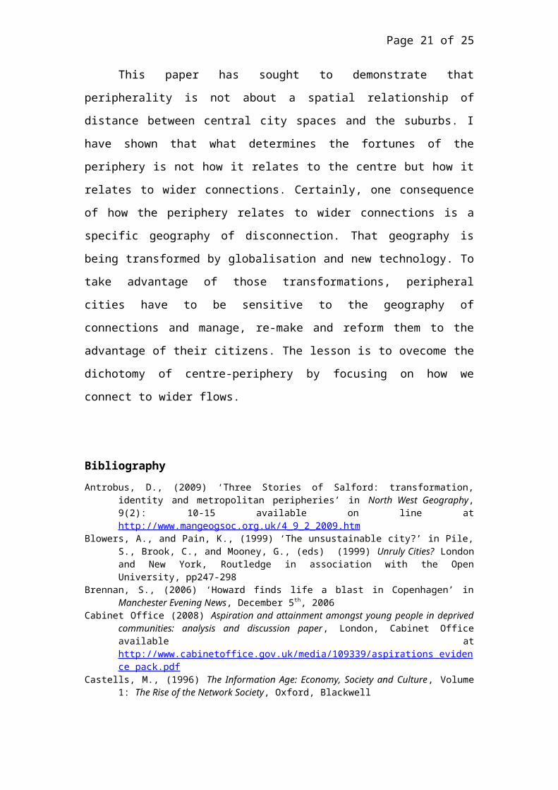
Since I will be using Salford as a case study, it is
useful to say something about the city’s geography (see
Fig 1). It lies to the west of Manchester in the North
West of England. The administrative boundary between
Salford and Manchester is principally the River Irwell.
The Irwell forms the northern boundary of Salford whence
it flows from the neighbouring borough of Bolton. To the
south, the Irwell is canalised as the Manchester Ship
Canal which also forms the administrative boundary. The
Canal links Greater Manchester to L:iverpool. Although
Manchester is a large authority with many suburbs, its
central business district, retail centre and leisure
areas are juxtaposed to Salford along the river. The far
Page 4 of 25
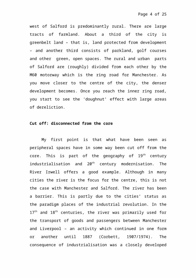
west of Salford is predominantly rural. There are large
tracts of farmland. About a third of the city is
greenbelt land – that is, land protected from development
– and another third consists of parkland, golf courses
and other green, open spaces. The rural and urban parts
of Salford are (roughly) divided from each other by the
M60 motorway which is the ring road for Manchester. As
you move closer to the centre of the city, the denser
development becomes. Once you reach the inner ring road,
you start to see the ‘doughnut’ effect with large areas
of dereliction.
Cut off: disconnected from the core
My first point is that what have been seen as
peripheral spaces have in some way been cut off from the
core. This is part of the geography of 19th century
industrialisation and 20th century modernisation. The
River Irwell offers a good example. Although in many
cities the river is the focus for the centre, this is not
the case with Manchester and Salford. The river has been
a barrier. This is partly due to the cities’ status as
the paradigm places of the industrial revolution. In the
17th and 18th centuries, the river was primarily used for
the transport of goods and passengers between Manchester
and Liverpool – an activity which continued in one form
or another until 1887 (Corbett, 1907/1974). The
consequence of industrialisation was a closely developed
Page 5 of 25
riverside. The river was no longer a focal point but a
barrier. This was reinforced by the pollution of the
river. As the Salford novelist Greenwood (1949)
commented: “The river is so disgusted with this crawling
vegetable called Man, which has murdered it, that it
expresses its disgust by throwing up thick and oily
chemical belches. Watch it. Every now and then from its
depths comes a slow regurgitation as the poor agonized
creature drags it oozy length towards the crowning
insult…Whenever I am in Manchester I make my customary
pilgrimage to the bridge and apologize to the river for
its treatment by my fellow men…”. The two cities turned
their backs on the river and instead of being a space
that joined them, it became a space that divided.
One reason for the decline of river transport was
the rise of the railway. That brought fresh division in
the space of the urban centre. The centre is
characterised by its terminals: it is a destination for
connections. In 1838 a railway line from neighbouring
Bolton had been built and ended at what is today Salford
Central Station. For the early years of the 19th century,
that district of Salford was a hub. The rail station was
alongside the wharves of the River Irwell. The
surrounding area had been developed for factories.
Workers’ housing packed the surrounding area and the main
thoroughfare of Chapel Street jostled with shops, pubs
and public buildings. In 1844 and 1884 new rail lines
involved the construction of huge viaducts which
Page 6 of 25
decimated the area, disconnected the centre of Salford
from its surrounding and refocused activity in
Manchester. The 1844 development was an extension from
the Liverpool-Manchester railway which connected the 1830
line – the world’s first – with the new Victoria station
in Manchester. The 1884 development brought in a new line
from Liverpool by a rival rail company. The impact of
this line was even greater because it involved the
building of a new station – the Exchange. The Salford
Borough Council collaborated in this project because of a
promise to build the new station on the Salford bank of
the Irwell – a promise that was kept: the railway company
built the station facing Manchester and built a bridge
across the Irwell to provide the main entrance. This
reinforced the sense of Manchester having the more active
spaces. The disconnection between Manchester and Salford
was made much worse by the building of the railway
viaducts. Salford’s main thoroughfare declined. It became
a place that people passed through on their way into
Manchester and no longer a place to go to.
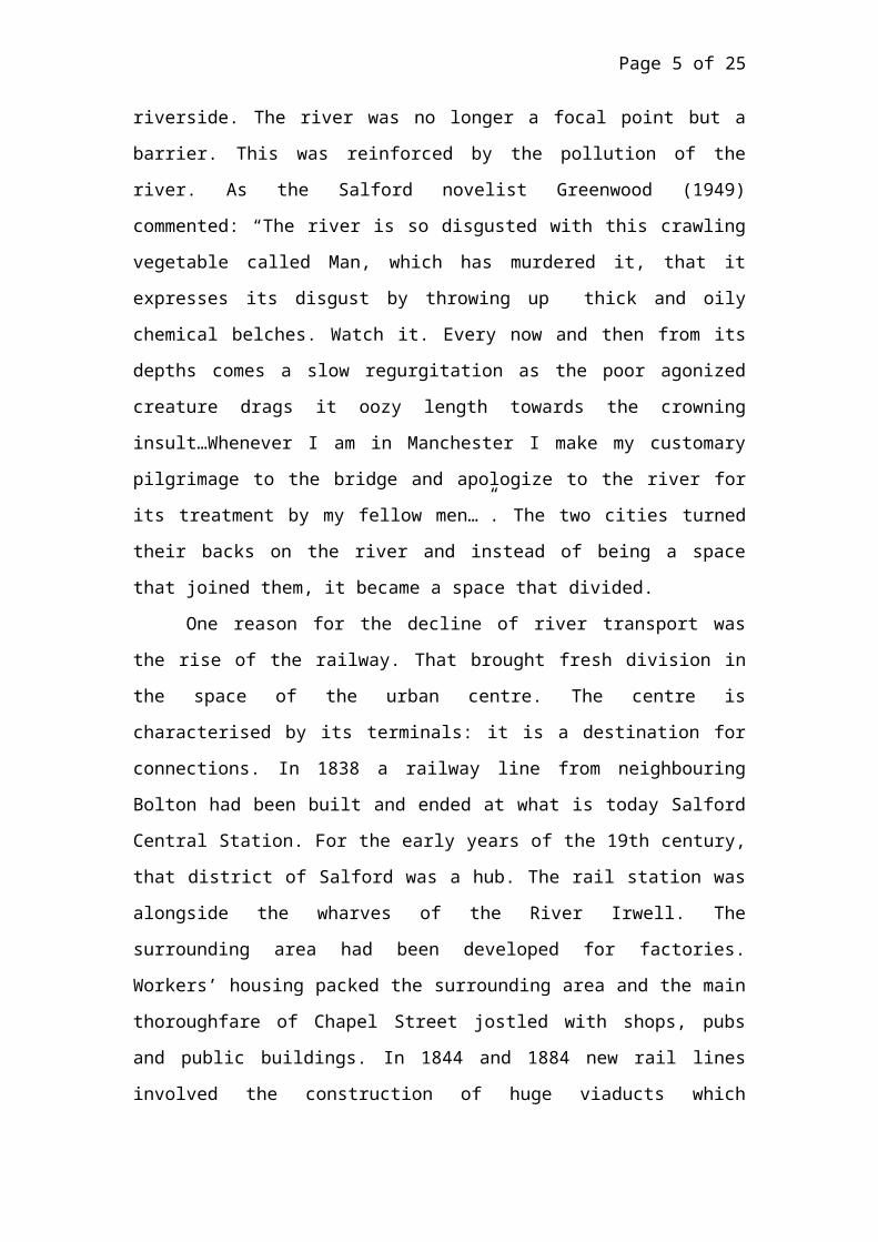
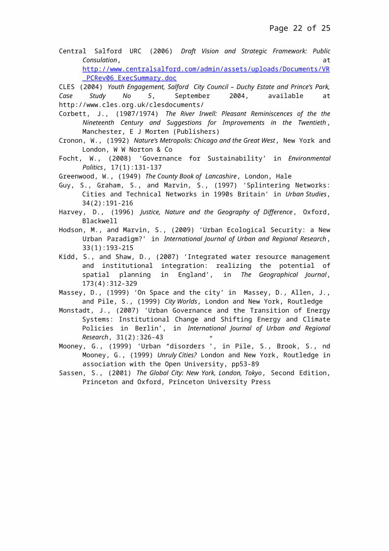
The automobile-dominated modernisation of the 20th
century brought the greatest indignity –Salford was to
become known as Manchester’s car park – graphically shown
in Figure 2 which is shows a space overwhelmed by car
parking on what was once the Exchange Station. There are
further car parks to the right in the area called
Greengate – once the ancient market square of Salford.
The city lost any sense of having its own centre which
Page 7 of 25
retreated into Manchester. This was reinforced by public
disinvestment from Chapel Street – Salford’s main
thoroughfare which had become a principal commuter route
into Manchester. The disinvestment occurred after local
government reorganisation shifted the administrative
centre to the town of Swinton in the west of the city. So
in this example the connections along railway
infrastructure marginalised Salford, disconnecting it
from the activity at the core and isolating its
communities. Salford was in the shade of Manchester,
offering low value support to Manchester’s central
functions. .
Cut up: communities isolated
My second point is that the convergence of transport
routes into the city disconnect communities from each
other. Chapel Street is a very physical barrier to the
communities that live either side of it. On one side is
the district of Trinity, on the other is Islington. Each
of these areas has its own residents’ association which
focuses on their area. This community division is
reinforced by administrative boundaries. Chapel Street,
because of its significance, has been viewed as a
‘natural’ boundary and the Government body which
determines boundaries has made it the dividing line
between two wards (a ward is the electoral area
represented by a councillor) of Ordsall and Irwell
Page 8 of 25
Riverside. The City Council has promoted neighbourhood
governance and these two wards also sit in two different
neighbourhoods as defined by the Council. Once again,
this is because Chapel Street is seen as a boundary –
something that divides – rather than a focal point for
its communities. This division is replicated elsewhere in
the city as major highways and railways – to Bury, to
Bolton, to Eccles, to Liverpool – shear through the city
and cut up its spaces.
These major routes not only cut off settlements from
each other, they determine the travel behaviour of the
people of the city. The highways and railways are radial
– emanating form Manchester like the spokes on a wheel.
The public transport routes follow that radial pattern. A
good example is Salford Quays – the city’s most
prestigious regeneration project which is a major driver
of employment in the Greater Manchester region. But
access to the Quays, its jobs and its cultural offer is
restricted for Salford people. Its principal public
transport is the tramway which links directly to
Manchester. The easiest way for most Salford people to
travel to the Quays is to firstly travel into Manchester
and then take the tram back into Salford.
Cut down: a diminished identity
My third point is that peripherality impacts on
image and identity. This leads to what has been called
Page 9 of 25
‘territorial stigmatization’ (Mooney, 1999) where the
residents of an area suffer real impacts in terms of
their life chances – their postcode determines their
employment prospects. A nice example is that of Mark
Howard, a footballer from Salford who played for
Manchester United and then moved to Denmark. There he
gained the nickname ‘The Ghetto Kid’ because of
journalist’s view of where he came from. He believes this
nickname and the association with a particular
representation has become part of his identity –
including how he is seen by football referees who, he
feels, unfairly penalise him (Brennan, 2006).
Page 10 of 25
It is not just a question of how others see us, but
how we see ourselves. The UK Government has identified a
link between certain types of neighbourhood and low
levels of aspiration (Cabinet Office, 2008). It suggests:
“Narratives of decline and poor reputations can permeate
everyday life and affect self-esteem” (ibid.) The report
argues: “An absence of a broader and more diverse network
of contacts outside the immediate neighbourhood can mean
that young people lack access to valuable sources of
inspiration, information and opportunity. Similarly, 40%
of employers use informal methods of recruitment.
Therefore, poor links to employment markets can make it
more difficult to find employment” (ibid.). The
disconnection described for Salford aligns with this
explanation of the link between place and identity.
Page 11 of 25
It is further evidenced in a study by the Centre
for Local Economic Strategies (CLES) which focused on the
Duchy housing estate and explicitly linked the physical
barriers to aspirations: “In the mid 1990’s the estate
began to decline, a high level of vacant properties began
to blight the estate, many houses fell into an
[un?]inhabitable (sic) and derelict state. The estate’s
decline was compounded by its isolation, the busy East
Lancashire road serves as a barrier for the people on the
estate as it can only be crossed in three places, one of
which is an underpass widely regard as a no go area by
the community due to increasing crime levels and the
local gangs of youths. This lack of access cuts off - and
isolates the community from local services, transport
links and employment opportunities. The Duchy Estate has
suffered disproportionately from the steady decline in
industrial employment. Unemployment gradually became a
norm on the estate, the resulting impact of this was seen
in rising crime levels and increased drug use, especially
amongst the youth, growing up in an estate on a downward
spiral. In summation the young peoples lifestyles
exhibited ‘a lack of opportunity and a poverty of
aspiration’ “ (CLES, 2004).
A new geography of the centre
Page 12 of 25
Contemporary city spaces are undergoing
transformation. Sassen (2001) has associated this with
globalisation and new information technologies. She
argues (a) that globalisation and the consequent need for
services has displaced traditional manufacturing and low-
value functions from the metropolitan centre and (b) that
technological change has contributed to the ‘de-centring’
of central functions by, for example, the location of
head offices and call centres in peripheral locations,
such as derelict manufacturing sites or old docklands.
These factors can be combined with the dominant European
planning discourse of ‘compact cities’ which has led to
the concentration of ‘brownfield’1 development within
metropolitan areas (Blowers and Pain, 1999). This re-
ordering of city spaces gives opportunities for the
periphery. Peripheral areas can reconnect with the centre
and make new connections beyond the city. In order to
settle flows of investment into their spaces, cities have
adopted a number of strategies.
The remainder of this paper examines some of these
strategies with reference to our case study of Salford.
There are five broad approaches – three of which directly
address the problems identified above in relation to
spaces being cut off, cut up and cut down. These involve
reconnecting the periphery to the centre, reconnecting
communities within the periphery, and remaking the
identity of a place. But I also argue that there are two
1 Brownfield land is that which has previously been developed. Greenfield sites are on previously undeveloped land.
Page 13 of 25
other broad strategies: to make new connections to the
global and to make connections to environmental flows.
Reconnecting to the centre
Reconnecting to the centre is one obvious strategy
that is being adopted. In Salford the primary project is
a massive investment in the River Irwell corridor known
as Irwell River Park. It is a £45 million project which
is intended to make the Irwell between Manchester,
Salford and the neighbouring borough of Trafford into a
focal point. Its aim is to transform the river from a
space that divides the cities to a place where the cities
meet. It will involve making 8km of waterside into an
accessible green space. It will include new bridges
across the river, walkways and cycleways on the riverbank
and a planning policy that demands new development
respects the river and encourages active use. The project
is being led by the Central Salford Urban Regeneration
Company - a public-private partnership set up to
stimulate change in Salford - on behalf of the three
local authorities. Some initial funding has been agreed
by the North West Development Agency and some future
funding will come from agreements with developers along
the river.
An early example of what can be achieved by this
strategy of reconnection is at Chapel Wharf, a site on
the Salford side of Irwell which was a run-down,
Page 14 of 25
abandoned industrial area. In the 1990s, the city council
formed a partnership with the landowners to redevelop.
The main idea was the construction of a new footbridge
which was designed by Calatrava. It connected Salford
across the river to a space which contained Manchester’s
then most fashionable retail store and one of its
principal shopping streets. This connection enabled
Salford to attract high-value uses: the Lowry Hotel which
was the centre’s first 5-star establishment and
prestigious apartment blocks (see Fig 3).
There are proposals to replicate this success at the
former Exchange rail station site which is currently
dominated by car parking. A partnership between the City
Council, landowners Network Rail and the private
developer Ask Developments. Two public squares, a river
walkway, and a new bridge across the River Irwell are all
part of the stunning public realm designs that will
establish Exchange-Greengate as a new city centre
destination. Just minutes from the main Victoria Rail
Station and the commercial heart of Manchester, Greengate
will be home to 2,500 residential units and over 85,000
sq m of commercial floor space. The Exchange-Greengate
scheme is expected to attract over £580m of private
sector investment and secured planning permission in June
2007. Public realm works are due to start in the spring
of 2010.
The Irwell River Park project involves a number of
new bridges over the Irwell and another that is due to
Page 15 of 25
commence in spring 2010 is at Stanley Street close to
Salford Centre Rail Station. The new footbridge will link
the station to a new commercial quarter of Manchester
known as ‘Spinningfields’ and the Central Salford Urban
Regeneration Company is proposing to redevelop with
partners a low density office development around the
rail station with high rise, high value commercial space.
This is viable because of way it is integrated into the
new commercial space in Manchester across the new bridge.
Reconnecting communities
A second strategy is to reconnect communities by
enhancing transport links, removing barriers and
connecting communities to the process of transformation.
I have already referred to the accessibility problems
associated with Salford Quays. Salford City Council is
working with the Urban Regeneration Company and the
Greater Manchester Integrated Transport Authority to
enhance public transport connections. The Council has
approved a Central Salford Transport Strategy which
emphasises the need for orbital connections around the
city. The first evidence of this will be in January 2010
when we expect a new bus route to be approved which
connects the University quarter and Chapel Street to
Salford Quays. We also plan for rail stations which are
currently boarding points for commuters into Manchester
to become major interchanges where passengers can arrive
Page 16 of 25
and transfer to bus services which penetrate and join up
the new centres of activity.
I have also referred earlier to the role of Chapel
Street as a major boundary. Another project which we hope
will be approved in early 2010 is a plan to ‘calm’ the
traffic so the street is less of a barrier. It will be
transformed from a grey, congested space to a tree-lined
boulevard with designs that will privilege the position
of pedestrians. High quality finishes and crossing places
will help to remove the barrier. This is the first stage
of a longer-term investment which will see a new square
developed opposite Salford Cathedral which stands on
Chapel Street and the plans for that quarter of the city
envisages a mixture of residential and commercial uses,
with he emphasis on ground floor active uses such as
bars, cafés and shops.
Salford has been a pioneer in the engagement of
communities and was one of the first councils in the
country to establish neighbourhood forums called
Community Committee so that residents are connected
politically to the transformations of their areas. Not
only are they consulted in detail on any proposals, but
they also have delegated budgets which allow them to
carry out changes – environmental or social – within
their areas which accord with their on priorities. The
City Council also commissions an annual opinion survey of
residents to ensure that its practices are aligned with
the priorities of citizens. Publkic consultation has also
Page 17 of 25
been at the heart of regeneration initiatives. For
example, the vision for Central Salford involved the
active participation of over 3,000 residents and 17
community groups formed themselves into a ‘Collective’ to
manage the exercise so it was genuinely a bottom-up
rather than a top-down engagement.
Remaking identity
There is, thirdly, also a need to transform
opportunities and change the image and self-image of the
city. I have discussed elsewhere the way in which the
image of the city is being positively changed (Antrobus,
2009) through place-marketing and the promotion of
exemplary regeneration projects. But we are also seeking
to raise the aspirations of citizens so the economic,
social and cultural opportunities are seen as something
that is for them. There are a variety of projects which
seek to link education and training to the new
opportunities in the media and cultural industries which
are growing in Salford. Two specific initiatives are
worthy of mention.
Firstly, the City Council has embarked on a
programme known as ‘Building Schools for the Future’
which will see the replacement of every secondary school
in the city. This £150 million investment programme is
centred not so much on new building but on transforming
learning, creating spaces and using technologies which

Page 18 of 25
meet the demands of the new industrial revolution. The
results so far have been startling. In those schools
which have been re-built, we see performance improving
and a dramatic change in pupils’ attitudes and behaviour.
Secondly, the University of Salford has a key role
and has created a community engagement team to end the
divide between the University – perceived as a facility
for ‘outsiders’ – and local people. An example of this is
the Salford Young People’s University which offers during
the summer a ‘taster’ of university life for secondary
age pupils in the city. Last year some 400 Salford
children engaged in this scheme. The University has also
embarked on a programme of ensuring its research benefits
local people with awards for academics who can show how
their research works with and benefits the local
community.
Making global connections
Previous points are about remaking and reconnecting
the city’s physical and socio-political spaces. But to
bring about success, cities must connect with the global.
The most exciting example of this in Salford is the
development of MediaCity:UK. The origins of this project
lie in a decision by the Government to encourage national
institutions to relocate some of their activities away
from London. Amongst them was the BBC which decided to
move some of its production to Greater Manchester. Local
Page 19 of 25
authorities in Greater Manchester offered a number of
sites but Salford was chosen. The reason for this is that
instead of offering a development site for a new
building, Salford’s managers had the imagination to think
about how the activity would link into global
connections. The starting point was to ask what was
happening in the global media. There was a recognition
that in eight or nine cities across the globe media firms
were coming together in a single space to benefit from
the synergy of new technologies. So the MediaCity:UK
project was about making the BBC the heart of a new space
which would attract other media giants and make Salford a
hub in a global network.
Making green connections
A final set of connections are vital to cities in an
era of dangerous climate change and resource constraint.
The idea of the city as what Massey (1999) calls ‘an open
intensity’ is a key element of an emergent discourse of
resilient cities. The notion of an ‘open intensity’ – a
concentration of flows which settle in space to create
something new – has been used to develop understandings
of the city primarily in terms of flows of information
(Castells, 1996) and capital (Harvey, 1996). More
recently, this has extended to the wider flows of
resources (Cronon, 1992). Marvin (1992) noted the
omission from the literature of a discussion of the
Page 20 of 25
infrastructure – water, waste, energy, telecoms and
transportation - which sustained these flows. He draws
attention to the fragility of these networks which he
sees as the “essential life support of cities” (Marvin,
1992:230). It is the very spatiality of such
environmental flows which renders their sustainability
problematic. The dependence on resource exchanges makes
sustainable planning complex (Focht, 2008). This inherent
problem has been further complicated by the privatization
and liberalization of infrastructure provision associated
with neo-liberalism and ecological modernization in which
environmental flows are commodified (Guy et al, 1997;
Monstadt, 2007). These issues have been extensively
explored in the field of water management where the
spaces of catchments and utility infrastructures do not
coincide with the institutions of urban governance (Kidd
and Shaw, 2007). There is a concern, therefore, within
the resilience discourse to manage and secure these flows
through new modes of governance which Hodson and Marvin
(2009) have labelled ‘urban ecological security’.
Salford has faces significant risks from flooding and is
collaborating with other authorities in Greater
Manchester on managing flood risk but also building in
energy security through a plan for renewable energy.
Conclusions
Page 21 of 25
This paper has sought to demonstrate that
peripherality is not about a spatial relationship of
distance between central city spaces and the suburbs. I
have shown that what determines the fortunes of the
periphery is not how it relates to the centre but how it
relates to wider connections. Certainly, one consequence
of how the periphery relates to wider connections is a
specific geography of disconnection. That geography is
being transformed by globalisation and new technology. To
take advantage of those transformations, peripheral
cities have to be sensitive to the geography of
connections and manage, re-make and reform them to the
advantage of their citizens. The lesson is to ovecome the
dichotomy of centre-periphery by focusing on how we
connect to wider flows.
BibliographyAntrobus, D., (2009) ‘Three Stories of Salford: transformation,
identity and metropolitan peripheries’ in North West Geography,9(2): 10-15 available on line athttp://www.mangeogsoc.org.uk/4_9_2_2009.htm
Blowers, A., and Pain, K., (1999) ‘The unsustainable city?’ in Pile,S., Brook, C., and Mooney, G., (eds) (1999) Unruly Cities? Londonand New York, Routledge in association with the OpenUniversity, pp247-298
Brennan, S., (2006) ‘Howard finds life a blast in Copenhagen’ inManchester Evening News, December 5th, 2006
Cabinet Office (2008) Aspiration and attainment amongst young people in deprivedcommunities: analysis and discussion paper, London, Cabinet Officeavailable athttp://www.cabinetoffice.gov.uk/media/109339/aspirations_evidence_pack.pdf
Castells, M., (1996) The Information Age: Economy, Society and Culture, Volume1: The Rise of the Network Society, Oxford, Blackwell
Page 22 of 25
Central Salford URC (2006) Draft Vision and Strategic Framework: PublicConsulation, athttp://www.centralsalford.com/admin/assets/uploads/Documents/VR_PCRev06_ExecSummary.doc
CLES (2004) Youth Engagement, Salford City Council – Duchy Estate and Prince’s Park,Case Study No 5, September 2004, available athttp://www.cles.org.uk/clesdocuments/Corbett, J., (1907/1974) The River Irwell: Pleasant Reminiscences of the the
Nineteenth Century and Suggestions for Improvements in the Twentieth,Manchester, E J Morten (Publishers)
Cronon, W., (1992) Nature’s Metropolis: Chicago and the Great West, New York andLondon, W W Norton & Co
Focht, W., (2008) ‘Governance for Sustainability’ in EnvironmentalPolitics, 17(1):131-137
Greenwood, W., (1949) The County Book of Lancashire, London, HaleGuy, S., Graham, S., and Marvin, S., (1997) ‘Splintering Networks:
Cities and Technical Networks in 1990s Britain’ in Urban Studies,34(2):191-216
Harvey, D., (1996) Justice, Nature and the Geography of Difference, Oxford,Blackwell
Hodson, M., and Marvin, S., (2009) ‘Urban Ecological Security: a NewUrban Paradigm?’ in International Journal of Urban and Regional Research,33(1):193-215
Kidd, S., and Shaw, D., (2007) ‘Integrated water resource managementand institutional integration: realizing the potential ofspatial planning in England’, in The Geographical Journal,173(4):312-329
Massey, D., (1999) ‘On Space and the city’ in Massey, D., Allen, J.,and Pile, S., (1999) City Worlds, London and New York, Routledge
Monstadt, J., (2007) ‘Urban Governance and the Transition of EnergySystems: Institutional Change and Shifting Energy and ClimatePolicies in Berlin’, in International Journal of Urban and RegionalResearch, 31(2):326-43
Mooney, G., (1999) ‘Urban “disorders”’, in Pile, S., Brook, S., ndMooney, G., (1999) Unruly Cities? London and New York, Routledge inassociation with the Open University, pp53-89
Sassen, S., (2001) The Global City: New York, London, Tokyo, Second Edition,Princeton and Oxford, Princeton University Press
Page 23 of 25
FIGURES
Figure 1: A schematic plan of Salford showing its shared
space with Manchester city centre to the east and its
rural area in the west
Page 24 of 25
Figure 2: Salford’s city centre space dominated by car
parking – cut off from Manchester city centre by the
river and isolated from the rest of Salford by railways
and major roads

Page 25 of 25
Figure 3: The Lowry Hotel – high-value land uses created
by linking Salford directly into city centre spaces