Beach Behavior and Impact of Coastal Structures on the Sustainable Development, Cases from...
13
OPEN JOURNAL OF OCEAN AND COASTAL SCIENCES Volume 1, Number 1, October 2014 OPEN JOURNAL OF OCEAN AND COASTAL SCIENCES Beach Behavior and Impact of Coastal Structures on the Sustainable Development, Cases from the Northwestern Coast of Egypt Moheb Mina Iskander*, Ahmed El Sayed El Kut Hydrodynamic Department, Coastal Research Institute, National Water Research Center, Alexandria, Egypt. *Corresponding author: coastal [email protected] Abstract: The Northwestern coast of Egypt extends for 520 km along the Mediterranean Sea west of Alexandria city. The special characteristics of this area have made it very attractive for tourists and entertainment activities. However, the beaches along the coast are not fully suitable for recreational activities due to some of their physical and morphological characteristics. This situation leads to unsupervised construction of artificial coastal measures along different parts of the coast. Most of these works have negative impacts on the coast. The available satellite images within the last ten years as well as field survey were used to evaluate the shoreline changes under the effect of artificial structures, identify the coastal problems, summarize the research efforts to reach the sustainable development, and specify the required research for the future. The coast can be divided into two main parts, undeveloped and developed. The undevel- oped areas are divided into flood affected and flood-unaffected areas while the developed areas represent the major towns along the coast. Monitoring of the undeveloped areas shows that it has dynamically stable shorelines. On the other hand, observing the developed areas reveal that the coastal structure along these areas have a significant impact on the shorelines. The study identifies three substantial challenges and recommends the solution trend for each challenge. Firstly, the sustainable development of the undeveloped areas. The morphological features can be used to control the land use to reach the sustainable development. Secondly, recreational resorts problems, which divided into two categories, one within dynamically stable beaches and the other within unstable beaches. A Suspended Breakwater on piles is recommended to be used for the first category, while a combination of hard and soft solutions, such as a perched beach, can work for the second one. The third challenge is the human interference within the developed areas, which can be solved case by case in the integrated manner. Keywords: Coastal Structures; Egypt Northwestern Coast; Satellite Images; Shoreline Changes; Sustain- able Development 12
Transcript of Beach Behavior and Impact of Coastal Structures on the Sustainable Development, Cases from...
OPEN JOURNAL OF OCEAN AND COASTAL SCIENCESVolume 1, Number 1, October 2014
OPEN JOURNAL OF OCEAN AND COASTAL SCIENCES
Beach Behavior and Impact of CoastalStructures on the SustainableDevelopment, Cases from the NorthwesternCoast of EgyptMoheb Mina Iskander*, Ahmed El Sayed El KutHydrodynamic Department, Coastal Research Institute, National Water Research Center, Alexandria, Egypt.
*Corresponding author: coastal [email protected]
Abstract:The Northwestern coast of Egypt extends for 520 km along the Mediterranean Sea west ofAlexandria city. The special characteristics of this area have made it very attractive for touristsand entertainment activities. However, the beaches along the coast are not fully suitable forrecreational activities due to some of their physical and morphological characteristics. Thissituation leads to unsupervised construction of artificial coastal measures along different partsof the coast. Most of these works have negative impacts on the coast. The available satelliteimages within the last ten years as well as field survey were used to evaluate the shorelinechanges under the effect of artificial structures, identify the coastal problems, summarize theresearch efforts to reach the sustainable development, and specify the required research for thefuture. The coast can be divided into two main parts, undeveloped and developed. The undevel-oped areas are divided into flood affected and flood-unaffected areas while the developed areasrepresent the major towns along the coast. Monitoring of the undeveloped areas shows that ithas dynamically stable shorelines. On the other hand, observing the developed areas reveal thatthe coastal structure along these areas have a significant impact on the shorelines. The studyidentifies three substantial challenges and recommends the solution trend for each challenge.Firstly, the sustainable development of the undeveloped areas. The morphological features canbe used to control the land use to reach the sustainable development. Secondly, recreationalresorts problems, which divided into two categories, one within dynamically stable beaches andthe other within unstable beaches. A Suspended Breakwater on piles is recommended to beused for the first category, while a combination of hard and soft solutions, such as a perchedbeach, can work for the second one. The third challenge is the human interference within thedeveloped areas, which can be solved case by case in the integrated manner.
Keywords:Coastal Structures; Egypt Northwestern Coast; Satellite Images; Shoreline Changes; Sustain-able Development
12

Beach Behavior and Impact of Coastal Structures on the Sustainable Development, Cases from the NorthwesternCoast of Egypt
Figure 1. General map of the Northwestern coast of Egypt with depth contours.
1. INTRODUCTION
The shoreline is one of the rapidly changing features of the coastal zone that is dynamic in nature.It is also one of the earlier features react to any changes in the coastal area. Analysis of the shorelinechanges is fundamental to a broad range of investigations undertaken by coastal scientists, oceanographers,coastal engineers, and coastal managers [1, 2]. Shoreline information is used in designing the coastalprotection, calibrating and verifying numerical models, assessing sea-level rise, developing hazard zones,and formulating policies to regulate coastal development. Shoreline changes can be investigated by usingfield data measurements or satellite images. Satellite data of high resolution at small intervals and shortspaced transect can accurately predict the shoreline changes with cost efficiency.
The Northwestern coast of Egypt is bounded by the Libyan border from the west and El-Agamiheadland, west of Alexandria, from the east with a total length of about 520 km, Figure 1. The beachesalong the coast are distinct by white Oolitic carbonate sand, clear blue water, mild weather, and the sunprevailing most of the year. All these privileges have made these beaches attractive sites for tourists andentertainment activities. During the last three decades, more than two hundred recreational villages havebeen constructed in this area.
There is no severe natural coastal erosion problem along this coastal zone. However, the beaches arenot suitable for swimming due to the steep slope of their surf zone and the generation of rip currents thatcause several troubles and serious hazards to the swimmers. This situation enforced village owners tobuild coastal structures or construct artificial swimming pools and/or lagoons connected to the sea in orderto create suitable and safe places for swimming activities. These coastal schemes were built in the formof inlets to coastal lagoons (El-Alamien Marina center jetties, and SidiKerair coastal resort breakwater),and protected swimming areas (Marabella and Six of October resort village breakwaters).
Most of these schemes have a noticeable impact on the beaches in form of coastal pollution, accretionand/or erosion. Several investigators have studied these coastal problems and they have concluded thatthe insufficient local data and the misunderstanding of the prevailing coastal processes were the mainreasons for the poor design of these coastal schemes [3–9].
The aim of this work is to evaluate the shoreline changes under the effects of coastal structures comparedto the natural behavior within the study area, identify the coastal problems, summarize the previousresearch efforts to reach the sustainable development and specify the required research for the future.
13
OPEN JOURNAL OF OCEAN AND COASTAL SCIENCES
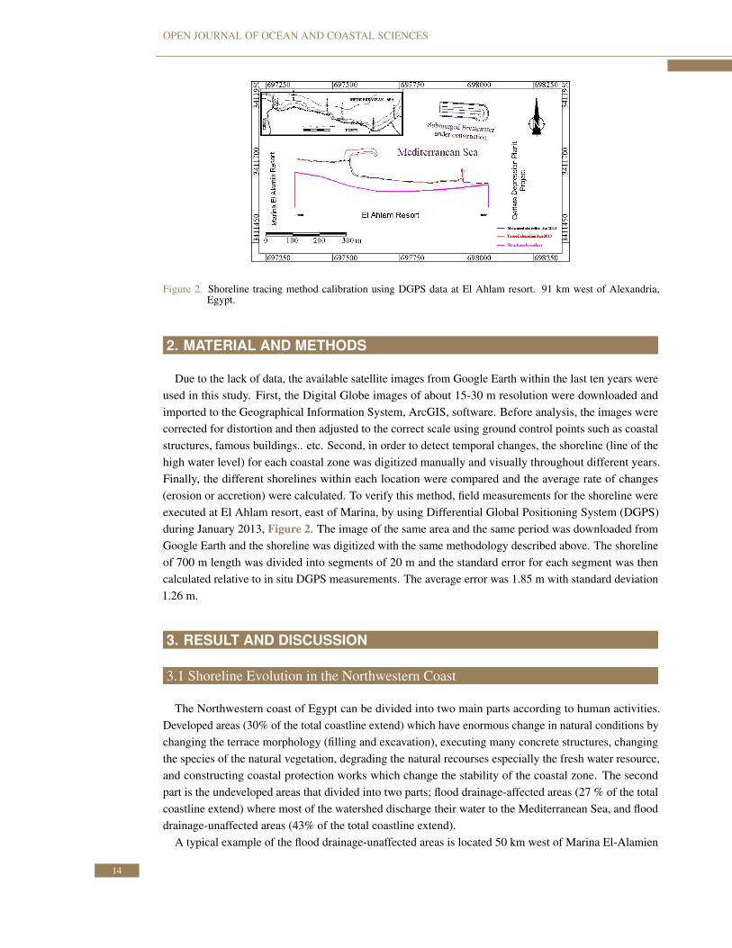
Figure 2. Shoreline tracing method calibration using DGPS data at El Ahlam resort. 91 km west of Alexandria,Egypt.
2. MATERIAL AND METHODS
Due to the lack of data, the available satellite images from Google Earth within the last ten years wereused in this study. First, the Digital Globe images of about 15-30 m resolution were downloaded andimported to the Geographical Information System, ArcGIS, software. Before analysis, the images werecorrected for distortion and then adjusted to the correct scale using ground control points such as coastalstructures, famous buildings.. etc. Second, in order to detect temporal changes, the shoreline (line of thehigh water level) for each coastal zone was digitized manually and visually throughout different years.Finally, the different shorelines within each location were compared and the average rate of changes(erosion or accretion) were calculated. To verify this method, field measurements for the shoreline wereexecuted at El Ahlam resort, east of Marina, by using Differential Global Positioning System (DGPS)during January 2013, Figure 2. The image of the same area and the same period was downloaded fromGoogle Earth and the shoreline was digitized with the same methodology described above. The shorelineof 700 m length was divided into segments of 20 m and the standard error for each segment was thencalculated relative to in situ DGPS measurements. The average error was 1.85 m with standard deviation1.26 m.
3. RESULT AND DISCUSSION
3.1 Shoreline Evolution in the Northwestern Coast
The Northwestern coast of Egypt can be divided into two main parts according to human activities.Developed areas (30% of the total coastline extend) which have enormous change in natural conditions bychanging the terrace morphology (filling and excavation), executing many concrete structures, changingthe species of the natural vegetation, degrading the natural recourses especially the fresh water resource,and constructing coastal protection works which change the stability of the coastal zone. The secondpart is the undeveloped areas that divided into two parts; flood drainage-affected areas (27 % of the totalcoastline extend) where most of the watershed discharge their water to the Mediterranean Sea, and flooddrainage-unaffected areas (43% of the total coastline extend).
A typical example of the flood drainage-unaffected areas is located 50 km west of Marina El-Alamien
14
Beach Behavior and Impact of Coastal Structures on the Sustainable Development, Cases from the NorthwesternCoast of Egypt
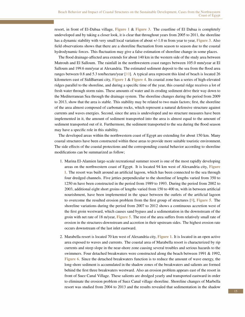
resort, in front of El-Dabaa village, Figure 1 & Figure 3. The coastline of El Dabaa is completelyundeveloped and by taking a closer look, it is clear that throughout years from 2005 to 2011, the shorelinehas a dynamic stability with very small local variation of about +/-1.0 m from year to year, Figure 3. Alsofield observations shows that there are a shoreline fluctuation from season to season due to the coastalhydrodynamic forces. This fluctuation may give a false estimation of shoreline change in some places.
The flood drainage-affected area extends for about 140 km in the western side of the study area betweenMatrouh and El Salloum. The rainfall in the northwestern coast ranges between 105.0 mm/year at ElSalloum and 199.6 mm/year at Alexandria. The estimated sediment deposit to the sea from the flood arearanges between 0.8 and 5.3 ton/hectare/year [10]. A typical area represent this kind of beach is located 26kilometers east of SidiBarrani city, Figure 1 & Figure 4. Its coastal zone has a series of high-elevatedridges parallel to the shoreline, and during a specific time of the year, this coastal ridge receives a lot offresh water through storm rains. These amounts of water and its eroding sediment drive their way down tothe Mediterranean Sea through the drainage system. The shoreline changes during the period from 2009to 2013, show that the area is stable. This stability may be related to two main factors; first, the shorelineof the area almost composed of carbonate rocks, which represent a natural defensive structure againstcurrents and waves energies. Second, since the area is undeveloped and no structure measures have beenimplemented in it, the amount of sediment transported into the area is almost equal to the amount ofsediment transported out of it. Furthermore, the sediment transported to the sea during the flood seasonmay have a specific role in this stability.
The developed areas within the northwestern coast of Egypt are extending for about 150 km. Manycoastal structures have been constructed within these areas to provide more suitable touristic environment.The side effects of the coastal protections and the corresponding coastal behavior according to shorelinemodifications can be summarized as follow;
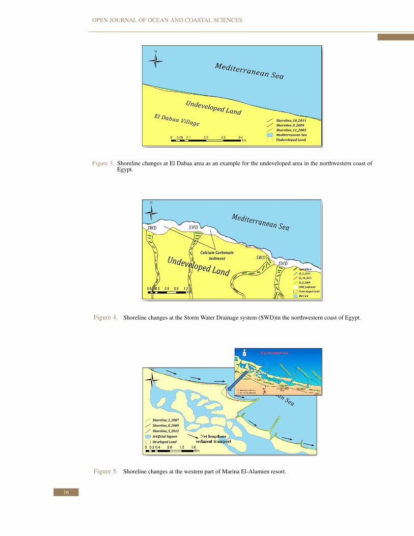
1. Marina El-Alamien large-scale recreational summer resort is one of the most rapidly developingareas on the northwestern coast of Egypt. It is located 94 km west of Alexandria city, Figure1. The resort was built around an artificial lagoon, which has been connected to the sea throughfour dredged channels. Five jetties perpendicular to the shoreline of lengths varied from 350 to1250 m have been constructed in the period from 1989 to 1993. During the period from 2002 to2003, additional eight short groins of lengths varied from 150 to 400 m, with in between artificialnourishment, have been implemented in the space between the outlets of the artificial lagoonto overcome the resulted erosion problem from the first group of structures [9], Figure 5. Theshoreline variations during the period from 2007 to 2012 shows a continuous accretion west ofthe first groin westward, which causes sand bypass and a sedimentation in the downstream of thegroin with net rate of 18 m/year, Figure 5. The rest of the area suffers from relatively small rate oferosion in the structures-downstream and accretion in their upstream sides. The highest erosion rateoccurs downstream of the last inlet eastward.
2. Marabella resort is located 70 km west of Alexandria city, Figure 1. It is located in an open activearea exposed to waves and currents. The coastal area of Marabella resort is characterized by ripcurrents and steep slope in the near-shore zone causing several troubles and serious hazards to theswimmers. Four detached breakwaters were constructed along the beach between 1991 & 1992,Figure 6. Since the detached breakwaters function is to reduce the amount of wave energy, thelong-shore sediment is accumulated in the shadow zones of the breakwaters and salients are formedbehind the first three breakwaters westward. Also an erosion problem appears east of the resort infront of Suez Canal Village. These salients are dredged yearly and transported eastward in orderto eliminate the erosion problem of Suez Canal village shoreline. Shoreline changes of Marbellaresort was studied from 2004 to 2013 and the results revealed that sedimentation in the shadow
15
OPEN JOURNAL OF OCEAN AND COASTAL SCIENCES
Figure 3. Shoreline changes at El Dabaa area as an example for the undeveloped area in the northwestern coast ofEgypt.
Figure 4. Shoreline changes at the Storm Water Drainage system (SWD)in the northwestern coast of Egypt.
Figure 5. Shoreline changes at the western part of Marina El-Alamien resort.
16

Beach Behavior and Impact of Coastal Structures on the Sustainable Development, Cases from the NorthwesternCoast of Egypt
Figure 6. Shoreline changes at Marbella resort, North western coast of Egypt.
zones of the breakwaters still occur. Also, The shoreline eastward of the breakwaters suffer fromerosion, Figure 6.
3. Sidi-Kerir is a summer resort located at about 33 kilometer west of Alexandria, Figure 1. Itis suffering from the steep slope beaches and rip currents that prevent residents from enjoyingswimming in the sea. In 1988, an artificial lagoon connected to the sea was constructed in themiddle part of backshore area, to provide safe swimming places and areas for water sports. Thelength of the lake is about 600 m with an average width of about 100 m and maximum water depthof 3.0 m, Figure 7. The water circulation inside the lagoon was established by a feeding water pipeintake at its western border while the drained water was carried out by a pumping station on itseastern side. However, some hydraulic and hygienic problems have been resulted in the area. In1993, a detached breakwater has been constructed in the sea in front of the lagoon. Shortly after itsexecution, sedimentation, erosion and pollution problems have been resulted. Accordingly, somesolutions have been attempted during the period from 1993 to 2005 to improve the situation of thelagoon and allow the residents to enjoy their stay in the village, but they failed to make the requiredimprovements in the water conditions, [7]. Observing SidiKerir shoreline throughout years 2004to 2009 shows that the entire shoreline suffers mainly from erosion problem with higher erosionrate east of the lagoon inlet with rates (3.2 – 5.2 m/year), Figure 7. This situation changed toslit accretion during the period from 2009 to 2013 where the shoreline modified to reach a newcondition of stability.
4. El-Agami protection project is located 20 km west of Alexandria city. It is bounded by WestNobarya drain westward and the eastern border of the sixth of October village resort eastwardwith a total length of about 2.0 km, Figure 8. There is a rocky ridge extending parallel to theshoreline. The distance of the ridge from the shoreline ranges from 600 to 1200m. Seven detachedbreakwaters have been constructed to provide safe and secure environment in the area, Figure 8.Breakwaters were constructed during the period from 1998 to 2003 at a distance of about 200 mfrom the original shoreline and in a water depth between 4 and 5 m. Each breakwater unit is 100 mlong with gap spacing of 50 m. A temporary small harbor was built to the west of these breakwatersto facilitate their construction. Deposition of sea grass and an undesirable sedimentation wereparts of the coastal area problems. Accordingly, a decision was made to remove the temporaryharbor. Removing the harbor improves the ecosystem of the area just behind the western breakwaterby clearing out and stopping the deposition of the sea grass in this area with its negative effectson beach conditions, [8]. Continuous observation of El Agami shoreline throughout the periodfrom June-2004 to April-2013 showed that, the shoreline west of Nobarya drain and eastward of
17

OPEN JOURNAL OF OCEAN AND COASTAL SCIENCES
Figure 7. Shoreline changes at SidiKerir resort village, North western coast.
Figure 8. Shoreline changes at El Agami resort village, north western coast of Egypt.
it until the beginning of the breakwaters shows a noticeable accretion with rates ranges from (0.5to 3 m/year). However, the area behind the breakers (shadow zone) is experiencing a significantaccretion(3 – 10 m/year) with a decreasing rate eastward then the situation is reversed and the areahas experienced erosion with an average rate of about -2.5 m/year, Figure 8.
The above section clarified that the coastal measures within the study area have dramatic impacts on thesurrounding beaches. Beach erosion, accretion, pollution and rip currents are some of the coastal structures-related impacts within the study area. In addition, the shoreline behavior is changing on the seasonal scaleaccording to the coastal hydrodynamics, Figure 9. The shoreline retreat is the dominated feature duringwinters, while summer seasons shows some sedimentation behavior. The detailed observation concludedthat the study area has three main challenges;
1. The sustainable development of the undeveloped area.
2. Unsuitability of the beaches within the resort areas for recreational activities due to rip currents.
3. Negative impacts of the coastal structures.
Several research studies have been carried out on these three challenges in order to develop theenvironmental conditions, and to reach the sustainable development of the study area. The following part
18

Beach Behavior and Impact of Coastal Structures on the Sustainable Development, Cases from the NorthwesternCoast of Egypt
Figure 9. Seasonal effect on the Shoreline changes at SidiKerir resort village, North western coast.
summarize the previous effort within the study area, and then identify the gaps and the required futurestudies to develop the Northwestern coast of Egypt.
3.2 The Sustainable Development of the Undeveloped Area
The undeveloped area on the west coast of Egypt from Alexandria to El Salloum is inconsistentlychanging its morphologic configuration forming a series of long-stretches with or without flood drains,headlands, bays, pocket beaches and completely naturally protected beaches. This variability exhibit awide range of natural sheltering of these shoreline ranges from weak to high protection depending stronglyon the interactions between shoreline orientation and incident waves.
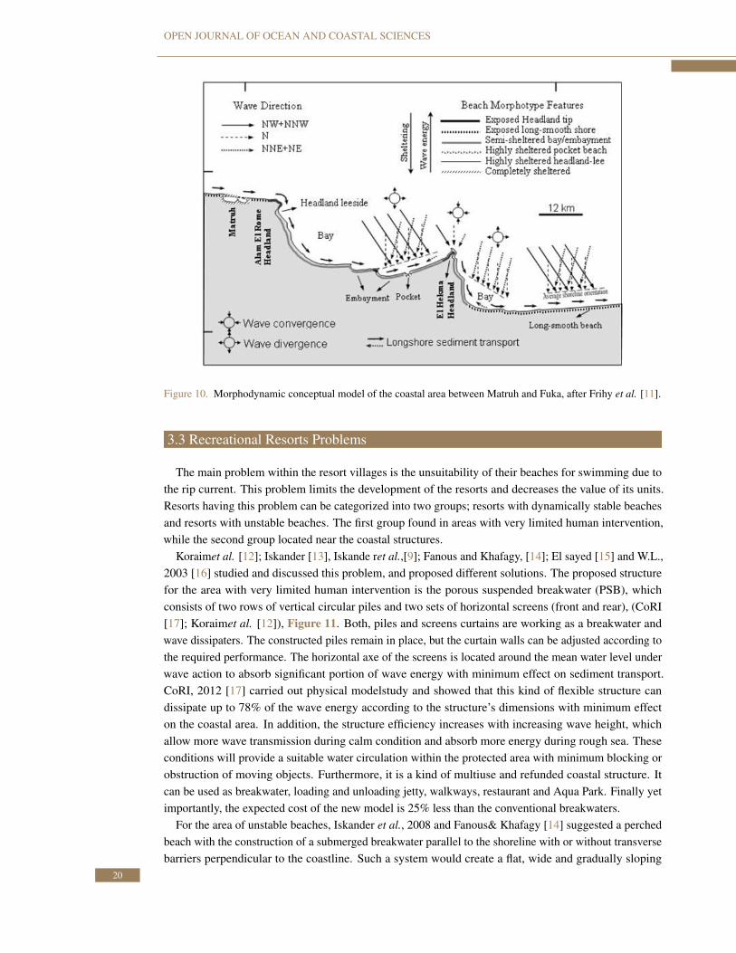
Frihy et al. [11] evaluated the coastal morphodynamics of the western Mediterranean coast of Egyptto increase recreational considerations. The analysis was based on numerical modeling of the degree ofshoreline vulnerability to hydrodynamic forces using a dataset of bathymetry, shoreline position and wavesthat were measured within the region. The study provided a baseline to support shoreline managementplan towards sustainability and maintaining the natural characteristics and resource capabilities of thearea by dividing the area into four morph-types, Figure 10:
1. High-energy exposed coastline such as headlands and Smooth-long coastline.
2. Moderate to high-energy semi-exposed coastline such as bays and embayment.
3. Low-energy semi-exposed coastline such as headlands leeside and pocket beaches.
4. Sheltered coastline such as naturally protected beaches.
The study recommended that the morphological features of the area can be used to control the land use.For example, the calm waters existing in a naturally protected leeside of headlands, pocket beaches andnaturally-sheltered areas can be used properly for recreational activities without protection measures. Onthe other hand, the high-energy conditions at headlands tips and at open coastlines are not favorable forimplementing hard structures and creating safe recreational beaches,however these areas can be used forindustrial activities.
19
OPEN JOURNAL OF OCEAN AND COASTAL SCIENCES
Figure 10. Morphodynamic conceptual model of the coastal area between Matruh and Fuka, after Frihy et al. [11].
3.3 Recreational Resorts Problems
The main problem within the resort villages is the unsuitability of their beaches for swimming due tothe rip current. This problem limits the development of the resorts and decreases the value of its units.Resorts having this problem can be categorized into two groups; resorts with dynamically stable beachesand resorts with unstable beaches. The first group found in areas with very limited human intervention,while the second group located near the coastal structures.
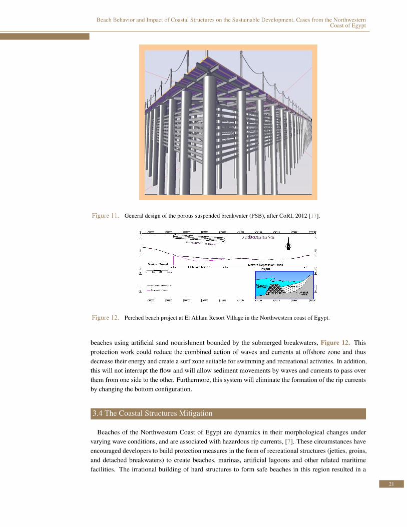
Koraimet al. [12]; Iskander [13], Iskande ret al.,[9]; Fanous and Khafagy, [14]; El sayed [15] and W.L.,2003 [16] studied and discussed this problem, and proposed different solutions. The proposed structurefor the area with very limited human intervention is the porous suspended breakwater (PSB), whichconsists of two rows of vertical circular piles and two sets of horizontal screens (front and rear), (CoRI[17]; Koraimet al. [12]), Figure 11. Both, piles and screens curtains are working as a breakwater andwave dissipaters. The constructed piles remain in place, but the curtain walls can be adjusted according tothe required performance. The horizontal axe of the screens is located around the mean water level underwave action to absorb significant portion of wave energy with minimum effect on sediment transport.CoRI, 2012 [17] carried out physical modelstudy and showed that this kind of flexible structure candissipate up to 78% of the wave energy according to the structure’s dimensions with minimum effecton the coastal area. In addition, the structure efficiency increases with increasing wave height, whichallow more wave transmission during calm condition and absorb more energy during rough sea. Theseconditions will provide a suitable water circulation within the protected area with minimum blocking orobstruction of moving objects. Furthermore, it is a kind of multiuse and refunded coastal structure. Itcan be used as breakwater, loading and unloading jetty, walkways, restaurant and Aqua Park. Finally yetimportantly, the expected cost of the new model is 25% less than the conventional breakwaters.
For the area of unstable beaches, Iskander et al., 2008 and Fanous& Khafagy [14] suggested a perchedbeach with the construction of a submerged breakwater parallel to the shoreline with or without transversebarriers perpendicular to the coastline. Such a system would create a flat, wide and gradually sloping
20
Beach Behavior and Impact of Coastal Structures on the Sustainable Development, Cases from the NorthwesternCoast of Egypt
Figure 11. General design of the porous suspended breakwater (PSB), after CoRI, 2012 [17].
Figure 12. Perched beach project at El Ahlam Resort Village in the Northwestern coast of Egypt.
beaches using artificial sand nourishment bounded by the submerged breakwaters, Figure 12. Thisprotection work could reduce the combined action of waves and currents at offshore zone and thusdecrease their energy and create a surf zone suitable for swimming and recreational activities. In addition,this will not interrupt the flow and will allow sediment movements by waves and currents to pass overthem from one side to the other. Furthermore, this system will eliminate the formation of the rip currentsby changing the bottom configuration.
3.4 The Coastal Structures Mitigation
Beaches of the Northwestern Coast of Egypt are dynamics in their morphological changes undervarying wave conditions, and are associated with hazardous rip currents, [7]. These circumstances haveencouraged developers to build protection measures in the form of recreational structures (jetties, groins,and detached breakwaters) to create beaches, marinas, artificial lagoons and other related maritimefacilities. The irrational building of hard structures to form safe beaches in this region resulted in a
21
OPEN JOURNAL OF OCEAN AND COASTAL SCIENCES
series of adverse impacts on the shoreline morphology, accelerating beach erosion, and degrading therecreational beach aesthetics as discussed in the first part of this study.
These problems affect the efficiency of the recreational villages and the surrounding areas, which leadsto serious losses in the villages’ economic value. Depending on the previous studies, [9, 13–16], somecoastal structures are recommended to be coincident with coastal properties and problems for each case.
Iskander et al., [9] used intensive field measurements and numerical models to show that the nour-ishment projects east of Marina El Alamien Resort and El Ahlam Resort are not sufficient to overcomethe erosion problem of this area, as a side effect of the coastal protection works. The study concludedthat, creating a sloping beach, 50:1, protected by a submerged breakwater parallel to the coast at waterdepth of 3-4 m is more suitable for this area. This cell is filled with nourished sand to create the requiredbeach. This project is under construction at El Ahlam resort village with regular monitoring to evaluatethe efficiency and the adverse impacts of the project during the construction phase, Figure 12.
Marabella four detached breakwaters accumulate sediment in the shadow zone of the breakwatersforming salient and cause severe erosion in the Suez Canal village eastward. These salient are dredgedyearly and transported eastward to eliminate the erosion problem of the Suez Canal village shoreline.
Fanous and Khafagy [14] El sayed [15], and W.L. [16] studied the rip current problem of Maraqia resortvillage which is located 51 km west of Alexandria. A perched beach project is proposed to create a safezone for recreational purposes without affecting the coastal environment. This technique was examinedusing mathematical and physical models. The results showed that this solution could reduce the waveheight by about 70 % and ensured a wide and safe area for swimmer to enjoy the sea water with very loweffect on the seabed morphology.
Fanous et al. [7] carried out a study based on the lessons learned from the previous protection works,and by applying mathematical model, to propose a solution for SidiKerir resort beach and its artificiallagoon. The solution consists of the complete removal of the ruins of the demolished breakwater andconstruct an offshore intake connected to a pipe leading to a pumping station fixed on the western side ofthe lagoon. In addition, the existing draining/pumping station on the outlet of the lagoon could be used incombination with the erection of water fountains inside the lagoon to renew the dissolved oxygen in thelagoon water, Figure 13.
The above discussion shows that it is hard to find a specific structure suitable for the all places froman environmental standpoint. A special study must be performed for each individual case to find theenvironmental characteristic of this area, the dominated hydrodynamic forces within coastal zone andspecify the coastal problems and its driving forces. Then the optimum solution could be recommendeddepending on how to deal with the problems, the environmental impact assessment, and the mitigationmeasures. Monitoring areas around the coastal measures are essential in construction phase as well asevery year after construction to identify the structure efficiency and side effect.
4. CONCLUSIONS AND RECOMMENDATIONS
The study evaluates the coastline of 520 km length from Alexandria to El Saloum along the Northwest-ern coast of Egypt. Field data, satellite images as well as reviewing of the previous studies are used toidentify the coastal problems, shoreline behaviors, coastal measures impacts and vulnerable areas withinthe study area. A review for the previous efforts to solve the coastal problems within the study area is alsocovered, in addition to identifying the required future studies to be implemented for the development ofthe Northwestern coast of Egypt.
The Northwestern coast of Egypt can be divided into; developed areas (30% of the total coastlineextend) which have enormous change in natural conditions, undeveloped flood-affected areas (27 % of
22

Beach Behavior and Impact of Coastal Structures on the Sustainable Development, Cases from the NorthwesternCoast of Egypt
Figure 13. A) Water circulation inside the lagoon with the proposed modification, B) Proposed solution for SidiKerirarterial lagoon, after Fanous et al. [7].
the total coastline extend) where most of the watershed discharge their water to the Mediterranean Sea,and undeveloped flood-unaffected areas (43% of the total coastline extend).
The undeveloped areas has a dynamically stable beaches with a shoreline seasonal fluctuation. Thisfluctuation may give a false estimation of shoreline movement in some places. The main challengewithin this area is to save a shoreline management plan towards sustainability and maintaining the naturalcharacteristics and resource capabilities of the area. This can be done by using the morphological featuresof the area as an indicator to control the land use.
On the other hand, the human interference within the developed areas has dramatically adverse impactson their surrounding beaches. Beach erosion, accretion, pollution and rip currents are some of suchimpacts within these areas. The main challenges of the developed areas are the unsuitability of the beachesfor recreational activities due to rip currents and the side effects of the coastal structures. Suspendedbreakwater of screen curtain wall supported on piles can be used to create a safe recreational area withminimum effect on sediment transport. This structure is suitable only for the dynamically stable beaches.While perched beach can be used for beaches suffer from erosion problem.
Detailed studies are recommended specially for the resorts with coastal structures to find the envi-ronmental characteristic of these areas, the hydrodynamic forces within coastal zone and specify thecoastal problems and their main causes. A comparison between the coastal zones behaviors within thedeveloped and undeveloped areas is very useful in understanding the effect of human interference. Also,it is recommended to study the effect of flood water and sediment in stabilize the shoreline within theflood zones. In addition the effect of the control structures for the flood water on the shoreline stability.
23
OPEN JOURNAL OF OCEAN AND COASTAL SCIENCES
References
[1] B. C. Douglas and M. Crowell, “Long-term Shoreline Position Prediction and Error Propagation,”Journal of Coastal Research, pp. 145–152, 2000.
[2] E. H. Boak and I. L. Turner, “Shoreline Definition and Detection: A Review,” Journal of CoastalResearch, pp. 688–703, 2005.
[3] H. Fahmy, “Evaluation of Breakwaters in Some Coastal Resorts,” in Proceeding of the Seminar onDevelopment of the Northern Coast of Egypt to Serve the Integrated Coastal Zone Management andTourist Activities, Alexandria, Egypt, Paper 15, p. 12, 1998.
[4] O. E. Frihy, “The Necessity of Environmental Impact Assessment (EIA) in Implementing CoastalProjects: Lessons Learned from the Egyptian Mediterranean Coast,” Ocean & Coastal Management,vol. 44, no. 7, pp. 489–516, 2001.
[5] W. Hydraulics, “Integrated Development of Egypt’s Northwestern Coastal Zone,” Interim Report,2002.
[6] I. Sebakhy, M. Sharaki, A. Fahiem, and M. Eid, “Alternative Design for the Detached Breakwaterat Marabella Village,” in Proceedings of the 4th International Conference on Role of EngineeringTowards a Better Environment, Alexandria, Egypt, pp. 243–252, 2002.
[7] A. Fanos, W. El-Sayed, and M. Iskander, “Proposed Coastal Works to Overcome the ExistingProblems of Sidi-Kerir Artificial Lagoon, Mediterranean Coast, Egypt,” in 3rd Arab Water RegionalConference, Research Advancement in Managing Limited Water Resources, Cairo, Egypt, paper no.102, pp. 183–185, 2006.
[8] M. M. Iskander, O. E. Frihy, A. E. El Ansary, M. M. Abd El Mooty, and H. M. Nagy, “each Impactsof Shore-parallel Breakwaters Backing Offshore Submerged Ridges, Western Mediterranean Coastof Egypt,” Journal of environmental management, vol. 85, no. 4, pp. 1109–1119, 2007.
[9] M. Iskander, A. Abo Zed, W. El Sayed, and A. Fanos, “Existing Marina Coastal Problems, WesternMediterranean Coast, Egypt,” Emirates J Eng Res, vol. 13, no. 3, pp. 27–35, 2008.
[10] DRC, “Egyptian National Action Program to Combat Desertification,” Technical report, Ministry ofAgriculture and Land Reclamation, Cairo, Egypt, p. 128, 2005.
[11] O. Frihy, M. Iskander, and W. El Sayed, “Application of Beach Morphodynamics to the WesternMediterranean Coast of Egypt for Management and Planning Implications,” in Third Arab RegionalConference, research advancement in managing limited water resources, Cairo, Egypt, Long Abstract,vol. 3, pp. 189–192, 2006.
[12] A. Koraim, M. Iskander, and W. Elsayed, “Hydrodynamic Performance of Double Rows of PilesSuspending Horizontal C Shaped Bars,” Coastal Engineering, vol. 84, pp. 81–96, 2014.
[13] M. Iskander, “Environmental Friendly Methods for the Egyptian Coastal Protection,” First in-ternational conference on Coastal Zone management of River Deltas and Low Land Coastlines,Alexandria, Egypt, pp. 625–642, 2010.
[14] M. A. Fanos and A. A. Khafagy, “Improving Nearshore Coastal Zone Conditions along MarakiaTourist Village Beaches on the Northwestern Coast of Egypt,” in 3rd Arab Water Regional Conference,Research Advancement in Managing Limited Water Resources, Cairo, Egypt, paper no. 103, pp. 183–185, 2006.
[15] W. El-Sayed, A 2-D mathematical model for simulating the coastal processes & its application alongthe Egyptian coast. PhD thesis, 2004.
[16] W. Hydraulics, “Integrated development of Egypt’s Northwestern coastal zone, Development ofNearshore Water Conditions,” Final Report, 2003.
[17] C. Coastal Research Institute, “Environmental Friendly Porous Suspended Breakwater for theEgyptian Northwestern Coast,” Final technical report for physical model experiments, Alexandria,Egypt, p. 77, 2012.
24