B.A. 6th Semester Unit IV Geography of Jammu and Kashmir
23
B.A. 6th Semester Unit IV Geography of Jammu and Kashmir 1 Introduction The state of Jammu and Kashmir constitutes northern most extremity of India and is situated between 32 o 17′ to 36 o 58′ north latitude and 37 o 26′ to 80 o 30′ east longitude. It falls in the great northwestern complex of the Himalayan Ranges with marked relief variation, snow- capped summits, antecedent drainage, complex geological structure and rich temperate flora and fauna. The state is 640 km in length from north to south and 480 km from east to west. It consists of the territories of Jammu, Kashmir, Ladakh and Gilgit and is divided among three Asian sovereign states of India, Pakistan and China. The total area of the State is 222,236 km 2 comprising 6.93 per cent of the total area of the Indian territory including 78,114 km 2 under the occupation of Pakistan and 42,685 km 2 under China. The cultural landscape of the state represents a zone of convergence and diffusion of mainly three religio-cultural realms namely Muslims, Hindus and Buddhists. The population of Hindus is predominant in Jammu division, Muslims are in majority in Kashmir division while Buddhists are in majority in Ladakh division. Jammu is the winter capital while Srinagar is the summer capital of the state for a period of six months each. The state constitutes 6.76 percent share of India's total geographical area and 41.83 per cent share of Indian Himalayan Region (Nandy, et al. 2001). It ranks 6 th in area and 17 th in population among states and union territories of India while it is the most populated state of Indian Himalayan Region constituting 25.33 per cent of its total population. The state is bounded on north by China and Afghanistan, Tibet on east, Pakistan on west and on south by Himachal Pradesh and Punjab states of India. The State is well connected with rest of the country by air, rail and road. The National Highway 1-A connects the capital cities of Srinagar and Jammu with rest of the country. The mountain chains that adorn the region include the Karakoram Range, Nun Kun range, the Zanskar range and Nanga Parbat. The State of Jammu and Kashmir has many Himalayan rivers flowing through it; the most significant among these are the Indus, Jhelum and Chenab. Among the glaciers are the Baltoro and Siachen Glaciers. There are many low lying valleys in the state like Tawi Valley, Chenab Valley, Poonch Valley, Sind Valley and Lidder Valley, but the main Valley is the valley of Kashmir, which is 100 km wide and 15520.3 km 2 in area. Administrative Divisions Jammu and Kashmir is a multi-lingual, multi-religious and multi-racial state and each group has its own distinct and peculiar cultural ethos, further deepened by geographical divisions created by
-
Upload
khangminh22 -
Category
Documents
-
view
2 -
download
0
Transcript of B.A. 6th Semester Unit IV Geography of Jammu and Kashmir

B.A. 6th Semester Unit IV Geography of Jammu and Kashmir
1
Introduction
The state of Jammu and Kashmir constitutes northern most extremity of India and is
situated between 32o 17′ to 36
o 58′ north latitude and 37
o 26′ to 80
o 30′ east longitude. It falls in
the great northwestern complex of the Himalayan Ranges with marked relief variation, snow-
capped summits, antecedent drainage, complex geological structure and rich temperate flora and
fauna. The state is 640 km in length from north to south and 480 km from east to west. It consists
of the territories of Jammu, Kashmir, Ladakh and Gilgit and is divided among three Asian
sovereign states of India, Pakistan and China. The total area of the State is 222,236 km2
comprising 6.93 per cent of the total area of the Indian territory including 78,114 km2 under the
occupation of Pakistan and 42,685 km2 under China. The cultural landscape of the state
represents a zone of convergence and diffusion of mainly three religio-cultural realms namely
Muslims, Hindus and Buddhists. The population of Hindus is predominant in Jammu division,
Muslims are in majority in Kashmir division while Buddhists are in majority in Ladakh division.
Jammu is the winter capital while Srinagar is the summer capital of the state for a period of six
months each. The state constitutes 6.76 percent share of India's total geographical area and 41.83
per cent share of Indian Himalayan Region (Nandy, et al. 2001). It ranks 6th in area and 17
th in
population among states and union territories of India while it is the most populated state of
Indian Himalayan Region constituting 25.33 per cent of its total population.
The state is bounded on north by China and Afghanistan, Tibet on east, Pakistan on west
and on south by Himachal Pradesh and Punjab states of India. The State is well connected with
rest of the country by air, rail and road. The National Highway 1-A connects the capital cities of
Srinagar and Jammu with rest of the country. The mountain chains that adorn the region include
the Karakoram Range, Nun Kun range, the Zanskar range and Nanga Parbat. The State of Jammu
and Kashmir has many Himalayan rivers flowing through it; the most significant among these
are the Indus, Jhelum and Chenab. Among the glaciers are the Baltoro and Siachen Glaciers.
There are many low lying valleys in the state like Tawi Valley, Chenab Valley, Poonch Valley,
Sind Valley and Lidder Valley, but the main Valley is the valley of Kashmir, which is 100 km
wide and 15520.3 km2 in area.
Administrative Divisions
Jammu and Kashmir is a multi-lingual, multi-religious and multi-racial state and each group
has its own distinct and peculiar cultural ethos, further deepened by geographical divisions created by

B.A. 6th Semester Unit IV Geography of Jammu and Kashmir
2
formidable mountain ranges. The state comprises of three natural divisions, namely, Jammu,
Kashmir and Ladakh. For administrative purposes, the state is divided into two main divisions, i.e.,
Kashmir and Jammu Provinces. A Divisional Commissioner heads the administration of each
division. The two districts of Ladakh region, namely, Leh and Kargil are part of the Kashmir
Division for purposes of administration. A Deputy Commissioner who is also District Development
Commissioner, heads each district. In Ladakh region, the ‘Autonomous Hill Development Council’
was established in 1995 as part of decentralized administration. The districts are divided into blocks
for development purposes and into tehsils for revenue purposes. The state consists of 22 districts with
Kashmir and Jammu divisions equally having 10 districts each and the remaining two districts
belonging to Ladakh division.
Jammu Region: The Jammu region is situated on the North Indian plains, close to the Siwalik
ranges. This region comprises the plains, hills and mountains south and west of the mighty Pir Panjal
range that separates Kashmir Valley from the plains of the subcontinent. North of the Siwaliks, the
rest of the Jammu region is drained by the Chenab River whose vast catchment area includes several
narrow valleys that extend deep into the Himalayas. Jammu is about 305 meters above the mean sea
level (MSL). Jammu is famous for its ancient temples and palaces. Today, the Jammu region
comprises the districts of Kathua, Jammu, Udhumpur, Doda, Rajouri, Ramban, Kishtiwar, Reasi,
Samba and Poonch.
Kashmir Region: The Kashmir region or valley is a significant part of the state. The valley is an
ancient lake basin 140 km long and 32 km wide (Raza, 1978). The average elevation of the valley is
1630 m above MSL. The tall mountains that surround the valley rising up to 5400 m ensure that the
weather here is pleasant for most of the year. The region is famous for its picturesque natural beauty
and among other things is known for its Dal Lake that reflects the surrounding snow-capped
mountain peaks. Its rich alluvial soil well drained by rivers and streams, yields rice, saffron,
vegetables and a variety of fruit. Wular Lake in Kashmir valley is the largest fresh water lake of India
which acts as a drainage basin for Jhelum river. The Valley is known for its fresh apples and the
intricate embroidery stitching. It comprises of ten districts, namely, Anantnag, Baramulla, Badgam,
Kupwara, Pulwama, Shopian, Kulgam, Bandipora, Ganderbal and Srinagar.
Ladakh Region: Ladakh constitutes the eastern-most part of the state of Jammu and Kashmir. It
comprises of two districts, namely, Leh and Kargil. This is one of the most breathtakingly beautiful
parts of the state and its surreal landscape has often been termed as ‘moonscape’. Ladakh covers
about 117,000 km2 and includes the Karakoram Range and the upper Indus River valley. Ladakh is

B.A. 6th Semester Unit IV Geography of Jammu and Kashmir
3
one of the highest places on earth with the average altitude being above 3700 m. Situated on the
leeward side of the mountain, it hardly gets any rain. The region is sparsely populated and people live
traditional life, herding sheep and yak and growing barley near the river beds in summer. Physical
features that characterize the region are its uplands, craggy barren cliffs and plateaus. The mighty
river Indus flows right through Ladakh. Leh is famous for its adventure sports. The region is famous
for the Leh Palace and the Namgyal Tsemo Gompa monastery.
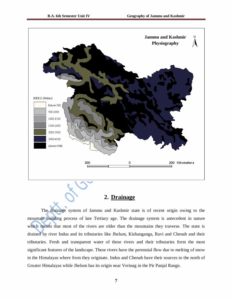
1. Physiography (Physical divisions)
The state of Jammu and Kashmir possesses a peculiar geo-physical setting as all the
major landforms i.e. mountains, plateaus, plains and valleys are present in its landscape.
Geographically, the state is divided into four zones – the mountainous and semi-mountainous
plain known as Kandi belt, hills including Siwalik ranges, mountains of Kashmir valley and Pir
Panjal range, and Tibetan tract of Ladakh and Kargil. The state has a number of lakes, rivers,
rivulets and glacial regions. The Physiography of the territory as a whole is divided into seven
zones those are closely associated with the structural components of the western Himalayas.
These include:
The Plains: The outer plain also known as Andarwah and Bajwat is a part of Great Plains of
India. The rocks of this region are of fluviate and subaerial formation. Its width varies from 5-25
kilometers and it stretches from river Ravi to River Chenab for an extension of 110 kilometers
with the elevation of 330 to 360 meters. The narrow zone of plains in the Jammu region is
characterized by interlocking sandy alluvial fans that have been deposited by streams discharging
from the foothills and by a much-dissected pediment (eroded bedrock surface) covered by loams
and loess (wind-deposited silt) of the Pleistocene Epoch (i.e., those about 10,000 to 1,600,000
years old). Besides Ravi and Chenab the region is also drained by Ujh, Basantar, Tawi and
Manawar Tawi. This plain is badly dissected by a series of deep and shallow ravines which carry
off the seasonal flood waters of monsoon rains. Such is the number of ravines that there are 200
bridges on the Jammu railway line which passes through this region (Khan, 2001). The
mountains of Jammu almost run parallel to the outer plain region. Rainfall is low, amounting to
about 15 to 20 inches (380 to 500 millimeters) a year, and it occurs mainly in the form of heavy
but infrequent rain showers in the summer (June to September) when the monsoon winds blow.
These plains are highly fertile owing to the favorable climatic conditions and assured irrigation
which enables the cultivation of crops throughout the year. Jammu, Kathua, Samba, Hiranagar
B.A. 6th Semester Unit IV Geography of Jammu and Kashmir
4
and Akhnoor belong to the outer plains (Husain, 1987). The countryside has been almost entirely
denuded of trees, and thorn scrub and coarse grass are the dominant forms of vegetation. At
higher elevations the topography changes and the hill slopes appear wooded.
The Siwaliks: The outermost relatively low hills of the Himalayas along its whole length from
the Indus to the Brahmaputra are known as the Siwaliks. The width is between 20-50 kms and
the altitude ranges between 600 -1200 meters in the state. The Siwaliks are made of the younger
tertiary rocks (Husain, 1987). The rocks are deposited in the parallel folded zones. Subjected to
folding these low hills resulted in the formation of a series of anticlinal hills with sloping
plateaus, gently towards the plain. The hills consist of clay, sand, round pebbles and boulders
which are badly dissected by ravines and seasonal stream courses. A series of wide longitudinal
valleys called dunes lie to the north of Siwalik hills. Udhumpur, Sunderbani, Bosahli, Ramkot
and Dansal are typical examples of such dunes. The slope facing the outer plains is gentle
covered with deciduous forests while the northern slopes are steep with dense vegetation. Due to
the presence of ravines, the Siwaliks appear as isolated and broken hills. Rainfall increases with
elevation, and the lower scrubland gives way to pine forests at higher altitudes. The undulating
slope adjacent to the plains up to an elevation of 300 m between Ravi and Chenab rivers is
locally known as Kandi Characterized by numerous torrents, hilly soils and scarcity of water.
Xerophytic vegetation is common in these areas while agriculture is subjected to the availability
of rainfall. Lake Mansar and Sarunsar are situated at an elevation of 600 meters to the east of
Jammu city in the Siwalik hills. The important towns are Jammu, Jasrota, Samba and Akhnoor.
The Middle Himalayas: The middle Himalayas are also known as the middle mountains, lesser
Himalayas or Pir Panjal. They have an east-west extension. They vary in elevation between 1820
m to 2240 m with a width of about 60 kms in the eastern part of Jammu division and 10 kms near
Rajouri. This physical division lies between the Ravi in the east and the Poonch in the west and
continues up to Muzafarabad. They are locally known as Pahar (mountain) in Jammu region.
They are composed of highly compressed and altered rocks of various geological ages, ranging
from the puranas and carboniferous to Eocene (Wadia, 1928). Consisting of an ancient rock core
of granites, gneisses, quartz rocks and slates, it has been subject to considerable uplift and
fracturing and was heavily glaciated during the Pleistocene Epoch (Diener, 1912). Several
important rivers like Tawi, Manawar Tawi, Basantra and Ujh have their sources in middle
Himalayas. However, Chenab is an important river of this region and the famous Salal

B.A. 6th Semester Unit IV Geography of Jammu and Kashmir
5
Hydroelectric project near Reasi is constructed on it. The mountains are orthoclinal which is
helpful in preserving soil and supporting huge and thick temperate vegetation like deodar, oak,
pine, spruce and fir. The range receives considerable precipitation in the form of winter snowfall
and summer rain and has extensive areas of pasture above the tree line. The people are largely
dependent on forestry, lumbering, herding and tourist activity.
The Valley of Kashmir: Between the Pir Panjal and the western end of the Great Himalayan
ranges lies a deep asymmetrical basin called the Vale of Kashmir and has an area of 15220 km2.
Average height of the valley is 1630 metres above MSL (Lawrance, 1996) but the surrounding
mountains, which are always snow-clad, rise from 3000-4000 metres above MSL. The river
Jhelum, which flows out from the spring at Verinag in Anantnag district, passes through this
Valley at a very slow speed and ultimately flows out through a narrow gorge at Baramulla. There
are also some small valleys in this region. On the north of Baramulla is Lolab valley which is 6
kms. long and 4.4 kms. wide. It has many meadows and groves of walnut trees. Forests are so
thick that they hide villages in them. Sind is the largest tributary of the river Jhelum. The Sind
valley is 100 Kms long upwards and its scenery is diversified. At the head of the valley is the
Zojilla pass which leads to Ladakh. Towards Pahalgam lies the Lidder Valley. Its length is 64
Kms. It has glaciers, grassy meadows, huge rock walls and gorges in its upper mountains. The
path to the holy Amaranth cave passes through this valley. The Kolahoi and Sheshnag streams
join at Pahalgam to form the Lidder River. The karewa formation cover a wide range of area on
the southern periphery of the valley all along its longitudinal extent. They are divided into
sloping karewas and flat topped karewas on the basis of surface characteristics. The sloping
karewas are found along the flanks of Pir Panjal range, where they form a continuous series,
reaching from Shalura in the north-west to below Shopian in the south-east. The flat topped
karewas consist of horizontal beds and attain a thickness of 92 m near Anantnag. Up to 2000 m,
woodlands of deodar cedar, blue pine, walnut, willow, elm, and poplars occur; from 2000 to
3000 m coniferous forests with fir, pine, and spruce are found; from 3000 to 3500 m birch is
dominant; and above 3500 m there are meadows with rhododendrons and dwarf willows as well
as honeysuckle. The climate is characterized by an annual rainfall of about 30 inches, some of
which is derived from the summer monsoon winds and some from winds associated with winter
low-pressure systems. Snowfall often is accompanied by rain and sleet.
B.A. 6th Semester Unit IV Geography of Jammu and Kashmir
6
The Greater Himalayas: The Greater Himalayan range along with the Zanskar range lie in the
northern side of Kashmir valley (Raza, et al. 1978). Geologically complex and topographically
immense, the Great Himalayas contain ranges reaching more than 6000 m in altitude and deeply
entrenched, remote valleys. The region was heavily glaciated in the Pleistocene (Wadia, 1928)
and remnant glaciers and snowfields are still present. Beyond this range lies the high plateau-
desert which is devoid of any kind of vegetation. The elevated plateaus and ridges are separated
from one another by great depressions. The altitude rises further north till the peak K2 (second
highest peak in the world) in the Karakorum range attains the height of 8621 m. The Zanskar
range is situated at an altitude of 5940 m. This range is famous for its two river valleys-the
Zanskar and the Suru. The famous Kargil town lies in the Suru valley. The Karakoram region is
aptly named the "roof of the world." The zone receives some rain from the southwest monsoon
winds in the summer months and hence the lower slopes are forested, but the mountains
constitute a climatic divide, representing a transition from the monsoon climate of the Indian
subcontinent to the dry, continental climate of Central Asia.
The Ladakh plateau: Ladakh is the loftiest inhabited region of the world. Most of the surface
area of Ladakh is mountainous and uninhabited as it comprises of old deserts and desolate
plateaus intervened by difficult passes and valleys. The mountain chain of Ladakh stretches
through the region from south-east to north-west with the altitude ranging between 5180-6400 m.
Owing to the great aridity of the atmosphere, the climate is extreme, from burning heat of some
of the deserts to several degrees below freezing point at night.
B.A. 6th Semester Unit IV Geography of Jammu and Kashmir
7
2. Drainage
The drainage system of Jammu and Kashmir state is of recent origin owing to the
mountain building process of late Tertiary age. The drainage system is antecedent in nature
which means that most of the rivers are older than the mountains they traverse. The state is
drained by river Indus and its tributaries like Jhelum, Kishanganga, Ravi and Chenab and their
tributaries. Fresh and transparent water of these rivers and their tributaries form the most
significant features of the landscape. These rivers have the perennial flow due to melting of snow
in the Himalayas where from they originate. Indus and Chenab have their sources to the north of
Greater Himalayas while Jhelum has its origin near Verinag in the Pir Panjal Range.
Jammu and Kashmir
Physiography

B.A. 6th Semester Unit IV Geography of Jammu and Kashmir
8
Indus: The Indus is one of the largest (25th ) river systems in the world. The common name of
Indus river is Singge-Chhu which means the Lion-River or Sher-Darya. It rises from the northern
slopes of Tibet near Mansarowar lake and enters Jammu and Kashmir state near Gartok where it
meets Gurtang stream at an altitude of 4245m. The Indus river flows in a north-westerly
direction through the trough between the Kailash and the Ladakh range. Hanle, Suru and Zanskar
are the left bank tributaries while Shyok, Shigar, Astor and Gilgit are the right bank tributaries.
The river has many alluvial fans and river terraces on its either sides stretching over a distance of
30kms. The flow is subjected to extreme variations with the maximum flow in the summer
months (June to August) when the snow melt is high. The total length of the river is 2900 kms of
which it runs for a distance of 966 kms in Jammu and Kashmir and finally through Pakistan falls
in the Arabian sea near Karachi.
Jhelum: The river Jhelum rises from Pir Panjal Ranges about one kilometer ahead of Verinag.
The river Jhelum is known as Veth in Kashmir valley. When it leaves Kashmir at Baramulla it is
called the Kashur Darya and after joining the Kishanganga it is called Jhelum. Jhelum joins the
Indus in the Punjab state of Pakistan. The river meanders in the valley, enters the Wular lake,
leaves it near Sopore and flows in the narrow Gorge across the Pir Panjal from Baramulla to
Muzafarabad (Raza, et al. 1978). In ancient times the river Jhelum served as the most important
highway of Kashmir. The famous waterfall of Aharbal (21m) is formed by the stream of Vishav.
The Jhelum and its tributaries are the main channels of drainage which sculpture the area during
their course. The discharge is maximum during south-west monsoon when heavy and widespread
rainfall occurs throughout the length and breadth of the valley. Sandran, Breng, Arpat, Lidder,
Harwan, Sind, Erin, Madhumati, Pohru and Viji-Dakil are the right bank tributaries while
Vishav, Rambiara, Romushi, Dudhganga, Sukhnag and Ningal are the left bank tributaries.
Kishanganga: This is an important tributary of river Jhelum. It has its origin in Kishansar lake
located in Drass mountains and hence named as Kishanganga. It drains the Gurez valley and
finally merges into Jhelum river at Domel near the city of Muzafarabad. The total length of the
river is 288 kms. Throughout the Gurez front, the river is completely frozen over during the
winter season. It separates the valley of Kashmir from Pakistan at present.
Chenab: This river is formed by two streams of Chandra and Bhaga at an elevation of 4891 m in
Himachal Pradesh. The river flows between the Himalayas and the Pir Panjal Range and then
takes a turn to the south through a gorge. It flows through Doda, Reasi and Akhnoor. From

B.A. 6th Semester Unit IV Geography of Jammu and Kashmir
9
Akhnoor the river assumes the plain stage and is navigable. From Tandi to Kishtiwar the river
has many gorges, rapids and falls. At Kishtiwar the river receives a perennial tributary known as
Wadwan stream and makes a typical gorge about 1000 feet below Kishtiwar valley. The Chenab
is about 1180 kms long in the state of Jammu and Kashmir. Important power projects of Salal
Hydel Project (345MW) and Dulhasti (390MW) are generating electricity through the waters of
river Chenab in Reasi and Kishtwar areas respectively.
Tawi: This river arises from Sewajdhar near Badarwah. The river passes through Ram Nagar,
Chenani, Udhumpur, Nagrota and Jammu before its confluence with Chenab at Akhnoor. It has
a total length of 120 kms.
Ravi: This river rises from the southern slopes of the Pir Panjal. The river passes through
Madhupur and Kathua before entering into Pakistan to meet Indus. Total length of this river is
about 65 kms.
Jammu and Kashmir
Drainage

B.A. 6th Semester Unit IV Geography of Jammu and Kashmir
10
3. Climate
The climate of the state differs from region to region on account of great variations in
altitude, location and topography. The tropical heat of the Punjab and the arctic cold of Ladakh
are the extremes, and there are certain places where snow makes the life stagnant for about seven
months in a year. The climate of the state varies from tropical in Jammu plains to semi-arctic
cold in Ladakh with Kashmir and Jammu mountainous tracts having temperate climatic
conditions. The temperature of the state varies spatially. Leh is the coldest (-28°C average) while
Jammu is the hottest. Mean monthly temperature is lowest in January and highest in July except
in Jammu where highest temperature is experienced in June. Mean monthly temperature in
January varies from –17°C at Drass to 14°C at Jammu; Kargil and Leh being other stations of
below freezing average. Considering the overall distribution of climatic elements, four units
become obvious:
1. The windward (Jammu region)
2. The leeward (Ladakh region)
3. The high altitude Kashmir (Himadri, Pir Panjal)
4. The Kashmir valley.
In the winter nights, temperature goes down below zero and very often heavy snowfall
occurs during November to February. The annual rainfall varies from region to region with 92.6
mm in Leh, 650.5 mm in Srinagar and 1,115.9 mm in Jammu. In the outer hilly region of the
Jammu Province, climate has three main seasons: (i) hot weather from April to June, (ii) a rainy
season from July to September and (iii) cold weather from October to March. The altitude of the
State rises steeply from 305 metres to 6910 metres above MSL. There are the hot plains of the
Jammu Province and the cold dry tableland of Ladakh. The area has different weather conditions
at different places because of the lofty mountains like the Pir-Panjal, the Zanskar and the
Karakoram that check the moisture-laden winds from entering the valleys.
In summers, the outer plains and the outer hills receive rainfall from monsoon winds while in
winters, winds from the Mediterranean cause snowfall and rainfall in the Valley of Kashmir. The
moisture-laden winds cause rainfall in the forests on the hills making the temperature to fall in
summer; hence, the thickly wooded areas such as Pahalgam and Gulmarg have milder weather
conditions than that of Srinagar. Similarly, the climate of the valley of Kashmir is comparatively
B.A. 6th Semester Unit IV Geography of Jammu and Kashmir
11
milder than that of the Outer Plains as it is on higher altitude therefore making it one of the most
liked tourist destinations during summer.
Seasons of Kashmir Valley
Season Date Local Name
Spring 16 March to 15 May SONTH
Summer 16 May to 15 July RETKOL
Rainy season 16 July to 15 September WAHARAT
Autumn 16 September to 15 November HARUD
Winter 16 November to 15 January WANDAH
Ice cold 16 January to 15 March SHISHUR
The climate of the valley of Kashmir has its own peculiarities. The seasons are marked with
sudden change and the climate can be divided into six seasons of two months each (Raina, 2002).
In the Kashmir Province there is not much rise in the temperature up to and end of May, but in
June, July and August the temperature can rise up to 32ºC in shade. After August there is a
decrease in the temperature and by the end of October it becomes cold and by January cold
becomes intense with the snowfall. The snowy period lasts for two and half months beginning
December through January to middle of March. During winter Dal Lake sometimes gets frozen,
enabling people to skate over it. The distinctive features of Kashmir’s climate is the absence of
monsoon rain, because the monsoons cannot cross the mountains enclosing Kashmir on the
south.
4. Natural Vegetation
The term natural vegetation is used loosely to describe any plant life that is not organized
or influenced by mankind. The state is well endowed in forest resources. The forests have great
diversity in species and varieties, ranging from the lush green margs (alpine pastures) to
evergreen conifers on the gentle slopes of the Middle and the Greater Himalayas, and from scrub
jungles of the foothills to the deciduous forests of the Siwaliks and the Pir Panjal Range. The
natural vegetation of the state has great altitudinal variations and latitudinal zonation. There is
hardly any vegetation at 5550 m above MSL because most of the plants cease growth when the
soil temperature drops below 50C.

B.A. 6th Semester Unit IV Geography of Jammu and Kashmir
12
There is a great diversity in the natural vegetation of the state as about 4000 species
belonging to 1500 genera are found in the state. Some of the important forests of the state
consist of deodar, juniper, pine, spruce, fir, yew, alder, elm, sorrel, poplar, birch, maple and
mulberry. Being situated at higher latitudes and characterized by undulating and mountainous
topography, most of the forest of the state belong to the coniferous category. The lower end of
the greater Himalayas are quite rich in timber forest. The state is relatively poor in natural
vegetation as compared to the other Himalayan states of India.
During the last 60 years a substantial proportion of forests has been cleared and brought
under agriculture and pastures. Forests have numerous productive, protective and bio-aesthetic
functions. Forests constitute 14.5 per cent of the state’s total geographical area. About 35 per
cent of the total forest area lies in Jammu division, the rest being shared by Kashmir and Ladakh
divisions. The most valuable timer, that of Deodar (Oak) is mainly found in Baramulla,
Anantnag, Doda and Udhumpur districts. In order to understand the spatial distribution of
different types of natural vegetation, the forests of the state may be classified into the following
categories.
District-wise forest area, Jammu and Kashmir, 2008-09
Source: Digest of statistics 2008-09, Government of Jammu and Kashmir, p. 138
S. No.
District
Area under forests (km2)
Percentage of total forest area Forest area Wild life area Total forest area
1 Anantnag 2068 546.75 2614.75 7.34
2 Pulwama 810 273.25 1083.25 3.039
3 Srinagar 380 311 691 1.94
4 Badgam 477 3.25 480.25 1.35
5 Baramulla 2690 384.75 3074.75 8.63
6 Kupwara 1703 - 1703 4.78
7 Leh 29 13018 13047 36.61
8 Kargil 7 112 119 0.33
9 Jammu 959 256.5 1215.5 3.41
10 Udhumpur 2343 42.25 2385.25 6.69
11 Kathua 991 44.75 1035.75 2.91
12 Doda 5555 418 5973 16.76
13 Rajouri 1267 - 1267 3.55
14 Poonch 951 - 951 2.67
Jammu and Kashmir 20230 15410 35640 100.00

B.A. 6th Semester Unit IV Geography of Jammu and Kashmir
13
Subtropical Forests: These forests are confined to the Siwaliks and lower slopes of the middle
Himalayas. There is great diversity of trees in these forests because of the various edaphic factors
and seasonality of rainfall. The dominant species are teak, sal, shisham, papal, tun, silver-pine,
and reed. These forests are mainly utilized for fuel wood, timber, agricultural implements and
miscellaneous purposes.
Temperate Forests: As the latitude and altitude increases towards the north, the subtropical
forest are replaced by temperate forests. The slopes of Pir Panjal, Greater Himalayas, Karakorum
and Zanskar between 1500 m to 3000 m are dominated by temperate forests. Deodar, pine, silver
fir, spruce, alder, cedar, sorrel, birch and hazal are the dominant species.
Alpine Pastures: Alpine pastures also known as margs lie between 3600 m to 4000 m above
MSL. The climate in these margs is extremely cold over most parts of the year which is
supporting only some of the dwarf varieties of birch and junipers making a shrubby appearances.
The lush green and nutritious grasses of these pastures are utilized by the Gujjars and Bakarwals
who practice transhumance.
Forests are mainly found where the annual rainfall is about 100 cm. However, scrub
forests are found where rainfall is less than 100 cm. Forests are one of the most important
resources of Jammu and Kashmir. More than 99 per cent of forest area is confined to the
province of Jammu and Kashmir only. The forest area of 2008-09 shows that 35640 km2 of the
state’s area is under forest which constitutes 35.15 per cent of the total geographical area of the
state on this side of the line of Control. Out of this, more than 99 per cent of the forest area is
confined to the province of Jammu and Kashmir only, with the largest area of 5973 km2 in the
district of Doda and smallest area of 119 km2 in the district of Kargil. Leh records the highest
percentage of forest area (36.61per cent) only because of the fact that it has got the highest
percentage of the total wild life area (84.47 per cent) of the state. Vegetation is influenced by
climate, rainfall soil and altitude. Since these factors vary as the altitude rises from the outer
plains of Jammu Province to the loftiest mountain ranges of the Inner Himalayas, it is but natural
that the vegetation should vary from the Inner Himalayas to the middle mountains and the outer
plains of Jammu region. Over 19,236 km2 is under coniferous softwood (Pine) and 946 km
2.
under non-coniferous softwood. In the coniferous category, fir accounts for 3355 km2, kail for
1874 km2, chir for 1773 km
2 and deodar for 1122 km
2.

B.A. 6th Semester Unit IV Geography of Jammu and Kashmir
14
Demographic Profile
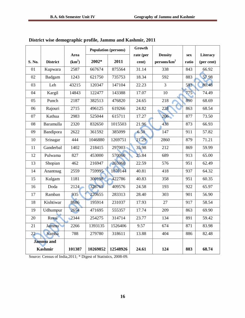
The state has a population of 12548926 (census of India, 2011) with a density of 124
persons per km2. The most striking feature of population is its uneven distribution, which is
closely related with relief and climate. The state is one of the least populated state’s of India
because only 10 per cent of its area is suitable for cultivation.
5. Population distribution
The spatial distribution of population in Jammu and Kashmir is highly uneven. The physical
factors like terrain, topography, slope, climate, soil, natural vegetation and accessibility have
largely controlled the distribution and density of population in the state. In general, about 85 per
cent of the total population of the state is occupying the Jammu plain and Kashmir valley
(Jhelum floor), 14 per cent is living in the Kandi areas and the side valleys within 2000 m above
MSL while the remaining 1 per cent is sprinkled in the high altitudinal zones of the Himalayas,
Zanskar, Ladakh, and Karakorum Ranges (Qazi, 2005). Kashmir division constitutes 55 per cent
of the total state’s population while 42.64 percent is distributed in Jammu division and the rest
2.3 percent population is dwelling in Ladakh division. The population distribution pattern among
the districts indicates high concentration in Jammu district followed by Srinagar, Anantnag and
Baramulla. These four districts also have maximum concentration of urban population. Least
concentration of population is in Leh, Kargil, Poonch, Rajouri, Kathua and Badgam districts.
Division wise distribution of population, Jammu and Kashmir, 2001 and 2011
S. No. Division Population 2001 Population 2011
Absolute Percentage Absolute Percentage
1 Kashmir 5441341 54.04 6907623 55.05
2 Jammu 4395712 43.65 5350811 42.64
3 Ladakh 232864 2.31 290492 2.31
Jammu and Kashmir 10069917 100 12548926 100
Source: Census of India, 2001 and 2011.

B.A. 6th Semester Unit IV Geography of Jammu and Kashmir
15
6. Population Density
Density of population in the state is 124 persons per km2. Srinagar and Jammu districts recorded
high density of population of 2860 and 674 persons per km2 respectively, mainly on account of
being the state’s administrative capitals which have made them the hub of socio-economic
activities. The lowest population density is found in the Ladakh division with only 3 persons per
km2 in Leh district. The population distribution and density pattern indicates an overwhelming
influence of geo-physical disposition across the different regions of the state. In addition to this
centralized distribution of small manufacturing and service sectors in few urban centers have
also influenced the population density and distribution pattern as well. Since social, economic
and technological development are in the early stages, agricultural land capability (growing
season, irrigation) and carrying capacity of land (soil fertility) and concentration of non-
agricultural economic activities especially service activities has played significant role in
population concentration and high density of population in Jhelum Valley Floor consisting of
Srinagar, Badgam, Pulwama , Anantnag and Baramulla districts.
Jammu and Kashmir
Population Density
2011
B.A. 6th Semester Unit IV Geography of Jammu and Kashmir
16
District wise demographic profile, Jammu and Kashmir, 2011
S. No. District
Area
(km2)
Population (persons) Growth
rate (per
cent)
Density
persons/km2
sex
ratio
Literacy
(per cent) 2002* 2011
01 Kupwara 2587 667674 875564 31.14 338
843 66.92
02 Badgam 1243 621750 735753 18.34 592
883 57.98
03 Leh 43215 120347 147104 22.23 3
583 80.48
04 Kargil 14843 122477 143388 17.07 10
775 74.49
05 Punch 2187 382513 476820 24.65 218
890 68.69
06 Rajouri 2715 496125 619266 24.82 228
863 68.54
07 Kathua 2983 525044 615711 17.27 206
877 73.50
08 Baramulla 2320 832650 1015503 21.96 438
873 66.93
09 Bandipora 2622 361592 385099 6.50 147
911 57.82
10 Srinagar 444 1046880 1269751 21.29 2860
879 71.21
11 Ganderbal 1402 218415 297003 35.98 212
869 59.99
12 Pulwama 827 453000 570060 25.84 689
913 65.00
13 Shopian 462 216947 265960 22.59 576
951 62.49
14 Anantnag 2559 759995 1070144 40.81 418
937 64.32
15 Kulgam 1181 300198 422786 40.83 358
951 60.35
16 Doda 2124 328765 409576 24.58 193
922 65.97
17 Ramban 935 220655 283313 28.40 303
901 56.90
18 Kishtiwar 8686 195914 231037 17.93 27
917 58.54
19 Udhumpur 2654 471695 555357 17.74 209
863 69.90
20 Reasi 2344 254275 314714 23.77 134
891 59.42
21 Jammu 2266 1393135 1526406 9.57 674
871 83.98
22 Samba 788 279780 318611 13.88 404
886 82.48
Jammu and
Kashmir 101387 10269852 12548926 24.61 124
883 68.74
Source: Census of India,2011; * Digest of Statistics, 2008-09.

B.A. 6th Semester Unit IV Geography of Jammu and Kashmir
17
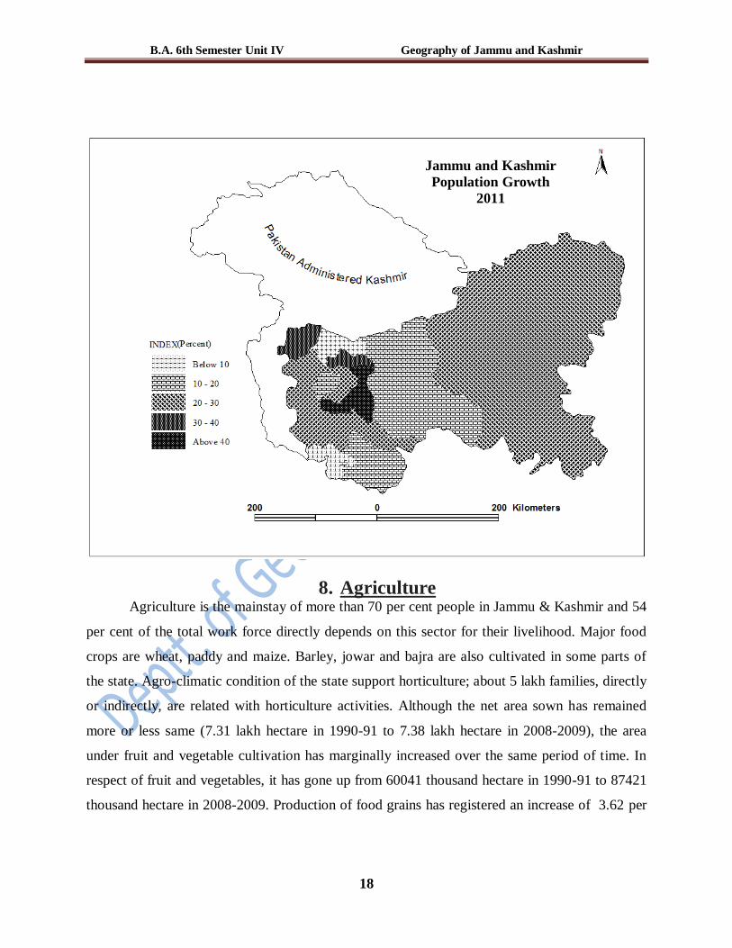
7. Population Growth
The size of population and its growth have a direct bearing on the economic development, social
well being and political stability of a region. Population growth is, thus, pivotal in the regions
demographic dynamism (Chandna, 1992). The population of the state has increased more than
two fold in the state during the last 30 years. In the first two decades of the 20th century the
population growth was below 10 per cent. After 1931, it was raising at a constant rate of 10 per
cent per decade up to 1961, were from it has an unprecedented rise of 29 per cent per decade
which is one of the highest growth rates in the country (17.64 percent for India). The districts of
Kulgam, Anantnag, Ganderbal, Kupwara, Poonch and Rajouri have registered high decadal
population growth rate than the state average of 24.6 percent, while it is very low in the districts
of Bandipora and Jammu. Further, it is below the state average in both the districts of Ladakh
region. However, decadal population growth was the highest (40.83 percent) in Kulgam district
and the lowest (6.5 per cent) in Bandipora district.
Decadal population growth, Jammu and Kashmir, 1901 – 2011
Year Population Density
(Persons/km2)
Percentage
Growth
Urban Population
Absolute Per cent Percentage Growth
1901 2139362 21 - 158748 7.42 -
1911 2292535 23 +7.16 268518 11.71 +69.2
1921 2424359 24 +5.75 267754 11.04 -0.28
1931 2670208 26 + 10.14 317805 11.90 +8.7
1941 2946728 29 + 10.36 386565 13.11 +21.64
1951 3253852 32 + 10.42 457213 14.05 + 18.28
1961 3560976 35 +9.44 593315 16.66 +29.77
1971 4616632 46 +29.65 858221 18.58 +44.65
1981 5987389 59 +29.69 1260403 21.05 +46.86
1991* 7803900 77 +30.34 1676914 21.94 +33.04
2001 10069917 99 +29.04 2505309 24.87 +49.4
2011 12548926 124 +24.61 3815585* 30.4 +52.3
Source: Census of India, 2001; * Projected figures
B.A. 6th Semester Unit IV Geography of Jammu and Kashmir
18
8. Agriculture Agriculture is the mainstay of more than 70 per cent people in Jammu & Kashmir and 54
per cent of the total work force directly depends on this sector for their livelihood. Major food
crops are wheat, paddy and maize. Barley, jowar and bajra are also cultivated in some parts of
the state. Agro-climatic condition of the state support horticulture; about 5 lakh families, directly
or indirectly, are related with horticulture activities. Although the net area sown has remained
more or less same (7.31 lakh hectare in 1990-91 to 7.38 lakh hectare in 2008-2009), the area
under fruit and vegetable cultivation has marginally increased over the same period of time. In
respect of fruit and vegetables, it has gone up from 60041 thousand hectare in 1990-91 to 87421
thousand hectare in 2008-2009. Production of food grains has registered an increase of 3.62 per
Jammu and Kashmir
Population Growth
2011

B.A. 6th Semester Unit IV Geography of Jammu and Kashmir
19
cent during the year 2008-09 as it has increased to 16275 thousand quintals from 15707 thousand
quintals during the year 2007-08 (Economic Survey Report, 2008-09).
Rice, the staple crop, is planted in May and harvested in late September. Maize is the
second-most important crop. The best soil for rice is reclaimed swamp and enormous crops are
raised from the black peaty land, which lies under the banks of river Jhelum. In the high villages
occupied by the Gujjars, very fine crops of maize are grown. In 2008-09 maize was cultivated on
31.14 per cent of the total area under food crops fallowed by wheat 27.46 per cent and rice 25.41
per cent. Jammu district has the highest area under rice cultivation (18.63 per cent of the total
area under rice in the state) fallowed by Kathua (13.08 per cent), Anantnag (9.82 per cent) and
Kulgam (7.1 per cent) while Rajouri has the highest area under maize (14.80per cent) fallowed
by Udhumpur (10.87 per cent), Doda (8.17 per cent) and Jammu (7.45 per cent). Jammu also
leads in the area under wheat (29.78 per cent) fallowed by Kathua (19.14 per cent), Samba (10.5
per cent) and Udhumpur (10.25 per cent). The average yield of rice has increased from 16.9
quintals per hectare (Q/ha) in 2001-02 to 21.88 Q/ha in 2008-09 with the highest yield of 24.5
Q/ha in Kashmir Division (Digest of Statistics, 2008-09). The average yield of Maize has
increased from 16.48 Q/ha in 2001-02 to 20.05 Q/ha in 2008-09 with the highest yield of 23.58
found in Jammu division. Wheat has also increased its yield from 113.21 Q/ha in 2001-02 to
17.35 Q/ha in 2008-09 with the highest yield of 17.5 recorded in Jammu division. Large orchards
in the valley of Kashmir produce apples, pears, peaches, walnuts, almonds, cherries and apricot.
Apple cultivation is carried on 65.15 per cent of the area under orchards fallowed by pear 6.17
per cent, citrus 6.01 per cent and mango 5.26 per cent. The state leads in terms of production of
apples, walnuts, pears, saffron, almonds and apricots, and has a huge potential for export of
processed food and allied services.
The state of Jammu and Kashmir is the largest producer of saffron in the Indian
subcontinent. It is a gifted crop which fetches a fair price in both national and international
market. The cultivation of saffron is restricted to the Karewas in Kashmir valley and Kishtiwar
district in Jammu division. It has been grown on the table lands of Pampore since last 2500 years
and is the world’s costliest spice. The Pulwama district with 73 per cent of the total saffron area
leads in both area and production. Artificial floating gardens on the lakes are favorable for the
cultivation of flowers and vegetables. In Ladakh, there is only one cropping season-Kharif,
which extends from March to October. Cultivation in Ladakh is restricted to near the main

B.A. 6th Semester Unit IV Geography of Jammu and Kashmir
20
valleys of Indus, Shyok and Suru rivers, where apricot, barley, buckwheat, turnips and mustard
are grown. Recently, strawberry cultivation has also been introduced in Ladakh. Pastoralism and
cattle breeding have long been the vital features of the Ladakh economy. The Kashmir goat
raised in the region provides pashmina for the production of fine fabrics.
9. Tourism
Kashmir is known as the paradise on earth because of its numerous scenic spots along
with other important tourism attractions such as shrines, monasteries, temples and caves in the
three regions. Major tourist places are Chashma Shahi springs, Shalimar Bagh and Dal Lake,
etc., in Srinagar; Gulmarg, Pahalgam and Sonamarg, etc., in the Valley; various ancient temples,
Buddhist sites and scenic beauty in Ladakh; Vaishno Devi temple and Patnitop near Jammu, etc.
Tourism is considered to be central nerve of the state economy with both forward and backward
linkages and trickle down effects. The tourism sector with a revenue generation of more than Rs
3000 crores, provides employment to about 5 lakh people. It contributes 16 per cent to state
domestic product. The sector with its potential for employing people across the skill spectrum
and positive externalities for other sectors like handicrafts, handlooms and transport occupies an
important place in the development and employment strategy of the state. Tourism as an industry
not only preserves the culture and heritage but also conserves the fragile environment of the
state. The state is endowed with rich tourism resource and like its power potential tourism too
has harnessed only one fourth of potential so far.
Tourist arrivals to Kashmir valley and pilgrim tourists
S.No.
Year
No. of tourists Growth in percent
Kashmir
Valley
Yatris Kashmir
valley
Yatris
1 1980 595117 19578 --- ---
2 1985 503614 42000 -15.37 114.53
3 1990 10,722 4824 -97.87 -88.51
4 1995 8,520 60000 -20.53 1143.78
5 2000 11,912 173334 39.81 188.89
6 2005 6,05,382 388000 4982.11 123.84
7 2010 6,01,252 264413 -0.68 -31.85
Source: Department of Tourism, Srinagar.

B.A. 6th Semester Unit IV Geography of Jammu and Kashmir
21
Tourist arrivals in the valley have waxed and waned in tandem with the security situation.
After declining to an all-time low of 27,356 visitors in 2002, it steadily increased to 6 lakh plus
in 2010. The number of pilgrims who visited Amarnath had gone up to 5 lakh in 2008 while 81.8
lakh tourists visited Vaishno Devi in 2009. However the total tourist arrivals has decreased
considerably in 2010. Though the total tourist arrivals in Ladakh are lower than in the other two
regions, it attracted the largest number of foreign visitors. Ladakh’s potential to develop as an
important international tourist destination in the state is evidenced by the steady increase in
foreign visitors whose numbers have risen from 22,000 in 2004 to 30,446 in 2009. Tourism
Department alone has earned Rs 73 crore in 2006-07 (Economic Survey Report, 2008-09). The
2009 Performance Review of Jammu and Kashmir Economy stresses that developing,
expanding, and upgrading tourist infrastructure is a priority in the initiatives being pursued in the
state and national development plans. Fifteen development authorities have been established,
more than tripling the previously existing total of four. They are specifically charged with
developing tourist infrastructure in new areas while upgrading facilities in popular tourist
destinations. Directorate of Economics & Statistics Jammu and Kashmir Economy survey report
for 2008-09 mentions that the revenue earnings made under the public sector in tourism sector
from 2004-05 till 2007-08 was about rupees 103.62 crore. The percentage increase has been
10.48 per cent for the year 2007-08 as compared to 2006-07. The economic and social impacts
on the local community depend on how much of the income is generated by tourists go to the
host communities. In most all-inclusive package tours more than 80 per cent of traveller’s fees
go to the airlines, hotels and other outside companies, not to local businessmen and workers.
In a way the state is economically dependent upon the tourism to a larger extent. State
Govt. has also been prioritizing the importance of the state tourism. Jammu & Kashmir tourism
Development Corporation (JKTDC) is looking after the interests of tourists coming from outside
state and country. The said corporation does make necessary and proper arrangements for
providing all sort of adequate facilities to the tourists and the kind of facilitation includes
transport, lodging, boarding etc. The corporation provides various types of tour packages to the
visitors all the time. Similarly, there are numerous travel agencies operational in the State to look
after the best interests of the tourists by providing adequate facilitation of transportation, lodging,
boarding etc to them.

B.A. 6th Semester Unit IV Geography of Jammu and Kashmir
22
10. Hydroelectric Power
The Jammu and Kashmir state possesses a huge potential of hydel power resources. The
state power development corporation has assumed a potential of 20000 MW and identified about
16000 MW for the four rivers in the state- Chenab (10853.81 MW), Jhelum (3141.30 MW),
Indus (1598.7 MW) and Ravi (417.00 MW). Despite the fact that the state could be among the
frontline states owing to huge hydel power potential but it is presently facing an acute shortage
of energy resources as the current generation is only 1658.59 MW where as the current demand
on account of domestic, industrial, agricultural and other demands is estimated about 2000 MW.
This acute deficiency in energy sector has impeded not only the industrial development but also
the other ancillary sectors of the state. If the power sector is fully developed, the state would
certainly attain the status of power exporting states. The hydel power is harnessed through state
and central sectors as indicated in the following table.
Installed capacities of power houses under the State and Centre sector
State Sector Centre Sector
S.No Name of the Power House Installed
Capacity
(2008-09)
(MWs)
Energy
Generated
(2008-09)
(MUs)
Name of the
Power House
Installed
Capacity
(2008-09)
(MWs)
Thermal Hydel
1 Gas Turbine Pampore- I 75.00 0 NHPC -Salal 690.000
2 Gas Turbine-II 100.00 0 NHPC- Uri-I 480.000
3 Diesel 20.74 16.64 NHPC- Dulhasti 390.000
Total 175.74 16.64
Hydel
A Jhelum River Basin
1 LJHP* 105.00 491.872
2 USHP-I 22.6 84.86
3 USHP-II 105.00 244.34
4 Ganderbal 15.00 22.20
5 Karnah 2.00 2.633
6 Pahalgam 3.00 6.63
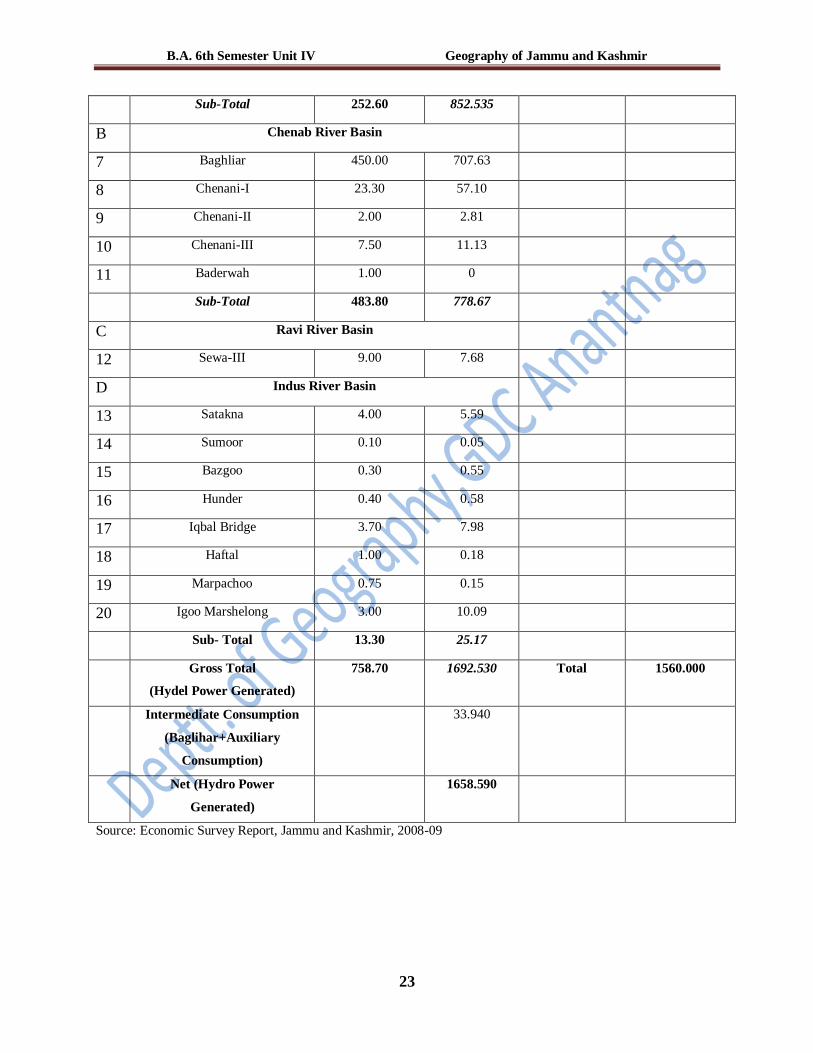
B.A. 6th Semester Unit IV Geography of Jammu and Kashmir
23
Sub-Total 252.60 852.535
B Chenab River Basin
7 Baghliar 450.00 707.63
8 Chenani-I 23.30 57.10
9 Chenani-II 2.00 2.81
10 Chenani-III 7.50 11.13
11 Baderwah 1.00 0
Sub-Total 483.80 778.67
C Ravi River Basin
12 Sewa-III 9.00 7.68
D Indus River Basin
13 Satakna 4.00 5.59
14 Sumoor 0.10 0.05
15 Bazgoo 0.30 0.55
16 Hunder 0.40 0.58
17 Iqbal Bridge 3.70 7.98
18 Haftal 1.00 0.18
19 Marpachoo 0.75 0.15
20 Igoo Marshelong 3.00 10.09
Sub- Total 13.30 25.17
Gross Total
(Hydel Power Generated)
758.70 1692.530 Total 1560.000
Intermediate Consumption
(Baglihar+Auxiliary
Consumption)
33.940
Net (Hydro Power
Generated)
1658.590
Source: Economic Survey Report, Jammu and Kashmir, 2008-09