atkins wsi
13
www.hertsrestoration.co.uk Historic building consultancy REF D.B.C. 4/00453/14/LBC: Courtyard ‘Outbuilding/Storeroom’ to rear of No. 5. Roughdown Villas. Roughdown Common. Hemel Hempstead. Herts. HP3, 0AX. WRITEN SCHEME OF INVESTIGATION (WSI) LEVEL 2: This document comprises a Written Scheme of Investigation setting out methodologies, resources and program for recording and analysis of elements of the ‘subterranean brick barrel vaulted outbuilding/ a brick&flint walled store’. It has been prepared specifically to deploy recording in line with English Heritage Level 2 building survey, as requested by Helen Cal Fernandes, Dacorum Borough Council and forms part of and subject to the Listed Building Consent granted condition. This document is subject to approval by the Local Authority and in accordance with historic buildings advice set out in a brief issued by Helen Cal Fernandes advisor Dacorum Borough Council 3.07.2014. The Site: The structure concerned ‘a Subterranean Outbuilding/Storeroom’ to the rear courtyard of No.5. Roughdown Villas. HP3, 0AX. was in existence by the time of the Ordnance survey 1 st edition 1878. It is no longer in use and in an advanced state of decay, much overgrown and in semi-ruinous structural condition. Part of a group of eight residences, Roughdown Villas were built by and for the engineers and managers employed in the construction of the Boxmoor Railway station 1835. Aims and Objectives: The objective of this Level 2 recording is to provide a simple, comprehensive map; visual and measured record of study structure , before demolition, and where strongly suspected to retain only limited historic significance. In accordance with the EH procedural document 2006 ‘Understanding Historic Buildings: A guide to good recording practice’. Recording Methodology: Site recording and research include, accurate archaeological record of the building to EH Level 2 (EH 2006/EH 2006b revised 2009), drawn plans, annotated with appropriate constructional details. Photographic survey of building in present condition. Black and white for archive purposes and colour digital media for reporting purposes. Written free-text notes setting out on-site observations of the building. Summary of background research to phase and date of origins and development. Reporting and Archive: Report to be submitted to Dacorum Borough Council/Hertfordshire County Council Archaeological advisor in order to discharge the L.B.C. planning condition. The report to include a summary of the deconstruction works to be undertaken and the aims and methods employed during the course of the recording. Description and interpretation of the structure recorded, interpretation of phasing, dating and development. Site-specific: Site name; Pre-start visit; Time-input on site recording; Research days; Reporting days. Historic map regression; NRO documentation search. Timetable for reporting; 8-12 weeks from end of field/site work. Note to HCC archaeology 2015. Health and Safety: All site/field work to be undertaken under appropriate Health and Safety Policies and procedures. A simple risk assessment to be prepared prior to deconstruction works commencing. Safety clothing/PPE will be deployed as required. J. Titmus (site manager) holds the Construction Site Managers Health and Safety Certificate until 2015. This Level 2 building survey document has been prepared by J. Titmus / Hertsrestoration Services, 30 years Historic Building works experience and is affiliated/full member of I.H.B.C.S.P.A.B.ICOMOS. Office: Mr. J. Titmus. 32. Field Road. Oxhey. Hertfordshire. WD19 4DR Tel/Fax 01923 250247 [email protected] VAT Reg No : 505 5276 58 S.P.A.B. I.H.B.C. ICOMOS VSA. Member. Historic Recording Surveys Planning Specification Project Management Scaled Drawings Service
-
Upload
independent -
Category
Documents
-
view
0 -
download
0
Transcript of atkins wsi

www.hertsrestoration.co.uk
Historic building consultancy
REF D.B.C. 4/00453/14/LBC:
Courtyard ‘Outbuilding/Storeroom’ to rear of No. 5. Roughdown Villas. Roughdown Common.
Hemel Hempstead. Herts. HP3, 0AX.
WRITEN SCHEME OF INVESTIGATION (WSI) LEVEL 2:
This document comprises a Written Scheme of Investigation setting out methodologies, resources and
program for recording and analysis of elements of the ‘subterranean brick barrel vaulted outbuilding/ a
brick&flint walled store’. It has been prepared specifically to deploy recording in line with English
Heritage Level 2 building survey, as requested by Helen Cal Fernandes, Dacorum Borough Council
and forms part of and subject to the Listed Building Consent granted condition.
This document is subject to approval by the Local Authority and in accordance with historic buildings
advice set out in a brief issued by Helen Cal Fernandes advisor Dacorum Borough Council 3.07.2014.
The Site:
The structure concerned ‘a Subterranean Outbuilding/Storeroom’ to the rear courtyard of No.5.
Roughdown Villas. HP3, 0AX. was in existence by the time of the Ordnance survey 1st edition 1878.
It is no longer in use and in an advanced state of decay, much overgrown and in semi-ruinous structural
condition. Part of a group of eight residences, Roughdown Villas were built by and for the engineers
and managers employed in the construction of the Boxmoor Railway station 1835.
Aims and Objectives:
The objective of this Level 2 recording is to provide a simple, comprehensive map; visual and
measured record of study structure , before demolition, and where strongly suspected to retain only
limited historic significance. In accordance with the EH procedural document 2006 ‘Understanding
Historic Buildings: A guide to good recording practice’.
Recording Methodology:
Site recording and research include, accurate archaeological record of the building to EH Level 2 (EH
2006/EH 2006b revised 2009), drawn plans, annotated with appropriate constructional details.
Photographic survey of building in present condition. Black and white for archive purposes and colour
digital media for reporting purposes.
Written free-text notes setting out on-site observations of the building.
Summary of background research to phase and date of origins and development.
Reporting and Archive:
Report to be submitted to Dacorum Borough Council/Hertfordshire County Council Archaeological
advisor in order to discharge the L.B.C. planning condition.
The report to include a summary of the deconstruction works to be undertaken and the aims and
methods employed during the course of the recording. Description and interpretation of the structure
recorded, interpretation of phasing, dating and development.
Site-specific: Site name; Pre-start visit; Time-input on site recording; Research days; Reporting days.
Historic map regression; NRO documentation search.
Timetable for reporting; 8-12 weeks from end of field/site work. Note to HCC archaeology 2015.
Health and Safety:
All site/field work to be undertaken under appropriate Health and Safety Policies and procedures. A
simple risk assessment to be prepared prior to deconstruction works commencing.
Safety clothing/PPE will be deployed as required.
J. Titmus (site manager) holds the Construction Site Managers Health and Safety Certificate until 2015.
This Level 2 building survey document has been prepared by J. Titmus / Hertsrestoration Services, 30
years Historic Building works experience and is affiliated/full member of I.H.B.C.S.P.A.B.ICOMOS.
Office: Mr. J. Titmus. 32. Field Road. Oxhey. Hertfordshire. WD19 4DR Tel/Fax 01923 250247
VAT Reg No : 505 5276 58 S.P.A.B. I.H.B.C. ICOMOS VSA. Member.
Historic Recording Surveys Planning Specification Project Management Scaled Drawings Service

Page2
LOCATION / HISTORIC BACKGROUND/CONTEXT
Documentary work was restricted to a search of; County & Local Archive records office, Genealogy
Hertfordshire, HER.
The information obtained was sufficient to meet the levels of historic building recording required
within the context/brief.
The structure lies on the south side of Roughdown Villas Road/South of Hemel Hempstead.
Centered on NGR. 504168 205750: 51’44’26.66 N - 0’ 29’33.00W.
Historic Documentation.
No.5. Roughdown Villas is part of a group of 8 semi-detached properties built by the London & North
West Railway (London to Birmingham) between 1835 – 1837, to house engineers and managers
employed in the construction of the Boxmoor (Hemel Hempstead) Station. Part of the railways
constructional trend of urbanization. The station being completed and opened in July 1837.
Navies employed in the construction, camped in the vicinity of nearby Roughdown Common.
As part of the twenty year building boom following the Napoleonic wars, this newer style of
architecture (Regency period) followed the basic plan of the late Georgian style of the 18c in layout,
and the rise of the detached and semi-detached ‘villa’. Retaining Georgian window proportions, thin
glazing bars, divided sash windows of twelve or more rectangular panes. Gable end / hipped
construction roofs with wide projecting eaves and Welsh slate the preferred covering material,
contrasting the pale stucco/brick walls. These ‘middle-class’ villas, contain twelve or more rooms with
separate family and basement service areas. Externally located, ‘Barrel brick-vaulted outbuildings
/storerooms’ serviced the basement service areas, located either to the front or rear of these properties.
A map from 1897 shows Roughdown Villas, in although a rural location, in a most convenient position
for easy access to the railway station works.
Sold on or let sometime after 1837; an 1851 census found residents of Roughdown Villas;
No.1/ Sarah Christopher, (45, unmarried, find holder), Ann Christopher, (37, sister, unmarried, fund
holder), Thomas Christopher, (40, brother, unmarried, proprietor of houses), visitor & servant.
2/Frank Wilkins, (46, retired farmer), Mary, (27, wife), Francis (son, 3).
3/John Pearce (42, solicitor) wife children, visitor and 2domestic servants.
4/ Unoccupied.
5/ George ??? (53, retired farmer), wife, 5 children, nephew, 4 servants.
6/Unoccupied.
7/Thomas Timms (50, gardener) and wife.
8/ Joseph Christopher (50, annuitant) wife, 2 children and 2 domestic servants.
An 1866 Trade Directory lists the following private residents in ‘Rowdon’ Villas as;
No.1/ Mr. Thomas Christopher
2/ Mrs. Lucy Mary Warr
3/ Miss Elizabeth Akerman
4/ Mr. David Saunders
5/ ???
6/ Miss Mary Ann Reynolds
7/ Miss Jane Winstanley
8/ Mr. Joseph Christopher.
The 1843 Tithe Award lists both owner and occupiers.
An 1857 advert in the East London Observer of October 31st included the following;
‘’Boxmoor Herts: One of those beautiful semi-detached villas residencies, known as Rowdown Villas,
within two minutes’ walk of the station of the North Western Railway, containing six bedrooms, three
siting rooms, two kitchens and abundantly supplied with water, with a two stall stable and coach house
for £32 per annum. These residencies command a view of the surrounding country for twelve miles
around, from the parlour windows. Inquire on the premises.’’
The 1843 Tithe Award lists both owners and occupiers. Photocopies of the award and map are in the
Hemel Hempstead Library and originals at the County Records Office (HALS) @ Hertford.
References: ‘’The Book of Boxmoor’’
‘’Royalty to Commoners: Four Hundred Years of the Boxmoor Trust’’
‘’Hertfordshire Genealogy’’ and ‘’County Records Office Hertford’’

Page 3
SITE LOCATION / GEOLOGY:
The underlying geology of the area comprises typical chalk of the Chilterns downland. The chalk is
exposed along steep escarpments towards Aylesbury and along valley sides. The drift slope is overlaid
by clay with flints which support the extensive surrounding woodlands, medium –grade farmland and
remnant heath. Lewes Nodular Chalk formation and the Sleaford Chalk Formation (undifferentiated).
A chalk sedimentary bedrock formed approx. 84-94 million years ago in the Cretaceous period.
Superficial deposits area recorded as clay with flint formations. A combination of clay, silt, sand and
gravels formed up to 5 million years ago in the Quaternary and Noegene periods, indicating a local
environment previously dominated by weathering process. (http://www.bgs.ac.uk/).
BUILDING SURVEY:
The study structure; a subterranean brick barrel vaulted‘’ Outbuilding/Storeroom’’, located to the rear
courtyard of No5. Roughdown Villas dating from 1835. Constructed of rubble chalk flint and local
‘Luton greys/multi’ handmade brick. Acting as a retaining wall to the steeply rising rear garden, also
forming part of the boundary and dividing the individual rear gardens of the semi-detached building
group of 4. Being part subterranean the barrel brick vault supports a ‘loading weight’ of 7cuM of
soil & chalk equal to 10 tonne. Previous attempts at stabilization include additional brickwork piers,
later brickwork sectional repairs and buttressing now fracturing. The vaulted brickwork ceiling has
deflected to near collapse at the front entrance due to the weight loading. The structures present near
collapsed condition and location has no present function, in its size, shape and layout and in its
semi-ruinous position acting also as a retaining wall, creates a potential danger to the occupants.
The structure was surveyed in April 2014 using a Disto measuring and hand-held GPS equipment.
The structure was unsafe to fully enter and required occasional flash photography to record.
Notations were undertaken regarding the characteristics, including metrical data, thresholds, materials
and building techniques employed.
SURVEY RESULTS:
The study structure, an external subterranean coalhole/store room serviced the basement and domestic
servant requirements accessed via the rear and lower ground rear kitchen courtyard.
Constructed as part retaining wall to the steeply rising rear gardens leading to the wooded ridge N.
The structure comprises local ‘Luton grey/multi’ handmade bricks to front and right flank elevations.
Brick barrel vaulted ceiling. Rubble chalk flints to rear wall and left flank, with later (20c) added
external brick skin as stabilization. Additional later (20c) brick piers and lintel added to front elevation
entrance. Original entrance and vaulted brick ceiling lintel has deflected under soil/chalk loading and
partially collapsed.
PHOTOGRAPHIC INDEX: B&W + DIGITAL COLOUR / FACING / DESCRIPTION:
001: B&W. VIEW S. FROM HOUSE GROUND LEVEL . ANNOTATED.
002: B&W. VIEW SOUTH FACING ENTRANCE BASEMENT/COURTYARD LEVEL.
003: B&W. EXTERNAL LEFT FLANK RISING 2.4M FROM COURTYARD LEVEL.
004: B&W. INTERNAL VIEW BRICK VAULTED COAL/STROEROOM.
005: COLOUR. COLLAPSE BETWEEN INT&EXT ENTRANCE LINTELS
006: COLOUR. COLLAPSE OF CHALK & EARTH LOAD.
007: COLOUR. ORIGINAL BRICK VAULT & LATER SEGMENTAL ARCHES.
008: B&W. EXT VIEW N. EXTERNAL DIMS.
009: B&W. REAR COURTYARD W. OF No.5. ROUGHDOWN VILLAS.
010: B&W. VIEW FROM BASEMENT/COURTYARD RISE OF LAND /\ 2.4m.
011: B&W. INT VIEW S. INTERNAL DIMS.
012: B&W. INT VIEW LEFT FLANK.
013: B&W. EXT VIEW N. FROM REAR GARDEN GROUND LEVEL.
014: B&W. ENTRANCE LINTEL LOAD DEFLECTION/COLLAPSE.

O.S. MAP INDEX:
001: O.S. 1878 16 hectare
002: 1878 zoom
003: O.S. 1898 16 hectare
004: 1898 zoom
005: O.S. 1925 16 hectare
006: O.S. 1:12500 16 HECTARE LOCATION MAP
007: O.S. 1:500 0.9 HECTARE SITE MAP
DRAWING INDEX:
001: LOCATION STUDY BUILDING GOOGLE EARTH IMAGE
002: DRAWING STUDY BUILDING GROUND PLAN 1:50
003: DRAWING STUDY BUILDING FRONT ELEVATION 1:20
004: DRAWING STUDY BUILDING SECTION THROUGH 1:20
005: LOCATION SITE OF STUDY BUILDING MAP
SUMMARY
The study building; rear courtyard subterranean outbuilding cum storeroom/coal hole clearly
had a service function but context had been lost through later life-style ‘improvements’ and the
lack of such a structures’ requirement. Measuring 1.2m internal height, 1.8m internal width and
4.1m internal depth. These utilitarian outbuildings appear to date up and to the last (19) century
have little academic merit. The removal of the structure enables the salvaged material of flint
and brick to be re-used in reconstructing and establishing the required rear garden retaining and
party walls.
DECONSTRUCTION: (site work to include watching brief/monitoring/risk assessed)
Timber brace - shoring to external left flank wall ( steps up to rear garden level. 1m x 2.4m x
2.7m.) 2.4 m rise from basement courtyard level to rear garden level.
Graded layers of the existing top soil and sub-soil chalk (approx. 7cuM total) to be removed via
mechanical excavator and hand tools. Deposits to be monitored and removed from rear garden.
Brick and flint work to the front and left flank and subsequently brick barrel ceiling, as works
proceed, to be carefully dismantled by hand using small mechanical and hand tools.
All salvaged materials to be set aside for re-use in reconstruction of retaining walls.
All surplus rubble and debris to be removed from cleared site of works.
The exposed internal faces of the rear, left and right flank walls to be refaced and reinforced/ tied
using salvaged materials where required.
ARCHIVE:
The archive has been compiled in accordance with the project/brief and the guidelines set out by
English Heritage (1991) and the I.F.A. ( 94/07/08). The archive will be deposited with the
appropriate repository, OASIS with copies donated to the County and Monuments Record.

LOCATION SITE OF STUDY BUILDING DRWG No.005.
GROUND PLAN 1: 50 DRWG No. 002.
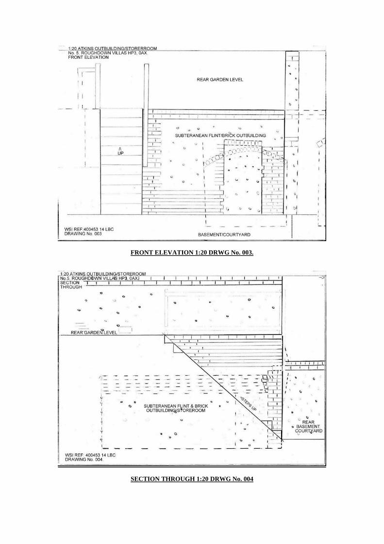
FRONT ELEVATION 1:20 DRWG No. 003.
SECTION THROUGH 1:20 DRWG No. 004

0.S. MAP 1878 INDEX No. 001/16ht.
O.S. MAP 1878 INDEX No.002
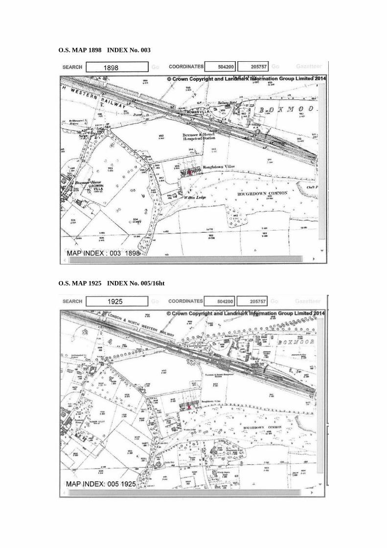
O.S. MAP 1898 INDEX No. 003
O.S. MAP 1925 INDEX No. 005/16ht

STUDY BUILDING PHOTOGRAPHIC SURVEY IMAGES
009: REAR COURTYARD AT BASEMENT LEVEL
008: EXT VIEW N. FACING EXT DIMS

010: VIEW FROM COURTYARD/BASEMENT LEVEL / RISE TO REAR LAND
005: INTERNAL VIEW / INT DIMS

0013: VIEW FROM UPPER REAR GARDEN LEVEL N.
0036: REAR GARDEN UPPER LEVEL >N.

007: INERNAL BRICK / HOOP LINTELS
005: COLLAPSE CHALK RUBBLE FLINT SOILS AT ENTRANCE
PHOTOGRAPHIC IMAGE Nos. 008/010/013/9

0012: INT VIEW LEFT FLANK
0030: INTERNAL RIGHT FLANK / PARTY WALL


![Atkins (a veteran of [World War I?],[see notes on his tombstone ...](https://static.fdokumen.com/doc/165x107/633859b041be8024090065a4/atkins-a-veteran-of-world-war-isee-notes-on-his-tombstone-.jpg)