Archaeology of a Civil War Prison in Blackshear, Georgia
87
Georgia Southern University Digital Commons@Georgia Southern Electronic Theses and Dissertations Graduate Studies, Jack N. Averitt College of Fall 2019 Preserving the Memory of those Perilous Times: Archaeology of a Civil War Prison in Blackshear, Georgia Colin H. Partridge Follow this and additional works at: https://digitalcommons.georgiasouthern.edu/etd Part of the Archaeological Anthropology Commons, and the Military History Commons Recommended Citation Partridge, Colin H., "Preserving the Memory of those Perilous Times: Archaeology of a Civil War Prison in Blackshear, Georgia" (2019). Electronic Theses and Dissertations. 2027. https://digitalcommons.georgiasouthern.edu/etd/2027 This thesis (open access) is brought to you for free and open access by the Graduate Studies, Jack N. Averitt College of at Digital Commons@Georgia Southern. It has been accepted for inclusion in Electronic Theses and Dissertations by an authorized administrator of Digital Commons@Georgia Southern. For more information, please contact [email protected].
-
Upload
khangminh22 -
Category
Documents
-
view
1 -
download
0
Transcript of Archaeology of a Civil War Prison in Blackshear, Georgia
Georgia Southern University
Digital Commons@Georgia Southern
Electronic Theses and Dissertations Graduate Studies, Jack N. Averitt College of
Fall 2019
Preserving the Memory of those Perilous Times: Archaeology of a Civil War Prison in Blackshear, Georgia Colin H. Partridge
Follow this and additional works at: https://digitalcommons.georgiasouthern.edu/etd
Part of the Archaeological Anthropology Commons, and the Military History Commons
Recommended Citation Partridge, Colin H., "Preserving the Memory of those Perilous Times: Archaeology of a Civil War Prison in Blackshear, Georgia" (2019). Electronic Theses and Dissertations. 2027. https://digitalcommons.georgiasouthern.edu/etd/2027
This thesis (open access) is brought to you for free and open access by the Graduate Studies, Jack N. Averitt College of at Digital Commons@Georgia Southern. It has been accepted for inclusion in Electronic Theses and Dissertations by an authorized administrator of Digital Commons@Georgia Southern. For more information, please contact [email protected].
PRESERVING THE MEMORY OF THOSE PERILOUS TIMES: ARCHAEOLOGY OF A CIVIL WAR PRISON IN BLACKSHEAR, GEORGIA
by
COLIN PARTRIDGE
(Under the Direction of Ryan McNutt)
ABSTRACT
In the closing months of 1864 Confederate prison authorities were forced to evacuate the large stockade prisoner of war (POW) camps at Millen and Andersonville, Georgia in the face of General Sherman’s ‘March to the Sea.’ While attempting to evade Union forces, approximately 5,000 POWs were sent along the Atlantic and Gulf railroad in southeast Georgia, stopping just outside of the town of Blackshear. For three weeks prisoners and guards camped along a small tributary of the Alabaha River with only a few stakes to mark a deadline between them. No formal prison enclosure or fortifications were constructed and while escapes were frequent the majority of the prisoners would endure their stay before continuing down the line to Thomasville. In this thesis, I continue the investigation of site 9PR26 by further delineating the boundaries with metal detection survey. By examining the spatial distribution of the artifacs I attempt to determine the general layout of the camp and why this particular location was chosen as the site of a makeshift prison by its commander.
INDEX WORDS: Civil War prisoner of war camps, Conflict archaeology, Archaeology of internment, Metal detecting survey
PRESERVING THE MEMORY OF THOSE PERILOUS TIMES: ARCHAEOLOGY OF A CIVIL WAR PRISON IN BLACKSHEAR, GEORGIA
by
COLIN PARTRIDGE
B.A., University of South Carolina, 2012
A Thesis Submitted to the Graduate Faculty of Georgia Southern University in Partial Fulfillment of the Requirements for the Degree
MASTER OF ARTS
STATESBORO, GEORGIA

© 2019
COLIN PARTRIDGE
All Rights Reserved
1
PRESERVING THE MEMORY OF THOSE PERILOUS TIMES: ARCHAEOLOGY OF A CIVIL WAR PRISON IN BLACKSHEAR, GEORGIA
by
COLIN PARTRIDGE
Major Professor: Ryan McNutt Committee: Jared Wood
Iain Banks
Electronic Version Approved: December 2019
2
ACKNOWLEDGMENTS
This project could not have been completed without the help and continued support of my professors, fellow students, family, and friends. Thank you to Dr. Ryan McNutt, my committee chair, for accepting me as your student and sharing your knowledge of historical and conflict archaeology. I would also like to thank the other members of my committee, Dr. M. Jared Wood and Dr. Iain Banks. Their guidance and encouragement during the work for this project will continue to benefit me throughout my career. I would also like to acknowledge the immense support I received from the other faculty and staff of the Department of Sociology and Anthropology, as well as my fellow graduate students and undergraduate volunteers many of whom assisted in the field work associated with this project. Finally, as always, I would like to thank my family for supporting me throughout this period. I could not have done it without you.
3
TABLE OF CONTENTS
Page
ACKNOWLEDGMENTS ................................................................................................................... 2 LIST OF TABLES ............................................................................................................................... 4 LIST OF FIGURES ............................................................................................................................. 5 CHAPTER 1: INTRODUCTION ........................................................................................................ 6
Civil War Prison Camps as Landscapes of Confinement ....................................................... 9 Previous Work at 9PR26 ......................................................................................................... 10 Methods and Significance of this Study ................................................................................. 16
CHAPTER 2: CIVIL WAR PRISONS, ENCAMPMENTS, AND THEIR ARCHAEOLOGY… ..... .18 Introduction… ......................................................................................................................... 18 Camp Blackshear .................................................................................................................... 23 Archaeology of Civil War Prisons and Encampments ............................................................ 28 Metal Detecting Sites of Conflict............................................................................................ 31
CHAPTER 3: METHODS ................................................................................................................... 36 Summary Results of the Metal Detecting Survey ................................................................... 39
CHAPTER 4: RESULTS ..................................................................................................................... 42 Artifact Patterning ................................................................................................................... 44 Spatial Patterning .................................................................................................................... 55
CHAPTER 5: DISCUSSION AND CONCLUSION .......................................................................... 65 Discussion ............................................................................................................................... 65 Conclusion .............................................................................................................................. 71
REFERENCES .................................................................................................................................... 74 APPENDICES ..................................................................................................................................... 79
Appendix A: Artifact Catalog from the 2018-2019 Field Work ............................................. 79
4
LIST OF TABLES
Page
Table 4.1: Artifacts recovered in metal detecting survey by activity group .............................44 Table 4.2: Square nail pennyweight count and percentage ........................................................46 Table 4.3: Artifact distribution by activity group ..................................................................... 60 Table 4.4: Artifacts recovered from TU 1 by activity group .....................................................61
5
LIST OF FIGURES
Page
Figure 1.1: Site location topographic map ................................................................................. 11 Figure 3.1: 2013-2019 excavation areas aerial map .................................................................. 36 Figure 4.1: Distribution of artifacts across the 2018-2019 project area .................................... 43 Figure 4.2: Sheet tin fragments, Catalog# 43.01 ....................................................................... 48 Figure 4.3: Railroad spike, Catalog# 133.01. ........................................................................... 48 Figure 4.4: Railroad spike, Catalog# 84.01. ............................................................................. 49 Figure 4.5: Watering bit/ Horse tack, Catalog# 81.01 ............................................................... 49 Figure 4.6: Utensil handle, Catalog# 57.01. ............................................................................. 51 Figure 4.7: U.S. Army general service button, Catalog# 71.01. ................................................ 52 Figure 4.8: U.S. Army general service button, Catalog# 136.01. .............................................. 53 Figure 4.9: Grommet, Catalog# 82.01… .................................................................................. 53 Figure 4.10: Alloy Rivet, Catalog# 159.01…............................................................................54 Figure 4.11: Artifact distribution and site boundary ................................................................ 59 Figure 4.12: FS# 187 in shovel test ........................................................................................... 62 Figure 4.13: Feature 1 mid excavation photo ........................................................................... 62 Figure 4.14: Test Unit 1 closing photo ..................................................................................... 63 Figure 4.15: Test Unit 1 west profile ........................................................................................ 64 Figure 5.1: Civil War occupation site boundary and possible POW occupation area .......... 70
6
CHAPTER 1
INTRODUCTION
The American Civil War was an event that encompassed the entire nation. The most
visible remnants of the conflict on the modern landscape are the battlefields, many of which have
been preserved on both private and public lands and serve as memorials to those who fought as
well as tools for interpreting the history of the war (Lees, 2002). However, a war, especially on the
scale of the Civil War, is not contained within the fields on which armies fought. Those armies
also require areas to train, camp, treat the wounded, store supplies, and hold captured prisoners of
war (POWs). These sites are as abundant as the thousands of battle sites and with the aid of
archaeological investigation can add to the developing interpretation of a conflict as a whole. The
Confederate POW camp known as Camp Blackshear is one of those sites.
This study consists of archaeological investigations of Camp Blackshear through the use
of metal detecting survey. The survey methodology employed for this study differs from those used
on this and other Civil War sites but has become the preferred option for investigating nineteenth
century military occupations (Balicki, 2011; Espenshade et al., 2011; Scott et al., 1989). Artifacts
recovered as part of this study were analyzed in an effort to reconstruct the historic landscape of the
camp to better understand how the prison operated in comparison with other Civil War prisons and
encampments. By analyzing the unique history of this prison site and the results of the methods
used in the archaeological investigation the author looks to contribute to the broader field of the
archaeology of conflict and internment.
Blackshear prison was occupied by approximately 5,000 enlisted Union POWs, several
hundred Confederate guards from the Second and Fourth Georgia Reserves, as well as several
companies of Georgia State militia from the end of November through mid-December 1864
(Forno, 1899). The soldiers arrived in Blackshear by train, traveling from Savannah along the
Atlantic and Gulf Railroad in an attempt to evade the Union army under General William T.
7
Sherman that had launched a campaign through Georgia in an effort to divide the Confederate
states and disrupt the supply of its armies. Many of the prisoners that arrived at Blackshear had
previously been held in Andersonville, a POW camp established in February 1864 located outside
of Americus, Georgia (McElroy, 1879). A portion of the garrison and prisoners were transferred to
Camp Lawton, another stockade prison located in Millen, Georgia constructed to alleviate the
massive overcrowding of Andersonville, before being quickly evacuated to Savannah and
Blackshear as Sherman’s army began the ‘march to sea’ (Derden, 2012).
Unlike the other prisons the solders had occupied, Camp Blackshear did not have a built
enclosure to contain the prisoners. It is unclear if existing structures were present during the
occupation and to what extent the guards prepared a defense against possible Union troop
movements (Smith, 1892:17). Many of the prisoners constructed shelters similar to those at Camp
Lawton and Andersonville, using what material they had available (Long, 1886:110). These
conditions left a unique impression on the POWs that is reflected in their diaries and memoirs and
represents a change in the treatment of these prisoners that is so far unexplored in the historic
record (Hosmer, 1896:17).
Immediately following the war, one of the more controversial topics was the treatment of
prisoners by both sides during the conflict. In the North, Union veterans published accounts of their
internment which were used as evidence of the cruelty of the Confederacy’s leadership. Meanwhile
those in the South claimed that while unable to provide adequate supplies to Union POWs, Union
authorities were more than capable of preventing the deaths of thousands of Confederate POWs in
northern prisons. Historians have since managed to provide a more objective view of Civil War
prisons and their legacies (Cloyd, 2010; Futch, 1968; Hesseltine, 1930, 1972; Speer, 1997).
However, a reliance on the historical accounts alone provides only a portion of the real lived
experiences of these individuals. Archaeology becomes an integral part in understanding the events
surrounding Civil War prisons.
8
It was not always apparent that archaeology could aid in the study of past conflict.
Historic accounts of battles fought, and maps prepared by officials based on those accounts were
believed to be reliable enough sources of information that even prominent historic archaeologists
did not think conflict archaeology was worth the effort. Ivor Nöel Hume once wrote:
“Little can usefully be said about battlefield sites… the site will have little to distinguish it, except perhaps some graves and a scatter of hardware… there can be no meaningful stratigraphy (as far as the battle is concerned), and the salvage of relics becomes the be all and end all.” (as cited in Scott et al., 1989:188)
However, as technology progressed, the methodology for the archaeological investigation of
conflict sites became more refined, which led to the development of more critical research
questions. Analysis focused not only on the outcomes of individual battles but the aspects of
culture that are reflected through conflict. Military lifeways reflect the culture in which they are
based, and the study of military related sites can isolate characteristics of that culture for in depth
analysis.
The primary method of locating and delineating historic sites of conflict is through metal
detecting survey. As an archaeological survey method suitable for conflict studies, metal detecting
in the U.S. got its start from the work of Scott (1989) at the battle of Little Big Horn. The study
demonstrated the effectiveness of metal detecting in locating and delineating battlefield remains in
the archaeological record. Conflict sites, particularly battlefield sites, are not well suited to
traditional archaeological investigation methods of shovel test survey and block excavation because
of the limited amount of subsurface archaeological features typically associated with them. The
majority of artifacts deposited on historic conflict sites tend to remain in the upper layers of the soil
and are most frequently metal. Therefore, metal detection survey provides an efficient means to
investigate large sites of conflict.
Archaeologists have since adapted metal detection survey to the archaeology of Civil
War encampments (Balicki, 2011; Geier et al., 2006). Although many camps were occupied for
longer durations, military regulations at the time dictated that these sites were organized in a
9
specific layout and regularly cleared of trash and debris that would otherwise find itself in the
archaeological record. As such, in order to locate and delineate these sites, metal detecting survey
is employed to locate concentrations of material that could indicate specific features such as
latrines or trash pits. Researchers have found that these features tend to be located in certain areas
of a camp site in accordance with period regulations and the remainder of the camp can often be
located by referencing these layout instructions (Whitehorn, 2006:37-40).
Civil War Prison Camps as Landscapes of Confinement
The American Civil War represented a new stage of confinement with the construction of
what one historian has called America’s concentration camps (Speer, 1997: xiv). Civil War prison
camps were large complexes designed to contain a large number of POWs, preventing their escape
and protecting them from recapture; they were a byproduct of a war that escalated beyond the scale
of anything imaginable at the time. As such, the logistical planning for the occurrence of POWs
before the war was far outpaced by the reality of the situation faced by both sides later in the
conflict. The unpreparedness of prison authorities combined with total war tactics over the
prolonged conflict would result in the high mortality rates experienced by Civil War POWs
(Hesseltine, 1930).
By placing prison stockades at rural train depots, prisoners would be isolated from
civilian populations and in unfamiliar territory (Davis, 2003). POWs were typically located within
a central location of a prison camp often surrounded by a stockade wall. The stockade prisons were
designed with exterior guard towers placed at regular intervals and manned by armed guards day
and night. The presence of these towers and lack of shelter within the stockades left the prisoners
exposed to the elements and the constant surveillance of the guards in their towers. Artillery
positions were also placed around the camp. These protected the stockade from outside attack but
also made it possible to fire on the prisoners inside (Derden, 2012; Futch, 1968). Twenty feet from
the stockade wall inside the prison was a barrier known as the deadline (Speer, 1997). If a prisoner
10
crossed this line, intentionally or otherwise, they would be fired upon (Hesseltine, 1930). Outside
of the stockade were camp facilities for the guards and their officers as well as a hospital and food
preparation areas.
Investigations at Johnson’s Island (Bush, 2011), Andersonville (Prentice and Mathison,
1989; Prentice and Prentice, 1990), and Camp Lawton (Chapman, 2012; McNutt, 2016) look to
better understand how the war resulted in the creation of these sites and what effect the camps had
on the lived experiences of the people who occupied them. Blackshear prison has been categorized
as an open area or barren ground prison where POWs were concentrated in a specific area and
surrounded by a guard detail. This type of prison was most frequently used by Confederate forces
late in the war when large groups of POWs were being transferred from various locations across
the South. Other sites of this nature include Camp Sorghum in Columbia, South Carolina, Camp
Verde near San Antonio, Texas, and to some extent Bell Isle located in the James River outside
Richmond, Virginia. While these sites exhibit similar characteristics of an open area prison, each is
uniquely adapted to the local landscape to provide the most efficient encampment for the guards
while maintaining control over the prisoners (DePratter et al., 2011; Speer, 1997; Thoms, 2004).
Previous Work at 9PR26
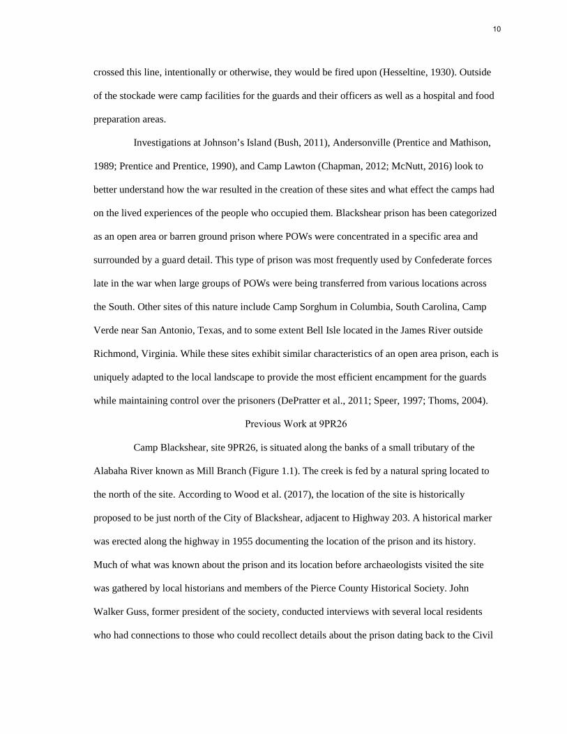
Camp Blackshear, site 9PR26, is situated along the banks of a small tributary of the
Alabaha River known as Mill Branch (Figure 1.1). The creek is fed by a natural spring located to
the north of the site. According to Wood et al. (2017), the location of the site is historically
proposed to be just north of the City of Blackshear, adjacent to Highway 203. A historical marker
was erected along the highway in 1955 documenting the location of the prison and its history.
Much of what was known about the prison and its location before archaeologists visited the site
was gathered by local historians and members of the Pierce County Historical Society. John
Walker Guss, former president of the society, conducted interviews with several local residents
who had connections to those who could recollect details about the prison dating back to the Civil
11
War occupation. The general consensus of these interviews is that the location of the prison is
where the original 1955 historical marker was placed. The interviewees also noted the presence of
a cemetery associated with the prison being in an old stand of trees on top of the hill east of the
marker (Guss, 1990, 1999 as cited in Wood et al., 2017).
Figure 1.1: Site Location
12
The descriptions of the prison location by the residents interviewed by Guss correlate
with those of Nellie Stewart, an inhabitant of Blackshear born in 1847. According to her account
the prison was located near Wards Chapel, under a hill leading to the brick kiln pond (Stewart
1915, as cited in Wood et al., 2017). Wards Chapel was originally built in 1898 and was renamed
Ward Memorial United Methodist Church in the 1940s; the building is located along Highway 203
just south of the historical marker. The current site location is on a low ridge that slopes down
towards the junction of Mill Branch and another tributary of the Alabaha River, Gully Branch.
Stewart also mentions the presence of Union graves throughout the town from both the
prison occupation and the post-war U.S. Army occupation. Records of the exhumation and reburial
of these soldiers from Blackshear were obtained by the Pierce County Chamber of Commerce and
document the recovery of twenty-seven bodies, eight of which are noted as being located near the
former prison site. The descriptions of these burials include references to the prison being located
approximately one mile from the town and near land belonging to a Mr. Grady (Wood et al.,
2017). Grady Street is located running parallel to the eastern boundary of the current site location
approximately 130m (435 ft) from the southeast corner of the site and may have been used as the
original road to the prison from town.
The descriptions of the prison location and geographic setting correlate with accounts
from the POWs themselves. A total of seventeen prisoner accounts were referenced during the
research for this project almost all of which describe the prison as being located approximately a
mile from the railroad tracks, in a stand of open pine, near a stream. Wood et al. (2017) notes that
the prisoner’s descriptions of the town of Blackshear do not adequately match the known historic
layout with many prisoners recounting the relatively small size and lack of buildings. This
description may indicate that the prisoners were removed from the train before entering the town
proper and marched to an out of the way area. Wood et al. (2017) also note that none of the
accounts mention the crossing of a stream during their approximately one-mile march into the
13
woods, meaning they likely followed the banks of the Alabaha River and its tributaries placing
them near the junction of Gully Branch and Mill Branch.
The POWs describe the prison as being an open area near the stream and lacking any
form of stockade.
“… I kept looking for another duplicate of Andersonville, but none appeared. When we were brought to a halt, about a half a mile from the railroad track, it was on the bank of a good-sized stream in a body of tall, open pine timber.” (Smith, 1893:257)
They describe the prison area as being guarded on all sides with stakes being placed at regular
intervals to mark the prisoner occupation area. One POW describes the general size of the prisoner
occupation area.
“…we were marched across the railroad track and about two hundred yards beyond onto a piece of land shaped like a gourd, about five acres in extent and nearly surrounded with water.” (Lightcap, 1902:62)
Although the POW accounts do mention several prisoner deaths at Blackshear, there is no mention
of a camp cemetery or burial ground.
The site was first visited by archaeologists in 2007 at the request of local community
members and the Pierce County Board of Commissioners who were interested in presevering the
site through purchasing portions of the property. Dwight Kirkland and archaeologists from
Southeastern Horizons, Inc. were consulted to do a walkover of the property which included the
historically purported camp and cemetery location. While no excavation was carried out during this
first visit, Kirkland did suggest the potential for future study and the Board of Commissioners
purchased 2.7 acres of the property including the possible cemetery tract in 2008. Looking to
expand their preservation and interpretation efforts, county officials reached out to Georgia
Southern University (GSU) archaeologists Dr. Sue Moore and Dr. Lance Greene inviting them to
conduct archaeological survey of the County owned portion of the property (Wood et al., 2017).
The GSU archaeologists were interested in the site due to their involvement with the Camp Lawton
Archaeology Project, an ongoing research agreement between Georgia Department of Natural
14
Resources, U.S. Fish and Wildlife, and GSU concerning the investigation of site 9JS1, the
Confederate POW camp located outside of Millen, GA (McNutt, 2017).
In March 2013 Dr. Greene led the preliminary field investigations at Blackshear with a
group of student volunteers. After establishing a local 100m (328 ft) by 160m (524 ft) grid, the
team conducted limited shovel testing and metal detecting survey which resulted in the discovery of
several artifacts dating to the 19th century. One of these finds was a U.S. Army general service
button, a good indication of the Civil War occupation. The reported cemetery area was not included
in the survey area so as not to disturb potential graves. Dr. Greene returned in July of that year with
the GSU summer archaeology field school to conduct more extensive survey and test excavations.
The primary goal of the early site visits was to determine the location of the camp and assess the
integrity of the archaeological remains. The survey consisted of shovel test excavations placed at a
20m interval across the site and systematic metal detecting also at 20m intervals. Additionally, five
1m x 1m test units were excavated to better define potential cultural features located during the
shovel test survey (Wood et al., 2017).
The summer field investigations resulted in the discovery of additional 19th and 20th
century artifacts related to the prison and post-war occupation. A review of historic plat maps
would reveal the location of an early 20th century house site at the end of Confederate Road
adjacent to Highway 203. Remains from the 20th century component are scattered across the
entirety of the site along with more modern material such as fence wire, shotgun shells, and fired
bullets. Artifacts related to the camp include three Civil War era buttons, a .69 caliber musket ball,
and a railroad spike, possibly scavenged by a POW and brought to the prison area. The test unit
excavation uncovered two cultural features; the first was a linear trench feature running roughly
north/south and parallel to an existing fence line. No artifacts were recovered from the feature
making it difficult to determine if it was related to camp activities or post dates the Civil War
occupation. The second was a large burn feature with evidence of possible reuse. No artifacts were
15
recovered from the feature, but several Civil War period artifacts were recovered nearby which
indicates the feature could be related to the camp. POW accounts describe large fires burning
around the perimeter of the camp at night to serve as watchfires; cooking fires would also have
been common. The camp was reportedly burned by the guards upon evacuation which could also
result in the formation of this feature (Wood et al., 2017).
In 2014, after being alerted by the Pierce County Historical Society and Chamber of
Commerce, the Georgia Trust for Historic Preservation listed the Blackshear Prison site as one of
its historic “Places in Peril” due to the property being privately owned and unprotected from future
development (Williams, 2017). Efforts to purchase more of the site for preservation were led by
current president of the Historic Society and Executive Director of the Chamber of Commerce,
Angela Manders. GSU Archaeologists were encouraged to return to the site in the summer of 2017
to conduct additional systematic metal detecting survey on the property in question. Dr. Ryan
McNutt, who took over directing the Camp Lawton Archaeological Project from Dr. Greene, led
the week-long survey.
Based on the data recovered during the field work of 2013, as well as a terrestrial LiDAR
scan conducted in 2016 by GSU archaeologist Dr. Jared Wood, and additional document research
by Inger Wood in 2016, three survey grid blocks were established further downhill and closer to
the stream in an attempt to locate suspected prisoner occupation areas (Blackshear Excavation
Archive, 2017). Metal detecting transects were placed at 10m intervals within each grid block to
achieve 25% ground coverage. Two 50m by 50m (164 ft) grids located in an open pasture
produced large amounts of modern shot and fence wire with sparse evidence of a 19th century
occupation. The third grid was 50m by 30m (98 ft) and was located along the base of the hill. Grid
3 contained two .32 caliber shot consistent with a buck and ball load known to be carried by
Confederate reserve troops. A harmonica reed was also found nearby indicating the presence of
16
a possible guard picket location (Blackshear Excavation Archive, 2017). A prehistoric element of
the site was located in the northern grid blocks closer to the creek.
While the previous studies successfully located evidence of the Civil War camp
occupation, the extent of the site remained unclear. After comparing results from the 2013 and
2017 field work it became clear that metal detecting survey would be the most effective survey
methodology going forward. Encouraged by the local community and the Pierce County Chamber
of Commerce, additional archaeological survey was called for on the remaining site property to
determine the boundaries of the prison.
Methods and Significance of this Study
This study is a direct continuation of the previous work to delineate Camp Blackshear
and identify the integrity of the archaeological remains. The current project will also be used to
better understand the benefits and limitations of the systematic metal detecting survey methods
employed. The primary research goals of this project are to further delineate the Civil War
occupation through metal detecting survey and identify specific areas of prisoner and guard
occupation. The location of specific features related to the camp such as shelter remains, latrines,
or a deadline may indicate the general layout of the prison and associated guard encampments. The
main focus of the research is:
• Determine the layout of the camp and why this particular site was chosen for either military,
prison, or basic camp needs.
• Identify the main prisoner and guard occupation areas to determine the spatial proximity
between the two groups and the overall size of the camp.
• Offer comparisons between Camp Blackshear and other POW camps in Georgia, including
Camp Lawton and Andersonville.
There are several challenges to the interpretation of Camp Blackshear, such as the lack of
structural remains present in the archaeological record due to the limited timeline of the Civil War
17
occupation. Furthermore, the material culture available to both groups, Union and Confederate, is
likely to be similar given the limitations of supply. The Confederate guards were better able to
supplement their rations with foraged goods, but clothing and shelter items were limited for both
groups. A camp sutler was not present at Blackshear unlike the previously occupied prisons of
Andersonville and Camp Lawton and it is unknown how often the camp was resupplied and to
what extent. Determination of the Confederate guard’s regimental camp layout based on period
regulations may also be challenging since the regiments present at Blackshear were Georgia State
Reserve troops. These troops lacked the formal training and discipline of front-line units whose
camps have been investigated previously (Bilecki, 2011; Reeves and Grier, 2006). The
identification of specific contexts within the site will aid in the understanding of how these groups,
prisoners and guards, interpreted the standards of camp construction at the time and how the
construction of the prison camp at Blackshear was adapted to local conditions. This history is of
great importance to both the local inhabitants of Blackshear as well as the larger sphere of
American history and the history of conflict.
In the following chapter I will provide a review of the archaeology of Civil War prisons
and encampments and how the American Civil War represents a new stage of confinement. I will
also outline the history of Civil War prisons and how Blackshear came to be. In Chapter 3 I will
discuss the methods used in the field work and how they compare with other examples of conflict
archaeology, as well as the methods of analysis and how artifact patterning influences the
interpretation of the use of the landscape during the Civil War occupation. Finally, I will present
my results and discuss the archaeological integrity of the site and what the recovered materials can
tell us about Camp Blackshear.
18
CHAPTER 2
CIVIL WAR PRISONS, ENCAMPMENTS, AND THEIR ARCHAEOLOGY
Introduction
During the American Civil War, fought between the United States and the Confederate
States of America 1861-1865, as many as 410,000 soldiers were captured on the battlefield and
incarcerated behind enemy lines (Speer 1997, xiv). At the start of the war neither side had devoted
a significant amount of time or planning to the treatment of POWs. The Federal government, under
President Abraham Lincoln, attempted to avoid legitimizing the Confederate government by
agreeing to a formal system of prisoner exchange while the general opinion on both sides was that
any hostilities would be short lived and result in few casualties or captured enemies. After the
battle of Bull Run the logistic realities of the conflict regarding POWs became apparent as about
one thousand retreating Union soldiers were captured by the Confederacy (Hesseltine, 1930).
In the first year of the war, prisoner exchange was organized by field commanders who
frequently swapped captured enemies under a flag of truce shortly after an engagement. Prisoners
taken in the first years of the war could expect to be exchanged within a few weeks of being
captured and either side held no more than a few thousand prisoners at a time (Bush, 2011; Speer,
1997). A formal system of prisoner exchange was not agreed upon and signed until July 1862, a
year and a half into the war. Known as the Dix-Hill Cartel, this system was modeled after a similar
exchange established during the War of 1812 and allowed captured prisoners to be paroled back
home and reentered into the army after they had been exchanged with a prisoner from the other
side (Hesseltine, 1930). Prisoners were assigned an exchange value determined by their rank,
meaning that officers were exchanged for each other, or a set number of enlisted men. Exchanges
were to take place at specific locations and were organized by agents appointed by both sides to
oversee each transfer (Hesseltine, 1930).
19
During the early war years, POWs that were transferred behind the front lines often found
themselves in city jails or pre-war forts. Prisons such as the Old Capital Prison in Washington, DC
were ready built and able to accept moderate numbers of captured enemy soldiers. As the battles
continued through the summer months of 1862 and 1863 the number of captured POWs began to
outpace the exchange system causing pre-war prisons to become overcrowded. Converted
warehouses and tobacco barns, such as Libby Prison and Castle Thunder in Richmond, VA, began
to be used to house prisoners as both sides implemented plans for the first purpose built prisoner of
war camps of the conflict (Speer, 1997).
By Spring 1863 the system of prisoner exchange began to break down. The Union was
deploying African American units into the field, and the Confederacy refused to treat these soldiers
the same as white POWs. Instead, the Confederacy declared that they would enslave any captured
African American troops and execute their commanding officers. The Union, therefore, refused to
return any Confederate soldiers they captured, effectively ending the exchange process in the
summer of 1863 (Hesseltine, 1930: 115). The total number of POWs held by both sides would
begin to grow exponentially in the following months.
Recognizing the need for large scale POW camps, both governments authorized their
prison authorities to acquire tracts of land far removed from the front lines. Confederate president
Jefferson Davis tasked General John H. Winder, commander of all Confederate prisons in 1864,
with the construction of a new prison in the interior of Georgia “where prisoners might be
supported at moderate cost” (Davis, 1899). The result was Andersonville, a stockade prison
enclosing 16 acres designed to hold up to 10,000 enlisted Union POWs. Also known as Camp
Sumter, the prison was located outside the town of Americus and began accepting its first POWs in
February 1864. A second stockade was constructed outside of Florence, South Carolina later that
same year. Similar camps were constructed in the North including Elmira in New York and Point
Lookout in Maryland. Officers were held in separate camps to avoid organized resistance among
20
the prisoners. The Confederacy constructed an officer’s prison in Macon, Georgia and later
Columbia, South Carolina while the Union held enemy officers on Johnson’s Island in Lake
Michigan (Speer, 1997).
As purpose built POW camps the design and layout of these prisons differed from those
already in use. These camps were designed to isolate a large number of enemy soldiers from the
current conflict until such time they would be exchanged or hostilities end. These prisons
frequently held a larger number of POWs than the number of troops in the garrison. Therefore,
several features of the camp were designed to deter escape or resistance, primary among which was
the location of the prison far behind enemy lines and away from cities or towns to further isolate
the POWs (Davis, 2003).
Other common features of these camps include a centralized prison area surrounded by a
stockade or enclosure with controlled access points through which prisoners and supplies were
moved. Along the top of the wall were guards either stationed on a parapet running the length of
the enclosure or in regularly spaced towers allowing for clear fields of vision from the base of the
stockade across the prisoner area. Sometimes a second stockade was built around the outside of the
prisoner area to prevent escape via tunneling or breaching the first wall. Approximately twenty feet
from the stockade wall inside the prison was a barrier known as the deadline (Speer, 1997). A low
rail fence or stakes with string tied between marked an area of no man’s land that prisoners could
not enter lest they get too close to the stockade wall. If a prisoner crossed this line, intentionally or
otherwise, they could be fired upon by a guard in a tower or along the top of the wall (Hesseltine,
1930). Artillery positions and additional fortifications were established around the outside of
certain camps to protect the stockade from outside attack but also made it possible to fire on the
prisoners inside serving as an additional deterrent to organized resistance.
The main difference between the POW camps in the North and the stockade prisons in
the South was that, beginning with the construction of Andersonville, the Confederate prison
21
authorities struggled to acquire and construct additional facilities aside from the stockades
themselves. Northern prisons, like Johnson’s Island, Ohio, consisted of several barracks built inside
the stockade to shelter prisoners. Each block house had a mess hall and sleeping areas with a
sheltered latrine out the back. One block house served as a hospital for prisoners inside the
stockade (Bush, 2011). The guards were also housed in barracks structures outside the stockade.
The stockade at Andersonville, on the other hand, was barren. POWs were left to construct their
own shelters out of what material they had with them when they entered the stockade and what
timber they were able to harvest themselves (Futch, 1968). Known as shanties and ‘shebangs’,
these prisoner huts would become common features at prisons throughout the South later in the war
(Speer, 1997).
The supply of rations would also become a problem in Southern prisons. After
Andersonville was constructed in February 1864 a Union army under the command of General
Sherman began a campaign through Georgia to disrupt the war making ability of the Confederacy
by cutting supply lines and destroying its industry (Sherman, 1891). Already struggling under the
coastal blockade and loss of access along the Mississippi River, the ability of Confederate prison
authorities to adequately supply rations to the growing number of POWs under their control was
increasingly limited. Andersonville, which was originally designed to hold as many as 10,000
prisoners, would swell to over 30,000 POWs interred during the summer months of 1864, leading
to high mortality rates. Overcrowding, a lack of supplies, and rampant disease led to the deaths of
approximately 12,000 prisoners during the prison’s entire occupation (Futch, 1968).
Supply of men was also at a premium in the Confederate army and by 1864 earlier losses
were becoming more noticeable. At this point in the war Confederate labor was in short supply and
the army was struggling to fill the ranks. The Confederate government passed a conscription law in
1862 requiring all white men between the ages of 18 and 32 to enlist. One of the groups exempt
from mandatory military enlistment were men who owned twenty or more slaves, an exclusion that
22
angered many of the conscripts who did not own slaves. By 1864 that law had been expanded to
the ages of 17 and 50 (Hesseltine, 1930). Most of the troops furnished to guard prisoners came
from reserve regiments and state militias, which represented the extreme ends of the age spectrum
as well as those deemed unfit for frontline duty. Reserve troops frequently supplied their own arms
and equipment and were generally less trained and less disciplined than regular army troops
(Derden, 2012).
In response to the death toll at Andersonville in the summer of ‘64, General Winder
ordered a new stockade to be constructed outside of Millen, Georgia to alleviate the overcrowding.
Incorporating the same prison architecture and defense characteristics employed at Andersonville,
Camp Lawton was completed in October 1864. The stockade enclosed 42 acres, over twice the
area of Andersonville. A natural spring running through the center of the camp provided fresh
water, but problems in acquiring rations for the POWs continued. As many as 10,000 prisoners
were transferred to the new prison via Savannah but their stay would be cut short as General
Sherman and his Union army, which had occupied Atlanta in September, began their ‘March to
the Sea’ (Derden, 2012).
It was at this time that the main Confederate army operating in Georgia, now under
General Hood, maneuvered around Sherman’s army in an attempt to draw it north into Tennessee.
Ignoring this development, Sherman, encouraged by General Grant, continued his campaign
towards Savannah forcing the remaining Confederate forces in front of him to retreat (Sherman,
1891). Without knowing the exact destination of Sherman’s army, the Confederates were forced
to evacuate the prisoners from Andersonville and Camp Lawton. As described in the historical
accounts, this was a period of massive confusion exacerbated by Union cavalry raids on
Confederate lines of transportation and communication (Davenport, 1977; Hosmer, 1896;
Lightcap, 1902; McElroy, 1879). Camp Lawton was abandoned in late November 1864, and the
POWs were moved to Savannah by rail. The Confederate guard forces then used the Atlantic and
Gulf Railroad
23
to travel from Savannah to Thomasville and/or the rail to Charleston in the hopes of avoiding
recapture. The plan was to eventually relocate the prisoners to Alabama or South Carolina
depending on which railroads had not been cut by Union forces (Forno, 1899).
In the pre-dawn hours of November 22nd, 1864, the remaining POWs were ordered out
of the Camp Lawton stockade and boarded railway cars heading for Savannah. After traveling all
day, they arrived after dark and were divided into smaller groups to be put aboard trains headed
north to Charleston and eventually the prison outside of Florence, or south along the Atlantic and
Gulf railroad to Blackshear. 5,000 POWs and a portion of the Camp Lawton garrison would travel
down the railroad on whatever trains were available to take them. Along the way there were
breakdowns and delays caused by rail traffic bringing more Confederate reinforcements to
Savannah. It would take another whole day and part of the night to travel 80 miles from Savannah
to Blackshear (Long, 1886; McElroy, 1879).
Camp Blackshear
The town of Blackshear was incorporated in 1859 and is named after General David
Blackshear, a U.S. Army engineer who oversaw the construction of a road through Pierce County
during the War of 1812 (Guss, 2001). The town was established along the route of the Atlantic and
Gulf Railroad which was built to connect the coastal railroads of Savannah and Brunswick to the
Gulf of Mexico through South Georgia. Work on the railroad was suspended at the breakout of the
war and the line extended only from Savannah to Thomasville. According to Wood et al. (2017), at
the time the prisoners arrived in Blackshear the county seat “...had over three hundred households,
a courthouse, a hotel, at least one store, and a two-story multipurpose “Academy”..." (Wood et al.
2017: 117).
Upon the arrival of the first prisoners to Blackshear station late in the day November
23rd, 1864, a decision was made by the camp’s commanding officer, Colonel Henry Forno, to
establish a makeshift camp north of the town. After spending the first night on the tracks, the
24
POWs and guard garrison were marched approximately one mile north, likely following the
Alabaha River in search of a suitable camp site. For a more complete summary of the locating of
the camp through local and historic documents see Wood et al. 2017. Although privately owned,
the land on which Camp Blackshear was established is described as being a “thick pine wood”
(Ames, 1969) with no agricultural activity or existing structures mentioned in any of the POW
accounts. After arriving in their new camp site, the prisoners began constructing shelters similar to
those used at Camp Lawton and Andersonville.
“[November] 24, Drew a little hard bread-three small crackers to each man. Were moved about one mile from R.R. and camped in thick pine woods. Did not get anything more to eat. Prisoners begin to fell trees to build “Shebangs”. Man knocked down by falling tree.” (Ames 1969:9)
The daily diaries kept by some of the POWs while at Blackshear capture the confusion of the
situation and the complete disorganization of the camp now that the prisoners were not bounded by
walls (Ames, 1969; Shearer, 1864; Umstead, 1986). Much of the talk around camp was focused on
the prospect of exchange. With the rapid and continued movement of the prisoners near established
sites of exchange, such as Fort Pulaski Savannah, many POWs believed that a general exchange
was imminent in order to avoid recapture of POWs by Sherman’s army. The Confederate
authorities encouraged this rumor of exchange partially because it helped pacify and control the
prisoner population by removing the desire to attempt escape if an exchange was to occur soon
(Speer, 1997). However, there was also active prisoner exchange being conducted out of Savannah
as reported by Forno in his December 7th letter to General Winder (Forno, 1899). The exchange
appears to have been limited to only the most sick and destitute prisoners.
Colonel Forno knew that the camp at Blackshear could only hope to contain the 5,000
POWs under his charge for so long and immediately began requesting orders to commandeer
passing trains to move the prisoners to a more suitable place of confinement. Two days after
establishing a prison in the pines several POW diaries and Col. Forno report that approximately
1,042 prisoners were sent by rail from Blackshear back to Savannah to be forwarded on to the
25
stockade at Florence (Ames, 1969; Forno, 1899; Shearer, 1864; Umstead, 1986; Urban, 1882).
Much excitement was generated within the camp as the guards attempted to organize the POWs
into divisions in order to better issue rations and move prisoners when need be. Divisions of 100
were formed and several were then selected to go outside the main prison into a secondary
gathering area and sign a parole. On November 26th after the first division of 1,000 was sent away
a second was called out to sign a parole and prepare to embark to Savannah (Ames, 1969; Shearer,
1864; Umstead, 1986).
Meanwhile organization within the camp was becoming an issue. Since the POWs from
Lawton were so hastily divided at the rail depot in Savannah, Col. Forno did not know exactly how
many POWs were in his camp. With no stockade and only a guard line preventing prisoner escape,
small handfuls of POWs began to run the line at night. Usually these prisoners were tracked down
the next day: being underfed, sparsely clothed, and likely suffering from a number of ailments it
would be difficult for a POW to make it back to friendly lines on foot (Vaughter, 1881). It is also
likely that none of the POWs had much of an idea about where they were or which way they could
travel to reach any elements of Sherman’s army at the time.
Therefore, a camp reorganization was performed on the 29th of November. The
reorganization process required the prisoners to stand and be counted for much of the day as they
were once again split into hundredths and then into larger divisions. Once the count was completed
the Confederates realized that they had been issuing a higher number of rations to include more
POWs than were actually present within the prison. Upon arriving at Blackshear most of the POW
accounts state that they were given two crackers or hardtack as their daily ration after getting off
the train and during the first week spent in the camp (Ames, 1969; Shearer, 1864; Umstead, 1986).
By a process known as “flanking” many of the prisoners report they were able to receive their
ration and then get back in the ration line to receive another without being caught by the guard.
This same technique was being used in an attempt to join the divisions being escorted out of the
26
main camp to board the trains headed for the exchange. That same day the second division of 1,000
POWs boarded trains bound for Savannah.
According to several of the POW accounts on November 30th a prisoner was mortally
wounded after being shot by a guard for crossing the deadline (Ames, 1969; Shearer, 1864; Smith,
1892; Umstead, 1986). These accounts state that this is the only occurrence of such an action while
they were interred at Blackshear. Although this type of incident was more frequent inside the
stockades of Andersonville and Camp Lawton, at Blackshear it appears to be more of a rarity. The
accounts suggest the presence of a barrier established around the main prison area and connecting
to the creek where the prisoners sourced their water and claim the prisoner inadvertently crossed
the deadline which was represented by a series of stakes driven into the ground.
No record of the total number of casualties suffered by the prisoners or guards at
Blackshear is in the historic record. Although many POWs recount how their rations improved by
flanking and that they were glad to be out of the stockades and in open green landscape, it was still
the middle of winter and the weather remained cold and rainy. Some of the POWs report burying
prisoners that did not survive the journey to Blackshear adjacent to the railroad the first night of
their arrival (Urban, 1882). Other than the incident of the shooting, however, there is not much
mention of other POWs dying in camp or a grave detail being selected. According to various
accounts approximately 750 prisoners died while at Camp Lawton where 10,000 POWs were
interred for three months. If the mortality rate remained the same (approximately 8 per day) that
would mean 141 men died at Camp Blackshear. Even if the death rate is reduced it can be assumed
that more than one POW died in the encampment. Post-war reburial efforts account for 8 graves
removed from Blackshear that may have been associated with the prison (Wood et al., 2017).
On December 2nd the second division of 1,000 POWs previously taken out for exchange
returned to Camp Blackshear (Ames, 1969; Shearer, 1864; Umstead, 1986). This resulted in a drop
in morale as exhibited in the POW memoirs. They felt as though they had been lied to about a
27
general exchange and that their best hope now was in the form of recapture by Sherman’s army or
an end to the war (Long, 1886). In fact, it was because of Sherman that the prisoners were returned
to Blackshear. According to his memoirs and a series of dispatches in the Official Record of War
of the Rebellion, Sherman knew that prisoners were being transferred out of the line of march of
his army. He had reached Millen on December 2nd but his cavalry, under General Kilpatrick, had
informed him on November 27th that the stockade had been abandoned (Sherman, 1891). He then
ordered Kilpatrick in pursuit of the prisoners and the cavalry made it as far as the Altamaha River
where Confederate forces had burned the Atlantic and Gulf railroad bridge, the only available
crossing (Sherman, 1899). Thus, the trains sent by Col. Forno on Nov. 29th were forced to return,
arriving on Dec. 2nd.
With only one direction left to travel, Col. Forno sent 1,600 POWs by rail to Thomasville
on December 5th and set in motion plans to construct an earthwork stockade. His December 7th
letter to Gen. Winder is the first time he had been able to get in touch with his commander. In his
letter he describes the difficulties faced in attempting to transport prisoners, maintain the garrison,
supply the camp, and prevent escape. He describes his attempts to move the entire prison to
Thomasville and construct some form of prison there including an enclosure (Forno, 1899).
The remaining POWs were evacuated from Camp Blackshear on December 10th.
Interestingly a few accounts remark that the prison area was subsequently burned to prevent any
POWs from attempting to hide and get left behind (Long, 1886; Umstead, 1986). The last POWs
out of Blackshear arrived at Thomasville on the 12th of December but their stay would not be long.
By December 20th Savannah was captured by Sherman’s army and there was no longer any need
to construct a new prison at Thomasville. Andersonville had been spared destruction by Union
forces and the stockade was still intact. The POWs that survived the evacuation of Camp Lawton
and the month-long flight through southeast Georgia would find themselves back behind the walls
28
of Andersonville on Christmas Day, 1864 where many would see out the remainder of the war
(Futch, 1968).
Archaeology of Civil War Prisons and Encampments
Studies conducted on Civil War prisons have relied on the use of archaeological survey
and historic records to identify different areas of occupation within these large site contexts. Many
Civil War prison complexes are documented historically through drawings and photographs
allowing archaeologists to pin point areas of interest, such as the stockade entrance at
Andersonville (Prentice and Mathison, 1989) or the prisoner barracks at Johnson’s Island (Bush,
2000). Each of these contexts provides unique information about the occupation as a whole and can
be identified through material culture. For example, the presence of medicine bottles and surgical
equipment may indicate the location of a hospital, whereas expensive ceramics and bottle glass
could indicate officer quarters (Reeves and Geier, 2006). Prisoner areas and guard areas should
exhibit different material remains which can then be compared to each other and the historic
record.
While supplies were sparse in Southern prisons late in the war, prisoner areas are hardly
devoid of material remains (Wood et al., 2017). While rations were limited, many prisons had a
sutler within the walls providing additional supplies to POWs in exchange for pay (Hesseltine,
1930). There was also illicit trade between prisoners and guards, as well as shipments of supplies
from home or the U.S. sanitary commission. Prisoners often traded buttons and ‘greenbacks’ for
food, alcohol, and tools (Long, 1886: 96-97). Evidence of the POW occupation can be found in the
remains of shelters, latrines, and wells. Many of the materials within prisoner areas are well worn
and reused, exhibiting the necessity for basic items needed to replicate the military camp life with
which captured soldiers were familiar (Bilecki, 2011; Chapmen, 2012; Prentice and Prentice,
1990). Close examination of material remains can provide researchers insight into the lived
experiences of the POWs.
29
Bush, in his study of the latrines on Johnson’s Island for example, attempts to categorize
prisoner behavior based on the material remains and documents of their experiences (Bush, 2000).
He states that three common choices are available to POWs when faced with imprisonment:
“resistance/escape, survival, and collaboration to full assimilation” (Bush, 2000:70). Evidence of
these behaviors are exhibited through features such as escape tunnels located within wells and
latrines out of view of the guards, black market trade items such as alcohol bottles, faunal remains
of vermin eaten to avoid starvation, and the regular adherence to camp rules through policing. It
can be argued that POWs are not limited to one of the three behaviors but frequently make choices
that exhibit multiple ones simultaneously.
In his memoir, John W. Urban of the 1st Pennsylvania Reserve Infantry Regiment recalls
the burial of fellow POWs immediately before the evacuation of Camp Lawton.
“Some might think that it was a hard thing to rob the dead of the little covering on them; but it is truly said that “self-preservation is the first law of nature,” and the prisoners tried to justify themselves by the thought that their poor comrades had passed through their sufferings… it could be no harm to take what they had to better their own condition.” (Urban, 1882:453)
Not long after this recorded incident Urban assisted members of his regiment with the burial of one
of their company along the railroad tracks at Blackshear and claims to have saved letters from the
soldier to his family for delivery after the war. He then willingly boarded another train destined for
Savannah on the guise of transporting prisoners to a general parole. Despite no parole being
accomplished many POWs continued to travel with their captors and comrades during this period
rather than attempt escape. Urban’s experiences demonstrate the uncertainty of the situation faced
by prisoners in captivity and how they adapted their behaviors accordingly.
Guard occupations are represented by defensive structures, camps, and prison facilities
such as the mess hall and hospital. While not on guard duty, these troops were regularly drilled and
spent time improving their living conditions within camp (Hesseltine, 1930, Speer, 1997). Like
many other facets of army life, regulations were employed for the proper construction and layout of
30
encampments. Two guide books, one by General Winfield Scott and the other by Lieutenant
Colonel William Hardee, were widely used by officers on both sides of the conflict during the Civil
War (Whitehorne, 2006). These guide books mapped out where members of each regiment should
be located within a camp and how much space should be between each company, the officers, the
mess, latrines, and even where prisoners are to be held. The layout is intended to make access to
the camp simple for resupply while also ensuring that when the regiment is required to move as a
whole, they can break camp in an organized manner in order of march (Whitehorne, 2006).
Certain prisons also made attempts to organize the layout of the POW area in accordance
with camp guidelines. Northern prisons were regularly structured due to the presence of prisoner
barracks. Southern stockade prisons on the other hand were less organized. Andersonville had only
one main street from which rations were distributed, while General Winder’s original plan for the
construction of Camp Lawton included company streets for better organization of POWs into units
called Hundredths (Derden, 2012). The layout of guard encampments and interior (inside the
stockade) POW areas can have important implications for the archaeology due to the regular
policing, or trash pickup, of camps. By regularly clearing camp sites of debris and designating
specific areas for shelters, streets, latrines, and trash pits, 19th century military camps take on a
unique archaeological signature. Material culture tends to be very sparse outside of these
designated areas and heavily concentrated within certain features depending on length of
occupation (Corle and Balicki, 2006).
Archaeologists investigating Civil War era camps have determined that the majority of
these sites are situated in accordance with the recommended guidelines. Therefore, by identifying
select features, such as latrines, there is a noticeable pattern of space between subsequent features
across the entire site (Corle and Balicki, 2006). The camp regulations were followed in the same
format regardless of which unit was occupying the camp or where the camp was located, either on
the front lines or in the rear, at POW camps for instance. Minor adjustments are made for terrain
31
and size of the units occupying the camp. Camp organization was drilled into the soldiers in order
to establish uniform and efficient camp construction across the entire army (Reeves and Grier,
2006, Whitehorn, 2006).
Material culture associated with Civil War era camps includes objects carried by
individual soldiers that may not be present on battlefield sites. Arms and equipment as well as
clothing items are joined in the record by ceramics, glass bottles, and architectural materials such
as nails used to modify structures. Armies in the field were issued tents to serve as easy to assemble
structures while in camp, however, as seasonal armies that campaigned in spring and summer and
camped during the winter, tents were often modified to include a floor, higher walls, a hearth, and a
chimney during prolonged winter encampments (Legg and Smith, 1989). In an undisturbed context,
remains of these structures are readily apparent on the landscape (Reeves and Geier, 2006).
While Blackshear prison camp was occupied during the winter of 1864, the short
occupation period does not lend itself to the construction of elaborate winter quarters by the
prisoners or guards. The overall layout of the prison would have been adapted to its location, but it
is unknown how closely the guard camps would have adhered to the guides and regulations. As the
Confederate forces consisted of poorly supplied and poorly led reserve and militia troops their
camp discipline may appear different in the archaeological record. Other features of both prisons
and camp sites may be absent from Blackshear entirely, such as latrines, wells, and escape tunnels
due to the lack of a stockade. Therefore, it can be assumed that the majority of artifacts associated
with the camp occupation will be in the plowzone, not unlike a battlefield site. When the surface
remains of a Civil War encampment are no longer visible, archaeologists can utilize metal
detecting to locate and delineate camp sites (Corle and Balicki, 2006).
Metal Detecting Sites of Conflict
As a geophysical survey method, metal detecting can aid in the location and delineation
of historic sites based on the frequency of metal artifacts present. It has become the primary
32
method associated with investigating battlefields and other sites of conflict for this reason. When
operated correctly a metal detector can indicate where archaeologists can excavate and what type of
excavation is best suited for the area, whether individual shovel tests at metal signal locations or
test unit excavation. Like other geophysical survey methods, metal detectors provide data on what
kind of material is in the ground and the decision can then be made to ground truth the information
with excavation. Although not a new technology and relatively inexpensive compared to other
geophysical survey devices, metal detecting has been slow to catch on as an accepted methodology
in archaeology. Archaeologists have shied away from using metal detectors in the past due to a
contentious history of metal detecting being associated with amateur treasure hunters and looters as
well as the base knowledge entry barrier of successfully utilizing the technology (Scott, 2014).
There is a certain level of technical training that must be undergone to successfully operate a metal
detector and several important factors to consider when planning to use metal detecting on an
archaeological site.
Metal detectors work by emitting a low frequency signal from the coil at the base of the
rod. This signal can penetrate the ground up to 30cm depending on the model used. If a metal
object is encountered the signal is reflected back to the coil and the machine sounds an alert. For
the best results the coil needs to be no more than one inch above the ground surface. The
detectorist swings the detector in an arc in front of them as they walk, coving approximately 1.5-2
meters in the swing. Therefore, metal detectors work best in clear open ground to allow for
maximum ground coverage and ground penetration (Scott et al., 2012; Scott, 2014).
The most common metal detectors used by archaeologists are what are known as very
low frequency detectors (VLF). A VLF detector works by emitting an electrical current into the
ground as a continuous sine wave and measures the difference in conductivity between the ground
and various objects in the ground. Objects with high conductivity interrupt the frequency emitted
by the detector which results in a tone or signal (Scott, 2014). Metal detectors need to be ground
33
balanced in order to block out the natural conductivity in the soil and better distinguish when they
encounter metal artifacts. Different types of metal have different conductivity and metal detectors
are able to discriminate or block the signal from certain types of metal based on the average
conductivity of those types (Skaggs and Severts, 2012). This can be used to detect around areas
with a lot of modern trash which usually contains aluminum or historic sites that may contain
building debris such as nail clouds.
VLF metal detectors typically have a depth range of 20-30 centimeters. Higher end
detectors can produce more frequencies allowing for more accurate discrimination or metal
identification and can increase the depth of detection (Scott and Fox, 1987; Scott, 2014). The type
of metal detector used can influence the results of the survey. Higher end metal detectors perform
differently but also tend to be less user friendly. Older metal detectors may need to be balanced
more frequently and can produce more false signals (Espenshade et al., 2011). The amount of
modern trash on site can influence the decision to use discrimination but discrimination also blocks
out potential historical artifacts.
If metal detecting is to be used on a project the type of ground needs to be considered as
well as the size of the research area and the level of disturbance. Modern trash can obscure or mask
historic artifacts and is common on both urban and rural sites. Other considerations include the
timeline, budget, number of crew, and their experience in metal detecting for the project. Crew
experience becomes vital if they are operating the metal detector due to the level of training
involved. Varying levels of training with metal detecting survey amongst professional
archaeologists can result in different methods applied in the field and inconsistent reporting.
Archaeology sites that do not receive the same treatment become more difficult to compare to each
other, potentially limiting their research value.
When conducting metal detector survey archaeologists refer to ground coverage as a
percentage of the area being investigated. 100% coverage means that overlapping transects were
34
walked over with a metal detector so that the entire ground surface in the survey area received at
least one pass with a metal detector. The percentage becomes smaller when intervals are put
between transects similar to shovel testing. Unlike shovel testing the entire transect is still covered
with the average swing width of 1.5-2m. It is well known that 100% coverage is not possible due to
the fact that the electrical current emitted by a VLF detector is cone shaped and at maximum depth
only a portion of the entire coil width is actually receiving the signal in the ground (Espenshade et
al., 2011). There is also the presence of natural obstacles such as trees and rocks that will inevitably
block the transect path.
However, there continues to be a tendency when reporting metal detecting results to refer
to 100% coverage and also treat it as the ideal, similar to data recovery (Balicki, 2011; Skaggs and
Severts, 2012). An argument can be made that on certain sites too much metal detecting can result
in skewed data pictures. If only one type of material is recovered from the site further work on the
site will have to take that into account. There is also a high amount of variability in the capability
of different metal detectors and the use of discrimination in the field. Efforts to control this
variability can be seen in recommended practices by those who have pioneered the use of metal
detecting in the field of archaeology (Espenshade et al., 2011; Scott et al., 2012; Scott, 2014).
Scott, most notably known for his work on the Little Bighorn Battlefield project, has
described a method of metal detecting survey that can be applied on a broad scale (Scott and Fox,
1987). That method recommends the use of marked transects across the transect area that are to be
metal detected bi-directionally with the aid of guides to keep the detectorists on track. Signals are
marked by the detectorists with flags that are then excavated by a recovery team. The second group
follows the metal detector and excavates the signals recording depth, soil, and position with a sub
meter accurate GPS unit. A variation of this method was used in this research project and is
detailed in the next chapter. Importantly, the methodology used for the current study is the same
that was used during the 2017 field season. By using the same methodology on different areas of
the site the

35
materials recovered during those studies can be compared to one another when making
interpretation about specific contexts, such as identifying prisoner areas versus guard areas. With
limited structural remains expected on site, the different frequencies of material culture may be the
only way to recreate the historic landscape and layout of the camp.
36
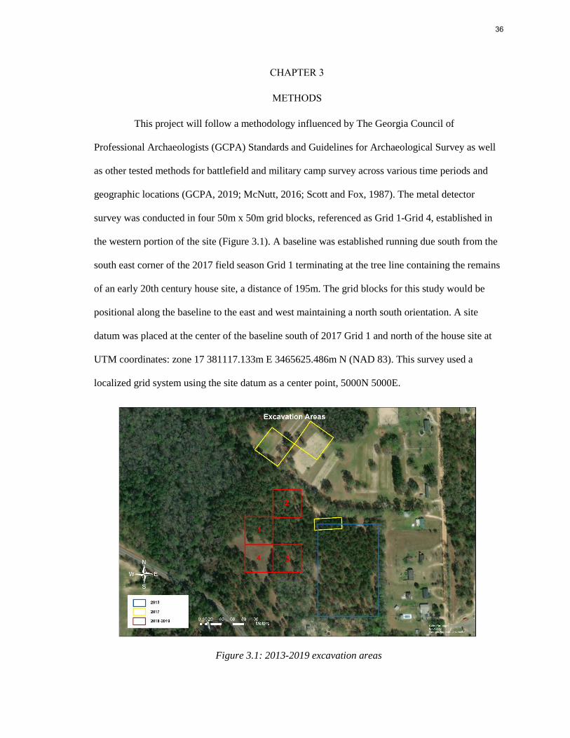
CHAPTER 3
METHODS
This project will follow a methodology influenced by The Georgia Council of
Professional Archaeologists (GCPA) Standards and Guidelines for Archaeological Survey as well
as other tested methods for battlefield and military camp survey across various time periods and
geographic locations (GCPA, 2019; McNutt, 2016; Scott and Fox, 1987). The metal detector
survey was conducted in four 50m x 50m grid blocks, referenced as Grid 1-Grid 4, established in
the western portion of the site (Figure 3.1). A baseline was established running due south from the
south east corner of the 2017 field season Grid 1 terminating at the tree line containing the remains
of an early 20th century house site, a distance of 195m. The grid blocks for this study would be
positional along the baseline to the east and west maintaining a north south orientation. A site
datum was placed at the center of the baseline south of 2017 Grid 1 and north of the house site at
UTM coordinates: zone 17 381117.133m E 3465625.486m N (NAD 83). This survey used a
localized grid system using the site datum as a center point, 5000N 5000E.
Figure 3.1: 2013-2019 excavation areas
37
Within each grid block six transects were laid out oriented north south at 10m intervals
starting at the southern edge/ line of the grid block. The width of each transect is approximately
1.5m, the width of an average single swing of a metal detector. This survey strategy is designed to
provide a representative sample of the artifacts present across the site. The north and south end of
each transect was recorded with a Trimble R2 GPS unit capable of sub-meter accuracy and
differential correction. Each transect was clearly marked with pin flags to aid the detectorists in
maintaining their respective lines. The detectorists swept each transect bi-directionally, starting
from the south end and turning around to go back over the same transect at the north end.
When a detectorist received a signal indicating the location of a metal object, that
location was marked with a pin flag. After each transect was fully detected the researchers went
back to the flagged locations and excavated a round, 15-30 cm diameter shovel test. Excavated dirt
was screened through ¼” mesh in order to increase the chances of locating non-metal artifacts of
archaeological significance. A small, handheld metal detector, known as a pinpointer, was used to
aid in the recovery of small metal objects. Each shovel test was dug until the original metal find
was located at which point the back dirt and hole were swept over with a metal detector to check
for the presence of additional metal artifacts before refilling. All recovered artifacts of
archaeological significance were collected, had their provenience recorded, were assigned a field
specimen (FS) number, and had their location documented using the Trimble GPS described above.
The metal detectors used included the Garrett AT Pro and White’s Spectra V3. Both are
VLF detectors with double-D wound coils. The Garrett has a depth penetration of +20cmbs and the
White’s can penetrate up to 30cmbs. Due to the increased sensitivity of the White’s model they
were only operated by the most experienced crew members. No discrimination was used on the
metal detectors. Because this method uses a 10m transect interval only 25% of the ground within
each 50m x 50m grid block was surveyed. Therefore, the artifacts sampled will only reflect 25% of
the potential material on site making the targeting of specific material unnecessary.
38
However, there were limitations to the no discrimination sampling method. The soil at
this site is very ferrous due to a high frequency of small concretions which contain iron oxides.
These concretions can interrupt the signal of the metal detector causing false hits. In order to
adjust to local conditions, the metal detectors used in this project were ground balanced several
times a day during field work. Both the Garrett and the White’s were set to near maximum balance
value to counteract the highly ferrous soil.
Another limitation encountered was the high frequency of non- significant metal objects
that had been deposited at the site over the decades since it had been occupied during the Civil
War. These included soda cans, modern shot and shell casings, and barbed wire fencing. The
fencing is associated with agricultural activity on the site starting in the early 20th century. Barbed
wire was not invented until the 1880s and by 1900 had become a common feature of many
farmsteads across the county (McCallum and McCallum, 1965). A 1938 aerial photograph of the
site documents several fence lines that were likely constructed with wire crossing the immediate
project area. The presence of the 20th century house site and associated outbuildings also
contribute to the potential masking of Civil War period artifacts with the presence of nail clouds.
The majority of the metal detecting for this project was done by the author, who before
working on this project had completed 80 hours of supervised metal detecting training during the
Spring and Summer 2017 GSU field schools at Camp Lawton. The remainder was completed by
undergraduate students, all of whom had previous field experience through the field schools taught
at GSU as well as classroom instruction on the theory and application of metal detecting survey
within the field of archaeology. The methodology detailed above can be a benefit when working
with more inexperienced detectorists. The 50m length and even spaced transects makes it easier for
detectorists to stay in their respective lanes. It also makes supervising a small group of surveyors
easier by bounding them within the grid blocks; no student is detecting more than 50m from a
supervisor at any time. By not using discrimination or headphones each signal is readily heard and
39
can be interpreted by both detectorists and supervisors. No discrimination also makes setting up
each machine, particularly the Garrett AP Pro, simpler. Once the metal detector has been properly
ground balanced and the settings adjusted to include no discrimination, the training of new
detectorists can focus on identifying and pinpointing different signals encountered in the ground.
During the field work portion of this project all material was returned to the Archaeology
lab at GSU for rough sorting and cataloging. Each artifact was assigned a unique catalog number in
addition to its prerecorded FS. Cataloging and artifact classification was performed by the author.
With the majority of recovered material being ferrous metal, conservation techniques were applied
to stabilize these artifacts. The least invasive approach to conservation was applied on each ferrous
metal artifact including the removal of corrosion through manual brushing, air abrasion, and
electrolysis. After removing corrosion the artifacts were soaked in a sodium bicarbonate and
deionized water solution to remove salts and chlorine before being dried in an oven at 350° for 30
minutes to remove moisture. The artifacts were then coated with a paraloid B-72 (acrylic resin)
solution to seal out environmental conditions. Any ferrous metal artifacts that could not withstand
heavy corrosion removal or were minimally corroded were soaked, dried, and coated in the same
manner described above.
Summary Results of the Metal Detector Survey
The metal detecting survey was conducted in four grid blocks that covered a 10,000
square meter area (2.47 acres) of the site. 199 metal detecting hits were excavated and recorded
resulting in 260 total artifacts recovered. The majority of the recovered artifacts were square cut
nails, round wire nails, and fence staples (n=139). Several camp related items were also recovered
including two brass U.S. Army general service eagle buttons, two knapsack rivets, a grommet, two
rail road spikes, a utensil handle, a knife blade, and a watering bit for horses. Non-metal artifacts
included a porcelain sherd, an ironstone sherd, two white ware sherds, 12 glass fragments, and two
40
small brick fragments. The non-metal artifacts and other non-camp related finds likely postdate
the Civil War occupation and are associated with the early 20th century house site.
Soils at the site consist of Tifton loamy sand. This soil type is found on interfluve
landforms with little to no slope and is considered prime farmland due to its well-draining features
(USDA, 2019). The stratigraphy across the site was uniform, with a plowzone layer of 10YR4/2
dark grayish brown loamy sand extending in depth from 25cm to 35cm below the ground surface
(cmbgs), followed by a 10YR5/8 yellowish brown fine sandy loam extending to 45cmbgs and
finally a subsoil of 10YR5/8 sandy clay loam underneath. As mentioned above, iron oxide
concretions were present at all levels ranging in size from 1-10cm in diameter, with larger
concretions containing enough iron to be detectable with the remote sensing equipment used .
Metal detecting hit FS#187 located in Grid block 4 on transect 5 uncovered the only
feature located during the metal detecting survey. Several large corrugated metal sheet fragments
were detected and excavated along with clear glass bottle fragments and a historic ceramic
fragment. Soil stains below the plowzone indicated the presence of an in-situ deposit, designated
Feature 1. A 1m x 1m test unit (TU 1) was placed over the original shovel test and oriented to grid
north. The unit was excavated using arbitrary 10cm levels. Levels 1 and 2 were located in the
plowzone and contained sheet metal fragments, historic ceramics, and bottle glass. Plow scars
were evident at the base of Level 2 at the transition to stratum II.
Feature 1 was encountered in level 3 at 30cm below datum in the western half of the
unit. The feature was excavated as its own provenience (context) to a depth of 53cm. The
remaining unit matrix was excavated to sterile soil. The majority of artifacts recovered from TU 1
(n=501) were recovered from Feature 1, a cigar shaped, hand dug trench oriented north west to
south east. The feature fill was interpreted as a single deposit in an open ditch that was subject to
several silting episodes before being covered by the plowzone. The feature was determined to
post-date the

41
Civil War camp occupation and is associated with the 20th century house site based on analysis of
the materials recovered which will be discussed in the following chapter.
42
CHAPTER 4
RESULTS
Following Wood et al. (2017) the artifacts recovered during the metal detector survey and
unit excavation were sorted by material and assigned a chronological period dating to the Civil War
or post-dating the Civil War (Wood et al., 2017:148). The artifacts were also assigned an activity
group after South (1977) which attempts to identify the past functional use of an artifact (South,
1977). By assigning activity groups to the collection it is hoped that comparisons can be made to
previous field season excavations within the site and with other similar sites of this type. While
originally designed for domestic sites in the southeast region, South’s classification system has
been modified by other researchers to better compare Civil War period occupations (Legg and
Smith, 1989; Avery and Garrow, 2008). In this instance the author decided to use a system adapted
by Avery and Garrow (2008) in the analysis of a phase III data recovery of portions of the Florence
Stockade (1864-1865), Florence, South Carolina. The primary adaptation made in this system is the
inclusion of accoutrements and other, personal weapon types in the arms category as well as the
use of the activities category as a catch-all for task specific and indeterminate items (Avery and
Garrow, 2008:13).
The overall artifact profile from the metal detector survey is dominated by architecture
group artifacts that make up 55.38% of the total assemblage, followed by the activities group which
makes up 24.23% and, the kitchen group at 15.38%. The test unit and feature excavation resulted in
50% kitchen group artifacts and 49% activity group artifacts. Several of South’s original activity
groups were not represented in the collection including personal items, tobacco related items, or
furniture items. While these groups are not highly represented on other Civil War period campsites
(Avery and Garrow, 2008), the methodology employed for this survey likely impacted the types of
material recovered by selecting for metal objects.
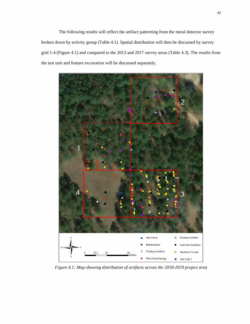
43
The following results will reflect the artifact patterning from the metal detector survey
broken down by activity group (Table 4.1). Spatial distribution will then be discussed by survey
grid 1-4 (Figure 4.1) and compared to the 2013 and 2017 survey areas (Table 4.3). The results from
the test unit and feature excavation will be discussed separately.
Figure 4.1: Map showing distribution of artifacts across the 2018-2019 project area
44
Artifact Patterning
Type Count Period Brick 2 Post-Bellum Fencing 9 Post-Bellum Flat Glass 2 Post-Bellum Hardware 1 Post-Bellum
Architecture Lead-Head Nails 1 Post-Bellum Round Wire Nails 35 Post-Bellum Square Cut Nails 81 Unknown Unknown Nail 13 Unknown Total 144 Fuel 1 Post-Bellum Hardware 20 Unknown Horse Tack 1 Civil War Period
Activities Indeterminate 15 Unknown Sheet tin/tinned iron 23 Unknown Tool 1 Unknown Wagon/Machine part 2 Post-Bellum Total 63 Can 21 Unknown Ceramic 4 Post-Bellum Container glass 11 Post-Bellum
Kitchen Container lid 1 Post-Bellum Cooking vessel 2 Unknown Utensil 1 Civil War Period Total 40 Buttons 2 Civil War Period
Clothing Fasteners 6 Civil War Period Total 8 Modern bullet 2 Post-Bellum
Arms Shot 2 Post-Bellum Shell casing 1 Post-Bellum Total 5 Total 260
Table 4.1: Artifacts recovered in metal detecting survey by activity group
Architecture Group Artifacts
The majority of artifacts recovered during the metal detecting survey were those related
to architecture (n=144). Among these artifacts, nails (n=130) dominate the collection making up
50% of the total artifacts recovered during survey followed by fencing material (n=9), brick
45
fragments (n=2), flat glass fragments (n=2), and a door hinge. The fencing material included in the
collection are bent, wire, fence staples that post-date the Civil War occupation becoming common
in the securing of barbed wire and other wire fencing during the late 19th century continuing to the
present (McCallum and McCallum, 1965). Small fragments of wire fencing, including twisted
barbed wire, were frequently encountered along every transect during the metal detecting survey.
Having been determined that the wire fencing post-dates the Civil War occupation, these items
were not collected or recorded on artifact distribution maps. Fence lines are present crossing the
survey area in a 1938 aerial photograph of the property being used to separate fields and access
roads and are currently erected on the site between property boundaries.
Of the nails recovered the majority were machine cut square nails (n=81) which are
diagnostic to the 19th century (Avery and Garrow, 2008). However, it cannot be determined how
many of these square nails are associated with the Civil War occupation or the later farmstead.
Although replaced by round wire nails in the early 20th century, square nails continued to be used
or recycled from older structures well into the 20th century (Fontana et al., 1962). Round nails
(n=35) were recovered in all four survey grid blocks along with the square nails. Thirteen nails
were not able to be identified as round or square due to excessive corrosion and one lead-headed
roofing nail was recovered from Grid block 3. While categorized as architectural artifacts not all
nails were used in building structures or fences. During the Civil War many different types of
supplies were issued to troops in the field using wooden crates, including food, ammunition, and
personal packages. Both the U.S. Army and the Confederate Army had regulations regarding the
types of nails used in supply crates (McNutt and Jones, forthcoming).
Nails are historically categorized by pennyweight, which is a reference to how much a
certain length of nail costs by the pound. The most common nail sizes used for supply crates
during the Civil War were between 1” and 2” or 4d and 6d pennyweight (McNutt and Jones,
2020). While the majority of nails recovered were fragmentary, 46 square nails were able to be
measured
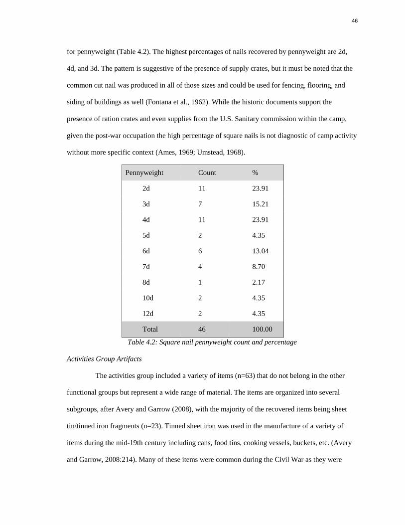
46
for pennyweight (Table 4.2). The highest percentages of nails recovered by pennyweight are 2d,
4d, and 3d. The pattern is suggestive of the presence of supply crates, but it must be noted that the
common cut nail was produced in all of those sizes and could be used for fencing, flooring, and
siding of buildings as well (Fontana et al., 1962). While the historic documents support the
presence of ration crates and even supplies from the U.S. Sanitary commission within the camp,
given the post-war occupation the high percentage of square nails is not diagnostic of camp activity
without more specific context (Ames, 1969; Umstead, 1968).
Pennyweight Count %
2d 11 23.91
3d 7 15.21
4d 11 23.91
5d 2 4.35
6d 6 13.04
7d 4 8.70
8d 1 2.17
10d 2 4.35
12d 2 4.35
Total 46 100.00
Table 4.2: Square nail pennyweight count and percentage
Activities Group Artifacts
The activities group included a variety of items (n=63) that do not belong in the other
functional groups but represent a wide range of material. The items are organized into several
subgroups, after Avery and Garrow (2008), with the majority of the recovered items being sheet
tin/tinned iron fragments (n=23). Tinned sheet iron was used in the manufacture of a variety of
items during the mid-19th century including cans, food tins, cooking vessels, buckets, etc. (Avery
and Garrow, 2008:214). Many of these items were common during the Civil War as they were
47
mass produced in a cost-efficient manner and durable enough to survive the conditions of field use.
Due to the fragmented nature of these artifacts their original function cannot be determined (Figure
4.2).
The hardware category (n=20) includes various fasteners, nuts, heavy wire, a six-link
chain, a large buckle, and other items that represent a number of functions not specifically
associated with the other activity groups. Of note in this category are two railroad spikes recovered
in grid block 3 (Figure 4.3 and 4.4). With the site being located over a mile from the railroad, the
presence of these railroad spikes could indicate an instance of scavenging for useful items by
POWs as they traveled from the railroad to the campsite. This theory was also posited by Wood et
al. with the discovery of a railroad spike in the 2013 survey area (Wood et al, 2017). All three
railroad spikes have different dimensions and characteristics which could indicate a morphological
change over time or, given the nature of the Atlantic and Gulf Railroad as being unfinished during
the Civil War, a characteristic of using whatever spikes were on hand for track repairs and
construction during war time. The spikes may also have been scavenged from different points
along the line or from the depot.
Other activities group items include a plowshare fragment, a cultivator blade fragment, a
pointed knife blade that is categorized as a tool, charcoal fuel, and a piece of horse tack identified
as a watering bit that likely dates to the camp occupation (Figure 4.5) (Crouch, 1995). Fifteen total
artifacts were categorized as indeterminate as they were unable to be identified by the author.
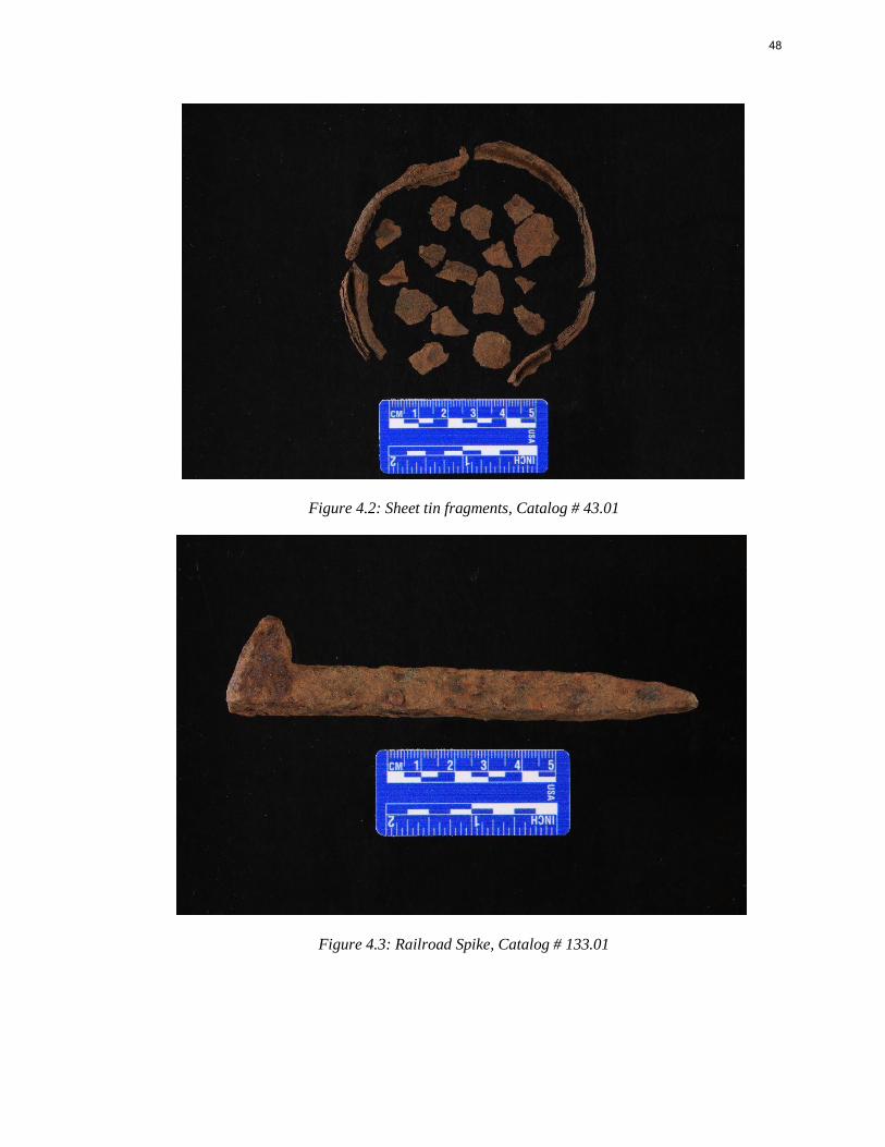
48
Figure 4.2: Sheet tin fragments, Catalog # 43.01
Figure 4.3: Railroad Spike, Catalog # 133.01
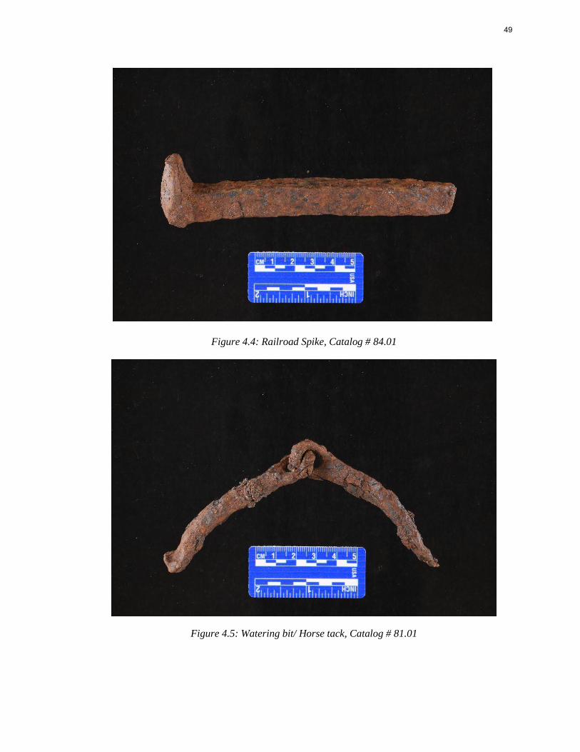
49
Figure 4.4: Railroad Spike, Catalog # 84.01
Figure 4.5: Watering bit/ Horse tack, Catalog # 81.01
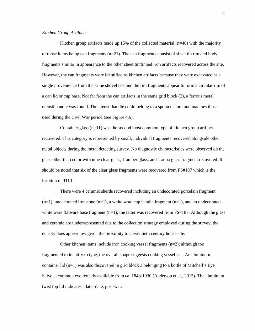
50
Kitchen Group Artifacts
Kitchen group artifacts made up 15% of the collected material (n=40) with the majority
of those items being can fragments (n=21). The can fragments consist of sheet tin rim and body
fragments similar in appearance to the other sheet tin/tinned iron artifacts recovered across the site.
However, the can fragments were identified as kitchen artifacts because they were excavated as a
single provenience from the same shovel test and the rim fragments appear to form a circular rim of
a can lid or cup base. Not far from the can artifacts in the same grid block (2), a ferrous metal
utensil handle was found. The utensil handle could belong to a spoon or fork and matches those
used during the Civil War period (see Figure 4.6).
Container glass (n=11) was the second most common type of kitchen group artifact
recovered. This category is represented by small, individual fragments recovered alongside other
metal objects during the metal detecting survey. No diagnostic characteristics were observed on the
glass other than color with nine clear glass, 1 amber glass, and 1 aqua glass fragment recovered. It
should be noted that six of the clear glass fragments were recovered from FS#187 which is the
location of TU 1.
There were 4 ceramic sherds recovered including an undecorated porcelain fragment
(n=1), undecorated ironstone (n=1), a white ware cup handle fragment (n=1), and an undecorated
white ware flatware base fragment (n=1); the latter was recovered from FS#187. Although the glass
and ceramic are underrepresented due to the collection strategy employed during the survey, the
density does appear low given the proximity to a twentieth century house site.
Other kitchen items include iron cooking vessel fragments (n=2); although too
fragmented to identify to type, the overall shape suggests cooking vessel use. An aluminum
container lid (n=1) was also discovered in grid block 3 belonging to a bottle of Mitchell’s Eye
Salve, a common eye remedy available from ca. 1848-1930 (Anderson et al., 2015). The aluminum
twist top lid indicates a later date, post-war.
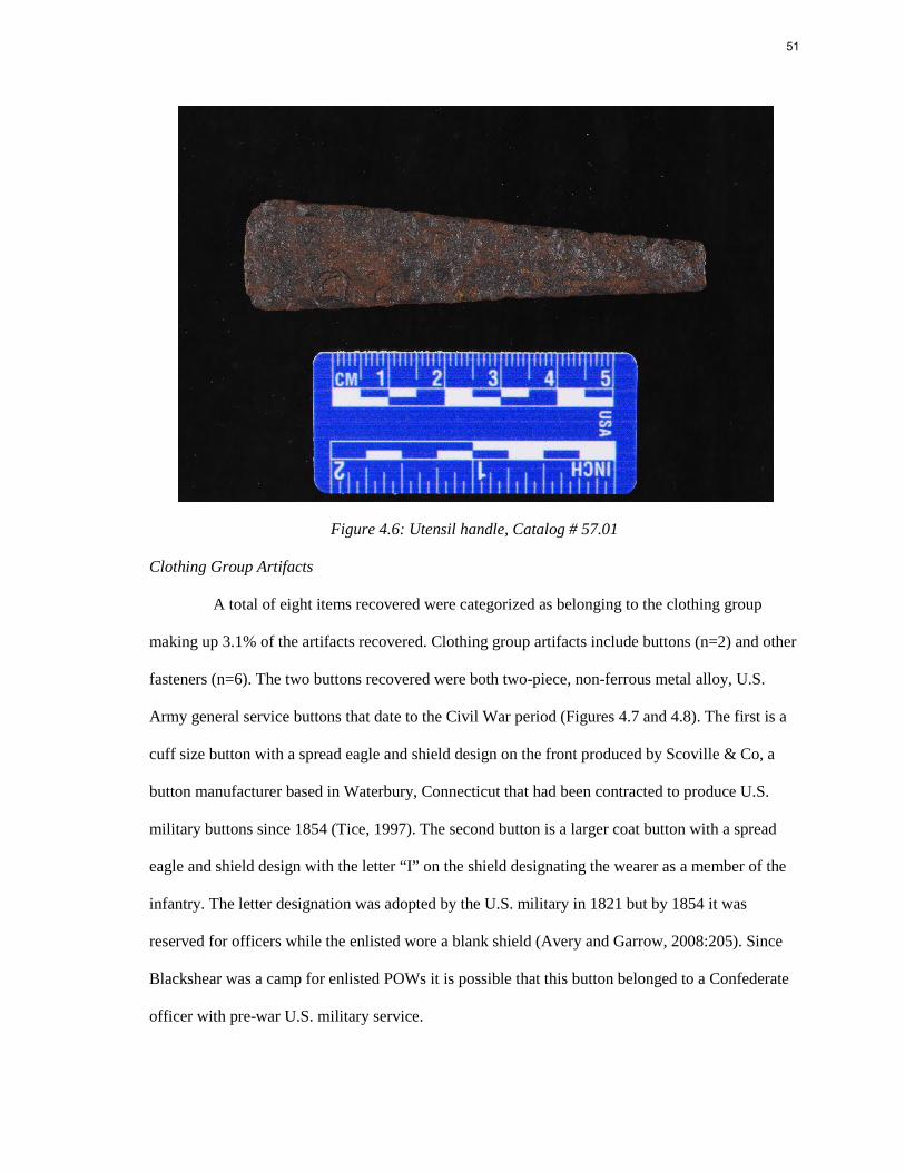
51
Figure 4.6: Utensil handle, Catalog # 57.01
Clothing Group Artifacts
A total of eight items recovered were categorized as belonging to the clothing group
making up 3.1% of the artifacts recovered. Clothing group artifacts include buttons (n=2) and other
fasteners (n=6). The two buttons recovered were both two-piece, non-ferrous metal alloy, U.S.
Army general service buttons that date to the Civil War period (Figures 4.7 and 4.8). The first is a
cuff size button with a spread eagle and shield design on the front produced by Scoville & Co, a
button manufacturer based in Waterbury, Connecticut that had been contracted to produce U.S.
military buttons since 1854 (Tice, 1997). The second button is a larger coat button with a spread
eagle and shield design with the letter “I” on the shield designating the wearer as a member of the
infantry. The letter designation was adopted by the U.S. military in 1821 but by 1854 it was
reserved for officers while the enlisted wore a blank shield (Avery and Garrow, 2008:205). Since
Blackshear was a camp for enlisted POWs it is possible that this button belonged to a Confederate
officer with pre-war U.S. military service.
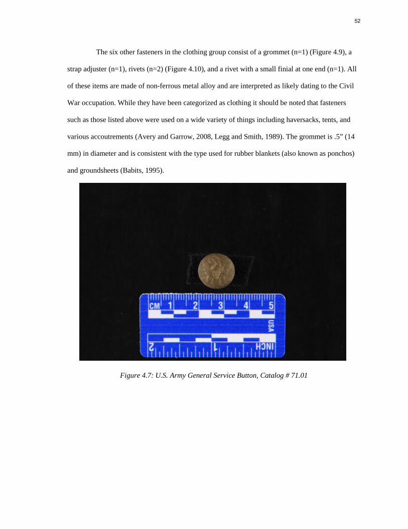
52
The six other fasteners in the clothing group consist of a grommet (n=1) (Figure 4.9), a
strap adjuster (n=1), rivets (n=2) (Figure 4.10), and a rivet with a small finial at one end (n=1). All
of these items are made of non-ferrous metal alloy and are interpreted as likely dating to the Civil
War occupation. While they have been categorized as clothing it should be noted that fasteners
such as those listed above were used on a wide variety of things including haversacks, tents, and
various accoutrements (Avery and Garrow, 2008, Legg and Smith, 1989). The grommet is .5” (14
mm) in diameter and is consistent with the type used for rubber blankets (also known as ponchos)
and groundsheets (Babits, 1995).
Figure 4.7: U.S. Army General Service Button, Catalog # 71.01
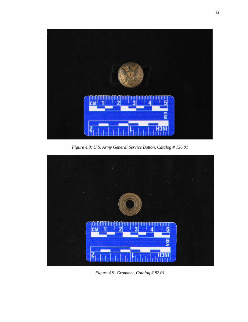
53
Figure 4.8: U.S. Army General Service Button, Catalog # 136.01
Figure 4.9: Grommet, Catalog # 82.01
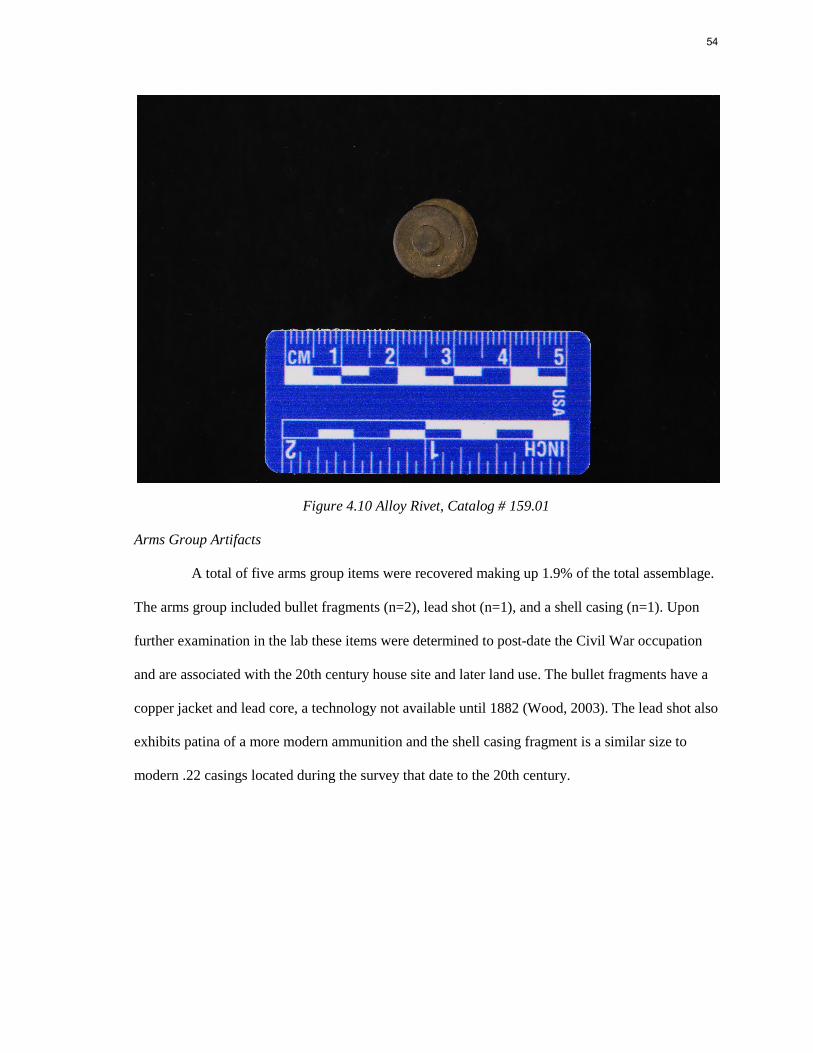
54
Figure 4.10 Alloy Rivet, Catalog # 159.01
Arms Group Artifacts
A total of five arms group items were recovered making up 1.9% of the total assemblage.
The arms group included bullet fragments (n=2), lead shot (n=1), and a shell casing (n=1). Upon
further examination in the lab these items were determined to post-date the Civil War occupation
and are associated with the 20th century house site and later land use. The bullet fragments have a
copper jacket and lead core, a technology not available until 1882 (Wood, 2003). The lead shot also
exhibits patina of a more modern ammunition and the shell casing fragment is a similar size to
modern .22 casings located during the survey that date to the 20th century.
55
Spatial Patterning
In order to better understand the layout of the prison camp the spatial distribution of
artifacts was compared to the 2017 and 2013 research areas (Table 4.3). The idea being that the
different excavations areas may represent different functional areas of the camp. According to
POW accounts the prisoners were kept in a relatively small area of approximately five acres,
bordered by the stream for easy access to water, and located under a hill from which the
Confederates were able to train artillery down on the prisoner area (Lightcap,1902; Smith, 1892).
The 2013 survey area is located to the east of the current project tract on the upper section of the
same landform overlooking the stream. The 2017 project area is located in open pasture below the
hill, bordering the stream to the north as well as on the lower slopes of the hill. The current project
area is located to the west of the site with the site boundary incorporating all three (Figure 4.11).
The site boundary is based on the recovery of Civil War related material and does not include the
entirety of the archaeological material present at the site including the prehistoric and 20th century
elements.
Comparisons in artifact distribution of these areas indicate several similarities and some
unique outliers that may contribute to identifying the prisoner and guard occupations within the
camp. It should be noted that the methodologies used for the 2013 survey differ from those used in
2017 and 2018-2019. The metal detecting survey conducted in 2013 was not completely systematic
and used a 20m interval for the majority of the survey area. The equipment used in 2013 also
differed from the metal detectors used in 2017-2019 which contributed to the overall lack of
ferrous metal recovered during the earlier survey work.
The 2017 project area contained mostly activities group artifacts including indeterminate
ferrous metal fragments and miscellaneous hardware. The architecture group and activities group
of the 2017 project area are similar to those recovered from Grid 4. Grid 2 also contains a similar
percentage of architecture material but a higher percentage of kitchen artifacts, however, the
56
presence of kitchen artifacts is largely attributed to sheet tin/ tinned iron as described above.
Suggested occupation patterns for these locations is further described below.
Grid Block 1
Grid Block 1 is located in the tree line north of the open field adjacent to GA highway
203. The terrain slopes down toward the north from the field and into the creek 20m north of the
grid block. 44 total artifacts were recovered from this area with the majority being nails (n=26). A
fence line is visible running northwest to southeast across the grid block in the 1938 aerial
photograph of the site. Overall the artifact density in this area was low with no definitive Civil War
period artifacts recovered. A few artifacts that could be related to the Civil War period include thin,
non-ferrous metal band fragments (n=3), a ferrous metal fragment with a rounded edge, and a semi-
circle, tapered ferrous metal band all cataloged as indeterminate.
This area represents a possible western boundary of the camp as it is located near the
creek and the artifact density is low including no definitive Civil War related artifacts. It has also
been heavily impacted by post-war agricultural occupation.
Grid Block 2
Grid Block 2 is located at the base of the hill just south of the property boundary
separating the 2018-2019 survey area and the 2017 survey tract. The grid block contained the least
number of artifacts recovered (n=38) with zero artifacts recovered along transect 2. The majority of
artifacts were cataloged as belonging in the kitchen group with 21 can fragments and one utensil
handle recovered at the north end of transect 6. These items were recovered in close proximity
within 10m of each other and could be related to the Civil War camp occupation. The other
artifacts recovered likely date to the post-war period and are associated with agricultural use.
Grid Block 3
Grid Block 3 was the most dense area of the survey containing 53% of the total artifacts
recovered via metal detecting (n=138). The dramatic increase in density compared to the other
57
survey grid blocks is due to the proximity to the 20th century house site immediately south of the
grid block. 71% of the artifacts recovered in this grid block were cataloged in the architecture
group. Several outbuildings are visible on the 1938 aerial photograph of the site as well as
additional fence lines. These structures were either dismantled or collapsed after the abandonment
of the house site resulting in the large amounts of nails and scrap metal encountered during the
metal detecting survey. The presence of this material masks the earlier camp related artifacts which
are also present in this grid block at the crest of the hill overlooking the creek and open field to the
north. 6 clothing group artifacts, including the two U.S. general service buttons, as well as the
railroad spikes and horse tack were recovered from this area of the site. These items are definitive
Civil War period artifacts and may indicate the presence of the Confederate guard occupation or
items dropped by POWs as they were moved into and out of the prison area.
Grid Block 4
Grid Block 4 is located adjacent to Grid Block 3 and Grid Block 1 and is in the open
clearing to the west of the site. Here the artifact density drops off with only 40 total artifacts
recovered during metal detecting survey. The presence of fence wire and other modern debris was
also reduced compared to the rest of the survey area. Two artifacts have been cataloged as likely
Civil War related including a brass alloy rivet and a brass alloy rivet with attached finial. Both are
either clothing items or associated with the various accoutrements carried by soldiers at the time.
This area may have also been located along the western boundary of the camp as
suggested by the limited number of artifacts. However, this area is also close to a public highway
which provides easy access to the site. The Blackshear Prison historical marker is located along the
highway adjacent to the property boundary and the current landowner has reported both legal and
illegal metal detecting activities in this area of the site. It is possible that this portion of the site has
been subject to past relic collecting activities that reduced the overall artifact density.
58
Test Unit 1
Grid Block 4 also contains the only feature identified during the metal detecting survey
(Figure 4.12). FS#187 consisted of sheet tin fragments, corrugated sheet metal, and clear container
glass fragments associated with a trash pit feature later excavated as test unit 1 (TU 1) (Figure
4.13). TU 1 contained 5 levels and extended to 55cm below datum before sterile soil was
encountered (Figure 4.14 and Figure 4.15). Feature 1was a shallow, linear trash pit visible 20cm
below datum under the plow zone in level 3 and extending to level 4. The profile of the feature
indicated a single fill episode that was then left open to the elements resulting in flooding and
eventually being covered by plowed soil. The artifacts recovered from Feature 1 (Table 4.4) were
mainly kitchen items including 8 partial and whole glass bottles, can fragments (n=54), table glass
(n=3), and ceramics (n=6). Many of the items appeared to be contained under a crushed bucket
which accounted for the majority of activity group items (n=192). Several of the glass bottles were
identified to date of manufacture including two Coca-Cola bottles dating from ca. 1913-1917.
Overall the artifacts recovered from Feature 1 were determined to date to the early 20th century and
were likely related to the nearby house site.
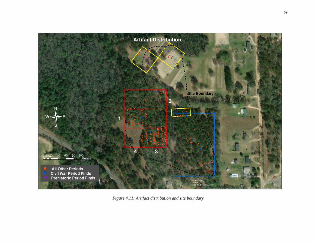
59
Figure 4.11: Artifact distribution and site boundary
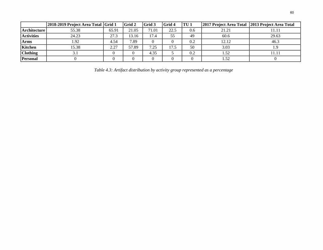
60
2018-2019 Project Area Total Grid 1 Grid 2 Grid 3 Grid 4 TU 1 2017 Project Area Total 2013 Project Area Total Architecture 55.38 65.91 21.05 71.01 22.5 0.6 21.21 11.11 Activities 24.23 27.3 13.16 17.4 55 49 60.6 29.63 Arms 1.92 4.54 7.89 0 0 0.2 12.12 46.3 Kitchen 15.38 2.27 57.89 7.25 17.5 50 3.03 1.9 Clothing 3.1 0 0 4.35 5 0.2 1.52 11.11 Personal 0 0 0 0 0 0 1.52 0
Table 4.3: Artifact distribution by activity group represented as a percentage
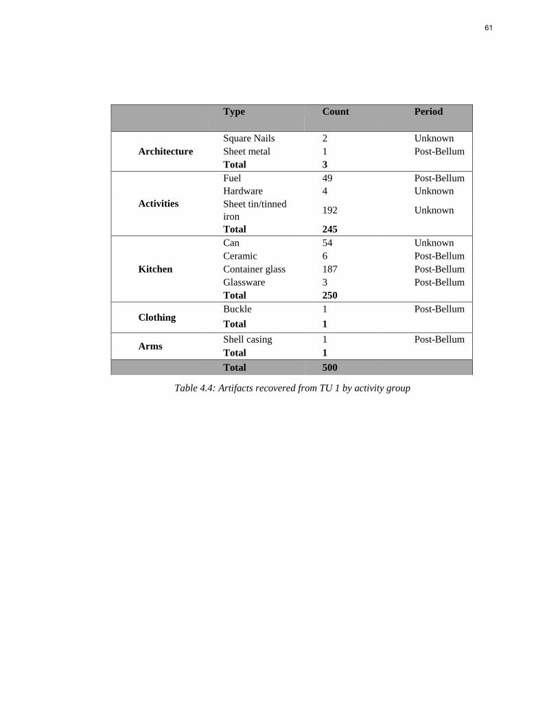
61
Type Count Period
Square Nails 2 Unknown Architecture Sheet metal 1 Post-Bellum
Total 3 Fuel 49 Post-Bellum Hardware 4 Unknown
Activities Sheet tin/tinned iron 192 Unknown
Total 245 Can 54 Unknown Ceramic 6 Post-Bellum
Kitchen Container glass 187 Post-Bellum Glassware 3 Post-Bellum Total 250
Clothing Buckle 1 Post-Bellum Total 1
Arms Shell casing 1 Post-Bellum Total 1 Total 500
Table 4.4: Artifacts recovered from TU 1 by activity group
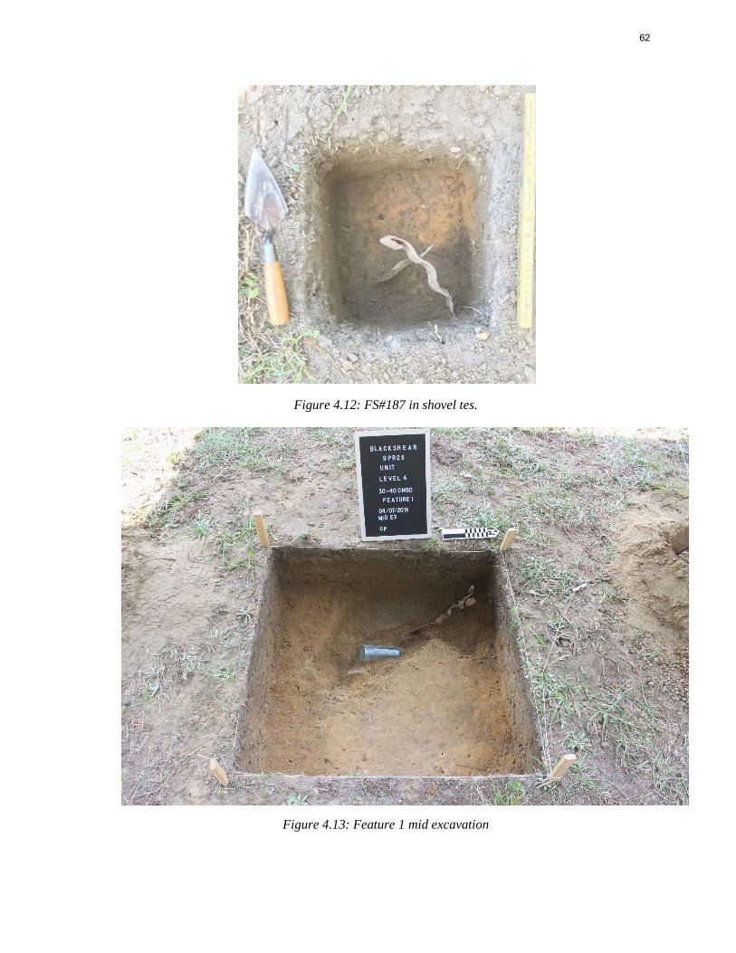
62
Figure 4.12: FS#187 in shovel tes.
Figure 4.13: Feature 1 mid excavation
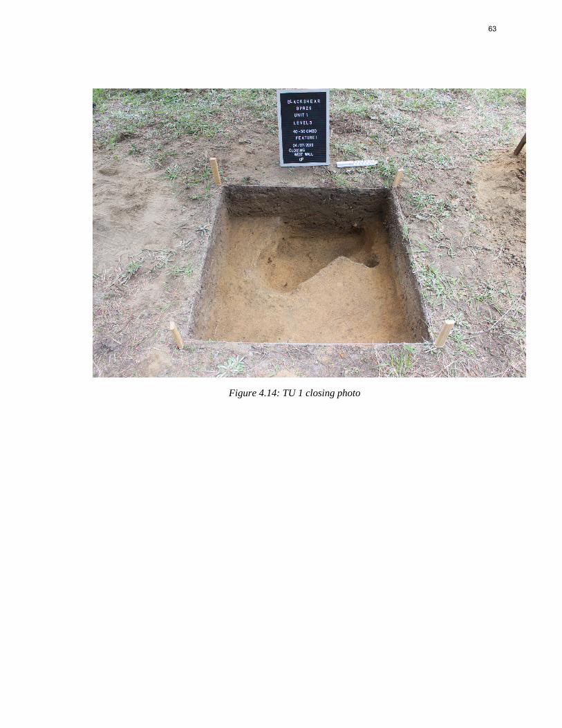
63
Figure 4.14: TU 1 closing photo
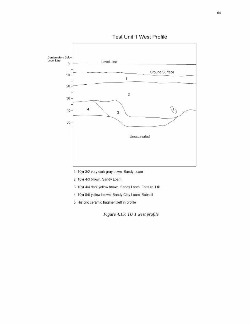
64
Figure 4.15: TU 1 west profile
65
CHAPTER 5
DISCUSSION AND CONCLUSION
The primary research goals of this project were to further delineate the Civil War
occupation through metal detecting survey and identify specific areas of prisoner and guard
occupation. More specifically, can certain areas of the camp layout be identified through the
material record given the current integrity of the site and the survey methodology employed? The
main focus of the research was to:
• Determine the layout of the camp and why this particular site was chosen for either military,
prison, or basic camp needs.
• Identify the main prisoner and guard occupation areas to determine the spatial proximity between
the two groups and the overall size of the camp.
• Offer comparisons between Camp Blackshear and other POW camps in Georgia, including Camp
Lawton and Andersonville.
The research at Blackshear Prison has produced valuable historical information through
the archaeological data set. Based on the types of materials recovered in this survey as well as the
spatial distribution of the artifacts we can begin to address these research questions. Below I
discuss the points outlined above and provide a general discussion of the results. While the data
collected is not enough to identify functional areas of space within the camp, I argue that elements
of specific guard and POW occupations were identified within the potential boundaries of the site
that can be preserved for future investigation.
Discussion
The results of the metal detecting survey were not altogether unexpected given the
previous work performed at the site. The proportion of diagnostic Civil War era material to
artifacts that post-date the Civil War is similar to the collections from 2013 and 2017. Background
research would also suggest that the archaeological signature of Camp Blackshear would be
66
relatively ephemeral compared to the larger, more densely populated, and longer occupied prison
sites at Camp Lawton, Andersonville, and the Florence Stockade. However, evidence of the camp
does appear in the archaeological record and with enough frequency to suggest that the current
project area is located within a portion of the former camp site. A total of ten diagnostic Civil War
artifacts were recovered from the current study area. Assuming that the material collected during
the current project represents a 25% sample of the total potential artifacts within the study area, the
total number of diagnostic artifacts would have been 40 during a 100% recovery. This number is
far below the thousands of artifacts recovered at Camp Lawton, Andersonville, and other known
Civil War camps and prisons and serves as an indicator of the limited amount of material
remaining at Blackshear as well as the effectiveness of the applied survey method.
By parceling the survey area into 50 m by 50 m grid blocks, a clear pattern of artifact
density emerged that indicates the boundaries of the site. The low density of artifacts in Grid 4 and
lack of Civil War material in Grid 1 suggest that these areas represent the western and northwestern
boundaries of the Civil War occupation. The northern most grid blocks surveyed in 2017 also
contain a low density of artifacts suggesting that the north end of the site, located in the open
pasture, was not a heavily occupied portion of the camp. It is likely that the main camp occupation
was located on the crest of the hill in Grid 3 and extends into the 2013 survey area in the direction
of the railroad.
Identifying the crest of the hill as a major occupation site indicates how the camp was
positioned and why the location was selected. Originally it was thought that the POWs were
housed below the high ground near the creek banks where they could be better secured and
observed by the Confederate guard occupation. This assumption was based on the POW
descriptions of the camp location which include descriptions of gun emplacements overlooking the
POW area, similar to the position of the emplacements overlooking the stockades at Camp Lawton
and Andersonville (Bates, 1910:24; Long, 1886:110; Smith, 1893:256). However, it seems that the
67
low areas below the hill were not densely occupied which could indicate that the POW occupation
was further up the landform or they had so little material by that point that little trace remains of
their occupation. The higher ground would have provided a more suitable camp location during the
wet winter of 1864. Soils in the project area are sandy and well-draining and the trees on the hill
would be dryer and more suitable for fire wood.
It would appear that the camp’s location was selected based predominantly on its
suitability as a decent camp site: a low-lying hill consisting of well-draining soil, sheltered from
the elements by tall pines, and near a fresh source of water above the flood zone. However, this
interpretation also suggests that this prime location may have been shared by both the POWs and
their guards. The relatively small landform represents a potential change in the spatial proximity
between the guards and POWs when compared to other Georgia prisons. Evidence of this close
occupation can also be found in the type of material recovered from Grid 3.
Diagnostic Civil War era artifacts identified during the analysis were mostly clothing
items, including two U.S. general service buttons, several non-ferrous alloy fasteners, and a
grommet. The buttons are the most readily diagnostic Civil War artifacts within the collection.
However, it is not immediately clear which groups occupying the prison they may represent.
Buttons were frequently traded between POWs and guards in exchange for illicit items and rations.
The coat, “I”, button was issued to U.S. Infantry but by the time of the Civil War was reserved
primarily for officers. While Blackshear was an enlisted POW camp there are accounts that place
several officers among the ranks of the prisoners being transferred from Camp Lawton (Wallsmith,
2018). Given Blackshear’s occupation history as a camp of necessity it seems plausible that
captured U.S. officers could have been interred in the camp alongside enlisted men. The location
of these buttons on top of the hill in Grid 3 and in the adjacent 2013 survey area does not
immediately suggest this location as the main POW occupation. However, at Camp Lawton, while
numerous U.S. general service buttons have been located within the former stockade none have
been found outside of the designated POW areas (Chapman, 2013; McNutt, 2017).
68
The fasteners and grommet are believed to date to the Civil War occupation and were
located in Grids 3 and 4. The grommet is .5” (14 mm) in diameter and is consistent with the type
used for rubber blankets (also known as ponchos) and groundsheets which were used frequently in
camp for shelter and water proofing and would have been highly valued by POWs and Confederate
reserve troops responsible for constructing their own shelters (Babits, 1995). Brass finials are also
encountered on various accoutrements, such as cartridge cases (Crouch, 1995). These finds in this
location further supports this area as being occupied during the Civil War occupation, likely as an
encampment area for guards given the presence of accoutrements.
Additional artifacts located in Grid 3 include a watering bit for a horse, an item that
would have been used by cavalry or mounted officers. While this artifact could have been carried
or scavenged by a POW it would have been an essential piece of equipment for Confederate guards
on horseback. The same cannot be said of the two railroad spikes also located in Grid 3. As
described above there are a number of ways these spikes may have arrived in the camp, but their
possible use by POWs should be noted.
The nails recovered during the metal detecting survey account for half of the total
artifacts recovered. Approximately half of the nails were machine cut and diagnostic of a 19th
century occupation. Many of these nails were located alongside round nails that date to the 20th
century, indicating the presence of post-war features, such as fence lines. The majority of the
square nails were recovered from Grid 3, close to the 20th century house site. However, a
percentage of these nails also fall into size categories utilized for supply crates during the Civil
War. While not enough data was collected to conclusively discern which nails could be associated
with the camp and which are associated with the later house site, the presence of these nails on the
upper elevations of the landform could be an indication of supplies being gathered within the guard
occupation areas of the camp for distribution to both guards and prisoners.
69
The overall concentration of diagnostic material in such close proximity suggests that the
actual space between guards and prisoners was much closer than in the stockade prisons at Camp
Lawton and Andersonville. If we consider that artifacts, such as the watering bit from Grid 3 and
the buckshot and harmonica reed located in the 2017 survey area at the base of the hill, represent
confederate guard occupation areas, then the proximity between guards and POWs becomes almost
indistinguishable. POW identifiers, such as the US general service buttons and scavenged railroad
spikes, are located in the same general area on top of the landform. A lack of diagnostic material
may also indicate the main POW encampment, for instance there are no period arms or ammunition
artifacts located in survey Grid 3. POWs would have limited access to these materials while in
captivity.
These findings suggest a change in the overall guard/prisoner dynamic. With Blackshear
being a more informal camp lacking built structures to separate and contain POWs, a different
strategy had to be employed by the guards to ensure their security and limit the likelihood of
escape. The archaeological data would suggest that part of this strategy involved limiting the
overall size of the camp. POWs may have been concentrated on the crest of the hill in close space
surrounded by guards who were positioned just outside the confines of the main prisoner
occupation. In the historic accounts one POW suggests that the total size of the prisoner area was
approximately five acres (Lightcap, 1902:62). That is 1/3rd the size of the Andersonville stockade
and 1/8th the size of Camp Lawton. While the number of prisoners held at Blackshear is also less
than at the previous camps, that small of an area limits the ability to organize a camp based on the
recommended guidelines of the time. Similar to Andersonville, the POW area would have likely
been too crowded for the existence of company streets making the camp difficult to police. It is
also possible that given the local topography and proximity to the town and railroad the
Confederate auxiliary areas, such as a field hospital, kitchen, and guard camps, may have been
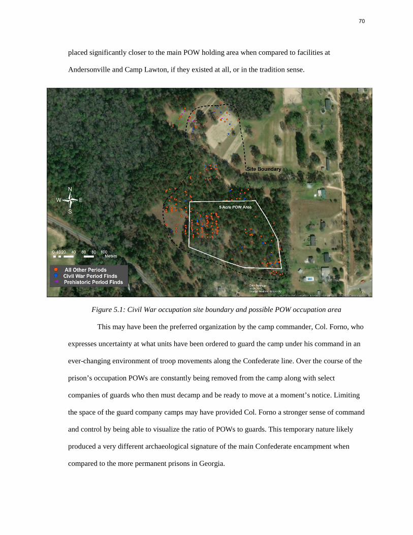
70
placed significantly closer to the main POW holding area when compared to facilities at
Andersonville and Camp Lawton, if they existed at all, or in the tradition sense.
Figure 5.1: Civil War occupation site boundary and possible POW occupation area
This may have been the preferred organization by the camp commander, Col. Forno, who
expresses uncertainty at what units have been ordered to guard the camp under his command in an
ever-changing environment of troop movements along the Confederate line. Over the course of the
prison’s occupation POWs are constantly being removed from the camp along with select
companies of guards who then must decamp and be ready to move at a moment’s notice. Limiting
the space of the guard company camps may have provided Col. Forno a stronger sense of command
and control by being able to visualize the ratio of POWs to guards. This temporary nature likely
produced a very different archaeological signature of the main Confederate encampment when
compared to the more permanent prisons in Georgia.
71
Conclusion
Blackshear Prison represents a unique opportunity to further explore the role of non-
battlefield related sites associated with conflict. Methodological refinements in the field of conflict
archaeology have made the recovery of important data from low density sites, such as Blackshear
more attainable. By utilizing metal detector survey at the intervals described, large portions of the
project tract were able to be examined and the recovered artifacts analyzed through spatial
distribution and artifact patterning, despite the presence of large amounts of 20th century artifacts
and modern debris. By comparing the analyzed results to the previous excavations on the site, a
better understanding of the overall size, integrity, and layout of the camp can be achieved.
The current project area is believed to incorporate a portion of the relatively smaller
prison site at Blackshear. The site boundary represented above (Figure 4.11 and Figure 5.1) likely
extends to the south and east beyond the current property boundary. The western boundary of the
site is likely where Grid block 1 and 4 were positioned for the current survey. The site is bound to
the north by Mill Branch and to the south west by Highway 203 and additional wetland. The POW
occupation is located on the top of the landform overlooking open pasture and Mill Branch to the
north and is surrounded by the guard occupation. The approximately five-acre POW area includes
Grid 3 and a portion of the 2013 survey area containing diagnostic Civil War material. Guard
occupation areas include the picket post in the 2017 survey area, Grid 4 and the western portion of
Grid 3, and the southeast portion of the 2013 survey area. These areas contained artifacts associated
with guard activity such as the ammunition, harmonica reed, watering bit, and large burn feature.
The southeast portion of the 2013 survey area is closest to the railroad and Grady Street and may
have served as the main entry point to the camp as well as a staging area for POWs before they
were transferred to the railroad for movement to different camps.
Overall the material remains of the Civil War era prison at Blackshear are limited. The
lack of material is due to a population that has been subject to continued material loss over time,
72
with little means to regain possessions or supplies other than the most basic of survival needs. A
short occupation timeline combined with limited means of resupply and the loss of material during
rapid evacuation has contributed to the low frequency of diagnostic artifacts present in the record.
The archaeological record has been further diminished by post-war agricultural activities, land
development, and artifact removal by means of pedestrian survey by landowners across tilled fields
as well as more deliberate relic collecting activities in the form of metal detecting.
Although artifact density is low across the site, especially compared to the modern debris
that was detected but not collected, it can be argued that the methodology employed was effective
in further delineating the Civil War occupation. With the discovery of Feature 1 in Grid 4, it can
also be argued that potential Civil War related features could be identified using the applied
methodology. Additional Civil War era archaeological features may be present within the site
boundaries but require more intensive survey, such as close interval metal detecting in order to
locate them. Other geophysical survey methods, such as ground penetrating radar, magnetometry,
and resistivity could be applied to aid in directed excavation efforts that may uncover features of
the camp, especially those that do not contain metal artifacts. These alternative methods are also
noninvasive and would be suitable to investigate the potential cemetery location for potential grave
sites.
The high-density areas located during this survey, including the remains of the 20th
century house site should be avoided to preserve the integrity of that occupation as well as more
effectively locate material related to the Civil War occupation. While an analysis of the spatial
distribution of artifacts recovered via metal detecting survey has aided in defining the size and
boundaries of a portion of the camp, there is not enough material data to definitively assign
functional context as would be expected from a military encampment of the era. In order to identify
specific occupation areas including, the prison yard, guard barracks, hospital area, officer barracks,
or the deadline more data is required which may be obtained through close interval testing.

73
Blackshear Prison represents a valuable cultural resource that has the potential to better our
understanding of the history of the site and the events that took place there as well as the methods
used to study archaeological sites of this nature.
74
REFERENCES
Ames, Amos. 1864. "A Diary of Prison Life in Southern Prisons." The Annals of Iowa 40 (1969), 1-19.
Anderson, Tyler J., Jared C. Donaldson, and Christopher T. Leffler. 2015. “The Evolution of Popular Eye Remedies in the United States Over the 20th Century”. Historia Ophthalmologica Internationalis Journal for the History of Ophthalmology and of Vision Sciences.
Avery, Paul G. and Patrick H. Garrow. 2008. Phase III Archaeological Investigations at 38FL2, The Florence Stockade, Florence, South Carolina. Prepared for the Department of Veterans Affairs National Cemetery Administration. Washington, D.C.
Babits, Lawrence E. 1995. “Rubber Poncho and Blankets from the Union Transport Maple Leaf”. Journal of the Company of Military Historians, 47(2). Accessed October 9, 2019 from https://www.libertyrifles.org/research/uniforms-equipment/rubber-blankets.
Balicki, Joseph. 2011. “Watch-Fires of a Hundred Circling Camps: Theoretical and Practical Approaches to Investigating Civil War Campsites”. In Historical Archaeology of Military Sites: Method and Topic, 57-74. College Station, TX: Texas A&M University Press.
Bates, Ralph O. 1910. Billy and Dick: From Andersonville Prison to the White House. Santa Cruz, CA: Sentinel Publishing Co.
Blackshear Excavation Archive. 2017. “Summer Field School 2013 and 2017.” Available from the Georgia Southern University Department of Sociology and Anthropology R.M. Bogan Archaeological Repository/ Laboratory of Archaeology, Statesboro, GA.
Bush, David R. 2000. “Interpreting the Latrines of the Johnson’s Island Civil War Military Prison.” Historical Archaeology, 34(1): 62-78.
Bush, David R. 2011. I Fear I Shall Never Leave This Island: Life in a Civil War Prison. Gainesville, FL: University Press of Florida.
Chapman, K. 2012. “Comparison of Archaeological Survey Techniques at Camp Lawton, A Civil War Prison Stockade.” Master’s Thesis, Georgia Southern University. http://digitalcommons.georgiasouthern.edu/etd/623
Cloyd, B. G. 2010. Haunted by Atrocity: Civil War Prisons in American Memory. Baton Rouge, LA: Louisiana State University Press.
Corle, Bryan L. and Joseph F. Balicki. 2006. “Finding Civil War Sites: What Relic Hunters Know, What Archaeologists Should and Need to Know.” In Huts and History: The Historical Archaeology of Military Encampment During the American Civil War, edited by Clarence R. Geier, David G. Orr, and Matthew B. Reeves, 55-73. Gainesville, FL: University Press of Florida.
75
Crouch, Howard R. 1995. Civil War Artifacts A Guide for the Historian. Centerville, VA: SCS Publications.
Davenport, Isaac N. 1977. Andersonville Prison and the Steamboat Sultana's Explosion. In The History of Scotts Hill, Tennessee, edited by G. H. Turner Sr., 194-199. Southaven, MS: Carter Printing Company.
Davis, Jefferson. 1899. The War of the Rebellion: A Compilation of the Official Records of the Union and Confederate Armies. Series II, Volume III, 681-682. Washington, D.C.: United States Government Printing Office
Davis, R. S. 2003. “Escape from Andersonville: A Study in Isolation and Imprisonment.” The Journal of Military History, 67(4): 1065-1081.
DePratter, Chester B., James B. Legg, and Kella E. DePratter. 2011. “Columbia’s Two Civil War Prison Camps- Camp Asylum and Camp Sorghum.” Legacy, 15(1): 20.
Derden, John K. 2012. The World’s Largest Prison: The Story of Camp Lawton. Macon, GA: Mercer University Press.
Espenshade, Chris, Douglas D. Scott, Patrick Severts, Sheldon Skaggs, Terry G. Powis, Garrettt Silliman. 2011. “A Discussion of Standards for Metal Detecting”. In Proceedings of the Advanced Metal Detecting for the Archaeologist Conference, edited by Terry G. Powis, 5-13. Helen, GA.
Fontana, Bernard L., J. Cameron Greenleaf, Charles W. Ferguson, Robert A. Wright & Doris Frederick. 1962. “Non-Indian Artifacts” KIVA 28(1-2): 44-107.
Forno, Henry. 1899. The War of the Rebellion: A Compilation of the Official Records of the Union and Confederate Armies. Series II, Volume VII, Part II:1204. Washington, D.C.: United States Government Printing Office
Futch, Ovid. 1968. History of Andersonville Prison. Gainesville, FL: University of Florida Press.
Georgia Council of Professional Archaeologists. 2019. Georgia Standards and Guidelines for Archaeological Surveys. Retrieved from: http://georgia- archaeology.org/GCPA/standards_for_survey/ 04/19/2019.
Geier, Clarence R., David G. Orr, and Matthew B. Reeves. 2006. “Introduction and Background.” In Huts and History: The Historical Archaeology of Military Encampment During the American Civil War, edited by Clarence R. Geier, David G. Orr, and Matthew B. Reeves, 1-3. Gainesville, FL: University Press of Florida.
Guss, John Walker. 2001. Images of America: Pierce County Georgia. Chicago, IL: Arcadia Publishing.
76
Hesseltine, W. B. 1930. Civil War Prisons: A Study in War Psychology. Columbus, OH: Ohio State University Press.
Hesseltine, W.B. ed. 1972. Civil War Prisons. Kent, OH: The Kent State University Press.
Hosmer, Francis J. 1896. A Glimpse of Andersonville and Other Writings. Springfield, MA: Loring and Axtell.
Lees, William B. 2002. “How Important is Battlefield Archaeology?” CRM, 4:16-20.
Legg, James B. and Steven D. Smith. 1989. “The Best ever Occupied: Archaeological Investigations of a Civil War Encampment on Folly Island, South Carolina.” Research Manuscript Series, Number 209. Colombia, SC: South Carolina Institute of Archaeology and Anthropology, University of South Carolina.
Lightcap, W.H. 1902. The Horrors of Southern Prisons during the War of the Rebellion. Platteville, WI: Journal Job Rooms.
Long, L. 1886. Twelve Months in Andersonville: On the March-In Battle-In the Rebel Prison Pens, and at last in God’s Country. Huntington, IN: Thad and Mark Butler Publishers.
McCallum, Henry D. and Frances T. McCallum. 1965. The Wire that Fenced the West. Norman, Oklahoma: University of Oklahoma Press.
McElroy, J. 1879. Andersonville: A Story of Rebel Military Prisons. Fifteen Months a Guest of the So-Called Southern Confederacy. A Private Solder’s Experience in Richmond, Andersonville, Savannah, Millen, Blackshear, and Florence. Toledo, OH: R.L. Locke.
McNutt, Ryan K. 2016. A Research Design for the Continuation of Camp Lawton (9JS1) Archaeological Project at Magnolia Springs State Park and Bo Ginn National Fish Hatchery in Millen, Georgia. Available from the Georgia Southern University Department of Sociology and Anthropology R.M. Bogan Archaeological Repository/ Laboratory of Archaeology, Statesboro, GA.
McNutt, Ryan K. 2017. “From the Director.” Camp Lawton A Confederate Military Prison. Last modified May 24, 2017. https://cbss.georgiasouthern.edu/camp-lawton/from-the-director/
McNutt, Ryan K. and Emily Jones. 2020. “For Want of a Nail? Proxies for Analyzing POW and Guard Access to Supplies at a Confederate Prison Camp."
Prentice, Guy, and Marie Mathison. 1989. “Archaeological Investigations of the North Gate at Andersonville National Historic Site.” Report submitted to the Southeast Archaeological Center, National Park Service, Tallahassee, FL.
Prentice, Marie, and Guy Prentice. 1990. “Archaeological Investigations of the Southeast Corner of the Inner Stockade at Andersonville National Historic Site, Georgia.” Report submitted to the Southeast Archaeological Center, National Park Service, Tallahassee, FL.
Forthcoming.
77
Reeves, Matthew B. and Clarence R. Geier. 2006. “Under the forest Floor: Excavations at a Confederate Winter Encampment, Orange, Virginia”. In Huts and History: The Historical Archaeology of Military Encampment During the American Civil War, edited by Clarence R. Geier, David G. Orr, and Matthew B. Reeves, 194-215. Gainesville, FL: University Press of Florida.
Scott, Douglas D. 2014. “Metal Detecting in Archaeology”. In Encyclopedia of Global Archaeology, edited by Smith C. New York, NY: Springer.
Scott, Douglas D., Christopher Espenshade, Patrick Severts, Sheldon Skaggs, Terry G. Powis, Chris Adams, and Charles Haecker. 2012. “Advances in Metal Detector Technology and Applications in Archaeology”. In Proceedings of the Advanced Metal Detecting for the Archaeologist Conference, edited by Terry G. Powis, 33-54. Helen, Georgia.
Scott, Douglas D. and Richard A. Fox Jr. 1987. Archaeological Insights in the Custer Battle: An Assessment of the 1984 Field Season. Norman, OK: University of Oklahoma Press.
Scott, D. D., Richard A. Fox, Jr., M.A. Connor, and D. Harmon. 1989. Archaeological Perspectives on the Battle of Little Bighorn. Norman, OK: University of Oklahoma Press.
Shearer, George M. 1864. “George M. Shearer diary, 1864”. University of Iowa, Libraries Special Collections Department. http://digital.lib.uiowa.edu/cdm/compoundobject/collection/cwd/id/842/rec/4
Sherman, William T. 1891. Personal Memoirs of Gen. W. T. Sherman: Vol II. New York, New York: Charles L. Webster & Co.
Sherman, William T. 1899. The War of the Rebellion: A Compilation of the Official Records of the Union and Confederate Armies. Series I, Volume XLIV, 810. Washington, D.C.: United States Government Printing Office
Skaggs, Sheldon and Patrick Severts. 2012. “Discrimination Detecting at the Allatoona Pass Battlefield Pilot Project.” In Proceedings of the Advanced Metal Detecting for the Archaeologist Conference, edited by Terry G. Powis, 87-102. Helen, GA.
Smith, W.B. 1892. On Wheels and How I Came There: A Real Story for Real Boys and Girls Giving the Personal Experiences and Observations of a Fifteen Year Old Yankee Boy as Soldier and Prisoner in the American Civil War. New York, NY: Hunt and Eaton.
Speer, L. R. 1997. Portals to Hell: Military Prisons of the Civil War. Mechanicsburg, PA: Stackpole Books.
Thoms, Alston V. 2004. “Sand Blows Desperately: Land-Use History and Site Integrity at Camp Ford, a Confederate POW Camp in East Texas.” Historic Archaeology, 38(40):73-95.
78
Tice, Warren K. 1997. Uniform Buttons of the United States. Gettysburg, PA: Thomas Publications.
United States Department of Agriculture. 2019. Natural Resources Conservation Service. Electronic document, https://websoilsurvey.nrcs.usda.gov/app/WebSoilSurvey.aspx, accessed September 14, 2019.
Umstead, Morgan John. 1986. “Chronicles of Morgan John Umsted, 1842-1913: His Experiences During the Civil War as an Active Soldier of the United States of America and a Prisoner of War of the Confederate States of America”. Unpublished manuscript transcribed by Allie Marie Umstead Uyehara. Bethesda, MD. Available from the Georgia Southern University Department of Sociology and Anthropology R.M. Bogan Archaeological Repository/ Laboratory of Archaeology, Statesboro, GA.
Urban, J. W. 1882. Battlefield and Prison Pen, or Through the War and Thrice a Prisoner in Rebel Dungeons. Philadelphia, PA: Hubbard Brothers Publishing.
Wallsmith, Deborah. 2018. “Camp Lawton Prisoner of War Database, Compiled from Primary Sources in the National Archives, including Adjutant General Reports of State Volunteers in United States Service.” Unpublished Electronic Database. Georgia Southern University, Statesboro, GA.
Whitehorn, Joseph W.A. 2006. “Blueprint for Ninteenth-Century Camps: Castramentation, 1778- 1865.” In Huts and History: The Historical Archaeology of Military Encampment During the American Civil War, edited by Clarence R. Geier, David G. Orr, and Matthew B. Reeves, 28-53. Gainesville, FL: University Press of Florida.
Williams, Robert M. Jr. 2017. “Prison Camp site has been Listed on ‘Places in Peril’.” Blackshear Times, May 31, 2017.
Wood, M. Jared, Lance Greene, and Inger Wood. 2017. “’Pend In a Pine Grove’: Archaeology of the Confederate POW Camp at Blackshear, Georgia.” Early Georgia, 45(1&2): 111-166.
Wood, J.B. 2003. The Gun Digest Book of Firearm Assembly/Disassembly: Centerfire Rifles, Volume 4. Iola, WI. Krause Publications.
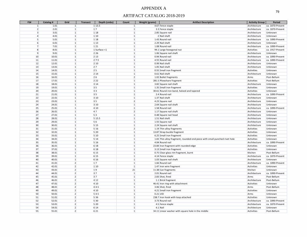
APPENDIX A 79
ARTIFACT CATALOG 2018-2019 FS# Catalog # Grid Transect Depth (cmbs) Count Weight (grams) Artifact Description Activity Group Period
1 1.01 1 1 13.5 1 4.67 Fence staple Architecture ca. 1870-Present 2 2.01 1 1 7 1 3.3 Fence staple Architecture ca. 1870-Present 3 3.01 1 1 18 1 2.85 Square nail Architecture Unknown 4 4.01 1 1 10 1 2 Nail shaft Architecture Unknown 5 5.01 1 1 18 1 1.43 Round nail Architecture ca. 1890-Present 6 6.01 1 1 13 1 2.29 Nail shaft Architecture Unknown 7 7.01 1 1 21 1 1.08 Round nail Architecture ca. 1890-Present 8 8.01 1 1 Surface <1 1 94.1 Large hexegonal nut Activities ca. 1917-Present 9 9.01 1 2 26 1 1.06 Square nail shaft Architecture Unknown
10 10.01 1 2 13 1 0.94 Round nail Architecture ca. 1890-Present 11 11.01 1 2 7.5 1 4.55 Round nail Architecture ca. 1890-Present 12 12.01 1 2 10 1 0.99 Nail shaft Architecture Unknown 13 13.01 1 2 7 1 1.05 Nail shaft Architecture Unknown 14 14.01 1 2 5 1 0.55 Small iron fragment Activities Unknown 15 15.01 1 2 14 1 0.61 Nail shaft Architecture Unknown 16 16.01 1 2 6 2 1.02 Bullet fragments Arms Post-Bellum 17 17.01 1 2 22 1 281.5 Plowshare fragment Activities Post-Bellum 18 18.01 1 3 14 1 3.82 Square nail shaft Architecture Unknown 19 19.01 1 3 5 1 1.35 Small iron fragment Activities Unknown 20 20.01 1 3 3 1 30.61 Round iron band, halved and tapered Activities Unknown 21 21.01 1 3 5 1 2.4 Round nail Architecture ca. 1890-Present 22 22.01 1 3 10 1 1.37 Nail shaft Architecture Unknown 23 23.01 1 3 5 2 4.23 Square nail Architecture Unknown 24 24.01 1 3 10 1 2.64 Square nail shaft Architecture Unknown 25 25.01 1 4 10 1 1.58 Round nail Architecture ca. 1890-Present 26 26.01 1 4 7 2 1.17 Square nail shaft Architecture Unknown 27 27.01 1 5 3 1 0.48 Square nail head Architecture Unknown 28 28.01 1 5 15.5 1 1.51 Nail shaft Architecture Unknown 29 29.01 1 5 6 1 1.55 Square nail Architecture Unknown 30 30.01 1 5 15 1 2.24 Square nail shaft Architecture Unknown 31 31.01 1 5 16 2 1.19 Thin alloy fragments Activities Unknown 32 32.01 1 5 20 1 13.87 Strap buckle fragment Activities Unknown 33 33.01 1 5 10 1 6.25 Small iron fragment Activities Unknown 34 34.01 1 5 14 1 1.65 Thin alloy fragment, rounded end piece with small punched rivet hole Activities Unknown 35 35.01 1 5 16 1 4.04 Round nail Architecture ca. 1890-Present 36 36.01 1 6 18 1 23.84 Iron fragment with rounded edge Activities Unknown 37 37.01 1 6 18 1 3.13 Small iron fragment Activities Unknown 38 38.01 1 6 15 1 0.75 Clear glass rim fragment, burnt Kitchen Post-Bellum 39 39.01 1 6 15 1 4.14 Fence staple Architecture ca. 1870-Present 40 40.01 1 6 16 1 1.03 Square nail shaft Architecture Unknown 41 41.01 2 1 7 1 1.66 Round nail Architecture ca. 1890-Present 42 42.01 2 1 10 1 1.47 Iron wire fragment Activities Unknown 43 43.01 2 1 9 21 11.38 Can fragments Kitchen Unknown 44 44.01 2 3 7 1 2.01 Round nail Architecture ca. 1890-Present 45 45.01 2 3 7 1 2.83 Shot, fired Arms Post-Bellum 46 46.01 2 4 12 1 1.1 Brick fragment Architecture Post-Bellum 47 47.01 2 4 10 1 46.41 Iron ring with attachment Activities Unknown 48 48.01 2 4 4.5 1 3.06 Shot, fired Arms Post-Bellum 49 49.01 2 4 10 1 4.21 Small iron fragment Activities Unknown 50 50.01 2 5 4.5 1 0.21 UID Arms Unknown 51 51.01 2 5 36 1 238.7 Iron hook with loop attached Activities Unknown 52 52.01 2 5 30 1 3.73 Round nail Architecture ca. 1890-Present 53 53.01 2 5 20 1 4.5 Fence staple Architecture ca. 1870-Present 54 54.01 2 6 14 1 4.1 Nail Architecture Unknown 55 55.01 2 6 21 1 34.11 Linear washer with square hole in the middle Activities Post-Bellum
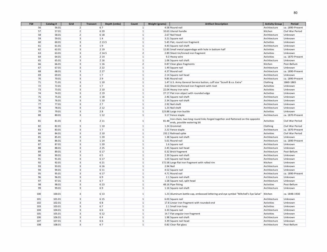
80
FS# Catalog # Grid Transect Depth (cmbs) Count Weight (grams) Artifact Description Activity Group Period 56 56.01 2 6 7 1 4.58 Round nail Architecture ca. 1890-Present 57 57.01 2 6 20 1 10.63 Utensil handle Kitchen Civil War Period 58 58.01 2 6 18 1 2.67 Nail head Architecture Unknown 59 59.01 3 1 4 1 3.21 Square nail Architecture Unknown 60 60.01 3 2 13.5 1 5.45 Flat, round iron fragment Activities Unknown 61 61.01 3 1 9 1 4.43 Square nail shaft Architecture Unknown 62 62.01 3 2 19 1 12.83 Small metal appendage with hole in bottom half Activities Unknown 63 63.01 3 2 14.5 2 2.89 Sheet tin/tinned iron fragment Activities Unknown 64 64.01 3 2 14 1 9.3 Heavy wire Activities ca. 1870-Present 65 65.01 3 2 16 1 1.06 Square nail shaft Architecture Unknown 66 66.01 3 1 16 2 0.87 Clear glass fragments Kitchen Post-Bellum 67 67.01 3 2 22 1 1.49 Square nail Architecture Unknown 68 68.01 3 2 27 1 4.37 Round nail Architecture ca. 1890-Present 69 69.01 3 1 7 1 2.14 Square nail head Architecture Unknown 70 70.01 3 2 9 1 9.85 Round nail Architecture ca. 1890-Present 71 71.01 3 1 10 1 1.47 U.S. Army General Service button, cuff size "Scovill & co. Extra" Clothing 1860-1865 72 72.01 3 1 7 1 4.63 Sheet tin/tinned iron fragment with rivet Activities Unknown 73 73.01 3 2 10 1 22.04 Heavy iron wire Activities Unknown 74 74.01 3 2 19 1 27.17 Flat iron object with rounded edge Activities Unknown 75 75.01 3 1 18 1 2.46 Square nail shaft Architecture Unknown 76 76.01 3 1 10 1 2.34 Square nail shaft Architecture Unknown 77 77.01 3 2 7 1 2.92 Nail shaft Architecture Unknown 78 78.01 3 2 12 1 1.23 Nail shaft Architecture Unknown 79 79.01 3 2 8 1 123.88 Large iron buckle Activities Unknown 80 80.01 3 1 12 1 3.17 Fence staple Architecture ca. 1870-Present
81 81.01 3 2 11 1 81.48 Iron chain, two long round links forged together and flattened on the opposite ends, possible watering bit Activities Civil War Period
82 82.01 3 1 10 1 1.24 Grommet Clothing Civil War Period 83 83.01 3 1 7 1 2.22 Fence staple Architecture ca. 1870-Present 84 84.01 3 2 10 1 232.2 Railroad spike Activities Civil War Period 85 85.01 3 1 20 1 1.38 Square nail shaft Architecture Unknown 86 86.01 3 1 14 1 5.01 Round nail Architecture ca. 1890-Present 87 87.01 3 1 20 1 1.6 Square nail Architecture Unknown 88 88.01 3 2 25 1 2.45 Square nail head Architecture Unknown 89 89.01 3 6 17 1 0.32 Brick fragment Architecture Post-Bellum 90 90.01 3 6 5 1 2.39 Square nail shaft Architecture Unknown 91 91.01 3 6 17 1 1.03 Square nail head Architecture Unknown 92 92.01 3 6 21 1 172.58 Large flat iron fragment with rolled rim Kitchen Unknown 93 93.01 3 6 16 1 2.94 Nail Architecture Unknown 94 94.01 3 6 11 1 4.52 Square nail Architecture Unknown 95 95.01 3 6 17 1 4.71 Round nail Architecture ca. 1890-Present 96 96.01 3 6 9 1 2.1 Square nail shaft Architecture Unknown 97 97.01 3 6 7 1 1.58 Square nail, split head Architecture Unknown 98 98.01 3 6 23 1 48.16 Pipe fitting Activities Post-Bellum 99 99.01 3 6 9 1 1.16 Square nail shaft Architecture Unknown
100 100.01 3 6 13 1 1.23 Aluminum bottle cap, embossed lettering and eye symbol "Mitchell's Eye Salve" Kitchen ca. 1848-1930
101 101.01 3 6 15 1 6.03 Square nail Architecture Unknown 102 102.01 3 6 8 1 17.8 Linear iron fragment with rounded end Activities Unknown 103 103.01 3 6 7 1 2.1 Small iron loop Activities Unknown 104 104.01 3 6 6 1 3.33 Square nail Architecture Unknown 105 105.01 3 6 12 1 14.7 Flat angular iron fragment Activities Unknown 106 106.01 3 6 4 1 1.98 Square nail shaft Architecture Unknown 107 107.01 3 6 6 1 3.39 Square nail head Architecture Unknown 108 108.01 3 6 7 1 0.82 Clear flat glass Architecture Post-Bellum
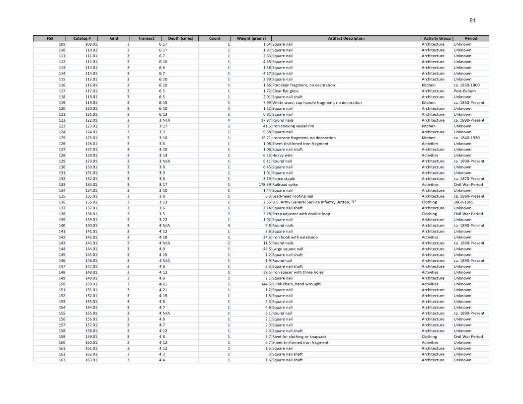
81
FS# Catalog # Grid Transect Depth (cmbs) Count Weight (grams) Artifact Description Activity Group Period 109 109.01 3 6 17 1 1.64 Square nail Architecture Unknown 110 110.01 3 6 17 1 1.97 Square nail Architecture Unknown 111 111.01 3 6 7 1 2.63 Square nail Architecture Unknown 112 112.01 3 6 10 1 4.18 Square nail Architecture Unknown 113 113.01 3 6 6 1 1.58 Square nail Architecture Unknown 114 114.01 3 6 7 1 4.17 Square nail Architecture Unknown 115 115.01 3 6 10 1 2.89 Square nail Architecture Unknown 116 116.01 3 6 10 1 1.86 Porcelain fragment, no decoration Kitchen ca. 1830-1900 117 117.01 3 6 5 1 1.72 Clear flat glass Architecture Post-Bellum 118 118.01 3 6 5 1 2.01 Square nail shaft Architecture Unknown 119 119.01 3 6 15 1 7.99 White ware, cup handle fragment, no decoration Kitchen ca. 1850-Present 120 120.01 3 6 10 1 1.52 Square nail Architecture Unknown 121 121.01 3 6 13 1 6.81 Square nail Architecture Unknown 122 122.01 3 3 N/A 4 17.87 Round nails Architecture ca. 1890-Present 123 123.01 3 3 17 1 41.5 Iron cooking vessel rim Kitchen Unknown 124 124.01 3 3 3 1 9.68 Square nail Architecture Unknown 125 125.01 3 3 16 1 15.71 Ironstone fragment, no decoration Kitchen ca. 1840-1930 126 126.01 3 3 6 1 1.08 Sheet tin/tinned iron fragment Activities Unknown 127 127.01 3 3 10 1 1.06 Square nail shaft Architecture Unknown 128 128.01 3 3 13 1 6.23 Heavy wire Activities Unknown 129 129.01 3 3 N/A 1 6.11 Round nail Architecture ca. 1890-Present 130 130.01 3 3 8 1 6.45 Square nail Architecture Unknown 131 131.01 3 3 9 1 1.01 Square nail Architecture Unknown 132 132.01 3 3 8 1 3.19 Fence staple Architecture ca. 1870-Present 133 133.01 3 3 17 1 178.39 Railroad spike Activities Civil War Period 134 134.01 3 3 10 1 1.44 Square nail Architecture Unknown 135 135.01 3 3 8 1 6.3 Lead-head roofing nail Architecture ca. 1890-Present 136 136.01 3 3 13 1 2.35 U.S. Army General Service Infantry Button, "I" Clothing 1860-1865 137 137.01 3 3 6 1 2.14 Square nail shaft Architecture Unknown 138 138.01 3 3 5 2 3.18 Strap adjuster with double loop Clothing Civil War Period 139 139.01 3 3 22 1 1.92 Square nail Architecture Unknown 140 140.01 3 4 N/A 3 9.8 Round nails Architecture ca. 1890-Present 141 141.01 3 4 12 1 3.6 Square nail Architecture Unknown 142 142.01 3 4 18 1 24.3 Iron hook with extension Activities Unknown 143 143.01 3 4 N/A 2 11.5 Round nails Architecture ca. 1890-Present 144 144.01 3 4 9 1 44.5 Large square nail Architecture Unknown 145 145.01 3 4 15 1 1.2 Square nail shaft Architecture Unknown 146 146.01 3 4 N/A 1 1.9 Round nail Architecture ca. 1890-Present 147 147.01 3 4 8 1 2.3 Square nail shaft Architecture Unknown 148 148.01 3 4 12 1 39.5 Iron spacer with three holes Activities Unknown 149 149.01 3 4 8 1 2.1 Square nail Architecture Unknown 150 150.01 3 4 21 1 144.5 6 link chain, hand wrought Activities Unknown 151 151.01 3 4 21 1 1.2 Square nail Architecture Unknown 152 152.01 3 4 15 1 1.5 Square nail Architecture Unknown 153 153.01 3 4 8 1 2.3 Square nail Architecture Unknown 154 154.01 3 4 7 1 4.6 Square nail Architecture Unknown 155 155.01 3 4 N/A 1 6.1 Round nail Architecture ca. 1890-Present 156 156.01 3 4 8 1 2.1 Square nail Architecture Unknown 157 157.01 3 4 7 1 2.3 Square nail Architecture Unknown 158 158.01 3 4 12 1 2.3 Square nail shaft Architecture Unknown 159 159.01 3 4 8 1 3.7 Rivet for clothing or knapsack Clothing Civil War Period 160 160.01 3 4 12 1 6.7 Sheet tin/tinned iron fragment Activities Unknown 161 161.01 3 4 12 1 1.5 Square nail Architecture Unknown 162 162.01 3 4 3 1 3 Square nail shaft Architecture Unknown 163 163.01 3 4 4 1 1.6 Square nail shaft Architecture Unknown
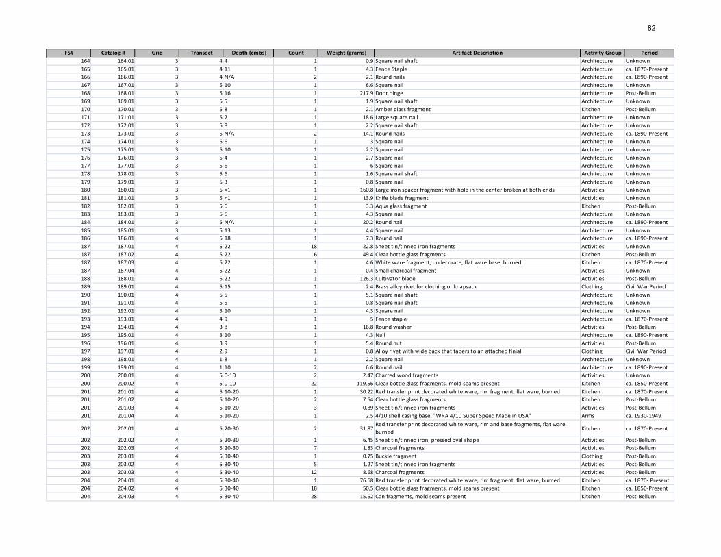
82
FS# Catalog # Grid Transect Depth (cmbs) Count Weight (grams) Artifact Description Activity Group Period 164 164.01 3 4 4 1 0.9 Square nail shaft Architecture Unknown 165 165.01 3 4 11 1 4.3 Fence Staple Architecture ca. 1870-Present 166 166.01 3 4 N/A 2 2.1 Round nails Architecture ca. 1890-Present 167 167.01 3 5 10 1 6.6 Square nail Architecture Unknown 168 168.01 3 5 16 1 217.9 Door hinge Architecture Post-Bellum 169 169.01 3 5 5 1 1.9 Square nail shaft Architecture Unknown 170 170.01 3 5 8 1 2.1 Amber glass fragment Kitchen Post-Bellum 171 171.01 3 5 7 1 18.6 Large square nail Architecture Unknown 172 172.01 3 5 8 1 2.2 Square nail shaft Architecture Unknown 173 173.01 3 5 N/A 2 14.1 Round nails Architecture ca. 1890-Present 174 174.01 3 5 6 1 3 Square nail Architecture Unknown 175 175.01 3 5 10 1 2.2 Square nail Architecture Unknown 176 176.01 3 5 4 1 2.7 Square nail Architecture Unknown 177 177.01 3 5 6 1 6 Square nail Architecture Unknown 178 178.01 3 5 6 1 1.6 Square nail shaft Architecture Unknown 179 179.01 3 5 3 1 0.8 Square nail Architecture Unknown 180 180.01 3 5 <1 1 160.8 Large iron spacer fragment with hole in the center broken at both ends Activities Unknown 181 181.01 3 5 <1 1 13.9 Knife blade fragment Activities Unknown 182 182.01 3 5 6 1 3.3 Aqua glass fragment Kitchen Post-Bellum 183 183.01 3 5 6 1 4.3 Square nail Architecture Unknown 184 184.01 3 5 N/A 1 20.2 Round nail Architecture ca. 1890-Present 185 185.01 3 5 13 1 4.4 Square nail Architecture Unknown 186 186.01 4 5 18 1 7.3 Round nail Architecture ca. 1890-Present 187 187.01 4 5 22 18 22.8 Sheet tin/tinned iron fragments Activities Unknown 187 187.02 4 5 22 6 49.4 Clear bottle glass fragments Kitchen Post-Bellum 187 187.03 4 5 22 1 4.6 White ware fragment, undecorate, flat ware base, burned Kitchen ca. 1870-Present 187 187.04 4 5 22 1 0.4 Small charcoal fragment Activities Unknown 188 188.01 4 5 22 1 126.3 Cultivator blade Activities Post-Bellum 189 189.01 4 5 15 1 2.4 Brass alloy rivet for clothing or knapsack Clothing Civil War Period 190 190.01 4 5 5 1 5.1 Square nail shaft Architecture Unknown 191 191.01 4 5 5 1 0.8 Square nail shaft Architecture Unknown 192 192.01 4 5 10 1 4.3 Square nail Architecture Unknown 193 193.01 4 4 9 1 5 Fence staple Architecture ca. 1870-Present 194 194.01 4 3 8 1 16.8 Round washer Activities Post-Bellum 195 195.01 4 3 10 1 4.3 Nail Architecture ca. 1890-Present 196 196.01 4 3 9 1 5.4 Round nut Activities Post-Bellum 197 197.01 4 2 9 1 0.8 Alloy rivet with wide back that tapers to an attached finial Clothing Civil War Period 198 198.01 4 1 8 1 2.2 Square nail Architecture Unknown 199 199.01 4 1 10 2 6.6 Round nail Architecture ca. 1890-Present 200 200.01 4 5 0-10 2 2.47 Charred wood fragments Activities Unknown 200 200.02 4 5 0-10 22 119.56 Clear bottle glass fragments, mold seams present Kitchen ca. 1850-Present 201 201.01 4 5 10-20 1 30.22 Red transfer print decorated white ware, rim fragment, flat ware, burned Kitchen ca. 1870-Present 201 201.02 4 5 10-20 2 7.54 Clear bottle glass fragments Kitchen Post-Bellum 201 201.03 4 5 10-20 3 0.89 Sheet tin/tinned iron fragments Activities Post-Bellum 201 201.04 4 5 10-20 1 2.5 4/10 shell casing base, "WRA 4/10 Super Speed Made in USA" Arms ca. 1930-1949
202 202.01 4 5 20-30 2 31.87 Red transfer print decorated white ware, rim and base fragments, flat ware, burned Kitchen ca. 1870-Present
202 202.02 4 5 20-30 1 6.45 Sheet tin/tinned iron, pressed oval shape Activities Post-Bellum 202 202.03 4 5 20-30 7 1.83 Charcoal fragments Activities Post-Bellum 203 203.01 4 5 30-40 1 0.75 Buckle fragment Clothing Post-Bellum 203 203.02 4 5 30-40 5 1.27 Sheet tin/tinned iron fragments Activities Post-Bellum 203 203.03 4 5 30-40 12 8.68 Charcoal fragments Activities Post-Bellum 204 204.01 4 5 30-40 1 76.68 Red transfer print decorated white ware, rim fragment, flat ware, burned Kitchen ca. 1870- Present 204 204.02 4 5 30-40 18 50.5 Clear bottle glass fragments, mold seams present Kitchen ca. 1850-Present 204 204.03 4 5 30-40 28 15.62 Can fragments, mold seams present Kitchen Post-Bellum
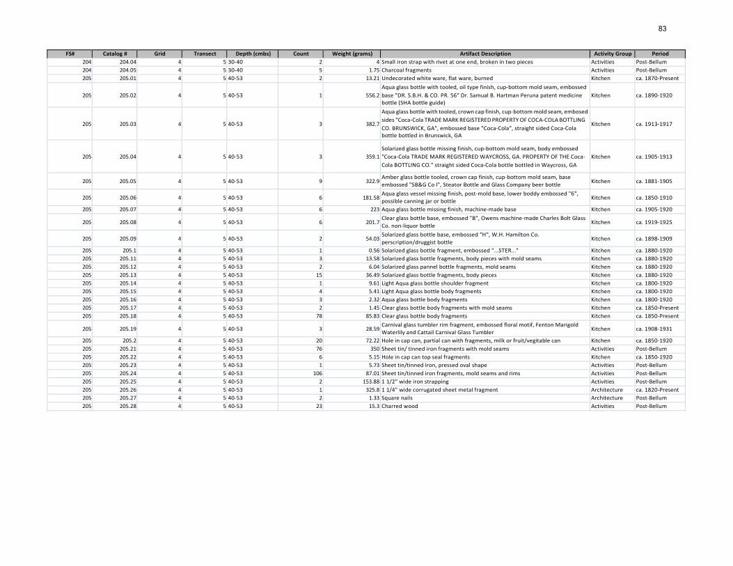
83
FS# Catalog # Grid Transect Depth (cmbs) Count Weight (grams) Artifact Description Activity Group Period 204 204.04 4 5 30-40 2 4 Small iron strap with rivet at one end, broken in two pieces Activities Post-Bellum 204 204.05 4 5 30-40 5 1.75 Charcoal fragments Activities Post-Bellum 205 205.01 4 5 40-53 2 13.21 Undecorated white ware, flat ware, burned Kitchen ca. 1870-Present
205 205.02 4 5 40-53 1 556.2 Aqua glass bottle with tooled, oil type finish, cup-bottom mold seam, embossed base "DR. S.B.H. & CO. PR. 56" Dr. Samual B. Hartman Peruna patent medicine bottle (SHA bottle guide)
Kitchen ca. 1890-1920
205 205.03 4 5 40-53 3 382.7
Aqua glass bottle with tooled, crown cap finish, cup-bottom mold seam, embosed sides "Coca-Cola TRADE MARK REGISTERED PROPERTY OF COCA-COLA BOTTLING CO. BRUNSWICK, GA", embossed base "Coca-Cola", straight sided Coca-Cola bottle bottled in Brunswick, GA
Kitchen ca. 1913-1917
205 205.04 4 5 40-53 3 359.1 Solarized glass bottle missing finish, cup-bottom mold seam, body embossed "Coca-Cola TRADE MARK REGISTERED WAYCROSS, GA. PROPERTY OF THE Coca- Cola BOTTLING CO." straight sided Coca-Cola bottle bottled in Waycross, GA
Kitchen ca. 1905-1913
205 205.05 4 5 40-53 9 322.9 Amber glass bottle tooled, crown cap finish, cup-bottom mold seam, base embossed "SB&G Co I", Steator Bottle and Glass Company beer bottle Kitchen ca. 1881-1905
205 205.06 4 5 40-53 6 181.58 Aqua glass vessel missing finish, post-mold base, lower boddy embossed "6", possible canning jar or bottle Kitchen ca. 1850-1910
205 205.07 4 5 40-53 6 223 Aqua glass bottle missing finish, machine-made base Kitchen ca. 1905-1920
205 205.08 4 5 40-53 6 201.7 Clear glass bottle base, embossed "B", Owens machine-made Charles Bolt Glass Co. non-liquor bottle Kitchen ca. 1919-1925
205 205.09 4 5 40-53 2 54.03 Solarized glass bottle base, embossed "H", W.H. Hamilton Co. perscription/druggist bottle Kitchen ca. 1898-1909
205 205.1 4 5 40-53 1 0.56 Solarized glass bottle fragment, embossed "...STER..." Kitchen ca. 1880-1920 205 205.11 4 5 40-53 3 13.58 Solarized glass bottle fragments, body pieces with mold seams Kitchen ca. 1880-1920 205 205.12 4 5 40-53 2 6.04 Solarized glass pannel bottle fragments, mold seams Kitchen ca. 1880-1920 205 205.13 4 5 40-53 15 36.49 Solarized glass bottle fragments, body pieces Kitchen ca. 1880-1920 205 205.14 4 5 40-53 1 9.61 Light Aqua glass bottle shoulder fragment Kitchen ca. 1800-1920 205 205.15 4 5 40-53 4 5.41 Light Aqua glass bottle body fragments Kitchen ca. 1800-1920 205 205.16 4 5 40-53 3 2.32 Aqua glass bottle body fragments Kitchen ca. 1800-1920 205 205.17 4 5 40-53 2 1.45 Clear glass bottle body fragments with mold seams Kitchen ca. 1850-Present 205 205.18 4 5 40-53 78 85.83 Clear glass bottle body fragments Kitchen ca. 1850-Present
205 205.19 4 5 40-53 3 28.59 Carnival glass tumbler rim fragment, embossed floral motif, Fenton Marigold Waterlily and Cattail Carnival Glass Tumbler Kitchen ca. 1908-1931
205 205.2 4 5 40-53 20 72.22 Hole in cap can, partial can with fragments, milk or fruit/vegitable can Kitchen ca. 1850-1920 205 205.21 4 5 40-53 76 350 Sheet tin/ tinned iron fragments with mold seams Activities Post-Bellum 205 205.22 4 5 40-53 6 5.15 Hole in cap can top seal fragments Kitchen ca. 1850-1920 205 205.23 4 5 40-53 1 5.73 Sheet tin/tinned iron, pressed oval shape Activities Post-Bellum 205 205.24 4 5 40-53 106 87.01 Sheet tin/tinned iron fragments, mold seams and rims Activities Post-Bellum 205 205.25 4 5 40-53 2 153.88 1 1/2" wide iron strapping Activities Post-Bellum 205 205.26 4 5 40-53 1 325.8 1 1/4" wide corrugated sheet metal fragment Architecture ca. 1820-Present 205 205.27 4 5 40-53 2 1.33 Square nails Architecture Post-Bellum 205 205.28 4 5 40-53 23 15.3 Charred wood Activities Post-Bellum