Archaeological Testing at Primm Park, Brentwood, Williamson County, Tennessee
62
ARCHAEOLOGICAL TESTING AT PRIMM PARK BRENTWOOD, WILLIAMSON COUNTY, TENNESSEE Technical Report Kevin E. Smith and Christopher Hogan Report of Archaeological Investigations No. 1 Department of Sociology and Anthropology Middle Tennessee State University April 2004
Transcript of Archaeological Testing at Primm Park, Brentwood, Williamson County, Tennessee

ARCHAEOLOGICAL TESTING AT PRIMM PARK BRENTWOOD, WILLIAMSON COUNTY, TENNESSEE
Technical Report
Kevin E. Smith and Christopher Hogan
Report of Archaeological Investigations No. 1 Department of Sociology and Anthropology
Middle Tennessee State University
April 2004

ii
CONTENTS
Contents ii List of Figures iii List of Tables v Acknowledgements vi Management Summary vii I. Introduction 1 II. Prior Archaeological Research 3 III. Current Archaeological Research 13 Excavations Beneath the Floorboards 13 Artifacts from Beneath the Floorboards 15 Yard Excavations Outside the Academy 29 Artifacts from Yard Area Excavations 42 IV. Results and Recommendations 50 References Cited 52

iii
LIST OF FIGURES
Figure Title Page
1 Project Location (USGS Franklin 7.5’ quad, 63NE) 2
2 Myer Map of the Fewkes Mound Group (1928) 2
3 Myer profile of Mound 2 4
4 Myer plan view of Mound 2 at first level 4
5 Myer plan view of Mound 2 at second level 5
6 Myer plan view of Mound 5 6
7 Myer plan view of House 6 7
8 Myer plan view of House 17 8
9 DuVall 1996 Shovel Test Locations 9
10 Plan View and Profiles of DuVall 1996 Shovel Tests 13 and 14 10
11 Plan View and Profiles of DuVall 1996 Profile Unit 11
12 Schematic of 2003 Excavations Beneath the Academy 13
13 Excavations in Progress 14
14 Screening Area 14
15 Selected architectural group artifacts 15
16 Histogram of window glass thicknesses 17
17 Slate tablet and pencils 19
18 Other small finds 19
19 Density distribution of prehistoric artifacts beneath the academy 22
20 O’Byam Incised variety Stewart sherd 25
21 Bowl sherds with notched appliqué rim strips 25
22 Pan sherds showing exterior fabric impressions 26
23 Selected handles 26
24 Triangular projectile points 27
25 Limestone disk 28
26 Location of Excavated Units, 2003-2004 29
27 Area Shot showing N1040E990, entrance from Moore’s Lane and cut bank
30
28 Profiles of N1040E990 31
29 Profiles of N1040E990 31
30 Profiles of N1030E990 32
31 N985E980 showing exposure of intact 19th century midden 33
32 Profiles of N985E980 33

iv
Figure Title Page
33 Excavation of N985E980 in progress 34
34 Profiles of N1005E981 34
35 Profiles of N927E969 35
36 Southeast corner posthole upon initial identification at base of Zone 2 36
37 Southeast corner posthole during excavation showing charcoal lens 36
38 Plan view of N927E969 at base of unit 37
39 Base of N927E969 after excavation of postholes 37
40 Profiles of N917E961 38
41 Profile photograph of N917E961 showing dark midden 39
42 Base of N917E961 showing continuation of dark midden 39
43 Profiles of “Bike Path” Unit 40
44 Photograph of “west” profile of Bike Path Unit 41
45 Tobacco pipes 48
46 Bowls with notched appliqué rim strips 48
47 Dover celt 49
48 Triangular projectile points 49

v
LIST OF TABLES
Table Title Page
1 Summary of Historic Period Artifacts from Beneath the Academy 20
2 Summary of Prehistoric Artifacts from Beneath the Academy 21
3 Faunal Material from Beneath the Academy 21
4 Bulk/Non-Diagnostic Material from Beneath the Academy 21
5 Detailed Prehistoric Ceramic Inventory, Academy 23
6 Detailed Prehistoric Lithic Inventory, Academy 23
7 Triangular Projectile Points, Academy 28
8 Triangular Points, Yard Area 44
9 Summary of Historic Period Artifacts, Yard Area 45
10 Summary of Prehistoric Artifacts, Yard Area 45
11 Faunal Material, Yard Area 46
12 Bulk/Non-Diagnostic Material, Yard Area 46
13 Detailed Prehistoric Ceramic Inventory, Yard Area 47
14 Detailed Prehistoric Lithic Inventory, Yard Area 47

vi
ACKNOWLEDGEMENTS This project would not have been successful without the contributions of many individuals. First and foremost, thanks to the volunteers who donated several hundred hours of valuable time to complete the fieldwork and labwork. Several MTSU students assisted with the fieldwork, including Bruce Burton, Bobbi Chahi, Charles Corum, Pat Cummins, Rachel Douglas, Hannah Guidry, Robert Pressnell, Amanda Richardson, Christopher Simpson, and Amanda Wolf. In addition, members of the Middle Cumberland Archaeological Society volunteered on several days of the project, including Daniel Brock, George Heinrich, Susan Hollyday, and Lib Roller. Mike Moore from the Tennessee Division of Archaeology assisted with testing of the proposed highway entrance area. Several students also assisted with processing and inventorying of artifacts in the lab, including Rachel Douglas, Robert Pressnell, Amanda Richardson, and Chris Simpson. We appreciate the opportunity and assistance provided by the City of Brentwood, with special thanks to Anne Dunn, Linda Lynch and Joe Lassus. Thanks also to Vic Hood of Leatherwood for his insights. Finally, we appreciate the assistance of the staff of the Center for Historic Preservation, especially Caneta Hankins.
vii
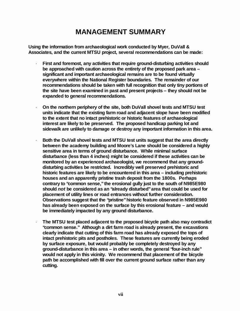
MANAGEMENT SUMMARY Using the information from archaeological work conducted by Myer, DuVall & Associates, and the current MTSU project, several recommendations can be made:
· First and foremost, any activities that require ground-disturbing activities should be approached with caution across the entirety of the proposed park area – significant and important archaeological remains are to be found virtually everywhere within the National Register boundaries. The remainder of our recommendations should be taken with full recognition that only tiny portions of the site have been examined in past and present projects – they should not be expanded to general recommendations.
· On the northern periphery of the site, both DuVall shovel tests and MTSU test
units indicate that the existing farm road and adjacent slope have been modified to the extent that no intact prehistoric or historic features of archaeological interest are likely to be preserved. The proposed handicap parking lot and sidewalk are unlikely to damage or destroy any important information in this area.
· Both the DuVall shovel tests and MTSU test units suggest that the area directly
between the academy building and Moore’s Lane should be considered a highly sensitive area in terms of ground disturbance. While minimal surface disturbance (less than 4 inches) might be considered if these activities can be monitored by an experienced archaeologist, we recommend that any ground-disturbing activities be restricted. Incredibly well preserved prehistoric and historic features are likely to be encountered in this area – including prehistoric houses and an apparently pristine trash deposit from the 1800s. Perhaps contrary to “common sense,” the erosional gully just to the south of N985E980 should not be considered as an “already disturbed” area that could be used for placement of utility lines or road entrances without further consideration. Observations suggest that the “pristine” historic feature observed in N985E980 has already been exposed on the surface by this erosional feature – and would be immediately impacted by any ground disturbance.
· The MTSU test placed adjacent to the proposed bicycle path also may contradict
“common sense.” Although a dirt farm road is already present, the excavations clearly indicate that cutting of this farm road has already exposed the tops of intact prehistoric pits and postholes. These features are currently being eroded by surface exposure, but would probably be completely destroyed by any ground-disturbance in this area – in other words, the general “four-inch rule” would not apply in this vicinity. We recommend that placement of the bicycle path be accomplished with fill over the current ground surface rather than any cutting.

viii
· Finally, both the DuVall shovel tests and MTSU excavations in the vicinity of the proposed new highway entrance indicate that this alternative should be reconsidered. Intact prehistoric midden and structures are clearly present throughout this area – we anticipate that any reasonable grade cut for a new entrance road would impact many important archaeological features. Myer’s investigations in this area, with some support from the DuVall shovel tests also indicate that this vicinity may contain substantial numbers of scattered prehistoric human graves. If substantial cutting to create a road grade would be necessary for the proposed highway entrance, this should be preceded by a larger scale archaeological project.
In summary, this relatively small-scale project using primarily volunteer labor has produced some significant new information about the distribution of artifacts, midden, and features within the boundaries of what is being developed as Primm Park. Many students have benefited from this partnership in terms of a significant opportunity to connect their “classroom work” with “real-life” field projects that benefit the local community. We also hope that it provides significant information that will both inform and facilitate proposed development of Primm Park by the City of Brentwood.

1
I. INTRODUCTION
In early 2003, Edgar and Dorothy Primm and CPS Land, LLC donated approximately 30-acres on Moores Lane to the City of Brentwood for development of a new park. This property contains the surviving portions of the Fewkes Site (Tennessee Archaeological Site Survey Number 40WM1), a large late prehistoric Mississippian mound complex, and the Boiling Springs Academy, a brick schoolhouse constructed in the early 19th century. The property was listed in the National Register of Historic Places in 1980. In October 2003, on-going restoration of the Boiling Springs Academy building required removal of flooring on the first story to repair broken joists. Removal of the flooring revealed a large number of prehistoric and historic artifacts scattered on the ground surface. Repairs to the floor joists required placement of a shallow (5-12 inch) trench approximately five feet in width and forty feet in length. Although the surface deposits were clearly heavily churned by rodent and other animal activity, they did contain artifacts that could be used to interpret both the prehistoric Native American use of this part of the Fewkes site and the later story of the Boiling Spring Academy. In consultation with officials from the City of Brentwood and the contractor restoring the building, the authors volunteered to excavate the trench and systematically recover artifacts. Fieldwork beneath the academy was conducted November 4 to 7, 2003 with assistance of student volunteers from Middle Tennessee State University and members of the Middle Cumberland Archaeological Society. Subsequently, the City of Brentwood contracted with the Center for Historic Preservation at Middle Tennessee State University to develop background and interpretive information on the academy. A portion of that contract provided funding for a single field assistant to conduct test excavations in areas for proposed sidewalks and trails. Equipment, supplies, and additional labor was donated by the Program in Anthropology at Middle Tennessee State University. During February and March 2004, the authors and volunteers from Middle Tennessee State University and the Middle Cumberland Archaeological Society placed eight test units designed to provide a basic understanding of the integrity of archaeological deposits and features in key locations of the property. In addition to a summary of previous archaeological investigations within the proposed park area, this report details the 2003-2004 fieldwork and laboratory analysis, and provides an evaluation of this information in terms of future ground-disturbing activities.

2
Figure 1. Project Location USGS Franklin 7.5’ Quad, 63NE (DuVall & Associates, Inc. 1996).
Figure 2. 1920 Myer map of Fewkes Group (Myer 1928)
3
II. PRIOR ARCHAEOLOGICAL RESEARCH
Joseph Jones provides the earliest known mention of the Fewkes/Boiling Academy site. Jones (1876:8) notes that “numerous stones graves are also found… in and around Brentwood; at the Boiling Spring…” Jones (1876:132) also includes a figure illustrating “the body of a black female idol, obtained from a stone grave at Boiling Springs, Williamson County, by the late Dr. Freeman.” According to Myer (1928:605), P.E. Cox conducted “a small amount of digging at Fewkes group about 1895. He made no written record at the time.” The first substantive archaeological investigations were conducted in October 1920 by William Edward Myer under the auspices of the Bureau of American Ethnology (for biographical information on Myer, see K. Smith 1998a). As noted by Myer (1928:559), “at the request of many citizens of Tennessee this site was named the Fewkes Group in honor of Dr. J. Walter Fewkes, Chief of the Bureau of American Ethnology, who had visited it and recognized its possibilities a few months before.” Although Myer died from a heart attack prior to completing the final report, his colleague and friend John Swanton completed editing of his archaeological reports on the Fewkes and Gordontown sites. These reports were published jointly by the Bureau of American Ethnology as Two Prehistoric Villages in Middle Tennessee (Myer 1928:557-613). In 1996, proposed improvements by the Department of Transportation to State Route 441 (Moore Lane) from Liberty Road to State Route 252 (Wilson Pike) initiated a series of archaeological survey and excavation projects. The Phase I archaeological survey included the placement of 10 shovel tests and one test unit of particular relevance to the park development (DuVall & Associates 1996). Additional excavations were funded by the Department of Transportation in 1997 and 1998, but were restricted to portions of the site on the west side of Moores Lane (outside the National Register and proposed park boundaries). Further work was conducted to the south and east of the proposed park in association with the Montclair development, but did not include excavations within the National Register boundaries. Summary of Myer’s work Although Myer’s conclusions are significantly dated, a summary of the approximate location and extent of his excavations is warranted. A more detailed review of Myer’s work will be provided after examination of his original fieldnotes, photographs, and artifacts is completed at the Smithsonian Institution in late 2004 by Kevin Smith and Michael Moore. Myer excavated significant portions of Mound 2, revealing at least three and probably four structures associated with different construction stages of the platform mound. The profiles and plan views of this mound are among the most detailed available for platform mounds in the Nashville region (Figures 3-5). Hopefully, sufficient additional information can be obtained from Myer’s fieldnotes and photographs to provide a reasonably clear picture of the nature of this structure.

4
Figure 3. Myer profile of Mound 2 (1928: Figure 156)
Figure 4. Plan View of Mound 2 at First Level (Myer 1928: Figure 157)

5
Figure 5. Plan View of Mound 2 a Second Level (Myer 1928: Figure 159)
Myer also investigated some portions of Mound 3. According to his report, this small burial mound had been extensively looted prior to 1920. While the full extent of Myer’s investigations is not clear in the report, he opened at least two relatively undisturbed burials in this mound. Myer placed a small test pit (3 x 2 feet) to the depth of three feet in Mound 4. He concluded that this was a largely natural formation “given its present shape by the removal of soil…” (Myer 1928:588).

6
Myer also investigated Mound 5 with somewhat inconclusive results (Figure 6). Based on information in the report, this low mound may have been similar to “ash mounds” identified at the periphery of the Sellars site (40WI1) in Wilson County. Mound 5 appears to have been completely destroyed by placement of the current farm road on the northern periphery of the site.
Figure 6. Plan View of Mound 5 (Myer 1928: Figure 195)
Other than the mound investigations, Myer also excavated portions of two structures and associated features (numbered 6 and 17 in Figure 2). Although termed “house circles” throughout the Fewkes report, Myer is almost certainly referring to square structures with open corners – his excavation maps indicate that he did not fully expose the post patterns of these buildings (Figures 7-8). His interpretation of the post patterns at these sites as the remnants of circular wattle-and-daub structures rather than square with open corners has been critically reviewed elsewhere (Smith 1998b).

7
Figure 7. House 6 plan view (Myer 1928:Figure 196)
8
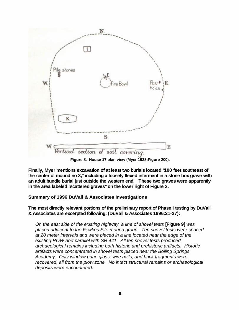
Figure 8. House 17 plan view (Myer 1928:Figure 200).
Finally, Myer mentions excavation of at least two burials located “100 feet southeast of the center of mound no 3,” including a loosely flexed interment in a stone box grave with an adult bundle burial just outside the western end. These two graves were apparently in the area labeled “scattered graves” on the lower right of Figure 2. Summary of 1996 DuVall & Associates Investigations The most directly relevant portions of the preliminary report of Phase I testing by DuVall & Associates are excerpted following: (DuVall & Associates 1996:21-27):
On the east side of the existing highway, a line of shovel tests [Figure 9] was placed adjacent to the Fewkes Site mound group. Ten shovel tests were spaced at 20 meter intervals and were placed in a line located near the edge of the existing ROW and parallel with SR 441. All ten shovel tests produced archaeological remains including both historic and prehistoric artifacts. Historic artifacts were concentrated in shovel tests placed near the Boiling Springs Academy. Only window pane glass, wire nails, and brick fragments were recovered, all from the plow zone. No intact structural remains or archaeological deposits were encountered.

9
Prehistoric artifacts included variable amount of shell tempered ceramics, lithic debitage, animal bone, charcoal, and fragments of fired clay. Shovel Tests 11 and 12, located close to the Little Harpeth River, contained a very small amount of prehistoric material in a shallow plow zone overlying sterile subsoil. Quantities of prehistoric artifacts increased in shovel tests located further south. All of these units were located near the base of Mound 2. The density of artifacts did not decrease until Shovel Test 20, which contained only 6 shell tempered sherds and 3 chert flakes.
Figure 9. Shovel Test Locations (DuVall & Associates 1996: Figure 5).

10
The stratigraphy encountered in the shovel tests mentioned above varied considerably. The northern end of the area investigated contained only a shallow plow zone overlying sterile subsoil and limestone bedrock. Shovel tests placed in the vicinity of Mound 2 possessed substantially thicker plow zone deposits. The plow zone in these units also contained large amounts of small fired clay frgments and charcoal. The increase in the thickness of the plow zone is attributed to deflation of the adjacent mound and the accumulation of colluvial sediments around its peripheries. Several shovel test profiles contained successive plow zones, each buried by later accumulations of colluvium.
Figure 10. Plan View and Profile of Shovel Test 13 (Left) and Shovel Test 14 (right).
(DuVall & Associates 1996: Figures 6-7).
In Shovel Tests 17, 18, and 19 intact prehistoric midden was found below the plow-disturbed soil at a depth ranging from 25 to 50 cm (.82 to 1.6 ft) below suface. The midden deposit matrix consisted of dark organically enriched silt clay loam that contained large numbers of prehistoric artifacts including charcoal, fragments of fired clay, shell tempered ceramics, and lithic debitage. Except for Shovel Test 17, where the midden exceeded 50 cm (1.6 ft) in thickness, the midden was found to average about 25 cm (.82 ft) thick. The midden deposit was underlain by a transitional AB horizon that graded vertically into sterile subsoil.

11
The greater thickness of the midden in Shovel Test 17 may actually represent a pit-like feature that intruded below the level of the midden and into the underlying subsoil. Potential features were encountered in several other shovel test areas. At the base of the plow zone in Shovel Test 13 a layer of small limestone slabs was encountered. The slabs were laid horizontally and were bordered on one side by a line or vertically oriented (implanted?) limestone slabs [Figure 10, left]. This small size of the stone slabs may indicate that this potential feature is simply a natural, albeit peculiar, arrangement of decaying limestone bedrock. On the other hand, it could also be the remains of a plow-disturbed stone box interment. Excavation ceased at the base of the plow zone before the identify of this anomaly could be confirmed. A layer of large shell tempered sherds was encountered in Shovel Test 14 [Figure 10, right]. Also associated with these artifacts were several large, unidentified long bones. These were found within a deposit of prehistoric midden at a depth of 33 cm (1.0 ft) below surface. The sherds, which were large, thick, and fabric marked, may have been from a salt pan-like vessel. It is suspected that this feature represents the partially disturbed remains of a human interment. Excavation ceased before the identity of this feature could be confirmed.
Figure 11. Profiles and plan views of 1996 profile unit (DuVall & Associates 1996: Figure 8).

12
A 1.0 meter (3.2 feet) wide, stepped soil profile was excavated in the cut bank on the east side of the existing highway, near Shovel Test 18 [Figure 11]. The resulting profile revealed the presence of intact midden within the existing ROW, buried by two successive plow zone deposits. The profile cut was stepped to accommodate the low contour of the highway bank cut. The resulting steps or floors were trowelled and inspected for the presence of features. Three posthole-like stains were observed in the floor that appeared to originate at the base of the midden. These stains contained large amounts of charcoal and fired clay fragments. Shell tempered ceramics, lithic debitage, bone, charcoal, and fired clay fragments were found in the overlying midden deposit, which extended approximately 2 meters (6.5 feet) into the existing ROW (west) from the adjacent fence line.

13
III. CURRENT ARCHAEOLOGICAL INVESTIGATIONS
Limited excavations were conducted in two phases (November 2003 and February-March 2004) under the direction of the authors. During November 2003, salvage excavations were conducted beneath the floorboards of the academy building. In February and March 2004, limited test excavations were conducted in four areas within the National Register boundary to establish baseline stratigraphic information and the potential for intact midden or features: 1) proposed handicap parking and access areas on the northern periphery; 2) proposed trails and utility lines to the west of the academy; 3) proposed bicycle path on the eastern periphery; and (4) proposed highway entrance west of the remnants of Mound 2. Results of these investigations are presented following.
BENEATH THE FLOORBOARDS In order to repair the broken floor joists, contractors needed to place two concrete pads at each end of the building to support a girder spanning the building length. Placement of pads and girder required at least 15 inches clearance below the floor joists. Figure 12 is a schematic illustration of the interior of the academy building with lines demarking the building foundations and floor joists. Given the short timeframe for recovery of information and the clearly disturbed nature of the sub-floor deposits, the excavation design was very simple. Areas between joists were number 1-18 and divided into thirds (N, C, and S). Originally, we had planned to remove approximately 6 inches of the subfloor deposits in all joist areas, but after establishing the direct impact zone and timeframe for completion of the salvage operation with volunteers, we determined to limit our excavations to the central zone (labeled C).
Figure 12. Schematic of excavated areas beneath the academy floorboards (current academy entrance shown at right).

14
Due to the extremely dusty nature of the deposits and the potential for rodent-deposited bacteria, excavators wore dust-masks throughout the process (Figure 13). As anticipated, all of the deposits removed had been thoroughly churned and mixed by rodent activity. All excavated soil was sifted through ¼-inch hardware mesh to recover artifacts (Figure 14). Despite the disturbed context, the artifact assemblage provides some interesting insights into the prehistoric and historic uses of this portion of the site.
Figure 13. Excavations in Progress.
Figure 14. Screening Area.

15
ARTIFACTS FROM BENEATH THE FLOORBOARDS
Artifacts (n=4634) recovered from beneath the academy floorboards were returned to the MTSU Archaeology Laboratory for processing and analysis. Tables 1-4 summarize the artifacts recovered from the academy building including 1,741 historic period artifacts; 1,447 prehistoric artifacts; 1,446 animal bones (and fragments); and numerous bulk materials such as wood charcoal, fired/burned clay fragments, coal, daub, burned limestone, and plaster.
HISTORIC ARTIFACTS Most of the historic period artifacts are architectural in nature – window glass, nails, wood, plaster, and bricks. Given the well-preserved nature of the building and information gathered from the surviving structure by Vic Hood of Leatherwood, Inc., only those artifacts providing potential additional, new or corroborating information are discussed in detail.
Figure 15. Selected architectural group artifacts: a) plaster blackboard fragment; b) structural
wood; c) decorative church window glass; d) cut nails; e) plaster with wallpaper Window Glass Window glass comprises a large portion of the architectural artifacts from most historic period archaeological investigations. The academy is no exception to this pattern.

16
Dating archaeological sites by window glass thickness is generally a “last resort” technique used when there is a lack of other chronologically sensitive artifacts and historic documentation available for that purpose. Given the small quantities of artifacts that would provide information on when the academy was renovated into a church, a detailed analysis of the window glass from the interior of the building was conducted. The use of window glass as a dating tool is based on the suggestion that pane thickness increases over time (Moir 1987, Roenke 1978, Schoen 1990). Both window pane size and pane thickness increased from the early nineteenth century until between 1910 and 1930 when automation and government regulation established a standardized thickness of 2.29 mm (Moir 1982 cited in McKee et al. 2003:79). Generally, the use of window glass as a tool for dating the initial construction of buildings can be affected by three factors: a) salvage and re-use of window glass from earlier structures, b) variation in regional manufacture and distribution patterns, and, c) replacement of broken window panes over time. However, another factor that we term “special-function glass” can be added to this list for flat glass from the academy. Most of the glass measuring 3.0 mm and thicker appears to derive from decorated windows (see Figure 15c) associated with use of the building as a church. Generally, 3.1 mm is considered the maximum thickness for flat glass deriving from “normal” windows – flat glass thicker than this usually derives from glass manufactured for special functions. A formula developed by Moir (1987) is intended to produce on estimated date of initial construction based on the mean thickness of all glass fragments:
Initial Construction Date = 84.22(mean thickness) +1712.7 Excluding thirteen fragments of flat glass thicker than 3.1 mm (most of them decorated “church” glass), measurements from 1,351 fragments of flat glass were included in the analysis. The Moir formula yields a date of 1878.6. Another formula has been proposed by Charles Orser (1983 cited in McKee et al 2003), where t is the mean window glass measurement in millimeters, Ln represents the natural logarithm, and Y is the resultant mean date of the site:
0.0271 x t + Ln(1783.97) = Ln(Y) The Orser formula yields a date of 1881.8. Recent comparisons of the results of the Moir and Orser formulae at several Middle Tennessee sites suggest that the Orser formula is not very accurate for early-mid nineteenth century structures in the region (cf. McKee et al 2003; Brock 2003; Smith 2004). In this instance, however, the resulting dates are virtually identical. The authors suggest, based on intuition more than any citable source, that that glass may have been sufficiently standardized in thickness by the late 19th and early 20th centuries to provide more regionally comparable results using the Moir and Orser formulae.

17
However, neither of the resulting dates relate to initial construction of the academy in the early 1830s. Figure 16 shows the distribution of glass thicknesses using the Moir formula. Examination of the distribution suggests the possibility that the academy did not have glass windows at the time of initial construction. Given the relatively normal distribution around the mean thickness, most of the fragments appear to derive from glass installed between 1870 and 1880 – presumably associated with renovation of the structure as a church. The single minor deviation from a normal distribution curve (the 1949 and greater thickness) appears to derive from the use of thicker panes for the decorated windows related to the church.
Histogram of Window Glass Thickness
0
50
100
150
200
1755
1763
1772
1780
1788
1797
1805
1814
1822
1831
1839
1847
1856
1864
1873
1881
1890
1898
1906
1915
1923
1932
1940
1949
1957
1965
1974
Dates A.D.
Qu
anti
ty
Figure 16. Results of Analysis of Academy Window Glass using the Moir formula
Nails The information resulting from analysis of the window glass is corroborated by the nail types recovered. Handwrought nails were popular through the eighteenth century, but had begun to decline in use by the 1820s (Nelson 1968). Cut nails were first manufactured in the 1780s and had become popular by the 1820s. Machine-made wire nails were in production by 1850. The popularity of cut nails decreased with the introduction of cheaper wire nails by the late 1880s and early 1890s (Nelson 1968). In a recent discussion of nail types and frequencies, Orser et al (1987:549-558) suggest that the relative proportion of cut to wire nails can serve as an index to the age of a structure and site. They propose that sites containing almost exclusively cut nails will predate 1855; that sites featuring more cut nails than wire nails should date to the period from 1855 to ca. 1880; that sites featuring a relatively even ratio of wire to cut nails should date to the period from 1880 to 1890; and that sites featuring more wire nails than cut nails postdate 1900.
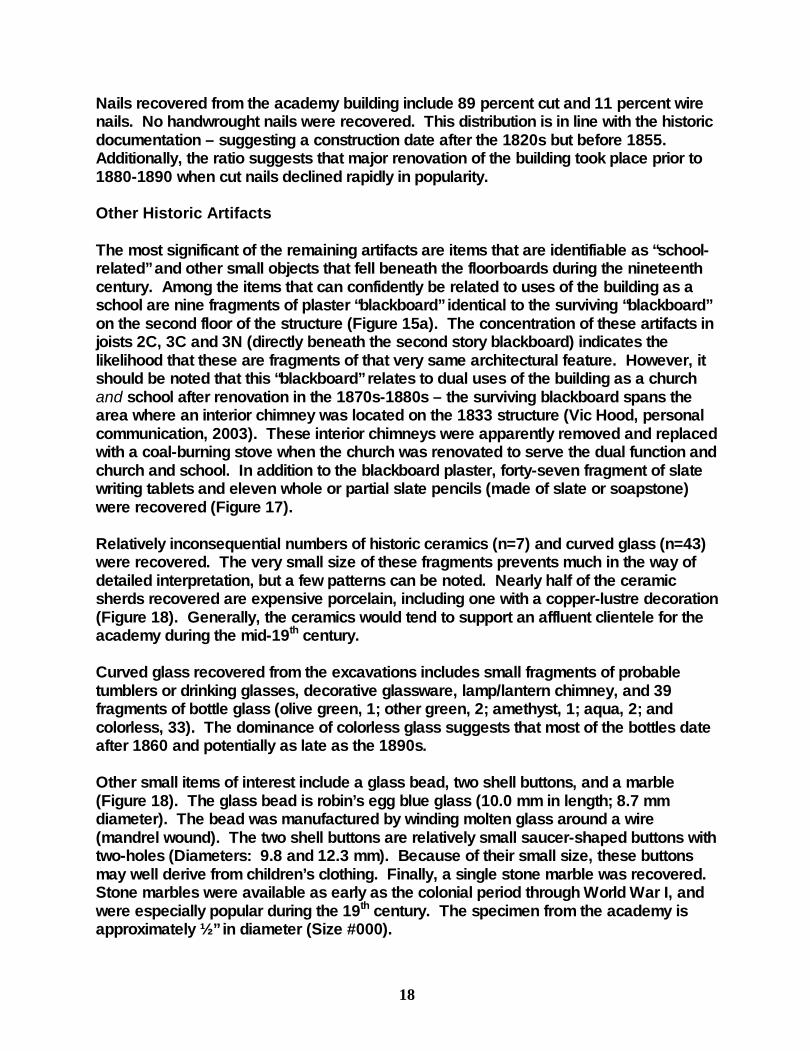
18
Nails recovered from the academy building include 89 percent cut and 11 percent wire nails. No handwrought nails were recovered. This distribution is in line with the historic documentation – suggesting a construction date after the 1820s but before 1855. Additionally, the ratio suggests that major renovation of the building took place prior to 1880-1890 when cut nails declined rapidly in popularity.
Other Historic Artifacts The most significant of the remaining artifacts are items that are identifiable as “school-related” and other small objects that fell beneath the floorboards during the nineteenth century. Among the items that can confidently be related to uses of the building as a school are nine fragments of plaster “blackboard” identical to the surviving “blackboard” on the second floor of the structure (Figure 15a). The concentration of these artifacts in joists 2C, 3C and 3N (directly beneath the second story blackboard) indicates the likelihood that these are fragments of that very same architectural feature. However, it should be noted that this “blackboard” relates to dual uses of the building as a church and school after renovation in the 1870s-1880s – the surviving blackboard spans the area where an interior chimney was located on the 1833 structure (Vic Hood, personal communication, 2003). These interior chimneys were apparently removed and replaced with a coal-burning stove when the church was renovated to serve the dual function and church and school. In addition to the blackboard plaster, forty-seven fragment of slate writing tablets and eleven whole or partial slate pencils (made of slate or soapstone) were recovered (Figure 17). Relatively inconsequential numbers of historic ceramics (n=7) and curved glass (n=43) were recovered. The very small size of these fragments prevents much in the way of detailed interpretation, but a few patterns can be noted. Nearly half of the ceramic sherds recovered are expensive porcelain, including one with a copper-lustre decoration (Figure 18). Generally, the ceramics would tend to support an affluent clientele for the academy during the mid-19th century. Curved glass recovered from the excavations includes small fragments of probable tumblers or drinking glasses, decorative glassware, lamp/lantern chimney, and 39 fragments of bottle glass (olive green, 1; other green, 2; amethyst, 1; aqua, 2; and colorless, 33). The dominance of colorless glass suggests that most of the bottles date after 1860 and potentially as late as the 1890s. Other small items of interest include a glass bead, two shell buttons, and a marble (Figure 18). The glass bead is robin’s egg blue glass (10.0 mm in length; 8.7 mm diameter). The bead was manufactured by winding molten glass around a wire (mandrel wound). The two shell buttons are relatively small saucer-shaped buttons with two-holes (Diameters: 9.8 and 12.3 mm). Because of their small size, these buttons may well derive from children’s clothing. Finally, a single stone marble was recovered. Stone marbles were available as early as the colonial period through World War I, and were especially popular during the 19th century. The specimen from the academy is approximately ½” in diameter (Size #000).

19
Among the bulk materials recovered (Table 4) are relatively significant quantities of coal. Coal was not readily available as a fuel source in Middle Tennessee until after the Civil War. The consistent presence of coal in the subfloor deposits suggests that the stove installed during the late 19th-century renovations to the academy was coal-burning. The greatest density of the fragments of coal is found in the vicinity of the joists (10C, 11C) where the stove was located based on other architectural information (Vic Hood, personal communication, 2003). The rest of the historic period artifacts from the academy appear related to “modern” use of the structure as a barn/storage building during the twentieth century (fence wire and staples, cotter pins, etc.).
Figure 17. Slate tablet and pencil fragments.
Figure 18. Other Small Finds (left to right: porcelain, marble, buttons, bead)

Table 1. Summary of Historic Artifacts from Beneath the Academy Building.
JOIST SECTION 2C 3C 3N 4C 4N 5C 6C 7C 8C 9C 10C 11C 12C 13C 14C 15C 16C 17C Totals KITCHEN GROUP Ceramics 1 1 1 1 2 1 7 Glass, Bottle 3 2 4 1 1 1 1 4 1 1 1 1 1 5 5 6 38 Glass, pharmaceutical 1 1 Glass, tumbler 1 1 2 Glassware 1 1 Utensil handle, bone 1 1 ARCHITECTURAL Glass, painted 3 2 1 1 2 1 10 Glass, window 37 69 287 82 65 73 107 104 79 98 79 67 46 27 41 38 19 45 1363 Nail, Cut 9 3 24 8 8 10 12 15 13 9 5 4 7 2 7 13 9 10 168 Nail, wire 1 1 5 1 1 1 2 8 20 Tack, wire 1 2 3 Wood, structural 1 4 3 2 4 7 21 Plaster/wallpaper 3 3 Screw 1 1 FURNITURE Lamp chimney 1 1 ARMS 0.22 calibre rimfire 1 1 CLOTHING Aglet, shoelace 1 1 Bead, glass 1 1 Button, shell 1 1 2 TOYS Marble 1 1 SCHOOL RELATED Blackboard 5 3 1 9 Slate tablet 3 1 3 1 3 1 5 7 3 4 10 1 1 2 1 1 47 Slate pencil 1 1 2 2 2 1 1 1 11 MODERN Wire, fence 1 2 1 1 2 1 8 Staple, fence 1 2 3 Pin, cotter 1 1 2 Golf tee 1 1 Burlap/canvas 2 2 Unidentifable iron 1 1 1 1 1 1 3 3 12
Totals 63 84 325 96 80 87 130 136 107 118 99 77 57 36 56 69 38 83 1741
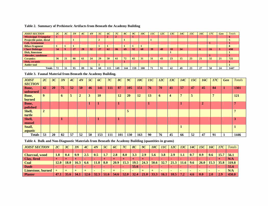
Table 2. Summary of Prehistoric Artifacts from Beneath the Academy Building JOIST SECTION 2C 3C 3N 4C 4N 5C 6C 7C 8C 9C 10C 11C 12C 13C 14C 15C 16C 17C Gen Totals Mississippi Triangular 1 2 2 1 6 Projectile point, distal 1 2 1 1 5 Celt, Greenstone 1 1 Biface fragment 1 1 1 1 1 1 1 1 8 Chert Debitage 34 9 27 28 32 27 62 86 69 92 68 39 48 18 34 6 16 3 698 Disk, limestone 1 1 Abrader, sandstone 1 1 Ceramics 36 21 66 61 24 29 50 61 72 65 31 31 43 23 15 23 21 32 21 725 Disk, ceramic 1 1 Antler tool 1 1
Totals 72 31 95 89 56 60 115 149 144 159 100 71 91 42 49 23 27 50 24 1447
Table 3. Faunal Material from Beneath the Academy Building.
JOIST SECTION
2C 3C 3N 4C 4N 5C 6C 7C 8C 9C 10C 11C 12C 13C 14C 15C 16C 17C Gen Totals
Bone, unburned
42 20 75 52 50 46 141 111 87 105 151 76 70 41 57 47 45 84 1 1301
Bone, burned
9 6 5 2 3 10 12 20 12 13 6 4 7 5 7 121
Bone, polished
1 1 1 1 1 2 7
Shell, turtle
2 5 7
Shell, mussel
1 1 1 3
Snail, aquatic
1 1
Totals 53 20 82 57 52 50 153 111 101 130 163 90 76 45 66 52 47 91 1 1446
Table 4. Bulk and Non-Diagnostic Materials from Beneath the Academy Building (quantities in grams)
JOIST SECTION 2C 3C 3N 4C 4N 5C 6C 7C 8C 9C 10C 11C 12C 13C 14C 15C 16C 17C Totals Charcoal, wood 1.8 0.4 0.9 2.5 0.5 1.7 2.8 8.0 3.3 2.9 5.6 3.8 2.9 1.1 0.7 0.9 0.6 15.7 56.1 Clay, fired + + + - - + + + + + - - - - - - - + N/A Coal 12.0 18.0 16.3 6.6 11.8 8.0 20.9 15.3 19.5 24.3 50.6 32.7 21.3 11.6 9.6 26.0 15.3 35.8 319.8 Daub - - - - - - - - 55.6 - - - - - - - - - 55.6 Limestone, burned + + + + - - + - - + + - - - - - - - N/A Plaster 47.1 35.6 34.1 12.6 32.3 51.6 54.6 52.0 32.4 21.0 33.3 16.1 10.5 7.2 4.6 0.0 2.0 2.9 450.0

22
PREHISTORIC ARTIFACTS
A large quantity of prehistoric artifacts (n=1447) was also recovered from the deposits beneath the academy floor (Table 2). These artifacts were classified according to a relatively standard system used by Kevin Smith and Michael Moore in the analysis of Mississippian period artifacts from numerous sites in the Nashville Basin (cf. Moore and Smith 1993, 2001; Smith and Moore 1996). Most of the prehistoric artifacts are primarily of interest only to the archaeologist – waste created during the manufacture and maintenance of stone tools and small fragments of broken plain pottery. However, several objects of broader interest and significance were recovered – and several patterns can be noted in their distribution. For example, the density distribution of prehistoric artifacts offers some suggestions of the presence of prehistoric structures or pits (Figure 19). Of particular significance is the distribution of “daub.” The typical Mississippian house in Middle Tennessee was of wattle-and-daub construction – the walls were constructed of woven cane mats plastered with clay. While fired or sun-dried clay was found in many of the joist sections, the only concentration of fired/dried clay showing impressions of cane/matting was found in Joist 8C. In conjunction with the density of other prehistoric artifacts, this suggests the probability that a prehistoric structure was located in this vicinity and might be preserved beneath the rodent-disturbed deposits.
Figure 19. Density distribution of prehistoric artifacts.

Table 5. Detailed Ceramic Inventory from Beneath the Academy Building. JOIST SECTION 2C 3C 3N 4C 4N 5C 6C 7C 8C 9C 10C 11C 12C 13C 14C 15C 16C 17C Gen Totals Grit-tempered body 1 1 2 Grit/shell tempered body 1 1 Shell/grog tempered body 1 1 Bell Plain, body/rim 2 1 2 3/2 6 4 5 4 9 5/2 1/1 1 3 3 1 1 3 59 Bell Plain, notched appliqué strip 1 1 2 Mississippi Plain, notched appliqué strip
1 1 1 1 4
Fine-shell tempered, gray paste 1 1 2 O’Byam Incised, var. Stewart 1 1 Kimmswick Fabric Impressed 1 1 2 Kimmswick Plain 0/1 0/1 2 Mississippi Plain, handle 1 1 1 3 Mississippi Plain body/rim 29/4 18/2 58/4 56 14/4 23/1 43 51/3 56/2 54/2 27 28/1 36/3 16/4 14 22/1 19 28/1 14/2 640 Shell tempered cordmarked 1 1 Mississippi Plain, bifurcate lug 1 1 1 3 Matthews Incised, var. Manly 1 1
Totals 36 21 66 61 24 29 50 60 72 65 31 31 43 23 15 23 21 32 21 724
Table 6. Detailed Lithic Inventory from Beneath the Academy Building. JOIST SECTION 2C 3C 3N 4C 4N 5C 6C 7C 8C 9C 10C 11C 12C 13C 14C 15C 16C 17C Gen Totals Blocky Debris 15 1 6 6 13 4 10 22 11 23 9 0 12 3 2 1 138 Angular/shatter 10 3 2 4 7 8 23 29 32 28 14 18 15 9 20 2 4 228 Core fragments 1 2 2 1 6 Primary flakes 1 2 6 7 4 2 10 7 5 16 13 7 3 2 5 1 5 96 Secondary flakes 2 3 7 4 4 8 7 10 10 12 17 5 8 3 9 3 2 114 Tertiary flakes 6 0 6 6 4 3 12 18 9 14 15 8 10 1 1 3 1 117 PPK, Small triangular 1 2 2 1 6 PPK, distal 1 2 1 1 5 Abrader, sandstone 1 1 Biface fragment 1 1 1 1 1 1 1 1 8 Celt, Greenstone frag 1 1
Totals 36 11 28 28 32 30 65 88 71 95 70 39 48 18 34 0 6 18 3 720

24
Ceramic Artifacts (n=724) In contrast to the very small quantities of historic period ceramics from beneath the floorboards, many prehistoric ceramic sherds were discovered during the excavations. Unlike the historic school and church, prehistoric Native Americans used this part of the site for less restricted domestic residential functions. A detailed ceramic inventory is provided in Table 5. While the majority of the broken pieces of pottery are small, several of them have significant things to say about the time when this portion of the site was used by prehistoric peoples and the nature of the people who lived there. Of chronological importance are several distinctive vessel forms and decorative techniques. The vessel forms represented tend to suggest a long occupation of the Fewkes Mound Group spanning the two major defined periods of Mississippian occupation in the Nashville region. Vessel forms generally associated with A.D. 1000-1250 occupations include cylindrical neck bottles, outflaring wall bowls, and simple hooded bottles – all of which were recovered during these investigations. In addition, small quantities of shell-tempered cordmarked vessels and exterior fabric-impressed vessels were recovered – both tentatively associated with A.D. 1000-1250 occupations in the Nashville Basin (Figure 22). However, the majority of diagnostic artifacts suggest the primary occupation of the site was during the period from A.D. 1250-1450. The common presence of bowls exhibiting notched rim appliqué strips at the Fewkes site indicates a substantive occupation during this latter horizon of Mississippian occupation (Figure 21). Handle Dating Formula. Previous studies in the Ohio Valley have indicated that the form of handles on Mississippian vessels have temporal significance (Hilgeman 2000:212). Based on a ratio of handle thickness to width, Hilgeman (2000:129) defined the following classes of closed handles: a) loop handles exhibiting ratios of 1.0-0.75; b) narrow intermediate handles with ratios of 0.74-0.57; c) wide intermediate handles with ratios of 0.56-0.39; and d) strap handles with ratios of 0.38-0.10. Wesler (2001:99-100) proposed a formula designed to generate approximate dates for Mississippian handles at the Wickliffe site in western Kentucky:
Date=A.D. 1500-[500*(thickness/width)]
Although this formula has not been widely tested (or accepted) by researchers outside the Wickliffe area, recent application to handle measurements from several sites in the Nashville Basin demonstrates a strong correlation between radiocarbon dates and dates resulting from associated handles. Three handles (Figure 23) recovered from beneath the academy were sufficiently intact to permit measurement and application of the formula. Joist 5C produced a narrow-intermediate handle yielding a date of A.D. 1194. Joists 8C and 17C produced one strap handle each, yielding dates respectively of A.D. 1408 and A.D. 1416. Results from the application of this formula in the Nashville Basin should be viewed with a

25
measure of caution until additional systematic testing is done. However, the results from Fewkes are consistent with other artifactual evidence from the site. Perhaps the most significant single artifact recovered was a small fragment of a ceramic type known as O’Byam Incised variety Stewart (Figure 20). Prior to the discovery of this sherd, only eight fragments of this ceramic type had been identified from sites in the Nashville Basin, all of which are clustered in a tight geographic area directly north of the Fewkes site (Smith et al 2004). Comparative data suggests that this decorative technique probably dates to the period from A.D. 1325-1450 (Smith et al 2004).
Figure 20. O’Byam Incised var. Stewart sherd from beneath the academy
Figure 21. Bowl sherds from beneath the academy with notched rim appliqué strips.

26
Figure 22. Exterior Fabric-impressed ceramics.
Figure 23. Handles (left: bifurcate lug open handle form ; right: strap closed handle form)
27
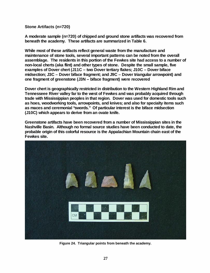
Stone Artifacts (n=720) A moderate sample (n=720) of chipped and ground stone artifacts was recovered from beneath the academy. These artifacts are summarized in Table 6. While most of these artifacts reflect general waste from the manufacture and maintenance of stone tools, several important patterns can be noted from the overall assemblage. The residents in this portion of the Fewkes site had access to a number of non-local cherts (aka flint) and other types of stone. Despite the small sample, five examples of Dover chert (J11C – two Dover tertiary flakes; J10C – Dover biface midsection; J3C – Dover biface fragment; and J9C – Dover triangular arrowpoint) and one fragment of greenstone (J3N – biface fragment) were recovered Dover chert is geographically restricted in distribution to the Western Highland Rim and Tennesseee River valley far to the west of Fewkes and was probably acquired through trade with Mississippian peoples in that region. Dover was used for domestic tools such as hoes, woodworking tools, arrowpoints, and knives; and also for specialty items such as maces and ceremonial “swords.” Of particular interest is the biface midsection (J10C) which appears to derive from an ovate knife. Greenstone artifacts have been recovered from a number of Mississippian sites in the Nashville Basin. Although no formal source studies have been conducted to date, the probable origin of this colorful resource is the Appalachian Mountain chain east of the Fewkes site.
Figure 24. Triangular points from beneath the academy.

28
Additional noteworthy discoveries include six whole or partial triangular Mississippian arrow points (Table 7; Figure 24) and a limestone disk (J13C – 38.4 mm diameter; 10.6 mm thickness – Figure 25).
Table 7. Small Triangular measurements (millimeters; *=broken)
Length Width Thickness J06C 20.24* 15.65 5.44 J06C 13.88* 20.72 3.81 J02C (incurvate base) 19.94* 15.98 5.29 J07C 40.0* 12.85 6.18 J09C (Dover) 24.11 15.43 4.37 J07C 22.00 18.00 3.48
Figure 25. Limestone disk
FAUNAL REMAINS
Relatively large quantities of animal bone (n=1446) were recovered from beneath the floorboards. Given the mixed nature of the deposits, a detailed analysis of the remains does not appear warranted. A large percentage of the bones are clearly from animals that resided and died beneath the floorboards of the building over the past century or so. Identifiable bones noted during the cataloguing include mice, rats, groundhogs, cats, opossums, raccoons, and turtles. While some of the bones are undoubtedly related to prehistoric and historic human activities in the location, the disturbance by later animal occupants does not permit much further interpretation.

29
YARD EXCAVATIONS OUTSIDE THE ACADEMY
As noted above, additional test excavations were conducted in February and March 2004 in selected “yard” areas. Initially, testing was to consist of a series of excavation units in the postulated vicinity of Mound 5 to ensure that proposed handicapped parking and sidewalk access areas did not impact potential surviving remnants of this mound. As the park development plans were formalized, testing was expanded in consultation with city officials and the state archaeologist to include eight excavation units (Figure 26) in four “areas:” 1) Handicapped parking and access areas; 2) Sidewalk/trail areas and possible subsurface utility lines between the academy building and Moore’s Lane; 3) a proposed bicycle path extension on the eastern portion of the site; and 4) a proposed new access road from Moore’s Lane. A grid was established by placing an eight-inch iron spike designated as N1000E1000 at the northwest corner of the academy building. This point was also used as the standard benchmark for elevations recorded on field forms. The metric grid was aligned with the current west-facing wall of the academy building. Additional eight-inch iron spikes were placed at N1010E1000 and N1020E1000. These spikes were driven beneath the current ground surface and remain in place to serve as benchmarks.
Figure 26. Location of Excavation Units, 2003-2004

30
With the exception of the “Bike Path Unit,” all excavations units were one meter squares oriented with the grid and designated by the southwest corner. In general, excavations proceeded in arbitrary 20-centimeter levels and included screening soil through ¼-inch hardware mesh to recover artifacts. Handicapped Parking and Sidewalk Areas Three excavation units (N1030E990; N1040E990; N1040E999) were placed adjacent to the proposed handicapped access areas on the northwestern corner of the park. These excavations were designed to determine whether any remnants of Mound 5 might be impacted by these facilities. As anticipated, the current “farm road” and sloping bank in this location appears to be a relatively modern feature of the landscape and has probably removed most if not all of the midden and features that once existed in this portion of the site.
Figure 27. Area Shot showing N1040E990, entrance from Moore’s Lane and bank.
Based on the results from the three units, the placement of the handicapped parking area and sidewalk on the current farm road, informal parking area and slope in this vicinity are unlikely to impact any intact midden or features. Detailed information on each excavation unit is provided following.

31
Unit N1040E999 This unit was placed at the base of the slope adjacent to the proposed handicapped parking and sidewalk on the northern periphery of the National Register boundary. Level 1 was largely sterile (shown as “sterile loamy clay”) – the artifacts listed in Tables 8-13 under Level 1 all derived from the exposure of the strata labeled “(displaced?) midden in the profiles. This zone appears to be colluvium/slopewash. Level 2 consisted of a dark black midden soil mottled with subsoil clay. Although this zone might represent remnants of intact midden or feature fill, it is interpreted as displaced or redeposited midden. While perhaps speculative, in the field it resembled a “load of midden” brought from elsewhere on the site as landscaping or fill material perhaps related to cutting of the existing road/parking area. Siltstone “bedrock” was encountered at the base of the “displaced midden.”
Unit 1040E990 Similar to N1040E999 this unit was placed near the base of the slope adjacent to the proposed handicapped parking and sidewalk on the northern periphery of the National Register boundary. Level 1 consisted of a shallow sterile loamy clay (again probably slopewash). Level 2 consisted of generally sterile dense clay mixed with siltstone fragments. Excavation in this unit was terminated after hacking out a few centimeters of a siltstone “bedrock” beneath the clay deposit.
Figure 28. Profiles for Unit N1040E999
Figure 29. Profiles for Unit N1040E990.

32
N1030E990 This unit was also placed in the general location of the proposed handicap access sidewalk leading from the proposed parking area on the northern periphery of the National Register boundary. While this unit was located on the more level ground above the slope to the north, it also indicates substantial landscape modification in the portion of the site. Level 1 consisted of approximately 25 cm of loamy clay with very few artifacts. Beneath this zone, a stratum of essentially sterile fine-grained clay sediment was encountered.
Figure 30. Profiles for N1030E990.

33
Academy Entrance Trails/Utility Lines
Two excavations units (N985E980; N1005E981) were placed between the academy building and Moore’s Lane in locations of proposed trails leading to the academy entrance (and in areas that might be impacted by placement of subsurface utility lines).
Figure 31. N985E980 showing exposure of intact 19th century midden.
N985E980
This portion of the site is largely undisturbed below current ground surface. Approximately 10-15 cm of appeared to be disturbed and mixed “plowzone” deposit containing fragmented historic and prehistoric artifacts. At 10-12 cm below the current ground surface, an intact and dense nineteenth-century midden or trash-filled feature was encountered consisting of large brick fragments, nails, and other historic artifacts (Figure 31). Beneath that zone, what appears to be a transitional strata containing both 19th century and prehistoric artifacts was identified. Underlying this transitional zone, an intact purely prehistoric midden deposit was identified. After identifying the intact prehistoric midden, the unit excavation was terminated at 40 cm below current ground surface – the prehistoric midden continued beneath the base of this excavation unit to an undetermined depth.
Figure 32. Profiles of N985E980.
34
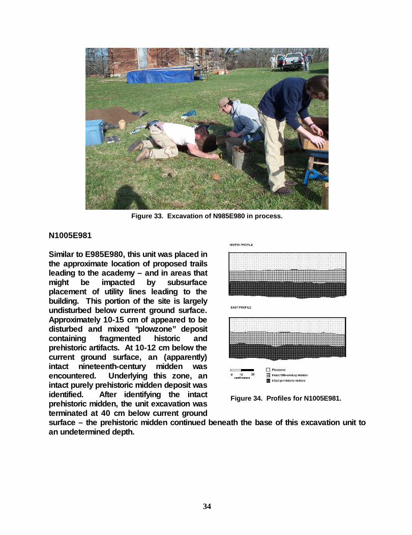
Figure 33. Excavation of N985E980 in process.
N1005E981 Similar to E985E980, this unit was placed in the approximate location of proposed trails leading to the academy – and in areas that might be impacted by subsurface placement of utility lines leading to the building. This portion of the site is largely undisturbed below current ground surface. Approximately 10-15 cm of appeared to be disturbed and mixed “plowzone” deposit containing fragmented historic and prehistoric artifacts. At 10-12 cm below the current ground surface, an (apparently) intact nineteenth-century midden was encountered. Underlying this zone, an intact purely prehistoric midden deposit was identified. After identifying the intact prehistoric midden, the unit excavation was terminated at 40 cm below current ground surface – the prehistoric midden continued beneath the base of this excavation unit to an undetermined depth.
Figure 34. Profiles for N1005E981.

35
Proposed Highway Access Road
After notification that plans might require cutting a new driveway access from Moore’s Lane, two excavation units (N927E969; N917E961) were placed to assess potential impacts in this area. Both of these units are probably located at the fringes of the former Mound 2 (largely excavated by Myer in 1920). Both units demonstrate that the upper 7-10 inches of soil has been disturbed and/or redeposited, although this may not be fully characteristic of the surviving deposits in the immediate area because of redeposited wash from Myer’s 1920s excavations. However, in both instances, intact prehistoric midden and features were encountered. Given that this area is listed as one containing “scattered graves” in Myer’s map, any extensive ground disturbance in this area should be approached with caution. N927E969 Immediately beneath the sod, a zone of dark humic clay approximately 20 centimeters in thickness was excavated. The zone was largely void of artifacts and appears to be relatively recently redeposited soils – possibly slopewash resulting from Myer’s excavation directly to the east. Beneath this zone, largely undisturbed prehistoric midden was encountered containing relatively substantial quantities of prehistoric artifacts and charcoal. This zone extends from about 20 cm below current surface to about 40 cm below the current surface. At the base of this midden, three (prehistoric?) postholes were identified. As the profiles illustrate, at least one and probably all of these postholes appear to originate near the top of the preserved midden – but were not distinguishable except in profile. Two of these postholes were excavated, both terminating at approximately 95-100 cm below the current ground surface. Excavations were continued into zone 3 – consisting of approximately 30 cm of largely sterile loose yellow-brown, fine-grained silt. Except for the postholes, excavation was terminated at approximately 70 cm below the current surface.
Figure 35. Profiles for N927E969.
36
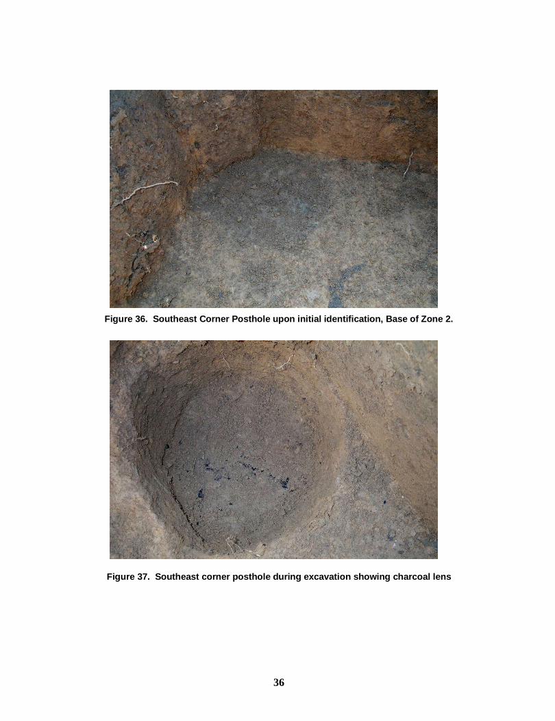
Figure 36. Southeast Corner Posthole upon initial identification, Base of Zone 2.
Figure 37. Southeast corner posthole during excavation showing charcoal lens

37
Figure 38. Plan View of N927E969 at base of unit (and posthole profiles originated at base of unit)
Figure 39. Base of N927E969 after excavation of postholes (note that the photo is facing south)

38
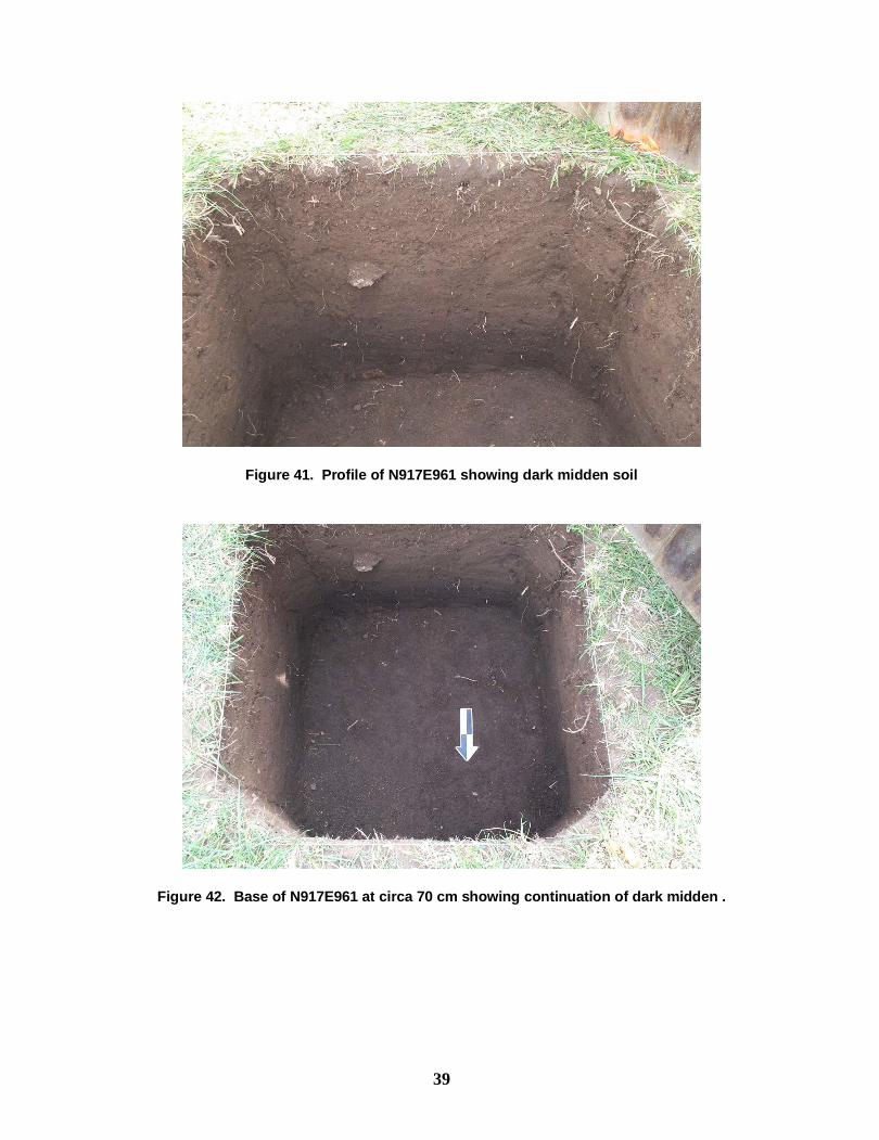
N917E961 Immediately beneath the sod, an approximately 25 cm thick zone of dense gravelly clay and stream worn pebbles was encountered. This zone may be related to landscaping related to construction of State Route 441. Beneath this strata was a (transitional?) zone approximately 10 cm in thickness very similar to that above, but without stream worn pebbles. This zone was underlain by approximately 12 cm of largely culturally sterile light brown loamy clay. At approximately 40 cm below current surface, intact prehistoric midden was encountered, including daub, charcoal, and other artifacts. The unit was continued to a depth of about 70 centimeters below current surface – the midden continued to an undetermined depth. However, probing suggests continuation of a similar soil matrix to 30-35 additional centimeters, suggesting the midden may continue to a depth of approximate 1 meter below current surface.
Figure 40. Profiles for N917E961
39
Figure 41. Profile of N917E961 showing dark midden soil
Figure 42. Base of N917E961 at circa 70 cm showing continuation of dark midden .

40
Bike Path Unit Finally, a 1.0 meter by 50 centimeter excavation unit was placed adjacent to the proposed bicycle path extension on the eastern periphery of the site. This unit was not oriented with the grid, but rather was placed in alignment with the current farm road on the cut bank to establish a stratigraphic profile. The resulting profiles indicate a relatively thick layer of slope wash overlying intact midden and prehistoric features. Although the small size of the unit does not permit firm interpretations, at least three postholes were encountered intrusive into what appear to be two or more overlapping pit features.
Comparison of the elevations of the strata and the current surface of the farm road is revealing. The current surface of the farm road is approximately even with the base of colluvial deposits shown in the South and North profiles of the unit. This suggests that the scatter of artifacts in the farm road is the result of the erosion of prehistoric midden and features exposed during road construction. The “protecting” zone of slope wash has been removed in this area, and any further ground-disturbance in the farm road area is likely to impact portions of intact features and/or midden.
Figure 43a. "West" profile of BikePath Unit.
Figure 43b. "North and South" profiles of BikePath unit.

41
Figure 44. Bike Path “West” profile.

42
ARTIFACTS FROM YARD AREA EXCAVATIONS Artifacts (n=1621) recovered from the yard area excavations were also cleaned and analyzed at the MTSU Archaeology Laboratory. Tables 8-11 summarize these artifacts including 148 historic period artifacts, 1,104 prehistoric artifacts, 369 animal bones (and fragments); and numerous bulk materials such as wood charcoal, fired/burned clay fragments, coal, daub, burned limestone, and plaster.
HISTORIC PERIOD ARTIFACTS (n=148) The distribution of historic period artifacts in the “yard area” varies widely (Table 8). Excluding items interpreted as modern surface scatter (modern glass bottle fragments, fence wire and staples, etc), the only significant concentration of historic artifacts was identified in N985E980 (62% of total) and to a lesser extent in N1005E981 (24% of total). The density of historic period artifacts in N985E980 appears related to a trash dump or trash-filled feature established during use of the building as the academy from 1833 to the Civil War or later. The scatter of brick rubble and artifacts is exposed in the erosional gully only a few meters to the south of this unit, and we suspect that the deposit is continuous. Although few of the artifacts are tightly diagnostic, the presence of a single “flow blue” ceramic sherd in the midden suggests a likely date range of 1844-1860 (although this decorative technique was briefly reintroduced from 1900-1910). Other artifacts from this deposit also suggest an early academy-related deposit – including the significant quantities of slate tablet fragments, fragments of early wine bottles, tobacco pipes (Figure 45), a clothing rivet (17.2 mm diameter, 8.0 mm thickness), and a bone button (saucer-shaped, 4-hole, 16.3 mm diameter, and 2.6 mm thickness). The pipe fragments represent at least two different snub-stem pipes (a type used with a separate reed for the stem) – two unglazed fragments that might come from the same pipe include a stem and fluted bowl; the other is a glazed redware fluted bowl. The location of this midden or feature in relation to the academy suggests that it was at least initially created during the earlier period of building use. The original 1833 door of the academy faced south, and the deposits in both N985E980 and N1005E981 would have been to the side and rear of the building as configured at that time (Vic Hood, personal communication, 2003). With relocation of the door to the west with the renovations in the 1870s or 1880s, it seems unlikely that a trash deposit would have been established in the “front yard” area. The area may have continued to be used as a trash dump during later uses of the structure – while the sample is much too small to permit any valid conclusions, the window glass sample from this unit produces dates of A.D. 1861 (Moir) and A.D. 1871 (Orser). Unfortunately, the limited sample does not provide sufficient numbers of tightly diagnostic artifacts to assess variation from the early to late 1800s. Regardless, the excavations and artifact analysis clearly suggest that the western yard area holds intact nineteenth-century deposits that should be avoided in terms of ground-
43
disturbing activity. Even the upper disturbed midden zones are largely “pristine” in terms of accumulated twentieth-century garbage and could provide some relatively unique information about landscape use at nineteenth-century Tennessee schools.
PREHISTORIC ARTIFACTS (n=1104) As one might expect from the more intensive use of the site during the prehistoric period – an entire town full of buildings and peoples versus a single special-use structure – the distribution of prehistoric artifacts is much more consistent in the excavation units. The notable areas of low density are on the northern periphery of the site, where substantial prior ground disturbance during construction of the old farm road has apparently removed most of the midden and features. Once again, the seemingly most mundane artifacts offer some intriguing clues to what lies beneath the surface in several areas tested. While fired clay is found in the majority of the excavation units, fragments of “daub” – the wall plaster from prehistoric structures – were only identified in two areas – N917E961 and N1005E981. This distribution suggests the potential presence of prehistoric structures in the vicinity of these two excavation units (and is corroborated by the general density of domestic refuse such as chert debitage and pottery sherds). Ceramic Artifacts Similar to the pattern beneath the floorboards, prehistoric ceramics (n=672; Table 12) were much more common than historic ceramics. In general, the patterns replicate those from the academy excavations – including the presence of bowls with notched rim appliqué strips (Figure 46) and shell-tempered cordmarked sherds. One difference of note is a single small sherd of a type known as Beckwith Incised from N917E961. Based on research at other Nashville area sites, this type seems to be confined chronologically to about A.D. 1325-1450 – and may actually be more restricted to the latter half of that timeframe. In general, the ceramics from the yard area excavations indicate an occupation spanning approximately three centuries from A.D. 1100 or so through 1450. Stone Artifacts A moderate sample (n=458) of chipped and ground stone artifacts was recovered from the yard area excavations (Table 9). Again, while most of these artifacts reflect general waste from the manufacture and maintenance of stone tools, two specific artifact classes are of particular interest. With some astonishment, we recovered a nearly perfect Dover celt (Figure 47) from the prehistoric midden in N1005E981. Given the rarity of this artifact type at local sites and the previously mentioned concentration of daub in this unit, we reiterate the likelihood of a structure in this vicinity.

44
In addition, three more whole or partial triangular Mississippian arrowpoints were recovered in different widely separated excavation units (Table 14; Figure 48).
Table 14. Small Triangular Measurements (millimeters)
Length Width Thickness N917E961 Level 3 28.91
(estimated) 17.28 6.72
N1005E981 Level 2 (incurvate base)
35.16 14.85 4.67
“Bike Path” Level 1 17.77 (estimated)
16.58 4.40
FAUNAL REMAINS
Moderate quantities of animal bone (n=369) were recovered from the yard area excavations. Unlike the academy animal bones, the majority of these were recovered from intact midden deposits that can be confidently associated with distinct historic or prehistoric zones. Although a detailed analysis of these remains is outside the scope of this report, future analysis could yield significant information related to the historic and prehistoric occupations at the site.
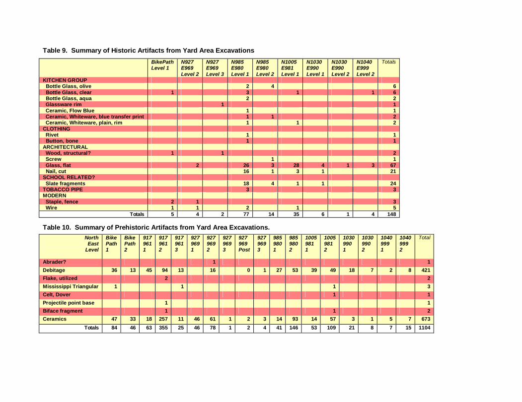
Table 9. Summary of Historic Artifacts from Yard Area Excavations
BikePath Level 1
N927 E969 Level 2
N927 E969 Level 3
N985 E980 Level 1
N985 E980 Level 2
N1005 E981 Level 1
N1030 E990 Level 1
N1030 E990 Level 2
N1040 E999 Level 2
Totals
KITCHEN GROUP Bottle Glass, olive 2 4 6 Bottle Glass, clear 1 3 1 1 6 Bottle Glass, aqua 2 2 Glassware rim 1 1 Ceramic, Flow Blue 1 1 Ceramic, Whiteware, blue transfer print 1 1 2 Ceramic, Whiteware, plain, rim 1 1 2 CLOTHING Rivet 1 1 Button, bone 1 1 ARCHITECTURAL Wood, structural? 1 1 2 Screw 1 1 Glass, flat 2 26 3 28 4 1 3 67 Nail, cut 16 1 3 1 21 SCHOOL RELATED? Slate fragments 18 4 1 1 24 TOBACCO PIPE 3 3 MODERN Staple, fence 2 1 3 Wire 1 1 2 1 5
Totals 5 4 2 77 14 35 6 1 4 148 Table 10. Summary of Prehistoric Artifacts from Yard Area Excavations.
North East
Level
Bike Path 1
Bike Path 2
917 961 1
917 961 2
917 961 3
927 969 1
927 969 2
927 969 3
927 969 Post
927 969 3
985 980 1
985 980 2
1005 981 1
1005 981 2
1030 990 1
1030 990 2
1040 999 1
1040 999 2
Total
Abrader? 1 1
Debitage 36 13 45 94 13 16 0 1 27 53 39 49 18 7 2 8 421
Flake, utilized 2 2
Mississippi Triangular 1 1 1 3
Celt, Dover 1 1
Projectile point base 1 1
Biface fragment 1 1 2
Ceramics 47 33 18 257 11 46 61 1 2 3 14 93 14 57 3 1 5 7 673
Totals 84 46 63 355 25 46 78 1 2 4 41 146 53 109 21 8 7 15 1104

Table 11. Faunal material from Yard Area Excavations.
BikePath Level 1
BikePath Level 2
N917 E961 Level 1
N917 E961 Level 2
N917 E961 Level 3
N927 E969 Level 1
N927 E969 Level 2
N0927 E969 Posthole (SW)
N985 E980 Level 2
N1005 E981 Level 1
N1005 E981 Level 2
N1030 E990 Level 1
N1030 E990 Level 2
N1040 E999 Level 2
Totals
Bone 17 13 7 119 2 10 17 1 50 50 4 6 6 302
Bone, burned 6 6 1 12 2 5 12 7 7 2 2 62
Bone, cut marks 1 1
Bone, tortoose shell 4 4
Totals 23 19 8 135 4 15 18 1 62 7 57 4 8 8 369
Table 12. Bulk and Non-diagnostic material from Yard Area Excavations.
Bike Path L 1
Bike Path L2
N917 E961 L1
N917 E961 L2
N917 E961 L 3
N927 E969 Level 1
N927 E969 Level 2
N0927 E969 Post (SW)
N929 E969 Post (W)
N927 E969 Level 3
N985 E980 Level 1
N985 E980 Level 2
N1005 E981 Level 1
N1005 E981 Level 2
N1030 E990 Level 1
N1030 E990 Level 2
N1040 E999 Level 1
N1040 E999 Level 2
Brick (2 liters)
(5 whole/partial)
Charcoal, wood
1.48 1.87 0.39 5.25 0.94 22.28 0.06 3.51 0.31 14.63 0.25 1.07
Clay, fired 41.67 12.01 18.15 69.79 20.55 6.05 0.51 515.12 27.97 132.41 304.49 5.12 0.31
Coal 2.86 19.24 1.67 12.3 0.43 1.35
Daub 11.73 11.21
Limestone, burned
7 3 1 16 9 2 1 3 2 2 4 2 6
Plaster 7.24 3.86
Quartz crystal
1

Table 13. Detailed Ceramic Inventory, yard area units.
North East
Level
Bike Path 1
Bike Path 2
917 961 1
917 961 2
917 961 3
927 969 1
927 969 2
927 969 3
927 969 Post
927 969 3
985 980 1
985 980 2
1005 981 1
1005 981 2
1030 990 1
1030 990 2
1040 999 1
1040 999 2
Total
Mississippi Plain (MP), Bifurcate lug
1 2 3
MP, Lug fragment 1 2 3 MP Body/rim 46/1 32/1 17/1 229/7 9/1 35/1 46/6 1 2 1/2 14 82/2 11 52/3 3 1 4/1 6/1 618 MP rim w/ node 1 1 MP , strap handle 1 1 MP , notched appliqué 1 2 3 MP, effigy fragment? 1 1 Shell Tempered cordmarked 2 2 Shell/grit tempered 5 5 Shell/grog tempered 3 3 Beckwith Incised 1 1 Kimmswick Plain 1 1 BP body/rim 10 6 4/1 5 3 2 31
Totals 47 33 18 257 11 46 61 1 2 3 14 93 14 56 3 1 5 7 672 Table 14. Detailed Lithic Inventory, yard area units
Bike Path Level 1
Bike Path Level 2
N917 E961 Level 1
N917 E961 Level 2
N917 E961 Level 3
N927 E969 Level 1
N927 E969 Level 2
N927 E969 Level 3
N985 E980 Level 1
N985 E980 Level 2
N1005 E981 Level 1
N1005 E981 Level 2
N1030 E990 Level 1
N1030 E990 Level 2
N1040 E999 Level 1
N1040 E999 Level 2
Totals
Abrader? 1 1
Core frag 1 1 2
Flake, primary 4 1 14 18 4 7 5 1 6 14 4 7 5 1 91
Flake, secondary 7 5 15 24 6 10 6 8 9 11 17 5 2 125
Flake, tertiary 11 4 7 26 2 4 2 4 13 13 15 2 4 3 110
Flake, utilized 2 2
Lithic, blocky debris 9 3 4 10 2 2 1 6 3 5 1 46
Lithic, shatter/angular debris
5 5 16 1 4 7 11 8 5 6 3 3 74
Mississippi Triangular 1 1 1 3
Celt, Dover 1 1
Late Archaic Stemmed
1 1
Biface fragment 1 1 2
37 16 45 98 14 27 17 1 27 53 39 52 18 7 2 8 458

48
Figure 45. Pipes
Figure 46. Bowl rims with notched appliqué strips

49
Figure 47. Dover celt
Figure 48. Small triangular arrow points.

50
IV. RESULTS AND RECOMMENDATIONS
Using the information from archaeological work conducted by Myer, DuVall & Associates, and the current MTSU project, several recommendations can be made:
· First and foremost, any activities that require ground-disturbing activities should be approached with caution across the entirety of the proposed park area – significant and important archaeological remains are to be found virtually everywhere within the National Register boundaries. The remainder of our recommendations should be taken with full recognition that only tiny portions of the site have been examined in past and present projects – they should not be expanded to general recommendations.
· On the northern periphery of the site, both DuVall shovel tests and MTSU test
units indicate that the existing farm road and adjacent slope have been modified to the extent that no intact prehistoric or historic features of archaeological interest are likely to be preserved. The proposed handicap parking lot and sidewalk are unlikely to damage or destroy any important information in this area.
· Both the DuVall shovel tests and MTSU test units suggest that the area directly
between the academy building and Moore’s Lane should be considered a highly sensitive area in terms of ground disturbance. While minimal surface disturbance (less than 4 inches) might be considered if these activities can be monitored by an experienced archaeologist, we recommend that any ground-disturbing activities be restricted. Incredibly well preserved prehistoric and historic features are likely to be encountered in this area – including prehistoric houses and an apparently pristine trash deposit from the 1800s. Perhaps contrary to “common sense,” the erosional gully just to the south of N985E980 should not be considered as an “already disturbed” area that could be used for placement of utility lines or road entrances without further consideration. Observations suggest that the “pristine” historic feature observed in N985E980 has already been exposed on the surface by this erosional feature – and would be immediately impacted by any ground disturbance.
· The MTSU test placed adjacent to the proposed bicycle path also may contradict
“common sense.” Although a dirt farm road is already present, the excavations clearly indicate that cutting of this farm road has already exposed the tops of intact prehistoric pits and postholes. These features are currently being eroded by surface exposure, but would probably be completely destroyed by any ground-disturbance in this area – in other words, the general “four-inch rule” would not apply in this vicinity. We recommend that placement of the bicycle path be accomplished with fill over the current ground surface rather than any cutting.

51
· Finally, both the DuVall shovel tests and MTSU excavations in the vicinity of the proposed new highway entrance indicate that this alternative should be reconsidered. Intact prehistoric midden and structures are clearly present throughout this area – we anticipate that any reasonable grade cut for a new entrance road would impact many important archaeological features. Myer’s investigations in this area, with some support from the DuVall shovel tests also indicate that this vicinity may contain substantial numbers of scattered prehistoric human graves. If substantial cutting to create a road grade would be necessary for the proposed highway entrance, this should be preceded by a larger scale archaeological project.
In summary, this relatively small-scale project using primarily volunteer labor has produced some significant new information about the distribution of artifacts, midden, and features within the boundaries of what is being developed as Primm Park. Many students have benefited from this partnership in terms of a significant opportunity to connect their “classroom work” with “real-life” field projects that benefit the local community. We also hope that it provides significant information that will both inform and facilitate proposed development of Primm Park by the City of Brentwood.

52
References Brock, Daniel H. 2003 Excavation of a Stone Filled Feature at Wynnewood State Historic Site, Sumner
County, Tennessee. Unpublished Manuscript Series No. 03-2. Tennessee Division of Archaeology, Nashville.
DuVall & Associates, Inc. 1996 Expanded Draft Report of Phase I Archaeological Investigation, State Route 441
(Moores Lane), Liberty Road to State Route 252 (Wilson Pike), Brentwood, Williamson County, Tennessee. Report submitted to De Leuw Cather & Company and Tennessee Department of Transportation. TDOA Permit #000223.
Jones, Joseph 1876 Explorations of the Aboriginal Remains of Tennessee. Smithsonian
Contributions to Knowledge 22(259):1-171. Washington D.C. Lassus, Joe 2003a Primm Family Facilitates Preservation of Boiling Springs Academy. The Bugle
5(3), Brentwood Historical Society. 2003b Fewkes Group Archaeological Site to Become Part of Primm Park. The Bugle
5(3), Brentwood Historical Society. McKee, Larry, Ted Karpynec, and Marc Wampler 2003 Archaeological Investigation of the Mansion Yard and Kitchen Wing at Carnton
Plantation, in Franklin, Williamson County, Tennessee. Volume I: Narrative Report. TRC, Inc. Nashville.
Moir, Randall W. 1982 “Windows to Our Past: A Chronological Scheme for the Thickness of Pane
Fragments from 1635-1982.” Unpublished paper in author’s file, Archaeology Research Program, Department of Anthropology, Southern Methodist University, Dallas, Texas.
1987 “Socioeconomic and Chronometric Patterning of Window Glass.” In Historic Buildings, Material Culture, and People of the Prairie Margin, edited by David H. Jurney and Randall W. Moir, pp. 73-81. Richland Creek Technical Series Volume V. Southern Methodist University, Dallas, Texas.
Moore, Michael C. and Kevin E. Smith (editors) 1993 A Report of the 1992 Archaeological Investigations at the Brandywine Pointe Site
(40Dv247), Davidson County, Tennessee. Tennessee Division of Archaeology, Department of Environment and Conservation, Report of Investigations No. 9. Nashville. 52 pp. 15 figs, 9 tables.

53
2001 Archaeological Investigations at the Rutherford-Kizer Site: A Mississippian Mound Center in Sumner County, Tennessee. Tennessee Division of Archaeology, Department of Environment and Conservation, Report of Investigations 13. Nashville. 396 pp. 103 figs, 33 tables, 8 appendices.
Myer, William Edward 1928 Two Prehistoric Villages in Middle Tennessee. 41st Annual Report, Bureau of
American Ethnology 1919-1924, pp. 485-614. Smithsonian Institution, Washington D.C.
Nelson, Lee H. 1968 Nail Chronology as an Aid to Dating Old Buildings. American Association for
State and Local History Technical Leaflet 48. History News 24(11). Orser, Charles E. 1983 “A Mean Flat Glass Dating Method for the Southesatern United States.”
Unpublished manuscript on file, Southeastern Archeological Center, Tallahassee, Florida.
Orser, Charles E., Jr.; Annete M. Nekola, and James L. Roark 1987 Exploring the Rustic Life: Multidisciplinary Research at Millwood Plantation, A
large Plantation in Abbeville County, South Carolina and Elbert County, Georgia. Russell Papers 1987, U.S. Army Corps of Engineers, Savannah District. Mid-American Resaerch Center, Loyola University of Chicago. Submitted to the U.S. National Park Service, Archeological Services Branch, Atlanta.
Roenke, Karl G. 1978 “Flat Glass: Its Uses as Dating Tool for Nineteenth Century Archaeological Sites
in the Pacific Northwest and Elsewhere.” Northwest Anthropological Research Notes, Memoir No. 4
Schoen, Christopher M. 1990 “Window Glass on the Plains: An Analysis of Flat Glass Samples from Ten
Nineteenth Century Plains Historic Sites.” Central Plains Archaeology 2(1):57-90.
Smith, Kevin E. 1998a William Edward Myer. In The Tennessee Encyclopedia of History and Culture,
edited by C. Van West, p. 665. Tennessee Historical Society, Rutledge Hill Press, Nashville.
1998b “Gordontown in Historical Perspective.” In Gordontown: Salvage Archaeology at a Mississippian Town in Davidson County, Tennessee edited by Michael C. Moore and Emanuel Breitburg, pp. 13-19. Tennessee Division of Archaeology, Research Series No. 11. Nashville

54
2004 (editor) Archaeology of the Old First Presbyterian Church of Murfreesboro. Report of Archaeological Investigations No. 2, Department of Sociology and Anthropology, Middle Tennessee State University. Forthcoming.
Smith, Kevin E., Daniel Brock, and Christopher Hogan 2004 Interior Incised Deep-Rimmed Plates from the Nashville Basin of Tennessee.
Manuscript submitted to Tennessee Archaeology. Under review May 2004. Smith, Kevin E. and Michael C. Moore 1996 The Hooper Site (40Dv234): A Mississippian Village in Davidson County,
Tennessee. Tennessee Division of Archaeology, Department of Environment and Conservation, Miscellaneous Publications No. 3. 47 pp., 18 figs, 11 tables, one appendix.
Smith, Samuel D. 1998 Tennessee Archaeology Awareness Week: Some Smith County Connections.
Smith County Historical and Genealogical Society Quarterly Newsletter 10(1):1-5.