Happy Valley Appreciation Club - Intellectual Property India
Upload
khangminh22Category
view
1download
0
www.ijcrt.org © 2021 IJCRT | Volume 9, Issue 3 March 2021 | ISSN: 2320-2882
IJCRT2103173 International Journal of Creative Research Thoughts (IJCRT) www.ijcrt.org 1328
Appreciation of Street Network Pattern around
Gandhi Hill Recreation Hub in Vijayawada through
Syntactic Approach for Spatial Cognition Prof. Srikonda Ramesh , Taraka TL and RNS Murthy
School of Planning and Architecture Vijayawada - INDIA
Abstract:
The aim of this study is to examine the relationship between urban spatial structure and movement taking the case of Gandhi hill –
recreation hub in one town area or downtown in Vijayawada. Accessibility is mainly based on connectivity networks which indicates
comprehending the connectivity of a particular activity to the whole immediate urban system and in turn emphasizes understanding
and to realize that and why the certain activity has its relative importance, in addition to the historical and cultural significance. This
has been achieved using Space syntax analysis. Although it seems plausible to understand how the movement if made on the basis of
these analyzes, the issue of why people travel through the vector network was seemed troublesome since the study does not include
any clear descriptions and explanations of either impulses or human intelligence. One possible explanation for the method's predictive
power is that the way people perceive their world and agree on behaviors of movement is somehow indirectly rooted implicitly in the
study of space syntax. Initially, the analyzed axial map that indicates the street which was drawn in Auto cad with reference to Google
maps in the selected recreation and heritage hub. Then, segment and axial map analysis to derive few topological and geometric
measures have been run in Depthmap X .028 version software. The obtained maps are plotted against the Intelligibility and Synergy
which helps in furthermore understanding of the said relationships. Finally, the results have been discussed with respect to spatial
cognition and morphological measures of the location. Syntactic approaches have been defined using domain-specific predictions and
functions which act as a basis for facts about the knowledge base's domain. Approximate reasoning is one of the important methods of
syntactic approaches for object detection and tracking.
Keywords: Space Syntax, Spatial analysis, Street network, axial map, Connectivity, Integration.
1. Introduction
In today’s fast growing world, the cities are developing in a much faster pace imbibing newer technologies in to
their systems. The structure of urban space in any given point of time is the consequence and at the same time
the origin of various social decisions (Attilia, 2007). The cultural diversity, pedestrian permeability and
interface catchments, social networking happening in a street level, interpret a significant part in assessing
character of a community, a neighborhood and in turn the city ultimately. Kevin Lynch states that, “the paths,
the network of habitual or potential lines of movement through the urban complex are the most potent means by
which the whole can be ordered.” (Lynch, 1960). Thus, analysis of patterns of street network at any given urban
setting helps in comprehending and perceiving most of the essential concepts in stating the city’s spatial and
functional systems and hence, how a city functions. The sustainable model of development of a settlement is
identified with the support of ‘ process', wherein the standards of living strengthens in a sense that,
manufacturing of social and economic goods does not compromise on the ecological credits, and also assure
their prolonged development (Attilia, 2007). Attilia (2007) also asserts, “The description of development
process is basically rooted in the schemes of human thinking or in the interpretation of phenomena observable
in nature”. Bill Hillier, the founder and designer of this theory states, “Spaces in city work in more than one
way, the foreground network is structured to maximize movement and it is so because, it is driven by micro
economic factors which benefit from high levels of movement” (Hillier.B, 1996). Bill Hillier, the founder and
www.ijcrt.org © 2021 IJCRT | Volume 9, Issue 3 March 2021 | ISSN: 2320-2882
IJCRT2103173 International Journal of Creative Research Thoughts (IJCRT) www.ijcrt.org 1329
designer of this theory states, “Spaces in city work in more than one way, the foreground network is structured
to maximize movement and it is so because, it is driven by micro economic factors which benefit from high
levels of movement” (Hillier.B, 1996).
Space syntax technique which was developed by Bill Hillier, Julienne Hanson, and other colleagues at Barlett
School of Architecture, University College London, has a major impact on understanding the pedestrian
movements in the city relative to spatial integration of the city structure (Jacoby, 2006). They designed a
morphological language, a grammar to define certain social spaces and conditions using elements like maps and
graphs. Space syntax emphasizes the relation between ‘abstract social relations’ and ‘physical space’ through
physical space characteristics (Attilia, 2007). In Durkheim’s view (Hanson. J, 1984) urban relations can be
interpreted through social solidarity; Solidarity or social cohesion can be realized in two ways: through local
networks and social networks overarching the whole urban society.
Hillier (Hanson.J, 1984) with UCL Space Syntax contend, Space syntax is based on two major postulations:
1. Space is not a background to human activity, but is intrinsic to it (Hillier B. &., 1984).”
2. Space is first and foremost configurationally to be addressed ,In other words, what happens in any
individual space – a room, corridor, street, or public space – is fundamentally influenced by the
relationships between that space and the network of spaces to which it is connected (Hillier B. &., 1984).”
In addition, it allows the comparison of spatial configurative analyses in relation to societal activities such as the
flow of pedestrian movements through streets, land use patterns, or the distribution of crime (O, 2005) (Van Nes
A, 2010). Today, space syntax research cannot be considered a specialized or novel field anymore. The
research is extending in various ways and links with other disciplines or research areas. (Karimi 2018). In its attempt to address the problem of how to better measure networking against science by evaluating spatial
types towards measurable functions rather than just human explanations, how people’s intuitions with respect to
movement can be studied, (Hanson. J, 1984) and (Hillier. B, 1996), Hillier and his colleagues postulated the
Space syntax theory. It simply puts human perceptions on the play and works on analytical figures and syntactic
variables, represents in terms of spatial configuration. Axial mapping was the first method used in predicting
movement and flow by Bill Hillier and his team and has since then become to be known as space syntax
(Hanson.J, 1984).
Space syntax as a static street network model that indicates dynamics is easy yet stable, enabling rapid syntactic
analysis of a number of cases (Akkelies van Nes, 2018). Akkelies explains, the approach for demonstrating the
actual spatial structure of buildings and towns can be used, The findings of the spatial analysis must be viewed
in accordance with the perception of social mechanisms and human behaviour. (Akkelies van Nes, 2018).
Representations of space
“The basic conceptions in space syntax analysis are:
- Convex space: It is a polygon in which all the lines drawn in between any two points lies inside the
polygon. No line traverses the perimeter of given polygonal space.
- Axial space: Or an axial line is the longest line that progress with convex polygons.
- Isovist space: This is the total vision angle and a three dimensional area that can be viewed from a single
point of space.”
“The spatial structure is measured using the syntactic maps, which are:
- Convex map: This represents a mass or a void in a given space. This consists of least number of convex
polygons connected with each other that entirely cover the area.
- Axial map: The map consists of the least number of axial lines covering all convex polygons in a given
area or a three dimensional space.
- Isovist map: This map presents the areas that are conically viewed from a human eye, also areas visible
from convex spaces.”

www.ijcrt.org © 2021 IJCRT | Volume 9, Issue 3 March 2021 | ISSN: 2320-2882
IJCRT2103173 International Journal of Creative Research Thoughts (IJCRT) www.ijcrt.org 1330
2. Significance of Space Syntax Philosophy and further scope
Much effort and research has already been focused on demonstrating how spatial syntax works in practice, how
specific projections are made by spatial syntax assessment and also how people travel mostly on highly
integrated streets. It is indeed a confounding notion, as most of us assume that the paths taken are often the
shortest, whether deliberately or inadvertently. Unless a road on a specific route is of greater importance to the
commuter, in which scenario the street do have an attractor that is further dealt with in place syntax, then that
may seem unreasonable to choose a route with fewer turns instead of the shortest route.
The variation in shortest route logic is to assume that in space syntax lets pedestrians make their choices about
only what routes to follow. Space syntax does not determine the optimal (shortest, simplest or similar) routes
for individuals to follow. Space syntax simply indicates which routes, hundreds or perhaps millions of
pedestrians would occupy by evaluating which paths are most embedded in to the city's network or structure.
Roads and pathways do not fit with the approaches used in the study of space syntax. What space syntax may
indicate is the amount of traffic and pedestrian or vehicular density on a specific path, but not the person's
specific choices of paths. The research is to extend in various ways and links with other disciplines or research fields. This scope
has to be elaborated in many directions, to develop further research in the direction of evidence-based
planning and design approaches, methods, strategies with various simulation tools (Sailer et al. 2008). It
is to emphasize the sectors such as transport planning and public transport systems (De Koning et
al. 2017), resilience and urban planning for hazards and disasters (Maureira and Karimi 2017), social
media and co-presence (Shen and Karimi 2016), environmental and spatial cognition (Dalton 2003;
Marcus, Giusti, and Barthel 2016), urban sprawl and regional planning, walkability studies (Dhanani,
Tarkhanyan, and Vaughan 2017), cycling studies (Raford, Chiaradia, and Gil 2007; McCahil and
Garrick 2008), urban regeneration and slum upgrading (Karimi and Parham 2012), Transport-Orientated
Design (TOD) and other major infrastructural studies, urban lighting and night economies (Dwimirnani and
Karimi 2017), and many other areas of research that have not conventionally been part of the
morphological or architectural research. This shows that while the research field is maturing and
consolidating, it also becomes more accessible and useful to the other fields of research.
3. Methods to analyze street network using the model:
There are several other forms of calculations that can be categorized as representations utilizing space syntax
but integration and choice are the two most widely used and accepted formulas. (Attilia, 2007).
According to Hillier, 1983, the ‘integration’ tests how many turns from the street segment have to be taken to
access all other road segments of the network structure using the shortest possible routes. When calculating the
number of turns required to reach all segments in the map, the calculation is said to calculate radius ' n ' of
integration. (Hillier B. H., 30 November, 1983,).”
For each line the integration value is determined using the expression given below as Equation 1”.
Integration =
[1]
Where, MD is the mean length, thus k = number of lines on the axial map.
A network configuration should be set up to determine the mean depth of any given line.

www.ijcrt.org © 2021 IJCRT | Volume 9, Issue 3 March 2021 | ISSN: 2320-2882
IJCRT2103173 International Journal of Creative Research Thoughts (IJCRT) www.ijcrt.org 1331
4. Relationship with theories
Spatial Cognition: “The observed correlation of movement and spatial structure, and in particular, The
relationship between the degree of integration and the number of individuals in a given space has made a
significant contribution to the resurgence of interest of spatial cognition by spatial syntax researchers.
(Hanson.J, 1984). This method took a unique approach to the concept of intelligibility of a system, defining it as
the predictability of the global structure of an environment by reading its local property (Hillier.B, 1996).”
There are two very significant relevant observations in this respect:
- Firstly, the relationship between spatial integration and movements (the predictability of an area) is itself
associated with the area's degree of "intelligibility" (the relation between the local and global spatial
measures) (Hanson.J, 1984). When environments become less intelligible, the connection between
spatial integration and movement often tends to be impaired.
- Secondly, in the example of a case of housing estates, the intelligibility of the space tends to break
down and is inclined towards defining the hierarchy of the spaces with respect to step one, two and so on
from the surrounding streets, in which the scattergram is not be assessed by the steep and tight
correlation. In this case, the global relation is not prognosticated with respect to local perceptions.
(Hillier B. H., 30 November, 1983,)
Axial synergy, on the other hand is the correlation between radius-3 and radius-n of integration. This tests the
extent to which an area's inner networking is connected to the larger system it is located in (Source: Space
syntax online platform).
DepthmapX software platform has been used for carrying out a range of spatial network analysis tailored to
comprehend complex social processes in the physical built environment. This operates from building
level across local residential to large cities or states on a number of scales. At each level, the program aims to
generate datasets of open- space components, link them via certain relationships such as inter-visibility or
overlapping, and then conduct the resulting network graph analysis. The purpose of the study is to extract
variables that may be of communal or experiential significance (Varoudis, 2012) .
The software version developed by Tasos Varoudis, named Depthmap x, version 0.28 has been used to
appreciate the Street Network Pattern around Gandhi Hill Recreation Hub in Vijayawada through Syntactic
Approach for Spatial Cognition
The Gandhi Hill is situated in Vijayawada in old one town area , the total extent of the land of Gandhi Hill is Ac. 17-50 Cts. The land is in the possession of the Gandhi Hill Foundation for the last 40 to 50 years. At present Gandhi Hill is manned by Gandhi Hill Foundation Committee. The Gandhi stupa designed by Mr. Nandalal Bose and moulded out of red marble by the sculptors of Durgi Village, rises to a height of 52 feet above the crest of a hill right in the heart of the town. The impressive column as shown in Fig.1, towering above as the highest point stands as a reminder to the nation of the ideals for which the Mahatma stood till the end. Things moved fast enough since the day
the Gandhi Hill Society thought of erecting the memorial. The stupa for which the foundation stone had been laid by Lal Bahadur Shastri was unveiled by Dr. Zakir Hussain on Oct. 1968.
Fig. 1 : location of Gandhi memorial on hill top in Vijayawada.

www.ijcrt.org © 2021 IJCRT | Volume 9, Issue 3 March 2021 | ISSN: 2320-2882
IJCRT2103173 International Journal of Creative Research Thoughts (IJCRT) www.ijcrt.org 1332
Next to be thrown open in the Gandhi Memorial Complex was a library. Intended to be a research centre for studies in Gandhism and in contemporary religions and philosophy, it was opened on the same day as the unveiling of the stupa. Gandhi Memorial Hall, built along the library is meant for conducting meetings, seminars and discussions on Gandhian thought and philosophy. Gandhi hill also known as Gandhi Stupa, is a very famous place in Vijayawada that attracts many tourists due to a planetarium and the Light and Sound show depicting the life and teachings of Mahatma Gandhi. A huge Gandhi structure of 15.8 meter height was unveiled in 1968 by Dr. Zakir Hussain, the then president of India, on this Hill to bring out the ideas of Mahatma Gandhi. It is essential and crucial to understand the actual spatial structure to view according to the perception of social mechanisms and
human behavior. All items such as memorial , library and all located on
the hill as shown in fig.2. The idea that the interaction between local and
global phenomena is a fundamental aspect of social architecture is evidently not only of concern in intellectual
terms. It also provides an important spatial syntax component in social theory. When cities serve as structures to
establish communication between visitors and locals (as would be determined by transaction and interaction
needs), on the basis of this, a spatial model will likely provide comparisons and relations between local and
global systems of movement.
Before understanding the need or necessity for redevelopment in any urban fabric the existing setting’s
understandings has to be established. To set up that comprehension of the city core’s configurations, a network
structure has to be formulated and analyzed. To this extent, space syntax can be applied for the outcomes of
present usages and possible interventions. Also understanding the spatial cognition and relationship to the
global and local interactions and integrations in here, can help in proposing the necessary interventions for the
further developments in increasing the interface between the railway station and the rest of settlement.
One town, Vijayawada is one of the oldest of the city’s settlements, its believed that the entire settlement of the
present city rose through this as a base. The prominent functions in the area are the residential and commercial
which goes hand in hand very well even today. The old market areas which date back to early 20th century are
till today fully functional and efficient. But the areas of public interactions and public plazas are just absent, the
users of the space depend mostly on the streets and access roads for their interactions. Hence this example helps
best in analyzing and understanding the role and qualities of any given street in the entire structure of network.
The settlement here is formed around the hill named Gandhi hill, which is an attractor and landmark for the
place. The settlement is of mixed morphologies the pathways being determined by the topography and contour.
To further carry out the study, the axial map as shown in Fig.3, had been produced using the ‘open street maps’
and ‘google maps’. It was then cross checked with manual observations to verify any missing geometries and
topological problems of the model. The axial lines were taken as the initial data for space syntax analysis. Axial
and segment analysis were then carried out based on this data set.
Figure 4: Map showing the selected area
of study, One town, Vijayawada. (Source:
Google maps-
https://www.google.com/maps/
Fig. 2 : location of Gandhi hill in Vijayawada.

www.ijcrt.org © 2021 IJCRT | Volume 9, Issue 3 March 2021 | ISSN: 2320-2882
IJCRT2103173 International Journal of Creative Research Thoughts (IJCRT) www.ijcrt.org 1333
5. Results and Discussion:
For the axial line model, axial analysis is done in Depthmap X .28 version of the software. The resultant
outcomes for axial map analysis are as follows. The color shades in the outcome indicates the levels of
integration, ranging high to low, from warmer shades (red, orange, yellow, green) to cooler shades (green, blue,
indigo) respectively in the spatial structure of the setting. Both in axial maps and segment maps, the potential of
the space in the network as seen with the respect of its assimilation into the setting decreases from red to blue
(red> orange> yellow> green> blue). The maps clearly indicate the most integrate and most segregate
components in the whole setting of the settlement as shown in Fig.4.
The integration core is formed around the most integrated lines in the map, which majorly is seen around the
‘Minar Masjid road’. The least integrated core is formed around ‘Nehru road’.
Figure 4: Maps showing the global Integration of the axial map.
Figure 3 : The maps showing axial lines in the selected area.

www.ijcrt.org © 2021 IJCRT | Volume 9, Issue 3 March 2021 | ISSN: 2320-2882
IJCRT2103173 International Journal of Creative Research Thoughts (IJCRT) www.ijcrt.org 1334
The results for segment map analysis are as follows. Figure 5 shows the Global integration of the segment map.
It follows a similar scale of red to blue representing the highest to lowest integration of a particular segment in
the map.
Figure 6 shows the Global and angular connectivity of the segment map. Global connectivity explains how well
the particular segment is connected to the macro level and it also reveals the number of segments directly being
connected to it. Angular connectivity explains the total turn angle to reach the particular segment.
These analyses were done at both local and global radius. Local and global integration values were generated
through axial map analysis. These metrics are not numerical markers, but are topological tests that provide us
with the number of axes and steps connected with each. A step is therefore considered to be a line segment
Figure 5: Maps showing the Global Connectivity of the axial maps.
Figure 6: Global Integration of
segment map
Figure 7: Maps showing Global and angular connectivity of
segment map.

www.ijcrt.org © 2021 IJCRT | Volume 9, Issue 3 March 2021 | ISSN: 2320-2882
IJCRT2103173 International Journal of Creative Research Thoughts (IJCRT) www.ijcrt.org 1335
between two points of intersection. Therefore, the point with the most axes around it will be the most available
points (Hillier B. &., 1984).
The resultant outputs that are obtained from these integration and connectivity values are the intelligibility and
synergy. Intelligibility however as discussed earlier is the relation between axial connectivity and global
integration, and is based on axial analysis which in turn associate with local and global measures of the
structure as mapped in Fig 6 and 7.
And Hillier states that, if a system can be read and understood completely, it implies that the parts can make up
to read the whole system (Hillier B. H., 30 November, 1983,).
So, that indirectly explains, if the areas become more intelligible, then they contribute to enhance the relation
between the movement and spatial integration (Penn, 2003).Intelligibility of the settlement is shown in the
below figure 8, which shows the scatter plot explains the change in the various independent variables selected
from the set of attributes in the list keeping the y axis as constant. In the figure, the correlation coefficient (r)
and linear regression of the considered two variables, (r 2) are conveyed.
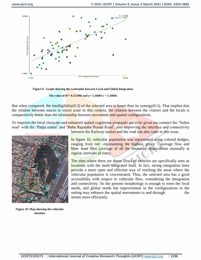
Synergy is the connection between integration locally and globally and is represented in the figure 8. As per Fig
9 , the r 2 value according to the plot is 0.511906 which is an average correlation found. The correlation is
explained by Medeiros (2006) as, “to synergy, the larger the system, the smaller the value”. So according to the
synergy of this settlement, it can be framed that the relationship between global and local integration is not very
successful, corresponding to poorer connectivity of some roads in the setting, like Nehru road.
Figure 8: Graph (scatterplot) showing the connectivity and Global integration of the segment analysis.
(The value of R2= 0.349857 and y=4.84362x + 4.84362.)
www.ijcrt.org © 2021 IJCRT | Volume 9, Issue 3 March 2021 | ISSN: 2320-2882
IJCRT2103173 International Journal of Creative Research Thoughts (IJCRT) www.ijcrt.org 1336
But when compared, the intelligibility(0.3) of the selected area is lesser than its synergy(0.5). That implies that
the relation between macro to micro scale in this context, the relation between the visitors and the locals is
comparitively better than the relationship between movement and spatial configurations.
To improve the local character and enhanced spatial cognitions proposals are to be given too connect the ‘Nehru
road’ with the ‘Panja centre’ and ‘Babu Rajendra Prasad Road’, also improving the interface and connectivity
between the Railway station and the road can also cater to this issue.
In figure 10, vehicular population was represented using colored dodges,
ranging from red –representing the highest, green – average flow and
blue- least flow (average of all the measured observations manually at
regular intervals of time).
The sites where there are dense flows of vehicles are specifically seen as
locations with the most integrated lines. In fact, strong integration lines
provide a more open and efficient way of reaching the areas where the
vehicular population is concentrated. Thus, the selected area has a good
accessibility with respect to vehicular flow, considering the Integration
and connectivity. So the present morphology is enough to meet the local
needs, and global needs but improvement in the configurations in the
setting may enhance the spatial movements to and through the
streets more efficiently.
Figure 9: Graph showing the scatterplot between Local and Global Integration.
The value of R2= 0.511906 and y= 1.34604 x + 1.34604.
Figure 10: Map showing the vehicular
densities

www.ijcrt.org © 2021 IJCRT | Volume 9, Issue 3 March 2021 | ISSN: 2320-2882
IJCRT2103173 International Journal of Creative Research Thoughts (IJCRT) www.ijcrt.org 1337
6. Conclusion
The process and theory of space syntax provide a tool set for evaluating spatial changes in the built
environment, irrespective of context-related circumstances and necessarily interwoven cultural aspects. Within
these restraints, in relation to certain presumptions and observations, it can help to find some spatial
documentation and evidences. Space syntax can therefore accommodate the understandings of structure of the
place, if not the place character. Often essential components of a place's environment are a comprehension of
the spatial conditions of pedestrian flow rates and the degree of urban vitality. If the objective is to create a
robust architectural and urban theory in which all kinds of aspects are considered as to how human beings exist
in their living environment, space syntax is therefore an important component in creating a perception of the
resilience and vitality of the place.In the above taken case, only the ‘Nehru road’ and its connecting roads are
extrapolated as the least integrated zones in the entire selected area. The most integrated street of all, is ‘Minar
masajid road’. Most of the maintenance projects and congestions issue arise majorly in this road, as observed
during manual survey. The present is enough to meet the spatial movement and connectivity. So the similar
areas of strategic importance can be further studied to ascertain present condition to appreciate or to strengthen
the connectivity and movement.
References
Akkelies van Nes, C. Y. (2018). Space syntax: a method to measure urban space related to social, economic and cognitive factors. New york:
Routledge:Oxon, Uk.
ALESSANDRO GEREMIA, F. L. (2017). ROAD DUPLICATION IMPACT IN URBAN
AREAS TOWARDS SPACE. Proceedings of the 11th Space Syntax Symposium.
Attilia, F. (2007). Space syntax in urban research. Budapest: Corvinus university of Budapest.
Dalton, R. 2003. “The Secret is to Follow Your Nose. Route Path Selection and Angularity, ” Environment and Behavior 35 (1) : 107 –
31.10.1177/0013916502238867 [Crossref], [Web of Science ®] , [Google Scholar]
Dhanani, A., L. Tarkhanyan, and L. Vaughan. 2017. “Estimating Pedestrian Demand for Active Transport Evaluation and Planning.” Transportation
Research Part a: Policy and Practice 103: 54–69. [Crossref], [Web of Science ®], [Google Scholar]
Dwimirnani, P., and K. Karimi 2017 “Space after Dark: Measuring the Impact of Public Lighting at Night on Visibility, Movement, and Spatial
Configuration in Urban Parks.” In: Proceedings of the 11 th Space Syntax Symposium, Lisbon, July 2017. [Google Scholar]
De Koning, R. E., A. Van Nes, Y. Ye, and H.-J. Roald 2017 “Strategies for Integrated Densification with Urban Qualities: Combining Space Syntax
with Building Density, Land Usage, Public Transport and Property Rights in Bergen City.” In: Proceedings of the 11th Space Syntax
Symposium, Lisbon, July 2017. [Google Scholar]
Eriksson. (2010). Stadsanalys for Kalix centrum. Lulea: Lulea university of technology.
Hanson.J, H. B. (1984). The Social logic of Space. Cambridge: Cambridge University press.
Hillier, B. &. (1984). The social logic of space. Cambridge: Press syndicate of the University of Cambridge.
Hillier, B. H. (30 November, 1983,). Space Syntax: a different urban. The Architects Journal, 47-63.
Hillier.B. (1996). Space is the machine. London: Cambridge University press.
Iqbal, S. (2010). An urban planners guide to space syntax. Lulea: Lulea university of technology.
Jacoby, K. (2006). Space syntax; Does the urban form of the city affect the level of burglary and crime? Stockholm: Royal Institute of Architecture,
Stockholm.
Karimi, K 2018. Space syntax: consolidation and transformation of an urban research field, Journal of Urban Design, 23:1, 1-
4, DOI: 10.1080/13574809.2018.1403177.
Karimi, K. 2002. “Iranian Organic Cities Demystified; a Unique Urban Experience or an Organic City like Others.” Built Environment 28 (3): 187–
202. [Google Scholar]
Karimi, K. 2012. “A Configurational Approach to Analytical Urban Design: ‘Space Syntax’ Methodology.” URBAN DESIGN International 17
(4): 297–318.10.1057/udi.2012.19 [Crossref], [Web of Science ®], [Google Scholar]
Karimi, K., and E. Parham 2012. “An Evidence Informed Approach to Developing an Adaptable Regeneration Programme for Declining Informal
Settlements.” In: Eighth International Space Syntax Symposium, Santiago, Chile, January 2012. [Google Scholar]
Lynch, K. (1960). Image of the city. United States of America: Massachusetts Institute of Technology.
Maureira, V., and K. Karimi. 2017. “The Everyday and the Post-Disaster Urban Systems as One Thing:A Configurational Approach to Enhance the
Recovery and Resilience of Cities Affected by Tsunamis.” In: Proceedings of the 11th Space Syntax Symposium, Lisbon, July 2017. [Google
Scholar]
McCahil, C., and N. Garrick (2008) The Applicability of Space Syntax to Bicycle Facility Planning. Transportation Research Record: Journal of the
Transportation Research Board. [Online] 2074, 46–51. Available from: doi:10.3141/2074-06. [Crossref], [Google Scholar]
Netzell.O. (2007). Kan Space syntax. Department of Real estate and construction management at Roysl in.
Next, t. c. (2007). Modeling street connectivity and pedestrian movement according to standard GIS street network. Analysis, 02.
O, H. a. (2005). High resolution analysis of crime patterns in urban street networks: an initial statistical sketch from an ongoing study of a London
borough. Space syntax Symposium.
Penn, A. (2003). Space syntax and spatial cognition: or why the axial line? Environment and behavior, 30-65.
Racu, M. (2016). LIMITATIONS, CRITIQUES AND INCONSISTENCIES OF THE SPACE SYNTAX METHODOLOGY. Sustainability and
Innovation for the Future.
Raford, N., A. Chiaradia, and J. Gil. 2007. Space Syntax: The Role of Urban Form in Cyclist Route Choice in Central London. [Online].
Accessed June 17 2012. http://escholarship.org/uc/item/8qz8m4fz#page-3 [Google Scholar]
www.ijcrt.org © 2021 IJCRT | Volume 9, Issue 3 March 2021 | ISSN: 2320-2882
IJCRT2103173 International Journal of Creative Research Thoughts (IJCRT) www.ijcrt.org 1338
Sailer, K., A. Budgen, N. Lonsdale, and A. Turner, et al. 2008. Evidence-Based Design: Theoretical and Practical Reflections of an Emerging
Approach in Office Architecture. [Online] Accessed December 2 2011. http://drs2008.designinquiry.wikispaces.net/ [Google Scholar]
Shen, Y., and K. Karimi. June 2016. “(2016) Urban Function Connectivity: Characterisation of Functional Urban Streets with Social Media Check-in
Data.” Cities 55: 9–21.10.1016/j.cities.2016.03.013 [Crossref], [Web of Science ®], [Google Scholar]
Van Nes A, L. M. (2010). Macro and micro scale spatial variables and the distribution of residential burglaries and theft from cars: an investigation
of space and crime in the Dutch cities of Alkamar and Gouda. Journal of Space syntax,2, 296-314.
Varoudis, T. (2012). depthmapX Multi-Platform Spatial Network Analysis Software’, Version 0.30 OpenSource.
Copyright © 2022 FDOKUMEN