
Analyse des problemes de geometrie et apprentissage de la preuve au secondaire
Upload
khangminh22Category
view
4download
0
HAL Id: tel-01490613https://tel.archives-ouvertes.fr/tel-01490613
Submitted on 15 Mar 2017
HAL is a multi-disciplinary open accessarchive for the deposit and dissemination of sci-entific research documents, whether they are pub-lished or not. The documents may come fromteaching and research institutions in France orabroad, or from public or private research centers.
L’archive ouverte pluridisciplinaire HAL, estdestinée au dépôt et à la diffusion de documentsscientifiques de niveau recherche, publiés ou non,émanant des établissements d’enseignement et derecherche français ou étrangers, des laboratoirespublics ou privés.
Analyse morphotectonique et géomorphologique de labordure nord de Bornéo (Malaisie)
Manoj Joseph Mathew
To cite this version:Manoj Joseph Mathew. Analyse morphotectonique et géomorphologique de la bordure nord de Bornéo(Malaisie). Géomorphologie. Université de Bretagne Sud, 2016. Français. �NNT : 2016LORIS408�.�tel-01490613�

1
THESE / UNIVERSITE DE BRETAGNE-SUD sous le sceau de l’Université Bretagne Loire
pour obtenir le titre de DOCTEUR DE L’UNIVERSITE DE BRETAGNE-SUD
Mention :Geoscience Marines
Ecole doctorale:Sciences de la Mer (EDSM)
Présentée par MANOJ JOSEPH MATHEW
Préparée au laboratoire de Géosciences Marines et Géomorphologie du
Littoral (GMGL)
Rattaché à l’UMR 6538 Domaine Océaniques (UBO-IUEM)
Thèse soutenue le 5th
Juillet, 2016
Devant le jury composé de :
Rapporteurs
Stephane BONNET (Professeur, Université de Toulouse III /
Paul Sabatier)
Bernard DELCAILLAU (Professeur, Université de Caen
Normandie)
Examinateurs
Manuel PUBELLIER (Professeur, Ecole Normale Supérieure)
Christine AUTHEMAYOU (MCF, Université de Brest)
Directeur de thèse
David MENIER (MCF, HDR Université de Bretagne Sud)
Geomorphology and
Morphotectonic
Analysis of north
Borneo
Geomorphology and morphotectonics of sarawak Borneo (Malaysia) Manoj joseph Mathew 2016

2
“Savor the irony should those orogens most alluring to hard-rock
geologists owe their metamorphic muscles to the drumbeat of tiny
raindrops”
(Hoffman, P.F., Grotzinger, J.P., 1993. Orographic precipitation, erosional unloading, and
tectonic style. Geology 21, 195–198.)
Geomorphology and morphotectonics of sarawak Borneo (Malaysia) Manoj joseph Mathew 2016

3
ACKNOWLEDGMENT
Immeasurable appreciation and deepest gratitude to my advisor, philosopher and friend, Dr.
David Menier. Thank you for giving me the opportunities that you have and for all the
encouragement, inspiration, guidance and friendship.
Special thanks to Numair Ahmed Siddiqui for his support and involvement in my research.
Finally, I want to extend my sincere appreciation and thanks to my family for their love,
encouragement and support.
Geomorphology and morphotectonics of sarawak Borneo (Malaysia) Manoj joseph Mathew 2016
4
TABLE OF CONTENTS
Chapter 1 9
1.1 Overview 9
1.1.1 The Evolving Landscape: Coupling of tectonics and geomorphic processes 10
1.1.2 Fluvial Systems: The Arteries of Continents 11
1.1.3 Application of digital terrain data and GIS in geomorphology 14
1.1.4 Geomorphic indices for morphotectonic analysis 16
1.2 The Drainage Basins of North and Central Sarawak, Borneo 17
1.3 Problem Statement 19
1.4 Research Questions 20
1.5 Aims and Objectives 20
1.6 Thesis Outline 21
1.7 Summary 21
Chapter 2 23
2.1 Geological, tectonic and geographic characterization of Borneo 24
2.2 Geologic and stratigraphic framework of Sarawak 30
2.3 Stratigraphy of central and north Sarawak 32
2.4 Geomorphic Expression 35
2.5 Summary 35
Chapter 3 36
3.1 Abstract 37
3.2 Introduction 38
3.3 Characteristics of Sarawak 41
3.3.1 Geographic and Climatic Setting 41
3.3.2 Geology 41
3.3.3 Tectonic and Structural Characteristics 44
3.3.4 Geomorphic Expression 44
3.3.5 The Drainage Network 46
3.4 Materials and Techniques 47
3.4.1 Digital Elevation Models 47
3.4.2 Hypsometric Curves 48
3.4.3 Spatial Distribution of Hypsometric Integrals 48
Geomorphology and morphotectonics of sarawak Borneo (Malaysia) Manoj joseph Mathew 2016

5
3.4.4 Spatial Autocorrelation Analysis Moran’s I and Getis-Ord (Gi*) Statistics 49
3.4.5 Asymmetry Factor 50
3.4.6 Relative Tectonic Uplift 51
3.4.7 Normalized Channel Steepness Index 51
3.5 Results 52
3.5.1 Hypsometric Curve Analysis 52
3.5.1.1 Rajang Sub-catchment Hypsometry 52
3.5.1.2 Baram Sub-catchment Hypsometry 53
3.5.2 Spatial Variation in Hypsometry 53
3.5.3 Spatial Statistics 54
3.5.4 Basin Asymmetry 54
3.5.5 Relative Tectonic Uplift 56
3.5.5.1 Rajang Drainage Basin Uplift 57
3.5.5.2 Baram Drainage Basin Uplift 59
3.5.6 Channel Profile Characteristics 59
3.5.7 Rajang and Baram Basin Channel Steepness 59
3.5.7.1 Rajang Catchment 59
3.5.7.2 Baram Catchment 60
3.5.8 Field Campaigns 61
3.6 Insights on Active Tectonics Through Morphotectonic Investigation of Sarawak 62
3.7 Conclusion 67
Chapter 4 69
4.1 Abstract 70
4.2 Introduction 70
4.3 Geological and Geomorphic Setting 72
4.3.1 General Geography and Climate of Sarawak 73
4.3.2 Tectonics and Geology 73
4.3.3 Geomorphological Characteristics 74
4.4 Data and Techniques 76
4.4.1 Digital Terrain Data 76
4.4.2 Quantitative Morphometric Analysis 76
4.4.2.1 Stream Length-Gradient Index (SL) 77
4.4.2.2 Ratio of Valley Floor Width to Valley Height (Vf) 78
Geomorphology and morphotectonics of sarawak Borneo (Malaysia) Manoj joseph Mathew 2016

6
4.4.2.3 Transverse Topographic Symmetry Factor (T) 79
4.4.3 Topographic Analysis 79
4.5 Results 80
4.5.1 SL Index 80
4.5.2 Vf Index 80
4.5.3 T Factor 81
4.5.4 Relief Anomaly 81
4.5.5 Field Campaigns 82
4.6 Discussion 83
4.6.1 Transient Landscape Evolution and Contribution of Geomorphic Agents 83
4.6.2 Implications on Regional Tectonism 89
4.7 Conclusion 92
Chapter 5 94
5.1 Introduction 94
5.2 Geological and Geomorphic Characteristics 96
5.3 Materials and Methods 99
5.3.1 Swath Topographic Profiles 99
5.3.2 Minimum Bulk Erosion 99
5.3.3 ksn Anomaly 100
5.4 Results 102
5.4.1 Topographic Characteristics 102
5.4.2 Relative Eroded Rock Column 103
5.4.3 Normalized Channel Steepness Anomaly 104
5.4.4 Sedimentology Field Campaigns 104
5.5 Discussion 108
5.5.1 The Geomorphic Evolution of Sarawak, north Borneo 108
5.5.2 Transient Channel Incision as a Driver of Erosion Rates in northern Borneo 112
5.6 Conclusion 114
Chapter 6 116
6.1 Active Tectonics of Sarawak 117
6.2 Transient Stage of Landscape Development in Response to Disequilibrium 117
6.3 Geomorphic Evolution of north Borneo 118
Geomorphology and morphotectonics of sarawak Borneo (Malaysia) Manoj joseph Mathew 2016

7
6.4 Recommendations 119
Bibliography 120
Geomorphology and morphotectonics of sarawak Borneo (Malaysia) Manoj joseph Mathew 2016

8
LIST OF FIGURES
Figure 1.1 Some of the most commonly encountered drainage patterns. 12
Figure 1.2. A stream network extracted from a Digital Elevation Model within a GIS
environment. 15
Figure 1.3. Hypothetical drainage basin indicating some of the variables that can be extracted
in numerical form to be utilized as input for morphometric analysis. 16
Figure 1.4. The Sunda Block. Approximate limit is shown in black dashed lines. 17
Figure 1.5. The Rajang and Baram drainage basins. 18
Figure 1.6. Simplified Geological Map of Sarawak, north Borneo. 19
Figure 2.1. Map of Sundaland showing land area during the Last Glacial Maximum. 25
Figure 2.2. Simplified geological map of Borneo. 26
Figure 2.3. Shaded relief map of Borneo showing diverse variations in altitude. 29
Figure 2.4. The Northwest Borneo Geosyncline. 31
Figure 2.5. Generalized stratigraphy of central and north Sarawak. 33
Figure 3.1. The two largest catchments of Sarawak: Rajang and Baram basins. 39
Figure 3.2. Simplified geological map of central and north Sarawak. 42
Figure 3.3. Hypsometric curves for sub-catchments of the Rajang and Baram drainage
basins. 43
Figure 3.4. Gi* spatial statistics estimation for HI values of Rajang Basin. 45
Figure 3.5. Gi* spatial statistics estimation for HI values of Baram Basin. 46
Figure 3.6. Widespread basin asymmetry is represented by arrows indicating the asymmetry
sense and color indicating the classes. 53
Figure 3.7. Longitudinal profiles of trunk streams of all sub-catchments of the Rajang and
Baram drainage basin. 55
Figure 3.8. Map of color coded normalized channel steepness indices (ksn) determined for the
Rajang basin. 56
Figure 3.9. Map of color coded normalized channel steepness indices (ksn) of the Baram
basin. 57
Figure 3.10. Field survey photographs for validation of morphometric and morphotectonic
analysis. 58
Figure 3.11. Longitudinal profiles of master streams of some sub-catchments of the Rajang
and Baram drainage basins. 60
Figure 4.1. Shaded relief model of the study location of Rajang and Baram drainage basins
of north Borneo. 72
Geomorphology and morphotectonics of sarawak Borneo (Malaysia) Manoj joseph Mathew 2016

9
Figure 4.2. Simplified geological map of central and north Sarawak, Borneo along with
major faults and structural lines. 74
Figure 4.3. (A) and (B) Panoramic photographs (field photographs) of a part of the strongly
folded and thrusted mountain belts of central Sarawak. 75
Figure 4.4. Conceptual figure of an idealistic drainage basin indicating parameters and
corresponding variables used for morphometric analysis conducted in this study. 77
Figure 4.5. 𝑆𝐿 anomaly profiles and corresponding stream longitudinal profiles of main
tributary streams of the Rajang drainage basin. 81
Figure 4.6. Stream longitudinal profiles and 𝑆𝐿 anomaly profiles of main tributary streams of
the Baram drainage basin. 82
Figure 4.7. Color coded 𝑆𝐿 index map of the Rajang and Baram basins. 83
Figure 4.8. Locations of sections for the 𝑉𝑓 computation of Rajang drainage basin and
anomalously low values of 𝑉𝑓 are appropriately indicated. 84
Figure 4.9. Locations of sections for the 𝑉𝑓 computation of Baram drainage basin and
anomalously low values of 𝑉𝑓 are appropriately indicated. 85
Figure 4.10. Transverse topographic symmetry factor for the studied drainage basins of north
Borneo. 86
Figure 4.11. Local relief map of Rajang and Baram drainage basin constructed with an
analysis grid consisting of cells having an area of 1 km2. 87
Figure 4.12. Field photographs of geomorphic features pertaining to topographic breaks or
knick-points corresponding to waterfalls in RB-S5 and BB-S3 (A), (B), (D) and (F), and
terraced boulder to gravel sized fluvial deposits unconformably overlain above the incised
basement rocks of streams in RB-S8 (C) and (E). 88
Figure 5.1. Shaded relief model of the study location of Rajang and Baram drainage basins
of north Borneo. 96
Figure 5.2. Perspective view of the geology of Sarawak. 97
Figure 5.3. Swath profiles across the Rajang and Baram basins. 101
Figure 5.4. Minimum bulk erosion map showing the main streams and faults of the Rajang
and Baram basins. 103
Figure 5.5. Ksn anomaly map indicating regions of high channel steepness. 105
Figure 5.6. Field photographs on Miri, Nyalau, Tatau Ransi and Belaga Formation. 106
Figure 5.7. Conceptual model of geomorphic evolution of Sarawak, north Borneo. 109
Geomorphology and morphotectonics of sarawak Borneo (Malaysia) Manoj joseph Mathew 2016

10
LIST OF TABLES
Table 1. Hypsometric parameters of sub-catchments of Rajang (RB-S1 – RB-S8) and Baram
(BB-S1 – BB-S9) drainage basins. 61
Geomorphology and morphotectonics of sarawak Borneo (Malaysia) Manoj joseph Mathew 2016

11
Chapter 1
Introduction
_____________________________________________
Contents
1.1 Overview
1.1.1 The Evolving Landscape: Coupling of tectonics and geomorphic processes
1.1.2 Fluvial Systems: The arteries of continents
1.1.3 Application of digital terrain data and GIS in geomorphology
1.1.4 Geomorphic indices for morphotectonic analysis
1.2 The Drainage Basins of North and Central Sarawak, Borneo
1.3 Problem Statement
1.4 Research Questions
1.5 Aims and Objectives
1.6 Thesis Outline
1.7 Summary
_____________________________________________
1.1 Overview
A myriad of geomorphic expressions consisting of fascinating physical landscapes and
intricately sculpted landforms envelop the upper lithosphere of our planet. The scientific
analysis of Earths landscapes and the investigation of processes that mold landforms are the
fundamental facets of geomorphology. Geomorphic examination of a region includes the
genetic analysis of landform assemblages and their spatial distribution to decipher the origin
and establish an understanding of its evolution. Geomorphology is a science of immense
significance with regard to processes that carve topography in the past and those that alter
them today. In essence, the relationship between land surface forms and processes is a close
and intricate one. The landform elucidates boundary condition for processes acting on it.
Geomorphology and morphotectonics of sarawak Borneo (Malaysia) Manoj joseph Mathew 2016

12
However, in acting on the surface the processes themselves modify the underlying form – the
canvas they act on – and thus, finally, the intensity and the patterns of themselves. Thus,
topography is both the result of past geomorphic processes and the stage for present
geomorphic processes which reshape it again for future geomorphic processes (Swanson et
al., 1988; Dehn et al., 2001; Straumann, 2010).
1.1.1 The Evolving Landscape: Coupling of Tectonics and Geomorphic
Processes
The Earth constitutes a succession of nested spheres of which the interface between the
lithosphere, hydrosphere and atmosphere is by far the most complex and dynamic in nature.
This interface houses landscapes that appear static to observations made over short periods of
time but are extremely active entities undergoing rapid change in geological terms. The
continental topography we witness today is by and large a product of processes and their
repercussion of the immediate past. In principle, landscapes have the capability to register
recent history of Earth’s surface and its environments.
Landscapes are created, constantly modified and torn asunder through the action of processes
driven by external forces arising from the surface of the earth and internal forces from within
the planet (Sharp, 1982). These processes combined together cause physical stresses and
chemical actions on surface material that change the configuration of the earth’s surface are
collectively known as geomorphic processes. The links between these driving forces and the
resulting topography are complicated by delays between a forcing factor changing and the
topographic expression of that change, leading to a system response time characteristic of the
forcing factor and the properties of the system it is acting upon (Whipple and Tucker, 1999;
Whipple, 2001; Saville, 2013).
The internal forces also called as endogenetic processes are responsible for continuously
elevating relief and constructing parts of the Earth’s surface. External forces known as
exogenetic processes operate by wearing down relief created by endogenic processes.
Variations in land surface forms and physical topography persist as long as the opposing
actions of exogenic and endogenic forces remain active. Processes that shift and uplift or
build up portions of the crust known as diastrophism or tectonism and volcanism are
considered as endogenic processes. Whereas, geomorphic processes such as weathering,
erosion and deposition express exogenic forces.
Geomorphology and morphotectonics of sarawak Borneo (Malaysia) Manoj joseph Mathew 2016

13
Tectonism comprises of two vital mechanisms – orogenic and epeirogenic processes.
Orogenic processes are responsible for mountain building through crustal folding resulting in
severe deformation affecting long and narrow belts of the earth’s crust, while, epeirogenic
processes involve uplift and warping of large regions on the surface of the earth. In order to
measure amount of geomorphic deformation resulting from tectonic processes, it is necessary
to have identifiable features that have been displaced called geomorphic markers (Burbank
and Anderson, 2001). The best geomorphic markers are readily recognizable landforms,
surfaces, or linear trends.
Exogenic processes derive their energy from the atmosphere and also the gradients created by
tectonic factors. The effects of most exogenic geomorphic processes are minor and slow and
may be imperceptible in a short time span, but will in the long run affect the rocks severely
due to persistent activity. Climate and climatic elements such as temperature and
precipitation are among the key driving forces behind exogenic geomorphic processes that
strip down surface material by erosion, weathering and mass movement, ultimately,
modifying landscapes (Burbank and Anderson, 2001). In order to denude, transport and
deposit earth material, exogenic processes have to depend on elements of nature that are set
mobile due to gravitational forces and earth surface gradients. These elements, called
geomorphic agents, are capable of removing material and moving them over slopes and
finally depositing them at lower levels. Running water, glaciers, ground water, waves and
currents can be classified as geomorphic agents.
1.1.2 Fluvial Systems: The Arteries of Continents
Fluvial networks are dynamic systems susceptible to alterations resulting from successful
recurrent disturbances in equilibrium over timescales ranging from seconds to tens of
thousands of years. They evolve remarkably, adjusting diversely to the wide range of
environments in which they can be observed. Topography inherited by constant interaction of
fluvial systems and consequent erosion, envelop extensive reaches of the earth’s surface.
Based on controlling factors such as landscape morphology, lithology and surface gradient,
fluvial systems can develop patterns pertaining to specific conditions within a drainage basin
(Charlton, 2007).
Rivers flow into oceans, although some drain to lakes and inland seas, meanwhile some
others dry up completely before reaching the ocean. Every river drains areas of continents
Geomorphology and morphotectonics of sarawak Borneo (Malaysia) Manoj joseph Mathew 2016

14
Figure 1.1 Some of the most commonly encountered drainage patterns. Figure source:
https://laulima.hawaii.edu.
called its drainage basin or catchment or watershed. The drainage area may be defined as the
area which contributes water and sediments to a particular channel or sets of channels. It is
the source area of the precipitation eventually provided to the stream channels by various
paths. As such it forms a convenient unit for the consideration of the processes determining
the formation of specific landscapes in the various regions of the earth. It provides a limited
unit of the earth’s surface within which basic climatic quantities can be measured and
characteristic landforms described, and a system within which a balance can be struck in
terms of inflow and outflow of moisture and energy.
Drainage patterns by theory specify shapes or designs the individual streams may form. A
distinction can be made between the patterns of the individual tributaries and their spatial
relationships to one another. They can be termed as drainage arrangements since they refer
more to the spatial relationships of individual streams than to the over-all pattern made by the
individual drainage lines. It is generally recognized that drainage patterns reflect the
influence of such factors as initial slopes, inequalities in rock hardness, structural controls,
recent diastrophism and the recent geologic and geomorphic history of the drainage basin.
Because drainage patterns are influenced by so many factors they are extremely helpful in the
interpretation of geomorphic features, and study of them represents one of the more practical
approaches to an understanding of structural and lithological control of land form evolution.
The most commonly encountered drainage patterns are dendritic, trellis, radial, parallel,
Geomorphology and morphotectonics of sarawak Borneo (Malaysia) Manoj joseph Mathew 2016

15
rectangular and deranged (Figure 1.1). Of these, dendritic patterns are by far the most
common. They are characterized by irregular branching of tributary streams in many
directions and at almost any angle, although usually at considerably less than a right angle.
They develop upon rocks of uniform resistance and imply a notable lack of structural control.
Dendritic patterns are most likely to be found upon nearly horizontal sedimentary rocks or in
areas of massive igneous rocks, but may be seen on folded or complexly metamorphosed
rocks, particularly when imposed upon them by superposition. Trellis patterns display a
system of sub-parallel streams, usually aligned along the strike of the rock formations or
between parallel or nearly parallel topographic features recently deposited by wind or ice.
The major streams frequently make nearly right-angled bends to cross or pass between
aligned ridges, and the primary tributary streams are usually at right angles to the main
stream and are themselves joined at right angles by secondary tributaries whose courses
commonly parallel the master stream. Trellis patterns reflect marked structural control of
most stream courses, except perhaps the trunk streams. The tributary valleys are usually
subsequent strike valleys. A variety of the trellis pattern is the fault trellis pattern, which may
be found where a series of parallel faults have brought together alternating bands of strong
and weak rock. Radial patterns have streams diverging from a central elevated tract. They
develop on domes, volcanic cones, and various other types of isolated conical or sub-conical
hills. Parallel patterns are usually found where there are pronounced slopes or structural
controls which lead to regular spacing of parallel or near-parallel streams.
Landscape results from the competition of tectonic and geomorphic processes (Burbank and
Anderson, 2001). The impact of tectonics on landscape development and geomorphic
processes in tectonically active regions can be quantitatively and qualitatively analyzed by
studying the drainage system (Jackson et al., 1998; Sung and Chen, 2004; Delcaillau et al.,
2006; Ramsey et al., 2008; Bahrami, 2013). The drainage system, ergo, is a key element of
the physical topography and analyzing their evolution can provide information on
denudational history and tectonic impacts on landscape development (Small, 1978; Vandana,
2013).
The deviation of course of present-day river networks from their common regional patterns,
termed as drainage anomalies, are a product of active tectonic deformation (Zernitz, 1932;
Howard, 1967; Clark, et al., 2004) and bedrock resistance. Hence, drainage patterns and their
corresponding anomalies have potential to archive information regarding regional and local
Geomorphology and morphotectonics of sarawak Borneo (Malaysia) Manoj joseph Mathew 2016

16
tectonic events (Deffontaines et al., 1992; Simoni et al., 2003; Delcaillau et al., 2006,
Ramasamy et al., 2011; Bahrami, 2013). In tectonically active zones, tectonics may directly
affect the development of fluvial systems through the modification of stream gradients, tilting
of surfaces and/or structural deformation (Maher and Harvey, 2008).
The geometry of river networks is sensitive to surface uplift in actively deforming regions,
thus recording the history of tectonically driven crustal motions (Howard, 1967; Seeber and
Gornitz, 1983; Oberlander, 1985; Cox, 1994; Jackson and Leeder, 1994; Clark et al., 2004).
Innate geomorphological characteristics of motions related to tectonics, reflect features such
as linear valleys, ridgelines, steep slopes of uniform aspect and tilt of terrain (Jordan, 2003).
Ancient riverine networks termed as paleochannels or paleo-valleys are remnants of stream
channels which are good geomorphological indicators of fault movements related to
tectonics, redirecting the flow regime, abandoning ephemeral or perennial systems, that now
stands buried or lost (Bates and Jackson, 1987). Rearrangement of the paleo-fluvial flow to
present day configuration can be the contribution of recent tectonic deformation events which
produces changes in polarity of regional slopes (Bonnet, 2009). As a result of these tectonic
events, the vestiges of former floodplains may be exposed or/and uplifted. These former
floodplain deposits are termed as fluvial terraces. Some terraces may have little or no
alluvium on them and may thus be classed as bedrock terraces in contrast with alluvial
terraces, which consist of gravel, sand and finer alluvium. Terrace staircases can be results of
regional uplift (Burbank et al., 1996; Pazzaglia and Brandon, 2001; Wegmann and Pazzaglia,
2002; Bridgland and Westaway, 2008; Cunha et al., 2008; Claessens et al., 2009; Viveen,
2012) whereas differential tectonic movements produce unpaired terraces along the stream
(Peters and van Balen, 2007; D'Allesandro et al., 2008; Larue, 2008; Martins et al., 2009).
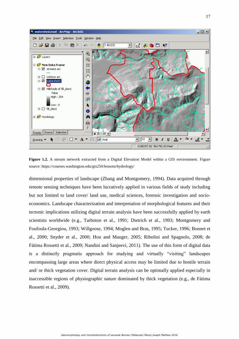
1.1.3 Application of digital terrain data and GIS in geomorphology
Geomorphic interpretations using drainage and their anomalies can be easily and rapidly
facilitated by employing remotely sensed digital terrain data such as Digital Elevation Models
(DEMs) (Jordan, 2003). Digital topographic data can be effectively integrated and organized
within Geographic Information Systems (GIS) in order to extract variables for numerical and
statistical analysis of geomorphic characteristics of drainage basins and stream networks
(Figure 1.2). DEMs store information as point elevation data assigned to each pixel on either
a regular grid or a triangular integrated network allowing the analysis of the three-
Geomorphology and morphotectonics of sarawak Borneo (Malaysia) Manoj joseph Mathew 2016
17
Figure 1.2. A stream network extracted from a Digital Elevation Model within a GIS environment. Figure
source: https://courses.washington.edu/gis250/lessons/hydrology/
dimensional properties of landscape (Zhang and Montgomery, 1994). Data acquired through
remote sensing techniques have been lucratively applied in various fields of study including
but not limited to land cover/ land use, medical sciences, forensic investigation and socio-
economics. Landscape characterization and interpretation of morphological features and their
tectonic implications utilizing digital terrain analysis have been successfully applied by earth
scientists worldwide (e.g., Tarboton et al., 1991; Dietrich et al., 1993; Montgomery and
Foufoula-Georgiou, 1993; Willgoose, 1994; Moglen and Bras, 1995; Tucker, 1996; Bonnet et
al., 2000; Snyder et al., 2000; Hou and Mauger, 2005; Ribolini and Spagnolo, 2008; de
Fátima Rossetti et al., 2009; Nandini and Sanjeevi, 2011). The use of this form of digital data
is a distinctly pragmatic approach for studying and virtually “visiting” landscapes
encompassing large areas where direct physical access may be limited due to hostile terrain
and/ or thick vegetation cover. Digital terrain analysis can be optimally applied especially in
inaccessible regions of physiographic nature dominated by thick vegetation (e.g., de Fátima
Rossetti et al., 2009).
Geomorphology and morphotectonics of sarawak Borneo (Malaysia) Manoj joseph Mathew 2016

18
Figure 1.3. Hypothetical drainage basin indicating some of the variables that can be extracted in numerical form
to be utilized as input for morphometric analysis.
1.1.4 Geomorphic indices for morphotectonic analysis
River network parameters and landscapes inherited by geomorphic processes can be defined
numerically allowing quantitative analysis of topography and is collectively termed
geomorphometry (Pike, 1995; Pike, 2000; Jordan, 2003; Rasemann et al., 2004; Hajam et al.,
2013) (Figure 1.3). Morphometry is defined as the quantitative measurement of landscape
shape. Landforms can be characterized in terms of size, elevation (maximum, minimum, or
average), and slope. Quantitative measurements facilitate comparison of different landforms
and to calculate less straightforward parameters defined as geomorphic indices that are useful
to identify particular characteristic of an area such as level of tectonic activity. Geomorphic
indices and geomorphometry are reconnaissance tools to quantitatively analyze spatially
distributed landscapes in order to identify and evaluate areas experiencing rapid tectonic
deformations (Keller and Pinter, 1996).
Geomorphology and morphotectonics of sarawak Borneo (Malaysia) Manoj joseph Mathew 2016

19
Figure 1.4. The Sunda Block. Approximate limit is shown in black dashed lines.
Geomorphic expressions and drainage response due to impact of tectonics on onshore
Sarawak, Borneo are poorly understood and research pertaining to geomorphology are
scanty. This thesis addresses the geomorphic evolution of north and central Sarawak through
morphometric analysis in order to draw inferences on active tectonics; making this research
the first of its type in this region. Consequences of active tectonics, ultimately affecting
sedimentation and preservation, are discussed with the aid of conceptual models.
1.2 The Drainage Basins of North and Central Sarawak, Borneo
Sarawak is one of the states belonging to Malaysia and is located on the Borneo Island. The
east Malaysian state forms the northwest Borneo segment and borders the Malaysian state of
Sabah to the northeast, the Indonesian state of Kalimantan to the south and surrounding the
independent state of Brunei (Figure 1.4). The continental margin of Sarawak forms part of the
Sunda Shelf, which structurally connects Borneo with East Malaysia and the rest of
Geomorphology and morphotectonics of sarawak Borneo (Malaysia) Manoj joseph Mathew 2016

20
Figure 1.5. The Rajang and Baram drainage basins and also shown are the sub-catchments.
continental Southeast Asia (Figure 1.4). N. S. Haile, one of the forerunners of extensive
geological work in Borneo, divided Sarawak into zones based on their geological history
(Haile, 1974). The Miri Zone to the north, the central part is called the Sibu Zone; the third
division is the Kuching Zone and the fourth division which is termed the West Borneo
Basement. According to Hutchinson (2005) the name of the fourth zone is a rather misleading
term and falls in the Indonesian state of Kalimantan. This research focuses on geomorphic
evolution by implementing topographic analysis and fluvial geomorphology techniques on
two of the largest drainage basins of Sarawak: the Baram and Rajang Drainage Basins
respectively (Figure 1.5). The drainage network of these basins drain entire north and large
areas of central Sarawak. The Rajang River flows for ca. 563 km and drains a total area of ca.
50,000 km2 of central Sarawak whereas the Baram River flows for ca. 400 km and drains a
total area of ca. 22,100 km2 of north Sarawak. These river systems are highly influential on
sediment distribution in the southern South China Sea margin. The headwaters of Rajang and
Baram basins emerge from the Central Borneo Massif that consists mainly of Cretaceous to
Geomorphology and morphotectonics of sarawak Borneo (Malaysia) Manoj joseph Mathew 2016

21
Figure 1.6. Simplified Geological Map of Sarawak, north Borneo.
Eocene folded and faulted clastic rocks (Figure 1.6; Wang et al., 2014). These clastics are
accretionary complexes and forearc basin sediments that were deposited during the Tertiary
opening and spreading of the South China Sea (Staub et al., 2000). Igneous extrusive and
intrusive rocks are present and much of the sedimentary rocks are highly metamorphosed
(Lam, 1988). Hill slopes are steep and flood plains represent very limited areas. Soils in both
basins are poorly developed, representing the mineral composition of the parent materials
(Scott, 1985). The average monthly sediment discharge rate for the Rajang River basin is
3600 m3/s (Staub et al., 2000) while the Baram basin delivers at an average, 1445 m
3/s of
sediments monthly to the South China Sea (Hiscott, 2001).
1.3 Problem Statement
The tectonically complex Borneo continent is enveloped by vastly inaccessible tropical
rainforests, mountains and deep valleys. Most parts of central and north Sarawak remain
Geomorphology and morphotectonics of sarawak Borneo (Malaysia) Manoj joseph Mathew 2016

22
inaccessible due to extensive tropical rainforest and peat swamp cover resulting in poor rock
exposures. Elements of the tectonic evolution of Borneo such as timing of deformation
events, uplift and erosion are still poorly understood (Hall and Nichols, 2002).
Geomorphology and evidences of tectonic processes onshore Sarawak is inadequately
analyzed. Investigation of morphotectonics and understanding the present day
geomorphological configuration of the region could assist in envisaging the processes
responsible for shaping the present day topography and ultimately, shedding light on the
controls on sedimentation pattern and, preservation of sediments both onshore and offshore.
Through this research, an attempt has been made to analyze active tectonics utilizing
geomorphometry and validation of results through conventional field techniques in order to
obtain valuable insights on neotectonic events that reconfigured the topography of Sarawak.
The results and onshore conceptual models produced herewith would provide new insights on
recent and active subtle tectonic events. The onshore models could be considered as
analogues to offshore architecture of north Borneo and could be beneficial for oil and gas
exploration strategy.
1.4 Research Questions
This research will address the following questions:
i. What are the processes responsible for sculpting the present-day geomorphic expressions in
Sarawak?
ii. What is the present state and stage of the landscape with regard to topographic evolution?
iii. Which regions are affected the most by forces accountable for a dynamically altering
landscape?
iv. What are the consequences of the altered topography in terms of sedimentation pattern
and preservation?
1.5 Aims and Objectives
The main aim of this thesis is to investigate geomorphology and morphotectonics of central
and north Sarawak utilizing geomorphometric analysis and field evaluation in order to obtain
insights on active tectonics and consequent topographic adjustment.
Geomorphology and morphotectonics of sarawak Borneo (Malaysia) Manoj joseph Mathew 2016

23
The specific objectives of this study are:
i. To conduct morphotectonic analysis of Sarawak through geomorphometry and geomorphic
indices.
ii. To understand the current stage of landscape development of north Borneo based on
results obtained from geomorphometry and gather field evidences (where accessible) to
support the results.
iii. To produce conceptual models defining present-day topographic and sub-surface
architecture of Sarawak describing how sedimentation patterns fluctuated over time and the
factors responsible for high denudation rates in the Quaternary.
1.6 Thesis Outline
The main body of the thesis is four chapters (2 – 5) describing the geomorphology and
morphotectonic analysis of north Borneo. Chapter 2 discusses the literature of the
geodynamic framework of the Tertiary Sundaland including the geological, tectonic and
geographic characterization of Borneo. The chapter also discusses the geologic and
stratigraphic framework of the study area and the general topographic characterization of
Sarawak. Chapter 3 discusses the evaluation of active tectonics in Sarawak using
morphometric parameters. Chapter 4 presents the analysis and results highlighting the current
stage of landscape development of north Borneo. Chapter 5 provides insights into the
landscape development of north Borneo using conceptual models and the factors responsible
for the onset of a strong erosional regime in the Quaternary. In chapter 6 the conclusion and
recommendations for further studies are presented with clear restatement of the main findings
of this study.
1.7 Summary
This chapter has outlined the overview of project and study area of north Borneo. It has also
drawn attention to the key objectives and research question of the study which focuses on the
processes responsible for the geomorphic expressions seen today in north Borneo and the
current stage of geomorphic development. It also highlighted the problem statement to
attempt to understand the geomorphology and topographic signature of the study area situated
Geomorphology and morphotectonics of sarawak Borneo (Malaysia) Manoj joseph Mathew 2016

24
in largely inaccessible tropical rainforest cover and hostile rugged mountainous terrain,
making this thesis the first of its kind in the study area.
Geomorphology and morphotectonics of sarawak Borneo (Malaysia) Manoj joseph Mathew 2016

25
Chapter 2
The Geodynamic Framework of Tertiary
Sundaland
_____________________________________________
Contents
2.1 Geological, tectonic and geographic characterization of Borneo
2.2 Geologic and stratigraphic framework of Sarawak
2.3 Stratigraphy of central and north Sarawak
2.4 Geomorphic Expression
2.5 Summary
_____________________________________________
The Sundaland is the continental core of SE Asia, constituting Indochina, Thai-Malay
Peninsula, Sumatra, Java, Borneo and the shallow marine ‘Sunda Shelf’ between them.
Sundaland comprises of numerous Cenozoic sedimentary basins, which developed during the
Paleogene and the Middle Miocene (McKenzie, 1978; Whittle and Short, 1978; Fulthorpe
and Schlanger, 1989; Hutchison, 1989; Hall and Nichols, 2002; Hall and Morley, 2004;
Hutchison, 2004; Hall et al., 2008; Metcalfe, 2011). To the south and southwest the oceanic
crust of the Indian plate and the southeast Australian continental crust forced the collision of
eastern Indonesia with the Sundaland margin causing subduction along the Sunda-Java
Trench. (Hall and Morley, 2004; Hutchison, 2004). Recent researches on the Sundaland
sedimentary basins and their settings have been documented by several authors (Morley,
1991; Sandal, 1996; Longley, 1997; Morley, 2001; Hall, 2002; Morley, 2002; Hall and
Morley, 2004; Pubellier and Morley, 2014). Perhaps, the most remarkable and unusual basins
within Sundaland are those in the central region. This region stretches from North Borneo to
Southern Laos and is composed of Cenozoic sediments. The present day tectonic elements of
Geomorphology and morphotectonics of sarawak Borneo (Malaysia) Manoj joseph Mathew 2016

26
Southeast Asia were shaped by complex extensional and compressional interactions during
the Cenozoic Era involving three tectonic plates. They are the continental Philippine tectonic
plates to the northeast, the oceanic Indian-continental Australian tectonic plate to the south
and southwest and finally, the oceanic Pacific tectonic plate to the east. The collision belts,
marginal seas, island arcs and micro-plates are the result of these complex interactions
(Sandal, 1996; Franke et al., 2014; Pubellier and Morley, 2014; Savva et al., 2014). The
Borneo region occupies a central position in Sundaland, bounded by the South China Sea to
northwest, the Sulu Sea and Celebes Sea to the east and the north-east part of Sundaland to
the South within the zone of lithospheric deformation (Hall and Morley, 2004). The extrusion
of continental fragments from Asia driven by India’s collision and effects of collision of
Australia with SE Asia have all been implicated in the development of Borneo.
2.1 Geological, tectonic and geographic characterization of Borneo
Borneo is one of the largest islands in the world but the geology of the area is poorly known
because of difficulties of access to the tropical rainforest of much of the interior, a lack of
reliable dating of igneous rocks, poorly fossiliferous sedimentary rocks and an absence of
coherent stratigraphic scheme for many parts of the island. To the north and NE of Borneo
are three deep basins (South China, Sulu and Celebes Seas) and to the east is the narrow
Makassar Strait. The continental margins of all of these areas have relatively narrow shelves
before descending to depths of several kilometers. In contrast, to the west and south is the
Sunda Shelf, an area of very shallow depths connecting Borneo to Indochina, peninsula
Malaysia and Thailand, Sumatra and Java. Much of the Sunda Shelf was emergent at
intervals during the Pleistocene and probably during significant periods of the Cenozoic
(Figure 2.1). A land connection between southern Borneo and mainland Southeast Asia is
believed to have been present during the Eocene and Oligocene (Pupilli, 1973). A large river
considered to possibly be the ancestral Mekong River ran across the length of Sundaland
from its Eurasian source with a delta in the Natuna Island during the Late Cretaceous-Early
Tertiary (Moss and Chambers, 1999).
Borneo is the result of Mesozoic accretion of ophiolitic, island arc crust and microcontinental
fragments of south China and Gondwana origin, with their sedimentary cover, onto the
Palaeozoic continental core of the Schwaner Mountains in the SW of the island (Figure 2.2;
Hutchison, 1989; Metcalfe, 1998). The Schwaner Mountains consist of Paleozoic
metamorphic rocks intruded by Cretaceous granites and tonalities, and this zone formed part
Geomorphology and morphotectonics of sarawak Borneo (Malaysia) Manoj joseph Mathew 2016

27
Figure 2.1. Map of Sundaland showing land area during the Last Glacial Maximum. Figure source:
http://phsyiography-indonesia.blogspot.fr/2014/08/sundaland.html.
of the stable Sundaland craton during the Mesozoic and Cenozoic. Pre-Tertiary rocks occur
in the southwestern and eastern parts of Borneo and from northeast to southwest across the
island. The SW Borneo continental terrain is intruded by a belt of Schwaner Mountains
granite batholiths (ca. 100-130 Ma) (Williams et al., 1989), which are the exhumed deeper
parts of a volcanic arc that formed above a South-dipping subduction of the ‘Proto-South
China Sea’ oceanic plate. Permo-Triassic schists, gneisses, granites, gabbros and serpentinites
also crop out at the eastern and western ends of the Ketungau Basin (Figure 2.2) (Pieters and
Supriatna 1990; Wilson and Moss, 1998). Much of the Central Kalimantan Ranges are
composed of Upper Cretaceous to lower Tertiary turbidites of the Rajang and Embaluh
groups and they have also been intruded by Cretaceous granites in places (Pieters and
Supriatna, 1990). The lithologies of Central Kalimantan ranges have been interpreted to have
an accretionary prism origin by Hamilton (1979). However, Moss (1998) was of the opinion,
that the turbiditic lithology was a remnant oceanic basin depositional setting byproduct.
Geomorphology and morphotectonics of sarawak Borneo (Malaysia) Manoj joseph Mathew 2016

28
Figure 2.2. Simplified geological map of Borneo (Moss and Wilson, 1998).
Cretaceous shelf sandstones, limestones, Triassic granites and older metamorphic rocks can
also be witnessed in central Borneo (Hutchison, 2005). Similarities between the pre-Cenozoic
rocks of western Sulawesi and east Kalimantan suggest that they were accreted onto the
eastern margin of Sundaland before the Cenozoic. At the beginning of the Cenozoic Borneo
formed a promontory of Sundaland at the eastern margin of Eurasia, partly separated from
Asia by oceanic crust of proto-South China Sea. Tertiary sedimentary rocks cover major
portions of eastern, central and northern Borneo, which were deposited in lacustrine, fluvial
Geomorphology and morphotectonics of sarawak Borneo (Malaysia) Manoj joseph Mathew 2016

29
marginal-marine and/or marine settings. The depocenters were often laterally interconnected
through local intricate and narrow links. Tertiary sediments rest unconformably on variably
deformed pre-Tertiary units (Wilson and Moss, 1998) and earlier basement structures
influenced basin evolution (Cloke, 1997). A period of Paleogene extension and subduction
which commenced in the middle Eocene was subsequent to contemporaneous Tertiary
sedimentation (Moss and Finch, 1998; Moss and Chambers, 1999). The onshore geology of
north Borneo is punctuated by a series of W-E to SW-NE trending accretionary complexes,
composed of intensely folded, predominantly South-dipping, imbricate deep water sediments
of Early Cretaceous to Middle Miocene age, with fragments of ophiolitic rocks. During the
early Neogene there was orogeny, denudation and change in sedimentation patterns
throughout much of Borneo (Hutchison, 1989; Tan and Lamy, 1990; van de Weerd and
Armin, 1992; Hazebroek and Tan, 1993; Moss and Chambers, 1999).The closing of the proto
South China Sea basin was probably diachronous, and was punctuated by microplate
collisions, like the Luconia/ Miri Block collision, which caused a Middle-Late Eocene uplift
event in onshore north Borneo. By the end of Early Miocene, after collision of the Dangerous
Grounds – Palawan Block, the subduction and arc volcanism ceased completely. This also
stopped the opening of the South China Sea, causing uplift across much of north Borneo-
Kalimantan, leading to progradation of deltas around Early-Middle Miocene boundary in
Sarawak and Kalimantan.
At the beginning of the Miocene, the sprawl of the island above prevalent sea level was
substantially smaller, and marine deposits covered much of north Borneo (Hamilton, 1979;
Moss and Chambers, 1999). Intense tectonism during this time resulted in compression that
was dominant in large parts of north and central Borneo causing strong folding and thrusting
initiated through basement uplifts and wrench faulting (Darman et al., 2000). As a result of
this orogeny and plate tectonic reorganization, more land surface area emerged as major
deltas prograded outwards. The increased loading of areas close to Borneo could then have
further contributed to rates of uplift of the central mountain ranges by flexural effects (Hall
and Nichols, 2002). The northern parts of Borneo experienced a phase of deformation
triggered by trough basement uplifts and wrench faulting during the Pliocene (Darman and
Damit, 2003). Evidences of folding and thrusting as results of these tectonic stages were
reported previously (Cullen, 2010; Menier et al., 2014). The increased elevation of orogens
and exposure of more land area would have influenced the climate in the region from an
Oligocene dry climate to an ever-wet climate of the Neogene in Borneo (Morley, 1998).
Geomorphology and morphotectonics of sarawak Borneo (Malaysia) Manoj joseph Mathew 2016

30
However, Borneo has had a similar climate from the Neogene up until present-day (Hall and
Nichols, 2002). In the Early Miocene there was a significant change in the character of
sedimentation around Borneo. Large amount of clastic sediments began to pour into the deep
basins to the north and east of the island and major delta system formed which prograded
rapidly away from the island (Hall and Nichols, 2002; Hall, 2013). The only possible source
for the sediment is Borneo itself. Although some of the Paleogene sediments in Borneo could
have been supplied by river systems from Indochina (Hutchison, 1989; Hall, 1996;
Hutchison, 1996; Hutchison et al., 2000), by the Early Miocene the South China Sea would
have been a barrier to sediment supply from the north and sediment that was transported
south from Asia was deposited in the Gulf of Thailand and the Malay Basin (Balaguru and
Nichols, 2004).
The Neogene sediments in the basins around Borneo can provides some estimates of the
amount and timing of uplift in the mountains of the island (Tongkul, 1994). From publish and
unpublished information including observations made by the SE Asia Research Groups, it
seems that much of the sediments in the north Borneo basins was derived initially from
erosion of Paleogene sediments and later from cannibalization of the older Neogene
sediments during inversion of the prograding deltas (Sandal, 1996; Moss et al., 1998; Moss
and Wilson, 1998; Hutchison et al., 2000). No detailed studies of petrography or provenance
have been made in most areas but the Neogene sediments seem to be relatively mature,
quartz-rich clastic rocks with some evidence of local clastic contributions from elevated
nearby basement rocks (Hall and Nichols, 2002). Hutchison, (Hutchison, 1996) remarks that
“an interesting heavy mineral provenance study remains to be carried out” in Sabah this is the
case elsewhere in Borneo. Tanean et al. (1996) reported that Lower Miocene sandstone is
moderately quartzose with a moderate lithic component, and a subsidiary but significant
volcanic lithic component that records continuous volcanic activity during the Early Miocene.
Uppermost Lower-lowermost Middle Miocene sandstone is volcanogenic, recording an
increase in volcanic activity in the western Kalimantan between 17 and 14.5 Ma. Middle and
Upper Miocene sandstone are highly quartos and are recycled products of basin inversion
events to the west and recorded no evidence of volcanic activity (Moss et al., 1998; Hall and
Nichols, 2002).
The Borneo Island has an area of 743,330 km2 and is a region of rugged terrain (Figure 2.3).
Although most of the central mountains are below 2500 m, there are about a dozen peaks of
Geomorphology and morphotectonics of sarawak Borneo (Malaysia) Manoj joseph Mathew 2016

31
Figure 2.3. Shaded relief map of Borneo showing diverse variations in altitude.
about 2500 – 3000 m, mostly in the half of the island north of the equator. The highest peak
is Mount Kinabalu (4101 m) in the extreme north in the Malaysian state of Sabah. Thus, on a
global scale Borneo is not an island of major mountains and although the present area of
highlands and mountains is large, at about 450,000 km2, most of this area (about 95%) is
well below 1000 m in height.
The climate of Borneo is tropically hot and humid along the coast as it geographically lies on
the Equator. The temperatures are fairly uniform, averaging 27 – 33° C during day time and
Geomorphology and morphotectonics of sarawak Borneo (Malaysia) Manoj joseph Mathew 2016

32
rarely dropping below 20° C at night with a relative humidity of around 80 % for much of the
year. The mountainous areas have a cooler climate and temperatures may drop below 20° C
at night. Annually Borneo averages from 2540 – 4060 mm yr-1 of rainfall with two monsoon
seasons. The climate is affected by the weather patterns of the South China Sea, Sulu Sea and
Sulawesi Seas and the seasonal winds can bring either warm dry weather or heavy rains
depending on their nature and origin.
2.2 Geologic framework of Sarawak
In 1960, the geology of Sarawak, Brunei and the western part of North Borneo was studied in
detail by Liechti and his group (Liechti et al., 1960). This work was compiled from the Royal
Dutch Shell Group of Companies in the British Territories in Borneo and from various
publications by Liechti, in association with Roe and Haile (1960). They pioneered the
geological understanding of Borneo. They generated structural, tectonic and
geomorphological maps based on extensive traditional outcrop and topographic observations.
The initial estimation of stratigraphic ages, regional and local unconformities were done by
his group. They also conducted photo-geological re-interpretation of the Bintulu area, Central
Sarawak and named the formations.
Following the preliminary geological works conducted in Sarawak by Liechti and his team;
N. S. Haile (1968) was among the first workers to attempt to fit the region into the
geosynclinal theory. A geosyncline, according to Whitten and Brooks (1972), is a major
sedimentation and structural unit of the crust. Depending on the type and characteristic of the
rock strata of the orogenic system, geosynclines can be divided into miogeosyncline
consisting of limestone and clastic sedimentary rocks and eugeosyncline comprising of deep
marine sediments and abundance of volcanic rocks. Through the geosynclinal theory, Haile,
he tried to understand the tectonic framework of Sarawak and proposed the famed 'Northwest
Borneo Geosyncline'. He classified thirty two formations as eugeosynclinal, miogeosynclinal
and isolated basin formations. He also subdivided all the geological formations in North-west
Borneo into four groups namely: Brunei Group, Plateau Group, Baram Group and Rajang
Group. Haile suggested the eugeosynclinal furrow was represented by the Rajang group
deposits whereas the miogeosynclinal ridge was represented by the Bukit Mersing spilitic
pillow lavas, spilite and radiolarian chert at Usun Apau Plateau and limestones in the upper
Baram Valley. The Tertiary sediments represented by the Baram Group were interpreted to
be deposited within the miogeosynclinal furrow (Haile 1968) (Figure 2.4).
Geomorphology and morphotectonics of sarawak Borneo (Malaysia) Manoj joseph Mathew 2016

33
Figure 2.4. The Northwest Borneo Geosyncline (Haile, 1968).
Geomorphology and morphotectonics of sarawak Borneo (Malaysia) Manoj joseph Mathew 2016

34
Sarawak can be divided into four zones according to their geological history (Haile, 1974).
The most northerly is the Miri Zone, dominated by shallow marine shelf sediments that were
deposited upon older continental crust. The boundary between the Miri Zone and Sibu Zone
is Bukit-Mersing Line (Hutchison, 1989) (Figure 1.6). The Sibu Zone is in the central part of
Sarawak that is dominated by thick shale-sandstone turbidite sequences deposited upon
oceanic crust. The rocks were uplifted in Late to Middle Eocene (William & Harahap, 1987;
Hutchison, 2005) time. The boundary between the Sibu Zone and Kuching Zone is the Lupar
Line (Tan, 1979). The Kuching Zone located to the southwestern part of Sarawak consists of
Jurassic – Cretaceous shelf deposits, molasses and related non-marine deposits on the edge of
the West Borneo Basement Complex (Haile, 1974; Hutchison, 2005). The most southerly
zone is the West Borneo Basement (Haile, 1974) composed of Carboniferous – Permian
basement rocks intruded by Cretaceous volcanic and plutonic rocks (William et al., 1988).
The drainage network of the watershed basins studied in this research drain entire central and
north Sarawak.
2.3 Stratigraphy of central and north Sarawak
In central Sarawak, the oldest formation at the base of the Rajang Group is the deep marine
turbidites of the Belaga Formation that began to be deposited during the Late Cretaceous and
ended in the Eocene by the Sarawak Orogeny (Figure 2.5; Leichti et al., 1960; Wolfenden,
1965; Hutchison, 1986; Mazlan, 1999; Kamaluddin Hassan, 2004; Hutchison, 2005). The
Belaga Formation is highly deformed with steeply dipping shaly turbiditic rocks as a result of
being compressed, uplifted and sheared when Sundaland and the Luconia blocks collided.
This collision led to the subduction of the Rajang Sea beneath the South Borneo Block that
uplifted the Belaga Formation (Adam, 1965; Hutchison, 2005). The Belaga Formation is
surrounded by the younger formation, i.e. Tatau Formation and Nyalau Formation along the
Anak-Nyalau Fault contact. Most of the Ransi Member conglomerate exposure is near the
contact of Belaga Formation.
The Middle Eocene to Oligocene Tatau Formation is estimated to be made up of over 2,500
m of clastic sediments (Kamaludin Hassan, 2004; Leichti et. al., 1960; Wolfenden, 1960).
The oldest unit of Tatau Formation is the Ransi Member. It is exposed in Tatau area at Ransi
Hill, Tatau Hill, and Tutong Hill. It is made up of about 20 to 30m of moderately thick
Geomorphology and morphotectonics of sarawak Borneo (Malaysia) Manoj joseph Mathew 2016

35
Figure 2.5. Generalized stratigraphy of central and north Sarawak.
bedded (1-2m) sandy conglomerate and sandstone with very thin bedded, light to dark grey
shale.
The Ransi Member is made up of 3 lithofacies: (1) thick bedded, coarse grained
conglomerate in the lower part; (2) thin to medium bedded coarse grained, bioturbated
sandstone in middle part and (3) medium grained, cross bedded sandstone in the upper part.
The lower contact with the underlying Belaga Formation is an angular unconformity while it
grades upward into the rest of Tatau Formation.
The Buan Formation conformably overlies the Tatau Formation and overlying Nyalau
Formation. This Formation is predominantly shaly and contains thin beds of siltstone and fine
to medium grained sandstone (Hutchison, 2005).
The Nyalau Formation of Oligocene – Miocene age consists of hard fine to medium grained
sandstones alternating with shale (Hutchison, 2005) and overlies the Buan Formation. Coal
Geomorphology and morphotectonics of sarawak Borneo (Malaysia) Manoj joseph Mathew 2016

36
beds are frequently encountered in the Formation. The sandstones have cross-bedding and
show ripples. Burrows of Ophiomorpha are common (Siddiqui et al., 2014). The Nyalau
Formation was interpreted to have been deposited in a shallow marine environment ranging
from coastal plain to estuarine, shallow littoral to inner neritic. The total thickness of the
Formation is estimated to be 5000-5500 m (Hutchison, 2005). To the east, the Nyalau is
conformably overlain by the Sibuti and to the northeast it interfingers with the shaly Setap
Shale.
In the central and north Sarawak, The Sibuti Formation, as described by various authors (e.g.
Liechti et al., 1960; Wilford, 1961; Haile, 1962), is mainly comprised of clay and shale with
subordinate siltstone and limestone. Liechti et al. (1960) interpreted an inner neritic
depositional environment for the Sibuti Formation, with possible extension into a shallower
environment, based on the presence of ripples. The Setap Shale Formation is a thick,
extensive and monotonous succession of shale with subordinate thin sandstone beds and a
few thin lenses of limestone. The common lithologies consist of grey shale, mudstone,
sandstones and a few limestones. In the north zone of Sarawak the Setap Shale Formation
makes a change to the very sandy Lambir Formation. The Miocene Formation found even in
the central zone comprises of sandstone, shale and some limestone. The maximum thickness
of the formation is estimated to be around 1600 m (Hutchison, 2005).
In the central zone the Balingian Formation rests unconformably on the Lambir Formation
and unconformably overlain by the Begrih Formation. The Balingian Formation is a thick
sequence of sandstone, pebbly sandstone, fossiliferous mudstone with abundant coal and
lignite. The Formation is interpreted to be deposited in an estuarine to lagoonal environment.
Whereas in the north zone, the Lambir Formation is overlain by the Miri Formation which is
mainly argillaceous in the lower parts and dominated by sandstones in the upper part
(Abieda, 2005).
The Balingian Formation in the central zone is unconformably overlain by the Pliocene age
Begrih Formation. This Formation consists of a succession of laminated sandstones, fine
sandstones, ortho-conglomerate, sandy conglomerate, coal and peat, clays and locally a
boulder conglomerate at the base (de Silva, 1986). The Begrih Formation is mainly fluviatile
and non-marine and contains abandoned channel deposits. The Formation is conformably
overlain by the Liang Formation which consists of successions of clay and sand with
Geomorphology and morphotectonics of sarawak Borneo (Malaysia) Manoj joseph Mathew 2016

37
abundant lignite and some tuff. The environment of deposition of the Liang Formation is
interpreted to be coastal plain to shallow marine (Hutchison, 2005).
The Balingian, Begrih and Liang Formations host major coal beds which are important coal
mining zones in Sarawak. The brown coals of the Begrih and Liang Formations are humic
and were formed in swamps identical to the present-day swamps of NW Sarawak.
2.4 Geomorphic Expression
The surficial topography of central Sarawak varies from terrain underlain by recessive shale
through zones of linear ridges (interbedded sandstone and shale) to rugged highlands
consisting of thick massive sandstones (Light et al., 1994). In the interiors of Sarawak, the
landscape is dominated by a wide swath of discontinuous plateaus built of late Cenozoic
volcanic and pyroclastic rocks. The Hose Mountain Plateaus (Figure 1.5), consisting of
deeply dissected mesa, is about 32 km across rising to 2006 m resting on lower Miocene
Nyalau formation equivalent (Kirk, 1957). The Linau-Balui Plateaus covers 290 km2 and
rises to 1127 m resting unconformably on folded Belaga formation. It consists of a northern
Tableland of 1100 m elevation and a larger southern Tableland of about 820 m elevation. The
Usan Apau Plateau is about 906 km2 and rises to 1372 m. The plateau separates a part of the
headwaters of the Baram and Rajang rivers (Figure 1.5). The plateau has waterfalls spilling
over its rim with plunges of more than 200 m (Hazenbroek and Morshidi, 2001; Cullen et al.,
2013). It consists of an eastern Tableland of about 1000 m elevation and a smaller western
Tableland of 760 m high (Hutchison, 2005). The mesas have strongly dissected margins with
precipitous cliffs and deep marginal embayment. The rivers plunge over the high plateau
edges in high cataracts and waterfalls (Hutchison, 2005).
2.5 Summary
This chapter has characterized first the geological, tectonic and geographic characterization
of the whole Borneo island. The chapter continues to give a detailed view of the geology of
the study area: Sarawak and also regarding the stratigraphic units. Finally the chapter
concludes with a view of the geomorphology of Sarawak.
Geomorphology and morphotectonics of sarawak Borneo (Malaysia) Manoj joseph Mathew 2016

38
Chapter 3
Active Tectonic Deformation along
Rejuvenated Faults in Tropical Borneo:
Inferences Obtained from Tectono-geomorphic
Evaluation
Mathew, M., Menier, D., Siddiqui, N., Kumar, S., Authemayou, C., 2016.
Geomorphology 267, 1-15.
_____________________________________________
Contents
3.1 Abstract
3.2 Introduction
3.3 Characteristics of Sarawak
3.3.1 Geographic and Climatic Setting
3.3.2 Geology
3.3.3 Tectonic and Structural Characteristics
3.3.4 Geomorphic Expression
3.3.5 The Drainage Network
3.4 Materials and Techniques
3.4.1 Digital Elevation Models
3.4.2 Hypsometric Curves
3.4.3 Spatial Distribution of Hypsometric Integrals
3.4.4 Spatial Autocorrelation Analysis Moran’s I and Getis-Ord (Gi*) Statistics
3.4.5 Asymmetry Factor
3.4.6 Relative Tectonic Uplift
3.4.7 Normalized Channel Steepness Index
3.5 Results
3.5.1 Hypsometric Curve Analysis
3.5.1.1 Rajang Sub-catchment Hypsometry
Geomorphology and morphotectonics of sarawak Borneo (Malaysia) Manoj joseph Mathew 2016

39
3.5.1.2 Baram Sub-catchment Hypsometry
3.5.2 Spatial Variation in Hypsometry
3.5.3 Spatial Statistics
3.5.4 Basin Asymmetry
3.5.5 Relative Tectonic Uplift
3.5.5.1 Rajang Drainage Basin Uplift
3.5.5.2 Baram Drainage Basin Uplift
3.5.6 Channel Profile Characteristics
3.5.7 Rajang and Baram Basin Channel Steepness
3.5.7.1 Rajang Catchment
3.5.7.2 Baram Catchment
3.5.8 Field Campaigns
3.6 Insights on Active Tectonics Through Morphotectonic Investigation of Sarawak
3.7 Conclusion
_____________________________________________
3.1 Abstract
The island of Borneo is enveloped by tropical rainforests and hostile terrain characterized by
high denudation rates. Owing to such conditions, studies pertaining to neotectonics and
consequent geomorphic expressions with regard to surface processes and landscape evolution
are inadequately constrained. Here we demonstrate the first systematic tectono-geomorphic
evaluation of north Borneo through quantitative and qualitative morphotectonic analysis (at
sub-catchment scale) of two large drainage basins located in Sarawak: the Rajang and Baram
basins. The extraction of morphometric parameters utilizing digital elevation models
arranged within a GIS environment focuses on hypsometric curve analysis, distribution of
hypsometric integrals through spatial autocorrelation statistics, relative uplift values,
asymmetry factor and normalized channel steepness index. Hypsometric analysis suggests a
young topography adjusting to changes in tectonic boundary conditions. Autocorrelation
statistics show clusters of high values of hypsometric integrals as prominent hotspots that are
associated with less eroded, young topography situated in the fold and thrust belts of the
Interior Highlands of Borneo. High channel steepness and gradients (> 200 m0.9) are
observed in zones corresponding to the hotspots. Relative uplift values reveal the presence of
tectonically uplifted blocks together with relatively subsided or lesser uplifted zones along
known faults. Sub-catchments of both basins display asymmetry indicating tectonic tilting.
Stream longitudinal profiles demonstrate the presence of anomalies in the form of knick-
Geomorphology and morphotectonics of sarawak Borneo (Malaysia) Manoj joseph Mathew 2016

40
zones without apparent lithological controls along their channel reaches. Surfaces represented
by cold spots of low HI values and low channel gradients observed in the high elevation
headwaters of both basins are linked to isolated erosional planation surfaces that could be
remnants of piracy processes. The implication of our results is that Borneo experienced recent
strong tectonic deformation and active folding continues in the Rajang Group fold–thrust belt
to present and these events reactivated old major faults and minor related dislocations. From
geomorphic analysis associated with sedimentary record, we posit that the terrain could have
undergone high uplift rates since 5 Ma or multi-phased uplift with periodic pulses of high and
low uplift rates intermittently. The accelerated denudation due to exacerbated precipitation
rates owing to orographic effect since 5 Ma allows the topography of Borneo to adjust rapidly
to a transient state of geomorphic evolution.
Keywords—morphometric indices; morphotectonics; geomorphic evolution; tectonic uplift;
fault reactivation; Borneo
3.2 Introduction
The constant interplay of tectonic deformation of the lithosphere and atmospheric forcing
constitute the essential components of topography. The records of these forcings may be
retained and manifest in fluvial systems that produce consequent erosion and combinedly
shape majority of landscapes that envelop the earth’s surface. Quantitative and qualitative
analysis of such landscapes and the identification of regions experiencing tectonic
deformation is made feasible through geomorphologic investigative techniques such as
geomorphometry and geomorphic indices (Keller and Pinter, 1996). This approach
numerically defines land surface parameters, and therefore have been successfully applied by
scientists in locations having thick vegetation cover or arid conditions, in order to
characterize landscapes and identify active tectonics of varying magnitudes (e.g., Strahler,
1952; Pike, 1995; Pike, 2000; Chen et al., 2003; Rasemann et al., 2004; Molin et al., 2004; El
Hamdouni et al., 2008; Troiani and Della Seta, 2008; Pedrera et al., 2009; Pérez‐Peña et al.,
2009a; Font et al., 2010; Pérez‐Peña et al., 2010; Giaconia et al., 2012; Mahmood and
Gloaguen, 2012, Gioia et al., 2014; Giachetta et al., 2015).
Borneo is the third largest island in the World, shared by Malaysia (Sarawak and Sabah),
Indonesia (Kalimantan) and Brunei (Figure 3.1). It is characterized by unusually high rates of
denudation over the last 20 Ma (average minimum denudation rate of 326 m Ma-1
) as a result
Geomorphology and morphotectonics of sarawak Borneo (Malaysia) Manoj joseph Mathew 2016

41
Figure 3.1. The two largest catchments of Sarawak, north Borneo: Rajang and Baram basins. Both watersheds
drain extensive regions of central and northern Sarawak. Sub-catchments of Rajang basin (RB-S1 – RB-S8) and
Baram basin (BB-S1 – BB-S9) are numbered and catchment boundaries are demarcated by black thin dashed-
lines. Drainage patterns are illustrated in blue color. Black thick dashed-line indicates approximate limit of the
Interior Highlands of Borneo. Inset map shows the location of major faults: WBL – West Baram Line and TF –
Tinjar Fault oriented NNW-SSE in the Baram basin and RF – Rajang Fault running W-E in the Rajang Basin
respectively. A major fault LPL – Lupar Line is also shown in the inset. Red circles denote areas of recent
seismicity (1960 – 2014).
of plate boundary forces (Hall and Nichols, 2002). Present day seismicity in Borneo indicates
a large number of seismic events in onshore and offshore Sabah and Kalimantan (Figure 3.1).
On the contrary, Sarawak, bordering Sabah and Kalimantan, indicates a sparse distribution of
seismicity occurring from 1960 – 2015 (http://earthquake.usgs.gov/earthquakes/) (Figure 3.1)
and is considered to experience an intra-plate setting since at least Late Miocene. A large
number of works have confirmed the incidence of important Late Mio-Plio-Quaternary
tectonic events in the offshore and coastal regions of northwest Borneo (e.g., Cullen, 2010;
Geomorphology and morphotectonics of sarawak Borneo (Malaysia) Manoj joseph Mathew 2016

42
Kessler, 2010; Kessler and Jong, 2011; Cullen, 2014; Mathew et al., 2014; Menier et al.,
2014; Pubellier and Morley, 2014). However, in the onshore interior parts of Borneo, studies
pertaining to possible recent and/or present-day tectonic activity and the consequent
geomorphic expressions with regard to surface processes and landscape response to forcings
are inadequately constrained. Recent studies involving outcrops and near-shore seismic
sections have shown tectonic activity locally during the Pleistocene/ Holocene border
(Kessler and Jong, 2011; Kessler and Jong, 2014). GPS velocities gathered by Simons et al.
(2007) indicate active movements against or along at least few segments of the Tinjar fault in
the order of 3 mm yr-1
(Figure 3.1).
Here we investigate and evaluate the occurrence of neotectonic events and consequential
deformation, and landscape response in northwest Borneo through quantitative and
qualitative geomorphic assessment of two of the largest drainage basins located in Sarawak:
Rajang and Baram Drainage Basins (Figure 3.1). The main rivers of the two basins drain
entire north and central Sarawak. Geomorphic analysis conducted by us focused on sub-
catchment scale hypsometric curves (HC) and hypsometric integral (HI) which has
capabilities to potentially reveal complex interactions between erosion and tectonics, and can
be significantly correlated to uplift rates (Strahler, 1952; Schumm, 1956; Weissel et al., 1994;
Hurtrez et al., 1999, Pérez‐Peña et al., 2009b). We then computed relative tectonic uplift
values (U) utilizing hypsometric integral (HI) and calculated the drainage basin asymmetry
(Af) to identify tectonic tilting of sub-catchments (Keller and Pinter, 1996). Finally,
normalized channel steepness index (ksn) (Wobus et al., 2006) was calculated in order to
identify areas where rivers would respond to tectonic forcing by steeping their gradient and
enhancing incision. This index has proved to be efficient in distinguishing zones subject to
varying rock uplift rates (Kirby and Whipple, 2012; Castillo et al., 2014). We conducted
qualitative analysis of longitudinal river profiles in order to detect anomalies in the stream
profiles and spatial variations of vertical motions.
The geomorphic approach adopted in this work was implemented because these treatments
have previously proved to be sensitive to changes in topography by detecting variations in
boundary conditions even in regions undergoing low/moderate tectonic deformation rates and
high rates of denudation (e.g., Ohmori, 1993; Molin et al., 2004; Dumont et al., 2005; Necea
et al., 2005; Pérez‐Peña et al., 2009a; Gioia et al., 2014).
Geomorphology and morphotectonics of sarawak Borneo (Malaysia) Manoj joseph Mathew 2016

43
3.3 Characteristics of Sarawak
3.3.1 Geographic and Climatic Setting
Situated in the Sundaland core, Borneo is enveloped by tropical rainforests, mountains and
deep valleys that effectively impede and restrain geological and geomorphological research
in this region. Sarawak is one of the states belonging to Malaysia and is located on the
Borneo Island. The east Malaysian state forms the northwest Borneo segment and borders the
Malaysian state of Sabah to the northeast, the Indonesian state of Kalimantan to the south and
surrounding the independent state of Brunei (Figure 3.1). Sarawak experiences a tropically
hot and extremely humid equatorial climate and can be considered to be uniform at the scale
of investigation. Annual mean temperature is of the order of 25° C – 32° C with a relative
humidity of ~80 % for much of the year. Annual rainfall in Sarawak varies from 3500 mm yr-
1 to 4600 mm yr
-1, spanning 220 days an year with two monsoonal changes (Hua et al., 2013).
An estimated 6 km of crust has been removed by erosion from Borneo during the Neogene
due to high rates of weathering and erosion (Hall and Nichols, 2002). In terms of sediment
yield, rapid removal of material by erosion makes Borneo Mountains comparable to
mountain ranges such as the Alps or Himalayas (Hall and Nichols, 2002). A rapid erosional
regime is induced with intense chemical weathering in majority of Sarawak.
3.3.2 Geology
Geologically, Sarawak can be divided into three distinct regions- west, central and north
Sarawak (Tan, 1979). Western Sarawak covers the area to the south of Lupar Line coinciding
with the location of the Lupar River. This region consists of shale, sandstones,
conglomerates, limestone with volcanic rocks and wide spread igneous rocks of different
ages from Carbo-Permian to Miocene. The oldest rocks in west Sarawak are considered to be
pre-Upper Carboniferous. Intrusive granitic rocks are confined mainly to this area.
The Rajang and Baram drainage basins predominantly drain the central and north Sarawak
regions located at the north and east of the Lupar line (Figure 3.2). Lithologies of both central
and north zones are generally composed of sandstones, greywacke, shale, siltstone, clay and
minor amounts of limestone and volcanic rocks ranging in age from late Cretaceous to
Pliocene (Light et al., 1994, Hutchison, 2005; Siddiqui et al., 2015) (Figure 3.2). A prominent
arcuate elevated orogenic zone extends from the north-west to the north-east, through central
Geomorphology and morphotectonics of sarawak Borneo (Malaysia) Manoj joseph Mathew 2016

44
Figure 3.2. Simplified geological map of central and north Sarawak. Faults are based on Tate (2001), Simons et
al. (2007), and Pubellier and Morley (2014).
Borneo, forming part of the Interior Highlands of Borneo, named as the Sibu Zone in
Sarawak (Haile, 1974; Hutchison, 2010) (Figure 3.1). The Interior Highlands of Borneo are
mainly composed of the Rajang-Embaluh Group which is a thick succession of strongly
deformed Upper Cretaceous to Paleogene deep-water turbidite clastic deposits that crop out
in a series of belts from Kalimantan to north Sabah (Tate, 2001; Cullen 2014). The Rajang
group, predominantly occurring in the Sarawak part of the Interior Highlands, has been
summarized as an Upper Cretaceous-Middle Eocene steeply dipping shaly turbidite with thin
sandstone layers (Figure 3.2) (Wolfenden, 1960; Haile, 1962; Hutchison, 2005). These
turbidite formations are difficult to date because of the impoverished nature of the microfossil
fauna that are often of long-lived ‘flysch’ foraminifera (Hutchison, 2010). In Sarawak, an
angular unconformity separates the Rajang Group from the overlying Oligocene-age shallow
marine sediments (Cullen, 2010) (Figure 3.2). The geology of central and north Sarawak is
younger than that of west Sarawak and special note must be taken that much of the geologic
Geomorphology and morphotectonics of sarawak Borneo (Malaysia) Manoj joseph Mathew 2016

45
Figure 3.3. Hypsometric curves for sub-catchments of the Rajang and Baram drainage basins. The curves have
been constructed using parameters derived from 30 m resolution DEMs. Note the black arrows show curves
illustrating complex hypsometric curves that do not fit into concave, S-shape or convex shape curves.
Geomorphology and morphotectonics of sarawak Borneo (Malaysia) Manoj joseph Mathew 2016

46
mapping of interior Borneo has been carried out only on a reconnaissance scale since access
to the interiors is still logistically difficult (Hutchison, 2010). The Miocene sediments in
Sarawak consist mainly of shallow marine successions of sandstone, siltstone and clay
(Figure 3.2). Faulting and folding are common and appear to have affected all the rocks in the
area except the Quaternary.
3.3.3 Tectonic and Structural Characteristics
The three zones identified in the geological classification of Sarawak can be applied to the
tectonics and structural zonation as well. The Lupar Line, which separates west Sarawak
from central and north Sarawak, is interpreted as a strike-slip fault and the line would have
probably reactivated several times until Eocene times (Mat-Zin, 1996). Central Sarawak
region referred to as Sibu zone by Haile (Haile, 1974), covers the area between Lupar Line
and the Bukit Mersing Fault. The Bukit Mersing Fault is interpreted to be of strike-slip nature
and active during Eocene to middle Miocene. The fault was reactivated several times and this
reactivation along with other movements led to severe deformation of parts of central and
north Sarawak (Mat-Zin, 1996). North Sarawak region referred to as Miri zone by Haile
(1974) covers the area to the north of the Bukit Mersing Fault.
The central Sarawak terrain is an arcuate fold and thrust belt, commonly referred to as NW
Borneo Rajang Group fold-thrust belt, that extends over a distance of >1000 km along strike
and a width of over 300 km (Tan, 1979; Williams et al., 1986; Tongkul, 1999). In central and
north Sarawak, structural trend lines run in broad curves. The folds are interpreted to be tight,
overturned and broken by thrust faults. Episodes of strike-slip faulting followed folding and
thrusting of central Sarawak region (Light et al., 1994). The general distribution of folds,
normal and strike-slip faults and thrusts may have developed due to periodic northwest to
southeast compression or left lateral strike-slip motion along north-northwest trending faults
(Tongkul, 1999).
3.3.4 Geomorphic Expression
The surficial topography of central Sarawak varies from terrain underlain by recessive shale
through zones of linear ridges (interbedded sandstone and shale) to rugged highlands
consisting of thick massive sandstones (Light et al., 1994). In the interiors of Sarawak, the
landscape is dominated by a wide swath of discontinuous plateaus built of late Cenozoic
Geomorphology and morphotectonics of sarawak Borneo (Malaysia) Manoj joseph Mathew 2016

47
Figure 3.4. Gi* spatial statistics estimation for HI values of Rajang Basin. Hotspots are represented by red color
and indicates high values of HI. Cold spots are represented by blue color and indicates low values of HI.
Distinct clusters of hotspots and cold spots are visible. Note the coldspots located in the headwaters of the sub-
catchment RB-S8 indicated by white arrow heads. Inset figure shows the spatial distribution of HI values using
an analysis grid of 1 km2, prior to treating it with Gi* statistics. Note they do not show any pattern pertaining to
clusters of high and low values.
volcanic and pyroclastic rocks (Figure 3.2). The Hose Mountain Plateaus (Figure 3.1),
consisting of deeply dissected mesa, is about 32 km across rising to 2006 m resting on lower
Miocene Nyalau formation equivalent (Kirk, 1957). The Linau-Balui Plateaus covers 290
km2
and rises to 1127 m resting unconformably on folded Belaga formation. It consists of a
northern Tableland of 1100 m elevation and a larger southern Tableland of about 820 m
elevation. The Usan Apau Plateau is about 906 km2
and rises to 1372 m. The plateau
separates a part of the headwaters of the Baram and Rajang rivers (Figure 3.1). The plateau
has waterfalls spilling over its rim with plunges of more than 200 m (Hazenbroek and
Morshidi, 2001; Cullen et al., 2013). It consists of an eastern Tableland of about 1000 m
elevation and a smaller western Tableland of 760 m high (Hutchison, 2005). The mesas have
strongly dissected margins with precipitous cliffs and deep marginal embayment. The rivers
plunge over the high plateau edges in high cataracts and waterfalls (Hutchison, 2005).
Geomorphology and morphotectonics of sarawak Borneo (Malaysia) Manoj joseph Mathew 2016

48
Figure 3.5. Gi* spatial statistics estimation for HI values of Baram Basin. Color code for hotspots and coldspots
are same as figure 3.4. Distinct clusters of hotspots and cold spots are visible. Note the coldspots located in the
headwaters of the sub-catchment RB-S3 and RB-S4 indicated by white arrow heads. Inset figure shows the
spatial distribution of HI values using an analysis grid of 1 km2, prior to treating it with Gi* statistics. Note they
do not show any pattern pertaining to clusters of high and low values.
3.3.5 The Drainage Network
Since Early Miocene, Borneo has experienced a similar ever-wet climate (Hall and Nichols,
2002). Due to the abundant precipitation, Sarawak has an intricate drainage network that rise
Geomorphology and morphotectonics of sarawak Borneo (Malaysia) Manoj joseph Mathew 2016

49
in the interior ranges and flow through deep gorges and rapids until they reach the coastal
plains where they meander before draining into the South China Sea. Here we focus on two
river systems of Sarawak that are the most influential on sediment distribution in the South
China Sea margin: the Rajang River and the Baram River. The drainage network of these
rivers drain entire north and large areas of central Sarawak. The Rajang River flows for ca.
563 km and drains a total area of ca. 50,000 km2 of central Sarawak whereas the Baram River
flows for ca. 400 km and drains a total area of ca. 22,100 km2 of north Sarawak. The
headwaters of Rajang and Baram basins emerge from the Central Borneo Massif that consists
mainly of Cretaceous to Eocene folded and faulted clastic rocks (Wang et al., 2014). These
clastics, which make up the ridge topography, are accretionary complexes and forearc basin
sediments that were deposited during the Tertiary opening and spreading of the South China
Sea (Hutchison, 1996). Hill slopes are steep and flood plains represent very limited areas.
Soils in both basins are poorly developed, representing the mineral composition of the parent
materials (Scott, 1985). The average monthly sediment discharge rate for the Rajang River
basin is 3600 m3/s (Staub, 2000) while the Baram basin delivers at an average, 1445 m3/s of
sediments monthly to the South China Sea (Hiscott, 2001).
3.4 Materials and Techniques
3.4.1 Digital Elevation Models
Most parts of onshore northwest Borneo remain inaccessible due to extensive tropical
rainforest and peat swamp cover resulting in poor rock exposures. Complex landscapes are
readily accessible and particularly amenable to quantification by the use of Digital Elevation
Models (DEMs). The approach adopted by us involves the use of SRTM (Shuttle Radar
Topographic Mission) DEM organized within a GIS environment. SRTM DEMs collected by
National Aeronautics and Space Administration (NASA) is distributed freely by United
States Geological Survey (USGS). The use of this form of digital data is a distinctly
pragmatic approach for studying and virtually “visiting” landscapes encompassing large areas
where direct physical access may be limited due to hostile terrain and/ or thick vegetation
cover. To extract the drainage network, drainage basins and geomorphic analysis, a DEM, in
raster format, of 30 m (1-arc second) spatial resolution has been used. SRTM data is acquired
using the C and X bands, but only the C band products were used in this study. The DEM
was pit/depression filled using Geographic Information Systems software ESRI ArcGIS 10.2
Geomorphology and morphotectonics of sarawak Borneo (Malaysia) Manoj joseph Mathew 2016

50
hydrology generic tools in order to remove voids and avoid errors while calculating
geomorphic indices. In addition, topographic maps and aerial photographs were used to check
the validity of the network and correct anomalous drainage flows.
3.4.2 Hypsometric Curves
The first morphometric analysis we used is drainage basin hypsometric curve which is a non-
dimensional representation of the hillslope profile and relates the percentage of total relief to
the cumulative percentage of area and hypsometric integrals which corresponds to the area
below the hypsometric curve (Keller and Pinter, 1996). We employ hypsometric curves and
integrals in this study since they are useful geomorphic indicators in terrains experiencing
enhanced denudation such as in Borneo as it not only reflects age of landscapes alone, but
can indicate erosional processes and patterns along river profiles.
Two types of hypsometric curves can be constructed to represent altitude frequency in
drainage basins. The first type of curve has the percentage of sub-catchment elevation relative
to the maximum height of the basin as the ordinate, while the abscissa represents the
percentage of the sub-catchment area relative to the total basin area (Schumm, 1956). The
second type of curve pertains to the hypsometry of the individual sub-catchments where the
ordinate represents the sub-catchment elevations normalized against its maximum height,
while the abscissa represents the corresponding areas normalized against the sub-catchment
total area (Strahler, 1954). Since the second type of curve takes into account the normalized
values of individual sub-catchment elevation and area, independent of the master drainage
basin, this type of curve is used to extract parameters for comparing sub-catchments of the
two studied basins.
3.4.3 Spatial Distribution of Hypsometric Integrals
Hypsometric integrals are thought to be affected by basin parameters such as geometry, area
and rapid lowering of basin elevations (Lifton and Chase, 1992; Masek et al., 1994; Hurtrez,
1999; Chen et al., 2003; Pérez‐Peña et al., 2009a). We computed hypsometric integrals
utilizing analysis grid composed of regular squares of area 1 km2 instead of calculating a
single value for the entire watershed basin or sub-basin. By calculating hypsometric integral
of each square, we obtain a regular distribution of values that is independent of drainage area
and basin geometry. The values do not strictly represent a measure of dissection but instead
Geomorphology and morphotectonics of sarawak Borneo (Malaysia) Manoj joseph Mathew 2016

51
indicate rapid elevation variations within each square (van der Beek and Braun, 1998;
Pérez‐Peña et al., 2009a). In this study, HI values are estimated by means of the following
equation (Keller and Pinter, 1996)
HI = 𝑀𝑒𝑎𝑛 𝑒𝑙𝑒𝑣𝑎𝑡𝑖𝑜𝑛−𝑀𝑖𝑛𝑖𝑚𝑢𝑚 𝑒𝑙𝑒𝑣𝑎𝑡𝑖𝑜𝑛
𝑀𝑎𝑥𝑖𝑚𝑢𝑚 𝑒𝑙𝑒𝑣𝑎𝑡𝑖𝑜𝑛−𝑀𝑖𝑛𝑖𝑚𝑢𝑚 𝑒𝑙𝑒𝑣𝑎𝑡𝑖𝑜𝑛
This grid scale was chosen as it takes into account the average dimensions and spacing of the
ridges and valleys in the study area, in that the channels follow a hectometric scale and are
rarely wider than 1 km. Thus, using a kilometric-scale, we can obtain significant topographic
information of the area under investigation (Blanchard et al., 2010). We used this technique
due to the large surface area of the studied basins and using small-scale grid cells can aid in
the identification of spatial distribution of zones having rapid elevation variations. Using
zonal statistics tools, we extracted the maximum, minimum and mean elevation from the
DEM for each grid cell.
Because HI computation is implemented by us to each individual square rather than
calculating a single value for the entire basin following the conventional method, high values
can occur together with low values depending if the square is located within a dissected zone
of the landscape or a flat zone. If tectonics play an important role in the study area,
corresponding HI values should follow a general spatial pattern of clusters of high and low
values together. To discern whether such patterns exist within the Rajang and Baram basins,
we tested the spatial autocorrelation of the data.
3.4.4 Spatial Autocorrelation Analysis Moran’s I and Getis-Ord (Gi*)
Statistics
Spatial autocorrelation measures the degree of sameness of spatially distributed values of a
single variable within their neighborhood (Moran, 1950; Cliff and Ord, 1981; Ratcliffe and
McCullagh, 1998; Pérez‐Peña et al., 2009a; Siddiqui and Soldati, 2014). We used Moran’s I
(Moran, 1950) which is regarded as the best known measure to test for spatial autocorrelation
(Pérez‐Peña et al., 2009a). The expected Moran’s I (E(I)) is calculated assuming a random
distribution of the values and is generally very close to 0. The actual Moran’s I (I) values
range between -1 and 1, whereby, if I is greater than 0, it shows a positive spatial
autocorrelation in which similar values of high or low are spatially clustered. On the other
hand, if the values are less than 0 or close to -1, it indicates negative spatial autocorrelation
Geomorphology and morphotectonics of sarawak Borneo (Malaysia) Manoj joseph Mathew 2016

52
showing complete dispersion of values. Z score and p value are calculated to obtain a
confidence level that any pattern of positive of negative association is not just due to chance
(Anselin, 1995). Positive Z scores indicate clustering, while a negative Z score indicates
dispersion.
Although used to test spatial autocorrelation, Moran’s I does not reveal the locations and
clusters of high and low values. To determine the concentration of high or low values around
a fixed location and to map the corresponding clusters, we used Gi* statistics. The Gi*
statistics provides specific measures of spatial association by defining a set of neighbors for
each location as being those observations that fall within a specified distance (d) (Ord and
Getis, 1995). The statistics is defined by Ord and Getis (1995) as
Gi* =∑ 𝑤𝑖𝑗𝑗 (𝑑)𝑥𝑗
∑ 𝑥𝑗𝑗
where; wij (d) are the elements of the contiguity matrix for distance (d) and xj is the measured
attribute of interest at location j.
Gi* shows the extent to which a location is surrounded by clusters of high values
corresponding to hotspots placed together within a specified distance and low values
corresponding to coldspots placed together for the variable under consideration (HI in this
work). This form of statistics has been significantly used globally in various disciplines such
as remote sensing, criminology and tectonic geomorphology among others (Pérez‐Peña et al.,
2009a).
3.4.5 Asymmetry Factor
Streams formed under the influence of active tectonics can reflect the direction of
deformation. These deformations can be in the form of tectonic tilting caused by flexure or
warping of the surface, resulting in longer streams with larger drainage area on one side of
the basin as compared to the other; thus creating basin asymmetry. This morphometric index
can be defined as (Keller and Pinter, 1996)
Af = 100 (Ar / At)
where; Ar is the area of a part of a drainage basin on the right of the master stream (looking
downstream) and At is the total area of the drainage basin. Af values close to or equal to 50
Geomorphology and morphotectonics of sarawak Borneo (Malaysia) Manoj joseph Mathew 2016

53
signifies no or little tilting indicating a symmetric basin. Values substantially higher or lower
than 50 specifies effects of active tectonics or strong lithological control.
Following the methodology defined by Pérez‐Peña et al. (2010), we expressed Af as the
absolute value minus 50 and added an arrow to demonstrate the asymmetry direction.
3.4.6 Relative Tectonic Uplift
The evolution and form of landscapes result from the interplay of tectonic and geomorphic
processes causing down-wasting due to erosion. Computation of relative tectonic uplift (U)
for comparing uplift in sub-catchments can be carried out by the means of the following
equation proposed by Sinha-Roy (2002),
U = hm + (1 – HI)
where; hm is the mean elevation of the sub-catchment obtained from the elevation covering
50% of the area and normalized against the elevation of the master drainage basin. hm can be
estimated from the first type of curve discussed in the above hypsometric curve subsection of
methods. HI is the hypsometric integral.
It has been observed from other studies that hypsometry can be fundamentally affected by
tectonic and lithological factors. However, in areas which have experienced a similar climate
over long term geological time scales, it has been proved that the influence of lithology on
the hypsometric integral persists and holds good only at small scales (~100 km2). Whereas, at
larger scales of investigation, as in this work (> ~1000 km2) the integral has proved to be
influenced by tectonics (Lifton and Chase, 1992; Pérez‐Peña et al., 2009a).
The value generated does not indicate absolute tectonic uplift, but is a measure of relative
tectonic uplift in individual sub-catchments of the entire drainage basin. The value of U
would vary from 0 to 2.
3.4.7 Normalized Channel Steepness Index
The normalized channel steepness index (ksn) is used to determine tectonically-induced
perturbations in channel profiles, as it shows a direct proportionality with uplift rates (Kirby
and Whipple, 2001). The slope–area regression has the following form (Flint, 1974)
Geomorphology and morphotectonics of sarawak Borneo (Malaysia) Manoj joseph Mathew 2016

54
S = ks A-θ
where S is the local channel slope, ks is the steepness index, A is the upstream drainage area
and θ is the channel concavity index. A normalized channel steepness index ksn is estimated
by normalizing the catchment area of a given reach and using a reference concavity (θref)
which corresponds to the regional concavity observed in reaches unperturbed by tectonic
signals. The above equation can be re-written as
S = ksn A-(θref)
A reference concavity (θref) of 0.45 was used for all channels to facilitate the comparison of
our results. θref of 0.45 was chosen as it is within the range commonly perceived in bedrock
rivers regardless of rock uplift rates and erosion (Kirby and Whipple, 2001; Wobus et al.,
2006).
3.5 Results
3.5.1 Hypsometric Curve Analysis
The shape of hypsometric curves can be used to infer the erosional stages of catchments and
characterize the landscape (Keller and Pinter, 1996). The area below the curve indicates the
amount of material remaining after denudational processes has acted on the landscape. Under
rapid erosional processes, the left-initial section representing the river-head attains a very
sharp gradient since lateral erosion is high in the headward direction; removing material
(Ohmori, 1993; Pedrera et al., 2009; Pérez‐Peña et al., 2009b).
3.5.1.1 Rajang Sub-catchment Hypsometry
From the hypsometric curves of Rajang basin sub-catchments (Figure 3.3a), it can be
observed that sub-catchments RB-S1, RB-S2, RB-S6 and RB-S7 reflect concave curves. RB-
S3, RB-S4 and RB-S5 can be seen to be concave at the upstream parts of the curve and attain
a gentle convexity at the downstream parts of the curve which can be attributed to the middle-
mouth basin zones (Pedrera et al., 2009). RB-S8 shows an irregular hypsometric curve that
cannot be classified into a concave, convex or S-shaped curve and can be said to illustrate a
complex hypsometric curve. There are no clear variations in the shape of the curves
corresponding to the basins from west to east.
Geomorphology and morphotectonics of sarawak Borneo (Malaysia) Manoj joseph Mathew 2016

55
Figure 3.6. Widespread basin asymmetry is represented by arrows indicating the asymmetry sense and color
indicating the classes. “+”/”-“ symbolize relative tectonic uplift value of sub-catchment blocks. Blocks with “+”
are relatively uplifted more than blocks having “-“ symbol that are subsided or lesser uplifted.
3.5.1.2 Baram Sub-catchment Hypsometry
Hypsometric curves of sub-catchments BB-S1, BB-S2 and BB-S8 of Baram basin (Figure
3.3b) show a concave shape. BB-S5 and BB-S6 indicate concavity at the upstream basin
zones and show a progressive increase of convexity at the middle-mouth reaches. BB-S3,
BB-S4, BB-S7 and BB-S9 show irregular complex hypsometric curves.
3.5.2 Spatial Variation in Hypsometry
HI was computed using a kilometric-scale analysis grid in order to identify and efficiently
record variations in topographic characteristics of the area. The HI values of both watershed
basins follow a normal distribution with a mean average slightly below 0.5 (Figure 3.4 and
3.5). The HI distribution of each square of the analysis grid of Rajang and Baram basin does
Geomorphology and morphotectonics of sarawak Borneo (Malaysia) Manoj joseph Mathew 2016

56
not show any precise spatially grouped values and varies considerably along adjacent cells
due to local contrasts in topography (inset of Figure 3.4 and 3.5).
3.5.3 Spatial Statistics
Because HI values were distributed spatially with no specific patterns or distinct clusters,
spatial autocorrelation statistics is applied to extract clusters of high and low HI values. The
Moran’s scores of both Rajang basin (I = 0.398896; E(I) = -0.000022; Z score = 120.157754;
p value = 0.000000) and Baram basin (I = 0.450306; E(I) = -0.000044; Z score = 95.060966;
p value = 0.000000) indicate that all the HI values are positively correlated and therefore
distributed spatially in clusters.
In order to map clusters of high and low HI values, the resulting maps were treated with Gi*
spatial statistics. A fixed significance distance of 5 km was used to define the neighbors in
the analysis. This threshold distance is sufficient to correlate neighboring grid cells that are
affected by deformation in hanging wall and/or foot wall of fault blocks. The results show
evident hotspots of high HI values and cold spots of low HI values (Figure 3.4 and 3.5). In
Rajang and Baram basin, hotspots are clustered locally in parts of the Interior Highland fold
and thrust belts and cold spots can be observed in the coastal plains. It should be noted that
locally cold spots of low HI values are found at the headwaters of both basins (Figure 3.4 and
3.5).
3.5.4 Basin Asymmetry
In order to supplement the analysis, the area is statistically analyzed through the parameter
drainage basin asymmetry (Af). The basin asymmetry factor is comprehensively used to
identify tectonic tilting transverse to flow at basin level (Figure 3.6). Based on our results we
divided the values into four asymmetry classes: class 1 Af < 5 showing symmetry; class 2 Af
= 5 – 10 indicating minor asymmetry; class 3 Af = 10 – 15 pertain to moderately asymmetric
and class 4 Af > 15 exhibit strongly asymmetric drainage basin. The values of Af and
corresponding classes are tabulated in Table 1.
Of the 8 sub-catchments analyzed in the Rajang basin, sub-catchments RB-S1 – RB-S5
indicates a common northwestwards asymmetry (Figure 3.6). The streams on the left side
facing downstream of the master river is shorter compared to the tributaries of the right side
facing downstream. Sub-basin RB-S6 and RB-S7 demonstrates a southeastwards asymmetry.
Geomorphology and morphotectonics of sarawak Borneo (Malaysia) Manoj joseph Mathew 2016

57
Figure 3.7. Longitudinal profiles of trunk streams of all sub-catchments of the Rajang and Baram drainage
basin. The numbers represent anomalies pertaining to knick-zones in the channel profile indicating breaks in
topography.
Meanwhile RB-S8 shows an asymmetry toward northwest, whereby, the streams on the right
side looking downstream of the trunk stream is shorter compared to the streams on the left
side facing downstream. Based on the classes, RB-S1 – RB-S7 show the highest values of
asymmetry, belonging to the forth class, whereas, RB-S8 belongs to the third class.
In the Baram basin, sub-catchment BB-S1 indicates no significant asymmetry (Figure 3.6).
Sub-catchments BB-S2, BB-S8 and BB-S9 show a common southwestwards asymmetry.
Sub-basins BB-S3 – BB-S7 indicates a common asymmetry direction toward northwestward
whereby the streams on the right side looking downstream of the master river is shorter upon
comparison with the tributaries on the left side looking downstream. BB-S1 shows the lowest
asymmetric value belonging to class 1 whereas, BB-S4 – BB-S6 and BB-S9 belong to the
Geomorphology and morphotectonics of sarawak Borneo (Malaysia) Manoj joseph Mathew 2016

58
Figure 3.8. Map of color coded normalized channel steepness indices (ksn) determined for the Rajang basin.
Note the low channel steepness in the areas with coldspots in Figure 3.4.
second class. BB-S2 and BB-S8 indicate moderately asymmetric values belong to the third
class. BB-S3 and BB-S7 show strong asymmetry with the highest values belonging to the
first class.
3.5.5 Relative Tectonic Uplift
The relative uplift parameter values of the sub-catchments of Rajang and Baram drainage
basins utilizing the empirical relation between uplift (U), mean elevation (hm) and
hypsometric integral (HI). The values obtained in this study are shown in Table 1. Uplift (U)
is a parametric measure of the elevation increase in excess of denudation since the time the
present drainage system was formed (Sinha-Roy, 2002). It may be noted that this parametric
value does not indicate absolute magnitude of tectonic uplift. As mentioned earlier,
hypsometric integrals are influenced by tectonics and lithology of a basin. Indeed, in small
basins (~100 km2), lithological controls are most dominant while, the integral has proved to
be influenced by tectonics when large scale basins (~ >1000 km2) are studied (Lifton and
Chase, 1992; Pérez‐Peña et al., 2009a); such as Rajang and Baram Basins. Therefore, the
distinction of uplift values observed in the sub-catchments denotes spatial variation in
possible tectonically controlled uplift magnitude (Figure 3.6).
Geomorphology and morphotectonics of sarawak Borneo (Malaysia) Manoj joseph Mathew 2016

59
Figure 3.9. Map of color coded normalized channel steepness indices (ksn) of the Baram basin. Note the low
channel steepness in the areas with coldspots in Figure 3.5.
3.5.5.1 Rajang Drainage Basin Uplift
Relative tectonic uplift values of sub-catchments of Rajang basin, range from 0.89 – 1 (Table
1) (Figure 3.6). Sub-catchments RB-S1 and RB-S2 show a low range of uplift value (0.89)
suggesting either low uplift or slight subsidence. RB-S3 – RB-S8 sub-catchments show the
maximum range of U value (0.9 – 1) suggesting a strong gradient in values from the upstream
Geomorphology and morphotectonics of sarawak Borneo (Malaysia) Manoj joseph Mathew 2016

60
Figure 3.10. Field survey photographs for validation of morphometric and morphotectonic analysis. 10A, 10B,
10C and 10D. Waterfalls observed at prominent knick-zones along main channels of RB-S5 (10A) and BB-S3
(10B, C and D). 10E and 10F. Fluvial terraces observed in the RB-S8 indicating surface uplift due to tectonic
processes. The basement called Belaga formation, assumed to be of Early Eocene age, is incised by the present
day river. Refer to figure 3.1 for location of terraces.
part of the Rajang catchment to the downstream part with RB-S8 showing a value of 1 and
adjacent basin RB-S5 also showing a value of 1.
Geomorphology and morphotectonics of sarawak Borneo (Malaysia) Manoj joseph Mathew 2016

61
3.5.5.2 Baram Drainage Basin Uplift
Sub-catchment tectonic uplift values of Baram basin, range from 0.8 – 1 (Table 1) (Figure
3.6). Sub-catchment BB-S7 shows the lowest uplift value (0.8) which indicates this block is
probably a highly subsided block. BB-S5 and BB-S6 sub-catchments show low ranges of
uplift values (0.85 – 0.89) which can be interpreted as blocks experiencing either low uplift
or mild subsidence. Sub-catchments BB-S1 – BB-S4, BB-S8 and BB-S9 demonstrates the
maximum range of uplift value (0.90 – 1).
3.5.6 Channel Profile Characteristics
Longitudinal stream profiles of the trunk streams of all sub-catchments of Rajang and Baram
drainage basin (Figure 3.7) were extracted. The stream profiles indicate knick-zones into
rocks of the Rajang group that mainly consists of shaly turbidites and rocks of the Oligocene
and Miocene shallow marine sandstones. It must be noted that only one trunk stream (RB-S7)
flow over volcanic rocks of the Hose Mountains. In the Rajang basin, the curves of RB-S1,
RB-S6 and RB-S7 exhibit a concave shape which is typical of a reach in equilibrium.
Meanwhile, RB-S2 – RB-S5 and RB-S8 show prominent knick-zones with convex segments
(Figure 3.7). In the Baram drainage basin BB-S1, BB-S6, BB-S7 shows a concave shape
while the other remaining sub-catchments exhibit convexity in their upstream segments.
3.5.7 Rajang and Baram Basin Channel Steepness
We calculated normalized channel steepness index for streams of entire Rajang and Baram
basin. Color coded maps were prepared for all channels of the catchments as shown in
Figures 3.8 and 3.9.
3.5.7.1 Rajang Catchment
The 8 sub-catchments of the Rajang basin display varying ksn values (Figure 3.8). Sub-
catchments RB-S1 and RB-S2 display the least values of ksn ranging between 10 and 20 m0.9
and ksn map does not show any significant spatial disturbances. Generally, lower values of ksn
are concentrated within these catchments as they form the mouth of the Rajang drainage
basin. RB-S3 and RB-S4 indicate an average ksn of 20 – 45 m0.9
. Sub-catchments RB-S5 –
RB-S8 display higher values of ksn averaging >50 m0.9
with RB-S8 illustrating very high
values along its headwaters. The Hose Mountains which forms the headwaters of RB-S6 and
Geomorphology and morphotectonics of sarawak Borneo (Malaysia) Manoj joseph Mathew 2016

62
Figure 3.11. Longitudinal profiles of master streams of some sub-catchments of the Rajang and Baram drainage
basins. The numbers represent anomalies in the channel profiles pertaining to knick-zones. The geological map
reveals a few knick-zones related to lithological controls meanwhile most of the knick-zones correspond to
faults and some to no apparent lithological and fault controls. Legend for geology is same as figure 3.2.
RB-S7 shows high values of ksn. Our results indicated an abrupt shift to high stream steepness
values observed in the sub-catchments to the eastern flank of the Rajang basin. Locally,
segments of streams in these sub-catchments have very high values >200 m0.9
(eg: RB-S8).
Fieldwork to accessible parts of these sub-catchments revealed the presence of uplifted
fluvial terraces and waterfalls in knick-zones (Figure 3.10). Low ksn values can be observed
in the elevated flat volcanic plateaus Linau-Balui and Usun Apau.
3.5.7.2 Baram Catchment
Normalized channel steepness index was calculated for all 9 sub-catchments of the Baram
basin (Figure 3.9). Distribution of ksn values in sub-catchments BB-S1, BB-S7 and BB-S8
Geomorphology and morphotectonics of sarawak Borneo (Malaysia) Manoj joseph Mathew 2016

63
Table 1. Hypsometric parameters of sub-catchments of Rajang (RB-S1 – RB-S8) and Baram
(BB-S1 – BB-S9) drainage basins
Sub-Catchments Asymmetry and class Mean Elevation and
HI Uplift (U)
RB-S1 28.2 – Class 4 0.03, 0.14 0.89
RB-S2 18.7 – Class 4 0.03, 0.14 0.89
RB-S3 26.4 – Class 4 0.13, 0.2 0.9
RB-S4 23.2 – Class 4 0.12, 0.2 0.9
RB-S5 36.8 – Class 4 0.20, 0.2 1
RB-S6 24.2 – Class 4 0.12, 0.2 0.9
RB-S7 18.7 – Class 4 0.09, 0.1 0.9
RB-S8 12.0 – Class 3 0.26, 0.3 1
BB-S1 0.6 – Class 1 0.01, 0.08 0.93
BB-S2 12.6 – Class 3 0.07, 0.17 0. 9
BB-S3 25.7 – Class 4 0.20, 0.3 0.9
BB-S4 9.3 – Class 2 0.34, 0.3 1
BB-S5 7.4 – Class 2 0.19, 0.3 0.89
BB-S6 8.6 – Class 2 0.15, 0.3 0.85
BB-S7 17.0 – Class 4 0.10, 0.3 0.8
BB-S8 11.5 – Class 3 0.04, 0.1 0.9
BB-S9 9.8 – Class 2 0.21, 0.2 1
showed an average value of <25 m0.9
with the lowest values displayed on relatively flat
floodplain topography. Sub-catchments BB-S2 – BB-S6 and BB-S9 displayed high values of
ksn averaging > 55 m0.9
. Anomalously high channel steepness and gradients were noticed
especially in streams of sub-catchments BB-S3, BB-S4 and BB-S9 with segments showing
values > 300 m0.9
(Figure 3.9). Knick-points corresponding to a number of waterfalls and/or
faults were observed along the segments showing high values (Figure 3.10).
3.5.8 Field Campaigns
The field surveys revealed deeply incised V-shaped valleys, knick-points corresponding to
waterfalls and terraced boulder to gravel sized fluvial deposits unconformably overlain above
the incised basement rocks (Figure 3.10).
Geomorphology and morphotectonics of sarawak Borneo (Malaysia) Manoj joseph Mathew 2016

64
3.6 Insights on Active Tectonics through Morphotectonic Investigation of
Sarawak
We investigated the occurrence of recent tectonic phasess and their associated deformation,
and resulting geomorphic expressions with regard to surface processes and landscape
response to forcings in northern Borneo. Our analysis focused on quantitative and qualitative
geomorphic assessment of two of the largest drainage basins located in Sarawak: Rajang and
Baram Drainage Basins (Figure 3.1). The results of tectono-geomorphic assessment show
that north Borneo experiences neotectonic perturbations and the response to changes in
boundary conditions have shaped the current topography.
Borneo a part of the Sundaland core of South East Asia, is described to have a weak thin
lithosphere, eminently receptive to plate boundary forces with unusually high rates of erosion
(Hall, 2011). Hypsometric curves of basins have the capability of elucidating erosional
patterns and processes along channel profiles and denudation stages of catchments. Following
the classification of basins and subsequent curves proposed by Strahler (1952), indeed
majority of the curves of sub-catchments in both Rajang and Baram drainage basins reflect
concave curves which shows a highly denuded topography. Strahler (1952) suggested a
convex shape for a basin in its youthful stage, S-shaped curves for a mature stage and
concave curves for a subdued peneplain stage. However, based on the size of the studied
basins in Sarawak, it could be noticed from the headwaters to the downstream segments of
each sub-catchment, there are areas with different degrees of dissection (Figure 3.1). Hence,
depending on the ratio of eroded to under-eroded terrain and the magnitude of erosional wave
propagating from the downstream to upstream segments of the landscape, the shape of the
curve could only show either a S-shape or concave shape with a high left-initial section
representing the river-head. This has been proved by studies conducted on large basins (>
1000 km2; each extending from the headwaters in the mountain to the river mouth at the
coast) located in areas experiencing rapid erosion and their results showed the curves were
concave or S-shaped but never convex despite having very young mountain ranges (Plio-
Pleistocene) (Ohmori, 1993; Pérez-Peña, 2009a).This could suggest that the curve would
maintain these shapes even if subject to tectonic uplift in the upstream reaches of the Rajang
and Baram drainage basins. Therefore, our results could confirm the findings of previous
studies (Ohmori, 1993; Pérez-Peña, 2009a) that mountain ranges formed under and
progressively being subjected to strong erosion, and experiencing recent or active uplift in the
Geomorphology and morphotectonics of sarawak Borneo (Malaysia) Manoj joseph Mathew 2016

65
headwaters, could demonstrate concave or S-shaped curves. It should be noted that the
Rajang basin sub-catchment RB-S8 and Baram basin sub-catchments BB-S3, BB-S4, BB-S7
and BB-S9 show curves which do not fit into either S-shape or concave shapes (Figure 3.3a
and 3.3b). Since the shape of the curve has the ability to describe lateral erosion in the
headward direction, it can be positively correlated to rejuvenation processes, piracy events or
differential uplift (Pedrera et al., 2009). These processes would increase erosion in the basin
and the curves relating to such processes would show an irregular shape or would show a
“complex hypsometric curve” as suggested by Giaconia et al. (2012). Visual examination of
DEMs of the sub-catchments of Rajang and Baram basins with complex hypsometric curves
shows a number of streams that have incised into strike-line ridges creating gorges, leaving
possible windgaps. The drainage network of BB-S3 and BB-S4 (Figure 3.1) shows streams
with orthogonal convergence points which are another diagnostic feature of capture events
pertaining to the elbow of capture. Recently, numerical models have provided insights
regarding capture processes, large scale basin evolution and quantifying differential uplift
rates (Giachetta et al., 2015). However, at present only this form of visual observation using
remotely sensed data can be used in areas such as Borneo because as mentioned by previous
workers (Hutchison, 2010; Cullen et al., 2013), fieldwork to these zones of Rajang and
Baram basin to retrieve initial input parameters for numerical models remains difficult.
Theoretically, rejuvenation and stream capture events may occur in rivers experiencing
disequilibrium due to changes in boundary conditions. A river in disequilibrium would then
reflect this perturbation as breaks in topography described as knick-points or knick-zones.
These topographic breaks are caused by parameters such as: (a) tectonic forcing resulting in
differential uplift, (b) bedrock erodibility variation and/or (c) drop in base-level due to high
frequency sea level variations during the Quaternary (Strahler, 1957). Hence, the presence of
knick-zones in the longitudinal stream profile can be used as reliable indicators of the stream
network and the landscape adjusting to changes in boundary conditions (Giletycz et al.,
2015). Channel profiles of Rajang and Baram basin exhibit various knick-zones of which the
prominent knick-zones are noticed in RB-S3, RB-S4, RB-S8, BB-S3, BB-S4, BB-S5, BB-S8
and BB-S9 (Figure 3.11). Of these sub-catchments, RB-S8, BB-S3, BB-S4 and BB-S9
showed complex hypsometric curves (Figure 3.3a and 3.3b). Field campaigns (where
accessible) to some of the knick-zones revealed waterfalls in sub-catchment RB-S8 of Rajang
basin with topographic breaks of more than 50 m elevation and sub-catchment BB-S3 of
Baram basin with breaks of more than 100 m elevation (Figure 3.7 and 3.10).The basins RB-
Geomorphology and morphotectonics of sarawak Borneo (Malaysia) Manoj joseph Mathew 2016

66
S8, BB-S3 and BB-S4 are located more than 200 km from the coast and the outlet is at a
minimum elevation of ca. 100 – 200 m. Moreover, since the knick-zones are located at
various altitudes in adjacent watersheds, there is no correlation with any narrow elevation
range throughout the drainage network. Due to this, we discard the possibility that the knick-
zones in these basins may have formed because of a fall in base-level due to sea level
fluctuations. It can be observed that only few of the knick-zones correspond to lithological
contrasts while many of the knick-zones are located along known faults identified from
previous works and some knick-zones without any apparent lithologic or fault control (Figure
3.11). Therefore, most of the prominent knick-zones may be related to changes in tectonic
boundary conditions which cause an increase of convexity in the channel profile toward the
upstream direction. These interpretations are consistent with our results of HI hotspots shown
in these zones (Figure 3.4 and 3.5). Distinctly high values of HI can be seen in sub-
catchments RB-S8, BB-S3, BB-S4 and BB-S9. The hotspots indicate anomalous variations in
elevations and since they do not represent a measure of incision; they do not show
lithological contrasts. This is evident from the hotspot map of Baram basin (Figure 3.5)
where prominent hotspots are clustered only along the rims of the Usun Apau volcanic
plateau. The ksn maps prepared in this study are congruent with all locations of hotspots
illustrating high channel steepness and gradients with RB-S8, BB-S3, BB-S4 and BB-S9
showing very high ksn values along their reaches (Figure 3.8 and 3.9). Considering that both
basins share consistently similar climatic conditions, it may be deduced from the maps that
the hotspots corresponding to high HI values and high ksn values demonstrate less eroded
landscapes affected by relatively high uplift rate. It should be noted that the volcanic plateaus,
Usun Apau and Linau-Balui and the Hose Mountains show hotspots of rapid elevation
variation along with high ksn values recorded along the rims of the plateaus and the hillslopes
of the Hose Mountains. These results are due to the fact that elevation is bound to rapidly
vary with respect to their surrounding due to the highly resistant volcanic rocks that
demonstrate slower incision rates as compared to sedimentary rocks and subsequently
maintain high channel steepness along the rims and hillsopes. Due to these factors, the
volcanic plateaus and Hose Mountains are discarded from the interpretations of hotspot and
ksn maps.
Onshore Sarawak, the main tectonic structures observable is compressional fold and thrusts
producing crustal shortening. During the Miocene, compression was dominantly ubiquitous
in large parts of offshore and onshore Sarawak resulting in folding. Central and southern
Geomorphology and morphotectonics of sarawak Borneo (Malaysia) Manoj joseph Mathew 2016

67
Sabah experienced this phase of tectonism with a relatively stronger magnitude resulting in
strong folding associated with basement uplifts and wrench faulting (Darman and Sidi, 2000).
This compressional regime may be linked to the first convergence of Australia and Southeast
Asia at ca. 23 Ma. The oblique convergence may have been accommodated by both strike-
slip faulting and crustal shortening. During the Upper Neogene, a transgressive phase of
rising sea-levels occurred in Sarawak (Hutchison, 2005). Sarawak and north Sabah
experienced a phase of deformation triggered by trough basement uplifts and wrench faulting
during the Pliocene (Darman and Damit, 2003). Evidences of folding and thrusting as a result
of these tectonic stages have been observed offshore by previous works (Cullen, 2010;
Menier et al., 2014). In regions experiencing high erosion rates such as Borneo, geomorphic
expressions of recent tectonic perturbations can be removed rather rapidly and uplift rates of
tectonic phases should be very high in order to maintain a young topography that retain
evidences of recent tectonic signals. Thus, results from our analysis could reveal that folding
related to crustal shortening has occurred in the recent past (< 5 Ma) and could still be
prevalent in the onshore fold and thrust belts of the Rajang Group Interior Highlands of
Sarawak. Recent studies have confirmed that most of the high terrains in the islands of
Southeast Asia are young (< 10 Ma) and mountain ranges have grown in the past 5 Ma
(Molnar and Cronin, 2015), further confirming the results obtained by us.
The active crustal shortening could possibly reactivate old dislocations related to wrench
faults and parallel thrusts within both the basins; especially noticed in sub-catchments RB-S3,
RB-S4 and RB-S5 showing anomalies in their stream profile at locations of known wrench
systems (Figure 3.7 and 3.11). The shortening of the crust could be accommodated along the
Tinjar Fault which is across-strike of the fold and thrust belts. This could explain the recent
GPS data confirming a relative movement of the fault at a rate of 3 mm yr-1 (Simons et al.,
2007). Reactivation of faults due to tectonics and their resulting surficial uplift can be
recorded by rivers in the form of fluvial terraces in these deposits are vestiges of former
floodplains that get exposed due to uplift. Conventional field work to accessible parts of the
studied drainage basins revealed waterfalls (Figure 3.10) and terraced boulder to gravel sized
fluvial deposits unconformably overlain above the basement rocks. High ksn values are
observed along the stream with the uplifted fluvial terraces and waterfalls (Figure 3.4 and
3.8). Active folding could also have created an orographic effect throughout Sarawak and
along with a rise in sea-level during Upper Neogene, could have promoted headward
incision. This wave of incision could have led to piracy events as a result of disequilibrium
Geomorphology and morphotectonics of sarawak Borneo (Malaysia) Manoj joseph Mathew 2016

68
induced in the channel network due to uplift and exacerbated precipitation rates, explaining
the complex hypsometric curves in some sub-catchments located in the interior highlands.
Although Borneo has experienced a similar climate since Early Miocene (Hall and Nichols,
2002), it is more than likely the island must have undergone an increase in precipitation rates
with amplified erosion and consequent escalated sediment flux due to orographic effect since
5 Ma.
It is noteworthy that the hotspot maps are able to highlight coldspots of low HI in the upper
reaches of RB-S8, BB-S3, BB-S4 and BB-S9, located at high elevations with low
corresponding ksn values (Figure 3.4, 3.5, 3.8 and 3.9). These coldspots may represent relict
planation surfaces characterized by low local relief which have been uplifted to their present
day elevations. The planation surface in BB-S4 consists of Miocene shallow marine deposits
(Figure 3.2 and 3.5) at a present-day elevation of ~1100 m. Assuming these surfaces could
have been graded to sea-level during Miocene, uplift of this terrain since 5 Ma, to its present-
day elevation, would yield an average minimum uplift rate of 0.22 mm y-1
which is consistent
with the long-term (2 Ma) base-level lowering estimated by Farrant et al. (1995) from
limestone caves and surrounding shale formations in Mulu, Sarawak which showed results of
0.19 +0.03/ -0.04 mm y-1
and 0.23 mm y-1
respectively. However, for an estimation of
uniform uplift since 5 Ma would require one to envisage a subdued topography, graded to
sea-level, for approximately 300 km from the coast taking into account the distance of this
surface from the present-day shoreline. Since Borneo is considered to have fully emerged
during this time and the palaeo-shoreline was approximately where it is in the present-day
(Hall, 2002), peneplanation is highly unlikely as there was intense folding and uplift during
end of Miocene times (Darman and Damit, 2003) and adjacent peaks within the same basin
have elevations of ~2400 m (Figure 3.1) which would require higher uplift rates than 0.22
mm y-1
. Moreover, very low rates of denudation and incision would have to be presumed if
uniform uplift since 5 Ma has to be presumed. Thus, in order to sustain high elevations
despite rapid denudation rates, it could be possible that Borneo has experienced a phase of
high uplift rate since 5 Ma or multi-phased rapid uplift with pulses of fast and slow uplift.
This phase of uplift could be related to the proto-South China Sea slab-breakoff which could
induce a large-scale uplift of the entire fold–thrust belts of the Interior Highlands of Borneo
(Sapin et al., 2013). Another explanation that seems plausible for the origin of these surfaces
could be that they represent isolated remnants of capture zones which are unable to balance
high uplift rates due to their streams being captured by adjacent basins, explaining the
Geomorphology and morphotectonics of sarawak Borneo (Malaysia) Manoj joseph Mathew 2016
69
complex hypsometric curves of RB-S8, BB-S3, BB-S4 and BB-S9. This seems to be a
reasonable justification considering the preserved flat topography of these surfaces indicating
low incision and erosion rates. In the light of the above explanations, in either case, it is
possible to consider the present-day drainage network of Sarawak could be reasonably young
(< 5 Ma) and could have undergone a reorganization of the drainage network at a local scale.
These sub-basins also show higher relative uplift values as compared to their adjacent basins
(Figure 3.6 and Table 1). The basins also indicate asymmetry (Figure 3.6) related to large-
scale northward tilting indicative of a tectonic control. The direction of deformation indicated
by basin asymmetry can be positively correlated with the direction of folding in the Rajang
Group fold and thrust belts.
3.7 Conclusion
Tectono-geomorphic investigation of Rajang and Baram drainage basins of northern Borneo
elucidate that these basins have been subjected to an increase of tectonic activity since 5 Ma
resulting in rapid uplift of terrain which probably continues up to the present. The topography
is still evolving while adjusting to disequilibrium caused by changes in tectonic boundary
conditions and active folding within the Rajang Group thrust belt would still be persistent.
The results from hypsometric curves suggest that given the size of the basins consisting of
areas with different degrees of dissection, the terrain indicates a young and transitory stage
that is subject to rapid denudation. The distribution of hotspots relating to high HI values
obtained through spatial autocorrelation statistical techniques indicate hotspots concentrated
in the Rajang fold and thrust belt which occupies some of the sub-catchments of both basins.
The hotspots indicate rapid elevation drops and show relatively less eroded topography
subject to uplift despite being within locations of uniform lithology and climate. High ksn
values pertaining to steep channel gradients can be observed along the zones showing
hotspots of high HI. Coldspots of low HI values and very low channel steepness situated at
high elevations in the headwaters of some sub-catchments with complex hypsometric curves
are observed in both basins. These surfaces could be related to remnants of paleosurfaces that
were not eroded due to high uplift rates or remnants of capture processes owing to rapid
tectonic uplift and exacerbated orographic precipitation since 5 Ma. All the sub-catchments
with the exception of one (located in the coastal plain regions of Baram basin) show
asymmetry with majority indicating northward tilting demonstrating the direction of
deformation and it can be correlated with the direction of the arcuate fold and thrust belt.
Geomorphology and morphotectonics of sarawak Borneo (Malaysia) Manoj joseph Mathew 2016

70
Relative uplift values of sub-catchments demonstrate relatively elevated blocks and highly to
mildly subsided or relatively lesser elevated blocks related to fault movements which may
have been reactivated due to active folding. Prominent knick-zones along channel profiles of
both basins with no apparent lithological controls show neotectonic activity and a transient
stage of topographic adjustment as a result of folding.
Bearing in mind the rapid erosion rates affecting Borneo, these expressions of tectonics could
be maintained only if the topography is considerably young and are diagnostic of regions
undergoing rapid tectonic uplift. Borneo could have experienced high rates of tectonic uplift
since 5 Ma or multi-phased uplift with periods of fast and slow uplift or subsidence in
between, and because of high denudation rates, this deceleration would allow the topography
to adjust swiftly to a transient stage.
Geomorphology and morphotectonics of sarawak Borneo (Malaysia) Manoj joseph Mathew 2016

71
Chapter 4
Drainage Basin and Topographic Analysis of a
Tropical Landscape: Insights into Surface and
Tectonic Processes in northern Borneo
Mathew, M., Menier, D., Siddiqui, N., Ramkumar, M., Santosh, M., Kumar, S.,
Hassaan, M., 2016. Journal of Asian Earth Sciences 124, 14-27.
_____________________________________________
Contents
4.1 Abstract
4.2 Introduction
4.3 Geological and Geomorphic Setting
4.3.1 General Geography and Climate of Sarawak
4.3.2 Tectonics and Geology
4.3.3 Geomorphological Characteristics
4.4 Data and Techniques
4.4.1 Digital Terrain Data
4.4.2 Quantitative Morphometric Analysis
4.4.2.1 Stream Length-Gradient Index (SL)
4.4.2.2 Ratio of Valley Floor Width to Valley Height (Vf)
4.4.2.3 Transverse Topographic Symmetry Factor (T)
4.4.3 Topographic Analysis
4.5 Results
4.5.1 SL Index
4.5.2 Vf Index
4.5.3 T Factor
4.5.4 Relief Anomaly
4.5.5 Field Campaigns
4.6 Discussion
4.6.1 Transient Landscape Evolution and Relative Contribution of Geomorphic Agents
Geomorphology and morphotectonics of sarawak Borneo (Malaysia) Manoj joseph Mathew 2016

72
4.6.2 Implications on Regional Tectonism
4.7 Conclusion
_____________________________________________
4.1 Abstract
We investigated the recent landscape development of Borneo through geomorphic analysis of
two large drainage basins (Rajang and Baram basins). The extraction of morphometric
parameters utilizing digital terrain data in a GIS environment, focusing on hydrography
(stream length-gradient index, ratio of valley floor width to valley height, and transverse
topographic symmetry factor) and topography (local relief, and relief anomaly), was carried
out in order to elucidate processes governing drainage and landscape evolution. Anomalously
high and low values of stream length-gradient indices of main tributary streams associated
with faults and multiple knick-points along the channel profiles are linked to deformation
events. The development of deeply incised V-shaped valleys show enhanced incision
capability of streams in response to steepening of hillslope gradients following tectonic
inputs. Deflection of streams and probable dynamic reorganization of the drainage system
through stream capture processes as feedbacks to tectonic uplift and orographic effect are
observed. Local relief and relief anomaly maps highlight the presence of preserved elevation-
accordant relict portions of landscapes characterized by low amplitude relief, nested between
ridgelines in regions of complex folding. Our results reveal dynamic geomorphic adjustment
of the landscape due to perturbations in tectonic and climatic boundary conditions. The
implication is that the landscape of north Borneo experienced a tectonic phase of rapid uplift
after 5 Ma and undergoes active folding of the Rajang Group thrust belts in the present-day.
Active shortening combined with high rates of denudation in Sarawak, demonstrates
transience emphasized by the drainage system attempting to adjust to tectonic and climatic
forcing.
Keywords–geomorphology; tectonic uplift; Borneo; relief; landscape evolution
4.2 Introduction
Internal tectonic processes deform the lithosphere while external climate forcing shapes the
surface topography. Any perturbation caused by these processes will shift a landscape from
its state of dynamic equilibrium to a state of disequilibrium. The landscape would then tend
Geomorphology and morphotectonics of sarawak Borneo (Malaysia) Manoj joseph Mathew 2016

73
toward a stable steady-state from its state of disequilibrium; while passing through a stage of
transience (Montgomery and Foufoula‐Georgiou, 1993; Willgoose, 1994; Giletycz et al.,
2015). Signatures of disequilibrium and transience can be observed in the morphometric
properties of river networks that drain the surfaces of these landscapes (Medwedeff, 1990;
Keller and Pinter, 1996; Mueller and Talling, 1997; Delcaillau et al., 1998; Tate et al., 2001;
Delcaillau, 2004; Willett et al., 2006; Burbank and Anderson, 2011).
Geomorphometry facilitates quantitative assessment of temporal stages of landscape
development by numerical representation of topographic parameters (Pike, 1995; Pike, 2000;
Jordan, 2003; Rasemann et al., 2004). Morphometry helps analyze and characterize
topography by examining the corresponding drainage basins, stream networks and/ or
mountain fronts. Drainage basins represent dynamic systems that may retain records of
formation and progression since most tectono-geomorphic processes occur within its confines
(Romshoo et al., 2012; Dar et al., 2014). Thus, landscape development is the result of the
evolution of individual drainage basins of which it is composed (Singh, 1980; Dar et al.,
2014).
Geomorphic characteristics of drainage basins and stream networks can be effectively
interpreted using remotely sensed digital topographic data (such as Digital Elevation
Models/DEMs) and Geographical Information System (GIS) software (Slaymaker, 2001;
Hajam et al., 2013; Waikar and Nilawar, 2014). These tools enable rapid, precise and
reproducible analysis of fluvial channels and characterization of landscapes (e.g.,Tarboton et
al., 1991; Dietrich et al., 1993; Montgomery and Foufoula‐Georgiou, 1993; Moglen and Bras,
1995; Tucker, 1996; Sklar and Dietrich, 1998; Weissel and Seidl, 1998; Snyder et al., 2000).
The use of this form of digital data is a distinctly pragmatic approach for studying and
virtually “visiting” landscapes encompassing large areas where direct physical access may be
limited due to hostile terrain and/ or thick vegetation cover.
The tectonically complex Borneo island is the third largest island in the World, shared by
Malaysia (Sarawak and Sabah), Indonesia (Kalimantan) and Brunei. It is enveloped by vastly
inaccessible tropical rainforests, mountains and deep valleys that effectively impede and
restrain geological and geomorphological research in this region.
Here we demonstrate the response of the tropical landscape of north Borneo to perturbations
in tectonic boundary conditions utilizing variables extracted from remotely sensed data on
Geomorphology and morphotectonics of sarawak Borneo (Malaysia) Manoj joseph Mathew 2016

74
Figure 4.1. Shaded relief model of the study location of Rajang and Baram drainage basins of north Borneo.
The sub-catchments of both basins are demarcated by black solid lines and numbered accordingly; RB-S1 – RB-
S8 for sub-basins of Rajang basin and BB-S1 – BB-S9 for sub-basins of Baram basin. The drainage network is
shown in blue solid lines for reference. Red circles denote locations of recent seismicity and their corresponding
magnitude on the Richter scale is indicated. Also shown are some of the important highlands and tablelands of
north Borneo. Black dashed-line marks the approximate northern limit of the Interior Highlands of Borneo.
two large drainage basins: Rajang and Baram Basin (Figure 4.1) and organized within a GIS
environment. These basins are located in the central and northern parts of Sarawak. Sarawak
is considered to experience an intra-plate setting since at least Late Miocene and in this
region studies pertaining to neotectonic activity and the consequent geomorphic response to
forcings are scarce and inadequately constrained.
4.3 Geological and Geomorphic Setting
Borneo along with Malay Peninsula, Sumatra, Java and Palawan is part of Sundaland that
forms the continental promontory of the Eurasian plate in SE Asia (Hall and Morley, 2004).
Borneo, a part of the Sundaland core of South East Asia, is reported to have a weak thin
Geomorphology and morphotectonics of sarawak Borneo (Malaysia) Manoj joseph Mathew 2016

75
lithosphere, and unusually high rates of denudation as a result of plate boundary forces, and
remarkably rapid vertical movements along with gravity-driven movements of the upper crust
(Hall, 2011). Borneo is a region of large swathes of rugged terrain with highlands and
mountain ranges exceeding elevations of 2000 m in the interior of the island north of the
equator covering ~450 000 km2 in area (Hall and Nichols, 2002).
The studied basins: Rajang and Baram Basins are the two major catchment systems of
northern Borneo and are located in the central and northern parts of Sarawak.
4.3.1 General Geography and Climate of Sarawak
Sarawak is one of the states belonging to Malaysia and is located on the island of Borneo. It
forms the northwest segment of Borneo and borders the Malaysian state of Sabah to the
northeast, the Indonesian state of Kalimantan to the south and surrounding the independent
state of Brunei. Sarawak experiences an equatorial climate that is tropically hot and
extremely humid and can be considered to be uniform at the scale of investigation. Annual
mean temperature is of the order of 25° C – 32° C with a relative humidity of ~80 % for
much of the year. Annual rainfall in Sarawak varies from 3500 mm yr-1
to 4600 mm yr-1
,
spanning 220 days an year with two monsoonal changes (Hua et al., 2013). A rapid erosional
regime is induced with intense chemical weathering in majority of Sarawak.
4.3.2 Tectonics and Geology
Structurally and geologically, Sarawak is divided into three distinct regions- west, central and
north Sarawak (Tan, 1979). Both central and north zones are composed of sandstones,
greywacke, shale, siltstone, clay (Hutchison, 2005; Siddiqui et al., 2015) and minor amounts
of limestone and volcanic rocks ranging in age from late Cretaceous to Pliocene (Light et al.,
1994) (Figure 4.2). In central and north Sarawak, structural trend lines run in broad curves.
The central Sarawak terrain, covering the area between Lupar Line and the Bukit Mersing
Line, is an arcuate fold and thrust belt called the Rajang Group Fold-Thrust belts that extends
over a distance of < 1000 km along strike and a width of over 300 km (Tan, 1979; Williams
et al., 1986) (Figures 4.3A and 4.3B). This zone composed of the orogenic belt, named as
Sibu Zone in Sarawak (Haile, 1974), forms the Sarawak part of the Interior Highlands of
Borneo (Figure 4.1), and has been summarized as an Upper Cretaceous-Middle Eocene
steeply dipping shaly turbidite with thin sandstone layers (Figure 4.2) (Wolfenden, 1960;
Geomorphology and morphotectonics of sarawak Borneo (Malaysia) Manoj joseph Mathew 2016

76
Figure 4.2. Simplified geological map of central and north Sarawak, Borneo along with major faults and
structural lines. Apart from the minor amounts of volcanic and pyroclastic rocks of the Hose Mountains and,
Linau-Balui and Usan Apau plateaus, the dominant lithologies are relatively lesser resistant rocks. Rajang and
Baram basin boundaries are shown by black dashed-lines.
Haile, 1962; Hutchison, 2010). The uplift of the Sibu Zone is interpreted to have occurred at
the end of the Eocene, an event referred to as the ‘Sarawak Orogeny’ (Hutchison, 2005,
2010). The folds of this belt are described to be tight, overturned and broken by thrust faults
(Tongkul 1997; Honza et al. 2000; Cullen, 2010) with at least one major thrust fault in
between the formations within the Group. Episodes of strike-slip faulting followed folding
and thrusting of central Sarawak region (Light et al., 1994).
The present-day (1960 – 2014) seismicity of north Borneo shows a sparse distribution in
Sarawak with average magnitude of >4.5 (Figure 4.1) occurring along the Rajang and Tinjar
Faults.
4.3.3 Geomorphological Characteristics
The surficial topography of central Sarawak varies from terrain underlain by recessive shale
through zones of linear ridges (interbedded sandstone and shale) to rugged highlands
Geomorphology and morphotectonics of sarawak Borneo (Malaysia) Manoj joseph Mathew 2016

77
Figure 4.3. (A) and (B) Panoramic photographs (field photographs) of a part of the strongly folded and thrusted
mountain belts of central Sarawak. These < 1000 km long and > 300 km wide arcuate orogens are results of
periodic compression and/or strike-slip motion. (C) Deeply incised valleys are prominent features visible in the
fold and thrust belts of north Borneo. (D) Planation low relief surfaces perched at high-elevation topography.
Refer to figure 4.8 and 4.11 for locations.
consisting of thick massive sandstones (Light et al., 1994; Siddiqui et al., 2015). In the
interior of Sarawak, the landscape is dominated by a wide swath of discontinuous plateaus
built of late Cenozoic volcanic and pyroclastic rocks (Figures 4.1 and 4.2). The Hose
Mountain Plateau, consisting of deeply dissected mesa, is about 32 km across rising to 2006
m rests on lower Miocene Nyalau Formation equivalent (Kirk, 1957). The Linau–Balui
Plateaus covers 290 km2 and rises to 1127 m resting unconformably on folded Belaga
Formation. It consists of a northern Tableland of 1100 m elevation and a larger southern
Tableland of about 820 m elevation. The Usun Apau Plateau is about 906 km2 with small
dissected volcanos that rise to 1372 m (Cullen, 2013). The plateau along with the Tinjar Fault
separates the Baram and Rajang basins (Figure 4.1). The plateau has high cataracts and
waterfalls spilling over its rim with plunges of more than 200 m (Hazenbroek and Morshidi,
2001; Cullen et al., 2013).It consists of an eastern Tableland of approximately 1000 m
elevation and a smaller western Tableland of 760 m high (Hutchison, 2005). The Usun Apau
Geomorphology and morphotectonics of sarawak Borneo (Malaysia) Manoj joseph Mathew 2016

78
and Linau–Balui volcanic plateaus and Hose Mountains are considered to be younger than 4
Ma (Cullen et al., 2013).
4.4 Data and Techniques
4.4.1 Digital Terrain Data
In this work, we conducted topographic and morphometric analysis on SRTM (Shuttle Radar
Topography Mission) DEMs having spatial resolution of 1 arc-second (~30 m) that were
seamlessly mosaicked together. The DEM mosaic was then pre-processed in a GIS
environment by filling sinks in the DEM through interpolation from surrounding pixels
following algorithms defined by Jenson and Domingue (1988) to obtain a homogenous
dataset without data-void pixels. Where necessary, we used a combination of Landsat OLI
PAN (Operational Land Imager Panchromatic) and multi spectral images for computing ratio
of valley floor width to valley height. For narrow valleys of width < 60 m, the DEM
resolution was found to be insufficient to extract precise valley width measurements. In those
situations, we pan-sharpened the Landsat OLI PAN images and then the multi spectral
images were fused using Subtractive Resolution Merge (SRM) to increase both spatial and
spectral resolution. The SRM fusion method was chosen as it adopts a strategy to combine
two images by image segmentation associated with a RGB color analysis to group pixels into
like categories (Canavosio-Zuzelski, 2011).To highlight topographic features, the images
were treated with linear contrast enhancement. Then, the images were draped over the pre-
processed DEMs and co-registered to produce datasets of RMSE (Root Mean Square Error)
below 0.3.
In addition, field surveys were organized to locations which could be logistically accessed in
order to detect evidences of anomalies and establish a direct control on geomorphological
features to complement the quantitative analysis. The objective of the field work was to
examine the possible impact of local lithology on channel morphology and verify knick-
points and sedimentary stratigraphic records (terraced fluvial deposits) of tectonic uplift.
4.4.2 Quantitative Morphometric Analysis
We conducted morphometric analysis of Rajang and Baram Basins by obtaining geomorphic
indices at sub-basin scale for allowing meaningful inferences of landscape development in
large areas of heterogeneous geomorphic and structural characteristics. The quantitative
Geomorphology and morphotectonics of sarawak Borneo (Malaysia) Manoj joseph Mathew 2016

79
Figure 4.4. Conceptual figure of an idealistic drainage basin indicating parameters and corresponding variables
used for quantitative morphometric analysis conducted in this study. (A) Stream length-gradient index (𝑆𝐿), (B)
Ratio of valley floor width to valley height (𝑉𝑓) and (C) Transverse topographic symmetry factor (𝑇).
indices used are: stream length-gradient index (𝑆𝐿), ratio of valley floor width to valley
height (𝑉𝑓) and transverse topographic symmetry factor (𝑇) (Figure 4.4). These indices have
previously proved to successfully demonstrate anomalies in fluvial systems and valley
morphology produced by local changes in tectonic uplift and erosional processes (Malik and
Mohanty, 2007; El Hamdouni et al., 2008; John and Rajendran, 2008; Pedrera et al., 2009;
Dehbozorgi et al., 2010; Font et al., 2010; Toudeshki and Arian, 2011; Dar et al., 2014) . We
supplemented our analysis by constructing local relief and relief anomaly maps to highlight
topographic features and substantiate the interpretations.
4.4.2.1 Stream Length–Gradient Index (SL)
𝑆𝐿 index was defined by Hack (1973) as;
𝑆𝐿 = (∆ℎ
∆𝑙) 𝐿
Geomorphology and morphotectonics of sarawak Borneo (Malaysia) Manoj joseph Mathew 2016

80
where; ∆ℎ/∆𝑙 is the channel gradient or slope of the reach and ∆ℎ represents the variation of
altitude for a channel of the reach with respect to ∆𝑙 that signifies the length of the reach. 𝐿 is
the total horizontal channel length from the divide to the midpoint of the channel reach
upstream for which the index is being calculated (Figure 4.4).
𝑆𝐿 index is effective in characterizing stream gradient conditions and to analyze the relation
between probable recent tectonic activity that alters slope gradient, topography, rock
resistance to erosion and length of streams (Keller and Pinter, 1996; Zhang et al., 2011; Dar
et al., 2014). It can be roughly related to stream power as erosional capability of rivers adjust
to rock resistance while trying to achieve dynamic equilibrium. This implies that 𝑆𝐿 values
would be high where rivers and streams flow over active uplifts. Conversely, lesser 𝑆𝐿 values
indicate low tectonic activity and when rivers flow over less-resistant and softer underlying
rocks.
4.4.2.2 Ratio of Valley Floor Width to Valley Height (Vf)
This index is described as the ratio of the width of the valley floor to its average height (Bull
and McFadden, 1977; Bull, 1978). The index is defined as;
𝑉𝑓 =2𝑉𝑓𝑤
𝐸𝑙𝑑 + 𝐸𝑟𝑑 − 2𝐸𝑠𝑐
where; 𝑉𝑓𝑤 is the width of the valley floor, 𝐸𝑙𝑑 and 𝐸𝑟𝑑 are the elevations of the left and right
valley divides respectively and 𝐸𝑠𝑐 is the average elevation of the valley floor (Figure 4.4).
Comparison of the valley floor width to its mean height yields an index (𝑉𝑓) that measures
rapid down cutting and lateral erosion into adjacent hillslopes by rivers. 𝑉𝑓was established to
discriminate between valleys with a wide floor relative to the height of the valley walls with a
“U” shape to narrow, steep valleys with a “V” shape (El Hamdouni et al., 2008). Deep, V-
shaped valleys are expressions of regions subjected to active uplift resulting in linear and
rapid stream incision and consequently narrowing the valley floor. Low values of 𝑉𝑓(<0.5)
are associated with higher rates of uplift and incision. In addition, flat-floored, wide valleys
with high 𝑉𝑓(>0.8) values indicate the attainment of base-level of erosion and tectonic
quiescence (Keller and Pinter, 1996).
Geomorphology and morphotectonics of sarawak Borneo (Malaysia) Manoj joseph Mathew 2016

81
4.4.2.3 Transverse Topographic Symmetry Factor (T)
𝑇 factor evaluates the amount of asymmetry of a stream within a catchment and the variation
of this asymmetry in different segments of the valley. The midline of drainage basin would be
the location of a stream that is symmetrically placed with regard to the drainage divide
(Verrios et al., 2004). It is calculated using the larger axis of the basin, extending from the
outlet to the most distal point in the headwater (Khavari et al., 2009). For a perfect symmetric
basin, value of 𝑇 will be 0. As the asymmetry increases, 𝑇 would increase toward 1,
assuming that shift of stream channels is an indication of possible surface tilting resulting in
variation of slope polarity and the influence of bedrock on stream migration is negligible. 𝑇 is
defined as;
𝑇 =𝐷𝑎
𝐷𝑑
where; 𝐷𝑎 is the distance from the midline of the drainage basin to the midline of the active
meander belt and 𝐷𝑑 is the distance from the basin midline to the basin divide (Keller and
Pinter, 1996) (Figure 4.4).
4.4.3 Topographic Analysis
We investigated the topographic features of Rajang and Baram basins in terms of relief
values, focusing on the spatial variation in maximum, mean and minimum elevations. These
were extracted to produce a local relief map that provided an overview of the topographic
heterogeneity and river incision patterns. In order to track these fluctuations, and to record
abrupt changes in relief pattern at short distances, an analysis grid composed of cells having
an area of 1 km2
was adopted. We computed the local relief map as the residual relief
between maximum topography which is the peak elevations displaying surfaces without
fluvial dissection and the minimum topography corresponding to the general pattern of valley
bottom elevations.
To further evidence anomalies in topographic relief, we constructed a relief anomaly map to
highlight surfaces displaying low local relief at high elevations. It represents elevations
normalized with respect to the local relief. Relief anomaly is defined by Scotti (Scotti et al.,
2014) as;
Geomorphology and morphotectonics of sarawak Borneo (Malaysia) Manoj joseph Mathew 2016

82
𝐴𝑟 =𝐻𝑚𝑒𝑎𝑛
𝑅𝑙
where; 𝐻𝑚𝑒𝑎𝑛 is the mean elevation of the raw topography and 𝑅𝑙 is the local relief.
4.5 Results
4.5.1 SL Index
In order to assess landscape development in north Borneo, we performed stream length-
gradient index (𝑆𝐿) on the main tributary streams of Rajang and Baram drainage basins. The
results are illustrated in figures 4.5 and 4.6. The index was determined from a DEM in GIS
environment considering 𝑆𝐿 points a value of 1 km as a calculation for fixing interval. The
interval distance was chosen to provide a high resolution analysis of the predominantly long
main streams of both basins. Our results highlighted peculiarities in the stream longitudinal
profiles with an array of knick-zones indicating topographic breaks (Figures 4.5 and 4.6).
Anomalously high and low values of 𝑆𝐿 are observed in both basins. Anomalously high
values of 𝑆𝐿 are observed especially in streams of RB-S5 and RB-S8 with gradient index
peaks of 1500 and above. Similarly in Baram basin, 𝑆𝐿 gradient index peaks exhibit very
high values of over 6000 in BB-S4 and above 1000 in streams of BB-S2, BB-S3, BB-S5, BB-
6 and BB-S9. The detected anomalies of values coincide with highly deformed terrain having
topographic steps (Figure 4.7).
4.5.2 Vf Index
The 𝑉𝑓 index was computed for all the channels of main valleys crossing mountain fronts of
both the studied drainage basins. As valleys upstream from the mountain front tend to be
narrow, the index was determined at a set distance of ̴1 km upstream from the mountain front.
We determined the heights of valleys from a DEM and where the resolution was insufficient
for accurate measurement of valley floor width (width < 60 m), we extracted measurements
from high resolution satellite imagery (Refer to data and techniques).In order to decrease the
margin of error, verification of values extracted from DEMs and satellite images was done by
comparing with field measurements obtained using handheld GPS to accessible parts of the
studied basins. 𝑉𝑓 values for the basins are shown in figures 4.8 and 4.9. 𝑉𝑓 values are
relatively low for most of the valleys with the exemption of low-lying subdued topographic
Geomorphology and morphotectonics of sarawak Borneo (Malaysia) Manoj joseph Mathew 2016

83
Figure 4.5. 𝑆𝐿 anomaly profiles and corresponding stream longitudinal profiles of main tributary streams of the
Rajang drainage basin. Note high peaks of 𝑆𝐿 values corresponding to topographic breaks and/or knick-points
are often recorded in the middle and lower reaches of all but two profiles (RB-S6 and RB-S7) while the upper
reaches show no prominent peaks. Also note the flat upstream segment of RB-S8. Main tributary streams used
for analysis and knick-point locations are shown in figure 4.11.
zones in both basins. The values computed by us elucidate V-shaped deep linear incised
valleys in structurally complex zones. It can be noted that remarkably low values are
observed in valleys of sub-catchments RB-S5 and RB-S8 and likewise in sub-catchments BB-
S3, BB-S4 and BB-S9 of Rajang and Baram drainage basins respectively.
4.5.3 T Factor
Transverse topographic symmetry factor was determined for all the main tributary streams of
both Rajang and Baram basins in order to identify variations in symmetry of the streams. We
calculated 𝑇 at an appropriate fixed interval of 10 km. From our results, noticeable stream
deflection and migration can be observed (Figure 4.10).
4.5.4 Relief Anomaly
Values of mean local relief of both basins are low despite the highly deformed, folded and
thrusted terrain of north Borneo (Figure 4.11). The highest values of (between 500 – 800 m)
are located locally in parts of the Rajang Group fold–thrust belts and in the central region
consisting of the Hose Mountains and along the uplifted rims of the Dulit triangle in the north
eastern part of the Rajang basin. In the Baram basin, the maximum local relief values are
recorded in the dome-shaped Mount Mulu and south of the basin in the Rajang Group
orogenic belts which mark the limit of the Interior Highlands of Borneo.
Geomorphology and morphotectonics of sarawak Borneo (Malaysia) Manoj joseph Mathew 2016

84
Figure 4.6. Stream longitudinal profiles and 𝑆𝐿 anomaly profiles of main tributary streams of the Baram
drainage basin. High peaks of 𝑆𝐿 is noticed in the middle and downstream segments of the profiles without high
values in the upper reaches. Note the flat upper reaches of BB-S2, BB-S4, BB-S5 and BB-S9. Main tributary
streams used for analysis and knick-point locations are shown in figure 4.11.
The spatial distribution of relief anomaly values highlight locations of elevated and low relief
landscapes located in north east and eastern parts of both Rajang basin and eastern parts of
Baram basin (inset of Figure 4.11). It should be noted that the volcanic plateaus show relief
anomalies due to its flat morphology. The factors governing the morphology of these plateaus
are not the focus of this work and due to this reason the volcanic tablelands will be discarded
from the interpretations of relief anomaly.
4.5.5 Field Campaigns
The field surveys revealed deeply incised V-shaped valleys, high-elevation low-relief
surfaces, knick-points corresponding to waterfalls and terraced boulder to gravel sized fluvial
deposits unconformably overlain above the incised basement rocks (Figures 4.3C, 4.3D and
4.12).
Geomorphology and morphotectonics of sarawak Borneo (Malaysia) Manoj joseph Mathew 2016

85
Figure 4.7. Color coded 𝑆𝐿 index map of the drainage network of Rajang and Baram basins. Also shown are
faults and structural lines following figure 4.2.
4.6 Discussion
4.6.1 Transient Landscape Evolution and Relative Contribution of
Geomorphic Agents
Geomorphological and morphometric analysis were performed on two large drainage basins
of north Borneo in order to elucidate neotectonic activity and the consequent geomorphic
response to changes in boundary conditions.
The anomalous values of 𝑆𝐿 obtained in this study are observed especially in RB-S8, BB-S3,
BB-S4 and BB-S9 (Figure 4.7). 𝑆𝐿 index is a surrogate of stream power per unit length (Ω; W
m-1
) (Font et al., 2010) defined by Summerfield (Summerfield, 2014). From this relation, it
can be deduced that 𝑆𝐿 has a first order dependence on channel slope gradients. Regions
consisting of uniform lithology with high values of 𝑆𝐿 indicates high channel steepness due
Geomorphology and morphotectonics of sarawak Borneo (Malaysia) Manoj joseph Mathew 2016

86
Figure 4.8. Locations of sections for the 𝑉𝑓 computation of Rajang drainage basin and anomalously low values
of 𝑉𝑓 are appropriately indicated. At a glance, V-shaped valleys dominate the landscape of Rajang basin. Inset
figure shows a field photograph of one of the numerous steep and deeply incised V-shaped valleys in RB-S8.
Refer to figure 4.4C for vertical scale. Black arrow head indicates location of inset figure.
to recent tectonic activity and lesser values when flowing parallel to features such as valleys
produced by strike-slip faulting (Dehbozorgi et al., 2010).
The longitudinal profiles of the rivers in sub-basins in RB-S8, BB-S3, BB-S4 and BB-S9
reveal prominent knick-zones showing topographic breaks and steps along the streams in the
downstream and mid-reach segments (Figures 4.5, 4.6 and 4.11). Theoretically, the
distribution of breaks can be influenced by tectonic uplift and/or faulting, contrasting bedrock
lithology of hard and soft rocks, and Quaternary climatic perturbations inducing base level
variations (Font et al., 2010). The basins RB-S8, BB-S3 and BB-S4 are located more than
300 km from the coast and the outlet is at elevations ranging ca. 75 – 200 m (Figure 4.5 and
4.6). Moreover, since the knick-zones are located at various elevations in adjacent sub-basins,
there is no correlation with any narrow altitude range throughout the network. Due to this, we
discard the possibility that the knick-zones in these sub-basins may have formed because of a
fall in base-level due to Quaternary sea level fluctuations. Knick-zones corresponding to a
number of waterfalls and/or faults were also observed in the field (Figures 4.12A, 4.12B,
4.12D and 4.12F). High values of 𝑆𝐿 in RB-S8, BB-S3, BB-S4 and BB-S9 are congruent to
Geomorphology and morphotectonics of sarawak Borneo (Malaysia) Manoj joseph Mathew 2016

87
Figure 4.9. Locations of sections for the 𝑉𝑓 computation of Baram drainage basin and anomalously low values
of 𝑉𝑓 are appropriately indicated. Note the distribution of V-shaped valleys are clustered in regions of complexly
deformed topography.
deformed terrain of the Sarawak part of the Interior Highlands of Borneo and many of the
steep gradients are consistent with known faults and structural lines in these sub-basins. The
major tributary streams of these sub-basins flow over generally uniform lithology and
formations (Figure 4.2) throughout mid-reaches to upstream segments. This information,
together with the absence of major Quaternary base-level fluctuations, we interpret the
anomalously high and low values of 𝑆𝐿 (Figures 4.5, 4.6 and 4.7) in our results as indication
Geomorphology and morphotectonics of sarawak Borneo (Malaysia) Manoj joseph Mathew 2016
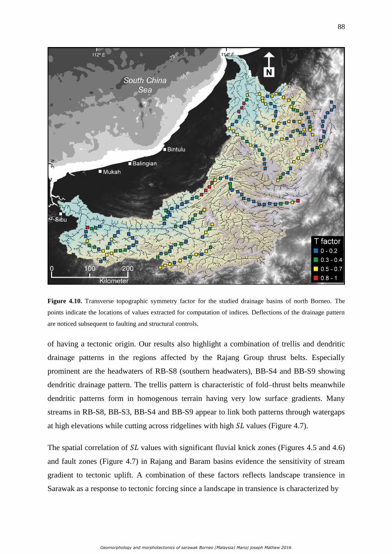
88
Figure 4.10. Transverse topographic symmetry factor for the studied drainage basins of north Borneo. The
points indicate the locations of values extracted for computation of indices. Deflections of the drainage pattern
are noticed subsequent to faulting and structural controls.
of having a tectonic origin. Our results also highlight a combination of trellis and dendritic
drainage patterns in the regions affected by the Rajang Group thrust belts. Especially
prominent are the headwaters of RB-S8 (southern headwaters), BB-S4 and BB-S9 showing
dendritic drainage pattern. The trellis pattern is characteristic of fold–thrust belts meanwhile
dendritic patterns form in homogenous terrain having very low surface gradients. Many
streams in RB-S8, BB-S3, BB-S4 and BB-S9 appear to link both patterns through watergaps
at high elevations while cutting across ridgelines with high 𝑆𝐿 values (Figure 4.7).
The spatial correlation of 𝑆𝐿 values with significant fluvial knick zones (Figures 4.5 and 4.6)
and fault zones (Figure 4.7) in Rajang and Baram basins evidence the sensitivity of stream
gradient to tectonic uplift. A combination of these factors reflects landscape transience in
Sarawak as a response to tectonic forcing since a landscape in transience is characterized by
Geomorphology and morphotectonics of sarawak Borneo (Malaysia) Manoj joseph Mathew 2016

89
Figure 4.11. Local relief map of Rajang and Baram drainage basin constructed with an analysis grid consisting
of cells having an area of 1 km2 (see data and techniques). The map is draped over 30 m SRTM DEM to
highlight the topography. High relief values mainly constitute locally parts of the Rajang Group thrust belts, the
Hose Mountains, Dulit triangle and Mount Mulu. Inset map illustrates relief anomaly of both basins highlighting
high-elevation low-relief surfaces indicated by white dashed ovals (see data and techniques and Fig. 4.3D). 𝑆𝐿
anomalies corresponding to figure 4.5 and 4.6 are shown along the main tributary streams used for analysis.
Also shown are locations of Figure 4.3 (A and D) and 4.12.
migrating knick-points and knick-zones in the river profile created by tectonics as compared
to static knick-points created by lithological contrasts (Whipple and Tucker, 1999; Bishop et
al., 2005; Willett, 2006; Whittaker et al., 2007; Attal et al., 2008; Loget and Van Den
Driessche, 2009; Gallen et al., 2013; Giletycz et al., 2015).
The response of a landscape to a change in tectonic uplift is dominated by an increase in
channel and hillslope gradient, leading to an increase in stream power and incision capability
of rivers. Landscape morphology and drainage evolution of both Rajang and Baram drainage
basins can be quantitatively characterized by the incision style of the rivers. The present day
Geomorphology and morphotectonics of sarawak Borneo (Malaysia) Manoj joseph Mathew 2016

90
Figure 4.12. Field photographs of geomorphic features pertaining to topographic breaks or knick-points
corresponding to waterfalls in RB-S5 and BB-S3 (A), (B), (D) and (F), and terraced boulder to gravel sized
fluvial deposits unconformably overlain above the incised basement rocks of streams in RB-S8 (C) and (E).
Refer to figure 4.11 for locations.
incision pattern observed in both basins shows active landscape dissection due to rapid down
cutting by streams in most of the valleys with prominent V-shapes that is consistent with field
Geomorphology and morphotectonics of sarawak Borneo (Malaysia) Manoj joseph Mathew 2016

91
observations (Figures 4.8 and 4.9). 𝑉𝑓 index is a proxy for active tectonics since uplift is
associated with incision (El Hamdouni et al., 2008). Active incision by streams in response to
tectonic deformation are responsible for the present-day morphology of the valleys in north
Borneo and deflection of streams leading to a possible drainage reorganization and landscape
rejuvenation. This inference is further substantiated by our results from 𝑇 factor analysis
(Figure 4.10).
Our results describe a topography, albeit with high altitudes, is characterized by upland low-
relief surfaces nested between ridges and in the regions of complex deformation (Figure
4.11). These are delimited by faults in Rajang (RB-S8) and Baram (BB-S3, BB-S4 and BB-
S9) basins (Figure 4.2) and evidenced through field survey as well (Figure 4.3D). These
elevation-accordant surfaces are preserved as relict surfaces in regions experiencing
perturbations in tectonic uplift rates and fluvial erosion has not yet counterbalanced this uplift
(Clark et al., 2005; Burbank and Anderson, 2011; Legrain et al., 2014; Giletycz et al., 2015).
We interpret the observed high-elevation low-relief surfaces, preserved locally in the interior
of the folded and thrusted ranges of Rajang and Baram basins, as relict portions of landscapes
characterized by low amplitude relief. Upstream segments of channel longitudinal profiles of
rivers draining the aforementioned sub-catchments along with others (Figures 4.5 and 4.6),
record planation surfaces without prominent knick-points followed by mid-reach fluvial
knick-zones. These characteristics suggest tectonic uplift of these relict surfaces separating a
lower adjusting zone and the remnant portions of the drainage network. As a feedback to a
dominant tectonic input, the topography exhibits progressively down-cutting streams creating
steep valleys. This propagating front of river incision is a dynamic adjustment to
counterbalance new base-level conditions, indicating that the landscape evidences a transient
response to disequilibrium.
4.6.2 Implications on Regional Tectonism
Among the two basins studied, the Rajang River coincides with the Rajang fault while the
trunk stream flows along the Tinjar fault (Figures 4.1 and 4.2) in the Baram drainage basin.
The drainage divides between Rajang and Baram basins are delimited by the onshore Tinjar
fault. The offshore West Baram discontinuity splits both zones into two major tectonic blocks
that experience varying levels of tectonic activity (Cullen, 2010) (Figure 4.3). The ongoing
tectonic activity causing recent uplift in Borneo may be attributed to regional compression or
extension (Hall, 2013) and possible large-scale geodynamic mantle processes and as a
Geomorphology and morphotectonics of sarawak Borneo (Malaysia) Manoj joseph Mathew 2016

92
response, the propagating wave of tectonic forcing reactivated these major faults along with a
number of smaller pre-existent dislocation zones.
Onshore Sarawak, the main tectonic structures observable is compressional fold and thrusts
producing crustal shortening. During the Miocene, compression was dominantly ubiquitous
in large parts of offshore and onshore Sarawak resulting in folding. Central and southern
Sabah experienced this phase of tectonism with a relatively stronger magnitude resulting in
strong folding initiated through basement uplifts and wrench faulting (Darman and Sidi,
2000). This compressional regime may be linked to the first convergence of Australia and
Southeast Asia at ca. 23 Ma. The oblique convergence may have been accommodated by both
strike-slip faulting and crustal shortening.
By the end of the Miocene (ca. 5 Ma), Borneo had completely emerged with only ~10 % of
present-day areal extent under water (Molnar and Cronin, 2015). Sarawak and north Sabah
experienced a phase of deformation triggered by trough basement uplifts and wrench faulting
during the Pliocene (Darman and Damit, 2003). Evidences of folding and thrusting as a result
of these tectonic stages have been observed offshore by previous works (Cullen, 2010;
Menier et al., 2014).
Long-term (2 Ma) base-level lowering estimated by Farrant et al. (1995) from limestone
caves in Mulu, Sarawak showed results of 0.19 +0.03/ -0.04 mm y-1
. They correlated this
base-level lowering with epirogenic uplift rates and suggested an uplift rate of 0.23 mm y-1
for the surrounding Setap Shale. Assuming this uplift rate as constant since 5 Ma, it would
yield a present day elevation of the low relief relict shallow marine Miocene deposits in the
headwaters of the Baram basin (Figures 4.2 and 4.11) at ~1100 m. This calculated elevation
coincides with the present-day elevation of this relict surface (Figure 4.1). However, for such
estimations, very low to no denudation have to be speculated in order to preserve the entire
bulk of uneroded landscape. This is not the case in Borneo where rapid erosion is estimated
to have removed more than 6 km crust since the Neogene (Hall and Nichols, 2002);
moreover, adjacent ridges within the same basin rise to elevations of exceeding 2000 m
(Figure 4.1). Based on the above, we posit that by the end of the Miocene (~ 5 Ma), entire
Borneo experienced a phase of rapid uplift (possibly due to proto–South China Sea slab
break-off) either in multi-phased alternating high and low rates of uplift, or a single-phase
rapid uplift that could have gradually slowed down to present-day rates estimated by Farrant
et al. (1995). This rapid uplift rate could have altered the precipitation rates of entire Borneo
Geomorphology and morphotectonics of sarawak Borneo (Malaysia) Manoj joseph Mathew 2016

93
through orographic effect resulting in a dense river network and local piracy events to
organize the present-day drainage basins of Sarawak. Our interpretation is congruent with the
conclusions of Molnar and Cronin (2015) that the mountains of Borneo are young (< 10 Ma)
and the ranges could have grown in elevation in the past 5 Ma and the precipitation rates of
tropical islands within the Maritime continent increased during the same time. The dense
drainage network formed by exacerbated precipitation rates in Sarawak could have
effectively removed (from the Sarawak part of the Interior Highlands) a covermass of
Miocene shallow marine sequence that was deposited prior to the rapid uplift. This removal
of Miocene covermass from the rapidly uplifting Interior Highlands could answer the
preservation of Oligocene-Miocene sediments only in the coastal regions of Sarawak (Figure
4.2) owing to relatively lower elevations and smaller drainage basins (with relatively lower
drainage density) in the coastal zones. However, local capture events while the present
drainage basins were being organized (as a result of rapid tectonic uplift and increased
orographic precipitation) could have left locally distributed isolated remnants of the
covermass and underlying Oligocene deposits manifested as the high elevation low relief
surfaces in our results (Figure 4.11) which were unable to erosionally balance the rapid uplift.
These surfaces can form in-situ as a result of local piracy processes in transient landscapes as
established by previous studies (e.g., Willett et al., 2014; Yang et al., 2015).
The newly organized stream network, after removing the covermass, could have then incised
into the underlying Oligocene deposits and the Rajang fold–thrust belts indicating
superposition with antecedence forming watergaps and windgaps as indicated by the results
of 𝑆𝐿 which shows discordant dendritic patterns in the headwaters of basins affected by
folding and thrusting (Figure 4.7). The dendritic pattern also shows high values of 𝑉𝑓
implying broad flat-floored valleys in the southern headwaters and northern mid reaches of
RB-S8 (Figure 4.8). These regions are characterized by low relief as seen in Figure 4.11.
Results from topographic analysis show regions maintaining high local relief within the fold–
thrust belts (Figure 4.11) with high 𝑆𝐿 values and knick-zones in the downstream to mid-
reaches of the rivers (Figure 4.5, 4.6 and 4.7), and stream deflection (Figure 4.10) along with
drainage reorganization to a trellis pattern through capture and piracy. These are diagnostic
features of active folding where the tectonic signal and consequent upstream propagating
erosional wave has not yet reached the headwaters (Holbrook and Schumm, 1999; Snyder et
al., 2000; Lavé and Avouac, 2001; Hilley and Arrowsmith, 2008; Burbank and Anderson,
Geomorphology and morphotectonics of sarawak Borneo (Malaysia) Manoj joseph Mathew 2016

94
2011). It should also be noted that in regions experiencing high erosion rates such as Borneo,
geomorphic response to tectonic deformation can be removed rather rapidly and uplift rates
during recent phases (<5 Ma) should be very high in order to maintain a young topography
that retain evidences of tectonic signals produced by these phases. Thus, through our results,
it can be reasoned that Borneo undergoes tectonic deformation in the form of active
shortening within the fold–thrust belts of the island that leads to resurgence of the Bornean
landscape. This shortening could be accommodated by major faults such as the Tinjar Fault
which runs across-strike of the fold–thrust belts and shows present-day motion along the fault
(Simons et al., 2007). Active shortening and reactivation of major faults could have also led
to reactivation of minor dislocations. Indeed, judging from the mean elevations of the
highlands of Borneo, it may not be classified under zones experiencing high rates of crustal
shortening. Therefore, as discussed above, the rates of deformation in Sarawak could be
considerably lower since ca. 2 Ma and enhanced orographic precipitation after ca. 5 Ma could
have increased erosional capabilities allowing the topography to quickly attain a transient
stage in response to the initial rapid uplift experienced between ~ 5 Ma – ~ 2 Ma and the
present-day active shortening. Indeed, timing of deformational events, rates of uplift and
denudation could be better constrained with the implementation of cosmogenic nuclide
techniques and numerical modeling. Within this setting in Sarawak, we conclude that fluvial
erosion has not yet fully compensated the perturbations in tectonic boundary conditions and
reflects transience in the present-day.
4.7 Conclusion
Through quantitative morphometric analysis emphasizing on hydrography and topography,
we demonstrated the role of surface processes and topographic adjustment on landscape
development in a tropical rainforest environment. The morphometric parameters indicate a
transient response of the landscape to disequilibrium initiated by active tectonic forcing. Our
results describe a topography in which rivers in Borneo are still adjusting to tectonic input.
This adjustment is prominently evident in stream length-gradient, which show anomalously
high and low values in the mid-reach and downstream segments of the streams. These values
corresponding to topographic breaks or knick-zones in the analyzed streams are controlled by
tectonic input as revealed in the channel longitudinal profiles. The landscape of north Borneo
is characterized by actively incising rivers that give rise to deep and steep V-shaped valleys
that are predominant signatures of active tectonics. Our analysis also revealed the presence of
Geomorphology and morphotectonics of sarawak Borneo (Malaysia) Manoj joseph Mathew 2016

95
high-elevation low-relief surfaces that indicate relict portions of landscapes that were
tectonically uplifted and preserved. These surfaces do not show prominent knick-zones in the
upstream segments of channels draining them; however, river long profiles reveal mid-reach
knick-zones indicative of adjustment related to new base-level conditions induced by uplift.
During Upper Neogene Period (~ 5 Ma), Borneo could have experienced a major tectonic
event leading to rapid uplift of possibly the whole Interior Highlands and coastal areas of
Sarawak. This tectonic setting could have promoted orographic effect and along with the
rapid uplift could have promoted capture and stream piracy events and resulted in a dynamic
reorganization of the drainage network and preserved relic landscapes. This work had shown
that deformation in the form of active folding is an ongoing process, perhaps at low rates.
However, the altered orographic precipitation patterns post ~ 5 Ma has since intensified
denudation and the possible deceleration of deformation rates after the rapid uplift phase has
helped to quickly attain a state of topographic adjustment. Given these conditions, we
conclude that the landscape of Borneo has undergone rejuvenation and demonstrates a
transient geomorphic response as feedback to tectonic-climatic forcing.
Geomorphology and morphotectonics of sarawak Borneo (Malaysia) Manoj joseph Mathew 2016

96
Chapter 5
The Geomorphic Evolution of Sarawak, North
Borneo
Mathew, M., Menier, D., Ramkumar, M., Santosh, M., Siddiqui, N., 2016.
Geoscience Frontiers (Submitted).
_____________________________________________
Contents
5.1 Introduction
5.2 Geological and Geomorphic Characteristics
5.3 Materials and Methods
5.3.1 Swath Topographic Profiles
5.3.2 Minimum Bulk Erosion
5.3.3 ksn Anomaly
5.4 Results
5.4.1 Topographic Characteristics
5.4.2 Relative Eroded Rock Column
5.4.3 Normalized Channel Steepness Anomaly
5.4.4 Sedimentology Field Campaigns
5.5 Discussion
5.5.1 The Geomorphic Evolution of Sarawak, north Borneo
5.5.2 Transient Channel Incision as a Driver of Erosion Rates in northern Borneo
5.6 Conclusion
_____________________________________________
5.1 Introduction
Understanding the interplay among tectonic deformation, climate forcing, erosion and long-
wavelength crustal responses to mass loading and unloading is pivotal in deciphering
Geomorphology and morphotectonics of sarawak Borneo (Malaysia) Manoj joseph Mathew 2016

97
landscape evolution of a region. Although isolating and diagnosing the exclusive role of each
process in sculpting a landscape at different time-scales may render uncertainties; channel
incision and erosion have been documented to be augmented by combined relationships
between tectonics and climate (e.g., Burbank and Anderson, 2001; Kirby et al., 2003; Kirby
and Whipple, 2012, Hagipour and Burg, 2014). Thus, fluvial systems are sensitive to tectonic
and/or climatic processes and the analysis of incision and erosional regimes of landscapes can
be used as archives recording these processes (e.g., Schumm et al., 2000).
Borneo is the third largest island in the World and is shared by Malaysia (Sabah and
Sarawak), Brunei and Indonesia (Kalimantan) (Figure 5.1). It is enveloped by vastly
inaccessible tropical rainforests, hostile rugged mountainous terrain and deep valleys that
effectively impede and restrain geological and geomorphological research in this region.
Borneo has experienced an ever-wet climate since Early Miocene following the collision of
the Australian Plate with the Eurasian Plate (Morley and Flenley, 1987; Sia et al., 2014). The
island is characterized by remarkably high rates of denudation over the last 20 Ma (average
minimum denudation rate of 326 m Ma-1) which, for the same period, can be compared to
the Himalayas albeit the area of land above 100 m asl in Borneo is only one third of the area
of the Himalayas (Hall and Nichols, 2002). Although much work has been done on the
sedimentology and stratigraphy of Borneo, there exists a general scarcity of studies pertaining
to geomorphic evolution and processes that govern ‘source to sink’ dynamics. Given the size
of Borneo and its tectonic complexity, it would thus be fittingly imperative to analyze parts of
the island having similar tectonic and stratigraphic history.
Here we demonstrate using conceptual models, the geomorphic evolution of Sarawak, north
Borneo by a systematic geomorphic evaluation of two of the largest drainage basins of
Borneo Island: Rajang and Baram basins (Figure 5.1). We combine our results from field
sedimentology (stratigraphy), and quantitative and qualitative geomorphic assessment in
order to elucidate the role of endogenic and exogenic processes affecting landscape evolution
of Sarawak. Stratigraphic successions can be indicators of environments of deposition and
could be used as analogs of local eustatic fluctuations. We extend classical field
sedimentological analysis by the quantitative description of topographic and geomorphic
characteristics of the basins, measured from digital elevation models (DEMs), which
distinctly expresses spatial distribution of the controls of the fluvial system with regard to
channel incision, erosion and deformation. The resulting model potentially highlights the
Geomorphology and morphotectonics of sarawak Borneo (Malaysia) Manoj joseph Mathew 2016

98
Figure 5.1. Shaded relief model of the study location of Rajang and Baram drainage basins of north Borneo.
The drainage network is shown in blue solid lines and thickness is based on upstream drainage area. Also shown
are some of the important highlands and tablelands of north Borneo. White dashed-line marks the approximate
northern limit of the Interior Highlands of Borneo. White solid lines indicate rectangular swath profile windows.
processes responsible for denudation, sediment sourcing and deposition, and it could be
integrated in tectonic evolution models at a regional scale.
5.2 Geological and Geomorphic Characteristics
Situated in the Sundaland core, Borneo is enveloped by tropical rainforests, mountains and
deep valleys that effectively impede and restrain geological and geomorphological research
in this region. Sarawak is one of the states belonging to Malaysia and is located on the
Borneo Island. The east Malaysian state forms the northwest Borneo segment and borders the
Malaysian state of Sabah to the northeast, the Indonesian state of Kalimantan to the south and
surrounding the independent state of Brunei (Figure 5.1).
Geomorphology and morphotectonics of sarawak Borneo (Malaysia) Manoj joseph Mathew 2016

99
Figure 5.2. Perspective view of the geology of Sarawak. Red triangles denote some of the locations of
fieldwork. Also shown is a general stratigraphic scheme of the central and north Sarawak.
Geologically, Sarawak can be divided into three distinct regions- west, central and north
Sarawak (Tan, 1979). The studied basins: Rajang and Baram Basins drain the north and
central parts of Sarawak. Both central and north zones are composed of sandstones,
greywacke, shale, siltstone, clay (Hutchison, 2005; Siddiqui et al., 2015) and minor amounts
of limestone and volcanic rocks ranging in age from late Cretaceous to Pliocene (Light et al.,
1994) (Figure 5.2). In central and north Sarawak, structural trend lines run in broad curves.
The central Sarawak terrain, covering the area between Lupar Line and the Bukit Mersing
Line, is an arcuate fold and thrust belt called the Rajang Group Fold-Thrust belts that extend
over a distance of < 1000 km along strike and a width of over 300 km (Tan, 1979; Williams
et al., 1986) (Figure 5.2). This zone composed of the orogenic belt, named as Sibu Zone in
Sarawak (Haile, 1974), forms the Sarawak part of the Interior Highlands of Borneo (Figure
5.1), and has been summarized as an Upper Cretaceous-Middle Eocene steeply dipping shaly
turbidite with thin sandstone layers (Figure 5.2) (Wolfenden, 1960; Haile, 1962; Hutchison,
Geomorphology and morphotectonics of sarawak Borneo (Malaysia) Manoj joseph Mathew 2016

100
2010). The uplift of the Sibu Zone is interpreted to have occurred at the end of the Eocene, an
event referred to as the ‘Sarawak Orogeny’ (Hutchison, 2005, 2010). The folds of this belt are
described to be tight, overturned and broken by thrust faults (Tongkul 1987; Honza et al.
2000; Cullen, 2010) with at least one major thrust fault in between the formations within the
Group. In Sarawak, an angular unconformity separates the Rajang Group from the overlying
Oligocene-age shallow marine sediments (Cullen, 2010) (Figure 5.2). The geology of central
and north Sarawak is younger than that of west Sarawak and special note must be taken that
much of the geologic mapping of interior Borneo has been carried out only on a
reconnaissance scale since access to the interiors is still logistically difficult (Hutchison,
2010). The Miocene sediments in Sarawak consist mainly of shallow marine successions of
sandstone, siltstone and clay (Figure 5.2). The Mio-Pliocene formations consist of
successions of clays, sandstones and very coarse to pebbly sandstone with local, boulder
conglomerates at the base (Mat-Zin, 1996). Faulting and folding are common and appear to
have affected all the rocks in the area except the Quaternary.
Since Early Miocene, Borneo has experienced a similar ever-wet climate (Hall and Nichols,
2002). Due to the abundant precipitation, Sarawak has an intricate drainage network that rise
in the interior ranges and flow through deep gorges and rapids until they reach the coastal
plains where they meander before draining into the South China Sea. Sarawak experiences a
tropically hot and extremely humid equatorial climate and can be considered to be uniform at
the scale of investigation. Annual mean temperature is of the order of 25° C – 32° C with a
relative humidity of ~80 % for much of the year. Annual rainfall in Sarawak varies from
3500 mm yr-1 to 4600 mm yr-1, spanning 220 days an year with two monsoonal changes
(Hua et al., 2013). An estimated 6 km of crust has been removed by erosion from Borneo
during the Neogene due to high rates of weathering and erosion (Hall and Nichols, 2002). In
terms of sediment yield, rapid removal of material by erosion makes Borneo Mountains
comparable to mountain ranges such as the Alps or Himalayas (Hall and Nichols, 2002). A
rapid erosional regime is induced with intense chemical weathering in majority of Sarawak.
The surficial topography of central Sarawak varies from terrain underlain by recessive shale
through zones of linear ridges (interbedded sandstone and shale) to rugged highlands
consisting of thick massive sandstones (Light et al., 1994; Siddiqui et al., 2015). In the
interior of Sarawak, the landscape is dominated by a wide swath of discontinuous plateaus
built of late Cenozoic volcanic and pyroclastic rocks (Figures 5.1 and 5.2). The Hose
Geomorphology and morphotectonics of sarawak Borneo (Malaysia) Manoj joseph Mathew 2016

101
Mountain Plateau, consisting of deeply dissected mesa, is about 32 km across rising to 2006
m rests on lower Miocene Nyalau Formation equivalent (Kirk, 1957). The Linau–Balui
Plateaus covers 290 km2 and rises to 1127 m resting unconformably on folded Belaga
Formation. It consists of a northern Tableland of 1100 m elevation and a larger southern
Tableland of about 820 m elevation. The Usun Apau Plateau is about 906 km2 with small
dissected volcanos that rise to 1372 m (Cullen et al., 2013). The plateau along with the Tinjar
Fault separates the Baram and Rajang basins (Figure 5.1). The plateau has high cataracts and
waterfalls spilling over its rim with plunges of more than 200 m (Hazenbroek and Morshidi,
2001; Cullen et al., 2013).It consists of an eastern Tableland of approximately 1000 m
elevation and a smaller western Tableland of 760 m high (Hutchison, 2005). The Usun Apau
and Linau–Balui volcanic plateaus and Hose Mountains are considered to be younger than 4
Ma (Cullen et al., 2013).
5.3 Materials and Methods
5.3.1 Swath Topographic Profiles
Elevation data of complex topographies can be condensed into a single profile (Duncan et al.,
2003; Ponza et al., 2010). A rectangular swath of 25 km width was chosen to extract a series
of parallel profiles that are separated by 1-cell (90 m). The width of the swath used in this
work was chosen as it is large enough to appropriately condense both elevated surfaces and
streams and on the other hand, is small enough to avoid averaging topographic structures that
are too oblique to the axis of the rectangular swath. Statistical parameters such as maximum,
minimum and mean elevations were calculated along each swath profile within a GIS
environment. The plot for maximum elevation corresponds to the ridgelines and the curve for
the minimum elevation depicts the valley floors or river beds. A measure for incision can be
produced by the arithmetic difference between the maximum and minimum elevations within
the longitudinal distance of the swath rectangle (Andreani and Gloaguen, 2016).
5.3.2 Minimum Bulk Erosion
The amount of eroded rock column and relative erosional stage of basins can be estimated by
firstly envisaging a theoretical pre-incision surface. The raster map of this surface was
constructed by interpolating elevations from the present-day drainage divide of the basins
(Menendez et al., 2008) using GIS software. A minimum bulk erosion map was then
Geomorphology and morphotectonics of sarawak Borneo (Malaysia) Manoj joseph Mathew 2016

102
constructed by subtracting elevation values contained in each cell of the pre-incision raster
from the elevation values contained in each cell of a Digital Elevation Model (DEM). Indeed
the ridgelines forming drainage divides themselves are subject to erosional processes
(Brocklehurst and Whipple, 2002). Therefore, the resulting map will highlight the minimum
amount of eroded-rock column and facilitate the discernment of under-eroded areas from
areas subject to high erosion rates, thus allowing relative comparisons of erosional stages
between basins.
5.3.3 ksn Anomaly
Normalized channel steepness index (ksn) is used by us in order to determine the relative
gradient of the channels (Safran et al., 2005). The slope–area regression has the following
form (Flint, 1974)
S = ks A-θ
where S is the local channel slope, ks is the steepness index, A is the upstream drainage area
and θ is the channel concavity index. A normalized channel steepness index ksn is estimated
by normalizing the catchment area of a given reach and using a reference concavity (θref)
which corresponds to the regional concavity observed in reaches unperturbed by tectonic
signals. The above equation can be re-written as
S = ksn A-(θref)
A reference concavity (θref) of 0.45 was used for all channels to facilitate the comparison of
our results. θref of 0.45 was chosen as it is within the range commonly perceived in bedrock
rivers regardless of rock uplift rates and erosion (Kirby and Whipple, 2001; Wobus et al.,
2006).
We then constructed anomaly maps from the values of channel steepness index by using an
ordinary krigging statistic method based on a variogram model. The resulting map highlights
areas with maximum density of high steepness values relative to its neighboring cells.
Geomorphology and morphotectonics of sarawak Borneo (Malaysia) Manoj joseph Mathew 2016

103
Figure 5.3. Swath profiles across the Rajang and Baram basins. Rectangular swath window is maintained at 25
km width. Blue, green and red curves in the line graph indicate maximum, mean and minimum elevation
respectively. Blue histogram graph shows incision and orange histogram graphs indicate ksn values. Black
dashed-lines identify mean annual precipitation rates derived from TRMM data. Note the elevation of the
Interior Highlands increases from profile 1 to 3.
Geomorphology and morphotectonics of sarawak Borneo (Malaysia) Manoj joseph Mathew 2016

104
5.4 Results
5.4.1 Topographic Characteristics
We analyzed the topography of both Rajang and Baram drainage basins along three swath
profiles (Figures 5.1 and 5.3). The maximum, minimum and mean elevation of each profile
was extracted and annual averaged precipitation derived from the Tropical Rainfall
Measuring Mission (TRMM), that was measured from 1998 – 2009 (Bookhagen, 2009), was
plotted along with the elevation curves (Figure 5.3). The swaths in both basins are
perpendicular to major ridgelines and valleys. Estimates of local incision were derived by
subtracting the maximum and minimum elevation.
In the Rajang basin, profile 1 passes through the Rajang Fault located in the central section of
the swath rectangle which coincides with the main trunk stream of the central valley of the
basin: the Rajang River (Figure 5.1). The southern zones of the swath profiles encompass
wrench faults and transform faults, and the profile in general covers the fold and thrust belts
of the Rajang Group. The topography increases significantly from ~ 450 m in the northern
side to ~ 1150 m in the southern side. The minimum elevation curve shows the floodplain of
the Rajang River to illustrate a steep gradient to the northern side in comparison to the flood
plains of the other valleys in the southern zone within the swath boundary. The mean
elevation of the central valley is ~ 300 m and the local incision appears to be ~ 50 m. Incision
rates increases considerably toward the southern parts of the profile with mean values ~ 100
m. Precipitation rates indicate peaks of orographic effects along ridgelines and rain shadow
zones can be noticed in the inner parts of the valleys (Figure 5.3). Profile 2 comprises of
topography covering major portions of the fold and thrust belts in the northern and central
parts of the swath (Figure 5.1). Although the southern zone passes along the less folded
topography showing low slope gradients as illustrated by the dendritic pattern drainage
network (Figure 5.1), the elevation appears to maintain similar peaks from the north to the
south (Figure 5.3). Incision patterns show prominent increase in the northern to central parts
consisting of rivers controlled by faults and fold and thrust belts with mean local incision
indicating values of ~ 100 m. Precipitation rates display spikes on topographic peaks
indicating increased orographic precipitation and shadowing effect in the shielded zones of
the valleys (Figure 5.3). It should be noticed that higher rainfall rates are recorded in the
northern and central parts of the swath as compared to the southern zone.
Geomorphology and morphotectonics of sarawak Borneo (Malaysia) Manoj joseph Mathew 2016

105
Figure 5.4. Minimum bulk erosion map showing the main streams and faults of the Rajang and Baram basins.
Within the profile 3 in the Baram basin (Figure 5.1), topographic elevations increase
dramatically from ~ 400 m in the northern parts of profile 3 to ~ 1900 m in the southern parts
and incision rates show significant increase in the same direction as well (Figure 5.3). It is
noteworthy that the headwaters of the Baram basin show deeper incision as compared to the
Rajang basin. Orographic rainfall rates increase as elevation rises with intermittent shadow
zones in the valleys.
5.4.2 Relative Eroded Rock Column
Even a cursory examination of the minimum bulk erosion map reveals that the Baram basin
shows a relatively larger volume of rock column being eroded from the headwaters and
central parts of the basin as compared to the Rajang basin (Figure 5.4). Indeed the Baram
basin hosts weakly eroded zones in the headwaters that belong to the Interior Highlands
Rajang Group fold and thrust belts. The Rajang basin on the other hand, shows a lesser
eroded topography with prominent under eroded zones along the thrust belts (Figure 5.4).
Geomorphology and morphotectonics of sarawak Borneo (Malaysia) Manoj joseph Mathew 2016

106
5.4.3 Normalized Channel Steepness Anomaly
Channel steepness index represents a metric of channel morphology and can define,
qualitatively, zones characterized by variations in rates of channel incision. The anomaly
maps constructed by us distinguish areas of high channel steepness from areas showing low
steepness that reveal clear variations in both drainage basins (Figure 5.5). The map shows
low values of steepness at the downstream segments of both basins. However, high values are
recorded in the headwaters of the Rajang and Baram basins (Figure 5.5). Higher values are
especially concentrated along the fold and thrust belts of the Interior Highlands Rajang
Group. Fieldwork to accessible parts of both basins revealed knick points corresponding to a
number of waterfalls and/or faults were observed along the segments showing high values
(Figure 5.5).
5.4.4 Sedimentology Field Campaigns
Elaborate and comprehensive field campaigns were carried out between the years 2012 –
2015 to various locations in northern Borneo of which some of the studied locations in
Sarawak are labeled in Figure 5.2. The objective of the field campaigns were to describe
structural characteristics, facies characterization in order to elucidate the lateral extent of
different lithofacies for stratigraphic correlation and interpreting depositional environments
and ultimately integrating these datasets into a geomorphic evolution model. Some of the
major stratigraphic units in Sarawak outcrop extensively along the coastal zones with good
exposures of complete sections (Figures 5.2 and 5.6). Bearing in mind the objective and
intend of this manuscript, only the main stratigraphic sequences of Sarawak will be discussed
in this section.
The Upper Miocene, Lower Pliocene and Upper Pliocene sequences of Balingian, Begrih and
Liang Formations outcrop in the Mukah – Balingian district (Figure 5.2). The Liang
Formation (Upper Pliocene) consists of successions of clay and sand with abundant lignite
and some tuff which were deposited in a shallow marine to coastal plain setting (Figure 5.2).
The Begrih Formation (Lower Pliocene) contains abundant abandoned channel deposits with
fine sandstone, laminated sandstone, ortho-conglomerates, sandy conglomerate and locally a
boulder conglomerate at the base (Figure 5.2). The Formation also includes large amounts of
coal and coal seams along with lignite beds. The deposits are interpreted to be of a
continental fluviatile origin. The Balingian formation (Upper Miocene) consists of thick
Geomorphology and morphotectonics of sarawak Borneo (Malaysia) Manoj joseph Mathew 2016

107
Figure 5.5. Ksn anomaly map indicating regions of high channel steepness. Note the congruence of high
channel steepness with the known faults of Sarawak.
sandstone, mudstone, shale, siltstone and rare pebbly conglomerate beds (Figure 5.2). The
formation hosts abundant coal and lignite beds, and is one of the largest coal mining sites in
Sarawak. The Balingian Formation is interpreted to have been deposited in an estuarine to
lagoonal environment.
The Middle – Late Miocene age Miri Formation outcrops around the Miri town (Figure 5.2
and 6). This Formation is one of the important oil bearing sedimentary strata offshore
Sarawak. Miri Formation is predominantly argillaceous in the lower sequences and the upper
succession is more arenaceous with thick sandstone beds and inter-bedded sandstone – shale.
The Formation is interpreted to have been deposited within a shallow marine environment.
For a detailed sedimentological and stratigraphic description with graphical logs, the reader is
referred to Siddiqui et al. (2014).
Geomorphology and morphotectonics of sarawak Borneo (Malaysia) Manoj joseph Mathew 2016

108
Figure 5.6. Field photographs on Miri, Nyalau, Tatau Ransi and Belaga Formation.
Geomorphology and morphotectonics of sarawak Borneo (Malaysia) Manoj joseph Mathew 2016

109
The Oligocene – Miocene (age derived from fossil records) Nyalau formation dominates the
Bintulu region and to south of Bintulu, and along the Bintulu – Miri coastal road in the north
(Figure 5.2 and 5.6). The Nyalau Formation is ~ 1000 – 2000 m thick sequences of shallow
marine and paralic sedimentary rocks in Bintulu, predominantly consisting of heterolithic
beds, cross bedded sandstones and coal-bearing mudstones. Coal is abundant and thin seams
are interbedded with shale and sandstone at many localities. The Formation is gently to
moderately folded and rests conformably on the Buan Formation and the upper boundary of
the formation grades into the Setap Shale Formation (Figure 5.2). Bioturbation of vertical
trace fossils particularly of Skolithos and Ophiomorpha ichnofacies is abundant within the
Formation (Figure 5.6).
The Eocene – Oligocene Tatau Formation is considered to rest unconformably on the Rajang
Group basement. The thickness of this Formation is measured to be 3000 m (Hutchison,
2005). The studied outcrops of the Tatau Formation consists of predominantly intensely
folded carbonaceous shale and siltstone in the lower sequence, fine to medium grained
sandstone and conglomerate beds (Figure 5.6). The Ransi Member conglomerates are found
in the lower sequence of the Tatau Formation. The conglomerates overlie the basement rocks
of the Belaga Formation of the Rajang Group with an angular unconformity (Figure 5.6).
The Eocene age Belaga Formation belongs to the Rajang Group that forms the major fold and
thrust belt Interior Highlands that stretches from the northwestern and central parts of
Sarawak to Sabah in the north (Figure 5.1 and Figure 5.2) and is dubbed as the backbone of
Borneo. The analyzed Belaga Formation outcrops consists mainly of inter-bedded sandstones
and shale and is tightly folded with near vertical overturned beds with the presence of
numerous slump folds within larger fold limbs (Figure 5.6). The Belaga Formation is
interpreted to be deposited in a deepwater turbiditic environment experiencing mass flows.
Fieldwork conducted in the interior parts of Sarawak revealed the presence of deeply incised
V-shaped valleys, a number of knick points corresponding to waterfalls, cascades and
cataracts, low relief relict surfaces perched at high elevations and terraced boulder to gravel
sized fluvial deposits (Figure 5.2).
Geomorphology and morphotectonics of sarawak Borneo (Malaysia) Manoj joseph Mathew 2016

110
5.5 Discussion
5.5.1 The Geomorphic Evolution of Sarawak, north Borneo
We investigated the response of the topography of northern Borneo to perturbations in
boundary conditions with regard to landscape evolution. Based on our results of geomorphic
analysis, extensive field campaigns and, recent and previously published works, we show
through conceptual models the topographic development of Sarawak, north Borneo
emphasizing the controls of tectonic and climatic forcing on transient channel incision and
erosion.
During mid-Eocene, the Semitau continental fragment from South China accreted to northern
Borneo (Zahirovic et al., 2014) and this collision induced folding and thrusting of the Upper
Cretaceous – Early Eocene Rajang Group shaly turbidite considered to be the basement
sequence of northern Borneo (Figure 5.6). This orogenic event commencing with accretion/
collision could have attained maximum magnitude at ~ 37 Ma and was termed as “Sarawak
Orogeny” by Hutchison (2010). The uplift of the Central Highlands of Borneo through crustal
shortening may have exposed most of the landmass of Sarawak except for the zones covering
the present day coastal plains which could have been areas of deposition of the Tatau
Formation (Figure 5.2, Figure 5.6 and Figure 5.7). The record of this uplift event is witnessed
in the Upper Eocene Melinau Limestone in Sarawak (Figure 5.2) and Sebuku Limestone in
Kalimantan (Hutchison, 2010). The basal section of the Tatau Formation includes
carbonaceous shale and siltstone with fine to medium grained quartz sandstone (Hutchison,
2005). The basal sequence also records tectonic deformation in the form of folding consistent
with the folding and thrusting of the Rajang Group basement rocks (Figure 5.2 and Figure
5.6). The Tatau formation hosts rare conglomerate beds which could be related to the uplift
causing exposure of more surface area for fluvial erosion.
The uplift of terrain during the Late Eocene would have caused a drop in base level and
consequent shoreline retreat, and induced disequilibrium in the rivers, promoting active
incision and deposition of the Lower Oligocene shallow marine sequences above the Eocene
benthic deposits (Figure 5.7). Shoreline retreat would have exposed the shallow marine
Eocene sequences which formed the continental zones during the Lower Oligocene. The
exposed continental surfaces of Eocene deposits would have then been subjected to fluvial
incision and erosional processes. The bedrock channels could have been in transience while
Geomorphology and morphotectonics of sarawak Borneo (Malaysia) Manoj joseph Mathew 2016

111
Figure 5.7. Conceptual model showing the geomorphic evolution of Sarawak, north Borneo.
Geomorphology and morphotectonics of sarawak Borneo (Malaysia) Manoj joseph Mathew 2016

112
adjusting to the tectonic input and trying to attain base level. Indeed, these surface processes
proposed in our model are consistent with the Ransi Member conglomerate bed resting
unconformably over the Eocene folded basement rocks (Figure 5.6). The Ransi Member
conglomerates are epiclastic conglomerates generated by the breakdown of older rocks of the
Rajang Group and are located in the lower part of the Tatau Formation (Wong, 2012).
Topographic adjustment would have been at its efficient best with rivers almost attaining a
stable grade during the Oligocene when incipient rifting and initiation of seafloor spreading
related to the opening of the South China Sea commenced in the Upper Oligocene (Zahirovic
et al., 2014). These events caused rapid tectonic subsidence in the offshore and near-shore
parts of Sarawak as documented by Mathew et al. (2014). Rapid subsidence would induce a
local transgressive phase increasing accommodation space and altering local base level. Hall
and Nichols (2002) report that at the beginning of Miocene, the area of Borneo above sea
level was considerably smaller than at present and those marine sediments covered much of
northern and eastern Borneo. The event of sea level rise forces shoreline and river-mouth
backstepping along with shortening of streams (Blum and Hattier-Womack, 2009). The
deposition of the Oligocene – Miocene sediments of the Nyalau formation (Figure 5.6) would
have commenced during this phase with the hinterland supplying sediments as mean
elevation of the Central Highlands dropped (Figure 5.7). During the Early Miocene, a major
climatic change occurred following the collision of the Australian Plate with Sunda Plate (Sia
et al., 2014). There was increased rainfall with the onset of the Asian monsoon due to the
closure of the Indonesian Throughflow after the separation of the Indian and Pacific Oceans
owing to the Australian Plate collision (Morley, 2003, 2006, 2012; Sun and Wang, 2005).
Extensive development of rainforests commenced during this period which could have
sourced the Miocene coals of the Mukah coal seams (Sia et al., 2014). Sia et al. (2014)
showed from the architecture of the Mukah coal accumulated in the Balingian Formation
(Figure 5.2) that there was rapid increase in depositional base level which supports the
transgression proposed in our model. The increase in precipitation rates along with
transgression would have led to widening of rivers with capability of transporting and
depositing large amounts of sediments, and development of meanders and dendritic drainage
networks characteristic of regions with low topographic slope devoid of structural controls.
Relic Miocene shallow marine deposits with low relief can be witnessed as far as the
Sarawak parts of the Interior Highlands (Figure 5.2). The Miocene deposits could have filled
the incised channels formed on the previously continental surfaces that were exposed during
Geomorphology and morphotectonics of sarawak Borneo (Malaysia) Manoj joseph Mathew 2016

113
the Lower Oligocene times, and thus forming a covermass of Miocene sediments. This
postulation by us is coherent with and supported by the presence of the Ransi Member
conglomerate bed overlain by the Nyalau Formation in the Bintulu – Tatau zone in Sarawak
(Figure 5.6).
By the end of the Miocene, post 5 Ma, Mathew et al. (2016) showed that north Borneo
experienced a phase of rapid uplift in polyphased or single-phase event. This rapid uplift
resulted in enhanced orographic precipitation rates which in turn promoted the formation of a
dense drainage network in Sarawak. This phase of uplift is also recorded in the subsidence
curves constructed by Mathew et al. (2014) using near-shore wells in the Sarawak regions of
South China Sea. Recent studies conducted by Molnar and Cronin (2015) on the growth of
the islands of South East Asia including Borneo, showed that since 5 Ma, the mean elevation
of mountain ranges in the islands have grown considerably and this in turn altered the climate
through orographic effect. The tectonic uplift would have considerably lowered base levels
and coupled with high rates of precipitation could have forced active and rapid channel
incision. Rapid uplift and enhanced precipitation rates during this period could have
reorganized the drainage network to the present day patterns as a result of piracy events
(Mathew et al., 2016). The uplift of entire Sarawak could have promoted the development of
superposed drainage networks with antecedence as seen in the Rajang Basin wherein
transitional drainage patterns exist showing dendritic patterns adjacent to trellis patterns in
the headwaters of the basin (Figure 5.1). The actively incising dense drainage network of
Sarawak would have had the erosional capabilities to remove the covermass of Miocene
sediments as progressive downcutting continued. The presence of isolated remnants of relic
surfaces with low amplitude relief at high elevations of the Interior Highlands (Mathew et al.,
2016) bears further evidence to the rapid uplift event and capture processes leaving isolated
surfaces unable to erosionally balance the rates of uplift. The beheading and abandoning of
channels owing to capture processes can be witnessed in the Pliocene Begrih Formation
consisting of fluvatile conglomerates (Figure 5.2) and abandoned channel deposits. The
sudden drop in base level and channel abandoning by capture may also produce lakes and
mangrove swamps which can be sources of coal forming peat. Indeed, organic geochemical
characteristics, palynological analysis and organic petrological analysis of the coals from the
Begrih Formation and Liang Formation reveal a mangrove-derived source (Ni and Abdullah,
2004). The rapid erosion rates owing to tectonic-climatic forcing promoted the supply of
Quaternary sediments to the offshore regions and aided in progradation of deltas around
Geomorphology and morphotectonics of sarawak Borneo (Malaysia) Manoj joseph Mathew 2016

114
Sarawak, especially the West Baram Delta which developed since Late Miocene –
Quaternary. This inference is supported by the provenance analysis of sediments of the West
Baram Delta which was found to be sourced from the erosion of uplifted sandy outcrops of
the Nyalau Formation (Hutchison, 2005).
5.5.2 Transient Channel Incision as a Driver of Erosion Rates in Northern
Borneo
There was a significant change in the patterns of sedimentation around Borneo in the Early
Miocene (Hall and Nichols, 2002). The major delta systems of entire Borneo formed and
prograded rapidly and enormous amounts of clastic sediments were deposited in the deep
basins in the north and east of Borneo. Hall and Nichols (2002) opined that sediment volumes
can be used to estimate the amount of crust removed by erosion using appropriate densities
for sediments and consolidated crust. Using the above volume estimation, an average
thickness of crust removed from Borneo would equal 6.5 km. However, these estimates were
made using present-day erosional areas above 100 m elevation and according to Hall and
Nichols (2002) this is unreasonable since the area above sea level during the Miocene was
very small. From the present-day denudation area an average minimum denudation rate of
326 m Ma-1
over the last 20 Ma and maximum denudation rates of 965 m Ma-1
over the last
20 Ma is implied (Hall and Nichols, 2002). These rates can be compared to the Himalayas
having an average minimum denudation rate of 383 m Ma-1
and average maximum
denudation rate of 950 m Ma-1
over the last 20 Ma for the same present-day denudation area
(Einsele, 1992). The thickness of the prograded Pliocene Baram Delta alone exceeds 6 km of
clastic sediment (Rensbergen and Morley, 2003).
Based on the above discussion on rates and sediment thicknesses, our results and conceptual
model of geomorphic evolution of north Borneo, we propose that following the rapid uplift of
Sarawak after 5 Ma (Mathew et al., 2016) exposed additional topographic area for surface
processes to work on and the present-day active folding of the Rajang Group thrust belts
along with consequently high rates of rainfall combinedly contributed to high sedimentation
rates around Borneo after Miocene.
Inferences gathered from ksn anomaly map (Figure 5.5) constructed in this study highlight
regions having relatively high/ steep stream gradients which can be associated to a young
topography owing to active folding and uplift of the Rajang Group thrust belts (Mathew et
Geomorphology and morphotectonics of sarawak Borneo (Malaysia) Manoj joseph Mathew 2016

115
al., 2016). Rates of bedrock incision act as primary controls over long-term denudation rates
of orogenic belts (Whipple, 2004). On the other hand, bedrock incision can be intensified by
steepening of local stream gradients and spike in fluvial discharge rates. Conversely, in an
actively uplifting topography, the hillslopes and corresponding channel gradients are thought
to respond to river incision into bedrock by steepening to a maximum stable or ‘threshold’
angle (Larsen and Montgomery, 2012). Thus, it can be surmised that patterns of stream
gradients in the studied basins act as proxies of relative bedrock incision rates. Our results
demonstrate that channel steepness shows a relation of direct proportionality with incision in
both basins, in that, when incision increases, subsequently channel steepness values escalate
and concurrently display high orographic precipitation rates in zones of significant incision
(Figure 5.3). The patterns of precipitous channel gradients are consistent with locations of
deeply incised V-shaped valleys formed parallel to strike of the fold thrust belts identified by
Mathew et al. (2016).
Results from minimum bulk erosion elucidate weakly eroded regions within both Rajang and
Baram basins (Figure 5.4). Upon comparing the map showing minimum bulk erosion and the
map of ksn anomaly, it can be observed that the weakly eroded areas coincide with high ksn
values (Figure 5.3, Figure 5.4 and Figure 5.5) along with high incision rates. This is
indicative of a recent tectonic input causing vertical crustal movement that in turn promoted a
transient wave of incision to be introduced in the system. The occurrence of high bulk erosion
values especially in Baram basin (Figure 5.4) could be related to continuous fault activity that
could lower local base-level of streams allowing active incision and consequent erosion.
Efficient local incision within the Baram basin is also evident from the swath profile showing
high rates of incision in the headwaters of the basin (Figure 5.3) as compared to the Rajang
basin.
We posit that there exists a coupling between tectonic and climate forcing such that it
produces a positive feedback on transient channel incision that consecutively forces the
topography to adjust by steepening hillslopes and channel gradients, and this feedback loop in
tandem with active folding, in turn, significantly increased erosion rates in north Borneo after
5 Ma.
Geomorphology and morphotectonics of sarawak Borneo (Malaysia) Manoj joseph Mathew 2016

116
5.6 Conclusion
Through a combination of sedimentology and stratigraphy data obtained from extensive field
campaigns and previously established works, and quantitative and qualitative geomorphic
assessment of two of the largest drainage basins in Borneo, we showed the geomorphic
evolution of Sarawak, north Borneo. The conceptual models constructed for the first time in
this study highlights the various stages of geomorphic development with respect to exogenic
and endogenic processes that govern ‘source to sink’ dynamics in Sarawak.
Late Eocene witnessed the “Sarawak Orogeny” owing to crustal shortening related to folding
and thrusting initiated by the collision of the Semitau continental fragment from south China.
The folding and thrusting exposed the Interior Highlands of Borneo while inducing
regression that promoted active downcutting by streams subjected to disequilibrium by the
drop in base level during the Lower Oligocene. Evidence of which is seen in the form of
conglomerate beds resting unconformably over intensely folded turbiditic basement rocks of
Eocene age in Sarawak. During Upper Oligocene times, offshore Borneo experience seafloor
spreading related to the opening of the South China Sea. The rapid subsidence in the offshore
and near-shore parts of Sarawak would have promoted a transgressive phase which is
evidenced in Sarawak in the form of Oligocene – Miocene age shallow marine deposits
covering large swathes of the region including the Sarawak part of the Interior Highlands.
Concurrent to the submersion of large areas of Sarawak by shallow sea, there was the onset
of the Asian Monsoon in the Early Miocene as a response to the collision between the
Australian Plate and the Eurasian Plate. The increased rainfall would have promoted the
widening of rivers leading to enhanced transportation and sedimentation capabilities to near-
shore regions of Sarawak along with relief lowering. Abundant growth of rainforests and
subsequent formation of lakes and peat swamps was widespread during the Miocene. At the
end of Miocene, there could have been a major tectonic event leading to the rapid uplift of
possibly the whole Interior Highlands and coastal areas of Sarawak. The creation of relief
further enhanced precipitation rates through orographic effect resulting in disequilibrated
stream networks reorganizing to attain a stable grade. The rapid uplift and drainage
reorganization could have produced lakes and mangrove swamps capable of forming peat
which could have indeed sourced the Pliocene coals in Sarawak. Enhanced erosion rates in
Sarawak (post 5 Ma) led to rapid progradation of deltas and Plio–Quaternary sediments that
reach thicknesses of above 6 km in the present-day. Our analysis indicates that as a result of
Geomorphology and morphotectonics of sarawak Borneo (Malaysia) Manoj joseph Mathew 2016

117
these events, post 5 Ma, the topography has been adjusting to perturbations in boundary
conditions. We suggest the onset of rapid erosion is due to a coupling between tectonic and
climatic processes producing incision which in turn allows for topographic adjustment by
regulating hillsopes and channel gradients.
Geomorphology and morphotectonics of sarawak Borneo (Malaysia) Manoj joseph Mathew 2016

118
Chapter 6
Conclusions and Recommendations _____________________________________________
Contents
6.1 Active Tectonics of Sarawak
6.2 Transient Stage of Landscape Development in Response to Disequilibrium
6.3 Geomorphic Evolution of north Borneo
6.4 Recommendations
___________________________________________
This chapter concludes the main finding with reference to specific objectives and some
recommendations for future work. Here we try to answer what were the processes that acted
and currently act on the landscape of north Borneo and sculpt it in the way it is today. The
complex landscape of Borneo is indeed undergoing constant change and the topography
pursues adjustment. The records of this can be witnessed in the high rates of erosion since
Miocene times and drastic climatic variations induced by global influences and local
topography since the same time.
The work in this thesis commenced with three objectives that firstly focuses on understanding
the geomorphology of Sarawak situated in northern Borneo through morphotectonic analysis
and substantial fieldwork to accessible parts of the heavily forested island. The second
objective of the work involved analyzing the current stage the landscape of Borneo is
experiencing and the thirdly to propose a geomorphic evolution model which takes into
account sedimentation patterns and preservation of sediments. The main focus of this work is
divided into three folds which are bonded with geomorphometric analysis of two of the
largest drainage basins of Borneo: the Rajang and Baram Basin and landscape development
Geomorphology and morphotectonics of sarawak Borneo (Malaysia) Manoj joseph Mathew 2016

119
with respect to factors controlling surface processes. In the following sections we conduct a
synthesis of our main findings.
6.1 Active Tectonics of Sarawak
The tectono-geomorphic investigation conducted on Rajang and Baram drainage basins
through morphometry reveal that the region has been subject to rapid tectonic uplift since 5
Ma which continues to present day. The topography shows signatures of active folding of the
Rajang Group fold and thrust belts which constantly force the landscape into adjustment.
Hypsometric analysis of the drainage basins suggest that the basin includes areas with
different degrees of dissection and indicates a young topography that is subject to rapid
erosional regime. Hotspot analysis of hypsometric integrals indicating rapid drops in
elevation and relatively under-eroded topography show high values along the fold and thrust
belts of both basins containing uniform lithologies and climate conditions. High values of
channel steepness were found to be congruent with the results of the hotspot analysis. Relict
surfaces perched at high elevations was identified in the fold and thrust belts which
demonstrated low amplitude relief and could be remnants of drainage reorganization which
left areas unable to balance the rapid uplift rates. Both basins showed prominent tectonic
tilting toward the direction of deformation and as a result showed highly asymmetric basins.
The longitudinal channel profiles of many rivers draining both basins showed prominent
knick-zones with no apparent lithological controls and in fact showed consistency with
known fault zones. Fieldwork conducted to these zones revealed waterfalls and cataracts
showing significant breaks in topography.
Bearing in mind the rapid erosion rates affecting Borneo, these expressions of tectonics could
be maintained only if the topography is considerably young and are diagnostic of regions
undergoing rapid tectonic uplift. Borneo could have experienced high rates of tectonic uplift
since 5 Ma in a single phase or polyphased uplift with periods of fast and slow uplift in
between.
6.2 Transient Stage of Landscape Development in Response to
Disequilibrium
By considering the topography and hydrography, the current stage of landscape development
in response to the tectonic input was deciphered. The landscape indicated a transient response
Geomorphology and morphotectonics of sarawak Borneo (Malaysia) Manoj joseph Mathew 2016

120
to disequilibrium initiated by active tectonic forcing in which rivers in Borneo are still
adjusting to tectonic input. Stream length gradient anomalies in the mid-reach and
downstream segments of rivers show the propagation of incision toward the upstream
segments promoted by perturbation indicate the migration of the wave of adjustment. The
incision is also prominently visible in the deep and steep V-shaped valleys that were revealed
during fieldwork to anomalous zones identified from our results. The rapid uplift rate
identified through this work could have promoted orographic effect which increased
precipitation rates in Borneo and this hypothesis is supported by other studies conducted in
the region (e.g., Molnar and Cronin, 2015). The altered orographic precipitation patterns post
~ 5 Ma has since intensified denudation and this has helped to quickly attain a state of
topographic adjustment. Given these conditions, we conclude that the landscape of Borneo
has undergone rejuvenation and demonstrates a transient geomorphic response as feedback to
tectonic-climatic forcing.
6.3 Geomorphic Evolution of north Borneo
Through a combination of sedimentology and stratigraphy data obtained from extensive field
campaigns and quantitative and qualitative geomorphic assessment of two of the largest
drainage basins in Borneo, we showed the geomorphic evolution of Sarawak, north Borneo.
The models highlight the various stages of geomorphic development with respect to exogenic
and endogenic processes that govern ‘source to sink’ dynamics in Sarawak.
Late Eocene witnessed the “Sarawak Orogeny” owing to crustal shortening related to folding
and thrusting initiated by the collision of the Semitau continental fragment from south China.
The folding and thrusting exposed the Interior Highlands of Borneo while inducing
regression that promoted active downcutting by streams subjected to disequilibrium by the
drop in base level during the Lower Oligocene. Evidence of which is seen in the form of
conglomerate beds resting unconformably over intensely folded turbiditic basement rocks of
Eocene age in Sarawak. During Upper Oligocene times, offshore Borneo experience seafloor
spreading related to the opening of the South China Sea. The rapid subsidence in the offshore
and near-shore parts of Sarawak would have promoted a transgressive phase which is
evidenced in Sarawak in the form of Oligocene – Miocene age shallow marine deposits
covering large swathes of the region including the Sarawak part of the Interior Highlands.
Concurrent to the submersion of large areas of Sarawak by shallow sea, there was the onset
of the Asian Monsoon in the Early Miocene as a response to the collision between the
Geomorphology and morphotectonics of sarawak Borneo (Malaysia) Manoj joseph Mathew 2016

121
Australian Plate and the Eurasian Plate. The increased rainfall would have promoted the
widening of rivers leading to enhanced transportation and sedimentation capabilities to near-
shore regions of Sarawak along with relief lowering. Abundant growth of rainforests and
subsequent formation of lakes and peat swamps was widespread during the Miocene. At the
end of Miocene, there could have been a major tectonic event leading to the rapid uplift of
possibly the whole Interior Highlands and coastal areas of Sarawak. The creation of relief
further enhanced precipitation rates through orographic effect resulting in disequilibrated
stream networks reorganizing to attain a stable grade. The rapid uplift and drainage
reorganization could have produced lakes and mangrove swamps capable of forming peat
which could have indeed sourced the Pliocene coals in Sarawak. Enhanced erosion rates in
Sarawak (post 5 Ma) led to rapid progradation of deltas and Plio–Quaternary sediments that
reach thicknesses of above 6 km in the present-day. Our analysis indicates that as a result of
these events, post 5 Ma, the topography has been adjusting to perturbations in boundary
conditions. We suggest the onset of rapid erosion is due to a coupling between tectonic and
climatic processes producing incision which in turn allows for topographic adjustment by
regulating hillsopes and channel gradients.
6.4 Recommendations
The work presented herein can be advanced and improved with acquisition of cosmogenic
nuclide dating of river terraces and bedrock. The dating of such sediments would give us
reliable constraints on timing of deformational events, erosion rates and rates of epirogenic
uplift. The work presented by us proves the complex interaction of tectonic-climatic forcing
on the Borneo landscape and can be used as reconnaissance results in order to conduct field
work. However, there still remains the reservation and restrain in the form of inaccessible
rainforests that post an undeniable and valid threat to any interested geologists. The work
may be developed with the improvement of logistical conditions in Borneo and exposure of
more outcrops. Nevertheless, it must be noted that the construction of numerical models open
promising perspectives and valuable insights into landscape evolution. The models can be
tested using various input parameters which give the user flexibility for an empirical and
pragmatic approach. Such models may strengthen the current and future work in this region
with limited field data.
Geomorphology and morphotectonics of sarawak Borneo (Malaysia) Manoj joseph Mathew 2016

122
BIBLIOGRAPHY
Andreani, L., Gloaguen, R., 2016. Geomorphic analysis of transient landscapes in the Sierra
Madre de Chiapas and Maya Mountains (northern Cantral America): implications for the
North American – Caribbean – Cocos plate boundary. Earth Surface Dynamics 4, 71-102.
Anselin, L., 1995. Local indicators of spatial association–LISA. Geographical Analysis 27,
93-115.
Attal, M., Tucker, G., Whittaker, A., Cowie, P., Roberts, G.P., 2008. Modeling fluvial
incision and transient landscape evolution: Influence of dynamic channel adjustment. Journal
of Geophysical Research: Earth Surfac e 113: F03013, doi:10.1029/2007JF000893.
Bahrami, S., 2013. Tectonic controls on the morphometry of alluvial fans around
Danehkhoshk anticline, Zagros, Iran. Geomorphology 180-181, 217-230.
Bates, R.L., Jackson, J.A., 1987. Glosary of Geology. American Geological Institute,
Alexandria, VA, 3rd ed., 788 pp.
Bishop, P., Hoey, T.B., Jansen, J.D., Artza, I.L., 2005. Knickpoint recession rate and
catchment area: the case of uplifted rivers in Eastern Scotland. Earth Surface Processes and
Landforms 30, 767-778.
Blanchard, S.D., Rogan, J., Woodcock, D.W., 2010. Geomorphic change analysis using
ASTER and SRTM digital elevation models in central Massachusetts, USA. GIScience &
Remote Sensing 47, 1-24.
Blum, M.D., Hattier-Womack, J., 2009. Climate change, sea-level change, and fluvial
sediment supply to deepwater depositional systems. In: Kneller, B.C., Martinsen, O.J.,
McCaffrey, B. (Eds.), External Controls on Deep-water Depositional Systems. SEPM Special
Publication 92, pp. 15-39.
Blum, M.D., Tornqvist, T.E., 2000. Fluvial response to climate and sea-level change: a
review and look forward. Sedimentology 47, 2-48.
Bonnet, S., 2009. Shrinking and splitting of drainage basins in orogenic landscape from the
migration of main drainage divide. Nature Geoscience 2, 766-771.
Bonnet, S., Guillocheau, F., Brun, J.P., Driessche, J.V.D., 2000. Large-scale relied
development related to Quaternary tectonic uplift of a Proterozoic-Paleozoic basement: The
Armorican Massif, NW France. Journal of Geophysical Research 105, 19273-19288.
Bookhagen, B., 2009. High resolution spatiotemporal distribution of rainfall seasonality and
extreme events based on a 12-year TRMM time series, available at:
http://www.geog.ucsb.edu/ ~bodo/TRMM/#tif.
Bridgland, D., Westaway, R., 2008. Climatically controlled river terrace staircases: A
worldwide Quaternary phenomenon. Geomorphology 98, 285-315.
Geomorphology and morphotectonics of sarawak Borneo (Malaysia) Manoj joseph Mathew 2016

123
Brocklehurst, S.H., Whipple, K.X., 2002. Glacial erosion and relief production in the Eastern
Sierra Nevada, California. Geomorphology 42, 1–24.
Bull, W.B., 1978. Geomorphic tectonic activity classes of the south front of the San Gabriel
Mountains, California. Geosciences Department, University of Arizona.
Bull, W.B., McFadden, L.D., 1977. Tectonic geomorphology north and south of the Garlock
fault, California, Geomorphology in arid regions. Proceedings of the eighth annual
geomorphology symposium. State University of New York, Binghamton, pp. 115-138.
Burbank, D.W., Anderson,R.S, 2001. Tectonic Geomorphology. Blackwell, Oxford, 274 pp.
Burbank, D.W., Leland, J., Fielding, E., Anderson, R.S., Brozovic, N., Reid, M.R., Duncan,
C., 1996. Bedrock incision, rock uplift and threshold hillslopes in the northwestern
Himalayas. Nature 379, 505-510.
Canavosio-Zuzelski, R., 2011. Using Image Fusion and Classification to Profile a Human
Population; A Study in the Rural Region of Eastern India. Pecora 18 - Forty Years of Earth
Observation. Understanding a Changing World November 14-17, 2011, Herndon, Virginia.
Castillo, M., Munoz-Salinas, E., Ferrari, L., 2014. Response of a landscape to tectonics using
channel steepness indices (ksn) and OSL: A case of study from the Jalisco Block, western
Mexico. Geomorphology 221, 204-214.
Charlton, R., 2007. Fundamentals of Fluvial Geomorphology. Routlege, UK, 280 pp.
Chen, Y-C., Sung, Q., Cheng, K-Y., 2003. Along-strike variations of morphotectonic features
in the Western Foothills of Taiwan: tectonic implications based on stream-gradient and
hypsometric analysis. Geomorphology 56, 109-137.
Claessens, L., Schoorl, J.M., Verburg, P.H., Geraedts, L., Veldkamp, A., 2009. Modelling
interactions and feedback mechanism between land use change and landscape processes.
Agriculture, Ecosystems and Environment 129, 157-170.
Clark, M.K., Maheo, G., Saleeby, J., Farley, K.A., 2005. The non-equilibrium landscape of
the southern Sierra Nevada, California. GSA TODAY 15, 4.
Clark, M.K., Schoenbohm, L.M., Royden, L.H., Whipple, K.X., Burchfiel, B.C., Zhang, X.,
Tang, W., Wang, E., Chen, L., 2004. Surface uplift, tectonic, and erosion of eastern Tibet
from large-scale drainage patterns. Tectonics 23, 1-20.
Cliff, A.D., Ord, J.K., 1981. Spatial processes: models & applications. Pion London.
Cox, R.T., 1994. Analysis of drainage-basin symmetry as a rapid technique to identify areas
of possible Quaternary tilt-block tectonics: an example from the Mississippi embayment.
Geol. Soc. Am. Bull. 106, 571-581.
Cullen, A.B., 2010. Transverse segmentation of the Baram-Balabac Basin, NW Borneo:
refining the model of Borneo's tectonic evolution. Petroleum Geoscience 16, 3-29.
Geomorphology and morphotectonics of sarawak Borneo (Malaysia) Manoj joseph Mathew 2016

124
Cullen, A.B., 2014. Nature and significance of the West Baram and Tinjar Lines, NW
Borneo. Marine and Petroleum Geology 51, 197-209.
Cullen, A.B., Macpherson, C., Taib, N.I., Burton-Johnson, A., Geist, D., Spell, T., Banda,
R.A., 2013. Age and petrology of the Usun Apau and Linau Balui volcanics: Windows to
central Borneo’s interior. Journal of Asian Earth Sciences 76, 372-388.
Cunha, P.P., Martins, A.A., Huot, S., Murray, A., Raposo, L., 2008. Dating the Tejo river
lower terraces in the Rodao area (Portugal) to assess the role of tectonics and uplift.
Geomorphology 102, 43-54.
D’Alessandro, L., Miccadei, E., Piacentini, T., 2008. Morphotectonic study of the lower
Sangro River valley (Abruzzi, Central Italy). Geomorphology 102, 145-158.
Dar, R.A., Romshoo, S.A., Chandra, R., Ahmad, I., 2014. Tectono-geomorphic study of the
Karewa Basin of Kashmir Valley. Journal of Asian Earth Sciences 92, 143-156.
Darman, H., Damit, A.R., 2003. Structural control on sediment distribution in offshore
Brunei Darussalam, South China Sea. Proceedings of the Indonesian Petroleum Association,
29th Annual Convention, Jakarta, Indonesia, 347-353.
Darman, H., Sidi, F.H., 2000. An outline of the geology of Indonesia. Indonesian Association
of Geologists, 192 pp.
de Fátima Rossetti, D., Goes, A.M., de Toledo, P.M., 2009. Archaeological mounds in
Marajo Island in Northern Brazil: A geological perspective integrating remote sensing and
sedimentology. Geoarchaeology: An International Journal 24, 22-41.
Deffontaines, B., Chotin, P., Brahim, L., Rozanov, M., 1992. Investigation of active faults in
Morocco using morphometric methods and drainage pattern analysis. Geol. Rundsch 81, 199-
210.
Dehbozorgi, M., Pourkermani, M., Arian, M., Matkan, A., Motamedi, H., Hosseiniasl, A.,
2010. Quantitative analysis of relative tectonic activity in the Sarvestan area, central Zagros,
Iran. Geomorphology 121, 329-341.
Dehn, M., Gartner, H., Dikau, R., 2001. Principles of semantic modeling of landform
structures. Computers and Geosciences 27, 1005-1010.
Delcaillau, B., 2004. Reliefs et tectonique récente. Nouveau précis de géomorphologie,
Vuibert, Paris, 259 pp.
Delcaillau, B., Carozza, J-M., Laville, E., 2006. Recent fold growth and drainage
development: The Janauri and Chandigarh anticlines in the Siwalik foothills, northwest India.
Geomorphology 76, 241-256.
Geomorphology and morphotectonics of sarawak Borneo (Malaysia) Manoj joseph Mathew 2016

125
Delcaillau, B., Deffontaines, B., Floissac, L., Angelier, J., Deramond, J., Souquet, P., Chu,
H.T., Lee, J., 1998. Morphotectonic evidence from lateral propagation of an active frontal
fold; Pakuashan anticline, foothills of Taiwan. Geomorphology 24, 263-290.
Dietrich, W.E., Wilson, C.J., Montgomery, D.R., McKean, J., 1993. Analysis of erosion
thresholds, channel networks, and landscape morphology using a digital terrain model.
Journal of Geology 101, 259–278.
Dumont, J.F., Santana, E., Vilema, W., 2005. Morphologic evidence of active motion of the
Zambapala Fault, Gulf of Guayaquil (Ecuador). Geomorphology 65, 223–239.
Duncan, C., Masek, J., Fielding, E., 2003. How steep are the Himalaya? Characteristics and
implications of along-strike topographic variations. Geology 31, 75–78.
Einsele, G., 1992. Sedimentary Basins. Springer, New York, 792 pp.
El Hamdouni, R., Irigaray, C., Fernández, T., Chacón, J., Keller, E., 2008. Assessment of
relative active tectonics, southwest border of the Sierra Nevada (southern Spain).
Geomorphology 96, 150-173.
Farrant, A.R., Smart, P.L., Whitaker, F.F., Tarling, D.H., 1995. Long-term Quaternary uplift
rates inferred from limestone caves in Sarawak, Malaysia. Geology 23, 357-360.
Flint, J.J., 1974. Stream gradient as a function of order, magnitude and discharge. Water
Resources Research 10, 969-973.
Font, M., Amorese, D., Lagarde, J.-L., 2010. DEM and GIS analysis of the stream gradient
index to evaluate effects of tectonics: the Normandy intraplate area (NW France).
Geomorphology 119, 172-180.
Franke, D., Savva, D., Pubellier, M., Steuer, S., Mouly, B., Auxietre, J-L., Meresses, F.,
Chamot-Rooke, N., 2014. The final rifting evolution in the South China Sea. Marine and
Petroleum Geology 58, 704-720.
Fulthorpe, C.S., Schlanger, S.O., 1989. Paleo-oceanographic and tectonic settings of early
Miocene reefs and associated carbonates of offshore Southeast Asia. Bulletin of the
American Association of Petroleum Geologists 73, 729-756.
Gallen, S.F., Wegmann, K.W., Bohnenstiehl, D., 2013. Miocene rejuvenation of topographic
relief in the southern Appalachians. GSA Today 23, 4-10.
Giachetta, E., Molin, P., Scotti, V.N., Faccenna, C., 2015. Plio-Quaternary uplift of the
Iberian Chain (central-eastern Spain) from landscape evolution experiments and river profile
modeling. Geomorphology 246, 48-67.
Giaconia, F., Booth-Rea, G., Martínez-Martínez, J.M., Azañón, J.M., Pérez-Peña, J.V., Pérez-
Romero, J., Villegas, I., 2012. Geomorphic evidence of active tectonics in the Sierra
Alhamilla (eastern Betics, SE Spain). Geomorphology 145-146, 90-106.
Geomorphology and morphotectonics of sarawak Borneo (Malaysia) Manoj joseph Mathew 2016

126
Giletycz, S., Loget, N., Chang, C.-P., Mouthereau, F., 2015. Transient fluvial landscape and
preservation of low-relief terrains in an emerging orogen: Example from Hengchun
Peninsula, Taiwan. Geomorphology 231, 169-181.
Gioia, D., Gallicchio, S., Moretti, M., Schiattarella, M., 2014. Landscape response to tectonic
and climatic forcing in the foredeep of the southern Apennines, Italy: insights from
Quaternary stratigraphy, quantitative geomorphic analysis, and denudation rate proxies. Earth
Surface Processes and Landforms 39, 814-835.
Hack, J.T., 1973. Stream-profile analysis and stream-gradient index. Journal of Research of
the US Geological Survey 1, 421-429.
Haghipour, N., Burg, J-P., 2014. Geomorphological analysis of the drainage system on the
growing Makran accretionary wedge. Geomorphology 209, 111-132.
Haile, N.S., 1962. The geology and mineral resources of the Suai-Baram area, north Sarawak.
Geological Survey Department of the British Territories in Borneo Memoir 13, 176 pp.
Haile, N.S., 1974. Borneo. In: Spencer, A.M. (Ed.), Mesozoic-Cenozoic Orogenic Belts.
Geological Society of London Special Publication 4, pp. 333-347.
Hajam, R.A., Hamid, A., Bhat, S., 2013. Application of morphometric analysis for geo-
hydrological studies using geo-spatial technology – a case study of Vishav drainage basin.
Hydrology Current Research 4, 1-12.
Hall, R., 2002. Cenozoic geological and plate tectonic evolution of SE Asia and the SW
Pacific: Computer-based reconstructions, model and animations. Journal of Asian Earth
Sciences 20, 353-431.
Hall, R., 2011. Australia–SE Asia collision: plate tectonics and crustal flow. Geological
Society London Special Publication 355, 75-109.
Hall, R., 2013. Contraction and extension in northern Borneo driven by subduction rollback.
Journal of Asian Earth Sciences 76, 399-411.
Hall, R., Morley, C.K., 2004. Sundaland Basins. In: Clift, P., Wang, P., Kuhnt, W., Hayes,
D.E. (Eds.), Continent-Ocean Interactions within the East Asian Marginak Seas. AGU
Geophysical Monograph 149, 55-85.
Hall, R., Nichols, G., 2002. Cenozoic sedimentation and tectonics in Borneo: climatic
influences on orogenesis. In: Jones, S.J., Frostick, L. (Eds.), Sediment Flux to Basins:
Causes, Controls and Consequences. Geological Society London Special Publication 191, pp.
5-22.
Hall, R., van Hattum, M.C.A., Spakman, W., 2008. Impact of India–Asia collision on SE
Asia: the record in Borneo. Tectonophysics 451, 366–389.
Geomorphology and morphotectonics of sarawak Borneo (Malaysia) Manoj joseph Mathew 2016

127
Hazenbroek, H.P., Morshidi, A.K., 2001. National parks of Sarawak. Natural History
Publications (Borneo), Kota Kinabalu, 502 pp.
Hilley, G.E., Arrowsmith, J.R., 2008. Geomorphic response to uplift along the Dragon's Back
pressure ridge, Carrizo Plain, California. Geology 36, 367-370.
Hiscott, R.N., 2001. Depositional sequences controlled by high rates of sediment supply, sea-
level variations, and growth faulting: the Quaternary Baram Delta of northwestern Borneo.
Marine Geology 175, 67-102.
Holbrook, J., Schumm, S., 1999. Geomorphic and sedimentary response of rivers to tectonic
deformation: a brief review and critique of a tool for recognizing subtle epeirogenic
deformation in modern and ancient settings. Tectonophysics 305, 287-306.
Honza, E., John, J., Banda, R., M., 2000. Am imbrication model for the Rajang Accretionary
Complex in Sarawak, Borneo. Journal of Asian Earth Sciences 18, 751-759.
Hou, B., Mauger, A.J., 2005. How well does remote sensing aid palaeochannel identification?
– an example from the Harris Greenstone Belt. MESA Journal 38, 46-52.
Howard, A.D., 1967. Drainage analysis in geologic interpretation: A summation. Bulletin of
the American Association of Petroleum Geologists 51, 2246-2259.
Hua, T.M., Hui, R.C.Y., Husen, R., 2013. Trends of rainfall in Sarawak from 1999 to 2008.
Proceedings of the International Conference on Social Science Research.
Hurtrez, J.E., Lucazeau, F., Lavé, J., Avouac, J.P., 1999. Investigation of the relationships
between basin morphology, tectonic uplift, and denudation from the study of an active fold
belt in the Siwalik Hills, central Nepal. Journal of Geophysical Research: Solid Earth 104,
12779-12796.
Hutchison, C.S., 1989. Geological evolution of south-east Asia. Oxford Monographs on
Geology and Geophysics 13, 376 pp.
Hutchison, C.S., 1996. The ‘Rajang accretionary prism’ and ‘Lupar Line’ problem of Borneo.
In: Hall, R., Blundell, D. (Eds.), Tectonic Evolution of Southeast Asia. Geological Society
London Special Publication 106, pp. 247-261.
Hutchison, C.S., 2004. Marginal basin evolution: the southern South China Sea. Marine and
Petroleum Geology 21, 1129-1148.
Hutchison, C.S., 2005. Geology of North-West Borneo: Sarawak, Brunei and Sabah.
Elsevier, Amsterdam. 422 pp.
Hutchison, C.S., 2010. Oroclines and paleomagnetism in Borneo and South-East Asia.
Tectonophysics 496, 53-67.
Geomorphology and morphotectonics of sarawak Borneo (Malaysia) Manoj joseph Mathew 2016

128
Jackson, J., Dissen, R., Berryman, K., 1998. Tilting of active folds and faults in the
Manawatu region, New Zealand: evidence from surface drainage patterns. New Zealand
Journal of Geology and Geophysics 41, 377-385.
Jackson, J., Leeder, M., 1994. Drainage systems and the development of normal faults: an
example from Pleasant Valley, Nevada. Journal of Structural Geology 16, 1041-1059.
Jenson, S.K., Domingue, J.O., 1988. Extracting topographic structure from digital elevation
data for geographic information system analysis. Photogrammetric engineering and remote
sensing 54, 1593-1600.
John, B., Rajendran, C., 2008. Geomorphic indicators of Neotectonism from the Precambrian
terrain of Peninsular India: a study from the Bharathapuzha Basin, Kerala. Journal of the
Geological Society of India 71, 827-840.
Jordan, G., 2003. Morphometric analysis and tectonic interpretation of digital terrain data: a
case study. Earth Surface Processes and Landforms 28, 807-822.
Keller, E.A., Pinter, N., 1996. Active tectonics: Earthquakes, Uplift, and Landscape. Prentice
Hall, New Jersey.
Kessler, F.L., 2010. The Baram Line in Sarawak: Comments on its anatomy, history and
implications for potential non-conventional gas deposits. Warta Geologi 35, 105-110.
Kessler, F.L., Jong, J., 2011. Habitat and C-14 age dating of lignitic terrace sands-
Implications for uplift on the Borneo coastline during the Holocene. Warta Geologi 37, 36.
Kessler, F.L., Jong, J., 2014. Habitat and C-14 ages of lignitic terrace deposits along the
northern Sarawak Coastline. Bulletin of the Geological Society of Malaysia 60, 27-34.
Khavari, R., Arian, M., Ghorashi, M., 2009. Neotectonics of the South Central Alborz
drainage basin, in NW Tehran, N Iran. Journal of Applied Sciences 9, 4115-4126.
Kirby, E., Whipple, K.X., 2001. Quantifying differential rock-uplift rates via stream profile
analysis. Geology 29, 415–418.
Kirby, E., Whipple, K.X., Tang, W., Chen, Z., 2003. Distribution of active rock uplift along
the eastern margin of the Tibetan Plateau: inferences from bedrock channel longitudinal
profiles. J. Geophys. Res. 108 (B4), 2217.
Kirby, E., Whipple, K.X., 2012. Expression of active tectonics in erosional landscapes. J.
Struct. Geol. 44, 54–75.
Kirk, H.J.C., 1957. The geology and mineral resources of the Upper Rajang and adjacent
areas. Geological Survey Department, British Territories in Borneo Memoir 8.
Lam, K.S., 1988. Sibu Area, Central Sarawak Malaysia, Explanation Sheet. Geological
Survey of Malaysia, Sarawak, 151 pp.
Geomorphology and morphotectonics of sarawak Borneo (Malaysia) Manoj joseph Mathew 2016

129
Larsen, I.J., Montgomery, D.R., 2012. Landslide erosion couples to tectonics and river
incision. Nature Geoscience Letters 5, 468-473.
Larue, J-P., 2008. Effects of tectonic and lithology on long profiles of 16 rivers of the
southern Central Massif border between the Aude and the Orb (France). Gemorphology 93,
343-367.
Lavé, J., Avouac, J., 2001. Fluvial incision and tectonic uplift across the Himalayas of central
Nepal. Journal of Geophysical Research 106, 26,561-26,591.
Legrain, N., Stüwe, K., Wölfler, A., 2014. Incised relict landscapes in the eastern Alps.
Geomorphology 221, 124-138.
Lifton, N.A., Chase, C.G., 1992. Tectonic, climatic and lithologic influences on landscape
fractal dimension and hypsometry: implications for landscape evolution in the San Gabriel
Mountains, California. Geomorphology 5, 77-114.
Light, M., Bird, D., Posehn, G., Hudi, M., 1994. Complex transtensional structures and the
hydrocarbon potential of the Greater Sarawak Basin, Sarawak as defined by synthetic
aperture radar. Bulletin of the Geological Society of Malaysia 36, 145-156.
Light, M., Bird, D., Posehn, G., Hudi, M., 1994. Complex transtensional structures and the
hydrocarbon potential of the Greater Sarawak Basin, Sarawak as defined by synthetic
aperture radar. Bulletin of the Geological Society of Malaysia 36, 145-156.
Light, M.P.R., Bird, D.J., Posehn, G.A., Hudi, M.A.A., 1994. Complex transtensional
structures and the hydrocarbon potential of the Greater Sarawak Basin, Sarawak as defined by
synthetic aperture radar. Bulletin of the Geological Society of Malaysia 36, 145-156.
Loget, N., Van Den Driessche, J., 2009. Wave train model for knickpoint migration.
Geomorphology 106, 376-382.
Longley, I.M., 1997. The tectonostratigraphic evolution of SE Asia. Geological Society of
London Special Publications 126, 311-339.
Maher, E., Harvey, A.M., 2008. Fluvial system response to tectonically induced base-level
change during the late-Quaternary: The Rio Alias southeast Spain. Geomorphology 100, 180-
192.
Mahmood, S.A., Gloaguen, R., 2012. Appraisal of active tectonics in Hindu Kush: Insights
from DEM derived geomorphic indices and drainage analysis. Geoscience Frontiers 3, 407-
428.
Malik, J.N., Mohanty, C., 2007. Active tectonic influence on the evolution of drainage and
landscape: geomorphic signatures from frontal and hinterland areas along the Northwestern
Himalaya, India. Journal of Asian Earth Sciences 29, 604-618.
Geomorphology and morphotectonics of sarawak Borneo (Malaysia) Manoj joseph Mathew 2016

130
Martins, A.A., Cunha, P.P., Huot, A., Murray, A.S., Buylaert, J.P., 2009. Geomorphological
correlation of the tectonically displaced Tejo River terraces (Gaviao-Chamusca area, central
Portugal) supported by luminescence dating. Quaternary International 199, 75-91.
Masek, J.G., Isacks, B.L., Gubbels, T.L., Fielding, E.J., 1994. Erosion and tectonics at the
margins of continental plateaus. Journal of Geophysical Research: Solid Earth 99, 13941-
13956.
Mathew, M.J., Menier, D., Rahman, A.H.A., Siddiqui, N., Pubellier, M., Hassaan, M., 2014.
Tertiary Sarawak basin origin: a small step in demystifying the ambiguity. Search and
Discovery article 10642, Proceeding of the International Conference and Exhibition of
American Association of Petroleum Geologist (AAPG). Istanbul, Turkey.
Mathew, M.J., Menier, D., Siddiqui, N., Ramkumar, M., Santosh, M., Kumar, S., Hassaan,
M., 2016. Drainage basin and topographic analysis of a tropical landscape: insights into
surface and tectonic processes in northern Borneo. Journal of Asian Earth Sciences 124, 14-
27.
Mathew, M.J., Siddiqui, N.A., Menier, D., 2014. An evolutionary model of the near-shore
Tinjar and Balingian Provinces, Sarawak, Malaysia. International Journal of Petroleum and
Geoscience Engineering 2, 81-91.
Mat-Zin, I.C., 1996. Tertiary tectonics and sedimentation history of the Sarawak basin, east
Malaysia. Ph.D. Thesis, Durham University, Durham, United Kingdom.
McKenzie, D.P., 1978. Some remarks on the development of sedimentary basins. Earth and
Planetary Sicence Letters 40, 25-32.
Medwedeff, D.A., 1990. Geometry and kinematics of an active, laterally propagating wedge-
thrust, Wheeler Ridge, California. In: Mitra, S., Fisher, G.W. (Eds.), Structural geology of
fold and thrust belts. Johns Hopkins University Press, Baltimore, Maryland, pp. 3–28.
Menendez, I., Silva, P.G., Martin-Betancor, M., Perez-Torrado, F.J., Guillou, H., Scaillet, S.,
2008. Fluvial dissection, isostatic uplift, and geomorphological evolution of volcanic islands
(Gran Canaria, Canary Islands, Spain). Geomorphology 102, 189–203.
Menier, D., Pierson, B., Chalabi, A., Ting, K.K., Pubellier, M., 2014. Morphological
indicators of structural control, relative sea-level fluctuations and platform drowning on
present-day and Miocene carbonate platforms. Marine and Petroleum Geology 58, 776-788.
Metcalfe, I., 1998. Paleozoic and Mesozoic geological evolution of the SE Asian region:
multidisciplinary constraints and implications for biogeography. In: Hall, R., Holloway, J.D.
(Eds.) Biogeography and Geological Evolution of SE Asia. Backhuys Publishers,
Amsterdam, pp. 25-41.
Metcalfe, I., 2011. Tectonic framework and Phanerozoic evolution of Sundaland. Gondwana
Research 19, 3-21.
Geomorphology and morphotectonics of sarawak Borneo (Malaysia) Manoj joseph Mathew 2016

131
Moglen, G.E., Bras, R.L., 1995. The importance of spatially heterogeneous erosivity and the
cumulative area distribution within a basin evolution model. Geomorphology 12, 173-185.
Molin, P., Pazzaglia, F.J., Dramis, F., 2004. Geomorphic expression of active tectonics in a
rapidly-deforming forearc, Sila Massif, Calabria, Southern Italy. American Journal of Science
304, 559-589.
Molnar, P., Cronin, T.W., 2015. Growth of the Maritime Continent and its possible
contribution to recurring Ice Ages. Paleoceanography 30, 196-225.
Montgomery, D.R., Foufoula‐Georgiou, E., 1993. Channel network source representation
using digital elevation models. Water Resources Research 29, 3925-3934.
Moran, P.A., 1950. Notes on continuous stochastic phenomena. Biometrika 37, 17-23.
Morley, C.K., 2001. Combined escape tectonics and subduction rollback-back arc extension:
a model for the evolution of Tertiary rift basins in Thailand, Malaysia and Laos. Journal of
the Geological Society of London 158, 461-474.
Morley, C.K., 2002. A tectonic model for the Tertiary evolution of strike-slip faults and rift
basins in SE Asia. Tectonophysics 347, 189-215.
Morley, R.J., 1991. Tertiary stratigraphic and palynology in Southeast Asia: current status
and new directions. Bulletin of the Geological Society of Malaysia 28, 1-36.
Morley, R.J., 2003. Interplate dispersal paths for megathermal angiosperms. Persp. Plant
Ecol. Evol. Syst. 6, 5–20.
Morley, R.J., 2006. Cretaceous and Tertiary climate change and the past distribution of
megathermal rainforests. In: Bush, M., Flenley, J.R. (Eds.), Tropical Rainforest Responses to
Climatic Change. Praxis-Springer, Chichester, UK, pp. 1–54.
Morley, R.J., 2012. A review of the Cenozoic palaeoclimate history of Southeast Asia. In:
Gower et al. (Eds.), Biotic Evolution and Environmental Change in SE Asia. Systematics
Association Cambridge University Press, pp. 79–114.
Morley, R.J., Flenley, J.R., 1987. Late Cainozoic vegetational and environmental changes in
the Malay Archipelago. In: Whitmore, T.C. (Ed.), Biogeographical Evolution of the Malay
Archipelago. Oxford Monographs on Biogeography 4. Oxford Scientific Publications,
Oxford, pp. 50–59.
Moss, S.J., Chambers, J.L.C., 1999. Tertiary facies architecture in the Kutai Basin,
Kalimantan, Indonesia. Journal of Asian Earth Sciences 17, 157-181.
Mueller, K., Talling, P., 1997. Geomorphic evidence for tear faults accommodating lateral
propagation of an active fault-bend fold, Wheeler Ridge, California. Journal of Structural
Geology 19, 397-411.
Geomorphology and morphotectonics of sarawak Borneo (Malaysia) Manoj joseph Mathew 2016

132
Nadini, C.V., Sanjeevi, S., 2011. Identification and mapping of Palaeochannels in a part of
south India using Remote Sensing and field studies. International Journal of earth sciences
and engineering 4, 39-45.
Necea, D., Fielitz, W., Matenco, L., 2005. Late Pliocene–Quaternary tectonics in the frontal
part of the SE Carpathians: insights from tectonic geomorphology. Tectonophysics 410, 137–
156.
Ni, C.S., Abdullah, W.H., 2004. Coal depositional settings of Mukah-Balingian, Sarawak :
Implications for coaly petroleum source rocks of the Balingian Province. Poster 11,
Petroleum Geology Conference and Exhibition, Kuala Lumpur, Malaysia, pp. 94-95.
Oberlander, T.M., 1985. Origin of drainage transverse to structures in orogens. In: Morisawa,
M., Hack, J.T. (Eds.), Tectonic Geomorphology, Allen and Unwin, Boston, pp. 155-182.
Ohmori, H., 1993. Changes in the hypsometric curve through mountain building resulting
from concurrent tectonics and denudation. Geomorphology 8, 263-277.
Ord, J.K., Getis, A., 1995. Local spatial autocorrelation statistics: distributional issues and an
application. Geographical analysis 27, 286-306.
Pazzaglia, F.J., Brandon, M.T., 2001. A fluvial record of long-term steady-state uplift and
erosion across the Cascadia Forearc High, Western Washington State. American Journal of
Science 301, 385-431.
Pedrera, A., Pérez-Peña, J.V., Galindo-Zaldívar, J., Azañón, J.M., Azor, A., 2009. Testing the
sensitivity of geomorphic indices in areas of low-rate active folding (eastern Betic Cordillera,
Spain). Geomorphology 105, 218-231.
Pérez-Peña, J.V., Azañón, J.M., Booth-Rea, G., Azor, A., Delgado, J., 2009a. Differentiating
geology and tectonics using a spatial autocorrelation technique for the hypsometric integral.
Journal of Geophysical Research 114 (F2), F02018. doi:10.1029/ 2008JF001092.
Pérez‐Peña, J.V., Azañón, J.M., Azor, A., Delgado, J., González-Lodeiro, F., 2009b. Spatial
analysis of stream power using GIS: SLk anomaly maps. Earth Surface Processes and
Landforms 34, 16-25.
Pérez‐Peña, J.V., Azor, A., Azañón, J.M., Keller, E. A., 2010. Active tectonics in the Sierra
Nevada (Betic Corillera, SE Spain): Insights from geomorphic indexes and drainage pattern
analysis. Geomorphology 119, 74-87.
Peters, G., van Ballen, R.T., 2007. Tectonic geomorphology of the northern Upper Rhine
Graben, Germany. Global and Planetary Change 58, 310-334.
Pike, R., 1995. Geomorphometry-process, practice, and prospect. Zeitschrift fur
Geomorphologie Supplementband, 221-238.
Geomorphology and morphotectonics of sarawak Borneo (Malaysia) Manoj joseph Mathew 2016

133
Pike, R.J., 2000. Geomorphometry-diversity in quantitative surface analysis. Progress in
Physical Geography 24, 1-20.
Ponza, A., Pazzaglia, F.J., Picotti, V., 2010. Thrust-fold activity at the mountain front of the
Northern Apennines (Italy) from quantitative landscape analysis. Geomorphology 123, 211–
231.
Pubellier, M., Morley, C.K., 2014. The basins of Sundaland (SE Asia): evolution and
boundary conditions. Marine and Petroleum Geology 58, 555-578.
Pupilli, M., 1973. Geological evolution of South China Sea area tentative reconstruction from
borderland geology and well data. Indonesia Petroleum Association Proceedings 2nd
Annual
Convention 1, 223-241.
Ramsey, L.A., Walker, R.T., Jackson, J., 2008. Fold evolution and drainage development in
the Zagros Mountains of Fars province, SE Iran. Basin research 20, 23-48.
Rasemann, S., Schmidt, J., Schrott, L., Dikau, R., 2004. Geomorphometry in mountain
terrain. GIS & Mountain Geomorphology. In: Bishop, M., Shroder, J. (Eds.), Geographic
Information Science and Mountain Geomorphology. Praxis Publishing, Chichester, UK, pp.
101-145.
Ratcliffe, J.H., McCullagh, M.J., 1998. Identifying repeat victimization with GIS. British
Journal of Criminology 38, 651-662.
Rensbergen, P.V., Morley, C.K., 2003. Re-evaluation of mobile shale occurrences on the
seismic sections of the Champion and Baram deltas, offshore Brunei. In: Rensbergen, P.
(Ed.), Subsurface Sediment Mobilization. Geological Society of London Special Publication
216, pp. 395-409.
Ribolini, A., Spagnolo, M., 2008. Drainage network geometry versus tectonic in the
Argentera Massif (French-Italian Alps). Geomorphology 93, 253-266.
Romshoo, S.A., Bhat, S.A., Rashid, I., 2012. Geoinformatics for assessing the morphometric
control on hydrological response at watershed scale in the Upper Indus Basin. Journal of
earth system science 121, 659-686.
Safran, E.B., Bierman, P.R., Aalto, R., Dunne, T., Whipple, K.X., Caffee, M., 2005. Erosion
rates driven by channel network incision in the Bolivian Andes. Earth Surface Process and
Landforms 30, 1007-1024.
Sandal, S.T., 1996. The Geology and Hydrocarbon Resources of Negara Brunei Darussalam
(1996 Revision). Brunei Darussalam, Brunei Shell Petroleum Company/Brunei Museum,
Syabas Bandar Seri Begawan, 243 pp.
Sapin, F., Hermawan, I., Pubellier, M., Vigny, C., Ringenbach, J-C., 2013. The recent
convergence on the NW Borneo Wedge–a crustal-scale gravity gliding evidenced from GPS.
Geophysical Journal International 193, 549-556.
Geomorphology and morphotectonics of sarawak Borneo (Malaysia) Manoj joseph Mathew 2016

134
Saville, C., 2013. Fluvial and tectonic geomorphology of orogenic plateaux. Ph.D. Thesis,
Durham University, Durham.
Savva, D., Pubellier, M., Franke, D., Chamot-Rooke, N., Steuer, S., Auxietre, J-L., 2014.
Different expressions of rifting on the South China Sea margins. Marine and Petroleum
Geology 58, 579-598.
Schumm, S., Dumont, J., Holbrook, J., 2000. Active Tectonics and Alluvial Rivers.
Cambridge University Press, Cambridge, UK.
Schumm, S.A., 1956. Evolution of drainage systems and slopes in badlands at Perth Amboy,
New Jersey. Geological Society of America Bulletin 67, 597-646.
Scott, M., 1985. The soils of the central Sarawak lowlands, east Malaysia. Soil Memoirs 2,
Department of Agriculture, Soils Division, Kuching, Sarawak, east Malaysia, 302 pp.
Scotti, V., Molin, P., Faccenna, C., Soligo, M., Casas-Sainz, A., 2014. The influence of
surface and tectonic processes on landscape evolution of the Iberian Chain (Spain):
Quantitative geomorphological analysis and geochronology. Geomorphology 206, 37-57.
Seeber, L., Gornitz, V., 1983. River profiles along the Himalayan Arc as indictors of active
tectonics. Tectonophysics 92, 335-367.
Sharp, R.P., 1982. Landscape evolution (A review). Proc. Natl. Acad. Sci. – Phys. Sci. 79,
4477-4486.
Sia, S-G., Abdullah, W.H., Konjing, Z., Koraini, A.M., 2014. The age, palaeoclimate,
palaeovegetation, coal seam architecture/mire types, paleodepositional environments and
thermal maturity of sy-collision paralic coal from Mukah, Sarawak, Malaysia.
Siddiqui, N., Rahman, A.H.A., Sum, C.W., Mathew, M.J., Menier, D., 2014. Facies
characteristics and static reservoir connectivity of some siliciclastic Tertiary outcrop
successions in Bintulu and Miri, Sarawak, East Malaysia. Search and Discovery Article
51035, Proceeding of the International Conference and Exhibition of American Association
of Petroleum Geologist (AAPG). Istanbul, Turkey.
Siddiqui, N.A., Rahman, A.H.A., Sum, C.W., Mathew, M.J., Menier, D., 2015. Onshore
sandstone facies characteristics and reservoir quality of Nyalau Formation, Sarawak, East
Malaysia: An analogue to subsurface reservoir quality evaluation. Arabian Journal for
Science and Engineering 41, 267-280.
Siddiqui, S., Soldati, M., 2014. Appraisal of active tectonics using DEM-based hypsometric
integral and trend surface analysis in Emilia-Romagna Apennines, northern Italy. Turkish
Journal of Earth Sciences 23, 277-292.
Simoni, A., Elmi, C., Picotti, V., 2003. Late Quaternary uplift and valley evolution in the
Northern Apennines: Lamone catchment. Quaternary International 101-102, 253-267.
Geomorphology and morphotectonics of sarawak Borneo (Malaysia) Manoj joseph Mathew 2016

135
Simons, W.J.F., Socquet, A., Vigny, C., Ambrosius, B.A.C., Abu, S.H., Promthong, C.,
Subaraya, C., Saristo, D.A., Matheussen, S., Morgan, P., Spakman, W., 2007. A decade of
GPS in Southeast Asia: Resolving Sundaland motion and boundaries. Journal of Geophysical
Research 112, B06420. http://dx.doi.org/10.1029/2005JB003868.
Singh, O., 1980. Geomorphology of drainage basins in Palamau upland. Recent Trends and
Concepts in Geography 1, 229-247.
Sinha-Roy, S., 2002. Hypsometry and landform evolution: a case study in the Banas drainage
basin, Rajasthan, with implications for Aravalli uplift. Journal of the Geological Society of
India 60, 7-26.
Sklar, L., Dietrich, W.E., 1998. River longitudinal profiles and bedrock incision models:
Stream power and the influence of sediment supply. In: Tinkler K.J., Wohl, E.E. (Eds.),
Rivers over rock: fluvial processes in bedrock channels. American Geophysical Union
Geophyscial Monograph 107, pp. 237-260.
Slaymaker, O., 2001. The role of remote sensing in geomorphology and terrain analysis in the
Canadian Cordillera. International Journal of Applied Earth Observation and Geoinformation
3, 11-17.
Small, R.J., 1978. The study of landforms. Cambridge University Press, Cambridge.
Snyder, N.P., Whipple, K.X., Tucker, G.E., Merritts, D.J., 2000. Landscape response to
tectonic forcing: Digital elevation model analysis of stream profiles in the Mendocino triple
junction region, northern California. Geological Society of America Bulletin 112, 1250-1263.
Staub, J.R., Among, H.L., Gastaldo, R.A., 2000. Seasonal sediment transport and deposition
in the Rajang River delta, Sarawak, East Malaysia. Sedimentary Geology 133, 249-264.
Strahler, A.N., 1952. Hypsometric (area-altitude) analysis of erosional topography.
Geological Society of America Bulletin 63, 1117-1142.
Strahler, A.N., 1954. Quantitative geomorphology of erosional landscapes. 19th International
Geologic Congress 13, 341-354.
Strahler, A.N., 1957. Quantitative analysis of watershed geomorphology. Transactions
American Geophysical Union 38, 913-920.
Straumann, R., 2010. Extraction and characterization of landforms from digital elevation
models: Fiat parsing the elevation field. Ph.D. Thesis, Universität Zürich, Switzerland.
Summerfield, M.A., 2014. Global geomorphology: An Introduction to the Study of
Landforms. Routledge, 537 pp.
Sun, X., Wang, P., 2005. How old is the Asian monsoon system? Palaeobotanical records
from China. Palaeogeogr. Palaeoclimatol. Palaeoecol. 222, 181–222.
Geomorphology and morphotectonics of sarawak Borneo (Malaysia) Manoj joseph Mathew 2016

136
Sung, Q-C., Chen, Y-C., 2004. Self-affinity dimensions of topography and its implications in
morphotectonics: an example from Taiwan. Geomorphology 62, 181-198.
Swanson, F. J., Kratz, T. K., Caine, N., Woodmansee, R. G., 1988. Landform effects on
ecosystem patterns and processes. BioScience 38, 92-98.
Synder, N.P., Whipple, K.X., Tucker, G.E., Merritts, D.J., 2000. Landscape response to
tectonic forcing: Digital elevation model analysis of stream profiles in the Mendocino Triple
Junction region, northern California. GSA Bulletin 112, 1250-1263.
Tan, D., 1979. Lupar Valley, West Sarawak, Malaysia. Geological Survey of Malaysia,
Report 13, 39-49.
Tarboton, D.G., Bras, R.L., Rodriguez‐Iturbe, I., 1991. On the extraction of channel networks
from digital elevation data. Hydrological processes 5, 81-100.
Tate, A.J., Mueller, K., Golombek, M., 2001. Geometry and kinematics of wrinkle ridges on
Lunae and Solis Plana, Mars: implications for fault/fold growth history. AGU Fall Meeting
Abstracts, p. 0561.
Tate, R.B., 2001. Geological Map of Borneo Island. CR-ROM. In: Geological Society of
Malaysia.
Tongkul, F. 1997. Sedimentation and tectonics of Paleogene sediments in
Tongkul, F., 1987. Sedimentology and structure of the Crocker Formation in the Kota
Kinabalu Area, Sabah, East Malaysia. Royal Holloway, University of London.
Tongkul, F., 1999. Regional geological correlation of Paleogene sedimentary rocks between
Sabah and Sarawak, Malaysia. Bulletin of the Geological Society of Malaysia 43, 31-39.
Toudeshki, V.H., Arian, M., 2011. Morphotectonic analysis in the Ghezel Ozan river basin,
NW Iran. Journal of Geography and Geology 3, p 258.
Troiani, F., Della Seta, M., 2008. The use of the Stream Length-Gradient index in
morphotectonic analysis of small catchments: A case study from Central Italy.
Geomorphology 102, 159-168.
Tucker, G.E., 1996. Modeling the regional-scale interaction of climate, tectonics and
topography. Pennsylvania State University Earth System Science Center Technical Report,
267 pp.
van der Beek, P., Braun, J., 1998. Numerical modeling of landscape evolution on geological
time-scales: A parameter analysis and comparison with the south-eastern highlands of
Australia. Basin Research 10, 49-68.
Vandana, M., 2013. Landform evolution of Kabani River Basin, Wayanad district, Kerala.
Transactions of the Institute of Indian Geographers 35, 89-101.
Geomorphology and morphotectonics of sarawak Borneo (Malaysia) Manoj joseph Mathew 2016

137
Verrios, S., Ζygouri, V., Κokkalas, S., 2004. Morphotectonic analysis in the Eliki fault zone
(Gulf of Corinth, Greece). Bulletin of the Geological Society of Greece 36, 1706-1715.
Viveen, W., van Balen, R.T., Schoorl, J.M., Veldkamp, A., Temme, A.J.A.M., Vidal-
Romani, J.R., 2012. Assessment of recent tectonic activity on the NW Iberian Atlantic
Margin by means of geomorphic indices and field studies of the Lower Mino River Terraces.
Tectonophysics 544-545, 13-30.
Waikar, M., Nilawar, A.P., 2014. Morphometric analysis of a drainage basin using
geographical information system: a case study. International Journal of Multidisciplinary and
Current Research 2, 179-184.
Wang, P., Li, Q., Li, C-F., 2014. Geology of the China Seas. Elsevier, Amsterdam, 696 pp.
Wegmann, K.W., Pazzaglia, F.J., 2002. Holocene strath terraces, climate change and active
tectonics: The Clearwater River Basin, Olympic Peninsula, Washington State. GSA Bulletin
114, 731-744.
Weissel, J.K., Pratson, L.F., Malinverno, A., 1994. The length‐scaling properties of
topography. Journal of Geophysical Research: Solid Earth 99, 13997-14012.
Weissel, J.K., Seidl, M.A., 1998. Inland propagation of erosional escarpments and river
profile evolution across the southeast Australian passive continental margin. Geophysical
Monograph-American Geophysical Union 107, 189-206.
Whipple, K.X., 2001. Fluvial landscape response time: How plausible is steady-state
denudation?. American Journal of Science 301, 313-325.
Whipple, K.X., 2004. Bedrock rivers and the geomorphology of active orogens. Annual
Review of Earth and Planetary Sciences 32, 151–185.
Whipple, K.X., Tucker, G.E., 1999. Dynamics of the stream-power river incision model:
Implications for height limits of mountain ranges, landscape response timescales, and
research needs. Journal of Geophysical Research 104, 17,661-17,674.
Whittaker, A.C., Cowie, P.A., Attal, M., Tucker, G.E., Roberts, G.P., 2007. Bedrock channel
adjustment to tectonic forcing: Implications for predicting river incision rates. Geology 35,
103-106.
Whittle, A.P., Short, G.A., 1978. The petroleum geology of the Tembungo Field, East
Malaysia. Southeast Asia Petroleum Exploration Society, Offshore South East Asia
Conference, 29-39.
Willett, S.D., Hovius, N., Brandon, M.T., Fisher, D.M. (Eds.), 2006. Tectonics, climate, and
landscape evolution. Geological Society of America, Special paper 398.
Willett, S.D., McCoy, S.W., Perron, J.T., Goren, L., Chen, C.-Y., 2014. Dynamic
reorganization of river basins. Science 343, 1248765.
Geomorphology and morphotectonics of sarawak Borneo (Malaysia) Manoj joseph Mathew 2016

138
Willgoose, G., 1994. A statistic for testing the elevation characteristics of landscape
simulation models. Journal of Geophysical Research: Solid Earth (1978–2012) 99, 13987-
13996.
Williams, P., Supriatna, S., Harahap, B., 1986. Cretaceous melange in West Kalimantan and
its tectonic implications. Bulletin of the Geological Society of Malaysia 19, 69-78.
Wobus, C.W., Whipple, K.X., Kirby, E., Snyder, N.P., Johnson, J., Spyropolou, K., Crosby,
B.T., Sheehan, D., 2006. Tectonics from topography: procedures, promise and pitfalls. In:
Willett, S.D., Hovius, N., Brandon, M.T., Fisher, D.M. (Eds.), Tectonics, Climate and
Landscape Evolution: Geological Society of America Special Paper 398, Penrose Conference
Series, pp. 55–74.
Wolfenden, E.B., 1960. The geology and mineral resource of the lower Rajang Valley and
adjoining area, Sarawak. Geological Survey Department of the British Territories in Borneo
Memoir 11, 167 pp.
Wong, Y.L., 2012. Stratigraphy of the Ransi Member of the Middle Eocene to Oligocene
Tatau Formation in the Tatau-Bintulu area, Sarawak, East Malaysia. Masters thesis,
University of Malaya, Malaysia.
Yang, R., Willett, S.D., Goren, L., 2015. In situ low-relief landscape formation as a result of
river network disruption. Nature 520, 526-529.
Zahirovic, S., Seton, M., Muller, R.D., 2014. The Cretaceous and Cenozoic tectonic
evolution of Southeast Asia. Solid Earth 5, 227-273.
Zernitz, E.R., 1932. Drainage patterns and their significance. The Journal of Geology 40,
498-521.
Zhang, W., Hayakawa, Y.S., Oguchi, T., 2011. DEM and GIS based morphometric and
topographic-profile analyses of Danxia landforms. Geomorphometry organization, 121-124.
Zhang, W., Montgomery, D. R., 1994. Digital elevation model grid size, landscape
resolution, and hydrologic simulations. Water Resour. Res. 30, 1019–1028.
Geomorphology and morphotectonics of sarawak Borneo (Malaysia) Manoj joseph Mathew 2016

139
Abstract
Geomorphic assessment of a region is considered to be crucial in understanding the present
day landscape and forces that have acted and is currently acting on the ever evolving
topography. This thesis explores the geomorphology of the tropical landscape of Sarawak,
north Borneo through morphotectonic analysis of two of the largest drainage basins of the
entire Borneo Island: the Rajang and Baram basin; making this work the first systematic
tectono-geomorphic evaluation of the region. The island of Borneo is enveloped by thick
rainforests, hostile rugged mountainous terrain with deep and steep valleys, and is
characterized by high denudation rates since Miocene. The studied drainage basins flow
across entire central and north Sarawak and drain a total combined area of ca. 75, 000 km2.
The first contribution to the field is by conducting a study on the presence of active tectonic
forces that modify the topography through rejuvenation of major and minor faults. The
analysis using basin-scale hypsometry, asymmetry factor, normalized channel steepness
index and spatial autocorrelation techniques showed that the landscape has been rejuvenated
and experiences tectonic deformation to present-day in the form of active folding of the fold-
thrust orogenic belts of the Interior Highlands which form the backbone of Borneo. From the
results, we highlighted the presence of relict surfaces of landscapes which were isolated at
high elevations unable to balance a rapid uplift phase experienced after 5 Ma. We extended
the study in order to identify the current stage of landscape development by conducting
stream profile analysis which displayed an array of knick-zones and knick points devoid of
lithological and climatic controls. Deep V-shaped valleys formed in the zones that
demonstrated active folding of the highlands also revealed relief anomalies highlighted
through topographic analysis. We showed that enhanced orographic precipitation following
the rapid creation of relief has supported adjustment of the topography to a state of
transience. In the next part of this work, we conducted swath profile analysis, minimum bulk
erosion and channel steepness anomaly maps in order to identify the role of rapid incision in
exacerbating erosion rates as a response to tectonic and climatic forcing. We show that there
exists a coupling between incision rates, precipitation and channel steepness which shows a
relation of direct proportionality. Extensive geomorphic and sedimentological field
campaigns were carried out in order to substantiate our results and conclusions. The field
work revealed the presence of uplifted fluvial terraces, waterfalls and cataracts corresponding
to knick-points identified by us. Finally, we combine our results from the geomorphic
Geomorphology and morphotectonics of sarawak Borneo (Malaysia) Manoj joseph Mathew 2016

140
analysis and stratigraphic field work in order to construct a conceptual model showing the
geomorphic evolution of Sarawak, north Borneo.
Geomorphology and morphotectonics of sarawak Borneo (Malaysia) Manoj joseph Mathew 2016
Copyright © 2022 FDOKUMEN