An Ecoregion Classification of the South Island, New Zealand
13
Journal of Environmental Management (1997) 51. 275-287 (A>) AK Ecoregioo Classification of the South Island, New Zealand Jon S. Harding* and Michael J. Winterbourn Department of Zoology, University of Canterbury, Private Bag 4800, Christchurch, New Zealand Received! October 1996; accepted 6 July 1997 Ecoregion classifications have been widely used, particularly in North America by freshwater biologists, as a tool for assessing environmental management techniques and conservation measures. We propose an ecoregion classification for the South Island of New Zealand and Stewart Island based on six macro- environmental variables: vegetative cover, bedrock geology, soils, relief, rainfall normals, and Meteorological Service Climatic Regions. South Island maps (1:1 000 000 and 1:2 000 000 scale) of these variables were digitized into a geographic information system (GIS), linework was merged, and composite ecoregion maps generated. Twelve ecoregions are proposed. Each ecoregion is distinguished by a suite of "typical" macro-environmental characteristics. Some ecoregions can be divided into subregions on the basis of variations from these typical characteristics, primarily vegetative cover, and climatic conditions if this is desired for management purposes. © 1997 Academic Press Limited JCeywords: ecoregions, New Zealand, GIS, macro-environmental factors, river classification, streams, vegetation, land use. 1. Introdtuctioo The development of a nationwide ecoregion framework has many potential uses for biologists, conservators, and resource managers. Ecoregions are large geographical regions including multiple ecosystems, often of similar function (Bailey, 1983). Eco- regions are likely to be particularly useful in the selection of biological monitoring sites (Hughes and Larsen, 1988). They may also act as a predictive tool for indicating likely changes in habitat quality and fauna resulting from, alterations in management practices. Several classifications have been suggested for elements of the New Zealand ter- restrial-based biota. Forster (1954) proposed a regional classification for New Zealand harvestmen species (Arthropoda: Opiliones), Lee (1959) made suggestions for a nation- wide classification based on the distributions of earthworms (Oligochaeta: Mega- scolecidae and Lumbricidae), and Crosby et al (1976) proposed 29 arbitrarily defined * Present address: Department of Biology, Virginia Polytechnic Institute & State University, Blacksburg, VA 24061-0406, V.S.A. 0301-4797/97/110275 + 13 S25.00/0/ev970145 © 1997 Academic Press Limited
-
Upload
canterbury-nz -
Category
Documents
-
view
1 -
download
0
Transcript of An Ecoregion Classification of the South Island, New Zealand
Journal of Environmental Management (1997) 51. 275-287
(A>)
AK Ecoregioo Classification of the South Island, New Zealand
Jon S. Harding* and Michael J. Winterbourn
Department of Zoology, University of Canterbury, Private Bag 4800, Christchurch, New Zealand
Received! October 1996; accepted 6 July 1997
Ecoregion classifications have been widely used, particularly in North America by freshwater biologists, as a tool for assessing environmental management techniques and conservation measures. We propose an ecoregion classification for the South Island of New Zealand and Stewart Island based on six macro-environmental variables: vegetative cover, bedrock geology, soils, relief, rainfall normals, and Meteorological Service Climatic Regions. South Island maps (1:1 000 000 and 1:2 000 000 scale) of these variables were digitized into a geographic information system (GIS), linework was merged, and composite ecoregion maps generated. Twelve ecoregions are proposed. Each ecoregion is distinguished by a suite of "typical" macro-environmental characteristics. Some ecoregions can be divided into subregions on the basis of variations from these typical characteristics, primarily vegetative cover, and climatic conditions if this is desired for management purposes. © 1997 Academic Press Limited
JCeywords: ecoregions, New Zealand, GIS, macro-environmental factors, river classification, streams, vegetation, land use.
1. Introdtuctioo
The development of a nationwide ecoregion framework has many potential uses for biologists, conservators, and resource managers. Ecoregions are large geographical regions including multiple ecosystems, often of similar function (Bailey, 1983). Ecoregions are likely to be particularly useful in the selection of biological monitoring sites (Hughes and Larsen, 1988). They may also act as a predictive tool for indicating likely changes in habitat quality and fauna resulting from, alterations in management practices.
Several classifications have been suggested for elements of the New Zealand terrestrial-based biota. Forster (1954) proposed a regional classification for New Zealand harvestmen species (Arthropoda: Opiliones), Lee (1959) made suggestions for a nationwide classification based on the distributions of earthworms (Oligochaeta: Megascolecidae and Lumbricidae), and Crosby et al (1976) proposed 29 arbitrarily defined
* Present address: Department of Biology, Virginia Polytechnic Institute & State University, Blacksburg, VA 24061-0406, V.S.A.
0301-4797/97/110275 + 13 S25.00/0/ev970145 © 1997 Academic Press Limited
276 An Ecoregion Classification of South Island
regions for entomological locality data. More recently, Simpson (1982), Timmins and King (1984) and McEwen (1987) proposed regional ecological frameworks based on geological, climatic and vegetation features. However, each of their classifications uses somewhat arbitrary boundaries (often major rivers), and this renders them less appropriate as classifications intended to include freshwater, including riverine biota.
The hydrological properties of streams and rivers in New Zealand have been used as the basis of two classifications of running waters for descriptive and predictive purposes. Toebes and Parmer (1969) divided the country into 90 hydrological regions on the basis of rainfall, bedrock geology and slope, whereas Beable and McKercher (1982) suggested nine flood frequency regions using mean annual flow data. The first New Zealand river classification incorporating a wide range of abiotic and biotic criteria, however, resulted from a nationwide survey summarized by Biggs et al (1990), and included flow variability, water quality, periphyton and faunal data. Biggs et al (1990) proposed dividing New Zealand into five ecoregions, with all ofthe South Island representing one of them. Unfortunately, large sections of the South Island (particularly in the West and South ofthe Island) were not included in their study, so its heterogeneity was under represented.
Recent North American classifications, particularly of aquatic systems, have acknowledged strong associations between terrestrial and aquatic ecosystems, and as a consequence considerable emphasis has been placed on geographical features that influence catchment conditions (Likens and Bormann, 1974; Hynes, 1975; Lotspeich, 1980; Lotspeich and Platts, 1982; Brussock et al, 1985; Frissell et al, 1986; Naiman et al, 1990). Similarly, several biologists have based classifications offish distributions on drainage basin criteria (e.g. Miller, 1958) and other physiographical features (e.g. Trautman, 1981). Nevertheless, drainage basins alone do not account for all changes in water characteristics resulting from alterations in surrounding land use. Thus in Quebec, Legendre and Legendre (1984) demonstrated that climate, geomorphology and vegetation were more useful than river basins for explaining present day distributions of fish because of postglacial changes in drainage patterns.
Two main strategies have been adopted to identify ecoregions. First, regions can be identilied by collecting and analysing large quantities of geographical and biological data (e.g. Pfiieger et al, 1981; Legendre and Legendre, 1984; Hawkes et al., 1986; Biggs et al, 1990). These regions can be grouped according to perceived or documented similarities and related to landscape properties. To be effective, this approach requires large databases, and even then it is often difficult to extrapolate results to other geographical regions. Alternatively, ecoregions can be defined by grouping known physical determinants of ecosystem structure and function (Lotspeich, 1980). This latter approach provides a more holistic perspective (Rowe and Sheard, 1981; Bailey, 1983), since information on broad-scale climate and geomorphology are used to explain the distributional patterns of ecosystems (Warren, 1979; Lotspeich, 1980). Intrinsic to this approach is the assumption that ecosystems and their components show regional differentiation that is reflected in combinations of different biogeographical factors (Larsen et ai, 1986; Omernik, 1987). In North America, soil, climate, water availability, vegetation type and land use criteria have been used to identify land resources regions and major resource areas (USDA Soil Conservation Service, 1981). A similar approach was used by Bailey (1976, 1981) to develop an ecoregion map of the U.S.A., and by Omernik who produced ecoregion maps of the Pacific Northwest and the entire United States (Omernik and Gallant, 1986; Omernik, 1987, 1995) by integrating mapped data on soils, land-surface form, potential natural vegetation, geology and land use. Similarly,
J. S. Harding and M. J. Winterbourn 277
New Zealand's Land Resource Inventory categorizes areas on the basis of soil type, geology, vegetation and slope (NWASCO, 1975-79).
The ecoregions proposed by Bailey (1976) and Omernik (1987) have been tested extensively in freshwater systems using diverse data sets, and validated within several North American States. Olson et al. (1982) used a geoecoiogical database (including climatic, geographical and biological data) to test the validity of Bailey's Laurentian mixed-forest province, while Rohm et al (1987) found that a high level of correspondence occurred between both the water chemistry and fish faunas of small Arkansas streams and Omernik's ecoregions. Larsen et al (1986, 1988) found a strong correlation between the concentrations of major ions and nutrients in stream waters and the five ecoregions recognized in Ohio. Eight ecoregions in Oregon could be distinguished using physical habitat criteria, water chemistry, benthic invertebrate assemblages and fish communities of running waters (Hughes et al., 1987; Whittier et al, 1988). Lastly, Heiskary et al (1987) found a strong association between iakewater quality and Minnesota/Wisconsin ecoregions, four of which had broad differences in their fish assemblages (Lyons, 1989).
The aim of our study was to develop an ecoregion classification for the South Island of New Zealand based on a range of climatic and geomorphological factors considered likely to be important in influencing the distribution and abundance of terrestrial and aquatic biota.
2. Identification of ecoregions
Ecoregions were defined by comparing climatic and geomorphological parameters, that on the basis of previous studies, were considered likely to influence terrestrial and freshwater biota (e.g. McEwen 1987, Biggs et al, 1990; Quinn and Hickey, 1990). Lotspeich (1980) suggested that stream communities evolve in response to climatic conditions acting on the geological landscape. Biggs et al (1990) further proposed that climate, vegetation, geology and human activities all influence the structure and functioning of river ecosystems (Figure 1). The primary tenets ofthe Biggs et al model are that geology, relief and climatic conditions are the "driving" factors that influence vegetation and land use, and that all of these factors, both directly and indirectly, influence water chemistry, stream hydrology and freshwater biota.
We used six parameters to identify ecoregions and establish their boundaries. They were: New Zealand Meteorological Climatic Regions, rainfall, relief, vegetation, soils and geology. New Zealand Climatic Regions were developed by the NZ Meteorological Service (1983), and were used to provide an indication of areas of comparable hydrology, temperature regimes and harshness of summer and winter conditions across the country. New Zealand Meteorological Climatic Regions range from "A" indicating semi-tropical hot summer temperatures, mild winters and lower rainfalls to "M" indicating a mountainous climate with cold, snowy winters and warm, dry summers. Furthermore, rainfall normals (1951-1980) representing the mean annual rainfall averaged over a 30 year period were included to indicate potential differences in flood disturbance patterns between the ecoregions. Vegetative cover was used as an indicator of present land use patterns, terrestrial and aquatic shading levels, and organic energy resources available to running water ecosystems. Soil type was included to give a perspective of past regional climate, topography (relief and slope), vegetation and bedrock material and groundwater chemistry. Bedrock geology was also used because of its effect on water chemistry, and on catchment and channel morphology. Lastly, altitudinal data were included as a surrogate of temperature (particularly seasonal extremes).

278 An Ecoregion Classification of South Island
Primary variables
Secondary variables
Biological variables
\ GEOLOGY
Bedrock Soils
RELIEF
•j Elevation Slope
FLORA Periphyton 1 Bryophytes P Macrophytes
y
VEGETATION
Land use
1
V
Hydrology
%
Water chemistry j
V
* CLIMATE
Rainfall Temperature regimes
Human activities
FAUNA
Invertebrates«« • Vertebrates
Figure 1. A hierarchical model of the major variables influencing the water chemistry, flora and fauna of stream ecosystems, and the linkages between them (modified from Biggs ei al., 1990).
An ecoregion map of the South Island was constructed using the geographic information system (GIS) package TERRASOFT (Digital Resources, 1987). GISs are computer software systems that enable information from maps, descriptive databases, satellite imagery and aerial photographs to be stored, overlaid, manipulated and integrated (Congalton and Green, 1992). It therefore enabled a geographical database incorporating both physical and biological data to be constructed. The great advantage of GIS over other database and mapping software is its ability to store both spatial data (e.g. land use information) at a variety of scales, and specific point source information (e.g. climatic data for a specific monitoring site) (Green, 1992).
To enable distinct regions to be formed, six "parent" maps representing detailed linework for bedrock geology (NZ Geological Survey 1:1 000 000, 1972a; 1972b), soils (NZ Geological Survey 1:1 000 000, 1973a; 1973b), Rainfall normals 1951-1980 (NZ Meteoroiogicai Service 1:2 000 000, 1985), NZ Climatic Regions (NZ Meteorological Service 1:2 000 000,1983), relief (NZ Lands and Survey 1:2 000 000,1989), and vegetation cover (Newsome, 1987) were overlaid.

J. S. Harding and M. J. Winterbourn 279
TABLE 1. Broad categories generalized from the six component maps and used to develop the ecoregion maps.
Climatic regions
A,-A2
B,-B, Q-C 3
D]-D2
Er-E, Fj-F, F , -F, G,-G, M
Elevation (m)
0-299
300-999 1000 +
Vegetation classes
Forest
Scrub Tussock/ pasture
Improved grasses
Soils classes
Yellow-brown loams, and pumice Brown granular loams Gley soils Yellow-brown, and yellow-grey earths Podzols, gley podzols Recent alluvial Recent volcanic Organic
Geology (time periods)
Cenozoic
Mesozoic Paleozoic
Rainfall (mm yr"1)
0-599
600-1199 1200-4799 4800 H-
The linework was digitized into the computer because digital map linework for the six variables selected did not exist. These six GIS "layers" corresponded to the six climatic and geomorphological variables. Each of these "layers55 was merged into several subjective classes of climatic or geomorphological conditions. For example, the original number of vegetative cover classes produced by Newsome (1987) was reduced from 47 to four in our vegetation map (Table 1). The four broad vegetation classes selected represent those indicated in previous studies to be most likely to have distinctive effects on stream biota (Corkum, 1990; Harding and Winterbourn, 1995). This amalgamation of classes reduced the number of polygons to a number that could readily be manipulated by the software (i.e. approximately 20-30 polygons per map).
TERRASOFT was used to overlay the linework from pairs of "parent maps"; bedrock geology and soils, rainfall normals and climatic regions, and relief and vegetation. The result of this process was the production of three "daughter" maps which consisted of polygons characterized by their parent maps. The three "daughter" maps were then merged to produce a final "granddaughter" ecoregion map. Merging and integrating maps produced numerous polygons that were reduced in number by removing areas of <1Q00 ha. TERRASOFT is unable to merge lines that are adjacent to each other but not touching, so new boundary lines were drawn manually between pairs of lines where necessary. Figure 2 provides an example of the overlay procedure, and shows the linework for the six component (parent) maps for the Banks peninsula (PE) ecoregion. In this figure, the boundary7 between the East Coast plains (EC) and Banks peninsula ecoregions was defined by differences in relief (plains vs. volcanic hills), land use activities (improved pasture vs, mixed indigenous scrub and tussock), soils (yellow grey earths vs. brown granular loams), and climatic conditions (e.g. annual rainfall of 400-1200 mm vs. 1200-2400 mm). It should be noted that the final ecoregion boundaries, although shown as discrete lines on the maps, are transitional zones along the mid-points of overlapping linework from the component maps. In practice, such transitional zones range in width from about 1-10 lou and were commonly associated with changes in vegetation and altitude. Ecoregions were identified by means of a name/ descriptor and a two letter code. Descriptors and codes are indicative of the general geographical area within that ecoregion.
To assess the similarity of ecoregions in geographical terms a cluster analysis was

280 AR Ecoregioii Classification of South Island
(b) Relief
s s r Vegetation
N 4
Figure 2. (a) The Banks peninsula (PE) ecoregion showing iinework from the six "parent" maps that were merged and generalized to form the final ecoregioii boundary with the East Coast plains (EC) ecoregion. and (b) the final PE-EC boundary, which although represented as a line is more accurately a zone 1-2 ian
wide.

co
ffi
TABLE 2. The 12 South Island ecoregions recognized in this study. Characteristic features of the six climatic and geomorphological variables used to differentiate the ecoregions are indicated.
Code Area
South Island NN
NF
NE
MP
WD
SA UC
EC
PE
CO
SL
SE
North-west Nelson forest Nelson plains
North-east Nelson forest Marlborough plains
Westland forest
Southern Alps High Country
East Coast plains
Banks peninsula
Central Otago basin
Southern plains
South-east forest
Climatic region
M
B,
C,/D2
c2
E,
M F2
F,
c,
F3
GJGj
F2/G1/G2
Rainfall (mm)
2400-9600
0-2400
1200-4800
600-1200
2400-4800
<4800 600-2400
400-1200
1200-2400
0-600
600-1200
1200-2400
Relief (rn)
300-2000
0-1500
0-2000
0-300
0-300
<1000 300-2000
0-300
300-1000
0-300
0-300
0-800
Vegetation
Beech/podocarp
Beech, Exotic, Horticulture Beech/lowland podocarp Improved pasture
Podocarp
Alpine scrub, rock Tussock, grassland, scrub Improved grasses
Grassland, scrub
Pasture, tussock
Improved grasses.
Lowland podocarp, limited beech
Soils
Gleyed podzols
Assorted earths
Podzols
Yellow-grey earths, recent Podzols, recent
Podzols, earths, rock Yellow-brown/grey earths Yellow-grey earths, recent Brown granular loams Sc clays Brown-grey & yellow-brown earths Yellow-grey/brown earths Yellow-brown earths, Organic, podsols
Geology
Greywacke, granite
Gravels, limestone, greywacke Greywacke, argillite
Gravel, marine sandstone, siltstone Greywacke, glacial gravels Greywacke, schist Greywacke, argillite
Glacial gravels
Volcanic basal flows
Alluvial gravels, schist.
Aggradation, gravels, greywacke Sandstone, siltstone
CM
- $ 3
;rbour
53
An Ecoreffion Classification of South Island
42° OO'S
44° 00'
46° 00'
168°00 ' 170° 00 ' 172° 00 ' 174°00 'E
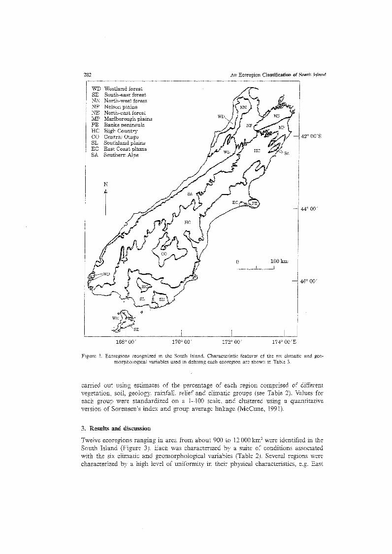
Figure 3. Ecoregions recognized in the South Island. Characteristic features of the six climatic and geomorphological variables used in defining each ecoregion are shown in Table 3.
carried out using estimates of the percentage of each region comprised of different vegetation, soil, geology, rainfall, relief and climatic groups (see Table 2). Values for each group were standardized on a 1-100 scale, and clustered using a quantitative version of Sorensen's index and group average linkage (McCune, 1991).
3. Results and discussion
Twelve ecoregions ranging in area from about 900 to 12 000 km2 were identified in the South Island (Figure 3). Each was characterized by a suite of conditions associated with the six climatic and geomorphological variables (Table 2). Several regions were characterized by a high level of uniformity in their physical characteristics, e.g. East
J. S. Harding and M. J. Winterbourn 283
Ecoregion Vegetative Cover
I I i
Closed canopied Open canopied
"Subregion" Podocarp Beech Exotic Scrub Alpine Tussock Pasture forest forest forest
Climate
Harsh Moderate Mild
"Domain"
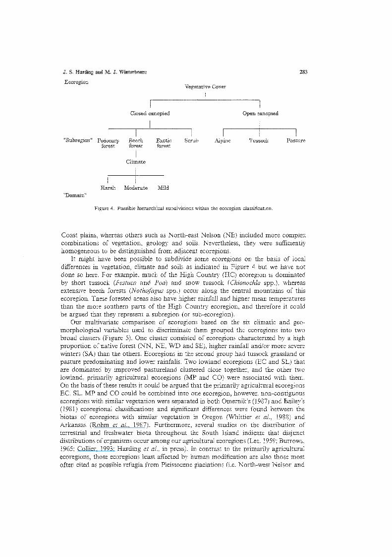
Figure 4. Possible hierarchical subdivisions within the ecoregion classification.
Coast plains, whereas others such as North-east Nelson (NE) included more complex combinations of vegetation, geology and soils. Nevertheless, they were sufficientiy homogeneous to be distinguished from adjacent ecoregions.
It might have been possible to subdivide some ecoregions on the basis of local differences in vegetation, climate and soils as indicated in Figure 4 but we have not done so here. For example, much of the High Country (HC) ecoregion is dominated by short tussock (Festuca and Poa) and snow tussock (Chionochla spp.), whereas extensive beech forests {Nothofagus spp.) occur along the central mountains of this ecoregion. These forested areas also have higher rainfall and higher mean temperatures than the more southern parts of the High Country ecoregion, and therefore it could be argued that they represent a subregion (or sub-ecoregion).
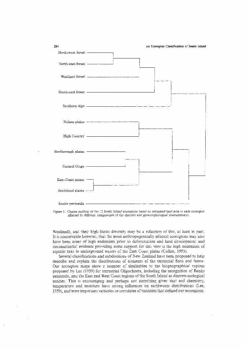
Our multivariate comparison of ecoregions based on the six climatic and geomorphological variables used to discriminate them grouped the ecoregions into two broad clusters (Figure 5). One cluster consisted of ecoregions characterized by a high proportion of native forest (NN, NE, WD and SE), higher rainfall and/or more severe winters (SA) than the others. Ecoregions in the second group had tussock grassland or pasture predominating and lower rainfalls. Two lowland ecoregions (EC and SL) that are dominated by improved pastureland clustered close together, and the other two lowland, primarily agricultural ecoregions (MP and CO) were associated with them.. On the basis of these results it could be argued that the primarily agricultural ecoregions EC, SL, MP and CO could be combined into one ecoregion, however, non-contiguous ecoregions with similar vegetation were separated in both Omernik's (1987) and Bailey's (1981) ecoregional classifications and significant differences were found between the biotas of ecoregions with similar vegetation in Oregon (Whittier ei al, 1988) and Arkansas (Rohm et al, 1987). Furthermore, several studies on the distribution of terrestrial and freshwater biota throughout the South Island indicate that disjunct distributions of organisms occur among our agricultural ecoregions (Lee, 1959; Burrows, 1965; Collier, 1993; Harding et al, in press). In contrast to the primarily agricultural ecoregions, those ecoregions least affected by human modification are also those most often cited as possible refugia from Pleistocene glaciations (i.e. North-west Nelson and
284 An Ecoregion Classification of South Island
North-west forest .
North-east forest
Westland forest
South-east forest
Southern Alps
Nelson plains
High Country
Marlborough plains
Central Otago
East-Coast plains
Southland plains '
Banks peninsula — '
Figure 5. Cluster analysis of the 12 South Island ecoregions based on estimated land area in each ecoregion affected by different components of the climatic and geomorphological characteristics.
Westland), and their high biotic diversity ma}' be a reflection of this, at least in part. It is conceivable however, that the most anthropogenically affected ecoregions may also have been areas of high endemism prior to deforestation and land development and circumstantial evidence providing some support for this view is the high endemism of aquatic taxa in underground waters ofthe East Coast plains (Collier. 1993).
Several classifications and subdivisions ofNew Zealand have been proposed to help describe and explain the distributions of elements of the terrestrial flora and fauna. Our ecoregion maps show a number of similarities to the biogeographical regions proposed by Lee (1959) for terrestrial Oligochaeta, including the recognition of Banks peninsula, and the East and West Coast regions ofthe South Island as discrete ecological entities. This is encouraging and perhaps not surprizing given that soil chemistry, temperature and moisture have strong influences on earthworm distributions (Lee, 1959), and were important variables or correlates of variables that denned our ecoregions.
J. S. Harding and M. J. Winterbourn 285
However, our recognition of 12 South Island ecoregions contrasts with the nationwide river classification of Biggs et al. (1990) in which the entire South Island is provisionally included as a single ecoregion. In part this reflects the limited geographical distribution of rivers considered by Biggs et al. (1990) (the West Coast, Fiordland, Banks peninsula, Eastern Southland and Stewart Island were not included in their study), but perhaps more importantly the moderately large size of the rivers they surveyed. Because rivers, in contrast to small streams, are less directly influenced by their immediate surroundings (Vannote et al, 1980), regional differences in their biological communities might be expected to be less marked. Such a situation is particularly likely in New Zealand which is a small country lacking extremes in climate and one whose river fauna includes a high proportion of widely distributed species and habitat generalists (Winterbourn 1995). The general similarity of the faunas of the few, moderately large (median flow 10.2 m3 s"1) South Island rivers considered by Biggs et al (1990) is therefore not unexpected. In contrast, we hypothesized that small headwater streams draining catchments characteristic of each ecoregion would support distinct assemblages of benthic invertebrates. Surveys of 10 streams in each of 10 South Island ecoregions (Harding et al., 1997) provided considerable support for this hypothesis with invertebrate faunas differing among ecoregions in taxonomic richness, numbers of endemic species, species dominance and faunal density.
An ecoregion classification is a useful tool for ecologists, conservationists and various resource managers. Omernik's (1995) ecoregions have gained wide acceptance by aquatic ecologists in North America and have been used to establish reference sites (Hughes et al, 1986) and to set stream recovery criteria (Hughes et al, 1990). Furthermore, an ecoregion classification can aid in the extrapolation of results from site-specific studies to a broader regional scale, and to help predict changes in biological communities related to changes in land use. Our ecoregion classification was developed with particular reference to stream environments and hence is based on geographical features that influence catchment conditions. In doing so the strong associations between aquatic ecosystems and their drainage basins (Hynes, 1975) is formally acknowledged. The challenge now is for the ecoregion classification to be evaluated rigorously as a tool for environmental managers.
We thank Marty Fastier, Tom Pearson, and Mac McLellan (Landcare) for assistance with the GIS. This research was funded by the Department of Conservation Contract no. 1495, and the Zoology Department, University of Canterbury. Thanks to John Quinn, who provided much of the original impetus for this project, and Kevin Collier, Mark Sanders and Lynda Corkum for their constructive comments on this work.
References
Bailey, R. G. fl 976). Ecoregions ofthe United States. 1:7 500 000 scale map. U.S. Forest Service, Intermontane Region, Ogden, Utah.
Bailey, R. G. (1981). Ecoregions of North America. 1:12 000 000 scale. U.S. Geological Survey, Reston, Virginia.
Bailey, R. G. (1983). Delineation of ecosystem regions. Environmental Management 1(4), 365-373. Beable, M. E. and McKerchar, A. I. (1982). Regional flood estimation in New Zealand. Water & Soil
Technical publication 20, National Water & Soil Conservation Organisation. Wellington. 131 pp. Biggs, B. J. R, Duncan, M. J., Jowett, I. G., Quinn, J. M., Hickey, C. W., Davies-Colley, R. J. and Close,
M. E. (1990). Ecological characterisation, classification, and modelling of New Zealand rivers: an introduction and synthesis. New Zealand Journal of Marine and Freshwater Research 24, 277-304.
Brussock, R R, Brown, A. V. and Dixon, J. C. (1985). Channel form and stream ecosystem models. Water Research Bulletin 21, 859-866.

286 An Ecoregion Classification of South Island
Burrows, CJ . (1965). Some discontinuous distributions of plants within Nev/ Zealand and their ecological significance. Tuatara 13, 9-29.
Collier, K J . (1993). Review ofthe status, distribution, and conservation of freshwater invertebrates in New Zealand. New Zealand Journal of Marine and Freshwater Research 27, 339-356.
Congalton, R. G. and Green, K. (1992). The ABCs of GIS. Journal of Forestry 90, 13-20. Corkum, L. D. (1990). Intrabiome distributional patterns of lotic macroinvertebrate assemblages. Canadian
Journal of Fisheries & Aquatic Sciences 47: 2147-2157. Crosby, T. K., Dugdale, J. S. and Watt, J. C. (1976). Recording specimen localities in New Zealand: an
arbitrary system of areas and codes defined. New Zealand Journal of Zoology 3, 69 +map. Digital Resources, (1987). TERRASOFT: The complete mapping solution. Digital Resources Ltd., Nanaimo,
B. C , Canada. Forster, R. R. (1954). The New Zealand Harvestmen (Sub-order Laniatores). Bulletin of the Canterbury
(NZ) Museum 2. pp. 1-329. Frissell, C. A.. Liss, W. J., Warren, C. E. and Hurley, M. D. (1986). A hierarchical framework for stream
habitat classification: viewing streams in a watershed context. Environmental Management 10, 199-214. Green, K. (1992). Spatial imagery and GIS. Journal of Forestry 90, 32-36. Harding, J. S. and Winterbourn, M J . (1995). Effects of contrasting land use on physico-chemical conditions
and benthic assemblages of streams in a Canterbury (South Island, New Zealand) river system. New Zealand Journal of Marine & Freshwater Research 29, 479-492.
Harding, J. S., Winterbourn, M. J. and McDiffett, W. F. (in press). Stream faunas and ecoregions in South Island, New Zealand: do they correspond? Archiv fur Hydrobiologie.
Hawkes, C. L., Miller, D. L. and Layher, W7. G. (1986). Fish ecoregions of Kansas: stream fish assemblage patterns and associated environmental correlates. Environmental Biology of Fishes 17. 267-279.
Heiskary, S. A., Wilson, C. B. and Larsen, D. R (1987). Analysis of regional patterns in lake water quality: using ecoregions for lake management in Minnesota. Lake Reservoir Management 3, 337-344.
Hughes, R.M. and Larsen, D.P. (1988). Ecoregions: an approach to surface water protection. Journal of the Water Pollution Control Federation 60, 486-493.
Hughes, R.M., Larsen, D.R and Omernick, J.M. (1986). Regional reference sites: a method for assessing stream potential. Environmental Management 10, 629-635.
Hughes, R. M., Rexstad, E. and Bond, C. E. (1987). The relationship of aquatic ecoregions, river basins, and physiographic provinces to the ichthyogeographic regions of Oregon. Copeia 1987, 423-432.
Hughes, R.M., Whittier, T.R., Rohm, C M . and Larsen, D.R (1990). A regional framework for establishing recovery criteria. Environmental Management 14, 673-683.
Hynes, H. B. N. (1975). The stream and its valley. Verhandlungen der Intemationalen Vereinigung fiir Theoretische und Angewandte Limnologie 19, 1-15.
Larsen, D. P., Dudley, D. R. and Hughes, R. M. (1988). A regional approach for assessing attainable surface water quality: an Ohio case study. Journal of Soil and Water Conservation 43, 171-176.
Larsen, D .R , Omemik, J. M., Hughes, R. M., Rohm, C. M., Whittier, T. R., Kinney, A. J., Gallant, A. L. and Dudley, D. R. (1986). Correspondence between spatial patterns rn fish assemblages in Ohio streams and aquatic ecoregions. Environmental Management 10, 815-828.
Lee, K. E. (1959). The earthworm fauna ofNew Zealand. New Zealand Department of Scientific & Industrial Research bulletin 130, pp. 1-486.
Legendre, P. and Legendre, V. (1984). Postglacial dispersal of freshwaxer fishes in the Quebec peninsula. Canadian Journal of Fisheries and Aquatic Sciences 41, 1781-1802.
Likens, G. E. and Bormann, F. H. (1974). Linkages between terrestrial and aquatic ecosystems. Bioscience 24, 447-456.
Lotspeich, F. B. (1980). Watersheds as the basic ecosystem: this conceptual framework provides a basis for a natural classification system. Water Resources Bulletin 16, 581-586.
Lotspeich, F. B. and Platts, W. S. (1982). An integrated land-aquatic classification system. North American Journal of Fisheries Management 2, 138-149.
Lyons, J. (1989). Correspondence between the distribution of fish assemblages in Wisconsin streams and Omernilcs ecoregions. American Midland Naturalist 122, 163-182.
McCune. B. (1991). Multivariate analysis on the PC-ORD system. Butler University, Indianapolis. Indiana. HRI report 15.
McEwen, W. M. (1987). Ecological regions and districts ofNew Zealand. New Zealand Biological Resources Centre Publication 5.
Miller, R. R. (1958). Origin and affinities of the freshwater fish fauna of western North America. In Zoogeography (C.L. Hubbs, ed.), pp 187-222. Washington D.C: American Association for the Advancement of Science.
Naiman, R. JL Lonzarich, D. G., Beechie, T. J. and Ralph, S. C. (1990). Stream classification and the assessment of conservation potential. Conference on the Conservation and Management of Rivers. York.
NWASCO (1975-1979). New Zealand land resource inventory worksheets 1:63,360. National Water & Soil Conservation Organisation, Wellington.
Newsome, P. F J. (1987). The vegetative cover of New Zealand. Water and Soil Miscellaneous publication 112. 153 p.

J. S. Harding and M. J. Winterbourn 287
New Zealand Geological Survey, (1972a). Geological map ofthe North Island ofNew Zealand. 1:1,000,000 scale. New Zealand Geological Survey, Wellington.
New Zealand Geological Survey, (1972b). Geological map ofthe South Island ofNew Zealand. 1:1,000,000 scale. New Zealand Geological Survey. Wellington.
New Zealand Geological Survey, (1973a). Soil map ofthe North Island ofNew Zealand. 1:1,000,000 scale. Soil Bureau Bulletin 26.
New Zealand Geological Survey, (1973b). Soil map of the South Island ofNew Zealand. 1:1,000,000 scale. Soil Bureau Bulletin 26.
New Zealand Lands and Survey Department, (1989). Topographical map ofNew Zealand. 1:2,000,000 scale. Lands and Survey Department, Wellington.
New Zealand Meteorological Service, (1983). NZ Climatic Regions map. 1:2,000,000 scale. Miscellaneous publication 175 part 2.
New Zealand Meteorological Service, (1985). NZ Annual rainfall normals 1951-1980 map. 1:2,000,000 scale. Miscellaneous publication 175 part 6(1).
Olson, R. J., Kumar, K. D. and Burgess, R. L. (1982). Analyses of ecoregions utilizing the geoecology data base. In In-place Resource Inventories: Principles and Practices (T.B. Brann, L.O. House and H.G. Lund, eds), pp 149-156. Bethesda: Society of American Foresters.
Omernik, J. M. (1987). Ecoregions ofthe conterminous United States. Annals ofthe Association of American Geographers ll, 118-125.
Omernik, J.M. (1995). Ecoregions: a spatial framework for environmental management. In Biological Assessment and Criteria - Tools for Water Resource Planning and Decision Making, (W.S. Davis and T.R Simon, eds), pp. 49-63. Boca Raton, USA: Lewis Publishers.
Omernik, J. M. and Gallant, A. L. (1986). Ecoregions of the Pacific Northwest. EPA/600/3-86/033. U.S. Environmental Protection Agency, Corvallis, Oregon.
Pflieger, W. L., Schene, M. A. and Haverland, P. S. (1981). Techniques for the classification of stream habitats, with examples of their application in defining the stream habitats of Missouri. In Acquisition and Utilization of Aquatic Habitat Inventory Information (N.B. Armantrout, ed.), pp 362-368. American Fisheries Society, Bethesda, Maryland.
Quinn, J. M. and Hickey, C. W. (1990). Characterisation and classification of benthic invertebrate communities in 88 New Zealand rivers in relation io environmental factors. New Zealand Journal of Marine and Freshwater Research 24, 387-410.
Rohm, C. M., Giese, J. W. and Bennett, C. C. (1987). Evaluation of an aquatic ecoregion classification of streams in Arkansas. Journal of Freshwater Ecology 4, 127-140.
Rowe, J. S. and Sheard, J. W. (1981). Ecological land classification: a survey approach. Environmental Management 5, 451-464.
Simpson, P. (1982). Ecological regions & districts ofNew Zealand. A natural subdivision. Biological Resources Centre publication 1, Wellington.
Timmins, S. and King, K. (eds) (1984). Register of Protected Natural Areas in New Zealand. Department of Lands & Survey, Wellington. 467 pp.
Toebes, C. and Palmer. B. Fl. (1969). Hydrological regions of New Zealand. Water & Soil Division, Miscellaneous Hydrological publication 4, Wellington.
Trautman, M. B. (1981). The Fishes of Ohio. Ohio State University Press, Columbus. USDA Soil Conservation Service (1981). Land resource regions and major land resource areas of the United
States. Agriculture Handbook 296, Washington, D.C. Vannote, R. L,, Minshall, G. W., Cummins, K. W., Sedell, J. R. and Cushing, C. E. (1980). The River
Continuum Concept. Canadian Journal of Fisheries and Aquatic Sciences 37, 130-137. Warren, C. E. (1979). Toward classification and rationale for watershed management and stream protection.
EPA/600/3-79/059. U.S. Environmental Protection Agency, Corvallis, Oregon. Whittier, T. R., Hughes, R. M. and Larsen, D. P. (1988). Correspondence between ecoregions and spatial
patterns in stream ecosystems in Oregon. Canadian Journal of Fisheries and Aquatic Sciences 45, 1264-1278. Winterbourn, M.J. (1995). Rivers and streams of New Zealand. In River and Stream Ecosystems (CE.
Cushing, K.W. Cummins and G.W. Minshall, eds), pp. 695-716. Amsterdam: Elsevier.