an assessment of the southern asian container rail corridor
69
STRENGTHENING CONNECTIVITY FOR TRADE AND DEVELOPMENT: AN ASSESSMENT OF THE SOUTHERN ASIAN CONTAINER RAIL CORRIDOR Anil Kumar Gupta Saroj Ayush Joseph George January 2019 DEVELOPMENT PAPERS 1901 ESCAP SOUTH AND SOUTH-WEST ASIA OFFICE
-
Upload
khangminh22 -
Category
Documents
-
view
2 -
download
0
Transcript of an assessment of the southern asian container rail corridor

STRENGTHENING CONNECTIVITY FOR TRADE AND DEVELOPMENT: AN ASSESSMENT OF THE SOUTHERN ASIAN CONTAINER RAIL CORRIDOR
Anil Kumar GuptaSaroj Ayush
Joseph George
January 2019
DEVELO
PMEN
T PAPERS 1901
ESCAP
SOUTH AND SOUTH-WEST ASIA
OFFICE

Strengthening Connectivity for Trade and Development:
An Assessment of the Southern Asian Container Rail Corridor
2
Disclaimer: The views expressed in this Development Paper are those of the author(s)
and should not necessarily be considered as reflecting the views or carrying the
endorsement of the United Nations or its member States. Development Papers describe
research in progress by the author(s) and are published to elicit comments and to
further debate. This publication has been issued without formal editing.
For any further details, please contact:
Dr. Nagesh Kumar, Head
United Nations Economic and Social Commission for Asia and the Pacific (ESCAP)
South and South-West Asia Office (SSWA)
C-2 Qutab Institutional Area, New Delhi-110016, India
Email: [email protected]

South and South-West Asia Development Papers 1901
3
Contents
Foreword--------------------------------------------------------------------------------------------------- 4
Abstract---------------------------------------------------------------------------------------------------- 5
I Imperatives of Transport Connectivity for Trade and Development in Southern Asia --- 6
II Rationale for Overland Trunk Corridors and Feeder Networks in Southern Asia -------- 11
III Proposal of a Trunk Transport Corridor: The ITI-DKD-Y Container Rail Corridor---- 15
IV An Economic Evaluation of the ITI-DKD-Y Container Rail Corridor ----------------------- 19
V Key Issues of Operationalization and the Way Forward----------------------------------------- 43
References-------------------------------------------------------------------------------------------------- 54
Annex: Branch Routes of Significance Along the ITI-DKD-Y Corridor--------------------- 57

Strengthening Connectivity for Trade and Development:
An Assessment of the Southern Asian Container Rail Corridor
4
Foreword
The Development Papers series of the United Nations ESCAP South and South-West Asia Office
(UNESCAP-SSWA) promotes and disseminates policy-relevant research on the development
challenges facing South and South-West Asia. It features policy research conducted at UNESCAP-
SSWA as well as by outside experts from within the region and beyond. The objective is to foster an
informed debate on development policy challenges facing the subregion and sharing of development
experiences and best practices.
This paper by Anil Kumar Gupta, Saroj Ayush and Joseph George evaluates the operational feasibility
of a trunk transport route connecting Southern Asian countries which will allow them to unlock their
true trade potential, while repositioning the subregion as a land-bridge linking neighboring regions of
Europe, Central Asia and East Asia. The trunk corridor, known as the Istanbul–Tehran–Islamabad–
Delhi–Kolkata–Dhaka-Yangon (ITI–DKD-Y) Container Rail Corridor, is an integral part of the Trans-
Asian Railway (TAR) network, and is connected to key commercial centers and production hubs of
Southern and Central Asian countries through various road and rail sub-links.
The paper finds substantial socio-economic gains resulting out of operationalization of the ITI-DKD-Y
Corridor and its sub-links, principally by way of lowering trade costs and enhancing trade
competitiveness, opening new possibilities of job creation and welfare generation. Even partial
activation of select segments of the Corridor is shown to allow savings of over 50 percent in transaction
costs and by 44 -78 percent in delivery time. With benefits of such proportions over existing transport
options available to traders, running at least one regular rail service between various transit points along
the Corridor is shown to generate savings worth US$ 10.8 to 80.3 million in transport costs per year per
service.
The operationalization of the Corridor and its sub-links requires an integrated approach to policy
making, including facilitation measures for speedy cargo clearance mechanisms, intermodal transfer
terminals, usage of ICT and modern cargo security/inspection systems etc. The paper offers
recommendations for transport reforms, particularly on institutional cooperation, sharing of
responsibilities for infrastructure development/upgradation, and transport policy alignment between the
host countries of Southern Asia. It calls for synergies between various transit and transport agreements
and initiatives undertaken unilaterally by countries of the subregion, initiatives taking place under the
aegis of subregional organizations such as BIMSTEC, ECO and SAARC, as well as technical and
capacity-building support offered by intergovernmental bodies such as UNESCAP.
This paper was prepared under a project implemented by UNESCAP titled ‘Strengthening connectivity
of countries in South and Central Asia’. Its purpose is in line with the call of the SDGs for ‘safe,
affordable, accessible and sustainable transport systems for all by 2030’. We hope that the policy
insights offered by this paper will guide collaboration between Southern Asian countries for the
operationalization of the ITI-DKD-Y Corridor and its sub-links to the benefit of trade led sustainable
development in the subregion.
Nagesh Kumar
Head, UNESCAP South and South-West Asia Office
South and South-West Asia Development Papers 1901
5
Strengthening Connectivity for Trade and Development:
An Assessment of the Southern Asian Container Rail Corridor
Anil Kumar Gupta, Saroj Ayush and Joseph George1
Abstract
Limitations of cross-border transport connectivity has been observed to have curtailed the full potential
of trade led development in the Southern Asian subregion. Inefficiencies of international transport has
hurt the trade prospects of not only Southern Asian countries but also trading partners from neighboring
subregions, especially the landlocked countries of South and Central Asia which could use well-
functioning Southern Asian transport corridors to the advantage of all. UNESCAP has proposed
operationalization of a trunk Southern Asian transport route, namely the Istanbul–Tehran–Islamabad–
Delhi–Kolkata–Dhaka-Yangon (ITI–DKD-Y) Container Rail Corridor, opening possibilities of new
cost-effective transport options. This paper undertakes an assessment of the operational feasibility of
this trunk corridor, and finds significant cost and time advantages. Comparing with existing alternative
transport options, which often involve circuitous carriageways and transshipment delays, usage of even
partial segments of the ITI-DKD-Y Corridor can lead to cost reduction to the tune of US$ 1122 per
container (twenty-foot equivalent unit), potentially halving the current costs under modest assumptions.
In certain segments, such as Delhi-Lahore, the rate of savings could be as high as 80 percent. Such high
rates of cost reduction could translate into savings worth over 50 percent in transaction cost for regular
cargo rail services between segments. Besides cost reduction, such services could also yield
considerable time savings compared to available alternatives. In certain segments, the delivery time
could be reduced by up to 14 days. Activation of end-to-end rail service along the ITI-DKD-Y route,
along with multimodal transit linkages to landlocked countries at strategic terminals in the route, can
maximize traffic volumes and revenues. Operationalization of the corridor requires concerted efforts to
build institutional collaboration, facilitation of container train operators, introduction of container
interchange protocols, usage of ICT tools, development of strategic dry ports for intermodal
connectivity and adoption of a connectivity master plan.
JEL Code(s): F15, R11, R41, R42
Key Words: Regional Transport Connectivity, Southern Asia, Container Rail Corridor
1 Anil Kumar Gupta is Consultant at UNESCAP South and South-West Asia Office (UNESCAP-SSWA),
advising on regional transport connectivity issues. Formerly, he served as the Chairman and Managing Director
of the Container Corporation of India Limited (CONCOR). Saroj Ayush - currently Senior Transport Specialist
at The World Bank - served as Consultant at UNESCAP-SSWA during the tenure of this study. Joseph George
is Research Associate at UNESCAP-SSWA. This paper was prepared as part of a project entitled ‘Strengthening
connectivity of countries in South and Central Asia’, led by UNESCAP-SSWA. The authors are grateful for the
overall guidance of Dr. Nagesh Kumar, Head of UNESCAP-SSWA. Sandeep Raj Jain, Economic Affairs
Officer, Transport Division, UNESCAP, provided valuable inputs. The views expressed in this paper are those
of the authors and do not necessarily reflect the views of the United Nations Secretariat.
Strengthening Connectivity for Trade and Development:
An Assessment of the Southern Asian Container Rail Corridor
6
Strengthening Connectivity for Trade and Development:
An Assessment of the Southern Asian Container Rail Corridor
I. Imperatives of Transport Connectivity for Trade and Development in Southern Asia
Connectivity has always been an important determinant of the trajectory of socio-economic
development worldwide. Throughout history, spatially connected economic units and sub-regions have
prospered faster than isolated ones because of better access to resources and markets. In modern times,
connectivity refers not only to infrastructure and systems for physical mobility of people and goods but
also to those enabling sharing of information and technology. UNESCAP reaffirmed the importance of
connectivity, in its broad sense, for development of the Asia-Pacific region by adopting ‘Regional
Connectivity for Shared Prosperity’ as the theme for the 70th Commission Session.2 Given that a well-
connected network of spatially spread economies generates greater growth opportunities for all
constituents of the network, more so for the lagging areas, better connectivity has the potential to reduce
stark intra-regional economic disparities, and facilitate balanced and inclusive development in the
region.
Transport connectivity is given due importance in the Sustainable Development Goals (SDGs) as a key
enabler, with a global call to provide access to safe, affordable, accessible and sustainable transport
systems for all by 2030. Goal 11 on ‘sustainable human settlements’ states this clearly, and Goal 9 on
‘infrastructure development’ stresses on transboundary transport infrastructure. Furthermore, the need
for achieving energy efficiency in transport (transport being a major driving force behind growing
global energy demand) is well acknowledged by the SDGs with the conceptualization of ‘sustainable
transport’ as a pervasive topic. The SDGs call for an integrated approach to policy making including
policies and planning for land use and infrastructure for achieving connectivity in its broader sense.
Regional connectivity in the South and South-West Asia subregion assumes special significance
because of its own developmental requirements and also because of the strategic geographic location
of the sub-region. South Asia is home to one of the world's biggest concentrations of poverty. The sub-
region's 1.7 billion people live with limited internal connectivity that remains fragmented and poorly
organized in many countries of this sub-region. Without upgrading its internal connectivity, the sub-
region will be unable to capitalize on its potential to be a land bridge connecting Europe with the east,
as well as serving as an economic gateway to and through the Central, South-West and South-East
Asian countries situated at its boundaries.
Improvements in cross-border connectivity would benefit South and South-West Asian countries in
more ways than is generally understood. Besides the direct impact on trade and economic growth,
transport networks would have several positive externalities, or unintended benefits. Enhanced
intraregional connectivity will open up possibilities for production networks and value chains to
develop within the sub-region, enhancing the competitiveness of final products from the region on
world markets. With the bulk of all South Asia trade focused on Europe, North America and East Asia,
creating final products in South Asia through sub-regional value chains would create interdependence,
boost productive capacity in LDCs of the sub-region, foster balanced regional development, and
enhance competitiveness for accessing markets across the Eurasian continent. South and South-West
2 UNESCAP (2014a). Also see UNESCAP (2013a) and UNESCAP Resolution (E/ESCAP/RES/73/3) on
‘Advancing integrated and seamless connectivity for sustainable development in Asia and the Pacific’ (2017).

South and South-West Asia Development Papers 1901
7
Asia’s transport corridors possess the potential to achieve massive efficiency gains and energy savings,
thus opening new pathways towards sustainable development.
Southern Asian countries have a lot of ground to cover in terms of achieving seamless transport
connectivity within the sub-region. Cross-border transport connectivity options are currently found to
be grossly inadequate, explaining the prohibitively high intra-regional trade costs prevalent in the
subregion. Inland cross-border transport of cargo is predominantly carried through roadways, while the
potential of rail transport is neglected. This paper assesses the potential of an integrated multimodal
international transport network for Southern Asia, centered around an arterial container rail corridor
which joins together important commercial centers and connects the subregional countries. This rail
corridor proposed by UNESCAP, which is an integral part of the Trans-Asian Railways (TAR) network
and is referred to as the Istanbul–Tehran–Islamabad–Delhi–Kolkata–Dhaka-Yangon (ITI–DKD-Y)
Container Rail Corridor3, has the potential to bring substantial transformative changes to the way cross
border transport is organized in Southern and Central Asian subregions. Before presenting the results
of an evaluation of the ITI-DKD-Y Corridor in subsequent sections of this paper, this section outlines
why transport connectivity reforms are critical for South and South-west Asia in the light of the
emerging challenges of sustaining the sub-region’s trade led development prospects.
I.1 Stagnation in Subregional Trade Growth
South and South-West Asia commands only less than 3% of annual world trade as of 2018, while the
subregion is home to about one-fourth of the world’s population. While the subregion should sustain
high growth rates in trade for translating trade gains into notable developmental outcomes, the overall
rate of growth of trade of the subregion has slowed down in recent years. The compound annual average
rate of growth of trade of South Asian countries has in fact declined sharply from a robust 21% during
2000-07 to 5.9 % during 2008-18. The global financial crisis of 2008 deeply affected the growth and
patterns of world trade, resulting in a dramatic decline in its rate of growth to an average of 2.6% per
annum in the post-crisis years compared to a healthy rate of growth of 12.6% during 2003-07. The sharp
fall in rate of growth of world trade is primarily due to subdued economic growth and subsequent fall
in trade demand in advanced countries in the Eurozone and North America. As these regions continue
to be important markets for South and South-West Asian countries, accounting for more than 45% of
the sub-region’s exports, the trade of the sub-regional countries has been affected adversely, registering
very low growth rates and even negative year-to-year growth rates in some years between 2013-18.
Recent trends of stagnation in trade growth of South and South-West Asia, closely following the weak
recovery and ongoing sluggishness in growth of world trade is worrisome for the sub-region’s trade led
development strategies. There are several factors for this decline, including the long term structural
changes that are taking place in world trade and the sub-region’s own failure in containing its
persistently, and often prohibitively, high trade/transaction costs. Most of these factors directly or
indirectly point towards transport related impediments faced by trading sectors of sub-region. As the
subregion is increasingly forced to look inwards to find new sources of dynamism in trade, transport
becomes a critical area of reforms.
3 See UNESCAP-SSWA (2013 and 2018)

Strengthening Connectivity for Trade and Development:
An Assessment of the Southern Asian Container Rail Corridor
8
I.2 High Transport Costs and Untapped Intra-regional Trade Potential
Intra-regional exports of South and South-West Asia have remained at very low rate of around 7% of
the sub-region’s total exports over last two decades. Registering a relatively low volume of US$ 48
billion in 2018, intra-regional exports of the sub-region have not been responsive to the post-crisis
volatilities of external export markers. It has been noted that, despite robust trade demand within the
region, favorable trade complementarities among sub-regional countries and estimated high
unexploited intra-regional export potential, trade volumes within the region failed to grow even in the
face of shrinking markets in the sub-region’s traditional and predominant export destinations.
High trade costs and limitations of supply capacities continue to exert a drag on growth of trade between
sub-regional countries and their trade with Asia-Pacific developing countries.4 Inefficiencies and
bottlenecks, particularly poor internal connectivity and numerous procedural barriers, in the intra-
regional trading channels of South and South-West Asia, which are well documented,5 collectively
explain the sub-region’s failure in fully utilizing its trade opportunities.
Intra-regional trade costs between four of the largest South Asian countries, viz., Bangladesh, India,
Pakistan and Sri Lanka are found to be 114% of the domestic value of goods exported.6 Trade costs of
these four SAARC nations with EU and US are respectively found to be 114% and 109%. SAARC
trade costs are not only higher within itself, but also comparatively high with neighboring sub-regions
of South East Asia, East Asia and North and Central Asia. Despite having the advantage of long cost
line and access to international sea routes, the sub-region’s inter-regional and intra-regional trade costs
are comparable to that of the landlocked North and Central Asian countries which suffer from severe
transport connectivity constraints.
As a result of internal connectivity deficiency induced trade costs, intra-regional trade is found to be far
below its potential levels. In facing an uphill task of taking the actual intra-regional trade to the
estimated potential levels, the sub-region is also pursuing attainment of a moving target. Buoyed by
deepening trade agreements, accompanying policy reforms and advancements in transport, global
benchmarks for the conduct of international trade is rising around the sub-region. Modelled on
relationship between bilateral trade, economic sizes and distance between pairs of trading partners,
bilateral trade flows among the sub-regional countries are observed to be far below ideal levels that are
prevalent worldwide. South and South-West Asia’s aggregate intra-regional trade volume of about US$
63.56 billion in 2015 fell short by about 66.5% of the estimated potential of about US$ 190 billion for
the same year. As against the gap between actual and potential intra-regional trade estimated for the
sub-region for the year 2013 at 49%,7 the wedge has widened by close to 17 percentage points by 2015.
4 The determinants of transport costs such as geographical features, endowments of financial resources and
technology, cost of fuel etc. varies from region to region. For a detailed discussion on factors affecting transport
costs, see (Behar and Venables, 2010). The characteristics of products being shipped also affects transport costs
and choice of transport mode (WTO, 2013). 5 For a detailed exposition on trade barriers in South and South-West Asia, see UNESCAP-SSWA (2013). 6 UNESCAP-SSWA (2018) 7 Ibid

South and South-West Asia Development Papers 1901
9
1.3 Emergence of Global Value Chains and Challenges of External Market Expansion
The possibilities of tapping into global value chains (GVCs) give South and South-West Asia more
reasons for looking inward for deeper integration. The phenomenal success of East and Southeast Asia
in forming value chains has come out of concerted efforts at intra-regional trade integration. For
Southeast Asia, since 2000, total trade within ASEAN region and with Northeast Asia has grown much
more quickly than trade with ASEAN’s traditional partners among the advanced economies.8 Rapidly
increasing trade within developing Asia reflects the heavy involvement of ASEAN countries in GVCs,
which has made them important parts of the global factory.9 Advancing regional integration through
establishment of strong logistics and connectivity networks has enabled East Asia to quicken the
process of forming cross-border value chains within the sub-region and reap substantial efficiency
gains.10 On the other hand prospects of value chains find itself as a major motivation behind formation
of the ASEAN Economic Community.11
Given that integration into GVCs can be found as both cause and effect of regional economic
integration, South and South-West Asia cannot afford to avoid strengthening of sub-regional production
networks in order to find an advantageous position in GVCs. This would open up prospects for building
better linkages with value chains led by East and Southeast Asia.12 Therefore, with internal reforms and
investments in internal connectivity, what is also on offer for the sub-region is enormous economic gain
from a larger Asian integration.
As value chains thrive on scale economies, particularly in producer driven chains found in the sub-
region, mass sourcing opens up doors to SMEs to be part of and benefit from such chains. UNESCAP’s
case studies shows market information flows and access to affordable transport as the key variables that
dictates the level of participation of small-scale participants.13 Formation of value chains and sub-
regional production networks involve uunbundling of different jobs that goes into a final output and
improving overall production efficiency through vertical specialisation in each segregated job. In today
GVCs, unbundling process is becoming deeper in terms of the segregation of jobs and wider in terms
of geographical spread of jobs. Better overland connectivity is absolutely essential in context for
providing the vital physical link between jobs spreading across SSWA, as value chains develop in the
region.
A classic case is that of the export potential of textiles and clothing (T&C) sector of South Asia.
Together, South Asian countries account for 10 percent of global T&C trade and more than 50 percent
of South Asian exports are destined for European markets.14 A study sponsored by UNCTAD finds
8 See ADB (2014). 9 Ibid 10 Ferdous (2011) reports that East Asia’s greater economic integration led to export diversification and that
economic growth tend to be positively related with the trade specialization in the subregion. 11 The AEC has four pillars that aim to “transform ASEAN into a single market and production base, a highly
competitive economic region, a region of equitable economic development, and a region fully integrated into
the global economy”, See Chia (2013). 12 For an exposition on importance of connectivity and production networks in integrating South and Southeast
Asia, see ADB and ADBI (2013). 13 See UNESCAP (2011). As observable from ginger value chains shared between Nepal and India and rubber
value chains shared by Sri Lanka with India and Pakistan, wherein small farm-holdings fail to benefit from
integration into business channels involving large scale procurement, connectivity is often found to deny small
and marginalized producer groups of the subregion. 14 Calculated from ITC TradeMaps, for 2017 trade flow figures of SSWA countries.

Strengthening Connectivity for Trade and Development:
An Assessment of the Southern Asian Container Rail Corridor
10
huge scope for intra-regional trade in T&C inputs within South Asia, which will enable the region to
lower its cost of production and improve its global competitiveness in T&C outputs.15 However, this
would materialise only if fluent logistics and complementary transport infrastructure allow South Asia
to move intermediates around quickly and send the final consignment taking as little lead time as
possible. ‘Mineral to machine part’ is another important value chain that can develop within the mineral-
resource rich regions of South and South-West Asia. A ‘hub and spoke’ model of transport connectivity
to promote value chains, wherein important locations along the trunk road and rail corridors act as hubs,
could help the sub-regional countries to achieve greater differentiation in product characteristics along
with greater flexibility in serving orders of different sizes.
1.4 Keeping Pace with Changing Patterns of Global Trade and Sensitivities of Transport Reforms
The external economic context has changed dramatically in the aftermath of the global financial crisis
of 2008. Along with demand decline in their traditional export destinations, South and South-West
Asian countries are increasingly facing rising barriers in these markets. Rising protectionist tendencies
are already becoming visible in the form of penalties for outsourcing, rising visa fees for migrant
workers, countervailing duties on developing country products among others. Regionalism has assumed
even more importance, especially in the developing world, and the emergence of large regional trading
blocs is suggestive of a renewed interest in regionalism. Certain parts of the Asia-Pacific, particularly
the East and South East Asian sub-regions, are the developing world’s leading examples of this trend.16
Regional groupings are now adopting bold and advanced templates for negotiating cooperative and
integrated agreements covering trade in goods and services, investments, transport connectivity, labor
mobility, product standards, property rights, knowledge transfer, government procurement,
environmental issues and many more.17 Deepening regionalism in other parts of the world, with its
overt implications for reconfiguration of global trade and economic relations, resets targets for South
and South-West Asia to look inwards.
This will require to explore trade complementarities that exist between the sub-regional countries. With
deepening regionalism in other parts of the world threatening to erode South and South-West Asia’s
trade and economic relations with its traditional markets, inward looking trade policies and regionally
focused trade expansion strategies are a priority for the sub-region. It is being recognized that deeper
integration at the regional level is a pre-requisite for South and South-West Asia to protect its market
access in advanced regional groupings and the urgency for moving ahead into topics of government
procurement, visa requirements, labor and environmental issues has got greater emphasis in national
level trade discourses in the sub-region.18 Intra-regional transport facilitation emerges as equally
important and essential as trade facilitation reforms in this regard.
15 The study considered three stage supply chains in T&C and identified 89 specific tariff lines at 6-digit level
(T&C final outputs for global markets originating from South Asia) which can be exported from one of
Bangladesh, India, Pakistan or Sri Lanka, with regional sourcing of inputs from each other. This would trigger a
substantial rise in intra-regional trade in inputs; see UNCTAD, Commonwealth Secretariat and CWS (2010). 16 For detailed expositions on the leading position of the East and South-East Asia subregions in global
economic recovery and growth, see UNESCAP (2015b), UNESCAP (2015c) and IMF (2015). 17 New mega trading blocs negotiations are reported to have produced a draft chapter on regulatory coherence
and new disciplines and rules on areas such as labor and environmental standards could eventually influence
multilateral trade laws. See WTO (2013) and Baldwin (2013). 18 For example, India’s proactive steps in furthering the India-ASEAN FTA and engagement with Regional
Comprehensive Economic Partnership, which has the potential to form the world’s largest trading bloc covering
40 per cent of world trade, are positive indications of urgency for catching up with global trends.

South and South-West Asia Development Papers 1901
11
II. Rationale for Overland Trunk Corridors and Feeder Networks in Southern Asia
South and South-West Asian countries have been attracting large scale investments into land transport
sector and, consequently, domestic transport infrastructure of the sub-regional countries has markedly
improved. Traffic intensity over both road and rail routes in the sub-region has grown massively, more
so in the case of road transport than railways. However, cross-border land transport connectivity
remains suboptimal, severely constraining intra-regional trade. Given the advantages of geographical
contiguity, overland transport corridors should ideally be the most important consideration for regional
transport planning. High intra-regional trade cost is clear and direct manifestation of underutilization of
land transport facilities.
On one hand, existing international carriageways and land transport infrastructure are getting crowded
with increase in trade, putting upward pressure on marginal costs of transportation. On the other hand,
missing links and heterogeneous transport regulations have been limiting development of land transport
corridors as viable alternatives or additional carriageways. In fact, high untapped intra-regional trade
potential in South and South-West Asia is to a large extent the result of a mutually reinforcing and
diminishing relationship between demand for cross-border transport and demand for trade, one withheld
for lack of the other, and has huge implications for the desirability of cross-border land transport
corridors in the sub-region.
Road density in South and South-West Asia is the highest amongst ESCAP sub-regions and way higher
than the average figure for the ESCAP region (Figure 1). It is notably higher for South Asia sub-region
and has registered a faster rate of improvement over the period 2000 to 2015. Enlargement of national
road networks has taken place in tune with the high population density and high land occupancy rate in
the sub-region. Though the national road networks of contiguous countries of South and South-West
Asia are linked, fully functional international road transport links are still few and far between.
Road density is notably higher for the South Asia sub-region and has registered a faster rate of
improvement over the period 2000 to 2015. Enlargement of national road networks has taken place in
tune with the high population density and high land occupancy rate in the sub-region. Though the
national road networks of contiguous countries of South and South-West Asia are linked, fully
functional international road transport links are still few and far between. Road density is notably higher
for the South Asia sub-region and has registered a faster rate of improvement over the period 2000 to
2015. Enlargement of national road networks has taken place in tune with the high population density
and high land occupancy rate in the sub-region. Though the national road networks of contiguous
countries of South and South-West Asia are linked, fully functional international road transport links
are still few and far between.

Strengthening Connectivity for Trade and Development:
An Assessment of the Southern Asian Container Rail Corridor
12
Figure 1
Road Density in UNESCAP Subregions
(Km of Road per 1000 SqKm Land Area)
Source: UNESCAP Database
While the sub-regional countries have hardly made additions to their established national rail networks
during the past decade, except Islamic Republic of Iran and Turkey, annual cargo movement through
rail routes have increased sharply for most member states (Table 1). South and South-West Asia saw a
growth of railway freight movement of 60% between 2005 and 2016, which is the highest among
ESCAP sub-regions. However, as in the case of road transport, international freight movement through
rail within sub-region remains very limited. While increasing rail freight traffic raises the challenges of
upgradation of haulage load capacity of existing rail infrastructure, enhancing freight traffic is critical
as the biggest source of revenue.
Pakistan and Bangladesh have been notable exceptions who saw national rail freight haulage volume
significantly declining compared to levels in the year 2005. Comparative inefficiency physical assets
and services vis-à-vis competing transportation modes are cited as principal reasons for sinking
desirability of rail cargo transport in these countries.19 Challenges of railway sector governance and
inadequate resource allocations are largely responsible for persistent obstacles. The adverse impacts of
budgetary constraints facing rail transport in Bangladesh and Pakistan can be overcome to a large extent
if additional revenue can be claimed through transit rights granted to neighbouring countries.
19 In Bangladesh, road:rail:inland waterways freight carriage ratio tilted in favor of road from 35:28:37 in 1975
to 80:4:16 by 2005. See World Bank (2009).
0
200
400
600
800
1000
1200
UNESCAP East andNorth-East
Asia
North andCentral
Asia
Pacific South-EastAsia
South andSouth-West
Asia
SAARC
2000
2015

South and South-West Asia Development Papers 1901
13
Table 1
Rail Transport Indicators for South and South-West Asia and ESCAP Subregions
Country/Region
Railway Density
(KM per 1000 sq.km. of surface
area)
Railway Freight
(Million Ton - KM)
2005 2016 % Change 2005 2016 % Change
Bangladesh 21.9 21.8 -0.5 896 710 -21
India 21.3 22.1 3.8 407398 665810 63
Pakistan 10.1 10.1 0.0 4796 1757 -63
Sri Lanka 23.2 23.3 0.4 138 135* -2
SAARC 19.1 19.3 1.0 413228 668412 62
Iran (Islamic Rep. of) 4.4 5.3 20.5 19127 24461 28
Turkey 11.3 13.1 15.9 8939 11145 25
South & South-West Asia 14.4 15.2 5.6 441294 703883 60
South-East Asia 4.4 4.7 6.8 12933 16651 29
North and Central Asia 5.5 5.5 0.0 2006910 2585100 29
East and North-East Asia 7.7 8.1 5.2 1966620 2350800 20
ESCAP 6.4 6.6 3.1 4473920 5716080 28 Source: UNESCAP Database
*Figure for 2008
II.2 Catalytic Effects on Intra-regional Trade
There are many ways than is commonly understood through which land transport corridors can
positively influence growth of intra-regional trade in SSWA. The conducive environment they create
for formation of production networks and value chains within the region is one such possibility. Various
segment of trunk land cargo transport corridors, with their inland rail/road links to industrial clusters
scattered all over the sub region, can provide an ideal base for developing regional value chains in high
potential sectors such as T&C and Machine Parts. A ‘hub and spoke’ model of physical connectivity to
promote value chains, wherein important locations along the corridors act as hubs, could help SSWA
countries to achieve better price competency, greater differentiation in product characteristics and more
flexibility in serving orders of different sizes.
The overall effect of land cargo corridors on regional trade should be assessed by taking into account
different manifestations of its primary impact on ‘transport’ component of trade costs. Newly facilitated
land routes can facilitate scaling up volume of freight movement by a huge margin. This is particularly
so in the case of rail transport.20 Bulking of international cargo sinks per unit transport cost and an initial
reduction in per unit transport cost boosts trade demand, leading to further scaling up of freight transport
and subsequent cuts in per unit cost. 21 The maximum haulage capacity of the standard rail locomotive
20 Bulking capacity is very limited for road transport. Though it is higher for maritime transport, comparatively
lower marginal cost of capacity upgradation and shorter inland linkages can make rail transport favorably
positioned. Marginal fuel cost by distance is the highest for air transport and so is its marginal cost of capacity
upgradation. Also, long distance rail transport leaves lesser carbon footprints than rival modes. 21 For an empirical exposition of how fall in per unit transport cost would have multiplier effects on trade
volume, see Carrere (2014).

Strengthening Connectivity for Trade and Development:
An Assessment of the Southern Asian Container Rail Corridor
14
and maximum frequency of service provision along the rail route, which can be together found as large
and flexible, defines the upper limit to growth in trade volume because of this vicious cycle between
bulking and per-unit cost. In addition, as volume of production rises at the producers’ end, scale
economies in manufacturing fortify or augment scale economies in transport, causing substantial trade
cost minimisation.
Reduction in per unit transport cost also helps to diversify trade baskets as more products become price-
competitive in destination markets and qualify as tradable. An important point to note here is that lower
transportation costs will tend to increase trade in low-priced goods and goods with lower value-to-
weight ratio such as intermediates.22 Diversification in turn has an additive impact on scale of operation
along the transport corridor.
Intra-regional trade of SSWA can be found to be highly sensitive to these forces. With current value of
regional trade estimated to be less than 50 per cent of potential,23 excessive transport cost being one of
the main obstacles, even a slight change in per unit transport cost can result in rise in demand for trade.
This will raise scale of operation by way of trade diversification, especially because trade baskets of
SSWA countries constitute of many items with low price and low value-to-weight ratio. As a result, an
iterative cycle between decreasing per unit transport cost and increasing scale of operation will ensue.
Growth in trade would become increasingly limited without adequate options for bulking of cargo
movement. With static total carriage capacity across all transport modes and with steady rise in trade,
marginal costs of hauling an additional unit will tend to rise after a point as the volume of trade nears
the carriage capacity of transport modes available, which would also raise per unit (average) transport
cost. Since they are currently function at far under carriage capacity, land transport corridors can absorb
a share of growth of trade volume and thereby sustain it by arresting rise in average transport costs,
saving other transport modes from chocking. Therefore, land corridors can also influence trade growth
through absorption of traffic pressure.
II.3 Inter-regional Trade and Mega Market Integration
Gains from economic integration would be greater for all countries involved, with wider geographic
coverage and deeper integration scenarios. In larger context, the trunk corridors of South and South-
west Asia can potentially bring sub-region closer to and better integrated with neighbouring regions of
Europe, Southeast Asia and Central Asia. Internal connectivity in Southern Asia can heavily influence
the way the overall trade climate between these regions improve in coming future. Important trade
agreements being negotiated triangularly between EU, India and ASEAN are expected to generate
multi-fold increase in demand of transportation along land transport corridors of sub-region. Besides
large-scale FTAs, there are several bilateral trade treaties like Malaysia-Turkey Free Trade Agreement
(MTFTA) as well as EU’s special market access programmes extended to South and Central Asian
LDCs under Neighbourhood Policy (ENP) and under Generalised System of Preferences (GSP). South
and South-West Asia’s land transport corridors lie well within usage domain of these trading
arrangements.
22 For detailed conceptual exposition, see (Hummels, 2007). 23 See Annex1, Chapter 4 in UNESCAP-SSWA (2013).

South and South-West Asia Development Papers 1901
15
Strategic location of the Southern Asia places the subregion at the confluence of trade flows between
at least three interesting mix of economic blocs; the EU, ASEAN and the Central Asian countries.24
Inter-regional trade is observed to be growing across all permutations of bilateral trade flows between
these regions, however at varying degrees of pace. SSWA’s trade with the three neighbouring regions
has been growing at robust range of 10 to 17 per cent. However, all cases exhibit low base of inter-
regional trade at below 4 per cent of their total trade. As can be observed, annual rates of growth of
inter-regional trade appear to be tapering off as trade-base and volume increases. For cases such as
South Asia to ASEAN and South Asia to EU, with higher bilateral trade size, growth rates are slowing
down sharply. This cannot be dismissed as sign of saturation of trade as it grows in size, because trade-
base between these regions is very low and their bilateral trade potential still remains very high.
One of the main reasons behind this trend is the rise in marginal cost of transportation with increase in
trade, as existing carriage ways and infrastructure get crowded. Therefore, while high trade potential
indicates an emerging demand for transport, as in classic case where demand for transport is considered
to be derived from demand for trade, an alternative transport mode can generate trade demand as it
brings down trade costs. Both these reciprocal forces at work have huge implications for Southern
Asia’s extended transport corridors connecting with neighbouring regions.
III. Proposal of a Trunk Transport Corridor: The ITI-DKD-Y Container Rail Corridor
Long distance freight transport through rail has the obvious advantages of time and cost savings over
road transport. Multimodal freight hauling needed to connect with inland production and consumption
centers is likely to be higher for maritime transport than rail transport. In this respect, rail can generate
certain transport advantages with its proximity to major inland commercial centers. A region wide
‘trunk route-feeder links’ model can be conceptualized based on an identified trunk rail corridor with
the aim of maximizing coverage of connectivity. Taking into consideration various criteria of coverage
and potential, UNESCAP has proposed a trunk rail corridor for Southern Asia, namely the Istanbul–
Tehran–Islamabad–Delhi–Kolkata–Dhaka-Yangon (ITI–DKD-Y) Container Rail Corridor.25
The ITI-DKD-Y Corridor runs through important commercial centres and administrative capitals of the
biggest five countries of the South and South-West Asia subregion, which together constitute more than
95 per cent of the entire subregional economy (See Table 2). This rail route has direct inland sub-links
at various points to most of the industrial hubs located across the geographical spread of Southern Asia.
Moreover, with its fragments almost complete, facilitation of uninterrupted container traffic along ITI-
DKD-Y Corridor is now more of a procedural question rather than of investments.
24 For the analysis here, the Central Asian countries considered are Armenia, Azerbaijan, Kyrgyzstan,
Tajikistan, Turkmenistan and Uzbekistan, taking into account proximity and likelihood of usage of Southern
Asian Land Transport Corridors. 25 UNESCAP-SSWA (2013). UNESCAP-SSWA’s original proposal of ITI-DKD-Y is extendable to Myanmar.
Construction work for completion of missing links is ongoing between Jiribam (India) and Imphal currently.
This will further be extended till Kalay (Myanmar) for which current Indian establishment is very keen as was
on display during Indian Prime Minister’s visit to Myanmar during September 2017.
Strengthening Connectivity for Trade and Development:
An Assessment of the Southern Asian Container Rail Corridor
16
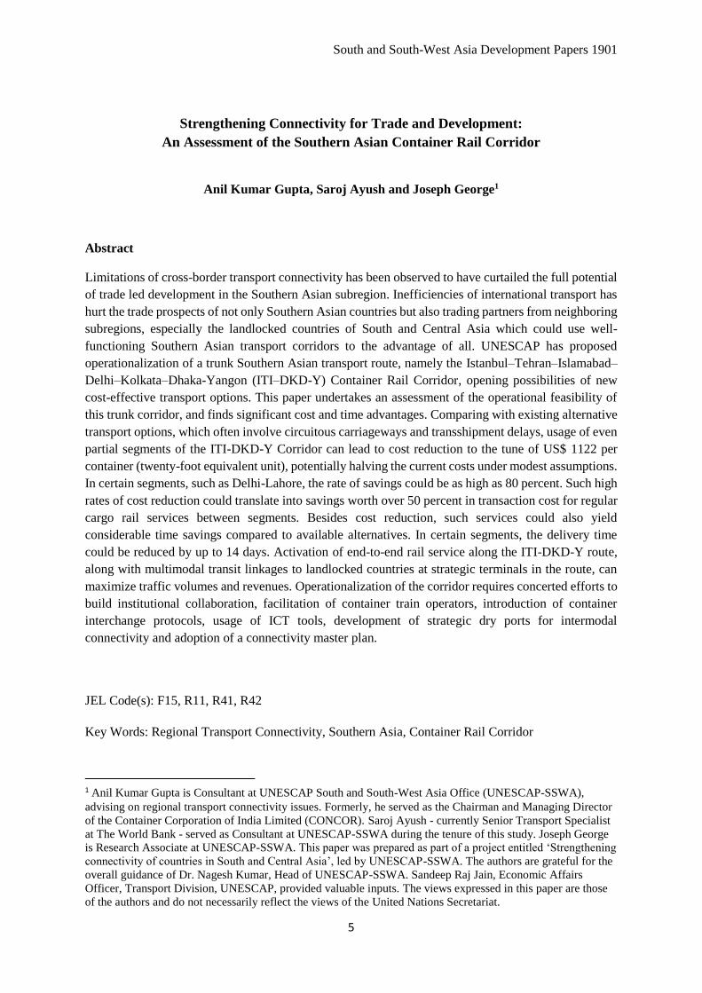
Figure 3
Istanbul-Tehran-Islamabad-Delhi-Kolkata-Dhaka-Yangon (ITI-DKD-Y) Container Rail Corridor
The ITI-DKD-Y Corridor is an integral parts of Trans-Asia Rail (TAR) network26 and, by multimodal
extension, is linked to the Asian Highway (AH) network. It has connecting sub-links to all South Asian
nations including landlocked countries like Afghanistan, Bhutan and Nepal, and to the existing major
ports of Bangladesh (Chittagong), India (Kolkata, Mumbai, JN Port, Mundra, Pipavav, Chennai among
26 See ‘List of the Lines in the Trans-Asian Railway Network’ annexed to Intergovernmental Agreement on the
Trans-Asian Railway Network. The ITI-DKD-Y Corridor currently has three key functional fragments, albeit at
varying levels of operationalisation. The principal segment in operation is the Istanbul-Tehran-Islamabad stretch,
through which regular container movement started since August 2010 after initial demonstration runs of 2009 and
early 2010. The second segment is Lahore-Delhi via Atari/Wagah border and the third segment is Kolkata-Dhaka
via Gede/Darshana or Petrapole/Benapole border stations. Both Lahore-Delhi and Kolkata-Dhaka rail corridors
allow freight movement in conventional railway wagons over certain limited stretches, though container traffic is
not interchanged. Since Islamabad-Lahore and Delhi-Kolkata-Dhaka segments are also well connected by national
railway networks of Pakistan, India and Bangladesh respectively, rail infrastructure is almost seamless along the
entire stretch of ITI-DKD-Y Corridor though it still calls for some improvements. However, the transport
facilitation protocol/policy side for containers coming out of/going to dry ports/ICDs including transit permits
and customs operations at border points is yet to be fully developed.

South and South-West Asia Development Papers 1901
17
others), Pakistan (Karachi) and Islamic Republic of Iran (Bandar Abbas). Together with the existing
road network, it offers multimodal transport facility to serve intra-regional trade across Southern and
Central Asia with numerous sub-links to the most populous as well as lagging rural hinterlands of the
sub-region. It also facilitates linkages to Central Asian economies through strategic ports of Bandar
Abbas (existing) and Chabahar (made operational in 2018), which will enable connection to landlocked
Central Asian countries through Afghanistan, in supplement to Afghanistan’s existing connectivity
through Pakistan. In addition, these two trunk corridors together offer onwards connectivity to European
markets on the western boundaries and on the eastern boundaries they have potential links to South-
East Asian markets through Myanmar, as existing gaps are addressed progressively.27 A recent study
commissioned by UNESCAP-SSWA has shown that these corridors exhibit better transport efficiency,
compared to rival transport routes and modes. 28
Irrespective of per unit financial cost advantages, bulking of container movement directly translates
into reduction in per unit carbon emission generated by transportation by rail vis-à-vis road. Therefore,
the real value of the ITI-DKD-Y Corridor has to be appreciated in terms of the robust option it would
provide for bulking a sizable share of the surge in freight load that Europe Asia trade is tipped to
generate in the coming decades. With eventual electrification and usage of renewable energy, the rail
route would prove itself as much more environmental friendly than its alternatives.
Table 2
Route Profile of ITI-DKD-Y Container Rail Corridor
Route Track Gauge Total Length
(kms)
Bangladesh
Dhaka -Joydebpur Dual Gauge of 1000/1676 mm 32
Joydebpur - Jamtoil Dual Gauge 99
Jamtoil – Ishurdi Dual Gauge (potential transshipment at Ishurdih between
BG & MG in view of existing load restrictions on BG
freight trains on Jamna bridge)
66
Ishurdi - Darshana Broad Gauge 1676 mm 81
Sub Total 278
India
Gede – Attari Broad Gauge 1676 mm 1975
Pakistan
Wagah – Koh – I-taftan Broad gauge 1676 mm 1730
Islamic Republic of Iran
Mirjaveh -Zahedan Broad gauge 1676 mm 92
Zahedan Break of gauge: Transshipment from BG to SG and vice
versa
Zahedan – Razi Std gauge 1435 mm 2481
Sub total 2573
27 For discussions on connectivity and trade expansion in the Eastern South Asia, see De, Das and Singh (2011). 28 TIPI-BM road corridor is found to be the most efficient in a comparison of 12 transport corridors of the
subregion. ITI-DKD-Y closely follows, and with an improvement in input usage by 25 percent, it can maintain
the same level of transport efficiency as that of TIPI-BM. See De (2014).

Strengthening Connectivity for Trade and Development:
An Assessment of the Southern Asian Container Rail Corridor
18
Turkey
Kapikoy – kapikule Std gauge 1435 mm; modal transfer for rail ferry across
lake Van
2354
Total route 9155 (4320
BG and 4743
SG)
Source: Authors’ compilation from various sources.
Detailed route profile of the corridor provided in Annex.
The westward traffic from Bangladesh can move from Dhaka on a gauntleted (dual gauge) track up to
Tongi junction. From Tongi the route moves through Joydebpur and then across Jamna Bridge over
River Padma to Jamtoil on same dual gauge track. From Jamtoil the route follows the broad gauge line
via Ishurdi to the border with the Indian state of West Bengal at Darsana (opposite the Indian border
station of Gede). This entire route of 278 kms is fit for running Broad Gauge trains with the exception
of the Jamuna Bridge over River Padma on which till now the Jamna Bridge Authority in Bangladesh
is not allowing BG freight trains to move due to technical reasons.
In India, the route starts at Gede on the Indian side of Bangladesh border and follows the Indian Broad
Gauge east west trunk line system right up to Indian border with Pakistan at Attari, passing through
Ranaghat, Naihati, Bandel, Shaktigarh, Sitarampur, Gaya, Sonnagar, Mughalsarai, Allahabad, Kanpur,
Tundla, Aligarh, Ghaziabad, Delhi, Ambala, Sirhind, Ludhiana, Jalandhar and Amritsar. This link is
entirely broad gauge with a total length of 1975 kms.
In Pakistan, the link has a length of 1730 kms which runs from the border with India to the border with
the Islamic Republic of Iran, essentially following an east west alignment. The route is also entirely
broad gauge and runs through the stations of Wagah, Lahore, Raiwind, Khanewal, Lodhran, Rohri, Sibi,
Abigum, Kolpur, Spezand, Ahmedwal, koh-i- teftan to the Iranian border station of Mirjaveh and
onwards to Zahedan in Islamic Republic of Iran for 92 km which is the last BG link station on this route
as one travels from Pakistan towards Teheran.
In Iran, the link forming part of this route runs from the border with Pakistan to the border with Turkey,
a distance of 2573 kms. From Koh-i-taftan (Pakistan) it crosses the border on the single track broad
gauge line which runs for 92 kms in a northwesterly direction till the provincial city of Zahedan. Beyond
Zahedan the track is built on Standard Gauge of 1435 mm. There is a transshipment facility created at
Zahedan to transship containers between broad gauge (BG) and standard gauge (SG) rakes. From there
the link runs in northwesterly direction to Bafq and then on to the Iranian border station of Razi to
Turkey through Kapikoy, Sistan, Qom, Mianeh, Tabriz and Sofian.
In Turkey, the line follows same standard gauge (1435 mm) and is the main east west trunk line. It runs
from the checkpoint on the border with the Islamic Republic of Iran at Kapicoy to the border with
Bulgaria at Kapilkule with and overall distance of 2354 kms. The link arrives from Kapicoy to the
eastern shore of the ferry terminal of Lake Van. At Van, trains are dissembles into short rakes for
loading onto ferries for the 91 km east west crossing of Lake Van which currently takes 4-5 hours. The
Turkish Railways have a plan to construct a line around the northern shore of Lake Van which would
avoid the need for the lake crossing. Reassembly of trains for onward dispatch occurs at Tatvan on the
western shore of Lake Van. From Tatvan the line reaches Kapikule through Malatya, Cetinkaya, Irmak,
Kayas, Ankara, Sincan, Eskeshir, Arifiye and then to Hydarpasa (eastern shore of the strait of
South and South-West Asia Development Papers 1901
19
Bosphorus). The underwater tunnel from Hydarpasa to Istanbul connects the European and Asian
borders of Strait of Bosphorus.
A detailed mapping of branch connections of the ITI-DKD-Y Container Rail Corridor is provided in
the Annex.
IV. An Economic Evaluation of the ITI-DKD-Y Container Rail Corridor
Freight movement along a long international trunk corridor such as the ITI-DKD-Y Container Rail
Corridor can be seen to be of utility in two forms. One would be an end to end connectivity between
markets located at the farthest reaches of the corridor and the other would be in terms of serving the
intermittent nodes in between the hoisting countries and linked neighborhood markets located all along
the corridor. Overall, the freight transport decisions would be made on the basis of cost, frequency,
consignment delivery times and safety and reliability of services provided by the competing transport
modes. For the ITI-DKD-Y Corridor, marine transport would serve as the main competitor, as road
vehicles are not seen to be an efficient mode for long distance transport of commodities beyond
distances of around 300 km or so29. However, on short distance bilateral movement of freight in between
neighboring countries, road transport may become the main competitor.
The end points of ITI-DKD-Y, namely Myanmar and Turkey, could carry out trade either on the rail
route of ITI-DKD-Y Corridor or through maritime connections. This corridor serves countries with
large maritime boundaries with very huge hinterlands as well as bordering land locked countries in the
North. Viewed only from geographical viewpoint, the ITI –DKD-Y corridor forms the southernmost
available Rail corridor for the concerned countries. This corridor is coupled with vertical lines of rail
connections with the landlocked countries in the North to the Sea ports in the south. With this kind of
a layout, it opens up a vast possibility of route choices for the northern landlocked countries such as
Bhutan, Nepal, Afghanistan, Turkmenistan, Ajerbaijan, Armenia and Georgia to connect with the sea
ports of southern sea routes.
However, distances are not the sole governing factor in determining the route choices. The track health
of the rail corridor, and the capability of the transport operator to provide safe, reliable and timely
services would affect the route choice of the shipper. Once the same is established then the relative
distance advantages translated into total user charges (tariffs plus carrying costs) would significantly
alter the decision of the shippers in favor of the all rail route choice offered by the corridor.
After the route is established the shippers in Dhaka, for example, would have two main choices to carry
out trade with, say, Tehran in the Islamic Republic of Iran. One would be the existing route and mode
choice of moving from Dhaka to Chittagong port by rail/road (320 km), then via established marine
route to Bandar Abbas either directly or through Colombo (transshipment), with onward railing from
Bandar Abbas to Teheran (1380 km). The other would be the all rail route choice of ITI-DKD-Y
Corridor (5600 km) avoiding port handlings and associated costs and delays at Chittagong, Colombo
and Bandar Abbas. Similarly, for Lahore shipments, the choice would be between direct railing
between Dhaka and Lahore (2280 km) vis-à-vis the option of moving consignment from Dhaka to
Chittagong (320 km), Colombo/Karachi, with onward railing from Karachi to Lahore (1220 km). A
detailed analysis would reveal that the shippers of all the dry ports situated on or near the ITI-DKD-Y
Corridor have only two route choices available to them. One is the current prevalent option of
29 The break even distances vary from country to country but in general, the container transportation by road
vehicles does not remain viable for distances beyond 300 km, except for landlocked countries where, per se, these
distances are higher.

Strengthening Connectivity for Trade and Development:
An Assessment of the Southern Asian Container Rail Corridor
20
connecting the Dry port at origin to the nearest Ocean Port and then follow the primary maritime route
to the nearest ocean port of destination and then the last mile connectivity through rail/road. Second
would be inter-modal connectivity by rail route, with rail being primary mode.
VI. 1. Traffic Demand
The countries along ITI-DKD-Y Corridor together with its branch routes currently move lot of
import/export containers of international trade. However, active container movements by rail have just
been confined to ITI route in between Turkey, Iran and Pakistan under the ECO trade and transit
framework agreement. Apart from ECO trains whose frequency is also very low, not much of transit
traffic has moved across these countries by rail on this corridor. The only significant rail container
movements are being done between India and Nepal under a Rail Service Agreement signed between
the two countries. Under this agreement, India moves container trains between Birgunj ICD of Nepal
and various Indian cities for bilateral traffic moving between India and Nepal, and between Birgunj
ICD and the seaports of Kolkata, Haldia and Vizag for third country cargo for/from Nepal. Very
recently, container trains have also been started for rail run upto a rail head of Batnaha in India, just 18
m short of Biratnagar border, for onward road link with Biratnagar ICD. However, there are no
container interchanges between India and Pakistan, and between India and Bangladesh, though rail
connectivity and linkages are operational for bulk freight traffic moving in railway wagons at both ends
under bilateral arrangements. For Indian freight cargoes destined for Northeast India, Bangladesh does
not carry any transit traffic on its Railways at present.
All these countries have, however, developed strong linkages with the Ocean Ports of their countries
which serve the ICD/Dry Ports located in the hinterland, except for Bhutan and Nepal which are using
Indian seaports of Haldia/Kolkata currently, with Nepal cargo also beginning to use Vishakhapatnam
on east coast of India this year, in 2017. As already indicated in previous chapter, many important dry
ports of these countries are strategically located on or near the ITI-DKD-Y Corridor or its branch lines
which would attract the trade to move towards the rail route provided it meets the expectations of the
shippers on cost, time, reliability and safety.
There is no assessment readily available for the number of containers being moved in this region.
However the same can be deduced based on certain assumptions. The countries of this region have been
witnessing a steady increase in the number of containers handled at the ports of the region as indicated
in Table 3, which gives port throughputs for container handling for Bangladesh, India, Pakistan, Islamic
Republic of Iran and Turkey.
Table 3
Container Throughputs handled at some key* South Asian Ports:
2009-2017
(Million TEUs)
Year Bangladesh India** Pakistan Islamic Republic of
Iran
Turkey
2009 1.18 8.01 2.06 2.21 4.52
2010 1.35 8.92 2.15 3.05 6.60

South and South-West Asia Development Papers 1901
21
2011 1.42 9.92 2.28 3.43 7.39
2012 1.43 10.28 2.22 2.65 8.17
2013 1.49 10.63 2.26 2.13 9.43
2014 1.64 11.32 2.53 2.27 9.34
2015 2.04 12.54 2.76 2.17 8.83
2016 2.38 13.71 2.76 2.56 8.58
2017 2.59 15.37 2.99 3.09 9.93
Source: UNCTAD Review of Maritime Transport, and UNCTAD Statistics, various issues
* We have not included port throughputs of Colombo (Sri Lanka) as quite a big proportion handled there is
actually the transshipment cargo of Bangladesh, India and Pakistan.
** For all Indian ports, the throughput includes the figures of third country exports/imports of Nepal and
Bhutan. The overall throughput levels increased to 12.54 million TEUs in 2015, 13.71 million TEUs in 2016,
and 15.37 million TEUs in 2017 (fiscal 2017-18).
Traffic has increased substantially in every country in the last five years, with almost 34 million TEUs
handled by the ports of these five countries put together in 2017. A study has indicated that intra-
regional trade of non-oil commodity amongst South and South west Asian countries is about 6.42% (in
2012) of the total trade being carried out by the countries involved (Prabir De 2014). If containerization
is any indication then 7% of the total containerized trade would also be meant for inter- regional trade.
As per the above data that would mean a trade potential of about 2.4 million TEUs every year.
The Rail coefficient of total trade handled is about 15% globally. That would mean that about 15% of
the total inter regional trade would move by trains amounting to around 3,60,000 TEUs per annum.
This would simplistically mean an average of 6 to 7 trains each way every day for the trains of average
size of 80 TEUs per train. For smaller length trains of, say, 50 TEUs which may be more practical in
beginning, this would amount to a potential of around 10 pairs of trains per day. Corroborating this
observation, a UNESCAP study30 had indicated the potential forecast of cross border trade in the year
2016/17 could be as high as 3.9 pairs of trains per day in between Bangladesh India border and 3.9 pairs
of trains in between India Pakistan Border.
However, these projections may account for only a part of the possible cargo traffic potential in the
Southern Asian subregion. Trade between the countries of South and South-West Asia suffers from a
number of tariff and non-tariff barriers. It is expected that lower transport costs and transit times
possible through alternative transport options in the form of all rail connectivity would boost economic
transactions by lowering overall trade costs substantially, with a direct impact in terms of increasing
trade volumes and boosting economic growth of the region.
Studies have suggested that the absence of a direct connection is associated with a drop-in exports value
varying between 42 and 55 per cent. Results also indicate that any additional transshipment is associated
with a drop in exports value varying between 20 and 25 per cent.31 Also, it has been observed that the
liner shipping connectivity accounts for about 25 percent of the changes in trade costs that are unrelated
30 See UNESCAP (1999) 31 UNCTAD (2015)

Strengthening Connectivity for Trade and Development:
An Assessment of the Southern Asian Container Rail Corridor
22
to non-tariff policies.32 Thus, as a country’s liner connectivity index improves, the cost of shipping
declines, boosting competitiveness, generating trade demand and increasing container traffic.
The proposed ITI-DKD-Y Corridor is expected to lead to the creation of new industries in the areas
though which these new links will pass through and thus generate new demand for rail services. The
actual demand generated would depend upon a number of factors including the industrial
responsiveness in the catchment areas of the corridor. In addition, rough estimates show that each
participating country could also benefit by passing transit freight traffic, by way of earning transit
revenue and creating jobs for the transit country.
VI.2 Transit Times
ITI_DKD-Y corridor can potentially offer transit time advantage to the shippers. The relative distance
advantage of land connectivity should be translated into moving the goods in lesser time than the
competitive ocean routes. In this section, we undertake a transit time analysis, considering the longer
end-to-end segment and for selected intermittent points on the route. For longer route, for the purpose
of analysis, origin and destination route points are identified as Dhaka (in Bangladesh) and Frankfurt
(in Germany), and the following assumptions are made.
i) The speed of the train on the ITI –DKD-Y corridor would maintain an average of 30 kmph or
720 kms per day except for Bangladesh for which speed is kept low at 20 kmph in view of
practical limitations as of now. For Pakistan speed is kept at actual experienced during runs of
ITI trains due to serious issues of train running in Quetta-Koh-i-Taftan section.
ii) The customs examination procedure would not delay the train at border check points for more
than 12 hours.
iii) The transshipment as required would not take more than 6 hours by using state of the art
technology
iv) There would be availability of wagons and locomotives to seamlessly move the train across the
countries and there would be no delay on this part
With above assumptions, the Tables 4 and 5 below describe the breakup of transits in two scenarios of
movement via ocean route and rail route respectively.
Table 4
Estimated transit time Dhaka – Frankfurt (Germany)
via ocean route
Component Mode Transit Time
(in days)
Remarks
Dhaka - Chittagong Rail 1 - 2 At present there are two trains running from
Dhaka to Chittagong daily, this would
include the waiting time at ICD
Ship Loading at
Chittagong
2 - 3 Average Dwell time at Chittagong port
32 It has been observed that bilateral trade costs are most elastic to the change in liner shipping connectivity of
trade partners. See Duval and Utoktham (2015).

South and South-West Asia Development Papers 1901
23
Chittagong -
Colombo
Feeder
Ship
6
Transshipment in
Colombo
2
Colombo -
Antwerp
Mainline
Ship
18 - 20 Includes allowance for en-route port calls
Transshipment at
Antwerp
1
Antwerp -
Frankfurt
Road 1 Door Delivery in Frankfurt
Total 31-35
Source: Authors’ estimations
Table 5
Estimated all rail transit time for Dhaka to Frankfurt
via ITI-DKD-Y route
Component Distance
(km.)
Transit
Time (in
hours)
Border
dwell time
for customs
clearance
(hours)
Dwell
time at
break of
gauge
(hours)
Total
no. of
hours
Remarks
Dhaka -
Darsana
278 14 12 - 26 @avg speed of 20kmph
Darsana –
Attari
1975 66 12 - 78 @avg speed of 30 kmph
Attari –
Koh-i-taftan
1731 187 12 - 199 Actual experience
Koh-i-taftan
- Razi
2573 86 12 6 104 @avg speed of 30 kmph
Razi -
Kapikule
2354 79 12 6 97 6 hrs for lake van
crossing
Kapikule -
Frankfurt
2239 45 48 - 93 Estimated speed 50
kmph; border delay time
@ 4 borders by 12 hrs
each
Total 11150 480 108 12 600=
25
days
Source: Authors’ estimations
The average speed of goods train over the last few years over the South Asian countries have been
around 22 -27 kmph. However, this speed averages over various congested, non-congested routes,
different types of wagons hauled, different locomotives etc. In India, with the new BLC type wagons

Strengthening Connectivity for Trade and Development:
An Assessment of the Southern Asian Container Rail Corridor
24
being utilized for hauling containers an average speed of 40-50 kmph can be easily attained. The
Mumbai – Delhi congested corridor runs the container trains at an average speed of 40 kmph. However,
we are here presuming only an average speed of 30 kmph for Asian leg of the route except for
Bangladesh and Pakistan (for Bangladesh it is presumed to be 20 kmph under existing circumstances
and actual experience speed has been used for Pakistan) which is attainable in case these trains are run
on scheduled identified paths which would be in interest of all participating railway administrations.
It may be noted here that the all rail corridor would offer a significant time advantage over the current
ocean route if an average speed of 50 kmph can be maintained and the customs procedures for border
crossing can be restricted to get completed in much less than 12 hours. This can be done by relying on
technology in which filing of customs documents can be standardized and submitted for scrutiny much
before the actual arrival of container trains as is being done in the case of vessels. Incidentally, this time
is an average of only 4 hours at the only existing rail interchange yard operative in this region at Raxaul
(India) - Birgunj (Nepal) cross border point which will imply substantial saving over the complete route
run.
Relative Transit times: Intermittent Routes
One of the biggest advantages of the ITI-DKD-Y Container Rail Corridor is that it connects locations
of strategic and industrial importance. These locations are placed in the hinterland of the ports and thus
suffer from a high transport cost to participate in international trade. The cargo to move from Delhi to
Mumbai port has to cover a distance of 1445 kms by rail, whereas in the same distance the cargo would
reach Islamabad and beyond at the same or even lesser cost.
To elaborate the point, a few intermediate routes on the ITI-DKD-Y Corridor are listed
a) ICD Dhaka to ICD Lahore
b) ICD Delhi to ICD Dhaka
c) ICD Delhi - Tehran
d) ICD Delhi – ICD Lahore
Table 6 below computes the transit time options for these intermittent routes via ocean mode of
transport:
Table 6
Estimates of transit Times via Ocean route
Route Component Distance Mode Transit/Dwell time
(number of days)
1. ICD Dhaka
– ICD
Lahore
Dhaka to
Chittagong Port
320 kms Rail/Road 1-2 days
Dwell time at
Chittagong Port
2-3 days
Chittagong Port to
Karachi Port
Ocean 10-12 days

South and South-West Asia Development Papers 1901
25
Dwell time at Port
Karachi
2-3 days
Karachi to Lahore 1220 kms Rail/Road 2 days
Total 17 - 22 days
2. ICD Delhi –
ICD Dhaka
Delhi to JN Port in
Mumbai
1445 km Rail/Road 2 days
Dwell time at JN
Port
2-3 days
JN Port to
Chittagong
Ocean 10-12 days
Dwell time at
Chittagong port
2-3 days
Chittagong to ICD
Dhaka
321 kms Rail/Road 2 days
Total 18 - 22 days
3. ICD Delhi –
Tehran
Delhi to JN Port in
Mumbai
1445 km Rail/Road 2 days
Dwell time at JN
Port
2-3 days
JN Port to Bandar
Abbas
Ocean 10-12 days
Dwell time at
Bandar Abbas port
2-3 days
Bandar Abbas to
Tehran
1316 km Rail/Road 2 days
Total 18-22 days
4. ICD Delhi –
Lahore
Delhi to JN Port in
Mumbai
1445 km Rail/Road 2 days
Dwell time at JN
Port
2-3 days
JN Port to Karachi Ocean 6-7 days
Dwell time at
Karachi port
2-3 days

Strengthening Connectivity for Trade and Development:
An Assessment of the Southern Asian Container Rail Corridor
26
Karachi to Lahore 1220 kms Rail/Road 2 days
Total 14-17 days
Source: Authors’ estimations
For rail mode, the transit time scenarios for these intermittent routes are tabulated in Tables 7 and 8
below for general and worst possible scenario respectively.
Table 7
Estimates of All Rail transit Times on ITI-DKD-Y Corridor
(general scenario)
Route Component Distance Transit
Time
(hrs.)
Border
dwell time
(hrs.)
Dwell
at gauge
break
(hrs.)
Total
hrs.
Remarks
Dhaka –
Lahore
Dhaka -
Darsana
278 14 12 - 26 @ 20 kmph
Gede – Attari 1975 66 12 - 78 @ 30 kmph
Attari - Lahore 27 2 - - 2
Total 2295 82 24 106 4-5 days
Delhi-
Dhaka
Delhi-Gede 1482 50 50
Darshana-
Dhaka
278 14 12 - 26
Total 1760 64 12 76 3-4 days
Delhi -
Tehran
Delhi - Attari 494 17 - - 17 @30kmph
Attari – koh-i-
taftan
1731 187 12 - 199 Previous
experience*
Koh-i-taftan -
Tehran
1585 53 12 6 71 @30kmph
Total 3810 257 24 6 287 11-12 days
Delhi-
Lahore
Delhi – Attari 494 17 12 - 29
Attari to
Lahore
27 2 - - 2
Total 521 19 12 31 1-2 days
*Reported by ECO secretariat at Regional meet for co-operation on facilitation of International Railway
Transport, in Bangkok, Thailand during 13-15 October 2014

South and South-West Asia Development Papers 1901
27
Table 8
Estimates of All Rail transit Times on ITI-DKD-Y Corridor
(worst scenario)
Route Component Distance Transit
Time
(hrs.)
Border
dwell time
for customs
clearance
(hrs.)
Dwell
time at
break of
gauge
(hrs.)
Total
hrs.
Remarks
Dhaka –
Lahore
Dhaka -
Darsana
278 19 18 - 37 @avg speed
of 15 kmph
Gede – Attari 1975 99 18 - 117 @avg speed
of 20 kmph
Attari - Lahore 27 2 - - 2
Total 2295 120 36 156 6-7 days
Delhi-
Dhaka
Delhi-Gede 1482 75 75
Darshana-
Dhaka
278 18 18 - 36
Total 1760 93 18 111 4-5 days
Delhi -
Tehran
Delhi - Attari 494 17 - - 17 @20kmph
Attari – koh-i-
taftan
1731 187 18 205 Previous
experience
Koh-i-taftan -
Tehran
1585 80 18 6 104
Total 3810 284 36 6 326 13-14 days
Delhi-
Lahore
Delhi – Attari 494 25 18 - 43
Attari to
Lahore
27 2 - - 2
Total 521 27 18 45 1-2 days
Source: Authors’ estimations
On comparing the transit time differences for various routes, it is seen that the all rail route of ITI-DKD-
Y Corridor offers significant saving of time. The significance of the time saved increases for the
hinterland area lying on the corridor (Table 9). The intermediate stations tend to gain much more than
the end to end destinations.
Table 9
Comparative transit times on two modes
(Number of days)
Route/sector Ocean mode Rail mode general
scenario
Rail mode worst
scenario
Dhaka - Lahore 17 - 22 4 -5 6-7
Strengthening Connectivity for Trade and Development:
An Assessment of the Southern Asian Container Rail Corridor
28
Delhi - Dhaka 18-22 3-4 4-5
Delhi – Teheran 18 -22 11-12 13-14
Delhi - Lahore 14 - 17 1-2 2
Summary of analysis in previous tables
Results are obvious. Considering huge savings in transit times even in worst scenario, the overall user
costs have a potential to be much attractive in all rail route for these and many more such intermittent
points. These benefits become all the more attractive once we consider associated freight tariffs and
overall financial costs associated with movements under two modes. This is what we turn to in the
following paras.
VI.3 Freight Tariffs
The most significant aspect of a route or mode choice in transport of cargoes by shipper is the total cost
of transportation, viz., the user charges which will enable the user to make the node choice. However,
comparison of all rail and predominantly ocean based node’s tariff is fraught with difficulties. For one
there is no standard International tariff of Railways. Second, Railway tariff is just one of the
components of user charges which also involves deployment of other complementary resources like
wagons (specifically in Indian case where container wagons are all privately owned by various
Container Train Operators and/or leasing companies), inter-modal terminals, containers, etc. Third,
ocean tariffs have not been set up in reference to the level and structure of the tariff of currently
nonexistent competing modes. The Ocean tariffs have undergone a lot of changes and now the market
relies primarily on the customized tariffs developed for particular customers. Moreover, the ocean
freight rates undergo seasonal fluctuations based on supply and demand of vessel space, container
availability, repositioning requirements, port of calls in a country and many other factors. The factors
that control the ocean freight rates are truly globalized and the extent of impact of these needs an
extensive research for an impact analysis of individual factors before rail freights can emulate these in
its tariff fixation analysis.
For rail haulage of containers also the private container train operators have been developing freight
rate packages to suit the requirement of the shippers. The traditional method of rating a particular
service on the Origin Destination distance basis no longer holds true. For example, import containers
moving from Mumbai to Delhi are subjected to higher freight tariff than the export containers from
Delhi to Mumbai. In such a situation, it would be erroneous to compare freight rates. However, for
comparative purpose an analysis is carried out based on some international rates prevalent in the region.
There are two methods of charging freight in the case of international transport. In the first case, each
country’s railway administration charges a haulage rate on per kilometer basis for movement within its
territory. In this category are the haulage rates as indicated in Table 10 below, as compiled by a UN
expert group.

South and South-West Asia Development Papers 1901
29
Table 10
Rail Tariffs for haulage of containers in various countries
(Per km costs in US dollars)
20 ft loaded per
km
40 ft loaded
per km
20 ft empty
per km
40 ft empty per
km
Azerbaijan 0.52 0.64
Bulgaria 0.75 0.85
China 0.40 0.50
Germany 0.75 0.85
Iran 0.46 0.68 0.23 0.34
Kazakhstan 0.64 1.03 0.31 0.48
Russian Federation 0.48 0.55
Tajikistan 0.55 0.75
Turkey 0.31 0.41 0.23 0.29
Turkmenistan 1.4 2.6
Uzbekistan 0.64 1.4 0.38 0.67
Source: Expert Group Report on Euro-Asian Transport Linkages Phase II, UN, 2012
A specific example of corridor wise rates in this category is of Istanbul-Almaty and Bandar Abbas –
Almaty corridor trains being run by ECO in the region under Transit Transport Framework Agreement
(TTFA). The rating of these trains is tabulated in Table 11 for Almaty linked Corridors.33
Table 11
Freight tariffs on ECO Corridors linked with Almaty Istanbul - Almaty container train freight tariff in US Dollars
Loaded container tariff Empty container tariff
Rail corridor Distance 20 feet per km 40 feet per km 20 feet per km 40 feet per
km
Turkey (Kose
koy-Kapikoy)
1850 802 0.44 1205 0.66 573 0.31 716 0.39
Iran 1619 462 0.29 770 0.48 278 0.17 462 0.29
Turkmenistan 469 882 1.88 1600 3.41 inclusive of one-way empty
33 Extracted from presentation by ECO secretariat at OTIF/UIC/ECO workshop on COTIF in Tehran on 11-12
November 2014.

Strengthening Connectivity for Trade and Development:
An Assessment of the Southern Asian Container Rail Corridor
30
Uzbekistan 732 608 0.83 1048 1.43
Kazakhstan 956 398 0.42 661 0.69 214 0.22 356 0.37
Total 5626 3152 0.56 5284 0.94
Bandar Abbas - Almaty container train freight tariff in US Dollars
Iran 1553 770 0.50 1126 0.73 385 0.25 562 0.36
Turkmenistan 469 882 1.88 1600 3.41 inclusive of one-way empty
Uzbekistan 732 608 0.83 1048 1.43
Kazakhstan 956 398 0.42 661 0.69 214 0.22 356 0.37
Total 3710 2658 0.72 4435 1.20
Source: ECO Secretariat
In second category, there is a standard rate which is applied for entire corridor, like for ITI for which
all those involved have used a charge of 0.22 Euro per km (equivalent to USD 0.26 @1.18 USD per
Euro) per 20’ container and 0.28 Euro (0.33 USD) per FEU. These tariffs are reproduced hereunder in
Table 12.
Table 12
Container Tariffs on ITI Corridor ITI container train freight tariff in Euros
loaded Empty
Total
kms
20 feet Per km 40 feet
per km 20 feet
Per km 40 feet
per km
Iran 2603 572 0.22 728.8 0.28 286.3 0.11 364.4 0.14
Pakistan 1990 437.8 0.22 537.3 0.28 218.9 0.11 318.4 0.16
Turkey (Kosekoy-
Kapikoy)
1850 407 0.22 518 0.28 204 0.11 259 0.14
Total (in Euros) 6443 1416.8 0.22 1784.1 0.28 709.2 0.11 941.8 0.15
Total (in US Dollars
@ 1.18 USD per
Euro))
1672 0.26 2106 0.33 836.9 0.13 1111.3 0.17
Source: Authors’ compilations from various sources

South and South-West Asia Development Papers 1901
31
Overall, for corridor runs, the per km rate of a 20 feet container vary from $ 0.26 to $ 0.72, whereas the
per km rate of 40 feet container vary from $0.33 to $ 1.20. In reality, for corridor rates the variation is
very wide which can be seen in Table 13.
Table 13
Rail tariffs for various ECO corridors (in US Dollars)
Corridor 20 ft loaded per
km
40 ft loaded
per km
20 ft empty
per km
40 ft empty
per km
Istanbul - Almaty 0.56 0.94
Bandar Abbas - Almaty 0.72 1.20
Istanbul – Tehran –
Islamabad (ITI)
0.26 0.33 0.13 0.17
Source: Authors’ compilations
There is lot of ambiguity about basing users’ charges on these tariffs as they appear to be just the haulage
charges being charged by individual railway administrations and do not reflect full users’ costs which
is essential to be developed as a robust comparative charge to match the level and structure of the
competing mode of Ocean freights. In fact, a few essential points which must be kept in consideration
about tariff setting principles would be
1. To attract traffic to ITI-DKD-Y Corridor a realistic and preferably uniform rail haulage charge
should be made applicable throughout the route meant for international movements.
2. Individual Railway Administrations should just give these haulage charges to the international
freight forwarding agencies who should take responsibility of providing rolling stock and
containers for movement across the corridor. These agencies need to enter into contracts with
individual railways for arranging through runs and should hire or take on lease railway wagons
(either from Railways owning them or from lessors/container train operators which is the case in
India) and containers for these movements. Freight forwarders will ultimately devise the
appropriate tariff structures, to be christened as the users’ charges.
3. The tariff structure/user charges evolved should appear attractive to the customers who are
presently using alternative mode of transport.
In this context, we have attempted an actual cost analysis on the basis of Indian context in which Indian
Railways are the leading partners, carrying almost 3.5 million TEUs over rails on various corridors
during 2017-18, corresponding to around 110 container trains daily on Indian Railway system. Indian
Railways have been having a very well-defined rail tariff structure for rail movement of ISO containers
based on the principle of Fully Distributed Costs related to rail haulage but excluding costs of wagons,
containers and inter-modal terminals where such wagons and containers are handled. Here the wagons
are not provided by Railways but the maintenance of private wagons operating on IR system is
Railway’s responsibility and cost. This is a weight wise slab cluster, with telescopic ratings. The latest
tariffs for some significant distance slabs of IR are tabulated in Table 14.

Strengthening Connectivity for Trade and Development:
An Assessment of the Southern Asian Container Rail Corridor
32
Table 14
Rail Haulage Charges per TEU in US Dollars (@ IUSD= INR 70)
Distance
slab Charges for 20’ Loaded Container in weight slabs*
20’
Empty
Containe
r
Empty Flat
Wagons*
upto 10
Tn
above
10Tn &
upto20T
n
above
20Tn
& upto
26Tn
above
26Tn &
upto
31Tn
above
31Tn
(Kms) (USD) (USD) (USD) (USD) (USD) (USD) (USD)
(1) (2) (3) (4) (5) (6) (7) (8)
201-250 56.46 69.61 82.84 91.77 101.10 31.76 29.65
451-500 103.16 129.46 155.91 173.77 192.46 58.03 54.16
701-750 149.86 189.30 228.99 255.79 283.79 84.30 78.68
951-1000 196.54 249.16 302.07 337.79 375.11 110.56 103.19
1201-1250 243.24 308.99 375.16 419.79 466.47 136.83 127.70
1451-1500 289.93 368.83 448.21 501.80 557.80 163.09 152.22
1701-1750 336.63 428.69 521.30 583.80 649.14 189.35 176.73
1951-2000 383.33 488.51 594.37 665.80 740.49 215.63 201.26
2201-2250 430.01 548.37 667.46 747.81 831.83 241.89 225.76
2451-2500 476.71 608.21 740.51 829.81 923.16 268.16 250.28
2701-2750 523.41 668.06 813.60 911.81
1014.5
1 294.43 274.80
2951-3000 570.10 727.90 886.69 993.83
1105.8
4 320.69 299.30
3201-3250 616.80 787.76 959.76 1075.83
1197.1
9 346.95 328.83
3451-3500 663.50 847.59
1032.8
3 1157.83
1288.5
3 373.22 348.34 * Weight slabs include cargo weight and tare weight of containers. 40 ft loaded containers are prized in two
slabs of upto 20 tn and over 20 tn weight respectively, at 1.8 times of rates indicated in columns 2 and 3
respectively.
Table 15 below shows per km rate for some indicative distances, with upper limit of slab taken as
denominator for each slab:
Table 15
Rail Tariffs for haulage of containers in India,
(per TEU km in US dollars)
Distance Loaded 20 ft Container
Empty 20 ft
Container
upto 10
T
above
10T&
upto20T
above
20T &
upto 26T
above 26T
& upto
31T above 31T
(Kms) (USD) (USD) (USD) (USD) (USD) (USD)
(2) (3) (4) (5) (6) (7)
500 0.21 0.26 0.31 0.35 0.38 0.12
1000 0.20 0.25 0.30 0.34 0.38 0.11
1500 0.19 0.25 0.30 0.33 0.37 0.11
2000 0.19 0.24 0.30 0.33 0.37 0.11

South and South-West Asia Development Papers 1901
33
2500 0.19 0.24 0.30 0.33 0.37 0.11
3000 0.19 0.24 0.30 0.33 0.37 0.11
Source: Authors’ calculations from Indian Railways rate table.
It is quite significant to note that the overall realization for Indian Railways for entire container traffic
moved on rail was USD 0.2483 per TEU kilometer (Rs.17.38 India Rupees) in 2016-17 which is
significantly close to ITI figure of 0.26 USD per TEU km shown in table 4.12 above.
Table 16 shows the charges which a rail operator, which is different from rail authorities in India for all
container movements by rail, can charge with a reasonable working margin over his costs including
wagon charges and the operators’ costs, but without including container charges which are to be borne
by the shippers using the operators’ services either directly or through liner companies who deploy their
own container fleets. There are 17 such licensed Container Train Operators in India who all own their
own wagons and provide train services on different rail routes spanning various parts of the country,
with Container Corporation of India (CONCOR) carrying over 75% of total traffic. The players include
freight forwarding/logistics companies, some associates of major liner (shipping) groups like MSC
(Mediterranean Shipping Co.) and American President Line (APL), and big business groups like Adanis
and Reliance Logistics.
Table 16
Haulage Charges in USD per TEU km
inclusive of wagon costs and 20% gross margin for operator
Distance Loaded 20’ container under weight slab of
Empty
20’
Containe
r
Empty
Flat
Wagons*
upto 10 T
above
10T&
upto20T
above 20T
& upto 26T
above 26T
& upto
31T
above
31T
(Kms) (USD) (USD) (USD) (USD) (USD) (USD) (USD)
(2) (3) (4) (5) (6) (7) (8)
201-250 0.31 0.38 0.46 0.50 0.56 0.17 0.16
451-500 0.28 0.36 0.43 0.48 0.53 0.16 0.15
701-750 0.27 0.35 0.42 0.47 0.52 0.15 0.14
951-1000 0.27 0.34 0.42 0.46 0.52 0.15 0.14
1201-1250 0.27 0.34 0.41 0.46 0.51 0.15 0.14
1451-1500 0.27 0.34 0.41 0.46 0.51 0.15 0.14
1701-1750 0.26 0.34 0.41 0.46 0.51 0.15 0.14
1951-2000 0.26 0.34 0.41 0.46 0.51 0.15 0.14
2201-2250 0.26 0.34 0.41 0.46 0.51 0.15 0.14
2451-2500 0.26 0.33 0.41 0.46 0.51 0.15 0.14
2701-2750 0.26 0.33 0.41 0.46 0.51 0.15 0.14
2951-3000 0.26 0.33 0.41 0.46 0.51 0.15 0.14
3201-3250 0.26 0.33 0.41 0.46 0.51 0.15 0.14
3451-3500 0.26 0.33 0.41 0.45 0.51 0.15 0.14
Source: Authors’ compilations
Usually operators are concerned about imbalances in directional trades which imposes an additional
repositioning charge varying from zero to 100%. A charge inclusive of 25%, 50% and 100%
repositioning in 10 ton to 20 ton weight category is tabulated in Table 17.

Strengthening Connectivity for Trade and Development:
An Assessment of the Southern Asian Container Rail Corridor
34
Table 17
Charges per TEU km for 10 to 20 Tn category units
With different repositioning circumstances
Distance
One-way LDD
Other Way Full Empty
One-way LDD
Other Way 50% Empty
One-way LDD
Other Way 25% Empty
(Kms) (USD) (USD) (USD)
(3) (4) (5)
201-250 0.54 0.46 0.42
451-500 0.51 0.43 0.39
701-750 0.49 0.42 0.38
951-1000 0.48 0.41 0.38
1201-1250 0.48 0.41 0.38
1451-1500 0.48 0.41 0.37
1701-1750 0.48 0.41 0.37
1951-2000 0.48 0.41 0.37
2201-2250 0.48 0.40 0.37
2451-2500 0.47 0.40 0.37
2701-2750 0.47 0.40 0.37
2951-3000 0.47 0.40 0.37
3201-3250 0.47 0.40 0.37
3451-3500 0.47 0.40 0.37
Source: Authors’ compilations
The public tariffs being charged by leading Container Train Operators for some important international
stream of traffic are given in Table 18:
Table 18
Rail Haulage Charges per TEU in US Dollars (@ IUSD= INR 70) Public Tariff per loaded 20’ container Empty
Stream / distance upto 10 T
above 10T&
upto20T
above 20T
& upto 26T
above 26T & upto
31T
above
31T
(Kms) (USD) (USD) (USD) (USD) (USD) (USD)
(1) (2) (3) (4) (5) (6) (7)
Kolkata – Birgunj (704) Imports 265 337 408 450 480 172
Exports 229 300 373 415 179
Delhi – JN Port (Mumbai) (1445)
Imports 486 586 722 808 865 308
Exports 358 444 522 608 658 144
Delhi – Mundra Port (1116 km)
Imports 386 472 600 665 708 265
Exports 343 422 536 600 644 226
Source: Authors’ compilations

South and South-West Asia Development Papers 1901
35
It is clarified that for Birgunj, Indian Railways collects freight upto international border at Raxaul which
is 704 km from Kolkata. There are no siding charges levied. IR, however, collects stabling charges if
rake is detained for more than four hours at Raxaul for any reason related to Dry Port Birgunj which
incidentally is also open for non-containerized cargoes moving in traditional railway wagons.
On per kilometer basis, the charges are as given in Table 19.
In summarized form, Table 20 describes the various charges on per TEU km basis for two representative
weight categories of gross weight till 20 ton and for weight category of 20-26 ton per TEU for 1000 km
distance which is the average lead of container hauls in India (actual leads in last two years have been
1009 km and 961 km respectively).
Table 20
Various categories of CTO’s charge per TEU km for 1000 km lead
(USD per TEU km)
Category of Charge Upto 20 ton gross weight
category
20-26 ton gross weight
category
Rail haulage charge 0.25 0.30
Table 19
Rail Freight Charges by Container Train Operators on per km basis
(in USD per TEU km)
Loaded Container
Empty
Container
Public Tariff per TEU Per TEU
Stream /
distance upto 10 T
above
10T&
upto20T
above 20T
& upto
26T
above 26T
& upto
31T
above
31T
(Kms) (USD) (USD) (USD) (USD) (USD) (USD)
(1) (2) (3) (4) (5) (6) (7)
Kolkata –
Birgunj (704
km) Imports 0.38 0.48 0.58 0.64 0.68 0.24
Exports 0.33 0.43 0.53 0.59 0.25
Delhi – JN
Port
(Mumbai)
(1446 km)
Imports 0.34 0.41 0.50 0.56 0.60 0.22
Exports 0.25 0.30 0.36 0.42 0.46 0.10
Delhi –
Mundra Port
(1116 km)
Imports 0.35 0.43 0.54 0.60 0.64 0.24
Exports 0.31 0.38 0.48 0.54 0.58 0.21
Source: Authors’ compilations

Strengthening Connectivity for Trade and Development:
An Assessment of the Southern Asian Container Rail Corridor
36
Basic Freight charge of Container
train operator
0.34 0.42
Freight charge with 100% empty flat
repositioning
0.56 0.63
Freight charge with 50% empty flat
repositioning
0.46 0.53
Freight charge with 25% empty flat
repositioning
0.41 0.48
Source: Authors’ compilations
As indicated elsewhere in the report, in reality, there is a differential between import and export freights
with import pricing being on higher side as India faces a scenario of imports exceeding exports resulting
in empty repositioning requirements on twin basis of (i) overall import export imbalance, and (ii) port
wise imbalances with some ports like Mundra being net export port while JN Port and Pipavav in
Gujurat are net import ports.
Based on above, the liners and Non Vessel Owning Common Carrier Companies
(NVOCCs)/international freight forwarding companies set their own Inland Haulage Charges (IHCs)
which among other things, also include all costs related to containers, the terminal handling charges of
dry ports and gateway ports and other charges which make up the overall charge to be borne by the
users, called Users’ Charge. These charges vary from line to line. As per a general quote obtained by
the author in 2018, the IHC (user charge) for over 20 ton 20’ container for Delhi – JN Port sector was
USD 752 for 20’ export, and USD 1100 for 20’ import, as against CTO’s freight of USD 522 and USD
722 respectively. In tabular form, these charges can be summarized as under both on absolute tariff
basis and per TEU km basis (Table 21).
Table 21
CTO’s tariff vis-à-vis Liners’ charge for Inland haulage in Delhi-Mumbai (JN Port)
sector for 20’ container in 20-26 ton weight category
(US Dollars)
Category CTO’s tariff Liners’ IHC
per TEU per TEU km per TEU per TEU km
Exports 522 0.362 752 0.520
Imports 722 0.500 1100 0.761
Source: Authors’ compilations

South and South-West Asia Development Papers 1901
37
One must clarify that there are variations between IHCs of shipping lines depending upon various
factors like individual strength of liner companies in managing balance between import and exports,
etc., overall the variations between CTOs tariffs and IHCs of shipping lines are accounted for by their
container provisioning and repositioning charges, port THCs, and other supplementary costs incurred
by liners.
For all rail haulage one significant saving would be there in these IHCs of which a major element of
port THC will become zero for both originating as well as destination port. Second main element of
saving would be in direct distance to be traversed by rail. However, container costs will have to be
added. Essentially, therefore rail tariffs of international freight forwarding companies who will have to
take responsibility of providing containers will include such provisioning and their own costs. Thus,
the overall freight to arrive at users’ costs will need to be pegged around 10 to 15% higher than CTO’s
tariffs indicated in table above. We presume these to be fixed at 15% higher in which scenario the actual
service provider’s charge would be as given in Table 22.
Table 22
Various categories of charge per TEU km for 1000 km lead to be levied by service
provider for haulage of containers on all ITI-DKD-Y route
(USD per TEU km)
Category of Charge Upto 20 ton gross weight
category
20-26 ton gross weight
category
Rail haulage charge 0.25 0.30
Basic Freight charge of Container
train operator
0.34 0.42
Haulage charge of Service Provider 0.40 0.48
Freight charge with 100% empty flat
repositioning
0.56 0.63
Freight charge with 50% empty flat
repositioning
0.46 0.53
Freight charge with 25% empty flat
repositioning
0.41 0.48
Source: Authors’ compilations
Armed with the above observations, we now set out to work out comparative users costs in two
scenarios, of ocean haulage based movements and all rail movements for same pairs of corridors for
which we worked out transits earlier. For ocean haulage based scenarios actual costs have been obtained
by way of quotes from liner companies. These are summarized in Table 23 below:

Strengthening Connectivity for Trade and Development:
An Assessment of the Southern Asian Container Rail Corridor
38
Table 23
Ocean haulage based likely users costs for 20-26 ton weight category
S.N. Route Component Distance Mode Cost (USD)
1. ICD Dhaka – ICD
Lahore
Dhaka to Chittagong
Port including
Chittagong port THC
321 kms Rail/Road 524
Chittagong Port to
Karachi Port
Ocean 675
Karachi to Lahore
including Karachi port
THC
1220 kms Rail 1065
Total 2264
2. ICD Delhi – ICD
Dhaka
Delhi to JN Port in
Mumbai including
JNP port THC
1445 km Rail 672
JN Port to Chittagong Ocean 650
Chittagong to ICD
Dhaka including
Chittagong port THC
321 kms Rail/Road 524
Total 1846
3. ICD Delhi – Tehran Delhi to JN Port in
Mumbai including
JNP port THC
1445 km Rail 672
JN Port to Bandar
Abbas
Ocean 168
Bandar Abbas to
Tehran including BA
port THC
1316 km Rail 1341
Total 2181
4. ICD Delhi – Lahore Delhi to JN Port in
Mumbai including
JNP port THC
1445 km Rail 672
JN Port to Karachi Ocean 105
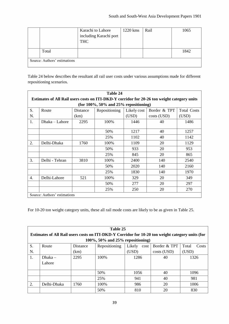
South and South-West Asia Development Papers 1901
39
Karachi to Lahore
including Karachi port
THC
1220 kms Rail 1065
Total 1842
Source: Authors’ estimations
Table 24 below describes the resultant all rail user costs under various assumptions made for different
repositioning scenarios.
Table 24
Estimates of All Rail users costs on ITI-DKD-Y corridor for 20-26 ton weight category units
(for 100%, 50% and 25% repositioning)
S.
N.
Route Distance
(km)
Repositioning Likely cost
(USD)
Border & TPT
costs (USD)
Total Costs
(USD)
1. Dhaka – Lahore 2295 100% 1446 40 1486
50% 1217 40 1257
25% 1102 40 1142
2. Delhi-Dhaka 1760 100% 1109 20 1129
50% 933 20 953
25% 845 20 865
3. Delhi - Tehran 3810 100% 2400 140 2540
50% 2020 140 2160
25% 1830 140 1970
4. Delhi-Lahore 521 100% 329 20 349
50% 277 20 297
25% 250 20 270
Source: Authors’ estimations
For 10-20 ton weight category units, these all rail mode costs are likely to be as given in Table 25.
Table 25
Estimates of All Rail users costs on ITI-DKD-Y Corridor for 10-20 ton weight category units (for
100%, 50% and 25% repositioning)
S.
N.
Route Distance
(km)
Repositioning Likely cost
(USD)
Border & TPT
costs (USD)
Total Costs
(USD)
1. Dhaka –
Lahore
2295 100% 1286 40 1326
50% 1056 40 1096
25% 941 40 981
2. Delhi-Dhaka 1760 100% 986 20 1006
50% 810 20 830

Strengthening Connectivity for Trade and Development:
An Assessment of the Southern Asian Container Rail Corridor
40
25% 722 20 742
3. Delhi - Tehran 3810 100% 2134 140 2274
50% 1753 140 1893
25% 1562 140 1702
4. Delhi-Lahore 521 100% 292 20 312
50% 240 20 260
25% 214 20 234
Source: Authors’ compilations
For 20-26 ton weight category units, the comparative users cost in two modes would be as given in
Table 26.
Table 26
Comparative Users Costs in Two Options
(Costs in USD)
Ocean mode All rail mode
100% repo 50% repo 25% repo
Dhaka-Lahore 2264 1486 1257 1142
Delhi-Dhaka 1846 1129 953 865
Delhi-Tehran 2181 2540 2160 1970
Delhi-Lahore 1842 349 297 270
Summary of analysis in previous tables
Putting transits and costs together, the comparative mode situation is as under for the assumptions used
in the analysis above for two categories of 50% and 25% flat re-positionings which need to be main
target points for this exercise of switching over to all rail modes for intermittent distances (Tables 27
and 28).
Table 27
Comparative Users Costs and transits in two modes
(in case of 50% empty repositioning by all rail)
Cost in US Dollars Transit time in days
Ocean mode All rail mode Ocean mode All rail mode*
Dhaka-Lahore 2264 1257 17-22 6-7
Delhi-Dhaka 1846 953 18-22 4-5
Delhi-Tehran 2181 2160 18-22 10-11
Delhi-Lahore 1842 297 14-17 1-2

South and South-West Asia Development Papers 1901
41
Summary of analysis in previous tables
* Worst scenario
Table 28
Comparative Users Costs and transits in two modes
(in case of 25% empty repositioning by all rail)
Cost in US Dollars Transit time in days
Ocean mode All rail mode Ocean mode All rail mode*
Dhaka-Lahore 2264 1142 17-22 6-7
Delhi-Dhaka 1846 865 18-22 4-5
Delhi-Tehran 2181 1970 18-22 10-11
Delhi-Lahore 1842 270 14-17 1-2
Summary of analysis in previous tables
* Worst scenario
Based on these, one can calculate potential savings per train of 80 TEUs size which is tabulated
hereunder for this scenario (Table 29).
Table 29
Savings in All Rail Transit of Containers
(in case of 25% empty repositioning by all rail)
Cost in US Dollars Saving per
TEU
Saving per train in USD
Ocean mode All rail mode Train=80
TEUs
Train=60
TEUs
Dhaka-Lahore 2264 1142 1122 89,760 67,320
Delhi-Dhaka 1846 865 981 78,480 58,860
Delhi-Tehran 2181 1970 211 16,880 12,660
Delhi-Lahore 1842 270 1572 125,760 94,320
Summary of analysis in previous tables
* Worst scenario
Annual savings for an assumption of running one train per day with 80 loaded TEUs in one direction
and 60 TEUs per train per day in the return direction will yield annual savings of the quantums shown
in Table 30 below.

Strengthening Connectivity for Trade and Development:
An Assessment of the Southern Asian Container Rail Corridor
42
Table 30
Savings in Annual Expense in Rail Transit of Containers
(One pair daily: 25% empty repositioning)
Saving per train per day in USD Annual Saving per pair of train per day
in million USD
Train size=
80 TEUs
Train size= 60
TEUs
Train size=
80+60 TEUs
Dhaka-Lahore 89,760 67,320 57.33
Delhi-Dhaka 78,480 58,860 50.13
Delhi-Tehran 16,880 12,660 10.78
Delhi-Lahore 125,760 94,320 80.33
Estimations based on analysis in previous tables
* Worst scenario
As can be seen, the running of just one pair of train (in both directions) between Delhi and Lahore
(80+60=140 TEUs) will yield a daily potential saving of over 50% in transaction cost of US Dollars
157,080 (USD 89,760+67,320), amounting to a yearly saving of 57.33 million USD in case the train
pair is run daily throughout the year. Needless to state, these advantages will accrue to shippers in both
countries who will gain tremendously in competitive strengths. Similar estimates can be done for other
streams, and several such streams which will follow out of trade expansion, which are bound to emerge
after successful diversions.
It is significant to note that in the 25% empty repositioning scenario, actually there is no comparison of
all rail transits and costs with ocean based transits and costs, with rail based option scoring on both
fronts. It also scores highly on safety front as the containers have no chance of manipulation anywhere
along rail route, as the railway wagons have in built safety installations, called Anti Pilferage Devise
(APD) which makes it failsafe. Hence, on relavant considerations, there is hardly any choice. For
intervening railways, this is a very big source of revenue as transit traffic which is actually getting
diverted from steamer agents. Even for 50% empty repositioning option, which might be the ruling
option for some time before all nations are able to react and take advantage of competitive options,
yields a positive picture once one adds to direct users cost advantages, the transit advantages translated
in financial savings with lower carrying and ordering costs. Just for illustration, in 50% empty scenario,
the transit savings of 15 days on cargo value of 35,000 US Dollars per TEU would yield a per TEU
saving of 172.6 US Dollars, presuming a modest 12% carrying costs (35000*0.12*15/365). For a pair
of train of 80+40= 120 TEUs, this itself will result in a financial benefit of 20,712 USD per pair of
train daily and 7.56 million USD annaully.
The real issue, however, is great risk associated with such direct railings of getting the volumes
stipulated, of 80 TEUs in one direction and 60 (25% empty repo) or 40 (50% repo) in other direction,
especially under the scenario presented of freighting based on haulage charges practiced by Indian

South and South-West Asia Development Papers 1901
43
Railways which is proposed to be adopted as model. The big caveat there is about one fact that Indian
Railways does insist on running a niminmum consist of 80 TEUs per train. In essence, therefore, the IR
freight charge is actually for a train and the operator has to bear the risk of train composition unless all
Railways including Indian Railways agree to make relaxation in minimum train load size for such cross
border container traffic trains for some specified period, in order to give fillip to such traffic.
Notwithstanding above, the aforesaid analysis makes things absolutely clear leaving nothing to doubt.
If the traffic grows, which must happen because of tremendous gains, all participating nations will have
huge benefits of land connectivity, translated into financial, economic, environmental34 and welfare
gains which can all be estimated clearly once the simulations are done. Unfortunately, all subregional
nations have predominantly regarded cross-border land connectivity through security prisms, and this
outlook towards connectivity should change35.
V. Key Issues of Operationalization and the Way Forward
At present, certain key segments of the ITI-DKD-Y Container Rail Corridor are fully or partially
operational, while seamless end-to end traffic is yet to be facilitated. Besides limited bilateral rail cargo
movement across Bangladesh-India and India-Pakistan cross-border links, the principal operational
segment is the ITI (Islamabad-Tehran-Istanbul route, 6543 km) container train service between
Pakistan, Iran and Turkey under ECO36 initiatives. This train, nicknamed as Gul train, began its
scheduled commercial runs on 2nd August 2010, and has had around 30 runs so far in last 7 years. There
have been around 15 exclusive runs towards Islamabad with transport of humanitarian relief cargo
following floods in Pakistan. Its operations are being coordinated by a High-Level Working Group
(HLWG) of the participating member states. It is yet to progress as a successful commercial venture
and has been constrained despite best intentions and efforts of all the three countries involved37.
However, technical feasibility of running these trains has been established. Sustained efforts are
required on several fronts to enable seamless traffic services across the entire southern TAR corridor.
Some of the priorities towards this are summarized as follows.
34 These gains will start following once road traffic starts getting diverted to diesel traction railways which will
imply carbon emission savings equivalent to 56 grams of CO2 per ton kilometer (as per McKenzie report,
emissions are 28 grams per ton km by diesel traction railway as against 18 grams per ton km by electrified
railway and 84 grams per ton km by road) or 64,364 kg per train of 80 TEU, traversing an average of 961 km
with weight of 14.95 tons per TEU (taken Indian averages of lead and tonnage for container traffic in 2016-17). 35 This is already evident in the actions of some governments, like in India where there is an enhanced emphasis
on “Act East” policy with the trilateral highway through Myanmar coming into implementation mode, slated to
open by 2020. Emphasis is also on Kaladan multi-modal project in which the collective steps are being taken to
handle Rakhine unrest issue. The steps taken for revival of four links connecting India and Bangladesh are also
significant. The quite step taken by India to completely switch over to broad gauge in North East Indian states is
also a major step in this direction. 36 It is an intergovernmental regional organization with 10 member countries namely Afghanistan, Azerbaijan,
Islamic Republic of Iran, Kazakhstan, Kyrgyzstan, Pakistan, Tajikistan, Turkey, Turkmenistan and Uzbekistan
of which 7 are landlocked coutries. Established for actualizing potential of the region by achieving strong
regional co-operation, it has established a Transit Transport Framework Agreement (TTFA), in force since
2006, ratified by 8 member states. 37 The main issue with the train services is stated to be poor transits, primarily on account of (a) long time being
taken in transshipment with ferry across Van Lake in Turkey, (b) bad state of track and gradients in Kohi
Taftan-Quetta section (682 km) in Pakistan where trains have to be broken and have been reported to be taking
between 24 to 36 hours, and (c) issues related to transposition of wagons at Zahedan (Iran). In our view, the real
issue is about marketability of the services being provided. The main operator, presumed to be the liner
companies, faces difficulties as liner companies’ main interest is in shipping and such a move conflicts with
their business objectives.

Strengthening Connectivity for Trade and Development:
An Assessment of the Southern Asian Container Rail Corridor
44
V.1 Operationalize detached segments of the ITI-DKD-Y Corridor
The first key priority is to extend ITI Corridor beyond Pakistan towards the east to Dhaka via Delhi and
Kolkata, i.e., operationalize full ITI-DKD-Y Corridor which is feasible with minimal infrastructural
upgradation. Simultaneously, steps need to be taken to extend this route via Myanmar, further to link
with South East Asia by organizing multi-modal connectivity till all railway gaps are filled. Dhaka-
Istanbul Broad Gauge-Standard Gauge (BG/SG) connection is now without any missing links, with just
one transshipment/gauge-break at Zahedan which is already being facilitated. This needs to be activated
as early as possible by running regular BG trains between Dhaka and Zahedan, and SG trains between
Zahedan and Istanbul. For SG section, standard gauge rakes are already in use in Islamic Republic of
Iran and Turkey. For BG section, there are enough rakes in circulation in India which can be used
through the Container Train Operating companies who are already owning such rakes. They are also
easily available on lease from international companies who have started getting them
manufactured/assembled within India38.
V.2 Operationalize sub-links to the ITI-DKD-Y Corridor
Currently, Kolkata/Haldia – Birgunj is the only rail corridor on which bilateral container trains are being
run between India and Nepal. Very recently, trains have also started running between Indian port of
Vishakhapatnam (Vizag) and ICD Birgunj. Totally around 36-37 sets of trains per month are being run
on these two corridors which is the only success story in Southern Asia. In reality, there are many more
such links which can be operationalized immediately after the main TAR route is activated, especially
within India and Bangladesh. Here also multi-modal supplements will be required. For instance, for
activating Phuentsholing (Bhutan) link which would involve just a small patch of road run of containers
between railhead at Hasimara and Phuentsholing provided Indian Railways agrees to develop the area
and permit crane handling of container trains at Hasimara from where containers can be shifted to
Phuentsholing by road trailers. ICD Biratnagar (Nepal) has already been linked through Indian railhead
at Batnaha by road whereas onward journey of containers is by train. Same can be done for
imports/exports destined to/originating from Myanmar which could be through rail from/to existing BG
railhead at Jiribam till Imphal being developed and expected to be operational by mid-202039, and road
linked for rest of the portion.
38 The railway rakes permitted to ply on Indian BG routes are called BLC/BLL rakes built with axle load of 20.3
tons. There are 400 plus such rakes already in use for loading an average of 110 container trains daily on IR.
BLC rakes have standard composition of 45 flats (9 consists of 5 BLC railcars each) with each flat having
capacity to carry either one 40’ ISO container or two 20’ ISO containers weighing up to 61 ton of weight which
is the upper limit for two 20’ ISO containers (30.48*2=60.96 tons). BLL rakes are in consist of 40 flats (8
consists of 5 BLL railcars each) with each flat having capacity to carry either one 45’ ISO container or two 20’
ISO containers. In India, on most of the sections, the trains with these wagons can be hauled at maximum speed
of 100 kmph with some restrictions on few sections. For Bangladesh and Pakistan Railway systems, weight and
speed restrictions can be determined by respective Railway authorities. 39 With Imphal-Moreh survey already on, early steps need to be taken to extend existing BG link upto Moreh
(India), and subsequently till Tamu (Myanmar) where a dry port could be made by Myanmar with a
transshipment facility for BG/MG or BG/road transshipment of boxes for onward carriage.
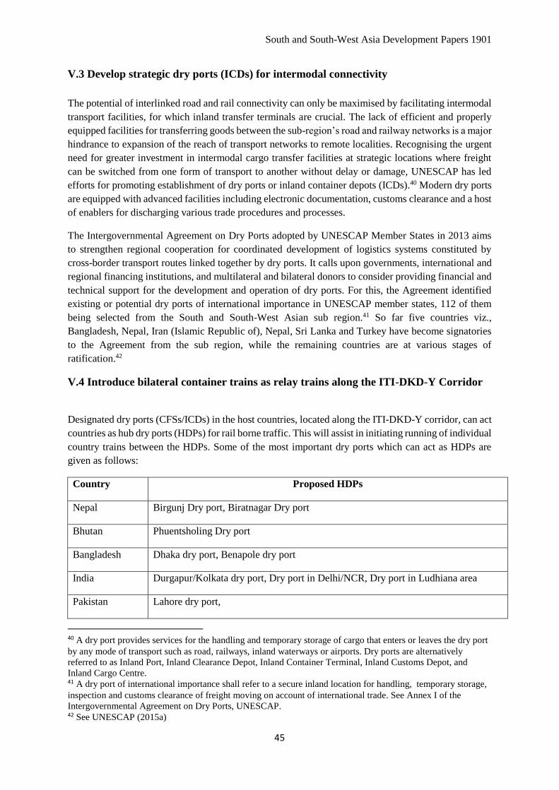
South and South-West Asia Development Papers 1901
45
V.3 Develop strategic dry ports (ICDs) for intermodal connectivity
The potential of interlinked road and rail connectivity can only be maximised by facilitating intermodal
transport facilities, for which inland transfer terminals are crucial. The lack of efficient and properly
equipped facilities for transferring goods between the sub-region’s road and railway networks is a major
hindrance to expansion of the reach of transport networks to remote localities. Recognising the urgent
need for greater investment in intermodal cargo transfer facilities at strategic locations where freight
can be switched from one form of transport to another without delay or damage, UNESCAP has led
efforts for promoting establishment of dry ports or inland container depots (ICDs).40 Modern dry ports
are equipped with advanced facilities including electronic documentation, customs clearance and a host
of enablers for discharging various trade procedures and processes.
The Intergovernmental Agreement on Dry Ports adopted by UNESCAP Member States in 2013 aims
to strengthen regional cooperation for coordinated development of logistics systems constituted by
cross-border transport routes linked together by dry ports. It calls upon governments, international and
regional financing institutions, and multilateral and bilateral donors to consider providing financial and
technical support for the development and operation of dry ports. For this, the Agreement identified
existing or potential dry ports of international importance in UNESCAP member states, 112 of them
being selected from the South and South-West Asian sub region.41 So far five countries viz.,
Bangladesh, Nepal, Iran (Islamic Republic of), Nepal, Sri Lanka and Turkey have become signatories
to the Agreement from the sub region, while the remaining countries are at various stages of
ratification.42
V.4 Introduce bilateral container trains as relay trains along the ITI-DKD-Y Corridor
Designated dry ports (CFSs/ICDs) in the host countries, located along the ITI-DKD-Y corridor, can act
countries as hub dry ports (HDPs) for rail borne traffic. This will assist in initiating running of individual
country trains between the HDPs. Some of the most important dry ports which can act as HDPs are
given as follows:
Country Proposed HDPs
Nepal Birgunj Dry port, Biratnagar Dry port
Bhutan Phuentsholing Dry port
Bangladesh Dhaka dry port, Benapole dry port
India Durgapur/Kolkata dry port, Dry port in Delhi/NCR, Dry port in Ludhiana area
Pakistan Lahore dry port,
40 A dry port provides services for the handling and temporary storage of cargo that enters or leaves the dry port
by any mode of transport such as road, railways, inland waterways or airports. Dry ports are alternatively
referred to as Inland Port, Inland Clearance Depot, Inland Container Terminal, Inland Customs Depot, and
Inland Cargo Centre. 41 A dry port of international importance shall refer to a secure inland location for handling, temporary storage,
inspection and customs clearance of freight moving on account of international trade. See Annex I of the
Intergovernmental Agreement on Dry Ports, UNESCAP. 42 See UNESCAP (2015a)

Strengthening Connectivity for Trade and Development:
An Assessment of the Southern Asian Container Rail Corridor
46
Some examples of feasible connectivity between these HDPs are given as follows:
• Nepal – India: already linked by rail directly between ICD/Birgunj (in Nepal) to gateway ports
of Kolkata/Haldia and Vizag (in India). Initially the containers for other countries can be moved
via Kolkata HDP till the volumes build up for direct trains between individual HDPs and
Birgunj/Biratnagar.
• Bhutan – India: to be linked inter-modally, by road between Phuentsholing (Bhutan) and
Hasimara railhead (18 km from border in India) and onward by rail directly. Here also, initially
the containers for other countries can be moved via Kolkata HDP till the volumes build up for
direct trains between individual HDPs and Hasimara.
• Bangladesh – India: to be linked directly by rail between Dhaka (ICD Kamlapura) to
Kolkata/Durgapur HDP in India via Darshana-Gede or Petrapole-Benapole till the volumes
build up for direct trains between individual HDPs and Dhaka.
• India – Pakistan: to be linked directly by rail between nominated ICD in Ludhiana where
containers coming from other countries and various dry ports of India can be aggregated for
movement to ICD Dhaka via Atari-Wagah border point by rail directly. The containers arriving
by/for this train should be able to have a link with Gul trains between Islamabad – Tehran –
Istanbul which should also become regular with improvement of economic viability of these
trains, subject to various steps required to be taken by the governments of these countries for
carrying out requisite infrastructural improvements and tariff adjustments.
These linkages will facilitate linking of Pakistan, India, Bangladesh, Nepal and Bhutan with the
understanding to link other partners’ containers as transit containers. For instance, the containers
booked in Bangladesh/Bhutan/Nepal for Pakistan may be allowed to be carried in India- Bangladesh,
India-Bhutan and India-Nepal trains for onward transshipment of such boxes in India – Pakistan train
at a suitable HDP in India. Similarly, shippers in these countries can also be given a choice for booking
containers for various destinations in Central Asia, Afghanistan, Islamic Republic of Iran and/or
Turkey, to be moved via bilateral trains to India, India-Pakistan and Gul trains, through transshipments
at suitable nominated hub points in India and Pakistan, and final transshipment at Zahedan. For
Afghanistan, the pick-up/drop point for the units will need to be developed at Chabahar which could
ultimately serve a suitable link for Central Asian Republics also once rail linkages are developed. This
will make services much more commercially viable and popular rather than depending upon a unified
train to run all over. Ultimately, of course, running unified train should be targeted after requisite
volumes are generated.
For the Kolkata-Dhaka sector, a trial run was conducted in March 2018 and a container train was run
between Kolkata and Bangabandhu Bridge west using existing BG link.43 The trial was quite successful
and catered to industries located in vicinity of Dhaka by use of inter-modal option from Bangabandhu
West. However, no arrangements were made to off load containers there and door deliver them. Instead,
the trial used side access containers which were actually de-stuffed on chassis and cargo delivered by
road after completion of Customs formalities. Regular train runs can be initiated once the requisite
transshipment facilities are created at either Bangabandhu Bridge west (or any other point west of Jamna
43 This was facilitated through an MOU between sate-owned institutions, Container Corporation of India Ltd.
and Container Company of Bangladesh Ltd. (CCBL) Bangladesh, in April 2017
South and South-West Asia Development Papers 1901
47
bridge, at either Muladuli or Ishurdih), with inter-modal option of using road between this point and
ICD Dhaka.
V.5 Follow ICP Model at cross border locations with rail interface
Land Port Authority of India has initiated setting up of Integrated Check Posts (ICPs) at various border
points. Establishment of similar facilities should also be initiated on each country at all cross-border
points, and existing LCSs upgraded to ICPs, so that entire cross border exchange facilitates interchange
of cargo for shippers, their agents, and associated value partners like freight forwarders, and other
associated agencies. In fact, they should be targeted to become a unified centre for both road as well as
rail cargo interchange which is lacking in its existing form at places like Atari and Benapole, despite
the fact that rail tracks are going in close vicinity at both places. Though it is true that the lack of
containerization and preference for break-bulk cargo continues to favor road transport as a means of
cross-border trade flows in the sub-region, it is also true that lack of specific enablers for full-fledged
and economical rail transport remains a big hindrance.
Even at these two places, currently cross-border rail transport is now sparsely used to carry break-bulk
cargo using open- or closed-top cargo wagons as compared to such rail movements in past. The
concerns are primarily security related concerns, combined with the way the cargoes are handled.
Containerization is the foremost enabling factor for making rail transport viable and for addressing
security concerns, other factors such as agreements and arrangements for joint management of rolling
stock, locomotives and crew, protocols for traffic control, additional infrastructural facilities such as
cargo yards, facilities for customs inspection and procedures etc. are also required. With unified ICPs,
this should be possible and beneficial for both/all countries.
Improvements in these areas of rail transport facilitation can result in increasing usage of cross-border
rail transport, paving the way also for possibilities of long distance multi country cargo movement
through land routes such as the IT-DKD container rail corridor proposed in this Report. For instance,
seamless cross-border rail traffic through Bangladesh-India and Pakistan-India borders can result in
increased utilization of inland transport for Bangladesh-Pakistan bilateral trade using India as a transit
country. Despite its high potential to be a cheaper and quicker alternative, such inland transport is barely
used for Bangladesh-Pakistan bilateral trade, which stand at about US$ 550 million currently. Case
studies of the existing cross-border rail connectivity of India with Bangladesh and Pakistan reveal that
progress can be achieved with minimal infrastructural investments, provided containerized cargo
transport is promoted through rail with accompanying procedural reforms44.
44 Preference for rail services as a complementary mode of transport to meet the ever-growing trade demand would
be significantly enhanced by introducing containerized freight movement. A preliminary assessment reveals the
potential for reforms in this direction with minimal infrastructural investments. Installation of scanners, preferably
portable scanners, and adequate container handling facilities are the foremost requirements in terms of additional
infrastructure. Case study of the Indian inbound cargo shows that a portable container scanner at the Atari station,
coupled with a lift-on, lift-off arrangement, can segregate containers if need be and thereby address the security
concerns while enabling speedy processing and clearance for inbound train services. Dhandharikalan (DDL) ICD,
a public-sector container handing and warehousing facility near Ludhiana, may function as the immediate logistic
center catering to the needs of traffic through Wagah-Atari stations. Similar arrangements can be made for
minimal investments for inbound container rail services by Pakistan to take advantage of cost and time savings
by circumventing the requirements of transshipment at borders.

Strengthening Connectivity for Trade and Development:
An Assessment of the Southern Asian Container Rail Corridor
48
V.6 Rating for ITI-DKD-Y trains
Introducing a rating system for specified rail services would also need to be made lucrative for local
railway authorities. In this context, it is seen that Indian Railway’s rating system based on “Fully
Distributed Costs” for container trains is very scientific and can be followed with country wise
variations in respect of fully distributed costs. Agencies such as UNESCAP can facilitate development
and adoption of similar rating systems by other countries who will need to fill in relevant costs of their
individual railway systems to arrive at appropriate tariffs. To start with, Indian haulage rates for 20 to
26 ton weight category could be used as the startup rates for rail haulage of loaded containers by all
national railways along ITI-DKD-Y route for International traffic coming from or going to across the
borders45.
V.7 Selection of Container Train Operators
The most significant change from past would be to evolve a system of Container Train Operators
(CTOs), as distinct entities from individual Railway Administrations who should be encouraged to run
the container trains, based on successful implementation of this concept on Indian Railways who
introduced such entities as part of a major policy reform in 2006. Today, India has 17 licensed CTOs
who own as many as 412 special container rakes (of BLC/BLL wagons/railcars)46 for hauling containers
and deploy these rakes on various circuits for hauling containers by rail, under their own multi-modal
arrangements. All together these CTOs offered Indian Railways over 3.17 million TEUs for movement
by rail within India (including third country cargo laden containers for Nepal) during 2016/17, yielding
a freight revenue of 828.59 million USD equivalent for Indian Railways. These are the people who
assume the role of custodian of the container trains for their run and subsequent storage of containers
in Customs bonded area till they are cleared for home consumption or exported out of the country. They
also actually issue their transport receipts or the specified multi-modal documents to liner
companies/international freight forwarders who in turn issue their bill of lading taking responsibility
for door to door movements for a single price, under a single rate and liability.
It is strongly felt that international freight forwarding companies will have to don the mantle of
contracting and running the container trains over the ITI-DKD-Y Corridor, which is indeed the practice
along other rail corridors also47. Initial talks in this respect with international freight forwarders in India
have evinced lot of interest in such a proposal. Advantages of such an arrangement are obvious as it
takes care of differing liability regimes and other considerations while the operator can arrange suitable
TT club kind insurance cover arrangements, as is the practice in shipping based operations. Otherwise,
45 As a matter of prudence, Container cargo transportation on route should be undertaken at special favorable
tariffs, under agreement to be reached on integrated tariff rates between participating nations. However, given the
political considerations on this corridor, it seems improbable. So, it may be better to have separate tariffs with
Indian tariffs being benchmark tariffs. 46 As per market information available there are 412 such rakes at present with the lead player, Container
Corporation of India (CONCOR) owning as many as 253 rakes. Rest of the CTOs are owning/leasing 129 rakes.
Each BLC rake can carry 90 TEUs while BLL rakes can carry 80 TEUs maximum per rake. 47 The latest case in point is of China-UK trains which commenced runs during January 2017 with London
becoming 15th European city of the link of trans-Asia rail intermodal land bridge services with China. The service
was operated by Swiss based InterRail group, on behalf of China Railways’ affiliate CRIMT upto Dostyk from
where the Union of Russian, Kazakh and Belarus Railway took it to Brest. From there the train was hauled by
PKP Cargo to German Rail border. DB Cargo AG moved train across Germany till Belgium where SNCB
Logistics took it and hauled through Belgium and France to Calais. Last leg from there was performed by DB
Cargo UK via Channel Tunnel, till its London Euro hub in Barking.

South and South-West Asia Development Papers 1901
49
all Railways would spend time in just resolving such issues and face a multitude of problems48. Having
such agencies who will actually market rail services, as against present scenario in ITI corridor where
individual railways are required to do marketing of such services,49 is highly useful. This would help to
share the operational burden of national railway administrations which, in most of the countries, are
found to be very poor marketing agents for rail services50.
V.8 Container Interchange Protocols as part of Rail Service Agreements
Member countries would also need to sign Container Train transport protocols for which model of Indo-
Nepal protocol could be used as it has been working very satisfactorily for over 13 years now. The main
aim of protocol should be to ensure speedy transit of trains without any undue detentions at cross border
points, after inspection of both revenue and security authorities of the countries concerned. Towards
this, a system needs to be designed for advance flow of information in respect of train consists followed
by advance filing of transit permits at borders with customs/revenue authorities like Import General
Manifest in shipping. In addition, it would also be advisable to install rail mounted scanners at cross
border locations consistent with world class security norms, especially on sensitive corridors with major
security concerns (See Box 2).
48 A case in point is regarding Railways’ liability towards losses and delay in transits. Indian Railways, for instance
restrict Railways’ liability to INR 50 per kg in cases of loss which is equivalent to just 0.78 USD @ 1 USD=64
INR. Such a limit would hardly be acceptable under CIM/COTIF or any other Railway Agreements. Problem for
Railways like Indian Railways would be of jacking up liabilities even for domestic traffic which would have
tremendous implications in view of the fact that IR hauls over 1100 million tons cargo every year. In 2016-17 IR
hauled 1108.79 million tons of revenue earning tonnage including 37.81 million tons of EXIM containers. It
cannot be expected to hike the liability for entire 1108 million ton just for the sake of 38 million tons. Similar
conflicts would be there in other national railways also which could thwart a consensus. 49 Another problem in existing model of ITI trains is regarding involvement of liner agencies as the ones
providing equipment (like containers), which actually goes against their entrenched interests in ocean based
liner business. This needs to be addressed. 50 See Levitt, Theodore (1975) on "Marketing myopia". Harvard Business Review. 53 (5).

Strengthening Connectivity for Trade and Development:
An Assessment of the Southern Asian Container Rail Corridor
50
Box 2
Usage of Drive-in Scanners for Minimizing Cargo Clearance Costs
Security concerns can be successfully addressed to a large extent using modern technology for monitoring integrity
of cargo through use of radio-frequency identification (RFID) and container scanners, both for rail and road transit
of containers at sensitive border points. Drive-through container scanners (Road) can scan up to 100 containers per
hour, while the drive-through container scanner (rail) can scan one train in 5 minutes. Such container scanners are
already being installed at gateway ports. While such scanning devices can be used for detecting restricted items
including nuclear material, they are useful in manifest verification, tariff collection and the identification of
contraband, which is the objective of each national agency permitting transiting of goods contained in containers
within their jurisdiction. While road scanners are now in used universally, rail scanners are becoming standard and
commonplace. Rail scanners have now been in use for long at some ports like Rotterdam where the world’s fastest
train scanner was opened in the port of Rotterdam with the installation and commissioning of a Rapiscan Eagle®
R60 rail scanner, on behalf of Dutch Customs in 2012. The scanner produces images of a good quality while the
train is running up to 60 kilometers per hour. As per information available, the system uses Eagle R60’s 6 MeV X-
ray imaging system which penetrates dense and densely-packed cargo. Installations in other countries operate at a
train speed of 30 kilometers. In India, there is a proposal to install 3 drive-through container scanners (road) at
JNPT, Cochin and Mundra and one drive through container scanners (rail) at JNPT.
Drive in road container scanner
Drive in rail container scanner
Image credits: Rapiscan Systems
V.9 Modernize Customs and Border procedure - Use of efficient ICT System for border
interchanges
There is an urgent need for facilitating cross border movements of containers which can promote ICD
to ICD connectivity across the borders, hence taking care of many sensitivities associated with current
pattern of movement of bulk cargoes with associated documentations and Customs examinations at
Land Crossing stations. Ideally, all units should be sealed in ICD of origin and move with advanced
information to cross border interchange station like, say, Atari where only Customs seal check be

South and South-West Asia Development Papers 1901
51
carried out by Indian Customs and train allowed to cross the border. Arrangements would, however,
need to be made for unloading of any containers which do not meet with Customs scrutiny. This is
already being done for Nepal bound containers at Raxaul, the interchange station of Indian Railways
where trains are detained for an average of 4 hours for such an examination and trains allowed to move
without any documentation/intervention.
This can be replicated at all cross-border points in all countries. In fact, the use of RFID and e-sealing
in containers would be another desirable step towards this. Incidentally, this is successfully tried for
activating new rail corridor of Kolkata – Biratnagar which has become second international corridor to
be operational for interchanging container trains between India and Nepal. This corridor, made
operational in 2018, is currently being operated under inter modal arrangements of a rail run from
Kolkata till Batnaha Rail Transfer facility being built at Batnaha, around 12 km short of
Jogbani/Biratnagar LCS from where containers are transshipped on road vehicles and dropped in CFS
Biratnagar in Nepal by trailers. The units are transported with use of Electronic Cargo Tracking System
(ECTS) which has obviated the necessity of presence of Customs supervision of transshipment between
rail and road at Batnaha and facilitate the transshipment process. This has being done following the
signing of a Memorandum of Intent (MOI) between India and Nepal in June 2017 to introduce ECTS
for monitoring of transit traffic to Nepal. The MOI contemplated that service provider in this case will
be selected by the ADB. This is a very significant move and has recently, on 15th February 2019, been
replicated for the Kolkata-Birgunj corridor also. This needs to be replicated at all cross-border points51.
Simultaneously, however, steps should also be taken for improving systems and procedures at existing
LCSs/ICPs where facilities of preclearance, risk management, AEO system etc. would need to be
introduced and important facilities of quarantine etc. made available with special emphasis on
data/information exchange. The status of modernization of Customs systems also needs to be
monitored, for facilitating such exchanges through the system. Current status is summarized hereunder:
Modernization
Component
Bangladesh Bhutan India Nepal Pakistan
Customs software
in use
ASYCUDA++ BACS ICEGATE ASYCUDA++ PaCCS
Upgradation under
way to
ASYCUDA
World
RAMIS UNI-PASS WeBOC
Application of
preclearance
Not started yet Not
started
yet
Applied, scope
for
improvement
Not started yet Applied
Application of risk
management
program
Not started yet Not
started
yet
Fully
operational
Applied, scope
for
improvement
Fully
operational
51 As indicated above, a beginning in this regard has been made for rail interchange of containers at Indo-
Bangladesh traffic with Indian Customs issuing a public notice mandating use of RFID seals for Gede-Darsana
interchanges in November 2017. The public notice is in Annex 4.

Strengthening Connectivity for Trade and Development:
An Assessment of the Southern Asian Container Rail Corridor
52
Application of
AEO system
System under
development
Not
started
yet
Applied, scope
for
improvement
Not started yet Not known
Source: JICA survey report, January 2014 and USAID trade project report of Customs to Customs EDI with
Central Asian Republics, August 2014.
Abbreviations:
ASYCUDA: Automated System for Customs Data, developed by UNCTAD in both versions (+++ and World)
AEO: Authorized Economic Operator
BACS: Bhutan Automated Customs System, developed with Indian assistance
ICES: Indian Customs and Excise System, developed by India
PaCCS: Pakistan Customs Computerised System developed by Agility, in use since 2005
WeBOC: Web based One Custom, developed by Pakistan, being used at some ports and terminals
RAMIS: Revenue Administration Management Information System, being developed with ADB assistance
UNI-PASS: this is system developed by (Republic of) Korea Customs Service, Nepal is considering changing
to it.
V.10 Policy Synergies, Institutional Collaboration and International Cooperation
A number of transport development initiatives are underway in the Southern and Central Asian
subregions. These overlapping initiatives can result in suboptimal outcomes if they are not well
coordinated and channelized for greater synergies. Noting that lack of a long term vision and
comprehensive approach for regional transport facilitation could lead to fragmented results, or even
new barriers in some cases due to conflicting agreements and projects, UNESCAP has adopted a
Regional Strategic Framework for the Facilitation of International Road Transport.52 A similar
framework for international railway transport has also been adopted. These policy frameworks covers
areas such as road transport permits and traffic rights, visas for professional drivers and crews of road
vehicles, temporary importation of road vehicles, insurance of vehicles, vehicle weights and
dimensions, and vehicle registration and inspection certificates. Implementation of the Framework
would proceed through an effective regional regulatory regime, wider application of new technologies,
development of professional training for international road transport, establishment/strengthening of
national facilitation coordination mechanisms, promotion of joint control at border crossings, promotion
of economic zones at border crossings, dry ports and logistics centres. The framework, and the network
of legal and technical experts established under it, would help the regional countries to share resources
and to develop and implement projects without inconsistency and conflicts in planning.
Similarly, the framework for international rail transport deals with, among other areas, better
coordination between relevant regulatory authorities, harmonization of applicable legal regimes and
standardization of rail infrastructure and rolling stock.53 The regional framework would encourage
member states to have subregional rail transport agreements, standardize cross border railway
operations, utilize advanced cargo information systems and new technologies in operations and in
container tracking. One of the most important proposals is to participate in international rail transport
52Many different areas of transport development that require regional policy attention are being undertaken under
the auspices of UNESCAP. The Regional Action Programme for Transport Development in Asia and the Pacific,
phase II (2012-2016), brings together 10 thematic areas for developing an integrated, intermodal, international
transport and logistics system in the Asia-Pacific region (See UNESCAP 2012). 53 See UNESCAP (2013b)

South and South-West Asia Development Papers 1901
53
conventions, which are already helping member countries in coordinating regulatory, technical and
various operational aspects of cross-border rail transport.
UNESCAP has also developed operational tools to facilitate international road transport. Amongst
them is the application of a Secure Cross-border Transport Model, which provides a conceptual and
practical basis for a cross-border vehicle monitoring system using new communication technologies,
satellite positioning and electronic seals. Jaigaon-Phuentsholing border crossing between India and
Bhutan is selected as one of the sites for implementing this model on pilot basis.
An overarching goal for the success of international transport facilitation in the Asia Pacific is
institutional collaboration. Besides UNESCAP, a number of intergovernmental bodies and multilateral
bodies are currently functioning in the area of transport facilitation in the region with various
programmes and initiatives, such as initiatives under Economic Cooperation Organization (ECO),
Transport Corridor Europe-Caucasus-Asia (TRACECA), Intergovernmental Organisation for
International Carriage by Rail (OTIF), and Organisation for Co-Operation between Railways (OSJD).
The responsibilities of infrastructure development/upgradation and transport facilitation policy
alignment along the international transport corridors of South and South-West Asia is scattered across
various intergovernmental treaties and programmes at present. Several treaties with partial coverage are
currently at work or are being developed, the principal of them being the trade, transit and transport
agreements under SAARC and ECO. The transport routes that are being identified and developed under
SAARC, ECO and BIMSTEC have overlaps with each other, while they mostly form part of the larger
AH and TAR networks. While the ECO has put into effect a region wide transit transport agreement,
SAARC is yet to have a similar version and is still progressing largely through bilateral arrangements.
Signatory status of Afghanistan and Pakistan in both ECO and SAARC can act as a principal unifying
factor to have broader coverage by integrating transport in two sub-regions. Accession of Pakistan and
India to Convention on International Transport of Goods Under Cover of TIR Carnets (TIR) and of
Pakistan to Convention concerning International Carriage by Rail (COTIF)54 to facilitate intra-regional
road and rail transport is an example of regional cooperation’s impact on streamlining of regulatory
regimes and infrastructure. With eventual inter-regional cooperation between ECO and SAARC, more
countries from subregion can be expected to join global transport conventions, taking forward the
agenda of seamless cross-border transport.
V.11 A Regional Connectivity Master Plan Approach
In order to operationalise regional level transport corridor projects, a comprehensive is needed as
coordinated action and participation of various stakeholders is extremely important for planning and
implementation. A comprehensive Connectivity Master Plan with a vision of improved connectivity is
required for guiding the processes. Ideally the Master Plan should aim for physical and institutional
connectivity, and facilitate coordinated policies and projects through responsibility sharing between
different stakeholder groups.55 It should represent a plan of action with a designated period of
54 By completing the accession procedure to COTIF Convention in 2013, Pakistan became its 48 th Member
State.
Pakistan in July 2015, and India in May 2017 have deposited their instruments of accession to the TIR
Convention, 1975. The Convention has already entered into force for Pakistan on 21 January 2016. For India, it
is entering into force in November 2017. With the accession of India, the TIR Convention will have seventy
Contracting Parties. 55 Comprehensive approach to connectivity through a Master Plan is adopted in other regions. The Master Plan
on ASEAN Connectivity, which is one of the first comprehensive strategic policy frame works to explicitly

Strengthening Connectivity for Trade and Development:
An Assessment of the Southern Asian Container Rail Corridor
54
implementation, laying out physical infrastructure requirements of the identified corridors and their
sublinks. It must take into account existing and ongoing corridor development projects in the region,
and special requirements of sub-regional LLDCs and frame a strategy for institutional coordination
between important regional institutions such as ECO, SAARC and BIMSTEC that are currently
operating with overlapping jurisdictions in the sub-region. It should contain a plan for implementing
region wide transit and transport agreements. Such a Master Plan can also help to coordinate for
mobilization and sharing of resources and finding synergies between ongoing corridor development
projects.
UNESCAP has been hosting a series of Regional Policy Dialogues in South and South-West Asia,
which would feed into the process for framing such a Connectivity Master Plan. Member states have
expressed support for conducting trial runs of container transport along designated transport routes in
South Asian segments of AH and TAR networks, including various segments of the ITI-DKD-Y
Container Rail Corridor. Various elements of a Master Plan are thus being drawn under a group of
activities of the Regional Action Programme for Transport Development in Asia and Pacific.56
Collective efforts, guided by a Connectivity Master Plan, can enable responsibility sharing between
different stakeholder groups and coordination between various regional organizations and initiatives,
and thereby enable Southern Asia to realize its potential as a key growth pole in the Asia-Pacific.
References:
ADB (2014), ‘Asian Development Outlook 2014 Update: Asia in Global Value Chains’, Asian
Development Bank, Manila.
ADB and ADBI (2013), ‘Connecting South Asia and Southeast Asia: Interim Report’, A Joint Study of
the Asian Development Bank and the Asian Development Bank Institute.
ASEAN (2011), ‘Master Plan on ASEAN Connectivity: One Vision, One Identity, One Community’,
The ASEAN Secretariat, The Association of Southeast Asian Nations, Jakarta.
Baldwin, Richard (2013), ‘Global supply chains: why they emerged, why they matter, and where they
are going’, in Global value chains in a changing world, edited by Deborah K. Elms and Patrick
Low, Fung Global Institute (FGI), Nanyang Technological University (NTU), and World Trade
Organization (WTO).
Behar, A. and A. J. Venables (2010), ‘Transport Costs and International Trade’, in A. de Palma, R.
Lindsey, E. Quinet, & R. Vickerman (Eds.), A Handbook of Transport Economics, Edward
Elgar Publishing, UK.
Carrere, Céline (2014), ‘Regional Agreements and Welfare in the South: When Scale Economies in
Transport Matter’, Journal of African Economies, Vol. 23, number 3, pg. 321–345.
address the issue of connectivity in various sectors, brings together various policy elements that are required for
broad based connectivity (ASEAN 2011). The APEC Policy Document on Connectivity is yet another lead in
this regard from the Asia-Pacific region. For a comparison of ASEAN and APEC connectivity frameworks see
UNESCAP (2014a) 56 See activities under ‘connecting subregional transport networks’ in UNESCAP (2014b). Also see UNESCAP
(2012)

South and South-West Asia Development Papers 1901
55
Chia, Siow Yue (2013), ‘The ASEAN Economic Community: Progress, Challenges, and Prospects’,
ADBI Working Paper Series No:440, Asian Development Bank Institute, Tokyo.
De, P., Das, G. and E. B. Singh (2011), ‘Expansion of North East India’s Trade and Investment with
Bangladesh and Myanmar: An Assessment of The Opportunities and Constraints’, Research
and Information System for developing countries, New Delhi.
De, Prabir (2014), Strengthening Regional Trade and Production Networks through Transport
Connectivity in South and South-West Asia, South and South-West Asia Development Papers
1401, UNESCAP South and South-West Asia Office, New Delhi.
Duval, Yann and Chorthip Utoktham (2015), ‘Trade Facilitation in Asia and the Pacific: Which Policies
and Measures Affect Trade Costs the Most?’, Working Paper Series, No.03, UNESCAP,
Bangkok
Ferdous, Farazi Binti (2011), ‘Export Diversification in East Asian Economies: Some Factors Affecting
the Scenario’, International Journal of Social Science and Humanity, Vol 1, No. 1, Pgs: 13-18.
Hummels, D. L. (2007), ‘Transportation Costs and International Trade in the Second Era of
Globalization’, Journal of Economic Perspectives 21(3): 131-154.
IMF (2015), ‘Regional Economic Outlook for Asia and Pacific: Stabilizing and Outperforming Other
Regions, World Economic and Financial Surveys, International Monetary Fund, Washington
D.C.
UNCTAD (2015), ‘Maritime Connectivity and Trade’, Policy Issues in International Trade and
Commodities, Study Series No. 70.
UNCTAD, Commonwealth Secretariat and CWS (2010), ‘Potential Supply Chains in the Textiles and
Clothing Sector in South Asia: An Exploratory Study’.
UNESCAP (1999), ‘Development of the Trans-Asian Railway: Trans-Asian Railway in the Southern
Corridor of Asia-Europe Routes’, United Nations Economic and Social Commission for Asia
and the Pacific, Bangkok.
UNESCAP (2011), ‘Enabling Environment for the Successful Integration of Small and Medium-sized
Enterprises in Global Value Chains: Country Studies on Bangladesh, Nepal and Sri Lanka’,
Studies in Trade and Investment 70, United Nations Economic and Social Commission for Asia
and the Pacific, Bangkok.
UNESCAP (2012), ‘Regional Action Programme for Transport Development in Asia and the Pacific,
phase II (2012-2016): Ministerial Declaration on Transport Development in Asia and the
Pacific’, United Nations Economic and Social Commission for Asia and the Pacific.
UNESCAP (2013a), ‘Review of Developments in Transport in Asia and the Pacific: Transport as a
Key to Sustainable Development and Regional Integration’, United Nations Economic and
Social Commission for Asia and the Pacific (ISSN: ST/ESCAP/2667).
UNESCAP (2013b), ‘Monograph Series on Transport Facilitation of International Railway Transport
in Asia and the Pacific’, Transport Division, United Nations Economic and Social Commission
for Asia and the Pacific (ST/ESCAP/2681).

Strengthening Connectivity for Trade and Development:
An Assessment of the Southern Asian Container Rail Corridor
56
UNESCAP (2014a), ‘Economic and Social Survey of Asia and the Pacific: Regional Connectivity for
Shared Prosperity’, United Nations Economic and Social Commission for Asia and the Pacific
(Sales No. E.14.II.F.4).
UNESCAP (2014b), ‘Activities implemented under the Regional Action Programme for Transport
Development in Asia and the Pacific, phase II (2012-2016)’, United Nations Economic and
Social Commission for Asia and the Pacific (E/ESCAP/CTR(4)/INF/4).
UNESCAP (2015a), ‘Status of implementation of the Intergovernmental Agreement on Dry Ports’,
Note by the Secretariat, E/ESCAP/DP/WG(1)/1
UNESCAP (2015b), ‘Economic and Social Survey of Asia and the Pacific 2015: Making Growth More
Inclusive for Sustainable Development’, United Nations Economic and Social Commission for
Asia and the Pacific, Bangkok.
UNESCAP (2015c), ‘Asia-Pacific Trade and Investment Report 2015: Supporting Participation in
Value Chains’, United Nations Economic and Social Commission for Asia and the Pacific,
Bangkok.
UNESCAP-SSWA (2013), ‘Regional Cooperation for Inclusive and Sustainable Development: South
and South-West Asia Development Report (2012-13)’, Routledge, New Delhi.
UNESCAP-SSWA (2018), ‘Unlocking the Potential of Regional Economic Cooperation and
Integration in South Asia: Potential Challenges and Way Forward’, ST/ESCAP/2779, New
Delhi.
World Bank (2009), ‘Bangladesh Transport Policy Note’, Transport Unit, Sustainable Development
Department, South Asia Region, The World Bank.
WTO (2013), ‘World Trade Report 2013: Factors shaping the future of world trade’, World Trade
Organisation, Geneva.

South and South-West Asia Development Papers 1901
57
Annex
Branch Routes of Significance Along the ITI-DKD-Y Corridor
The ITI-DKD-Y Container Rail Corridor is laterally linked to various national segments of the Trans-
Asian Railway network. These links connect the trunk corridor multimodally with important routes of
national and international significance, providing connectivity for local production hubs to nearby
seaports and dry ports (ICDs) in the host countries. These lateral links at strategically important
junctions also provide connectivity options for landlocked countries of the subregion which are not
otherwise directly linked to the trunk corridor.
Main branch connections to ITI-DKD-Y rail route
Branch Route
Number
From to Remarks
Branch no. 1 Dhaka to Chittagong Port Currently MG except for Dhaka –
Tongi which is dual gauge.
However, dual being planned all
across
Branch no.2 Dhaka to Yangon port via akhaura-
kulaura- shahbazpur – mahisasan –
jiribam – tamu - kalay
Missing link from kalay to jiribam
(India 219 kms and Myanmar 127
kms)
Branch no. 3 Kolkata(India) – Phuentsholing (Bhutan) Broad gauge, Last rail head is at
Hasimara (India) which is 18 km
from Phuentsholing (Bhutan)
Branch no. 4 Kolkata(India) – Birgunj (Nepal) Broad gauge, Operational
Branch no. 5 Delhi to Indian Ports of Mumbai,
Chennai, Tuticorin, Visakhapatnam,
Kolkata/Haldia
Broad gauge Operational, main
marine route and connection to hub
port of Colombo and Singapore
Branch no. 6 Lahore to Islamabad – Peshawar –
Jalalabad (Afghanistan)
Broad gauge Operational till
Peshawar. Missing link Peshawar
to Jalalabad
Branch no. 7 Quetta(Pakistan) to
Kandahar(Afghanistan)
Broad gauge. Missing link from
Chaman to Kandahar
Branch no. 8 Bafq(Iran) to Sarrakhs(Iran) to Ashgabat
(Turkmenistan)
Standard gauge (1435 mm) utpo
sarrakhs and then 1520 mm from
sarrakhs to Ashgabat
Branch no. 9 Bafq(Iran) to Herat (Afghanistan) Missing link Sangan to Herat
Branch no.10 Qazvin-Rasht – Bandar-e-Anzali to
Caspian Sea Ferry terminals of
Turkmenistan, Kazakhstan,
Missing link between Rasht and
Bandar-e –Anzali

Strengthening Connectivity for Trade and Development:
An Assessment of the Southern Asian Container Rail Corridor
58
Branch no. 11 Sufiyan(Iran) to Tbilisi (Georgia) Rail link closed
Branch no. 12 Khorramshahr(Iran) to Baghdad(Iraq) Missing link Khorramshahr to
Basra
Branch no. 13 Kalin(Turkey)-Kars(Turkey)-Tbilisi
(Georgia)
Missing link from Kars to Tbilisi
Branch no. 14 Kalin – Samsun – Black Sea Ferry
terminals
Operational
1. Bangladesh
Four TAR links nominated for Bangladesh are as under:
Link Track Gauge (mm) Route
length
(km)
Link 1
(i) Shahbazpur –Joydebpur 1000 277
(ii) Joydebpur - Jamtoil –Ishurdih Dual 1000/1676 165
(iii) Ishurdih - Darsana 1676 81
Link 2
(i) Dhaka – Tongi Dual 1000/1676 22
(ii) Tongi – Akhoura* 1000
(Dual planned at later stage)
80
(iii) Akhoura – Laksham –Chittagong Current MG double line. Dual
under construction till Laksham in
the form of a single line BG.
182
(iv) Chittagong – Dohazari – border
(gundhum)
1000 192
Link 3
(i) Ishurdih – Parbatipur Dual 1000/1676 174
(ii) Parbatipur – Dinajpur – Kanchan
– Birol border
1000 45
Link 4
Abdulpur – Rajshabi – Rohanpur
border
1676 104
‘* This section is shared with Main link route No.1
In effect, these links cover three main rail routes of Bangladesh as under:
Route 1: Gede (West Bengal, India) - Darshana (Chuadanga, Bangladesh) – Ishurdi - Jamuna
Bridge – Joydebpur – Akhoura – Chittagong – Dohazar i- Gundhum – Myanmar;
Route 2: Singhabad (West Bengal) - Rajshahi (Bangladesh) – Ishurdi - Jamuna Bridge –
Joydebpur – Akhaura – Chittagong – Dohazari – Gundum – Myanmar;
Route 3: Radhikapur (West Bengal) – Dinajpur - Ishurdi - Jamuna Bridge – Joydebpur –
Akhaura –Chittagong – Dohazari – Gundhum - Myanmar.

South and South-West Asia Development Papers 1901
59
A part of the TAR link route no.1 up to Tongi junction along with the sub route extension up to Dhaka
forms the Dhaka connection of the ITI-DKD route of international significance. This route, Broad
Gauge upto Tongi/Dhaka, is further extended up to Shahbazpur as Meter Gauge route currently from
where it is connected to the North East Frontier Railway of Indian Railway Network at Mahisashan.
From Mahisashan, it moves further to Jiribam, the border station with Myanmar as Broad Gauge route.
To operationalize this route Bangladesh MG Railway portion from Kulaura to Shahbazpur, a section of
37 km. was required to be repaired which has remained unused and is in dilapidated condition.
However, under new scheme following conversion of almost all MG tracks to BG in North East of
India, the entire section from Tongi to Mahisashan via Akhoura, Kuaura, Shahbazpur is slated to be
converted in dual gauge in Bangladesh. While work has already started for dual gauge construction in
Mahisashan – Shahbazpur – Kulaura (65 km) under Indian Line of Credit, there are yet no plans for
Kulaura – Akhoura – Tongi which need to be put on as priority works in Bangladesh. This will enable
BG trains to run through upto Mahisashan and beyond to North East India without any gauge change
issues. Once operationalized this route can also serve as a direct access route for the North Eastern
States of India to the Port of Chittagong through TAR link route no. 2 portion of Akhaura – Chittagong
rail link. This project has currently been taken up by Bangladesh Railways on Indian State Credit
Funding. Government of Bangladesh had also sought to revise the sub route 1 of TAR route 1 with the
proposed rail route from Dhaka to Jessore via Mawa – Padma Bridge – Bhanga. This would reduce the
distance of Dhaka from Benapole by 185 kms.
Bangladesh sub regional rail routes serve two prime purposes. One is connectivity with existing sea
ports like Chittagong and Mongla and dry ports in Bangladesh. The other is connectivity with the
neighboring countries, namely India and Myanmar (future connectivity).
1.1 Connectivity with India and Myanmar
1.1.1 With India, currently Bangladesh has four main points of connectivity on the TAR routes:
(a) Gede –Darshana on TAR route 1: This is the main broad gauge (BG) interchange point on the
ITI-DKD route connecting Ranaghat (India) with Dhaka (Bangladesh) via Ishurdih. This has
potential to get extended beyond Dhaka to Imphal on MG route via Tongi, Akhaura, Kulaura,
Shahbazpur (Bangladesh) entering India again at Mahisashan border point to Imphal. Near to
Gede-Darsana is also active another BG rail link between Bongaon (India) and Khulna
(Bangladesh) via Petrapole (Bangladesh) – Benapole (India).
(b) Singhabad – Rohanpur on TAR route 2: Bilateral trade between India and Bangladesh is
happening via this BG route. The main commodity being carried is stone from India. There is
generally no cargo from Bangladesh side.
(c) Radhikapur – Birol on TAR route 3: This interchange point was suspended in the year 2005 due
to conversion of Indian side routes into BG. Bangladesh Railway has since undertaken a project
and is scheduled to convert Parbatipur –Birol MG section into Dual Gauge section which is slated
to be completed shortly. The two governments are in talks with each other to restore traffic on this
section duly rehabilitating the railway on the Indian side.
(d) Shahbazpur - Mahisashan on TAR route 1: This MG route was to serve as an interchange point
with north eastern States of India and thereafter form a connectivity with Myanmar. However,
there is a missing link in between Tamu (India) and Kalay (Myanmar) of 135 kms. The distance
between Tamu to Mahisashan is about 340 kms out of which 180 kms rail link is missing.

Strengthening Connectivity for Trade and Development:
An Assessment of the Southern Asian Container Rail Corridor
60
1.1.2 Connectivity with Myanmar: Bangladesh connectivity with Myanmar is planned to be done by
constructing the missing link in TAR route 1 in between Chittagong – Dohazari – Gundum.
It is planned to construct a second rail cum road bridge over river karnaphuli at Kalurgaht
point and to convert the existing single line meter gauge track to double line dual gauge. About
128 kms of track has to be constructed in between Dohazari and Cox Bazaar via Ramu in order
to be able to connect to Myanmar. The projects are currently under planning stage. Hence rail
connectivity to Myanmar via Gundum point is not there at present.
1.2 Connectivity with Seaports and Dry Ports
(a) Chittagong port – the TAR route 1 with sub route 1 runs from Dhaka through Tongi – Akhoura to
Chittagong. This is the main route which connects Dhaka to Chittagong port. Currently, the section
from Tongi to Chittagong is the most heavily worked meter gauge section. Plan is underway to
convert this entire section of about 320 kms to dual gauge with double line MG and single line BG
link.
(b) Mongla port is planned to be connected with the Indian side via the Khulna – Jessore –Benapole-
Petrapole link. The proposed connectivity at Khulna would also offer connectivity of Mongla port
to the main TAR route 1 (ITI-DKD route) at Darshana.
(c) Payra port is the new proposed port to be constructed with connectivity to Dhaka through the new
proposed sub route 1 of TAR route 1 at Bhanga.
(d) Among dry ports/ICDs, the eight existing dry ports at Akhaura (Brahmanbaria), Benapole (Jessore),
Bibirbazar (Comilla), Burimari (Lalmonirhat), Hili (Dinajpur), Kamlapur (Dhaka), Sonamasjid,
Chapai (Nawabgunj) and Teknaf (Cox Bazar) can easily be linked to TAR under multi-modal
options involving rail road transfers at different hub points including Ishurdih yard which has
already been identified for developing a rail based dry port/ICD with integrated multi-modal
transport linkages.
Capacity Enhancement works on TAR lines
The single most critical section on the TAR route 1 forming part of the ITI-DKD route is the Jamna
bridge over river Padma. This bridge, called Bangabandhu bridge, faces some technical limitations, in
form of a load restriction of 43.7KN/m and a speed restriction of 20 kmph. The Jamna Multipurpose
Bridge Authority currently does not allow BG freight trains to cross over it. As such it is essential to
construct a separate bridge for railway to allow TAR traffic. Feasibility study has been carried out under
ADB funded TA project. A dedicated railway bridge with the provision of double line dual gauge (DG)
is planned to be constructed under JICA funding. Detailed design for this under JICA fund is stated to
be under formulation at advanced stage.
New Sub route of TAR
In conformity with article 8(4) of the Agreement, Bangladesh proposed an amendment of TAR network
as under: On the Darsana – Gundum line Replace Tongi (junction) Dhaka With Tongi (junction) Dhaka
– Narayanganj – [Mawa – Bhanga – Narail – Jessore] – Benapole (border station) – (India). The said

South and South-West Asia Development Papers 1901
61
route was adopted by the Railway Working group meetng at Bangkok in 2015. This would give another
connectivity towards West Bengal side of India.
Transit facility through Bangladesh: The most significant development on this route would be
associated gain for transport through Bangladesh of Indian traffic to North Eastern Indian states like
Tripura which currently has to crisscross through chicken’s neck or Siliguri corridor, saving almost
1150 km travel (Kolkata – Agartala is around 500 km via Bangladesh as against 1650 km journey
through the chicken’s neck). In 2015, Bangladesh government had allowed the use of its territory for
transit of Indian cargo and passengers to North East. The option envisaged was to do goods transit
through Ashugunj river port in Bangladesh. Inaugurated in June 2016, Bangladesh allowed Indian users
to ferry cargo from Kolkata port to Ashugunj via inland water. From Ashugunj, the cargo would travel
50 km to reach Akhoura border gates with Indian state of Tripura. Though beneficial, the facility has
not been used on account of long turnaround time (21-28 days), inadequate port facilities at Ashugunj,
transit related procedure hassles, and uneconomical transit fee vis-à-vis the road and rail transport
through Siliguri corridor which has become an attractive option after the recent introduction of BG
services to Agartala in January 2017. The linking of TAR network to this place is likely to change the
dynamics completely.
2. India
Six TAR links have been nominated for India as under:
Link Track Gauge (mm) Route length
(km)
Link 1: Gede - Atari 1676 1975
Link 2: Delhi - Tuticorin 1676 2866
Link 3: Mathura - Mumbai 1676 1380
Link 4: Raxaul – Sitarampur (on link 1) 1676 471*
Link.5:
a. Myanmar border -Lekhapani (missing
link)
b. Lekhapani –Maghalsarai (on link 1)
1676
1676
45
1830
Iink.6:
(i) Lumding (on link 5)-Badarpur-Jiribam
(ii) Jiribam-Moreh-Tamu (missing link)
(iii) Jiribam-Mahisashan
1676
1676
1676
110
180
160
• Currently trains traverse 701 km between Kolkata port and Raxaul/Birgunj
These links can be sub classified as main links which connect India with other neighboring countries
via rail route and the links of this main route with the Ports of the country.
2.1 Connectivity with neighboring countries
(a) TAR main link route (Link.1) runs from Gede on the Indian side of Bangladesh border and runs
through the trunk route of Indian Railway System. The entire route from Gede to Attari, the Indian
side of India - Pakistan border is broad gauge. The route passes through Ranaghat, Naihati,
Sitarampur, Gaya, Sonnagar, mughalsarai, Allahabad, Kanpur, Tundla, Aligarh, Ghaziabad, Delhi,
Ambala, Sirhind and Amritsar. The Attari (India) – Wagah (Pakistan) border connection is served
by this route and this border remains the only effective border for dealing with freight traffic.

Strengthening Connectivity for Trade and Development:
An Assessment of the Southern Asian Container Rail Corridor
62
Currently it caters to around 250 to 300 eight wheeler freight wagons per month which are moving
by rail, governed by a bilateral agreement between the two countries.
(b) Apart from serving as an international connectivity route this trunk route of Indian Railways also
caters to India’s internal domestic traffic of coal, steel and other goods. It is a congested route as it
caters to heavy passenger movement demands as well. India has already initiated construction of
an Eastern Dedicated Freight corridor along the same alignment from Dankuni to Delhi. Once
completed it would ease traffic congestion from the trunk route.
(c) Gede- Mahisashan rail link moves across Bangladesh on its TAR link 1 as mentioned earlier.
Mahisashan (India) border station is currently linked to Jiribam in Assam by BG link. This station
is planned to be linked to Myanmar through Imphal (Moreh) by constructing Tamu-Kalay missing
link.
2.2 Connectivity with Seaports and Dry Ports
a. Connecting Southern Ports of India (Delhi – Tuticorin link): The main TAR link of Gede – Attari
branches off from Delhi station to Mathura from where it moves towards Tuticorin Port via Agra –
Nagpur- Vijaywada- Chennai- Jolarpettati – Madurai. This (Iink. 2) is the main trunk route
connecting North and Central India with South India.
b. Connecting Western ports with Delhi (Delhi – Mumbai link): This link, called Iink.3, branches from
Mathura and connects main Industrial hubs of North India including the hub near Delhi area with
the two prime gateway ports of India located in Mumbai (Mumbai port and JN Port), through Kota
– Ratlam and Vadodara. In Mumbai, the link serves all important sea Container Terminals of
Mumbai and four terminals of JN Port in Mumbai including Nhava Sheva Intermodal Container
Terminal (NSICT), Jawaharlal Nehru Port Container Terminal (JNPCT), Gateway Terminal of
India Ltd (GTIL) and having combined capacity of handling over 4.8 million TEUs per annum,
likely to increase shortly to over 10 million TEUs after start of a fifth mega terminal being
constructed there by Port Of Singapore Authority (PSA) under a concession agreement. Essentially,
this route shares the main TAR route from Delhi to Mathura and then moves southwest through
Kota, Ratlam, Baroda and Bharuch. This is a completely broad gauge route and currently handles
maximum container traffic moving between these sea ports of Mumbai and northern parts of the
country. There is an another branch rail link which connects the main TAR link to Mumbai port via
Mathura – Agra – Nagpur – Mumbai. This link follows the southern port link route up to Nagpur
junction. Mumbai ports are also connected to the southern ports of Chennai and Tuticorin by
Mumbai – Chennai link running via jolarpettai junction.
There is also a link Connecting ports on Gujarat coast with Delhi (Delhi – Mundra/Pipavav link).
This link branches from Delhi itself and connects main Industrial hubs of North India including the
hub near Delhi area with the gateway ports of India located on Gujarat coast including the ports of
Kandla, Mundra, Pipavav, and Dahej, through Jaipur – Ahmedabad and Vadodara. This is a
completely broad gauge route and currently handles all container traffic moving between these
gateway ports and northern parts of the country. This is also substantial portion of the new
alignment of Western Dedicated Freight corridor which will provide a dedicated freight link
between seven states including Maharashtra, Gujarat, MP, Rajasthan, Haryana, Delhi and UP in
form of a dedicated Delhi Mumbai Industrial Corridor (DMIC). Once completed it would ease

South and South-West Asia Development Papers 1901
63
traffic congestion from the trunk route of Delhi – Mumbai, as almost all freight traffic will get
diverted to this route. In our opinion, once the Western DFC gets fully commissioned, this link
should actually replace link. 3 described in this para above.
While link. 1 connects North India with Eastern Ports on the main TAR link, another rail link
connecting the same runs via Mathura – Nagpur – Kolkata. Another rail route branching off from
Nagpur connects the main eastern port of Vishakhapatnam. A branch line runs along the eastern
side of the country and connects Vishakhapatnam port to Kolkata port. These form links to
interconnect the ports of western and eastern side via land routes.
c. Connecting Nepal to Kolkata Ports (Raxaul – Kolkata link): This link (link. 4) provides an
important sea port connectivity to the land locked country of Nepal with the gateway ports of
Kolkata and Haldia in West Bengal. Currently India runs container trains between Kolkata/Haldia
port and Dry port (ICD) of Nepal at Birgunj. This dry port is connected to main TAR link of India
by two routes. One is from Kanpur to Raxaul and the other from Sitarampur to Raxaul. Both
Kanpur and Sitarampur are stations on the main TAR link.
d. Links 5 and 6 provide connectivity to Northeast states of India through the chicken neck.
Ultimately, the connectivity is also planned to be extended to Myanmar via Jiribam – Imphal –
Moreh – Tamu line work of which has already commenced upto Imphal which is slated to be
connected with a direct BG link by 2019-20. This route will have world’s tallest girder rail bridge
with pier height of 141 meters (existing tallest bridge is 139 mtr high in Montenegro, Europe).
e. Most of the route described in para above, from Guwahati onwards used to be meter gauge but is
now converted into Broad Gauge for connecting states of Tripura, Mizoram and Manipur. However,
efforts are also on for getting a connectivity to these Northeast Indian states and Myanmar through
Bangladesh which would reduce rail distances considerably as is clear from tabular description
below:
Scenario Rail route Distances
Existing rail route
within India
through chicken
neck
Agartala-Badarpur-Lumding-Guwahati-
Siliguri-Kolkata
1590 km
Future rail route
via Bangladesh
Agartala-Akhaura-Tongi-Kolkata 499 km
Towards this, a 15-km long Agartala-Akhoura linking project has already been launched to provide
direct connectivity between Indian states of West Bengal and Tripura through Bangladesh. Project,
initiated in July 2016, envisages construction of a flyover of 3.7 km on Indian side to save cultivable
lands. Indian Railways is also extending the broad gauge link at Agartala to Sabroom (110 km)
which can then be linked to Chittagong (in Bangladesh) for getting access to Chittagong port. Work
till Udaypur has already been completed on this section.
Significantly, link 5 also provides an important sea port connectivity to the land locked country of
Bhutan with the ports of Kolkata and Haldia. Currently almost entire traffic moves by road between
Kolkata port and Bhutan’s functional port at Phuentsholing cross border point (738 km) which is

Strengthening Connectivity for Trade and Development:
An Assessment of the Southern Asian Container Rail Corridor
64
only 18 km away from a Indian BG rail head at Hasimara57 in West Bengal (in New Alipurduar
division of Indian Railways). Rail linkage to TAR can make rail access easier for all nations to
Bhutan giving it a major advantage. Currently, lot of bilateral cargo laden containers are moving
on this link from various railheads in India for chassis destuffing at HSA from where agents take
cargo delivery in break bulk, transport it to Phuentsholing in ordinary trucks, and arrange Customs
clearance there.
f. Among Indian dry ports/ICDs, India has almost over 60 functional dry ports located in all parts of
the country including the dry ports at locations like Majerhat/Kolkata (West Bengal), Durgapur
(West Bengal), Tatanagar/Jamshedpur (Jharkhand), Nagpur (Maharashtra), Varanasi (U.P.),
Kanpur (U.P.), Moradabad (U.P.), Dadri (U.P.), Loni (U.P.), Agra (U.P.), Mandideep/Bhopal
(M.P.), Tughlakabad (New Delhi), Garhi Harsaru/Gurgaon (Haryana), Patli (Haryana), Rewari
(Haryana), Ballabhgarh (Haryana), Kathuwas (Rajasthan), Jaipur (Rajasthan), Kota (Rajasthan),
Jodhpur (Rajasthan), Dhandari Kalan/Ludhiana (Punjab), Sanhewal (Punjab),
Khodiyar/Ahmedabad (Gujarat), Vadodara (Gujarat), Ankleshwar (Gujarat) which can all easily be
linked to TAR at various hub points through inter-modal connections which are already well
established in India for movements between Indian dry ports and the gateway ports. Indian dry port
facilities near international borders on main TAR route are Dhandari Kalan (Ludhiana) in the west,
171 km from Attari-Wagah border, and Majerhat (Kolkata) in the east, 113 km from Gede which
can be the nodal hubs.
3. Pakistan
Five TAR links nominated for Pakistan are as under:
Link Track gauge (mm) Route length
(km)
link. 1: Wagah – Koh-i-Taftan via Lahore,
Lodhran. Rohri, Spezend
1676 1731
link. 2 : Spezand – Quetta - Chaman 1676 167
link. 3: Rohri - Karachi 1676 480
link. 4: Lahore – Peshawar Cantt. 1676 462
link. 5: Lodhran – Multan – Faisalabad –
Shahdara
1676 439
57 Hasimara is a BG station on New Jalpaiguri_Alipurduar-Samuktala line which can be developed for container handling. It is a single line with diesel traction. There have been talks about drawing a BG link from Hasimara (HAS) to Phuentsholing border in the past but no steps have been initiated.

South and South-West Asia Development Papers 1901
65
3.1 Connectivity with neighboring countries
(a) The main TAR link route of Pakistan runs from Wagah Border (with India) to Koh-i-taftan border
(with Islamic Republic of Iran). At koh-i-taftan (Pakistan) it meets the border station of Islamic
Republic of Iran at Mirjaveh. The route follows a west to north-easterly connect across Pakistan
along the existing rail route of Koh-i-taftan – Dalbandin- Spezand – Rohri – Lodhran – Khanewal
– Lahore – Wagah – Attari. The entire route is Broad gauge and has trains running over it. This
route up to Lahore forms a part of the route of ITI container trains being run by ECO. From Lahore
it moves northwards to Islamabad via Wazirabad – Rawalpindi.
(b) The sub route from Koh-i-Taftan – Spezand – Quetta - Sibi does not allow more than 55 Km per
hour speed. The signaling system is based mostly on standard-I key interlocking which hamper
train operations seriously. The trains from Koh-i-Taftan to Quetta are required to be split into
smaller loads while passing up and down the Bolan Pass, 101 Km, and between Quetta and Sibi,
because of 4% gradient.
(c) The second important international link of Pakistan Rail network on TAR is the link 4, connecting
Lahore with Peshawar. The route moves via Islamabad, Rawalpindi, and Shahadara. Peshawar is
about 150 kms from Jalalabad and it is proposed to construct a rail link between the two through
Khyber pass or the Loi Shilman valley. Once constructed this link line would connect the
landlocked country of Afghanistan to the port of Karachi in Pakistan.
3.2 Connectivity with Seaports and Dry Ports
(a) Gwadar Port – the proposed Gwadar port connectivity is planned to branch off from the main TAR
connectivity route at the junction station of Dalbandin. Currently it is in planning stage.
(b) Afghanistan land route connectivity with the main TAR link is provided with a branch line
extending from the station of Spezand on to Quetta – Boston – Chaman (border station of Pakistan).
This is planned to be connected to a rail head at Spinbolduk (border station) and further on to
Kandahar in Afghanistan (a total of 118 kms is to be built, 111 kms from spinbolduk to Kandahar
and 7 kms from Chaman to spinbolduk). Afghanistan and Pakistan governments have declared their
willingness to take up the project on Broad gauge soon.
(c) A branch line takes off from Rohri junction and connects to Karachi and Port Qasim the main
existing gateway ports of Pakistan. This line also extends from Hyderabad junction to Khokhrobar
(border station) via Mirpurkhas. This is the second rail connectivity with Munnabao station of
India. Currently only passenger traffic movement has been allowed on this route. If opened to
freight traffic the same would allow access to Karachi Port to the Northern parts of India.
(d) Dry port connections: The 13 existing dry ports at Hyderabad, Faisalabad, Peshawar, Mughalpura
(Lahore), Margalla (Islamabad), Multan, Quetta, Sambrial (Sialkot), Kasur, Baltistan can all be
linked through suitable inter-modal connections.
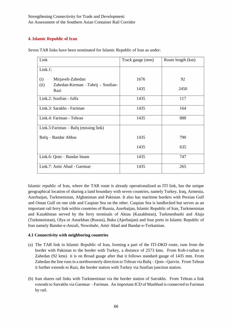
Strengthening Connectivity for Trade and Development:
An Assessment of the Southern Asian Container Rail Corridor
66
4. Islamic Republic of Iran
Seven TAR links have been nominated for Islamic Republic of Iran as under:
Link Track gauge (mm) Route length (km)
Link.1:
(i) Mirjaveh-Zahedan
(ii) Zahedan-Kerman –Tabrij - Soufian-
Razi
1676
1435
92
2450
Link.2: Soufian - Julfa 1435 117
Link.3: Sarakhs - Fariman 1435 164
Link.4: Fariman - Tehran 1435 888
Link.5:Fariman – Bafq (missing link)
Bafq – Bandar Abbas
1435
1435
790
635
Link.6: Qom – Bandar Imam 1435 747
Link.7: Amir Abad - Garmsar 1435 265
Islamic republic of Iran, where the TAR route is already operationalized as ITI link, has the unique
geographical location of sharing a land boundary with seven countries, namely Turkey, Iraq, Armenia,
Azerbaijan, Turkmenistan, Afghanistan and Pakistan. It also has maritime borders with Persian Gulf
and Oman Gulf on one side and Caspian Sea on the other. Caspian Sea is landlocked but serves as an
important rail ferry link within countries of Russia, Azerbaijan, Islamic Republic of Iran, Turkmenistan
and Kazakhstan served by the ferry terminals of Aktau (Kazakhstan), Turkmenbashi and Aluja
(Turkmenistan), Olya or Astarkhan (Russia), Baku (Ajerbaijan) and four ports in Islamic Republic of
Iran namely Bandar-e-Anzali, Nowshahr, Amir Abad and Bandar-e-Torkamian.
4.1 Connectivity with neighboring countries
(a) The TAR link in Islamic Republic of Iran, forming a part of the ITI-DKD route, runs from the
border with Pakistan to the border with Turkey, a distance of 2573 kms. From Koh-i-taftan to
Zahedan (92 kms) it is on Broad gauge after that it follows standard gauge of 1435 mm. From
Zahedan the line runs in a northwesterly direction to Tehran via Bafq – Qom - Qazvin. From Tehran
it further extends to Razi, the border station with Turkey via Soufian junction station.
(b) Iran shares rail links with Turkmenistan via the border station of Sarrakhs. From Tehran a link
extends to Sarrakhs via Garmsar – Fariman. An important ICD of Mashhad is connected to Fariman
by rail.

South and South-West Asia Development Papers 1901
67
(c) Ajerbaijan is connected by rail with Iran upto the border station of Jolfa. There is a branch line
which moves from Soufian junction of the ITI-DKD corridor and goes upto Jolfa and Djulfa
(Ajerbaijan border station). Ajerbaijan follows a standard gauge of 1520 mm hence there would be
a break of gauge between the two countries.
(d) Iraq also shares a boundary with Iran though it is presently not connected with rail. A branch line
from Qom junction to Arak is planned to be extended from Arak to Khosravi (border station) via
Kermanshah. This may further connect to Iraq via the border station of Khanqin on the other side.
This would serve as a direct rail connection to Baghdad and is one of the two bilateral railway
connection being planned between the two countries. The other connection is form Khorramshahr
– Basra border station connection to Baghdad.
4.2 Connectivity with Seaports and Dry Ports
(a) Bandar-e-Anzali: From Qazvin a line branches off to Rasht via Kuhin – Lowshan. The connectivity
from Rasht to Bandar – e- Anzali is currently missing.
(b) Khorramshahr and Bandar Emam Khomeyni: A branch line takes off from the junction station of
Qom and moves via Arak upto the junction station of Ahvaz. From Ahvaz the line branches off to
connect the two ports of Khorramshahr and Bandar-Emam Khomeyni. There is a by-pass route (by
passing Ahvaz) from Nezamiyeh to Miyandasht for connecting the port of Bandar Emam khomeyni.
(c) Bandar-e-Abbas and Band-e-Shahid Rajayi: These two ports of St. Hormuz connecting Oman Gulf
and Persian Gulf are connected with the main ITI-DKD route from Bafq via Sham Abad, Khatun
Abad, Gol gohar and Tezerj. This also forms part of the Sarrakhs –Bandar Abbas rail line which
connects the central Asian countries to the Arabian sea via Oman Gulf. This main route also
branches off at Torbat-e-Heydariyah station to Sangan border station with Afghanistan. There is a
missing rail link with Afghanistan of Khaf-Sangan- Herat(Afghanistan) which is planned to be
constructed by the two governments.
(d) Bandar-e-Amirabad: A rail link exists from Tehran to Garmsar from where it branches off in two
directions one to Amirabad port via Sari and the other to Sarrakhs border via Shahrun and Fariman.
(e) Among dry ports, the existing dry ports at Tehran, Mashhad (Khorasan Razavi), Salafchegan
(Qom), and Sirjan (Kerman) can all be linked to TAR through appropriate multi-modal connections
on hub and spoke basis.
(f) The Republic is also well poised for linking Chabahar, first phase commissioned and
operationalized in 2017 to Afghanistan and Central Asian Republics via shorter routes. The rail link
from Chabahar to Zahedan is already planned for construction.

Strengthening Connectivity for Trade and Development:
An Assessment of the Southern Asian Container Rail Corridor
68
5. Turkey
Five TAR links have been nominated for Turkey as under:
Link Track gauge (mm) Route length (km)
link.1:
(i) Kapikoy – Van
(ii) Van – Tatvan (ferry)
(iii) Tatvan – Kapikule
1435
Ferry
1435
114
91
2149
link.2:
(i) Aktas – Kars (missing link)
(ii) Kars-Cetinkaya
1435
1435
92
652
link.3: Malatya-Iskenderun 1435 377
link.4: Toprakkale-Mersin 1435 147
link.5:Bostankaya-Samsun 1435 431
Turkey is an important connection between Asian countries and Europe. It serves as the Western
extremity of ITI-DKD corridor of Trans Asian Railway line on which it is running Gul trains, covering
6500 kms between Istanbul and Islamabad via Teheran in 16 days. The strait of Bosphorus (northern
end of sea of Marmara) and the strait of Dardanelles (southern end of sea of Marmara) serves as the
dividing line between the European and Asian portions of Turkey. There is an underwater tunnel
constructed under the Strait of Bosphorus which serves as an important rail link between two portions.
Turkey is bordered by the Black Sea on the north, the Aegean Sea on the West and the Mediterranean
Sea on the south. This gives a long coastline to Turkey with important ports like Istanbul, Samsun
(Black Sea), Izmir (Aegean Sea) and Iskendrun and Mersin on Mediterranean Sea.
5.1 Connectivity with neighboring countries
(a) The ITI-DKD corridor enters Turkey from the border station of Kapikoy and runs westwards across
the country via Van – Tatvan – Malatya – Cetinkya – Sivas – kalin – Ankara – Eskesehir – Istanbul
to the border town of Kapikule. The whole route is standard gauge of 1435 mm and totals upto 2354
kms. The distance of 92 kms in between Van and Tatvan is done by a rail ferry moving over Lake
Van. The ITI train of ECO is currently running on this route.
(b) A rail link branches off from Cetinkaya station towards Kars via Erzincan and Erzurum. The station
of Kars used to serve as a rail link to the countries of Georgia and Armenia. However, currently
the rail link to both these countries is closed. A rail line from Kars via Dogukapi connects
Akhuriyan (border station) in Armenia and then moves onwards to Tbilisi in Georgia. There is a

South and South-West Asia Development Papers 1901
69
break in gauge as Armenia follows the standard gauge of 1520 mm. This rail link is not working
since 1993.
(c) Another rail link from Kars moves via Mezra – Aktas (border station) to Akhalkalaki (border
station) in Georgia and then moves further north to Tbilisi. There is a break of gauge in between
Turkey and Georgia as it follows the standard gauge of 1520 mm. This rail link is closed currently.
5.2 Connectivity with Seaports and Dry Ports
(a) Izmir: A branch line from the ITI-DKD corridor of TAR route takes off from Eskeshehir junction
and connects to the border port of Izmir (Aegean Sea) via Alayunt and Balikesir. Izmir and
Hydarpasa (Istanbul) remain the top ports of the country.
(b) Samsun: This is an important port connection on the Black sea and serves ferry connections with
Constanza (Romania) and Kavkaz (Georgia) in Sea of Azov. A branch line runs from Kalin to
Samsun Port. This port runs a roll on roll off service with the port of Novorosyssk and a servie to
Ukranian port of Odessa.
(c) Mersin: From Malatya junction of the ITI –DKD corridor a branch line takes off to Toprakkale
junction and then one line leads to Mersin port via Adana and the other to Iskendrun Port.